inside all about volcano
TRANSCRIPT

Vol.8 (4) Jan - Mar 2010 & Vol.9 (1) April - June 2010
ENVIS - MoEF Newsletter on Coastal Zone Management and Coastal Shelterbelts
All aboutvolcanoicelandic volcanoes
INSIDE...
TIDBITS
PHOTO GALLERY
FACTS AND FIGURES

Signing of MoU between Ministry of Environment and Forests (MoEF) and Anna University for the establishment of National Centre for Sustainable Coastal Management (NCSCM) at Anna University, Chennai....more photos on page 30

from the Editor’s Desk
Volcanoes are spectacular manifestations of the fiery power contained deep within the Earth. These formations are essentially vents on the Earth’s surface where molten rock, debris, and gases from the planet’s interior are emitted. The most recent eruption of Iceland’s volcano has seen one of the worst atmospheric disturbances in recent history. This eruption can be extremely dangerous for people living near the volcano. Flows of searing lava, which can reach 12500C or more, can be released, burning everything in its path, including whole towns. It has been reported that mud flows from rapidly melting snow can strip mountains and valleys bare and bury towns. Ash and toxic gases emanating from volcanic eruptions cause severe health hazards. Scientists estimate that more than 260,000 people have died in the past 300 years from volcanic eruptions and their aftermath.
This issue of Coast Track is dedicated to provide information on the formation of volcanoes both on land and submarine, its causes and effects. Submarine volcanoes and volcanic vents are common features on certain zones of the ocean floor. Some are active at the present time and, in shallow water, disclose their presence by blasting steam and rock-debris high above the surface of the sea. Many others lie at such great depths that the tremendous weight of the water above them results in high, confining pressure and prevents the formation and explosive release of steam and gases. However, even very large, deep-water eruptions may not disturb the ocean surface. Recent investigations have reported ocean-bottom seismometers to have recorded the seismic activity associated with a submarine volcanic eruption, revealing important differences from eruptions on land. The unlimited supply of water surrounding submarine volcanoes can cause them to behave differently from volcanoes on land.
From this issue of Coast Track a new section on “Facts and Figures” pertaining to topics of interest in coastal zone management, coastal shelterbelt and other important aspects concerning the coast and its livelihood will be made available. It is my sincere hope that this issue on volcanoes is useful and we value your esteemed feedback to our newsletters and the contents.
Editor

EDITOR
Prof. R. RameshCoordinatorENVIS Centre for Coastal Zone Management and Coastal ShelterbeltsInstitute for Ocean ManagementAnna University Chennai
ASSOCIATES
Dr. Purvaja RamachandranScientist & FacultyInstitute for Ocean ManagementAnna University Chennai
Dr. Ahana Lakshmi Guest Faculty Institute for Ocean Management Anna University Chennai
Mr. S. A. SwamynathanSenior Programme Officer
CONTACTProf. R. RameshDirectorInstitute for Ocean ManagementAnna University Chennai Chennai - 600025 INDIA
Phone : + 91 44 2230 0108, 2220 0159 2220 3408Fax : + 91 44 2220 0158Email : [email protected] [email protected] [email protected]
Important websites
1. www.iomenvis.in2. www.iomenvis.nic.in3. www.annauniv.edu4. www.annauniv.edu/iom/home.htm5. www.southasialoicz.org6. www.ncscm.org
All about VolcanoA.Priya, V.P.Sathiyabama, Ahana Lakshmi, Purvaja Ramachandran, Ramesh Ramachandran
Icelandic VolcanoesDr.B.Senthilkumar, A.Priya, V.P.Sathiyabama, Purvaja Ramachandran, Ramesh Ramachandran
Tidbits
Photo Gallery Signing of MoU between Ministry of Environment and Forests (MoEF), New Delhi and Anna University for the establishment of National Centre for Sustainable Coastal Management (NCSCM) at Anna University, Chennai
Facts and Figures
1
18
29
32
ContentsVol.8 (4) Jan - Mar 2010 & Vol.9 (1) April - June 2010
24
Design S.A.SwamynathanSenior Programme Officer
Printed at Srikals GraphicsChennai

ALL ABOUT VOLCANO
A volcano is an opening, or rupture, in a planet’s surface or crust, which allows hot magma, ash and gases to escape from below the surface. The word volcano is derived from the name of Vulcano Island off Sicily which in turn, was named after Vulcan, the Roman god of fire. The power and destructive capability of volcanoes is well known, but there are many more volcanoes underwater, termed submarine volcanoes, than there are on land. Some are quite active with recent eruptions, whereas many others lie quietly dormant.
VolcanologyVolcanology is the study of volcanoes. The role of volcanology is to gain an understanding of how volcanoes work, to further scientific knowledge, provide eruption hazard assessment, monitoring, and crisis management. One of the most important roles of volcanology is to foresee hazardous events, and save lives when an eruption occurs.
How Volcanoes are formed?The surface of the Earth is made up of rigid plates that move, at a rate of a few centimeters per year. When they collide, one plate can be pushed beneath another. As it sinks it heats up and begins to melt. This molten rock then rises and erupts on the surface as lava, building up a volcano. That’s why we see volcanoes along plate edges. Sometimes volcanoes can form in the middle of a plate because there happens to be a hot mantle plume there e.g. Hawaii.
Incredible Underwater VolcanoesHawaii’s Mauna Kea or White Mountain1. Molokini Crater, Hawaii2. Morro Rock, CA3. Surtsey, Iceland4. Eldfell volcano, Heimaey Island, Iceland5. Underwater volcano near Iwo Jima 6. island, JapanBrothers volcano, New Zealand7. Healy Volcano, Kermadec ridge, New 8. ZealandKick ‘em Jenny, Caribbean sea9. Bransfield , Antarctica10.
Formation of VolcanoA volcano is formed by pressure building up below the Earth’s crust. Magma forces it way through weaknesses in the earth’s crust. When the magma emerges it is called lava. When it cools, it solidifies into rock, or it may emerge though thin cracks, which are called fissure. Or it may be forced though
a.priya, V.P.sathiyabama, ahana lakshmi, purvaja ramachandran, ramesh ramachandranINSTITUTE FOR OCEAN MANAGEMENT, ANNA UNIVERSITY, CHENNAI
1Vol.8 (4) Jan - Mar 2010 & Vol.9 (1) April - June 2010

http://library.thinkquest.org/03oct/01530/images/Plateboundaries1.gif
wider pipes, that starts to build up, to a volcano. Majority of volcanic eruptions occur near plate boundariesConvergent Plate movement: Most powerful eruptions occur when plates collide, where there is an enormous amount of energy built up in the Earth’s crustDivergent Plate movement: Volcanoes can also erupt when plates move apart from each other, but these eruptions are much gentler.
Formation of Submarine or Underwater Volcanoes Underwater Volcanoes are formed as the surface of the Earth rips apart since the ocean surface is denser than the underlying mantle it creates pressure on the mantle and the surface cracks. The sea floor sinks down on the mantle and the pressure on the molten rock below decreases as a result of the crack. Due to the reduction in pressure
2 Vol.8 (4) Jan - Mar 2010 & Vol.9 (1) April - June 2010

there is a lot of buoyant liquid, which is molten, rock that is formed and it tries to come up. So when the liquid rock, which is called “magma”, finally comes up through the fissure on the sea floor, it is called “eruption”. Magma when it comes out onto the earth surface is called “lava”. At times the lava blocks the fissure and also at times piles up in several layers to form underwater ridges.
Distinguish Underwater Volcanoes from Surface Volcanoes? The presence of water near these fissures greatly makes it different from surface volcanoes. The impact and the nature of eruption also change with the environment. The difference is because the pressure of water is more than the pressure of air. So the eruptions in case of underwater volcanoes are massive explosions and the results are as massive as an island. There are many islands that have been formed as a result of eruption of underwater volcanoes. The thermal conductivity of water is much more than earth or solid rock particles, as a result of which magma is transformed into glass much more faster than in case of volcanic eruption on land surface.
As stated the pressure is more than in case of terrestrial eruption, as a matter of fact it is approximately two hundred and fifty times more. Thus the explosive boiling is considerably reduced between magma and the seawater. The lava that is formed in case of underwater eruption is also different from the lava of a terrestrial eruption. When lava comes in contact with the surrounding water a solid crust is formed and the lava flows in that crust consistently, thus forming a structure, which is called “pillow lava”. Due to the immense heat that is produced during a volcanic eruption the ocean or the water body becomes really shallow where the volcano erupts. At times there are various chemicals dissolve in the water which come out under the earth’s surface. The biggest underwater volcano is now in Hawaii
and if measured from the sea floor it is actually larger than Mount Everest.
Volcanic featuresA volcano constitutes a vent, a pipe, a crater, and a cone.
The vent is an opening at the Earth’s surface.•The pipe is a passageway in the volcano in which the magma •rises through to the surface during an eruption.The crater is a bowl-shaped depression at the top of the volcano •where volcanic materials like, ash, lava, and other pyroclastic materials are released.Solidified lava, ashes, and cinder form the cone. Layers of lava, •alternate with layers of ash to build the steep sided cone higher and higher.
Active and non-active volcanoesAn active volcano is a volcano that has had at least one eruption •during the past 10,000 years. An active volcano might be erupting or dormant.An erupting volcano is an active volcano that is having an •eruptionA dormant volcano is an active volcano that is not erupting, but •supposed to erupt again.An extinct volcano has not had an eruption for at least 10,000 •years and is not expected to erupt again in a comparable time scale of the future.
Eruption mechanismsVolcanic eruptions arise through three main mechanisms:
Gas release under decompression causing magmatic eruptions.1. Thermal contraction from chilling on contact with water causing 2. phreatomagmatic eruptions.Ejection entrained particles during steam eruptions causing 3. phreatic eruptions (Heiken & Wholtez 1985).
3Vol.8 (4) Jan - Mar 2010 & Vol.9 (1) April - June 2010

1.Magmatic eruptionsMagmatic eruptions produce juvenile clasts during explosive decompression from gas release. They range in size from the relatively small fire fountains on Hawaii to >30 km Ultra Plinian eruption columns, bigger than the eruption that buried Pompeii (Heiken & Wohletz 1985).
Strombolian eruptions are named because of activity of Stromboli in Sicily. They are characterized by huge clots of molten lava bursting from the summit crater to form luminous arcs through the sky. Collecting on the flanks of the cone, lava
a. Strombolian eruptionVulcanian eruptions are named after Vulcano, following Giuseppe Mercalli’s observations of its 1888-1890 eruptions. Another example was the eruption of Parícutin in 1947. They are characterized by a dense cloud of ash-laden gas exploding from the crater
b. Vulcanian eruption
In a Peléan eruption or nuée ardente (glowing cloud) eruption, such as occurred on the Mayon Volcano in the Philippines in 1968, a large amount of gas, dust, ash, and lava fragments are blown out of a central crater, fall back, and form
c. Peléan eruption
clots combine to stream down the slopes in molten rivulets. The explosions are driven by bursts of gas slugs that rise faster than surrounding magma.
and rising high above the peak. Steaming ash forms a whitish cloud near the upper level of the cone.
avalanches that move downslope at speeds as great as 160 km per hour. Such eruptive activity can cause great destruction and loss of life if it occurs in populated areas, as demonstrated by the devastation of Saint-Pierre during the 1902 eruption of Mont Pelée on Martinique, Lesser Antilles, from which Peléan eruptions are named.
Hawaiian eruptions may occur along fissures or fractures that serve as vents, such as during the eruption of Mauna Loa Volcano in Hawaii in 1950. Also, they can occur at a central vent, such as during the 1959 eruption in Kilauea Iki Crater
d. Hawaiian eruption
of Kilauea Volcano, Hawaii. In fissure-type eruptions, lava shoots from a fissure on the volcano’s rift zone and feeds lava streams that flow downslope. In central-vent eruptions, a lava fountain is erupted to a height of several hundred meters or more. Such lava may collect in old pit craters to form lava lakes, or form cones, or feed radiating flows.
A Surtseyan eruption occurs in shallow seas or lakes. It is named after the island of Surtsey off the southern coast of Iceland.These eruptions are commonly phreatomagmatic eruptions, representing violent
e. Surtseyan eruption
explosions caused by rising basaltic or andesitic magma coming into contact with abundant, shallow groundwater or surface water. Tuff rings, pyroclastic cones of primarily ash, are built by explosive disruption of rapidly cooled magma. Other examples of these volcanoes: Capelinhos, Faial Island, Azores; and Taal Volcano, Batangas, Philippines.
Usually the most powerful, and involve the explosive ejection of relatively viscous lava. Large plinian eruptions—such as during 18 May 1980 at Mount St. Helens or, more recently, during 15 June 1991 at Pinatubo in the
f. Plinian eruption
Philippines—can send ash and volcanic gas hundreds of kilometers into the atmosphere. The resulting ash fallout can affect large areas hundreds of miles downwind. Fast-moving pyroclastic surges and pyroclastic flows together with nuées ardentes, are often associated with Plinian eruptions. These volcanoes can destroy all of the plants around the blast zone, and can kill many if people do not evacuate.
4 Vol.8 (4) Jan - Mar 2010 & Vol.9 (1) April - June 2010
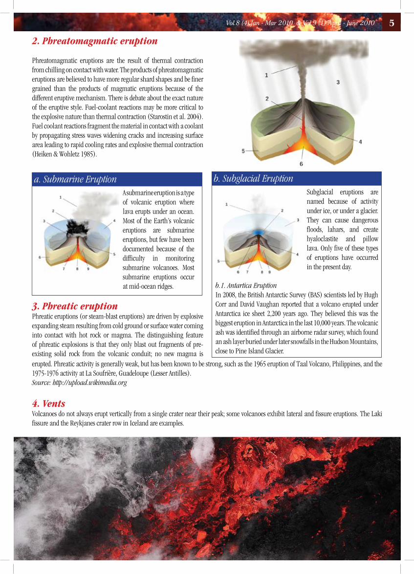
2. Phreatomagmatic eruption
Phreatomagmatic eruptions are the result of thermal contraction from chilling on contact with water. The products of phreatomagmatic eruptions are believed to have more regular shard shapes and be finer grained than the products of magmatic eruptions because of the different eruptive mechanism. There is debate about the exact nature of the eruptive style. Fuel-coolant reactions may be more critical to the explosive nature than thermal contraction (Starostin et al. 2004). Fuel coolant reactions fragment the material in contact with a coolant by propagating stress waves widening cracks and increasing surface area leading to rapid cooling rates and explosive thermal contraction (Heiken & Wohletz 1985).
A submarine eruption is a type of volcanic eruption where lava erupts under an ocean. Most of the Earth’s volcanic eruptions are submarine eruptions, but few have been documented because of the difficulty in monitoring submarine volcanoes. Most submarine eruptions occur at mid-ocean ridges.
a. Submarine EruptionSubglacial eruptions are named because of activity under ice, or under a glacier. They can cause dangerous floods, lahars, and create hyaloclastite and pillow lava. Only five of these types of eruptions have occurred in the present day.
b. Subglacial Eruption
b.1. Antartica EruptionIn 2008, the British Antarctic Survey (BAS) scientists led by Hugh Corr and David Vaughan reported that a volcano erupted under Antarctica ice sheet 2,200 years ago. They believed this was the biggest eruption in Antarctica in the last 10,000 years. The volcanic ash was identified through an airborne radar survey, which found an ash layer buried under later snowfalls in the Hudson Mountains, close to Pine Island Glacier.
3. Phreatic eruptionPhreatic eruptions (or steam-blast eruptions) are driven by explosive expanding steam resulting from cold ground or surface water coming into contact with hot rock or magma. The distinguishing feature of phreatic explosions is that they only blast out fragments of pre-existing solid rock from the volcanic conduit; no new magma is erupted. Phreatic activity is generally weak, but has been known to be strong, such as the 1965 eruption of Taal Volcano, Philippines, and the 1975-1976 activity at La Soufrière, Guadeloupe (Lesser Antilles).Source: http://upload.wikimedia.org
4. VentsVolcanoes do not always erupt vertically from a single crater near their peak; some volcanoes exhibit lateral and fissure eruptions. The Laki fissure and the Reykjanes crater row in Iceland are examples.
5Vol.8 (4) Jan - Mar 2010 & Vol.9 (1) April - June 2010

Volcanologists have classified volcanoes into groups based on the shape of the volcano, the materials they are built of, and the way the volcano erupts. The groups are:
Types of Volcano
Diagram of the structure of six types of volcano
StratovolcanoesA stratovolcano, is a tall, conical volcano with many layers (strata) of hardened lava, tephra, and volcanic ash. Stratovolcanoes are characterized by a steep profile and periodic, explosive eruptions. The lava that flows from stratovolcanoes tends to be viscous; it cools and hardens before spreading far. The magma forming this lava is often felsic, having high-to-intermediate levels of silica (as in rhyolite, dacite, or andesite), with lesser amounts of less-viscous mafic magma.
VsevidofThe effects of erosion are visible in this view from the SW of two prominent stratovolcanoes on SW Umnak Island in the Aleutians. Mount Vsevidof (left) is a symmetrical, constructional volcano where frequent eruptions, which have continued into historical time, have overcome the effects of erosion. Recheschnoi volcano (right), in contrast, has been inactive for longer periods of time and has been extensively dissected by glaciers. Only small pyroclastic cones and lava domes have erupted during the past 10,000 years.
KliuchevskoiKamchatka’s two highest volcanoes rise above a sea of clouds. Construction of extensively eroded Kamen volcano (left) took place during the Pleistocene. Its eastern (right) side was removed by a massive landslide about 1200-1300 years ago, leaving the steep escarpment. Symmetrical Kliuchevskoi, in contrast, is one of Kamchatka’s youngest and most active volcanoes, growing to 4835 m in the past 6000 years
Photo courtesy: www.avo.alaska.edu
Photo by Yuri Doubik (Institute of Volcanology, Petropavlovsk)
6 Vol.8 (4) Jan - Mar 2010 & Vol.9 (1) April - June 2010

Shield VolcanoesA shield volcano is a volcano with shallow-sloping sides. Shield volcanoes normally form from fluid lava flows that can travel long distances across slight inclines, resulting in their relatively flat, broad profile. Oceanic shield volcanoes such as those in the Hawaiian Islands can rise as much as 8000 m above the surrounding sea floor and 12,000 m above their actual bases, which have sagged due to the immense mass of the volcano. Shield volcanoes can vary widely in size, and much smaller Icelandic-type shield volcanoes are common in many volcanic regions. These volcanoes can form during single long-term effusive eruptions. A less common type of shield volcano is a pyroclastic shield, whose broad low-angle slopes are formed by accumulation of fragmental material from powerful explosive eruptions.
Auckland FieldRangitoto shield volcano, the youngest volcanic center of New Zealand’s Auckland volcanic field, forms a 5.5 km wide island. The volcano, seen here from the NW, erupted about 600 years ago and is capped by a scoria cone containing a deep crater. The 140 km2 Auckland volcanic field contains more than 50 maars, tuff rings, and scoria cones. Of the 19 eruptions known to have occurred during the past 20,000 years, only Rangitoto has erupted during the Holocene.
San Quintín Volcanic FieldIsla San Martín, 6 km off the west coast of Baja California, is the western most volcano of the San Quintín volcanic field and the only one that is located offshore. The 2 km wide island is a small basaltic shield volcano that is capped by scoria cones that rise to 230 m above sea level. Wave erosion has truncated part of the shield volcano, forming the sea cliffs seen at the left on the south side of the island
Photo by Jim Cole (University of Canterbury).
http:// wikimedia.org
CalderasCalderas are large volcanic depressions formed by collapse of the summit or flanks of a volcano into underlying chambers evacuated by very large explosive eruptions or the effusion of large volumes of lava flows. Calderas may be simple structures formed during an eruption that truncates either the summit of a single stratovolcano or a complex of multiple overlapping volcanoes, such as at Crater Lake in Oregon. Calderas are most often defined as depressions produced as a result of large-scale eruptions, but the word has also been used as a morphological term that encompasses volcanic depressions formed by erosion or large volcanic landslides. Calderas may be ephemeral features that are partially or totally obscured by post-caldera eruptions.
Banda ApiThe arcuate islands of Neira and Lonthor, seen here looking east from the summit of Indonesia’s Banda Api volcano, are remnants of two largely submarine calderas that preceded the construction of the Banda Api stratovolcano. The outer caldera has a diameter of 7 km, the nested inner caldera is 3 km wide. Neira, the largest town in the Banda Islands, occupies the southern tip of Neira Island.
FACT
S &
FIGU
RES A volcano is formed by eruptions of lava and ash.1.
Volcanoes are usually cone shaped mountains or hills.2. When magma reaches the Earth’s surface it is called lava. When the lava cools, it forms rock.3. Volcanic eruptions can happen at destructive and constructive boundaries, but not at conservative boundaries. 4.
7Vol.8 (4) Jan - Mar 2010 & Vol.9 (1) April - June 2010

CratersCraters are typically formed by the explosive ejection of material in and surrounding the upper part of the conduit, rather than by collapse. Steep-walled pit craters, in contrast, often found on shield volcanoes, are more passive features formed when magma drains from a fissure, leaving overlying lava flows unsupported. Multiple explosive eruptions can form overlapping or nested craters, and adjacent craters may reflect localized areas of eruption along fissures, as seen in craters rows in Iceland that extend for tens of kilometers. Maars and tuff rings are broad, low-rimmed craters formed during powerful explosive eruptions involving magma-water interaction. The accumulation of material ejected from craters contributes to the formation of their surrounding rims.
ErebusThe summit of Antarctica’s Mount Erebus, the world’s southern most historically active volcano, contains an elliptical, 500 x 600 m wide crater whose NE side is cut by the 250-m-wide Inner Crater. The flat, snow-covered floor of the Main Crater lies about 100 m below its rim. Steam rises from the steep-walled, 100-m-deep Inner Crater, which has a phonolitic lava lake that has been active since 1972.Photo by Bill Rose, 1983 (Michigan Technological University).
Fissure VentsThe intrusion of magma into an edifice can produced large fractures, or fissures, that locally become the focus of explosive activity or lava effusion. Fissures often extend radially away from the summit and can reach from the upper part of the volcano to its base. Fissures can also reflect regional tectonic trends independent of the volcanoes themselves, such as in Iceland, where the mid-Atlantic Ridge rises above sea level, or along continental rift zones such as those in eastern Africa. Much larger scale fissures of Tertiary or older age fed voluminous eruptions of lavas known as flood basalts.
ErebusThe summit of Antarctica’s Mount Erebus, the world’s southern most historically active volcano, contains an elliptical, 500 x 600 m wide crater whose NE side is cut by the 250-m-wide Inner Crater. The flat, snow-covered floor of the Main Crater lies about 100 m below its rim. Steam rises from the steep-walled, 100-m-deep Inner Crater, which has a phonolitic lava lake that has been active since 1972.Photo by Michael Ryan, 1984 (U.S. Geological Survey).
Pyroclastic ConesPyroclastic cones are small cones, named from a combination of the Greek words for fire (pyro) and broken (klastos), are built of fragmental material. Pyroclastic cones typically range from a few tens of meters to a few hundred meters in height and are most often formed during single eruptions, when explosively ejected material accumulates around the vent. The slopes of pyroclastic cones consequently approach the angle of repose of its constituent materials. Pyroclastic cones, also known as cinder cones or scoria cones, can form rapidly, but remain active for long periods of time. Tuff cones are a variety of pyroclastic cone formed by more energetic explosions involving groundwater that extensively fragment ejecta, producing finer-grained ash deposits; they typically have steeper slopes and wider craters than cinder cones.
FACT
S &
FIGU
RES
Some volcanoes happen underwater, along the seabed or ocean floor.1. Mauna Loa volcano is one of the tallest mountains in the world.2. Indonesia has the most volcanoes3. The term “volcano” is from the Latin Volcanus or Vulcan, the Roman god of fire4. Volcanologists use a special electric thermometer called a “thermocouple” to take a volcano’s temperature5. Volcanologists measure the size of an eruption with the Volcanic Explosivity Index (VEI), with 0 being the weakest and 8 6. the strongest.The largest volcano found in the solar system is Olympus Mons on Mars, though it is now extinct.7.
8 Vol.8 (4) Jan - Mar 2010 & Vol.9 (1) April - June 2010

Barren IslandsThe 1991 eruption dramatically modified the morphology of the central cinder cone on the small Barren Island, one of the Andaman Islands, north of Sumatra. During the eruption the height of the cinder cone was lowered from 305 m to 225 m, and the diameter of its crater increased from 60 m to about 200 m. Two small cinder cones also formed in the lava field west of the main cone
Photo courtesy of D. Haldar, 1992 (Geological Survey of India).
Lava DomesLava domes are formed when viscous magma slowly extrudes from a vent and piles up around it. Silicon promotes rigidity in magmas because it has a +4 charge and forms multiple bonds with other elements. Domes are consequently often produced by magmas of more silica-rich dacitic-to-rhyolitic compositions. Domes are steep-sided structures typically a few tens of meters to a few hundred meters high and can form at the summit of a volcano, on its flanks, or as independent volcanic centers
BogoslofAn aerial view shows the 1992 lava dome of Bogoslof Island, the summit of a largely submarine stratovolcano located in the Bering Sea 50 km behind the main Aleutian arc. The 1992 lava dome grew to a height of 100 m in July at the northern tip of Bogoslof Island. The island is about 1.5 x 0.6 km wide, and due to its frequent eruptive activity and energetic wave action, has changed shape dramatically since first mapped in the late 1700’s
Photo by Tom Miller, 1994 (Alaska Volcano Observatory, U.S. Geological Survey)
St. HelensLava domes are formed by the extrusion of viscous, silica-rich lava that accumulates above the volcanic vent. This steaming lava dome partially fills the crater of Mount St. Helens in April 1983. Dome extrusion often follows explosive eruptions, which decrease the gas content of the remaining magma. Dome growth, however, is commonly accompanied by explosive activity and pyroclastic flows. Lava domes can form within the summit craters of volcanoes or on their flanks. They may build solitary, domical masses, or a complex of overlapping domes.
Photo by Bob Symonds, 1983 (U.S. Geological Survey).
MaarA maar is a low-relief, broad volcanic crater formed by shallow explosive eruptions. The explosions are usually caused by the heating and boiling of groundwater when magma invades the groundwater table. Maars often fill with water to form a lake
Ukinrek Maars Ukinrek Maars, Alaska; Lake Becharof. Water partially fills the eastern maar and completely covers a lava dome that was erupted in the 100-m deep crater during a 10 day eruption in 1977. Maar is about 300 m in diameter.
Photograph by C. Nye on 9 May 1994Alaska Division of Geological and Geophysical Surveys
9Vol.8 (4) Jan - Mar 2010 & Vol.9 (1) April - June 2010

Ubehebe CratersThe Ubehebe Craters include over a dozen maar volcanoes formed during hydrovolcanic eruptions of alkali basalt through permeable fanglomerate deposits on the north side of Tin Mountain. The craters formed along a range-bounding fault that marks the western margin of Tin Mountain. The volcanic center is named Ubehebe Crater, the largest tuff ring (0.8 kilometers wide, 235 meters deep) of the volcanic field
Spatter RampartLava fountains that erupt from an elongate fissure will build broad embankments of spatter, called spatter ramparts, along both sides of the fissure. The spatter commonly sticks together, or agglutinates, when it lands and is buried by later spatter. In contrast to these low linear fortifications, spatter cones are more circular and cone shaped-the only real distinction between the two structures is their shape
Mauna LoaMauna Loa has erupted 39 times since 1832. These historical flows cover 806 km² of the volcano’s surface. According to USGS estimates, the volcano has erupted an average of once every 6 years over the past 3000. The highest point on Mauna Loa is 4,170 m above sea level. But the flanks of Mauna Loa continue another 5,000 m below sea level to the sea floor. The massive central portion of the volcano has depressed the sea floor another 8,000 m in the shape of an inverted cone, reflecting the profile of the volcano above it. Thus, the total relief of Mauna Loa, from its true base to its summit, is about 17,170 m. Mauna Loa is the largest active volcano in the world.
Spatter and Cinder ConeLong-lived basaltic lava fountains that erupt spatter, scoria or cinder, and other tephra from a central vent typically build steep-sided cones called spatter-and-cinder cones. The greatest bulk of these cones consists of spatter, but during fountaining a lava flow usually pours down one side of the cone. Eruptions that build spatter and cinder cones are much longer in duration and much more varied in intensity than those that eject only spatter to build spatter cones and ramparts
Photograph by J.D. Griggs on 26 March 1984
Pu`u `O`oA small short-lived lava fountain built this elongate cone of spatter around a vent located on the flank of the much larger Pu`u ̀ O`o spatter and cinder cone. This spatter cone is 4-5 m tall. Lava fountain from the main vent of Pu`u `O`o adds new tephra to its towering spatter and cinder cone. In 1986, the cone was about 255 m tall. The summit was built higher than the main vent (about 86 m higher) as tephra from dozens of tall fountains between 1983 and 1986 was blown by the persistent trade winds toward the southeast.
Spatter cone Photograph by T.N Mattox on 3 March 1992
FACT
S &
FIGU
RES
Venus may have at one time produced more volcanoes than any other planet in our solar system, though they are all now 1. extinct.There are no active volcanoes in Australia because it sits in the middle of a tectonic plate.2. “Lava” derives from the Latin lavara, meaning “to wash”3. Over half of the world’s volcanoes arise in a belt around the Pacific Ocean called the Ring of Fire.4. During volcanic eruptions, lightning storms are common5. Volcanoes produce tsunamis through nine different mechanisms. Volcanic earthquakes, undersea eruptions, pyroclastic 6. flows, caldera collapse, landslides, lahars, phreatomagmatic eruptions, lava bench collapse, and airwaves from large explosions
10 Vol.8 (4) Jan - Mar 2010 & Vol.9 (1) April - June 2010

Volcanic Hazards
Pyroclastic FlowsPyroclastic flows and surges are high-speed avalanches of hot ash, rock fragments, and gas that move down the sides of a volcano during explosive eruptions or when the steep edge of a dome breaks apart and collapses. These pyroclastic flows, which can reach 1,500 degrees Fahrenheit and move at 100-150 miles per hour, are capable of knocking down and burning everything in their paths. A more energetic and dilute mixture of searing gas and rock fragments is called a pyroclastic surge. Surges move easily up and over ridges, while flows tend to follow valleys.
LaharsLahars are mixtures of water, rock, sand, and mud that rush down valleys leading away from a volcano. They can travel over 50 miles downstream, commonly reaching speeds between 20 and 40 miles per hour. Sometimes they contain so much rock debris (60-90% by weight), that they look like fast-moving rivers of wet concrete. Close to the volcano, they have the strength to rip huge boulders, trees, and houses from the ground and carry them down the valley. Further downstream, they simply entomb everything in mud. Historically, lahars have been one of the most deadly volcanic hazards. Lahars can form in a variety of ways, either during an eruption or when a volcano is quiet.
Some examples include: (1) rapid release of water from the breakout of a summit crater lake; (2) generation of water by melting snow and ice, especially when a pyroclastic flow erodes a glacier; (3) flooding following intense rainfall; and (4) transformation of a volcanic landslide into a lahar as it travels downstream.
LandslidesA landslide is a rapid down slope movement of rock, snow, and ice. Landslides range in size from small movements of loose debris on the surface of a volcano, to massive failures of the entire summit or flanks of a volcano. Volcanic landslides are not always associated with eruptions; heavy rainfall or a large regional earthquake can trigger a landslide on steep slopes. Volcanoes are susceptible to landslides because they are composed of layers of weak, fragmented, volcanic rocks that tower above the surrounding terrain. Furthermore, some of these rocks have been altered to soft, slippery, clay minerals by hot, acidic ground water inside the volcano.
Lava FlowsMolten rock, or magma, that pours onto the Earth’s surface is called lava. The higher a lava’s silica content, the more viscous it becomes. Low-silica basalt lava can form fast-moving (10-30 miles per hour), narrow lava streams or spread out into broad sheets up to several miles wide.
Major hazards of lava flows include, burying, crushing, covering, and burning everything in their path. Sometimes lava melts ice and snow to cause floods and lahars. Lava flows can dam rivers to form lakes that might overflow or break their dams causing floods. Methods for controlling the paths of lava flows include: constructing barriers and diversion channels, cooling the advancing front with water, or disrupting the source or advancing front of the lava flow by explosives.
TephraWhen a volcano erupts it will sometimes eject material known as tephra, i.e. rock fragments, into the atmosphere. The largest pieces of tephra are called blocks and bombs. Blocks and bombs are normally shot ballistically from the volcano, and because they are so large, they tend to fall near their source. Blocks and bombs as large as 8-30 tons have fallen as far as 0.6 miles or 1 kilometer from their source. Small blocks and bombs have been known to travel as far away as 12-50 miles. Smaller ejecta, such as lapilli 0.5-16 inches in size and ash less than 0.5 inches, which are lifted upward by the heat of the eruption, will fall farther from the volcano. The smallest particles, which are less than 0.0025 inches, can stay in the atmosphere for two or three years after a volcanic eruption. Some scientists believe that these particles may contribute to global warming.
Tephra produces a wide range of hazards. When the ejected material is in the atmosphere, it is electrically charged and often produces lightning, which has killed a number of people. Large ejecta shot ballistically from the volcano are also a hazard to those unfortunate enough to be near the volcano. Other hazards are produced when the ash is deposited on the ground. Ash can disrupt electricity, television, radio, and telephone communication lines, bury roads and other man made structures, damage machinery, start fires, and clog drainage and sewage systems.
Ash can also produce poor visibility and cause respiratory problems. Often people living in areas affected by volcanic ash will wear filter masks or wet cloths over their nose and mouth to protect themselves from breathing in volcanic ash and fumes. If ash builds up on the tops of roofs, it will often cause structural collapse. This is especially common of flat-topped buildings. Most of the deaths resulting from the eruption of Mount Pinatubo in 1991 were due to collapsing roofs.
Volcanic GasVolcanoes emit gases during eruptions. Even when a volcano is not erupting, cracks in the ground allow gases to vent to the surface. The most common volcanic gases are water vapor (90%), carbon dioxide, sulfur dioxide, hydrogen sulfide, and hydrogen. Sulfur dioxide gas can react downwind with water droplets in the atmosphere and fall as acid rain, causing corrosion, and adversely affecting vegetation. Carbon dioxide is heavier than air and tends to collect in depressions, where on occasion, it can accumulate in lethal concentrations and cause
11Vol.8 (4) Jan - Mar 2010 & Vol.9 (1) April - June 2010

people and animals to suffocate. Large eruptions inject sulfur dioxide gas into the stratosphere, where it combines with water to form an aerosol of sulfuric acid. By reflecting sunlight, the sulfur aerosols can lower Earth’s average surface temperature by a few degrees Fahrenheit.
Examples of volcanic gas compositions, in volume percent concentrations(from Symonds et. al., 1994)
VolcanoTectonic StyleTemperature
Kilauea SummitHot Spot1170°C
Erta` AleDivergent Plate
1130°C
MomotomboConvergent Plate
820°C
H20 37.1 77.2 97.1
C02
48.9 11.3 1.44
S02 11.8 8.34 0.50
H2 0.49 1.39 0.70
CO 1.51 0.44 0.01
H2S 0.04 0.68 0.23
HCl 0.08 0.42 2.89
HF --- --- 0.26
These aerosols also hasten ozone destruction by altering chlorine and nitrogen chemical species in the stratosphere.
Tsunami
A tsunami is a long-period seismic generated by a sudden displacement of water. Tsunamis travel at very high speeds through deep water as low broad waves, building to great heights as they approach the shallow bottom of shores. Most are caused by fault displacements on the sea floor, but many have been caused by volcanic action. The pyroclastic flow generated by this eruption, displaced the water that initiated the tsunamis.
Volcanic Gases and Climate Change Volcanoes can impact climate change. During major explosive eruptions huge amounts of volcanic gas, aerosol droplets, and ash are injected into the stratosphere. Injected ash falls rapidly from the stratosphere most of it is removed within several days to weeks and has little impact on climate change. But volcanic gases like sulfur dioxide can cause global cooling, while volcanic Carbon dioxide, a greenhouse gas, has the potential to promote global warming.
The most significant climate impacts from volcanic injections into the stratosphere come from the conversion of sulfur dioxide to sulfuric acid, which condenses rapidly in the stratosphere to form fine sulfate aerosols. The aerosols increase the reflection of radiation from the Sun back into space, cooling the Earth’s lower atmosphere or troposphere. Several eruptions during the past century have caused a decline in the average temperature at the Earth’s surface of up to half a degree (Fahrenheit scale) for periods of one to three years. The climatic eruption of Mount Pinatubo on June 15, 1991, was one
of the largest eruptions of the twentieth century and injected a 20-million ton (metric scale) sulfur dioxide cloud into the stratosphere at an altitude of more than 20 miles. The Pinatubo cloud was the largest sulfur dioxide cloud ever observed in the stratosphere since the
beginning of such observations by satellites in 1978. It caused what is believed to be the largest aerosol disturbance of the stratosphere in the twentieth century, though probably smaller than the disturbances from eruptions of Krakatau in 1883 and Tambora in 1815. Consequently, it was a standout in its climate impact and cooled the Earth’s surface for three years following the eruption, by as much as 1.3 degrees at the height of the impact. Sulfur dioxide from the large 1783-1784 Laki fissure eruption in Iceland caused regional cooling of Europe and North America by similar amounts for similar periods of time.Emanations of gas are rarely large enough to cause loss of life. However, 142 people were killed by carbon dioxide from the Deng Plateau in Java.
While sulfur dioxide released in contemporary volcanic eruptions has occasionally caused detectable global cooling of the lower atmosphere, the carbon dioxide released in contemporary volcanic eruptions has never caused detectable global warming of the atmosphere. This is probably because the amounts of carbon dioxide released in contemporary volcanism have not been of sufficient magnitude to produce detectable global warming. For example, all studies to date of global volcanic carbon dioxide emissions indicate that present-day
12 Vol.8 (4) Jan - Mar 2010 & Vol.9 (1) April - June 2010

sub aerial and submarine volcanoes release less than a percent of the carbon dioxide released currently by human activities.
Volcanic versus anthropogenic CO2
emissions Do the Earth’s volcanoes emit more CO
2 than human activities?
Research findings indicate that the answer to this frequently asked question is a clear and unequivocal, “No.” Human activities, responsible for some 36,300 million metric tons of CO
2 emissions in
2008 [Le Quéré et al., 2009], release at least a hundred times more CO
2 annually than all the world’s degassing sub aerial and submarine
volcanoes.
The half dozen or so published estimates of the global CO2 emission
rate for all degassing sub aerial and submarine volcanoes lie in a range from 123 to 378 million metric tons per year [Gerlach, 1991; Varekamp et al., 1992; Allard, 1992; Sano and Williams, 1996; Marty and Tolstikhin, 1998; Kerrick, 2001]. The current anthropogenic CO
2
emission rate of some 36,300-million metric tons of CO2 per year is
about 100 to 300 times larger than this range of estimates for global volcanic CO
2 emissions. The anthropogenic rate is 138 times larger
than the preferred global estimate of Marty and Tolstikhin (1998) of 264 million metric tons per year, which falls close to the middle of the range of global estimates.
In recent times, about 50-60 volcanoes are normally active on the Earth’s subaerial terrain. One of these is Kilauea volcano in Hawaii, which has an annual baseline CO
2 output of about 3.1 million metric
tons per year [Gerlach et al., 2002]. It would take a huge addition of volcanoes to the sub aerial landscape—the equivalent of an extra 11,700 Kilauea volcanoes—to scale up the global volcanic CO
2
emission rate to the anthropogenic CO2 emission rate. Similarly,
scaling up the volcanic rate to the current anthropogenic rate by adding more submarine volcanoes would require the addition of over 100 mid-oceanic ridge systems to the sea floor. Global volcanic CO
2
emission estimates are uncertain and variable, but there is little doubt that the anthropogenic CO
2 emission rate is more than a hundred
times greater than the global volcanic CO2 emission rate.
Source: Le Quéré, C., et al., 2009, Trends in the sources and sinks of carbon dioxide: Nature Geosciences.
How Volcanoes Cause Tsunamis?There are two different ways that volcanoes can cause seismic waves. One possibility is for a land-based volcano to break down and collapse, forcing large amounts of ash and debris into the water. This sudden change and displacement of the water column transfers to kinetic energy and results in waves. More debris can create a bigger increase in wave amplitude and number.
Eruption of Mount Pinatubo on June 15, 2001.
13Vol.8 (4) Jan - Mar 2010 & Vol.9 (1) April - June 2010

Source:http://academic.evergreen.edu/g/grossmaz/springle/
Uses of Volcanoes
One of the most destructive natural forces on the Earth is volcanoes. Even though they have killed 200,000 people since the 1400’s, they also produce benefits. The greatest resource from volcanoes is the land formed by the materials they erupt.
Fertile Soil: Volcanic activity has created some of the most scenic and fertile regions on earth. Farms and villages are built on the slopes of active volcanoes, although they can erupt at any point of time. Volcanic ash that has been weathered greatly improves soil fertility. In India the ancient basalt lava flows from volcanic eruptions in the past have eroded into rich black soil of the Deccan Plateau, where cotton is now grown. Farmers in Indonesia grow rice in volcanic soil and vineyards and orange and lemon groves are found on the slopes of Mount Etna. The soil is rich because the volcanic tephra released in eruptions is easily weathered by rain. This process breaks down nutrients in the ash and rock delivering it slowly to the plants.
Geothermal Energy: Geothermal energy or energy from the earth is another vital resource of volcanic areas. It would take 20000 times the world’s coal supply to produce the heat that exists in the upper 7 miles of the earth’s crust. Harnessing the natural heat of volcanic systems has provided a nearly pollution-free source of thermal and electric energy. The steam from the Geysers located in Northern California, which is the world’s largest geothermal field, is sufficient to meet the electrical needs of the city of San Francisco. Many geothermal power plants have been built in Iceland, New Zealand, Italy and Japan where groundwater and magma provide hot water and steam. Geothermal energy serves as a good alternative to fossil fuels and is relatively clean and almost endless energy resource for the future.
The volcanic materials have important industrial and chemical uses. Volcanic rocks and magmatic rocks also contain valuable ore deposits,
such as copper, lead, zinc, gold, silver, molybdenum and mercury. Crushed lava rocks, pumice, cinders, and other eruptive products are a source of raw materials for the road-building, constructing, manufacturing and landscaping industries. A natural glass that comes from lava is pumice, it is widely used for grinding and polishing metals, stones, and other materials. When lava dries and makes a rock form it is commonly used in building roads. Volcanic material has a source of precious gems, Opal. When volcanoes erupt, the lava releases some healthy gases, including carbon dioxide and hydrogen. When oxygen mixes with hydrogen, it creates water vapor and that begins the water cycle.
Island Formation: Volcanoes also create brand new islands. For example, the entire Hawaiian chain of islands was created by the constant eruptions of a single volcanic hot spot. Over hundreds of thousands of years, these volcanoes breached the surface of the ocean becoming habitable islands, and rest stops during long sea journeys. Unique species of plants and animals evolved into new forms on these islands, creating balanced ecosystems.
Ring of Fire: The Ring of Fire is surrounded by the Pacific Plate, which is surrounded by the Pacific Ocean. It contains more than half of the world’s volcanoes. Some of the world’s famous volcanoes are in this fantastic ring in the ocean. The existence is explained by plate tectonics. The Ring of Fire is on one of the plates of the earth’s crust. Newly-formed magma rises to the air of the earth’s surface and erupts, forming chains of these violent volcanoes, like the Ring of Fire. The Ring of Fire is very big. It stretches from New Zealand to Alaska and eastern Asia to North and South America. The Ring of Fire also produces heavy seismic activity. Frequent earthquakes are also very common in the Ring of Fire.
14 Vol.8 (4) Jan - Mar 2010 & Vol.9 (1) April - June 2010

15Vol.8 (4) Jan - Mar 2010 & Vol.9 (1) April - June 2010

16 Vol.8 (4) Jan - Mar 2010 & Vol.9 (1) April - June 2010

17Vol.8 (4) Jan - Mar 2010 & Vol.9 (1) April - June 2010

ICELANDICVOLCANOB.senthil kumar, A. priya, v.p.sathiyabamapurvaja ramachandran, ramesh ramachandraninstitute for ocean management, anna university, chennai
Iceland is a European Island country located in the North Atlantic Ocean on the Mid-Atlantic Ridge. It has a population of about 3,20,000 and a total area of 103,000 km2. Iceland is volcanically and geologically active. The interior mainly consists of a plateau characterized by sand fields, mountains and glaciers, while many glacial rivers flow to the sea through the lowlands. Iceland is warmed by the Gulf Stream and has a temperate climate despite high latitude just outside the Arctic Circle.
Iceland has a high concentration of active volcanoes due to unique geological conditions. The island has about 130 volcanic mountains, of which 18 have erupted since the settlement of Iceland in 874 AD. Of these 130 volcanoes, the most active/volatile is Hekla. Over the past 500 years, Iceland’s volcanoes have erupted a third of the total global lava output. Although the Laki eruption in 1783 had the largest eruption of lava in the last 500 years, the Eldgjá eruption of 934 AD and other Holocene eruptions were even larger. Seismologists explain this high concentration of volcanic activity as being due to a combination of the island’s position on the Mid-Atlantic Ridge and a volcanic hotspot underneath the island. The island sits astride the boundary between the Eurasian and North American Plates, and most volcanic activity is concentrated along the plate boundary, which runs across the island from the south-west to the north-east of the island. Some volcanic activity occurs offshore, especially off the southern coast. This includes wholly submerged submarine volcanoes and even newly formed volcanic islands such as Surtsey and Jólnir.
Fig. 1: Map of IcelandSource: www.geographicguide.net/.../iceland-map.htm
Fig. 2: Active volcanic areas and systems in Iceland(Source: www.volcanodiscovery.com/en/iceland.html)
18

Eyjafjallajökull
Eyjafjallajökull is one of the smaller ice caps of Iceland, situated to the north of Skógar and to the west of Mýrdalsjökull. The ice cap covers the caldera of the volcano with a summit elevation of 1,666 metres (5,466 ft). The volcano has erupted relatively frequently since the last glacial period, most recently from 1821 to 1823 and again in 2010. Around December 2009, seismic activity was detected in the volcano area, with thousands of small earthquakes (mostly magnitude 1–2 on the Richter magnitude scale, with only a couple greater than 3 magnitudes) 7–10 kilometres (4.3–6.2 mi) beneath the volcano. On 26 February 2010, unusual seismic activity along with rapid expansion of the Earth’s crust was registered by the Meteorological Institute of Iceland. This gave geophysicists evidence that magma was pouring from underneath the crust into the magma chamber of the Eyjafjallajökull volcano and that pressure stemming from the process caused the huge crustal displacement at Porvaldseyri farm. The seismic activity continued to increase and from 3–5 March, close to 3,000 earthquakes was measured at the epicentre of the volcano. The eruption is thought to have begun on 20 March 2010, about 8 kilometres (5.0 mi) east of the top crater of the volcano, on Fimmvörðuháls, the high neck between Eyjafjallajökull and the neighboring icecap, Mýrdalsjökull. This first eruption, in the form of a fissure vent, did not occur under the glacier and was smaller in scale than had been expected by some geologists. The fissure opened on the north side of Fimmvörðuháls, directly across the popular hiking trail between Skógar, south of the pass, and Þórsmörk, immediately to the north.
Volcano plume 17 April 2010
Location of Eyjafjallajökull
The eruption of Eyjafjallajökull on 27 March 2010
19Vol.8 (4) Jan - Mar 2010 & Vol.9 (1) April - June 2010

On 14 April 2010 Eyjafjallajökull resumed erupting after a brief pause, this time from the top crater in the centre of the glacier, causing meltwater floods (also known as jökulhlaup) to rush down the nearby rivers, and requiring 800 people to be evacuated. This eruption was explosive in nature, due to melt water getting into the volcanic vent. It is estimated to be ten to twenty times larger than the previous one in Fimmvörðuháls. This second eruption threw volcanic ash several kilometres up in the atmosphere which led to air travel disruption in northwest Europe for six days from 15 April and in May 2010, including the closure of airspace over many parts of Europe. The eruptions also created electrical storms. On 23 May 2010, the London Volcanic Ash Advisory Commission declared the eruption to have stopped, but are continuing to monitor the volcano. The volcano continues to have several earthquakes daily, with Volcanologists watching the volcano closely.
Volume of erupted material and magma discharge
The Institute of Earth Sciences, Taiwan (IES,) made a preliminary estimate of erupted material in the first three days of the eruption on 14 April 2010 at Eyjafjallajökull. The erupted products are fragmented material, the majority fine-grained airborne tephra. Eruptive products can be split into three categories along with preliminary estimated erupted volumes:
Material (tephra) in the ice cauldrons around the volcanic •vents: 30 million m3Tephra filling the glacial lagoon of Gígjökulslón, carried by •floods down the outlet glacier Gígjökull: 10 million m3Airborne tephra that has been carried to the east and south •of the volcano. Uncompacted tephra fallout from eruption plume: 100 million m3
The average magma discharge rate is about 300 m3/s or 750 t/s. This is 10–20 times the average discharge rate in the preceding flank eruption at Fimmvörðuháls (First Eruption on 20 March 2010). The IES updated the eruption flow rate on 21 April 2010 to estimation of less than 30 m³/s of magma, or 75 t/s, with a large uncertainty. IES also noted that the eruption continue with less explosive activity.
Impact of Eyjafjallajökull volcano on ClimateDespite huge disruption to air travel, emissions from Iceland’s Eyjafjallajökull volcano are so far having minimal impact on the climate and global warming processes. While volcanic eruptions in recent times have caused noticeable falls in global average temperatures in a given year, this has only after months of emission activity. The content and density of volcanic emissions are also key factors, and the Icelandic event is so far of low impact on this regard. Eyjafjallajökull’s eruption has so far been short, has very low global-cooling sulphur content and the bulk of ash and fumes have not reached 30,000 feet cause massive disruption to aircraft travel in
northern Europe.
This is in stark contrast to the much larger 1991 eruption of Mount Pinatubo in the Philippines. It had high sulfuric emissions and came with enough explosive impact to propel large volumes of material into the stratosphere – where cooling impact is greatest. The net result was a reduction in global average temperatures of about half a degree Celsius (0.9°Fahrenheit) for about a year or so following.
Eyjafjallajökul is, however, spewing large volumes of global warming CO2 into the atmosphere – an estimated 150,000 tones a day according to early research. Yet this remains significantly less than the nearly 350,000 tones of CO2 emissions from European air travel on a normal day. Of course, European air travel has been cut by 60 per cent from normal levels. This has resulted in a reduction in emissions from the aviation sector of around 200,000 tones a day – leaving a net change in carbon emissions of broadly zero.
So, the impact on overall emissions this year will be unnoticeable at this stage. Eruptions, of course, can last months and their composition can change so it’s too early to say the final impact won’t be great.
Short- and long-term weather and environmental effects
At the mouth of the crater, the gases, ejecta, and volcanic plume have created a rare weather phenomenon known as volcanic lightning (or a “dirty thunderstorm”). When rocks and other ejecta collide with one another, it creates static electricity. This, coupled with the abundant amount of water-ice located at the summit, aids in the creation of lightning.
( S o u r c e : h t t p : / / e n . w i k i p e d i a . o r g / w i k i / F i l e : L a k i _fissure_%283%29.jpg)
High-fluoride Hekla eruptions pose a threat to foraging livestock, especially sheep. Fluoride poisoning can start in sheep at a diet with fluorine content of 25 ppm. At 250 ppm, death can occur within a few days. In 1783, 79 per cent of the Icelandic sheep stock
20 Vol.8 (4) Jan - Mar 2010 & Vol.9 (1) April - June 2010

was killed, probably as a result of fluorosis caused by the eruption of Laki. The effect also spread beyond Iceland. Ash from the current Eyjafjallajökull eruption contains one third the concentration typical in Hekla eruptions, with a mean value of 104 milligrams of fluoride per kilogram of ash. Large-scale release of sulphur dioxide into the atmosphere also poses a potential health risk, especially to people with pre-existing breathing disorders. While it is suspected that major volcanic eruptions that coincide with cyclic solar minimum activity could produce temporary global cooling or reduction in global temperature, it is noted that coincidentally the earth-facing side of the Sun is mostly blank with no sun spots since the day of 2nd eruption on 14 April 2010 and during the week since. Although the current unusually long solar minimum came to a close earlier this year, the current cycle may witness unusual weak solar maximum. Other research links volcanic eruptions including recent Icelandic activity to the solar cycle. Most consider the climate anomaly of the Year Without A Summer 1816 to have been caused by a combination of a historic low in solar activity with a volcanic winter event; the latter caused by a succession of major volcanic eruptions capped off by the Mount Tambora eruption of 1815, the largest known eruption in over 1,600 years. As of 15 April, the eruption was not large enough to have an effect on global temperatures like that of Mount Pinatubo and other major past volcanic eruptions. One previous related sequence of eruptions of this volcano, beginning in 1821 is recorded as having lasted for over two years, however no single set of major eruptions is known to have lasted more than ‘several days’. Should the eruption continue for a sufficient length of time at its current intensity, the potential remains for a temporary global cooling effect. By analogy, the Laki eruption has been linked with extreme weather events from severe hailstorms in Great Britain to the Mississippi River freezing at New Orleans. Sulfate aerosols that reach the stratosphere catalyze the production of chlorine monoxide (ClO), which destroys ozone (O3). In the upper troposphere, the same aerosols become nuclei for cirrus clouds, which increase the Earth’s albedo and thus alter its radiation balance. Several eruptions during the past century have caused a decline in the average temperature at the Earth’s surface of up to half a degree Celsius for periods of one to three years.
Comparison to other recent eruptions
The recent eruptions of Eyjafjallajökull and the large ash plume associated with the second eruption were not unparalleled in volume and abundance; their location was particular because it affected air travel across Europe. Neither eruption was unusually powerful. Other notable volcanic eruptions in recent years include the eruption of Mount Pinatubo of 1991. This eruption lasted 8 days, from 7 June – 15 June of that year, with an ash cloud that would have required additional days to dissipate and resulted in worldwide abnormal weather and decrease in global temperature over the next few years. It is considered 10 times larger than the Mount St. Helens which lasted less than 24 hours. However, the second eruption of Eyjafjallajökull
has already lasted longer than that of Mount Pinatubo. Since the 2nd eruption on 14 April 2010, and according to the SI / USGS Weekly Volcanic Activity Report (14–20 April 2010) by the Smithsonian’s Global Volcanism Program the eruption at Eyjafjallajökull coincided with eruptions at a number of other volcanoes, including new activity at Barren Island, Andaman, India plume rose to an altitude of 2.4 km and drifting 55 km to the north on 19 April 2010. Gaua, Banks Islands, SW Pacific, Vanuatu ash plumes reported from during 13–16 and 19–21 April 2010. The plumes regularly rose to altitudes of 3 km. A spokesman for the Vanuatu Disaster Management Office described the activity as “huge, dark plumes” in an AAP news report.
Hekla
(Source:http://tlacaelel.igeofcu.unam.mx/~GeoD/spreading/iceland/iceland.html)
Hekla is a stratovolcano located in the south of Iceland with a height of 1,491 metres (4,892 ft). Hekla is one of Iceland’s most active volcano; over 20 eruptions have occurred in and around the volcano since 874. During the Middle Ages, Icelanders called the volcano the “Gateway to Hell.” Hekla is part of a volcanic ridge, 40 kilometres (25 mi) long. However, the most active part of this ridge, a fissure about 5.5 km (3.4 mi) long named Heklugjá, is considered to be the volcano Hekla proper. Hekla looks rather like an overturned boat, with its keel being in fact a series of craters, two of which are generally the most active. The volcano’s frequent large eruptions have covered much of Iceland with tephra and these layers can be used to date eruptions of Iceland’s other volcanos. 10% of the tephra produced in Iceland in the last thousand years has come from Hekla, amounting to 5 km3. The volcano has produced one of the largest volumes of lava of any in the world in the last millennium, around 8 km3.Eruption history The earliest recorded eruption of Hekla took place in 1104, since then there have been between twenty and thirty considerable eruptions, with the mountain sometimes remaining active for periods of six years with little pause. Eruptions in Hekla are extremely varied and difficult to predict. Some are very short (a week to ten days) whereas others can stretch into months and years (the 1947 eruption started March
21Vol.8 (4) Jan - Mar 2010 & Vol.9 (1) April - June 2010

29, 1947 and ended April 1948). But there is a general correlation: the longer Hekla goes dormant, the larger and more catastrophic its opening eruption. The most recent eruption was on February 26, 2000. In January 2010 there were reports of patches near to the summit not covered with snowand that the lava chamber pressure had reached levels similar to those before Hekla last erupted. One of the largest Holocene eruptions in Iceland was the Hekla 3 (or H3) eruption of (950 BC) (1159 BC) which threw about 7.3 km3 of volcanic rock into the atmosphere, placing its Volcanic Explosivity Index (VEI) at 5. This would have cooled temperatures in the northern parts of the globe for a few years afterwards. Traces of this eruption have been identified in Scottish peat bogs, and in Ireland a study of tree rings dating from this period has shown negligible tree ring growth for a decade. The most recent eruption was relatively short, it started at 18:18 on February 26, 2000 and lasted until March 8. It was a VEI3 eruption producing a lava volume of 0.189 km3 DRE[35] / 0.29 km3[9] and 107 m3 of tephra.[9] The eruption went through four phases:
Initial explosive stage•Fire fountains•Bursts of Strombolian eruption•Effusion of lava•
Eruption activity was at a maximum in the first hour and by the first night the fissure on Hekla had opened to a length of 6–7 km. The steam column rose to a height of almost 15 km and ash was transported to Grímsey. During this eruption, a NASA DC-8 aeroplane accidentally flew through the plume with all instruments switched on, resulting in unprecedented measurement of a young volcanic plume. Up until this eruption, it had always been assumed that Hekla was incapable of producing the most dangerous of volcanic phenomena, the pyroclastic flow. In January 2003, however, a team from the Norvol Institute in Reykjavík, under the leadership of Dr. Ármann Höskuldsson, reported that they found traces of a pyroclastic flow, roughly 5 km long, stretching down the side of the mountain. This will call for a reappraisal of volcanic eruptions of the basic rock type, which up to now were generally thought not to produce large pyroclastic flows. It will also require that the public and curious spectators who always rush to the scene at the start of a new outbreak, be kept much further away from the volcanic activity than was thought necessary during previous outbreaks.
Volcanoes have the biggest affect on Climate ChangeThe increasing concentrations of greenhouse gases in the atmosphere are not the only factors influencing climate. Explosive volcanic eruptions can inject enormous amounts of sulfur dioxide and ash into the atmosphere. Aerosol particles injected into the stratosphere can result in climate changes lasting up to several years. Observed climatic responses to the Mt. Pinatubo eruption have included tropospheric cooling, stratospheric warming, and an overall drop of about 0.5°C in the global average surface temperature. The IPCC base their whole theory of global warming on a global temperature rise of 0.48°C over
a period of five decades and are blaming it on the human release of aerosol gases and the trace gas CO2. There are not yet comprehensive estimates of how the effects of changes in aerosol concentrations, changes in land cover and land use, and changes in concentrations of greenhouse gases will combine with natural influences to alter the global climate. Examination of the temperature record of the last 100 years does show a warming of about 0.5°C, only temporarily reversed recently by the volcanic influence of Mt. Pinatubo, suggesting that the enhanced greenhouse effect is exerting the primary influence. The fact that this warming is somewhat less and different in timing than that predicted by computer models emphasizes the need for continuing research directed toward gaining a better understanding of both human and natural influences such as solar variability on the climate system. Volcanoes release more CO2 than humans ever could! 90% of what comes out of volcanoes is CO2 and the climate gets cold afterwards. The IPCC bases their whole theory of global warming on a global temperature rise of 0.4°C over five decades and are blaming it on the human release of aerosol gases and the trace gas 0.033% CO2. Argon from the decay of potassium isotopes in the rocks makes up 1% of our atmosphere. The present average temperature on earth is 32°F. During all past geologic ages when the coal, oil and limestone were gown from CO2 the average temperature on Earth was 50 to 80°F.Volcanoes have led to global cooling and then, later, global warming. The cooling comes from sulfur particles that form sulfuric acid droplets in the atmosphere. The particles are just the right size to block sunlight. That’s what is thought to have led to the famous “year without a summer” in 1816 after a powerful eruption of the volcano Tambora in Indonesia.
Over the last 1,000 years, volcanoes have been the major natural driver of climate and recent observations of the sun show it doesn’t vary in brightness nearly enough to compete with the much more striking effects of volcanic gases on Earth climate, he said. Changes in global temperatures over the course of the last millennium track with volcanic activity. The fewer active volcanoes, the higher the temperature. That connection stops in the 20th century, when temperatures began to rise dramatically despite several major eruptions. Volcanoes also cause global warming - but that happens later, over longer time scales that’s because they emit carbon dioxide, which hangs in the atmosphere long after the sulfur particles rain back down. In the 100,000-some-odd years that modern humans have existed, there’s been one megavolcano, Toba, which erupted in Indonesia about 74,000 years ago. Its ash covered much of India and Pakistan and parts of China. The temperature probably plunged around 20 degrees Fahrenheit below normal for several decades, and the murky daytime sky would have barely outshone the night.
References
Institute of Earth Sciences. “”Eruption in Eyjafjallajökull””. 1. University of Iceland. Retrieved 17 April 2010.
2. “Eruption in Iceland - frequently asked questions”. En.vedur.is. 3. Retrieved 2010-04-21.
22 Vol.8 (4) Jan - Mar 2010 & Vol.9 (1) April - June 2010

Roger Boyes. “”Iceland prepares for second, more devastating 4. volcanic eruption””. TimesOnline. Retrieved 17 April 2010.BBC Newsnight interview with President Grímsson of Iceland, 20 5. April 2010“Microsoft Word - 013_eyjafjallajok_sg2.docx” (PDF). Retrieved 6. 2010-04-19.Veðurstofa Íslands (5 March 2010) “Jarðskjálftahrina undir 7. Eyjafjallajökli”. Veðurstofa Ísland (The Meteorological Institute of Iceland).Measurements made by using maps and measurement tools from 8. Fasteignaskrá Íslandskort “Fasteignaskrá measurement tools”.Volcano Erupts Under Eyjafjallajökull Reykjavík Grapevine, 9. March 21, 2010.Tom Robbins. “Iceland’s erupting volcano | Travel”. The 10. Guardian. Retrieved 2010-04-15.Volcanic eruption in Eyjafjallaglacier – flights to Iceland are on 11. hold. Icelandair. Retrieved March 21, 2010. A report in Icelandic: Landbúnaður skiptir máli (transl. 12. “Agriculture matters”) says that 28 per cent of the total workforce in agriculture are scattered throughout southern Iceland.”Landbúnaður skiptir máli”. Bændasamtök Íslands.“Experimental Acute Sodium Fluoride Poisoning in Sheep: Renal, 13. Hepatic, and Metabolic Effects”. M. KESSABI, A. HAMLIRI, J. P. BRAUN and A. G. RICO: Département de Toxicologie, Pharmacie et Biochimie, Institut Agronomique et Vétérinaire Hassan II B.P. 6202, Rabat-Agdal, Maroc {dagger}Département de Biochimie et Biophysique, Ecole Nationale Vétérinaire 23, chemin des Capelles, 31076 Toulouse, France. 1985.“Iceland Review Online: Daily News from Iceland, Current 14. Affairs, Business, Politics, Sports, Culture”. Icelandreview.com. 2005-12-06. Retrieved 2010-04-19. “Iceland Review Online: Daily News from Iceland, Current 15. Affairs, Business, Politics, Sports, Culture”. Icelandreview.com. 2005-12-06. Retrieved 2010-04-21.Robert Barr (15 April 2010). “Iceland’s volcanic ash halts flights 16. in northern Europe”. BBC News. Retrieved 15 April 2010.“Iceland’s volcanic ash halts flights across Europe | World news | 17. guardian.co.uk”. Guardian. 2008-01-23. Retrieved 2010-04“Eyjafjallajökull: SI / USGS Weekly Volcanic Activity Reports”. 18. Global Volcanism Program, Smithsonian Institution.“Volcanic Ash Advisory “, Met Office(UK), from London, 17 April 19. 2010 at 12:00http://en.vedur.is/earthquakes-and-volcanism/articles/nr/188420. http://hraun.vedur.is/ja/Katla2009/gosplott.html21. http://icelandreview.com/icelandreview/daily_news/?cat_22. id=16567&ew_0_a_id=361120http://icelandreview.com/icelandreview/daily_life/?cat_23. id=17283&ew_0_a_id=361232http://www.earthice.hi.is/page/ies_Eyjafjallajokull_eruption 24. http://www.helium.com/items/1811423-possible-katla-25. eruption-triggeredhttp://www.digitaljournal.com/article/29082026. http://www.earthice.hi.is/page/ies_Eyjafjallajokull_eruption27. http://en.vedur.is/earthquakes-and-volcanism/articles/nr/188428.
http://icelandreview.com/icelandreview/daily_news/?cat_29. id=16539&ew_0_a_id=361325http://icelandreview.com/icelandreview/daily_news/?cat_30. id=28304&ew_0_a_id=361281http://hraun.vedur.is/ja/Katla2009/gosplott.htm31. http://clients.net2000.com.au/~shankara/Space%20Weather.32. htmlhttp://sc25.com/index.php?id=10&linkbox=true33. http://www.smithsonianmag.com/history-archaeology/blast.34. htmlhttp://www.spaceweather.com/archive.php?view=1&day=24&m35. onth=04&year=2010h t t p : / / c l i m a t e r e a l i s t s . c o m / a t t a c h m e n t s / f t p /36. EarthquakesVolcanoesSolarActivityNEWConnections3.pdfhttp://en.wikipedia.org/wiki/Year_Without_a_Summer37. “News and information about meteor showers, solar flares, 38. auroras, and near-Earth asteroids”. SpaceWeather.com. “Solar Cycle Progression and Prediction”. Swpc.noaa.gov. 2009-39. 05-08. Retrieved 2010-04-21.“Year Without a Summer — Wikipedia, the free encyclopedia”. 40. En.wikipedia.org. Retrieved 2010-04-21.http://earthobservatory.nasa.gov/Newsroom/view.php?id=2247141. http://www.giss.nasa.gov/research/briefs/rind_03/42. http://www.giss.nasa.gov/research/briefs/rind_03/ http://www.43. giss.nasa.gov/research/briefs/shindell_12/“Volcano could mean cooling, acid rain: ‘Not like Pinatubo’ so 44. far, but potential is there”. MSNBC.com. 2010-04-15.
Beautiful volcanoes - Mt Fuji in Japan, Kronotsky volcano 1. in Kamchatka, Mayon volcano in PhilippinesLongest volcano name: Theistareykjarbunga Volcano, 2. IcelandThere are two main volcano warning systems - colour 3. codes, and alert levelsVenus is a volcanic heavyweight. It has more volcanoes 4. than anywhere else in the solar system. Radar mappings of the planet identified more than 1,600 major volcanic structures and maybe 100,000 smaller ones.Volcanoes are not always mountain shaped. Some 5. volcanoes for depressions in the earth because the loss of magma and earth materials causes the earth to sag.Japan has more active volcanoes than any other country in 6. the world, with more than 10% of all the earth’s volcanoes. All this volcanic activity has created more than 10,000 known thermal vents in the surface of the country, and of these, over 2,100 have been developed into hot-spring spas - Onsen.The eight main high islands of the Hawaiian Archipelago 7. include Hawaii, Maui, Oahu, Kauai, Molokai, Lanai, Niihau and Kahoolawe (listed in order of size) which extend for only 350 miles at the south-eastern end of the volcanic mountain-island chain.
FACTS & FIGURES
23Vol.8 (4) Jan - Mar 2010 & Vol.9 (1) April - June 2010

Tid
bit
sItaly first in world to monitor underwater volcanoesSource:http://news.xinhuanet.com/english2010/sci/2010-04/28/c_13270101.htmBy Silvia Marchetti, ROME, April 27 (Xinhua) Italy will be the first country in the world to adopt such a groundbreaking approach, according to a statement by the civil protection headquarters. The goal is to assess Italy’s volcanic risk, with a particular focus at controlling the activity of the 12 “invisible” submarine volcanoes all located between the Tyrrhenian Sea and Sicily’s Canal. Bertolaso warned that these underwater volcanoes were even more terrifying than the rest because they are difficult to track being below the sea-level. He analyzed Italy’s volcanic risk observing that alongside Iceland it had the most active volcanoes in Europe. The most perilous, in need of constant monitoring, are Naples’ Vesuvius (an eventual eruption is set to impact on millions of people living in the area), Stromboli, Etna and the island volcano of Ischia. According to him, Ischia’s was even more hazardous than the others given that the top of the volcano had recently grown up to 800 meters with inside pure magma. But there’s much more to be worried about. “Among these 12 underwater volcanoes is the Marsilio, with a surface of 50x20 km that makes it the world’s largest active volcano. But we know nothing on it,” he added. Four ships will be needed in the monitoring activity. It will take about 3 years and cost 10 million euros to have an efficient underwater mapping, said Bertolaso.
Europe’s largest underwater volcano at risk of collapseSource: http://www.ethiopianreview.com/news/96427EthiopianReview.com | May 5th, 2010 at 8:19 am Just off Italy’s southwestern coast, about 450 meters beneath the Tyrrhenian Sea, lies Europe’s largest underwater volcano. The Marsili volcano, which measures 70 kilometers long and 30 kilometers wide, made headlines worldwide recently after geologist’s uncovered disturbing new information. New research by the National Institute for Geophysics and Volcanology (INGV) in Italy, found that the volcano is losing magnetism and that its walls are weakening. Geologists say Marsili could collapse at any moment. If the volcano’s walls were to crumble, it would force thousands of tons of magma into the sea, setting off a tsunami.
“This could happen due to an eruption, seismic events – or another scenario – and these factors can change the equilibrium of the volcano,” said Filipo Muccini, one of the authors of the report, who is based at the INGV office in the seaside town of Fezzano. Geologists cannot predict when or how the Marsili volcano would erupt, but they predict a tsunami triggered by such an event would hit the coast of southern Italy, including the regions of Calabria and Campania, and the island of Sicily.
Scientists to Evaluate Effects of Deep-Sea Volcano Mining Source: http://www.voxy.co.nz/national/scientists-evaluate-effects-deep-sea-volcano-mining/5/47373Wellington, May 5 NZPA – A National Institute of Water and Atmospheric Research (Niwa) research team would explore the mineral value of the area and the vulnerability of the ecosystem to human impacts, Niwa said. The team would focus on three submarine volcanoes, the East and West craters of Rumble II, and Brothers Volcano. The volcanoes were rich in iron, manganese, and copper, with lesser concentrations of zinc, lead and gold and were a potentially large mineral resource within New Zealand’s Exclusive Economic Zone (EEZ), Niwa said. The sub-surface structure of areas known to have submarine vents capable of creating valuable mineral deposits. The seabed biodiversity of the volcanoes and take samples from areas identified as having both high and low levels of mineral deposition. “This gives us the ability to evaluate the impacts of mining, and whether particularly sensitive animals will be affected,” Niwa’s Dr Malcolm Clark said.
Deep volcanic vents discoveredA British scientific expedition has discovered the world’s deepest undersea volcanic vents in the Cayman Trough in the Caribbean – known as black smokers, the vents are 3.1 miles deep and erupt water hot enough to melt lead.
Deep-ocean volcanic vent Credit: National Oceanography Centre
24 Vol.8 (4) Jan - Mar 2010 & Vol.9 (1) April - June 2010

Tid
bit
s
The vents – half a mile deeper than any previously observed – were discovered by a deep-diving vehicle controlled from the Royal Research Ship James Cook. Autosub 6000 surveyed the seafloor, while HyBIS filmed the vents, which take the form of slender spires consisting of copper and iron ores on the seafloor erupting sea water.
“Seeing the world’s deepest black-smoker vents looming out of the darkness is awe-inspiring,” said Dr John Copley from the University of Southampton’s School of Ocean and Earth Science, “Superheated water was gushing out of their two-storey high mineral spires, more than three miles beneath the waves.” Deep-sea vents are underwater springs where superheated water erupts from the ocean floor. They nourish colonies of deep-sea creatures and studying life that thrives in this unlikely place is providing insights into patterns of marine life, and possibly of life on other planets.
The team – all scientists from Southampton – will now compare the marine life in the Cayman Trough to that near other vents in order to understand life in the deep ocean. They will also study the chemistry of the hot water gushing from the vents and the geology of the submarine volcanoes to understand the geological and geochemical processes shaping the world.
“We hope our discovery will yield new insights into biogeochemcially important elements in one of the most extreme naturally occurring environments on our planet,” said Dr Doug Connelly, principal scientist on the expedition. Environment Research Council to study deep undersea volcanoes. The team will return for a second expedition using ISIS, a deep-diving remotely-operated vehicle, once a research ship is schedules for the next phase.
Iceland volcano stresses need for global disaster plans Source:http://globalnation.inquirer.net/news/breakingnews/view/20100425-266310/Iceland-volcano-stresses-need-for-global-disaster-plans
NEW YORK—The recent eruption of a volcano in Iceland, which grounded flights in Europe for nearly one week, has exposed the world’s vulnerability to such disruptive events and underscored the need for global plans to minimize fallouts in the future, a top United Nations official said.“We only realize how disruptive hazards can be when they have already happened,” said Margareta Wahlström, the Secretary-General’s Special Representative for Disaster Reduction.Although the recent eruption of the Eyjafjallajokull volcano was relatively smaller than others in the past, it
caused chaos on a massive scale, according to ISDR. Had other volcanoes in Europe—including Italy’s Vesuvius and Iceland’s much bigger Katla—erupted today, they would have wreaked much more havoc than they did in the past, said Henri Gaudru, who heads the European Volcanologist Society, speaking at a ISDR briefing in Geneva.
Scientists will meet in Tenerife, Canary Islands, next month to discuss how to manage crises in the midst of volcanoes, especially their impact on mega-cities. “As the Pinatubo eruption in the Philippines showed us in 1991, as well as other ones since then, volcano risks must urgently be considered for their huge economic and social impacts and be integrated in urban planning, early warning systems, and preparedness plans,” said Ms. Wahlström.Earlier this week, the UN World Meteorological Organization (WMO) warned that while eruptions from the Icelandic volcano has recently ejected less ash that could change at any time.
The current high pressure system with weak winds does not help to disperse the ash cloud, but a stronger low pressure system is expected over Iceland towards the end of the week, changing the winds and pushing the cloud towards the Arctic, with accompanying rains resulting in a degree of “wash out” of ash at lower levels, it added. The WMO said the plume from volcano was now reaching less than 3,000 meters, with its whiteness suggesting it contains mainly steam and little ash. “However, the volcano is liable to revert to explosive eruptions at any time,” it added. Regarding public health, the ash has no effect except in the immediate vicinity of the volcano in Iceland, according to the UN World Health Organization (WHO).
How volcanoes have shaped history?
The eruption of Mount Pinatubo caused global coolingSourc e : h t t p : / /news .bbc . co .uk /2 /h i / s c i enc e /nature/8622520.stmIn 1991, Mount Pinatubo on the island of Luzon, in the Philippines, erupted just 90km north-west of the capital, Manila.Over the course of several eruptions, the volcano ejected
25Vol.8 (4) Jan - Mar 2010 & Vol.9 (1) April - June 2010

Tid
bit
sa massive 10 km³ of material, making it the second biggest eruption of the 20th Century. While volcanic dust is in the upper atmosphere, it can have a profound short-term effect on the global climate, because it blocks out a portion of the sunlight able to reach the ground. The Mount Pinatubo eruption caused the average global temperature to drop by 0.4-0.5°C. Previous eruptions have been much more deadly. The eruption of the volcano on Krakatoa in Indonesia in 1883 is one of the best known eruptions in relatively recent times, because it occurred after the invention of the telegraph. It killed thousands, pulverised two-thirds of the island and drastically altered the ocean floor. But Krakatoa was a mere baby compared with the eruption of Tambora, also in Indonesia, some 68 years earlier. This was the most powerful eruption in recorded history. Rivers of hot ash rolled down the 4,000m (13,000ft) -high volcano, killing around 10,000 people on the island.
It is thought to have ejected 50 km³ or more of material and pumped vast amounts of sulphur dioxide into the atmosphere. The cloud from Tambora caused an unusual chill, lowering global temperatures by an estimated 0.4-0.7°C. In parts of Europe and in North America, 1816 became known as “the year without a summer”. Frosts killed off crops in New England and Canada; Europe was also hit badly.
If one ventures even further back in time, to around 70,000 years ago, a massive volcanic eruption may even have threatened the existence of humankind. The “super-eruption” of Mount Toba on the Indonesian island of Sumatra is thought by some to have caused a six-year long volcanic winter followed by a 1,000-year-long freeze. Super-eruptions are so-called if they eject more than 1,000 km³ of material - far more than any event in recorded history. Toba could have caused a mass die-off of plant life and a famine for animal species. There is evidence of a major “bottleneck” in the DNA of human populations, which means that genetic variation was drastically reduced.
Eruption of Eyjafjallajökull Volcano, IcelandMarch 27, 2010Source:http://earthobservatory.nasa.gov/IOTD/view.php?id=43252Iceland’s Eyjafjallajökull Volcano burst into life for the first time in 190 years on March 20, 2010. A 500 meter (2,000-foot) long fissure opened in the Fimmvörduháls pass to the west of the ice-covered summit of Eyjafjallajökull. Lava fountains erupted fluid magma, which quickly built several hills of bubble-filled lava rocks (scoria) along the
vent. A lava flow spread northeast, spilling into Hrunagil Gully.
This natural-color satellite image shows lava fountains, lava flows, a volcanic plume, and steam from vaporized snow. The image was acquired on March 24, 2010, by the Advanced Land Imager (ALI) aboard NASA’s Earth Observing-1 (EO-1) satellite. The lava fountains are orange-red, barely visible at the 10-meter (33-foot) resolution of the satellite. The scoria cones surrounding the fissure are black, as is the lava flow extending to the northeast. White volcanic gases escape from the vent and erupting lava, while a steam plume rises where the hot lava meets snow. (The bright green color along the edge of the lava flow is an artifact of the sensor.)
The eruption of Eyjafjallajökull was presaged by a series of earthquakes starting in early March. Over time, the earthquakes rose towards the surface, and land near the volcano rose at least 40 millimeters (2 inches)—both indications that magma was moving underneath the volcano. The eruption continued through at least March 26th, and may continue for several more months.Previous eruptions in the area have caused flooding due to the melting of glacial ice (a Jökulhlaup), but the current eruption is in an area covered by winter snow, not permanent ice. Although some past eruptions of Eyjafjallajökull were followed by larger, explosive eruptions at nearby Katla Volcano, there is currently no sign of activity at Katla.
Iceland Volcano Lightning PicturesSource:http://phreakaholic.com/news/iceland-volcano-lightning-pictures/As reported by National Geographic a few hours ago, there were spurts of lava mix with horrible lightning over Eyjafjallajökull volcano in Iceland on Sunday April 18. Those electrifying light show and activities were captured amazingly by Oli Haukur Myrdal, a submitter in NG.Responding to Sunday’s Iceland volcano lightning, Uman from University of Florida said that most of them are still mysteries for scientists. Since people can’t easily get inside thunder and lightning storms, no one knows exactly how they form, he said. However, scientists can install instruments near volcanoes’ vents to measure certain data, such as the magnetic field; something scientists are doing right now in Iceland, he said.
26 Vol.8 (4) Jan - Mar 2010 & Vol.9 (1) April - June 2010

Underwater Volcanoes Help Suck Carbon from the Airby Sarah Parsons, 03/16/10source:http://www.inhabitat.com/2010/03/16/underwater-volcanoes-help-suck-carbon-from-the-air/
Scientists recently determined the planet has an unlikely ally in the battle against climate change–undersea volcanoes. A group of Australian and French scientists found that a vast network of underwater volcanoes in the Southern Ocean pump out nutrient-rich water, promoting phytoplankton growth. That phytoplankton plays a crucial role in sucking carbon dioxide out of the air.
Tid
bit
sResearchers have known for awhile that the world’s oceans absorb about one-quarter of mankind’s carbon emissions, but they never understood exactly what role underwater volcanoes played in creating these carbon sinks. As the volcanoes pump out iron-rich water between Australia and Antarctica, phytoplankton blooms. The phytoplankton acts much like trees do, absorbing carbon dioxide and emitting oxygen, creating an all-natural carbon sink.
The Southern Ocean is one of the world’s largest carbon sinks. Scientists estimate that iron from deep sea volcanoes is responsible for anywhere between five and 15 percent of the Southern Ocean’s carbon storage, up to 30 percent in some regions.
While this study is interesting in its own right, the finding is also a step forward in the fight against climate change. The more we know about how the world absorbs carbon, the more equipped people can be to curb greenhouse gas emissions.
Indonesia plans to tap volcano power for 4000MW of clean electricitySource: http://www.ecofriend.org/entry/indonesia-plans-to-tap-volcano-power-for-4000mw-of-clean-electricity/Eco Factor: Plans to build 4000MW geothermal power plants in Indonesia. Indonesia has launched an ambitious plan to use the vast power of its volcanoes that spread from the Indian to the Pacific Oceans to generate about 4000MW of clean energy. The 17,000 islands contain hundreds of volcanoes that are estimated to hold about 40 percent of the world’s geothermal potential.
27Vol.8 (4) Jan - Mar 2010 & Vol.9 (1) April - June 2010

Tid
bit
s
The country has set the goal to generate 4GW of power by 2014, which will almost quadruple the current capacity of 1189MW. The project will cost about $12 billion, for which the country is looking forward to the World Bank, private investors and developed countries like Japan and the US. This plan will also help the country reach its goal of cutting emissions by 26 percent by 2020.
Eyjafjallajökull Eruption 2010 Special Feature S o u r c e : h t t p : / / w w w. e x p l o r e v o l c a n o e s . c o m /EyjafjallaEruption.htmlIceland sits astride the Mid Atlantic ridge and is owes its entire existence to volcanic activity. The country lies astride the boundary of two tectonic plates which are pulling away from each other. As they move apart from pressure on the magma mantle below is released and magma rises to the surface. This process usually happen unseen under the oceans waves but in Iceland another process is happening too. A mantle plume or hot spot- a jet of hot mantle is brising rapidly towards the surface and
produces vast quantities of lava which allows Iceland to break through the waves and form an island.
The current eruption is taking place in the main central zone of volcanic activity where the crust is being pulled apart. On March 20 the eruption began after earthquake swarms indicated the magma chamber below the volcano was being filled with magma. The original eruption fissure was 500m long and erupted basalt lava out of 12 smaller volcanic centres. The fountains of liquid lava were at 1000 c. A new fissure opened on 31 March to the NW and was 300m land. At this point the eruption was explosive but effusive the key ingredient missing was water and volcanologists feared that the eruption may extend under the glacier- they were right!
Second eruptionOn 14 April the eruption moved under the centre of the Eyjafjallajökull glacier (Jokull is lcelandic for glacier and Eyjafjalla is the name of the volcano.)The eruption again to melt the glacier and dramatic floodwaters gushed from the glacier and swept away the main coast road. The glacial water instantly cooled the erupting lava causing it to shatter into minute share of glass and ash which was propelled 1000s metres into the atmosphere by the force of the explosions. This cloud drifted towards Northern Europe and closed the air space for days on end stranding millions of people all over the world who could not fly.
At the time of writing on 20 April a new eruption is pushing an ash cloud towards the UK. Scientists are watching the neighbouring volcano of Kafla which usually erupts in tandem with “EJ” it is considerably bigger so let’s hope it stays sleeping.
28 Vol.8 (4) Jan - Mar 2010 & Vol.9 (1) April - June 2010

Signing of MoU between Anna University Chennai and MoEF for National Centre for Sustainable Coastal Management
A MoU was signed between Ministry and Environment and Forests (MoEF) and Anna University for the establishment of National Center for Sustainable Coastal Management on 21st June, 2010 at Anna University.
Additional Secretary J M Mauskar and Anna University Vice-Chancellor P Mannar Jawahar signed a MoU in the presence of Planning Commission Member Dr K Kasturirangan and eminent agricultural scientist and Rajya Sabha member, Prof M S Swaminathan. As per the MoU, a consortium of varsities and research institutions, all from coastal states and UTs, will be formed with Anna university acting as the hub. It will undertake various activities relating to coastal zone management. These include preparing immediate remedial action using existing knowledge resources and plans for conservation and protection of coastal environment and safeguarding the livelihood of communities dependent on marine resources.
The National Centre for Sustainable Coastal Management (NCSCM) at Anna University in Chennai will be setup at a cost of Rs 166 crore. This project is to be implemented over the next five years by the Ministry of Environment and Forests.
visit www.ncscm.org for more details
more photos inside...
29Vol.8 (4) Jan - Mar 2010 & Vol.9 (1) April - June 2010

Prof.S.Shanmugavel, Registrar, Anna University delivering the Welcome Address.
Dr.K.Kasthurirangan, Member, Planning Commission, Govt of India and Prof. M.S.Swaminathan, Member of Parliament, Rajya Sabha & Chairman, MSSRF during the signing of MoU
Shri.J.M.Mauskar, Additional Secretary, MoEF and Prof.P.Mannar Jawahar, Vice-Chancellor , Anna University Chennai signing the MoU
30 Vol.8 (4) Jan - Mar 2010 & Vol.9 (1) April - June 2010

From left: Prof.M.S.Swaminathan, Prof.Mannar Jawahar, Shri.J.M.Mauskar, Prof.K.Kasthurirangan after signing the Mou
Consortium members after signing the Anna University Declaration
Dr.K.Kasthurirangan, Member, Planning Commission, Govt of India inaugurating the website of National Centre for Sustainable Coastal Management - http://www.ncscm.org
31Vol.8 (4) Jan - Mar 2010 & Vol.9 (1) April - June 2010

350000 is the age of the oldest volcano, Mt Etna.
2000 years since Stromboli, in the Mediterranean of Italy, has been erupting It is the “Lighthouse of the Mediterranean.”
500 million people live near the volcanoes
1815 is the year when ever deadly volcano erupted Tambora, Indonesia. It killed 92,000 people and left 82,000 starving in the aftermath.
10 percentage of volcano in Japan
80 and more is the percentage of Earth’s surface created by volcanoes
3477403 is the exact number of underwater volcanoes
88000 that’s 16 miles high, more than three times as high as Earth’s tallest peak, Mt. Everest is the height Olympus Mons rises which towers over the Martian landscape in Mars.
200 is the number of volcanoes that comprise the “The Ring of Fire” that encircles the Pacific Ocean.
5 major gases are released by volcanoes - SO
2,
H2S, HCl, H
2O and CO
2.
3 products are produced by volcanoes - Tephra, Lava and Gases.
Facts and Figures
Sponsored byMinistry of Environment and ForestsGovernment of India, New Delhi
Apocalyptic: A black column of ash is pictured over the farm of Drangshlid at Eyjafjoll, Iceland - Image courtesy: Reuters
Radar image of the volcano, taken by the Icelandic Coastal Patrol.
A breathtaking view of the Icelandic volcano in full flow. Image courtesy - John Beatty, Jon Magnusson, Sigmundur Saemundssson