indonesian journal of geography
TRANSCRIPT

1/27/2020 Indonesian Journal of Geography
https://journal.ugm.ac.id/ijg/index 1/3
JOURNAL CONTENT
Search
Search Scope
All
Browse
By Issue
By Author
By Title
Other Journals
USER
Username
Password
Remember me
LINK
Author Fees
Copyright Transfer Form
Cover Letter
Editorial Board
Focus & Scope
Journal History
Online Submission
Order Journal
Publication Ethics
Peer Reviewers
Statement of Originality
Screening For Plagiarism
Visitor Statistics
TEMPLATE
Current Volume: 51, Issue No. 1, April 2019
Indonesian Journal of Geography ISSN 2354-9114 (online), ISSN 0024-9521 (print) is an
international journal published by the Faculty of Geography, Universitas Gadjah Mada in
collaboration with The Indonesian Geographers Association. Our scope of publications includes
physical geography, human geography, regional planning and development, cartography, remote
sensing, geographic information system, and environmental science.
Indonesian Journal of Geography (IJG) welcomes original Research Articles, Short
Communications, Review Papers, and Comments/Responses.
IJG publishes its issues three times a year in April, August, and December.
Online Journal System (OJS) Guideline: Click here
Subscription Order Form/Hardcopy: Click here
Request for New Issue ALERT: Click here
Menu
Home > Vol 51, No 3 (2019)
Indonesian Journal of Geography
Vol 51, No 3 (2019): Indonesian Journal of
Geography
Table of Contents
Research Articles
Predictive numerical modeling of groundwater drawdown impacts in Jakarta
Iwan Nursyriwan, Muhammad Bisri, Lily Montarcih, Ery Suhartanto
10.22146/ijg.47438 Abstract views : 230 | views : 124
231-241
Tweets Flooded in Bandung 2016 Floods: Connecting Individuals and Organizations to Disaster
Information
Anang Dwi Santoso
10.22146/ijg.34767 Abstract views : 131 | views : 72
242-250
Landsat 8 Observation of the Internal Solitary Waves in the Lombok Strait
I Wayan Gede Astawa Karang, Chonnaniyah Chonnaniyah, Takahiro Osawa
10.22146/ijg.42655 Abstract views : 211 | views : 97
251-260
Conservation Design and Scenario for Flood Mitigation on Arui Watershed, Indonesia
Mahmud Mahmud, Ambar Kusumandari, Sudarmadji Sudarmadji, Nunuk Supriyatno
10.22146/ijg.37296 Abstract views : 121 | views : 71
261-272
Improving Numerical Weather Prediction of Rainfall Events Using Radar Data Assimilation
Miranti Indri Hastuti, Jaka Anugrah Ivanda Paski, Fatkhuroyan Fatkhuroyan
10.22146/ijg.44924 Abstract views : 157 | views : 86
273-384
Building Information Modeling (BIM) Utilization for 3D Fiscal Cadastre
Sadikin Hendriatiningsih, Andri Hernandi, Asep Yusup Saptari, Ratri Widyastuti, Dhendy Saragih
10.22146/ijg.41783 Abstract views : 78 | views : 65
285-294
Urban sediment in in�ltration wells: A lesson from the northern area of greater Yogyakarta city
Slamet Suprayogi Sudarmadji Sudarmadji Muhammad Ngainul Malawani
295-303
Home About Login Register Search Current Archives Statistics Indexing & Abstracting Author Guidelines Contact
1/27/2020 Indonesian Journal of Geography
https://journal.ugm.ac.id/ijg/index 2/3
JOURNAL RANK
Scimago journal rank :
SUGGESTED TOOLS
Mendeley
Zotero
Grammarly
NOTIFICATIONS
View
Subscribe
INFORMATION
For Readers
For Authors
For Librarians
ISSN
ISSN (PRINT) BARCODE
ISSN (ONLINE) BARCODE
KEYWORDS
Agglomeration of function
Education Flood GIS Gender
Indonesia Land
suitability Landslide
perception Nigeria Remote
Sensing Remote sensingSpatial articulation Spatial
physical changes coping
strategies �ood gentri�cation
poverty regional development
risk governance framework
spatial autocorrelation
Slamet Suprayogi, Sudarmadji Sudarmadji, Muhammad Ngainul Malawani
10.22146/ijg.33721 Abstract views : 136 | views : 81
The Risk Assessment of Multi Hazard Area: A Case of Mitigation Consider in Spatial Planning of
Bukittinggi City
Firmansyah Firmansyah, Deden Syarifudin, Jajan Rohjan
10.22146/ijg.33298 Abstract views : 147 | views : 58
304-323
Assessment of the Current Pollution Status of Jabi Lake in the Federal Capital Territory, Abuja, Nigeria
Cyril Kanayochukwu Ezeamaka, Sadiq Queen, Daful Mwanret, Ogbole Moses, Anjide Theresa Wado
10.22146/ijg.40328 Abstract views : 62 | views : 56
324-331
Modernization of Agriculture and Use of Information and Communication Technologies by Farmers in
Coastal Yogyakarta
Subejo Subejo, Dyah Woro Untari, Ratih Ineke Wati, Gagar Mewasdinta
10.22146/ijg.41706 Abstract views : 200 | views : 61
332-345
Contesting the Social Spaces: Gender Relations of Literary Communities in Yogyakarta and Surakarta
Wening Udasmoro, Saeful Anwar
10.22146/ijg.44165 Abstract views : 95 | views : 48
346-356
Urban Temperature Pro�les and Land Cover Detection in the Jakarta Metropolitan Area using Remote
Sensing
Hasti Widyasamratri, Kazuyoshi Souma, Tadashi Suetsugi
10.22146/ijg.45934 Abstract views : 111 | views : 59
357-363
Human and Economic Resources Mapping Analysis to Evaluate the SDGs Accomplishment in South
Kalimantan, Indonesia
Ratih Fitria Putri, Josaphat Tetuko SriSumantyo, Sukamdi Sukamdi, Rika Harini
10.22146/ijg.39986 Abstract views : 143 | views : 81
364-384
The Spreading of Vernacular Architecture at the Riverways of South Sumatra, Indonesia
Maya Fitri Oktarini
10.22146/ijg.43923 Abstract views : 95 | views : 60
385-392
Education among Scheduled Caste Population in India
Harihar Sahoo, Sumana Acharya
10.22146/ijg.43192 Abstract views : 51 | views : 60
393-405
Accredited Journal, Based on Decree of the Minister of Research, Technology and Higher Education, Republic of Indonesia Number
30/E/KPT/2018, Vol 50 No 1 the Year 2018 - Vol 54 No 2 the Year 2022
ISSN 2354-9114 (online), ISSN 0024-9521 (print)
IJG STATISTIC

1/27/2020 Indonesian Journal of Geography
https://journal.ugm.ac.id/ijg/index 3/3
water quality

1/27/2020 Editorial Team
https://journal.ugm.ac.id/ijg/about/editorialTeam 1/3
JOURNAL CONTENT
Search
Search Scope
All
Browse
By Issue
By Author
By Title
Other Journals
USER
Username
Password
Remember me
LINK
Author Fees
Copyright Transfer Form
Cover Letter
Editorial Board
Focus & Scope
Journal History
Online Submission
Order Journal
Publication Ethics
Peer Reviewers
Statement of Originality
Screening For Plagiarism
Visitor Statistics
TEMPLATE
Menu
Home > About the Journal > Editorial Team
Editorial Team
CHIEF EDITOR
Eko Haryono, ID SCOPUS: 6508073148, Faculty of Geography, Universitas Gadjah Mada, Indonesia
INTERNATIONAL EDITORIAL TEAM
Marko D. Petrović, Geographical Institute "Jovan Cvijić" of the Serbian Academy of Sciences and Arts (SASA), Belgrade, Serbia
Zarina Othman, Ketua Fakultas Sains sosial dan Kemanusian Universitas Kebangsaan Malaysia, Malaysia
Junun Sartohadi, ID SCOPUS: 24766831900, Faculty of Geography Universitas Gadjah Mada, Yogyakarta, Indonesia, Indonesia
Simone Sandholz, United Nations University, Institute for Environment and Human Security (UNU-EHS), Germany
Shewjiuan su, ID SCOPUS:7402029952 National Kaohsiung Normal University, Department of Geography, Kaohsiung, Taiwan, Province of
China
Muh Aris Marfai, Faculty of Geography, Universitas Gadjah Mada, Yogyakarta, Indonesia
Tjahyo Nugroho Adji, Faculty of Geography, Universitas Gadjah Mada, Indonesia
Evita Hanie Pengaribowo, ID SCOPUS :57091660400, Faculty of Geography,Universitas Gadjah Mada,, Indonesia
Dr. Pramaditya Wicaksono, ID SCOPUS: 54279699900, Faculty of Geography Universitas Gadjah Mada, Yogyakarta, Indonesia
Franck Lavigne, Universite Paris 1 Pantheon-Sorbonne, Paris, France
ASSISTANT EDITOR
Ahmad Cahyadi, Faculty of Geography Universitas Gadjah Mada Yogyakarta, Indonesia
Surani Hasanati, Faculty of Geography Universitas Gadjah Mada, Yogyakarta, Indonesia
Purwani Istiana, Universitas Gadjah Mada, Indonesia
Winarsih Winarsih, Faculty of Geography, Universitas Gadjah Mada, Indonesia
Accredited Journal, Based on Decree of the Minister of Research, Technology and Higher Education, Republic of Indonesia Number
30/E/KPT/2018, Vol 50 No 1 the Year 2018 - Vol 54 No 2 the Year 2022
ISSN 2354-9114 (online), ISSN 0024-9521 (print)
IJG STATISTIC
Home About Login Register Search Current Archives Statistics Indexing & Abstracting Author Guidelines Contact
The Effect of Baseline Component Correlation on the Design of GNSS Network Configuration for Sermo Reservoir Deformation Monitoring
Yulaikhah1,3, Subagyo Pramumijoyo2, Nurrohmat Widjajanti3
1Ph.D. Student, Doctoral Study Program of Geomatics Engineering, Department of Geodetic Engineering, Faculty of Engineering, Universitas Gadjah Mada, Indonesia2Department of Geological Engineering, Faculty of Engineering, Universitas Gadjah Mada, Indonesia 3Department of Geodetic Engineering, Faculty of Engineering, Universitas Gadjah Mada, Yogyakarta, Indonesia
Abstract The condition of the geological structure in the surrounding Sermo reservoir shows that there is a fault crossing the reservoir. Deformation monitoring of that fault has been carried out by conducting GNSS campaigns at 15 monitoring stations simultaneously. However, those campaigns were not well designed. With such a design, it took many instruments and spent much money. For the next GNSS campaign, it should be designed so that the optimal network configuration is obtained and the cost can be reduced. In the design of deformation monitoring network, sensitivity criteria become very important for detecting the deformations. In GNSS relative positioning, the baseline components are correlated, but this correlation is often ignored. This research examined the effect of baseline component correlations on the design results of the GNSS configuration of the Sermo Fault network based on sensitivity criterion. In this case, the western side of the fault was taken as a reference, while the other side as an object moving rela-tively against the western side. This study found that the baseline component correlation affects the results of GNSS network configuration. Considering the correlation could result a sensitive network configuration with a fewer baseline; therefore, the cost and time of field surveys can be reduced. It can be said that the baseline component correlation needs to be taken into account in the configuration design of deformation monitoring network.
Received: 2019-05-18Accepted: 2019-07-29
Keywords: baseline correlation, sensitivity, GNSS network, deformation
Corespondent Email: [email protected]
1. IntroductionSermo reservoir is located in the western part
of Yogyakarta, Indonesia. It was built by damming Ngrancah river and officially operated in 1997. It can hold 25 million cubic meters of water and serves a vital role as a water reservoir from which water is then distributed by the Water Utilities (PDAM) serving the needs for clean water, irrigation, and flood prevention.
The condition of the geological structure in the Sermo reservoir and surrounding have an interesting phenomenon. Overlaying geological map and Landsat imagery show that there are reverse and thrust faults which cross the reservoir (Figure 1). This condition is confirmed by (Widagdo, Pramumijoyo, Harijoko, & Setiawan, 2016) in their research about the geological structure of rock distribution in the area of Kulonprogo. They found that the secondary structure which controls the rock distribution in Kulonprogo mountain is in the form of Northwest-Southeast normal fault, Southwest-Northeast reverse fault, and North-Northwest lateral fault. The similar description is also found in the main report of Sermo Reservoir Project Details Design (Departemen Pekerjaan Umum, 1985).
The fault, henceforth referred to as the Sermo fault, potentially affects the Sermo Dam deformation. In
the last three years, deformation monitoring has been carried out by conducting GNSS campaigns. However, those campaigns were not well designed. Observations were carried out simultaneously at 15 monitoring stations distributed around the fault. With such a design, it took many instruments and spent much money. For the next GNSS campaign, it should be designed so that the optimal network configuration is obtained and the cost can be reduced.
In general, network optimization design can be classified into several orders, namely zero, first, second, and third orders (Halicioglu & Ozener, 2008; Kuang, 1996; Mehrabi & Voosoghi, 2014). A geodetic network needs to be designed to meet the criteria of accuracy, reliability, and low cost. However, a deformation monitoring network must meet one more criterion, that is, sensitivity to the occurring deformation (Benzao & Shaorong, 1995; Even-Tzur, 2002). Several study has been done to design the optimum geodetic and deformation monitoring network, wherein accuracy and reliability have been the most used criteria. Mehrabi and Voosoghi (2014) used the precision criteria with analytical methods
Indonesian Journal of Geography Vol. 51 No. 2, August 2019 (199-206)DOI: http://dx.doi.org/10.22146/ijg.44914
© 2019 by the authors. This article is an open access article distributed under the terms and conditions of the Creative Commons Attribution(CC BY NC) licensehttps://creativecommons.org/licenses/by-nc/4.0
RESEARCH ARTICLERESEARCH ARTICLE RESEARCH ARTICLE
Landsat 8 Observation of the Internal Solitary Waves in the Lombok Strait
I Wayan Gede Astawa Karang1,2, Chonnaniyah2 and Takahiro Osawa2,3,4
1 Department of Marine Sciences, Faculty of Marine Science and Fisheries, Udayana University, Bali, Indonesia2 Center for Remote Sensing and Ocean Science (CReSOS), Udayana University, Denpasar, Bali, Indonesia3Center for Research and Application of Satellite Remote Sensing (YUCARS), Yamaguchi University, Ube, Japan4Regional Satellite Applications Center for Disaster Management (RSCD), Japan Aerospace Exploration Agency (JAXA), Ube, Japan
Abstract Landsat 8, Landsat Data Continuity Mission (LDCM) satellite, was launched on 11 February 2013 with Operation Land Imager (OLI) sensors. This sensor has better radiometric performance than the previous mission, which is quantized in the 12-bit dynamic range due to an increase in the signal-to-noise (SNR) ratio. In this analysis, the spatio-temporal distribution of the propagation of the internal solitary wave (ISW) in the Lombok Strait was extracted from the Landsat 8 images described for the first time. There were 14 ISW events studied for period 2014 - 2015 using Landsat 8. The manifestations of ISW recorded on Landsat 8 images were then extracted using digitization method to investigate and measure several parameters and ISW distribution in the Lombok Strait. The estimation results of the average ISW phase velocity in this study are 2.05 ms-1 with the direction of propagation heading north at an average angle of 19.08°. This study has shown that Landsat 8 can be used to monitor and analyze several internal wave parameters in the ocean.
Indonesian Journal of Geography Vol. 51 No. 3, December 2019 (251 - 260) DOI: http://dx.doi.org/ 10.22146/ijg.42655
© 2019 by the authors. This article is an open access article distributed under the terms and conditions of the Creative Commons Attribution(CC BY NC) licensehttps://creativecommons.org/licenses/by-nc/4.0
Received: 2019-01-20Accepted: 2019-10-14
Keywords:
Internal Solitary Waves, Landsat 8, Lombok Strait
Correspondent Email:
1. Introduction Internal Waves (IWs) manifestation using the
satellite imagery have been widely studied and analyzed (Apel, 2004). The ability of satellite imagery, both radar and optical imagery, has been used by several researchers to examine the characteristics of IWs in the oceans (Apel et al., 1975; Alpers, 1985; Mitnik, 2000; Susanto et al., 2005; Jackson, 2007; Matthews et al., 2011; Lindsey et al., 2018). Radar imaging by synthetic aperture radar (SAR) is capable of detecting IWs signatures in more detail compared to optical imagery, but the optical images can produce coverage almost every day throughout the world and also can produce some sun-glint images. Optical sensors can also be used for detecting IWs surface manifestation, but the capability is limited to daytime, cloud free, and viewing geometry related to the sun position (Jackson, 2007; Alpers, 2014). Accordingly, optical sensors can be used as a complement to SAR images that have the potential to be used to survey phenomena that occur at sea level on a nearly global scale. Myasoedov (2010) had proven the ability of the optical sensor images to detect the IWs manifestation in the sun-glint area.
Landsat 8 is a continuation of the Landsat mission for the first time into the earth observation satellites since 1972 (Landsat 1). Although Landsat sensors were
not designed for aquatic applications, the sun-glint imagery for IWs detection has been previously applied to imagery acquired from Landsat (Apel et al., 1975; Sawyer, 1983). The panchromatic band of Landsat 8 has a spatial resolution of 30 m and 15 m with the temporal resolution for 16 days, is a tool that can describe the assessment of IWs in the oceans. Although Landsat 8 imagery has a purpose for land and coastal observations, such as geo-ecology identification (Maulana et al., 2017). Characteristics of Landsat 8 images that have 12-bit sensitivity can interpret the surface more clearly.
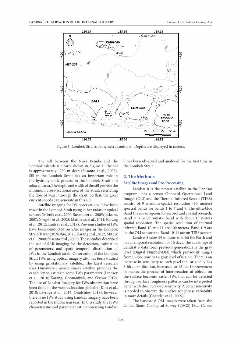
IWs characteristics is an important thing to studied because this wave can strongly influence some ocean and coastal activities such as acoustic wave propagation, submarine navigation, and coastal engineering (Klemas, 2012). Lombok Strait is very popular with the IWs intensive characteristics because it has a complex bathymetry and supported by a strong current complexity. Lombok Strait bathymetry is shown in Figure 1, in the northern part of the strait deeper than the middle section. The northern part has a depth of about 1200 m. The Bathymetric contours derived from the General Bathymetric Chart of the Oceans (GEBCO_2014) grid, version 20150318 (http://www.gebco.net) with 30 arc-second resolution.
LANDSAT 8 OBSERVATION OF THE INTERNAL SOLITARY I Wayan Gede Astawa Karang, et.al
252
Figure 1. Lombok Strait’s bathymetry contours. Depths are displayed in meters.
8 has been observed and analyzed for the first time in the Lombok Strait.
2. The MethodsSatellite Images and Pre-Processing
Landsat 8 is the newest satellite in the Landsat program,, has a sensor Onboard Operational Land Imager (OLI) and the Thermal Infrared Sensor (TIRS) consist of 9 medium-spatial resolution (30 meters) spectral bands for bands 1 to 7 and 9. The ultra-blue Band 1 is advantageous for aerosol and coastal research. Band 8 is panchromatic band with about 15 meters spatial resolution. The spatial resolution of thermal infrared Band 10 and 11 are 100 meters. Band 1-9 are on the OLI sensor and Band 10-11 are on TIRS sensor.
Landsat 8 takes 99 minutes to orbit the Earth and has a temporal resolution for 16 days. The advantage of Landsat 8 data from previous generations is the gray level (Digital Number-DN) which previously ranges from 0-256, now has a gray level of 0-4096. There is an increase in sensitivity to each pixel that originally has 8-bit quantification, increased to 12-bit. Improvement in makes the process of interpretation of objects on the surface becomes easier. IWs that can be detected through surface roughness patterns can be interpreted better with this increased sensitivity. A better sensitivity is needed to observe the surface roughness variability in more details (Chander et al., 2009).
The Landsat 8 OLI images were taken from the United States Geological Survey (USGS) Data Center
The sill between the Nusa Penida and the Lombok islands is clearly shown in Figure 1. The sill is approximately 250 m deep (Susanto et al., 2005). Sill in the Lombok Strait has an important role in the hydrodynamic process in the Lombok Strait and adjacent area. The depth and width of the sill provide the minimum cross-sectional area of the strait, restricting the flow of water through the strait. So that, the great current speeds can generate in this sill.
Satellite imaging for IW observations have been made in the Lombok Strait using either radar or optical sensors (Mitnik et al., 2000; Susanto et al., 2005; Jackson, 2007; Ningsih et al., 2008; Matthews et al., 2011; Karang et al., 2012; Lindsey et al., 2018). Previous studies of IWs have been conducted on SAR images in the Lombok Strait (Karang & Nishio, 2011; Karang et al., 2012; Mitnik et al., 2000; Susanto et al., 2005). These studies described the use of SAR imaging for the detection, estimation of parameters, and spatio-temporal distribution of IWs in the Lombok strait. Observation of the Lombok Strait IWs using optical imagery also has been studied by using geostationary satellite.. The latest research uses Himawari-8 geostationary satellite provides the capability to estimate some IWs parameters (Lindsey et al., 2018; Karang, Connaniyah, and Osawa 2019). The use of Landsat imagery for IWs observation have been done in the various location globally (Kim et al., 2018; Lavrova et al., 2016; Osadchiev, 2018), however there is no IWs study using Landsat imagery have been reported in the Indonesian seas. In this study, the ISWs characteristic and parameter estimation using Landsat
Indonesian Journal of Geography, Vol. 51 No. 3, December 2019 :251 - 260
253
(https://earthexplorer.usgs.gov/). Landsat 8 OLI/TIRS C1 Level - 1 data, where the geometric correction has been improved the accuracy using DEM topographic maps (Zanter, 2015), was used in this study. The composite Landsat 8 Bands 5 (850 – 880 nm at 30 m resolution), 4 (630 – 670 nm at 30 m resolution) and 3 (530 – 590 nm at 30 m resolution) into the red, green and blue image channels respectively is used to create
false-color images.. Full detail of the characteristics of Landsat 8 data products is given in Table 1.
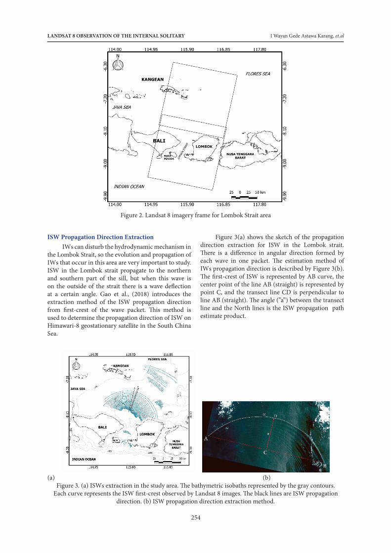
There are 14 Landsat 8 images of Lombok Strait area with cloud cover less than 10% were used for this study (Table 2). To cover the entire area of the Lombok Strait, we used two frames of Landsat 8 images as in Figure 2 to observe the ISW detection in this area.
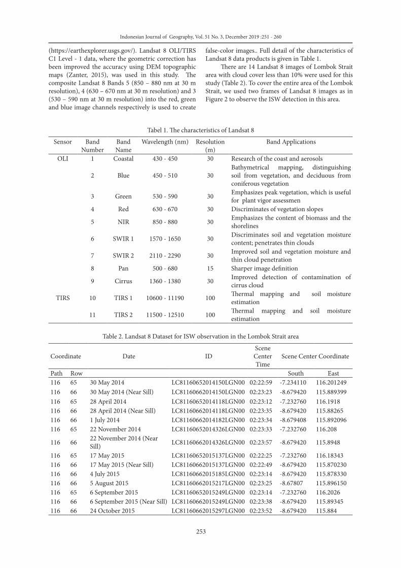
Tabel 1. The characteristics of Landsat 8Sensor Band
NumberBand Name
Wavelength (nm) Resolution (m)
Band Applications
OLI 1 Coastal 430 - 450 30 Research of the coast and aerosols
2 Blue 450 - 510 30Bathymetrical mapping, distinguishing soil from vegetation, and deciduous from coniferous vegetation
3 Green 530 - 590 30 Emphasizes peak vegetation, which is useful for plant vigor assessmen
4 Red 630 - 670 30 Discriminates of vegetation slopes
5 NIR 850 - 880 30 Emphasizes the content of biomass and the shorelines
6 SWIR 1 1570 - 1650 30 Discriminates soil and vegetation moisture content; penetrates thin clouds
7 SWIR 2 2110 - 2290 30 Improved soil and vegetation moisture and thin cloud penetration
8 Pan 500 - 680 15 Sharper image definition
9 Cirrus 1360 - 1380 30 Improved detection of contamination of cirrus cloud
TIRS 10 TIRS 1 10600 - 11190 100 Thermal mapping and soil moisture estimation
11 TIRS 2 11500 - 12510 100 Thermal mapping and soil moisture estimation
Table 2. Landsat 8 Dataset for ISW observation in the Lombok Strait area
Coordinate Date IDScene Center Time
Scene Center Coordinate
Path Row South East116 65 30 May 2014 LC81160652014150LGN00 02:22:59 -7.234110 116.201249116 66 30 May 2014 (Near Sill) LC81160662014150LGN00 02:23:23 -8.679420 115.889399116 65 28 April 2014 LC81160652014118LGN00 02:23:12 -7.232760 116.1918116 66 28 April 2014 (Near Sill) LC81160662014118LGN00 02:23:35 -8.679420 115.88265116 66 1 July 2014 LC81160662014182LGN00 02:23:34 -8.679408 115.892096116 65 22 November 2014 LC81160652014326LGN00 02:23:33 -7.232760 116.208
116 66 22 November 2014 (Near Sill) LC81160662014326LGN00 02:23:57 -8.679420 115.8948
116 65 17 May 2015 LC81160652015137LGN00 02:22:25 -7.232760 116.18343116 66 17 May 2015 (Near Sill) LC81160662015137LGN00 02:22:49 -8.679420 115.870230116 66 4 July 2015 LC81160662015185LGN00 02:23:14 -8.679420 115.878330116 66 5 August 2015 LC81160662015217LGN00 02:23:25 -8.67807 115.896150116 65 6 September 2015 LC81160652015249LGN00 02:23:14 -7.232760 116.2026116 66 6 September 2015 (Near Sill) LC81160662015249LGN00 02:23:38 -8.679420 115.89345116 66 24 October 2015 LC81160662015297LGN00 02:23:52 -8.679420 115.884
LANDSAT 8 OBSERVATION OF THE INTERNAL SOLITARY I Wayan Gede Astawa Karang, et.al
254
Figure 2. Landsat 8 imagery frame for Lombok Strait area
ISW Propagation Direction ExtractionIWs can disturb the hydrodynamic mechanism in
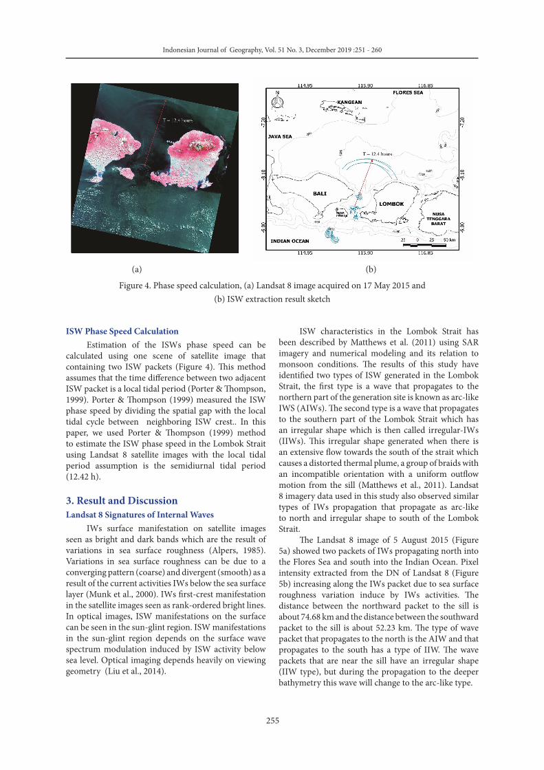
the Lombok Strait, so the evolution and propagation of IWs that occur in this area are very important to study. ISW in the Lombok strait propagate to the northern and southern part of the sill, but when this wave is on the outside of the strait there is a wave deflection at a certain angle. Gao et al., (2018) introduces the extraction method of the ISW propagation direction from first-crest of the wave packet. This method is used to determine the propagation direction of ISW on Himawari-8 geostationary satellite in the South China Sea.
Figure 3(a) shows the sketch of the propagation direction extraction for ISW in the Lombok strait. There is a difference in angular direction formed by each wave in one packet. The estimation method of IWs propagation direction is described by Figure 3(b). The first-crest of ISW is represented by AB curve, the center point of the line AB (straight) is represented by point C, and the transect line CD is perpendicular to line AB (straight). The angle (”a”) between the transect line and the North lines is the ISW propagation path estimate product.
Indonesian Journal of Geography Vol. 51 No. 3, December 2019 ( - )
DOI: http://dx.doi.org/ 10.22146/ijg.42655
8
Formatted: Font: 8 pt, Complex ScriptFont: 8 pt
١٣٥ (a) (b) ١٣٦
Figure 3. (a) ISWs extraction in the study area. The bathymetric isobaths represented by the gray contours. Each ١٣٧ curve represents the ISW first-crest observed by Landsat 8 images. The black lines are ISW propagation ١٣٨
direction. (b) ISW propagation direction extraction method. ١٣٩ ١٤٠
Figure 3(a) shows the sketch of the propagation direction extraction for ISW in the Lombok strait. There is a ١٤١
difference in angular direction formed by each wave in one packet. The estimation method of IWs propagation ١٤٢
direction is described by Figure 3(b). The first-crest of ISW is represented by AB curve, the center point of the ١٤٣
line AB (straight) is represented by point C, and the transect line CD is perpendicular to line AB (straight). The ١٤٤
angle (”a”) between the transect line and the North lines is the estimation result of ISW propagation path ١٤٥
estimate product.direction. ١٤٦
ISW Phase Speed Calculation ١٤٧
Estimation of the ISWs phase speed can be calculated using one scene of satellite image that containing two ISW ١٤٨
packets (Figure 4). This method assumes that the time difference between two adjacent ISW packet is a local ١٤٩
tidal period (Porter & Thompson, 1999). Porter & Thompson (1999) measuredestimated the ISW phase speed ١٥٠
by dividing the spatial gap with the local tidal cycle between distance neighboring between two adjacent ISW ١٥١
crest. with the local tidal period. In this paper, we used Porter & Thompson (1999) method to estimate the ISW ١٥٢
phase speed in the Lombok Sstrait using Landsat 8 satellite images with the local tidal period assumption is the ١٥٣
semidiurnal tidal period (12.42 h). ١٥٤
Formatted: Font: 10 pt, ComplexScript Font: 10 pt
Formatted: Font: 10 pt, ComplexScript Font: 10 pt
Formatted: Font: 10 pt, ComplexScript Font: 10 pt
Formatted: Font: 10 pt, ComplexScript Font: 10 pt
Formatted: Font: 10 pt, ComplexScript Font: 10 pt
Formatted: Font: 10 pt, ComplexScript Font: 10 pt
Formatted: Font: 10 pt, ComplexScript Font: 10 pt
Formatted: Font: 10 pt, ComplexScript Font: 10 pt
Formatted: Font: 10 pt, ComplexScript Font: 10 pt
Formatted: Font: 10 pt, ComplexScript Font: 10 pt
Formatted: Font: 10 pt, ComplexScript Font: 10 pt
Formatted: Font: 10 pt, ComplexScript Font: 10 pt
(a) (b)Figure 3. (a) ISWs extraction in the study area. The bathymetric isobaths represented by the gray contours.
Each curve represents the ISW first-crest observed by Landsat 8 images. The black lines are ISW propagation direction. (b) ISW propagation direction extraction method.
Indonesian Journal of Geography, Vol. 51 No. 3, December 2019 :251 - 260
255
Indonesian Journal of Geography Vol. 51 No. 3, December 2019 ( - )
DOI: http://dx.doi.org/ 10.22146/ijg.42655
9
Formatted: Font: 8 pt, Complex ScriptFont: 8 pt
١٥٥ (a) (b) ١٥٦
Figure 4. Phase speed calculation, (a) Landsat 8 image acquired on 17 May 2015 and (b) ISW extraction result ١٥٧
sketch ١٥٨
١٥٩
3. Result and Discussion ١٦٠
Landsat 8 Signatures of Internal Waves ١٦١
IWs surface manifestation on satellite images seen as bright and dark bands which are the result of variations in ١٦٢
sea surface roughness (Alpers, 1985). Variations in sea surface roughness can be due to a converging pattern ١٦٣
(coarse) and divergent (smooth) as a result of the current activities IWs below the sea surface layer (Munk et al., ١٦٤
2000). IWs first-crest manifestation in the satellite images seen as rank-ordered bright lines. In optical images, ١٦٥
ISW manifestations on the surface can be seen in the sun-glint regionarea. ISW manifestations can be seen in ١٦٦
the sun-glint regionarea depends on the modulation of the surface wave spectrum modulation induced by ISW ١٦٧
activity below sea level. Optical imaging is strongly depends heavily on dent upon viewing geometry (Liu et al., ١٦٨
2014). ١٦٩
ISW characteristics in the Lombok Strait has been described by Matthews et al. (2011) using SAR imagery and ١٧٠
numerical modeling and its relation to monsoon conditions. The results of this study have identified two types ١٧١
of ISW generated in the Lombok Strait, the first type is a wave that propagates to the northern part of the ١٧٢
generation site is known as arc-like IWS (AIWs). The second type is a wave that propagates to the southern part ١٧٣
of the Lombok Strait which has an irregular shape which is then called irregular-IWs (IIWs). This irregular ١٧٤
shape generated when there is an extensive flow towards the south of the strait which causes a distorted thermal ١٧٥
Formatted: Font: 10 pt, ComplexScript Font: 10 pt
Formatted: Font: 10 pt, ComplexScript Font: 10 pt
Formatted: Font: 10 pt, ComplexScript Font: 10 pt
Formatted: Font: 10 pt, ComplexScript Font: 10 pt
Formatted: Font: 10 pt, ComplexScript Font: 10 pt
Formatted: Font: 10 pt, ComplexScript Font: 10 pt
Formatted: Font: 10 pt, ComplexScript Font: 10 pt
Formatted: Font: 10 pt, ComplexScript Font: 10 pt
Formatted: Font: 10 pt, ComplexScript Font: 10 pt
Formatted: Font: 10 pt, ComplexScript Font: 10 pt
Formatted: Font: 10 pt, ComplexScript Font: 10 pt
Formatted: Font: 10 pt, ComplexScript Font: 10 pt
(a) (b)
Figure 4. Phase speed calculation, (a) Landsat 8 image acquired on 17 May 2015 and (b) ISW extraction result sketch
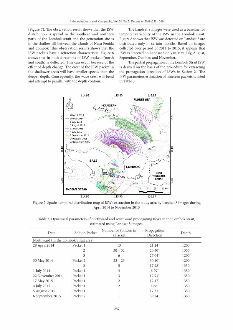
ISW characteristics in the Lombok Strait has been described by Matthews et al. (2011) using SAR imagery and numerical modeling and its relation to monsoon conditions. The results of this study have identified two types of ISW generated in the Lombok Strait, the first type is a wave that propagates to the northern part of the generation site is known as arc-like IWS (AIWs). The second type is a wave that propagates to the southern part of the Lombok Strait which has an irregular shape which is then called irregular-IWs (IIWs). This irregular shape generated when there is an extensive flow towards the south of the strait which causes a distorted thermal plume, a group of braids with an incompatible orientation with a uniform outflow motion from the sill (Matthews et al., 2011). Landsat 8 imagery data used in this study also observed similar types of IWs propagation that propagate as arc-like to north and irregular shape to south of the Lombok Strait.
The Landsat 8 image of 5 August 2015 (Figure 5a) showed two packets of IWs propagating north into the Flores Sea and south into the Indian Ocean. Pixel intensity extracted from the DN of Landsat 8 (Figure 5b) increasing along the IWs packet due to sea surface roughness variation induce by IWs activities. The distance between the northward packet to the sill is about 74.68 km and the distance between the southward packet to the sill is about 52.23 km. The type of wave packet that propagates to the north is the AIW and that propagates to the south has a type of IIW. The wave packets that are near the sill have an irregular shape (IIW type), but during the propagation to the deeper bathymetry this wave will change to the arc-like type.
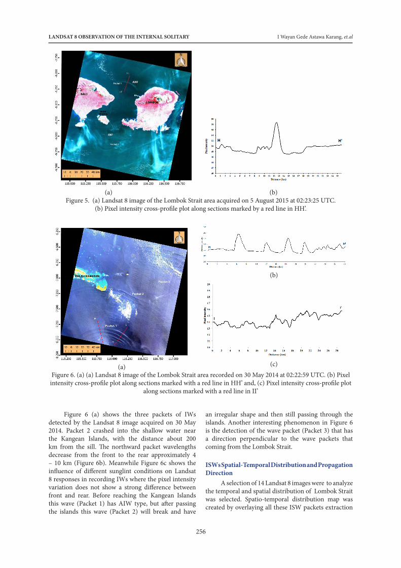
ISW Phase Speed CalculationEstimation of the ISWs phase speed can be
calculated using one scene of satellite image that containing two ISW packets (Figure 4). This method assumes that the time difference between two adjacent ISW packet is a local tidal period (Porter & Thompson, 1999). Porter & Thompson (1999) measured the ISW phase speed by dividing the spatial gap with the local tidal cycle between neighboring ISW crest.. In this paper, we used Porter & Thompson (1999) method to estimate the ISW phase speed in the Lombok Strait using Landsat 8 satellite images with the local tidal period assumption is the semidiurnal tidal period (12.42 h).
3. Result and Discussion Landsat 8 Signatures of Internal Waves
IWs surface manifestation on satellite images seen as bright and dark bands which are the result of variations in sea surface roughness (Alpers, 1985). Variations in sea surface roughness can be due to a converging pattern (coarse) and divergent (smooth) as a result of the current activities IWs below the sea surface layer (Munk et al., 2000). IWs first-crest manifestation in the satellite images seen as rank-ordered bright lines. In optical images, ISW manifestations on the surface can be seen in the sun-glint region. ISW manifestations in the sun-glint region depends on the surface wave spectrum modulation induced by ISW activity below sea level. Optical imaging depends heavily on viewing geometry (Liu et al., 2014).
LANDSAT 8 OBSERVATION OF THE INTERNAL SOLITARY I Wayan Gede Astawa Karang, et.al
256
Indonesian Journal of Geography Vol. 51 No. 3, December 2019 ( - )
DOI: http://dx.doi.org/ 10.22146/ijg.42655
10
Formatted: Font: 8 pt, Complex ScriptFont: 8 pt
plume, a group of braids with an incompatible orientation with a uniform outflow motion from the sill ١٧٦
(Matthews et al., 2011). Landsat 8 imagery data used in this study also observed similar types of IWs propagation ١٧٧
that propagate as arc-like to north and irregular shape to south of the Lombok Strait. ١٧٨
١٧٩ (a) (b) ١٨٠
١٨١ Figure 5. (a) Landsat 8 image of the Lombok Strait area acquired on 5 August 2015 at 02:23:25 UTC. (b) The plot ١٨٢ of the Ppixel intensity cross- profile plot along sections marked by a red line in HH’. ١٨٣ ١٨٤
TIn the Landsat 8 image of 5 August 2015 (Figure 5a) showed, two packets of IWs were observed propagating ١٨٥
northward into the Flores Sea and southhward into the Indian Ocean. Pixel intensity extracted from the DN of ١٨٦
Landsat 8 (Figure 5b) increasing along the IWs packet due to sea surface roughness variation induce by IWs ١٨٧
activities. The distance between the northward packet to the sill is about 74.68 km and the distance between the ١٨٨
southward packet to the sill is about 52.23 km. The type of wave packet that propagates to the north is the AIW ١٨٩
and that propagates to the south has a type of IIW. The wave packets that are near the sill have an irregular ١٩٠
shape (IIW type), but during the propagation to the deeper bathymetry this wave will change to the arc-like type. ١٩١
(b)
Formatted: Font: 10 pt, ComplexScript Font: 10 pt
Formatted: Font: 10 pt, ComplexScript Font: 10 pt
Formatted: Font: 10 pt, ComplexScript Font: 10 pt
Formatted: Font: 10 pt, ComplexScript Font: 10 pt
Formatted: Font: 10 pt, ComplexScript Font: 10 pt
Formatted: Font: 10 pt, ComplexScript Font: 10 pt
Formatted: Font: 10 pt, ComplexScript Font: 10 pt
Formatted: Font: 10 pt, ComplexScript Font: 10 pt
Formatted: Font: 10 pt, ComplexScript Font: 10 pt
Formatted: Font: 10 pt, ComplexScript Font: 10 pt
Formatted: Font: 10 pt, ComplexScript Font: 10 pt
Formatted: Font: 10 pt, ComplexScript Font: 10 pt
(a) (b)Figure 5. (a) Landsat 8 image of the Lombok Strait area acquired on 5 August 2015 at 02:23:25 UTC.
(b) Pixel intensity cross-profile plot along sections marked by a red line in HH’.
(a)
(b)
(c)Figure 6. (a) (a) Landsat 8 image of the Lombok Strait area recorded on 30 May 2014 at 02:22:59 UTC. (b) Pixel intensity cross-profile plot along sections marked with a red line in HH’ and, (c) Pixel intensity cross-profile plot
along sections marked with a red line in II’
Figure 6 (a) shows the three packets of IWs detected by the Landsat 8 image acquired on 30 May 2014. Packet 2 crashed into the shallow water near the Kangean Islands, with the distance about 200 km from the sill. The northward packet wavelengths decrease from the front to the rear approximately 4 – 10 km (Figure 6b). Meanwhile Figure 6c shows the influence of different sunglint conditions on Landsat 8 responses in recording IWs where the pixel intensity variation does not show a strong difference between front and rear. Before reaching the Kangean Islands this wave (Packet 1) has AIW type, but after passing the islands this wave (Packet 2) will break and have
an irregular shape and then still passing through the islands. Another interesting phenomenon in Figure 6 is the detection of the wave packet (Packet 3) that has a direction perpendicular to the wave packets that coming from the Lombok Strait.
ISWs Spatial-Temporal Distribution and Propagation Direction
A selection of 14 Landsat 8 images were to analyze the temporal and spatial distribution of Lombok Strait was selected. Spatio-temporal distribution map was created by overlaying all these ISW packets extraction
Indonesian Journal of Geography, Vol. 51 No. 3, December 2019 :251 - 260
257
(Figure 7). The observation result shows that the ISW distribution is spread in the southern and northern parts of the Lombok strait and the generation site is in the shallow sill between the islands of Nusa Penida and Lombok. This observation results shows that the ISW packets have a refraction characteristic. Figure 8 shows that in both directions of ISW packets (north and south) is deflected. This can occur because of the effect of depth change. The crest of the ISW packet in the shallower areas will have smaller speeds than the deeper depth. Consequently, the wave crest will bend and attempt to parallel with the depth contour.
The Landsat 8 images were used as a baseline for temporal variability of the ISW in the Lombok strait. Figure 8 shows that ISW was detected on Landsat 8 are distributed only in certain months. Based on images collected over period of 2014 to 2015, it appears that ISW is detected on Landsat 8 only in May, July, August, September, October, and November.
The partial propagation of the Lombok Strait ISW is derived on the basis of the procedure for extracting the propagation direction of ISWs in Secion 2.. The ISW parameters estimation of nineteen packets is listed in Table 3.
Figure 7. Spatio-temporal distribution map of ISWs extraction in the study area by Landsat 8 images during April 2014 to November 2015
Table 3. Dynamical parameters of northward and southward propagating ISWs in the Lombok strait, estimated using Landsat 8 images.
Date Soliton Packet Number of Solitons in a Packet
Propagation Direction Depth
Northward (in the Lombok Strait area)28 April 2014 Packet 1 13 21.24˚ 1200
2 30 – 32 20.30˚ 1350 3 6 27.04˚ 1200
30 May 2014 Packet 2 23 – 25 30.40˚ 1200 3 5 17.98˚ 1350
1 July 2014 Packet 1 4 6.29˚ 135022 November 2014 Packet 1 3 12.91˚ 135017 May 2015 Packet 1 2 12.47˚ 13504 July 2015 Packet 1 2 4.66˚ 13505 August 2015 Packet 1 1 17.31˚ 13506 September 2015 Packet 2 1 39.24˚ 1350
LANDSAT 8 OBSERVATION OF THE INTERNAL SOLITARY I Wayan Gede Astawa Karang, et.al
258
Average azimuth 19.08˚Northward (in the Flores Sea)30 May 2014 Packet 1 4 295.58˚ 4506 September 2015 Packet 1 5 289.30˚ 1200Average azimuth 292.44˚Southward30 May 2014 Packet 4 6 195.68˚ 16501 July 2014 Packet 2 4 190.51˚ 165017 May 2015 Packet 2 8 202.02˚ 16505 August 2015 Packet 2 5 190.37˚ 16506 September 2015 Packet 3 3 226.96˚ 165024 October 2015 Packet 1 2 130.62˚ 1050Average azimuth 189.36˚
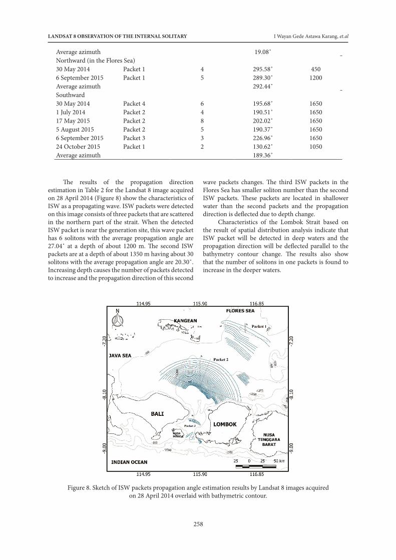
The results of the propagation direction estimation in Table 2 for the Landsat 8 image acquired on 28 April 2014 (Figure 8) show the characteristics of ISW as a propagating wave. ISW packets were detected on this image consists of three packets that are scattered in the northern part of the strait. When the detected ISW packet is near the generation site, this wave packet has 6 solitons with the average propagation angle are 27.04˚ at a depth of about 1200 m. The second ISW packets are at a depth of about 1350 m having about 30 solitons with the average propagation angle are 20.30˚. Increasing depth causes the number of packets detected to increase and the propagation direction of this second
wave packets changes. The third ISW packets in the Flores Sea has smaller soliton number than the second ISW packets. These packets are located in shallower water than the second packets and the propagation direction is deflected due to depth change.
Characteristics of the Lombok Strait based on the result of spatial distribution analysis indicate that ISW packet will be detected in deep waters and the propagation direction will be deflected parallel to the bathymetry contour change. The results also show that the number of solitons in one packets is found to increase in the deeper waters.
Figure 8. Sketch of ISW packets propagation angle estimation results by Landsat 8 images acquired on 28 April 2014 overlaid with bathymetric contour.
Indonesian Journal of Geography, Vol. 51 No. 3, December 2019 :251 - 260
259
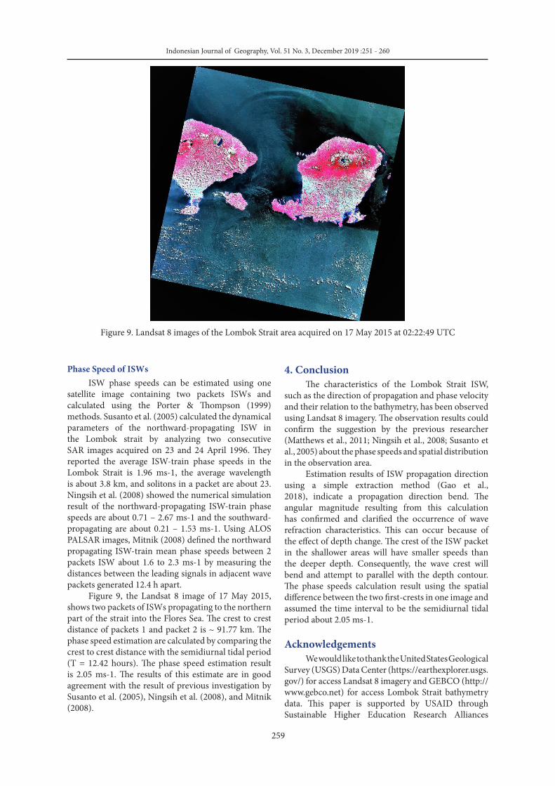
Figure 9. Landsat 8 images of the Lombok Strait area acquired on 17 May 2015 at 02:22:49 UTC
4. Conclusion The characteristics of the Lombok Strait ISW,
such as the direction of propagation and phase velocity and their relation to the bathymetry, has been observed using Landsat 8 imagery. The observation results could confirm the suggestion by the previous researcher (Matthews et al., 2011; Ningsih et al., 2008; Susanto et al., 2005) about the phase speeds and spatial distribution in the observation area.
Estimation results of ISW propagation direction using a simple extraction method (Gao et al., 2018), indicate a propagation direction bend. The angular magnitude resulting from this calculation has confirmed and clarified the occurrence of wave refraction characteristics. This can occur because of the effect of depth change. The crest of the ISW packet in the shallower areas will have smaller speeds than the deeper depth. Consequently, the wave crest will bend and attempt to parallel with the depth contour. The phase speeds calculation result using the spatial difference between the two first-crests in one image and assumed the time interval to be the semidiurnal tidal period about 2.05 ms-1.
Acknowledgements We would like to thank the United States Geological
Survey (USGS) Data Center (https://earthexplorer.usgs.gov/) for access Landsat 8 imagery and GEBCO (http://www.gebco.net) for access Lombok Strait bathymetry data. This paper is supported by USAID through Sustainable Higher Education Research Alliances
Phase Speed of ISWsISW phase speeds can be estimated using one
satellite image containing two packets ISWs and calculated using the Porter & Thompson (1999) methods. Susanto et al. (2005) calculated the dynamical parameters of the northward-propagating ISW in the Lombok strait by analyzing two consecutive SAR images acquired on 23 and 24 April 1996. They reported the average ISW-train phase speeds in the Lombok Strait is 1.96 ms-1, the average wavelength is about 3.8 km, and solitons in a packet are about 23. Ningsih et al. (2008) showed the numerical simulation result of the northward-propagating ISW-train phase speeds are about 0.71 – 2.67 ms-1 and the southward-propagating are about 0.21 – 1.53 ms-1. Using ALOS PALSAR images, Mitnik (2008) defined the northward propagating ISW-train mean phase speeds between 2 packets ISW about 1.6 to 2.3 ms-1 by measuring the distances between the leading signals in adjacent wave packets generated 12.4 h apart.
Figure 9, the Landsat 8 image of 17 May 2015, shows two packets of ISWs propagating to the northern part of the strait into the Flores Sea. The crest to crest distance of packets 1 and packet 2 is ~ 91.77 km. The phase speed estimation are calculated by comparing the crest to crest distance with the semidiurnal tidal period (T = 12.42 hours). The phase speed estimation result is 2.05 ms-1. The results of this estimate are in good agreement with the result of previous investigation by Susanto et al. (2005), Ningsih et al. (2008), and Mitnik (2008).

LANDSAT 8 OBSERVATION OF THE INTERNAL SOLITARY I Wayan Gede Astawa Karang, et.al
260
(SHERA) Program – Center for Collaborative Research Animal Biotechnology and Coral Reef Fisheries (CCR ANBIOCORE).
References Alpers, W. (1985). Theory of Radar Imaging of Internal
Waves. Nature, 314(No. 6008), 245–247.Alpers, W. (2014). Ocean Internal Waves. In Njoku, E. G.
Encyclopedia of Remote Sensing. 433-437. Springer Reference. New York.
Apel, J. R., Byrne, H. M., Proni, J. R., & Charnell, R. L. (1975). Observations of oceanic internal and surface waves from the Earth Resources Technology Satellite. Journal of Geophysical Research, 80(6).
Apel, J. R. (2004). Oceanic Internal Waves and Solitons. In Jackson, C. R. and Apel, R. Synthetic Aperture Radar Marine User’s Manual. NOAA/ NESDIS, Washington DC., 189–206.
Chander, G., Markham, B.L., Helder, D.L. (2009). Summary of current radiometric calibration coefficients for Landsat MSS, TM, ETM+, and EO-1 ALI sensors. Remote Sens. Environ., 113, 893-903
Gao, Q., Dong, D., Yang, X., Husi, L., & Shang, H. (2018). Himawari-8 Geostationary Satellite Observation of The Internal Solitary Waves In The South China Sea. In The International Archives of the Photogrammetry, Remote Sensing and Spatial Information Sciences (Vol. XLII, pp. 7–10). Beijing, China.
Jackson, C. (2007). Internal wave detection using the Moderate Resolution Imaging Spectroradiometer (MODIS). Journal of Geophysical Research. 112(C11), C11012. https://doi.org/10.1029/2007JC004220.
Karang, I. W. G. A., & Nishio, F. (2011). Internal waves in the Lombok Strait revealed by ALOS PALSAR images. In IEEE Intern Geosci.Remote Sensing Symp. IGARSS 2011 (Vol. 17, pp. 253–256). Vancouver, Canada.
Karang, I. W. G. A., Nishio, F., Mitnik, L., & Osawa, T. (2012). Spatial-Temporal Distribution and Characteristics of Internal Waves in the Lombok Strait Area Studied by Alos-Palsar Images. Earth Science Research, 1(2), 11–22. https://doi.org/10.5539/esr.v1n2p11.
Karang, I. W. G. A., Chonnaniyah & Osawa, T. (2019). Internal solitary wave observations in the Flores Sea using the Himawari-8 geostationary satellite. International Journal of Remote ensing, DOI: 10.1080/01431161.2019.1693079
Kim, H., Son, B. Y., Jeong, J-Y., and Jo, Y-H. (2018). Comparison of Internal Waves in Various Ocean Fields Around the Korean Peninsula. Journal of Coastal Research: Special Issue 85 - Proceedings of the 15th International Coastal Symposium. 466-470.
Klemas, V. (2012). Remote Sensing of Ocean Internal Waves: An Overview. Journal of Coastal Research, 282(May 2012), 540–546. https://doi.org/10.2112/JCOASTRES-D-11-00156.1.
Lavrova, O. Y., Soloviev, D. M., Strochkov, M. A., Bocharova, T. Y. (2016). River plumes investigation using Sentinel-2A MSI and Landsat-8 OLI data. Proc. SPIE 9999, Remote Sensing of the Ocean, Sea Ice, Coastal Waters, and Large Water Regions 2016, 99990G. https://doi.org/10.1117/12.2241312.
Lindsey, D. T., Nam, S. H., & Miller, S. D. (2018). Tracking oceanic nonlinear internal waves in the Indonesian seas from geostationary orbit. Remote Sensing of Environment, 208, 202–209.
Liu, B., Yang, H., Ding, X., & Li, X. (2014). Tracking the internal waves in the South China Sea with environmental satellite sun glint images. Remote Sensing Letters, 5(7), 609–618. https://doi.org/10.1080/2150704X.2014.949365
Matthews, J. P., Aiki, H., Masuda, S., Awaji, T., & Ishikawa, Y. (2011). Monsoon regulation of Lombok Strait internal waves. Journal of Geophysical Research: Oceans, 116(5), 1–14. https://doi.org/10.1029/2010JC006403
Maulana, E., Wulan, T. R., Wahyunungsih, D. S., Ibrahim, F., Putra, A. S., & Putra, M. D. (2017). Geoecology Identification Using Landsat 8 for Spatial Planning in North Sulawesi Coastal. Indonesian Journal of Geography, 49(2), 212–217. https://doi.org/http://dx.doi.org/10.22146/ijg.13189
Mitnik, L., Alpers, W., Hock, L., Branch, F. E., & Road, L. K. (2000). Thermal Plumes and Internal Solitary Waves Generated. In ERS-Envisat Symposium: Looking down to Earth in the New Millenium. Gothenburg, Sweden: European Space Agency, Publication Division, Noordwijk, The Netherlands.
Mitnik, Leonid. (2008). Advanced Land Observing Satellite PALSAR Observations of the Oceanic Dynamic Phenomena in the Coastal Zone. International Geoscience and Remote Sensing Symposium (IGARSS). 2. 351-354. 10.1109/IGARSS.2008.4779000.
Munk, W., Armi, L., Fischer, K., & Zachariasen, F. (2000). Spirals on the sea. Proceedings of the Royal Society A: Mathematical, Physical and Engineering Sciences, 456(1997), 1217–1280. https://doi.org/10.1098/rspa.2000.0560
Myasoedov, A. (2010). Sunglitter Imagery of the Ocean Surface Phenomena, (48). Retrieved from http://www.nersc.no/sites/www.nersc.no/files/SUNGLITTER IMAGERY OF THE OCEAN SURFACE PHENOMENA.pdf
Ningsih, N. S., Rahmayani, R., Hadi, S., & Brojonegoro, I. S. (2008). Internal Waves Dynamics in the Lombok Strait Studied By a Numerical Model. International Journal Of Remote Sensing And Earth Sciences, 5, 17–33.
Osadchiev, A. A. (2018). Small Mountainous Rivers Generate High-Frequency Internal Waves in Coastal Ocean. Nature Scientific reports. 8:16609. DOI:10.1038/s41598-018-35070-7.
Porter, D. L., & Thompson, D. R. (1999). Continental shelf parameters inferred from SAR internal wave observations. Journal of Atmospheric and Oceanic Technology, 16(4), 475–487.
Sawyer, C. (1983). A Satellite Study of Ocean Internal Waves. Pac. Mar. Environ. Lab., Seattle, Wash. https://doi.org/10.1108/CG-06-2013-0073.
Susanto, R. D., Mitnik, L., & Zheng, Q. (2005). Ocean Internal Waves Observed in the Lombok Strait. Oceanography, 18(4), 80–87.
Zanter, K. (2015). Landsat 8 (L8) Data User Handbook Version 1.0. EROS. South Dakota.