in respect of new inn, rugby road bulkington transport...
TRANSCRIPT

April 2018
A Planning Application by
COYNE GROUP
In respect of
New Inn, Rugby Road BULKINGTON
Transport Statement


New Inn, Rugby Road BULKINGTON Coyne Group Transport Statement
1705-78/TS/01 Transport Planning Associates
April 2017 ii
CONTENTS PAGE
1 INTRODUCTION 1
2 THE REDEVELOPMENT SITE 2
3 TRANSPORTATION PLANNING POLICY AND GUIDANCE 9
4 THE REDEVELOPMENT PROPOSALS 10
5 FORECAST DEVELOPMENT TRIP GENERATION 13
6 CONCLUSIONS 15
LIST OF FIGURES
Figure 2.1 Site Location Plan
Figure 2.2 Local Facilities and Amenities Plan
Figure 4.1 Proposed Access Arrangements
Figure 4.2 Swept Path Analysis of a Large Car Entering and Exiting the Site Access
Figure 4.3 Swept Path Analysis of a Box Van Entering and Exiting the Site Access
Figure 4.4 Swept Path Analysis of a Fire Appliance within the Site
LIST OF APPENDICES
A Warwickshire County Council Personal Injury Accident Data
B Worcestershire County Council PIC Correspondence
C Architects Masterplan
D TRICS Report – Sheltered Housing

New Inn, Rugby Road BULKINGTON Coyne Group Transport Statement
1705-78/TS/01 Transport Planning Associates April 2018 Page 1 of 14
1 INTRODUCTION
1.1 This Transport Statement (TS) has been prepared by Transport Planning Associates (TPA) on behalf of Coyne Group in order to support a detailed planning application for the redevelopment of the former New Inn Public House for 44 age-restricted residential dwellings.
1.2 This TS includes a review of the following:
(i) site description and an assessment of existing provision for all modes of travel;
(ii) review of local highway safety for the most recent five year period available;
(iii) a summarised view of relevant transport planning policy; and
(iv) assessment of forecast trips generated by the scheme using the TRICS database.
1.3 Planning permission was granted in April 2017 for the redevelopment of the site for 14 residential dwellings (reference: 034236). There were no highway objections to the scheme.
1.4 This TS concludes that the proposed redevelopment provides access on foot, by cycle and by local bus services to amenities and facilities required on a regular basis, that it has satisfactory access arrangements and that it can be accommodated without detriment to the existing safety or operation of the local highway network.
1.5 It is concluded that there are no highway or transportation reasons, which should prevent the proposed redevelopment of this site.

New Inn, Rugby Road BULKINGTON Coyne Group Transport Statement
1705-78/TS/01 Transport Planning Associates April 2018 Page 2 of 14
2 THE REDEVELOPMENT SITE
Site Location
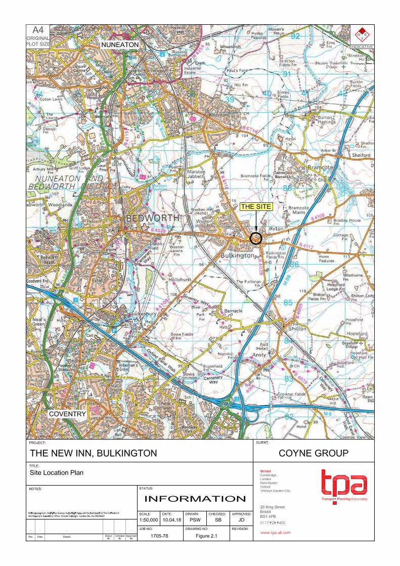
2.1 The site is located within the village of Bulkington. It is located approximately seven kilometres south of Nuneaton and approximately 13 kilometres north of Coventry. Figure
2.1 shows the location of the site in its wider geographical context.
2.2 The site is bound by Oakham Crescent to the north, east and west, a small commercial promenade to the south west and the site fronts onto both the B4112 Rugby Road and the B4109 Wolvey Road to the south with vehicular access from both of these roads.
2.3 The existing site is currently accessed via two footway crossovers on the B4112 Rugby Road and the B4109 Wolvey Road.
Planning Background
2.4 The site benefits from an existing class A4 (drinking establishment) use which dates to pre-1994.
2.5 The relevant planning history of the site is set below:
(i) TP/0442/94 – Ground and first floor extensions to the Public House (27 October 1994).
(ii) TP/0356/94 – First floor extension over dining room and garage (15 July 1994).
(iii) TP/0530/95 – Change of use of first floor flat (C3) to bed and breakfast (C1) accommodation (25 October 1995).
(iv) Single storey rear extension to form toilet area (28 April 2000).
(v) Entrance Lobby, access ramp and floodlights to side, timber decking to the rear of the property (26 March 2004).
(vi) Single storey extension to side and rear (14 January 2008).
(vii) 034236 – Demolition of the New Inn [Public House] and associated outbuildings and erection of 14 dwellings with new access road off Oakham Crescent (13 April 2017).
New Inn, Rugby Road BULKINGTON Coyne Group Transport Statement
1705-78/TS/01 Transport Planning Associates April 2018 Page 3 of 14
Local Highway Network
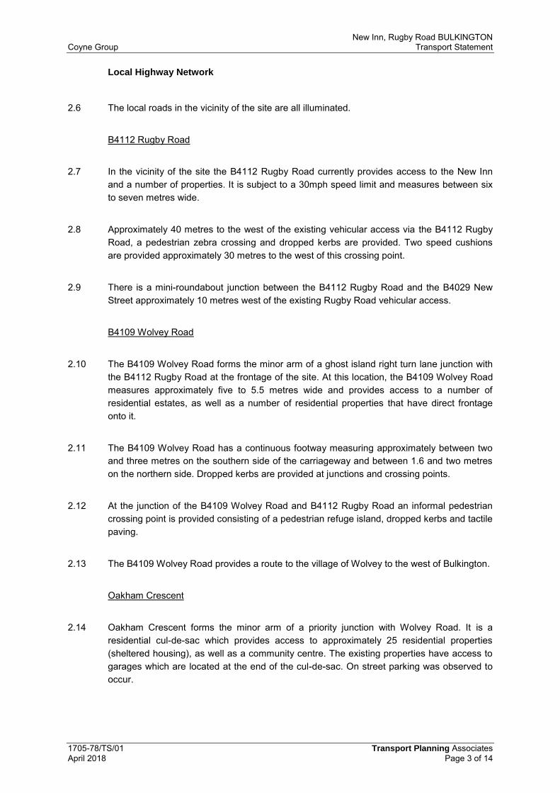
2.6 The local roads in the vicinity of the site are all illuminated.
B4112 Rugby Road
2.7 In the vicinity of the site the B4112 Rugby Road currently provides access to the New Inn and a number of properties. It is subject to a 30mph speed limit and measures between six to seven metres wide.
2.8 Approximately 40 metres to the west of the existing vehicular access via the B4112 Rugby Road, a pedestrian zebra crossing and dropped kerbs are provided. Two speed cushions are provided approximately 30 metres to the west of this crossing point.
2.9 There is a mini-roundabout junction between the B4112 Rugby Road and the B4029 New Street approximately 10 metres west of the existing Rugby Road vehicular access.
B4109 Wolvey Road
2.10 The B4109 Wolvey Road forms the minor arm of a ghost island right turn lane junction with the B4112 Rugby Road at the frontage of the site. At this location, the B4109 Wolvey Road measures approximately five to 5.5 metres wide and provides access to a number of residential estates, as well as a number of residential properties that have direct frontage onto it.
2.11 The B4109 Wolvey Road has a continuous footway measuring approximately between two and three metres on the southern side of the carriageway and between 1.6 and two metres on the northern side. Dropped kerbs are provided at junctions and crossing points.
2.12 At the junction of the B4109 Wolvey Road and B4112 Rugby Road an informal pedestrian crossing point is provided consisting of a pedestrian refuge island, dropped kerbs and tactile paving.
2.13 The B4109 Wolvey Road provides a route to the village of Wolvey to the west of Bulkington.
Oakham Crescent
2.14 Oakham Crescent forms the minor arm of a priority junction with Wolvey Road. It is a residential cul-de-sac which provides access to approximately 25 residential properties (sheltered housing), as well as a community centre. The existing properties have access to garages which are located at the end of the cul-de-sac. On street parking was observed to occur.

New Inn, Rugby Road BULKINGTON Coyne Group Transport Statement
1705-78/TS/01 Transport Planning Associates April 2018 Page 4 of 14
2.15 Oakham Crescent measures between approximately 3.7 and 4.5 metres wide and is subject to a 30mph speed limit.
2.16 A continuous footway measuring approximately two metres wide is provided on the eastern side of the carriageway. On the western side of the carriageway, a 1.5 to 1.8 metre wide footway is provided to the Community Hall, approximately 55 metres from its junction with Wolvey Road.
Existing Highway Safety
2.17 Warwickshire County Council (WCC) has provided Personal Injury Collision (PIC) data for the most recent five year period between 1st January 2011 and 7th June 2016. The study area consists of an approximate 125 metre length of Rugby Road including the Rugby Road / New Street mini roundabout junction and the Rugby Road / Wolvey Road priority junction, a 60 metre stretch of Wolvey Road including the Wolvey Road / Oakham Crescent priority junction and an 80 metre section of Oakham Crescent including the area of the proposed site access junction. The accident data confirms that there have been four slight PICs within this period. The full report is included at Appendix A.
2.18 WCC has confirmed that there have been no further PICs recorded in the study area in the most recent period between 8th June 2016 and 16th March 2018. A copy of the correspondence is contained at Appendix B.
2.19 The first PIC occurred on Wednesday 21st March 2012 at 1213 in dry, light conditions. The incident appears to have occurred when a car turning right on the mini roundabout junction between Rugby Road and New Street pulled out and collided with a cyclist already on the roundabout. The incident resulted in slight injury to the cyclist.
2.20 The second PIC occurred on Monday 10th February 2014 at 0612 in wet/damp conditions with street lighting on. The incident appears to have occurred when a vehicle turning right on the mini roundabout junction between Rugby Road and New Street collided with a cyclist who was already on the roundabout. The incident resulted in a slight injury to the cyclist.
2.21 The third PIC occurred on Wednesday 11th June 2014 at 1550 in dry and light conditions. The incident appears to have occurred when a vehicle approaching the junction between Rugby Road and Wolvey Road from the south east slowed to make a turn and the vehicle behind failed to slow and collided with the vehicle in front. The incident resulted in one slight injury.
2.22 The fourth incident occurred on Tuesday 3rd November 2015 at 1730 in wet/damp and dark conditions with street lighting on. The incident appears to have occurred when a vehicle travelling south east on Rugby Road clipped the nearside kerb after negotiating the roundabout between Rugby Road and New Street. This caused the vehicle to mount the kerb, strike a bollard and flip onto its side. The incident resulted in one slight injury.

New Inn, Rugby Road BULKINGTON Coyne Group Transport Statement
1705-78/TS/01 Transport Planning Associates April 2018 Page 5 of 14
2.23 The two incidents involving slight injuries to cyclists occurred on the Rugby Road / New Street roundabout junction on different days of the week, at different times and in different conditions. It is therefore considered that two PICs involving cyclists in a six year period does not indicate a highway safety problem at this location.
2.24 All incidents appear to have occurred as a result of temporary driver error or misjudgement. It is therefore concluded that there is no highway safety pattern or problem in the vicinity of the study area or in the vicinity of the proposed site access.
Proximity to Local Services and Amenities
2.25 The site is located approximately 730 metres to the east of Bulkington District Centre as shown on Figure 2.2. This equates to around an eight minute walk (based on a walking speed of 80 metres per minute1) and up to a two minute cycle based upon a speed of 320 metres per minute2. It is accepted that the time it takes people to walk and cycle this distance will depend on the individual’s level of health and fitness and will therefore vary from person to person. However, Manual for Streets (MfS, 2007) confirms that “walking offers the greatest potential to replace short car trips, particularly those under 2km.”
2.26 Further facilities and amenities that could be utilised on a regular basis by the residents are summarised on Table 2.1.
1 ‘Providing for Journeys on Foot’, published by the IHT in 2000 2 Transport Note 2/08 ‘Cycle Infrastructure Design’, published by the DfT in October 2008.

New Inn, Rugby Road BULKINGTON Coyne Group Transport Statement
1705-78/TS/01 Transport Planning Associates April 2018 Page 6 of 14
Table 2.1 – Proximity to Facilities and Services
2.27 Bulkington War Memorial Club recently rebranded as Poppies has recently undergone an extensive refurbishment. The Club has two rooms for hire and cater for all types of events including weddings, christenings, funerals and birthdays.
2.28 Bulkington Village Community and Conference Centre is located in the centre of Bulkington on School Road, as shown on Figure 2.2. Activities are held here on a regular basis for people of all ages including adult community learning courses, yoga, dance, dog training and acupuncture. Rooms of different sizes can also be hired for community or corporate activities and events.
2.29 A number of major supermarkets provide an online shopping and home delivery service and can deliver to Bulkington, further reducing the need for residents to travel by car.
Existing Pedestrian and Cycle Facilities
2.30 A continuous footway connection approximately two metres wide from Oakham Crescent into the village centre is provided via Rugby Road, New Street and School Road. The footways are lit throughout and the provision is considered appropriate.
Service
Distance from
centre of the site
(metres)
Walk time (based on
walk speed of 80 metres
per minute)1
Cycle time (based on
cycle speed of 320
metres per minute)2
The Fishnet Fish Bar, Mini Market Convenience Store and the Village Barber
85 1 1
Ryton Methodist Church 90 1 1
Dr R Bhavananthan - Bulkington Surgery 95 1 1
The Weavers Arms Public House 335 4 1
Bulkington War Memorial Club (Poppies) 355 4 1
Bulkington Congregational Church 445 6 1 Bulkington Library / Information Centre 550 7 2
Bulkington Village Community and Conference Centre
600 8 2
St James’ Church 680 9 2
Bulkington District local centre (includes Coop Foodstore, Spar, Post Office,
Pharmacy, Eye Clinic, Dentist, Takeaways, Cafe, Building Society, Newsagents, Hair Salons, Charity Shop, Public Houses and
other local shops)
Up to 730 9 2
Bulkington Recreational Ground 800 10 3
Bulkington Working Men’s Club 865 11 3
Parkers Fisheries and Willow Tree Cafe 870 11 3
Catholic Church of Our Lady of the Sacred Heart
1060 13 3
Weston Hall Hotel 1062 13 3
Shilton Industrial Estate 1600 20 5

New Inn, Rugby Road BULKINGTON Coyne Group Transport Statement
1705-78/TS/01 Transport Planning Associates April 2018 Page 7 of 14
2.31 Dropped kerbs are provided at appropriate crossing points and on junctions. All of the footways are lit throughout.
Existing Public Transport Provision
2.32 Bus services provide public transport services within the vicinity of the site. The closest bus stops to the site are located on New Street between approximately 170 and 205 metres to the west of the site, as shown on Figure 2.2. Both the eastbound and westbound bus stops consist of a flag pole and timetable information.
2.33 Local bus services are summarised in Table 2.2.
Table 2.2 – Summary of Existing Bus Services (based on Traveline as of 19/03/2018)
Service
Number Route Description
Service
Provider
Approximate Frequency Intervals
Monday - Saturday
Sunday
Daytime Evening
56 Nuneaton – Coventry via
Bulkington Stagecoach
Warwickshire 30 Minutes 60 – 80 Minutes 60 Minutes
74
Coventry – Nuneaton via Wolvey, Bramcote
Mike De Courcey Travel
90 -180 Minutes
No Service
74A Two Services
1249 & 1419
74B
One Saturday Service
(1249)
2.34 The first bus to depart from the stop is at approximately 0558 towards Coventry, arriving at 0651. The first bus to depart in the direction of Nuneaton is at approximately 0706 and arriving at 0729. The last bus from Nuneaton arrives at the stop at 2012 and departs Nuneaton at 1956. The last bus to arrive at the stop from Coventry is at 2150, departing Coventry (Trinity Street) at 2102.
Community Transport
2.35 Medicar Transport Service is a community transport service operated by the Volunteer Centre for Nuneaton and Bedworth.
2.36 All of the drivers are volunteers, use their own vehicles and give their time for free. The transport is provided to hospitals, doctors’ surgeries, clinics, dentists, opticians or any medically related journey. Further information can be found http://www.volunteercentre.org.uk/medicar.html.

New Inn, Rugby Road BULKINGTON Coyne Group Transport Statement
1705-78/TS/01 Transport Planning Associates April 2018 Page 8 of 14
Suitability of the Development Site
2.37 It is concluded that the site provides the opportunity for future residents to walk, cycle or use public or community transport facilities to access the site and local facilities as an alternative to the private car for typical day to day activities. It is therefore anticipated that vehicular trips associated with the residents and visitors of the proposed redevelopment could be minimised.

New Inn, Rugby Road BULKINGTON Coyne Group Transport Statement
1705-78/TS/01 Transport Planning Associates April 2018 Page 9 of 14
3 TRANSPORTATION PLANNING POLICY AND GUIDANCE
3.1 Relevant transportation policies are set out in the following documents:
(i) National Planning Policy Framework (2012);
(ii) National Planning Practice Guidance (2014);
(iii) Warwickshire County Council Local Transport Plan 2011-2026;
(iv) Nuneaton and Bedworth Borough Local Plan (adopted 2006);
(v) Nuneaton and Bedworth Borough Council Residential Design Guide 2004; and
(vi) Nuneaton and Bedworth Borough Council New Borough Plan – Publication Draft and Supporting Documents (2016).
3.2 The main thrust of recent national and local policy guidance is to:
(i) actively manage patterns of growth;
(ii) make the fullest possible use of public transport, walking and cycling; and
(iii) focus significant development in locations which are or can be made sustainable.
3.3 It is considered that the proposed development is broadly in accordance with the transportation policies of local, regional and national government, as the site is located close to an existing residential area and within walking and cycling distances of services and amenities that may be required on a daily basis.
3.4 As set out in Chapter 2, there are local bus services and facilities located nearby. As set out in Chapter 5, traffic arising from the redevelopment is forecast to be low in real terms and the residual cumulative impact of the redevelopment is therefore not considered to be material.

New Inn, Rugby Road BULKINGTON Coyne Group Transport Statement
1705-78/TS/01 Transport Planning Associates April 2018 Page 10 of 14
4 THE REDEVELOPMENT PROPOSALS
The Scheme
4.1 The scheme comprises a comprehensive redevelopment of the site for up to 44 age restricted residential dwellings consisting of one and two bedroom apartments. A copy of the Architects masterplan is contained at Appendix C.
Access Arrangements
4.2 It is proposed that the two existing access points to the site from the B4112 Rugby Road and the B4109 Wolvey Road will be closed and access to the site will be via a new priority junction with Oakham Crescent.
4.3 Concerns have been raised regarding the loss of car parking for existing residents on Oakham Crescent due to the location of the proposed access location and overspill parking from the redevelopment. Residents were reassured that the development is providing car parking that is in line with WCC’s parking guidance and 2011 Census data.
4.4 The proposed access arrangements are illustrated on Figure 4.1.and the following design measures have been included:
(i) The carriageway will be 6.5 metres wide and designed to act as a shared space. This is considered appropriate to accommodate two large cars or a refuse vehicle and large car;
(ii) Figure 4.2 and Figure 4.3 demonstrate that a large car and box van can enter and egress the site access whilst the on-street car parking spaces opposite the access are occupied and therefore will not result in a loss of existing residents car parking; and
(iii) Visibility splays of 2.4 x 43 metres can also be achieved to the nearside kerb looking left at the Oakham Crescent junction, as shown on Figure 4.1. This is in accordance with guidance set out in Manual for Streets (MfS) as speeds on Oakham Crescent are considered to be low and therefore considered appropriate.
4.5 A visibility splay of 2.4 x 30.7 metres looking right can be achieved to the give way line of the Oakham Crescent / B4109 Wolvey Road junction. Given the proximity of the junction, vehicle speeds are considered to be well below 30 mph as vehicles negotiate the junction and this is therefore considered appropriate.
Proposed Layout Design

New Inn, Rugby Road BULKINGTON Coyne Group Transport Statement
1705-78/TS/01 Transport Planning Associates April 2018 Page 11 of 14
4.6 The primary street network through the development will be designed to reflect a 15mph design speed by motorists, which is anticipated to encourage pedestrian and cycle travel.
4.7 The proposed internal layout has been designed to act as shared space for both vehicles and pedestrians and as such no segregated footways are provided. Shared space reduces the dominance of motor vehicles, reduces speeds and encourages drivers to be more accommodating towards pedestrians in line with Manual for Streets (MfS). As set out in the Council’s guidance (Nuneaton and Bedworth Borough Council Residential Design Guide, 2004), streets should be designed whereby pedestrians have priority. This approach is therefore considered to be appropriate given the scale and type of development proposed.
4.8 The scheme has been designed to accommodate the local municipal and emergency services and the development will provide access for a fire appliance with appropriate areas to manoeuvre and turn within the site and exit in a forward gear, as shown on Figure 4.4.
4.9 It is proposed that the road within the site will be built to an adoptable standard however it will not be offered for adoption.
4.10 A communal bin store will be provided onsite and refuse and recycling will be collected by a private waste management company.
Parking Provision
Car Parking
4.11 Maximum car parking standards are set out in Nuneaton and Bedworth Borough Council’s Car Parking Standards Supplementary Planning Document (SPD). The parking standards have been produced based on the likely requirement for resident and visitor spaces.
4.12 The strategy provides maximum standards for off-street parking provision for new residential developments as follows:
(i) One and Two bedroom houses / flats: one space per dwellings (maximum standard); and
(ii) Two and Three bedroom houses / flats: two spaces per dwelling (maximum standard).
4.13 It is understood from previous discussions with highway officers at WCC that these standards are no longer applicable but that there is no replacement as yet.
4.14 A total of 45 car parking spaces are proposed (including two disabled bays located in prominent locations, bay numbers 22 and 28), this is considered appropriate for the proposed number of dwellings, in line with the WCC guidance and prevent on street parking.

New Inn, Rugby Road BULKINGTON Coyne Group Transport Statement
1705-78/TS/01 Transport Planning Associates April 2018 Page 12 of 14
Cycle Parking
4.15 There is no cycle parking guidance set out within Nuneaton and Bedworth Borough Council’s guidance. However, 10 cycle parking spaces will be provided within a centurion bike store which can be accessed via a footway adjacent to car parking bay number 21.
Construction Traffic
4.16 It is considered that a Construction Traffic Management Plan (CTMP) can be secured via a suitably worded planning condition.

New Inn, Rugby Road BULKINGTON Coyne Group Transport Statement
1705-78/TS/01 Transport Planning Associates April 2018 Page 13 of 14
5 FORECAST REDEVELOPMENT TRIP GENERATION
5.1 The number of trip movements that could be associated with the proposed redevelopment has been forecast through an interrogation of the TRICS database, (2018) version 7.4.4 for the morning peak and evening peak periods on a weekday.
5.2 The TRICS database provides trip rate information based on existing trips observed from surveys at similar sites throughout England and Wales. Sites within Greater London have been excluded as a result of the greater public transport opportunities that are available. Rates in Neighbourhood Centre, Suburban and Edge of Town locations have been extracted.
5.3 The multi-modal trip numbers likely to be generated by the development of the 44 age restricted dwellings have been assessed using the ‘Sheltered Housing’ category within TRICS. These are considered to be the most representative trip rates for the age restricted dwellings. A copy of the full TRICS report is included as Appendix D and summarised daily and peak hour total multi-modal forecast trips are illustrated on Table 5.1.
Table 5.1 – Forecast Multi-Modal Trips – Age Restricted Dwellings (Sheltered Housing)
Land use
Units
Forecast two-way trip attraction
Sheltered
Housing
Vehicles Pedestrians Cyclists Public
Transport Users
Other
(PSV/OGV)
Trip Rate
Trips Trip Rate
Trips Trip Rate
Trips Trip Rate
Trips Trip Rate
Trips
AM Peak
(0800-0900) 44
0.163 7 0.135 6 0.019 1 0.00 0 0.00 0
PM Peak
(1700-1800) 0.24 11 0.067 3 0.019 0 0.00 0 0.00 0
5.4 Table 5.1 demonstrates that as a result of the proposed redevelopment there could be seven two-way vehicle movements on the local highway network associated with the age restricted residential units during the AM peak period and up to 11 two-way vehicle trips during the PM peak periods. This equates to up to around one additional vehicle every five minutes, on average.
5.5 In order to provide a robust assessment, the number of vehicle trips that could be associated with the previous public house at the site have not been considered, which will no longer be on the local highway network.

New Inn, Rugby Road BULKINGTON Coyne Group Transport Statement
1705-78/TS/01 Transport Planning Associates April 2018 Page 14 of 14
5.6 It is concluded that the proposed redevelopment will not a material impact on the safety or operation of the local highway network and is not be considered as severe in the context of NPPF.

New Inn, Rugby Road BULKINGTON Coyne Group Transport Statement
1705-78/TS/01 Transport Planning Associates April 2018 Page 15 of 14
6 CONCLUSIONS
6.1 This Transport Statement has been prepared by Transport Planning Associates on behalf of Coyne Group to address the highway and transportation issues associated with the proposed redevelopment of the New Inn Public House, Bulkington, to provide 44 age restricted residential dwellings.
6.2 This report has examined the local highway network, existing public transport provision and facilities for pedestrians and cyclists. It is concluded that this site is located appropriately with a range of local services and amenities located in the vicinity of the site.
6.3 The existing local highway network is considered to operate efficiently and safely. It is concluded that traffic arising from the development will have no material impact on the existing situation.
6.4 The proposed development of 44 age restricted dwellings will be served by a new priority junction access via Oakham Crescent. The report demonstrates that the proposed site access arrangements and servicing arrangements are appropriate.
6.5 The proposed car parking provision is considered appropriate and is in line with local and national guidance.
6.6 It is demonstrated that the redevelopment proposals could generate a maximum of 11 two way vehicle trips during the AM and PM peak hours which cannot be considered as a severe impact in the context of the NPPF.
6.7 It is therefore concluded that there are no valid transportation reasons, which should prevent the proposed residential redevelopment of this site.

New Inn, Rugby Road BULKINGTON Coyne Group Transport Statement
1705-78/TS/01 Transport Planning Associates April 2018 Figures
FIGURES