combined phase i desk study and phase ii exploratory...
TRANSCRIPT

GeoDyne Limited
Combined Phase I Desk Study and Phase II Exploratory Investigation
For
Barratt Homes (North Midlands) Ltd

Contents
Executive Summary Page No
Appendices
Project No: 35067 Date: 31st July 2015
Senior Engineer Director Director

EXECUTIVE SUMMARY
Ground Conditions Across the majority of the site, the surface materials typically comprised Topsoil which extended to depths ranging between 0.15m to 0.30m begl. Whilst this material was recorded as undisturbed Natural Strata, it is likely to contain localised small man-made inclusions.
Localised Made Ground was encountered at the location of the two potential ponds (TP9 and TP19) comprising sand with brick and concrete underlain by potential buried topsoil, and at the location of the old burnt down farm structure in the centre of the site (TP18) comprising ashy demolition debris. The Made Ground extended to depths ranging between 0.65m to 1.55m begl.
Beneath the Topsoil and Made Ground, Natural Strata was encountered tentatively assigned as the Mercia Mudstone Group. Within the former ponds, Made Ground was underlain by soft grey slightly silty Clay that extended to a depth of 2.20m begl.
Beneath the majority of the site the Topsoil was underlain by a layer of stiff fissured silty slightly gravelly Clay that may represent fluvially re-worked Mercia Mudstone or Anker Sand and Gravel, extending to depths ranging between 0.40m and 0.80m begl.
The potentially fluvially re-worked Clay was underlain by stiff fissured slightly silty Clay extending to depths ranging between 1.30m and >3.00m begl. This layer was locally soft or firm beneath the potential former ponds to depths of between 1.70m to 2.20m begl (locally not penetrated). The stiff clay locally became highly friable clay with fine to coarse fragments of extremely weak Mudstone in a sandy/clayey matrix.
Where penetrated, the stiff clay was underlain by slightly weathered weak thinly bedded closely fissured friable reddish brown Mudstone which was proven to a maximum depth of 3.00m begl but not fully penetrated. Locally, the Mudstone was interbedded with thin beds of moderately strong light grey Siltstone or fine grained Sandstone.
Foundation Design Based on our findings, foundations for the proposed redevelopment may be traditional strip or trench fill placed at a minimum depth of 1.00m below existing or proposed levels, whichever is greater and deepened below any Made Ground or soft spots.
The near surface stiff Clay is considered suitable for a nett allowable ground bearing pressure of 150kN/m2.Building Near Trees Foundation designs will require adjusting when building near existing, recently removed or proposed trees due to
the localised presence of cohesive soils beneath the site. Laboratory testing has confirmed that the cohesive soils present at the site should be regarded as being of high volume change potential and we would recommend that this classification is adopted for design purposes.
Floor Slabs and Ground Gas Precautions
Made Ground was found to be largely absent across the site but locally present in former ponds to in excess of 0.60m thickness. Furthermore, the site may be subject to re-grading works to establish required working levels. Therefore, where there is less than 600mm of geotechnically competent Made Ground beneath a floor slab (or where Made Ground is absent or removed) ground floor slabs may be designed as non-suspended i.e. ground bearing. Alternatively, where Made Ground exceeds 600mm or where preferred by the Client, the proposed structures at the site may be designed with suspended ground floor slabs i.e. beam and block. Suspended ground floor slabs are recommended where plots encroach over existing ponds.
The results of the ground gas monitoring programme have revealed that ground gas precautions are considered not to be required for the site.
Radon Radon protective measures are considered not to be required in the construction of new buildings at the site.Coal Mining No specific coal mining investigations or precautions are required in relation to historical coal mining issues.Water Significant dewatering of shallow excavations is considered unlikely to be necessary based on the site observations
undertaken to date. Slow seepages into excavations may be dealt with by pumping from sumps. Excavations Shallow excavations may require sidewall support for health and safety reasons. In addition, deep excavations will
require sidewall support for construction purposes i.e. sheet piles or trench boxes.
The natural cohesive clay soils are likely to be subject to deterioration and softening if excavations are left open and exposed to wet weather. Any softened soils should be removed from excavations prior to the pouring of concrete and foundation construction.
Deep excavations within the Mudstone may require the use of breaking equipment, although large tracked excavators may be sufficiently powerful enough to excavate through these materials.
Sulphate Classification BRE Special Digest 1 Design Sulfate Class DS-1 and ACEC classification of AC-1. CBRs and Pavements CBR values for the Made Ground materials at the site are likely to be less than 2%.
Laboratory remoulded CBR tests have been scheduled on three selected samples from near surface Natural Strata obtained from the site revealed average CBR Values of between 8.75% to 12.35%. However, in-situ CBR values may locally be significantly lower than the values revealed by the limited ex-situ remoulded CBR testing undertaken, as samples have been compacted under laboratory conditions and it may not be possible to replicate this on site.

The in-situ CBR value of subgrade materials should be confirmed by in-situ testing upon completion of installation of sewers along the line of proposed roads. All buried organic soils and buried topsoil should be removed from beneath areas of road construction.
Soakaways The presence of cohesive soils beneath the site indicates that the use of soakaways is likely to be unfeasible in this instance. Therefore, alternative methods of surface water disposal should be investigated.
Contamination Assessment The Topsoil and Natural Strata soil samples tested may be regarded as being uncontaminated for the proposed residential use of the site.
Localised Made Ground deposits (particularly the ashy materials associated with the burnt out former farm structure) should be considered as contaminated with Arsenic and Lead.
The concentrations of determinants in the samples tested are considered not to be sufficiently elevated to represent a potential significant risk to controlled waters.
Remediation Proposals Where aesthetically undesirable Made Ground or ashy Made Ground is exposed at formation level, the material should be removed from the garden or soft landscaped area prior to placement of a nominal layer of chemically clean topsoil (i.e. NHBC minimum thickness of 0.15m). The thickness of topsoil should be increased as appropriate in accordance with the Landscape Architects requirements.
The ashy Made Ground may be retained in areas of POS or planting areas beneath a suitable clean layer of topsoil (minimum NHBC thickness of 0.15m applies).
The Natural Strata underlying the site appears to be chemically uncontaminated with respect to the proposed residential end use. Consequently, where Natural Strata are exposed at formation levels (including where Made Ground is removed to expose Natural Strata) only a nominal thickness of topsoil will be required.
The above ground fuel storage tanks located at the northeastern extent of the site should be removed and the soils immediately below the tanks inspected, with any grossly impacted soils being similarly removed from site. The near surface samples collected from the vicinity of the ASTs did not reveal TPH determinands above the Tier 1 SACs, however localised impaction may have occurred beneath the tanks.
The subsequent excavation beneath the ASTs should be validated by sampling and testing for TPH compounds. Imported Soil Any imported soil or topsoil (if required) should be tested at source to ensure they are suitably clean. Any imported
topsoil should conform to BS3882: 2015 ‘Specification for topsoil’, with respect to the presence of foreign objects, and ideally nutrient levels etc.
Off-site Disposal If off-site disposal is required the chemical testing regime can be different to the chemical testing required to assess the suitability of the soils for retention on site and the risks to human health and controlled waters. Therefore, effectively a new contamination assessment may be required to classify the soils for off-site disposal with testing criteria to assess whether the soil is hazardous, non-hazardous or inert waste. In the first instance, the test results, including the WAC test results from this investigation should be supplied to landfill operators.
Due to the uncontaminated nature of the Topsoil and Natural Strata soils tested we would recommend that any excess soils are re-used either on site, or at an off-site location. The re-use of soil at an off-site location would be subject to the approval of the Local Authority Environmental Health Department for the receiving site and possible additional testing and/or assessment.
Unforeseen Circumstances Should any areas of potentially contaminated soil or anomalous features be encountered we would recommend consultation with GeoDyne.
We have been anecdotally informed by the farmer that a potential soft spot is present in the eastern extent of the southern field which, albeit relatively small (apparently an area less than 2m in diameter), it has required ‘topping up’ in the past when the feature has settled. No visual evidence of this feature was noted during the works and the location of the potential feature could not be identified. A watching brief should be maintained during clearance works by ground workers for evidence of such features, including former wells.
Construction Workers Construction personnel involved with direct contact with soils should use appropriate PPE and welfare facilities.Utilities We would recommend that this report is supplied to utility companies and their recommendations relating to
appropriate supply pipes are adhered to. Licenses, Permits, Registrations & Approvals
The Contractor/Developer is responsible for, and must ensure that, all necessary licenses, permits, registrations, plans and approvals are in place prior to commencing with the works at the site.
Statutory Consultation We would recommend that a copy of our report is issued to the Local Authority for review/comment and approval. Backfilled Ponds The recommendations in this report have assumed that the backfilled ponds will be accurately located, and their
depth and extent confirmed and the existing infill materials (which are locally organic) removed and placed at shallow depth beneath a layer of clean topsoil in areas of POS or planting areas. The excavated ponds should then be infilled with geotechnically competent material (which may be site won cohesive Natural Strata materials (excluding topsoil)).
Inaccessible Area/Pond The northeastern extent of the site was inaccessible due to an electrified fence and storage of sundry farming materials and equipment. It is anticipated that ground conditions in this area are unlikely to vary significantly from that identified across the remainder of the site. However, a potential infilled pond is present in this area which we have anecdotally been informed may have been used for burial of fire arms after the Second World War.

It is recommended that further site investigation is undertaken across the inaccessible area to confirm ground conditions. The potential infilled pond should be surveyed using geophysical methods to attempt to confirm the presence or absence of buried firearms.
Further Works The following additional works are recommended upon completion of the purchase of the site.
A programme of trial pits across eastern extent of the site in the area currently unavailable due to the presence of an electrified fence and storage of sundry farming materials and waste products (including tyres etc).These works should also further investigate the location, extent and contents of the infilled ponds. Geophysical survey work in the eastern extent to attempt to confirm and locate the presence of anecdotal fire arms, or disprove their presence. A review of any existing geophysical data in this area (i.e. archaeological surveys) may also assist in this process.

1.0 INTRODUCTION
1.1 Introduction
1.2 Scope of Works
1.3 Project Understanding
1.4 Limitations

1.5 Confidentiality

2.0 SITE DESCRIPTION & HISTORY
2.1 Site Description

2.2 Site History
TABLE 1 – HISTORICAL PUBLICATION DATA
Date Features on Site Features off Site 1880s The site comprises four fields.
A farm house is located centrally. A rectangular feature is present north of the farmhouse. There are two large ponds indicated on the site. A third smaller pond is indicated at the northeastern extent.
A road is indicated immediately beyond the sites western boundary. A residential building is located immediately beyond the sites southwestern corner. A track is indicated immediately beyond the sites southern boundary. Farm buildings are present immediately beyond the sites northern boundary at the eastern extent. Several pumps (P) are indicated associated with the building. A large pond is indicated to the north of the farm buildings.Fields are present beyond the sites northern and eastern boundaries. Fields are present beyond the road to the west and the track to the south of the site.
1900s The site appears sensibly unchanged. The sites immediate environs appear broadly unchanged. The farm to the north of the site is called Lower Farm.
1920sand
1930s
The site appears sensibly unchanged. The sites immediate environs appear broadly unchanged, although a tank is indicated adjacent to Lower farm.
1950s The farm house has a further rectangular structure to the east.
Residential properties lie adjacent to the sites northwestern corner, beyond the track south of the site and adjacent to the sites southwestern corner beyond the road, and including The Oaks Nursery.
1960sand
1970s
The ponds are no longer indicated from the 1960s.
The area of Weddington is further developed south and southwest of the site.
1990s The farm building formerly on the site is no longer indicated. The field boundary in the south of the site is no longer indicated and gaps are shown in the field boundaries centrally.
The sites immediate environs appear broadly unchanged.
2000 to 2015
The site appears sensibly unchanged. The sites immediate environs appear broadly unchanged.


3.0 GEOLOGICAL & ENVIRONMENTAL SETTING
3.1 Geological References
3.2 Geology
3.3 Faults
3.4 Made Ground
3.5 Coal Mining Report

3.7 Hydrogeology
3.8 Hydrology
3.9 Radon

3.10 Landmark Envirocheck Report

3.11 Land Use Assessment
3.11.1 On Site Assessment
3.11.2 Off Site Assessment

4.0 GROUND INVESTIGATION
4.1 Introduction
4.2 Ground Conditions

4.3 Summary
TABLE 2 – SUMMARY OF EXPLORATORY HOLE FINDINGS
Stratum Exploratory Holes Encountered
Depth to Base of Stratum (m begl)
Typical Description
Topsoil All locations except TP9, TP18 and TP19
0.15m to 0.30m Brown clayey gravelly Sand, locally sandy Clay (Topsoil).
Made Ground TP9, TP18 and TP19 0.65m to 1.55m Loose sandy ash and slag with brick, metal, glass, pipe and ceramic underlain by possible buried topsoil (TP18). The potential old ponds (TP9 and TP19) were underlain by loose clayey gravelly sand with inclusions of brick and concrete, becoming sandy clay with depth and with a basal layer of potential buried topsoil.

TABLE 2 – SUMMARY OF EXPLORATORY HOLE FINDINGS
Stratum Exploratory Holes Encountered
Depth to Base of Stratum (m begl)
Typical Description
Natural Strata TP9
Majority of locations
Majority of locations
Locally encountered.
2.20m
0.40m to 0.80m
1.30m to >3.00m
Base of stratum not encountered
Soft grey slightly silty Clay.
Stiff fissured silty slightly gravelly Clay that may represent fluvially re-worked Mercia Mudstone or the Anker Sand and Gravel.
Stiff fissured reddish brown locally with light grey slightly silty Clay (becomes friable with depth). This layer was locally soft or firm in TP9 and TP19.
Slightly weathered weak thinly bedded closely fissured friable reddish brown Mudstone. Locally, the Mudstone was interbedded with thin beds of moderately strong light grey Siltstone or fine grained Sandstone.
4.4 Water
4.5 Stability and Excavations
4.6 Standard Penetration Testing (SPTs)


4.7 In-Situ and ex-Situ Shear Vane Tests
Dep
th (m
beg
l)
Undrained Shear Strength (kN/m2)
Weddington Road, Nuneaton
Shear Vane Values (kN/m2) Vs Depth (m begl)

5.0 LABORATORY TESTING & CONTAMINATION ASSESSMENT
5.1 Introduction
5.2 Geotechnical Soil Test Results
TABLE 3 – SUMMARY OF PLASTICITY INDEX (PI) DATA
Sample Ref. MoistureContent (%)
Reported PI Value (%)
Portion Passing 425 m Sieve
Modified PI Value (%)
Volume Change Potential
TP1, 0.75m 23 47 100 NA HighTP3, 1.00m 39 55 100 NA High
TP4, 0.50-0.75m 24 34 100 NA MediumTP7, 0.35-0.60m 27 38 100 NA Medium
TP8, 0.75m 29 47 100 NA High

TABLE 3 – SUMMARY OF PLASTICITY INDEX (PI) DATA
Sample Ref. MoistureContent (%)
Reported PI Value (%)
Portion Passing 425 m Sieve
Modified PI Value (%)
Volume Change Potential
TP13, 0.35-0.60m 23 31 100 NA MediumTP15, 0.75m 26 29 100 NA MediumTP17, 0.80m 25 31 100 NA MediumTP20, 0.75m 27 51 100 NA HighTP21, 0.75m 29 49 100 NA High
TABLE 4 : SUMMARY OF REMOULDED CBR TESTING
Location Depth (m) Average Final M.C. (%)
Bulk Density (Mg/m3)
Dry Density (Mg/m3)
Average (Top and Base of samples) CBR Value (%)
TP4 0.50 24 1.99 1.60 8.75TP7 0.35-0.60 27 1.94 1.53 12.35TP13 0.35-0.60 23 1.98 1.60 11.95
5.3 Contamination Assessment Rationale

5.3.1 Selection of Appropriate Tier 1 Screening Values
5.3.2 Category 4 Screening Levels


urban
Substance Principaldomain
Urbandomain
Mineralisation domain 1
Mineralisation domain 2
Ironstone ChalkSouth
Arsenic 32 mg/kg 290 mg/kg 220 mg/kg Benzo-a-pyrene 0.5 mg/kg 3.6 mg/kgCadmium 1.0 mg/kg 2.1 mg/kg 17 mg/kg 2.9 mg/kg 2.5 mg/kgLead 180 mg/kg 820 mg/kg 2400 mg/kg
5.3.3 National Planning Policy Framework (NPPF)

The Part 2A Statutory Guidance and accompanying Impact Assessment were developed on the basis that Category 4 Screening Levels could be used under the planning regime, as they would be in Part 2A investigations directly
5.3.4 Summary
5.3.5 Selection of Soil Organic Matter (SOM) Content
5.3.6 Assessment Methodology

5.3.7 Statistical Considerations
5.3.8 Null and Alternative Hypothesis
The Null Hypothesis (Ho)
The Alternative Hypothesis (H1) (the question the selected statistical test is designed to answer)
5.3.9 95th Percentile Upper Confidence Level Mean Values

5.3.10 Considerations for Appropriate Dataset(s)
5.3.11 Consideration of Normality of Dataset
The one-sample t test
The one-sided Chebychev Theorem
Failing,however to detect non-normality in a small dataset is unlikely to compromise the validity of the one sample t-test
Given that the one sample t-test is also not sensitive to moderate departures from normality, it is recommended that assessors use the t-test unless there is good evidence that the dataset departs significantly from normality
5.3.12 Consideration of Non-Detects within the Dataset.

5.3.13 Consideration of Outliers
TABLE 5– OUTLIER DECISION MATRIX
UCL < SAC UCL > SAC Outlier Test reveals No Hotspot(s)
Determinant present at acceptable concentrations.
Pervasive contamination present in soil at unacceptable concentrations.
Outlier Test reveals Hotspot(s)
Determinant present at acceptable concentrations.
Possible second population identified. Only of potential concern where outlier is at an individual concentration in excess of the Tier 1 SAC.
Pervasive contamination present in soil at unacceptable concentrations with possible hotspots of contamination identified.
5.3.14 CLEA Averaging Area
5.3.15 Sampling Strategy

5.4 Contamination Soil Test Results
5.4.1 Standard Contamination Suite – Topsoil and Made Ground
TABLE 6 – SUMMARY OF TIER 1 SITE ACCEPTANCE CRITERIA DATA ASSESSMENTRESIDENTIAL END-USE WITH PLANT UPTAKE (TOPSOIL AND MADE GROUND)
Contaminants – Potentially Harmful to
Human Health
No. of Samples Tested
Concentration Range (mg/kg)
Tier 1 SAC (mg/kg)
C4SL(mg/kg)
UCL(mg/kg)
Tier 1 SAC Exceeded @
UCL(Yes/No)
MetalsArsenic 8 7-110 37 S4UL 37 45.9 Yes-TP18
(Made Ground) Chromium 8 29-100 910 S4UL - NA No
Copper 8 19-460 2400 S4UL - NA NoLead 8 32-230 200 C4SL 200* 61.9* No but CLEA
Mean Value Test Required-TP18 (Made
Ground) Nickel 8 28-40 180 S4UL - NA NoZinc 8 76-730 3700 S4UL - NA No
PAHsPhenanthrene 8 <0.1-0.6 95 S4UL - NA No
Anthracene 8 <0.1-0.1 2400 S4UL NA NoFluoranthene 8 <0.1-1.0 280 S4UL - NA No
Pyrene 8 <0.1-0.8 620 S4UL - NA NoBenzo(a)anthracene 8 <0.1-0.3 7.2 S4UL - NA No
Chrysene 8 <0.1-0.3 15 S4UL - NA NoBenzo(b)fluoranthene 8 <0.1-0.3 2.6 S4UL - NA NoBenzo(k)fluoranthene 8 <0.1-0.2 77 S4UL NA No
Benzo(a)pyrene 8 <0.1-0.3 2.2 S4UL 5 NA NoIndeno(123cd)pyrene 8 <0.1-0.2 27 S4UL - NA NoBenzo(ghi)perylene 8 <0.1-0.2 320 S4UL - NA No
KeyS4UL – CIEH/LQM Suitable 4 Use Levels (2015). Copyright Land Quality Management Limited reproduced with permission; Publication Number S4UL3026. All rights reserved. C4SL – C4SL value for Lead taken from DEFRA publication SP1010 and based on a residential end-use with home-grown produce pathway NA – Not applicable as Tier I SAC greater than individual soil concentrations. *– Geometric Mean (see SGV10 pg14)

5.4.2 Standard Contamination Suite – Natural Strata
TABLE 7 – SUMMARY OF TIER 1 SITE ACCEPTANCE CRITERIA DATA ASSESSMENTRESIDENTIAL END-USE WITH PLANT UPTAKE (NATURAL STRATA)
Contaminants – Potentially Harmful to
Human Health
No. of Samples Tested
Concentration Range (mg/kg)
Tier 1 SAC (mg/kg)
C4SL(mg/kg)
UCL(mg/kg)
Tier 1 SAC Exceeded @
UCL(Yes/No)
MetalsArsenic 8 7-13 37 S4UL 37 NA No
Chromium 8 33-70 910 S4UL - NA NoCopper 8 12-51 2400 S4UL - NA NoLead 8 15-28 200 C4SL 200* NA NoNickel 8 28-64 180 S4UL - NA NoZinc 8 56-87 3700 S4UL - NA No
KeyS4UL – CIEH/LQM Suitable 4 Use Levels (2015). Copyright Land Quality Management Limited reproduced with permission; Publication Number S4UL3026. All rights reserved. C4SL – C4SL value for Lead taken from DEFRA publication SP1010 and based on a residential end-use with home-grown produce pathway NA – Not applicable as Tier I SAC greater than individual soil concentrations. *– Geometric Mean (see SGV10 pg14)
5.5 Total Petroleum Hydrocarbon (TPH)

TABLE 8 – SUMMARY OF TIER 1 SITE ACCEPTANCE CRITERIA DATA ASSESSMENTRESIDENTIAL END-USE WITH PLANT UPTAKE (TOTAL PETROLEUM HYDROCARBONS)
Contaminants – Potentially Harmful to
Human Health
No. of Samples Tested
Concentration Range (mg/kg)
Tier 1 SAC (mg/kg)
C4SL(mg/kg)
UCL(mg/kg)
Tier 1 SAC Exceeded @
UCL(Yes/No)
TPHAliphatic >C12-C16 2 <2-15 1100 S4UL 37 NA NoAliphatic >C16-C21 2 <1-300 65000 S4UL - NA NoAliphatic >C21-C35 2 27-540 65000 S4UL - NA NoAliphatic >C35-C44 2 7-74 65000 C4SL 200* NA NoAromatic >C16-C21 2 <1-79 260 S4UL - NA NoAromatic >C21-C35 2 7-310 1100 S4UL NA NoAromatic >C35-C44 2 2-120 1100 S4UL NA No
BTEXToluene 2 <0.02-0.023 130 S4UL NA No
KeyS4UL – CIEH/LQM Suitable 4 Use Levels (2015). Copyright Land Quality Management Limited reproduced with permission; Publication Number S4UL3026. All rights reserved. C4SL – C4SL value for Lead taken from DEFRA publication SP1010 and based on a residential end-use with home-grown produce pathway NA – Not applicable as Tier I SAC greater than individual soil concentrations. *– Geometric Mean (see SGV10 pg14)
5.6 Pesticides/Insecticides
5.7 Asbestos
5.8 Contamination Assessment Summary
6.0 GROUND GAS & WATER MONITORING
6.1 Introduction
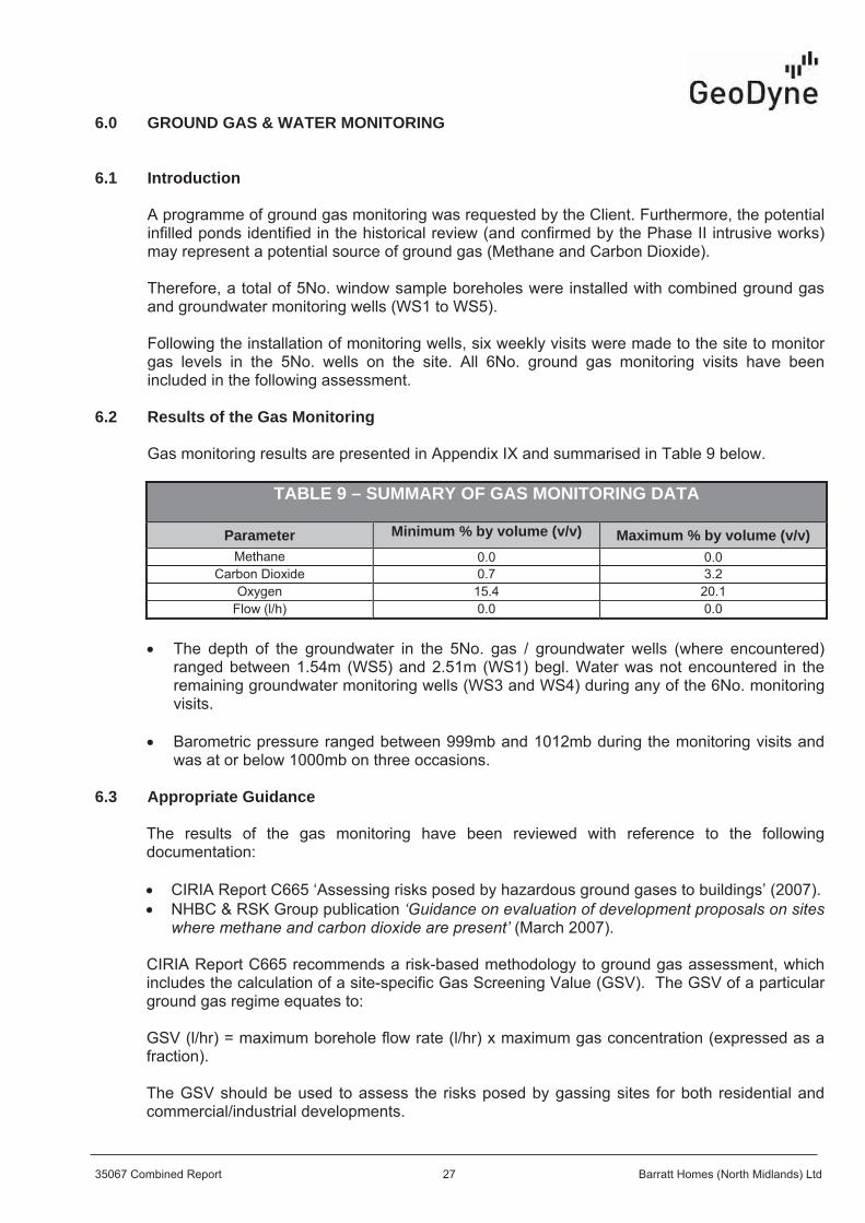
6.2 Results of the Gas Monitoring
TABLE 9 – SUMMARY OF GAS MONITORING DATA
Parameter Minimum % by volume (v/v) Maximum % by volume (v/v)
6.3 Appropriate Guidance
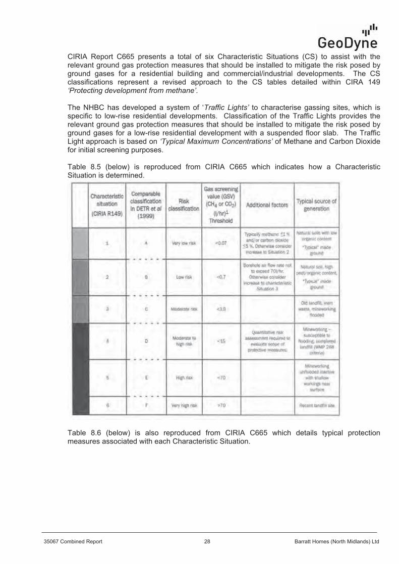


6.4 Ground Gas Analysis
6.5 Ground Gas Precautions

7.0 CONCEPTUAL SITE MODEL
7.1 General


7.2 CPR Considerations
7.3 Consideration of Potential Sources of Contamination (C)
7.4 Consideration of Potential Pathways (P)
7.5 Consideration of Potential Receptors (R)
7.6 Summary

TABLE 10 – SUMMARY OF CPR ASSESSMENT
Contaminant Pathway Receptor Comments
Plau
sible
Pollu
tant
Lin
kage
Possible Mitigation
Possible Statutory
‘Contaminated Land’
followingmitigation
Contaminated Soils
DirectIngestion & Direct Contact
Site Workers The soils tested at the site may be regarded as being uncontaminated for the proposed end use.
Localised ashy Made Ground should be excluded from gardens and soft landscaping.
X
Site workers to wear appropriate PPE for health and safety reasons.
X
Contaminated Soils
Inhalationof Dust
Site Workers The soils tested at the site may be regarded as being uncontaminated for the proposed end use.
XSite workers to wear appropriate PPE for health and safety reasons. X
Contaminated Soils
DirectIngestion & Direct Contact
End Users The soils tested at the site may be regarded as being uncontaminated for the proposed end use.
Localised ashy Made Ground should be excluded from gardens and soft landscaping.
X
Provision of suitable topsoil growing media.
X
Contaminated Soils
Inhalationof Dust
End Users The soils tested at the site may be regarded as being uncontaminated for the proposed end use.
Localised ashy Made Ground should be excluded from gardens and soft landscaping.
Following site development, generation of significant levels of dust on a chronic basis unlikely.
X
Provision of suitable topsoil growing media.
X
Contaminated Soils
DirectIngestion
Flora andFauna
The soils tested at the site may be regarded as being uncontaminated for the proposed end use.
Localised ashy Made Ground should be excluded from gardens and soft landscaping.
X
Provision of suitable topsoil growing media.
X
Contaminated Soils
Verticaland lateral migration
ControlledWaters
The concentrations of determinants detected are considered unlikely to represent a potential significant risk to controlled waters.
X
No specific mitigation required in relation to the chemical status of the soils at the site. X
Contaminated Soils
Directcontact
BuildingMaterials
Design Class DS-1/ACEC Class AC-1 (BRE Spec. Digest 1).
XAdopt appropriate concrete mix to all buried concrete.
XContaminated Soils
Directcontact
Services The soils tested at the site may be regarded as being uncontaminated for the proposed end use.
XConsult utility companies regarding appropriate utility materials (including water supply pipes).
X
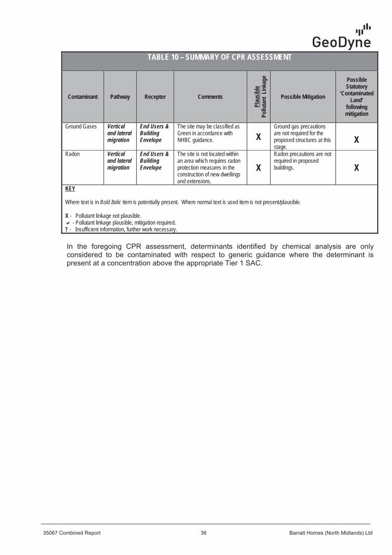
TABLE 10 – SUMMARY OF CPR ASSESSMENT
Contaminant Pathway Receptor Comments
Plau
sible
Pollu
tant
Lin
kage
Possible Mitigation
Possible Statutory
‘Contaminated Land’
followingmitigation
Ground Gases Verticaland lateral migration
End Users &BuildingEnvelope
The site may be classified as Green in accordance with NHBC guidance. X
Ground gas precautions are not required for the proposed structures at this stage.
XRadon Vertical
and lateral migration
End Users &BuildingEnvelope
The site is not located within an area which requires radon protection measures in the construction of new dwellings and extensions.
XRadon precautions are notrequired in proposed buildings. X
KEY
Where text is in Bold Italic item is potentially present. Where normal text is used item is not present/plausible.
X - Pollutant linkage not plausible. - Pollutant linkage plausible, mitigation required.
? - Insufficient information, further work necessary.

8.0 CONCLUSIONS & RECOMMENDATIONS
8.1 Ground Conditions
8.2 Foundation Design

2
8.3 Building Near Trees
8.4 Floor Slabs and Ground Gas Precautions
8.5 Radon
8.6 Coal Mining
8.7 Water

8.8 Excavations
8.9 Sulphate Classification
8.10 CBRs and Pavements
8.11 Soakaways

8.12 Contamination Assessment
8.13 Remediation Proposals
8.13.1 Proposed Gardens and Soft Landscaped Areas
8.13.2 Topsoil
8.13.3 Off-site Disposal
8.13.4 Removal of ASTs
8.14 Unforeseen Circumstances
8.15 Construction Workers
8.16 Utilities

8.17 Licenses, Permits, Registrations and Approvals
8.18 Statutory Consultation
8.19 Backfilled Ponds
8.20 Inaccessible Area/Pond
8.21 Further Works

APPENDIX I
Site Location Plan (Figure No. 35067/01)


APPENDIX II
Annotated Site Plan (Figure No. 35067/02)


APPENDIX III
Site Plans Showing Site Views (Figure No’s 35067/03)


APPENDIX IV
Exploratory Hole Location Plan (Figure No. 35067/04)


APPENDIX V
Exploratory Hole Logs

Legend Depth
Project No:
Description of Strata (m)Sample
RefSample
Type
Field
TypeTest
FieldTest
ResultGround-Water
Remarks:
Project: Client:
Logged:
Date:
Checked & Approved: Field Book Ref: Plant:
Scale:
Drawing No.
2 2
Weddington Road, Nuneaton Barratt Homes Limited
TP1

Legend Depth
Project No:
Description of Strata (m)Sample
RefSample
Type
Field
TypeTest
FieldTest
ResultGround-Water
Remarks:
Project: Client:
Logged:
Date:
Checked & Approved: Field Book Ref: Plant:
Scale:
Drawing No.
2 2
Weddington Road, Nuneaton Barratt Homes Limited
TP2

Legend Depth
Project No:
Description of Strata (m)Sample
RefSample
Type
Field
TypeTest
FieldTest
ResultGround-Water
Remarks:
Project: Client:
Logged:
Date:
Checked & Approved: Field Book Ref: Plant:
Scale:
Drawing No.
2 2
Weddington Road, Nuneaton Barratt Homes Limited
TP3

Legend Depth
Project No:
Description of Strata (m)Sample
RefSample
Type
Field
TypeTest
FieldTest
ResultGround-Water
Remarks:
Project: Client:
Logged:
Date:
Checked & Approved: Field Book Ref: Plant:
Scale:
Drawing No.
2 2
Weddington Road, Nuneaton Barratt Homes Limited
TP4

Legend Depth
Project No:
Description of Strata (m)Sample
RefSample
Type
Field
TypeTest
FieldTest
ResultGround-Water
Remarks:
Project: Client:
Logged:
Date:
Checked & Approved: Field Book Ref: Plant:
Scale:
Drawing No.
2 2
Weddington Road, Nuneaton Barratt Homes Limited
TP5

Legend Depth
Project No:
Description of Strata (m)Sample
RefSample
Type
Field
TypeTest
FieldTest
ResultGround-Water
Remarks:
Project: Client:
Logged:
Date:
Checked & Approved: Field Book Ref: Plant:
Scale:
Drawing No.
2 2
Weddington Road, Nuneaton Barratt Homes Limited
TP6

Legend Depth
Project No:
Description of Strata (m)Sample
RefSample
Type
Field
TypeTest
FieldTest
ResultGround-Water
Remarks:
Project: Client:
Logged:
Date:
Checked & Approved: Field Book Ref: Plant:
Scale:
Drawing No.
2 2
Weddington Road, Nuneaton Barratt Homes Limited
TP7

Legend Depth
Project No:
Description of Strata (m)Sample
RefSample
Type
Field
TypeTest
FieldTest
ResultGround-Water
Remarks:
Project: Client:
Logged:
Date:
Checked & Approved: Field Book Ref: Plant:
Scale:
Drawing No.
2 2
Weddington Road, Nuneaton Barratt Homes Limited
TP8

Legend Depth
Project No:
Description of Strata (m)Sample
RefSample
Type
Field
TypeTest
FieldTest
ResultGround-Water
Remarks:
Project: Client:
Logged:
Date:
Checked & Approved: Field Book Ref: Plant:
Scale:
Drawing No.
2 2
Weddington Road, Nuneaton Barratt Homes Limited
TP9

Legend Depth
Project No:
Description of Strata (m)Sample
RefSample
Type
Field
TypeTest
FieldTest
ResultGround-Water
Remarks:
Project: Client:
Logged:
Date:
Checked & Approved: Field Book Ref: Plant:
Scale:
Drawing No.
2 2
Weddington Road, Nuneaton Barratt Homes Limited
TP10

Legend Depth
Project No:
Description of Strata (m)Sample
RefSample
Type
Field
TypeTest
FieldTest
ResultGround-Water
Remarks:
Project: Client:
Logged:
Date:
Checked & Approved: Field Book Ref: Plant:
Scale:
Drawing No.
2 2
Weddington Road, Nuneaton Barratt Homes Limited
TP11

Legend Depth
Project No:
Description of Strata (m)Sample
RefSample
Type
Field
TypeTest
FieldTest
ResultGround-Water
Remarks:
Project: Client:
Logged:
Date:
Checked & Approved: Field Book Ref: Plant:
Scale:
Drawing No.
2 2
Weddington Road, Nuneaton Barratt Homes Limited
TP12

Legend Depth
Project No:
Description of Strata (m)Sample
RefSample
Type
Field
TypeTest
FieldTest
ResultGround-Water
Remarks:
Project: Client:
Logged:
Date:
Checked & Approved: Field Book Ref: Plant:
Scale:
Drawing No.
2 2
Weddington Road, Nuneaton Barratt Homes Limited
TP13

Legend Depth
Project No:
Description of Strata (m)Sample
RefSample
Type
Field
TypeTest
FieldTest
ResultGround-Water
Remarks:
Project: Client:
Logged:
Date:
Checked & Approved: Field Book Ref: Plant:
Scale:
Drawing No.
2 2
Weddington Road, Nuneaton Barratt Homes Limited
TP14

Legend Depth
Project No:
Description of Strata (m)Sample
RefSample
Type
Field
TypeTest
FieldTest
ResultGround-Water
Remarks:
Project: Client:
Logged:
Date:
Checked & Approved: Field Book Ref: Plant:
Scale:
Drawing No.
2 2
Weddington Road, Nuneaton Barratt Homes Limited
TP15

Legend Depth
Project No:
Description of Strata (m)Sample
RefSample
Type
Field
TypeTest
FieldTest
ResultGround-Water
Remarks:
Project: Client:
Logged:
Date:
Checked & Approved: Field Book Ref: Plant:
Scale:
Drawing No.
2 2
Weddington Road, Nuneaton Barratt Homes Limited
TP16

Legend Depth
Project No:
Description of Strata (m)Sample
RefSample
Type
Field
TypeTest
FieldTest
ResultGround-Water
Remarks:
Project: Client:
Logged:
Date:
Checked & Approved: Field Book Ref: Plant:
Scale:
Drawing No.
2 2
Weddington Road, Nuneaton Barratt Homes Limited
TP17

Legend Depth
Project No:
Description of Strata (m)Sample
RefSample
Type
Field
TypeTest
FieldTest
ResultGround-Water
Remarks:
Project: Client:
Logged:
Date:
Checked & Approved: Field Book Ref: Plant:
Scale:
Drawing No.
2 2
Weddington Road, Nuneaton Barratt Homes Limited
TP18

Legend Depth
Project No:
Description of Strata (m)Sample
RefSample
Type
Field
TypeTest
FieldTest
ResultGround-Water
Remarks:
Project: Client:
Logged:
Date:
Checked & Approved: Field Book Ref: Plant:
Scale:
Drawing No.
2 2
Weddington Road, Nuneaton Barratt Homes Limited
TP18

Legend Depth
Project No:
Description of Strata (m)Sample
RefSample
Type
Field
TypeTest
FieldTest
ResultGround-Water
Remarks:
Project: Client:
Logged:
Date:
Checked & Approved: Field Book Ref: Plant:
Scale:
Drawing No.
2 2
Weddington Road, Nuneaton Barratt Homes Limited
TP19

Legend Depth
Project No:
Description of Strata (m)Sample
RefSample
Type
Field
TypeTest
FieldTest
ResultGround-Water
Remarks:
Project: Client:
Logged:
Date:
Checked & Approved: Field Book Ref: Plant:
Scale:
Drawing No.
2 2
Weddington Road, Nuneaton Barratt Homes Limited
TP20

Legend Depth
Project No:
Description of Strata (m)Sample
RefSample
Type
Field
TypeTest
FieldTest
ResultGround-Water
Remarks:
Project: Client:
Logged:
Date:
Checked & Approved: Field Book Ref: Plant:
Scale:
Drawing No.
2 2
Weddington Road, Nuneaton Barratt Homes Limited
TP21

Legend Depth
Project No:
Description of Strata (m)Sample
RefSample
Type
Field
TypeTest
FieldTest
ResultGround-Water
Remarks:
Project: Client:
Logged:
Date:
Checked & Approved: Field Book Ref: Plant:
Scale:
Drawing No.
2 2
Weddington Road, Nuneaton Barratt Homes Limited
TP22

Depth &LegendDepth (Thickness)Type Sample SPT
(m) Ref "N"Value
Samples and TestsDescription of Strata
(m)Casing
(m)Ground-water Installation
Remarks:
Project:Logged:Date:
Client:Checked & Approved: Field Book Ref: Plant:
Scale:Drawing Ref:
Key:
Weddington Road, Nuneaton Barratt Homes Limited
WS1

Depth &LegendDepth (Thickness)Type Sample SPT
(m) Ref "N"Value
Samples and TestsDescription of Strata
(m)Casing
(m)Ground-water Installation
Remarks:
Project:Logged:Date:
Client:Checked & Approved: Field Book Ref: Plant:
Scale:Drawing Ref:
Key:
Weddington Road, Nuneaton Barratt Homes Limited
WS2

Depth &LegendDepth (Thickness)Type Sample SPT
(m) Ref "N"Value
Samples and TestsDescription of Strata
(m)Casing
(m)Ground-water Installation
Remarks:
Project:Logged:Date:
Client:Checked & Approved: Field Book Ref: Plant:
Scale:Drawing Ref:
Key:
Weddington Road, Nuneaton Barratt Homes Limited
WS3

Depth &LegendDepth (Thickness)Type Sample SPT
(m) Ref "N"Value
Samples and TestsDescription of Strata
(m)Casing
(m)Ground-water Installation
Remarks:
Project:Logged:Date:
Client:Checked & Approved: Field Book Ref: Plant:
Scale:Drawing Ref:
Key:
Weddington Road, Nuneaton Barratt Homes Limited
WS4

Depth &LegendDepth (Thickness)Type Sample SPT
(m) Ref "N"Value
Samples and TestsDescription of Strata
(m)Casing
(m)Ground-water Installation
Remarks:
Project:Logged:Date:
Client:Checked & Approved: Field Book Ref: Plant:
Scale:Drawing Ref:
Key:
Weddington Road, Nuneaton Barratt Homes Limited
WS5

APPENDIX VI
Laboratory Soil Test Results

Scientific Analysis Laboratories LtdCertificate of Analysis
Hadfield HouseHadfield Street
CornbrookManchester
M16 9FETel : 0161 874 2400Fax : 0161 874 2468
Report Number: 486421-1
Date of Report: 24-Jun-2015
Customer: Geodyne LtdUnit 2.2Clarendon HouseClarendon Business ParkNottinghamNottinghamshireNG5 1AH
Customer Contact: Mr Ross McIntyre
Customer Job Reference: 35067Customer Site Reference: Wedding Road, Nuneaton
Date Job Received at SAL: 16-Jun-2015Date Analysis Started: 18-Jun-2015
Date Analysis Completed: 22-Jun-2015
The results reported relate to samples received in the laboratoryOpinions and interpretations expressed herein are outside the scope of UKAS accreditationThis report should not be reproduced except in full without the written approval of the laboratoryTests covered by this certificate were conducted in accordance with SAL SOPsAll results have been reviewed in accordance with Section 25 of the SAL Quality Manual
This document has been printed from a digitally signed master copy
Scientific Analysis Laboratories is a
limited company registered in England and
Wales (No 2514788) whose address is at
Hadfield House, Hadfield Street, Manchester M16 9FE
1549
Report checkedand authorised by :Chris MurphyProject Manager
Issued by :Chris MurphyProject Manager
Page 1 of 3
486421-1

SAL Reference: 486421
Project Site: Wedding Road, Nuneaton
Customer Reference: 35067
Soil Analysed as Soil
MCERTS Preparation
SAL Reference 486421 001 486421 002Customer Sample Reference GRAB 1 GRAB 2
Date Sampled 12-JUN-2015 12-JUN-2015Type Topsoil Topsoil
Determinand Method TestSample LOD Units
MCERTS Classification T143 AR
Moisture @ 105 C T162 AR 0.1 % 46 18
SAL Reference: 486421
Project Site: Wedding Road, Nuneaton
Customer Reference: 35067
Soil Analysed as Soil
Geodyne TPH (CWG)
SAL Reference 486421 001 486421 002Customer Sample Reference GRAB 1 GRAB 2
Date Sampled 12-JUN-2015 12-JUN-2015Type Topsoil Topsoil
Determinand Method TestSample LOD Units
TPH (C5-C6 aliphatic) T209 M105 0.100 mg/kg (110) <0.200 (110) <0.200
TPH (C6-C8 aliphatic) T209 M105 0.10 mg/kg (110) <0.20 (110) <0.20
TPH (C8-C10 aliphatic) T209 M105 0.10 mg/kg (110) <0.20 (110) <0.20
TPH (C10-C12 aliphatic) T206 M105 1 mg/kg <1 (9) <10
TPH (C12-C16 aliphatic) T206 M105 2 mg/kg <2 15TPH (C16-C21 aliphatic) T206 M105 1 mg/kg <1 300TPH (C21-C35 aliphatic) T206 M105 4 mg/kg 27 540TPH (C35-C44 aliphatic) T8 M105 1 mg/kg 7 74
TPH (C6-C7 aromatic) T209 M105 0.10 mg/kg (110) <0.20 (110) <0.20
TPH (C7-C8 aromatic) T209 M105 0.10 mg/kg (110) <0.20 (110) <0.20
TPH (C8-C10 aromatic) T209 M105 0.10 mg/kg (110) <0.20 (110) <0.20
TPH (C10-C12 aromatic) T206 M105 1 mg/kg <1 (9) <10
TPH (C12-C16 aromatic) T206 M105 1 mg/kg <1 (9) <10
TPH (C16-C21 aromatic) T206 M105 1 mg/kg <1 79TPH (C21-C35 aromatic) T206 M105 1 mg/kg 7 310TPH (C35-C44 aromatic) T8 M105 1 mg/kg 2 120TPH (Aliphatic) total T85 M105 mg/kg 33 940TPH (Aromatic) total T85 M105 mg/kg 8.8 510TPH (Aliphatic+Aromatic) (sum) T85 M105 mg/kg 42 1500
SAL Reference: 486421
Project Site: Wedding Road, Nuneaton
Customer Reference: 35067
Soil Analysed as Soil
BTEX GRO MTBE
SAL Reference 486421 001 486421 002Customer Sample Reference GRAB 1 GRAB 2
Date Sampled 12-JUN-2015 12-JUN-2015Type Topsoil Topsoil
Determinand Method TestSample LOD Units
Benzene T209 M105 10 μg/kg (13,110) <20 (110,13) <20
Toluene T209 M105 10 μg/kg 23 (110) <20
EthylBenzene T209 M105 10 μg/kg (110) <20 (110) <20
M/P Xylene T209 M105 10 μg/kg (110) <20 (110) <20
O Xylene T209 M105 10 μg/kg (110) <20 (110) <20
Methyl tert-Butyl Ether T209 M105 10 μg/kg (110) <20 (110) <20
Gasoline Range Organics T54 M105 100 μg/kg (110) <100 (110) <100
This document has been printed from a digitally signed master copy
Produced by Scientific Analysis Laboratories Ltd, Hadfield House, Hadfield Street, Cornbrook, Manchester, M16 9FE Page 2 of 3
486421-1

Index to symbols used in 486421-1
Method Index
Accreditation Summary
Value DescriptionAR As Received
M105 Analysis conducted on an "as received" aliquot.Results are reported on a dry weight basis wheremoisture content was determined by assisted drying ofsample at 105C
9 LOD raised due to dilution of sample
110 LOD raised due to low internal standard recovery.
13 Results have been blank corrected.
M Analysis is MCERTS accredited
N Analysis is not UKAS accredited
Value DescriptionT85 Calc
T206 GC/FID (MCERTS)
T8 GC/FID
T143 Process
T162 Grav (1 Dec) (105 C)
T209 GC/MS(Head Space)(MCERTS)
T54 GC/MS (Headspace)
Determinand Method TestSample LOD Units Symbol SAL References
TPH (C5-C6 aliphatic) T209 M105 0.100 mg/kg N 001-002
TPH (C6-C8 aliphatic) T209 M105 0.10 mg/kg N 001-002
TPH (C8-C10 aliphatic) T209 M105 0.10 mg/kg N 001-002
TPH (C10-C12 aliphatic) T206 M105 1 mg/kg N 001-002
TPH (C12-C16 aliphatic) T206 M105 2 mg/kg M 001-002
TPH (C16-C21 aliphatic) T206 M105 1 mg/kg M 001-002
TPH (C21-C35 aliphatic) T206 M105 4 mg/kg M 001-002
TPH (C35-C44 aliphatic) T8 M105 1 mg/kg N 001-002
TPH (C6-C7 aromatic) T209 M105 0.10 mg/kg N 001-002
TPH (C7-C8 aromatic) T209 M105 0.10 mg/kg N 001-002
TPH (C8-C10 aromatic) T209 M105 0.10 mg/kg N 001-002
TPH (C10-C12 aromatic) T206 M105 1 mg/kg M 001-002
TPH (C12-C16 aromatic) T206 M105 1 mg/kg M 001-002
TPH (C16-C21 aromatic) T206 M105 1 mg/kg M 001-002
TPH (C21-C35 aromatic) T206 M105 1 mg/kg M 001-002
TPH (C35-C44 aromatic) T8 M105 1 mg/kg N 001-002
TPH (Aliphatic) total T85 M105 mg/kg N 001-002
TPH (Aromatic) total T85 M105 mg/kg N 001-002
TPH (Aliphatic+Aromatic) (sum) T85 M105 mg/kg N 001-002
Benzene T209 M105 10 μg/kg M 001-002
Toluene T209 M105 10 μg/kg M 001-002
EthylBenzene T209 M105 10 μg/kg M 001-002
M/P Xylene T209 M105 10 μg/kg M 001-002
O Xylene T209 M105 10 μg/kg M 001-002
Methyl tert-Butyl Ether T209 M105 10 μg/kg M 001-002
Gasoline Range Organics T54 M105 100 μg/kg N 001-002
MCERTS Classification T143 AR M 001-002
Moisture @ 105 C T162 AR 0.1 % N 001-002
This document has been printed from a digitally signed master copy
Produced by Scientific Analysis Laboratories Ltd, Hadfield House, Hadfield Street, Cornbrook, Manchester, M16 9FE Page 3 of 3
486421-1

Scientific Analysis Laboratories LtdCertificate of Analysis
Hadfield HouseHadfield Street
CornbrookManchester
M16 9FETel : 0161 874 2400Fax : 0161 874 2468
Report Number: 482614-1
Date of Report: 09-Jun-2015
Customer: Geodyne LtdThe GranaryChurch LaneThrumptonNottinghamshireNG11 0AX
Customer Contact: Mr Chris Paling
Customer Job Reference: 35067Customer Purchase Order: 482614
Customer Site Reference: NuneatonDate Job Received at SAL: 01-Jun-2015
Date Analysis Started: 04-Jun-2015Date Analysis Completed: 09-Jun-2015
The results reported relate to samples received in the laboratoryOpinions and interpretations expressed herein are outside the scope of UKAS accreditationThis report should not be reproduced except in full without the written approval of the laboratoryTests covered by this certificate were conducted in accordance with SAL SOPsAll results have been reviewed in accordance with Section 25 of the SAL Quality Manual
This document has been printed from a digitally signed master copy
Scientific Analysis Laboratories is a
limited company registered in England and
Wales (No 2514788) whose address is at
Hadfield House, Hadfield Street, Manchester M16 9FE
1549
Report checkedand authorised by :Ross WalkerSales Support Manager
Issued by : Ross WalkerSales Support Manager
Page 1 of 9
482614-1

SAL Reference: 482614
Project Site: Nuneaton
Customer Reference: 35067
Soil Analysed as Soil
MCERTS Preparation
SAL Reference 482614 013 482614 014 482614 019 482614 020 482614 024 482614 025Customer Sample Reference TP5 TP5 TP7 TP7 TP9 TP9
Date Sampled 29-MAY-2015 29-MAY-2015 29-MAY-2015 29-MAY-2015 29-MAY-2015 29-MAY-2015Depth 0.10 0.30 0.10 0.40 0.25 1.30Type Topsoil Sandy Soil Topsoil Sandy Soil Sandy Soil Topsoil
Determinand Method TestSample LOD Units
Moisture @ 105 C T162 AR 0.1 % 13 19 16 18 25 29Retained on 10mm sieve T2 M40 0.1 % <0.1 <0.1 <0.1 <0.1 <0.1 <0.1
SAL Reference: 482614
Project Site: Nuneaton
Customer Reference: 35067
Soil Analysed as Soil
MCERTS Preparation
SAL Reference 482614 033 482614 034 482614 040 482614 041 482614 044 482614 045Customer Sample Reference TP13 TP13 TP16 TP16 TP18 TP18
Date Sampled 29-MAY-2015 29-MAY-2015 29-MAY-2015 29-MAY-2015 29-MAY-2015 29-MAY-2015Depth 0.20 0.50 0.20 0.80 0.30 0.75Type Topsoil Sandy Soil Topsoil Clay Sandy Soil Clay
Determinand Method TestSample LOD Units
Moisture @ 105 C T162 AR 0.1 % 11 14 19 19 22 17Retained on 10mm sieve T2 M40 0.1 % <0.1 <0.1 <0.1 <0.1 <0.1 <0.1
SAL Reference: 482614
Project Site: Nuneaton
Customer Reference: 35067
Soil Analysed as Soil
MCERTS Preparation
SAL Reference 482614 047 482614 048 482614 051 482614 052Customer Sample Reference TP19 TP19 TP21 TP21
Date Sampled 29-MAY-2015 29-MAY-2015 29-MAY-2015 29-MAY-2015Depth 1.00 1.75 0.20 0.60Type Clay Sandy Soil Topsoil Clay
Determinand Method TestSample LOD Units
Moisture @ 105 C T162 AR 0.1 % 24 14 17 19Retained on 10mm sieve T2 M40 0.1 % <0.1 <0.1 <0.1 <0.1
This document has been printed from a digitally signed master copy
Produced by Scientific Analysis Laboratories Ltd, Hadfield House, Hadfield Street, Cornbrook, Manchester, M16 9FE Page 2 of 9
482614-1

SAL Reference: 482614
Project Site: Nuneaton
Customer Reference: 35067
Soil Analysed as Soil
Geodyne Suite 1
SAL Reference 482614 013 482614 014 482614 019 482614 020 482614 024 482614 025Customer Sample Reference TP5 TP5 TP7 TP7 TP9 TP9
Date Sampled 29-MAY-2015 29-MAY-2015 29-MAY-2015 29-MAY-2015 29-MAY-2015 29-MAY-2015Depth 0.10 0.30 0.10 0.40 0.25 1.30Type Topsoil Sandy Soil Topsoil Sandy Soil Sandy Soil Topsoil
Determinand Method TestSample LOD Units
pH T7 AR 6.8 7.2 7.6 8.0 7.5 6.7Arsenic T6 M40 2 mg/kg 11 7 7 7 8 7Cadmium T6 M40 1 mg/kg <1 <1 <1 <1 <1 <1
Chromium T6 M40 1 mg/kg 34 70 38 51 39 54Chromium VI T6 AR 1 mg/kg <1 <1 <1 <1 <1 <1
Copper T6 M40 1 mg/kg 31 15 19 16 22 17Lead T6 M40 1 mg/kg 72 15 32 21 54 25Mercury T6 M40 1 mg/kg <1 <1 <1 <1 <1 <1
Nickel T6 M40 1 mg/kg 28 64 34 50 33 49Selenium T6 M40 3 mg/kg <3 <3 <3 <3 <3 <3
Zinc T6 M40 1 mg/kg 120 81 76 69 99 82Total Organic Carbon T21 M40 0.1 % 4.4 0.6 2.4 1.0 1.6 2.9
SAL Reference: 482614
Project Site: Nuneaton
Customer Reference: 35067
Soil Analysed as Soil
Geodyne Suite 1
SAL Reference 482614 033 482614 034 482614 040 482614 041 482614 044 482614 045Customer Sample Reference TP13 TP13 TP16 TP16 TP18 TP18
Date Sampled 29-MAY-2015 29-MAY-2015 29-MAY-2015 29-MAY-2015 29-MAY-2015 29-MAY-2015Depth 0.20 0.50 0.20 0.80 0.30 0.75Type Topsoil Sandy Soil Topsoil Clay Sandy Soil Clay
Determinand Method TestSample LOD Units
pH T7 AR 7.0 7.3 7.2 7.3 7.8 7.5Arsenic T6 M40 2 mg/kg 7 7 9 13 110 11Cadmium T6 M40 1 mg/kg <1 <1 <1 <1 <1 <1
Chromium T6 M40 1 mg/kg 35 44 29 52 100 33Chromium VI T6 AR 1 mg/kg <1 <1 <1 <1 <1 <1
Copper T6 M40 1 mg/kg 25 15 44 12 460 51Lead T6 M40 1 mg/kg 43 18 94 12 230 28Mercury T6 M40 1 mg/kg <1 <1 <1 <1 <1 <1
Nickel T6 M40 1 mg/kg 33 42 30 48 30 28Selenium T6 M40 3 mg/kg <3 <3 <3 <3 <3 <3
Zinc T6 M40 1 mg/kg 82 71 150 66 730 87Total Organic Carbon T21 M40 0.1 % 2.2 0.8 4.8 0.4 5.4 0.8
This document has been printed from a digitally signed master copy
Produced by Scientific Analysis Laboratories Ltd, Hadfield House, Hadfield Street, Cornbrook, Manchester, M16 9FE Page 3 of 9
482614-1

SAL Reference: 482614
Project Site: Nuneaton
Customer Reference: 35067
Soil Analysed as Soil
Geodyne Suite 1
SAL Reference 482614 047 482614 048 482614 051 482614 052Customer Sample Reference TP19 TP19 TP21 TP21
Date Sampled 29-MAY-2015 29-MAY-2015 29-MAY-2015 29-MAY-2015Depth 1.00 1.75 0.20 0.60Type Clay Sandy Soil Topsoil Clay
Determinand Method TestSample LOD Units
pH T7 AR 6.9 8.0 7.1 7.4Arsenic T6 M40 2 mg/kg 17 11 7 7Cadmium T6 M40 1 mg/kg <1 <1 <1 <1
Chromium T6 M40 1 mg/kg 48 42 34 69Chromium VI T6 AR 1 mg/kg <1 <1 <1 <1
Copper T6 M40 1 mg/kg 48 12 27 13Lead T6 M40 1 mg/kg 55 12 34 12Mercury T6 M40 1 mg/kg <1 <1 <1 <1
Nickel T6 M40 1 mg/kg 40 37 29 60Selenium T6 M40 3 mg/kg <3 <3 <3 <3
Zinc T6 M40 1 mg/kg 160 56 89 79Total Organic Carbon T21 M40 0.1 % 2.8 0.2 2.7 0.7
SAL Reference: 482614
Project Site: Nuneaton
Customer Reference: 35067
Soil Analysed as Soil
Miscellaneous
SAL Reference 482614 001 482614 005 482614 012 482614 016 482614 021 482614 022Customer Sample Reference TP1 TP2 TP4 TP6 TP7 TP8
Date Sampled 29-MAY-2015 29-MAY-2015 29-MAY-2015 29-MAY-2015 29-MAY-2015 29-MAY-2015Depth 0.10 0.40 0.75 0.10 0.75 0.10Type
Determinand Method TestSample LOD Units
Asbestos ID T27 AR N.D. - - N.D. - N.D.
(Water Soluble) SO4 expressed as SO4 T242 AR 0.01 g/l - 0.01 <0.01 - <0.01 -
SAL Reference: 482614
Project Site: Nuneaton
Customer Reference: 35067
Soil Analysed as Soil
Miscellaneous
SAL Reference 482614 029 482614 034 482614 037 482614 039 482614 042 482614 043Customer Sample Reference TP11 TP13 TP14 TP15 TP17 TP17
Date Sampled 29-MAY-2015 29-MAY-2015 29-MAY-2015 29-MAY-2015 29-MAY-2015 29-MAY-2015Depth 0.10 0.50 0.75 0.50 0.15 0.50Type Sandy Soil
Determinand Method TestSample LOD Units
Asbestos ID T27 AR N.D. - - - N.D. -
(Water Soluble) SO4 expressed as SO4 T242 AR 0.01 g/l - <0.01 0.01 <0.01 - <0.01
This document has been printed from a digitally signed master copy
Produced by Scientific Analysis Laboratories Ltd, Hadfield House, Hadfield Street, Cornbrook, Manchester, M16 9FE Page 4 of 9
482614-1

SAL Reference: 482614
Project Site: Nuneaton
Customer Reference: 35067
Soil Analysed as Soil
Miscellaneous
SAL Reference 482614 045 482614 050 482614 051 482614 052 482614 053 482614 055Customer Sample Reference TP18 TP20 TP21 TP21 TP22 HA1
Date Sampled 29-MAY-2015 29-MAY-2015 29-MAY-2015 29-MAY-2015 29-MAY-2015 29-MAY-2015Depth 0.75 0.75 0.20 0.60 0.20Type Clay Topsoil Clay
Determinand Method TestSample LOD Units
Asbestos ID T27 AR - - N.D. - N.D. N.D.
(Water Soluble) SO4 expressed as SO4 T242 AR 0.01 g/l 0.12 <0.01 - <0.01 - -
SAL Reference: 482614
Project Site: Nuneaton
Customer Reference: 35067
Soil Analysed as Soil
GeoDyne USEPA16 PAHs
SAL Reference 482614 013 482614 014 482614 019 482614 020 482614 024 482614 025Customer Sample Reference TP5 TP5 TP7 TP7 TP9 TP9
Date Sampled 29-MAY-2015 29-MAY-2015 29-MAY-2015 29-MAY-2015 29-MAY-2015 29-MAY-2015Depth 0.10 0.30 0.10 0.40 0.25 1.30Type Topsoil Sandy Soil Topsoil Sandy Soil Sandy Soil Topsoil
Determinand Method TestSample LOD Units
Naphthalene T207 M105 0.1 mg/kg <0.1 <0.1 <0.1 <0.1 <0.1 <0.1
Acenaphthylene T207 M105 0.1 mg/kg <0.1 <0.1 <0.1 <0.1 <0.1 <0.1
Acenaphthene T207 M105 0.1 mg/kg <0.1 <0.1 <0.1 <0.1 <0.1 <0.1
Fluorene T207 M105 0.1 mg/kg <0.1 <0.1 <0.1 <0.1 <0.1 <0.1
Phenanthrene T207 M105 0.1 mg/kg <0.1 <0.1 <0.1 <0.1 0.6 <0.1
Anthracene T207 M105 0.1 mg/kg <0.1 <0.1 <0.1 <0.1 0.1 <0.1
Fluoranthene T207 M105 0.1 mg/kg 0.1 <0.1 0.1 <0.1 1.0 <0.1
Pyrene T207 M105 0.1 mg/kg 0.1 <0.1 0.1 <0.1 0.8 <0.1
Benzo(a)Anthracene T207 M105 0.1 mg/kg <0.1 <0.1 <0.1 <0.1 0.3 <0.1
Chrysene T207 M105 0.1 mg/kg <0.1 <0.1 <0.1 <0.1 0.3 <0.1
Benzo(b)fluoranthene T207 M105 0.1 mg/kg <0.1 <0.1 0.1 <0.1 0.3 <0.1
Benzo(k)fluoranthene T207 M105 0.1 mg/kg <0.1 <0.1 <0.1 <0.1 0.1 <0.1
Benzo(a)Pyrene T207 M105 0.1 mg/kg <0.1 <0.1 <0.1 <0.1 0.3 <0.1
Indeno(123-cd)Pyrene T207 M105 0.1 mg/kg <0.1 <0.1 <0.1 <0.1 0.1 <0.1
Benzo(ghi)Perylene T207 M105 0.1 mg/kg <0.1 <0.1 <0.1 <0.1 0.1 <0.1
PAH(total) T207 M105 0.1 mg/kg 0.2 <0.1 0.3 <0.1 4.0 <0.1
Dibenzo(ah)Anthracene T99 M105 0.10 mg/kg <0.10 <0.10 <0.10 <0.10 <0.10 <0.10
This document has been printed from a digitally signed master copy
Produced by Scientific Analysis Laboratories Ltd, Hadfield House, Hadfield Street, Cornbrook, Manchester, M16 9FE Page 5 of 9
482614-1

SAL Reference: 482614
Project Site: Nuneaton
Customer Reference: 35067
Soil Analysed as Soil
GeoDyne USEPA16 PAHs
SAL Reference 482614 033 482614 034 482614 040 482614 041 482614 044 482614 045Customer Sample Reference TP13 TP13 TP16 TP16 TP18 TP18
Date Sampled 29-MAY-2015 29-MAY-2015 29-MAY-2015 29-MAY-2015 29-MAY-2015 29-MAY-2015Depth 0.20 0.50 0.20 0.80 0.30 0.75Type Topsoil Sandy Soil Topsoil Clay Sandy Soil Clay
Determinand Method TestSample LOD Units
Naphthalene T207 M105 0.1 mg/kg <0.1 <0.1 <0.1 <0.1 <0.1 <0.1
Acenaphthylene T207 M105 0.1 mg/kg <0.1 <0.1 <0.1 <0.1 <0.1 <0.1
Acenaphthene T207 M105 0.1 mg/kg <0.1 <0.1 <0.1 <0.1 <0.1 <0.1
Fluorene T207 M105 0.1 mg/kg <0.1 <0.1 <0.1 <0.1 <0.1 <0.1
Phenanthrene T207 M105 0.1 mg/kg <0.1 <0.1 0.1 <0.1 0.2 <0.1
Anthracene T207 M105 0.1 mg/kg <0.1 <0.1 <0.1 <0.1 <0.1 <0.1
Fluoranthene T207 M105 0.1 mg/kg <0.1 <0.1 0.5 <0.1 0.3 <0.1
Pyrene T207 M105 0.1 mg/kg <0.1 <0.1 0.4 <0.1 0.3 <0.1
Benzo(a)Anthracene T207 M105 0.1 mg/kg <0.1 <0.1 0.2 <0.1 0.1 <0.1
Chrysene T207 M105 0.1 mg/kg <0.1 <0.1 0.3 <0.1 0.2 <0.1
Benzo(b)fluoranthene T207 M105 0.1 mg/kg <0.1 <0.1 0.3 <0.1 0.2 <0.1
Benzo(k)fluoranthene T207 M105 0.1 mg/kg <0.1 <0.1 0.2 <0.1 <0.1 <0.1
Benzo(a)Pyrene T207 M105 0.1 mg/kg <0.1 <0.1 0.3 <0.1 0.1 <0.1
Indeno(123-cd)Pyrene T207 M105 0.1 mg/kg <0.1 <0.1 0.2 <0.1 <0.1 <0.1
Benzo(ghi)Perylene T207 M105 0.1 mg/kg <0.1 <0.1 0.2 <0.1 <0.1 <0.1
PAH(total) T207 M105 0.1 mg/kg <0.1 <0.1 2.7 <0.1 1.4 <0.1
Dibenzo(ah)Anthracene T99 M105 0.10 mg/kg <0.10 <0.10 <0.10 <0.10 <0.10 <0.10
SAL Reference: 482614
Project Site: Nuneaton
Customer Reference: 35067
Soil Analysed as Soil
GeoDyne USEPA16 PAHs
SAL Reference 482614 047 482614 048 482614 051 482614 052Customer Sample Reference TP19 TP19 TP21 TP21
Date Sampled 29-MAY-2015 29-MAY-2015 29-MAY-2015 29-MAY-2015Depth 1.00 1.75 0.20 0.60Type Clay Sandy Soil Topsoil Clay
Determinand Method TestSample LOD Units
Naphthalene T207 M105 0.1 mg/kg <0.1 <0.1 <0.1 <0.1
Acenaphthylene T207 M105 0.1 mg/kg <0.1 <0.1 <0.1 <0.1
Acenaphthene T207 M105 0.1 mg/kg <0.1 <0.1 <0.1 <0.1
Fluorene T207 M105 0.1 mg/kg <0.1 <0.1 <0.1 <0.1
Phenanthrene T207 M105 0.1 mg/kg <0.1 <0.1 <0.1 <0.1
Anthracene T207 M105 0.1 mg/kg <0.1 <0.1 <0.1 <0.1
Fluoranthene T207 M105 0.1 mg/kg <0.1 <0.1 <0.1 <0.1
Pyrene T207 M105 0.1 mg/kg <0.1 <0.1 <0.1 <0.1
Benzo(a)Anthracene T207 M105 0.1 mg/kg <0.1 <0.1 <0.1 <0.1
Chrysene T207 M105 0.1 mg/kg <0.1 <0.1 <0.1 <0.1
Benzo(b)fluoranthene T207 M105 0.1 mg/kg <0.1 <0.1 <0.1 <0.1
Benzo(k)fluoranthene T207 M105 0.1 mg/kg <0.1 <0.1 <0.1 <0.1
Benzo(a)Pyrene T207 M105 0.1 mg/kg <0.1 <0.1 <0.1 <0.1
Indeno(123-cd)Pyrene T207 M105 0.1 mg/kg <0.1 <0.1 <0.1 <0.1
Benzo(ghi)Perylene T207 M105 0.1 mg/kg <0.1 <0.1 <0.1 <0.1
PAH(total) T207 M105 0.1 mg/kg <0.1 <0.1 <0.1 <0.1
Dibenzo(ah)Anthracene T99 M105 0.10 mg/kg <0.10 <0.10 <0.10 <0.10
This document has been printed from a digitally signed master copy
Produced by Scientific Analysis Laboratories Ltd, Hadfield House, Hadfield Street, Cornbrook, Manchester, M16 9FE Page 6 of 9
482614-1

Index to symbols used in 482614-1
Notes
SAL Reference: 482614
Project Site: Nuneaton
Customer Reference: 35067
Soil Analysed as Soil
Organochlorine insecticides
SAL Reference 482614 057 482614 058 482614 059 482614 060 482614 061Customer Sample Reference WS1 WS2 WS3 WS4 WS5
Date Sampled 29-MAY-2015 29-MAY-2015 29-MAY-2015 29-MAY-2015 29-MAY-2015Depth 0.10 0.15 0.10 0.10 0.10
Determinand Method TestSample LOD Units
Aldrin T16 AR 0.01 mg/kg <0.01 <0.01 <0.01 <0.01 <0.01
Chlordane T16 AR 0.01 mg/kg <0.01 <0.01 <0.01 <0.01 <0.01
DDD T16 AR 0.01 mg/kg <0.01 <0.01 <0.01 <0.01 <0.01
DDE T16 AR 0.01 mg/kg <0.01 <0.01 <0.01 <0.01 <0.01
DDT T16 AR 0.01 mg/kg <0.01 <0.01 <0.01 <0.01 <0.01
Dieldrin T16 AR 0.01 mg/kg <0.01 <0.01 <0.01 <0.01 <0.01
Endosulphan T16 AR 0.01 mg/kg (2) <0.02 (2) <0.02 (2) <0.02 (2) <0.03 (2) <0.02
Endrin T16 AR 0.01 mg/kg <0.01 <0.01 <0.01 <0.01 <0.01
Heptachlor T16 AR 0.01 mg/kg <0.01 <0.01 <0.01 <0.01 <0.01
Heptachlor epoxide T16 AR 0.01 mg/kg <0.01 <0.01 <0.01 <0.01 <0.01
Hexachlorobenzene T1 AR 0.01 mg/kg <0.01 <0.01 <0.01 <0.01 <0.01
Hexachlorocyclohexane T16 AR 0.01 mg/kg (2) <0.02 (2) <0.02 <0.01 (2) <0.02 (2) <0.02
SAL Reference: 482614
Project Site: Nuneaton
Customer Reference: 35067
Soil Analysed as Soil
Organophosphorous insecticides
SAL Reference 482614 057 482614 058 482614 059 482614 060 482614 061Customer Sample Reference WS1 WS2 WS3 WS4 WS5
Date Sampled 29-MAY-2015 29-MAY-2015 29-MAY-2015 29-MAY-2015 29-MAY-2015Depth 0.10 0.15 0.10 0.10 0.10
Determinand Method TestSample LOD Units
Azinphos methyl T16 AR 0.01 mg/kg <0.01 <0.01 <0.01 <0.01 <0.01
Diazinon T16 AR 0.01 mg/kg <0.01 <0.01 <0.01 <0.01 <0.01
Dichlorvos T16 AR 0.01 mg/kg <0.01 <0.01 <0.01 <0.01 <0.01
Dimethoate T16 AR 0.01 mg/kg (2) <0.02 (2) <0.02 <0.01 (2) <0.02 (2) <0.02
Fenitrothion T16 AR 0.01 mg/kg <0.01 <0.01 <0.01 <0.01 <0.01
Malathion T16 AR 0.01 mg/kg <0.01 <0.01 <0.01 <0.01 <0.01
Mevinphos T16 AR 0.01 mg/kg <0.01 <0.01 <0.01 <0.01 <0.01
Parathion T16 AR 0.01 mg/kg <0.01 <0.01 <0.01 <0.01 <0.01
Pirimiphos methyl T16 AR 0.01 mg/kg <0.01 <0.01 <0.01 <0.01 <0.01
Value DescriptionAR As Received
M40 Analysis conducted on sample assisteddried at no more than 40C. Results arereported on a dry weight basis.
M105 Analysis conducted on an "as received"aliquot. Results are reported on a dry weightbasis where moisture content wasdetermined by assisted drying of sample at105C
N.D. Not Detected
2 LOD Raised Due to Matrix Interference
S Analysis was subcontracted
M Analysis is MCERTS accredited
U Analysis is UKAS accredited
N Analysis is not UKAS accredited
This document has been printed from a digitally signed master copy
Produced by Scientific Analysis Laboratories Ltd, Hadfield House, Hadfield Street, Cornbrook, Manchester, M16 9FE Page 7 of 9
482614-1

Method Index
Accreditation Summary
Asbestos was subcontracted to REC Asbestos
Value DescriptionT21 OX/IR
T16 GC/MS
T1 GC/MS (HR)
T6 ICP/OES
T7 Probe
T99 GC/MS (LV)
T207 GC/MS (MCERTS)
T162 Grav (1 Dec) (105 C)
T242 2:1 Extraction/ICP/OES (TRL 447 T1)
T2 Grav
T27 PLM
Determinand Method TestSample LOD Units Symbol SAL References
Asbestos ID T27 AR SU 001,016,022,029,042,051,053,055
(Water Soluble) SO4 expressed as SO4 T242 AR 0.01 g/l N 005,012,021,034,037,039,043,045,050,052
pH T7 AR M 013-014,019-020,024-025,033-034,040-041,044-045,047-048,051-052
Arsenic T6 M40 2 mg/kg M 013-014,019-020,024-025,033-034,040-041,044-045,047-048,051-052
Cadmium T6 M40 1 mg/kg M 013-014,019-020,024-025,033-034,040-041,044-045,047-048,051-052
Chromium T6 M40 1 mg/kg M 013-014,019-020,024-025,033-034,040-041,044-045,047-048,051-052
Chromium VI T6 AR 1 mg/kg N 013-014,019-020,024-025,033-034,040-041,044-045,047-048,051-052
Copper T6 M40 1 mg/kg M 013-014,019-020,024-025,033-034,040-041,044-045,047-048,051-052
Lead T6 M40 1 mg/kg M 013-014,019-020,024-025,033-034,040-041,044-045,047-048,051-052
Mercury T6 M40 1 mg/kg M 013-014,019-020,024-025,033-034,040-041,044-045,047-048,051-052
Nickel T6 M40 1 mg/kg M 013-014,019-020,024-025,033-034,040-041,044-045,047-048,051-052
Selenium T6 M40 3 mg/kg M 013-014,019-020,024-025,033-034,040-041,044-045,047-048,051-052
Zinc T6 M40 1 mg/kg M 013-014,019-020,024-025,033-034,040-041,044-045,047-048,051-052
Total Organic Carbon T21 M40 0.1 % N 013-014,019-020,024-025,033-034,040-041,044-045,047-048,051-052
Naphthalene T207 M105 0.1 mg/kg M 013-014,019-020,024-025,033-034,040-041,044-045,047-048,051-052
Acenaphthylene T207 M105 0.1 mg/kg U 013-014,019-020,024-025,033-034,040-041,044-045,047-048,051-052
Acenaphthene T207 M105 0.1 mg/kg M 013-014,019-020,024-025,033-034,040-041,044-045,047-048,051-052
Fluorene T207 M105 0.1 mg/kg M 013-014,019-020,024-025,033-034,040-041,044-045,047-048,051-052
Phenanthrene T207 M105 0.1 mg/kg M 013-014,019-020,024-025,033-034,040-041,044-045,047-048,051-052
Anthracene T207 M105 0.1 mg/kg U 013-014,019-020,024-025,033-034,040-041,044-045,047-048,051-052
Fluoranthene T207 M105 0.1 mg/kg M 013-014,019-020,024-025,033-034,040-041,044-045,047-048,051-052
Pyrene T207 M105 0.1 mg/kg M 013-014,019-020,024-025,033-034,040-041,044-045,047-048,051-052
Benzo(a)Anthracene T207 M105 0.1 mg/kg M 013-014,019-020,024-025,033-034,040-041,044-045,047-048,051-052
Chrysene T207 M105 0.1 mg/kg M 013-014,019-020,024-025,033-034,040-041,044-045,047-048,051-052
Benzo(b)fluoranthene T207 M105 0.1 mg/kg M 013-014,019-020,024-025,033-034,040-041,044-045,047-048,051-052
Benzo(k)fluoranthene T207 M105 0.1 mg/kg M 013-014,019-020,024-025,033-034,040-041,044-045,047-048,051-052
Benzo(a)Pyrene T207 M105 0.1 mg/kg M 013-014,019-020,024-025,033-034,040-041,044-045,047-048,051-052
Indeno(123-cd)Pyrene T207 M105 0.1 mg/kg M 013-014,019-020,024-025,033-034,040-041,044-045,047-048,051-052
Benzo(ghi)Perylene T207 M105 0.1 mg/kg M 013-014,019-020,024-025,033-034,040-041,044-045,047-048,051-052
PAH(total) T207 M105 0.1 mg/kg U 013-014,019-020,024-025,033-034,040-041,044-045,047-048,051-052
Dibenzo(ah)Anthracene T99 M105 0.10 mg/kg M 013-014,019-020,024-025,033-034,040-041,044-045,047-048,051-052
Moisture @ 105 C T162 AR 0.1 % N 013-014,019-020,024-025,033-034,040-041,044-045,047-048,051-052
Retained on 10mm sieve T2 M40 0.1 % N 013-014,019-020,024-025,033-034,040-041,044-045,047-048,051-052
Aldrin T16 AR 0.01 mg/kg U 057-061
Chlordane T16 AR 0.01 mg/kg U 057-061
DDD T16 AR 0.01 mg/kg U 057-061
DDE T16 AR 0.01 mg/kg U 057-061
DDT T16 AR 0.01 mg/kg U 057-061
Dieldrin T16 AR 0.01 mg/kg U 057-061
Endosulphan T16 AR 0.01 mg/kg U 057-061
Endrin T16 AR 0.01 mg/kg U 057-061
Heptachlor T16 AR 0.01 mg/kg U 057-061
Heptachlor epoxide T16 AR 0.01 mg/kg U 057-061
Hexachlorobenzene T1 AR 0.01 mg/kg U 057-061
Hexachlorocyclohexane T16 AR 0.01 mg/kg U 057-061
Azinphos methyl T16 AR 0.01 mg/kg U 057-061
Diazinon T16 AR 0.01 mg/kg U 057-061
Dichlorvos T16 AR 0.01 mg/kg U 057-061
Dimethoate T16 AR 0.01 mg/kg U 057-061
This document has been printed from a digitally signed master copy
Produced by Scientific Analysis Laboratories Ltd, Hadfield House, Hadfield Street, Cornbrook, Manchester, M16 9FE Page 8 of 9
482614-1

Determinand Method TestSample LOD Units Symbol SAL References
Fenitrothion T16 AR 0.01 mg/kg U 057-061
Malathion T16 AR 0.01 mg/kg U 057-061
Mevinphos T16 AR 0.01 mg/kg U 057-061
Parathion T16 AR 0.01 mg/kg U 057-061
Pirimiphos methyl T16 AR 0.01 mg/kg U 057-061
This document has been printed from a digitally signed master copy
Produced by Scientific Analysis Laboratories Ltd, Hadfield House, Hadfield Street, Cornbrook, Manchester, M16 9FE Page 9 of 9
482614-1

5 – 7 Hexthorpe Road, Hexthorpe, Doncaster DN4 0AR tel: +44 (0)844 815 6641 fax: +44 (0)844 815 6642e-mail: [email protected] awatkins
A copy of the Laboratory Schedule of accredited tests as issued by UKAS is attached to this report. This certificate is issued in accordance with the accreditation requirements of the United Kingdom Accreditation Service. The results reported herein relate only to the material supplied to the laboratory. This certificate shall not be reproduced in full,
without the prior written approval of the laboratory.
Checked and Approved Signatories:
R Gunson A Watkins M Beastall (Director) (Director) (Laboratory Manager)
D Lambe S Royle (Senior Technician) (Senior Technician)
Page 1 of
LABO RATO RY REPO RT
4043
Contract Number: PSL15/2725
Client’s Reference: Report Date: 11 June 2015
Client Name: GeoDyne The Granary Church Lane Thrumpton NottsNG11 0AX
For the attention of: Claire Houghton
Contract Title: Nuneaton
Date Received: 4/6/2015 Date Commenced: 4/6/2015 Date Completed: 11/6/2015
Notes: Opinions and Interpretations are outside the UKAS Accreditation * Denotes test not included in laboratory scope of accreditation $ Denotes test carried out by approved contractor
@prosoils.co.uk

SUMMARY OF LABORATORY SOIL DESCRIPTIONS
Hole Sample Sample Depth Description of SampleNumber Number Type m
TP1 1 B 0.75 Brown CLAY.TP3 1 B 1.00 Brown CLAY.TP4 1 B 0.50-0.75 Reddish brown slightly gravelly slightly sandy CLAY.TP7 1 B 0.35-0.60 Reddish brown slightly gravelly slightly sandy CLAY.TP8 1 B 0.75 Reddish brown CLAY.
TP13 1 B 0.35-0.60 Reddish brown slightly gravelly slightly sandy CLAY.TP15 1 B 0.75 Reddish brown slightly sandy CLAY.TP17 1 B 0.80 Reddish brown slightly sandy CLAY.TP20 1 B 0.75 Reddish brown CLAY.TP21 1 B 0.75 Reddish brown CLAY.
Compiled by Date Checked by Date Approved by Date11/06/15 11/06/15 11/06/15
Contract No:
Client Ref: 35067
PSL15/2725NUNEATON.

SUMMARY OF SOIL CLASSIFICATION TESTS(B.S. 1377 : PART 2 : 1990)
Moisture Bulk Dry Particle Liquid Plastic Plasticity %Hole Sample Sample Depth Content Density Density Density Limit Limit Index Passing Remarks
Number Number Type m % Mg/m3 Mg/m3 Mg/m3 % % % .425mmClause 3.2 Clause 7.2 Clause 7.2 Clause 8.2 Clause 4.3/4.4 Clause 5.3 Clause 5.4
TP1 1 B 0.75 23 79 32 47 100TP3 1 B 1.00 39 87 32 55 100TP4 1 B 0.50-0.75 24 59 25 34 100TP7 1 B 0.35-0.60 27 65 27 38 100TP8 1 B 0.75 29 79 32 47 100
TP13 1 B 0.35-0.60 23 57 26 31 100TP15 1 B 0.75 26 59 30 29 100TP17 1 B 0.80 25 56 25 31 100TP20 1 B 0.75 27 82 31 51 100TP21 1 B 0.75 29 80 31 49 100
SYMBOLS : NP : Non Plastic * : Liquid Limit and Plastic Limit Wet Sieved.
Compiled by Date Checked by Date Approved by Date11/06/15 11/06/15 11/06/15
PSL15/2725
35067NUNEATON.
Contract No:
Client Ref:
High plasticity MH.High plasticity CH.
Very high plasticity CV.Very high plasticity CV.High plasticity CH.
Very high plasticity CV.High plasticity CH.
High plasticity CH.
Very high plasticity CV.Very high plasticity CV.

PLASTICITY CHART FOR CASAGRANDE CLASSIFICATION.(B.S.5930 : 1999)
Compiled by Date Checked by Date Approved by Date11/06/15 11/06/15 11/06/15
PSL15/2725
35067NUNEATON.
Contract No:
Client Ref:
CL CI CH CV CE
ML MI MH MV ME

Hole Number: TP4 Depth (m): 0.50
Sample Number: 1 Sample Type: B
Initial Sample Conditions Test Conditions Method of compaction 2.5Kg Rammer
Moisture Content: 24 Surcharge Kg: 4.00
Bulk Density Mg/m3: 1.99 Soaking Time hrs 0 Sample Top 24 Sample Top 8.5
Dry Density Mg/m3: 1.60 Swelling mm: 0 Sample Bottom 24 Sample Bottom 9.0
Percentage retained on Remarks: See Summary of Soil Description.20mm BS test sieve:
Checked by Date Approved By Date
11/06/15 11/06/15
California Bearing Ratio Test. BS 1377 : Part 4 : 1990
0
NUNEATON.Contract No.PSL15/2725
Final Moisture Content % C.B.R. Value %
0
0.5
1
1.5
2
2.5
0 2 4 6 8
Penetration of Plunger (mm)
Forc
e on
plu
nger
(kN
)
Top Bottom

Hole Number: TP7 Depth (m): 0.35-0.60
Sample Number: 1 Sample Type: B
Initial Sample Conditions Test Conditions Method of compaction 2.5Kg Rammer
Moisture Content: 27 Surcharge Kg: 4.00
Bulk Density Mg/m3: 1.94 Soaking Time hrs 0 Sample Top 27 Sample Top 13.1
Dry Density Mg/m3: 1.53 Swelling mm: 0 Sample Bottom 27 Sample Bottom 11.6
Percentage retained on Remarks: See Summary of Soil Description.20mm BS test sieve:
Checked by Date Approved By Date
11/06/15 11/06/15
California Bearing Ratio Test. BS 1377 : Part 4 : 1990
0
NUNEATON.Contract No.PSL15/2725
Final Moisture Content % C.B.R. Value %
0
0.5
1
1.5
2
2.5
3
0 2 4 6 8
Penetration of Plunger (mm)
Forc
e on
plu
nger
(kN
)
Top Bottom
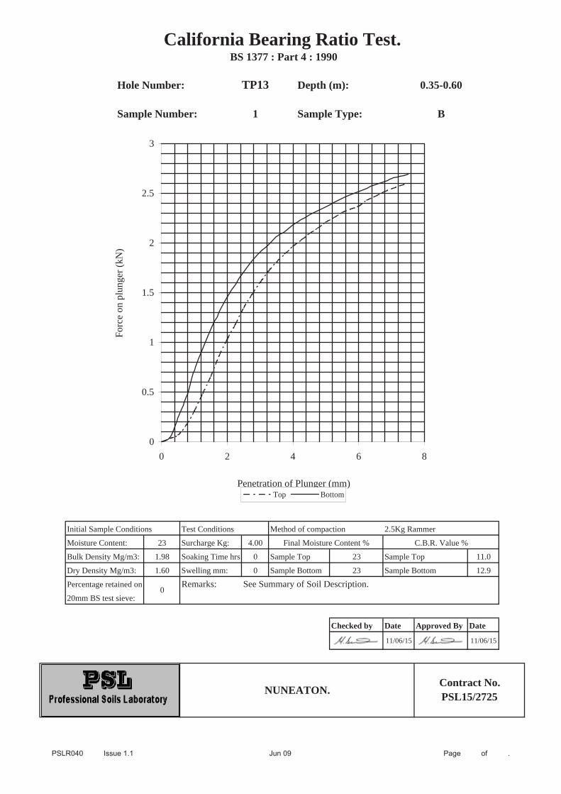
Hole Number: TP13 Depth (m): 0.35-0.60
Sample Number: 1 Sample Type: B
Initial Sample Conditions Test Conditions Method of compaction 2.5Kg Rammer
Moisture Content: 23 Surcharge Kg: 4.00
Bulk Density Mg/m3: 1.98 Soaking Time hrs 0 Sample Top 23 Sample Top 11.0
Dry Density Mg/m3: 1.60 Swelling mm: 0 Sample Bottom 23 Sample Bottom 12.9
Percentage retained on Remarks: See Summary of Soil Description.20mm BS test sieve:
Checked by Date Approved By Date
11/06/15 11/06/15
California Bearing Ratio Test. BS 1377 : Part 4 : 1990
0
NUNEATON.Contract No.PSL15/2725
Final Moisture Content % C.B.R. Value %
0
0.5
1
1.5
2
2.5
3
0 2 4 6 8
Penetration of Plunger (mm)
Forc
e on
plu
nger
(kN
)
Top Bottom

APPENDIX VII
Historical Plans

Ord
er D
etai
ls
Site
Det
ails
Wed
ding
ton
Roa
d, N
unea
ton
Ord
er N
umbe
r:C
usto
mer
Ref
:N
atio
nal G
rid R
efer
ence
:S
lice:
Site
Are
a (H
a):
Sea
rch
Buf
fer (
m):
6661
6114
_1_1
3506
743
6420
, 293
810
A 9.98
100
Tel:
Fax:
Web
:
0844
844
995
208
44 8
44 9
951
ww
w.e
nviro
chec
k.co
.uk
Pag
e 1
of 1
4A
Lan
dmar
k In
form
atio
n G
roup
Ser
vice
v4
7.0
20
-Apr
-201
5
His
toric
al M
ap -
Segm
entA
13
Ord
nanc
e Su
rvey
Cou
nty
Serie
s an
d O
rdna
nce
Surv
ey P
lan
1:2,
500
Ord
nanc
e Su
rvey
Pla
n, A
dditi
onal
SIM
s an
dSu
pply
of U
npub
lishe
d Su
rvey
Info
rmat
ion
1:2,
500
and
1:1,
250
Larg
e-Sc
ale
Nat
iona
l Grid
Dat
a 1:
2,50
0 an
d 1:
1,25
0
His
toric
al M
appi
ng L
egen
ds
His
toric
al M
appi
ng &
Pho
togr
aphy
incl
uded
:
War
wic
kshi
reW
arw
icks
hire
War
wic
kshi
reO
rdna
nce
Surv
ey P
lan
Ord
nanc
e Su
rvey
Pla
nO
rdna
nce
Surv
ey P
lan
Add
ition
al S
IMs
Supp
ly o
f Unp
ublis
hed
Surv
ey In
form
atio
nO
rdna
nce
Surv
ey P
lan
Add
ition
al S
IMs
Add
ition
al S
IMs
Larg
e-Sc
ale
Nat
iona
l Grid
Dat
aLa
rge-
Scal
e N
atio
nal G
rid D
ata
1:2,
500
1:2,
500
1:2,
500
1:2,
500
1:1,
250
1:1,
250
1:1,
250
1:1,
250
1:1,
250
1:1,
250
1:2,
500
1:1,
250
1:2,
500
1890
1903
1925
1952
- 19
6319
52 -
1962
1962
1962
- 19
8619
7319
75 -
1977
1985
1988
1994
1994
2 3 4 5 6 7 8 9 10 11 12 13 14
Map
ping
Typ
eSc
ale
Dat
ePg
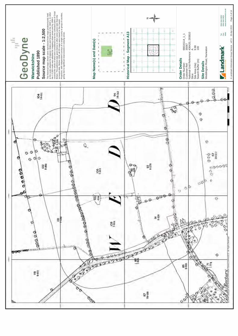
Ord
er D
etai
ls
Site
Det
ails
Wed
ding
ton
Roa
d, N
unea
ton
Ord
er N
umbe
r:C
usto
mer
Ref
:N
atio
nal G
rid R
efer
ence
:S
lice:
Site
Are
a (H
a):
Sea
rch
Buf
fer (
m):
6661
6114
_1_1
3506
743
6420
, 293
810
A 9.98
100
Tel:
Fax:
Web
:
0844
844
995
208
44 8
44 9
951
ww
w.e
nviro
chec
k.co
.uk
Pag
e 2
of 1
4A
Lan
dmar
k In
form
atio
n G
roup
Ser
vice
v4
7.0
20
-Apr
-201
5
War
wic
kshi
rePu
blis
hed
1890
Sour
ce m
ap s
cale
- 1:
2,50
0Th
e hi
stor
ical
map
s sh
own
wer
e re
prod
uced
from
map
s pr
edom
inan
tly h
eld
at th
e sc
ale
adop
ted
for E
ngla
nd, W
ales
and
Sco
tland
in th
e 18
40`s
. In
1854
th
e 1:
2,50
0 sc
ale
was
ado
pted
for m
appi
ng u
rban
are
as a
nd b
y 18
96 it
co
vere
d th
e w
hole
of w
hat w
ere
cons
ider
ed to
be
the
culti
vate
d pa
rts o
f Gre
atB
ritai
n. T
he p
ublis
hed
date
giv
en b
elow
is o
ften
som
e ye
ars
late
r tha
n th
e su
rvey
ed d
ate.
Bef
ore
1938
, all
OS
map
s w
ere
base
d on
the
Cas
sini
P
roje
ctio
n, w
ith in
depe
nden
t sur
veys
of a
sin
gle
coun
ty o
r gro
up o
f cou
ntie
s,
givi
ng ri
se to
sig
nific
ant i
nacc
urac
ies
in o
utly
ing
area
s.
His
toric
al M
ap -
Segm
entA
13
Map
Nam
e(s)
and
Dat
e(s)

Ord
er D
etai
ls
Site
Det
ails
Wed
ding
ton
Roa
d, N
unea
ton
Ord
er N
umbe
r:C
usto
mer
Ref
:N
atio
nal G
rid R
efer
ence
:S
lice:
Site
Are
a (H
a):
Sea
rch
Buf
fer (
m):
6661
6114
_1_1
3506
743
6420
, 293
810
A 9.98
100
Tel:
Fax:
Web
:
0844
844
995
208
44 8
44 9
951
ww
w.e
nviro
chec
k.co
.uk
Pag
e 3
of 1
4A
Lan
dmar
k In
form
atio
n G
roup
Ser
vice
v4
7.0
20
-Apr
-201
5
War
wic
kshi
rePu
blis
hed
1903
Sour
ce m
ap s
cale
- 1:
2,50
0Th
e hi
stor
ical
map
s sh
own
wer
e re
prod
uced
from
map
s pr
edom
inan
tly h
eld
at th
e sc
ale
adop
ted
for E
ngla
nd, W
ales
and
Sco
tland
in th
e 18
40`s
. In
1854
th
e 1:
2,50
0 sc
ale
was
ado
pted
for m
appi
ng u
rban
are
as a
nd b
y 18
96 it
co
vere
d th
e w
hole
of w
hat w
ere
cons
ider
ed to
be
the
culti
vate
d pa
rts o
f Gre
atB
ritai
n. T
he p
ublis
hed
date
giv
en b
elow
is o
ften
som
e ye
ars
late
r tha
n th
e su
rvey
ed d
ate.
Bef
ore
1938
, all
OS
map
s w
ere
base
d on
the
Cas
sini
P
roje
ctio
n, w
ith in
depe
nden
t sur
veys
of a
sin
gle
coun
ty o
r gro
up o
f cou
ntie
s,
givi
ng ri
se to
sig
nific
ant i
nacc
urac
ies
in o
utly
ing
area
s.
His
toric
al M
ap -
Segm
entA
13
Map
Nam
e(s)
and
Dat
e(s)

Ord
er D
etai
ls
Site
Det
ails
Wed
ding
ton
Roa
d, N
unea
ton
Ord
er N
umbe
r:C
usto
mer
Ref
:N
atio
nal G
rid R
efer
ence
:S
lice:
Site
Are
a (H
a):
Sea
rch
Buf
fer (
m):
6661
6114
_1_1
3506
743
6420
, 293
810
A 9.98
100
Tel:
Fax:
Web
:
0844
844
995
208
44 8
44 9
951
ww
w.e
nviro
chec
k.co
.uk
Pag
e 4
of 1
4A
Lan
dmar
k In
form
atio
n G
roup
Ser
vice
v4
7.0
20
-Apr
-201
5
War
wic
kshi
rePu
blis
hed
1925
Sour
ce m
ap s
cale
- 1:
2,50
0Th
e hi
stor
ical
map
s sh
own
wer
e re
prod
uced
from
map
s pr
edom
inan
tly h
eld
at th
e sc
ale
adop
ted
for E
ngla
nd, W
ales
and
Sco
tland
in th
e 18
40`s
. In
1854
th
e 1:
2,50
0 sc
ale
was
ado
pted
for m
appi
ng u
rban
are
as a
nd b
y 18
96 it
co
vere
d th
e w
hole
of w
hat w
ere
cons
ider
ed to
be
the
culti
vate
d pa
rts o
f Gre
atB
ritai
n. T
he p
ublis
hed
date
giv
en b
elow
is o
ften
som
e ye
ars
late
r tha
n th
e su
rvey
ed d
ate.
Bef
ore
1938
, all
OS
map
s w
ere
base
d on
the
Cas
sini
P
roje
ctio
n, w
ith in
depe
nden
t sur
veys
of a
sin
gle
coun
ty o
r gro
up o
f cou
ntie
s,
givi
ng ri
se to
sig
nific
ant i
nacc
urac
ies
in o
utly
ing
area
s.
His
toric
al M
ap -
Segm
entA
13
Map
Nam
e(s)
and
Dat
e(s)

Ord
er D
etai
ls
Site
Det
ails
Wed
ding
ton
Roa
d, N
unea
ton
Ord
er N
umbe
r:C
usto
mer
Ref
:N
atio
nal G
rid R
efer
ence
:S
lice:
Site
Are
a (H
a):
Sea
rch
Buf
fer (
m):
6661
6114
_1_1
3506
743
6420
, 293
810
A 9.98
100
Tel:
Fax:
Web
:
0844
844
995
208
44 8
44 9
951
ww
w.e
nviro
chec
k.co
.uk
Pag
e 5
of 1
4A
Lan
dmar
k In
form
atio
n G
roup
Ser
vice
v4
7.0
20
-Apr
-201
5
Ord
nanc
e Su
rvey
Pla
nPu
blis
hed
1952
- 19
63So
urce
map
sca
le -
1:2,
500
The
hist
oric
al m
aps
show
n w
ere
repr
oduc
ed fr
om m
aps
pred
omin
antly
hel
d at
the
scal
e ad
opte
d fo
r Eng
land
, Wal
es a
nd S
cotla
nd in
the
1840
`s. I
n 18
54
the
1:2,
500
scal
e w
as a
dopt
ed fo
r map
ping
urb
an a
reas
and
by
1896
it
cove
red
the
who
le o
f wha
t wer
e co
nsid
ered
to b
e th
e cu
ltiva
ted
parts
of G
reat
Brit
ain.
The
pub
lishe
d da
te g
iven
bel
ow is
ofte
n so
me
year
s la
ter t
han
the
surv
eyed
dat
e. B
efor
e 19
38, a
ll O
S m
aps
wer
e ba
sed
on th
e C
assi
ni
Pro
ject
ion,
with
inde
pend
ent s
urve
ys o
f a s
ingl
e co
unty
or g
roup
of c
ount
ies,
gi
ving
rise
to s
igni
fican
t ina
ccur
acie
s in
out
lyin
g ar
eas.
His
toric
al M
ap -
Segm
entA
13
Map
Nam
e(s)
and
Dat
e(s)

Ord
er D
etai
ls
Site
Det
ails
Wed
ding
ton
Roa
d, N
unea
ton
Ord
er N
umbe
r:C
usto
mer
Ref
:N
atio
nal G
rid R
efer
ence
:S
lice:
Site
Are
a (H
a):
Sea
rch
Buf
fer (
m):
6661
6114
_1_1
3506
743
6420
, 293
810
A 9.98
100
Tel:
Fax:
Web
:
0844
844
995
208
44 8
44 9
951
ww
w.e
nviro
chec
k.co
.uk
Pag
e 6
of 1
4A
Lan
dmar
k In
form
atio
n G
roup
Ser
vice
v4
7.0
20
-Apr
-201
5
Ord
nanc
e Su
rvey
Pla
nPu
blis
hed
1952
- 19
62So
urce
map
sca
le -
1:1,
250
The
hist
oric
al m
aps
show
n w
ere
repr
oduc
ed fr
om m
aps
pred
omin
antly
hel
d at
the
scal
e ad
opte
d fo
r Eng
land
, Wal
es a
nd S
cotla
nd in
the
1840
`s. I
n 18
54
the
1:2,
500
scal
e w
as a
dopt
ed fo
r map
ping
urb
an a
reas
and
by
1896
it
cove
red
the
who
le o
f wha
t wer
e co
nsid
ered
to b
e th
e cu
ltiva
ted
parts
of G
reat
Brit
ain.
The
pub
lishe
d da
te g
iven
bel
ow is
ofte
n so
me
year
s la
ter t
han
the
surv
eyed
dat
e. B
efor
e 19
38, a
ll O
S m
aps
wer
e ba
sed
on th
e C
assi
ni
Pro
ject
ion,
with
inde
pend
ent s
urve
ys o
f a s
ingl
e co
unty
or g
roup
of c
ount
ies,
gi
ving
rise
to s
igni
fican
t ina
ccur
acie
s in
out
lyin
g ar
eas.
His
toric
al M
ap -
Segm
entA
13
Map
Nam
e(s)
and
Dat
e(s)
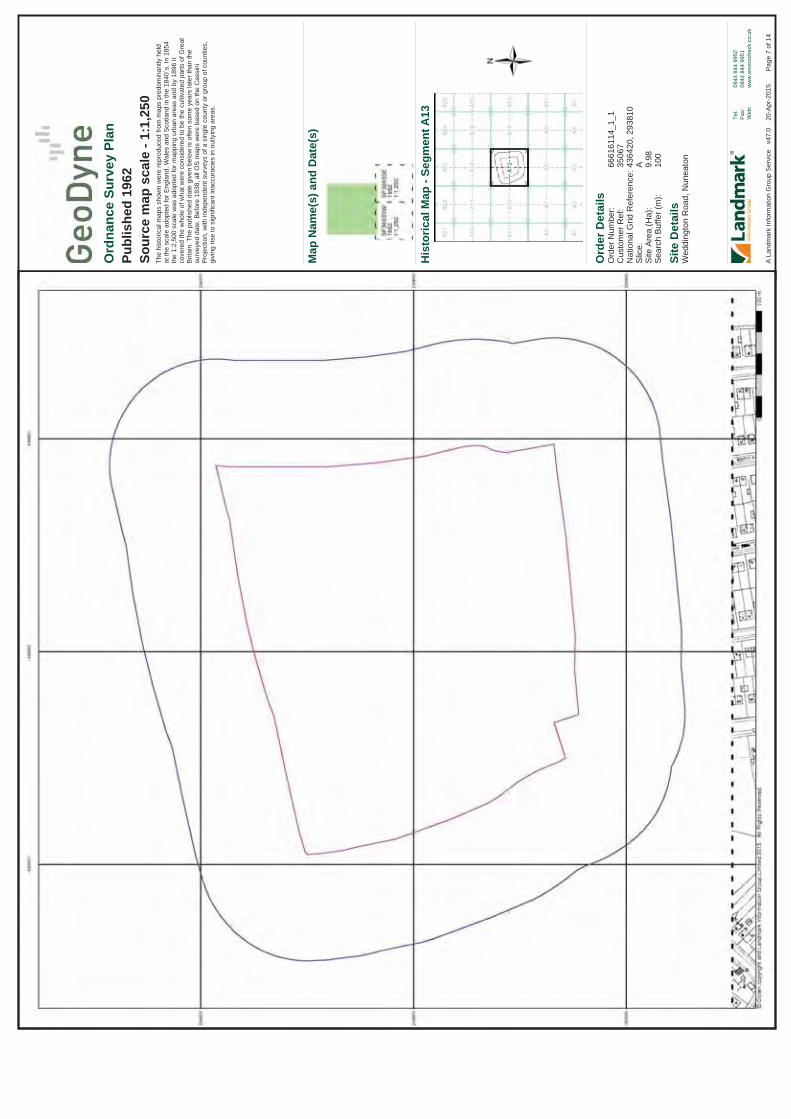
Ord
er D
etai
ls
Site
Det
ails
Wed
ding
ton
Roa
d, N
unea
ton
Ord
er N
umbe
r:C
usto
mer
Ref
:N
atio
nal G
rid R
efer
ence
:S
lice:
Site
Are
a (H
a):
Sea
rch
Buf
fer (
m):
6661
6114
_1_1
3506
743
6420
, 293
810
A 9.98
100
Tel:
Fax:
Web
:
0844
844
995
208
44 8
44 9
951
ww
w.e
nviro
chec
k.co
.uk
Pag
e 7
of 1
4A
Lan
dmar
k In
form
atio
n G
roup
Ser
vice
v4
7.0
20
-Apr
-201
5
Ord
nanc
e Su
rvey
Pla
nPu
blis
hed
1962
Sour
ce m
ap s
cale
- 1:
1,25
0Th
e hi
stor
ical
map
s sh
own
wer
e re
prod
uced
from
map
s pr
edom
inan
tly h
eld
at th
e sc
ale
adop
ted
for E
ngla
nd, W
ales
and
Sco
tland
in th
e 18
40`s
. In
1854
th
e 1:
2,50
0 sc
ale
was
ado
pted
for m
appi
ng u
rban
are
as a
nd b
y 18
96 it
co
vere
d th
e w
hole
of w
hat w
ere
cons
ider
ed to
be
the
culti
vate
d pa
rts o
f Gre
atB
ritai
n. T
he p
ublis
hed
date
giv
en b
elow
is o
ften
som
e ye
ars
late
r tha
n th
e su
rvey
ed d
ate.
Bef
ore
1938
, all
OS
map
s w
ere
base
d on
the
Cas
sini
P
roje
ctio
n, w
ith in
depe
nden
t sur
veys
of a
sin
gle
coun
ty o
r gro
up o
f cou
ntie
s,
givi
ng ri
se to
sig
nific
ant i
nacc
urac
ies
in o
utly
ing
area
s.
His
toric
al M
ap -
Segm
entA
13
Map
Nam
e(s)
and
Dat
e(s)

Ord
er D
etai
ls
Site
Det
ails
Wed
ding
ton
Roa
d, N
unea
ton
Ord
er N
umbe
r:C
usto
mer
Ref
:N
atio
nal G
rid R
efer
ence
:S
lice:
Site
Are
a (H
a):
Sea
rch
Buf
fer (
m):
6661
6114
_1_1
3506
743
6420
, 293
810
A 9.98
100
Tel:
Fax:
Web
:
0844
844
995
208
44 8
44 9
951
ww
w.e
nviro
chec
k.co
.uk
Pag
e 8
of 1
4A
Lan
dmar
k In
form
atio
n G
roup
Ser
vice
v4
7.0
20
-Apr
-201
5
Add
ition
al S
IMs
Publ
ishe
d 19
62 -
1986
Sour
ce m
ap s
cale
- 1:
1,25
0Th
e S
IM c
ards
(Ord
nanc
e S
urve
y's
`Sur
vey
of In
form
atio
n on
Mic
rofil
m')
are
furth
er, m
inor
edi
tions
of m
appi
ng w
hich
wer
e pr
oduc
ed a
nd p
ublis
hed
in
betw
een
the
mai
n ed
ition
s as
an
area
was
upd
ated
. The
y da
te fr
om 1
947
to
1994
, and
con
tain
det
aile
d in
form
atio
n on
bui
ldin
gs, r
oads
and
land
-use
. Th
ese
map
s w
ere
prod
uced
at b
oth
1:2,
500
and
1:1,
250
scal
es.
His
toric
al M
ap -
Segm
entA
13
Map
Nam
e(s)
and
Dat
e(s)

Ord
er D
etai
ls
Site
Det
ails
Wed
ding
ton
Roa
d, N
unea
ton
Ord
er N
umbe
r:C
usto
mer
Ref
:N
atio
nal G
rid R
efer
ence
:S
lice:
Site
Are
a (H
a):
Sea
rch
Buf
fer (
m):
6661
6114
_1_1
3506
743
6420
, 293
810
A 9.98
100
Tel:
Fax:
Web
:
0844
844
995
208
44 8
44 9
951
ww
w.e
nviro
chec
k.co
.uk
Pag
e 9
of 1
4A
Lan
dmar
k In
form
atio
n G
roup
Ser
vice
v4
7.0
20
-Apr
-201
5
Supp
ly o
f Unp
ublis
hed
Surv
ey
Info
rmat
ion
Publ
ishe
d 19
73So
urce
map
sca
le -
1:1,
250
SU
SI m
aps
(Sup
ply
of U
npub
lishe
d S
urve
y In
form
atio
n) w
ere
prod
uced
be
twee
n 19
72 a
nd 1
977,
mai
nly
for i
nter
nal u
se a
t Ord
nanc
e S
urve
y. T
hese
w
ere
mor
e of
a `w
ork-
in-p
rogr
ess'
pla
n as
they
sho
wed
upd
ates
of i
ndiv
idua
l ar
eas
on a
map
. The
se m
aps
wer
e un
publ
ishe
d, a
nd th
ey d
o no
t rep
rese
nt a
si
ngle
mom
ent i
n tim
e. T
hey
wer
e pr
oduc
ed a
t bot
h 1:
2,50
0 an
d 1:
1,25
0 sc
ales
.
His
toric
al M
ap -
Segm
entA
13
Map
Nam
e(s)
and
Dat
e(s)

Ord
er D
etai
ls
Site
Det
ails
Wed
ding
ton
Roa
d, N
unea
ton
Ord
er N
umbe
r:C
usto
mer
Ref
:N
atio
nal G
rid R
efer
ence
:S
lice:
Site
Are
a (H
a):
Sea
rch
Buf
fer (
m):
6661
6114
_1_1
3506
743
6420
, 293
810
A 9.98
100
Tel:
Fax:
Web
:
0844
844
995
208
44 8
44 9
951
ww
w.e
nviro
chec
k.co
.uk
Pag
e 10
of 1
4A
Lan
dmar
k In
form
atio
n G
roup
Ser
vice
v4
7.0
20
-Apr
-201
5
Ord
nanc
e Su
rvey
Pla
nPu
blis
hed
1975
- 19
77So
urce
map
sca
le -
1:1,
250
The
hist
oric
al m
aps
show
n w
ere
repr
oduc
ed fr
om m
aps
pred
omin
antly
hel
d at
the
scal
e ad
opte
d fo
r Eng
land
, Wal
es a
nd S
cotla
nd in
the
1840
`s. I
n 18
54
the
1:2,
500
scal
e w
as a
dopt
ed fo
r map
ping
urb
an a
reas
and
by
1896
it
cove
red
the
who
le o
f wha
t wer
e co
nsid
ered
to b
e th
e cu
ltiva
ted
parts
of G
reat
Brit
ain.
The
pub
lishe
d da
te g
iven
bel
ow is
ofte
n so
me
year
s la
ter t
han
the
surv
eyed
dat
e. B
efor
e 19
38, a
ll O
S m
aps
wer
e ba
sed
on th
e C
assi
ni
Pro
ject
ion,
with
inde
pend
ent s
urve
ys o
f a s
ingl
e co
unty
or g
roup
of c
ount
ies,
gi
ving
rise
to s
igni
fican
t ina
ccur
acie
s in
out
lyin
g ar
eas.
His
toric
al M
ap -
Segm
entA
13
Map
Nam
e(s)
and
Dat
e(s)

Ord
er D
etai
ls
Site
Det
ails
Wed
ding
ton
Roa
d, N
unea
ton
Ord
er N
umbe
r:C
usto
mer
Ref
:N
atio
nal G
rid R
efer
ence
:S
lice:
Site
Are
a (H
a):
Sea
rch
Buf
fer (
m):
6661
6114
_1_1
3506
743
6420
, 293
810
A 9.98
100
Tel:
Fax:
Web
:
0844
844
995
208
44 8
44 9
951
ww
w.e
nviro
chec
k.co
.uk
Pag
e 11
of 1
4A
Lan
dmar
k In
form
atio
n G
roup
Ser
vice
v4
7.0
20
-Apr
-201
5
Add
ition
al S
IMs
Publ
ishe
d 19
85So
urce
map
sca
le -
1:1,
250
The
SIM
car
ds (O
rdna
nce
Sur
vey'
s `S
urve
y of
Info
rmat
ion
on M
icro
film
') ar
e fu
rther
, min
or e
ditio
ns o
f map
ping
whi
ch w
ere
prod
uced
and
pub
lishe
d in
be
twee
n th
e m
ain
editi
ons
as a
n ar
ea w
as u
pdat
ed. T
hey
date
from
194
7 to
19
94, a
nd c
onta
in d
etai
led
info
rmat
ion
on b
uild
ings
, roa
ds a
nd la
nd-u
se.
Thes
e m
aps
wer
e pr
oduc
ed a
t bot
h 1:
2,50
0 an
d 1:
1,25
0 sc
ales
.
His
toric
al M
ap -
Segm
entA
13
Map
Nam
e(s)
and
Dat
e(s)

Ord
er D
etai
ls
Site
Det
ails
Wed
ding
ton
Roa
d, N
unea
ton
Ord
er N
umbe
r:C
usto
mer
Ref
:N
atio
nal G
rid R
efer
ence
:S
lice:
Site
Are
a (H
a):
Sea
rch
Buf
fer (
m):
6661
6114
_1_1
3506
743
6420
, 293
810
A 9.98
100
Tel:
Fax:
Web
:
0844
844
995
208
44 8
44 9
951
ww
w.e
nviro
chec
k.co
.uk
Pag
e 12
of 1
4A
Lan
dmar
k In
form
atio
n G
roup
Ser
vice
v4
7.0
20
-Apr
-201
5
Add
ition
al S
IMs
Publ
ishe
d 19
88So
urce
map
sca
le -
1:2,
500
The
SIM
car
ds (O
rdna
nce
Sur
vey'
s `S
urve
y of
Info
rmat
ion
on M
icro
film
') ar
e fu
rther
, min
or e
ditio
ns o
f map
ping
whi
ch w
ere
prod
uced
and
pub
lishe
d in
be
twee
n th
e m
ain
editi
ons
as a
n ar
ea w
as u
pdat
ed. T
hey
date
from
194
7 to
19
94, a
nd c
onta
in d
etai
led
info
rmat
ion
on b
uild
ings
, roa
ds a
nd la
nd-u
se.
Thes
e m
aps
wer
e pr
oduc
ed a
t bot
h 1:
2,50
0 an
d 1:
1,25
0 sc
ales
.
His
toric
al M
ap -
Segm
entA
13
Map
Nam
e(s)
and
Dat
e(s)
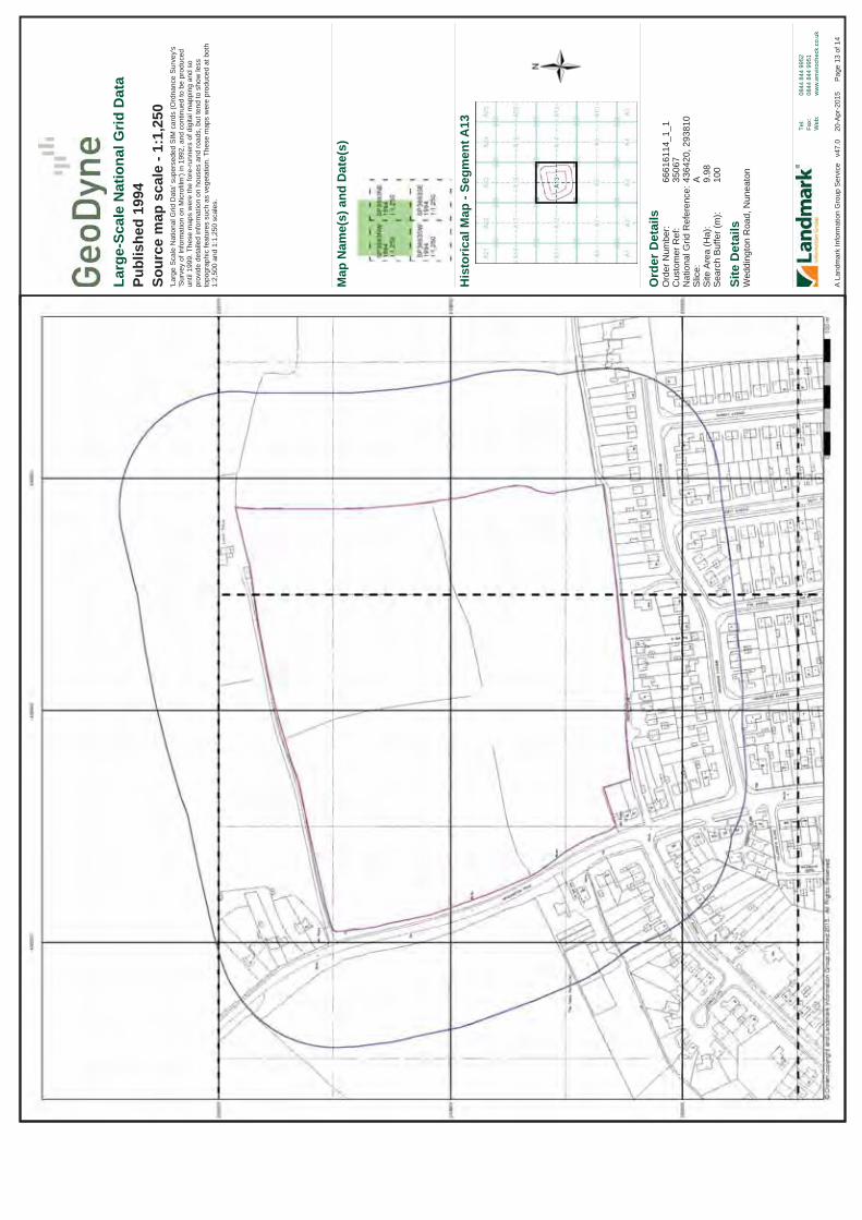
Ord
er D
etai
ls
Site
Det
ails
Wed
ding
ton
Roa
d, N
unea
ton
Ord
er N
umbe
r:C
usto
mer
Ref
:N
atio
nal G
rid R
efer
ence
:S
lice:
Site
Are
a (H
a):
Sea
rch
Buf
fer (
m):
6661
6114
_1_1
3506
743
6420
, 293
810
A 9.98
100
Tel:
Fax:
Web
:
0844
844
995
208
44 8
44 9
951
ww
w.e
nviro
chec
k.co
.uk
Pag
e 13
of 1
4A
Lan
dmar
k In
form
atio
n G
roup
Ser
vice
v4
7.0
20
-Apr
-201
5
Larg
e-Sc
ale
Nat
iona
l Grid
Dat
aPu
blis
hed
1994
Sour
ce m
ap s
cale
- 1:
1,25
0'L
arge
Sca
le N
atio
nal G
rid D
ata'
sup
erse
ded
SIM
car
ds (O
rdna
nce
Sur
vey'
s 'S
urve
y of
Info
rmat
ion
on M
icro
film
') in
199
2, a
nd c
ontin
ued
to b
e pr
oduc
ed
until
199
9. T
hese
map
s w
ere
the
fore
-run
ners
of d
igita
l map
ping
and
so
prov
ide
deta
iled
info
rmat
ion
on h
ouse
s an
d ro
ads,
but
tend
to s
how
less
to
pogr
aphi
c fe
atur
es s
uch
as v
eget
atio
n. T
hese
map
s w
ere
prod
uced
at b
oth
1:2,
500
and
1:1,
250
scal
es.
His
toric
al M
ap -
Segm
entA
13
Map
Nam
e(s)
and
Dat
e(s)

Ord
er D
etai
ls
Site
Det
ails
Wed
ding
ton
Roa
d, N
unea
ton
Ord
er N
umbe
r:C
usto
mer
Ref
:N
atio
nal G
rid R
efer
ence
:S
lice:
Site
Are
a (H
a):
Sea
rch
Buf
fer (
m):
6661
6114
_1_1
3506
743
6420
, 293
810
A 9.98
100
Tel:
Fax:
Web
:
0844
844
995
208
44 8
44 9
951
ww
w.e
nviro
chec
k.co
.uk
Pag
e 14
of 1
4A
Lan
dmar
k In
form
atio
n G
roup
Ser
vice
v4
7.0
20
-Apr
-201
5
Larg
e-Sc
ale
Nat
iona
l Grid
Dat
aPu
blis
hed
1994
Sour
ce m
ap s
cale
- 1:
2,50
0'L
arge
Sca
le N
atio
nal G
rid D
ata'
sup
erse
ded
SIM
car
ds (O
rdna
nce
Sur
vey'
s 'S
urve
y of
Info
rmat
ion
on M
icro
film
') in
199
2, a
nd c
ontin
ued
to b
e pr
oduc
ed
until
199
9. T
hese
map
s w
ere
the
fore
-run
ners
of d
igita
l map
ping
and
so
prov
ide
deta
iled
info
rmat
ion
on h
ouse
s an
d ro
ads,
but
tend
to s
how
less
to
pogr
aphi
c fe
atur
es s
uch
as v
eget
atio
n. T
hese
map
s w
ere
prod
uced
at b
oth
1:2,
500
and
1:1,
250
scal
es.
His
toric
al M
ap -
Segm
entA
13
Map
Nam
e(s)
and
Dat
e(s)

Ord
er D
etai
ls
Site
Det
ails
Wed
ding
ton
Roa
d, N
unea
ton
Ord
er N
umbe
r:C
usto
mer
Ref
:N
atio
nal G
rid R
efer
ence
:S
lice:
Site
Are
a (H
a):
Sea
rch
Buf
fer (
m):
6661
6114
_1_1
3506
743
6420
, 293
810
A 9.98
250
Tel:
Fax:
Web
:
0844
844
995
208
44 8
44 9
951
ww
w.e
nviro
chec
k.co
.uk
Pag
e 1
of 1
9A
Lan
dmar
k In
form
atio
n G
roup
Ser
vice
v4
7.0
20
-Apr
-201
5
His
toric
al M
ap -
Slic
eA
Ord
nanc
e Su
rvey
Cou
nty
Serie
s 1:
10,5
60O
rdna
nce
Surv
ey P
lan
1:10
,000
1:10
,000
Ras
ter M
appi
ng
His
toric
al M
appi
ng L
egen
ds
His
toric
al M
appi
ng &
Pho
togr
aphy
incl
uded
:
War
wic
kshi
reW
arw
icks
hire
Leic
este
rshi
reW
arw
icks
hire
Leic
este
rshi
reLe
ices
ters
hire
War
wic
kshi
reW
arw
icks
hire
War
wic
kshi
reLe
ices
ters
hire
His
toric
al A
eria
l Pho
togr
aphy
Ord
nanc
e Su
rvey
Pla
nO
rdna
nce
Surv
ey P
lan
Ord
nanc
e Su
rvey
Pla
nO
rdna
nce
Surv
ey P
lan
Ord
nanc
e Su
rvey
Pla
n10
K R
aste
r Map
ping
Vect
orM
ap L
ocal
1:10
,560
1:10
,560
1:10
,560
1:10
,560
1:10
,560
1:10
,560
1:10
,560
1:10
,560
1:10
,560
1:10
,560
1:10
,560
1:10
,000
1:10
,000
1:10
,000
1:10
,000
1:10
,000
1:10
,000
1:10
,000
1887
- 18
8819
0419
0419
2019
2119
2519
2519
2519
3819
3819
5019
5519
67 -
1968
1975
1989
1994
2006
2015
2 3 4 5 6 7 8 9 10 11 12 13 14 15 16 17 18 19
Map
ping
Typ
eSc
ale
Dat
ePg

Ord
er D
etai
ls
Site
Det
ails
Wed
ding
ton
Roa
d, N
unea
ton
Ord
er N
umbe
r:C
usto
mer
Ref
:N
atio
nal G
rid R
efer
ence
:S
lice:
Site
Are
a (H
a):
Sea
rch
Buf
fer (
m):
6661
6114
_1_1
3506
743
6420
, 293
810
A 9.98
250
Tel:
Fax:
Web
:
0844
844
995
208
44 8
44 9
951
ww
w.e
nviro
chec
k.co
.uk
Pag
e 2
of 1
9A
Lan
dmar
k In
form
atio
n G
roup
Ser
vice
v4
7.0
20
-Apr
-201
5
War
wic
kshi
rePu
blis
hed
1887
- 18
88So
urce
map
sca
le -
1:10
,560
The
hist
oric
al m
aps
show
n w
ere
repr
oduc
ed fr
om m
aps
pred
omin
antly
hel
d at
the
scal
e ad
opte
d fo
r Eng
land
, Wal
es a
nd S
cotla
nd in
the
1840
`s. I
n 18
54
the
1:2,
500
scal
e w
as a
dopt
ed fo
r map
ping
urb
an a
reas
; the
se m
aps
wer
e us
ed to
upd
ate
the
1:10
,560
map
s. T
he p
ublis
hed
date
giv
en th
eref
ore
is
ofte
n so
me
year
s la
ter t
han
the
surv
eyed
dat
e. B
efor
e 19
38, a
ll O
S m
aps
wer
e ba
sed
on th
e C
assi
ni P
roje
ctio
n, w
ith in
depe
nden
t sur
veys
of a
sin
gle
coun
ty o
r gro
up o
f cou
ntie
s, g
ivin
g ris
e to
sig
nific
ant i
nacc
urac
ies
in o
utly
ing
area
s. In
the
late
194
0`s,
a P
rovi
sion
al E
ditio
n w
as p
rodu
ced,
whi
ch u
pdat
ed
the
1:10
,560
map
ping
from
a n
umbe
r of s
ourc
es. T
he m
aps
appe
ar
unfin
ishe
d - w
ith a
ll m
ilitar
y ca
mps
and
oth
er s
trate
gic
site
s re
mov
ed. T
hese
m
aps
wer
e in
itial
ly o
verp
rinte
d w
ith th
e N
atio
nal G
rid. I
n 19
70, t
he fi
rst
1:10
,000
map
s w
ere
prod
uced
usi
ng th
e Tr
ansv
erse
Mer
cato
r Pro
ject
ion.
The
revi
sion
pro
cess
con
tinue
d un
til re
cent
ly, w
ith n
ew e
ditio
ns a
ppea
ring
ever
y 10
yea
rs o
r so
for u
rban
are
as.
His
toric
al M
ap -
Slic
eA
Map
Nam
e(s)
and
Dat
e(s)

Ord
er D
etai
ls
Site
Det
ails
Wed
ding
ton
Roa
d, N
unea
ton
Ord
er N
umbe
r:C
usto
mer
Ref
:N
atio
nal G
rid R
efer
ence
:S
lice:
Site
Are
a (H
a):
Sea
rch
Buf
fer (
m):
6661
6114
_1_1
3506
743
6420
, 293
810
A 9.98
250
Tel:
Fax:
Web
:
0844
844
995
208
44 8
44 9
951
ww
w.e
nviro
chec
k.co
.uk
Pag
e 3
of 1
9A
Lan
dmar
k In
form
atio
n G
roup
Ser
vice
v4
7.0
20
-Apr
-201
5
War
wic
kshi
rePu
blis
hed
1904
Sour
ce m
ap s
cale
- 1:
10,5
60Th
e hi
stor
ical
map
s sh
own
wer
e re
prod
uced
from
map
s pr
edom
inan
tly h
eld
at th
e sc
ale
adop
ted
for E
ngla
nd, W
ales
and
Sco
tland
in th
e 18
40`s
. In
1854
th
e 1:
2,50
0 sc
ale
was
ado
pted
for m
appi
ng u
rban
are
as; t
hese
map
s w
ere
used
to u
pdat
e th
e 1:
10,5
60 m
aps.
The
pub
lishe
d da
te g
iven
ther
efor
e is
of
ten
som
e ye
ars
late
r tha
n th
e su
rvey
ed d
ate.
Bef
ore
1938
, all
OS
map
s w
ere
base
d on
the
Cas
sini
Pro
ject
ion,
with
inde
pend
ent s
urve
ys o
f a s
ingl
e co
unty
or g
roup
of c
ount
ies,
giv
ing
rise
to s
igni
fican
t ina
ccur
acie
s in
out
lyin
g ar
eas.
In th
e la
te 1
940`
s, a
Pro
visi
onal
Edi
tion
was
pro
duce
d, w
hich
upd
ated
th
e 1:
10,5
60 m
appi
ng fr
om a
num
ber o
f sou
rces
. The
map
s ap
pear
un
finis
hed
- with
all
milit
ary
cam
ps a
nd o
ther
stra
tegi
c si
tes
rem
oved
. The
se
map
s w
ere
initi
ally
ove
rprin
ted
with
the
Nat
iona
l Grid
. In
1970
, the
firs
t 1:
10,0
00 m
aps
wer
e pr
oduc
ed u
sing
the
Tran
sver
se M
erca
tor P
roje
ctio
n. T
here
visi
on p
roce
ss c
ontin
ued
until
rece
ntly
, with
new
edi
tions
app
earin
g ev
ery
10 y
ears
or s
o fo
r urb
an a
reas
.
His
toric
al M
ap -
Slic
eA
Map
Nam
e(s)
and
Dat
e(s)

Ord
er D
etai
ls
Site
Det
ails
Wed
ding
ton
Roa
d, N
unea
ton
Ord
er N
umbe
r:C
usto
mer
Ref
:N
atio
nal G
rid R
efer
ence
:S
lice:
Site
Are
a (H
a):
Sea
rch
Buf
fer (
m):
6661
6114
_1_1
3506
743
6420
, 293
810
A 9.98
250
Tel:
Fax:
Web
:
0844
844
995
208
44 8
44 9
951
ww
w.e
nviro
chec
k.co
.uk
Pag
e 4
of 1
9A
Lan
dmar
k In
form
atio
n G
roup
Ser
vice
v4
7.0
20
-Apr
-201
5
Leic
este
rshi
rePu
blis
hed
1904
Sour
ce m
ap s
cale
- 1:
10,5
60Th
e hi
stor
ical
map
s sh
own
wer
e re
prod
uced
from
map
s pr
edom
inan
tly h
eld
at th
e sc
ale
adop
ted
for E
ngla
nd, W
ales
and
Sco
tland
in th
e 18
40`s
. In
1854
th
e 1:
2,50
0 sc
ale
was
ado
pted
for m
appi
ng u
rban
are
as; t
hese
map
s w
ere
used
to u
pdat
e th
e 1:
10,5
60 m
aps.
The
pub
lishe
d da
te g
iven
ther
efor
e is
of
ten
som
e ye
ars
late
r tha
n th
e su
rvey
ed d
ate.
Bef
ore
1938
, all
OS
map
s w
ere
base
d on
the
Cas
sini
Pro
ject
ion,
with
inde
pend
ent s
urve
ys o
f a s
ingl
e co
unty
or g
roup
of c
ount
ies,
giv
ing
rise
to s
igni
fican
t ina
ccur
acie
s in
out
lyin
g ar
eas.
In th
e la
te 1
940`
s, a
Pro
visi
onal
Edi
tion
was
pro
duce
d, w
hich
upd
ated
th
e 1:
10,5
60 m
appi
ng fr
om a
num
ber o
f sou
rces
. The
map
s ap
pear
un
finis
hed
- with
all
milit
ary
cam
ps a
nd o
ther
stra
tegi
c si
tes
rem
oved
. The
se
map
s w
ere
initi
ally
ove
rprin
ted
with
the
Nat
iona
l Grid
. In
1970
, the
firs
t 1:
10,0
00 m
aps
wer
e pr
oduc
ed u
sing
the
Tran
sver
se M
erca
tor P
roje
ctio
n. T
here
visi
on p
roce
ss c
ontin
ued
until
rece
ntly
, with
new
edi
tions
app
earin
g ev
ery
10 y
ears
or s
o fo
r urb
an a
reas
.
His
toric
al M
ap -
Slic
eA
Map
Nam
e(s)
and
Dat
e(s)

Ord
er D
etai
ls
Site
Det
ails
Wed
ding
ton
Roa
d, N
unea
ton
Ord
er N
umbe
r:C
usto
mer
Ref
:N
atio
nal G
rid R
efer
ence
:S
lice:
Site
Are
a (H
a):
Sea
rch
Buf
fer (
m):
6661
6114
_1_1
3506
743
6420
, 293
810
A 9.98
250
Tel:
Fax:
Web
:
0844
844
995
208
44 8
44 9
951
ww
w.e
nviro
chec
k.co
.uk
Pag
e 5
of 1
9A
Lan
dmar
k In
form
atio
n G
roup
Ser
vice
v4
7.0
20
-Apr
-201
5
War
wic
kshi
rePu
blis
hed
1920
Sour
ce m
ap s
cale
- 1:
10,5
60Th
e hi
stor
ical
map
s sh
own
wer
e re
prod
uced
from
map
s pr
edom
inan
tly h
eld
at th
e sc
ale
adop
ted
for E
ngla
nd, W
ales
and
Sco
tland
in th
e 18
40`s
. In
1854
th
e 1:
2,50
0 sc
ale
was
ado
pted
for m
appi
ng u
rban
are
as; t
hese
map
s w
ere
used
to u
pdat
e th
e 1:
10,5
60 m
aps.
The
pub
lishe
d da
te g
iven
ther
efor
e is
of
ten
som
e ye
ars
late
r tha
n th
e su
rvey
ed d
ate.
Bef
ore
1938
, all
OS
map
s w
ere
base
d on
the
Cas
sini
Pro
ject
ion,
with
inde
pend
ent s
urve
ys o
f a s
ingl
e co
unty
or g
roup
of c
ount
ies,
giv
ing
rise
to s
igni
fican
t ina
ccur
acie
s in
out
lyin
g ar
eas.
In th
e la
te 1
940`
s, a
Pro
visi
onal
Edi
tion
was
pro
duce
d, w
hich
upd
ated
th
e 1:
10,5
60 m
appi
ng fr
om a
num
ber o
f sou
rces
. The
map
s ap
pear
un
finis
hed
- with
all
milit
ary
cam
ps a
nd o
ther
stra
tegi
c si
tes
rem
oved
. The
se
map
s w
ere
initi
ally
ove
rprin
ted
with
the
Nat
iona
l Grid
. In
1970
, the
firs
t 1:
10,0
00 m
aps
wer
e pr
oduc
ed u
sing
the
Tran
sver
se M
erca
tor P
roje
ctio
n. T
here
visi
on p
roce
ss c
ontin
ued
until
rece
ntly
, with
new
edi
tions
app
earin
g ev
ery
10 y
ears
or s
o fo
r urb
an a
reas
.
His
toric
al M
ap -
Slic
eA
Map
Nam
e(s)
and
Dat
e(s)

Ord
er D
etai
ls
Site
Det
ails
Wed
ding
ton
Roa
d, N
unea
ton
Ord
er N
umbe
r:C
usto
mer
Ref
:N
atio
nal G
rid R
efer
ence
:S
lice:
Site
Are
a (H
a):
Sea
rch
Buf
fer (
m):
6661
6114
_1_1
3506
743
6420
, 293
810
A 9.98
250
Tel:
Fax:
Web
:
0844
844
995
208
44 8
44 9
951
ww
w.e
nviro
chec
k.co
.uk
Pag
e 6
of 1
9A
Lan
dmar
k In
form
atio
n G
roup
Ser
vice
v4
7.0
20
-Apr
-201
5
Leic
este
rshi
rePu
blis
hed
1921
Sour
ce m
ap s
cale
- 1:
10,5
60Th
e hi
stor
ical
map
s sh
own
wer
e re
prod
uced
from
map
s pr
edom
inan
tly h
eld
at th
e sc
ale
adop
ted
for E
ngla
nd, W
ales
and
Sco
tland
in th
e 18
40`s
. In
1854
th
e 1:
2,50
0 sc
ale
was
ado
pted
for m
appi
ng u
rban
are
as; t
hese
map
s w
ere
used
to u
pdat
e th
e 1:
10,5
60 m
aps.
The
pub
lishe
d da
te g
iven
ther
efor
e is
of
ten
som
e ye
ars
late
r tha
n th
e su
rvey
ed d
ate.
Bef
ore
1938
, all
OS
map
s w
ere
base
d on
the
Cas
sini
Pro
ject
ion,
with
inde
pend
ent s
urve
ys o
f a s
ingl
e co
unty
or g
roup
of c
ount
ies,
giv
ing
rise
to s
igni
fican
t ina
ccur
acie
s in
out
lyin
g ar
eas.
In th
e la
te 1
940`
s, a
Pro
visi
onal
Edi
tion
was
pro
duce
d, w
hich
upd
ated
th
e 1:
10,5
60 m
appi
ng fr
om a
num
ber o
f sou
rces
. The
map
s ap
pear
un
finis
hed
- with
all
milit
ary
cam
ps a
nd o
ther
stra
tegi
c si
tes
rem
oved
. The
se
map
s w
ere
initi
ally
ove
rprin
ted
with
the
Nat
iona
l Grid
. In
1970
, the
firs
t 1:
10,0
00 m
aps
wer
e pr
oduc
ed u
sing
the
Tran
sver
se M
erca
tor P
roje
ctio
n. T
here
visi
on p
roce
ss c
ontin
ued
until
rece
ntly
, with
new
edi
tions
app
earin
g ev
ery
10 y
ears
or s
o fo
r urb
an a
reas
.
His
toric
al M
ap -
Slic
eA
Map
Nam
e(s)
and
Dat
e(s)

Ord
er D
etai
ls
Site
Det
ails
Wed
ding
ton
Roa
d, N
unea
ton
Ord
er N
umbe
r:C
usto
mer
Ref
:N
atio
nal G
rid R
efer
ence
:S
lice:
Site
Are
a (H
a):
Sea
rch
Buf
fer (
m):
6661
6114
_1_1
3506
743
6420
, 293
810
A 9.98
250
Tel:
Fax:
Web
:
0844
844
995
208
44 8
44 9
951
ww
w.e
nviro
chec
k.co
.uk
Pag
e 7
of 1
9A
Lan
dmar
k In
form
atio
n G
roup
Ser
vice
v4
7.0
20
-Apr
-201
5
Leic
este
rshi
rePu
blis
hed
1925
Sour
ce m
ap s
cale
- 1:
10,5
60Th
e hi
stor
ical
map
s sh
own
wer
e re
prod
uced
from
map
s pr
edom
inan
tly h
eld
at th
e sc
ale
adop
ted
for E
ngla
nd, W
ales
and
Sco
tland
in th
e 18
40`s
. In
1854
th
e 1:
2,50
0 sc
ale
was
ado
pted
for m
appi
ng u
rban
are
as; t
hese
map
s w
ere
used
to u
pdat
e th
e 1:
10,5
60 m
aps.
The
pub
lishe
d da
te g
iven
ther
efor
e is
of
ten
som
e ye
ars
late
r tha
n th
e su
rvey
ed d
ate.
Bef
ore
1938
, all
OS
map
s w
ere
base
d on
the
Cas
sini
Pro
ject
ion,
with
inde
pend
ent s
urve
ys o
f a s
ingl
e co
unty
or g
roup
of c
ount
ies,
giv
ing
rise
to s
igni
fican
t ina
ccur
acie
s in
out
lyin
g ar
eas.
In th
e la
te 1
940`
s, a
Pro
visi
onal
Edi
tion
was
pro
duce
d, w
hich
upd
ated
th
e 1:
10,5
60 m
appi
ng fr
om a
num
ber o
f sou
rces
. The
map
s ap
pear
un
finis
hed
- with
all
milit
ary
cam
ps a
nd o
ther
stra
tegi
c si
tes
rem
oved
. The
se
map
s w
ere
initi
ally
ove
rprin
ted
with
the
Nat
iona
l Grid
. In
1970
, the
firs
t 1:
10,0
00 m
aps
wer
e pr
oduc
ed u
sing
the
Tran
sver
se M
erca
tor P
roje
ctio
n. T
here
visi
on p
roce
ss c
ontin
ued
until
rece
ntly
, with
new
edi
tions
app
earin
g ev
ery
10 y
ears
or s
o fo
r urb
an a
reas
.
His
toric
al M
ap -
Slic
eA
Map
Nam
e(s)
and
Dat
e(s)

Ord
er D
etai
ls
Site
Det
ails
Wed
ding
ton
Roa
d, N
unea
ton
Ord
er N
umbe
r:C
usto
mer
Ref
:N
atio
nal G
rid R
efer
ence
:S
lice:
Site
Are
a (H
a):
Sea
rch
Buf
fer (
m):
6661
6114
_1_1
3506
743
6420
, 293
810
A 9.98
250
Tel:
Fax:
Web
:
0844
844
995
208
44 8
44 9
951
ww
w.e
nviro
chec
k.co
.uk
Pag
e 8
of 1
9A
Lan
dmar
k In
form
atio
n G
roup
Ser
vice
v4
7.0
20
-Apr
-201
5
War
wic
kshi
rePu
blis
hed
1925
Sour
ce m
ap s
cale
- 1:
10,5
60Th
e hi
stor
ical
map
s sh
own
wer
e re
prod
uced
from
map
s pr
edom
inan
tly h
eld
at th
e sc
ale
adop
ted
for E
ngla
nd, W
ales
and
Sco
tland
in th
e 18
40`s
. In
1854
th
e 1:
2,50
0 sc
ale
was
ado
pted
for m
appi
ng u
rban
are
as; t
hese
map
s w
ere
used
to u
pdat
e th
e 1:
10,5
60 m
aps.
The
pub
lishe
d da
te g
iven
ther
efor
e is
of
ten
som
e ye
ars
late
r tha
n th
e su
rvey
ed d
ate.
Bef
ore
1938
, all
OS
map
s w
ere
base
d on
the
Cas
sini
Pro
ject
ion,
with
inde
pend
ent s
urve
ys o
f a s
ingl
e co
unty
or g
roup
of c
ount
ies,
giv
ing
rise
to s
igni
fican
t ina
ccur
acie
s in
out
lyin
g ar
eas.
In th
e la
te 1
940`
s, a
Pro
visi
onal
Edi
tion
was
pro
duce
d, w
hich
upd
ated
th
e 1:
10,5
60 m
appi
ng fr
om a
num
ber o
f sou
rces
. The
map
s ap
pear
un
finis
hed
- with
all
milit
ary
cam
ps a
nd o
ther
stra
tegi
c si
tes
rem
oved
. The
se
map
s w
ere
initi
ally
ove
rprin
ted
with
the
Nat
iona
l Grid
. In
1970
, the
firs
t 1:
10,0
00 m
aps
wer
e pr
oduc
ed u
sing
the
Tran
sver
se M
erca
tor P
roje
ctio
n. T
here
visi
on p
roce
ss c
ontin
ued
until
rece
ntly
, with
new
edi
tions
app
earin
g ev
ery
10 y
ears
or s
o fo
r urb
an a
reas
.
His
toric
al M
ap -
Slic
eA
Map
Nam
e(s)
and
Dat
e(s)

Ord
er D
etai
ls
Site
Det
ails
Wed
ding
ton
Roa
d, N
unea
ton
Ord
er N
umbe
r:C
usto
mer
Ref
:N
atio
nal G
rid R
efer
ence
:S
lice:
Site
Are
a (H
a):
Sea
rch
Buf
fer (
m):
6661
6114
_1_1
3506
743
6420
, 293
810
A 9.98
250
Tel:
Fax:
Web
:
0844
844
995
208
44 8
44 9
951
ww
w.e
nviro
chec
k.co
.uk
Pag
e 9
of 1
9A
Lan
dmar
k In
form
atio
n G
roup
Ser
vice
v4
7.0
20
-Apr
-201
5
War
wic
kshi
rePu
blis
hed
1925
Sour
ce m
ap s
cale
- 1:
10,5
60Th
e hi
stor
ical
map
s sh
own
wer
e re
prod
uced
from
map
s pr
edom
inan
tly h
eld
at th
e sc
ale
adop
ted
for E
ngla
nd, W
ales
and
Sco
tland
in th
e 18
40`s
. In
1854
th
e 1:
2,50
0 sc
ale
was
ado
pted
for m
appi
ng u
rban
are
as; t
hese
map
s w
ere
used
to u
pdat
e th
e 1:
10,5
60 m
aps.
The
pub
lishe
d da
te g
iven
ther
efor
e is
of
ten
som
e ye
ars
late
r tha
n th
e su
rvey
ed d
ate.
Bef
ore
1938
, all
OS
map
s w
ere
base
d on
the
Cas
sini
Pro
ject
ion,
with
inde
pend
ent s
urve
ys o
f a s
ingl
e co
unty
or g
roup
of c
ount
ies,
giv
ing
rise
to s
igni
fican
t ina
ccur
acie
s in
out
lyin
g ar
eas.
In th
e la
te 1
940`
s, a
Pro
visi
onal
Edi
tion
was
pro
duce
d, w
hich
upd
ated
th
e 1:
10,5
60 m
appi
ng fr
om a
num
ber o
f sou
rces
. The
map
s ap
pear
un
finis
hed
- with
all
milit
ary
cam
ps a
nd o
ther
stra
tegi
c si
tes
rem
oved
. The
se
map
s w
ere
initi
ally
ove
rprin
ted
with
the
Nat
iona
l Grid
. In
1970
, the
firs
t 1:
10,0
00 m
aps
wer
e pr
oduc
ed u
sing
the
Tran
sver
se M
erca
tor P
roje
ctio
n. T
here
visi
on p
roce
ss c
ontin
ued
until
rece
ntly
, with
new
edi
tions
app
earin
g ev
ery
10 y
ears
or s
o fo
r urb
an a
reas
.
His
toric
al M
ap -
Slic
eA
Map
Nam
e(s)
and
Dat
e(s)

Ord
er D
etai
ls
Site
Det
ails
Wed
ding
ton
Roa
d, N
unea
ton
Ord
er N
umbe
r:C
usto
mer
Ref
:N
atio
nal G
rid R
efer
ence
:S
lice:
Site
Are
a (H
a):
Sea
rch
Buf
fer (
m):
6661
6114
_1_1
3506
743
6420
, 293
810
A 9.98
250
Tel:
Fax:
Web
:
0844
844
995
208
44 8
44 9
951
ww
w.e
nviro
chec
k.co
.uk
Pag
e 10
of 1
9A
Lan
dmar
k In
form
atio
n G
roup
Ser
vice
v4
7.0
20
-Apr
-201
5
War
wic
kshi
rePu
blis
hed
1938
Sour
ce m
ap s
cale
- 1:
10,5
60Th
e hi
stor
ical
map
s sh
own
wer
e re
prod
uced
from
map
s pr
edom
inan
tly h
eld
at th
e sc
ale
adop
ted
for E
ngla
nd, W
ales
and
Sco
tland
in th
e 18
40`s
. In
1854
th
e 1:
2,50
0 sc
ale
was
ado
pted
for m
appi
ng u
rban
are
as; t
hese
map
s w
ere
used
to u
pdat
e th
e 1:
10,5
60 m
aps.
The
pub
lishe
d da
te g
iven
ther
efor
e is
of
ten
som
e ye
ars
late
r tha
n th
e su
rvey
ed d
ate.
Bef
ore
1938
, all
OS
map
s w
ere
base
d on
the
Cas
sini
Pro
ject
ion,
with
inde
pend
ent s
urve
ys o
f a s
ingl
e co
unty
or g
roup
of c
ount
ies,
giv
ing
rise
to s
igni
fican
t ina
ccur
acie
s in
out
lyin
g ar
eas.
In th
e la
te 1
940`
s, a
Pro
visi
onal
Edi
tion
was
pro
duce
d, w
hich
upd
ated
th
e 1:
10,5
60 m
appi
ng fr
om a
num
ber o
f sou
rces
. The
map
s ap
pear
un
finis
hed
- with
all
milit
ary
cam
ps a
nd o
ther
stra
tegi
c si
tes
rem
oved
. The
se
map
s w
ere
initi
ally
ove
rprin
ted
with
the
Nat
iona
l Grid
. In
1970
, the
firs
t 1:
10,0
00 m
aps
wer
e pr
oduc
ed u
sing
the
Tran
sver
se M
erca
tor P
roje
ctio
n. T
here
visi
on p
roce
ss c
ontin
ued
until
rece
ntly
, with
new
edi
tions
app
earin
g ev
ery
10 y
ears
or s
o fo
r urb
an a
reas
.
His
toric
al M
ap -
Slic
eA
Map
Nam
e(s)
and
Dat
e(s)

Ord
er D
etai
ls
Site
Det
ails
Wed
ding
ton
Roa
d, N
unea
ton
Ord
er N
umbe
r:C
usto
mer
Ref
:N
atio
nal G
rid R
efer
ence
:S
lice:
Site
Are
a (H
a):
Sea
rch
Buf
fer (
m):
6661
6114
_1_1
3506
743
6420
, 293
810
A 9.98
250
Tel:
Fax:
Web
:
0844
844
995
208
44 8
44 9
951
ww
w.e
nviro
chec
k.co
.uk
Pag
e 11
of 1
9A
Lan
dmar
k In
form
atio
n G
roup
Ser
vice
v4
7.0
20
-Apr
-201
5
Leic
este
rshi
rePu
blis
hed
1938
Sour
ce m
ap s
cale
- 1:
10,5
60Th
e hi
stor
ical
map
s sh
own
wer
e re
prod
uced
from
map
s pr
edom
inan
tly h
eld
at th
e sc
ale
adop
ted
for E
ngla
nd, W
ales
and
Sco
tland
in th
e 18
40`s
. In
1854
th
e 1:
2,50
0 sc
ale
was
ado
pted
for m
appi
ng u
rban
are
as; t
hese
map
s w
ere
used
to u
pdat
e th
e 1:
10,5
60 m
aps.
The
pub
lishe
d da
te g
iven
ther
efor
e is
of
ten
som
e ye
ars
late
r tha
n th
e su
rvey
ed d
ate.
Bef
ore
1938
, all
OS
map
s w
ere
base
d on
the
Cas
sini
Pro
ject
ion,
with
inde
pend
ent s
urve
ys o
f a s
ingl
e co
unty
or g
roup
of c
ount
ies,
giv
ing
rise
to s
igni
fican
t ina
ccur
acie
s in
out
lyin
g ar
eas.
In th
e la
te 1
940`
s, a
Pro
visi
onal
Edi
tion
was
pro
duce
d, w
hich
upd
ated
th
e 1:
10,5
60 m
appi
ng fr
om a
num
ber o
f sou
rces
. The
map
s ap
pear
un
finis
hed
- with
all
milit
ary
cam
ps a
nd o
ther
stra
tegi
c si
tes
rem
oved
. The
se
map
s w
ere
initi
ally
ove
rprin
ted
with
the
Nat
iona
l Grid
. In
1970
, the
firs
t 1:
10,0
00 m
aps
wer
e pr
oduc
ed u
sing
the
Tran
sver
se M
erca
tor P
roje
ctio
n. T
here
visi
on p
roce
ss c
ontin
ued
until
rece
ntly
, with
new
edi
tions
app
earin
g ev
ery
10 y
ears
or s
o fo
r urb
an a
reas
.
His
toric
al M
ap -
Slic
eA
Map
Nam
e(s)
and
Dat
e(s)

Ord
er D
etai
ls
Site
Det
ails
Wed
ding
ton
Roa
d, N
unea
ton
Ord
er N
umbe
r:C
usto
mer
Ref
:N
atio
nal G
rid R
efer
ence
:S
lice:
Site
Are
a (H
a):
Sea
rch
Buf
fer (
m):
6661
6114
_1_1
3506
743
6420
, 293
810
A 9.98
250
Tel:
Fax:
Web
:
0844
844
995
208
44 8
44 9
951
ww
w.e
nviro
chec
k.co
.uk
Pag
e 12
of 1
9A
Lan
dmar
k In
form
atio
n G
roup
Ser
vice
v4
7.0
20
-Apr
-201
5
His
toric
al A
eria
l Pho
togr
aphy
Publ
ishe
d 19
50So
urce
map
sca
le -
1:10
,560
The
His
toric
al A
eria
l Pho
tos
wer
e pr
oduc
ed b
y th
e O
rdna
nce
Sur
vey
at a
sc
ale
of 1
:1,2
50 a
nd 1
:10,
560
from
Air
Forc
e ph
otog
raph
y. T
hey
wer
e pr
oduc
ed b
etw
een
1944
and
195
1 as
an
inte
rim m
easu
re, p
endi
ng
prep
arat
ion
of c
onve
ntio
nal m
appi
ng, d
ue to
pos
t war
reso
urce
sho
rtage
s.N
ew s
ecur
ity m
easu
res
in th
e 19
50's
mea
nt th
at e
very
pho
togr
aph
was
re-
chec
ked
for p
oten
tially
uns
afe
info
rmat
ion
with
sec
urity
site
s re
plac
ed b
y fa
ke
field
s or
clo
uds.
The
orig
inal
edi
tions
wer
e w
ithdr
awn
and
only
late
r mad
e av
aila
ble
afte
r a p
erio
d of
fifty
yea
rs a
lthou
gh d
ue to
the
accu
racy
of t
he
editi
ng, w
ithou
t vie
win
g bo
th re
visi
ons
it is
not
eas
y to
spo
t the
edi
ts.
Whe
re
avai
labl
e La
ndm
ark
have
incl
uded
bot
h re
visi
ons.
© L
andm
ark
Info
rmat
ion
Gro
up a
nd/o
r Dat
a S
uppl
iers
201
0.
His
toric
al A
eria
l Pho
togr
aphy
- Sl
ice
A
Map
Nam
e(s)
and
Dat
e(s)

Ord
er D
etai
ls
Site
Det
ails
Wed
ding
ton
Roa
d, N
unea
ton
Ord
er N
umbe
r:C
usto
mer
Ref
:N
atio
nal G
rid R
efer
ence
:S
lice:
Site
Are
a (H
a):
Sea
rch
Buf
fer (
m):
6661
6114
_1_1
3506
743
6420
, 293
810
A 9.98
250
Tel:
Fax:
Web
:
0844
844
995
208
44 8
44 9
951
ww
w.e
nviro
chec
k.co
.uk
Pag
e 13
of 1
9A
Lan
dmar
k In
form
atio
n G
roup
Ser
vice
v4
7.0
20
-Apr
-201
5
Ord
nanc
e Su
rvey
Pla
nPu
blis
hed
1955
Sour
ce m
ap s
cale
- 1:
10,0
00Th
e hi
stor
ical
map
s sh
own
wer
e re
prod
uced
from
map
s pr
edom
inan
tly h
eld
at th
e sc
ale
adop
ted
for E
ngla
nd, W
ales
and
Sco
tland
in th
e 18
40`s
. In
1854
th
e 1:
2,50
0 sc
ale
was
ado
pted
for m
appi
ng u
rban
are
as; t
hese
map
s w
ere
used
to u
pdat
e th
e 1:
10,5
60 m
aps.
The
pub
lishe
d da
te g
iven
ther
efor
e is
of
ten
som
e ye
ars
late
r tha
n th
e su
rvey
ed d
ate.
Bef
ore
1938
, all
OS
map
s w
ere
base
d on
the
Cas
sini
Pro
ject
ion,
with
inde
pend
ent s
urve
ys o
f a s
ingl
e co
unty
or g
roup
of c
ount
ies,
giv
ing
rise
to s
igni
fican
t ina
ccur
acie
s in
out
lyin
g ar
eas.
In th
e la
te 1
940`
s, a
Pro
visi
onal
Edi
tion
was
pro
duce
d, w
hich
upd
ated
th
e 1:
10,5
60 m
appi
ng fr
om a
num
ber o
f sou
rces
. The
map
s ap
pear
un
finis
hed
- with
all
milit
ary
cam
ps a
nd o
ther
stra
tegi
c si
tes
rem
oved
. The
se
map
s w
ere
initi
ally
ove
rprin
ted
with
the
Nat
iona
l Grid
. In
1970
, the
firs
t 1:
10,0
00 m
aps
wer
e pr
oduc
ed u
sing
the
Tran
sver
se M
erca
tor P
roje
ctio
n. T
here
visi
on p
roce
ss c
ontin
ued
until
rece
ntly
, with
new
edi
tions
app
earin
g ev
ery
10 y
ears
or s
o fo
r urb
an a
reas
.
His
toric
al M
ap -
Slic
eA
Map
Nam
e(s)
and
Dat
e(s)

Ord
er D
etai
ls
Site
Det
ails
Wed
ding
ton
Roa
d, N
unea
ton
Ord
er N
umbe
r:C
usto
mer
Ref
:N
atio
nal G
rid R
efer
ence
:S
lice:
Site
Are
a (H
a):
Sea
rch
Buf
fer (
m):
6661
6114
_1_1
3506
743
6420
, 293
810
A 9.98
250
Tel:
Fax:
Web
:
0844
844
995
208
44 8
44 9
951
ww
w.e
nviro
chec
k.co
.uk
Pag
e 14
of 1
9A
Lan
dmar
k In
form
atio
n G
roup
Ser
vice
v4
7.0
20
-Apr
-201
5
Ord
nanc
e Su
rvey
Pla
nPu
blis
hed
1967
- 19
68So
urce
map
sca
le -
1:10
,000
The
hist
oric
al m
aps
show
n w
ere
repr
oduc
ed fr
om m
aps
pred
omin
antly
hel
d at
the
scal
e ad
opte
d fo
r Eng
land
, Wal
es a
nd S
cotla
nd in
the
1840
`s. I
n 18
54
the
1:2,
500
scal
e w
as a
dopt
ed fo
r map
ping
urb
an a
reas
; the
se m
aps
wer
e us
ed to
upd
ate
the
1:10
,560
map
s. T
he p
ublis
hed
date
giv
en th
eref
ore
is
ofte
n so
me
year
s la
ter t
han
the
surv
eyed
dat
e. B
efor
e 19
38, a
ll O
S m
aps
wer
e ba
sed
on th
e C
assi
ni P
roje
ctio
n, w
ith in
depe
nden
t sur
veys
of a
sin
gle
coun
ty o
r gro
up o
f cou
ntie
s, g
ivin
g ris
e to
sig
nific
ant i
nacc
urac
ies
in o
utly
ing
area
s. In
the
late
194
0`s,
a P
rovi
sion
al E
ditio
n w
as p
rodu
ced,
whi
ch u
pdat
ed
the
1:10
,560
map
ping
from
a n
umbe
r of s
ourc
es. T
he m
aps
appe
ar
unfin
ishe
d - w
ith a
ll m
ilitar
y ca
mps
and
oth
er s
trate
gic
site
s re
mov
ed. T
hese
m
aps
wer
e in
itial
ly o
verp
rinte
d w
ith th
e N
atio
nal G
rid. I
n 19
70, t
he fi
rst
1:10
,000
map
s w
ere
prod
uced
usi
ng th
e Tr
ansv
erse
Mer
cato
r Pro
ject
ion.
The
revi
sion
pro
cess
con
tinue
d un
til re
cent
ly, w
ith n
ew e
ditio
ns a
ppea
ring
ever
y 10
yea
rs o
r so
for u
rban
are
as.
His
toric
al M
ap -
Slic
eA
Map
Nam
e(s)
and
Dat
e(s)
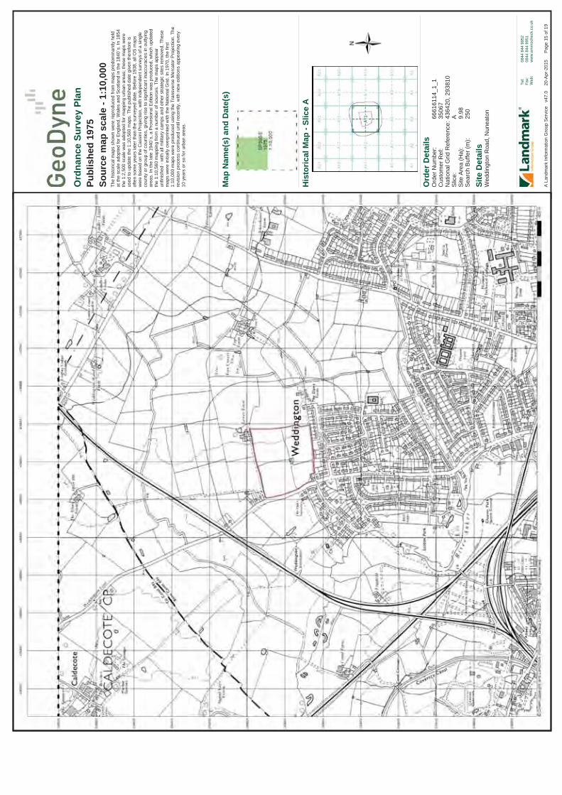
Ord
er D
etai
ls
Site
Det
ails
Wed
ding
ton
Roa
d, N
unea
ton
Ord
er N
umbe
r:C
usto
mer
Ref
:N
atio
nal G
rid R
efer
ence
:S
lice:
Site
Are
a (H
a):
Sea
rch
Buf
fer (
m):
6661
6114
_1_1
3506
743
6420
, 293
810
A 9.98
250
Tel:
Fax:
Web
:
0844
844
995
208
44 8
44 9
951
ww
w.e
nviro
chec
k.co
.uk
Pag
e 15
of 1
9A
Lan
dmar
k In
form
atio
n G
roup
Ser
vice
v4
7.0
20
-Apr
-201
5
Ord
nanc
e Su
rvey
Pla
nPu
blis
hed
1975
Sour
ce m
ap s
cale
- 1:
10,0
00Th
e hi
stor
ical
map
s sh
own
wer
e re
prod
uced
from
map
s pr
edom
inan
tly h
eld
at th
e sc
ale
adop
ted
for E
ngla
nd, W
ales
and
Sco
tland
in th
e 18
40`s
. In
1854
th
e 1:
2,50
0 sc
ale
was
ado
pted
for m
appi
ng u
rban
are
as; t
hese
map
s w
ere
used
to u
pdat
e th
e 1:
10,5
60 m
aps.
The
pub
lishe
d da
te g
iven
ther
efor
e is
of
ten
som
e ye
ars
late
r tha
n th
e su
rvey
ed d
ate.
Bef
ore
1938
, all
OS
map
s w
ere
base
d on
the
Cas
sini
Pro
ject
ion,
with
inde
pend
ent s
urve
ys o
f a s
ingl
e co
unty
or g
roup
of c
ount
ies,
giv
ing
rise
to s
igni
fican
t ina
ccur
acie
s in
out
lyin
g ar
eas.
In th
e la
te 1
940`
s, a
Pro
visi
onal
Edi
tion
was
pro
duce
d, w
hich
upd
ated
th
e 1:
10,5
60 m
appi
ng fr
om a
num
ber o
f sou
rces
. The
map
s ap
pear
un
finis
hed
- with
all
milit
ary
cam
ps a
nd o
ther
stra
tegi
c si
tes
rem
oved
. The
se
map
s w
ere
initi
ally
ove
rprin
ted
with
the
Nat
iona
l Grid
. In
1970
, the
firs
t 1:
10,0
00 m
aps
wer
e pr
oduc
ed u
sing
the
Tran
sver
se M
erca
tor P
roje
ctio
n. T
here
visi
on p
roce
ss c
ontin
ued
until
rece
ntly
, with
new
edi
tions
app
earin
g ev
ery
10 y
ears
or s
o fo
r urb
an a
reas
.
His
toric
al M
ap -
Slic
eA
Map
Nam
e(s)
and
Dat
e(s)

Ord
er D
etai
ls
Site
Det
ails
Wed
ding
ton
Roa
d, N
unea
ton
Ord
er N
umbe
r:C
usto
mer
Ref
:N
atio
nal G
rid R
efer
ence
:S
lice:
Site
Are
a (H
a):
Sea
rch
Buf
fer (
m):
6661
6114
_1_1
3506
743
6420
, 293
810
A 9.98
250
Tel:
Fax:
Web
:
0844
844
995
208
44 8
44 9
951
ww
w.e
nviro
chec
k.co
.uk
Pag
e 16
of 1
9A
Lan
dmar
k In
form
atio
n G
roup
Ser
vice
v4
7.0
20
-Apr
-201
5
Ord
nanc
e Su
rvey
Pla
nPu
blis
hed
1989
Sour
ce m
ap s
cale
- 1:
10,0
00Th
e hi
stor
ical
map
s sh
own
wer
e re
prod
uced
from
map
s pr
edom
inan
tly h
eld
at th
e sc
ale
adop
ted
for E
ngla
nd, W
ales
and
Sco
tland
in th
e 18
40`s
. In
1854
th
e 1:
2,50
0 sc
ale
was
ado
pted
for m
appi
ng u
rban
are
as; t
hese
map
s w
ere
used
to u
pdat
e th
e 1:
10,5
60 m
aps.
The
pub
lishe
d da
te g
iven
ther
efor
e is
of
ten
som
e ye
ars
late
r tha
n th
e su
rvey
ed d
ate.
Bef
ore
1938
, all
OS
map
s w
ere
base
d on
the
Cas
sini
Pro
ject
ion,
with
inde
pend
ent s
urve
ys o
f a s
ingl
e co
unty
or g
roup
of c
ount
ies,
giv
ing
rise
to s
igni
fican
t ina
ccur
acie
s in
out
lyin
g ar
eas.
In th
e la
te 1
940`
s, a
Pro
visi
onal
Edi
tion
was
pro
duce
d, w
hich
upd
ated
th
e 1:
10,5
60 m
appi
ng fr
om a
num
ber o
f sou
rces
. The
map
s ap
pear
un
finis
hed
- with
all
milit
ary
cam
ps a
nd o
ther
stra
tegi
c si
tes
rem
oved
. The
se
map
s w
ere
initi
ally
ove
rprin
ted
with
the
Nat
iona
l Grid
. In
1970
, the
firs
t 1:
10,0
00 m
aps
wer
e pr
oduc
ed u
sing
the
Tran
sver
se M
erca
tor P
roje
ctio
n. T
here
visi
on p
roce
ss c
ontin
ued
until
rece
ntly
, with
new
edi
tions
app
earin
g ev
ery
10 y
ears
or s
o fo
r urb
an a
reas
.
His
toric
al M
ap -
Slic
eA
Map
Nam
e(s)
and
Dat
e(s)

Ord
er D
etai
ls
Site
Det
ails
Wed
ding
ton
Roa
d, N
unea
ton
Ord
er N
umbe
r:C
usto
mer
Ref
:N
atio
nal G
rid R
efer
ence
:S
lice:
Site
Are
a (H
a):
Sea
rch
Buf
fer (
m):
6661
6114
_1_1
3506
743
6420
, 293
810
A 9.98
250
Tel:
Fax:
Web
:
0844
844
995
208
44 8
44 9
951
ww
w.e
nviro
chec
k.co
.uk
Pag
e 17
of 1
9A
Lan
dmar
k In
form
atio
n G
roup
Ser
vice
v4
7.0
20
-Apr
-201
5
Ord
nanc
e Su
rvey
Pla
nPu
blis
hed
1994
Sour
ce m
ap s
cale
- 1:
10,0
00Th
e hi
stor
ical
map
s sh
own
wer
e re
prod
uced
from
map
s pr
edom
inan
tly h
eld
at th
e sc
ale
adop
ted
for E
ngla
nd, W
ales
and
Sco
tland
in th
e 18
40`s
. In
1854
th
e 1:
2,50
0 sc
ale
was
ado
pted
for m
appi
ng u
rban
are
as; t
hese
map
s w
ere
used
to u
pdat
e th
e 1:
10,5
60 m
aps.
The
pub
lishe
d da
te g
iven
ther
efor
e is
of
ten
som
e ye
ars
late
r tha
n th
e su
rvey
ed d
ate.
Bef
ore
1938
, all
OS
map
s w
ere
base
d on
the
Cas
sini
Pro
ject
ion,
with
inde
pend
ent s
urve
ys o
f a s
ingl
e co
unty
or g
roup
of c
ount
ies,
giv
ing
rise
to s
igni
fican
t ina
ccur
acie
s in
out
lyin
g ar
eas.
In th
e la
te 1
940`
s, a
Pro
visi
onal
Edi
tion
was
pro
duce
d, w
hich
upd
ated
th
e 1:
10,5
60 m
appi
ng fr
om a
num
ber o
f sou
rces
. The
map
s ap
pear
un
finis
hed
- with
all
milit
ary
cam
ps a
nd o
ther
stra
tegi
c si
tes
rem
oved
. The
se
map
s w
ere
initi
ally
ove
rprin
ted
with
the
Nat
iona
l Grid
. In
1970
, the
firs
t 1:
10,0
00 m
aps
wer
e pr
oduc
ed u
sing
the
Tran
sver
se M
erca
tor P
roje
ctio
n. T
here
visi
on p
roce
ss c
ontin
ued
until
rece
ntly
, with
new
edi
tions
app
earin
g ev
ery
10 y
ears
or s
o fo
r urb
an a
reas
.
His
toric
al M
ap -
Slic
eA
Map
Nam
e(s)
and
Dat
e(s)

Ord
er D
etai
ls
Site
Det
ails
Wed
ding
ton
Roa
d, N
unea
ton
Ord
er N
umbe
r:C
usto
mer
Ref
:N
atio
nal G
rid R
efer
ence
:S
lice:
Site
Are
a (H
a):
Sea
rch
Buf
fer (
m):
6661
6114
_1_1
3506
743
6420
, 293
810
A 9.98
250
Tel:
Fax:
Web
:
0844
844
995
208
44 8
44 9
951
ww
w.e
nviro
chec
k.co
.uk
Pag
e 18
of 1
9A
Lan
dmar
k In
form
atio
n G
roup
Ser
vice
v4
7.0
20
-Apr
-201
5
10k
Ras
ter M
appi
ngPu
blis
hed
2006
Sour
ce m
ap s
cale
- 1:
10,0
00Th
e hi
stor
ical
map
s sh
own
wer
e pr
oduc
ed fr
om th
e O
rdna
nce
Sur
vey`
s 1:
10,0
00 c
olou
r ras
ter m
appi
ng. T
hese
map
s ar
e de
rived
from
Lan
dpla
n w
hich
repl
aced
the
old
1:10
,000
map
s or
igin
ally
pub
lishe
d in
197
0. T
he d
ata
is h
ighl
y de
taile
d sh
owin
g bu
ildin
gs, f
ence
s an
d fie
ld b
ound
arie
s as
wel
l as
all
road
s, tr
acks
and
pat
hs. R
oad
nam
es a
re a
lso
incl
uded
toge
ther
with
the
rele
vant
road
num
ber a
nd c
lass
ifica
tion.
Bou
ndar
y in
form
atio
n de
pict
ion
incl
udes
cou
nty,
uni
tary
aut
horit
y, d
istri
ct, c
ivil
paris
h an
d co
nstit
uenc
y.
dum
my His
toric
al M
ap -
Slic
eA
Map
Nam
e(s)
and
Dat
e(s)

Ord
er D
etai
ls
Site
Det
ails
Wed
ding
ton
Roa
d, N
unea
ton
Ord
er N
umbe
r:C
usto
mer
Ref
:N
atio
nal G
rid R
efer
ence
:S
lice:
Site
Are
a (H
a):
Sea
rch
Buf
fer (
m):
6661
6114
_1_1
3506
743
6420
, 293
810
A 9.98
250
Tel:
Fax:
Web
:
0844
844
995
208
44 8
44 9
951
ww
w.e
nviro
chec
k.co
.uk
Pag
e 19
of 1
9A
Lan
dmar
k In
form
atio
n G
roup
Ser
vice
v4
7.0
20
-Apr
-201
5
Vect
orM
ap L
ocal
Publ
ishe
d 20
15So
urce
map
sca
le -
1:10
,000
Vec
torM
ap L
ocal
(Ras
ter)
is O
rdna
nce
Sur
vey'
s hi
ghes
t det
aile
d 'b
ackd
rop'
m
appi
ng p
rodu
ct. T
hese
map
s ar
e pr
oduc
ed fr
om O
S's
Vec
torM
ap L
ocal
, a
sim
ple
vect
or d
atas
et a
t a n
omin
al s
cale
of 1
:10,
000,
cov
erin
g th
e w
hole
of
Gre
at B
ritai
n, th
at h
as b
een
desi
gned
for c
reat
ing
grap
hica
l map
ping
. OS
V
ecto
rMap
Loc
al is
der
ived
from
larg
e-sc
ale
info
rmat
ion
surv
eyed
at 1
:125
0 sc
ale
(cov
erin
g m
ajor
tow
ns a
nd c
ities
),1:2
500
scal
e (s
mal
ler t
owns
, villa
ges
and
deve
lope
d ru
ral a
reas
), an
d 1:
10 0
00 s
cale
(mou
ntai
n, m
oorla
nd a
nd
river
est
uary
are
as).
His
toric
al M
ap -
Slic
eA
Map
Nam
e(s)
and
Dat
e(s)

APPENDIX VIII
Landmark Envirocheck Report

Order Number: 66616114_1_1 Date: 20-Apr-2015 rpr_ec_datasheet v49.0 A Landmark Information Group Service
Datasheet
Order Details:Order Number:
Customer Reference:
National Grid Reference:
Slice:
Site Area (Ha):
Search Buffer (m):
Site Details:
Client Details:
Prepared For:
66616114_1_1
35067
436420, 293810
A
9.98
250
Weddington RoadNuneaton
Mr R SpencerGeoDyne LtdThe GranaryChurch LaneThrumptonNG11 0AX
Barratt Homes2 Horizon PlaceMellors WayNottingham Business ParkNottinghamNG8 6PY
Report:®Envirocheck

Order Number: 66616114_1_1 Date: 20-Apr-2015 rpr_ec_datasheet v49.0 A Landmark Information Group Service
Summary
Agency & Hydrological
Waste
Hazardous Substances
Geological
Industrial Land Use
Sensitive Land Use
Data Currency
Data Suppliers
Useful Contacts
Introduction
Copyright Notice
Natural England Copyright Notice
Ove Arup Copyright Notice
Peter Brett Associates Copyright Notice
Radon Potential dataset Copyright Notice
The Environment Act 1995 has made site sensitivity a key issue, as the legislation pays as much attention to the pathways by which contamination could spread, and to the vulnerable targets of contamination, as it does the potential sources of contamination. For this reason, Landmark's Site Sensitivity maps and Datasheet(s) place great emphasis on statutory data provided by the Environment Agency/Natural Resources Wales and the Scottish Environment Protection Agency; it also incorporates data from Natural England (and the Scottish and Welsh equivalents) and Local Authorities; and highlights hydrogeological features required by environmental and geotechnical consultants. It does not include any information concerning past uses of land. The datasheet is produced by querying the Landmark database to a distance defined by the client from a site boundary provided by the client.
In the attached datasheet the National Grid References (NGRs) are rounded to the nearest 10m in accordance with Landmark's agreements with a number of Data Suppliers.
© Landmark Information Group Limited 2015. The Copyright on the information and data and its format as contained in this Envirocheck® Report ("Report") is the property of Landmark Information Group Limited ("Landmark") and several other Data Providers, including (but not limited to) Ordnance Survey, British Geological Survey, the Environment Agency/Natural Resources Wales and Natural England, and must not be reproduced in whole or in part by photocopying or any other method. The Report is supplied under Landmark's Terms and Conditions accepted by the Customer. A copy of Landmark's Terms and Conditions can be found with the Index Map for this report. Additional copies of the Report may be obtained from Landmark, subject to Landmark's charges in force from time to time. The Copyright, design rights and any other intellectual rights shall remain the exclusive property of Landmark and /or other Data providers, whose Copyright material has been included in this Report.
Site of Special Scientific Interest, National Nature Reserve, Ramsar, Special Protection Area, Special Conservation Area, Marine Nature Reserve data (derived from Ordnance Survey 1:10000 raster) is provided by, and used with the permission of, Natural England who retain the copyright and Intellectual Property Rights for the data.
The Data provided in this report was obtained on Licence from Ove Arup & Partners Limited (for further information, contact [email protected]). No reproduction or further use of such Data is to be made without the prior written consent of Ove Arup & Partners Limited. The information and data supplied in the product are derived from publicly available records and other third party sources and neither Ove Arup & Partners nor Landmark warrant the accuracy or completeness of such information or data.
The cavity data presented has been extracted from the PBA enhanced version of the original DEFRA national cavity databases. PBA/DEFRA retain the copyright & intellectual property rights in the data. Whilst all reasonable efforts are made to check that the information contained in the cavity databases is accurate we do not warrant that the data is complete or error free. The information is based upon our own researches and those collated from a number of external sources and is continually being augmented and updated by PBA. In no event shall PBA/DEFRA or Landmark be liable for any loss or damage including, without limitation, indirect or consequential loss or damage arising from the use of this data.
Information supplied from a joint dataset compiled by The British Geological Survey and Public Health England.
Report Section Page Number
Contents
Report Version v49.0
-
1
3
-
4
7
8
9
14
15

Order Number: 66616114_1_1 Date: 20-Apr-2015 rpr_ec_datasheet v49.0 A Landmark Information Group Service
Summary
Data Type PageNumber On Site
Agency & Hydrological
0 to 250m
Contaminated Land Register Entries and Notices
Discharge Consents
Enforcement and Prohibition Notices
Integrated Pollution Controls
Integrated Pollution Prevention And Control
Local Authority Integrated Pollution Prevention And Control
Local Authority Pollution Prevention and Controls
Local Authority Pollution Prevention and Control Enforcements
Nearest Surface Water Feature
Pollution Incidents to Controlled Waters
Prosecutions Relating to Authorised Processes
Prosecutions Relating to Controlled Waters
Registered Radioactive Substances
River Quality
River Quality Biology Sampling Points
River Quality Chemistry Sampling Points
Substantiated Pollution Incident Register
Water Abstractions
Water Industry Act Referrals
Groundwater Vulnerability
Bedrock Aquifer Designations
Superficial Aquifer Designations
Source Protection Zones
Extreme Flooding from Rivers or Sea without Defences
Flooding from Rivers or Sea without Defences
Areas Benefiting from Flood Defences
Flood Water Storage Areas
Flood Defences
Detailed River Network Lines
Detailed River Network Offline Drainage
Yes
Yes
Yes
Yes
n/a
n/a
n/a
Yes
Yes
(*up to 500m)
pg 1
pg 1
pg 1
pg 1
pg 1
pg 1

Order Number: 66616114_1_1 Date: 20-Apr-2015 rpr_ec_datasheet v49.0 A Landmark Information Group Service
Summary
Data Type PageNumber On Site
Waste
Hazardous Substances
Geological
0 to 250m
BGS Recorded Landfill Sites
Historical Landfill Sites
Integrated Pollution Control Registered Waste Sites
Licensed Waste Management Facilities (Landfill Boundaries)
Licensed Waste Management Facilities (Locations)
Local Authority Recorded Landfill Sites
Registered Landfill Sites
Registered Waste Transfer Sites
Registered Waste Treatment or Disposal Sites
Control of Major Accident Hazards Sites (COMAH)
Explosive Sites
Notification of Installations Handling Hazardous Substances (NIHHS)
Planning Hazardous Substance Consents
Planning Hazardous Substance Enforcements
BGS 1:625,000 Solid Geology
BGS Estimated Soil Chemistry
BGS Recorded Mineral Sites
BGS Urban Soil Chemistry
BGS Urban Soil Chemistry Averages
Brine Compensation Area
Coal Mining Affected Areas
Mining Instability
Man-Made Mining Cavities
Natural Cavities
Non Coal Mining Areas of Great Britain
Potential for Collapsible Ground Stability Hazards
Potential for Compressible Ground Stability Hazards
Potential for Ground Dissolution Stability Hazards
Potential for Landslide Ground Stability Hazards
Potential for Running Sand Ground Stability Hazards
Potential for Shrinking or Swelling Clay Ground Stability Hazards
Radon Potential - Radon Affected Areas
Radon Potential - Radon Protection Measures
Yes
Yes
Yes
Yes
Yes
Yes
n/a
Yes
n/a
n/a
n/a
Yes
n/a
n/a
(*up to 500m)
pg 4
pg 4
pg 5
pg 6
pg 6
pg 6

Order Number: 66616114_1_1 Date: 20-Apr-2015 rpr_ec_datasheet v49.0 A Landmark Information Group Service
Summary
Data Type PageNumber On Site
Industrial Land Use
Sensitive Land Use
0 to 250m
Contemporary Trade Directory Entries
Fuel Station Entries
Areas of Adopted Green Belt
Areas of Unadopted Green Belt
Areas of Outstanding Natural Beauty
Environmentally Sensitive Areas
Forest Parks
Local Nature Reserves
Marine Nature Reserves
National Nature Reserves
National Parks
Nitrate Sensitive Areas
Nitrate Vulnerable Zones
Ramsar Sites
Sites of Special Scientific Interest
Special Areas of Conservation
Special Protection Areas
1
1
(*up to 500m)
pg 7
pg 8

Order Number: 66616114_1_1 Date: 20-Apr-2015 rpr_ec_datasheet v49.0 A Landmark Information Group Service Page 1 of 15
Agency & Hydrological
MapID Details
QuadrantReference(CompassDirection)
EstimatedDistanceFrom Site
Contact NGR
1
2
3
Nearest Surface Water Feature
Groundwater Vulnerability
Drift Deposits
Bedrock Aquifer Designations
Superficial Aquifer Designations
Extreme Flooding from Rivers or Sea without Defences
Flooding from Rivers or Sea without Defences
Areas Benefiting from Flood Defences
Flood Water Storage Areas
Flood Defences
Detailed River Network Lines
Detailed River Network Lines
Detailed River Network Lines
A13SW(SW)
A13SE(N)
A13SE(N)
A13NE(NE)
A12SE(SW)
A13SW(SW)
A14SW(E)
A14SW(E)
25
0
0
0
242
25
210
232
-
2
3
3
2
2
2
2
Soil Classification:Map Sheet:Scale:
Aquifer Designation:
Aquifer Designation:
Type:Flood Plain Type:Boundary Accuracy:
River Type:River Name:Hydrographic Area:River Flow Type:River Surface Level:Drain Feature:Flood Risk Management Status:Water Course Name:Water Course Reference:
River Type:River Name:Hydrographic Area:River Flow Type:River Surface Level:Drain Feature:Flood Risk Management Status:Water Course Name:Water Course Reference:
River Type:River Name:Hydrographic Area:River Flow Type:River Surface Level:Drain Feature:Flood Risk Management Status:Water Course Name:Water Course Reference:
Not classifiedSheet 23 Leicestershire1:100,000
Secondary Aquifer - B
Secondary Aquifer - A
Extent of Extreme Flooding from Rivers or Sea without DefencesFluvial ModelsAs Supplied
Tertiary RiverNot SuppliedD004Primary Flow PathSurfaceNot a DrainOther Rivers
Not Supplied
Not Supplied
Tertiary RiverDrainD004Primary Flow PathSurfaceDrain (ditch, Reen, Rhyne, Drain)Other Rivers
Not Supplied
Not Supplied
Tertiary RiverNot SuppliedD004Primary Flow PathSurfaceNot a DrainOther Rivers
Not Supplied
Not Supplied
None
None
None
None
None
436261293682
436423293811
436423293811
436513293872
436061293589
436261293682
436799293791
436824293695

Order Number: 66616114_1_1 Date: 20-Apr-2015 rpr_ec_datasheet v49.0 A Landmark Information Group Service Page 2 of 15
Agency & Hydrological
MapID Details
QuadrantReference(CompassDirection)
EstimatedDistanceFrom Site
Contact NGR
4Detailed River Network Lines
Detailed River Network Offline Drainage
A14SW(E)
232 2River Type:River Name:Hydrographic Area:River Flow Type:River Surface Level:Drain Feature:Flood Risk Management Status:Water Course Name:Water Course Reference:
Tertiary RiverNot SuppliedD004Primary Flow PathSurfaceNot a DrainOther Rivers
Not Supplied
Not Supplied
None
436824293695

Order Number: 66616114_1_1 Date: 20-Apr-2015 rpr_ec_datasheet v49.0 A Landmark Information Group Service Page 3 of 15
Waste
MapID Details
QuadrantReference(CompassDirection)
EstimatedDistanceFrom Site
Contact NGR
Local Authority Landfill Coverage
Local Authority Landfill Coverage
0
0
4
6
Name:
Name:
Nuneaton And Bedworth Borough Council - Has not been able to supply Landfill data
Warwickshire County Council - Had landfill data but passed it to the relevant environment agency
436423293811
436423293811

Order Number: 66616114_1_1 Date: 20-Apr-2015 rpr_ec_datasheet v49.0 A Landmark Information Group Service Page 4 of 15
Geological
MapID Details
QuadrantReference(CompassDirection)
EstimatedDistanceFrom Site
Contact NGR
BGS 1:625,000 Solid Geology
BGS Estimated Soil Chemistry
BGS Estimated Soil Chemistry
BGS Estimated Soil Chemistry
BGS Estimated Soil Chemistry
BGS Estimated Soil Chemistry
BGS Estimated Soil Chemistry
A13SE(N)
A13SE(N)
A13NE(NE)
A13NE(N)
A13NE(N)
A13NE(NE)
A13SW(W)
0
0
0
15
90
95
167
3
3
3
3
3
3
3
Description:
Source:Soil Sample Type:ArsenicConcentration:CadmiumConcentration:ChromiumConcentration:Lead Concentration:NickelConcentration:
Source:Soil Sample Type:ArsenicConcentration:CadmiumConcentration:ChromiumConcentration:Lead Concentration:NickelConcentration:
Source:Soil Sample Type:ArsenicConcentration:CadmiumConcentration:ChromiumConcentration:Lead Concentration:NickelConcentration:
Source:Soil Sample Type:ArsenicConcentration:CadmiumConcentration:ChromiumConcentration:Lead Concentration:NickelConcentration:
Source:Soil Sample Type:ArsenicConcentration:CadmiumConcentration:ChromiumConcentration:Lead Concentration:NickelConcentration:
Source:Soil Sample Type:ArsenicConcentration:CadmiumConcentration:ChromiumConcentration:Lead Concentration:NickelConcentration:
Triassic mudstones (including Keuper Marl, Dolomitic Conglomerate and Rhaetic)
British Geological Survey, National Geoscience Information ServiceRural Soil<15 mg/kg
<1.8 mg/kg
60 - 90 mg/kg
<150 mg/kg15 - 30 mg/kg
British Geological Survey, National Geoscience Information ServiceRural Soil<15 mg/kg
<1.8 mg/kg
60 - 90 mg/kg
<150 mg/kg15 - 30 mg/kg
British Geological Survey, National Geoscience Information ServiceRural Soil<15 mg/kg
<1.8 mg/kg
60 - 90 mg/kg
<150 mg/kg15 - 30 mg/kg
British Geological Survey, National Geoscience Information ServiceRural Soil<15 mg/kg
<1.8 mg/kg
60 - 90 mg/kg
<150 mg/kg15 - 30 mg/kg
British Geological Survey, National Geoscience Information ServiceRural Soil<15 mg/kg
<1.8 mg/kg
60 - 90 mg/kg
<150 mg/kg15 - 30 mg/kg
British Geological Survey, National Geoscience Information ServiceRural Soil<15 mg/kg
<1.8 mg/kg
60 - 90 mg/kg
<150 mg/kg15 - 30 mg/kg
436423293811
436423293811
436513293871
436423294000
436418294046
436641294053
436097293683

Order Number: 66616114_1_1 Date: 20-Apr-2015 rpr_ec_datasheet v49.0 A Landmark Information Group Service Page 5 of 15
Geological
MapID Details
QuadrantReference(CompassDirection)
EstimatedDistanceFrom Site
Contact NGR
BGS Estimated Soil Chemistry
BGS Estimated Soil Chemistry
BGS Estimated Soil Chemistry
BGS Estimated Soil Chemistry
BGS Estimated Soil Chemistry
BGS Measured Urban Soil Chemistry
BGS Urban Soil Chemistry Averages
Coal Mining Affected Areas
Non Coal Mining Areas of Great Britain
Potential for Collapsible Ground Stability Hazards
A13NE(NE)
A12SE(W)
A18SE(NE)
A12NE(NW)
A12SE(W)
A13SE(N)
181
210
216
233
236
0
3
3
3
3
3
3
Source:Soil Sample Type:ArsenicConcentration:CadmiumConcentration:ChromiumConcentration:Lead Concentration:NickelConcentration:
Source:Soil Sample Type:ArsenicConcentration:CadmiumConcentration:ChromiumConcentration:Lead Concentration:NickelConcentration:
Source:Soil Sample Type:ArsenicConcentration:CadmiumConcentration:ChromiumConcentration:Lead Concentration:NickelConcentration:
Source:Soil Sample Type:ArsenicConcentration:CadmiumConcentration:ChromiumConcentration:Lead Concentration:NickelConcentration:
Source:Soil Sample Type:ArsenicConcentration:CadmiumConcentration:ChromiumConcentration:Lead Concentration:NickelConcentration:
Hazard Potential:Source:
British Geological Survey, National Geoscience Information ServiceRural Soil<15 mg/kg
<1.8 mg/kg
60 - 90 mg/kg
<150 mg/kg15 - 30 mg/kg
British Geological Survey, National Geoscience Information ServiceRural Soil<15 mg/kg
<1.8 mg/kg
60 - 90 mg/kg
<150 mg/kg15 - 30 mg/kg
British Geological Survey, National Geoscience Information ServiceRural Soil<15 mg/kg
<1.8 mg/kg
60 - 90 mg/kg
<150 mg/kg15 - 30 mg/kg
British Geological Survey, National Geoscience Information ServiceRural Soil<15 mg/kg
<1.8 mg/kg
60 - 90 mg/kg
<150 mg/kg15 - 30 mg/kg
British Geological Survey, National Geoscience Information ServiceRural Soil<15 mg/kg
<1.8 mg/kg
60 - 90 mg/kg
<150 mg/kg15 - 30 mg/kg
Very LowBritish Geological Survey, National Geoscience Information Service
No data available
No data available
In an area that might not be affected by coal mining
No Hazard
436674294137
436000293811
436695294165
436000294000
436000293744
436423293811

Order Number: 66616114_1_1 Date: 20-Apr-2015 rpr_ec_datasheet v49.0 A Landmark Information Group Service Page 6 of 15
Geological
MapID Details
QuadrantReference(CompassDirection)
EstimatedDistanceFrom Site
Contact NGR
Potential for Compressible Ground Stability Hazards
Potential for Ground Dissolution Stability Hazards
Potential for Landslide Ground Stability Hazards
Potential for Running Sand Ground Stability Hazards
Potential for Running Sand Ground Stability Hazards
Potential for Running Sand Ground Stability Hazards
Potential for Running Sand Ground Stability Hazards
Potential for Running Sand Ground Stability Hazards
Potential for Shrinking or Swelling Clay Ground Stability Hazards
Potential for Shrinking or Swelling Clay Ground Stability Hazards
Radon Potential - Radon Protection Measures
Radon Potential - Radon Affected Areas
A13SE(N)
A13SE(N)
A13SE(N)
A13SE(N)
A13NE(NE)
A13NE(N)
A13NE(NE)
A13SW(W)
A13SE(N)
A13NE(NE)
A13SE(N)
A13SE(N)
0
0
0
0
0
90
95
167
0
181
0
0
3
3
3
3
3
3
3
3
3
3
3
3
Hazard Potential:Source:
Hazard Potential:Source:
Hazard Potential:Source:
Hazard Potential:Source:
Hazard Potential:Source:
Hazard Potential:Source:
Hazard Potential:Source:
Hazard Potential:Source:
Hazard Potential:Source:
Hazard Potential:Source:
Protection Measure:
Source:
Affected Area:
Source:
No HazardBritish Geological Survey, National Geoscience Information Service
No HazardBritish Geological Survey, National Geoscience Information Service
Very LowBritish Geological Survey, National Geoscience Information Service
No HazardBritish Geological Survey, National Geoscience Information Service
Very LowBritish Geological Survey, National Geoscience Information Service
Very LowBritish Geological Survey, National Geoscience Information Service
Very LowBritish Geological Survey, National Geoscience Information Service
Very LowBritish Geological Survey, National Geoscience Information Service
Very LowBritish Geological Survey, National Geoscience Information Service
No HazardBritish Geological Survey, National Geoscience Information Service
No radon protective measures are necessary in the construction of new dwellings or extensionsBritish Geological Survey, National Geoscience Information Service
The property is in a lower probability radon area, as less than 1% of homes are above the action levelBritish Geological Survey, National Geoscience Information Service
436423293811
436423293811
436423293811
436423293811
436513293871
436418294046
436641294053
436097293683
436423293811
436674294137
436423293811
436423293811

Order Number: 66616114_1_1 Date: 20-Apr-2015 rpr_ec_datasheet v49.0 A Landmark Information Group Service Page 7 of 15
Industrial Land Use
MapID Details
QuadrantReference(CompassDirection)
EstimatedDistanceFrom Site
Contact NGR
5Contemporary Trade Directory Entries
A8NE(SE)
219 -Name:Location:Classification:Status:Positional Accuracy:
Personality Foil Print30, Scott Avenue, Nuneaton, Warwickshire, CV10 0DPPrintersActiveAutomatically positioned to the address
436606293450

Order Number: 66616114_1_1 Date: 20-Apr-2015 rpr_ec_datasheet v49.0 A Landmark Information Group Service Page 8 of 15
Sensitive Land Use
MapID Details
QuadrantReference(CompassDirection)
EstimatedDistanceFrom Site
Contact NGR
6Nitrate Vulnerable Zones
A13SE(N)
0 5Name:Description:Source:
Not SuppliedSurface WaterDepartment for Environment, Food and Rural Affairs (DEFRA - formerly FRCA)
436423293811

Order Number: 66616114_1_1 Date: 20-Apr-2015 rpr_ec_datasheet v49.0 A Landmark Information Group Service Page 9 of 15
Data Currency
Agency & Hydrological Version Update CycleContaminated Land Register Entries and Notices
Discharge Consents
Enforcement and Prohibition Notices
Integrated Pollution Controls
Integrated Pollution Prevention And Control
Local Authority Integrated Pollution Prevention And Control
Local Authority Pollution Prevention and Controls
Local Authority Pollution Prevention and Control Enforcements
Nearest Surface Water Feature
Pollution Incidents to Controlled Waters
Prosecutions Relating to Authorised Processes
Prosecutions Relating to Controlled Waters
Registered Radioactive Substances
River Quality
River Quality Biology Sampling Points
River Quality Chemistry Sampling Points
Substantiated Pollution Incident Register
Water Abstractions
Water Industry Act Referrals
Groundwater Vulnerability
October 2014October 2014October 2014
January 2015
March 2013
October 2008
January 2015
August 2014June 2014
September 2014
August 2014June 2014
September 2014
August 2014June 2014
September 2014
July 2012
December 1999
March 2013
March 2013
January 2015
November 2001
July 2012
July 2012
January 2015January 2015January 2015January 2015
October 2014
January 2015
January 2011
Annual Rolling UpdateAnnual Rolling UpdateAnnual Rolling Update
Quarterly
As notified
Not Applicable
Quarterly
Annual Rolling UpdateAnnual Rolling UpdateAnnual Rolling Update
Annual Rolling UpdateAnnual Rolling UpdateAnnual Rolling Update
Annual Rolling UpdateAnnual Rolling UpdateAnnual Rolling Update
Quarterly
Not Applicable
As notified
As notified
Quarterly
Not Applicable
Annually
Annually
QuarterlyQuarterlyQuarterlyQuarterly
Quarterly
Quarterly
Not Applicable
Hinckley And Bosworth Borough Council - Environmental Health DepartmentNorth Warwickshire Borough Council - Environmental Health DepartmentNuneaton And Bedworth Borough Council - Environmental Health Department
Environment Agency - Midlands Region
Environment Agency - Midlands Region
Environment Agency - Midlands Region
Environment Agency - Midlands Region
Nuneaton And Bedworth Borough Council - Environmental Health DepartmentHinckley And Bosworth Borough Council - Environmental Health DepartmentNorth Warwickshire Borough Council - Environmental Health Department
Nuneaton And Bedworth Borough Council - Environmental Health DepartmentHinckley And Bosworth Borough Council - Environmental Health DepartmentNorth Warwickshire Borough Council - Environmental Health Department
Nuneaton And Bedworth Borough Council - Environmental Health DepartmentHinckley And Bosworth Borough Council - Environmental Health DepartmentNorth Warwickshire Borough Council - Environmental Health Department
Ordnance Survey
Environment Agency - Midlands Region
Environment Agency - Midlands Region
Environment Agency - Midlands Region
Environment Agency - Midlands Region
Environment Agency - Head Office
Environment Agency - Head Office
Environment Agency - Head Office
Environment Agency - Midlands Region - Central AreaEnvironment Agency - Midlands Region - East AreaEnvironment Agency - Midlands Region - Lower Trent AreaEnvironment Agency - Midlands Region - Upper Trent Area
Environment Agency - Midlands Region
Environment Agency - Midlands Region
Environment Agency - Head Office

Order Number: 66616114_1_1 Date: 20-Apr-2015 rpr_ec_datasheet v49.0 A Landmark Information Group Service Page 10 of 15
Data Currency
Agency & Hydrological Version Update CycleDrift Deposits
Bedrock Aquifer Designations
Superficial Aquifer Designations
Source Protection Zones
Extreme Flooding from Rivers or Sea without Defences
Flooding from Rivers or Sea without Defences
Areas Benefiting from Flood Defences
Flood Water Storage Areas
Flood Defences
Detailed River Network Lines
Detailed River Network Offline Drainage
January 1999
October 2012
January 2015
January 2015
October 2014
October 2014
October 2014
October 2014
October 2014
March 2012
March 2012
Not Applicable
As notified
As notified
Quarterly
Quarterly
Quarterly
Quarterly
Quarterly
Quarterly
Annually
Annually
Environment Agency - Head Office
British Geological Survey - National Geoscience Information Service
British Geological Survey - National Geoscience Information Service
Environment Agency - Head Office
Environment Agency - Head Office
Environment Agency - Head Office
Environment Agency - Head Office
Environment Agency - Head Office
Environment Agency - Head Office
Environment Agency - Head Office
Environment Agency - Head Office

Order Number: 66616114_1_1 Date: 20-Apr-2015 rpr_ec_datasheet v49.0 A Landmark Information Group Service Page 11 of 15
Data Currency
Waste Version Update CycleBGS Recorded Landfill Sites
Historical Landfill Sites
Integrated Pollution Control Registered Waste Sites
Licensed Waste Management Facilities (Landfill Boundaries)
Licensed Waste Management Facilities (Locations)
Local Authority Landfill Coverage
Local Authority Recorded Landfill Sites
Registered Landfill Sites
Registered Waste Transfer Sites
Registered Waste Treatment or Disposal Sites
June 1996
February 2015February 2015February 2015February 2015
October 2008
August 2014August 2014August 2014August 2014
August 2014August 2014August 2014August 2014
May 2000May 2000May 2000May 2000May 2000
May 2000May 2000May 2000May 2000May 2000
March 2003March 2003
March 2003March 2003
March 2003March 2003
Not Applicable
QuarterlyQuarterlyQuarterlyQuarterly
Not Applicable
QuarterlyQuarterlyQuarterlyQuarterly
QuarterlyQuarterlyQuarterlyQuarterly
Not ApplicableNot ApplicableNot ApplicableNot ApplicableNot Applicable
Not ApplicableNot ApplicableNot ApplicableNot ApplicableNot Applicable
Not ApplicableNot Applicable
Not ApplicableNot Applicable
Not ApplicableNot Applicable
British Geological Survey - National Geoscience Information Service
Environment Agency - Midlands Region - Central AreaEnvironment Agency - Midlands Region - East AreaEnvironment Agency - Midlands Region - Lower Trent AreaEnvironment Agency - Midlands Region - Upper Trent Area
Environment Agency - Midlands Region
Environment Agency - Midlands Region - Central AreaEnvironment Agency - Midlands Region - East AreaEnvironment Agency - Midlands Region - Lower Trent AreaEnvironment Agency - Midlands Region - Upper Trent Area
Environment Agency - Midlands Region - Central AreaEnvironment Agency - Midlands Region - East AreaEnvironment Agency - Midlands Region - Lower Trent AreaEnvironment Agency - Midlands Region - Upper Trent Area
Hinckley And Bosworth Borough Council - Environmental Health DepartmentLeicestershire County CouncilNorth Warwickshire Borough Council - Environmental Health DepartmentNuneaton And Bedworth Borough Council - Planning DepartmentWarwickshire County Council
Hinckley And Bosworth Borough Council - Environmental Health DepartmentLeicestershire County CouncilNorth Warwickshire Borough Council - Environmental Health DepartmentNuneaton And Bedworth Borough Council - Planning DepartmentWarwickshire County Council
Environment Agency - Midlands Region - Lower Trent AreaEnvironment Agency - Midlands Region - Upper Trent Area
Environment Agency - Midlands Region - Lower Trent AreaEnvironment Agency - Midlands Region - Upper Trent Area
Environment Agency - Midlands Region - Lower Trent AreaEnvironment Agency - Midlands Region - Upper Trent Area

Order Number: 66616114_1_1 Date: 20-Apr-2015 rpr_ec_datasheet v49.0 A Landmark Information Group Service Page 12 of 15
Data Currency
Hazardous Substances
Geological
Version
Version
Update Cycle
Update Cycle
Control of Major Accident Hazards Sites (COMAH)
Explosive Sites
Notification of Installations Handling Hazardous Substances (NIHHS)
Planning Hazardous Substance Enforcements
Planning Hazardous Substance Consents
BGS 1:625,000 Solid Geology
BGS Estimated Soil Chemistry
BGS Recorded Mineral Sites
Brine Compensation Area
Coal Mining Affected Areas
Mining Instability
Non Coal Mining Areas of Great Britain
Potential for Collapsible Ground Stability Hazards
Potential for Compressible Ground Stability Hazards
Potential for Ground Dissolution Stability Hazards
Potential for Landslide Ground Stability Hazards
Potential for Running Sand Ground Stability Hazards
Potential for Shrinking or Swelling Clay Ground Stability Hazards
Radon Potential - Radon Affected Areas
Radon Potential - Radon Protection Measures
January 2015
October 2014
November 2000
December 2014July 2007
March 2014March 2015
October 2014
December 2014July 2007
March 2014March 2015
October 2014
August 1996
January 2010
October 2014
August 2011
December 2013
October 2000
July 2014
June 2014
June 2014
June 2014
June 2014
June 2014
June 2014
July 2011
July 2011
Bi-Annually
Bi-Annually
Not Applicable
Annual Rolling UpdateAnnual Rolling UpdateAnnual Rolling UpdateAnnual Rolling UpdateAnnual Rolling Update
Annual Rolling UpdateAnnual Rolling UpdateAnnual Rolling UpdateAnnual Rolling UpdateAnnual Rolling Update
Not Applicable
Annually
Bi-Annually
Not Applicable
As notified
Not Applicable
Not Applicable
Annually
Annually
Annually
Annually
Annually
Annually
As notified
As notified
Health and Safety Executive
Health and Safety Executive
Health and Safety Executive
North Warwickshire Borough Council - Planning AdministrationWarwickshire County CouncilNuneaton And Bedworth Borough Council - Planning DepartmentLeicestershire County CouncilHinckley And Bosworth Borough Council
North Warwickshire Borough Council - Planning AdministrationWarwickshire County CouncilNuneaton And Bedworth Borough Council - Planning DepartmentLeicestershire County CouncilHinckley And Bosworth Borough Council
British Geological Survey - National Geoscience Information Service
British Geological Survey - National Geoscience Information Service
British Geological Survey - National Geoscience Information Service
Cheshire Brine Subsidence Compensation Board
The Coal Authority - Mining Report Service
Ove Arup & Partners
British Geological Survey - National Geoscience Information Service
British Geological Survey - National Geoscience Information Service
British Geological Survey - National Geoscience Information Service
British Geological Survey - National Geoscience Information Service
British Geological Survey - National Geoscience Information Service
British Geological Survey - National Geoscience Information Service
British Geological Survey - National Geoscience Information Service
British Geological Survey - National Geoscience Information Service
British Geological Survey - National Geoscience Information Service

Order Number: 66616114_1_1 Date: 20-Apr-2015 rpr_ec_datasheet v49.0 A Landmark Information Group Service Page 13 of 15
Data Currency
Industrial Land Use
Sensitive Land Use
Version
Version
Update Cycle
Update Cycle
Contemporary Trade Directory Entries
Fuel Station Entries
Areas of Adopted Green Belt
Areas of Unadopted Green Belt
Areas of Outstanding Natural Beauty
Environmentally Sensitive Areas
Forest Parks
Local Nature Reserves
Marine Nature Reserves
National Nature Reserves
National Parks
Nitrate Sensitive Areas
Nitrate Vulnerable Zones
Ramsar Sites
Sites of Special Scientific Interest
Special Areas of Conservation
Special Protection Areas
February 2015
November 2014
February 2015February 2015
February 2015February 2015
February 2015
August 2014
April 1997
April 2015
July 2013
March 2015
February 2015
February 2012
July 2014
March 2014
April 2015
March 2014
April 2015
Quarterly
Quarterly
As notifiedAs notified
As notifiedAs notified
Bi-Annually
Annually
Not Applicable
Bi-Annually
Bi-Annually
Bi-Annually
Bi-Annually
Not Applicable
Annually
Bi-Annually
Bi-Annually
Bi-Annually
Bi-Annually
Thomson Directories
Catalist Ltd - Experian
North Warwickshire Borough Council - Planning AdministrationNuneaton And Bedworth Borough Council - Planning Department
North Warwickshire Borough Council - Planning AdministrationNuneaton And Bedworth Borough Council - Planning Department
Natural England
Natural England
Forestry Commission
Natural England
Natural England
Natural England
Natural England
Department for Environment, Food and Rural Affairs (DEFRA - formerly FRCA)
Department for Environment, Food and Rural Affairs (DEFRA - formerly FRCA)
Natural England
Natural England
Natural England
Natural England

Order Number: 66616114_1_1 Date: 20-Apr-2015 rpr_ec_datasheet v49.0 A Landmark Information Group Service Page 14 of 15
Data Suppliers
Ordnance Survey
Environment Agency
Scottish Environment Protection Agency
The Coal Authority
British Geological Survey
Centre for Ecology and Hydrology
Natural Resources Wales
Scottish Natural Heritage
Natural England
Public Health England
Ove Arup
Peter Brett Associates
Data Supplier Data Supplier Logo
A selection of organisations who provide data within this report

Order Number: 66616114_1_1 Date: 20-Apr-2015 rpr_ec_datasheet v49.0 A Landmark Information Group Service Page 15 of 15
Useful Contacts
Contact Name and Address Contact Details
2
3
4
5
6
-
-
Environment Agency - National Customer Contact Centre (NCCC)
British Geological Survey - Enquiry Service
Nuneaton And Bedworth Borough Council - Planning Department
Department for Environment, Food and Rural Affairs (DEFRA - formerly FRCA)
Warwickshire County Council
Public Health England - Radon Survey, Centre for Radiation, Chemical and Environmental Hazards
Landmark Information Group Limited
PO Box 544, Templeborough, Rotherham, S60 1BY
British Geological Survey, Kingsley Dunham Centre, Keyworth, Nottingham, Nottinghamshire, NG12 5GG
Town Hall, Coton Road, Nuneaton, Warwickshire, CV11 5AA
Government Buildings, Otley Road, Lawnswood, Leeds, West Yorkshire, LS16 5QT
PO Box 43, Shire Hall, Warwick, Warwickshire, CV34 4SX
Chilton, Didcot, Oxfordshire, OX11 0RQ
Imperium, Imperial Way, Reading, Berkshire, RG2 0TD
Telephone: 08708 506 506Email: [email protected]
Telephone: 0115 936 3143Fax: 0115 936 3276Email: [email protected]: www.bgs.ac.uk
Telephone: 024 7637 6376Fax: 024 7637 6251Website: www.nuneatonandbedworth.gov.uk
Telephone: 0113 2613333Fax: 0113 230 0879
Telephone: 01926 410410Website: www.warwickshire.gov.uk
Telephone: 01235 822622Fax: 01235 833891Email: [email protected]: www.ukradon.org
Telephone: 0844 844 9952Fax: 0844 844 9951Email: [email protected]: www.landmarkinfo.co.uk
Please note that the Environment Agency / Natural Resources Wales / SEPA have a charging policy in place for enquiries.

Ord
er D
etai
ls
Site
Det
ails
Wed
ding
ton
Roa
d, N
unea
ton
Ord
er N
umbe
r:C
usto
mer
Ref
:N
atio
nal G
rid R
efer
ence
:S
lice:
Site
Are
a (H
a):
6661
6114
_1_1
3506
743
6420
, 293
810
A 9.98
Tel:
Fax:
Web
:
0844
844
995
208
44 8
44 9
951
ww
w.e
nviro
chec
k.co
.uk
Pag
e1
of 1
A L
andm
ark
Info
rmat
ion
Gro
up S
ervi
ce
v47.
020
-Apr
-201
5
Site
Sen
sitiv
ity M
ap -
Segm
entA
13

Ord
er D
etai
ls
Site
Det
ails
Wed
ding
ton
Roa
d, N
unea
ton
Ord
er N
umbe
r:C
usto
mer
Ref
:N
atio
nal G
rid R
efer
ence
:S
lice:
Site
Are
a (H
a):
Sea
rch
Buf
fer (
m):
6661
6114
_1_1
3506
743
6420
, 293
810
A 9.98
250
Tel:
Fax:
Web
:
0844
844
995
208
44 8
44 9
951
ww
w.e
nviro
chec
k.co
.uk
Pag
e1
of 4
A L
andm
ark
Info
rmat
ion
Gro
up S
ervi
ce
v47.
020
-Apr
-201
5
Site
Sen
sitiv
ity M
ap -
Slic
eA

Ord
er D
etai
ls
Site
Det
ails
Wed
ding
ton
Roa
d, N
unea
ton
Ord
er N
umbe
r:C
usto
mer
Ref
:N
atio
nal G
rid R
efer
ence
:S
lice:
Site
Are
a (H
a):
Sea
rch
Buf
fer (
m):
6661
6114
_1_1
3506
743
6420
, 293
810
A 9.98
250
Tel:
Fax:
Web
:
0844
844
995
208
44 8
44 9
951
ww
w.e
nviro
chec
k.co
.uk
Pag
e2
of 4
A L
andm
ark
Info
rmat
ion
Gro
up S
ervi
ce
v47.
020
-Apr
-201
5
Floo
d M
ap -
Slic
eA
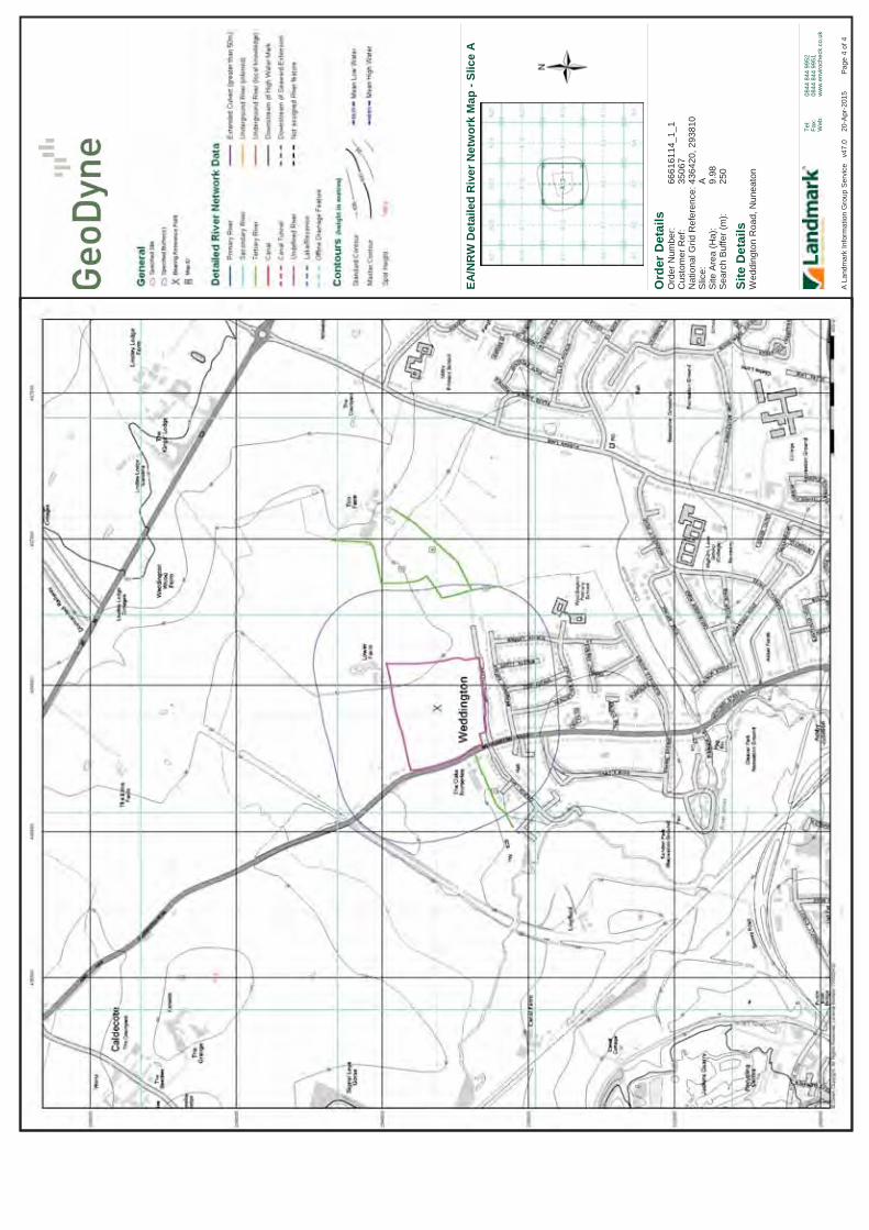
Ord
er D
etai
ls
Site
Det
ails
Wed
ding
ton
Roa
d, N
unea
ton
Ord
er N
umbe
r:C
usto
mer
Ref
:N
atio
nal G
rid R
efer
ence
:S
lice:
Site
Are
a (H
a):
Sea
rch
Buf
fer (
m):
6661
6114
_1_1
3506
743
6420
, 293
810
A 9.98
250
Tel:
Fax:
Web
:
0844
844
995
208
44 8
44 9
951
ww
w.e
nviro
chec
k.co
.uk
Pag
e4
of 4
A L
andm
ark
Info
rmat
ion
Gro
up S
ervi
ce
v47.
020
-Apr
-201
5
EA/N
RW
Det
aile
d R
iver
Net
wor
k M
ap -
Slic
eA
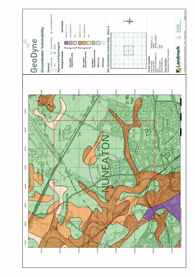
Ord
er D
etai
ls
Site
Det
ails
Wed
ding
ton
Road
, Nun
eato
n
Ord
er N
umbe
r:Cu
stom
er R
ef:
Natio
nal G
rid R
efer
ence
:Sl
ice:
Site
Are
a (H
a):
Sear
ch B
uffe
r (m
):
6661
6114
_1_1
3506
743
6420
, 293
810
A 9.98
250
Tel:
Fax:
Web
:
0844
844
995
208
44 8
44 9
951
www.
envir
oche
ck.c
o.uk Pa
ge1
of 5
A La
ndm
ark
Info
rmat
ion
Gro
up S
ervic
e v
15.0
20-A
pr-2
015
Site
Sen
sitiv
ity C
onte
xt M
ap -
Slic
eA
Gro
undw
ater
Vul
nera
bilit
y

Ord
er D
etai
ls
Site
Det
ails
Wed
ding
ton
Road
, Nun
eato
n
Ord
er N
umbe
r:Cu
stom
er R
ef:
Natio
nal G
rid R
efer
ence
:Sl
ice:
Site
Are
a (H
a):
Sear
ch B
uffe
r (m
):
6661
6114
_1_1
3506
743
6420
, 293
810
A 9.98
250
Tel:
Fax:
Web
:
0844
844
995
208
44 8
44 9
951
www.
envir
oche
ck.c
o.uk Pa
ge2
of 5
A La
ndm
ark
Info
rmat
ion
Gro
up S
ervic
e v
15.0
20-A
pr-2
015
Site
Sen
sitiv
ity C
onte
xt M
ap -
Slic
eA
Bed
rock
Aqu
ifer D
esig
natio
n

Ord
er D
etai
ls
Site
Det
ails
Wed
ding
ton
Road
, Nun
eato
n
Ord
er N
umbe
r:Cu
stom
er R
ef:
Natio
nal G
rid R
efer
ence
:Sl
ice:
Site
Are
a (H
a):
Sear
ch B
uffe
r (m
):
6661
6114
_1_1
3506
743
6420
, 293
810
A 9.98
250
Tel:
Fax:
Web
:
0844
844
995
208
44 8
44 9
951
www.
envir
oche
ck.c
o.uk Pa
ge3
of 5
A La
ndm
ark
Info
rmat
ion
Gro
up S
ervic
e v
15.0
20-A
pr-2
015
Site
Sen
sitiv
ity C
onte
xt M
ap -
Slic
eA
Supe
rfic
ial A
quife
r Des
igna
tion

Ord
er D
etai
ls
Site
Det
ails
Wed
ding
ton
Road
, Nun
eato
n
Ord
er N
umbe
r:Cu
stom
er R
ef:
Natio
nal G
rid R
efer
ence
:Sl
ice:
Site
Are
a (H
a):
Sear
ch B
uffe
r (m
):
6661
6114
_1_1
3506
743
6420
, 293
810
A 9.98
250
Tel:
Fax:
Web
:
0844
844
995
208
44 8
44 9
951
www.
envir
oche
ck.c
o.uk Pa
ge4
of 5
A La
ndm
ark
Info
rmat
ion
Gro
up S
ervic
e v
15.0
20-A
pr-2
015
Site
Sen
sitiv
ity C
onte
xt M
ap -
Slic
eA
Sour
ce P
rote
ctio
n Zo
nes

Ord
er D
etai
ls
Site
Det
ails
Wed
ding
ton
Road
, Nun
eato
n
Ord
er N
umbe
r:Cu
stom
er R
ef:
Natio
nal G
rid R
efer
ence
:Sl
ice:
Site
Are
a (H
a):
Sear
ch B
uffe
r (m
):
6661
6114
_1_1
3506
743
6420
, 293
810
A 9.98
250
Tel:
Fax:
Web
:
0844
844
995
208
44 8
44 9
951
www.
envir
oche
ck.c
o.uk Pa
ge5
of 5
A La
ndm
ark
Info
rmat
ion
Gro
up S
ervic
e v
15.0
20-A
pr-2
015
Site
Sen
sitiv
ity C
onte
xt M
ap -
Slic
eA
Sens
itive
Lan
d U
ses

Order Number: 66616114_1_1 Date: 20-Apr-2015 rpr_ec_datasheet v49.0 A Landmark Information Group Service
BGS Boreholes Datasheet
Order Details:Order Number:
Customer Reference:
National Grid Reference:
Slice:
Site Area (Ha):
Borehole Search Buffer (m):
Site Details:
Client Details:
Prepared For:
66616114_1_1
35067
436420, 293810
A
9.98
250
Weddington RoadNuneaton
Mr R SpencerGeoDyne LtdThe GranaryChurch LaneThrumptonNG11 0AX
Barratt Homes2 Horizon PlaceMellors WayNottingham Business ParkNottinghamNG8 6PY
Report:®Envirocheck

Order Number: 66616114_1_1 Date: 20-Apr-2015 rpr_ec_datasheet v49.0 A Landmark Information Group Service
BGS Boreholes Summary
Data Type PageNumber On Site 0 to 250m
BGS Boreholes None None
Introduction
Copyright Notice
The Environment Act 1995 has made site sensitivity a key issue, as the legislation pays as much attention to the pathways by which contamination could spread, and to the vulnerable targets of contamination, as it does the potential sources of contamination. For this reason, Landmark's Site Sensitivity maps and Datasheet(s) place great emphasis on statutory data provided by the Environment Agency and the Scottish Environment Protection Agency; it also incorporates data from Natural England (and the Scottish and Welsh equivalents) and Local Authorities; and highlights hydrogeological features required by environmental and geotechnical consultants. It does not include any information concerning past uses of land. The datasheet is produced by querying the Landmark database to a distance defined by the client from a site boundary provided by the client.
In the attached datasheet the National Grid References (NGRs) are rounded to the nearest 10m in accordance with Landmark's agreements with a number of Data Suppliers.
© Landmark Information Group Limited 2015. The Copyright on the information and data and its format as contained in this Envirocheck® Report ("Report") is the property ofLandmark Information Group Limited ("Landmark") and several other Data Providers, including (but not limited to) Ordnance Survey, British Geological Survey, the Environment Agency and Natural England, and must not be reproduced in whole or in part by photocopying or any other method. The Report is supplied under Landmark's Terms and Conditions accepted by the Customer. A copy of Landmark's Terms and Conditions can be found with the index Map for this report. Additional copies of the Report may be obtained from Landmark, subject to Landmark's charges in force from time to time. The Copyright, design rights and any other intellectual rights shall remain the exclusive property of Landmark and /or other Data providers, whose Copyright material has been included in this Report.
A copy of the BGS Borehole Ordering Form is available to download from the Support section of www.envirocheck.co.uk.
Report Version v49.0

Order Number: 66616114_1_1 Date: 20-Apr-2015 rpr_ec_datasheet v49.0 A Landmark Information Group Service Page 1 of 1
Data Currency and Contact Details
BGS Boreholes Version Update CycleBGS Boreholes
January 2015 QuarterlyBritish Geological Survey - National Geoscience Information Service
Contact Details Contact Logo
-
-
British Geological Survey - Enquiry Service
Landmark Information Group Limited
British Geological Survey, Kingsley Dunham Centre, Keyworth, Nottingham, Nottinghamshire, NG12 5GG
Imperium, Imperial Way, Reading, Berkshire, RG2 0TD
Telephone: 0115 936 3143Fax: 0115 936 3276Email: [email protected]: www.bgs.ac.uk
Telephone: 0844 844 9952Fax: 0844 844 9951Email: [email protected]: www.landmarkinfo.co.uk

Ord
er D
etai
ls
Site
Det
ails
Wed
ding
ton
Roa
d, N
unea
ton
Ord
er N
umbe
r:C
usto
mer
Ref
:N
atio
nal G
rid R
efer
ence
:S
lice:
Site
Are
a (H
a):
Sea
rch
Buf
fer (
m):
6661
6114
_1_1
3506
743
6420
, 293
810
A 9.98
250
Tel:
Fax:
Web
:
0844
844
995
208
44 8
44 9
951
ww
w.e
nviro
chec
k.co
.uk
Pag
e3
of 4
A L
andm
ark
Info
rmat
ion
Gro
up S
ervi
ce
v47.
020
-Apr
-201
5
Bor
ehol
e M
ap -
Slic
eA
For B
oreh
ole
info
rmat
ion
plea
se re
fer t
o th
e B
oreh
ole
data
shee
t whi
ch
acco
mpa
nied
this
slic
e.
A c
opy
of th
e B
GS
Bor
ehol
e O
rder
ing
Form
is a
vaila
ble
to d
ownl
oad
from
the
Sup
port
sect
ion
of w
ww
.env
iroch
eck.
co.u
k.

Ord
er D
etai
ls
Site
Det
ails
Wed
ding
ton
Roa
d, N
unea
ton
Ord
er D
etai
ls:
Cus
tom
er R
ef:
Nat
iona
l Grid
Ref
eren
ce:
Slic
e:S
ite A
rea
(Ha)
:S
earc
h B
uffe
r (m
):
6661
6114
_1_1
3506
743
6420
, 293
810
A 9.98
250
Tel:
Fax:
Web
:
0844
844
995
208
44 8
44 9
951
ww
w.e
nviro
chec
k.co
.uk
Pag
e1
of 5
A L
andm
ark
Info
rmat
ion
Gro
up S
ervi
ce
v47.
020
-Apr
-201
5
Estim
ated
Soi
l Che
mis
try
Arse
nic
- Slic
eA

Ord
er D
etai
ls
Site
Det
ails
Wed
ding
ton
Roa
d, N
unea
ton
Ord
er D
etai
ls:
Cus
tom
er R
ef:
Nat
iona
l Grid
Ref
eren
ce:
Slic
e:S
ite A
rea
(Ha)
:S
earc
h B
uffe
r (m
):
6661
6114
_1_1
3506
743
6420
, 293
810
A 9.98
250
Tel:
Fax:
Web
:
0844
844
995
208
44 8
44 9
951
ww
w.e
nviro
chec
k.co
.uk
Pag
e2
of 5
A L
andm
ark
Info
rmat
ion
Gro
up S
ervi
ce
v47.
020
-Apr
-201
5
Estim
ated
Soi
l Che
mis
try
Cad
miu
m -
Slic
eA

Ord
er D
etai
ls
Site
Det
ails
Wed
ding
ton
Roa
d, N
unea
ton
Ord
er D
etai
ls:
Cus
tom
er R
ef:
Nat
iona
l Grid
Ref
eren
ce:
Slic
e:S
ite A
rea
(Ha)
:S
earc
h B
uffe
r (m
):
6661
6114
_1_1
3506
743
6420
, 293
810
A 9.98
250
Tel:
Fax:
Web
:
0844
844
995
208
44 8
44 9
951
ww
w.e
nviro
chec
k.co
.uk
Pag
e3
of 5
A L
andm
ark
Info
rmat
ion
Gro
up S
ervi
ce
v47.
020
-Apr
-201
5
Estim
ated
Soi
l Che
mis
try
Chr
omiu
m -
Slic
eA

Ord
er D
etai
ls
Site
Det
ails
Wed
ding
ton
Roa
d, N
unea
ton
Ord
er D
etai
ls:
Cus
tom
er R
ef:
Nat
iona
l Grid
Ref
eren
ce:
Slic
e:S
ite A
rea
(Ha)
:S
earc
h B
uffe
r (m
):
6661
6114
_1_1
3506
743
6420
, 293
810
A 9.98
250
Tel:
Fax:
Web
:
0844
844
995
208
44 8
44 9
951
ww
w.e
nviro
chec
k.co
.uk
Pag
e4
of 5
A L
andm
ark
Info
rmat
ion
Gro
up S
ervi
ce
v47.
020
-Apr
-201
5
Estim
ated
Soi
l Che
mis
try
Lead
- Sl
ice
A

Ord
er D
etai
ls
Site
Det
ails
Wed
ding
ton
Roa
d, N
unea
ton
Ord
er D
etai
ls:
Cus
tom
er R
ef:
Nat
iona
l Grid
Ref
eren
ce:
Slic
e:S
ite A
rea
(Ha)
:S
earc
h B
uffe
r (m
):
6661
6114
_1_1
3506
743
6420
, 293
810
A 9.98
250
Tel:
Fax:
Web
:
0844
844
995
208
44 8
44 9
951
ww
w.e
nviro
chec
k.co
.uk
Pag
e5
of 5
A L
andm
ark
Info
rmat
ion
Gro
up S
ervi
ce
v47.
020
-Apr
-201
5
Estim
ated
Soi
l Che
mis
try
Nic
kel -
Slic
eA

APPENDIX IX
Ground Gas and Water Monitoring Results

Project No.Client Unit 2.2 Clarendon HouseSite Location Clarendon Business ParkDate Clumber AvenueWeather NottinghamAtmospheric Pressure Range (mb) NG5 1AHEquipment Tel: 0115 962 0001Operator Fax: 0115 960 9995
Borehole No. Peak Methane Carbon Dioxide Oxygen Gas Flow Depth to Time to steady Other Issues i.e. odour, condition of installation, etcSteady (% v/v) (% v/v) (% v/v) (l/h) Groundwater (mbgl) reading (secs)
Peak 0.0 1.6 19.5 0.0
Steady 0.0 1.6 19.5 0.0
Peak 0.0 1.7 19.3 0.0
Steady 0.0 1.7 19.3 0.0
Peak 0.0 1.4 19.7 0.0
Steady 0.0 1.4 19.7 0.0
Peak 0.0 1.0 19.8 0.0
Steady 0.0 1.0 19.8 0.0
Peak 0.0 0.9 20.1 0.0
Steady 0.0 0.9 20.1 0.0
Ambient 0.0 0.0 20.6 N/A N/A N/A
Notes
Cell is highlighted in the following conditions1. Where Methane exceeds 1% v/v (after BR212)2. Where Carbon Dioxide exceeds 5% v/v (after BR212)
N/A - Not Applicable/ Not Available BOH - Bottom of HoleND - Not DeterminedNGW - No groundwater encountered
Overcast1002
35067Barratt HomesWeddington Road Nuneaton12/06/2015
GEO09 & dipmeterHW
MONITORING OF SOIL GASES AND GROUNDWATER - IN ACCORDANCE WITH CIRIA C665
WS1 2.50 50 Monitored for 120 seconds
1.85 20 Monitored for 310 seconds
WS3 NGW 15 Monitored for 120 seconds
WS2
WS5 1.59 20 Monitored for 120 seconds
WS4 NGW 20 Monitored for 120 seconds

Project No.Client Unit 2.2 Clarendon HouseSite Location Clarendon Business ParkDate Clumber AvenueWeather NottinghamAtmospheric Pressure Range (mb) NG5 1AHEquipment Tel: 0115 962 0001Operator Fax: 0115 960 9995
Borehole No. Peak Methane Carbon Dioxide Oxygen Gas Flow Depth to Time to steady Other Issues i.e. odour, condition of installation, etcSteady (% v/v) (% v/v) (% v/v) (l/h) Groundwater (mbgl) reading (secs)
Peak 0.0 3.2 15.4 0.0
Steady 0.0 3.2 15.4 0.0
Peak 0.0 3.2 15.4 0.0
Steady 0.0 3.2 15.4 0.0
Peak 0.0 3.1 16.2 0.0
Steady 0.0 3.1 16.2 0.0
Peak 0.0 1.5 18.5 0.0
Steady 0.0 1.5 18.5 0.0
Peak 0.0 1.1 19.7 0.0
Steady 0.0 1.1 19.7 0.0
Ambient 0.0 0.0 20.6 N/A N/A N/A
Notes
Cell is highlighted in the following conditions1. Where Methane exceeds 1% v/v (after BR212)2. Where Carbon Dioxide exceeds 5% v/v (after BR212)
N/A - Not Applicable/ Not Available BOH - Bottom of HoleND - Not DeterminedNGW - No groundwater encountered
WS4 NGW 60 Monitored for 120 seconds
WS5 1.54 49 Monitored for 120 seconds
WS2 1.71 20 Monitored for 120 seconds
WS3 NGW 39 Monitored for 120 seconds
GEO09 & dipmeterHW
MONITORING OF SOIL GASES AND GROUNDWATER - IN ACCORDANCE WITH CIRIA C665
WS1 2.40 20 Monitored for 120 seconds
35067Barratt HomesWeddington Road Nuneaton19/06/2015Overcast1012

Project No.Client Unit 2.2 Clarendon HouseSite Location Clarendon Business ParkDate Clumber AvenueWeather NottinghamAtmospheric Pressure Range (mb) NG5 1AHEquipment Tel: 0115 962 0001Operator Fax: 0115 960 9995
Borehole No. Peak Methane Carbon Dioxide Oxygen Gas Flow Depth to Time to steady Other Issues i.e. odour, condition of installation, etcSteady (% v/v) (% v/v) (% v/v) (l/h) Groundwater (mbgl) reading (secs)
Peak 0.0 3.0 18.5 0.0
Steady 0.0 3.0 18.5 0.0
Peak 0.0 3.0 18.3 0.0
Steady 0.0 3.0 18.3 0.0
Peak 0.0 2.8 18.6 0.0
Steady 0.0 2.8 18.6 0.0
Peak 0.0 2.0 18.0 0.0
Steady 0.0 2.0 18.0 0.0
Peak 0.0 0.7 20.0 0.0
Steady 0.0 0.7 20.0 0.0
Ambient 0.0 0.0 20.5 N/A N/A N/A
Notes
Cell is highlighted in the following conditions1. Where Methane exceeds 1% v/v (after BR212)2. Where Carbon Dioxide exceeds 5% v/v (after BR212)
N/A - Not Applicable/ Not Available BOH - Bottom of HoleND - Not DeterminedNGW - No groundwater encountered
35067Barratt HomesWeddington Road Nuneaton02/07/2015Overcast1008GEO09 & dipmeterHW
MONITORING OF SOIL GASES AND GROUNDWATER - IN ACCORDANCE WITH CIRIA C665
WS1 2.46 20 Monitored for 120 seconds
WS2 1.73 30 Monitored for 120 seconds
WS3 NGW 24 Monitored for 120 seconds
WS4 NGW 30 Monitored for 120 seconds
WS5 1.63 15 Monitored for 120 seconds

Project No.Client Unit 2.2 Clarendon HouseSite Location Clarendon Business ParkDate Clumber AvenueWeather NottinghamAtmospheric Pressure Range (mb) NG5 1AHEquipment Tel: 0115 962 0001Operator Fax: 0115 960 9995
Borehole No. Peak Methane Carbon Dioxide Oxygen Gas Flow Depth to Time to steady Other Issues i.e. odour, condition of installation, etcSteady (% v/v) (% v/v) (% v/v) (l/h) Groundwater (mbgl) reading (secs)
Peak 0.0 2.8 18.9 0.0
Steady 0.0 2.8 18.9 0.0
Peak 0.0 2.3 19.1 0.0
Steady 0.0 2.3 19.1 0.0
Peak 0.0 2.1 19.3 0.0
Steady 0.0 2.1 19.3 0.0
Peak 0.0 1.7 19.0 0.0
Steady 0.0 1.7 19.0 0.0
Peak 0.0 1.1 19.8 0.0
Steady 0.0 1.1 19.8 0.0
Ambient 0.0 0.0 20.6 N/A N/A N/A
Notes
Cell is highlighted in the following conditions1. Where Methane exceeds 1% v/v (after BR212)2. Where Carbon Dioxide exceeds 5% v/v (after BR212)
N/A - Not Applicable/ Not Available BOH - Bottom of HoleND - Not DeterminedNGW - No groundwater encountered
WS4 NGW 15 Monitored for 120 seconds
WS5 1.64 20 Monitored for 120 seconds
WS2 1.78 50 Monitored for 120 seconds
WS3 NGW 25 Monitored for 120 seconds
GEO09 & dipmeterHW
MONITORING OF SOIL GASES AND GROUNDWATER - IN ACCORDANCE WITH CIRIA C665
WS1 2.51 20 Monitored for 120 seconds
35067Barratt HomesWeddington Road Nuneaton08/07/2015Overcast999

Project No.Client Unit 2.2 Clarendon HouseSite Location Clarendon Business ParkDate Clumber AvenueWeather NottinghamAtmospheric Pressure Range (mb) NG5 1AHEquipment Tel: 0115 962 0001Operator Fax: 0115 960 9995
Borehole No. Peak Methane Carbon Dioxide Oxygen Gas Flow Depth to Time to steady Other Issues i.e. odour, condition of installation, etcSteady (% v/v) (% v/v) (% v/v) (l/h) Groundwater (mbgl) reading (secs)
Peak 0.0 2.1 18.8 0.0
Steady 0.0 2.1 18.8 0.0
Peak 0.0 1.7 18.8 0.0
Steady 0.0 1.7 18.8 0.0
Peak 0.0 2.0 19.0 0.0
Steady 0.0 2.0 19.0 0.0
Peak 0.0 2.0 18.7 0.0
Steady 0.0 2.0 18.7 0.0
Peak 0.0 1.2 19.4 0.0
Steady 0.0 1.2 19.4 0.0
Ambient 0.0 0.0 20.4 N/A N/A N/A
Notes
Cell is highlighted in the following conditions1. Where Methane exceeds 1% v/v (after BR212)2. Where Carbon Dioxide exceeds 5% v/v (after BR212)
N/A - Not Applicable/ Not Available BOH - Bottom of HoleND - Not DeterminedNGW - No groundwater encountered
35067Barratt HomesWeddington Road Nuneaton17/07/2015Overcast999GEO09 & dipmeterHW
MONITORING OF SOIL GASES AND GROUNDWATER - IN ACCORDANCE WITH CIRIA C665
WS1 2.57 25 Monitored for 120 seconds
WS2 1.87 30 Monitored for 120 seconds
WS3 NGW 40 Monitored for 120 seconds
WS4 NGW 15 Monitored for 120 seconds
WS5 1.69 20 Monitored for 120 seconds

Project No.Client Unit 2.2 Clarendon HouseSite Location Clarendon Business ParkDate Clumber AvenueWeather NottinghamAtmospheric Pressure Range (mb) NG5 1AHEquipment Tel: 0115 962 0001Operator Fax: 0115 960 9995
Borehole No. Peak Methane Carbon Dioxide Oxygen Gas Flow Depth to Time to steady Other Issues i.e. odour, condition of installation, etcSteady (% v/v) (% v/v) (% v/v) (l/h) Groundwater (mbgl) reading (secs)
Peak 0.0 2.3 19.4 0.0
Steady 0.0 2.3 19.4 0.0
Peak 0.0 1.8 19.4 0.0
Steady 0.0 1.8 19.4 0.0
Peak 0.0 2.1 18.9 0.0
Steady 0.0 2.1 18.9 0.0
Peak 0.0 1.0 19.4 0.0
Steady 0.0 1.0 19.4 0.0
Peak 0.0 0.5 20.3 0.0
Steady 0.0 0.5 20.3 0.0
Ambient 0.0 0.0 20.4 N/A N/A N/A
Notes
Cell is highlighted in the following conditions1. Where Methane exceeds 1% v/v (after BR212)2. Where Carbon Dioxide exceeds 5% v/v (after BR212)
N/A - Not Applicable/ Not Available BOH - Bottom of HoleND - Not DeterminedNGW - No groundwater encountered
35067Barratt HomesWeddington Road Nuneaton24/07/2015Overcast1000GEO09 & dipmeterHW
MONITORING OF SOIL GASES AND GROUNDWATER - IN ACCORDANCE WITH CIRIA C665
WS1 2.61 30 Monitored for 120 seconds
WS2 1.90 30 Monitored for 120 seconds
WS3 NGW 25 Monitored for 120 seconds
WS4 NGW 25 Monitored for 120 seconds
WS5 1.74 20 Monitored for 120 seconds

APPENDIX X
Plates


APPENDIX XI
Statistical Assessments
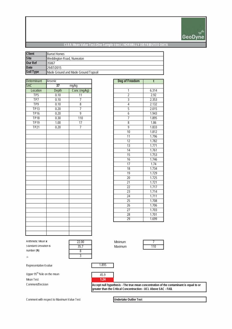
ClientSiteOur RefDateSoil Type
Determinant Arsenic Deg of Freedom tSAC 37 mg/kg
Location Depth Conc (mg/kg) 1 6.314TP5 0.10 11 2 2.92TP7 0.10 7 3 2.353TP9 0.10 8 4 2.132
TP13 0.20 7 5 2.015TP16 0.20 9 6 1.943TP18 0.30 110 7 1.895TP19 1.00 17 8 1.86TP21 0.20 7 9 1.833
10 1.81211 1.79612 1.78213 1.77114 1.76115 1.75316 1.74617 1.7418 1.73419 1.72920 1.72521 1.72122 1.71723 1.71424 1.71125 1.70826 1.70627 1.70328 1.70129 1.699
Arithmetic Mean x 22.00 Minimum 7Standard Deviation s 35.7 Maximum 110number (N) 8
n 3
Representative t value 1.895
Upper 95th %ile on the mean 45.9Mean Test 1.24Comment/Decision
Comment with respect to Maximum Value Test Undertake Outlier Test
Accept null hypothesis - The true mean concentration of the contaminant is equal to or greater than the Critical Concentraction - UCL Above SAC - FAIL
CLEA Mean Value Test (One Sample t-test ) NORMALLY DISTRIBUTED DATA
Barrat HomesWeddington Road, Nuneaton3506729/07/2015Made Ground and Made Ground Topsoil

ClientSiteOur RefDateSoil Type
Determinant Arsenic Sample Size Tcrit (@ 0.05)SAC 37 mg/kg
Location Depth Conc (mg/kg) 3 1.153TP5 0.10 11 4 1.462TP7 0.10 7 5 1.671TP9 0.10 8 6 1.822
TP13 0.20 7 7 1.938TP16 0.20 9 8 2.032TP18 0.30 110 9 2.11TP19 1.00 17 10 2.176TP21 0.20 7 11 2.234
12 2.28513 2.33114 2.37215 2.40916 2.44317 2.47518 2.50419 2.53120 2.55721 2.5822 2.60323 2.62424 2.64425 2.66326 2.68127 2.69828 2.71429 2.7330 2.745
Arithmetic Mean x 22.00Standard Deviation s 35.7
Maximum Value Xn
Number NCritical Value TcritCalculate Tn
Comment/Decision
CLEA Outlier Test (Grubbs Test) NORMAL DISTRIBUTION
Barrat HomesWeddington Road, Nuneaton3506729/07/2015Made Ground and Made Ground Topsoil

ClientSiteOur RefDateSoil Type
Determinant Arsenic Deg of Freedom tSAC 37 mg/kg
Location Depth Conc (mg/kg) 1 6.314TP5 0.10 11 2 2.92TP7 0.10 7 3 2.353TP9 0.10 8 4 2.132
TP13 0.20 7 5 2.015TP16 0.20 9 6 1.943TP18 0.30 7 1.895TP19 1.00 17 8 1.86TP21 0.20 7 9 1.833
10 1.81211 1.79612 1.78213 1.77114 1.76115 1.75316 1.74617 1.7418 1.73419 1.72920 1.72521 1.72122 1.71723 1.71424 1.71125 1.70826 1.70627 1.70328 1.70129 1.699
Arithmetic Mean x 9.43 Minimum 7Standard Deviation s 3.6 Maximum 17number (N) 7
n 3
Representative t value 1.943
Upper 95th %ile on the mean 12.1Mean Test 0.33Comment/Decision
Comment with respect to Maximum Value Test Do Not Undertake Outlier Test
CLEA Mean Value Test (One Sample t-test ) NORMALLY DISTRIBUTED DATA
Barrat HomesWeddington Road, Nuneaton3506729/07/2015Made Ground and Made Ground Topsoil
Reject null hypothesis - The true mean concentration of the contaminant is less than the Critical Concentration - UCL Below SAC - PASS

ClientSiteOur RefDateSoil Type
Determinant Lead n tSAC 200 mg/kg
2 6.314TP5 0.10 72 3 2.92TP7 0.10 32 4 2.353TP9 0.10 54 5 2.132
TP13 0.20 43 6 2.015TP16 0.20 94 7 1.943TP18 0.30 230 8 1.895TP19 1.00 55 9 1.86TP21 0.20 34 10 1.833
11 1.81212 1.79613 1.78214 1.77115 1.76116 1.75317 1.74618 1.7419 1.73420 1.72921 1.72522 1.72123 1.71724 1.71425 1.71126 1.70827 1.70628 1.70329 1.70130 1.699
Arithmetic Mean x 76.8 MinimumStandard Deviation s 65.2 Maximumnumber (N) 8
n 2.8
Representative t value Not Applicable
Geometric Mean (See SGV10 pg14) 61.9Mean Test 0.31
Comment with respect to Maximum Value Test Undertake Outlier Test
CLEA Mean Value Test - Geometric Mean Model (Lead)
Reject null hypothesis - The true mean concentration of the contaminant is less than the Critical Concentration - UCL Below SAC - PASS
Barratt HomesWeddington Road, Nuneaton3506729/07/2015Made Ground and Made Ground Topsoil

ClientSiteOur RefDateSoil Type
Determinant Lead Sample Size Tcrit (@ 0.05)SAC 200 mg/kg
Location Depth Conc (mg/kg) 3 1.153TP5 0.10 72 4 1.462TP7 0.10 32 5 1.671TP9 0.10 54 6 1.822
TP13 0.20 43 7 1.938TP16 0.20 94 8 2.032TP18 0.30 230 9 2.11TP19 1.00 55 10 2.176TP21 0.20 34 11 2.234
12 2.28513 2.33114 2.37215 2.40916 2.44317 2.47518 2.50419 2.53120 2.55721 2.5822 2.60323 2.62424 2.64425 2.66326 2.68127 2.69828 2.71429 2.7330 2.745
Arithmetic Mean x 76.75Standard Deviation s 65.2MinimumMaximum Value Xn
Number NCritical Value TcritCalculate Tn
Comment/Decision
CLEA Outlier Test (Grubbs Test) NORMAL DISTRIBUTION
Barratt HomesWeddington Road, Nuneaton3506742214Made Ground and Made Ground Topsoil

ClientSiteOur RefDateSoil Type
Determinant Lead n tSAC 200 mg/kg
2 6.314TP5 0.10 72 3 2.92TP7 0.10 32 4 2.353TP9 0.10 54 5 2.132
TP13 0.20 43 6 2.015TP16 0.20 94 7 1.943TP18 0.30 8 1.895TP19 1.00 55 9 1.86TP21 0.20 34 10 1.833
11 1.81212 1.79613 1.78214 1.77115 1.76116 1.75317 1.74618 1.7419 1.73420 1.72921 1.72522 1.72123 1.71724 1.71425 1.71126 1.70827 1.70628 1.70329 1.70130 1.699
Arithmetic Mean x 54.9 MinimumStandard Deviation s 22.1 Maximumnumber (N) 7
n 2.6
Representative t value Not Applicable
Geometric Mean (See SGV10 pg14) 51.3Mean Test 0.26
Comment with respect to Maximum Value Test Do Not Undertake Outlier Test
CLEA Mean Value Test - Geometric Mean Model (Lead)
Barratt HomesWeddington Road, Nuneaton3506729/07/2015Made Ground and Made Ground Topsoil
Reject null hypothesis - The true mean concentration of the contaminant is less than the Critical Concentration - UCL Below SAC - PASS

APPENDIX XII
Conditions & Limitations

Conditions & Limitations Phase I Desk Studies
Phase II Intrusive Investigations
Payment
Liability