implementation of community-based ... of community-based monitoring system in tanzania: the salient...
TRANSCRIPT

1
IMPLEMENTATION OF COMMUNITY-BASED MONITORING SYSTEM IN TANZANIA: THE SALIENT USES IN DODOMA MUNICIPALITY
By
Rangya Kyulu Muro,
CBMS Team Leader – Dodoma Municipal Council, Tanzania
A Paper Presented at the CBMS Annual Meeting
9th – 12th December, 2008
Manila, Philippines
2
1.0 Introduction Dodoma is the national capital of Tanzania, located at the geographical centre of
the country. The municipality covers an area of 2,669 square kilometers of which
625 square kilometers are urbanized. Based on the 2002 National Population
and Housing Census, the population of Dodoma was 324,347 of whom 157,469
or 48.5 percent are male and 166,878, or 51.5 per cent are female. The
estimated total number of households is 74,914 with an average household size
of 4.3 people.
Dodoma Municipal Council recognizes the fact that, good planning and decision
making require a comprehensive municipal information system that captures
pertinent data and produces meaningful reports (DMC, 2003). The council
therefore, has adopted the implementation of a Community-Based Monitoring
System (CBMS) which draws from community-collected data to bolster municipal
as well as national databases.
2.0 An overview of CBMS Implementation in Dodoma Among the specific objectives stipulated in the Dodoma CBMS project were
providing the policy makers with data to be used for facilitating the prioritization of
development plans, preparation of poverty profiles and maps, effective
monitoring of developmental programmes and capacity building for the related
local actors at the community level.
By using CBMS, the spatial, time related and socio-economic data were captured
at the village, ward and municipal level during the project span (2006 – 2007).
The system has been test-piloted in one ward (urban area) of K/Ndege which has
approximately 2,396 households, and one Village (rural setting) of Nala, which
has approximately 2,444 households. It is worth noting that the villages and
wards have autonomy in terms of planning and implementation; meaning that the
CBMS can fairly be adopted in their specific administration units.

3
3.0 The Role of Dodoma Municipality in CBMS Implementation
Dodoma municipality remains the key actor in the process of initiating and
overseeing the implementation of CBMS related projects. These functions
focused on project initiation, adoption of project results and dissemination,
facilitation of the related plans and scaling up (replication) of the CBMS
methodology.
• Project initiation The project had to be adopted by the council at the initial stage so that the
required arrangements for human resources and the working environment
would be accessible during and beyond the span of the project. The project
document was therefore submitted for application for funding after the
approval by the municipal council. This stage triggered other stages of
implementation whereby it was important to introduce the project to various
stakeholders namely local community, municipal staff, researchers, non-
governmental organizations and governmental departments related to poverty
issues.
• Adoption of project results and implementation: The pilot work was organized and conducted by the municipal council by
involving the project stakeholders and thereafter the results were presented at
the ward and village level whereby some strategies were proposed to work on
the identified problems. While the proposed initiatives are being implemented
at the community level, the municipality holds a patronage role to see to it that
the plans are feasible and in line with the national policies. Where possible,
the municipality takes a further step of soliciting implementation support from
the parent ministry by including some of the issues in the nationally funded
programmes.
• Dissemination and scaling-up of the CBMS results (Advocacy):
4
Dissemination workshops at municipal and national levels were organized
under the umbrella of the municipality. The workshops brought together the
representatives from local areas, various influential officials from the
government and non-governmental agencies to discuss and give resolutions
on how the CBMS results could be implemented sustainably, with an end goal
of encouraging the officials to institutionalize the proposed system. . This
step was an advocacy component in CBMS whereby the scaling up strategies
were chatted about and espoused.
It was clear that when CBMS is implemented in other parts of the country, it
will facilitate availability of timely routine data to feed into the National
policies. Moreover, capacity building for data collection and analysis for
monitoring poverty at local level was found to be imperative as it will reduce
the need of conducting costly national surveys such as Household Budget
Surveys (HBS), Integrated Labor Force Surveys etc. In that light, it can be
anticipated that the use of volunteers at local level is among the important
characteristics that has made CBMS score high acceptability. . 4.0 Salient Uses of CBMS in Dodoma Municipality As stated earlier, CBMS has led to more need-based approaches for poverty
data capturing by targeting the problem areas and beneficiaries, forming the
basis of development plans and therefore becomes an influential tool for better
allocation of resources for implementing the programmes that address the priority
issues in the communities.
4.1 Targeting resources to problem areas and beneficiaries The Poverty Maps produced by CBMS were presented and interpreted to give
spatial perception of the problem areas such as condition of roads, housing
distribution and their conditions, location of water sources and other social

5
amenities. When linked with the data from the household survey report, it has
also been possible to identify the beneficiaries of the action plans set forth.
Examples of poverty maps are shown in Annex1.
The information provided by poverty maps have been used for communicating
geographical differences in performance for different aspects of poverty to a wide
audience. This has aided better understanding of the needs of local areas and
thereby ensures that poverty issues are addressed in the most effective manner.
With these maps therefore, the decision makers were able to know the extent of
problems in specific areas and the justification of where to allocate funds for
intervention.
4.2 CBMS as a basis for preparation of development plans During the validation of the survey results, the communities in the pilot areas
were informed about the CBMS findings through workshops. This activity
prompted an opportunity to discuss the causation of the identified issues and
proposed possible interventions needed to address the problem areas as shown
in the table below.
NALA VILLAGE Identified Issues Proposed Interventions
Frequent outbreak of diseases like typhoid and dysentery due to poor access to safe water.
Preparation of Water Distribution project proposal; launching of water-boiling campaign in vitongoji
High rate of trachoma and meningitis cases due to poor housing and unclean surroundings
Promotion of Improved housing with good ventilation and well-organized surroundings
Poor nutrition and low attendance to clinics by children
Health extension service to be established to monitor at kitongoji level.

6
Low income due to poor crop production
Preparation of village land use plan based on land use suitability.
Poor accessibility by roads due to erosion and the use of unplanned footpaths
Launching of road rehabilitation routine: assigning road stretch per household. Preparation of road network plan.
Windy and dusty environment due to low initiatives of tree planting.
Organization of community working groups to raise tree seedlings and demonstration woodlots.
K/NDEGE WARD Poor register of property tax collection that causes annoyance to collectors, landlords and renters
Establishment of property tax database that can show property ownership, development changes and the related taxation.
High rate of malaria infection due to poor sanitation, stagnant water and existence of unmanaged lawns.
Launching of cleanliness campaigns at kitongoji level and ensuring that there are local monitors continuously.
Poor waste management due to uncontrolled disposal system by local authority and individual habits of residents.
Establishment of waste management project that addresses solid and liquid waste disposal: using public private partnership approach.
Poor services in the unplanned settlement of Oysterbay: roads, power line, water and drainage system.
Preparation of squatter upgrading project: negotiation for soliciting land for the required services and resources for implementation.
Based on the identified issues, three interventions have been implemented as
follows:
• Tree Planting Initiatives at Household Level in Nala Village
As agreed during the validation workshop, the windy and dusty surrounding was
seen as an issue that calls for intervention. However, understanding that the
affordability of most of the villagers is low, the related activities were planned on
the self-help basis. That is, the involved costs are shared in kind by using locally
existing resources (working time, communal assignments, contribution of

7
tools/materials and the like). Where necessary the village government funds
some technical arrangements that may arise.
The project is supporting the community groups (women, youths) and schools to
develop tree nurseries that produce seedlings of varieties of trees and sell to the
villagers at an affordable price. At the initial stage, the groups are given some of
the working tools and extension service by the council but later on as the
nurseries of more seedlings are developed, the activity will be self-supporting.
• Establishment of House-to-house Collection of Solid Waste
CBMS data revealed that the problem of solid waste collection is rampant in
K/Ndege ward. While some households with ample space in their homesteads do
burry garbage in the pits, most of them dispose the waste crudely on the areas
around the roads and open spaces. In the squatter area of Oysterbay
neighborhood, the situation is even worse as the streets are narrow and the
houses are congested with no specific collection points. causing an eye-sore and
health hazard in the urban environment.
Through this project, five community working groups have been mobilized and
they are able to reach every household and collect solid waste twice per week.
Also, secondary collection points have been identified so that the waste is
conveniently disposed there by using push carts and later on is collected by the

8
municipal truck. It was agreed that every household that gets the service pays
500 TZS (0.37USD) per week, starting from July,2007. As the awareness grows,
the user charge may be raised so as to reflect more realistic cost of the service
delivered. The Municipal council has incorporated the implementation procedures
of this plan in the by-laws in order to regularize the operation.
• Property tax management
CBMS data were used to develop a property tax management register that
identifies location, ownership, property type and the related administrative
attributes. The data were obtained from the household lists and the sketch maps
prepared during enumeration exercise.
By using CBMS data, property valuation roll of K/Ndege ward was updated and
for some localities (informal low-income housing areas) the flat rates were
estimated. The developed register has triggered better monitoring and a
substantial increase (35%) in property tax collection. Other components which
are anticipated to benefit from the CBMS data in the future include land rent,
business licenses, and billboards as shown in the structure of the municipal
database below.
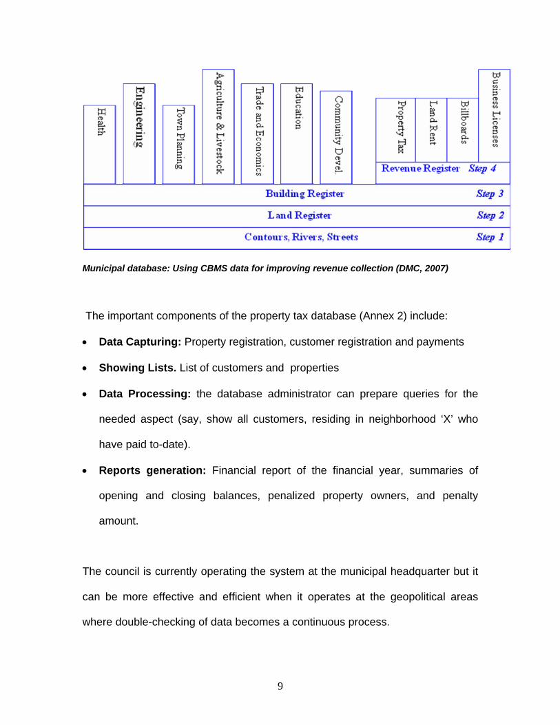
9
Municipal database: Using CBMS data for improving revenue collection (DMC, 2007)
The important components of the property tax database (Annex 2) include:
• Data Capturing: Property registration, customer registration and payments
• Showing Lists. List of customers and properties
• Data Processing: the database administrator can prepare queries for the
needed aspect (say, show all customers, residing in neighborhood ‘X’ who
have paid to-date).
• Reports generation: Financial report of the financial year, summaries of
opening and closing balances, penalized property owners, and penalty
amount.
The council is currently operating the system at the municipal headquarter but it
can be more effective and efficient when it operates at the geopolitical areas
where double-checking of data becomes a continuous process.

10
5.0 Other Potential Uses of CBMS
CBMS data obtained from the household survey and poverty maps can generate
information for other uses including:
• Improvement of informal housing: data for decision-making about which areas
require interventions in such aspects as improving housing condition,
infrastructure provisioning and agreements on land consolidation and spill-
over areas during resettlement. Presently, there are three squatter areas
which accommodate about 12,000 households living in unbearably
continuous high densities that should be arrested.
• The same data can also be used for monitoring urban agriculture by
identifying appropriate areas for farming and proposing ways of controlling
spontaneous encroachment in marginal land such as water sources and
buffer zone. When the local community is involved in land use issues, it can
be easier to protect conservation areas against detrimental activities that
happen in the proximity instead of relying on higher tier operations.
6.0 The Way Forward
The fact that the Dodoma CBMS project has gained commendable political and
executive support it has set up important factors for future successes. Further,
the appreciation and interest raised by other villages, wards and municipalities
that have seen the results of this pilot work can be considered as an added value
to be harnessed through replication of CBMS process.

11
Certainly, the lessons learnt in the pilot project suggest preparation of better
environment for implementing CBMS in other areas by avoiding previous
underperformances. On this ground, completion of the preceding CBMS work
provides a clearer avenue for examining specific areas of improvement for the
operationalization of the system especially on coordination with local key officials,
survey design, training, processing and utilization of data.

12
Annex 1: Poverty Maps – targeting resources.

13

14
Annex 2: Property tax database Data Capturing Forms Step I: Property Registration form:
All properties must be registered in the database through this form. The Database
administrator assigns every property with unique Property Code, Plot Number and Block
Number as per properties map.
Step II: Customer RegistrationForm: Every property owner is given a Customer Identity (ID) that uniquely identifies the
property owner. After filling in the other details as indicated on the form, the details are
matched with the property in the combo box by clicking the drop down arrow.
15
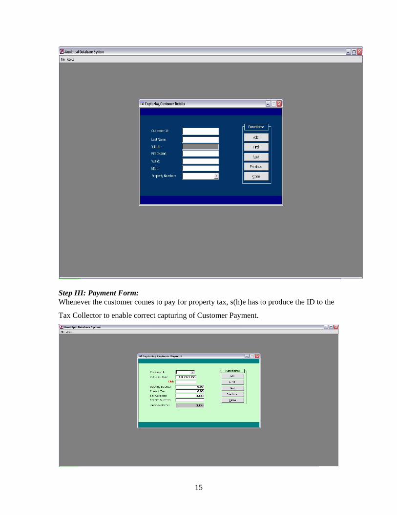
Step III: Payment Form: Whenever the customer comes to pay for property tax, s(h)e has to produce the ID to the
Tax Collector to enable correct capturing of Customer Payment.

16
LIST OF PROPERTIES:
Clicking on Properties button in Lists group, the list of all properties in the database will
be displayed.
LIST OF CUSTOMERS:
The list of all Customers can be seen in the database by clicking the Customers
button.

17
REPORTS All reports are dynamic queries that generate a result based on parameter keyed.
Financial Report: In all reports, the database gives an opportunity to write the report title required to be displayed on top of the document.
Steps: • Enter parameter value of Starting date required. • Enter parameter value of ending date required. • The report is displayed!

18
Types of useful printable reports: Outstanding – Mtaa: • This report shows outstanding tax payment by mtaa. Outstanding – Owner: • This report shows the outstanding tax payment by owner. Opening and Closing Balance: mtaa • This report shows Opening and Closing balance by mtaa. Opening and Closing Balance: Owner: • This shows the Opening and Closing Balance by owner. Penalty: • This report shows all Customers subjected to penalty and it calculates the respective
tax to be paid.