impacts of land use and land cover changes on the
TRANSCRIPT
Int J Environ Sci Nat Res 21(5): IJESNR.MS.ID.556072 (2019) 00149
IntroductionOver the years, many countries have focused on promoting
development of learning institutions for the prosperity of their citizens. As much as development of learning institutions is seen as positive development, however, they have also brought with them significant negative impacts on the environment. Education is key in almost all our nations and it makes people gain knowledge and skills used in the development of all sectors. Education also enables citizens of particular nations to improve in their competencies and capabilities in competing with the changing world market in terms of securing jobs and being able to perform particular tasks requiring higher technology. It has always been known that establishment of institutions of higher in a given place not only brings ease in accessing education but also creates employment opportunities in the region. Their establishment also result in the development of business services and improve transport and communication
infrastructure in the region. In many occasions, environment has been degraded knowingly and unknowingly in the process of establishing these institutions of higher learning. Our natural resources come from the environment and anything that disrupts the well-being of our environment, disrupts the very survival of these natural resources. Majority of the rural poor in developing countries depends on wood fuel and the surface water together with farming. They also depend on immediate pasture that they can get around. As we may all know, environment is the mother of all resources. Vegetation for instance is a land cover and helps to purify the air since green plants are able to manufacture their own food through the process of photosynthesis which yields oxygen. In the process of photosynthesis, carbon dioxide which is a greenhouse gas is absorbed by the plants and for this reason, plants act as carbon sinks hence purify the air. Vegetation which is a land cover protects the soil from being eroded or degraded by the runoff and also control the rate of infiltration.
Abstract
Human activities have been at the centre in land use and land cover changes. Activities such as farming, new settlement, land reclamation, industrialization together with urbanization have been seen to influence land use and land cover changes. This study examined how establishment of Rongo University as an institution of higher learning has influenced land use and land cover changes in Rongo Sub-County, Migori County, Kenya. The study adopted the use of GIS and Remote sensing techniques to acquire, analyze and determine changes in Landsat images for 2003, 2010, 2013, 2013, 2014, 2015, 2016, 2017 and 2018. Before and after the University was established. The land use and land cover classes that were used included tree cover, open land, plantation agriculture, settlement patterns, and grassland vegetation. Supervised classification was used to analyze land-use/cover change date generated from GIS and remote sensing which made it possible to define training data set/signature that indicated the pixels to be selected and the type of software to be used for land-cover categories. The study established that there is a significant influence on land use and land cover changes as a result of establishing Rongo University as an institution of higher learning. As they come with a number of activities in the areas of establishment. The study noted that new settlements have emerged and replaced the initial land cover with attendant effects on ecosystem and biodiversity. Further, the study recorded considerable transformation of farmlands into built up environment. The open land also reduces significantly, and university triggered informal settlement or slums also emerged.
Keywords: Institutions of higher learning; University establishment; Land use/land cover changes
Impacts of Land Use and Land Cover Changes on the Environment associated with the Establishment of Rongo University in Rongo Sub-County, Migori County, Kenya
Research ArticleVolume 21 Issue 5 - October 2019DOI: 10.19080/IJESNR.2019.21.556072
Int J Environ Sci Nat ResCopyright © All rights are reserved by George Ouma Ochola
George Ouma Ochola*, Daniel Odinde Nyamai and J B Okeyo Owuor George Ouma Ochola*, Daniel Odinde Nyamai and J B Okeyo Owuor
Submission: September 09, 2019; Published: October 03, 2019
*Corresponding author: George Ouma Ochola, Department of Agronomy and Environmental Studies, Rongo University, P.O. Box 103-40404 Rongo, Kenya
How to cite this article: George Ouma Ochola, Daniel Odinde Nyamai, J B Okeyo Owuor . Impacts of Land Use and Land Cover Changes on the Environment associated with the Establishment of Rongo University in Rongo Sub-County, Migori County, Kenya. Int J Environ Sci Nat Res. 2019; 21(5): 556072. DOI: 10.19080/IJESNR.2019.21.556072
0150
International Journal of Environmental Sciences & Natural Resources
It has been noted that where many structures are coming up, land cover is lost. That is, natural environment is transformed into a built environment. The land use also changes as what was initially used as farmland is changed into settlement or serve a different purpose. Open lands are also built up. Grassland is also lost together with the forested lands. Some wetlands are reclaimed and therefore their ecological roles compromised. Establishment of these institutions of higher learning are always associated with development of slums. These are unplanned urban centres which come up as a result of people who are drawn from various places while seeking business or job opportunities. As a result of the need for housing services, and business enterprises, unplanned development is realized. Often, development of these slums is characterized by haphazard placement of structures which do not conform with their neighbourhoods. They are also associated with poor waste management which in most cases interferes with surface and ground water quality and the general hygiene of the public.
Literature ReviewSeveral sessional papers and control processes governed
by various pieces of Legislation are embraced for urban development in Kenya. These include: the Constitution of Kenya 2010, the Physical Planning Act 1996 [1] Cap 286, Urban Areas and Cities Act No. 3 of 2011 [2], Environment Management and Coordination Act 1999 [3], Land Control Act Cap 302, National Land Commission Act 2012 [4], the Land Registration Act 2012 [5] and the Land Act 2012 [6], and the Sessional Paper No.3 of 2009 [7] on the National Land Policy, among others.
Establishment and growth of universities in most cases transform small shopping centres around them to university slums or informal settlements. This has been witnessed in areas occupied by Kenyatta, Baraton University of East Africa and Rongo University whose neighbouring Kitere shopping centre is developing into a university unplanned town/slum. The structures coming up in this centre are not planned and hence haphazard. This type of development is contrary to the provision of Urban Areas and Cities Act, Physical planning Act and Environmental Management and Coordination Act of 1999 [3] and reviewed 2015.
NEMA which is under EMCA provides that all new projects should be subjected to Environmental Impact Assessment (EIA) before given an approval for initiation. Article 42 of the Constitution of Kenya entitles every person to right to clean and healthy environment. This includes having the environment protected for the benefit of the present and future generations through legislatives and other measures. Article 69 of the same constitution provides obligations under which the environmental resources should be protected. Clauses 184 and 176 (2) of the Constitution of Kenya 2010 [8] provide for regulation of urban areas and cities. Clause 200 (2) outlines the governance of the capital city, other cities and urban areas. Similarly, Vision 2030 advocates for a nationwide urban planning
and development. Considering these provisions, if sustainability of urban development is to be realized, then planning should be proactive.
Nabutola [9] argued that rapid increase of urban population is not an issue to be whispered since it is evident to all humanity unfortunately, the rapid growth is taking place without corresponding capacity of the cities and towns planning and management institutions to guarantee sustainable urban livelihoods. The existing urban planning and implementation tools have inadequately provided an orderly and attractive urban environment in Kenya [9]. Among the examples he highlighted included environmental problems such as poor waste management, squatter’s settlements, the proliferation of slums, incessant collapse of buildings, competing land uses, traffic congestion urban sprawls and ribbon pattern of development.
Haphazard development comes as a result of the settlement drawn by the establishment of universities which in turn leads to unplanned changes in land use land cover that generally impact on the environment. The fact that urban areas play a critical role in national development as has been established by Nautola [9] in 2012 in which it is estimated that they contribute 70 percent of the Gross Domestic Product (GDP) cannot be refuted. It is important therefore to harness the huge potential of urbanization as a vehicle for growth and development while at the same time fully addressing the challenges caused by such growth [9]. Kenya for instance has faced a lot of challenges in terms of urban development owing to lack of follow up activities in implementation of a comprehensive national urban policy framework [10]. There has been a challenge since the past sector policies failed to adequately address the nature of evolving urbanization system that could foster development and economic growth. The policies failed to integrate urban and rural development in a mutually beneficial relationship hence leading to challenges being realized today.
The Physical Planning Act of 1996 and now repealed Local government Act Cap 265 have been guiding the urban centres’ development in Kenya. These Acts have right provisions and stipulations but follow up in their implementation had proven to be a nightmare. Thus, they have inadequately addressed the myriad urbanization challenges. Streamlining, implementation and proper follow up of Urban Areas and Cities Act of 2011 [2], the physical Planning Act Cap 286 of 1996 [1] and the Constitution of Kenya 2010 [8] may help realize proper management, governance and sustainable urbanization. The revised Physical Planning Act 2012 CAP 286 has not provided clear reference to the plan users but stipulate the preparation of physical development plans which is a preserve of the regional or local director.
Land Use/Land Cover ChangesAccording to Meyer [11], land use is described as the use to
which the land is assigned. This could be agriculture, grazing,
How to cite this article: George Ouma Ochola, Daniel Odinde Nyamai, J B Okeyo Owuor . Impacts of Land Use and Land Cover Changes on the Environment associated with the Establishment of Rongo University in Rongo Sub-County, Migori County, Kenya. Int J Environ Sci Nat Res. 2019; 21(5): 556072. DOI: 10.19080/IJESNR.2019.21.556072
0151
International Journal of Environmental Sciences & Natural Resources
mining, urban development and logging among others. On the other hand, Turner II et al. [12] defined land cover as the biophysical state of the earth’s surface and immediate subsurface. This definition was acknowledged by Briassoulis [13]. In 1995, Meyer asserted that land cover comprises cropland, forest, wetland and pasture. Melaku [14] defined land cover change as the modification of the existing land cover or complete conversion of the land cover to a new cover type.
Land use/land cover changes are closely related terms which are frequently being used interchangeably. They associate land cover with the purposes for which lands are being used. That is whether the land is used for agricultural, as forest, residential, or industrial. The causes and consequences of land use/land cover change are linked with the understanding of relationship of the two terms since land use change is the proximate cause of land cover change (Sherbinin, 2002). Turner & Meyer [15] established that land use change may directly affect land cover whereas change in land cover might not alter land use.
The existing linkage between land-use and land cover changes is that both impacts negatively on the environment which in turn contributes to local, regional and global climatic changes. Thus, need for emphasis in the inter-linkage and their analysis which necessitates examination on how they relate at various levels of spatial and temporal detail. According to Briassoulis [13], local level land use change may not produce significant local land cover change and consequently, no significant environmental impact nevertheless they may accumulate across space or over time and produce significant land cover change at higher (e.g. national regional, or global) levels. A good example of such is turning agricultural land to serve urban uses which involves various individual landowners who convert their farmland to non-farm uses [16].
Seto et al. (2002) described land-use/land cover change as changes in structure and function (qualitative) and change in the areal extent (quantitative) of a given type of land use or cover. Different scholars have postulated that there are two distinct land cover change [13]. These include conversion and modification. The former means a change or replacement of one cover type to another while the latter implies alteration of structure, function or composition without changing its overall classification or the type. According to Skole [17] and Briassoulis [13], modification could comprise change in productivity, biomass, or phenology. Lambin [18] stated that technological, scenic, demographic and economic are some of the driving forces in land use/land cover changes. Specific human activities that lead to land cover change include agriculture, transportation, settlement, manufacturing, recreation uses infrastructure, parks, fishery and mining, among others. Gonzales [19] asserted that land use change encompasses conversion from one type of use to another. According to Jones & Clark (1997), modification of a particular land use may involve change in the intensity of this use as well as alteration of its characteristic’s qualities/attributes. This could
comprise extensification, marginalization, intensification and abandonment as qualitative typologies in agricultural land-use.
Qian et al. [20] posited that with regards to global environmental concern, land use and land cover change is critical. Growth in human population, expansion of urban centres, need for more productive land, scarcity of land, changing technologies constitute drivers of land use and land cover change in the world [21]. This was also asserted by Barros (2004). Masek et al. [22] established that demographic and environmental conditions together with cultural, socio-economic, political, and other forces which are associated with high human population form major drivers of land use land cover changes. Cheruto et al. [21] affirmed in their study that land use and land cover changes have informed a number of researches and has also become a major concern for both decision makers and researchers globally.
Ginblett [23] study support or agreed with the findings of the previous researches which posited that changes in LU and LC has informed a global debate. The previous studies linked these changes with human activities on the environment. An example is construction of a residential structure on agricultural land that not only leads to land use change but impact also on land cover. The implication of this is that cumulative impacts may lead to climate change considering that the vegetation are contributors to atmospheric moisture recharge and also act as carbon sinks [23]. Steffen & Tyson [24] posited that increasing concentration of carbon (iv) oxide in the atmosphere, conversion and fragmentation of natural vegetation areas, biodiversity loss, and accelerated emission of greenhouse gases are some of the indicators of land use and land cover changes that are evident in the current major global concerns.
Agarwal et al. [25] also argued that the dynamics of land use and land cover changes are widespread. They postulated the changes are processes that are accelerating, significant and are majorly driven by human actions. They articulated that as a result of these land use and land cover changes, human livelihood is also affected. Bruijnzeel [26] argued that the availability of natural resources such as water, vegetation and soil are being modified by land use and land cover changes.
Integrity of natural resources and the ecosystems has been compromised due to the rapid increase in population over the years. Kenya for instance has only 20 percent of arable land and approximately 75 percent of the Kenyan population rely on agriculture. As a consequence, pressure has been imposed on land resources to help meet the needs of the rising population. More land is being cleared for cultivation especially in the wetter margins of rangelands. Decline in grassland and deforestation, charcoal burning, overgrazing, have been witnessed. These directly imply unsustainable use of land resources [27]. Depending on the context of the use and purpose for application, description and definition of land-use/cover and their changes vary [19]. Turner et al. (1993) defined land use as the purposes
How to cite this article: George Ouma Ochola, Daniel Odinde Nyamai, J B Okeyo Owuor . Impacts of Land Use and Land Cover Changes on the Environment associated with the Establishment of Rongo University in Rongo Sub-County, Migori County, Kenya. Int J Environ Sci Nat Res. 2019; 21(5): 556072. DOI: 10.19080/IJESNR.2019.21.556072
0152
International Journal of Environmental Sciences & Natural Resources
for which humans exploit or immediate actions modifying or converting the land and its resources/covers.
Understanding of land use/land cover change is imperative as it enables the comprehension of the earth’s surface and immediate subsurface changes [28]. That is, the magnitude, pace, and spatial reach due to human impact [15]. Major land use/land cover changes are human induced even though natural processes also impact. This was asserted by Gonzales [19]. Volcanic eruptions, rise in sea level, change in river channels together with climatic variations are some of the natural processes that underpin land cover changes. The human actions cause alteration of the earth’s surface and are unprecedented [18]. Human prompted changes in land use/land cover started with his multiplication existence on earth. Land use/land cover change leads to degradation of land since it enhances exposure of land to erosion hazard. Generally, the human factors that lead to land cover changes are agriculture and settlement as was postulated by Turner II et al. (1995).
Gonzales [19] postulated that over the past 50 years, human land use has changed ecosystems more rapidly and extensively than in any comparable period of time in human history. The change in land use/land cover is directly linked to rapid growth in demand for natural resources as was observed by Watson & Zakri [29]. Degradation of the natural ecosystem functions is a clear evidence of land cover change since ecological roles are compromised resulting in land-use/land cover change. It is therefore imperative to understand the implication of the two for environmental conservation and protection. Similarly, recognition of the services provided by the natural ecosystem is equally critical [19].
Bossel [30] argued that studying environmental functioning and human impacts on it still remains a challenge since the development of appropriate indicators capable of providing the required information on a system’s viability and its changing rate and how that influences the overall system’s sustainable development is a critical issue whose achievement is yet to be established.
Almost every individual knows the benefits that accrue from land in terms of support to human activities and other living organisms. It supports growth of crops which human depend on and it is also a resource where minerals are extracted. Other benefits include waste assimilation and regulatory services that it offers [31]. Influence and interaction of human needs and environmental processes and features are the two sets of forces that dynamically shape land use. Argawal et al. [25] argued that land use changes occur at various spatial and temporal levels and these changes are at certain times beneficial while may be detrimental at other times. Their being detrimental affect the structure and functioning of ecosystems and ultimately, the earth system as well as the human well-being as was established by Turner II et al. [31].
The accumulation of land use/land cover change impacts may be at global scale and status though not physically connected through a globally operating system [13]. Meyer & Turner II [23] stated that biodiversity loss, land degradation, deforestation, desertification, and wetland drainage have all amounted to a globally significant alteration of the land cover class involved. While analyzing land use change, it is imperative to determine their causes and drivers, socio-economic and environmental impacts [32]. Biophysical and socio-economic are the two main categories widely accepted drivers of land use changes [13]. Briassoulis [13] asserted that the biophysical drivers are characterized by landform, climate variation, plant succession and geomorphic process, soil process and types, drainage pattern among others. On the other hand, the socio-economic determinants encompass economic, social, demographic, political, technological, market and institutional factors and their processes. Further, he argued that environmental and socio-economic categories of land use changes impacts are interlinked. The environmental impacts cause socio-economic impacts which then feedback to the environmental impacts potentially causing succession rounds of land use change.
MethodologyThe study reviewed relevant literature on land use and land
cover changes. It also sought information through key informant/ resource persons’ interview. It studies also use field survey techniques where photography and household questionnaire administration were conducted. Focused group discussions were also conducted. The study also applied remote sensing and GIS in data acquisition particularly Landsat images. Statistical Package for Social Scientists (SPSS) was used to analyze data gathered from the households and key informants together with focused group discussions. Landsat images for 2003, 2010, 2013, 2014, 2015, 2016, 2017 and 2018 were acquired through extraction of individual bands from the raw image for detection of land use and land cover changes. Supervised classification method was used where a shape file was created and Areas of Interest (AOI) determined. The study adopted the use of the AOI shape file which was renamed. The images were classified for the time stamp interval that was 2010-2013 by drawing some polygons with the help of colour key on the image using interactive supervised classification. This is because it allows for definition of the training data set/signature that indicated the pixels to be selected and the type of software to be used for land-cover categories. Analysis of this data was performed by the use of IDRISI Selva 17.0 where the classified image in Arc map 10.3.1 were converted to ASCII for IDRISI to display the image. The IDRISI Selva was then launched and converted images imported
Results and DiscussionsThe study subjected community members to a question
seeking their views on what they considered drivers of land use
How to cite this article: George Ouma Ochola, Daniel Odinde Nyamai, J B Okeyo Owuor . Impacts of Land Use and Land Cover Changes on the Environment associated with the Establishment of Rongo University in Rongo Sub-County, Migori County, Kenya. Int J Environ Sci Nat Res. 2019; 21(5): 556072. DOI: 10.19080/IJESNR.2019.21.556072
0153
International Journal of Environmental Sciences & Natural Resources
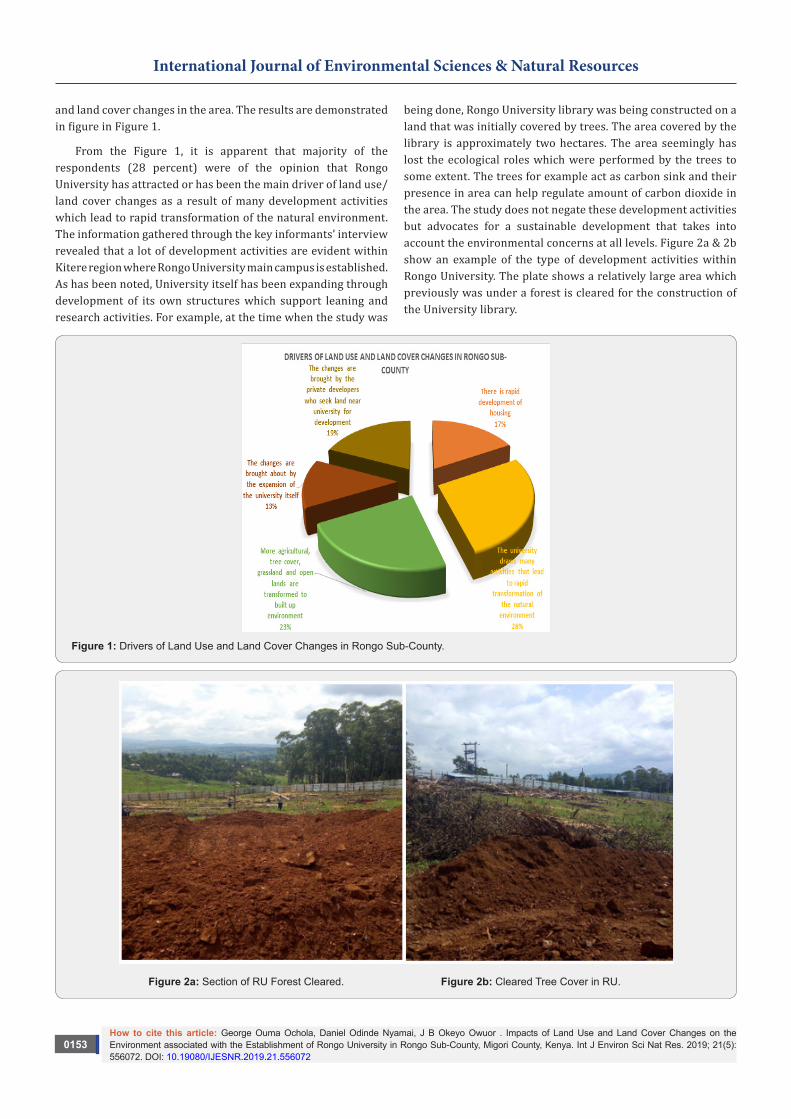
and land cover changes in the area. The results are demonstrated in figure in Figure 1.
From the Figure 1, it is apparent that majority of the respondents (28 percent) were of the opinion that Rongo University has attracted or has been the main driver of land use/land cover changes as a result of many development activities which lead to rapid transformation of the natural environment. The information gathered through the key informants’ interview revealed that a lot of development activities are evident within Kitere region where Rongo University main campus is established. As has been noted, University itself has been expanding through development of its own structures which support leaning and research activities. For example, at the time when the study was
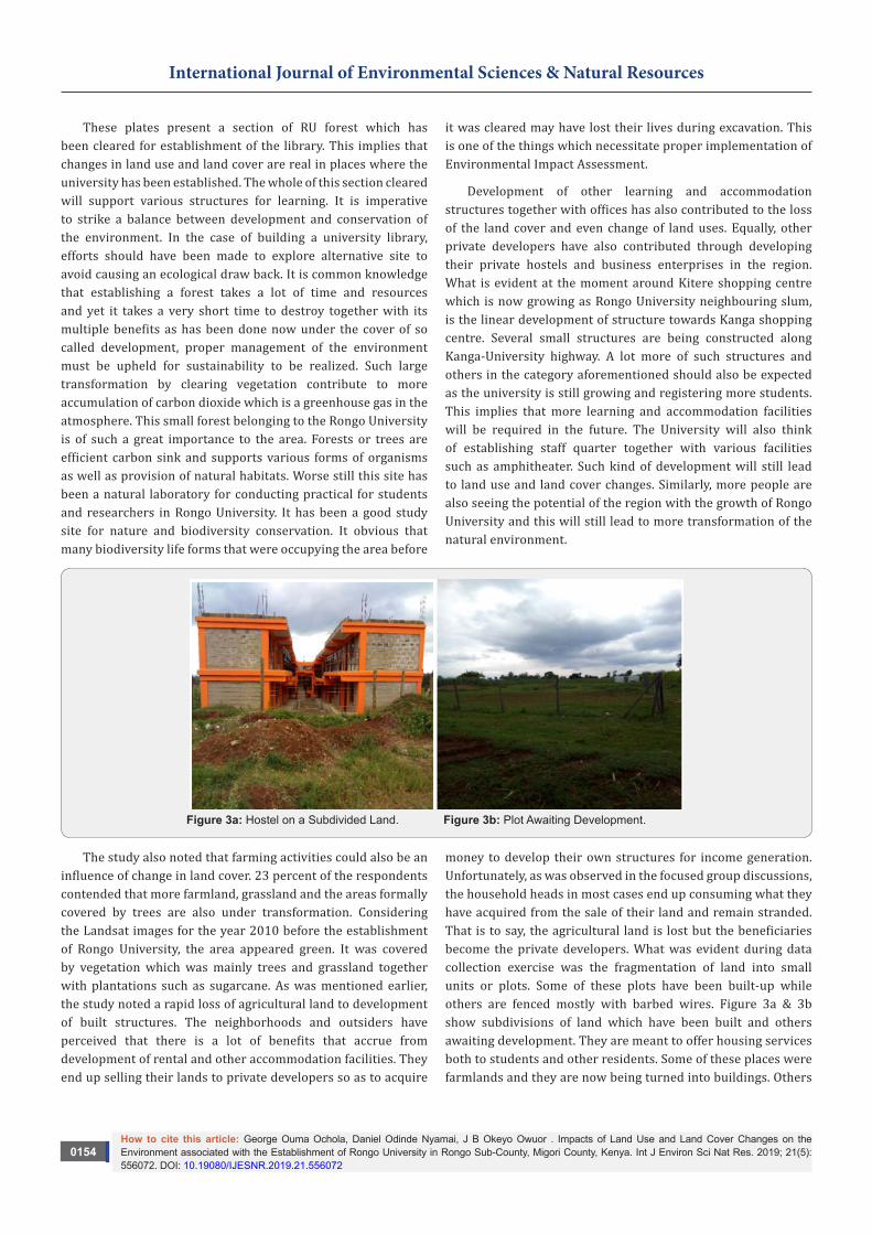
being done, Rongo University library was being constructed on a land that was initially covered by trees. The area covered by the library is approximately two hectares. The area seemingly has lost the ecological roles which were performed by the trees to some extent. The trees for example act as carbon sink and their presence in area can help regulate amount of carbon dioxide in the area. The study does not negate these development activities but advocates for a sustainable development that takes into account the environmental concerns at all levels. Figure 2a & 2b show an example of the type of development activities within Rongo University. The plate shows a relatively large area which previously was under a forest is cleared for the construction of the University library.
Figure 1: Drivers of Land Use and Land Cover Changes in Rongo Sub-County.
Figure 2a: Section of RU Forest Cleared. Figure 2b: Cleared Tree Cover in RU.
How to cite this article: George Ouma Ochola, Daniel Odinde Nyamai, J B Okeyo Owuor . Impacts of Land Use and Land Cover Changes on the Environment associated with the Establishment of Rongo University in Rongo Sub-County, Migori County, Kenya. Int J Environ Sci Nat Res. 2019; 21(5): 556072. DOI: 10.19080/IJESNR.2019.21.556072
0154
International Journal of Environmental Sciences & Natural Resources
These plates present a section of RU forest which has been cleared for establishment of the library. This implies that changes in land use and land cover are real in places where the university has been established. The whole of this section cleared will support various structures for learning. It is imperative to strike a balance between development and conservation of the environment. In the case of building a university library, efforts should have been made to explore alternative site to avoid causing an ecological draw back. It is common knowledge that establishing a forest takes a lot of time and resources and yet it takes a very short time to destroy together with its multiple benefits as has been done now under the cover of so called development, proper management of the environment must be upheld for sustainability to be realized. Such large transformation by clearing vegetation contribute to more accumulation of carbon dioxide which is a greenhouse gas in the atmosphere. This small forest belonging to the Rongo University is of such a great importance to the area. Forests or trees are efficient carbon sink and supports various forms of organisms as well as provision of natural habitats. Worse still this site has been a natural laboratory for conducting practical for students and researchers in Rongo University. It has been a good study site for nature and biodiversity conservation. It obvious that many biodiversity life forms that were occupying the area before
it was cleared may have lost their lives during excavation. This is one of the things which necessitate proper implementation of Environmental Impact Assessment.
Development of other learning and accommodation structures together with offices has also contributed to the loss of the land cover and even change of land uses. Equally, other private developers have also contributed through developing their private hostels and business enterprises in the region. What is evident at the moment around Kitere shopping centre which is now growing as Rongo University neighbouring slum, is the linear development of structure towards Kanga shopping centre. Several small structures are being constructed along Kanga-University highway. A lot more of such structures and others in the category aforementioned should also be expected as the university is still growing and registering more students. This implies that more learning and accommodation facilities will be required in the future. The University will also think of establishing staff quarter together with various facilities such as amphitheater. Such kind of development will still lead to land use and land cover changes. Similarly, more people are also seeing the potential of the region with the growth of Rongo University and this will still lead to more transformation of the natural environment.
Figure 3a: Hostel on a Subdivided Land. Figure 3b: Plot Awaiting Development.
The study also noted that farming activities could also be an influence of change in land cover. 23 percent of the respondents contended that more farmland, grassland and the areas formally covered by trees are also under transformation. Considering the Landsat images for the year 2010 before the establishment of Rongo University, the area appeared green. It was covered by vegetation which was mainly trees and grassland together with plantations such as sugarcane. As was mentioned earlier, the study noted a rapid loss of agricultural land to development of built structures. The neighborhoods and outsiders have perceived that there is a lot of benefits that accrue from development of rental and other accommodation facilities. They end up selling their lands to private developers so as to acquire
money to develop their own structures for income generation. Unfortunately, as was observed in the focused group discussions, the household heads in most cases end up consuming what they have acquired from the sale of their land and remain stranded. That is to say, the agricultural land is lost but the beneficiaries become the private developers. What was evident during data collection exercise was the fragmentation of land into small units or plots. Some of these plots have been built-up while others are fenced mostly with barbed wires. Figure 3a & 3b show subdivisions of land which have been built and others awaiting development. They are meant to offer housing services both to students and other residents. Some of these places were farmlands and they are now being turned into buildings. Others

How to cite this article: George Ouma Ochola, Daniel Odinde Nyamai, J B Okeyo Owuor . Impacts of Land Use and Land Cover Changes on the Environment associated with the Establishment of Rongo University in Rongo Sub-County, Migori County, Kenya. Int J Environ Sci Nat Res. 2019; 21(5): 556072. DOI: 10.19080/IJESNR.2019.21.556072
0155
International Journal of Environmental Sciences & Natural Resources
were occupied by trees or vegetation and these have been lost as the land loses its natural form.
The study findings reveal that the lands which were formerly open/bare, including the grass lands and the ones which were supporting sugarcane and food crops such as maize have tremendously reduced in sizes. The Kitere region is taking a new picture. The only challenge is that the community around perceive this as positive direction taken in the region. Little or no attention has been paid to the harm caused on the environment as was noted earlier that very few development activities in the region follow the laid down procedures in the policies guiding development activities in Kenya. It is apparent that such trend will most likely continue unabated with resulting degradation of the environment and natural resources thereof.
Interestingly, another group of respondents (19 percent) were of the opinion that another driver of land use and land cover changes were the private developers who buy land
around the Rongo University and develop them to meet their desired interest. This scenario has been discussed on a number of occasions concerning land acquisition and development of private hostels and business enterprises to supplement what the Rongo University is able to provide. The construction of these hostels is seen as a strategy to help the students who are not able to cope with the rules governing the university hostels. Other students are also married and would like to enjoy their free life hence prefer these other hostels which are not managed by the university. Figure show some of the hostels which are privately owned. The challenge is that developments of these hostels do not follow what is provided in the Physical Planning Act Cap 286 and Development Controls (Local Government Act Cap 265) which provide for conformity and zoning of structures. Some of these hostels are out of character. They neighbor homes with roofless bathrooms and single floor houses hence depriving the neighborhoods of their privacy. A good example is the building portrayed in Figure 4a & 4b.
Figure 4a: Out of character hostel. Figure 4b: Oxford and the Neighborhood.
The provisions in the Physical Planning Act Cap 286 for residential neighborhoods development are very clear on neighborhood development. For example, some of the aspects considered important in the Act are the size of the population, plot coverage and the dwelling units’ number. A residential neighborhood unit should also ensure sufficient provision of basic services to the community and effective road network. The existing support services should be adequate to the population within that neighborhood. It is unfortunate that the developers do not look into these.
The remaining 17 percent who were of the view that there is rapid development of housing and the 13 percent who argued that changes are brought about by the expansion of the university itself speak about the same thing as what has been discussed under this sub-section. In summary, the drivers of land use and land cover changes within Rongo University and its environs is the rapid development of infrastructure, basically housing which substitute the vegetation. It is worth noting that this is not only seen in Kitere region alone but within the entire Rongo
Sub-County. The pattern of urban development (including Rongo town) together with other shopping centres within the region portray similar situations as has been said previously. The study also noted that farming activities could also be an influence of change in land cover. 23 percent of the respondents contended that more farmland, grassland and the areas formally covered by trees is also under transformation.
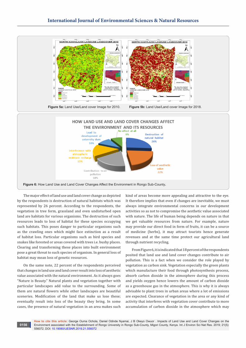
Considering the Landsat images for the year 2010 and 2018 that is before and after the establishment of Rongo University, the area appeared greener in 2010 as opposed to 2018. See Figure 5.
The study findings also reveal that the lands which were formerly open/bare, the grass lands and the ones which were supporting sugarcane and other food crops such as maize have tremendously reduced in sizes.
The study also land use and land cover changes affect the environment in Rongo Sub-County. The information provided by respondents was analyzed and illustrated in Figure 6.
How to cite this article: George Ouma Ochola, Daniel Odinde Nyamai, J B Okeyo Owuor . Impacts of Land Use and Land Cover Changes on the Environment associated with the Establishment of Rongo University in Rongo Sub-County, Migori County, Kenya. Int J Environ Sci Nat Res. 2019; 21(5): 556072. DOI: 10.19080/IJESNR.2019.21.556072
0156
International Journal of Environmental Sciences & Natural Resources
Figure 5a: Land Use/Land cover Image for 2010. Figure 5b: Land Use/Land cover Image for 2018.
Figure 6: How Land Use and Land Cover Changes Affect the Environment in Rongo Sub-County.
The major effect of land use and land cover change as depicted by the respondents is destruction of natural habitats which was represented by 26 percent. According to the respondents, the vegetation in tree form, grassland and even undisturbed open land are habitats for various organisms. The destruction of such resources leads to loss of habitat for these species occupying such habitats. This poses danger to particular organisms such as the crawling ones which might face extinction as a result of habitat loss. Particular organisms such as bird species and snakes like forested or areas covered with trees i.e. bushy places. Clearing and transforming these places into built environment pose a great threat to such species of organism. In general loss of habitat may mean loss of genetic resources.
On the same note, 22 percent of the respondents perceived that changes in land use and land cover result into loss of aesthetic value associated with the natural environment. As it always goes “Nature is Beauty.” Natural plants and vegetation together with particular landscapes add value to the surrounding. Some of them are natural flowers while other landscapes are beautiful sceneries. Modification of the land that make us lose these; eventually result into loss of the beauty they bring. In some cases, the presence of natural vegetation in an area makes such
kind of areas become more appealing and attractive to the eye. It therefore implies that even if changes are inevitable, we must always integrate environmental concerns in our development activities so as not to compromise the aesthetic value associated with nature. The life of human being depends on nature in that we get valuable resources from nature. For example, nature may provide our direct food in form of fruits, it can be a source of medicine (herbs), it may attract tourists hence generate revenues and at the same time protect our agricultural land through nutrient recycling.
From Figure 6, it is indicated that 18 percent of the respondents posited that land use and land cover changes contribute to air pollution. This is a fact when we consider the role played by vegetation as carbon sink. Vegetation especially the green plants which manufacture their food through photosynthesis process, absorb carbon dioxide in the atmosphere during this process and yields oxygen hence lowers the amount of carbon dioxide as a greenhouse gas in the atmosphere. This is why it is always advisable to plant trees in urban areas where a lot of emissions are expected. Clearance of vegetation in the area or any kind of activity that interferes with vegetation cover contribute to more accumulation of carbon dioxide in the atmosphere which may
How to cite this article: George Ouma Ochola, Daniel Odinde Nyamai, J B Okeyo Owuor . Impacts of Land Use and Land Cover Changes on the Environment associated with the Establishment of Rongo University in Rongo Sub-County, Migori County, Kenya. Int J Environ Sci Nat Res. 2019; 21(5): 556072. DOI: 10.19080/IJESNR.2019.21.556072
0157
International Journal of Environmental Sciences & Natural Resources
later lead to global warming. As was mentioned earlier, the role of vegetation as a land cover cannot be slighted because it helps in air purification. Both human beings and other animals breathe fresh air because of the existence of vegetation, specifically the green plants which are also producers in the ecosystem.
The other 15 percent of the respondents also claimed that land use and land cover changes interfere with atmospheric moisture recharge. What is normally given out during evapotranspiration from plants or vegetation in general contribute in recharging the atmospheric moisture. This is very essential in completing the water cycle or hydrological cycle. Water is one of the most important resource that no living organism can do without and anything that disrupts its supply and distribution, disrupts the very survival of humanity and other living organisms. It supports
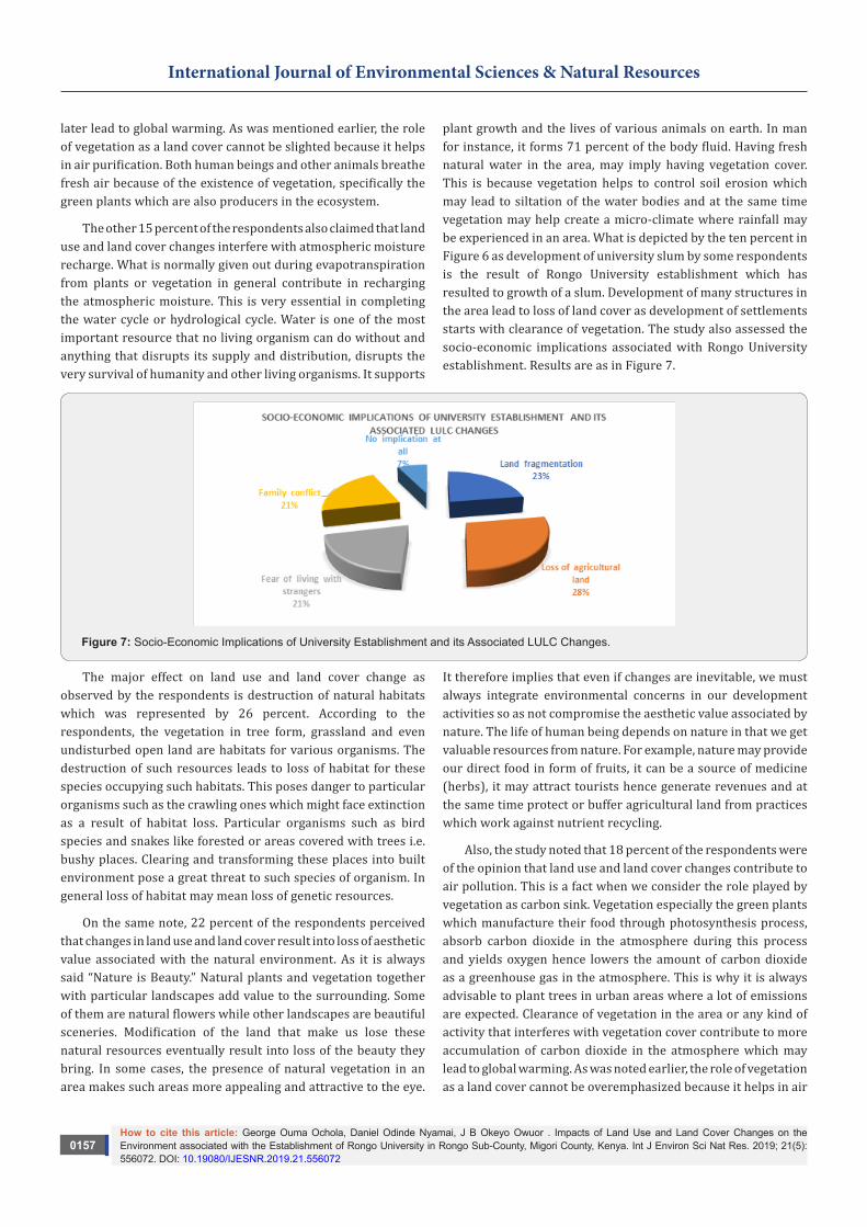
plant growth and the lives of various animals on earth. In man for instance, it forms 71 percent of the body fluid. Having fresh natural water in the area, may imply having vegetation cover. This is because vegetation helps to control soil erosion which may lead to siltation of the water bodies and at the same time vegetation may help create a micro-climate where rainfall may be experienced in an area. What is depicted by the ten percent in Figure 6 as development of university slum by some respondents is the result of Rongo University establishment which has resulted to growth of a slum. Development of many structures in the area lead to loss of land cover as development of settlements starts with clearance of vegetation. The study also assessed the socio-economic implications associated with Rongo University establishment. Results are as in Figure 7.
Figure 7: Socio-Economic Implications of University Establishment and its Associated LULC Changes.
The major effect on land use and land cover change as observed by the respondents is destruction of natural habitats which was represented by 26 percent. According to the respondents, the vegetation in tree form, grassland and even undisturbed open land are habitats for various organisms. The destruction of such resources leads to loss of habitat for these species occupying such habitats. This poses danger to particular organisms such as the crawling ones which might face extinction as a result of habitat loss. Particular organisms such as bird species and snakes like forested or areas covered with trees i.e. bushy places. Clearing and transforming these places into built environment pose a great threat to such species of organism. In general loss of habitat may mean loss of genetic resources.
On the same note, 22 percent of the respondents perceived that changes in land use and land cover result into loss of aesthetic value associated with the natural environment. As it is always said “Nature is Beauty.” Natural plants and vegetation together with particular landscapes add value to the surrounding. Some of them are natural flowers while other landscapes are beautiful sceneries. Modification of the land that make us lose these natural resources eventually result into loss of the beauty they bring. In some cases, the presence of natural vegetation in an area makes such areas more appealing and attractive to the eye.
It therefore implies that even if changes are inevitable, we must always integrate environmental concerns in our development activities so as not compromise the aesthetic value associated by nature. The life of human being depends on nature in that we get valuable resources from nature. For example, nature may provide our direct food in form of fruits, it can be a source of medicine (herbs), it may attract tourists hence generate revenues and at the same time protect or buffer agricultural land from practices which work against nutrient recycling.
Also, the study noted that 18 percent of the respondents were of the opinion that land use and land cover changes contribute to air pollution. This is a fact when we consider the role played by vegetation as carbon sink. Vegetation especially the green plants which manufacture their food through photosynthesis process, absorb carbon dioxide in the atmosphere during this process and yields oxygen hence lowers the amount of carbon dioxide as a greenhouse gas in the atmosphere. This is why it is always advisable to plant trees in urban areas where a lot of emissions are expected. Clearance of vegetation in the area or any kind of activity that interferes with vegetation cover contribute to more accumulation of carbon dioxide in the atmosphere which may lead to global warming. As was noted earlier, the role of vegetation as a land cover cannot be overemphasized because it helps in air
How to cite this article: George Ouma Ochola, Daniel Odinde Nyamai, J B Okeyo Owuor . Impacts of Land Use and Land Cover Changes on the Environment associated with the Establishment of Rongo University in Rongo Sub-County, Migori County, Kenya. Int J Environ Sci Nat Res. 2019; 21(5): 556072. DOI: 10.19080/IJESNR.2019.21.556072
0158
International Journal of Environmental Sciences & Natural Resources
purification. Both human beings and other animals breathe fresh air because of the existence of vegetation, specifically the green plants which are also producers in the ecosystem.
The other 15 percent of the respondents also claimed that land use and land cover changes interfere with atmospheric moisture recharge. What is normally given out during evapotranspiration from plants or vegetation in general contribute in recharging the atmospheric moisture. This is very essential in completing the water cycle or hydrological cycle. Water is one of the most important resource that no living organism can do without and anything that disrupts its supply and distribution, disrupts the very survival of humanity and other living organisms. It supports plant growth and the lives of various animals on earth. In man for instance, it forms 71 percent of the body fluid. Having fresh natural water in the area, may imply having vegetation cover. This is because vegetation helps to control soil erosion which
may lead to siltation of the water bodies and at the same time vegetation may help create a micro-climate where rainfall may be experienced in an area.
What is depicted by the ten percent in Figure 8 as development of slums in university neighbourhood by some respondents is the result of Rongo University establishment which has catalyzed the growth of slums. The study had noted earlier the mixed up of structure and development which do not follow the legal framework stipulations and the policies guiding development activities in Kenya. New storey buildings are evidenced among the old dilapidating structures.
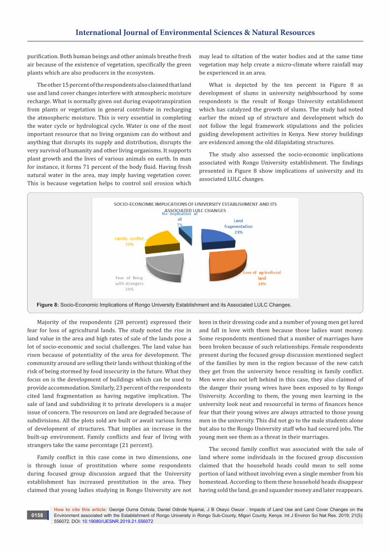
The study also assessed the socio-economic implications associated with Rongo University establishment. The findings presented in Figure 8 show implications of university and its associated LULC changes.
Figure 8: Socio-Economic Implications of Rongo University Establishment and its Associated LULC Changes.
Majority of the respondents (28 percent) expressed their fear for loss of agricultural lands. The study noted the rise in land value in the area and high rates of sale of the lands pose a lot of socio-economic and social challenges. The land value has risen because of potentiality of the area for development. The community around are selling their lands without thinking of the risk of being stormed by food insecurity in the future. What they focus on is the development of buildings which can be used to provide accommodation. Similarly, 23 percent of the respondents cited land fragmentation as having negative implication. The sale of land and subdividing it to private developers is a major issue of concern. The resources on land are degraded because of subdivisions. All the plots sold are built or await various forms of development of structures. That implies an increase in the built-up environment. Family conflicts and fear of living with strangers take the same percentage (21 percent).
Family conflict in this case come in two dimensions, one is through issue of prostitution where some respondents during focused group discussion argued that the University establishment has increased prostitution in the area. They claimed that young ladies studying in Rongo University are not
keen in their dressing code and a number of young men get lured and fall in love with them because those ladies want money. Some respondents mentioned that a number of marriages have been broken because of such relationships. Female respondents present during the focused group discussion mentioned neglect of the families by men in the region because of the new catch they get from the university hence resulting in family conflict. Men were also not left behind in this case, they also claimed of the danger their young wives have been exposed to by Rongo University. According to them, the young men learning in the university look neat and resourceful in terms of finances hence fear that their young wives are always attracted to those young men in the university. This did not go to the male students alone but also to the Rongo University staff who had secured jobs. The young men see them as a threat in their marriages.
The second family conflict was associated with the sale of land where some individuals in the focused group discussion claimed that the household heads could mean to sell some portion of land without involving even a single member from his homestead. According to them these household heads disappear having sold the land, go and squander money and later reappears.
How to cite this article: George Ouma Ochola, Daniel Odinde Nyamai, J B Okeyo Owuor . Impacts of Land Use and Land Cover Changes on the Environment associated with the Establishment of Rongo University in Rongo Sub-County, Migori County, Kenya. Int J Environ Sci Nat Res. 2019; 21(5): 556072. DOI: 10.19080/IJESNR.2019.21.556072
0159
International Journal of Environmental Sciences & Natural Resources
This is a contributor to conflict in the family as it may result into landlessness. The fear of living with stranger emanates
when land is sold to strangers. The community claimed through focused group discussion that they nowadays live with people whom they don’t understand their background at all. They are people they can’t trace their origin if in any case anything happens. Similarly, they fear that these people could be having strange characters like one respondent mentioned they could be living with night runners or people who might have escaped from their places of origin having committed some crime.
The study also examines whether the development in the area was being monitored by the lead agencies and the authorities concerned. On this issue, the respondents were of the
opinion that they normally see the individuals working with
the National Constructions Authority (NCA) but have never seen any member working with the National Environment Management Authority (NEMA). This showed a significant gap in enforcement and a major weakness in policy implementation in that the National Environmental Management Authority should be working to implement what is provided in the Environmental Management and Coordination Act of 1999 (reviewed in 2015).
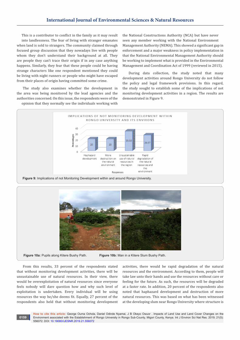
During data collection, the study noted that many development activities around Rongo University do not follow the policy and legal framework provisions. In this regard, the study sought to establish some of the implications of not monitoring development activities in a region. The results are demonstrated in Figure 9.
Figure 9: Implications of not Monitoring Development within and around Rongo University.
Figure 10a: Pupils along Kitere Bushy Path. Figure 10b: Man in a Kitere Slum Bushy Path.
From this results, 33 percent of the respondents stated that without monitoring development activities, there will be unsustainable use of natural resources. In their view, there would be overexploitation of natural resources since everyone feels nobody will dare question how and why such level of exploitation is undertaken. Every individual will be using resources the way he/she deems fit. Equally, 27 percent of the respondents also held that without monitoring development
activities, there would be rapid degradation of the natural resources and the environment. According to them, people will take law unto their hands and use the resources without care or feeling for the future. As such, the resources will be degraded at a faster rate. In addition, 20 percent of the respondents also noted that haphazard development and destruction of more natural resources. This was based on what has been witnessed at the developing slum near Rongo University where structure is
How to cite this article: George Ouma Ochola, Daniel Odinde Nyamai, J B Okeyo Owuor . Impacts of Land Use and Land Cover Changes on the Environment associated with the Establishment of Rongo University in Rongo Sub-County, Migori County, Kenya. Int J Environ Sci Nat Res. 2019; 21(5): 556072. DOI: 10.19080/IJESNR.2019.21.556072
0160
International Journal of Environmental Sciences & Natural Resources
taking its own form and does not conform to the neighborhoods. In such cases offering and managing urban services like water supply will be difficult. There should be provisions for such public utilities in an urban set up. The access roads/avenues and way-leaves must also be catered for. Figure 10a & 10b indicate the condition of access road in Kitere. They might not be visible and at times someone may think they are not in use.
The study was concluded by seeking to know from the public the way forward having recognized that establishment of Rongo University has led to land use and land cover changes. The findings in this section were summarized in Figure 11.
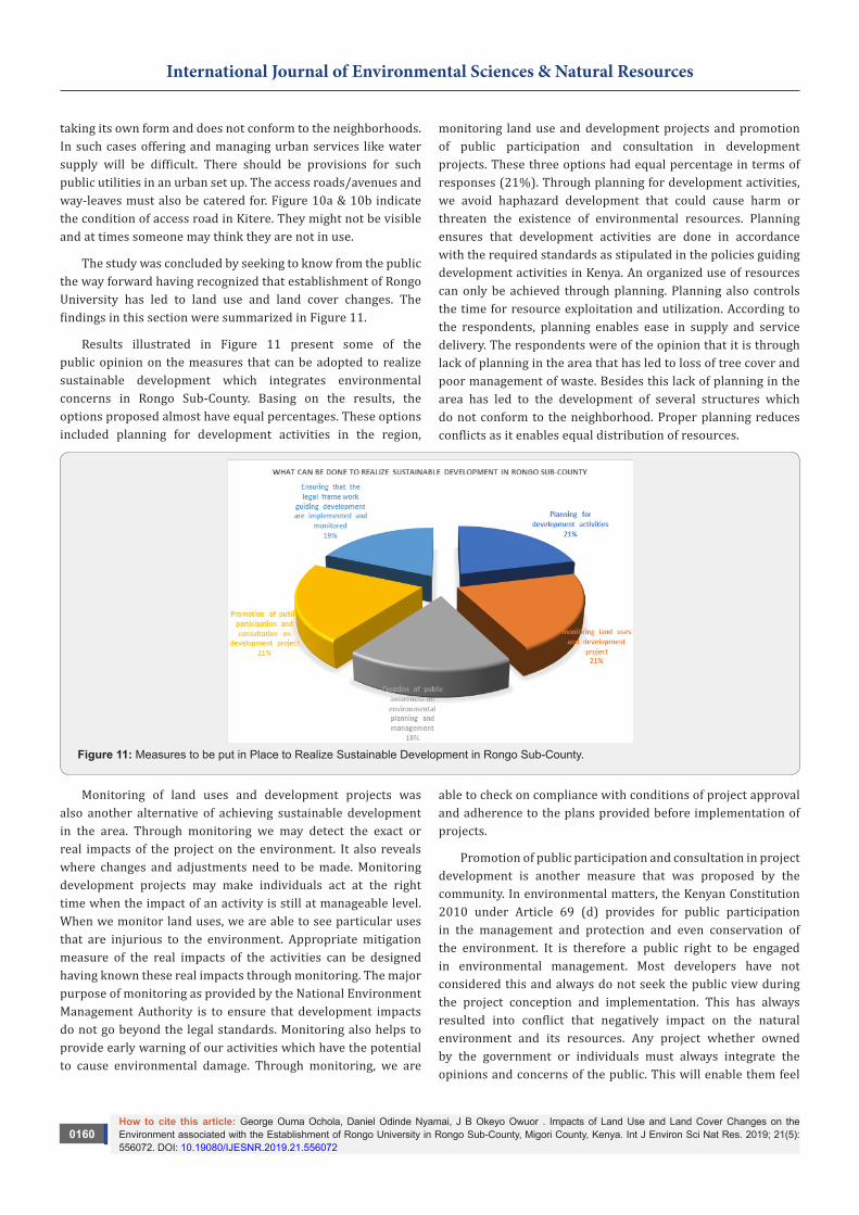
Results illustrated in Figure 11 present some of the public opinion on the measures that can be adopted to realize sustainable development which integrates environmental concerns in Rongo Sub-County. Basing on the results, the options proposed almost have equal percentages. These options included planning for development activities in the region,
monitoring land use and development projects and promotion of public participation and consultation in development projects. These three options had equal percentage in terms of responses (21%). Through planning for development activities, we avoid haphazard development that could cause harm or threaten the existence of environmental resources. Planning ensures that development activities are done in accordance with the required standards as stipulated in the policies guiding development activities in Kenya. An organized use of resources can only be achieved through planning. Planning also controls the time for resource exploitation and utilization. According to the respondents, planning enables ease in supply and service delivery. The respondents were of the opinion that it is through lack of planning in the area that has led to loss of tree cover and poor management of waste. Besides this lack of planning in the area has led to the development of several structures which do not conform to the neighborhood. Proper planning reduces conflicts as it enables equal distribution of resources.
Figure 11: Measures to be put in Place to Realize Sustainable Development in Rongo Sub-County.
Monitoring of land uses and development projects was also another alternative of achieving sustainable development in the area. Through monitoring we may detect the exact or real impacts of the project on the environment. It also reveals where changes and adjustments need to be made. Monitoring development projects may make individuals act at the right time when the impact of an activity is still at manageable level. When we monitor land uses, we are able to see particular uses that are injurious to the environment. Appropriate mitigation measure of the real impacts of the activities can be designed having known these real impacts through monitoring. The major purpose of monitoring as provided by the National Environment Management Authority is to ensure that development impacts do not go beyond the legal standards. Monitoring also helps to provide early warning of our activities which have the potential to cause environmental damage. Through monitoring, we are
able to check on compliance with conditions of project approval and adherence to the plans provided before implementation of projects.
Promotion of public participation and consultation in project development is another measure that was proposed by the community. In environmental matters, the Kenyan Constitution 2010 under Article 69 (d) provides for public participation in the management and protection and even conservation of the environment. It is therefore a public right to be engaged in environmental management. Most developers have not considered this and always do not seek the public view during the project conception and implementation. This has always resulted into conflict that negatively impact on the natural environment and its resources. Any project whether owned by the government or individuals must always integrate the opinions and concerns of the public. This will enable them feel
How to cite this article: George Ouma Ochola, Daniel Odinde Nyamai, J B Okeyo Owuor . Impacts of Land Use and Land Cover Changes on the Environment associated with the Establishment of Rongo University in Rongo Sub-County, Migori County, Kenya. Int J Environ Sci Nat Res. 2019; 21(5): 556072. DOI: 10.19080/IJESNR.2019.21.556072
0161
International Journal of Environmental Sciences & Natural Resources
part and owners of the project and will work towards its proper implementation. By nature, the public always fight what they are not part of. For instance, the government may not implement afforestation project/programme in an area without involving the locals in that area. The study noted that most development projects such as housing development in the region do not integrate the public opinion during their implementation. For example, development of very tall structure near somebody’s home without a building of the same kind might be a security risk or may deprive the neighborhoods of their privacy. This is because the neighbor could be having a roofless bathroom and would like to take a bath during the day. In such a case he or she may be deprived of privacy.
Ensuring that the legal frameworks guiding development are implemented and monitored was another proposal from the public. It was represented by 19 percent. Despite the weakness and inadequacies realized in the legal framework assessed in objective one, their stipulations can still guide and ensure sustainable development in the area. The provisions of the Environmental management and Coordination Act of 1999 (Reviewed 2015) are very clear that all development projects are supposed to be subjected to an Environmental Impact Assessment before their initiation. This in most cases helps to control the implementation of the project which have the potential to cause harm to the environment.
Through undertaking an Environmental Impact Assessment, the impacts can be anticipated and mitigation measures for such impacts developed. The Environmental Impact Assessment also provides for analysis of alternatives for the project is not forced in an area which might be an ecologically fragile zone. It also ensures compliance and conformity of the project in areas they are established. Section 36 of the Physical Planning Act Cap 286 is also clear on what the project owner/proponents should do. It provides for submission of the Environmental Impact Assessment report before the approval of the development plans. Other specifications guiding development including the development of neighborhoods are very clear. Similarly, the Public Health act Cap 242 section 115 prohibits any form of nuisance and development activities which have the potential to cause harm to human in the environment. The provisions other legal frameworks such as the County Government Act No.17 of 2012 [33], the Urban Areas and Cities Act No.3 of 2011 [2] and the
University Act Cap 210B of 2012 clear in guiding development of structures to be used in institutions of higher learning. The only challenge or in adequacy realized is that they have not taken into account the sprawling developments around these institutions and externalities associated with their establishment such as the rise of university neighbourhood slums. The study still notes that if these policies are well implemented together with development control and proper monitoring and other follow up activities enforced, sustainable development can be achieved.
The last suggestion from the public was creation of public awareness on environmental planning and management which stood at 18 percent. The study noted that there is a higher percentage of ignorance on environmental issues among the community. This was noted when they were subjected to a question on the direction of change in development. As demonstrated in Figure 10, 63 percent of the respondents were of the opinion that the change was taking the right direction that is from bad to good. As was mentioned earlier, they considered the area to be bushy initially. Now that buildings are replacing the vegetation and other environmental resources are lost, the community perceives this change to be taking the right direction. May be because the structures are more beautiful than the natural environment which used to exist. This reveals the amount of sensitization required by the community in terms of environmental issues. At this state the study considered creation of awareness on environmental issues to be critical [34].
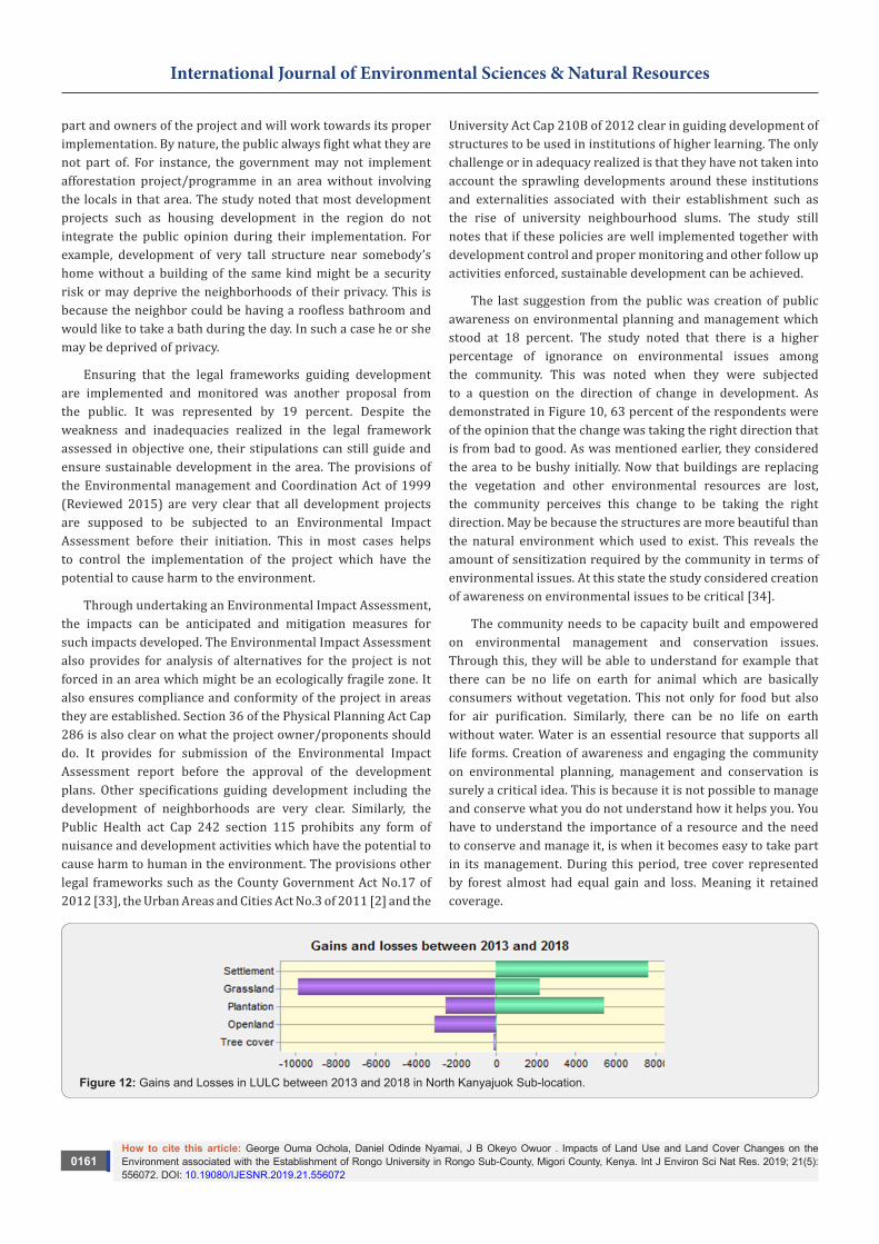
The community needs to be capacity built and empowered on environmental management and conservation issues. Through this, they will be able to understand for example that there can be no life on earth for animal which are basically consumers without vegetation. This not only for food but also for air purification. Similarly, there can be no life on earth without water. Water is an essential resource that supports all life forms. Creation of awareness and engaging the community on environmental planning, management and conservation is surely a critical idea. This is because it is not possible to manage and conserve what you do not understand how it helps you. You have to understand the importance of a resource and the need to conserve and manage it, is when it becomes easy to take part in its management. During this period, tree cover represented by forest almost had equal gain and loss. Meaning it retained coverage.
Figure 12: Gains and Losses in LULC between 2013 and 2018 in North Kanyajuok Sub-location.
How to cite this article: George Ouma Ochola, Daniel Odinde Nyamai, J B Okeyo Owuor . Impacts of Land Use and Land Cover Changes on the Environment associated with the Establishment of Rongo University in Rongo Sub-County, Migori County, Kenya. Int J Environ Sci Nat Res. 2019; 21(5): 556072. DOI: 10.19080/IJESNR.2019.21.556072
0162
International Journal of Environmental Sciences & Natural Resources
The study provided a summary of gains and losses in land use and land cover in North Kanyajuok sub-location where Rongo University main campus is established. Figure 12 presents the losses and gains between 2013 and 2018.
From the results presented in Figure 12, it is clear that settlement or the built-up environment has gained a lot as compared to other land uses. The open land is almost disappearing. These results portray that tree cover has not lost a lot. This is due to the Eucalyptus species planted in the area as a commercial plantation crop. The commercial value attached to Eucalyptus is also demonstrated by the university which has also maintained a small woodlot/forest consisting mainly of eucalyptus species even though part of it has been eaten by the new library under construction.
ConclusionThe study has confirmed that land use and land cover changes
have taken place at unprecedented rate which have significant impacts on the environment. Change of agricultural land into settlements does not only affect the natural environment but also has significant impact on food security. Agricultural lands are habitats to various micro-organisms. When natural ecosystems are transformed into built environments, the lives of the biodiversity in them are interfered with. Modifications on land due to university establishment has resulted to loss of land cover which apparently affect existence of different organisms in the area. More accumulation of carbon dioxide in the atmosphere is likely to be experienced in the area since vegetation is being lost at a faster rate. As it is always known, vegetation especially green plants act as carbon sinks hence reduce the amount of carbon dioxide in the atmosphere. Any activity that degrade the vegetation therefore tend to increase the amount of carbon dioxide (a greenhouse gas) in the atmosphere.
RecommendationsBased on the findings, the study makes the following
recommendations:
i. Monitoring land uses in the regions where the universities are established is critical to avoid unsustainable development which compromises the environmental integrity;
ii. Proper enforcement of environmental policies and law meant to safeguard the environment and natural resources in regions where the university is established is mandatory;
iii. Awareness creation on environmental management and conservation is clearly wanting on the part of the public. It is therefore imperative to enhance public education on the same;
iv. Ensure proper coordination between the regulatory agencies of the government responsible for physical planning development and environmental conservation are effectively
discharged and well-coordinated to avoid confusion and unnecessary overlaps.
References1. Republic of Kenya (1996) Physical Planning Handbook Nairobi.
Government Press.
2. Republic of Kenya (2011) Urban Areas and Cities Act. Nairobi, Government Press.
3. Republic of Kenya (1999) Environmental Management and Coordination Act. Nairobi, Government Press.
4. Republic of Kenya (2011) National Land Commission Act. Nairobi, Government Press.
5. Republic of Kenya (2012) Land Registration Act. Nairobi, Government Press.
6. Republic of Kenya (2012) Land Act. Nairobi, Government Press.
7. Republic of Kenya (2009) Sessional Paper No. 9. Nairobi, Government Press.
8. Republic of Kenya (2010) The Kenya Constitution. Nairobi, Government Press.
9. Nabutola W (2012) National Urban Development Policy (NUDP) Making Process: The Kenyan Way: Big Challenges and Some Opportunities. Planning Policies and Procedures I, 5828.
10. Republic of Kenya (2011) National Urban Development Policy. Nairobi, Government Press
11. Meyer WB (1995) Past and Present Land-use and Land-cover in the U.S.A. Consequences 1(1): 24-33.
12. Turner B (1995) Changes in land use and land cover: A global perspective: 3-10. Cambridge University Press.
13. Briassoulis H (2006) Analysis of land use change - Theoretical and modeling approaches. Regional
14. Melaku S (2016) Effect of Land Use Land Cover Changes on the Forest Resources of Ethiopia. International Journal of Natural Resource Ecology and Management 1(2): 51-57.
15. Turner II BL, Meyer BL (1994) Global land use and land cover change: An overview.
16. Musa M, Odera P (2015) Land Use Land Cover Changes and their Effects on Agricultural Land: A Case Study of Kiambu County – Kenya. Kabarak Journal of Research & Innovation 3(1).
17. Skole DL (1994) Data on global land-cover change: Acquisition, assessment, and analysis. In: Meyer WB, Turner BL II (Eds.), Changes in land use and land cover: A global perspective: 437-471. Cambridge University Press.
18. Lambin E (2004) Modelling land-use change. In: Wainwright J, Mulligan M (Eds.), Environmental Modeling: Finding Simplicity in Complexity: 245–254. John Wiley & Sons, Chichester, UK.
19. Gonzales C (2009) Assessing the Land Cover and Land Use Change and Its Impact on Watershed Services in a Tropical Andean Watershed of Peru. Master thesis.
20. Qian J, Zhou Q, Hou Q (2007) Comparison of pixel-based and object-oriented classification methods for extracting built-up areas in arid zone. In: ISPRS Workshop on Updating Geo-Spatial Databases with Imagery & the 5th ISPRS Workshop on DMGISs, pp. 163-171.
21. Cheruto MC, Kauti MK, Kisangau PD, Kariuki P (2016) Assessment of Land Use and Land Cover Change Using GIS and Remote Sensing Techniques: A Case Study of Makueni County, Kenya. J Remote Sensing & GIS 5: 175.
How to cite this article: George Ouma Ochola, Daniel Odinde Nyamai, J B Okeyo Owuor . Impacts of Land Use and Land Cover Changes on the Environment associated with the Establishment of Rongo University in Rongo Sub-County, Migori County, Kenya. Int J Environ Sci Nat Res. 2019; 21(5): 556072. DOI: 10.19080/IJESNR.2019.21.556072
0163
International Journal of Environmental Sciences & Natural Resources
22. Masek JG, Lindsay FE, Goward SN (2000) Dynamics of urban growth in the Washington DC metropolitan area, 1973-1996, from Landsat observations. International Journal of Remote Sensing 21(18): 3473-3486.
23. Ginblett R (2006) Modelling human-landscape interactions in spatially complex settings: Where are we and where are we going? MODISM05, pp. 11-20.
24. Steffen W, Tyson P (2001) Global Change and the Earth System: A planet under pressure. Environmental Policy Collection, UNT Digital Library, USA, p. 33.
25. Argawal C, Green GM, Grove JM, Evans TP, Schweik CM (2007) A review and assessment of land-use change models - Dynamics of space, time, and human choice. United States Department of Agriculture, Forest Service, Northeastern Research Station, General Technical Report NE-297, p. 84.
26. Bruijnzeel LA (2004) Hydrological functions of tropical forests: not seeing the soil for the trees? Agriculture, Ecosystems and Environment 104(1): 185-228.
27. Campbell DJ, Lusch DP, Smucker T, Wangui EE (2003) Root causes of land use change in the Loitoktok area, Kajiado District, Kenya. LUCID Working Paper Series No. 19, Michigan State University, USA, pp. 1-32.
28. Tumebo A (2017) Land Use and Land Cover Change Detection Analysis using Remote Sensing Techniques: The Case of Hawassa Town, Southern Ethiopia.
29. Watson RT, Zakri AH (2003) Millennium Ecosystem Assessment - Ecosystems and human wellbeing, a framework for assessment. The United Nations Environment Programme and World Resources Institute, p. 245.
30. Bossel H (1999) Indicator for sustainable development - theory, method, and application. A report to the Balaton Group, International Institute for Sustainable Development, Manitoba, Canada, p. 124.
31. Turner II BL, Lambin E, Reenberg A (2007) The emergence of land change science for global environmental change and sustainability. Proceeding of the National Academy Sciences of the United States of America (PNAS) 104(52): 20666-20671.
32. Meyer WB, Turner II BL (1996) Land-Use/Land-Cover change: Challenges for Geographers. Geojournal 39(3): 237-240.
33. Republic of Kenya (2012) County Government Act. Nairobi, Government Press.
34. Odhiambo V (2014) Institutions of Higher Learning as Drivers of Urban Development: A Case Study of University of Eastern Africa, Baraton Nandi County-Kenya. Master project report.
Your next submission with Juniper Publishers will reach you the below assets
• Quality Editorial service• Swift Peer Review• Reprints availability• E-prints Service• Manuscript Podcast for convenient understanding• Global attainment for your research• Manuscript accessibility in different formats
( Pdf, E-pub, Full Text, Audio) • Unceasing customer service
Track the below URL for one-step submission https://juniperpublishers.com/online-submission.php
This work is licensed under CreativeCommons Attribution 4.0 LicenseDOI: 10.19080/IJESNR.2019.21.556072