image - politesi.polimi.it · first ayyubid and then mamluk citadel, is a jut-ting semi-artificial...
TRANSCRIPT

The Reconstruction of Aleppo’s Historic Center
Students Esref Gokalp Fuat Uguz
Supervisor Prof. Domenico Chizzoniti
IMAGE

Supervisor:Prof. Domenico Chizzoniti
Co-SupervisorsProf.Stehen Cusatelli
PhD Flavio Menici
Thesis:
Esref Gokalp mat: 871389 Fuat Uguz mat: 873008
The Reconstruction of Aleppo’s Historic Center

07 The evolution process of the city
11 The Ancient Era | 3500 b.C. – 312 b.C.13 Hellenistic-Roman Time | 312 b.C. – 325 a.C. 18 Byzantine Time | 395 a.C. – 634 a.C.21 Islamic Times | 636 a.C. – 1516 a.C.30 Ottoman Times | 1516 a.C. – 1918 a.C.35 Current Times | 1918 a.C. – 2011 a.C.
41 Typological Analysis of the Old City
43 Accessibility and urban patterns48 The Souk54 The other main types64 The courtyard67 Architectural elements
75 The current condition of the city
77 The Syrian civil war85 Aleppo’s reconstruction
99 Project Proposal
101 Abstract105 Introduction112 Urban Analysis117 Main Concept according to Existing Traces such as souks,streets gates and courtyards137 General Properties140 Panels of Project Proposal
174 Bibliography176 Table of figures
INDEX
5

The evolution process of the cityFrom ancient time to present day

The eternal city, Aleppo, is one of the few cities among the Syrian “first-born” that are still te-eming with life. It has been perpetuated than-ks to its immutable and tight traces, in which exchanges took place in response to needs and production: the buildings destroyed after a defeat or a looting, the men killed or sent into exile, have always replaced to maintain the ef-ficiency of this place.1
It is difficult to determine the precise age of first settlements in Aleppo, because ancient traces of the city have been obliterated by modern buildings, thus, limiting archaeologi-cal research. It has believed that the human history of Aleppo begins during in the third mil-lennium BC. Since the antiquity it has always been famous being one of the few important centres of long-distance trade in the Old Wor-ld. The city is situated in the heart of an area of intensive economic interaction between the east and the west. According to that, the city has been ruled by the most relevant gover-nors of Mediterranean history, such as Hitti-tes, Assyrians, Akkadians, Greeks, Romans, Umayyads, Ayyubids, Mamelukes, Ottomans, French and many others.For this reason, Aleppo cannot properly be defined as Islamic city in its traditional ori-gins and configuration; rather it represents the co-presence of the Classical-occidental with Islamic-oriental city. In fact, through the reconstruction of the alignments of the walls of the buildings, the reading of the urban fabric reveals that Aleppo in its original quadrilateral
1 DAVID JEAN CLAUDE, Alep (2002), p. 9
configuration was entirely planned in the clas-sical period. In the course of time, an Islamic scheme was superimposed on the classical one, and the city today is the result of this su-perimposition. Thus, different developing sy-stem, like the typical cul-de-sac, disrupted the ancient geometrical street pattern in order to allow access to the courtyard buildings, whi-ch were created through a division of and en-croachment on the older classical-domus and courtyard houses lots.2
Built in Islamic times right along the main stre-et of the old Hellenistic city plan, the bazaar of Aleppo and its shopping arcades expan-ded until the 1930s. The Aleppo souk covered 160.000 square meters, in which one can still find sail makers, copper beaters, soap makers and every kind of urban market good.There was a central market in every big capital which provided a passage for international tra-ding of goods, but apart from this, there were also local markets with traditional exchange customs which existed since the earliest times of Islam. The goods were laid on the ground and displayed upon the view of the customers. This informal pattern was extended in the fa-bric of city and villages, with sellers benefitting from the pedestrian flows in many important locations in the city: around the gate, close to the mosques and the main public buildings. All together, these buildings constituted the core of the main Islamic cities, like Aleppo, cha-
2 NEGLIA ANNALINDA GIULIA, Aleppo. Pro-cessi di formazione della città della città medievale islamica (2009)
9

racterizing them by their economic power over the others.The oldest “lives” of Aleppo have left almost nothing visible and the image of the original city is not clear except from the times of the Crusades, when, becoming a strategic point against the Frankish kingdoms of the Holy Land, it has been partly rebuilt by its prince Nur al-Din. Almost everything that has exi-sted before has been rebuilt or restored. The remains, accumulated over five thousands of years, constitute the informal matter of the subsoil, and this past, since it cannot be read by archaeology, can only be measured by the meter of the considerable depth of the “strati-graphic layers”.3
3 DAVID JEAN CLAUDE, Alep (2002), p. 11
The most ancient archaeological finds concer-ning the origins of Aleppo date from the second half of the 3rd millennium BC, the Acadian pe-riod during which the natural environment was changed into an anthropic structure and the primitive settlements were founded, with the resulting modification of the natural structure of the land and the formation of a series of tell: artificial or semi-artificial high grounds, with a regular form, formed over the centuries as a consequence of the superimposition and stra-tification of fictile materials used to build the settlements. The tell correspond to the first anthropic “building”, even if still unplanned, of the Middle-Eastern pre-historic landscape and characterize the structure of the urban and ex-tra-urban landscape of Aleppo. The main tell in Aleppo, the acropolis of the pre-Islamic city and, currently, the archaeological area of the first Ayyubid and then Mamluk citadel, is a jut-ting semi-artificial high ground, a remodelled calcareous outcrop, made higher by human work over time. The strong symbolic character of this truncated-conical outcrop, about fifty metres higher than the surrounding area, al-most immediately determined its specializa-tion, representing since prehistoric times an important place of worship on a regional scale. Later, when the secularization of the Syrian so-ciety induced to move the political and admi-nistrative centre to the place which once was the religious capital, it became the military and civil centre.4
4 NEGLIA ANNALINDA GIULIA, Aleppo. Pro-cessi di formazione della città della città medievale
Texts found in Ebla, refer to a shrine of the storm god located on the main tell yet in the 3rd millennium BC. Since these early times, the name of the storm god has been closely associated with Aleppo. Later known as Addu, he regained importance in the eighteenth-cen-tury BC when Aleppo enjoyed its first politi-cal and economic peak as the capital of the kingdom of Yamkhad, under king Jarim-Lim. At one time, this territory extended from nor-thern Mesopotamia to the Mediterranean, but the large empire was short-lived, and Aleppo was soon dominated by the Mittani and, later, from the middle of the fourteenth century BC, the Hittites. As a result, the city lost in signifi-cance and became a centre of only regional importance. By the end of the second millen-nium BC, when immigrant Semitic Arameans and Indo-European Luwians shaped the hi-story of Central and Northern Syria, Aleppo continued to be famous as the spiritual home of the storm god. The remains of an extraor-dinary monumental temple with rich decora-tive reliefs devoted to this deity have recently been excavated on the citadel hill by a joint Syrian-German team. This is one of the most important recent archaeological discoveries in Syria because for the first time it documents Aleppo’s history for the entire period between the early Syrian and the Aramean eras.5
islamica (2009)5 GONNELLA JULIA, Introduction to the Cita-del of Aleppo (pp. 103-138), in BIANCA STEFANO, Syria - Medieval Citadels between East and West (2007)
The Ancient Era3500 b.C. – 312 b.C.
1.1 The prospect of the city f Aleppo in Ottoman times.
10 11

re”: together with the territorial routes and the natural elements, they represent the morpho-logical structure from which one can begin a reading of the different phases in the formation of the urban fabric of the Syrian city.6
6 NEGLIA ANNALINDA GIULIA, Aleppo. Pro-cessi di formazione della città della città medievale islamica (2009)
Another tell, the Tell el-’Akabé (the slope) is wi-thin the walled Mamluk city, near Bab Antakia, aligned in the direction of the main tell along the east-west link road. It is about fifteen me-tres higher than the urban area and J. Sauva-get identified it with the place of the primitive settlement of Aleppo. There is a great number of artificial hills in Syria, present-day archaeological sites, two hundred of them on the territory of Aleppo. They repre-sent the traces of the first modification of the natural structure of the area, dating back to prehistoric times, and are a sort of “first natu-
The conquest by Alexander the Great and the subsequent rule of the Seleucids marked the beginning of Syria’s Hellenistic age, blending Western with Eastern religious values. Se-leucids Nicator revived Aleppo as a capital between 301 and 281 BC under the name of Beroia.The territorial and urban structure of the Hel-lenistic refoundation of Beroia, was not dissi-milar from that of the other Seleucid colonies in Syria, founded in a short lapse of time, fol-lowing the rules of a scheme easy to be rea-lized and replicated in sites which were cho-sen for their identical aptitude to be settled: in correspondence of fords, of important nodes along the main caravan routes, in order to con-trol traffic and commerce. The first anthropization of the city of Alep-po carried out in this phase consisted in the strigatio of the valley along the course of the river Quweyq. This operation satisfied two ba-sic needs: it served as a drainage of the ter-ritory in the area surrounding the river, and it allowed to easily subdivide the urban territory to be settled into a series of regular-shaped blocks whose structure is still legible (although the thorough Ottoman renewing of the buil-ding fabric) in the urban fabric of the district of al-Medina and, in particular, in the central souk around the Great Mosque. Starting from the studies carried out by J. Sau-vaget 1, which provided fundamental intuitions
1 SAUVAGET JEAN, Alep. Essai sur le dével-oppement d’une grande ville syrienne, des origines au milieu du XIXème siècle (1941)
about the urban morphology of the Hellenistic Beroia, the structure of the building fabric of Aleppo has been the object of several scien-tific analysis and has resulted as being a mo-no-directional structure in which the via recta (the main axis of the settlement) was laid in an east-west direction and was delimited, on one side, by the main tell, and, on the other side, by the Gate of Antioch (Bab Antakia). During its course, the via recta, a wide colonnade road, was tangent to what has been identified by J. Sauvagetas the Tell el-‘Akabé, the primi-tive settlement which, in this phase, was still located beside the Seleucid planned town.2
On the citadel itself, there is evidence of the Hellenistic settlement, with some layers up to two metres high, and it is suspected that a lar-ger building, possibly a temple 3, was located north-east of the excavation site of the storm god temple; thanks to this clue the historians claim that the citadel hill was at that time the Acropolis of the city of Beroia.64 BC Pompeius deposed the last Seleucid ruler and created the Roman province of Syria. So far, few traces of Roman times have been found on the citadel, which remained the re-ligious reference of the city. In 363, emperor
2 NEGLIA ANNALINDA GIULIA, Aleppo. Pro-cessi di formazione della città della città medievale islamica (2009)
3 GONNELLA JULIA, Introduction to the Cita-del of Aleppo (pp. 103-138), in BIANCA STEFANO, Syria - Medieval Citadels between East and West (2007)
Hellenistic-Roman Time312 b.C. – 325 a.C.
1.2 Immage description.
12 13

Roman epoch is scarce or almost nonexistent: even if the city seems to have played the role of provincial centre of the region of Antioch, since the conquest of the region and the birth of the Syrian Province, the Roman presence in Aleppo is witnessed only by a few archaeolo-gical finds.The favourable geographical posi-tion of Aleppo with regard to traffic and com-merce, makes it plausible to hypothesize that the town represented an important nodality for
Julian came to Aleppo and from his notes is understandable that worship of the storm god was transferred to Zeus and survived into Late Antiquity.4 The information of a historical-archaeological nature about the urban structure of Aleppo in
4 GONNELLA JULIA, Introduction to the Cita-del of Aleppo (pp. 103-138), in BIANCA STEFANO, Syria - Medieval Citadels between East and West (2007)
traffic and commerce within the Roman-Syrian urban system and that the form, the orienta-tion and the structure of its building fabric de-rived from its role on a territorial scale. Thus, the main tool to obtain some information on the extension and the structure of the urban fabric of Roman Beroia was represented by the reading of the orthogonal alignments of the building fabric.5
5 NEGLIA ANNALINDA GIULIA, Aleppo. Pro-
Roman urban settlements derived from terri-torial planning that includes different steps of urban evolution based on different rules and recognizable by different alignments: limitatio socondum coelum was the first step, followed by two similar steps, delineation secondum naturam I and II, with slightly different orien-tations.
cessi di formazione della città della città medievale islamica (2009)
1.3 Scheme of the Hellenistic refoundation of Beroia: Tell el-‘Akabé (1), Acropolis (2), Agorà (Citadel). 1.4 Scheme of the first Roman settlement.
14 15
12

Observing the portions of urban fabric still re-cognizable as the roman plan secondum natu-ram II, with the direction deviated by 18° we-stward, it’s evident that these alignments are prevalently set around a wide empty space, apparently amorphous, located at the foot of the citadel. Two routes which seem to indicate the presence of two corners whose limits are non-existent today delimit and give it a form. Thence, we could think that in the second phase of the Roman anthropic organization of the territory of Aleppo, was a built-up area or, maybe, an enclosure: a “square enclosure” whose main axis horizontally coincided with the decumanus of the city (considerind the 3rd roman configuration) and vertically with the axis of the entrance to the acropolis, parallel to the main cardus of the structuring.For its form and position one could think that this enclosure could have been the castellum, or a small military strong hold, with the function of controlling an important route whose posi-tion and orientation are closely derived from the secundum naruram form the town assu-med in this phase. Indeed, given the small di-mension of this “square enclosure”, it is plau-sible to hypothesize that it was a small fortress to strengthen the system of the acropolis in its weakest point and to control an important rou-te for traffic and commerce.7
7 NEGLIA ANNALINDA GIULIA, Aleppo. Pro-cessi di formazione della città della città medievale islamica (2009), pp. 141-144
the Greek city.6 The first significant change in the urban fabric started on second roman planning phase that belongs to the roman ter-ritorial planning which clearly considers to the orographic conditions.
6 NEGLIA ANNALINDA GIULIA, Aleppo. Pro-cessi di formazione della città della città medievale islamica (2009)
The first Roman town plan of Aleppo was a continuation of the Greek and probably con-sisted simply of an adaptation of the earlier urban layout to meet the needs of the new inhabitants. Traces of this plan are legible in the widening of one or perhaps two blocks to the east of the agora and in the presence of domus agglomerations laid out in north-south direction scattered around the periphery of
16 17
1.8 Individuation of the castellum
1.5/6/7 Scheme of the Hellenistic refoundation of Beroia: Tell el-‘Akabé (1), Acropolis (2), Agorà (3).

In 395, the Roman empire was divided, and Syria came under the control of Byzantium. The various plans developed so far represen-ted the sub stratum of the urban and building structures of medieval Islamic Aleppo, whose development upon their traces and the re-mains of the public and defensive architectu-res of the Hellenistic-Roman town came about gradually, not because of the deterioration of the Hellenistic-Roman structures, but for a progressive change of the settling models at the basis of the construction of the anthropic space of the different cultural groups who sett-led in the Syrian town. What we call the medievalization process, from the morphological point of view, of the urban fabrics of Aleppo is not a process of deterioration of the Roman planned structures due to the inability of the new conquerors to handle extended and regular plans but rather a process already begun in Byzantine epoch because of the probable building of a new wall circuit or the strengthening of the existing de-fensive system and of the resulting urban con-traction and congestion of the building fabrics. This process, moreover, involved an already complex and apparently disordered urban structure due to the progressive superimposi-tion of three different plans of Roman epoch on the Hellenistic one.In 395, the Roman empire was divided, and Syria came under the control of Byzantium. The various plans developed so far represen-ted the sub stratum of the urban and building structures of medieval Islamic Aleppo, whose
development upon their traces and the re-mains of the public and defensive architectu-res of the Hellenistic-Roman town came about gradually, not because of the deterioration of the Hellenistic-Roman structures, but for a progressive change of the settling models at the basis of the construction of the anthropic space of the different cultural groups who sett-led in the Syrian town. What we call the me-dievalization process, from the morphological point of view, of the urban fabrics of Aleppo is not a process of deterioration of the Roman planned structures due to the inability of the new conquerors to handle extended and regu-lar plans but rather a process already begun in Byzantine epoch because of the probable bu-ilding of a new wall circuit or the strengthening of the existing defensive system and of the resulting urban contraction and congestion of the building fabrics. This process, moreover, involved an already complex and apparently disordered urban structure due to the progres-sive superimposition of three different plans of Roman epoch on the Hellenistic one.The beginning of the process of contraction, congestion and medievalization of the urban fabric of Aleppo can be dated to the 6th cen-tury AD. This phase belongs to the reign of Justinian and is chronologically later than the earthquake of 526, which severely damaged the Syrian cities, and the Persian invasion of 540 led by Khosrau I, events that mark the first moment of arrest in the urban growth, which had been virtually uninterrupted in the long Roman phase.
Byzantine Time395 a.C. – 634 a.C.
18 19
1.9 The Byzantine City with the new wall.Cathedral (1), Forum | Cemetery (2), Synagogue (3)

We have little information of a historical nature about the city in this phase, but we do know that the work of urban and architectural re-newal following the Persian invasion consisted of rebuilding the fortifications and reinforcing them with a system of double walls and tren-ches in the weakest areas to the south of the citadel, rebuilding the defensive system of the citadel by creating the moat, restoring the co-lonnaded street, and rebuilding the Byzantine cathedral (now the Halawiya madrasa).1
1 NEGLIA ANNALINDA GIULIA, Aleppo. Pro-cessi di formazione della città della città medievale islamica (2009)
centres of their caliphates and their cultural points of reference. This situation allowed the Byzantine urban landscape to remain nearly the same for a very long time, even if, a series of minor modifications were carried out at an architectural level.The first Umayyad intervention at the archi-tectural scale, which deeply modified the structure of the city, is represented by the edi-fication of ash-Shuabiya, the very first mosque of Aleppo, built near the Bab Antakia and en-croaching on the Roman monumental arch. The use of such a small structure as the main place of prayer of the city demonstrates that the Muslim troops in Aleppo were made up of just a few warriors, who did not need wide areas to pray. This operation brought about considerable morphological changes in the urban fabric at the centre of the city, altering the structure of the main street axis which was now blocked at both ends. On the Bab Anta-kia side, the colonnaded street was blocked by the presence of the new little mosque and at the opposite end by the presence of the ci-tadel. 1
1 NEGLIA ANNALINDA GIULIA, Aleppo. Pro-cessi di formazione della città della città medievale islamica (2009)
When the Arabs conquered Aleppo, they took over a city and a territory that already had a disordered form, reflecting the coexistence of the various superimposed Roman plans of dif-ferent spontaneous growth phases of the re-structuring of the Byzantine city. From a mor-phological reading of the building fabrics and from the comparison with the historical data, in fact, we inferred that a long time after the Muslim conquest and in particular for all the Umayyad age, the urban fabric of Aleppo was not substantially modified. Nonetheless, from the moment of the occupa-tion onwards, a slow process of transforma-tion of the fabrics and of the building types began, clearly manifesting itself from the 10th century, as a consequence of an actual chan-ge in the social and civic order of the popula-tion of Aleppo and of the region. One can identify at least three macro-phases in the type morphological process that cha-racterized the transition from the structure of the Roman Byzantine city to the medieval Islamic city and the first phase corresponds with the Arab conquest of Aleppo, during the Umayyad and Abbasid caliphates.In 636-37, the city was captured by Muslim tro-ops under the command of Khalid ibn al-Wa-lid. In those days, Aleppo was only a provincial town, and the Umayyad and Abbasid rulers considered the city to be on the boundary of their territories. The occupation of Umayyad came about peacefully and left intact the exi-sting civic structure, especially because the Umayyad had Roman Syrian cities as both the
Islamic Times636 a.C. – 1516 a.C.
1.10 The Cathedral (2) with respect to the forum (1) and the axis parallel to the colonnaded via recta
20 21

ties, the exchanges, commerce and negotia-tions being carried out under the porticos of the colonnaded street.2 In essence, the market was firstly shifted from the agora to one of the city gates, housed in a building rather like antecedents of a khan, with a central courtyard surrounded by stalls and shops attached to the surrounding wall fronted by a covered portico which ran all around the court. However, all the shops displaced from the ancient agora could not be accommoda-ted in this new market and had to find other lo-cations along the colonnaded street. Since the built of ash-Shuabiya, the decumanus ceased to be the major traffic route as the Romans conceived it, as long as the small mosque in
2 NEGLIA ANNALINDA GIULIA, Aleppo. Pro-cessi di formazione della città della città medievale islamica (2009)
From this moment onwards, the process of transformation of the colonnaded street into a souk began: the space of the colonnades and the central lane were initially encroached upon by commercial building units that transformed the main street axis of the city into two, three, and four parallel commercial roads. This pro-cess of congestion of the colonnades corre-sponds to a phenomenon common in other Hellenistic-Roman Syrian cities.Since the commercial vocation of the colon-naded street was already affirmed in the impe-rial age, the congestion of its colonnades with shops corresponds to the formalization of a phenomenon that had already been widespre-ad for centuries.Actually, while the Hellenistic agora represen-ted the centre of the political and economic life of the Syrian cities, the forum represented just the political centre, with the economic activi-
The beginning of the Souk The Great Mosque
When the Arabs conquered Aleppo, they built a small mosque under the Roman monumental arch, announcing a new era for the city. After almost a century since the capture of Aleppo, the urban structure of the Byzantine town re-mained mostly unaltered and the need was felt to build the first congregational mosque of the city. Thus, in 715 when the Muslim presence in Aleppo increased, the Caliph Suleyman ibn Abdel Malek decided to build a mosque that would rival the work of his brother al-Walid in Damascus. 5
The Great Mosque was built in the only open space available in the city centre: the site pre-viously occupied by the Hellenistic agora, the Roman forum, and Byzantine cathedral ce-metery; while the heart of the city centre was chosen for the site of the Friday Mosque. In this way, the former site of political activity and the sacred place of Christianity, was replaced by a building symbolizing the new political and religious power.Like in Hama, Damascus and in many of the Syrian cities of pre-Islamic foundation, the construction of the Great Mosque on the site of the Hellenistic agora (later the site of the Roman forum) was facilitated by the fact that through out the Middle East one assumes that the qibla faces south and so it was easy for
5 GONNELLA JULIA, Introduction to the Cita-del of Aleppo (pp. 103-138), in BIANCA STEFANO, Syria - Medieval Citadels between East and West (2007)
the triumphal archway blocked its egress. 3
This new commercial activity was the reason for the construction of parallel rows of little stalls and huts, which eventually grew together and split the large avenue into a number of pa-rallel smaller lanes. Later the informal arran-gement was replaced by vaulted architectural structures which “monumentalized” the origi-nal pattern, retaining the additive structure of small cellular shops and the constituted pede-strian flows.A reading of the structure of the urban fabric reveals that the shops of the souk conserve – in the rhythmic dimensions of the width of the commercial cells (2.66m for the main module) and the thickness of the walls (o,88m) – the di-mensions of the original intercolumnar structu-re and the diameter of the columns of the co-lonnaded street, in spite of the large amount of reorganization that took place over time in this part of the city (especially in Mamluk and Ottoman epoch).It is plain that the first area to be involved in this transformation process was the nearest to the Great Mosque, considering its original re-levance and considering the subsequent con-struction of the main religious building. 4
3 GONNELLA JULIA, Introduction to the Cita-del of Aleppo (pp. 103-138), in BIANCA STEFANO, Syria - Medieval Citadels between East and West (2007)4 NEGLIA ANNALINDA GIULIA, Aleppo. Pro-cessi di formazione della città della città medievale islamica (2009)
22 23
1.11 A schematic illustration of the process of transforming the colonnaded decumanus into the souk of medieval Islam.

ces to the forum on the east side of the sahn6. In the Abbassid period, a new entrance was opened on the west side, while at the same time a planned route orthogonal to the axis of the souk was built. In the Zengid period the entrance to the al-Halawiyya Madrasa – built by adapting the remains of the Byzantine ca-thedral – was opened on this new route.7
6 The courtyard in religious Islamic architectu-re. Most traditional mosques have a large central sahn, which is surrounded by a riwaq or arcade on all sides.
7 NEGLIA ANNALINDA GIULIA, Aleppo. Pro-cessi di formazione della città della città medievale islamica (2009)
Muslims to adapt pre-Islamic urban structures and specialized buildings for worship, while at the same time avoiding any significant reorga-nization of the urban fabric and surrounding buildings.The type of Syrian Umayyad mosque, indeed, with one nave and two aisles parallel to the wall of the qibla, directly derived from the reu-se of the Byzantine cathedrals, changing the prayer orientation from east to south.From the reading of the structure of the mo-sque, and the urban fabric around it, it comes out indeed as, in this phase, the main entrance of the Great Mosque was one of the entran-
Aleppo begin to enjoy a political and cultural renaissance. This short period of prosperity was followed by troubled years, bringing se-veral invasions by Byzantine troops and regu-lar raids by Bedouins. The city was temporarily under the control of the Egyptian Fatimids and later under the rule of two Arab nomad dyna-sties, the Mirdasids and the Uqailids.The twelfth and the thirteenth centuries were marked by battles with the Crusaders. Alep-po was on their route to Jerusalem and they attacked the city shortly after they had con-quered Antioch (1100 and 1103). Under the leadership of the Zangid prince, Imad al-Din Zangi (ruled 1127-1146), and his son, Nur al-Din (ruled 1146-1173), the Muslims succeeded in containing the expansion of the Crusaders. Both father and son were feared military com-manders and strong-willed politicians, devo-ted to the ideals of the jihad (holy war) and the unification of all Muslims.9 For the first time in centuries, Nur al-Din suc-ceeded in unifying Damascus and Aleppo un-der one rule, and he made great efforts to de-velop both cities. New public institutions in the city were established, including a courthouse, the central hospital and numerous hammams. The Great Mosque was restored and expan-ded by the Zengid sultan Nur al-Din in 1159 after a great fire that had destroyed the earlier Ummayad structure.
9 GONNELLA JULIA, Introduction to the Cita-del of Aleppo (pp. 103-138), in BIANCA STEFANO, Syria - Medieval Citadels between East and West (2007)
During the Abbasid caliphate, the process of spontaneous development of the urban fabric, typical of the medieval city, was accentuated. In a phase of urban growth in which commerce began to become the most important aspect of the city, transferring the functions of the agora to the souk and the specialized buildin-gs around it seems to correspond to the initial phase in a process of monumentalization of the agora that would eventually turn the souk into grand architecture on an urban level in the Ottoman period.In this phase, the first khans for housing mer-chants and their wares were built next to the souk. The archetype of the khan is to be found in the agora, the function and structure of whi-ch is reproduced on a smaller scale in this new building type. In addition, with the specializa-tion of three sides of the Great Masque as part of the souk (Suq Al Halawiya, Suq al-Hibal, Suq Sirmayatiya, Suq New Istanbul), commer-cial activity became closely linked to public and religious activity. 8
Aleppo gained more prominence during Ham-danid rule (750-1258) and it is during this period that the city’s landmark, the Citadel, was converted and gained the role of a for-tress. Built on the site of the former Helleni-stic-Roman acropolis this military fortress was commissioned by the Hamdanid prince Sayf al-Dawla after he established Aleppo as the capital of northern Syria in 944. Thanks to him
8 NEGLIA ANNALINDA GIULIA, Aleppo. Pro-cessi di formazione della città della città medievale islamica (2009)
24 25
1.12 The Great Umayyad Mosque and the relationship with the old Byzantine cathedral (1); First entrance of the Mosque

Subsequently he changed his plans and deci-ded to extend the city wall towards the south and the east in such a way that the eastern and southern suburbs were also enclosed. The citadel no longer formed part of the for-tification but was now located in the centre of the fortification itself. Ghazi strengthened the walls, smoothed the surface of the outcrop and, most importantly, had sections of the gla-cis near the entrance area covered with stone slabs. The depth of the moat was increased, filled with water and spanned by a tall brid-ge-cum-viaduct which today still serves as the entrance into the citadel. Under his rule the ci-tadel was not only a formidable garrison, but also the luxurious residence of the Ayyubid court, consisting of several palaces, baths and gardens.In this period, they commissioned the con-struction of a multitude of mosques, madra-sas (Koran schools), and mashhads (shrines), reasserting Aleppo as a city of religion and piety. The most prominent examples of the Ayyubid contributions to the historic fabric of the city included al-Firdous Madrasa, al-Sul-taniya Madrasa, al-Zaheriya Madrasa, Mashad al-Dikka, and Mashhad al-Hussayn. Like much of the built environment in Aleppo, these mo-numents were constructed in limestone due to the abundance of quarries near the city. This rich resource created a unique city of stone that differed greatly in architectural form from its closest rival, Damascus. The Aleppine ma-sons cut and carved the stone into geometric patterns which covered the buildings’ surfa-
In this period, Aleppo became a main stop for merchants traveling on the Silk Road tra-de route that extended from the Far East to Europe. This strategic location influenced the development of Aleppo’s mercantile archi-tecture – its bazaars or souks, and its mer-chant quarters, khans – in the city centre, cre-ating a commercial hub. In addition, since the end of twelfth century, the Turks imported in Aleppo their own styles and building methods. According to the that time, the new designs were “glamourized” with an innovative amount of niches, complex, multi-lobed arcades and geometrical interlacing. The iwan which is a vaulted hall opening onto a courtyard or open space, is a structure that originated in the East and first made its appearance in the Zangid era belongs to the Seljuk’s as well. In Aleppo, Nur al-Din fortified the city walls bu-ilding towers and fortified gates, most of whi-ch remain today, and the citadel, he created a new brick-walled entrance leading up to the hill and he rebuilt the two mosques founded by the Mirdasids.But the citadel’s importance peaked during the period of Ayyubid rule, in particular un-der prince sultan Malik al-Zahir Ghazi (1186-1216) who was appointed ruler of Aleppo by his father Salah al-Din (Saladin). Sultan Ghazi fortified Aleppo into a strategically important stronghold against the Crusaders in the north and built his palace right in the centre of the citadel.Initially, sultan Ghazi’s plan envisioned a total rebuilding of the city wall, including new gates.
26 27
1.13 The Zengid | Ayyubid city:Madrasa al-Halawiyya (1), the first souk (2), the Great Mosque (3) and the citadel gateway (4).

ce for commercial goods, stables, and a mo-sque. In addition, a new Mamluk palace was constructed at the Citadel, rising higher than the two entrance towers.10
10 GONNELLA JULIA, Introduction to the Cita-del of Aleppo (pp. 103-138), in BIANCA STEFANO, Syria - Medieval Citadels between East and West (2007)
ces with ornate cornices, muqarnas and ma-shrabiya.In 13th century the Mongols defeated the Ayyubid and stormed the citadel, but right after that, the Mamluks conquered Aleppo. Form 1260 the Mamluks ruled over Syria from their capital in Cairo. In the early years, they showed little interest in rebuilding Aleppo. Sul-tan Qala’un (1279-1290) first began restora-tion work on the citadel, which was completed under his son, sultan Ashraf al-Khalil (1290-1293).After the terrible onslaught by Timur (Tamer-lan), the Mamluks immediately regained and rebuilt Aleppo. They restored all fortifications and extended the city walls towards the east. In particular, governor Jakam invested a great deal of energy into the rebuilding of the cita-del. To the north and the south, two advance defence towers were added at the foot of the citadel, and in 1406-1407, the governor had the impressive throne hall built on top of the Ayyubid gateway.In those years, the city underwent major re-storation and reconstruction efforts re-emer-ging as a spiritual centre. Aleppo’s economy simultaneously grew stronger, to become a leading Mediterranean exporter of various goods, including pistachios, silk, cotton and spices. Khans, such as Khan al-Sabun, Khan Court Bek (Khan Cordoba) and Khan Khayr Bek, were built at this time to accommodate visiting merchants and their merchandise. The khan served as a trading base and hostel for merchants and usually provided storage spa-
Urban model of the Oriental City
The new age of Aleppine urban development has begun with the Islamic conversion of its inhabitant. According to E. Wirth11 Islamic ci-ties have a different model of city formation with respect to the Hellenistic-Roman one (Fig. 10). The city centre should be the public (built) space such as mosque, palace and so on. From that centre the “main streets” run to the several city gates. This radial structure of “main streets” was used not only for reli-gious and political reasons, but also for eco-nomic and cultural activities. In the outskirts and direct areas inside of the city wall different kind of markets flourished. Around this main structure, innumerable blind alleys led to the dwelling areas.The specific composition of the public (open) space and the private (closed) space should be the main feature of the Islamic urban to-pography. H. Gaube and E. Wirth have found such a radial street system and a contiguous relation between public spaces and private spaces also in Aleppo. The core of the city is the Great Mosque and the neighbouring Souk. Several “main streets” run to the city gates, from west to east, Bab Antakiyah, Bab al-Ji-nan, Bab al-Faraj, Bab an-Naşr, Bab al-Hadid, Bab al-Nairab, Bab al-Maqam and Bab Qin-nasrın. The contiguous relation between pu-blic and private spaces has been conserved through the Islamic age till now.
11 GAUBE HEINZ, WIRTH EUGEN, Aleppo (1984)
28 29
1.14 Scheme of the Islamic traditional urban layout.

Constantinople in the empire. By the middle of the 16th century, Aleppo had displaced Dama-scus as the principal market for goods coming to the Mediterranean region from the east.As a result of this economic development, many European states had opened consulates in Aleppo during the 16th and the 17th cen-turies, such as the consulate of the Republic of Venice in 1548, the consulate of France in 1562, the consulate of England in 1583 and the consulate of the Netherlands in 1613.Because of this the importance of the citadel diminished, increasing a lot the importance of the souk area. Indeed, it’s during the Ottoman time that the souk reached its definitive layout. Many khans were built, and the souk was dra-
Despite systematic fortification, developed by the Ayyubid, of the main outposts on the northern frontier of the Mamluk empire, the Ottoman conquest could not be prevented. In 1516, sultan al-Ghuri died in the decisive batt-le of Marj Dabiq, not far from Aleppo.The Aleppines welcomed the conquest by the Ottomans, since the city would benefit from the extensive trading network of the large em-pire that extended from the Mediterranean to the Euphrates. The city was now located in the heart of the empire and threats from external enemies subsided. Thanks to its strategic ge-ographic location on the trade route between Anatolia and the east, Aleppo rose to high pro-minence, at one point being second only to
Ottoman Times1516 a.C. – 1918 a.C.
30 31
1.15 Historical changes in souk area
1.16 Main streets and the gates of the Ottoman city.

Thus, in 17th and 18th century, numerous for-mal and informal measures were developed, including new neighbourhood building sy-stems, bringing about changes in development strategies and importing new typologies. New avenues have been opened and western-like urban plans start appearing in Aleppo. However, the prosperity Aleppo experienced in the 16th and 17th century started to fade as silk production in Iran went into decline with the fall of the Safavid dynasty in 1722. By mid-century, caravans were no longer bringing silk from Iran to Aleppo, and local Syrian pro-duction was insufficient for Europe’s demand. European merchants left Aleppo and the city went into an economic decline that was not reversed until the mid-19th century when lo-cally produced cotton and tobacco became the principal commodities of interest to the Europeans.In addition, internal religious issues caused the schism of the Catholics of Aleppo, marking their separation with the Orthodox. A popular riot against Ottoman power happened in 1819, followed by the city siege, for four months, by the army.The economy of Aleppo was badly hit by the opening of the Suez Canal in 1869. This, in ad-dition to political and religious instability that followed the implementation of significant re-forms in 1841, contributed to Aleppo’s decline and the rise of Damascus as a serious econo-mic and political competitor with Aleppo.The city remained Ottoman until the empire’s collapse, but was occasionally hit by few ca-
stically enlarged.1 Also, the “pencil minarets” were added by the Ottomans to the splendid squared-plan mosques that were around or near the citadel.The souk of Aleppo became the economic core of the city, in which commercial and pu-blic life was ruling the market streets. The main buildings such as the Great Mosque, the ma-drasas, the khans, the hammams, all scatte-red throughout the passageways of the souk. Apart from the “main” souks in the city, there were often smaller markets in the residential districts providing the residents with their ne-eds.The city was expanded, both inside, by incre-asing the density, and outside the walls, as a consequence of the flourish economy and the demographic growing. Ottoman monuments were raised rapidly all over the country, espe-cially concerning commercial buildings (like khans), on the main trade routes which helped Aleppo to become a centre of manufacturing of raw materials and a market for both Euro-pean and Oriental products.On that time, a huge building reconstruction transformed the whole city: streets turned out wider and some new district were created. The creativity of Ottoman architecture spread all over the city, to the mosques, madrasas, hospitals, hammams, markets, houses, khans, gates and walls.
1 GONNELLA JULIA, Introduction to the Cita-del of Aleppo (pp. 103-138), in BIANCA STEFANO, Syria - Medieval Citadels between East and West (2007)
cline of commercial activities and the drop of the population. After the Egyptian occupation (1831 - 1840), a new centralized administra-tion - the Serail - was created, and in 1868 the city acquired a western style Municipality. The increase of western influence was also marked by the foundation of the new Azizie district, the first to be entirely separated from the old city, with wide streets and a chessboard plan. This district was inhabited by the Christian middle class.In 1882, the Ismaeliyeh and Jamiliya districts sprang up to the west of the city, separated from the old quarters by the gardens and or-chards of the river Quweyq. Here the Muslim and the Jewish middle classes predominated. The construction of a railway station in 1905 accelerated the urbanization. Other new resi-dential areas were built in 1887 and in 1907.After 1882 the first elements of a modern cen-tre (i.e. warehouses, horse stables, blacksmi-ths and mechanical workshops, hotels, re-staurants, coffee-houses, cabarets, theatres, offices, etc.) appeared to the west of Bab al Faraj, and quickly expanded. The establish-ment of this new centre at the north-western corner of the walled city was mainly due to the proximity of the new middle-class distri-cts, to the presence of available land near the Medina, and to the excellent connections with the souk through Bab al Faraj. In fact, the old city had previously expanded with its suburbs towards the north and the east, and therefore the area to the west, between the walls and the orchards of the Quweyq, offered the only
tastrophes, like the huge earthquake in 1822, the attacks of cholera from 1823 and the pla-gue, that in 1827 killed around 20-25 percent of the population.2 In 1850 a Muslim mob attacked Christian neighbourhoods, tens of Christians were killed, and several churches looted. Though this event has been portrayed as driven by pure sectarian principles, Bruce Masters argues that such analysis of this pe-riod of violence is too shallow and neglects the tensions that existed among the population due to the commercial favour afforded to cer-tain Christian minorities by the Tanzimat Refor-ms during this time which played a large role in creating antagonism between previously cooperative groups of Muslim and Christians in the eastern quarters of the city.3
The consequences of this slow revolution were deep changes in the Aleppine’s society. An evolution in all domains was ongoing and, un-der the influence of the West, the country was adopting western policies and it was turning into an industrialized country, with factories and modern transport systems, such as roads, railways and steam navigation. The weight of the West is increasingly felt in the Middle East.From the architectural point of view, up to the mid-nineteenth century, Aleppo fully maintai-ned its traditional features. This is mainly due to the fact that growth stopped with the de-
2 FAROQHI SURAIYA, İNALCIK HALIL, QUA-TAERT DONALD, An economic and social history of the Ottoman Empire, (1997), p.788.3 MASTERS BRUCE, The 1850 Events in Aleppo, (1990), pp. 3-4.
32 33

chard. These plans, dated to the 1930s, re-called modernist and urban renewal planning principles, as expressed in Le Corbusier’s “Charte d’Athènes”, that valued the grid as a pattern for organizing urban blocks. The grid prototype was to be used for new develop-ments and for reorganizing the organic pattern of the Old City fabric.1 However, most of these planning proposals were not realized until twenty years later be-cause of the resistance of the inhabitants of the old town, and the corresponding difficulties in acquiring or expropriating the large amount of real estate needed to execute the plans. In ad-dition, vehicular traffic was still not important enough to justify the ambitious programme of road construction. In 1954, a new masterplan was worked out by the French architect An-dré Gutton. It had a much more serious impact on the development of Aleppo. Although the author claimed that all changes were to pro-tect the historical character of the townscape, it seems clear today that the major elements of his scheme were in flagrant contradiction to conservation objectives. In fact, the basic con-cern of the masterplan was to stress Aleppo’s position as a major node of regional, national and international road connections, with spe-cial regard to freight transport.2
1 BUSQUETS JOAN (edited by), Aleppo. Rehabilitation of the old City (2006), p. 47.2 BIANCA STEFANO, DAVID JEAN-CLAUDE, ET AL., The Conservation of the Old City of Aleppo, UNESCO Report, Paris 1980.
opportunity for adding a centre near to the Medina.After 1890 and mainly during and after the First World War, the wealthy looked for possibili-ties of investment. Large-scale town planning projects were carried out, completing the new centre and improving the connections with the souk and the residential quarters. One of the major projects, started in 1893, was the tran-sformation of the moat of the northern wall into a 14-metre-wide street bordered by residential blocks, hotels, warehouses and shops.4
Anyway, those years are characterized by many interreligious riots and massacres in Lebanon and Damascus. French and British troops intervened, affecting the administrative system as well, imposing several reforms. Du-ring the World War I, Arab nationalists refuse to follow the war commitment of the Ottomans with Germany. The armistice of Moudros mar-ks the end of the Ottoman Empire.5
4 BIANCA STEFANO, DAVID JEAN-CLAUDE, ET AL., The Conservation of the Old City of Aleppo, UNESCO Report, Paris 1980.5 DAVID JEAN CLAUDE, Alep (2002), p. 317
Syria’s independence is proclaimed in 1919: Emir Faisal is the king of Syria and the capi-tal is Damascus. It is immediately persecuted by the French. The Conference of San Remo, Treaty of Sèvres, establishing French and Bri-tish mandates, according to the secret agree-ments of Sykes-Picot of 1916: Syria under the French mandate.The Treaty of Sèvres made most of the Provin-ce of Aleppo part of the newly established na-tion of Syria. However, Kemal Atatürk annexed those to Turkey in his War of Independence. The Arab residents in the province supported the Turks in this war against the French. The outcome was disastrous for Aleppo, because as per the Treaty of Lausanne, most of the Pro-vince of Aleppo was made part of Turkey with the exceptions of Aleppo and Alexandretta (the last was annexed to Turkey in 1939 depriving Aleppo of its main port). Thus, the city was cut from its northern satellites and from the Anatolia beyond on which Aleppo depended heavily in commerce. Moreover, the Sykes-Pi-cot division of the Near East separated north Syria from most of Mesopotamia, which also harmed the economy of the city.By the onset of the French mandate in Syria, Aleppo had a population of approximately 125,000. Western-style municipal administra-tive arrangements emerged, including a city planning department, the Service d’Urbani-sme. The first modern master plans to control the expansion and growth of the city were cre-ated during this period by French architects, one by R. Danger and another by Michel Eco-
Current Times1918 a.C. – 2011 a.C.
34 35

the capital, and in Aleppo, the commercial centre of northern Syria. In the latest, a new master plan was conceived by a French-Ja-panese architect, Gyoji Banshoya, in collabo-ration with the central Government. This plan called for additional transportation axes to in-tersect the Old City. It aimed to connect the main highways to the west and east of Alep-po, through the Old City, which would destroy additional historic fabric. Again, parts of this plan were implemented, further exacerbating the conditions discussed above.This ongoing destruction of the Old City fa-bric set a precedent for continued demolition throughout the 1970s, accelerating the phy-sical and socioeconomic division between members of the Old City community and the rest of the population. In less than thirty ye-ars, this division had marginalized the historic centre from the rest of the city. However, whi-le the majority of the population and the local government rejected the value of the Old City as a residential destination, it still sustained a population of well over 150,000 people (out of an approximate 1.5 million total population).By 1977, the governorate of the city had plans to construct a fourteen-story tower adjacent to the governor’s office, directly across from the entrance to the Citadel. At this time, a group of architects, geographers, engineers, and histo-rians lobbied the municipality to prevent con-struction of the high-rise structure. This team of conservationists was successful in convin-cing the Syrian Ministry of Culture to list the intramural and parts of the extramural Old City
After the French mandate period, Syria began to modernize at a rapid rate. Many middle- and upper-class Old City residents left their tradi-tional homes to live in residential suburbs that could provide more modern amenities. Hou-ses were abandoned, rented out to lower-in-come families, or subdivided into smaller units and sold out. In turn, some homes became occupied by migrants from the city’s rural hin-terland.Other houses became used for commercial activity such as industrial workshops and wa-rehouses. Many lost their courtyards when more than one family would come to occupy a house and partition the central courtyard to create more indoor living space. Furthermore some property owners added an extra story to their homes. As a result many private pro-perties in the Old City suffered from bad main-tenance. This contributed to accelerating the decay of the Old City courtyard houses, which were not constructed to withstand such de-mands. In addition, former khans were being transformed into spaces for storage, many becoming hosts for small-scale industrial and commercial activities, coupled with greater traffic congestion, led to an increase in noise and water pollution for the residents of these neighbourhoods.By 1974, efforts to modernize Syria had be-come a national agenda under the rule of President Hafez al-Asad. This program was reflected in urban planning policies across the country, most specifically in Damascus,
UNESCO Report, Paris 1980.
As a result of this plan, approximately one-ten-th of the Old City’s intramural urban fabric was supplanted by transportation infrastructure, including a road through the neighbourhood that connected the Umayyad Mosque to the Citadel. The plan gave some thought to sepa-ration of housing and traffic in new residential areas, but no consideration to future impact on the old town.In fact, it suggested that the old fabric should be crossed by two large road channels in the west-east direction, concentrating truck and bus terminals, as well as large modern stores, in front of Bab Antakia (Fig. 1.16). Inside the walls, the Medina was to be separated from the surrounding urban fabric by an interior ring road in order to give direct vehicular access to the khans and souks. The isolation of the hi-storic commercial centre corresponded to the idea of “dégager pour mettre en valeur”, this clearance being justified by the idea of “expo-sing” a monument to spectators.This concept, however, contradicts the cha-racter of Islamic architecture, which is not pri-marily intended to be seen from the outside but to be perceived from within (as empha-sized by the courtyard structure of most tra-ditional buildings). Fortunately enough, only part of the Gutton Masterplan was executed. However, its basic approach and its spirit have been reflected in all the projects and proposals of the Municipality in the 25 years before the Civil War. 3
3 BIANCA STEFANO, DAVID JEAN-CLAUDE, ET AL., The Conservation of the Old City of Aleppo,
36 37
1.17 Gutton’s infrastructure plan.

as a registered national monument, theoreti-cally preventing further demolition of any part of the site by the master plan. At this time, a group of consultants from UNESCO was invi-ted to Aleppo to offer its professional opinion about urban planning policies for the Old City. The report, published in 1980, included an as-sessment of the current situation and outlined alternative planning opportunities to those de-tailed in the master plan. Significantly, the re-port reasserted the historic significance of the area and by 1986, the Old City of Aleppo had become Inscribed on the World Heritage List.Right before the war, much of the Old City was in a state of disrepair, suffering from the de-velopment pressures of overcrowding, disin-tegrating infrastructure, structurally unstable buildings, and poor sanitary and health con-ditions. The major challenge was to improve the socioeconomic conditions of residents and users of the Old City while preserving the historic integrity of the urban fabric. Together with the German Technical Cooperation (GTZ) the local municipality initiated a comprehensi-ve rehabilitation project to achieve this goal. In addition the Aga Khan Trust for Culture’s Hi-storic cities support programme had initiated a major restoration program for the citadel. 4
4 BUSQUETS JOAN (edited by), Aleppo. Rehabilitation of the old City (2006), pp. 47-50.
38 39

Typological Analysis of the Old CityMain features and typological aspects of the urban fabric

side towards the main road to the south. 1
Some of these gates show a distinct continu-ity thorough time; the Antioch Gate (the main city gate on the westen side) in the Ayyubid reconstruction exhibits a plan close to that of its forerunner of pre-classical times. The me-dieval streets approaching the gate have an oblique orientation, which recalls the double
1 NIGRO, L. “Yamkhad/Aleppo: Investigating the Second Millennium B.C. Capital of Northern Syria through Islamic,Byzantine and Classical Towns.” In Environmental Design: Journal of the Islamic Environmental De sign Research Centre 1-2 (1997.1999) pp. 50-51
The historical gates
Six gates of old Syrian Aleppo can be identi-fied today (Fig. 2.1): the Antioch Gate in the middle of the western side, the Northwest Gate opening onto the road through the Nahar Quweiq Valley the fertile region that provided agricultural produce to the town, the North Gate, giving access to the Jabbul Plain, the Northeast Gate, opening onto the highway to the Euphrates, the Southeast Gate which le-ads to the Lake of Matkh, the shallow marsh depression where the Quweiq River ends, and the Ebla Gate, which opens in the southern
Accessibility and urban patterns
43
2.1 Plan of the Town of Aleppo during the Middle Bronze Age ( ca. 2000-1600 b.C)

The urban plan is thus set up on a rectangu-lar scheme and the eccentric location of the acropolis are urban features typical of a distin-ct group of second millennium b.c. Syro- Pa-lestinian towns, which includes Tell Atchana (Alalakh), Tell Tugan, el Mishrifeh (Qatna), Tell el Qadi (Dan), Tell el Wagas (Hazor), al Kabri, Tell el’Ajjul (Sharuhen). All these towns were defended by massive earthen ramparts, have triple-arched gateways, and show a rectangu-lar plan associated with an eccentric location of the ideological and political city center, as well as regular subdivision by orthogonal stre-ets. Aleppo fits this urban model well, even though two further important public areas can be identified in addition to the Acropolis that is, the central terrace and the mound of al’A-qaba.3
3 NIGRO, L. “Yamkhad/Aleppo: Investigating the Second Millennium B.C. Capital of Northern Syria through Islamic,Byzantine and Classical Towns.” In Environmental Design: Journal of the Islamic Environmental De sign Research Centre 1-2 (1997.1999) pp. 52-53
planimetric organization of second-millen-nium bentaxis city gates known from Ebla, and many other sites of Syria-Palestine. The gateway was incorporated into a double tower abutting the rampart, with an outer entrance not aligned with the inner one and an overall length of almost 50 meters. The main passa-ge was triple-arched, with a series of facing offsets, and a couple of big doors locked on both sides.2
The old Syrian origin of this plan, preserved until Islamic times is quite certain in urban centers like Aleppo, which exhibit a continuo-us occupation for many centuries. Two main streets divide old Syrian Aleppo into four par-ts. The first, east-west oriented, leads from the Antioch Gate to the city center, then it proce-eds towards the Acropolis, turning gradual-ly right, because of the gradient; the second crosses the city center north- south in an ap-proximately straight line. A roughly rectangular pattern is thus adopted not only for fortifica-tions, but also for the street network, with the exception of the eastern quarter of the town, where because of the slope of the Acropo-lis, streets have to ascend gradually, turning around it. Two more gates are opened on the northern and southern sides, near the eastern corners of the town.
2 NIGRO, L. “Yamkhad/Aleppo: Investigating the Second Millennium B.C. Capital of Northern Syria through Islamic,Byzantine and Classical Towns.” In Environmental Design: Journal of the Islamic Environmental De sign Research Centre 1-2 (1997.1999) pp. 52
44 45
2.2 The So-called Damascus Gate at Tell Mardikh, Ancient Ebla, A Possible Striking Comparison for the Antioch Gate of Aleppo in the First Half of the Second Millennium B.C.

lement shorten the length of the routes, if the access is organized with a cul-de-sac. It is not by accident that the subdivision of the large urban blocks determined by the progressive stratification of the abric occurs in the Arab city at the expense of the cul-de-ac with an increment in the number of routes.5
5 PETRUCCIOLI A, After Amnesia -- The Buil-ding Tissue (2007) pp.170-173
The cul-de sac system
On a neighborhood level, the cul-de-sac sy-stem (blind alleys that give access to residen-tial buildings) is derived from a process of tran-sformation n of the ancient courtyard house lots and their subdivision into more than one housing unit following the resurgence of urban growth. This resulted in the need for more hou-sing space, and the consequent increase in building density. This process is similar to the medievalization that invested the residential fabric based on aggregates of courtyard hou-ses in Italy and led to the complete introver-sion of the building fabric around the structure of the cul-de-sac, centre of the social life of the clan.4
The morphology of the Cul – de Sac can be very complex: Straight sections can suddenly take a right-angled or even a U-urn; covered parts alternate with open-air ones, bordered by houses of differing heights, fostering diffe-rent feelings of physical compression: occa-sionally it functions as the neighborhood core, often housing a common service like a foun-tain or a well: at other junctures houses bridge the Cul-de-Sac, turning it into a tunnel. The cul-de-sac clearly appears as the result of a process of adjustment to an existing sche-me. It is the most reasonable solution to serve houses in the interior of deep urban blocks. The large urban blocks typical of an early sett-
4 SCHRYVER J. Study in the Archaeology of the Medival Mediterranean -Chapter Five- The For-ma Urbis of Aleppo (2010) p. 141 2.3 Map of the Cul- de-sac system in Aleppo.
46 47

in a linear way. They reflect memories, beha-viors, stories, vital relations and commercial practices. These places are lived, maintained and arranged as a “daily space” and not pre-served or restored as a “historical monument”. Textiles, spices and other everyday items were being sold. The workshops and the storage ro-oms (which can be closed) were also situated in the narrow streets. The vaults were uses as a protection for the weather, and as an impro-vement of the protection from fire.Regarding the space organization, it was pos-sible either to form linear series of individual shops along both sides of pedestrian roads or composing the shops in an angular way around an enclosed courtyard which can be
The Bazaar and the principals of its urban configuration
The typical formal structure of many later souks was being formed by so many new shops taking over the busiest parts of public street network. Most shops could have space just for the owner and the stock, and would be able to open from the alleyway. This resulted into the streets becoming a social place. Souqs are the product of an accumulation between the transformation of an organized space in an architectural presentation, resul-ted from the social interaction among mer-chants, sellers, customers, visitors and local people, who give definition to the movements 2.5 Selling of Goods placement in shops, Aleppo
souk and because they had mainly one entry, the entrance was between the shops, thus breaking the continuity of the shops in specific points.1
1 STEFANO BIANCA, Urban form in the arab world (2000) pp. 123-129
accessed through a single entrance and an exit. The first possibility (the linear arrangement) produced the structures of the souk as long shopping alleys, which were later divided into smaller sections. Each souk section was secu-red by gates which would close in the nights, so that the accessibility is interrupted. In the residential clusters it was the same. The indi-vidual souk sections could also be duplicated and facing back to back so that more complex market units could be formed inside the city. The second possibility (the angular compo-sition), instead of creating linear sequences, created spatial “pockets” which resulted in forming the typical structure of the caravan-serai (used for storage, production and ac-commodation rather than retail). Because the caravanserai had enclosed walls and a central courtyard, they could either stand indepen-dently or be integrated into the urban fabric. They were located right behind the lines of the
The Souk
48 49
2.4 Selling of Goods placement in shops, Aleppo

ve ground level and was frequently extended into the street by a bench. This may be in order to protect the shop from any floods or to keep the merchandise at pedestrian eye level.Commercial sectors are aligned on 2.5 km of the Souk, where 1.5 km are of stone vaulting is applied in them. The rest is open to the sky or covered with some light materials such as tarpaulin, wood, metal frame work, etc. The occupied surface of the old central part of the city which includes Souks, Khans and some other areas, in Aleppo, in the years 1930, has become from sixteen Hectares to twenty nowadays and the number of boutiques in the same period, from 1660 old local’s sections to more than 2100 boutiques now thanks to the transformation of certain neighborhood alleys to souk functions.2
2 ANDRE RAYMOND, The great Arab cities in the 16tth – 18th century (1984) p. 37
The main features of the souk
The Souk is a wholly public space, however the perception from outside standing is limited to few meters visually. The system is that the client whenever he comes to visit a boutique, he or she must be able to look at the products and compare with other stores at the same time. The height of each souq is in proportion to its width; usually the height is twice the width. The primary souqs (lanes), which normally connect the major gates to the souq area, are usually wider, longer, and higher than the se-condary lanes. The minor lanes, in most ca-ses, do not progress exactly perpendicularly, but rather deviate to the right or left and di-sappear around blind bends. The idea behind that, it seems, is to reduce conflict of traffic to a minimum.The flooring was usually raised 2 or 3 feet abo-
2.7 Souk’s store pattern2.6 Skylights, domes and path in the souk
50 51

day mosque was, on a larger scale, the uni-fying factor which operated to consolidate all the quarters of the city, and to become not only the center of religious activities, but also the assembly place of all the Muslim inhabi-tants of the city. As a result, in order to give an easy and short access for pedestrians from all the residential quarters, the jami’ (Friday mosque) should be located somewhere in the middle of the city. The same principle, more social contact, was applied on souqs. To give an easy and short access, not only for the Muslims but also for other ethnic groups in the different quarters, it was necessary to locate the souq somewhere in the district of the Friday mosque, which is the center of the city. But, the reason behind locating the souq very close to or surrounding the Friday mosque was to make it easier for the shopkeepers and the shoppers to attend the congregational prayers in the mosque.4
The transition point between two different merchandising souqs usually occurs at the cross-points of the main routes of the souq network. This area is either covered with a dome higher than the surrounding ones or open to the sky. It was also used as a land-mark to indicate the location of other buildin-gs. Small water pools are sometimes located in this area. They help modify the souq’s mi-cro-climate during the hot summers. 5
4 JIHAD ABDULLATIF AWAD, Islamic souqs (bazaars) in the urban contexts, the souq of Nablus (1984) p. 355 ELEANOR SIMS, op. cit., pp. 100
Public and private buildings in and around the souk
The main Mosque is always in the center of old city and followed by the sides of one to multiple Souq’s axes. Three big and famous mosques of Ottoman empire were constructed in Alep-po; accompanied with relating buildings such as Souqs, khans, established by very substan-tial Waqfs where are situated approximately in the heart of central Souq. Although the way Souqs are designed is that you are only able to see the Minaret and the Dome of the Mosque from lateral alleys in the neighborhood and not from covered Souqs itself. First, there would be a citadel, very often pla-ced on some natural defense work.Second, there might be a royal “city” or “quar-ter” which would include the administrative of-fices. The location could be either around the city center or in the citadel. Third, there would be a central urban complex which would in-clude the great mosques (especially the Friday mosque) and religious schools, and the central markets with their khans. Fourth, there would be a “core” of residential quarters. And fifth, streets would be narrow and winding, espe-cially in residential areas. Other features like hammams (public baths), the surrounding wall, and the maydan (the major open space), are still an argument between scholars. 3 Therefore, while local mosques acted as cen-ters of the quarters or neighborhoods, the Fri-
3 MUHAMMAD MUHSIN KHAN, pp. 166
Other public buildings, such as madrasas, hammams, khans, mosques, drinking foun-tains and toilets, were built in the souqs area. By the middle of the thirteenth century Aleppo had, for instance, at least 194 public baths.The most important new edifices were the khans of the central souqs which covered large areas, signifying the amplitude of their trading. Their form is rigorously adhered to; shops and stalls are disposed around one or two courts of unequal size.These were rented by foreign merchants living on the upper floor, in rooms opening out onto a gallery. Most were highly specialized, such as the 13 khan which was entirely occupied by Venetian merchants.6
Mediné is the heart of old city the large com-mercial center established along the traditio-nal east-west axis of the Hellenistic town, with the main mosque occupying the former space of the Agora. The Medina has a total length of approximately 750 meters, stretching from the Antioch Gate (Bab Antakia) to the foot of the Citadel and extending to a width of approxi-mately 300 meters near the Great Mosque. It is the focal point for all the city’s public activities, but contains no private dwellings; these are confined to separate residential areas includes 20 large Khans, which each has almost 3000 m2. Most of the buildings are from Ottoman empire around 16th century, where Aleppo was the third commercial city of the world,
6 JIHAD ABDULLATIF AWAD, Islamic souqs (bazaars) in the urban contexts, the souq of Nablus (1984), pp. 86
(because of all the negotiations and fabrication of products.)Khans are the spacious areas which include souks inside, have been constructed in the periods of Mamlouk, late 15th and early 16th century. Khan is the space of a commercial center containing depots of goods, or tempo-rary residential place for merchants to short stays. They were planned to accommodate foreign traders and their goods. Khans, the urban equivalent of the caravanserais, were scattered around the souq or near the city ga-tes in such a way that each group of similar merchandise had its own khan.7
With all their facilities, were providing a very important back up for the souk. But one of the most important significances of the khans was the open space which was integrated in them and which provided a change of environment when compared to the busy alleys of the souk. Since many parts of the souk were covered either with gabled roofs, vaulted structures or improvised shading systems, there was a huge contrast offered by the khans because of its open courtyards. Waqf is considered as a property which is en-tailed by some private owner or organization, it can be a building or an area of neighborhood. During time the ownership changes by taking over through legal actions. All the related acti-vities in it would be managed and directed by the new owner.
7 JIHAD ABDULLATIF AWAD, Islamic souqs (bazaars) in the urban contexts, the souq of Nablus (1984), pp. 58
52 53

Mosque
Space in the Mosque has to be Two-Directio-nal; The one vertical tending upwards linking it with the sky, and the other horizontal linking it to Mecca. The horizontal direction is due to the fact that Islam is ecumenical. The idea is expressed by having one sanctuary for all Muslims, the Kaaba in Mecca. This direction is indicated by “Mihrab”or “Niche”, but this is not sufficient, and it has to express by building orienting itself architecturally towards Mecca.In the mosques architecture, the presence of rectangular walled courtyards with arcades has been used with surrounded walls and foun-tains in order to perform ritual ablutions and a pavilion like the one found in both Umayyad mosques in Damascus and in Aleppo. Even though these buildings had courtyards; there are no planted trees or vegetation in the city`s mosques of Umayyad period in Syria. Some materials used in mosques were grani-te, marble, stone, wood, and brick. Decora-tion, texture, materials, form and etc., have a symbolic way in tradition. Tradition embraces the architecture with its totality with all the elements that together make the building re-ligious. Design, concept, space, shape, deco-rative motifs, color, light and even acoustic in the building.1
The first mosque in Islam was the courtyard of the Prophet’s house in Medina, which had no architectural refinements. The general plan
1 HASSAN FATHY, “Architecture of Mosque”
or markers to guide caravans or crusade rou-tes the minarets attached to Islamic fortresses along the Syria were used as light houses or signal towers by the Byzantines. A minaret has a significance at both the spiritual and material level. Standing vertically, it serves as spiritual symbol that links heaven and earth.3
Hajj Mousa Mosque - The mosque built in 1762 by Hajj Mousa Ibn Al-miry, displays the architectural characteristics of both the Mam-luk and Ottoman mosques found in Aleppo. In 1986 the acute-arched portico on the north side of the courtyard was converted into “Hija-zya” (a private place of prayer or reflection) and a fountain for ablution. Rooms were also built
3 ROBERT HILLENBRAND, Islamic archi-tecture.
consists of a large courtyard surrounded by ar-ched porticoes, with more aisles or arcades on the side facing Mecca (Qibla) than the other si-des.2 The elements constituting a mosque are: Minaret, Mihrab, Minbar, Abulation fountain, and the main Dome.
Minbar and Mihrab is mainly the liturgical qibla axis made visible. It is an early innovation in Islamic architecture, and its origins have been the object of controversy. It entered Islamic world in 707- 9 as a concave shape. Mihrab is an acoustic device, a resonator for the voice, shaped to bounce the sound back and magni-fy it at the same time. The concave mihrab is where the imam (the prayer leader) stations himself to lead the congregation in prayers, therefore it wasn’t fortuitous innovation but the consequence of an order that the Muslims overseers must have given the Copts.
Abulation fountain is the place were Muslims wash some specific parts of their body before starting the prayer with all others
Minaret serves a dual function. It is both a land mark and place from which the call to prayer is broadcasted. The minaret was derived from Syrian architecture. It is tall, slender tower at-tached to or built near a mosque. The meaning for minaret (manara or manar) in pre-Islamic Arabia was used to designate high places of light or fire. Minarets served also as beacons
2 D. RUGGLES. F., Islamic Gardens and Land-scapes, (2008), p. 90
on the east side of the courtyard for the use of those on duty at the mosque. The northwest corner of the courtyard became an Ottoman elementary school for children. The Ottoman style minaret is located at the southwest cor-ner of the mosque. The main shaft is a 16-si-ded design and it is crowned with a lead-pla-ted cone.
Al Adlya Mosque - Al Adlya mosque was built in 1555 by the great architect Sinan, under the order of Mohammed Pasha, son of the Alep-po governor Ahmed Dokak, it was the first self-contained mosque to be built in Aleppo in the Ottoman style. The outdoor arena of the mosque is (16m × 16m), and the interior is square in design, with no pillars, it is covered by a large spherical dome, the exterior of whi-ch is a domed with intricate pen work.
2.8 Mihrab, fountain and minaret of the Great Umayyaad Mosque
The other main types
54 55

2.9 Courtyard, porch and fountain of Al Adlya Mosque 2.10 Floorplan and view from the courtyard of the Madrasa al-Kamaliyya al-’Adimiyya.
At the front of the mosque, the praying portico is made up of two separate porticos. The open space between them creates an entrance into the mosque, with stone platforms on either side. The Adlya mosque is the only example in Aleppo of an Ottoman mosque with a two-part praying portico. The roof of the first part of the praying portico is covered in lead and consists of 5 hemispherical domes. The se-cond portico roof was made of wood in the original construction, but in 1923 was repla-ced by steel, and in 1975 by concrete. The side of the praying portico facing the cour-
tyard is designed with acute arches. Rising from the southwest side of the praying porti-co is the 16-sided minaret. The courtyard can be found on the northern side of the praying portico and the mosque`s internal area. It can be accessed from western (mohamas) and eastern (Alsafaheya) directions by two long paths. The central area is hexagonal in shape and has a wooden-domed “shadirwan” (foun-tain for ablutions). On the western side of the courtyard located several rooms and are used those on duty in the mosque. The whole of the mosque is encircled by gardens.
Madrasa
Often translated as “law school” or “theologi-cal college”, the madrasa is a centre of higher education that is usually designated according to the “madhhab”, or the juridical school. As an institution, the madrasa functioned as a centre for higher education, which also offered free accommodation for scholars and visiting gue-sts. The majority of Syrian madrasas followed a local type composed mainly of a rectangu-lar hall in the south suitable for prayer, a main iwan in the north suited to a library, and lo-dgings surrounding the courtyard often found on the upper floors. Typically, a central basin
furnished the courtyard.4
Madrasas were (and still are) the typical Mu-slim institutions of higher learning, teaching exegesis of the Quran, Muslim tradition and Muslim law, as well as a range of subsidiary subjects. From these came forth, after many years of study, the officials appointed to the main legal and administrative positions of the state. The invention of the madrasa is some-times credited to the Seljuk visier Nizam al-Mulk, in the late 11th century Baghdad but his interference seems to have been limited to bringing madrasa education under state con-trol, with lasting effect.
4 BIANCA, STEFANO, Urban Form in the Arab World - Past and Present. (2000 )
56 57

2.11 Floorplan and aerial view from the courtyard of Bimaristan Arghun al-Kamili. 2.12 Floorplan and aerial view from the courtyard of Bimaristan Arghun al-Kamili.
Bimaristan
The bimaristan is an important urban con-struction introduced to Syria by Nur al-Din. The bimaristan, therefore, contributed toward the institutionalization of Islamic medicine and to the professionalization of physicians, featu-res that are also paralleled by madrasas for the juridical sciences.Inside this structure it was treated both physi-cal and psychological illnesses, offering treat-ment without charge, and medical education for aspiring physicians. Architecturally the layout again follows the four-iwans-in-axial- symmetry plan, featuring a central courtyard with a pool. The abundance of water was cru-cial for the upkeep of hygiene in the bimaristan and for the administration of different forms of medication. Generally, bimaristans were so-othing places. They had rooms overlooking pleasant views to help patients recover, and
expert musicians playing calming music.The natural ventilation efficiency and thermal performance in traditional Islamic hospitals is examined here. It assesses the effect of va-rious design variables on indoor ventilation, thermal efficiency in patients’ wards in traditio-nal Islamic hospitals taking into consideration seasonal weather conditions (summer-winter), and to which extent these buildings adapts climate change passively. Analysis show that ambient air behavior in courtyard space and larger urban context, and its influence on in-door ventilation and thermal efficiency in pa-tients’ wards, clarifies how air moves passively using architectural elements (vaults, courts, openings, water elements).Iwans work as wind catchers, and oriented exactly towards prevai-ling wind direction.5
5 BIANCA, STEFANO, Urban Form in the Arab World - Past and Present. (2000)
Khan
Khans were considered to be stores for goods, marketing opportunities and exchanging go-ods beside the markets within the cities. Trade inns consisted of remarkable entrance doors, shops all around the courtyard and colonna-des. Shops around the courtyard were formed as two storeys, generally used for the purpo-
se of stores, offices, and depot functions. In the center of courtyards, there were usually a fountain or a small mosque. In some of them, there were barns that could be located in cour-tyard spaces or outside of the inns.6
6 Özlem, Atalan & Arel, Hasan Yüzyıllarda Yapılmış Osmanlı Han Yapılarının Mekânsal Analizi. (2016)
58 59
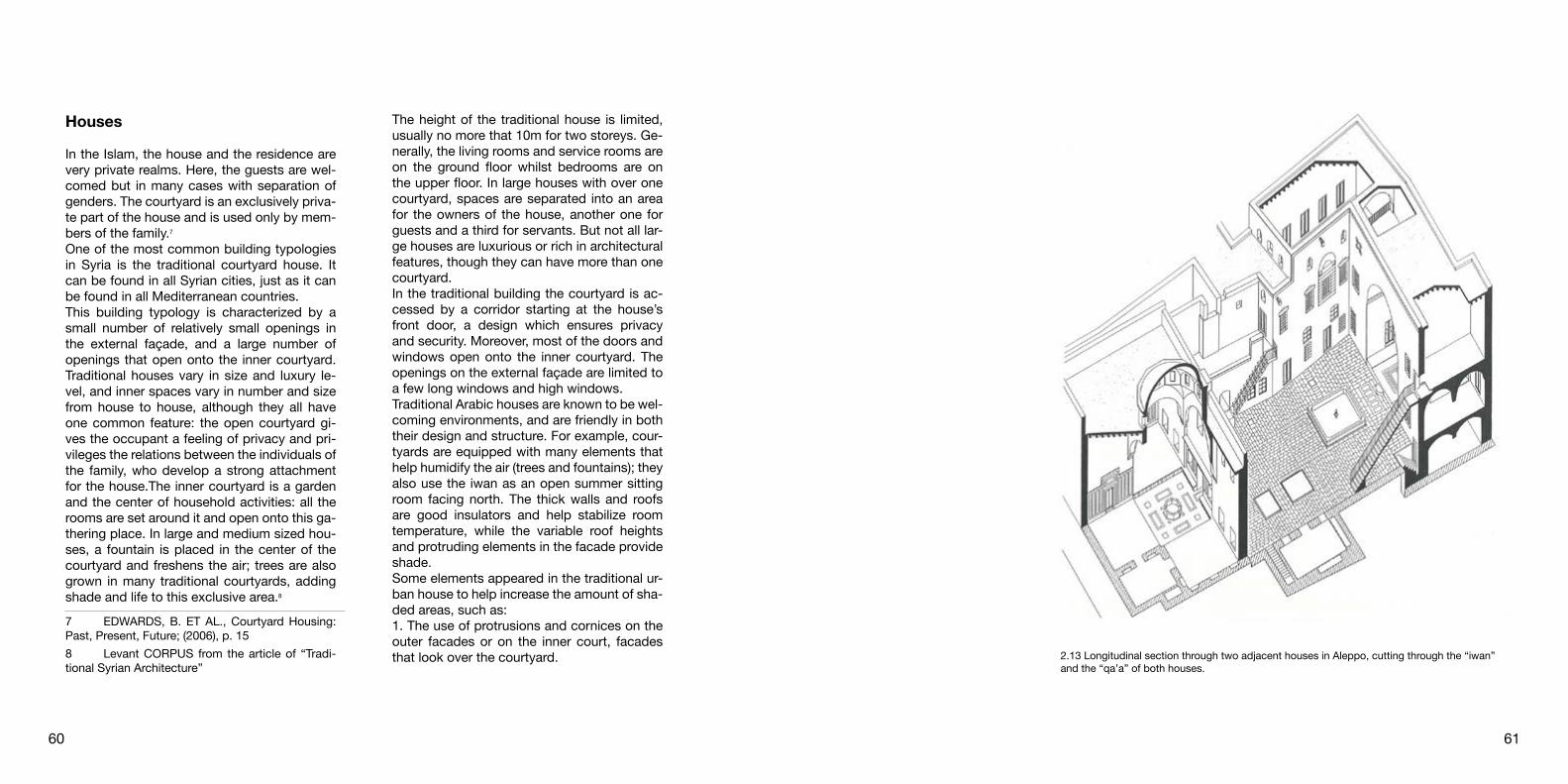
2.13 Longitudinal section through two adjacent houses in Aleppo, cutting through the “iwan” and the “qa’a” of both houses.
Houses
In the Islam, the house and the residence are very private realms. Here, the guests are wel-comed but in many cases with separation of genders. The courtyard is an exclusively priva-te part of the house and is used only by mem-bers of the family.7
One of the most common building typologies in Syria is the traditional courtyard house. It can be found in all Syrian cities, just as it can be found in all Mediterranean countries.This building typology is characterized by a small number of relatively small openings in the external façade, and a large number of openings that open onto the inner courtyard. Traditional houses vary in size and luxury le-vel, and inner spaces vary in number and size from house to house, although they all have one common feature: the open courtyard gi-ves the occupant a feeling of privacy and pri-vileges the relations between the individuals of the family, who develop a strong attachment for the house.The inner courtyard is a garden and the center of household activities: all the rooms are set around it and open onto this ga-thering place. In large and medium sized hou-ses, a fountain is placed in the center of the courtyard and freshens the air; trees are also grown in many traditional courtyards, adding shade and life to this exclusive area.8
7 EDWARDS, B. ET AL., Courtyard Housing: Past, Present, Future; (2006), p. 158 Levant CORPUS from the article of “Tradi-tional Syrian Architecture”
The height of the traditional house is limited, usually no more that 10m for two storeys. Ge-nerally, the living rooms and service rooms are on the ground floor whilst bedrooms are on the upper floor. In large houses with over one courtyard, spaces are separated into an area for the owners of the house, another one for guests and a third for servants. But not all lar-ge houses are luxurious or rich in architectural features, though they can have more than one courtyard.In the traditional building the courtyard is ac-cessed by a corridor starting at the house’s front door, a design which ensures privacy and security. Moreover, most of the doors and windows open onto the inner courtyard. The openings on the external façade are limited to a few long windows and high windows.Traditional Arabic houses are known to be wel-coming environments, and are friendly in both their design and structure. For example, cour-tyards are equipped with many elements that help humidify the air (trees and fountains); they also use the iwan as an open summer sitting room facing north. The thick walls and roofs are good insulators and help stabilize room temperature, while the variable roof heights and protruding elements in the facade provide shade.Some elements appeared in the traditional ur-ban house to help increase the amount of sha-ded areas, such as:1. The use of protrusions and cornices on the outer facades or on the inner court, facades that look over the courtyard.
60 61

2.14 Floorplan and aerial view from the courtyard of Bimaristan Arghun al-Kamili.
2. The use of the “Kishks” (protruding wooden kiosk) to cover the openings in the external wall, rarely used on inner facades.3. Some traditional houses use the roof garden as a way to lessen heat in the house.4. Covered streets protect external walls from direct sunlight.Traditional houses in urban areas also con-tain many architectural elements made to en-sure a natural airflow through all the spaces; wind catchers as well as openings opposite each other are used. A great variety of ceiling heights are used and the main spaces of the house are conceived so as to be ventilated by soothing winds.9
The courtyard in the traditional typology of a residential building in Aleppo is an important morphological, functional, environmental ele-ment supplies natural lighting and ventilation. Most of Aleppo buildings are rectangular sha-pe and the long axis are towards east-west. The exterior appearance of the building pre-sents an important component in the building construction to preserve the cultural heritage of the city; elevations possess varied functions such as resisting the heat transfer through the external walls and reflecting sun radiation to reduce the indoor air temperature. Most of the traditional buildings in Aleppo have a massi-ve construction consisting of very thick walls with minimum external openings to prevent the heat flux into the interior spaces. These buildings used stones as the structural mate-
9 Levant CORPUS from the article of “Tradi-tional Syrian Architecture”
rial, which has a high level of heating storage capacity, where the stones store the energy during the day and resend it at night.10
In Aleppo, the most common type of house is Syro-Ottoman which derives from a fusion of pre-existing courtyard types of different deri-vations, among the Roman “domus” in a mo-dified version already in the foundation stage. The original module of the courtyard house in Aleppo is rectangular room called the “Bayt” that is 4 meters wide and of varying lengths, corresponding to a multi-functional room; whi-ch is grouped in a rather serial way around one, two, three or four side of a rectangular courtyard of wide dimensions that can vary between 12-15 x 8-10 meters. The entrance to the courtyard occurs through a long, narrow corridor placed in a corner position and never axial with respect to the courtyard, whether covered or open.In the case of large parcelization in the three or four housing units, the regularity of courtyard is lost, and a series of filtering structures from between the courtyard and the street that are increasingly more complex as the new lots formed further inside the lot and thus further from the street. The distribution of the organi-sm involves the entire courtyard-house combi-nation beginning with a long, narrow vestibule that connects the entrance door, element of inside-outside separation, and the real cour-
10 HADYA SALKIN, LAURA GREC. ROBERTA LUCENTE “Towards adaptive residential buildings traditional and contemporary scenarios in bioclima-tic design.
tyard. The vestibule leads into the courtyard which, in the larger complexes where a clear distinction between male and female spaces is possible, takes form of several autonomous courtyards.11
The traditional courtyard house in Syria is composed of three parts: basement floor, ground floor comprising the main living areas called ‘al salanlek’ and a first floor comprising the private area called ‘al haramlek’.12
In this private typology, the implementation of a basement floor allows the inhabitants to enjoy an even temperature throughout the year. It is therefore an attractive living space in periods of extreme winter and summer. This basement acts as a thermal moderator during the hot dry
11 PETTRUCCIOLI A. After Amnesia, Lear-ning from the Islamic Mediterranean Urban Fabric. (2007) p. 9512 Edwards, B. et al. Courtyard Housing: Past, Present, Future; (2006), pp.31
season, as it allows the hot air collected by the wind-catchers to be cooled and humidified before it is released to courtyard space. It is also used for the yearly storage of food sup-plies as is the case in many courtyard houses of Aleppo, a city that has endured many wars. The courtyard organization is appropriate to hot dry climates because it maximizes sha-ding and allows for the creation of a pleasant microclimate. The availability of the plants and water feature within the courtyard helps in co-oling and humidifying the internal atmosphere. Then, speaking about the constuction techi-que, it is based on thick load-bearing stone masonry and it provides an adequate termal mass. The existence of cooling towers allows for a good summer ventilation as hot air is fun-neled down into the basement where it is coo-led and let out into the courtyard space.13
13 Edwards, B. et al. Courtyard Housing: Past, Present, Future; (2006), pp.32-33
62 63

re such element was known as Al Iwan which is a covered open space used as a pleasant and comfortable open-air usually located on the north facade of the courtyard to catch the cool breeze during the summer and oriented to the south side for winter.4
Fountain
In the garden the water is located in the cen-ter of the courtyards where there is a fountain from which four paths radiate. It is placed at the heart of the garden which gives its many roles into the design; it emphasizes architectu-ral elements, masks the outdoor noise, produ-ces pleasing sounds, refreshes the eyes, cools the body in the high temperatures and provi-des a space for spiritual contemplation. At the same time it irrigates plants, and soothes the dusty wind.5
The main directional view focus is invariably from the peripheral arcade to the centrally lo-cated pool or fountain. The courtyard is viewed and appreciated from its surrounding arcade.6
4 HADYA SALKIN.,LAURA GREC. ROBERTA LUCENTE, towards adaptive residential buildings traditional and contemporary scenarios in bioclima-tic design (the case of Aleppo)5 HAMED,S.,E., Paradise on earth: Historical gardens of the arid Middle, ( pp.84)6 LEHRMAN, J. B., Earthly Paradise: Garden and Courtyard in Islam, (pp.35)
which is a sheltered place for plants and foun-tains, fulfilling a religious purpose as a sign of paradise in the midst of arid country.2
Iwan
The iwan is an important covered open space from which the aesthetic qualities of the cour-tyard can be enjoyed. It provides a raised pla-tform (by one or two steps), used as pleasant and comfortable open-air reception and sea-ting area and a venue for evening events such as playing traditional music. The iwan is usual-ly located on north-facade of the courtyard to catch the cool breeze during the summer. It also comprises two symmetrical rooms fa-cing each other and it has an ornamental front stone arch facing the courtyard. The transition from the courtyard to the iwan space is mar-ked by a multicolored marbled patterned floor, which resembles an oriental carpet.3
One of the significant bioclimatic architectural elements in the traditional buildings in Aleppo is Al iwan, a semi- outdoor open space closed from three sides and opened from one side by three large arches at the south side of the buil-ding. This semi-open space protects the walls from sun penetration in summer and allows it to absorb solar radiation in winter. The origin of this element is from the courtyard house whe-
2 EDWARDS, B. ET AL. Courtyard Housing: Past, Present, Future; (2006) p. 153 EDWARDS, B. ET AL. Courtyard Housing: Past, Present, Future; (2006) p. 31
The idea of courtyards as plan configuration goes back thousands of years, its documen-ted that it started from the Neolithic settlemen-ts. In the begininng, the logic behind this type was mainly to provide a protective area from outside forces, such as invasion by human, and wild animals. Over time, it has developed into a solid, logical configuration that maximi-zes the built-up area in the urban context and allows the control of the sun-light, especially in the regions where it is abundant. The cour-tyard is one of the most important features from the traditional architecture and the histo-ric urban fabric in the Islamic cities of Middle East as Aleppo, Damascus, and Fes. Since then, it has transcended regional, historical and cultural boundaries.1
The use of this element has been has a lot of advantages; the first of them it’s that it allowed high density in ancient cities which needed to be surrounded by walls in order to protect against the attacks of the enemy as Bagdad, Damascus, and Aleppo. At the same time, in those cramped cities, the courtyard also offe-red privacy and security. Speaking about the climatic advantages in the desert climates of the Middle East, this typology provided solar protection by having everything open toward this shaded courtyard. To provide light and ventilation to the rooms, the courtyard win-dows are much larger and are more decora-ted than in the external facades For the Isla-mic culture, the courtyard had another benefit
1 EDWARDS, B. ET AL. Courtyard Housing: Past, Present, Future; (2006) p. 15
2.15 The courtyard house reflects the need for privacy, expressed also in the hejab.
The CourtyardAnd its role in different typologies
64 65

Openings
The term “openings” not only refers to the openings on external façades, such as doors, windows and arches: it also includes open and half open spaces inside the building. The open courtyards and balconies in some building types.In general, openings are divided into two groups: the first consists of doors and win-dows, the second consists of arches.The general reasons for alterations carried out on openings differ from one case to another: they are sometimes carried out to let in more sun and light, they are sometimes due to a change in living standards inside the building, such as a new layout of rooms or a grouping of multiple rooms into one, therefore calling upon new openings that alter the shape of the origi-nal openings, arched or ornamented.Another situation that can be harmful to the building is the case where the inner courtyard in the traditional building is closed, blending partly or fully into inner rooms. This affects the amount of light and sunshine that enters the building, as well as the general shape of the building, changing the typology of the building itself. Windows represent important elements for air circulation regulation and natural lighting. Traditional architecture had a high care to the windows location and size, to regulate the air circulation and the entry of sun, and for achie-ving privacy. The placement of the openings at a high level of the external walls and at the
According to Shari‘ah, the utilization and su-stainable use of natural resources and elemen-ts is the right and privilege of all people. This right is to a certain degree considered by Islam as an obligation. According to climate respon-sive approach, the interactive and adaptive re-lationship between building, site, and climate consider a basic rule to reduce the environ-mental impact and improving energy efficiency in buildings.1
Orientation
The spatial organization of the buildings, stre-ets treatments, and landscape should facilita-te wind penetration in the summer time where the desirable breeze come from the west or west-south sides. In the same time, the spatial organization should avoid undesirable breeze from the north side, thus the optimum orien-tation of the streets grid is the south-east or north-west axis for shading the streets and promote natural ventilation during the hot pe-riod. Inspiration of narrow pedestrian tracks from traditional architecture, which reduces the distance between the buildings then mini-mize the sun penetration of the building walls.
1 HISHAM MORTADA, traditional Islamic prin-ciples of built environment
Accessibility to the courtyard
1. Access to the courtyard through a corridor: the access to the inner space of the house from outside is through an intermediate area (an entrance) which emphasizes the distin-ction between the external public and internal private spaces.
2. Access to the courtyard through another room: the enclosed sanctuary of the house designed to protect the privacy of the family. Means of access and filters are multiplied in order to create different degrees of intimacy as one proceeds from the external public spaces to the internal private ones.
3. Access to the courtyard through a path: this area constitutes a filter which establishes a sequence of penetration and control through changes in direction. It is designed to obstruct any view of the inside, and hence does not give immediate access to the inner courtyard.
4.Direct access to the courtyard: in other types of buildings such as schools, mosques and other public buildings where courtyards are a climatic necessity and there is no demand on privacy, the entrance is open directly into the courtyard.7
7 PETTRUCCIOLI A. After Amnesia, Learning from the Islamic Mediterranean Urban Fabric. (Poli-técnico di Bari, Italia. 2007, pp.81) 2.16 Different types of access to courtyards.
Architectural elementsTraditional solutions to face functional and climatic issues
66 67
43
1 2

tecture are small on the external facade and larger on the inner façade, looking onto the courtyard; this architectural style is environ-mentally healthy and takes privacy into con-sideration; an essential factor in eastern archi-tecture.2
Shading System
he major part of the heat gain comes from the solar radiation, which plays a crucial role in in-creasing the air temperature within the buildin-gs; therefore, sufficient shading could reduce these effects drastically. Al Mashrabiyya is a bioclimatic architecture element utilized at the external side of the windows in the traditional buildings for screening the solar radiations in hot periods, enhancing air movement, and achieving privacy.3
Ventilation
The ventilation need is considered a major priority for both urban fabric and occupants, whereas achieving smooth air movement from the exterior to the interior of the building was an important issue in the traditional residential
2 LEVANT CORPUS Traditional Syrian Archi-tecture3 HADYA SALKIN, LAURA GREC, ROBERTA LUCENTE, towards adaptive residential buildings traditional and contemporary scenarios in bioclima-tic design (the case of Aleppo)
lower level of the internal walls aimed to im-prove cross ventilation and to get rid of the hot air. Moreover, to increase heat gain and reduce heat loss in the wintertime the openings size in the south walls should be larger than the north side.The sizes of openings vary in stone buildings: the borders of these openings are either strai-ght, curved or pointed. It is important to arran-ge the top part of the opening carefully so that it can withstand loads and transfer them to the jambs. The top part is called the “najafeh” (lin-tel) and the sides of the opening are called the “fakhdan” (jambs). Many different types of lin-tels can be found in old buildings, such as the one-piece straight lintel, made of stone for the outside and wood for the inside. Flat lintels are also used when an odd number of stones are arranged carefully and locked into place, with a central stone called the key stone; the resi-stance of this type of opening depends on the shapes of the stones, and their contact and fit-ting the stones that rest on the jambs bear the greatest loads from the upper layers. A slightly curved lintel a semi-circle arch, a pointed arch or a horse shoe are sometimes used as well, all structurally performing.In general, the stone lintel is used on the ex-ternal façade for all types of arches. On the inside, a wooden lintel is generally put 5cm hi-gher: it consists of wooden logs arranged over the width of the opening, covered underneath with a thin wooden panel called “al twan” (so-fit).In general, the openings in traditional archi-
water-filled jars were placed, to increase the internal climate’s moisture, in this way the fre-sh air loaded with water vapor at summer time, could access by using operable windows On the other hand, one of the effective biocli-matic elements in the traditional buildings of Aleppo was the indirect entrance, which cle-arly enhanced the privacy and air movement control. The entrance consists of double do-ors, the first usually led to a passageway and the second led to the courtyard. This design solution could reduce the heat transfer throu-gh the entrance in both hot and cold seasons, and improve air circulation inside the building through creating different air pressure betwe-en the passageway and the courtyard.
buildings. Al Malqaf was an innovative biocli-matic architectural element in the traditional residential buildings, which consist of shaft high rising above the building and opened from the prevailing wind side, constructed on the north side of the building to capture the cool air and channels it down into the interior of the building. This airflow concept can be applied to all the residential building types in various forms, based on the different climatic factors like humidity, prevailing wind flow, pat-terns and building materials. In the case of the old city of Aleppo, a special type of Al Malqaf was utilized, where all traditional building had one shaft located at the north side of the bu-ilding to capture the cool air. Within the shaft
2.17 Moucharabieh House.
68 69

in mosques, churches, baths and some great houses. These cupolas take on different sha-pes: semi spherical, onion shaped or ribbed; they can also be an egg shape, depending on the dimensions of the space and the ratio of its length to its width. The formwork that is used to set the shape and degree of the stone’s cur-ve must be prepared to give the structure a smooth surface from the interior and exterior. The stones are lined up on the formwork, in their final position, up to the final stone, which is called the key stone. The latter can be cut into a star shape, a round shape or a squared shape. 6
Circular vaulted construction used as a me-ans of roofing. First used in much of the Mid-dle East and North Africa whence it spread to other parts of the Islamic world, because of its distinctive form the dome has, like the minaret, become a symbol of Islamic architecture.Islam, like other great cultures, has always been, sensitive to the impressive effect of do-med spaces, from outside to make the buil-ding conspicuous from afar, and from inside to awe the visitor. Early domes were cautiously built, normally spanning a square bay, but la-ter it was found to be simpler to heighten the rectangular base of the dome rather than in-crease span. The earliest large domes were of wood, but the use of baked brick in ‘Abbasid Mesopotamia spread rapidly all over Islam. By the 15th century, stone domes were widespre-ad from Syria and Egypt to the Indian subcon-
6 LEVANT CORPUS Traditional Syrian Archi-tecture
Vaults
Roofing using vaults is an old way of covering large halls, crossing areas and passages; no matter how long they are, as can be observed in traditional souks.There are two types of vaults in traditional ar-chitecture:1. Barrel Vaults: also known as half cylindrical vaults.2. Cross Vaults: consist of two consecutive crossing and orthographic vaults.Stone is the main material used in building vaults; both types of vaults have the same building principle. They are structured on a wooden formwork that takes the shape of the vault; this frame is built up to the height of the wall and is supported by horizontal and verti-cal supports that hold the arch-shaped frame. Mud or lime mortar is used to join the stones and give the whole structure stability.The thickness of the roof ranges between 35-40 cm, plus the layer of earth filling used to fill the gaps that finalize the shape of the roof: this surface structure increases the thickness of the roof, thereby further improving its insu-lation properties.
Cupolas
Architects used cupolas as a substitute for the flat roof. Stone cupolas were considered one of the most important architectural featu-res used in roofing: it covers the main spaces
Light
God is the light of the heavens and the ear-th, says the Koran.There is no more perfect symbol of the Divine Unity than light. For this reason, the Muslim artist seeks to transform the very stuff he is fashioning into a vibration of light. It is to this end that he covers the in-terior surfaces of a mosque or palace—and occasionally the outer ones—with mosaics in ceramic tiles.4
Kishk
Kishk (wooden kiosks) are protruding windows that look like closed wooden balconies. They were used in traditional architecture to ensure the privacy of a house but let inhabitants see passersby and watch the street without being seen; they also provide natural ventilation. Ki-shks are considered an Ottoman architectural feature that spread in Syria in the Ottoman period. The wooden construction of the kishk rests on stone consoles; Kishks were decora-ted simply; special attention was given to cor-ners, cornices and the “oriel” (underneath the projecting sides of the roof).5
4 TITUS BURKHARDT, art of Islam, language and meaning5 LEVANT CORPUS, Traditional Syrian Archi-tecture 2.18 Traditional Kishk
70 71

been altered to adapt to modern times.Lifestyles change from one place to another, and the building materials that change accor-ding to availability in the particular area, pro-duced different building typologies in different areas and cities. The building materials avai-lable in each area define the building typology as well as the shape of the buildings and their overall appearance.In cities, stone is the main material used in bu-ilding; though a few other rare typologies can be found.
Materials
Traditional architecture usually depended on handcrafts, and building materials made from natural components were widely available lo-cally.These materials differed from area to area, thus conferring particular characteristics to the architecture of every area in Syria: this is noticeable in the style, color and dimensions of buildings, all adapted to local lifestyles and needs. Some of these characteristics have withstood time, others have changed or have
mes into multiple facets with the purpose of unifying a dome’s transitional zone into a com-positional unity.
Arcade
There are many ways to construct arches: the-se change according to the different building typologies used in the Syrian areas, but in ge-neral they are mainly used to shorten the span.Arches are frequently used in urban archi-tecture and are widely used in the architecture of important buildings and religious structures. They are found in the entrances and passages of these buildings, and are used in houses on a smaller scale, mostly in the Iwan. The shape of the arch changed with the change of archi-tectural style and age.The arches that were used in Syrian architectu-re depend on the architectural style. Semicir-cle arches or transcending arches are used in the Umayyad era, with plant ornamentation and elements such as grape vines, palm bran-ches, roses and tulips on their edges. Pointed arches consisting of two sections, an upper flat section and a lower curving section, are originally Persian and were used in the Abba-sid age. These were then further developed in the Ottoman age and were modernized, ma-king the flat part of the arch more complex.
tinent, but even the great Ottoman architects of the 16th century failed to match the span of Justinian’s church (now a mosque), the Hagia Sophia, in Istanbul More recently, ingenious use has been made of mud-brick with an ela-borate timber scaffolding to form domes in the Islamic architecture of Central Africa.One of the main problems of dome con-struction was the transition from a square spa-ce or area into a circular domed area. Usually there was an intermediary octagonal area from which it is easier to convert to a circular area although there is still the problem of converting from square to octagon. Two main methods were adopted, which are the squinch and the pendentive. The squinch is a mini-arch which is used to bridge a diagonal corner area whilst a pendentive is an inverted cone with its point set low down into the corner and its base at the top providing a platform for the dome.7
Muqarnas
Muqarnas are a traditional architectural em-bellishment of Islamic architecture, which resemble stalactite rock formations. Among the most characteristic artifacts and original inventions of medieval Islamic Architecture, they are structures formed out of small poin-ted niches with rhythmic modularity and infini-te compositions.They were built to break down vaults and do-
7 ANDREW PETERSEN, Dictionary of Islamic Architecture 2.19 Stone flooring of the Great Mosque’s courtyard
72 73

The current condition of the cityAleppo after the Civil war

by the ethnic minority of the Syrian Kurds in 9%, Turkmens that are approximately 5% and other ethnic groups embrace Armenians, Cir-cassians, Greeks, Mhallami, Kawliya, Yezidi, Shabaks and Mandeans.3
Due to the exaggeration of free market policies by Hafez al-Assad, socioeconomic inequality increased remarkably and it expedited when Bashar al-Assad came to power. With the un-derlined service sector, these policies took advantage of the minorities; who had con-nections with government and members of Sunni merchant class of Damascus and Alep-po.4 The annual growth rate of 3.39%, is below most other developing countries and its nei-ghbours. Thus, the country faced high youth unemployment rates and it led to uprisings in Syria’s poor areas; predominantly among con-servative Sunnis.5 This came across with the most severe drought ever recorded in Syria between 2011 and 2016 which was followed by widespread crop failure, increased food pri-ces and mass migration of farming families to urban centres. At the same time this migration forced infrastructure.6 Therefore, adequate water supply continues to be an issue in the
3 DAGHER R., Syrian’s Alawites: The People Behind Assad (2015)4 LARSEN R., Youth Exclusion in Syria: Social, Economic and Institutional Dimensions (2011)5 ASSOCIATED PRESS, Rebels in Syria’s Lar-gest City of Aleppo - mostly poor, pious and from rural backgrounds (2015)6 MUIR J., BBC Report ‘Aleppo water supply cut as Syria fighting rages’ (2012)
The Syrian Civil War is a proceeding conflict between the Government of Bashar al-Assad with its allies, multifarious forces each other in different combinations.1 Several armed groups have been involved in the on-going ci-vil war, however, there are five main factions: the Syrian Arab republic and allies, the Syrian opposition and allies, the Democratic Federa-tion of Northern Syria and allies, Islamic State of Iraq and the Levant and allies. The trouble started as an uprising against Bashar al-Assad with the wide wave of the 2011 Arab Spring protests due to the high amount of unemploy-ment, deteriorations and restriction of free-dom.After Hafez al-Assad’s death in 2000, his son Bashar al-Assad was elected as President of Syria. Bashar al-Assad and his wife, who is Sunni Muslim born and educated in Britain, infused expectations for democratic reforms. The period of the social and political deba-te, called ‘The Damascus Spring’, was held between July 2000 and August 2001 and en-ded with the incarceration of ten activists due to calling democratic elections and campaign of civil ‘disobedience’. However, Bashar al-As-sad had failed to serve the promised reforms.2
The demography of Syria consists mostly of Syrian Arabs, which are divided in 74% Sun-nis, 13% Shias, 3% Druze and 10% are Chri-stians. The rest of the population is composed
1 SLACKMAN M., Syrian Troops Open Fire on Protestors in Several Cities (2011) 2 MACFARQYHAR N., STACK L., Syrian Pro-testers Clash with Security Forces (2011)
The Syrian civil war15th march 2011 - today
77

sion. Jihadist groups’ involvement brought the war to another level. According to the UN10, all groups of conflict have committed war crimes: in 2013, for example, chemical weapons star-ted to being used in the conflict. As a result of all, a huge humanitarian crisis happened.
10 United Nations Human Settlements Pro-gramme (UN–Habitat); it was established in 1978 and it is the United Nations agency for human settlements and sustainable urban development; it promotes socially and environmentally sustainable towns and cities with the goal of providing adequa-te shelter for all.
on-going civil war and it is frequently the target of military action. The human rights situation in Syria has long been the subject of harsh critique from global organizations. Syrian government strictly con-trolled the rights of free expression, associa-tion and assembly even before the rebellion.7 Security forces had sweeping powers of arrest and detention. The conflict started as a protest and uprising against government in Deraa, later it turned into violence, arrests and torturing. After that, opposition supporters started to take force against the governmental forces for pro-de-mocracy demonstrations. The Country star-ted to enter the civil war with armed rebels and jihadist groups. As a result of that there were many war crimes.8
To sum up, since 2011, the civil war caused more than 400’000 deads, damages within the country and loss of global power; more than 5.6 million citizens have fled and 6.1 million are displaced inside the country.9 The war lasted so long because of the intervention of world powers such as Russia, Saudi Arabia, USA and Iran. That country supports, in terms of military political and financial, made the war last longer. Also, inside the country, the Sun-ni majority and Shias created such a big divi-
7 OWEIS K. Y., Syria’s Assad Vows to Lift Emergency Law by Next Week (2011)8 CHULOY M., MARSH K., Assad Blames Conspirators for Syrian Protests (2011)9 BBC Report ‘Grafiklerle: Suriye’de 8. yılına giren savaş’ (2008) 3.1 Who controls what? - Current condition map of Syria
78 79

splaced Persons (IDP) from various governo-rates and cities. At the end of 2012, this IDPs in-migration tendency turned into massive displacement and out-migration, and Aleppo inhabitants fled away to other governorates and outside the country. Almost 1.72 million inhabitants had been displaced by November 2013, and 53% of whom fled the Governora-te. Another 48% have been displaced within Aleppo.- Over 302.000 housing units are partially or fully damaged (end 2013), i.e. 52% of the city’s 2011 housing stock.- Approximately 140.000 labourers in the indu-strial sectors have been laid off, which has di-rectly impacted the source of income for more than 600.000 city inhabitants.- The City Profile concluded that 21 of the as-sessed 125 city neighbourhoods have been he-avily damaged and was no longer functioning; they will require wide scale reconstruction for future reoccupation by inhabitants. Another 53 neighbourhoods are partially functioning, de-spite widespread damages.- On the other hand, the City Profile concluded that 40 neighbourhoods are currently functio-ning since governorate and municipal mana-gement still persist, and due to the acceptable level of security. Such factors have made these neighbourhoods attractive to IDPs from more impacted areas, with evident implications for the demand for services and infrastructure.11
11 UN HABITAT, City Profile Aleppo - Multi Sec-tor Assessment (2014)
responsive or appropriate. UN Habitat tried to provide up to date, holistic documentation and analysis of the impact of the crisis in key cities through city profiles, synthesising information and insight from existing sources and priori-ty sectors, which are supplemented by direct field research by UN Habitat teams based in each city, carried out from December 2013 to March 2014.‘Aleppo City Profile’ is the primary pilot UN Habitat team has developed with urban analy-sis, community approaches and crisis context. The city profile is improved by a close asso-ciation with governorates and municipalities which helps to demonstrate the functionality of the city, economy and services, to under-stand the capacities and coping mechanisms and to identify humanitarian and recovery pri-orities. Although it did not supply exhaustive data, it provided a balanced general view. The city profile gives the opportunity to access detailed investigation on shelter and housing issues which are helpful for the shelter asses-sment process.Before the conflict had started in 2011, Alep-po was the city with largest population: 3 mil-lion, almost 25% of the entire Syrian urban population. The city had a strong economy as a national industry and trade hub, with hi-storic and collaborative commercial relations with neighbouring countries. Because of that, Aleppo was the most charming city for rural migrants and because of that almost 40% of population lived in informal areas. Due to the crisis, the city became a place for Internally Di-
The end of the war and the humani-tarian emergency
The Syrian Civil War caused the biggest di-splacement crisis in the world: millions of inha-bitants were forced to move from their home both inside of the country and through the borders. Almost 400.000 people died and 6.1 million people were displaced. Most of the re-fugees went to Turkey and Lebanon, but also Jordan, Iraq and Egypt took a part of them. These countries have struggled with one of the largest refugee flows in recent history. Turkey hosts over 3.2 million registered Syrians, mo-stly in urban areas or refugee’s camps. More than 1 million refugees live in Lebanon with struggles. Others in Jordan, Iraq and Egypt. About 10% of refugees fled to Europe. The UN reported that in 2016 the humanitarian assi-stance for the 13.5 million Syrians (including 6 million children) is worth $3.2 billion.The remarkable effect of Syrian uprising is mostly observed in major cities due to the large-scale movements of population, the destruction of buildings and infrastructure and the interruptions of markets. One of the main features of the crisis is the lack of infor-mation about the decision making, the moni-toring of the issues and the evolution of the needs. For instance, the majority of displaced families are finding accommodation through host or rent arrangements, but information on such dynamics is very limited. Without better understanding at family, community and city levels, humanitarian interventions may not be 3.2 Image from the area around the Palace of Justice.
80 81

nal airport and other cities’ centres. Aleppo’s airport and railways have been closed since December 2012 and they had reported da-mages regarding the infrastructure. The pu-blic transportation system has broken down but there are still limited microbus services in the western part of the city. The cost of tran-sportation has increased due to growth of fuel price.
Electricity and fuel – Essentially 60% of the city’s power is supplied by the eastern Aleppo thermal plant which is still functioning under crisis. The main factor in the failure of the basic services is the lack of electricity supply. Prices of the main fuel materials rely on the city ac-cessibility and changes in market demand per season. Nevertheless, in the eastern part of the city, prices are less expensive because of the accessibility to the source (Fig. 3.4).
Food and livelihood – In spite of the fact that food is largely available in the markets, it is still the most critical problem for inhabitants. Due to changes in the prices and inadequacy of cooking fuel and impairment of livelihoods, food becomes inaccessible. Although there are no evident problems of starvation, many areas are at risk. There is variation of food pri-ces at both sides of the cross-point: they are generally higher in the west because of the cut offs of supplies (Fig. 3.5).
Health and nutrition – All operational public and private hospitals are located in the we-stern part of the city and they have encounte-red a significant decrease in their number (Fig. 3.3). Due to uncollected garbage in the we-stern part, scab and lice, a variety of diseases and epidemics have emerged in the city; espe-cially at schools and clusters of IDP. Moreover, lack of access routes has caused the stop of 70% of Aleppo’s pharmaceutical industry and the production of medicine not reachable for most of the defenceless population.
Education – Since the direct damage, 34% of schools are not been functioning and this calls for rehabilitation. Moreover, these scho-ols are occupied by collective shelters and other uses with limited facilities (Fig. 3.4). The Governorate of Aleppo led efforts to empty 60 schools of IPDs in order to restore them for educational function. Due to the different fac-tors, attendance rates are low and they slow down the regular education process. The main reasons to abandon education are fear, acces-sibility and lack of facilities, but also educatio-nal materials. In Aleppo all schools are opera-ting in double shifts.
Accessibility – Humanitarian access from Damascus to Aleppo has been seriously af-fected since July 2013. Eastern and southern parts of the city are still accessible through international road connections. However, we-stern parts are under irregular blockades; so, there are limited-access routes for internatio-
3.3 Operational status of public health facilities.3.5 Consumer prices of fuel commodities.
3.6 Consumer prices on food items.
3.7 Current sector of employment.3.4 School facilities operations.
82 83

and historic photos to create a digital archi-ve on the basis of the Cadastral plans of the Old City; they also gathered documents about single monuments, the development of public spaces, the urban structure of the traditional historic quarters and the typology of housing. This documentation is the basic instrument for future strategies in order to reconstruct in dialogue with the existing city and with the cultural heritage. In this complex process, it is important both the participation of former and actual inhabitants of Aleppo, as well as the contribution of experts in the matter (such as urban planners, architects, archaeologists and local craftsmen).4 Besides human help, many political, ideological, religious, social and eco-nomic aspects will influence the development: according to A. Gangler5, it should start from the top-down with legally-binding instruments like qualitative and quantitative land use plans on different planning levels (regional and city level; old city and quarter level; housing level).6
When the war in Syria ends, people are expected to return, hence, there will be a demanding need of accommodations. Re-
nde.de/language/en/about-us/4 GANGLER A., Aleppo - The Old City at a Glance (2016) p. 175 Anette Gangler, architect and urban planner from the University of Stuttgart. She has professio-nal experience in town planning, urban planning and regional planning in different, complex social environments in Southern Germany and in the Arab World.6
Needs and premises for a recon-struction
The conflict has caused more than 400,000 dead and millions of refugees and around 40 national initiatives are involved in helping the inhabitants, but at the same time the historic monuments and the cultural heritage are being continuously damaged as a strategic tool to destroy the cultural identity of the Syrian po-pulation.As Bianca1 explained, a city (especially a hi-storic centre) contains the ‘spirit’ of a culture because it acts as a collective memory for its own society and it shows the attitudes and common patterns of life, hence becoming the source of identity. If the urban fabric is de-stroyed, the sense of wholeness disappears, especially in traditional Islamic cities, where single buildings were always conceived as part of a comprehensive fabric.2
To protect the cultural heritage, many orga-nizations are monitoring the damage and are starting initiatives to defend it. For example, the association ‘Friends of the Old City of Aleppo’3 has supported the collection of plans
1 Stefano Bianca, architectural historian and an urban designer. He is currently working as Direc-tor of the Historic Cities Support Program by (HCP) of the Aga Khan Trust for Culture (AKTC) that pro-motes the conservation and re-use of buildings and public spaces in historic cities of the Muslim World.2 BIANCA S., Urban Form in the Arab World. Past and Present (2000)3 For more information see: www.aleppofreu-
The failure of the industrial and construction sectors that used to be the largest economic drivers, the slowed commercial relations with Turkey, the collapse of the role of the Ancient city of Aleppo as main commercial and touri-sm hub and the decrease of the agricultural sector caused a negative effect on the liveliho-od activities. Because of the collapse of live-lihood activities, many activities like informal markets, private transportation, and minor re-pairing activities emerged (Fig. 3.6).
Water, sanitation and solid waste – Al-though the city benefited by the functional status of the channel from the Euphrates, by the quality of potable water and by the sani-tation network, there has been a significant decrease in the level of services because of the damages in the infrastructures; the qua-lity of the water deteriorated due to the lack of sterilization chemicals, the supplying hours dropped and inevitability most hygiene items suffered of inflated prices. Waste management and collection services have become almost non-existent in some areas (mostly in eastern and northern areas), or only continue through the efforts of the people living there.12
12 UN HABITAT, City Profile Aleppo - Multi Sec-tor Assessment (2014)
Aleppo’s reconstruction
84 85

of Aleppo has been severely damaged, with 30% totally destroyed.8
Of the locations examined, 104 have sustai-ned damage, while roughly a fifth of the sites are completely destroyed. Inspection of the imagery suggests that within the World Heri-tage Site, the area to the east and southeast of the citadel towards Bab Antakya is the most affected, particularly between the citadel and the Umayyad Mosque; large parts of this area are no longer present.9
8 UNESCO, Reports on extensive damage in first emergency assessment mission to Aleppo (2017)9 UNITAR, Satellite-based Damage Asses-sment to Cultural Heritage Sites in Syria (2014)
City’s damages
The battle of Aleppo began on 19 July 2012 and was part of the ongoing Syrian Civil War. A stalemate that had been in place for four years finally ended in July 2016. For this reason, the city of Aleppo has also been badly damaged in the conflict (Fig. 3.10 - next page). The changing of the old city of Aleppo is com-prehensible with the passing years (Fig. 3.8 and Fig. 3.9).The UNESCO team reported extensive dama-ge at the Great Umayyad Mosque, the Citadel, mosques, churches, suqs, khans, madrassas, hammams, museums and other significant hi-storic buildings in Aleppo. According to a pre-liminary assessment, some 60% of the old city
building the destroyed residential quarters is urgent and the necessity for rapid re-housing through temporary buildings has to be a pri-ority; although, rebuilding historic monuments and restoring the image of the city could also be done as a starting project. The way a city is rebuilt post-disaster is critical in defining both its urban as well as its historical continuity.7
Certainly, many problems linked with recon-struction already existed before the conflict: the rapid urbanization and demographic chan-ges led to a loss of meaning of the historic part by the whole city. The lack of governan-ce, maintenance and public investments in the past permitted the negligence of the historic centre as a cultural heritage. But then again city centres are subject to change so the main task of renewal and rehabilitation should be about managing it in order to retain cultural si-gnificance rather than reducing it. As claimed by J. Qudsi, to achieve the pro-per reconstruction it should also be taken into consideration other factors: for example, the-re needs to be an awareness and aversion to a ‘Beirutization’; moreover, there should be researches and analysis of various cases of urban reconstruction of other post-war cities (such as Berlin, Dresden, Hamburg); finally, it is important to remember that the city of Alep-po belongs to its citizens, so public opinions should matter and be consulted during the re-construction.
7 QUDSI J., Rebuilding Old Aleppo. Post-war Sustainable Recovery and Urban Refugee Resettle-ment (2016) p. 03 3.8 Top view of the Souk-Citadel area - 20163.8 Top view of the Souk-Citadel area - 2012
86 87

Souq – Many of the souqs were badly dama-ged in 2012. Imagery verified visible damage to 34 of the 45 souqs examined; a 35th souq was reported to have been damaged, but da-mage could not be confirmed. Additionally, 20 of these 35 souqs contained 1,121 shops supporting the of official estimate that 1,500 of the 1,600 shops were damaged or destroyed. Of the 20 souqs which sustained damages: 4 souqs sustained a minimum to moderate da-mage and at least one is suspected to have severe damage inside; 19 sustained severe damage; and 11 have been completely de-stroyed.
City walls and gates – Bab al-Nasr gate and Bab Jinan gate have sustained modera-te structural damage. Bab al-Hadid gate has been severely damaged. Damage has been reported to Bab Qinnasrin gate, but this is not visible. However, the section of the city wall to the east of that gate does show severe da-mage.
Great Umayyad Mosque – The Umayyad Mosque is perhaps the worst affected of Alep-po’s monuments. The minaret was destroyed during gutting in 2013; its rubble is clearly vi-sible in the image. There appears to be severe damage to the eastern outer wall, the southern part of the eastern gallery, and the northeast corner of the northern gallery. It was destroyed by the same way which ravaged the rest of the gallery and destroyed the library in 2013. In addition, the marble-tiled courtyard has been 3.10 Destroyed Building Map of Aleppo (Red-Destroyed, Orange-Severe Damage, Yellow-Moderate Damage) 3.11 Souk al Medina
88 89

real challenge for a new strategy is how to deal with the historic core: the old town needs to stay alive and viable, but it still needs to be protected against too many activities that will overload its capacity.« A key could be to filter and adapt the dyna-mic input by controlling the traffic-related acti-vities, which are the main cause of dynamism within the urban system, in order to reduce the impact upon the old town. »12
Applying these principles to the current post-war situation can be difficult because of the lack or severe damage of activities and bu-ildings in the historic centre, but Bianca’s methodology can still be applied when talking about interventions in selected areas. In ‘De-signing Compatibly Between the New Project and the Local Urban Traditions’ he claims that most of the interventions made where either new large-scale development promoted by modern economy and technologies, or at-tempts at conservation that are often sterile since they do not consider the requirements of a living city;13 his main goal is to find in-betwe-en solutions that will produce appropriate de-velopments that can interrelate conservation and innovation.The principles to reach this goal are:a. An integrated planning framework: all aspects of planning must be considered in mutual interrelation.
12 Cit. Ibidem, p. 3613 BIANCA S., Designing Compatibly Betwe-en the New Project and the Local Urban Traditions (1984) p. 22
Strategies for a coherent recon-struction methodology
In this chapter some methods and guidelines for the city’s development and reconstruction will be discussed and compared. The first that can be mentioned is the one by Bianca even if it was formulated before the beginning of the war. The need of reconstruction has been constant during the history of Aleppo and, in modern days, some problems of the past that needed yet to be solved, are made worse by the conflict and they are still a concern.The biggest problem he encountered in the city is the integration between the modern urban fabric and the historic one: the exi-sting masterplans didn’t propose any kind of solutions and this led to the absence of de-velopment strategies and negligence of the historic fabric; it is also mentioned that once it is established a relation between both ur-ban fabrics allowing both for development of the new town and for rehabilitation of the old town, the remaining problems will be discus-sed with a greater chance of success.11 This is also the reason why in the report ‘The Conser-vation of the Old City of Aleppo’, he first pro-poses general guidelines for the entire town, then he focuses on the Bab al Faraj and Bab Antakia areas, which are critical for the transi-tion between the old and the new fabric. The
11 BETON Y., BIANCA S., CHAUFFERT-YVART B., DAVID J.C., RIZZARDI G., The Conservation of the Old City of Aleppo (1980)
Jdeide Quarter – Little damage was visi-ble on the buildings in this area after review of satellite imagery. However, the area (inclu-ding the historic buildings in it) is reported to be heavily damage. Therefore, these buildings represent most of the sites marked as possibly sustaining damage in the Annex.
Aleppo National Museum – Potential da-mage to the south-eastern section of the roof was visible when satellite imagery was exami-ned. This may be a result of reported shelling of the building, however most damage may be to the facade of the structure, so is not visible in the imagery. 10
10 UNESCO, Reports on extensive damage in first emergency assessment mission to Aleppo (2017)
partially destroyed. Lastly, the garden is seve-rely damaged as is the entrance to the souq from the eastern gallery.
Aleppo Citadel – Impact damage is visible on the stone cladding of the glacis (the dama-ge largely dates back to 2012. Minor structural damage is visible on some of the other structu-res, including some of the towers on the wall. The worst damage was done to the Temple to the Storm God. A roof was constructed in 2005 to protect the excavated area; this is no longer present. The state of the excavation un-derneath is unclear in the imagery, but appears as if it may have been disturbed. Although the Gatehouse is known to have sustained minor to moderate damage from an attack in 2012, damage cannot be verified with the image.
3.12 Entrance to the Citadel before and after the conflict.
90 91

development. During the introduction presen-tation Gangler, stated that strategic planning cannot be adopted easily from one culture to another: cultural, political and economic con-ditions must be analysed as well as natural conditions such as climate and local ecosy-stems.« It is necessary to develop adapted planning instruments and to learn from experiments, to work into detail but to reflect its interaction with the city system in a parallel fashion. »17
One of the contributors to the workshop is G.A. Neglia,18 who spoke about a strategy for the post-war development in her presentation ‘A Methodological Approach to the Post-War Reconstruction of the Aleppo Building Fabric Morphology’. Her main concern is the re-construction of residential and mixed-use hi-storic neighbourhoods, since they represent the greatest part of the damaged areas, with a method that allows for both shelter for the inhabitants and to face future reconstruction. Moreover, the post-war reconstruction should be planned as a rehabilitation of Aleppo’s cul-tural heritage with the aim of giving back to the Syrian people their cultural identity, their homes and their urban spaces.19
17 GANGLER A., Aleppo - The Old City at a Glance (2016) p. 1618 Giulia Annalinda Neglia, architect and pro-fessor at Politecnico of Bari. She is a researcher and she got a PhD in Architectural Design for the Mediterranean Countries with a thesis on Aleppo.19 NEGLIA C. A., A Methodological Approach to the Post-War Reconstruction of the Aleppo Buil-
This set of problems is also the base of Can-tacuzino’s15 strategy defined in ‘Aleppo: Bab EI Faraj. The importance of townscape in recon-struction’. There he expresses the importance of the townscape concept, which is a matter of relationships that can enhance the reality of a living city and not turn it into a static museum:« It is the relationship of buildings and featu-res, enlivened by people and by their activities and expressions, as perceived by the static or moving eye. »16
There are five principles of townscape:
a. High density without height: a site could be developed with the same amount of floor area in several different ways (high-rise, medium-ri-se and low-rise); the traditional Arab town with its courtyard houses not more than two-sto-ries high, is a perfect example of high density without the need of very high buildings.
b. Continuity and contiguity: the courtyard plan produces continuous walls and buildings tou-ching and merging with the next ones; this re-sults in a compact urban scale fabric and cha-racter, as well as liveable spaces in-between buildings like streets, alleyways, small squares and courtyards.
15 Serban Cantacuzino, architect, founder and president of ‘Pro Patrimonio foundation’.16 CANTACUZINO S., Aleppo: Bab EI Faraj. The importance of townscape in reconstruction (1984) p. 24
c. The informality of public space and the for-mality of private space: the typical Arab town is an aggregation of formal private courtyard spaces with the streets as informal left-over space along the natural lines of communica-tion; from a visual point of view, both the tor-tuous street and the rectangular courtyard (of mosques, madrassas, khans and houses) are essential elements of the townscape that ne-eds to be protected, so importing the Europe-an formality of public spaces feels foreign and wrong.
d. Mix of people and uses: the tendency of modern development is to separate and to concentrate uses; each of them is given its own separate building and then grouped with others according to function producing spe-cialised zones. Yet in the middle east there is the souk, which is the most developed exam-ple of mix and the physical expression of a particular culture.
e. Scale and Frequency of movements: move-ment in cities, both pedestrians and vehicles, is largely determined by mix. If in a given area there is a lot of mix of activities, there will be more movement than if the same area is re-de-veloped with superblocks.
The IUSD Lab’s workshop ‘Scenarios for Post-War Reconstruction in Aleppo’ was developed around the idea of focusing on the urban fa-bric of the Old Town, beyond monuments, as an integrated part for future global sustainable
b. An appropriate transportation strategy: the vehicular accessibility of the city centre should be limited and the coherence of the fabric and environmental values should be protected.c. A well-adapted land-use scheme: rules of compatibility have to be established between certain types of historic architectural structu-res and the activities they contain to reach a balance of the urban system.d. A comprehensive urban design strategy: conservation and development in historic are-as should be considered as a single action; conservation should involve different kinds of interventions such as restoration, functional rehabilitation, renovation and also replace-ment (according to strict typology criteria).Bianca also focuses his analysis around the effects of modern town planning, mostly im-ported by European countries and planners, in Islamic cities. He underlines how master-plans often relay on isolated blocks and use the historic fabric to create new open spaces; moreover, since the block typology is not com-patible with the contiguous cellular structure of the traditional Islamic fabric, the connection between the two different urban structures be-comes a serious problem. In addition to the change in typology, many modern interven-tions often vary the size of the development, which leads to larger open spaces around them interrupting the continuity of the fabric; this may also cause climatic and social pro-blems and produce high concentrations of activities that cannot be absorbed easily.14
14 Ibidem, p. 21
92 93

infrastructure have been the basis for the com-pany’s claim to creating an economically viable downtown that will lead to economic growth. However, this caused rapid investments just in the downtown, while the rest of the city re-mains still stagnant today.24
The reconstruction of the Souks, vital parts of Islamic cities, should also be mentioned in or-der to understand better the methodology and if it can be applied to the Aleppo’s Souk. The new structure was developed by Rafael Moneo and it had the goal of preservation through an architectural and typological perspective. The site, suitable for a large-scale project due the tabula rasa plan, has been constructed to re-vitalize the character of a souk with a contem-porary retail setting within the new financial and commercial centre. The criteria for recon-struction emphasize the importance of pre-vious street patterns, old functions and their form and it takes into consideration pre-exi-sting axes. In this new souk, however, the local crafts are replaced by corporate brands that need a different space configuration: hence, the scale and size of the shops is increased, but this may result in the loss of character and identity proper of the Souk’s structure. 25
Other examples are given by many World War II cities that saw their historical quarters de-stroyed in the conflict; while they can appe-
24 QUDSI J., Rebuilding Old Aleppo. Post-war Sustainable Recovery and Urban Refugee Resettle-ment (2016) p. 0625 EL CHAMI Y., From Multipli-City to Corpora-te City in Beirut Central District (2012)
into the city in order to recreate sociality and to give urban security; therefore, some housing lots could be left un-built to this aim as well as to create a visual connection between past and future.21
Other strategies that will be analysed are tho-se that already have been used in post-war reconstructions: cities like Beirut, but also Berlin, Dresden, Cologne and other European towns, could offer practical examples of the outcome of different methods. The case of Beirut, is the prime example of extensive re-construction where the town was not rebuilt how it was. The city had sustained immense damage between the years of 1975 and 1990 after a lengthy civil war and by 1990, Beirut resembled a ghost town.Soon after the end of the war, however, most of the buildings in the old centre were demo-lished even if not all of them were damaged beyond repair.22 In 1994 prime minister Ra-fiq Hariri founded ‘Solidere’,23 a real estate company that carried out the reconstruction of downtown Beirut over the following years resulting in the most westernized urban area in the Middle East. The reconstruction effort rapid rate and high standards for design and
21 NEGLIA C. A., A Methodological Approach to the Post-War Reconstruction of the Aleppo Buil-ding Fabric Morphology (2016) p. 36-3922 SARKIS H., Resilient City: How Modern Ci-ties Recover from Disaster (2005), p. 28323 Lebanese Company for Development and Reconstruction of the Beirut Central District.
b. There is a need to upgrade historic courtyard houses typology to modern living standards while still preserving their main architectural and morphological characteristics. Recovery plans should include specific guidelines for a typological self-reconstruction of undocumen-ted historic courtyard houses; several different layouts for their partial or total reconstruction should be also proposed according to the lo-gics of gradual settling of rooms around the courtyard.
c. Building techniques of traditional courtyard houses are necessary to provide self-con-struction skills (perhaps re-using destroyed building materials).
d. Urban landscape characteristics of the Old City areas that were heavily transformed be-cause of the construction of multi-story bu-ildings be improved to recover from the cut within the ancient fabric. These buildings will need to be reduced in height or demolished in some cases; in particular, it could be an opportunity in the middle-term perspective to solve emergencies by using these empty plots for inhabitants.
e. The archaeological layer within the recon-struction plans should not be neglected. This could present a chance to integrate archaeolo-gy with architecture into the Aleppo’s renewed urban landscape.
f. Public open spaces need to be implemented
It is important to rebuild the urban fabric ‘in continuity’ with the past and with the traditio-nal structure of the Old City, but also to avoid the risk of globalization given by economic in-terests. With the aim of regaining the original urban landscape, it is necessary to guide the spontaneous reconstruction actions that the Old City inhabitants are currently carrying out by developing a methodology that will give di-rectives to rebuild neighbourhoods.20 Further-more, different approaches should be adopted according to the different layers of the built en-vironment such as monuments, archaeologies and traditional courtyard houses.
The strategy outlined indicates that:
a. All the urban layers related to the morpholo-gy of the Old City should be considered, espe-cially, the courtyard houses layer, which defines the city’s urban landscape. The typo-morpho-logical approach is the most suitable to face cases of housing reconstruction: it allows to interpret the urban fabric and to propose desi-gn solutions that are ‘in continuity’ with the hi-storic structure. Therefore, understanding and following the ‘typical behaviours’ of the buil-ding fabric means proposing a gradual design of shelters for the Old City’s inhabitants inside their own houses; by giving them methodolo-gical tools to progressively re-build their own houses, the emergency could be the first step of the reconstruction process.
ding Fabric Morphology (2016) p. 3320 Ibidem, p. 36
94 95

ar too foreign to the Aleppo context because of different cultural backgrounds, techniques and even historic period, it is still significant to analyse the theoretical strategies and re-sults developed as a follow up from a similar common ground (i.e. the urban destruction fol-lowing a war).One of the most cited heritage reconstructions is the city of Dresden. In 1945, Dresden was carpet-bombed by allied planes, an estimated 35,000 people were killed and the historic he-art of the city was destroyed. Today, the old quarters of the city have been precisely rebuilt with very little evidence the destruction ever occurred. In fact, planners sometimes went further than simply returning monuments to the state they were right before the war: the-re was such a strong will to restore the gran-diosity of German historical architecture that certain monuments were recreated identical to their older versions like the Residenzschloss Palace, which was restored to its 16th-cen-tury version.26 Dresden is not alone in the list of cities where historical cores were identically rebuilt: Mostar and Warsaw are other notable examples.
26 BREBBIA C. A., JAGER W., The Revival of Dresden (2000)
96 97

Project Proposal
IMAGE
The Reconstruction of Aleppo’s Historic Center

Obeying the historical and cultural heritance, it was aimed to reconstruct the buildings and are-as that were damaged and devastated during the war in the historical region of Aleppo. With this purpose, taking all the architectural elements into consideration, the design is made by contextua-lizing with the city texture. A new meaning has been given to the Souk system and it has been aimed to be interaction with the current Souk. According to the possible future needs, function propositions have been made for the architectural structures located in the work field. It is aimed to be a reference point for the future projects and any restructuring work.
L’obiettivo é; ricostruire gli edifici ed i siti danneggiati/demoliti dopo la guerra nell’area storica di Aleppo, conservando la sua identi-ta storica e culturale. Per raggiungere questo scopo; tutti gli elementi tradizionali architetto-nici sono stati presi in considerazione e pro-gettati associando con il tessuto urbano della citta esistente. Uno nuovo commento é stato suggerito per il sistema di ‘Souk’ e stato in-teragito con il sistema esistente. Nell’area di progetto, le nuove funzioni sono state propo-ste per gli edifici in base all’esigenza future. Questa tesi ha lo scopo di essere un punto di riferimento per i progetti future o qualsiasi la-voro di ristrutturazione.
Abstract
100 101

IMAGE
1 Immage description.
102 103

While being one of the oldest cities in the world, Aleppo is also located in the south of Turkey and west of Iraq. It is at the junction point between Anatolia, Mezopotamia, Mediterranean and Iran. It has been a home to many civilizations and it is one of the biggest two cities of Syria. Aleppo is an important point on the Silk Road and this has caused the development of the city in socio-eco-nomic aspect. It is also known as a commercial city. In centuries it has been a resort to merchants. It is also one of the most affected cities from the domestic war started in 2011 and still ongoing. This war has been affecting the historical pla-ces and many historical buildings were damaged including the symbolic ones such as the Souks and the Great Mosque. Entirely demolished old hotel area close to the Citadel is one side of the working area while the other side includes some parts of the Souks and the wall of the Great Mo-sque. According to the analysis in the city sca-le and historical research, it has been revealed that the city texture holds several axes. It is seen that each axis reflects a certain period. The city has expanded with respect to these axes. In this context, main decisions about the restructuring have been taken and it has been sought to find a solution and notion in the city scale. Entire data-base has been scrutinized in order to understand the reasons of emergence. Souks, citadel, cour-tyards, khans, Turkish baths, madrasah typolo-gies, mosques, traditional houses of Aleppo, stre-ets, pedestrian paths and such architectural data and progress of structure have been observed.
Focusing on a main concept, shaped the whole project and the relation between the idea, souks and khans. Starting point of the idea is the first settlement reason of the city and its location on a trade route. Because of that there was the need to construct souks and khans. The orientation of the souks between the boarders of the city (the gate of Antioch and Citadel), has a great effect on the design process. New construction area will be the continuity of the existing texture and it will be an important gain for the city itself. In this way, unity of the city is provided. In a small scale with the perception of khans and souks, balance between the open and closed areas is achieved by creating a contrast to closed construction and large openings of existing typo-logy and designing small and multiple openings in the project area. With that approach, in larger scale, the pattern in the demolished area is com-pleted with the architectural design. As a conclusion, traditional architecture sty-le of Aleppo, streets, access to the project area, interpretation of axes, use of materials, all archi-tectural elements and the local history have been influential for the project. The main characteristics of the project are simplistic representation of to-day’s architectural design, variety of size, adapta-tion to daily functions, new forms which shape the project but at the same time that adapt to the city texture, use of old lines, reducing the layers and showing the differentiation by changing materials, mixing different historic elements of multiple cul-tures, using irreplaceable elements of history such as domes and arcs in the project with a harmony.
Introduction
104 105

IMAGE
1 Immage description.
106 107

IMAGE
1 Immage description.
108 109

IMAGE
1 Immage description.
110 111

Aleppo has an important role because of its lo-cation and history. It shelters lots of cultures and that enriches the story of the city. In the Helleni-stic era, borders of the city was planned between the gate of Antioch (Bab Antakia) and the hill of Citadel. It is called as an historic center because it was the first settlement area in that era. The city started to rise on a strong axis between east and west direction. This orientation causes an ortho-gonal pattern which shapes the morphology of the city. In addition to the positioning, locating on an important trade route and the activity in the city shows the reasons of formation. For this rea-son, the souks and the khans have an important role in the city fabric. The concept of this project also formed around those two main architectural
items. The linearity of the existing souk system is vi-sible in the area. In the existing situation, there is a horizontal distribution of the souks which sha-pes around the khans and crossed perpendicular by the narrow streets. All buildings are located around the souks and this situation represents the dense existence of close spaces. The function of the city creates the need of retails and having the retails around the souks brings out the requi-rement of a place to accommodate for traders. During the empire of Mamluks, construction of khans started as a solution to this problem. The structural openings of the mosques which built in Islamic era and the architecture of khans create a balance between the dense texture of the shops.
Urban Analysis of Aleppo’s Old City
4.1 Souq’s boundaries and open internal space
4.2 Orthogonal axis system,vertical streets and horizontal main axis(black:regular,red:irregular)
112 113

Also, the big square of Hellenistic era which is called Agora, easily adapted this texture by this planning system. Agora of the Hellenistic times that is now called by the name of ‘great mosque’ is right next to the gate of Antioch within a parallel axis. This place-ment shows that this axis works like a spine for the whole structure of the city from past to today. All of the khans and streets are spread from this main path to different parts of the city. Observation of the relation between khans and souks shows that, the orthogonal grid system of the city planning in Roman times changed into more organic texture in Islamic era with crossing streets and change in direction of the souks. In the places close to the gate of Antioch, there are continuous perpendicular streets. The change in the grid system of streets is visible around the khans of Memluk times. They branch into two streets from a main axis and shift at some points. This branching creates a disorientation and di-sconnection of the horizontal development of the souks. It can be analysed that, each continuous vertical streets and horizontal souks are blocked and changes its direction because of an existence of a khan or a mosque. As a conclusion, those blocked horizontal cir-culation system increased its number in the nor-th-south direction in parallel with the main path. The paths become denser and create a pattern while they are closer to the façade of the citadel. This layout explains the main idea of the project and reveals the idea of linearity.
4.3 Process of souk and khans improvement in time
Pre-Mamluk (before 1260)
Early Mamluk (1260-1400)
Late Mamluk (1401-1516)
Early Ottoman (1517-1770)
Late Ottoman (1771-1918)
After Ottoman (After 1918)
114 115

Linearity
Through time, development of the souks was in the horizontal direction. It gave the main idea of the project: working on a linearity. In order to show the old souks as a reference, inside the de-molished area, new axes were designed. Single main street starts the circulation from the gate of Antioch and it branches through the path to Cita-del. This brings up the idea of having a new gate to the project site. New gate is designed as simi-lar as the existing main axis and it is constructed in the same linearity. Other horizontal lines are discontinuous similar to the old souk and khan relationship. The number of the lines increased as parallel lines and they are all connected with the vertical streets. This design supports the historic development of the souks as well as it coordina-tes the circulation through the shops.
Traditional Narow Streets
Aleppo is located in a warm climate and it ef-fects the architecture. Through time, having nar-row streets is indispensable for this kind of hot places. They create shaded area all day long and it helps to have coolness. Because of that, sur-rounding streets have been a reference for the tightly designed circulation paths of the project. The narrow streets, which connects the souks that ends with blind walls, are classified as nega-tive circulation paths of the project area. Having streets with vertical alignment also help the na-tural ventilation in the project. They also work as an escape point from the long and closed souks
Main Concept according to Existing Traces such as souks,streets gates and courtyards
4.5 Relation of horizontal traces and khans
4.4 Texture of horizontal traces and location of existing gates
116 117

New Gates The proposal of new gate gives the possibility to have a closer entrance to the front structure of citadel and splits into two the pedestrian crowd passing through the road. This second gate wor-ks as a distributor through the project area and it represent the effect of the main axis on the desi-gn. It is surrounded with commercial spaces like its old situation. On the old axis, all destroyed and demolished souk areas totally restored and reconstructed by keeping the old functions. There is a second access proposition from Cita-del area, but it is not functioning as a gate. It can be called as a closed street between the buildings and it serves an extra entrance to the buildings
from the second level of the souk. It is a part of the vertical system and it does not serve for the services and commercial areas.
4.7 Adding vertical streets and see the compare old and new urban fabric.And balance of open and closed Areas(black:closed,red:open areas)
4.6 Explanation of linear concept with souks,gates and courtyards.(black:existing souks,red: new adings,grey:existing khans)
4.8 New and old gates of bazaar area(black:old,red:new)
118 119

Courtyards Sizes of the courtyards in the project area are designed different than the rest of the existing city to provide a transition of the existing urban courtyard texture and create a bond between re-sidential and commercial areas. The typology of the courtyards in the project area works as a buf-fer between two different sizes. The need to have a large courtyard in a public area was because people had to leave their horses in a secure place while they were accommodating or trading. On the other hand, having small courtyard in residen-tial buildings was because of the private use and having small spaces were enough for families. In the project, sizes of the courtyards decreased in more human scale in order to create useful and
functional spaces. In addition to the size of cour-tyards, also by including both private and public places, project site turn into a complex. Due to the fact that the linearity of the project, also new linearly enlarged typology of the cour-tyards are designed with a new perspective to courtyard space. Those courtyards have different function than the rest of the open areas. One of them functions like a large square where people hang out or rest, second type is designed as a courtyard of a building works as a diaphragm.
4.9 Courtyards of project area
4.10 Relation of existings and new courtyards in the urban fabric.(black:existing,red:new)
120 121

The third one locates in a basement floor level in between two souks. It is larger than the other two because the axis of the second gate passes through this open space and also it helps to have natural light and ventilation for the spaces in the basement floor. It gives the project a second di-mension and helps the surrounding two floored souks to have an appearance and to let air flow through the façades to interior spaces. Courtyard configuration in the project is rare and controlled in the souk area. However, rest of the spaces it is dense and in the places between the souks, they are designed out of alignment.
Definition of The New Souks New interpretation of the souk design as a section is the combination of traditional archs from Islamic times and simplistic lines of the mo-dern age.In the project, there is a new interpre-tation of round-headed arch which is one of the Islamic arch typologies. Over the course of de-signing the project, this rounded archs are used and the surrounding contur are kept simple and plain. In the existing souks, ventilation openings are like small chimneys with some gaps in betwe-en. As a contrast to this idea, in the new souk design, there is a linear opening in the middle to let the air flow thgrough the street. This opening directs to Citadel and intensifies the idea of orien-tation. The height of the new souk system, eleva-tes throgh the second gate in the Citadel part in an harmony with the silouette of the city. In some of the souks there are second levels, by the help of the level difference which provides to have another commercial level. It also strengthens the circulation from the upper level and it increase the accessibility to the buildings. Opposing façades of the couks are designed as a continious arch openings. In some parts they are higher than the other souks and it creates a risk for them to be a heavy element of the project. At the same time they need acceses in the cros-sing points with the perpendicular streets and courtyards. Because of that, continious arches are used as façades to make them lighter and to let them have more connection with the surroun-ding on the ground floor
4.11 Longitudinal courtyards in the project area
4.12 Explanation of new one floor souk and doble floor souk
122 123

Integration of Old and New Souks
After analyzing the existing situation of the souks, some parts were renovated, and some parts were restored. Ruins of the old walls were preserved, and new interaction was created between the old and the new. Old walls became a part of the new project. In the earlier times, size of the shops was smaller, however ruins of the walls easily adapted to the new grid system of the plan. In the project area, shops were enlarged through both vertical and horizontal direction. Hereby, old souks were created a new layer inside the new souks and it helped to have different spaces inside the shops. All this approach was managed by respecting the existing axis and formation. Fitting the new plan
to a grid system was the only transformation for the existing plan. This grid system gave rise to a hierarchy of dimensions from the gate of Antioch to the project site. Integration of the old and new, prevents to have a sharp distinction. The finishing line of the souks and shops are not same with the starting point for the new walls. They don’t have a border line and they work together to create one unique design.
4.13/14 Section of existing souks and skylights, domes and path in the souk
4.15 Examination walls of commercials to be protected(black:maintenance,red:restorantion)
124 125

4.16/17 Relation of the new and old souks in the section and plan of the existing, restorated and reconstructed walls 4.18 Integration of old and new souks on the plan (black:old,red:new)
126 127

Khan and Madrasah Classification according to Architectural Elements Buildings in the project site are classified ac-cording to their common use and also architectu-ral elements that are used in those buildings. The elements of traditional Islamic architecture such as iwans and cloister have a great influence on the project design. They can be classified under two topics: public and private. Public buildings are de-fined with courtyards surrounded by cloister. This typology of buildings come from the architecture of khans. In addition to that common aspect of having a courtyard, typology of the khans shows differentiation according to use. Building with two cloisters and one iwan is one of those typologies.
In the private buildings there is direct connection to the courtyards from the buildings and instead of cloisters there are more iwans in order to let people spend more time in a shaded area. They have a specific owner, so they do not need a cir-culation layer and they have stronger connection between the spaces facing each other. It is also an explanation for them to not have cloisters.
4.19 Khan types of project areas 4.20 Floorplan and view from the courtyard of the Madrasa al-Kamaliyya al-’Adimiyya, Aleppo. Syria.
128 129

Public buildings
Diaphragms There are three different diaphragms in the project. Two of them are the buildings with cen-tral courtyards and the other one is a big squa-re with stairs which lets the dense texture of the shop’s breath with a large opening. They have a common feature as having a direct connection to the project site. In addition to the main con-nection, they also have several alternative axes to the area. They have a direct entrance because of their total public use. They locate at the end of a narrow street which leads people to a large free space. Those buildings are working as a node. As a contrast to other buildings with courtyards, they
are a part of the public circulation. Visitors can directly pass through those spaces and continue their travel through the souks. Diaphragms are designed according to the typology of old khans. They are the new representation of khans becau-se of the resemblance about having cloistered corridors which surrounds the courtyards.
In order to underline the access route to those diaphragms, the side walls of the streets are desi-gned higher than the surrounding buildings. Ver-tical circulations of the buildings which are facing to those streets are located on the sides. It helps to have a continuous circulation for also entering the surrounding buildings.
IMAGE4.21 Floorplan and view from the courtyard of the Khan Al Jumruk, Aleppo, Syria.
4.22 Diaphragms of Projects Area(reds are showing them)
130 131

There are pools in the middle of the courtyards of the diaphragm buildings like some other buil-dings with courtyards. Having a pool in the middle of the opening is another typology for khan archi-tecture. However, there is a design difference in the diaphragms. Pools are also linear as the ope-ning itself.
IMAGEIMAGE
4.23 Plan of one of diaphgrams
4.24 Plan of longitudinal diaphgrams
132 133

Private buildings This typology of building is designed with a di-rect connection of spaces in ground floor with the courtyard. Most of the closed spaces are directly connected to the courtyard. Some of them has di-rect entrance to iwan which is another important element of Islamic architecture. It is a typical type of space that can be seen in hot climate areas. Presence of this kind of semi-open areas, accor-ding to the use, some of the closed spaces have direct opening to those places.
Commercial Areas
Dense texture of the souks is reconstructed as the density of the souks in existing preserved areas. Some of the totally destroyed areas are turned into squares to lighten the intensity of the constructed areas. In the project area, new souks are closely placed in order to mention the axis of the new entrance. In other places, they designed more separated from each other.
Existing ventilation system of the commercial are-as are some windows on the interior façades of the souks because they do not have any opening on exterior façades or roofs.
IMAGE4.25 Plan type of the private buildings with iwan
4.26 Courtyards of commercial areas to provide open areas balance
134 135

The problem of circulating the natural air through the commercial buildings of project are solved by designing single opening for each shop and kee-ping the roofs of some of the buildings lower to let the air flow. Two different layers of the roof cre-ates window space for different shops in vertical direction. Typology of the windows are interpreted as arcs with same dimension of the shop’s entran-ces and they placed in the opposing side. This ventilation solution is applied for the shops which have empty roofs. Roofs of some buildings turn into slabs and creates a second-floor level for the shops. In addition, some roofs of the shops serve as a terrace for adjacent buildings. Ventilation of those shops is solved through the openings on the façades of the souks which are serving tho-se shops also for pedestrian axes. Especially this idea works efficiently in the two leveled souks.To conclude, all traditional elements have a role in the project. To create a difference from the past, traditional motives represented in a purer way. Solutions without to much detail and basic use of proper local materials are the modern way of architecture style and it will lead the future.
Accessibility of Roman and Islamic References
The references from both Roman and Islamic times are important even for the accessibility of the project. As in the old times, there are conti-nuous main axis and not grid like horizontal and vertical connections in the project area. The axis of the second gate is designed similar to the main axis and it is kept linear like a spine for the project. It also connects with the streets between other souks and completes the circulation in the project site. This organization shows the effect of Islamic era on the broken grid system.
General Properties
Function program and distribution are made in order to cover the needs of the city. New fun-ctions are provided by reuse of the parts and fun-ctions of demolished buildings. Existing plans of those buildings is kept as size and to cover the same space, they are moved to new designed bu-ildings. This moving process is succeeded accor-ding to the location with respect to transportation network, the need to service etc. In the relation between buildings and souks, place to place, there are some designed breaks. Those breaks are created new terraces on the upper levels and abled to have open spaces. In
4.28 Different type of accessibility(black:roman type,Red:ottoman type)
4.27 Different types of souk’s ventilations
136 137

addition to have different functions, it separates buildings from souks and help them to be defi-ned as a strong element. Also, those openings are used to have a direct connection between souks and new terraces. For the reason to have a compact circulation system in the project, all circulation systems in the buildings are designed in vertical direction. This system separated itself from the continuous horizontal pedestrian path by working in a diffe-rent axis. When it is studied as planning of the project, domes has their important place as a product of Islamic architecture. Space composition shows that large and two floored spaces give the fee-ling of the mass of a building by having domes. Variety of dome sizes are traditional but with their simplicity and they are harmonious with the archi-tecture of today. At the same time, they are used in controlled levels to match with the silhouette of Aleppo. In contradistinction to surrounding do-mes, underneath, they have additional levels with a square base. Stone is used as a general material of the project. Inside the new commercial areas, preser-ved old souk walls are left as it is and they are not covered with a new material. To maintain the balance between old and new, plain concrete is used inside the commercial areas to create a con-trast with the existing preserved walls.
138 139

140 141

142 143

144 145

146 147

148 149

150 151

152 153

154 155

156 157

158 159

160 161

162 163

164 165

166 167

168 169

170 171

172 173

Post-War Reconstruction of the Aleppo Building Fabric Morphology in IUSD LAB TEAM, LAUE F., GANGLER A., Expert and Researchers’ Workshop ‘Scenarios for Post-War Reconstruction in Aleppo’. Workshop Documentation (University of Stuttgart, Stuttgart 2016)26. QUDSI J., Rebuilding Old Aleppo. Post-war Sustai-nable Recovery and Urban Refugee Resettlement (NYU Marron Institute of Urban Management, New York 2016)27. SARKIS H., A vital void: reconstructions of downtown Beirut in CAMPANELLA T. J., LAWRENCE J. V., Resilient City: How Modern Cities Recover from Disaster (Oxford University Press, New York 2005) 28. SLACKMAN M., Syrian Troops Open Fire on Protestors in Several Cities (in «The New York Times», 25 March 2011) Retrieved from: https://www.nytimes.com/2011/03/26/world/middleeast/26syria.html, 20 September 2018
Chapter I
01. BIANCA STEFANO, Syria - Medieval Citadels between East and West, Umberto Allemandi & Co., Torino 2007.02. NEGLIA ANNALINDA GIULIA, Aleppo. Processi di for-mazione della città della città medievale islamica, PoliBA Press, Bari 2009.03. SAUVAGET JEAN, Alep. Essai sur le développement d’une grande ville syrienne, des origines au milieu du XIXème siècle, Éditions Geuthner, Paris 1941.04. DAVID JEAN CLAUDE, Alep, Editions Flammarion, Pa-ris 2002.05. FAROQHI SURAIYA, İNALCIK HALIL, QUATAERT DO-NALD, An economic and social history of the Ottoman Empire, Cambridge University Press, New York 1997.06. MASTERS BRUCE, The 1850 Events in Aleppo: The Aftershock of Syria’s Incorporation into the Capitalist Wor-ld System, International Journal of Middle East Studies, vol. 22, no. 1 (February 1990).07. BIANCA STEFANO, DAVID JEAN-CLAUDE, ET AL., The Conservation of the Old City of Aleppo, UNESCO Re-port, Paris 1980.08. BUSQUETS JOAN (edited by), Aleppo. Rehabilitation of the old City, Harvard Graduate School of Design, Bo-ston 2006.09. NEGLIA ANNALINDA GIULIA, An interpretation of the urban fabric: the structure of pre–Islamic Aleppo, PoliBA Press, Bari 2006.10. TERAO MAKOTO, Traditional structure of the Old City, Aleppo: the multiple composition and the vertical articu-lation of the urban community in Aleppo, Keio Economic Society, Keio University 1995.11. GAUBE HEINZ, WIRTH EUGEN, Aleppo: Historical and Geographical Contributions to Structural Design, So-cial Organization and the Economic Dynamics of One. Of the Middle East (English Edition), Dr. Ludwig Reichert Ver-lag, Wiesbaden 1984.
Chapter II
01. NİGRO, L. “Yamkhad/Aleppo: Investigating the Se-cond Millennium B.C. Capital of Northern Syria through Islamic,Byzantine and Classical Towns.” In Environmen-tal Design: Journal of the Islamic Environmental Design Research Centre 1-2 (edited by Attilo Petruccioli, 46-55. Rome: Dell’oca Editore,1997-1999)02. SCHRYVER J. Study in the Archaeology of the Me-dival Mediterranean -Chapter Five- The Forma Urbis of Aleppo (Edited by James G. Schryver 2010)03. PETRUCCİOLİ A, After Amnesia -- The Building Tissue (Edited by Attilio Petruccioli 2007)04. STEFANO BIANCA, Urban form in the arab world (Pu-blished in Zurich, 2000)05. ANDRE RAYMOND, The great Arab cities in the 16tth – 18th century (Published in New York, 1984 )06. JIHAD ABDULLATIF AWAD, Islamic souqs (bazaars) in the urban contexts, the souq of Nablus (B.S., Yarmouk University, Jordan, 1984)07. D. Ruggles. F., Islamic Gardens and Landscapes, (Uni-versity of Pynnsylvania, 2008)08. Thermal and Ventilation Performance Assessment in Traditional Islamic Hospitals Based on Computational Flu-id Dynamics Simulation, Case Study: Bimaristan Al-Qai-mari - Damascus. Available from: [accessed Oct 01 2018].09. Özlem, Atalan & Arel, Hasan Yüzyıllarda Yapılmış Osmanlı Han Yapılarının Mekânsal Analizi. (Journal of Tur-kish Studies., . (2016). 15. ve 16. 11. 217-217. 10.7827/ TurkishStudies.9488.)10. Edwards, B. et al. Courtyard Housing: Past, Present, Future; (Taylor & Francis, London, 2006)11. Hamed,S.,E., Paradise on earth: Historical gardens of the arid Middle, 199412. Lehrman, J. B., Earthly Paradise: Garden and Cour-tyard in Islam, 198113. Hisham Mortada,Traditional Islamic Principles of Built Environment, 200214. Andrew Petersen, Dictionary of Islamic Architectu-re,1996
15. NEGIN DADKHAH. HADI SAFAEIPOUR. GHO-LAMHOSSEIN MEMARIAN Traditional Complex Modula-rity in Islamic and Persian16. Levant CORPUS ,Traditional Syrian Architecture
Chapter III
17. BETON Y., BIANCA S., CHAUFFERT-YVART B., DAVID J.C., RIZZARDI G., The Conservation of the Old City of Aleppo (UNESCO, Paris 1980)18. BIANCA S., Designing Compatibly Between the New Project and the Local Urban Traditions, in SEVCENKO M. B., In Continuity and Change: Design Strategies for Lar-ge-Scale Urban Development (Cambridge, Massachus-setts 1984)19. BIANCA S., Urban Form in the Arab World. Past and Present (Thames&Hudson, London 2000)20. BREBBIA C. A., JAGER W., The Revival of Dresden (WIT Press, Boston 2000)21. CANTACUZINO S., Aleppo: Bab EI Faraj. The impor-tance of townscape in reconstruction in KHAN H. U., Mi-mar 12: Architecture in Development (Concept Media Ltd., Singapore 1984)22. EL CHAMI Y., From Multipli-City to Corporate City in Beirut Central District (2012) Retrieved from: http://projectivecities.aaschool.ac.uk/portfolio/yasmina-el-cha-mi-from-multipli-city-to-corporate-city/23. GANGLER A., Aleppo - The Old City at a Glance in IUSD LAB TEAM, LAUE F., GANGLER A., Expert and Researchers’ Workshop ‘Scenarios for Post-War Recon-struction in Aleppo’. Workshop Documentation (University of Stuttgart, Stuttgart 2016)24. GANGLER A., World Cultural Heritage Site Aleppo - Planning Approaches Before the Crisis in IUSD LAB TEAM, LAUE F., GANGLER A., Expert and Researchers’ Workshop ‘Scenarios for Post-War Reconstruction in Aleppo’. Workshop Documentation (University of Stutt-gart, Stuttgart 2016)25. NEGLIA C. A., A Methodological Approach to the
Bibliography
174 175

Chapter I
Fig. 1.01 - NEGLIA ANNALINDA GIULIA, Aleppo. Proces-si di formazione della città della città medievale islamica, (2009), p. 83Fig. 1.02 - NEGLIA ANNALINDA GIULIA, ivi, p. 95Fig. 1.03 - NEGLIA ANNALINDA GIULIA, ivi, p. 104Fig. 1.04 - NEGLIA ANNALINDA GIULIA, An interpretation of the urban fabric: the structure of pre–Islamic Aleppo, (2006), p. 48Fig. 1.05 - NEGLIA ANNALINDA GIULIA, ivi, p. 51Fig. 1.06 - NEGLIA ANNALINDA GIULIA, ivi, p. 54Fig. 1.07 - NEGLIA ANNALINDA GIULIA, Aleppo. Proces-si di formazione della città della città medievale islamica, (2009), p. 142Fig. 1.08 - NEGLIA ANNALINDA GIULIA, ivi, p. 174Fig. 1.09 - NEGLIA ANNALINDA GIULIA, ivi, p. 183Fig. 1.10 - SAUVAGET JEAN, op. cit., p. 397.Fig. 1.11 - NEGLIA ANNALINDA GIULIA, Aleppo. Proces-si di formazione della città della città medievale islamica, (2009), p. 191Fig. 1.12 - NEGLIA ANNALINDA GIULIA, ivi, p. 195Fig. 1.13 - TERAO MAKOTO, Traditional structure of the Old City, Aleppo: the multiple composition and the vertical articulation of the urban community in Aleppo, (1995), p. 81FIG. 1.14 - GAUBE, H. AND WIRTH, E., AleppoFig. 1.15 - TERAO MAKOTO, ivi, p. 79Fig. 1.16 - BIANCA STEFANO, DAVID JEAN-CLAUDE, ET AL., The Conservation of the Old City of Aleppo, UNESCO Report, Paris 1980.
Fig. 2.19 - Retrived from https://archnet.org/sites/2154/media_contents/126367 on September 28th, 2018.Fig. 2.20 - Levant Corpus, Traditional Syrian Architecture retrived from https://docplayer.net/54893485-Traditio-nal-syrian-architecture.htmlFig. 2.21 - Edwards, B. et al. Courtyard Housing: Past, Present, Future; (Taylor & Francis, London, 2006), p.15Fig. 2.22 - Edwards, B. et al. Courtyard Housing: Past, Present, Future; (Taylor & Francis, London, 2006),Fig. 2.23 - Edwards, B. et al. Courtyard Housing: Past, Present, Future; (Taylor & Francis, London, 2006),Fig. 2.24 - Edwards, B. et al. Courtyard Housing: Past, Present, Future; (Taylor & Francis, London, 2006), p.77Fig. 2.25 - Abd al-Razzaq M., Islamic Art in the Meditte-ranean. The Ayyubid Era. Art and architecture in Medieval Syria. (Ministry of Culture, Syria & Museum With No Fron-tiers Vienna, Austria / Brussels, Belgium, Egypt, 2009), p.53Fig. 2.26 - Retrived from http://muslimheritage.com/arti-cle/courtyard-houses-syria on September 29th,2018Fig. 2.27 - Pettruccioli A. After Amnesia, Learning from the Islamic Mediterranean Urban Fabric. (Politécnico di Bari, Italia. 2007) , p.103Fig. 2.28 - Retrived from https://www.istockphoto.com/br/foto/palmeiras-gm173937878-9748701 on September 29th,2018Fig. 2.29 - Retrived from https://www.alamy.com/stock-photo-aleppo-bazaar-souk-souq-market-town-city-syria-syrian-middle-east-36165968.html Fig. 2.30 - Retrived from https://archnet.org/col-lections/1348/media_contents/126368 on September 30th,2018Fig. 2.31 - Retrived from https://www.wmf.org/project/cultural-heritage-sites-syria on September 30th,2018
Chapter III
Fig. 3.32 - Retrieved from: https://www.aljazeera.com/indepth/interactive/2015/05/syria-country-divi-ded-150529144229467.htmlFig. 3.33 - UN HABITAT, City Profile Aleppo - Multi Sector Assessment (May 2014) p. 03Fig. 3.34 - UN HABITAT, City Profile Aleppo - Multi Sector Assessment (May 2014) p. 15Fig. 3.35 - UN HABITAT, City Profile Aleppo - Multi Sector Assessment (May 2014) p. 15 Fig. 3.36 - UN HABITAT, City Profile Aleppo - Multi Sector Assessment (May 2014) p. 14Fig. 3.37 - UN HABITAT, City Profile Aleppo - Multi Sector Assessment (May 2014) p. 14Fig. 3.38 - UN HABITAT, City Profile Aleppo - Multi Sector Assessment (May 2014) p. 15Fig. 3.39 - Overview of Aleppo: Google Earth aerial view (2012)Fig. 3.40 - Overview of Aleppo: Google Earth aerial view (2017)Fig. 3.41 - Plan of the Old Town of Aleppo, highlighting the level of damage of buildings. Plan developed in the Architectural design studio 2, based on the UN Habitat survey.Fig. 3.42 - Retrieved from: https://www.wmf.org/project/souk-aleppoFig. 3.43 - Retrived from: http://english.alarabiya.net/en/life-style/art-and-culture/2017/07/26/Photos-The-Gre-at-Mosque-of-Aleppo.htmlFig. 3.44 - Retrieved from: elpais.com/elpais/2016/12/16/media/1481895078_965666.html
Chapter II
Fig. 2.01 - Petruccioli A, After Amnesia -- The Building Tissue , p.170Fig. 2.02 - Petruccioli A, After Amnesia -- The Building Tissue , p.171Fig. 2.03 - Petruccioli A, After Amnesia -- The Building Tissue , p.171Fig. 2.04 - Petruccioli A, After Amnesia -- The Building Tissue , p.173Fig. 2.05 - Gaube, H. and Wirth, E., Aleppo, p.47Fig. 2.06 - J. Sauvaget, op. Cit., p.216Fig. 2.07 - Retrived from https://design.epfl.ch/organi-cites/2010b/1-assignments/3-vernacular-lessons/the-souq-in-aleppo-helpFig. 2.08 - Retrived from https://design.epfl.ch/organi-cites/2010b/1-assignments/3-vernacular-lessons/the-souq-in-aleppo-helpFig. 2.09 - Retrived from https://ninstravelog.wordpress.com/2013/04/26/the-great-mosque-of-aleppo/Fig. 2.10 - Retrived from https://ninstravelog.wordpress.com/2013/04/26/the-great-mosque-of-aleppo/Fig. 2.11 - Retrived from https://ninstravelog.wordpress.com/2013/04/26/the-great-mosque-of-aleppo/Fig. 2.12 - Floorplan and aerial view from the Mınaret to the courtyard of the Great Mosque, Aleppo. SyriaFig. 2.13 - Allemandi U. ,Siria Medieval citadels between East and West. (Aga Khan trust for culture., p.77Fig. 2.14 - Floorplan and view from the courtyard of the Madrasa al-Kamaliyya al-’Adimiyya, Aleppo. Syria.Fig. 2.15 - Retrived from https://archnet.org/sites/5562/publications/1275 on september 28th 2019Fig. 2.16 - Floorplan and aerial view from the courtyard of Bimaristan Arghun al-Kamili, Aleppo. Syria.Fig. 2.17 - Retrived from https://archnet.org/sites/1801/media_contents/130144 on September 28th. 2018.Fig. 2.18 - Floorplan and view from the courtyard of the Khan Al Jumruk, Aleppo, Syria.
Table of figures
176 177

Chapter IV
Fig.4.01-Retrived from https://design.epfl.ch/organi-cites/2010b/1-assignments/3-vernacular-lessons/the-souq-in-aleppo-helpFig. 4.13- Gaube, H. and Wirth, E., Aleppo, p.47Fig. 4.14-J. Sauvaget, op. Cit., p.216Fig. 4.20-Retrived from https://ninstravelog.wordpress.com/2013/04/26/the-great-mosque-of-aleppo/Fig. 4.21-Floorplan and aerial view from the Mınaret to the courtyard of the Great Mosque, Aleppo. SyriaFig. 4.22 -Macro Reginal Map,Page;102,103Fig. 4.23- Reginal Map,Page;106,107Fig. 4.24-Urban Analysis Map,Page;108,109Fig.4.25-Typological Maps(Functional,Distroyed,Foot print),Page;110,111Fig.4.26-Project_Urban Position 1/2000 scale,Pa-ge;140,141Fig.4.27-Project_Roof Plan 1/1000 scale, Page;142,143Fig.4.28-Project_Typological Map, 1/1000 scale,Pa-ge;144,145Fig.4.29-Project_Roof Plan, 1/500 scale,Page;146,147Fig.4.30-Project_Typological Map, 1/500 scale,Pa-ge;148,149Fig.4.31-Project_Ground Floor, 1/200 scale,Page;150,151Fig.4.32-Project_First Floor, 1/200 scale,Page;152,153Fig.4.33-Project_Underground Floor, 1/200 scale,Pa-ge;154,155Fig.4.34-Project_Section, 1/500 scale,Page;156,157Fig.4.35-Project_Section, 1/200 scale,Page;158,159Fig.4.36-Project_Facade, 1/200 scale,Page;160,161Fig.4.37-Project_Axonometrical Projection, 1/500 sca-le,Page;162Fig.4.38-Project_Axonometrical Projection, 1/200 sca-le,Page;163Fig.4.39-Project_Axonometrical Section, 1/200 scale,Pa-ge;164
Fig.4.40-Project_Section Perspective, 1/500 scale,Pa-ge;165Fig.4.41-Project_Perspective Views, 1/500 scale,Pa-ge;166,167Fig.4.42-Project_Physical Model Photos, 1/500 scale,Pa-ge;168,169Fig.4.43-Project_Physical Model Photos, 1/500 scale,Pa-ge;170Fig.4.44-Project_Physical Model Photos, 1/500 scale,Pa-ge;171
178 179