i-3 to i-4 migration inmarsat c (inm-c) service guide · inmarsat c (inm-c) service guide review...
TRANSCRIPT

While the information in this document has been prepared in good faith, no representation, warranty, assurance or undertaking (express or implied) is or will be made, and no responsibility or liability (howsoever arising) is or will be accepted by the Inmarsat group or any of its officers, employees or agents in relation to the adequacy, accuracy, completeness, reasonableness or fitness for purpose of the information in this document. All and any such
responsibility and liability is expressly disclaimed and excluded to the maximum extent permitted by applicable law. INMARSAT is a trademark owned by the International Mobile Satellite Organisation, the Inmarsat LOGO is a trademark owned by Inmarsat (IP) Company Limited. Both trademarks are licensed to Inmarsat Global Limited. All other Inmarsat trade marks in this document are owned by Inmarsat Global Limited.
© Inmarsat Global Limited 2018. All rights reserved
Page 1
of 2
7
I-3 to I-4 migration –
Inmarsat C (Inm-C)
service guide
Review history
Version Date Author Comment
1.0 07 February 2018 AV Version released externally
2.0 15 March 2018 AV/MM/TI Updated LES information
Updated planning – for external release
3.0 28 September 2018
AV Updated tables with LES information Added section on the coverage change
following AORE migration Updated planning – for external release
Inm
arsa
t C I-3
to I-4
mig
ratio
n
Version 3.0 | Date: 28 September 2018
Inmarsat Global Limited
Page 2 of 27
inmarsat.com
Table of Contents
1. Introduction ....................................................................................... 4
2. Migration Sequence and planning ..................................................... 5
2.1. Timetable 7
3. Impact on Inmarsat-C Land Earth Stations (LES)............................. 8
4. Migration impact on Terminals .......................................................... 9
4.1. AORW Migration coverage change 9
4.2. POR Migration coverage change 9
4.3. AORE Migration coverage change 10
4.4. IOR Migration coverage change 10
4.5. Coverage Change after AORE migration from 15.5W to 54W 11
5. SafetyNET ........................................................................................ 14
5.1. What will change on the terminal side? 14
5.2. What will change on the terrestrial side? 14
6. Distress Alerting .............................................................................. 15
7. Inmarsat-C messaging .................................................................... 16
7.1. What will change on the terminal side? 16
7.2. What will change on the terrestrial side? 16
7.3. How to prepare? 16
7.4. What to do after the migration? 16
8. Enhanced group call/ FleetNET ....................................................... 17
8.1. What will change on the terminal side? 17
8.2. What will change on the terrestrial side? 17
8.3. How to prepare? 17
8.4. What to do after the migration? 17
9. Data Reporting & Polling ................................................................. 18
9.1. What will change on the terminal side? 19
9.2. What will change on the terrestrial side? 19
9.3. How to prepare? 19
9.4. What to do after the migration? 20
10. Impact on LRIT, VMS and SSAS services ........................................ 21
11. User Applications and Devices ......................................................... 22
Annex 1: Acronyms .................................................................................... 23
ANNEX 2: LESO information ...................................................................... 24
Version 3.0 | Date: 28 September 2018
Inmarsat Global Limited
Page 3 of 27
inmarsat.com
ANNEX 3: Ocean Region footprints ........................................................... 26
Version 3.0 | Date: 28 September 2018
Inmarsat Global Limited
Page 4 of 27
inmarsat.com
1. Introduction
The Inmarsat I-3 satellites are predicted to reach end-of-life between 2019 and 2020. Inmarsat is
committed to maintaining a number of services which are currently provided via the I-3 satellite
constellation. These services must be migrated onto the I-4 satellites in order to ensure their continuity.
In order to perform an orderly migration of the identified services from the I-3 satellites to the I-4
satellites with minimum interruption, the migration is programmed to take place in stages during the course of 2018.
This document provides details on the migration of each of the Inmarsat-C services. It describes
the impact of the migration and provides an overview on how to prepare for the migration.
Particular note should be taken of section 3, which describes the general consequences for terminals and section 9, covering the actions required for terminals using the Data Reporting and
Polling service.
Note: The terms “terminal” and “MES” are used throughout the document to refer to Inmarsat-C or Inmarsat Mini-C mobile equipment, whether maritime, aeronautical or land-based, unless
otherwise indicated.

Version 3.0 | Date: 28 September 2018
Inmarsat Global Limited
Page 5 of 27
inmarsat.com
2. Migration Sequence and planning
The migration will take place in 4 steps, as listed below.
Step 1: Move of AORW from the 3F5 satellite (54o W) to the 4F3 satellite (98o W).
Step 2: Move of POR from the 3F3 satellite (178o E,) to the 4F1 satellite (143.5o E).
Step 3: Move of AORE from the 3F2 satellite (15.5o W) to the 3F5 satellite (54o W)
Step 4: Move of IOR from the 3F1 satellite (64 o E) the AF1 satellite (25 o E).
The resulting network configuration will consist of three I-4 satellites 4F1 (APAC), 4F3 (AMER), AF1 (EMEA) and one I-3 satellite 3F5 (AORE).
The Ocean Region naming will stay the same for the Inmarsat-C network. Effectively the coverage
or footprint of the AORW, AORE, IOR and POR will move to the west. In addition, the coverage area of the IOR will change, due to the non-standard footprint of the AF1 (AlphaSat) satellite.
The figures below provide a graphical view on the changing footprints of the 4 Ocean Regions. The
dashed contour is the footprint before the migration. The solid contour is the footprint after the migration. In Annex 3, the combined footprints of all ocean regions are given before and after
migration.
Figure 1: Step 1 - AORW migration

Version 3.0 | Date: 28 September 2018
Inmarsat Global Limited
Page 6 of 27
inmarsat.com
Figure 2: Step 2 - POR migration
Figure 3: Step 3 - AORE migration
Figure 4: Step 4 - IOR migration

Version 3.0 | Date: 28 September 2018
Inmarsat Global Limited
Page 7 of 27
inmarsat.com
2.1. Timetable
The figure below shows the proposed timetable for the implementation of the migration. Each step
is expected to require around 3 months to prepare, execute and verify.
Step 1 for Inmarsat C (to include Aero-C and Mini-C) services was executed on 9 May 2018.
Step 2 for Inmarsat C (to include Aero-C and Mini-C) services was executed on 29 August 2018.
Step 3 for Inmarsat C (to include Aero-C and Mini-C) services is scheduled to be executed on 30
October 2018.
The dates for the additional steps will be confirmed and notified at least 6-weeks in advance by Inmarsat.
Note that operational requirements may impose changes to this timetable.
Figure 5: Migration timetable
Version 3.0 | Date: 28 September 2018
Inmarsat Global Limited
Page 8 of 27
inmarsat.com
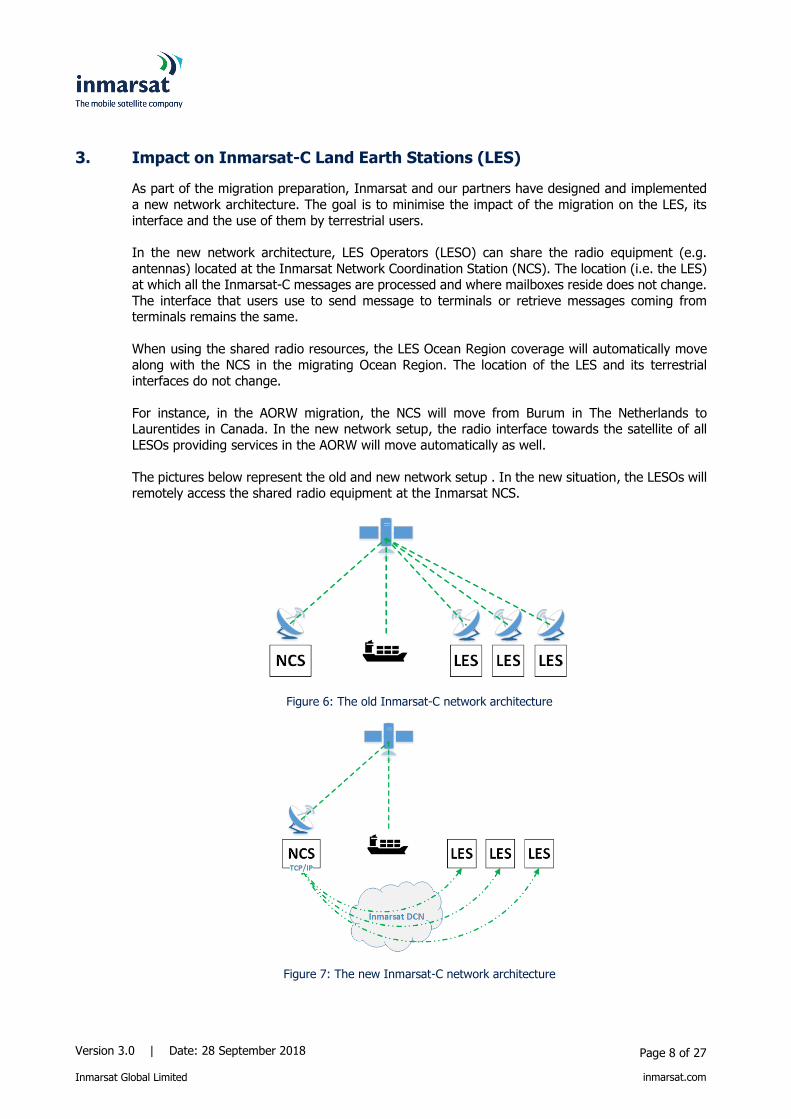
3. Impact on Inmarsat-C Land Earth Stations (LES)
As part of the migration preparation, Inmarsat and our partners have designed and implemented
a new network architecture. The goal is to minimise the impact of the migration on the LES, its
interface and the use of them by terrestrial users.
In the new network architecture, LES Operators (LESO) can share the radio equipment (e.g.
antennas) located at the Inmarsat Network Coordination Station (NCS). The location (i.e. the LES) at which all the Inmarsat-C messages are processed and where mailboxes reside does not change.
The interface that users use to send message to terminals or retrieve messages coming from terminals remains the same.
When using the shared radio resources, the LES Ocean Region coverage will automatically move
along with the NCS in the migrating Ocean Region. The location of the LES and its terrestrial interfaces do not change.
For instance, in the AORW migration, the NCS will move from Burum in The Netherlands to Laurentides in Canada. In the new network setup, the radio interface towards the satellite of all
LESOs providing services in the AORW will move automatically as well.
The pictures below represent the old and new network setup . In the new situation, the LESOs will remotely access the shared radio equipment at the Inmarsat NCS.
Figure 6: The old Inmarsat-C network architecture
Figure 7: The new Inmarsat-C network architecture

Version 3.0 | Date: 28 September 2018
Inmarsat Global Limited
Page 9 of 27
inmarsat.com
4. Migration impact on Terminals
During normal operation, a terminal is “logged in” to an Ocean Region. When moving into the
coverage of another Ocean Region, terminals may switch to this region automatically. GMDSSS-
approved terminals will provide an alarm when this occurs and require manual intervention to switch Ocean Regions (Log in).
Due to the migration, the footprint of the Ocean Region changes. As a consequence, a terminal
may find itself out of the coverage of the Ocean Region to which it was originally logged in. GMDSS terminals will in such cases provide an alarm and require manual intervention.
Note: GMDSS-certified terminals will always handle Distress Alerts, even if they are not logged
in to an Ocean Region. See also section 6.
Mobile users that reside in the area that will not be covered by the new footprint Ocean Region after migration are encouraged to switch the terminal to another region before the migration
occurs.
The paragraphs below provide a graphical overview of the areas that will no longer be covered by the “migrating Ocean Region” and specific instructions relating to these areas
4.1. AORW Migration coverage change
In the case of the AORW migration, the new footprint of the ocean region will no longer cover the crescent-shaped area depicted in Figure 8 below (roughly between 240 East and 200 West on the
lower latitudes). Terminal users residing in that area are advised to switch before the migration to
AORE.
Figure 8: Area out of AORW coverage after migration step 1
4.2. POR Migration coverage change
In the case of the POR migration, the new footprint of the ocean region will no longer cover the crescent-shaped area depicted in Figure 9 below (roughly between 1100 West and 1500 West on
the lower latitudes). Terminal users residing in that area are advised to switch before the migration
to AORW.
Version 3.0 | Date: 28 September 2018
Inmarsat Global Limited
Page 10 of 27
inmarsat.com
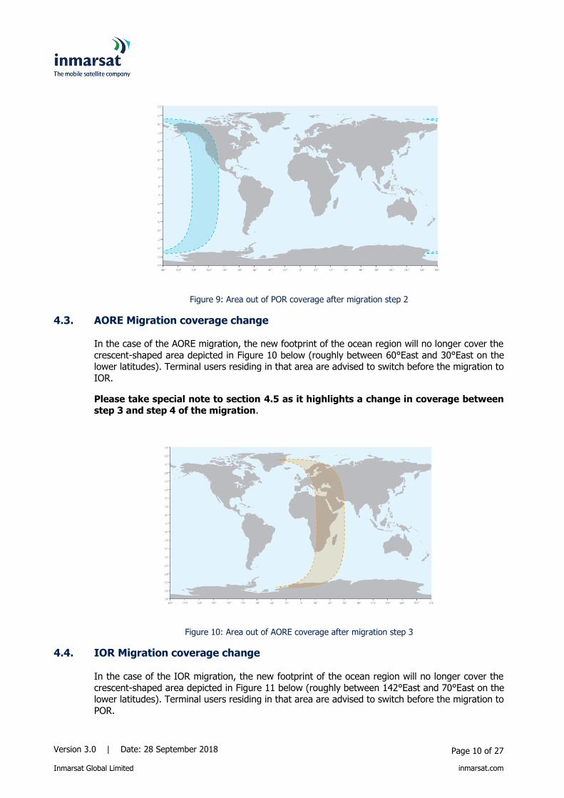
Figure 9: Area out of POR coverage after migration step 2
4.3. AORE Migration coverage change
In the case of the AORE migration, the new footprint of the ocean region will no longer cover the
crescent-shaped area depicted in Figure 10 below (roughly between 60°East and 30°East on the lower latitudes). Terminal users residing in that area are advised to switch before the migration to
IOR.
Please take special note to section 4.5 as it highlights a change in coverage between step 3 and step 4 of the migration.
Figure 10: Area out of AORE coverage after migration step 3
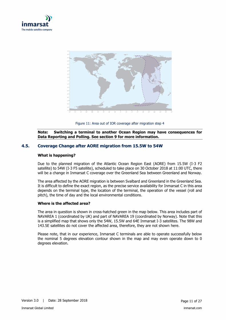
4.4. IOR Migration coverage change
In the case of the IOR migration, the new footprint of the ocean region will no longer cover the
crescent-shaped area depicted in Figure 11 below (roughly between 142°East and 70°East on the lower latitudes). Terminal users residing in that area are advised to switch before the migration to
POR.
Version 3.0 | Date: 28 September 2018
Inmarsat Global Limited
Page 11 of 27
inmarsat.com
Figure 11: Area out of IOR coverage after migration step 4
Note: Switching a terminal to another Ocean Region may have consequences for
Data Reporting and Polling. See section 9 for more information.
4.5. Coverage Change after AORE migration from 15.5W to 54W
What is happening?
Due to the planned migration of the Atlantic Ocean Region East (AORE) from 15.5W (I-3 F2 satellite) to 54W (I-3 F5 satellite), scheduled to take place on 30 October 2018 at 11:00 UTC, there
will be a change in Inmarsat C coverage over the Greenland Sea between Greenland and Norway.
The area affected by the AORE migration is between Svalbard and Greenland in the Greenland Sea. It is difficult to define the exact region, as the precise service availability for Inmarsat C in this area
depends on the terminal type, the location of the terminal, the operation of the vessel (roll and
pitch), the time of day and the local environmental conditions.
Where is the affected area?
The area in question is shown in cross-hatched green in the map below. This area includes part of
NAVAREA 1 (coordinated by UK) and part of NAVAREA 19 (coordinated by Norway). Note that this
is a simplified map that shows only the 54W, 15.5W and 64E Inmarsat I-3 satellites. The 98W and 143.5E satellites do not cover the affected area, therefore, they are not shown here.
Please note, that in our experience, Inmarsat C terminals are able to operate successfully below
the nominal 5 degrees elevation contour shown in the map and may even operate down to 0 degrees elevation.

Version 3.0 | Date: 28 September 2018
Inmarsat Global Limited
Page 12 of 27
inmarsat.com
Figure 12: Inmarsat C coverage changes after AORE migration
What are the consequences for Inmarsat C service in the affected area?
Vessels sailing in the affected area might be prevented from transmitting or receiving messages
via Inmarsat C. This may impact both private communications as well as SSAS transmissions.
Additionally, EGC messages might not be received by the Inmarsat C terminals while transiting or sailing in the affected area. Vessels reporting their positions to the shore-side for commercial
(Inmarsat C tracking) or regulatory purposes (LRIT or VMS) might also stop reporting.
When is the coverage expected to be improved?
The Inmarsat C coverage in the affected area will improve after the migration of the Indian Ocean Region (IOR) from 64E to 25E, currently planned to take place around mid-December 2018. The
period between the migrations of AORE and IOR is being kept as short as possible to reduce the
impact on users. We currently expect this period to extend to about 6 weeks and will provide more information once we confirm the schedule.
How does this change affect SOLAS (Safety of Life at Sea) and Non-SOLAS vessels?
It is important to stress that it is a Global Maritime Distress and Safety System (GMDSS)
requirement that all SOLAS vessels must have multiple communication systems (i.e. MF/HF DSC equipment, EPIRB, VHF, etc.), therefore, SOLAS vessels will always have the ability to send and
receive Distress, Urgency and Safety communications, even when they are outside the satellite coverage area.
All vessels (including non-SOLAS) operating in the affected area will receive an automatic alarm
from their Inmarsat C terminals when they move outside the satellite coverage area.

Version 3.0 | Date: 28 September 2018
Inmarsat Global Limited
Page 13 of 27
inmarsat.com
What Maritime authorities have been informed?
The IMO, the SafetyNET panel coordinator and all member states have been informed via paper
14-4 at NCSR-5, submitted by IMSO. The migration programme was approved and is being overseen by IMSO.
What are the next steps?
Inmarsat will advise NAVAREA 1 and NAVAREA 19 coordinators via notices to mariners of any
notifications they should broadcast via non-Inmarsat C channels. We will also keep all end-users informed via Enhanced Group Calling (EGC) messages to their Inmarsat C terminals prior to each
migration, with a minimum of six weeks’ notice.
Inmarsat advises partners and administrations to contact all vessels operating in the affected area,
to inform them of the potential degradation of service following the migration of AORE to 54W.
What about other Inmarsat Maritime services in the area?
FleetBroadband and Fleet Xpress services remain unaffected by the change caused due to the
migration. Existing 505 emergency services will continue to be available on FleetBroadband.
Version 3.0 | Date: 28 September 2018
Inmarsat Global Limited
Page 14 of 27
inmarsat.com
5. SafetyNET
SafetyNET is the international service for the broadcasting and automatic reception of Maritime
Safety Information (MSI) via the Inmarsat EGC system. The capability to receive SafetyNET
information is mandatory for ships that need to comply with the provisions of the International Convention for the Safety of Life at Sea, 1974.
Certified Maritime Safety Information Providers (MSIPs) use SafetyNET and SafetyNET II to
broadcast navigational and meteorological warnings, meteorological forecasts, shore-to-ship distress alerts, SAR information and other urgent information. MSIPs are able to direct a message
to a given geographical area. The area may be fixed, as in the case of a NAVAREA/METAREA or coastal warning area; or it may be a user-defined area (circular or rectangular). Seafarers will
receive the MSI messages automatically on their Inmarsat-C or Mini-C terminals and always free
of charge.
Note: SafetyNET is a service provided to maritime terminals and may not be available on
terminals types for the land or aeronautical sectors.
5.1. What will change on the terminal side?
The migration will not affect seafarers receiving MSI as the Inmarsat-C and Mini-C terminals will not be affected provided the terminal is logged in to an ocean region. Seafarers can continue to
select the NAVAREA and METAREA regions from which they want to receive MSI. Under strict supervision of International Mobile Satellite Organization (IMSO), Inmarsat Safety Team will closely
monitor the migration, ensuring the 99.9% service availability level is maintained.
Note: See section 4 for the general consequences for terminals.
5.2. What will change on the terrestrial side?
During the migration of I-3 to I-4 satellites, SafetyNET information providers, such as Maritime
Safety Information Providers (MSIPs) and Maritime Rescue Coordination Centres ((M)RCCs) that
broadcast EGC messages, may have to make minor changes to ensure all messages are broadcast over the correct satellites to their area of responsibility. This may include changing LESO.
Inmarsat strongly recommends that all MSIPs and (M)RCCs that currently use the SafetyNET
system for broadcast of EGC messages, contact their current LESO to request confirmation that they will continue to cover their NAV/METAREA or area of responsibility, during and after the
migration process. If your current LESO cannot broadcast to all required satellites, a list of alternative LESOs are given in Annex 2. Alternatively, any certified SafetyNET user (MSIPs and
MRCCs) can request access to the SafetyNET II system that will internally manage the migration
process with no intervention required from the end user (MSIPs and MRCCs).
All NAVAREA and METAREA Coordinators will be contacted individually through the International
SafetyNET Co-ordinating Panel to discuss the actions that are required for each of the migration
steps.
Version 3.0 | Date: 28 September 2018
Inmarsat Global Limited
Page 15 of 27
inmarsat.com
6. Distress Alerting
The Distress Alerting service will not change and is not impacted by the migration. Alerts will
continue to be handled by the Land Earth Stations in each region and automatically routed, with
the highest priority, to the associated Maritime Rescue Coordination Centre (RCC).
Please note that GMDSS-certified terminals will always handle Distress alerts, even if they are not
logged in to an Ocean Region.
Note: Distress Alerting is a service provided to maritime terminals and may not be available on
terminals types for the land or aeronautical sectors.

Version 3.0 | Date: 28 September 2018
Inmarsat Global Limited
Page 16 of 27
inmarsat.com
7. Inmarsat-C messaging
The standard function of the Inmarsat-C service is the exchange of message between the terminal
and the Land Earth Station (LES). The LES will store message for later retrieval or forward the
messages immediately to the end destination.
Terminals are designed to work within any Ocean Region and with any LES. See Annex 2 for an
overview of LESOs in each Ocean Region before and after migration.
If during the migration a terminal moves out of the footprint of the satellite, it may select the
nearest satellite and continue to operate. Mobile users should check if their terminal is logged in to an Ocean Region.
GMDSS-certified terminals will provide an alarm and will require manual intervention. See section
4 for more details.
7.1. What will change on the terminal side?
Assuming that the terminal is logged in into an Ocean Region, there is no impact on the terminal
side. Mobile users can continue to send messages in the same way as they are used to.
Note: See section 4 for the general consequences for terminals.
7.2. What will change on the terrestrial side?
There is no impact on the terrestrial side, assuming the terminal is logged in into an ocean region.
Terrestrial side senders can continue to send and retrieve their Inmarsat-C messages in the same way as before. If terminals do not log in after losing Ocean Region coverage due to the migration,
messages cannot be delivered, hence the terminal needs to log in. See section 4.
7.3. How to prepare?
Mobile users that reside in the area that will not be covered by the footprint of the Ocean Region
after migration are encouraged to switch the terminal to another region before the migration
occurs. Terminal users which do not reside in that area do not need to take any action.
7.4. What to do after the migration?
In principle, no actions are required after the migration. However, to ensure correct working,
terminal users should check that their terminal is logged into an Ocean Region. As a precaution, terminal users can reboot their terminal or enforce an Ocean Region log in.
Version 3.0 | Date: 28 September 2018
Inmarsat Global Limited
Page 17 of 27
inmarsat.com
8. Enhanced group call/ FleetNET
Enhanced Group Call (EGC) or FleetNET is a ‘broadcast’ service of Inmarsat-C.
Customers who use this service have been assigned an Enhanced Network IDentifier (ENID), which
is used to create a closed user group of mobile terminals. The ENID is downloaded (over the satellite channels) into the terminals that are part of the closed user group. Broadcast messages
are addressed to an ENID and all terminals that are configured with that ENID will receive the
message.
ENIDs are unique in the entire Inmarsat-C network and not bound to a specific Ocean Region.
8.1. What will change on the terminal side?
Assuming that the terminal is logged in into an Ocean Region, there is no impact on the terminal
side. Terminals will continue to pick up the broadcast messages that are intended for the groups they are part of.
Note: See section 4 for the general consequences for terminals.
8.2. What will change on the terrestrial side?
FleetNET messages are sent per Ocean Region. The sender of the messages determines in which Ocean Region(s) the group of terminals they want to address reside and will need to send out the
message in each of the regions.
The migration will effectively change the geographical footprint of each Ocean Region. Consequently, the FleetNET user may need to send broadcast messages in different Ocean Regions
than before.
8.3. How to prepare?
Mobile users that reside in the area that will not be covered by the footprint of the Ocean Region
after the migration are encouraged to switch their terminal to another region before the migration
occurs.
The FleetNET user (i.e. the sender of messages) needs to determine if the terminals they want to address have changed Ocean Region. If so, the FleetNET user will have to send messages to
more/different ocean regions.
8.4. What to do after the migration?
Terminal users need to log in into an Ocean Region and FleetNET users need to determine to which
Ocean Region they want to broadcast their message.
Version 3.0 | Date: 28 September 2018
Inmarsat Global Limited
Page 18 of 27
inmarsat.com
9. Data Reporting & Polling
Data Reporting
The Data Reporting service is an optional service of Inmarsat-C. The terminal is enabled/set-up to
send small amounts of information (from either the terminal itself or another peripheral piece of equipment) to a predefined address.
In order to have the terminal providing Data Reports, a terminal needs to be part of a closed user
group, identified by a Data Network Identifier or DNID. The closed user group is defined by the
LES ID and the Ocean Region. As a member of the Closed User Group, each terminal in that group is assigned a member number.
The most widely used form of Data Reporting is Position Reporting services. The Positioning
Reporting Service uses the Data Reporting protocols to send information about the position (latitude-longitude) together with optional information such as course, speed, time stamps, Macro
Encoded Messages back to a terrestrial address. Position Reporting service is used for example by Vessel Monitoring Systems (VMS), Long Range Identification and Tracking (LRIT) and other
applications.
The transmission of a Data Report can be the result of a) a single (interrogation) command, b) the result of a program to send reports at regular intervals that is stored in the terminal memory or c)
the result of a particular trigger event.
In each of these cases, the terminal will construct a Data Report and transmit it to the relevant
LES. Depending on the configuration in the LES, the information is either forwarded immediately or at intervals to a pre-configured destination, or stored for retrieval.
To transmit a data report, the Inmarsat-C terminal should have the Data Network ID (DNID),
member number and Ocean Region downloaded using the polling command. All three are stored in the terminal’s memory.
Polling
With the Polling service, commands and instructions can be sent by an authorized terrestrial user
to an individual Inmarsat-C terminal, an entire closed user group (identified by the DNID) or a group of DNID members that are in a given geographical area. Polling is generally used to:
Include a terminal in a closed user group, by downloading a DNID and member number
to a terminal in an Ocean Region (Multi Ocean Region Polling allows this action for all
Ocean Regions supported for a DNID by the LES; support of this feature depends on
terminal make/model and software version.
Remove a terminal from a closed user group
Instruct a terminal or a group of terminals to send a position report immediately
Program a terminal or a group of terminals to regularly send reports with a defined interval
Instruct a terminal or a group of terminals to start reporting
Instruct a terminal or a group of terminals to stop reporting
For many poll commands, the originator of the Poll will have to indicate in which Ocean Region the
poll needs to be transmitted.

Version 3.0 | Date: 28 September 2018
Inmarsat Global Limited
Page 19 of 27
inmarsat.com
9.1. What will change on the terminal side?
The DNIDs are stored in the terminal’s memory on a per Ocean Region basis. An active terminal is
always “logged” into one of the four Ocean Regions. Its data reporting behaviour is based on the DNIDs and associated parameters configured for that Ocean Region. A particular DNID
configuration may not be present in the terminal for all Ocean Regions and the data reporting behaviour may differ per Ocean Region.
The effect of the migration is that the footprint of Ocean Regions will move in a westerly direction.
A terminal logged into the migrating region may find itself out of coverage after the migration and must log into another region (see section 4). Consequently, if a terminal is not configured, or
configured differently for the “new” Ocean Region, the terminal may stop sending out reports or in
different time intervals.
Note: See section 4 for the general consequences for terminals.
9.2. What will change on the terrestrial side?
On the shore side, nothing will change. Data Reports will continue to be delivered according to the
DNID configuration of the Ocean Region in which the terminal resides (provided the terminal is logged in to the Ocean Region). Also, for sending Polls to the terminals, no changes are expected.
If large amounts of polls from multiple LESOs need to be transmitted right after the migration, the
polls will be queued by the NCS and handled in sequential order; this may cause some delay.
9.3. How to prepare?
The following actions can be taken to ensure that the data-reporting and polling function of a
terminal will continue:
If possible, change Ocean Region before the migration. Make sure the terminal is logged
in to an Ocean Region after the migration. See section 4 for details. If needed, reboot or power-cycle the terminals after the migration.
Check for all the terminals in the DNID user group that the terminal is configured with the
DNID and associated parameters for all Ocean Regions. This can best be done before the first step in the migration.
If required, download the DNID and its parameters for all Ocean Regions by using a Multi
Ocean Region Poll (MORP) command. This can best be done before the first step in the
migration. Older terminals pre- 2005 may not support the MORP. In this case the DNID programming
needs to take place after the terminal has changed its Ocean Region. This can best be
done before each migration step. If necessary, DNID (re-)programming commands best executed in sequence: stop
reporting – program reporting – initiate reporting individually or group wise.
A terminal’s DNID configuration can be updated remotely using specified Poll messages.

Version 3.0 | Date: 28 September 2018
Inmarsat Global Limited
Page 20 of 27
inmarsat.com
9.4. What to do after the migration?
Mobile users should ensure their terminal is working correctly. Users may want to check their
terminal is logged in to an Ocean Region. As a precaution, terminal users can reboot their terminal after the migration or enforce an Ocean Region log in.
Users of the DR&P services should ensure that their terminal do indeed continue to send data
reports. If receivers of the data reports detect that a terminal no longer sends reports, it may need to be programmed with the DNID and its parameters.

Version 3.0 | Date: 28 September 2018
Inmarsat Global Limited
Page 21 of 27
inmarsat.com
10. Impact on LRIT, VMS and SSAS services
LRIT and VMS are applications that use Data Reporting and Polling to monitor the position and
movement of terminals (on board vessels). All implications discussed in section 9 are applicable
here.
The Ship Security Alert System (SSAS) is a covert alerting application that resides in terminals that
support SSAS. It is based around a number of pre-configured destinations, to which an alert can
be sent. The application uses Inmarsat-C messaging with normal priority. To the Inmarsat-C network SSAS messages are standard store-and-forward messages. The terminal needs to be
logged in to an Ocean Region for sending messages. All implications discussed in section 7 are applicable here.

Version 3.0 | Date: 28 September 2018
Inmarsat Global Limited
Page 22 of 27
inmarsat.com
11. User Applications and Devices
Applications and external devices that communicate via Inmarsat-C are outside Inmarsat’s control.
Users should be aware that such applications and/or devices may make assumptions about the
Inmarsat-C network that may no longer be valid once the migration of the services from the I-3 satellites to the I-4 satellites takes place.
For instance, applications may use the contours of the Ocean Region footprints in user interface or
terminal control logic. All applications will need to be updated with the new footprint contours.
Inmarsat has planned the migration process in a way to have as few changes as possible to the network configuration, however, some changes (e.g. to satellite locations) are inevitable and this
may affect the operation of applications and/or devices connected to the Inmarsat-C terminal.
Inmarsat strongly advises all LESOs, Service Providers and users to seek advice from their equipment or application providers to ensure that service can be maintained during and after the
migration.

Version 3.0 | Date: 28 September 2018
Inmarsat Global Limited
Page 23 of 27
inmarsat.com
Annex 1: Acronyms
The acronyms shown in the table below are used in this document. The term “MES” is used in this
document to refer to all mobile earth stations, whether maritime, aeronautical or land-based.
Similarly, the term “LES” is used to refer to all land earth stations, whether part of the Inmarsat-C, Inmarsat-F (Fleet), Swift 64 or Classic Aero networks.
Acronym Meaning
AMER Americas Ocean Region, operated by I-4 satellite located at 98W
AORE Atlantic Ocean Region East, operated by I-3 satellite located at
15.5W
AORW Atlantic Ocean Region West, operated by I-4 satellite located at 98W
APAC Asia/Pacific Ocean Region, operated by I-4 satellite located at 143.5E
CUG Closed User Group
DNID Data Network Identifier (Inmarsat-C)
EGC Enhanced Group Call (Inmarsat-C)
EMEA Europe/Middle East Ocean Region, operated by I-4 (AlphaSat)
satellite located at 25E
ENID Enhanced Network IDentifier (Inmarsat-C)
GMDSS Global Maritime Distress Safety System
IMO International Maritime Organisation
IOR Indian Ocean Region, operated by I-3 satellite located at 64E
LES Land Earth Station
LESO Land Earth Station Operator
LRIT Long Range Identification and Tracking
MEAS Middle East/Asia Ocean Region, operated by I-4 satellite located
at 64E
MES Mobile Earth Station (also commonly referred to as “terminal”)
NCS Network Coordination Station
POR Pacific Ocean Region, operated by I-4 satellite located at 143.5E
SSAS Ship Security Alert System
VMS Vessel Monitoring System
Version 3.0 | Date: 28 September 2018
Inmarsat Global Limited
Page 24 of 27
inmarsat.com
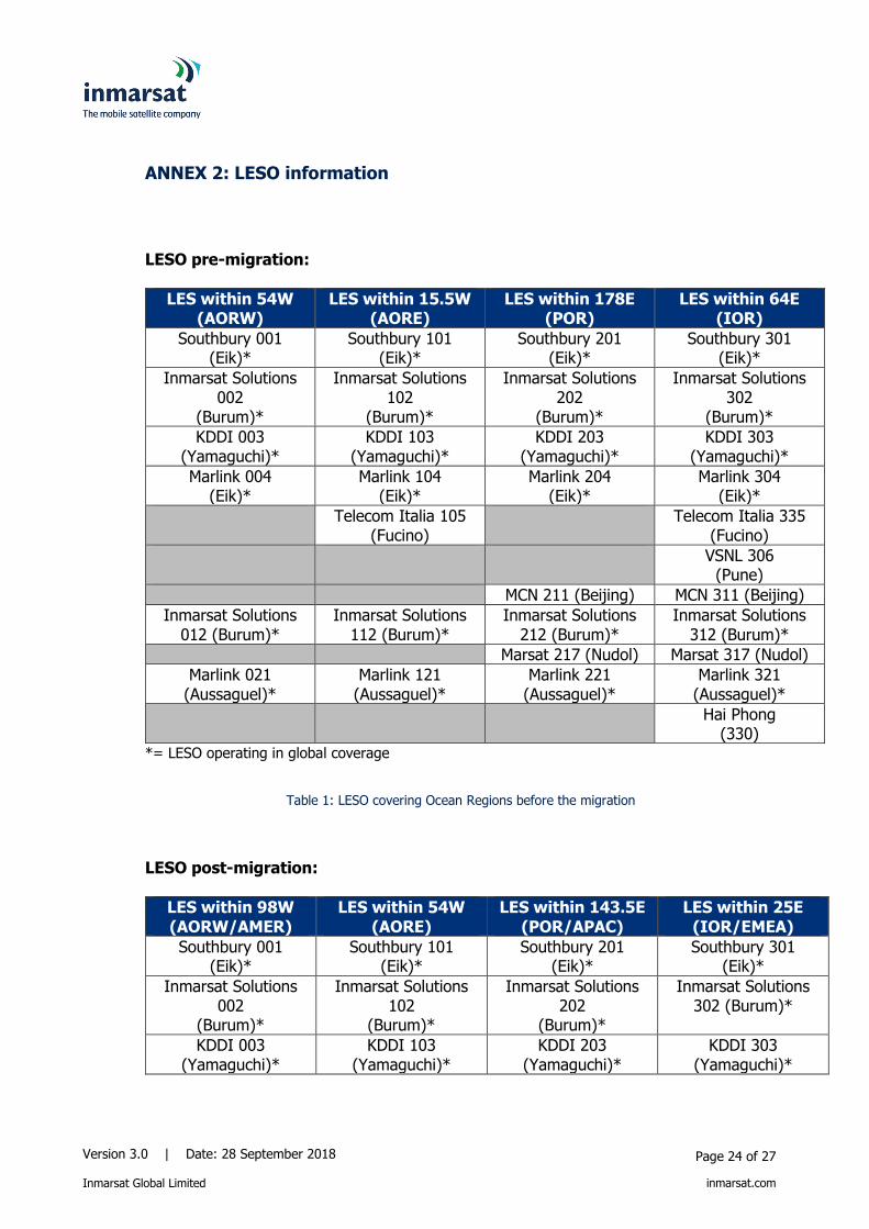
ANNEX 2: LESO information
LESO pre-migration:
LES within 54W (AORW)
LES within 15.5W (AORE)
LES within 178E (POR)
LES within 64E (IOR)
Southbury 001 (Eik)*
Southbury 101 (Eik)*
Southbury 201 (Eik)*
Southbury 301 (Eik)*
Inmarsat Solutions 002
(Burum)*
Inmarsat Solutions 102
(Burum)*
Inmarsat Solutions 202
(Burum)*
Inmarsat Solutions 302
(Burum)*
KDDI 003 (Yamaguchi)*
KDDI 103 (Yamaguchi)*
KDDI 203 (Yamaguchi)*
KDDI 303 (Yamaguchi)*
Marlink 004 (Eik)*
Marlink 104 (Eik)*
Marlink 204 (Eik)*
Marlink 304 (Eik)*
Telecom Italia 105 (Fucino)
Telecom Italia 335 (Fucino)
VSNL 306 (Pune)
MCN 211 (Beijing) MCN 311 (Beijing)
Inmarsat Solutions 012 (Burum)*
Inmarsat Solutions 112 (Burum)*
Inmarsat Solutions 212 (Burum)*
Inmarsat Solutions 312 (Burum)*
Marsat 217 (Nudol) Marsat 317 (Nudol)
Marlink 021 (Aussaguel)*
Marlink 121 (Aussaguel)*
Marlink 221 (Aussaguel)*
Marlink 321 (Aussaguel)*
Hai Phong (330)
*= LESO operating in global coverage
Table 1: LESO covering Ocean Regions before the migration
LESO post-migration:
LES within 98W (AORW/AMER)
LES within 54W (AORE)
LES within 143.5E (POR/APAC)
LES within 25E (IOR/EMEA)
Southbury 001 (Eik)*
Southbury 101 (Eik)*
Southbury 201 (Eik)*
Southbury 301 (Eik)*
Inmarsat Solutions 002
(Burum)*
Inmarsat Solutions 102
(Burum)*
Inmarsat Solutions 202
(Burum)*
Inmarsat Solutions 302 (Burum)*
KDDI 003 (Yamaguchi)*
KDDI 103 (Yamaguchi)*
KDDI 203 (Yamaguchi)*
KDDI 303 (Yamaguchi)*

Version 3.0 | Date: 28 September 2018
Inmarsat Global Limited
Page 25 of 27
inmarsat.com
LES within 98W (AORW/AMER)
LES within 54W (AORE)
LES within 143.5E (POR/APAC)
LES within 25E (IOR/EMEA)
Marlink 004 ( Eik)*
Marlink 104 (Eik)*
Marlink 204 (Eik)*
Marlink 304 (Eik)*
Telecom Italia 105 (Fucino)
Telecom Italia 335 (Fucino)
VSNL 306 (Pune)**
VSNL 306 (Pune)**
MCN 211 (Beijing)
MCN 311 (Beijing)
Inmarsat Solutions 012
(Burum)*
Inmarsat Solutions 112
(Burum)*
Inmarsat Solutions 212
(Burum)*
Inmarsat Solutions 312
(Burum)*
Marsat 217 (Nudol)
Marsat 317 (Nudol)
Marlink 021 (Aussaguel)*
Marlink 121 (Aussaguel)*
Marlink 221 (Aussaguel)*
Marlink 321 (Aussaguel)*
Vishipel 230 (Haiphong)
* = LESO operating in global coverage
** = depending on final decision in relation of LES concerning coverage area
Table 2: LESO covering Ocean Regions after the migration

Version 3.0 | Date: 28 September 2018
Inmarsat Global Limited
Page 26 of 27
inmarsat.com
ANNEX 3: Ocean Region footprints
Figure 13: Ocean region footprints before the migration
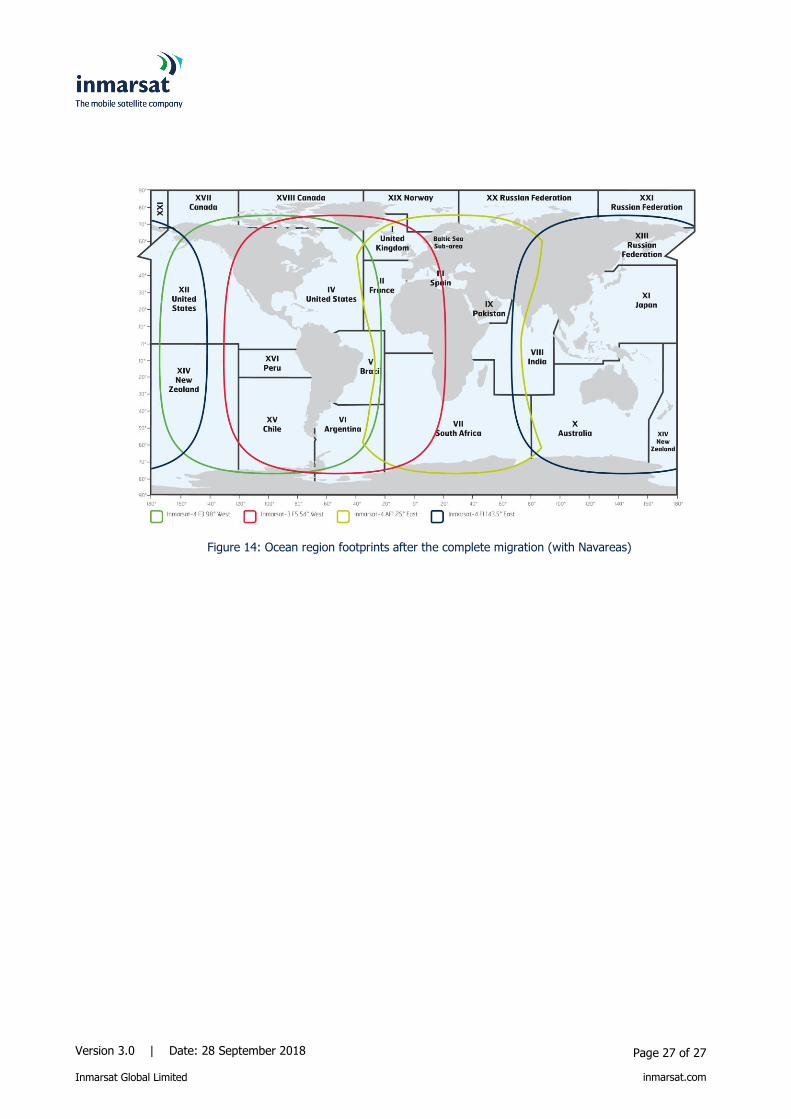
Figure 14: Ocean region footprints after the complete migration
Version 3.0 | Date: 28 September 2018
Inmarsat Global Limited
Page 27 of 27
inmarsat.com
Figure 14: Ocean region footprints after the complete migration (with Navareas)