hazard potential classification assessment south …
TRANSCRIPT
16644 West Bernardo Drive, Suite 301
San Diego, CA 92127 Phone: 858.674.6559
Fax: 858.674.6586 www.geosyntec.com
SW0251.09.02 WILL COUNTY HPCA.F.DOCX 1
HAZARD POTENTIAL CLASSIFICATION ASSESSMENT SOUTH ASH POND 2S & SOUTH ASH POND 3S
WILL COUNTY STATION OCTOBER 2016
This initial hazard potential classification assessment (HPCA) addresses the requirements of §257.73(a)(2) of the Coal Combustion Residuals (CCR) regulations, Code of Federal Regulations Title 40, Part 257 for South Ash Pond 2S and South Ash Pond 3S (the Ponds) at the Will County Station (Site) near Romeoville, Illinois. The CCR regulations were published in the Federal Register on 17 April 2015 and became effective as of 19 October 2015. The Site is a coal-fired power station, owned and operated by Midwest Generation, LLC (Midwest Generation).
Ms. Jane Soule, P.E., of Geosyntec, prepared this HPCA in accordance with §257.73(a)(2). Mr. Michael Houlihan, P.E., reviewed this report in accordance with Geosyntec’s peer review policy.
Summary
Based on the results of the analyses provided in this report, South Ash Pond 2S and South Ash Pond 3S are classified as significant hazard potential CCR surface impoundments because their failure would not result in probable loss of life, but could result in potential economic and environmental losses.
1. Regulation Requirements - §257.73(a)(2)
According to the Preamble of the CCR regulations (page 21377), “a hazard potential classification provides an indication of the potential for danger to life, development, or the environment in the event of a release of CCR from a surface impoundment.” This classification is not an assessment of the likelihood of a release or failure, but rather an evaluation of the potential impacts if one were to occur. Per §257.73(a)(2), “the owner or operator must document the hazard potential of each CCR unit as either a high hazard potential CCR surface impoundment, a significant hazard potential CCR surface impoundment or a low hazard potential surface impoundment.” The assessment must include certification from a qualified professional engineer stating that the initial hazard potential classification (and each subsequent periodic classification) was conducted in accordance with these requirements. Section 257.53 provides the following definitions for hazard potential classifications:
• A high hazard potential CCR surface impoundment means a diked surface impoundment where failure or mis-operation will probably cause loss of human life;
South Ash Pond 2S & South Ash Pond 3S, Will County Station Hazard Potential Classification Assessment October 2016
SW0251.09.02 WILL COUNTY HPCA.F.DOCX 2
• A significant hazard potential CCR surface impoundment means a diked surface impoundment where failure or mis-operation results in no probable loss of human life, but can cause economic loss, environmental damage, disruption of lifeline facilities, or impact other concerns; and
• A low hazard potential CCR surface impoundment means a diked surface impoundment where failure or mis-operation results in no probable loss of human life and low economic and/or environmental losses. Losses are principally limited to the surface impoundment owner’s property.
Based on the definitions contained in §257.53, a demonstration that an impoundment does not qualify for either a low or high hazard potential classification results in a hazard classification of significant by default.
2. Site Plan
The Site is bounded by the Des Plaines River on the west and the Chicago Sanitary and Ship Canal on the east. Because of geographic constraints, the watershed area for the Site is limited. A Site Plan identifying the Ponds and key Site elements, including buildings and other surface impoundments, is shown in Figure 1. The Ponds are located along the eastern banks of the Des Plaines River and west of an electrical substation area and main power block structure. Surface water ponds are located south of the Ponds and a lined process pond no longer in service is located north of South Ash Pond 2S.
Based on site observations and a review of available construction documents, the Ponds were constructed with elevated embankments surrounding the Ponds so run-on to the Ponds is limited to the embankment crests. The capacity and embankment height of the Ponds are shown in Table 1 below:
Table 1: Estimated Capacity and Maximum Depth
South Ash Pond 2S
South Ash Pond 3S
Estimated Capacity 13.2 acre-feet 15.1 acre-feet
Estimated Maximum Depth 8 feet 8.5 feet
3. Pond Failure Impact Evaluation
In order to classify the hazard potential of the Ponds, impacts of a potential failure must be evaluated. Due to the proximity of the Ponds to the Des Plaines River, a potential failure of the western embankment(s) of the Ponds could result in environmental losses resulting from
South Ash Pond 2S & South Ash Pond 3S, Will County Station Hazard Potential Classification Assessment October 2016
SW0251.09.02 WILL COUNTY HPCA.F.DOCX 3
discharge of CCR and CCR-laden water to a water of the United States. This potential impact excludes the Ponds from a low hazard classification.
The next step in classification is to evaluate the potential for failure or mis-operation to cause loss of human life. Figure 1 identifies the location of buildings in the vicinity of the Ponds, including both occupied and unoccupied buildings1. Occupied buildings, including the main power block, are located over 700 feet east of the Ponds; no occupied buildings are located north or south of the Ponds. Visual evaluation of the building layout in relation to the Ponds indicates that a potential breach of the eastern embankment of either Pond could result in a potential impact on human life. Detailed modeling, discussed in Section 3.1, was used to assess the impact of a potential breach of the eastern embankments.
3.1 Eastern Embankment Failure Modeling
Impact analysis was performed for a scenario where the Pond(s) are at full capacity prior to embankment failure and downstream depressions or other surface impoundments within the impact area are full and not capable of containing additional flow (flood conditions failure scenario). As discussed in Section 2, run-on to the Ponds is limited and inflow is generally limited to direct precipitation. Therefore, modeling of the Probable Maximum Precipitation (PMP) or other precipitation frequency event was not performed as the inflow of the precipitation event is minimal compared to the capacity of the Ponds.2
HEC-HMS Version 4.1 (HEC-HMS, 2013) modeling software was used to estimate the breach hydrographs which are plots of the rate of flow versus time. A two-dimensional model of the Site was then developed using FLO-2D Basic (FLO-2D, 2009) modeling software which incorporates land use (e.g., vegetation or asphalt surfacing) and topographic data. The FLO-2D model estimates flow depth and velocity resulting from the selected hydrograph. The results of the modeling area described below. Details of the modeling are provided in Geosyntec (2016).
Calculated maximum flow depth and maximum velocity from the South Ash Pond 2S breach modeling are shown in Figures 2 and 3, respectively. The results of the FLO-2D model show that flow through the modeled breach travels from South Ash Pond 2S toward the north, south, and east with a majority of the flow heading southeast. Estimated water depths near Building 2 range
1 Building identification numbers used in this report were generated for reference purposes only and may not correspond to identifications names or numbers utilized at the Site. Buildings are assumed to be occupied if there is at least one human occupant for a minimum of 12 hours per day.
2 The total volume of direct precipitation from PMP event during the estimated duration of the failure (less than 20 minutes) is minimal compared with the volume that would be released during a failure.
South Ash Pond 2S & South Ash Pond 3S, Will County Station Hazard Potential Classification Assessment October 2016
SW0251.09.02 WILL COUNTY HPCA.F.DOCX 4
from 0 to 1 foot with velocities less than 1.0 fps. Estimated water depths near Buildings 5, 6, and 7 range from 0 to 1 foot with velocities less than 1.0 fps.
Calculated maximum flow depth and maximum velocity from the South Ash Pond 3S breach modeling are shown in Figures 4 and 5, respectively. The results of the FLO-2D model show that the breach flows from South Ash Pond 3S toward the north, south, and east with a majority of the flow heading south. Estimated water depths near Building 2 range from 0 to 1 foot with velocities less than 1.0 fps. Depths near Buildings 5, 6, and 7 range from 0 to 1 foot with velocities ranging from 1.0 to 2.0 fps.
4. Hazard Classification Assessment
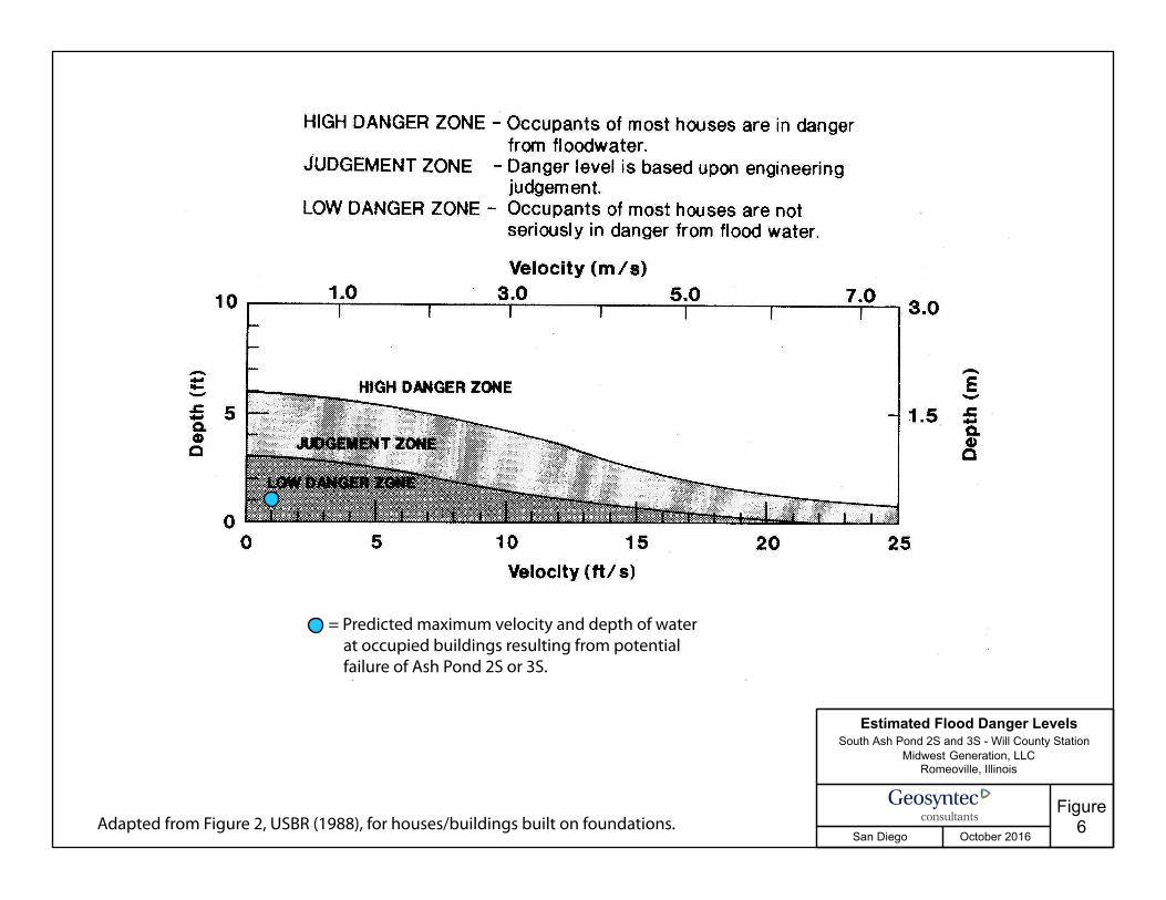
As discussed in Section 1, a CCR surface impoundment is classified as having a high hazard potential if failure or mis-operation will probably cause loss of human life. Guidelines for evaluating potential loss of life during flood conditions are provided in USBR (1988). Figure 6, adapted from USBR (1988), presents a relationship between danger to human life and flood flow depth and velocity for a house-type structure, and depth-velocity combinations that plot within the ‘low danger zone’ correspond to zero lives seriously in danger from that particular scenario (USBR, 1988). Figure 6 shows a plot of the predicted velocity (~1 fps) and depth of flow (~1 foot) at occupied buildings from a potential failure of South Ash Pond 2S or 3S. This point lies within the ‘low danger zone’ indicating that a breach of either South Ash Pond 2S or 3S will not result in probable loss of human life.
Based on the results of the analysis, provided in this report, South Ash Pond 2S and South Ash Pond 3S are classified as significant hazard potential CCR surface impoundments because their failure would not result in probable loss of life, but could result in impacts to the Des Plaines River creating potential economic loss and environmental damage.
South Ash Pond 2S & South Ash Pond 3S, Will County Station Hazard Potential Classification Assessment October 2016
SW0251.09.02 WILL COUNTY HPCA.F.DOCX 6
6. References
FLO-2D, 2009. FLO-2D Basic, FLO-2D Software, Inc., Arizona 2009.
Geosyntec, 2016. Ash Ponds 2S and 3S – Hazard Potential Classification Assessment Embankment Breach Analysis, Will County Station, Romeoville, Illinois, October.
HEC-HMS, 2013. HEC-HMS Hydrologic Modeling System – User’s Manual, Version 4.0, U.S. Army Corps of Engineers, Hydrologic Engineering Center (HEC), Davis, California, December 2013.
United States Department of the Interior, Bureau of Reclamation (USBR), 1988. Downstream Hazard Classification Guidelines, ACER Technical Memorandum No. 11.
Attachments Figure 1 – Site Map Figure 2 – South Ash Pond 2S Flood Conditions – Maximum Flow Depth Figure 3 – South Ash Pond 2S Flood Conditions – Maximum Velocity Figure 4 – South Ash Pond 3S Flood Conditions – Maximum Flow Depth Figure 5 – South Ash Pond 3S Flood Conditions – Maximum Velocity Figure 6 – Estimated Flood Danger Levels
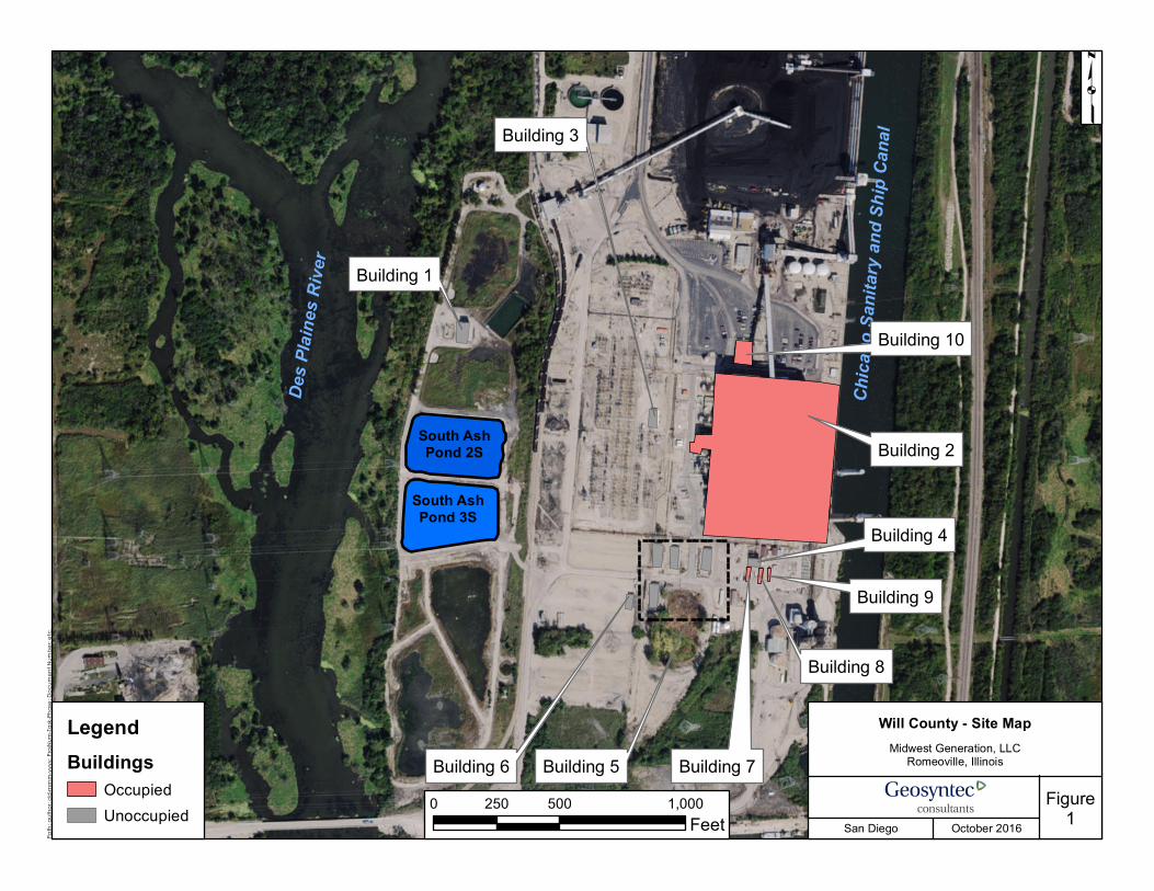
Will County - Site MapMidwest Generation, LLC
Romeoville, Illinois
Figure1
Path
; aut
hor; d
d-m
mm-
yyyy
; Proj
Num
-Task-
Phas
e; Do
cum
ent N
umbe
r; etc
.
San Diego October 2016
p
Building 1
Building 2
Building 3
Building 6 Building 5 Building 7
Building 8
Building 9
Building 4
LegendBuildings
OccupiedUnoccupied
Chica
go Sa
nitary
and S
hip C
anal
0 500 1,000250Feet
Building 10
South AshPond 3S
South AshPond 2S
Des P
laine
s Rive
r
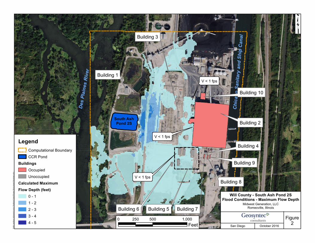
Will County - South Ash Pond 2SFlood Conditions - Maximum Flow Depth
Midwest Generation, LLCRomeoville, Illinois
Figure2
Path
; aut
hor; d
d-m
mm-
yyyy
; Proj
Num
-Task-
Phas
e; Do
cum
ent N
umbe
r; etc
.
San Diego October 2016
p
Building 1
Building 2
Building 3
Building 6 Building 5 Building 7
Building 8
Building 9
Building 4LegendComputational BoundaryCCR Pond
BuildingsOccupiedUnoccupied
Calculated MaximumFlow Depth (feet)
0 - 11 - 22 - 33 - 44 - 5
Des P
laine
s Rive
r
Chica
go Sa
nitary
and S
hip C
anal
0 500 1,000250Feet
Building 10
V < 1 fps
V < 1 fps
V < 1 fps
South AshPond 2S
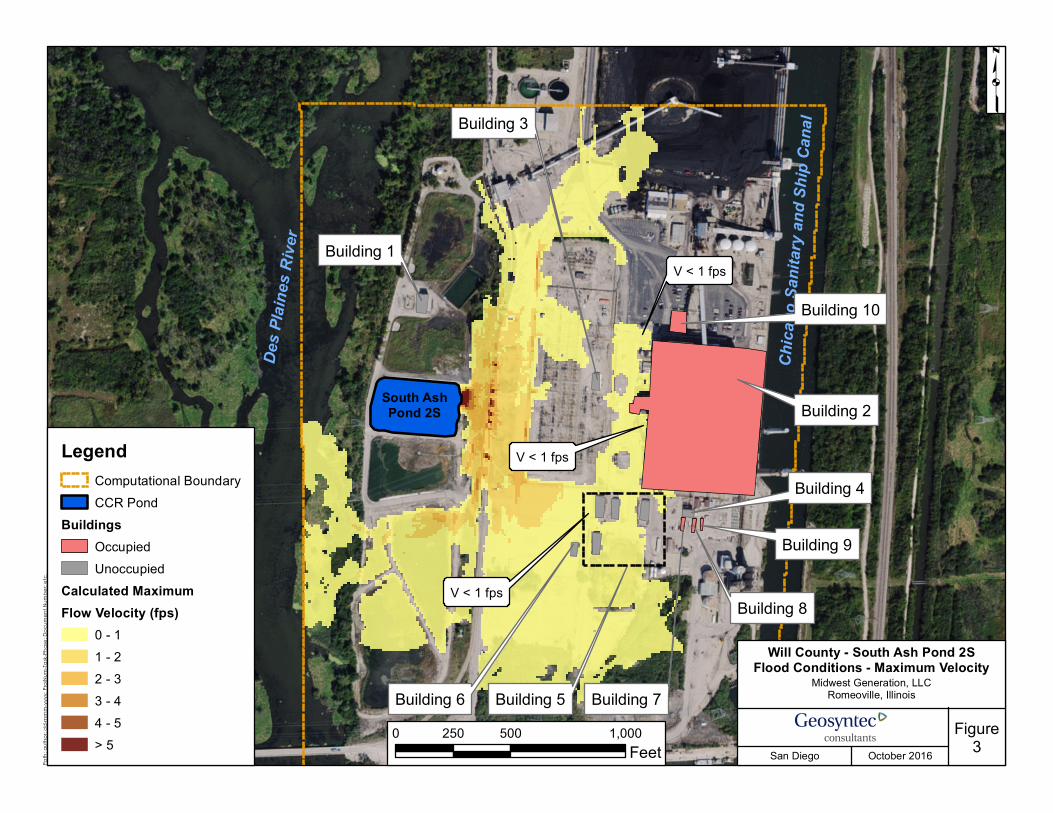
Will County - South Ash Pond 2SFlood Conditions - Maximum Velocity
Midwest Generation, LLCRomeoville, Illinois
Figure3
Path
; aut
hor; d
d-m
mm-
yyyy
; Proj
Num
-Task-
Phas
e; Do
cum
ent N
umbe
r; etc
.
San Diego October 2016
p
Building 1
Building 2
Building 3
Building 6 Building 5 Building 7
Building 8
Building 9
Building 4Legend
Computational BoundaryCCR Pond
BuildingsOccupiedUnoccupied
Calculated MaximumFlow Velocity (fps)
0 - 11 - 22 - 33 - 44 - 5> 5
Chica
go Sa
nitary
and S
hip C
anal
0 500 1,000250Feet
Building 10
V < 1 fps
V < 1 fps
V < 1 fpsDe
s Plai
nes R
iver
South AshPond 2S
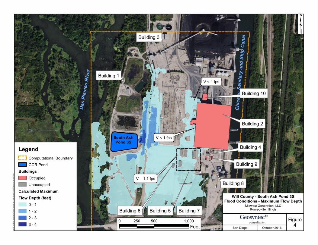
Will County - South Ash Pond 3SFlood Conditions - Maximum Flow Depth
Midwes t Generation, LLCRomeoville, Illinois
Figure4
Path
; aut
hor; d
d-m
mm-
yyyy
; Proj
Num
-Task-
Phas
e; Do
cum
ent N
umbe
r; etc
.
San Diego Octob er 2016
p
Building 1
Building 2
Building 3
Building 6 Building 5 Building 7
Building 8
Building 9
Building 4LegendComputational BoundaryCCR Pond
BuildingsOccupiedUnoccupied
Calculated MaximumFlow Depth (feet)
0 - 11 - 22 - 33 - 4
Chica
go Sa
nitary
and S
hip C
anal
0 500 1,000250Feet
Building 10
V < 1 fps
V ≈ 1.1 fps
V < 1 fpsDe
s Plai
nes R
iver
South AshPond 3S
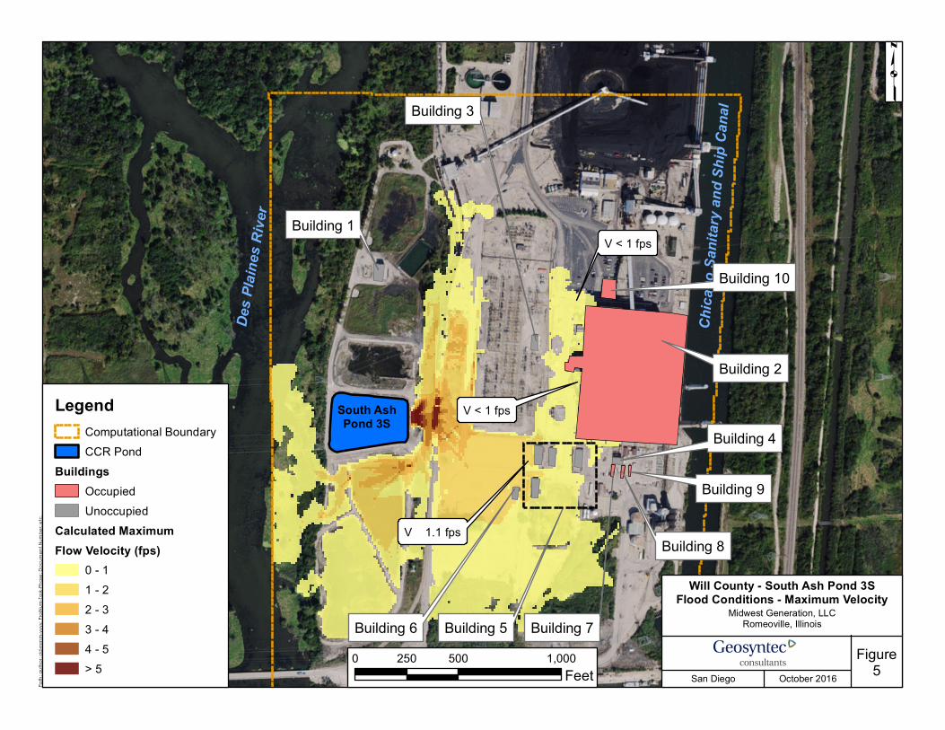
Will County - South Ash Pond 3SFlood Conditions - Maximum Velocity
Midwes t Generation, LLCRomeoville, Illinois
Figure5
Path
; aut
hor; d
d-m
mm-
yyyy
; Proj
Num
-Task-
Phas
e; Do
cum
ent N
umbe
r; etc
.
San Diego Octob er 2016
p
Building 1
Building 2
Building 3
Building 6 Building 5 Building 7
Building 8
Building 9
Building 4Legend
Computational BoundaryCCR Pond
BuildingsOccupiedUnoccupied
Calculated MaximumFlow Velocity (fps)
0 - 11 - 22 - 33 - 44 - 5> 5
Chica
go Sa
nitary
and S
hip C
anal
0 500 1,000250Feet
Building 10
V < 1 fps
V ≈ 1.1 fps
V < 1 fpsDe
s Plai
nes R
iver
South AshPond 3S
Midwest Generation, LLC Romeoville, Illinois
Figure6San Diego October 2016
Estimated Flood Danger LevelsSouth Ash Pond 2S and 3S - Will County Station
= Predicted maximum velocity and depth of water at occupied buildings resulting from potential failure of Ash Pond 2S or 3S.
Adapted from Figure 2, USBR (1988), for houses/buildings built on foundations.