grassland bird inventory for seven prairie parks · grassland bird inventory for seven prairie...
TRANSCRIPT
Grassland Bird Inventory for Seven Prairie
Parks
Northern Prairie Wildlife Research Center
U.S. Department of InteriorU.S. Geological Survey

i
REVIEW NOTICE
This report has been prepared for peer-review through the procedures of the U.S. Geological Survey, Northern
Prairie Wildlife Research Center. Mention of trade names or commercial products do not constitute endorsement
or recommendation for use.
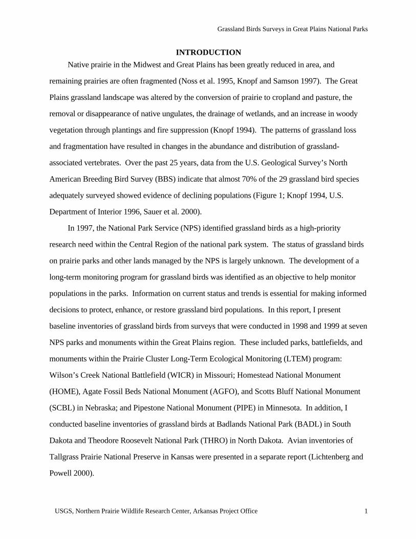
Cover: The Eastern Meadowlark is a common breeding bird in grasslands of eastern North America (drawingcourtesy of Christopher M. Goldade, Northern Prairie Wildlife Research Center, Jamestown, North Dakota).
ii
U.S. Department of Interior
U.S. Geological Survey
Grassland Bird Inventory
of Seven Prairie Parks
by
Abby N. Powell
U.S. Geological SurveyNorthern Prairie Wildlife Research Center
Arkansas Project OfficeDepartment of Biological Sciences, 223 WAAX
University of ArkansasFayetteville, AR 72701
Prepared for Great Plains Prairie Cluster Long-Term Ecological Monitoring ProgramNational Park Service
October 2000

USGS, Northern Prairie Wildlife Research Center, Arkansas Project Office iii
ACKNOWLEDGMENTS
Funding for this project was provided through the Inventory and Monitoring Program of the U.S.
Geological Survey and the National Park Service. I thank Gary Willson, DeeAnna Adkins, and
Larry Igl for their comments and editing of this report. I am grateful to Janene Lichtenberg, Mike
Powers, Amy Hardwick, Brett Gullet, and Dennis Lichtenberg for all of their hard work in the field.
I also thank all of the park personnel who provided logistical support for this work.
Suggested citation:
Powell, A. N. 2000. Grassland bird inventory of seven prairie parks. Final Report to the GreatPlains Prairie Cluster Long-Term Ecological Monitoring Program, National Park Service,Wilson’s Creek National Battlefield, Republic, Missouri. 46 p.
USGS, Northern Prairie Wildlife Research Center, Arkansas Project Office iv
CONTENTS
REVIEW NOTICE............................................................................................................................i
ACKNOWLEDGMENTS..............................................................................................................iii
CONTENTS....................................................................................................................................iv
LIST OF TABLES...........................................................................................................................v
LIST OF FIGURES........................................................................................................................vi
APPENDICES................................................................................................................................vi
INTRODUCTION...........................................................................................................................1
METHODS......................................................................................................................................2
RESULTS........................................................................................................................................4
Wilson’s Creek National Battlefield.............................................................................................4
Homestead National Monument...................................................................................................4
Pipestone National Monument....................................................................................................10
Agate Fossil Beds National Monument......................................................................................10
Scotts Bluff National Monument................................................................................................10
Badlands National Park..............................................................................................................16
Theodore Roosevelt National Park:.............................................................................................16
DISCUSSION...............................................................................................................................20
PARK-SPECIFIC MONITORING RECOMMENDATIONS.....................................................22
Wilson’s Creek National Battlefield...........................................................................................22
Homestead National Monument.................................................................................................22
Pipestone National Monument....................................................................................................22
Agate Fossil Beds National Monument......................................................................................23
Scotts Bluff National Monument................................................................................................23
Badlands National Park..............................................................................................................23
Theodore Roosevelt National Park..............................................................................................24
LITERATURE CITED...................................................................................................................25

USGS, Northern Prairie Wildlife Research Center, Arkansas Project Office v
LIST OF TABLES
Table 1. List of avian species found at one national battlefields and two national monuments in1998..........................................................................................................................................5
Table 2. Number and relative abundance (percent of total) of birds counted within 100-m radiuspoints at Wilson’s Creek National Battlefield, 1998.................................................................7
Table 3. Number and relative abundance (percent of total) of birds counted within 100-m radiuspoints at Homestead National Monument, 1998.......................................................................9
Table 4. Number, relative abundance (percent of total), and regional trends of birds counted within100-m radius points at Pipestone National Monument, 1998..................................................11
Table 5. List of avian species found at two national parks and two national monuments in 1999...12
Table 6. Number and relative abundance (percent of total) of breeding birds counted within 100-mradius points at Agate Fossil Beds National Monument, 1999................................................15
Table 7. Number and relative abundance (percent of total) of breeding birds counted within 100-mradius points at Scotts Bluff National Monument, 1999.........................................................17
Table 8. Number and relative abundance (percent of total) of breeding birds counted within 100-mradius points at Badlands National Park, 1999........................................................................18
Table 9. Number and relative abundance (percent of total) of breeding birds counted within 100-mradius points at Theodore Roosevelt National Park, 1999.......................................................19

USGS, Northern Prairie Wildlife Research Center, Arkansas Project Office vi
LIST OF FIGURES
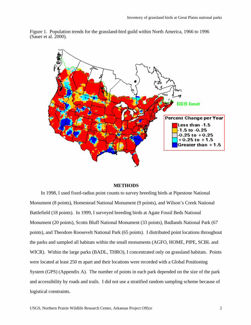
Figure 1. Population trends for the grassland-bird guild within North America, 1966 to 1996(Sauer et al. 2000).....................................................................................................................2
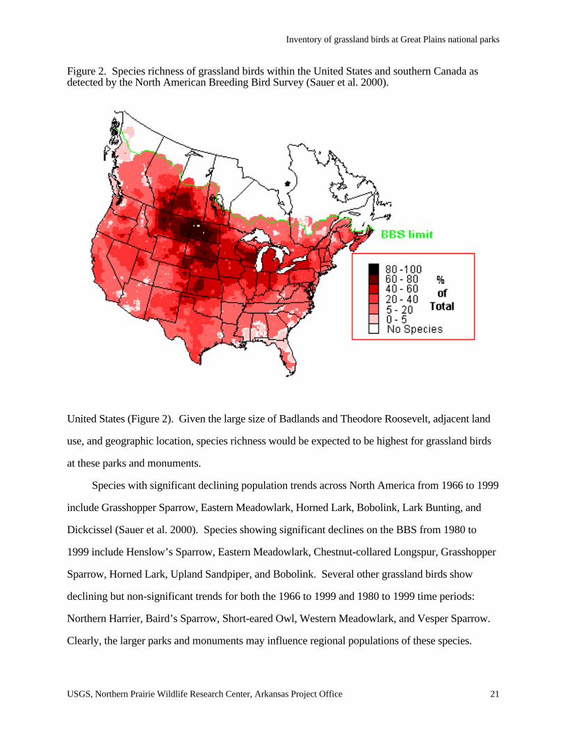
Figure 2. Species richness of grassland birds within the United States and southern Canada asdetected by the North American Breeding Bird Survey (Sauer et al. 2000).............................21
APPENDICES
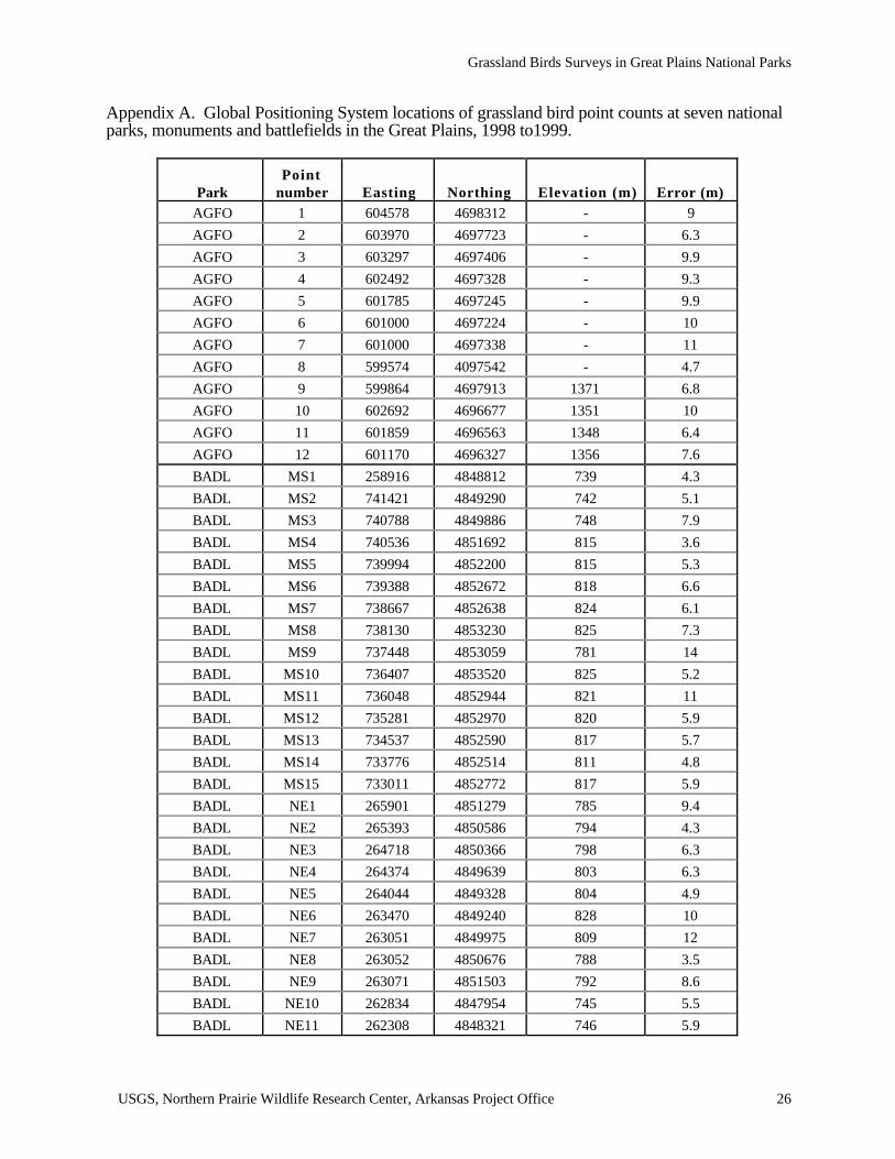
Appendix A. Global Positioning System locations of grassland bird point counts at seven nationalparks, monuments and battlefields in the Great Plains, 1998 to1999.......................................26
Appendix B. Sample datasheets for point count data.....................................................................32
Appendix C. Information available on Northern Prairie Wildlife Research Center Web site on theeffects of management on grassland birds:(http://www.npwrc.usgs.gov/resource/literatr/grasbird/grasbird.htm)......................................34
Appendix D. Draft protocol for monitoring birds on national parks..............................................36
Grassland Birds Surveys in Great Plains National Parks
USGS, Northern Prairie Wildlife Research Center, Arkansas Project Office 1
INTRODUCTION
Native prairie in the Midwest and Great Plains has been greatly reduced in area, and
remaining prairies are often fragmented (Noss et al. 1995, Knopf and Samson 1997). The Great
Plains grassland landscape was altered by the conversion of prairie to cropland and pasture, the
removal or disappearance of native ungulates, the drainage of wetlands, and an increase in woody
vegetation through plantings and fire suppression (Knopf 1994). The patterns of grassland loss
and fragmentation have resulted in changes in the abundance and distribution of grassland-
associated vertebrates. Over the past 25 years, data from the U.S. Geological Survey’s North
American Breeding Bird Survey (BBS) indicate that almost 70% of the 29 grassland bird species
adequately surveyed showed evidence of declining populations (Figure 1; Knopf 1994, U.S.
Department of Interior 1996, Sauer et al. 2000).
In 1997, the National Park Service (NPS) identified grassland birds as a high-priority
research need within the Central Region of the national park system. The status of grassland birds
on prairie parks and other lands managed by the NPS is largely unknown. The development of a
long-term monitoring program for grassland birds was identified as an objective to help monitor
populations in the parks. Information on current status and trends is essential for making informed
decisions to protect, enhance, or restore grassland bird populations. In this report, I present
baseline inventories of grassland birds from surveys that were conducted in 1998 and 1999 at seven
NPS parks and monuments within the Great Plains region. These included parks, battlefields, and
monuments within the Prairie Cluster Long-Term Ecological Monitoring (LTEM) program:
Wilson’s Creek National Battlefield (WICR) in Missouri; Homestead National Monument
(HOME), Agate Fossil Beds National Monument (AGFO), and Scotts Bluff National Monument
(SCBL) in Nebraska; and Pipestone National Monument (PIPE) in Minnesota. In addition, I
conducted baseline inventories of grassland birds at Badlands National Park (BADL) in South
Dakota and Theodore Roosevelt National Park (THRO) in North Dakota. Avian inventories of
Tallgrass Prairie National Preserve in Kansas were presented in a separate report (Lichtenberg and
Powell 2000).
Inventory of grassland birds at Great Plains national parks
USGS, Northern Prairie Wildlife Research Center, Arkansas Project Office 2
Figure 1. Population trends for the grassland-bird guild within North America, 1966 to 1996(Sauer et al. 2000).
METHODS
In 1998, I used fixed-radius point counts to survey breeding birds at Pipestone National
Monument (8 points), Homestead National Monument (9 points), and Wilson’s Creek National
Battlefield (18 points). In 1999, I surveyed breeding birds at Agate Fossil Beds National
Monument (20 points), Scotts Bluff National Monument (33 points), Badlands National Park (67
points), and Theodore Roosevelt National Park (65 points). I distributed point locations throughout
the parks and sampled all habitats within the small monuments (AGFO, HOME, PIPE, SCBL and
WICR). Within the large parks (BADL, THRO), I concentrated only on grassland habitats. Points
were located at least 250 m apart and their locations were recorded with a Global Positioning
System (GPS) (Appendix A). The number of points in each park depended on the size of the park
and accessibility by roads and trails. I did not use a stratified random sampling scheme because of
logistical constraints.
Inventory of grassland birds at Great Plains national parks
USGS, Northern Prairie Wildlife Research Center, Arkansas Project Office 3
Birds were surveyed using the point-count method described in Ralph et al. (1993, 1995).
Point counts are a standard method used to monitor populations of breeding birds by the U.S.
Forest Service and U.S. Fish and Wildlife Service (Ralph et al. 1993, Peterjohn 1994). All birds
found during point counts were assumed to be breeding because I conducted counts during the
peak of the breeding season, and point counts depend on counting singing males (denoting
territoriality). Breeding birds were surveyed from mid-May through June in 1998 and late-May
through mid-July in 1999. Observers recorded all birds seen or heard within a 5-minute period
within a 100-m radius of each survey point (Ralph et al. 1993, 1995). Observers estimated the
distance to each stationary bird and recorded the number of birds flying overhead. Only trained
observers proficient at bird identification by sight and sound performed counts (Kepler and Scott
1981).
Observers started counts within 0.5 hour of local sunrise and ended no later than 0930 CST.
Counts were not conducted in rain, high wind, or other inclement weather that could affect detection
of birds. Raptors, swallows, nightjars, and waterbirds were noted (i.e., included on lists of avian
species) but were not included in quantitative data because the methods were not appropriate to
survey these species (Ralph et al. 1995). I calculated relative abundance as the total number of
individuals per species within a 100-m radius divided by the grand total of all individuals of all
species at the park or monument. Observers also conducted informal surveys by slowly walking
through the habitats within the park and listening and watching for rare species.
In 1998, field data were divided into two time periods (0 to 3 minutes and 3 to 5 minutes) and
two distance bands (0 to 50 m and 51 to 100 m; Appendix B). In 1999, at the request of the NPS,
observers also estimated the distances of each stationary bird heard or seen from the center of the
point for future analysis of detection rates. Results reported, however, are summarized for all birds
seen or heard within a 100-m radius because our distance estimates, particularly for those birds that
were heard but not seen, were inconsistent and inaccurate. In addition, all birds seen or heard
outside of points at each park were recorded to aid in the development of bird species checklists.
Inventory of grassland birds at Great Plains national parks
USGS, Northern Prairie Wildlife Research Center, Arkansas Project Office 4
Finally, I present my data along with U.S. Geological Survey’s BBS trends for
corresponding physiographic regions (Peterjohn 1994, Sauer et al. 2000). Although BBS data may
not be statistically rigorous for some species in some regions, trends may point towards general
declines in some avian populations (Sauer et al. 2000). Tables in this report show estimated
population trends (percent increase or decline per year) and a measure of their statistical
significance (* = P <0.05, ** = P < 0.01), and species are listed in taxonomic order (AOU 1998).
BBS trends for those species with major data deficiencies (i.e., small sample size) within a region
are not included in this report (Sauer et al. 2000).
RESULTS
Wilson’s Creek National Battlefield
Observers recorded a total of 748 individuals of 54 species on point counts, and noted 62
species overall at this site (Table 1). Of the breeding bird species found on point counts, only 6
(11%) were grassland-associated (Table 2). Brown-headed Cowbird was the most abundant
species, followed by Indigo Bunting, American Goldfinch, Northern Cardinal, Field Sparrow, and
Yellow-breasted Chat. Wilson’s Creek also supported Grasshopper Sparrow and Dickcissel, two
grassland species showing overall declines on the BBS in the U.S. (Knopf 1994). Within the
Osage Plains physiographic region, Northern Bobwhite and Eastern Meadowlark show significant
population declines on the BBS, and we found both species at Wilson’s Creek (Table 2).
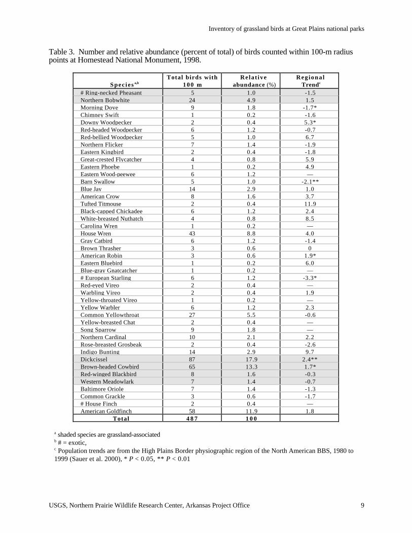
Homestead National Monument
Observers found 487 individuals of 44 species during point counts at this site in 1998, and
recored 46 species overall (Table 1). Six (13%) species on point counts were grassland-associated
(Table 3). In descending order, the most abundant species on point counts were Dickcissel, Brown-
headed Cowbird, American Goldfinch, House Wren, Common Yellowthroat, Northern Bobwhite,
Indigo Bunting, and Blue Jay (Table 3). No grassland bird species showing significant population
declines in the High Plains Border physiographic region of the BBS (Sauer et al. 2000) were found
at Homestead. Dickcissel, however, was the most abundant species at the monument and has
shown significant population increases in the region (Table 3).
Inventory of grassland birds at Great Plains national parks
USGS, Northern Prairie Wildlife Research Center, Arkansas Project Office 5
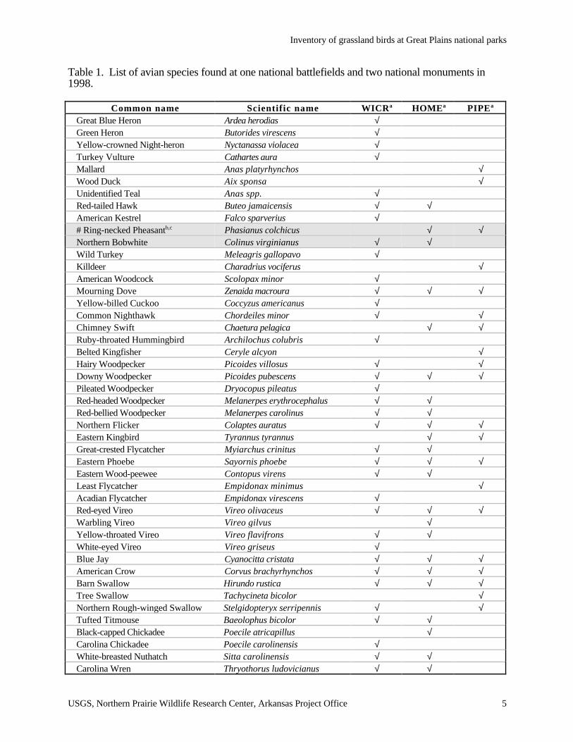
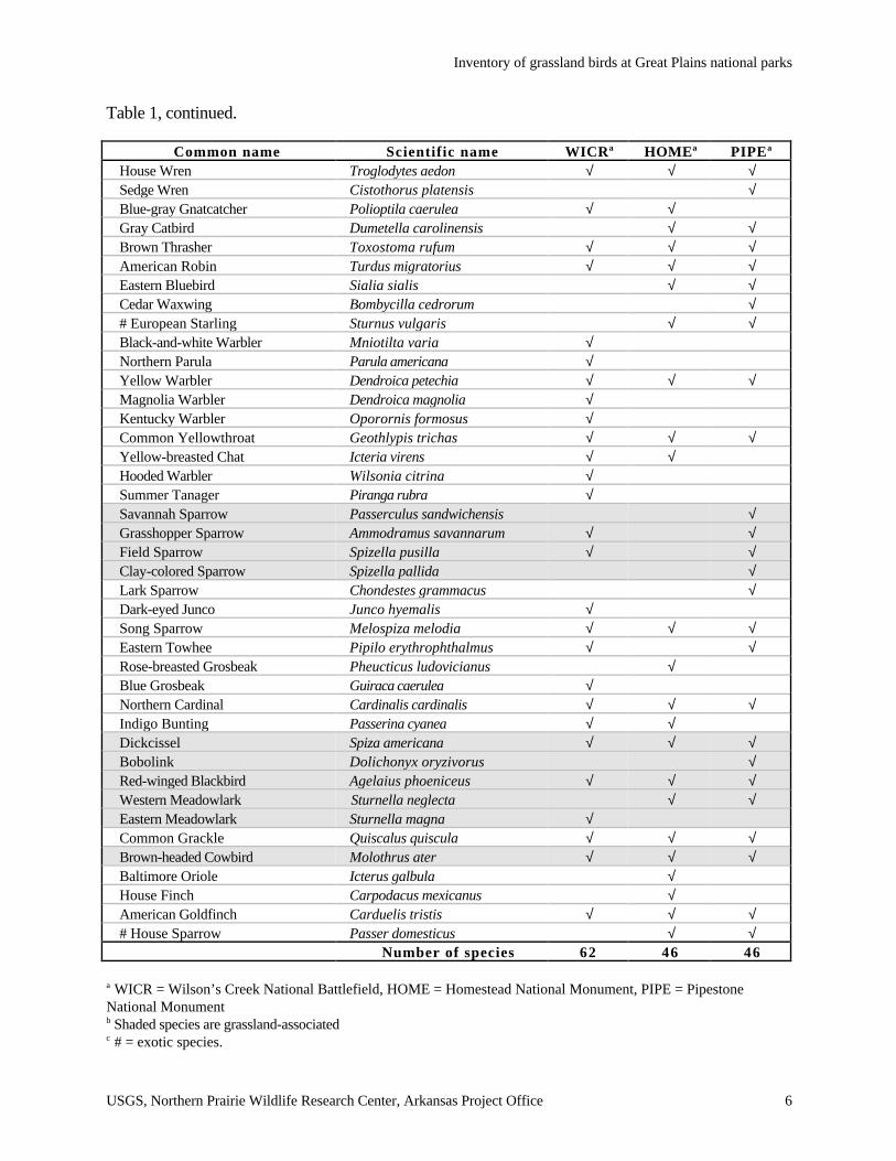
Table 1. List of avian species found at one national battlefields and two national monuments in1998.
Common name Scientific name WICRa HOMEa PIPEa
Great Blue Heron Ardea herodias √Green Heron Butorides virescens √Yellow-crowned Night-heron Nyctanassa violacea √Turkey Vulture Cathartes aura √Mallard Anas platyrhynchos √Wood Duck Aix sponsa √Unidentified Teal Anas spp. √Red-tailed Hawk Buteo jamaicensis √ √American Kestrel Falco sparverius √# Ring-necked Pheasantb,c Phasianus colchicus √ √Northern Bobwhite Colinus virginianus √ √Wild Turkey Meleagris gallopavo √Killdeer Charadrius vociferus √American Woodcock Scolopax minor √Mourning Dove Zenaida macroura √ √ √Yellow-billed Cuckoo Coccyzus americanus √Common Nighthawk Chordeiles minor √ √Chimney Swift Chaetura pelagica √ √Ruby-throated Hummingbird Archilochus colubris √Belted Kingfisher Ceryle alcyon √Hairy Woodpecker Picoides villosus √ √Downy Woodpecker Picoides pubescens √ √ √Pileated Woodpecker Dryocopus pileatus √Red-headed Woodpecker Melanerpes erythrocephalus √ √Red-bellied Woodpecker Melanerpes carolinus √ √Northern Flicker Colaptes auratus √ √ √Eastern Kingbird Tyrannus tyrannus √ √Great-crested Flycatcher Myiarchus crinitus √ √Eastern Phoebe Sayornis phoebe √ √ √Eastern Wood-peewee Contopus virens √ √Least Flycatcher Empidonax minimus √Acadian Flycatcher Empidonax virescens √Red-eyed Vireo Vireo olivaceus √ √ √Warbling Vireo Vireo gilvus √Yellow-throated Vireo Vireo flavifrons √ √White-eyed Vireo Vireo griseus √Blue Jay Cyanocitta cristata √ √ √American Crow Corvus brachyrhynchos √ √ √Barn Swallow Hirundo rustica √ √ √Tree Swallow Tachycineta bicolor √Northern Rough-winged Swallow Stelgidopteryx serripennis √ √Tufted Titmouse Baeolophus bicolor √ √Black-capped Chickadee Poecile atricapillus √Carolina Chickadee Poecile carolinensis √White-breasted Nuthatch Sitta carolinensis √ √Carolina Wren Thryothorus ludovicianus √ √
Inventory of grassland birds at Great Plains national parks
USGS, Northern Prairie Wildlife Research Center, Arkansas Project Office 6
Table 1, continued.
Common name Scientific name WICRa HOMEa PIPEa
House Wren Troglodytes aedon √ √ √Sedge Wren Cistothorus platensis √Blue-gray Gnatcatcher Polioptila caerulea √ √Gray Catbird Dumetella carolinensis √ √Brown Thrasher Toxostoma rufum √ √ √American Robin Turdus migratorius √ √ √Eastern Bluebird Sialia sialis √ √Cedar Waxwing Bombycilla cedrorum √# European Starling Sturnus vulgaris √ √Black-and-white Warbler Mniotilta varia √Northern Parula Parula americana √Yellow Warbler Dendroica petechia √ √ √Magnolia Warbler Dendroica magnolia √Kentucky Warbler Oporornis formosus √Common Yellowthroat Geothlypis trichas √ √ √Yellow-breasted Chat Icteria virens √ √Hooded Warbler Wilsonia citrina √Summer Tanager Piranga rubra √Savannah Sparrow Passerculus sandwichensis √Grasshopper Sparrow Ammodramus savannarum √ √Field Sparrow Spizella pusilla √ √Clay-colored Sparrow Spizella pallida √Lark Sparrow Chondestes grammacus √Dark-eyed Junco Junco hyemalis √Song Sparrow Melospiza melodia √ √ √Eastern Towhee Pipilo erythrophthalmus √ √Rose-breasted Grosbeak Pheucticus ludovicianus √Blue Grosbeak Guiraca caerulea √Northern Cardinal Cardinalis cardinalis √ √ √Indigo Bunting Passerina cyanea √ √Dickcissel Spiza americana √ √ √Bobolink Dolichonyx oryzivorus √Red-winged Blackbird Agelaius phoeniceus √ √ √Western Meadowlark Sturnella neglecta √ √Eastern Meadowlark Sturnella magna √Common Grackle Quiscalus quiscula √ √ √Brown-headed Cowbird Molothrus ater √ √ √Baltimore Oriole Icterus galbula √House Finch Carpodacus mexicanus √American Goldfinch Carduelis tristis √ √ √# House Sparrow Passer domesticus √ √
Number of species 62 46 46
a WICR = Wilson’s Creek National Battlefield, HOME = Homestead National Monument, PIPE = PipestoneNational Monumentb Shaded species are grassland-associatedc # = exotic species.

Inventory of grassland birds at Great Plains national parks
USGS, Northern Prairie Wildlife Research Center, Arkansas Project Office 7
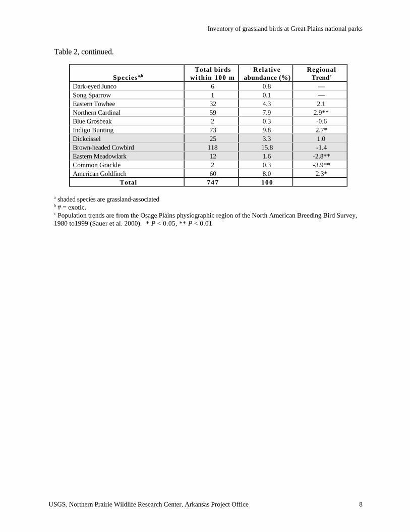
Table 2. Number and relative abundance (percent of total) of birds counted within 100-m radiuspoints at Wilson’s Creek National Battlefield, 1998.
Speciesa,bTotal birds
within 100 mRelative
abundance (%)Regional
Trendc
Yellow-crowned Night-heron 1 0.1 —Turkey Vulture 1 0.1 -0.2Red-tailed Hawk 3 0.4 2.4*American Kestrel 1 0.1 0Northern Bobwhite 6 0.8 -2.6**Wild Turkey 1 0.1 10.4American Woodcock 1 0.1 —Mourning Dove 5 0.7 0.1Yellow-billed Cuckoo 13 1.7 -1.8*Common Nighthawk 1 0.1 -2.8*Ruby-throated Hummingbird 2 0.3 4.5Hairy Woodpecker 1 0.1 -9.5Downy Woodpecker 15 2.0 1.4Pileated Woodpecker 2 0.3 2.0Red-headed Woodpecker 1 0.1 -8.3**Red-bellied Woodpecker 8 1.1 1.1Northern Flicker 1 0.1 -5.6**Great-crested Flycatcher 6 0.8 0.5Eastern Phoebe 5 0.7 4.8**Eastern Wood-peewee 4 0.5 0.5Acadian Flycatcher 6 0.8 2.8Barn Swallow 4 0.5 0Northern Rough-winged Swallow 1 0.1 5.9Blue Jay 12 1.6 1.2American Crow 24 3.2 2.8**Tufted Titmouse 22 2.9 2.2*Carolina Chickadee 26 3.5 2.9White-breasted Nuthatch 2 0.3 3.5Carolina Wren 15 2.0 17.2**House Wren 2 0.3 6.4*Brown Thrasher 6 0.8 -3.9**Blue-gray Gnatcatcher 10 1.3 5.9Yellow-throated Vireo 1 0.1 —White-eyed Vireo 13 1.7 —Black-and-white Warbler 9 1.2 -0.3Northern Parula 14 1.9 6.5Yellow Warbler 1 0.1 —Magnolia Warbler 1 0.1 —Kentucky Warbler 1 0.1 -2.6Common Yellowthroat 23 3.1 3.3*Yellow-breasted Chat 37 5.0 6.5Grasshopper Sparrow 6 0.8 0.7Field Sparrow 44 5.9 3.0*
Inventory of grassland birds at Great Plains national parks
USGS, Northern Prairie Wildlife Research Center, Arkansas Project Office 8
Table 2, continued.
Speciesa,bTotal birds
within 100 mRelative
abundance (%)Regional
Trendc
Dark-eyed Junco 6 0.8 —Song Sparrow 1 0.1 —Eastern Towhee 32 4.3 2.1Northern Cardinal 59 7.9 2.9**Blue Grosbeak 2 0.3 -0.6Indigo Bunting 73 9.8 2.7*Dickcissel 25 3.3 1.0Brown-headed Cowbird 118 15.8 -1.4Eastern Meadowlark 12 1.6 -2.8**Common Grackle 2 0.3 -3.9**American Goldfinch 60 8.0 2.3*
Total 747 100
a shaded species are grassland-associatedb # = exotic.c Population trends are from the Osage Plains physiographic region of the North American Breeding Bird Survey,1980 to1999 (Sauer et al. 2000). * P < 0.05, ** P < 0.01
Inventory of grassland birds at Great Plains national parks
USGS, Northern Prairie Wildlife Research Center, Arkansas Project Office 9
Table 3. Number and relative abundance (percent of total) of birds counted within 100-m radiuspoints at Homestead National Monument, 1998.
S p e c i e s a,bTotal birds with
1 0 0 mRelat ive
abundance (%)Reg iona l
Trendc
# Ring-necked Pheasant 5 1.0 -1.5Northern Bobwhite 24 4.9 1.5Morning Dove 9 1.8 -1.7*Chimney Swift 1 0.2 -1.6Downy Woodpecker 2 0.4 5.3*Red-headed Woodpecker 6 1.2 -0.7Red-bellied Woodpecker 5 1.0 6.7Northern Flicker 7 1.4 -1.9Eastern Kingbird 2 0.4 -1.8Great-crested Flycatcher 4 0.8 5.9Eastern Phoebe 1 0.2 4.9Eastern Wood-peewee 6 1.2 —Barn Swallow 5 1.0 -2.1**Blue Jay 14 2.9 1.0American Crow 8 1.6 3.7Tufted Titmouse 2 0.4 11.9Black-capped Chickadee 6 1.2 2.4White-breasted Nuthatch 4 0.8 8.5Carolina Wren 1 0.2 —House Wren 43 8.8 4.0Gray Catbird 6 1.2 -1.4Brown Thrasher 3 0.6 0American Robin 3 0.6 1.9*Eastern Bluebird 1 0.2 6.0Blue-gray Gnatcatcher 1 0.2 —# European Starling 6 1.2 -3.3*Red-eyed Vireo 2 0.4 —Warbling Vireo 2 0.4 1.9Yellow-throated Vireo 1 0.2 —Yellow Warbler 6 1.2 2.3Common Yellowthroat 27 5.5 -0.6Yellow-breasted Chat 2 0.4 —Song Sparrow 9 1.8 —Northern Cardinal 10 2.1 2.2Rose-breasted Grosbeak 2 0.4 -2.6Indigo Bunting 14 2.9 9.7Dickcissel 87 17.9 2.4**Brown-headed Cowbird 65 13.3 1.7*Red-winged Blackbird 8 1.6 -0.3Western Meadowlark 7 1.4 -0.7Baltimore Oriole 7 1.4 -1.3Common Grackle 3 0.6 -1.7# House Finch 2 0.4 —American Goldfinch 58 11.9 1.8
Total 4 8 7 1 0 0
a shaded species are grassland-associatedb # = exotic,
c Population trends are from the High Plains Border physiographic region of the North American BBS, 1980 to1999 (Sauer et al. 2000), * P < 0.05, ** P < 0.01

Inventory of grassland birds at Great Plains national parks
USGS, Northern Prairie Wildlife Research Center, Arkansas Project Office 10
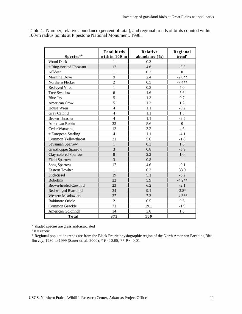
Pipestone National Monument
Observers recorded a total of 373 individuals of 30 species at Pipestone National Monument
during point counts in 1998, and recorded 46 species overall (Table 1). Ten species (33%) of
breeding birds were considered to be grassland-associated (Table 4). The most abundant species,
in descending order, were Common Grackle, Red-winged Blackbird, American Robin, Western
Meadowlark, Brown-headed Cowbird, Bobolink, Common Yellowthroat, and Dickcissel (Table 4).
Of the three parks sampled in 1998 (PIPE, HOME, WICR), Pipestone had the highest proportion
of grassland habitats and thus the highest proportion of grassland birds. Of the grassland species
that have shown significant declining population trends on BBS routes in the Black Prairie
physiographic region (Sauer et al. 2000), Pipestone supported breeding Western Meadowlarks,
Bobolinks, and Red-winged Blackbirds (Table 4).
Agate Fossil Beds National Monument
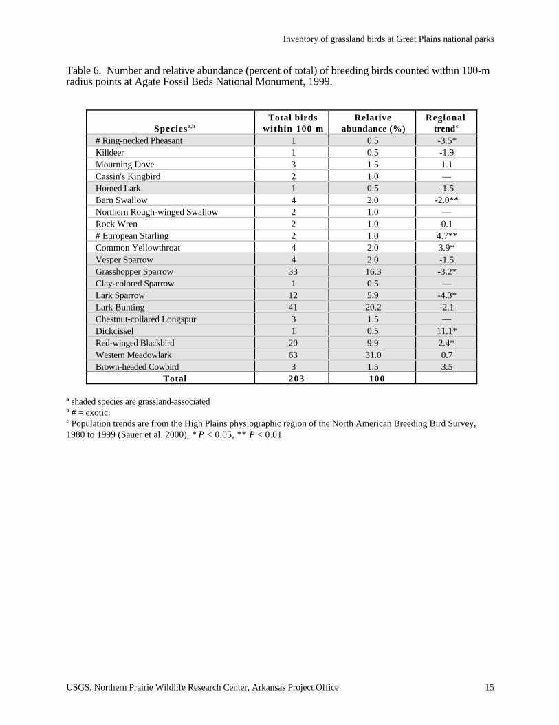
Observers recorded a total of 203 individual birds of 20 species at Agate Fossil Beds during
point counts in 1999, and found 50 species overall (Table 5). Twelve species (60%) of breeding
birds found on point counts were considered to be grassland-associated (Table 6). The most
abundant species, in descending order, included Western Meadowlark, Lark Bunting, Grasshopper
Sparrow, Red-winged Blackbird, and Lark Sparrow. Grasshopper Sparrows and Lark Sparrows
show significant population declines in the High Plains physiographic region of the BBS since
1980 (Table 6). Although Ring-necked Pheasants also have experienced declines in the region,
they are introduced exotics.
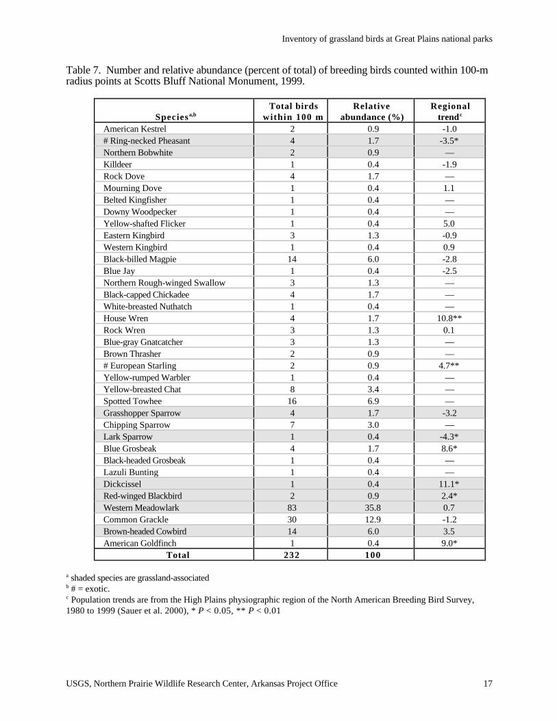
Scotts Bluff National Monument
Observers found 232 individuals of 36 species of breeding birds were recorded on point
counts at this site in 1999, and found 64 species overall (Table 5). Eight (22%) species on point
counts were grassland-associated (Table 7). The most abundant species on point counts were
Western
Meadowlark, Common Grackle, Spotted Towhee, Black-billed Magpie, and Brown-headed
Cowbird. Western Meadowlarks and Common Grackles combined constituted 49% of all species
Inventory of grassland birds at Great Plains national parks
USGS, Northern Prairie Wildlife Research Center, Arkansas Project Office 11
Table 4. Number, relative abundance (percent of total), and regional trends of birds counted within100-m radius points at Pipestone National Monument, 1998.
Speciesa,bTotal birds
within 100 mRelative
abundance (%)Regional
trendc
Wood Duck 1 0.3 —# Ring-necked Pheasant 17 4.6 -2.2Killdeer 1 0.3 0Morning Dove 9 2.4 -2.8**Northern Flicker 2 0.5 -7.4**Red-eyed Vireo 1 0.3 5.0Tree Swallow 6 1.6 5.6Blue Jay 5 1.3 0.7American Crow 5 1.3 1.2House Wren 4 1.1 -0.2Gray Catbird 4 1.1 1.5Brown Thrasher 4 1.1 -3.5American Robin 32 8.6 0Cedar Waxwing 12 3.2 4.6# European Starling 4 1.1 -4.1Common Yellowthroat 21 5.6 -1.8Savannah Sparrow 1 0.3 1.8Grasshopper Sparrow 3 0.8 -5.9Clay-colored Sparrow 8 2.2 1.0Field Sparrow 3 0.8 —Song Sparrow 17 4.6 -0.1Eastern Towhee 1 0.3 33.0Dickcissel 19 5.1 -3.2Bobolink 22 5.9 -4.2**Brown-headed Cowbird 23 6.2 -2.1Red-winged Blackbird 34 9.1 -2.8*Western Meadowlark 27 7.3 -4.3**Baltimore Oriole 2 0.5 0.6Common Grackle 71 19.1 -1.9American Goldfinch 14 3.8 1.0
Total 373 100
a, shaded species are grassland-associatedb # = exoticc Regional population trends are from the Black Prairie physiographic region of the North American Breeding BirdSurvey, 1980 to 1999 (Sauer et. al. 2000), * P < 0.05, ** P < 0.01
Inventory of grassland birds at Great Plains national parks
USGS, Northern Prairie Wildlife Research Center, Arkansas Project Office 12
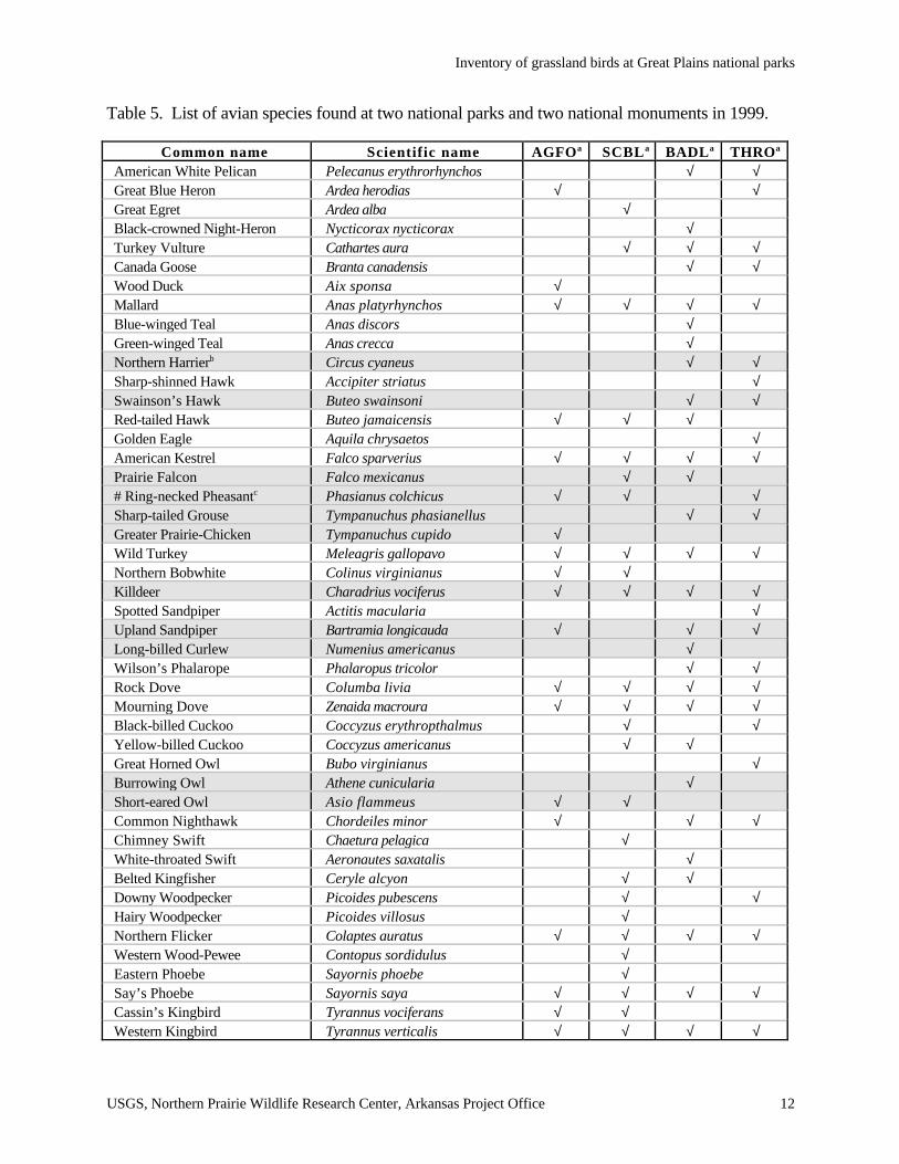
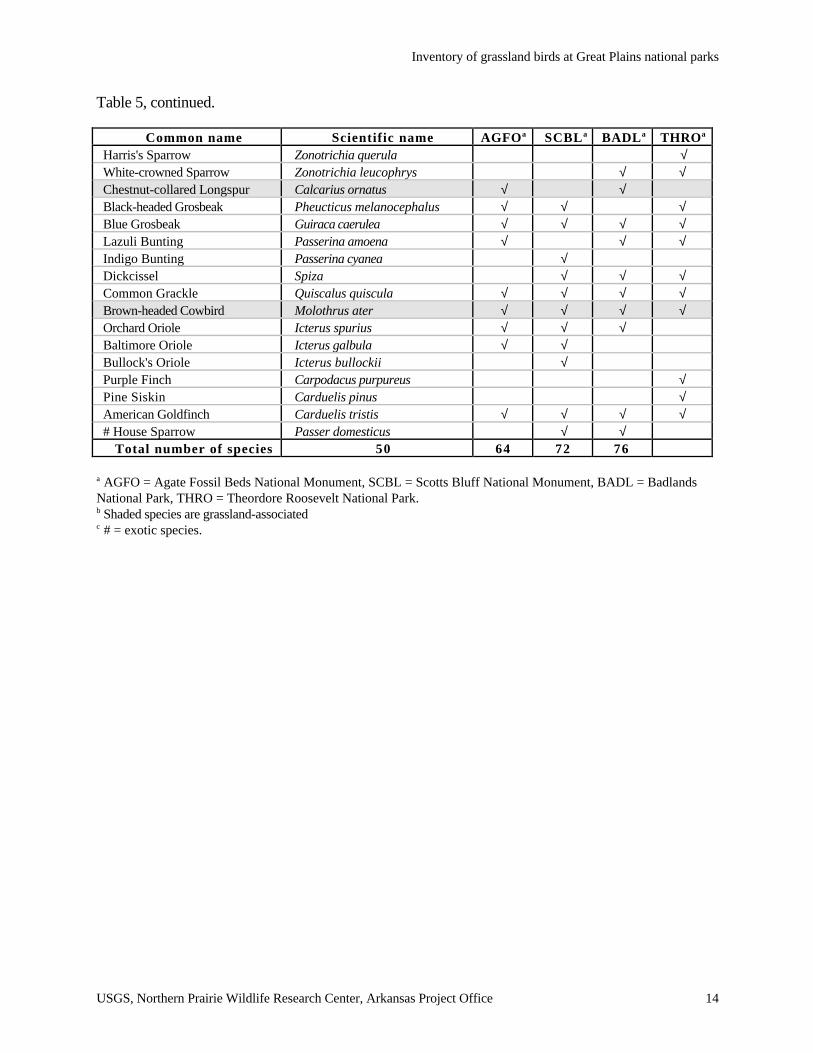
Table 5. List of avian species found at two national parks and two national monuments in 1999.
Common name Scientific name AGFOa SCBLa BADLa THROa
American White Pelican Pelecanus erythrorhynchos √ √Great Blue Heron Ardea herodias √ √Great Egret Ardea alba √Black-crowned Night-Heron Nycticorax nycticorax √Turkey Vulture Cathartes aura √ √ √Canada Goose Branta canadensis √ √Wood Duck Aix sponsa √Mallard Anas platyrhynchos √ √ √ √Blue-winged Teal Anas discors √Green-winged Teal Anas crecca √Northern Harrierb Circus cyaneus √ √Sharp-shinned Hawk Accipiter striatus √Swainson’s Hawk Buteo swainsoni √ √Red-tailed Hawk Buteo jamaicensis √ √ √Golden Eagle Aquila chrysaetos √American Kestrel Falco sparverius √ √ √ √Prairie Falcon Falco mexicanus √ √# Ring-necked Pheasantc Phasianus colchicus √ √ √Sharp-tailed Grouse Tympanuchus phasianellus √ √Greater Prairie-Chicken Tympanuchus cupido √Wild Turkey Meleagris gallopavo √ √ √ √Northern Bobwhite Colinus virginianus √ √Killdeer Charadrius vociferus √ √ √ √Spotted Sandpiper Actitis macularia √Upland Sandpiper Bartramia longicauda √ √ √Long-billed Curlew Numenius americanus √Wilson’s Phalarope Phalaropus tricolor √ √Rock Dove Columba livia √ √ √ √Mourning Dove Zenaida macroura √ √ √ √Black-billed Cuckoo Coccyzus erythropthalmus √ √Yellow-billed Cuckoo Coccyzus americanus √ √Great Horned Owl Bubo virginianus √Burrowing Owl Athene cunicularia √Short-eared Owl Asio flammeus √ √Common Nighthawk Chordeiles minor √ √ √Chimney Swift Chaetura pelagica √White-throated Swift Aeronautes saxatalis √Belted Kingfisher Ceryle alcyon √ √Downy Woodpecker Picoides pubescens √ √Hairy Woodpecker Picoides villosus √Northern Flicker Colaptes auratus √ √ √ √Western Wood-Pewee Contopus sordidulus √Eastern Phoebe Sayornis phoebe √Say’s Phoebe Sayornis saya √ √ √ √Cassin’s Kingbird Tyrannus vociferans √ √Western Kingbird Tyrannus verticalis √ √ √ √
Inventory of grassland birds at Great Plains national parks
USGS, Northern Prairie Wildlife Research Center, Arkansas Project Office 13
Table 5, continued.
Common name Scientific name AGFOa SCBLa BADLa THROa
Eastern Kingbird Tyrannus tyrannus √ √ √ √Loggerhead Shrike Lanius ludovicianus √ √ √Bell’s Vireo Vireo bellii √Red-eyed Vireo Vireo olivaceus √Black-billed Magpie Pica pica √ √American Crow Corvus brachyrhynchos √ √ √Horned Lark Eremophila alpestris √ √Tree Swallow Tachycineta bicolor √Violet-green Swallow Tachycineta thalassina √Northern Rough-winged Stelgidopteryx serripennis √ √ √ √Bank Swallow Riparia riparia √ √Cliff Swallow Petrochelidon pyrrhonota √ √ √Barn Swallow Hirundo rustica √ √ √ √Black-capped Chickadee Poecile atricapillus √ √ √Tufted Titmouse Baeolophus bicolor √White-breasted Nuthatch Sitta carolinensis √ √Rock Wren Salpinctes obsoletus √ √ √ √House Wren Troglodytes aedon √ √ √Blue-gray Gnatcatcher Polioptila caerulia √Western Bluebird Sialia mexicana √Mountain Bluebird Sialia currucoides √ √ √Swainson’s Thrush Catharus ustulatus √American Robin Turdus migratorius √ √ √Brown Thrasher Toxostoma rufum √ √ √ √# European Starling Sturnus vulgaris √ √ √Sprague’s Pipit Anthus spragueii √Cedar Waxwing Bombycilla cedrorum √ √Orange-crowned Warbler Vermivora celata √Yellow Warbler Dendroica petechia √ √ √Yellow-rumped Warbler Dendroica coronata √ √Black-and-white Warbler Mniotilta varia √Ovenbird Seiurus aurocapillus √Northern Waterthrush Seiurus noveboracensis √Common Yellowthroat Geothlypis trichas √ √Yellow-breasted Chat Icteria virens √ √ √Spotted Towhee Pipilo maculatus √ √ √ √Chipping Sparrow Spizella passerina √ √ √Clay-colored Sparrow Spizella pallida √ √ √Field Sparrow Spizella pusilla √ √ √Vesper Sparrow Pooecetes gramineus √ √ √ √Lark Sparrow Chondestes grammacus √ √ √ √Lark Bunting Calamospiza melanocorys √ √ √Savannah Sparrow Passerculus sandwichensis √ √Grasshopper Sparrow Ammodramus savannarum √ √ √ √Baird's Sparrow Ammodramus bairdii √Song Sparrow Melospiza melodia √
Inventory of grassland birds at Great Plains national parks
USGS, Northern Prairie Wildlife Research Center, Arkansas Project Office 14
Table 5, continued.
Common name Scientific name AGFOa SCBLa BADLa THROa
Harris's Sparrow Zonotrichia querula √White-crowned Sparrow Zonotrichia leucophrys √ √Chestnut-collared Longspur Calcarius ornatus √ √Black-headed Grosbeak Pheucticus melanocephalus √ √ √Blue Grosbeak Guiraca caerulea √ √ √ √Lazuli Bunting Passerina amoena √ √ √Indigo Bunting Passerina cyanea √Dickcissel Spiza √ √ √Common Grackle Quiscalus quiscula √ √ √ √Brown-headed Cowbird Molothrus ater √ √ √ √Orchard Oriole Icterus spurius √ √ √Baltimore Oriole Icterus galbula √ √Bullock's Oriole Icterus bullockii √Purple Finch Carpodacus purpureus √Pine Siskin Carduelis pinus √American Goldfinch Carduelis tristis √ √ √ √# House Sparrow Passer domesticus √ √
Total number of species 50 64 72 76
a AGFO = Agate Fossil Beds National Monument, SCBL = Scotts Bluff National Monument, BADL = BadlandsNational Park, THRO = Theordore Roosevelt National Park.b Shaded species are grassland-associatedc # = exotic species.
Inventory of grassland birds at Great Plains national parks
USGS, Northern Prairie Wildlife Research Center, Arkansas Project Office 15
Table 6. Number and relative abundance (percent of total) of breeding birds counted within 100-mradius points at Agate Fossil Beds National Monument, 1999.
Speciesa,bTotal birds
within 100 mRelative
abundance (%)Regional
trendc
# Ring-necked Pheasant 1 0.5 -3.5*Killdeer 1 0.5 -1.9Mourning Dove 3 1.5 1.1Cassin's Kingbird 2 1.0 —Horned Lark 1 0.5 -1.5Barn Swallow 4 2.0 -2.0**Northern Rough-winged Swallow 2 1.0 —Rock Wren 2 1.0 0.1# European Starling 2 1.0 4.7**Common Yellowthroat 4 2.0 3.9*Vesper Sparrow 4 2.0 -1.5Grasshopper Sparrow 33 16.3 -3.2*Clay-colored Sparrow 1 0.5 —Lark Sparrow 12 5.9 -4.3*Lark Bunting 41 20.2 -2.1Chestnut-collared Longspur 3 1.5 —Dickcissel 1 0.5 11.1*Red-winged Blackbird 20 9.9 2.4*Western Meadowlark 63 31.0 0.7Brown-headed Cowbird 3 1.5 3.5
Total 203 100
a shaded species are grassland-associatedb # = exotic.c Population trends are from the High Plains physiographic region of the North American Breeding Bird Survey,1980 to 1999 (Sauer et al. 2000), * P < 0.05, ** P < 0.01

Inventory of grassland birds at Great Plains national parks
USGS, Northern Prairie Wildlife Research Center, Arkansas Project Office 16
found within point counts at this location (Table 7). Scotts Bluff supported Lark Sparrows, which
have declined significantly in the High Plains physiographic region since 1980 (Table 7).
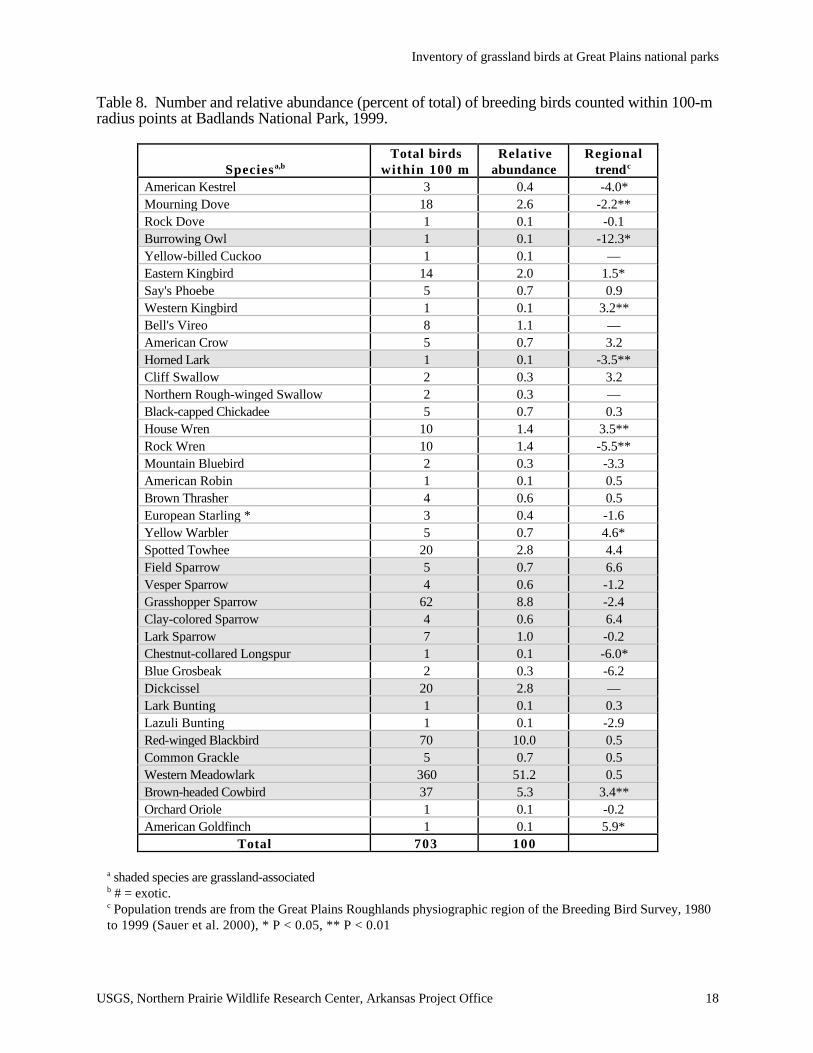
Badlands National Park
Observerse recorded a total of 703 individuals of 38 species on point counts in 1999, and saw
72 species overall at this site (Table 5). Of the breeding birds found on point counts, 14 (37%)
were grassland-associated, and of all the individual birds within point counts, 51% were Western
Meadowlarks (Table 8). The next most abundant species were Red-winged Blackbird,
Grasshopper Sparrow, Brown-headed Cowbird, Dickcissel, and Spotted Towhee. Badlands
National Park supported Burrowing Owls, Chestnut-collared Longspurs, and Horned Larks, all of
which have had significant population declines in the Great Plains Roughlands physiographic
region since 1980 (Table 8).
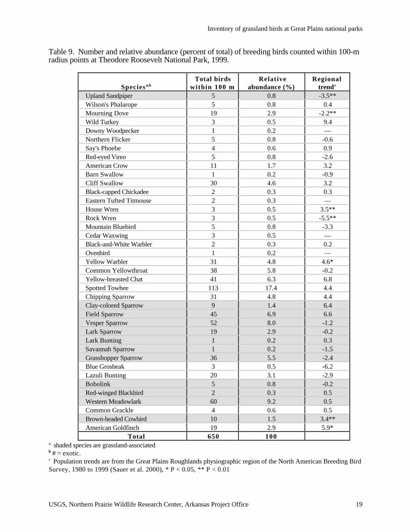
Theodore Roosevelt National Park:
Observers found 650 individuals of 39 species on point counts and a saw total of 76 species
in 1999 (Table 5). Twelve (31%) of the breeding species found on point counts were grassland-
associated (Table 9). The most abundant species, in descending order, were Spotted Towhee,
Western Meadowlark, Vesper Sparrow, Field Sparrow, and Yellow-breasted Chat. Of the
grassland-associated species showing significant declines in some regions since 1980, Theodore
Roosevelt supported Upland Sandpipers, although in small numbers (Table 9).
Inventory of grassland birds at Great Plains national parks
USGS, Northern Prairie Wildlife Research Center, Arkansas Project Office 17
Table 7. Number and relative abundance (percent of total) of breeding birds counted within 100-mradius points at Scotts Bluff National Monument, 1999.
Speciesa,bTotal birds
within 100 mRelative
abundance (%)Regional
trendc
American Kestrel 2 0.9 -1.0# Ring-necked Pheasant 4 1.7 -3.5*Northern Bobwhite 2 0.9 —Killdeer 1 0.4 -1.9Rock Dove 4 1.7 —Mourning Dove 1 0.4 1.1Belted Kingfisher 1 0.4 —Downy Woodpecker 1 0.4 —Yellow-shafted Flicker 1 0.4 5.0Eastern Kingbird 3 1.3 -0.9Western Kingbird 1 0.4 0.9Black-billed Magpie 14 6.0 -2.8Blue Jay 1 0.4 -2.5Northern Rough-winged Swallow 3 1.3 —Black-capped Chickadee 4 1.7 —White-breasted Nuthatch 1 0.4 —House Wren 4 1.7 10.8**Rock Wren 3 1.3 0.1Blue-gray Gnatcatcher 3 1.3 —Brown Thrasher 2 0.9 —# European Starling 2 0.9 4.7**Yellow-rumped Warbler 1 0.4 —Yellow-breasted Chat 8 3.4 —Spotted Towhee 16 6.9 —Grasshopper Sparrow 4 1.7 -3.2Chipping Sparrow 7 3.0 —Lark Sparrow 1 0.4 -4.3*Blue Grosbeak 4 1.7 8.6*Black-headed Grosbeak 1 0.4 —Lazuli Bunting 1 0.4 —Dickcissel 1 0.4 11.1*Red-winged Blackbird 2 0.9 2.4*Western Meadowlark 83 35.8 0.7Common Grackle 30 12.9 -1.2Brown-headed Cowbird 14 6.0 3.5American Goldfinch 1 0.4 9.0*
Total 232 100
a shaded species are grassland-associatedb # = exotic.c Population trends are from the High Plains physiographic region of the North American Breeding Bird Survey,1980 to 1999 (Sauer et al. 2000), * P < 0.05, ** P < 0.01
Inventory of grassland birds at Great Plains national parks
USGS, Northern Prairie Wildlife Research Center, Arkansas Project Office 18
Table 8. Number and relative abundance (percent of total) of breeding birds counted within 100-mradius points at Badlands National Park, 1999.
Speciesa,bTotal birds
within 100 mRelative
abundanceRegional
trendc
American Kestrel 3 0.4 -4.0*Mourning Dove 18 2.6 -2.2**Rock Dove 1 0.1 -0.1Burrowing Owl 1 0.1 -12.3*Yellow-billed Cuckoo 1 0.1 —Eastern Kingbird 14 2.0 1.5*Say's Phoebe 5 0.7 0.9Western Kingbird 1 0.1 3.2**Bell's Vireo 8 1.1 —American Crow 5 0.7 3.2Horned Lark 1 0.1 -3.5**Cliff Swallow 2 0.3 3.2Northern Rough-winged Swallow 2 0.3 —Black-capped Chickadee 5 0.7 0.3House Wren 10 1.4 3.5**Rock Wren 10 1.4 -5.5**Mountain Bluebird 2 0.3 -3.3American Robin 1 0.1 0.5Brown Thrasher 4 0.6 0.5European Starling * 3 0.4 -1.6Yellow Warbler 5 0.7 4.6*Spotted Towhee 20 2.8 4.4Field Sparrow 5 0.7 6.6Vesper Sparrow 4 0.6 -1.2Grasshopper Sparrow 62 8.8 -2.4Clay-colored Sparrow 4 0.6 6.4Lark Sparrow 7 1.0 -0.2Chestnut-collared Longspur 1 0.1 -6.0*Blue Grosbeak 2 0.3 -6.2Dickcissel 20 2.8 —Lark Bunting 1 0.1 0.3Lazuli Bunting 1 0.1 -2.9Red-winged Blackbird 70 10.0 0.5Common Grackle 5 0.7 0.5Western Meadowlark 360 51.2 0.5Brown-headed Cowbird 37 5.3 3.4**Orchard Oriole 1 0.1 -0.2American Goldfinch 1 0.1 5.9*
Total 703 100
a shaded species are grassland-associatedb # = exotic.c Population trends are from the Great Plains Roughlands physiographic region of the Breeding Bird Survey, 1980to 1999 (Sauer et al. 2000), * P < 0.05, ** P < 0.01
Inventory of grassland birds at Great Plains national parks
USGS, Northern Prairie Wildlife Research Center, Arkansas Project Office 19
Table 9. Number and relative abundance (percent of total) of breeding birds counted within 100-mradius points at Theodore Roosevelt National Park, 1999.
Speciesa,bTotal birds
within 100 m Relative
abundance (%)Regional
trendc
Upland Sandpiper 5 0.8 -3.5**Wilson's Phalarope 5 0.8 0.4Mourning Dove 19 2.9 -2.2**Wild Turkey 3 0.5 9.4Downy Woodpecker 1 0.2 —Northern Flicker 5 0.8 -0.6Say's Phoebe 4 0.6 0.9Red-eyed Vireo 5 0.8 -2.6American Crow 11 1.7 3.2Barn Swallow 1 0.2 -0.9Cliff Swallow 30 4.6 3.2Black-capped Chickadee 2 0.3 0.3Eastern Tufted Titmouse 2 0.3 —House Wren 3 0.5 3.5**Rock Wren 3 0.5 -5.5**Mountain Bluebird 5 0.8 -3.3Cedar Waxwing 3 0.5 —Black-and-White Warbler 2 0.3 0.2Ovenbird 1 0.2 —Yellow Warbler 31 4.8 4.6*Common Yellowthroat 38 5.8 -0.2Yellow-breasted Chat 41 6.3 6.8Spotted Towhee 113 17.4 4.4Chipping Sparrow 31 4.8 4.4Clay-colored Sparrow 9 1.4 6.4Field Sparrow 45 6.9 6.6Vesper Sparrow 52 8.0 -1.2Lark Sparrow 19 2.9 -0.2Lark Bunting 1 0.2 0.3Savannah Sparrow 1 0.2 -1.5Grasshopper Sparrow 36 5.5 -2.4Blue Grosbeak 3 0.5 -6.2Lazuli Bunting 20 3.1 -2.9Bobolink 5 0.8 -0.2Red-winged Blackbird 2 0.3 0.5Western Meadowlark 60 9.2 0.5Common Grackle 4 0.6 0.5Brown-headed Cowbird 10 1.5 3.4**American Goldfinch 19 2.9 5.9*
Total 650 100a, shaded species are grassland-associatedb # = exotic.c Population trends are from the Great Plains Roughlands physiographic region of the North American Breeding BirdSurvey, 1980 to 1999 (Sauer et al. 2000), * P < 0.05, ** P < 0.01
Inventory of grassland birds at Great Plains national parks
USGS, Northern Prairie Wildlife Research Center, Arkansas Project Office 20
DISCUSSION
The battlefield, monuments, and parks within the Prairie Cluster LTEM are small in area, and
only Agate Fossil Beds National Monument, is not surrounded by urban and/or agricultural
landscapes. Pipestone, National Monument however, is unique in that it was adjacent to a wildlife
management area amenable to breeding grassland birds, and Scotts Bluff National Monument and
Agate Fossil Beds have adjacent rangeland. Homestead National Monument and Wilson’s Creek
National Battlefield are both surrounded primarily by agricultural or urban landscapes, and thus
their effective size, in terms of breeding grassland birds, is limited. Grassland birds with low area-
sensitivity were common at these small parks: Dickcissel, Northern Bobwhite, Red-winged
Blackbird, American Goldfinch, Field Sparrow, and Common Yellowthroat (Herkert et al. 1993). In
addition, the most abundant grassland species found at these sites are generally associated with
higher densities of shrubs and medium to dense vegetation (Herkert et al. 1993). Agate Fossils
Beds had the greatest proportion of grassland bird species (60% of the total number of bird
species), probably because the monument consists entirely of grassland habitat (Graetz et al. 1995).
Pipestone had the next greatest proportion of grassland birds (33%), and most of this monument
consisted of grassland habitats. Scotts Bluff consisted of several habitat types, including
woodlands, pine-studded bluffs, and shrub-dominated slopes (Cox and Franklin 1989). Wilson’s
Creek had the least proportional amount of grassland habitat and grassland birds.
The large parks, Badlands and Theodore Roosevelt, had relatively high proportions of
grassland birds (37% and 33%, respectively), but I did not locate any points in non-grassland
habitats at these sites. In addition, the larger parks had greater species richness of grassland birds
than the smaller parks. Agate Fossil Beds, however, had similar species richness to Badlands and
Theodore Roosevelt (12 species of grassland birds compared to 14 and 12 species, respectively).
In general, species richness in grasslands is low (Igl and Johnson 1997). Theodore Roosevelt and
Badlands national parks and Agate Fossil Beds and Scotts Bluff national monuments occur in the
geographic area with the greatest diversity of breeding grassland birds species within the
Inventory of grassland birds at Great Plains national parks
USGS, Northern Prairie Wildlife Research Center, Arkansas Project Office 21
Figure 2. Species richness of grassland birds within the United States and southern Canada asdetected by the North American Breeding Bird Survey (Sauer et al. 2000).
United States (Figure 2). Given the large size of Badlands and Theodore Roosevelt, adjacent land
use, and geographic location, species richness would be expected to be highest for grassland birds
at these parks and monuments.
Species with significant declining population trends across North America from 1966 to 1999
include Grasshopper Sparrow, Eastern Meadowlark, Horned Lark, Bobolink, Lark Bunting, and
Dickcissel (Sauer et al. 2000). Species showing significant declines on the BBS from 1980 to
1999 include Henslow’s Sparrow, Eastern Meadowlark, Chestnut-collared Longspur, Grasshopper
Sparrow, Horned Lark, Upland Sandpiper, and Bobolink. Several other grassland birds show
declining but non-significant trends for both the 1966 to 1999 and 1980 to 1999 time periods:
Northern Harrier, Baird’s Sparrow, Short-eared Owl, Western Meadowlark, and Vesper Sparrow.
Clearly, the larger parks and monuments may influence regional populations of these species.
Inventory of grassland birds at Great Plains national parks
USGS, Northern Prairie Wildlife Research Center, Arkansas Project Office 22
Whether the influence is positive or negative will depend on whether these sites serve as population
sources or sinks (Pulliam 1988, Powell and Collier 1998). Habitat management, including
prescribed fire, grazing, and mowing, may be implemented to target specific grassland-bird species
to enhance their productivity and, in some cases, increase species richness. Species-specific
literature reviews on the effects of management on grassland birds have been distributed to all the
parks within this baseline inventory. In addition, updates to these literature reviews are readily
accessible from the Northern Prairie Wildlife Research Center Web site (Johnson and Igl 2000;
Appendix C).
PARK-SPECIFIC MONITORING RECOMMENDATIONS
Wilson’s Creek National Battlefield
This site does not support large numbers of grassland birds and is unlikely to influence
regional populations of grassland birds because of its small size (708.2 ha), limited amount of
grassland habitat, and altered surrounding land use. Future monitoring of grassland birds is not
recommended at Wilson’s Creek.
Homestead National Monument
Homestead National Monument is very small (64.8 ha) and is not surrounded by habitats
used by most breeding grassland birds. Habitat management for grassland birds at this site would
not likely contribute to their regional populations. Future monitoring of grassland bird populations
at this monument is not recommended.
Pipestone National Monument
This monument is very small (114.1 ha) but supports relatively large numbers of Bobolinks
and Western Meadowlarks. Both species show significant declines in the Black Prairie
physiographic region of the BBS and are of concern throughout their range. This monument is
small enough that a study of the productivity of Bobolinks and Western Meadowlarks within the
monument is feasible. An intensive study on nest success would be particularly pertinent given the
ongoing program of prescribed burning that is used at Pipestone and that effectively divides the
monument into smaller nesting-habitat fragments.
Inventory of grassland birds at Great Plains national parks
USGS, Northern Prairie Wildlife Research Center, Arkansas Project Office 23
Agate Fossil Beds National Monument
Although this is a small monument (1,236.3 ha), it supports relatively large numbers of
grassland birds, several species of which are declining regionally (Grasshopper Sparrow and Lark
Sparrow) or continentally (Western Meadowlark and Lark Bunting). This site would make a good
candidate for a comparative study of nest success of grassland birds in and adjacent to the
monument because grasslands surrounding it are grazed by cattle. In addition, there is a BBS route
that crosses the western end of the monument that can provide information on long-term grassland
bird population trends in the area (http://www.npwrc.usgs.gov/resource/1998/agate/bird.htm).
Finally, an inventory of vertebrates at the monument conducted in 1993 established four 1,000-m
transects in four primary habitat types (lowland prairie, upland prairie, riparian/wetland, and rocky
bluffs) for monitoring birds (Graetz et al. 1995). These transects could be used in the future to
monitor densities of breeding birds and species richness at the monument.
Scotts Bluff National Monument
Scotts Bluff is another monument small in size and surrounded by range and urban land uses.
However, the monument supports several species that have shown declines continentally and/or
regionally. Burrowing Owls in the monument should be monitored annually. This species is
closely tied to the prairie dog town in the monument, and therefore monitoring of the owl
population should use direct counts at that location rather than point counts distributed throughout
the monument. The value of monitoring other grassland bird populations at the monument is
questionable given the small area of grassland habitats. In the 1980s, three 1,400 m line transects
were established to estimate avian density and diversity (Cox and Franklin 1989). As in Agate
Fossil Beds, these transects could be used to monitor grassland bird densities and species richness.
Badlands National Park
Badlands National Park had high numbers of grassland birds, especially Western
Meadowlarks. Several species found at Badlands are of regional and continental concern, including
Burrowing Owl, Horned Lark, Chestnut-collared Longspur, Western Meadowlark, and
Grasshopper Sparrow. Given the park’s large size, a long-term monitoring program should be
developed using a stratified-random sampling scheme (Bibby et al. 1992). Points should be located
Inventory of grassland birds at Great Plains national parks
USGS, Northern Prairie Wildlife Research Center, Arkansas Project Office 24
in grassland habitats throughout the park. Given the time and resources available, I focused on the
areas with easy access along the northern edge of the North Unit and at Sheep Mountain in the
South Unit. The logistics of this design need to be considered because of the limited access of
much of the park (Stronghold Unit and Sage Creek Wilderness Area). If a monitoring scheme is
developed for Badlands, time and expense need to be factored in given the remoteness of areas,
limited access, and rugged topography. Species-specific monitoring, such as for Burrowing Owls,
should be developed separately. Counts of Burrowing Owls can be associated with monitoring
prairie dog towns at the park.
Theodore Roosevelt National Park
As at Badlands National Park, Theodore Roosevelt National Park should develop a long-term
monitoring program for grassland birds using a stratified-random sampling scheme focusing on
grassland habitats. Again, logistics of sampling design need to be considered given the remoteness
of much of the park (south of the Little Missouri River in the North Unit, west of the Little
Missouri River in the South Unit). However, much of the remote areas at the park do not consist of
grassland habitats. Finally, Theodore Roosevelt has the benefit of an established BBS route that
includes some of the North Unit of the park.
Inventory of grassland birds at Great Plains national parks
USGS, Northern Prairie Wildlife Research Center, Arkansas Project Office 25
LITERATURE CITED
Bibby, C. J., N. D. Burgess, and D. A. Hill. 1992. Bird Census Techniques. Academic Press,London. 257 p.
Cox, M. K. and W. L. Franklin. 1989. Terrestrial vertebrates of Scotts Bluff National Monument,Nebraska. Great Basin Naturalist 49:597-613.
Graetz, J. L., R. A. Garrott, and S. R. Craven. 1995. Faunal survey of Agate Fossil Beds NationalMonument. IAR CA6000-2-8024. Report to National Park Service, Midwest Region,Omaha, Nebraska. 54 p.
Herkert, J. R., R. E. Szafoni, V. M. Kleen, and J. E. Schwegman. 1993. Habitat establishment,enhancement and management for forest and grassland birds in Illinois. Natural HeritageTechnical Publication No 1, Illinois Department of Conservation, Springfield, Illinois. 19 p.
Igl, L. D. and D. H. Johnson. 1997. Changes in breeding bird populations in North Dakota: 1967to 1992-93. Auk 114:74-92.
Johnson, D. H., and L. D. Igl, series coordinators. 2000. Effects of management practices ongrassland birds. Northern Prairie Wildlife Research Center, Jamestown, North Dakota:Northern Prairie Wildlife Research Center Web Site. Available from:http://www.npwrc.usgs.gov/resource/literatr/grasbird/grasbird.html.
Kepler, C. B. and J. M. Scott. 1981. Reducing bird count variability by training observers.Studies in Avian Biology 6:366-371.
Knopf, F. L. 1994. Avian assemblages on altered grasslands. Studies in Avian Biology 15:247-257.
Knopf, F. L., and F. B. Samson. 1997. Conservation of grassland vertebrates. In: F. L Knopf andF. B. Samson, editors. Ecology and conservation of Great Plains vertebrates. Springer-Verlag, New York. p. 273-289.
Lichtenberg, J. S. and A. N. Powell. 2000. Avian inventory of Tallgrass Prairie National Preserve,Kansas. IAR 1443IA600098022. Report to National Park Service, Midwest RegionalOffice, Omaha, Nebraska. 38 p. Available from:http://www.npwrc.usgs.gov/resource/2000/tapr/tapr.htm.
Noss, R. F., E. T. LaRoe and J. M. Scott. 1995. Endangered ecosystems of the United States: Apreliminary assessment of loss and degradation. U.S. Department of Interior/NBSBiological Report 28. Washington, D. C. 58 p.
Peterjohn, B. G. 1994. The North American Breeding Bird Survey. Birding 26:386-398.Powell, A. N. and C. L. Collier. 1998. Reproductive success of Belding’s Savannah Sparrows in a
highly fragmented landscape. Auk 115:508-513.Pulliam, H. R. 1988. Sources, sinks, and population regulation. American Naturalist 132:653-
661.Ralph, C. J., S. Droege, and J. R. Sauer. 1995. Managing and monitoring birds using point
counts: standards and applications. In: C. J. Ralph, R. Sauer, and S. Droege, editors. .Monitoring bird populations by point counts. General Technical Report PSW GTR-149.U.S. Forest Service, Pacific Southwest Research Station, Albany, California. p. 161-168
Ralph, C. J., G. R. Geupel, P. Pyle, T. E. Martin, and D. F. DeSante. 1993. Handbook of fieldmethods for monitoring landbirds. General Technical Report PSW-GTR-144. U.S. ForestService, Pacific Southwest Research Station, Albany, California.
Sauer, J. R., J. E. Hines, I. Thomas, J. Fallon, and G. Gough. 2000. The North American BreedingBird Survey, Results and Analysis 1966 - 1999. Version 98.1, USGS Patuxent WildlifeResearch Center, Laurel, Maryland. Available from: http://www.mbr-pwrc.usgs.gov/bbs/bbs.html.
U.S. Department of the Interior. 1996. Declining birds in grassland ecosystems: A Department ofthe Interior Conservation Strategy. Report from the DOI Grassland Bird Working Group.10 p.
Grassland Birds Surveys in Great Plains National Parks
USGS, Northern Prairie Wildlife Research Center, Arkansas Project Office 26
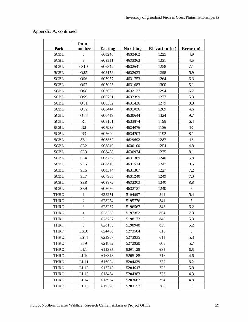
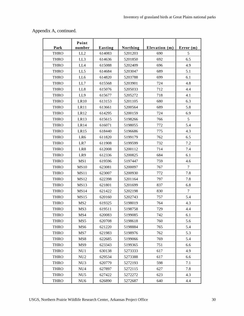
Appendix A. Global Positioning System locations of grassland bird point counts at seven nationalparks, monuments and battlefields in the Great Plains, 1998 to1999.
ParkPoint
number Easting Northing Elevation (m) Error (m)AGFO 1 604578 4698312 - 9
AGFO 2 603970 4697723 - 6.3
AGFO 3 603297 4697406 - 9.9
AGFO 4 602492 4697328 - 9.3
AGFO 5 601785 4697245 - 9.9
AGFO 6 601000 4697224 - 10
AGFO 7 601000 4697338 - 11
AGFO 8 599574 4097542 - 4.7
AGFO 9 599864 4697913 1371 6.8
AGFO 10 602692 4696677 1351 10
AGFO 11 601859 4696563 1348 6.4
AGFO 12 601170 4696327 1356 7.6
BADL MS1 258916 4848812 739 4.3
BADL MS2 741421 4849290 742 5.1
BADL MS3 740788 4849886 748 7.9
BADL MS4 740536 4851692 815 3.6
BADL MS5 739994 4852200 815 5.3
BADL MS6 739388 4852672 818 6.6
BADL MS7 738667 4852638 824 6.1
BADL MS8 738130 4853230 825 7.3
BADL MS9 737448 4853059 781 14
BADL MS10 736407 4853520 825 5.2
BADL MS11 736048 4852944 821 11
BADL MS12 735281 4852970 820 5.9
BADL MS13 734537 4852590 817 5.7
BADL MS14 733776 4852514 811 4.8
BADL MS15 733011 4852772 817 5.9
BADL NE1 265901 4851279 785 9.4
BADL NE2 265393 4850586 794 4.3
BADL NE3 264718 4850366 798 6.3
BADL NE4 264374 4849639 803 6.3
BADL NE5 264044 4849328 804 4.9
BADL NE6 263470 4849240 828 10
BADL NE7 263051 4849975 809 12
BADL NE8 263052 4850676 788 3.5
BADL NE9 263071 4851503 792 8.6
BADL NE10 262834 4847954 745 5.5
BADL NE11 262308 4848321 746 5.9
Inventory of grassland birds at Great Plains national parks
USGS, Northern Prairie Wildlife Research Center, Arkansas Project Office 27
Appendix A, continued.
ParkPoint
number Easting Northing Elevation (m) Error (m)BADL NE12 261665 4848522 746 9.6
BADL NE13 260928 4848821 735 5.1
BADL NE14 260170 4849117 741 5.1
BADL NE15 259709 4848709 746 5.4
BADL SC1 722373 4861008 977 5.2
BADL SC2 721676 4861400 943 5
BADL SC3 720900 4861157 947 4.9
BADL SC4 720590 4861533 943 4.8
BADL SC5 719976 4862125 927 4.5
BADL SC6 716266 4864701 916 5.7
BADL SC7 715571 4864486 908 46
BADL SC8 715040 4864284 914 4.1
BADL SC9 714339 4864439 916 3.9
BADL SC10 713813 4865001 907 11
BADL SC11 713661 4865675 908 5.9
BADL SC12 712418 4865553 905 5.8
BADL SC13 711840 4864905 855 5.1
BADL SC14 711003 4864820 836 5.2
BADL SC15 710569 4865019 838 6.7
BADL SC16 709845 4864911 839 6.8
BADL SC17 708879 4865190 827 7.1
BADL SC18 707975 4864992 775 5.5
BADL SC19 707943 4864202 776 5.5
BADL SC20 707819 4863441 778 7.9
BADL SC21 707071 4864360 794 11
BADL SC22 706990 4863649 860 7.2
BADL SC23 706443 4863153 874 7.7
BADL SM2 697887 4843001 861 5.5
BADL SM3 697098 4843134 675 6.6
BADL SM4 696346 4843071 884 5.1
BADL SM5 696550 4843380 881 5.4
BADL SM6 694975 4843156 892 5.1
BADL SM8 695043 4841632 917 7
BADL SM9 695103 4840911 972 6
BADL SM10 695363 4840159 972 6
BADL SM11 695622 4839395 990 10
BADL SM12 696031 4838739 998 5.8
BADL SM13 696076 4838085 991 7.1
Inventory of grassland birds at Great Plains national parks
USGS, Northern Prairie Wildlife Research Center, Arkansas Project Office 28
Appendix A, continued.
ParkPoint
number Easting Northing Elevation (m) Error (m)BADL SM14 695681 4837567 991 5.7
BADL UW1 732298 4853079 823 4.7
BADL UW2 731445 4853285 823 5.2
BADL UW3 730832 4853649 829 5
BADL UW4 730139 4854229 842 4.4
BADL UW5 729559 4854625 851 4.4
BADL UW6 728687 4854747 856 4.7
BADL UW7 728008 4854813 871 5.6
BADL UW8 727575 4855551 871 5.4
BADL UW9 727099 4856006 - 5.1
BADL UW10 727134 4856998 860 7.9
BADL UW11 726765 4857476 861 7
BADL UW12 726047 4857900 863 6.7
BADL UW13 725688 4858525 868 6.5
HOME 1 0684201 4462006 387 5.7
HOME 2 0694278 4461828 382 5.2
HOME 3 0684503 4461732 387 6.9
HOME 4 0684676 4461599 396 5.7
HOME 5 0684496 4461449 387 8.1
HOME 6 0684230 4461472 390 6.1
HOME 7 0684005 4461489 384 5.8
HOME 8 0683826 4461472 382 5.9
HOME 9 0683649 4461393 383 9.4
PIPE 1 0714376 4877146 504 6.7
PIPE 2 0714401 4876897 504 7
PIPE 3 0714658 4876830 512 7.1
PIPE 4 0714888 4876851 521 6.3
PIPE 5 0714546 4876544 503 2.8
PIPE 6 0714277 4876279 501 3.1
PIPE 7 0714906 4876386 516 6.3
PIPE 8 0714052 4876940 502 5.8
SCBL 1 607879 4630896 1271 5.8
SCBL 2 607272 4631219 1265 7.3
SCBL 3 606494 4631706 1268 7.1
SCBL 4 605965 4632446 1232 7.2
SCBL 5 606451 4634008 1218 8.8
SCBL 6 607146 4633773 1227 6.2
SCBL 7 607635 4633622 1220 5.2
Inventory of grassland birds at Great Plains national parks
USGS, Northern Prairie Wildlife Research Center, Arkansas Project Office 29
Appendix A, continued.
ParkPoint
number Easting Northing Elevation (m) Error (m)SCBL 8 608248 4633462 1225 4.9
SCBL 9 608511 4633262 1221 4.5
SCBL 0S10 606342 4632641 1258 7.1
SCBL OS5 608178 4632033 1298 5.9
SCBL OS6 607977 4631753 1264 6.3
SCBL OS7 607095 4631683 1300 5.1
SCBL OS8 607005 4632127 1294 6.7
SCBL OS9 606791 4632399 1277 5.3
SCBL OT1 606302 4631426 1279 8.9
SCBL OT2 606444 4631036 1289 4.6
SCBL OT3 606419 4630644 1324 9.7
SCBL R1 608101 4633874 1199 6.4
SCBL R2 607983 4634076 1186 10
SCBL R3 607600 4634203 1192 8.1
SCBL SE1 608532 4629692 1287 12
SCBL SE2 608840 4630100 1254 4.8
SCBL SE3 608458 4630974 1235 8.1
SCBL SE4 608722 4631369 1240 6.8
SCBL SE5 608418 4631514 1247 8.5
SCBL SE6 608344 4631307 1227 7.2
SCBL SE7 607965 4631240 1249 7.3
SCBL SE8 608872 4632203 1240 8.8
SCBL SE9 608636 4632727 1240 8
THRO 1 628271 5194997 844 5.4
THRO 2 628254 5195776 841 5
THRO 3 628237 5196567 848 6.2
THRO 4 628223 5197352 854 7.3
THRO 5 628207 5198172 840 5.3
THRO 6 628195 5198948 839 5.2
THRO ES10 624450 5273584 618 5
THRO ES11 623907 5273935 611 5.3
THRO ES9 624882 5272920 605 5.7
THRO LL1 613365 5201128 685 6.5
THRO LL10 616313 5205188 716 4.6
THRO LL11 616904 5204829 729 5.2
THRO LL12 617745 5204647 728 5.8
THRO LL13 618424 5204383 733 4.3
THRO LL14 618964 5203667 754 4.8
THRO LL15 619396 5203157 760 5
Inventory of grassland birds at Great Plains national parks
USGS, Northern Prairie Wildlife Research Center, Arkansas Project Office 30
Appendix A, continued.
ParkPoint
number Easting Northing Elevation (m) Error (m)THRO LL2 614083 5201203 690 5
THRO LL3 614636 5201850 692 6.5
THRO LL4 615088 5202409 696 4.9
THRO LL5 614684 5203047 689 5.1
THRO LL6 614820 5203788 699 6.1
THRO LL7 615568 5203901 724 4.8
THRO LL8 615076 5205033 712 4.4
THRO LL9 615677 5205272 718 4.1
THRO LR10 613153 5201105 680 6.3
THRO LR11 613661 5200564 689 5.8
THRO LR12 614295 5200159 724 6.9
THRO LR13 615615 5198266 766 5
THRO LR14 616071 5198055 772 5.4
THRO LR15 618440 5196686 775 4.3
THRO LR6 611820 5199179 762 6.5
THRO LR7 611908 5199599 732 7.2
THRO LR8 612008 5200112 714 7.4
THRO LR9 612336 5200825 684 6.1
THRO MS1 619596 5197447 759 4.6
THRO MS10 623081 5200097 767 7
THRO MS11 623007 5200930 772 7.8
THRO MS12 622398 5201164 797 7.8
THRO MS13 621801 5201699 837 6.8
THRO MS14 621422 5202198 830 7
THRO MS15 620160 5202743 757 5.4
THRO MS2 619325 5198019 764 4.3
THRO MS3 619511 5198758 729 4.4
THRO MS4 620083 5199085 742 6.1
THRO MS5 620708 5198618 760 5.6
THRO MS6 621220 5198884 765 5.4
THRO MS7 621983 5198976 762 5.3
THRO MS8 622685 5199066 769 5.4
THRO MS9 623343 5199365 751 6.6
THRO NU1 630138 5273333 617 4.9
THRO NU2 629534 5273388 617 6.6
THRO NU3 620779 5272193 598 7.1
THRO NU4 627897 5272115 627 7.8
THRO NU5 627422 5272272 623 4.3
THRO NU6 626890 5272687 640 4.4

Inventory of grassland birds at Great Plains national parks
USGS, Northern Prairie Wildlife Research Center, Arkansas Project Office 31
Appendix A, continued.
ParkPoint
number Easting Northing Elevation (m) Error (m)THRO NU7 626290 5272631 626 4.1
THRO NU8 625499 5272449 599 5.2
THRO SS1 612076 5197884 725 4.3
THRO SS2 612675 5197778 722 5.4
THRO SS3 613591 5198418 753 6.6
THRO SS4 612941 5198569 771 4.7
THRO SS5 612284 5198811 773 5.8
THRO WS12 623082 5274130 630 6.9
THRO WS13 621747 5274941 744 7
THRO WS14 621646 5275713 760 5.4
THRO WS15 621007 5276001 760 6.1
THRO WS16 620354 5276017 746 5.6
THRO WS17 619467 5275982 734 5.6
THRO WS18 618309 5275072 743 6.2
THRO WS19 617740 5274758 745 4.7
THRO WS20 617664 5274069 722 5.1
THRO WS21 616902 5273924 718 6.8
THRO WS22 616941 5273365 721 5.4
WICR 1 0464398 4106449 317 10
WICR 2 0464025 4105634 317 11
WICR 3 0463917 4104828 345 7.1
WICR 4 0463479 4105289 361 7.2
WICR 5 0463177 4106068 357 6.7
WICR 6 0463054 4106809 367 16
WICR 7 0462934 4107522 358 18
WICR 8 0463654 4107720 340 18
WICR 9 0464219 4107338 352 7.7
WICR 10 0464364 4105376 363 13
WICR 11 0464507 4104778 379 6.8
WICR 12 0464214 4104122 332 5.9
WICR 13 0462992 4104794 353 8.6
WICR 14 0463104 4104164 349 8
WICR 15 0463877 4104028 354 8.1
WICR 16 0463740 4106000 329 10
WICR 17 0464189 4107267 317 12
WICR 18 0463831 4107529 342 17
AGFO = Agate Fossil Beds National Monument, BADL = Badlands National Park, HOME = Homestead NationalMonument, PIPE = Pipestone National Monument, SCBL = Scotts Bluff National Monument, THRO = TheodoreRoosevelt National Park, WICR = Wilson’s Creek National Battlefield.

Grassland Birds Surveys in Great Plains National Parks
USGS, Northern Prairie Wildlife Research Center, Arkansas Project Office 32
Appendix B. Sample datasheets for point count data.
ORIGINAL DATA SHEET
Observer Date Location
0 - 3 minutes 3 - 5 minutesPoint # Time Species
50 m 50-100 m fly over 50 m 50-100 m fly over

Inventory of grassland birds at Great Plains national parks
USGS, Northern Prairie Wildlife Research Center, Arkansas Project Office 33
Appendix B, continued.
ESTIMATED DISTANCE DATA SHEET
Observer Date Location
0 - 3 minutes 3 - 5 minutes
Point Time Species Total Distance(m)fly
over Total Distance(m)fly
over
Grassland Birds Surveys in Great Plains National Parks
USGS, Northern Prairie Wildlife Research Center, Arkansas Project Office 34
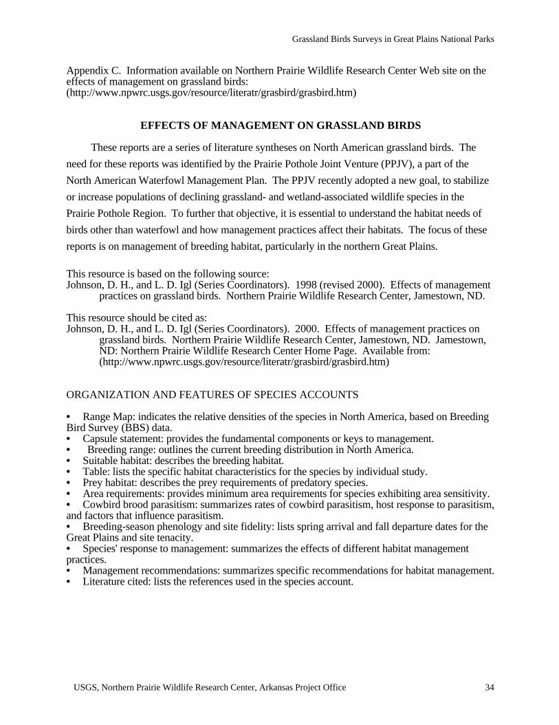
Appendix C. Information available on Northern Prairie Wildlife Research Center Web site on theeffects of management on grassland birds:(http://www.npwrc.usgs.gov/resource/literatr/grasbird/grasbird.htm)
EFFECTS OF MANAGEMENT ON GRASSLAND BIRDS
These reports are a series of literature syntheses on North American grassland birds. The
need for these reports was identified by the Prairie Pothole Joint Venture (PPJV), a part of the
North American Waterfowl Management Plan. The PPJV recently adopted a new goal, to stabilize
or increase populations of declining grassland- and wetland-associated wildlife species in the
Prairie Pothole Region. To further that objective, it is essential to understand the habitat needs of
birds other than waterfowl and how management practices affect their habitats. The focus of these
reports is on management of breeding habitat, particularly in the northern Great Plains.
This resource is based on the following source:Johnson, D. H., and L. D. Igl (Series Coordinators). 1998 (revised 2000). Effects of management
practices on grassland birds. Northern Prairie Wildlife Research Center, Jamestown, ND.
This resource should be cited as:Johnson, D. H., and L. D. Igl (Series Coordinators). 2000. Effects of management practices on
grassland birds. Northern Prairie Wildlife Research Center, Jamestown, ND. Jamestown,ND: Northern Prairie Wildlife Research Center Home Page. Available from:(http://www.npwrc.usgs.gov/resource/literatr/grasbird/grasbird.htm)
ORGANIZATION AND FEATURES OF SPECIES ACCOUNTS
• Range Map: indicates the relative densities of the species in North America, based on BreedingBird Survey (BBS) data.• Capsule statement: provides the fundamental components or keys to management.• Breeding range: outlines the current breeding distribution in North America.• Suitable habitat: describes the breeding habitat.• Table: lists the specific habitat characteristics for the species by individual study.• Prey habitat: describes the prey requirements of predatory species.• Area requirements: provides minimum area requirements for species exhibiting area sensitivity.• Cowbird brood parasitism: summarizes rates of cowbird parasitism, host response to parasitism,and factors that influence parasitism.• Breeding-season phenology and site fidelity: lists spring arrival and fall departure dates for theGreat Plains and site tenacity.• Species' response to management: summarizes the effects of different habitat managementpractices.• Management recommendations: summarizes specific recommendations for habitat management.• Literature cited: lists the references used in the species account.

Inventory of grassland birds at Great Plains national parks
USGS, Northern Prairie Wildlife Research Center, Arkansas Project Office 35
Appendix C, contiuned.
SPECIES ACCOUNTS
Below is a list of species for which syntheses are available. These species accounts will be updated
as necessary.
American Bittern Baird's SparrowMountain Plover Henslow's SparrowMarbled Godwit Le Conte's SparrowLong-billed Curlew Nelson's Sharp-tailed SparrowWillet Vesper SparrowWilson's Phalarope Savannah SparrowUpland Sandpiper Lark SparrowGreater Prairie-Chicken* Field SparrowNorthern Harrier Clay-colored SparrowSwainson's Hawk Chestnut-collared LongspurFerruginous Hawk McCown's LongspurShort-eared Owl DickcisselBurrowing Owl Lark BuntingHorned Lark BobolinkSedge Wren Eastern MeadowlarkLoggerhead Shrike Western MeadowlarkSprague's Pipit Brown-headed Cowbird**Grasshopper Sparrow
* not completed** should be available 11/00
Inventory of grassland birds at Great Plains national parks
USGS, Northern Prairie Wildlife Research Center, Arkansas Project Office 36
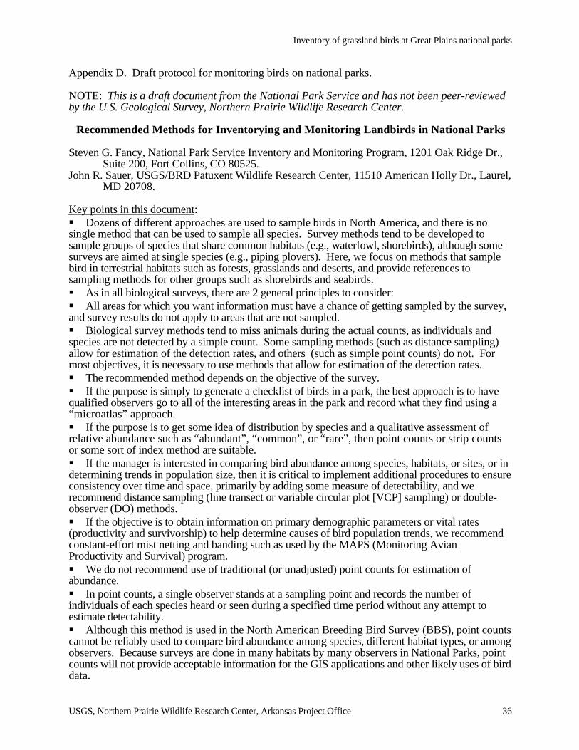
Appendix D. Draft protocol for monitoring birds on national parks.
NOTE: This is a draft document from the National Park Service and has not been peer-reviewedby the U.S. Geological Survey, Northern Prairie Wildlife Research Center.
Recommended Methods for Inventorying and Monitoring Landbirds in National Parks
Steven G. Fancy, National Park Service Inventory and Monitoring Program, 1201 Oak Ridge Dr.,Suite 200, Fort Collins, CO 80525.
John R. Sauer, USGS/BRD Patuxent Wildlife Research Center, 11510 American Holly Dr., Laurel,MD 20708.
Key points in this document:§ Dozens of different approaches are used to sample birds in North America, and there is nosingle method that can be used to sample all species. Survey methods tend to be developed tosample groups of species that share common habitats (e.g., waterfowl, shorebirds), although somesurveys are aimed at single species (e.g., piping plovers). Here, we focus on methods that samplebird in terrestrial habitats such as forests, grasslands and deserts, and provide references tosampling methods for other groups such as shorebirds and seabirds.§ As in all biological surveys, there are 2 general principles to consider:§ All areas for which you want information must have a chance of getting sampled by the survey,and survey results do not apply to areas that are not sampled.§ Biological survey methods tend to miss animals during the actual counts, as individuals andspecies are not detected by a simple count. Some sampling methods (such as distance sampling)allow for estimation of the detection rates, and others (such as simple point counts) do not. Formost objectives, it is necessary to use methods that allow for estimation of the detection rates.§ The recommended method depends on the objective of the survey.§ If the purpose is simply to generate a checklist of birds in a park, the best approach is to havequalified observers go to all of the interesting areas in the park and record what they find using a“microatlas” approach.§ If the purpose is to get some idea of distribution by species and a qualitative assessment ofrelative abundance such as “abundant”, “common”, or “rare”, then point counts or strip countsor some sort of index method are suitable.§ If the manager is interested in comparing bird abundance among species, habitats, or sites, or indetermining trends in population size, then it is critical to implement additional procedures to ensureconsistency over time and space, primarily by adding some measure of detectability, and werecommend distance sampling (line transect or variable circular plot [VCP] sampling) or double-observer (DO) methods.§ If the objective is to obtain information on primary demographic parameters or vital rates(productivity and survivorship) to help determine causes of bird population trends, we recommendconstant-effort mist netting and banding such as used by the MAPS (Monitoring AvianProductivity and Survival) program.§ We do not recommend use of traditional (or unadjusted) point counts for estimation ofabundance.§ In point counts, a single observer stands at a sampling point and records the number ofindividuals of each species heard or seen during a specified time period without any attempt toestimate detectability.§ Although this method is used in the North American Breeding Bird Survey (BBS), point countscannot be reliably used to compare bird abundance among species, different habitat types, or amongobservers. Because surveys are done in many habitats by many observers in National Parks, pointcounts will not provide acceptable information for the GIS applications and other likely uses of birddata.
Inventory of grassland birds at Great Plains national parks
USGS, Northern Prairie Wildlife Research Center, Arkansas Project Office 37
Appendix D, continued.
§ We recommend that point count protocols can be modified using VCP or double-observermethods to allow estimates of detectability for many species and yet still allow comparisons tohistorical data obtained with unadjusted point counts.§ Use of methods that allow for estimation of detectability are recommended for projects fundedby the NPS Inventory and Monitoring Program. We think that the improvement in the quality andcredibility of data compared to that obtained by unadjusted point counts more than justifies theincrease in cost and effort required to incorporate an estimate of detectability.§ Distance sampling or the double-observer approach are the default methods. Any proposal touse unadjusted point counts or some other index method when the objective is to comparedifferences among species or provide population trend information must provide good justificationfor why the better methods cannot be used.§ Although distance sampling requires additional training and is not a panacea for all species, itcan and is being done throughout the country in many types of habitats.
IntroductionBirds are an important component of park ecosystems, and their high body temperature, rapid
metabolism, and high ecological position in most food webs make them a good indicator of theeffects of local and regional changes in ecosystems. Moreover, birds have a tremendous followingamong the public, and many parks provide information on the status and trends of birds in the parkthrough their interpretive program. More than 650 species of birds breed in North America. Mostcommon survey methods allow simultaneous collection of information about species that share acommon life history or habitat, but no single method will adequately sample the diversity of eitherhabitats that birds occupy or life history groups such as seabirds, songbirds, raptors, and shorebirdsall bird species. Hundreds of different sampling approaches have been used to quantify status ortrend of bird populations, and dozens of different monitoring programs are currently in placethroughout North America to determine local, regional, or national trends in bird numbers. Thewebsite http://www.mp1-pwrc.usgs.gov/ birds.html has information on 20 different bird monitoringprograms used in North America.
The purpose of this document is to help busy natural resource managers in national parks(and their contractors and cooperators) find the most appropriate methods for inventorying andmonitoring bird populations in the hopes of developing some consistency in bird samplingapproaches among parks and regional efforts. The appendix lists some recommended methods andsources of additional information for surveys of raptors, shorebirds, marsh birds, and colonial-nesting birds, but our focus is on methods that are appropriate for simultaneously sampling a largenumber of terrestrial bird species in a variety of habitats such as forests, deserts and grasslands.We identify some of the problems with existing programs that should be avoided, and highlightsome of the promising, recent developments in the art and science of bird counting that people maynot be aware of.
We think that it is especially important to use consistent methods to sample birds so that datacan be compared among parks and to samples taken outside of parks. Sample sizes for birdsurveys in parks will usually be small because of limitations of personnel and funding, andcomparison with other sites will help put the park’s data in context and may help to interpret theresults. Because of the annual variability in most biological indicators, it may require 10 or moreyears of data to identify population trends. By adding the spatial dimension (comparisons to otherlocations) to the temporal dimension (repeated surveys over time), it may be possible to identifypatterns sooner, and to develop partnerships to respond to problems that are identified.
In the next sections, we identify 4 general objectives, and discuss approaches to meeting theobjectives. In our view, any survey must be reviewed in light of 3 primary concepts: (1) Objectives– to adequately develop a survey, some goal must be clearly stated so that the design can bespecified and a clear product will be produced that can be evaluated by predefined criteria; (2)Sampling Frame – to conduct a statistically valid survey, you have to randomly select
Inventory of grassland birds at Great Plains national parks
USGS, Northern Prairie Wildlife Research Center, Arkansas Project Office 38
Appendix D, continued.
samples from a list of all possible samples. The list is called the sampling frame. This samplingframe defines the area to which your survey actually applies, and must be defined as part of thesurvey development; and (3) Detectability – we miss birds during counting, and to conduct acredible survey we either have to assume that the number missed does not vary over space and timeor we have to incorporate some method of figuring out how many birds are missed. For eachobjective, we briefly note some of the issues associated with sampling frames and detectability.
Objective 1: The goal of the survey is to simply document which species occur in the park.
The recommended approach here is to have qualified birders go to different areas of thepark and record which species they find there to produce a checklist. A good inventory usuallyrequires multiple visits and methods at different times of the year in order to document the rarespecies that are often of greatest interest. A fairly complete inventory may require considerableeffort to survey all habitats and different seasons to increase the chance of detecting most speciesthat occur in the park.
The park must provide some structure to this effort to ensure that the information will becredible. The following should be kept in mind as you plan the inventory: (1) Evaluate anddocument the skill level of each observer - Observers should be able to identify all birds that mightbe seen in the park; the success and credibility of the survey will depend on using well-trained,experienced observers; (2) Record keeping – survey data including species encountered, locations,dates, evidence of breeding status, and other relevant information must be appropriately stored incomputer files; (3) Taxa and habitats of interest must be adequately surveyed - as in all surveys, ifsome areas (or species groups) are not sampled, we cannot claim to have surveyed them.
To ensure adequate and extensive coverage, we recommend that a “sampling framework”such as a grid or some other map-based areas be developed, and that sampling be encouraged in allareas. A grid (such as UTM cells) could be placed over the park, and observers asked to keepseparate lists for each cell in the grid. In that way, information can be integrated with other parkdata using the park GIS at the scale of the grid cells. Other possibilities for collecting informationat more local scales include defining areas (strata) for surveying based on permanent features suchas roads, trails, rivers, or other features. We also suggest that particular habitats and species groupsbe targeted for special counting effort.
Estimating Total (and Relative) number of Species - Of course, no one will count all species,and it is difficult to figure out how much sampling is sufficient to get a good species list. Oneapproach is to use statistical procedures with checklist data to estimate the number of speciesmissed (i.e., the detectability of species) during counting. These procedures, which have beenapplied to bird count data (e.g. Boulinier et al. 1998), are based on capture-recapture methods, inwhich a “capture” is a species seen by a birder and the total number is estimated from the patternof species’ occurrences among birders. Using these procedures, it is possible to calculate speciesrichness for the park, or for different strata within the park (e.g., different vegetation types orelevation zones; see the paper by Nichols and Conroy 1996). The programs CAPTURE andSPECRICH, available at http://www.mbr-pwrc.usgs.gov/software.html, allow you to enter data fromone or more surveys and calculate species richness online. These procedures do not identifyspecies that are not seen, but they do provide an estimate of the number of species that have not yetbeen encountered but are likely to be present. This allows an assessment of the adequacy of thesampling that has been conducted (e.g., have you recorded 90% of the species that occur in thepark?)
To estimate species richness for the entire park or for different strata within the park, youshould have people with similar skill in detecting birds visit each of the areas of interest andgenerate a checklist using some standardized approach that will ensure that they could encounter allthe targeted species. Each observer must be capable of identifying each species, and each speciesmust have some chance of being detected. Hence, to survey a subset of species such as nocturnalbirds or marsh birds (that only call at night or when stimulated by playback of recordings), all
Inventory of grassland birds at Great Plains national parks
USGS, Northern Prairie Wildlife Research Center, Arkansas Project Office 39
Appendix D, continued.
checklist participants must maintain a protocol that would allow them to encounter the species.Generally, 5 replicate checklists are needed for each sample site to apply the statistical estimationprocedures (Nichols and Conroy 1996).
Objective 2: The goal of the survey is to determine distribution and get a qualitative measure ofrelative abundance (“abundant”, “common”, “rare”) of each species in the park.
There are many different ways to generate distribution maps using either direct sampling ormodeling approaches, but in each case it is important to develop a statistical sampling design thatallows inferences to be made beyond the areas actually sampled. The document “Guidance for thedesign of sampling schemes for inventory and monitoring biological resources in national parks”available at http://www.nature.nps.gov/sfancy gives some examples of how to select sample sitessuch that data from those sites can be used to make inferences to specific strata or the entire park.
One method appropriate for this objective is the standard (or “unadjusted”) Point Count, inwhich an observer stands at a predefined location and counts birds with a specific protocol. ThePoint Count method is currently the most common method of monitoring birds, and is used in theBBS, National Wildlife Refuge monitoring programs, National Forest monitoring programs (e.g.Manley et al. 1995), and to assist management efforts associated with Partners in Flight (Ralph etal. 1995). Counts are usually most effective during the breeding season, when singing rates arehigher. Details of the method and field data forms are available in Ralph et al. (1995).
Point counts provide a great deal of information, and are generally easy to implement. Theycan be used to estimate species richness by strata, and the results can be used to classify the relativeabundance of each species into categories such as “abundant”, “common”, “uncommon”, and“rare”. Standardization of methods and observer training is essential in ensuring some level ofcomparability of results. The difficulty with point counts is that people often use the results as ameasure of differences in bird population size over time or among locations. Unfortunately, thenumber of birds that are counted at a sampling station is actually a combination of the number ofbirds that are actually there, and the proportion of them that you detect. Many people interpretdifferences between two point counts as the difference in number of birds, when in fact thedifference may be caused entirely by differences in detectability. Without a measure ofdetectability, counts of birds are an unreliable measure of differences in the actual number of birdspresent. Burnham (1981) wrote that “Without estimating detection probabilities, the use of countsas indices of abundance is scientifically unsound and unreliable”. Barker and Sauer (1995) foundthat the incomplete counts obtained by point counts “can bias estimators and testing procedures,leading to inappropriate conclusions. A large portion of the variability in point counts is caused bythe incomplete counting, and this within-count variation can be confounded with ecologicallymeaningful variation”. Nichols et al. (2000) wrote that "We believe that most questions meritingthe effort required to carry out point counts also merit serious attempts to estimate detectionprobabilities associated with the counts". We concur.
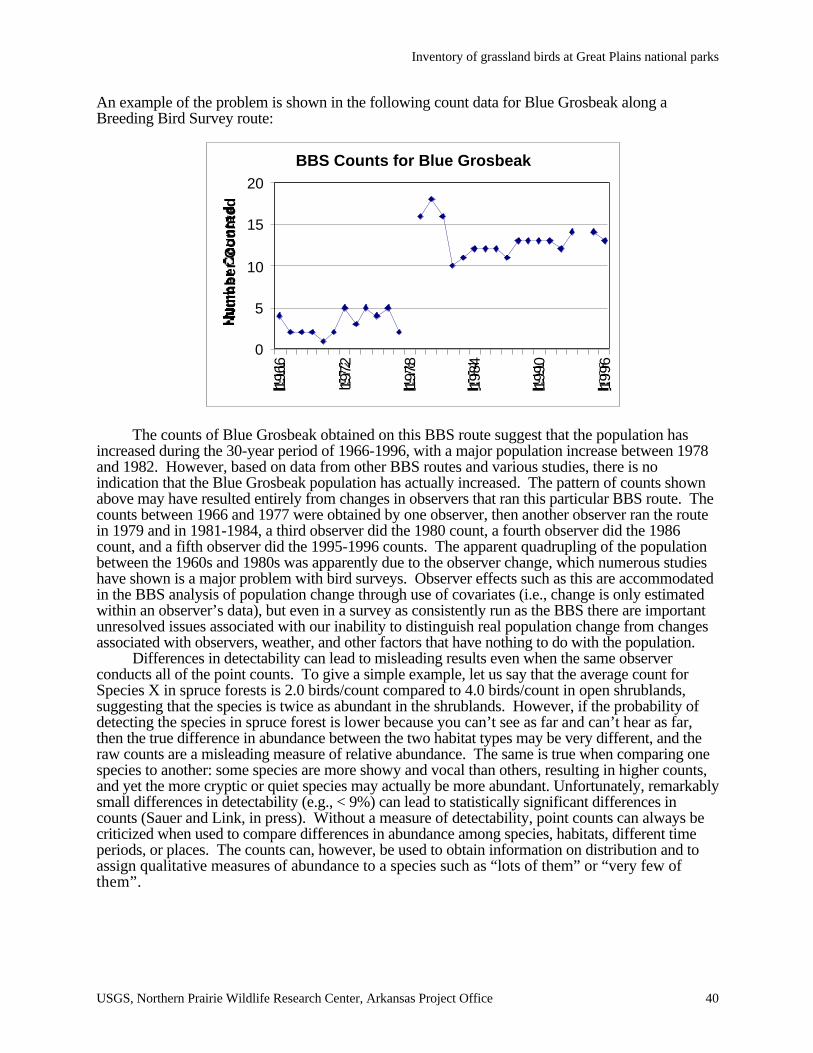
Inventory of grassland birds at Great Plains national parks
USGS, Northern Prairie Wildlife Research Center, Arkansas Project Office 40
An example of the problem is shown in the following count data for Blue Grosbeak along aBreeding Bird Survey route:
The counts of Blue Grosbeak obtained on this BBS route suggest that the population hasincreased during the 30-year period of 1966-1996, with a major population increase between 1978and 1982. However, based on data from other BBS routes and various studies, there is noindication that the Blue Grosbeak population has actually increased. The pattern of counts shownabove may have resulted entirely from changes in observers that ran this particular BBS route. Thecounts between 1966 and 1977 were obtained by one observer, then another observer ran the routein 1979 and in 1981-1984, a third observer did the 1980 count, a fourth observer did the 1986count, and a fifth observer did the 1995-1996 counts. The apparent quadrupling of the populationbetween the 1960s and 1980s was apparently due to the observer change, which numerous studieshave shown is a major problem with bird surveys. Observer effects such as this are accommodatedin the BBS analysis of population change through use of covariates (i.e., change is only estimatedwithin an observer’s data), but even in a survey as consistently run as the BBS there are importantunresolved issues associated with our inability to distinguish real population change from changesassociated with observers, weather, and other factors that have nothing to do with the population.
Differences in detectability can lead to misleading results even when the same observerconducts all of the point counts. To give a simple example, let us say that the average count forSpecies X in spruce forests is 2.0 birds/count compared to 4.0 birds/count in open shrublands,suggesting that the species is twice as abundant in the shrublands. However, if the probability ofdetecting the species in spruce forest is lower because you can’t see as far and can’t hear as far,then the true difference in abundance between the two habitat types may be very different, and theraw counts are a misleading measure of relative abundance. The same is true when comparing onespecies to another: some species are more showy and vocal than others, resulting in higher counts,and yet the more cryptic or quiet species may actually be more abundant. Unfortunately, remarkablysmall differences in detectability (e.g., < 9%) can lead to statistically significant differences incounts (Sauer and Link, in press). Without a measure of detectability, point counts can always becriticized when used to compare differences in abundance among species, habitats, different timeperiods, or places. The counts can, however, be used to obtain information on distribution and toassign qualitative measures of abundance to a species such as “lots of them” or “very few ofthem”.
BBS Counts for Blue Grosbeak
0
5
10
15
20
1966
1972
1978
1984
1990
1996
Nu
mb
er
Co
un
ted
Inventory of grassland birds at Great Plains national parks
USGS, Northern Prairie Wildlife Research Center, Arkansas Project Office 41
Appendix D, continued.
Note: These comments just begin to touch on an important controversy in biological sampling.Estimation of detection rates is considered by statisticians to be essential in any sampling that is nota “census.” As biologists with field experience, we are sympathetic to the need to develop feasiblemethods. However, it is essential that the information be scientifically credible and defensible sothat it can be relied upon to make resource management decisions. In our view, point counts that donot incorporate some procedure for estimating detectability do not meet this standard.
One common modification of point counts is to play recorded calls to increase probability ofdetecting rare or secretive species such as marsh-breeding or nocturnal species. Sample protocolsfor these species are referenced in the Appendix. Because the number of species encountered inthese surveys is usually quite small, it is difficult to apply the statistical methods for estimatingspecies richness, and the counts of both species and relative abundance of species are used as thedependent variables. It may be practical to include the playback procedures at a subset of points inhabitats appropriate to the targeted species. Broadcasting the taped calls after the standard countperiod could increase the chance of detecting the targeted species.
Objective 3: The goal of the survey is to compare relative abundance among species, habitats orareas, or to detect trends in population size.
As indicated in #2 above, the number of birds you count at a sampling station is acombination of the number that is actually there and the proportion of them that you detect duringthe count. Very rarely do you count all of the birds that are actually present, and to meet theobjectives stated in #3 you need to estimate the proportion of birds that you miss. We recommendthat you use one of two methods to meet this objective: either Distance Sampling or the DoubleObserver Approach. Each is explained below, with greater emphasis on Distance Sampling becauseit is the most established of the two and can be conducted by only one person.
Distance Sampling.Distance sampling, which includes both line transect sampling and variable circular plot
(VCP) counts, has been used for more than 30 years to estimate animal abundance and for mostsampling situations is the best method currently available for determining relative abundance ortrends for most bird species. In practice, the method is basically the same as unlimited distancepoint counts, except that for each bird heard or seen during the count, its horizontal distance fromthe observer is estimated. In the case of line transect sampling, the observer walks down a transectand records either the perpendicular distance to each bird heard or seen, or else records the sightingangle and sighting distance instead of the perpendicular distance. Variable circular plots are a typeof distance sampling where the observer stands at a sampling station and records the horizontaldistances between the observer and each bird. Line transects are usually more efficient than VCPcounts where they can be conducted because you continually collect data as you walk down thetransect, whereas during VCP counts you count birds only from stations located every 250 m orsome interval along the transect. However, VCP counts are the preferred approach in patchyhabitats if you want to associate bird data with vegetation or other habitat information, and in dense,rugged or hazardous terrain where you need to watch your footing as you walk down the transect.Another advantage of VCP counts is that the data can be directly compared to historical point countdata such as from BBS counts and can contribute to ongoing programs such as the National PointCount Database.
Distance sampling is currently being used to sample birds in various national park settingsthroughout the country. VCP counts have been used to sample birds in parks in Hawaii for morethan 20 years, and several field tests have been conducted in Hawaii that validate the method (e.g.,Fancy 1997, Nelson and Fancy 1999). Channel Islands NP has been conducting line transectsampling and VCP counts to monitor landbirds since 1993, and VCP counts are currently beingused for bird inventories in Yukon-Charley NPP and Great Smoky Mountains NP. We need toemphasize, however, that although distance sampling generally does improve estimates ofabundance and population trends for many species, it is not a panacea and there are a number of
Inventory of grassland birds at Great Plains national parks
USGS, Northern Prairie Wildlife Research Center, Arkansas Project Office 42
Appendix D, continued.
limitations of the method even with the best trained and most highly skilled observers. Forexample, in many surveys, the majority of birds are heard but not seen, and the observer estimatesthe distance to a tree or bush or other object where they think the bird is hiding. Distances cannotbe estimated accurately in many situations because of habitat complexity or ventriloqual bird voicesor other reasons. Also, more than 100 detections may be required to develop a good detectionfunction for each species, such that multiple surveys of the same area will be required for all but themost common species in order to get adequate sample sizes.
Occasionally, there are detectability issues in bird sampling that VCP and other estimationprocedures cannot address. For example, there may be unobservable portions of the population(such as females) that are not detected at all during counting. Or, it may be impossible to estimatedetectability at the appropriate scale, for example when habitat-specific detectability exists in a rarespecies. Thus, even with a measure of detectability factored into estimates derived from counts ofbirds, such estimates may still be an unreliable measure of differences in the actual number of birdspresent in some situations. Interpretation of survey data requires a sensitivity to these extra-statistical limitations of the estimation procedures.
Nevertheless, we recommend distance sampling as the best method currently available formeeting this objective of collecting abundance or trend information. There have been a number ofrecent developments with distance sampling that now make it easier to implement both in the fieldand with data analysis:• The book “Distance sampling: estimating abundance of biological populations” by Bucklandet al. (1993) provides a good background of the theory and specific details of distance sampling.• Distances do not have to be estimated exactly in the field as some earlier reports suggested.Distances that are recorded as accurately as possible in the field can then be placed into distanceintervals and analyzed as grouped data, such as 0-16 m, 17-32 m, 33-48 m, etc. When data areanalyzed in distance intervals, there is no error as long as the estimated distance to the bird is placedin the correct interval. Laser rangefinders are now available in the $200 to $300 range that canmeasure the distance to a rock or tree within 1% accuracy, and these can be used in certainsituations for training and to improve distance estimates during counts (distances to variousreferences points around each sampling station can be estimated prior to the start of the count).• Data from repeated surveys of the same area or areas with similar habitat characteristics can becombined to increase sample sizes. By combining surveys, it is possible to estimate densities ofmany rare species, even in situations where only 1 or 2 birds are detected while sampling 30-40stations.• It is possible to adjust for different covariates such as the observer effect, and effects of densevegetation or weather on detection distances. Version 4 of the DISTANCE program will allow youto model covariates directly in the software.• It is still possible to use historical count data collected using unadjusted point counts if a parkswitches to VCP counts but records the number of birds detected during the same duration ofsampling. For example, if you have been running a BBS route in the park for 20 years, you canstill make direct comparisons between the new data if you conduct VCP counts and recorddetections made during the first 3 minutes with the old data for each sample location and species.To compare with historical 5-minute point counts as well as BBS data, you could record those birdsdetected during the first 3 minutes, and then indicate those detected in the next 2 minutes of a 5-minute count.• Version 4 of the DISTANCE software, due out in Fall 2000, will have a number of featuresspecifically designed to make it easier to analyze bird count data. It will be possible to program adata entry form that matches your field form to make it easier to enter data into the program. Thesoftware will allow you to combine data from multiple surveys, and covariates such as differentobservers can be modeled directly in the program. The software will be free, and a number ofpeople in the National Park Service or partner agencies will be trained to analyze data – you do notneed to be able to analyze your data to use this method.
Inventory of grassland birds at Great Plains national parks
USGS, Northern Prairie Wildlife Research Center, Arkansas Project Office 43
Appendix D, continued.
• The NPS I&M program is in the process of developing materials to help parks implementdistance estimation in parks, including data forms, training materials, and assistance with datamanagement and analysis. Check the website http://www.nature.nps.gov/sfancy after June 2000 forinformation and examples that are available.
Double-observer Counting
Double-observer counting provides an alternative method of modifying point counts to incorporatedetectability information. In this procedure, two observers count at each point. One observer is the“primary,” who counts all birds they see or hear. A “secondary” observer records the birdsdetected by the primary observer, but also notes any birds missed during counting by the primaryobserver. The two observers alternate roles between points, so that for any area of interest the datawill have replicate points at which each observer was primary. Using these data, the proportion ofbirds missed by each counter can be estimated (Cook and Jacobson 1979, Nichols et al. 2000).This procedure has only recently been implemented for point counts, but it appears to providereasonable results (Nichols et al. 2000). A few comments:• General protocols for point counts, such as standardized criteria for duration and conditions forcounting, can be followed for both double-observer and VCP counts. However, both proceduresgreatly enhance the quality of the information from the counts, by allowing for estimation ofdetectability. Double-observer counts also have intrinsically-higher detection rates than unadjustedpoint counts, simply because two observers are counting.• Double-observer methods require that birds be counted within a fixed radius to allow arigorously-defined area for estimation of density. The fixed radius also eliminates the possibilitythat differences in detectability between observers represents differences in area counted byobservers.• Detectability can only be estimated when both observers have counted as primary observers.Consequently, if habitat-specific detection rates are needed (and they generally are needed), it mustbe ensured that sufficient replicates exist within each habitat type to allow each observer to beprimary at more than one point.• Sample field sheets and specific protocols for a double-observer study are available on requestfrom the USGS Patuxent Wildlife Research Center.• Computer programs exist for estimation of detection rates from double-observer surveys (J. E.Hines, USGS Patuxent Wildlife Research Center, Laurel, MD).
General Comment on Detectability Estimation
Bird surveys tend to be omnibus, in that the survey is designed to count many species at thesame point. Unfortunately, this limits our ability to modify the surveys to increase the efficiencyfor any particular species. Consequently, most surveys collect good information for a few species,and relatively poor information for many species. This is not a reflection of the quality of theestimation procedure, but instead reflects the lower quality of all information for these lowabundance species. This should be a warning sign for any use of the data for those species, not justfor the estimation of detectability.
Objective 4: The goals of the monitoring effort are to aid in determining the causes of populationtrends and differences in abundance among species, habitats, and areas; and to identify and evaluatemanagement actions to reverse declining trends and increase low population sizes.
The use of point counts that include measures of detectability can provide estimates ofabundance or density of landbirds, and can facilitate analyses to determine population trends anddifferences in abundance among species, habitats, and geographic areas. These methods, however,fail to provide data on the primary demographic parameters or vital rates (productivity andsurvivorship) of landbirds. Without data on vital rates, it is difficult to test competing hypotheses to
Inventory of grassland birds at Great Plains national parks
USGS, Northern Prairie Wildlife Research Center, Arkansas Project Office 44
Appendix D, continued.
account for observed population changes, or even to determine the stage(s) in the life cycle at whichpopulation change is taking place; that is, whether the change is being driven by causal agents thataffect birth rates or death rates or both. This information is critical for most landbird species,especially those for which death rates are driven primarily by factors operating on their winteringgrounds, often thousands of kilometers removed from their breeding grounds.
Monitoring the vital rates of landbirds allows the construction of demographic models toassess the viability of populations, aids efforts to identify management actions to reverse populationdeclines, and facilitates evaluating the effectiveness of those remedial management actions. This isbecause environmental stressors and management actions affect vital rates directly and usuallywithout the buffering or time lags that often occur with population trends. Moreover, habitat- andlandscape-specific data on vital rates provide a clear index of habitat and landscape quality, and canidentify population sources and sinks.
The technique of constant-effort mist netting and banding is a tested and proven method forcollecting information on vital rates of landbirds. Annual indices of productivity and adultpopulation size are obtained from analyses of data on the numbers of young and adult birdscaptured; annual estimates of adult survival rate, adult population size, proportion of residents in theadult population, and recruitment into the adult population are obtained from modified Cormack-Jolly-Seber analyses of mark-recapture data. The technique has been in standardized use since1982 in the British Constant Effort Sites Scheme, and since 1992 in North America in theMonitoring Avian Productivity and Survivorship (MAPS) Program. MAPS protocol is currentlyused in both Denali and Shenandoah National Parks as part of their Long-Term EcologicalMonitoring (LTEM) efforts, and 37 MAPS stations are currently being operated in 17 NPS unitsnationwide. The standardized nature of MAPS data and the continental scope of the program, withover 500 stations operated annually, means that data on vital rates of landbirds from NPS units canbe directly compared to each other and to data from >100 stations on national forests, >100 stationson DoD military installations, and >270 stations on other federal, state, and private landholdings.
A MAPS station includes a permanent array of about ten mist nets located in the core eighthectares of a 20-ha study area. MAPS protocol includes the standardized operation of these netsfor about six morning hours during one day per 10-day period, for six to ten (depending onlatitude) consecutive 10-day periods between May or early June and early August. All birdscaptured are identified to species, age, and sex and, if unbanded, are banded with USGS/BRDnumbered bands. Additionally, the apparent breeding status of each species encountered at thestation is determined each year, and habitat structure within and surrounding the station is assessedaccording to a standardized protocol. These combined protocols allow landscape-leveldemographic data for a whole suite of landbirds species to be collected in a cost-effective, nationallystandardized manner.
An integrated approach to monitoring both vital rates and population trends of landbirds,and relating them to habitat characteristics across the landscape, is critical for determining causes ofpopulation changes and for identifying, as well as testing, management actions and conservationstrategies to reverse population declines. The most effective and useful avian monitoring programswill be those that incorporate multiple, complementary approaches —population distribution andtrend monitoring through VCP point counts, and determination of vital rates through constant-effortmist netting. Finally, avian monitoring efforts should be conducted in conjunction withassessments of the habitats on which targeted bird communities depend, to provide insights into theecological correlates of declining or increasing populations. Ideally, appropriate habitatassessments should be coordinated with other park monitoring programs, so that effort is notrepeated, and data on a variety of taxa and ecological processes throughout the park can be readilyintegrated.
Inventory of grassland birds at Great Plains national parks
USGS, Northern Prairie Wildlife Research Center, Arkansas Project Office 45
Appendix D, continued.
Acknowledgments: Helpful reviews and comments on earlier drafts of this document were made byDeanna Dawson, David DeSante, Colleen Handel, Bruce Peterjohn, Ken Pollock, C. J. Ralph,Rodney Siegel, Ted Simons, and Keith Watson. We appreciate their help in developing theseguidelines.
Literature Cited
Barker, R. J., and J. R. Sauer. 1995. Statistical aspects of point count sampling. Pages 125-130in C. J. Ralph, J. R. Sauer, and S. Droege, eds. Monitoring Bird Populations by Point Counts,USDA Forest Service, Pacific Southwest Research Station, General Technical ReportPSW-GTR-149.
Boulinier, T, J. D. Nichols, J. R. Sauer, J. E. Hines, and K. H. Pollock. 1998. Estimating speciesrichness to make inference in community ecology: The importance of heterogeneity inspecies detectability as shown from capture-recapture analyses of North American BreedingBird Survey Data. Ecology 79:1018-1028.
Buckland, S. T., D. R. Anderson, K. P. Burnham, and J. L. Laake. 1993. Distance sampling:Estimating abundance of biological populations. Chapman and Hall, New York. 446pp.
Burnham, K. P. 1981. Summarizing remarks: environmental influences. Studies in Avian Biology6:324-325.
Cook, R. D., and J. O. Jacobson. 1979. A design for estimating visibility bias from aerial surveys.Biometrics 35:735-742.
Fancy, S. G. 1997. A new approach for analyzing bird densities from variable circular-plot counts.Pacific Science 51:107-114.
Gibbs, J. P., and S. M. Melvin. 1993. Call-response surveys for monitoring breeding waterbirds.Journal of Wildlife Management 57: 27-34.
Kennedy, P. L., and D. W. Stahlecker. 1993. Responsiveness of nesting northern goshawks totaped broadcasts of 3 conspecific calls. J. Wildl. Manage. 57:249-257.
Long Point Bird Observatory. 1996. Marsh Monitoring Program Training Kit and Instructions.Long Point Bird Observatory and Environment Canada, Long Point, Ontario.
Manley, P. N. et al. 1995. Monitoring Task Force Group Report: guidelines for monitoringpopulations of neotropical migratory birds on National Forest System Lands. U. S. ForestService, Unpublished Memo.
Nelson, J. T. and S. G. Fancy. 1999. A test of the variable circular-plot method when exact densityof a bird population was known. Pacific Conservation Biology 5:139-143.
Nichols, J. D., and M. J. Conroy. 1996. Estimation of species richness. Pages 226-234 in D. EWilson, F. R. Cole, J. D. Nichols, R. Rudran, and M. S. Foster. Measuring and monitoringbiological diversity: Standard methods for mammals. Smithsonian Institution Press,Washington.
Nichols, J. D., J. E. Hines, J. R. Sauer, F. Fallon, J. Fallon, and P. J. Heglund. 2000. A double-observer approach for estimating detection probability. The Auk. In Press.
Ralph, C. J., S. Droege, and J. R. Sauer. 1995. Managing and monitoring birds using point counts:standards and applications. Pages 161-168 in C. J. Ralph, J. R. Sauer, and S. Droege, eds.Monitoring Bird Populations by Point Counts, USDA Forest Service, Pacific SouthwestResearch Station, General Technical Report PSW-GTR-149.
Sauer, J. R., and W. A. Link. Some consequences of using counts of birds banded as indices topopulations. in C. J. Ralph and W. Peach, eds. Monitoring Bird Populations with Mist Nets,USDA Forest Service, Pacific Southwest Research Station, General Technical Report, (InPress).
Inventory of grassland birds at Great Plains national parks
USGS, Northern Prairie Wildlife Research Center, Arkansas Project Office 46
Appendix D, continued.
Sources of information for monitoring other bird groups
Many regional and national monitoring programs exist for taxa of management interest.Here, we provide references for some of the techniques and protocols used for these programs. Itis important to recognize that these procedures often do not conform to the principles of surveydesign stated in this document, especially when local managers take the information and attempt toimplement the methods for local areas. Instead of providing sampling frames useful at local scales,they tend more often to provide information that can be aggregated at regional scales. Detectabilityis often not estimated as part of these surveys, a reflection of the emphasis on estimation oftemporal change rather than spatial pattern. We suggest that the protocols used for these taxa bereviewed before use to ensure that they will provide information relevant at the scale of a NationalPark.
Hawks: Fuller and Moster (1987, Raptor survey techniques. Pages 37-65 in Raptormanagement techniques manual, National Wildlife Federation, Washington DC). The tapeplayback method works fairly well for breeding woodland hawks, but is rather labor intensive. Theirmethods for non-breeding surveys are the current "standards", but undoubtedly have problems withdetectability issues. A “Report of a Workshop to Develop a North American Raptor MonitoringStrategy” is available at http://www.mp1-pwrc.usgs.gov/raptor/ raptor.html .
Shorebirds: A standardized monitoring protocol to collect, compile, analyze, and disseminateinformation about shorebird population trends, distribution, and abundance is being developed. Thereport “A Comprehensive Monitoring Program for North American Shorebirds” can bedownloaded from http://www.manomet.org/USSCP/files.htm
Marsh Birds: Secretive marsh birds are difficult to detect and inhabit areas that are often notreadily accessible. Therefore, they are poorly surveyed by the Breeding Bird Survey and otherexisting monitoring programs. A number of efforts have been made to standardize marsh birdsurveys using taped playback response. Notable among these is the work by Gibbs and Melvin(1993. J. Wildl. Manage. 57: 27-34) and the Long Point Bird Observatory's (LPBO) MarshMonitoring Program (1996, Marsh Monitoring Program Training Kit and Instructions). Seehttp://www.mp1-pwrc.usgs.gov/marshbird/ to download copies of workshop reports and obtaininformation on efforts to develop consistent methods for monitoring marsh birds.
Colonial Waterbirds: The USFWS, USGS, and state agencies are collaborating to create asystem of periodic inventories of colonial waterbirds in the United States. Seehttp://www.im.nbs.gov/cwb/cwb.html.