u. s. fish & wildlife service dakota tallgrass prairie · u. s. fish & wildlife service....
TRANSCRIPT

Grassland Easement ProgramEnvironmental Assessment
Dakota Tallgrass PrairieWildlife Management Area
U. S. Fish & Wildlife Service

Environmental Assessment
Dakota Tallgrass Prairie
Wildlife Management Area
Grassland Easement Program
Prepared by:
U.S. Fish and Wildlife ServiceWetland Acquisition Office3425 Miriam AvenueBismarck, ND 58502
June 2000

1Dakota Tallgrass Prairie Wildlife Management Area Grassland Easement Program - June 2000
Table of Contents
Purpose of and Need For ActionIntroduction and Background ....................................................................... 3Proposed Action .............................................................................................. 3Project Area .................................................................................................... 4Purpose of and Need for Proposed Action .................................................. 5Decisions to be Made ...................................................................................... 6Issues Identified and Selected for Analysis ................................................ 6Biological Issues .............................................................................................. 6
Native Tallgrass Prairie Habitat ........................................................... 6Social and Economic Considerations ........................................................... 6Issues Not Selected for Analysis .................................................................. 7Related Actions and Activities ...................................................................... 7National Wildlife Refuge System and Authorities ..................................... 9Guiding Principles of the National Wildlife Refuge System..................... 9Goals of the National Wildlife Refuge System ........................................... 10The Habitat Protection and Land Acquisition Process ............................. 11
Alternatives for the Dakota Tallgrass Prairie WildlifeManagement Area
Alternative A. No Action ............................................................................... 13Alternative B. Establish the Dakota Tallgrass Prairie Wildlife Management
Area as Originally Proposed. (Preferred Alternative) ........................ 13Alternative C. Establish the Dakota Tallgrass Prairie Wildlife
Management Area incorporating options to broaden eligibility for theprogram and increase public access. ..................................................... 14
Affected EnvironmentBiological Environment ................................................................................. 17
Climate ...................................................................................................... 17Ecoregions ....................................................................................................... 17Tallgrass Prairie .............................................................................................. 18
Lake Agassiz Plain .................................................................................. 18North-Central Glaciated Plains ............................................................. 23
Prairie Coteau ................................................................................................. 23Mixed-Grass Prairie ....................................................................................... 24Wildlife ............................................................................................................. 25
Invertebrates ........................................................................................... 25Fish ............................................................................................................ 25Amphibians and Reptiles ........................................................................ 26Mammals .................................................................................................. 26Birds .......................................................................................................... 27
Social and Economic Considerations ........................................................... 28Agricultural Resources ........................................................................... 28Mineral Resources ................................................................................... 28Landownership ........................................................................................ 29Property Tax ............................................................................................ 29Public Use and Wildlife Dependent Activities .................................... 29
Cultural Resources ......................................................................................... 30Contaminants and Hazardous Wastes ......................................................... 30

2 Dakota Tallgrass Prairie Wildlife Management Area Grassland Easement Program - June 2000
Environmental ConsequencesEffects on the Biological Environment ....................................................... 31Native Tallgrass Prairie Habitat .................................................................. 31Social and Economic Considerations ........................................................... 33
Eligibility of Planted Grasslands .......................................................... 33Minimum Eligible Tract Size ................................................................. 35Perpetual Nature of Easements ............................................................ 37Hunting Rights/Public Access to Easements ...................................... 39
Unavoidable Adverse Impacts ...................................................................... 41Irreversible and Irretrievable Commitment of Resources ....................... 41Short-term Uses Versus Long-term Productivity ..................................... 41Cumulative Impacts ....................................................................................... 41
Coordination and Environmental ReviewAgency Coordination ...................................................................................... 43National Environmental Policy Act ............................................................. 43Other Federal Laws, Regulations, and Executive Orders ........................ 43Distribution and Availability ......................................................................... 44List of Preparers and Reviewers .................................................................. 44References ....................................................................................................... 45
AppendicesAppendix A. Endangered and Threatened Species ................................... 51Appendix B. Distribution List for the Environmental Assessment
North Dakota ........................................................................................... 52South Dakota ............................................................................................ 53
Appendix C. Common and Scientific Names Used in the Text ................ 55
FiguresFigure 1. Original Extent of the Great Plains and the Tallgrass Prairie ... 3Figure 2. Dakota Tallgrass Prairie WMA Proposed Project Area .......... 4Figure 3. Focus Areas for the Dakota Tallgrass WMA under
Alternatives B and C ............................................................................... 15Figure 4. Ecoregions of the Dakota Tallgrass Prairie WMA ................... 19Figure 5. Landcover and Physiographic Regions of the Dakota
Tallgrass Prairie WMA ........................................................................... 21
TablesTable 1. Summary of Actions Under Each Alternative ............................. 12Table 2. Projected Impacts with Implementating
Alternatives A, B, and C ......................................................................... 40Table 3. Cumulative Impacts Over the Next Seven Years, the estimated
length of time of the Dakota Tallgrass Prairie WMA Program, UnderAlternatives A, B, and C ......................................................................... 42
3Dakota Tallgrass Prairie Wildlife Management Area Grassland Easement Program - June 2000
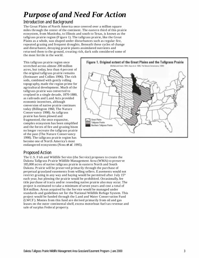
Purpose of and Need For ActionIntroduction and BackgroundThe Great Plains of North America once covered over a million squaremiles through the center of the continent. The eastern third of this prairieecosystem, from Manitoba, to Illinois and south to Texas, is known as thetallgrass prairie region (Figure 1). The tallgrass prairie, like the GreatPlains as a whole, was shaped under disturbances such as regular fire,repeated grazing and frequent droughts. Beneath these cycles of changeand disturbance, decaying prairie plants assimilated nutrients andreturned them to the ground, creating rich, dark soils considered some ofthe most fertile in the world.
This tallgrass prairie region oncestretched across almost 200 millionacres, but today, less than 4 percent ofthe original tallgrass prairie remains(Steinauer and Collins 1996). The richsoils, combined with gently rollingtopography, made the region prime foragricultural development. Much of thetallgrass prairie was converted tocropland in a single decade, 1870-1880,as railroads and Land Acts providedeconomic incentives, althoughconversion of native prairie continuestoday (Billington 1960, The NatureConservancy 1998). As tallgrassprairie has been plowed andfragmented, the once expansive,complex ecosystem has been simplifiedand the forces of fire and grazing bisonno longer recreate the tallgrass prairieof the past (The Nature Conservancy1998). The tallgrass prairie region hasbecome one of North America’s mostendangered ecosystems (Noss et al. 1995).
Proposed ActionThe U.S. Fish and Wildlife Service (the Service) proposes to create theDakota Tallgrass Prairie Wildlife Management Area (WMA) to preserve185,000 acres of native tallgrass prairie in eastern North and SouthDakota. Prairie will be preserved primarily through the purchase ofperpetual grassland easements from willing sellers. Easements would notrestrict grazing in any way and haying would be permitted after July 15th
each year, but plowing the prairie would be prohibited. Occasionally, feetitle purchase of tracts and/or reseeding native prairie also may occur. Theproject is estimated to take a minimum of seven years and cost a total of$14 million. Areas acquired by the Service would be managed understandards and guidelines set for the National Wildlife Refuge System. Thisproject would be funded through the Land and Water Conservation Fund(LWCF). Monies from this fund are derived primarily from oil and gasleases on the outer continental shelf, excess motorboat fuel tax revenue andsale of surplus Federal property.

4 Dakota Tallgrass Prairie Wildlife Management Area Grassland Easement Program - June 2000
Project AreaThe northeastern portion of the tallgrass prairie including portions of Manitoba, North and South Dakota, Minnesota, and Iowahas been designated the Northern Tallgrass Prairie Ecoregion (Figure 1) (McNab and Avers 1994, Keys et al. 1995, The NatureConservancy 1998). The Dakota Tallgrass Prairie WMA encompasses all of the Northern Tallgrass Prairie in SouthDakota and a portion in North Dakota. The portion of North Dakota in the project area contains the largest blocks of northerntallgrass prairie remaining in the state.
The proposed project boundary includes 32 counties in eastern North and South Dakota (Figure 2). The project areacovers some of the transitional zone into mixed grass prairie where, under appropriate conditions, tallgrass prairie canbe found.

5Dakota Tallgrass Prairie Wildlife Management Area Grassland Easement Program - June 2000
Purpose of and Need for Proposed ActionThe primary purpose of the Dakota Tallgrass Prairie WMA is to preserve185,000 acres of high-quality tallgrass prairie habitat in eastern North andSouth Dakota. Other goals of the Dakota Tallgrass Prairie WMA are tohelp maintain biodiversity and slow habitat fragmentation within theproject boundary by clustering the 185,000 acres into 10,000 to 20,000 acreblocks. The Dakota Tallgrass Prairie WMA also would create opportunitiesto manage existing prairies for biodiversity in cooperation with landownersand in some cases, reseed native prairie grasses.
The Dakota Tallgrass Prairie WMA is needed because the tallgrass prairieecosystem has already been reduced to less than 4 percent of its originalsize, and more continues to be lost every year (Steinauer and Collins 1996).Within the proposed project boundary, the original 10.3 million acres oftallgrass prairie already has been reduced to 2.1 million acres, primarilythrough conversion to cropland (HAPET 2000). The conversion of nativeprairie not only results in a direct loss of biodiversity, but also fragmentsthe landscape by creating prairie “islands.” These islands are morevulnerable to pesticide drift and contamination, soil erosion, and generaldegradation (Caughley and Gunn 1996, Steinauer and Collins 1996, TheNature Conservancy 1998). While it is difficult to know how much prairiewill be converted in the future, as much as 5 to 15 percent of the nativeprairie has been converted to cropland in the last 15 years (NRCS 1999),and historical data shows that when agricultural markets becomefavorable, there is a related increase in the conversion of native prairie(Gerard 1995). Therefore, this project also is needed to preserve prairieboth in the present and the long-term future.
The Dakota Tallgrass Prairie WMA also is needed to help preserve the richdiversity of plant and animal species supported by tallgrass prairie habitat,in part, by providing additional funds to protect high quality native prairienot eligible for current programs. There are at least 300 species of plants,113 species of butterflies, 35 species of reptiles and amphibians, 60 speciesof mammals, and 260 species of birds known to breed in or use tallgrassprairie habitat within the proposed project area (see Affected Environmentfor full description). According to the North and South Dakota NaturalHeritage Programs, 237 species of plants and animals are considered rarewithin the project boundary, and of those, 59 are threatened or endangeredat the State level. Although it should be noted, in North Dakota thesespecies have been designated by the State Wildlife Society, but do not havelegal status. At the Federal level, 13 species are under consideration orlisted as threatened and endangered in the project area such as thewestern prairie fringed orchid, piping plover, and topeka shiner (seeAppendix A).
The proposed boundary of the Dakota Tallgrass Prairie WMA wouldencompass the largest blocks of native tallgrass prairie remaining in theNorthern Tallgrass Prairie Ecoregion. The 2.1 million acres of tallgrassprairie in the proposed project boundary account for 80 to 90 percent of theremaining Northern Tallgrass Prairie. Thus the Dakotas, especiallynortheastern South Dakota, are essential to the preservation of theNorthern Tallgrass Prairie ecosystem.
6 Dakota Tallgrass Prairie Wildlife Management Area Grassland Easement Program - June 2000
Decisions to be MadeBased on the analysis provided in this Environmental Assessment, theRegional Director of the U.S. Fish and Wildlife Service, Region 6 -Mountain Prairie Region, will make three decisions.1. Determine whether the Service should establish the Dakota Tallgrass
Prairie Wildlife Management Area. If yes,2. Select an approved Wildlife Management Area boundary that best
fulfills the habitat protection purpose; and3. Determine whether the selected alternative will have a significant
impact upon the quality of the human environment. This decision isrequired by the National Environmental Policy Act (NEPA) of 1969. Ifthe quality of the human environment is not affected, a Finding of NoSignificant Impact will be signed and will be made available to thepublic. If the alternative will have a significant impact, then anEnvironmental Impact Statement will be prepared to further addressthose impacts.
Issues Identified and Selected for AnalysisComments were solicited from the public for the Dakota Tallgrass PrairieWMA through news releases and a series of public meetings. A newsrelease explaining the project and providing Service contact informationwas sent to 20 newspapers in North Dakota and 28 newspapers in SouthDakota in early September 1999. A total of 72 people attended the publicmeetings or provided written comments on the project. Meetings were heldin Fargo, North Dakota on September 7, 1999; Yankton, South Dakota onSeptember 15, 1999; and Brookings, South Dakota on September 16, 1999.In addition, personal visits were made to the offices of the Congressionaldelegations for both States.
Most people commenting on the project were supportive of the effort topreserve native tallgrass prairie. Some additional wildlife habitat andmanagement issues were raised, as well as social and economic concerns.
Biological IssuesNative Tallgrass Prairie HabitatP Native Tallgrass Prairie is one of the most endangered and fragmented
forms of wildlife habitat in North America. Perpetual grasslandeasements are a means of preserving tallgrass habitat for futuregenerations. Many people attending the meetings, both landownersand the general public, felt that preserving and protecting nativetallgrass prairie habitat for plants and wildlife was important.
Social and Economic ConsiderationsP Several people indicated that they would like retired cropland that has
been planted to native grasses, such as under the ConservationReserve Program, to be eligible for Dakota Tallgrass Prairie WMAeasements.
P Tracts of less than 40 acres in size should be eligible for grasslandeasements.
P Some people felt that the perpetual nature of the easements was toorestrictive, effectively making decisions for future generations.
P If tax dollars are used to protect wildlife habitat, then that habitatshould be made open to public hunting access.
7Dakota Tallgrass Prairie Wildlife Management Area Grassland Easement Program - June 2000
Issues Not Selected for AnalysisP Provisions and plans for burning native prairie to control weeds and maintain
vigor should be part of the management of grassland easements.
Money from the Land and Water Conservation Fund, which is thesource for this project, cannot be used for management costs such asdeveloping burn plans and administering prescribed burns. TheService Coordinator for the tallgrass region is working on developing aprivate lands burning program which would be administered inconjunction with State and County offices. Funding for such a programwill have to be acquired through grants or funds other than the LWCF.
P The ability to accept easements for wind generators on grasslandeasements under the Dakota Tallgrass Prairie WMA was a concern forsome individuals.
The disturbance of native grass associated with establishing windgenerators is not compatible with the provisions of a grasslandeasement. Wind generators for commercial sale of power are notconsidered a related agricultural use that might be allowed throughthe Service’s easement permitting process for modifying easements.
Related Actions and ActivitiesThe Northern Tallgrass Prairie National Wildlife Refuge is a tallgrassprairie preservation project administered by Region 3 of the U.S. Fish andWildlife Service. The project has a goal of preserving 77,000 acres of nativetallgrass prairie habitat in western Minnesota and northwestern Iowa,primarily with grassland easements. Because the native tallgrass prairie ishighly fragmented and more than 99 percent of the original prairie is gonein this Region, this program also focuses on restoration of native prairie.Despite some differences in goals and priorities between the NorthernTallgrass Prairie NWR and the Dakota Tallgrass Prairie WMA, Regions 3and 6 of the Service will be working together closely, with the possibility ofcombining the projects at some future date.
Dakota Tallgrass Prairie WMA, Phase I is a Service program which isworking to protect 5,000 acres of native prairie in northeast Brown Countyin South Dakota. Protection will be accomplished primarily through perpetualgrassland easements although some fee-title purchase may occur.
North American Waterfowl Management Plan was enacted in 1986 toaddress declining waterfowl populations. Under this Plan, the PrairiePothole Joint Venture was created to coordinate the efforts of NorthDakota, South Dakota, Minnesota, Iowa, and Montana. The TewaukonWetland Management District in southeastern North Dakota is currentlyworking on a project to enhance waterfowl habitat that includes theprotection of approximately 13,000 acres of upland habitat. Landprotection efforts will focus on good waterfowl habitat, i.e., grasslandsassociated with wetlands, but not specifically tallgrass prairie. The fundingand efforts for this project are based on a partnership between privatelandowners, U.S. Fish and Wildlife Service, Ducks Unlimited, NorthDakota Game and Fish Department, the North Dakota Wetlands Trust,Delta Waterfowl, and the Ransom County Soil Conservation District.
Migratory Bird Conservation Act established the Migratory BirdConservation Commission which oversees the purchase and rental ofproperties benefitting migratory birds. These land acquisitions are fundedprimarily through money generated by the purchase of Migratory BirdHunting and Conservation Stamps or “Duck Stamps.” With these fundsthe Service has purchased over 185,000 acres of grassland easements inSouth Dakota within the Dakota Tallgrass Prairie WMA. Purchase ofgrassland easements with these funds is an on-going process in the projectarea. These funds are also used to purchase wetland easements in Northand South Dakota.

8 Dakota Tallgrass Prairie Wildlife Management Area Grassland Easement Program - June 2000
The Nature Conservancy is active in conservation and preservation issuesin the Northern Tallgrass Prairie Region of the Dakotas. In 1998, anecoregional planning document for the Northern Tallgrass Prairie wascompleted and an implementation team formed to address the issues in theRegion. The Conservancy recently acquired the Brown Ranch, 1,500 acresof tallgrass prairie adjacent to the Sheyenne National Grasslands insoutheastern North Dakota. In addition, the Conservancy owns the 560-acre Pigeon Point Preserve in Ransom County, North Dakota and ninepreserves in the tallgrass region of South Dakota, which currently protectalmost 3,400 acres of a variety of tallgrass prairie subtypes. The Service iscurrently working with the Conservancy to coordinate planning efforts inthe Tallgrass Region.
U.S. Department of Agriculture, Natural Resources ConservationService has several programs active in North and South Dakota aimed atconserving tallgrass prairie rangeland resources in the project area. Bothstates have the Environmental Quality Incentives Program (EQIP) whichprovides farmers and ranchers with information and resources for grazingsystems, water development projects and educational programs. In NorthDakota, the Sheyenne River Basin has been identified as a priority area forthis program. The Conservation Reserve Program has an option known asConservation Practice 2 or CP2 under which highly erodible cropland isplanted specifically with a mixture of native grasses for 10 to 15 yearcontracts. Approximately 112,000 CP2 acres are within the project area.North Dakota NRCS also has a Sustainable Agriculture ResourcesEducation grant which will assist in improving range management throughgrazing systems. In South Dakota, the Wildlife Habitat Incentive Program(WHIP) provides expertise and funding for planting native grasses andfloodplain and wetlands easement programs have associated native grassplantings.
U.S. Forest Service manages the Sheyenne National Grasslands, a 70,000-acre parcel of grassland in southeastern North Dakota. The Forest Serviceis currently developing an Environmental Impact Statement addressingthe management plan for the next 10 years on the grasslands. Of the 70,000acres, approximately 53,000 are native tallgrass prairie which make theSheyenne Grasslands the largest, contiguous block of tallgrass prairie inNorth Dakota.
Ducks Unlimited is currently working with the Tewaukon WetlandManagement District in southeastern North Dakota on a project toenhance waterfowl habitat that will include the protection of approximately13,000 acres of upland habitat. Also, Ducks Unlimited is initializing aRevolving Land Acquisition Program on the Prairie Coteau ofnortheastern South Dakota that is aimed at restoration of waterfowlhabitat on large tracts.
Friends of Prairie is a group of private citizens that have organized toaddress issues related to the conservation and preservation of tallgrassprairie in the Dakotas. The group is presently focused on raising publicawareness and support.
Private landowners own over 98 percent of the project area and haveprimary stewardship of the remaining tallgrass prairie. A significantportion of biodiversity of tallgrass prairie, in particular the rare speciesand species of special concern, occur on private lands. Many landowners inthe area are concerned with protecting wildlife and preserving grasslandsand have entered into cooperative agreements with the Service and otherpartner agencies.

9Dakota Tallgrass Prairie Wildlife Management Area Grassland Easement Program - June 2000
National Wildlife Refuge System and AuthoritiesThe Service proposes to protect lands within the project area throughgrassland easements to enhance the survival prospects of endangered andthreatened species in the area, and to protect and maintain grassland andwetland habitat for migratory birds and other species of animals andplants. The proposed grassland easement program would be administeredas part of the Refuge System and operated under a Wildlife ManagementArea in accordance with the overall mission of the National Wildlife RefugeSystem. The mission of the National Wildlife Refuge System is to preservea national network of lands and waters for the conservation andmanagement of fish, wildlife, and plant resources of the United States forthe benefit of present and future generations. The proposed resourceprotection actions also would be consistent with the guiding principles andgoals for the National Wildlife Refuge System.
Guiding Principles of the National Wildlife Refuge System1. Habitat. Fish and wildlife will not prosper without high-quality habitat,
and without fish and wildlife, traditional uses of refuges cannot besustained. The Refuge System will continue to conserve and enhancethe quality and diversity of fish and wildlife habitat within refuges.
2. Public Use. The Refuge System provides important opportunities forcompatible wildlife-dependent recreational activities involving hunting,fishing, wildlife observation and photography, and environmentaleducation and interpretation.
3. Partnership. America’s sportsmen and women were the first partnerswho insisted on protecting valuable wildlife habitat within nationalwildlife refuges. Conservation partnership with other Federal agencies,State agencies, Tribes, organizations, industry and the general publiccan make significant contributions to the growth and management ofthe Refuge System.
4. Public Involvement. The public should be given full and openopportunity to participate in decisions regarding acquisition andmanagement of our National Wildlife Refuges.

10 Dakota Tallgrass Prairie Wildlife Management Area Grassland Easement Program - June 2000
Goals of the National Wildlife Refuge SystemA. To preserve, restore and enhance in their natural ecosystems (when
practicable) all species of animals and plants that are endangered orthreatened with becoming endangered.
B. To perpetuate the migratory bird resource.C. To preserve a natural diversity and abundance of fauna and flora on
refuge lands.D. To provide an understanding and appreciation of fish and wildlife
ecology and the human’s role in the environment.E. To provide refuge visitors with high quality, safe, wholesome and
enjoyable recreational experiences oriented toward wildlife, to theextent these activities are compatible with the purpose for which therefuge was established.
The proposed Dakota Tallgrass Prairie Wildlife Management Area wouldbe managed as part of the National Wildlife Refuge System in accordancewith the National Wildlife Refuge System Administration Act of 1966,Refuge Recreation Act of 1962, Executive Order 12996 (Management andGeneral Public Use of the National Wildlife Refuge System), NationalWildlife Refuge System Improvement Act of 1997, and other relevantlegislation, executive orders, regulations, and policies.
Conservation of wildlife habitat in Dakota Tallgrass Prairie WildlifeManagement Area would also continue to be consistent with the followingpolicies and management plans:1. Prairie Pothole Joint Venture (PPJV 1987, 1998 updated)2. North American Waterfowl Management Plan (USFWS 1987, updated
1994, 1998)3. Piping Plover Recovery Plan (Great Lakes and Northern Great Plains)
(USFWS 1988)4. Bald Eagle Recovery Plan (Northern states) (USFWS 1983)5. Whooping Crane Recovery Plan (USFWS 1994 revised)6. American Burying Beetle Recovery Plan (USFWS 1991)7. Pallid Sturgeon Recovery Plan (USFWS 1993)8. Western Prairie Fringed Orchid Recovery Plan (1996)

11Dakota Tallgrass Prairie Wildlife Management Area Grassland Easement Program - June 2000
The Habitat Protection and Land Acquisition ProcessOnce a project area boundary is approved, habitat protection will primarilybe through the purchase of grassland easements; however, fee-titlepurchase, no-cost transfer, long-term lease, donation or exchange also mayoccur. It is the established policy of the Service to acquire land or interestof land from willing sellers.
The authority for the acquisition of property interests within the proposedDakota Tallgrass Prairie Wildlife Management Area is the Fish andWildlife Act of 1956 (16 U.S.C. 742 f (b) (1), as amended. Acquisitionfunding is made available through the Land and Water Conservation FundAct of 1965. The Land and Water Conservation Fund is derived primarilyfrom oil and gas leases on the outer continental shelf, excess motorboat fueltax revenues and sale of surplus Federal property. Additional funds couldbe made available through Congressional appropriations, North AmericanWaterfowl Conservation Act Funds, donations from non-profitorganizations or other sources to acquire lands, waters, or interest thereinfor fish and wildlife conservation purposes.
The basic considerations in acquiring land are the biological significance ofthe land, existing and anticipated threats to wildlife resources, andlandowner’s willingness to sell conservation easements, or otherwise makeproperty available to the project. The purchase of grassland easementsprogresses according to the availability of funds.
Under provisions of the Refuge Revenue Sharing Act (Public Law 95-469),the Service would annually reimburse counties to offset revenue lost as aresult of fee-title acquisition of private property. This Law states that theSecretary of the Interior (Secretary) shall pay to each county in which anyarea acquired in fee title is situated, the greater of the following amounts:1. An amount equal to the product of 75 cents multiplied by the total
acreage of that portion of the fee area which is located within suchcounty.
2. An amount equal to ¾ of 1 percent of the fair market value, asdetermined by the Secretary, for that portion of the fee area which islocated within such county.
3. An amount equal to 25 percent of the net receipts collected by theSecretary in connection with the operation and management of suchfee area during such fiscal year. However, if a fee area is located in twoor more counties, the amount for each county shall be apportioned inrelationship to the acreage in that county.
The Refuge Revenue Sharing Act also requires that Service lands bereappraised every five years to ensure that payments to local governmentsremain equitable. Payments under this Act would be made only on landsthat the Service acquires in fee title. On lands where the Service acquiresonly partial interest through easement, all taxes would remain theresponsibility of the individual landowner.

12 Dakota Tallgrass Prairie Wildlife Management Area Grassland Easement Program - June 2000
Alternatives for theDakota Tallgrass PrairieWildlife Management AreaThis Section describes the three alternatives identified for this project: aNo Action alternative, an alternative giving the Service the authority tocreate the Dakota Tallgrass Prairie Wildlife Management Area (WMA) asoriginally proposed, and a third alternative, expanding the scope of thegrassland easement program within the WMA. The alternatives aresummarized in Table 1.
If the preferred alternative is selected, current and future grasslandeasements acquired by the U.S. Fish and Wildlife Service will beadministered in accordance with Executive Order 12996, Management andGeneral Public Use of the National Wildlife Refuge System (1996) and theNational Wildlife Refuge System Improvement Act (1997). Managementactivities would include monitoring the properties to ensure thatlandowners did not violate the terms of the easement. The Service wouldcontinue to monitor the status and recovery of endangered, threatened andcandidate species, conduct other activities for enhancing wildlife habitatand restoring native species with landowners permission and coordinatewith private organizations and State and Federal agencies.
evitanretlAhcaErednUsnoitcAfoyrammuS.1elbaT
AevitanretlA BevitanretlA CevitanretlA
devreserPsercA 0 P evitanfoserca000,581nidevreserpeiriarpssargllat
atokaDhtuoSdnahtroN
P dnalssargfoserca000,581htuoSdnahtroNnidevreserp
atokaD
sdnalssarGelbigelE enon P ssargllatevitanyliramirpeiriarp
P eiriarpssargllatevitanP revocdetnalp/PRC
stnemesaEfosnoitcirtseR a/n :stnemesaellAP eiriarpwolptonnacP snoitcirtsergnizargonP ht51yluJretfagniyah
:eiriarPevitaNP eiriarpwolptonnacP snoitcirtsergnizargonP ht51yluJretfagniyah
:PRCP wolptonnacP tpecxegniyahrognizargon
5ot3yreveetanevujerotsraey
stcarTlaudividnIfoeziS 0 P serca061,serca04tsaeltaderreferp
P ezisyna
nosseccAcilbuPstcarTtnemesaE
enon P sseccalortnocotthgirrofrenwodnalhtiwsniamer
stnemesaeP fotrapebyamsseccacilbup
sesahcrupeltit-eef
P ybdedivorpsseccacilbupehtgnisahcrupecivreSeht
htiwrenwodnalehtmorfthgirstnemesae
P fotrapebyamsseccacilbupesahcrupeltit-eef
13Dakota Tallgrass Prairie Wildlife Management Area Grassland Easement Program - June 2000
Alternative A. No Action.Under the No Action alternative, the Service would not establish theDakota Tallgrass Prairie Wildlife Management Area and the 185,000 acresof native tallgrass prairie would not be perpetually protected.
Alternative B. Establish the Dakota Tallgrass Prairie WildlifeManagement Area as Originally Proposed. (Preferred Alternative)Under Alternative B, the Service would establish the Dakota TallgrassPrairie Wildlife Management Area (WMA) within the proposed boundaryincluding 32 counties in eastern North and South Dakota. The DakotaTallgrass Prairie WMA would preserve 185,000 acres of high quality, nativetallgrass prairie primarily with perpetual grassland easements, althoughsome fee-title purchase of land may occur. The goal of the project is topreserve prairie in blocks of 10,000 to 20,000 acres. To meet this goal, focusareas have been identified within the project area that contain relativelylarge, unfragmented blocks of native prairie where it may be possible topreserve 10,000 to 20,000 acre areas (Figure 3). Within these focus areas,grassland tracts will be given first priority for purchase if they are nativetallgrass prairie, larger than 160 acres (although as small as 40 acres will beconsidered), nearby other protected lands and have biological significance,such as the presence of rare or listed species. In some cases, small pieces ofplanted cover/CRP may be included in a larger easement for native prairie ifthe CRP rounds out a tract or connects two grassland easements. Underthis Alternative, the total number of CRP acres would be small relative tothe acres of native prairie and probably would be only 5 to 10 percent of the185,000 acre goal. As additional biological information becomes available,these focus areas may be refined to better preserve the biodiversity of thetallgrass prairie.
The easement program would rely on voluntary participation from landowners.Grazing would not be restricted on the land included in the easementcontract, although haying would be restricted until after July 15th. Plowingthe land would not be permitted. All land with easements would remain inprivate ownership; therefore, property tax, weed control, and control ofpublic access would remain the responsibility of the landowner. Any feetitle land purchased by the Service would be managed in accordance withExecutive Order 12996, Management and General Public Use of theNational Wildlife Refuge System (1996) and the National Wildlife RefugeSystem Improvement Act (1997) and the county in which the land islocated would receive payment-in-lieu-of-taxes through the Service’sRevenue Sharing Program (see Purpose of and Need for Action).
14 Dakota Tallgrass Prairie Wildlife Management Area Grassland Easement Program - June 2000
Alternative C. Establish the Dakota Tallgrass Prairie WildlifeManagement Area incorporating options to broaden eligibilityfor the program and increase public access.Under Alternative C, the Service would establish the Dakota Tallgrass PrairieWildlife Management Area (WMA) within the proposed boundary including 32counties in eastern North and South Dakota. The Dakota Tallgrass Prairie WMAwould preserve 185,000 acres of high quality, native tallgrass prairie primarily withperpetual grassland easements, although some fee-title purchase of land mayoccur. The goal of the project is to preserve prairie in blocks of 10,000 to 20,000acres. To meet this goal, focus areas have been identified within the project areathat contain relatively large, unfragmented blocks of native prairie where it maybe possible to preserve 10,000 to 20,000 acre areas (Figure 3). Grassland tractswould be eligible if they were native prairie and/or planted cover, of any size,nearby other protected lands and/or had biological significance, such as thepresence of rare or listed species. Under this Alternative, 20 to 30 percent of the185,000 acre goal may be planted cover/CRP.
The easement program would rely on voluntary participation from landowners.On native prairie tracts, grazing would not be restricted, although haying would berestricted until after July 15th. On tracts of planted cover/CRP, annual grazing andhaying would be prohibited. Although, burning, haying or grazing may be neededevery 3 to 5 years to maintain the quality of the grass. Plowing the land would notbe permitted with any easement. All land with easements would remain in privateownership; therefore, property tax and weed control would remain theresponsibility of the landowner. In addition, under this Alternative, public accesswould be associated with land for which the Service had purchased a grasslandeasement. Any fee title land purchased by the Service would be managed inaccordance with Executive Order 12996, Management and General Public Use ofthe National Wildlife Refuge System (1996) and the National Wildlife RefugeSystem Improvement Act (1997) and the county in which the land is located wouldreceive payment-in-lieu-of-taxes through the Service’s Revenue Sharing Program(see Purpose of and Need for Action).

15Dakota Tallgrass Prairie Wildlife Management Area Grassland Easement Program - June 2000

16 Dakota Tallgrass Prairie Wildlife Management Area Grassland Easement Program - June 2000

17Dakota Tallgrass Prairie Wildlife Management Area Grassland Easement Program - June 2000
Affected EnvironmentBiological EnvironmentClimateThe region encompassed by the proposed Dakota Tallgrass Prairie WMAhas a continental climate, with warm summers and cold winters. Meanminimum January temperatures range from -7 degrees Fahrenheit inNorth Dakota to 8 degrees Fahrenheit at the southern tip in South Dakotaand average maximum temperature increases from 82 degrees Fahrenheitin North Dakota to 88 degrees Fahrenheit in southern South Dakota(Bryce et al. 1998).
Annual precipitation increases from west to east across the Great Plains,making the tallgrass prairie relatively moist compared to the mixed andshortgrass prairies. In fact, the tallgrass prairie is the only prairie regionwith enough moisture to support native or natural tree growth (Bragg1995, Steinauer and Collins 1996). As with temperature, mean precipitationincreases from 15 to 19 inches in North Dakota to 19 to 23 inches in SouthDakota, with most of the precipitation falling from April to September(Chapman et al. 1998). Periodic droughts, which can be severe, are alsocommon in the tallgrass region (Steinauer and Collins 1996).
EcoregionsWith the exception of the southernmost tip, the topography in the DakotaTallgrass Prairie WMA was created by glaciers that advanced andretreated over the surface 10,000 to 12,000 years ago. As the sheets of iceadvanced, they ground up the surface, mixing ice with rock and soil. Asthey melted and retreated, the debris (i.e. glacial till) was left strewnacross the landscape creating the undulating, gently rolling plains thatcover much of the project area.
This landscape has been divided into ecological or physiological regions byseveral authors (Bailey 1995, McNab and Avers 1994, Keys et al. 1995,Johnson et al. 1995, Bryce et al. 1998). Most of the Dakota Tallgrass PrairieWMA lies in the Prairie Parkland Province, characterized by tallgrassprairie vegetation and interspersed woody vegetation (Bailey 1995). ThePrairie Parkland Province extends from central Canada south to Oklahomaand as far east as Indiana. This province has been divided into severalsections, and the two northernmost, the Lake Agassiz Plain and NorthernGlaciated Plains, have been designated as the Northern Tallgrass Prairie(Figure 4) (McNab and Avers 1994, Bailey 1995, Keys et al. 1995, TheNature Conservancy 1998, USFWS 1998). The remainder of the DakotaTallgrass Prairie WMA is a transition zone to shortgrass prairie, known asthe mixed-grass prairie. In this portion of the project area, tallgrass prairiemay be found if conditions are appropriate. Mixed-grass prairie is in theGreat Plains-Palouse Dry Steppe Province (Bailey 1995).

18 Dakota Tallgrass Prairie Wildlife Management Area Grassland Easement Program - June 2000
Tallgrass PrairieLake Agassiz PlainThe proposed Dakota Tallgrass Prairie WMA project boundary includesthe southeastern corner of the Lake Aggasiz Plain. The Plain was formedalong North Dakota’s eastern border 12,000 years ago as glaciers meltedand the area flooded forming Lake Agassiz (Bluemle 1991, McNab andAvers 1994). When Lake Agassiz eventually disappeared, a virtually flatplain with sediment deposits of silt and clay up to 95 feet thick was leftbehind (Bryce et al. 1998). The Plain has few wetlands and is crossed byslow moving, meandering streams that flow to the north and east into theRed River. The ancient lake sediments developed into highly productivesoils, and today, over 80 percent of the Plain is used for agriculturalproduction of crops (HAPET 2000).
Included in the proposed boundary for the Dakota Tallgrass Prairie WMAis the Sheyenne delta where the Sheyenne River once emptied into ancientglacial Lake Agassiz (Figure 5). On this ancient delta lies the largest,contiguous block of native prairie on the Lake Aggasiz Plain. The sandysoils in this area are not ideal for most crop production and much of thisarea is used for grazing. Approximately 120,000 acres of native vegetationstill exist (Chapman et al. 1998). The U.S. Forest Service owns andmanages 70,000 of these acres as the Sheyenne National Grasslands.Native prairie on the Sheyenne delta includes mesic, wet-mesic and dry-mesic tallgrass prairie characterized by big and little bluestem,Indiangrass, porcupine grass, green needlegrass, and sideoats grama aswell as species typical of sand prairie including prairie sandreed, sandbluestem, and sand dropseed. Typical forbs include prairie blazing star,stiff sunflower, leadplant, white prairie clover, wild lily, and white camas. Invery sandy, blown out and xeric areas forbs such as green sage, greenmilkweed, and longbract spiderwort also can be found. Conversely, inwetter areas, switchgrass, northern reedgrass, blackeyed Susan and Balticrush generally occur (Shenk and Lenz 1998, Boe and Lenz 1999). Oaksavannahs, relatively open woodlands with an understory of prairie grassessuch as big and little bluestem, porcupine grass, and sideoats grama, arealso common on the delta (Shenk and Lenz 1998, Boe and Lenz 1999).Scientific names for all species can be found in Appendix C.
The Sheyenne delta is also a haven for many rare, threatened andendangered plants. An intensive survey of privately owned prairie inRichland and Ransom counties, which mostly occurs around the Sheyennedelta, found 51 species of rare plants including white lady’s slipper, smallyellow lady’s slipper orchid, dotted smartweed, and eastern marsh fern(Shenk and Lenz 1998). Some of the rare plants are considered criticallyimperiled in North Dakota such as purple sandgrass, Richardson’s sedge,handsome sedge, and hooked crowfoot (NDNHP 2000).
The Sheyenne Delta is also the location for one of only three largepopulations of the federally threatened western prairie fringed orchid thatexist in the United States. The orchid most often occurs in unplowedprairie and sedge meadows, although it may occur in previously disturbedsites such as roadside ditches and old fields (USFWS 1996a). Recentsurveys estimate the population on the Sheyenne delta to be around 7,758individual plants (K. Kreil pers. comm, Lenz 1997).

19Dakota Tallgrass Prairie Wildlife Management Area Grassland Easement Program - June 2000

20 Dakota Tallgrass Prairie Wildlife Management Area Grassland Easement Program - June 2000

21Dakota Tallgrass Prairie Wildlife Management Area Grassland Easement Program - June 2000

22 Dakota Tallgrass Prairie Wildlife Management Area Grassland Easement Program - June 2000

23Dakota Tallgrass Prairie Wildlife Management Area Grassland Easement Program - June 2000
North-Central Glaciated PlainsWithin the Dakota Tallgrass Prairie WMA, the tallgrass prairie of easternSouth Dakota occurs in the North-Central Glaciated Plains section(McNab and Avers 1994). It is generally a flat to rolling landscape coveredby glacial debris or ‘till’ created as glaciers moved over the area grindingup the surface and mixing it with ice. As the glaciers receded, the icemelted unevenly, depositing surface debris arbitrarily and creating apocked landscape. The depressions between rises in debris form numerousshallow basins, which fill with water, forming temporary and seasonalwetlands. The rolling uplands were historically covered by tallgrassprairie, but the glacial till has developed into rich soils intensivelycultivated today (Omodt et al. 1968, Bluemle 1991, Bryce et al. 1998). Withthe exception of the Prairie Coteau (discussed below), the remaining nativetallgrass prairie is largely on hillsides flanking streams and rivers (Figure5). Rare plants of these areas include snow trillium, bush clover, Turk’s caplily, and compass plant (Houtcooper et al. 1985).
Prairie CoteauThe dominant feature of the tallgrass region in South Dakota is the PrairieCoteau (Figure 5). The Coteau was formed as the glaciers advanced andretreated, carrying a mixture of surface material and ice over a pre-existing shale plateau. The result is a highland rising approximately 300 to600 feet above the plain with a topography of knobby, raised uplands anddepressed basins. The basins on the Coteau, however, are generally large,leading to the formation of semipermanent wetlands and lakes (Bryce et al.1998).
In the North-Central Glaciated Plains of South Dakota, most of therelatively unfragmented, large blocks of native tallgrass prairie are foundon the Coteau (The Nature Conservancy 1998, Loeschke 1997, HAPET2000). This is largely because the hilly nature of the Coteau limits cropproduction, and livestock grazing is common. Dry-mesic hill prairie andnorthern mesic tallgrass prairie, characterized by grass species such as bigand little bluestem, Indiangrass, porcupine grass, prairie June grass, andsideoats grama, are two of the most common plant communities on theCoteau. Intermingled with the grasses are forbs such as prairie blazingstar, stiff sunflower, yellow and prairie coneflowers, leadplant, and whiteprairie clover. At least 45 species of rare plants exist on the Coteauincluding small fringed gentian, sage leaf willow, Kalm’s lobelia, smallwhite lady’s slipper, wild cranesbill, and wood anenome, which are allconsidered imperiled at the state level (Loeschke 1997, SDNHP 1999). TheCoteau receives sufficient precipitation to support plains Americanbasswood and bur oak forests along the margins of the wetlands (Bryce etal. 1998).
The northern and eastern edges of the Coteau, where it slopes down to thesurrounding level plain, create a unique ecological region. Perennialstreams that flow off of this edge provide cool, oxygenated water unlikesurrounding habitats. These drainages are often flanked by deciduouswoodlands of bur oak, green ash, elm, quaking aspen, American basswood,chokecherry, and smooth sumac with an understory of prairie grasses(Loeschke 1997, Bryce et al. 1998).

24 Dakota Tallgrass Prairie Wildlife Management Area Grassland Easement Program - June 2000
Mixed-Grass PrairieThe remainder of the Dakota Tallgrass Prairie WMA lies in the GreatPlains-Palouse Dry Steppe province (Bailey 1995). This area also has agently rolling topography created by glacial till. The tallgrass prairie in theeast gives way to mixed-grass prairie to the west creating a transition zoneover much of the area. Thus, conditions at individual sites dictate whethertallgrass species such as little and big bluestem, Indiangrass, andporcupine grass or the mixed-grass species such as western wheatgrassand green needlegrass are present. A good example are the Hecla sandhills(see Figure 5), where tallgrass species are commonly found even thoughthis area is in the mixed-grass zone. Several rare prairie plants can befound in this area including prairie loosestrife, moonwort, alpine rush,meadowsweet, and Great Plains ladies’-tresses (USFWS 2000). This areahas persisted in part, because the sandy soils, where ancient river deltasemptied into glacial lakes, is currently unsuitable for most crop production.Another example of tallgrass prairie communities in the mixed-grass zoneis the Sheyenne River Valley in Ransom County, North Dakota. Along theRiver, central-mesic and dry-mesic tallgrass prairie, as well as bur oakforests, woodlands and eastern bur oak savanna, can all be found (Shenkand Lenz 1998).
The mixed-grass portion of the Dakota Tallgrass Prairie WMA contains asignificant number of native grassland acres, and this area has been losingprairie at a relatively high rate (NRCS 1999). Within this area in SouthDakota, a large percentage of Beadle and Sanborn counties (30 to 40percent) are still in native grassland, although these grasslands arefragmented (NASS 1999b, HAPET 2000). At least 12 rare plant speciesthat have been documented exist in the mixed-grass zone of the DakotaTallgrass Prairie WMA (NDNHP 2000, SDNHP 1999).

25Dakota Tallgrass Prairie Wildlife Management Area Grassland Easement Program - June 2000
WildlifeInvertebratesIn general, insect populations in the project area are not well studied.Much of the research has focused on invertebrates in wetlands thatcomprise the diets of waterfowl. The diversity of insects in wetlands islimited by harsh conditions including wide fluctuations in temperature,hydrology, and chemical composition of the water (Euliss et al. 1999).
At least 113 species of butterflies occur throughout the Dakota TallgrassPrairie WMA area (Opler et al. 1995). Six of these butterflies have beenidentified as species of concern on the Great Plains, and of these, theDakota skipper, powesheik skipperling, and the regal fritillary butterfliesare considered vulnerable or imperiled at the global level (Sidle 1998,NDNHP 2000). These three butterflies are all prairie specialists, and theDakota Tallgrass Prairie WMA encompasses some of the last remaininghabitat and strongholds for these species (Sidle 1998, Royer 1997, Skadsen1998). A recent survey of the Dakota skipper on the Prairie Coteau found58 sites with skipper populations, but of those, only 37 of the populationswere considered secure (Skadsen 1998).
The American burying beetle, which is federally listed as endangered, wasfound historically in the project area. The beetle has been found recently inSouth Dakota counties outside of the project area, and until comprehensivesurveys are completed, the project area is considered possible habitat.Fragmentation of habitat, such as the Dakota Tallgrass Prairie WMA seeksto prevent, is thought to be one of the main causes of this species’ decline(USFWS 1991).
FishWithin the project area boundary, at least 32 species exist of common fishesand another 15 species that are rare, of concern or listed under theEndangered Species Act. The majority of the common species are found inthe Missouri River and its tributaries. A minority of common species arefound primarily in large lakes and reservoirs within the project area and afew, including fathead minnows, creek chubs, brook sticklebacks, andJohnny darters, are common species primarily found in tallgrass prairiestreams and wetlands (Neumann and Willis 1994). Rare species, such asthe federally endangered Topeka shiner, the State threatened northernredbelly dace and trout perch, utilize habitat in smaller prairie streams andrivers which may be currently protected by tallgrass prairie along thebanks and shores. Other federally listed species in the project area,including the endangered pallid sturgeon and candidate sicklefin chub,inhabit the Missouri River.

26 Dakota Tallgrass Prairie Wildlife Management Area Grassland Easement Program - June 2000
Amphibians and ReptilesFifteen species of amphibians and 20 species of reptiles are in the projectarea (Wheeler and Wheeler no date, Del Fosse 1973). Common andwidespread species found in a variety of habitats include the tigersalamander, leopard frog, snapping turtle, and the plains garter snake.Tallgrass prairie grasslands in the project area provide habitat for thegreat plains toad, Woodhouse’s toad, and the western hog-nosed snake. Thefalse map turtle and eastern hog nose snake are threatened at the Statelevel in South Dakota, and the lined snake, which is found in the southernGreat Plains, is endangered in South Dakota. Rare species within theproject area include the wood frog, plains leopard frog, eastern graytreefrog, Cope’s gray treefrog, Blanchard’s cricket frog, mudpuppy, andthe prairie skink, which is a specialist of sand dunes and grasslands(Fischer et al. 1999, NDNHP 2000).
MammalsAt least 60 different species of mammals can be found in the project area(Jones et al. 1985). Several of these species, particularly rodents, areadapted specifically to grasslands. These include the Franklins’ groundsquirrel, Richardson’s ground squirrel, thirteen-lined ground squirrel,northern grasshopper mouse, the prairie vole, and two species of jumpingmice. At least two prairie specialists, the plains pocket mouse and the leastshrew, are considered rare in the project area (Houtcooper et al. 1985).Several species, particularly predators, have a wide distribution acrossmany habitats including the red and gray fox, coyote, striped skunk, andlong-tailed weasel as well as the wide ranging white-tailed and mule deer.Marshy areas provide habitat for meadow voles, muskrats, the least weaseland mink.

27Dakota Tallgrass Prairie Wildlife Management Area Grassland Easement Program - June 2000
BirdsThe Dakota Tallgrass Prairie WMA area has a wide diversity of birdspecies. Approximately 260 species of birds exist that use the tallgrassprairie region. Of these, 160 species are known breeders, and theremaining 100 species use the area during their migration (Stewart 1975,South Dakota Ornithologist’s Union 1991).Numerous species of birds are directly associated with the grasslands ofthe tallgrass prairie. These include raptors, such as northern harriers andferruginous hawks, shorebirds, such as killdeer, upland sandpipers, willets,and marbled godwits, and songbirds, such as grasshopper sparrows,bobolinks, western meadowlarks, and dickcissels. Additional grasslandspecies include the short-eared owl, horned lark, greater prairie-chicken,and marsh wren.
Woodlands along the river margins and dispersed throughout the tallgrassprairie provide habitat for additional bird species. Swainson’s hawks,mourning doves, kingbirds, American goldfinches, great horned owls, clay-colored sparrows, song sparrows, and yellow warblers are some of thespecies that breed in woodlands throughout the project area. Thewoodlands also provide migratory stop-over sites for at least 20 species ofwarblers including the yellow-rumped warbler, American redstart,blackpoll warbler, and the orange-crowned warbler.
Wetlands, which are often associated with areas of tallgrass prairie in theproject area, attract additional bird species. Temporary wetlands, whichhold water for shorter periods, attract Wilson’s phalaropes, commonyellowthroats, and western meadowlarks. Seasonal ponds, which holdwater for most of the summer, attract most of the duck species in the areaincluding gadwall, mallards, northern pintails, blue-winged and green-winged teals, northern shoveler, redheads, and American wigeons. Wadingbirds such as sora, American coots, American avocet, Virginia rail, andmarbled godwits are also found on seasonal wetlands. Semipermanent andpermanent wetlands, such as those found on the Prairie Coteau, providebreeding habitat for water birds like the horned grebe, black-crownednight heron, ring-billed gull, and double-crested cormorant.
While winter is a time when most birds leave the tallgrass prairie region,several species migrate to this area in the winter. Lapland longspurs andsnow buntings are two particularly common species. Brown creepers,Bohemian waxwings, pine and evening grosbeaks, and white- winged andred crossbills also may utilize the project area during winter.
Twenty species of birds exist within the Dakota Tallgrass Prairie WMAwhich are designated as species of concern by the U.S. Fish and WildlifeService (USFWS 1996b). The veery and American bittern are foundprimarily in North Dakota while the common loon, white-faced ibis,ferruginous hawk, barn owl, burrowing owl, olive-sided flycatcher, andsedge wren are found more commonly in South Dakota. The uplandsandpiper, black tern, northern harrier, red headed woodpecker, Sprague’spipit, loggerhead shrike, grasshopper sparrow, Baird’s sparrow, chestnut-collared longspur, dickcissel, and lark bunting are found throughout theproject area. With the exception of the black tern, red headed woodpecker,and loggerhead shrike, all of the species of concern are grasslandspecialists, relying on prairie habitat for breeding (Stewart 1975, SouthDakota Ornithologist’s Union 1991).
Several threatened and endangered bird species at the State and Federallevel occur in the project area. These include the federally endangeredwhooping crane and least tern and the threatened bald eagle and pipingplover. At the State level, the osprey is considered threatened in SouthDakota, and in North Dakota, the greater prairie-chicken and yellow railare threatened (Bry 1986, Sidle 1998).

28 Dakota Tallgrass Prairie Wildlife Management Area Grassland Easement Program - June 2000
Social and Economic ConsiderationsThe Dakota Tallgrass Prairie WMA encompasses 15.7 million acres and 32counties in North and South Dakota. Within the project area, approximately200 communities of less than 1,000 people exist. Approximately 36 towns of1,000 to 10,000 people occur. Eight cities exist with over 10,000 people, andthe largest city in the project area is Sioux Falls, South Dakota with apopulation of over 100,000 people. Population densities within the countiesvary considerably throughout the project area, with the highest densitiesfound in counties with large cities (US Census Bureau 2000).
Agricultural ResourcesAgriculture is a major sector of the economies of both States. In NorthDakota, the primary enterprise is agriculture which accounts for one-thirdof the total economy. Other enterprises with major contributions to theeconomy of North Dakota include the Federal Government and energyproducing businesses (Leistritz and Coon 1991). In South Dakota,agriculture also generates just over one-third of the total economic activityin the state (Beutler 1997). The remaining economic activity in SouthDakota has diversified over the last 20 years, including manufacturing,computer, and service industries (Beutler 1997).
Agricultural uses of the land vary throughout the Dakota Tallgrass PrairieWMA. For example, the proportion of the county land converted tocropland ranges from 80 to 90 percent in southeastern North Dakota to 50to 60 percent in northeastern South Dakota (NASS 1999a, 1999b). Thelargest crops, in terms of the number of acres planted, are soybeans, corn,and wheat (NASS 1999a, 1999b). The largest acreage of pastureland isfound in counties of northern South Dakota where it is primarily used forcattle grazing. Average gross agricultural income ranges from $70,000 to$190,000 for counties in the project area (NASS 1999a, 1999b).
In the proposed project area, approximately 850,000 acres are enrolled inthe Conservation Reserve Program (CRP) (USDA 1999). Under theConservation Reserve Program, farmers voluntarily agree to plantmarginal or highly erodible cropland with approved cover and maintainthat cover for 10 to 15 years in exchange for annual payments. In theDakotas, the most common type of planted cover is either a mixture ofintroduced grasses and legumes (known as Conservation Practice 1 orCP1) or a mixture of native grasses (CP2), although there are 25 totalConservation Practice options. In North Dakota, 2,041 CRP acres areplanted in native grasses under CP2, and in South Dakota 110,180 acresare planted in native grasses (USDA 1999).
Despite these differences in land use and income, farm operators in theproject area share many characteristics. Most farm operators are full orpart owners of their operation. Most have been on the farm an average of20 to 25 years. In most counties, the largest group of farm operators are inthe 35 to 44 age category, although some counties do have more operatorsin the 45 to 54 age category. Farming is still the principal occupation ofmost farm operators, although this number has decreased in virtually allcounties of the project area since 1992 (NASS 1999a, 1999b).
Mineral ResourcesDeposits of non-metallic mineral resources such as sand and gravel, stone,cement, and clay are found throughout the project area. In South Dakota,sand and gravel are the most important non-metallic mineral commodity,and are produced in nearly every county of the project area (USGS 1964,Durkin et al. 1998). Extensive deposits are also present in North Dakota,particularly along the beach ridges and deltas of the Lake Agassiz Plain,but the quality is highly variable (Bluemle 1991). Sand and gravel are usedprimarily for road construction projects (Durkin et al. 1998). Siouxquartzite is also mined extensively in southeastern South Dakota and usedprimarily for construction. Oil and gas are not mined in the project area,nor are precious metals such as gold (Durkin et al. 1998, Murphy no date).

29Dakota Tallgrass Prairie Wildlife Management Area Grassland Easement Program - June 2000
LandownershipMost of the land in the 15.7 million acre Dakota Tallgrass Prairie WMA isprivately owned. Approximately 2 percent, or 369,521 acres, is public land.Of the publicly owned land, about 60 percent is federally owned and theother 40 percent is owned by the States of North and South Dakota.Federally managed lands include U.S. Fish and Wildlife Service NationalWildlife Refuges and Waterfowl Production Areas. The U.S. ForestService manages the largest block of public land in the project area, theSheyenne National Grasslands. The Sheyenne National Grasslands cover70,000 acres of southeastern North Dakota. State managed lands includeschool lands granted to the States, State parks and wildlife managementareas/game production areas managed by the North Dakota Game andFish Department and the South Dakota Game, Fish, and ParksDepartment.
Property TaxProperty tax on private land is currently paid to the counties by thelandowners. Since acquisition of easements does not result in a transfer ofland title, private landowners would continue to pay property taxes. If anyfee title acquisitions occur by the Service, the affected counties wouldreceive mitigated payments from the Service in-lieu-of-taxes under theRefuge Revenue Sharing Act (see Purpose of and Need for Action).
Public Use and Wildlife Dependent ActivitiesHunting, fishing and other non-consumptive wildlife related uses such aswildlife watching, feeding, and photography are popular among residentsin the project area. A recent survey of South Dakota residents found thatone-third hunt, one-third fish, and almost half are involved in non-consumptive wildlife-related activities (Gigliotti 1996). Hiking and campingare also popular activities in the project area.
The public hunts for a variety of game animals, and hunters can generate asignificant amount of revenue for communities in the project area. Gameincludes deer, waterfowl, furbearers, and upland birds. North Dakotahunters and anglers spent $578 million dollars on related expenditures in1996, which was 8 percent of the State’s economy (Meyer and Harmoning1999). Pheasant hunting is particularly popular in South Dakota. Last year,half of all pheasant hunters hunted land in the project area, generating$38.2 million dollars (SDGFP 1998).
Since most of the land in the project area is privately owned, most huntingis done on private land. In North Dakota, 87 percent of hunters use privateland and in South Dakota, 92 percent of hunters use private land(McDannold 1993, Dietz et al. 1996). The State wildlife agencies in bothNorth and South Dakota have developed programs in cooperation withlandowners to increase public access to private land. Within the projectarea, approximately 85,000 acres exist of Walk-in Access in South Dakotaand 360 acres of Private Land Open to Sportsmen (PLOTS) in NorthDakota. In addition, 150,000 acres of State land exist, such as parks andgame areas, and 220,000 acres of Federal land, such as wildlife refuges andnational grasslands, for a total of 455,000 acres open to both consumptiveand non-consumptive uses in the project area.

30 Dakota Tallgrass Prairie Wildlife Management Area Grassland Easement Program - June 2000
Cultural ResourcesThe U.S. Fish and Wildlife Service, as a Federal agency, has a trustresponsibility to Tribes which includes the protection of the sovereignty ofthe Tribal government and preservation of Tribal culture and other trustresources. The easement program does not compromise Tribal jurisdictionor Tribal rights because it deals only with willing sellers of private land foran easement. The protection of trust resources is enhanced with theeasement program by conservation of wildlife habitat and protection ofresources from land conversion and development.
Archaeological and historical resources within any fee title lands wouldreceive protection under Federal laws mandating the management andprotection of cultural resources. These laws include, but are not limited to,the Archaeological Resources Protection Act, the Archaeological andHistoric Preservation Act, the Native American Graves Protection andRepatriation Act, Native American Religion Freedom Act, and theNational Historic Preservation Act.
Currently, the Service does not propose any project, activity, or programthat would result in changes in the character of, or would potentiallyadversely affect any historic cultural resource or archaeological site. Whensuch undertakings are considered, the Service would take all necessarysteps to comply with section 106 of the National Historic Preservation Act(NHPA) of 1966, as amended. The Service would also pursue proactivecompliance with section 110 of the NHPA to survey, inventory, and evaluatecultural resources.
Contaminants and Hazardous WastesFieldwork for the pre-acquisition contaminant survey will be conductedprior to the purchase of any land interests. The preliminary survey will beconducted on these properties to determine if contaminants pose a threatto fish and wildlife or if they would be a liability to the Service. TheEnvironmental Contaminants Specialist located at Bismarck, NorthDakota, or Pierre, South Dakota, Ecological Services Offices, will becontacted to ensure policies and guidelines are followed before acquisition.

31Dakota Tallgrass Prairie Wildlife Management Area Grassland Easement Program - June 2000
Environmental ConsequencesEffects on the Biological EnvironmentThis section assesses the environmental impacts expected to occur fromthe implementation of Alternatives A, B, and C, as described inAlternatives for the Dakota Tallgrass Prairie Wildlife Management Area(Table 2). Environmental impacts are analyzed by issues for eachalternative and appear in the same order as discussed in Purpose of andNeed For Action.
Native Tallgrass Prairie HabitatAlternative A (No Action)– Under the No Action alternative, the Servicewould not establish the Dakota Tallgrass Prairie WMA and 185,000 acresof native tallgrass prairie would not be protected with grassland easementsand fee title purchase over the next seven years. Over the last 15 years, theNatural Resources Conservation Service (NRCS) has tracked changes inland use through its Natural Resources Inventory (NRI). NRI estimatesthat since 1982, 278,000 acres of native prairie were lost throughconversion to other uses in the proposed project area, which averages to18,500 acres/year (NRCS 1999). If this trend continues, almost 130,000acres of prairie could be lost over the next seven years. It is difficult topredict the rate of future prairie conversion, but historically the rate ofconversion is tied closely to commodity prices, rising and falling with theagricultural economy (Gerard 1995, The Nature Conservancy 1998).
Future losses of native prairie would have a direct impact on thebiodiversity in the project area. The majority of rare plant and animalspecies in the project area occur on privately owned native prairie(Chapman and Waterhouse 1997). Once native prairie has been plowed, thefull biodiversity of that site, including rare species, is lost immediately andcomplete restoration in the future is impossible.
Furthermore, as prairie is converted, the landscape becomes fragmentedcreating a patchwork of small grass islands which increases thevulnerability of wildlife and plants to negative impacts. For example,studies have shown that for both waterfowl and other ground-nestingbirds, nest predation increases as fragmentation of the landscape increases(Cowardin et al. 1985, Johnson and Temple 1990, Ball et al. 1995). Inaddition, smaller prairie fragments may not support certain grasslandbirds at all (Heckert 1994). Smaller pieces of grass do not buffer wildlifeand plants as well from the impacts of pesticide use such as loss of nestingcover and reduced invertebrate food sources (Hartwig and Hall 1980, Grueet al. 1988, Zollinger et al. 1996).
32 Dakota Tallgrass Prairie Wildlife Management Area Grassland Easement Program - June 2000
Alternative B (Dakota Tallgrass Prairie WMA, Preferred Alternative)– Ifthe trends in prairie conversion listed under Alternative A continue, theloss of native prairie over the next seven years in the project area could bealmost 130,000 acres. Under Alternative B, the Service would preserve185,000 acres of native tallgrass prairie primarily through grasslandeasements at a rate of about 27,000 acres per year over seven years,although it may take longer. The Dakota Tallgrass Prairie WMA wouldfocus on protecting native tallgrass prairie in both North and South Dakotaand would be a mechanism for developing further voluntary agreementswith landowners for managing and improving the overall health anddiversity of native tallgrass prairie.
The strategy of the Dakota Tallgrass Prairie WMA is to cluster theeasements to preserve blocks of prairie from 10,000 to 20,000 acres in size.These blocks of prairie would be formed in conjunction with other Serviceprograms, such as grassland easements purchased with Migratory BirdConservation Act funds in South Dakota and North American WetlandConservation Act grants in North Dakota. The preservation of blocks ofnative tallgrass prairie will not only protect the existing biodiversityperpetually, but will also reduce the future impacts of fragmentation.
Slowing fragmentation can affect prairie habitat and wildlife positively byreducing the effect of external impacts such as pesticides and predators(Hartwig and Hall 1980, Cowardin et al. 1985, Grue et al. 1988, Johnsonand Temple 1990, Ball et al. 1995, Zollinger et al. 1996). For example, as thesize of a block of native grasslands increases, both species diversity andsurvivorship increase for grassland birds (Johnson and Temple 1990,Heckert 1994). This is particularly important because grassland birds haveshown consistent population declines over the last 30 years (Sauer et al.1997). In addition, larger areas of native prairie can better buffer wildlifeand plants against drift and runoff from pesticide application onneighboring croplands, which can harm wildlife directly or indirectly byremoving nesting cover and reducing invertebrate food sources (Hartwigand Ball 1980, Zollinger et al. 1996). Larger blocks of prairie also reducethe chance that a population of plants or animals will become isolatedresulting in a local extinction and reducing the overall survivorship of thespecies (Steinauer and Collins 1996).
Alternative C (Dakota Tallgrass Prairie WMA, broader scope)– Underthis Alternative, 185,000 acres would still be protected primarily withgrassland easements and they would be arranged in the same manner asdiscussed under Alternative B. Therefore, the biological effects of thisAlternative would be similar to those expected under Alternative B.However, since 20 to 30 percent of the acres may be CRP instead of 5 to 10percent under Alternative B, 30,000 to 40,000 fewer acres of native prairiewould be preserved perpetually with Alternative C. This reducedpreservation of native prairie may result in a greater loss of biodiversity,particularly plant diversity.

33Dakota Tallgrass Prairie Wildlife Management Area Grassland Easement Program - June 2000
Social and Economic ConsiderationsEligibility of Planted GrasslandsAlternative A (No action)- Under this No Action Alternative, the Servicewill have no impact on the continued existence of the 850,000 ConservationReserve Program (CRP) acres in the proposed project area. It is generallyaccepted that the conversion of such a large number of acres of cropland toplanted cover through the CRP program has been beneficial to wildlife,particularly birds. CRP increases wildlife habitat diversity in the landscapeby creating areas of tall, dense vegetative cover (Johnson and Schwartz1993). The CRP program is associated with improved nest success andpopulation increases of waterfowl and nongame grassland birds (Kantrud1993, Reynolds et al. 1994, Delisle and Savidge 1997, McCoy et al. 1999).Breeding grassland bird species that appear to have benefitted from CRPinclude mallards, gadwalls, blue-winged teal, sedge wrens, commonyellowthroats, grasshopper sparrows, American goldfinches, bobolinks,and savannah sparrows (Johnson and Schwartz 1993, Johnson and Igl1995, Delisle and Savidge 1997, McCoy et al. 1999). Of these, the sedgewren and grasshopper sparrow are USFWS species of concern (USFWS1996b). In winter, American tree sparrows and pheasants also benefit fromthe residual cover (Best et al. 1998, McCoy et al. 1999).
Despite the current popularity of CRP and its benefits to wildlife, the long-term persistence of CRP in the Dakota Tallgrass Prairie WMA is notguaranteed. The CRP program costs about 2 billion dollars annually andthe renewal of the program is subject to Congressional approval (Osborn1993). Although sign-up for CRP contracts has remained steady over thelast several years, it is always vulnerable to change. CRP contracts last 10to 15 years, and surveys have shown that about 30 percent of landownersexpect to return their CRP to cropland at the end of their contract, whichis relatively easy to do under current regulations, and another 37 percentdo not know (Mortensen et al. 1989, Osborn 1993). According tolandowners, the most important factor in determining whether or not to re-enroll CRP acres is the economic conditions at the time the contractexpires (Osborn 1993).
Therefore, if enrollment significantly decreased due to improved economicconditions or the CRP program was eliminated, up to 67 percent oflandowners may return their CRP to cropland. Such a change may mean thatpositive population trends for waterfowl and nongame grassland birds wouldreverse and sedge wrens, grasshopper sparrows, dickcissels, lark buntings,and savannah sparrows might be particularly vulnerable (Johnson and Igl1995). Other conservation programs that might be implemented in place ofCRP, such as annual set-asides, are not considered as beneficial to wildlifeas the CRP program (Osborn 1993, Johnson and Igl 1995).
Alternative B (Dakota Tallgrass Prairie WMA, Preferred Alternative)-Under the current proposal for the Dakota Tallgrass Prairie WMA, CRPacres would not be eligible for grassland easements. In some cases, smallpieces of CRP may be included in a larger easement for native prairie if theCRP rounds out a tract or connects two grassland easements. In thesecases, the CRP acres would be small relative to the acres of native prairie,probably 5 to 10 percent or 10,000 to 20,000 acres, in the project area. Inaddition, once the CRP contract expired, the land could then be grazed orhayed after July 15th, similar to the native prairie. CRP acres are noteligible to be re-enrolled in a new CRP contract if a grassland easementhas been purchased for the land.
If the Service implements the Dakota Tallgrass Prairie WMA under thisAlternative, the overall landscape level impact on CRP acres would besimilar to the effects of not implementing the project (Alternative A). If theCRP program were to end or decline significantly, the small number ofCRP acres with grassland easements, approximately 10,000 to 20,000acres, would not maintain the wildlife benefits the current CRP programprovides, even though those CRP acres could not be converted to cropland.

34 Dakota Tallgrass Prairie Wildlife Management Area Grassland Easement Program - June 2000
Alternative C (Dakota Tallgrass Prairie WMA, Broader Scope)- Underthis Alternative, 20 to 30 percent of the grassland easements in the DakotaTallgrass Prairie WMA (40,000 to 60,000 acres) could be purchased forCRP acres or planted cover. Those CRP acres with grassland easementswould be maintained in the landscape even if the CRP program ceased toexist or the agricultural economy changed.
The overall goal of the Dakota Tallgrass Prairie WMA is to help preservethe biodiversity of native tallgrass prairie (see Purpose of and Need forAction). CRP acres planted in native prairie grasses do not have the plantdiversity of native prairie. However, CRP contributes to the biodiversity oftallgrass prairie by creating areas of tall, undisturbed vegetation that arenot hayed or grazed annually which benefit nesting birds (King andSavidge 1995). If CRP acres with easements were to contribute to the goalof the Dakota Tallgrass Prairie WMA, which is to maintain diversity of thetallgrass prairie, the CRP acres would need to remain in the samecondition with no annual grazing or haying.
Restricting grazing or haying on grassland easements would be differentthan the originally proposed easement program. Typically, grasslandeasements do not restrict grazing, and haying can be done after July 15th ofeach year. The easement only purchases the right to convert the land tocropland and generally costs about 25 to 35 percent of the full fee-titlevalue of the land. In order to restrict grazing and haying on CRP landunder easement, the Service would have to purchase the grazing andhaying rights from the landowner. Easements with these restrictions arepurchased by the Service in Minnesota and Iowa, and it is estimated thatsuch easements cost approximately 80 to 90 percent of the full fee-titlevalue of the land, although it can vary. In addition, since the value of theland is based on it “highest and best use,” CRP acres that have been usedas cropland would have a higher value than native prairie that had onlybeen used as grazing land (S. Wacker, W. Enquist pers comm). Together,these factors would make easements on CRP 2 to 3 times more expensiveper acre than easements on native prairie.
CRP acres with easements would require additional enforcementconsiderations since CRP would have a different type of easement, withdifferent restrictions, than native prairie easements. Furthermore,additional management, such as burning, haying or grazing CRPeasements every 3 to 5 years, would be needed to remain in the samecondition for wildlife habitat (Millenbah 1996).
35Dakota Tallgrass Prairie Wildlife Management Area Grassland Easement Program - June 2000
Minimum Eligible Tract SizeAlternative A (No Action)- If the Dakota Tallgrass Prairie WMA is notcreated, then no easements, or fee-title lands, of any size would bepurchased.
Alternative B (Dakota Tallgrass Prairie WMA, Preferred Alternative)-If the Service enacts the Dakota Tallgrass Prairie WMA as originallyproposed, grassland tracts of at least 160 acres would be given firstpriority, but tracts of at least 40 acres in size would be eligible for grasslandeasements. Tracts less than 40 acres generally would not be eligible exceptunder special circumstances such as a location adjacent to other grasslandseasements or the presence of rare species.
For the prairie species that have been studied, 25 percent can sustain apopulation on 40 acres of habitat (USFWS 1998). Eleven of 12 keygrassland bird species also can sustain a population on at least 40 acres(USFWS 1998). In general, larger tracts of prairie support morebiodiversity and localized extinction of populations is less likely (Hopkins1955, Conner and McCoy 1979, Diamond 1988).
Processing an easement from beginning to end costs the Service anestimated $2,300 if it is in a new area, and around $700 if easements arenearby (S. Wacker, pers comm). Therefore, the maximum cost to processan easement of 40 acres would be $18 to $58/acre. This cost is largelyindependent of the size of the tract, and therefore, the Service gets moreacres per dollar for larger tracts than for smaller ones. Furthermore, it isoften easier to find sales of land at least 40 acres in size on which to baseappraisals, making the overall process more efficient. Larger tracts,however, require more time to search courthouse records and morecomplex analysis of land details, such as soil composition.
Based on other Service grassland protection programs, it is estimated thatpreserving 185,000 acres of grassland in the Dakota Tallgrass PrairieWMA would involve approximately 700 to 800 landowners (R. Severson,pers comm). A survey of landowners in the Prairie Pothole Region foundthat approximately one-fourth own less than 40 acres of grassland(Responsive Management 1998). Therefore, some landowners will beprevented from participating in the program if parcels must be larger than40 acres. Landowners with tracts of less than 40 acres adjacent toadditional tracts of native prairie may still be eligible if they coordinatewith neighbors to sign-up a block of prairie greater than 40 acres.
Limiting eligible grassland tracts to a 40-acre minimum will exclude someof the native prairie that currently exists. Landcover data taken withsatellite imagery indicate that about 25 to 30 percent of native prairieoccurs in pieces smaller than 40 acres (HAPET 2000). Therefore, of the 2.1million acres of tallgrass prairie in the project area (HAPET 2000), theexclusion of one-third would leave 1.4 million acres. If the prairie that isalready protected with easements and public land also is excluded, therewould be 1 to 1.2 million acres of tallgrass prairie eligible for the program.

36 Dakota Tallgrass Prairie Wildlife Management Area Grassland Easement Program - June 2000
Alternative C (Dakota Tallgrass Prairie WMA, Broader Scope)- Tractsless than 40 acres in size, as stated under Alternative B, support lessbiodiversity than larger tracts. Surveys in the project area have found thattracts of grass less than 40 acres tend to be irregularly shaped whichincreases ‘edge effect’ (Shenk and Lenz 1998). Edge effect is the ability ofnegative external forces such as erosion, pesticide drift, and predators, toreduce the diversity of the tract (Caughley and Gunn 1996). Smaller tractsare also more likely to be isolated, putting populations of species on thattract at higher risk for extinctions (Conner and McCoy 1979). In addition,less than 25 percent of prairie species, for which data is available, cansustain a population on less than 40 acres (USFWS 1998).
Purchasing easements for tracts smaller than 40 acres would reduceefficiency and increase costs for the Service because these smaller parcelsrequire more appraisal time to search records (S. Wacker pers comm).Since the total cost to process an easement is $2,300, the maximum cost toService Realty staff to process easements as small as 1 to 10 acres wouldbe $230 to $2,300/acre. In addition, processing many, smaller tracts wouldbe more expensive ($2,300 each) than fewer, larger tracts. Furthermore,tracts less than 40 acres in size are often an irregular shape that cannot bedescribed by traditional legal descriptions, and therefore, would requireadditional money and time to be surveyed (R. Severson, pers comm).Easements on surveyed tracts are historically more difficult to enforce andmanage as the boundary is often difficult to define.
All landowners who own native prairie in the project area would be eligibleto participate in the program. If more easements were purchased for lessthan 40 acres, the number of landowners that could participate would begreater than the 700 to 800 estimated under Alternative B. If land witheasements and public land is excluded, an estimated 1.7 to 1.9 million acresof the 2.1 million acres of native tallgrass prairie in the project area wouldbe potentially eligible for grassland easements under this Alternative.

37Dakota Tallgrass Prairie Wildlife Management Area Grassland Easement Program - June 2000
Perpetual Nature of EasementsAlternative A (No Action)– If the Service does not create the DakotaTallgrass Prairie WMA, then the additional 185,000 acres of prairie wouldnot be perpetually restricted from conversion to cropland. Landowners,from whom easements might have been purchased, would retain the rightto develop the land without any restrictions. However, even withouteasements, landowners may still make irreversible decisions. For example,if a landowner converts native prairie to cropland, the native prairie cannever be fully restored.
Depending on the land and the crop, individuals may generate morepersonal income from native prairie converted to cropland. However, theeconomic multiplier for crop production is 3.7, whereas for livestockproduction it is 4.5 (Coon et al. 1989). The economic multiplier estimateshow many times money from a particular source is multiplied in thecommunity. Therefore, native prairie pastureland that is converted tocropland would have to generate enough money to offset the difference ineconomic multipliers or the total revenue generated for the communitywould decrease. Landowners would receive no income from the Service foreasements or fee-title purchase with this Alternative.
Alternative B (Dakota Tallgrass Prairie WMA, Preferred Alternative)-If the Service creates the Dakota Tallgrass Prairie WMA, then Land andWater Conservation Funds would be used to preserve 185,000 additionalacres of native tallgrass prairie, including areas that are not high prioritywaterfowl habitat, but are nonetheless high quality native prairie. Theperpetual nature of the easements would ensure that 185,000 acres ofnative tallgrass prairie persisted regardless of future changes inagricultural economics or policies, the major factor influencing conversionof native prairie to cropland (Gerard 1995). Data indicate that less thanperpetual easements typically do not provide long-term protection forwildlife habitat. Short-term (20 year) wetland easements in the Dakotas inthe 1960s and 1970s prevented wetland loss during the term of thecontract, but immediately after the contract expired, annual drainage ratesincreased 10 times and drainage occurred on almost one-third of the tractsformerly under easement (Higgins and Woodward 1986).
If the Service purchases grassland easements for the full 185,000 acres, theland use on those acres will not change, consequently, the revenuegenerated from that land will not change. If the Service does purchasesome of the 185,000 acres in fee-title, the land may still be hayed or grazedunder lease agreements with private parties, but likely to a lesser extentthan under private ownership. This small change in land use may lower theoverall gross business volume slightly. Fewer acres purchased in fee-titleby the Service within the project area will result in a smaller effect on thetotal gross business volume.
38 Dakota Tallgrass Prairie Wildlife Management Area Grassland Easement Program - June 2000
Any decrease in the gross business volume as a result of Service ownershipcould be offset by an increase in recreation and tourism expenditures, forexample through hunting. The economic multiplier for recreation andtourism dollars is 3.3 (Coon et al. 1989). An increase in recreation andtourism is not unrealistic as public access for hunting would likely increaseon lands that came under Service ownership.
In addition, there will be an estimated total income to landowners of 25 to35 percent of the fee-title value of their land from the Service for thepurchase of grassland easements. Household incomes have an economicmultiplier of 3.1, which means the income generated through easementpayments will have three times the impact on the overall gross businessvolume within the project area (Coon et al. 1989). Local communities couldexpect to receive this economic boost over the length of time needed tocomplete the project, currently estimated at a minimum of seven years.
A detailed economic analysis was conducted for a 77,000-acre perpetualtallgrass prairie easement program administered by the Service inMinnesota and Iowa. The study found that during the course of the project,the expenditures by the Service increased the gross business volume forthe community. At the completion of the project, a slight decrease occurredin total business volume because of changes in land use and reduceddevelopment for crop production (Leitch et al. 1997, USFWS 1998). Theconclusion of the analysis was that the project would have a minor effect onthe community economy and would not be significantly different thanconditions without the project. The Dakota Tallgrass Prairie WMAproposes to preserve more acres, but plans fewer changes in land use thanthe program in Minnesota and Iowa.
If the Service implements the Dakota Tallgrass Prairie WMA, landownersin the project area will have three choices relative to grassland easements(Tegene et al. 1999). A landowner could choose not to sell an easement, butcontinue to keep the land in grass, sell an easement or convert the nativeprairie to cropland. Both the decision to sell an easement and to convert tocropland are irreversible decisions. Once an easement has been sold, theland cannot be converted, and once land has been converted to cropland,restoration of the original prairie is impossible. If the Service implementsthe Dakota Tallgrass Prairie WMA under this Alternative, landowners willstill have the opportunity to choose among these three options since theprogram is voluntary.
Alternative C (Dakota Tallgrass Prairie WMA, Broader Scope)– Underthis Alternative, perpetual easements would still be purchased for up to185,000 total acres; therefore, the expected impacts would similar to thoselisted under Alternative B. However, the larger number of CRP acres thatcould have perpetual easements under this Alternative would mean thatmore acres of former cropland would be permanently taken out ofproduction. This may result in a larger long-term reduction in grossbusiness volume because of the loss of potential crop production.

39Dakota Tallgrass Prairie Wildlife Management Area Grassland Easement Program - June 2000
Hunting Rights/Public Access to EasementsAlternative A (No Action)- If the Service does not create the DakotaTallgrass Prairie WMA, access to public and private lands for hunting willnot change. Currently, the States of North and South Dakota and theService own approximately 370,000 acres within the project area, whichprovide various levels of access and hunting opportunities, and the Stateagencies have contracted with landowners for hunting access on another85,360 acres. In South Dakota, 77 percent of hunters were satisfied withtheir hunting experience (Gigliotti 1996). Among those that weredissatisfied, poor access to land was cited as the main reason; however,other surveys have found that only 13 percent of South Dakota huntersconsidered limited access to land a reason to hunt less and 5 percent ofNorth Dakota hunters considered access a problem (McDannold 1993,Gigliotti 1996).
Alternative B (Dakota Tallgrass Prairie WMA, PreferredAlternative)– Under the originally proposed Dakota Tallgrass PrairieWMA, the Service estimated that 10 percent, or 18,500 acres of the total185,000-acre goal, of the project may be purchased in fee-title primarily inSouth Dakota. Public hunting and access may be permitted by the Serviceon these lands. Public access to land for which easements are purchasedwould remain under the control of the private landowner.
Alternative C (Dakota Tallgrass Prairie WMA, Broader Scope)– Theright to trespass and hunt on land is part of the rights of ownership of theland. If grassland easements in the Dakota Tallgrass Prairie WMA projectarea provided public access for hunting, the Service would need topurchase that right from the landowner as the Service currently proposesto purchase the right to break the sod and restrict haying until after July15th. The Service is bound by law to provide compensation to thelandowner for any real interest acquired in their property (Public Law 91-646). Examples from habitat leasing programs such as PLOTS and Walk-inareas conducted by the North and South Dakota state wildlife agenciesindicate that these rights cost an average of $2 to $15/acre to lease on ashort-term basis, the higher price reflects habitat improvements usually inconjunction with access (SDGFP 1999, Link, pers. comm.). The cost to theService would be higher since the term of the agreements would beperpetual. However, at rates similar to the State programs, public accessadded to 160,000 acres of easements would add a minimum of $320,000 to$2,400,000 to the total cost of the project.
The overall effect of the addition to hunting rights to easements in theDakota Tallgrass Prairie WMA would be to make an additional 185,000acres available for public access, approximately 160,000 in easements and18,500 in fee-title. However, surveys of landowners have found that manyare concerned with safety and liability issues with hunters on theirproperty, and therefore, interest in grassland easements might be reducedif hunting access was also part of the agreement (McDannold 1993).

40 Dakota Tallgrass Prairie Wildlife Management Area Grassland Easement Program - June 2000
Cdna,B,AsevitanretlAgnitnemelpmIhtiwdetaicossAstcapmIdetcejorP.2elbaT
stcapmI AevitanretlAnoitcAoN
BevitanretlAevitanretlAderreferP
CevitanretlAepocSredaorB
eiriarPevitaNnoitcetorPtatibaH
P revotsolserca000,031sraeyneves
P detcetorpserca0
P sercanoillim2.1ot1elbigileeiriarpevitan
P revotsolserca000,031sraeyneves
P eiriarpfoserca000,581htuoSdnahtroNni
fo%59ot09(atokaDevitaneblliwserca
)eiriarpssargllat
P sercanoillim9.1ot7.1elbigileeiriarpevitan
P revotsolserca000,031sraeyneves
P nieiriarpfoserca000,581atokaDhtuoSdnahtroN
eblliwsercafo%08ot07()eiriarpssargllatevitan
PRC P yllauteprepserca0detcetorp
P foserca000,02ot000,01yllauteprepPRC
detcetorpP rognizarglanoitiddaon
snoitcirtsergniyahP PRCnostnemesae
fo%53ot52tsocsercadnalfoeulaveltit-eef
P foserca000,06ot000,04detcetorpyllauteprepPRC
P gniyahdnagnizarglaunnadetibihorp
P sercaPRCnostnemesaeeltit-eeffo%09ot08tsoc
dnalfoeulav
eziStcarTmuminiM P A/N P erca/85$ot81$ssecorpotmumixam
stnemesaeP tcartmuminimerca-04
%52tsaeltastroppusezisseicepseiriarpfo
P erca/003,2$ot032$ssecorpotmumixam
stnemesaeP serca04nahtsselstcart
fo%52nahtsseltroppusseicepseiriarp
srenwodnaL P etapicitrapotelba0P damsnoisicedelbisreverri
esudnaltuoba
P srenwodnal008ot007P snoisicedelbisreverri
esudnaltuobaedam
P etapicitrapotelba+008P snoisicedelbisreverri
esudnaltuobaedam
deddAsseccAcilbuPaerAtcejorPehtni
P serca0 P yletamixorppaotpucilbupfoserca005,81
eltit-eefhtiwdeddasseccaesahcrupdnal
P foserca000,581otpudeddasseccacilbup
P 000,033$fotsoclanoitiddaedivorpot+000,004,2$ottnemesaeotsseccacilbup
dnal

41Dakota Tallgrass Prairie Wildlife Management Area Grassland Easement Program - June 2000
Unavoidable Adverse ImpactsUnder Alternative A, adverse impacts such as direct loss of native tallgrassprairie habitat and degradation of the remaining prairie habitat for nativeplants and animals likely would occur. With Alternatives B and C, noadverse impacts would occur to the biological environment. In the future,some individuals who may want to convert native prairie to cropland will beunable to if the land has a perpetual easement. This may adversely affecttheir personal economic condition.
Irreversible and Irretrievable Commitment of ResourcesThe selection of the No Action Alternative would not result in any irreversibleor irretrievable commitment of resources. The purchase of easements andfee-title lands under Alternative B and C would require an irreversible andirretrievable commitment of money and staff time to process theagreements. Additional resources would be needed, such as expendituresfor fuel and staff, to monitor easements once they are acquired.
Short-term Uses Versus Long-term ProductivityUnder Alternatives B and C, the local short-term uses of the environmentfollowing acquisition include managing wildlife habitats and maintainingcompatible agricultural practices. The Dakota Tallgrass Prairie WMAwould help maintain the long-term biological productivity of the remainingtallgrass prairie ecosystem. This would be accomplished in part bymaintaining the biological diversity and protecting rare, threatened andendangered species. The public would also gain long-term opportunities forwildlife-dependent recreational activities.
Cumulative ImpactsAlternative A: Without the Dakota Tallgrass Prairie WMA, currentService programs would continue such as the grassland easement programfunded with Migratory Birds Conservation Act funds in South Dakota.This program perpetually preserves an average of 15,000 to 20,000 acres ofgrassland per year in the project area. Therefore, over the next sevenyears, this program could preserve 105,000 to 140,000 acres of grassland.Approximately 10 percent of these acres, or 10,500 to 17,500 may be CRPland. The acres of grassland preserved under current Service programs,however, would be almost exclusively in South Dakota and would notspecifically focus on tallgrass prairie. Other efforts and programs to enhancenative tallgrass prairie habitat in the project area include agreements withprivate landowners to burn, graze or hay prairie and restoration of nativeprairie; however, these programs can be 2 to 4 times more expensive thangrassland easements, and cannot fully recreate native prairie.
These programs purchase grassland easements and fee-title lands fromabout 50 to 100 landowners per year in the Dakota Tallgrass Prairie WMAproject area, for a projected total of 350 to 700 landowners over the nextseven years. Under this Alternative, no acres of public access would beadded to the 455,000 currently available in the project area.

42 Dakota Tallgrass Prairie Wildlife Management Area Grassland Easement Program - June 2000
Alternative B: With the proposed Dakota Tallgrass Prairie WMA, 185,000acres of native tallgrass prairie would be preserved in addition to the105,000 to 140,000 acres of grassland easements projected to be purchasedwith Migratory Bird Conservation Act funds in South Dakota. Over thenext seven years, a total of 190,000 to 325,000 acres could be preservedwithin the project area. The Dakota Tallgrass Prairie WMA would providean additional $14 million to purchase easements and fee-title lands from upto 700 to 800 landowners. Over the next seven years, the Dakota TallgrassPrairie WMA, in addition to current Service grassland easementprograms, would enable a total of 1,050 to 1,500 landowners to participate.Under this alternative, approximately 18,500 acres of public access may beadded to the 455,000 acres currently provided in the project area for a totalof 473,500 acres.
Alternative C: Under this alternative, 185,000 acres of native tallgrassprairie would be preserved in addition to the 105,000 to 140,000 acres ofgrassland easements projected to be purchased with Migratory BirdConservation Act funds in South Dakota. Over the next seven years, a totalof 190,000 to 325,000 acres could be preserved within the project area. Theeligibility of smaller tracts under this Alternative, in addition to currentService grassland easement programs, would enable over 1,500 landownersto participate. Under this Alternative, up to 185,000 acres of land open topublic access could be added to the 455,000 acres currently provided in theproject area, for a total of 640,000 acres.
foemitfohtgneldetamitseeht,sraeYneveStxeNehtrevOstcapmIevitalumuC.3elbaTCdna,B,AsevitanretlArednu,margorPAMWeiriarPssargllaTatokaDeht
evitalumuCstcapmI
AevitanretlA BevitanretlA CevitanretlA
htiwdetcetorPsercAro/dnastnemesaE
eltit-eeF
P 000,071ot000,501evitanfoserca
niyliramirp,dnalssarghguorhtatokaDhtuoS
gnidnuFCCBM
P foserca000,063ot000,091htroNnidnalssargevitan
htiw,atokaDhtuoSdnarofdetegrat000,581
eiriarpssargllat
P foserca000,063ot000,091dnahtroNnidnalssargevitan
atokaDhtuoS
detcetorPsercAPRCyllautepreP
P 000,71ot005,01 P 000,63ot000,91 P 000,77ot005,05
renwodnaLlatoTnoitapicitraP
P 007ot053 P 005,1ot050,1 P +005,1
htiwsercAlatoTrofsseccAcilbuP
sesUsuoiraV
P 000,554 P 005,374 P 000,046

43Dakota Tallgrass Prairie Wildlife Management Area Grassland Easement Program - June 2000
Coordination andEnvironmental ReviewAgency CoordinationThe proposal for the establishment of the Dakota Tallgrass Prairie WildlifeManagement Area, through the authorization of an executive boundary to protect185,000 acres, has been discussed with landowners, conservation organizations,Federal, State, and county governments, and other interested groups andindividuals.
This Environmental Assessment addresses the protection of nativegrasslands, primarily through acquisition of grassland easements, by theService under the direction of the National Wildlife Refuge System.
Funding for acquisition of grassland easements will be provided by the Land andWater Conservation Fund. Management activities associated with easements maybe funded through other sources, such as the North American WetlandsConservation Act grants, Ducks Unlimited, Pheasants Forever, andPartners for Fish and Wildlife.
National Environmental Policy ActAs a Federal agency, the U.S. Fish and Wildlife Service must comply withprovisions of the National Environmental Policy Act (NEPA). An EnvironmentalAssessment is required under NEPA to evaluate reasonable alternatives that willmeet stated objectives and to assess the possible impacts to the humanenvironment. The Environmental Assessment serves as the basis for determiningwhether implementation of the proposed action would constitute a major Federalaction significantly affecting the quality of the human environment. TheEnvironmental Assessment also facilitates the involvement of governmentagencies and the public in the decision making process.
Other Federal Laws, Regulations, and Executive OrdersIn undertaking the proposed action, the Service would comply with anumber of Federal laws, Executive Orders and legislative acts, including:P Floodplain Management (Executive Order 11988)P Intergovernmental Review of Federal Programs (Executive Order 12372)P Protection of Historical, Archaeological, and Scientific Properties
(Executive Order 11593)P Protection of Wetlands (Executive Order 11990)P Management and General Public Use of the National Wildlife Refuge
System (Executive Order 12996)P Endangered Species Act of 1973, as amendedP Uniform Relocation Assistance and Real Property Acquisition Policy
Act of 1970, as amendedP Refuge Recreation Act, as amendedP Refuge System Administration Act, as amendedP National Historic Preservation Act of 1966, as amended

44 Dakota Tallgrass Prairie Wildlife Management Area Grassland Easement Program - June 2000
Distribution and AvailabilityCopies of the Environmental Assessment were sent to Federal and Statelegislative delegations, Tribal Councils, agencies, landowners, privategroups and other interested individuals (see Appendix B). Additional copiesof these documents are available at:P U.S. Fish and Wildlife Service, Wetland Acquisition Office, 3425 Miriam Ave
Bismarck, North Dakota 58501 (phone 701-250-4415; fax 701-250-4412)P Tewaukon National Wildlife Refuge, 9754 143½ Avenue SE, Cayuga,
North Dakota 58013 (phone 701-724-3598; fax 701-724-3683)P U.S. Fish and Wildlife Service Regional Office, Land Acquisition and
Refuge Planning, P.O. Box 25486-DFC, Denver, Colorado 80225 (phone303-236-8145 ext. 658; fax 303-236-4792)
Copies will also be available at Service offices within the project boundary.
List of Preparers and ReviewersAuthor:P Vanessa L. Hill, Biological Technician, Land Acquisition and Refuge
Planning, Division of Realty, Refuges and Wildlife, Bismarck, NDField Office.
Reviewers:P Ron Shupe, Refuge Supervisor, NGARD/RW, Lakewood, COP Harvey Wittmier, Chief, Division of Realty, Refuges and Wildlife,
Lakewood, COP Mike McEnroe, Supervisory Biologist, ND Wetland Habitat Office,
Bismarck, NDP John F. Esperance, Fish and Wildlife Biologist, Land Acquisition and
Refuge Planning, Division of Realty, Refuges and Wildlife, Lakewood, COP Barbara Shupe, Writer/Editor, Land Acquisition and Refuge Planning,
Division of Realty, Refuges and Wildlife, Lakewood, COP Craig Mowry, Tallgrass Prairie Coordinator, Division of Realty,
Tewaukon NWR/Waubay NWRP Karen Kreil, Fish and Wildlife Biologist, Ecological Services, Bismarck, NDP Sandra Siekaniec, Refuge Manager, Tewaukon National Wildlife
Refuge, Cayuga, NDP Bob VandenBerge, Project Leader, Kulm Wetland Management
District, Kulm, NDP Connie Mueller, Refuge Operations Specialist, Waubay National
Wildlife Refuge, Waubay, SDP Doug Leschisin, Refuge Manager, Waubay National Wildlife Refuge,
Waubay, SDP Scott Glup, Wetlands Manager, Sand Lake Wetland Management
District, Columbia, SDP Tom Turnow, Refuge Manager, Madison Wetland Management
District, Madison, SDP Sylvia Pelizza, Project Leader, Lake Andes National Wildlife Refuge
Complex, Lake Andes, SDP Pat Russell, Project Leader, Aberdeen Wetland Acquisition Office,
Aberdeen, SDP Tonna Hughes, Project Leader, Huron Wetland Acquisition Office,
Huron, SD
Acknowledgments:P Chuck Loesch, Wildlife Biologist, Habitat and Population Evaluation
Team, Bismarck, NDP Mike Estey, Wildlife Biologist, Habitat and Population Evaluation
Team, Bismarck, NDP Sean Fields, Wildlife Biologist, Habitat and Population Evaluation
Team, Bismarck, NDP Ken Torkelson, Writer/Editor, Wetland Habitat Office, Bismarck, ND

45Dakota Tallgrass Prairie Wildlife Management Area Grassland Easement Program - June 2000
ReferencesBailey, R.G.. 1995. Description of the ecoregions of the United States. 2nd
ed. Misc. Publ. No. 1392 rev. Washington, D.C. USDA Forest Service108pp.
Ball, I.J., Eng, R.L. and S.K. Ball. 1995. Population density andproductivity of ducks on large grassland tracts in north-centralMontana. Wildl Soc Bull 23 (4):767-773.
Best, L.B., Campa III, H., Kemp, K.E., Robel, R.J., Ryan, M.R., Savidge,J.A., Weeks Jr., H.P., and S.R. Winterstein. 1998. Avian abundance inCRP and crop fields during iwnter in the midwest. Am Midl Nat139(2):311-25.
Beutler, M.K. 1997. Impact of South Dakota Agriculture 1997. South DakotaState University and Cooperative Extension Unit. 2pp. bflynd/bflynd.htm
Billington, R.A. 1960. Westward expansion: a history of the Americanfrontier. The Macmillan Company, NY. 893pp.
Bluemle, J.P. 1991. The Face of North Dakota: revised edition. NorthDakota Geological Survey. Bismarck, North Dakota. 177pp.
Boe, K.K. and D.M. Lenz. 1999. Tallgrass prairie inventory in Sargent andBarnes Counties, North Dakota. North Dakota Parks and RecreationDept. Bismarck, ND. 33pp + xv.
Bragg, T.B. 1995. The physical environment of great plains grasslands. InA. Joern and K.H. Keeler eds, The Changing Prairie: North AmericanGrasslands. Oxford Univ Press, Oxford.
Bry, E. 1986. The rare ones. North Dakota Outdoors 49(2):2-33.
Bryce, S., Omernick, J.M., Pater, D.E., Ulmer, M., Schaar, J., Freeouf, G.,Johnson, R., Kuck, P. and S.H. Azevedo. 1998. Ecoregions of NorthDakota and South Dakota. Reston, VA. U.S. Geological Survey.
Caughley, G. and A. Gunn.1996. Conservation biology in theory andpractice. Blackwell Science, Inc. Cambridge, MA 459pp.
Chapman, K.A., Fischer, A. and M.K. Ziegenhagen. 1998. Valley of grass:tallgrass prairie and parkland of the red river region. North StarPress, St. Cloud, MN. 122pp.
Chapman, K. and M. Waterhouse. 1997. Tallgrass prairie and parkland ofthe Red River region. The Nature Conservancy. 69pp.
Connor, E.F. and E.D. McCoy. 1979. The statistics and biology of thespecies-area relationship. Am Naturalist 113(6): 791-833.
Coon, R.C., Golz, T., and J.A. Leitch. 1989. Expanding the North DakotaInput-Output Model to Include Recreation and Tourism. Departmentof Agricultural Economics, North Dakota State University, Fargo, ND.27pp.
Cowardin, L.M., Sargeant, A., and H.F. Duebbert. 1985. Low waterfowlrecruitment in the prairies: the problem, the reasons and the challengeto management. In H. Boyd ed., First Western Hemisphere Waterfowland Waterbirds Symposium, pgs 16-18.
Del Fosse, 1973. Amphibians and Reptiles of South Dakota: a manual ofidentification and species distribution. Gainesville, FL. 34pp.

46 Dakota Tallgrass Prairie Wildlife Management Area Grassland Easement Program - June 2000
Delisle, J.M. and J.A. Savidge. 1997. Avian use and vegetation characteristicsof conservation reserve program fields. J Wildl Manag 61(2):318-25.
Diamond, J. 1988. Factors controlling species diversity: overview andsynthesis. Ann Missouri Bot Gard 75:117-129.
Dietz, N.J., Higgins, K.F., and R.D. Mendelsohn. 1996. Factors associatedwith declining proportion of citizens hunting in South Dakota. ThePrairie Naturalist 27(4): 223.
Durkin, T.V., Holm, E.H., and D.K. Burtts. 1998. South Dakota- 1998Mineral Summary, Production, Exploration and Environmental Issues.SD Dept of Natural Resources, Mineral and Mining Program. http://www.state.sd.us/denr/DES/mining/mineprg.htm
Enquist, Wayne. Personal communication. Supervisory Realty Specialist.U.S. Fish and Wildlife Service, Fergus Falls Wetland AcquisitionOffice, Fergus Falls, MN.
Euliss, N.H., Jr., Mushet, D.M., and D.A. Wrubleski. 1999. Wetlands of thePrairie Pothole Region: Invertebrate Species Composition, Ecology,and Management. Pages 471-514 in D.P. Batzer, R.B. Rader and S.A.Wissinger, eds. Invertebrates in Freshwater Wetlands of NorthAmerica: Ecology and Management, Chapter 21. John Wiley & Sons,New York. Jamestown, ND: Northern Prairie Wildlife ResearchCenter Home Page. http://www.npwrc.usgs.gov/resource/1999/pothole/pothole.htm (Version 02SEP99).
Fischer, T.D., Backlund, D.C., Higgins, K.F., and D.E. Naugle. 1999. Fieldguide to South Dakota amphibians. SDAES Bulletin 733. Brookings:South Dakota State University. 52pp.
Gerard, P.W. 1995. Agricultural practices, farm policy and the conservation ofbiological diversity. Biological Science Report 4. U.S. Dept of Interior,Washington DC. 28pp.
Gigliotti, L.M. 1996. South Dakota Hunter, anglers and wildlife watchers.South Dakota Conservation Digest 64(1):2.
Grue, C.E., Tome, M.W., Swanson, G.A., Borthwick, S.M., and L.R. DeWeese.1988. Agriculutral chemicals and the quality of prairie-pothole wetlandsfor adult and juvenile waterfowl-what are the concerns? NatlSymposium on Protection of Wetlands from Agricultural Impacts,CSU, Ft. Collins, CO.
HAPET. 2000. Detailed Landcover classification for East River NorthDakota and South Dakota (map). USFWS, Habitat and PopulationEvaluation Team, Bismarck, ND.
Hartwig, N.L. and J.K. Hall. 1980. Influencing the action of herbicides:runoff losses. Crops and Soil Magazine, October: 14-16.
Heckert, J.R. 1994. The effects of habitat fragmentation on midwesterngrassland bird communities. Ecological Appl (3): 461-471.
Higgins and Woodward. 1986. Comparison of wetland drainage during andafter protection by 20-year easements. Prairie Nat 18(4):229-233.
Hopkins, B. 1955. The species-area relations of plant communities. J ofEcol 43:409-426.
Houtcooper, W.C., Ode, D.J., Pearson, J.A., and G.M. Vandel III. 1985.Rare animals and plants of SD. Prairie Naturalist 17:143-65.

47Dakota Tallgrass Prairie Wildlife Management Area Grassland Easement Program - June 2000
Johnson, D.H. and M.D. Schwartz. 1993. The conservation reserveprogram: habitat for grassland birds. Great Plains Res 3:273-95.
Johnson, R.R., Higgins, K.F., and D.E. Hubbard. 1995. Using soils to delineateSouth Dakota physiographic regions. Great Plains Res 5:309-22.
Johnson, R.G. and S.A. Temple. 1990. Nest predation and brood parasitismof tallgrass prairie birds. J Wildl Manage 54(1):106-111.
Johnson, D.H. and L.D. Igl. 1995. Contributions of the ConservationReserve Program to populations of breeding birds in North Dakota.Wilson Bull 107(4):709-719.
Jones, J.K. Jr, Hoffmann, R.S., and C. Jones. 1985. Guide to mammals ofthe plains states. U of Neb Press, Lincoln, 371pp
Kantrud, H.A. 1993. Duck nest success on conservation reserve programland in the prairie pothole region. J of Soil and Water Conserv48(3):238-43.
Keys, J.E. Jr., Carpenter, C.A., Hooks, S.L., Koenig, F.G., McNab, W.H.,Russell, W.E., and M. Smith. 1995. Ecological units of the easternUnited States: first approximation (map). Technical publication R8-TP21,U.S.Department of Agriculture, Forest Service, Atlanta, GA.
King, J.W. and J.A. Savidge. 1995. Effects of the conservation reserveprogram on wildlife in southeast Nebraska. Wildl Soc Bull 23(3):377-85.
Kreil, K. Personal communication. U.S. Fish and Wildlife Service, Fish andWildlife Biologist, Ecological Service, Bismarck, North Dakota.
Leistritz, F.L. and R.C. Coon. 1994. The role of agriculture in the NorthDakota Economy. North Dakota Farm Research. Winter:11-13.
Leitch, J.A., Leistritiz, F.L., and D. Bangsund. 1997. Economic impact ofnorthern tallgrass prairie habitat preservation area (proposal).Prepared for U.S. Fish and Wildlife Service, Ft. Snelling, MN. 49pp.
Lenz, D. 1997. Status of Platanthera praeclara (western prairie fringedorchid) in North Dakota with population summaries. ND NaturalHeritage Program, Bismarck, ND. 20pp.
Leoschke, M.J.. 1997. The prairie coteau natural areas inventory: Day,Marshall and Roberts Counties, South Dakota. The NatureConservancy, Minneapolis, MN. 44pp.+vi
Link, G. Personal communication. Private Lands Program Coordinator.North Dakota Game and Fish Department. Bismarck, North Dakota.
McCoy, T.D., Ryan, M.R., Kurzejeski, E.W., and L.W. Burger Jr. 1999.Conservation reserve program: source or sink habitat for grasslandbirds in Missouri. J Wild Manage 63(2); 530-38.
McDannold, B. 1993. Survey shows! A future for private lands hunting inNorth Dakota. North Dakota Outdoors 60(7): 2.
McNab, W.H. and P.E. Avers. 1994. Ecological subregions of the UnitedStates: section descriptions. Administrative Publication WO-WSA-5.U.S. Dept of Agriculture, Forest Service, Washington, D.C. 267pp.http://www.fs.fed.us/land/pubs/ecoregions/
Meyer, A.J. and A.K. Harmoning. 1999. Hunter/Angler expenditures inNorth Dakota. North Dakota Outdoors, February:19.

48 Dakota Tallgrass Prairie Wildlife Management Area Grassland Easement Program - June 2000
Millenbah, K.F., Winterstein, S.R., Campa III, H., Furrow, L.T., and R.B.Minnis. 1996. Effects of conservation reserve program field age onavian relative abundance, diversity and productivity. Wilson bulletin108(4): 760-771.
Mortensen, T.L., Leistritz, F.L., Leitch, J.A., Coon, R.C., and B.L. Ekstrom.1989. Landowner characteristics and the economic impact of theConservation Reserve Program in North Dakota. J of Soil and WaterConserv 44(5):494-97.
Murphy, E. No Date. Mineral resources of North Dakota. North DakotaGeological Survey. http://www.cc.ndsu.nodak.edu/intruct/schwert/ndgs/mineral.htm
National Agricultural Statistics Service (NASS). 1999a. 1997 Census ofAgriculture. North Dakota, State and County Data. Volume 1, part 34.U.S. Department of Agriculture.
National Agricultural Statistics Service (NASS). 1999b. 1997 Census ofAgriculture. South Dakota, State and County Data. Volume 1, part 41.U.S. Department of Agriculture.
NDNHP. 2000. A list of rare occurrences in North Dakota. North DakotaNatural Heritage Program, North Dakota Parks and Recreation Dept.Bismarck, ND.
Neuman, R.M. and D.W. Willis. 1994. Guide to the common fishes of SouthDakota. South Dakota State University, South Dakota Department ofGame, Fish and Parks and South Dakota Cooperative ExtensionService. 60pp.
Noss, R.F., LaRoe III, E.T., and J.M. Scott. 1995. Endangered ecosystems ofthe United States: a preliminary assessment of loss and degradation.Biological Report 28, National Biological Service. Washington, DC. 58pp.
NRCS. 1999. The Natural Resources Inventory, 1997. U.S. Department ofAgriculture, Natural Resource Conservation Service in cooperation withIowa State Univ. Washington, D.C. http://www.nhq.nrcs.usda.gov/NRI
Omodt, H.W., Johnsgard, G.A., Patterson, D.D., and O.P. Olson. 1968. Themajor soils of north Dakota. Dept. Of Soils Agricultural ExperimentStation, North Dakota State Univ. Fargo, ND
Opler, P.A., Pavulaan, H., and R.E. Stanford (Coordinators). 1995. Butterfliesof North America. Jamestown, ND: Northern Prairie Wildlife ResearchCenter Home Page. (Ver 16MAR2000). http://www.npwrc.usgs.gov/resource/distr/lepid/bfly/bflyusa.htm
Osborn, T. 1993. The conservation reserve program: status, future, andpolicy options. J of Soil and Water Conserv 48(4):271-279.
Responsive Management. 1998. Attitudes of landowners towardsconservation practices in the prairie pothole region. Harrisonburg, VA.
Reynolds, R.E., Shaffer, T.L., Saier. J.R., and B.G. Peterjohn. 1994.Conservation reserve program: benefit for grassland birds in thenorthern plains. Trans 59th N. Am Wild and Natur Resour Conf: 328-336.
Royer, R.A. 1997. Atlas of North Dakota butterflies. Jamestown, ND:Northern Prairie Wildlife Research Center Home Page. http://www.npwrc.usgs.gov/resource/distr/lepid/
Sauer, J.R., Hines, J.E., Gough, G., Thomas, I., and B.G. Peterjohn. 1997.The North American breeding bird survey results and analysis.Version 96.3 Patuxent Wildlife Research Center, Laurel, MD

49Dakota Tallgrass Prairie Wildlife Management Area Grassland Easement Program - June 2000
SDGFP. 1998. Pheasant Economics. South Dakota Game, Fish and Parks.http://state.sd.us/state/executive/gfp/hunting/Pheasant/pheasant_economics.htm
SDGFP. 1999. Walk-In access 2000: a plan to expand public huntingopportunities on private land. South Dakota Department of Game,Fish and Parks. Pierre, SD.
SDNHP. 1999. List of rare occurrences in South Dakota. South DakotaNatural Heritage Program, South Dakota Game, Fish and ParksDepartment. Pierre, South Dakota.
Severson, Robert. Personal communication. Senior Realty Specialist.USFWS, Aberdeen Wetland Acquisition Office, Aberdeen, SD.
Shenk, G.K. and D.M. Lenz. 1998. Tallgrass prairie inventory in Richlandand Ransom Counties, North Dakota. North Dakota Parks andRecreation Dept. Bismarck, ND. 26pgs.
Sidle, J.G. 1998. Matrix of “Listed” species in the great Plains of NorthAmerica and their occurrence on National Grasslands. USDA ForestService, Chadron, NE.
Skadsen, D. 1998. Addendum to A report on the results of a survey forDakota Skipper (Hesperia dacotae (Skinner, 1911)) in Northeast SouthDakota. 18pp.
South Dakota Ornithologist’s Union. 1991. The Birds of South Dakota, 2nd
Edition. Aberdeen, South Dakota.
Steinauer, E.M. and S.L. Collins. 1996. Prairie ecology—the tallgrassprairie. In Samson, F.B. and F.L. Knopf eds, Prairie Conservation:Preserving North America’s Most Endangered Ecosystem. IslandPress, Washington D.C. 339pp.
Stewart, R.E. 1975. Breeding birds of North Dakota. Tri-college center forenvironmental studies. Fargo, ND.
Tegene, A., Wiebe, K., and B. Kuhn. 1999. Irreversible investment underuncertainty: conservation easements and the option to developagricultural land. J of Agr Econ 50(2): 203-19.
The Nature Conservancy, Northern Tallgrass Prairie EcoregionalPlanning Team. 1998. Ecoregional planning in the Northern TallgrassPrairie ecoregion. The Nature Conservancy, Midwest Regional Office,Minneapolis, MN, 208pp. +iv.
U.S. Census Bureau. 2000. County population estimates for July 1,1999and population change for July 1, 1998 to July 1, 1999. PopulationEstimate Program, Population Division, U.S. Census Bureau,Washington D.C. http://www.census/gov
USDA. 1999. Farm Service Agency-Conservation Reserve Program:summary of practices for active contracts for all sign ups. North andSouth Dakota. Farm Services Agency, North and South Dakota.
USFWS. 1991. American burying beetle (Nicrophorus americanus)Recovery Plan. Newton Corner, MA. 80pp.
USFWS. 1996a. Platanthera praeclara (western prairie fringed orchid)recovery plan. U.S. Fish and Wildlife Service, Ft. Snelling, Minnesota.vi+101pp.

50 Dakota Tallgrass Prairie Wildlife Management Area Grassland Easement Program - June 2000
USFWS. 1996b. Migratory nongame birds of management concern in theUnited States: the 1995 list. Office of Migratory Bird Management.U.S. Government Printing Office.
USFWS. 1998. Northern Tallgrass Prairie Habitat Preservation Area, FinalEnvironmental Impact Statement. Region 3. Fort Snelling, MN. 142pp+ xiii.
USFWS. 2000. Dakota Tallgrass Prairie Habitat Preservation AreaEnvironmental Assessment. U.S. Fish and Wildlife Service, Lakewood,CO. 31pp.
USGS, U.S. Bureau of Reclamation and SD State Geological Survey. 1964.Mineral and water resources of South Dakota. U.S. Govt PrintingOffice, Washington, DC.
Wacker, Stuart. Personal communication. Realty Field Supervisor. USFWSWetland Acquisition Office, Bismarck, ND.
Wheeler, G.C. and J. Wheeler. No date. The amphibians and reptiles ofNorth Dakota. 56pp.
Zollinger, R.K., Dexter, A.G., Dahl, G.K., Fitterer, S.A., McMullen, M.P.,Waldhause, G.E., Glogoza, P., and K. Ignaszewski. 1996. Pesticide useand pest management practices for major crops in North Dakota 1996.NDSU Extension Report No. 43.

51Dakota Tallgrass Prairie Wildlife Management Area Grassland Easement Program - June 2000
Appendix A.Endangered andThreatened SpeciesSpecies documented from counties within the Dakota TallgrassPrairie Wildlife Management Area
Plants:western prairie fringed orchid Platanthera praeclara (T)
Invertebrates:American burying beetle Nicrophorus americanus (E)scaleshell mussel Leptodea leptodon (P)
Fish:topeka shiner Notropis topeka (E)pallid sturgeon Scaphirhynchus albus (E)sicklefin chub Macrhybopsis meeki (C)
Mammals:lynx Lynx canadensis (C)
Birds:bald eagle Haliaeetus leucocephalus (T)Eskimo curlew Numenius borealis (E)interior least tern Sterna antillarum athalassos (E)piping plover Charadrius melodus (T)whooping crane Grus americana (E)mountain plover Charadrius montanus (P)
Key:
(E) Endangered Listed (in the Federal Register) as being indanger of extinction
(T) Threatened Listed as likely to become endangered within theforeseeable future
(P) Proposed Officially proposed (in the Federal Register) forlisting as endangered or threatened
(C) Candidate Candidate to become a proposed species

52 Dakota Tallgrass Prairie Wildlife Management Area Grassland Easement Program - June 2000
Appendix B.Distribution List for theEnvironmental AssessmentNorth DakotaU.S. CongressP Senator Byron DorganP Senator Kent ConradP Representative Earl Pomeroy
Federal GovernmentP US Department of AgricultureP Farm Services AgencyP Natural Resources Conservation ServiceP US Forest ServiceP US Bureau of ReclamationP US Bureau of Land ManagementP US Fish and Wildlife Service
Bismarck ESDevils Lake WMDValley City WMD
P USGS-Northern Prairie Wildlife Research Center
State OfficesP Office of the Governor, Edward ShaferP North Department of Game and FishP Department of AgricultureP State Historical SocietyP North Dakota State LibraryP North Dakota Parks and Recreation DepartmentP North Dakota State Water CommissionP North Dakota State Soil Conservation Committee
State Congressional DelegatesP District 27 Sen Joel Heitkamp
Rep Howard GramboRep Robert Huether
P District 25 Sen Russell ThaneRep Bruce EckreRep Myron Koppang
P District 26 Sen Jerome KelshRep Micheal BrandenburgRep Pam Gulleson
County OfficesRansom, Richland, and Sargent County Commissioners
Groups4 Corners Wildlife ClubAlice Wildlife Inc.Bluestem Co.Cogswell Gun ClubDakota Wildlife TrustDelta Waterfowl FoundationDickey County Wildlife FederationDucks UnlimitedFargo Area SportsmenFt. Ransom SportsmenKindred Wildlife ClubL.A.N.D.Lake Region Wildlife ClubLudden Sportsmens’ ClubNational Audubon SocietyNorth Dakota Birding AssociationNorth Dakota Chapter of the Wildlife Soc.North Dakota Soil and Water Conservation SocietyNorth Dakota Stockmen’s AssociationPheasants Forever, Fargo, Ransom Co., Sargent Co.Red River Valley Potato Growers Assoc.Red River Area SportsmenRichland Wildlife ClubRutland Sportsmens’ ClubSheyenne Valley Grazing AssociationSierra Club, FargoTewaukon Rod and Gun ClubThe Farm Bureau of North DakotaThe Nature Conservancy, Fargo and MNWild Rice SCD
Individuals (23)

53Dakota Tallgrass Prairie Wildlife Management Area Grassland Easement Program - June 2000
South DakotaU.S. CongressP Senator Tom DaschleP Senator Tim JohnsonP Representative John Thune
Federal GovernmentP US Department of AgricultureP Farm Services Agency
Clark, Grant, MarshallP Natural Resources Conservation Service
Brookings, Day Co., Huron, Aberdeen, RedfieldP US Fish and Wildlife Service
Big Stone NWR, MNBrookings WHO, SDMorris WMD, MNPierre ES, SD
TribesP Sisseton-Wahpeton-Sioux Tribe
State OfficesP Office of the Governor, William JanklowP South Dakota Natural Heritage ProgramP South Dakota Game, Fish, and Parks DepartmentP DENR- Div of Water RightsP Department of Agriculture, Aberdeen, Huron,
Sioux Falls, WatertownP South Dakota State University Coop Research
Unit
City OfficesP Mayor of WatertownP City of WaubayP Mayor of Webster
State Congressional DelegatesP District 1 Sen Paul Symens
Rep. Gary HansonRep. Mike Jaspers
P District 2 Sen Paul DennertRep. Steve CutlerRep Duane Sutton
P District 3 Sen Jim LawlerRep Elmer DiedtrichRep Al Waltman
P District 4 Sen Harold HalversonRep Larry DiedrichRep Robert Weber
P District 5 Sen Don BroszRep Claire KonoldRep Burdette Solum
P District 6 Sen Randy FrederickRep Art FryslieRep Doug Kazmerzak
P District 7 Sen Arnold BrownRep Robert RoeRep Orville Smidt
P District 8 Sen Gerald LangeRep Dale SlaughterRep Dan Sutton
P District 9 Sen Dennis DaugaardRep Kevin CrispRep Clarence Kooistra
P District 10 Sen David MunsonRep Roger HuntRep Roger Brooks
P District 16 Sen Kenneth AlbersRep Michael BroderickRep Roland Chicoine
P District 17 Sen John ReedyRep Judy ClarkRep Junior Engbrecht
P District 18 Sen Garry MooreRep Matthew MichaelsRep Donald Munson
P District 19 Sen Frank KloucekRep Jim PutnamRep Richard Wudel
P District 20 Sen Mel OlsonRep Deb Fischer-ClemensRep Lou Sebert
P District 21 Sen Charles FlowersRep Pat HaleyRep Ron Volesky
P District 22 Sen Robert DuxburyRep Quinten BergRep Joanne Lockner
County OfficesP Conservation District: Brookings, Clark,
Codington, Day, Deuel, Grant, Hamlin,Kingsbury, Lake, Marshall, McCook, Miner,Minnehaha, Moody, Roberts
P County Commissioners (ALL)P Extension Agent: Clark

54 Dakota Tallgrass Prairie Wildlife Management Area Grassland Easement Program - June 2000
Groups29-90 ClubBrookings County Pheasant RestorationClark County Pro PheasantsDakota Bass ClubDell Rapids Sportsman’s ClubDucks Unlimited, Splitrock, Sioux Falls, Sioux Falls-
LadiesFriends of PrairieGarretson Sportsman’s ClubLakota Audubon SocietyMinnehaha ArchersMinnehaha Sportsman’s ClubMinnehaha BowhuntersNational Wild Turkey AssociationNational Wild Turkey FederationOutdoorswomen of South Dakota-NEOutdoorswomen of South DakotaPheasants Forever, Minnehaha CountyPrairie Restorations, Inc.Pro Pheasants, MadisonRiver Improvement SocietyRocky Mountain Elk FoundationSD Bass FederationSE Area Field GovernorSF Izaak Walton LeagueSierra Club, Sioux FallsSioux Falls Birding ClubSoo Bassmaster, Inc.South Dakota Shooting AssociationSouth Dakota Farm BureauSouth Dakota Wildlife FederationSouth Dakota Ornithologists UnionThe Nature Conservancy, Clear Lake, LeolaUnited Sportsmen for South DakotansUSBR Watershed ProjectWall Lake AssociationWhitetail Bowman Archery ClubWildlife Management Institute
Individuals (29)

55Dakota Tallgrass Prairie Wildlife Management Area Grassland Easement Program - June 2000
Appendix C.Common and ScientificNames Used in the TextPlantsalpine rush Juncus alpinusquaking aspen Populus tremuloidesBaltic rush Juncus balticusAmerican basswood Tilia americanabig bluestem Andropogon gerardiiblackeyed Susan Rudbeckia hirtaprairie blazing star Liatris pynchostachyabur oak Quercus macrocarpabush clover Lespedeza spp.chokecherry Prunus virginianacompass plant Silphium laciniatumdotted smartweed Polygonum punctatumDrummond’s milkvetch Astragalus drummondiidwarf spikerush Eleocharis parvulaelm Ulmus spp.Great Plains ladies’-tresses Spiranthes magnicamporumgreen milkweed Asclepias viridifloragreen needlegrass Nasella viridulagreen ash Fraxinus pennsylvanicagreen sage Artemesia campestrishandsome sedge Carex formosahooked crowfoot Ranunculus recurvatusIndiangrass Sorghastrum nutansprairie Junegrass Koeleria pyramidatajuneberry Amelanchier alnifoliaKalm’s lobelia Lobelia kalmiileadplant Amorpha canescenslittle bluestem Schizachyrium scopariumeastern marsh fern Thelypteris palustrismeadowsweet Spirea albaMissouri gooseberry Ribes missourienemoonwort Botrychium minganensenorthern reedgrass Calamagrostis strictapeduncled sedge Carex pedunculatapinweed Lechea spp.porcupine grass Stipa sparteaprairie sandreed Calamovilfa longifoliaprairie loosestrife Lythrum alatumprairie coneflower Ratibida columniferapurple sandgrass Triplasis purpureaRichardson’s sedge Carex richardsoniisage leaf willow Salix candidasand dropseed Sporobolus cryptandrussand bluestem Andropogon halliisideoats grama Bouteloua curtipendulasmall yellow lady’s slipper Cypripedium parviflorumsmall fringed gentian Gentianopsis procerasnow trillium Trillium nivalelongbract spiderwort Tradescantia bracteatastiff sunflower Helianthus rigidussmooth sumac Rhus glabraswitchgrass Panicum virgatumTurk’s cap lily Lilium canadensew. prairie fringed orchid Platanthera praeclarawestern wheatgrass Pascopyrum smithiiwhite prairie clover Dalea candidawhite camas Zigadensus eleganswhite lady’s slipper Cypripedium candidumwild lily Lilium philadephicumwild cranesbill Geranium maculatumwood anenome Anemone quinquefoliawoodreed Cinna arundinacea
InvertebratesAmerican burying beetle Nicrophorus americanusDakota skipper Hesperia dacotaepowesheik skipperling Oarisma powesheikregal fritillary Speyeria idalia
Fishbrook stickleback Culaea inconstanscreek chub Semotilus atromaculatusfathead minnow Pimephales promelasJohnny darter Etheostaoma nigrum
Amphibians and ReptilesBlanchard’s cricket frog Acris crepitans blanchardiCope’s gray treefrog Hyla chrysosceliseastern gray treefrog Hyla versicoloreastern hognose snake Heterodon platyrhinosfalse map turtle Graptemys pseudogeographicalined snake Tropidoclonion lineatummudpuppy Necturus maculosusnorthern redbelly snake Storeria o. occipitomaculataplains leopard frog Rana blairiplains garter snake Thamnophis radixprairie skink Eumeces septentrionalissnapping turtle Chelydra serpentinaspiny softshell Trionyx spiniferustiger salamander Ambystoma tigriniumwestern hog-nosed snake Heterodon nasicuswood frog Rana sylvaticaWoodhouse’s toad Bufo woodhousei
Mammalscoyote Canis latransFranklin’s ground squirrel Spermophilus frankliniigray fox Urocyon cinereoargenteusjumping mice Zapus spp.least weasel Mustela nivalislittle brown myotis Myotis lucifuguslong-tailed weasel Mustela frenatameadow voles Microtus pennsylvanicusmink Mustela visonmule deer Odocoileus hemionusmuskrat Ondatra zibethicusn. grasshopper mouse Onychomys leucogasterprairie vole Microtus orchrogasterred fox Vulpes vulpesRichardson’s ground squirrel Spermophilus richardsoniistriped skunk Mephitis mephitisthirteen-lined ground squirrel
Spermophilus tridecemlineatuswhite-tailed deer Odocoileus virginianus
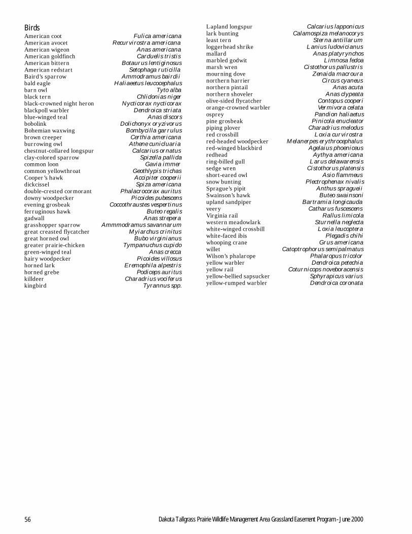
56 Dakota Tallgrass Prairie Wildlife Management Area Grassland Easement Program - June 2000
BirdsAmerican coot Fulica americanaAmerican avocet Recurvirostra americanaAmerican wigeon Anas americanaAmerican goldfinch Carduelis tristisAmerican bittern Botaurus lentiginosusAmerican redstart Setophaga ruticillaBaird’s sparrow Ammodramus bairdiibald eagle Haliaeetus leucocephalusbarn owl Tyto albablack tern Chlidonias nigerblack-crowned night heron Nycticorax nycticoraxblackpoll warbler Dendroica striatablue-winged teal Anas discorsbobolink Dolichonyx oryzivorusBohemian waxwing Bombycilla garrulusbrown creeper Certhia americanaburrowing owl Athene cunicluariachestnut-collared longspur Calcarius ornatusclay-colored sparrow Spizella pallidacommon loon Gavia immercommon yellowthroat Geothlypis trichasCooper’s hawk Accipiter cooperiidickcissel Spiza americanadouble-crested cormorant Phalacrocorax auritusdowny woodpecker Picoides pubescensevening grosbeak Coccothraustes vespertinusferruginous hawk Buteo regalisgadwall Anas streperagrasshopper sparrow Ammmodramus savannarumgreat creasted flycatcher Myiarchus crinitusgreat horned owl Bubo virginianusgreater prairie-chicken Tympanuchus cupidogreen-winged teal Anas creccahairy woodpecker Picoides villosushorned lark Eremophila alpestrishorned grebe Podiceps aurituskilldeer Charadrius vociferuskingbird Tyrannus spp.
Lapland longspur Calcarius lapponicuslark bunting Calamospiza melanocorysleast tern Sterna antillarumloggerhead shrike Lanius ludovicianusmallard Anas platyrynchosmarbled godwit Limnosa fedoamarsh wren Cistothorus pallustrismourning dove Zenaida macrouranorthern harrier Circus cyaneusnorthern pintail Anas acutanorthern shoveler Anas clypeataolive-sided flycatcher Contopus cooperiorange-crowned warbler Vermivora celataosprey Pandion haliaetuspine grosbeak Pinicola enucleatorpiping plover Charadrius melodusred crossbill Loxia curvirostrared-headed woodpecker Melanerpes erythrocephalusred-winged blackbird Agelaius phoeniceusredhead Aythya americanaring-billed gull Larus delawarensissedge wren Cistothorus platensisshort-eared owl Asio flammeussnow bunting Plectrophenax nivalisSprague’s pipit Anthus spragueiiSwainson’s hawk Buteo swainsoniupland sandpiper Bartramia longicaudaveery Catharus fuscescensVirginia rail Rallus limicolawestern meadowlark Sturnella neglectawhite-winged crossbill Loxia leucopterawhite-faced ibis Plegadis chihiwhooping crane Grus americanawillet Catoptrophorus semipalmatusWilson’s phalarope Phalaropus tricoloryellow warbler Dendroica petechiayellow rail Coturnicops noveboracensisyellow-bellied sapsucker Sphyrapicus variusyellow-rumped warbler Dendroica coronata

U.S. Fish and Wildlife ServiceLand Acquisition and Refuge PlanningP.O. Box 25486, DFCDenver, CO 80225-0486303/236 8145
U. S. Fish and Wildlife Servicehttp://www.fws.gov
For Refuge Information1 800/344 WILD
June 2000