grandview woodland community plan commercial...
TRANSCRIPT

Grandview‐Woodland Community Plan
Commercial Drive Sub‐Area Workshop: Backgrounder March 2015

Commercial Drive Sub‐Area Workshop: Backgrounder (March 2015) 2
What’s the future look like for Commercial Drive? A major street on the eastern edge of Grandview‐Woodland, Commercial Drive, or “The Drive”, has long been the social, cultural, and economic high street of Grandview‐Woodland. The Commercial Drive sub‐area includes the area between Hastings Street and the Grandview Cut. The Drive is an eclectic high street filled with a rich history, a diverse array of independent shops and services, social and cultural facilities, and a thriving public life. In 2011, Spacing Magazine named Commercial Drive one of the top‐10 public spaces in the province. This background will provide an overview of the Grandview‐Woodland’s community planning process to date, giving an overview of the specific considerations policy ideas, considerations and opportunities that will help shape the next few decades of growth and change in the neighbourhood.
Background
This backgrounder starts by looking at the draft policies that were developed for the Commercial Drive sub‐area, as well as the community feedback that was received. The aim of our planning work is to revise these directions as appropriate. This could mean:
Affirming the existing policy ideas for the area;
Modifying policy proposals or identifying alternative options;
Identifying gaps in the proposed policy – and helping to address those.
At the end of the day, we’re looking for your help to identify key options for land‐use and building types, housing, local economy, public spaces and more. This work will then be integrated into the larger, neighbourhood‐wide planning process, including the work of the Grandview‐Woodland Citizens’ Assembly.

Commercial Drive Sub‐Area Workshop: Backgrounder (March 2015) 3
Background
In April 2012, the City of Vancouver launched a Community Plan process for Grandview‐Woodland that has four phases. Phase One of the process, completed in August 2012, involved outreach and engagement, as well as the general identification of assets, issues and opportunities in the neighbourhood (that is, what people love about the community, and areas they’d like to see changed). Phase Two, which was completed in the spring of 2013, was focused on the exploration of general policy themes (such as Housing, Transportation, parks and Public Space, and more). The current Phase Three focuses on the development and refinement of an integrated set of Emerging Directions, including draft community‐wide and sub‐area policies. The first draft of Emerging Directions was released at the beginning of June 2013. While many of the 225 recommendations were well received, some were the source of considerable discussion and concern. Based on community discussions that took place, the City extended the planning process and created the city’s first Citizens’ Assembly to help resolve some of the issues that emerged. It is now anticipated that Phase 3 will be complete in summer/fall 2015. The last phase of the community plan process, anticipated to begin in fall 2015, will focus on finalizing the Community Plan, and testing a complete draft document with the community.
Commercial Drive Sub‐Area Workshop: Backgrounder (March 2015) 4
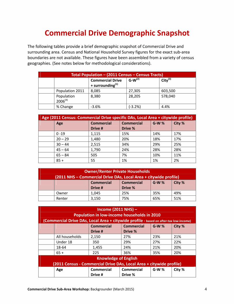
Commercial Drive Demographic Snapshot The following tables provide a brief demographic snapshot of Commercial Drive and surrounding area. Census and National Household Survey figures for the exact sub‐area boundaries are not available. These figures have been assembled from a variety of census geographies. (See notes below for methodological considerations).
Total Population – (2011 Census – Census Tracts) Commercial Drive
+ surrounding(1) G‐W(2) City(3)
Population 2011 8,085 27,305 603,500
Population 2006(4)
8,380 28,205 578,040
% Change ‐3.6% (‐3.2%) 4.4%
Age (2011 Census: Commercial Drive specific DAs, Local Area + citywide profile) Age Commercial
Drive # Commercial Drive %
G‐W % City %
0 ‐19 1,115 15% 14% 17%
20 – 29 1,480 20% 18% 17%
30 – 44 2,515 34% 29% 25%
45 – 64 1,790 24% 28% 28%
65 – 84 505 7% 10% 11%
85 + 55 1% 1% 2%
Owner/Renter Private Households (2011 NHS – Commercial Drive DAs, Local Area + citywide profile)
Commercial Drive #
Commercial Drive %
G‐W % City %
Owner 1,045 25% 35% 49%
Renter 3,150 75% 65% 51%
Income (2011 NHS) – Population in low‐income households in 2010
(Commercial Drive DAs, Local Area + citywide profile ‐ based on after‐tax low‐income) Commercial
Drive # Commercial Drive %
G‐W % City %
All households 2,150 27% 23% 21%
Under 18 350 29% 27% 22%
18‐64 1,455 24% 21% 20%
65 + 225 36% 35% 20%
Knowledge of English (2011 Census ‐ Commercial Drive DAs, Local Area + citywide profile)
Age Commercial Drive #
Commercial Drive %
G‐W % City %
Commercial Drive Sub‐Area Workshop: Backgrounder (March 2015) 5
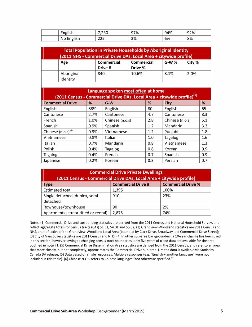
English 7,230 97% 94% 92%
No English 225 3% 6% 8%
Total Population in Private Households by Aboriginal Identity (2011 NHS ‐ Commercial Drive DAs, Local Area + citywide profile)
Age Commercial Drive #
Commercial Drive %
G‐W % City %
Aboriginal Identity
840 10.6% 8.1% 2.0%
Language spoken most often at home (2011 Census ‐ Commercial Drive DAs, Local Area + citywide profile)(5)
Commercial Drive % G‐W % City %
English 88% English 80 English 65
Cantonese 2.7% Cantonese 4.7 Cantonese 8.3
French 1.0% Chinese (n.o.s) 2.8 Chinese (n.o.s) 5.1
Spanish 0.9% Spanish 1.2 Mandarin 3.2
Chinese (n.o.s)(6) 0.9% Vietnamese 1.2 Punjabi 1.8
Vietnamese 0.8% Italian 1.0 Tagalog 1.6
Italian 0.7% Mandarin 0.8 Vietnamese 1.3
Polish 0.4% Tagalog 0.8 Korean 0.9
Tagalog 0.4% French 0.7 Spanish 0.9
Japanese 0.2% Korean 0.3 Persian 0.7
Commercial Drive Private Dwellings (2011 Census ‐ Commercial Drive DAs, Local Area + citywide profile)
Type Commercial Drive # Commercial Drive %
Estimated total 1,395 100%
Single detached, duplex, semi‐detached
910 23%
Rowhouse/townhouse 90 2%
Apartments (strata‐titled or rental) 2,875 74% Notes: (1) Commercial Drive and surrounding statistics are derived from the 2011 Census and National Household Survey, and reflect aggregate totals for census tracts (CAs) 51.01, 54.01 and 55.02; (2) Grandview‐Woodland statistics are 2011 Census and NHS, and reflective of the Grandview‐Woodland Local Area (bounded by Clark Drive, Broadway and Commercial Drive Street); (3) City of Vancouver statistics are 2011 Census and NHS; (4) In other sub‐area backgrounders, a 10‐year change has been used in this section; however, owing to changing census tract boundaries, only five years of trend data are available for the area outlined in note #1; (5) Commercial Drive Dissemination Area statistics are derived from the 2011 Census, and refer to an area that more closely, but not completely, approximates the Commercial Drive sub‐area. Limited data is available via Statistics Canada DA release; (5) Data based on single responses. Multiple responses (e.g. “English + another language” were not included in this table). (6) Chinese N.O.S refers to Chinese languages “not otherwise specified.”

Commercial Drive Sub‐Area Workshop: Backgrounder (March 2015) 6
Existing Zoning of Grandview‐Woodland RS – Single‐family zoning RT – Two‐family (duplex) zoning RM – Multi‐family zoning C – Commercial zoning I – Light‐industrial zoning M – Heavy manufacturing zoning CD – Custom (comprehensive development) zone C‐2, C‐2C & C‐2C1 Zoning ‐ Heights Outright – 10.7m Conditional – 13.8m RM‐4 & RM‐4N Zoning ‐ Heights Outright – 10.7m Conditional – see District Schedule
RS‐1

Commercial Drive Sub‐Area Workshop: Backgrounder (March 2015) 7
The Big Picture: Responding to Key Challenges The Commercial Drive sub‐area is a vibrant neighbourhood, but here – like elsewhere in Grandview‐Woodland and across the city, we are faced with some big challenges:
Growth – Over the next 30 years, the population of the Vancouver is expected to increase by at least 160,000 people. New residents to the city need to be accommodated in all neighbourhoods and growth needs to be managed in a way that maintains the overall livability of the city.
Affordability and economic hardship – Vancouver is desirable place to live, but it is also a city with considerable challenges around income security. Maintaining – or increasing – the number of affordable places to live (including homes, gathering areas, places to shop) is a key priority. Also a priority: economic security and a diverse economy that creates and sustains well‐paying, meaningful jobs for residents.
Social Issues – In addition to challenges around affordability, other pressing social issues need to be addressed. These include food insecurity, physical and mental health and well‐being, the provision of adequate social supports for children, youth and seniors, settlement services, reconciliation with Aboriginal peoples, protection for vulnerable populations such as the homeless and survival sex workers.
Environmental well‐being – The challenges posed by climate change are well‐documented,
and require a strong response from all levels of government. At the local level, investing in compact, walkable, low‐carbon communities is seen as one way that local government can reduce its carbon footprint and support the overall objectives of a greener, more sustainable city.
Maintaining a sense of place amidst change – The many aspects of neighbourhood
character contribute to ‘a sense of place’. They are the features – good or bad – that make each neighbourhood unique. Change is inevitable; however, amidst change, attention must also be focussed on maintaining (or enhancing) the positive aspects of neighbourhood character.
Community plans aim to respond to these and other issues. A neighbourhood‐scale community plan won’t solve all the challenges identified, because many of these issues are city‐wide, provincial, and even national in scale. However, the plans do have an important role to play, and will help to respond to the “big issues” by
moving the dial towards a greener, more socially inclusive, economically just city.

Commercial Drive Sub‐Area Workshop: Backgrounder (March 2015) 8
The Big Picture: Key City‐wide Planning Principles
Achieve a green, environmentally sustainable urban pattern Locate higher densities near neighbourhood and transit centres • Implement greenhouse gas reduction strategies • Improve and enhance water, air quality, and ecological diversity
Support a range of affordable housing options to meet the diverse needs of the community Increase the diversity of the housing stock • Provide a range of affordable housing options • Recognize the value of existing affordable and low‐income housing • Increase options and enhance stability for vulnerable community residents • Attract and retain a vibrant workforce
Foster a robust, resilient economy Enhance and support community economic development and green enterprises • Develop employment space able to accommodate future growth and avoid displacement • Consider the value of existing affordable commercial spaces • Ensure integration of job space with the transportation network • Engage businesses to improve choice and affordability of housing and daycare
Enhance culture, heritage and creativity within the city Plan for flexible spaces for cultural and social activity reflecting local character • Integrate public art into the public realm • Review opportunities to integrate cultural space • Consider cultural programming needs when designing public and private spaces • Identify, recognize, and retain important heritage resources
Provide and support a range of sustainable transportation options Make walking and cycling safe, convenient, delightful and comfortable for all ages • Encourage transit improvements to ensure fast, frequent, reliable and accessible service • Manage the road network efficiently • Support the efficient movement and delivery of goods and services
Protect and enhance public open spaces, parks and green linkages Ensure that residents enjoy good access to green spaces and linkages to neighbourhood resources • Develop or improve greenspaces in areas that are underserved • Apply ecological “best practices” for public realm and infrastructure design
Foster resilient, sustainable, safe and healthy communities Strategically integrate social amenity and land use planning • Seek partnerships on social infrastructure • Support a range of programs and explore co‐location possibilities • Preserve and enhance local food systems • Develop unique responses with communities to social and environmental issues • Recognize, reinforce and maintain the strong sense of place and community • Make public safety a priority so that people feel safe at all times
Commercial Drive Sub‐Area Workshop: Backgrounder (March 2015) 9
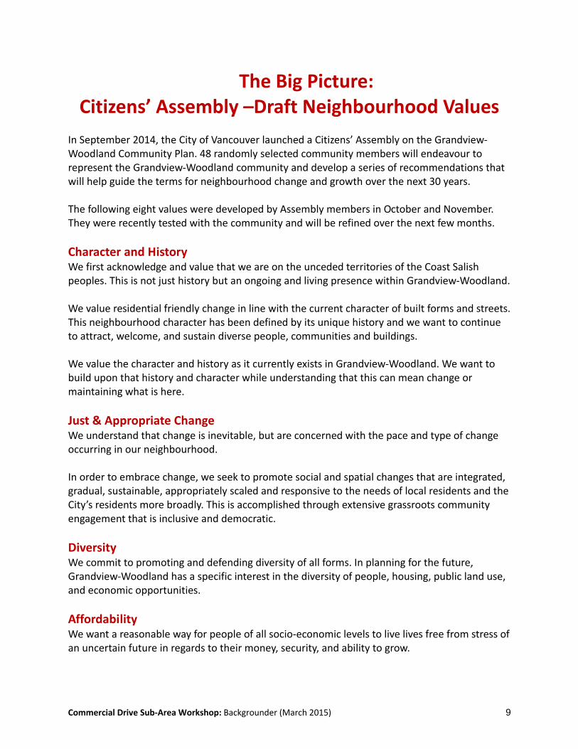
The Big Picture: Citizens’ Assembly –Draft Neighbourhood Values
In September 2014, the City of Vancouver launched a Citizens’ Assembly on the Grandview‐Woodland Community Plan. 48 randomly selected community members will endeavour to represent the Grandview‐Woodland community and develop a series of recommendations that will help guide the terms for neighbourhood change and growth over the next 30 years. The following eight values were developed by Assembly members in October and November. They were recently tested with the community and will be refined over the next few months.
Character and History We first acknowledge and value that we are on the unceded territories of the Coast Salish peoples. This is not just history but an ongoing and living presence within Grandview‐Woodland. We value residential friendly change in line with the current character of built forms and streets. This neighbourhood character has been defined by its unique history and we want to continue to attract, welcome, and sustain diverse people, communities and buildings. We value the character and history as it currently exists in Grandview‐Woodland. We want to build upon that history and character while understanding that this can mean change or maintaining what is here.
Just & Appropriate Change We understand that change is inevitable, but are concerned with the pace and type of change occurring in our neighbourhood. In order to embrace change, we seek to promote social and spatial changes that are integrated, gradual, sustainable, appropriately scaled and responsive to the needs of local residents and the City’s residents more broadly. This is accomplished through extensive grassroots community engagement that is inclusive and democratic.
Diversity We commit to promoting and defending diversity of all forms. In planning for the future, Grandview‐Woodland has a specific interest in the diversity of people, housing, public land use, and economic opportunities.
Affordability We want a reasonable way for people of all socio‐economic levels to live lives free from stress of an uncertain future in regards to their money, security, and ability to grow.
Commercial Drive Sub‐Area Workshop: Backgrounder (March 2015) 10
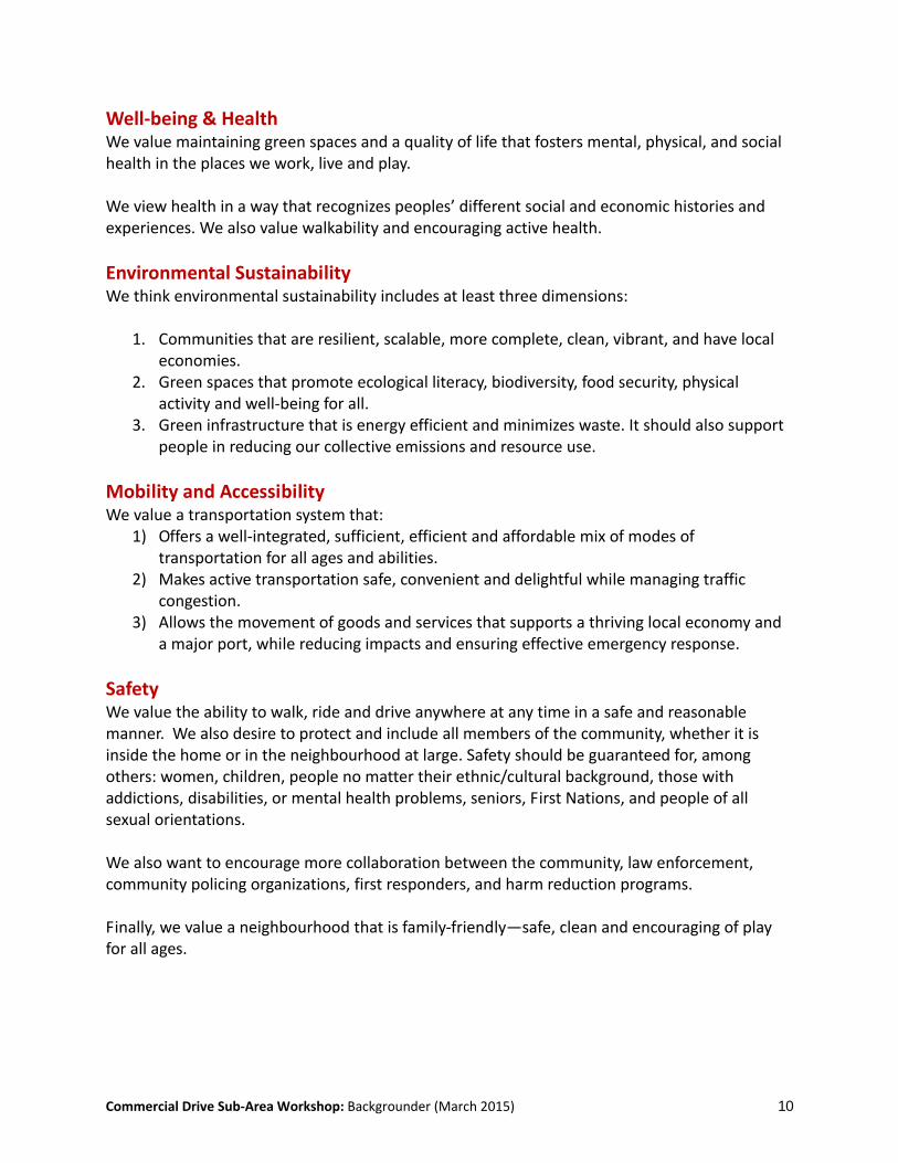
Well‐being & Health We value maintaining green spaces and a quality of life that fosters mental, physical, and social health in the places we work, live and play. We view health in a way that recognizes peoples’ different social and economic histories and experiences. We also value walkability and encouraging active health.
Environmental Sustainability We think environmental sustainability includes at least three dimensions:
1. Communities that are resilient, scalable, more complete, clean, vibrant, and have local economies.
2. Green spaces that promote ecological literacy, biodiversity, food security, physical activity and well‐being for all.
3. Green infrastructure that is energy efficient and minimizes waste. It should also support people in reducing our collective emissions and resource use.
Mobility and Accessibility We value a transportation system that:
1) Offers a well‐integrated, sufficient, efficient and affordable mix of modes of transportation for all ages and abilities.
2) Makes active transportation safe, convenient and delightful while managing traffic congestion.
3) Allows the movement of goods and services that supports a thriving local economy and a major port, while reducing impacts and ensuring effective emergency response.
Safety We value the ability to walk, ride and drive anywhere at any time in a safe and reasonable manner. We also desire to protect and include all members of the community, whether it is inside the home or in the neighbourhood at large. Safety should be guaranteed for, among others: women, children, people no matter their ethnic/cultural background, those with addictions, disabilities, or mental health problems, seniors, First Nations, and people of all sexual orientations. We also want to encourage more collaboration between the community, law enforcement, community policing organizations, first responders, and harm reduction programs. Finally, we value a neighbourhood that is family‐friendly—safe, clean and encouraging of play for all ages.
Commercial Drive Sub‐Area Workshop: Backgrounder (March 2015) 11
Sub‐Area Planning – What we heard in the early planning process
The Grandview‐Woodland community plan was launched in 2012. During the first 16 months a number of activities took place, including: Literature review ‐ neighbourhood and city‐wide policy (2011‐12) Assets, issues and opportunities mapping (May – July 2012) Energy & GHG Futures workshop (June 2012) Urban design walks and workshop (Sept 2012) Planning Principles & Neighbourhood character workshops (Sept – Oct 2012) Planning through Dialogue – thematic workshops (Dec 2012 – Mar 2013) Commercial Drive Street questionnaire (May 2013)
These activities identified a number of important ideas about the Commercial Drive sub‐area and its future. This is a sampling of some of the key points:
Housing Commercial Drive provides an interesting array of housing (predominantly rental)
opportunities, including a number of affordable apartments above stores In addition, there is an array of older, purpose‐built rental and strata‐titled buildings
located north of Venables – a source of affordable housing for the neighbourhood. Specific seniors housing (Lions Den) provides an important service to the community,
providing older residents with housing and support.
Transportation Commercial Drive is a key commercial street, it serves residents and visitors alike, and is
a regional destination. The Drive attracts people using all modes of transportation – but it is also a ‘hot‐spot’
for pedestrian, cycling and automotive crashes – particularly at key intersections. There is a desire to see improvements to the pedestrian environment (including wider
sidewalks, better seating, water fountains and other supports), as well as better cycling and transit facilities (especially improvements to the #20 bus).
The shift from a four‐lane to six‐lane street width (at Gravely), creates a change in scale and ‘feel’ of the street.
Traffic volumes, particularly at peak hours, also change the feel of the street – especially south of E 1st. There is interest in looking at parking regulations to address this
There is concern about the potential loss of parking, and what impacts (if any) this might have on both local businesses and the community.
Commercial Drive Sub‐Area Workshop: Backgrounder (March 2015) 12
Parks and Public Space Grandview Park and Britannia are often described as the “heart” of the neighbourhood,
but there are also several key park spaces located within close proximity – including Woodland, Salsbury, Victoria and McSpadden parks.
The Grandview Cut, at the south end of the sub‐area, is an important ‘green finger’ – an important habitat corridor and greenspace.
Other important public spaces – include the Britannia plaza, and the gathering areas to the north of the Cut. There is support for street‐to‐park and parklet spaces on or adjacent to the Drive.
Other public space opportunities include the adjacent lanes, locations where the street grid is offset (e.g. at McSpadden), and the ‘orphaned space’ at Adanac (enhanced in 2012 with the addition of the ‘picture frame’).
Social Sustainability & Social Issues Britannia CC seen as a key component of the neighbourhood. There is broad support for
the facility, and a strong desire to see the facility enhanced and expanded. Commercial Drive continues to play an important role in fostering (and showcasing)
neighbourhood diversity of all types. The ‘Drive has served as a place of arrival for many generations of newcomers to the city. More broadly, it is seen as a place where people of different gender, ethnicity, politics, incomes and abilities can come together.
There is concern about the displacement of lower income residents due to gentrification.
Heritage Commercial Drive sub‐area contains a number of older buildings. Local architecture
contains a number of key features, including bay windows and cornices, inconsistent set‐backs, and a variety of architectural styles.
Several buildings are listed on the City’s Heritage Register, as are Grandview Park and the park’s cenotaph. There is support to see the definition of heritage broadened to include other aspects of the Drive’s streetscape or social and cultural history.
Arts & Culture The ‘Drive is a key cultural asset in and of itself. It is also home to several cultural
facilities There are a number of pieces of public art on the Drive, mostly found within commercial
murals. There is a desire to see the ‘Drive function as a better showcase for local artists – but there is some debate over the type of art that might best showcase the ‘Drive (to simplify: a more consistent ‘look’, or a diversity of different interventions)
Desire to see improvements to night‐life; creation of additional performance areas (incl. all‐ages spaces)
Suggestions regarding creation of an artists market – on, or near the Drive. Possible use of a laneway for this purpose?

Commercial Drive Sub‐Area Workshop: Backgrounder (March 2015) 13
Local Economy Strong support for Commercial Drive as a high street – especially its fine‐grained pattern
(narrow frontages, small lots), its high proportion of independent (non‐chain store) businesses, and its role in providing a variety of shops and services to support the community.
Concern that local businesses may be displaced via higher lease rates, or be negatively impacted by new development in the area. A contrasting view: suggestion that new development (and more people) could result in improved opportunities for local businesses.
Discussion about the role and importance of ensuring that people using different modes of transportation can access businesses on the Drive.
There is a strong desire to see improved retail to better link the area between Venables and Hastings.
Commercial Drive Sub‐Area Workshop: Backgrounder (March 2015) 14
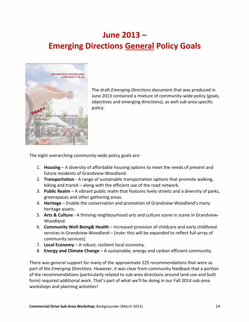
June 2013 – Emerging Directions General Policy Goals
The draft Emerging Directions document that was produced in June 2013 contained a mixture of community‐wide policy (goals, objectives and emerging directions), as well sub‐area specific policy.
The eight overarching community‐wide policy goals are:
1. Housing – A diversity of affordable housing options to meet the needs of present and future residents of Grandview‐Woodland.
2. Transportation ‐ A range of sustainable transportation options that promote walking, biking and transit – along with the efficient use of the road network.
3. Public Realm – A vibrant public realm that features lively streets and a diversity of parks, greenspaces and other gathering areas.
4. Heritage – Enable the conservation and promotion of Grandview‐Woodland’s many heritage assets.
5. Arts & Culture ‐ A thriving neighbourhood arts and culture scene in scene in Grandview‐Woodland.
6. Community Well‐Being& Health – Increased provision of childcare and early childhood services in Grandview‐Woodland – [note: this will be expanded to reflect full‐array of community services].
7. Local Economy – A robust, resilient local economy. 8. Energy and Climate Change – A sustainable, energy and carbon efficient community.
There was general support for many of the approximate 225 recommendations that were as part of the Emerging Directions. However, it was clear from community feedback that a portion of the recommendations (particularly related to sub‐area directions around land‐use and built form) required additional work. That’s part of what we’ll be doing in our Fall 2014 sub‐area workshops and planning activities!
Commercial Drive Sub‐Area Workshop: Backgrounder (March 2015) 15
Sub‐Area Planning: Emerging Directions ‐ Commercial Drive policies The following pages provide a summary of the draft sub‐area policies and (and related ideas noted on the draft land‐use map) – organized by key planning theme. (Because some of the policies relate to more than one theme, you will notice some overlap here). There is also a complete set of community‐wide policies contained in the Emerging Directions document. Some of these apply to Commercial Drive, so we have summarized them here. You can find the complete set of Emerging Directions policies at vancouver.ca/gw.
Commercial Drive Sub‐Area Workshop: Backgrounder (March 2015) 16
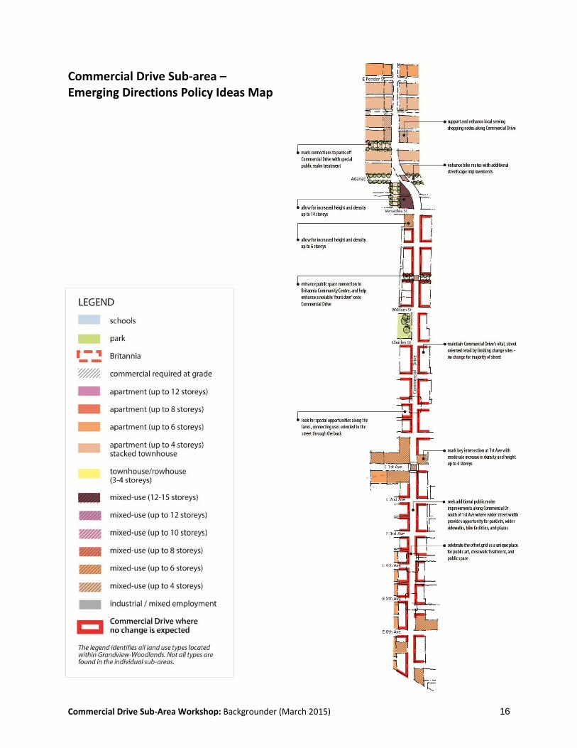
Commercial Drive Sub‐area – Emerging Directions Policy Ideas Map
Commercial Drive Sub‐Area Workshop: Backgrounder (March 2015) 17
Emerging Directions –Commercial Drive Policies
Housing
Sub‐Area Policies and Policy Ideas (Emerging Directions) (pg. 28) CD‐1: Maintain existing zoning for most of Commercial Drive and encourage gradual
build‐out over time. CD‐2: Allow additional height and mixed‐use development (as noted on the drawings) at
selected locations along the street: o Astorino’s/Kettle – NW corner of Commercial and Venables (up to 14‐storeys); o SW corner of Commercial and Venables (up to 6‐storeys); o NW corner of Commercial & E 1st (up to 6‐storeys); o NE corner of Commercial and E 1st (up to 6‐storeys); o SW corner of Commercial & E 1st (up to 6‐storeys); o Key sites south of E 5th (key sites) (up to 6‐storeys)
Other relevant community‐wide policies (Emerging Directions) (p.4‐5) Policies to: eliminate street homelessness; increase supported housing options; expand
non‐market rental housing; maintain existing affordable rental housing and create new market (and secondary) rental opportunities; increase new housing types to support home ownership opportunities; review design guidelines against future land‐use directions.
What people said: - General support for maintaining existing zoning on the Drive – though uneven
recognition that this would allow up to four‐storeys. Some commentary regarding value of varied building heights, versus a ‘build‐out’ with even four‐storey ; discussion of importance of gradual change
- Considerable discussion about proposed development of the Astorino’s/Kettle site. Strong support for the role of the Kettle Friendship Centre. While some support exists for a new site “up to 14 storeys,” a sizeable portion of feedback indicates a preference for a building (or buildings) with reduced height. There were various opinions about what this should mean – “nothing above four storeys”, “four to five”, “four to six” “up to six storeys”, “six to eight”, “under eight” “up to 10‐storeys”, “nothing higher than 10,” “capped at 12 storeys”
- Additional recognition that the Kettle/Astorino’s site – at the ‘jog’ of the Drive – is in an important location. Need to ensure good architecture and urban design
- Regarding sites identified for additional height (other than Kettle/Astorino’s): Some concern that additional height will negatively affect the Drive. Others suggest height would be acceptable if matched by quality design, upper storey step‐backs, additional job space or affordable housing etc. Differing opinions re acceptability of “up to four,” “four to five”, “four to six”
- In general, strong desire to ensure good quality of design throughout the Drive, and in all new (mixed‐use) developments – with commentary around ensuring a ‘fit’ with

Commercial Drive Sub‐Area Workshop: Backgrounder (March 2015) 18
local architecture. A desire not to see anything that looks like Metrotown, or downtown Vancouver; discussion around tenure preferences – rental vs strata‐titled condominiums.
- Interest in seeing additional mixed‐use (retail + housing, or retail + office + housing) north of Venables
Local Economy
Sub‐Area Policies and Policy Ideas (Emerging Directions) (p.28) CD‐1: Maintain existing zoning for most of Commercial Drive and encourage gradual
build‐out over time. CD‐3: Ensure that new development respects the existing built‐form character of the
‘Drive (including heritage features, fine‐grained retail environment, eclectic mix of architectural styles).
Land‐use Map: [north of Adanac] support and enhance local serving shopping nodes along Commercial Drive
Land‐use Map: maintain Commercial Drive’s vital, street‐oriented retail by limiting change sites ‐ no change for majority of street
Land‐use Map: look for special opportunities along the lanes, connecting uses oriented to the street through the back
Other relevant community‐wide policies (Emerging Directions) (p.20‐21) Policies to: support commercial high streets in Grandview‐Woodland.
What people said: - Strong support for local, independent nature of businesses on the Drive; concern
about loss of this character, displacement of businesses, retail gentrification, or influx of chain store retailers
- Desire to see the diversity of businesses on Commercial Drive remain – as a key means to support neighbourhood walkability. Some reference to increasing number of cafes and restaurants
- Concern about impact of increasing lease rates – and general displeasure with the impact that this has had on the loss of popular neighbourhood businesses
- Concern about potential impacts of new mixed‐use development/higher buildings on lease rates, as well as neighbourhood traffic and parking.
- Support for the architectural character associated with existing retail – ‘fine‐grained’ nature of narrower storefronts, smaller spaces, varied set‐backs
- Support for gradual improvements to Commercial Drive night‐life, and desire to see this further enhanced
- Interest in seeing expansion of retail opportunities in two ways: (1) via better use of alley space (potentially for multiple entrances to businesses, or creation of market spaces), (2) via better connection between Commercial Drive high street area (which currently ends at Venables), with Hastings Street area

Commercial Drive Sub‐Area Workshop: Backgrounder (March 2015) 19
- General support for maintaining existing zoning on the Drive – though uneven recognition that this would allow up to four‐storeys. Some commentary regarding value of varied building heights
- Differing opinions on allowing buildings “up to 6‐storeys” at SW Venables, E 1st and south of E 5th. Some concern that additional height will negatively affect the Drive. Others suggest this height would be acceptable if matched by quality design, upper storey step‐backs, additional job space or affordable housing etc.
Transportation & Public Realm
Sub‐Area Policies and Policy Ideas (Emerging Directions) (p.28) CD‐5: Where possible, expand
sidewalks and improve existing public realm features (street furniture, street trees, public art).
CD‐6: Introduce bike lanes between e 10th and Gravely. minimize impacts to parking, and explore using parking as a buffer between motor vehicle and moving traffic.
Land‐use Map: mark connections to parks (e.g Woodland, Salsbury) off Commercial Drive with special public realm treatment
Land‐use Map: enhance bike routes with additional streetscape improvements
Land‐use Map: look for special opportunities along the lanes, connecting uses oriented to the street through the back
Land‐use Map: celebrate the offset grid as a unique place for public art, crosswalk treatment, and public space
Land‐use Map: enhance public space connection to Britannia Community Centre, and help enhance a notable ‘front door’ onto Commercial Drive
Land‐use Map: seek additional public realm improvements along Commercial Dr south of 1st Ave where wider street width provides opportunity for parklets, wider sidewalks, bike facilities, and plazas
Other relevant community‐wide Transportation policies (Emerging Directions) (p.6‐9) Policies to: enhance and maintain the pedestrian network (on key arterials); improve
existing cycling network (including a potential E/W connections on Charles, Gravely and

Commercial Drive Sub‐Area Workshop: Backgrounder (March 2015) 20
E 8th); work with Translink to improve local transit service (e.g. a community shuttle on E 1st); ensure safe and efficient use of road network (including parking, goods movement).
Other relevant community‐wide Public realm policies (Emerging Directions) (p.9‐11) Policies to: enhance existing parks and greenspaces; expand neighbourhood greenspace
assets; explore “green links” to connect public spaces and community facilities; increase the number of street trees; expand available street furniture; support the optimization and upgrade of Britannia; review the efficacy of having two swimming pools (Britannia and Templeton) in close proximity to one‐another.
What people said: - Strong support for policies to support Commercial Drive pedestrian areas – with a
variety of supports (seating, fountains, garbage cans, street trees etc.) and safety improvements (better crossings; commentary about need to ensure the fit of new features with existing character (sub‐text: reflect the eclectic; nothing too consistent and uniform).
- Some discussion of signage regulations – that could help free up sidewalk space - Strong community support for parklets and (on adjacent streets) street‐to‐park
features - Considerable support for cyclists on the Drive, and improvements to cycling safety;
however, debate regarding the potential merits and impact of a bike lane (areas of discussion include: positive and negative impacts on business, access to shopping, need to understand implications for parking, vehicle flow and transit, impact on health and well‐being, potential pros and cons of different route locations/alternatives (on the Drive and on adjacent streets), possible design elements, etc.)
- Support for improvements to #20 bus – and frequent reference to challenges with existing service levels, bus ‘bunching’
- Support for the creation of additional gathering areas; discussion re use of off‐set grid and differing building set‐backs for public realm improvements, need for public art features, need to weather‐proof/all‐season spaces
- Strong support for recent improvements to Grandview and Victoria Park; related desire to see improvements to other parks. Additional commentary about need to ensure that park space remains safe and accessible for all residents and visitors
- Desire to see improvements to laneway spaces that connect (or run parallel) to the Drive. Suggestion that these could be better used for small business spaces, markets, alternative walking routes, etc.
- Concern about traffic volume and speeds on E 1st; commentary about the street being ‘dangerous’
- Suggestion that the City revisit parking regulations on Commercial Drive and E 1st – with a view to using parked cars to buffer the sidewalk during peak hours
- Commentary regarding the role of Commercial Drive and laneway areas in supporting the local economy – particularly as it relates to goods movement.
Commercial Drive Sub‐Area Workshop: Backgrounder (March 2015) 21
Community Well‐being
Sub‐Area Policies and Policy Ideas (Emerging Directions) (p.28) CD‐7: Support expansion of key social, health and community services (Britannia, Kettle,
REACH). Land‐use Map: enhance public space connection to Britannia Community Centre, and
help enhance a notable ‘front door’ onto Commercial Drive
Other relevant community‐wide policies (Emerging Directions) (p.16‐19) Policies to: support the expansion of key community facilities such as the Britannia
Community Centre, Aboriginal Friendship Centre; Urban Native Youth Association and REACH; increase the provision of childcare, youth services and seniors services; increase the number of local food assets; strengthen neighbourhood safety; support local low‐income workers as part of future neighbourhood development.
What people said: - General support for policies relating to the
expansion of community social services that are located on or near the Drive.
- Strong support for expansion of Britannia facility, and for the ‘hub’ model, with many services (recreation, childcare, school, library) co‐located; commentary regarding the need for specific types of services and programming features (e.g. maker space, more youth space, etc.) in the facility
- Desire to see more meeting areas where people can gather year ‘round.
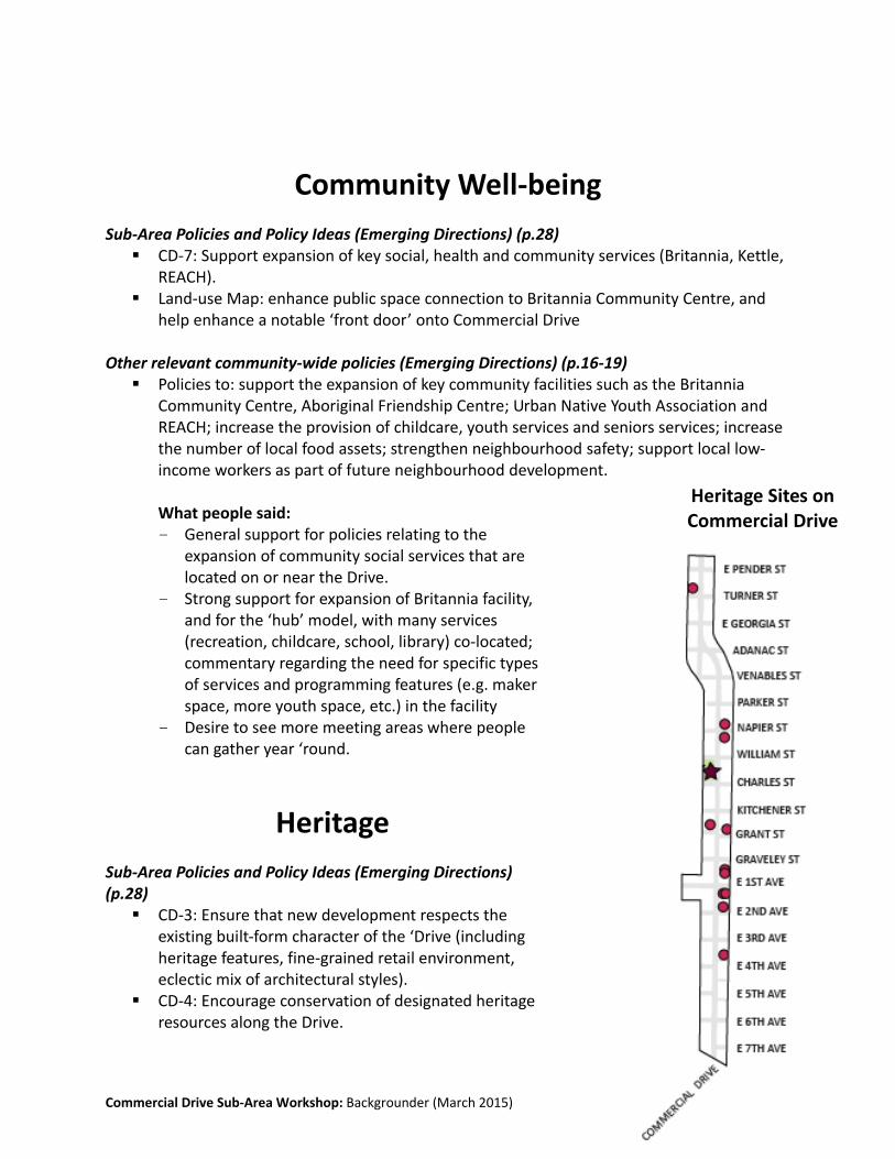
Heritage
Sub‐Area Policies and Policy Ideas (Emerging Directions) (p.28) CD‐3: Ensure that new development respects the
existing built‐form character of the ‘Drive (including heritage features, fine‐grained retail environment, eclectic mix of architectural styles).
CD‐4: Encourage conservation of designated heritage resources along the Drive.
Heritage Sites on Commercial Drive

Commercial Drive Sub‐Area Workshop: Backgrounder (March 2015) 22
Other relevant community‐wide policies (Emerging Directions) (p.12) Policies to: increase understanding and recognition of local heritage; broaden definitions
of heritage; update the heritage register; ensure sufficient incentives to encourage protection of local heritage resources; review design guidelines against future land‐use directions.
What people said:
- Desire to see new architecture well‐integrated with existing buildings –some respondents tied this idea to a particular architectural period/style; others referenced the more eclectic building styles as being complimentary
- Discussion around enhancing existing heritage features and storefront facades as a point of focus for policy; difference of opinion about benefit of including ‘heritage’ features in new buildings
- Significant concern noted about the loss of independent business, and the impact that this would have on the overall heritage of the Drive.
- Identification of the important role that older buildings play in supporting new business ventures (because these buildings are cheaper to lease).
- Discussion around the possibility of design guidelines (or pattern books) to guide new development
- General support for conservation of designated heritage resources. Related concern about the impact that new development may have on the character of the neighbourhood.
- Support for broader, more inclusive definition of heritage – as well as updates to the heritage register, heritage incentives, etc.
Arts and Culture
Sub‐Area Policies and Policy Ideas (Emerging Directions) (p.28) CD‐5: Where possible, expand sidewalks and improve existing public realm features
(street furniture, street trees, public art). Land‐use Map: celebrate the offset grid as a unique place for public art, crosswalk
treatment, and public space
Other relevant community‐wide policies (Emerging Directions) (p.12, 13‐15, 21) Policies to: support the creation of affordable and accessible arts and culture space;
preserve and increase creation/production space; ensure a variety of neighbourhood presentation and market spaces; increase public art; support the diverse array of cultural traditions; and, expand office and ancillary space for arts & culture organizations.
What people said:
- General support for sub‐area policies as they relate to public art; some commentary around the ‘type’ of public art.

Commercial Drive Sub‐Area Workshop: Backgrounder (March 2015) 23
- Discussion around ways to support the night‐life on Commercial Drive (incl. hours of operation, liquor licensing)
- General support noted for larger cultural events (e.g. Italian Day and Car Free Day); desire to see these events supported with appropriate infrastructure (e.g. garbage cans); further desire to ensure that cultural events consider the needs of local businesses that may be adversely affected.
- Support for the use of ‘off‐set grid’ to create community spaces; additional support for creation of other gathering spaces, performance areas
- Support for existing cultural assets in Grandview‐Woodland. - General discussion around need to maintain/increase performance spaces in the
neighbourhood. - General support for arts and cultural policies. Discussion regarding the loss of
existing affordable production space (e.g. studios), as well as concerns about neighbourhood affordability (including housing), and its impact on artists.
Energy and Climate Change
Sub‐Area Policies and Policy Ideas (Emerging Directions) (p.27) No specific sub‐area policies
Other relevant community‐wide policies (Emerging Directions) (p.22‐23) Policies to encourage energy conservation in existing
buildings; exploration of opportunities around renewable energy and neighbourhood energy utilities; implementation of green building policies; deconstruction services for re‐use and recycling of building materials.
What people said:
- General support for proposed energy, climate change and green building policies. Some discussion around incentives, relationship between different types of building and environmental performance.
- Suggestions for additional policy related to water‐use, water heating and waste‐water, toxic materials, local food resources, landscaping, green roofs, urban forestry, sustainable transportation.
- General feedback on this topic around density. Mixed opinions: increased density as a means to support urban sustainability vs. concerns that increased density could cause traffic issues, overuse of amenities).
Commercial Drive Sub‐Area Workshop: Backgrounder (March 2015) 24
Land Use and Built Form – Additional Considerations and Constraints
Planning for the future of the community can be a tricky job. A myriad of effects can shape how neighbourhoods grow and change. Some of these can be anticipated, while others can’t. To make matters more interesting, there are a range of other considerations that come to bear. Neighbourhood planning inherently means making choices – about types of housing, about land‐use, about funding allocations, about social and cultural policy, and so on. At the same time, there is also an existing regulatory environment (comprised of city‐wide policies and guidelines, as well as federal and provincial law) that constrains what can and can’t be part of planning activities. Here are some of the key considerations and constraints that come into play – particularly as they relate to built form:
Affordability and Social Need Different forms of housing can accommodate different household types and incomes in general. They can also generate different levels of affordability. One important question to think about is this: "Who will live in Grandview‐Woodland in the next 30 years? What type of housing will they need?"Will there be more families with children (or extended families in general) who will require larger 2‐3 bedroom units? Will there be more singles, students and seniors, who may require smaller units – 0 to 1 bedroom facilities? What sorts of non‐market and supported housing will be required? Will it be for seniors, those with health considerations, those with particular cultural needs? Different types of housing creates different opportunities. For those looking to enter the ownership market, detached housing can be prohibitively expensive, whereas strata‐titled condominiums, row‐houses or townhouses may offer a better opportunity. Similarly, if the aim is to support new renters, then creation of purpose built rental (apartments) will be a key mechanism, where secondary rental (e.g. renting houses, duplexes, condominiums), will only provide a fraction of the needed supply. Finally, alternative ownership models – e.g. co‐ops and co‐housing – offer other possibilities that need to be part of the discussion. Finally, housing – like many other goods – has certain economic thresholds inherent in its production. On a very basic level, bells and whistles aside, the cost of housing generally decreases with the amount built – as it becomes possible for economies of scale to be achieved.
Commercial Drive Sub‐Area Workshop: Backgrounder (March 2015) 25
Environmental Performance The energy and sustainability performance of a residential building will vary a great deal based on the types of materials used in its construction. For example, building materials like metal and concrete have lower insulating properties and are therefore more prone to heat loss than a material like wood. Window‐walls made entirely out of glass and metal also demonstrate a lower energy efficiency than wooden walls with smaller, inserted (or punched) windows. Similarly, wood also has a lower carbon footprint than other structural building materials like concrete and metal. At the same time, taller buildings made from concrete metal and glass may not achieve the energy efficiency of wood framed buildings, but they can achieve a number of other benefits – such as providing the sort of population numbers that support more and better public transit, reducing urban sprawl, and sustaining a strong local economy with commensurate community amenities.
Public Amenities Public amenities (such as childcare, non‐market or supported housing, parks, libraries, community facilities) cost money to build, maintain and operate. There’s only ever ‘so much money to go around’ – and when it comes to capital expenditures, there are choices that need to be made. One of the key goals (and key challenges) in community planning, is establishing the public benefits priorities. This can be complex, as there are a wide variety of competing demands. There’s also the question of funding. A sizeable portion of the funding for building or maintaining community amenities) comes through taxes, capital budgeting and municipal borrowing. Another portion is also generated through the development process. Each of these funding sources also has implications for the neighbourhood.
Neighbourhood Character Choices around buildings can impact neighbour character in a number of ways. The type of materials used, the scale and form of development, and the nature of permitted uses can be seen to complement or contrast with existing neighbourhood character. This doesn’t mean that new buildings necessarily have to look exactly like old ones. (In fact, one of the ways that architectural heritage can supported, is through the contrast provided by newer designs ‐ versus the development of “faux” heritage). Similarly, concerns around building height can often be mitigated through close and thoughtful attention to the first 2‐3 storeys of a building (that is: street‐level activity).
Questions of character can involve a lot of subjective preferences, which makes for engaging discussions.

Commercial Drive Sub‐Area Workshop: Backgrounder (March 2015) 26
Enabling a Complete Street Commercial Drive is a special place, with businesses and services that welcome a wide range of local residents and visitors from throughout the region. It is a street that people can walk to, cycle to, take the bus to, and drive to. Currently, people who walk, take the bus or drive are reasonably well supported, but people who ride a bike to the Drive are made to share the road with high volumes of motor vehicles – which poses a number of safety considerations. Indeed, some people who ride a bike to Commercial Drive choose to use the sidewalk because it feels safer. A helpful way to think about Commercial Drive, and how it could best serve all road users, is to think of it as a “complete” street. A Complete Street is one that is designed for, and serves the needs of, all ages, abilities, and modes of travel – allowing safe and comfortable access for people who are walking, cycling, riding transit, dealing with mobility challenges, or driving a car. Providing safe and convenient access for a broad array of travel options supports local businesses and works to create a lively public realm. However, given that there is only so much space (right‐of‐way) on Commercial Drive, striking the right balance between these modes of travel is a tricky – but essential – exercise.
Existing Policy The City of Vancouver has a variety of existing policies that need to be respected as part of the community plan. These include the Greenest City Action Plan, our Housing and Homelessness Strategy, and our Healthy City Strategy – all of which speak to larger city‐wide needs, aspirations and urban systems. This poses some constraints to our community planning work. Neighbourhood scale transportation policy, for example, can’t run counter to the city‐wide transportation network. In Commercial Drive, one of the key policy considerations is the Transportation 2040 Plan. This document includes policy that supports bicycle lanes on Commercial Drive, south of Gravely. As part of the Grandview‐Woodland planning process, the City is seeking feedback from the community to ensure that this policy is addressed in a thoughtful way – one that balances the needs of all road users, together with the needs of businesses and services along the Drive.

Commercial Drive Sub‐Area Workshop: Backgrounder (March 2015) 27
Neighbourhoods Change Commercial Drive in 2014 is not the same place it was five years ago, 10 years ago or even longer. The neighbourhood has been around – as part of the City of Vancouver – for over 125 years. It has gone through a number of changes. Like cities as a whole, all neighbourhoods change. Commercial Drive will continue to grow and evolve as new people move into the neighbourhood, as businesses and economy change, as the city as a whole grow and changes.
Neighbourhood change, in one fashion or another, is not only inevitable, it can be a good thing.
Community plans – and the sub‐area policies within – are designed to enable positive growth and change in a neighbourhood.
They seek to respond to the challenges and opportunities that come with an increased population ‐ identifying where(and in what form) growth will take place ‐ while also responding to current issues, unique neighbourhood considerations,
and identified community needs.

Commercial Drive Sub‐Area Workshop: Backgrounder (March 2015) 28
Help us to get the plan right Commercial Drive is an important part of Grandview‐Woodland and the city. We need to plan thoughtfully and responsibly for the next three decades and beyond. The work we do today will play a key role in refining directions for this neighbourhood and shaping the overall Grandview‐Woodland community plan.
Thank you for your participation in the planning process.