gps tutorial 1.pdf
TRANSCRIPT

7/29/2019 GPS Tutorial 1.pdf
http://slidepdf.com/reader/full/gps-tutorial-1pdf 1/43
GPS Tutorial # 1Overview
Darren Sessions

7/29/2019 GPS Tutorial 1.pdf
http://slidepdf.com/reader/full/gps-tutorial-1pdf 2/43
GPS Overview GPS System
Calculating a Position
Receiver Outputs
Accuracy and Availability

7/29/2019 GPS Tutorial 1.pdf
http://slidepdf.com/reader/full/gps-tutorial-1pdf 3/43
GPS System NAVSTAR GPS
¦ Navigation Satellite Timing and Ranging
Global Positioning System
¦ Funded and controlled by U. S. Department
of Defense. Comprised of three segments
¦ Space Segment
¦ Control Segment
¦ User Segment

7/29/2019 GPS Tutorial 1.pdf
http://slidepdf.com/reader/full/gps-tutorial-1pdf 4/43
Space Segment
Space segment consists of the GPS space
vehicles (SVs). Nominally 24 SVs plus spares.
¦ Each vehicle has a12 hour orbit.
¦ Repeats same ground track daily.¦ 6 orbital planes with 4 vehicles each.
¦ Planes are equally spaced 60 degrees apart.
¦ Inclined 55 degrees from equatorial plane.
¦ 20,200 km above the earth.
¦ 5 to 8 SVs visible from anywhere on earth.

7/29/2019 GPS Tutorial 1.pdf
http://slidepdf.com/reader/full/gps-tutorial-1pdf 5/43
Space Segment

7/29/2019 GPS Tutorial 1.pdf
http://slidepdf.com/reader/full/gps-tutorial-1pdf 6/43
Control Segment
SVs are controlled by five system tracking stations

7/29/2019 GPS Tutorial 1.pdf
http://slidepdf.com/reader/full/gps-tutorial-1pdf 7/43
Control Segment
Stations monitor and measure signals from
the SVs which are incorporated into orbitalmodels for each of the satellites.
The models compute precise orbital data
(ephemeris) and SV clock corrections for each satellite.
The Master Control station uploads updated
ephemeris and clock data to the SVs.

7/29/2019 GPS Tutorial 1.pdf
http://slidepdf.com/reader/full/gps-tutorial-1pdf 8/43
User Segment
Civilian
¦ SPS - Standard Positioning Servicey Uses single frequency L1
y Uses C/A code only
Military
¦ PPS - Precise Positioning Servicey Uses two frequencies L1/L2
y Uses C/A code and P-code

7/29/2019 GPS Tutorial 1.pdf
http://slidepdf.com/reader/full/gps-tutorial-1pdf 9/43
GPS System Review
Space Segment
Control Segment User Segment

7/29/2019 GPS Tutorial 1.pdf
http://slidepdf.com/reader/full/gps-tutorial-1pdf 10/43
GPS Overview
GPS System
Calculating a Position
Receiver Outputs
Accuracy and Availability

7/29/2019 GPS Tutorial 1.pdf
http://slidepdf.com/reader/full/gps-tutorial-1pdf 11/43
Calculating a Position
Measure distance to satellites.
Obtain satellite positions.
Perform triangulation calculations.
(Trilateration)
Adjust local clock bias.
7/29/2019 GPS Tutorial 1.pdf
http://slidepdf.com/reader/full/gps-tutorial-1pdf 12/43
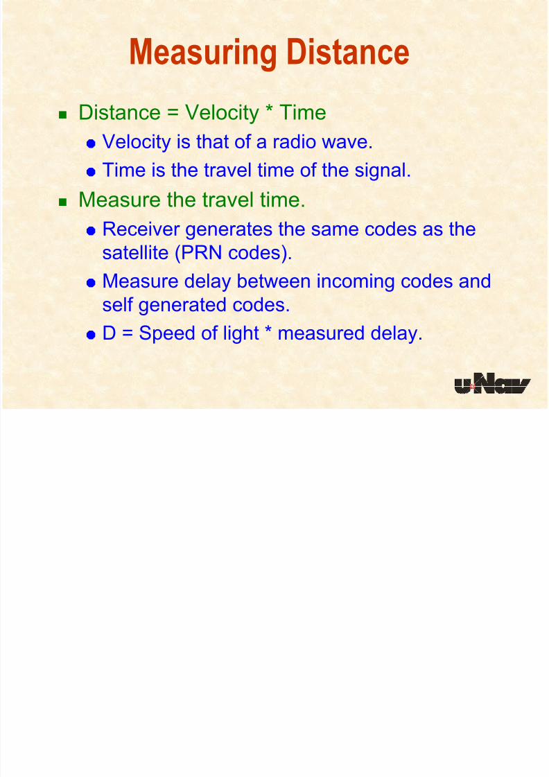
Measuring Distance
Distance = Velocity * Time
¦ Velocity is that of a radio wave.¦ Time is the travel time of the signal.
Measure the travel time.
¦ Receiver generates the same codes as the
satellite (PRN codes).
¦
Measure delay between incoming codes andself generated codes.
¦ D = Speed of light * measured delay.

7/29/2019 GPS Tutorial 1.pdf
http://slidepdf.com/reader/full/gps-tutorial-1pdf 13/43
Measuring Distance
Distance = Time Delay * Speed of Light
Time Delay
Signal Generated at Satellite
Received Signal
Signal Generated by Receiver
Receiver Generated Signal with
phase delay
(Code Phase)

7/29/2019 GPS Tutorial 1.pdf
http://slidepdf.com/reader/full/gps-tutorial-1pdf 14/43
Calculating a Position
Measure distance to satellites.
Obtain satellite positions.
Perform triangulation calculations.
Adjust local clock bias.

7/29/2019 GPS Tutorial 1.pdf
http://slidepdf.com/reader/full/gps-tutorial-1pdf 15/43
Satellite Positions
Orbital data (Ephemeris) is embedded in
the satellite data message.
Ephemeris data contains parameters that
describe the elliptical path of the satellite.
Receiver uses this data to calculate theposition of the satellite. (X,Y,Z)

7/29/2019 GPS Tutorial 1.pdf
http://slidepdf.com/reader/full/gps-tutorial-1pdf 16/43
Elliptical path of Satellite

7/29/2019 GPS Tutorial 1.pdf
http://slidepdf.com/reader/full/gps-tutorial-1pdf 17/43
Calculating a Position
Measure distance to satellites.
Obtain satellite positions.
Perform triangulation calculations.
Adjust local clock bias.

7/29/2019 GPS Tutorial 1.pdf
http://slidepdf.com/reader/full/gps-tutorial-1pdf 18/43
Triangulation in 2D
If location of point A is known, and the
distance to point A is known, desiredposition lies somewhere on a circle.
Could be anywherealong circle
A

7/29/2019 GPS Tutorial 1.pdf
http://slidepdf.com/reader/full/gps-tutorial-1pdf 19/43
Distance to two points are known.
Desired position is in one of two locations.
Triangulation in 2D
Or Here
Could Be Here
AB

7/29/2019 GPS Tutorial 1.pdf
http://slidepdf.com/reader/full/gps-tutorial-1pdf 20/43
Triangulation in 2D
Distance to three points are known.
Position is known!
AB
C

7/29/2019 GPS Tutorial 1.pdf
http://slidepdf.com/reader/full/gps-tutorial-1pdf 21/43
Distance to two points is known.
Triangulation in 3D
Could be anywhere
along ellipse

7/29/2019 GPS Tutorial 1.pdf
http://slidepdf.com/reader/full/gps-tutorial-1pdf 22/43
Triangulation in 3D Distance to 3 points are known.
Intersects at 2 points.

7/29/2019 GPS Tutorial 1.pdf
http://slidepdf.com/reader/full/gps-tutorial-1pdf 23/43
Calculating a Position
Measure distance to satellites.
Obtain satellite positions.
Perform triangulation calculations.
Adjust local clock bias.

7/29/2019 GPS Tutorial 1.pdf
http://slidepdf.com/reader/full/gps-tutorial-1pdf 24/43
Clock Bias
Time Delay
Signal Generated at Satellite
Received Signal
Signal Generated by Receiver
Receiver Generated Signal with
phase delay
(Code Phase)
Clock bias results in incorrect time delay measurement

7/29/2019 GPS Tutorial 1.pdf
http://slidepdf.com/reader/full/gps-tutorial-1pdf 25/43
Time Error Local clock and Satellite clock are not synchronized.

7/29/2019 GPS Tutorial 1.pdf
http://slidepdf.com/reader/full/gps-tutorial-1pdf 26/43
Clock Bias
Fourth satellite will not intersect with the firstthree.
¦ Local clock is not synchronized to SV clocks.
Clock error is from a single source.¦ Common to all satellites.
Apply a clock bias
¦ Add or subtract a constant to all SV pseudoranges.

7/29/2019 GPS Tutorial 1.pdf
http://slidepdf.com/reader/full/gps-tutorial-1pdf 27/43
Clock Bias
SV 3
SV 9
SV 31
SV 7

7/29/2019 GPS Tutorial 1.pdf
http://slidepdf.com/reader/full/gps-tutorial-1pdf 28/43
Calculating a Position Review
Measure distance to satellites.
¦ Use pseudo ranges Obtain satellite positions.
¦ Decoded ephemeris from satellite message.
Perform triangulation calculations.
¦ Need at least 3 satellites for triangulation.
Adjust local clock bias to find position.¦ Need 4th satellite to adjust bias.
Position is now known!

7/29/2019 GPS Tutorial 1.pdf
http://slidepdf.com/reader/full/gps-tutorial-1pdf 29/43
GPS Overview
GPS System
Calculating a Position
Receiver Outputs
Accuracy and Availability

7/29/2019 GPS Tutorial 1.pdf
http://slidepdf.com/reader/full/gps-tutorial-1pdf 30/43
Receiver Outputs
Typically receivers provide two differentformats.
NMEA (Nation Marine Electronics Association)
¦ ASCII Format¦ Defines a set of standard messages.
Proprietary Format¦ Typically Binary
¦ No limit on information transmitted.

7/29/2019 GPS Tutorial 1.pdf
http://slidepdf.com/reader/full/gps-tutorial-1pdf 31/43
Receiver Outputs
Position, Velocity, Time (PVT)
¦
Positiony Latitude ddmm.mmmm
y Longitude dddmm.mmmm
y
Altitude m¦ Velocity
y Speed knots
y
Heading degrees¦ Time (UTC)
y Date dd/mm/yy
y Time hh/mm/ss.sss

7/29/2019 GPS Tutorial 1.pdf
http://slidepdf.com/reader/full/gps-tutorial-1pdf 32/43
Receiver Outputs
Satellite information
¦ Satellite ID or PRN¦ Azimuth
¦ Elevation
¦ Signal Strength
Dilution of precision (DOP)
¦ PDOP¦ HDOP
¦ VDOP

7/29/2019 GPS Tutorial 1.pdf
http://slidepdf.com/reader/full/gps-tutorial-1pdf 33/43

7/29/2019 GPS Tutorial 1.pdf
http://slidepdf.com/reader/full/gps-tutorial-1pdf 34/43
GPS Overview
GPS System
Calculating a Position
Receiver Outputs
Accuracy and Availability

7/29/2019 GPS Tutorial 1.pdf
http://slidepdf.com/reader/full/gps-tutorial-1pdf 35/43
Differential GPS
Maritime Differential GPS (DGPS)
¦ Managed by the U.S. Coast Guard (USCG)¦ Employs ground stations along the coasts
with known fixed locations.
¦ Corrections are transmitted from groundstations at low frequencies (200-500kHz).
¦ Requires an additional Differential Beacon
Receiver (DBR) and an additional antenna.
¦ Accuracy is a function of the distance from
the ground station.

7/29/2019 GPS Tutorial 1.pdf
http://slidepdf.com/reader/full/gps-tutorial-1pdf 36/43
Differential GPS
Wide Area Augmentation System (WAAS)
¦ Managed by the FAA¦ Communicates with several ground stations.
¦ Provides atmospheric corrections.
¦ Early warning of GPS failures.
¦ Same frequency as GPS
¦
Higher data rate 250 Hz¦ Satellites are in geostationary orbits.

7/29/2019 GPS Tutorial 1.pdf
http://slidepdf.com/reader/full/gps-tutorial-1pdf 37/43
Ionoshperic Delay

7/29/2019 GPS Tutorial 1.pdf
http://slidepdf.com/reader/full/gps-tutorial-1pdf 38/43
Differential GPS
European Gestationary Navigation Overlay
System (EGNOS)¦ Managed by the European tripartite group
¦ Corrections for GPS and GLONASS
Multi-Function Transport Satellite Space
Based Augmentation System (MSAS)¦ Managed by the Japanese Civil Aviation
Bureau (JCAB)

7/29/2019 GPS Tutorial 1.pdf
http://slidepdf.com/reader/full/gps-tutorial-1pdf 39/43
Geostationary Satellites

7/29/2019 GPS Tutorial 1.pdf
http://slidepdf.com/reader/full/gps-tutorial-1pdf 40/43
Accuracy
25 ns40 ns340 ns
Time Accuracy
to UTC(2σ)
7.6 m30 m140 mVertical Position
Accuracy
(2σ)
7.6 m20 m100 m
Horizontal Position
Accuracy
(2σ)
WAASGPS w/o SAGPS with SAParameter

7/29/2019 GPS Tutorial 1.pdf
http://slidepdf.com/reader/full/gps-tutorial-1pdf 41/43
Signal Availability

7/29/2019 GPS Tutorial 1.pdf
http://slidepdf.com/reader/full/gps-tutorial-1pdf 42/43
Signal Availability

7/29/2019 GPS Tutorial 1.pdf
http://slidepdf.com/reader/full/gps-tutorial-1pdf 43/43
Further Reading
Elementary
¦
http://www.trimble.com/gps/index.html
Novice
¦ http://www.colorado.edu/geography/gcraft/notes/gps/gps_f.html
Expert¦ http://www.gmat.unsw.edu.au/snap/gps/gps_
survey/principles_gps.htm