gmw.conservation.ca.gov · 1981-08-31 · ' . • .. ' ' ms. shirley mcdougall...
TRANSCRIPT
' .
• .. ' '
Ms. Shirley McDougall Executive Secretary City of Pleasanton 200 Bernal Avenue P.O. Boi< 520 Pleasanton, CA 94566
Dear.Ms. McDougall:
,..
September 25, 1981
We are placing on open file the following report, reviewed and approved by the City of Pleasanton in compliance with the •:1<,quist-Priolo Special Studie• .Zones Acti
Geologic and fault iJl' .. 'estigation report, .SPRR property, Hacienda Buaine•• Park, Pleaaanton, Califo'n!ia; by Wahler Aaaociatee; August, 1981.
EWJ!/map
ce: A-P file
Sincerely yours,
EARL W. l!AR't Office of the Stat<1 Geologist CEG 935
(Oll''W @If 1})11~#\~~[MII@lro AREA CODE 415 846-3.202 -:· 200 BERNAL AVENUE
September 23 / 1981
Mr. Earl Hart 1009 Ferry Building San Francisco, CA 94111
RE: Wahler Associates HBP-109A
Dear Mr. Hart:
P. 0. BOX 520 -:- .. PLEA:;ANTON, CALIFORNIA 94566
Transmitted herewith is the above-referenced report along with the comments of Dave Carpenter, Engineering Geologist, R.G, #248 for your files.
If you have any questions concerning this transmittal, please feel free to give us a call.
Yours truly,
.- I . . .· ---~ . - . }d:. .( ' . ?1u (/'in' .' "'shi~'1e~D ugall "7 -e:L
Executive Secretary
/sm
Enclosures
Ha Shirley Mc!Doupll Elc.ecutive Secretary City of Pleaaantcm, l"lannins Dept. P.o. Box sao Plf!1tsonton, CA 914566
Dear Ma McDoupll 1
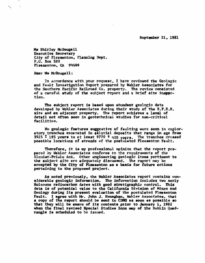
Septfi!lllber 21. 1981
In aoonl'dance with yoUX' l'eque•t, I have rev.:tewll'd the Geologic •nd F•ult lnveatigation Re.port preparad by Wahler A••ocist•• for the southern Pacific Railroad Co. prQPerty. The r!Niew consisted of a careful atudy of the subject ?'l!pQrt and a brief site inQJOtion.
The subject report 1• baffd upon ebundnnt geolog:l.o data developed by Wa.hler AseQCiatea during their study of the S.P.R.R. eite 1tnd 11n adjaaent property. The report 11chieve11 a level of det•il not often seen in geotechnical etud:l.es fol' non-ar!tical i'•cilitie:i.
No geologic fqtu.l"ea suggestive of faulting were aeen in qx,ploratoey trenoheit ll!Xoavated in eiluvial depoe1tlll that range in age from 3925 t 185 years to st least 9770 * l!OO year.a. The trenohllfs croaaed po•sihle looetions of •tr.ands of the postulated Pleasanton hult.
Therefore. it 1• my profese1.onal c>pinion that the report p:rapared by Wahler As•ociatea conforn1• to the requirements of the Alquia1:-J'riUlu Ao~. Othe1• engineering geologic iteme pertinent to the auhject site are adequately di111cu&aed. the l'epOTt nu1y be aceepted by the City of Plaunton •• • baaia for fut11n1 action• pertaining to the proposed project.
Ae noted previouely, the Wahler Aaeoeliates report contains considerable geoloaic inforntation. 'l'he informatiOfl includes two eurly Holocene radiocarbon dates with good stratigraphic: control. Thia data is of potential value to the Cal1forn.1u D:l.vieion of Mf.nes and Geology d.ur~ ite preefl!Jlt evaluation of the postulated Plesaimton FeW.t. l agree with Hr. John J. Henegban. wahltt A111sOC!iate111. that a oopy of the report should be Hlit to CDKG aa llOOD •• t>Ohibl• eo that they will be J[Ware of !ta conteata prior to January 1. 1982 when the final reviaed Speciul Studies zone •P of the Dublin Quad• rangle is scheduled to be !asued.
Ms Shirley McDougall -2- September 21, 1981
Costs for this review are $150.00. Please forward the enclosed copy of this letter to the Purchasing Agent as a billing for this 9mount to be charged to P.O. 8258. I have appreciated this opportunity to provide geological review service for the City of Pleasanton ancl woul.d be plea sad to do so again if desired by the City.
Very truly yours,
(\ .'': \ ) JJ n ........ ~···.·~-;\ J ...
David W. Carpenter Engineering Geologist R,G. #248 CCE.G. #135
cca'TI'w ©rf IPLL~~~~rrotr@rro AREA CODE 415 846-3202 _,_ 200 BERNAL AVENUE
Septewber 14, 1981
Mr. Dave Carpenter 41882 Mahoney St. Fremont, CA 94538
Dear Mr. Carpenter:
P. 0. BOX 520 -:· PLEASANTON, CALIFORNIA 94566
RE: Wahler Associates Project HBP-109A
Enclosed is a Geologic and Fault Investigation report for the recently acquired SPRR Property for the Hacienda Business Park for Prudential Insurance/Callahan Pentz Properties, Pleasanton, California dated August 1981.
Would you please advise the amount of time and fees to be charged for this review at the earliest possible time.
Thank you.
C'#v ·/,.~, J;;~tU'J!__ Shi.~i'eY,; /&'bouqal)" Execut ve Secretary
/s!n
Enclosure
• ~~ GeorgoB. Fin~ Jac~G. Wullf
Chartes W, Perry
.&.'1 \Al hi As • .j. JohnL.l-o•""Y ~ yyQ er SOCIC1es JooephLMarzai< ---------------------------------- JosephJ.Kulikowski
Geotechnlcal Engineering Forroot w. Giffo'tl
September 2, 1981 Project HBP-109A
City of Pleasanton P.O. Box 520 200 Bernal Avenue Pleasanton, California
Attention:
Subject:
Gentlemen:
Mr. Robert Warnick Director of Public Works and Utilities
Geologic and Fault Investigation Report SPRR Property, Hacienda Business Park Pleasanton, California
John J. Heneghan t<ennell1 v. Rodda
Eme$t Solomoo Antonio S. at.iangan
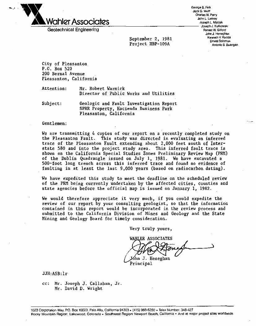
We are transmitting 4 copies of our report on a recently completed study on the Pleasanton Fault. This study was directed in evaluating an inferred trace of the Pleasanton Fault extending about 2,000 feet south of Interstate 580 and into the project study area. This inferred fault trace is shown on the California Special Studies Zones Preliminary Review Map (PRM) of the Dublin Quadrangle issued on July 1, 1981. We have excavated a 500-foot long trench across thi.s inferred trace and found no evidence of faulting in at least the last 9,000 years (based on radiocarbon dating).
We have expedited this study to meet the deadline on the scheduled review of the PRM being currently undertaken by the affected cities, counties and state agencies before the official map is issued on January 1, 1982.
We would therefore appreciate it very much, if you could expedite the review of our report by your consulting geologist, so that the information contained in this report would be incorporated in the review process and submitted to the California Division of Mines and Geology and the State Mining and Geology Board for timely consideration.
JJH:ASB:lr
cc: Mr. Joseph J. Callahan, Jr. Mr. David D. Wright
Very truly yours,
~hn J. Heneghan Principal
1023 Corpora1ion Way. ~O. Box 10023, Palo Alto, California 94303. (415) 968-6250 • Telex Number: 348·427 Rocky Mountain Region: Lakewood, Colol'ado. Southwest Region: Newport Beach, California• And at major project sites wortdwide.
•
•
•
•
•
•
•
•
•
•
GEOLOGIC AND FAULT INVESTIGATION
SPRR PROPERTY
HACIENDA BUSINESS PARK
Pleasanton, California
/
PRUDENTIAL INSURANCE/CALLAHAN PENTZ PROPERTIES, PLEASANTON
August 1981
WAHLER ASSOCIATES
Geotechnical Engineers
Project HBP-109A
•
•
•
•
..
*
•
•
•
•
•
,, . . •\.Wahler Associates
Geotechnical Engineering
August 31, 1981 Project HBP-109A
Prudential Insurance/Callahan Pentz Properties, Pleasanton 155 Moffett Park Drive Suite 101, Building A Sunnyvale, CA 94086
Attention:
Subject:
Gentlemen:
Mr. David D. Wright
Geologic and Fault Investigation SPRR Property, Hacienda Business Park Pleasanton, California
George B. Fink Jack G. Wulff
Charles W. Perry John L. Laskey
Joseph L. Ma(zaK Jo:sepn J, Kulikowski
Forrest W. Gifford Jahn J. Heneghan
Kenneth V, Rodda Ernest Solomon
Antonio S. Buangan
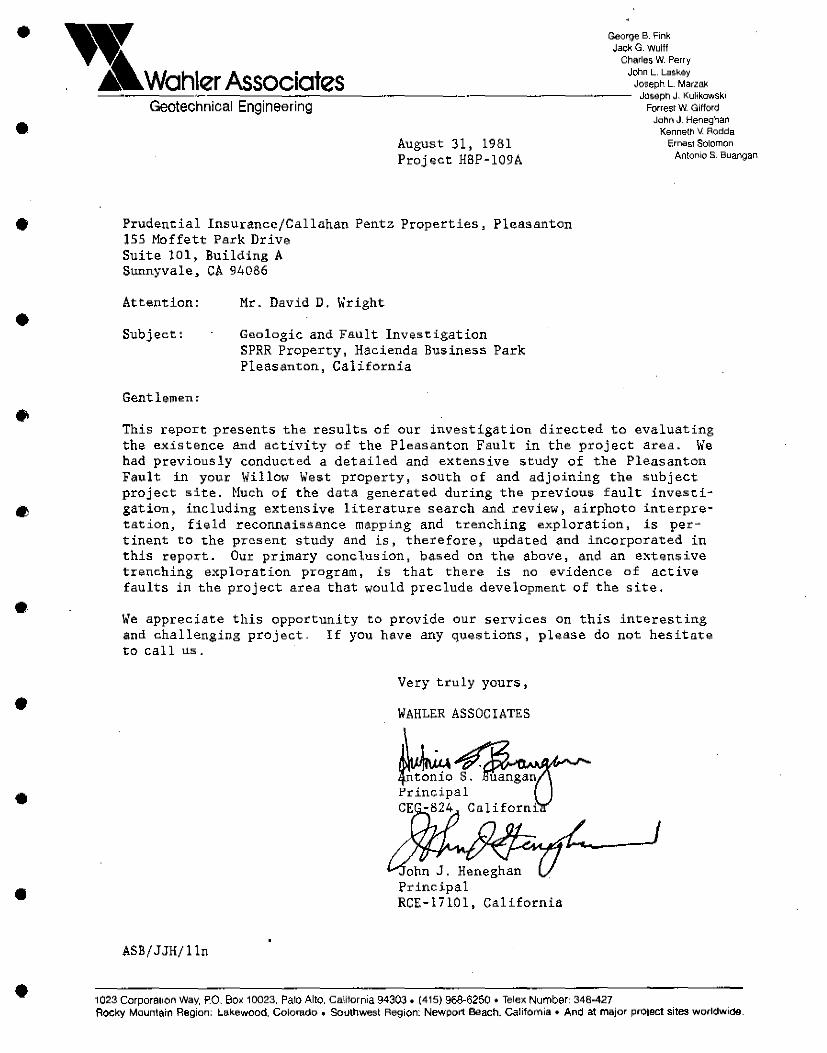
This report presents the results of our investigation directed to evaluating the existence and activity of the Pleasanton Fault in the project area. We had previously conducted a detailed and extensive study of the Pleasanton Fault in your Willow West property, south of and adjoining the subject project site. Huch of the data generated during the previous fault investigation, including extensive literature search and review, airphoto interpretation, field reconnaissance mapping and trenching exploration, is pertinent to the present study and is, therefore, updated and incorporated in this report. Our primary conclusion, based on the above, and an extensive trenching exploration program, is that there is no evidence of active faults in the project area that would preclude development of the site .
We appreciate this opportunity to provide our services on this interesting and challenging project. If you have any questions, please do not hesitate to call us.
ASB/JJH/lln
Very truly yours,
WAHLER ASSOCIATES
ohn J. Heneghan Principal RCE-17101, California
1023 Corporation Way, P.O. Box 10023, Palo Alto. California 94303, (415) 968-6250 •Telex Number, 348·427 Rocky Mountain Region; Lakewood, Colorado • Southwest Region: Newport Beach, Califo~nia • And at major project sites worldwioo.
•
•
•
•
•·
•
•
•
•
TABLE OF CONTENTS
EXECUTIVE SUMMARY
Chapter
I INTRODUCTION
A. Project Location B. Purpose of Investigation C. Scope of Investigation D. Site Description and Conditions
II GEOLOGIC SETTING AND SEISMICITY
A. Geologic Setting and History B. Seismicity
III METHODS OF INVESTIGATION
A. General B. Literature Review C. Airphoto Interpreta.tion D. Surf ace Observation E. Subsurface Investigation F. Radiocarbon Dating
IV FINDINGS AND CONCLUSIONS
REFERENCES
Number
I-1
I-2
I-3
I-4
II-1
II-2
II-3
III-1
III-2
III-3
III-4
FIGURES
Location Map
Sp.,cial Studies Zones, 1981 Dublin Preliminary Review Map
Site Map
Well Location Map
Generalized Geologic Map, San Francisco Bay Region
Seismicity Map, San Francisco Bay Region
Earthquake Epicenters, Pleasanton Arca 1969-1974
1951 Geologic Map, Pleasanton Area
Pleasanton Fault Compilation Map
1964-1969 U.S. Coast and Geodetic Survey Vector Diagram
Camp Parks Reconnaissance Map
Project HBP-109A
• Wohlizr Associatizs
I-1 l-1 I-2 I-4
II-1 II-2
III-1 IlI-1 III-12 III-14 III-16 III-21
Following Page
I-4
I-4
I-4
I-4
Il-5
II-5
II-5
III-21
in pocket
III-21
IlI-21
i
•
•
•
•
•
•
•
•
•
•
Appendix
A
B
TABLE OF CONTENTS (Continued)
APPENDICES
Trench Logs - Figures A-1 to A-2
Test Pit Logs - Sheets 1 to 4
Borehole Logs DH-36 through DH-43
Site Map and Trench Logs, Previous Willow West Property Study
C Radiocarbon Age Determination
D Historical Earthquakes
Wohler Associates Project HBP-109A ii
•
•
•
•
•
0
•
•
•
•
•
EXECUTIVE SUMMARY
The 280-acre Southern Pacific Railroad (SPRR) property of the proposed
Hacienda Business Park is located on the alluvial flats on the west side of
Livermore Valley. A portion of the project site is within an Alquist
Priolo Special Studies Zone as shown on the California Division of Mines
and Geology Special Studies Zones Preliminary Review tlap of the Dublin
Quadrangle issued on July 1, 1981. The Special Studies Zone is a o;one of
potential damage due to faulting as delineated by the California State
Geologist in compliance with the Alquist-Pdolo Special Studies Zones Act
(codified as Chapter 7 .s, Division 2, of the California Public Resources
Gode). The present study was conducted in compliance with the Act, which
requires local governments to "withold development permits for sites within
the zones until geologic investigation demohst:ra.te.s that the site is not
threatened by surface displacement from future faulting." Thfa investi
gation was directed to evaluating the existence and activity of the Pleasan
ton Fault within the project area.
This investigation included excavation and detailed logging of a 500-foot
exploratory trench and an updated review of the geologic and seismicity
informat:.ion, as well as airphoto interpretation. Wahler Associates had
previously conducted a special studies o;one investigation on an adjoining
property to the south of the SPRR property known as the Willow West prop
erty. Much of the data previously generate9- is relatively current and
pertinent to this present study and fa therefore updated and incorporated
in this report. Though faulting in the Pleasanton area is first noted on a
1951 geologic map of the San Francisco Bay region, the first evidence for
its existence was presented by the California Deparlment of Watar Resources
in its 1963 study of ground water resources in the Livermore Valley. This
evidence consisted of lineations in 1940 aerial photos, alignment of geomor
phic features such as linear drainages and 11 sag ponds 0 ~ and diffe:rcnces ln
ground water levels. Other workers have reported right-late•al slip move
ments on the order of several millimeters based on geodetic measurements;
Project llBP-109A ES-1
Wohler Associates
•
•
•
•
••
•
•
•
•
•
•
these phenomena were attributed to fault creep. Most of the evidence cited
pertains to mapped traces of the Pleasanton Fault in the Camp Parks area
about 1/2 mile north of the project site, and where no investigative ti:ench
ing is known to have been performed.
South of the project site, several detailed studies, employing investi
gative techniques including trenching .• have bean previously performed. All
the studias reviewed found no direct evidence to substantiate the existence
and/or activity of the Pleasanton Fault .
North of the project site in the Camp Parks area, airphoto interpretations
of 1940 aerial photographs indicate three, well-defined, strong tonal
lineaments in the alluvium. These tonal features become abruptly faint or
discontinuous to the south and north. The eastei:nmost lineament could be
traced vaguely about 2,000 feet south of Interstate 580 and onto the SPRR
property. A field reconnaissance was performed in areas traversed by the
mapped traces of the Pleasanton Fault, particularly in the Camp Parks area
and othar areas whei:e most of the previously cited surficial evidence has
been reported; however, no features indicative of and consistent with
faulting were found. However, because these airphoto tonal lineaments
occur in the Holocene alluvium, supporting subsurface information would be
required to provide direct evidence of faulting in the pi:-oject ai:ea .
Consequently, it was reasoned that trenching would disclose evide.nce of
faulting in the exposed subsurface materials. Therefore, a 500-foot-long
trench was excavated in the alluvium across the inferred trace of the
Pleasanton Fault which passes through the project area, as indicated by the
easternmost tonal lineament on the 1940 airphotos, and by the 1981 Spacial
Studies Zones Preliminary Review Hap .
The backhoe exploration trench was excavated to an average depth of 15 feet
and up to a maximum of 16 feet. The trenches were logged continuously and
in detail by our ongineering geologists at a field scale of 1-inch equals S
feet. The materials exposed in the trenches consist of identifiable,
Project HBP-109A ES-2
Wohler Associates
•
•
•
•
•
•
•
•
•
•
•
horizontal to nearly horizontal and interfingering layers of clays, silty
clays and sandy clays, usually interbedded gradationally. The individual
layers could be traced laterally for several feet, where they ei.ther pinch
ed out or graded to another layer. Detailed logging of the alluvial ma
terials in the trenches failed to show any offsets, ruptures, distortions
or warping, presence of fault gouge materials, ground water barriers or any
other feature that is indicative of faulting.
Charcoal and shell fragments were collected at depths of 11.2 and 9.5 feet
respectively and sent out for radiocarbon dating. The results indicate C14
ages ranging from 7,320 ± 610 years B.P. (Before Present) to 9,770 ± 400
B.P.
Therefore, based on our detailed investigation using currently available
geological techniques, it is our conclusion that no active faulting has
occurred at the project site in _at least the last 9 ,000 years, and that
evidence to date for the existence of the Pleasanton Fault at the project
site is indirect, inconclusive and unsubstantiated by the information
currently available .
Project HBP-l09A ES-3 Wahler Associates
•
•
•
IiiTRODUCTION
•
•
•
•
•
•
•
•
•
•
•
•
•
•
•
•
•
•
CHAPTER I
U\TRODUCTION
The project site comprises the Southern Pacific Railroad (SPRR) property
and is a portion of the proposed Hacienda Business Park in Pleasanton, Cal
ifornia. Hereinafter, the project site will be referred to as the SPRR
property. The SPRR property is located on the west side of the Livermore
Valley, south of Interstate 580 and between Hopyard and Old Santa Rita
roads (Figure I-1). It encompasses an area of approximately 280 aci:-es,
straddling the Southern Pacific Railroad tracks. Although specific site
development plans are not presently available, it is our understanding that
the proposed development will consist of a number of buildings to be used
for light industrial and commercial purposes .
B. PURPOSE OF INVESTIGATION
The California Division of Mines and Geology (CDMG) has just recently
fasucd a Preliminary Review Map (PRM) of the Alquist-Priolo Special Studies
Zones (SSZ) for the 7-! min. Dublin Quadrangle dated July 1, 1981. A por
tion of this PRM pertinent to this project study is shown on Figure I-2.
This PRM is a proposed revision of the official SSZ map originally issued
on July 1, 1974. Th~ PRM was submitted to the affected cities, counties
and state agencies for their review and comment. Following the appropriate
reviews, the State Geologist must provide an official map to the affected
cities, counties and state agencies. In the case of the Dublin Quadrangle,
in which the Pleasanton Fault is located, this official map will be issued
on January 1, 1982.
Relative to the subject propei:ty, this Dublin Preliminary Review Map shows
revisions on the traces of the Pleasanton Fault as a result of abundant and
Project HBP-109A I-1
Wahler Associates
•
•
•
•
•
•
•
•
•
•
•
recent geologic information, including the extensive fault investigation
Wahler Associates' (1980a) performed on the Willow WQst property of tho
proposed Pleasanton Business Pa:rk, hereinafter referred to as the Willow
West property, south of, and adjoining the SPRR property. However, the PRH
shows an inferred trace of the Pleasanton Fault extending for about 2,000
feet south of Interstate 580 and passing through the SPRR property (Figure
I-2). This inferred trace is based on an airphoto lineament that is more
pronounced in the Camp Parks area north of Interstate 580 (Hart, 1981).
Because no direct geologic evid.,nce is available as to the presence or
absence of faulting interpreted from this airphoto lineament, a geologic
study with supporting subsurface exploration program would be required to
investigate faulting in the SPRR property.
A portion of the project site as shown on the PRH, therefore lies within
tho Alquist-Priolo Special Studies Zone, a zone of potential damage due to
faulting as delineated by the California State Geologist in fulfillment of
the Alquist-Priolo Special Studies Zones Act of 1972. The Alquist-Priolo
Special Studies Zones Act r"quires local governments to "withhold develop
ment permits for sites within the zones until geologic investigation demon
strates that the sites are not threA.tencd by surface displacement from
future faulting'' (Hart, 1980). It is, therefore, the purpose of this study
to assess and evaluate the presence and activity of faulting at the SPRR
property.
C. SCOPE OF INVESTIGATION
As discussed above, Wahler Associates has previously and recently conducted
an extensive study on the Pleasanton Fault on the adjoining Willow West
property to the south of the SPRR property. This previous study included:
• an extensive literature review on the geology and seismicity of the
project area, and review and analysis of studies previously performed
by various other investigators of the Pleasanton fault;
Project HBP-109A I-2
Wohler Associates
•
•
•
•
•
•
•
•
•
•
•
• field reconnaissance, specifically directed to identifying surficial
evidence of active faulting;
• excavation and detailed logging of a 2,000-foot-long trench and a
short trench which straddled mapped tracos of the Pleasanton Fault;
• radiocarbon dating of samples for age determination;
• office geologic analyses .
The results of this previous study were presented in a comprehensive report
entitled, "Geologic and Fault Investigation, Pleasanton Business Park" for
CPS & Associates and dated, February 1980. Because the data generated from
this previous study is relatively current and pertinent to this present
investigation, much of .it is incorporated in this report.
Specifically, the scope of work for the present study includes:
•
•
an updated review and analysis of literature concerning the geology
and seismicity of the project area;
excavation and detailed logging of a 500-foot-long trench at an aver
age depth of 15 feet across the inferred trace of the Pleasanton Fault
in the project area;
• radioca~bon dating of samples for age d~termination;
• off.ice geologic analyses;
• preparation of this report .
Project HBP-109A l-3
Wohler Associates
•
•
•
•
•
•
•
•
•
•
•
D. SITE DESCRIPTION AND CONDITIONS
The project site consist• of one large parcel of land divided by the South
ern Pacific Railroad right-of-way. It is borde.red on the north by Inter
state 580, on the east by Tassajara Creek, on the west by Chabot Canal, and
on the south by the Willow West property that was the subject of our pre
vious fault study (Figure I-3).
The site is essentially flat with a maximum topographic relief of 22 feet
across its 1.3-mile east-west width. At the time of this investigation, it
wao used as a grazing ground for cattle.
Several old exploratory borings and wells apparently exist on the SPRR
property, as shown on the well location map provided to us by the Alameda
County Flood Control and Water Conservation District, Zone 7 in Livermore
(Figure I-4). The exploratory borings and some wells were reportedly
filled in or destroyed; except for 5M-l, 6J-l and 6Q-2 which still have
casing in the ground (Figure I-3). During our si.te investigation we found
the location of Well No. SM-1, where we measured the water level at a depth
of 15. 3 feet below ground surface. Well No. SM-1 is presently monitored by
Zone 7 as a part of a ground water monitoring network (Personal Communi
cation, Mr. F. Moss, August 26, 1981). Other features present at the site
include a buried Pacific Telephone trunkline which crosses the eastern
pox·tion of the site in a roughly east-west direction (Figure I-3) .
Project HBP-109A I-4
Wahler Associates
•
•
•
•
•
•
•
•
•
•
•
·~~ ! ... 1~,NCl;l(:fl \ .... p,,m.oo'll'I
1.''·, •• ,, '
[1.t .. '~""'"'""' (':r. ' ,"!'WO
REFERENCE
\
BASE FRO• C.$.A.A. 11 BAY AMO RIVER AREA 11 •A~
'.'i
•
•
•
•
•
•
•
•
r_:,-,"' ,-, 'tr-;ed-Lei"
'• ~·
sir
••
'. :,..;.•
s A ·····
'1\ ...... _,-, - _V' -Y
<_ L ..... ·• ·j f JI.
lfolflandorsk! f I Vlllaglfl:
' '
\ ~ .. ' ,,,.·
... . "' ' -
I I I
• -_. •f;r---
- ... .,:= !-:-·~- ~· --,..c:. "uiir .. ! HI ~.tllN ,
-A-.--~-111111111
/ '~ '~(-- _-'")·.-·~-
•• ······~
ll; i "15
-..•. · .. · ..... ~ . •"/:-~ /
11f .• n .l'l'I n 111 •u :ruu ~-
sar.ta Rita -- r'~ ~Rehab1l·tati.r:in ,Cfrn.~1
: ) -----.·
l
. I I
I,,, .. I I~
j
_,.,,L_····.-L_1.~ rn . . . ·:1
~ ----,.._ ..... __ ,,,_,..,, . • . . . . . . . . · 1 • ..
I
E I P L A M A T l 0 N
I
PITt:NlUltl AUIYE FL\UL TS I
fA¥LH ellll IHllU TO ~¥E IHN JtTlff UR IN& ffllUCEME ffllf MID Ti
t1AW£ A HEU. TllElY IHH PDTEllTl.tl fH SHf'ACE RUPlURf: Stlll UllE
IHUE ACHRATtU ll~TED. UNG DUH HEU APP!llXIUTttY lHUH •
511811 DISH lllERE I llFJ!Ufll , DIT1f8 UERE ClllCU lED: UUl en !Nit ICA TEI ADO I 1 l Dllll I NCU u IN In . EY ID ENCE 9F H inn ft amn
I
I HD I CA TI! D IY TUR I fl E JRTNDl!.l IE...tSSIUATEI UEMJ Oii C fH
D 15'U. CUE MT CA US ED ~ CRHP 9R PH SlllE CIEEP .
S Pt:C I Al STUD IE S I ONE! BOUHAR I ES
THESE ARE DHINEATU AS STRA l&NT-LINE 1ElfiNTS THAT CDllNECT EHlllCLEI
1 UIH I Ml Pl ltlTS U U· TO OEF l NE SPEC !Al STUD IU lUE If lllENn .
zoao
« E y
~· [IJI]]
$CHE
0
I I
SPRR PUPERTY
WlllOI WEST PROPERTY
EXPLDRATIRT tREftC~
!ODO FEET
USE FRH PHT IOM OF CAUHRN!A. SPEC-lAl STU1l 1£S HNES, PUl 111 I NAU UYI l'"I II.IP Gf !Dl)r 1 , 1 lft .
D Uil IM QUAHAll 8LE
W mR PR9PERIY , . A Wohler MAC IEllDA BUS 1 llESS PAR~ Assoclales°'":':":"":~:":'!~~::o::~~~~":"""::-:~=-1~-'~'~'~'~''~'=-'-"-· --1~--::=='~'~'~'':':l:~-+-~'-'-'~'~''~'-'-·~~
il'ILO .... TO- • Nfl,.llT ll•C-11 • If I IBM_IM .ll
OVERSIZED -~·
DOCUMENT HAS BEEN PULLED AND SCANNED, WITH THE MAP.
FILE.
•
•
•
•
•
•
•
•
•
•
•
' . \
" )I."'
BM 325 '" '-.. l, PROJECT SITE
'. Cl V I ,, ~I ,..,
' '
"
SCALE: 1":2000'
A. WELL LOCATION MAP -GEOLOGIC LOGS
WELL NUMBER,
R2 • DEPTH 75 OF WELL/
0
K E Y
SOLID CIRCLE WHERE GEOLOQ IC LOG AVAILABLE.
OPEN CIRCLE WHERE NO LOOS AVAILABLE.
HORIZONTAL LINE, WATER LEVEL MEASUREMENT AVAILABLE, VERTICAL LINE WATER QUALITY DATA AVAILABLE.
~ DESTROYED WELL
B. WELL LOCATION MAP -HYDROLOGIC DATA
SOURCE: A. FROM ALAMEDA COUNTY FLOOO CONTROL ANO WATER CONSERVATION DISTRICT'S ZONE 7 WELL LOCATION MAP • QEoLOOIC LOGS. SHEET 1 OF a: LAST UPDATE: MARCH, 1 DBO; B. FROM WELL LOCATION MAP HYOROLOGIC DATA, SHEET 1 OF 3; LAST UPDATE: MARCH, 1980.
"l Wahler s PR R PR 0 PER TY
Assocl'at·"'s '-:~"'.'H".""AC-:-l-EN_DA"'.".'."."BU~S-IN_E_ss_P_A_RK __ +~:.!'.'..!!.::.!.~-11--!.!l.~-+-_!.!..!.!!.!L!!!C;__.J WELL LOCATION MAP
"' - Pi:ia,ECT Na. OATE FIGURE 110.
PALO ALTO• N!"WPOllT 9EAC!t • DEH'IER HBP-109A AUGUST 1981 1-4
•
•
•
• GEOLOGIC SETTING AND SEISMICITY
•
•
•
•
•
•
•
•
•
•
•
•
•
•
•
•
•
CHAPTER II
GEOLOGIC SETTING AND .~EISMTCTTY
A. GEOLOGIC SETTING AND HISTORY
The SPRR property is located in the western portion of the Livermore Valley,
an area more specifically referred to as the Amador Valley. The Livermore
Valley is the most prominent valley within the Hamilton~Mt. Diablo Mountain
Range of Central California and is bounded on the west by the Pleasanton
Ridge and on the east by the Altamont Hills. The general geology of the
area is shown on Figure II-1. The Pleasanton Ridge and Altamont Hills
consist of Jurassic to Cretaceous sediment;ary rocks known as the Great
Valley Sequence and are flanked on the foothills by Tertiary sedimentary
rocks. To the north of Livermore Valley are the Black Hills, which are
underlain by Eocene to Pliocene sedimentary rocks, forming a belt extending
to Suisun Bay. The highlands to the south of the valley contain rocks of
the Jurassic to Cret;aceous Franciscan Formation, which represent the oldest
rock units adjoining the project area.
The Livermore Valley is a structural basin underlain by a downwarped and
faulted sequence of Miocene-Pliocena sandstones and conglomerates. The
trend of the syncline defining this basin is roughly cast-west which is
somewhat of a departure from the northwest-trending regional physiography.
The basal units in the Livermore Valloy were deposited in shallow water and
nearshore marine environments thronghout the Miocene and into the middle
Pliocene epochs. These units have been identified as the Briones, Cierbo
and Orinda formations and are part of the Tertiary sedimentary rocks shown
on Figure II-1. During late middle Pliocene time, a great crustal disturb
ance caused uplift of the entire Coast Ranges with associated folding and
faulting. Toward the end of this period of st;ructural disturbance, the
Livermore depression gradually developed as a downwarp between two zones of
weakness; the Calaveras Fault to the west and the Greenville Fault to the
Project HBP-109A II-1
• Wahler Associates
•
•
•
•
•
•
•
•
•
•
•
east. Erosion of the Cretaceous and Jurassic highlands continued with
accompanying deposition of the Livermore sediments in outwash plains and
lakes within the Livermore depression, and lasted into late Pleistocene
time. During the middle Pleistocene, the region was subjected to renewed
faulting and folding and the Livermore Formation developed a synclinal
structure. A period of quiescence followed until uplift of th" region was
renewed in the upper Pleistocene with the formation of the ancient Liver
more Valley. At that time, the drainage was probably northward ouL into
what is now Suisun Bay. Sediment deposition continued and, at one point
during this depositional episode, the drainage assumed its present course
towards Alameda Creek through the Sunol Cap.
The region defined by the Livermore Valley has been subjected to two periods
of faulting and folding since the middle Tertairy. The Calaveras Fault,
running along the base of the Pleasanton Ridge immediately west of the
project site, is tho most immediate expression of that deformation and
serves to abruptly terminate the Livermore Valley syncline to the west .
B. SEISMICITY
The project area is located in a seismically active region which was sub
jected to several strong earthquakes within the last two centuries.
Earthquakes have occurred throughout the entire San Francisco Bay region,
but most of them have been concnntrated along the active San Andreas,
Hayward, and Calaveras fault zones. Most epicenter locations are within a
mile or so of known fault traces. Recent small earthquakes also have the
same spatial distribution, as evidenced on a map (Brown and Lee, 1971) that
shows the location of active faults and the epicenter of earthquakes greater
than 0.5 Richter magnitude for the period from January 1, 1969 to December
31, 1970.
The most important active faults, their distances to the project site and
maximum credible earthquakes (Greensfelder, 1974) are listed below:
Project HBP-109A II-2
Wahler Associates
•
•
•
•
•
•
•
•
•
•
•
Fault
San Andreas Hayward Calaveras
Distance (miles) and Direction
33.5 West 11.5 West 2.5 West
Maximum Credible Earthquake (Richter Magnitude)
Another significant fault includes the Greenville Fault, located about 8
miles east of the project site. This fault had been previously mapped but
considered inactive and was the cause of magnitudes 5.5 and 5.2 earthquakes
in January, 1980. Several other faults, such as the Pleasanton and Parks
Fault, have been postulated to exist within the confines of the valley but
their presence and activity continues to be the subject of much debate.
The inferred Parks Fault crosses the southeastern corner of the project
site in an east-west direction. It was postulated on the basis of analyses
of well log and water level data by the California Department of Water
Resources (CDWR), (1963). No surface expression of this inferred fault
exists, neither does it appear on aerial photos. Burkland and Associates
(1975) trenched across the inferred mapped trace of this fault (as shown on
the 1974 CDWR map); however no evidence of foul ting was found.
The history of earthquakes in and around the San Francisco Bay Region that
probably affected the proposed SPRR property goes back to the early lSOO's .
Large earthquakes that affected this region are listed in the "Descriptive
Catalogue of Earthquakes of the United States" (Townley and Allen, 1939),
which includes seismic events prior to 1927. The U.S. Coast and Geodetic
Survey has published non instrument reports for later years, as well as
instrument-located epicenters of earthquakes that have occurred since 1928.
Appendix D presents a listing of major earthquakes, occurring between 1800
and January 1980 in the San Francisco Bay Region, that caused damage, had
severe shaking cl1aracteristics or showed evidence of surface "t"Upture •
As shown on the seismicity map (Figur<> II-2), during the period from 1900
to ~arch, 1979, 11 earthquakes of Richter magnitude 4.0 and greater occur
red within a JO•mile radius of the project site. Recently, two sizable
earthquakes occurred in the Livermore Valley area; the magnitudes 5.5 and
Project HBP-109A II-3
Wohler Associates
•
•
•
•
•
•
•
•
•
•
•
5. 2 (as measured by the U.S. Geological Survey) seismic events of January
24 and 27, 1980, respectively, with epicenters located about 10 miles
northeast of the project site. These recent earthquake events are also
plotted on Figure II-2. Another magnitude 5.5 earthquake occurred on June
11, 1903 about 8 miles to the southeast as shown on the Earthquake Epi
center Map of California (Real and others, 1978). As shown on Figure II-2,
no earthquakos of magnitude 4. 0 and greater, have occurred within 5 miles
of the projoct during the period 1969 to 1974, two small earthquakes of
magnitudes 0.5 to 1.5 occurred immediately west of the project site (Figure
II-3). During the time interval 1900 to March, 1979, several tens of
earthquakes of magnitude 4.0 and greater occurred within a 40-mile radius.
Two of the earthquakes had magnitudes greater than 6. 0. One was a magni
tude 6.6 earthquake on June 1, 1911 located about 30 miles south of the
project site and apparently originating on the Calaveras Fault Zone. The
other was the great 1906 San Francisco earthquake with an estimated magni
tude of 8.3 with an epicenter location located about 37 miles west of the
project site .
The largest and closest earthquake to the site was the July 3, 1861 event
that was probably caused by movement along the Calaveras Fault west of the
site. The earthquake had a probable maximum Modified Hercalli (MH) inten
sity of IX and was associated with ground ruptures in San Ramon and Amador
Valleys (Radbruch, 1968).
In May-July, 1970, several thousand small earthquakes ranging up to magni
tude 4 occurred near Danville, California about 6 miles northwest of the
project site. This is shown as the roughly circular cluster of epicenters
in Figure II-3. The Danville earthquake swarm was studied in detail by Lee
and others (1971). Fault-plane solutions indicated that a north-west
trending, righ-lateral, strike-slip sense of fault movement was associated
with the earthquakes. Although the earthquakes could not be related to any
known geological structure or fault, the epicentral area lies in the north
west projection of the mapped Pleasanton Fault. However, a 3 km (1.9 mile)
gap in the seismic activity occurs between the epicentral area and the
Project HBP-109A II-4
Wohler Associates
•
•
•
•
•
•
•
•
•
•
•
mapped traces of the Pleasanton Fault. Because of the roughly circular
pattern of the earthquake foci, Lee and others (1971) suggested that the
earthquake activity could be related to some type of pierccment structure.
According to Ellsworth and Ma:rks (1980), through the use of focal mechanism
solutions and other seismological evidence, the Pleasanton Fault is "prob
ably seismically active". They note that "the distribution of earthquake
hypocenters and orientation of their focal mechanism to the north (of the
Camp Parks area) strongly suggest that this fault continues to the north
along the east side of San Ramon Valley". Th<iy state that few epicenters
are actually located near the inferred traces of the Pleasanton Fault and
that "their association with the fault cannot be nnambiguously demon
strated". South of the Camp Parks ai;ea in which the project site is lo
cated, no evidence ·of histodc scismicity is associated with the Pleasanton
Fault .
Project llBP-109A II-5
Wahler Associates
' I ,
I
' I
I ' OVERSIZED · DOCUMENT HAS
BEEN PULLED AND SCANNED WITH THE MAP.
FILE.
•
•
•
•
•
•
•
•
•
EARTHOUAKE EPICENTERS 1900 THROUGH MARCH 1979*
MAGNITUDE
4.0 TO 4.9
5.0T05.9
6.0 TO 6.9
7.0 TO 7.9
a.a OR GREATER
INTEGER .... MAXIMUM REPORTED INTENSITY , ·.,.->I!).·. (Only for 11rthquako1 ot UNKNOWN maw;nltude), ,
*INCLUDES COYOTE LAKE EARTHQUAKE OF AUG 8. 1979 AND MT. DIADLO EARTHQUAKES OF JAN 24 AND 27, 1980·,
FROM EARTHQUUE EPICENTER MAP fT'I OF CALIFORNIA, 1901)...1974; REAL"-..:..) AND OTHERS, (1978), ANO TOPPDZAOA AND OTHERS, (1979).
SCALE
l!I'
-t-.._ ' ' ' -
·~. . I '"--.~. / .·· ••• · .. -\ ""---"'""'' •' : ,
' /
I.· I / .·· ·' I \. I '· ·• I ·"· . i /- _,,_ .. ·"}' ·, ··-_
--- l ,\
SEISMICITY MAP
,P..: I -··.J ,.-~. :!-'--
~ ' \ \ ,,~)
·· -37'0 001
• '1. Wohler SPRR PROPERTY
HACIENDA BUSINESS PARK Associates""::':":"'.:-:~:-:~~~~~~~~~....i1--...:.;''~'~'~';•~·;·~·~·~1--...,,,.,.;•~·~·~·,..,.,.,...-1-....::..:.:.:;.;.!,,.:"~'~---.1
fl'AlO ALTll • MEWPOA'f BEAcM· • DEflYElt H8P-108A AUlllUIT !911
SAN FRANCISCO BAY REGION
• ++
•
• +
• • +
.. •
• •
•
•
• SCALE
2 0 2 Ml LES x x • MOOIFIEO FROM.HANNA
AND BRABB, 1979. +
"iwahler SPRR PROPERTY HACIENDA BUSINESS PARK
Associates
• PALO ALTO • MEllPgAT l!IEACH • 0£N't'ER
+ •
•
•
• • ... •
•
• • +t
"* • • • .. + +
+
+
•
..
<'>' •.. I• ., \
·• .-'i ··-: ... _. -...
E X P L A N A T I 0 N
•
+
•• •
• + +
'· "·\' .,, .... ~\ -·.
+
•
\. __ _
MAGNITUDE 3.5 TO 4.5 + MAONITUDE 0.5 TD 1.5 MAGNITUDE 2. 5 TO 3.5 • i!AGN I TUOE LESS THAN Q. 5
MAONITUOE 1.5 TO 2.5
EARTHQUAKE EPICENTERS PLEASANTON AREA 1969-1974
PllOJ£Ct ND. OlT~ ••• H8P-109A AUGUST 1981
+
+
•
•
•
• METHODS OF INVESTIGATIOM
•
•
•
•
•
•
•
•
•
•
•
•
•
•
•
•
•
A • GENERAL
CHAPT£R III
METHODS OF INVESTIGATIOt>!
As discussed previously, the previous fault study on the Willow West prop
erty immediately south of the project site included an exte11sive literature
seai::ch on the Pleasanton Fault, field reconnaissance mapping, airphoto
interpretation and subsui;face (trenching) exploration work. Huch of the
information generated dudng the previous fault study is applicable and
pertinent to the present study and is, thiorafore, updated and incorporated
in this report .
B. LITERATURE REVIEW
A significant part of the previous fault investigation of the Willow West
property, consisted of an extensive and in-depth literature review on the
Pleasanton Fault, including several detailed studies directed at evaluating
mapped traces of the Pleasanton Fault as shown on the 1974 Special Studies
Zones Map of the Dublin Qu.~drangle. Sources of this information included
the California Division of Mines and Geology Special Studies Zone file in
San Francisco, tha Alameda County Geologist's files in Hayward, U.S. Geo
logical Survey in Menlo Park, Abmeda County Flood Control and Wate.r Con
servation District, Zone 7, ir1 Livermore, and personal communications with
various government and private consultants.
1. [~story of the Pleasanton Fault
The earliest known mapping of faults in the Pleasanton area is on a geology
map of the San Francisco Bay Region by Bowen and Crippen (1951). This map,
at a scale of 1-inch equals approximately 6.8 miles, was reportedly com
piled from various sources which are not referred to in the text accompany
ing the map. The northwest-trionding fault is shown passing through the
Project HBP-l09A III-1
Wohler Associates
•
•
•
•
•
•
•
•
•
•
•
City of Pleasanton (Fi.gure Ill-1). The 1918 Geologic Map of California
(Jenkins, 1938) does not show the Pleasanton Fault; neithar is the fault
shown on a relatively more detailed geologic map of the 15-minute Pleasan
ton quadrangle by Hall (1958). A review of other publications (ll,anner,
1912.; Lawson, 1912.; and Funkhouser, 1948) did not disclose any reforences
to faulting in the Pleasanton area .
The Geological Society of Sacramento (1959) first named the fault and shows
it in a small scale map as two separate fault traces similar to the traces
contained in California Department of Water Resources (GDWR) Bulletin No .
13 (1963) in their study of the ground water geology of the Alameda County
area. The Society describes the Pleasanton Fault as having expression on
1939 aerial photographs as far south as one-half mile south of Interstate
580. The existence of the Pl.easanton Fault as mapped by the GDllR, was
based on interpretation of 1940 aerial photographs and diff<>rcnces in
ground water level. The Pleasanton Fault is described as consisting of two
separate, nearly parallel fault traces trClnding about N2.5"W. Subsequent
publications of the CDWR (1964 and 1966) show the same location of the
Pleasanton Fault. Radbruch (1968), in her investigation of historic fault
activity, also cites the 1963 CDWR map. Gibson and Wollenberg (1968), in
their evaluation of geologic and geodetic studies in the Camp Parks area,
also used the 1963 CDWR Pleasanton Fault location. In 1974, the California
Department of Water Resources published an Addendum to the Geology Appendix
of the 1966 CDWR Bulletin No. 118-2, based on acquisition of additional
geologic and ground water data. In the 1974 g<>ologic map, the location of
the Pleasanton Fault was modified to include as many as four coalescing
fault traces in the Camp Parks area with the two parallel traces from the
1963 CDWR map shifted up to 400 feet to the west.
The California Division of 'lines and Geology (CDHG) Special Studies Zone
map of the Dublin Quadrangle issued on July 1, 1974, retains the 1974 CDWR
Pleasanton Fault location north of Interestate 580. South of Interstate
580, the Special Studies Zones map shows the western trace coincident with
the western trace shown on the 1974 CDWR map. However .• the eastern traces
and the eastern branch of the western trace are shifted as much as 900 feet
to the west of the 1963 CDWR fault location.
Project HBP-109A III-2
Wahler Associates
•
•
•
•
•
•
)
Herd (1978) indicates three fault traces in the Camp Parks area, based upon
his interpretation of the 1940 ae.ria.l photos, with the location of these
traces generally similar to those on the 1963 CD\IR map. He.rd does not show
the three traces extending into the project area. Dibblee (1980) in his
prelimit>ary geologic map of the Dublin Quadrangle, shows two short, infer
red traces of the Pleasanton Fault near Interstate 580, both of which
extend into the project area. His traces do not correspond with those by
other workers and are indicated on the geologic map as inferred traces of
doubtful existence in the area .
The location of these interpretations of Pl"asanton Fault traces discussed
above, is compiled on Figure III-2. The California Division of Hines tlnd
Geology essentially adopted the 1974 CDWR Pleasanton Fault location north
of Interstate 580 with some modification to the south for their Special
Studies Zones tlap of the Dublin Quadrangle issued on July 1, 1974.
2. Prelimi.narv Review Hap, Dublin Quadrangle July 1, 1951
On July 1, 1981, the California Division of Hines and G<>.ology issued a
Preliminary Review Hap (PRH) of the Dublin Quadrangle showing revisions of
the Special Studies Zones (SSZ) for the Pk,>santon Fault. The proposed new
and revised Special Studies Zones Hap was issued for review purposes pur
suant to the Alquist-Priolo Special Studies Zones AcL The PRM will be
superseded by an official map on January l, 1982 at which time the zoning
becomes effective.
The basis for revising the Special Studies Zones for the Pl~asanton rault
is discussed in detail by Hart (19Sl) and cit.es numerous investigati.ons re
lated to the Pleasanton Fault. Basied upon mor<> recent and direct evidence,
including Wahl<>.r A5sociates' (1980a) previous fault. study on the Willow
West. property, this PRH has eliminated a number of the more doubtful tnices
of the Pleasanton Fault from the 1974 SSZ map. The more pertinent conclu
sions of Hr. Hart (1981) relative to the project site are quoted below:
Project HBP-l09A III-3
Wahler Associates
•
•
•
•
•
•
•
•
•
•
11 1. Camp Park~-~~· Three well-defined t.onal lineaments axe revealed by 1940 aerial photos of the U.S.D.A. (Figure 4). Although the features may be artificially create.ct, they occur in Holocene 1'1luvium and may be caused by faulting. However, the reported creep of Radbruch (1968) could not be verifi.ed. Evidence for horizontal crustnl strain is small (maximum 1.8 cm right-lateral slip), confined to a short period of time (1964-1969). Such movement may be related to ~urvey errors c111d/or subsidence related to gr-ound v.·ater ch[1ngcs and expansive soi ls. ·rhe well-do.fined features cannot be tr~iccd more than 2, 000 feet south of Highway I-580. Only the middle trace can be inferred to extend northward through Camp Parks along a linear drainagn (former channel of Aluino Creek) that m.ay o:r. may not be fault-controlled. That trace was not identified in terrnce deposits of Alamo Creek, either on aerial photos, in the creek bank, or in exploi-atory trenches. Th'° inferred fault traces mapped in this study largely coincide with the traces of Hansen (1966)."
"4. Hig_hway I-580 to P.l_e_asanton. Except for the vagno tonal lineament extending 2000 feet south from Camp Parks, there is no evidence of faulting in the late Holocene depodts. The ground water barrier inferred to exist at deptl1 cannot be seen on ae.rial photos and no faults were reported in deep trenches or in the exposures of Arroyo Hocho and Arroyo Valle."
Based on these conclusions, Hart (1981) i-ccommended revision of the Special
Studies Zones for the Pleasanton Fault. In the Camp Parks area, he recom
mended rezoning of the three well-defined features of Holocene Hge that may
be related to faulting. Between Interstate 580 to Pleasanton, Hart recom
mended deletion of all traces except the easterly trace that extends 2,000
feet sonth of the highway. These revisions are shm<r1 on Figure I-3 .
3. Discussion of General References on the Pleasanton Fault
Most of the evidence for the existence and r~c.cnt activity of the Pleasan
ton Fault is for the mapped fault tr,,ces north of Arroyo Mocha. Various
California Department .of Water Resources publJcations (1963, 1964, and
1966) on the ground water geology of the Livermore Volley area cite inter
preta~ions of 1940 aerial photographs of the Commodity Stabilization Ser
vice of the U.S. Department of Agriculture and diffoJ:-ences in ground water
levels as nvidence for the existence of the. PleJ:l.sa.nton Fault.. From these
studies, the Pleasanton Fault was interpre.t:ed as consisting of a ma.in ~·est
fault and a discontinuous east branch. In reference to the 1940 photos and
ground water level differences, we quote the following stateme.nt f:rom the
1963 CDWR report.
Project HBP-109A III-4
• Wohler Associates
•
•
•
•
•
•
•
•
•
•
"The expression of these faults can be clearly seen on aerial photographs taken in 1940 (Aerial Photograph No. BUT 341-105). The area has since been leveled for construction purpooes, and snbsc•quent aerial photos do not show th~ fault traces. On the 1940 photos, the faults are strongly expressed by aligned gullies and saddles in the low alluvial terrace on the north side of the valley floor. A sag pond was observed in 1951 where the western-most fault crosses Doughtery Road on this terrace. From the edge of this terrace southward to U.S. Highway 50, the 1940 photos show a marked change in shading at the faults due to differences in vegetation of soil or both. Surface evidences of the faults disappeai: about one-half mile south of U.S. Highway 50. Farther south there is no surficial evidence of the faulting, but a marked difference in ground water levels across this fault defines its positon to the southern edge of the valley. The ground water surface usually stands higher on the east s:lde of the fault. Evidence from well logs, and the pi;esence of wells of high yield very near the ground water break on both sides, indicate that the difference in water levels is not due> to a pinching out of the wator-bea•ing sands and gravels along the ground water break, but rather to a barrier effect at the fault itself, probably caused by offset of beds and/or the presence of gouge."
The 1966 CD\IR report refers to the 1940 aerial photos describing both fault
traces appearing "as dark lines against a slightly lighter-toned background
that p<n:haps results from a slight difference in the moisture content of
the. soil. 11 This aforementioned report also cites topographic evidence of
the main fault consisting of "small creek channels that parallel the trace
including a 1,200 foot stretch of Alamo Cre<>k .1nd aligned ravines·' par
ticularly where the main fault crosses the Orinda Formation between South
San Ramon and Or ind a Crocks . 11
Several detailed gravity profiles were run in the Livermore Valley area,
including a profile across thn C1'mps Parks area (Griscom and others, 1979).
The Camp Parks profile traverses the three Pleasanton Fault traces mapped
by Herd (1978). Two small gravity highs were located close to the eastern
most and westernmost fault t.races mapped by Herd. However, a fault further
to the east of these small gravity highs, on a steep gradient on the gra
vity profi ln, was offCTrcd as an alternate ,interpretation. Because: of
uncertainties in interpretation, the authors suggested that 11more exter1sive
data arc needed to determine the most likely intcrpJ;"etatiaI1. tt Another
detailed gravity profile, known as the Randum gr1'vity profile, was several
Project HBP-109A lII-5
• Wahler Associates
•
•
•
•
•
•
•
•
•
•
miles long and was conducted along the Southern Pacific Railroad right-of
way through Pleasanton (Figure III-2). Several local gravity fe.atures are
pre.sent on the profile and as many alternate interpretations of possible
fault locations related to these gravity features were discussed (Griscom
and others, 1979). These i,nt"rp-cetations are apparently inconclusive; the
authors have noted significantly that:
"Because of ambiguity it is nearly impossible to prove that local gravity anomalies on detailed profilP.s across unconsolidated sediments are definitely :related to faulting. Several closely spaced profiles will be necessary. Even if the same local gravity features are present on each profile and even if the features are colinear and located along a proposed fault trace, then the relationship, though rather compelling, is still not proven. In general, detailed profiles are only one piece of cwidcnce which must be evaluated in conjunction with all other evidence when searching for proposed faults in unconsolidated sediments. 11
Studies relating aeromagne.tic anomalies to identify fault system~ in the
San Francisco Bay region have recently been published (Hanna and Brabb,
1979). No magnetic anomalies occur in the Pleasanton area, however, sev~
eral narrow, olongated northwest-trending positive anomalies occur north
east of the project area. Most are less than 20 kms (12 miles) long. Most
of these anomalies are associated with serpnnt.i.nite or other magnetic
source rocks. One such li11ear anomaly, c..-111cd the Doolan feature, occurs
about; S miles northeast of the project area and appears to extend to pre
viously mapped faults to the southeast, including the Carnegie and Tesla
Fault. It is interesting to note that tho 1970 Danville cluster of earth
quake epicenters, which assumes a roughly circular distribution, occurred
at the northwest extremi.ty of the Doolan anomaly. Hanna and Brabb (1979)
suggest the possibility of serpentinite being emplaced diapirical1y in the
Danville area, which is in line with the piercem~nt structure postulated by
Lee and others (1971) .
A geodetic network was established by the U.S. Coast and Geodetic Survey in
the Camp Parks area in 1964, specifically to evalut<> movements along the
Pleasanton Fault, which was considered to be undergoing active tcctonism
(Gibson and Wollenberg .• 1968). The three small networks in the Camp Parks
Project HBP-l09A III-6
• Wahler Associates
•
•
•
•
•
•
•
•
•
•
•
area consist of two simple quadrilaterals and two connected quadrilaterals
and were installed to span the main west and east trace of the Pleasanton
Fault (Figure III-2). The stations consist of 18 to 24-inch diameter piers
extending to depth of 40 frot (Parkins, 1965). The original triangulation
was done in April and May, 1964, and re-observation made one year later in
June, 1965. Detailed analyses of these measurements by Gibson and Wollen
berg (1969) indicated consfatcnt clockwise horizontal movement across the
Pleasanton Fault, although the magnitudes of displacement were question
able. A vertical difference on the order of 0.05 feet was attributed to
the develpment of a subsidence basin in the southern San Ramon Valley .
A second set of measurements was made by the U.S. Coast and Geodetic Survey
(Hiller, 1970) in November, 1969. Analyses based upon the 5-year interval,
1964 to 1969, suggests a right-lateral movement of about 18 mm at site PFS
(Figure III-2). No significant movements were measured 11t site PFE; how
ever, at site PFW there is an indication of about 10 mm of relative move
ment. The position vectors and 95 percent error ellipses at the survey
stations at the Camp Parks site are shown on Figure III-3. The California
Division of Hines and Geology (Bennett, 1979) measured the lines in the PFS
network using electronic di.stance measurements in October, 1974, and again
in May, 1979. This most recent survey (1974-1979) indicated the absence of
any lateral movement within thw PFS network which had earlier indicated 18
mm of right lateral movement during the Lime interval 1964 to 1969. Al
though the U.S. Coast and Geodetic Survey data obtained by triangulation
and the CDMG data obtained by electronic distance measurement are not
strictly comparable, Bennett (1979) indicated good agreement in comparing
lin" lengths between the surveys and suggested that there was no continued
lateral movement of any sjgnificance during the 1969-1974 period. First
order releveling surveys conducted by CDMG from 1965 through 1975, indi
cated that additional subsidence for that period was of the same order of
magnitude as that determined for the 14-month period in 1964-1965 by the
U.S. Coast and Geodetic Survey.
The results of these surveys are inconsistent in the three networks during
the time period 1964 to 1979, although Bennett (1979) explains earlier
Project HBP-109A III-7
Wohler Associates
•
•
•
•
•
•
•
•
•
•
•
offsets as a result of periodic creep. Although 18 mm of horizontal dis
placement occurring in a 5-year period would appear to be significant,
su"t""face evidence and seismicity are lacking or inconclusi·ve.:1 B::ii discussed
previously and later in this chapter.
Hart (1981) in his analysis of the geodetic data, suggests that the concen
tration of horizontal and vertical movements in the 1964-1965 period and
the reversals of moverr1ent at certain benchrr1arks in the Carr1p Parks area, rr1ay
be largely •elated to ground water withdrawal/recharge or expansive soil
conditions .
4. Previous Plea .. ~anton Fault_ Investigations
Since the original zoning of the Pleasanton Fault as part of the Special
Studies Zones in 1974, several detailed investigations have been conducted.
The locations of the rr1ore significant and pertinent investigation areas are
shown on Figure I II -2. As discussed previously, rr1ost of the evidence for
the existence and recent activity of the rr1apped traces of the Pleasanton
Fault cited by earlier workers, include aerial photo lineations and dif
ferent ground water elevation in welts (CDWR, 1963., 1964, 1966 and 1974),
fence offsets (Radbruch, 1968), subtle rr1orphologic features (Herd, 1978),
and very small differences in geodetic rr1easurements (Gibson and Wollenberg,
1968; Parkins, 1965; and Hiller, 1970). Host of this indirect evidence is
located in the Camp Parks area and, to onr knowledge, the. existence of the
fault has not been confirmed by trenching. The following investigations by
Wahler Associates and other workers cite the more recent and direct evi
dence whi.ch has been used to nwise the 1974 Special Studies Zones Map.
Only the studies north of Arroyo Mocho and de.err1ed pertinent to this fault
study are surr1marized .
a. Willow West Property (rlell.santon Business Park)
(1980a)
Wahler Associates
As mentioned earlier, a previous fll.ult investigation was per£orrr1ed by
Wahler Associates, on two pll.rccls of land irr1mediately south of the
present project site (Figure I-3). This .investigation included a
Project HBP-109A III-8
Wahler Associates
•
•
•
•
•
•
•
•
•
•
•
d£!:tsiled fiold reconnaissance of inferred surface. features, extensive
trenching, and a review of the literat1ire concerning evidence for and
against the e>dstcnce of the Pleasanton fault and concerning the
geology and seismicity of the area.
The field reconnaissance was performed primari. ly in the Camp Parks
area, but included much of the area surrounding the Willow West prop
erty. No <>vidence indicative of fault movement and activity was found.
Many structures along the inferred fault trace were found undisturbed,
and those that were could have been alte<nativcly explained by dif
fere11tial soil expansion or imprecise construction.
A 2, 000-foot-long trench was excavated across a 11 known inferred
traces of the Pleasll.nton Fault (as shown on the 1974 SSZ map) within
the Willow West property. Another 200-foot-long trench was excavated
where it might intercept the projection across the railroad tracks of
the 1940 airphoto tonal lineament found within the SPRR property. The
location of these trenches is shown on Figure 1-3. Because of the
pertinence of the prBvious trenching work to this present study, the
trench logs and site map from the Willow Wnst property investigation
are included in Appendix B of this repoi:t. No evidence of faulting
was found in either trench. Radjocarbon dating allov:ed Wahler Associ
ates to estimate the age of a layer found continuous throughout the
base of the long trench at about 5,600 years before present. Thus, the
evidence indicated that there had be<>n no faulting at the site for the
past 5, 600 years .
A detailed analysis of the available literature failed to reveal
direct, conclusive evide11ce supporti.ng the fault's existence. Based
upon the available information, Wahler Associates concluded that
evidence for the existence of the Pleasanton fault at the side was
indirect, inconclusive, and u11substantiated by the information current.
ly avail ah la .
Project HBP-109A III-9
Wahler Associates
•
•
•
•
•
•
•
•
•
•
b. Hopyard Road Site - Harding, Miller, Lawson & Associates (1972) .
c .
This ar<>a includes the western poi;tion of the SPRR property. The in
vestigation consisted of an airphoto intcrpretatio11 and a series of
east-west trenches and seismic lines across tonal features :seen in the
aerial photos. The tonal features were thought to represent "newly
suspected faults". Three ti:enches were excavated, each about 600 feet
long and about 8 to 10 feet deep. Two east-west seismic lines, 800
and 1,200 feet long, were also performed. "l"he location of the trench
es are shown on Figure III-2. The materials in the trenches are
described as stiff clays interlayered with thinner sand horizons. The
individual sand beds thin and pinch out or were replaced by another
lower or higher bed. Occasionally, they thicken downward to fill
buried channels eroded in the underlying clay. · A zone of caliche
nodules also persists in a regular zo11e ~'"it a uniform depth throughout
the trenches. Variations in the seismic velocity profiles were inter
preted as local lenses of coarser grained material. No evidence of
faulting was found in the alluvium to the depths explored by trench
ing.
VaU~y Memorial Hospit:_al Site - Burkland and Associates (1975).
This site is located southeast of the SPRR property and outside the
Special Studies Zones (CDHG, 1974); however, published information
(Ford, 1967 and ClJWR, 1974) showed traces of the Pleasanton Fault and
Parks Fault passing through the site. Three exploratory trenches wei:e
excavated in the hospital site area, with an aggregate length of l, 190
feet and depths of about 10 feet. Soil horizons in the trenches were
virtually hor.izontal and continuous for the entire trench length, and
no evidence. of faulting was found. Part of this investigation includ
ed the logging of 8, 500 feet of the north bank of Arroyo Macho from
Hopyard Road east to beyond Santa Rita Road. The log of the 15 to
18-foot high bank shows nearly horizontal to low-dipping, continnous
to interfingered, alluvial units, which ~how no evidence of vertical
or lateral offset or shearing. This study also included a geologic
Project l!BP-109A III-10
• Wahler Associates
•
•
•
•
•
•
•
•
•
•
•
reconnaissance, which consisted mainly of searching for evidence of
fault creep in the Cnmp P1trks area. Paveme11ts, concrete st rue.tu-res·'
curbs, and railroad tracks were reportedly closely examined, but no
evidence of fault creep was found. Numerous distortion features
observed in fences of all types could be attributed to highly expan
sive soils and/or deterioration with age. According to this study,
the sag pond reported in a CDWR (1963) study across Dougherty Road was
apparently created whan the road alignment destroyed the natural
drainage to the north .
South of Arroyo Mocha, several other fault studies have been conducted and
included the Tract 3359 Creeks Bend Subdivision by Applied Soil Mechanics
(1977); Amador High School by Earth Sciences Associates (197.5a and 1975b);
Proposed Civic Center Additions by Judd Hull and Associates (1977); Pro
posed East County Civic Government Center by Carpenter- (1975); and Sycamore
Road Site by Earth Sciences Associates (1979). All these studies failed to
uncover any direct evide11ce of Holocene faulting .
As discussed previously, north of Interstate 580 in the Camp Parks area, no
known subsurface exploration work was performed to confirm indirect evi
dence of faulting. However, in the Komandoroki Village, west of Camp
Parks, Engeo, Inc., (1979) conducted subsurface exploration consi.sting of
geophysical and trenching work to evaluate the presence and activity of the
western trace of the Pleasanton Fault (Figure III-2). Five anomalies noted
in geophysical lines were investigated by ""cavating trenches 30 to 50 fe"t
long .1nd 12 feet deep. The trenching revealed that the anomal i.es wore not
fault-related, but were due to buried pipes, dipping gravel lenses, or
saturated concrete and metal debris fill. Napping conductCld along adjacent
Alamo Cre"k also indicated no evidence of faulting .
North of Camp Parks, in the Dougherty Hills area, there is no evidence of a
well-defined, through-going fault. Trenching along most likely fault
traces failed to reveal any evidence of faulting in the alluvium (Hart,
1981). In several places, mapped faults were shown by trenching to be
inactive or non-.,xistcnt with the exception of the Terrasearch (1979)
Project HBP-l09A III-11
Wohler Associates
•
•
•
•
•
•
•
•
•
•
•
fault. The northorn third of this fault reportedly affects topsoil in some
of the tre.nches and aligns with a ground water barrier and distressed
segment of Old Ranch Road. The southern part of this fault is somewhat
inferential and therefore questionable (Hart, 1981).
c. AIRPHOTO INTERPRET~TION
A thorough examination was made of several sets of vertical aerial photos
of the projflct site and vicinity listed below .
DATE TYPE AND S_CALE :E_HOTO NUMBERS
6/8/1940 Black and white BUT-341-104 through 106 l" = -1660'
3/12/1950 Black and white BUT-4G-54 through 56
11/ 22/ 1950 Black and white AV 49-01-03 and 04 AV 49-02-01 and 02
5/16/1957 Black and white AV 253-25-34 through 36 1: 12000 AV 253-25-42 and 43
5/15/1969 Black and whit" AV 903-03-19 and 20 AV 903-04-18 and 19
Lineaments were identified on several sets of aerial photos, but those seen
on the 1940 set were the strongest and most significant and were also
ob;erved by others (CDWR, 1963, 1964 and 1966; Herd, 1978; Han, 1981).
Photo Nos. BUT-341-104 through 106 (of the 1940 set) show three tonal
lineaments trending northwesterly through the area now occupied by Camp
Parks. These features occur in young alluvium and it is evident that they
formed in the last few t::housund years. These ton.al features could conceiv~
ably be artificial and may be attributed to farming or drainage lines
(Hart, 1981). The westernmost feature consists of a faint tonal lineotTient
restricted to within the immediate Camp Parks area. The central feature is
a sharp, tonal lineament which crosses Camp Parks and to the north becomes
coincident with several linear drainages~ a closed depression feature which
was probably noted as a "sag pond" by others (CDWR, 1963) and an aligne.d
Project l!BP~ 109A III-12
Wohler Associates
•
•
•
•
•
•
•
•
•
•
•
river gully. The third and easternmost fcatnre is a strong tonal lineament
seen on the Camp Parks site and extending as a weak lineament south of
Interstate 580 and through the project site, where it appears to terminate
at the Southern Paci fie Railroad ti:acks. It is this lineament fr,1ture that
was investigated by trenching within the project area during thi.s study.
The southerly projection of this easternmost lineament was also inves
tigated by trenching during the previous Willow West property study.
These lineaments were found to closely coincide in the Camp Parks area with
soil lineations noted by Herd. (1978) and also referred to as the "visible"
northern portion of both the main fault; and the east branch of the Pleasan
ton Fault in several California Depart:ment of Water Resoui;ces publications
(1963, 1964 and 1966). As discusse.d in these references, the tonal line
ations are. restricted to an area north of Interstate 580 becoming '1weak to
indi.stinguishable" as they entered north of the Camp Parks area beyond
Dougherty Road and are no longer discernable a half-mile south of Inter
state 580. Construction and grading activities subsequently obliterated
these lineaments which acco11nts for their abtience in the. more recent sets
of aerial photos (after 1940).
In summary, a single to11al lineament was found crossing the project site
between Camp Parks and the railroad tracks. It was this lineament which
was used as a guidelin~ for locating our trenchi11g exploration program in.
the pi:-oject area (Figures I-2 and T-3). Other lineaments observed within
the Camp Parks area, although field-checked in our previous research, have
not to our knowledge been investigated by trenching .
Tl1e accepted contention in aerial photo interpretation is that lineations
like those noted above, may be axpressions of surficial faulting, but that
they are not conclusive evidences of faulting and may represent other
natural procP.sscs such as buried stream channels 1 or they may be related to
man-made activities, such as farming or drainage lines .
Project HBP-109A III-13
Wohler Associates
•
•
•
•
•
•
•
•
•
•
•
D. SURFACE O~SERVATIO~
1. Camp ~arks Area
The Camp Parks area was built as an Army installation just prior to World
War II and has been cited in several previously publish<>d papers and re
ports (Radbruch, 1968; Gibson and Wollenberg, 1968; CDWR .• 1963, 1964, and
1966) on the axistence and/or activity of the Pleasanton Fault. Surface
observations were conducted during our previous study on the Willow West
property in 1980 and arc discussed herein. An initial field i;cconnaissance
was undertaken to identify any features which might be construed as bei.ng
associated with active faulting or creep activity, as well as to field
check features noted by other authors. The streets south of the parade
grounds from 6th Street to Railroad Drive were walked· with special atten
tion directed towards identifying any disturbances to pavements, railroad
tracks or structures, particularly those positioned along the inferred
traces of the Pleasanton Fault. Figure III-4 is a compilation of 1) obser
vations made in the Camp Parks area throughout the course of this investi
gation, and 2) a plot of all the inferred traces of the Pleasanton Fault by
various investigators. It should be noted that Camp Parks exists in a
state of almost total abandonment and has apparently be.en so fer several
years .
The decayed state of pavements on the site made disti:-ess identification
somewhat dif f icl1 l t; however-, exposed concrete perimeter foundations, rail
road tracks .and fence lir1es, provided excellent points. of observation .
Pavements located along the inferred traces showed no more additional signs
of distress or deformation than did adjacent pavenients. Disturbsnces to
railroad tracks were observed in two locations (Figure Illc4), but the
presence of 11ndisturbed structures and/or parallel sets of rai.lroad tracks
immediately adjacent to these features, suggests that these disturbances
were not fault-related. Buildings straddling the inferred traces e.xh.ibit
no higher degree of disturbance Lhan do adjacent structures .
Fences bordering Camp Parks to the northwest and the south, were noted to
have been offset on the order of several inches by Radbruch (1.968). During
Project HBP-109A II I -14
Wahler Associates
•
•
•
•
•
•
•
•
•
•
•
the surface reconnaissance~ evidence of distortion to the presumed ini
tially straight alignment of these fences was observed randomly along these
and other areM not positioned along inferred traces .• and is probably
related to the effects of expansive soils or deterioration with age. One
section of fence to the southeast noted to have been offact (Radbruch,
1968) has been reconstructed. The remaining two to the north and southwest
appeared to be in their original state.
A surface reconnaissance was also conducted, following an extended period
of heavy rains, on February 1980. Linear drainages, depressions and poorly
drained areas were observed as noted on Figure III-4. Some of these fea
tures were also observed by E. Hart of the CDMG in his reconnaissance in
about July 1979 (personal communication .• E. Hart, February 1980) and were
apparent1y related to either blocked roadways o:r drainages .
A thorough search of the area immediately around the "sag pond" noted by
previous work (CDWR, 1%3) northwest of Camp Parks, indicated that it was
apparently created when the alignment of Dougherty Road destroyed a pre
vious drainage. A wide survey of the Amador Valley region observed large
numbers of closed depress ions, fille.d with water, frequently positioned
adjacent to roadways .
2. Other .Areas
Terrace deposits visible in the channel of Alamo Creek northwest of Camp
Pai:ks, located along an infori:ed fault trace, showed no evidence of fault
ing (Figure II I-4).
A railroad bridge located at the south central portion of the project site
and positioned directly in line with the easternmost 1940 airphoto line
ament, was obsP..rved to be undisturbed; as were the railroad tracks border
ing the site in that area (Figures I-3 and 111-4) .
Project HBP-109A TII-15
Wohler Associates
•
•
•
•
•
•
•
•
•
•
•
A brief reconnaissance was made of Tassajara Creek, which borders a portion
of the site to the south (Figure I-3). A contact between two distinctive
soil types (dark b1'own silty clay and moderate brown sandy clay) at about
13 feet below the top of the bank, was traced ~·here exposed along the banks
of the canal between the Southern Pacific railroad bridge to the east and
Arroyo Mocha to the west. No evidence of offset in this contact was ob
served in exposed sections of the bank.
E. SUBS\Jl\FllCE INVESTJGATION
Subsurface exploration during this inve.stigatio11 consisted of e:icc.avating a
500-foot-long trench and 5 test pits. Seven auger holes were also drilled
as par-t of a preliminary geotcchnical investigation of the s.ame property by
Wahler J\ssociates. The trenches were excavate.d with a backhoe equipped
with a 30-inch-wide bucket to an average depth of 15 feet with maximum
depth of 16 feet in places. Auger holes were dri l lcd with a 6-inch
continuous flight auger and ranged in depth from 26. 5 to 56. 5 feet. In
addition, 3 pie;>;ometer holes were also drilled to evaluate ground water
conditions near the exploratory trench. The locations of the exploratory
trench, test pits and borings are shown on Figure I-3. Detailed logs of
the trenches, test pits and the logs of the exploratory borings are con
tained i.n Appendix J\ of this report.
1. Bor~holes
Evaluation of the subsurface conditions is based on data from boreholes
drilled recently at the project site, as well as interpretation of explora
tory borings and t.:ell logs obtained from the J\larneda County Flood Control
and Water Conservation District, Zo11e 7 (referred to herein As tl1e Dis
trict) and located within the project site (Figure 1-4).
The well information obtained from the files of the District are listed
below and the location of wells within the SPRR property is shown on Figures
I-3 and 1-4.
Project HBP-109A III-16
Wohler Associates
•
•
•
•
•
•
•
•
•
•
Depth \'later Level Depth We!~ ifoct) (feet)
3S/ 1E-5Hl 93 15. 3 measured by \~rahler Associa.te~ July 16, 1981
3S/ 1E-6Q2 266 22.9 measured by ACFCllCD July 3, 1981
3S/1E-6Jl 33 filled in to 6 inches of surfocc
Our analysis of exploratory borings drilled during Wahler Associates'
preliminary geotechnical investigation, as well as logs of previous explor
atory borings compiled by the District, indic1'tes that the site is general
ly underlain by alluvial de.posits consisting of stiff clays ond silty
clays, interbedded witi1 thin lny<ns of sandy clay, silt, sand, and gravel>
to a maximum depth on the order of 200 foct. The surficial soils am
moderately to highly expansive cL1ys and silty clays, generally firm to
stiff in consiste11cy. Thin, water-bearir1g gravel a.nd gravelly sand laye:rs
were encountered genernl ly at depths of greater tl1an 40 feet.
Ground ~ater, or indications of free water were encountered in all seven
borings drill"d at the site by Wahler Associotes during the preliminary
geotcchniciil investigation. The ""atei: was encountered from 5. S feet (DH-
43) to about 25 feet in DH-40 and 41, ond gener"lly indicates a gradual
dot...'nward gradient to the ease.
2. Trenching
As discussed previously, the evidence cited by previous workers (CD\~~R,
1963, 1964, 1966 and 1974; Radbruch, 1968; Gibson and ll'oJlenberg, 1968;
Hart, 1981) on the Pleasanton Foult (north of Interstate 580) suggested
very recent movement. Thet"c fore, a tr~nch. excavated in the al luvj urn across
the inferred trace in the project area would eithe.r confirm or deny the
presence of active faulting ot the site. Accordingly, a 500-foot-long
Lrench was excavated across all possible interpretations of the location of
the easternmost 1940 aerial photo tonal lineam0.nt in the project urea .
The trencl1ing exploration program was performed intcrimittcntly bo.twe.en
Project HBP-109A III-17
Wohler Associates
•
•
•
•
•
•
•
•
•
•
•
July 16 and August 10, 1981. The trench logs a,-c shown on Figures A-1 and
A-2 in Appendix A .
Trench wall caving in the 500-foot trench occasionally present<>d a poten
tial hazard to personnel within the trench. However, such caving was
ordinarily limited to depths of greater than 10 feet, and except for one
20-foot section, interpolation of stratigraphic contacts could be made
based upon uninterrupted bedding above and on either side of the collapsed
zone and visual observation in the collapsed area itself. In the case of
the 20-foot section which was impossible to enter due to complete collapse,
an adjacent trench (TS-2) was excavated 25 feet to the southeast of and
parallel to the main trench (TS-1). Interpretation was extended laterally
in this case .
Due to a ground water level difference observed within the long trench,
piezomcters were installed at Stations 1+75, 1+95, nnd 2+15 (Figure A-1,
Appendix A). After a period of two weaks, measurements were taken, indi
cating a ground water level difference between P-1 (Station 2+15) and P-2
(Station 1+95) of nearly four feet. The piezon1eter data are shown below.
Depth Below Water Level Depth Piezometer Surface of (feet)
Number Sta tip (ft) 10 Aug 81 25 Aug 81
P-l 2+15 19. 0 10. l 10.1
P-2 1+95 18.6 6.3 6.0
P-3 1+75 17.3 6.0 6.1
Another parallel trench (TS-3) was excavated 15 fe"t to the southeast of
TS-1, and adjacent to Stations 1+75 through 2+10, in order to investigate
the nature of the ground water level difference. The water level change
appears to be gradual, and no abrupt change (such as ground water barrier)
was observed.
All trenches were logged continuously and in detail by Wahler Associates'
engineering geologists. Alluvial soils exposed in the trenchos, which were
Project HBP-109A III-18
Wahler Associates
•
•
•
•
•
•
•
•
•
•
•
excavated to a maximum diapth of 16.5 feet, generally conoisted of silty
clays of moderate to high plasticity, intBrbedd"d gradationally or inter
fingei:-ed with sandy clays.
The criteria used to identify various types of soil layers which a.re arbi
trarily numbered and shown on the lag> are applied tlnoughaut the logging
of all of the. trenches and include:
• grain size distribution,
• color changes, sometimes sharp, more often gradational~
• •
moisture content,
presence and/or amount of caliche,
• shell fossils or charcoal content,
• plasticity and consistency of clay layers,
• other features such as internal slickcnsidc~ and relic dessica
tion structure.
Important featur<1s which are exposed in the trench and which have a major
impact on thls study include continuity of soil horizons, buried channels,
and inclusion of organic materials at depth, all of which are discussed
below .
Except for a. gradational color change, layer 3b is present at the base of
the trench throughout its entire length. Where it grades from bluish-gray
to grayish-brown, the nomenclature changes to 3d_: however, the layer is
otherwise unchanged. Slickensides were observed, occurring at random both
late,ally and vertically in layers 3b/3d, and occasionally in the layers
above. The slickensides ai:e limited in extent and are oriented in a random
manner. It is thought that the slickensides are related to consolidation
and/or dessication of the clays, rather than to fuulting activity .
Charcoal was found at the top of layer 3d with.in Trench TS-3 at a depth of
11. 2 feet (Station 1+90). Samples of this charcoal-bearing layer "ere sent
to the University of Arizona Laboratory of Isotope Geoch<imistry in Tucson,
Project HBP-l09A I Il-19
Wohler Associates
•
•
•
•
•
•
•
•
•
'
•
Arizona for radiocarbon dating. The results indicate a Cl4 age of 9,770 ±
400 years B. P. as shown in Appendix C. Since this layer extends to the
bottom of the tre.nch at about 15 feet, it is likely to be older at that
depth. Thfa layer remains uninterrupted throughout the length of the
trench so that it may be used as evidence that no fault movement has dis
placed it since the tin1e of its deposition .
Two adjacent buried channels were found in Trench TS-2, both between Sta
tions 0+40 and 0+50, at a depth of about 10 feet. Both contained a sandy
clay layer in the base of the channel which contained small pebbles and
shall fragments. Radiocarbon dating of these shell fragments indicated a
Gl4 age of 7,320 ± 610 years B.P. (Before Present).
Ground water was encountered at various depths during the excavatior1 of
Trench TS-1. The variability of ~nt, clay, or sand content within the
layers encountered, combined with their very low permeability, made it dif-
ficult to determine the exact. level of the w.~ter table in some case~. For
ex:ample, at one station, water was found ac.cumulating in the t:rench bottom
when it had only been excavated to a depth of 6 feet, but water flowed in
at a much greater rate at a depth of 12 fee.t when the trench was deepened.
Also, near Trench TS-3, a water level difference of 4 feet was measured by
piezometers only 20 feet apart; excavation of Trench TS-3, parallel to TS-1
at this reach, r<wealed a gradual saturation gradient rather than an abrupt
ground water barrier that could be ascribed to faulting.
Throughout the detailed logging of all trBnches, particular attention was
directed to identifying any features which might be representative of
active faulting. These include, but are not restricted to; offset., dis
tortion or localized warping of horizontal soil contacts, presence of fault 11gougc 11 materials; zones of anomalous moisture; or abrupt termination of
soil horizons. No evidgnte. of any of tl1ese features was observed in any of
the trenches. Based upon our invcstigationJ it is our opjnion that no
active faulting has occurred at the site in the recent past--in Ill least
the time since deposHion of layer 3d, which has been indicated by radio
carbon dating to be at least 9,000 years old.
Project HBP-109A III-20
Wahler Associates
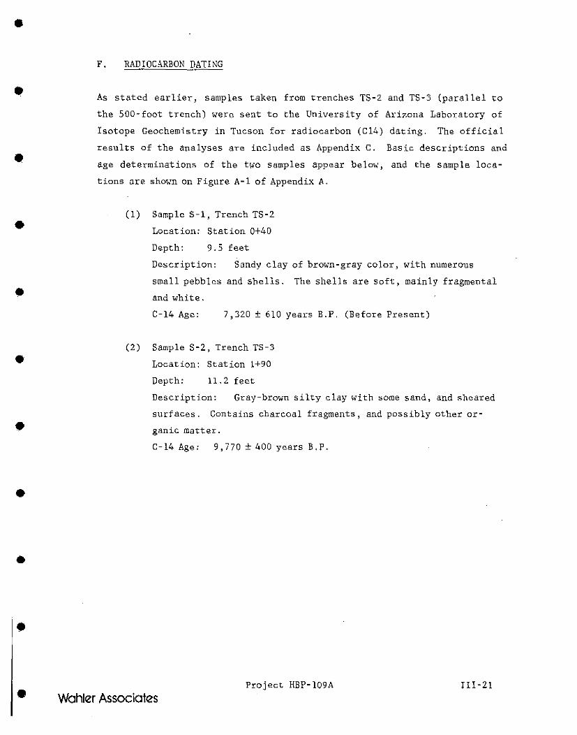
•
•
•
•
•
•
•
•
•
•
•
F. RADIOCARBON DATING ~--
As stated earlier, sampl<>s taken from tr,enches TS-2 and TS-3 (par.~l lel to
the 500-foot trench) wero sent to the University of Ari7.ona Laboratory of
Isotope Geochemistry in Tucson for radiocarbon (C 14) dating. The officia 1
results of the analyses are included as Appendix C. Basic de.scriptions and
age determinations of the two samples appear below, and the sample loca
tions are shown on Figure A-1 of Appendix A.
(l)
(2)
Sample S-1, Trench TS-2
Location: Station 0+40
Depth: 9.5 feet
Description: Sandy clay of brown-gray color, with numerous
small pe.bblcs and shells. The shells are soft, mainly fragmental
and white.
C-14 Age: 7,320 ± 610 years B.P. (Before Pre"mt)
Sample S-2, Trench TS-3
Location: Station 1+90
Depth: 11.2 feet
Description: Gray-brown silty clay with some sand, and sheared
surfaces. Contains charcoal fragments, and possibly otl1er or
ganic mutter.
C-14 Age: 9,770 ± 400 years B.P .
Project HBP-109A III-21
Wohler Associates
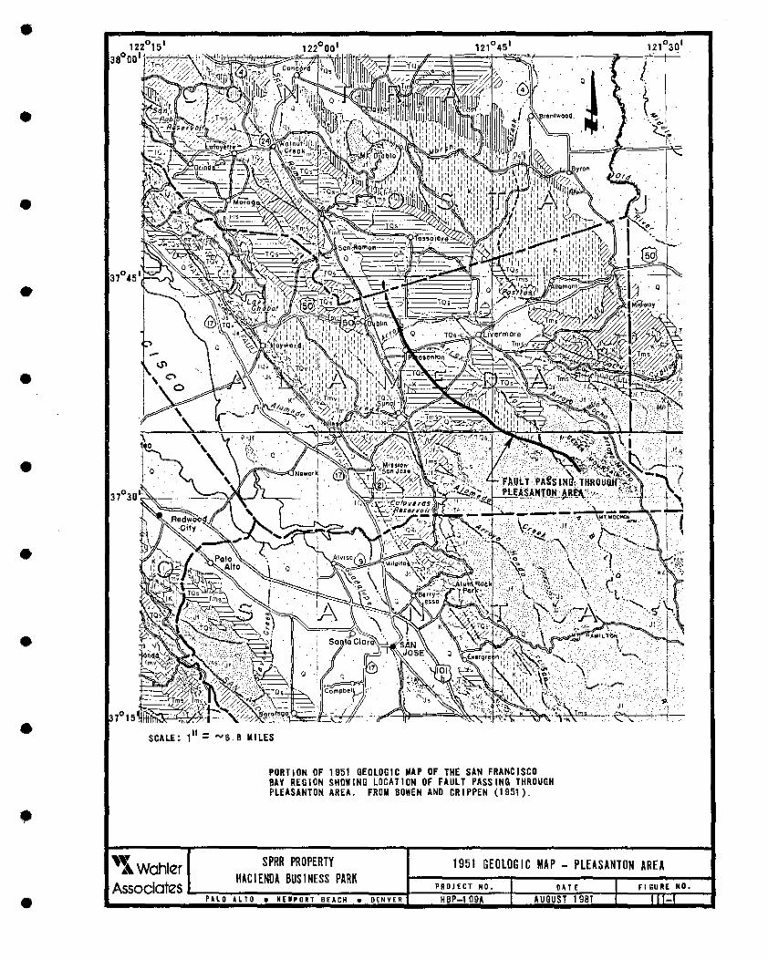
•
•
•
•
•
•
•
•
•
•
: ..... 6.B MILES
PORTION OF 1951 GEOLOGIC ~AP OF THE SAN FRANCISCO 8AV REGION SHOWING LOCATION OF FAULT PASSING THROUGH PLEASANTON AREA. FROM BOWEN AND CRIPPEN (1951).
'l Wohl~r SPRR PROPERTY HACIENDA BUSINESS PARK
.A.ssoclotes ..... ....,...,.._----~~~--------~~~~-1----'-'~'~'-'-'r.,..-."~'~·~+-----,....;:'~'~'~'~----1-~-'~'~'~"~"~'~"~'~·~.....1 P~l..O ALtll • NE"IPOltT BfAl:H • D~NVER HBP-109A AUGUST 1981
1951 GEOLOGIC MAP - PLEASANTON AREA
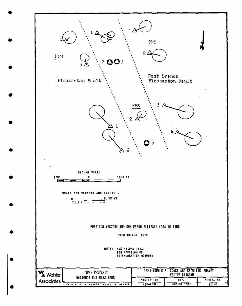
•
•
•
•
•
•
•
•
•
•
•
•
PF'.'1 .
2 003 • ..
• Pleasanton Fault
East Branch Pleasanton Fault
. . . . · .
• •
.. ~~ PFS
. •
• . . .
•
os 6
. •
ORDUNO SCALE
1 o.E:i°°3:=EE33::::JE3E:i':o =====:51 o1oo n
SCALE FOR VECTORS AND ELLIPSES
oC::i::nccr::=::::'.:· jo . 100 n
POSITION VECTORS AND 95% ERROR ELLIPSES 1964 TO 1965
FROM MILLER, 1970
NOTE: SEE FIGURE 111-2
~ SPRR PROPERTY
FOR LOCATION OF TRIANOULATJON NETWORK .
1964-1969 U.S. COAST AND GEODITIC SURVEY VECTOR DI AGRAM A Wahler HACIENDA BUSINESS PARK
Associates1..::":":".~~~~..,.-~"".'"'."~~------4-~~·~·0~·~"~'~"~'~·--+~~~'~'~"~..,---l-~~"~"~""~'~"~·~·--1 PALO Al.TO • NEff'Off7 1£ .. CH • OENYEi;t HBP-109A AUGUSl 1S81 \I -3
' ' ' ! I
OVERSIZED··. DOCUMENT HAS
BEEN PULLED AND SCANNED
: · WITH THE MAP FILE,.
I ,
'.
•
•
•
• FINDINGS AND CONCLUSIONS
•
•
•
•
•
•
•
•
•
•
•
•
•
•
•
•
CHAPTER IV
FINDTNGS AND CONCLUSIONS
This chapter summarizes our findings and conclusions on the detailed in
vestigation performed to evaluate the existence and activity of the Pleasan
ton Fault within the SPRR property. This detailed investigation included
an extensive trenching exploration program and an update of the extensive
literature search, review and analysis, airphoto interpretation, and sur
face reconnaissance, performed during a previous fault study by Wahler
Associates on an adjoining property to the south of the SPRR property. A
full description of this investigation can only be gained by reading the
entire text of the report. However, to make our principal findings more
readily accessible to the reader, they are summarized below.
1.
2.
The earliest known mention of faulting in the Pleasanton area is
shown on a 1951 geologic map of the San Francisco Bay Region. No
evidence is referenced to substantiate the existence of this
fault. Since that time, almost all literature or information on
the Pleasanton Fault has assumed that the fault exists .
The California Department of Water Re.sources, in their ground
water rcsources study of the Livermore Valley, appear to have
presented the first published evidence of the Pleasanton Fault,
mapping it on the bas is of airphoto lineaments, geomorphic fea
tures and variations in ground water levels on the order of 30
feet in widely-spaced wells. Except for the single tonal line
ament from the 1940 airphotos which passes through the project
area, most of the indirect evidence cited is for mapped traces
north of the project area (Camp Parks area), where, to our know
ledge, the existence of faulting has not been confirmed by trench
ing .
Project HBP-109A IV-1
Wahler Associates
•
•
•
•
•
•
•
•
•
•
3. Right-lateral offsets in fences in the Camp Parks area have also
been reported in one investigation along mapped traces of the
Pleasanton Fault. However, no other surficial evidence consis
tent with these observed offsets has been noted in the developed
portions of the Camp Parks area (i.e. along roadways, building
structures, railroad). Our own surface reconnaissance indicates
several areas of disturbance along fences, which are not consis
tent with the mapped traces of the fault and which could be
alternatively explained by man-made activities or expansive
so:i ls .
4. Geodetic measurements of three networks that straddled the infer
red traces of the Pleasanton Fault in the Camp Parks area indi
cated an element of right lateral movement, but were not consis
tent in aither time or in space. For example .• right-lateral
movement of 18 mm was reported during a 5-year interval from 1964
to 1969, while no movement was interpreted for the period 1969 to
1979. Furthermore, an 18 mm offset is considered significant and
would probably have been expressed on the surface by a consistent
alignment of disturbed cultural features. None have been reported
or observed .
5.
6.
7.
Detailed gravity profiles, conducted reccmtly, show local ano
malies along mapped traces of the Pleasanton Fault; however,
al ternativc inte>pretations of the anomalie• in the gravity
profile• have also been presented and their relevance to the
fault is therefore admittedly ambiguous and inconclusive.
Recent studies relating aeromagnetic anomalies to identify fault
systems indicate no magnetic anomalies in the Pleasanton Fault
area.
The 1970 Danville earthquake swarm, centered about 6 miles north
west of the project site, has been ascribed by some workers to
activity on a 110rthward extension of the Pleasanton Fault. The
Project HBP-109A IV-2
• Wahler Associates
•
•
•
•
•
•
•
•
•
•
•
8.
9 .
10 .
seismic activity does not follow a linear trend, as is commonly
shown along known active faults in the area, but is rather concen
trated in a roughly spherical distribution. Some investigators
have sugge$tod that the earthquake activity could be related to
some type of piercement structure .
Recent epicenter maps (1969-1974) showing epicente:rs of earth
quakes with magnitudes of less than 0.5 to 4.5 shown rare occur
rences of earthquake epicenters in the vicinity of the site. It
would seem reasonable to expect seismic activity on a fault that
is activoly creeping; however, no such activity is evident at the
site during the period of record.
South of the project site, several detailed studies, employing
investigative techniques including trenching, have been previous
ly performed. All the studies reviewed found no direct evidence
to substantiate activity on or the existence of the Pleasanton
Fault. This included a 2, 000-foot-long trench excavated by
Wahler Associates immediately south of the SPRR property across
the inferred traces of the Pleasanton Fault shown in the 1974 SSZ
map of the Dublin Quadrangle. Another 200-foot-long trench was
excavated to evaluate the southward projection of a tonal linea
ment shown in 1940 aerial photos. No evidence of Holocene fault
ing was found in these trenches excavated by Wahler Associates.
North of the project site in the Camp Parks area, airphoto inter
pretations of 1940 aerial photographs indicate three, well-de
fined, strong tonal lineaments in the alluvium. These tonal
features become abruptly faint or discontinuous to the south and
north. The easternmost lineament could be traced vaguely about
2,000 feet south of Interstate 580 and onto the SPRR property.
Although these features may be artificially created, they occur
in the Holocene alluvium and may be caused by faulting .
Project HBP-109A IV-3
Wohler Associates
•
•
•
•
•
•
•
•
•
•
•
11.
12.
Since the airphoto lineaments discussed above occur in the Holo
cene alluvium, it was reasoned that trenching would disclose
evidiJ.nccs of faulting in tl1e exposed subsurf1'";lce materials.
Therefore, a 500-foot-long trench was excavated in the alluvium
across the inferred trace of tha Pleasanton Fault which passes
through the project area, as indicated by the easternmost tonal
lineamRnt on the 1940 airphotos, and by the 1981 Special Studies
Zones Preliminary Review Map.
The backhoe trenches were excavated to an average depth of 15
feet and up to a maximum of 16 feet. Based on detailed logging,
the materials exposed in the trench consist of identifiable
horizontal to nearly horizontal and i.nterfingering ] ayers of
silty clays and sandy clays, interhedded gradat:ionally .
A distinctive bluish-gray to grayish brown silty clay layer near
the bottom of the trench could be traced continuously throughout
the entire length of the trench. Radiocarbon age detei;mination
of charcoal detritus from the top of this layer at a depth of
ll.2 feet has indicated a Cl4 age of 9,770 ± 400 years B.P.
During the trenching program, it was observed that ground water
depths may var;y locally within short lateral distances, due to
compositional differences and their nffect upon permeability.
Det.~iled logging of the alluvial materials in the trenches foiled
to show any offsets, ruptures, di::stortions or. warping, presence
of fault gouge material, ground water barriers i or any other
feature that is indicative of faulting.
Based on our detailed investigation using currently availabc geo
logical techniques, it is our conclusion that no active faulting
has occurred at the project site in at least 9 ,000 years, and
that evidence to date for the existence of the Pleasanton Fault
at the project site is indirect~ inconclusive and unsubstantiated
by the information currently availahle .
Project HBP-109A IV-4 Wahler Associates
•
•
•
• REFERENCES
•
•
•
•
•
•
•
•
•
•
•
•
•
•
•
•
•
•
REFERENCES
Applied Soil Mechanics Inc .. • (1975), Geologic and Seismic Hazards Investigation, Tract 3606, Pleasanton, California.
-----' (1977), Geologic and Seismic Hazards Investigation, Creeks Bend Subdivision, Tract 3359, Pleasanton, California .
Bennett, J., (1979), Memorandum letter to E. Hart, California Division of Mines and Geology, San Francisco, from J. Bennett, CDMG, Sacramento, dated September 6, 1979; Subject: Pleasanton Fault Horizontal and Vertical Movement Data.
Bowen, O.E., and Crippen, R.A., (1951), Geologic Map of San Francisco Bay Region in Geologic Guidebook of the San Francisco Bay Counties, California Division of Mines, Bulletin 154.
Branner, J.C., (1912), Report on the Geology of Livermore Valley, in the Future Water Supply of Sau Francisco, Spring Valley Water Supply Company .
Brown, R.D. Jr., (1970), Historically Active Faults, San Francisco Bay Area: Basic Data Contribution No. 1, San Francisco Bay Region Environment and Resources Planning Study, U.S.G.S.
Brown, R.D., and Lee, W.H.K., (1971), Active Faults and Preliminary Earthquake Epicenters (1969-1970) in the SoutheTn Part of tho San Francisco Bay Region, Basic Data Contribut:ion 30, San Fr,lncisco Bay Region Environment and Resources Planning Study U.S. G. S.
Burkland and Associates, (1974), Supplementary Report Geologic and Seismic Hazards Investigation, Valley Memorial Hospital, Pleasanton, California September 1974.
_____ , (1975), Suppl<>ment 2 to the Geologic and Seismic Hazards Investigation, Valley Memorial Hospital, Pleasanton, California, January 1975 .
Byerly, P., (1951), History of Earthquakes in the San Francsico Bay Area; in Geologic Guidebook of the San Francisco Bay Counties, California Division of Hines, Bulletin 154.
California Dep11nment of Water Resources, (1963), Alameda County Investigation, Bulle.tin 13 .
---~-, ( 1964), Alameda Creek Watershed Above Ni lcs.
(1966), Evaluation of Ground Water Resources, Livermore and Sunol Valley, Bulletin 118-2, Appendix A, Geology .
---~-' (1974), Water Resources of Livermore and Sunol Valleys, Bulletin 118-2 (revised edition, June 1974).
Project HBP-109A R-1
Wahler Associates
•
•
•
•
•
•
•
•
•
•
•
California Division of Mines and Geology, (1974), Special Studies Zones; Dublin Quadrangle .
California Division of Mines and Geolgoy, (1981), Special Studies Zones, Dublin Quadrangle, Preliminary Review Map of July 1, 1981.
Carpenter, D., (1975), Geologic Evaluation of Proposed East County Government Center, Sunol Boulevard Site, Pleasanton, California, County of Alameda, Public Works Department .
Dibblee, T. W. , Jr. , (1980), Preliminary Geologic Map of the Dublin Quadrangle, Alameda and Contra Costa Counties, California: U.S. Geological Survey Open-File Report 80-537.
Earth Sciences Associates, (197 Sa), Fault Investigation, Library Addition Amador Valley High School, Pleasanton, California
____ , (1975b), Fault Investigation, Phase II, Library Investigation, Amador Valley High School, Pleasanton, California.
, (1979), Geologic Investigation, Phase II, General Electric Test ----Reactor Site .• Vallecitos, California.
Ellsworth, W.L., and Marks, S.M., (1980), Seismicity of the Livermore Valley, California Region 1969-1979; U.S. Geological Survey Open-File Report 80-515 .
Engeo, Inc., (1979), Seismic Hazards Exploration, Komandorski Village, Pleasanton, California, l!ay 7, 1979.
Ford, R.S., (1969), Groundwater Geology of Livermore Valley - A Satellite Urban Area: Urban Environmental Geology in the San Francisco Bay Region, Special Publication .
, (1975), Most Recent California Department of Water Resources Well ----Data, Letter to Murray Levish dated January 13, 1975 from R. Ford, in Burkland and Associates, 1975.
Funkhouser, L.W., (1948), The Geology of the Arroyo dcl Valle Area, Alameda County, California, Unpublished Masters Thesis, Stanford University.
Geological Society of Sacramento, (1959), Field Trip Guide: Coast Ranges, Livermore Valley to Hollister, 19 p., maps.
Gibson, W.M., and Wollenberg, H.A., (1968), Investigation for Ground Stability in the Vicinity of the Calaveras Fault, Livermore and Amador Valleys, Alameda County, California, Geological Society of America Bulletin 1, v. 79, pp. 627-638.
Greensfelder, R.W., (1974), Maximum Credible Rock Acceleration from Earthquakes in California, California Division of Mines and Geo logy, Map Sheet 23.
Project HBP-109A R-2
Wohler Associates
•
•
•
•
•
•
•
•
•
•
•
G.-iscom, A., Roberts, C.W., and Harden, K.D., (1979), Gravity Data and Interpretation of Detailed Gravity Profiles in the Livermore Valley Aren, California; U.S. Geological Survey Open-File Report 79-549 .
Gutenberg, B., and Richter, C.F., (1954), Seismicity of the Earth, Princeton Press, Lists Earthquakes 1904-1952 of Magnitudes 5.3 and Greater.
Hall, C.A., (1958), Geology and Paleontology of the Pleasanton Area, Alameda and Contra Costa County, California, University of California, Publication in Geological Science, v. 24, No. 1.
Hanna, W.F., and Brabb, E.E., (1979), Naps Showing Aeromagnetic Anomalies, Faults, Earthquake Epicenters, and Igeous and Volcanic Rocks in the Southern San Francisco Bay Region, California; U.S. Geological Survey Open-File Report 79-827 .
Harding, Miller, Lawson & Associates, (1972), Supplementary Report Seismic Risk Assessment, l!opyard Road Site, Neai: Pleasanton, California, February 1972.
Hart, E.W., (1980), Fault-Rupture Hazard Zones in California, California Division of Hines and G"ology, Special Publication 42, Revised March 1980.
~~~~' (1981), Pleasanton and Related Faults, Dublin Quadrangle: California Division of Hines and Geology Fault Evaluation Report FER109 (unpublished) .
Herd, D., (1978), Nap of Quaternary Faulting Along the Northern Calaveras Fault Zone: U.S. Geologic Survey Open-File Report.
Jenkins, O., (1938), Geologic Map of California, California Division of Mines .
Jennings, C.W., (1975), Fault Nap of California, California Division of Mines and Geology, Geologic Data Hap Series, Map 1.
Johnson, R., (1980), Personal Communications, Alameda County Flood Control and Water Conservation District, Febrnary 25, 1980 .
Judd Hull and Associates, (1977), Geologic Investigation for Proposed Civic Center Additions, Pleasanton, California.
Lawson, A.C. (1912), Report on the Geology and Underground Water Supply of Livermore Valley, in the Future Watar Supply of San Francisco~ Spring Valley Water Supply Company.
Lee, W.1!.K., Eaton, M.S., and Brabb, E.E., (1971), Earthquake Sequence Near Danville, California, 1970, Bulletin Seismology Society of America, v. 61, No. 6 .
Project HBP-109A R-3
Wahler Associates
•
•
•
•
•
•
•
•
•
•
•
Hiller, R.W., (1970), Study of Earth Movement Determined by Triangulation, Camp Parks Vicinity of Pleasanton, California, Supplement No. 1, U.S. Coast and Geodetic Survey, Unpublished Report .
Parkins, E.J., (1965), Report Camp Parks Vicinity of Pleasanton, California, Study of Earth t!ov.,mcnt Determined by Triangulation, U.S. Coast and Geodetic Survey, Unpublished Report.
Radbruch, D.H., (1968), New Evidence of Historical Fault Activity in Alameda, Contra Costa and Santa Clara Counties, California, Stanford University Publications Geological Science Volume XI pp 45-54.
Real, C.R., Toppozada, T.R., and Park, D.L., (1978), Earthquake Epicenter Map of California, 1900-1974, California Division of Mines and Geology, Map Sheet 39 .
Richter, Charles F., (1958), Elementary Seismology, W.H. Freeman & Company, San Francisco) California.
Schlocker, J., (1970), Generalized ~lap of the San Francisco llay Region, California, U.S. Geological Survey Open-File flap .
Terrasearch, Inc., (1979), Geotechnical Investigation, 600-acro parcel, Dougherty Hills, Alameda and Contra Costa Counties, Phases I and II; Unpubl ishcd Consul ting Report for Kremco, Tnc.
Thompson and West, (1878), Official and Historical Atlas Map of Alameda County, 1878; reprinted as 1976 Bicentennial Edition, Valley Publishing Company) Fresno.
Tocher, D., (1959), Se.smic History of the San Francisco Bay Reg.ion, in Oakeshott, G.B., ed., San Francisco Earthquake of March 1957, California Division of Mines Special Report 57 .
Toppozada, T.R., Real, C.R., and Pierzinski .• D.C., Seismicity of California January 1975 through March 1979: California Geology v. 32, No. 7 July 1979.
Townley, S.D., and Allen, f!.W., (1939), Descriptive Catalogue of Earthquakes of the Pacific Coast of te United States 1769 to 1928; Bulletin Seismology Society of Anierica, v. 29, No. 1.
U.S. Geological Survey, (1972), Seismicity l!ap of Greater San Francisco Area, California, 1969-1971, Open-File Hap .
Wahler Associates, (1980a), Geologic and Fault Investigation, Pleasanton Business Park, (Willow Wost Property), Pleasanton, California: Cnpublished Consul ting Report for CPS & Associates.
---- , (1980b), Preliminary Geotechnical Evaluation, Pleasanton Business Park, Pleasanton, California: Unpublished Consul'ting Report fot" CPS & Associates.
Project HBP-109A
Wohler Associates
•
•
•
•
•
•
•
•
•
•
•
Wire, J.C., (1972), Geological and Geophysical Investigation Proximity of the Pleasanton Fault to the Walnut Grove School, Pleasanton, California .
Yadon, D.M., and Wright, R.H., (1979), Evidence for Recent l'aulting in the Pleasanton Area, California, in l'ield Trip Guide for the G<!ological Society of America, 75th Annual Cordilleran Section Meeting, San Jose, California, April 1979 .
Project HBP-109A R-5
Wohler Associates
•
•
•
•
• APPENDIX A
•
•
•
•
•
•
•
•
•
•
•
•
•
•
•
•
r f-Q..
UJ a
rs
2o'
5
'" r z t:: .""1
,0 ill I Cl ~
~
~
rs
---- -
', I, i:& Sr-'.·-~ c· .... f.;i· f:::_i.--::...':l)
·.._-q:11<; IT.u 'fl1.~C:i•..i. rr. ... ,'r;/•',IE: -a"f:;).,11, b M•...ur. "TLC· ':!-1'.T·,a,, :J-'r I-'- L:..: L·,·.i-E. Co. 1.1 :::_te.· &.ff'C. ~-f°irlE'.. 5o..od a,ra·,_l'iS (a~cut 3~£~-, r"ocT 1:'.;::J.u.tif'.s: c..art1.p Tc- rr..c1:st, ~rote. ;J'10.s.f-1c'1t-y_ -:::.alii;lte::J.r,d mo':t1·~ha. .mere 1·r.te11stF1Eii rr. 'rhe.. lou..:e:'r ('Citt-1-:::rf'i.
---
SPAR PROPERTY
HACIENDA BUSINESS PARK
:t~O
J_
·~ S:-·~T"t c L;\"' (C.i...-Crl) Gro·-rrs'r-. f::,r:::i;.on . w ifn. m re S;JJ"Ld Q'f::l.·,n~. 5·,rn;_lu1 to ::%:.. or.f~ _·or.::;.~r. su.r-Pa..ce_ i "= ·10% 1rrC'<:iu.k1.r or. 2 . qrcir.L!..lar: a"nd qo% ."S.n€:::1.~C:;
,.... vc.1v rnc-i:st --:-o wet · :=,;');f;ters ~ hEn .srru.U:. w it~, n am rr.er.
TRENCH NO. TS-1 , T S-2 ANO TS-3 LOG OF SOUTH WALL
•
•
•
•
•
•
•
•
•
•
•
vi-
SCALt:::
0 5 FE.E;T
.... ..•
···· .. ,
'
-t \
"'ffl':r I 1"1'.i'i" ::,i;- l:af'.e._ o · u.:o.te(' .'50.t...1.~o.t•.cr.
):.., :51 L 7'> C:. L-..::.,..., I~::_ L-_c.n~, "-t:.--· ,\li~bi'-'11'1- t:~~uJr\_ 1).:1+~. DfL>-U,::.·
[!rr;.JJr• r-1.n-:J-.ljy,c.1 ~M TJ.O ~ ·:U'1·.~·. ·'.:.~"':"-1- 5-,'9%. ·,.i.1tl!~·~r.,,,eoi ::..o;~f'i flfl'f'i. .'Y:.::;~~r.:;.to?t·J pb:":-'t- 1
(__
'7+00 I
.31!.,,~) (' f'-..1fr1-( ·r-1~ Grn:f,:::.'1.-. t:ruu..:r•: ~irl~. ';T&.( es qf v'i!.~·,• f:rie. ?o"'d, r::::.:::.r C-a.'v •.":"'1"'-S; ca.•,v.f ~-0 r.i.o'.S-T: ·r,1.:::.0et-::1;'te.1\1 f='f::i.5'ri (.: i:=-, w. . M ~S·f\ 1-~ le r.:> '!..€Y'. 51..11&~ e · :;, o.;::iy10-.,.-,11Aa~··~· .507f:. =_rre.'7•...._',o.-r ~_,-4·ru •. 'al'" s· .... rfuq: ::J·,•.::J t:r(!!,.l:P-, .:111 d 56% 1--::,<c.._._:r_ -o::r"'\' f-c.'iS'r~d or s:t::i::._e.•,S'•.dE.0 5'.J.1---fa(€S - r·.~-"V C·'.::-1Y'rOX!l SO'J'\.\E'~ g1.:::i:·1- u.lii.:_te C.a.1·,c_'ro.e.., _s·,1.-1---~· pxt-e"rs., .c,.-..-.c '1-::.1.1·-""~ lt-6 l") c..a':.;:.he:_ r-:0d·..:..·1-e.-s ~
'lfZS I
:s·,:.__1·i :._-•. ;::.,-... 0:::: ~-co:1:--i D:~r~ q{O..'j- tr::v:.es u'r F1r.e Sc:!,1·.d; :{;,=.-=-i·"'-~-...,. C.::i. .... ·.P, P• r ,..... ts- sh ~-rw-i:-~1;: ~ • .,,.~ r::i.:.t rt•'<' '-' ~ ('_ :::._ 1 D ~-;·.t -:::.on -kw..s c1bu-.•OO•,.,T °Cf:5.-.-1;u.".'r.=.~e co..'i~'r.£.
/-.. /
--------- - --
-- ~ --:
- -- !:
-l· ---~---_-_..,.'- --/,_ __ ____ ,,.., @
~
'· \..m:::i;_.,,'::"u-i:~ :::i.mc.· •. e.,...>r
(U~>.~ - l"il·~;'i;,t i::-oo,r.n1·~ / l,'ffl_ oi <>;+·....i. -re. -:::i. ,.-ad', e Yl. ~
'1):.1~~ - Lo;'tf (:SC.:."ru•->;l"-0"': 'i::.curj:Jt1 ' i
~ s·,1--1'l _::=,1,.-.t-;"i ;:::..1.-.-C'r-1) ,~l e:h!.:..i .-.~. - b~c·....:: l~; ::;:.-,.::..: ..... ~·-~ :SJ.r.~'{· .:::r:n~f; fin11i wifr._ ~~.x.-e·~:)_\-e p'..:.i.s-L;c=,~ ,S)...-.·.i.9.-,- ';··.°'f t....a~:.V,C"'t0 2.c., er.I-. mo...li•~ :r,T"".f uec!d-ed .... :thif• Q.::_ ;
SPAR PROPERTY
HACIENDA BUSINESS PARK
P~ LO .l.L TO • "EWPOAT if.I.CH • 01 M~ER
I
PRO 'E<:T HG.
HBP-1 09.1.
-
5fOO
I
-- - -
-·,
t~~e~ g a.,,_,!.~ 'oo:i';I", f"1n-:j'o, OJ.,
i) ~ :;::-~,.,~ "!,· l.cw.-::1 "1.-3 f:r ~- k-::.:Ji"at5-
2.~: Tf::!1'c. 'r,e:s e_»::.0-..;::.i-Td l_i.!1t'-i. & ~03:.::: i': &i.d.<..-'rile a:r.d 3o- il'I er. '..<Ji Ci:> b ... _-::.K~ -t J1.,1:r n '3 --'_fie_ pef·~·:::I -: .. 1~· 2.0_.t9'1!:1 +nrr ...... ~-..... h---ie,'-1~~ ·10, 1q-t1.
.3) L~9ei:J D~· ke·&. [:, B('::l'...JI"! r:\nJ R-~.'t! ..... 10 .::.. S-:...a"Gcu-.. , ~r.ff• fle."'-ri "°! :5-.:-:d.;__·~i::;. ts, lhcr.1-e.r fl, :sscc'.o -te'S. -
TRENCH NO TS-1 LOG Of SOUTH WALL
I DUI: FIGIJI! MD.
•
•
•
•
•
•
•
•
•
•
•
SHEET No.1 of 4 DATE LOGGED 7 /16/81 LOGGED BY K. B.
RIG J.D •. 310 A (J. & W. Construction) PIT WIDTH 24"
PIT ND. DEPT" IN FEET SOil TYPE DESCRIPTION
TPS-1 o.o- 3.3 CL-CH Trend N75E
3.3-10.0 CH
10.0-11.5 CL-CH
11. 5-12. 3 CL-CH
SILTY CLAY: medium brown; firm to stiff; dessication cracks and grass roots to 6"; slightly damp.
3.0-3.3 - Traces of caliche (white) and orange mottling; traces of fine gravel (to 1/4") and coarse sand.
CLAY: dark gray-brown; moderate to high S-1 plasticity; stiff; slightly damp; tr,.ce.s of charcoal and fine sand .
6 '-10' - Medium brown; traces of c·aliche; moderate plasticity; damp.
SILTY CLAY: light yellow-brown;· son1e finE sand grains;. moderate p_l'asticity; damp ..
SILTY CLAY: dark brown-gray; moist to wet; firm; moderate plasticity; trac.es of fine sand.· . ,
I , 12.0 - Ground-water encountered •
W. A. WA HUR SPRR PROPERTY TEST p IT LDGS
& ASSOCIA HS .__...,...HA_c_I_E_ND_A_IJ_u_s_IN_E_· s_s_P_A_RK _ _..,t---='=-' ',-'-' -"-' '--!-'.-'---"-'-' ---r'--'-"-'-' '-'-"-'--t PllO llTO • lllfll'O~T lflC~ • Clllf HRP . . irr.r\~ I AJTl'""TT,..m il'\Ql I
•
•
•
•
•
•
•
•
•
•
SHEET No. 2 of 4 DATE LOGGED 7 /16/ 81 LOGGED BY K. B.
RIG J.D .. 310A (J. & W. Construction) PIT WI OTH 24"
PIT NO. DEPTH IN FEET SOIL TTPE
TPS-2 _Trend N47W
o.o- 3.0
3.0-.8.5
CL-CH
CL-CH
OESCRI PT I OH
SILTY CLAY: dark gray; slightly damp; firm to stiff; moderate plasticity; dessication cracks to 1.5' roots to 311 .
SILTY CLAY: green-gray to medium browngray; moderate .. plasticity; firm; some very fine and ve~y aoarse sand; some orange mottling and organic material.
SAMPLE
4'-8.5' - (Gradational Contact); S-1
8.5- 9:0 CL
9.0-11.0 CH
11. 0-16. 0 ML-CL
becomes moderate to highly plastic· damp, with very fine grained sand -becoming more silty towards lower contact.
SANDY CLAY: gray-browo; with 50% medium to fine sand; some orange mottling; slightly plastic; wet.
I 9.0 - Ground-water encountered flowing from SE end of trench at about 1/2 gal./minute •
CLAY: grayish-brown with yellow-brown mottling; dirty white caliche; highly plastic; moist.
SANDY SILT: browoish-gray; contains considerable clay; low plasticity; soft; contains very find sand grains.
Caving of trench sides at 11-13'. Ground-water encountered at 11.0'. Flow: 10 cu. ft. /hr •
S-2
S-3
IV.A. WAHUR SPRR PROPERTY TEST PIT LOGS
& ASSOCIAHS .._ __ HA __ cr_E_.ND_A_B_us_r_N_E_s_s __ PA_RK---1---:.,.,",.,,',.;;"~".,,.,,.",......-1-:-:-:l==-'•',,"c=--Jl-~'-"-*-"-'-'-'--t 11'.llO ll!O • 111(1',.0llf l!IEACM • C~ll' H~P-109A. !AUGUST 1981 l
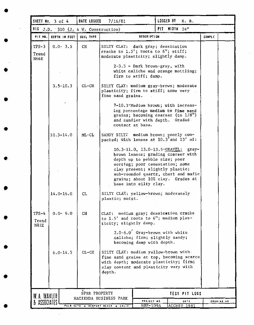
•
•
•
•
•
•
•
•
•
•
•
SHEET No. 3 of 4 DATE LOGGED 7/16/81 LOGGED BY K. B.
RIG J.D. · 310 (J. & W. Construction) PIT WIDTH 24"
PIT HO. DEPTH IH FEET SOIL TYPE
TPS-3
Trend N66E
0.0- 3.5
3.5-10.3
10.3-14.0
14.0-16.0
TPS-4 0.0- 6.0
Tre.nd N82E
6.0-14.5
CH
CL-CH
ML-CL
CL
CH
CL-Cll
DESCRIPTION
SILTY CLAY: dark gray; dessication c.racks to 1.5'; roots to 6"; stiff; moderate plasticity; slightly damp.
2-3.5 - Dark brown-gray, wi~h white caliche and orange mottling; firm to stiff; damp.
SILTY CLAY: medium gray-brown; moderate plasticity; firm to stiff; some very fine sand grains .
7-10.3-Medium brown; with increasing percentage medium to fine sand grains; becoming "oarser (to 1/8") and sandier with depth. Graded contact at base .
SANDY SILT! medium brown; poorly compacted; with lenses at 10.3'and 13' of:
10.3-11.0, 13.0-13.5-GRAVEL: graybrown lenses; grading coarser with depth up to pebble size; poor sorting; poor cementation; some clay present; slightly plastic; sub-rounded quartz, chert and mafic grains; about 10% clay. Grades at base into silty "lay •
SILTY CLAY: yellow-brown; moderately plastic; moist.
CLAY: medium gray; dessicat;ion cracks to ]. . . 5' and roots to 6"; medium plasti.city; slightly damp.
r 2.0-6.0 Gray-brown with white .caliche; firm; slightly sandy; becoming damp witl1 depth .
SILTY CLAY: medium yellow-brown with· fine sand grains at top, becoming scarce with depth; moderate plasticity; firm; clay content and plasticity vary with depth .
SPRR PROPERTY TEST PIT LOGS
SlMP~E
W_ A_ WAHUH HACIENDA BUSINESS PARK & ASS 0 CI AH S .__.,.,.,.~...,.,.--..,..,..,.~,,.,.,..,.,...-,..,..,.._r----i'"'';"E",..'.,.."=-' '.--11r.tt=:::::-'-;"~'-;;-;---t1 --'-"-'-"-'-"-'--;
jl'1LO i.LlO • 111Et'c•r 8f..&CM • c•L1f HBP-l09A IAUGUST 1081 I
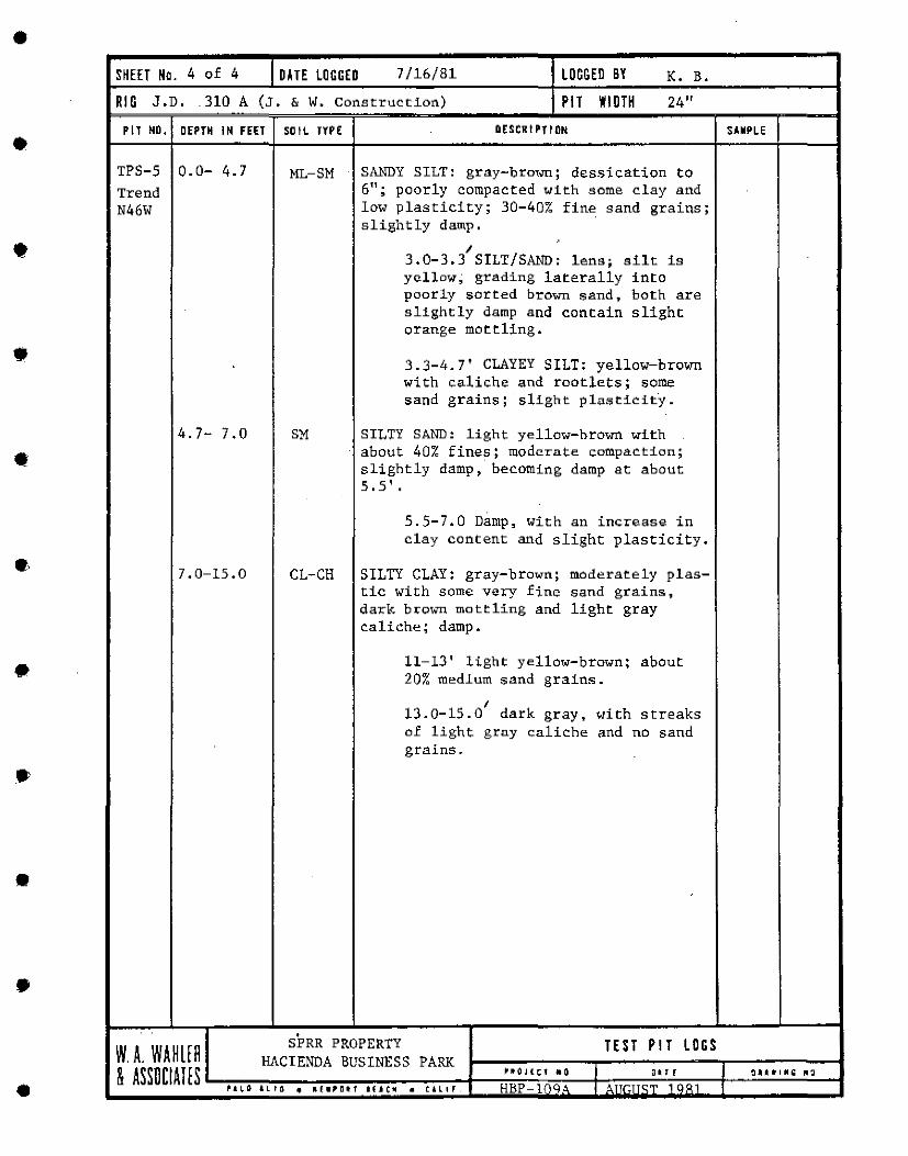
•
•
•
•
•
•·
•
•
•
•
SHEET Ha. 4 of 4 DATE LOGGED 7/16/81 LOGGED BY K. B.
RIG J.D .. 310 A (J. & W. Construction) PIT WIDTH 24"
PIT ND. DEPTH IN FEET SDIL TYPE
TPS-5 0.0- 4.7 Trend N46W
4.7- 7.0
7.0-15.0
ML-SM
SM
CL-CH
DESCRIPTION
SANDY SILT: gray-brown; dessication to 6"; poorly compacted with some clay and low plasticity; 30-40% fine sand grains; slightly damp .
I 3.0-3.3 SILT/SAND: lens; silt is yellow; grading laterally into poorly sorted brown sand, both are slightly damp and contain slight orange mottling .
3.3-4.7' CLAYEY SILT: yellow-brown with caliche and rootlets; some sand grains; slight plasticity.
SILTY SAND: light yellow-hrown with about 40% fines; moderate compaction; slightly damp, becoming damp at about 5.5'.
S.S-7.0 Damp, with an increase in clay content and slight plasticity.
SILTY CLAY: gray-brown; moderately plastic with some very fine sand grains, dark brown mottling and light gray caliche; damp.
11-13' light yellow-brown; about 20% medlum sand grains.
I 13.0-15.0 dark gray, with streaks of light gray caliche and no sand grains .
W.A. WAHlfA SPRR PROPERTY TEST PIT LOGS
SAMPLE
HACIENDA BUSINESS PARK & ASSilCIAHS 1-------------+----,.,.,",.,,',..".,-"~",..-'-t-.-'==':-'-:".,,.,,,,--;ir---'-'-"-' -"--"'--t
il'a1,.o t.ltO 41 "'•'!U'f •(.ac111 • ~;.L,, HBP tr q.1 I l\nr:nc:.,, 100:1 I
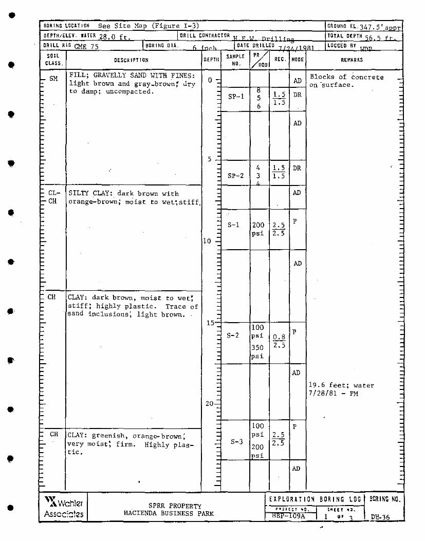
• BORING LOCATION See Site Map (Figure I-3) OROUflD EL. 34 7. 5' a""l'. OEPTH1ELEV. WA !ER 28. 0 ft. 1 OR I LL CONTRACTOR u ,, '·' ....,. , ..;: 1 1 .I TOTH DEPTH "~ 'i < • DRILL RIG CME 75 I BORING DIA. " .. '~ I DATE DRILLED "/•;,, RI LOGGECI BY ___
• SOIL
DESCRIPTION OEPTll SAMPLE 1% REC. MOOE REMARKS
CLASS . NO. a
SM FILL; GRAVELLY SAND WITH FINES: 0 - AD
Blocks of concrete -~
light brown and gray-brown~ Jry on -surface . -.... -.... -.... to damp; uncornpac.ted. - !l -.... - SP-1 5 l. 5 DR : -... - 1.5 -... 6 -.... -
• -I--.... -
~ - -.... . AD -.... - -.... - -..... - -... - -'- - -..... - -..... - -I- 5 - -I- -'- - ' -'- - 4 1. 5 DR -... - -... - SP-2 3 1. 5 -- - I. --... - -... CL- SILTY CLAY: dark brown with - AD -... - --=-CH orange-brown; moist to -wet; stiff. - --• -- -- -- - -- p -- S-1 200 2.5 -- - -- - 2.5 -I- - psi -L-
10 .: -L- -.... -.... -.... - -• -.... - -.... - AD -.... -.... - -,_ - -
L- - -L- - -.... - --- -t CH dark brown, - -CLAY: moist to wet! - -I- - -.... stiff; highly plastic:. Trace of - --.... sand inclusions~ light brown. - -.... - -...
15 - -..... 100 -L- -.... - p -- S-2 psi 0.8 - -- - -- - 2.5 -'- - 350 ... - --- - psi -- -- --- - -- - AD '- - ::-'- - -'- - 19.6 feet; water -- -... -... 7/28/81 - PH -... - -- -
~ 20- -• -- - -... - -'- -'- -... - 100 -p -... -
• -'- CH - psi 2.S -'- CLAY: greenish, orange- brown; - -.... - S-3 2.5 -..... very moist: firm. Highly plas- - 200 -,_ - -.... tic. - -.... - ipsi -.... - -.... - AD -.... -.... - -.... - -.... • - -~ -
• '~~Wcr,\er EXPLORATION BORING LOG SCR I HG HO. SPRR PROPERTY P•;nE::t ._0, I $111 (I[' ,,.
Asscc:::!es HACIENDA BUSINESS PARK ttt'1'-1U~A I I •• 0 Dl!-36
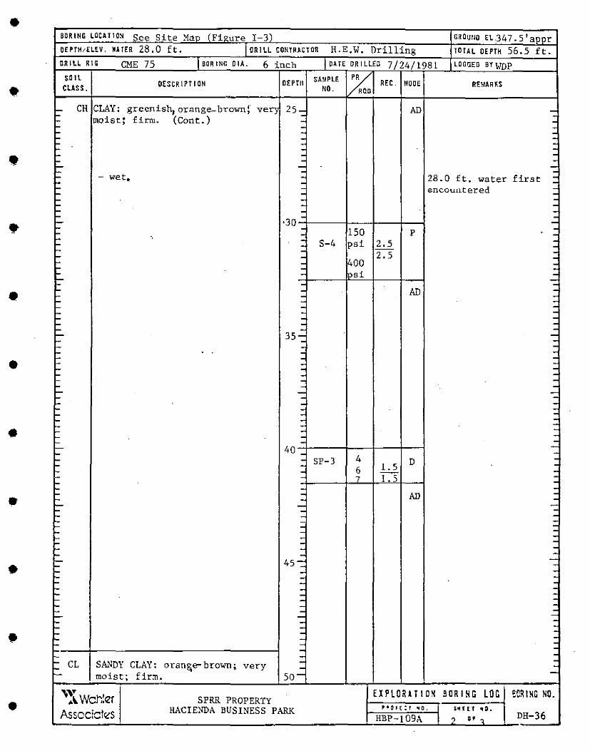
• SORING LOCATION See Site Man (Fiqure I-31 GROUllO EL.347. 5 1 aoor
OEPTH1ELEV. UTER 28.0 ft. I OR I LL CONTRACTOR H.E.W. Drilling TOTAL OEPTH 56.5 ft. DRILL RIO CME 75 I BORING 0 IA. 6 inch I DA TE ORI LLEo 7/24/1981 LOGGED BY WDP
• SOIL
OESCRIPT I ON OEPTll SA"PLE %1 REC. MOOE REMARKS CLASS. NO. 0
- CH CLAY: greenish, orange..-brown!" ver; 25- AD -: - -moist: f irn1. (Cont:.) - -- - -... - : ... -... - -... - -• -... -... - -'- - -'-- - -... ~ wet • - 28.0 ft. water first: -... - -'-- - encountered -... - -- . -- - -- - -- - -• •30 -,_
-... - 150 ... - p -- ·. - S-4 psi 2.5 -- - -- - 2.5 -- - -- - 400 -- - -- - 'Si -- -- - -• - - AD -- - . -- - -- - -- - -- - -- - -- - -- 35-: ---- - -- - -... - -• ... - -- - -- - -- - -... - -,_ - -- - -- - -- - -... - -... - -- - -• . - - -- -- - --~ 40 - -- 4 -... - SP-3 D ... - 6 l. 5 -- - -- - 7 1.5 --- - -• -- - AD -- -- - -- - -- - -- -- - --- - -- - -- -- - --- -
• -- 45-:: -- -- -- - -... . -,_ - -,_ - -- - -... - -,_ - --,_ - -... - . ,_ -• -,_ - . ,_ - . ... - . - . ,_ . . ,_ CL SA.c"-lDY CLAY: oran&e- brown; - . ... very - -,__ moist; firm. so-
• \Y EXPLOUTIO~ BORING LOG eCRING NO. •"- Wch!er SPRR PROPERTY
HACIENDA BUSINESS PARK 11' 41 1)1 ~ :t '10' I Ult t. t 1110. Asscciclrts HBP-!09A I ? .. ' DH-36
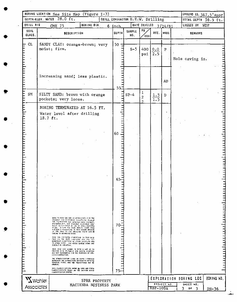
• BORING LOCATION See Site Map (Figure I-3) ~ROUND EL.347. 5 'a~~r DE PTH1ELEV. WATER 28.0 ft. I DRILL CONTRACTOR H, E, W, Drilling TOTAL DEPTH 56.5 ft. ORILL RIG CME 75 leaRING DIA_ i; in~ ... I oATE OR I LLED 7"'·" LOGGED BY WDP
• SOIL
DESCRIPTION DEPTll SAMPLE ~ REC. MOOE REMAR!S CLASS. NO. RQO
- CL SANDY CLAY: orange-brown; 50 - very - -... moist; firm. - s-s 400 0.0 p -... - -... - psi 2.5 : ... -... - Hole caving in. -- - -- - -- - -- -- - -- - -- - -- Increasing sand; less plast.ic:.. - -'-- - -- - AD -- - -- - -'' y;- ---- - 1 -- SM SILTY SAND: brown with - SP-4 1.5 D -~ orange - 2 -~ pockets; loose. - 1.5 -~ very - 0 -- -- - -- BORING TERMINATED AT 56.S FT. - -- - -
• '- level after drilling - -,_ Water - -... - -- 18.7 ft. - -- - -·- - -·- - -- - -- - -- 60 .: -' -'- - -~ - -'- - -~ - -• '- - -~ - -,_ - -'-- - -'-- - -'- - -- - -'-- - -L.. - -~ - -~ - -,_ - -
• ~ - -' - - -~
6~ -
'-- -... - -~ - -~ - -' - - -... - -~ - -~ - -'-- - -• L.. - -~ - -~ - -~ - -~ - -~ - -~ - -,_ - -~ DHA ~~ rwr~ 1.l'IG A~~-~ ~p~~c)\!"IAT::·~ Of 'Ml! - -,_ r.r1.1«.rr A\D ~i111·•r.>(E: Cl·~ol~l."' ih'Al~t - -
• L.. TII~ hf1>i•:Hl\1N _.,~ l'~fAl~t~ tm~T l'DIXlL"T, - -~
~!~CO"'l'l~LL~~. "~ t'<.'~~l~LY !!;~l'.K~lD 'A~· 10--;; -Pll•~ ,.:u:-~•uno '1 '"~ L!)' ~>:A~C·DLA>!•TI:• -'-- ~o':tJ:~ ~·'f.1•'1 A~D H~~ B!!~!~I; ll~l.U lfWl
'-- hKIH~M ~c">~\,l•A;lc'~' I~ ':"IH3 ~[GAR~ UCA!:~[ - 3 '-- ~1· ~~ ~H'1 f'J \~[ ORLLLI~" r1.1:;0 A.~D1n1 -L. l:A3!11G 1.~ 1.uvi.."11:1.~" nnu:s -.... -... TllU TilG l\Drr.ATI:~ r.''~~1Tli1~~ !~ 1111~ H~LE - -l-
~~l.Y '" ·~· om 1,n1c•.11rn "' . ., ~~r - -••PRr~prr ('.1\l,DITI~~~ ~t \l~HOll: l<il.'.\r:·.!"3 A~l:I
'-- ~~ OThl~ (••Tr,~ ~~~ ~·AflK LJ:.~h,11 ~~~ UC - -'-- Sl.&J[~·t ·ti:J '~I IATl~~. - -'--- - -L. nti5 H<'l.I ~·.11 Li:i;i;co rs ~1'r.11 A I.AT i..~ m - -
• L l'MOV!Ot 01.,A l'N:~.1R1:v rnR nr,~rr.~ P\Ri'\""c~r.~ - -... A~l:I !<llJT ~t~tS3UlLY r.lR TII[ l'l:U-1131'.S ar ~M:- - -l:l~LC t:~AL"TOH. -... -L. :l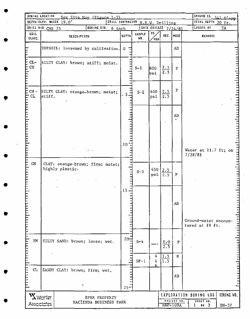
• BORING LOCAllON ;, __ qHo M-- ("O • T .~, CROUND EL; .... , 1 ,.., 1 _
DEPJH1ELEV. WATER 19.0' I DR I LL CONTRACTOR TOJAL DEPTH 30 ft. .
!!.E.W. Drillinry DRILL RIG CME 75 ieoRING 0 IA. 6 inch IDAIEORILLED 7 I '• /Q LOGCED BY TA
• SOIL
DESCRIPJION DEPTH SAMPLE r~ REC. ~ODE RrnARKS CLASS. NO. 0
~ TOPSOIL: loosened by cultivation. 0 - AD -L - -L. - -L - --L. - -': CL- SILTY CLAY: brown; stiff; moist. - -- -
• :::: CH - 2.5 -- S-1 600 p -- - 2.5 -- - psi -~ - -~ - -'- --'- - --~ - -
• '=.CH~ SILTY CLAY: orange-brown; moist; - 600 2.5 p -
s..: S-2 -=-CL stiff. psi 2.5 -- -·- - -'- " - -L. ··-L. - -L - -- - -- - AD -- - -- - - -- - -- - -• ,_ - -L. - -L. - -L - -L - -L - -L - -· ~ 10-:: -,_ -L. - -
• L. - Water at 11. 7 ft; on : L. -L. - 7/28/81 --L. - -L -'. CH CLAY: OJ; ange-brown; firm; moist; - -'- - -L. highly plastic. - 450 ,L.2._ -L : S-3 -~ psi 2.5 p -L. - -L. - -~ - -• L - ---L -L. -L... 15 - -L - -L. - -L. - -L - -, __ - AD -L. - -L. - -L. - -• ' - -'- - -L. - -L. - Ground-wui:cr -'- - encoun- -'- : tered at 19 ft. -L.. -L ---L. -L ·- -' - - -'- 20: -L.. SM SILTY SAND: brown; loose; S-4 0.0 -L.. wet. - p -L.. - --- -L.. - 2.5 -L - -,_ -' - 4 l. 5 D -L.. - --L - SP-1 4 1.5 -'- - --- " -L -'. CL SANDY CLAY: brown; firm; wet. - -L. -L. - -L - AD -'- - .
-'- - -~ • - -~ 25-
• '" SPRR PROPERTY EXPLDRAT ION SORl~G LOG ecRl~G NO. ... 1..Wchier
HACIENDA BUSINESS PARK "•'l/f:Ct "''· ~ s."' t t r 1111:1.
Asscc:::!es HBP-109A 1 •• 2 DH-37
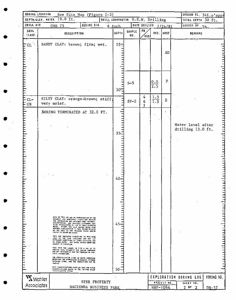
• BORING LllClTIQN See Site Map (Fi~rnre I-3) GROUl<O EL 341, o 'aoni OEPTH1ELEV. WA !ER 19.0 ft. I DRILL CONTRACTOR !!.E.W. Drilling TOTAL DEPTH 30 ft. DR Ill RIG CME 75 I BORING DIA. 6 inch I DA TE DRILLED 7/0!./< lDCHH;D BY
~·
• SOIL
DESCRIPTION DEPTll SAMPLE ~ REC. MOOE REMAR~S '.LASS. NO. D
~CL SANDY CLAY: b"t:"own; firm; wet. 25-: -. L. . . ~ .
AD .
L. . . L. . -L. . -L. . -~ - -• L. - -L- - -~ . -~ --~ . -'- - -'- . -L. . p -L.. . S-5 o.o -L.. . -
• L.. . 2.5 -L- 30-: -L. -L. ..
4 1.5 . '- SILTY CLAY: orange-brown; stiff . . '-CL- . SP-2 6 1.5 D . t:: CH moist. . . very . , . . '- . . L- .BORING TERMINATED AT 32.0 FT. - -: '- . '- . . • .. . . .. - : '- .
Wa t":r: level after . '- . '- . . '- - drilling 13.0 ft. -'- 35.:
. L.. -'- - -- - . - - -- - -• - - -- . -- - -- . -- - -- - -- - -- - -- - -- - -- - --- .
• -- - -'- - . - 40..: --- . -- - . - . . - . . - . -- - -- . -- . -• - . -- - -: - -- . -- . -.. - . .. - : '- -
• . .. DATA Oii 7111$ !.O!i ~[ H APPl'f()~Jl'tllTJON Dr Tiii - . ... C.lOUIGIC l..•ll ~UUL"Ul.i'.I: rclfobLT!WIS UCA!l:U - -'- Tiii: llm"l~~·t10N IM.~ ~Ahl~rn fRDl'I UllllUC?, -
L.. lll~Cl'JNTlN~ilJl!li, I.Im l'(t:1~1HI Ul~T1111Ull ~!ill- 45- -~ n!MG tn;q...,JUTIC!> .. LJ<~ vf ~MU·!llNmT>:• - -
MnrJ:~. fl<.•rA111 A)ffi ~·:.H to!KING tte>U.~ MA"'I ~
nlllTIIU ~<!~1UCAT1i'>rl:ll I~ lHI~ MLGfJIJI R~C.All~~ - 3 ~ nr T1IJ: "'tll'.l TO !I~[ n~ I LLIH!.' rLU!ll Alll)/Oll -~ Cl.!!INr. IN IWVAl!o::IWn Mc'>J.l~, -'-TNI~ u.: lllD!r..tn.8 (0M'(llfl'I~~ lM ?!In Jl(ILI - . '- 11ritv '-'~ na o~rg 1.•Lil•.o.rn A"1l ~Y ~;;·t - . ~ ~~~~i:~U•T COllillH<J~~ Ar onru l.i'>CA~[(lri~ AllD - . ~ I)" l.l'r!Lt:.11 OAn:~ Al''r WATU u:vu • .a. ~*11111 All.It - . ,_ 5~D.JllT TO V.IRfAtJ()M. - -~ - -~ Tltl~ HOl.l II~ UJ&G~D IM .~ll~H A ..,.AT "-~ ro -
• -'- rl!O'l'l!I~ n~T~ UI~!I.Y ,,..,~ ~f~l!ill rU11ro:i;~1 -AHO NnT N"H~~5All"ILY rn.11 nni: P~f'r.llll 01 ~n:- - .
~ CJllC <.l)~l'RAL"TOJll. -~ - -~ Tiii! ~'l'JLl.fIFIU.THllll L!ot:j. Qtli Deni! lll"ITll'V'[;!I . . ... Hrll~k~I'\' Tiii .O.Pl'!Wlll]¥l'l! ~'l!llDM/11~ R~.1'\.U~ - . L. 11.'.TUIAL nrn, ~ fl(! f.llAH~JTIOll~ II.\( u -••ll.l.rll!~L -~ - -'- ;~~~;·~=~~~~T!.:~D~:.l'oll f! ~\~~:,11: i~~::: - -L.. so-<l.A~~lf"l•ATTON ~HTI.lo
• \~~Wchler EXP LOR AT IO~ BORING LOG ECRlNG NO. SPRR PROPERTY ii"• o J £: r •O. I SK f,; l f ...
As=ociates HACIENDA BUSINESS PARll" HBP-109A l 2 ., 2 DH-17
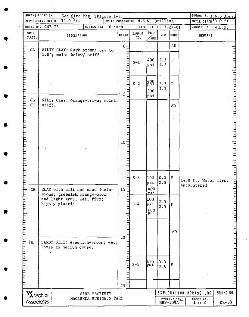
• BORING LOCATION See Site Man ·rFi~ure I-J) GROU•m EL.JJ6.5'Annr DEPTH1ELEV. WATER 14.0 ft. 1 DR I LL CONTRACTOR H.E.W. Drilling TOTAL OEPTH50.0 ft. DRILL RIG CME 75 I BOA ING DIA. 6 inch I DA TE OR I LL(O 7-27-81 LOGGED BY W.D.P.
• SOIL
DESCRIPTION DEPTll SA~PLE % REC. MOOE REMA R'S cuss . NO, ROD
- 0- AD -- CL SILTY CLAY: 9. ark brown: dry to - -- -
• - 1.0'; moist below: stiff. - -- - : - - 400 2.5 p - - S-1 -- - 2.5 -- - psi -- - -- ·- -- - -- -- - -- -
40~ -- - S-2 2.3 -- - ps p -- - -- - 300 2.5 -.. - -• ' 5- psi -- - -L.. -~ CL- SILTY CLAY: orange-brown; moist, - -- CH stiff. - -- - AD --· - -- - -~ - -~ - -I- - -,_ - -• '- - -- - -- - -
·- - -... - -- - -- - -... - -I- 10-: -'- -~ - -~ - -~ - -• ~ - -~ - -~ - -'- - -'- - -'- - -,_ - -'- -.. - -~ - -
• L - S-3 100 0.0 p -~ - 14.0 ft. Water first -~ - psi 2.S -~ - encountered -~ - -··-· CH CLAY with silt and sand inclu- 15-: 400 -L.. - _, -~ sions; greenish, orange-:Orown -~ - -
• • nnd light gray; wet; firm; - 100 -'- - 2.3 -~ highly plastic. - S-4 psi p -~ - 2.5 -L.. - 600 -L.. - -'-- - psi -L - -L -L.. - -L.. - -'- - -~ - -~ - -~ - AD -I... - -
• 20-: -L -L ML SANDY SILT: gcecnish-brown; wet; - -... - -L loose to medium dense. - -~ - -I- - -I- - -L -L - -
• L- - 450 0.0 -L - -L - S-5 psi p . I- - 2.5 -I- - . '- - -'- - --I- -I- .
-'- • - -'- 25-
• '~~Wch!er SPRR PROPERTY EXP LOR AT 10~ BORl~G LOG BORING NO. HACIENDA BUSINESS PARK f'•;JJf:f "'°'· I $11[£ r ~Q.
Associctes ttlll'-lU~t\ I 1., 2 DH-38
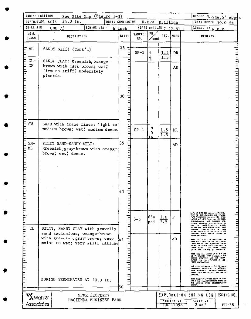
• BOR I NC LOCU I ON See Site Mao (Figure I-3) GROUt<O ELoo<,5•
, __ x
DE PTH1ElEV. WATER 14.0 ft. I DRILL CONTRACTOR H.E.W. Drilling TOTAL DEPTH 50.0 ft. CRILL RIG CME 75 I BORING o IA.· 6 inc:h I DATE DRILLED 7 27 -R" LOGGED BY 1,1 n ,.,
• SOIL
DESCRIPTION DEPTll SAMPLE %1 REC. MODE REMlRKS CLASS. NO . a
~
25 - "'.: ~ ML SANDY SIL Tl (Cont'd) ~ - SP-1 4 1.5 DR -~ - -
• ~ 1.5 -I- - -CL- SANDY CLAY: greenish
1orange- -I-
: ... -~ CH brown With dark brown; wet; - AD - -I- firm to stiff; moderately -,_ - -~ - -~ plastic:. - -I- -I- . -I- . -... - -... - -... : -... -• 1::- 30 -: --.-... - -... - -... - -... - -'"" - -- - -... - -'"" - -- -'"" - -• ... SW SAND with fines; light -... trac.e to - 4 --... medium brown; wet! medium dense~ - SP-2 1.5 DR -... - 9 -... - 1.5 ... - 1 /, --... - -t::- SM- SILTY SAND-SANDY SILT: 35 - AD -- --t: ML greenish,gray-brown with orange- - --• -I- brown; wet: dense. - -I- -I- - . -... -'"" - -... - -...... - --... -... - -... - -... - ---...
• - -... - -I- - -... I- - --...... 40 -: -... I- - --I- -... - -- - --- - -- -•
•
-'= - D~U ffil Tiii~ lJJG A1111. M ~Pl'lt\'1~11111• -- ?IQ~ L"lr flit GlDLQ!;IC Mii S!~JL<;Ull• -- 650 1.0 p h(! ~(JlltlUJOW~ DKAO~t ?IG l>mlR• -- - S-6 ~?l(ljl "~~ 1)1lTAlW1D fMl!l'I !~!RUT, -- - psi 2.5 D!5COl'11MIJ()l.Tt. <!ID 1'!.'~~!Bl1 Ill~- -I- : ~llD SAlll'Ll~Q ia~·:HSLTAHD H -... "" " ~1111.LL-D11.111.n~ 111)!,J..<I • -... - l!OTAll1 Al!D w~SH -J~~ KUL.f.11 llAW: -I- CL SILTY, SANDY CLAY with gravelly - ~~· c~nlCritrn~~ " tM1A -- RtC.UO llCAU~E ~f 1111. !IUD !1J I'~~ - sand inclusions; orange-brown ORllLLNG HULb ..,mli'IR CA.!ilNll 1~ -- l.!LWJK:lNG llUllll. -.... - -~ with greenish., gray- brown; vel:"y ,5 - AD "PHIA i..>i:: lHl!!<:ATf.~ <"i\lm!TIC•r. t• .
~ - T~U ~m..1 OllLI u~ M [)AT[ IM~I- -~ moist to wet; very stiff c:aliche. - ~ .. TF.11 .'Jill KAY 11'.lT 11.HA.'~lllT co~11(- -~ - Tl()NS. AT OT1WI l;~'.•T1ilNS .'JI~ u!I ~ - ~nn::I DATl:S. .vrl ~I.TU Lt:~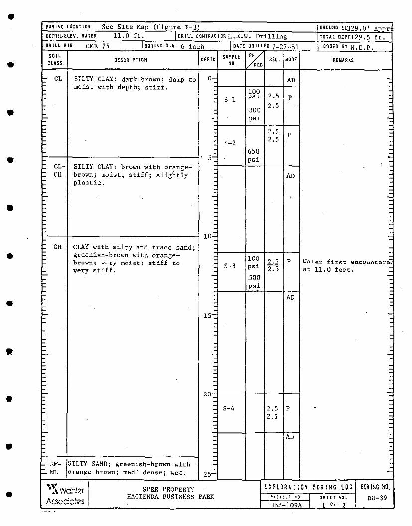
• BOR !NO LOCATION See Site Map (Ffaure I-3) ORO UNO Eq29, 0' Annr OEPTH,ELEV. WA !ER 11.0 ft. I DRILL CONTRACTOR H.E.W. Drilling TOTAL DEPTH 29, 5 ft. DRILL RIG CME 75 IBDRINGOIA. 6 inch I DA TE DR I LLEO 7-27-81 LOGGED BY W, D, p,
• SOIL
DESCRIPTION DEPTll SAMPLE ~ REC. MOOE REMAR~S CLASS. ND . 0
I:' CL SILTY CLAY: dark brown; damp to 0- AD -- . L.. moist with depth; stiff. -.... - 100 -.... - psi 2.5 p : L.. - S-1 L.. . -
• L.. - 2.5 -L.. - 300 -.... - -!::' - psi -. -L... -L.. . 2.5 -.... - p . .... .
2.5 -L... . S-2 . L... . . '- . 650 . L... . .
• s- psi· . .... - . .... CL- SILTY CLAY: brown with orange- . . L... . . '- CH brown; moi$t, stiff; slightly . AD . L... . . .....
plastic. . -.... . . .... - I -.... - . ..... - ' -:: '- -• '- . -I- - . .... - -'- - -'- - -'- . -'- . -L. . -10- -:: .... -
• L.. - -L.. CH CLAY with silty and trace sand; - -L.. -L.. greenish-brown with orange- .
100 -L.. - 2.5 p Water first encounter~ L.. brown; very moist; stiff to -L. - S-3 psi 2.5 at 11.0 feet. -- very stiff, - -- - .500 -- - -L.. - psi -L.. - -L.. -- - AD -- - -• L.. - -L.. - -L.. - -L... 15-: -L.. -.... - -L.. - -.... - -L. . -.... - -- - -L.. - -• L.. - -L... - -.... - -i- - -.... -.... - -.... - . -,_ - . .... - . ,_ - . . L. -
• -..... 20 . .... - . .... - . .... - S-4 2.5 p . i- - -'- - 2.5 -~ - . I- - . '- - . '- -,__ -. '- - AD . '- -• . L. - . ~ - . '- - -- -~
SILTY SAND; greenish-brown with - -.... SM- - -L... orangc~brown; med: dense; - -'--ML wet. 25-
• '~\Wchler SPRR PROPERTY EXPLORU IO~ SORI~G LOG eCRl~G NO. HACIENDA BUSINESS PARK ,. g:)' i.: t "'0. I $111 ( t: ' '" DH-39
Assccia~es . HBP-109A I 1 "' 2
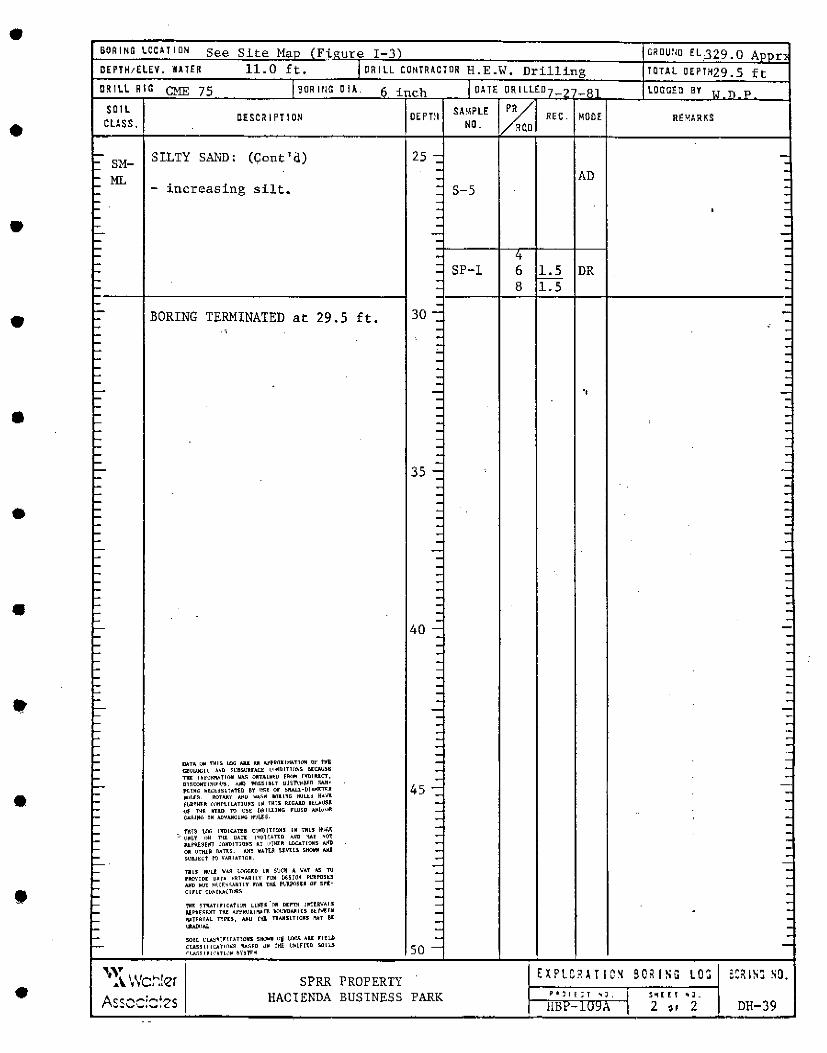
•
•
•
•
•
•
•
•
•
•
•
BORING LOCaTION See Site Ma ure I-3 C.OU'10 EL329. 0 A r DEPTH;ELEV. WATER 11.0 ft. ORILL CONTRICJOR H.E.W. Drilling TOTAL OEPTH29. 5 ft DRILL RIG CME 75 SOR I rl!'.i 0 11.
SOIL cuss.
SM-ML
DESCRIPTION
SILTY SAND: (Cont'd)
- increasing silt.
BORING TERMINATED at 29.S ft • ..
DATA CJ11 ~1~ l.nG AILI I.II AftR\"JKltlATT!lll IJY t1rB CZUWCL~ .\~II ~1:11suu...a \nNDITHl~-~ ll[l:llU)ti Tiii: Jhl'<.!t<WoTli'lll ~ DRTAlll~U fRI .. P!llllUL"T,
lll~COllTL~l.l'>I.~. A.fi) l'<JSSlllll llJ~l\·~~l;I ~/JI• t«M" h~<:~•~•IA1i.D &r '"'" <ir S""'1.L·Dlu<l'.T<• "''rs~. OOTllJIY Al'U .. ~~M l(lllMG lll.ILU H•llK H,i,?~R 1:1lf'trll!:ATIU~~ l~ fMtS RlGIJID nLAl<!I~ uf TMl llllll ni u~~ 1•~11.l.lllG FLUID >.!<~/<Ill Gcilll<'"• Ill AD~M~l~G ll'!Li~·
ftl\~ 1.f1G IllDLCATH t•!Pl'TlfTICIH Ill Till5 ~!I.~ :, <.!~LY clN Til1 llA!l i•O!(AUD I.ND 'VII •<)~
n:f'~~El'I <:CllD!TllJH~ AT 1.•!llJ:W 1.£1U.Tl!.\115 .t.111,'1 Oii •!Tttl.~ MTU. AJIT 'o'AU~ 1-'l'US SllOWll Mi S~a.J~l:f tQ VIJll!LTICll
Tll5 11(\1..f: \IA~ !.ill".f.rn LW ~~~11 ~ o,;u "5 1'J l'llO\'IDE ~At• ~~TNARll.Y rc»i [111;8MM F1..'11!'05U >.ilD 11'.!T ~~.(~-~~~11.Y mR tHi l'\,ll.i'('l$tl ar s~tc1ric Cl\~tl'.!o(TLlll~
1'111' ~TIUTlrlCAfl()ft Ll~~-()1! DEl"Tlt !~tUVAI.~ IU.F"llf~~IIT Tiil Af~~~~l""~ ~!.'ll!llJllU ~tM.r.M ""Tr~IAL nrn, AllU tltl T'lllJl5\T!oJ~5 MT 91: ~)AL
50lL ~1.J1~~1r1~Anan sll'..IW!I •!~ {J"ll'JI AU: r1u.b CtA55ll'Ll:Jlflll~~ ILA~~D \JN tt!E ~~lf[~D ~OILS (l.A~~lrL<"ATL,,~ ~vHrN
inch
DEPTll
25
30
35
40
45
50
'~\. Wct".!er Asscc::::~zs
SPRR PROPERTY HACIENDA BUSINESS PARK
OA TE DRILLED LOGGED BY
SA\IPLE PR REC. MODE REMARKS: NO. ROD
AD S-5
SP-1 6 1.5 DR 8 1.5
.,
l't~1!:T ,.J, ~"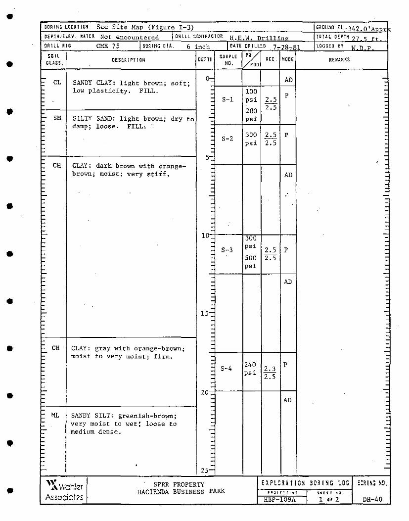
• BORING LOC>! I ON See Site Map (Figure I-3) GR OUM EL. 342 -0. Ann-~ OEPJH,ELEV. •ITER Not encountered I OR I LL t::ONTRACTOR H.E.W. Drill in" TOTAL DEPTH 17 <; H
DRILL RIG CME 75 f BORING a IA. 6 inch I DATE DRILLED . 7~28-oBl LIJGGEO B't T.T " ?
• SOIL
OESCRIPJION OEPTll SAMPLE %1 MOOE RE"'RKS GLASS . NO.
REC. 0
- D-: AD -- CL SANDY CLAY: light brown; soft; -- -- low plasticity. FILL. - 100 -- - p -- - S-1 psi 2.5 -- - -
• - - 2.5 ' -'- _,
200 -'- - -'- SM SILTY SAND: light brown; dry to - psi -'- - -'- damp; loose. FILL, -'- - -'- - 300 2.5 p -'- - S-2 -'- - psi 2.5 -L.. - -t: - -- -• '-- 5-: -'-
' -'- CH CLAY: dark brown with orange- -L.. - -L.. brown; moist; stiff. - AD -L.. very c -L.. - -L.. - -L.. - : L.. -'- - -L.. - -• L - -L.. - -L.. -L.. - -L.. - -L - -L - = t:.. -
10 _ -.... 300 -L - -
• L - psi : L - S-3 2.5 p L - -L - 500 2.5 -L.. - -L - psi -.... - -'-- -: L -L. - AD -L. - : L. -.... - -L. - -• L.. - -L.. - -L.. - -'-- 15-:: -L -L.. - -L.. - -L - -'- - ---L.. - -'- - -• '- CH CLAY: gray with orange-brown; - -'- -.... moist to very moist; firm • - -L.. - -'- - 240 p -.... - S-4 2.3 '- - psi -L.. - 2.5 -L. - -L. - -L - -
• ,_ -~ 20 - --,_ - AD ~ - -'-- --L.. - -L ML SANDY SILT: greenish-brown; - -~ - -~ very moist loose - -to wet: to -,_ - -~
medium dense. -: -~ ,_ - -• -L. - -L. - -~ -
~ - -L. - -'-- - -' • --'- 25- -
• '" SPRR PROPERTY EXPLCHTIO~ 90•l~G LOG :C!ltS• S~. ,.\ wcr.!er HACIENDA BUSINESS PARK P •~I [:: f "':I. I S.~ [I; T ~ :J •
Asscci:;t·2s HBP-109A l 1 •• 2 DH-40
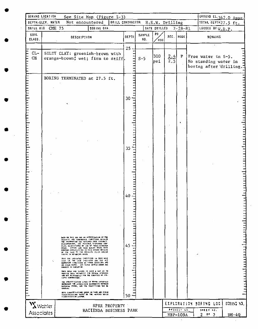
• SORING LOC1TION See Site Mao IFiourc I-3) OROUtlO El,142. n '--~, OEPTH,ELEV. WAHR Not encountered I OR I LL CONTRAC!OR H.E.W. Drilling TO!>L OEPTH27, 5 ft. ORILL RIO CME 75 1 BORING 0 II. I DA TE DRILLED 7,-28-81 LOGGED eiw.D.P.
• SOIL
OESCRIPTION OEPTll SAMPLE % REC. MOOE REMAR~S CLASS. NO . D
- 25 -- - -- CL- SILTY CLAY: greenish-brown with - -- - 300 2.4 p Free water in S-5. -- CH or·ange-brown: wet; firm to stiff. - S-5 -: - psi 2,5 No standing water in -- -
• - - boring after 'drilling.: - -- - -L. - -- BORING TERMINATED at 27.5 ft. - -- - -- - -- - -- - -- - -'- - -c. - -
• '- 30-: -L -L. - - -L. - -L.. - -L. ~ -L.. - -c. - -'- - -L - -L... -: • -L -
• '- - . -L.. - -L.. - -'- - -'- - -'- - -'- - -'- - -L... 35 -:: -L.. -l.. - -l.. . -L.. - -• L.. : -L.. -l.. - -... - -L.. - -L... - -L - -... . -... - -L.. - -L.. - -L - -• -L - -L - -L
40..: 1..- -'- - -L.. - -L.. - -L - -L. - -L... - -L... - -L.. - -• L.. - -'- - -L.. - -L.. - -L.. - -L.. - -L.. - --L - -L. bllT• l'lill TlllS UlG llJI~ N' A~PIR1KlllllTL~ (IF Tl\i -
• L. <;t;<Jl,<.C.lf. AllD 5UllSl.VA1., <"~MOITJQM5 6t~AV11f. - -'-
nlil IMf'i>ll..:A?lOll \l.U n~r~lrl~D l'Rat L.•U!Mb~t. - -'-
Ol~<J~ll~ul\ll5, l.llU l"J~~lt~Y Dl5TIJHW ~M-
45 -:: -rLL~~ ~t.(€~~ITATU1 11 u~e (If 511A.LL-Ull.tlli:~ -L.. ~~. ,1rfAiY ANll 4.l~N 111.!iiJ~f. Hfll.J:S llAVI -L FUii.THU ~'>r"~L[{ATl<"rll~ IN THI~ H~MRD AHAU~l -L or ntt: ~tt~ ,.,., 115l DN!LLLH~ Hll!D A~!l/OR - -L (".A.Siii(; IN /,l)O>.IM:JU, M1llJ:S - "' -,_ - -~1~ !«. !NOICAtn (~Ma!Th"lllS I~ nus 111">1~ . '- \!~tY "' TU l!Ht l~D!o."A.Trn A1111 Mi "'" - . '- lli'l'l~(IR 1'<)llCITl~I At "!MU 1.0CATL\!11~ .IJltl - . L.. IHI Q'IKl~ flAf':~. AH "AIUI. l,l\'1:1.:1 S*- AM£ -L SIJLl[CT 1\1 ¥¥!•THlll - .
• -'- Tllll llCIL[ w..ij J;IC,(.l:D Ill svcll .. loAY A~ TD - -L PtiWl!ll: OATA !'1(!'1.1~11.Y rnt Uf.SjY, Pl"ll":L'll.~ - -'- A11D lkJT lll:~ls,,.,,;1LY ;(Ill TU r~t'l!~U ii# ~1'1- - -,_ cine r.arTIW."T\11!3 . - -L - -L Tiii: ~fll:•T!rrr..tnllll u~t~ (·~ !)l'.1"1"111 111ru:vAl.3 - -L 1!11"-l:!!l!!l'f fMll A~l'llOX!'IAR 11')1.J~JIU![S 1[11oltU -llATUll'J. fYH,:11, .um TIIL ~~lll!'JllS IUll .._ - -,_ ... ~. -,_ - -L 5llll ~LAl>llUl(•Tl,._ V'Jlllll '"' lo'lal 11111: nno - -L... CU.SSlrlU.TlC)ll~ ll.A:lll.D (]II n111: ~'111/rl[D SOILS 50 -Cl.J.55/FICATLC)ll St~T'llll.
• ,,y w hi SPRR PROPERTY EXPLCH T 18~ 90R ISG LOG W!ISG S3.
A c ... er HACIENDA BUSINESS PARK ft•)1(:r ''· I ~" l l r ''· Assc::iotzs HBP-109A I 2 •• 2 DH-40
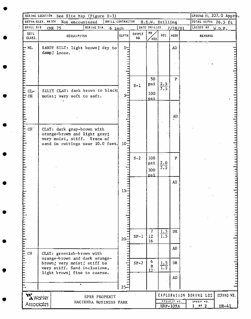
• BORING LOCHION See Site Map (Figure I-3) CROUim El. 337, Q Appr OEPTH,ELEV. \Ill TER Not encountered I OR I LL CONTRAOTOR H.E.W. Drilling TOTAL DEPTH 26.5 ft ORILL RIG CME 75 J eoR 11<G DIA. 6 inch jOATF; DRILL.E'.D 7/28 81 LOGGED BY W.D.P.
• SOIL OEPTll SAMPLE /Ca REC. MOOE
CLASS. OESCOIPTION NO. RE~ARiS
D
>--ML - SANDY SILT: light brown; dry to o-- AD --- damp; loose. - -- - -- - -- - -- - -- - ' .. • - - -- - -- - -- - -- -- - so p -- - -
• - - psi 2.5 -- S-1 -- - 2.5 -: CL- SILTY CLAY: dark brown to black;' - -- 100 -:- CH moist; very soft to soft. 5- -- nsi -- • -- - -- : -- -- - -- - -- - AD -- - -- - -- - -• - -- - --CH CLAY: dark gray-brown with -- - -- orange-brown and light gray; - -- - -- very moist, stiff. Trace-of - -- - -- sand in cuttings near 10. 0 feet. 10- -- - -- - --- -• - -- - -- - S-2 100 p -- - -- - psi 2.0 -- - --- - 2.5 -- - 300 -- - -- - no< -- -
• - - -... - AD -- -- -- - -- tS...: - -- - -- - -... - -- - -- - -- - -- - -• - - -- - -- - -- - -- - -- -- - -- - --
• - 7 l. 5 -- - DR - - -
- 2~ SP-1 12 l. 5 --- 16 -- - --- - -- - AD -- - -
- CH CLAY: gr<>enish-brown wit_h - -- - -
• - orange-brown and dark orange- -- - 6
-- brown; very moist; stiff to - SP-2 1. 5 DR -- - 8 -- very stiff. Sand inclusions, - 1. 5 -- - 12 ' -
light bro1Nn; fine -- to c.oarse. -- -- - AD -- - --- - -->-- 2S.: -
• 'v SPRR PROPERTY EXPLCfiU IO~ S Of! I~ G lOC eCRISG so. A\ Wot':ler
Asscciotes HACIENDA BUSINESS PARK "'ll£:f "I:), I SM I ( r . '. HBP-109A I l .. 2 DH-41
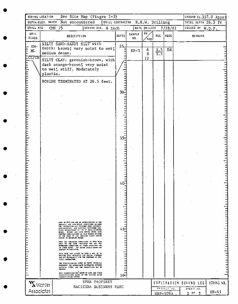
•
•
•
•
•
•
•
•
•
•
•
SOR I MG COCA! ION See Site Map (Fiugre I-3} encountered DR I LL CONTRACTOR H.E.W. Drilling
ORIU RIG CME 75 6CRltlG DIA. 6 in~h SOIL
cuss. DESCilPTIOM
SILTY SAND-SANDY SILT" with tlepth: brown; very moist to wet; medium dense.
SILTY CLAY: greenish-brown, dark orange-brown; very moist to wet; stiff'. Moderately plastic.
BORING TERMINATED AT 26.5 feet •
DAh '* Tllr~ !.ilii <Ill: .tJI ILl'l"!IOXtMTI"" <Jr t1it !i&ll~I~ L'III ~l!k>lllUM.ll OOWlTI~ llt:l:Mllll T1ll( 1n·1~tr ... ~ ~~TAlllUI '111»1 INDIUCT, DJOC•,.....l•l• ............. 1) k>.<~IU¥ Dl~TI."llUI> .........
rLIM~ ~E\'•~~lhti.JI ~1 \:~~ <l, S/IALL-DlfJll:TU. llllL.IU. ~TAllT loJID w.x~ ll"lllNG ~IJ:S llAIJ:I nml?l:I Cl.m'Llc.!Tl~ IN Tlll~ l~.:..ltll U:C.AIJSll OI' Tiii: M~ TI> \;?;I l!l!lt~ll'll fl.l,llD A.o!l/1:11. CA.llllfoli l' AllVAIKJl!li 111.11.H-.
1'111~ LDG LllDICAn5 t':IP:l'ITll.lri lM 1"11" llilLI OML1 !)II Tiii: D.l!ll IMDICA'!UI ~~l) .... t lli"rf U:PllL~lllT CDIAllT!DllS AT •mill l.'11.:At!i""~ ~..m i'ljl 11Tlll:I lllLnJ;. IJjT WATU LIY1U 5lllJWll A~I !Wt.ll.:i' m 11A,il•?T"111.
tftl'j: 11(11 .. """" \J'll:.i.&:B Ill ~llCll A ritAr !.!! 'Ill i'~Y~[~ flo.l~ l'tl!M.111.f f\":t IMUHill l'l!lll"Jl!l.5 AJIO ~\"f !lliC.1-SJl..d:!!.f f()ll Tiii. ?W.l'OSU Yf 51'1.CJIJ~ (IJ!ftMCfl$!1
Tiii. STIV.Tll!CATI\• ~\~ ca !ll."11 nrn:IYALS HJ1tUillT T1fl: Al'l"ll'Jllllllll [il}<'llllili!3 ~1\11:.lll
!\ATUIAL TYPlll, AllD Tlllo TlWl~lfl( ... ~ Ml 911 ........ S/lll Cl.A51l11UTI0:.5 ~ i1li !iW':ll! .IJll HU~ (.!,._.i;UTTUTIOlll ~lfl <)II l>dl •~\flt~ !11111.& (~.UTTCATl(llj 5TI'T'1'"
DEPTll
'" .\ \\'cr.!er SPRR PROPERTY
HACIE::DA BUSINESS PAR!: Associct2s
DATE DRILLED 7/28/81 SA•PLE PR
REC. MODE NO. RUD
SP-3 6 1.5 DR 8 1. 5
12
HB -109A
GROUtiO H,337. 0 Appr TOTH oEPrn 26.5 ft
LOOGED Bl W.D.P.
DH-41
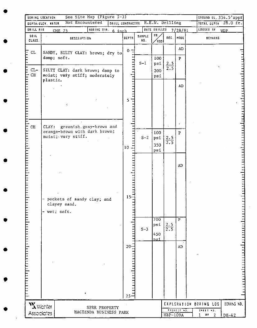
• 6aRING LOCAllON See Site Map (Figur" I-3) GAO"'m <L. 334.S'appr DEPJH,(LEV. IAHR Not Encountered I DR I LL CONTRACTOR H.E.W. Drilling TOTAL OEPTH 28.0 ft.
DRILL RIG CMI' 7 'i IBORINC O IA. h ,_ ·h I OAT< DRILLED 7 28/81 LOCiGEO BY <.m"P
• SOIL OEPTll SAMPLE XI REC. MOO< REMARKS
CLASS . DESCRIPTION
NO. D
- o- AD -- CL SANDY, SILTY CLAY: brown; dry to - -- -- damp; soft. - 100 p -- - -- - S-1 psi 2.5 -- -
• - - 2.5 ' -- CL- SILTY CLAY: dark brown; damp to - 200 -- - --CH moist; vety stiff; moderately - psi -- - -- plastic. -- - -- - -- - AD -- - -- - -- - -- - -
• - 5 -:: -- .. -- ' - -- - -- - -- - -- - -- - -- - -- - -- - -
• : CH CLAY: greenish.gray-brown and - --- orange-brown with dark brown; - 100 -- - p -- moist;\ very stiff. - -- - S-2 psi 2.5 --- -- - 2.5 -- 10 .::_ 350 -- -- - psi ---- - --• - -- - --- -- - AD -- - -- - -- - -- - --- -- - --- - -- - -• - -- - -- - --- -- 15- -- - pockets of sandy clay; and - --- -- clayey sand. - --- - -- -- - wet; soft. - --- - --• - - 700 p -- - -- - psi 2.5 -- - -- - S-3 2.5 --- - -- - 450 -- - -- - "'.::; -- -- -
• - 20- AD --- - -- - -- - -· -- - -- - -- - -- - -- - -- - -- - -- - -- - -• ,... - -,... - -- - -- - -,... - -,... - -- • -- 25- -
• '~\Wch!er EXPLCHTIOH BO• ING LOG ~C?.ISG so. SPRR PROPERTY
HACIENDA BUSINESS PARK II") I E : T ., J. I S Ill [ [ T .,_ Assccic~2s HBP-109A I 1 .. 2 DH-42
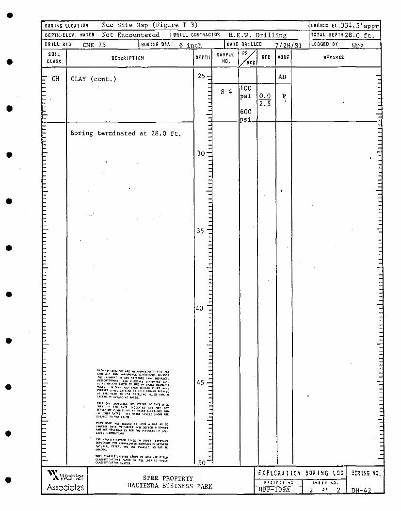
• BORING LOCITION See Site Map (Figure I-3) cnou:io EL,334.S'appr O(PTN, ELEV. \Ill TER: Not Encountered I OR I LL CONTRACTOR H.E.W. Drilling TOTAL DEPIH28.0 ft. DRILL RIG CME 75 i eoR ING OIA. 6 inch I OA TE OR I LlEO 7/28 81 LOG GEO Bl tll'\P
• SOIL DESCRIPTION OEPTll SAMPLE IX REC. MOOE RE.!r\ARPiS CLASS. NO. 0
>-- CH CLAY (cont,) 25- AD -- - -- -- - 100 -- - S-4 -- - psi 0.0 p -- - -
• - - 2.5 ' -- - -- - 600 -- - -- - , __ , -- - -- - -- Boring terminated at - 28.0 ft. - -- -- - -- - -- - -• - 3o- -- - ' -- ., - -- - . - - -- '- -- - -- - : - -- -- - ' -I- - -• f- - -f- - -f- - -I- - -I- - -I- - -I- - -I- - ->- 35 -: -f- --- - -- -• - - -.... - : - -I- - -I- - -f- - ->-- - -I- - -I- - -I- - -f- - -f- - --• I- -I- - --- - -- - -- 40 -: - --- -- - --- -- - -f- - -f- - -
• f- - -f- - -f- - -f- - -f- - -h - -- - ~ - - -- - -
• - nl.T' "!I TlllS IN. I.A[ ~N A~l'll\'lXHl!ITlll~ <'•f THI: -- ~[l!Lllj;IC ;.im ~'''"W~YACI 1:•)"1llTln~~ ~tCA\l~l - -
~:U:Ki::r~~~~~'.111 .~~1 ~~~r:i~~r: ~~~~~R1:[n~~~~ - . --- 45 - -n1•~ n<;~·~1r1.n.o nv 11~~ <!• ~f!ALL·!l!Alil:n.- -- llllLU. ••Hi'.!!! -'!10 \'I.~~ ~"~INO J!oll.S:~ !t•~t -- 1\lllU~~ '.ll~~LU:ATE)lj.~ IN INL~ l\f:t;A~D AHAL:~[ - -- or nr. HL~~ IO I'~.[ DAfUl~iJ l'LUID I.HD/Cl~ - -- CA~lNr, I• .'J!VAHC!MG ~)I.~~- - -· --- -- TNI~ L<-.; LMDICATJ:~ il\•~ITI~~~ I~ T~TS H"L..l - -- ll~I,~. "' Ul ~.r~ l•ll!(:ATrn A•~ 'l.&T Ml)T - -Rf~k£~~11T C•INlllTlo'>N~ Ar <ITMU toH:Atllll'5 lo'.irD -- <>fl ll'IHU DAU~ ~.•I O\IA'BR !.~•i.L~ SH!.IWll lolll - -- SUllo.!1!."T m v.,.IATl[.'1111 - -- -
• T1115 HOU: "1111 WG<;f:D TW ~1.1\:1 A \/AT !&. f<.1 -- -- rll\l'llrit: r"ln l'llfWlll.T f'<~ DUlr.M r.i'RP<°T'J1'5 - -
- AllD flll)T ~~n~~AlllU rclR 1~1 fll~N~r~ II~ ~fK- - -cine ,.,,.til.A<.:11..'lt!. -- -- T1l'1I: •Tv.ATITl(.AT!<"IH l!•ts !"Ill! llH'l'll \~'TT.MVALS - --- Rr,>11ntl!T nl1: A~~IW•l!.L'IATK lloNIMl\A,iein K'l'l'l!U - -- .,..1.t•IU TTr-t:~ .... ~; nuL 'TT<.<M)lrl1lM5 !\AT H - -
IOllALlllAI.. -- -- '°LL CI.M;~IFTl'nl\11115 st:Mii '"' l.()o;S dl fltl.11 - -- CL.AS~lfU.•l!•>111 M~ID '"* ?>u:: OM!f!Fllo ".\l,>LL.ll so- -
CL.AS51r!CATl1"' 1Y1TT.ll
• '~\ wcr.!er EXPLCHTIC~ 90"1~G LOG :CR IS!i N~.
SPRR PROPERTY
Ass::cict2s HACIENDA BUSINESS PARK ii' I JI f : T .. ~ . I S111 l ( f ''.
HBP-109A I 2 " 2 DH-4?
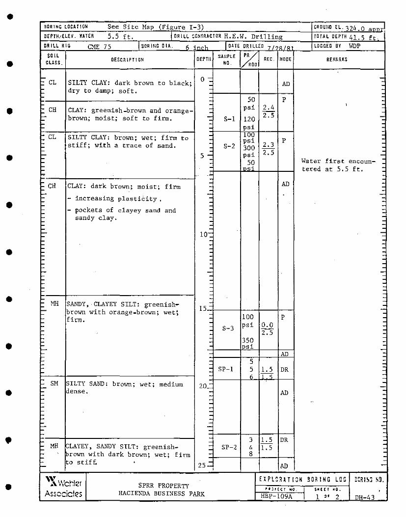
• BORING LOCAllON See Site Map (Fizure I-3) ooou:10 Ec. 321,.o a--J DEPTH1£LEV. WATER 5.5 ft. I DRILL CONTRACTOR H.E.W. Drilling TOTAL DEPTH 41. 5 ft-DRILL RIG CME 75 i soR ltiG DIA. ~ -nh jDATE DRILLED 71 n/01 LOGGED Bl WDP
• SOIL
OEPTll SA\IPLE ~ AEt::. MODE REMAR!S CLASS . DESCRIPTION NO. 0
- 0 - -: CL SILTY CLAY: dark brown to black; - AD
. - -- dry to damp; soft. - -'- -- - 50 p -- -
• - - psi 2.4 ' -'- CH CLAY: greenish-brown and - -'- orange- - 2.5
-'-- brown; moist; soft to firm. - S-1 120 -'- - -'- - -'- - psi --
• '- CL SILTY CLAY: brown; firm - 100 -'- wet; to - psi p -... stiff; with trace of - 2.3 -... a sand. - S-2 300 -... - 2.5 -..... 5- psi -... - Water first -... - 50 encaun- -'- - - ~.; tered at 5.5 ft. -'- -L.,, . -~ -- -
• '- - AD . '- CH CLAY: dark brown; moist; firm - . '- - .:. t:- -- increasing plasticity. -.... - -.... - -,_ - pockets of clayey sand snd - -,_ -L sandy clay. - -,_ - -,_ - -.... - -,__
10-: -.... -'- - -- - -
• - - -- - -- - -- - -- - -- - -- - -- - -- - -- - --- - -- - -• - - -- - -- MR SANDY, · CLAYEY SILT: greenish- - -- 15 - -- browi1 with orange-brown; wett -- - 100 p -- firm. -- - -- - S-3 psi 0.0 -- - 2.5 -- - -
• - - 350 -- -- - -si -.... -:: - - AD --'- - 5 : - -'- - SP-1 5 1. 5 DR -'- -
"' I <" -- -....
• -L SM SILTY SAND: broi;\711; wet; medium 20--= -~
dense. -~ - AD -~ -~ - -.. ~ - -.... - --~ - -~ - -~ - . .... - -~ - -~ -,_ .
• -- 3 1.5 DR -.... - -~ MR CLAYEY, SANDY SILT: greenish- - SP-2 /,. 1. 5 -~ -brown with dark brown; firm 8 -h wet; - -.... ~ to stiff. ' 25 _: -I- AD -
• '~~ Wcr:ler EXPlG'lUl8N 90'l ING LOG ;SRISG s~.
SPRR PROPERTY I l'.)J(Cf 111Q. S.M ( ( f •O. ' As.sc:cictes HACIENDA BUSINESS PARK HBP-109A I 1 •• 2 DH-43
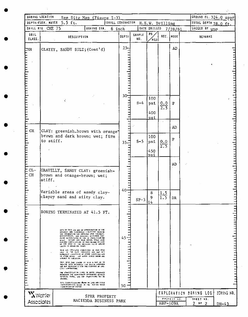
• SORING LOCAi I OH s "" Site Man fFinure 1-3) C~OUNO EL.324.0 -212~ DEPTK,fLEV. JHER 5.5 ft. JORILL CONTRACTOR H.E.W. Drill in~ TD! AL DEPTH 28. () f~
DR ILL RIC CME 75 I SOR I llG 0 IA, 6 inch I DATE OR "LEa 7 28/81 LOCGEO BY 1,mp
• SOIL O(SCa I Pl I ON OEPTll SAMPLE %;] REC. MOOE REMAR!!;S
CLASS. NO. 0
::Mil CLAYEY, SANDY SILT; (Cont'd) 25: AD --- - -- - -- - -- - -- - -- - ' -• - - -- - -- - -: - -- - : - -'- - -'- - -'- - . -L. - -'- : -h- -• '- 3u. -'- 100 -'- - • -L.. • - S-4 psi 0.0 p : L.. -L.. ' 2.5 -'- - -L. - 400 -L.. - -L. - ~o.i -'- -L. - -• - -. h- - AD -h- - -t: CH CLAY: greenish_ brown with orange - : L brown· and dark brown; wet; firm - 100 -... - -'- to stiff. - S-5 psi 0.0
p -'- 35- -: '- - 2.5 -L.. -
• L.. - 450 -L.. - -L.. - insi -L.. . L.. - -h- - -'- - AD -- -
• L.. - ->-.CL- GRAVELLY, SANDY CLAY: greenish- - -~CH - -brown and orange-brown; wet; - -L.. - -L.. stiff. - -L.. - -L.. - -L.. - -'- 40 - -L Variable areas of sandy clay- 8 1.5 -'- - -'- clayey sand and silty elay. - 9 1. 5 DR -L. - SP-3 -L - 14 -
'- - -• h - -
L BORING TERMINATED AT 41.5 FT. - -L- - -'- - -... - -'- : -L : '- - -L.. - -'- [>AU OH 77115 LIJG I.I(~ AJI •~PRi'IU~TIClll or Tl'.f! -L. ~f.i'll.i'IGJC AllCI ~LB~UIU'AL[ \<.•i>1Tl()M~ A[CAL'51t --
• -L T>it tl!Ti'l~llJl.TIOM ~A5 ~~Hl~tu tRclR l'!ll!HCT, -
'-D(~rHT!lll!llll~, A~tl l'Q~~l~Ll Ol~!IJRR[tl ~!Vt·
45-:: -HfHG NiC[~~l!ATlD &I ·~~ •!r ~~LL-h!l.lfl..Tll -'- HnU:& RLlTARY A>tl W"'°H Jl.!HIH\; 'l'•L~~ H~VI: -'- f~HlliE~ <'.<' .. ~l.l<".ATIQNS IN IHLS UOIJW ~(.<"All~[ - -..... O)f T\<'I: ~u.n rn 15[ DRLLLLM.; 11.<.10 Ajffi/()R - ., -'- <.:A~lll<", IX AD\"AMCIN~ NQU:5. -'- - -
L.. TH!~ w(: lrll'llCAH~ cmmLT!(IN5 !M rH(S ~(Jl,li - -DNLY ·"' T'<'F: D•Tr l'o/lllCAH.D A.~U M1 ~,·,y -'- Rt~ll.tn~'t '-"~~1111'•~ AT L"ITl!RR LOC!LT!•)~~·~/i~ - -'- ~N QTHIR ~ rE~ •~V ~/,TfR l.~'il.LS ~*!WI A.Ill:. - .
L.. ~!.11.!ICT 'ro V>.Jll!LT J<.1~. - -L- -
• .
h- l'lH~ lllllJ; "llA., L.-... .;w I~ ~<.<.M ~ l/Af ,I.!! TII - . f'~(>~IDI: DA!A r'l~lll 1·<,M vt:~I~~ f'llflll(ll;U L.. !LJl"ll lkYr MlCR.l~A.11\1.Y H'M Tit.I. l'\,~!'l.>:ioe~ <ll" ~F1:- - . '- (IT IL'. <=<lll'TllACTOILS. - . L - . ... Tiil ~~l'Jlf!J1(~TE"'il 11111:~ OR DU'Tll LHTI:RV~LS - -... Rll'!lt5tllT !Hl ~f'j>ili1XTRATl: llC~.~DAR!l~ BE'Ntt~ -L 't!LTUIA.I. lYl"lB. JJI.~ 11(1' r~~~ITIOll~ flAY H - -'- ~- - -'- ~(Ill CLA5511LCATL\1"~ ~- flO [i.'lllij AR[ TtU.D --'- L".1.A~~lrLCATl'!~, !.\jtD IOM f'lf_ :111\llf,[I ~)II,!; so- -
L'.l.A.ISITICATIQM ,UTI:~
• 'v EXPLCHTIC~ eo."sG LOG 2:~ ISG SO. .\ wcr.!er SPRR PROPERTY I HACIENDA BUSINESS PARK ~•j1f:T ''· $11 f;' ' ". Ass.::dotes HBP-109A I 2 .. 2 DH-43
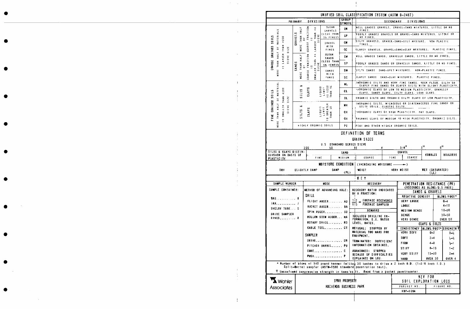
• UH IFlED SO IL CLASS Fl CHI OM SYSTEM (ASTM 0-24a7) Pill' IU.Ln...- OIVl<IO"' GROUP i;;: I= ,...,I.Jn I 1:1 y "'"'"""' .;:,. .. IJU-
~ z . ~l E.AN GI WELL GR• DEC. GR.li'IELS. G li'.I. YE L-S ilN!I lril I .!:TU ~ES, L I TTL.:: DR NO ., ~
0 . FI NE S • - -~Ril'YELS ~ .. -
• c ~ z w z ( L -~SS i'.1.1 AN PDD~LY GR.llDEJ GRilYEL S "' EiRA'fEL-SJ,ND Ml X!"IJRES. LI T lL :!: " - ~ .. w Gf ~ ~ 0 w z .. z > f I :\IE S) i MO F l NE S . ~ 0 > .. ~ ~ :,.") I- ..... J :-;.
- - ~ .. % c - - !S I L TY c c . ,_ ~., GM GR.Ii 'l'ft S. GR•'l'~l-SAND-S IL T 1111• XTURE. "I IJ.N PLAS Tl~
~ ~ ~ ~ w ~Ail YEL r 1 NE S . ~
c z ~ ~ 0 Iii' I TH --
~ c ~
~ w 0 ~ 0 c .. GC 'CL.Ii'!' E 'f GR • ._.E:L-SAN!i-Ct.l.'f Ml XTURfS. P"L ilS- T I C f I ill E S. z - ~ 0
~ FINES G~il\'ELS,
•
- ~ ., --~- ---.. ~ !:: ~ z . CL EA~ ~ c 0 . ; SW 'fE LL GRADED S1UtDS. GRA 'fE Ll l SU-IDS. t I TTL E DA '° f ! NE S. ~ % > ~ - S llN D S ' .. w
~ z z -
~ z .. -
~ w ( l ES S TH ~11
~ .. ~
., c z .. z w SP POORLY 'ii R il.D EC. Sil.NOS O~ GAil~ELL'f SAii D S . ll TTLE " '" F I hi! S .
% .. ~ - > "5°'1i F 111{ S l .. - w z ., w c - .. % 0 - ~ - !:s ! ·~ ... ., u ~ ~
~ w ., SANDS SM SANDS S•ND-Sit T lill~TURE:S. H-DN-PLAS Tr C r l NE S.
~ ~
c ~ ~ ~ "KI T H
~ 0 c .. !c L A'f E 'f P"L il.S TIC ~ c ~ ~IN~ S SC SAN C•S Slllt:D-CL-"Y Ml XTURfS. FI NE S. u
• I
~ ML I NO AGAN IC S 1 L TS '"' 'iE RY ~ l NE S llNO S. qo Cl!: Fl~ U f:. SH. l'f OR
- ~ c ~- c CLAYEY F I NE S illl:O S " Cl ii. 'f El SILTS- 'fllTH SLIGHT l'LASTI Cl TY.
:: 0 "' - t- V'> lJ": ·.~DRC.ilH IC CL .liY S "' LO'K TO MEJ I Ulll PlilSTI :l TY. GAil"YELLY
' "' 0 ~ >- ~;~z CL ~ - - < CL .fl Y S. S1UHIY Cl. A! S . S I L TY CL l 'f S . Le:• H CL.lil S. - < " ~ ~ - - <
0 ~ - u ~ ~ - % ~ z w ~ OL ORGANIC S: IL TS '" OR~.l.NIC S-1 L TY C-L.llY S er LOl' PLllST1 Cl Tl'. ;; < ~
0 % -w - - I NO A rO.liN I C S l LT S . Iii I (:JiCEO!JS '" :I I ATCI01GEOt:S f I JI E. S .l.NtlY OR z ~
- ~ :: 00 ~ MH S l L T'f S{l I LS . ELASTIC Sll l'S. < c >
~ = - -0
~ % ~ ~ >- .. ""
'-' ~ - - < ::i; ......
z CH i: lfD~GAN ! C CL•~ S C: f 11 ! C.H PLAS!l:ITY. "1 CL ll 'f S. z c ~ 0 - ~ w .. ~
~ ~ - ~ c .. -- ---- --z z ~ - u ~ ~
' - - "' ., - DH :l!o A IJ:il NI C CLAYS Of lilEOIUlll TD "I I G~ PLASTICITY. ORGAN I: S I L TS . ~
~ --• ~
0 H I GH LY ORGANIC SO 1 L S Pl iP ~Ji T '"' D THEA HI C>HLl DRGilNIC S-0 I l S:. ~
DHINITION OF TERMS GRAIN S lztS
U.> SJ!NO!RO SERIES SIEVE .3./4LI 2 OD 50 16 4 3" s" • SILTS & CL!YS DISllN- ~· SAND I GRAVEL I BOULDERS GU- ISHEO lJr.i BAS. l S OF
I I I COBBLES
PL!ST IC I TY F I hi E lll ~ D I UM ' co,1,qs~ ;:- ~NE C C-J. RS E
MOISTURE CONDITION I (I NC REAS I HG WOISJURE )
' DRY Sll GHTL Y DAMP OAMP I MOIST VERY MO IS! IE! {SA JURA lEO) (PL) (LL)
• K E Y SA•PLE NUMBER MOOE RECOVERY PEMHHTIOM RES ISHHCE (PR)
•
SAMPLE CONTAINER: HOLE: RECOVERY RAJIO (RECOROED AS BLOIS/0.5 FOOT)
METHOD OF ADVAHC ING I HO I Cl TED HHOS & GRAVELS BY A FRACI ION: OR I LL I RfUJIVE DENS IJY BLOIS/FOOT'
BAG. . - . - .. - 8 112 - FOOTAGE RECOVERED Fll GHT AUGER. . -- . . - . AD VERY LOttSE 0-4
JAR ........... J m- FOOTAGE SAMPLED 4-1 a BUC!ET AUGER. BA LOOSE SHELBY TUBE. s . - . "
SP I H AUGER ..... _ .. - . so I REMAR!S MEDIU• DENSE 10-30 OR I VE SAMPLER ' DENSE 30-SD RINGS ..... - ... R HOLLDI STEM AUGER .. _ HA l!CLUOES ORILLIHG IN-
F RMAllDH. E.G. IATER VERY DENSE OVER oD ROl!RY DRILL ....... RO l VEl, DAJES. CLAYS & SILTS CABLE TOOL •••••••••• CJ REFUSAL: STOPPED BY CONS I SJEHCY BLDIS/FOOJ• STRENGTH 1
• MAIER IAL TOD HARO FOR VERY SOFT D-2 0-~ SAMPLER EOU I PM ENT. SOFT 2-4 ' '· .-.. -'2
DRIVE. ....... -·, ... , OR TE RM I NAJED : SUFF IC I rnT FIRM 4-8 l;-1
PI lCHfR BARREL •••••• PB I HrnRMA JI ON DBJAINED. SJ lfF 8-15 1-Z
CORE,, •. ••••• 4 •••••• c ABANDONED: SJOPPEO BcCAUSE OF DIFFICULTIES VERY SJ IFF 15-30 1-<
PUSH .•• _ ••• _ •••••••• p Eifu INED ON LOG. HARO OVER 30 DiER 4 • • Number of blo., of 140 pound homm01 hi I i•t 30 i•ehos to dr ivo • 2 i11eti O.D. ( 1-3. 8 inch I. a. )
S.p l it-Bar re- l s !limp i er {lSTM-1 '58-6 s taDda rd pe11·ed r:i t i an t l!l~ l).
"t UneCJn fined co.mp r111 ss i rte st r111 ngth ~ n to.ns/'tq i It. R!IO!ld fr-om a p cc k.111 l p.ane l r(lmB tier.
"i. Wahler I HY FOR
S ~ R PR OPERlY S 0 I L EX PLO RAT I OH LOGS
• Associates HAC IEHOA SUSI HESS P~R~ P A:1l J E C T "'. I FIGURE NO.
KBP-1 09! I I
•
•
•
•
• APPEMDIX B
•
•
•
•
•
•
•
• -
•
•
•
•
•
•
•
•
•
I
1;.. ' I
I I
II J
:- -'
=-- r· -
OH-10
-· -· CHA ll!IT CANH
HOl'YARD ROAD
HEWLETT CANAL
~ -
APPROX IMHE SI TE BOUNDARY
TR EllCH NO. 1
W. A. WAKlEH P LEASAHTOll SUS I HESS PARK
E X P L A N A T I 0 M
"'H-16 TRENCH NO. 2
-
500
APPROXIMATE LOCATION OF DR I LL HOLES
APPROXIMATE LOCATION OF Ex PLDRA l OR y rnrnc HES
APPROXIMATE LDCATIDH OF FAULT TRACES AS llAPPEO DH ALQUIST-PRIOLD SPECIAL STUD JES ZOHE llAP (CDMG, 1974) DUBLIN QUADRANGLE •
SCALE
0 500 FEET ------SOURCE: llltSE PHOTO REDUCED FROM AERo-tlEDDETIC CORPORAT1DN MAP. DATED 6-9-19.
SITE \!AP
& ASS 0 CI A HS .,,mw~:-:i7.ii":7-:7':;";":"":"":~1-;--1-..:.'.::;" ·~' ;.:";..;'i':_::".;..· -+--;-::-::::;;"~'~' =~~..:..· '...'."~" ;;"....::" "'..:.· -I ll'lliLIJ "l TCI • N E'IPllltT E!IEJC:-H • C:ilil F _ CPS-, 01A FEB.RU.A:RY 1981l 11-
•
•
•
•
•
·•
•
•
•
•
•
BFA RJNC OF fRENClf - .570"W
0+00 I
s-
15'
20-
J+SO I
0 i
IS' -
3+00 I
S-
'
·:JJ
' '@S!LTYCL,qy {n..); ""'C-Hfed
tiQ h-1 bro .... ..., "'"""' :ymy ~-.- _ _,ca __ P.~~x.~ho,., al f'ro>rJ ·:Zi
{H25 I
C.CC:==--·--;o;·- --------
'fl
~ ~4 .... L..,..,..:::: Lljl';"' /<: l- 1 To_c..:._~rr' L4 T1f.:_ I .f7'0+--l-:'.-:d .b-<'."'W>-7 C1'1d /_fe'l/~l>fr
h-r-,,~·~; f'i'l'~P .• -.<>o~ r-·_h.,,."=,-c.
3+25 I
·., :51.!..TY Sfil•iP/S-11-1} ·re; C.:..."1Y~:-::'"5._'r"i:>o-"":5c.I; '.'"f':l.-'<'"•L-ir .b.-.::i.vn; lo..,_,.. p.".., ,,,+ictiy
3+50 I
~C:u'IT'c1..l; ']r-<'!y "'"'°WJ."7; _, od ,e> ,.;.,,,., +-•c; ,..,~'5-"'f:
'\ .
: ~~ .. ;~~:;~~:to Qn.d -::Ji# • ..,,.,.,...,....
.'"o~•~cl- '
3+75 I
J~er@ _pi,r.r; ~'5 ev-f-..
WAH if A ASSOCIAHS
'
2+50 :
"S ';_ ~"l_'._ 5 Jl_WO- '0 ~:9:"!? JSYI /:c;p) (,(I!' .'~·F9' bro"""TJ" - "''.If" fr:::;
-:,...~"::' _{'l'7e --ro ~edi<1»-Ji 0:bc1.odrin -r cha1·co~ f rie-1,...J-f-u-J olo.-,q b~5<'11 .Pn.--f-k-:,..,. jrocfiort of""' ,;., ch -t-d. 'Z" --t-1-uc_k:' at ~-m. 3--tlQ,
PLEASANTON BUSINESS PAR~
P~LO .l.L TD • ir.IPOAT BE~Cll • CAL I~.
2+75 I
·-....., -sA.-.··:;;- 5:''- TC'-F!"Y; !ighf
~11NJ; d1rkj lfffll!-e,S""~Y br?;W~ _; -f-Ai~-'(-1
1 >;. fr?:rbe&;!6:;}. horT-z .. 0nm.1 lo.-yer::;_; ,,.~~ -if1_~ ,..,;,.Y,,~1l fmq~n-f's_ --h:v~e ~~ ~~.'7+55--M 3+55.
·~
L '-"4 • ... , Sa.mpi.e t-lo. 1 , J5TA- .l+@-'"e s+o'5-1 O.pt'h. 11-S etiarcea I Ol!!!tr i-t1,1i"'!o i.._. "Si lfy-~ -c1ii A~«- 3;1t5±1as ~.ors S.R
1+50 I
1MO I
11,.so I
PRO Ji CT NO •
Cl'S-1 It.I.
TRENCH NO. 1 LOG OF SOUTH WALL
I !UTE I I FEBRW.f:~ 1 9BO j
FIGiltllE ll'CI.
A-1
•
•
•
•
•
•
•
•
•
•
'f-l-50 I
M·
~JL T"Y CLAY (Cl.-Cfl); rn•d. qray wtoffJed .,.,,.;.f;, ~ wn; ~fiche 7+75
I
C:J:'J1t.. T'J' CL4"Y (CL-CH}; nr;d. brown -lo l1:qht-9roy; ........ /~~ _J-in~ sand· des-s ,ca-fu!Jn c10cK5; s ligh T ly ~; rocrl- le T- .s .
laye:r 3 differs_ fi-'o,..y;i /Clye.- f'.2._ 6y be; nq li9hier j·n a:>lcir al'?CI O!l,,-rfa;ni~ .....,.:=ire ca{;~ in Cl!"J~'"'° -IO ""-ri-,e.::b,_.I.{' tt'Jt!:}ff_I~ d a f'pea ranee d la...,.-er- 12. ....
WAHlER ASSOCIAHS
PLEASANTON BUSINESS PAR~
,._to H 11 • 11El'PllRT iUCH • CAt If.
PROHCT IKL
TRENCH NO. 1 LOG OF SOUTH WALL
UTE
FEIRIMIY 1111
6+oD I
FIME llD.
•
•
•
•
•
•
•
•
•
•
</+00 I
~fL TY Ct.A Y CL ; t;q~+ bn::nun 10- :Z.0 ~ 'Sand ' °" // h-f_I ob 1,9 ~ it•ide d~ica 7-FOn
cracks; rocTs.
5fl TY CLAY (CL-Cff): . t'ned .gn:Jiy brew.n >f.!1-#J
brown motf!Jf'Jqfi.
::'5 TONE Fl/!'AG)rl~!VT'S ~ concen Trr:o+i~n o rou01cled -ro s,q bn:iu.n:red '5"Q...7ds n::inf!: and che-rt--; ~c:Yne wi--t-h b:::tked "$ur;faces; a~cia--+ed charcoatde+-r~::=.
::57".4-"i',.:44, 4.4-'- +.:El~ ~p: CCncen-fm-+U:m a -s-httiv .:ind
~r ~-:osionganics.· ?[ '' d~ ::i=s=ica f-inn croc~ I obove.
@~11,_7yC-LA"TftL); ligh.- fyel/owr 9 + 50 I S!t7YSAJ{0(.5M}:ltqh-ryelht'f"" q-r 75 r brown Wr~ Cl.lc>uncbn-1--H,;,, I i bro-vn; Fn e ft, P??edlU~ ~- I /
:Sll T)' CLA"t (Cl·CJI ): medium To obrl< bo-C'W~ ....::3 • de5-si ca -t-1 on crocK-s "il:J S/fqirfJ';j dQ'7'lp-
'"'i""' \ .1()~50
I ! ca!iche la.1n;.na+f<'11-'/S; ........ w_t , i ~~nd-lnfil/ed de!JS.iccrhon,cm:rKs
(I l~~~t;;;;~~~2~;;~~;~""~"~d.;;;~~~~~~· ~l~~~~~~~~§~~~i;-.~-:.~~:-~-~-~··~·-==·~-.; ... ~~·~-~~~~~~·~ .. ~~.-~·-~"·~· -~·~···~·"~·"·~· ·:"·~··-·:·:·:· .. ~· : .. ·=·~"·=· :]"·~··:· ~·~· ~~§~~~~~. ·~-~·-~·-~·'·C'~··<~···~' --- ------ ==z:: . -~ - ___ · ' -~-~--.-.- ..-.--= ,. . . . . ·@ . -===-~. ____ _.@ _____ §.~-- ------. ----------~-· --T-----~- } ,--<-
5
12+00 I
0
20
--=-~~__£_ - --- ------------------ ___ ··----------------------------------------- --- ----(-- -- __ .;___ __________ . .,,,____ /~ +1- '.
---------~~--------------L ___ · ---== @ - ~1L i_J ~ (i}) ------------ --------------------- --------- @ /
\ ------------- ------------ -------------------- II
.:SILTY Ct AY (CL-CH): ro~I( b~my .,.ri+h gray ond brof:JWf'l ...no fft, nq'$; :;,h9hfly ob.mp; 0Yii011'1s .-:al1che near ba-:;.ail J!-"Or-+ion.
.S:ANOY::5fLT(Ml-5M): light brawri~· Qboui- 35.,; /1,,e sand: -sof fda"'_P; rocf-:s; pinch~s e:out-- c.i-+ ........ STA fl-rl-30. /Of- 75 51L7YC:LA-Y~<¢L}: ffJO.d_--fo I darKb~n .
·9 ~tLTY CLAY(CL): ~ rle.,w b...-oi.un
YndH-led ,,..,.,#, qro.y and darl<' t>rr:::iwn; ~11gnH'7" eoioth?p; .w kche on lower ~n./-acT.
-------.or~nollr.a!.d layeri"'!} _-c·'j~/ ~hf and a;.l,cht- ~d
/ ,oi~ out af ......._. ~A IC-1'85..
i l/+00
I
9 ~JL TY CLAY (Cl-Ci-t):
gr-a y brow"; c:bn-rp; :<;fi<:--ky.
CcncRn-fra +i<:YJ oj- -ein_.Jan1c debri~_.. TTJOs-fly grass ..
q
•'f!J ./
.,IL TY C[__A Y (CL ) : ffqh-fbrc":>"Vn Cl rvi-y : abunctor.I' =lich..f. ..
8 ~ft.. TY CLA y Cc L ) ; ye J!oHr brni.-111'1 1?1of-f{l2 r:i w·i---ff1 11-qf}f b.--own; a:,bo, _ _.d-20 :( -=sand or.id .c:iccai-::>~ianat fin"" grr::ivel.
12+25 I
~ilfv sand (sMj ien:5;
7~ t low b R'.M"n.
']"'a d.a -fiona / ch~ rige. \\"'
12-t so I ./
5JL TY CLA.-Y (CL-CH): dorK O-Own1 :sh gray; ,,..'2nj -::>f-iff; abundanT caiiche; 1n-f-crnQ/ :=;;/fcKen5Jde5.
layer II Qrad~s ~and;er- w.P--:::: -fQ-ficri.
"'i25
51 l TY c LAY re L ): yellow bre>wn ff!ot+led 111llfh hqhf brclY;/"' and q..-o y; fO- 15~-' -l'-1').e --fa !le'"'Y hne '!3a'°id; -'5on"e ca' ,ch(?.
' STONE F,,l;f' A GMEN TS: : eoncen-tra ·li-:.'»"l cif' ~nded
TI:J ~rAbt:ourlded 9.!"QV'e"/S' Qrd cebblfi!' :s o.f tmrrB ~and5"1-une GY?cl cherl.
i5/L TY C. LAY 1'c t..-Cl-l): da..-A~ brownqray; da~p~· ~+ic-Ky; can-fo1.ns
·'[!) SIL T"t CLA-1 (CL): mod. / To .CJOrk brew-a_:
/ ca:,cl-,e lciyero--,q / cahche. ,/ .0.{"a• base
@
'foyer 10 pncJ--i.:"~ =..f
5JL r-,· CLA'f (CL-Cl-I).' chrK b..-owl"1i-:5h gn::1y~· s+1H: c:ia.mp; ~f-_ick y; in-T-e.-nol '"5-l;cke:Y}s1de:"'.; -s-r:::Jn?e eatiche
12+75 I
·~
focaHy corJ"fQrn5 pa-IC.he~ of .---edcii~ o.--an.ge "SOr;d
WAHlrn ASSOCIAHS
13-/"00 I
PLEASANTON BUSINESS PA K
P~tD ~LTD • HEl'f'Dli:T BU.CH • C~t•f.
PAOJIH NO •
C.,_._10-1.t
TRENCH NO. 1 LOG OF SOUTll WALL
om FElllHIJ.RY I DBI
'2+00 I
L
~IQMI HO.
•
•
•
•
•
•
••
•
•
•
•
@5.ILECtA "I {CL); moden:.rre rown - va l affJOUJ7f-::5
<::' 5and; 'n~~ .:5"anci o:-..c"J.n-f"enT- --fowaro's .base /
:'
/ ~11-T"fCtAY {-:_.L--CH): , mod.. -tc da~k ro
~ILTY CLA)" fcLL =iome "'5Gnd; ,- Ii hi ro bn:::iwn To while·
nbundan t ca fiche; d~~':"lic..a-t--ion crack'"5. \
/ /U·50
I ca, -foe -t ob~re; 1
lo yer 3a. g.ro ~ ,I
""7'n layer- ,4
/4-r-25 I
1 1q.--r-so / I
15-HJO I
--------------
.:5il TY CLAt (CL) q~dlnJ ro .:'.iA Noy CL/J y --me LA ":i'"'EY
.:S-4 ND CCL- SC) Ot-......., 257A. 1.f-+ZS '51l TL CLAY (CL~Cfl}.· rnedn,1,,.,-.
brown gray; a.ba:.lf t0°' coo~ sand; ':!'.--Tiff;· clomp-~2 ~;;J~!o ~a~7J,.""" ~;; ~ -t:i·:~r7~·
':5i;ghfly ck:r~P-
layer .le qma'.e-5- -fo 5't.¥D2-· SIL"r / ondc.::_A-.-~Y~~
@J
• _......._ 35~~ f;,..,e- -;::,and/ 5ai-::..-ra --_.~fi"cf; o:;;cili-; abuncft:lnT- IO+OO
ac--r~-~~---r::~,--,--,7fil'-----,~---c--c--c-~-c-'-':,--,--,---,-,,--~-~-_,_~~--------,--,--,~-cc----=~~~-~~~:?C"='C'~l,,.,.,,~=-c~~'"'=+:-:-='""~,,...,.,.,..,..,,.,--'='"~'"'=~~~~~..,,,,-=c=-..:.._ _ ~ :-r _ ,: _ -.-- -=---~~___:_---=-~ --T';--_-----____ --r------~---- ___ -~~--___ --~~-"--'-"-••·-.:._ '-- ~-.__.c.•c:C."-'-C:.·C.-'~-:.-cc.jj_--"'"--c:.·--::c·"-"_-,~d.--c.--'-'· --~ "'--'- ---' •:c.-_;_;/_',""-- '--'"-·eoc:·-_:::_.; .. _c·
_....-O?ii<'he a,,..d /1nt!' "'5('.1_..-,c:i
_,/ la-j(!'rJ"ng 'J"l •o/r .Id.
,/
a.ou,,.1ci:'ln-:f <::ic~-_ / ~-:1--jr:"J,,-i C.rcK.A~ . ft:J 6.5~
15+50 10+25 I
tb~SO I
15+.00 I
1s72s 15 -r 75 ' .,_
5~__Jj;-------------+- J____I j_ -=---~~-=-==-=- -~~-- -___ -'fil!_ @) _______ ---------~~ - ------------------------------ ---- - - - - ---- -- ----- ---------------------- ------
@ ---- ---------------
·'ZJ --------- --------- --------- - - -- - -- - ---- - ---~ ::, ------~@l;-______________________________________ _J,_ _________ ____; ___ --;;?;"---~-------------~--+------~~'""~ff~-co:::c:--::::-:;z.=-==--=-=--==:=:-=--:=:~=--~-_2,'-1 15~.1='"'<~~-----------------------------------------------------"~:--------~~---:;,Ll ___ ~,-f"""------------------------t------------"7{__ _______ ~-·~;@:;~----'-----: ~ co,.-;~·-7'( f- no+ h. '5/ ,'_T2~ f":_ I A y Cc L ~ 70 c LA YEY SA NOf-=:.c ): •:='JfLTY CLAY (CL-C.<I): "!;" ci."'5+incf . ...---- I§ · · ~ .3.5~,: snrycf_; iiqh+ 0--o..c.-·n +n rnf1>d1£.fi-TJ -to darKgr0y_:
,YE' Jl-.-::l-1/ b.....-ciwn; -'rio.-n_p_; <:rwrn bly. rio..-n_e. · s+icKy/ very
16-f"5o I
It>-
17+00 I
~..5/l TY CLAy(cL l; rnedf1A..n l -to dar.< gn::i y; Qj/Jche : ."'no~-filnqs .. • d~ '55/CQ -tio...-;
crar:.ol.;.::;,
WAHHR ASSOCIAHS
17-;-SO I
PLEASANTON BUSINESS PARK
P~L!Ji ~LTD 4 llEIPDRT BHCI-: • nL If.
PROJECT ND.
C'Pt-1 f1 l
~f-j ii
TRENCH NO. 1 LOG Of SOUTH WALL
DA.TE
FElli:UUt~ 1tllD
fllil.llf !lllD.
L
•
•
•
•
•
•
,.
•
f</+50 I
~n; ....... 35~ :fin.f" sand; so-t-ura-le:d; so f -f; abu ncbnf root~.
·~ '
[) SC-:5#1 . }-t!!fio w brawn; coliche h~rln9i dry.
/9+00 I
,../ / ' I
.51
/'1+25 I
------- @ ---- --=--====---==-----====- ~ -~- ~ : ~ ----=---=---=-- --=-- --===--===--~+ ---i- - - - _:_-,_ - ·0 -=-----=--______, @ \ ' @
~rg;·-==·-· __ ---@
3/L TY CLAY {CL): ~flow brarvn ro ~r.::;i k brown • ....... 10 .1 CCK:Y5e :Sand; occa:s-:Tk!-na/ -=x;:tndy poc"k'e-f.s
fQ~75
I ll. 20!00
I
{)
---~- ----------+---L \ I -------------·,-+-------------
' I
------------+-----------------@
----------®-
!J i-------------®------------------- ----- 5
20
-----------------/
------------------------ -------!
------------®
NOTES:
t. 5EE Fi GU"1 E5 11-1 /I.ND 11/-2 FOR T~ENCH LOCl>.T\ON
l. TR'ENCH EXGAVATED WITH FOR'D 750 BACKHOE' AND ?>0-1 NCH W\DE BUCKET DUR• NG 'l"'KE Pl' R' I Or;> DE CE MS E R' l ~ oq7q TH R'O LJG 1--\ JANUARY '28, 1'160.
5- LOGGED BY PAUL- C. DENTON AND A\<!TONLO
5- 6UANGAN, GSOLOG•ST5, WAHLER A"550C IATE""-
WAHlfH ASS0£1AHS
PLEASANTON BUSINESS P4K
'P.l.LD ~l TCI • l!Ell'DRT BE•Clt • :£:.1.L I~.!
PIDlECT MD.
CPZ-1t1.t
TRENCH NO. 1 LOO OF SOUTH WALL
11.lTE FISURE Ill.
·-•
•
•
•
·•
•
•
•
NOTES:
15
fi-00 I
•
J../)~.ILTYCLAY (CL): ....... 1o:fsand; ;- J?'.le d 1 uf'Y/ brown: SQTurO~; i :::'50 f-f; obunc.bn f rcoTs. / Oi-25 ' I !
\'@.:5JL TY CLA ':I (cL-CH): cJa,.._I(' 9n:iy ···vi'+h dorf< br-own rnof-T//i?gs riear bQ5')".'") =>io]h-f/y da""'.p; ~i-y 3-Tifj · de~si.C-a +io.>? cracl<~; o-/+ernal slicken':5ide'="; co//ch.e !'nct-T lin9 ~nd •'?Ciu-::s1cr7S r.f ~rd dry c:/0t y o::::o nc..-e t-/c, ri :s n~or ba :se. I T-25
I
1. :>EE FLGUF<ES 11· l AND IV·2 FOR TRENCH l-OC.AT!ON.
Z. TRENCH EXGA VA TED w LT>! FOF?D 750 BACK KO Ee AND 30-INGI-! WLDE BUCKET ON .JANDARY 2'1 TH F?OLJGI-\ 31, I '180.
J. LOGGED BY PA\JL C. DE'NTON, GEOLOGl-S--i;
WAHLER' A"550C\A>ES-
id:i5IL TY Ct 4Y (CL-CH}: darK r 0~1115'1 gray; daff1-P• / stiff; de-:s~ico "f"IDn
,' cracf<'?/ -ti7~rl coliche 0 +so 11 /a yer-1 ng ,-iear -k:p; I
' ! ' I
~ 5 ame o s @ buf- 'Yt.'l-!h T dfs-fl.-icTiYe
1 whi-fe
/ calichr"'" Ynof;llln9·
'
lei y-er 3 9.racle~ -t-o laye-r 4-
0+75 I
1+75
rSJL-r)' CLA'y (CL- CH): ¥ned/ui-n -fr:; dt::;littk brown· ':'!1-/lgh!'ly damp,• ~.ry ~;/_/; ~-
! :::i:icafiOl'1 crack<:s; /TOO roo-fs. ~
I (l)
2+00
L
WAHlrn ASSOCIAHS
PLEASANTON BUSINESS PARK TRENCH NO. 2
LOG OF SOUTH WAL.L Pffl)J ECT ND. Oil.TE
P~LI) -~L Ta • MEll'DRT BHCH- • C~L If. cts-111~ FEBRLMIY 1180
flWRE NO. .. ,
•
•
•
•
• APPENDIX C
•
•
•
•
•
•
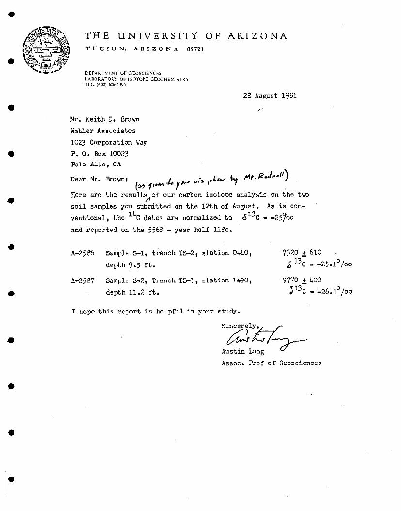
•
•
•
•
•
•
•
•
•
•
•
THE UNIVERSITY OF ARIZONA TUC S 0 N, AR l Z 0 N A 85721
DEPARTMENT OF GEOSCIENCES LABORATORY 01' JSC)l'Of'E GEOCHEMISTRY TEL (002) 626-1396
28 August 1981
Mr. Keith D. Brown
Wahler Associates
1023 Corporation Way
P. O. Box 10023 Palo Alto, CA
Mr ,,_ - •H-- / __ "'1 "'r. (?-,.J .. 411) Dear • =own: / ~- _ (' >..1>.< r• (» .,, .... _,.,, ,,._, ' Here are the result~of our carbon isotope analysis on the two
soil samples you submitted on the 12th of August. As is con
ventional, the 14c dates are normalized to &13c ~ -25/oo
and reported on the 5568 - year half life •
A-2586 Sample S-1 1 trench TS-2, station 0+40,
depth 9.5 ft.
A-2587 Sample S-2 1 Trench TS-3, station 1"'90 1
depth 11.2 ft •
I hope this report is helpful in your study.
7320 ± 610
[i 13c ~ -25.1° /oo
9770 !. 400
J13c - -26.1° /oo
S~l:c-;;-Austin Long
Assoc. Prof of Geosciences
•
•
•
•
.. APPENDIX D
•
•
•
•
•
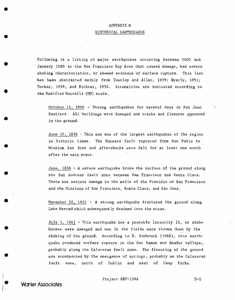
•
•
•
•
•
•
•
•
•
•
•
APPENDIX D
HISTORICA.L EARTHQUAKES
Following is a listing of major earthquakes occurring between 1800 and
January 1980 in the San Francisco Bay Are.a that caused damage, had •evere
shaking characteristics, or showed evidence of surface rupture. This list
has bean abstracted mainly from Townley and Allen, 1939; Byerly, 1951;
Tocher, 1959; and Richter, 1958. Intensities are indicated according to
the Modified Mercalli (MM) scale.
Octobe' 11, 1800 - Strong earthquakes for several days in San Juan
Bautista. All buildings were damaged and cracks and fissures appeared
in the ground.
June 10, 1836 - This was one of the largest earthquakes of the region
in historic times. The Hayward fault rupturad from San Pablo to
Mission San Jose and aftershocks were felt for at least one month
after the main event.
June, 182§ - A severe earthquake broke the surface of the ground along
the San Andreas fault zone between San Francisco and Santa Clara.
There was serious damage to the walls of the Presidio of San Francisco
and the Missions of San Francisco, Santa Clara, and San Jose .
November 22, 1852 -. A strong earthquake fractured the ground along
Lake Merced which subsequently drained into the ocean.
July 3, 1861 - This earthquake has a probable Intensity IX, as adobe
houses were damaged and men in the fields <>'ere thrown down by the
shaking of the ground. According to D. Radbruch (1968), this earth
quake prodnced surface rupture in the San Ramon and Amador valleys,
probably along the Calaveras fault zone. The fissuring of the ground
was accompanied by the emergence of springs, probably on the Calaveras
fault >:one, north of Dublin and west of Camp Parks.
Project HBP-109A D-1
Wahler Associates
•
•
•
•
•
•
•
•
•
•
•
October 8, 1865 - A very large earthquake, apparently centere.d on the
San Andreas fault, occurred in the Santa Cruz Mountains. The intensity
of at least IX is corroborated by the occurrence of ci;acks in the
ground, landslides, and dust clouds. San Francisco suffered great
damage in the filled areas and a fissure appeared in the ground on
Howard Street from Seventh to Ninth Street,s .
October 21, 1868 This was one of the largest historic earthquakes.
Horizontal offset of about 3 feet was observed on the Hayward fault
from Warm Springs to San Leandro, a distance of about 20 miles. The
total ruptured length was about 30 miles. The severity of this earth
quake is demonstrated by the assigned intensity of X for Ha.yward and
IX for San Francisco, by the wide damage area which extended as fai:
south as Gilroy and Santa Cruz, and because it was felt at places as
far as 175 miles from the origin.
March 30, 1885 - An Intensity VIII eai:thquake on the San Andreas fault
at Mulberry, southeast of Hollister, extensively cracked the soft
river banks at the junction of the Pajaro and San Benito rivers.
April 24, 1890 - This strong earthquake occun:cd at 3:36 a.m. and
produced extensive damage in the Monterey region. Gi;ound fissures
were observed in the San Andreas fault zone near Chittenden, east of
Watsonville.
June 20 ~ 189 7 - The source of this earthquake was the San Andi;eas
fault in San Benito County. It was felt over a wide area and was very
strong in Hollister (Intensity VIIT to IX) and Salinas.
June 11, 1903 - The epicenter of this earthquake was probably on the
Hayward or the Calaveras fault north of San Jose. The intensity <-'as
VIII in San Jose, Haward, Livermore~ and neal':" Niles.
April 18, 1906 - This is probably one of the three greatest histoi:ic
shocks of California. It originated on the San Andreas fault north of
Project HBP-109A D-2 Wahler Associates
•
•
•
•
•
•
•
•
•
•
•
San Francisco and produced a maximum horizontal ground offset of 21
feet near Tomales Bay. Vertical movement apparently did not exceed 3
feet. Ground fissuring along the San Andreas fault zone was observed
from Upper Hattola in l!umbolt County to San Juan in San Benito County.
Extensive damage occurred in the filled areas of San Francisco and in
Santa Rosa and San Jose .
June 1, 1911 - The epicent:er of this Richte:r Magnitude 6.6 (estimated)
earthquake was most likely on the Calaveras fault east of Coyote. The
intensity at Coyote was VIII to IX and VII to VIII at San Jose, Horgan
Hill, and Gilroy.
May 16, 1933 - A Richte• Magnitude 4.5 ea<thquake with HM intensities
of VIII nea• Overacker Station between Niles and Irvington, and VI to
VII at Hayward, Martinez, Mission San Jose, and Walnut Creek.
April 25, 1954 - The epicenter was located on the San Andreas fault at
its intersection with Pajaro River. This earthquake has a Richter
Magnitude of 4.5 plus.
October 23, 1955 - Moderate property damage from a Magnitude 5. 4
earthquake which has an epicenter probably located on the Calaveras
fault between Walnut Creek and Concord, about 7! miles northeast of
Lafayette Dam. St. MaJCy's Dam, near Moraga, was slightly damaged in
that a 1-to 20-inch wide crack extended from the spillway to the right
abutment. The concrete ccre wall near the ce.nter of the dam shifter
1/2 inch downstream.
March 22, 1957 - A Magnitude 5.3 earthquake occurred on the San Andreas
fault near Mussel Rock. No breakage of the surface was observed,
although there were landslides on the steep coastal cliffs near the
epicenter.
January 8-9, 1977 - A series of earthquakes occured in Briones 
•
•
•
•
•
•
•
•
•
•
•
San Francisco Bay Ai:ca. Ten other earthquakes ranging from Magnitude
2. 6 to 3. 8 also occurred during this two-day period .
August 6, 1979 - This magnitude 5.7 earthquake was located about 1 km
east of the trace of the Calaveras Fault near Coyote Lake, Santa Clara
County, California .
January 24 and_ll 1980 - Reffered to as the Mt. Diab lo earthquaka
with magnitudes 5.5 and 5.2 respectively (USGS) caused moderate damage
in the Livermore Valley area. Associated ground rupture exhibiting
right lateral movement along the Greenville Fault .
Project HBP-109A D-4
Wahler Associates