glowa volta phase iii · imk-ifu institut für meteorologie und klimaforschung atmosphärische...
TRANSCRIPT

’
submitted to
Bundesministerium für Bildung und Forschung
by the
Rheinische Friedrich-Wilhelms-Universität zu Bonn
October 2005
GLOWA Volta Phase III
Synthesis and Transfer

Table of Contents
Abbreviations and Acronyms List of Figures and Tables 1. General Introduction 7
1.1 Objectives of GLOWA Volta Project Phase III 7 1.1.1 Integration of Phase I and II research results, knowledge, data and tools 8 1.1.2 Construction of a framework for evaluating and projecting effective demand for
water resources 9 1.1.3 Development of operational versions of research models and tools 9 1.1.4 Transfer of GVP infrastructure, tools and activities to partners in the basin 9
1.2 Project Organization and Linkages 9 1.3 DSS Utilization Approach 13 1.4 External Collaboration 16
2. Cluster S Water Supply and Distribution 18 2.1 Subproject S1: Hydrometeorological Modelling (MM5 and WaSiM) 20
2.1.1 Progress to date 21 2.1.2 Research Needs 22 2.1.3 Objectives 22 2.1.4 Methods 23 2.1.5 Milestones 24 2.1.6 Resources 24
2.2 Subproject S2: Hydrometeorological Observatory 24 2.2.1 Progress to date 24 2.2.2 Research Needs 25 2.2.3 Objectives 26 2.2.4 Methods 26 2.2.5 Milestones 26 2.2.6 Resources 26
2.3 Subproject S3: Remote Sensing and Surface Energy Balance 26 2.3.1 Progress to date 27 2.3.2 Research Needs 28 2.3.3 Objectives 28 2.3.4 Methods 28 2.3.5 Milestones 29 2.3.6 Resources 29
2.4 Subproject S4: Surface, soil and groundwater 29 2.4.1 Progress to date 31 2.4.2 Research Needs 31 2.4.3 Objectives 32 2.4.4 Methods 32 2.4.5 Milestones 34 2.4.6 Resources 34
1

3. CLUSTER E: Analysis of Long-Term Environmental Change 36 3.1 Subproject E1: Automated Classification of Remotely Sensed Imagery 38
3.1.1 Progress to date 38 3.1.2 Research Needs 38 3.1.3 Objectives 39 3.1.4 Methods 39 3.1.5 Milestones 40 3.1.6 Resources 40
3.2 Subproject E2: The basin wide Cellular Automata LUCC model 40 3.2.1 Progress to date 41 3.2.2 Research Needs 41 3.2.3 Objectives 41 3.2.4 Methods 42 3.2.5 Milestones 44 3.2.6 Resources 44
3.3 Subproject E3: GV-LUDAS: A High Resolution Agent-Based Model 44 3.3.1 Progress to date 45 3.3.2 Research Needs 45 3.3.3 Objectives 46 3.3.4 Methods 46 3.3.5 Milestones 48 3.3.6 Resources 48
3.4 Subproject E4: Land-use Change Predictions and impact on Land- and water-use Policies 48
3.4.1 Progress to date 48 3.4.2 Research Needs 49 3.4.3 Objectives 50 3.4.4 Methods 50 3.4.5 Milestones 51 3.4.6 Resources 51
4. CLUSTER D: Water Demand 52 4.1 Subproject D1: Agricultural Demand for Water 54
4.1.1 Progress to date 55 4.1.2 Objectives 55 4.1.3 Methods 56 4.1.4 Milestones 57 4.1.5 Resources 57
4.2 Subproject D2: Non-Agricultural Water Demand 57 4.2.1 Progress to date 59 4.2.2 Research Needs 59 4.2.3 Objectives 60 4.2.4 Methods 60 4.2.5 Milestones 62 4.2.6 Resources 62
4.3 Subproject D3: Integrated Demand Simulation Framework 62 4.3.1 Progress to date 64 4.3.2 Research Needs 65 4.3.3 Objectives 66 4.3.4 Methods 66 4.3.5 Milestones 67 4.3.6 Resources 67
2

5. Cluster C Participatory Decission Support System and Coordination of Technology Transfer 68
5.1 Subproject C1: Participatory Decision Support and Coordination of Technology Transfer 69
5.1.1 Progress to date 70 5.1.2 Research Needs 70 5.1.3 Objectives 71 5.1.4 Methods 72 5.1.5 Milestones 72 5.1.6 Resources 73
5.2 Subproject C2: Transboundary Water Management 73 5.2.1 Progress to date 73 5.2.2 Research Needs 74 5.2.3 Objectives 75 5.2.4 Methods 75 5.2.5 Milestones 76 5.2.6 Resources 76
5.3 Subproject C3: Consortium Building, Training and Outreach in the use of DSS 77 5.3.1 Progress to date 77 5.3.2 Research Needs 77 5.3.3 Objectives 78 5.3.4 Methods 78 5.3.5 Milestones 78 5.3.6 Resources 78
6. Cluster I GLOWA Volta Decision Support System 79 6.1 Subproject I1: Requirements Engineering 80
6.1.1 Progress to date 80 6.1.2 Research Needs 82 6.1.3 Objectives 82 6.1.4 Methods 82 6.1.5 Milestones 85 6.1.6 Resources 85
6.2 Subproject I2: GVDSS Infrastructure 85 6.2.1 Progress to date 86 6.2.2 Research Needs 86 6.2.3 Objectives 87 6.2.4 Methods 87 6.2.5 Milestones 90
6.3 Subproject I3: GVDSS Workbench 91 6.3.1 Progress to date 91 6.3.2 Research Needs 92 6.3.3 Objectives 93 6.3.4 Methods 93 6.3.5 Milestones 95
7. References 97
3

Abbreviations and Acronyms AMMA African Monsoon Monitoring Multidisciplinary Analysis ANN Artificial neural networks ASAR Advanced Synthetic Aperture Radar BGR German Federal Institute for Geosciences and Natural Resources BIOTA West BIOdiversity Monitoring Transect Analysis in Africa West CA cellular automata CACHCROP crop growth model CALSIM CALifornia SIMulation Model CALVIN California Value Integrated Network CAPS coupled land-surface/boundary-layer model CGIAR Consultative Group on International Agricultural Research CIDA Canadian International Development Agency COBIDS COmponent-Based Integration of Data and Services CONOPT Constrained Optimization CP Circulation pattern CPWF Challenge Program for Water and Food CSF Common Sampling Frame CSIR Council for Scientific and Industrial Research DGIRHDirection Générale de l'inventaire des Ressources Hydrauliques DLR Deutsches Institut für Luft- und Raumfahrt DSS Decision Support System DSSAT Decision Support System for Agrotechnology Transfer ECHAM4 Atmospheric general circulation model ECHAM ECOWAS Economic Community Of West African States EMS Execution management services ESA European Space Agency ET Evapotranspiration EVI Enhanced Vegetation Index FAO Food and Agriculture Organization (United Nations) GAMS General Algebraic Modelling System; GAT Grid Application Toolkit GCM General Circulation Model GEF-UNEP Global Environment Facility – UN Environment Programme GMP Governance and Modelling Project, CGIAR CPWF GoBF Government of Burkina Faso GoG Government of Ghana GPRS Ghana Poverty Reduction Strategy (IMF) GRAM Grid Resource Allocation and Management GUI Graphical User Interface GVP GLOWA Volta Project GWP Global Water Partnership HSD Hydrological Services Department IKONOS High spatial resolution satellite IMK-IFU Institut für Meteorologie und Klimaforschung
Atmosphärische Umweltforschung INERA Institut de l'environnement et des recherches agricoles IRBM Integrated River Basin Management IT Information Technology IUCN International Union for Conservation of Nature and Natural Resources IWMI International Water Management Institute IWRAM Integrated Water Resources Assessment and Management IWRM Integrated Water Resources Management KACE Kofi Annan Centre of Excellence in ICT LAI Leaf area index
4

Land-SAF Land Satellite Application Facilities LAS Large Aperture Scintillometer LST land surface temperature LUCC Land Use and Land Cover Change LUDAS Land-use Dynamics Simulator MAS Multi-agent simulation MATA Multi-Level Analysis Tool for the Agricultural Sector Matlab MATrix LABoratory METEOSAT Geosynchronous Meteorology Satellite METOP Meteorological Operational Polar satellite MM5 Penn State mesoscale climate model MMP Malaria Modelling Project MODIS Moderate-Resolution Imaging Spectroradiometer MoFA Ghanaian Ministry of Food and Agriculture MoWH Ministry of Works and Housing MoU Memorandum of Understanding MSD Meteorological Services Department MSG METEOSAT Second Generation NDVI Normalized difference vegetation index NFS Network File System NGO Non-governmental organization NUTMON Nutrient monitoring at farm level OGSA Open Grid Services Architecture OOP Object Oriented Programming PEST Parameter Estimation Tool PRISM Probabilistic Symbolic Model Checker RE Requirements Engineering RS Remote sensing, RUSLE Revised Universal Soil Loss Equation SADC Southern African Development Community SEBAL Surface Energy Balance Algorithm for Land SMOS Soil Moisture and Ocean Salinity mission SPSS Statistical Product and Service Solutions SRES Special Report on Emissions Scenarios SRP Small Reservoirs Project SSA Sub-Saharan Africa SST Sea Surface Temperature SVAT Soil-Vegetation-Atmosphere Transfer model SWAP Statewide Agricultural Production Model UCC Uniform Commercial Code UML Unified Modeling Language UNU United Nations University USD US Dollar USGS United States Geological Survey USLE Universal Soil Loss Equation VO Virtual organization VRA Ghanaian Volta River Authority (Hydropower Commission) WAGP West Africa Gas Pipeline WAPP West African Power Pool WES Workflow execution services WRC Ghanaian Water Resources Commission WRI Ghanaian Water Research Institute WVPP White Volta Pilot Project ZEF Zentrum fur Entwicklungsforschung (Center for Development Research)
5

List of Figures and Tables Figure 1: Integration Diagram (from Status Conference) Figure 2: DSS Utilization from consultation to validation Figure 3: Overview of the remote sensing-derived biophysical and land surface data used
within the project Figure 4: Prototype Volta Basin Integrated Model Figure 5: Some research questions/interventions for GVDSS identified in Phase II
Figure 6: Grid-based Architecture of the GVDSS
Figure 7: Decentralized workflow execution
Figure 8: Prototype of the interface for composition of decision support workflows Figure 9: Prototype of the interface for visualization and analysis of multi-disciplinary data Table 1: Summary of priority use cases
6

GLOWA Volta Phase III: Synthesis and Transfer 1. General Introduction During the first phase of the GLOWA Volta Project (GVP), priorities included the establishment of research infrastructure and the collection of climatic, hydrologic, environmental and socioeconomic data, which are scarce within the Volta Basin. A large number of focused studies, many conducted by Ph.D. trainees from the Volta region, attempted to bridge gaps in spatial and temporal scales as solutions to the problems of data scarcity. Phase I also encompassed the establishment of working relationships between European GVP partners and counterparts in Ghana. During Phase II, modeling activities predominated. Mesoscale climate models (MM5) were successfully linked with physical hydrology models (WaSIM-ETH) at catchment, tributary and full basin scales. Numerous anthropologic and socioeconomic studies were successfully completed, creating databases from which a range of household models of socioeconomic behavior were identified. Phase III activities will focus on integration of Phase I and II outputs, emphasis on aggregate economic analysis, operationalization of DSS components and transfer of activities and responsibilities to institutions within the Volta Basin. The overall objectives of GVP Phase III remain consistent with the initial and Phase II proposals: (1) to provide an analysis of the physical and socio-economic determinants of the hydrological cycle within the Volta Basin, and (2) to develop a scientifically sound Decision Support System (DSS) for the assessment, sustainable use and development of the Basin’s water resources. Under Phase III, the structure of research clusters and work packages will be modified to reflect the priorities placed on (i) integration of Phase I and II research results, knowledge, data and tools, (ii) greater emphasis on economic analysis at aggregated and sectoral levels, and (iii) shift in orientation from research to operational modes, emphasizing delivery of services described in previous phases of GVP research. Proposed research clusters are introduced below, and described in detail in following sections. It will be seen that although essential continuity with Phase I and II research activities is preserved, work packages have been re-organized to reflect operational, rather than research requirements. We are replacing the Atmosphere, Land and Water themes that gave structure to GVP research in Phases I and II with themes that can be described as • Water Supply and Distribution (S); • Analysis of Long-Term Environmental Change (E) • Water Demand (D) • Consortium Building for Technology Transfer (C) • DSS Infrastructure (I) Although a certain conceptual simplicity (and verbal parsimony) appears at risk of being lost, the new clusters cut across the earlier themes in ways that reflect the requirements of an operational program of integrated water resources management at large basin scale. 1.1 Objectives of GLOWA Volta Project Phase III The original GLOWA program concept emphasized three core scientific themes guiding interdisciplinary research: • Natural variability of precipitation, and variations caused by human activities and their
effect on the hydrologic cycle • Interactions between the hydrologic cycle, the biosphere and land use • Water availability and conflicting water uses
7

These themes have guided the GLOWA Volta Project (GVP) since inception, although research priorities (and project resources) have been shifted repeatedly in recognition of the evolving nature of binding constraints to further progress. Analysis of the variation in precipitation and of long-term water availability each require data, therefore the earliest priority was placed on the acquisition and development of infrastructure, methods of analysis and models to enhance the quantity, quality and spatial coverage of data within the basin. Extensive survey research (the Common Sampling Framework) addressed the corresponding scarcity of data impeding socio-economic enquiry. As the data framework of the GVP became more solid, emphasis and resources shifted to simulation modeling, required to study the interactions and feedbacks between atmospheric, land surface and hydrologic processes. The GLOWA concept also stresses the importance of innovation in the development of early warning- and planning tools to improve decision-making, particularly over long time horizons under conditions of high uncertainty. With just over three years remaining in the project cycle, we now shift our priorities to synthesis activities, in order to address practical water sector problems and challenges within the Volta Basin, and to enhance and enable the modes of co-operation that will be required to ensure that our efforts are translated into ongoing success in meeting these challenges. Accordingly, the primary goals of Phase III are the following: 1.1.1 Integration of Phase I and II research results, knowledge, data and tools Efforts to date have succeeded in effecting linkages between selected research tools, notably the coupling of the mesoscale climate model MM5 with the physical hydrology model WaSIM, and the recursive coupling of WaSIM with economic optimization models coded in GAMS, albeit of limited complexity. Greater challenges remain, principally in the inclusion of land use land cover change (LUCC) models within the climate-hydrology model complex, and the interactive coupling of physical science models with economic optimization models at basin and sub-basin (e.g., White Volta) scales. Software coupling represents only one aspect of integration, however, and comparable challenges must be addressed in combining knowledge and experience acquired in anthropologic fieldwork and institutional analysis with software engineering requirements in order to create a genuinely user-friendly DSS accessible by a wide range of stakeholders. 1.1.2 Construction of a framework for evaluating and projecting effective demand for water resources Water scarcity has both a relative and an absolute interpretation, but it is relative scarcity – the extent of supply relative to effective demand - that circumscribes water management options. Within GVP, considerable effort has been allocated to field data collection and high-quality community-level studies of domestic and agricultural water use. What remains to be accomplished is a synthesis of this work that leads to a comprehensive framework of demand for water resources, both in the near term and over coming decades. Part of the challenge is methodological – the equivalent of scaling rules are required to provide regional estimates of water demand and withdrawal patterns, even when such patterns are reasonably well understood at household or community level. A comparable effort will be required to generate credible projections of the growth in water demand within the basin, by sector (agriculture, domestic, hydropower, industry, fisheries, environmental flows), over the next 40-50 years. Since factors external to the water sector such as population growth, economic restructuring and global commodities markets will profoundly influence trends in the demand for water, there is a need to develop simulation and forecasting models for important economic sectors linked to water, or as an efficient alternative, to identify and link to sectoral models already in use within the region. The Volta Basin integrated economic-hydrologic optimization model, when complete, will be a central component in the Volta Basin DSS.
8

1.1.3 Development of operational versions of research models and tools With the notable exception of operational weather forecast for the Volta region calculated daily at IMK-IFU, most or all GVP data retrieval, analysis and modelling activities to date have been designed to serve research purposes. However, operational water management tools are already required in several settings such as the White Volta Basin, where efforts are underway to establish a framework for cross-boundary water allocation. Among remaining tasks required to provide operational versions of several simulation tools (MM5, WaSIM ETH, LUDAS, GAMS, …) already in use by project scientists, the automation of data assimilation routines carries a high priority. Several opportunities for improving data assimilation capabilities, many relying on newly available remote sensing (RS) techniques, are described subsequently. Another important activity with the potential to rapidly advance models from research to operational mode is the development of grid computing infrastructure that will facilitate linkages and queries between models and databases (inclusive of RS) even at physically remote locations. These activities will also be described in detail. A final and indispensable task is to place the models in the hands of scientists and water managers within the Volta Basin, who can then proceed to customize applications to match the requirements of their mandates. 1.1.4 Transfer of GVP infrastructure, tools and activities to partners in the basin The knowledge and tools developed in the context of the GVP are intended to serve two purposes: (i) to advance the scientific understanding of the complex linkages between atmosphere, land use, human settlement and economic activities and the hydrologic cycle; and (ii) to support economically- and ecologically sound water management decision-making in the Volta Basin. These are not conflicting objectives. However, experience in both advanced and emerging economies suggests that tools and methods used successfully in one setting will not succeed automatically when transferred to another setting, unless there is a strong commitment in time, resources and training. We propose to make strategic use of an expanding consortium of institutions to effect the transfer of GVP activities and infrastructure to the Volta Basin, and to ensure the ongoing success of scientific decision support in water resources management. 1.2 Project Organization and Linkages The current structure of GVP scientific activities is indicated schematically in Figure 1, as prepared for the 2nd GLOWA Status Conference held in Cologne, May 17-19 2005. This remains an accurate description of project structure as we enter Phase III, although it will be seen that there is not a precise mapping between icons appearing in Figure 1 (many of which represent specific modeling tools, such as MM5) and Phase III research clusters. Much of the Phase III agenda involves integrative tasks which by definition encompass many or all of the project components depicted in Figure 1. The figure does convey the fundamental organization of Phase III through conceptual separation of research tasks involving the physical distribution of water in space and time (supply), encompassing climate, hydrology and remote sensing; from those that focus on human activities linked to water (demand), including sectoral economic modeling and institutional analysis. The land surface itself lies at the interface between natural and social sciences, as land cover and land use are manifestations of purposive human activities overlaid on the environmental matrix which co-evolve over relatively long timescales. Thus LUCC research activities, which fit neatly into neither “supply” nor “demand” categories, are accorded a unique research cluster (long term environmental change). Two proposed research clusters do not fall neatly into Figure 1, however. The Consortium Building for Technology Transfer (C) cluster is concerned with stakeholder consultation, knowledge transfer and training encompassing all relevant GVP research components, irrespective of discipline. Similarly, tasks associated with the technical integration of DSS components via grid computing infrastructure can be envisioned as an additional layer of project activities that extends over the entire domain of Figure 1.
9

Figure 1: Integration Diagram (from 2nd GLOWA Status Conference, 2005) Phase III research clusters and associated work packages are summarized briefly as follows, and described in detail in the following chapters: The Water Supply and Distribution (S) cluster encompasses the analysis of physical water distribution and availability in space and time, inclusive of atmospheric, surface and subsurface hydrologic processes. It contains most of the elements of the Atmosphere cluster, as well as current work package W1 (Runoff and Hydraulic Routing), extended to include probabilistic analysis of climatic and hydrologic phenomena and investigation of groundwater recharge. Cluster S consists of four subprojects: Subproject S1. Hydrometeorological Modelling (MM5 and WaSIM). Linked climatic - hydrologic modelling is required to remedy the scarcity of directly measured climatic and hydrologic data within the Volta Basin; and to simulate conditions associated with global environmental change that are beyond the domain of historical observation. Phase II included the successful coupling of mesoscale climate model MM5 and physical hydrologic model WaSIM ETH, and research on the onset/cessation of the rainy season advanced. This ongoing research will be enhanced by comprehensive analysis of error and uncertainly associated with model specification and natural variability, respectively. Subproject S2. Hydrometeorological Observatory) builds on site instrumentation and data collection infrastructure installed throughout Phases I and II, and reflects the ongoing need for ground truth data both to support Phase III activities and to provide the backbone of a hydro-climatological observatory that will outlive the GVP.
10

Subproject S3. Remote sensing and surface energy balance, involves integration of three ongoing research initiatives measuring or estimating surface energy balances at various scales: remote sensing (basin scale); SEBAL algorithm (intermediate scales) and LAS (scintillometers, local scales). Data obtained will be assimilated by MM5 and WaSIM. Subproject S4. Surface, Soil and Groundwater monitoring and modeling, emphasizes the importance of the land-phase hydrologic cycle, particularly to agricultural and domestic water users. Activities include automating and linking RS methods to detect surface and soil water; expanded pedotransfer modeling of basin soil hydrologic properties, and measurement and modeling of shallow groundwater in collaboration with the Canadian International Development Agency (CIDA) Hydrogeological Assessment Project within Ghana, commencing September 2005. The Analysis of Long-Term Environmental Change (E) cluster focuses on environmental changes endogenous to the Volta Basin that evolve over decadal time scales. These changes, such as alterations in land cover, soil degradation and loss of wetlands reflect complex interactions and feedbacks between climate, human settlement and economic activities. Cluster E carries forward much of the work currently conducted within the Land Use cluster. Primary objectives are (i) to provide credible future land cover scenarios required by climate and hydrology models, and (ii) to provide decision support tools for proactive land management on the local and basin scales. Subproject E1. Automated Classification of Remotely Sensed Imagery. Integrated analysis of the hydrologic cycle within the Volta basin requires quantitative data on land cover and land use at different spatial and temporal scales. Key variables include land cover classification, land surface temperature, surface emissivity, vegetation indices (NDVI/EVI, LAI) and percentage tree cover. Subproject E1 carries forward activities undertaken in Phase I and II using enhanced methods and automated scaling algorithms. Subproject E2. Cellular Automata: a Coarse Resolution Land Conversion Model at basin scale. In Phase III, we develop two LUCC models appropriate for different scales: the cellular automata (CA) land-use model is developed at full-basin scale, and multi-agent simulation (MAS) model GVP-LUDAS at community scale. The CA approach is based on spatially uniform transition rules derived from spatial regression analysis, and behavioural rules generated by the MAS model. The CA model is capable of capturing both emergence phenomena and system response to exogenous changes, such as shifts in land use policy, at basin and regional scales. Subproject E3. GVP-LUDAS: A High Resolution Agent-Based Model. MAS models are designed for use at smaller scales, such as communities and watersheds. The MAS model GVP-LUDAS captures bio-complexity driven by interaction between human actors and the local physical environment. The MAS approach is inherently well suited to stakeholder involvement in the modelling process, and will provide standalone DSS capabilities of local resource use decision-making. Subproject E4. Land-use Change Predictions and Land-use Policy. Spatially explicit land-use changes occur over decadal timescales (and longer). Prediction uncertainty is inherently high due to complex feedbacks and interactions between land, society and climate. Subproject E4 synthesizes Cluster E research to develop credible projections of LUCC changes. These projections support coupled modelling of near-future conditions (S1); and demand forecasting for water and related resources (D). The Water Demand and Management (D) cluster consists largely of integrative activities that build extensively on research conducted within Phase II on operations research modeling of water-demanding economic sectors. It integrates Phase II work packages W2 (Water and Livelihood), W3 (Institutional Analysis), D2 (Household Decision-making and
11

Policy Response), D3 (White Volta Policy Pilot), D4 (Policy Dialog at Basin Level) and some aspects of D1 (Technical Integration of Socio-Economic and Environmental Modeling Sub-Systems). The demand cluster has three components: Subproject D1. Agricultural Water Demand. Agriculture is the dominant economic activity and the largest consumer of water resources. Expansion of irrigation is an essential component of strategies to increase agricultural productivity, mitigate climate change and improve rural livelihoods. Research activities focus on physical modeling of irrigation water use at overlapping scales, methods of spatially aggregating demand, and partial equilibrium agricultural sector modeling using the CIRAD modeling tool MATA. Subproject D2. Non-Agricultural Water Demand. Non-agricultural water demand encompasses domestic, industrial, hydropower generation and environmental uses. Urban and rural household water demand are critical as the availability and quality of domestic water supply have profound effects on health and well-being. Hydropower generation is another important, albeit non-consumptive source of water demand, as hydropower currently supplies most of Ghana’s energy requirements. Water to support environmental and ecological functions will become increasingly important as overall demand increases. Subproject D3. Integrated Demand Simulation Framework. The Volta Basin integrated economic-hydrologic model is the fundamental interface between physical science and social/policy domains. It is designed to identify potential gains from re-allocation of water resources in space and in time across competing uses and locations within the basin. Subproject D3 seeks to expand the integrated model framework, and to develop more effective approaches in achieving interoperability with hydrologic models. The fourth research cluster is Consortium Building for Technology Transfer (C): The success of the GLOWA Volta project will ultimately be measured by the continuity of activities within the region following completion of GVP. GVP has built an effective network of partners in Ghana and Burkina Faso, as well as a consortium of international organizations including KACE, IWMI and UNU. During Phase III these three institutions will progressively assume leadership of project activities, with the ultimate objective of transferring ownership to capable institutional partners within all 6 riparian states. Subproject C1. Knowledge Exchange and Participatory Decision Support. Successful transfer of GVP knowledge and infrastructure requires tools and methods of consultation that are relevant and user friendly to stakeholders at all levels of social organization. Consultation is required to identify relevant and potentially useful DSS queries. Subproject C1 aims to develop a better understanding of societal negotiation processes in the water sector. Acquired insights will be used to identify the information needs of different actors and the roles that expert knowledge can play in the mitigation of conflicts. Subproject C2. Transboundary Water Management. The Volta Basin is shared by six riparian countries, with Ghana and Burkina Faso predominant. The basin lacks effective supra-national water governance institutions, suggesting a potential for conflict as scarcity increases. To ensure integrated and sustainable transboundary management of the Volta’s resources, technical, political and institutional cooperation across all sectors and societal levels is needed so that scientific knowledge can improve political outcomes. Subproject C3. Consortium building Training and Outreach in use of DSS. Enduring use of the Volta Basin DSS requires (i) successful transfer of DSS infrastructure, (ii) competent regional scientists who can work with stakeholders in utilizing the DSS and (iii) a network of effective partners who can work locally and regionally to formulate new initiatives. Subproject C3 focuses on organizing the consortium that will assume the coordination role post-GLOWA, including training and out-scaling activities. The UNU will have a leadership role in this consortium.
12

The final cluster, GLOWA Volta Decision Support System) (I) encompasses technical activities required for the implementation of a scientifically sound DSS. DSS encompass a wide range of scientific simulation tools embodying various methodological approaches and technologies. However, there are several reasons why DSS are not often used effectively at the management level, including lack of user-friendly interfaces, insufficient involvement of potential end-users in software development, poor identification of user needs and lack of adequate system infrastructure. The primary goal of cluster I is to facilitate the development of an effective, user-friendly Grid-based DSS infrastructure for water management in the Volta Basin Subproject I1. Requirements Engineering. This subproject involves all the tasks that go into the instigation, scoping and definition of a new DSS. It is a complex collaborative process consisting of several steps and representing a dialog between potential DSS users, and the project’s natural, social and computer scientists. The primary result of this subproject is a model of the DSS filling the gap between the business (DSS users) and Information Technology (IT) worlds. Subproject I2. GVDSS Infrastructure. The second subproject encompasses all the activities needed for the development of a distributed Grid-computing infrastructure that will be capable of integrating distributed simulation systems and data sources for the GLOWA Volta DSS in accordance to the specification developed in subproject I1. Subproject I3. GVDSS Workbench. This subproject supplements the Grid infrastructure focusing on the development of the DSS user interface (Grid client). In addition to the common functionality of the client interface for the execution of decision-support workflows, specialized services for visualization and analysis of data are strongly needed. 1.3 DSS Utilization Approach The development of a DSS for the assessment, sustainable use and development of the Basin’s water resources is the GVP’s primary output. During Phase II, project scientists engaged a number of software engineers in extended dialogs in order to improve our understanding of the state-of-the art in integrated simulation modeling and DSS design. We were interested in learning (i) what integration options were available to the GVP given objectives and modeling activities to date, (ii) what levels of resources and time were required to make each approach workable, and (iii) what specialized skills were needed. Through these dialogs, we concluded that software engineering expertise well beyond current “in-house” capabilities was required to maximize the probability that our efforts would succeed. As one important consequence, computer scientists from the Bonn University Department of Informatics III are now full research partners in GVP phase III. The first thing that our new partners explained to us is that the design of a DSS cannot be considered apart from its intended uses, and its likely users. The requirements of simulation determine the architecture of the system. Much of the literature on global climate change and its impacts highlights the use of scenarios in providing frameworks for integrated analysis of future conditions1. As an outcome of related discussions held during Phase II, we concluded that, given the emphasis on stakeholder involvement in DSS development, it is more useful for us to focus on policy interventions as the subject matter for integrated analysis than on the development of canonical scenarios. The reasons are as follows: a scenario, however carefully and
1 “Scenarios are not predictions, forecasts or projections. Rather, they are stories about the future with a logical plot and narrative governing the manner in which events unfold. A scenario is a possible course of events leading to a resulting state of the world, or image of the future… The importance of considering scenarios as courses of events is that this directs attention to the unfolding of alternatives and to branching points at which human actions can significantly alter the future.” (Gallopin and Rijsberman, 2002)
13

realistically constructed, describes only one possible state of the future among the infinity of such states in potential. Embedded in each scenario is a wide range of assumptions and assumed causalities, making judgments about specific cause and effect linkages difficult. By contrast, the value of a decision support system lies in its ability to provide useful information concerning the likely outcomes of specific, well defined actions or policies. By isolating specific interventions, we are more likely to arrive at informed judgments concerning their likely impacts, uncomplicated by extraneous assumptions. Each of these outcomes serves to highlight the importance of the interface linking stakeholders and project scientists (particularly software engineers), and the proper design of methods of consultation and elicitation. It has indeed proven challenging to design a structure for Phase III research that simultaneously acknowledges (i) the continuum of activities, and actors, involved in the design and use of the DSS, and (ii) the distinct disciplinary perspectives and training required for success in stakeholder consultation on one hand, and software engineering on the other. The chosen structure for phase III, which places requirements analysis within the technical integration cluster (Subproject I1: Requirements Engineering) and primary stakeholder consultation activities within the technology transfer cluster (Subproject C1: Knowledge Exchange and Participatory Decision Support) is in fact a compromise. Thus, it is important to consider how we envision the DSS development and utilization process to function. Figure 2 provides a schematic overview of this process. We can anticipate three relatively distinct classes of DSS users (beneficiaries). There are stakeholders in the literal sense, a community that includes farmers, households and water service providers at local and regional scales; NGO’s and other advocacy groups, and local (non-statutory) decision-makers. We do not assume that they are scientists (although they might be), but we do assume that their interest in the outcomes of water resources management decisions is linked directly to their health, livelihoods and personal or collective well being. A second category of potential users we will call the Water Bureaucracy2. This category encompasses agents with explicit responsibility and/or authority for water resources decision-making. Examples include members of Ghanaian WRC, VRA, MoFA and so on; and possibly representatives of multilateral lending or development agencies. Some will be scientists, and most or all will be scientifically literate. Their interest in water management is professional: they wish to discharge their appointed duties effectively, and to deploy societal resources wisely. The third category consists of scientists, both within and external to the GVP. Their primary interest is assumed to be the advance of scientific knowledge, perhaps motivated by a desire to remedy specific problems or to address specific technical challenges.
2 The term “bureaucrat” is not intended pejoratively
14

Figure 2: DSS Utilization from consultation to validation Each group is assumed to desire distinct types of information from the DSS, which we will define as queries to the system. Scientists are primarily interested in scientific output from integrated analysis. Stakeholders may be interested in either institutional innovation (interventions that modify power or authority relationships with regard to water resources) or in technical interventions, which typically take the form of investments in infrastructure or other technologies that influence water management options. Water bureaucrats are interested in the same types of queries, although they might be expected to place greater emphasis on technical intervention. Each type of query is then subject to the process of requirements analysis (described in Subproject I1), irrespective of qualitative differences. What emerges from requirements analysis is the use case for the specific query on the system. At the stage of requirements analysis, computer scientists are clearly involved, although physical and social scientists remain engaged via the validation loop: assumptions embedded in the use case must be re-evaluated by physical and/or social scientists to ensure that the simplifications invariably required to enable numerical policy simulation do not invalidate or undermine the query’s intended purpose. Use cases in turn specify requirements on the DSS (or on specific components), which may then generate a need for new or additional software engineering tasks. Such tasks may consist of new research, particularly if the linked simulation task is novel or unconventional; or may require the development and implementation of new software code utilizing established principles; or both. Finally, the outputs of integrated analysis must again be validated by project scientists, and possibly by stakeholders, at which point they become genuinely useful to policymakers. Through this process, a wide range of interests can be addressed within a single, flexible DSS.
15

1.4 External Collaboration The informal network of projects and organizations affiliated with the GLOWA Volta has continued to expand throughout Phase II, and several new Phase III collaborative activities are planned or are already underway. The GVP continues to share offices, infrastructure and scientific and managerial staff with the IWMI through their West Africa regional office in Accra. Past collaboration has included malaria risk mapping within the Volta Basin. New and potential areas of collaborative research include the evaluation of shallow groundwater irrigation in the Upper East region of Ghana, where GVP scientists will support IWMI efforts to inventory “informal” irrigated area within the region via experimental application of infrared digital photography, used successfully by GVP and BIOTA West Africa scientists for vegetation mapping in Burkina Faso; and studies of irrigation water productivity. IWMI will provide economic analysis for ongoing GVP studies of physical water use efficiency in small and medium irrigation schemes in the Upper East (Makarius Mdemu, Ph.D. research in progress), and in turn GVP will provide data and expertise in the physical component of water productivity. GVP, through ZEF, will also share in the support of an IWMI post-doctoral scientist (Anne Chapponiere) who will develop basin-scale models (SWAT) to support the joint GVP-IWMI research agenda in the basin. GVP scientists continue to work closely with the research staff of the Small Reservoirs Project (SRP), a 3-year study involving careful water balance accounting on heavily instrumented small reservoirs in the Upper East Region of Ghana. SRP is funded via the CGIAR Challenge Program on Water and Food (Project 46). GVP scientists will utilize SRP data to improve the calibration and validation of linked economic-hydrologic models at catchment and White Volta scales, respectively, and will in turn contribute expertise in satellite radar RS methods useful to the SRP. The expansion of GVP groundwater studies during Phase III is designed to complement with CIDA via the Hydrogeological Assessment of the Northern Regions of Ghana project, a 2-year project commencing in October of 2005, which will focus on mapping and modeling of geologic (deep) groundwater. This study is intended to improve the effectiveness of borehole development programs, in which CIDA has been extensively involved for 3 decades. CIDA focus on hydrogeology will free GVP researchers to focus on shallow groundwater, an important source of water for informal dry season irrigation and domestic water supply; and on the modeling and measurement of groundwater recharge. CIDA and GVP will share data, and co-ordinate modeling efforts. GVP (via ZEF) and the University of Heidelberg, Department of Tropical Hygiene and Public Health are developing a joint proposal provisionally titled Impact of climate change, water availability, human settlement, agriculture practice and soil degradation on malaria transmission risk. A comparative study between two climatic zones in Burkina Faso, to be submitted to DFG under the (pending) priority programme on Global Environmental Change and Human Health. The project is designed to exploit the complementarity between GVP and the Nouna Malaria Modelling Project (MMP). The MMP aims to develop malaria transmission models for children under five in the North-West of Burkina Faso, using environment parameters as driving forces. MMP research activities have been focused on Nouna District, Burkina Faso within the Soudano-Sahelian climate zone, an area of endemic malaria. GVP in turn maintains a research site at Dano, in western Burkina Faso within the Sudano-Guinean climate zone. The Dano site is the focus of a wide range of ecological, agricultural and water management studies. The proposed research methodology is based on an exchange of capacities between the two sites, with protocols developed at Nouna for the study of malaria transmission are duplicated (transferred) to Dano, and ecological, agronomic and related physical geographic findings from Dano transferred to Nouna. The Dano field site will also serve as the locus for collaboration between GVP and the African Monsoon Multidisciplinary Analysis (AMMA), an international study of the dynamics of the West African Monsoon. We will participate in the intensive field campaign planned for
16

the summer of 2006 through shared use of the Dano facilities. More information can be found at: http://www.ofps.ucar.edu/amma/amma_summary.htm
Challenge Program on Water and Food - Small Reservoirs Project (SRP)
In response to unreliable rainfall patterns, small reservoirs have been constructed throughout the northern Volta Basin over the last 4 decades by Government agencies and NGOs – over 150 in the Upper East Region of Ghana and roughly 1400 in Burkina Faso. These multipurpose structures impound the transient rainy season runoff from small catchments to provide rural communities with seasonal storage for small-scale irrigation and water for domestic purposes, livestock and aquiculture. They consist of earth-fill dams roughly 2.5 to 10 m in height and 100-750 m in length with passive spillways, capable of storing maximum volumes of 104 – 107 m3 and supporting irrigation perimeters of 5 – 20 Ha. These small irrigation systems are equipped with simple distribution channel networks, typically lined with concrete and controlled via manually operated gates. The reservoirs begin filling with the onset of the rainy season, provide supplemental irrigation during the rainfed cropping season (April - September) and primary water supply for a second, irrigated cropping season (October – February). Although these structures are small individually, they may act collectively to influence the patterns of discharge on important Volta tributaries, and alter regional hydrologic budgets through high surface evaporation rates and possibly, though local impacts on groundwater recharge. As the number of small reservoirs within the Volta Basin is likely to increase dramatically over coming decades, GVP scientists are interested in understanding their ensemble behavior, and their collective contribution to agricultural output and rural livelihoods. The CGIAR Challenge Program on Water and Food supports the Small Reservoirs Project (CPWF Project 46), a 4-year, USD 2.0 M project that seeks to support the planning, development and management of small reservoir ensembles, and to harmonize the interests of individuals served by small multi-purpose reservoirs, others living in the basin, and the requirements of riparian ecosystems. SRP encompasses research activities in the Volta (West Africa), Limpopo (Southern Africa) and Sao Francisco (Brazil) Basins. Research focuses both on individual reservoirs and the communities they serve, and on ensembles of small reservoirs. Important SRP outputs will include a small reservoir design manual, and a tool box which will assist stakeholders in siting, constructing and managing small multi-purpose reservoirs. More information can be found at: http://www.smallreservoirs.org/. GVP and SRP research activities have been coordinated since the inception of the SRP, and the projects share a number of key scientific staff. Both projects currently have intensive field instrumentation campaigns underway in the Upper East Region of Ghana, to collect timely information on dry season 2005-06 hydrologic behavior and water balance dynamics of small reservoirs (SRP) and the associated small irrigation systems (GVP). Data, research infrastructure, logistics and scientific expertise are shared to maximize the effectiveness of each respective research agenda. SRP outputs will make significant contributions to GVP objectives, particularly through the Agricultural Water Demand (D1) and Surface, Soil and Groundwater (S4) subprojects.
17
2. Cluster S Water Supply and Distribution Cluster S, Water Supply and Distribution, is designed to provide the primary physical components of the integrated analysis of the hydrologic cycle within the Volta Basin, inclusive of atmospheric, surface and subsurface processes. Cluster S carries forward most of the elements of the Atmosphere cluster of Phase II, as well as current Water cluster work package W1 (Runoff and Hydraulic Routing). It also encompasses probability-based analysis of climatic and hydrologic events made possible via Phase II outputs, and a range of activities focused on the surface-soil water-groundwater continuum. These include measurement and modelling of groundwater resources on regional and sub-basin scale, estimation of soil hydrologic properties by pedotransfer function methods extended to regional and basin scale, and remote sensing of soil moisture at comparable spatial scales. The emphasis within Cluster S, as throughout Phase III, is on the integration of ongoing research activities leading to operational prototypes of water resources forecasting and management tools. Such an emphasis is mandated by our responsibility fully to operationalize and to test the prototype Decision Support System (DSS) prior to the end of Phase III, in mid-2009, by which time it will be transferred to research partners within the basin. It also reflects the fact that much of the basic, disciplinary research required to remedy the scarcity of climatic and hydrologic data within the Volta Basin, to develop and evaluate scaling rules, and to identify, parameterize and test the linked climate-hydrology models has been completed successfully in Phases I and II. We now possess an expanded (and growing) hydroclimatic observatory and corresponding physical database, a set of climate and hydrology simulation tools, and a small library of detailed climate/hydrology scenarios available for use in testing hypotheses and evaluating intervention strategies while further refinements and improvements to the models progress. The sustainable management of water resources in the Volta Basin requires accurate and timely information on consumptive water use over a range of spatial and time scales. Spatially, we have an interest in water use at field, range unit, catchment and entire river basin scales. Temporally, we have an interest in daily and weekly water use for management of irrigated and dry land farms as well as seasonal and annual water budgets (and their variability) for strategic management of infrastructure and water supply in large watersheds. Consumptive water use by grasses and shrubs, agricultural crops, and riparian vegetation in the Volta Basin is highly variable in space and time. Spatial variability is caused by the heterogeneous nature of vegetation cover, hydraulic soil properties, ground water table depths, and variations in water input reflecting complex hydrological processes. The temporal variability is caused by the overlay of structured (cyclical) and random variations in climatic input at daily, annual and possibly decadal scales, and water storage in soil, aquifers, river channels, and surface water bodies, including small and large reservoirs . We address the challenges posed by such complexity through the linking and assimilation of directly and remotely sensed data into simulation models. The objective of hydrological data collection in this phase is to ensure that all significant fluxes into, out of and within the Volta basin “control volume” are properly accounted for. We plan to maintain the existing meteorological and hydrological networks established by the GVP, and to assist regional partners in strategically expanding regional gauging networks, and in developing improved data retrieval, storage and analysis capabilities prior to formal transfer of GVP infrastructure. Strategic expansion of existing networks is required in order to fill geographical gaps in order to achieve more uniform coverage of climatic and hydrologic events. Efforts to ensure the ongoing quality and secure archiving of gauge data will support future model development and validation, as well as operational water management. Protocols will be developed with the stakeholders to ensure that data collection and management will be continued after formal completion of the GLOWA-Volta project.
18

In data-poor environments such as the Volta basin, efficient, accurate, and inexpensive procedures to collect data that cover large areas and that can be used directly to predict evaporation3 fluxes and soil water status are needed to assess the water balance. An additional goal of this Sub-project is to develop such procedures for the Volta Basin. The outputs of this work package will be used as an automated input in the MM5-WaSIM Model Complex as well as for basin wide soil parameterization and characterization of soil moisture fields. We proceed on the assumption that the DSS developed by the GVP will serve several functions. The DSS will be used in operational mode to support near-term water management decision-making, such as providing guidance to farmers concerning optimal planting dates, or to reservoir operators attempting to balance hydropower production and irrigation demands given forecast system inflows. Alternatively, it can be used in planning and design mode, such as the ex ante analysis of hydraulic infrastructure projects or cropping strategies in major irrigation systems. Finally, the DSS can be utilized in policy simulation mode to test and to evaluate the impacts of proposed policies, regulations or incentives with respect to well-defined indicators. In the first of these applications, measured climatic and hydrologic data in near-real time are the required inputs. The latter two are more likely to require simulated input data chosen to reflect the hydro-climatic conditions most relevant to design or policy evaluation, such as flood-, drought- or future-climate scenarios. Thus, activities conducted within the S cluster place emphasis both on the collection, management and evaluation of observed data; and on the capacity to forecast hydrologic conditions contingent upon assumptions concerning environmental change. Accordingly, the Water Supply and Distribution (S) cluster consists of the following four (proposed) sub-projects. Sub-Project S1. Hydrometeorological Modelling (MM5 and WaSIM). As sustainable water management requires scientifically sound and spatio-temporally explicit information on the distribution of water resources in the catchment, this Sub-project aims at the improvement in and validation of model-based tools for the quantification of the water balance. At the request of basin stakeholders, Phase II included (i) initiation of operational water balance modelling in the White Volta catchment, (ii) a comprehensive examination of the onset/cessation of the rainy season and (iii) an analysis of combined impacts of land use and climate change on water availability in the Volta Basin. Research on the first two topics is ongoing and will be finalized during Phase III. The third task will rest on outputs from Cluster E (Long Term Environmental Change), to become available within Phase III. Completed Phase II collection and synthesis of climatic and hydrologic data will also support probabilistic modelling and risk and error analysis, critical to the evaluation of new infrastructure investment. Sub-project S2, Hydrometeorological observatory builds on site instrumentation and data collection infrastructure installed throughout Phases I and II, and serves the ongoing need for ground truth data both to support Phase III modelling activities and to provide the backbone of an ongoing hydro-climatological observatory that will outlive the GLOWA-Volta Project. Key partners include the Ghanaian Hydrological Services Department (HSD) and Meteorological Services Department (MSD), Burkinabé counterpart INERA, BIOTA West Africa and AMMA. Significant tasks include (i) maintenance of existing gauges and instruments established by GVP and partners; (ii) identification of gaps in the combined GVP/Hydro Services surface gauge network and strategic expansion of the network as required, in collaboration with Hydrological Services; and (iii) upgrading of real-time data transmission links with key stations wherever practicable. For this task, we propose to deploy new Hydro-Argos units selectively, as their worth and reliability have been established during Phase II. The network serves several functions, including near-term water supply forecast, flood/drought early warning and input for model validation and hindcasts.
3 In remote sensing literature it is common to use the term “evaporation” to include all evaporation and transpiration that occurs at the land surface.
19

Sub-project S3, Remote sensing and surface energy balance, aims to integrate three ongoing research initiatives that measure or estimate surface energy balances at various scales: remote sensing (basin scale); Surface Energy Balance Algorithm for Land (SEBAL) (intermediate scales) and Large Aperture Scintillometers (LAS) and eddy covariance instruments (local scales). Each component was or will be largely completed during Phase II; the task for Phase III will be to integrate this work to provide critical input into, and validation for the WaSIM-MM5 model complex. Sub-project S4, Surface, soil and groundwater, combines several activities highly relevant to agricultural and domestic water use. Soil moisture is the key to rainfed agricultural productivity, and timely knowledge of soil moisture conditions is valuable in agricultural planning. Remotely sensed data on soil moisture, soon to be available via the European Space Agency’s (ESA) Soil Moisture and Ocean Salinity mission (SMOS), will support real-time agricultural decision-making, and data will be assimilated to improve coupled atmospheric-hydrologic modelling. Modeling of meteorological, hydrological and land use processes further requires good estimates of key soil hydraulic properties. During Phase III we will extend to full basin scale the methods developed in Phase II for estimating saturated hydraulic conductivity (Ksat) using a combination of Spatial Information System and ANN. Finally, we will expand an initiative, commencing on an exploratory basis late in Phase II, to examine and model groundwater recharge, and the use of shallow groundwater in informal irrigation and village water supply. This work will be structured to complement the Canadian Government’s Hydrogeological Assessment Project, a two-year study within Ghana, commencing October 2005. 2.1 Sub-project S1. Hydrometeorological Modelling (MM5 and WaSiM) In contrast to European catchments, the Volta Basin is characterised by inadequate technical infrastructure. The network of synoptic climate stations and more critically, of hydrologic gauging stations is limited in extent, and in fact has declined throughout West Africa since the Hydrologic Decade (1965-1974) resulting in scarcity of data, which hinders the rational management of water. As sustainable water management rests on spatially explicit, internally consistent data on water balances and fluxes at a range of timescales, the synthesis of such a database for the Volta has held a high priority within the GVP since inception. Coupled simulation of atmospheric and hydrologic processes provides an alternative means of generating required data where none exists, and a complementary approach where such data do exist but are limited in quality and/or coverage. In addition, the linked model complex provides a credible approach to generating data corresponding to environmental conditions that have not yet been observed, but which can be anticipated within the near future due to increasingly well understood and documented global and regional processes. Sub-project S1 accordingly focuses on the expansion and conclusion of linked mesoscale climate (MM5) and hydrology (WaSIM ETH) model development, which has proceeded during Phase II at a range of nested spatial scales. During Phase II, the following projects were initiated in accordance with the requirements of basin stakeholders: 1) development of a model-based, operational water flow and balance system for the White Volta Catchment (a key component of the White Volta Pilot Project) 2) analysis and prediction of the onset/cessation of the rainy season 3) investigation of the relative and combined impacts of land use and climate changes on water availability over the entire Volta Basin Research activities focused on the first two topics are ongoing and will be finalized midway through Phase III. Research on the climatic aspects of topic 3 is nearly complete (see below), and incorporation of land cover change impacts will build on activities commencing in Phase II and continuing in Phase III within Cluster E which will generate the required land
20

cover datasets. An important addition to the Phase III research agenda is the probabilistic analysis of error and uncertainty in future hydrologic conditions, embodying uncertainties in climatic drivers, land use conditions and model specification as well as natural variation. Outputs from this analysis are particularly relevant in the design of hydraulic and hydrologic infrastructure, including hydropower generation facilities, and in the design of operational water allocation strategies. Subproject S1 also encompasses the setup, compilation, test applications and staff training at the Kofi Annan Centre of Excellence in ICT (KACE), which has been identified as the regional host center for the DSS. An important component of this DSS, the operational weather forecast (which is currently calculated daily at IMK-IFU and accessible at http://www.glowa-volta.de/atm/forecast.htm) will be transferred to the KACE early in Phase III. 2.1.1 Progress to date Within Phase II, regional climate simulations have been generated successfully using the mesoscale meteorological model MM5, fully coupled to a 1D SVAT model which accounts for soil properties and soil-atmosphere feedback mechanisms. The global climate model ECHAM4 scenario IS92a (“business as usual”), which provides MM5 atmospheric boundary conditions, has been dynamically downscaled to a resolution of 9x9 km² over the Volta Basin. Two 10-year scenarios were simulated: 1991-2000 (current climate) and 2030-2039 (future climate). At this point, assumptions concerning land cover are consistent across scenarios. WaSIM ETH physical hydrology models were also specified, and are undergoing evaluation at three nested scales: Atankwidi, in the Upper East region of Ghana (270 km², Martin 2005), White Volta (94,000 km²) and the entire Volta (400,000 km²) basins, respectively. Larger scales use 1 km grid spacing and daily timestep; 1 Ha pixels and hourly timesteps are used at Atankwidi. MM5 and WaSIM were then successfully coupled unidirectionally to facilitate investigation of the impacts of atmospheric change on terrestrial water balance. Linked regional simulations predict increasing annual precipitation for the Volta region overall, exhibiting strong spatial (-20% to + 50%) and temporal heterogeneity (-20% to +20%). A delay in the onset and a general shortening of the rainy season are also predicted. Model runs predict increasing temperatures ranging from 1°C in the maritime South of Ghana increasing to 1.6°C in the Sahelian North of Burkina Faso. The coupled meteorological-hydrological modelling chain is currently capable of automatic water balance calculations at a time delay of only 2-3 days on the basis of updated boundary conditions. An understanding of factors influencing the onset of the rainy season, and a corresponding capacity to forecast the arrival of the first rains after the dry season are high-value DSS outputs. Tools and methods for the reliable determination of onset of rains were requested by the Ghanaian Meteorological Service, a major stakeholder in the GVP. Research commenced in mid-phase II at IMK-IFU, where linear discriminant analysis in combination with fuzzy logic was used successfully to generate maps of precipitation onset via automated objective circulation pattern (CP) definition and classification (Patrick Laux, Ph.D. in progress). Parallel research commencing in early 2005 at Ghanaian MSD seeks to develop regionally calibrated definitions of the onset of rains in agriculturally meaningful terms using the simulation model CropSyst (Stockle, et al., 2003). Short-term forecasts of precipitation and temperature are essential tools for operational water management and agricultural planning, in particular planting and harvesting decisions. During Phase II (2005) numerical weather predictions for West Africa and the Volta Basin were automated and made available on-line. AVN global re-analyses at 2.5x2.5° resolution are retrieved automatically on a daily basis and dynamically downscaled to 27x27 km² resolution. The forecast is interpreted with respect to temperature, precipitation, surface runoff (infiltration excess) and soil moisture/saturation. It is rendered graphically and placed on the GLOWA Volta server where it can be viewed by any user with access to the internet.
21

Detailed validation extending through Phase III of the Project is anticipated to provide real-time forecasts of increasing accuracy. 2.1.2 Research Needs The basic GCM downscaling procedures have been established, permitting coupled climate-hydrologic modelling at catchment, sub-basin and basin scales. Although this procedure explicitly assimilates information concerning climatic boundary conditions, coupled simulations to date have employed relatively static assumptions concerning dynamics of land cover over decadal timescales. Evidence suggests that land cover and climate co-evolve to some extent (e.g., Costa & Foley 2000; Doherty, et al., 2000); and anthropogenic land conversion is an important dynamic within the Volta Basin. Thus, additional coupled simulation modelling work will be required to evaluate the discrete as well as the combined impacts of global atmospheric and regional land surface changes over decadal timescales. Of particular importance are questions concerning the relationship between removal (conversion) of the remaining lowland rainforest in the southern portions of the basin, and temperature and precipitation patterns in the dryer northern reaches of the basin. A linkage is often asserted, but no conclusive proof has been established to date. In order to utilize the MM5-WaSIM model complex effectively for design, planning and policy simulation applications, an analysis of uncertainty and corresponding risk is required. Uncertainty in simulated outflow series relate to uncertainty in model input and parameter values. By contrast, variation in observed discharges reflects the natural variability of climatic processes. Potential sources of uncertainty in input values include (i) choice of CO2 emission scenario, (ii) choice of GCM and (iii) method of downscaling. Uncertainty in output can also be introduced through choice of hydrologic model parameters, particularly those related to land use and soil characteristics. The application of probability-based methods is required in, e.g., the design of dams, where estimates of risk and uncertainty must be made explicit (e.g., Al-Futaisi & Stedinger, 1999). An analysis of the sources of uncertainty in simulated hydrologic conditions is therefore required. In addition, established statistical methods for assigning probabilities to design events, which assume stationary climatic processes, may provide misleading results when climate is in fact non-stationary (Sankarasubramanian & Lall, 2005). An important component of risk and uncertainty analysis will therefore include the evaluation and potentially, the modification of statistical methods designed to evaluate risk and uncertainty under changing climate generating mechanisms. This is critical in evaluating future risks of flood, drought, threats to food security, and the reliability of hydropower generation. Accurate prediction of the onset of the rainy season, as well as the likely success of rainfed cultivation, are of key interest to farmers in the Volta basin. Farmers end up seeding a crop several times due to misinterpretation of early rains, particularly in the Northern regions. Research completed during Phase II suggests that useful information is contained in atmospheric circulation patterns. Questions remain concerning the information content of Sea Surface Temperatures (SSTs) and its anomalies relative to the onset of rains, and of potential gains in the reliability of estimates of onset dates if methods and indicators are combined. It is also important to assess the strategies and signals that farmers themselves have used traditionally in deciding when it is desirable (and safe) to plant. Similarly, fundamental questions must also be resolved concerning the criteria by which the rainy season is determined to have arrived. Commonly utilized definitions (e.g., Stern, et al., 1981), which are based on precipitation depths, carry different implications for rainfed cropping over different climatic bands within the basin. A more calibrated set of definitions is required. 2.1.3 Objectives • To complete the development, application and validation of operational coupled
meteorological-hydrological model systems, with high priority given to the White Volta
22

Basin, as requested by stakeholders to support the objectives of the White Volta Pilot Project (WVPP).
• To utilize the coupled model system to identify the discrete impacts of land use changes, as distinct from greenhouse gas emissions, on basin climate, hydrology and water balances as definitive land use projections become available
• To operationalize the assimilation of satellite-derived land surface parameters in the coupled model system
• To operationalize the assimilation of ground-based measurements in the coupled model system
• To develop a probabilistic modelling framework to support risk-based analysis of hydrologic conditions, utilizing (among other methods) Latin Hypercube simulations with WaSIM ETH to explore uncertainty related to model parameters an assumptions
• To improve the reliability of methods of forecasting the onset and cessation of the rainy season; and to provide improved definitions of the onset of rains applicable to rainfed agriculture
• To reconcile such forecast methods with farmers’ traditional rules for judging rainy season onset/cessation
• To transfer models and linked modelling capacities to research partners within the Volta Basin
2.1.4 Methods Coupled Modelling: Detailed land use change information for West Africa has now been assembled for the entire basin at four time slices (1974, 1984, 1990, 2000) based on Landsat TM/ETM+ at 30x30 m resolution; and more detailed time series of biophysical parameters including normalized difference vegetation index (NDVI) and leaf area index (LAI), and land surface parameters including surface albedo, land surface temperature (LST) and surface emissivity were assembled using MODIS/TERRA for the years 2000 - 2004. Land use maps for 1990 and 2000 will be applied to two time slices corresponding to “recent climate” and “future climate” boundary conditions to provide a basis for comparative regional climate simulations emphasizing discrete contributions of land use and climate change, respectively. Later in Phase III, outputs from Cluster E (Long Term Environmental Change), sub-project E2 will provide cellular automata-based predictions of future land cover, enabling more realistic projections through the near future (to 2039). In addition to the “business as usual” (IS 92 a) scenario, the SRES Scenarios A2 and B2 and time slices of 2x30 years (increased from 2x10 years in Phase II) will be dynamically downscaled. This allows 1) analysis of uncertainty related to CO2 levels, and 2) improved estimates of statistical significance of the derived trends, both of which are critical for future planning. Probability-Based Analysis: Uncertainty in calculated water fluxes linked to uncertainty in selected land surface parameters will be quantified by use of Monte Carlo/Latin Hypercube-based simulations, a form of Monte Carlo analysis (Kay, et al., 1979). Random values (within conceptually reasonable bounds) of 10 WaSIM ETH land surface parameter sets are generated, and the distribution of model outputs provides a basis of the quantification of model uncertainty (M.Sc. Rebekka Neumann and Sven Wagner, Ph.D. in progress). Focus of this subproject is the White Volta catchment, where the project operates its own hydro-meteorological observation system designed in part for the validation of the coupled model system. Statistical models of extreme events under future climate/land use scenarios will be developed based on recently proposed models of non-stationary climate (e.g., Sankarasubramanian & Lall, et al, 2003; Willems, 2004); and improved via use of regionalization methods based on L-moments, developed by Hosking & Wallis (2005). One promising approach to improved risk analysis for future climatic conditions is the utilization of synthetic streamflow generators such as SAMS (Salas, et al., 2001) or SPIGOT (Grygier & Stedinger, 1990) which could be used to extend the available time series in a more computationally efficient manner than via coupled MM5-WaSIM.
23

Onset of the Rainy Season: Definitions of rainy season onset will be improved through the use of biophysical simulation models. The model CropSyst simulates soil moisture and plant growth, and will be used to identify ex post facto the specific dates on which crops, if planted, would have survived. Using improved descriptions, the Phase II approach, based on linear discriminant analysis for the derivation of reliable predictor variables, will be extended by completing work on fuzzy-based circulation pattern analysis, and the inclusion of additional potential predictors such as SST anomalies. Resulting forecast techniques will then be compared with farmers’ traditional approaches and definitions, which are being recorded and evaluated by GVP social scientists. This indigenous knowledge will be used to sharpen the scientifically derived definitions. 2.1.5 Milestones • Transfer of operational weather forecasting to KACE, Ghanaian Met Services • Completion of 2x30 years time slices of ECHAM4 A2 and B2 scenario runs in 27x27 km²
resolution for West Africa, both for land use 1990 and 2000. • Completion of interface for assimilation of satellite derived land surface parameters
(albedo, emissivity, albedo, LAI) into MM5 and WaSiM. • Coupled water balance simulations completed and validated for White Volta catchment • Completion of uncertainty analysis of WaSIM output in the White Volta Basin using Monte
Carlo simulation • Identification of statistical models of risk of extreme events; regionalization of models • Transfer and implementation of coupled model system on LINUX cluster at KACE • Completion of CropSyst simulations to provide improved rainy season onset definitions • Identification of pressure and SST anomaly patterns that indicate onset and cessation of
the rainy season • Methods and tools for onset/cessation estimation completed and implemented in overall
decision support system at KACE 2.1.6 Resources Staff: 1 senior scientist: Harald Kunstmann (IMK/IFU) Continuation of two ongoing Ph.D.’s (Sven Wagner and Patrick Laux). 2 Post Doc positions (Sven Wagner and Patrick Laux) Two M.Sc. Students (weather forecast validation) 1 Ph.D. for statistical modelling (Raymond Kasei, DAAD-funded) 2.2 Sub-project S2. Hydrometeorological Observatory, The Hydrometeorological Observatory established within the Volta Basin over the course of the GVP represents a substantial contribution to the climatic/hydrologic data collection infrastructure within the region. Although this infrastructure performs a service function, its intended contribution is to provide empirical data for the parameterization and validation of climate, hydrology and land use models. Through scaling relationships developed by GVP researchers and assimilation of remotely sensed data, this data permits the understanding of large scale hydrologic and bio-geophysical dynamics of the basin. There is a need to maintain this valuable network, and to expand it strategically to provide a data collection, archiving and real-time interpretation infrastructure that supports operational hydrologic decision-making as well as ongoing research efforts. 2.2.1 Progress to date The ground based observation network developed by the project to date consists of 8 permanent monitoring stations in Burkina Faso and Ghana. The GVP Biophysical Observation Network, established in conjunction with BIOTA West Africa, currently consists of heavily instrumented sites at Ejura, Tamale, Navrongo and Boudtenga along a south-north transect; and Pendjari, Kompienga, (Boudtenga), Dano and Bontioli along an east-west transect. These sites monitor local energy and water balance components and fluxes at fine
24

time resolution. Meteorological sites are equipped with synoptic weather stations and, in some locations, with either eddy covariance systems or LAS. The automated weather stations measure surface meteorological and geophysical parameters such as soil temperature, soil heat flux and soil moisture. They use conventional in situ sensors to obtain 10-minute statistics on surface wind speed, wind direction, air temperature, relative humidity, barometric pressure, downward /reflected short-, long-wave and photo-synthetically active components of the radiation budget, as well as precipitation. Most locations are equipped with arrays of recording rain gauges to evaluate spatial precipitation patterns. Heat and water vapour fluxes are determined using either the Energy Balance Bowen Ratio or the eddy covariance technique, where the latter also gives CO2 fluxes. At LAS-equipped sites, wide-area sensible heat flux is also measured. In Ghana, the GVP has also established several river gauging stations in cooperation with the HSD to augment the existing HSD network, and to provide data for model calibration and validation at strategic points (e.g., Cluster S1). In the White Volta Basin, GVP has augmented the HSD network, consisting of 21 surface discharge gauges, with an additional 6 gauges, two of which are Hydro-Argos units providing near-real time remote access to discharge conditions via dedicated satellite linkages and website. The discharge data recorded from the combined HSD and GVP stations provide a relatively dense hydrological data network, which is collected and maintained in the GVP database. The data retrieval and quality control process has been improved by assigning station tenders to the various monitoring stations and by introducing better data retrieval protocols. The GVP server, which archives all data, was upgraded in 2005, greatly extending storage capacity. 2.2.2 Research Needs The current meteorological and hydrological gauge networks in the Volta basin are not of sufficient density and coverage to meet the demands of modern regional climate- and hydrological modelling. As it is not feasible to establish such a network within the context of the GVP, the project has invested heavily in remote sensing (RS) approaches (where costs are decreasing and quality and coverage increasing rapidly), and in the investigation of scaling relationships, to expand the information content of existing gauge data. However, substantial investments have been made during Phases I and II both in strategic expansion of the existing hydrologic network and in establishing highly instrumented sites in climatically significant locations. These new assets will need to be retained in the long-run to verify the quality and validity of RS-based products, to validate surface hydrologic model output and to support (and improve) operational water resources management within the basin. Some degree of expanded coverage will also be required during Phase III, particularly with regard to precipitation monitoring. The most important research need is the design and implementation of a ground monitoring system that can be maintained by local partners, and has the capacity to maximize the value of data obtained free-of-charge via RS-based observations. In planning the strategic expansion and maintenance of Volta Basin gauging networks, the highest priority is placed on the value of data in supporting important upcoming water management challenges, the inter-state allocation of transboundary White Volta flows providing an important example. For operational purposes (flood, drought, reservoir operations, toxic spills) it is necessary for gauge data to be available to decision-makers in real- or near-real time (USGS 1999). The current gauge network within the Volta relies heavily on human gauge-tenders to collect data in a timely fashion, and the difficulty of their task is compounded by poor gauge access in many locations owing to weak transportation and/or communications infrastructure. Many gauges used for research purposes are visited relatively infrequently, so that if on-site data storage has been compromised (e.g., faulty divers), irreplaceable data may be lost or over-written. As a contribution to sustainable and effective water management, it will be necessary to automate selectively the retrieval and preliminary analysis of gauging data within the basin.
25

2.2.3 Objectives • To provide for the maintenance and strategic expansion of the basic hydrological and
meteorological data collection networks within the Volta Basin • To develop (in Burkina Faso) and enhance (Ghana) modes of cooperation and shared
responsibility with national counterparts in the retrieval, quality control, archiving, dissemination and analysis of meteorologic and hydrologic data
• To establish and maintain a centralized GVP database and associated web services providing, in the near future, public access to current and historical data
• To develop the capacity for automated real-time data collection and transfer at (at least) a subset of meteo- and streamgauge sites, to support operational water management (flood, drought)
2.2.4 Methods Activities are based on existing inventory of gauges, and linked climate-hydrologic model ensemble which can be used to evaluate the impact of deletion and/or addition of gauges on the accuracy of simulated outflow. Tasks include (i) maintenance of existing gauges and instruments established by GVP and partners; (ii) identification of gaps in the combined GVP/Hydro Services river gauging network and, if required, filling these strategically, in collaboration with Hydrological Services; (iv) maintaining the GLOWA Volta server for data storage and providing data access to project members and partners; and (vi) performing sensitivity analysis to decide upon the optimal configuration of the ground observation system vis-a-vis the possibility of satellite observations. The GVP has installed 2 HydroArgos automated gauges within the White Volta in Ghana. These units relay depth (discharge) information via dedicated satellite link, which is then available within 24 hours at any remote location having internet access and a HydroArgos account. During Phase II we will continue to evaluate the efficiency of these units, and as they continue to prove their worth, we plan on installing a minimum of 5 additional units during Phase III, at locations identified through the above methods. 2.2.5 Milestones • Completed assessment of coverage requirements (needs for selective expansion) in
existing data collection networks; identification of highest-priority expansion sites • Data-sharing and co-management protocols with Burkinabe hydrologic services
established • Enduring protocols for site maintenance and data retrieval at joint GVP/HSD/MSD
Services hydrological and meteorological monitoring sites established • Complete automated archiving and quality control procedures on GVP server • Complete development of the public website and data portal (via sub-projects I2, I3) 2.2.6 Resources One regional scientist, 4 M.Sc. Students (INERA, MSD, CSIR, HSD). Consulting: van de Giesen, TU Delft, Equipment 2.3 Sub-project S3. Remote Sensing and Surface Energy Balance Several RS-based algorithms exist which estimate the evaporative or latent heat flux from the land surface into the lower atmosphere. Knowledge of these fluxes is essential both from a meteorological and agro-hydrological points of view. Meteorologically, evapotranspiration is an important term in the basin atmospheric water and energy budgets. From an agro-hydrological perspective, the amount of water transpired by the vegetation determines to an important extent the vegetation's biological productivity. Agricultural within the basin is primarily rainfed, and monitoring of evapotranspiration (ET) allows decisionmakers to monitor crop performance, the effects of droughts and, ultimately, supports on-demand irrigation water management.
26

2.3.1 Progress to Date During Phases I and II of the project, LAS were established and collected data at Ejura, Tamale and Navrongo sites within Ghana. In 2004, the Navrongo unit was relocated to Boudtenga, in Burkina Faso, to improve the installation height and underlying transect surface. The move also brings the LAS in closer proximity to Ouagadougou, where operational radiosoundings are available. It also extends the climatic transect northward with little loss of information since differences in climate between Navrongo and Tamale are not great. We also plan to install an additional LAS at the Dano field station in Western Burkina Faso within Phase II. Time series data thus exist for 4 locations, sampling the most important and representative climatic/ecological regions within the basin. Throughout Phases I and II, LAS data were continually evaluated, allowing improvements in configuration, siting, cleaning, alignment and recalibration of the instruments. Through use of this data in model evaluation, it was learned that information on long-term variability of fluxes and parameters is more valuable than detailed knowledge acquired over a short period (Ph.D. Schüttemeyer, 2005), further establishing the importance of long-term continuity in the GVP instrument network (subproject S2). Phase I SVAT model evaluation (Schüttemeyer et al., 2006b) concluded that green vegetation fraction is a strong determining factor in seasonal and spatial variation of actual evaporation. This led to the development of a first order remote sensing algorithm to estimate actual evaporation using the (modified) Makkink approach by which potential ET can be determined from reference evaporation and a crop factor. The underlying assumption is that the vegetation cover adjusts to the available amount of water, and that the actual green vegetation transpires optimally. The first test of the method was performed in cooperation with DLR-Stuttgart. A satellite-based retrieval for incoming solar and direct solar radiation, based on METEOSAT data, was developed and improved based on the work of Schillings et al. (2004). Different approaches for dealing with varying optical thickness in the atmosphere during the season due to varying amounts of aerosols were tested and the best results were obtained using the database from Wald et al. (2002). The vegetation fraction was derived from MODIS data. The algorithm was validated against scintillometer measurements at the different test sites in Ghana for a complete drying-up period (fall 2002) and it was shown that it is possible to monitor daily ET with daily mean errors of between 5 and 35% of measured ET and a seasonal error less than 10% (Schüttemeyer et al., 2006a). METEOSAT-8 (METEOSAT Second Generation 1) became operational in 2004, and a low-cost custom built MSG receiver was designed, installed and operationalized. As of January 2005 we received and stored subsections of the full-disk image for the Volta-Basin and parts of Europe for all channels at 15 min. With those data we derived global radiation and temperature using the method of DLR-Stuttgart. By July 2005, Land-SAF had started to produce some pre-operational products in nearly-real time and we have incorporated these products as well. Downward global radiation and long-wave radiation are currently available, as well as land-surface temperature for cloudless pixels. Albedo will be (pre-operationally) available within a few weeks. Numerous other products are planned but not yet operationally available (among others vegetation fraction). Consequently we are currently combining the (pre-)operational Land-SAF products with parameters derived from our own images.
Overall, it has been demonstrated that the best estimates of actual ET rates are obtained using the Schüttemeyer method during cloudy conditions, and by SEBAL when cloud cover is less than 30%. The SEBAL has been validated now over large basins (Bastiaanssen et al. 2002) under a wide range of hydrological conditions (Allen et al. 2003, Allen et al. 2005, Bastiaanssen, et al., 2005, Hendrickx, et al., 2005, Hong, et al., 2005). Its application in the Volta Basin (Navrongo area) under clear conditions by Hendrickx, Compaore and Friesen looks very promising.
27

2.3.2 Research Needs Due to scale and location, climatic conditions within the Volta are quite heterogeneous, and the establishment of a high-density network of meteorological stations is not a viable option for assessing spatial and temporal distribution of regional evaporation (Pelgrum and Bastiaanssen 1996). Remote Sensing (RS) is likely to provide the only feasible, cost effective approach. Spatial resolutions coarser than 1000 m are likely to be insufficient for several reasons, including (i) spatially detailed modeling of hydrological processes requires input data at a comparable resolution, and WaSIM is being run at a 100m resolution in catchment settings; and (ii) mixed pixels along the edges of wetlands (dry higher areas, moist wetlands) will introduce considerable errors when using ET maps at 1000 m resolution. Consequently, it will be necessary first, to automate the SEBAL procedure and second, to integrate ET maps derived from SEBAL with those derived using the Schüttemeyer method in order to ensure continuous ET information under both cloudiness and cloudy conditions. The SEBAL method can be applied with Landsat images (resolution 30-120 m) and MODIS images (resolution 250-1000 m) which can be downloaded free of charge. The method of choice here is the approach developed in Phases I&II by Schüttemeyer based on Meteosat data and the simple Makkink approach. Despite the promising results for the baseline algorithm as shown in Schüttemeyer et al. (2006a), however, a number of limitations were also revealed: • the baseline method reduces evaporation based on the vegetation fraction alone,
whereas it is not able to incorporate reduced evapotranspiration due to water stress;
• bias and random errors arise due to the fact that the Makkink approach is perhaps not the best estimate of potential ET, as it neglects the influences of wind and atmospheric humidity, and uses global rather than net radiation;
• random or bias errors can be introduced due to error in estimated vegetation fraction;
• bias errors can arise on certain days due to ignoring bare-soil evaporation and/or evaporation from canopy interception;
• bias errors can arise for all days due to errors in the crop factor, assumed to be 1.0 as an initial working assumption.
Given those limitations, additional information must be introduced, both from RS sources and from atmospheric models. Our plan is to study the limitations as mentioned above further with the coupled land-surface/boundary-layer model (CAPS).
2.3.3 Objectives • To integrate the outputs from SEBAL and the Schüttemeyer method into an ET product
that allows evapotranspiration monitoring by means of remote sensing over the entire Volta Basin, regardless of cloud cover.
• Develop procedures for the integration of ET maps obtained by SEBAL during cloud free conditions with those obtained from the Schüttemeyer method under cloudy conditions for the quantification of regional evaporation rates in the Volta Basin.
• Develop and evaluate downscaling procedures for ET maps that cover the full range of spatial resolutions ET maps at 100 m or less from MODIS and METEOSAT derived ET maps at 1000 m resolution.
2.3.4 Methods The highest resolution ET maps are obtained from the analysis of Landsat images. Unfortunately, the amount of work as well as the cost of this analysis prohibits its application on a routine basis. ET maps with a resolution of 1000 m will be generated from free MODIS and METEOSAT images that are available at relatively high frequency (MODIS images every
28

3 to 4 days; METEOSAT every half hour; MSG every 15 minutes). Downscaling procedures will need to be developed and evaluated for ET maps that cover the full range of spatial resolutions at which information is gathered and needed. To meet the varied resolution requirements of the project, it is necessary to develop a downscale procedure to go from MODIS resolution (1000 m) to Landsat resolution and WaSIM resolution (60-120 m). Downscaling of MODIS derived ET maps to Landsat scale ET maps will use the procedure for heterogeneous landscape developed for arid New Mexico by Hendrickx’s research group (Hong, et al., 2005).
We will acquire a mobile MSG receiving station, which will initially be installed at TU Delft, but which will ultimately be transferred to a suitable location within the Volta Basin, which will be the locus of this application in Ghana. Procedures will be developed for the integration of ET maps obtained by SEBAL during cloud free conditions with those obtained from the Schüttemeyer method under cloudy conditions for the quantification of regional evaporation rates in the Volta Basin. The method developed by Schüttemeyer will be adapted to the MSG satellite. During Phase II, development, scintillometer data were used for calibration. In Phase III, a data assimilation scheme will be developed that allows inclusion of scintillometer data from the three available scintillometer stations that cover a 1000 km transect from moist southern Ghana to dry Burkina Faso in the North.
2.3.5 Milestones • Installation of mobile MSG receiving station and storage system • A series of pilot maps at a resolution of 100 m or less that provide ET information during
one hydrologic year in the Upper East Province using SEBAL and the Schüttemeyer method.
• Implementation of SEBAL in Ghana using the SEBAL code in Matlab • Automatic implementation of SEBAL using scintillometer measurements. • Integration of SEBAL and the Schüttemeyer method into a procedure for the derivation of
a continuous ET product for the Volta Basin. • Compare ET maps derived from Landsat images at high resolution with ET maps
downscaled from MODIS images. • Implementation of downscaling procedures for preparation for high resolution ET maps. 2.3.6 Resources
2 Ph.D. students , Consultation: Hendrickx, van de Giesen MSG receiver, computer mass storage
2.4 Sub-project S4. Surface, soil and groundwater, Water available as soil moisture, shallow and deep groundwater and storage in natural and artificial surface features provides the primary basis for human health, well-being and economic activity within the Volta Basin. Most domestic and economic activities involve the capture, storage, management and use of surface- and near-surface water, via small reservoirs, dug wells, boreholes and the direct use of soil moisture in rainfed agriculture. Accordingly, sub-project S4 focuses on the measurement and modelling of surface and near-surface hydrologic processes. Specific activities include (i) remotely-sensed measurement of surface water storage, (ii) broad scale estimation of soil hydrologic properties, (iii) remote sensing of soil moisture content, and (iv) measurement and modeling of groundwater recharge and shallow groundwater storage. It is important to recognize that research activities within sub-project S4 reflect the continuum of hydrologic processes – groundwater recharge cannot be separated from surface water fluxes and soil moisture dynamics, which in turn cannot be isolated from soil genesis, structure and hydrologic properties.
29

Surface waters in rivers, wetlands and lakes (manmade or natural) are heavily utilized in agriculture, aquiculture, stock watering and other important domestic and economic activities. Access to and control of these resources are often improved via construction of small dams and use of pumps. The extent of surface water therefore needs constant monitoring, although the number of gauging stations has been declining steadily throughout West Africa since the hydrological decade (1965-1974). Several satellite RS systems are now available which possess the capability to fill this observation gap. Experimental techniques based on the ESA’s Envisat satellite, including radar imagery (ASAR), freely available through the ESA Tiger project; and Envisat altimeter data as produced by the ESA River and Lakes project hold the potential to generate regular updates on the status of surface water storage. The first set of activities under sub-project S4 develop methods by which RS approaches will improve operational water management within the basin. The ability to model meteorological, hydrological and land use change processes depends to a great extent on the availability of reasonably accurate data on soil hydrologic properties (Rawls, et al., 1998). Among the most important of these are soil texture, bulk density and particle size distribution, which largely determine water retention characteristics; and KSAT. KSAT in particular is a critical parameter in a wide range of hydrologic and biophysical models, but is difficult to measure, and exhibits considerable spatial variability. Existing soil maps of the Volta Basin are primarily restricted to FAO level 2, which do not provide KSAT values, and comprehensive field surveys over the basin would require efforts well beyond the resources and purview of the GVP. As an alternative, we will extend research, initiated in Phase I and expanded in Phase II, on developing pedotransfer functions estimated using artificial neural networks (ANN) to generate synthetic maps of soil hydrologic properties predicted on the basis of terrain, land use and geological information for many important regions, including the White Volta Basin. The resulting Spatial Information System, beyond supporting GVP integrated modeling, provides an important service to resources managers and researchers within the Volta Basin. Soil moisture per sé plays a key role in hydro-climatological modeling, and is the key parameter in measuring green water extent and distribution for agriculture. It is not feasible currently to measure or monitor soil moisture in situ at large spatial scales. Thus, a third sub-project S4 research activity utilizes satellite RS information to derive broadscale soil moisture information at regular intervals. The challenge will be to distinguish soil moisture from water stored in vegetation. Insight will be gained from data collected at three soil moisture profile transects installed and operationalized during Phase II. If successful, this activity will provide basin-wide soil moisture fields on a monthly basis. Soil moisture fields will be used both to initialize model runs and to update the models’ soil moisture estimates on a monthly basis. Central to the success of these methods are the launching of the European METOP and SMOS satellites, each carrying instruments designed to provide improved soil moisture measurement capabilities. GLOWA Volta Scientists have been selected to participate in the Calibration/Validation campaign of SMOS in 2007. Shallow groundwater is used extensively for domestic water supply and “informal” (garden plot) irrigated agriculture, particularly in the Northern regions of Ghana and throughout Burkina Faso. Water is typically withdrawn by hand from shallow dugwells of 2 to 10 m in depth. In areas where geologic formations possess favorable water-bearing characteristics, boreholes equipped with pumps are used to supply high-quality groundwater for drinking and related domestic purposes. Although overall volumes of extraction are currently small relative to water used in irrigated agriculture and hydropower production, the quality and reliability of shallow and deep groundwater are critical determinants of the quality of life in rural areas. Accordingly, the final set of activities within sub-project D4 are focused on the measurement and modeling of groundwater recharge and dynamics. Many activities are planned in close collaboration with Canadian International Development Agency (CIDA) via the Hydrogeological Assessment of the Northern Regions of Ghana project, a 2-year project commencing in October of 2005, which will focus on mapping and modeling of geologic
30

(deep) groundwater. This study is intended to improve the effectiveness of borewell development programs, in which CIDA has been extensively involved for 3 decades. 2.4.1 Progress to date Surface Water Measurement: During Phase I, field research established that the volume stored in small reservoirs can be approximated well by radar RS estimates of reservoir surface area (Liebe, 2002). Large numbers of reservoirs can be monitored via Envisat radar imagery, which is not affected by cloud cover, because they share a common surface-area-to-volume geometry. A data assimilation scheme was developed in Phase II (Amisigo & van de Giesen, 2005) to infer surface runoff on the basis of freely available surface level measurements derived from the Envisat radar altimeter. Using these methods, the level in Lake Volta can be monitored with a precision of about 10 cm. The same approach can in principle be used to monitor broader stretches of the White and Black Volta and the Oti. Soil hydrologic characteristics: During Phase I, an environmental correlation approach based on ANN for estimating saturated hydraulic conductivity was developed that yielded promising results at research sites in Tamale and Ejura, Ghana (Agyare, 2004). This approach utilizes environmental parameters such as terrain, vegetation and parent material generated from GIS and RS images as predictors of soil hydrologic properties (Park & Vlek, 2002). During Phase II, the validity of the Neural Network approach in predicting KSAT and particle size distribution is being tested by upscaling to larger areas within the Upper East Region in the White Volta sub-basin. This work is ongoing and will be completed early in the third phase. The data and experience gathered during the first two phases will provide the basis for a Volta basin-wide soil parameterization in Ghana and Burkina Faso during Phase III. Soil moisture measurement: During Phase II, three soil moisture profile transects were installed and made operational. Data collected permits discrimination between canopy and soil moisture as evaluated by RS methods. Together with core soil moisture data collected at every test site, they provide the measurement data needed to calibrate and validate the satellite RS information. Special field experiments for surface temperature measurement and scaling, as well as for soil temperature profiles are ongoing and will provide the basis for the coupling of field models to the relevant remote sensing products. Groundwater measurement and modelling: During Phase II, pilot groundwater studies have been conducted at two locations, at Atankwidi in the Upper East Region of Ghana (Martin & van de Giesen, 2004) and in S.E Burkina Faso (Jean-Pierre Sandwidi, Ph.D. in progress), the former in collaboration with BGR (Hannover). The spatial distribution of groundwater abstraction for domestic supply within the Volta was quantified at coarse resolution (Martin and van de Giesen, 2004), and a database on the location, construction date and capacity of boreholes, hand pumps, piped systems and hand-dug wells was assembled containing information on over 30,000 geo-referenced groundwater sources in Ghana and Burkina Faso. Current extraction rates were estimated at less than 5% of average annual groundwater recharge, indicating that overall, groundwater extraction has not yet exceeded sustainable limits. 2.4.2 Research Needs Surface Water Measurement: The availability of two platforms providing low-cost RS data on water surface area and elevation, respectively (ESA Tiger project radar imagery; Envisat altimeter data) provide alternative and possibly complementary methods of near-real time measurement of surface water storage and flux within macro surface features. The success of Liebe’s (2002) application of radar imagery in estimating storage in small reservoirs rests on the regularity of surface-area-to-volume relationships within the basin, as established by bathymetry. Extension of these methods to major surface water bodies will have a significant payoff, given the relatively greater volumes of water stored in major tributary channels of the Volta, and in Lake Volta itself. A critical task is the establishment of the (surface area/depth)-
31

volume (Lake Volta) and (surface area/depth)-cross section-velocity (tributary channel) relationships required to utilize the RS data effectively. Soil hydrologic characteristics: Agyare’s (2004) ANN-pedotransfer function approach has been validated at local scales (101 km2, Ejura and Tamale), and is currently undergoing evaluation at substantially larger scales (102 – 103 km2) in the Upper East Region of Ghana. Linked atmospheric-hydrologic modelling, by contrast, is focused on White Volta Basin (105 km2) and entire Volta Basin (4x10⁵ km2) scales. The primary research need with respect to the estimation of soil hydrologic properties is a step-wise upscaling of these methods. An important aspect of this work is systematic validation of ANN/pedotransfer model results at ever-larger scales employing ever-coarser predictor variables. Soil moisture measurement: Uncorrected estimates of soil (land surface) moisture are now available, and soon to be improved via the SMOS initiative. The primary research need in this area is the development of methodologies to distinguish canopy moisture from soil moisture over the wide range of canopy/land cover and soil types that characterize the Volta Basin. Groundwater measurement and modelling: Preliminary research conducted by the Ghanaian WRI (W. Andah, personal communication, 2005) suggests that groundwater recharge, which currently represents 4% - 6% of annual precipitation input, is likely to be sensitive to modest changes in climate, primarily via changes in surface energy budgets. To improve our ability to develop and to manage groundwater under climatic uncertainty, more information is required concerning the mechanisms of groundwater recharge, and the dynamics of shallow and deep groundwater. As very few monitoring wells are maintained within the basin, improved physical data collection and analysis are important preconditions for successful model development. 2.4.3 Objectives • To develop and apply methods based on fluvial geomorphology to enable monitoring of
surface runoff in upstream parts of the river network through Envisat images • To develop analogous methodologies to enable monitoring of water surface elevations in
Lake Volta and broader stretches of White and Black Volta and Oti using radar altimetry • To identify the environmental parameters (terrain, vegetation and parent material) most
suitable for predicting soil hydrologic properties at extended spatial scales • To progressively upscale existing ANN/pedotransfer models of soil hydrologic
characteristics to tributary, and possibly to basin scale • To develop procedures and algorithms to correct microwave RS estimates of soil water
for vegetation water content in densely vegetated areas. • To identify existing data and/or to measure the seasonal dynamics and long term
behavior of shallow groundwater in the White Volta Basin • To develop, test and apply physically based models suitable for predicting groundwater
recharge under varying climatic and land use conditions 2.4.4 Methods Surface Water Measurement: The basic methodology has been established in Phases I and II - Envisat radar imagery, which is not hindered by cloud cover, provides pixilated estimates of water surface area which can be interpreted as water volume via established surface area – volume relationships. To extend this approach to river reaches, corresponding geometric relationships must be established for river reaches and channels. In areas where hydraulic models have been utilized, this data may already be available. An alternative is to utilize relationships documented in the literature on fluvial geomorphology, with bedslope and bed materials as predictors of channel cross-section and, by extension, reach storage. The second method, based on Envisat radar altimeter, permits monitoring of water surface elevations of water bodies having minimum width of hundreds of meters, effectively limiting this approach to Lake Volta and the main stems of Volta tributaries (Black, White, Oti). The
32

data assimilation method developed in Phase II (Amisigo & van de Giesen, 2005) supports inference of surface runoff on the basis of the surface level measurements. As above, geometric characteristics of the major water bodies will be obtained (Lake Volta) or inferred from geomorphologic laws. Soil hydrologic characteristics: The basis for pedotransfer function estimation, as described in Agyare (2004), is that much of the information concerning local soil textural and hydrologic characteristics is implicit in more easily observable (or obtainable) data on topography, geology, land cover and related variables. Pedotransfer functions are effectively environmental correlations, by which soil characteristics are related parametrically to the properties of the predictors. The process of estimation involves (i) obtaining soil sample from well-defined sampling locations within the landscape, for which textural and hydrologic properties can be measured directly; (ii) selecting environmental factors on the basis of predictive power, (iii) estimating parameters of the model(s) linking environment to soil properties, and finally (iv) validating results on a subset of the initial sample, which has been excluded from estimation. As the domain of prediction expands, in this case from 10’s to 100,000’s of km2, it is not yet clear that parametric relationships are consistent across scales. To establish the validity of the approach over expanded domain, soil data collected during Phases I and II will be used as training data set, and the functional relationship established will be extrapolated over the whole basin using kriging with regression (McBratney et al., 2000). Data collected during Phase III from selected locations within the basin will be used for cross validation of the model and the validation of the model output. Soil moisture measurement: To establish effective satellite-based soil moisture monitoring of the Volta Basin, two challenges must be addressed. The first is cloud cover, which is nearly total during the wet season, and the second is impact of vegetation, which ranges from bare soil to dense forests. Satellite-derived estimates of surface moisture incorporate both vegetation- and soil moisture; and the former must be corrected for to obtain the soil moisture component. One approach is to utilize seasonal fluctuations to filter out vegetation signals (Wagner 1999a, 1999b, 2000). The high cloud cover restricts us to use microwave remote sensing and products with a high temporal sampling rate, such as METEOSAT. In order to combine the comparatively large pixels with ground measurements, scaling laws have to be established. In order to bridge this gap between ground data and remotely sensed data, surface models based on ground observations will be used to establish models for soil temperature, root zone soil moisture, and surface temperature. Groundwater measurement and modelling: To establish and improve our ability to monitor and simulate groundwater behavior, two primary tasks are required. The first is to assemble a database providing sufficient spatial and temporal coverage to parameterize and validate model(s) of surface water – groundwater dynamics. This is a formidable task, since relatively few monitoring wells (not used for abstractive purposes) exist within critical areas of the basin (CIDA, 2004), and there is little or no systematic collection of data on shallow groundwater (e.g., water levels in dugwells), although anecdotal evidence of falling (shallow) groundwater levels has been reported in some areas. The CIDA Hydrogeological Assessment of the Northern Regions of Ghana project, in collaboration with the Ghanaian WRI, will address the data scarcity issue via (i) inventory of boreholes that have been drilled in the Northern Regions, indicating their location, properties, such as depth, water level, yield, hydrogeologic log, water chemistry and their current use and condition, (ii) literature search and generation of an annotated bibliography of previous investigations of groundwater resource development and quality in northern Ghana, and (iii) review of available data and information on the geology and hydrogeology of the investigated areas. The GVP will assist by instituting systematic collection of data on shallow groundwater in strategic locations within the Upper East Region, conducted by GVP staff and scientists working in the area. The second task is the development of a physically based model capable of predicting shallow groundwater dynamics and recharge under a range of
33
assumed boundary conditions. Preliminary work is underway in identifying the appropriate model(s) for this task, with MIKE SHE (MIKE SHE, 2005) a likely candidate. 2.4.5 Milestones • Completed geomorphological profiles of key Volta tributary reaches • Automated delineation of surfaces of reservoirs and important reaches via Envisat ASAR
images, and of corresponding stored volumes. • Application of Envisat altimetry to derive near-real-time levels of Lake Volta and larger
upstream rivers • Pedotransfer/ANN function derived for saturated hydraulic conductivity • Tested and verified saturated hydraulic conductivity and textural map of the White Volta
Basin (entire basin may require more time) • Surface temperature model and scaling methods • Root zone model that will adequately estimate soil water in the root zone from RS data. • Automated generation of soil moisture fields for input to regional climate model • Preliminary database on groundwater levels in Northern regions of Ghana • Calibrated, validated physical model of groundwater recharge within UER 2.4.6 Resources
Van de Giesen 1 Post Doc (Friesen 1 year), 3 M. Sc. Student ZEF/Delft, Two regional scientist, one Ph.D. student (2 years-Friesen), one Ph.D. student (Dedzoe), 2 M. Sc. Students (INERA, CSIR), 2 M. Sc. Students ZEF/Delft. One Ph. D. student (Obuobie, DAAD) and 2 M.Sc. students Equipment and software
Environmental Change and Malaria Transmission Risk – A Collaboration Between the GLOWA Volta Project and Heidelberg University
Malaria is among the world’s most devastating infectious diseases, and contributes significantly to high rates of infant mortality in West Africa. The malaria parasite (plasmodium falciparum) exists in complex equilibrium with host and vector populations. Habitat suitability for p. falciparum and the mosquito vector are sensitive to environmental conditions, in particular ambient temperature and presence of standing water. Modest changes in these factors hold the potential to alter the ecological matrix, resulting in significant changes in the risk of infection. Environmental change in West Africa may exacerbate the malaria pandemic by generating conditions more favorable to the survival of both parasite and host. It may also favor increased malaria transmission through its impacts on irrigation development and soil degradation. As climatic variability increases and rainfed cultivation becomes more risky, farmers turn increasingly to irrigation to reduce the risk of crop failure. However, irrigation reservoirs or tanks, flooded fields (paddies), channels, drains and seepage ponds are all potential vector breeding sites. As climate becomes less favorable to traditional agriculture, farmers and rural residents may be faced with the choice between maintaining household incomes and nutritional status while facing increased risk of infectious disease, or minimizing the environmental sources of infection at the cost of reduced food security.
34

Malaria continued
To evaluate the likely impacts of climate change on malaria risk in West Africa, the GLOWA Volta Project, Centre de Recherche en santé de Nouna, Foundation Dreyer and the University of Heidelberg are designing research to improve our understanding of the epidemiology and transmission dynamics of malaria in Burkina Faso as influenced by hydrology, agriculture practice, soil degradation and human settlement. The study, submitted for funding under the (pending) DFG programme Global Environmental Change and Human Health, is designed to exploit complementarities between two existing research initiatives, the GVP and the Nouna Malaria Modelling Project (MMP). The GVP will contribute the analysis of physical alteration to the hydrologic cycle within the Volta Basin, focusing on the region surrounding the Dreyer Foundation research station at Dano. The MMP will develop a malaria transmission model using environment parameters as driving forces. The proposed research approach is based on an exchange of capacities between the two sites, with protocols developed at Nouna for the study of malaria transmission duplicated at Dano, and ecological, agronomic and related physical geographic findings from Dano transferred to Nouna. Study sites
Sahel zone
Sudan-Sahel zone
Sudan-Guinea zoneDano (study site 2)
Nouna (study site 1)
~ 250 km
Climatic zone of Burkina Faso and location of the study sites
35

3. CLUSTER E: Analysis of Long-Term Environmental Change The Analysis of Long-Term Environmental Change (E) cluster focuses on environmental changes endogenous to the Volta Basin that evolve over decadal time scales. These changes, such as alterations in land cover, soil degradation and loss of wetlands on which many ecosystem services depend, reflect complex interactions and feedbacks between climate, population density and economic activities. They affect the water balance directly through the partitioning of surface water fluxes, and likely indirectly as well through contributions to regional and global climate change. Much of the research in cluster E is the continuation or culmination of work currently conducted within the Land Use cluster of Phase II. Land cover and land use are important influences on the water cycle within the Volta basin. The observed progression of land surface characteristics within the basin reveal the underlying physical and anthropogenic factors driving land use change (Colditz et. al, 2005). Research cluster E aims (a) to quantify and predict the evolution and future state(s) of the land surface within the Volta Basin, (b) to provide spatially- and temporally scaled land surface data as input for models of land use change, regional climate and hydrology, respectively, and (c) to develop and implement operational models of land use change within the basin. The primary objective of cluster E is to provide credible scenarios regarding the future state of the Basin’s land cover, to be used as input to the climate and hydrology models, and to assess the impact of such changes on livelihood and economic activity. Beyond providing support for linked climate and hydrological models, we plan to utilize the land conversion models as decision support tools for proactive land management on the local and basin scales. Spatial and temporal land surface data are necessary inputs into models of the water cycle. The land use, climate (MM5) and hydrological (WaSIM ETH) models are calibrated and validated using biophysical and land surface parameters derived by remote sensing at different spatial and temporal resolution (Figure 3). Moreover, the data flow between land use, climate and hydrological models envisioned for the GVP decision support system (DSS) call for consistency in input data that assures an interpretable quality assessment of the results. In the previous phases, we developed the methodology and the prototype of Multi-Agent System (MAS) and Cellular Automata (CA) frameworks for land-use change modelling. A prototype multi-agent simulation framework (Land-use Dynamics Simulator (LUDAS)) was developed in Phase I. In the second phase we started the development of a CA model for the Volta basin. In the third phase we will continue the development of these two models in parallel, leading rapidly from prototype to operational versions. The models operate at different scales and will be able to address the requirements of specific DSS queries as identified by stakeholders at the community (MAS) and at the regional level (CA). Both models are currently operational as prototypes, albeit in rudimentary forms. The parallel development of these models is dictated by the different needs in the project. The CA model is designed to project changes in land cover on a sub-basin scale which can be directly assimilated to drive the WaSIM and MM5 models at similar scales. The MAS model addresses the need of local communities to optimize their limited water resources based on conditions within their watershed. It is also anticipated that relationships identified within the (high resolution) MAS will be used to improve CA model specification.
36

Figure 3: Overview of the remote sensing derived biophysical and land surface data used within GVP The MAS model captures bio-complexity driven by the interaction of human actors with the local environment in small areas (100 km2), and captures stakeholder behaviour through their involvement in the modelling processes. This is difficult accomplish at the scale of the CA. The CA land-use model, by contrast, is developed for the whole basin using uniform transition rules derived both from spatial regression analysis and from community behavioural rules generated by the MAS model in hot-spot areas of land-use/cover changes. By combining these two approaches we can enhance both the predictive capacity of the LUCC modelling work and also its explanatory power concerning what is termed emergence phenomena (Albin, 1998). Our objective, beyond producing input for climate and hydrological models, is to make these models available as stand-alone decision support tools for sustainable land management on the local and basin scales. This entails the development of a user friendly graphic interface that facilitates participation by land use stakeholders. In summary, the Analysis of Long-Term Environmental Change (E) cluster consists of: • E1: Automated Classification of Remotely Sensed Imagery which involves
o retrieval and classification of the spatio-temporal biophysical and land surface data used in land use, climate and hydrological models
o quantification of natural vegetation dynamics and anthropogenic vegetation change within the Volta Basin
• E2: Basin-Wide Cellular Automata LUCC model, integrating vegetation parameters and socio-economic data into a basin-scale CA model and, following calibration, providing input for simulation runs of the climate and hydrological models within the GLOWA-Volta DSS framework.
37

• E3: GV-LUDAS: A High Resolution Agent-Based Model, integrating land characteristics and socio-economic information for selected key communities, calibrating this model and using it to generate transition rules which will be generalized in the LUCC-CA model and,
• E4: Land-use Change Predictions and Impact on Land- and Water-Use Policies, applying GV-LUDAS for land use decision support in optimizing water use at the community level on the basis of the extensive community information gathered in Phase I and II, and potentially for other DSS queries that are generated in consultation with local stakeholders.
Activities within Cluster E are conducted jointly between the University of Würzburg and ZEF, with the former taking prime responsibility for E1 and E2, and ZEF for E3 and E4. 3.1 Subproject E1. Automated Classification of Remotely Sensed Imagery. In order to model the impacts of land surface change on the water cycle within the Volta basin, it is necessary to retrieve, classify and parameterize the properties of land cover and land use. These parameters are obtained and/or derived using remote sensing at different spatial and temporal scales. Two sensors are used to provide (i) high resolution data on land surface properties utilizing Landsat TM/ETM+ (30 m spatial resolution) for specific, localized areas of interest and (ii) medium resolution data based on MODIS/TERRA (250 m-1km spatial resolution) for West Africa. Land surface parameters measured or derived include land cover classification, land surface temperature (LST) and surface emissivity. Vegetation indices NDVI/EVI, LAI (leaf area index) and percentage tree cover are also derived to analyze the spatial and temporal behaviour of Vegetation within the Volta basin (see Figure 3). In order to calibrate land use, climate and hydrological models, it is necessary to properly classify and accurately quantify land surface processes including vegetation dynamics and vegetation change relative to past periods. Prediction of future evolution and changes in surfaces processes can be estimated and modelled via proper understanding of the mechanisms of natural vegetation dynamics; and of anthropogenic changes within the basin. Model hindcasting, and the analysis of spatial and temporal dynamics and changes in the vegetation within the Volta basin are essential to develop prediction rules for future vegetation behaviour and changes. The changes and dynamics of vegetation detected using remote sensing data are used as references in the calibration runs of the LUCC prediction model. 3.1.1 Progress to date During Phase I of the GVP, collection and interpretation of remotely sensed data was performed selectively in the context of specific studies and specific regions (Duadze, 2004; Braimoh, 2004), but did not yield systematic coverage over complete regions within the Volta Basin, although important progress was made in developing automated classification routines. During Phase II, time series of biophysical parameters including NDVI and LAI, and land surface parameters including surface albedo, LST and surface emissivity were assembled using MODIS/TERRA for the years 2000 - 2004 to detect vegetation dynamics. These data were used to analyze the seasonal response of vegetation to changes in the environment in order to investigate the yearly vegetation dynamics in West Africa for the period 2000 - 2004. Land cover conversion was also mapped over the period 1990 - 2000 in the Upper East region using Landsat TM/ETM+ data with 30m spatial resolution. 3.1.2 Further Research Needs As RS land use coverages are used increasingly as the basis for generating model parameters that are difficult or costly to obtain via field measurement, there is a perceived need to deliver these products speedily and accurately. Based on experience and accomplishment to date, further work is required to enhance methodologies for deriving land cover parameters and land use maps from RS images, and to automate the statistical quality
38

control of biophysical and land surface products derived by remote sensing. End-users of processed RS imagery often require an understanding of the relative accuracy of classification procedures in the context of error or uncertainty analysis (e.g., subproject S1). There is also a need for up- and downscaling protocols for biophysical and land surface raster data, and protocols to validate these data using high resolution RS (IKONOS, 1 m – 4 m spatial resolution) and ground truth data. Such protocols could be incorporated directly into land use, climate and hydrological models, respectively. This would in turn permit analysis of errors and identify restrictions associated with transferring the information content of the biophysical and land surface parameter to different spatial scales. In order to gain a better understanding of the role of long-term changes in vegetation in water cycle behavior, a time series of yearly vegetation dynamics extracted from the RS imagery will be correlated with climatic data. By distinguishing between natural and anthropogenic changes in vegetation phenology over different vegetation classes, it should be possible to identify the human impact on the water cycle as transmitted via manipulation of the vegetation, and the extent to which global climate change is influencing vegetation properties and distribution in West Africa. Detailed land cover information (land cover, land use and land cover change products) will also serve to calibrate and validate the LUCC models and model outputs. 3.1.3 Objectives • To continue the retrieval and processing of relevant biophysical and land surface
parameters via RS data, and to make this data available to climate and hydrologic modelling groups (subproject S1).
• To derive land use and land cover classes using time series of polar orbiting remote sensing data.
• To aggregate (disaggregate) RS information at different spatial scales based on a sound scaling protocol.
• To provide multispatial and multitemporal land cover and land use data as inputs for the LUCC model, the climate model and the hydrological model.
• To develop and utilize sophisticated change detection algorithms in order to distinguish between natural and anthropogenic vegetation changes.
• To identify “hotspots” where rapid anthropogenic vegetation change is occurring, which can then be targeted for intensive study using multi-agent based modelling.
3.1.4 Methods • Time series of MODIS NDVI and LAI products will be used as the basis for analyzing the
phonological cycles associated with land cover and land use over one year. • The extent of deforestation and land degradation will be evaluated using a tree density
map developed for the Volta basin. • A statistical analysis of classification errors in the respective RS products will be
performed using high resolution remote sensing data like IKONOS (1 m – 4 m spatial resolution), airborne remote sensing data and ground truth data at the GLOWA research sites.
• New up- and down-scaling algorithms will be applied to retrieve the information content of RS data at 1m (IKONOS data), 30 m (Landsat data) and 250 m and 1 km (MODIS data), respectively.
• The relationship between monthly precipitation data and time serious data of NDVI and LAI in West Africa will be quantified using regression analysis.
• Time series of MODIS NDVI and LAI products will be used to detect and to distinguish between land cover changes associated with anthropogenic activity, and inter-annual changes in vegetation due to climate conditions.
• Inter-annual variability and changes will be detected by comparing the phenological cycles of the vegetation over different years using MODIS time series analyses to identify vegetation dynamics.
39

• Change detection to differentiate between anthropogenic and natural vegetation changes and dynamics between the years 1990 and 200 will be performed using land cover classifications derived from Landsat (30 m data) over the entire basin.
3.1.5 Milestones
• Completed retrieval of NDVI/EVI, LST, emissivity, surface land cover, and tree density values for the entire Volta basin at spatial resolution of 250m to 1km for the years 1999 to 2009 using the MODIS AQUA and TERRA sensors.
• Completed validation of land cover and land use algorithms using high resolution remote sensing data (IKONOS and airborne remote sensing data).
• Development and implementation of up- and downscaling algorithms within the RS image processing cycle.
• Completed processing and availability of RS products on a multitemporal and multispatial basis for land use, climate and hydrologic models
• Estimation of Vegetation dynamics due to climate variability complete • Estimation of Vegetation change due to anthropogenic impacts complete • Completion of change detection map for the period 1990 and 2005 for the entire
basin at spatial resolutions of 30 m and 100 m, respectively. • Completed parameterization of vegetation change detection and dynamics within the
Volta basin, used as a basis for development of rule-based algorithms of LUCC models
3.1.6 Resources Sasa Fistric (50%), HiWi 3.2 Subproject E2: The basin wide Cellular Automata LUCC model Land use change is an important dimension of environmental change that is co-determined by the evolution of physical and anthropogenic systems. Within the GVP, data on land use is required to parameterize hydrological and climate models. Data obtained from intensive monitoring alone are insufficient for the prediction of future LUCC and its consequences unless causal mechanisms underlying changes are better understood and adequately modeled (Lambin et al., 1999). Improved understanding of the controlling factors in land-use systems is important for more reliable projections and more realistic scenarios of future changes (Veldkamp and Lambin, 2001). Land use change is a dynamic spatio-temporal process involving complex interactions between many factors at various spatial scales. This complexity makes the development of a comprehensive prediction model of land-use change at basin level extremely challenging. Recent development in CA modelling suggest new approaches and methods for modelling the complex dynamics of land use change (White and Engelen, 1997). CA models, defined as discrete dynamical systems can, under the proper circumstances, produce or mimic complex land-use change processes using a set of basic rules that are spatially uniform. On the application side, CA is a dynamic modelling approach that inherently integrates spatial and temporal dimensions of the land-use change process. This modelling approach can capture important dimensions of the self-organisation and emergence properties of spatio-temporal land-use change. The CA approach also provides possibilities for developing contingent land-use scenarios by changing either controlling factors in land cover or use transition rules. Moreover, socio-economic datasets (either spatial or non-spatial) gathered in the context of different case studies can be used to specify the transitional rules, thus case-specific socio-economic knowledge can be represented in spatial simulation on a wider scale.
40

3.2.1 Progress to date CA represents a relatively new modeling activity within the GVP, although preliminary research leading to the specification of a logit-based CA model of land conversion was completed by Braimoh during Phase II (2004). A GIS-based multilayer structure was used for prediction of land use conversion within the savannah agro-ecological zone within the Northern Region of Ghana. Input data included land cover and land cover conversion mapped using Landsat data, and physical and socio-economic data from the Ghana censuses of 1980 and 2000 for geo-referenced Census enumeration areas. The prediction of land use change conversion, expressed as a global probability of land development, was derived from a calibrated logit regression. The purpose of calibration is to establish the relationship between land use change and the development factors affecting it. The dependent variable is the change in land use class, i.e. a change from undeveloped to developed land for each cell. The set of explanatory variables used to compute the development probability for each cell included slope, land elevation measure, a variable measuring the range of variation in elevation, distance to settlement, distance to road, land suitability index, population density, industry/occupation of the population and migration status. The logit equation is used to calculate the probability of a pixel’s transition from its current state to an alternate state within a given timestep, and forms the basis of the CA simulation model of land use change. 3.2.2 Research Needs In CA models of land-use change, global change (e.g., land-use change across a river basin) is the upward aggregation of land use transitions at pixel level, following spatially uniform rules. The scientific quality of the CA model thus relies on how well the rule set is formulated and calibrated. The rule sets can be derived from the survey information gathered in the first two phases of the project and can be strengthened or verified from community level observations and agent based modelling as described under subproject E3. Adequate formulation of the transition rule set should embody the two following criteria, at least: (i) the interpretation of transition rules should be consistent with theoretical knowledge land-use systems dynamics, and (ii) the rule set should incorporate top-down processes (i.e., it should be possible to link the micro interaction rules to macro factors such as national/regional policies on land development). The calibration of land-use transition rules at pixel level deals with the estimation of rules parameters using rigorously measured datasets. Therefore, given the CA approach selected in the previous phase of the project, relevant research questions for Phase III include the following: • What are the key drivers of land use change and how can such causal relationships be
transformed into universal land-use transition rules for the CA model? • How can land-use transition rules be calibrated at pixel level using the available range of
bio-physical and socio-economic datasets collected in the first two phases of the project? • How can the micro land-use transition rules be linked to external controlling factors (e.g.,
national/regional policies on land development) in ways that facilitate policy analysis involving the CA model?
• What is the range of plausible land-use change scenarios at the scale of the Volta basin that can be generated using an operational CA model, and what criteria should be used to select the most appropriate scenarios?
• What is the most likely basic temporal course of spatial land-use distribution across the Volta basin from 2005 to 2030?
3.2.3 Objectives Reflecting the (above) research questions, priority research objectives for this subproject are: • To identify the determinants of land-use changes at a pixel level that corresponds to the
size of cellular automation in the CA model, and to calibrate the corresponding probability-of-transition model
41

• To specify and verify a land-use transition rule set at pixel level that captures the causal relationships identified above and has functional links to external controlling factors (e.g., land-use policy factors)
• To develop an operational CA model capable of predicting land-use changes throughout the Volta basin resulting from different external human interventions.
• To validate the resulting CA model of land-use change, and to utilize it to generate LUCC predictions to 2030.
3.2.4 Methods The primary method is the CA modelling approach (Wolfram, 1986; Albin, 1998) which generates a dynamic spatio-temporal representation of the evolution of land use pattern. As is common to CA land conversion models, the basic elements of the GVP-CA model include cell space, cell states, time steps, neighbourhoods, and transitional rules. However, to enhance the capabilities of the model for inclusion as a DSS component representing a large geographic area (i.e., the Volta basin) and following a stakeholder query-driven DSS approach, the GVP-CA model requires some extension from the basic or conventional CA type. The details of these modifications are as follows: Cell space (lattice): The cell space is composed of individual cells, embedded within a geometrically regular grid extending over the study area. The basis upon which we select the cell space is the relationship between the cell space and the quality of transition rules. One disadvantage of conventional CA models is that certain land use transition rules valid at the level of specific pixels are applied to all cells within the model spatial domain, thus some locally specific transition phenomena may be neglected. This is more likely to happen if the cell space is a huge area like the Volta basin, containing dramatically different socio-ecological zones. For instance, transition rules applicable to crop land in the Upper East Region of Ghana or Southern Burkina may significantly differ from corresponding rules applicable to the Southern Region of Ghana. Efforts to empirically extract common transition rules for particular land uses distributed across wide heterogenous regions may not succeed. To avoid that risk, an alternative is to divide the basin model domain into a relatively small number of socio-ecological sub-regions, which can serve as cell spaces for a number of CA models of the same structure. The selection of cell spaces corresponding to smaller socio-ecological sub-regions also helps avoid the problem of large cell size in the case where the cell space encompasses the entire Volta basin. If the entire basin is considered as the cell space of only one CA model, the cell size must be at least 1 km2 to allow robust computation of the model. At this large cell size, many important land-use categories such as agricultural land, which are sub-grid-scale phenomena within the Volta Basin, are not accurately represented. If a socio-ecological sub-region (e.g., the Upper East Region of Ghana) is used as the cell space, the cell size can be reduced, for example, to 0.01 km2 (1 ha), thus allowing more detailed and relevant land-use categories to be simulated within the model. Cell states: The cell states include state variables, corresponding to GIS-raster layers. The state variables include land-use types and proven key drivers of land-use changes. At the cell size of 0.01 km2, most of typical land-use categories in the Volta basin as characterized in Phase I can be captured. Proven key drivers of land-use change are the results of spatial regression analyses of land-use choice. In the GVP-CA model, which will differ from conventional CA models which assume external events cannot influence internal dynamics, many cell states will have functional links to exogenous factors via constraints and choice of algorithm. To build greater flexibility into the model, we divided state variables into two groups, specifically: fixed/constant and functional/dynamic state variables. The state variables which are not changed in the process of transition (e.g., slope, elevation, water bodies, etc.) are fixed/constant. The state variables that can change with respect to time (e.g., population and land-use) or to policy interventions (e.g., protected areas, planned road, irrigation network, etc.) are functional/dynamic in accordance with specific exogenous link
42

algorithms. By storing the specification of algorithms for exogenous links within cells, we expect that the GVP-CA model can be used to predicting land-use changes in response to different policy interventions, as required in policy analysis. Transition rules: In GV-CA model, we distinguish two types of transition rules: Land-use transition rules and exogenous response rules. Land-use transition rules are functional requirements that drive changes in each cell from one land-use type to another based on neighbourhood attributes and histories. Although rules are universally applied, the spatio-temporal heterogeneity of cell states results in complex land-use change patterns. In CA modelling, there are many ways to define transition rules. We utilize the method based on probability functions (nominal logistic form) calculated from multi-criteria utility functions (Wu, 1998). Given the probability function of the logistic form selected, rule parameters will be estimated using current datasets. According to the logistic probability computed for every cell, Monte Carlo procedures will be used to simulate land-use transition at pixel level. After each time step, state variables in all cells will be updated and the cell’s multi-criteria utility function will be recalculated based on the new spatial information of the cell’s neighbourhood. Exogenous response rules are reflex rules that drive changes in cell values of state variables, or dynamic drivers of land-use changes (e.g., protected area, accessibility to market, accessibility to irrigation network, etc.) in response to changes in the related external factors. Based on the functionalities of these rules, changes in external forces, such as land-use policy factors, can influence the spatio-temporal dynamics of land-use during simulation runs. Neighbourhoods: Neighbourhoods are defined spaces within which the state of each cell depends on the states of surrounding cells. Each cell, at each time step, has a defined probability of transition from existing land use to modified land use based on rules. Because of direct interactions, an adequate spatial extent of an extended neighbourhood must be identified. The relevant neighbourhood extent for each land-use transition function will be defined by means of geo-statistics. Empirical Rule Extraction: While there are many possible ways to assign transition rules, we use an empirically extracted, global probability of land development derived from nominal logistic regression analyses. The purpose of calibration is to establish the relationship between land use change and the development factors affecting it. Pk (cell state = land use k|neighbourhood L ) = exp(zk)/(1+ΣΩ exp(zk)) where Pk is the transition probability of a cell from a land-use type ≠ k to land-use type k; Ω (integer) represents the number of cells within the defined neighbourhood of the cell. zk is the multiple-criteria utility function of land-use type k: zk = a+Σibixi, where xi (i=1, 2, …,N) are the proven drivers of land-use change, stored in cells as their state variables, and bi are coefficients of xi that will be estimated by bi-nominal logistic regressions. These regression analyses will be done as case studies outside the GVP-CA model. The dependent variable in the logistic regression is the actual transition of land-use types at pixel level, which will be the extracted by the change detection analysis of multi-temporal Landsat dataset 1990 – 2000 (subproject L2). Independent variables in the logistic regression are the hypothesized drivers of land use change, in particular population density, distance to road, distance to water bodies, land elevation/variation in land elevation measures, land suitability, and migration status. Population related data is extracted from the geo-referenced 2000 Census of the Republic of Ghana. Land suitability is taken from the 1999 Ghana Soil Research Institute land suitability study. Such spatial data are assembled in the GIS database. If the cell space is chosen to be the extent of a sub-region, (e.g., the Upper East Region of Ghana), we will use the cell size of 100 m x 100 m (1 ha) as a point of
43

departure. While transitional coefficient rules are consistently used in the CA model, the drivers can be changed according to the assumptions defining a DSS query (subproject E4). Programming an operational GV-CA model: Once the structure and rule set of GVP-CA have been validated, a computer platform and language must be chosen. A number of newly developed computer platforms for modelling complex systems (including CA and multi-agent system) including NetLogo, REPAST, ASCAPE, SWARM are potential candidates. Validation of the GV-CA model: As CA are complex system models, validation demands alternative approaches to simple comparison between simulated and observed data. First, validation based on hindcasting will be performed. By taking the 1990 land-use map as input and fixing model parameters to status quo in the period 1990-2000, the model will be used for simulating land use in 2000. Goodness-of-fit analysis (using Kappa statistics) between the simulated and observed land-use map in 2000 provide a traditional validation of the model. CA simulation of spatio-temporal land-use dynamics is viewed as a complex process, and establishing its quality is crucial (Wu, 1998). An acceptable CA simulation must capture important signatures of the system modelled. Therefore, we will apply different methods to recognize and compare model skill in simulating land-use change patterns, including the Moran index to compare spatial distribution of land-use change, fractal geometry to compare the spatial form of land-use changes, and statistical pattern analyses. 3.2.5 Milestones • Identification of key drivers of land-use changes, and empirical rule extraction (1st year) • Specification of the rule set (2nd year) • Operational GV-CA model and pilot simulation runs (2nd and 3rd years) 3.2.6 Resources Sasa Fistric, Ph. D. student (Uni Würzburg) Maria Plotnikova (ZEF) 3.3 Subproject E3: GVP-LUDAS: A High Resolution Agent-Based Model LUCC is an complex process that emerges from interactions among various components of the human-environment system, which in turn feed back to influence the subsequent development of those interactions (Reynolds et al., 2003). Early in the project it was recognized that LUCC in the Volta basin is concentrated in hot spots, leaving large tracts of land virtually untouched by human activity. Getting the dynamics of land use and cover change right in these spots is crucial, both to capture impacts on climate and water dynamics, and also in order to redesign water provision and use at the community level. The complex dynamics of LUCC call for a bottom-up and actor-based modeling approach. At the level of the system’s constituent units (e.g., household - land plot), many small changes in land allocation or natural vegetation growth occur. These may aggregate to net change, or may cancel each other out. These short-term and localized changes are the results of multiple decisions made by individual human actors, who act under certain specific conditions, anticipating specific future outcomes of their decisions, and adapting their behavior to changes in their external and internal conditions. Temporal accumulations of these short-term changes and spatial aggregations of these localized changes generate continuously emergent patterns of both LUCC and socio-economic dynamics at larger scales (e.g., community - catchment, inter-communities – river basin) (Le, 2005). Changes at the macro level, along with certain policy interventions, feed back to influence the behavior of individuals and households. Furthermore, the need for policy guidelines for sustainable management of land and water resources creates an urgent demand for operational models that allow ex-ante evaluations of proposed land-use policy interventions. Sustainable land management requires a long-term perspective (e.g., decadal), which is difficult to obtain when emergent phenomena such as
44

LUCC, representing multiple causal interactions, become more uncertain with advancing time. Thus, the risks and uncertainty associated with long-term prediction are high. Therefore, instead of straightforward prediction, researchers doing ex-ante evaluation for sustainable land management are turning toward policy simulation, which involves the systematical generation of alternative scenarios around several what-if questions concerning a specific policy issue. The various courses of action are played out using a MAS as a type of scientific reasoning tool. These scenario-based studies provide a scientific approach that enables stakeholders, including policy makers, to proactively explore, discuss and examine potential interventions and resulting outcomes (both benefits and costs), thereby supporting more rational policy making with regard to land and water management. The reliability and realism of the future land-use change scenarios are determined by the scientific quality of the MAS tool employed. LUDAS is a spatially explicit MAS of LUCC and interrelated socio-economic dynamics at the community-catchment scale. Its prototype has been developed during the first and second phases of the project. By modelling LUCC and attending social processes at the catchment level based on micro-interactions between heterogeneous decision-making households (human agents) and land patches (landscape agents), the model captures the most important aspects of the structural complexity of the coupled human-ecological system (i.e., hierarchy, interdependency and heterogeneity). A strength of LUDAS is that it is a single framework for integrating several micro dynamic models into the structures of household and landscape agents, coordinating flexible interactions among these autonomous agents, and monitoring macro LUCC and associated socio-economic dynamics emerging from such micro interactions. By using LUDAS model as a virtual computational laboratory, one can systematically generate spatio-temporally explicit LUCC and interrelated socio-economic dynamics for specific land-use policy interventions. 3.3.1 Progress to date Research on LUDAS over phases I and II consisted of methodological development, including system design, specification, computer programming, and database building and pilot runs. The model functions at a spatial extent of 100 km2 and has been shown to be sensitive to the external policy environment, as required. Shifts in land cover (forest to agriculture) and land use (irrigated or rainfed agriculture) were shown to emerge as a result of changing protection or subsidy policies. The effect on the overall economy of the community, and on different social groups could be gauged adequately. A user-friendly interface was developed, allowing stakeholders and policy-makers to “follow” the emergent developments on screen. Once calibrated for specific scientific queries, the model allows shifts in the boundary (e.g. infrastructural change or desertification) or policy conditions. It currently takes 2-3 hours to run a 20-year course. 3.3.2 Research needs The current LUDAS structure has not yet encompassed substantial surface bio-physical processes, such as run-off (e.g. WaSIM) and associated soil erosion/deposition and nutrient movement. Because the main policy issues with regard to land and water management may vary between communities in different agro-ecological zones, the land-use decision-making model - which contains variables linked to such policy factors – may also have particular variations among the geographical areas. Along with the improvements of LUDAS structure, the database must also be updated for calibrations of the adjusted model. Although the current pilot version of LUDAS is viable, there remain important research needs in the third phase of the project, including the following: • Fine-scale verification of model algorithms, and integration of new sub-models of bio-
physical and/or management processes (e.g., WaSIM, soil erosion, farm nutrient management, irrigation management) into the current multi-agent model (requiring the identification of more relevant policy issues for the model).
• Fine-scale calibration of sub-models based on the most up-to-date database, and
45

• Development of operational LUDAS for testing specific policy use cases on land and water management in typical catchments within the Volta basin.
3.3.3 Objectives The overall objective in the third phase is to develop (and continuously improve) an operational MAS simulation model of land-use and land-cover change. By incorporating rudiments of the WASiM physical hydrology model into the MAS, it can be used to assess the impact of LUCC on communal water availability and to explore policy options for improving rural livelihoods and the environment. This provides stakeholders with support, enabling better-informed decision-making concerning land and water management in catchments within Volta basin. The operational models will feed into other models of the DSS, in particular the basin-wide CA model of LUCC (subproject E2), by providing transition rules for “hot spot” regions of rapid land conversion. It will also serve as stand-alone DSSs for land and water policy decision making at the community-catcment level. To achieve the overall objective, the subproject has four specific objectives: • to develop procedures for integrating sub-models of soil run-off/erosion/deposition,
nutrient management, and irrigation management into the current LUDAS framework, • to verify the sub-model of household land-use decsion making, taking into account the
relevant policy assumptions regarding land and water management in selected catchments,
• to calibrate model parameters using an updated and more detailed model database, and • to program operational LUDAS models for visually evaluating potential outcomes of
policy scenarios for land and water management most relevant to the study site. 3.3.4 Methods Integrations of additional sub-models into the current LUDAS framework Following the agent-based design, the integration of ecological and socio-economic sub-models into the current LUDAS framework will be done in two sequential steps: (i) incorporating these sub-models in the structures of household and landscape agents, and (ii) specifying interaction routes and rules between these sub-models and other components of the entire land-use system. We will utilize existing models of soil run-off, erosion/depositions and nutrient management developed via ZEF research activities rather than develop them anew. However, conversion of model source codes may be needed to insure compatibility with the computer language used by LUDAS (NetLogo). Given the importance of soil erosion for long term land use, a number of models dealing with water movement (WASiM) and surface run-off based erosion models, including EROSION 3-D and/or RUSLE will be coupled with the landscape module of LUDAS. EROSION 3-D has proven to be a superior erosion model in previous ZEF research, as it is a physically process-based soil erosion model capturing the erosion-sedimentation processes, using terrain attributes, soil characteristics and land-use activities. RUSLE models are empirical rather than physical, but provide siomplicity in specification of parameters and computational algorithms. By incorporating both models into LUDAS, we will improve the relevance of the land-use model in a wider range of application contexts. Nutrient inter-flows between components of each farm-household typology will be empirically specified on the basis of results of a farm nutrient dynamics study, which is not an activity within subproject E3 but is being conducted at a same site. This study focuses primarily on human-induced movements of nutrients between farm components managed by typological households, using the NUTMON model. Additionally, a model of irrigation water use by agricultural land use type will be formulized. The model is calibrated on the basis of empirical surveys of actual irrigaton water use and management in different types of crop production and by different household typologies, which may have different degrees of accessibility to irrigation networks and possibly, different water management practices.
46

Interactions between these sub-models and other components of the land-use system (LUDAS) will be represented primarily in terms of the environmental effect - feedback loop. This loop involves inter-flows of information between sub-models and other parts of the system. Environmental effects correspond to ways in which the land-use activities practiced by household agents affect the natural processes characterized by the bio-physical sub-models. Input variables of these sub-models are naturally subject to the land-use decisions of diverse household agents and the heterogeneity of the landscape environment. Environmental feedback reflects how the changes in environmental conditions (soil, nutrient and water status) constrain the livelihood and land-use behavior of household agents. It is common to assume that changes in the soil-water conditions affect household behavior through changes in agricultural productivities. Therefore, characterizations of the environmental feedbacks deal with causal analyses of agriculural productivity in response to the magnitude of soil erosion/deposition, nutrient balance and water availability for every land patch. These causal relationships can be empirically measured through correlation or regression analyses using plot-based datasets. In these analyses, the response variable will be the observed crop yield of the land patch, and the driving variables will be the quantity of soil loss/deposition, nutrient balance, water availability given by the sub-models, and possibly other important regulating factors of crop yield. The regression model of patch productivities can take the form of power functions, and can then converted to log-linear form for easier estimation (Le, 2005). Verification of the sub-model of household land-use decision making The land-use choice sub-model in LUDAS contains variables related to policy assumptions, thus the verification of these models first must address the parameterization of relevant policy issues that will be tested by the model. Policy simulations should be defined at the community level as relevant policy issues in land and water mangement may vary from community to community. To cope with this problem, we will take advantages of the social studies conducted during Phases I and II which will facilitate participatory processes to identify particularly important policy issues in some representative communities for specification of use cases. In general, the policy issues selected can be the immediate drivers of land-use changes, for example the extension of irrigation networks, the application of new soil/water conservation measures, changes in accessibilities of farmers to different rural development projects; and the underlying drivers of land-use changes such as population growth, migration, and expansion of road network. LUDAS’s decision-making module will also be verified for representative communities. This LUDAS module includes empirical land-use choice models nested within several anthropological rules. As variables and parameters of these rules are community-specific, the decision-making model is generally community specific as well. This implies that verification of the decision-making module is required when applying LUDAS in a given community. Updating database and finer calibrations of model parameters Given the structural enhancement of LUDAS described above, there will be a need to update the model database. Targeted bio-physical and socio-economic surveys are being conducted (Phase II) to obtain data for new variables, and for the statistical analyses required to estimate parameters of new integrated sub-models. These calibrations will also be used to compare and associate datasets collected during Phases I and II of the project. Compter programming of operational LUDAS We will continue to program operational LUDAS in NetLogo (Wilensky, 1999) since this package has several advantages. NetLogo is a true multi-agent programming language and modeling environment, and is particularly well-suited for modeling complex systems that evolve over time. This makes it possible to explore connections between the micro-level behavior of individuals and the macro-level patterns that emerge. NetLogo is a stand-alone application written in Java so it can run on most platforms.
47

3.3.5 Milestones • New algorithms specified for integration of bio-physical sub-models (runoff/soil
erosion/deposition, nutrient dynamics) (1st year) • Relevant policy queries identified for selected typological community-catchments (1st
year) • Database updated for selected catchments (1st year) • Statistical models estimated (land-use choice by typological household group, agricultural
productivity responses to water availability, soil erosion, and soil nutrient status, and) (2nd year)
• Operational LUDAS programming complete (1st and 2nd years) 3.3.6 Resources Le, Laube, 1 Ph.D. student (Bosch Stipend), 1 Ph.D. Student, 2 M.Sc. Students (CSIR/INERA) 3.4 Subproject E4: Land-use Change Predictions and impact on Land- and water-use Policies. During Phases I and II, considerable insight was gained about the development of water sector policies, their implementation, and the options as well as difficulties of institutional change within the water sector. The objectives and strategies of different interest groups at different levels have been identified. In the third phase, this knowledge will need to be integrated with knowledge from the natural science and economic research components of the project. Macro-level studies will be able to utilize directly linked climate-, hydrological- and economic optimization models. However, sociological studies have indicated that a large number of decisions regarding the management of water resources are made at the local level. The scale oat which LUDAS operates provides an opportunity to address land use dilemmas that arise at the local (100 x 100 km) level. LUDAS, coupled with WaSim, might also provide decision support capabilities for water allocation at the community level. The institutional knowledge and stakeholder networks established in Phases I and II provide an opportunity to formulate land use decision dilemmas as structured DSS queries, and to facilitate knowledge exchange that will help in the assessment of the model outputs. 3.4.1 Progress to date The analysis of the institutional framework and the political economy of water resource management within the Volta Basin conducted during the previous two phases have clearly shown that most decisions regarding water resources are taken at the local level. National sector policies and reform programs show little impact as traditional patterns of resource management prevail and decentralised bodies of governance have a strong mandate (Laube, 2005). In Burkina Faso this is reflected in the slow progress of water and decentralization reform programmes, but also in the consequently weak authority of decentralised bodies of governance and in the existing plurality of legitimate institutions dealing with land and water management. It has also been pointed out that decreasing water availability and increasing water demand will lead to a large number of problems regarding the sustainable use of water resource at the sub-basin and community level (Laube and van de Giesen, 2005). As irrigation development, planned and spontaneous, is the major factor regarding the sustainable use of water resources in the arid and semi-arid northern parts of the Volta Basin, scientific tools which permit analysis of future expansion, and help to determine critical threshold levels of sustainable water use will be of increasing importance. Within the GLOWA Volta project, multi-agent system modelling, using LUDAS coupled with WaSiM, will be able to support local decision making and hopefully, to improve land and water management. LUDAS has the ability to combine, in a single framework, socio-economic insights into behavioural patterns and decision making at the household level with scientific data describing the natural environment. In combination with WaSiM, LUDAS can simulate the feedback mechanisms linking human decision making, land use changes and
48

hydrology. LUDAS also provides a user-friendly interface, which assists users and local decision-makers in visualising simulated developments. Social and institutional information gathered so far is proving to be of great value in the development and calibration of the multi-agent model, providing data on actors’ behaviour, on the institutional framework and on local economic strategies. 3.4.2 Research Needs The cellular automata (GV-CA) is the primary link to the climate-hydrology model complex at full basin and tributary scale. LUDAS, by contrast, has two aims: identifying and verifying transition rules for GVP-CA, and providing DSS on land and water management at the communal level. If LUDAS is to serve its DSS function appropriately it is important to identify the predominant policy dilemmas confronting various communities, particularly in basin hot spots. This will be done through the participatory identification of DSS queries, subsequently developed as DSS use cases. The development of these policy scenarios, and the evaluation of their institutional and socio-political dimensions, will require the formation of interdisciplinary research teams, inclusive of the relevant stakeholders. Newly acquired and existing information and social science knowledge obtained from different sectors and levels will be used to provide structure to these queries, and to evaluate the institutional and socio-political plausibility of model outcomes. Knowledge gaps may have to be closed by targeted sociological investigations involving small surveys, expert interviews and/or group discussions. The efficiency and stakeholder acceptance of the LUDAS model as a means of local knowledge exchange and decision support must be tested. A user-friendly model interface will be programmed, assisted by feedback from stakeholders. To accomplish these tasks, two communities with pre-existing water- and/or land use problems, and for which basic hydrological, meteorological, socio-economic and institutional data are available, have been identified. They lie within the Ghanaian part of the White Volta Basin, where the GVP and Ghanaian WRC, co-participate in a pilot project to assess various mechanisms for IWRM. In the southwestern part of Burkina Faso, in the Mouhoun (Black Volta) basin, two more communities with existing water and/or land use problems have been identified, for which basic institutional data are at least partially available. Additional data will be collected at these sites during Phase III. These are key sites at which the GVP collaborates with INERA. These communities lie in the area that has been selected for the VIP project and will form the basis for further data collection in Burkina Faso. General insights have been acquired on the development of water sector policies in Burkina Faso, and on opportunities and constraints to implementation. More specific institutional information concerning resource allocation, negotiation processes and conflict resolution in these communities is still lacking. For example, little is known about the role that international donors might play in the design and implementation of land and water management policies, at national and communal levels. Knowledge of modes of access to and control over land and water, and consequence for household decision making, are needed to specify the decision rules used in LUDAS. A second focus of these case studies is the manner in which negotiation processes, which involve interest groups having differing levels of power, cross different societal levels (macro-micro) and different water sectors in these communities. These case studies will help to understand the patterns of negotiation processes in which an emerging civil society will play an important role. The objective is to discover the constructive roles that expert knowledge can play in resolving these conflicts, and to design a system of knowledge exchange using DSS which serves the information needs of different interest groups.
49

Research Questions • What are the most relevant policy issues driving land/water-use change scenario analysis
at the community level ? • How do we integrate local knowledge into the process of preparing well-posed questions
for DSS analysis? • How do we make the information generated in DSS analysis accessible to stakeholders
and other interested parties? • What improvements in the models are required to increase their relevance in supporting
proactive land and water management in “hot spot” areas of the Volta basin? • How do we design knowledge exchange protocols to address the specific information
needs of local actors? • What factors define successful negotiating processes that lead to effective change, and
how can this knowledge be represented within the DSS framework? 3.4.3 Objectives • To develop algorithms that realistically capture agents’ rule based behaviour in order to
specify and calibrate the LUDAS model. • To identify relevant policy issues in land/water management, emphasizing “hot spot”
areas of the Volta basin, to be evaluated using the land-use change models? • To provide more active roles for stakeholders and other interested parties in knowledge
exchange, and in the process of land (water)-use scenario analysis. • To identify key improvements in model specification to make them more effective in
supporting proactive land (water) management • To help identify additional mechanisms for integrating the land-use change models into
the DSS. (with E2 and E3) 3.4.4 Methods Intensive studies of the institutional and organisational set up of the selected communities will be carried out. Qualitative methods including participant observation and semi-structured interviews will provide the necessary information to deliver a ‘thick description’ (Geertz, 1973) of the rules and regulations that guide the management of natural resources and the ways that they are put into practice. Local social and political organisations will be mapped in order to identify strategic groups and their interests in the management of land and water. Where necessary, the land and water development programmes implemented by state and development actors (NGOs, international organisations) will be documented and the implementation process will be analysed and discussed with the stakeholders. Thus, factors influencing the acceptance and adoption of programmes and the sharing of knowledge and resources among identified interest groups (e.g., lineages, ethnicity, gender, etc.) will be determined. Institutional and strategic group analysis (Evers, 2005) will provide the basis for the identification of relevant stakeholders to be included in decision making processes, and will help to determine legitimate local partners in the coordination of sustainable management of natural resources. Furthermore, relevant local knowledge on historic trends in availability and use of natural resources will be gathered to add an historic dimension to the databases. Two postdoctoral researchers who have gained substantial experience in the region during Phase II will work in each country, in association with MSc students from the basin who will work in the local communities. Ongoing Ph.D. research on land rights, household decision making and land use changes started in Phase II in Burkina Faso will be continued through the beginning of Phase III. Postdoctoral researchers will design appropriate algorithms for integrating institutional information into LUDAS. Qualitative findings will have to be quantified. Household surveys will provide socio-economic data to guide the specification of household typologies and to assess the ways in which different households/actors access and make use of natural
50

resources. Quantitative data analysis (SPSS) will be used to provide a statistical basis to qualitative statements about natural resource regimes and actors’ practices, leading to probability statements concerning specific actors’ likelihood of engaging in activities that lead to changes in the use of natural resources. Focus group discussions with local farmers and regional experts will be held in order to identify relevant policy issues and interventions concerning the management of land and water. The contributions of experts and stakeholders will be recorded and analysed using Atlas TI software to categorize and compile information. Data on relevant economic strategies, agricultural policies and interventions will be transformed into scenarios for the LUDAS model. In a second round of focus group discussions, the outcomes of modelling will be discussed with the relevant stakeholders. It is then that an innovative technology for knowledge sharing, which makes use of a user-friendly model interface allowing visualization of predicted developments in the form of on-screen maps, will be tested. While these focus group discussions aim to share scientific knowledge with local stakeholders and support local decision making, stakeholders’ reactions and comments will be recorded in order to evaluate the potential value of new approach towards knowledge sharing, and to refineme the user interface. 3.4.5 Milestones • Identification of appropriate topics for scenario analysis in the selected sub-basin and
communities • Assessment of local socio-political and institutional set up and stakeholder analysis. • Identification of relevant stakeholders, interest groups and prevailing patterns of resource
management. • Assessment of stakeholder managerial capacities, information needs and potential
mechanisms for decision support. • Filling of data gaps and assessment of relevant local knowledge on negotiation
processes in conflict resolution • Collaboration in the calibration of the LUDAS/WaSIM-DSS • Scenario analysis using the identified policy issues • Creation of a framework for knowledge sharing • Development of a user-friendly model interface • Discussion of model output with relevant stakeholders • Proposition of future changes in national land and water use policies (2nd year) 3.4.6 Resources Laube, 2 Ph.D. Student, 2 MSc students (Ghana, Burkina Faso), Van der Schaaf
51

4. CLUSTER D: Water Demand The interactions between supply and demand, in space and time, determine effective water scarcity. In the Water Supply and Distribution (S) cluster, supported by input from the Analysis of Long-Term Environmental Change (E) cluster, we develop the capacity to simulate the physical supply of water resources within the basin under a range of assumptions concerning climatic boundary conditions and land use. The Water Demand (D) cluster encompasses the analysis of demand for water resources, and by extension, the demand for investments and institutional innovations required to improve the provision, the allocation and the productive value of water across national boundaries, regions and economic sectors. The Water Demand (D) cluster builds on a wide range of activities completed under Phases I and II. These include the common sampling framework household surveys (rounds I and II) and investigations based on this data (subproject W2: Water and Livelihood); on anthropological fieldwork at community level (subproject D2: Household Decision-making and Policy Response) and on the analysis of institutions at district, regional and national levels (sub-Project W3: Institutional Analysis). Research proposed under cluster D expands upon these themes in important ways. Integrated assessment and management of water resources at Basin level requires an understanding of the aggregate behavior and impacts both of water users and of investments and other interventions in the water sector; and on realistic models of aggregate behavior. The integrated water resources optimization model of the Volta Basin is the primary tool for policy simulation within the DSS. The entire spectrum of GLOWA Volta socio-economic research is embedded and expressed within this model variously as model structure, parameter values, systems of constraints and related boundary conditions. This integrated model is also the fundamental interface between the linked atmosphere – land surface – flow system domain and the social/policy domain. The basic architecture for the DSS/Policy Simulation model has been established during Phase II. We now require an integrated analysis of supply-demand relationships over a range of spatial scales. In order to reach this point, several methodological tasks must be completed. Our efforts to date in developing models of water use and water value based on completed survey work have emphasized the household, or the community level of organization. This reflects, to a large extent, the inherently rural character of human settlement within the Volta Basin4. In order to successfully model and evaluate water sector policy decisions at regional, national and basin levels, a first critical task under Phase III is to develop methods of representing and aggregating spatially diffuse water-using economic activities. The most important of these activities are small scale irrigation and domestic water use. Water is not the only important input to the agricultural sector, however, and farmers’ incentives to invest in irrigation, or in other areas that influence water use in agriculture, can take many forms. Among these are commodity prices, distance to markets, prices of inputs such as fertilizer and pesticides, and government policies that encourage (or discourage) domestic production relative to imports. A second critical task is, therefore, to develop appropriate agricultural sector modeling tools, in order to facilitate the examination of linkages and interactions between the structure and performance of the agricultural sector and the water sector, at local, regional and national levels. Likewise, the demand for water to generate hydroelectric power, and for new investment in the hydropower sector, carries the potential to alter the allocation of Volta Basin water 4Accra, which relies on Volta water stored behind Kpong dam for much of its domestic water supply, is itself outside the Basin boundaries, as are Kumasi and all important coastal population centers
52

resources profoundly. The economic performance of hydropower investments also depends on a wide range of factors beyond hydrology, including the respective costs of alternatives such as natural gas and oil, and growth in regional demand for electricity. Another critical task is thus to tap into the necessary energy sector databases and modeling tools in order to facilitate the examination of linkages and interactions between the regional energy and water sectors. Hydropower is but one water-utilizing industry within the basin, and although industrial abstractions are presently small in relative terms, growth in industrial demand for water is anticipated to mirror growth in national incomes, and the diversification of regional economies away from agriculture. Credible models of industrial demand are therefore required as well. Finally, integrated analysis must explicitly acknowledge the importance of water resources in supporting a wide range of environmental processes, many of which provide irreplaceable ecological services. The overall objective of the cluster D is to develop and to expand our software tools and methods of analysis in order to enable us to describe, simulate and forecast the structure of demand for water, and for important goods and services embodying water, at a range of spatial and temporal scales. In so doing, we acquire the ability to assess the likely implications of environmental change on economic activity, public health and the overall integrity of human society within the Volta Basin. These tools will also be used to evaluate a wide range of research questions and interventions, as developed in work package I1. Our goal is to permit an integrated analysis of the interactions between basin climate and hydrology, water investments and management choices, growth in the agricultural and energy sectors, and the overall health and performance of the economy (e.g., Rogers, et al., 1993). Accordingly, the cluster D will consist of three work packages: D1. Agricultural Water Demand: Agriculture is the dominant economic activity and primary source of livelihood within the basin, and the agricultural sector is largest consumptive user of water resources. Currently, less than 2% of cultivated area, and less than 5% of potentially irrigable area receives supplementary irrigation. Expansion of irrigation is viewed as the essential component of any strategy to increase agricultural productivity, mitigate negative impacts of climate change and improve rural livelihoods. The extent of expansion and the form(s) that this expansion will take – either via surface- or groundwater, large or small systems, government- or locally developed and managed – are issues with the greatest potential to influence the future structure of demand for water resources within the Volta Basin. The analysis and modeling of these trends based on the data gathered in Phase I and II are core activities within sub-project D1. D2: Non-Agricultural Water Demand: D2 activities encompass analysis of the demand for water to serve domestic, industrial, hydropower generation and environmental purposes. Urban and rural household water demand, while less significant than agriculture in volumetric terms, are critical in demand analysis as the availability and quality of domestic water supply have profound effects on health and well-being. Domestic water is therefore given the highest priority in supply allocation. Hydropower generation is another important, albeit non-consumptive source of water demand, as hydropower currently supplies most of Ghana’s energy requirements. Chronic shortage of energy in the Volta region is a constraint to economic growth and countries in the region are examining alternative power development pathways. Due to the basin configuration, upstream consumptive use competes directly with downstream hydropower generation. Water resources allocation policies must also take full account of environmental and ecological water requirements. Natural flow regimes and riparian features, such as floodplains, riparian forests and wetlands, provide a range of beneficial features. Determining minimum flow requirements and optimal flow regimes that are compatible with water sector economic activity will pose a significant water management challenge. D3. Integrated Demand Simulation Framework: The existing Volta Basin integrated economic-hydrologic model serves as the fundamental interface between the linked bio-
53

physical and social/policy domains. The primary utility of the model lies in its capacity to identify potential gains from the re-allocation of water resources in space and in time across competing uses and locations within the basin. It operates with the objective of maximizing the net benefits of water use subject to resource, production, environmental and policy constraints over a range of water supply conditions. Sub-project D3 seeks to improve and to expand the integrated framework, and to develop more effective approaches in achieving interoperability with hydrologic models. 4.1 Subproject D1: Agricultural Demand for Water Roughly two in three Volta Basin inhabitants, and nearly 9 out of 10 in Burkina Faso, are employed in agriculture, although agricultural productivity is low, at roughly 1 t of cereal yield per hectare, well below the world average of 2.2 t/ha. Erratic and unreliable precipitation and low fertilizer consumption contribute significantly to the yield gap, although the factor of greatest significance is the extremely low percentage of cropland within the basin and surrounding areas that is currently under irrigation– less than 1% in Ghana and Burkina Faso, as against 4% throughout SSA and 20% globally (World Bank, 2004). Considerable potential exists for the expansion of irrigation: of the estimated 700,000 – 1.9M ha of potentially irrigable land in Ghana, only 30,000 ha are presently irrigated (1.5 – 4.5%), and in Burkina Faso, only 46,000 ha are now irrigated out of a potential 165,000 ha. Despite extremely low levels of irrigation development, irrigated agriculture is still the dominant consumptive use of water within the Basin. Irrigation withdrawals represent between 66% (FAO, 2005) and 77% (MoWH, 1998) of total withdrawals around year 2000. Any effective strategy to reverse the downward trends and improve agricultural productivity and rural livelihoods within the basin will require expansion of irrigable area. Paradoxically, irrigation investment as a strategy to mitigate poverty and low agricultural productivity will position the agricultural sector increasingly as a competitor to the power generation sector, also critical to economic development. Detailed modeling of agriculture is a first priority in capturing the demand for water resources. Government development priority has shifted from large irrigation schemes to smaller, farmer-manages systems, and the Ghana Poverty Reduction Strategy 2003-2005 (IMF, 2003) explicitly promotes small-scale irrigation development. In addition, the rapid expansion of informal irrigation, consisting of small private plots watered by hand from shallow dugwells, needs to be documented and included in the water balance framework (MoFA, personal communication 2005). The likely expansion path of the agricultural sector is of critical importance as groundwater development for irrigation has economic and hydrologic implications far different from surface water development. Moreover, agricultural activities are diverse and complex, and do not lend themselves to simplified modeling approaches. Farmers’ irrigation investment decisions also reflect a wide range of incentives beyond the availability of water for dry-season cropping. Among these are commodity prices, distance to markets, prices of inputs such as fertilizer and pesticides, opportunities for wage employment off-farm, and government policy biases in favor of consumers at producers’ expense (and vice versa). The likely future expansion of irrigated area cannot be evaluated in isolation from broader range of issues facing the agricultural sector. In addition to subsistence and commercial agriculture, fisheries are an increasingly important component of the Volta basin economy. Fish account for some two-thirds of animal protein consumed in Ghana (Thorpe and Reid, 2004). Lake Volta is a major fishery, but due to growing population and new fishing techniques, catches are declining. This has been recognized by the GoG and more emphasis is given to inland fisheries production5. Promotion of aquaculture involves development of hatcheries, production of fingerlings, construction of ponds, pens and cages, harvesting, control and distribution of water to the
5 See, for example, the Ghanaian Poverty Reduction Strategy Paper (GPRS, 2003)
54

production facilities, harvesting and handling of fish, storage, processing and marketing. Each of these labor-intensive activities improves food security and creates new job opportunities especially in the rural sector. While fisheries do not directly compete with irrigation, fish cannot survive if reservoirs are drawn down beyond critical thresholds. 4.1.1 Progress to Date Major field data collection efforts were completed during Phase I (Common Sampling Frame (CSF), Ghana 1st round) and Phase II (CSF Ghana 2nd round and Burkina Faso). Additional progress was made in Phase II in extracting quantitative models of household economic behaviour from the 1st round CSF (2002) and the Ghanaian rural living standards survey which produced, among other outputs, a model of rural water demand (Osei-Asare, 2004), an evaluation of rural health and water security (Engel, et al., 2003), an evaluation of government policies which act either to encourage or discourage private and community investment in irrigation infrastructure, notably rural credit (Tsegaye Yilma, Ph.D. in progress) and a study of water-related factors motivating migration from rural to urban areas (Tsegai, 2005). The prototype Phase II Volta River Basin integrated optimization model was completed in Phase II (Obeng-Asiedu, 2004), and model runs to date suggest (1) that irrigated rice cultivation is economically inefficient, and farm incomes and water resources availability would both improve under crop diversification strategies; (2) increases in irrigated areas have clear negative impacts on hydropower production, both within Burkina Faso and downstream at Akosombo, and (3) small, farmer-managed irrigation systems are more economically viable than large systems. The latter point is encouraging given the Government of Ghana’s (GoG) emphasis on small-scale irrigation development. We are currently conducting field instrumentation studies in the Upper East region to determine the relative water use efficiencies of medium-scale public irrigation systems (e.g., Tono, 2,800 ha) relative to small reservoir systems of 5-20 ha (Makarius Mdemu, Ph.D. in progress). Field work will be completed within Phase II and analysis available by late 2006. This research is complemented by concurrent research on modelling the water use of important agricultural crops in the Upper East and Burkina Faso (Sefakor Kpongor, Ph.D. in progress, Somé, Ph.D. in progress), the results of which will also become available in 2006/7. Through our partnership with the CGIAR Challenge Program on Water and Food (CPWF) Small Reservoirs Project (SRP) we are working to develop a detailed understanding of the hydrologic budgets of small reservoirs, which are important sources of irrigation water throughout northern Ghana and Burkina Faso. Our work in agricultural sector modelling will be greatly accelerated through our existing partnership with CIRAD, which has already developed the MATA model for Burkina Faso (1995), coded in GAMS and as such fully compatible with the model framework of GLOWA-Volta, and continues to maintain and update it. CIRAD will assist us in extending the MATA framework to Ghana. 4.1.2 Objectives • To complete the development of biophysical models of crop yield response to water and
other inputs appropriate to the soils, climate and agronomic conditions within Ghana and Burkina Faso. This will enable prediction of output variation in response to simulated changes in climatic and hydrologic conditions and input use, including the introduction of supplemental irrigation, at field scale
• To complete research on the efficiency of water use in irrigation at scales of plot, small- and medium-size systems. This will support the analysis of the hydrologic implications of various irrigation development pathways
• To quantify the extent and dynamics of informal irrigation, which are currently undocumented, and to aggregate water demand over numerous, spatially diffuse wells,
55

plots and systems, allowing full inclusion of household- and community-scale irrigation water use in models specified at tributary and sub-basin scales
• To develop credible models of irrigation adoption and forecasts of the expansion path of irrigated area and water demand in irrigated agriculture
• To update/extend the MATA agricultural sector models for Ghana and Burkina Faso, inclusive of factor and product markets, international demand conditions and other market linkages. This will permit an analysis of the demand for agricultural products which underlies the demand for water in agriculture. This will also enable the treatment of input and output prices as endogenous, since supply conditions clearly influence market equilibrium prices, which in turn serve as incentives for production.
• To expand the existing integrated model framework (subproject D3) to incorporate the fisheries sector
4.1.3 Methods Field-scale models of water demand will be built on biophysical models of crop water response (DSSAT, version 4, 2005), combined with survey data on input use and prices, product prices, labor markets and investment costs related to irrigation development. Biophysical models provide guidance on the appropriate specification of physical yield response to physical input levels, while data on input and output prices, opportunity costs of labor and investment costs determine economically rational (optimal) input configurations, inclusive of irrigation investment decisions. The general modeling approach involves the estimation of parametric agricultural production functions (Chambers, 1988) which can be incorporated directly within the basin optimization model at the desired level of aggregation. With the assistance of CIRAD, the existing Multilevel Analysis Tool for Agriculture (MATA) (Deybe 1998; Deybe & Castella 1999) of Burkina Faso will be extended to Ghana to form a regional agricultural sector economic model. MATA will subsequently be coupled to the basin integrated economic-hydrological model described in Sub-project D3. MATA is an agricultural sector model in which prices are determined endogenously. It was first specified for Burkina Faso in 1995 and has been maintained and updated ever since. The model is based on a detailed description of ecoregions, and farm types in each ecoregion. It includes farm-type differentiated production functions including constraints on land, labor and capital as well as assumptions concerning risk aversion. The MATA model will also be extended to Ghana. This involves: • Verifying the digitized eco-regional maps of Ghana and elaborating farm types in each
ecoregion based on data available at the national level (Standard Survey in Ghana and Enquêtes prioritaires in Burkina Faso)
• Conducting verification surveys in key ecoregions to ascertain the technical coefficients of the farm production and consumption modules.
• Estimating demand functions for food, water and energy for the non agricultural population to obtain price and income elasticities. Demand for water for domestic purposes will be derived from the GLOWA Volta survey and constitutes a separate activity within subproject D2. Power supply is modeled within the GLOWA Volta DSS and also falls within subproject D2.
• Determining locations where aquaculture is taking place currently, as well as identifying potential sites for new fishery development based on soil conditions, water availability and etc.
• Incorporating fisheries within the production - consumption framework in the farm module of MATA
MATA will retain a distinct identity from the basin integrated model (D3), but will be coupled to the basin model via assumptions concerning water and input use and agricultural output. Water accounting and optimal allocation are performed within the basin integrated model, while factor and product prices, labor costs and related variables are solved endogenously within MATA.
56

4.1.4 Milestones • Completed biophysical model specification for important rainfed and irrigated crops in
Ghana and Burkina Faso, 2006/07 • Completed specification of aggregate parametric production functions, 2006/07 • Completed MATA model for Ghana after, 2007 • Linked MATA models for Ghana, BF, 2007/08 • Linked regional MATA and integrated basin models, 2008 • Model of investment in irrigation, forecast trends in area under irrigation by technology
type 4.1.5 Resources Maria Plotnikova, Luna Bharati, two M.Sc. Consultant: Bruno Barbier 4.2 Subproject D2: Non-Agricultural Water Demand Non-agricultural water demand encompasses the demand for water to serve domestic, industrial, hydropower generation and environmental purposes. Sub-project D2 will provide updated estimates of current and projected demand for water by sector and by location. We also will develop or improve aggregate models of demand for water as influenced by investment and pricing policies, by income and by factors external to the Basin water economy, such as energy prices. Domestic: Household water use for drinking, washing, cooking and sanitation is an essential and high-priority category of water demand. Improved water sources include piped water in municipal areas and boreholes in rural areas. Traditional or unimproved sources include shallow wells, ponds, lakes and rivers. Access to improved water sources such as pipes and boreholes is far from universal (Engel, et al., 2003) but through targeted public investment, coverage has been increasing. Results of the GVP Common Sampling Frame survey (Round I) indicate that only 49% of compounds (housing units) in Ghana have access to improved water sources. Coverage is similar in Burkina Faso. The GoG’s decentralization reforms shifted emphasis to community-oriented water management under the Community Water and Sanitation Agency in 1994. Communities were also made financially responsible for operation and maintenance of water systems. Engel, et al., (2003) indicate that households often choose to continue using traditional sources rather than pay for water from improved sources. They also found that those with access to improved sources consumed more water during the dry season than those without access. Urban water coverage is slightly higher at more than 70%, although distribution systems are deteriorating due to siltation and contamination. Both the Ghanaian and Burkinabé governments have plans for greater coverage of improved water sources, with Ghana targeting 100% urban and 90% rural coverage by year 2020. It is thus anticipated that domestic demand will expand rapidly within the basin as coverage expands and incomes improve. As with irrigation, domestic demand, particularly in rural areas, is a spatially diffuse demand. In Phase III these insights will be used to estimate and model domestic water demand both in urban and rural areas, the latter requiring spatial aggregation techniques consistent with spatial units defined by the node link model network. Hydropower: The definitive challenge for water resources management in the Volta basin stems from the fact that unlike most basins, consumptive uses (irrigation, domestic, ..) lie upstream from hydroelectric generation sites, which are now concentrated at the tail of Lake Volta. The great majority of Ghana’s energy is produced at Akosombo (912 MW) and downstream Kpong (160 MW) hydropower stations. Some supplemental thermal generation capacity exists as well (550 MW). Several new facilities have been identified, that may interfere with downstream power generation if climate change reduces water availability. Bui Dam on the Black Volta (285-400 MW) is the new project most likely to be constructed in the near future (IMF, 2003). Other hydropower projects, including Juale (87 MW), Pwalugu (48
57

MW) and Hemang (93 MW) are in the pipeline (Bowen and Sparrow 2001). In Burkina Faso, hydropower provides less than one third of the national energy needs, and two major dams on the White Volta provide almost all of the hydropower. Since the country is landlocked and far from the sea, fuel costs for thermal generation are among the highest in the world. The Burkinabè government is planning new hydropower plants in the Black Volta (Kompienga, Numbiel) but under international law downstream countries (Ghana) must agree to any new dams. The primary alternative to hydro is thermal generation. The West Africa Gas Pipeline (WAGP), currently being built from Nigeria to transport natural gas to Benin, Togo and Ghana, will provide an economically viable alternative to dam construction, assuming current energy prices. However, it is no longer safe to assume that fuel prices can be extrapolated accurately over the lifetimes of new projects. When the World Bank (2004) conducted the economic analysis of the WAGP, the study suggested that electric power could be generated thermally using natural gas at 0.042 USD per KWH, as compared with 0.072 USD per KWH for hydropower generated at the proposed Bui Gorge hydropower dam. The Bank analysis assumed that oil prices would be in the range USD 24 – 27 per barrel over the period 2007 – 2025, whereas actual oil prices have been in the range of USD 50 – 70 for much of 2005. Natural gas prices are on steep upward trajectories as well, making 20-30 year projections unreliable. Since rainfalls are seasonal and appear to be becoming more erratic, economic analysis of hydropower generation cannot rely on static assumptions concerning inflows, which may prove to be as uncertain as oil and gas prices6. Special attention will be given to the appropriate modeling of uncertainty and risk in hydropower through stochastic analysis of precipitation and system inflows (see Sub-project S1). Since the economics of both hydro and thermal power are increasingly subject to uncertainty, the GVP DSS will prove particularly valuable in evaluating alternative power sector investment plans. Activities conducted within Sub-project D2 also include the acquisition of a framework for forecasting the demand for power within the Volta region. Industrial Demand: Rapidly developing Ghanaian and, to a lesser extent, Burkinabè infant industries are becoming important consumers of water and power. Industrial output can be affected adversely by insufficient rainfall, as occurred in Ghana in 1998. Wolf (2004) indicates than two-thirds of manufacturers surveyed have their own power generation and water storage facilities to maintain operations during water or power cuts. These expenditures divert resources from potentially more productive investments, and hamper industrial growth. Water saving technologies, water trading and other mechanisms currently used in counties experiencing regular water scarcity, such as Middle East and North Africa, offer potential alternatives for improving efficiency. Environmental Flows: Protocols for the optimal allocation of water resources guided by economic valuation must take full account of environmental and ecological water requirements as well. Natural flow regimes and riparian features, such as floodplains, riparian forests and wetlands, provide a range of beneficial features. Seasonal floods act to flush sediment and waste from channel beds; receding floods replenish floodplain soils and moisture, permitting flood recession agriculture, an important informal irrigation activity in Ghana. Seasonal flows also act to protect wetland ecosystems and replenish coastal wetlands, and to recharge coastal aquifers and thus prevent seawater intrusion (Barbier, 2003; Cai & Rosegrant, 2004). However, by including environmental services directly in objective functions we are explicitly comparing the putative values of such services, which can be measured only with relatively low precision, with far more defensible estimates of benefits associated with economic activities per se. Previous research suggests that only weak integration of economic and ecological objectives may be feasible (Russell, 1996), suggesting that alternative approaches may be required.
6 In 1998 a drought compounded by reservoir mismanagement essentially brought the Ghanaian economy to a halt.
58

4.2.1 Progress to Date The majority of economics-related activities to date have involved structured data collection, although a limited number of analytic studies have also been completed or are nearing completion, including Osei-Asare’s (2004) study of rural demand for water, in which household-level demand functions were estimated; and Engel, et al.’s (2003) evaluation of rural health and water security. In addition, other studies completed in Phase II, including Fuest et al. (2005), have examined the institutional dimension of urban water provision. Preliminary work on hydropower generation, including ex ante analysis of the proposed Bui Gorge dam, was included in Obeng-Asiedu’s (2004) prototype integrated water optimization model, described in greater detail under sub-project D3. This framework was recently revised and updated to provide an analysis of Bui Dam presented at Stockholm Water Week, 2005. In addition, a considerable body of analysis has been completed in the context of the West African Power Pool (WAPP), primarily at Purdue University, USA, which should be available to GVP scientists. In particular, projections of regional demand for power under a number of scenarios, and the respective costs of new power generation by thermal and hydropower in numerous locations within and surrounding the Volta basin have been completed under WAPP. It is assumed that these projections are credible, and will serve as the basis for energy demand forecasts and investment scenarios in Phase III. Some limited studies of the Ghanaian industrial sector have been conducted recently at ZEF (Wolf, 2004) although this research did not specifically address issues of water and/or energy use by industrial sector, owing primarily to lack of data. Indeed, a search of the literature has been unable to discover any comprehensive quantitative economics studies of industrial water and energy use in Ghana. It is expected that the new Ghana Census of Manufacturers’ will enable more studies to be done on the subject. Likewise, little work has been done to date examining environmental flow requirements within the Volta Basin, although research on the hydrology of floods, including impacts of flooding on riparian forests, commenced in Phase II and will be complete early in Phase III (Kofi Njarko, Ph.D. in progress). 4.2.2 Research Needs The priority tasks related to domestic water demand during Phase III are (i) the estimation of per capita water demand, and the factors underlying demand (e.g., income) for urban households, and (ii) spatial extrapolation and aggregation of domestic water demand both in rural and urban areas in accordance with spatial units defined by the structure and coverage of the node link network of the integrated basin model. Cost-benefit analysis of improved water sources will be required, likely based on the studies of Ghana Water Research Institute on willingness to pay for clean water. In order to address important questions concerning future growth in rural water demand, there is a need to undertake a spatial extrapolation of the existing water demand estimation (Osei-Asare, 2004) using the data from the latest surveys conducted in Phase II. Simulation of hydropower generation and associated storage is relatively straightforward when supported by adequate data on construction and operating costs, reservoir topography, fuel costs and related information. The primary research need is to gain access to this information, which is held by a wide range of government agencies, private engineering firms and multilateral lending institutions. Developing a database adequate for the purposes of performing integrated analysis will be a research challenge in its own right, although a considerable quantity of data is already accessible via Ghanaian WRC, VRA, WRI and related institutions; and prospectively available via the WAPP consortium, inclusive of energy sector agencies within Ghana and Burkina Faso. The other priority task concerns the development of statistical models of risk and uncertainty in water supply, specifically in the stochastic behavior of reach inflows which determine the reliability with which hydroelectric power can be generated, hence the relative performance of investments in the hydropower
59

sector. Activities described under sub-project S1 should provide much of the desired analysis. These models in turn support the critical analysis of trade-offs in water allocation between upstream consumptive uses and (non-consumptive) hydropower generation, incorporating further trade-offs between hydroelectric generation, thermal alternatives and, potentially, the import of electricity. Explicit modeling of the demand for water in the industrial sector (excluding hydropower) has yet to be incorporated in the integrated demand framework, owing to lack of data, and to the relatively low level of industrial abstractions at the current stage of Volta Basin industrial development. Two research tasks are identified here: the first is the need for a credible projection of industrial water demand within the region, and the second is a model of demand for water in key industries as a function of industry type, cost and availability of water, cost and availability of other inputs, and comparative advantage. In Ghana, current water tariffs are higher for the industrial sector than for domestic users, reflecting a policy of encouraging water saving technologies. Prices of water and power are still set by the Public Utilities Regulatory Commission despite some pressure to make prices reflect supply and demand. Finally, credible estimates are required of environmental flows, particularly at ecologically sensitive locations within the basin flow network. Since it is likely that environmental flow requirements will be represented as model constraints rather than as benefit/damage functions, the emphasis is on identifying thresholds of vulnerability, below which ecological damage or other dis-benefits occur. 4.2.3 Objectives • Develop model of aggregate demand for domestic water based on location (rural, urban),
socio-economic variables • Develop methods for spatially aggregating domestic demand • Develop linkages to existing analyses of Volta Region energy demand (e.g., WAPP) • Integrated assessment of hydropower generation at Bui Gorge Dam and other proposed
locations • Assess the potential demand of the industrial sector for water and its impact on
alternative uses • Assess the impact of various development pathways on the residual water available for
ecosystem services 4.2.4 Methods Domestic Demand: The conceptual basis upon which domestic (municipal) demand is calculated is different than that of agricultural demand, since the water diverted and consumed by households is not an input to a production process as such, but rather an end use that serves a variety of needs, including drinking, cooking, washing and sanitation, which are not market transactions. The anticipated approach is to estimate the consumer surplus (CS) associated with each level of water use. Many existing basin-scale aggregate water demand studies (e.g., Rodgers and Zaafrano, 2003; Cai, et al., 2003) have utilized conventional log-linear demand functions estimated using data from household surveys, in this case the Common Sampling Framework (I and II) water use schedules, and Ghana Water Research Institute on willingness to pay study. Water demand is generally found to be an increasing function of income and a decreasing function of price, as consistent with economic theory. The demand equation is inverted to obtain the inverse demand or willingness-to-pay curve. The next stage is to identify a minimum acceptable level of consumption, w0. This can be done either on the basis of the household sample survey results, or on the basis of internationally accepted norms. Per capita consumer surplus (CS) is then estimated as a function of water consumption (w) by integrating the inverse demand function between w0 and w, and subtracting the price actually paid. Per capita CS estimates are scaleable on the basis of the population served, subject to constraints posed by infrastructure.
60

As an alternative, and possibly as a complement to CS estimates, the value of access to improved water supply can be estimated using the “damages averted” approach. Implied benefits associated with access to improved sources (as distinct from volume utilized) are estimated as the inverse of costs associated with using degraded water. In the Volta, such damages, or health risks, include treatment for waterborne diseases (malaria, schisto-somiasis, guinea worm) that are more prevalent when the unimproved (usually surface) water sources are used. Hydropower: Volta Basin hydropower facilities can be categorized either as reservoir facilities, for which effective hydraulic head varies with the extent of reservoir storage, and run-of-river stations, for which head is essentially constant (e.g., Kpong). Within the integrated model, power generation is estimated using a standard approach based on effective hydraulic head, turbine discharge volume and efficiency. The economic value of water used in hydropower generation is simply the quantity of power generated times the wholesale tariff. Thus, the simulation of hydropower generation (new and existing) is based almost entirely on the technical specifications of modeled reservoirs, dams and power plants (assuming these are available), and on simulated flows entering the reservoir. Although hydropower generation is typically treated as a non-consumptive use, water is invariably lost from the system during the dry season through free water surface evaporation, thus the introduction of new facilities will potentially affect the quantity of downstream flows in addition to the timing. An extensive database on hydraulic infrastructure has already been obtained from WRI, VRA and other research partners within the Volta region. To provide a complete economic analysis of demand for water to generate hydropower, inclusive of alternative sources (i.e., thermal), it is necessary to have a credible model of the regional demand for energy itself. It is anticipated that we will rely on models and projections of regional demand already developed and maintained via the WAPP project. The WAPP model, also programmed in GAMS, is a detailed engineering model of the WAPP energy generation and trading bloc developed at Purdue University (Bowen and Sparrow, 2001) and distributed to planners in ECOWAS member countries (Plunkett, 2004). Ghana and Burkina Faso are already integrated within the ECOWAS energy grid (Zone A), and WAPP will enable us to simulate the effects from new power sharing infrastructure on the Ghanaian and Burkinabé energy sector. While the Purdue model incorporates costs of power production, the cost-side of the model needs to be improved, especially if the planning horizon exceeds one year7. Industrial demand: The calculation of economic demand for water by industrial users in the Volta is complicated by several factors. First, very little water is currently used for industrial purposes, thus little data and technical literature are available. In addition, we have no reliable information on the internal economics of water use by Volta industries, and each category of commercial user makes use of water in unique ways. A production function approach to water demand (which is conceptually correct given that water is an input to a marketed end product) is likely to be unworkable in this setting. Second, we do not have survey or other data revealing willingness to pay by industry for various increments of water delivery, as we do for domestic use. In Ghana, water tariffs are imposed on the industrial sector the Public Utilities Regulatory Commission in a manner designed to induce water saving technologies, thus any empirical relationship between price and quantity demanded (assuming it were available) would provide very little information on the underlying economic demand relationships. A straightforward alternative to industrial water production functions, developed by Rodgers & Zaafrano (2003), is the use of the assumption that producers extract a “surplus” from the use of resources when the contribution to value added exceeds the price paid for water. Key to this analysis is a credible estimate of elasticity of demand by the industry with respect to price. A review of some recent literature on industrial demand for
7 Comparing the costs and benefit of hydropower versus thermal power has been a subject of ongoing controversy, complicated by recent instability in energy prices.
61

water (Wang and Lall, 1999; Renzetti, 1992) suggests that industrial demand elasticity of water has an absolute value in the range 0.5 to 1.0. It is likely to be higher in regions where industries are relatively inefficient in water use; and relatively inelastic where they are highly efficient. An alternative to the production function approach is based on the Ghana Industrial Census, conducted in 2004 by the Ghana Statistical Services. This provides data that supports estimation of a detailed input-output matrix for Ghana and a water accounting matrix. The input-output matrix for Ghana will describe the interdependence of industries in terms of the flow of goods and services. Water accounts consisting of water supply and water use tables will describe the flow of water resources from the hydrological system to the economic system. This framework will allow data on water quantities to be matched with economic data for the same units of analysis, providing a tool for policy analysis. When completed, this work will serve as a basis for many policy evaluation studies within the framework of the National Environmental Accounting, a system already common in developed countries (Lenzen, 2004). This sub-project will require the active cooperation of the relevant Ghana agencies and may extend beyond the duration of the GLOWA Volta project. Environmental Services: Existing methods for estimating economic values associated with environmental services (e.g., contingent valuation, hedonic price methods) often rest on tenuous assumptions, or contain a high degree of subjectivity. In addition, within the Volta region, many proposed categories of ecosystems value that reflect aesthetic or ideological preferences are likely to be overshadowed by practical, subsistence concerns. As an alternative to optimization using net economic values as metrics for both explicitly economic and environmental valuation, we will be more successful via identification of minimum threshold values of environmental flows, below which ecological damage is likely to occur (Cai & Rosegrant, 2004). These thresholds can then be represented within the optimization model as minimum flow constraints. 4.2.5 Milestones • Completed per capita consumer surplus-type models of urban and rural domestic water
demand, respectively, with elasticity coefficients regionally adjusted • Acquisition of technical date on proposed dams, reservoirs and hydropower generation
facilities within Ghana and Burkina Faso • Memorandum of Understanding with Purdue University/WAPP to enable sharing of data
and computational resources in the Volta energy sector • input-output and water accounting matrices for Ghana (this will probably not be realized
fully within Phase III) • Minimum environmental flow constraints defined for each critical reach in each model
time period (monthly at basin scale) 4.2.6 Resources One Resource economist (BAT IIa)- 50%, 2 regional Ph. D. students 4.3 Subproject D3: Integrated Demand Simulation Framework The Volta Basin integrated economic-hydrologic model serves as the fundamental interface between the linked atmosphere – land surface – flow system model complex and the social/policy domain. The primary utility of the model lies in its capacity to identify potential gains from the re-allocation of water resources in space and in time across competing uses and locations within the basin. It operates with the objective of maximizing the net benefits of water use subject to resource, production, environmental and policy constraints over a range of water supply conditions. A key technical challenge is to design the integrated optimization model, and the interfaces that couple it to the physical science model complex and to auxiliary economic sector models, in a manner that is computationally efficient while
62

effectively supporting the desired range of integrated analysis. In designing the model, it is particularly important to determine which physical and economic processes, and which variables, are most efficiently determined endogenously, and which are more effectively calculated in auxiliary models. Part of the challenge lies in the fact that the integrated model is both a simulation and an optimization model. That is, its simulation capabilities are used to predict the basin hydrosystem’s response to a given design configuration with sufficient accuracy to quantify likely costs, benefits and impacts of specific designs or policies. The optimization capabilities are used to reduce the number of alternatives requiring detailed simulation by identifying configurations of design, operation and policy-related parameters that lead to desirable outcomes (McKinney & Savitsky, 2003). In recent years, a number of integrated water resources management studies have been conducted in which economic optimization models have been linked with models of surface and groundwater hydrology, and often with other models of, e.g., soil and water quality. In one modeling format (“unified”), the technical, economic and hydrologic model components are seamlessly integrated in a unitary body of code, often GAMS. Studies employing this modeling approach include Rosegrant, et al.’s (2000) study of the Maipo Basin, Chile; Cai, et al.’s (2002, 2003) studies of the Syr Darya Basin in Central Asia; Ringler and Cai’s (2003) study of the Mekong Basin and Rodgers and Zaafrano’s (2003) study of the Brantas Basin, Indonesia. In an alternative approach, economic optimization models are coupled with engineering hydrology and possibly other simulation models and run as ensembles. Examples of studies employing coupled model ensembles for integrated analysis at basin-scale include Draper, et al. (2003) and Jenkins, et al’s (2004) California water management study, in which the network flow hydrologic optimization model California Value Integrated Network (CALVIN) is linked to the Statewide Agricultural Production Model (SWAP), which maximizes farm profit given water, land, technology and capital inputs; and Quinn, et al.’s (2004) study of climate change and water resources in the San Joaquin Basin, California. Quinn, et al. (2004) generated climate scenarios using downscaled output from the HadCM2/PRM climate model which was linked to the PRISM rainfall-runoff model to simulate system inflows. These were passed to the CALSIM water demand-allocation model, which was in turn coupled to the APSIDE salinity control and the DSM2-SJR surface water quality models. In the Integrated Water Resources Assessment and Management (IWRAM) project, Letcher, et al. (2002) developed a DSS containing the linked IHACRES rainfall-runoff model, USLE-based soil erosion model, crop growth model (CACHCROP) and linear programming economic models, respectively, to evaluate the impacts of climate, commodity prices, technological innovations and government policies on agricultural output, land conservation and water supply within the Mae Chaem catchment, Thailand. In the DANUBIA project, Barth, et al. (2005), dynamically couple up to thirteen models, representing both physical (meteorology, hydrology, ecology,…) and social (agricultural economics, tourism, environmental psychology, ..) sciences through the use of OOP methods and a global time controller. DANUBIA represents a unique approach in which the model components themselves are designed explicitly to facilitate inter-operability. Each approach possesses characteristic advantages and disadvantages. The unified approach reduces model integration and data management tasks by eliminating the need for model interfaces. As a consequence, however, the representation of many hydrologic (and possibly other) processes must be greatly simplified in order to avoid over-taxing nonlinear optimization algorithms. This can result in overly simplistic treatments of hydrologic processes such as groundwater flow and soil moisture storage. The unified modeling approach in any event requires an external source of hydrologic data in order to provide boundary conditions such as inflows to each river reach within each model timestep, since land surface hydrologic processes, including rainfall-runoff dynamics, cannot realistically be incorporated within the optimization framework itself. The use of coupled model ensembles greatly enhances the modelers’ ability to simulate hydrologic, terrestrial and socioeconomic processes at finer levels of detail, and likely with enhanced accuracy, but model coupling
63

introduces the need for significant software engineering tasks required to enable inter-operability. The current GVP approach is the development of an integrated economic-hydrologic policy simulation model that is coupled with, and shares a subset of simulation functions with a physical hydrology model. In this respect, it more closely resembles the modeling approaches of Draper, et al. (2003), Jenkins, et al. (2004) and Quinn, et al. (2004) while retaining many of the features of Cai, et al’s (2002, 2003) unified modeling approach. We code the integrated model in GAMS8, to take full advantage of its powerful nonlinear optimization capabilities, and link it bi-directionally with WaSIM ETH. The GAMS policy simulation model for the Volta will combine a network flow hydrologic model with physical process simulation models of irrigated agricultural production, hydropower generation, municipal (domestic) and industrial demand; and with economic relationships characterized by the relative prices and values of water in its respective uses. Environmental flow requirements are introduced as model constraints. 4.3.1 Progress to Date During Phase I, a basic water optimization model was developed, primarily as a tool for communications between project scientists. This “first generation” model was spreadsheet-based, and optimization algorithms were restricted to linear programming. The flow network contained a limited number of demand nodes, reflecting the lack of both hydrologic and socioeconomic data of sufficient quality and coverage to support detailed specifications of biophysical and economic behavior. During Phase II, the integrated economic-hydrologic optimization approach was broadened through utilization of GAMS (Brooke, et al., 1998), a high-level mathematical programming language providing seamless linkages between numerical models and a suite of powerful, large scale optimization algorithms including CONOPT and MINOS. The prototype Phase II Volta River Basin optimization model (Obeng-Asiedu, 2004) encompasses agricultural water use, urban and rural domestic uses, industrial demand and hydropower generation. It also simulates regional supply, demand and trade in electricity both from hydro and thermal sources, providing a framework for evaluating the critical tradeoffs between upstream abstractive uses (principally irrigated agriculture) and downstream hydropower generation. In the 2004 prototype model, the Volta Basin is resolved into 19 river nodes and contains 5 storage reservoirs, 4 power stations, 10 irrigated agricultural demand sites and 11 rural and urban demand sites. The model schematic appears as Figure 4.
8 Although GAMS is a high-level programming language, our subsequent references to “GAMS” are shorthand for the simulation-optimization models coded in GAMS.
64

Figure 4: Prototype Volta Basin Integrated Economic-Hydrologic Model 4.3.2 Research Needs The current (prototype) basin model is incomplete in several respects. Availability of system inflow and cropping data still represent constraints to introducing additional spatio-temporal detail. It is anticipated that coupled MM5-WaSIM ETH outputs will provide synthetic inflow data to allow the specification of nearly any desired network configuration9. The present model is incomplete with respect to irrigation water demand, since only those systems explicitly connected to the flow system have been included, greatly understating the extent of irrigation abstraction. Activities conducted jointly with Sub-project D1 are needed to enable the expansion of model coverage to include spatially diffuse agricultural water use. The current model also excludes groundwater use, both because the extent of groundwater abstraction was not known, and because the structure and behavior of aquifers were similarly poorly understood. During Phase II, some progress has been made in estimating current spatial patterns and levels of groundwater use (Martin and van de Giesen, 2005), and activities conducted within Sub-project D2 should enable the estimation and projection of groundwater use. Adding groundwater as a potential source of supply requires model reconfiguration, since mass balance accounting must then be extended to include the groundwater domain. In expanding and improving basin water supply/demand and optimization capabilities, the primary Phase III research task is to develop the interface between the physical hydrology model (WaSIM ETH) and the GAMS model in a manner that enables GAMS to take full advantage of WaSIM’s simulation capabilities while retaining the ability to converge on optimal values of the objective function. This challenge embodies both a research task,
9 A “gauge” can be inserted at any point within the WaSIM simulation grid, enabling water balance calculations, including inflow contributions, for the sub-basin draining through that gauge.
65

which is to determine the optimal allocation of computing effort between these models, and a software engineering task. 4.3.3 Objectives • To expand the integrated model specification to include spatially diffuse “demand sites”
(small-scale irrigation, rural domestic); requiring an increase in overall model complexity • To permit an evaluation of the optimal conjunctive use of surface and groundwater on a
regional basin; requiring the introduction of groundwater mass balance accounting and an enhanced ability to simulate surface-groundwater interactions
• To determine the optimal sharing of computational tasks between GAMS and WaSIM; and between GAMS and auxiliary sector models (e.g., MATA), and to engineer an interface that facilitates such recursive calculations efficiently
4.3.4 Methods The integrated economic-hydrologic-policy analysis model currently under development is based on the Maipo model (Rosegrant, et al., 2000) and initially adapted to the Volta Basin by Obeng-Asiedu, (2004). The model structure outwardly resembles a conventional network flow optimization model. Model nodes, which represent sources of inflow to the system (reservoirs, river reaches, ...), points of water storage, control, diversion and abstraction (dams, reservoirs, barrages, weirs, ...), and demand sites (irrigation, municipal, industrial, hydropower, ...) are linked via spatially permissible flow paths, which can represent natural or artificial channel reaches. Inflows to the system, including effective precipitation, are model boundary conditions, and storage, channel and spillway capacities are model constraints. The integrated model differs from a standard network flow model in many key respects, however. Demand for water by sector (D1 and D2) and by location is endogenous to the integrated model. It represents the interaction of technical/economic water production or utility relationships in agriculture, industry and households with the costs of delivering water to each potential consumer under assumptions concerning the structure of water pricing, entitlements, public institutions, social custom and law. As noted, technical relationships can take the form of production functions, benefit (CS) functions or constraints. Within the model, decisions concerning e.g., the type and hectarage of crops planted in an irrigation system during a particular season are decision variables, and not assigned ex ante. Experience gained in the Brantas Basin (Indonesia) study (Rodgers & Zaafrano, 2003) suggests that there are limits to the complexity that can be incorporated within a unitary framework. The Brantas model, which contained roughly 20,000 decision variables and a large number of non-linear functions, required a 4-stage solution in order to ensure the initial feasibility of model solutions. This experience strongly suggests that it is desirable to limit the complexity of optimization model structure wherever possible, particularly when hydrologic functions are already simulated with much greater precision and physical realism within the coupled hydrologic model. The research task is therefore to determine the optimal allocation of simulation tasks between the two coupled models. In Phase II a prototype model interface was combined with integration software that permits the recursive coupling of GAMS optimization models with the WaSIM-ETH physical hydrology model, thereby addressing an important technical prerequisite for integrated analysis WaSIM generates the inflow and groundwater conditions under default assumptions concerning diversion and abstraction for irrigation and other purposes. These outputs are then passed, along with climatic variables (temperature, rainfall, potential evaporation and transpiration rates) generated by the mesoscale climate model MM5, to GAMS as formatted input data files. GAMS optimizes the spatial and temporal allocation of water subject to constraints posed by supply, by storage, conveyance and other technical capacities, and by institutional rules. The solution is then passed back to WaSIM, and the water balance re-computed. If the new balance diverges from the original balance in a manner that threatens to make the optimal GAMS solution unfeasible (for example, sustainable groundwater
66

extraction limits exceeded), new boundary conditions are passed to GAMS and the cycle repeated. 4.3.5 Milestones • Completion of the prototyping exercise linking GAMS as WaSIM ETH at catchment scale,
Atankwidi (Upper East Region) (2006) • Inclusion of additional groundwater mass balance equations (2006) • Completion, testing and application of the integrated economic-hydrologic optimization
model for the Volta Basin; and for important sub-regions including the White Volta Basin • Development, testing and application of a linkage between the integrated framework and
agricultural economic sector models of Ghana and Burkina Faso (MATA) • Development and/or adaptation, testing and application of a linkage between the
integrated framework and engineering energy supply and distribution model(s) for the Volta River region (WAPP)
• Development and testing of model linkage and data exchange protocols for the models described above at basin scale using MM5-WaSIM output
4.3.6 Resources Staff: C. Rodgers, hydrologist & agricultural economist (ZEF); L. Bharati, hydrologic modeler (ZEF); M. Plotnikova, spatial economist Resource economist/GAMS model developer One regional Ph. D. Partners: Water Resources Commission, MoFA, VRA (Ghana), ISSER
67

5. CLUSTER C. Participatory Decision Support and Coordination of Technology Transfer The fourth research cluster is designed to enable Participatory Decision Support and Coordination of Technology Transfer. The success of GLOWA Volta will in part be measured by the continuity of the activities in the region of concern after the project has ended. The GVP has built an effective network of partners in the two principal riparian countries, Ghana and Burkina Faso, which includes several effective international and non-governmental organizations including KACE, IWMI, the Dreyer Foundation and UNU. Each of these partners has signed the necessary MoU’s with the University of Bonn. In GVP Phase III, these three institutions will progressively assume leadership of the program with the ultimate responsibility of overseeing the transfer of ownership to the respective national partners of all 6 riparian states. To that end, ZEF proposes to build and strengthen the consortium of international and national centers designated by these governments. During the last phase, the technology transfer activities will be organized within three subprojects. Subproject C1: Knowledge Exchange and Participatory Decision Support The key to delivering the beneficial results of the GVP to the community of stakeholders is in making the DSS tools user-relevant and user-friendly. Stakeholders are expected to identify the (possibly controversial) water sector issues that require resolution. These stakeholders are found at various levels of public institutions, from ministerial to communal levels. Based on GVP social-science research completed to date, it is possible to identify the important stakeholders and actors that have influence or interest in the management of water resources. In consultation with these stakeholders, relevant DSS queries will be identified and defined. In the past, there have been a number of conflicts (e.g., privatisation of urban water provision, pollution of surface water by gold mines, competing domestic, agricultural and industrial uses, etc.), which have raised public concerns. Such case studies may be amenable to DSS- aided resolution once refined through requirements analysis. Moreover, they may provide opportunities to evaluate the outcomes of negotiations among water bureaucracies, powerful interest groups, politicians, NGOs and water users at various societal levels and from different water sectors. What remains to be done, is to develop a better understanding of societal negotiation processes in the water sector by examining current conflicts over water. The insights acquired via analysis of water conflicts will be used to devise strategies that facilitate knowledge sharing and decision support to all relevant actors, including members of civil society. The objective will be to understand the information needs of different actors and the constructive roles that expert knowledge can play in the mitigation of conflicts. Participatory DSS development will also provide insights into the validity and acceptability to civil society of the alternative management options offered by the DSS. Subproject C2. Transboundary Water Management Internationally shared river basins contain both the potential risk of water conflicts and opportunities for peaceful coexistance. The Volta Basin is shared by six riparian countries, with Ghana and Burkina Faso encompassing roughly 80% of drained area. However, there is potential for conflict in the Volta Basin because there is currently no significant trans-boundary water institution or management protocol. On both sides of the Ghana - Burkina Faso border, different interest groups claim the unrestricted right to make use of the water resources in their part of the basin. Competing interests among countries have greatly exacerbated water shortages and competition in the basin. In an attempt to address these issues, the Volta Basin Technical Committee was launched in December 2004. Its main objective is to balance the vested interests of upstream and downstream parties within the Volta Basin, and to implement international guidelines codifying basic rules for the utilization, development, conservation, management and protection of international watercourses (1997 United Nations Convention of the Law of the Non-navigational Uses of International Watercourses).
68

Any DSS analysis at national and local levels will eventually have to be reconciled at the international level. Thus, to realize the integrated and sustainable management of transboundary waters, technical, political and institutional cooperation between all sectors and societal levels is needed so that scientific knowledge can be incorporated beneficially into political strategies. Technical information and scientific data on water resources have to be shared across borders and between agencies. In addition, indigenous knowledge and modes of knowledge transfer must be considered in order to avoid lack of public participation. The aim of the GVP is to develop a DSS, which may, among other important functions, serve as a tool to develop and to evaluate alternative institutional and legal arrangements for transboundary water management. Subproject C3: Consortium building Training and Outreach in use of DSS The ultimate success of the GVP within the region will be measured by the extent of commitment to ongoing use and maintenance, and the extent to which DSS outputs are perceived as fair and useful, and put into practice. The replication of the GVP DSS approach in other basins within the region would be another clear measure of its success. Effective use of the DSS in the region following transfer will require 1) the successful transfer of the modeling infrastructure, 2) a cadre of competent regional scientists who can work with stakeholders in applying and further developing the DSS, and 3) a strong network of cooperation partners that can work both locally and across boundaries, and has the vision to formulate new initiatives. Certain of these prerequisites are covered in other subprojects, such as the hydro-meteorological observatory (S2) or the transfer of IT to the KACE (I3). This subproject focuses on the establishment of the Consortium that will coordinate the various activities post-GLOWA and will play a leading role in organizing the training and out-scaling activities. The UNU will take a leadership role in establishing this consortium. In the context of this subproject, UNU will also organize a series of stakeholder consultations and training workshops for the various interest groups in all riparian states of the Volta basin Additional workshops will be organized to introduce the GVP products and approach to interested parties within the region who are confronted with similar issues in other river basins. 5.1 Subproject C1: Participatory Decision Support and Coordination of Technology Transfer The GLOWA Volta Project is currently creating a demand-driven DSS, which has been designed to assist in the integrated management of water resources (IWRM) at different scales within the Volta Basin. To tailor the DSS to local requirements, cooperation between scientists and water administrations from the basin is crucial. This involves exchange of data, enhancement of managerial capacities, and acquiring an understanding of current water sector problems and policies. However, decision-making concerning water resources is an inherently political process that cannot be left to experts and politicians alone (Allan, 2003). IWRM demands public participation by relevant societal groups (Global Water Partnership, 2003; World Bank, 2003). Therefore, the GVP will ensure that members of civil society are allowed to provide input to, and benefit from the DSS, to avoid a situation in which strategic groups restrict the processes of knowledge sharing and decision making (Evers, 2005), and monopolise the access to crucial resources (World Bank, 2003). GVP sociological research has thus far focused on the ways in which water resources are managed and governed at different societal levels and in different sub-sectors of the water sector within Ghana and Burkina Faso. The objective has been to develop an overall picture of the various institutions (values, norms, rules and laws), organizations, and interest groups that are of prime importance within the Volta River Basin (van Edig, 2000). What remains is to develop a better understanding of societal negotiation processes in the water sector, particularly by looking at current conflicts over water. The insights developed by the analysis of water conflicts will be used to devise strategies through which knowledge is shared and decision support provided to all relevant actors, including members of civil society.
69

5.1.1 Progress to date Analysis of the institutional framework and political economy of water resource management within the Volta Basin have clearly shown that decisions regarding the management of water resources are taken on different levels. Today and - given the slow progress of reforms - most likely in the near future, a large number of decisions regarding water will be taken at the local level. However, strategic development plans and water policies are decided on the national level and have to be communicated to and negotiated with other riparian countries. Sociological research within the Volta basin has highlighted the organizational fragmentation and institutional plurality of the water sector. Transboundary commissions, governments and water agencies, as well as local administrations, traditional authorities, NGOs, and water users have overlapping responsibilities, concurrent competencies and competing interests with regard to water resources (van Edig, 2001; Laube, 2005; Laube and van de Giesen 2005). Furthermore, the water sector is undergoing major reforms. Governments are disengaging from the funding and management of public infrastructure, and private sector participation in the provision of drinking water supplies is being promoted (van Edig and Youkhana 2003). Within the irrigation sector the (financial) participation of communities in the funding, construction, operation and maintenance of hydraulic infrastructure has been the goal of reforms. In Ghana and Burkina Faso the water administration has been reorganized and IWRM is gaining importance. Furthermore, a framework for transboundary coordination across the basin is being created. (Goes, 2005; MoWH, 2002; Laube and van de Giesen 2005). The formulation of new water sector policies and the process of the implementation of reforms have been at the heart of the research within the subproject. Studies have been carried out at different levels and sub-sectors in order to be able to understand the political economy of the water sector and to grasp the processes of reform implementation as they unfold within the wider socio-economic and political context of the riparian countries (van Edig, 2002; van Edig and Youkhana 2002; Fuest, 2005; Laube, 2005). Evidently, the implementation of new policies and reforms falls short of the proclaimed objectives. A lack of funding, human resources and capacities, as well as the reluctance to enforce internationally prescribed policies that may be politically disadvantageous for the governments in power, make reform processes slow and unpredictable. But, apart from the specific problems of water reform implementation, water resource management has to be seen as part of larger dynamics that unfold at the interface between society and the state. The riparian countries, despite some major advances towards democratization, decentralization and the rule of law, are still hampered by their political and administrative systems, which are at least partially weakened by private interests. Furthermore the nation state and the public administration have only partial control over people and resources and the relationship between state institutions and citizens is still characterized by authoritarian approaches and consequent avoidance strategies (Azarya and Chazan 1998; Crook and Manor 1998; Laube, 2004). Therefore, the sustainable, efficient and equitable use and allocation of water resources can not be monitored, let alone be enforced in large parts of the Volta Basin. Even at the national level and in urban centers, where the civil society is more vibrant and water policies are hotly debated, principles of good water governance and IWRM struggle with objectives of powerful political and economic interest groups, which are not taking care of wider economic, environmental and social considerations (ISODEC, 2002). These findings imply that in order to implement an effective IWRM, the sharing of knowledge has to be institutionalized as part of a decision support system and relevant societal negotiation processes have to be supported. 5.1.2 Research Needs A key objective in the third phase of the GVP will be the transfer of a workable DSS, and the knowledge of how to use it, to relevant stakeholders within the Volta Basin. Such knowledge transfer strategy cannot solely focus on the national water administration and water experts,
70

but has to account for the heterogeneity and complexity of the institutional and socio-political context of the water sector in the riparian countries of the Volta Basin. The GVP therefore has to devise a system of knowledge exchange that opens up opportunities for various stakeholders in the water sector, including members of civil society - water users, consultants and NGOs - to contribute directly to and benefit from the creation of the DSS. To support this objective, sociological researchers will have to devise strategies for knowledge sharing that take the specific institutional and political nature of the water sector in the Volta Basin into consideration. The GVP is well positioned and has established long- standing partnerships with respective water administrations and relevant research institutions on the transboundary and national levels in Ghana and Burkina Faso. What remains is to elucidate how civil society can contribute to and benefit from the development of the DSS. As we discuss in greater detail within the IT cluster (I1), the process of developing DSS use cases is based on a cycle of consultation, analysis and feedback that begins with the prospective users (or beneficiaries) of the system, and proceeds to involve computer (and possibly physical) scientists via requirements engineering to produce an analysis model, which is used to identify the requirements on the DSS, inclusive of actors, dataflow and computing resources. Throughout, both stakeholders and social scientists remain in the loop, since explicit validation of assumptions and interpretation of results are required at several key points. The process of identifying questions or issues appropriate for integrated analysis, refining the query and providing the data required for DSS utilization thus form a knowledge exchange between scientists and stakeholders. The scope of social-science contributions to the GVP will have to be broadened to reflect the critical role that social scientists, trained to elicit information and conduct dialog in culturally appropriate ways, will play in identifying and developing relevant DSS queries. The need for well-trained social scientists is particularly acute when queries involve dilemmas, conflicts and/or delicate negotiation processes among different interest groups with varying bargaining power, and which span different societal levels (macro-micro) and different water sectors. There have been a number of recent conflicts (e.g., privatisation of urban water provision, pollution of surface water by gold mines, competing domestic, agricultural and industrial uses, and etc.), which have raised public concerns. Such issues may provide interesting examples of conflicts that are suitable for DSS-assisted resolution once formulated appropriately. Moreover, they may provide opportunities to evaluate the outcomes of negotiations among water bureaucracies, powerful interest groups, politicians, NGOs and water users at various societal levels and from different water sectors. The objective is to understand the information needs of different actors and the beneficial roles that expert knowledge can play in the mitigation of conflicts. Insights acquired will contribute to the design of a system of knowledge exchange and DSS, which can be calibrated to the explicit needs of different interest groups. 5.1.3 Objectives • To identify key issues that require resolution and help structure appropriate DSS queries
with the help of the different stakeholders and experts. • Elucidate the typical patterns in public negotiations over water resource management
among different interest groups and their respective bargaining power. • To create an adequate framework to allow for civil society participation in knowledge
sharing and DSS. • Establish mechanisms for the integration of non-expert knowledge and civil society inputs
into the DSS. • Develop adequate forms of presentation of scientific knowledge and DSS outcomes that
cater to the information needs of different stakeholders.
71

5.1.4 Methods Sociological research: Three intensive studies of important societal negotiation processes regarding water resource management (privatization of drinking water supplies, building of the dams, conflict among competing water users) will be carried out by MA students from the basin. Research will be based on qualitative methods. Archival research, participant observation, expert interviews and unstructured interviewing are the appropriate means to deliver a “thick description” (Geertz, 1973) of the historical contingency and current development of resource conflicts and negotiation processes. The analysis of qualitatively derived data with the Atlas TI software will provide information on important actors and strategic groups, their interests and respective bargaining power, and the way knowledge is used to legitimize competing claims. Where quantitative information is needed to understand conflict patterns and to develop use cases, surveys will be conducted and data statistically analyzed (SPSS). A Ph.D. student will focus on more general patterns of civil society participation within the water sector at the national level. Archival research, policy analysis, expert interviews and network analysis are the methodological approaches that will help to identify the relevant stakeholders at the national level. The aim is to understand their interests, networks and bargaining power and to assess their knowledge needs. Under the guidance of the postdoctoral researcher who has gained substantial sociological insights about the region during Phase II, the M.A. students will help develop a more general understanding of the conditions and requirements for civil society participation. This understanding will guide the process of implementation of the DSS. An iterative process of consultations will be conducted involving an interdisciplinary team of postdoctoral researchers from GVP, and focus group discussions between experts and representative stakeholders. Focus group discussions will be recorded and the range of contributions evaluated with the help of the Atlas TI software to formulate appropriately structured DSS queries that focus on problem resolution options. Workshops and consultations: Workshops with participation by relevant water sector actors and members of civil society will be conducted in order to determine effective mechanisms for knowledge exchange, and for ensuring public acceptance of the DSS process. Workshops and consultations will ensure that members of civil society are able to contribute to the formulation of DSS queries, and enable the organization of adequate databases and the generation of relevant knowledge. Furthermore, the information needs of various actors will be assessed in order to ensure the provision of relevant scientific outputs. Workshop participants will in addition be able to respond to and comment on DSS outputs, and help to assess the likelihood that these will indeed support the resolution of dilemmas and conflicts. Protocol development: Access to the DSS has to be regulated and modes of participation by, and transparency to civil society have to be specified. It has to be clear whose information needs must be addressed, who has the right to make use of the DSS, and for what purposes. 5.1.5 Milestones • Selection of case studies completed and key dilemmas or conflicts formulated in
requirements analysis • Negotiation processes in case study areas understood and particular patterns and needs
for knowledge sharing identified. • Conflict resolution process among important strategic groups and actors in the water
sector on the national level analyzed and partners and mechanisms for the cooperation with the civil society determined.
• Workshops and consultations conducted with relevant actors from civil society providing information about different information needs and the demand for decision support within the civil society and evaluating validity of DSS outputs.
• Protocol created based on insights from consultations and workshops defining public access to the GVP DSS and the forms of information needed by the various actors.
72

5.1.6 Resources Wolfram Laube, Eva Youkhana, 1 Hiwi, (ZEF) 1 Ph.D. Student, 3 M.A. Students (Department of Sociology, Institute of African Studies, Legon) 5.2 Subproject C2: Transboundary Water Management The Volta Basin, shared by six riparian countries, holds the potential for water conflicts, as well as opportunities for peaceful coexistence. Ghana and Burkina Faso encompass 80% of the basin drainage area, but there is currently no significant transboundary water institution in operation. Various initiatives advanced by international organizations (GEF-UNEP, Green Cross International, IUCN, UCC) have recognized the potential for water conflict in the Volta Basin (Lautze, et al., 2005). Particularly in Ghana and Burkina Faso, different interest groups claim unlimited rights to make use of the water resources in their part of the basin. Whereas southern Ghana is the primary locus of increasing industrial and domestic energy demand, communities in northern Ghana and Burkina Faso need increasing quantities of water for irrigation (van Edig, et al., 2001). Ghana relies on the Akosombo Dam for almost all of its energy supply, and also exports energy to the neighboring countries. Burkina Faso has elected to produce its own hydropower at Ziga and Bagré Dams, constructed in 1993, rather than relying on Ghana’s increasingly uncertain capacity to export power. Competing interests have greatly exacerbated water shortages and competition over the basin’s water resources. Low water levels at Akosombo Dam in 1998 caused a major energy crisis in Ghana, repeated in 2003. Transboundary issues are also raised by poor flood control at the Bagré Dam, which has already resulted in health problems, particularly downstream. In 1999, 48 people died from an outbreak of cholera in northern Ghana following torrential rains and flooding, which also made some 9,000 people homeless (Reuters September 14, 1999). Overall, the growing water demand in both countries contributes to intensified competition over increasingly scarce water resources on the one hand, and water related health problems in the basin on the other. In April 2004, the governments of the two countries signed a joint declaration acknowledging the need to coordinate and manage the common water resources and environmental issues. As a consequence, the Volta Basin Technical Committee was launched in December 2004 (Lautze, et al., 2005). Its main objective is to balance the vested interests upstream and downstream in the Volta Basin and to implement international guidelines, which have codified basic rules for the utilization, development, conservation, management and protection of international watercourses. DSS outputs and policy conclusions at national and local levels will eventually have to be reconciled at the international level. Accordingly, to realize the integrated and sustainable management of transboundary waters, technical, political and institutional cooperation between all sectors and societal levels is needed (Mostert 2005, Curtin 2000). Scientific knowledge has to be incorporated into political strategies. Technical information and scientific data concerning water resources have to be shared widely with diverse interest groups. In addition, indigenous communication structures and information networks must be taken seriously in order to encourage broad public participation. One aim of the GVP in developing a DSS for the region is to provide a tool for developing and evaluating different institutional and legal arrangements for water management. Clear insight into legal constraints and options for reform are prerequisites to the effective use of the DSS. 5.2.1 Progress to date Upstream and downstream effects of land use change patterns and human interventions and institutional frameworks have been investigated within the GVP (Andreini, et al., 2000, van Edig, et al., 2001, Laube und van de Giesen, 2005). As an outcome of this research, an empirical basin water balance equation was estimated in order to calculate water fluxes for
73

the Akosombo Dam on the basis of runoff, groundwater recharge, evapotranspiration and rainfall conditions. Through objective water balance measurement at basin scale, the relative contributions of supply and demand to perceived water scarcity and supply problems were illustrated. The results demonstrate the interdependency of policies across sectors, and point to a growing need for policy coordination and strengthened legal and regulatory arrangements (GEF-UNEP 2002) in order to secure win-win outcomes for all riparian states sharing Volta Basin waters. Mechanisms for transboundary cooperation must be based on international agreements. Most African transboundary watercourses are already regulated by international agreements, including the Protocol on the Shared Watercourse Systems in the Southern African Development Community (SADC, 1995), the Convention relating to the creation of the Gambia River Basin Development Organisation (1978), the Agreement for the establishment of the Organization for the Management and Development of the Kagera River Basin (1977), and the Convention creating the Niger Basin Authority (1980). The riparian States of the Volta Basin have yet to conclude such an international agreement. However, first steps have been taken towards international cooperation, as the Volta Basin Technical Committee was recently established to promote international cooperation between Ghana and Burkina Faso. Likewise, transboundary/transdistrict water resource allocations are also contested at local level where principles of customary (non-statutory) law and indigenous practices determine the distribution of water (Opoku-Agyemang, 2005). Where local allocation and local decision making protocols prevail, and water management problems are largely related to cultural, economic and social issues, international policies and regulation will have a limited impact unless these issues are properly accommodated and reconciled. In particular, water bodies not registered or administered by national water authorities are objects of negotiation by strategic groups operating at local and regional level (Laube and van de Giesen, 2005). Participatory approaches to cooperation developed locally have often turned out to be sound strategies for conflict prevention, as demonstrated at the Bagré Dam and in the Nakambé River Basin. 5.2.2 Research Needs A central question facing GVP researchers and partners is how to effect joint management of shared water resources in an integrative way. An institutional framework which integrates the interests of diverse user groups, and reflects the legal-pluralistic governance context of the water sector, has yet to be developed. In the context of subproject C2, we will therefore examine the implementation process emerging from multiple transboundary institutions and the legal aspects of transboundary water management. We will attempt to determine why previous negotiation processes have rarely been effective, and what the major legal and institutional constraints to future cooperation between Burkina Faso and Ghana are. In this context, we will examine the process of transboundary management not only in the light of substantive provisions of international law, e.g. the “no harm” and the „equitable utilization” principles, but also in the light of international „procedural law of co-operation”, leading riparian States to a system of reciprocal exchange of information, consultation and notification concerning the respective activities on a shared watercourse (McCaffrey, 1997). We will also assess the extent to which the DSS can be applied usefully in resolving these issues. We will provide ongoing monitoring and evaluation of pilot projects like PAGEV (Improving Water Governance in the Volta Basin, a joint initiative of the World Conservation Union & The West African water Partnership of the Global Water Partnership (IUCN-GWP/WAWP)) that support scientific knowledge sharing between Ghana and Burkina Faso, and identification of water management options on the basis of specific water availability scenarios (Goes, 2005). Studies on successful transboundary collaboration and knowledge transfer in peripheral areas of Ghana and Burkina Faso will also be conducted. Given the numerous initiatives underway to establish international agreements, it will be of paramount importance to understand how local interests and practices are represented at transboundary
74

level, and on the other hand, how principles of international (non-navigational) water law might lead to changes at the local level. By focusing on both international and local venues of action, we are likely to bridge the knowledge gap between international agreements, national policies and indigenous protocols. Some of the issues that will be addressed include: • Which legal and institutional framework is best suited to future transboundary
cooperation, considering institutional reality and differing water sector legal regimes in Ghana and Burkina Faso?
• Which responsibilities should be assigned to the recently established Volta Basin Technical Committee in order to manage joint water resources effectively?
• How and at what institutional levels can the „procedural law of co-operation“ best be implemented to lead Ghana and Burkina Faso to a system of reciprocal exchange of information, consultation and notification concerning the respective activities on shared water resources?
• What measures and incentives have been considered so far between these two riparian States to promote the concept of optimal water utilization of the Volta Basin, and what role can the DSS play in this process?
• In which ways can indigenous networks contribute to improved strategies for the management of scarce water resources (case of the Bagré Dam)
• What lessons can we learn from recently resolved transboundary water conflicts in order to formulate principles for “Best Practices“ in the Volta Basin?
5.2.3 Objectives Decision makers at international, national and local levels are considered to be potential beneficiaries of DSS output. Consequently, the focus of this subproject will be: • To utilize the DSS to examine options available to Ghana and Burkina Faso in attempts
to reconcile their national interests and develop co-operation in the light of the guidelines of international law
• To identify the major obstacles to the development of bilateral institutions, taking full account of equity and the respective States’ legitimate water needs
• To identify communication protocols and methods of cooperation that address the increasing need for effective transboundary water management
• To identify the “gatekeepers of knowledge”, and to find ways in which strategic information at all levels can be shared
• To identify the impact of international water policies/ national reform processes in peripheral areas
5.2.4 Methods Research on transboundary water management and allocation will be carried out using sociological and juridical methods. A Ph.D. candidate will conduct a legal study comparing and reconciling national water laws in Ghana and Burkina Faso, and highlighting their emergence from different legal traditions. He will examine the extent to which principles embedded within international guidelines (UN-Convention) have been implemented, and if, in what ways, the “procedural law of co-operation” has already had an impact on transboundary water negotiations in the Volta region. The recently initiated implementation process of the Volta Basin Technical Committee will be evaluated and accompanied by an analysis of the negotiation process at different stages in the context of international principles of water law. To that end, water laws will be compared based on qualitative interviews to be carried out with decision makers in the water sector of Ghana (WRC) and Burkina Faso (Department of Water Resources Assessment, DGIRH) and with spokespersons from different initiatives (GEF, IUCN, GWP). All of these institutions are attempting to foster improvement in transboundary water management.
75

In order to complement the extensive information acquired in Phase II regarding institutional competences, two Master students from the basin will conduct short-term sociological/ anthropological case studies in riparian communities in the vicinity of Bagré dam and reservoir, shared by Ghana and Burkina Faso. They will investigate strategies of information exchange and knowledge transfer between upstream and downstream districts and communities concerning transboundary water issues. The students will use participatory methods in order to involve the public. Social maps will be created to identify important actors, institutions, opinion leaders and informants in the communities. A ranking exercise will determine the most important and effective communication channels within and across the communities. The results will be compared with respect to the effectiveness of knowledge networks, institutions and strategic groups operating in the water sector in the different countries. An actor-oriented approach will be applied to improve understanding of the nature and application of knowledge networks, and their embedding within particular social relations. Qualitative interviews, group discussions and expert consultation will be employed to increase understanding of the environmental, technical and social problems and the plural legal arrangements affecting shared water resources. Historiographies in the respective communities and/or districts will help to reconstruct the conflict over transboundary waters and the local solutions developed. Consultation with District Assemblies and local water institutions will provide insight into the impact/influence of national water laws in peripheral areas, and will at the same time illuminate the effectiveness of water policies at local level. On the basis of results from case studies and legal work, we will identify the institutions and legal structures underpinning water resources management, and highlight the communication structures and information networks which are most effective in transboundary water management in a workshop for water sector decisionmakers. This gathering will moreover create a context for effective knowledge sharing between users and administrators of transboundary waters. The main challenge will be to develop strategies, institutions and a legal framework to actualize scientific knowledge generated through this process. 5.2.5 Milestones • Comprehensive, annotated review of all projects and activities involved with
transboundary water management in Ghana and Burkina Faso • Definitive review of laws and regulations in the water sectors of Ghana and Burkina Faso
which address or influence transboundary water management, with discussion of any major shortcomings and possible remedies
• Analysis of case studies in rural areas where successful transboundary cooperation in management of water resources has been realized locally (e.g the ECOWAS/FAO Oncho Transborder Project, Bagré Dam)
• Workshop involving water sector actors representing a range of geographic scales and jurisdictions, to develop joint strategies and communication structures and to address the plural Legislative Framework for Rural Water Management in Africa
• Summary of recommendations for institutional framework and legal arrangements for transboundary water management, to serve as catalyst for transboundary cooperation in the Volta Basin
5.2.6 Resources Eva Youkhana, Ph.D. student (Oliver Korth), 2 M.Sc. (University of Legon in Ghana and University of Burkina Faso, Social Science Department)
76

5.3 Subproject C3: Consortium Building, Training and Outreach in the use of DSS The GVP will be judged as successful if the DSS and attending infrastructure, data and institutional protocols are adopted, used and maintained in the Volta Basin following formal project completion. The replication of the GVP DSS approach in other basins in the West African region would provide another clear measure of success. Effective use of the DSS will require 1) successful transfer of the modeling infrastructure (models, databases, hydro-climatic observatory); 2) a cadre of competent regional scientists willing and able to work with stakeholders in ongoing DSS application and development; and 3) a network of motivated and capable institutional partners that can work both locally and across jurisdictional boundaries. Certain of these prerequisites are addressed in other subprojects, specifically, transfer of the hydro-meteorological observatory (subproject S2) and the transfer of IT infrastructure to the KACE (subproject I3). This subproject focuses on the establishment of the consortium that will assume responsibility for coordinating a wide range of GVP activities post-project completion (May 2009) and which will play a leading role in organizing the training and out-scaling activities. The UNU will assume a leadership role in this consortium. In the context of subproject C3, UNU will organize a series of stakeholder consultations and training workshops, each targeted to specific interest groups within the riparian states of the Volta basin Additional workshops will be organized to introduce the GLOWA products and approach to interested parties elsewhere in the West African region that are confronted with similar river basin management issues. 5.3.1 Progress to date Over the 1st and 2nd project phases, the GVP has developed partnerships with a wide range of institutions at national and community levels in Ghana and Burkina Faso. Many state institutions have restricted mandates, and can make only modest contributions to the shared database. Yet, the ongoing collection of data, and proper management, analysis and archiving are crucial long term activities required to support rational water management in the Basin. Data management, storage and dissemination will be performed through a collaborative arrangement with the KACE, which already operates under a mandate to serve the West African region. Physical data collection will continue to be coordinated through the IWMI, Accra office, which is an international institution experienced in such tasks. Finally, ZEF has established a presence in Burkina Faso via the Foundation Dreyer Research Center, located in Dano, western Burkina Faso. The Dreyer Center has excellent residential facilities to support research and training. To date, ZEF has played a key role in securing the cooperation of the various national partners and in arranging for the necessary capacity building in the key countries. Stakeholders and end users are regularly consulted regarding ongoing GVP research activities, progress and outputs. To ensure continuity of important GVP functions following formal completion of the project, these tasks must be assumed by an institution possessing comparable authority and mandate to engage the different stakeholders at various levels within the water management hierarchy. 5.3.2 Research Need The United Nations University Institute for Natural Resources in Africa (UNU), located at the Legon Campus of the University of Ghana, is a Research and Training Center that serves the sub-continent. It has a mandate to deal with water resource issues and the credibility required to anchor the consortium of existing and future partners. It also acts at various official levels, including middle management dealing with natural resources. ZEF and UNU already work closely together under a MoU signed between the Rectors of UNU and the University of Bonn. It is proposed that ZEF and UNU, together with the KACE, IWMI, and the Dreyer Foundation, work together as the core international members of the consortium. The consortium, inclusive of national partners, will locate its secretariat at UNU, Accra. In addition, UNU will take the lead in organizing the necessary workshops for stakeholder consultation and short term training to familiarize potential users within all riparian states of the use of the DSS.
77

5.3.3 Objectives • Establish a consortium of institutional partners that contribute and benefit from the use of the DSS and establish the communication framework among them. • Transfer the initiative in regional consultation and short-term training to the UNU with the ultimate aim of establishing a facility to effectively utilize the DSS • Involve the riparian states that have (so far) not been included formally in the GVP • Coordinate and conduct demonstration workshops for water managers at different levels in the use of DSS. 5.3.4 Methods The UNU will assign a regional scientist to the task of networking in the region. This scientist will coordinate among the various international and national partners, and formalize the consortium through the appropriate documents and instruments. The consortium will establish goals for itself, and seek additional external funding to reach these goals. The Consortium will utilize the internet to facilitate communications and provide updated project information via a public website. A system of virtual and personal consultations will also be established. With the help of ZEF and its partners, demonstration and training curricula will be developed and various sessions will be held to test its effectiveness. 5.3.5 Milestones • Consortium established and flourishing • Communication system put in place that allows easy exchange of ideas and resolution of problems • System of regular consultation put in place • Training and demonstration curricula established and tested 5.3.6 Resources One Regional Coordinator (UNU-INRA) One senior international scientist (IWMI, Ghana and at the Dreyer Center, Burkina Faso) Funds for workshops
78

6. CLUSTER I: GLOWA Volta Decision Support System The fourth cluster, GLOWA Volta Decision Support System (GVDSS) (“I”) focuses on the development of a Decision-Support System (DSS) and comprises all the activities that are required for the implementation of a functional, scientifically sound DSS. Sustainable management of water resources is a complex and difficult task. This is due to the very complex socio-economic systems with different interest groups pursuing multiple and conflicting objectives. The intrinsic complexity of conflicting human systems is reinforced by the natural non-triviality and spatial diversity of the ecological systems. In such a context, an increasing role is played by computerized systems that have proven useful tools for assisting the authorities in charge of water resource management in order to settle compromises for the water demands of competing sectors, while preserving the quality of the environment. Water management authorities may take advantage in using such systems in complex institutional contexts. By simulating and evaluating huge amounts of different policy interventions, these systems allow decision-makers to select the most efficient solutions that are difficult or impossible to find in a traditional way. The above-mentioned systems, designed to support the tasks of decision-makers, are generally called DSSs and encompass a very large range of different scientific simulation tools based on various methodological approaches and technologies. There are many examples of DSS tools for water resource management and the use of DSS technology is broadly acknowledged in the scientific and technical literature. However, only few of them have been successfully deployed, which makes the development of DSS tools quite risky. The risk of a failure development of a computerized system for senior executives has been estimated as being higher than 70% (McBridge 1997). There are several reasons why, despite a huge development effort, these systems have been scarcely used at the management level: the lack of user-friendly interfaces, the insufficient involvement of potential end-users in software development, a poor identification of user needs, the lack of adequate system infrastructures, etc. The need for improving the DSS structure and underlying information technologies building the system’s architecture and their potential for real world DSS application has been identified by European and Worldwide Founding Communities through a key action line dedicated to the development of new distributed infrastructures (D-Grid Initiative, 2005, EUROGRID, 2005). The growing deployment of broadband networks throughout the research community and the fact that network capacity grows at a much greater rate than CPU power and storage capacity (Moore's Law) have led to the creation of a distributed environment for sharing resources known as the Grid. The technologies of Grid-enabled Infrastructure, which are being developed around the world, allow for new methods of building globally distributed heterogeneous systems. Today a large number of national and international initiatives are being developed, making the "World Wide Grid" and its applications one of the major global research and development topics of this century. However, at the same time the current infrastructures for the management of water resources lack the technology advancements and know-how needed to be part of and exploit the current trends in research and technology in the above fields. Therefore, the primary goal of this cluster is to provide specific support actions to pave the way towards the development of a Grid-based DSS infrastructure for water management. The cluster consists of the following subprojects: • I1 Requirements Engineering(RE). This subproject involves all the tasks that go into the
instigation, scoping and definition of a new DSS. It is a complex collaborative process consisting of several steps and representing a dialog between potential DSS users, and the project’s natural, social and computer scientists. The primary result of this subproject is a model of the DSS filling the gap between the business (DSS users) and Information Technology (IT) worlds.
79

• I2 GVDSS Infrastructure. The second subproject encompasses all the activities needed for the development of a distributed Grid-computing infrastructure that will be capable of integrating distributed simulation systems and data sources for the GVDSS in accordance to the specification developed in subproject I1.
• I3 GVDSS Workbench. This subproject supplements the Grid infrastructure focusing on the development of the DSS user interface (Grid client). In addition to the common functionality of the client interface for the execution of decision-support workflows, specialized services for visualization and analysis of data are strongly needed.
6.1 Subproject I1: Requirements Engineering It is difficult to overestimate the importance of RE in the process of software development, since it determines the feasibility of the development process as well as the structure of the system. Nowadays, RE is seen as a key issue for the development of software systems with the responsibility for maintaining the requirements of a system over time and across traditional and organizational boundaries. Correct understanding, elicitation, documentation and validation of user/customer needs are becoming more and more crucial as the ultimate measure for a system’s quality is the degree of user satisfaction, i.e. the ability of the system to meet the users’ needs. Traditionally, RE has been seen as the first phase of the software life cycle in which a specification is produced from informal ideas or requirements. A requirement is a feature that the system must have or a constraint that it must satisfy to be accepted by the user. RE aims at defining the requirements of the system under construction. RE includes two main activities; requirements elicitation, which results in the specification of the system that the customer understands, and analysis, which results in an analysis model that the developers can unambiguously interpret. RE is a very challenging step of software development because it requires the collaboration of several groups of participants with different backgrounds. On the one hand, the DSS users and the natural scientists are experts in their domains and have a general idea of what the system should do, but they often have little experience in software development. On the other hand, the developers have experience in building systems, but have little knowledge of the everyday environments of the users. Therefore, RE is about communication among developers, clients, and DSS users to define the new system. Failure to communicate and understand each other’s domains results in a system that is difficult to use or that simply fails to support the users’ work. Errors introduced during RE are expensive to correct, as they are usually discovered late in the process, often as late as delivery. Such errors include missing functionality that the system should have supported, functionality that was incorrectly specified, user interfaces that are misleading or unusable, and obsolete functionality. Thus, RE is becoming the essential activity within the software life cycle in which a variety of scientists has to be involved. 6.1.1 Progress to date In Phase II, following the cooperation agreement between ZEF and the Dept. of Computer Science III, University of Bonn we have started with the development of the integrated DSS for the Volta Basin. The process was guided by the spiral model for software development (Boehm, 1986). In the context of the subproject D1 “Technical Integration of Socio-economic and Environmental Modeling Subsystems” we have started with the first step – elicitation of requirements for the integrated GVDSS. It has been part of the stakeholder consultation that has been built into the GVP as an ongoing process, and several important research questions have already been identified in meetings and workshops.
80
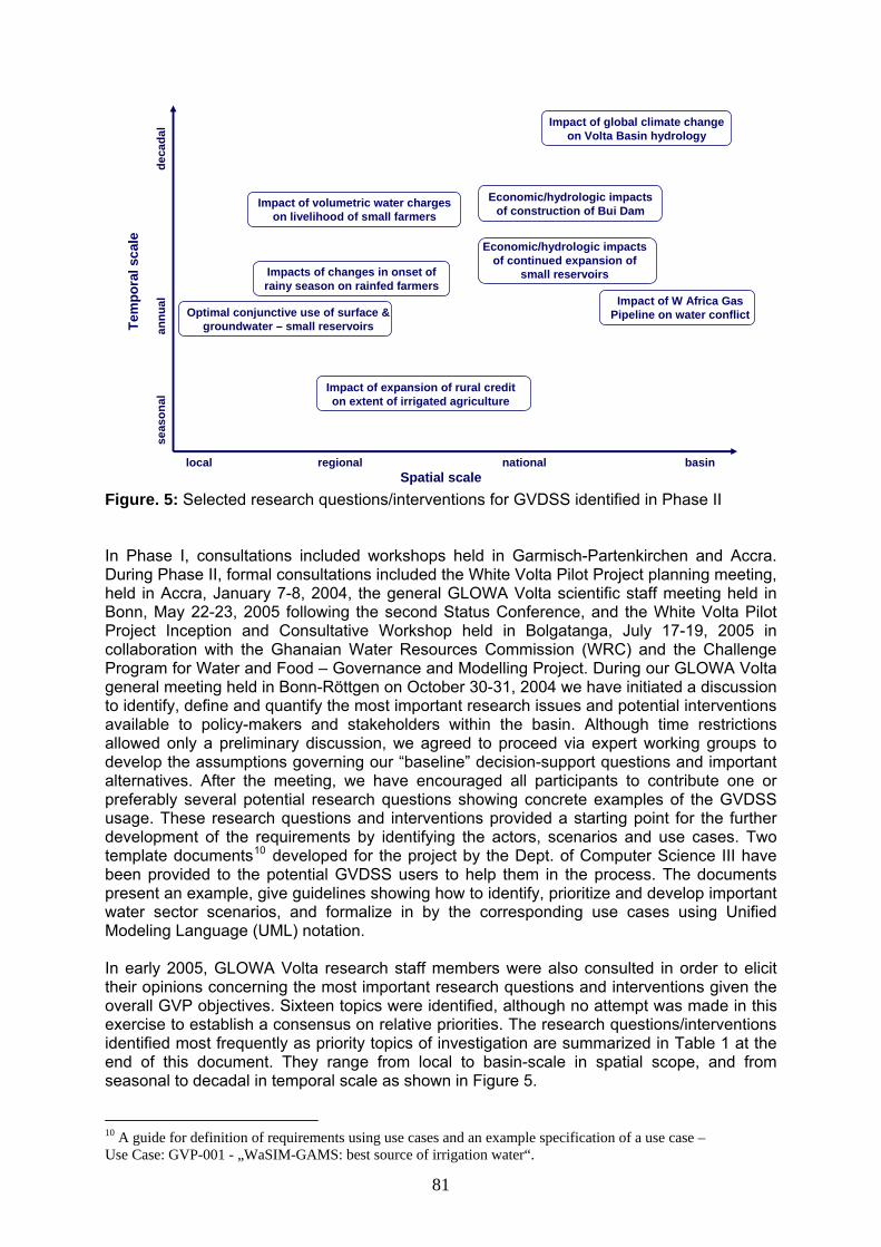
Spatial scalelocal basin
Tem
pora
l sca
le
seas
onal
deca
dal
Optimal conjunctive use of surface & groundwater – small reservoirs
Impacts of changes in onset of rainy season on rainfed farmers
Economic/hydrologic impacts of construction of Bui Dam
Economic/hydrologic impacts of continued expansion of
small reservoirs
Impact of expansion of rural credit on extent of irrigated agriculture
Impact of volumetric water charges on livelihood of small farmers
annu
al
regional national
Impact of global climate change on Volta Basin hydrology
Impact of W Africa Gas Pipeline on water conflict
Figure. 5: Selected research questions/interventions for GVDSS identified in Phase II In Phase I, consultations included workshops held in Garmisch-Partenkirchen and Accra. During Phase II, formal consultations included the White Volta Pilot Project planning meeting, held in Accra, January 7-8, 2004, the general GLOWA Volta scientific staff meeting held in Bonn, May 22-23, 2005 following the second Status Conference, and the White Volta Pilot Project Inception and Consultative Workshop held in Bolgatanga, July 17-19, 2005 in collaboration with the Ghanaian Water Resources Commission (WRC) and the Challenge Program for Water and Food – Governance and Modelling Project. During our GLOWA Volta general meeting held in Bonn-Röttgen on October 30-31, 2004 we have initiated a discussion to identify, define and quantify the most important research issues and potential interventions available to policy-makers and stakeholders within the basin. Although time restrictions allowed only a preliminary discussion, we agreed to proceed via expert working groups to develop the assumptions governing our “baseline” decision-support questions and important alternatives. After the meeting, we have encouraged all participants to contribute one or preferably several potential research questions showing concrete examples of the GVDSS usage. These research questions and interventions provided a starting point for the further development of the requirements by identifying the actors, scenarios and use cases. Two template documents10 developed for the project by the Dept. of Computer Science III have been provided to the potential GVDSS users to help them in the process. The documents present an example, give guidelines showing how to identify, prioritize and develop important water sector scenarios, and formalize in by the corresponding use cases using Unified Modeling Language (UML) notation. In early 2005, GLOWA Volta research staff members were also consulted in order to elicit their opinions concerning the most important research questions and interventions given the overall GVP objectives. Sixteen topics were identified, although no attempt was made in this exercise to establish a consensus on relative priorities. The research questions/interventions identified most frequently as priority topics of investigation are summarized in Table 1 at the end of this document. They range from local to basin-scale in spatial scope, and from seasonal to decadal in temporal scale as shown in Figure 5.
10 A guide for definition of requirements using use cases and an example specification of a use case – Use Case: GVP-001 - „WaSIM-GAMS: best source of irrigation water“.
81

6.1.2 Research Needs Development of the GVDSS in Phase II was performed according to the agile methodology, which is based on the spiral model. The spiral model was first introduced by Barry Boehm in the mid-80s (Boehm, 1986). By now it has matured and is one of the most popular development practices, which has been successfully used in many large industrial projects (Cockburn, 2002). The difference between the spiral model and the traditional waterfall model is that it reduces the scope of all development steps so that during a short time period the development process can go through all the steps – from requirements engineering to the first prototype – before a new iteration is started. There are no distinct phases with clearly defined boundaries between them; the different documents describing the system are not necessarily completed before the next stage of the process begins and there is a lot of feedback between process activities. The advantage of this model is that finishing every full circle produces a working system that can be evaluated. As problems are discovered, they can be taken into account in the next iteration of the development process and lead to a more robust system at the end. According to the spiral model the development activities in Phase II completed one full circle and will be continued by starting the next circle. Therefore, RE will be the first stage of the new circle for GVDSS software development with the next stages in the following I2 and I3 subprojects. In the next phase, the RE has to be continued with the further refinement of the requirements of the GVDSS now taking into account all the experience gained from the first prototype developed in Phase II. This work will result in the extension of the requirements specification and the analysis model for new decision-support questions that were identified in Phase II. Further concretization and formalization of these research questions in the corresponding requirements documents is required. Specific tasks on this stage will include the completion of the requirements specification for new decision-support questions involving GAMS and WaSIM-ETH, and adding new specialized simulation systems available in the public domain as well as those developed within the context of GLOWA Volta, for example MM5 and GVP-LUDAS. The last assumes a tight cooperation with other research groups such as DLR in Würzburg and IMK-IFU in Garmisch-Partenkirchen. 6.1.3 Objectives • Completion of the existing requirements specification for all decision-support questions
involving socio-economic and hydrology simulation systems (GAMS and WaSiM-ETH) • Elicitation of requirements for new decision-support questions involving climate and land
use simulation systems (MM5 and GVP-LUDAS). • Development of the DSS analysis model according to the defined requirements
specification 6.1.4 Methods During the RE process, the GVDSS users and developers (the natural and computer scientists) have to identify a problem area and define a system that addresses the problem. This work encompasses several activities that are necessary for the identification of all GVDSS users, gathering and formalizing all their needs, checking that all their needs are taken into account and ensuring that they understand the implications of the new system (Kokonya & Sommenville, 2004). The Unified Modeling Language (UML) is used as a standard notation to assess requirements (OMG, 2005). The particular activities for the requirements engineering process can be defined as follows. 1. Requirements elicitation and negotiation Requirements elicitation is the usual name given to activities involved in discovering the requirements of the system. The developers (the natural and computer scientists) work with stakeholders and potential GVDSS users to find out about the problem to be solved, the system services, the required performance of the system, hardware constraints, and so on.
82

This does not just include asking people what they want; it requires a careful analysis of the organization, the application domain and business intervention processes where the GVDSS will be used. During this activity, the developers must discover the requirements to the GVDSS system through consultation of stakeholders, from system documents, domain knowledge and different local studies. The results of this activity must later be documented by a requirements specification defining a set of features that the system should have. For example, the system’s functionality, the interaction between the user and the system, the errors that the system can detect and handle, and the environmental conditions in which the system functions are part of the requirements. On this way the requirements specification focuses mainly on the user’s view of the system. The development and prioritization of decision-support questions in Phase II was an essential first step of the RE process that involved input from GLOWA Volta scientific staff in all disciplines and research areas. In the next phase, this collaborative work has to be continued and completed with the delivery of the requirements specification for all essential decision-support questions that are pre-selected for the implementation. Now these questions involve the use of several specialized simulation systems (GAMS, WaSIM-ETH, MM5, GVP-LUDAS) and datasets (land use data provided by DLR in Würzburg, climate data provided by IMK-IFU in Garmisch-Partenkirchen). Several techniques to obtain the requirements have already been used in Phase II. They include such approaches as holding interviews, creating requirements lists, scenarios, prototyping, and use cases. We found that open interviews were very effective for developing an understanding the users’ needs and for eliciting very general system requirements such as research questions. End-users are usually happy to describe their work and the difficulties they face, although they may have unrealistic expectations about the computer support that can be provided (Kokonya & Sommenville, 2004). Since the set of available simulation tools and datasets is now almost complete, closed interviews focusing on the policy interventions related to this set of simulation systems will be preferred in the next phase. The collected requirements will be described in terms of actors, scenarios and use cases. While actors represent external entities that interact with the system, use cases are generalizations of one or more scenarios, which are sequences of actions between an actor and the system for a given piece of functionality. Use cases have proved to be easily understandable by business users, and so have proven an excellent bridge between developers and GVDSS users. Use cases may be excellent for capturing the functional requirements of a system, however, they are not suited to easily capture the non-functional requirements. Non-functional requirements to the system will be documented separately through interviews and requirement lists. In the first project’s phase people find it difficult to visualize how a written statement of requirements will be translated into a software system. Therefore, to simplify this process in the phase II the prototyping technique was used. A prototype is an initial or partial version of the system, which assumes a quick development so that parts of the functionality may be left out. Elicitation prototypes can include only those requirements that are particularly difficult to understand. The principal benefit of developing a prototype during requirements elicitation is that it allows the GVDSS users and the natural scientists to experiment with the software during the development process. With a prototype system to demonstrate requirements that are not yet fully understood, stakeholders found it easier to discover problems and suggest how the requirements may be improved (Figures 8, 9). Therefore, this technique will be continued to use in the next phase also. 2. Requirements analysis and negotiation Requirements analysis and negotiation are processes which are closely linked with requirements elicitation. The goal of these activities is to establish an agreed set of requirements and formalize the analysis model of the GVDSS, which must be correct,
83

complete, consistent, unambiguous and verifiable so that it can be used for system development in the following subprojects I2 and I3. Analysis is different from the requirements elicitation in that developers (natural and computer scientists) focus on further structuring and formalizing the requirements elicited from the GVDSS users. This formalization will lead to new insights and the discovery of errors in the requirements. During this activity, the developers must discover ambiguities and inconsistencies in the requirements specification that they resolve together with the end users and negotiate the requirements that are to be accepted. This process is necessary because there are inevitably conflicts between the requirements from different sources, information may be incomplete or the requirements expressed may be incompatible with the budget available to develop the GVDSS. Prototyping and meetings are the most effective means that will be used to negotiate requirements and resolve requirements conflicts. The planned conflict resolution meetings will be solely concerned with resolving outstanding requirements problems and must be attended by analysts who have discovered requirements conflicts, omissions and overlaps and GVDSS users who can help resolve these problems. The results of this activity must be documented in the GVDSS analysis model that is composed of three individual models: the analysis object model, represented by class and object diagrams, the dynamic model, represented by statechart and sequence diagrams, and the functional model, represented by processes and data flows (Bruegge & Dutoit, 2004). The most important model of the system is the object model, as it will identify all the objects that will make up the system, their properties and their relationships. In other words, the object model is a visual dictionary of the main concepts visible to the user. The object model is depicted with UML class diagrams, it includes classes, attributes, and operations. The dynamic model focuses on the behavior of the system and represents more or less a rough abstraction of what the process will look like and how things might be run together. It reflects the changes to objects and their relationships over time, demonstrating possible control flows through the system. The model is depicted with UML sequence diagrams and statecharts. As a complementary part to the dynamic model concentrating on the logical dependencies among the (simulation) systems within the GVDSS, the functional model focuses on the analysis of data structures, relationships and formats of the data to be used. The functional model will show how the input and output values of particular simulation systems are derived and is therefore very important for understanding their interoperation within the GVDSS. The process of developing the functional model will involve analyzing the kinds of data that will be exchanged among the systems, and the relationships between different data elements within these systems. This activity strives to define data flows showing what actually happens during a process bringing the data structures of interest together in a cohesive, inseparable whole by eliminating unnecessary data redundancies and binding relevant data structures. It does this using UML data flow diagrams. 3. Requirements documentation The gathered, agreed-upon and analyzed requirements have to be documented at the appropriate level of detail by a requirements specification and analysis model, which will serve as a contract between the GVDSS users and the developers (the natural and computer scientists). Here it is important to consider that these requirements documents are understandable by all groups involved in the development of the system. As the most widely approved industry-standard for design and documentation the OMG Unified Modeling Language (UML) is used as a standard modeling language (OMG, 2005). 4. Requirements validation The resulted requirements documents must be carefully checked for their consistency and completeness. This process is intended to detect problems in the documents before they are used as a basis for system development. It makes sense to later use the prototypes
84

developed for requirements elicitation and analysis for validation. Prototypes for validation have to be more complete than elicitation prototypes. They have to include a sufficient number of facilities implemented in an efficient and robust way in order to be of practical use to the end-users. The elicitation prototype developed in Phase II has missing functionality and it is therefore necessary to continue the development of the prototype during the requirements validation process in Phase III. 5. Requirements management The process of requirements management is concerned with managing changes to the requirements. Changing requirements is inevitable as business priorities change, as errors or omissions in the requirements are discovered and as new requirements emerge. This activity is intended to keep track of these changes and ensure that changes are made to the requirements documents in a controlled way. In practice, according to the spiral model selected for the development in Phase II, the activities are interleaved and there is a great deal of interaction and feedback from one activity to another (Cockburn, 2002). All activities are repeated until a decision is made that the requirements documents are to be accepted. If a draft of the requirements document is found to have problems, the elicitation, analysis, documentation, validation spiral is re-entered. This continues until an acceptable document is produced or until external factors such as schedule or lack of resources force the requirements engineering process to end. The final requirements documents must then be produced. Any further changes to the requirements are then part of the requirements management process. 6.1.5 Milestones • Completion of the elicitation and preparing the requirements specification for all decision-
support questions involving socio-economic and hydrology simulation systems (GAMS and WaSIM-ETH)
• Development of the analysis model for requirements specification involving economic and hydrology simulation systems (GAMS and WaSiM-ETH)
• Elicitation of requirements for new decision-support questions involving climate and land use simulation systems (MM5 and GVP-LUDAS)
• Extension of the analysis model for requirements specification involving climate and land use simulation systems (MM5 and GVP-LUDAS)
• Requirements management • Requirements validation 6.2 Subproject I2. GVDSS Infrastructure Decision making for water resource management in the Volta Basin is a complex task requiring an integrated analysis of numerous physical and socio-economic determinants of the hydrological cycle. A scientifically sound DSS to be developed in the project will assist the water management authorities in selecting the most efficient strategies for water use. In order to be able to perform scientifically sound simulations of physical processes, the GVDSS has to integrate several scientific simulation systems and data sources. Additionally, it has to provide decision makers with interactive analytical tools enabling them to define, simulate and evaluate different policy interventions.
The integration of the GLOWA Volta resources within a DSS is further complicated by the fact that data sources and simulation systems are heterogeneous and highly distributed across institutional and national boundaries. The straightforward solution addressing this issue where all the distributed resources are centralized into one single location is not realistic in the context of this project. Firstly, many data sources are managed by their responsible organizations and may not be moved to any other location, and secondly, some simulation systems (for example, for climate modeling) need large computational and storage capabilities that cannot be easily provided within a centralized DSS. Therefore, in subproject
85

I2 we concentrate on the development of the GVDSS infrastructure that links heterogeneous distributed resources using modern integration technologies to satisfy the requirements defined in subproject I1.
6.2.1 Progress to date In Phase II, approaches for integration of few particular simulation systems were investigated. As a result, the prototype “High VOLTAge” integrating the simulation systems WaSIM and GAMS was developed (Rodgers et al., 2005). Only intended to serve as a first proof-of-concept, the prototype allowed us to evaluate the integration method and practically learn how we can run and control the models, configure and handle their input and output data, which followed to further refinements in the original requirements. The prototype has demonstrated the advantages of the COmponent-Based Integration of Data and Services (COBIDS) integration method for a “loose coupling” developed at the Dept. of Computer Science III (Bode et al., 2004) for integrating heterogeneous simulation systems in GLOWA Volta (Shumilov & Erdenberger, 2005). The method enabled us to connect individual simulation systems by keeping the original systems unchanged, thus retaining as much flexibility as possible. This experience will help us to continue the development of the GVDSS in the next phase. An initial activity to prepare for the transfer of technology developed in the project was already undertaken in Ghana. This activity is called “High Performance Computing Applications in Regional Climate Modelling: An inter-comparison study of the performance of Linux clusters” and focused on the upgrade and reinstallation of a Linux cluster, installation of climate modeling software and the establishment of a local “West African-based” cluster facility user group. Within this activity, the installation of the Mandrake Linux Limited Edition 2005 distribution on an NFS fileserver and computational nodes was undertaken. Optimized versions of mathematical libraries such as BLAS, LAPAK and ATLAS were installed on the master node. Two main state-of-the-art regional climate models 1) RegCM3 developed/maintained at ICTP and 2) MM5 were installed and finally the master node was connected to the internet to make it accessible via SSH login and to perform cluster performance monitoring via the GANGLIA web interface. To enable the design of complex experiments for the calibration and validation of GVDSS component models, the highly efficient nonlinear Parameter Estimation Tool (PEST) was also installed. This provides us with a suite of basic software tools necessary for state-of-the-art regional climate and environmental modeling research in the next phase. 6.2.2 Research Needs During Phase III, the research activities will focus on the development of a common distributed infrastructure, which will be able to integrate the simulation systems and data sources required for the GVDSS. The infrastructure should virtualize heterogeneous distributed resources – that is, abstract resources connected to a network from their physical instantiations – and present these resources to GVDSS clients as services. This virtualization can be archived by means of different modern networking technologies. Grid technology is the most powerful and promising one for developing infrastructures where flexible, secure, coordinated resource sharing among dynamic collections of individuals, institutions, and resources is required (Foster, et al., 2001). Therefore, the central research topic of this subproject in Phase III is the development of the GVDSS infrastructure by utilizing, adapting and extending available middleware technologies. This includes many specific conceptual and technical problems to be solved, which deal with establishing and adapting the core Grid-based infrastructure for GLOWA Volta data sources and simulation systems, developing new Grid services, providing coordinated execution of distributed workflows, etc. One of these problems is efficient transformation of data exchanged between simulation systems in the distributed Grid environment. We believe we can solve this problem by using the COBIDS integration method that was already evaluated in Phase II. The existing COBIDS integration framework relying
86

on mediators (Wiederhold, 1997) for automatic data conversion must be extended and integrated into the Grid-based infrastructure. 6.2.3 Objectives The primary objective of subproject I2 is to develop an open Grid-based DSS infrastructure that will be capable to integrate distributed heterogeneous simulation systems and data sources as specified in subproject I1. The specific objectives in the third phase are: • To create an architecture of the Grid-based infrastructure defining a common distributed
execution environment for heterogeneous simulation systems and data services involved in the GVP
• To develop a decentralized workflow engine for executing complex tasks in the DSS infrastructure representing decision-making scenarios as defined in subproject I1
• To explore open-source frameworks for building Grid applications and examine their suitability for the developed architecture and requirements formulated in subproject I1
• To implement the core infrastructure services based on the selected Grid application development framework
• To extend the core infrastructure with workflow execution services realizing the proposed decentralized model
• To develop specific Grid services for GLOWA Volta simulation systems (GAMS, WaSIM, MM5) taking into account that these systems run at different time scales
6.2.4 Methods From the GVDSS viewpoint, the GLOWA Volta community can be considered as a distributed virtual organization (VO) (Foster et al., 2001) that unites individuals and institutions involved in the project in a dynamic environment where participants can share and access available resources regardless of their locations and solve decision support problems of common interest. The backbone of the GLOWA Volta VO is the Grid-based GVDSS infrastructure. To serve this purpose the architecture of the DSS infrastructure has to include three primary kinds of components: distributed Grid resources, global services and Grid clients. Figure 6 shows the architecture and all components of the infrastructure. Grid resources are represented by special Grid services providing access to the GLOWA Volta data sources and simulation systems. The main part of such Grid services are so-called Local Services (LS) that are controlling and connecting local Grid-unaware resources with the Grid. The Global Grid services are placed in a separate group, because they provide “global” functionality for all other Grid services. Thus, the Mediator service supports automatic discovery, composition and storage for mediators used for data conversions by the LSs, the Catalog service manages meta-information about available Grid resources and makes it possible to locate them. The refinement of the requirements being performed in subproject I1 may result in the need for some additional global services. The third kind of components in Figure 6 are Grid client interfaces, which enable the interaction of GVDSS users with Grid services. The development of Grid clients is the main topic of subproject I3 “DSS Workbench”. In the development of the Grid-based GVDSS infrastructure, we will strive to use well-proven standards and frameworks in order to speed up the development process and make the infrastructure open, easily extensible, and maintainable. Therefore, we are going to realize the conceptual architecture of our GVDSS infrastructure based on the Open Grid Services Architecture (OGSA), a widely accepted conceptual foundation for building Grid applications (Foster, et al., 2005). OGSA addresses core capabilities and behaviors to be provided in Grid environments and relies on existing Web Services standards, such as SOAP, XML, and WS-Security. According to OGSA, Grid services are extensions of Web Services that expose a set of well-defined interfaces and that follow particular conventions for the sharing of resources. Based on the OGSA service taxonomy (Minoli, 2005), we categorize the Grid
87

services to be supported in the infrastructure into three main groups: core services, execution management services, and data services. The OGSA core services are intended to establish a secure foundation for service management and communication in a Grid environment. Service management includes functions to provision, deploy, maintain, discover and access the Grid components. Service communication implies support for several communication models that may be composed to enable effective inter-service communication, including queued messages, publish–subscribe event notification, and reliable distributed logging. The functionality of core services is quite common for most Grid systems. Therefore, we assume that the existing toolkits for building Grid systems can be successfully used to facilitate the development of the GLOWA Volta core Grid services. There is a number of freely available software solutions (e.g., Globus Toolkit, UNICORE, Legion, Gridbus) (Asadzadeh et al., 2005) that will have to be evaluated. Most probably, we will prefer a platform based on the Globus Toolkit (Globus Alliance, 2005) that is the de facto standard for developing Grid software.
Land Use
DLR, WürzburgClimate
IMK-IFU, Garmisch-Partenkirchen
MM5
Internet
LS
Land UseData Service
LS
EconomyZEF, Bonn or Ghana
HydroZEF, Bonn or Ghana
WaSIM
LS
GAMS
LS
Distributed Resources
1 week
1 min 1 hour
CatalogService
Bonn
MediatorsService
Bonn
Grid Local Resource Management Services (GRAM, MDS, …)
ClientInterface 2
Ghana
ClientInterface 1
Bonn
Distributed Clients
Grid Global Services
Figure 6: Grid-based Architecture of the GVDSS The OGSA execution management services (EMS) address problems with executing units of work (jobs), including their placement, provisioning, and lifetime management (Foster, et al., 2005). In the GVDSS infrastructure, the major requirement to EMS is efficient support for scheduling and execution of complex multi-unit tasks representing decision-making scenarios. The way of representing these tasks within a Grid context must be, on the one hand, intuitive and easy-to-use for DSS users, and on the other, powerful and flexible enough to orchestrate heterogeneous distributed Grid resources required for decision- support. We believe that Grid workflow technology is able to fulfill all these requirements. For GVDSS users, it has to offer a means of constructing decision-making scenarios just by connecting together various Grid data and simulation services in an intuitive manner and without any special knowledge about the underlying infrastructure. For the infrastructure, workflow-driven job management enables advanced coordination and integration of Grid services and control of data transfer in the Grid.
88

The workflow management mechanism to be developed for the DSS infrastructure is intended to work in a distributed, data-intensive Grid environment. We expect the need for effective data transfer in the infrastructure due to the fact that particular simulation systems manage large amounts of data and will therefore produce quite intensive data exchange during decision-making scenarios. In such data-intensive Grid environments, fully centralized workflow management has serious drawbacks. By making scheduling decisions for all tasks in the workflow, the central scheduler is also the single data exchange point for the cooperating Grid services and it may become a severe performance bottleneck for the whole system. This problem concerns two elements of the workflow management mechanism: scheduling architecture and data movement. The analysis of the taxonomy of Grid workflow systems presented in (Yu & Buyya, 2005) has shown promising alternatives to centralized solutions for these two elements. They have to be evaluated and the engine for decentralized execution of workflows most suitable to the project needs has to be found. Together with the COBIDS mediator facilities for local data transformations adapted to the Grid, this engine will be able to support direct data exchange between Grid services and should solve the bottleneck problem. Figure 7 illustrates the application of this approach to the Grid infrastructure with the WaSiM and GAMS simulation services. According to this approach, Grid clients as well as Grid simulation services possess their own local workflow execution services (WES). Each local WES processes a part of a workflow definition until the point where interaction with another service is needed. Then data or a request for data along with the rest of the workflow description is sent to the required Grid service. This service also has its own local WES, which continues to process the workflow. At the last step of a correctly defined workflow, result data should be returned to the Grid client which has initiated the execution of this workflow. The realization of required decentralized workflow management for our DSS infrastructure cannot be properly facilitated by the Globus Toolkit that will probably be used for the standard OGSA core services. The Globus Toolkit includes the Grid Resource Allocation and Management (GRAM) service, which allows to locate, submit, monitor, and cancel jobs on Grid computing resources. However, providing a uniform, flexible interface to job scheduling systems, GRAM does not target any special approach to workflow management. Based on the Grid workflow system survey done in (Yu & Buyya, 2005), we have selected an open source project called Triana (Taylor, et al., 2003) which supports decentralized workflow management. The Triana system is developed on top of the GridLab Grid Application Toolkit (GAT) (Allen et al., 2003), which is designed to be a common interface to different types of grid middleware. Therefore, we assume that the combination of Globus Toolkit and Triana solutions is very promising.
Grid ClientSimulation Service
Workflow Execution Service
WaSIM
Simulation Service
Workflow Execution Service
GAMS
Mediator Management
Workflow ExecutionService
Mediator Management
MediatorService
CatalogService
Grid Global Services
Grid ClientSimulation Service
Workflow Execution Service
WaSIM
Simulation Service
Workflow Execution Service
GAMS
Mediator Management
Workflow ExecutionService
Mediator Management
MediatorService
CatalogService
Grid Global Services
Figure 7: Decentralized workflow execution
89

We are going to integrate the GLOWA Volta data sources and simulation systems in the GVDSS Grid infrastructure with the help of the Local Services (LS). A complicating factor here is that the simulation systems rely on computational models having quite different running times from the order of minutes (for the GAMS model) to the order of weeks (for the MM5 model). The integration of these systems into the OGSA-based infrastructure demands the construction of special LSs, which encapsulate access to the simulation systems and make the response times acceptable for the interactive decision-making process. Existing caching strategies or some other special disconnecting mechanisms have to be studied and an approach suitable to our needs has to be developed. For example, the LS must alleviate the interaction problem between the fast GAMS, the quite slow WaSIM and the really time-consuming MM5 Grid services. This subproject will furthermore continue the activities that are required in order to transfer the GVDSS to our Ghanaian and Burkinabé partners, including preparation of the distributed computing environment required for the GVDSS and installation and validation of the GVDSS functionality in Ghana. Currently, several experiments are on-going to enable us to benchmark and improve the performance of the cluster that was established. More important is the participation of the subproject in the local activities for training, providing IT consulting and advisory services to the KACE, and the UNU in Accra. Further activities are planned on capacity development for users, policy-makers and other stakeholders in the Volta Basin. This capacity development program will be co-organized by the UNU (Ghana), ZEF (Bonn), Institute of Mathematical Sciences (Ghana) and other local counterparts in Ghana and Burkina Faso. Some general aims of these activities are to:
1. Identify effective ways of putting computational facilities in the South to state-of-the-art computational research,
2. Identify limitations/bottlenecks in the use of computational facilities in the South 3. Technology Transfer in Computational Science and IT to scientists in the South
through organization of capacity development programs and academic exchange 4. Promote South-South cooperation by inviting scientists from the region to brainstorm
on possible problems and design possible solutions 6.2.5 Milestones • Design of the architecture of the GVDSS Grid infrastructure • Evaluation of existing software frameworks facilitating the realization of the “low-level”,
core functionality for the Grid infrastructure • Evaluation of existing workflow management systems facilitating distributed workflow
execution • Adaptation of the COBIDS mediator framework to the Grid infrastructure and
implementation of global core Grid services (Mediator Service, Catalog Service) on top of the selected software framework
• Adaptation of the selected workflow management system to the Grid infrastructure and integration with the COBIDS data transformation facilities
• Development of the specific local services (LS) enabling access to the Grid infrastructure and solving the time-scale problems for GLOWA Volta data sources and simulation services
• Test and evaluation of the DSS infrastructure on the most common decision-making scenarios
• Preparation of the required distributed computing environment, IT consulting and advisory services to the KACE, and the UNU in Accra
• Transfer of the DSS to Ghana, installation and validation of the DSS functionality
90

6.3 Subproject I3. GVDSS Workbench. The GVDSS will be the result of a collaboration of various research groups and represents a complex simulation system being composed of several applications and data models. Regarding the interdisciplinary character of the project, we particularly expect heterogeneous user groups to run the GVDSS, such as stakeholders and scientists of diverse areas of research. In this context, various user requirements and different technical skills of individual user groups as identified in subproject I1 have to be taken into account when designing and realizing interfaces as well as means for interaction with the GVDSS. Extensive dialogues between potential GVDSS user groups and natural, socio-economic and computer scientists resulted in a detailed requirements specification, collecting and documenting functional and non-functional requirements to be met by the GVDSS. Thus, relevant scientific decision-support questions were identified and then formalized via use cases. Considering the specified user needs we propose in subproject I2 a Grid-based infrastructure in order to combine the needed distributed heterogeneous simulation systems and data sources. As a consequence, GVDSS tasks will be processed within the Grid-based infrastructure and hence need to be mapped on the Grid for execution. Regarding the GVDSS usage this implies detailed knowledge in computer science. With the objective of overcoming these difficulties and enabling non-expert users an intuitive way to formulate, pose and analyze decision-support questions, we focus on modeling and developing adequate means to interact with the GVDSS infrastructure in subproject I3. In the end, we intend to integrate all resulting components into a uniform GVDSS workbench, incorporating the functionalities requested by stakeholders and scientists as investigated within subproject I1. 6.3.1 Progress to date Within Phase II we designed and realized the prototypical implementation “High VOLTAge” (compare “progress to date” in I2). This prototype combines an interface for the composition of decision support workflows as well as an interface for visualization and analysis of multi-disciplinary data. The former interface is intended for controlling the linkage between the particular simulation systems used for the GVDSS. As an example Figure 8 shows the linkage of the hydrological and socio-economic water optimization models, involving the results from the WaSIM run passed on to the economic water optimization model GAMS, which then uses these WaSIM results as input data in solving the model. The second interface provides a GIS-like visualization facility for spatial data (such as river networks or land covers) that can be overlaid with results of the integrated model run. Furthermore, statistical data (reservoir storage, demographic information, etc) associated with locations on the map can be displayed in diagrams. Figure 9 illustrates an example of a geographic map with projected water flow directions and additional diagrams with demographic and statistical data showing precipitation and river runoff.
Figure 8: Prototype of the interface for composition of decision support workflows
91

Figure 9: Prototype of the interface for visualization and analysis of multi-disciplinary data 6.3.2 Research Needs During Phase II we have identified a series of user-demands and interface-specific functionalities to be met by the GVDSS. We plan to fulfil these requirements by developing a unified GVDSS workbench being comprised of three principal constituents. First, we aim at realizing an easy to use workflow composition and execution system for complex tasks to be processed within the underlying Grid-based infrastructure. This tool is strongly needed by scientists to define coupled applications composed of several simulation systems and multi-disciplinary as well as distributed datasets. To prevent redundant workflow specifications the composition system should also provide adequate means to define, edit, and save workflows, so that workflows can be predefined for future execution. A common GVDSS interaction interface for stakeholders regarding the demands investigated by subproject I1 represents the second main component within the DSS workbench. In this context the essential user requirement is a convenient handling of the GVDSS. This particularly comprises abstracting away scientific and technical details and offering an intuitive possibility to execute DSS-tasks. Technically, we therefore aim at preparing a collection of predefined workflows along with an easy to use graphical interface for stakeholders. Besides the definition and execution of workflows, the analysis and visualization of datasets is a crucial subject for both scientists and stakeholders. The specific challenge in the GVDSS context lies in the unified visualization of multi-disciplinary datasets. The prototype developed in Phase II represents a promising first step but is far from being functionally sufficient, thus requiring further research. In the end, the three main components are planned to be merged into a single workbench that is integrated with the overall GVDSS Grid-based infrastructure as a Grid client. Concerning the implementation of the workbench as a whole, we mainly aim at integrating existing solutions, customizing them where necessary and thus avoid building novel components from scratch wherever possible. Beside the actual realization of the workbench, considerable efforts have to be undertaken in exploring and where necessary adapting and extending adequate concepts and techniques. Regarding the limited personal resources, we particularly expect the resulting workbench to be more of research character than meeting commercial system requirements.
92

6.3.3 Objectives The primary objective of subproject I3 is the development and implementation of a Grid-aware GVDSS workbench that meets the miscellaneous requirements and technical prerequisites of the heterogeneous user groups involved in the GVP. We expect this main aim to induce the following subtasks: • Building up a workflow composition system based on existing solutions, tailored and
customized where necessary. • The design and realization of a unified GVDSS-interface based on predefined abstract
workflows and capable of interactive workflow execution within the Grid-based architecture.
• To develop custom-tailored visualization and analysis tools for complex multi-disciplinary simulation data.
• Integrating all implemented tools and interfaces into a single GVDSS-workbench and incorporate it as a Grid client into the overall DSS infrastructure.
6.3.4 Methods The main functionality of the GVDSS workbench will be the user-driven, where required interactive execution of more or less complex tasks or rather workflows within the GVDSS Grid-based infrastructure. Workflows are specified by the underlying workflow model, including a task definition and a structure definition. In the literature, two types of workflow models are differentiated, namely the abstract model and the concrete model. They are also called abstract and concrete workflows (Deelman et al., 2004). In some works such as (Ludäscher et al., 2003), the concrete model is also referred to as executable workflows. To provide GVDSS users with a common and intuitive way to define complex executions of coupled applications within the GLOWA Volta Grid infrastructure, we intend the usage of abstract workflow specifications. The abstract workflow model enables the description of workflows in a high-level form in which the workflow is specified without referring to the specific Grid recourses for task execution, as is the case with concrete workflows. Thus, GVDSS users will be able to define workflows without being concerned about low-level implementation details. Abstracting away the resource descriptions allows workflows to be portable as they are mapped onto any suitable Grid services at run-time by applying suitable discovery and mapping mechanisms. This especially eases the sharing of workflow descriptions between GVDSS users and allows providing predefined workflows for common GVDSS-tasks. In particular the participants of the GLOWA Volta VO not being familiar with single components and technical details will benefit from this functionality (Foster et al., 2001). We particularly expect predefined workflows to play a decisive role in realizing a user-friendly interface for stakeholders, as scientific and technical details are hidden and thus the triggering of complex executions within the GVDSS is exceedingly facilitated. Specifying abstract workflows implies the existence of a suitable workflow composition system enabling users to assemble components into the workflow and providing a high-level view for the construction of DSS workflow applications. Within language-based modelling, workflows are expressed using a markup language such as XML (e.g. GridAnt (Von Laszewski et al., 2004), XLANG (Thatte, 2001), and BPEL4WS (Andrews et al., 2003)) or alternative formats (e.g. Condor DAGman (DAGMan, 2004)). Regarding the fact that many non-expert users will run the GVDSS we plan to use a Graph-based workflow composition system, which allows graphical definition of arbitrary workflows through a few basic graph elements (Hoheisel, 2004). Thus, even users without detailed skills in computer science can easily compose and review complex workflows by just dragging and dropping the components of interest. The hiding of low-level details enables users to focus on higher levels of abstraction at application level and offers scientists not being familiar with technical details an intuitive way to specify complex tasks within the DSS. Rather than inventing a workflow composition system from scratch, we attempt to base our implementation on
93

existing and already established solutions, such as Taverna (Oinn et al., 2004), Triana (Taylor et al., 2003), and Kepler (Altintas et al., 2005) and propose extensions where appropriate. Concerning the workflow structure and patterns respectively, the requirements of various user-groups have to be taken into account. In subproject I1 we identified needs for sequences, parallelism, choice, and iteration structures. With these four types of workflow structures we expect all relevant workflows within the DSS to be expressible. As a result, we intend to base the workflow composition system on Non-DAG-based workflows (Mayer et al., 2003). Although further approaches still need to be examined, we currently plan to use Petri-net-based workflow nets (Guan et al., 2004). Petri-nets are a special class of directed graphs that can model sequential, parallel, repeated and conditional execution of tasks. They have been used in many workflow composition systems (e.g. Grid-Flow (Guan et al., 2004), Flow Manager (Lerina et al., 2002), and XLR/Flower (Verbeek et al., 2002)) and offer only a few basic graph elements and allow a graphical orchestration of complex workflows by just connecting data and software components. Mapping the abstract workflow description to an executable form involves finding adequate resources that are available and can perform the computations and provide the data and software that is used in the workflow. We plan to build this coordination and execution service on top of low-level Grid middleware, probably the Globus Toolkit (Globus Alliance, 2005), through which services provided by Grid resources are invoked. A detailed description of the corresponding workflow environment and all further technical particulars regarding the integration of the workbench with the DSS infrastructure as a Grid client are provided in subproject I2. In addition to the common client interface for the definition and execution of decision-support workflows, both a GVDSS interface for stakeholders and a specialized service for visualization and analysis of data for stakeholders and scientists is strongly needed. The service should provide a GIS-like visualization facility for the multi-disciplinary data used by the simulation systems within the infrastructure. Good data visualization eases the interpretation of the simulation results, as well as it helps GVDSS users to better understand their needs. Many data exploratory analysis tasks are significantly facilitated by the ability to see data in an appropriate visual presentation. There are many visualization ideas and proposals for effective graphical data presentation. For our purpose the main task will be evaluating and customizing existing systems. Here we made first experiences during Phase II with GeoTools (GeoTools, 2005) and ArcGIS (ESRI, 2005). However, there is still much research to accomplish in order to obtain good visualization tools for complex multi-disciplinary datasets that can be used to display and manipulate the data in the specific context of the GVDSS. Regarding the standard GUI for stakeholders we are confronted with the task of abstracting from scientific and technical details and at the same time meeting functional requirements as investigated in subproject I1. We therefore first plan to realize several pre-selected GVDSS tasks according to already specified use-cases, thus offering stakeholders an intuitive and high-level method to execute GVDSS-tasks. In a following phase we then intend to tune predefined tasks to the needs of stakeholders and to guarantee the suitability of the interface. For this purpose, activities toward verification and tuning of the interface as well as assessing user needs through further negotiations with stakeholders are required and have to take place locally and in close contact with stakeholders. The major issues related to the user-interface and the visualization as well as analysis tools are "screen real-estate", information rendering, and interaction. Interactive use of the data and simulation results is crucial since it provides a means for the DSS user to focus on and refine the decision-support tasks, as well as to view the discovered knowledge from different angles and at different conceptual levels. During Phase II we have already produced a light-
94

weight prototype of the visualization service, development will be continued in the third phase. Thereby we intend to continue following the approach of integrating existing, possibly customized visualization tools and libraries instead of developing our own visualization tools. The resulting GVDSS workbench - just like the GVDSS as a whole - will finally be tailored to the specific demands of expected user-groups and represents rather a research implementation than a system satisfying commercial claims. 6.3.5 Milestones
• Analysis of existing graph-based workflow composition systems and adaptation of the selected system to the GVDSS infrastructure and client
• Building a collection of workflows according to the set of use-cases defined in subproject I1
• Integration of existing GIS-like visualization and analysis facilities for multi-disciplinary data with the GVDSS client
• Implementation of the common GVDSS user-interface for stakeholders and scientists • Testing, validation and finalizing of the GVDSS client
95

Table 1: Summary of priority Use Cases
96

7. References AGYARE, W. A. (2004): Soil characterization and modeling of spatial distribution of
saturated hydraulic conductivity at two sites in the Volta Basin of Ghana. Ecology and development series, No. 17. Göttingen
ALBINP.S. (1998): Barriers and bounds to rationality: essays on economic complexity and dynamics in interactive systems. Princeton
AL-FUTAISI, A., STEDINGER, J.R. (1999): Hydrologic and Economic Uncertainties and Flood-Risk Project Design. Journal of Water Resources Planning and Management 125 (6). Austin, Texas
ALLAN, T. (2003): IWRM/IWRAM: a new Sanctioned discourse? SOAS: 27. London ALLEN, G., DAVIS, K., DOLKAS, K. N., DOULAMIS, N. D., GOODALE, T., KIELMANN,
T., MERZKY, A., NABRZYSKI, J., PUKACKI, J., RADKE, T., RUSSELL, M., SEIDEL, E., SHALF, J., TAYLOR, I. (2003): Enabling Applications on the Grid: A GridLab Overview. International Journal of High Performance Computing Applications: Special issue on Grid Computing: Infrastructure and Applications, 17 (4). London
ALLEN, R., MORSE, G. A., TASUMI, M. (2003): Application of SEBAL for Western US Water Rights Regulation and Planning. In: Proceedings of the International Workshop on Use of Remote Sensing of Crop Evapotranspiration for Large Regions. 54th IEC Meeting of the International Commission on Irrigation and Drainage (ICID), Montpellier
ALLEN, R., TASUMI, M., TREZZA, R. (2005): M E T R I Ctm Mapping Evapotranspiration at High Resolution. Applications Manual for Landsat Satellite Imagery. Version 2.0. Kimberly, ID
ALTINTAS, I., BIRNBAUM, A., BALDRIDGE, K., SUDHOLLT, W., MILLER, M., AMOREIRA, C., PORTIER, Y., LUDAESCHER, B. (2005): A Framework for the Design and Reuse of Grid Workflows. Scientific Applications of Grid Computing: First International Workshop, SAG 2004, Beijing, China, September 20-24. Heidelberg
AMISIGO, B. A., VAN DE GIESEN, N. (2005): Using a spatio-temporal dynamic state-space model with the EM algorithm to patch gaps in daily riverflow series, with examples from the Volta Basin, West Africa. Hydrology and Earth System Sciences Discussions, 2.
ANDREINI, M., VAN DE GIESEN, N., VAN EDIG, A., FOSU, M., ANDAH, W. (2000): Volta Basin Water Balance. ZEF-Discussion Papers on Development Policy 21. Bonn
ANDREWS, T., CURBERA, F., DHOLAKIA, H., GOLAND, Y., KLEIN, J., LEYMANN, F., LIU, K., ROLLER, D., SMITH, D., THATTE, S., TRICKOVIC, I., WEERAWARANA, S. (2003): Business Process Execution Language for Web Services, Version 1.1. Specification, BEA Systems, IBM Corp., Microsoft Corp., SAP AG, Siebel Systems
ASADZADEH, P., BUYYA, R., KEI, C. L., NAYAR, D., VENUGOPAL, S. (2005): Global Grids and Software Toolkits: A Study of Four Grid Middleware Technologies. In: Yang, L., Guo, M. (Eds.): High Performance Computing: Paradigm and Infrastructure. NJ
AZARYA, V., CHAZAN, N. (1998): Disengagement from the State in Africa: Reflections on the Experience of Ghana and Guinea. In: Lewis, P. (Ed.): Dilemmas of Development and Change. Boulder
97

BARBIER, E. B. (2003): Upstream Dams and Downstream Water Allocation: The Case of the Hadejia-Jama’are Floodplain, Northern Nigeria. Water Resources Research 39 (11). Washington, D.C.
BARTH, M., HENNICKER, R., KRAUS, A., LUDWIG, M. (2005): DANUBIA: An Integrative Simulation System for Global Change Research in the Upper Danube Basin. Institute for Informatics, Ludwig-Maximilians-Universität. München
BASTIAANSSEN, W. G. M., AHMAD, M.-D., CHEMIN, Y. (2002): Satellite surveillance of evaporative depletion across the Indus Basin. Water Resources Research 38
BASTIAANSSEN, W. G. M., NOORDMAN, E. J. M., PELGRUM, H., DAVIDS, G., THORESON, B. P., ALLENR. G. (2005): SEBAL model with remotely sensed data to improve water-resources management under actual field conditions. Journal of Irrigation and Drainage Engineering, 131
BEVEN, K.J. (1995): Linking parameters across scales: Subgrid parameterizations and scale dependent hydrological models. In: Kalma, J.D., Sivapalan, M. (Eds.): Scale Issues in Hydrological Modeling. Wiley, Chichester
BODE, T., CREMERS, A. B., RADETZKI, U., SHUMILOV, S. (2004): COBIDS: A Component-Based Framework for Sharing Standardized and Non-Standardized Geo-Services. In: Proc. of the 18th International Conference Informatics for Environmental Protection, October 21-23. Geneva
BOEHM, B. (1986): "A Spiral Model of Software Development and Enhancement". ACM SIGSOFT Software Engineering Notes. New York
BOWEN, B., SPARROW, F. T., (2001): Ghana’s Electricity Long-term Capacity Expansion Plans and its Role in the Proposed West African Power Pool. USAID Project Report. Washington D.C.
BRAIMOH, A.K. (2004): Modeling land-use change in the Volta Basin of Ghana. Ecology and Development Series No. 14, Göttigen
BRANS, E.H.P., DE HAAN, E. J. NOLLKAEMPER, A., RINZEMA, J. (1997): The Scarcity of Water, Emerging Legal and Policy Responses. London
BROOKE, A., KENDRICK, D., MEERAUS, A., RAMAN, R. (1998): GAMS: A User’s Guide. GAMS Development Corp. Washington, D.C.
BRUEGGE, B., DUTOIT, A.H. (2004): Object-Oriented Software Engineering. Using UML, Patterns, and Java. 2nd edition, Prentice Hall, Upper Saddle River, NJ
CAI, X., MCKINNEY, D. C., LASDON, L. (2003): “An Integrated Hydrologic-Agronomic-Economic Model for River Basin Management.” Journal of Water Resources Planning and Management, 121 (9). Austin, TX
CAI, X., MCKINNEY, D. C., LASDON, L. (2003): A Framework for Sustainability Analysis in Water Resources Management and Application to the Syr Darya Basin. Water Resources Research 38 (6). Washington, D.C.
CAI, X., ROSEGRANT, M. (2004): Optional Water Development Strategies for the Yellow River Basin: Balancing Agricultural and Ecological Water Demands. Water Resources Research 40 (8). Washington, D.C.
CHAMBERS, R. G. (1988): Applied Production Analysis – The Dual Approach. Cambridge
COCKBURN, A. (2002): Agile Software Development. Amsterdam COLDITZ, R.R., CONRAD, C., RÜCKER, G.R., SCHWEITZER, C., FISTRIC, S.,
SCHMIDT, M., DECH, S.W., (2005): Ableitung von phänologischen Verlaufsmustern aus MODIS-Zeitserien und Möglichkeiten der Anwendung. In: Strobl, J., Blaschke T., Griesebner, G. (Eds.): AGIT. Beiträge zum AGIT-Symposium Salzburg '05. Salzburg
98

COSTA, M., FOLEY, J. A. (2000): Combined effects of deforestation and doubled atmospheric CO2 concentrations on the climate of Amazonia. Journal of Climate 13 (1). Boston, MA
CROOK, R. C., MANOR, J. (1998): Democracy and Decentralisation in South Asia and West Africa: Participation, Accountability, and Performance. Cambridge, New York
CURTIN, F. (2000): Transboundary Impacts of Dams: Conflict Prevention Strategies. Discussion Note prepared for the World Commission on Dams by Green Cross International. Geneva
DAGMAN APPLICATION (2004): http://www.cs.wisc.edu/condor/dagman DEELMAN, E., BLYTHE, J., GIL, Y., KESSELMAN, C., MEHTA, G., PATIL, S., SU, M.
H., VAHI, K., LIVNY, M. (2004): Pegasus: Mapping Scientific Workflow onto the Grid. Across Grids Conference, Nicosia, Cyprus
DEFRIES, R. S., TOWNSHEND J. R. G. (1994): NDVI derived land cover classifications at a global scale. International Journal of Remote Sensing, 15. Abingdon
DEYBE, D. (1998): Can agricultural sector models be a tool for policy analysis? An application for the case of Burkina Faso. Agricultural Systems 58 (3). Oxford
DEYBE, D., CASTELLA, J.-C. (1999): Is trade liberalisation the right policy after a devaluation? The case of Burkina Faso. In: Tisdell, C. A., Dragun A.K (Eds.): Sustainable agriculture and environment. Globalisation and the impact of trade liberalisation. Cheltenham
D-GRID-INITIATIVE (2005): Supported by the German Ministry for Education and Research (BMBF). Source: http://www.d-grid.de
DOHERTY, R., KUTZBACK, J., FOLEY, J., POLLARD, D. (2000): Fully coupled climate/dynamical vegetation model simulations over Northern Africa during the mid-Holocene. Climate Dynamics 16 (8). New York
DRAPER, A. J., JENKINS, M. W., KIRBY, K. W., LUND, J. R., HOWITT, R. E . (2003): Economic-Engineering Optimization for California Water Management. Journal of Water Resources Planning and Management 129 (3). Austin, TX
DUADZE, S.E.K. (2004): Land use and land cover study of the savannah ecosystem in the Upper West Region (Ghana) using remote sensing. Ecology and Development Series No. 16. Göttigen
ENGEL, S., ISKANDARANI, M., USECHE, M. D. P. (2003): Household Water Security in the Ghanaian Volta Basin: Why do people still not use improved water sources? Journal of River Basin Management, special edition (in review)
ESRI (2005): ArcGIS - an integrated collection of GIS software products for building a complete GIS for your organization. Source: http://www.esri.com
EUROGRID PROJECT (2005): Supported by the European Commission (grant no. IST 1999-20247). Source: http://www.eurogrid.org
EVERS, H.D (2005) Wissen ist Macht: Experten als strategische Gruppe. ZEF-Working Papers 8. Bonn
FAO (2005): AQUASTAT. Source: www.fao.org/ag/agl/aglw/aquastat/countries/ghana FOSTER, I., KESSELMAN, C., (Eds.) (2004): The Grid 2 - Blueprint for a New
Computing Infrastructure 2. San Francisco FOSTER, I., KESSELMAN, C., TUECKE, S. (2001): The Anatomy of the Grid: Enabling
Scalable Virtual Organizations. International J. Supercomputer Applications, 15 (3). London
FOSTER, I., KISHIMOTO, H., SAVVA, A. (Eds.): The Open Grid Services Architecture, Version 1.0 (2005). Source: http://www.gridforum.org/documents/GWD-I-E/GFD-I.030.pdf
99

FRIEDL, M. A., MCIVER, D. K., HODGES, J. C. F., ZHANG, X. Y., MUCHONEY, D., STRAHLER, A. H., WOODCOCK, C. E., GOPAL, S., SCHNEIDER, A., COOPER, A., BACCINI, A., GAO F., SCHAAF, C. B. (2002): Global land cover mapping from MODIS: algorithms and early results. Remote Sensing of Environment 83. New York
FUEST, V. (2005): Policies, Practices and Outcomes of Demand-Oriented Community Water Supply in Ghana: The National Community Water and Sanitation Programme 1994-2004. Bonn
GALLOPIN, G. C., RIJSBERMAN, F. (2000): Three global water scenarios. International Journal of Water 1 (1)
GEERTZ, C. (1973): Thick Description: Toward an Interpretative Theory of Culture. In: Geertz, C. (Ed.): The Interpretation of Cultures. New York
GEOTOOLS (2005): The open source Java GIS toolkit. Source: http://geotools.sourceforge.net
GLOBAL WATER PARTNERSHIP (2003): Effective Water Governance. Global Water Partnership: 4. Stockholm
GLOBUS ALLIANCE (2005): The Globus Toolkit - an open source software toolkit used for building Grid systems and applications. Source: http://www.globus.org
GOES, B. J. M. (2005): Pre-water audit for the Volta River Basin, West Africa. Ouagadougou, PAGEV Project and IUCN-BRAO.
GRYGIER, J. C., STEDINGER, J. R. (1990): SPIGOT, A Synthetic Streamflow Generation Software Package. Technical desciption, version 2.5, School of Civil and Environmental Engineering. Ithaca, N.Y.
GUAN, Z., HERNANDEZ, F., BANGALORE, P., GRAY, J., SKJELLUM, A., VELUSAMY, V., LIU, Y. (2004): Grid-Flow: A Grid-Enabled Scientific Workflow System with a Petri Net-based Interface. Birmingham, AB
HENDRICKX, J. M. H., BASTIAANSSEN, W. G. M., NOORDMAN, E. J. M., HONG, S.-H. , CALVO L. E., GOBBETI, H. (2005): Estimation of regional actual evapotranspiration in the Panama Canal watershed. In: Harmon, R. S., (Ed.): The Rio Chagres: A multidisciplinary profile of a tropical watershed. Dordrecht
HENDRICKX, J. M. H., HONG, S.-H. (2005): Mapping sensible and latent heat fluxes in arid areas using optical imagery. Proc. International Society for Optical Engineering, SPIE 5811
HIRIJ, R., (1998): Managing International Waters in Africa: Process and Progress. International Watercourses, World Bank. Washington D.C.
HOHEISEL, A. (2004): User Tools and Languages for Graph-based Grid Workflows. Grid Workflow Workshop, GGF10, March 9. Berlin
HONG, S.-H., HENDRICKX, J. M. H., BORCHERS, B. (2005): Effect of scaling transfer between evapotranspiration maps derived from LandSat 7 and MODIS images. Proceedings of the International Society for Optical Engineering, SPIE 5811
HOSKING, J. R. M., WALLIS, J. R. (2005): Regional Frequency Analysis – An Approach Based on L-Moments. Cambridge
HUETE, A.R., DIDAN, K., MIURA, T., RODRIGUEZ, E. P., GAO, X., FERREIRA, L. G. (2002): Overview of the radiometric and biophysical performance of the MODIS vegetation indices. Remote Sensing of Environment 83. New York
INTERNATIONAL CONSORTIUM FOR AGRICULTURAL SYSTEMS APPLICATIONS (2005): Decision Support System for Agrotechnology Transfer (DSSAT), version 4. Source: http://www.icasa.net/dssat/
INTERNATIONAL MONETARY FUND (2003): Ghana Poverty Reduction Strategy 2003-2005. An Agenda for Growth and Prosperity. IMF Country Report No. 03/56. Washington, D.C.
100

ISODEC (2002): Report of the International Fact – Finding Mission on Water Sector Reform in Ghana. Accra
JENKINS, G., MARCHESINI, M. (1999): Analysis of Electricity Generation and Tariff Options in Ghana, Harvard Institute for International Development Discussion Paper No 702. Harvard
JENKINS, M. W., LUND, J. R., HOWITT, R., DRAPER, A. J., MSANGI, S. M., TANAKA, S. K., RITZEMA, R. S., MARQUES, G. F. (2004): Optimization of California’s Water Supply System: Results and Insights. Journal of Water Resources Planning and Management 130 (4). Austin, TX
KAY, M. D., BECKMAN, R. J., CONOVER, W. J. (1979): A comparison of three methods for selecting values of input variables in the analysis of output from a computer code. Technometrics 21 (2). Alexandria, VI
KOTONYA, G., SOMMENVILLE, I. (2004): Requirements engineering. Processes and techniques. London
LAMBIN, E. F., TURNER, B. L. II, GEIST, H. J., AGBOLA, S. B., ANGELSEND, A., BRUCE, J. W., COOMES, O. T., DIRZO, R., FISCHER, G., FOLKE, C., GEORGE, P. S., HOMEWOOD, K., IMBERNON, J., LEEMANS, R., LI, X., MORAN, E. F., MORTIMORE, M., RAMAKRISHNAN, P. S., RICHARDS, J. F., SKANES, H., STEFFEN, W., STONE, G. D., SVEDIN, U., VELDKAMP, T. A., VOGEL, C., XU, J. (2001): The causes of land-use and land-cover change: moving beyond the myths. Global Environmental Change 11. London
LAUBE, W. (2004): Vision und Wirklichkeit: Die Umsetzung des IWRM und die Erfahrungen mit Landrechtsreformen in Subsahara-Afrika. In: Neubert, S., Scheumann, W., van Edig, A. (Eds.): Integriertes Wasserressourcen-Management (IWRM). Ein Konzept in die Praxis überführen. Wiesbaden
LAUBE, W. (2005): Promise and Perils of Water Reforms: Perspectives from Northern Ghana. Journal of River Basin Management, special edition (in review)
LAUBE, W., VAN DE GIESEN, N. (2005): Ghanaian Water Reforms: Institutional and Hydrological Perspectives. Hydrological information in water law and policy: current practice and future potential. Dordrecht, London
LAUTZE, J., GIORDANO, M., BORHESE, M. (2005): Driving forces behind African transboundary water law: internal, external and implications. Working Paper at the International Workshop on “African Water Laws: Plural Legislative Frameworks for Rural Water Management in Africa, 26-28 January 2005, Johannesburg
LE, Q. B. (2005): Multi-agent system for simulating land-use and land-cover change: a theoretical framework and its first application for an upland watershed in the Central Coast of Vietnam. Ecology and Development Series 29. Göttingen
LENZEN, M., SCHAEFFER R. (2004): Environmental and social accounting for Brazil, Environmental and Resource Economics 27
LERINA, A., ANIELLO, C., PIERPAOLO, G., LUISA, V. M. (2002): FlowManager: A Workflow Management System Based on Petri Nets. In: 26th Annual International Computer Software and Applications Conference, Oxford, England, IEEE Computer Society Press. Los Alamitos, CA
LETCHER, R. A., MERRITT, W. S., CROKE, B. F., JAKEMAN, A. J., BULLER, C. (2002): Integrated Water Resources Assessment and Mangement (IWRAM) Project. Integrated Toolboox. Integrated Catchment, Assessment and Management Centre (iCAM). iCAM working paper 2002/2. Canberra
LEYMANN, F., LIU, K., ROLLER, D., SMITH, D., THATTE, S., TRICKOVIC, I., WEERAWARANA, S. (2003): Business Process Execution Language for Web
101

Services Version 1.1. Specification, BEA Systems, IBM Corp., Microsoft Corp., SAP AG, Siebel Systems
LIEBE, J. (2002): Estimation of Water Storage Capacity and Evaporation Losses of Small Reservoirs in the Upper East Region of Ghana. Diploma Thesis, Geographische Institute der Rheinischen Friedrich-Wilhalms-Universitat, Bonn
LOVELAND, T. R., REED, B. C., BROWN, J.F., OHLEN, D. O., ZHU, Z., YANG, L., MERCHANT, J. W. (2000): Development of a global land cover characteristics database and IGBP DISCover from 1 km AVHRR data. International Journal of Remote Sensing 21. Abingdon
LUDÄSCHER, B., ALTINTAS, I., GUPTA, A. (2003): Compiling Abstract Scientific Workflows into Web Service Workflows. In: Proceedings of the 15th International Conference on Scientific and Statistical Database Management, July 9-11. Cambridge, MA
MARTIN, N., VAN DE GIESEN, N. (2004): Spatial Distribution of Groundwater Production and Development Potential in the Volta River basin of Ghana and Burkina Faso. Water International 30 (2). Carbondale, Il
MAYER, A., MCGOUGH, S., FURMENTO, N., LEE, W., NEWHOUSE, S., DARLINGTON, J. (2003): ICENI Dataflow and Workflow: Composition and Scheduling in Space and Time. In UK e-Science All Hands Meeting, Nottingham, UK, IOP Publishing Ltd, Bristol
MCBRATNEY, A. B., ODEH, I. O. A., BISHOP, T. F. A., DUNBAR, M. S., SHATAR, T. M. (2000): An overview of pedometric techniques for use in soil survey. Geoderma 97. Amsterdam
MCBRIDE, N. (1997): The rise and fall of an executive information system: a case study. Information Systems Journal 7 (4). Oxford
MCCAFFREY, S. C. (1997): Water Scarcity: Institutional and Legal Responses. In: Brans, E. H. P., de Haan, E. J., Nollkaemper, A., Rinzema, J. (Eds.): The Scarcity of Water: Emerging Legal and Policy Responses. London
MCKINNEY, D., SAVITSKY, A. (2003): Basic Optimization Models for Water and Energy Management. Prepared under USAID Contract No. Washington D.C.
MDEMU, M. (2004): Productivity of Water in Irrigation Systems: Accounting for Water in both Crop and Non-Crop Uses. Ph.D. Dissertation Proposal, ZEF. Bonn
MIKE SHE (2005): Mike She. Source: http://www.dhisoftware.com/mikeshe/ MINISTRY OF WORKS AND HOUSING (1998): Ghana's Water Resources:
Management Challenges and Opportunities., Ministry of Works and Housing (MoWH). Accra
MINISTRY OF WORKS AND HOUSING (2002): Water Sector Restructuring in Ghana (Including Private Sector Participation). The Decision, the Framework, the Issues. Ministry of Works and Housing, 18. Accra
MINOLI, D. (2005): A Networking Approach to Grid Computing. Hoboken, NJ MOSTERT, E. (2005): How Can International Donors Promote Transboundary Water
Management? DIE Discussion Paper No. 8/2005, German Development Institute /Deutsches Institut für Entwicklungspolitik (DIE). Bonn
MYNENI, R. B., HOFFMAN, S., KNYAZIKHIN, Y., PRIVETTE, J. L., GLASSY, J., TIAN, Y., WANG, Y., SONG, X., ZHANG, Y., SMITH, G. R., LOTSCH, A., FRIEDL, M. A., MORISETTE, J.T., VOTAVA, P., NEMANI, R. R., RUNNING, S. W. (2002): Global products of vegetation leaf area and fraction absorbed PAR from year one of MODIS data. Remote Sensing of Environment 83. New York
OBENG-ASIEDU, P. (2004): Allocating Water Resources for Agricultural and Economic Development in the Volta Basin. European University Studies, Series V, Economics and Management 3096. Frankfurt a.M.
102

OINN, T., ADDIS, M., FERRIS, J., MARVIN, D., SENGER, M., GREENWOOD, M., CARVER, T., GLOVER, K., POCOCK, M. R., WIPAT, A., LI. P. (2004): Taverna: A tool for the composition and enactment of bioinformatics workflows. Bioinformatics, 20 (17). Oxford
OMG Inc. Unified Modeling Language (UML), (2005): Version 2.0. Source: http://www.omg.org/technology/documents/formal/uml.htm
OPOKU-AGYEMANG, M. (2005): The role of the district assemblies in the management of transdistrict water basins in Ghana. Working Paper at the International Workshop on “African Water Laws: Plural Legislative Frameworks for Rural Water Management in Africa, 26-28 January 2005, Johannesburg
OSEI-ASARE, Y. B. (2004): Household water security and water demand in the Volta Basin of Ghana. European University Studies, Series V, Economics and Management 3152. Frankfurt a.M
PARK, S. J. VLEK, P. L. G (2002): Environmental correlation of three-dimensional spatial soil variability: A comparison of three adaptive techniques. Geoderma 109. Amsterdam
PELGRUM, H., BASTIAANSSEN, W. B. M. (1996): An intercomparison of techniques to determine the area-averaged latent heat flux from individual in situ observations: a remote sensing approach using the European Field Experiment in a Desertification-Threatened Area data. Water Resources Ressearch 32
PLOTNIKOVA, M., SONIS, M., HEWINGS, G., FISTRIC, S. (2005): A study of land use changes in the Upper East Region of Ghana: Application of Matrix Land Uses Analysis. Multifunctionality of Land Use Conference, May 17-20. Giessen
PLUNKETT, D. J. (2004): West African Electricity Sector Integration – State of Progress and Future Challenges for the West African Power Pool. Cambridge, Mass.: Associates for International Resources and Development. Prepared under the West African Regional Program of the U. S. Agency for International Development (USAID/WARP), cooperative agreement #624-A-00-02-00021-00. Cambridge, MA
POGODAEV, G., SHUMILOV, S., ARENDT, B. M. (2005): Metadata Management for Integrated Assessment of Water Resources in the GLOWA Volta Project. Status Conference, May 17-19, Cologne
QUINN, N. W. T., BREKKE, L. D., MILLER, N. L., HEINZER, T., HIDALGO H., DRACUP, J. A. (2004): Model Integration for Assessing Future Hydroclimatic Impacts on Water Resources, Agricultural Production and Environmental Quality in the San Joaquin Basin, California. Environmental Modelling & Software 19. Amsterdam
RADETZKI, U., MANCKE, S., CREMERS, A. B. (2004): IRIS: A Framework Supporting Composition and Device-Specific Access of Software Services. In: Proc. of the 18th International Conference Informatics for Environmental Protection, October 21-23. Geneva
RAWLS, W. J., GIMENEZ, D., GROSSMANN, R. (1998): Use of soil texture, bulk density and slope of water retention curve to predict saturated hydraulic conductivity. Transactions of ASAE 41 (4). St. Joseph, MI
RENZETTI, S. (1992): Estimating the Structure of Industrial Water Demands: The Case of Canadian Manufacturing. Land Economics 68 (4). Madison, WI
REYNOLDS, J. F., STAFFORD-SMITH, D. M., LAMBIN, E. F. (2003): Do human cause desserts? An old problem through the lens of a new framework: The Dahlem desertification paradigm. In: Allsopp, N., Palmer, A. R., Milton, S. J., Kirman, K. P., Kerley, G. I. H., Hurt, C. R., Brown, C. J. (Eds.): Proceedings of the VIIth International Rangelands Congress. Durban
103

RINGLER, C., CAI, X. (2003): Addressing Environmental Water Values in an Integrated Economic-Hydrologic River Basin Modeling Framework. Paper prepared for the workshop on “Integrating Environmental Impacts into Water Allocation Models of the Mekong River Basin’. Ho Chi Minh City
RODGERS, C., BHARATI, L., ERDENBERGER, T., INTSIFUL, J., PLOTNIKOVA, M., SHUMILOV, S. (2005): Toward a Decision Support System (DSS) for the Volta Basin. Status Conference, May 17-19, Cologne
RODGERS, C., SIREGAR, M., WAHIDA, S., HENDRADJA, B., SUPRAPTO, S., ZAAFRANO, R. (2001): Integrated Economic-Hydrologic Modeling of the Brantas Basin, East Java, Indonesia: Issues and Challenges. In: Integrated Water Resources Management in a River Basin Context: Institutional Strategies for Improving Agricultural Water Management, Proceedings of an International Workshop held in Malang, Indonesia January 15-19, 2001, International Water Management Institute. Colombo
RODGERS, C., ZAAFRANO, R. (2003): A Water Resources Management Policy Simulation Model of the Brantas Basin, East Java, Indonesia. Paper prepared for the Panel on Water Policy and Agricultural Production at the Global and River Basin Levels August 16-23. Durban
ROGERS, P., HURST, C., HARSHADEEO, N. (1993): Water Resources Planning in a Strategic Context: Linking the Water Sector to the National Economy. Water Resources Research 29 (7). Washington, D.C.
ROSEGRANT, M., RINGLER, C., MCKINNEY, D.C., CAI, X., KELLER A., DONOSO. G. (2000): Integrated Economic-Hydrologic Water Modeling at the Basin Scale: The Maipo River Basin. Journal of Agricultural Economics (IAEA) 24 (1). Nottingham
ROY, D. P., BORAK, J. S., DEVADIGA, S., WOLFE, R. E., ZHENG, M., DESCLOITRES, J. (2002): The MODIS Land product quality assessment approach. Remote Sensing of Environment 83. New York
RUSSELL, C. S. (1996): Integrating ecology and economics via regional modeling. Ecological Applications 6 (4). Washington D.C.
SALAS, J.D., FREVERT, D., RIEKER, J., KING, D., MEYER, S., LANE, W., ZAGONA, E. (2001): New Developments on the Sams Stochastic Hydrology Package. Bridging the Gap: Meeting the World's Water and Environmental Resources Challenges
SANKARASUBRAMANIAN, A. LALL, U. (2003): Flood Quantiles in a Changing Climate: Seasonal Forecasts and Causal Relations. Water Resources Research 39 (5). Washington, D.C.
SCHILLINGS C., MANNSTEIN, H., MEYER, R. (2004): Operational method for deriving high resolution direct normal irradiance from satellite data. Solar Energy 76
SCHÜTTEMEYER, D. (2005): The surface energy balance over drying semi-arid terrain in West Africa. Ph.D.-thesis. University Wageningen
SCHÜTTEMEYER, D., MOENE, A. F.,. HOLTSLAG, A. A. M, DE BRUIN, H. A. R., VAN DE GIESEN, N. (2005): Surface fluxes and characteristics of drying semi-arid terrain in West Africa. Boundary-Layer Meteorology, in press. Dordrecht
SCHÜTTEMEYER, D., MOENE, A. F.,. HOLTSLAG, A. A. M, DE BRUIN, H. A. R. (2006b): Evaluation of two land-surface schemes over drying terrain in West Africa, under review for Journal of Hydrometeorology. Boston, MA
SCHÜTTEMEYER, D., SCHILLINGS, C. H., MOENE, A. F., DE BRUIN, H. A. R. (2006a): Satellite-based actual evapotranspiration over drying semi-arid terrain in West Africa, under review for Journal of Applied Meteorology. Boston, MA
104

SHUMILOV, S. (2003): Integrating existing Object-Oriented Databases with distributed Object Management Platforms. Developed and evaluated on the example of ODBMS ObjectStore and CORBA. PhD Thesis, Department of Computer Science III, University of Bonn
SHUMILOV, S., ERDENBERGER, T. (2005): Towards an Integrated Decision Support System – COBIDS: A Platform for Model Integration. Status Conference, May 17-19, Cologne
SILD, S., MARAN, U., ROMBERG, M., SCHULLER, B., BENFENATI, E. (2005): OpenMolGRID: Using Automated Workflows in GRID Computing Environment. In: Proceedings of European Grid Conference. Amsterdam
STOCKLE, C. O., DONATELLI, M., NELSON, R. (2003): CropSyst, a cropping system simulation model. European Journal of Agronomy 18. Amsterdam
TANZI, A., ARCARI, M. (2001): The United Nations Convention on the Law of International Watercourses. The Hague
TAYLOR, I., SHIELDS, M., WANG, I. (2003): Resource Management of Triana P2P Services. Grid Resource Management. Amsterdam
THATTE, S. (2001): XLANG-Web Services for Business Process Design, Microsoft Corporation. Source: http://www.gotdotnet.com/team/xml_wsspecs/xlang-c/default.htm
THORPE, A., REID, C. (2004): African Poverty Reduction Strategy Programmes and the Fisheries Sector: Current Situation and Opportunities. Oxford
TOWNSHEND, J. R. G., JUSTICE, C. O. (2002): Towards operational monitoring of terrestrial systems by moderate-resolution remote sensing. Remote Sensing of Environment 83. New York
TSEGAI, D. (2005): The Economics of migration in the Volta basin of Ghana: Household and district-level analysis. Doctoral thesis, Center for Development Reserach (ZEF). Bonn
UNITED STATES GEOLOGICAL SURVEY (1999): Streamflow Information for the Next Century: A Plan for the National Streamflow Information Program of the U.S. Geological Survey. Denver, CO
VAN EDIG, A. (2000) The GLOWA-Volta Project: The Institutional Part (W5). ZEF: 40. Bonn
VAN EDIG, A., ENGEL, S., LAUBE, W. (2003): Ghana's water institutions in the process of reforms: from the international to the local level. In: Neubert, S. et al. (Eds.): Reforming Institutions for Sustainable Water Management. German Development Institute. Bonn
VAN EDIG, A., VAN DE GIESEN, N., ANDREINI, M., LAUBE, W. (2001): Transboundary, institutional and legal aspects of the Water Resources Commission in Ghana. International Conference on Hydrological Challenges. In: Transboundary Water Resources Management. Koblenz
VAN EDIG, A., YOUKHANA, E. (2003): Arme und Umwelt - Verlierer der Wasserprivatisierung, in: Kaiser, M. (ed.) WeltWissen. Entwicklungs-zusammenarbeit in der Weltgesellschaft. Bielefeld
VELDKAMP, A., LAMBIN, E. F. (2001): Predicting land use change. Agriculture, Ecosystems and Environment 85. Amsterdam
VERBEEK, H. M. W., HIRNSCHALL, A., VAN DER AALST, W. M. P. (2002): XRL/Flower: Supporting Inter-Organizational Workflows Using XML/Petri-nets Technology. In: Proceedings of the Workshop on Web Services, e-Business, and the Semantic Web (WES): Foundations, Models, Architecture, Engineering and Applications, The 14th International Conference on Advanced Information
105

Systems Engineering (CAiSE 2002), Toronto, Ontario, Lecture Notes in Computer Science (LNCS) May 27-28. Heidelberg
VON LASZEWSKI, G., AMIN, K., HATEGAN, M., ZALUZEC, N. J., HAMPTON, S., ROSSI, A. (2004): GridAnt: A Client-Controllable Grid Workflow System. In: Proceedings of the 37th Annual Hawaii International Conference on System Sciences (HICSS'04), Big Island, Hawaii, January 5-8. Los Alamitos, CA
WAGNER, W. (1999a): A study of vegetation cover effects on ERS scatterometer data. IEEE Transactions on Geosciences and Remote Sensing, 37 (2).
WAGNER, W. (1999b): A Method for Estimating Soil Moisture from ERS Scatterometer and Soil Data. Remote Sensing of the Environment, 70. New York, NY.
WAGNER, W. (2000): Large-scale soil moisture mapping in Western Africa using the ERS Scatterometer. IEEE Transactions on Geosciences and Remote Sensing, 38 (4).
WALD, L. ET AL. (2002): SoDa: a project for the integration and exploitation of networked solar radiation databases. In: Pillmann, W., Tochtermann, K. (Eds.): Environmental Communication in the Information Society, Part 2. Vienna
WANG, H., LALL, S. (1999): Valuing Water for Chinese Industries: A Marginal Productivity Assessment. World Bank Working Paper Series 2236, Washington, D.C.
WHITE, R., ENGELEN, G. (1997): Cellular automata as the basis of integrated dynamic regional modelling. Environment and Planning B 24 (2). London
WIEDERHOLD, G. (1997): Value-added Mediation in Large-Scale Information Systems. In: Meersman, R., Mark, L. (Eds.): Database Application Semantics. London
WILENSKY, U. 81999): NetLogo. Source: http://ccl.northwestern.edu/netlogo/ WILLEMS, W. (2004): Statistische Analysen von Niedrigwasser-Kenngrößen auf der
Grundlage stationärer und instationärer Wahrscheinlichkeitsmodellierung. Forum für Analysen und Wasserbewirtschaftung, 07.04
WOLF, S. (2004): Performance and Problems of Enterprises in Ghana. Survey of Formal Private Sector Enterprises in the Agricultural and Manufacturing Sectors. DEPARTMENT OF AGRICULTURAL ECONOMICS AND AGRIBUSINESS. UNIVERSITY OF GHANA. Legon
WOLFRAM, S. (1986): Theory and applications of cellular automata. World Scientific. Singapore
WORLD BANK (2003): World Development Report 2004. Making Services Work for Poor People. Washington, DC
WORLD BANK (2004): Updated Project Information Document (PID). Africa – 3A – West African Gas Pipeline (IDA S/UP). Report No.: AB493. Washington D.C.
WORLD BANK (2004): World Development Indicators On-line Database. Source: (http://publications.worldbank.org/WDI/)
WU, F. (1998): SimLand: a prototype to simulate land conversion through the integrated GIS and CA with AHP-derived transition rules. International Geographical Information Science 12 (1). London
YU, J., BUYYA R. (2005): A Taxonomy of Scientific Workflow Systems for Grid Computing. SIGMOD Record 34 (3)
106