gis approaches to emergency field response at dohmh
TRANSCRIPT

1-1
By: Mustafa Ali (Moose) MPH, CPHNew York City Depar tment of Health and Mental Hygiene’s Of f ice of Emergency Preparedness and Response (OEPR)
POINTS OF DISPENSING (PODS)
GIS approaches to Emergency Field Response at DOHMH
1-2
Emergency Field Operations – Topics to Discuss
POD Assignment
• GIS assignment
• POD reporting
• Public sharing

1-3
Points of Dispensing (PODs) are located strategically in all 5 boroughs
165 active PODs
Can serve the public during a health emergency
DOHMH staff and volunteers are assigned to each POD
POD Assignment Background

1-4
Agency staff and POD Responder Volunteers are geocoded
POD Assignment Process

1-5
Agency staff and POD Responder Volunteers are geocoded
A python script that utilizes Network Analyst assigns staff
• Location Allocation
• Closest Facility
NY State are assigned first
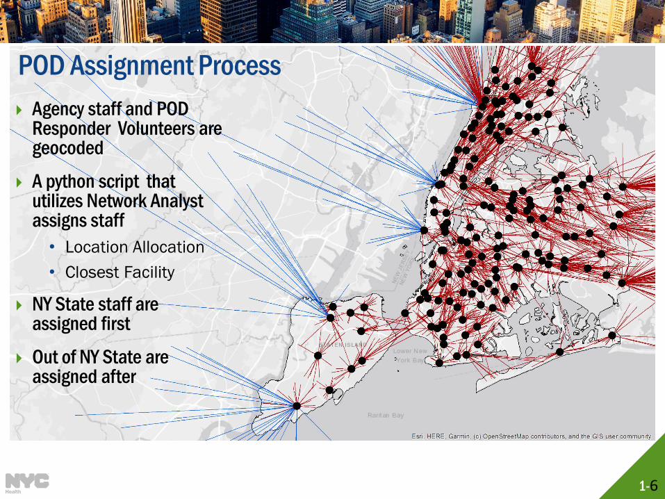
POD Assignment Process
1-6
Agency staff and POD Responder Volunteers are geocoded
A python script that utilizes Network Analyst assigns staff
• Location Allocation
• Closest Facility
NY State staff are assigned first
Out of NY State are assigned after
POD Assignment Process

1-7
Notification
POD
POD OC Leadership
POD Staff
Alternate Staffing flow Notification
ArcGIS Online
Online layers
Situational Awareness
Reporting
POD Assignment Workflow
DOHMH Employee Database
• All staff• Messaging to staff
Vesta
• All volunteers• Emergency
Notifications
Automated flow
NYCAPs
• Citywide Database • Emergency Roles• Citywide Training
Ad-Hoc Load
Automated flow
Automated flow
GAL
• All volunteers• Dynamic emergency
notifications
GIS FGDB
• Geoprocessing
ArcGIS
OEPR Staffing Database
• All volunteers• Dynamic
Emergency Notifications
ExportGeoprocessing

1-8
POD Management Tool Background
Staff are assigned to different roles
at each POD site
• Manage the ins and outs at the POD
• Trained to mobilize sites rapidly
• Stations under Administration Manager will report out to the POD Operations Center (POD OC)

1-9
Survey123
Survey123 for ArcGIS is a form-centric
application from ESRI that allows users to
share and analyze survey information
Works on smartphones, tablets, and the web
POD Staff can download the application onto
their device and download surveys to report
out to the POD OC
Data can be
collected without
connectivity

1-10
Survey123
Users select the applicable tile from
Survey123
The event is controlled by the Operations
Center and is not editable
The borough and POD are selected
Reporting is conducted

1-11
Data Flow
Smart PhoneSurvey 123
ArcGIS Online
SQL Server
Database
165 POD Sites
POD
Operations
Center
DesktopArcGIS Online
DOHMH

1-12
Form Count Dashboard

1-13
Med Count Dashboard

1-14
How do we share data with the public?

1-15
POD Locator (Phase I Complete!)
Public facing web app, linked on the DOHMH site
Allows members of the public to search and find POD Sites near them
Can view information such as operations status and wait time

1-16
POD Locator (public facing)
• Production: https://maps.nyc.gov/pods/

1-17
Future Steps POD Assignment
• Apply a more equity based framework for POD placement
• Recruit from City Agencies
Forms:
• Consolidate forms for ease of use
• Revise forms as operating plans evolve
• Incorporate notification structure for users
Dashboards:
• Aesthetic updates, optimize widget selection
• Annual process of User Acceptance Testing
POD Locator Tool:
• Incorporate 11-60 day planning

1-18
Questions?