geology of the ara-cinca region, spanish pyrenees, province of huesca
TRANSCRIPT

GEOLOGY OF THE ARA-CINCA REGION,SPANISH PYRENEES, PROVINCE OF HUESCA
(WITH SPECIAL REFERENCE TO COMPARTMENTATIONOF THE FLYSCH BASIN)

Dit proefschrift is tevens de 16e aflevering van deGEOLOGICA ULTRAIECTINA
(Mededelingen van het Geologisch Instituut der Rijksuniversiteitte Utrecht)
This thesis is published as no. 16 of the seriesGEOLOGICA ULTRAIECTINA
(Publications of the "Geologisch Instituut" of the Utrecht StateUniversi ty)
p. 28p. 29p. 36p. 36p. 54p. 55p. 69p. 69p. 70p. 75p. 87p. 99p.102Appendix 1.
GEOLOGY OF THE ARA-CINCA REGION, SPANISH PYRENEES' PROVINCE OF HUESCA.Thesis, Utrecht, 1970. H.A. van Lunsen. Geologica Ultraiectina, 16.
Chapter III.D.8, San Vicente Formation, prefIx A.Chapter III.D.8, Burgase Formation, prefIx B.left column, 4th line from below, Fig. 2 is Fig. 3right column, 3rd line from above, Fig. 3 is Fig. 2text Fig. 6, 3rd line from below "upper right" has to be "lower left"text Fig. 7, add "scale 1:27"left column, 11th line from below "The phenomenen ..." has to be "This phenomenon ..."Fig. 25A to be replaced by the fIgure shown belowright column, 9th line from below "In section IlL." has to be "In this section ..."right column, 3rd line from below, "more or less" has to be "more and less"right column, 9th line from below, "southerly" has to be "from the south"left column, 3rd line from below, Fig. 52left column, 9th line from above "Ghast-structures, has to be "Ghost-structures"right column, 3rd line from above "Gallinera" has to be "Metils"Fig. 55. Replace synclinal symbols of the Boltana Anticline by anticlinal symbols.Add anticlinal symbols to the Boltana Anticline

GEOLOGY OF THE ARA-CINCA REGION, SPANISH PYRENEES, PROVINCE OF HUESCA
(WITH SPECIAL REFERENCE TO COMPARTMENTATION
OF THE FLYSCH BASIN)

GEOLOGY OF THE ARA-CINCA REGION, SPANISH PYRENEES, PROVINCE OF HUESCA
(WITH SPECIAL REFERENCE TO COMPARTMENTATION OF THE FLYSCH BASIN)
PROEFSCHRIFT
TER VERKRIJGING VAN DE GRAAD VAN DOcrOR IN DE
WISKUNDE EN NATUURWETENSCHAPPEN AAN DE RIJKSUNIVERSITEIT
TE UTRECHT, OP GEZAG VAN DE RECTOR MAGNIFICUS
PROF.DR. F. VAN DER BLIJ
VOLGENS BESLUIT VAN DE SENAAT IN HET
OPENBAAR TE VERDEDIGEN OP WOENSDAG 28 OcrOBER 1970
DES NAMIDDAGS TE 4.15 UUR
DOOR
HENDRIKUS ANTONIUS VAN LUNSEN
GEBOREN OP 10 JANUARI 1937 TE UTRECHT
1970
DRUKKERIJ BRONDER-DFFSET N.V. ROTTERDAM

PROMOTOR: PROF.DR. M.G. RUTTEN

STELLINGEN
I De, door Andrusov, op grond van accumulatieve diktebepalingen aan Flysch-type afzettingen, getrokken konklusiesomtrent het stabiele geosynklinale karakter van de Noord Karpaten, zijn aanvechtbaar.
D. Andrusov, 1967. Geol. Rundsch., 560).
II Het voorkomen van rolstenen met zuideIijke aanvoer in de Lutetien Flysch van het Ara-Cinca gebied, wijst op de aanwezigheid van een landmassa in het Ebro gebied.
Dit proefschrift.
III Bovengenoemde rolstenen bestaan voor een deel uit mariene kalken van Jura en Onder Krijt ouderdom, wat in overeenstemming is met Perconig's bewering dat het zogenaamde Ebro Hoog toen niet bestond.
E. Perconig, 1968. Brill, Leiden. Dit proefschrift.
IV De evenwijdig tegengestelde aanvoerrichtingen in de Flysch van de westelijke Spaanse Pyreneeen, wijst eerder op ongelijktijdigheid dan op gelijktijdigheid van de afzettingen.
H.B. Voort, 1964. Geol. Rundsch., 53.
V Het optreden van slumps in Flysch-type afzettingen, kan wijzen zowel op een ontstaan tengevolge van lokale verstoringen van de trog-bodem als op snelle evenwijdige verplaatsingen van de trag-as gedurende de Flysch-phase.
Ph.H. Kuenen, 1967. Sedimentology, 9. Dit proefschrift.
VI De afwezigheid van schistes-Iustrees rolstenen in de sub-alpiene en Apennijnen Flysch van Noord Italie, is geen afdoende argument voor het later plaatsen van het tijdstip van de dynamo-metamorfose van het Penninikum.
R.B. Behrmann, 1958. Geotekt. Forsch., 12.
VII De opvatting van Gorier c.s. over de mise en place van olisthostromen wordt tegengesproken op grond van waarnemingen aan kleine olisthostromen in het Ara-Cinca gebied. Deze laatsten tonen al duidelijk erosieve werking.
K. Gorler und K.J. Reutter, 1968. Geol. Rundsch., 57 (2). Dit proefschrift.
VIII Het grover worden van de terrigene detritus in oostelijke richting, in de Boven Krijt-Paleoceen serie van de Centraal Spaanse Pyreneeen, is geen afdoende argument voor een aanvoer van de detritus uit het oosten.
E. van de Ve1de, 1967. Estudios Geo1ogicos, 23. J. van E1sberg, 1968. Estudios Geo1ogicos, 24. G.F.J. Jeurissen, 1969. Geologica U1traiectina, 10. Dit proefschrift. .

IX Mattauer's opvatting over het ontstaan van satelliet-massieven aan de noordzijde van de oostelijke Pyreneeen, houdt geen rekening met de mogelijkheid van horizontale bewegingen langs de Noord Pyreneeen randbreuk.
M. Mattauer, 1968. Rev. Geogr. Phys. GeoJ. Dyn., 2 (10).
X "The Southern Mesozoic Zone (of the Pyrenees) has the peculiarity that the thick horizontal Oligocene conglomerate blanket dips a few degrees toward the centre of the mountain chain. Evidently a collapse of the axial zone preceded the youngest upheaval".
L.u. de Sitter, 1958, p.430 (dtaat) Bezwaren:
a) "horizontal", moet zijn "sub-horizontal". b) het Zuid pyreneeen Oligoceen is zwak geplooid, zodat meting van dips over grote afstand niet zinvol is. c) in conglomeraten zijn dips van enkele graden, over korte afstand, praktisch niet meetbaar. d) conglomeraten hebberi vaak scheve gelaagdheid waarvan de hellingen grater kunnen zijn dan enkele
graden. e) het onderste deel van de Zuid Pyreneeen Molasse behoort weIlicht nog tot het Boven Eoceen.
Konklusie: "a collapse of the axial zone" is uit het citaat niet klaarblijkelijk.
XI Bij het gebruik van tracers ter bepaling van grondwater stromings-patronen en debiet verdelingen, verdient het aanbeveling, de tijdsduur van de experimenten voldoende groot te maken, om het nakomen van tracers langs een langere (diepere) weg te kunnen registreren.
D.J. Burden, et aI., 1963. Proc. Symp. AppJ. Radio Isot. Hydr., Tokyo.
J. Toth, 1965. Thesis, Utrecht.
XII Produceren, in de moderne betekenis van het woord, is het namaken (vermenigvuldigen) van proto-types van een object. In strikte zin, zou men dit reproduceren moe ten noemen, het product, een reproductie.
XIII Sedert de senaatszaal van de Rijksuniversiteit te Utrecht is uitgerust met een electrisch uurwerk van meer dan normale afmeting, is het "hora est" overbodig geworden.
Utrecht, 28 oktober, 1970. H.A. van Lunsen

Aan Tonnie
Aan onze ouders

CONTENTS
LIST OF FIGURES AND TABLES ..... 10 ACKNOWLEDGMENTS (WOORD VOORAF) 13 SUMMARY 16 RESUMEN 18 RESUME . 20 SAMENVATTING 22
CHAPTER I. INTRODUCTION 25 A. General 25 B. Purpose of the study 25 C. Location of the region 25 D. Methods of investigation 25 E. Previous authors 26 F. Some geographical remarks 27
CHAPTER II. GEOMORPHOLOGY 28 A. Introduction 28 B. Glaciation 28 C. Stream erosion 29 D. Miscellaneous . 30
CHAPTER III. STRATIGRAPHY 31 A. Introduction 31 B. Upper Cretaceous-Palaeocene 33
1. Estrecho Formation (Campanian)33 2. Tozal Formation (Maastrichtian) 33 3. Salarons Formation (Lower Dano/Montian) 34 4. Gallinera Formation (Montian-L.Ilerdian) 34
Introduction 34 Lithologic character and thickness 34 Fossil content and age 35 Developments of the Gallinera Formation outside our region 37
5. Millaris Formation (Middle Ilerdian? ) 38 Lithologic character 38 Fossil content and age 38 Thickness and distribution of the Millaris Formation 40
6. MetiIs Formation (Upper Ilerdian-L.Cuisian) 41 Lithologic character and thickness 41 Fossil content and age 42 Distribution and other developments of the MetiIs Formation 42
C. Remarks on the direction of supply of terrigenous matter within the Cretaceous-Palaeocene sequence of the Western Spanish Pyrenees 43
D. Eocene 45 7. Marina Formation (Cuisian) 45
. Introduction ..... 45 Lithologic character and thickness 45
a. Flysch-type member 45 b. Lower nodular limestone and marl member 46 c. Lower sandy limestone and marl member 47
d. Upper nodular limestone and marl member 48 e. Nodular limestone member . . . . . . . 50 f. Upper sandy limestone and marl member 51
Fossil content and age of the Marina Formation 52 Remarks concerning abrupt changes in thickness of the Marina Formation 54
8. Flysch-type Formations (Cuisian? -Lutetian) 56 General introduction 56 Directions of detrital supply 58 Carbonate content of the graded beds and marls 59 Burgase Formation (Cuisian? -Lutetian) 62
Lithologic character and thickness 62 Remarks on the A1a-member and the base of the Burgase Formation 63 Remarks concerning the thickness of the Burgase Formation 66
San Vicente Formation (Cuisian? -Lutetian) ..... 68 Fossil content and age of the Flysch-type Formations 71
Introduction 71 Fossil content and age of the Burgase Formation . 71 Fossil content and age of the San Vicente Formation 73
Concluding remarks 73 SEDIMENTOLOGICAL CHARACTER AND COMPONENTS OF THE PEBBLY MUDSTONES AND CONGLOMERATIC BEDS OF THE FLYSCH-TYPE FORMATIONS 74
Introduction 74 San Vicente Formation . . 74
(1) Barranco de Ascaso 74 (2) Barranco de Ferrera 78 (3) Confluence of the Barranco de Trassierra and the Rio Ara 78 (4) Path from Muro to San Vicente 78 (5) Barranco de San Martin . . . . . . . . . . . . . 79 (6) Barranco de la Sierra 81 (7) Upper course of the Barranco north of Labuerda 82 (8) Barranco del Estafiuela 82 (9) Road exposure south of Ainsa 83
Burgase Formation 87 (10) Rio Aso north of Fanlo 87 (11) Path to Burgase north-west of Yeba 87 (J 2) Barranco de Santiago 89
Conclusions . . . . . . . . . . . . . . . . . . . . . 90 NOTES ON THE PALEOGEOGRAPHY OF THE FLYSCH-TYPE FORMATIONS 90
Introduction 90 The basal nonconformity 91 A small-size submarine canyori 91 Salt-diapyrism as a source and trigger of detrital supply in the San Vicente Formation 91 Compartmentation of the Flysch-basin 93
Inversion of lateral differences in facies between the Burgase Formation and the San Vicente Formation . . . . . . . . . . . . . . . . . . 93 Tecto-sedimentary compartmentation of the Flysch-basin 94
Cannibalism of older Flysch? 94 9. Fiscal Formation (Biarritzian? ) 95
Lithologic character and thickness 95 Fossil content and age 95
10. Fenes Formation (Upper Eocene) 96

E. Environment of deposition 96 Introduction 96 Campanian 97 Maastrichtian 97 Lower Dano/Montian 97 Montian-Lower Ilerdian 97 Middle Ilerdian 99 Upper Ilerdian-Lower Cuisian 99 Cuisian . 99 Cuisian? - Lutetian . 100 Upper Lutetian (Biarritzian)? 100 Upper Eocene . 100
CHAPTER IV. STRUCTURAL GEOLOGY . .. . . . . . 101 A. Introduction .. . . . . . . 101 B. Tectonic structures of the Cretaceous-Lower Eocene sequence 101
1. Folds . 101 2. Nature and age of the BoUafia Anticline 105 3. Overthrust structures 106 4. Upthrusts . 108 5. Normal faults . 109 6. Age and nature of the faults 111
C. Tectonic structures of the younger Eocene sequence 111 Tectonic unit A, zone A-I 112 Tectonic unit A, zone A-2 113 Tectonic unit B, zone B-1 114 Tectonic unit B, zone B-2 114
D. Compartmentation in tectonics . 114 E. Conclusions . 115
BIBLIOGRAPHY 116

Fig. 1, p. 24 : Fig. 2, p. 29 : Fig. 3. p.29 : Fig. 4. p. 30 : Fig. 5.p.32:
Fig. 6, p. 36 : Fig. 7, p.36 : Fig. 8, p. 37 : Fig. 9, p.39 : Fig.10, p.39 : Fig.11, pAO : Fig. 12, pAl: Fig.13, p.44 :
Fig.14, p.44 : Fig.15, p.46 : Fig. 16, p.47 : Fig.17, p.49 : Fig.18,p.50:
Fig.19, p.50 :
Fig.20, p. 51 : Fig.21,p.52 :
Fig.22, p. 52 : Fig.23, p. 53 : Fig.24, p. 54 : Fig.25, p.55 :
Fig.26, p. 57 :
Fig.27, p. 59 :
Fig.28, p. 60 :
Fig.29, p. 63 :
Fig.30, p. 64 : Fig.31, p. 65 : Fig.32, p. 67 : Fig.33, p. 68 :
Fig.34, p.69 : Fig.35, p.69 : Fig.36, p.70 :
Fig.37, p.72 :
LIST OF FIGURES AND TABLES
Schematic geological map of the Pyrenees. "Badland" development in the marls north of Boltafia. Panoramic view on the river Vellos region. Carbonate precipitation in the lower course of a river Ara tributary east of Fiscal. Lithostratigraphic corr{}lation of sections through Upper Cretaceous and Lower Tertiary sediments of the Western Spanish Pyrenees (province of Huesca). Photomicrograph of Alveolina-limestone 9f the upper part of the Gallinera Formation. Sketch of cross stratification and channelling in the limestones of the Gallinera Formation. Photomicrograph of Alveolina-limestone of the upper part of the Gallinera Formation. Marly limestones of the Millaris Formation. Photomicrograph of a gypsum crystal in the marly limestones of the Millaris Formation. Sketch of outcrop of the upper part of the Millaris Formation, Barranco Borrue west of Fanlo. Lenticular bedded nodular limestones of the Metils Formation. Areal extent of the exposures of Upper Cretaceous-Palaeocene deposits along the External Zone of the Western Spanish Pyrenees (province of Huesca). Schematic diagram of directions of detrital supply. River Ara exposure of the Marina Formation east of Janovas. Lithostratigraphic correlation of sections of the Marina Formation. Columnar section of the upper part of the Marina Formation (d-member) west of Boltafia. Nonconformity between limestones of the Marina Formation and subhorizontal graded beds of the San Vicente Formation. Sketch of the transition of the e-member of the Marina Formation into the graded beds of the San Vicente Formation. Slumped sandy limestone boulder in the f-member of the Marina Formation. Slump-structures on the transition of the Marina Formation into the graded beds of the San Vicente Formation. Intraformational outwedging of limestone beds of the f-member of the Marina Formation. Photomicrograph of Foramimfera-limestone from the lower part of the Marina Formation. Photomicrograph ofForaminifera-limestone from the upper part of the Marina Formation. (A) Discocyclina sp. and Assilina sp. arranged in oval tubes. (B) Orbitoides sp. and'Lepidorbitoides sp. occurring in oval tubes. Directions of detrital supply in the graded beds of the Burgase Formation and San Vicente Formation. Sketch of outcrop of a slumped zone on the transition of units Aland A2 of the Burgase Formation. Analyses of carbonate weight percentages for the graded beds and marls of the Burgase- and San Vicente Formations. Diagram illustrating the variation in thickness of the beds of the lower part of the Burgase Formation exposed in the Barranco de Sorrosa, west of Torla. Photograph of the thick slump zone exposed east of that of Fig.27 . Cross-section through the basal beds of the Burgase Formation. Photograph of sandy limestone beds in the upper part of the Millaris Formation. SChematic section to indicate the difference between apparent thickness (dII) and real thickness (dI) of an outcropping series of Flysch-type deposits. Thick bedded sandy limestone of the San Vicente Formation. Typical outcrop of fine bedded to laminated, bluish-grey marls of the San Vicente Formation. Intercalations of sandy limestone complexes in the marly' B2-member of the San Vicente Formation. Photomicrograph of a Foraminiferal limestone pebble from the mudstones at the base of the Burgase Formation.
10
Fig.38, p. 75:
Fig.39, p. 76: FigAO, p. 77: FigAl, p. 77: FigA2, p. 79:
FigA3, p. 80:
FigA4, p. 82:
FigA5, p. 82: FigA6, p. 83: FigA7,p.84: FigA8, p. 85: FigA9, p. 85: Fig.50, p. 86: Fig.5l, p. 86: Fig.52, p. 88: Fig.53, p. 89:
Fig.54, p. 92: Fig.55, p.l02: Fig.56, p.l03: Fig.57, p.l04: Fig.58, p.l04: Fig.59, p.l06: Fig.60, p.l07: Fig.6l, p.l09: Fig.62, p.l09:
Fig.63, p.llO: Fig.64, p.112: Fig.65, p.l13:
Table I, p. 43:
Table II, p. 46: Table III,p.61 :
Table IV,p.62:
Appendix 1. Appendix 2.
Locations of outcrop of pebbly mudstones and conglomeratic beds of the San Vicente Formation. Reef-limestone boulder in the western valley wall of the Barranco de Ascaso. Olisthostrome surrounding the lower part of the boulder shown in Fig.39. The same olisthostrome as that of FigAO, about 10 m upstream in the Barranco. Photomicrograph of biotite granite found as a rounded pebble in the mudstones southwest of Escalona. Conglomeratic mudstones (I, II, III) exposed in the steep valley wall of the Barranco de san Martin, north of Boltafia. Large boulder of bituminous, dolomitic, limestone exposed in the upper course of an unnamed barranco north of Labuerda. Zone of reef-limestone boulders in the marls of the San Vicente Formation. Close-up of the frontal boulder shown in FigA5. Remains of a large size leaf found in the mud. of the boulder-zone of FigA5. Densily packed conglomeratic mudstone bed in the upper part of the San Vicente Formation. Close-up of FigA8. Same exposure as that of FigA8, some ten meters further south. Photomicrograph of a polymict pebble. Locations of outcrops of pebbly mudstones of the Burgase Formation. Photomicrograph of a quartz-dacitic pebble from a mudstone bed in the lower part of the Burgase Formation. General directions of detrital supply for the graded beds of the Flysch-type formations. Schematic tectonic map of the Ara-Cinca region. Palaeogeography of the Cretaceous of the Central Spanish Pyrenees according to Misch (1934). Simplified geologic map of Huesca province. Geologic map of the Cinca-Yesa region by Almela (1956). Structural map of the Central Spanish Pyrenees by Choukroune et al. (1968). N-S sections across the Ordesa valley, northwest of Torla. Geologic map of the Vellos-Arres region, northwest of Escalona. Schematic diagram illu,strating the relative positions of the faulted blocks of the Vellos-Arres region. Sketch of the Gallisue fault-zone exposed along the road from Janovas to Boltafia. N-S section across the folded Flysch of the Burgase Formation (Zone AI). Sketch of "chevron" folds in the basal beds of the Burgase Formation west of Fanlo.
Qualitative grainsize distribution of terrigenous matter in the Cretaceous-Palaeocene sequence of the Central Spanish Pyrenees, province of Huesca. Directions of detrital supply of the a-member of the Marina Formation. Average carbonate weight percentages of the graded beds and marls of the western and eastern Flysch-type Formations. Correlation of maximum and minimum carbonate weight percentages between Flysch-type deposits of the Ara-Cinca region and their lateral aequivalents of the Western Spanish Pyrenees (Mangin, 1958).
Geologic map of the Ara-Cinca region. Fence diagram of the Ara-Cinca region.
11

WOORD VOORAF
Gedurende de jaren op Payenborgh doorgebracht, hebben vele contacten op wetenschappelijk en niet wetenschappelijk gebied bijgedragen tot mijn academische vorming. Bij het afsluiten van deze periode en de voltooiing van mijn proefschrift wil ik dank zeggen aan allen die in meerdere of mindere mate betrokken zijn geweest bij mijn geologische opleiding en de tot standkoming van dit proefschrift.
Hooggeleerde Rutten, hooggeachte promotor, uw geduld met mij bleek groter dan ik mocht verwachten. Ondanks de ernstige ziekte die u trof, hebt u mij gedurende de laatste phase van proefschrift voorbereiding op een bewonderenswaardige manier bijgestaan. Tot dit laatste gedeelte liet u mij, deeIs onvoorzien, volkomen vrij om overeenkomstig aard en aanleg te werken. Met genoegen denk ik terug aan uw colleges, uw scherpzinnige opmerkingen tijdens excursies, veldwerken en referaten. De gastvrijheid waarop u en uw echtgenote mij, in het veld en thuis, onthaalden zal ik me blijven herinneren.
Hooggeleerde Van Bemmelen, uw colleges en uw persoonlijke belangstelling voor mijzelf en mijn werk hebben veel bijgedragen tot mijn vorming als mens, wereldburger en als geoloog. Uw enthousiasme werkte aanstekelijk, uw gebreidelde fantasie wekte bewondering, uw niet aflatende productiviteit ontmoedigde me soms.
Hooggeleerde De Raaf, de bijzondere belangstelling die u regelmatig toonde voor mijn werk en voor Flysch-type afzettingen in het algemeen heb ik op grote prijs gesteld. Mijn werkzaamheden bij de Geologische Dienst van Ierland wIlen mij wellicht toestaan uw sedimentologen van dienst te zijn bij hun werk in Ierland. In uw persoon dank ik alle leden van de afdeling Sedimentologie voor de gastvrijheid en de belangstelling die ik genoot.
Monsieur Aubouin, je vous suis extremement reconnaissant de votre aimabilite et de la bienveillance avec laquelle vous avez bien voulu me faire parvenir vos communications sur la geologie des Pyrenees et sur les aspects regionaux de la formation Flysch.
Sehr geehrter Herr Professor Hottinger, ich danke Ihnen vielmahls fUr Ihre Hilfe bei der Determinierung der Alveolinen.
Zeergeleerde Ten Haaf, dat u als Flysch-kenner bij uitnemendheid, mij in het veld begeleidde, was het beste waf een Flysch-onderzoeker zich kan wensen. "Standing on your shoulders", bleek het vaak een wankele positie.
Zeergeleerde Marks, ondanks uw drukke onderwijstaak, zag u kans met mij van gedachten te wisselen over Eocene faunae, waarvoor ik u erkentelijk ben. Dankzij uw bemiddeling kwam een vruchtbaar contact tot stand met Professor Hottinger (Basel).
Geleerde Smit, uw zeer drukke onderwijstaak in Ghana belette u het detail-palaeontologisch onderzoek van de Marina-kalken te voltooien. Desondanks stond u mij toe het door u onderzochte gebied te annexeren. U bleek zelfs bereid waardevolle informatie dienomtrent te verschaffen. Ik hoop dat de onderbreking van het onderzoek geen afstel zal betekenen en dank u voor uw belangloze hulp.
Zeergeleerde Van Kreulen, weliswaar bleek het voorlopig koolstofonderzoek aan plantenresten in de Flysch geen belangrijke resultaten op te leveren, desalniettemin ben ik u zeer erkentelijk voor uw hulp en voor de waardevolle gesprekken die ik met u mocht voeren.
Zeergeleerde Tobi, mijn belangstelling voor de petrografie werd aangewakkerd door uw grondige en duidelijke colleges, en door de excellente excursie naar Schotland, onder uw leiding uitgevoerd, waarvoor ik u hartelijk dank.
13
Zeergeleerde Van Moort, jouw slaaf was ik in het Lozere gebied, in de laatste, ietwat haastige phase van jouw these-veldwerk. Oat ik in mijn proefschrift aandacht besteed aan intrusiva (exotica) is deels aan jou te danken.
Zeergeleerde Dahlberg, nog afgezien van alle vriendschappelijke contacten, dank ik je voor de hulp bij de analyse van veldspaten.
Geleerde Visser, legio zijn de onderwerpen welke wij, in lange discussies bespraken. Hartelijk dank voor de vele "choques des opinions" die voor ons beiden zo waardevol bleken. Jouw hulp bij de determinatie van enkele pollen monsters bracht ons op het spoor van halokinese tijdens de Flysch-vorming.
Zeergeleerde Van Warnel, dat ons onderzoek naar de aanwezigheid van Conodonten in Flysch-exotica een negatief resulta~t had, bleek een indicatie voor de afwezigheid van bepaalde gesteenten in het Ebro-gebied, tijdens de Flysch-vorming. Jouw hulp kreeg daardoor extra palaeogeografische waarde.
Zeergeleerde Van Meurs, met waardering denk ik terug aan onze vele gesprekken, discussies en activiteiten rondom en in Payenborch. Jij bleek altijd bereid tot luisteren en helpen waar dat nodig was. Jouw bijdragen aan dit proefschrift zijn geenszins beperkt gebleven tot kritisch commentaar. Enkele rapporten over delen van mijn werkgebied kwamen onder meer van jouw hand. Zij verschaften mij waardevolle informatie.
Zeergeleerde Kees en kamergenoot, menige uiting van ongenoegen over schijnbaar onoplosbaie geologische en andere problemen werden in de laatste jaren over de kunstmatige kamerbarriere heen en weer gecaramboleerd. Zelfs tot voorbij het laatste moment van mijn verblijf in Utrecht, kon je het niet laten mij onomwonden te herinneren aan wat ons moest bezielen en aan datgene waarin we tekort schoten. AIleen daarvoor al ben ik je zeer dankbaar. Jouw groot talent om, in het voetspoor van de meester, als het moet, snel te handelen, heeft me zeer verbaasd. Jouw aanbod om enkele organisatorische problemen rondom de thesis voor me op te lossen, was zeer genereus.
Zeergeleerde Verdenius, Van de Velde, Mulders, geleerde Geyskes, Van Baren, Bonsma,Tjalsma, Klootwijk, Van Hengel, uitjullie veldverslagen putte ik ongevraagd, onder meer, de nodige diptekens en spaarde schoenzolen.
Hoogedelgestrenge Quarles van Ufford, vaak heb ik op uw mat gestaan, zoals het een horige betaarnt, en mocht uw dienaar genade vinden in uw ogen, werd zijn leven telkens met een halfjaar verlengd. Voor het oogluikend toelaten van allerlei karweitjes door uw afdeling voor mij verricht ben ik u zeer erkentelijk.
Waarde Van der Kruk, de haastige spoed waarmee u rnijn lijvig manuscript op taalfouten corrigeerde bleek desondanks goed. Veel dank hiervoor.
Geachte Dekkers, met bewondering heb ik u gadegeslagen bij de running van de steeds ingewikkelder wordende administratie. Uw medewerking heb ik op grote prijs gesteld.
Geachte Frans Henzen, met vaart en verve heb je mijn tekeningen en foto's verzorgd. Ik hoop dat er een tijd zal komen, waarin jij de ruirnte krijgt die je zo hard nodig hebt. Dank voor de zeer goede sarnenwerking.
Geduldige Santoe, jouw aanwezigheid op de tekenkamer blijkt een grote aanwinst.
Geachte Maarten Dubbleman, weinigen weten hoe groot jouw artistieke talenten zijn. Ik bewonder je zeer om wat je al hebt gepresteerd en wens je de tijd en de ruirnte toe om je verder te ontplooien, dank voor de vele nuttige adviezen.
Waarde slijpkamerbewoners, de talrijke dunne doorsneden en polijstvlakken door jullie gemaakt zijn van groot nut geweest. Voor de goede uitvoering en de prettige samenwerking dank ikjullie zeer.
14

Beste Reggy de long en Rolien Sissingh, voor de snelle en accurate wijze waarop jullie mijn manuscript hebben getypt en overgetypt ben ik zeer dankbaar.
De Cultuurtechnische Dienst te Utrecht ben ik erkentelijk voor hun medewerking bij het afdrukken van mijn geologische kaart.
De Firma VanDoorne (DAF, Geldrop) dank ik bijzonder voor de fmancitHe steun gedurende de eerste jaren van mijn studie.
De Staat der Nederlanden dank ik voor de beurzen en toelagen. Zonder deze steun zou dit proefschrift niet tot stand zijn gekomen.
De werkers van het elfde uur, de hekkensluiters Rekko, Smit en Nachtegaal dank ik voor de prettige onderbrekingen van de lange avonden op het Instituut.
15

SUMMARY
Geological investigations have been carried out from 1955 to 1968 in the Spanish Pyrenees, Province of Huesca, directed by Prof. Dr. M.G. Rutten (Geological Institute of the State University of Utrecht). Locations are indicated on Fig.I. These investigations resulted in a number of theses and papers which appeared in: Estudios Geol6gicos (Madrid) and Geologica Ultraiectina (Utrecht).
The present thesis describes the geology of the Ara-Cinca Region. Fieldwork was done during the summers of 1964, 1966 and 1967. Simultaneously, Dr. E. ten Haaf and his students of the same Institute mapped the southerly bordering Eocene Flysch-zone, of which the Ara-Cinca Region is the most eastern part.
Literature about the region studied is scarce and of a general nature only. More detailed, mainly structural, information has been given in unpublished reports of B.Sc. students of the Utrecht Institute who covered minor parts of the Ara-Cinca Region.
After a general Introduction (Chapter I) and a short exposition of the Geomorphology (Chapter II), the litho- and biostratigraphy, the environment of deposition and the palaeogeography are discussed (Chapter III).
In the Ara-Cinca Region a succession of sediments ranging from Upper Cretaceous to Upper Eocene is found. The Upper Cretaceous- and Palaeocene deposits (± 1000 m) laterally show only minor changes in facies and thickness, as they do allover the Aragonian Pyrenees. For the greater part they consist of limestones and dolomites, with subordinate amounts of sandstones and conglomerates, deposited under shallow marine conditions. The Eocene deposits, however, show strong lateral variations in facies and in thickness. The Lower Eocene (0-2000 m) consists of alternating nodular limestones and marls. The limestones are largely sandy. A shallow marine environment is evident. The Middle Eocene, mainly developed in a Flysch-type facies (0-4000 m), is marine. The depth of deposition must have been at least beyond the reach of wave action. The Upper Eocene (600-1200 m) consists of the "blue marls", marls and sandstones, which were deposited under shallow marine conditions and which, with a gradual transition via a lagoonal facies of sandstones and marls (the "gres aripple marques"), pass into the sandstones and conglomerates of the continental Molasse facies (Oligo-Miocene).
Much attention has been given to compartmentation phenomena, before, during, and after the formation of Eocene Flysch-type deposits. These phenomena can be outlined palaeogeographica1ly as follows: (1) At the beginning of the Upper Cretaceous a relative "high" was situated approximately west of the line Bielsa-Ainsa (N-S). In this positive area the Lower Cretaceous was either not developed, or was eroded during a transgressive phase at the beginning of the Upper Cretaceous. East of that line a thick marine Lower Cretaceous sequence occurs; (2) During the Upper Cretaceous and Palaeocene in the whole northern part of Aragon shallow marine rocks were developed which gradually change to the east into the continental facies of the so-called "Garumnian". In this period the relief was reversed when compared with (1); (3) The Middle Eocene was characterized by the infilling of the South Pyrenean longitudinal basin with Flysch-type deposits. An original longitudinal supply of detritus by means of turbidites from the east and south-east changed upwards, in the area west of the north-south trending Boltafia Anticline, to a transverse supply from the north. This was accompanied by rigorous changes in: the carbonate weight percentages of the turbidites; the sedimentary character (from distal to proximal) of the graded sequences; and the occurrence of a thick slump-horizon which could be traced laterally over large distances. In general all these phenomena reflect a downward tilt to the south of the western region during Flysch deposition. This tilting had a minimal westward extent of about 30 km. Indications for a continuation of the tilting movement are found in the wedging-out of the Upper Eocene formations to the east against the Boltafia Anticline.
In Chapter IV the tectonics of the region are described. Structurally a division is made into a northerly belt of, partly overthrusted (Ordesa Overthrust Mass and Cotiella Nappe), NW-SE folds with a southward "Vergenz". The orientation of the foldaxes follows that of the Western External Zone of the Spanish Pyrenees. These structures are formed in the massive limestones and dolomites of the Upper Cretaceous and Palaeocene. To the south of this belt Flysch-type deposits occur which are more intensily folded but on a smaller scale. They apparently acted in a more plastic way on the southward gravitational gliding of the External Zone, than did the Upper Cretaceous-Palaeocene sequence.
16

The Ara-Cinca Region is dissected in a north-south direction by the Boltafia Anticline, a transverse structure with an orientation perpendicular to the general Pyrenean trend. West of this structure the Flysch fold belt has a direction parallel to that of the External Zone; east of the structure a thinner Flysch-type formation which is but slightly folded covers the N-S structured underlying Cretaceous-Palaeocene "basement". The formation of the transverse structures in the Ara-Cinca Region is considered to be related to halokinesis of Triassic evaporites in the subsurface, caused by rejuvenation of N-S fault systems in the crystalline basement during the Middle and Upper Eocene. The NW-SE fold belts originate from "decollement" of the Southern External Zone of the Central Spanish Pyrenees which might have been formed in the Oligo-Miocene at the same time as the Ordesa and Cotiella overthrusting took place to the south.
The structural compartmentation which follows from the differences between the structures in the Flysch-type deposits west and east of the Boltafia
Anticline is also emphasized by the difference in scale of the southward overthrusts west (Ordesa) and east (Castillo Mayor-Cotiella) of the transverse zone. The horizontal southward displacement of the Ordesa Overthrust may reach a maximum of about 3 km, that of the Cotiella Overthrust 20 km. Along the line of outcrop of the parautochthonous Upper Cretaceous-Palaeocene epidermis north of the nappe structures no important dextral or sinistral north-south movements have taken place. The supposition is therefore justified that the area east of the line BielsaAinsa was tilted downwards more strongly to the south, during these overthrust activities, than was the area west of that line. THE DISTINCT COMPARTMENTATIONS FROM THE LOWER CRETACEOUS TO THE OLIGO-MIOCENE RESULT IN A SCISSOR-LIKE MOVEMENT OF CRUSTAL BLOCKS ALONG A LINE WHICH COINCIDES WITH THE LOCATION OF THE TRANSVERSE STRUCTURES IN THE ARA-CINCA REGION.
17

RESUMEN
Investigaciones geoIogicas fueron emprendidas durante los afios 1955 a 1968 en los Pirineos de Huesca, bajo la direccion de Dr. M.G. Rutten, del Instituto Geologico de l'Universidad de l'Estado, Utrecht. La figura 1 muestra la ubicacion de las regiones estudiadas hasta la fecha. Estas investigaciones conducieron a varios theses y otros informes publicados en las revistas "Estudios geologicos" (Madrid) y "Geologica Ultraiectina" (Utrecht).
£1 presente thesis presenta la descripcion geologica de la region, comprendida entre el rio Ara y el rio Cinca. Los trabajos de campo fueron efectuados durante los veranos de las afios 1964, 1966 y 1967. Simultaneamente el Dr. E. ten Haaf y sus estudiantes cartografiaron la region del Flysch eocenico situada mas al sur, de la cualla region Ara-Cinca representa la parte la mas oriental.
Publicaciones acerce de la geologia de nuestra region son escasas y de caracter muy general. Informes mas detallados, principalmente de naturaleza estructural, son los informes archivados de los licenciados del Instituto Geologico de Utrecht, que cartografiaron algunas partes menores de la region Ara-Cinca.
Despues de una Introducci6n de caracter general (Capitulo I), y una exposicion breve de la GeomorfoIOgla (Capitulo II), se discute la litoestratigrafia y bioestratigrafia, las condiciones de deposicion y la paleogeografia (Capitulo 1Il).
En la regi6n Ara-Cinca se encuentra una secuencia de dep6sitos estratigraficamente comprendida desde el Cretaceo superior hasta el Eoceno superior. El conjunto Cretaceo superior-Paleocenico no muestra variaciones laterales de facies 0 de espesor muy pronunciados; con esto no difiere del desarollo en otras partes de los Phineos aragonesas. El conjunto se constituye principalmente de calizas y de dolomitas, y en menor proporci6n de areniscas y conglomerados, productos de una sedimentaci6n marina poco profunda. Sin embargo, los depositos eocenicos muestran importantes variaciones de espesor. EI Eoceno inferior (0-2000 m) se constituye de una alternaci6n de cali- . zas nodulares, y mamas. Las calizas son frecuentamente arenosas. La sedimentaci6n se debia efectuar en un ambiente de mar poco profundo. El Eoceno medio (0-4000 m) es de facies marina, y principalmente consiste de sedimentos del tipo Flysch. El conjunto fui depositado fuera de la zona de la acci6n del oleaje. El Eocene superior (600-1200 m) es compues
to de mamas azules y areniscas; la sedimentacion comenz6 bajo las condiciones ambiengales de un mar poco profundo; despues la facies se convectio gradualmente, por una facies intermedia y lagunosa (areniscas y mamas, "gres a ripple marques") a una facies de tipo molase, que se distingue par areniscas y conglomerados (Oligoceno y Mioceno).
De una manera general, hay individulizaci6n de zonas estratigraficas bien caracterizadas. Esta formacion de compartimentos distintos representa uno de los rasgos el mas interesante de la geologia de nuestra region, explicando muchos de los fenomenos geologicos observados en la region estudiada. Esto tesis se aclarara en el esquema paleogeografico sigecienta.
1. Al comienzo del Cretacico superior un bloque leventado se situo al oueste de la linea N-S BielsaAinsa; en esa regi6n no se encuentra depositos de edad Cretacico inferior, sea que ellos nunca fueron depositados, sea que elIos fueron erosionados durante una fase transgresiva al comienzo del Cretacico superior. Al este de la Ifnea mencionada, el Cretaceo inferior es bien desarollado y de potencia considerable.
2. Durante el Cretacico superior y el Paleocenico, en toda la parte septentrional de la region de Aragon, rocas en facies marina, fueron depositadas, las cuales hacia el este gradualmente pasan a las rocas en facies continental del Garumnense clasico. Durante este periodo el relieve topografico es en sentido inverso respecto al cual se refiere arriba (1).
3. Durante el Eocenico medio la cuenca longitudinal de los Pirineos meridionales se llano de depositos del tipo Flysch. Originalmente el aporte de materiales clasticos se efectuo en sentido longitudinal por medio de turbiditos, del este hacia el oueste; despues prendio una direccion en sentido transversal desde el norte hacia el sur, en la region al oueste del Anticlinal de Boltafia. Relacionado con es6, es el cambio riguroso; en el contenido de carbonato de los turbiditos, la modificacion de la naturaleza sedimentaria de la sequencia graduada (del tipo "distal" al tipo mas "proximal"), y fmalmente el desarollo de un nivel de deslazimientos subacuaticos que se extiende lateralmente por une distancia larga. De una manera general, estos fenomenos indican un vuelco descendiente hacia el sur de la region occidental durante la deposicion del Flysch. Esto vuelco se extendio hacia el oueste al menos por 30 km.
4. El adelgazamiento de las formaciones del Eoceno superior hacia el Anticlinal de Boltafia sugiere
18

que el movimiento de vuelco se continu6 durante el Eocenico superior.
En el Capitulo IV se discute la tect6nica de la region. Se distrngue una zona septentrional caracterizado por pliegues orientados NW-SE, con vergencia hacia el sur y parte de ellos cabalgados ("Macizo" cabalgante de Ordesa, "Nappe" de Cotiella), luego una zona meridional, constituida de Flysch, con estilo tect6nico diferente. Los ejes de los pliegues son paralelos a la direccion general de la Zona externa occidental de los Pirineos. Estas estructuras fueron formadas dentro las calizas espesas y dolomitas del Cretaceo superior y Paleoceno. Al sur de esto tramo se encuentra la zona form ada de materiales del Flysch, en la cual se produjo un plegamiento fuerte y apretado.
La diferencia en estilo tectonico de las estructuras en ambos tramos, las cuales son causadas por el deslazimiento por gravitaci6n de la Zone externa de los Pirineos hacia el sur, se podria explicar por diferencias en plasticidad de los conjuntos sedimentarios.
La region Ara-Cinca es atravesada por el Anticlinal de Boltafia, que sique una direcci6n N-S, perpendicular al rumbo general de los Pirineos. Al oueste de esta estructura, se encuentra el Flysch fuertemente plegado, mientras que al este del anticlinalla secuencia del Flysch mas delgado y poco pIegada, descansa directamente sobre el "basamento" del Cretaceo-Paleoceno, estructurado com rumbo del norte al sur. La formacion de las estructuras transversales en la regi6n AraCinca se explica por "halokinesis" de los evaporitos triassicos en el subsuelo, de que result6 la reactivacion
de las sistemas de fallas, dirigidos N-S en el basamento cristaline, durante el Eocenico medio y superior.
EI plegamiento en direcci6n NW-SE es producido por el despegamiento de la cubierta sedimentaria de la Zona extema de los Pirineos centrales, probablemente durante el Oligocenico-Miocenico, simultaneamente con la formacion de los sobre escurrimientos de Ordesa y de Cotiella.
La formaci6n de compartementos estructurales, que se manifiestan claramente por las diferencias estructurales en el Flysch al este y al oueste del Anticlinal de Boltafia, es acentuada por la diferencia en escala de los sobre escurrimientos al un y otro lado de la estructura transversal.
EI deslazimiento lateral, al sur, del cabalgamiento de Ordesa alcanza maximalmente 3 lan, mientras eso del cabalgamiento de Cotiella es 20 lan. Se concluye que la region al este de la linea Bielsa-Ainsa fui volcada mas, en sentide descendiante hacia el sur, durante los movimientos calbagantes, que la regi6n al ouste de esa lInea.
DE LA FORMACION DE COMPARTEMENTOS ESTRUCTURALES Y ESTRATlGRAFICOS DU, , RANTE LA DEPOSICION DEL CRETACEO INFERIOR HASTA EL OLIGOCENO-MIOCENO, SE DEDUCE UN MOVIMIENTO EN BISAGRA DE BLOQUES DEL ROCALO, A LO LARGO DE UNA, , LINEA, QUE COINCIDE CON LA UBICACION DE LAS ESTRUCTURAS TRANSVERSALES EN LA REGION.
19

, , RESUME
Depuis 1955 des recherches geologiques ont ete effectuees sous la direction de M. Ie Professeur Rutten (Institut de geologie de l'universite d'Utrecht) dans les Pyrenees espagnoles (province de Huesca). Voir fig. 1 pour les locations et les references bibliographiques publiees dans les revues Estudios Geo16gicos (Madrid) et Geologica Ultraiectina (Utrecht).
La presente these traite de la geologie de la region entre Ara et Cinca. Les levers sur Ie terram ont ete effectues en 1964, 1966 et 1967. Ces recherches ont marche parallelement avec la mise en carte de la zone Flysch realisee par M. Ie docteur ten Haaf et les etudiants de I'Institut susmentionne, la region de l'AraCinca en est la partie orientale la plus eloignee.
Les ouvrages precedents sur la region sont tres superficiels et n'ont de valeur que dans un contexte plus large et regional. Des donnees plus detaillees ont ete foumies par une dizaine de rapports dits "internes" par des etudiants d'Utrecht traitant quelques parties de la region etudiee.
Vne introduction generale (Chap.I) et un aper9u de la geomorphologie (Chap.II) precedent les exposes sur la litho- et sur la biostratigraphie, sur Ie milieu de la sedimentation et sur la paleogeographie (Chap.III).
Dans Ia region etudiee on rencontre une serie de sediments mesozoiques et tertiaires. Le Cretace Superieur et Ie Paleocene (1000 m) montrent peu de diversites d'epaisseur et de facies. Us se composent, en majeure partie, de calcaires et, en moindre partie, de dolomie et de gres; Ie milieu de sedimentation etant du marin peu profond. Les sediments eocenes varient fortement en sens laterale en epaisseur et en facies. I'Eocene Inferieur (0-1000 m) se compose d'une alternance de complexes de calcaires noduleux et de complexes mameux. Les calcaires sont surtout sablonneux. Le tout de l'ambiance sedimentaire etait apparemment du marin peu profond.l'Eocene Moyen, compose en majeure partie de facies-Flysch, varie en epaisseur de 0 a 4000 m et est marin, mais de profondeur inconnu. l'Eocene Superieur (600-2000 m) est compose de mames bleues et de gres, probablement depose a peu de profondeur; marin au debut, avec un passage regulier par un facies lagunaire aux conglomerats et aux gres de I'Oligocene et Miocene (Molasses).
Cette these etude en particulier les phenomenes de compartimentation avant, pendant et apres la sedimentation du Flysch eocene. Du point de vue paleogeographique ces phenomenes peuvent etre depeint
de maniere suivante: (1) Au commencement du Cretace Superieur il se
trouvait, a l'ouest de la ligne N-S Bielsa-Ainsa, une elevation structurelle sur laquelle Ie Cretace Inferieur ou bien n'a pu se developper ou bien a disparu par erosion au cours de la transgression du Cretace Superieur; tandis qu'a l'est de cette ligne on rencontre une formation epaisse de Cretace Inferieur marin.
(2) Durant la periode du Cretace Superieur et du Paleocene il se developpe sur toute la partie septentrionale d'Aragon un facies marin peu profond qui, vers l'est passe peu a peu au facies continental dit "Garumnien". n parait donc qu'a cette epoque Ie relief se pnlsentait en sens inverse.
(3) Durant I'Eocene des sediments du genre Flysch remplissent Ie fosse au sud des Pyrenees Centrales. Un apport au debut longitudinal des materiaux detritiques cause par des turbidites venant de l'est et du sudest - se change en apport transversal - venant du nord - dans la region a l'ouest de la structure N-S de l'anticlinal de Boltafia. Ce changement est accompagne d'un changement brusque en ce qui conceme: la teneur en carbonates des turbidites, Ie caractere sedimentologique des sequences granoclassees (de distal a proximal) et l'apparition d'une zone epaisse de glissement tectonique en forme d'ecailles qu'on peut suivre sur une grande distance. Le tout retlechit un basculement de la region - Flysch dont la pente changea de l'ouest au sud. Des indices d'une continuation de ce basculement sont trouves dans les biseautages vers l'est des formations de I'Eocene Superieur vers l'anticlinal de Boltafia.
Le IV ieme Chapitre traite la tectonique de la region. Du point de vue structural on peut faire une subdivision en une zone septentrionale de plissements N0-SE renverses aux sud et en partie charries, dont l'orientation suit celle de la Zone Exteme de l'ouest des Pyrenees espagnoles. Ces structures ce sont formees dans les calcaires et dolomies massives du Cretace Superieur et du Paleocene. Au sud de cette zone on trouve des depOts du genre-Flysch, en partie plisses intensivement en detail, qui, a ce qu'il parait, ont reagi plus plastiquement au glissement gravitatif de la "Zone Exterieure" des Pyrenees espagnoles, que la serie Cretace-Paleocene.
La region du Flysch est traversee du nord au sud par l'Anticlinal de Boltafia. A l'ouest de cette structure transversale l'ensemble des plissements-Flysch est oriente comme ceux des structures Cretace-Paleocene;
20

al'est de l'Anticlinal de BoItana une serie Iegerement plissee couvre Ie soubassement de plissement peu profonds de direction nord sud.
La formation des structures transversales de la region d'Ara-Cinca peut etre mise en rapport avec une remontee des evaporites triasiques dans Ie sous-sol, liee aun rajeunissement de systemes de failles dans Ie socle cristallin, rajeunissement qui doit avoir eu lieu pendant I'Eocene Moyen et Superieur. Par contre, les plissements orientes nord-ouest a sud-est, causes par un decollement de la Zone Externe septentrionale des Pyrenees lors du soulevement de la zone axiale, ont ete formes pendant I'Oligo-Miocene. Lors de cette phase de l'orogenese des Pyrenees les nappes d'Ordesa et de Cotiella ont glissees vers Ie sud.
La compartimentation structurelle se montrant dans la difference entre les structures-Flysch al'ouest
et al'est de I'Anticlinal de Boltana est accentuee une fois de plus par la difference en distances de charriage ouest (region d'Ordesa) et est (Castillo Mayor-Cotiella) de la zone transversale. Les charriages vers Ie sud d'Ordesa ont parcouru une distance de 3 km au maximum, ceux de Cotiella une distance de 20 km. On peut supposer que, lors des charriages susmentionnes, la region a l'est doit avoir ete relativement basse, la region al'ouest relativement haute.
LES COMPARTIMENTATIONS SUCCESSIVES DEPUIS LE CRETACE INFERIEUR JUSQU'AU, MIOCENE INDIQUENT UN CISAILLEMENT DES PARTIES CRUSTALES LE LONG D'UNE ZONE QUI COINCIDE AVEC LA LOCAnON DES STRUCTURES TRANSVERSALES DANS LA REGION DE L'ARA-CINCA.
21

SAMENVATTING
Onder leiding van Prof. Dr. M.G. Rutten (Geologisch Instituut der Rijksuniversiteit te Utrecht), werden vanaf 1955 geologische onderzoekingen verricht in de Spaanse Pyreneeen (Provincie Huesca). Voor 10katies en literatuurverwijzingen zie Fig.I. Deze onderzoekingen resulteerden in een aantal proefschriften en artikelen welke verschenen in de tijdschriften: Estudios Geol6gicos (Madrid) en Geologica Ultraiectina (Utrecht). Dit proefschrift, dat deels de afsluiting vormt van Prof. Rutten's onderzoeksprogramma in de Spaanse Pyreneeen, behandelt de geologie van het Ara-Cinca gebied. Het veldwerk daarvoor werd verricht gedurende de zomers 1964, 1966 en 1967. Gelijktijdig met dit onderzoek, werd door Dr. E. ten Haaf en zijn studenten van hetzelfde Instituut, de zuidelijk aangrenzende Flysch-zone gekarteerd. Het AraCinca gebied vormt daarvan het meest oostelijke gedeelte.
De literatuur over het onderzoeksgebied is zeer oppervlakkig, slechts in een breder en meer regionaal verband van betekenis. Meer gedetailleerde informatie werd verkregen uit een aantal interne rapporten van doctoraal studenten van het Geologisch Instituut te Utrecht, betrekking hebbend op delen van het bestudeerde gebied.
Na een algemene inleiding (Hoofdstuk I) en een beknopte behandeling van de Geomorfologie (Hoofdstuk II), wordt de litho- en bio-stratigrafie, het milieu van de afzettingen, en de paleogeografie uiteengezet.
In het Ara-Cinca gebied treffen we een opeenvolging aan van Mesozoische en Oud Tertiaire sedimenten. Het Boven Krijt en Paleoceen, dat ongeveer 1000 m dik is, toont lateraal weinig variatie in dikte en facies. Het is opgebouwd uit overwegend kalken en in mindere mate uit dolomiet en zandstenen, het milieu van afzetting is ondiep marien. De Eocene sedimenten varieren lateraal sterk in dikte en facies. Het Onder Eoceen varieert in dikte van 0-1000 m, bestaat uit een afwisseling van knollige kalk complexen en mergel complexen. De kalken zijn overwegend zandig. Het geheel is duidelijk ondiep marien afgezet. Het Midden Eoceen, in hoofdzaak in Flysch-facies ontwikkeld, varieert in dikte van 0-4000 m, is marie.n, de diepte van afzetting is echter onbekend. Het Boven Eoceen dat 600-2000 m dik is, is opgebouwd uit blauwe mergels en zandstenen. Het geheel is vermoedelijk ondiep afgezet, aanvankelijk marien met een geleidelijke overgang via een lagunaire facies naar de kontinentale conglomeraten en zandstenen van het
Oligoceen en Mioceen (molasse facies). In dit proefschrift wordt in het bijzonder aandacht
besteed aan kompartirnentatie verschijnselen voorafgaand aan, tijdens en na de vorming van Eocene Flysch-type afzettingen. Paleogeografisch laat zich dit als voIgt schetsen:
(1) Aan het begin van het Boven Krijt bevond zich westelijk van de lijn Bielsa-Ainsa (N-S) een relatief "Hoog", waarop het Onder Krijt hetzij niet tot ontwikkeling kwam of werd afgeerodeerd gedurende de Boven Krijt transgressie, terwijl oostelijk van die lijn een dikke mariene Onder Krijt ontwikkeling wordt aangetroffen.
(2) Gedurende het Boven Krijt en Paleoceen ontwikkelt zich over geheel noordelijk Aragon een ondiep-mariene geosynklinale facies, die naar het oosten toe geleidelijk overgaat in de kontinentale facies van het Garumnien. In deze periode blijkt het relief te zijn omgekeerd. Oostelijk van de lijn Ainsa-Bielsa vinden we dan een "Hoog", westelijk een "Laag".
(3) Tijdens het Midden Eoceen vullen Flysch-type afzettingen de randtrog der Centrale Zuid Pyreneeen. Een aanvankelijk longitudinale aanvoer van kalkige detritus door middel van turbidieten uit het oosten en zuidoosten verandert in het gebied westelijk van de Boltana Antiklinaal (N-S struktuur) in een transversale aanvoer vanuit het noorden. Deze verandering gaat gepaard met aanzienlijke veranderingen van: het kalkgehalte van de turbidieten, het sedimentologische karakter van de gegradeerde sequenties (van distaal naar proximaal) en het optreden van een zeer dikke slumpzone, welke lateraal over grote afstand is te vervolgen. Het geheel reflecteert een kanteling van het westelijke Flysch-gebied naar het zuiden. Aanwijzingen voor een voortzetting van deze kanteling worden gevonden in de uitwiggingen naar het oosten van de Boven Eocene Formaties tegen de Boltafia AntikIinaal.
In Hoofdstuk IV wordt de tektoniek van het gebied behandeld. Struktureel komen we tot een onderverdeling in een noordelijke gordel van zuidvergente, deels overschoven, (Ordesa en CotieIla-Castillo Mayor Gebied) NW-SE plooien, waarvan de orientatie die van de westelijke externe zone van de Spaanse Pyreneeen voIgt. Deze strukturen ontstonden in de massieve kalken en dolomieten van Boven Krijt en Paleocene ouderdom. Zuidelijk van deze gordel treffen we, in detail intensief verplooide, Flysch-type afzettingen aan welke blijkbaar plastischer hebben gereageerd op de gravitatieve afglijding van de externe zone dan de
22

Krijt-Paleoceen gordel. Het Flysch-gebied wordt in noord-zuid richting doorsneden door de Boltafia Antiklinaal. Westelijk van deze transversale struktuur heeft de Flysch-plooi-bundel een richting parallel aan die van de Krijt-Paleoceen strukturen, oostelijk van de Boltafia Antiklinaal drapeert een dunne Flysch-bedekking, slechts weinig in zichzelf verplooid, het onderliggende basement van zwakke noord-zuid plooien.
De vorming van de transversale strukturen in het Ara-Cinca gebied, wordt in verband gebracht met halokinese van Triadische evaporieten in de ondergrond, gekoppeld aan rejuvenatie van oude breuksystemen in het kristallijne basement, welke moet hebben plaats gevonden tijdens het Midden en Boven Eoceen. De NW-SE gerichte plooibundels, ontstaan door decollement van de zUidelijke externe zone van de Pyreneeen tijdens de axiale opheffing, werden in het Oligo-Mioceen gevormd. Tijdens deze phase van de Pyreneese orogenese schoven de Ordesa en Cotiella eenheden naar het zuiden.
De strukturele kompartimentatie volgend uit het verschil tussen de Flysch strukturen west en oost van de Boltafia Antiklinaal, wordt eens te meer benadrukt door het verschil in grootte orde van de overschuivingen west (Ordesa gebied) en oost (Castillo MayorCotiella) van de transversale zone. De Ordesa overschuivingen bedragen maximaal 3 km, de Cotiella 20 km zuidwaarts. Aangezien er geen aanwijzingen zijn voor dextrale noord-zuid bewegingen langs de dagzoom van het parautochtone Krijt-Paleoceen van de Centrale Zuid Pyreneeen, wordt verondersteld dat het oostelijk gebied tijdens de afschuivingen een Telatief "Laag" moet zijn geweest, het westelijk gebied een relatief "Hoog".
DE ONDERSCHEIDEN KOMPARTlMENTATlES VANAF HET ONDER KRIJT TOT HET MIOCEEN RESULTEREN IN EEN SCHAARBEWEGING VAN KORSTDELEN, LANGS EEN ZONE, DIE SAMENVALT MET DE LOKATIE VAN DE TRANSVERSALE STRUKTUREN IN HET ARA-CINCA GEBIED.
23

I
F R A N c
SCHEMATIC GEOlOG - H",,,ICAl MAP OF THE SPANI~ WI TH COM PYRENEES. l
MEMBERS OF TH;HE lOCATION OF T~,~,oRB~G von lUNSEN GEOLOGICAL INSTITUTE IONS STUDIED BY I
"on ELSBEAG ([964) OF UTRECHT
][ SCHWARZ (1962)
.m JEURISSEN (1966) II f /:,'--F-r)fnr van der LINGEN ( L..--J Tertiary I y 1960)
WENSINt< (1962) _ M~sozolC :'ill von der veo ( 1966) I ",'C,,;I;,"=~"') '~" JZ:[ VCn de VELDF. ([964) ~ Paleozoic
1lII[ 'DO LITH (1965) "" I Jl[ ,,, HAAF (;0 p"p ) G,.,ito Lk.;.;.;j .:x: van LUNSEN (1970) O~_'O_"-"-"- '.".
I
"I
I 1m""", of lli ~ m,p of llie Py=,,, willi lli ,IFO'ii:g~'l~,:s~c:h~e~m::a~t~l'c;,g:e~o~l:o~gl~' ~:l ;;~~~~:!:~:,.:;~'~~:::-=;-:~----------- JI_Uan s , mem ers of the Geological e State University at Utrecht (The Nee~~~tti~n)s of the regions studied by b - _-----.J

CHAPTER I
INTRODUCTION
A. GENERAL
During the years 1955-1968 members of the Geological Institute of the State University of Utrecht investigated the axial and southern external zones of the Spanish Pyrenees between the rivers Veral in the west and Cinea in the east. This area is situated in the Province of Huesca, which forms the northeastern part of the Aragon region. The investigations directed by Professor M.G. Rutten resulted in seven theses and one paper (for references and locations, see Fig.I). Simultaneously with the above mentioned investigations Dr. ten Haaf, reader at the Geological Institute of Utrecht, was carrying out a student's field-work program covering the "South Pyrenean trough", an area which consists for the greater part of Eocene Flysch-type deposits. A paper on the latter subject did appear already (ten Haaf, 1969) and another one will follow shortly (ten Haaf, et al., 1970).
The present study deals with the first mentioned area in as much as it lies on the eastern limit of Professor Rutten's program. On the other hand it can be brought into relation with Dr. ten Haafs field of interest as it also deals with the eastern limit of the "southern trough"-area. It started in the summer of 1964 as a part of the student's field-work program. Fieldwork was continued during the summers of 1966 and 1967.
D. PURPOSE OF THE STUDY
Lateral changes of facies were known to occur between the Flysch-type sediments in the west and a calcareous development of more or less synchronous deposits in the eastern part of the Ara-Cinca Region. Moreover, several authors (Dalloni, 1910; Von Hillebrandt, 1962; Van de Velde, 1967) investigating the Ordesa region (Fig.1) did observe a small non-conforrnity between the Upper Paleocene (Ilerdian) Millaris Formation and the base of the Lower Eocene (Cuisian) Flysch-type formations. Also, internal reports of the Geological Institute of Utrecht dealing with parts of the region studied and of the surrounding areas, gave some data on the direction of supply of detrital matter, based on measurements of the graded sandstones (Van Daren, 1961; Verdenius, 1961; Geyskes, 1961). These data, which indicated a
transport from southeast to northwest, appeared to be in disagreement with the suggested heteropy of the facies of the Flysch-type sediments and its supposed easterly limestone equivalent. Supplementary informations were needed to settle this problem.
A geomorphologically well expressed anticlinal structure crosses the region from north to south and divides most of the Flysch area into a westerly and an easterly part. Besides its role as a tectonic structure, this dividing unit, the Boltana Anticline, proved to have also lithologic, stratigraphic and even paleogeographic importance. The resulting compartmentation made it worth while to make a detailed comparative study between east and west, which is the main subject of this thesis.
C. LOCATION OF THE REGION
The region is situated at the southern side of the Central Spanish Pyrenees, province of Huesca. Geographical limitations: IO'W - lO'E of Greenich (3°30' 3°50' east of Madrid) and 42°25' - 42°50' latitude north (see appendix 1).
To the west and south the region is bordered by the river Ara between Torla and Ainsa. The river Cinca from Escalona to Ainsa forms the eastern border. The northern boundary follows the mountainrange Sierra de las Cutas-Castillo Mayor, which in tum forms the southern border of the Ordesa region known as "Parque Nacional de Ordesa".
D. METHODS OF INVESTIGATION
Use was made of the available topographic maps (1 :50.000) published by the "Direccion General del Instituto Geognifico y Catastral de Madrid". These maps were photographically enlarged to a scale of 1:20.000. The region of investigation occupies the sheets: Boltana (211); Broto (178); Campo (212) and Graus (250). Use was also made of the aerial photographs Series No.12 (Jaca-Boltana); Runs No.: 168, 364, 367 and 377 . NotWithstanding their rather mediocre quality, the photographs could be used for the recognition of some topographic details and tectonic lineaments.
The geologic map of Boltana 1:50.000 (Almela et al., 1958), which covers the southern part of the
25

region studied was a valuable base-map for our more detailed studies. Moreover, many internal reports of the Geological Institute of the State University at Utrecht dealing with parts of the region studied were at our disposal.
The laboratory work carried out at this Institute consisted of: Carbonate analyses (Scheibler Method). Conodant separation (Frantz isodynarnic magnetic separator). Thin section analyses (petrographic; sediment-petrographic ; micropaleontologic).
The search for conodonts in the components of the conglomeratic mudflows was carried out by Mr. W.A. van Wamel of the Geological Institute of Utrecht. Some marls of the Flysch-type deposits were tested on their "pollen" content by Me. H. Visscher of the Palynological Institute of the State University at Utrecht. Fossil determinations on some thin sections of the Palaeocene and Eocene rocks have been carried out by Professor L. Hottinger of the University of Basel.
Samples, thin sections and heavy mineral preparations are placed in the collections of the Geological Institute, Utrecht.
E. PREVIOUS AUTHORS
Contrary to the "Parque Nacionaf' situated to the north, our region received but little attention of geologists. In point of view of geologic tourism, only the canyon of the river Vellos proved to be cool enough and awe-inspiring to be visited. The Flysch-type deposits which cover the greater part of the area, having a very monotonous appearance, could not stimulate a closer geological investigation. Therefore most of the former geologists in their classic approaches to the Pyrenean Range rapidly crossed this region and coloured their maps in an Eocene ochre.
Mallada (I878) and Carez (I881), investigating the Mesozoic and Tertiary of northern Spain, made a first attempt to unravel the Eocene stratigraphy of the province of Huesca. Mallada divided the Eocene (Nummulitique) into a lower (limestone), a middle (marl) and an upper (Flysch) part. He based this division primarily on an extensive study of a large fossil collection. At about the same time Carez made a detailed study of the nummulitic fauna, trying to set up a more differentiated Eocene stratigraphy. He came to a subdivision of the Nummulitic into eleven marine zones, all restricted to the Lower- and Middle Eocene. Dalloni {I910), however, investigating the Pyrenees of Aragon, noted that the blue marls of the uppermost three zones of Carez represented the Bartonian,
whereas the whole sequence terminated with the Upper Eocene sandstones (poudingues superieures). Dalloni also supplied the basis for the stratigraphy of the pre-Flysch sequence of rocks and their faunal content within the Ordesa and Ara-Cinca region. Gomez Llueca (I929) profoundly revised the Nummulites hitherto described from the Iberian Peninsula, without, however, being able to make a clear statement on the age of the Flysch-type deposits of Aragon.
Selzer (1934) mainly based his time-stratigraphic information of the Eocene on the preceding authors. In his investigation of the Aragonian Pyrenees the Eocene sequence was laid at the base a CretaceousEocene transition zone followed by Alveolina-limestones (Upper Gal1inera Formation, Van de Velde, 1967). Selzer considered these limestones to represent the base of the Lutetian. The whole nummulitic limestone development which follows was given a Lower and Middle Lutetian age, whereas the overlying Flysch-type deposits were placed in the Upper Lutetian. Since Selzer was of the opinion that the bluish marls south of Fiscal represented the timestratigraphic equivalent of the Flysch-type deposits in the north, the former were also placed in the Upper Lutetian. In his tectonic approach of the Aragon region, Selzer was the frrst to pay more than local attention to the north-south structures of Vellos and Boltafia. He brought them in relation with the Sierra de la Carrodilla fold belt east of Barbastro. His study clearly points out that there exist distinct structural differences between the eastern and western Aragonian Sierras. As we shall see in Chapter IV, these structural differences form the starting point of a more detailed study of a complex of phenomena at both sides of the Boltafia structure.
The papers by Misch (I934) and by Mangin (1958) who investigated the central, and the western part of the southern Pyrenees respectively, have been of great value for the understanding of the regional frame of the area studied. Especially Mangin's detailed stratigraphic approach pointed the way in formulating the knowledge of the palaeogeographic problems of the Ara-Cinca region.
Lotze (I953), studying the halokinetic phenomena of the Estella region (west of Pampiona), came across some palaeogeographic principles which partly found their confrrmation within the Ara-Cinca region. The southern Sierra-tectonics described by Rios and Almela (I954) accentuated two tectonic phases, one with north-south anticlinal structures (Eocene), the other with NW-SE oriented folds and thrust-planes (Oligocene or younger). The Eocene phase is related to the genesis of the Boltafia structure.
26

In 1958 Almela and collaborators completed the geological survey of the Boltana region (Sheet 211). The northeastern part of this map coincides with the area south of the line Fiscal-Escalona (see appendix. 1).
After the revision of the stratigraphy of the Mediterranean Palaeocene and Eocene by Hottinger and Schaub (1960), a new approach in studying the Mesozoic and older Tertiary of the Ordesa region was made by Von Hillebrandt (1962). The latter study brought new data on the stratigraphic position and character of the base of the Flysch-type deposits and their southward extension to the Ara-Cinca region. Van de Velde (1967), investigating the same area, paid special attention to the tectonics of the "Ordesa Overthrust Mass". Some of the stratigraphical and sedimentological facts mentioned by Van de Velde, however, appeared to be not in agreement with the observations made by the present author in the AraCinca region.
Recent papers by Seguret (1967) and Choukroune et al. (1968), dealing with the Gavarnie-Cotiella Overthrust, are of particular interest for the reconstruction of the palaeogeography. During the printing phase of this thesis the author came across papers by Van Hoorn (1970) and Van Eden (1970) dealing with the sedimentology and paleogeography of the Upper Cretaceous and Eocene deposits (east of the rivers Cinca and Esera respectively. Both papers give a detailed supplement to the paleogeography of the eastern part of the Central Southern Pyrenees.
F. SOME GEOGRAPHICAL REMARKS
Two metalled roads are present in the region, respectively following the valleys of the rivers Ara and Cinca. From Torla by way of Fiscal to Ainsa they
form a link in the main route: Col de PourtaletBiescas-Barbastro, upstream the river Cinca from Ainsa a bifurcation at Escalona leads to the city of Bielsa. From Escalona a metalled road following the river Vellos upstream (Cartera de hydro nitro) leads to the Molino de Aso at the confluence of the rivers Aso and Vellos. An extension of this road has been designed for wood-transport out of the Fanlo area. For the same reason a road project is in preparation from Lacort by way of Tricas to Burgase in the southern part of the region.
The region is dotted by partly inhabitated villages and ghost-towns. Relics of a former abundant agricultural way of life are spread all over the area. But, with the -exception of the villages and small towns along the main roads, most of the settlements have been abandoned during the last 25 years. During the short period of our geological investigations most of the inhabitants of Fanlo, Nerin, Ceresuela, Yeba and Vio migrated to the big cities in the south.
Near Janovas at the western flank of the anticlinal structure of Boltana preparations have been made for the construction of a dam across the river Ara. This project will be finished within seven years. Thereafter the whole Ara Valley from Fiscal to Janovas will be inundated, creating a water reservoir for the generation of electric power.
The "Fuente de Suspiros" is a thermal saline source of great capacity in the valley of the river Vellos. It is frequently visited because of the healing power attributed to it.
The yearly increasing number of tourists, both Spaniards and foreigners, passing along the valleys of the rivers Ara and Cinca form a welcome additional source of income for the original agriculturists of the region.
27

CHAPTER II
GEOMORPHOLOGY
A. INTRODUCTION
The region studied can be divided morphologically into a higher, mountainous area consisting of massive limestones with subordinate calcareous sandstones and marls of the Upper Cretaceous-Palaeocene, and a lower area composed of calcareous sandstones, marls and sandy limestones of the Eocene.
With the exception of the Sestrales dip slope, which is covered by pine trees, the mountainous area is completely exposed. In the lower parts of the region the erosion of the less resistant Flysch-type rocks resulted in more gentle mountain forms. These are almost completely overgrown by forests or covered by terraced fields of former agricultural cultivations now almost entirely abandoned. A barren mountain-crest connects the Diazas (2237 m) with the Pueyo (2208 m), the last mentioned being the highest point in the Flysch-area. In the south the solitary Suerio rises to an altitude of 1955 m and in the centre the Comiella reaches 1894 m. North of Hnovas the dominating anticlinal structure fmds its culmination in the summit of the Santa Marina (1775 m).
B. GLACIATION
The Pleistocene glaciation of the Pyrenees has been described by Penck (1882) and Schrader and de Margerie (1893).*) Van de Ve1de (1967), investigating the Ordesa region, found several indications for glacial activity.**) In our region the glacial phenomena, if once present, have disappeared for the greater part by the strong effects of post-glacial fluviatile erosion.
Schrader and de Margerie (1893) observed what they thought were roches-moutonnees-structures on the mountain-slope between Perdido and Fanlo. However, the morphologic features of the SestralesMondicieto area, as illustrated by Fig.2, appear to be due more to geological than to glacial factors. Both the youngest Flysch-type deposits and the underlying soft and fractured rocks of the Millaris Formation,
*) As cited by Dalloni (1910) the Arazas valley represents one of the most spectacular features of Pleistocene morphology in the central part of the southern Pyrenees.
which in tum overlies the massive Gallinera limestones, are easily attacked by fluviatile erosion. This has resulted in a barren landscape of subhorizontal, slightly folded dip slopes of massive limestones on which relics of the former cover of Flysch-type and Millaris Formation are still found.
It is not improbable that during the Pleistocene the Barranco de Perdido contained a glacier fed by a small area between the Estiva, Mondicieto and Collado Custodia mountains. The valley of the river Vellos, upstream of the confluence of the river Aso, though deeply incised at the moment, could have been scoured out by a glacier of the trunk-type, originating far north of the region studied, on the southern slope of the Collado de Anisclo.
Apart from these topographical arguments, no clear evidence exists for glaciation, except for some small remnants of moraine-like deposits west of the Barranco de Perdina.
A main glacier fl11ed the Ara valley and brought moraine material into the lower courses of the tributary valleys. Between Linas de Broto and Broto Dalloni (1910) observed moraine deposits up to an altitude of at least 1200 m along the northern valleywall. East of the river Ara, between Torla and Fiscal, relics of moraine-like deposits were observed at several places by the present author. These relics consist of non-sorted, angular and partly rounded rocks, ranging from pebble- to bouldersize and cemented by pelitic material. The components consist mainly of limestones of the Flysch-type and of Upper Cretaceous-Palaeocene limestones.
Locations and altitude of moraine-like deposits:
East of Torla (Casetas) 1550 m Southeast of Broto (Bco del Furco) 1100 m East ofSarvise (Co aFanlo) 1000 m North of Fiscal (Cra aBroto) 780 m West of Fiscal (Berroy) ± 900 m
The most southern exposure of these deposits is to be found east of the river Ara about 500 m north of Fiscal. According to Dalloni (1910) the southern
**) According to Van de Velde a threshold at the confluence of the rivers Arazas and Ara indicates the "hanging" character of the Arazas valley.
28

Fig.2. "Badland" development in the marls north of Boltafia seen from the north. The ruins of a fortress are situated on the culminating part of a dipslope of sandy limestone beds dipping south-east.
limit of the glaciers was situated at about 10 Ian south of Broto, where the course of the river Ara turns to the southeast. However, as far as the deposits south of Broto are concerned, they might as well have a fluvio-glacial character. The southern limit of the glaciers as suggested by Dalloni (1910) forms only a rough approximation. Between Escalona and Ainsa no indications are present in favour of Dalloni's suggestion that the southern limit of the glacial extension is situated between Labuerda and Ainsa.
C. STREAM EROSION
Contrary to the subordinate importance of fluviatile erosion in the Ordesa region (Van de Velde, 1967), it characterizes the denudation of the AraCinca region. A single shower can transport huge masses of detrital matter from the Flysch-area to the river Ara.
The Flysch-type areas show much gentler mountain-forms than those of the mountainous limestonearea in the north-east. In places, however, where the
.'!l!
E
j J.!!
: "' ON
c; t !l
,,, , , , Bt-~-c .
, ,,,,
Fig.3. Panoramic view on the river Vellos region seen from the Vasones mountain, north-west of the Castillo Mayor (drawing after photograph). Angle of view 1900 , for orientation see figure.
vegetation has disappeared for some reason or other, erosion resulted in the formation of badlands, especially in the marly southern areas (Fig.3).
The upper courses of the rivers west of the watershed between Ara and Cinca generally follow the strike of the strata, whereas the lower courses with some exceptions are more or less perpendicular to the trend of the Flysch folds.
East of the main watershed the river Aso follows the strike of the massive Upper Palaeocene limestones. The lower course of the river Yesa marks the line of outcrop of the base of the Marina Formation in its southern valley wall. One of the manifest examples of a subsequent stream is to be found at the eastern side of the Sestrales anticline, where the Barranco Arres flows along the dip slopes of the Metils Formation. This barranco has to be of younger origin than the gorge of the river Vellos west of it, which deeply dissects the Sestrales anticline down to the oldest rocks occurring in this region (Campanian). The upper course of the river Vellos may have had a pre-Pleistocene origin. Later on it was widened, pos-
E
i ..o'
.....~ :i
j
29
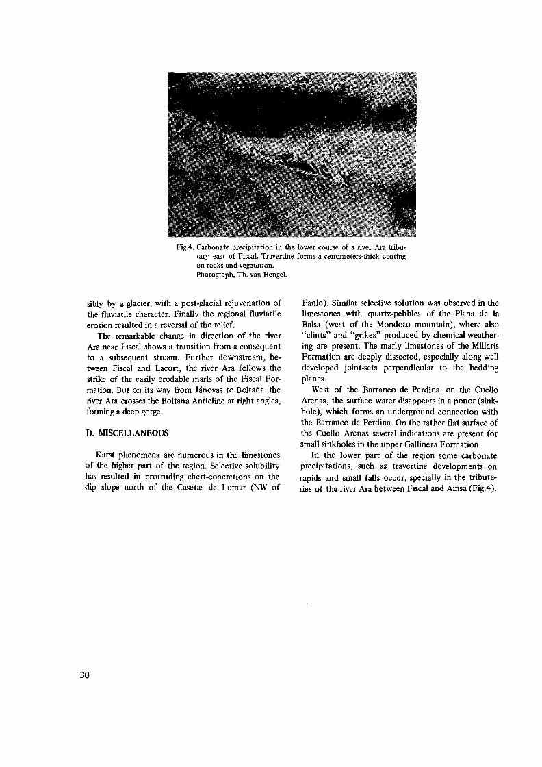
FigA. Carbonate precipitation in the lower course of a river Ara tributary east of Fiscal. Travertine forms a centimeters-thick coating on rocks and vegetation. Photograph, Th. van Hengel.
sibly by a glacier, with a post-glacial rejuvenation of the fluviatile character. Finally the regional fluviatile erosion resulted in a reversal of the relief.
The remarkable change in direction of the river Ara near Fiscal shows a transition from a consequent to a subsequent stream. Further downstream, between Fiscal and Lacort, the river Ara follows the strike of the easily erodable marls of the Fiscal Formation. But on its way from Janovas to Boltafia, the river Ara crosses the Boltafia Anticline at right angles, forming a deep gorge.
D. MISCELLANEOUS
Karst phenomena are numerous in the limestones of the higher part of the region. Selective solubility has resulted in protruding chert-concretions on the dip slope north of the Casetas de Lomar (NW of
Fanlo). Similar selective solution was observed in the limestones with quartz-pebbles of the Plana de la Balsa (west of the Mondoto mountain), where also "clints" and "grikes" produced by chemical weathering are present. The marly limestones of the Millaris Formation are deeply dissected, especially along well developed joint-sets perpendicular to the bedding planes.
West of the Barranco de Perdina, on the Cuello Arenas, the surface water disappears in a ponor (sinkhole), which forms an underground connection with the Barranco de Perdina. On the rather flat surface of the Cuello Arenas several indications are present for small sinkholes in the upper GaIIinera Formation.
In the lower part of the region some carbonate precipitations, such as travertine developments on rapids and small falls occur, specially in the tributaries of the river Ara between Fiscal and Ainsa (Fig.4).
30

CHAPTER III
STRATIGRAPHY
A. INTRODUCTION
The southern external zone of the Central Spanish Pyrenees is built up by Cretaceous-Lower Tertiary rocks. The sequence mainly consists of limestones, sandy limestones, marls and dolomites with subordinate amounts of sandstones and conglomerates. The Upper Cretaceous-Palaeocene sequence reaches a thickness of about 1000 m, the Eocene deposits locally are even 4000 m thick.
In a lithostratigraphic correlation (Fig.5) eight sections are shown, located from the Aragon Subordan region in the northwest to the Ara-Cinca region in the southeast. The compilation of data is mainly derived from Jeurissen (thesis, Utrecht, 1966, Fig.6) with corrections for the Tendenera region (Van der Voo, 1966), and supplemented with the Gallisue section (this thesis).
In an area measuring some 60 krn across, a continuous development is present from the Campanian up to the Upper Palaeocene. The gradual increase of the calcareous content of the Cretaceous sequence to the east is evident, this leads to the imposing high limestone walls along the river valleys in the Ordesa National Park and in adjacent regions. The Palaeocene deposits, on the other hand show a very constant facies development laterally.
In our correlation the upper part of the Palaeocene sequence (Gallinera Formation) is used as base of reference instead of the Maastrichtian-Palaeocene boundary as used by Jeurissen (1969, Fig.6), for the following reasons: The Upper Palaeocene deposits coincide with the top of a relatively competent sequence when compared with the younger preponderantly Flysch-type deposits; in contrast with the uniform lateral development of the Cretaceous-Palaeocene sequence the younger tertiary sediments show strong variations in thickness and facies and lastly, the upper beds of the Palaeocene contain numerous cherthorizons above Alveolina-limestone beds which thus formed an easily recognizable and mappable horizon.
In the Ara-Cinca region the Cretaceous-Palaeocene sequence is exposed in the beds of the rivers Aso and Vellos and on the barren dip slopes north of these rivers. The Eocene rocks could be studied specially in the tributaries of the rivers Ara, Yesa and Cinca. The latter rocks mainly consist of sandy limestones and
marls of the Flysch-type. Between Janovas and Boltafia the river Ara cuts across the Boltafia Anticline exposing limestones and marls of the Marina Formation.
We may distinguish the following formations in the region studied: 300 - 1000 m Fenes Formation (Upper Eocene) 300 - 1200 m Fiscal Formation (Biarritzian?)
2000 m San Vicente Formation (Cuisian? - Lutetian)
0-4000m Burgase Formation (Cuisian? - Lutetian)
0- 1000 m Marina Formation (Cuisian) 0 220 m Metils Formation
(Upper Ilerdian - Lower Cuisian) 0 125 m Millaris Formation (Middle Ilerdian)
155 m Gallinera Formation (Montian - Lower Ilerdian)
95 m Salarons Formation (Lower DanojMontian)
185 m Tozal Formation (Maastrichtian) 100 m Estrecho Formation (Campanian)
The names of the formations of the CretaceouSPalaeocene sequence - except the Metils Formation - are derived from the type-sections located in the Ordesa region (Fig.!) and have been introduced by Van de Velde (1967). The names of the younger formations given by the present author are derived from type-localities in the Ara-Cinca region.
Age determinations of the Campanian-Upper Palaeocene rocks were made by thin section analyses of the fauna and correlation with those of the sequence described from the Ordesa region (Dalloni, 1910; Von Hillebrandt, 1962; Van de Velde, 1967). For the younger formations the fauna is partly determined by Professor H. Hottinger (Basel) supplemented with the fossil lists of Dalloni (1910) and our own observations.
The boundary between Upper Cretaceous and Tertiary is still the subject of controversial opinions. This study in a limited area repeatedly proves the difficulty of making a reconstruction of the geologic history just preceding and during the first symptoms of orogenic activity.
31

Eal' 01 Modrid
: .1 Llthastrallgraphlc
- ,c.·.o upp_er cretace_ous and of the western Spanish
Huesca
" Compiled
42-40'
9 6 6
W~.
..!.l2: "00"'" ~
;a Cre'acaou. - Lower Tertiory
., '
Geochronology
,...~'- ,:J _SABINANI~,or~U·30' v
!5 10 1511111. -'- ' I ~
Cuisian ?
Lutetian
-----""'-M.I1erdian " ---------~~~1=
onf.-L.Ilerd. --------M. Paleocene
~Jj!~O=c~~-_'"'";q:iIr''''+_t'
Maostrichtian
Companion
Santonian
Coniacian
Turonian Cenomanian
I
correlation of sections thraugh
Lower Tertiary sediments Pyrenees. province of
by H A van Lunsen ~
i """"'"""Ii!...
2 3 4 5 6
800
700
800
900
1000
~ limn,one with ~ Sandy Ll.,...tone I'Bi:!':i!I chert nodule. ~ Conolomeral ..
oll.rnalian of lime.tona
~ Flr-ch-type dapo.ih ~ ",o"ive Lim.,tona oolitic U",.,tone
II1II nodular lim••ton. dDlomite • AIVIolino lim.,tone~marl' with marl)' Lim..lone mJ ~:~~~~a::ni:~th
Fig.5. Lithostratigraphic correlation of sections through Upper Cretaceous and Lower Tertiary sediments of the Western Spanish Pyrenees (province of Huesca). Data mainly obtained from a compilation by Jeurissen (1969), corrected for the data of Van der Voo (1966). Datum line originally placed on top of the Salarons Formation (Jeurissen, 1969) is now drawn on top of the Gallinera Formation.
32

B. UPPER CRETACEOUS-PALAEOCENE
1. ESTRECHO FORMATION (Campanian)
Over a length of about 2.5 km the river Vellos cuts across the oldest rocks of the region studied. They consist of dark to medium grey massive limestones, fine grained, locally with concentrations of external moulds of large Rudistids which, however, nowhere in my area has led to the formation of real bioherms. These Rudistids belong to the species Biradiolites angulosis D'ORBIGNY, They can reach sizes from 7-15 cm. On account of the lesser resistance of these fossils against dissolution they weather out easily and the resulting hollows give a coarsely vesicular character to the surface of the otherwise massive rocks.
According to Tjalsma (1960, Internal Report, Utrecht) the limestone matrix contains: Cuneolina sp., Dicyclina sp., Globotruncana sp. and numerous larger Miliolidae. In between the dense rocks three thin horizons of limestone have been observed, rich in debris of shells, Coralline Algae, Bryozoa and Pseudosiderolites sp. As the lower limit of the formation is not exposed, a thickness of at least 100 m can be assumed for this part of the Estrecho Formation.
Comparing the Estrecho Formation, as exposed in the river Vellos, with the type section in the Ordesa region (Van de Velde, 1967) it can be noted that the gradual increase of detrital supply in the uppermost part of the Ordesa section appears to be absent in the Vellos exposures.
According to Van de Velde, the upper part of the Estrecho Formation in the Ordesa region contains numerous: Hippurites, Orbitoides media (d'ARCHIAC) and Pseudosiderolites vidali (DOUVILLE). On account of this association, a Campanian age is assigned to this formation. As the Vellos section forms its lithostratigraphic aequivalent, the same age is attributed to the latter deposits.
According to Wensink (1962) the basal beds of the Campanian, to the north-west of the region studied, are conglomeratic. Similar observations have been made in other areas of the Pyrenees, a fact which is not at all surprising, as the Campanian is transgressive after a prolonged period of regression; moreover, we will see in our text that each of the bases of the younger formations of the Cretaceous-Palaeocene sequence may also contain detrital matter.
2. TOZAL FORMATION (Maastrichtian)
In the north and north-east of the region studied massive limestones overlie the Estrecho Formation. These rocks build up the valley walls of the river
Arazas and the river Vellos north of Gallisue. They consist of marly or sandy limestones weathering to a yellowish brown, but the dense fresh rock has a bluish-grey colour.
The base of the formation is formed by conglomerates which consist of quartz-pebbles. These basal conglomerates have a maximum thickness of about 50 m, showing an alternation of coarser and fmer detritus, normally with diameters of the components up to 3 cm, although some pebbles have a diameter of about 10 cm. At the very base of these deposits debris of Stromatopores occur, rounded by transport; they resemble Devonian Stromatoporoids. Also some fragments of Rudistids have been observed, which in~
dicate that during the deposition of the basal conglomerates the Upper Campanian was, at least locally, attacked by erosion (reflecting a nearby landmass). This phenomenon probably caused the disappearance of the sandy limestones on top of the Estrecho Formation in the Gallisue section (cf. p.32). So there evidently exists a slight non-conformity between the Estrecho Formation and the base of the Tozal Formation.
From the gravel conglomerates upwards a gradual transition into sandy limestones takes place. This sandy limestone reaches a thickness of 65 m. It is overlain by some 30 m of coarse bluish grey limestones alternating with thin layers of violet limestone (weathering to a pink colour). The latter contain shell debris and large Orbitoides sp., which are locally concentrated in lenticular beds. Some 40 m of massive bluish grey limestone follow, in which the grain-size decreases upwards. At the base of this massive limestone unit two thin silex horizons occur. In its middle part a thin (2-10 cm) fossilliferous layer has been observed, composed of numerous shell debris, Corals and Orbitoides sp., and covered by a marly limestone layer which could be followed over a long distance. About 17 m of greyish limestone form the top of this formation.
The Orbitoides sp. as cited above are restricted to the upper 70 m of the formation, whereas the whole formation reaches a thickness of 185 m.
The following fossils could be determined: Orbitoides apiculata SCHLUMBERGER, Lepidorbitoides sp., Siderolites calcitrapoides LAMARCK, Omphalocyclus macroporus LAMARCK, Simplorbites gensacicus LEYMERIE. Moreover, in the lithostratigraphicalIy equivalent formation in the Ordesa region, Van de Velde (1967) came across: Lepidorbitoides socialis LEYMERIE, Lepidorbitoides minor SCHLUMBERGER, Globotruncana sp. and the macro-fossils: Anachytes sp., Pecten sp., Exogyra pyrenaica LEYMERIE and Lopha (Ostrea) sp. The microfauna is characteris
33

tic for a Maastrichtian age of the formation. Vande Velde (1967) frequently observed Orbi
toides sp. and Lepidorbitoides sp. which occur in vertical oval tubes, specially in the upper part of the Tozal Formation. Later on we shall see that this arrangement could be observed on larger Foraminifera of the Lower Eocene Marina Formation as well.
Comparing the development of the Tozal Formation from the Tendenera region in the west (Van der Voo, 1966), the Ordesa region in the centre (Van de Velde, 1967) to the Ara-Cinca region in the east, a remarkable thinning in southeasterly direction is established from about 490 m in the northwest to 185 m in the southeast. Within 50 km the thickness of the formation decreases to less than half. As the Tozal Formation is conformably overlain by dolomites, we apparently are dealing with an original depositional feature controlled by palaeogeography. According to Seguret (1967) the formation of Maastrichtian age of the axial border east of the region studied proved to be considerably thinner than the formations of the same age in the Cotiella Overthrust Mass. As the overthrust mass came from the north, the conclusion can be drawn that during the Maastrichtian the strongest basin development must have taken place in the general area of the present axial zone.
3. SALARONSFORMATION (Lower Dano-Montian)
Along the path southwest of Gallisue and at about 1300 m upstream the Veilos river, north of the confluence of the rivers Aso and Vellos, we observed light grey dolomites, rather coarse grained, probably recrystallized, with a saccharoidal character. The fresh colour varies from dark blue to very light grey. These bedded to massive dolomites are generally homogeneous in composition allover the 95 m thickness of this formation. However, near Gallisue, some gravel layers have been observed at about 25 m above the base of the formation, varying in thickness from 10 to 60 cm with an average grain size of one centimeter. In the Valle de Anisclo east of Sercue these gravel layers can reach a thickness of more than two meters with diameters of up to 5 cm of the pebbles.
The dolomitization of the Salarons Formation appears to be incomplete. Locally a relatively high calcium content has been found.
Notwithstanding the fact that no fossils have been found, the position of the Salarons Formation between the Maastrichtian Tozal Formation and the overlying Gallinera Formation (Montian-Early lIerdian) suggests a Danian to Lower Montian age of the dolomites.
As to the lateral development of these dolomites, the Salarons Formation, in contrast to the Tozal Formation, has its greatest thickness in the region studied (95 m in the Gallisue section). In both the Ordesa region as in the Tendenera region a thickness of about 60 m has been established (Van de Velde, 1967;Van derVoo, 1966).
4. GALLINERA FORMATION (Montian-Lower Herdian)
INTRODUCTION
The limestones of the Gallinera Formation form the upper part of the competent calcareous sequence. These rocks define to a large extent the geomorphological character of the northern area. In the Gallisue area the formation is about 155 m thick. The barren dip slopes north of Fanlo and east of the Sestrales mark the greater part of the boundary between this sequence and the overlying less resistent Late Herdian-Eocene rocks.
In the literature we frequently meet the name "Alveolina-limestone" as an equivalent for the Gallinera Formation. Van de Velde (1967) remarks that some confusion may arise in giving that name to the whole formation, as Alveolina sp. are supposed to occur only in its upper part. In the Gallisue section, however, we observed Alveolina in the upper, as well as in the lower part of the Gallinera Formation, which would justify the use of the name Alveolinalimestone. But we are of the opinion that there still may arise some confusion for another reason. In the younger formations, specially in the Cuisian Marina Formation, numerous horizons have been observed, crammed with Alveolinae. So there is no reason, to maintain such a confusing name as the name for a formation.
UTHOLOGIC CHARACTER AND THICKNESS
In the Gallisue area the formation starts with 70 m medium to coarse grained sandy Miliolid-limestones, indistinctly bedded, dark to medium grey. Numerous brownish-black spots, scattered through these limestones appeared under the microscope to be clear rounded quartz grains and small idiomorphic quartz crystals. The quartz-content decreases upward. The sandy limestones gradually pass into densely massive limestones, medium to light grey, weathering to a nearly white colour. The ubiquitous occurrence of Lithothamnium with its characteristic white colour makes it an easily recognizable member allover the Aragonian Pyrenees. In the literature it is commonly called "Lithothamnium-limestone". This member
34

reaches a thickness of about 20 m. On top of the Lithothamnium-limestones follow some 20 m, dark to medium grey limestones. Their lower 9 mare sandy; a one meter thick bed of mottled sandy limestone follows, which consists of coarse grained irregularly formed, rounded and angular limestone fragments wit!). a light grey colour, embedded in a darker dense limestone matrix. Probably we are dealing with a horizon of reworked material out of the underlying sandy limestone member. Similar phenomena were observed by Van de Velde (1967) in the limestones of the Gallinera Formation of the Soaso-cirque section (Ordesa region).
On this reworked horizon about 10 meters of completely recrystallized coarse grained limestones follow which are indistinctly bedded, medium to dark grey, with a slight amount of fine sandy quartz grains scattered through the rocks. The member is overlain by about 10 meters of sandy fossiliferous limestones with Alveolina sp. and Nummulites sp. In the middle part of the member numerous short prismatic idiomorphic quartz crystals and rounded quartz grains occur which do not pass 2 mm in diameter (Fig.6). The Gallinera Formation is terminated by about 35 m of dense massive medium to thick bedded limestones, dark to medium grey, with a great many brownishblack chert horizons concentrated in the middle of the beds. Near the Fuente de Suspiros in the valley of the river Vellos 35 chert horizons have been counted in the uppermost 20 m of the member.
South of the Collado Custodia we met with a different development. On top of the Litothamniumlimestones lie 30 m of quartz-sandstones, thick bedded with grain sizes ranging up to 2 mm. The quartz grains are wellrounded and sorted. These sandstones are followed upwards by a complex of dense limestones with idiornorphic quartz crystals and rounded quartz grains,*) both irregularly distributed throughout the rocks. This complex, which reaches a thickness of eleven meters, consists for the greater part of black to dark-grey, dense, bituminous beds, with a fetid smell. (Van de Velde observed the same fetid limestone in the Ordesa region).
An analysis of the carbonate and organic content
gave ±97% CaC03 (weight percentage) and less than 0,5% organic matter. About 2,5% of the total weight may represent the quartz content. The crystals are clearly visible as black glittering specks on the fresh rock surface. The apparent black colour of the crystals evidently is due to the optical effect of the matrix surrounding the grains. Superficial observation therefore easily leads to descriptions such as "sandy limestone" or "recrystallized" limestone, such as are frequently seen in the literature.
Next follow 0,6 m of dark grey limestone with quartz grains and crystals, then a 1,60 m thick massive, medium to dark grey, Alveolina bearing limestone bed, in which the Alveolinae are concentrated in thin horizons and clusters.
On top of this bed 8,5 m of massive medium grey fme grained limestones have been deposited, which are indistinctly thick bedded and rich in Gryphea sp. Between the Mondoto and Estiva mountains these rocks form a badland landscape of deeply incised "karst" relief.
Pure white quartz-pebbles lenticularly concentrated occur along the bedding plane. But in places they mark a kind of high-angle cross-bedding within the limestone beds (Fig.7). The pebbles, which reach sizes of up to one centimeter in diameter, are well rounded and non-sorted. The quartz crystals are here concentrated in the upper part of the latter member.
Of the overlying 50 m medium to thickbedded, dark to medium grey dense limestones, the lowermost 20 m contain chert-horizons.
FOSSIL CONTENT AND AGE
The Gallinera Formation is rich in fossils. In the basal sandy limestones overlying the Salarons Formation the first Alveolina occur. We determined Aweolina primaeva HOTTINGER, further Fallotella alvensis MANGIN, and numerous Miliolidae. In the Soaso cirque section Van de Velde came across Gryphea sp. in the lowermost part of the formation, which has not been observed in the lithostratigraphically corresponding beds of the Ara-Cinca region. The above mentioned fossils are characteristic for the Montian,
*) In the Flysch-type deposits of Lutetian age east of the Boltafia Anticline a sandy limestone pebble is found in which idiomorphic quartz-erystals are enclosed (Sample Nr.312CC). The pebble is presumably an erosion-product of the same facies of IithostratigraphicalIy equivalent beds as found in the GalIinera Formation. Ghost-structures of fossil intergrowth and inclusions of tourmaline needles are visible in the crystals. Fig.6 shows the growth of quartzcrystals around clearly visible cores of well rounded quartz-grains. The formation of the crystals must have taken place after the deposition of the A1veolinae, for in
several places, the quartz-erystals are found to have grown with sharp borders through an Alveolina specimen, leaving behind a fme ghost structure in the crystals. As carbonate veinlets cut through both the A1veolinae and the quartzcrystals, the growth of the crystals must have taken place before the GalIinera Formation has been tectonized. On account of the observation of a limestone pebble with idiomorphic quartz-erystals in the Lutetian-FIysch, cited above it is probable that the formation of quartz in the GalIinera Formation took place before the Middle Eocene.
35

Fig.6. Photomicrograph of Alveolina-limestone of the upper part of the Gallinera Formation (Sample No.87, parallel nicols, enlargement 15x, river Veilos north of Gallisue). Idiomorphic quartz crystals grown round rounded grains of quartz. The crystals often show prismatic habitus. In the central part of the photograph ghost structures of Alveolina specimen are observable in the quartz crystals growing through the Foraminifera. In the upper right corner of the photograph a calcite vein cuts off the Alveolina sp. as well as the quartz crystals.
considered to belong to the Middle Palaeocene in the • « Pyrenean literature, and thus attest to a Montian age
for the lower part of the Gallinera Formation.
• - _ _" 4 •••• .. .. . ' ..... ............. -... Just below the Lithothamnium-limestones, Van de
Velde (1967) found Operculina heberti MUNIER CHALMAS. In the Lithothamnium-limestone we
•• - .... - •••••• 4 ••• • ",", __ "" .... __ ,. ... ~ ... _
came across Discocyclina seunesi H.DOUVILLE and numerous indeterminable fragments of larger Foraminifera.
According to Von Hillebrandt (1962) the Alveolina-beds of the upper part of the Gallinera Formation in the Ordesa region contain the following fossils: .'
Alveolina cf. triestina HOTTINGER, Alveolina trempina HOTTINGER, Nummulites cf. exilis DOUVILLE, Nummulites globulus LEYMERIE, Nummulites cf, subramondi DE LA HARPE, Assilina cf.leymeriei d'ARCHIAC and HAIME, Discocyclina cf. trabayensis NEUMANN, Operculina sp., Miliolidae and Bryozoan fragments. Mengaud (1939) moreover
,.-.~ ~----------------- found Assilina granulosa LEYMERIE. In thin sections from the lithostratigraphically corresponding beds SW
Fig.7. Sketch of cross stratification and channelling in the of the Collado Custodia we found Alveolina globula limestones of the GalIinera Formation, visible by selecHOTTINGER, Alveolina dolioliformis SCHWAGER,tive weathering of (milky) quartz-gravel horizons. Ex
posure east of the Estiva mountain. Orbitolites cf. gracitis LEHM, Alveolina (Glomalveo/ina) fragments probably of lepidenta (Fig.8). In the Gallisue section we, moreover, observed small Num
36

Fig.B. Photomicrograph of Alveolina-limestone of the upper part of the Gallinera Formation (Sample No.30C, parallel nicols, enlargement l5x, Barranco de Perdina, east of the Mondicieto mountain). Zone of Alveolina cucumifonnis (lowest Lower Ilerdian) with: A.globula HOTT.; A.doliolifonnis SCHWAG.; fragments of Glomalveolina (A.lepidenta? ) and Orbitolites cf. gracilis LEHM. Matrix biomicritic with rounded grains of quartz.
mulites sp., Miliolidae, Textularids and fragments of Crinoids. Most of the Alveolinae were partly or totally flosculinized.
According to Hottinger and Schaub (1960), the fossils mentioned above mark the very beginning of the Ilerdian and represent the zone of Alveolina cucumiformis, characteristic for the lowest Lower IIerdian. The determinations of Von Hillebrandt, on the contrary, point to a Middle and Late Ilerdian age for the lithostratigraphicaIly equivalent member.
At this state of our knowledge about the Ilerdian fauna in the Mediterranean region, speciaIly that of the Alveolinidae, the present author considers the determination by Hottinger as the best approach.
According to Jeurissen (1969) the age assigment of his CpS-bed (the lithostratigraphicaIly corresponding layer of the Alveolina-limestone bed on top of the GaIlinera Formation) was based on the occurrence of: Alveolina cf. triestina and Alveolina trempina (HOTTINGER, 1960). He attributed a Late Palaeocene age to this association. Although it foIlows that the fossil lists of the Alveolina-beds of both Von Hillebrandt and Jeurissen differ from the determinations by Hottinger, nevertheless, the age assignent of the two first mentioned authors happen to cover in a broad sense the more precise determinations of Hottinger.
The limestone with chert-concretions overlying the limestones with Alveolinae are poor in fossils. Jeuris
sen (1969) cited the possible occurrence of Operculina cf. canalifera d'ARCHIAC in his Cq member (the lithostratigraphically correlative chert-limestones northwest of the Ara-Cinca region) which, according to Mangin (1958) would indicate a Lutetian age. Cuvillier (1956) places Operculina canalifera d'ARCHIAC in the Lower Eocene of the western Aquitaine basin. According to our knowledge about the more complete Ilerdian and Eocene sequence in the region studied it is hardly conceivable that Operculina cf. canalifera reaIly exists in the Lower Herdian.
DEVELOPMENTS OF THE GALLINERA FORMATION OUTSIDE OUR REGION
According to Von Hillebrandt (1962) and Van de Velde (1967) the thickness of the Ga1Iinera Formation increases in the Ordesa region from west to east, from 140 to 240 m respectively. In the Ga1lisue section a thickness of 155 m could be established. More to the northwest in the Gillego-Aspe region, Jeurissen (1969) observed an increase in thickness from west to east of the lithostratigraphically corresponding formation from 80 to 110m respectively. In his lithostratigraphic correlation, Jeurissen (1969, Fig.6) foIlowed the preliminary results of investigations of Van der Voo (Internal Report, Utrecht, 1961) for the Sierra
37

de Tendefiera (Fig.l), which were however corrected later (Van der Voo, 1966) and the thickness of the Gallinera Formation was then estimated at 120 m. The latter thickness is more in accordance with the continuous development west and east of the Tendefiera region (Fig.5).
Where the Gallinera Formation is conformably overlain by the MiIlaris Formation, a thinning of the formation is suggested in the direction of the axial zone. Seguret (1967), who studied the Cotiella Overthrust region east of the river Cinca, came to the same conclusion. The lateral variations in thickness of the Gallinera Formation probably are of primary sedimentary origin.
5. MILLARIS FORMATION (Middle Ilerdian? )
LITHOLOGIC CHARACTER
The Millaris Formation is named after the Pica de Millaris, a mountain top located in the Ordesa region (Van de Velde, 1967). In general the formation consists of fine grained marly limestones weathering to a yellow grey and brownish colour. The fresh colour of the marly limestones varies from medium to dark grey. The carbonate content amounts to about 75% by weight. The formation reaches thicknesses of 0 to 250 m. Bedding, though indistinct, may reach 1-3 m.
In the Ordesa region Van de Velde describes the rocks as: "marly limestones, highly affected by fracture cleavage". Weathering resulted in the formation of beds totally composed of small sharply broken rock sheets. In the Ara-Cinca region, the lithostratigraphic equivalent shows the same character on barren dip slopes. In general, cleavage is most pronounced in the rocks of the northwestern part of this region. In places where the Millaris Formation is overlain by limestones of the Metils Formation, the fracture cleavage turns out to be less distinct, and the inner structures of the beds show a fine lamination parallel to the bedding planes (Fig.9).
A remarkable aspect of the marly limestones is formed by the development of joint-sets perpendicular to the bedding planes, along which strong chemical erosion has taken place.
The dark colour and fetid smell of the newly broken rock fragments is probably due to a slight amount of organic matter within the deposits. Irregularly scattered in the rocks concretions of haematite frequently occur. They were probably formed by oxidation of pyrite, which is locally still present in the inner cores of the concretions. On one location, in the Veilas exposures near Gallisue, the basal beds of the Millaris Formation contain some concretions of
limestones in which numerous well developed crystals of gypsum occur. Most of the crystals are twinned in perfect arrowhead forms (Fig. 10). Thin section analyses show clear gypsum crystals surrounded by a very fine grained calci-pelite, polluted by opaque, probably organic, matter, and some badly preserved micro-foraminifera. In the matrix surrounding the crystals no signs have been observed of textural disturbance by a possible post-sedimentary growth of the crystals. The conclusion is justified that the crystals have a syn-sedimentary origin. Considering the idiomorphic configuration and sharp outlines, together with the well-known softness of gypsum, it is probable that the crystals have been formed in situ.
In places where no fracture cleavage affected the rocks, the transition of the Gallinera Formation to the Millaris Formation is sharp and concordant. North of Fanlo at the top of the Millaris Formation some layers of brownish weathered silty-sandy limestones occur, rich in tracks of burrOWing and creeping benthos and in larger Foraminifera. Internal parallel lamination is visible through selective weathering of more and less calcareous laminae.
South of Nerin, on the route from the Molino de Aso to Via, an influx of terrigenous matter occurs as thin layers of silty limestones, both in the upper beds of the Millaris Formation and in between the basal beds of the overlying limestones of the MetiIs Formation. They are dark grey, weathering brownish-ochre. Lithologically they resemble the silty limestones of the Flysch-type series but no sedimentological evidence does exist in favour of a turbiditic origin of the beds. Near the Fuente de Suspiros in the valley of the river Vellos the silty character of the upper part of the Millaris Formation is only visible macroscopically through a slight difference in the weathered colour of these beds, when compared with the over- and underlying limestones.
FOSSIL CONTENT AND AGE
At the base of the lithostratigraphically aequivalent formation in the Ordesa region Von Hillebrandt (1962) observed Discocyclina fortisi (d'ARCHIAC). He further came across Globigerinids and debris of Bryozoans and of Echinids. West of the Ara-Cinca region, Jeurissen (1969) observed in correlative beds Discocyclina sp., Nummulites sp., Alveolina sp. and Miscellanea sp. According to Mengaud (1939) some badly preserved Ophiurids and a single Pleurotomaria were observed in the Ordesa region.
Thin section analyses of rock samples of the region studied by the present author only gave a poor fauna of indeterminable Globigerinids in a rme calci-pelitic
38

Fig.9. Marly limestones of the Millaris Fonnation. Internal lamination clearly visible on weathered surface of the rock. Fracture cleavage subordinate. Confluence of the rivers Aso and Vellos.
Fig.l0. Photomicrograph of a gypsum crystal in the marly limestones of the Millaris Fonnation (Sample No.69, parallel nicols, enlargement 15x, river Vellos near the fuente de Suspiros). Matrix, micritic with rare Globigerinids.
39

c
matrix (see Fig.IO). The scarce fossils observed in the Millaris Formation give no evidence for its age. Its position between the Lower Herdian Gallinera Formation and the Upper Herdian Metils Formation may, however, indicate a Middle Ilerdian age for the Millaris Formation in the region studied, as no sedimentary hiatus between these successive formations has been observed.
THICKNESS AND DISTRIBUTION OF THE MILLARIS
FORMATION
From northwest to southeast an increase in thickness of the formation is evident: In the upper course of the Barranco Borrue the formation is (almost) absent and the limestones of the Gallinera Formation are directly overlain by Flysch-type deposits. North of Fanlo, a 40 m thick Millaris Formation is conformably overlain by limestones of the Metils Formation. In the Gallisue section 125 m of marly limestones could be established. East of the region studied, Th. van Hengel (Internal Report, Utrecht, 1967) measured a thickness of about 120 m for the lithostratigraphically aequivalent formation. The latter two exposures are also conformably overlain by limestones of the Metils Formation. Apparently the increase in thickness of the formation from west to east is of a primary sedimentary origin.
The same trend in lateral variation of thickness of the Millaris Formation is observed in the Ordesa region (Van de Velde, 1967), where the Millaris Formation, however, is directly overlain in the whole area by Flysch-type deposits.
From southwest to northeast an increase in thickness of the formation is also established. On the Collado Custodia at least 250 m is found. In the Ordesa
NW d
a
region Van de Velde (1967) noted an even stronger increase in thickness of the formation to the northeast, than is observed in the Ara-Cinca region.
In the Ordesa region and in the northern part of the Cinca region first Mengaud (1939) and later Von Hillebrandt (1962) observed a slight non-conformity between the Millaris Formation and the overlying Flysch-type sediments. According to Van de Ve1de (1967) "a more important indication is to be inferred from the thinning of the Millaris Formation....". However, this thinning out may be mostly of primary sedimentary origin, since it is also observed in places where the formation conformably is overlain by limestones of the Metils Formation. Only in the extreme western part of the region studied, does a superficial erosional effect appear to be due to a slight nonconformity (Fig. 11). Perhaps the same can be said of the upper part of the Millaris Formation in the Ordesa region. The lack in key-fossils in the Millaris Formation makes it possible that towards the northeast the upper part of the Millaris Formation may represent the time-stratigraphic aequivalent of the Metils Formation.
Of the development of the formation west of the region studied Jeurissen (1969, Dr-member) shows the total absence of the marly limestones in the Aurin-Tendenera region (see also Fig.S). Further to the west, with the exception of the Aragon region, a layer of 10m marly limestones occurs, underlying Flysch-type deposits. In his description of the Aragon section (Fig.S) Jeurissen notes a sudden increase in thickness of the Millaris Formation, which in his area reaches 50 m. In fact, 10m of marly limestones affected by fracture cleavage are overlain there by the relics of a strongly disturbed, locally coarse grained, sandy limestone and massive limestone breccia. The
I
I I
: I I I I ' ...------15m ---_~~!,..
Fig. I I. Sketch of outcrop of the upper part of the Millaris Fonnation, Barranco Borrue west of Faillo. a=rnarly limestone of the Millaris Fonnation. b=ehannels filled with densily packed limestone nodules rich in larger Foraminifera. c~aded limestone beds of the Flysch-type, d=mudstone with limestone pebbles. Between a) and c) a thin pyrite horizon.
40

Fig.12. Lenticular bedded nodular limestones of the Metils Fonnation exposed along the path from Nerin to Vio, south of the river Aso. The flat surface of outcrop represents a joint plane.
lower 10 meters in our opinion represent the lithostratigraphic correlative beds of the Millaris Formation, whereas the remaining 40 m probably may be correlated with the Metils Formation of our region. The coarse grained sandy character of the upper part of leurissen's Dr-member has also been observed in the Metils Formation in the western part of the AraCinca region.
6. METILS FORMATION (Upper Ilerdian - Lower Cuisian)
LITHOLOGIC CHARACTER AND THICKNESS
The formation is named after the Alto Metils, a mountain top northeast of Ceresuela which forms a slightly folded barren dip slope of nodular limestones.
It consists of dark to medium grey, fine grained dense limestones and marls, weathering to a medium to light grey colour. A distinct bedding, often lenticular, with a monotonous alternation of knobbynodular limestone beds (thickness 15-50 cm) and marly layers (0.5-1.5 cm) is characteristic for the whole formation (Fig. 12).
In the basal part of the formation an alternation of
knobby limestone with more sandy limestones occurs. These sandy beds have much in common with the limestones of the Flysch-type higher up in the Eocene sequence. The specific character of turbidites however, could not be established. On cross-sections through the weathered sandy limestone beds some internal lamination has been observed. In the Gallisue area these sandy limestones are rich in larger Foraminifera. Numerous tracks of benthonic fauna occur at the base of the sandy layers.
An analysis of some samples from the sandy basal part of the formation gives a carbonate content of about 80% (weight percentage). The overlying limestones prove to be more calcareous (90%).
A detailed section taken in the Gallisue area (See Fig.5) shows the following members of the formation. From base to top we meet with:
20 m coarse grained sandy limestones, dark grey, weathering to a brownish-grey colour, distinctly bedded, bed thickness from 30 to 50 cm. The sandy member is rich in larger Foraminifera, amongst others in Alveolina sp.
45 m fine grained knobby limestones, dark-medium grey, medium bedded, alternating with thin bedded marls. The latter often contain shell
41

debris and larger Foraminifera. 6 m massive, dark grey, Foraminifera-limestone,
weathering to a brownish-grey colour. They contain, amongst others, Alveolina sp.
105 m knobby limestones, fme grained, medium bedded, alternating with thin bedded marls.
6 m knobby limestones, fme grained, dense, medium bedded, with black-brownish chert concretions concentrated in the middle of individual beds. In general these concretions have smaller sizes than those in the chert horizons on top of the Gallinera Formation.
40 m very fine grained, medium bedded limestones, medium grey, weathering to a light grey colour. Towards the top of this member the marly intercalations gradually become more and more important, whereas the limestone beds get more marly. On weathered surfaces, numerous sections of oval and circular burrows are found, with diameters of up to one centimeter.
FOSSIL CONTENT AND AGE
At the sandy base of the formation we came across Nummulites sp., Assilina sp., Discocyclina sp., and Alveolina sp.
In the lithostratigraphically aequivalent beds of the Tendefiera region, just overlying the Millaris Formation, the slumped relics of the Metils Formation contain Alveolina cf. corbarica HOTTINGER, Nummulites atacicus LEYMERIE, Nummulites exilis, and Assilina leymeriei d'ARCHIAC.
According to Hottinger and Schaub (1960) this association represents the Middle Ilerdian, and more precisely, by the presence of A lveolina cf. corbarica HOTTINGER, the upper part of the Middle Ilerdian.
About 65 m above the base of the formation in the Gallisue area R. Tjalsma (1961, Internal Report, Utrecht) determined Alveolina riitimeyerie HOTTINGER. According to Hottinger (1960) this species of Alveolina is already found in the Upper Ilerdian, but it appears to be characteristic for the beginning of the Cuisian in the Mediterranean area.
The oldest rocks exposed in the Boltafia Anticline consist of dense limestones with low angle crossstratification developed in lenticular beds. Several chert horizons were observed. Probably we are dealing with the lithostratigraphic aequivalent of the limestones with chert-nodules in the Gallisue area, which belong to the upper part of the Metils Formation. The limestones with chert-nodules contain Cuvillierina eocenica, DEBOURLE, Alveolina cf. oblonga d'ORBIGNY, Nummulites partschi DE LA
HARPE, and Operculina sp. We further came across numerous Miliolidae, Bryozoa, and fragments of Holothuroid-skeletons.
According to Hottinger and Schaub (1960) the foraminiferal association marks the transition from the Upper Ilerdian to the Lower Cuisian. On account of the fossil content and lithology we may attribute an Upper Ilerdian-Lower Cuisian age to the Metils Formation.
DISTRIBUTION AND OTHER DEVELOPMENTS OF THE
METILS FORMATION
According to Jeurissen (1969) the limestones with the fracture cleavage (the lithostratigraphic aequivalent of the Millaris Formation) in the Aragon valley are overlain by coarse grained sandy limestones. Within these limestones marine slope breccias occur, with limestone components ranging in size from 0.1 to 0.5 m diameter. This limestone member reaches a thickness of about 40 meters. It is overlain by Flysch-type deposits. In our opinion the above mentioned sandy limestone member in the Aragon region (Fig.5) may be the lateral correlative of the sandy base of the Metils Formation exposed in the Gallisue area.
The slump zone described by Jeurissen, however, follows the base of the overlying Flysch-type deposits in easterly direction. We fmd it back in the Tendefiera region, where the Metil Formation is composed of a thick slumped zone with Foraminifera-rich pebbles of sandy limestone.
In the valley of the Barranco Borrue (northwest of Fanlo) the Millaris Formation is overlain by lenticular beds composed of Foraminifera-rich limestone pebbles in very dense packing (See Fig.1l).
North of Fanlo, in the bed of the river Aso, the upper part of the Metils Formation contains a gradual transition towards thicker marly intercalations, whereas the limestone beds become more strongly nodular toward the top of the formation. The uppermost layers are totally transformed into slumped beds of variable thickness, built up of limestone nodules and overlain by an alternation of graded sandy limestone beds and slumped beds, which already belong to the next higher Flysch-type Formation. The Metils Formation here reaches a thickness of 60 m.
North of Nerin a thickness of 80 m is established, whereas in the Gallisue section we measured about 220 m. In the Cinca area, between La Fortunada and Escalona, the lithostratigraphically aequivalent formation may even reach a thickness of about 700 m, according to Th. van Hengel (Internal Report, Utrecht, 1967), whereas northeast of the Castillo Mayor the
42

Metils Formation appears to be absent (P. van Meurs, Internal Report, Utrecht, 1962). West of the Aragon region, as well as in the Ordesa region, the Metils Formation is absent.
Obviously, the formation thins out in westerly and northerly direction. In the north, in the direction of the axial zone, the underlying Millaris Formation reaches its greatest thickness, whereas the Metils Formation did not develop. The absence of suitable key fossils for determining the exact age of the Millaris Formation in that area (see Van de Velde, 1967) of course leaves open the possibility for lateral facies changes between the upper part of the Millaris Formation in the Ordesa region and the Metils Formation in our region.
C. REMARKS ON THE DIRECTION OF SUPPLY OF TERRIGENOUS MATIER WITHIN THE CRETACEOUS-PALAEOCENE SEQUENCE OF THE WESTERN SPANISH PYRENEES
Van de Velde (1967) and Jeurissen (1969) observed lateral changes in facies of the CretaceousPalaeocene sequence which suggested a supply of ter
rigenous matter from an easterly direction. Mangin (1958), reconstructing the palaeogeography of the Maastrichtian-Montian deposits in the Pyrenean area, draws an east-west trending border line of the "Ebro Continent" which crosses the Pyrenees north of the Monte Perdido region. Though the MaastrichtianMontian sediments south of the Perdido region are still deposited in a marine facies, the distribution of clastic material points to the existence of a nearby landmass, at that time, situated to the south. We may presume that Mangin's "Ebro-Continent" lies somewhat more southerly than indicated by him. Therefore, the idea of a supply of terrigenous matter from the east has to be considered with caution.* The infoqnation about the grain size distribution given by the above mentioned authors, as illustrated in Table I, appears to us to be more a suggestion than a real argument for the determination of the direction of detrital supply. When we consider the regional geologic situation of the Cretaceous-Paleocene sequence in the Southern Pyrenees it is of importance to realize that we are dealing only with a border strip measuring no more than 5-10 km in width, but with a length of 70 km (See Fig.13) which gives us but one dimension of the paleogeography of the above mentioned se-
Table I. Qualitative grain size distribution of terrigenous matter in the Cretaceous-Palaeocene sequence of the Southern Spanish Pyrenees, province of Ruesca.
FORMATION Aragon subordan region Aragon-Gallego region Tendenera-Ordesa region Rio Cinca region Van Elsberg, 1%8 Jeurissen, 1969 Van der Voo, 1966 Van Lith, 1965
W Van de Velde, 1967 E
§ 6 '" 0...-1 Q)1=1 ..... '" o~-..-.
~ § ~ ~ ca 0 • ., Vl~8u
Absence of quartz in the the Cpl-3 beds
Small amounts of quartz in the Cpl-2 beds
Conglomeratic to coarse sandstone, increase in grain size and thickness of the beds to the east
No observations available
1=1,6o u ~ OJ::'" .....
]§~§ ~ & 6';::
0-25% quartz in fine grained sandy limestone and sandy dolomite
Increase of quartz and ferruginous matter to the east (Bg,Bh,Bi and Bl-member). Increase of the thickness and number of quartz-gravel lenses to the east (Bh-member)
Sandy and conglomeratic base of the formation. Increase of the thickness and grain size of the beds to the east
Small amount of quartz in sandy dolomite and sandy limestone
Basal conglomerates Quartz-gravel lenses in Incr.ease in grain size from Basal conglomerates §§ .~
o .~ §and pudding-stones the eastern part of the
region (Ac and Aewest to east of quartz pebbles up
to 1.5 em in the west. fj~~
~ § § members). Increase of the thick
ness of the gravel ~~~ beds to the east
* According to Van Room (1970, pp.145-149) the region Maastrichtian times. Thus during this period this region east of the Aragon swell (which in turn is east of the Ara could not have delivered detritus to the western part of the Cinca region) formed a small basin in which marine sedi Central Spanish Pyrenees. ments were deposited from Lower Santonian to Upper
43
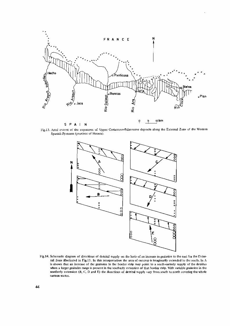
FRANCE
...... + .,. 1IC
• K •
.,.lC )It T :ll to +.,..-11"
N
..
" x"
o8iescas o oPlan ..!! Iii C> o o a:: ii:
o 5 lOkm ~,----'-,-----',
5 P A N
Fig.i3. Areal extent of the exposures of Upper Cretaceous-Palaeocene deposits along the External Zone of the Western Spanish Pyrenees (province of Huesca).
N
Fig.i4. Schematic diagram of directions of detrital supply on the basis of an increase in grainsize to the east for the External Zone illustrated in Fig.13. In this interpretation the area of outcrop is imaginarily extended to the south. In A is shown that an increase of the grainsize in the border strip may point to a south-easterly supply of the detritus when a larger grainsize range is present in the southerly extension of that border strip. With variable grainsize in the southerly extension (B, C, D and E) the directions of detrital supply vary from south to north covering the whole eastern sector.
44
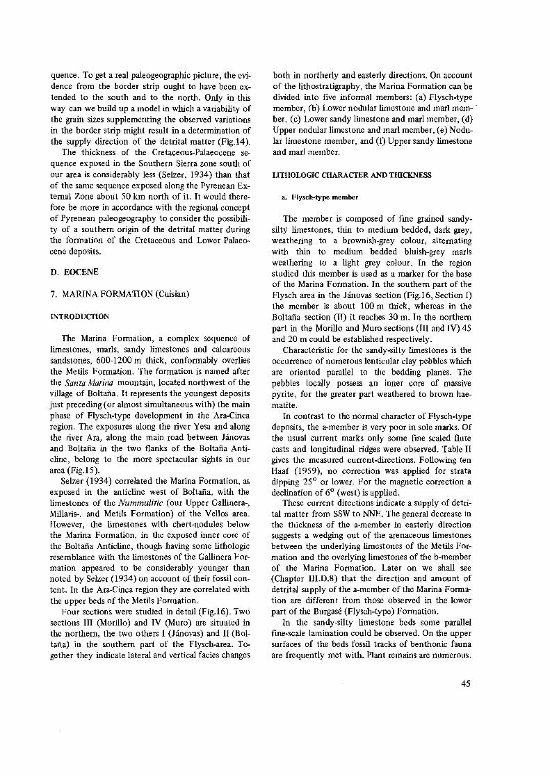
quence. To get a real paleogeographic picture, the evidence from the border strip ought to have been extended to the south and to the north. Only in this way can we build up a model in which a variability of the grain sizes supplementing the observed variations in the border strip might result in a determination of the supply direction of the detrital matter (Fig.14).
The thickness of the Cretaceous-Palaeocene sequence exposed in the Southern Sierra zone south of our area is considerably less (Selzer, 1934) than that of the same sequence exposed along the Pyrenean External Zone about 50 km north of it. It would therefore be more in accordance with the regional concept of Pyrenean paleogeography to consider the possibility of a southern origin of the detrital matter during the formation of the Cretaceous and Lower Palaeocene deposits.
D. EOCENE
7. MARINA FORMATION (Cuisian)
INTRODUCTION
The Marina Formation, a complex sequence of limestones, marls, sandy limestones and calcareous sandstones, 600-1200 m thick, conformably overlies the Metils Formation. The formation is named after the Santa Marina mountain, located northwest of the village of Boltafia. It represents the youngest deposits just preceding (or almost simultaneous with) the main phase of Flysch-type development in the Ara-Cinca region. The exposures along the river Yesa and along the river Ara, along the main road between Janovas and Boltafia in the two flanks of the Boltafia Anticline, belong to the more spectacular sights in our area (Fig. I 5).
Selzer (1934) correlated the Marina Formation, as exposed in the anticline west of Boltafia, with the limestones of the Nummulitic (our Upper Gallinera-, Millaris-, and Metils Formation) of the Vellos area. However, the limestones with chert-nodules below the Marina Formation, in the exposed inner core of the Boltafia Anticline, though having some lithologic resemblance with the limestones of the Gallinera Formation appeared to be considerably younger than noted by Selzer (1934) on account of their fossil content. In the Ara-Cinca region they are correlated with the upper beds of the Metils Formation.
Four sections were studied in detail (Fig.16). Two sections III (Morillo) and IV (Muro) are situated in the northern, the two others I (Janovas) and II (Boltafia) in the southern part of the Flysch-area. Together they indicate lateral and vertical facies changes
both in northerly and easterly directions. On account of the lithostratigraphy, the Marina Formation can be divided into five informal members: (a) Flysch-type member, (b) Lower nodular limestone and marl mem-' ber, (c) Lower sandy limestone and marl member, (d) Upper nodular limestone and marl member, (e) Nodular limestone member, and (0 Upper sandy limestone and marl member.
LITHOLOGIC CHARACTER AND TillCKNESS
a. Flysch-type member
The member is composed of rme grained sandysilty limestones, thin to medium bedded, dark grey, weathering to a brownish-grey colour, alternating with thin to medium bedded bluish-grey marls weathering to a light grey colour. In the region studied this member is used as a marker for the base of the Marina Formation. In the southern part of the Flysch area in the Janovas section (Fig.16, Section I) the member is about 100 m thick, whereas in the Boltafia section (II) it reaches 30 m. In the northern part in the Morillo and Muro sections (III and IV) 45 and 20 m could be established respectively.
Characteristic for the sandy-silty limestones is the occurrence of numerous lenticular clay pebbles which are oriented parallel to the bedding planes. The pebbles locally possess an inner core of massive pyrite, for the greater part weathered to brown haematite.
In contrast to the normal character of Flysch-type deposits, the a-member is very poor in sole marks. Of the usual current marks only some rme scaled flute casts and longitudinal ridges were observed. Table II gives the measured current-directions. Following ten Haaf (1959), no correction was applied for strata dipping 25° or lower. For the magnetic correction a declination of 6° (west) is applied.
These current directions indicate a supply of detrital matter from SSW to NNE. The general decrease in the thickness of the a-member in easterly direction suggests a wedging out of the arenaceous limestones between the underlying limestones of the Metils Formation an<l the overlying limestones of the b-member of the Marina Formation. Later on we shall see (Chapter III.D.8) that the direction and amount of detrital supply of the a-member of the Marina Formation are different from those observed in the lower part of the Burgase (Flysch-type) Formation.
In the sandy-silty limestone beds some parallel fine-scale lamination could be observed. On the upper surfaces of the beds fossil tracks of benthonic fauna are frequently met with. Plant remains are numerous.
45

Fig.15. River Ara exposure of the Marina Formation east of Janovas. The strata form the steeply dipping western side of the Boltaiia Anticline.
Table II. Directions of detrital supply, a-member (Marina Formation)
Location Strike and dip of strata
Type of sole-mark
Current direction
Sect.n
Kp.58
3600 _15 0 Flute cast 70
356 0
160
357 0
40
34 0 (3x)
S.of
Sercue
1000 _100 Longitudinal
Ridges
540
67 0
Sect.lII
Morillo
580 _480 Flute cast 3380
320
Sect.IV
Muro
25 0 _23 0 Flute cast 34 0
At one location in the Morillo-section (III) a well preserved small Ophiurid is present. In general the upper surface of the individual beds and laminae are rich in flakes of biotite and muscovite.
Microscopically, the sandy-silty limestones consist of a non-sorted mixture of angular and rounded quartz, rather fresh felspars and of opaque matter with an accessorial amount of muscovite. The matrix is a very fme calci-Iutite. Generally the grain size decreases to the east from sandy to silty. The carbonate content is about 60% (weight percentage).
b. Lower nodular limestone and marl member
Member b is composed of an alternation of medium bedded, fine grained to dense limestones, medium grey, weathering to a light greyish pink colour, and thin to medium bedded marls, light grey, weathering greyish-white. The limestone beds generally have a nodular character. Pyrite concretions partly ftll the imprints probably left by Molluscs scattered through the beds.
In the Janovas section (I) the member reaches a thickness of about 380 m. In the Morillo-section (III) 65 m is encountered, whereas west of Puarruego
46
STRATIGRAPHIC SECTIONS OF THE MARINA FORMATION (CUISIAN)
SECTION I SEC nON ]I SECTION m SECTION Ill: 1200 JANOVAS BOLTANA MORILLO MURO
I~
200 p!t:.,.~~
160 ~~~liII
1000
600 . ",. '.:':- ::
:. ;-.:: ".:":. :.:
~~~s4 b- member
FLYSCH TYPE
FORMATION
Fig.16. Lithostratigraphic correlation of sections of the Marina Formation. Sections I and II measured along the road from lanovas to Boltafia, sections III and IV measured along the river Yesa, west of Escalona. l::::llinestone with chert concretions (Metils Formation), 2::::silty limestones and marls of the Flysch-type, 3::::t:hick bedded nodular limestones and marls, 4=thick bedded sandy limestones and marls, 5=thin to medium bedded, dense, nodular limestones and marls. Thickness in meters.
(Muro section, IV) we measured about 240 m. By the thinning of the member east and west of
the Boltma Anticline the development of the b-member suggests the presence of a less quickly subsiding central part toward the tectonic structure (Fig.16).
Microscopically the limestones of the b-member are foraminiferal biomicrites with Globigerinids, Rotalids, small Miliolids and fragments of larger Foraminifera.
c. Lower sandy limestone and marl member
In section I (Fig.16) the member is composed of a series of complexes each consisting of a number of
Foraminifera-rich sandy limestone beds alternating with marls. Harder and more limestone-rich complexes alternate with softer and more marly ones. The limestones are rrne grained, indistinctly bedded, locally with a knobby upper surface, medium grey, with a pinkish-grey weathered colour. Individual complexes reach thicknesses from one to two meters, but, within the member, there is an increase in thickness towards the younger layers.
The member, which reaches a thickness of about 230 m, shows numerous pyrite inclusions and in the limestones imprints of Molluscs.
At the base of the member some medium bedded rrne grained sandy limestone beds do occur, medium
47

grey, weathering to a brownish-grey colour. In contrast to the knobby upper surfaces of the limestone beds, these sandy layers have sharp and flat upper surfaces and irregularly developed bottom surfaces. Parallel internal lamination is observed locally.
Microscopically the basal layers consist of angular and rounded grains of quartz and feldspar, detrital limestone fragments, rounded grains of clay, plant remains, haematite and accessorial amounts of biotite and muscovite. The matrix is a fine grained calcilutite. Generally the grain sizes do not exceed 0.05 mm. Apparently we are dealing with a sandysilty limestone. Microscopically the coarse layers are found to be badly sorted, whereas grading could be observed in the finer ones. The median grain size of the arenaceous limestones decreases to the north. In the Morillo section (III) the graded beds are more calcareous and contain a rich fauna of planctonic Foraminifera (Globigerinids) in the matrix. In the Muro section (IV) a rich content of organic matter and haematite is present, whereas the strong activity of burrowing benthos generally destroyed the locally observed original lamination. In the latter section we came across Palaeodictyon sp. and in one locality (south of Puarruego) we observed the imprints of Phycodus-like burrows on the lower surface of the beds.
The limestone which follow on top of the basal sandy beds contain a large amount of fossils. Several of the upper limestone beds of the individual complexes are almost exclusively built up of larger Foraminifera, Miliolidae, Algal debris and Bryozoan fragments.
The detrital matter consists of angular and rounded quartz, feldspar, opaque minerals and accessorial biotite and glauconite. In the member as a whole the sand content increases upwards. Within the harder and limestone rich complexes, however, the inverse development took place.
In the upper 100 meters of the c-member of section I the sedimentary character of the limestone beds changes considerably. With the increase of the thickness of the complexes the individual beds take a distinct lenticular form, with a low-angle cross-stratification locally visible. According to Mr. J. Brookman (Utrecht, 1968, Personal commUnication) these features normally characterize a shallow marine environment, apparently within the direct influence of wave activity. This might give an explanation for the reworked aspect of most of the fossils, which, moreover are fragmented frequently. _
In the Morillo section (III) the member is about 180 m thick. From the basal turbiditic beds upwards the marl and limestone complexes are more pro
48
nounced than in the Janovas section and richer in larger Foraminifera. In the uppermost 10 m we came across the same lenticularly developed sandy limestone beds as in section I.
In the Muro section (IV) a further thinning to about 100 m was established. On top of a turbiditic basal part (20 m) an alternation of thin bedded, darkgrey limestones, rich in larger Foraminifera, and bluish-grey marls follow. The upper beds of the member are marked by an important increase of sandy material. In section IV, however, the lenticular development of the beds is absent so that the upper limit of the c-member in this section in fact is an arbitrary one.
d. Upper nodular limestone and marl member
In the Janovas section (I) the d-member of the Marina Formation is about 260 m thick and here it forms the upper member of the formation. It consists of very thick complexes (5-20 m) of sandy limestones, calcareous sandstones and marls. The marls are rich in larger Foraminifera, whereas the calcareous sandstones are almost sterile.
The complexes are built up by well bedded, coarse grained calcareous sandstones, fme grained, indistinctly bedded, nodular limestones and thin marly beds. On account of variations in the fossil content, clastic detritus and glauconite, the weathering colour of the complexes and of the individual beds varies from broWnish-pink (sandy limestone), over yellowish-grey (marls) to light grey (limestones). The fresh rock shows dark to medium grey tints.
In the Janovas section (I) the d-member is overlain by a bluish-grey marly complex which belongs to the next higher formation. In the basal beds of the latter complex pebbles of the upper beds of the d-member are found irregularly distributed in a thick slump zone.
In the Boltana section (II) we met with a different development. Here the d-member reaches a thickness of about 400 m. The limestone complexes predominate over the marly ones which are almost completely absent in the upper part of the member. The nodular character of the limestones is more pronounced than in the Janovas section. Especially in the upper part of the member imprints of Gastropods and Echinids frequently were observed on the upper surface of the beds. Locally haematized pyrite fills the casts of former benthonic fauna. In general the content of clastic detritus and glauconite increases upwards. An increase in the thickness of the limestone complexes and individual beds was also observed.
The upper 20 m of the d-member, as exposed

--------- ----------- ---- ------- ------------
-------------------- -------- -- --- ---------
--------------------
--------------------------- - ---- -----
-----------------------------------------
along the road west of the Barranco de Ascaso, has south-western flank of the Pozo mountain, at an altithe composition as shown in Fig.l? tude of 1190 m, where sub-horizontal graded beds of
In the Morillo section (III) the d-member reaches a the San Vicente Formation cut off the 300 souththickness of about 400 m. On the southern Yesa easterly dipping limestones of the d-member of the valley-wall the calcareous complexes form slightly Marina Formation (Fig.18). On the other hand, we losouth dipping ridges, on account of their stronger re cally found, on a lower topographic level northeast of sistance to weathering, which can be followed from the Pozo mountain, small exposures of nodular limeMorillo de San Piedro eastward to Escalona. Member stones which belong to the next (e) member of the d is here directly overlain by the graded beds of the Marina Formation. On these lower levels the Flysch-type Formation. From the exposures along Flysch-type deposits of the next higher formation apthe river Yesa it is apparent that a low-angle non parently overlie conformably the nodular limestones conformity forms the upper limit of the Marina For of the e-member of the Marina Formation. mation. A similar situation was encountered on the Evidently we are dealing with a kind of palaeo-
Thickness in m........,.,...--:-.......--,..,
1.10m,yellowish-grey ca]cnreous RMlodstones,thin to medium bedded,glauconite and clastic content decreasing upward,upper part nodular.
18
17 3.50m,ochre weathered,ereyish-brown,fine arcillaceous marls.
16
15
1.9nm,reddish-brown weathered,fille ~ruined,calcareous sandstones 14 wi th t,lauconi te and pyri te, se para ted by Ii ti, i n r~ar ly bed, crammed
with large burrows (2 cm diaMeter).
13 1-:-20ffi~r;ddish-br~.:;-;;; tl,;;';ct ~AI-;;-a;e_;;_us S;I "d" tonp", CArbonate content 40;6 (weie;ht percentac;e),fine crained,rich in clauconite and pyrite12 c..?.::.':.:~t2~n.:::... _
1.00m,mf>'liurn-t:Te.T sandy marls (mwlflow) rich in hictlte and muscovite.
1.40m,reddish-brown wi"athered calcarpOllS f;"nd~iton.""parnllel lamina10 ted,medi!!m c;rained,rich in biotite und muscovite •
8
7.50m,pinkish-grey marls a]ternatin~ with thin bedded (1-2dm) calcareous6 sandstones poor in Jar~er Foraminifer1.
5
~------------------------------------"""--- """'- .'" o.1.?:iI,r·oraminifera-limp.:stones rich in [lallconite Bryozoa and
"'. ': . ", "::', larger Foraminifera. :.. :'..:.:" ~--------------------------------------". . '. . '." 1 • 'r'0m, calc areou" "and" t on e s, med i um to fi r,e-r;rai npli, WPA t. h pr i n['; brovl!li s1,
o " pi'lk,fresh colour,J'inki·:h-l~rp.v,rirh in c);",conit" "no l'1rf:er Foraminif.:.r:?.: ~::'e_~::'G2.~~2..t.::..n.!.. 21~~::'::~ _u_E?~~l~ _
Fig.I? Columnar section of the upper part of the Marina Fonnation (d-member) west of Boltafia, near the confluence of the Barranco de Ascaso with the river Ara.
:,::,,:: 1:•••• :". I ,-,.
_ ......... f--- - ."
---~ ..
.' :. '. . . " .. :. . '... . ....
-- ___
2
49

SE
Fig.iS. Nonconfonnity between limestones of the Marina Formation (below) and subhorizontal graded beds of the San Vicente Fonnation. Sketch of a small, isolated, outcrop on the south-westerly side of the Pozo mountain.
relief, which, during the formation of the San Vicente-Flysch was gradually onlapped.
In the Muro section (IV) the d-member is about 115 m thick, built up of a lower marly part (85 m) and an upper complex of sandy limestones (30 m). Just as in the Boltafia section (11) the d-member in section IV is conformably overlain by nodular limestones of the e-membe~. In the Yesa exposures (III and IV) a thinning of the d-member in easterly direction is evident. This is a sedimentary effect.
e. Nodular limestone member
East of the Boltafia Anticline the glauconitic, Foraminifera-rich limestones of the d-member locally are overlain by thin bedded, very fine grained, dense limestones with a distinct nodular character, alternating with blUish-grey marls. Both the marls and the limestones weather to an almost white colour. The fresh colour is medium-light grey. Neither glauconite nor larger Foraminifera have been observed in this member. A few badly preserved Echinids and Gastropods are present. Locally small burrows are found, crossing the marls.
The e-member proved to be useful for lateral lithostratigraphic correlation, on account of its specific lithologic appearance. In the Boltafia section (11) near the Barranco de Ascaso, the e-member is 80 m thick. At its base a thin bedded alternation of nodUlar limestones and marls is observed. The limestone beds increase in thickness upward to medium bedded, whereas the marls remain thin bedded. The upper limit of the member is formed by a gradual transition into distinctly bedded sandy limestones, which have much in common with the upper part of the d-member in the same section.
In the Muro section (IV) the e-member shows thinner nodular limestone beds (5-10 cm), regularly alternating with medium bedded marls. A thickness of about 60 m is reached. The limestones and marls are overlain by a rather schistose marly complex, strongly
tectonized, a fact which is probably due to the overthrust tectonics of the Pella Montafiesa east of Escalona.
On the path (camino) from Muro to San Vicente, at an altitude of about 1050 m southwest of Muro, the upper part of the member is completely exposed. Here, a remarkable transition into the overlying Flysch-type Formation is visible (Fig.19).
E ¢
Fig.19. Sketch of the transition of the e-member of the Marina Fonnation into the graded beds of the San Vicente Fonnation. Path from Muro to San Vicente, west of Escalona.
Thin (5-8 cm) beds of nodular limestone alternate with bluish-grey marls (40 cm). The upper nodular limestone beds are in a slumped disorder. The original beds, broken into bent and rounded fragments, still maintain their layered position and apparently flaot in a marly matrix. The latter matrix gets coarser upwards on account of the increase of clastic detritus and foraminiferal debris, whereas the dense nodular limestone layers gradually are replaced upwards by a chaotically disturbed zone, preponderantly of Foraminifera-rich sandy limestone pebbles and folded fragments of thin Flysch-type beds. This slump zone is overlain by coarse grained sandy limestones with an irregular, lenticular to fragmentary, layered bedding configuration, alternating with marls. On the bottom surfaces of the sandstone beds deformation by loadcoasting is evident, whilst the upper surfaces generally are flat and sharp. Finally, thick bedded, very coarse grained, graded, sandy limestone beds follow, locally even with conglomeratic basal parts and numerous clay pebbles concentrated in the middle of the beds. These graded sandstones mark the beginning of the Flysch-type sedimentation
50

f. Upper sandy limestone and marl member
Along the road section between the Barrancos Ferrera and Ascaso, west of Boltafia, the nodular limestones of the e-member are overlain by medium bedded, glauconitic, sandy limestones alternating with marls. The exposed member is about 140 m thick. The transition from the e-member to the f-member is a gradual one. The thickness of the limestone beds increase to 20-30 cm, and, compared with the e-member, a renewed supply of clastic detritus is visible. Glauconite reappears and the typical nodular limestone character decreases upwards. However, the upper and lower surfaces of the beds still retain a knobby appearance. The basal part of the member is rme grained, medium grey, and weathers to a light grey colour. In the limestones tracks of burrowing benthos are frequently observed. The intercalated marls show dark spots of glauconite. Carbonate makes up about 90% of the weight of the rocks.
Locally, near the bridge over the Barranco Ascaso, the stratification is interrupted by areas showing a more brownish weathered, homogeneous development, which turned out to be due to the inclusion of rounded boulders (1.5 m diameter) of sandy limestone, the carbonate content of which proved to be some what less than that of the surrounding layered beds (80%). In one place (Fig.20,A) the stratified limestones thin laterally towards the boulder and bend slightly upward. In other places (Fig.20,B) a sharp contact exists between layers and boulder. Probably we are dealing with slump phenomena, which took place during the sedimentation of the limestones, reflecting some relief forming activity. In the same Ascaso exposure intraformational nonconformities occur. A thinning of the beds towards the west is frequently met with.
The marly intercalations increase in thickness upwards. At about 80 m from the base of the f-member a thick bed is exposed near Lavellila, which is almost
N s
I I I I
-4E:1(~- 1.50 m~ ®
entirely built up by larger Foraminifera. The latter fossils reach sizes of up to one centimeter diameter. Most fossils are glauconitized Discocyclina sp. Within the rme grained matrix glauconite spots could be observed too.
In the description of the Burgase (Flysch-type) Formation we shall meet with a thick Foraminifera rich bed exposed in the marls to the west of the Boltafia Anticline. This bed and its accompanying marly limestones has much in common with the above mentioned glauconitic fossilliferous bed of the f-member. However, in contrast to the fauna of the latter bed the dominating fossils in the bed of the Flysch exposures are Nummulites. Moreover, we shall see in the next section, that a difference in age exists between the two beds.
From the fossilliferous bed upwards a gradual increase in the thickness of the intercalated marls takes place. Near km 56 along the road west of Boltafia the sandy limestones are overlain by strongly disturbed bluish-grey marls of the next higher formation. Locally these marls appear to overlie non-conformably the sandy limestones of the f-member (Fig.21). Eastwards, the marls of the Flysch-type Formation cut off younger and younger beds of the underlying f-member. The latter beds generally consist of thick complexes of rme grained sandy limestone of a knobby, partly nodular aspect, alternating with thin marly beds. The limestones are rich in glauconite. The sand content decreases upwards, accordingly an increase in the carbonate content was established from about 80% to 90%.
A rapid thinning of the f-member in westerly direction is observed. At one locality it Was seen how a complete limestone complex of about 2 m thick wedges out over a distance of about 5 m against the anticline (Fig.22). Rounded fragments from pebble to boulder size and tom from the upper beds of the f-member are found in a fluidally structured matrix of sandy-muddy marls which non-conformably over-
N
Fig.20. Slumped sandy limestone boulders in the f-member of the Marina Formation. (A) Outwedging of limestone beds against a boulder (upper right) and deformation + outwedging of a bed underlying the boulder (lower right). The former indicates sedimentational compensation of the relief caused by the boulder, the latter syndepositional movement of the boulder. (B) Undisturbed sharp transition of bedded strata into a homogenous limestone boulder.
51

w
50 m -------7)\'1-
Fig.21. Slump-structures on the transition of the Marina Formation into the graded beds of the San Vicente Formation. The slumped zone which consists of strongly deformed marls, contain fragments of underlying strata. Slumping might be the cause of the formation of a slight nonconformity. Road exposure west of Boltafia.
W E
: I I ~II I( 5 m )1
Fig.22. Intraformational outwedging of limestone beds of the f-member of the Marina Formation in westerly direction (against the Boltaiia Anticline). Road exposure west of Boltaiia.
lie the Marina Formation (Fig.21). Microscopically the Marina Formation shows a
complex series of preponderantly bioclastic sediments. The content of terrigenous detritus varies considerably from bed to bed. The most sandy beds contain angular and sub-rounded grains of quartz, which in rare cases show undular extinction and inclusions of rutile and apatite, angular, rather fresh feldspars, plagioclase with combined Karlsbad-albite twinning, quartz aggregates (in one case with fan-like inclusions, probably of andalusite crystals), strongly weathered c10ritized biotite, muscovite, and in one thin section (294b) small rock fragments of micaschists. In most of the sections studied, small amounts of opaque matter are found scattered throughout the rock. Rounded grains of glauconite are frequently met with. In some of the larger Foraminifera fine grained glauconitic matter is observed.
In the beds with the highest content of clastic detritus the larger Foraminifera appeared to have undergone strong effects of mechanical transport. The Alveolinas are frequently deformed and partly peeled off. The sharp edges of the Discocyclinas are broken off, and a large amount of fossil-debris forms the fine grained matrix. Where a subordinate amount of terrigenous detritus is observed, the larger Foraminifera show less influence of transport and the specimen are
52
bedded in a very fine grained bioclastic matrix. In the latter circumstances an autochtonous position of the fauna is apparent. Although a greater part of the fauna indicates reworking, because many of the fossils are broken this does not, in our opinion, point to a transport over large distances. Because of the shallow depth of deposition within the reach of wave action, it does not necessarely indicate more than reworking on the spot. Throughout the Marina Formation indications of a slight dolomitisation are observed.
Summarizing the Marina Formation is built up of a complex series of detrital sandy-silty limestones and marls, with a nodular to knobby habit, rich in larger Foraminifera and Bryozoa. Except for the a- and e-members, the content of clastic detritus and glauconite increases toward the south and the east. The grain size of the matrix generally does not exceed one millimeter, though the presence of larger Foraminifera locally gives a coarser appearance to the rocks. The thickness of the marly complexes in the road section between H.novas and Boltana decreases laterally to the east. The sections measured in detail show strong differences in facies both in vertical and in lateral sense. As for the lower limit of the formation, which could only be studied in a small number of exposures along the Yesa river and in the core of the Boltana Anticline, the specific Flysch-type character of the beds of the a-member justifies its importance as a valuable marker horizon. This is strengthened by the uniform directions of detrital supply of the a-member, as found both in the northern and in the southern area (See Table II). To a lesser extent the nodular limestones of the e-member have the same value. The Marina Formation is overlain by calcareous sandstones and marls of the Flysch-type Formation. Locally there exists a gradual transition from one formation into the other, but more frequently a more or less pronounced non-conformity is observed.
FOSSIL CONTENT AND AGE OF THE MARINA FOR· MATION
Throughout the Marina Formation fossil fauna and flora occurs. For the greater part it comprises larger Foraminifera and Dasycladacaea. Locally the beds are almost completely composed of Alveolina sp., Nummulites sp., Orbitolites sp., Operculina sp., Assilina sp., Discocyclina sp., Rotalidae, Miliolidae, Bryozoa and Dasycladacaea. Spe<;ially the limestones in which Alveolina occurs are crammed with debris of Algae and Bryozoa. In most of the thin sections studied relics of probably Holothuroid skeletons were observed. In the upper part of the formation we fre

Fig.23. Photomicrograph of Foraminifera-limestone from the lower part of the Marina Formation (Sample No.142, parallel nicols, enlargement 14x, Morillo-section (III), west of Escalona). Cuvillierina eocenica DEBOURLE, Orbitolites complanatus minima HENSON, Rotalia trochidiformis LAMARCK, Alveolina distefanoi CHECCHIO RISPOLI (or A.oblonga D'ORBIGNY), Nummulites group aquitanicus. Biomicritic matrix with scattered grains of quartz and felspar.
quently met with Dentalium sp. According to Me. J. Smit (1968, Ghana, personal communication) some fossil horizons mainly contain reworked fauna.
In the preceding section we noted the occurrence of limestones with chert nodules in the exposed inner core of the Boltafia Anticline, which have a strong lithologic (chert) and faunistic (Alveolinae) resemblance to the limestones of the upper part of the Gallinera Formation. Almela (1956) consequently attributed a Danian age to these rocks, that were correlated with the Alveolina-limestones exposed in the river Vellos. However, on account of the fossils found, a transition from the Upper Ilerdian to the Lower Cuisian is more obvious, representing the upper part of the Metils Formation.
In the lower part of the Marina Formation (Morillo Section III; sample No.142 and 145) we came across Cuvi/lierina eocenica DEBOURLE, Orbitolites complanatus minima HENSON, Rotalia trochidiformis LAMARCK, Alveolina distefanoi CHECCHIA RISPOLI (or oblongo d'ORBIGNY) andNummulites aquitanicus (See Fig.23).
According to Hottinger and Schaub (1960) the presence of A.distefanoi C.R. and A.oblonga d'ORB., is characteristic for the beginning of the Cuisian in the Mediterranean area.
In the upper part of the formation (Morillo Sec
tion, III; sample No.150) part of the same fauna as mentioned above could be determined: Cuvillierina eocenica DEBOURLE and Alveolina oblonga d'ORBIGNY. Moreover we came across Assilina placentula DESHAYE, Nummulites burdigalensis DE LA HARPE, other Nummulites sp., Discocyclina sp. and Operculina aff. parva DOUVILLE (See Fig.24).
In the Janovas section (I) the upper part of the Marina Formation (Sample No.I62) contains Distichoplax sp. (not biserialis), Cuvillierina eocenica DEBOURLE, Orbitolites complanatus minima HENSON, Alveolina cf. Schwageri CHECCHIA RISPOLI and Nummulites burdigalensis DE LA HARPE. According to Cuvillier (1956) the rotalidae appear to be related to Rotalia tuberculata SCHUBERT, which Silvestri (1955) described as Cuvillierina eocenica DEBOURLE in the Ypresian (Cuisian) of the Aquitaine Basin.
According to Hottinger (1960) and Hottinger and Schaub (1960) the fossil association cited above is characteristic for the Cuisian.
In the marly beds of the d-member in the Janovas section (I) larger Foraminifera are arranged in oval tubes of about 2-3 cm diameter. The broken fragments of these tubes reach lengths of more than 4 cm. We are dealing with cylindrical arrangements predominantly composed of Discocyclina sp.
53

Fig.24. Photomicrograph of Foraminifera-limestone from the upper part of the Marina Formation (Sample No.ISO, parallel nicols, enlargement lOx, Morillo-section (III) west of Escalona). Cuvillierina eocenica DEBOURLE, Alveolina oblonga D'ORBIGNY, Assilina placentula DESHAYE, Nummulites burdigalensis DE LA HARPE, Discocyclina sp., Operculina aff. parva DOUVILLE. Fine sandy to silty matrix rich in fossil debris.
(Fig.25,A) (D. seunesi H.DOUV.?) and in subordinate amounts of Assi/ina sp. (A.leymeriei d'ARCHIAC and HAIME? ). The same arrangement was observed by Van de Velde (1967) of other larger Foraminifera in the limestones of the Upper Tozal Formation (Maastrichtian). He came across Orbitoides and Lepidorbitoides as building material for the tubes (Fig.25,B). According to Seilacher, A. and Crimes, T.P. (personal communication, Liverpool, 1970) these arrangements were formed along the (vertical) inner sides of boreholes probably of Molluscs.
The rich fossil assemblage is surprisingly constant throughout the whole formation over more than a thousand meters of sediment. The phenomenen is frequently cited by Hottinger (1960) as characteristic for the Upper Palaeocene and Eocene faunae in the Mediterranean area.
REMARKS CONCERNING ABRUYf CHANGES IN THICK
NESS OF THE MARINA FORMATION
On the western flank of the Boltafia Anticline, east of the village of Burgase, the line of outcrop of the Marina Formation shows a considerable kink (cf. appendix 1). This kink apparently is not caused by topographic effects, since the western flank of the anticline is sub-vertical, nor by strike-slip along a trans
verse fault which would possibly cross the Boltafia Anticline in easterly direction. Detailed investigations in that area have proved that no transverse fault is present in the Marina Formation.
Comparing the dimensions of the Marina Formation south and north of the kink, an abrupt change in thickness of the formation is apparent from about 1000 m in the south to about 500 m north of it.
One small exposure of nodular limestone amidst the graded Flysch-type beds west of Yeba, which does not show any contact with the surrounding Flysch, is possibly a slumped boulder of the Marina Formation limestone. But no further indications were found in favour of a possible interfingering of the limestones of the Marina Formation with the Flysch-type deposits north of the kink-line.
The anomaly in the line of outcrop of the Marina Formation must consequently be due to the existence of a palaeorelief on-lapped by graded beds of the Flysch-type Burgase Formation.
It represents a small-scale palaeo-canyon, scoured out in the limestones of the Marina Formation. In the next section this hypothesis is further augmented by the study of the directions of detrital supply of the graded beds of the Flysch-type and their variations in carbonate content on bothsides ofthe BoltafiaAnticline.
54

A
B
Fig.25. (A) Discocyclina sp. and Assilina sp. arranged in oval tubes. Longitudinal section of a tube found in the marls of the d-member of the Marina Formation, east of Janovas. Photograph of thin section, enlargement 3x. (B) Orbitoides sp. and Lepidorbitoides sp. occurring in oval tubes. Cross-section on weathered surface of Gallinera Limestone (Ordesa region, photograph E. van de Velde, 1967, fig.5), natural size.
55

8. FLYSCH-TYPE FORMATIONS (Cuisian? -Lutetian)
GENERAL INTRODUCTION
West and east of the Boltafia Anticline a large area of Flysch-type deposits is exposed. To the west it forms part of a Flysch zone which extends 160 kID to the west as far as Estella (Mangin, 1958), whereas its eastern part belongs to the Central South Pyrenean Flysch zone extending 80 kID to the east as far as Tremp (Misch, 1934).* In the region studied the Flysch-type deposits west of the Boltafia Anticline form the Burgase Formation, those east of that anticline the San Vicente Formation. Though both formations are of approximately the same age, palaeogeographic considerations led to the conclusion that they mainly developed in separate basins. First of all we shall describe the results of measurements of detrital supply and the analyses of the carbonate content of both formations, on the basis of which we come to a short description of the formations themselves.
With the formation of Flysch~type deposits in these zones a new period in the process of sedimentation begins. The sequence hitherto described in general formed a succession of megarhythms which started with conglomeratic or sandy basal parts and ended with more or less pure limestones and dolomites. The Cretaceous-Palaeocene sequence in the region studied reaches a maximum thickness of about 1000 m, a thickness which remains fairly constant laterally throughout the Western Spanish Pyrenees (Fig.5) During the Eocene a much greater and laterally less constant thickness is found. The Lower Eocene limestones of the Marina Formation already reach a maximum thickness of about 1000 m, whereas the Flysch-type deposits (Lower? and Middle Eocene) may even reach a thickness of about 4500 m (Ten Haaf, 1966). In contrast to the megarhythmic development of the Cretaceous-Palaeocene sequence, the Flysch-type formations are mainly composed of rapid rhythmical alternations of graded sandy limestone beds and of marls with subordinate intercalations of slumped zones, conglomeratic mudflows and smallscale olisthostromes. Apparently the calm, shallow marine sedimentation of the Cretaceous-Palaeocene sequence (Jeurissen, 1969) of the Central and Western Spanish Pyrenees was followed by a diastrophical influx of detrital matter into the Eocene troughs. An important slumped zone in the western Flysch (Burgase Formation) coincides with a change in basin con
figuration which is reflected by rigorous changes in the direction of detrital supply of the deposits below and above this zone (Fig.26). Exotic boulders found in olisthostromes of the eastern Flysch (San Vicente Formation) point to a kind of sedimentation which is different from that observed in the CretaceousPalaeocene sequence. Flysch-type deposits in fact represent the "youngest sedimentation in a deforming basin" (Ten Haaf, 1964; Rech-Frollo, 1964). In the Central and Western Spanish Pyrenees these deposits announce the beginning of the Pyrenean orogenesis.
The main problems in Flysch geology comprise estimating the mechanism of transport of the detritus, the depth of deposition and the origin of the detritus (Vander Lingen, 1969). In the literature (see Potter and Pettijohn, 1963, p.224-251) it is generally supposed that the original sedimentary areas from which the material of the Flysch sediments was derived may have been situated from near the ultimate place of deposition to very far away on the outer end of a longitudinal basin. In this context a distinction is made between transverse supply by olisthostromes, fluxoturbidites, conglomeratic mudflows and longitudinal supply by turbidites. The original sediments are normally thought to have been dislocated by trigger effects such as earthquakes or tsunamis. When transported over longer distances the material of these dislocated sediments may become mixed with sedimentary material from deeper environments. This must also have been the case with the fossils and assemblages both of the same and of older age. As to the depth of deposition, neither lithology nor fauna content of the graded Flysch-type deposits can bear positively upon this problem. A determination of the environmental position of the graded beds can only be made in terms of proximal or distal sites (Dzulynski et al., 1959; Potter and Pettijohn, 1963; Walker, 1965,1967). A different opinion has recently been expressed by Van der Lingen (1969) who maintains that: "The (Flysch-type) rocks in the Spanish Pyrenees were undoubtedly deposited in a shallow water environment, but they nevertheless display other sedimentary features characteristic of Flysch-type sediments". Van der Lingen derived this conclusion from the discovery of birdtracks (Mangin, 1962) and pseudomorphs after salt crystals (De Raaf, 1964). However, the latter Shallow water indications are found in the gres aripple marks (the laterally correlative beds of our Fenes Formation) which are much younger than the Flysch-type deposits of the Central and Western Spanish Pyrenees; they have no
* In a recent paper Van Eden (1970, pp.155-157) places the the west, about 35 km southeast of BoUaiia. eastern border of the Eocene marginal trough far more to
56

'" ~
'~
~
'~. '.. . .~ ". .~
~. ~
.~
42"39'
"
-Az
.
-GN
MN\f
-~ Pre Flysch Deposits
Post Flysch Deposits
Flysch type Deposits
Groove costs (g); Slide costs (s)
Boundary between sedimentary units
Flute costs
2km
rnIIIIlJ o lmmiiil
---------
'~ '. '~
~
A I and
.~
A2
~. ". '00. -~
42" 29
Fig.26. Directions of detrital supply in the graded beds of the Burgase Fonnation and San Vicente Fonnation. Boundary between the sedimentary units Al and A2 of the Burgase Fonnation coincides with the stratigraphic position of a thick slump-zone (see also Fig.27). The "big bed" of Ten Haaf (1966, fig.3) lies approximately in the same stratigraphic position west of the river Ara (near Sarvise).
57
relation to the sedimentational environment of the Flysch series.
In his analyses of the sedimentary properties of the Peira Cava Flysch-type sediments (Southeastern France), Bouma (1962) came to a subdivision of the graded beds. Detailed observations and analyses of the vertical sequence within a single bed made it possible to distinguish five intervals by the predominance of one or another sedimentary feature. The complete sequence was found to be as follows: Ta: 'graded interval, Tb: lower interval of parallel lamination, Tc: interval of current ripple lamination, Td: upper interval of parallel lamination, Te: turbiditic pelitic interval and pelagic pelitic interval. In the Ara-Cinca region complete sequences are poorly represented and restricted to the thickest beds. We frequently met with the interval Ta. In a few cases a repetition of the interval Ta, visible by repeated grading (see Ten Haaf, 1959) was observed. In these cases only the lowest Ta interval shows loadcasting at its base. The repeated Ta intervals show no loadcasting on the plain of junction. Less frequently interval Tb is present. Interval Tc (current ripple and convolute lamination) is rare. In our area pelitic intervals which can be correlated with interval Te of Bouma normally follow directly on the graded sequences of interval Ta.
The results of carbonate analyses of the graded beds and the marls of the region studied point to an intimate relation* between the two which may indicate that the main part of the marly beds still belong to the pelitic-turbiditic interval (Te) of the sequence. The contacts are nearly always sharp. According to Bouma (1962) this can be explained by the mechanism of the turbidity current itself. During turbiditic transport of detritus the finer parts would stay behind the coarser and become deposited later, which results in a sharp contact between both grain size ranges. In our opinion, however, there is no special reason to explain this break by the mechanism of the turbidity current. The possibility exists that the material transported by turbidites is composed of a mixture of two components with different grain size both originally present in the unconsolidated sediments of the basin border (see also Kuenen, 1967). The original sediments may partly have consisted of older Flysch-type deposits. In the later case cannibalism would have taken place.
According to Lombard (1963) the presence of only the Ta interval in the sandy parts of Flysch-type deposits is considered to be typical for a sediment laid down by turbidity currents, whereas the other in
tervals might have been formed by laminar currents. For the latter intervals he proposed to use the name "laminites" whereas the former are called "turbidites" (s.s.). The graded beds of the Ara-Cinca region are for the greater part built up by Ta intervals followed by Te intervals, the sandy beds of the Flysch in our region therefore may be called turbidites and the marls in general laminites.
Tectonically the Flysch-type formations of the Ara-Cinca region are simply structured. Neither important faults nor overthrusting do in general complicate the elucidation of the stratigraphic column. Only in the most northerly part of the Flysch area folding is intensive and small-scale thrusting occurs (Mondicieto, Fanlo). The monotony in the alternation of limestones and marls nevertheless does not allow a detailed lateral lithostratigraphic correlation of one exposure with another. We therefore paid attention to more general trends in the sedimentology of the formations such as directions of supply; carbonate content and to lithostratigraphic features such as: slumped zones, intercalations of olisthostromes and of conglomeratic mudflows. The base of the Flysch-type Formations was studied in particular to verify the existence of a non-conformity observed at the base of the Flysch-type deposits by Mengaud (1939), Von Hillebrandt (1962) and Van de Velde (I967) north of the region studied.
DIRECTIONS OF DETRITAL SUPPLY
Of the sedimentary features observed in the graded beds of the Flysch-type Formations, sole marks turned out to be the most useful indicators for estimating the direction of detrital supply. Special use was made of flute casts of the linguiform type (see Ten Haaf, 1959, fig.l3). Their rare occurrence was compensated by registration of all the flute casts observed in the field. This resulted in a pattern of data irregularly scattered all over the Flysch area (Fig.26), both in lateral as well as in vertical, stratigraphic, sense. Most of the arrows plotted on Fig.26, represents the average of three or more measurements on successive graded beds of the same exposure. Groove casts were observed less frequently. They have been plotted on the same figure as straight lines indicated by "G". In general their directions differ from those of the flute casts of the same beds. Sporadically slide casts occur in the basal beds of the eastern Flysch, which are indicated on the figure by straight lines with "S". Their directions differ considerably from
... On the basis of measurements of the thickness of sandy nish Pyrenees) Rupke (1969) carne to the same conclusion. beds and marls of the Flysch north of lata (Western Spa
58

those of the flute casts of the same outcrops. All data of Fig.26 are corrected both for the dip of
strata and for the magnetic declination. The exactness of the measurements lies within about So. The points of the arrows on the figure indicate the location of the measured flute casts.
When trying to reconstruct the original areal position of the locations of the directional phenomena, one should keep in mind the shortening of the strata by folding and their displacement by rotation. For the strongly folded northern part of the Flysch area a shortening which increases northward to a maximum of about 2/3 of its original length must be considered, but it has no particular palaeographic consequences for the positions of the measurements. Southwest of Yeba, on the other hand, a group of flute cast directions show a deviation from the general trend of the directions in this southern area which might have been brought about by a clockwise rotation of the Flysch cover when gravitationally sliding off the Boltana Anticline (see also the variation of the tectonic directions of the Flysch fold belt in the area southwest of Yeba, Fig.SS).An anticlockwise rotation of the belt southwest of Yeba of about' 150 brings the data of that area more in accordance with those to the west of it.
The directions of detrital supply of the graded beds of the Flysch-type in the region studied can be divided into those of a western Unit (A), which is located west of the Boltafia Anticline, and those of an eastern Unit (B), east of the Boltafia Anticline. On Fig.26 this division is emphasized by the outcrop of limestones of the Marina Formation in between both Flysch units. Unit A is subdivided into a northerly (lower) part A1 with average directions of detrital supply from the southeast and into a southerly (upper) part A2 with directions from the north. Unit B is subdivided into a northerly part Bl with average di-
E
rections of detrital supply from the southeast and into a southerly (upper) part B2 with directions from the south. The scarcity of directional data of the latter unit B2 are due to the predominantly marly development of the Flysch in that area, with but few graded beds intercalated. The units Al and A2 are separated by an important slumped zone (Fig.27) which apparently is related to the change in dJrection of detrital supply below and above this zone.
Although the directions of detrital supply of the Al and Bl units are similar, the one forming the prolongation of the other, they are separately treated on account of the strong differences in lithologic character of the respective series.
CARBONATE CONTENT OF THE GRADED BEDS AND
MARLS
Using the Scheibler apparatus, a hundred samples of the graded beds and marls of the Flysch-type have been analysed for their carbonate content. VariatIons of the Standard Dissolvment were checked after the analyses of each eight samples. Corrections were then applied. The Standard Dissolvment consisted of 0.165 g Na2C03 with excess of HCL. 0.165 gr of each sample was subjected to the analyses.
The division of the Flysch-type deposits on the basis of the current directions of turbidites (Fig.26) was found to apply also to the carbonate content. The results of carbonate analyses of both the western Flysch Unit A and of the eastern Flysch Unit Bare collected in Fig.28. Unit Al may be subdivided into a lower member Ala with average carbonate weight percentages of the graded beds of about 70% and into an upper member Alb with an average carbonate weight percentage of 36%. Unit A2 shows a reversed variation of the carbonate content upwards, whilst the carbonate content of individual samples shows
Fig.27. Sketch of outcrop of a slumped zone on the transition of units Al and A2 of the Burgase Formation. The basal part of the graded bed overlying the slumped zone is fractured. The fractures are filled with calcite. River exposure, Barranco de Chate de JaIle, east of Sarvise.
59
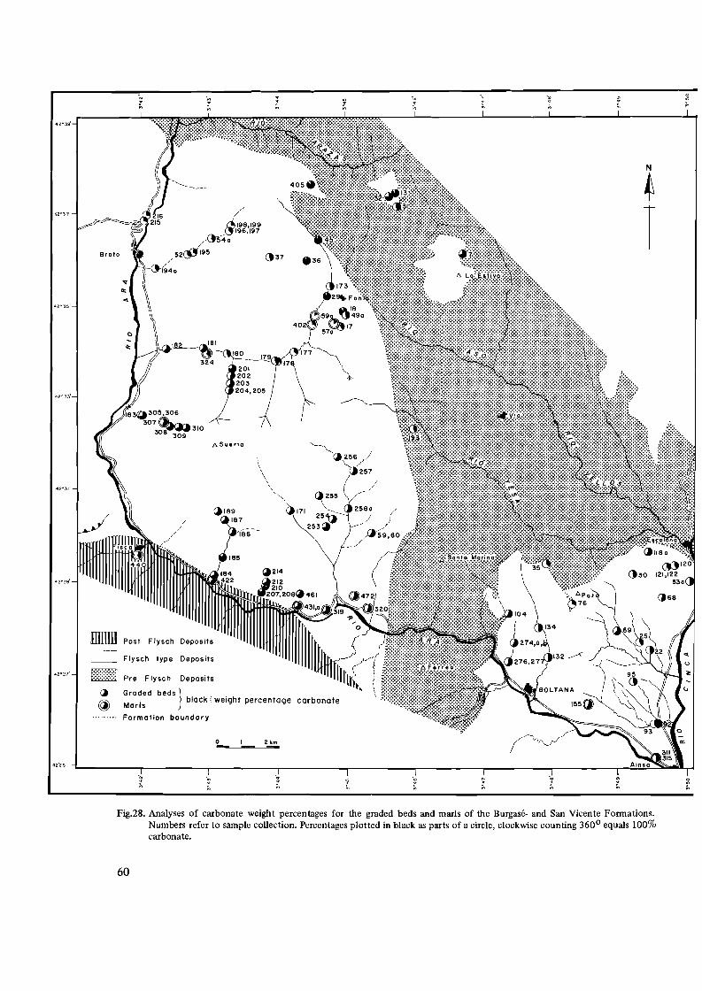
-- - ----
-,-~ -~ ~
-~ ~ ~ ~ ~
~
-42~39'
N
42'37
Broto
42°35'
42°31'
mrrm Post Flysch Deposits
CJ Flysch type Deposits
42°27' ~:~:~:f~{1 P,re Flysch Deposits
(j Groded beds} block; weight percentage carbonate@ Mar Is
Formation boundary
o I 2 km
-~
Fig.28. Analyses of carbonate weight percentages for the graded beds and marls of the Burgase- and San Vicente Formations. Numbers refer to sample collection. Percentages plotted in black as parts of a circle, clockwise counting 3600 equals 100% carbonate.
60

Table III. Average carbonate weight percentages of the graded beds and marls of the western and eastern Flysch-type Formations.
Unit A (western Flysch)
member
Top A2b
A2a
Base
Top
Base
Alb
Ala
Unit B (eastern Flysch)
B2
B1
graded beds
number of samples
Average
7
26
74%
63%
slumped zone
15 36%
70%13
graded beds
11 46%
I marls
number of samples
4
3
4
Average
64%
55%
24%
- J high
marls
3 49%
12 (10) * -51 %(55 %)1
* Sample No.76 and 35 give strong deviating results, if omitted the average of 10 samples increases to 55 %.
less variation than in Unit AI. The lower member content of Flysch-type Formations as illustrated A2b has an average of about 60% carbonate, the up below. per member A2b even reaches 75%. Unit B is subdivided into a lower member BI with about 50% car
MaastriCh-1 Landenian Lutetian I Transitionbonate and an upper member B2 with about 45% cartian Zone
bonate. When two aberrant data (sample no. 35 and -c-ar-b-on-a-te--+----~ F%76) are omitted, we get respectively 55% and 45%. content 31 %-38% 320/040% 370/0-51% 490/0-66%Although the directions of detrital supply of the units by weight %
Ala+b and B are approximately the same, the average carbonate content of the graded beds of these units is clearly different (Table III).
With regard to the marls of Unit A, the marls of It is not known what kind of samples (marls or the Ala member are rich in larger Foraminifera and graded beds) were analysed. The lithostratigraphic debris of carbonaceous fossils. Their carbonate con aequivalent of Mangin's Lutetian Flysch probably is tent is very high. In the higher parts of Unit A a varia our Unit Al of the western Flysch in the Ara-Cinca tion upwards of the carbonate content was found pa region. Mangin's "Transition Zone" might be correrallel to that found in the graded beds of the same lated with Unit A2. members. The absolute carbonate content of the When we compare the results of carbonate anamarls is, however, lower than that of the graded beds lyses of Mangin with those of the correlative units in (Table III). The few samples available of the marls of the Ara-Cinca region the following table results: Unit B approximately have the same carbonate weight percentages as the graded beds:
In the western Spanish Pyrenees Mangin (1958) found a distinct upward increase of the carbonate
61
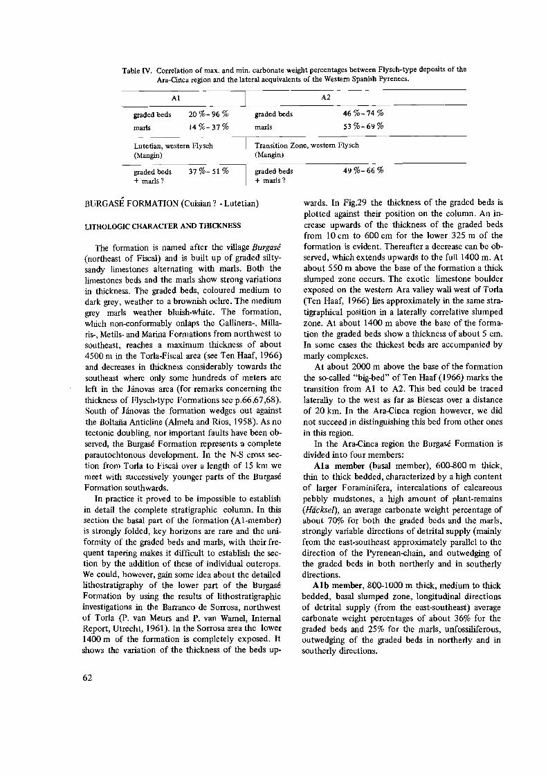
Table IV. Correlation of max. and min. carbonate weight percentages between Flysch-type deposits of the Ara-Cinca region and the lateral aequivalents of the Western Spanish Pyrenees.
Al A2
graded beds 20%-96 % graded beds 46 %-74 %
marls 14%-37% marls 53 %-69%
Transition Zone, western Flysch Lutetian, western Flysch (Mangin)(Mangin)
graded beds 49%-66 %graded beds 37%-51 % + marls?+ marls?
BURGASE FORMATION (Cuisian? -Lutetian)
LITHOLOGIC CHARACTER AND THICKNESS
The formation is named after the village Burgase (northeast of Fiscal) and is built up of graded siltysandy limestones alternating with marls. Both the limestones beds and the marls show strong variations in thickness. The graded beds, coloured medium to dark grey, weather to a brownish ochre. The medium grey marls weather bluish-white. The formation, which non-conformably onlaps the Gallinera-, Millaris-, Metils- and Marina Formations from northwest to southeast, reaches a maximum thickness of about 4500 m in the Torla-Fiscal area (see Ten Haaf, 1966) and decreases in thickness considerably towards the southeast where only some hundreds of meters are left in the Janovas area (for remarks concerning the thickness of Flysch-type Formations see p.66,67,68). South of Janovas the formation wedges out against the Boltana Anticline (Almela and Rios, 1958). As no tectonic doubling, nor important faults have been observed, the Burgase Formation represents a complete parautochtonous development. In the N-S cross section from Torla to Fiscal over a length of 15 km we meet with successively younger parts of the Burgase Formation southwards.
In practice it proved to be impossible to establish in detail the complete stratigraphic column. In this section the basal part of the formation (AI-member) is strongly folded, key horizons are rare and the uniformity of the graded beds and marls, with their frequent tapering makes it difficult to establish the section by the addition of these of individual outcrops. We could, however, gain some idea about the detailed lithostratigraphy of the lower part of the Burgase Formation by using the results of lithostratigraphic investigations in the Barranco de Sorrosa, northwest of Torla (p. van Meurs and P. van Wamel, Internal Report, Utrecht, 1961). In the Sorrosa area the lower 1400 m of the formation is completely exposed. It shows the variation of the thickness of the beds up
wards. In Fig.29 the thickness of the graded beds is plotted against their position on the column. An increase upwards of the thickness of the graded beds from 10 cm to 600 cm for the lower 325 m of the formation is evident. Thereafter a decrease can be observed, which extends upwards to the full 1400 m. At about 550 m above the base of the formation a thick slumped zone occurs. The exotic limestone boulder exposed on the western Ara valley wall west of Torla (Ten Haaf, 1966) lies approximately in the same stratigraphical position in a laterally correlative slumped zone. At about 1400 m above the base of the formation the graded beds show a thickness of about 5 cm. In some cases the thickest beds are accompanied by marly complexes.
At about 2000 m above the base of the formation the so-called "big-bed" of Ten Haaf (1966) marks the transition from Al to A2. This bed could be traced laterally to the west as far as Biescas over a distance of 20 km. In the Ara-Cinca region however, we did not succeed in distinguishing this bed from other ones in this region.
In the Ara-Cinca region the Burgase Formation is divided into four members:
Ala member (basal member), 600-800 m thick, thin to thick bedded, characterized by a high content of larger Foraminifera, intercalations of calcareous pebbly mudstones, a high amount of plant-remains (Hiicksel), an average carbonate weight percentage of about 70% for both the graded beds and the marls, strongly variable directions of detrital supply (mainly f(om the east-southeast approximately parallel to the direction of the Pyrenean-ehain, and outwedging of the graded beds in both northerly and in southerly directions.
Alb member, 800-1000 m thick, medium to thick bedded, basal slumped zone, longitudinal directions of detrital supply (from the east-southeast) average carbonate weight percentages of about 36% for the graded beds and 25% for the marls, unfossiliferous, outwedging of the graded beds in northerly and in southerly directions.
62

1400
1300
1200
IIOO~¢=:::J
·1000 E
~
Z 900 ::i" ::> ...J o BOO u
W I /:I- 700
l.L "
; 600-fill
W '%/I ~:·.r========
500 :.L1
400
~ ./1
300
f--C-"
~ 200
100 m ~
0
0 100 200 300 400 500 600
THICKNESS OF THE GRADED BEDS IN em
Fig.29. Diagram illustrating the variation in thickness of the beds of the lower part of the Burgase Formation exposed in the Barranco de Sorrosa, west of Torla. Shaded are the thicknesses of the sandy complexes. Bed-thickness in ems. stratigraphic position in ms. Data obtained from A.P.R. van Meurs and W.A. van Wame) (Internal Report, Utrecht, 1961.
A2a member, 0-1500 m thick, medium to thick bedded, basal slumped zone about 10m in thickness (Figs. 27 and 30), transversal directions of detrital supply (from the north-northeast), average carbonate weight percentages of the graded beds of about 60% and 55% for the marls, fossils mainly observed in the basal parts of the thicker graded beds, outwedging of the graded beds both in westerly and in easterly directions.
A2b member, (top-member), 0-700 m thick, medium to thick bedded, intercalations of pebbly mudstone layers, specially in the upper part of the member, predominant transversal directions of detrital supply (from the north-northwest), average carbonate weight percentages for the graded beds of about
75% and of 65% for the marls, outwedging of the graded beds both in westerly and in easterly directions.
REMARKS ON THE Ala MEMBER AND THE BASE OF
THE BURGASE FORMATION
The Ala member is exposed in the valley of the Barranco Borrue and the upper course of the river Aso, whilst on the Estiva and Mondicieto mountains scree material for the greater part masks the basal beds of this member. In the Torla-Sarvise section the member may reach a thickness of about 800 m, decreasing in thickness towards the southeast. On account of the complex folding of the strata and the
63

Fig.3D. Photograph of the thick slump-zone exposed east of that of Fig.27. In the centre of the photograph a boulder-sized undeforrned fragment of layered rocks of the Flysch-type in allochtonous position. Above the slumped zone rhythms in the development of the successive graded complexes. Base of the slumped zone not exposed.
64

sw NE G
Fig.31. Cross-section through the basal beds of the Burgase Formation. River Aso exposure north-east of Fanlo. a=Graded beds of the Flysch-type, b4Jebbly mudstone beds crammed with larger Foraminifera both in the pebbles and in the matrix. Packing of the pebbles strongly variable. Composition monomict. c=Gravel bed, ddimestones of the Metils Formation. Strata overturned.
local nature of exposures, no exact thickness can be given. The Ala member is composed of alternating coarse, sandy, often fossiliferous, graded limestone beds and of marls. An important amount of lenticular layered calcareous mudstones are intercalated, loaded with pebbles which almost completely consist of larger Foraminifera (Fig.3l). These pebbly mudstone beds reach thicknesses of 0.5-6.5 m. The thickness of the fossiliferous graded beds varies considerably from very thin to about 0.4 m. On the upper surfaces of the thinnest beds current ripplemarks locally (north of Fanlo) are very numerous.
Following H. van Baren (Internal Report, Utrecht, 1961) who made a detailed sedimentological study of the Flysch-type deposits along the eastern valley wall of the river Ara between Broto and Torla, the limestone beds show: (a) Distinct grading, specially in the thicker (coarser) beds. Locally repeated grading is observed, however without load casting on the plain of junction. (b) Mudpebble horizons are frequent in the thicker beds. On one locality they occur below the interval of parallel lamination (Tb) in the graded interval Ta (for explanation see p. 58). In most cases the mud pebbles are folded, the latter phenomenon points to the unconsolidated state of the material during transport. (c) On the whole, parallel and current lamination is rather scarce. (d) Plant remains are frequently observed on the upper surfaces of the graded beds and laminae. In gene
ral they show random orientation of their longer axes. (e) The graded beds show, without exception, sharp upper and lower contacts with the marls. (f) The lower surfaces of the thicker and coarser beds are in generalloadcasted. (g) Flute casts are common but not numerous, they are restricted to the medium thick beds. Most of them belong to the linguiform type. (h) Groove casts are rare and for the greater part indistinctly developed. (i) At the base and top of the Ala member slumped horizons occur. G) A graded (polygenic) layer of fine gravel is exposed south of Fanlo, and can be traced in southeasterly direction along the mountain crest. (k) Burrows and tracks of benthonic fauna are numerous on the surfaces of the beds (for description of the kind of tracks see p. 73 ).
The average carbonate weight percentage of the graded beds of the Ala member (70%) is, in our opinion, due to the high amount of reworked larger Foraminifera and their debris.
Following the very base of the Ala member from northwest to southeast, we laterally meet with younger formations in the underlying strata as follows: (1) Along the Sierra de las Cutas the member overlies limestones with chert concretions belonging to the upper part of the Gallinera Formation (Lower Herdian). (2) At an altitude of about 1420 m (location 311) in the upper courses of the Barranco Borrue a
65

sharp contact of graded beds of Flysch-type with the marly limestones of the underlying Millaris Formation (Middle Ilerdian) is marked by a thin haematite (weathered pyrite) horizon. This sharp contact laterally covers lenticular beds of compact fossiliferous mud pebbles (Fig.ll). (3) In the river bed of the Barranco Borrue, north of Fanlo, the Millaris Formation (Middle Ilerdian), which at this place is almost outwedged, underlies Flysch-type deposits. (4) East of Fanlo massive to nodular limestones of the Metils Formation (Upper Ilerdian-Lower Cuisian) underly the Ala member, the basal beds of the Flysch forming an alternation of graded sandy limestones and compact mud pebble layers, crammed with larger Foraminifera (Fig.31). (5) At an altitude of 1940 m on the eastern slope of the Estiva mountain a sharp contact between the Millaris Formation and the overlying Flysch-type deposits is characterized by a one centimeter thick horizon of haematite. The lowest graded bed (0.9 m) shows a high content of pyrite concretions. (6) North of Ceresuela the basal beds of the A1a member are strongly disturbed tectonically and locally slumped. They border the limestones and marls of the Marina Formation (Cuisian) to the west.
The observations cited above strongly suggest a non-conformity at the base of the Burgase Fornlation marked by evidence of submarine erosional phenomena such as channelling in the older series (Fig. 11) and by slumped basal beds of the Burgase FOmlation (Fig.31 ).
Other observations, on the other hand, point to a kind of interfingering of the Flysch-type sediments of the Burgase Formation with, respectively from northwest to southeast, the limestones of the Millaris-, Metils- and Marina Formations. These are the following: (I) Northeast of Fanlo at an altitude of 1620 m (loc.327A) brownish weathered, sandy, fossiliferous limestones occur in the upper part of the Millaris Formation just underlying the limestones of the Metils Formation that are almost outwedged. The lower surface of these sandy beds are crammed with imprints and tracks of organisms. (2) South of Sercue, on the path to Vio (loc.624, altitude 950 m) silty limestones form the top beds of the Millaris Formation. They have sharp contacts with the marly limestones of the Metils Formation. Their brownishochre weathering colour and dark grey fresh colour show some resemblance to the graded beds of the Flysch (Fig.32). (3) Along the same path to Vio, at the base of the Marina Formation (loc.629, altitude 1180 m), we again observed sandy limestone beds alternating with marls. Here we are probably dealing with the a-member of the Marina FOmlation. The beds, which reach thicknesses of up to 0.3 m, are dis
tinctly graded. Some sole marks (ridge casts with dendritic pattern, see Bouma, 1962, fig.6) give directions of detrital supply from the southwest. The beds are rich in haematite concretions which locally show pyrite in their inner cores. (4) Along the Caretera de Hydro Nitro, near the village Puarruego and the Fuente de Suspiros (loc.619 and 577 respectively), beds lithostratigraphically correlative to those cited under (2) and (3) could be recognized. The beds aequivalent to (2) consist of silty limestones, thin to medium bedded, with a slight brownish-grey weathering colour. Those correlated with (3) clearly show a turbiditic character with sole marks. They are also rich in pyrite. The supply directions measured on flute casts of these beds are from the south and southwest (see Table II).
Summarizing the field observations, we fmd on the one hand evidence for a non-conformity at the base of the Burgase Formation, which is extra emphasized by biostratigraphic evidence of a considerable hiatus decreasing in importance towards the southeast, on the other, intercalations of Flysch-type depOSits occurring in the upper beds of the Millaris Formation and at the base of the Marina Formation. The latter phenomena would point to a lateral facies change between the Burgase (Flysch-type) F ormation in the west and the Millaris-, Metils-, and Marina Formation in the east of the region studied. Both situations are possible, when only the lithostratigraphic sections are compared. If, however, we take into consideration that the current directions measured on the graded beds of the Al member of the Burgase FOmlation (Fig.26) in general show directions of detrital supply from the east-southeast, a lateral facies change is impossible, because in that area mainly limestones and marls have been deposited. This leads to the conclusion that the Burgase Formation non-conformably onlaps the Gallinera-, Millaris-, Metils-, and Marina Formation from northwest to southeast respectively.
REMARKS CONCERNING THE THICKNESS OF THE
BURGASEFORMATION
The thickness of the Burgase Formation estimated by constructing the Ara section between Torla and Fiscal is 4500 m (Ten Haaf, 1966). The latter author remarks that the thickness measured un 'est evidemment qu 'un chiffre tres theorique".
On account of the large horizontal distance between base and top of the formation and the shortening of strata by intensive folding, specially in the lower half of the formation, the thickness measured probably does represent but an apparent value. The horizontal distance between Torla and Fiscal is
66

I
Fig.32. Photograph of sandy limestone beds in the upper part of the Millaris Fonnation. Path from Sercue to Vio, south of the confluence of the rivers Aso and Vellos.
about 14 km. Over the northern half of this N-S section (AI member) the Flysch-type deposits show a strong lenticular development of the individual beds as well as of the graded complexes. This development is frequently observed even within a single outcrop. Wedging out of the beds is evident in a northerly and southerly direction, that is, perpendicular to the general direction of detrital supply (Fig.26).
In the southern part (A2 member) of the TorlaFiscal section a pronounced lenticular development in an east-west direction is again perpendicular"to the directions of detrital supply (in the latter case, notherly supply directions prevail): According to Ten Haaf et al. (1970, in press) this upper member can be followed towards the west as far as the G311ego river, where it wedges out. An outwedging in easterly direction is observed south of Janovas against the Boltafia Anticline (see geological map, appendix 1).
In the southerly Sierra Zone, although thick series
of alternating sands and clays abound, the graded beds of the Flysch-type are totally absent (Selzer, 1934; Mr. F. Hehuwat, 1969, personal communication). Apparently these beds did not extend beyond the zone of the blue marls which form our Fiscal Formation. This means that the original transversal northerly directions of supply found in the A2 member of the Burgase Formation, must have turned to more east-west (longitudinal) directions south of the region studied. As the presence of a haut fond in the east must have prevented the currents to take that direction, it is obvious to think of longitudinal westerly continuations of the turbidity currents during the deposition of the upper part of the Burgase Formation south of the region studied.
Fig.33 illustrates schematically how an apparent thickness measured between the exposed top and base of a formation (dII) may differ from the real thickness (dI) when also the development of indivi
67
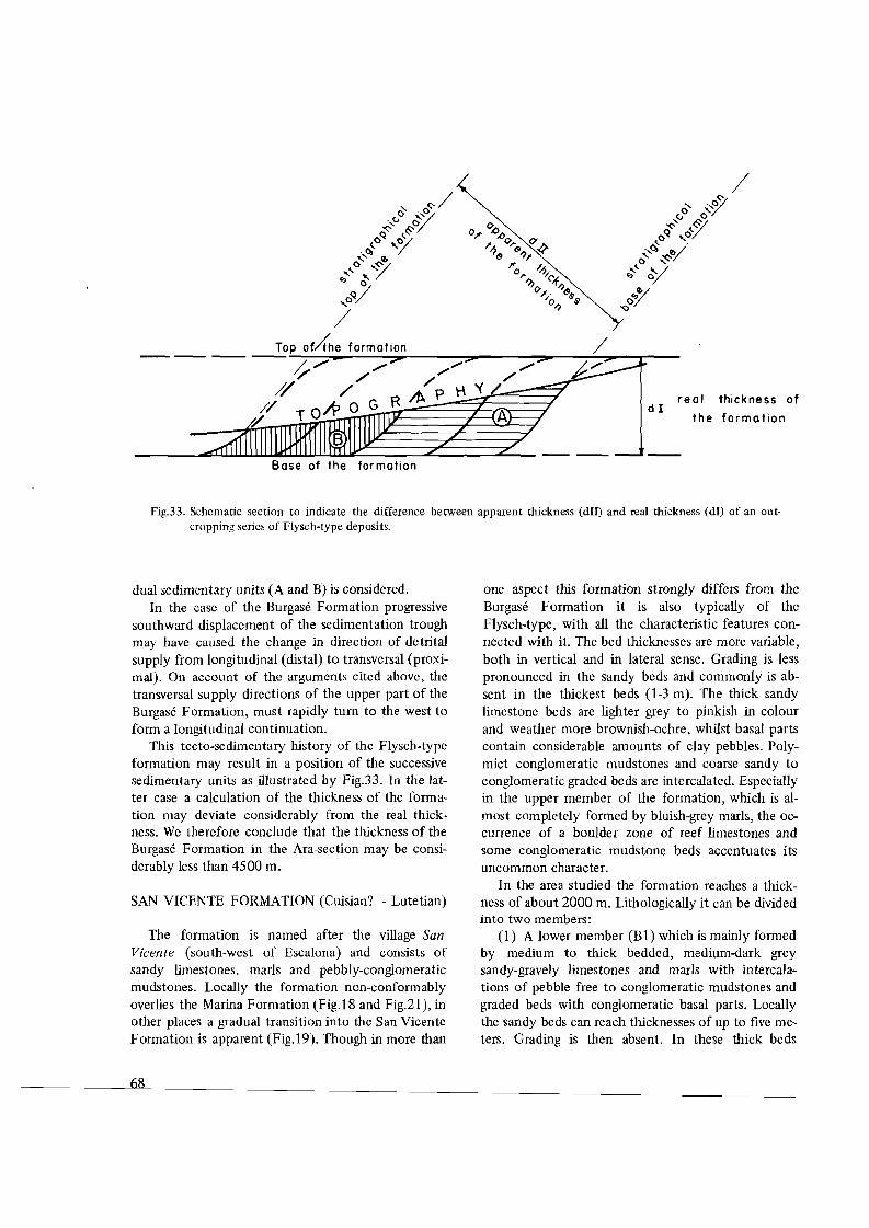
real thickness ofdI
the formation
the formation
Fig.33. Schematic section to indicate the difference between apparent thickness (dIll and real thickness (dl) of an outcropping series of Flysch-type deposits.
dual sedimentary units (A and B) is considered. In the case of the Burgase Formation progressive
southward displacement of the sedimentation trough may have caused the change in direction of detrital supply from longitudinal (distal) to transversal (proximal). On account of the arguments cited above, the transversal supply directions of the upper part of the Burgase Formation, must rapidly tum to the west to form a longitudinal continuation.
This tecto-sedimentary history of the Flysch-type formation may result in a position of the successive sedimentary units as illustrated by Fig.33. In the latter case a calculation of the thickness of the formation may deviate considerably from the real thickness. We therefore conclude that the thickness of the Burgase Formation in the Ara-seetion may be considerably less than 4500 m.
SAN VICENTE FORMATION (Cuisian? - Lutetian)
The formation is named after the village San Vicente (south-west of Escalona) and consists of sandy limestones, marls and pebbly-conglomeratic mudstones. Locally the formation non-conformably overlies the Marina Formation (Fig.IS and Fig.21), in other places a gradual transition into the San Vicente Formation is apparent (Fig.19). Though in more than
6S
one aspect this formation strongly differs from the Burgase Formation it is also typically of the Flysch-type, with all the characteristic features connected with it. The bed thicknesses are more variable, both in vertical and in lateral sense. Grading is less pronounced in the sandy beds and commonly is absent in the thickest beds (1-3 m). The thick sandy limestone beds are lighter grey to pinkish in colour and weather more brownish-ochre, whilst basal parts contain considerable amounts of clay pebbles. Polymict conglomeratic mudstones and coarse sandy to conglomeratic graded beds are intercalated. Especially in the upper member of the formation, which is almost completely formed by bluish-grey marls, the occurrence of a boulder zone of reef limestones and some conglomeratic mudstone beds accentuates its uncommon character.
In the area studied the formation reaches a thickness of about 2000 m. Lithologically it can be divided into two members:
(1) A lower member (B1) which is mainly formed by medium to thick bedded, medium-dark grey sandy-gravely limestones and marls with intercalations of pebble free to conglomeratic mudstones and graded beds with conglomeratic basal parts. Locally the sandy beds can reach thicknesses of up to five meters. Grading is then absent. In these thick beds

Fig.34. Thick-bedded sandy limestones of the San Vicente Formation exposed along the path from Muro to San Vicente, south-west of Muro. For the scale see bag (b) at the base of the bed.
Fig.35. Typical outcrop of fine-bedded to laminated, bluish-grey marls of the San Vicente Formation north-west of Labuerda. The trees in the centre right of the photograph have a height of about 1.5 m.
(Fig.34) the basal parts are rich in clay pebbles, whilst in general they have a lenticular appearance. The member reaches a thickness of about 700 m.
The general direction of detrital supply measured on flute casts and groove casts for the BI member (see also Fig.26) is approximately the same as for the Al member of the Burgase Formation (from the southeast).
As for the average carbonate weight percentages of the sandy limestones, they appear to be less than those of the Ala member of the Burgase Formation and higher than those of the Alb member (see for the percentages, Table III). The BI member shows an average carbonate weight percentage of about 50% for the sandy beds.
In several outcrops we observed a lenticular development of the graded beds, perpendicular to the general direction of detrital supply. A great number of coarse graded beds with conglomeratic basal parts are found intercalated in the BI member. One of the mudstone beds (olisthostromes) contains a reef limestone boulder of enormous size. In section III we shall go into the details of the sedimentological character and components of the mudstones and conglomerates.
(2) An upper member (B2), which mainly consists of bluish-grey marls (Fig.35) shows an alternation of thin bedded to laminated more or less calcareous zones. Locally intraformational non-conformities and thick slumped zones break the monotony of the
69

Fig.36. Intercalations of sandy limestone complexes (a) in the marly B2-member of the San Vicente Formation. View to the south-east. Exposure in the Barranco del Royo west of Labuerda. a=Sandy limestone complex, b::intraformational nonconformity, c=slumped zone.
marls. Thin section analyses of the more calcareous beds showed a graded, fine silty composition. Three thick sandy limestone complexes (see for instance Fig.36) are intercalated in the marly member. They reach thicknesses from 75 to 100 m. Their basal beds are the thickest (2-2.5 m), pinkish-brown with clay pebble horizons in their lower parts and further consist of a non-sorted mixture of quartz, feldspars and detrital limestone fragments in a non-graded, homogenous texture. A rapid decrease in thickness of the overlying beds follows, with an increase of the thickness of the marly intercalations. The medium bedded sandy limestones are graded. Irregularly intercalated in the thick marls lenticular sandy limestone beds are found, rich in larger Foraminifera, which appear to be completely reworked.
Both the sandy complexes and the lenticular beds are rich iIi trace fossils, both on the lower and on the upper surfaces of the beds. Asymmetrical ripple marks found on the upper surfaces of the beds give current directions from the north (contrary to the general directions of detrital support of the turbidites). According to Mr. R. Geyskes (Internal Report, Utrecht, 1962) mud cracks may occur on some of the upper surfaces of the thicker sandy beds, but we did not find them on our field trips. The fluxo-turbiditic appearance of the thicker of the sandy beds, which indicates their proximal character, coupled with the
presence of conglomeratic mudstones and conglomeratic basal parts in some graded beds, may point to a very shallow marine environment. The thin bedded to laminated marls in which the sandy beds are intercalated do, however, not show any effect of wave action. The B2 member reaches a minimal thickness of about l300m.
The average directions of detrital supply, measured on some flute casts in the sandy complexes, are from the south to southeast. The limited number of sole marks observed on these beds (see Fig.26) is concentrated in the three main sandy complexes and does not show important variations. We therefore may conclude that the directions of detrital supply for the B2 member are more southerly, than those of the B1 member.
The carbonate weight percentages for both the marls and the sandstones are somewhat lower than for the BI member (see Table III). Taking this distinction together with their more southerly directions of detrital supply, it follows that they are in no way comparable with the members of the Burgase Formation.
70
FOSSIL CONTENT AND AGE OF THE FLYSCH-TYPE FORMATIONS
INTRODUCTION
The type of sediments indicated by the general term Flysch in the Ara-Cinca region is characterized by an alternation of graded (silty-sandy) limestone beds and marls with a subordinate amount of pebbly mudstones intercalated. The graded beds were deposited by turbidity currents, whereas the marls also mainly belong to the turbiditic sequence (laminites). Both the turbitites and the mudstones are composed of reworked sediments. Their fossil content is a mixture of pelagic and benthonic species which may have originated from different depths of marine environment and from different places on the basin border. The reworked fauna found in these sediments can only indicate an age of deposition which is identical with, or younger than the age of the youngest fossils present.
In the Ara-Cinca region the fauna in the limestone of the Marina Formation (Cuisian) is autochthonous (see p.52), whereas the fauna in the graded beds and mudstones of the surrounding Flysch is evidently reworked. It appears to be partly identical with that of the Marina Formation, but partly it is definitely older; Montian or Ilerdian. If the time range of the Lutetian species of larger Foraminifera is properly assessed, their presence at the base of the Burgase Formation gives a Middle Eocene age to these Flysch-type deposits.
In the literature of the Central and Western Spanish Pyrenees a lateral facies change between Eocene limestones and Flysch-type deposits is frequently suggested (Selzer, 1934; Mangin, 1958; Ten Haaf, 1966), whereas other authors observed a nonconformity between Flysch-type deposits and underlying strata in the Ordesa region (Mengaud, 1939; Von Hillebrandt, 1962; Van de Velde, 1967). In my region, as stated in the preceding section, this nonconformity is most pronounced in the western part. The timestratigraphic hiatus between Flysch-type deposits and the underlying sequence decreases in importance from northwest to southeast. In the eastern part of the region it could remain a point of discussion, whether the autochtonous limestones of the Marine Formation are of the same age, or older than the Flysch-type deposits to the west of it. But since, as we have seen the Flysch-type deposits contain reworked Foraminifera of Lower and Middle Cuisian age, it follows that even here the Flysch-type sediments must be younger than the limestones of the
Marina Formation. This precludes the possibility of a lateral facies change between both formations.
FOSSIL CONTENT AND AGE OF THE BURGASE FOR
MATION
Except for the basal part of the formation, the graded beds of the Burgase Formation are generally poor in fossils. The intercalated mudstones and some basal parts of thick graded beds contain numerous fossils. The fauna consists predominantly of larger Foraminifera. Nummulites sp., Discocyclina sp., Assilina sp., subordinate amounts of Alveolina sp., Operculina sp., Orbitolina sp. and Miliolidae have been observed throughout the formation, whereas numerous plant remains cover the upper surfaces of the sandy beds. Several kinds of tracks of burrowing benthos and imprints of organisms were observed.
In the basal beds of the formation exposed in the Fanlo-Torla area Dalloni (1910) came across the following Foraminifera Nummulites atacicus LEYMERlE, Nummulites globulus LEYMERIE, Nummulites scaber LEYMERIE, Assilina leymeriei d'ARCHIAC, and Assilina granulosa d'ARCHIAC. In the Diazas area he came across Nummulites lucasanus DEFRANCE, Nummulites globulus LEYMERIE, Nummulites atacicus LEYMERIE, Nummulites guettardi d'ARCHIAC, Nummulites granulosa d'ARCHIAC, Assilina spira DE ROISSY, Assilina mamillata d'ARCHIAC, Discocyclina (Orthophragmina) pratti MICHELOTTI and Discocyclina (Orthophragmina) sella d'ARCHlAC. According to Hottinger and Schaub (1960) Assilina spira DE ROISSY is one of the characteristic key fossils for the Lower Lutetian in the Mediterranean area.Assilina mamillata d'ARCHIAC, according to Schaub (1960, p.447) changed its name into Assilina exponens SOWERBY, which is characteristic for the Lutetian. The name Nummulites lucasanus is replaced by Nummulites perforatus A, which is mainly found in the Upper Lutetian.
West of Torla (Sample No.46) we came across Discocyclina douvillei SCHLUMBERGER, Discocyclina sp. (augustae V.D. WEYDEN? ), Alveolina cf. rutimeyerie HOTTINGER, Orbitolites of the group minima HENSON, Operculina of the group parva DOUVILLE, Cuvillierine eocenica DEBOURLE, Praerhapidionina sp., small Pararotalia sp. and Miliolidae. This assemblage probably belongs to the Cuisian.
In the Barrano Borrue (west of Fanlo) a slumped zone rich in larger Foraminifera contains a mixture of limestone fragments (Sample No.20) in which we observed Nummulites sp., Assilina placentula DE LA HARPE, Discocyclina sp., Alveolina schwageri
71

Fig.3? Photomicrograph of a Foraminiferal limestone pebble from the mudstones at the base of the Burgase Formation (Sample No.19, parallel nicols, enlargement 6x, Barranco Borrue, west of Fanlo). Nummulites group exilis, Assilina group Leymeriei, Planorbulina antiqua MANGIN, Kathina sp., Rotalia sp. and other Rotalids, Alveolina sp., Discocyclina sp. Reworked Middle Ilerdian limestone.
CHECCHIA RISPOLI, Alveolina distephanoi CHECCHIA RISPOLI, Orbitolites of the group minina HENSON, Operculina sp., Cuvillierina eocenica DEBOURLE, Rotalia trochidiformis LAMARCK and Miliolidae. This association, though totally reworked, belongs to the Lower Cuisian. In the same sample we further noted Alveolina of the group ellipsoidales and Alveolina of the group rotundata, which have Lower and Middle Ilerdian ages respectively.
A limestone pebble (sample No.l9) in the mudstones west of Fanlo contains Nummulites of the group exilis, Assilina of the group leymeriei, Planorbulina antiqua MANGIN, Kathina sp., Rotalia sp. and other Rotalids, Alveolina sp. and Discocylina sp. (Fig.37). Following Hottinger and Schaub (1960) and Schaub (1960) a Middle Ilerdian age is assigned to this fauna. Mangin (1958), however, attributed a Montian age to the Planorbulina antiqua MANGIN in the western Pyrenees.
In the laterally aequivalent Flysch beds exposed north of the Arazas River Von Hillebrandt (1962) determine'd a rich fauna of larger Foraminifera, which according to Hottinger and Schaub (1960) represents the Lower and Middle Cuisian. Van de Velde (1967) remarks that these fossils are reworked. We therefore may conclude that the deposits in which this mixed fauna occurs are younger than Middle CUisian. At the base of the A2a member a fossiliferous bed which fol
lows the Barranco Cajol (Sample No.467) contains Nummulites of the group perforatus, Eorupertia sp., Discocyclina sp. and small Rotalids. Sample No.468, derived from the same exposure, contains Algal debris, Nummulites sp., Alveolina sp., Chapmanina sp., Discocyclina sp. and Rotalids.
In the Aquitanian basin the first Chapmaninas are encountered at the very Upper Lutetian (Cuvillier, 1958). Eorupertia is found already in the Lower Lutetian of the Southern Alps (Bianca Cita, 1965), but in the Aquitanian basin they only occur from the beginning of the Upper Lutetian. Nummulites of the group perforatus characterizes the Upper Lutetian (Biarritzian) according to Hottinger and Schaub (1960). Although we have but scarce information about the age of the A2a member, the lower limit for its base thus is Lutetian and may even be the. Upper Lutetian.
In the upper beds of the Burgase Formation (A2b member) Almela and Rios (1958) found west of Javierre Alveolina elongata d'ORBIGNY, Nummulites lucasanus DEFRANCE and Orbitolites complanatus LAMARCK. Alveolina elongata d'ORBIGNY and Nummulites lucasanus (perforatus) DEFRANCE are typical for the Biarritzian. Orbitolites complanatus LAMARCK is found by Cuvillier (1958) in the Upper Lutetian of the Aquitanian basin in which they mainly occur. In the older Lutetian of that basin they
72

are very rare, being found only in association with the more numerous Opertorbitolites, which have not been observed in the Flysch of the Ara-Cinca region.
An Upper Lutetian (Biarritzian) lower age limit may consequently be given to the upper member of the Burgase Formation.
Northwest of Fanlo the base of the Flysch-type deposits non-conformably overlies the limestones of the Gallinera Formation which, in its upper part, is of Lower Ilerdian age. In that area there apparently exists a timestratigraphic hiatus which comprises the Middle and Upper Ilerdian and probably also Lower (and Middle) Cuisian. On the basis of the faunae cited above, the Ala member of the Burgase Formation is composed of detritus from Middle and Upper Ilerdian and Lower and Middle Cuisian age. The occurrences of Lutetian specimen indicates that the base of the Burgase Formation probably already belongs to the Middle Eocene (Lutetian).
FOSSIL CONTENT AND AGE OF THE SAN VICENTE
FORMATION
More than in the Burgase Formation, the Flysch-type deposits of the San Vicente Formation show clear evidence of their reworked character. A great many pebbly mudstones, conglomeratic mudflows and olisthostromes intercalated in the marls and graded sequences contain individual fossils as well as fossiliferous rounded pebbles and angular fragments of different kinds of rock. In some olisthostromes boulders of reef limestone occur which can reach sizes of up to eight meters in diameter. In the muddy matrices we frequently meet with individual corals, thick shelled Ostreas and fragments of coral colonies of pebble size. When describing the pebbly mudstones and conglomeratic beds of the Flysch-type deposits of the San Vicente Formation we shall go into the details of the exotic components. For the dating of this formation we restrict ourselves here mainly to larger Foraminifera found in the marls and graded sequences.
The thicker graded beds of the San Vicente Formation show coarse sandy to conglomeratic basal parts which in general are very rich in fossils. In a graded bed along the path from Escalona to Muro (Sample No.119) we came across Assilina placentula DE LA HARPE, Assilina cf. reicheli SCHAUB, Nummulites planulatus (cf. manfredi SCHAUB? ), Operculina canalifera d'ARCHIAC, fragments of Orbitolites sp. (0. complanatus LAMARCK?) and Cuvillierina eocenica DEBOURLE. In a fme gravely detrital limestone (Sample No.124) of the same location we determined Alveolina cf. oblonga d'ORBIGNY,
Alveolina sp., Nummulites of the group partschi, Nummulites of the group burdigalensis and Discocyclina sp. These assemblages probablY represent reworked Ilerdian and Lower and Middle Cuisian (Hottinger and Schaub, 1960).
A reworked limestone pebble in the "Wild-Flysch" west of Escalona (Sample No.540) contains Assilina placentula DE LA HARPE, Discocyclina sp., Operculina sp., Nummulites sp. and small Rotalids. This pebble probably is an erosion product of unconsolidated Lower Cuisian limestone.
Between the villages Escalona and Labuerda DaIloni (1910) found Ostrea stricticostata RAUL., Cerithium almeroe CARALP., Nummulites atacicus LEYMERlE, Nummulites scaber LAMARCK, Assilina Leymeriei d'ARCHIAC, Assilina granulosa d'ARCHIAC (= A. laxispera DE LA HARPE), Assilina mamillata d'ARCHIAC (=A.exponens A) and Orthophragmina archiaci SCHLUMBERGER. This assemblage forms a mixture of Ilerdian-Lower Lutetian fossils.
In the basal beds of the San Vicente Formation, south of the village Boltafia, Dalloni observed Ostrea sp., Panopea sp., Velates sp., Calliostoma sp., Cidaris subularis d'ARCHIAC, Cidaris striatigranosa d'ARCHIAC, Echinocyamus aff. planulatus d'ARCHlAC , Macropneustes sp., Schizaster sp., Cypraea sp., Tu"itella sp. and Pecten sp.
We further came across Nummulites aturicus JOLY & LEYMERIE, Nummulites crassus BOUBEE, Nummulites globulus LEYMERIE, Assilina spira DE ROISSY, Assilina granulosa d'ARCHIAC var. minor DONCIEUX and Nummulites lucasanus DEFRANCE (= N.perforatus A). The larger Foraminifera form a mixture of specimen of Middle Ilerdian to Lower Lutetian age.
A thin fossiliferous horizon in the marls west of Labuerda (B2 member of the San Vicente Formation, Sample No.94) contains Alveolina cf. boscii DEFRANCE, Alveolina of the group stipes and Nummulites of the group perforatus (small forms). A lower Lutetian age is assigned to these fossils.
Between Boltana and Ainsa, Almela and Rios (1958) frequently observed in the marls Nummulites perforatus DE MONF. and Assilina exponens SOWERBY, which may indicate a lower Lutetian age as well.
CONCLUDING REMARKS
As in most of the Flysch-type deposits elsewhere in the world, burrows and imprints of organisms also are common in the Ara-Cinca Flysch. H. van Baren (Internal Report, Utrecht, 1961) observed in the Al
73

member of the Burgase Formation: Palaeodictyon sp., Helminthopsis sp.?, Munsteria sp.? , Subphyllochorda, Chondrites sp., Helminthoidea, Polykampton? , Palaeobullia, Taphrelminthopsis? and Terebel/ina.
The fauna determined in both the Burgase Formation and in the San Vicente Formation seems to have been largely reworked. The time of deposition of the Flysch-type deposits therefore must be, somewhat younger than indicated by the youngest fossils observed in the various members. But the chronology rougWy follows the lithostratigraphic succession in as much as the basal parts of the San Vicente and Burgase Formation contain mixtures of reworked Herdian and Lower and Middle Cuisian fauna with rare Lutetian species and the upper members contain almost exclusively Lutetian fauna, the A2 member having an Upper Lutetian (Biarritzian) lower age limit, and the B2 member a Lower Lutetian one.
We are therefore inclined to think of a steady supply of sediments by turbidity currents and olisthostromes from localities at the basin border. Shallow marine sedimentation might have taken place there simultaneously with partial transport of unconsolidated masses of sediment towards the deeper parts of the basin. According to this picture, and on account of the fossil content, the age of the base of the Flysch-type formations probably coincides with the beginning of the Lutetian. No timestratigraphic difference appears to exist between the basal parts of the San Vicente Formation and the Burgase Formation. The former locally non-conformably overlies the limestones of the Marina Formation (Fig.l8) which have an authochthonous Cuisian fauna. There consequently is a small timestratigraphic hiatus between the Marina Formation and the base of the San Vicente Formation.
The directions of detrital supply of the graded beds and marls of the Al member of the Burgase Formation are from the east-southeast (see Fig.26). The same directions are measured for the basal part of the Bl member, of the San Vicente Formation. This indicates that the turbidity currents have crossed the limestones of the Marina Formation which formed a submarine ridge at that time. Part of the reworked fauna of the Ala member of the Burgase Formation is identical with that of the Marina Formation and might originate from erosion of these limestones.
SEDIMENTOLOGICAL CHARACTER AND COMPONENTS OF THE PEBBLY MUDSTONES AND CONGLOMERATIC BEDS OF THE FLYSCH-TYPE FORMATIONS
lNTRODUcnON
When describing the Flysch-type Formations, we did not enter into the details of the intercalated mudstones and conglomeratic beds. These will be discussed separately in the next sections, on the basis of a series of twelve exposures.
The exposures numbered 1-9 (for locations see Fig.38), which belong to the San Vicente Formation, are described in section A (1-9), whereas those numbered 10-12 are found in the Burgase Formation and are described in section B (10-12).
Descriptions of the individual outcrops are followed by a summary of the results of thin-section analyses of the pebbly components of the beds. Where possible these results are divided into those of sedimentary and of igneous components. The descriptive sections are closed with remarks about the age and origin of the pebbles.
A. San Vicente Formation
(1) Barranco de Ascaso
Along the valley wall of the river Ascaso a calcareous mudstone bed is exposed in which boulders of reef limestone (Fig.39) and badly sorted angular and rounded pebbles of various rock types are observed (Fig.40). The bed is intercalated in the sandy limestones and marls of the basal part of the San Vicente Formation.
Following the interpretation by Flores (1955) and Gorler und Reutter (1968) this bed represents a small scale olisthostrome. According to Dott (1963) olisthostromes are formed by submarine mudflows.
Our olisthostrome shows the following characteristic features:
(a) A marly-sandy groundmass in which fragments of rocks of strongly variable size (0.01-10 m) occur, densily to loosely packed, in a non-sorted and nongraded mixture. The components are partly rounded, partly angular. Some contorted bedding is observed, resulting from draping of laminated fragments of mudstone in a more sandy matrix. The components of olisthostromes are called olistholites, following Flores (1955).
(b) The olisthostrome is intercalated in graded beds and marls of the Flysch-type. Its thickness varies from one to five meters. Laterally its composition fre
74
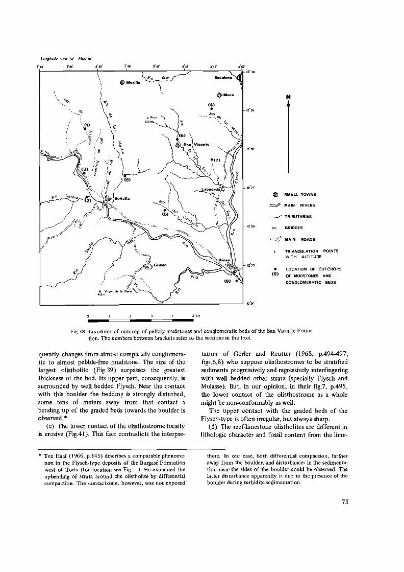
Longitude east of Madrid
3<> 46' 3'47 3'48' 3'49' 3'50'l- ....�.. -!, .J..._""'_.....J..I ~~--....I..--"'""__,jl_42' 30'
Rio Yesa Escalona ,, alUPMorilio ,, , • Muro N
~\.... 119('0
............ (4)
qlJJ SMALL TOWNS
~ MAIN RIVERS
___ ,../ TRIBUTARIES
BRIDGES
~.4" MAIN ROADS
TRIANGULATION ,POINTS
WITH ALTITUDE
LOCATION OF OUTCROPS (5)•
OF MUDSTONES AND
CONGLOMERATIC BEDS
42"25'
• ..... Bco---- - ... ~
~ , ... -b.,r ........ "1,.....
0,
(9) .',
i:J. POZO
1323m.
'" o "
"'~ ....... _%
I, \(1)
~\ ~ '~ I
/'~ (' 8 (g,..,
i, "al(3l l~' ~)a
L .....> ..... 42·24'
5 km
--====---====-Fig.38. Locations of outcrop of pebbly mudstones and conglomeratic beds of the San Vicente Forma
tion. The numbers between brackets refer to the sections in the text.
quently changes from almost completely conglomeratic to almost pebble-free mudstone. The size of the largest olistholite (Fig.39) surpasses the greatest thickness of the bed. Its upper part, consequently, is surrounded by well bedded Flysch. Near the contact with this boulder the bedding is strongly disturbed, some tens of meters away from that contact a bending up of the graded beds towards the boulder is observed.*
(c) The lower contact of the olisthostrome locally is erosive (Fig.4l). This fact contradicts the interpre
* Ten Haaf (1966, p.145) describes a comparable phenomenon in the Flysch-type deposits of the Burgase Formation west of Torla (for location see Fig. ). He explained the upbending of strata around the olistholite by differential compaction. The contactzone, however, was not exposed
tation of Gorier and Reutter (1968, p.494497, figs.6,8) who suppose olisthostromes to be stratified sediments progressively and regressively interfmgering with well bedded other strata (specially Flysch and Molasse). But, in our opinion, in their fig.7, p.495, the lower contact of the olisthostrome as a whole might be non-conformably as well.
The upper contact with the graded beds of the Flysch-type is often irregular, but always sharp.
(d) The reef-limestone olistholites are different in lithologic character and fossil content from the lime-
there. In our case, both differential compaction, farther away from the boulder, and disturbances in the sedimentation near' the sides of the boulder could be observed. The latter disturbance apparently is due to the presence of the boulder during turbidite sedimentation.
75
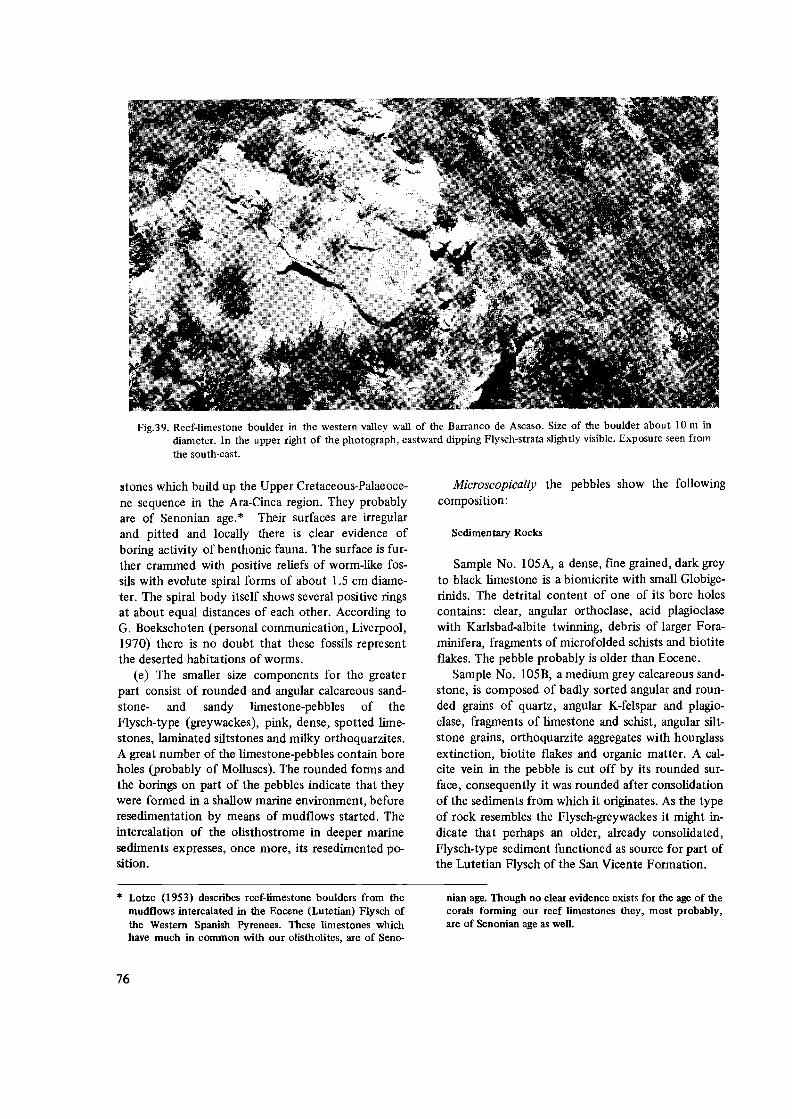
Fig.39. Reef-limestone boulder in the western valley wall of the Barranco de Ascaso. Size of the boulder about 10 m in diameter. In the upper right of the photograph, eastward dipping Flysch-strata slightly visible. Exposure seen from the south-east.
stones which build up the Upper Cretaceous-Palaeocene sequence in the Ara-Cinca region. They probably are of Senonian age. * Their surfaces are irregular and pitted and locally there is clear evidence of boring activity of benthonic fauna. The surface is further crammed with positive reliefs of worm-like fossils with evolute spiral forms of about 1.5 em diameter. The spiral body itself shows several positive rings at about equal distances of each other. According to G. Boekschoten (personal communication, Liverpool, 1970) there is no doubt that these fossils represent the deserted habitations of worms.
(e) The smaller size components for the greater part consist of rounded and angular calcareous sandstone- and sandy limestone-pebbles of the Flysch-type (greywackes), pink, dense, spotted limestones, laminated siltstones and milky orthoquarzites. A great number of the limestone-pebbles contain bore holes (probably of Molluscs). The rounded forms and the borings on part of the pebbles indicate that they were formed in a shallow marine environment, before resedimentation by means of mudflows started. The intercalation of the olisthostrome in deeper marine sediments expresses, once more, its resedimented position.
Microscopically the pebbles show the following composition:
Sedimentary Rocks
Sample No. 105A, a dense, fme grained, dark grey to black limestone is a biomicrite with small Globigerinids. The detrital content of one of its bore holes contains: clear, angular orthoclase, acid plagioclase with Karlsbad-albite twinning, debris of larger Foraminifera, fragments of microfolded schists and biotite flakes. The pebble probably is older than Eocene.
Sample No. 105B, a medium grey calcareous sandstone, is composed of badly sorted angular and rounded grains of quartz, angular K-felspar and plagioclase, fragments of limestone and schist, angular siltstone grains, orthoquarzite aggregates with hourglass extinction, biotite flakes and organic matter. A calcite vein in the pebble is cut off by its rounded surface, consequently it was rounded after consolidation of the sediments from which it originates. As the type of rock resembles the Flysch-greywackes it might indicate that perhaps an older, already consolidated, Flysch-type sediment functioned as source for part of the Lutetian Flysch of the San Vicente Formation.
* Lotze (1953) describes reef-limestone boulders from the nian age. Though no clear evidence exists for the age of the mudflows intercalated in the Eocene (Lutetian) Flysch of corals forming our reef limestones they, most probably, the Western Spanish Pyrenees. These limestones which are of Senonian age as well. have much in common with our olistholites, are of Seno
76

FigAO. Olisthostrome surrounding the lower part of the boulder shown in Fig.39. Angular and rounded pebbles (olistholites) are to be seen in a nonsorted mixture in the muddy matrix.
FigAl. The same olisthostrome as that of FigAO, about 10 m upstream in the Barranco. It shows erosion of the underlying graded beds and sharp upper contacts with the overlying ones. This part of the olisthostrome is almost pebble-free.
77
Sample No. 105C, a medium to light grey, calcareous sandstone with a graded and laminated texture, in which occur angular quartz, fragments of limestone, argillite grains, schist fragments, debris of Nautiloculina sp., Miliolldae and debris of Lithothamnium sp.
The pebble probably is of Cretaceous age.
(2) Barranco de Ferrera
Thick, graded, coarse sandy to conglomeratic beds and marls occur at the base of the San Vicente Formation west of Boltana. The conglomeratic basal parts of the thickest beds locally show strong load casting. The pebbles, which in majority are well rounded, reach sizes of up to 11 cm in length. They mainly consist of dark to medium grey sandy limestone (about 60% CaC03) and foraminiferal limestone (about 90% CaC03). Both rock types contain some disseminated glauconite and have some resemblance with the Marina limestones (Lower Eocene) of the region. A single polygenic conglomerate pebble was collected.
In the sandy limestone matrix we came across numerous reworked larger Foraminifera (Alveolina sp., Nummulites sp.) and some corals (Montlivautia egozcuei MALLADA? ) which probably belong to the Lutetian (Mallada, 1878; Alastrue et al., 1957), debris of thick-shelled Ostreas, some Orbitolina' sp. and a well preserved sharktooth. A radial coral colony (5 cm in diameter) attacked by boring benthos, is found in the coarse basal part of a graded bed. The corals are structured like Favosites, though the columnar arrangement of the specimen is much finer. It probably belongs to the Senonian.
On account of the general directions of detrital supply of the turbidites in this formation (see Fig.26) the coral specimen undoubtedly came from the south. *
A limestone nodule (Sample No. 248C) microscopically shows a biomicritic texture and reworked (? ) Fallotella alavensis (Coscinolinidae, according to Mangin, 1958), numerous Miliolidae, Rotalidae, Operculina sp. and primitive Alveolonellidae (Glomalveolina sp.? ).According to Cuvillier (1958) and Hottinger (1960) this association is characteristic for the Middle Palaeocene (our Dano/Montian).
Remarks
The whole pebble content of the graded beds of this exposure points to erosion of a landmass south of the region studied and built up by Cretaceous, Palaeocene and perhaps even Lower Eocene deposits. On account of their nodular form, the Eocene pebbles might have been in a semi-consolidated state when transported. The fragments of radial coral colonies (Senonian? ) may point to the presence of these rocks during the Middle Eocene on a landmass situated south of the region studied. In the Aragonian Pyrenees such rocks are not developed (Misch, 1934; Jeurissen, 1969).
(3) Confluence of the Barranco de Trassierra and the Rio
Ara
On the eastern Ara valley wall the laterally correlative beds of those described in (2) are exposed. Coarse sandy to gravelly beds with conglomeratic basal parts contain rounded pebbles reaching sizes up to 7 cm in length. We came across fine conglomeratic quartz pebbles, quartz-limestones, silty limestones (about 55% CaC03), dense limestones with recrystallized fossil debris, dense dolomitic limestones (calciteveined) with shell debris, idem with Ostrea sp., coarse grained spotted limestone with larger Foraminifera and coarse sandy to gravelly pebbles in which we recognized subrounded and angular quarzite and black chert.
Microscopical analyses of the pebbles give the following results:
Sample No. 270E, an oomicrite with shell-debris and pelagic Foraminifera; Sample No. 270F, an intrabiomicrite with Rotalidae; Sample No. 270G, a biomicrite with sponge spicules, fragments of Molluscs and Tintinnids (the latter generally occur in sediments older than Palaeocene); Sample No. 270-0, a quartzgravel conglomerate with fragments of microspherulitic rhyolite and rounded orthoquarzite grains.
(4) Path from Muro to San Vicente
Pebbly mudstones are intercalated in medium to thick bedded, graded, coarse sandy to gravelly beds and marls. The fossils and pebbles collected from this exposure came both from the mudstones and from the conglomeratic basal parts of the graded beds.
* Debris of the same type of corals and even boulder sized is of importance to note that both the turbidites and the olistholites composed of such reef corals have been found olisthostromes apparently have the same direction of detriin the olisthostrome of the Barranco de Ascaso (Fig.39). It tal supply from the south.
78

Amongst others we collected: fragments of thick shelled Ostreas; nodules of sandy limestone with Discocye/ina sp., idem with Alveolina sp., nodules of spotted, dark grey sandy limestone and rounded pebbles of fme-grained igneous rocks and of coarse grained quarzite.
Microscopically the pebbles have the following composition:
Sedimentary rocks
Sample No. 125B, a sandy limestone nodule, is a biosparrudite with Dicye/ina sp., small Nummulites sp., Operculina sp., eye/olina sp., Flosculina sp., Alveolina sp., Discocye/ina sp. and fragments of Microcodium sp. This faunal association has much in common with that of the Lower Eocene Marina Formation. According to Cuvillier (1958) Microcodium sp. is environmentally restricted to lagoonal and lacustrine facies. In the Aquitanian basin they are characteristic for the Maastrichtian-Middle Palaeocene, and only rarely occur in the Lower Eocene. In our sample Microcodium sp. probably is reworked.
Igneous rocks
Sample No. 125E, a rounded pebble of strongly weathered, fine grained, tourmaline granite consists of xenomorphic quartz, hypidiomorphic felspars, brown biotite and skeletal and idiomorphic tourmaline crystals concentrated on the outer rims of completely chloritized minerals (Fig.42).
Sample No. 125F, a rounded pebble of fresh, coarse grained, biotite granite, consists of xenomorphic quartz, (hyp)idiomorphic orthoclase (large, filmperthitic crystals with poicilitic intergrowth of biotite
and plagioclase), hypidiomorphic plagioclase (andesine), brown biotite and accessorial apatite as idiomorphic inclusions in the felspars.
Remarks
The nodular pebbles apparently are erosion products of semi-consolidated Palaeocene-Eocene deposits. The rounded igneous pebbles might originate from a Palaeozoic basement south of the region studied, or from conglomerates of Cretaceous age in the same area.
Caralp (1896) and Clin (1962) describe tourmaline bearing granulites (muscovite granites) occurring as dikes in the Palaeozoic of the Central Spanish Pyrenees, northeast of the Ara-Cinca region. Tourmaline bearing biotite granite, however, has not yet been encountered. It is not improbable that our sample originally came from a granite mass somewhere in the Ebro region.
(5) Barranco de San Martin
Near the confluence of the main tributary of the barranco, in the eastern valley wall, three conglomeratic mudstone beds are exposed (Fig.43). The phenomena described for the olisthostromes of the Barranco de Ascaso (1) in general also hold for this exposure. The components are almost exclusively rounded and reach sizes of up to 15 cm in length. Within the olisthostromes the pebble concentration is strongly variable, whilst contorted fragments of silty beds and fluidal structures in the mudstone matrix are frequently observed.
One of the striking phenomena of these mudflows is their erosive effect on the underlying strata. Local-
FigA 2. Photomicrograph of biotite-granite found as a rounded pebble in the mudstones south-west of Escalona (Sample No.125F, crossed nicols, enlargement 15x). Q=quartz, O:::K-felspar (orthoclase), P::::plagioclase (andesine), B=biotite.
79

fig.43. Conglomeratic mudstones (1, II, Ill) exposed in the steep valley wall of the Barranco de San Martin, north of Boltaiia. At the base of bed II, in the centre of the photograph, erosion by the mudflow has cut through the underlying graded beds, at (a) more to the left, the same mudflow directly overlies flow 1. At (b) the upper surface of flow II is very irregular. The relief is filled with lenticular and wedge-shaped graded beds. Exposure seen from the north.
ly erosion of the intercalated graded beds and marls is complete; one olisthostrome then directly overlies another (Fig.43, centre left). The graded beds show lenticular development or even outwedging perpendicular to the general direction of detrital supply from the south. The upper surface of the youngest olisthostrome shown in Fig.43 has depressions which are filled with lenticular graded beds. Once the relief is filled up, the younger beds cover the whole olisthostrome.
Of the pebbles found in the mudstones darkmedium grey sandy limestones (greywackes), medium grey, fine gravelly to coarse sandstones, medium grey sandy limestones with boreholes of benthos and light grey foraminiferal limestones are the most numerous. In subordinate amounts we came across white orthoquarzites. Igneous pebbles are very rare.
Microscopically the pebbles have the follOWing composition:
Sedimentary rocks
Sample No. 131, a dense, yellowish-grey, Alveolina limestone, is a biomicrite with Ovalveolina ovum d'ORBIGNY, Cyclolina sp., Prealveolina sp., Milioli
dae and Dasycladaceae. This association probably belongs to the Lower Cretaceous.
Sample No. 287A, a nodule of foraminiferal limestone is a biosparrudite with large Alveolina sp. (10-13 mm in length), Assilina sp. (16 mm in length), Nummulites sp. (3 mm in diameter), Dentalium sp., Cyclolina sp. and Eorupertia sp.? . This association represents a mixed fauna of Eocene and Palaeocene age.
Sample No. 287D, a rounded pebble of mediumlight grey limestone is an intra-biosparite with Miliolidae, micritic intraclasts and rounded and angular quartz grains.
Sample No. 287F, a rounded pebble of medium grey, coarse grained, sandy limestone, is a biosparrudite (85% CaC03) with Miliolidae, fragments of Lithothamnium sp., Dasycladaceae, reworked fragments of Orbitoides media d'ARCHIAC, shell debris, Rotalidae and Coskinolina liburnica STACHE. The faunal association points to an Upper Cretaceous age.
Sample No. 287G, a rounded pebble of medium to dark grey sandy limestone is a bio-intrasparrudite (50% CaC03) with Bryozoa, reworked fragments of Orbitella media d'ARCHIAC, Lithothamnium sp. and rounded grains of orthoquarzite. This rock type with its faunal association resembles 287F and probably is
80

also of Maastrichtian age. Sample No. 287N, a rounded pebble of dense, pin
kish, limestone, is a biomicrite with Radiolaria and recrystallized calcite is vesicles.
Sample No. 287P, a rounded pebble of dense, pinkish, limestone, is an oomicrite with Miliolidae, pelagic Foraminifera, fragments of microspherulitic rhyolite and rounded orthoquarzite grains.
Igneous lOcks
Sample No. 278U, a mesocratic, coarse grained, biotite granite, contains xenomorphic quartz, hypidiomorphic large orthoclase (fresh, fJ1m-perthitic, inclusions of fresh plagioclase and totally weathered biotite), hypidiomorphic plagioclase (sericitised, Karlsbad-albite twinned, An % 0-10) and weathered biotite.
Sample No. 287Z, a leucoeratic tourmaline granite, contains xenomorphic quartz, film-perthitic orthoclase, hypidiomorphic plagioclase (strongly sericitised, An %, 0-10), intergranular tourmaline (brownish-yellowish pleochroitic), muscovite and accessorial ore minerals.
Sample No. 287AA, a leucocratic, fine grained muscovite-biotite granite, contains xenomorphic quartz, hypidiomorphic microcline, hypidiomorphic plagioclase (Karlsbad-albite twinned, An %, 0-10), muscovite and chloritised biotite.
All the igneous samples show undulous extinction of their quartz.
Remarks
The pebble association points to source rocks ranging in age from Cretaceous to Eocene for the sediments. The intrusiva, forming a subordinate component in the pebbly mudstones, cannot easily be explained as originating from another conglomerate, unless that earlier conglomerate was formed near the border of a granite mass. The pebbles in the mudstones and conglomeratic beds of the San Vicente Formation originated from the south. According to Selzer (1934) Upper Cretaceous deposits are thinning out in southerly direction against the former Ebro Mass, whereas their detrital content increases in size and in amount in the same direction. At the former Ebro Mass border a transition into the continental facies of the Garumnian occurs. These facts support an origin of the igneous pebbles from Cretaceous conglomerates, whilst the pebbles themselves may be erosion products of Palaeozoic granites intruded in the Ebro Mass.
(6) Barranco de la Sierra
Thick bedded, coarse-sandy to conglomeratic beds and pebbly mudstones are exposed in the Barranco de la Sierra north of San Vicente. They form the uppermost beds of the B1 member of this formation and probably are lateral lithostratigraphic correlatives of those described in (5). The densily packed conglomerates contain dense limestones, orthoquarzites, sandy limestones and sandstones. A great number of fragments of thick shelled Ostreas and Gastropods are found in the muddy beds, which also contain some black limestone pebbles and orthoquarzite gravel. The muddy beds in.general are very sandy.
Microscopical analyses of some of the pebbles gives the following results:
Sedimentary lOcks
Sample No. 70, a rounded pebble of medium grey, dense, spotted limestone, is a biomicrite with Miliolidae, shell debris, primitive Alveolinellidae (Ovalveolina sp.? ) Jlnd pelagic Foraminifera. The sample resembles No. 131, described in (5). It probably is of Lower Cretaceous age.
Igneous lOCks
Sample No. 71, a mesocratic, fine grained, fresh, tourmaline granite, is composed of xenomorphic quartz, hypidiomorphic K-felspar (fJ1m-perthitic, partly sericitised, Karlsbad-twinned), hypidiomorphic plagioclase (An %, 0-10, strongly sericitised, Karlsbadalbite and complex twinned, with mechanically bended lamellae, muscovite in K-felspar) and strongly pleochroic intergranular tourmaline (pleochroitic from yellow to deep brown).
Sample No. 72, a leuco-mesocratic, fine grained, fresh, tourmaline granite, is composed of xenomorphic quartz, hypidiomorphic K-felspar (microcline), hypidiomorphic plagioclase (An %, 0-10, strongly sericitised, Karlsbad-albite and pericline twinning) and hypidiomorphic tourmaline (also skeletal crystals, halo's around minute inclusions, pleochroitic from brownish to yellow).
Remarks
The pebbles described here have much in common with those of (5). For remarks about their age and origin we therefore refer to p.79.
81

Fig.44. Large boulder of bituminous, dolomitic, limestone exposed in the upper course of an unnamed barranco north of Labuerda. Strata, steeply dipping to the south-west, mainly consist of bluish-grey marls and thin-bedded, sandysilty limestones. Note the wedge-shaped "shadow"(s) of the strata to the right of the boulder. Exposure seen from the north-west.
Fig.45. Zone of reef-limestone boulders in the marls of the San Vicente Formation south of the Barranco de Estafiuela. Size of the boulder in front 3 m diameter. Exposure seen from the east.
(7) Upper course of the Barranco north of Labuerda
On the transition of the BI and B2 member of the San Vicente Formation a dolomitic, bituminous limestone boulder is found intercalated in the marls and thin bedded sandy-silty limestones (Fig.44). Its surface is sub-rounded but irregular and suggests a formation from semi-consolidated sediments. Around the boulder the bedding is disturbed. The sediments north of the boulder form a wedge shaped shadow in which normal bedding is absent. Not visible on the figure is the slight downward bending of thin limestone beds below the boulder and the uptilt of the beds in the lower front (north) of the boulder. The bedding distortions apparently are due to the slumping of the boulder in northerly direction, which is also the direction of the turbidity currents in this formation.
(8) Barranco del Estafiuela
Intercalated in the bluish-grey marls of the B2 member of the San Vicente Formation a boulder zone is exposed (Fig.45) on the southern valley wall of the Barranco del. Estafiuela. The zone reaches a thickness of about three meters. Below and above it is bordered by thin, coarsely sandy, fossiliferous limestone beds, full of reworked larger Foraminifera. The boulders reach maximum sizes of about three meters
82

Fig.46. Close-up of the frontal boulder shown in Fig.45. Irregular, locally pitty (p), character of the surface.
diameter. Their surfaces are very irregular and pitted (Fig.46), it looks as if they have suffered strong erosion by wave action. Some of the holes are partly filled with larger Foraminifera of Eocene age and with small, rounded, pebbles of Alveolina-limestone (probably Ilerdian). The boulders are "floating" in a sandy, calcareous, mudstone matrix in which debris of thick-shelled Ostrea sp. and fragments of rounded coral colonies with a radial structure occur of the same type as those found in the boulders, as well as those found in the conglomeratic basal parts of the graded beds in the Barranco de Ferrera, described in section (2).
We further collected from the mudstone matrix: a Fungia-like coral individual, probably Cunnolites sp., which is characteristic for the Upper Cretaceous of the Pyrenees (P.Marks, personal communication, Utrecht, 1969), a detrital limestone pebble with Assilina sp., and Discocyclina sp., which is covered by Meandrinidae-like corals, probably Dimorphastraea sp. (Lutetian), fragments of Echinids, several other types of small size corals, arranged in colonies, and an extraordinary well preserved remains of a large leaf (Fig.47).
Remarks
The whole association of fossils in pebbles and boulders suggest near coast admixture of Lutetian reef-faunas to erosion products of Cretaceous-Lower Eocene fossiliferous limestones and reef limestones.
(9) Road exposure south of Ainsa
At about 500 m south of the Ara-Cinca confluence, at the western side of the road to Barbastro, conglomeratic mudstones are intercalated in the marls and coarsely sandy to conglomeratic limestones. They form the uppermost part of the San Vicente Formation (B2 member). A mudstone bed is almost completely composed of densily packed, well rounded pebbles (Fig.48), which reach sizes of up to 20 cm. Specially in the densily packed parts of the bed the rounded surfaces of the pebbles show circular impressions caused by compression-dissolution of limestone on the contacts of one pebble with another (Fig.49). The contact of the mudstone bed with the overlying graded limestone bed is, in general, sharp, but very irregular (Fig.50). The overlying bed apparently fills the relief of the mudflow. The thickness of the olisthostrome is about one meter.
A great variety of rock-types is present. We came across white orthoquarzite, red quarzitic sandstone, ochre, cross-bedded sandstone, bended fragments of red claystone, polymict gravel pebbles, polymict conglomeratic breccia, quartz gravel pebbles, flat, igneous pebbles, which are greenish-pink with peculiar pitted weathered surfaces, dark-medium grey, silty-sandy limestone, dense light grey and ochre limestones, black quarzites, dolomites, and Alveolina limestone.
Microscopically the pebbles show the following composition:
83

o / 2 5cm ! I
Fig.47. Remains of a large-size leaf (Sample No.154P) found in the mud of the boulder-zone of Fig.45. On the upper right of the specimen the circular desi~'11 of a trunk is visible. The leaf surface shows a well-preserved nervature.
Sedimentary rocks
Sample No. 3120, bended fragments of red claystone, consist of fme argillaceous matter in which clusters of Classopollis sp. occur. According to H. Visscher (personal communication, Utrecht, 1969) these species of pollen, which are arranged in tetrades probably belong to the Upper Triassic or Lower Jurassic. *
Sample No. 312F, a conglomeratic gravel pebble, with polymict, angular and rounded components and a calcareous matrix has the following content (see Fig.51): Algal biomicrite, metamorphic rock fragments, Tintinnide biomicrite (with Calpionella sp.), re-crystallized rhomboedrical calcite, dolomite with idiomorphic crystals of perfectly uniform size, oomicrite, and corraligenic rock with Melobesias sp.
In the matrix of the conglomerate, which mainly
consists of recrystallized calcite, we came across Dictyoconus sp. and Melobesias sp.
Tintinnides are characteristic for the Upper Jurassic-Lower Cretaceous in the Mediterranean region, Melobesias sp. for the Lower Albian reef-facies of the Aquitanian basin (Cuvillier, 1956). Most probably, this polymict conglomeratic pebble originates from the basal conglomerate of the Upper Cretaceous or from another littoral facies of the Cretaceous south of the region studied. The marine Lower Cretaceous and Upper Jurassic-Lower Cretaceous limestone fragments points to the former presence of these sediments in Aragon.
Sample No. 312V, a dense, pink limestone is a biosparrudite in which a few micrite pellets, Miliolidae, primitive Alveolinellidae, Coskinolina sp., and shell debris. This pebble may be of Lower Paleocene age.
* Lotze (1953) describes the occurrence of red clays in the submarine slope breccias in the Eocene Flysch of the Western Spanish Pyrenees. These clays should represent the finest residual parts of the dissolution of Triassic evaporites which, under submarine circumstances, diapirically broke
through the Cretaceous-Palaeocene strata. The discovery of Upper Triassic or Lower Jurassic pollen in the clay fragments in the Eocene Flysch of the San Vicente Formation strengthens Lotzes hypothesis of the red clay origin.
84

Fig.48. Densily packed conglomeratic mudstone bed in the upper part of the San Vicente Formation. Road exposure south of Ainsa. Pebbles almost exclusively well-rounded.
Fig.49. Close-up of Fig.48. Pebble surfaces show circular to ellipsoidal impressions (i) caused by compression-dissolution of the limestone pebbles on their contacts with others.
85

Fig.50. Same exposure as that of Fig.4~. Some ten meters further south. The sandy limestone bed overlying the conglomeratic mudstone bed shows an irregular lower surface (a). It thins to the right. The sharp upper surface of the bed (b) can be followed all over the mudstone exposure.
Fig.51. Photomicrograph of a polymict pebble (Sample No.3l2F, parallel nicols, enlargement lOx, road exposure south of Ainsa). Upper right, angular fragment of limestone with Melobesias sp. (M). To the left dolomite composed of idiomorphic equal-sized crystals (Cr.). In the matrix of the centre of the photograph, Dictyoconus sp. (D).
86

Sample No. 3l2X, a medium grey, fine sandy limestone, is an Alveolina biosparrudite with: Alveolina sp. (A. oblonga d'ORBIGNY?), Flosculina sp. and Opertorbitolites sp. This faunal association resembles that of the Lower Eocene Marine Formation.
Sample No.3 12C, a medium grey, sandy limestone, is a biosparrudite in which Alveolina sp. and shell debris. In one of the shells idiomorphic quartz-crystals occur of about 3 mm in length. Ghast-structures of the shell have been observed in the crystals. The rock type, fauna content and the crystals strongly resemble those described from the lIerdian Gallinera Formation (see Fig.6). Their occurrence as a pebble in the Lutetian Flysch limits the time of formation of the quartz crystals. They must have formed between the Lower Ilerdian and the Lutetian.
Igneous rocks
Sample No. 312H, yellowish-ochre, weathered, flat, rounded pebble, with pitted surface, probably ophites, shows an ophitic intergrowth of small, lath like, felspars, strongly weathered to calcite and sericite, ~d idiomorphic ore minerals. The pitted surface of the pebbles is due to the complete weathering of these ore minerals. The same kind of rock often has been observed in the Spanish Pyrenees and Sierras. Misch (1934) describes them from the Upper Triassic of the Western Spanish Pyrenees, Lotze (1953) found enormous amounts of ophites, from pebble to boulder size, in submarine Eocene slope breccias surrounding diapirs of Triassic evaporites of the Estella region (Western Spanish Pyrenees). They are known from the diapiric evaporites of the Alquezar region (Aragonian Sierras, south of the region studied), according to F. Hehuwat (personal communication, Utrecht, 1969). Van Hoorn (1969,1970) describes them from the Upper Cretaceous "Campo Breccia" exposed east of the Ara-Cinca region. * These ophites probably originate from the same sources as those found in the San Vicente Formation.
Remarks
The pebble association indicates the result of erosion of a nearby coast, composed of rock types ranging in age from Upper Triassic to Lower Eocene. The direction of supply of this detritus and the proximal character of the deposit locates such a coast not
far south of the region studied. The presence of red clays of Upper Triassic-Lower Jurassic age might be the result of reworking by mudflows of a non-consolidated clay layer in the Flysch basin. The clay itself probably was formed by submarine dissolution of Triassic evaporites (see also Lotze, 1953), its relation to diapirism in the Sierra Zone will be discussed in the next chapter.
B. Burgase Formation**
(10) Rio Aso
The pebbles in the mudstones intercalated in the lower part of the Burgase (Flysch-type) Formation (see Fig.31) are considered to be formed under submarine conditions. Their surfaces are nodular and indicate formation from an un-consolidated or semiconsolidated state of the foraminiferal limestone from which they originate.
A slight sorting is apparent in the generally densily packed nodule beds. The nodule beds have a monomict composition. On account of the fossil content of the nodules, their age is Upper Palaeocene-Lower Eocene.
(11) Path to Burgase.northwest of Yeba
In a contorted, marly mud bed we found a rounded pebble (3 cm in diameter) of volcanic rock (Sample No.326). Under the microscope it turned out to be a quartz dacite (Fig.53) with phenocrysts of clear, partly corroded, rounded quartz, subrounded felspars (An %, 30-40), brown biotite (strongly weathered to cWorite), apatites (partly as inclusions in the biotite) and hornblende, completely altered into calcite, chlorite and magnetite. In the groundmass small laths of felspars and biotite can be recognized.
Remarks
According to Wensink (1962, p.62) quartz dacites occur as dikes in the Palaeozoic rocks of the Upper Gallego and upper Ara regions (Axial Pyrenean Zone, northwest of the region studied). In general, quartz dacites are fairly common in the Palaeozoic of the Pyrenees.
The directions of detrital supply for the graded
* Comparison of thin sections of ophites from the San Vicen ophites apparently have suffered a longer period of surface te Formation and the "Campo Breccia" shows the same weathering and might even have been repeatedly reworked. petrographical character of both rock types. The Campo ** For locations of the exposures numbered 10-12 we refer to ophites, however, are considerably fresher. Our Lutetian Fig.52.
87

Longitude east of Madrid
o SMALL TOWNS
o I
• LOCATIONS
+ TEN HAAF'S 2 4 I I
MUDSTONE OUTCROPS "EXCOTIC - aOULDER 6 8 10 Km I I I
Fig.52. Locations of outcrops of pebbly mudstones of the Burgase Formation. Te numbers between brackets refer to the sections in the text.
88

Fig.53. Photomicrograph of a quartz-dacitic pebble from a mudstone bed in the lower part of the Burgase Formation (Sample No.3.26, crossed nicols, enlargement lOx, exposure north-west of Yeba). Q=eorroded quartz, P=subrounded plagioclase with albite twinning. The matrix is composed of quartz, laths of felspar and biotite.
beds of the Burgase Formation (AI member) are from the southeast and east. It is not improbable that this pebble was transported transversily, by a mudflow, into the Flysch basin, and originated from the north.
(12) Barranco de Santiago
The upper part of the Burgase Formation contains at least five thick olisthostromes intercalated in the graded sequence. They are exposed in the lower course of the Barranco de Santiago, near the confluence with the river Ara. The beds contain rounded and angular pebbles and nodules of strongly variable composition and probably also of variable ages. The pebbles generally are badly sorted, losely packed, floating in a matrix of sandy-silty calcareous mudstone crammed with larger Foraminifera (Nummulites sp., Assilina sp., Discocyclina sp.). For the greater part the pebbles belong to the greywacke type of rock. They are composed of non-fossiliferous sandy to silty limestones and calcareous sandstones. The sandy detritus in the limestones and sandstones consists of angular and rounded grains of quartz (partly orthoquarzite), fresh K-felspar and plagioclase and accessorial muscovite and biotite. Their groundmass is calcareous and recrystallized, and contains some plant remains.
The greywackes have much in common with the
graded beds of the Burgase Formation. The roundness of the pebbles point to erosion of consolidated source rock, which might have been a locally emerged older Flysch. The largest diameter of the pebbles does not surpass 6 em.
Next to the greywackes, pebbles of variable composition occasionally were found. We came across medium grey, quarzitic, sandstone, milky orthoquarzite, dense to coarse crystalline limestones varying in colour from black to pinkish, dolomitic limestone, silty limestone, nodules of corraligenic limestone with irregular outer forms, nodules of Lithothamniumlimestone, nodules of Alveolina-limestone, olive green, pitted and weathered porphyry, dense, laminated quarzite, rosaceous and whitish spotted, homogenous, limestone, mudstone nodules with coarse sandy-gravelly components (black chert, brown and milky quartz), Crinoid-limestone, nodules of foraminiferal limestone (Nummulites sp., Discocyciine sp.) and dark grey and black, fine grained, sandstone.
Microscopical analyses of the pebbles gives the following results:
Sample No. 279B, a biosparrudite with sponge spicules, has vesicles filled with recrystallized calcite. Sample No. 279F is a biosparrudite with Echinids and Globigerinids. Sample No. 280M, a calcareous sandstone, shows detrital components consisting of an
89

gular quartz, clear, angular plagioclase (albite twinned), brown biotite, fragments of schists and opaque (organic?) matter in a recrystallized calcite matrix. Sample No. 280P is a biomicrite with large Miliolidae (Triloculina sp.), Dicyclina sp. and Crinoid stems. Stylolites cut through this pebble. Probably this pebble is of Upper Cretaceous age.
Remarks
In general the fossil content of the nodules points to Palaeocene and Eocene ages, their form to a semi-consolidated state of the source rocks. They represent the youngest rock types involved in the formation of the olisthostromes.
The well rounded pebbles, on the other hand, represent rock types which, for the greater part, do not occur in the Cretaceous-Palaeocene sequence of the Ara-Cinca region, unless they might have been derived from conglomeratic beds intercalated in this sequence. As the latter beds (with the exception of the conglomerates at the base of the Campanian) consist almost· exclusively of quarzitic pebbles, the rounded pebbles of the Santiago olisthostromes probably represent several kinds of rock derived from PermoTriassic or older rocks exposed during the Eocene, probably north of the Ara-Cinca region. This means that perhaps parts of the Axial Zone of the Pyrenees were emerged during Lutetian time.
Conclusions
The phenomena described in the preceding sections deal either with olisthostromes or with very proximal turbidites or fluxo-turbidites. The olisthostromes show strong effects of erosion on the underlying strata. The coarse grained graded beds and conglomerates are load casted when overlying marly deposits. With the exception of section (10), the pebblesize components of the olisthostromes and of the conglomeratic beds are polymict and in general well rounded, though angular pebbles may occur in the olisthostromes. Partly the pebbles have nodular forms. The latter represent the youngest rock types (Palaeocene-Eocene), the former, the older ones (Permo-Triassic to Palaeocene). Because of their granitic and dacitic composition, the oldest specimen may represent erosion products of Palaeozoic basement rocks, either primarily or secondarily from Cretaceous conglomerates. The boulder size components mainly represent debris of Senonian reef limestones.
Flute cast measurements prove that the turbidites came from the south and southeast in the San
Vicente Formation and from the north in the A2 member of the Burgase Formation, whereas several indications are present in favour of the same directions of the submarine mudflows which formed the olisthostromes.
In the San Vicente exposures pebbles of Jurassic and Lower Cretaceous marine limestones occur. They were conveyed from the south, which means that south of the region studied marine conditions governed during those periods. The latter data throw a new light on the palaeogeography of the northern Ebro region.
Red clay fragments found as olistholites in the San Vicente olisthostromes contain Upper Triassic-Lower Jurassic pollen. These clay fragments were in an nonconsolidated state during transport by the mudflows and most probably were deposited and reworked during the formation of the Flysch-type deposits in the area. The age of the pollen in these clays, together with the frequent occurrence of ophite pebbles of the same age, suggest the presence of a secondary source south of the region studied, where Triassic deposits diapirically broke through the Cretaceous-Lower Eocene, probably in the present Sierra Zone.
A large part of the pebbly components of the olisthostromes in the A2 member of the Burgase Formation are greywackes. They have much in common with those of the graded beds of that formation. It is not improbable, that emerged parts of the Flyschbasin north of the region studied, in a cannibalistic way, formed sources for detrital supply.
NOTES ON THE PALAEOGEOGRAPHY OF THE FLYSCH-TYPE FORMAnONS
INTRODUCTION
On p. 43 attention was drawn to the linear character of the Cretaceous-Palaeocene exposures along the Central and Western Spanish Pyrenees and to their limited value for palaeogeographic reconstruction. These difficulties were higWighted by a literature study on the palaeogeographic conclusions drawn by those authors who studied parts of this border strip. We suggested that only in case of a study of the Cretaceous-Palaeocene rocks both along the Southern Pyrenean border and along the Sierra Zone (some 40 kIn south of it) palaeogeographic conclusions could be drawn which are in accordance with the areal nature of such a subject.
In order to avoid the same misinterpretation through using linearly arranged data to arrive at an areal conclUSion, we limited our palaeogeographic approach to that part of the formations where direc
90

tional phenomena measured on sole marks of graded beds really indicate (in the small area studied) from what direction the detritus came. Moreover, the facies of the beds gave us some insight in its proximal or distal position (Walker, 1967). The occurrence of a transverse structure and its relation to the Flyschfacies on both sides further broadened our view on the areal extent of the deposits. The southerly prolongation of this structure in the Campodarbe Anticline facilitates comparison with phenomena described in the Sierra Zone (Selzer, 1934; Misch, 1934; Alastrue et al., 1957) and related phenomena known from the Western Spanish Pyrenees (Lotze, 1953).
THE BASAL NON-CONFORMITY
Summarizing the observations described in the preceding sections a series of arguments has been found which rules out a lateral facies change of the Burgase Formation (Flysch-type) with the limestones and marls of the Marina Formation exposed in the Boltafia Anticline east of it. It follows that a nonconformity is present between the two formations.
The arguments against a lateral facies change are the following.
1. The detrital character of the graded beds of the Al member of the Burgase Formation (see Fig.26) contradicts a contemporary shallow marine limestone development of the Marina Formation at its upcurrent side.
2. In several localities a low angle non-conformity (see Fig.19) and outwedging Flysch strata separate the Burgase and San Vicente Formation from the underlying Palaeocene-Lower Eocene formations.
3. Part of the reworked fauna and reworked limestone nodules in the Al member of the Burgase Formation are identical with the authigenic fauna and shallow marine limestones of the Marina Formation. The nodular beds further contain slumped Ilerdian pebbles. The nodular character of the pebbles indicates a non-consolidated state of the sediments from which they originated and a submarine transport by means of a mudflow.
4. Although there has been approximately the same directions of detrital support in both the Al member of the Burgase Formation and in the Bl member of the San Vicente Formation, the average weight percentages of carbonate in the graded beds
differ considerably, the Ala member shOWing higher percentages, the Al b member much lower ones (Table III). The higher carbonate percentages in the lower series might point to erosion of limestones, possibly of the Marina Formation, on the upcurrent side, the lower percentages in the higher series to uninterrupted or unmixed detrital supply from the source of the turbidite material after erosion of the local Marina limestone relief ended.
5. The occurrence of rounded pebbles of sandy limestones of Cuisian age in the conglomeratic mudstones of the San Vicente Formation (Cuisian? Lutetian) is a further indication for the erosive forces acting during the Flysch phase on limestones of the Marina Formation to the south of the region studied (see for locations: Alastrue et al., 1957; Selzer, 1934; Dalloni, 1910).
The above cited arguments all favour the existence of a non-conformity at the base of the Flysch-type Formations.
A SMALL SIZE SUBMARINE CANYON
When both the A1 member of the Burgase Formation and the Bl member of the San Vicente Formation were supplied through one and the same turbidite channel, erosive activity by the turbidites when passing the submarine threshold formed by the structural uplift of Marine limestones might explain the abnormal high carbonate content of the Al a member* compared with those of the Bl member (upcurrentwards).
The discontinuous decrease in thickness of the Marina Formation south of Yeba probably is the result of submarine erosion of that formation during the Cuisian? - Lutetian Flysch phase. This erosion may eventually have formed a small scale canyon, which dissected the initial Boltana stmcture in an east-west direction (see Fig.54A).
SALT DIAPIRISM AS A SOURCE AND TRIGGER OF
DETRITAL SUPPLY IN THE SAN VICENTE FORMATION
The conglomerates of the graded beds and mudstones of the San Vicente Formation most probably were derived from the south. They are polygenic and contain components of variable age and composition. In the sandy limestone pebbles and mudstones many fossils were found. The oldest fossils recognized are
* Von Hillebrandt (1962) notes the absence of reworked their numerous occurrence west of that region. This may larger Foraminifera in the lower part of the Flysch-type indicate that the threshold formed by the Boltana structure deposits exposed in the east of the Ordesa Region (east of might even have had its influence outside the Ara-Cinca the northerly prolongation of the Boltaiia Anticline) and region towards the Axial Zone of the Pyrenees.
91
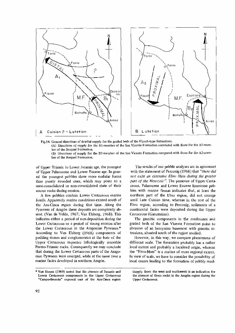
N
-~,
""
" o\Fonlo
/\
\/ \
\
\ \ \ I I I
I /
(
\ M.F. ,-/
I I
1I 8 2
I
B L utetian \\.,L-__- . -'----__\.__
Fig.54. General directions of detrital supply for the graded beds of the Flysch-type fonnations. (A) Directions of supply for the BI-member of the San Vicente Fonnation correlated with those for the AI-member of the Burgase Fonnation. (B) Directions of supply for the B2-member of the San Vicente Fonnation compared with those for the A2-mem
Boitano! 0
I I
* Van Hoom (1969) noted that the absence of Jurassic and (supply from the west and southwest) is an indication for Lower Cretaceous components in the Upper Cretaceous the absence of those rocks in the Aragon region during the "Campo-Breccia" exposed east of the Ara-Cinca region Upper Cretaceous.
A Cuisian? - Lutetian
ber of the Burgase Fonnation.
of Upper Triassic to Lower Jurassic age, the youngest of Upper Palaeocene and Lower Eocene age. In general the youngest pebbles show more nodular forms than purely rounded ones, which may point to a semi-consolidated or non-consolidated state of their source rocks during erosion.
A few pebbles contain Lower Cretaceous marine fossils. Apparently marine conditions existed south of the Ara-Cinca region during that time. Along the Pyrenees of Aragon these deposits are completely absent. (Van de Velde, 1967; Van Elsberg, 1968). This indicates either a period of non-deposition during the Lower Cretaceous or a period of strong erosion after the Lower Cretaceous in the Aragonian Pyrenees.* According to Van Elsberg (1968) components of pudding stones and conglomerates at the base of the Upper Cretaceous sequence lithologically resemble Permo-Triassic rocks. Consequently we may conclude that during the Lower Cretaceous parts of the Aragonian Pyrenees were emerged, while at the same time a marine facies developed in southern Aragon.
The results of our pebble analyses are in agreement with the statement of Perconig (1968) that "there did not exist an extensive Ebro Mass during the greater part of the Mesozoic". The presence of Upper Cretaceous, Palaeocene and Lower Eocene limestone pebbles with marine faunas indicates that, at least the northern part of the Ebro region, did not emerge until Late Cuisian time, whereas in the rest of the Ebro region, according to Perconig, sediments of a continental facies were deposited during the Upper Cretaceous (Garumnian).
The granitic components in the mudstones and graded beds of the San Vicente Formation point to abrasion of an hercynian basement with granitic intrusions, situated south of the region studied.
However, in this way, we compare phenomena of different scale. The formation probably has a rather local extent and probably a localized origin, whereas the "Ebro-Mass" is a matter of more regional extent. In view of scale, we have to consider the possibility of local causes leading to the formation of pebbly mud
92

stone and conglomeratic beds in the San Vicente Formation.
In this context Lotze (1953) drew attention to the effect of salt diapirism on the formation of polygenic conglomerates and breccia in the Flysch of the Western Spanish Pyrenees. In his reconstruction of the history of the Anoz salt diapir west of Pamplona, the formation of the diapir is clearly reflected in the sedimentation of the Eocene deposits and "erfolgte offenbar submarin und durchstiess eine Decke von zuvor abgelagerten alteoziinen Nummulitenkalken Cber diese lagert sich mit scharfem Schnitt der Schutt des aufgebrochenen Diapirs in Form einer miichtigen Breksie mit z.T. ii.berrasschend grossen abgerutschten Gesteinsb16cke senoner Riffkalke "... "Zwischen die Einzelgerolle legt sich rotgefiirbter Kalkschlamm, offenbar die sich niederschlagende rote Trii.be aus aufgewirbeltem Keuperton "..... "Ophit Brocken liegen dazwischen Resten von Salz und Gips finden sich Naturgemiiss nicht. Sie wurden offenbar im Meereswasser gelost':
In the Ara-Cinca region the influence of salt diapirism in its surroundings may be deduced from fragments of red argillaceous limestone and flat ophite pebbles found in the conglomerates and pebbly mudstones of the San Vicente Formation. As stated before, a palynological study of some samples of these red fragments by Mr. H. Visscher (Palynological Institute of the State University of Utrecht) encountered clusters of Classopollis sp. (Sample No.312D). This genus indicates an Upper Triassic-Lower Jurassic age for the red material.
The description by Lotze, cited above, is applicable to our observations of the San Vicente Formation and its components of the mudstones and graded beds:
1. The conglomeratic mudstones and graded beds are intercalated in the Flysch type formation which non-conformably overlies the Lower Eocene Marina limestones.
2. On several localities breccias of reef limestone pebbles and boulders occur in the olisthostromes, some of which reach sizes from five to eight meters in diameter. These limestones probably are of Senonian age.
3. In the muddy matrix of the conglomerates and mudstones red argillaceous limestone fragments are found. They were non-consolidated during the transport by mudflows and (fluxo) turbidites, as is shown by their strongly bended form and the enveloping of the more rigid pebbles. The clay sedimentation, which is of the same age as the San Vicente Formation (Cuisian? -Lutetian), contains a reworked flora of Upper Triassic-Lower Jurassic pollen.
4. A great number of flat, rounded ophite pebbles with characteristically pitted weathered surfaces have been observed in the conglomeratic mudstones. According to Misch (1934) and Mey (1968) ophites are known from Triassic deposits of the Central Spanish Pyrenees. They, moreover, are frequently observed in the central parts of the diapirs and outer breccia rims of the Sierra Zone (Mr. F. Hehuwat, personal communication, Utrecht, 1969) and by Van Hoorn (1969) in the Upper Cretaceous "Campo-Breccia", to the east of the Ara-Cinca region.
5. Salt and gypsum are absent in the mudflows. The observations cited above, which are complete
ly similar to those of Lotze (1953) for the Western Pyrenean Flysch, point to an analogous origin of the detritus.
The direction of detrital supply both for the graded beds and for the pebbly mudstones is from the south (Fig.26) where an extensive east-west zone of diapirs forms the core of the Sierras west and east of Alquezar (Rios and Almela, 1954; see also Fig.5). These authors attribute a Middle Eocene age to these diapirs and the north-south oriented anticlines in which they occur. Hence they came into being contemporaneously with the deposition of the graded beds and mudstones of the San Vicente Formation and probably formed their sources.
The granitic pebbles in the conglomeratic mudstones, which in most cases are unweathered (see Li. Fig.42), would point to erosion of an emerged hercynian basement. They might however, just as well originate from Upper Cretaceous rocks, which, according to Selzer (1934) and Perconig (1968) formed a continental facies (Garumnian) in the northern part of the Ebro region.
Thus the terrigenous detritus, originally accumulated along the northern part of the Sierras, has successively been transported by turbidites, j7uxoturbidites and submarine mudj70ws over at least 30 km in northerly direction into an environment of quiet marly sedimentation The diastrophical inj7ux of this material might have been triggered by halokinesis.
COMPARTMENTATION OF THE FLYSCH BASIN
Inversion of lateral differences in facies between the Burgase
Fonnation and the San Vicente Fonnation
In general the sandy limestones and mudstones of the San Vicente Formation show a proximal turbidite character being preponderantly coarse sandy, medium to thick bedded, partly fluxo-turbiditic, in that case non-graded, with intercalations of pebbly mudstones
93

and conglomeratic beds, and with lenticular graded beds.
The thick marly deposits, however, which form the main part of the formation (1300 m), are built up of finely laminated to thin bedded, more and less calcareous, fine silty beds (see Fig.35). Microscopically they are graded in their more calcareous laminae, which points to a more distal environment of deposition of turbidites.
The lateral lithostratigraphic aequivalent of the San Vicente Formation, the Al member of the Burgase Formation, is mainly built up by a rather monotonous rhythmical succession of graded sandy-silty limestone beds and marls. They reach a thickness of about 2000 m. Their facies is more proximal than that of the San Vicente marls. The A I member of the Burgase Formation shows approximately the same direction of detrital supply as the coarser, sandyconglomeratic intercalations found in the San Vicente Formation (Fig.26). The latter material, being only ± 400 m thick, could not have formed all the allochthonous detritus of the Al member, which is ± 1000 m thick, by the same turbidites. Moreover we would then find a distal facies on the upcurrent side of a more proximal one, which is in fact a contradictional situation.
To explain the abrupt differences in facies of the formations on both sides of the BoItana structure, we must conclude that the sandy to conglomeratic beds and mudstones of the San Vicente Formation represent a local diastrophical influx of detrital matter in a transversal direction (from south to north) into the longitudinal Flysch basin (see Fig.26). The main supply of detritus into this basin may have come from more easterly or even northerly directions (Fig.54A). The two facies, west and east of the BoItana structure, represent different compartments. On the Geologic Map of Huesca (Alastrue et a!., 1957) the marly facies of the San Vicente Formation is seen to extend some 40 km to the southeast as far as La Puebla de Roda. The sandy Flysch facies of the Burgase Formation can be traced to the west over a distance elf at least 80 km (ten Haaf, personal communication, Utrecht, 1969), as far as Ans6. The BoItana structure in the Ara-Cinca region evidently forms the threshold between the two basins.
Tecto-sedimentary compartmentation of the Flysch basin
During the Lutetian (Middle Eocene) the parallel but opposite directions of detrital supply for the series west and east of the BoItana Anticline (from the north and from the south respectively, Fig.54B) accentuate the compartmentation indicated by the
facies differences cited above. As to the directional changes of detrital supply of the Burgase Formation (Fig.26) west of the Boltana Anticline, the longitudinal direction originally found in the lower part of the formation in the Al member, changes quite abruptly into a transversal one in its upper part in the A2 member. Simultaneously the carbonate content of the graded beds changes abruptly from below 50% to far above 50% (see Table III). The general sedimentological character of the graded beds thereby shows an increase in turbidite proximity in the higher member. Consequently, on the basis of our facies and directional observations, the area of origin of the sandy detritus of the Al member must be different from that of the A2 member.
At the transition of the Al to the A2 member a thick slumped zone (fig.27 and Fig.30) is found. Its components consist of fragments of Flysch-type strata, which are in no way different from the underlying rocks of the Al member, and apparently originate from it. The presence of this slumped zone between the two members suggests a deformation of the relief during Flysch-type sedimentation. The increase in proximality in the younger beds, and also the change in direction of detrital supply from longitudinal to transversal, reflect a deformation of the longitudinal basin in a southward sense. This development can be followed as far as Biescas, some 30 km westward (Ten Haaf, personal communication, Utrecht, 1969). The southward tilting of the westerly compartment relative to the eastern one brings the northern border of the longitudinal Flysch basin more to the south, whereas the easterly compartment, on account of the continuity of detrital supply from the south, apparently remained in a more stable position.
CANNIBALISM OF OLDER FLYSCH?
During the Lutetian the turbidites forming the A2 member of the Burgase Formation came from the north. Their proximal facies points to a nearby source. There apparently existed a clastic sedimentary source-area approximately where we now find the Axial Zone of the Pyrenees.
Contemporaneously with the Flysch phase in the southern Central Pyrenees, a shallow marine limestone facies developed in the Aquitanian Basin on the northern border of the Central Pyrenees (Gignoux, 1950, p.558; Mangin, 1958, thesis, p.389-391). Consequently the area of the Northern Central Pyrenean border could not have delivered the detrital material of the Burgase Formation. A rapid local emergence, or submarine uplift, of the Axial Zone north
94

of the Ara-Cinca region, on which presumably Flysch-type deposits of Cuisian age were already deposited, could have acted as a source for the material of the A2 member. For the Krosno Flysch of the Polish Karpathians, Dzulynski and Slacka (1958) similarly suppose secondary sources formed by emerged older Flysch-type deposits along the border of the "Krosno Basin". The possibility of rapid rising and sinking geanticlines as the sources of Flysch-type detritus has been emphasized by Rech Frollo (1960). The composition of the greater part of the pebbles in the upper A2 member of the Burgase Formation, makes their Flysch-type character apparent and probably reflects cannibalisms of older Flysch. The rounded form of a number of the pebbles points to uplift of consolidated Flysch-type rocks above sea level. A more detailed study on the sedimentpetrographical character of Flysch-type rocks and their pebbly erosion products is, however, necessary to bring our results in a more regional genetical model of Flysch-type formation.
9. FISCAL FORMATION (Biarritzian? )
LITHOLOGIC CHARACTER AND THICKNESS
Between the villages of Fiscal and Janovas, in the southern part of our region, the river Ara follows the strike of a formation which for the greater part consists of bluish-grey marls. The formation, which conformably overlies the Burgase Formation, reaches a thickness of 1200 m in the western part, in the Fiscal area, thinning out to 800 m in the east near Albella. The carbonate content of the marls in the lower part of the formation (40% by weight) is considerably less than that of the underlying Flysch marls (60%).
South of Fiscal the formation can be divided into three members:
A. A lower member which consists of 600 m of bluish-grey marls alternating with thin marly limestone beds. Both the marls and the marly limestones weather to a nearly white colour. At the base of this lower member some thin, about 5 em thick, silty layers occur with a brownish-grey colour, rich in totally weathered biotite and muscovite. They show some resemblance with the turbiditic silty limestones of the Flysch-type, though no grading or other such characteristic features are observed.
B. A middle member which represents the "blue marls", and shows a striking resemblance with the "blue marls of Pamplona" (Mangin, 1958) probably is its lithostratigraphically aequivalent (Ten Haaf, et al., 1970). According to R. Schiittenhelm (Internal Report, Utrecht, 1969), the carbonate content of the
blue marls of the Pamplona region (Western Spanish Pyrenees) also is much lower than that of the underlying Flysch marls. In the Fiscal section, the member reaches a thickness of about 400 m.
C. An upper member, composed of 200 m of greyish-ochre sandy marls and sandstones, of which the grain size increases upwards, with intercalated fossiliferous sandy beds, 80-110 em thick which are predominantly built up of larger Foraminifera, specially Nummulites sp. reaching sizes of up to three centimeters in diameter.
The upper part of the formation is marked by a rapid transition from marls and sandy marls to an alternation of coarse and fine grained thick bedded sanastones. The upper limit of the formation is placed where the colour of the rocks abruptly changes from greyish-ochre to brownish, which coincides with an abrupt increase in the sand content.
According to Almela and Rios (1958) the lithostratigraphic aequivalent formation wedges out against the western flank of the Boltafia Anticline south of the Ara-Cinca region. This outwedging may be brought in relation with the presence of a synsedimentary "haut fond" at about the same place where the Anticline of Boltafia is located now. It thus has a primary sedimentary origin, whilst there is evidence for a gradual subsidence of the basin floor west of the anticline during the sedimentation of the marls.
FOSSIL CONTENT AND AGE
The lower and middle parts of the formation are very poor in fossils. Some badly preserved Agglutinants could be observed. In one locality, about 300 m west of Fiscal, a fossil rich horizon occurs in the lower member, containing Alveolina sp.,Discocyclina sp., Nummulites sp., Chapmannina sp., and numerous Miliolidae.
According to Mallada (1878), the fossiliferous upper member contains Dentalium tenuistriatum ROU, Cerithium Lejeani ROU, Fusus mutus D'ARCHIAC, Rostellaria fusoides d'ARCHIAC, Chama granulosa d'ARCHIAC, Nummulites perforatus d'ORBIGNY and Nummulites lucasanus DEFRANCE.
South of Fiscal E. van de Velde (Internal Report, Utrecht, 1962) came across Nummulites lucasanus DEFRANCE, Nummulites striatus BRUGUIERE, Nummulites contortus? (this species reaches sizes up to 3 em diameter), Operculina canalifera d'ARCHIAC, Corbis escherz"? , Ostrea sp. and Clavelfa longaeva DESHAYES? .
South of Albella we observed in the fossiliferous upper member Dentalium sp., Cardita sp., Clavelfa
95

sp., Cardium oppenheimi? Nummulites perforatus d'ORBIGNY, Operculina sp. and Balanus sp.
This fauna, by the absence of Assilina sp. and the presence of, among others, Nummulites perforatus, probably belongs to the Biarritzian (Hottinger and Schaub, 1960, p.467).
The lithostratigraphic aequivalent deposits in the western Pyrenees were also placed in the Upper Eocene by Mangin (1958). At the time of Mangin's investigations, the more detailed biostratigraphic studies of Hottinger were not yet known. The latter author introduced the name Biarritzian for deposits with a well developed fauna of Nummulites and Alveolines between the Lutetian (of which the upper limit has not been defmed) and the Upper Eocene Bartonian-Ludian. He consequently placed the Biarritzian fauna in the type locality in the upper part of the Middle Eocene Lutetian.
Nothwithstanding the fact that the Fiscal Formation delivered but a scarce collection of Biarritzian fossils, we prefer to follow Hottinger and attribute a Biarritzian age to the Fiscal Formation.
10. FENES FORMATION (Upper Eocene)
The formation is named after the Col de Fenes, located west of Fiscal and conformably overlies the Fiscal Formation. It consists of sandstones and sandy marls and reaches a thickness of 1000 m south of Fiscal gradually thinning in easterly direction. South of Albella only 300 m remains. According to Almela and Rios (1958) tjle lateral lithostratigraphic correlative beds south of our region non-conformably overly the limestones of the Marina Formation. This non-conformity is observed on the southerly continuation of the Boltana Anticline. In the latter area a sedimentary hiatus apparently exists between the Marina Formation and the Fenes Formation, comprising the Flysch-type deposits of the Burgase Formation and the marls of the Fiscal Formation. A hiatus, which is evidently due to the presence of a haut fond against which outwedging of the Burgase Formation and the Fiscal Formation has taken place.
In the Ara-Cinca region the Fenes Formation consists of complexes of sandy marls alternating with coarser grained sandstones. The sandstones are broWnish-grey, weathering yellowish-brown. The sandy marls are strongly weathered to a light greyishyellow. The medium to thick bedded sandstone complexes are 4-5 m thick, the marly complexes decrease in thickness upwards from 20 to 8 meters. A gradual increase upwards of the grain size of the sandstones could be observed. The upper limit of the formation is placed where the fIrst conglomerates appear in the
sandstones. Specially when developed in thick beds the coarse
sandstones are rather cavernous in their lower parts. These caverns originate from the weathering out of clay pebbles, which locally still are present.
On the upper surfaces of the sandstone beds ripple marks frequently occur. Southwest of Fiscal, Th. van Hengel and C. Klootwijk (Internal Report, Utrecht, 1964) measured some flute casts on the lower surfaces of the thicker sandstone beds, which give a direction of detrital supply from the NW, approximately parallel to the strike of the formation. The lower surfaces of the beds often show a rich pattern of replicas of tracks and burrows of benthonic fauna.
The Fenes Formation may be considered as the lateral lithostratigraphic correlative of the Cres a ripple-marks, exposed in the Pamplona region (Mangin, 1958, p.465). According to Mangin, this formation is characteristic for the beginning of the Oligocene, though it is still transitional in a marine facies. In the Ara-Cinca region the Fenes Formation, which appears to be sterile, conformably overlies the Upper Lutetian (Biarritzian) Fiscal Formation. As in the Fiscal-Albella area no sedimentary hiatus occurs between the Fiscal Formation and the molassic conglomerates, the Fenes Formation is placed in the Upper Eocene. The marls and sandstones form a gradual transition from a calm marine sedimentation consisting for the greater part of thin bedded marls of the Fiscal Formation to a thick continental development of coarse molassic conglomerates and sandstones.
E. ENVIRONMENT OF DEPOSITION OF THE CRETACEOUS-EOCENE SEQUENCE
INTRODUCTION
The Upper Cretaceous-Palaeocene sequence nonconformably overlies Permo-Triasic and older rocks of the Axial Zone of the Central Pyrenees. The sequence is characterized by a succession of sedimentary megarhythms (Lombard, 1956, p.450). Most of them start with a conglomeratic, coarse, sandy, sometimes turbiditic, basal part, followed upwardS by a gradual decrease in the amount of terrigenous matter and in its grain size. Finally an upper, dense limestone is formed which is often accompanied by chert horizons.
In the Eocene sequence series of alternating sandy limestones and marls predominate. A parautochtonous fossiliferous sandy limestone is deposited during the Lower Eocene, a strong Flysch phase developed during the Middle Eocene, whereas in the Upper
96

Eocene a gradual transition from marls via sandstones and marls to conglomerates forms an inverse rhythm which ends in a Molasse facies.
On the whole, the environment of deposition of the Upper Cretaceous-Palaeocene sequence has been shallow marine, clear and warm. The lower Eocene also developed under shallow marine conditions. The depth of deposition of the Flysch-type sediments, however, still remains uncertain. During the Upper Eocene a gradual shallowing of the sea finally results in a continental facies.
CAMPANIAN (Estrecho Fonnation)
In the Aragonian Pyrenees a transgressive phase forms basal conglomerates (exposed outside the region studied) at the beginning of the Campanian. They mainly consist of Palaeozoic components (Wensink, 1962; Van Lith, 1965). A rapid decrease in supply of terrigenous matter follows and limestones are predominantly deposited. A period followed in which coralline Algae, Bryozoa and Rudistids lived under clear, warm and shallow marine conditions. The Rudistids locally are concentrated in lenticular beds but no real bioherm formation has taken place.
MAASTRICHTIAN (TozaI Fonnation)
At the beginning of the Maastrichtian a faint emergence causes renewed supply of terrigenous detritus from a nearby coast. Quartz gravel and conglomerates are deposited with pebbles locally reaching 10 cm in size. Debris of Devonian (?) Stromatoporids and some Rudistids (Campanian) are found in the conglomerates, indicating a phase of erosion of the Palaeozoic basement as well as of the Campanian limestones. An abraded surface of a non-conformity locally separates the Maastrichtian from the underlying strata. The influence of the continent grows gradually weaker and an upward decrease in the amount of rounded quartz is observed. Some cross bedding in the more sandy limestone beds may be due to submarine current action.
In the Ordesa region, Orbitoides and Lepidorbitoides locally are arranged in oval to circular tubes (Fig. 25,B). They are thought to be formed in a kind of symbiosis with seaweed. * In that case the environment must have been shallow enough, with a maximum depths of some 50 m, for daylight to reach the sea bottom. This peculiar arrangement of larger Fora
minifera was also frequently met with in the upper part of the (Cuisian) Marine Formation (Fig.25 ,A). Even apart from this, the fossil content, specially the larger Foraminifera, indicate shallow marine conditions. Moreover they point to a rather high temperature of the sea water.
Northwest of the region studied Van Elsberg (1968) and Jeurissen (1969) observed mudcrack-like structures and a kind of intraformational conglomerates in the upper layers of the Maastrichtian limestones. According to Jeurissen these phenomena may indicate a temporary emergence of the see bottom. In the Ara-Cinca region the Tozal Formation thins strongly in southeasterly direction, whereas the amount of terrigenous detritus and its grain size increases in the same direction (see also Table I). In the Ara-Cinca region neither mudcracks nor intraformational conglomerates have been observed in this formation. In our opinion the shallow marine character of the deposits and the "hard ground" features mentioned above, rather point to changes in sea level than to a temporary emergence of the sea bottom. At the end of the Maastrichtian conditions became favourable for the development of chert nodules within the limestone beds.
LOWER DANO/MONTIAN (SaIarons Fonnation)
During the Danian a thick series of dolomites have been formed. According to Van de Velde (1967) these dolomites have to be considered as formed through syn-sedimentary recrystallisation of limestones by which all signs of the former fossil content disappeared. In the Lower part of the dolomite formation, apparently under the influence of a faint emergence of the Hinterland, some supply of quartz pebbles took place.
On account of our knowledge of recent dolomitization processes, a shallow warm, marine or lagoonal environment probably existed during the deposition of the Salarons Formation.
MONTIAN-LOWER ILERDIAN (Gallinera Fonnation)
With the building of the Gallinera Formation it came to a renewed sandy detrital supply within the preponderantly bioclastic limestones rich in Miliolidae. In the basal beds the first representatives of Alveolina occur. A decrease of the detrital supply upwards is again established. A laterally wide spread de
* According to A. Seilacher and T.P. Crimes (personal com larger Foraminifera took place along the vertical sides of munication, liverpool, 1970) the circular arrangement of boreholes of Molluscs.
97

velopment of Lithothamnium-limestone follows which indicates a clear, warm, and very shallow marine environment. In the upper part of the formation variable amounts of quartz grains again mark some renewed supply of terrigenous matter from nearby landmasses. The quartz grains which are, in general, well rounded, locally reach sizes of up to one centimeter. In the fine grained limestone matrix numerous larger Foraminifera do occur, which are concentrated in thick lenticular or bedded ho'rizons. For the greater part these horizons are built up of Allieolina sp., in a lesser amount by Nummulites sp. and Discocyclina sp., whilst the rocks are, moreover, crammed with Bryozoa and Algae. According to Mangin (1958, p.245) comparable species of the group of the Alveolinellidae are nowadays living under clear, warm and shallow marine conditions. They are often found together with Algae, with which they seem to live in symbiosis. According to Hottinger (1960) Allieolina sp. in general may have lived in quiet water, outside the direct influence of terrigenous support. In the Ara-Cinca region, however, a considerable amount of coarse terrigenous detritus is frequently observed in the Allieolinalimestones (see Figs.6 and 8). The conservation of the specimen in most cases does indicate the absence of any reworking activity. It follows that, contrary to the opinion of Hottinger, the Alveolinas may live in an environment in which a considerable amount of coarse terrigenous detritus is sedimented.
In the upper beds of the formation a decrease of the continental influence is apparent, Fine grained bioclastic limestones are deposited, whilst benthonic fauna is not observed in these beds. FollOWing Phleger (1960), the decrease in the content of benthonic fauna may indicate a deepening of the sea, but recent shallow marine sedimentation of carbonates also may show absence of benthonic fauna as well (M.G. Rutten, personal communication, 1969). A great many chert horizons concentrated in the middle of thick beds announce the close of the Gallinera Formation. According to Van de Velde (1967) the chert nodules are considered to be secondary concretions formed shortly after the deposition of the individual limestone beds. As for the depth of formation of chert nodules, Mangin (1958, p.242) cites the occurrence of limestones with chert concretions and Algae intercalated in marly limestones with Globigerinidae (Montian, Navarre). According to Mangin the development of chert may have taken place under shallow marine conditions.
In the Gallisue area 35 horizons of chert nodules have been counted within a limestone complex of about 20 m.
It is generally suggested (see Pettijohn, 1957) that there should be a relation between the concentration of chert in the limestones and the amount of Radiolaria, Diatomaea or sponge spicules originally present in these deposits. In the Ara-Cinca region no signs of such fossils have been observed in the cherty limestones. There is however no reason to bring the possible presence of Si-rich fossils in the limestones in direct relation with the formation of chert. According to Bien et al. (1958) the fossils may have acted as crystallization cores only, as is also the case with the formation of idiomorphic quartz crystals around crystallization cores of rounded quartz grains, whereas the Si oxydes may have been brought in by volcanic activities as well as by the dissolution of silicates from detrital matter in the Hinterland.
A problem arises in trying to explain the origin of idiomorphic quartz crystals in the Allieolina-limestones of the Gallinera Formation (Fig.6). These crystals, developed around rounded quartz grains, must have formed after the deposition of the limestones, on account of their growth habit (cf. Fig.6), and consequently are younger than Lower Ilerdian. By chance we found a limestone pebble containing idiomorphic quartz crystals (Sample No.312CC) in the conglomeratic mudflows of the San Vicente Formation (Lutetian). Probably this pebble is an erosion product of a lithostratigraphic correlative, emerged, part of the Gallinera Formation to the south of the region studied. The development of idiomorphic crystals therefore must have taken place between Lower Ilerdian and Lutetian times.
The idiomorphic quartz crystals in the limestone pebble mentioned above contain a great number of inclusions, which partly consist of tourmaline and rutile. These inclusions may point to a hydrothermal origin of the quartz. But the crystals have a distinct zoning, which would point to a different origin. According to Grimm (1962), most of the idiomorphic quartz crystals formed as secondary products in sediments are characteristic indicators for a saline facies during or shortly after the formation of the limestone beds in which they occur. Their zoning may be due to rhythmic growth (Grimm, 1962, Fig.8c). According to Lotze (1953, p.820) submarine diapirism of triassic evaporites has taken place in the Western and Central Spanish Pyrenees during Upper Cretaceous to Eocene times. This might have produced a hyposaline environment which stimulated the formation of idiomorphic quartz crystals as a secondary product in the unconsolidated sediments. As there are several other indications for salt diapirism in the surroundings of the Ara-Cinca region, recently and in the geologic history, the hypothesis of Grimm explains quite well the
98

formation of idiomorphic quartz in the Gallinera Formation of the Ara-Cinca region.
MIDDLE ILERDIAN (Millaris Fonnation)
During the Middle Ilerdian fine grained bioclastic and argillaceous matter is deposited. Pelagic Foraminifera, specially Globigerinids, make up the greater part of the generally poor fauna. In the region studied no benthonic fauna is observed in the lower part of the formation.
Microscopically the bioclastic calcareous grains are mainly angular, which at present is an indication for offshore conditions of sedimentation (Houbolt, 1957). The fme, undisturbed, parallel lamination (Fig.9) is an argument in favour of a depth beyond the reach of wave action and without current action (Broekman, personal communication, 1968). But, according to M.G. Rutten (1969, personal communication, Utrecht) in recent coastal shallow marine sedimentation similar lamination can be observed in deposits formed at high tide.
In one locality, we observed a concentration of gypsum crystals (Fig.lO) in the marly limestones of the Millaris Formation. These crystals obviously were formed in situ and may be due to an induced saline facies under the influence of submarine salt diapirism (Lotze, 1953), as discussed earlier for the formation of quartz crystals in the Gallinera Formation. They may even have been formed under quiet and deeper marine conditions.
On the other hand, the stratigraphic position of the Millaris Formation between shallow marine limestone deposits is not in favour of an assigment of too great a depth of sedimentation. Moreover, the outwedging of the Millaris Formation points to a border position of this facies and may therefore also indicate the shallow marine.
At the top of the Millaris Formation a slight amount of fine grained, terrigenous detritus, consisting of angular quartz and felspars, and the abundant presence of reworked larger Foraminifera (a.o. Nummulites, Discocyclina and Assilina) in the northwest of the Ara-Cinca region, point to a renewed influence of the continent. On account of the reworked character of the fauna, nothing can be said about the depth of sedimentation, but in view of the shallow marine character of the overlying limestones, the upper sandy-silty beds of the Millaris Formation may also have been deposited under shallow marine conditions.
UPPER ILERDIAN-LOWER CUISIAN (Metils Fonnation)
During the Upper llerdian the dense fme grained bioclastic limestones of the Gallinera Formation are deposited. To the west and north the formation rapidly wedges out. At the base of the formation small amounts of terrigenous matter, which gradually decrease upward, again reflect some influence of a nearby landmass. Numerous larger- Foraminifera (among others Alveolina, Discocyclina and Assilina) and smaller ones (Miliolidae, Textularidae and Rotalidae) are locally concentrated in thick beds. A distinct lenticular bedding (Fig.12) is characteristic for the whole formation. Moreover, the surfaces of the beds in general show a knobby structure. Both the fauna and the lithologic character of the limestones are indicative for a shallow marine environment. The content in benthonic fauna increases upwards. Fine grained bioclastic limestones and marls are deposited. Chert concretions were formed in the upper beds of the formation. By the development of lenticular bedding and of low angle cross stratification the sedimentological character of the series indicates a shallow marine environment.
CUISIAN (Marina Formation)
The Marina Formation starts with fine grained terrigenous and carbonate matter transported by turbidity currents. the supply direction measured on flute casts roughly gives a southerly origin of the detritus (Table II). In the present South Pyrenean Sierra Zone an extensive Ebro Mass was present, during the Eocene, according to Mangin (1958). This may have functioned as the source region for at least part of the South Pyrenean Flysch. After the deposition of the turbidites it came to a thick development of sandysilty limestones and marls in the Ara-Cinca region. The terrigenous matter, which rapidly changes in amount from bed to bed, mainly consists of angular quartz, felspars and in lesser amount of biotite and muscovite, reflecting the presence of granitic source rocks on a nearby landmass. In most beds glauconite forms an accessorial component. The terrigenous detritus is mixed with limestone fragments and larger Foraminifera, specially of Alveolina sp. which point to a clear, warm and shallow marine environment. Accordingly, the turbiditic sandy limestones in the basal part of the formation probably have been deposited in a shallow marine environment.
99

In the middle of the formation limestones are deposited with a high content of terrigenous detritus. Probably the sedimentation took place within the reach of wave action (presence of lenticularly bedded, sandy limestones with low angle cross stratification and locally fine-scale channelling). In these sandy beds the benthonic Foraminifera are highly reworked. In the northern and western parts of its area of outcrop, a gradual lateral as well as vertical transition into more marly deposits is obvious. It probably indicates more quiet and somewhat deeper depositional circumstances in those areas, but even there the upper part of the formation still contains large amounts of larger Foraminifera.
CUISIAN? - LUfETIAN
(Burgase and San Vicente Formations)
The sequence hitherto described showed several indications for a shallow marine environment of deposition. Even the turbiditic a member of the Marina Formation probably is also formed under shallow marine conditions. The depth of deposition of the Burgase and San Vicente Formations of Cuisian (? -) Lutetian age remains, however, uncertain.
The fossils observed in the graded beds should not be used as depth indicators for they are all redeposited. Moreover, apart from some badly preserved Agglutinants, the intercalated pelites turned out to be sterile. As the shallow marine fauna found in the graded beds has been reworked by gravitationally induced turbity currents, the final depth of deposition must have been greater than the original depth indicated by this fauna.
Contrary to the observations in the Marina Formation no wave action has been encountered on the graded beds and marls of the Flysch-type. The deposition must at least have been below the reach of wave action.
BIARRlTZIAN? (Fiscal Formation)
The filling up by turbidity currents of the basin
west of the Boltafia Anticline continued during the Biarritzian when, preponderantly bluish-grey, marls of the Fiscal Formation were deposited. The marls wedge out against the Boltafia Anticline south of the village of Janovas. Sedimentation took place under rather quiet circumstances. No disturbances of the fine-scale layering is observed, except in some fossiliferous beds south of Fiscal. If not reworked, the benthonic fauna of larger Foraminifera may point to a shallow marine environment. At the time of deposition of the "blue marls" of Fiscal, the Boltafia Anticline apparently still existed as a submarine ridge against which the Fiscal Formation thins out.
During the deposition of the upper member of the Fiscal Formation a gradual increase in the content of terrigenous matter takes place. An alternation of sandy marls and sandstone layers marks the periodical influx of coarser detritus from a nearby landmass. Thick beds are almost completely composed of larger Foraminifera, Dentalia, Gastropods and Brachiopods and since there are no indications of strong reworking, the fauna has apparently lived in the area of deposition, indicating a shallow marine environment.
UPPER EOCENE (Fenes Formation)
On account of sedimentary structures such as ripple marks and of their fossil content, the sandstones of the Fenes Formation reflect shallow marine to lagoonal deposition, according to Mr. F. Hehuwat (Utrecht, personal communication, 1969). The symmetrical ripple marks observed in the lithostratigraphic correlative beds of the Ludena region (Navarra) generally are considered to be caused by wave action, according to De Raaf (1964). The sandstones, which in general are thick bedded, are more brownish in colour, whilst upwards the grain size further increases to coarse sandy. Conglomeratic intercalations already indicate the transition to the molassic facies of the Central Southern Pyrenees. A gradual transition without any visible non-conformity therefore marks the development of a continental facies.
100

CHAPTER IV
STRUCTURAL GEOLOGY
A. INTRODUCTION
The Ara-Cinca region forms part of the Southern External Zone of the Central Spanish Pyrenees (Jacob, 1930; De Sitter, 1964; Rutten, 1969). This zone is built up by a sequence of Upper CretaceousEocene rocks. To the north this sequence is separated from the hercynian basement by a Permo-Triassic lubrication zone (Van der Voo, 1966; Van der Velde, 1967; Jeurissen, 1969). The NWW-SEE trending external zone is structurally characterized by gravitational southward gliding tectonics. For an extensive study on the subject we refer to Jeurissen, 1969, pp.II-58 and 59).
Since the Ara-Cinca region presents some special tectonic aspects, its structural investigation throws a new light on the palaeogeographic history of this region. A deviation of the general direction of the Southern External Zone is caused by the presence of the Boltafia Anticline (Fig.55), which dominates the eastern half of the Ara-Cinca region. This N-S oriented structure forms part of the so called Campodarbe Anticline (Selzer, 1934; Almela and Rios, 1954; Alastrue et al., 1957) which runs as far as Alquezar at about 35 km south of Boltafia.
Misch (1934) recognized the presence of a threshold (Oberaragonische Schwelle) situated west of the line Bielsa-Ainsa, which existed during the early Cretaceous and Cenomanian-Santonian (Fig.56). The position of this haut fond coincides with the present location of the Boltafia Anticline. According to Almela and Rios (1954) the southern prolongation of the latter structure is moreover related to the small N-S anticlines west of Alquezar (Fig.57). These are considered to be older than the NW-SE folding of the
Southern External Pyrenean Zone. On his map of the Central and Eastern Pyrenees, De Sitter (1954, fig.282) plots the transverse structure of Boltafia between two longitudinal troughs of Eocene age. This suggests the presence of a haut fond also during the formation of Flysch-type deposits.
In the Ordesa region (Fig.1) folding and overthrusting took place in the External Zone after the deposition of the Lower Eocene (Cuisian), according to Van de Velde (1967). In the Ara-Cinca region there are indications for a post-Eocene age of these tectonics. It is highly probable that the N-S direction of the Boltafia Anticline is related genetically to still older tectonic movements. Their present day architecture, however, may be of Middle Eocene age, as was stated by Almela and Rios (1954).
The tectonics of the Eocene Flysch-type deposits west of the Boltafia Anticline generally follow the fold structures of the underlying Mesozoic, though on a much smaller scale. In regard of the more plastic behaviour to deforming agents of Flysch-type deposits, when compared with the structures of the MesozoicPalaeocene sequence, these are therefore discussed separately.
B. TECTONICS OF THE CRETACEOUS-LOWER EOCENE
1. FOLDS
The geologic map and diagram (appendices 1 and 2) illustrate the apparent* regularity in the development of the tectonic structures from the river Arazas area in the northwest to the Boltafia area in the southeast.
* On page 105 the genetic differences between the Ordesa structures and the Boltana Anticline are explained.
101

Fig.55. Schematic tectonic map of the Ara-Cinca region. l::£ocene Flysch-type formations, 2=Cretaceous-Lower Eocene formations, 3=Upper Eocene (=blue marls), 4=boundary between tectonic Unit Al and A2.
Arazas Anticline
At the northern border of the region, just south of the Arazas valley, the axis of a symmetrical fold forms the culminating southern part of a structural high.
The anticline gently plunges about 50 to the southeast, where it dissolves in the Mondicieto homocline. Along the Sierra de las Cutas a steep southward dipping step borders the high to the south.
Vellos Anticline
An asymmetrical anticline with a southwest to west Vergenz runs from the Mandato mountain in the north, along the Vellos river, to the village of Gallisue in the south. The axis gently plunges both in northwesterly and southerly direction. Its greatest asymmetry is reached east of Vio, where it even develops a high angle, northeast dipping upthrust in its inner core.
Following the structure to the northwest, the rocks of the Mondoto mountain are still structured anticlinally but near the Nerin fault this anticline too dissolves in the Mondoto homocline. At the confluen
ce of the rivers Aso and Vellos the axis of the anticline turns to the south. The curve is accompanied by faults roughly perpendicular to that axis. Northeast of Gallisue the Vellos Anticline is cut off by the Gallisue fault.
Pozo Anticline
An equally asymmetric fold with west Vergenz runs from the river Yesa south of Gallisue, via the Pozo mountain to the south. The fold axis plunges approximately 150 to the south. This fold probably forms the southerly prolongation of the Vellos Anticline.
According to Almela (l956) the fold axis follows the upper course of the river Vellos north of the Sestrales mountain (Almela, 1956, see also Fig.58). South of Gallisue he projects a southeasterly continuation of the Vellos Anticline, which crosses the river Cinea at about 1500 m north of Labuerda. In our opinion the latter continuation is not in agreement with the field data, because the fold axes in the Escalona-San Vicente area are formed by secondary folding of the Lutetian Flysch, which is perpendicular to the folding in the Cretaceous-Lower Eocene limestone basement of the Pozo Anticline.
102

x x Lignit
br . _ Bracklsche Mergel
-.=--:. -:. Mergel u. - - -Orbitalinenkalke
IIIII Machtiger OrMa Imenkalk cler sa de Aulet
r o
( Au~enrdnd v. Urgon (e,) u. Cenoman (C,l
Mergel Orbltolinenl\alke u.Sandstw1e ~
::l ... ~ ~ <§
AOrenle zwischen Cl. westl Kalk· und A/ ostl. Merge1fazles im tieferen Cenoman
a) Unterkreide und Cenoman
:-:·:·yorw.Sandsteine Mergel u Kalkmergel
IIIII Kalke
" Santon nlcht n3chgew'esen ~ (HippuritenkalK nur Camp.n
••• Brekzl€ von Cam po
--\ Kein Santon ','
b
MaBstab 1: 1500000. b) Santon
Fig. 56. Paleogeography of the Cretaceous of the Central Spanish Pyrenees according to Misch (1934). (a) During the Lower Cretaceous and Campanian. (b) During the Santonian. Note the position of the "Aragonische Schwelle" which roughly coincides with that of the Boltafia-eampodarbe structure.
103

d
PUERTOLAS
e
I\:JI
: C \ C CASTILLO SfSTRAL~S • MAYOR
ALTA' , \ d
~ . "\ °BESTUE
\'\',
c \ '. \ :,:\ : \ : \ : d \ : \
::~.:. \ ',: ""0', ~ \
C' ~8\
d
e /
SANTA-I
MAoRINA,'
IASCASO I
/
", c
d
BROTOc
d
, ' .
.•. :.~ • BOLTANA .....". .
a PANTICOSA °
" c-----r---:
o 5 10 , • I
RONCAL b
CANFRANC b
C c
-i'~D Aragon
•
W OLIGOCENE} TERTIARY [£] EOCENE
rn MESOZOIC (EVAPORITES) @] PALEOZOIC -f- SYNCLINE
a.NORMAL Jr-+aANTICLINE b, OVERTURNED .......... OVERTHRUS T
UNCASTILLO d
SOS DEL REY
•
Fig.57. Simplified geologic map of Huesca province. Data mainly obtained from Rios and Almela (1954). Note the structural relation of the Boltafia Anticline with the north-south structures in the Sierras, west of Alquezar.
MARLS
LIMESTONES + MARLY LST. } EOC. ALVEOLINA LIMESTONE (DANIAN]
MAESTRICHTIAN } CR T SANTONIAN _ CAMPANIAN NEO E.
FORMATION BOUNDARIES
+ OVERTHRUSTS
ANTICLINAL AXIS
STEEP FAULT
d
ESCALONA
PE~TANESA d
o 2 4km,I
Fig.58. Geologic map of the Cinca-Yesa Region by Alrnela (1956). Note the prolongation of the Vellos Anticline southwest of Muro.
104
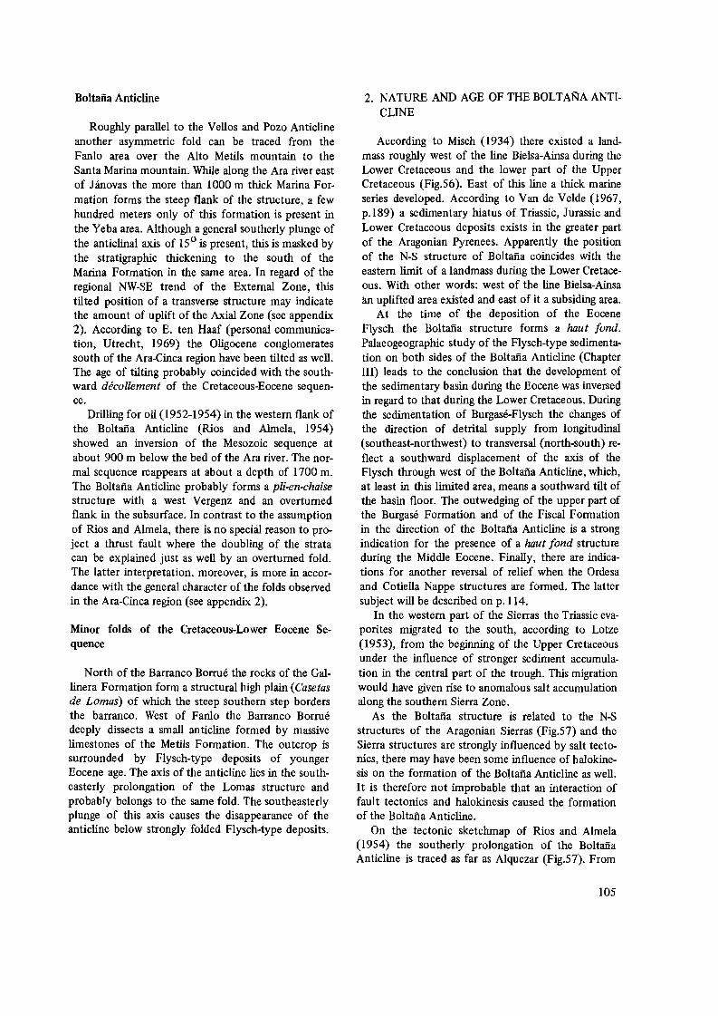
Boltana Anticline
Roughly parallel to the Vellos and POlO Anticline another asymmetric fold can be traced from the Fanlo area over the Alto Metils mountain to the Santa Marina mountain. While along the Ara river east of Janovas the more than 1000 m thick Marina Formation forms the steep flank of the structure, a few hundred meters only of this formation is present in the Yeba area. Although a general southerly plunge of the anticlinal axis of 15 0 is present, this is masked by the stratigraphic thickening to the south of the Marina Formation in the same area. In regard of the regional NW-SE trend of the External Zone, this tilted position of a transverse structure may indicate the amount of uplift of the Axial Zone (see appendix 2). According to E. ten Haaf (personal communication, Utrecht, 1969) the Oligocene conglomerates south of the Ara-Cinca region have been tilted as well. The age of tilting probably coincided with the southward decollement of the Cretaceous-Eocene sequence.
Drilling for oil (1952-1954) in the western flank of the Boltafia Anticline (Rios and Almela, 1954) showed an inversion of the Mesozoic sequence at about 900 m below the bed of the Ara river. The normal sequence reappears at about a depth of 1700 m. The Boltafia Anticline probably forms a pli-en-chaise structure with a west Vergenz and an overturned flank in the subsurface. In contrast to the assumption of Rios and Almela, there is no special reason to project a thrust fault where the doubling of the strata can be explained just as well by an overturned fold. The latter interpretation, moreover, is more in accordance with the general character of the folds observed in the Ara-Cinca region (see appendix 2).
Minor folds of the Cretaceous-Lower Eocene Sequence
North of the Barranco Borrue the rocks of the Gallinera Formation form a structural high plain (Casetas de Lomas) of which the steep southern step borders the barranco. West of Fanlo the Barranco Borrue deeply dissects a small anticline formed by massive limestones of the Metils Formation. The outcrop is surrounded by Flysch-type deposits of younger Eocene age. The axis of the anticline lies in the southeasterly prolongation of the Lomas structure and probably belongs to the same fold. The southeasterly plunge of this axis causes the disappearance of the anticline below strongly folded Flysch-type deposits.
2. NATURE AND AGE OF THE BOLTANA ANTICLINE
According to Misch (1934) there existed a landmass roughly west of the line Bielsa-Ainsa during the Lower Cretaceous and the lower part of the Upper Cretaceous (Fig.56). East of this line a thick marine series developed. According to Van de Velde (1967, p.189) a sedimentary hiatus of Triassic, Jurassic and Lower Cretaceous deposits exists in the greater part of the Aragonian Pyrenees. Apparently the position of the N-S structure of Boltafia coincides with the eastern limit of a landmass during the Lower Cretaceous. With other words: west of the line Bielsa-Ainsa an uplifted area existed and east of it a subsiding area.
At the time of the deposition of the Eocene Flysch the Boltafia structure forms a haut fond. Palaeogeographic study of the Flysch-type sedimentation on both sides of the Boltafia Anticline (Chapter III) leads to the conclusion that the development of the sedimentary basin during the Eocene was inversed in regard to that during the Lower Cretaceous. During the sedimentation of Burgase-Flysch the changes of the direction of detrital supply from longitudinal (southeast-northwest) to transversal (north-south) reflect a southward displacement of the axis of the Flysch through west of the Boltafia Anticline, which, at least in this limited area, means a southward tilt of the basin floor. The outwedging of the upper part of the Burgase Formation and of the Fiscal Formation in the direction of the Boltafia Anticline is a strong indication for the presence of a haut fond structure during the Middle Eocene. Finally, there are indications for another reversal of relief when the Ordesa and Cotiella Nappe structures are formed. The latter subject will be described on p.114.
In the western part of the Sierras the Triassic evaporites migrated to the south, according to Lotze (1953), from the beginning of the Upper Cretaceous under the influence of stronger sediment accumulation in the central part of the trough. This migration would have given rise to anomalous salt accumulation along the southern Sierra Zone.
As the Boltafia structure is related to the N-S structures of the Aragonian Sierras (Fig.57) and the Sierra structures are strongly influenced by salt tectonics, there may have been some influence of halokinesis on the formation of the BoHafia Anticline as well. It is therefore not improbable that an interaction of fault tectonics and halokinesis caused the formation of the Boltafia Anticline.
On the tectonic sketchmap of Rios and Almeia (1954) the southerly prolongation of the Boltafia Anticline is traced as far as Alquezar (Fig.57). From
105

o 10 20km 1...' __...., __---1'
Dans Ia nappe de Gavarnie /a densite des points suggere /'amplitude du deplacement Synclinal Oligocene
. ?'
A
Fig.59. Structural map of the Central Spanish Pyrenees by Choukroune et al. (1968). Note the position of the Cotiella Nappe and of the Gavarnie Nappe.
Alquezar to the west a great number of small parallel anticlines occur with distinct N-S orientation. They are exposed in the Mesozoic-Eocene rocks of the southern Sierras and are discordantly covered by Oligocene conglomerates north and south of the Sierra Zone. Structurally the Oligocene cover shows broad synclines in east-west direction, perpendicular to the minor folds of the Sierras and also perpendicular to the BoHana Anticline. In the western part of the AraCinca region the structures in both the MesozoicLower Eocene sequence and in the Burgase Flysch-type Formation show the same character and direction of folding as the Oligocene to the south of it. Flysch-type formations in part overthrust the Oligocene conglomerates south-west of Fiscal.
On account of the arguments mentioned above, we may state that the BoHana Anticline is older than the structures of the western part of the Ara-Cinca region and of the Ordesa-region. As the Oligocene conglomerates non-conformably overlie the north-south structures of the southern Sierras, which also comprise the Boltana (Campodarbe) Anticline, the age of these anticlines evidently is older than Oligocene. The eastern part of our Tectonic Unit A, Zone AI, is influenced tectonically by the BoHana structure. The latter structure in its present architecture also must be younger than Middle Eocene, most probably of Upper Eocene age. It received its tilted position after the Oligocene, which coincides with the age of the South-Pyrenean phase of folding.
3. OVERTHRUST STRUCTURES
The Castillo Mayor Klippe
An isolated mass of dense limestones and dolomites forms a castle (Castillo) like mountain which tectonically overlies Flysch-type deposits of the San Vicente Formation (Fig.3). According to Misch (1934), this mass is a klippe related to the Pena Montanesa situated east of the river Cinca. In fact we are dealing with erosional remnants of a former nappe of which the largest part is represented by the Cotiella Mass (Misch, 1934; Choukroune et al., 1968) whilst the Pena Montanesa and Castillo Mayor belong to its western border (Fig.59).
The Castillo Mayor consists of limestones and dolomites of the Tozals, Salarons and Gallinera Formations* in normal position. The western side of the mass shows subvertical strata (P. van Meurs, Internal Report, Utrecht, 1961), whereas on the eastern side westward dips of about 200_300 occur. The synclinal axis plunges about 50 in southeasterly direction (1200
).
Misch (1934, p.143) considers the Castillo Mayor to be "the overthrusted structural upfold of the Cotiella front". The north-northwest to south-southeast orientation of the structure and the general strike of the strongly folded underlying Flysch indicate a final movement of this part of the Cotiella Nappe in southwesterly direction. The direction of movement of the Castillo Mayor, however, is not representative
* On the geologic map (appendix 1) the Castillo Mayor lime of Maastrichtian age. stones are not further differentiated and were indicated as
106

ORDESA VALLEY
~,,"'-
500 m
s
2500
2000
1500
raoo
2500
2000
1500
1000 N
Fig.60. N-S sections across the Ordesa valley, north-west of Torla. (A) structural interpretation by Van de Velde (1967). (B) structural interpretation by Ten Haaf (1966). Dolomites of the Salarons Formation extra indicated.
107
for the movement of the Cotiella Nappe as a whole. The latter shows distinct southward directions (Misch, 1934; Seguret, 1967). Apparently the aberrant directions of the Castillo Mayor reflect its position as the utmost western part of the nappe structure, which incidentally limits its extension to the area east of the river Vellos.
According to Choukroune et aI. (1968, section 4), the Cotiella Nappe has a maximum southward overlap of 20 km (see also Fig.59). The Castillo Mayor itself may have been displaced over at least eight kilometers to the southwest.
® 500 m
2500
SIERRA CASA
2000
1500
s 100
The Ordesa Overthrust Mass
Van de Velde (1967) investigated the tectonics of the Ordesa region northwest of the Ara-Cinca region. In his cross section II (Fig.60,A) which covers the northwestern part of the Ara-Cinca region, the rock sequence of the Sierra de las Cutas is considered to be in an aIlochtonous position (Van de Velde's tectonic unit II). The position of the thrustplane which separates this unit from the underlying strata (unit I), is approximately parallel to the bedding planes. According to Van de Velde (1967, p.200), the amount of
2500
2000
1500
N 1000

horizontal southward overlap of unit II would be at least 10 km.
The overthrust mass is expected to continue to the east, though its thrustplane is no longer exposed. In the bed of the river Vellos east of Vio the Campanian limestones are strongly tectonized. Since they represent the oldest rocks of the Mesozoic epidermis in that area, the thrustplane may still be present in the subsurface at the base of the Campanian.
Assuming that the Boltafia Anticline can be followed 30 km to the south as far as Alquezar, this structure, which turned out to be much older than the Ordesa structures (see p. 105), represents a completely parautochthonous development. On account of its stable position, the amount of overthrusting of the Ordesa Mass may rapidly decrease toward the east, against the Boltafia Anticline, where the overthrust dies out in the Vellos area. North of Torla, where Van de Velde (1967) assumed a southward overlap of about 10 km, Ten Haaf (1966) came to a considerably lesser amount (Fig.60,B). When one reconstructs the original position of the Ordesa Unit, using a ten kilometer displacement in the Torla area, the rock sequence of the Sierra de las Cutas should originally have had a position in the northerly prolongation of the Boltafia Anticline. The decrease of the intensity of overthrusting towards the east makes a smaller amount of overthrusting of the Ordesa Overthrust Mass in the Torla area acceptable.
The Boltana Anticline may have acted as an obstacle, a sort of obstruction against southward gravitational gliding of the Mesozoic-Eocene sequence, whereas further west, where no such older structure were present, the epidermis could move southward more freely.
4. UPTHRUSTS
Vellos Upthrust
The anticline of the river Vellos, between Sercue and Gallisue, shows in its inner core a fault structure of which the line of outcrop, which is parallel to the fold axis, follows the river bed. The fault plane dips 600 _700 to the northeast. The southerly Vergenz of the asymmetric fold and the limited extent of the steeply northeast dipping fault zone may indicate the development of a low angle detachment plane in the subsurface east of the anticline (cf. De Sitter, 1956, pp.171-176).
Although in the Aragonian Pyrenees salt deposits are known only rarely, the occurrence of a brackish thermal source (Fuente de Suspiros) at the confluence of the river Vellos and the Gallisue fault may re
flect their presence in the subsurface.
Vacas Upthrust
West of the Castillo Mayor a thrustfault is exposed which shows a low angle dip to the northeast. Near the Castillo Mayor the fault is masked by scree material and by strongly tectonized Flysch-type deposits.
In some localities along the outcrop of the thrust plane a dip varying between 25 0 and 300 could be established. Striation shows 2200 directions, which are perpendicular to the general strike of the folded Flysch to the north of it. In detail the small scale folds in the Flysch have a distinct southwest Vergenz. The horizontal displacement of the Vacas upthrust, though distinctly southwestward, appears to be of subordinate importance. It moreover decreases to the northwest, where the upthrust fades out against the Vellos dipslope.
Around the Castillo Mayor Mass the Vergenz of the strongly folded Flysch follows more westerly directions than north of the Vacas upthrust. Both the increase in amount of low angle upthrusting of the Vacas upthrust toward the southeast and the westward turn of the Vergenz of the folds in the Flysch-type deposits are indications for a horizontal drag of the westward moving Cotiella Nappe on the underlying and surrounding Flysch-type deposits. The limited westward extent of the Vacas Upthrust indicates that the influence of nappe movement, and consequently the nappe itself, is restricted to the area east of the river Vellos.
Muro Upthrust
Southwest of Escalona minor upthrusts occur in the basal beds of the San Vicente Formation and in the uppermost layers of the underlying Marina Formation. Two thrust planes have been recognized, which show a slight dip to the northeast. The fold axes within the overthrust units have west-northwest to east-southeast directions. The position of the thrust planes and the orientation of the folds indicate a force acting from the northeast.
About 250 m north of Escalona, along the road to Puarruego, small thrust sheets are developed in the upper layers of the Marina Formation. Striae in the thrust planes indicate final displacements from northeast to southwest. According to Th. van Hengel (Internal Report, Utrecht, 1967) upthrusting also occurs along the road from Escalona to La Fortunada. All these upthrusts can be brought in relation with the nappe movement of the Pena Montanesa (Cotiella) Mass situated east of the river Cinca, in a comparable
108

way as the Vacas Upthrust is related to the Castillo Mayor Mass.
5. NORMAL FAULTS
Fanlo Fault
A subvertical transverse fault runs from Fanlo in northeasterly direction to the Barranco de Perdina. South of Fanlo the fault is covered by the basal beds of the Burgase Formation. Its subsurface continuation to the south is reflected by small scale folding, locally with aberrant strikes in the generally NW-SE trending fold belt of Flysch-type deposits.
The greatest displacement occurs in the river Aso exposure and reaches no more than five meters downthrow of the eastern block. A fading out in northerly direction is observed.
Nerin Fault
East of Nerin a subvertical transverse fault crosses the Vellos Anticline parallel to the Fanlo fault and fades out in northerly direction. The Nerin fault shows a downthrow of the western block of about 10m.
Molino Faults
East of the confluence of the rivers Aso and Vellos the Vellos Anticline is segmented by two parallel, transverse faults. The vertical to slightly overturned strata of the steep western flank of the anticline show differential westward displacement of about 150 m along the fault tracks. Tectonic breccia observed south of the river Aso (on the footpath to Nerin), may point to a westward continuation of these faults. West of Bestue, in the bed of the Barranco Arres, two faults come together. One of them, which has a direction approximately the same as those of the Molino faults, may be its easterly prolongation.
Arres Faults
Three closely related transverse faults occur between the river Vellos and the river Arres. They are cut off by the Vellos Upthrust (Fig.61) in the west and covered by strongly faulted and folded Flysch-type deposits in the east. Apparently displacement along the faults increases toward the west and gives rise to a set of blocks differentially tilted westward. East of the Barranco Arres the faults turned out to be no more than fractures in the limestones of the Metils Formation. In Fig.62 the situation of the
1~
2 f:>:::i::::j
,~
Fig.61. Geologic map of the Vellos-Arres region, north-west of Escalona. I-IV=fault-blocks, A-B=l.ine of section of Fig.62, l:::Metils Formation, 2:::Millaris Formation, 3::::Gallinera Formation and older formations.
N
Fig.62. Schematic diagram illustrating the relative positions of fault-blocks of the Vellos-Arres region along the line A-B of Fig.61.
109
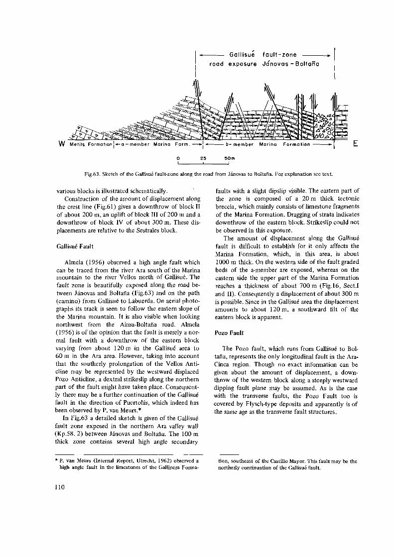
Gallisue fault-zone
road exposure Janovas - Boitano
t>
W Metils Formation i-a-member Morino Form. -: - b- member Morino E
o I
Fig.63. Sketch of the Gallisue fault-zone along the road from Janovas to Boltafia. For explanation see text.
25 50m I
various blocks is illustrated schematically. Construction of the amount of displacement al~ng
the crest line (Fig.61) gives a downthrow of block II of about 200 m, an uplift of block III of 200 m and a downthrow of block IV of about 300 m. These displacements are relative to the Sesttales block.
Gallisue Fault
Almela (1956) observed a high angle fault which can be traced from the river Ara south of the Marina mountain to the river Vellos north of Gallisue. The fault zone is beautifully exposed along the road between H.novas and Boltana (Fig.63) and on the path (camino) from Gallisue to Labuerda. On aerial photographs its track is seen to follow the eastern slope of the Marina mountain. It is also visible when looking northwest from the Ainsa-Boltana road. Almela (1956) is of the opinion that the fault is merely a normal fault with a downthrow of the eastern block varying from about 120 m in the Gallisue area to 60 m in the Ara area. However, taking into account that the southerly prolongation of the Vellos Anticline may be represented by the westward displaced Pozo Anticline, a dextral strikeslip along the northern part of the fault might have taken place. Consequently there may be a further continuation of the Gallisue fault in the direction of Puertohis, which indeed has been observed by P. van Meurs. *
In Fig.63 a detailed sketch is given of the Gallisue fault zone exposed in the northern Ara valley wall (Kp.58. 2) between Janovas and Boltana. The 100 m thick zone contains several high angle secondary
* P. van Meurs (Internal Report, Utrecht, 1962) observed a high angle fault in the limestones of the Gallinera Forma-
faults with a slight dipslip visible. The eastern part of the zone is composed of a 20 m thick tectonic breccia, which mainly consists of limestone fragments of the Marina Formation. Dragging of strata indicates downthrow of the eastern block. Strikeslip could not be observed in this exposure.
The amount of displacement along the Gallisue fault is difficult to establish for it only affects the Marina Formation, which, in this area, is about 1000 m thick. On the western side of the fault graded beds of the a-member are exposed, whereas on the eastern side the upper part of the Marina Formation reaches a thickness of about 700 m (Fig.l6, Sect.! and II). Consequently a displacement of about 300 m is possible. Since in the Gallisue area the displacement amounts to about 120 m, a southward tilt of the eastern block is apparent.
Pozo Fault
The Pozo fault, which runs from Gallisue to Boltafia, represents the only longitudinal fault in the AraCinca region. Though no exact information can be given about the amount of displacement, a downthrow of the western block along a steeply westward dipping fault plane may be assumed. As is the case with the transverse faults, the Pozo Fault too is covered by Flysch-type deposits and apparently is of the same age as the transverse fault structures.
tion, southeast of the Castillo Mayor. This fault may be the northerly continuation of the Gallisue fault.
110
6. AGE AND NATURE OF THE FAULTS
Following Jeurissen (1969), we may assume that the transverse high angle faults in the MesozoicPalaeocene sequence of the Central Southern Pyrenees do not extend to the Palaeozoic basement of the Axial Zone. Consequently they fmd their origin in the movements of the epidermis itself, which moved southward differentially in blocks bordered by these faults. In the area between the Aragon and Gallego rivers (Fig.5), the magnitude of these movements increases toward the east. A major strikeslip fault must be present between the Tendefiera region and the Ordesa Overthrust Mass, which is, however, masked by the valley of the Ara river. No strikeslip occurs along the Fanlo and Nerin Faults in the Ara-Cinca region (Fig.5 5) and sinistral strikeslip along the Molino Faults even indicates an opposite southward movement of the successive blocks.
The fact that no strikeslip occurs along the Nerin and Fanlo Faults and sinistral strikeslip is observed along the Molino Faults has the following consequences:
1. It indicates the limited amount of southward overlap of the Ordesa Overthrust Mass and its decrease toward the east.
2. Sinistral strikeslip along the Molino Faults (appendix 1) means that the differential southward movements of the epidermis, which increases eastward from Hecho to Torla (Van Elsberg, 1968; Jeurissen, 1969; Van der Voo, 1966 and Van de Velde, 1967) decreases in the Ara-Cinca region.
3. Dextral strikeslip along the Gallisue Fault apparently belongs to the tectonics of the eastern compartment only.
Hence there is no special reason to connect the gliding tectonics in the external zone northwest of the Boltafia Anticline with those observed by Van Lith (1965) in the Cinca region to the northeast, as was suggested by Jeurissen (1969, pJI-56). Nor is it justified to conclude that a "gradual increase" to the east of the alpine uplift of the Axial Zone of the Pyrenees would have taken place (Jeurissen, 1969, p.I1-58).
The direction of the Gallisue Fault is roughly parallel to the transverse faults of the Southern External Zone to the west (Van Elsberg, 1968; Jeurissen, 1969; this thesis). Strikeslip along this fault again is dextral, which indicates a relative southward displacement of the eastern block. Vertical displacement increases from north to south (P.109) so a distinct southward tilt is apparent. The northern part of the Gallisue fault disappears below the San Vicente For
mation (Flysch) in the Puertohis area. A further northeastward continuation of the Gallisue fault is probably exposed in the river Yaga east of the Castillo Mayor (P. v. Meurs, Internal Report, Utrecht, 1962).
In general the southern parts of the transverse faults west of the Gallisue fault disappear below Flysch-type deposits of Eocene age. Locally the basal beds of the Flysch show some dislocation above the supposed southerly continuations of the faults in the subsurface. The latter phenomenon is an argument in favour of faulting after the deposition of, at least, the basal part of the Flysch-type deposits.
According to Ten Haaf (1966), the Eocene Flysch-type deposits of the Central Western Pyrenees· probably have been folded in an unconsolidated state. As the decollement of the Mesozoic-Eocene sequence of the External Zone is associated with the developments of transverse faults (decrochement structures) fault tectonics apparently smoothen upwards on account of the unconsolidated state of the covering Flysch.
The limestones of the Marina Formation (Cuisian) probably are the lateral time aequivalents of, or slightly older than, the lower part of the Burgase Formation (see p.91). The Gallisue Fault dissects these competent limestones and consequently the fault must be younger than Cuisian (Lower Eocene). If the Gallisue Fault is related genetically to the transverse faults of the Western External Zone, its occurrence in the Cuisian limestones may indicate the presence of such faults below the western Flysch also. This gives rise to the hypothesis that the basement of the western Flysch trough may be built up by blocks that are differentially tilted southward and bordered by transverse faults, which are younger than Lower Eocene but masked by the Flysch-cover, which still plastically reacted during their formation.
C. TECTONIC STRUCTURES OF THE YOUNGER EOCENE SEQUENCE
Compared with the structures of the MesozoicEocene sequence, tectonics in the younger formations are developed on a much smaller scale. The general difference in magnitude between structural elements of both series is indicated on the geologic map by thicker and thinner lines.
The Boltafia Anticline structurally divides the area of younger Eocene strata in a western unit A and eastern unit B. Unit A is built up by graded sandy limestones and marls of the Flysch-type (Burgase Formation), blue marls (Fiscal Formation) and alternating sandy marls and sandstones (Fenes Forma
111

------. 0 u lD
S 216 0 W o 0.5 1 km I 1
Fig.64. N-S section across the folded Flysch of the Burgase Fonnation (zone AI). Note the gradual steepening southward
* On the geologic map the fold axes have been drawn along of the axial planes with its low northerly dips had been the northern edge of the steep flanks of the individual anti constructed, this would have obscured the belt structure clines, this is done to indicate the belt structure of parallel because of the influence of the strong topography. anticlines in this area. If the exact position of the outcrop
2400
Q)
2200 0..., .....
2000 Q) ...... "0 \ \\ 1:--:1800 "\
1600
1400
1200
1000
of the fold-axes.
tion). Unit B mainly consists of Flysch-type sediments, partly in marly facies (San Vicente Formation).
TECTONIC UNIT A, ZONE Al
Approximately north of the line Sarvise-Burgase an intensively folded belt occurs built up by successive asymmetric folds with southwest Vergenz, which are strikingly parallel throughout the belt.* The short southern flanks of the folds are strongly overturned to sub-vertical. In the most northern part of the zone the overturning reaches dips of about 500 to the northeast, but southwards .a gradual transition to almost vertical is found (Fig.64). The northern flanks of the folds have low northward dips in the north, which gradually steepen near the southern border of the fold belt. The axial planes steepen southwards, which probably indicates a flattening of the Mesozoic-Palaeocene limestone basement.
Both the fold axes and the general hade of the strata strike fairly constant 3100_1300. In the area enclosed by the villages Torla, Sarvise and Fanlo, J.G. Verdenius (Internal Report, Utrecht, 1961) measured 60 fold axes. A graphical analysis leads to the conclusion that in the mean the axes are approximately horizontal. The folded zone, though built up by NWand SE-plunging anticlines, has, upon the whole, a
sub-horizontal position. In the eastern part of Zone Al the folds end rather abruptly against the Boltafia Anticline. Although an angle of about 25 0 between the Boltana Anticline and the fold axes is eVident, no tectonic dislocation has been observed.
Thrusting occurs in the Flysch of the Mondicieto mountain and in the Burgase Formation west and east of Fanlo. The thrust planes of the Mondicieto have dips of about 150 to the northeast, whereas their strike is parallel to the fold axes of Zone AI. Striation in the thrust planes indicates fmal directions of movement of about 1900 for the overlying Flysch-type deposits.
Bedding plane slip is commonly met with in the basal beds of the Burgase Formation. Both thrusting, bedding plane slip and southwest Vergenz of the folds of Zone Al point to southward decollement of the Flysch-type deposits over the Mesozoic-Palaeocene basement (Jeurissen, 1969, pp.Il-58,59).
In the cores of the anticlines chevron folds (Fig.65) are frequently observed. According to Ten Haaf (1966) this type of sharp regular folding in the graded beds of the Flysch is an indication for the unconsolidated state of the sediments during tectonic deformation.
Open fissures occur in the beds overlying the thrust plane in the Mondicieto area. They contain numerous almost idiomorphic quartz crystals, which
E
(7l '" <D
o Q)
c :it el 01 ul
'" I ~ __ _-) ~t:::=-\i--'~;:r=~~~~ . __..--(
2400 m
2200
2000
1800
1600
1400
1200
1000
112

NWSE
o 2 4m , ! !
Fig.6S. Sketch of "chevron" folds in the basal beds of the
Burgase Fonnation west of Fanlo.
reach sizes of up to three centimeters in length and one centimeter thick. The fissures are at right angles to the thrust plane. They evidently have been formed after consolidation of the beds, probably during formation of the thrust plane.
The presence of open fissures, related to overthrusting, in the graded beds overlying the Mondicieto thrust plane is in contradiction with the assumption that chevron folds in the same formation were formed when the graded beds were still in an unconsolidated state. This contradiction is cancelled if chevron folding and the formation of open fissures had taken place at different times during different phases of tectonization of the Flysch. In this way chevron folding may have occurred during deformation of unconsolidated Flysch, followed by a later phase of overthrusting during a more conSOlidated state of the series.
According to Ten Haaf et al. (1970), Zone AI can be traced to the northwest as far as Hecho (Rio Aragon subordan, see Fig.I,IX, p.24l. In the same direction folding increases in intensity, whilst in several places large scale overthrusting has taken place. The orientation of the folds remains, without exception, parallel to the structures of the External Zone north of Zone AI. There is no doubt that the tectonics of the Flysch-type sediments in the Central Southern Pyrenees west of the Boltafia Anticline are intimately related to those of the Mesozoic-Palaeocene epidermis north of it.
An exception to this rule is formed by the structural position of the most southern part of Zone AI. South of Burgase a transverse high angle fault, which ends against the Boltafia Anticline, separates the NW-SE trending part of zone Al from its N-S trending southerly prolongation. In the latter part a thinning of the fold belt and a fading out of the folds
parallel to the Boltafia Anticline is evident. Strikeslip along this transverse fault indicates a more westward movement of the southern part of the fold zone than that of its northern part.
Just east of the fault, the line of outcrop of the Marina Formation shows a remarkable link. There are, however, no indications for a tectonic origin of this phenomenon in the Marina Formation, hence we think of a local influence of palaeorelief in the Marina Formation on the decollement of the Flysch-cover west of it (See also Chapter III).
TECTONIC UNIT A, ZONE A2
The intensively folded Zone AI is bordered to the south by a broad shallow syncline of which the northern flank shows small superimposed folds. The general dip of the strata of this northern flank is about 150 to the south, whereas the southern flank, which is not disturbed by secondary folding, shows northern dips of 5_100
. The axis of the syncline is located between Asin de Broto (north of Fiscal) and Lacort.
The syncline is bordered to the south by the Santiago Anticline, a fold showing strong southwest Vergenz in which the Burgase Formation borders the blue marls of the Fiscal Formation exposed to the south. South of the overturned flank of the Santiago Anticline the dips change rapidly from overturned via vertical to southward in the Fiscal and Fenes Formation, which indicates that the Santiago Anticline represents the exposed upper part of a cascade fold of which the overturned southern flank is very short and will rapidly change into a normal sequence of southward dipping strata in the subsurface.
The increase in the intensity of folding of the Santiago Anticline from the southeast, where it fades out, to the northwest gives rise to a southward overthrusting of the Burgase Formation even over the molassic conglomerates which follow on top of the Fenes Formation in the area west of Fiscal.
Along the Ara river north of Fiscal a number of aberrant strikes are found in the Burgase Formation which have probably been brought about by a decrochement of the overthrusted western part of the Santiago Anticline. A strikeslip fault which runs from south to north, west of Fiscal, probably separates the overthrusted western part from the parautochtonous cover east of it.
The area occupied by tectonic Zone A2 forms the eastern limit of a large belt of undisturbed to slightly dipping strata. West of the Ara river this zone contains an overthrusted unit along the southern area of the blue marls.
113

TECTONIC UNIT B, ZONE Bl
Around the Klippe of the Castillo Mayor an area of Flysch-type deposits (Puertolas Flysch, Misch, 1934) occurs, which is strongly tectonized.
Southwest of the Klippe the general dip of the underlying Metils Formation is about ISo northeast, whereas northeast of the Klippe a southwesterly dip of about 200 is found (P. Bleeker, Internal Report, Utrecht, 1961).
The synclinal structure of the Castillo Mayor, with an axial plunge of about five degrees to the southeast, is conformable with the structure of the basement as measured to the west of Zone Bl in the general area of the Velios river and to the east of this zone in the river Yaga area. Between these two elements the Flysch-type deposits have suffered strong tectonization. Measurements. in small folds in the Flysch just underlying the Castillo Mayor Klippe give westerly to southwesterly directions of compression.
The low angle upthrust (Vacas Upthrust) northwest of the Castillo Mayor and the locally observed faults southeast of it are orientated approximately parallel to the synclinal axes of both the basement and the Castillo Mayor Klippe. Apparently the tectonization of the Puertolas Flysch has been caused by overthrusting of the Cotiella Nappe in its former extension, of which the Castillo Mayor Mass now forms an erosional remnant.
TECTONIC UNIT B, ZONE B2
The tectonics of the San Vicente Formation exposed east of the Boltana Anticline and south of the river Yesa differ considerably from those of the Burgase Formation west of the Boltana Anticline. Flysch-type deposits of Zone B2 in general foliow the structures of the underlying limestone basement of the Marina Formation, which is folded in N-S oriented anticlines and synclines. Both the anticlines and the synclines show a plunge of their axes of about 150 to the south. A small scale south to southwest Vergenz of folding of the Flysch, perpendicular to the latter structures, occurs in the area between Muro and San Vicente. In the barrancos west of Labuerda, bedding plane slip in the Flysch marls frequently occurs. Secondary folding of the Flysch-type epidermis may be due to gravity gliding of the San Vicente Formation over the southward tilted N-S structures of the basement. A later phase in the tectonics of the area is illustrated by low angle upthrusts (p.108)west of Escalona and by a bending to the southeast of the secondary folds between Muro and Labuerda. The above mentioned phenomena may also
be due to the movement in southwesterly direction of the Cotiella Nappe.
D. COMPARTMENTATION IN TECTONICS
The Cotielia Nappe (Choukroune et aI., 1968) of which the Castillo Mayor forms a part, apparently has slid more to the south than did the Ordesa Overthrust Mass west of it (Van de Velde, 1967; this thesis). This may indicate that there was higher potential relief energy to the east, caused either by a stronger upheaval of the Axial Zone, or by a stronger subsidence of the southern trough area. In both cases the overthrusting mechanism will have been activated more strongly towards the east.
Overthrusting of the Cotielia Mass and of the Ordesa Mass probably has taken place simultaneously, because the Cotielia Nappe overlies parautochtonous Flysch-type deposits of Eocene age (Cuisian-Lutetian) and thus is post-Lutetian, whilst the folding and overthrusting of the Burgase Formation, which is parallel to and contemporaneous with that of the Ordesa Mass, also is of post-Lutetian age. Since the line of outcrop of the parautochtonous Upper CretaceousPalaeocene sequence north of the Cotielia Nappe shows no important strikeslip along transverse faults (Van Lith, 1965; Choukroune et aI., 1968), the more southerly transport of the Cotielia Nappe (Fig.59) must be caused by a stronger subsidence to the south.
According to Voigt (1962) and Rutten (1969) such differential sinking of parts of sedimentary basins seems to be the rule in the Mesozoic and Cenozoic basins of Western Europe. Rutten noted moreover, that, apart from the retrocharriage in the internal zone of the French Alps, the "see-saw" movements of the basement were difficult to detect in the fold belts, since folding and overthrusting in most cases mask the basement structures.
In the Ara-Cinca region we were able to observe the reflections of former tectonic movements in the palaeogeography of the Cretaceous-Eocene sequence. During the Eocene the basin to the west of the Boltana Anticline, and consequently to the south of the later Ordesa Overthrust, apparently was deepening more strongly than the area east of the Boltana Anticline, that is, south of the later Cotielia Nappe. During the deposition of the Burgase and San Vicente Formations. these movements were apparently reversed in regard to those which must have caused the invasion of the Cotielia Nappe east of the Bohana Anticline. In this context it might be remembered that already in the Lower Cretaceous an opposite situation was found by Misch (1934), which gave rise to a reversion of basins in the Upper Cretaceous.
114

Such inversions of basin formation have also been found by Mangin (I958, p.581) in the Spanish Pyrenees west of the province of Aragon. He advances the hypothesis of a mouvement de segmentation qui fait du massif basque une mosaique de panneaux dont Ie jeu ascendant et descendant n 'est pas obligatoirement synchrone. He further suggested that, during the period of post-Cuisian deformation, simultaneous with the segmentation of the trefonds basque, distinct compartments (panneaux) acted rather independently. By this mechanism he tried to explain the presence of Lutetian limestones on distinct haut fonds of the axial zone amidst the Flysch-type sediments in the surrounding basins.
In the region studied by the present author the position of the shallow marine limestones of the Marina Formation, developed in the area of the future Boltana Anticline, and surrounded by Flysch-type deposits in the basins of the future synclines, points to an analogous phenomenon.
E. CONCLUSIONS
In the post-Eocene phase of axial uplift of the Central Spanish Pyrenees the Mesozoic-Palaeocene sequence graVitationally slid down to the south. Lateral differences in the amount of tilt of the southern part of the External Zone, due to differential movements in the southern trough area, caused the development of transverse northeast-southwest trending faults between which separate tectonic units formed more or less individually. The Flysch-type sediments which, at that time, probably were in an unconsolidated state, mask the southerly continuations of these transverse faults.
Jeurissen (I969) observed an increase of southward gliding movements of the individual tectonic units along dextral transverse faults from the river
Aragon towards the southeast. In the Ara-Cinca region, on the other hand, a decrease of such movements is apparent in the same direction, whilst in the transition from the Ordesa structures towards the older Boltana structure sinistral movements are locally observed along the Molino faults. Northeast of the region studied dextral slip has again taken place (Gallisue Fault; Cotiella Nappe). Consequently a break in the continuity of the southwestward movements of the epidermis is situated in the Ara-Cinca region. It can be correlated with the presence of a north-south oriented transverse structure in the Boltana area. This structure, which is older than the decollement structures of the Cretaceous-Palaeocene sequence of the External Zone has acted as a local obstruction against the southward gliding of the sequence. A further compartmentation of the southern trough area, with an extra sinking of the block east of the Boltana Anticline resulted in the stronger southward movement of the Cotiella Nappe.
On a smaller scale the structures in the younger Eocene sequence on both sides of the Boltana Anticline also reflect compartmentation. Superimposed on the epidermal southward gliding of the Cretaceous-Palaeocene sequence the Flysch-type sediments, on their turn, acted as a higher epidermis sliding southwestward and southward over their own marly beds. This resulted in the development of foIas, bedding plane slip and local thrusting in the basal and top parts of these formations, which are quite different west and east of the Boltana Anticline. West of the anticline gravitational gliding and overthrusting has taken place in southwesterly directions, east of the anticline the Flysch-type deposits follow the north-south structures of the Cretaceous-Palaeocene basement, whereas secondary folding of the Flysch epidermis shows east-west axes which indicate a gliding to the south.
115
BIBLIOGRAPHY
Alastrue, E., Almela, A., y Rios, 1.M., 1957. Explicacion al mapa geologico de la provincia de Huesca, 1:200,000. Mem. Inst. Geol. Min. Esp., 58.
Almela, A., 1956. Datos sobre la geologia del valle de Aniselo (Huesca). Actes du ·2me Congr. Intern. d'Et. pyr., Luchon-Pau, 1954: 15-23.
Almela, A., De GaIvez-Lanero, A., y Rios, J.M., 1958. Explicacion de la Hoja N.o 211 Boltana (Huesca) 1:50,000. Mem. Inst. GeoI. Min. Esp. NO 297 H.
Bianca Cita, M., 1965. Jurassic, Cretaceous and Tertiary microfacies from the Southern Alps. Brill, Leiden.
Bien, G.S., Contois, D.E., and Thomas, W.H., 1958. Removal of soluble silica from fresh water entering the sea. Geoch. Cosmoch. Acta, 14 :35-54.
Bouma, A.H., 1962. Sedimentology of some Flysch deposits. A graphic approach to facies interpretation. Elsevier Publ. Cie, Amsterdam/New York, 168 pp.
Caralp, 1., 1896. Le granite de Borderes, son age, ses relations avec quelques autres granites pyreneeens. Bull. Soc. geoI. Fr., 24(3): 528-532.
Carez, Z., 1881. Etude des terrains cretaces du N. de 1'Espagne, These, Paris.
Choukroune, P., Martinez, Cl., Seguret, M., et Mattauer, M., 1968. Sur 1'extension, Ie style et rage de mise en place de la Nappe de Gavarnie (Pyrenees Centrales). c.r. Acad. Sc. Paris, Ser.D., 266:1360-1363.
Clin, M., 1959. Etude geologique de la haute chaIne des Pyrenees Centrales entre Ie cirque de Troumouse et Ie cirque de Lys, These, 1964. Mem. Bur. Rech. GeoI. Minieres, 27 :379 pp.
Cuvillier, J., 1956. Stratigraphic correlations by microfacies in Western Aquitaine. Brill, Leiden.
Dalloni, M., 1910. Etude geologique des Pyrenees de 1'Aragon, Ann. Fac. Sc. Marseille, t. XXVI, fasc. III.
De Raaf, J.F.M., 1964. The occurrence of flute casts and pseudomorphs after salt crystals in the Oligocene "gres aripplemarks" of the southern Pyrenees. Developments in Sedimentology, 3: 192-199.
De Sitter, G.U., 1956. Structural Geology, McGraw-Hill, N.Y., San Francisco, Toronto, London, 551 pp.
De Sitter, G.v., 1957. A cross-section through the Central Pyrenees. GeoI. Rundsch., 45: 214-233.
De Sitter, G.v., 1965. Hercynian and alpine ·orogenies in northern Spain. Geol. Mijnb., 44: 373-383.
Dott, jr., H.R., 1963. Dynamics of sub-aqueous gravity depositional processus. Bull. Am. Assoc. Petro Geol., 47(1): 104-128.
Dzulynski, S., and Slacka, A., 1958. Directional structures and sedimentation of the Krosno-beds (Carpathian Flysch). Ann. Soc. geoI. Pol., 28.
Dzulynski, S., Ksiazkiewicz, M., and Kuenen, Ph.H., 1959. Turbidites in Flysch of the Polish Carpathian Mountains. Bull. Geol. Soc. Am., 70: 1089-1118.
Flores, G., 1955. Discussion - 4th WId. Petroleum Congr., Rome. Proc. Sect. I-A-2: 120-121.
Gignoux, M., 1950. Geologie Stratigraphique. Masson, Paris, pp.548-558.
Gomez Llueca, F., 1929. Los Nummulitidos de Espana. Mem. Com. de Invest. pal. prehist., 36. Madrid.
Gorler, K. und Reutter, K.J., 1968. Entstehung und Merkmale der Olisthostrome. Geol. Rundsch., 57(2): 484-514.
Grimm, W.D., 1962. Idiomorphe Quarze als Leit-mineralien fiir salinare Fazies. Erdol und Kohle, Erdgas, Petroch., 15: 880-887.
Hottinger, G., 1960. Recherches sur les Alveolines du Paleocene et de 1'Eocene. Schweiz. Pal. Abh., 75/76. (1): 183-193.
Hottinger, G. und Schaub, H., 1960. Zur Stufeneinteilung des Eocaens. Einfiihrung des Ilerdiens und des Biarritziens. Eel. Geol. Helv., 53(1): 453-480.
Houbolt, J.J.H.C., 1957. Surface sediments of the Persian Gulf near the Quatar Peninsula, Thesis, Utrecht. 113 pp.
Jacob, Ch., 1930. Zone axiale, versant sud et versant nord des Pyrenees. Livre jubilaire, Centenaire Soc. geol. Fr., 389-410.
Jeurissen, G.F.J., 1969. Geology of the Upper Cretaceous and part of the Lower Tertiary between the Rio Aragon Subordan and the Rio Gallego (Spanish Pyrenees, province of Huesca), (Thesis, Utrecht, 1966). Geologica Ultraiectina, 10, II, 71 pp.
Kuenen, Ph.H., 1967. Emplacements of Flysch-type sand beds. Sedimentology, 9: 203-243.
Lombard, A., 1956. Geologie Sedimentaire. Les series marines. Masson, Paris. 727 pp.
Lombard, A., 1963. Laminites: a structure of Flysch-type sediments. J. Sed. Petrol., 33(1): 14-22.
Lotze, F., 1953. Salzdiapirismus im nordlichem Spanien. Z. Deutsch. Geol. Ges., 105: 814-822.
Mallada, L., 1878. Descripcion nsica y geologica de la provincia de Huesca. Mem. Com. Mapa Geol. de Espana LXV, 439 pp., Madrid.
Mangin, J.P., 1958. Le nummulitique Sud-Pyreneen a1'ouest de l'Aragon. These, Dyon. Pirineos, 51-58 :631.
Mangin, J.P., 1958a. Hypothese sur Ie Nummulitique du domain Pyreneen. Act. Terc. Congr. Intern. Est. Pirenaicos, Gerona, 1958: 107-128.
Mangin, J.P., 1962. Traces de pattes d'oiseaux et flutecasts associes dans un "facies flysch" du tertiaire Pyreneen. SedimentOlogy, 1: 163-166.
Mengaud, G., 1939. Etudes geologiques dans la region de Gavamie et du Mont Perdu. Bull. geol. Fr., 40: 197-223.
Mey, P.H.W., 1968. Geology of the Upper Ribagorzana and Tor Valleys, Central Pyrenees, Spain. Leidse Geol. Med., 41: 229-292.
Mey, P.H.W., Nagtegaal, P.J.C., Roberti, K.J. and Hartevelt, J.J.A., 1968. Lithostratigraphic subdivision of post-Hercynian deposits in the Southern Central Pyrenees. Leidse Geol. Med., 41: 221-228.
116
Misch, P., 1934. Der Bau der Mittleren Siidpyreniien. Abh. Ges. Wiss. Gott., Math. phys., III (12): 1597-1764.
Penck, A., 1882. La periode glaciaire dans les Pyrenees. Bull. Soc. Hist. Natur. t. XIX., Toulouse.
Perconig, E., 1968. Microfacies of the Triassic and Jurassic sediments of Spain. Brill, Leiden., 63 pp.
Pettijohn, F.J., 1957. Sedimentary Rocks. Harper and Br., New York, 718 pp.
Potter, P.E. and Pettijohn, F.J., 1963. Paleocurrents and basin analysis, Springer Verlag, Berlin-Gottingen-Heidelberg, 296 S.
Phleger, F.B., 1960. Ecology and Distribution of Recent Foraminifera. John Hopkins, Baltimore. 297 pp.
Rech Frollo, M., 1960. Flysch et Molasse. Bull. Soc. geol. Fr., 2(7): 752-757.
Rech Frollo, M., 1964. Le Flysch: Definition; depot de faible profondeur? Developments in sedimentology, 1: 347-356.
Rios, J.M. y Almela, A., 1954. Explicacion de la Hoja N.0209, Aguero (Huesca y Zaragossa), 1:50,000. Mem. Inst. Geol. Min. Esp. Num. 229 H.
Rupke, N.A., 1969. Aspects of bed thickness in some Eocene turbidite-sequences, Spanish Pyrenees. Geological Note. J. Geol., 77 (4): 482-484.
Rutten, M.G., 1955. Nota prelirninar sobre la Geologia de los Pirineos de La provincia de Huesca. Estud. Geol. Inst. Mallada, 12: 19-26.
Rutten, M.G., 1969. Geology of Western Europe. Elsevier, Amsterdam. 520 pp.
Schaub, H., 1960. Uber einige Nummuliten und Assilinen der Monographie und der Sammlung d'Archiac. Ecl. Geol. Helv., 53 (1): 443-451.
Schrader, Fr., et de Margerie, N., 1893. Apen;u de la forme et du relief des Pyrenees. Ann. 0. Alp. Fr., 19.
Schwarz, E.J., 1962. Geology and Paleomagnetism of the valley of the river Aragon Subordan N. and E. of Oza, Spanish Western Pyrenees, province of Huesca. (Thesis, Utrecht, 1962). Estudios Geologicos., XVIII; 193-240, Madrid.
Seguret, M., 1967. Mise en evidence sur Ie versant sud des Pyrenees centrales d'une nappe a materiel cretace deversee au sud: La nappe du Cotiella. C.r. Acad. Sc. Paris, Ser. D., t. 265; 1448-1451.
Selzer, G., 1934. Geologie der SUdpyreniiischen Sierren in Oberaragonien. Neues Jb. Geol. Pal. Min., BB., Abt. b: 370-406.
Silvestri, M., 1955. Cuvil!ierina eocenica, nouveau genre et nouvelle espece de Foraminifere de I'Ypresien d'Aquitaine. Bull. Soc. geol. Fr., Ser. 6, t.V.: 55-57.
Ten Haaf, E., 1959. Graded beds of the northern Apennines. Thesis, Groningen. V.R.B., 102 pp.
Ten Haaf, E., 1964. Aspecten van Flysch-afzetting. Openbare les, gegeven bij de aanvaarding van het ambt van lector in de alg. geol. aan de R. U. te Utrecht op 23 mrt. 1964. 16 pp.
Ten Haaf, E., 1966. Le Flysch Sud-Pyreneen Ie long du Rio Ara (Huesca). Actas V. Congr. Intern. Est. Dir. Jaca-Pamplona, 1966, 1: 143-149.
Ten Haaf, E., Van der Voo, R., and Wensink, H., 1970. The S-External Pyrenees of Huesca. Geol. Rundsch. (in press).
Van der Lingen, G.J., 1960. Geology of the Spanish Pyrenees, north of Canfranc, Huesca province. Thesis, Utrecht, 1960. Esmdios Geologicos, 16: 205-242, Madrid.
Van der Lingen, G.J., 1969. The turbidite problem. New Zealand. J. Geol. Geoph., 12 (1); 7-50.
Van der Voo, R., 1966. Geology of the Sierra de Tendeiiera region, Spain, Pyrenees, province of Huesca, Estudios Geologicos, 22: 61-64. Madrid.
Van de Velde, E., 1967. Geology of the Ordesa overthrust mass, Spanish Pyrenees, province of Huesca (Thesis, Utrecht, 1964). Estudios geologicos, 23: 163-201. Madrid.
Van Eden, J.G., 1970. A reconnaissance of deltaic environment in the Middle Eocene of the SouthCentral Pyrenees, Spain. Geol. Mijnb., 49 (2): 145-157.
V:an Elsberg, J.N., 1968. Geology of the Upper Cretaceous and part of the lower Tertiary, north of Hecho and Aragiies der Puerto, Spanish Pyrenees, province of Huesca (Thesis, Utrecht, 1964). Estudios geologicos, 24: 39-77. Madrid.
Van Hoorn, B., 1969. Submarine canyon and fan deposits in the Upper Cretaceous of the South-Central Pyrenees, Spain. Geol. Mijnb. 6,48 (1);'67-72.
Van Hoorn, B., 1970. Sedimentology and Palaeogeography of an Upper Cretaceous turbidite basin in the South Central Pyrenees, Spain. Leidse Geol. Med., 45: 73-154.
Van Lith, J.G.J., 1965. Geology of the Spanish part of the Gavarnie Nappe (Pyrenees) and its underlying sediments near Bielsa (Province of Huesca). (Thesis, Utrecht, 1965). Geologica Ultraiectina, 10: 67 pp.
Von Hillebrandt, A., 1962. Das Alttertiiir irn Mont Perdu Gebiet. Ecl. Geol. Helv., 55 (2): 295-316.
Walker, R.G., 1965. The origin and significance of the internal sedimentary structures of turbidites. Proc. Yorkshire Geol. Soc., 35: 1-39.
Walker, R.G., 1967. Turbidite sedimentary structures and their relationship to proximal and distal depositional environments. J. Sed. Petrol., 37 (1); 25-44.
Wensink, H., 1962. Paleozoic of the upper Gallego and Ara valleys, Huesca Province, Spanish Pyrenees (Thesis, Utrecht, 1961). Estudios geologicos, 18: 1-74. Madrid.
UNPUBLISHED REPORTS
Bleeker, P., 1961. Internal Report, Utrecht (Geology of the Castillo Mayor region).
Geyskes, R., 1961. Internal Report, Utrecht (Geology of the San Vicente region).
Schiittenhelm, R., 1967. Internal Report, Utrecht (Sedimentology of the Arga-, Ulzama and Erro valley, Pyrenees, Navarre, Spain).
Tjalsma, L., 1960. Internal Report, Utrecht (Stratigraphy of the Peiia Sestrales region).
Van Baren, J.H.V., 1961. Internal Report, Utrecht (Geology of the Sierra de las Cutas region).
Van der Voo, R., 1961. Internal Report, Utrecht (Geology of the Sierra de Tendeiiera region).
Van de Velde, E., 1962. Internal Report, Utrecht (Geology of the Yebra de Basa region).
117

Van Hengel, T.J.C., 1967. Internal Report, Utrecht (Geology Van Meurs, P., 1962. Internal Report, Utrecht (Geology of of the Pefia Montafiesa region). the Castillo Mayor region).
Van Hengel, T.J.C. and Klootwijk, G.T., 1964. Internal Re Verdenius, J.G., 1961. Internal Report, Utrecht (Geology of port, Utrecht (Geology of the Fiscal region). the Sarvise region).
Van Meurs, P. and Van Warne1, P., 1961. Internal Report, Utrecht (Geology of the barranco Sorrosa region).
118
ENKELE PERSOONLIJKE GEGEVENS
De schrijver behaalde in 1956 het diploma RBS-B aan het St. loris College te Eindhoven. Datzelfde jaar werd, aan de Rijksuniversiteit te Utrecht, de studie in de geologie aangevangen. Van februari 1958 tot november 1959 vervulde hij zijn militaire dienstplicht, waarna de studie werd hervat. Ret candidaatsexamen (j) werd in december 1963 afgelegd, het doctoraalexamen (met hoofdvak Algemene Geologie en bijvakken, Petrografie en Geofysica) in mei 1966, waarna dit proefschrift werd voorbereid. Gedurende het collegejaar 1968-1969 was hij, als wetenschappelijk medewerker, verbonden aan de afdeling Algemene en Economische Geologie van de Rijksuniversiteit te Utrecht. Sedert oktober 1969 is de schrijver werkzaam bij de Geologische Dienst van Ierland.
119

