geologic field-trip guide to steens mountain loop road
TRANSCRIPT
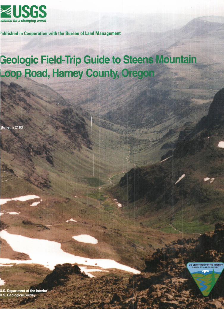
EUSGS »cience for a changing world
•ublished in Cooperation with the Bureau of Land Management
eologic Field-Trip Guide to oad, Harney Coun ,

U.S. Department of the Interior U.S. Geological Survey
Geologic Field-Trip Guide to Steens Mountain Loop Road, Harney County, Oregon
By James G. Evans and Thresa M. Geisler
Bulletin 2183
Published in cooperation with the Bureau of Land Management
U.S. Department of the Interior Gale A. Norton, Secretary
U.S. Geological Survey Charles G. Groat, Director
Any use of trade, product, or firm names in this publication is for descriptive purposes only and does not imply endorsement by the U.S. Government.
Un ited States Government Printing Office: 2001
For additional copies please contact
USGS Information Services Box 25286 Denver, CO 80225
For more information about the USGS and its products:
Telephone: 1-888-ASK-USGS World Wide Web: http://www.usgs.gov/
Text edited by James W. Hendley II Layout and design by Stephen L. Scott Manuscript approved for publication, February 14, 2001
Library of Congress Cataloging-in-Publication Data
Evans, James George, 1938-Geologic field-trip guide to Steens Mountain Loop Road, Harney County, Oregon I by
James G. Evans and Thresa M. Geisler. p. em.-- (U.S. Geological Survey bulletin ; 2183)
1. Geology--Oregon--Steens Mountain Region--Guidebooks. 2. Steens Mountain
Region (Or.)--Guidebooks. I. Geis ler, Thresa M. IT. Title. III. Series.
QE156.S74 E88 2001 557.95 '95--dc21
2001040123
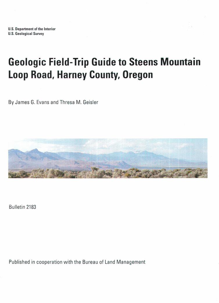
Cover-View to south down Wildhorse Creek. The valley is U-shaped as a result of glacial erosion . Its northerly trend parallels a north-trending fault zone that cuts the basalt. The lower ridges in the background constitute the South Steens. Pueblo Valley is the pale brown lowland (playa) in upper left.
Title Page-High Steens is the snow-covered mountain on right overlooking Alvord Valley. Flat mountain crest in middle is top of South Steens. Pointed peak on left is Alvord Peak.
CONTENTS Glossary--------------------------------------------------------------------------------------------- V Note to the Visitor to Steens Mountain Loop Road-------------------------------------------VIII
Introduction----------------------------------------------------------------------------------------- 1 Geology-------------------------------------------------------·--------------------------------------
Structural Setting-------------------------------------·-------------------------------------- 1 Oldest Rocks------------------------------------------·-------------------------------------- 2 Flood Basalts-------------------------------------------------------------------------------- 3 Volcanic Ash Flows-------------------------------------------------------------------------- 3 Pleistocene Glaciers and Lakes----------------------------------------------------------- 3 Faults----------------------------------------------------------------------------------------- 4
Road Log------------------------------------------------------·-------------------------------------- 4 Stop 1---------------------------------------------------·-------------------------------------- 4 Stop 2---------------------------------------------------·-------------------------------------- 5 Stop 3---------------------------------------------------·-------------------------------------- 5 Stop 4---------------------------------------------------·-------------------------------------- 5 Stop 5---------------------------------------------------·-------------------------------------- 6 Stop 6---------------------------------------------------·-------------------------------------- 6 Stop 7 ----------------------------------·-------------------------------------------------------- 7 Stop 8------------------------------------------------------------------------------------------ 7 Stop 9------------------------------------------------------------------------------------------ 7 Stop 10--------------------------------------------------------------------------------------- 8 Stop 11--------------------------------------------------------------------------------------- 8 Stop 12--------------------------------------------------------------------------------------- 8 Stop 13--------------------------------------------------------------------------------------- 9 Stop 14--------------------------------------------------------------------------------------- 9 Stop 15--------------------------------------------------------------------------------------- 9 Stop 16--------------------------------------------------------------------------------------- 10 Stop 17--------------------------------------------------------------------------------------- 11 Stop 18--------------------------------------------------------------------------------------- 11 Stop 19--------------------------------------------------------------------------------------- 12 Stop 20--------------------------------------------------------------------------------------- 12 Stop 21--------------------------------------------------------------------------------------- 13 Stop 22--------------------------------------------------------------------------------------- 13 Stop 23--------------------------------------------------------------------------------------- 13 Stop 24--------------------------------------------------------------------------------------- 14 Stop 25--------------------------------------------------------------------------------------- 14 Stop 26--------------------------------------------------------------------------------------- 14
Selected References------------------------------------------------------------------------------- 15
FIGURES
1. Index map showing location of Steens Mountain, Oregon-------------------------------------------------------------------- 1 2. Block diagram showing three-dimensional relations of High Steens and Alvord Valley---------------------------------- 2 3-31. Photographs showing:
3. View to the west towards Jackass Mountain and Frenchglen----·--------------------------------------------------------- 4 4. View to the north towards the low mesa on the north side of Frazier Reservoir---------------------------------------- 5 5. A glacial erratic---------------------------------------------------------·-------------------------------------------------------- 6 6. View looking west at a small unnamed kettle lake on McCoy Ridge---------------------------------------------------- 6 7. View looking north toward Pate Lake, a kettle------------------------------------------------------------------------------ 6 8. View looking west at Fish Lake----------------------------------------------------------------------------------------------- 6
III
IV
CONTENTS
FIGURES
9. View to the west looking down Fish Creek west of Fish Lake--------------------------------------------------------- 7 10. Boulder of Steens Basalt containing numerous large flat crystals of plagioclase------------------------------------ 7 11. View to the north down Kiger Gorge from the headwall area---------------------------------------------------------- 7 12. View to the east down Mosquito Creek to Alvord Valley---------------------------------------------------------------- 8 13. View to the east down Little Willow Creek to Alvord Valley----------------------------------------------------------- 9 14. View to the northeast along east scarp of Steens Mountain------------------------------------------------------------- 9 15. View to the east down Big Alvord Creek---------------------------------------------------------------------------------- 10 16. View to the south down Wildhorse Creek--------------------------------------------------------------------------------- 10 17. View to the southeast from repeater station------------------------------------------------------------------------------- 10 18. Chaotic breccia developed between two basalt flows along road to repeater station-------------------------------- 11 19. View of Wildhorse Lake from overlook------------------------------------------------------------------------------------ 11 20. View to the south into Big Indian Gorge----------------------------------------------------------------------------------- 11 21. View to the west looking down the Steens Mountain Loop Road at east (upper) end of The Rooster Comb---- 11 22. Outcrop of weathered Steens Basalt at the east end of The Rooster Comb------------------------------------------- 12 23. Irregular contact between two basalt flows near the west end of The Rooster Comb-------------------------------- 12 24. View to the northeast up Little Blitzen Gorge from vicinity of the west end of The Rooster Comb--------------- 12 25. View to the east up Big Indian Gorge-------------------------------------------------------------------------------------- 12 26. View southeast up Little Indian Creek------------------------------------------------------------------------------------- 13 27. View north from Steens Mountain Loop Road, showing rounded glacial erratic------------------------------------ 13 28. View northeast towards the mouth of Big Indian Gorge----------------------------------------------------------------- 13 29. The polygonal tops of columnar jointed Steens Basalt------------------------------------------------------------------ 14 30. Ten-foot-wide culvert under Steens Mountain Loop Road-------------------------------------------------------------- 14 31. View looking west towards cliffs on the east side of LaVoy Tables (mesa) from Highway 205------------------- 15
PLATE
1. Geologic map showing Steens Mountain Loop Road, geographic features mentioned in text, and stops described in road log.
GLOSSARY
Arete. A narrow serrate mountain crest or rocky sharpedged ridge, commonly present above the snowline in rugged mountains sculpted by glaciers, and resulting from the continued backward growth of the walls of adjoining cirques (see below).
Ash. Fine-grained material erupted from a volcano.
Ash-flow tuff. Consolidated deposit from an ash-flow, or density current consisting of a very hot mixture of volcanic gases and ash.
Basalt. Dark-colored mafic igneous rock, composed chiefly of calcium-rich plagioclase (see below) and clinopyroxene ( calcium+iron+magnesium+silica).
Basalt flow. A layer of basalt extruded as molten material.
Breccia. A coarse-grained clastic rock, composed of angular broken rock fragments held together by a mineral cement, or in a fine-grained matrix, or by fine-grained volcanic minerals or glass.
Butte. A conspicuous, usually isolated, generally fiattopped hill or small mountain with relatively steep sides often capped with a resistant layer of rock.
Calcium carbonate. CaC03•
Caldera. A large basin-shaped depression, more or less circular in form, resulting from surface collapse accompanying or following a volcanic eruption.
Caliche. In this report, a white cement of calcium carbonate.
Cirque. A steep-walled, half bowl-like hollow, variously described as horseshoe- or crescent-shaped or semicircular in plan, situated high on the side of a mountain, commonly at the head of a glacial valley, and produced by the erosive activity of a mountain glacier.
Columnar jointing. Parallel, prismatic columns, polygonal in cross section, in basalt flows, formed as the result of contraction during cooling.
Dike. In this report, a tabular intrusion of molten rock that cuts across the older surficial rock.
Escarpment. A long, more or less continuous cliff or relatively steep slope facing in one direction, breaking the continuity of the land by separating two level or gently sloping surfaces, and produced by erosion or faulting.
Exsolve. To come out of solution.
Fault. A fracture or a zone of fractures along which there has been displacement of the sides relative to one another.
Fault scarp. A steep slope or cliff formed directly by move ment along a fault and representing the exposed surface of the fault before modification by erosion and weather in g.
Fault zone. A fault that is expressed as a zone of numerous fractures, or of faulted, or crushed rock.
Flood basalt. A term applied to basaltic lavas that occur as vast composite accumulations of horizontal or subhorizontal flows, which erupted in rapid succession over great areas or regions.
Frost wedging. The fracturing of rock as the result of expansion as ice forms in cracks from water at the freezing point.
Gabbro. In this report, a coarse-grained rock equivalent in composition to basalt. The coarser grain is the result of relatively slow cooling of molten material.
Geomorphic feature. A topographic shape that may be characteristic of or have formed as the result of surficial geologic processes.
Glacier. A large mass of ice formed by the compaction and recrystallization of snow, moving slowly by creep downslope or outward in all directions due to the stress of its own weight, and surviving from year to year.
Glaciation. The formation, movement, and recession of glaciers or ice sheets; also a collective term for the geologic processes of glacial activity, including erosion and deposition, and the resulting effects of such action on the Earth's surface.
Glacial advance. The forward or down-slope movement of the terminus, or front, of a glacier, generally resulting from an accumulation of ice.
Glacial till. Unsorted and unstratified deposits of sediment ranging in size from clay to boulders deposited directly by and underneath a glacier without subsequent rework ing by water.
Glacial moraine. A mound, ridge, or other distinct accumulation of unsorted, unstratified sediments, predominantly till, deposited by direct action of glacier ice.
v

VI
GLOSSARY
Glacial erratic. A rock fragment carried by glacial ice, deposited at some distance from the outcrop from which it was derived. In this report, erratics are conspicuous by their large size relative to rock fragments in underly ing deposits of till.
Granitic. Pertaining to relatively coarse-grained silicarich rock or molten material. The noun is "granite."
Hanging valley. A tributary valley whose mouth is at a relatively high level on the steep side of a large glacial valley and the result of large differences in downcutting between the ice in the large valley and the ice in the tributary valley.
Headwall. In this report, a rock cliff at the back of a cirque (see above).
Icefall. The part of a glacier that is highly crevassed because of the steep slope of the glacier bed.
Intrusion. In this report, a body of rock emplaced as magma and subsequently cooled.
Kettle. A bowl-shaped basin or depression, commonly without surface drainage, in glacial deposits, contain ing a lake or swamp, formed by the melting of a large, detached block of stagnant ice left behind by a retreating glacier and wholly or partly buried by glacial till.
Kettle meadow. A meadow formed by deposition of sand, silt, and clay into a kettle.
Lateral moraine. A low ridge-like glacial moraine deposited at or near the side of a glacial valley.
Magma. Molten material generated within the Earth.
Magma chamber. A reservoir of magma.
Mesa. A nearly level landmass standing above the surrounding country, bounded by steeply sloping erosional scarps on all sides, and capped by layers of resistant, nearly horizontal rock layers. The top of the mesa is larger in area than the top of a butte (see above).
Nunatak. An isolated hill, knob, ridge, or peak of bedrock that projects prominently above the surface of a glacier.
Paleosurface. The ground surface of an area at a particular time in the geologic past.
Paleotopography. The topographic relief of an area at a particular time in the geologic past.
Plagioclase. A common mineral composed of calcium, sodium, silica, and aluminum.
Playa. A dry, vegetation-free, flat area at the lowest part of an undrained desert basin underlain by clay, silt, or sand, and commonly by water-soluble salts.
Pleistocene. A geologic epoch that extended from 1,600,000 to 10,000 years ago, according to a commonly used geologic time scale used in North America (Palmer, 1983).
Pumice. A light-colored vesicular glassy rock commonly having the composition of rhyolite (see below) and commonly containing enough trapped air or volcanic gases that it floats on water.
Pumice flow. A type of volcanic ash-flow in which a large percentage of the material is of pumice.
Pyroclastic. Pertaining to clastic rock material erupted from a volcanic vent; includes ash and pumice (see above).
Rhyolite. A type of volcanic rock that consists predominantly of silica (see below).
Sandstone. A clastic sedimentary rock composed of abundant angular to rounded fragments of sand size set in a finer grained matrix and more or less firmly cemented by silica, iron oxide, or calcium carbonate.
Scoria. In this report, a very vesicular dark gray to black, generally fine-grained material extruded from a volcano, or formed on lava flows. The vesicular character of the rock is due to the escape of volcanic gases before solidification. It is usually darker and denser than pumice, and will not float on water.
Seismic faulting. Faulting accompanied by earthquakes.
Silica. Silicon dioxide, Si02.
Siltstone. A clastic sedimentary rock composed of abundant fragments of silt size set in a matrix of clay and more or less firmly cemented or compacted.
Spheroidal weathering. A form of chemical weathering in which concentric or spherical shells of decayed rock are successively loosened and separated from a block of rock by water penetrating the bounding fractures and attacking the block from all sides.
GLOSSARY
Stone stripe. A sorted stripe consisting of coarse rock debris occurring between wider stripes of finer material. The stripes are oriented downslope.
Table. In this report, a local name for "mesa" (see above).
Tarn. In this report, a relatively small and deep, steepbanked lake or pool occupying an ice-gouged rock basin amid glaciated mountains.
Tectonic. Pertaining to the forces involved in tectonics, a branch of geology that deals with the evolution of structural or deformational features
Terrace. In this report, a large bench or step-like ledge breaking the continuity of slope.
Tephra. A general term for all pyroclastic material erupted from a volcano; includes ash and pumice (see above).
Trap. Dark-colored fine-grained intrusive or extrusive
rock, especially basalt and gabbro (see above) Tuff. A rock consisting of pyroclastic material (see above)
erupted from a volcano; includes ash and pumice (see above).
Tuffaceous. Pertaining to sediments containing up to 50 percent tuff.
Vesicular. In this report, a texture of lava characterized by abundant spaces formed as the result of the expansion of gases during the fluid stage of the lava.
Weather. To undergo changes, such as discoloration, softening, crumbling, or pitting of rock, brought about by exposure to the atmosphere.
Welded ash-flow tuff. A glass-rich pyroclastic rock that has been indurated by the welding together of its glass shards under the combined action of the heat retained by the volcanic particles, the weight of overlying material, and exposure to hot volcanic gases.
VII
VIII
Note to the Visitor to Steens Mountain Loop Road
On October 30, 2000, the Steens Mountain Cooperatve Management and Protection Act of 2000 (Public Law 1 06-399) was signed into law. Several purposes of the act include designating ( 1) the Steens Mountain Wilderness Area, (2) the Steens Mountain Cooperative Management and Protection Area, and (3) a mineral withdrawal area. Maps showing the new Wilderness Area boundary, the mineral withdrawal area, and other features are available at the Bums District Bureau of Land Management (BLM) office or at http://www.or.blm.gov/steens. The new Wilderness Area is south of Steens Mountain Loop Road between Stops 3 and 4 (see Introduction and map plate) and is encountered again on both sides of the Loop Road between Stops 8 and 21. The Wilderness Area is closed to bicycles, motor vehicles, and mechanized equipment.
Steens Mountain Loop Road is generally graded twice a year. "Washboards" frequently develop that make it unsafe to travel at high speeds on the road. The segment of the road that traverses the Rooster Comb grade (between Stops 18 to 21) is steep, rough, and rocky and is not recommended for recreational vehicles, trailers, and passenger cars. Visitors, of course, may stop at any point along the route within the bounds of vehicular and pedestrian safety and respect for private land traversed by the road.
Geologic Field-Trip Guide to Steens Mountain Loop Road, Steens Mountain, Harney County, Oregon
By James G. Evans1 and Thresa M. Geisler2
Introduction Steens Mountain is a textbook, written in stone and sedi
ment, of the surficial, crustal, and deeper geologic processes that have shaped the rugged landscape of southern Harney County, Oregon (fig. 1 ). The Steens Mountain Loop Road provides a window into the past 20 million years of geologic processes-volcanism, glaciation, faulting, and erosion-in southeastern Oregon. Our understanding of these processes is the result of more than a hundred years of scientific observations, beginning in 1884 with "A Geological Reconnaissance of Southern Oregon," by I.C. Russell, published in the U.S. Geological Survey's Fourth Annual Report.
The Steens Mountain Loop Road, which is 63 miles (mi; 100 kilometers, km) long connects with State Highway 205 at the southern end of the town of Frenchglen and with Highway 205 at a point 9.5 mi ( 15 km) south of Frenchglen (fig. 1 ). Between these two intersections the graded gravel Steens Mountain Loop Road climbs close to the top of the highest segment of Steens Mountain, referred to as the "High Steens." There the road attains an elevation of 9,540 feet (ft; 2,910 meters, m), only 190ft (58 m) below the highest point on the mountain.
This guide to the geologic features visible from or near the Steens Mountain Loop Road is written as a result of an increasing demand for information about the geologic history of the Steens Mountain area. The guide provides both a geological overview of the area and a road log that visitors can follow at their own convenience and pace. Technical terms are explained in the guide where they are first used. For readers who prefer to follow this guide in greater detail on the 1:24,000-scale maps published by the U.S. Geological Survey (USGS), the pertinent quadrangles are Frenchglen, Page Springs, McCoy Ridge, Fish Lake, Wildhorse Lake, Tombstone Canyon, and Roaring Springs.
The road log begins at the road intersection of Oregon Highway 205 and the Steens Mountain Loop Road at Frenchglen (fig. 1; plate 1). Mileages are figured from that point. Mileages and reference points are provided in detail so that visitors can start and stop the field trip at any point along the Steens Loop Road, complete the trip in segments, or go
1U.S. Geological Survey, 904 W. Riverside. Room 202. Spokane. WA. 99201-1087. 2U.S. Bureau of Land Management. HC 74-12533, Highway 20 West, Hines. OR, 97738.
directly to those parts of the road that have special interest for them.
Certain parts of the route are judged to be of sufficient geological interest to merit classification as a "Stop." The distance to the next stop or point of interest is given in parentheses at the conclusion of each stop description.
Geology Structural Setting
Steens Mountain is located in what is known as the hydrographic Great Basin of the western United States. The term "Great Basin" was coined by John C. Fremont, who in his travels through the west in the mid 1800's noticed that
78
118'30'
10 20 MILES
10 20 30 KILOMETERS
Coyote Lake
Figure 1.-lndex map showing location of Steens Mountain, Oregon.
water in this part of the west flowed neither to the Pacific nor Atlantic Oceans, but to inland lakes and marshes and (or) evaporated. This defining characteristic of the Great Basin is a result of mountain-forming processes that produced high, generally linear mountain ranges flanked by broad valleys that do not have outlets to the sea. One famous valley in the Great Basin, Death Valley in California, would be filled by sea water if it were connected to the sea because it is below sea level.
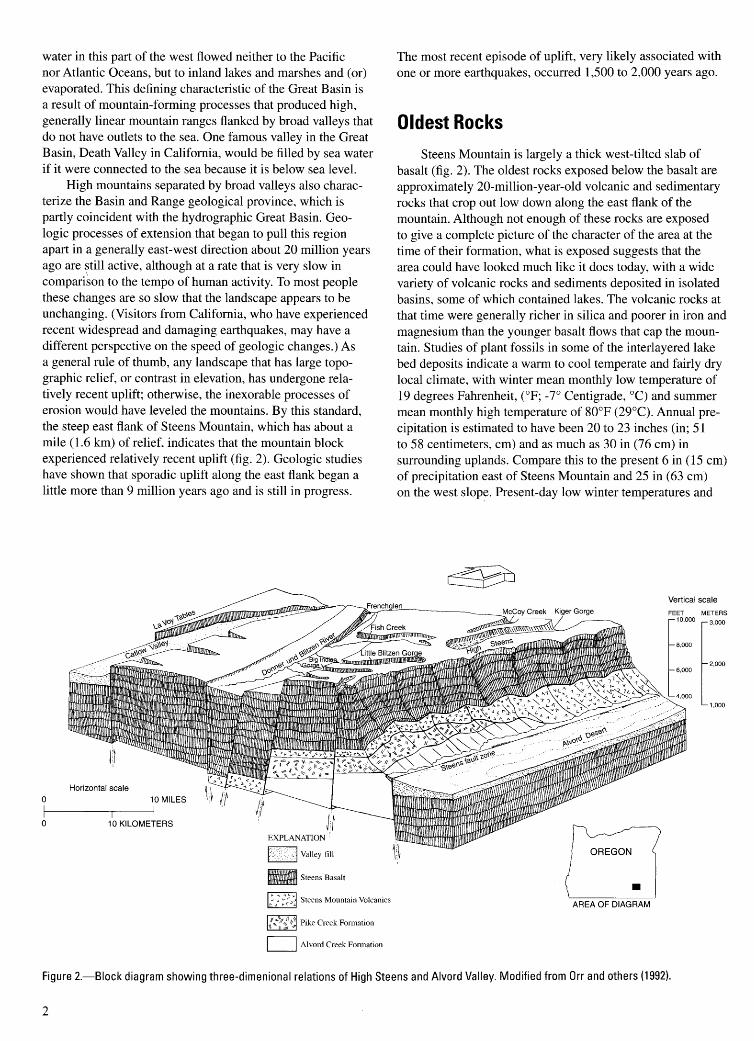
High mountains separated by broad valleys also characterize the Basin and Range geological province, which is partly coincident with the hydrographic Great Basin. Geologic processes of extension that began to pull this region apart in a generally east-west direction about 20 million years ago are still active, although at a rate that is very slow in compari~on to the tempo of human activity. To most people these changes are so slow that the landscape appears to be unchanging. (Visitors from California, who have experienced recent widespread and damaging earthquakes, may have a different perspective on the speed of geologic changes.) As a general rule of thumb, any landscape that has large topographic relief, or contrast in elevation, has undergone relatively recent uplift; otherwise, the inexorable processes of erosion would have leveled the mountains. By this standard, the steep east flank of Steens Mountain, which has about a mile ( 1. 6 km) of relief, indicates that the mountain block experienced relatively recent uplift (fig. 2). Geologic studies have shown that sporadic uplift along the east flank began a little more than 9 million years ago and is still in progress.
Horizontal scale 0 10 MILES
0 10 KILOMETERS
EXPLANATION .
1::: cl Valley-fill
Steens Basalt
~ Steens Mountain Volcanics ~
{.,.""~~~~~ Pike Creek Formation
D Alvord Creek Formation
The most recent episode of uplift, very likely associated with one or more earthquakes, occurred 1,500 to 2,000 years ago.
Oldest Rocks
Steens Mountain is largely a thick west-tilted slab of basalt (fig. 2). The oldest rocks exposed below the basalt are approximately 20-million-year-old volcanic and sedimentary rocks that crop out low down along the east flank of the mountain. Although not enough of these rocks are exposed to give a complete picture of the character of the area at the time of their formation, what is exposed suggests that the area could have looked much like it does today, with a wide variety of volcanic rocks and sediments deposited in isolated basins, some of which contained lakes. The volcanic rocks at that time were generally richer in silica and poorer in iron and magnesium than the younger basalt flows that cap the mountain. Studies of plant fossils in some of the interlayered lake bed deposits indicate a warm to cool temperate and fairly dry local climate, with winter mean monthly low temperature of 19 degrees Fahrenheit, (°F; -7° Centigrade, °C) and summer mean monthly high temperature of 80°F (29°C). Annual precipitation is estimated to have been 20 to 23 inches (in; 51 to 58 centimeters, em) and as much as 30 in (76 em) in surrounding uplands. Compare this to the present 6 in (15 em) of precipitation east of Steens Mountain and 25 in (63 em) on the west slope. Present-day low winter temperatures and
AREA OF DIAGRAM
Vertical scale
METERS
3,000
2,000
1,000
Figure 2.-Biock diagram showing three-dimenional relations of High Steens and Alvord Valley. Modified from Orr and others (1992).
2
high summer temperatures are more extreme than the ones suggested for the area 20 million years ago.
Flood Basalts
Geologic processes in the Steens Mountain area changed dramatically about 17 million years ago, when over a period of about one and a half million years, much of the Pacific Northwest from Washington State to as far south as northern Nevada was buried by massive eruptions of flood basalts. Much of the lava erupted from fissures in northeastern Oregon, southeastern Washington, and adjacent parts of Idaho and cooled to form the well known basalt flows of the Columbia River Basalt Group that cover large parts of southern and central Washington, northern Oregon, and western Idaho. The compositionally similar Steens Basalt, which is as much as 3,168 ft (966 m) thick, was erupted in the same period and is considered part of the flood basalt province. Eruptive centers were probably connected to larger intrusions of basalt and gabbro, such as are found in the Lady comb Peak area of the northern Pueblo Mountains, 12 mi (20 krn) south of Steens Mountain. Altogether, in less than 2 million years, more than 50,000 cubic miles (mi3; 205,000 cubic kilometers, km3) of basaltic lava were brought to the surface during the flood basalt eruptions of the Pacific Northwest. Although the eruptive volume and rate are impressive, they are by no means the world 's largest. Some flood basalt provinces, such as the Siberian traps of Russia and the Deccan traps of India, total as much as 250,000 mi3 (1 ,000,000 kfn3) and were erupted over a similarly short time interval.
Volcanic Ash Flows
Most of the Steens Mountain area was volcanically quiet for some time following the flood basalt eruptions. Sediments accumulated in topographic lows on the basalt surface. Some of the westward dip (tilt) of the Steens Basalt developed just before eruption of the 9.3-million-year-old Devine Canyon Ash-Flow Tuff. This hot volcanic ash was blown violently out of the top of a magma chamber that is now solidified and covered by young sediments somewhere in the Malheur Lake basin just east of Burns, Oregon. Eruptions of this kind often occur at the end of the evolution of granitic magmas (bodies of molten rock) in relatively near-surface magma chambers, when volatile compounds and relatively low-density components accumulate at the top of a chamber. During and after major eruptions, the roof of the magma chamber may collapse to form a roughly circular depression called a caldera. The Devine Canyon Ash-Flow Tuff has a volume of about 50 mi3 (205 km3) and consists mainly of glass shards and crystals so hot at the time of eruption that the glass shards were flattened and welded together to form a hard, erosion-resistant rock called welded tuff. The eruption of the hot volcanic ash would have killed most life forms in an area of about 7,500 square miles (mi2; 19,200 square kilometers, krn2) and as much as 60 mi (96 km) from the eruptive center due to the heat of the ash
and the volcanic gases released during the eruption. Detailed mapping of the Devine Canyon Ash-Flow Tuff indicates that the ash filled in stream channels that had developed on the already west-tilting slab of Steens Basalt.
A well known modern, but imperfect, analogy to the eruption that produced the Devine Canyon Ash-Flow Tuff is the 1980 eruption from Mount St. Helens in southeastern Washington. The Mount St. Helens eruption, however, released about 0.25 mi3 (1 km3) of volcanic ash, or tephra. The tephra from Mount St. Helens was an easily erodable material that was largely an inconvenience at distances of more than 20 miles (32 krn) from the volcano, except for certain corridors of destruction from mudflows, such as along the Toutle River.
Sediment, mainly poorly lithified and poorly exposed sandstone, were deposited on the Devine Canyon Ash-Flow Tuff. Above the sediment is the Rattlesnake Ash-Flow Tuff, which forms hard, resistant ledges that commonly cap mesas. This tuff erupted about 7 million years ago from the top of a magma chamber located at Harney Lake, about 25 mi ( 40 km) south of Burns. Like the eruption of the Devine Canyon AshFlow Tuff, this eruption dwarfed the 1980 eruption of Mount St. Helens. About 55 mi3 (225 kfn3) of ash were erupted in a matter of hours or days and the deposits covered more than 15,000 mi2 (38,400 km2). Most life forms in this area would have been killed from the heat and volcanic gases. In the Steens Mountain area, the Rattlesnake Welded Ash-Flow Tuff is as much as 10ft (3 m) thick.
Between deposition of the Rattlesnake Ash-Flow Tuff and the ice ages of the Pleistocene, which began about 1.6 million years ago, few rocks were deposited in the Steens Mountain area. It is likely, however, that continued regional east-west extension resulted in continued westward tilting of the Steens Basalt and development of the spectacular east-facing escarpment of today.
Pleistocene Glaciers and Lakes
With the onset of a colder climate about 1.6 million years ago in the Pleistocene, ice and snow accumulated on Steens Mountain until ice caps and valley glaciers formed. Development of a colder climate involved changes in major weather patterns, such as the shifting of the northern hemisphere storm track southward. The glaciers moved large volumes of rock and soil, carved U-shaped valleys, and formed cirques (bowlshaped depressions, which may be occupied by a small lake, or tarn), hanging valleys (tributary valleys that are much higher than the major valley and commonly drain into the main stream by a waterfall), and other landforms associated with ice erosion and freeze-thaw action. Some of this glacial history has been studied, but much more is probably waiting to be documented, including the relations between glacial deposits (till or moraine, which consists of unsorted accumulations of boulders, cobbles, pebbles, sand, silt, and clay) and the active faults that bound the High Steens block.
To date, two ice advances in the region have been identified. The oldest and most extensive is called the Fish Lake
3

Advance. Deposits of this period are attributed to an ice cap that deposited glacial till on the Steens Basalt on the western dip-slope of the mountain and formed valley glaciers in preexisting stream valleys. This was followed by the less extensive valley glaciers of the Blitzen Advance. These two glacial stages are distinguished largely by superposed glacial moraines at the mouths of the gorges of Little Blitzen River and Big Indian Creek on the southern flank of the High Steens and two sets of cirques eroded into drainages along the east slope of the High Steens.
One estimate of climate parameters during glaciation in this area includes a mean annual temperature of 25.8°F (-3.4°C) and annual precipitation of 19.6 in (49.8 cm).During the Pleistocene, lakes developed in Alvord Valley on the east side of Steens Mountain and in Catlow Valley, southwest of Frenchglen. Lake Alvord at one time was nearly as high (4,300 ft; 1,310 m) as the mouth ofWildhorse Creek. A barrier bar formed near the mouth of the creek where sediment was transported into the lake. It is possible that this high stand of Lake Alvord correlates with high levels in other lakes in the region dated at 24,000 to 16,000 years ago.
There are no dates on glaciation on Steens Mountain, but dates and stratigraphic relations elsewhere in the Great Basin show that the maximum expansion of the glaciers predated the maximum expansion of the lakes. In addition, climate models indicate that the lakes formed from increased precipitation that occurred when the jet stream moved as the glaciers melted. Consequently, the glaciers formed during a cold and relatively dry climate; later, the Pleistocene lakes formed during a wetter, cool climate.
The lakes disappeared as the region, and the world, experienced a period of global warming about 10,000 years ago. Storm tracks shifted northward and summer evaporation rates increased, resulting in the desert that presently occupies the area. In comparing the estimated annual precipitation during glacial periods with that of today (19.6 in during glaciation versus 25 in today; 49.8 versus 63.5 em), it can be seen that more precipitation, by itself, will not create a new glacial advance. Significant winter moisture must be accompanied by decreased annual temperature; lower temperatures are especially important during the summer evaporation period.
Faults
The north-northeast-trending Steens Mountain is segmented along steep northwest-striking faults associated with the Brothers Fault Zone (plate 1 ), a band of faults that can be traced from the eastern escarpment of Steens Mountain to the eastern margin of the Cascade Range 110 miles (176 km) northwest of Frenchglen. At Frenchglen, the Brothers Fault Zone splits into two branches that bound the highest segment of Steens Mountain, called the "High Steens." The High Steens is about 2,000 ft (610 m) higher than the North and South Steens segments.
The Steens Mountain block began rising and tilting westward more than 9.3 million years ago. As calculated based on the height of the spectacular east-facing escarpment, the
4
accumulated vertical offset along the Alvord Fault on the east side of the Steens Mountain block exceeds one mile (1.6 km; fig. 2). Geothermal drilling in Alvord Valley indicates that the valley-fill sediments are no more than about 2,000 ft (600 m) thick, and rest on tuff and Steens Basalt. These relations suggest a maximum vertical offset of about 7,000 ft (2,200 m). and a long term vertical slip rate of 0.009 inches per year (0.23 millimeters per year). The faulting most likely occurred in increments that could be as great as several feet (meters). The Alvord Fault cuts an ancient shoreline ( 4,300 ft; 1312 m) of Lake Alvord and alluvial fan deposits and has scarps as much as 6 ft (2 m) high. Fault scarp studies suggest that the fault was most recently active in the last 1,500 to 2,000 years.
ROAD LOG
0 mi. Intersection of Oregon Highway 205 and the Steens Mountain Loop Road at the south end of the town of Frenchglen.
Stop 1 0.25 mi (0.4 km). Cattleguard. Stop and look back toward
Frenchglen (fig. 3). Jackass Mountain (referred to locally as Frenchglen Rim), which is west of (behind) Frenchglen, consists of Steens Basalt capped by Devine Canyon Ash- Flow Tuff. The basalt flows are visible as ledges. The irregular topography is a result of erosion along the numerous faults that are part of the south branch of the Brothers Fault Zone. The faults cut northwest across the east side of the mountain in a zone about 1.5 mi (2.4 km) wide (plate 1). Proceed east on the Steens Mountain Loop Road. You are crossing part of the Malheur National Wildlife Refuge. This swampy basin is fed by the Donner und Blitzen River. Water entering the refuge either evaporates or flows northward to Malheur Lake and, ultimately, to Harney Lake. None of it flows to the Pacific Ocean, as this area is part of the Great Basin (1.25 mi, 2 km, to next landmark).
1.5 mi (2.4 km). Center Patrol Road to left (north) goes to P Ranch and refuge headquarters (0.2 mi, 0.3 km to next viewpoint).
Figure 3.- Viewto the west towards Jackass Mountain and Frenchglen. Jackass Mountain consists almost entirely of Steens Basalt with a cap of welded tuff. Irregular topography behind Frenchglen is a result of closely spaced northwest-striking faults, part of the Brothers Fault Zone, that cut obliquely across the mountain's flank. The asphalt road on the left is State Highway 205, which becomes a county road south of Roaring Springs. In the foreground is marsh terrain of the Malheur Wildlife Refuge, which is part of the hydrographic Great Basin (see text).
1.7 mi (2.7 km). Looking ahead (east), you can see low mesas capped by a ledge- forming rock unit, the Devine Canyon Ash-Flow Tuff, that overlies sediments deposited on Steens Basalt (Turn right; 0.6 rni, 1 km to next viewpoint).
2.3 mi (3.7 km). From here you can see the high bluff on the east side of Page Springs Campground. The bluff is composed of the Devine Canyon Ash-Flow Tuff, lying directly on Steens Basalt. A nature trail at the south end of the campground explores that area (0.7 mi, 1.2 km to next landmark) .
3.0 mi ( 4.8 km). Cross the bridge over the Donner und Blitzen River (sign says Blitzen River). Just beyond this bridge is a second bridge across the Malheur National Wildlife Refuge East Side Canal (0.1 mi, 0.16 km to next landmark).
3.1 mi (5 km). Intersection. Road on the right goes to Page Springs Campground. Continue to the left on the Steens Mountain Loop Road past the gate. The sign at the gate will indicate road conditions and road closures, if any. If the upper gates are locked you still have the option of proceeding beyond them on foot (0.1 mi, 0.16 km to next stop).
Stop 2 3.2 mi (5.1 km). Roadcut. Rock in this roadcut consists of
welded fragments of basalt and scoria (very vesicular basalt) that formed as a mix of hot volcanic rock fragments stopped flowing and the fragments welded at points of contact due to the heat. Later, white caliche (CaC03) was deposited from groundwater moving through the partly welded fragmental volcanic rock, filling pore spaces and serving as a cement (0.8 mi, 1.3 km to next stop).
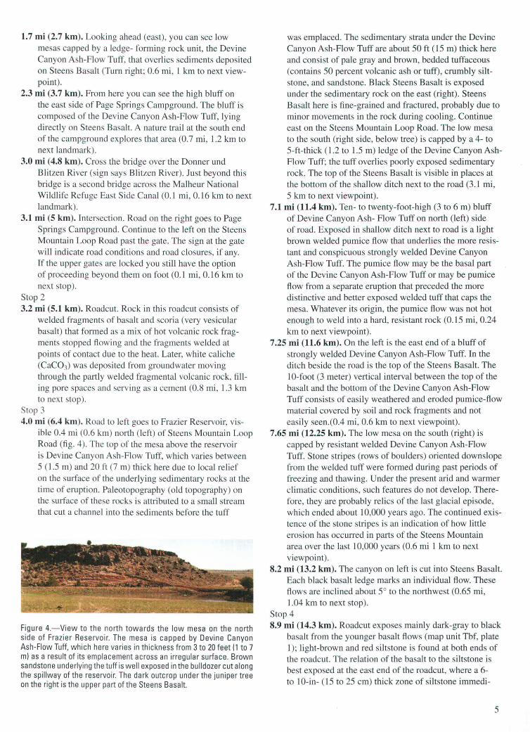
Stop 3 4.0 mi (6.4 km). Road to left goes to Frazier Reservoir, vis
ible 0.4 mi (0.6 km) north (left) of Steens Mountain Loop Road (fig. 4). The top of the mesa above the reservoir is Devine Canyon Ash-Flow Tuff, which varies between 5 ( 1.5 m) and 20 ft (7 m) thick here due to local relief on the surface of the underlying sedimentary rocks at the time of eruption. Paleotopography (old topography) on the surface of these rocks is attributed to a small stream that cut a channel into the sediments before the tuff
Figure 4.- View to the north towards the low mesa on the north side of Frazier Reservoir. The mesa is capped by Devine Canyon Ash-Flow Tuff, which here varies in thickness from 3 to 20 feet (1 to 7 m) as a result of its emplacement across an irregular surface. Brown sandstone underlying the tuff is well exposed in the bulldozer cut along the spillway of the reservoir. The dark outcrop under the juniper tree on the right is the upper part of the Steens Basalt.
was emplaced. The sedimentary strata under the Devine Canyon Ash-Flow Tuff are about 50ft (15m) thick here and consist of pale gray and brown, bedded tuffaceous (contains 50 percent volcanic ash or tuff), crumbly siltstone, and sandstone. Black Steens Basalt is exposed under the sedimentary rock on the east (right). Steens Basalt here is fine-grained and fractured, probably due to minor movements in the rock during cooling. Continue east on the Steens Mountain Loop Road. The low mesa to the south (right side, below tree) is capped by a 4- to 5-ft-thick (1.2 to 1.5 m) ledge of the Devine Canyon AshFlow Tuff; the tuff overlies poorly exposed sedimentary rock. The top of the Steens Basalt is visible in places at the bottom of the shallow ditch next to the road (3.1 mi, 5 km to next viewpoint).
7.1 mi (11.4 km). Ten- to twenty-foot-high (3 to 6 m) bluff of Devine Canyon Ash- Flow Tuff on north (left) side of road. Exposed in shallow ditch next to road is a light brown welded pumice flow that underlies the more resistant and conspicuous strongly welded Devine Canyon Ash-Flow Tuff. The pumice flow may be the basal part of the Devine Canyon Ash-Flow Tuff or may be pumice flow from a separate eruption that preceded the more distinctive and better exposed welded tuff that caps the mesa. Whatever its origin, the pumice flow was not hot enough to weld into a hard, resistant rock (0.15 rni, 0.24 km to next viewpoint).
7.25 mi (11.6 km). On the left is the east end of a bluff of strongly welded Devine Canyon Ash-Flow Tuff. In the ditch beside the road is the top of the Steens Basalt. The 10-foot (3 meter) vertical interval between the top of the basalt and the bottom of the Devine Canyon Ash-Flow Tuff consists of easily weathered and eroded pumice-flow material covered by soil and rock fragments and not easily seen.(0.4 rni, 0.6 km to next viewpoint).
7.65 mi (12.25 km). The low mesa on the south (right) is capped by resistant welded Devine Canyon Ash-Flow Tuff. Stone stripes (rows of boulders) oriented downslope from the welded tuff were formed during past periods of freezing and thawing. Under the present arid and warmer climatic conditions, such features do not develop. Therefore, they are probably relics of the last glacial episode, which ended about 10,000 years ago. The continued existence of the stone stripes is an indication of how little erosion has occurred in parts of the Steens Mountain area over the last 10,000 years (0.6 mi 1 km to next viewpoint).
8.2 mi (13.2 km). The canyon on left is cut into Steens Basalt. Each black basalt ledge marks an individual flow. These flows are inclined about 5° to the northwest (0.65 mi, 1.04 km to next stop).
Stop 4 8.9 mi (14.3 km). Roadcut exposes mainly dark-gray to black
basalt from the younger basalt flows (map unit Tbf, plate 1); light-brown and red siltstone is found at both ends of the roadcut. The relation of the basalt to the siltstone is best exposed at the east end of the roadcut, where a 6-to 10-in- (15 to 25 em) thick zone of siltstone immedi-
5

ately beneath the basalt has been baked and reddened. The red color is the result of oxidation of iron in the siltstone when the basalt, which was at a temperature of about 2,000°F ( 1 ,080°C), flowed over the surface of the siltstone. The contact relations suggest that the basalt filled a shallow depression , possibly a small stream channel cut into underlying silt that rests on Steens Basalt (0.05 mi, 0.08 km to next viewpoint).
8.9 mi (14.3 km). Glacial till, recognized by its bouldery and hummocky surface, first appears near here (elevation 5,660 ft; 1, 726 m) and increases in thickness to the east. The dark brown dirt and basalt boulders were brought by the ice and were left when the ice melted. As you proceed eastward, you will pass a few shallow road cuts in light brown and red-brown sandstone. In places, the sandstone contains scattered boulders of Devine Canyon Ash-Flow Tuff, indicating that the sandstone is younger than the eruptions of the tuff. The sandstone and the tuff are mostly covered by the glacial till (2.2 mi, 3.5 km to next viewpoint).
11.15 mi (17.9 km). Low outcrops of Steens Basalt surrounded by glacial till (0.9 mi, 1.4 km to next landmark).
12.05 mi (19.3 km). Cattleguard. Large boulders near road are as much as 8 ft (2.4 m) across (fig. 5). These boulders are much larger than the other sedimentary components of the glacial till and are called glacial erratics. The till was deposited when the ice melted more than 10,000 years ago. In the distance in figure 5 are remnant snowfields. If the past winter was severe and you come early enough in the year, you will see similar snowfields. Depending on the snowfall, the snowfields may last into August, as shown in figure 5, which was taken in midAugust. Snowfields much more extensive than these created the ice cap that moved the boulders (2.5 mi, 4 km to next stop).
Stop 5 14.55 mi (2.3 km). Private road to right. Lily Lake near
here is a kettle. A kettle is a bowl-shaped depression that formed in glacial till by melting of a large mass of residual glacial ice entrained in the till. Such depressions usually fill with water (figs. 6 and 7) and are gradu-
Figure 5.-A glacial erratic. This photograph was taken looking southeast toward the High Steens from Steens Mountain Loop Road in mid-August 1995. Note the snowfields in the distance. Hat for scale.
6
Figure 6.- View looking west at a small unnamed kettle lake on McCoy Ridge.
Figure 7.-View looking north toward Pate Lake, a kettle. Dirt road and truck on left for scale. The low rolling hills are underlain by glacial till. Outcrops of Steens Basalt are seen in the upper right.
ally filled with silt, eventually forming meadows. Steens Mountain has both kettle lakes and kettle meadows ( 1.4 mi, 1.8 km to next landmark).
15.95 mi (25.5 km). Main entrance to Fish Lake Campground (0.25 mi, 0.4 km to next stop).
Stop 6 16.2 mi (25.9 km). Blocked dirt road on right provides hiking
and bicycle access to Fish Lake Campground. Fish Lake (fig. 8) differs from the other lakes in the area because it was created in a glacially scoured low area when a
Figure 8.-View looking west at Fish Lake. Vehicles and boat dock give the scale. In the left foreground is an exposure of Steens Basalt. The rest of the environs of the lake consists of glacial till. A morainal dam blocks the drainage to the west and creates the closed depression occupied by the lake.
glacial moraine dammed the drainage at its western end. The campground at the west end of Fish Lake is located on the moraine. If you drive there and take the dirt road at the far end of the campground loop, you will proceed over a low hill. At 0.5 mi (0.8 km) from the campground loop, you will approach a fenceline along the hillside above Fish Creek. At the fenceline, look west and down into Fish Creek canyon to see a low cross-valley moraine dam (fig. 9). The dam is a terminal moraine that developed as a glacier flowed down Fish Creek, melted at the site of the
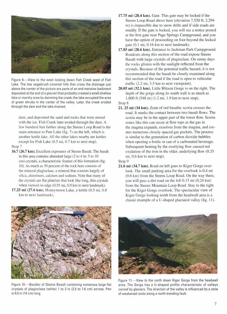
Figure 9.- View to the west looking down Fish Creek west of Fish Lake. The low sagebrush-covered hills that cross the drainage just above the center of the picture are parts of an end moraine (sediment deposited atthe end of a glacier) that probably created a small shallow lake or marshy area by damming the creek; the lake occupied the area of green shrubs in the center of the valley. Later, the creek eroded through the dam and the lake drained.
dam, and deposited the sand and rocks that were mixed with the ice. Fish Creek later eroded through the dam. A few hundred feet farther along the Steens Loop Road is the main entrance to Pate Lake (fig. 7) on the left, which is another kettle lake. All the other lakes nearby are kettles except for Fish Lake (0.5 mi, 0.7 km to next stop).
Stop 7 16.7 (26.7 km). Excellent exposures of Steens Basalt. The basalt
in this area contains abundant large (2 to 4 in; 5 to 10 em) crystals, a characteristic feature of this formation (fig. 10). As much as 50 percent of the rock here consists of the mineral plagioclase, a mineral that consists largely of silica, aluminum, calcium and sodium. Note that many of the crystals are fi at platelets that look like long, thin crystals when viewed on edge (0.55 mi, 0.9 km to next landmark).
17.25 mi (27.6 km). Honeymoon Lake, a kettle (0.5 mi, 0.8 km to next landmark).
Figure 10.-Boulder of Steens Basalt containing numerous large flat crystals of plagioclase (white) 1 to 3 in (2.5 to 7.6 em) across. Pen is 5.5 in (14 em) long.
17.75 mi (28.4 km). Gate. This gate may be locked if the Steens Loop Road above here (elevation 7,520 ft; 2,294 m) is impassible due to snow drifts and if side roads are muddy. If the gate is locked, you will see a notice posted at the first gate near Page Springs Campground, and you have the option of proceeding on foot beyond the locked gate (0.1 mi, 0.16 km to next landmark).
17.85 mi (28.6 km). Entrance to Jackman Park Campground. Roadcuts along this section of the road expose Steens Basalt with large crystals of plagioclase. On sunny days the rocks glisten with the sunlight reflected from the crystals. Because of the potential traffic hazard, it is not recommended that the basalt be closely examined along this section of the road if the road is open to vehicular traffic (2.2 mi, 3.5 km to next viewpoint).
20.05 mi (32.1 km). Little Blitzen Gorge is on the right. The depth of the gorge along its south wall is as much as 1,800 ft (548 m) (1.2 mi, 1.9 km to next stop).
Stop 8 21. 25 mi (34 km). Zone of red basaltic scoria crosses the
road. It marks the contact between two basalt flows. The scoria may be in the upper part of the lower flow. Scoria zones like this can occur at flow tops as the gas in the magma expands, exsolves from the magma, and creates numerous closely spaced gas pockets. The process is similar to the generation of carbon dioxide bubbles when opening a bottle or can of a carbonated beverage. Subsequent heating by the overlying flow caused red oxidation of the iron in the older, underlying flow (0.35 mi , 0.6 km to next stop).
Stop 9 21.6 mi (34.7 km). Road on left goes to Kiger Gorge over
look. The small parking area for the overlook is 0.4 mi (0.6 km) from the Steens Loop Road. On the way there, you will pass a dirt road on the left 0.15 mi (0.24 km) from the Steens Mountain Loop Road. Stay to the right for the Kiger Gorge overlook. The spectacular view of Kiger Gorge looking north from the headwall area is a classic example of aU-shaped glaciated valley (fig. 11).
Figure 11.- View to the north down Kiger Gorge from the headwall area. The Gorge has a U-shaped profile characteristic of valleys carved by glaciers. The direction of the valley is influenced by a zone of weakened rocks along a north-trending fault.
7
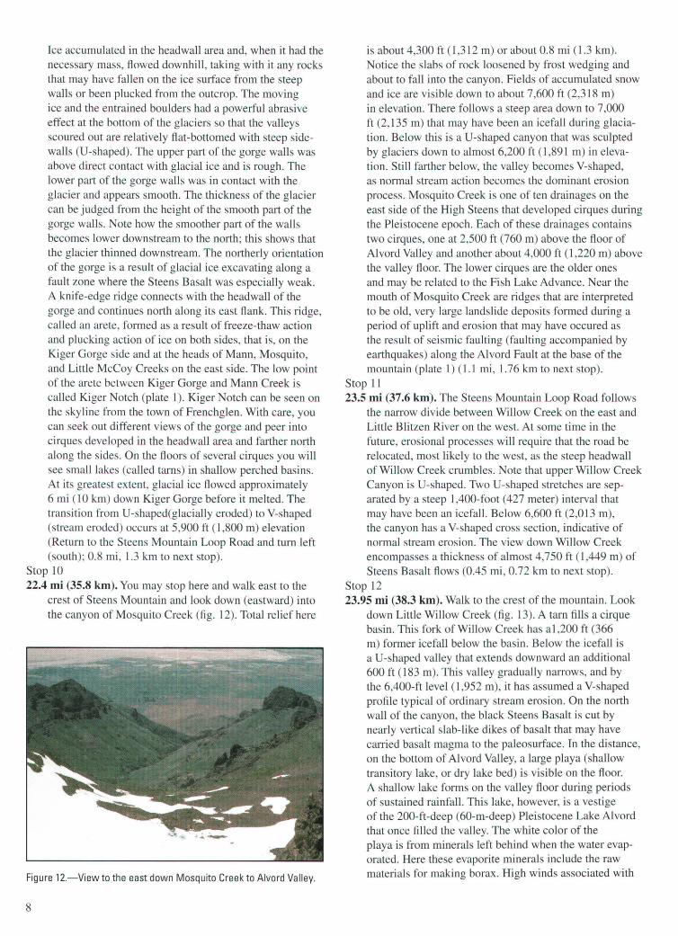
Ice accumulated in the headwall area and, when it had the necessary mass, flowed downhill, taking with it any rocks that may have fallen on the ice surface from the steep walls or been plucked from the outcrop. The moving ice and the entrained boulders had a powerful abrasive effect at the bottom of the glaciers so that the valleys scoured out are relatively flat-bottomed with steep sidewalls (U-shaped). The upper part of the gorge walls was above direct contact with glacial ice and is rough. The lower part of the gorge walls was in contact with the glacier and appears smooth. The thickness of the glacier can be judged from the height of the smooth part of the gorge walls. Note how the smoother part of the walls becomes lower downstream to the north; this shows that the glacier thinned downstream. The northerly orientation of the gorge is a result of glacial ice excavating along a fault zone where the Steens Basalt was especially weak. A knife-edge ridge connects with the headwall of the gorge and continues north along its east flank. This ridge, called an arete, formed as a result of freeze-thaw action and plucking action of ice on both sides, that is, on the Kiger Gorge side and at the heads of Mann, Mosquito, and Little McCoy Creeks on the east side. The low point of the arete between Kiger Gorge and Mann Creek is called Kiger Notch (plate 1). Kiger Notch can be seen on the skyline from the town of Frenchglen. With care, you can seek out different views of the gorge and peer into cirques developed in the headwall area and farther north along the sides. On the floors of several cirques you will see small lakes (called tarns) in shallow perched basins. At its greatest extent, glacial ice flowed approximately 6 mi (1 0 km) down Kiger Gorge before it melted. The transition from U-shaped(glacially eroded) to V-shaped (stream eroded) occurs at 5,900 ft (1,800 m) elevation (Return to the Steens Mountain Loop Road and turn left (south); 0.8 mi, 1.3 km to next stop) .
Stop 10 22.4 mi (35.8 km). You may stop here and walk east to the
crest of Steens Mountain and look down (eastward) into the canyon of Mosquito Creek (fig. 12). Total relief here
Figure 12.-View to the east down Mosquito Creek to Alvord Valley.
8
is about 4,300 ft (1,312 m) or about 0.8 mi (1.3 km). Notice the slabs of rock loosened by frost wedging and about to fall into the canyon. Fields of accumulated snow and ice are visible down to about 7,600 ft (2,318 m) in elevation. There follows a steep area down to 7,000 ft (2, 135 m) that may have been an icefall during glaciation. Below this is aU-shaped canyon that was sculpted by glaciers down to almost 6,200 ft (1 ,891 m) in elevation. Still farther below, the valley becomes V-shaped, as normal stream action becomes the dominant erosion process. Mosquito Creek is one of ten drainages on the east side of the High Steens that developed cirques during the Pleistocene epoch. Each of these drainages contains two cirques, one at 2,500 ft (760 m) above the floor of Alvord Valley and another about 4,000 ft (1,220 m) above the valley floor. The lower cirques are the older ones and may be related to the Fish Lake Advance. Near the mouth of Mosquito Creek are ridges that are interpreted to be old, very large landslide deposits formed during a period of uplift and erosion that may have occured as the result of seismic faulting (faulting accompanied by earthquakes) along the Alvord Fault at the base of the mountain (plate 1) (1.1 mi, 1.76 km to next stop).
Stop 11 23.5 mi (37 .6 km). The Steens Mountain Loop Road follows
the narrow divide between Willow Creek on the east and Little Blitzen River on the west. At some time in the future , erosional processes will require that the road be relocated, most likely to the west, as the steep headwall of Willow Creek crumbles. Note that upper Willow Creek Canyon is U -shaped. Two U -shaped stretches are separated by a steep 1,400-foot (427 meter) interval that may have been an icefall. Below 6,600 ft (2,013 m), the canyon has a V-shaped cross section, indicative of normal stream erosion. The view down Willow Creek encompasses a thickness of almost 4,750 ft (1,449 m) of Steens Basalt flows (0.45 mi, 0.72 km to next stop).
Stop 12 23.95 mi (38.3 km). Walk to the crest of the mountain. Look
down Little Willow Creek (fig. 13). A tarn fills a cirque basin. This fork of Willow Creek has a1 ,200ft (366 m) former icefall below the basin. Below the icefall is aU-shaped valley that extends downward an additional 600ft (183 m). This valley gradually narrows, and by the 6,400-ft level (1,952 m), it has assumed a V-shaped profile typical of ordinary stream erosion. On the north wall of the canyon, the black Steens Basalt is cut by nearly vertical slab-like dikes of basalt that may have carried basalt magma to the paleosurface. In the distance, on the bottom of Alvord Valley, a large playa (shallow transitory lake, or dry lake bed) is visible on the floor. A shallow lake forms on the valley floor during periods of sustained rainfall. This lake, however, is a vestige of the 200-ft-deep (60-m-deep) Pleistocene Lake Alvord that once filled the valley. The white color of the playa is from minerals left behind when the water evaporated. Here these evaporite minerals include the raw materials for making borax. High winds associated with

Figure 13.-View to the east down Little Willow Creek to Alvord Valley.
dry summer storms create dust storms on the playa, during which very fine material is canied out of Alvord Valley, generally to the east (0.2 mi, 0.32 km to next landmark).
24.15 mi (38.6 km). Rock shelter on west (right) side of Steens Mountain Loop Road. Probably built by cowboys or sheepherders for protection from prevailing westerly winds. This entire upland area was formerly used as summer grazing pasture for cattle and sheep (0.15 mi, 0.24 km to next stop).
Stop 13 24.3 mi (38.9 km). Road on left goes to the East Overlook
at an elevation close to 9,730 ft (2,967 m). The side road from the main road to the parking area near the crest is 0.25 mi (0.4 km) long. From this overlook one can see a panorama of the High Steens and, in the background, the perennial lakes in northern Alvord Valley and the lower crest of the North Steens (fig. 14). Northward along
Figure 14.-View to the northeast along east scarp of Steens Mountain. Mann Lake is visible in the low country east of Steens Mountain. The lower North Steens is visible in the upper part of the figure left of center. Rocks cropping out along Steens Mountain are Steens Basalt. A few nearly vertical basalt dikes cut the horizontal basalt flows (lower right).
-N s-
the crest of Steens Mountain you can see that the basalt flows are inclined as much as 1 oo to the west; in the background, the generally lower North Steens block is down-dropped along the north branch of the Brothers Fault Zone (plate 1). Some of the basalt flows shown in figure 14 along the east scarp of the mountain (center foreground) dip to the east, probably as a result of sagging owing to removal of supporting rock by erosion (Return to the Steens Mountain Loop Road; 200ft, 61 m to next landmark).
24.2 mi (38.7 km). The road forks. Take left fork which heads south to the radio repeater station (0.6 mi, 0.96 km to next stop).
Stop 14 24.8 mi (39.7 km). Walk east 500ft (152m) to the crest
of Steens Mountain. Look down into Cottonwood Creek. Much of the canyon has a V-shaped stream-produced erosional profile, although it is clear that the erosion of the upper 3,000 ft (915 m) of the canyon was dominated by glacial processes. The geomorphic feature that most suggests ice erosion is the U-shaped valley profile between 6,600 and 7,000 ft (2,013 and 2,135 m) elevation (0.2 mi, 0.32 km to next stop).
Stop 15 25 mi (40 m). Walk east 500ft (152m) to the crest of Steens
Mountain. Look down into the drainage of Big Alvord Creek (fig. 15). A tarn is present about 600ft (183m) below the rim in aU-shaped segment of the canyon. Below this segment, the creek flows and falls 1,800 ft (549 m) over a steep segment of the canyon that may have been an icefall during glaciation. AU-shaped valley profile occurs below the steep segment. Below about 6,200 ft ( 1,891 m) the valley profile has the V-shape typical of stream erosion. Devine Rock, a prominent butte located on the divide between Cottonwood and Big Alvord Creeks, is an erosional remnant of Steens Basalt (dark brown; map unit Tsb, fig. 12; plate 1) that overlies the older gray and rusty brown volcanic and sedimentary rock of the Steens Mountain Volcanics (map unit Tsv; fig.
9
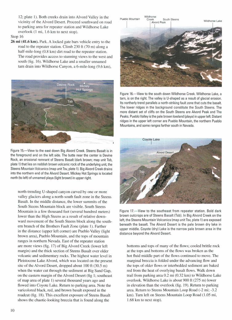
12; plate 1). Both creeks drain into Alvord Valley in the vicinity of the Alvord Desert. Proceed southward on road to parking area for repeater station and Wildhorse Lake overlook (1 mi, 1.6 krn to next stop).
Stop 16 26 mi (41.6 km). Park. A locked gate bars vehicle entry to the
road to the repeater station. Climb 230 ft (70 m) along a half-mile-long (0.8 krn) dirt road to the repeater station. The road provides access to stunning views to the west and south (fig. 16). Wildhorse Lake and a smaller unnamed tarn drain into Wildhorse Canyon, a 6-mile-long (9.6 krn) ,
Figure 15.-View to the east down Big Alvord Creek. Steens Basalt is in the foreground and on the left side. The butte near the center is Devine Rock, an erosional remnant of Steens Basalt (dark brown; map unit Tsb, plate 1) that lies on reddish brown volcanic rock of the underlying unit, the Steens Mountain Volcanics (map unit Tsv, plate 1 ). Big Alvord Creek drains into the northern end of the Alvord Desert. Mickey Hot Springs is located north (to left) of unnamed playa (light brown) in upper right.
10
north-trending U-shaped canyon carved by one or more valley glaciers along a north-south fault zone in the Steens Basalt. In the middle distance, the lower summits of the South Steens Mountain block are visible. South Steens Mountain is a few thousand feet (several hundred meters) lower than the High Steens as a result of relative downward movement of the South Steens block along the southern branch of the Brothers Fault Zone (plate 1). Farther in the distance (upper left corner) are Pueblo Valley (light brown area), Pueblo Mountain, and the tops of mountain ranges in northern Nevada. East of the repeater station are more views (fig. 17) of Big Alvord Creek (lower left margin) and the thick section of Steens Basalt over older volcanic and sedimentary rocks. The highest water level in Pleistocene Lake Alvord, which was located on the present site of the Alvord Desert, dropped about 100ft (30.5 m) when the water cut through the sediment at Big Sand Gap, on the eastern margin of the Alvord Desert (fig 1; southeast of map area of plate 1) several thousand years ago and flowed into Coyote Lake. Return to parking area. Note the varicolored black, red, and brown basalt exposed in the roadcut (fig. 18). This excellent exposure of Steens Basalt shows the chaotic-looking breccia that is found along the
Wildhorse Pueblo Mountain Creek South Steens
Alvord Peak Wildhorse Lake
I
Figure 16.- View to the south down Wild horse Creek. Wild horse Lake, a tarn, is on the right. The valley is U-shaped as a result of glacial erosion. Its northerly trend parallels a north-striking fault zone that cuts the basalt. The lower ridges in the background constitute the South Steens. The more distant set of cliffs on the South Steens are Alvord Peak and The Peaks. Pueblo Valley is the pale brown lowland (playa) in upper left. Distant ridges in the upper left corner are Pueblo Mountain, the northern Pueblo Mountains, and some ranges farther south in Nevada.
Coyote Lake I
Figure 17.-View to the southeast from repeater station. Bold dark brown outcrops are of Steens Basalt (Tsb). In Big Alvord Creek on the left, the Steens Mountain Volcanics (map unit Tsv, plate 1) are exposed beneath the basalt. The Alvord Desert is the pale brown dry lake in upper middle. Coyote (dry) Lake is the narrow pale brown area in the distance beyond the Alvord Desert.
bottoms and tops of many of the flows; cooled brittle rock at the tops and bottoms of the flows was broken as the hot fluid middle part of the flows continued to move. The marginal breccia is folded under the advancing flow and the tops of older flows or interbedded sediment are baked red from the heat of overlying basalt flows. Walk down trail from parking area 0.2 mi (0.32 km) to Wildhorse Lake overlook. Wildhorse Lake is about 900ft (275m) lower in elevation than the overlook (fig. 19). Return to parking area. Return to Steens Mountain Loop Road ( -2 mi; -3.2 km). Turn left on Steens Mountain Loop Road (1.05 mi, 1.68 km to next stop).
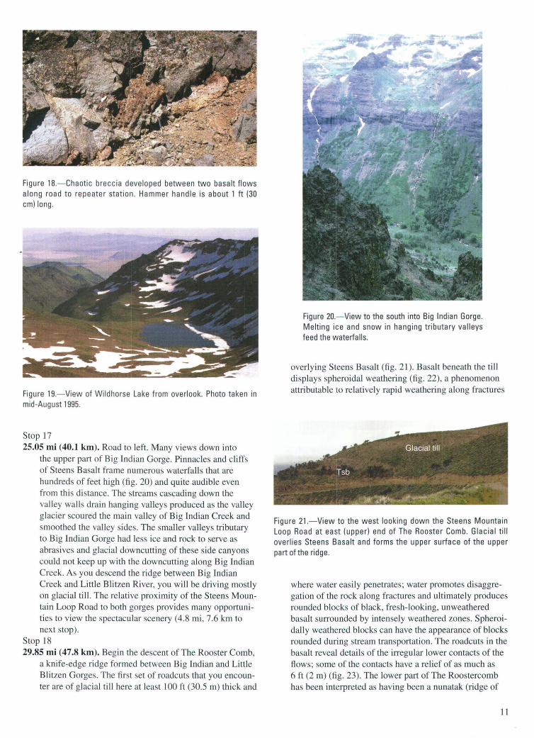
Figure 18.-Chaotic breccia developed between two basalt flows along road to repeater station. Hammer handle is about 1 ft (30 em) long.
Figure 19.-View of Wildhorse Lake from overlook. Photo taken in mid-August 1995.
Stop 17 25.05 mi (40.1 km). Road to left. Many views down into
the upper part of Big Indian Gorge. Pinnacles and cliffs of Steens Basalt frame numerous waterfalls that are hundreds of feet high (fig. 20) and quite audible even from this distance. The streams cascading down the valley walls drain hanging valleys produced as the valley glacier scoured the main valley of Big Indian Creek and smoothed the valley sides. The smaller valleys tributary to Big Indian Gorge had less ice and rock to serve as abrasives and glacial downcutting of these side canyons could not keep up with the downcutting along Big Indian Creek. As you descend the ridge between Big Indian Creek and Little Blitzen River, you will be driving mostly on glacial till. The relative proximity of the Steens Mountain Loop Road to both gorges provides many opportunities to view the spectacular scenery ( 4.8 mi, 7.6 km to next stop).
Stop 18 29.85 mi (47.8 km). Begin the descent of The Rooster Comb,
a knife-edge ridge formed between Big Indian and Little Blitzen Gorges. The first set of roadcuts that you encounter are of glacial till here at least 100ft (30.5 m) thick and
Figure 20.- View to the south into Big Indian Gorge. Melting ice and snow in hanging tributary valleys feed the waterfalls.
overlying Steens Basalt (fig. 21). Basalt beneath the till displays spheroidal weathering (fig. 22), a phenomenon attributable to relatively rapid weathering along fractures
Figure 21.-View to the west looking down the Steens Mountain Loop Road at east (upper) end of The Rooster Comb. Glacial till overlies Steens Basalt and forms the upper surface of the upper part of the ridge.
where water easily penetrates; water promotes disaggregation of the rock along fractures and ultimately produces rounded blocks of black, fresh-looking, unweathered basalt surrounded by intensely weathered zones. Spheroidally weathered blocks can have the appearance of blocks rounded during stream transportation. The roadcuts in the basalt reveal details of the irregular lower contacts of the flows; some of the contacts have a relief of as much as 6ft (2m) (fig. 23). The lower part of The Roostercomb has been interpreted as having been a nunatak (ridge of
11
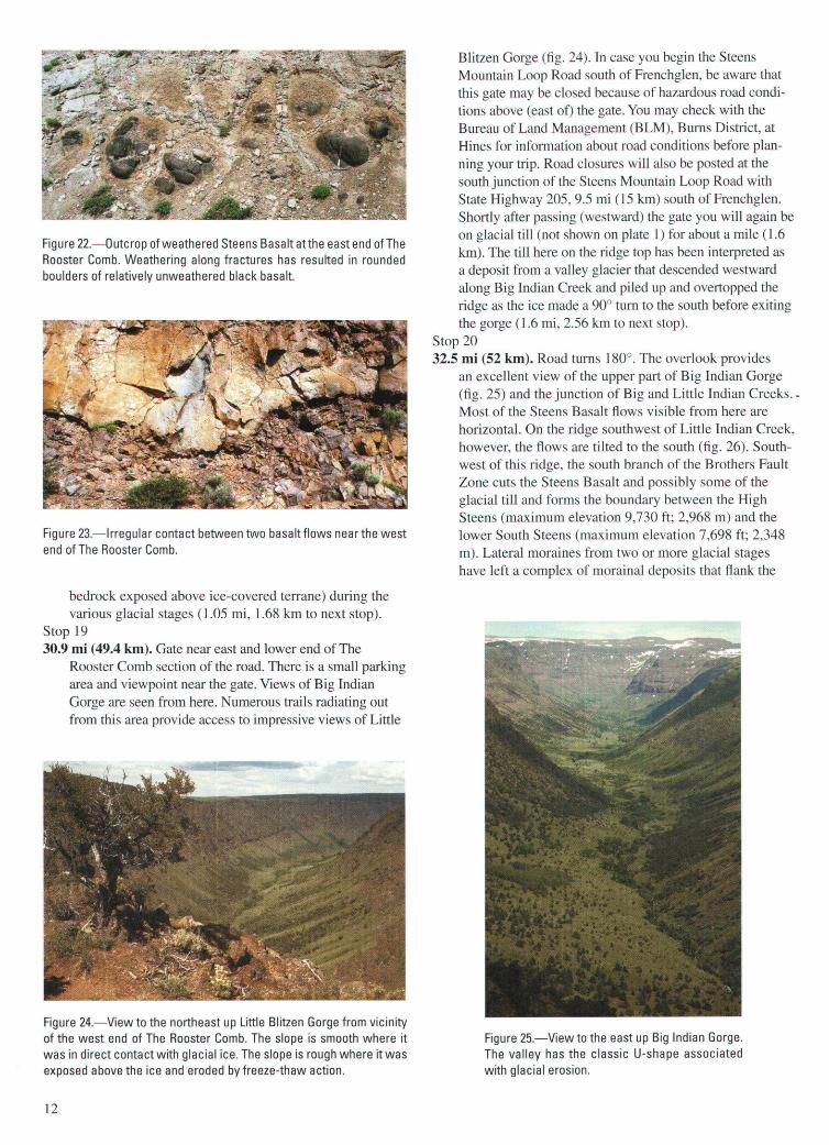
Figure 22.-0utcrop of weathered Steens Basalt atthe east end of The Rooster Comb. Weathering along fractures has resulted in rounded boulders of relatively unweathered black basalt.
Figure 23.- lrregular contact between two basalt flows near the west end of The Rooster Comb.
bedrock exposed above ice-covered terrane) during the various glacial stages (1.05 mi, 1.68 km to next stop).
Stop 19 30.9 mi (49.4 km). Gate near east and lower end of The
Rooster Comb section of the road. There is a small parking area and viewpoint near the gate. Views of Big Indian Gorge are seen from here. Numerous trails radiating out from this area provide access to impressive views of Little
Figure 24.- View to the northeast up Little Blitzen Gorge from vicinity of the west end of The Rooster Comb. The slope is smooth where it was in direct contact with glacial ice. The slope is rough where it was exposed above the ice and eroded by freeze-thaw action.
12
Blitzen Gorge (fig. 24). In case you begin the Steens Mountain Loop Road south of Frenchglen, be aware that this gate may be closed because of hazardous road conditions above (east of) the gate. You may check with the Bureau of Land Management (BLM), Burns District, at Hines for information about road conditions before planning your trip. Road closures will also be posted at the south junction of the Steens Mountain Loop Road with State Highway 205, 9.5 mi (15 km) south of Frenchglen. Shortly after passing (westward) the gate you will again be on glacial till (not shown on plate 1) for about a mile (1.6 km). The till here on the ridge top has been interpreted as a deposit from a valley glacier that descended westward along Big Indian Creek and piled up and overtopped the ridge as the ice made a 90° turn to the south before exiting the gorge (1.6 mi, 2.56 km to next stop).
Stop 20 32.5 mi (52 km). Road turns 180°. The overlook provides
an excellent view of the upper part of Big Indian Gorge (fig. 25) and the junction of Big and Little Indian Creeks.Most of the Steens Basalt flows visible from here are horizontal. On the ridge southwest of Little Indian Creek, however, the flows are tilted to the south (fig. 26). Southwest of this ridge, the south branch of the Brothers Fault Zone cuts the Steens Basalt and possibly some of the glacial till and forms the boundary between the High Steens (maximum elevation 9,730 ft; 2,968 m) and the lower South Steens (maximum elevation 7,698 ft; 2,348 m). Lateral moraines from two or more glacial stages have left a complex of morainal deposits that flank the
Figure 25.-View to the east up Big Indian Gorge. The valley has the classic U-shape associated with glacial erosion.
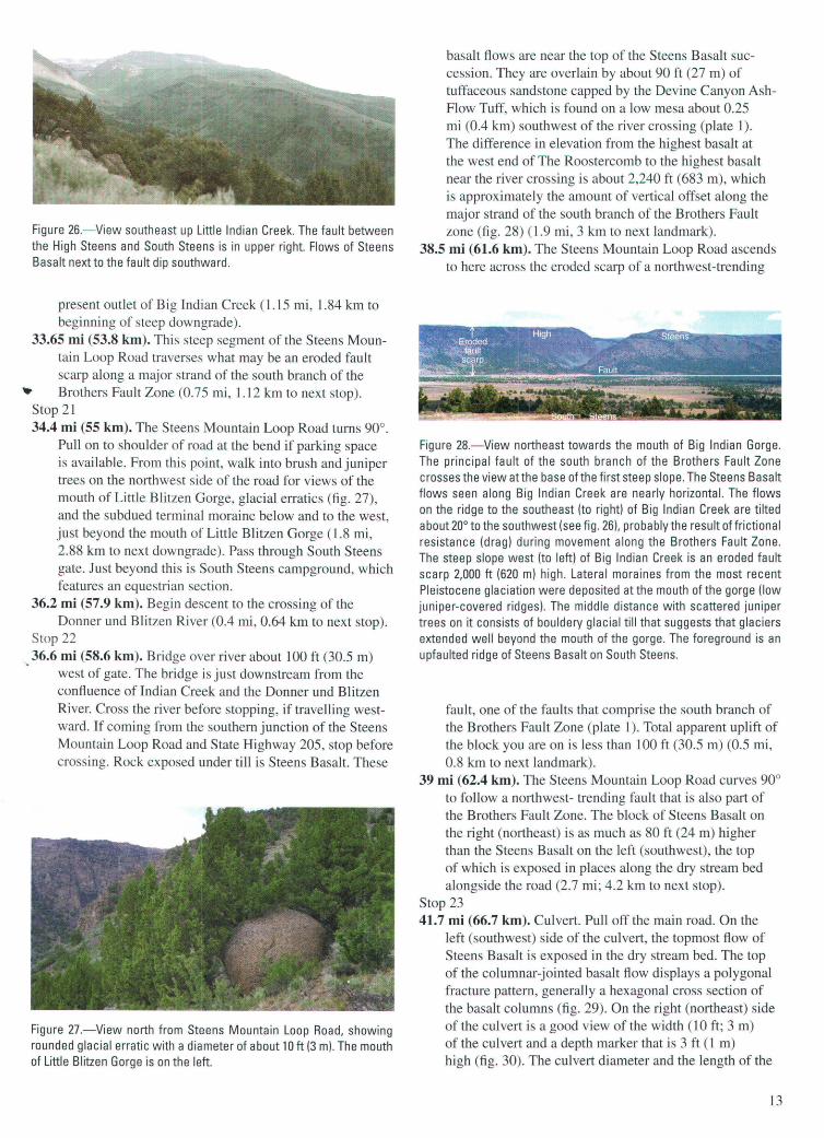
Figure 26.- View southeast up Little Indian Creek. The fault between the High Steens and South Steens is in upper right. Flows of Steens Basalt next to the fault dip southward.
present outlet of Big Indian Creek (1.15 mi, 1.84 km to beginning of steep downgrade).
33.65 mi (53.8 km). This steep segment of the Steens Mountain Loop Road traverses what may be an eroded fault scarp along a major strand of the south branch of the
_. Brothers Fault Zone (0.75 mi, 1.12 km to next stop). Stop 21 34.4 mi (55 km). The Steens Mountain Loop Road turns 90°.
Pull on to shoulder of road at the bend if parking space is available. From this point, walk into brush and juniper trees on the northwest side of the road for views of the mouth of Little Blitzen Gorge, glacial erratics (fig. 27), and the subdued terminal moraine below and to the west, just beyond the mouth of Little Blitzen Gorge ( 1.8 mi, 2.88 km to next downgrade). Pass through South Steens gate. Just beyond this is South Steens campground, which features an equestrian section.
36.2 mi (57.9 km). Begin descent to the crossing of the Donner und Blitzen River (0.4 mi, 0.64 km to next stop).
Stop 22 "" 36.6 mi (58.6 km). Bridge over river about 100ft (30.5 m)
west of gate. The bridge is just downstream from the confluence of Indian Creek and the Donner und Blitzen River. Cross the river before stopping, if travelling westward. If coming from the southern junction of the Steens Mountain Loop Road and State Highway 205, stop before crossing. Rock exposed under till is Steens Basalt. These
Figure 27.- View north from Steens Mountain Loop Road, showing rounded glacial erratic with a diameter of about 10ft (3m). The mouth of Little Blitzen Gorge is on the left.
basalt flows are near the top of the Steens Basalt succession. They are overlain by about 90 ft (27 m) of tuffaceous sandstone capped by the Devine Canyon AshFlow Tuff, which is found on a low mesa about 0.25 mi (0.4 km) southwest of the river crossing (plate 1). The difference in elevation from the highest basalt at the west end of The Roostercomb to the highest basalt near the river crossing is about 2,240 ft (683 m), which is approximately the amount of vertical offset along the major strand of the south branch of the Brothers Fault zone (fig. 28) (1.9 mi, 3 km to next landmark).
38.5 mi (61.6 km). The Steens Mountain Loop Road ascends to here across the eroded scarp of a northwest-trending
Figure 28.- View northeast towards the mouth of Big Indian Gorge. The principal fault of the south branch of the Brothers Fault Zone crosses the view at the base of the first steep slope. The Steens Basalt flows seen along Big Indian Creek are nearly horizontal. The flows on the ridge to the southeast (to right) of Big Indian Creek are tilted about 20° to the southwest (see fig. 26), probably the result of frictional resistance (drag) during movement along the Brothers Fault Zone. The steep slope west (to left) of Big Indian Creek is an eroded fault scarp 2,000 ft (620 m) high. Lateral moraines from the most recent Pleistocene glaciation were deposited at the mouth of the gorge (low juniper-covered ridges). The middle distance with scattered juniper trees on it consists of bouldery glacial till that suggests that glaciers extended well beyond the mouth of the gorge. The foreground is an upfaulted ridge of Steens Basalt on South Steens.
fault, one of the faults that comprise the south branch of the Brothers Fault Zone (plate 1). Total apparent uplift of the block you are on is less than 100ft (30.5 m) (0.5 mi, 0.8 km to next landmark).
39 mi (62.4 km). The Steens Mountain Loop Road curves 90° to follow a northwest- trending fault that is also part of the Brothers Fault Zone. The block of Steens Basalt on the right (northeast) is as much as 80 ft (24 m) higher than the Steens Basalt on the left (southwest), the top of which is exposed in places along the dry stream bed alongside the road (2.7 mi; 4.2 km to next stop).
Stop 23 41.7 mi (66.7 km). Culvert. Pull off the main road. On the
left (southwest) side of the culvert, the topmost flow of Steens Basalt is exposed in the dry stream bed. The top of the columnar-jointed basalt flow displays a polygonal fracture pattern, generally a hexagonal cross section of the basalt columns (fig. 29). On the right (northeast) side of the culvert is a good view of the width (10ft; 3 m) of the culvert and a depth marker that is 3 ft ( 1 m) high (fig. 30). The culvert diameter and the length of the
13

Figure 29.-The polygonal tops of columnar jointed Steens Basalt. This flow is the uppermost flow of the Steens Basalt succession.
depth marker indicate the amount of water and sediment that can be expected to flow through the culvert during flash floods and emphasize the danger of being in canyon bottoms at such times (0.1 mi, 0.16 km to next landmark).
41.8 mi (66.9 km). Road bends 90° and goes generally west (2.45 m,; 3.92 km to next landmark).
44.35 mi (70.8 km). Road curves to the northwest (1 mi, 1.6 km to next landmark).
45.35 mi (72.6 km). Road bends 90° to the southwest (0.6 mi, 0.96 km to next landmark).
45.95 mi (73.5 km). The Steens Mountain Loop Road again turns 90° to the northwest. The road descends about 60ft (18 m) and crosses a narrow north-trending valley. Steens Basalt is exposed along this part of the road (0.8 mi, 1.2 km to next landmark).
46.75 mi (74.8 km). Road bends about 90° north to follow a depression eroded along a generally north-trending fault. The rocks in the half-mile-wide valley between the two north-trending faults has been downdropped 60 to 80 ft (18 to 24m), increasing to about 100ft (30.5 m) to the north (1.3 mi, 2.08 km to next landmark).
48.05 mi (76.9 km). Pale gray outcrops of Devine Canyon Ash-Flow Tuff are exposed along a dry stream bed to the right (east). Devine Canyon Ash-Flow Tuff caps the Steens Basalt on the ridge to the left. These stratigraphic relations indicate that you are near the top of the Steens
Figure 30.-Ten-foot-wide culvert under Steens Mountain Loop Road. Three-foot-tall flood gauge on the right.
14
Basalt and that the local vertical offset on the northtrending fault on the west side of the valley is about 80 ft (24 m) (0.95 mi, 1.52 km to next landmark).
49 mi (7 .4 km). Steens Mountain Loop Road turns northwest (left) into upper Black Canyon, which exposes Steens Basalt (0.7 mi, 1.12 km to next landmark).
49.5 mi (79.5 km). Gate (0.25 mi, 0.4 km to next landmark). 49.95 mi (79.9 km). Road crosses Kueny Creek (plate 1).
Rock exposed on both sides of the creek is Steens Basalt. These are the last good outcrops of the basalt that you will see along the Steens Mountain Loop Road as you go west. The entire stratigraphic section is dipping at a low angle to the west so that you have been generally ascending through the stratigraphic section. To the west of here you will see westerly inclined mesas capped with Devine Canyon Ash-Flow Tuff, which is about 4ft (1.2 m) thick. (2.6 mi, 4.2 km to next stop).
Stop 24 52.55 mi (84.1 km). Intersection of Steens Mountain Loop
Road with State Highway 205. If you travel the Steens .., Loop Road from the south end, a large sign near here will indicate road closures, if any. You have the option of proceeding on foot beyond the locked gates. Highway 205 lies along the eastern margin of Catlow Valley. Catlow Valley is a topographic and structural depression that was produced by tectonic extension in an east-west direction. In this case, the rocks under Catlow Valley were relatively down faulted. In the Pleistocene, the valley was filled by a lake, the shoreline terraces of which can be seen along the east side of the road 2 mi (3.2 km) to the south of here. Turn right (north) and proceed towards Frenchglen (9.5 mi; 15 km) to complete the guided loop (5.3 mi, 8.48 km to next stop). Turn left (south) if you wish to go to Fields ( 46 mi; 73.6 km.
Stop 25 57.85 mi (92.6 km). To the west across this northern end
of Catlow Valley is a group of mesas named LaVoy Tables (fig. 31 ). The steep slope on the east side of the LaVoy Tables is the result of faulting and erosion The stratigraphic cross section exposed in the cliff shows Steens Basalt exposed in the lower cliffs, overlain by poorly lithified sediments and volcanic ash. Capping the mesa is the Rattlesnake Ash-Flow Tuff. (1.5 mi, 2.4 km to next stop).
Stop 26 59.35 mi (95 km). Road on left (west) side of road goes to
a borrow pit which has been excavated enough to show some of the upper sedimentary beds that fill this part of Catlow Valley. The cliffs on the west side of Catlow Valley are part of southern Jackass Mountain, which is the complexly faulted mountain, principally of Steens Basalt, west of Frenchglen (see fig. 3; plate 1). The narrow valley that contains the pit and the sand and gravel deposits exposed there were formed as a result of down-dropping of basalt and the overlying ash-flow tuffs and sediments on the eastern side of the valley and deposition of sediment eroded from the surrounding high country (1.4 mi, 1.76 km to next landmark).
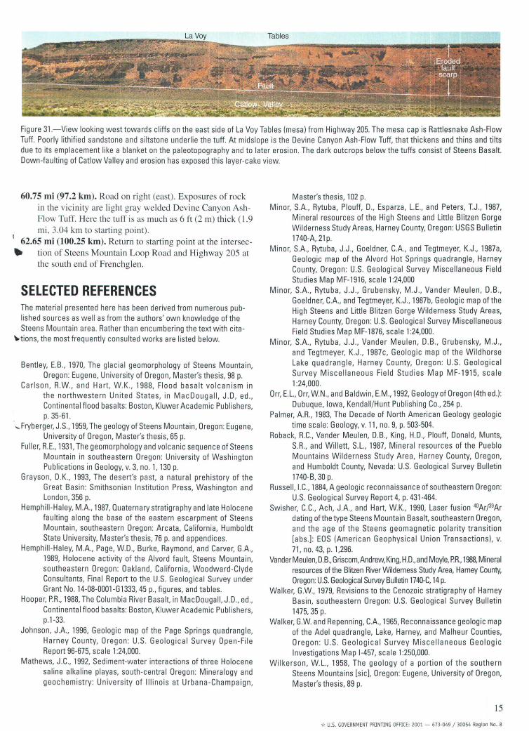
Figure 31 .-View looking west towards cliffs on the east side of LaVoy Tables (mesa) from Highway 205. The mesa cap is Rattlesnake Ash-Flow Tuff. Poorly lithified sandstone and siltstone underlie the tuff. At midslope is the Devine Canyon Ash-Flow Tuff, that thickens and thins and tilts due to its emplacement like a blanket on the paleotopography and to later erosion. The dark outcrops below the tuffs consist of Steens Basalt. Down-faulting of Catlow Valley and erosion has exposed this layer-cake view.
60.75 mi (97.2 km). Road on right (east). Exposures of rock in the vicini ty are light gray welded Devine Canyon AshFlow Tuff. Here the tuff is as much as 6ft (2 m) thick (1 .9 mi, 3.04 km to starting point).
62.65 mi (100.25 km). Return to starting point at the intersec-.. tion of Steens Mountain Loop Road and Highway 205 at
the south end of Frenchglen.
SELECTED REFERENCES The material presented here has been derived from numerous published sources as well as from the authors' own knowledge of the Steens Mountain area . Rather than encumbering the text with cita-
-.tions, the most frequently consulted works are listed below.
Bentley, E.B., 1970, The glacial geomorphology of Steens Mountain, Oregon: Eugene, University of Oregon, Master's thesis, 98 p.
Carlson , R.W., and Hart, W.K., 1988, Flood basalt volcanism in the northwestern Un ited States, in MacDougall, J.D, ed ., Continental flood basalts: Boston, Kluwer Academic Publishers, p. 35-61.
....... Fryberger, J.S., 1959, The geology of Steens Mountain, Oregon: Eugene, University of Oregon, Master's thesis, 65 p.
Fuller, R.E., 1931, The geomorphology and volcanic sequence of Steens Mountain in southeastern Oregon: University of Washington Publications in Geology, v. 3, no. 1, 130 p.
Grayson, O.K., 1993, The desert's past, a natural prehistory of the Great Basin: Smithsonian Institution Press, Washington and London, 356 p.
Hemphill-Haley, M.A., 1987, Quaternary stratigraphy and late Holocene faulting along the base of the eastern escarpment of Steens Mountain, southeastern Oregon: Arcata, California, Humboldt State University, Master's thesis, 76 p. and appendices.
Hemphill-Haley, M.A., Page, W.O., Burke, Raymond, and Carver, G.A., 1989, Holocene activity of the Alvord fault, Steens Mountain, southeastern Oregon: Oakland, California, Woodward-Clyde Consultants, Final Report to the U.S. Geological Survey under Grant No. 14-08-0001-G1333, 45 p., figures, and tables.
Hooper, P.R., 1988, The Columbia River Basalt, in MacDougall, J.D., ed., Continental flood basalts: Boston, Kluwer Academic Publishers, p.1-33.
Johnson, J.A., 1996, Geologic map of the Page Springs quadrangle, Harney County, Oregon : U.S. Geological Survey Open -File Report 96-675, scale 1:24,000.
Mathews, J.C., 1992, Sediment-water interactions of three Holocene saline alkaline playas, south-central Oregon: Mineralogy and geochemistry: University of Illinois at Urbana-Champaign,
Master's thesis, 102 p. Minor, S.A., Rytuba, Plouff, D., Esparza, L.E., and Peters, T.J., 1987,
Mineral resources of the High Steens and Little Blitzen Gorge Wilderness Study Areas, Harney County, Oregon: USGS Bulletin 1740-A,21p.
Minor, S.A., Rytuba, J.J., Goeldner, C.A., and Tegtmeyer, K.J ., 1987a, Geologic map of the Alvord Hot Springs quadrangle, Harney County, Oregon: U.S. Geological Survey Miscellaneous Field Studies Map MF-1916, scale 1:24,000
Minor, S.A., Rytuba, J.J., Grubensky, M.J ., Vander Meulen, D.B., Goeldner, C.A., and Tegtmeyer, K.J., 1987b, Geologic map of the High Steens and Little Blitzen Gorge Wilderness Study Areas, Harney County, Oregon: U.S. Geological Survey Miscellaneous Field Studies Map MF-1876, scale 1:24,000.
Minor, S.A., Rytuba, J.J., Vander Meulen, D.B., Grubensky, M.J., and Tegtmeyer, K.J ., 1987c, Geologic map of the Wildhorse Lake quadrangle, Harney County, Oregon: U.S. Geological Survey Miscellaneous Field Studies Map MF-1915, scale 1:24,000.
Orr, E.L., Orr, W.N., and Baldwin, E.M., 1992, Geology of Oregon (4th ed.): Dubuque, Iowa, Kendall/Hunt Publishing Co., 254 p.
Palmer, A.R., 1983, The Decade of North American Geology geologic time scale: Geology, v. 11, no. 9, p. 503-504 .
Roback, R.C., Vander Meulen, D.B., King, H.D., Plouff, Donald, Munts, S.R., and Willett, S.L., 1987, Mineral resources of the Pueblo Mountains Wilderness Study Area, Harney County, Oregon, and Humboldt County, Nevada: U.S. Geological Survey Bulletin 1740-B, 30 p.
Russell , I. C., 1884, A geologic reconnaissance of southeastern Oregon: U.S. Geological Survey Report 4, p. 431-464.
Swisher, C.C., Ach, J.A., and Hart, W.K., 1990, Laser fusion 40Arf39Ar dating of the type Steens Mountain Basalt, southeastern Oregon, and the age of the Steens geomagnetic polarity transition [abs.]: EOS (American Geophysical Union Transactions), v. 71, no. 43, p. 1,296.
VanderMeulen, D.B., Griscom, Andrew, King, H.D., and Mayle, P.R., 1988, Mineral resources of the Blitzen River Wilderness Study Area, Harney County, Oregon: U.S. Geological Survey Bulletin 1740-C, 14 p.
Walker, G.W., 1979, Revisions to the Cenozoic stratigraphy of Harney Basin, southeastern Oregon: U.S. Geological Survey Bulletin 1475, 35 p.
Walker, G.W. and Repenning, C.A., 1965, Reconnaissance geologic map of the Adel quadrangle, Lake, Harney, and Malheur Counties, 0 regan: U.S. Geologica I Survey Miscellaneous G eo logic Investigations Map 1-457, scale 1:250,000.
Wilkerson, W.L., 1958, The geology of a portion of the southern Steens Mountains [sic], Oregon: Eugene, University of Oregon, Master's thesis, 89 p.
15
-t< U.S. GOVERNM ENT PRINTING OFFICE: 2001 - 673-049 / 30054 Region No. 8