quicksilver deposits in the steens and … · low crescent of northerly trend in the eastern part...
TRANSCRIPT

UNITED STATES DEPARTMENT OF THE INTERIOR Harold L. Ickes, Secretary
GEOLOGICAL SURVEY W. C. Mendenhall, Director
Bulletin 931-J
QUICKSILVER DEPOSITS IN THE
STEENS AND PUEBLO MOUNTAINS
SOUTHERN OREGON
BY
CLYDE P. ROSS
Strategic Minerals Investigations, 1941 (Pages 227-258)
UNITED STATES
GOVERNMENT PRINTING OFFICE
WASHINGTON : 1942
For sale by the Superintendent of Documents, Washington, D. C. ------- Price 40 cents


CONTENTS
Page
Abstract.................................................. 227Introduction.............................................. 227
Location.............................................. 227Scope of the report................................... 229Acknowledgments....................................... 229
Topography................................................ 230Geology................................................... 232
Pre-Tertiary rocks.................................... 232Age............................................... 232
Tertiary volcanic rocks............................... 232Age............................................... 235
Older alluvium........................................ 236Quaternary alluvium................................... 237Structure............................................. 237
Quicksilver deposits...................................... 240Mineralogy............................................. 240The lodes............................................. 244Origin................................................ 246Outlook............................................... 247
Prospects................................................. 249Steens Mountain prospect.............................. 249Fisher group.......................................... 250Lucky Strike and adjacent prospects................... 251Claims near Sesena Creek.............................. 255The Red King group.................................... 255The Rabbit Hole group................................. 256The Blue Bull group................................... 256Arizona mine.......................................... 257Prospects on Pueblo Mountain.......................... 257
ILLUSTRATIONS
Page
Plate 39o Geologic sketch map of parts of the Steens and Pueblo Mountains, Harney County, Oregon.................................. In pocket
40. Geologic sketch map of the tunnel at theSteens Mountain prospect..................... 250
41. The lodes of the Fisher group.................. 25042. Geologic and topographic map of the Lucky
Strike group and adjacent ground............. 25443. The lodes on the Mogul, Blair, and O'Keefe
groups and adjacent ground................... 25444. Geologic and topographic map of the Rabbit Hole
and Red King prospects near Fields, Oregon... 254 Figure 23. Index map of Oregon, showing the location of
the Steens and Pueblo Mountains.............. 228
III


QUICKSILVER DEPOSITS IN THE
STEENS AND PUEBLO MOUNTAINS, SOUTHERN OREGON
By Clyde P. Ross
ABSTRACT
The Steens and Pueblo mountain ranges together form a shal low crescent of northerly trend in the eastern part of Harney County, Oreg. They contain more than 15 quicksilver prospects and a few that were opened for gold and copper. Most of the area is underlain by flexed and faulted Tertiary lava, but pre- Tertiary metamorphic and igneous rocks are exposed in the south ern part. Part of the eastern flank of the mountains consists of somewhat deformed alluvial deposits, which are younger than the lava but older than the lacustrine and alluvial deposits on the valley floors.
The lavas along the east side of the mountains have under gone rather extensive hydrothermal alteration. At intervals for a distance of about 30 miles they contain mineralized fracture zones, in most of which mercurial tetrahedrite and cinnabar are the principal valuable minerals. The pre-Tertiary rocks in the southern part of the mountains also contain lodes; These were first explored for gold and copper, but locally they contain quicksilver as well.
Although the presence of quicksilver deposits in the Steens ' and Pueblo Mountains has been known for 40 years, they have been very little explored and probably less than 10 flasks of quick silver has been produced from them. The lodes on the whole are of low grade, although they contain rich pockets, some of which may have formed in the zone of weathering. The low average ten or, coupled with the large size of some of the lodes and the metallurgical problems introduced by the unusual mineralogy, suggest that the area may be better adapted to exploration by large, well-equipped organizations than to working by individual operators. If keen demand for quicksilver continues, this re gion should be considered as a possible source of supply.
INTRODUCTION
Location
The Steens and Pueblo Mountains, in eastern Harney County,
Oreg., together form an essentially continuous range, resembling
227

228 STRATEGIC MINERALS INVESTIGATIONS, 1941
a shallow crescent in plan, which extends from near the 43° par
allel of latitude almost due south past the Oregon-Nevada bound
ary, which is the 42° parallel (fig. 23). This part of Oregon
is a sparsely settled region, devoted to stock raising. The
supply centers are Burns, Oreg., and Winnemucca, Nev. The prin
cipal settlements close to the prospects are Andrews, Fields,
and Denio. The last-named, which is at the State boundary, is
by far the largest of the three. According to the 1940 census,
320° "Off HO" 117'
Figure 23. Index map of Oregon, showing the location of the Steens andPue'blo Mountains.
the Denlo precinct contains 158 people and the Andrews precinct
125, but most of these live at scattered ranches in Alvord Val
ley.
Denio is about a hundred miles from Winnemucca, Nev., by a
road which is partly paved and partly surfaced with gravel.
Prom Denio to Fields there is a dirt road, about 23 fflilSS lOIlgj
that is easily passable in dry weather. Prom Fields one road,
approximately 118 miles long, extends across the mountains to

QUICKSILVER IN THE STEENS AND PUEBLO MOUNTAINS, OREGON 229
the west and goes through Prenchglen and Narrows to Burns. An
other, roughly 134 miles long, passes along the east front of
the mountains through Andrews to Burns. Both roads are unim
proved except near Burns. The prospects can all be reached or
closely approached by automobile along branch roads passable in
dry weather.
Scope of the report
During the summer of 1940, 34 days were spent in a prelimi
nary study of the quicksilver deposits in the Steens and Pueblo
Mountains. Nearly all of the quicksilver prospects were exam
ined and mapped, and the general geology of the east flank of
the mountains from north of Andrews to Denio was reconnoitered.
Airplane photographs of most of the area in the two mountain
ranges were made by the Aero Service Corporation of Philadelphia
for use in the geologic field work, and these form the principal
basis for the sketch map of the region (see pi. 39), as well as
for plates 41 and 43. The township plats Issued by the General
Land Office and other published information were also used in
compiling plate 39. As the photographs were not individually
adjusted to control, and few section corners were identified,
plate 39 is only approximately correct.
Acknowledgments
The whole-hearted cooperation extended by those interested
in the quicksilver deposits of the region is deeply appreciated.
Cecil Doan and A. 0. Bartell were especially helpful, but every
one encountered during the field work gave assistance and infor
mation freely. Herman Zwang assisted efficiently in the field
work. The cooperation of J. J. Fahey, who made the chemical
analyses, of P. C. Calkins, H. G. Ferguson, C. S. Ross, and
other members of the Geological Survey has been indispensable.

230 STRATEGIC MINERALS INVESTIGATIONS, 1941
TOPOGRAPHY
The Steens and Pueblo Mountains together form a sinuous
range about 90 miles long, about half of which is included in
the present reconnaissance. The Steens Mountains, with a maxi
mum width of 25 miles, rise in gentle slopes cut by steep can
yons on the west, but on the east they break off in a series of
cliffs and steep slopes. The ragged crest line culminates in
Steens Mountain (9,354 feet), which is north of the area shown
in plate 39. The crest descends rather abruptly northward and
more gradually southward. Alvord Peak, near the southern end of
the range, is about 7,100 feet above sea level. The pass be
tween the Steens and Pueblo ranges has an elevation of roughly
5,500 feet.
The central part of the Steens Mountains is so rugged that
it is unsettled and rarely visited, a fact which may account for
the scarcity of prospects there. No prospects were reported to
the writer in the mountains north of Bone Canyon except the
Steens Mountain prospect and a few others near it. All of them
are close to the northern border of the area shown in plate 39
Some of the comparatively low and easily accessible ridges at
the southern end of the Steens Mountains, on the contrary, are
thickly dotted with prospect holes.
The Pueblo Mountains are a topographic and structural con
tinuation of the Steens Mountains. They are lower but broken
into a number of ridges. On the west, gentle, partly dissected
slopes rise to a fairly even, sinuous crest. The northern part
of this crest has elevations close to 7,000 feet, but about 15
miles south of the pass utilized by the road from Fields to
Frenchglen and Burns, the mountains are more rugged and rise to
elevations of over 8,000 feet. East of the northern part of the
crest there is a precipitous descent to a dissected upland bench
dotted with cuesta-llke hills. A number of ranches and camps
are scattered on and along the margins of this bench, and pros-

QUICKSILVER IN THE STEENS AND PUEBLO MOUNTAINS, OREGON 231
pects are fairly plentiful near Its eastern border. The stream
valleys on the bench are shallow but most of them become fairly
steep-walled as they plunge eastward to die out near the border
of Alvord Valley. From near Fields to Arizona Creek the eastern
border of the mountain consists of smooth-surfaced spurs trend-
Ing roughly perpendicular to the edge of Alvord Valley. These
spurs are composed of such porous material that the streamways
carry little water past them In dry weather. Most of the spurs
end eastward in low bluffs, but some merge with modern alluvial
cones.
South of Arizona Creek the east side of the mountain is rel
atively rocky and steep. This part of the range culminates in
Pueblo Mountain (8,550 feet), which crowns a ridge more than 2
miles east of the crest of the main range. Some of the streams
in this part of the range carry water during much of the year a
Steep, winding roads extend well up the eastern slope of Pueblo
Mountain, in part to serve the gold, copper, and quicksilver
prospects there.
East of the higher part of the Steens Mountains lies the
compound, nearly level Alvord Valley, about 4,000 feet above sea
level. The valley is nearly 35 miles wide and contains the pla-
ya known as Alvord Desert. In dry weather the wind commonly
keeps great clouds of fine dust in circulation. At times these
clouds reach heights of over a mile above the level of the des
ert. Alvord Lake, a little farther south in the same valley,
retains some water for much of the year. South of this lake the
valley is In places only a few miles wide. Borax was formerly!/
quarried from deposits south of Alvord Lake. Turn Turn Lake,
near the southern end, dries up in the summer. Stock ranches
are dotted over the valley wherever water is available.
I/ Waring, G. A., Geology and water resources of the Barney Basin re gion, Oregon: U. S. Geol. Survey Water-Supply Paper 231, p. 72, 1909.

232 STRATEGIC MINERALS INVESTIGATIONS, 1941
GEOLOGY
Pre-Tertiary rocks
The rocks beneath the Tertiary lavas are exposed only in the
southern part of the region. In the present investigation they
were seen at only two localities, one in the vicinity of the
prospects high on the east slopes of Pueblo Mountain and near
Arizona Creek, and the other close to the main road from north
of Colony Creek to Denio. At the first locality these older
rocks are mainly greenstone and associated sedimentary beds, lo
cally schistose; at the second locality they are mainly white,
much-weathered sericite schist. About a mile and a half north
east of Denio there are outcrops of somewhat gneissic granitic
rock. The part of the Pueblo Mountains that extends south into2/
Nevada contains, according to Blake, limestones and micaceous
and talcose schists.
Age. No direct evidence as to the age of the old rocks was
obtained, but they are obviously much older than the Tertiary
volcanic rocks. Analogy with more thoroughly studied rocks in3/neighboring parts of Nevada -J suggests that the stratified rocks
are of Paleozoic, possibly Carboniferous, age, and that the
granitic rocks may have been intruded near the end of the Juras
sic. Some support for these assumptions is afforded by the fact
that limestone in the Pine Forest Range, Just south of the Pueb
lo Mountains, has yielded round crinoid stems that may be Car- 47
bonlferous.
Tertiary volcanic rocks
The Steens and Pueblo mountain ranges consist mainly of vol
canic rocks. Within the area of plate 39 these include repre-
2/ Blake, James, On the Puebla rang$ df ffl6ttnt&l!li! CalifOmiS Sci. Proc., vol. 5, pp. 210-?lU, 1873.
V Terguson, H. G-., personal communication.4/ Merriam, J. C., Tertiary mammal beds of Virgin Valley and Thousand
Creek, in northwestern Nevada: California Univ., Dept. Oeol. Sci., Bull. 6. PP. 29-30, 1910.

QUICKSILVER IN THE STEENS AND PUEBLO MOUNTAINS, OREGON 233
5/aentatives of the units described by Fuller ' as the Pike Creek
volcanic series, the Steens Mountain andesitic series, and the6/
Steens Mountain, or, as It is now called, the Steens basalt.
It is not possible at present to separate the three units on
plate 39.
The gray to lavender rock at the Steens Mountain prospect
tunnel belongs to the part of Puller's Pike Creek series that'he
regards as the sites of vents through which the lava reached the
surface. It has fine laminations which vary in attitude within
short distances but are generally Inclined at angles of 60° to
85°. This rock is thoroughly silicified but may be an altered
glassy rhyolite. A short distance above the tunnel a light pur
ple dacite is exposed that has closely spaced, nearly vertical
parting planes but is not banded. East of the tunnel are thinly
banded, steeply Inclined rhyolites, locally containing abundant
spherulites.
The volcanic rocks in the Steens and Pueblo Mountains south
of the locality just described are mainly basalts and andesitic
lavas, although other rocks are present in places. The aggre
gate thickness has not been measured but is several thousand
feet. The flows exposed In the vicinity of prospects along the
east side of the Pueblo Mountains and in the southern end of the
Steens Mountains include several kinds of porphyritic and amyg-
daloidal lavas with some flow breccias. The dashed portions of
the contacts on plate 39 are based mainly on interpretation of
airplane photographs, supported by distant observations. In the
northern part of the area shown on this map no photographs are
available for most, of the mountain border and at no place do the
photographs extend east of the western edge of Alvord Valley.
£/ Fuller, R. E., The geomorphology and volcanic sequence of Steens Mountain in southeastern Oregon: Washington Univ. /jSeattle/T Pub. in Geolo gy, vol. 3, No. 1, pp. 57-121, 1931.
£/ Piper, A. M., Robinson, T. W., and Park, C. P., Jr., Geology and ground-water resources of the Barney Basin, Oregon! U. S. Geol. Survey ffa- ter-Supply Paper gUl, pp. U9-50, 1939.

234 STRATEGIC MINERALS INVESTIGATIONS, 1941
Geologic boundaries and other features in these parts of plate
39 are consequently based on township plats, supplemented by
Waring's geologic map.
The andesites are purple and brownish rocks consisting main
ly of plagioclase embedded in devitrified glass with small
amounts of dark minerals, which are altered beyond recognition
iri the material studied. The plagioclase ranges in composition
In different flows from oligoclase to calcic andesine. Some of
the flows contain amygdules filled mainly with zeolites and
quartz. Magnetite in tiny grains Is widely distributed through
out the rock, and hematite and hydrous Iron oxides provide the
principal coloring matter in the altered flows. Clay, silica,
and iron oxide minerals formed by hydrothermal alteration are
widespread in the lavas and are similar to those described by77
Puller -1 in areas farther north. The effects of alteration are
especially Intense in the vicinity of the quicksilver lodes.
Some of the rock In and near the lodes is altered beyond recog
nition.
The basalt flows are black to dark brown. Some flows con
tain abundant large labradorite phenocrysts, but most of them
consist of dense rocks, with few phenocrysts, composed of labra
dorite laths with interstitial augite. Some of the nonporphy-
ritic rock contains a little olivine. The basalts are less In
tensely altered than the andesites.
Long, narrow dikes of basalt stand up here and there as
ridges. The basalt of the dikes is so much fresher than that of
the flows as to suggest that It may be considerably younger.
There are also irregular masses of comparatively coarse-grained
basalt like that at the Red King prospect (pi. 44). Some of
these are clearly Intrusive, but some of the basalt flows are
so coarse as to be Indistinguishable from iniruslv^ t)0(li@S
If Jailer, R. E.. op. cit., pp. 75, 83, 8$, and 86.

QUICKSILVER IN THE STEENS AND PUEBLO MOUNTAINS, OREGON. 235
exposures are poor. Only the more conspicuous dikes in the vi
cinity of areas that have been studied in detail are represented
on plate 39. Some of the exceptionally porphyritic andesite in
the mineralized reefs has such Irregular outlines as to suggest
that it also may be intrusive, though similarly porphyritic rock
near some of the reefs seems clearly to be effusive lava.
' Silicic lavas were recognized south of the Horse Heaven
prospect in only two places, one at the Fisher prospect and the
other near the center of T. 40 S., R. 35 E., though they proba
bly are present in other parts of the Pueblo Mountains also. At
the Fisher prospect there are at least two flows of dacite, in-
terstratifled with andesitic flows. The isolated exposure near
the main road in T. 40 S., R. 35 E. probably consists mainly of
rhyolite but includes some tuff.
Age. The silicic rocks represented by outcrops near the
Steens Mountain prospect are probably the oldest Tertiary rocks
in the region. The dominantly andesitic flows along the eastern
side of the mountains, particularly along the upland bench from
Fields Creek tOyArizona Creek, are next younger and probably
correspond roughly to the Steens Mountain andesitic series of
Fuller. The flows that form the main crests of both mountain
ranges are stratigraphically still higher and probably corre
spond in a general way to the Steens basalt.
No fossils are known to occur in the volcanic ro.cks within
the area of plate 39, and few have been reported from neighbor-8/ ing areas. Fuller -'found leaves that he regarded as of middle
Miocene age in beds thought to be older than any here described,
and stated that his Steens Mountain basalt was erupted either
late in the Miocene or early in the Pliocene. -The conclusion
that the volcanic rocks here described are mainly of Miocene age
g/ Fuller, R. E., op. clt., pp. 43, 51-52, 115.

236 STRATEGIC MINERALS INVESTIGATIONS, 1941
rocks in neighboring regions,
Older alluvium
The easterly spurs of the mountains from the southeast cor
ner of T. 37 S., R. 32 3/4 E. to southeast of the center of T.
40 S., R. 35 E. are composed of material that has the essential
characteristics of alluvial deposits but has been compacted, up
lifted, and both flexed and faulted. It consists largely of
coarse, subrounded to angular sand-but contains also much grav
el, most of which is rather poorly rounded and sorted. On the
lower northeast slopes of Pueblo Mountain the formation includes
a heterogeneous assemblage of gravel and boulders that could
only have been deposited by floods or torrential streams. In a
few places, small masses of compact sllicious sinter appear to
be interbedded with the sand. The formation has obviously been
derived from the erosion of the rocks described above, for it
includes representatives of the different andesitlc and basaltic
lavas and, in its southern part, of the metamorphic rocks as
well. The material is compacted and somewhat cemented. Its
bedding is indistinct in most places, but exceptionally good ex
posures in widely scattered places show that it is inclined" at
angles up to 35°. The tilting and the extensive erosion this
older alluvium has undergone distinguish it from the coarse
parts of the Quaternary alluvial deposits, which it otherwise
resembles.
The older alluvium rests on the dominantly andesitic beds at
the eastern edge of the upland bench. In some exposures there
is a small angular unconformity between the two, in others both
formations are horizontal. The only fossil remains that have
been found in this alluvium are two fragments of a silicified
£/ MacOlnltle, E. D., The Trout Creek flora of southeastern Oregon: Carnegie Inst. Washington Pub. Ul6, pp. HO-45, 1933.
Piper, A. M., and others, op. cit., pp.

QUICKSILVER IN THE STEENS AND PUEBLO MOUNTAINS, OREGON 237
bone, from an outcrop at the edge of the mountains north of
Arizona Creek. According to C. L. Gazin of the National Museum
the fragments are "part of a metapodial of a large cameloid or
antilocaprlne mammal". ' The bone gives little clue as to age,
f«or Gazln remarks that "these types range through most of the
later Tertiary". The relations of the older alluvium to other
rocks suggest that it is of Pliocene age.
Quaternary alluvium
Alvord Valley is floored with sand and silt, which grade in
to the coarser materials.forming the alluvial cones along its
margins. The finer deposits are thought to have been laid down
mainly in Pleistocene and later lakes. There has been some re
distribution of material by wind, but in the area represented by
plate 39 the amount so moved has been small. The streamways in
the mountains are lined with shallow deposits of silt, sand, and
gravel. The outer spurs and foothills in some places have thin
mantles of unconsolldated gravel.
Structure
Both the volcanic rocks and the older, compacted alluvial
deposits have been folded. The Steens and Pueblo ranges are on
the western flank of a broad dome which appears to have extended
across the site of Alvord Valley. The prevalent dip of the vol
canic rocks throughout the Pueblo Mountains is westerly at low
to moderate angles, though in a few places the dip exceeds 45°.
The dip and strike symbols on plate 39 that do not give the an
gle of dip are based on distant observations or on airplane pho
tographs. The dome is complicated by local anticlines such as
the Irregular fold in the neighborhood of the Rabbit Hole and
Red King prospects. East of these prospects the older alluvium
10/ Oazin, C. I., personal communication.

238 STRATEGIC MINERALS INVESTIGATIONS, 1941
dips west for most of the extent of its exposure, although com
monly at lower angles than the lava. Over large areas the allu
vium lies nearly flat. Farther south, however, as shown on
plate 39, the dips in the older alluvium are diverse, and local
ly as steep as 35° NW.
The flexed rocks are broken by moderately complex faulting.
The scattered observations made during the present study are in
accord with the view generally held that the faults are nor-12/
mal. Smith, however, has argued that the faults are reverse.
As detailed studies during the present investigation were
13/ faults have not been mapped. Puller 'mentions a number of
step faults in the Steens Mountains. He thinks that the high
range crest west of Andrews results from a major fault that
strikes N. 20° E., dips east, and merges with one of northerly
trend along Wild Horse Creek. The faults mapped at the Fisher
prospect (see pis. 39 and 41) coupled with the topography in
this part of the range, Indicate the presence of major faults
that strike about N. 20° W. and in part dip southwest. The long
northeastward-striking dikes of fresh basalt, scattered along
the east flanks of both ranges, seem to be in fissures comple
mentary to these fault fissures.
Fuller's inference that the topographic depression between
the Steens and Pueblo ranges results from transverse faults is
strengthened by the presence of fractures that have an average
trend of N. 50° W. in the ridges near Pedro Ranch and by the
form of the main ridges in and near the southern part of
ll/ Russell. I. c., A geological reconnaissance in southern Oregon; u. s.-Beol. Surrey Uth Ann. Kept., pp. ^gJjiJO; ^2-^5, 18gU. -
Waring, G. A., op. clt., pp. 2U-26, pi. 3.Fuller, R. 2., and Waters, A. C., The nature and origin of the
horst and .graben structure of southern Oregon: Jour. Geology, vol. 37. pp. 204-238, 1929.
Fuller, R. E., op. clt., pp. 1-130.12/ Staith, ff. D., Contribution to the geology of southeastern Oregon
(Steens and Pueblo Mountains): Jour. Geology, vol. 36, pp. U22-U1«), 1927. 137 Fuller, R. E., op. cit., pp. 2^-36.

QUICKSILVER IN THE-STEENS AND PUEBLO MOUNTAINS, OREGON 239
T. 37 S., R. 32 3/4 E. and the northwestern part of T. 39 S., R.
34 E. The zone of transverse faults may extend from near Alvord
Peak to south of Fields trlangulation station.
The main faults on the eastern slopes of the Pueblo Moun
tains probably have an average trend of N. 20°-30° W. They may
have a radiate pattern analogous to that of the minor fractures
at the Rabbit Hole prospect.14/
As Davis has pointed out, the mountains have been so ex
tensively eroded as to prove that the main uplift is old. He
regards the upland bench just east of the main ridge of the
Pueblo Mountains as "a series of normal subsequent valleys--"
and interprets the southern part of the Steens Mountains as "a
block of base-leveled monoclinal mass, lifted and somewhat
tilted to the west and maturely eroded." Inspection of the
ground, with the aid of airplane photographs, results in conclu
sions broadly similar to those of Davis. The upland bench is an
old erosion surface with numerous cuesta-shaped monadnocks.
Streams in the southern part of the Steens Mountains are bor
dered by imperfect berms which appear to record the continuation
northward of the same erosion surface, less perfectly developed.
Most of the transverse faults conspicuous in this part of the
region probably antedate the old surface, but renewed movement
on some of them may have contributed to the complexity of the
topography. The deposits of older alluvium that form the foot
hills from Pueblo Mountain to north of Fields probably consti
tute the waste from the old erosion surface and were uplifted
with it. These foothills swing in a shallow arc, Jagged in de
tail, along the border of Alvord Valley.
The bluffs at the valley end of most of the spurs have been
cut or modified by wave action in the lake that filled Alvord15/
Valley in Pleistocene time. In places the bluffs are so
lU/ Davia, W. M., The mountain ranges of the Great BaaIn: Geographical essays, pp. 760-768, 1920.
15/ Russell, I. C., op. cit., p. U58.
427230 O-42-2

240 STRATEGIC MINERALS INVESTIGATIONS, 1941
straight as to suggest that they resulted from fault movements
of comparatively recent date. This straightness is best exem
plified in the line of bluffs, about 2-jjr miles long and striking
about N. 53° W., through which Willow and Cottonwood creeks
reach the plain.
QUICKSILVER DEPOSITS
The presence of metal minerals in the Steens and Pueblo
mountain ranges has long been known, but the deposits have re-
ceived little attention except for desultory prospecting, mainly
by the local stock ranchers. Quicksilver, the principal metal
sought, is reported to have been discovered over 40 years ago,
yet the total production of quicksilver from the two mountain
ranges through 1940 has probably been less than 10 flasks.
There has been some mining for gold and copper, especially in
the southern Pueblo Mountains, where a little gold has been pro
duced.
The metal deposits are of three kinds. In one, represented
by the Steens Mountain prospect, the cinnabar is along fractures
in widely sllicifled rhyolitic rock. The -second kind, to which
most of the numerous deposits near Fields belong, consists of
long, narrow silicifled zones or reefs in volcanic rock, con
taining mercurial tetrahedrite, cinnabar, and subordinate
amounts of other minerals. The third kind, on and near Pueblo
Mountain, is in irregular fracture zones in metamorphlc rock.
These fracture zones have been worked mainly for their gold con-
tent, but they also contain chalcopyrite, tetrahedrite, and oth
er sulfides, including some cinnabar in places.
Mineralogy
The lOdeS Contain mercurial tetrahedrite, cinnabar, pyrite,
chalcopyrite and other copper sulfides, galena, magnetite and
other iron oxides, quartz, barite, clay, and oxidized copper

QUICKSILVER IN THE STEENS AND PUEBLO MOUNTAINS, OREGON 241
minerals. The sheared rock of the lodes in the Tertiary lavas
is so intensely altered that original constituents rarely remain.
In the metamorphic rocks of Pueblo Mountain and its vicinity the
original rock minerals are not so thoroughly altered.
.Mercurial tetrahedrite (5Cu2S.2(Cu,Fe,Zn,Hg)S.2Sb2S3 ), with
so large a proportion of arsenic as to approach mercurial ten-
nantite (5Cu2S.2(Cu,Fe,Zn,Hg)S.2As2S,) in composition, is the
distinctive mineral of most of the lodes. This mineral is wide
spread but rarely abundant, and in most of the present exposures
it is altered. A partial analysis of tetrahedrite picked out of
a specimen from the retort dump at the Rabbit Hole Prospect has
been made by J. J. Fahey of the Geological Survey. The specimen
is exceptionally rich and fresh, but like all material obtain
able from the shallow workings in the district, it is somewhat
weathered and slightly contaminated by supergene minerals.
Among these chalcocite, covellite, and bornite are recognizable.
Traces of cinnabar are also present. The specimen was used up
in the chemical work done.
Analysis of tetrahedrite from the Rabbit Hole prospect [J. J. Fahey, analyst]
Insoluble........ 3.58Hg............... 10.68Cu............... 33.16Zn............... 2.07Fe............... .66Sb.............. . 11.03As............... 6.94Sn............... .03S................ 22.64S03 .............. .34H20.............. 1.40Pb............... .02Bi............... .02
Ag............... 0.01Cd............... .01Hn............... .01Cl............... .01Ni............... None.Col/............. None.Ge............... None.Mo............... None.Se............... None.Te............... None.Ca............... None.Mg............... None.
I/ Determined spectrographically by George Steiger.
The analysis indicates that the tetrahedrite contains only
a little more than 10 percent of quicksilver, whereas cinnabar
contains 86 percent. Even so, rock in which such tetrahedrite
is so finely disseminated or so masked by oxidized products as

242 STRATEGIC MINERALS INVESTIGATIONS, 1941
to be difficult to see might nevertheless be ore. This fact
should be borne in mind by prospectors who might otherwise let
the conspicuously colored oxidized copper minerals lead them to
overlook the quicksilver content of lodes of this kind.
The fact that tetrahedrite is one of the principal quick
silver minerals in the district may necessitate special metal
lurgical treatment, for there is danger that antimony and arsen-
and contaminate the quicksilver. Zinc, which is also present,IT/
is another metal that is reported to complicate treatment of
quicksilver ore, but the analysis indicates that the quantity of
zinc is too small to be significant. Lodes in the metamorphic
rock of Pueblo Mountain contain tetrahedrite, but it is not
known whether this mineral is mercurial, for the material ob
tained was so altered that it could not be determined whether
its quicksilver content is confiried to the cinnabar.
Cinnabar (HgS) is the only quicksilver mineral recognized in
the deposits at the Steens Mountain prospect, and it is present
in most of the other prospects. Some is distinctly crystalline,
but much of it is compact and earthy, and, where untarnished,
comparatively light-colored. In some places cinnabar grains are
scattered through the altered lava at some distance from the
lodes, mainly in interstices between the grains in the rock.
Where tetrahedrite and cinnabar occur together, the cinnabar
commonly cuts or coats the tetrahedrite. In places on the Fish
er group cinnabar appears to coat malachite. In places, es
pecially on Pueblo Mountain, earthy cinnabar is mingled with
iron oxides. Analyses show that a little mercuric chloride" is
associated with the cinnabar, but no chloride minerals have been
recognized and it is doubtful whether enough chloride is present
to materially affect the treatment of the ore.
l6/ Dttschak, L. H., and Schuette, C. N., The metallurgy of quicksilver: U. S.~Bur. Mines Bull. 222, pp. 16-17, 1925-
1_7/ Could, Henry, personal communication.
QUICKSILVER IN THE STEENS AND PUEBLO MOUNTAINS, OREGON 243
Some pyrlte (FeSg) is probably present In most parts of the
lodes, but only In small grains. Chalcopyrite (Cu0S 8 Pe S ) Is£t & G
locally abundant In lodes In the metamorphlc rocks of Pueblo
Mountain, but in the Tertiary rocks it is nowhere abundant and
is commonly absent. Galena (PbS) has been recognized only in
ore from the Blue Bull prospect. A little bornite (CUgPeS,),
chalcocite (Cu2S), and covellite (CuS), accompany the tetrahe-
drite and probably the chalcopyrite, but these minerals are
rarely plentiful enough to be recognized in the field. Such ox
idized copper minerals, including malachite (SCuO.COg.HgO), azu-
rite (SCuO.SCOg.HgO), chrysocolla (CuO.SlOg.nHgO), and tenorite
(CuO), make conspicuous splashes of color on most exposures of
the lodes but are nowhere present in large quantities.
Several different iron-oxide minerals are widely but sparse
ly distributed throughout the altered lava that forms the wall
rock of most of the lodes. These include magnetite (Fe 0 ), and
probably both hematite (FOgO,) and different forms of limonite
(hydrated iron oxides). As leucoxene appears to be present the
magnetite probably contains some titanium<> Aggregates of the
iron-oxide minerals, mixed with clay minerals, rim and replace
the constituents of the original rock in such a way as to indi
cate that they are of hydrothermal origin. Those parts of the
lodes that have ferruginous sulfides and carbonates as original
constituents .contain such weathering products as earthy hematite
and limonite in the present exposures.
Quartz is finely disseminated through much of the altered
lava in the walls of the lodes. It is abundant in the altered
rock and forms numerous cherty veinlets in those parts of the
lodes that are hard enough to stand in relief. At the Steens
Mountain prospect the country rock is thoroughly impregnated
with fine-grained quartz, and In the ore zones there are bands
of quartz crystals with earthy cinnabar molded on them. Most of
the quartz in the lodes in metamorphic rock is coarse and has a
244 STRATEGIC MINERALS INVESTIGATIONS, 1941
glassy luster, so that it differs sharply in appearance from the
dull-white, fine-grained quartz in the Tertiary rocks.
Barite (BaS04 ) forms crystalline crusts in some of the lodes -
especially on and near the Rabbit Hole and Fisher properties,
but is nowhere abundant.
Calcite (CaCO,,), at least in part ferruginous, is fairly
widespread in the altered lava in the walls of the lodes, and
forms gash veins in several places. On and near the Blue Boy
claim there are large veins of ferruginous calcite.
Clay minerals are plentiful in the altered lava. Kaolinite
(Al20,-.2Si02 .2H20) is probably the most abundant of these, but
hydro-micas and nontronite ((Fe,Al) 20,,.2Si02 .2H20) are locally
abundant. Small amounts of other clay minerals are locally
present.
The lodes
The deposits at the Steens Mountain prospect (pp. 249-250)
consist of compound fracture zones in thoroughly silicified rhy-
olitic rock. Closely spaced, subparallel parting planes are
cut by longer but more irregular fissures, and both are locally .
accompanied by cinnabar. Outcrops are inconspicuous and the re
sults of the little development so far done suggest that indi
vidual ore shoots are so small and irregular that blocking out
any large -tonnage would probably be difficult. On the other
hand the ore is relatively rich and consists so largely of cin-
nabar and quartz as to present no metallurgical problems. It
contains no tetrahedrite.
The lodes in most of the prospects in the southern Steens
and northern Pueblo mountains are different from these. Here
the volcanic rocks are more or less thoroughly altered over wide
areas. Within these areas there are mineralized fracture 20H8S,
many of which are hard enough to form raised ribs, locally over
10 feet high. Many of the mineralized fractures are reefs that

QUICKSILVER IN THE STEENS AND PUEBLO MOUNTAINS, OREGON 245
persist from one to several thousand feet and have widths up to
20 feet, locally more. These reefs form groups that are easily
traceable for long distances. One such group, which includes
those of the Rabbit Hole property (pis. 39 and 44), is certainly
over 2 miles long. The ground between the Rabbit Hole and Blue
Bull was not studied during this investigation, but it contains
projecting siliceous reefs that are visible from a distance, and
the mile and a half between the two prospects should probably be
added, therefore, to the length of the group of reefs. The
width of the group exceeds half a mile in places. Both to the
north and south the ground in which possible extensions may lie
is at least in part buried beneath the older alluvium.
The group of reefs that includes those of the Lucky Strike
property is well over a mile and a half long, and the branch to
the north that crosses Crimson Rose ground may extend consider
ably beyond the reefs plotted on plate 43. The silicified zones
on Lucky Strike ground (see pi. 42) are broader and less rib-
like than most, but it is only in certain of the more thoroughly
fractured parts of these that cinnabar is reported to occur.
The reefs of the Fisher group (see pi. 41) have exceptional
ly diverse trends. One reef is a thick breccia zone that is a
prominent feature of the topography and is essentially continu
ous for about a mile, but most of the quicksilver so far found
is in the shorter reefs, none of which are more than a few feet
wide, near the northeast end of the group. These do not project
as conspicuously above the surrounding hill slopes as many of
those farther south. There are prospect pits north of the hill
occupied by the Fisher group, and the reefs may continue farther
in that direction than is indicated on plate 41.
The reefs consist largely of altered lava, which differs
from that outside the reefs in being more thoroughly altered and
in containing a larger proportion of fine-grained, added quartz.
The altered rock is shot through with veinlets of quartz, many

246 STRATEGIC MINERALS INVESTIGATIONS, 1941
of which follow fractures approximately parallel to the reefs.
The material of the reefs is rudely banded, mainly because of
differences in the intensity of alteration along such fissures.
Tetrahedrite, cinnabar, and minor amounts of other sulfides, to
gether with some barite and calcite, are scattered through the
reefs. Alteration products of the metal minerals color the ma
terial of the reefs in patches.
The apparently discontinuous quartz lenses and silicified
shear and breccia zones in the metamorphic rocks near Pueblo
Mountain constitute a third variety of lode. Some of these con
tain enough gold to be mined for this metal. All contain some
copper, mainly in chalcopyrite and tetrahedrite, but the average
copper tenor is rather low and no record of the production of
any copper is available. Some cinnabar is present, in part min
gled with alteration products of the copper minerals. A few
hundred pounds of the cinnabar ore is reported to have been
mined and treated. The lodes have some resemblance to the more
extensively developed lodes of the Sumpter quadrangle, in and
near Baker County, Oregon, some of which contain mercurial and18/ arsenical tetrahedrite and cinnabar. ' The lodes of the Sumpter
area are probably of Mesozoic age, and it may be that those in
the metamorphic rocks of the Pueblo Mountains are also Mesozoic,
although the others, in the volcanic rocks, are obviously not
older than Miocene.
The present ore deposits result from a succession of hydro-
thermal processes. The lodes in the metamorphic rocks probably
were formed long before Tertiary volcanism began, and it is pos
sible that the cinnabar In them has been added by solutions that
18/ Lindgren, laldemar. The gold belt of the Blue Mountains of Oregon: U. S. Geol. Survey 22d Ann. Eept., pt. 2, pp. 599-697, 1901.
Pardee, J. T., and Hewett, D. 7., Geology and mineral resources of the Sumpter quadrangle: Mineral Resources of Oregon, vol. 1, No. 6, pp. 50- 66, 191^.
QUICKSILVER IN THE STEENS AND PUEBLO MOUNTAINS, OREGON 247
^circulated along the old, mineralized fracture zones in Tertiary
time. At a late stage In the volcanic activity widespread hy-
drothermal alteration of the lava obliterated most of the origi
nal magmatic minerals over considerable areas. Changes of this
kind were especially Intense in certain areas containing frac
ture zones, which may have aided in the circulation of the solu
tions. The rock of the fracture zones was more thoroughly si-
licified than the rest, and the fractures were filled with
quartz and other minerals, of which mercurial tetrahedrite was
the principal valuable mineral, except in a few Instances. Much
of the cinnabar that accompanies the tetrahedrite Is later than
that mineral. Possibly part of it is a result of redistribution
by surficial waters of quicksilver released from the tetrahe
drite by weathering. Presumably part of the cinnabar in all of
the lodes, and most or all of that in lodes of the kind repre
sented by the Steens Mountain prospect, is original.
Outlook
The district contains no blocked-out ore reserves and very
little ore in sight. Large parts of the lodes probably average
as little as 3 pounds of quicksilver to the ton or less. On the
other hand, the quantity of mineralized material is great.
Quicksilver lodes are known at intervals for a distance of about
30 miles along the eastern flanks of the two ranges; many of
these reefs are large and closely spaced, and several pockets of
rich ore have been found in them.
Exploration so far has been limited and haphazard. Most of
those engaged In it have had little experience and training in
quicksilver mining and have lacked equipment and capital,, The
district is not well-adapted to development under these circum
stances, partly because ore bodies that could be profitably
worked by a few men with retorts appear to be both rare and
small. Deposits like those of the Steens Mountain prospect may

248 STRATEGIC MINERALS INVESTIGATIONS, 1941
prove amenable to small-scale operations, but such deposits have
thus far been found only at the north end of the district. The
possible metallurgical difficulties mentioned on page 242 may
also be a handicap to operators that are inadequately equipped.
Nevertheless the large size and wide distribution of the lodes
appear to warrant further exploration, and to hold out some hope
that more extensive underground exploration may expose large ore
bodies of low to moderate tenor.
Presumably the richer ore bodies will be found in zones of
especially extensive fracture, mostly in the bodies here termed
reefs. Possibly the apparent scarcity of quicksilver in the
great breccia zone on the Pisher ground, in contrast to the rel
atively rich ore in the much smaller and less conspicuous frac
ture zones farther east, is typical. That is, the larger and
more intensely sillcified reefs may prove to be leaner than some
of the smaller fracture zones, which were less effectively
sealed with quartz. Most of the present prospect holes that
show cinnabar are in the less thoroughly siliclfied parts of the
reefs or in the kaolinized rock along the walls. In places cin
nabar is disseminated in the wall rocks for scores of feet be
yond the reefs and fracture zones. So far as present develop
ment shows, the tenor of this material is too low to be of value,
but the possibility that some parts of the altered wall rocks
contain enough quicksilver to be mined should not be overlooked.
In most quicksilver districts the cinnabar is so largely
primary that secondary enrichment is not of economic importance.
Here, however, conversion of tetrahedrite to cinnabar, with its
higher quicksilver content, may have produced rich pockets that
are confined to the shallow depths in which surface water has
circulated. The cinnabar in the lodes of the Sumpter region
that contain mercurial tetrahedrite has been similarly ex- !§/plained. On the other hand, the reefs are so long as to sug-
19/ Pardee, J. T., and He wet t, D. F., pp. clt., pp. 65-66.

QUICKSILVER IN THE STEENS AND PUEBLO MOUNTAINS, OREGON 249
gest that they persist to considerable depths. As tetrahedrite
is a mineral that is commonly found in relatively deep-seated
deposits, its presence here suggests that the lodes of this re
gion may persist to greater depths than is usual in deposits in
which cinnabar is the principal ore mineral. In a few places,
notably on Pueblo Mountain, there may be enough copper and gold
to be of value, if only as a byproduct of mining for quicksil
ver.
PROSPECTS
The Information gathered about each of the prospects visited
in the summer of 1940 is summarized below, approximately in or
der from north to south. Information on ownership and history
was furnished principally by C. M. Doan, the postmaster at
Fields; some was gleaned from claim notices. About 17 groups of
claims scattered along the eastern front of the Steens and Pueb
lo ranges were visited. Most of the principal prospects are
within 5 miles of Fields. A few scattered prospects were not
visited.
A deposit on the east slope of the middle part of the Steens
Mountains near the western border of T. 34 S., R. 34 E., and
southeast of the peak of Steens Mountain, is known as the Steens
Mountain prospect. It was discovered in the summer of 1939 by
John Stephenson. In 1939 and 1940 it was operated by the Horse
Heaven Mines, Inc. In November 1940, the property was returned
to the original owners, G-lenn Stephenson; R.A.O. Officer, and
Bert Roark. At that time there was about 60 tons of ore of an20/
average tenor of 1.5 percent of quicksilver on the dump. ' Oth
er deposits are reported to have been discovered a short dis
tance to the southwest.
20/ Williston, S. H., personal communication.

250 STRATEGIC MINERALS INVESTIGATIONS, 1941
The prospect Is in highly slliclfled and kaolinlzed rhyolit-
ic lava, which is in part sheeted by closely spaced, parallel
fracture planes. The principal development is in the branching
tunnel shown in plate 40, but there are also a number of surface
trenches, some of which show cinnabar. The tunnel has an aggre
gate length of about 270 feet and contains two shallow winzes
and a small underhand stope. It discloses three fissure zones
each of which contains considerable cinnabar. A small sample
chipped across a width of 8 Inches In the fracture zone on the
west side contained 4.63 percent of quicksilver and 0.21 percent
of mercuric chloride. The work In 1939 is reported to have re
sulted in mining, close to the portal of the tunnel, about 1,800
pounds of ore from which 6 flasks of quicksilver were obtained.
While this body of exceedingly high-grade ore was very small,
its presence encourages the hope that other rich ore shoots ex
ist in the vicinity.
Fisher group
The deposits of the Fisher group, in the southwest part of
T. 36 S., R. 33 E., were discovered by Clay T. Fisher. The six
claims of this group and the three claims of the adjacent Regal
group are owned by M. H. Doan and members of his family and are
here considered together. In February 1941, they were under op
tion to Carl Olsen of Seattle, Washington. At intervals through
1939 and 1940 several pits a few inches to a few feet deep and
one tunnel 30 feet long had been dug. In September 1940, about
a ton and a half of selected ore was taken from one of the pits
and carried to the reto'rt at the Rabbit Hole prospect. Accord
ing to C. M. Doan it yielded about 20 pounds of quicksilver.
The Fisher and Regal claims occupy a wedge-shaped hill at
the edge of the mountains (pi. 41). This hill Is composed main-ly of porphyritic andesitic lava that In general lies nearly
horizontal. West of It a basalt dike strikes about N. 20° E.

UNITED STATES DEPARTMENT OF THE INTERIOR GEOLOGICAL SURVEY BULLETIN 931 PLATE 40
Stri ke and dtp of flow bands
Topography and geology by C. P. Ross and H. Zwang September 1940
GEOLOGIC SKETCH MAP OF THE TUNNEL AT THE STEENS MOUNTAIN PROSPECT
30 Feet

GEOLOGICAL SURVEY BULLETIN U31 PLATE 41
THE LODES OF THE FISHER GROUP.
Traced in Scplcniber 1940 by C. P. ROBS. Scale, approximately 1:24,000. Qal, Quaternary alluvium; TV, Tertiary volcanic rocks; Q) horizontal beds; white lines indicate silicified zones.
QUICKSILVER IN THE STEENS AND PUEBLO MOUNTAINS, OREGON 251
through flows of amygdaloidal andesite. A conspicuous silici-
fied fault breccia that dips southwest extends along the south-
west side of the hill. This breccia is so closely in line with
a series of topographic depressions which extend far to the
northwest as to suggest that it is part of a large fault zone.
No direct evidence of faulting was noted on the east side of the
hill, but this side is so straight and steep as to suggest that
it may -be bounded by a fault with downthrow on. the valley side.
If so, the silicified zones mapped on plate 41 mark fractures
within a wedge-shaped fault block between masses that are down-
thrown on both sides of it. So far most of the work on the
group has been done at the north end of the hill, where most of
the pits in the silicified fracture zones show copper-stained
rock with some tetrahedrite, and many of them also show cinnabar.
Barite crystals are conspicuous in places. The silicified zones,
of diverse trends which extend all over the hill are so similar
to those .that have yielded cinnabar that all might be expected
to contain this mineral in places. A little cinnabar has been
found disseminated in lava some distance from any of the obvi
ously mineralized fractures.
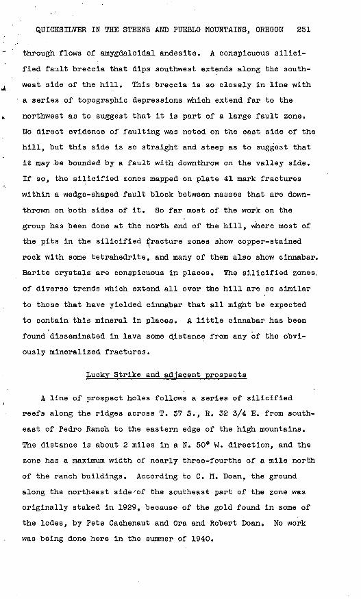
Lucky Strike and adjacent prospects
A line of prospect holes follows a series of silicified
reefs along the ridges across T. 37 S., R. 32 3/4 E. from south
east of Pedro Ranch to the eastern edge of the high mountains.
The distance is about 2 miles in a N. 50° W. direction, and the
zone has a maximum width of nearly three-fourths of a mile north
of the ranch buildings. According to C. M. Doan, the ground
along the northeast side'of the southeast part of the zone was
originally staked in 1929, because of the gold found in some of
the lodes, by Pete Cachenaut and Ora and Robert Doan. No work
was being done here in the summer of 1940.

252 STRATEGIC MINERALS INVESTIGATIONS, 1941
Some of the gold prospects are included in the Blue Boy
claim, which according to a claim notice was located January 17,
1929, by Olive W. Doan, C. Sturgeon, and R. E. Doan. Claim no
tices indicate that the Crimson Rose group of five claims, lo
cated by members of the Doan family, lies northwest of the Blue
Boy. The hill between the Blue Boy claim and the deserted
buildings of the Pedro ranch is occupied by the seven claims of
the Lucky Strike group, staked in 1933 by M. M. Doan and associ
ates. Part of this ground was staked in 1931 by Tom Dufferena
and associates but is reported to be no longer claimed by them.
The .Lucky Strike group is joined on the northwest by the four
claims of the Mogul group, staked in 1939 by C. M. Doan. North
west of the Mogul group are six claims held by R. E. and B. J.
Blair since 1933, and beyond these are four claims located by
Ben O'Keefe in December 1931. The approximate position of most
of the Lucky Strike claims is evident from marked claim stakes,
but the boundaries of the claims in other groups were not
learned.
The Blue Boy claims and adjacent ground, on the nose of a
ridge immediately northeast of Lucky Strike claim No. 5, contain
a tunnel 120 feet long, a shaft 40 feet deep, and several cuts
and pits. The lodes in places contain visible cinnabar. Pour
of the samples cut here gave negative results on assay, but one
from the shaft contained 0.01 percent of quicksilver, and re
fined tests show that the others contain the metal in very small
quantities. Tests for gold were not made during the present in
vestigation, but several assays are reported to show a range of
$7 to $29 a ton in gold (presumably at $35 an ounce). The ridge
on which the Blue Boy lies is composed mainly of andesite. A
conspicuous silicified rib follows the nose of the ridge down to
creek level (pi. 42). This PiD Strikes aDOUt N, 15° W. anastands nearly vertical, but in places it dips steeply east. As
the lava on opposite sides differs in appearance, attitude, and

QUICKSILVER IN THE STEENS AND PUEBLO MOUNTAINS, OREGON 253
extent of alteration, the rib probably marks a fault of cpnsid-
erable displacement. On the ridge top the rib is crossed by>»
thin veins of calcareous tufa that strike east and dip about 35°
S. Much of the lava on the southwest slope of the ridge is
markedly altered but does not contain enough silica to be highly
resistant to erosion or to have wholly obliterated the original
texture. This altered material is cut by numerous veins of
rusty calcite, most of which strike north of west (pi. 42). On/
plate 43, the principal calcite veins are shown, but, in order
to avoid confusion, the broad area of partly slllcified ground
on the Blue Boy is not.
The ridge just described is a branch of a larger ridge, the
adjacent part of which contains the Crimson Rose claims.- The
branches of this ridge northwest of the Blue Boy contain several
silicified reefs (see pi. 43), most of which stand in distinct
relief. One is a continuation of the principal reef at the Blue
Boy. The reefs contain sulfides in several places, and cinnabar
is exposed in at least one place. Exploration has been confined
to shallow pits. A basalt dike is also exposed.
The Lucky Strike group occupies a ridge between two low sad
dles. The ridge consists largely of amygdaloidal andesite with
some basalt and other kinds of lava. Irregular zones of altered
rock contain enough silica to stand in some relief (pi. 42).
Here and there within these are fractures of northwest trend.
Shallow excavations on these are reported to have revealed some
cinnabar in the rusty quartz. A long trench on Lucky Strike No.
3 explores a zone of calcite veins in basaltic lava near a ba
salt dike.
The Mogul group includes numerous, branching silicified
zones (see pi. 43) that in several places contain quicksilver
and copper minerals, and a basalt dike that probably cuts one
of the silicified zones. Small excavations are scattered over
these claims. On the ridge crest on the Mogul No. 2 a short

254 STRATEGIC MINERALS INVESTIGATIONS, 1941
shaft connects with a small Irregular tunnel, from the floor of
which extends a winze little more than 10 .feet deep. On Febru
ary 11, 1941, a new inclined shaft below the tunnel was reported
to be 60 feet deep. The lode had not yet been reached in this
shaft.
Two samples cut in the winze contained 0.12 and 0.05 percent
of quicksilver. A sample from the shaft contained 0.03 percent
of quicksilver. Most of the metal in this sample was in chlo-\
ride. Some of the material in these workings contains so much
cinnabar as to be obviously of higher tenor than the samples re
ported above. Both the shaft and the winze contain masses of
porous chalky-white quartz, containing cinnabar, which differs
in appearance from any of the other mineralized material seen in
the district. Since this area was visited, exploration work has
been resumed.
The silicifled zones on Mogul ground become less conspicuous
when they enter the Blair property. In the northwestern part of
the Blair property, however, a vertical reef that crops out on
the crest of the ridge (see pi. 43) contains some exceptionally
rich material, especially on the southwest side, where a tunnel
15 feet long and some pits have been opened. Samples from here
are reported to have yielded several percent of quicksilver, but
ore as rich as this was not found by the writer. One sample
from a 4-inch band along a slip proved to contain 0.47 percent
of quicksilver and a sample, of the clay above this slip yielded
0.14 percent of quicksilver.
Northwest of the Blair claims" mineralized ground was noted
only on the O'Keefe No. 2 claim. Here pits and trenches dis
close a vertical "shear zone which contains some quartz and cop
per minerals. This zone is not resistant enough to stand In re
lief.

UNITED STATES DEPARTMENT OF THE INTERIOR GEOLOGICAL SURVEY
N
BULLETIN 931 PLATE 42
EXPLANATION
Silicifled rock
^20°
Strike and dip of lava
Claim boundaries shown in solid lines only when claim stakes were identified on the ground. Stakes shown inside of claims are discovery or location monuments.
Topography and geology by C, P. Ross and H, Zwang
August 1940
GEOLOGIC AND TOPOGRAPHIC MAP OF THE LUCKY STRIKE GROUP AND ADJACENT GROUND100 0 500 Feet
Contour interval 25 feet Datum approximate

GEOLOGICAL SURVEY BULLETIN 931 PLATE 43
THE LODES OF THE MOGUL, liLAIK, AINU O'KEEFE GROUPS AND ADJACENT GUOUND.
Traced in September 1940 by C. 1*. Koss. Scale, approximately 1:24,000. Qal, Quaternary alluvium; Tal, older alluvium; TV. Ternary volcanic rocks; heavy black lines indicate basalt dikes; heavy white lines indicate silicilied reefs and oilier veins; white areas are Hilicificd zones.

BULLETIN 931 PLATE 4 4
Quaternary alluvium Older alluvium Reefs45°
Strike and dip of min- Strike of vertical min- Strike and dip eralized fracture eralized fracture of lava bed
Contour interval 25 feetDatum approximate
Intrusive basalt
9
Horizontal lava bed
Tertiary lava
Pit
Topography and geologyby C. P. Ross and H. Zwang
July 1940
GEOLOGIC AND TOPOGRAPHIC MAP OF RABBIT HOLE AND RED KING PROSPECTS NEAR FIELDS, OREGON

QUICKSILVER IN THE STEENS AND PUEBLO MOUNTAINS, OREGON 255
Claims near Sesena Creek
In the northeastern part of T. 39 S., R. 34 E., between
Sesena Creek and the Red King and Rabbit Hole prospects, are
several pits and short tunnels. Much of this ground was in
cluded in the Harmony group, located by C. M. Doan, but allowed
to lapse. Early in September 1940, two claims in or close to
sec. 2, T. 39 S., R. 34 E. were being worked by W. B. Stewart
and Clay R. Fisher. These are called the Surprise group. When
the property was visited a tunnel about 30 feet long had been
driven in the older, tilted alluvium close to and nearly paral
lel with a silicified zone in the lava nearby. The hillside was
strewn with numerous float pieces of quartz containing dissemi
nated cinnabar, presumably from the silicified zone, and it is
reported that cinnabar has since been found in place on this
property. Some work was done in 1940 by Ben O'Keefe at a place
roughly three-quarters of a mile west of the Surprise tunnel.
The Red King group
The Red King group of four claims is in the east-central
part of T. 39 S.,.R. 34 E. It was located in April 1939, by
Glenn Stephenson, George Stephenson, Andrew Shull, and Bert
Roark. This property contains a shaft 17 feet deep, a tunnel,
and several pits and trenches (pi. 44). The tunnel is inclined
and is filled with water to within a short distance from the
portal. The principal lode on this property has been mapped for
a distance of 1,800 feet, and extends beyond this to the north
west, though it is less clearly exposed there. An irregular
mass of coarse basalt, believed to be intrusive, is exposed on
the west side. The lode, which is several feet wide, consists
of fractured, kaolinized, and somewhat silicified andesite. The
andesite in the walls is intensely kaolinized for some distance
beyond the material that is sufficiently silicified to stand in

256 STRATEGIC MINERALS INVESTIGATIONS, 1941
relief. This lode does not form such prominent outcrops as
those on the Rabbit Hole property. The main lode contains some
pyrite, copper minerals, and cinnabar. The kaolinized wall
rocks also contain cinnabar in places, but a sample from the
bottom of the shaft in the wall rock contained no quicksilver.
The Rabbit Hole group
The Rabbit Hole group of six claims, located in March 1940,
by Robert Doan, lies east of the Red King prospect. It contains
a small retort, a shaft 48 feet deep with a 30-foot drift to the
west at its bottom, a tunnel 25 feet long, and many trenches and
pits, some of which are 10 feet deep. Quicksilver was first
found on these claims in 1929, and work has been done at inter
vals since then. Early in 1940 about a flask of quicksilver was
retorted from between 3 and 4 tons of ore from the shaft and an
equal amount from ore hauled in from neighboring properties.
The group is on the eastern flank of a local anticline in
andeslte and basalt flows with some clastic beds. It contains a
system of siliceous reefs that radiate to the north and north
west and dip eastward (pi. 44). The shaft is at the junction of
two of these, one of which is over 1,500 feet long. Several of
the reefs are over 10 feet wide. Nearly all the excavations
show copper stains, and in many of them tetrahedrite or cinnabar
or both are visible,. Barite is locally conspicuous. The se
lected ore that was retorted was moderately rich, but the aver
age tenor of the exposed material is low. A sample chipped from
a 3-lnch vein at the bottom of the shaft yielded only 0.01 per
cent of quicksilver on assay.
The Blue Bull group/
The Blue Bull group of six claims is at the eastern edge of
the upland bench between Horse and Willow Creeks, in the south-

QUICKSILVER IN THE STEENS AND PUEBLO MOUNTAINS, OREGON 257
eastern part of T. 39 S., R. 34 E. M. M. Doan Is the principal
owner. The group contains a shaft 25 feet deep, at an inclina
tion of 63° along a vein. A crosscut at the bottom extends 35
feet northward. The outcrop at the shaft is Inconspicuous, but
330 feet northwest is the southern end of a large silicious reef.
A sample from a 2-inch band at the top of the shaft was found to
contain 0.99 percent of quicksilver and 0.07 percent of mercuric
chloride. A sample chipped across a width of 2 feet on both
sides of the shaft at a depth of 8 feet contained 0.01 percent
of quicksilver. Both tetrahedrite and cinnabar are visible here,
and in some narrow bands they are so abundant that several per
cent of quicksilver appears to be present.
There is reported to be a quicksilver prospect known as the
Cash group on Willow Creek south of the Blue Bull. No work has
been done there recently and the group was not visited.
Arizona mine
On the northwest side of upper Arizona Creek, in the north
west corner of T. 40 S., R. 35 E. there are extensive pits and
trenches and a caved tunnel. A claim notice dated November 3,
1934, signed by A, W. Van Riper, A. R. Wood, and William Grobe
refers to the property as the Arizona mine. Much of the work
here must have been done earlier than 1934.
The pits are in ancient quartzose sedimentary rocks and ex
pose shatter zones with quartz, pyrite, and malachite. One of
the better-defined fracture zones strikes N. 40° E. and dips 40°
NW. It Is reported that these workings were opened in the
search for gold but that some quicksilver was also found in them.
Prospects on Pueblo Mountain
There are many pits, short tunnels, and shallow shafts high
on the east slope of Pueblo Mountain in the western half of T.
40 S., R. 35 E. Most of these belong to the Pueblo and Parnham

258 STRATEGIC MINERALS INVESTIGATIONS, 1941
groups of claims. There are also prospect tunnels near Denio,-
but these were not studied. The presence of copper, gold, and
quicksilver in this vicinity has been known for at least 25
years. The limits of the Pueblo and Parnham groups of claims
are not known, but the workings of the Pueblo Gold Mining Co.
center around the gold mill shown on plate 39, close to the end
of the road in the southern part of the prospected ground. The
tunnel at the mill is 260 feet long, and some of the caved work
ings farther north may once have been equally long. Small ship
ments of gold ore are reported to have been made from this prop
erty. A little work was done here in the summer of 1940.
The Parnham group is owned by E. D. Farnham, who has done
intermittent prospecting there since about 1916. He says that
he mined a few hundred pounds of high-grade quicksilver ore a
few years ago, and that some of his workings contain considera
ble copper.
Both groups are in the Paleozoic (?) metamorphic rocks and
are on poorly defined fracture zones with widely different atti
tudes. These zones have lentils of quartz and calcite with
small quantities of pyrite, chalcopyrite, bornite, tetrahedrite,
their oxidation products, and locally cinnabar.
O

The use of the subjoined mailing label to return
this report will be official business, and no
postage stamps will be required
UNITED STATES PENALTY FOR PRIVATE use TO AVOID DEPARTMENT OF THE INTERIOR PAYMENT OF POSTAGE. $300
GEOLOGICAL SURVEY
OFFICIAL BUSINESS
This label can be used only for returning official publications. The address must not be changed.
GEOLOGICAL SURVEY,
WASHINGTON, D. C.

Orton Memorial Library of Geology 180 Orton Hall,1558. Ova! Mall The Ohio State University Columbus, OH 43210