geol 10: environmental geology activity 11: ground water ......geol 10: environmental geology ... to...
TRANSCRIPT
GEOL 10: Environmental Geology Activity 11: Ground Water Contamination
Page | 1
Name: ______________________________________________ Date: ____________________
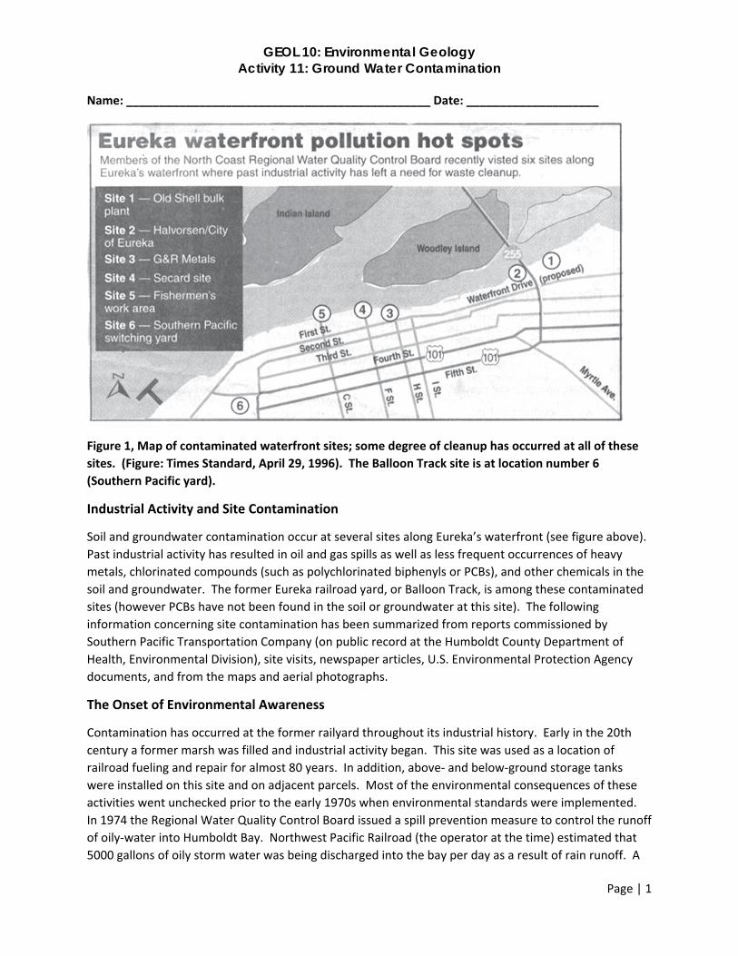
Figure 1, Map of contaminated waterfront sites; some degree of cleanup has occurred at all of these
sites. (Figure: Times Standard, April 29, 1996). The Balloon Track site is at location number 6
(Southern Pacific yard).
Industrial Activity and Site Contamination
Soil and groundwater contamination occur at several sites along Eureka’s waterfront (see figure above).
Past industrial activity has resulted in oil and gas spills as well as less frequent occurrences of heavy
metals, chlorinated compounds (such as polychlorinated biphenyls or PCBs), and other chemicals in the
soil and groundwater. The former Eureka railroad yard, or Balloon Track, is among these contaminated
sites (however PCBs have not been found in the soil or groundwater at this site). The following
information concerning site contamination has been summarized from reports commissioned by
Southern Pacific Transportation Company (on public record at the Humboldt County Department of
Health, Environmental Division), site visits, newspaper articles, U.S. Environmental Protection Agency
documents, and from the maps and aerial photographs.
The Onset of Environmental Awareness
Contamination has occurred at the former railyard throughout its industrial history. Early in the 20th
century a former marsh was filled and industrial activity began. This site was used as a location of
railroad fueling and repair for almost 80 years. In addition, above‐ and below‐ground storage tanks
were installed on this site and on adjacent parcels. Most of the environmental consequences of these
activities went unchecked prior to the early 1970s when environmental standards were implemented.
In 1974 the Regional Water Quality Control Board issued a spill prevention measure to control the runoff
of oily‐water into Humboldt Bay. Northwest Pacific Railroad (the operator at the time) estimated that
5000 gallons of oily storm water was being discharged into the bay per day as a result of rain runoff. A
GEOL 10: Environmental Geology Activity 11: Ground Water Contamination
Page | 2
year later, they installed an oil collection system and an oil‐water separator system to control this
problem. This system was operational until 1986 when site use had decreased significantly. The oil‐
water separators were sealed; however, some of the former drainage ditches (and newer drainage
ditches) used for surface runoff were not maintained and still collect and channel surface water into
Clark Slough.
Legislation that required removal of old underground storage tanks led to a 1988 request for Southern
Pacific Transportation Company to have underground storage tanks removed from the site. According
to a report from an environmental services corporation at the time of the tanks’ removal in 1988, no
detectable concentrations of petroleum‐associated compounds were found in the soil surrounding the
tanks. However, nearby groundwater samples collected during this activity contained 0.69 parts per
million benzene, 1.10 parts per million toluene, and 1.2 parts per million xylenes (all are components of
gasoline). The benzene levels were considerably greater than the maximum contaminant level standard
for drinking water (see the attached table of accepted values and health risks).
Interest in using this site as a possible location for the Humboldt County Jail led to new environmental
investigations in the late 1980s. Soil and groundwater samples indicated the presence of oil, grease,
petroleum hydrocarbons, and lead. Neither pesticides nor PCBs were detected. The environmental
consultants for this project recommended that the site be remediated (cleaned‐up) before development
of the property. The site was not chosen for the Humboldt County jail.
In 1989 the Regional Water Quality Control Board requested that Southern Pacific Transportation
Company assess soil and groundwater quality beneath the former railroad yard and conduct the
appropriate clean up actions. An environmental consulting company was retained to assess the site,
remove potentially hazardous materials, and make recommendations for further clean up. A total of
980 gallons of uncharacterized oil was removed from the site. Waste materials were either transported
to a recycling facility or disposed at a facility in Kettleman City, California. Approximately 3500 gallons of
oily wastewater was removed from the oil‐water separator system and transported to a recycling
facility. The inoperative oil‐water separator was sealed. Exploratory boring and trenching was
conducted to assess the subsurface soils and groundwater samples were collected to evaluate the
distribution of contaminants beneath the site.
Three general areas of soil contamination (in the upper six feet of soil) were identified. The areas are 1)
the former railroad tracks from the service platform to the turntable, 2) the Bunker C oil tank area, and
3) the area around and south (up to 150 feet) of the former roundhouse (see attached site map). These
areas contained 100 to 42,000 parts per million of total petroleum hydrocarbons in the upper six feet of
soil. Localized stained soil was observed in these former operational areas. The material was
characterized as diesel and as oil and grease. Benzene and xylenes were found in two soil samples at
concentrations of 1.7 and 21 parts per million respectively. Metal concentrations in the soil were well
below the safety limits for the particular metals. The highest concentrations were for lead at up to 374
parts per million. The consultants stated that the volatile organic compounds (including benzene and
xylenes) were “insignificant” and they emphasized that the lead was reported “only” in three samples.
They concluded that the petroleum hydrocarbons (primarily diesel and crude oil) were the primary
compounds of concern.

GEOL 10: Environmental Geology Activity 11: Ground Water Contamination
Page | 3
Comparisons of contaminant concentrations at these locations over several years indicate that the
concentrations are stable and have been decreasing over time. Accordingly, further active remediation
in this area has been deemed unnecessary. The current course of action appears to be one of passive
remediation. From 1989 to present soil and groundwater samples have been periodically collected and
analyzed for a variety of contaminants related to former industrial activity. Relatively low levels of
contaminants (below maximum contaminant levels for drinking water) have been found in groundwater
of both the upper A Zone and the lower B Zone. In general, these analyses show that the greatest
volume of contaminants is degraded diesel‐range petroleum hydrocarbons limited to the former storage
tank and refueling areas.
These studies also show that the upper soil contains low levels of lead (2 to 1800 part per million) and
arsenic (1 to 93 parts per million). The arsenic is possibly due to the use of pesticides and herbicides
near the railroad sidings. Further actions regarding concentrations of lead in the soil was not mentioned
in the recommendation of a 1999 study of the site. However, that same year consults hired by WalMart
submitted a proposal to the Regional Water Quality Control Board for a study to include evaluation of
the presence of both heavy metals and arsenic.
Contractors hired by Union Pacific (formerly Southern Pacific Transportation Company) periodically
collected trash and cleared brush at the site and subsurface remediation continued under a policy of
passive remediation.
In the mid‐2000s the property was purchased by Security National Properties who is the current owner.
Security National has proposed a mixed‐use development for the site; however, controversy regarding
the cleanup and use of this site continues. This controversy regarding the site remediation has resulted
in litigation and a request for remediation beyond what was originally planned by either Union Pacific or
the Security National (current owner). Soil sampling conducted by Humboldt Baykeeper (as the result of
litigation) revealed "hot spots" on the property with significant levels of contaminants such as dioxins,
metals, and arsenic. Fish tissue sampling in Clark Slough found dioxin in an amount four times higher
than the "Do Not Consume" level set by U.S. EPA. In addition, the California Coastal Commission has
jurisdiction over land use of the property and conflicts between Security National and this governmental
agency have led to a delay in development of the site. These later issues have been the topic of
litigation; more details about the current state of affairs will be described in class.
This following discussion and questions are designed to help understand the details of site
contamination and methods of remediation (clean up). The example used is an actual case taken from
public records; however, this activity is for educational purposes and is not intended to promote a
specific remediation plan or land use option.
This activity requires an understanding of geologic materials, permeability, stratification, types of
contaminants, behavior and flow of ground fluids, and methods of remediation. The following resources
provide this background information:
Groundwater Contamination http://oceanworld.tamu.edu/resources/environment‐
book/groundwatercontamination.html
Groundwater Remediation http://oceanworld.tamu.edu/resources/environment‐
book/groundwaterremediation.html
GEOL 10: Environmental Geology Activity 11: Ground Water Contamination
Page | 4
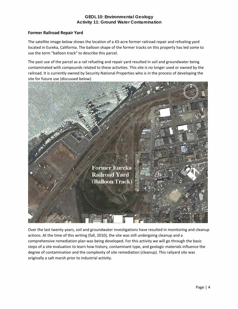
Former Railroad Repair Yard
The satellite image below shows the location of a 43‐acre former railroad repair and refueling yard
located in Eureka, California. The balloon shape of the former tracks on this property has led some to
use the term "balloon track" to describe this parcel.
The past use of the parcel as a rail refueling and repair yard resulted in soil and groundwater being
contaminated with compounds related to these activities. This site is no longer used or owned by the
railroad. It is currently owned by Security National Properties who is in the process of developing the
site for future use (discussed below).
Over the last twenty years, soil and groundwater investigations have resulted in monitoring and cleanup
actions. At the time of this writing (fall, 2010), the site was still undergoing cleanup and a
comprehensive remediation plan was being developed. For this activity we will go through the basic
steps of a site evaluation to learn how history, contaminant type, and geologic materials influence the
degree of contamination and the complexity of site remediation (cleanup). This railyard site was
originally a salt marsh prior to industrial activity.
GEOL 10: Environmental Geology Activity 11: Ground Water Contamination
Page | 5
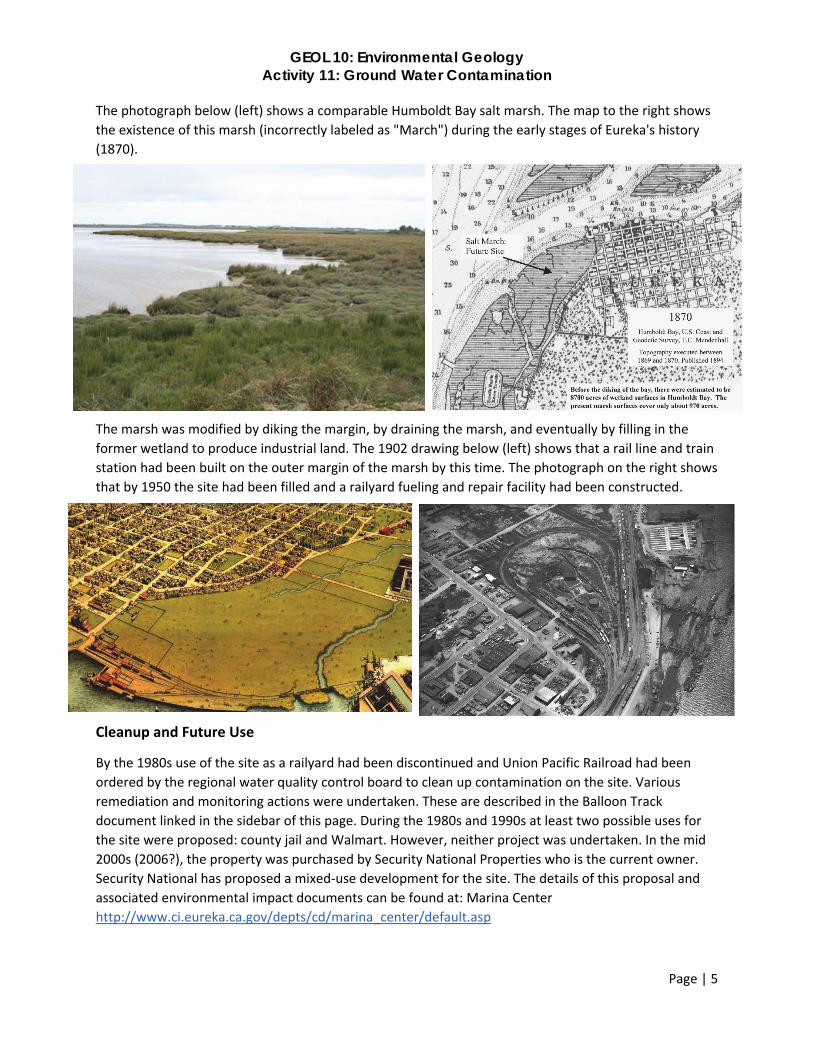
The photograph below (left) shows a comparable Humboldt Bay salt marsh. The map to the right shows
the existence of this marsh (incorrectly labeled as "March") during the early stages of Eureka's history
(1870).
The marsh was modified by diking the margin, by draining the marsh, and eventually by filling in the
former wetland to produce industrial land. The 1902 drawing below (left) shows that a rail line and train
station had been built on the outer margin of the marsh by this time. The photograph on the right shows
that by 1950 the site had been filled and a railyard fueling and repair facility had been constructed.
Cleanup and Future Use
By the 1980s use of the site as a railyard had been discontinued and Union Pacific Railroad had been
ordered by the regional water quality control board to clean up contamination on the site. Various
remediation and monitoring actions were undertaken. These are described in the Balloon Track
document linked in the sidebar of this page. During the 1980s and 1990s at least two possible uses for
the site were proposed: county jail and Walmart. However, neither project was undertaken. In the mid
2000s (2006?), the property was purchased by Security National Properties who is the current owner.
Security National has proposed a mixed‐use development for the site. The details of this proposal and
associated environmental impact documents can be found at: Marina Center
http://www.ci.eureka.ca.gov/depts/cd/marina_center/default.asp
GEOL 10: Environmental Geology Activity 11: Ground Water Contamination
Page | 6
One result of the past evaluation and cleanup efforts was the installation of monitoring wells. These
wells provide both subsurface geologic information and groundwater contaminant information. The
interactive map below includes subsurface geologic information for three of these monitoring wells
(MW). The "bullseye" locations provide information about the site contamination, and remediation
history as well as a photograph of each area (click on any of these to explore the site).
http://tinyurl.com/jnvtqdg
Part I. Construct a Cross‐Section of the Balloon Track Site and Questions
1. Use the enclosed data and graph paper (provided in class) to construct a diagram that shows the
subsurface geology of the site. The data are from three wells located on a northeast‐southwest line
through the property (see web site figure; A paper copy will be provided in class).
Well Data
Well MW‐2 (northeastern portion of property)
0 to 1 feet: Sandy Gravel (Fill): dark grayish brown, 55% gravel to 3 inches, 40% fine sand
1 to 7.5 feet: Sand (Fill): dark greenish gray, 95% fine to medium sand, shell fragments
7.5 to 11.5 feet: Clay (Bay Mud): dark greenish gray, 95% silt and clay, trace roots
11.5 to 30 feet: Sand: dark greenish gray, 95% fine to medium sand, shell fragments
Well MW‐3 (middle of property): 400 feet southwest of well MW‐2
0 to 2 feet: Gravel (Fill): brown, 60% gravel, 35% fine sand, wood fragments
2 to 7 feet: Sand (Fill): dark bluish gray, 95% fine to medium sand, shell fragments
7 to 8 feet: Clay (Bay Mud): 95% silt and clay, roots, organic rich zone at top
8 to 8.5 feet: Clay with sand (Bay): 80% silt and clay, 20% sand, roots
8.5 to 12 feet: Clay (Bay mud): 95% silt and clay
12 to 30 feet: Sand: dark greenish gray, 95% fine to medium sand, trace shell fragments
Well MW‐5 (southwestern portion of property): 900 feet southwest of well MW‐3; 1300 ft SW of MW‐2
0 to 2 feet: Sandy Gravel (Fill): dark grayish brown, 55% gravel to 3 inches, 40% fine sand
2 to 7.5 feet: Sand (Fill): dark greenish gray, 95% fine to medium sand, shell fragments
7.5 to 10 feet: Clay (Bay Mud): dark greenish gray, 95% silt and clay, trace roots
10 to 12.5 feet: Sandy silt: dark greenish gray, 60% sandy silt, 35% clayey sand
12.5 to 40 feet: Sand: dark greenish gray, 95% fine to medium sand, trace shell fragments
a. Orient the graph paper so the longest dimension (11”) is horizontal and the minimum dimension
(8.5”) is vertical (a landscape view).
b. Make a vertical line for each well. Use an appropriate horizontal scale to space the vertical lines
along the 1300 feet of horizontal distance between wells MW‐3 and MW‐5.
c. Use an appropriate vertical scale to accommodate the 40 feet of depth
d. Write your scales on your graph paper (for example, one block = 10 feet)
e. Use your scale to plot the thickness of each sedimentary unit on the vertical lines.

GEOL 10: Environmental Geology Activity 11: Ground Water Contamination
Page | 7
f. Connect similar units between the three wells (using horizontal lines)
g. Use a symbol (shading, dots, dashed lines, etc.) to show each sedimentary unit
h. Provide a key to show the symbol associated with each rock type.
2. Monitoring wells show that groundwater inhabits two discrete stratigraphic zones beneath the site:
the upper “A zone” and the lower “B zone”. These zones are separated by an aquiclude. Identify
Aquifers A in B in your stratigraphic cross section.
3. Explain how the aquiclude may have controlled the migration of contaminants.
Part II. Site Contamination
The Geotracker interactive map below from the California State Water Resources Control Board
provides details of the site including remediation history and monitoring well data. Click the monitoring
well box in the legend to view each well site (in pink). Then click on a well to view the data. Click on the
green box to view other site data. Each data link will open a new window (or tab) in your browser. There
is extensive information in this California State site with lots of detail to explore.
http://tinyurl.com/h4vzcml
Additional Concerns
Controversy regarding the remediation of this site has resulted in litigation and a request for
remediation beyond what was originally planned by either Union Pacific or the current owner. Soil
sampling conducted by Humboldt Baykeeper (as the result of litigation) revealed "Hot Spots" on the
property with significant levels of contaminants such as dioxins, metals, and arsenic. Fish tissue sampling
in Clark Slough found dioxin in an amount four times higher than the "Do Not Consume" level set by U.S.
EPA. Details can be found at: BayKeeper‐Marina Center: http://www.humboldtbaykeeper.org/marina‐
center.html
The following references provide some details regarding the contaminants discussed above and
concerns related to dioxins:
Chemical Hazards ‐ EPA Analysis
http://www.science.earthjay.com/instruction/CR_eureka/2016_spring/GEOL_10/activities/activ
ity_11/epatable.pdf
Dioxins ‐ EPA Site https://www.epa.gov/dioxin
Use the information from above (including the cross‐section you made), the Geotracker information and
our discussions in class to answer the following questions.
GEOL 10: Environmental Geology Activity 11: Ground Water Contamination
Page | 8
Past History
1. What was the original state of the land?
2. How has it been used during the last 100 years?
3. What are some of the uses that have been proposed for this site?
Geology and Hydrology
1. Describe what is shown in your cross‐section (Exercise Question I) including rock type and
permeability of layers.
2. Describe the portion of the subsurface that represents either a confined aquifer(s), an aquiclude(s),
or an open aquifer(s).
3. Discuss the possibility of contaminants being able to permeate the layers and the possibility of
contaminants migrating to adjacent property (including the bay). Is it possible for surface run‐off to
allow contaminants to move off of the property?
GEOL 10: Environmental Geology Activity 11: Ground Water Contamination
Page | 9
Contaminants
1. Describe the types of contaminants that have been found on the site.
2. What level of health risk do these pose to people?
3. What is the rate of breakdown of these materials?
Treatment Process
1. Describe the nature of remediation and study that has been performed on this site. Describe both
passive and active remediation efforts.
Your Opinion
1. State your opinion regarding the current state of the property (in terms of health risk), the need for
(and nature of) future study, and the need for (and type of) future remediation. Discuss your opinion
regarding future land use. Feel free to comment on the proposed Marina Center or to propose your
own (or others) vision of land use and clean up.