geographic information systems: challenges to effective ... · information policy, ... challenges...
TRANSCRIPT
Testimony Before the Subcommittee on Technology, Information Policy, Intergovernmental Relations and the Census, Committee on Government Reform, House of Representatives
United States General Accounting Office
GAO
For Release on Delivery Expected at 10:00 a.m. EDT Tuesday, June 10, 2003 GEOGRAPHIC
INFORMATION SYSTEMS
Challenges to Effective Data Sharing
Statement of Linda D. Koontz Director, Information Management Issues
GAO-03-874T
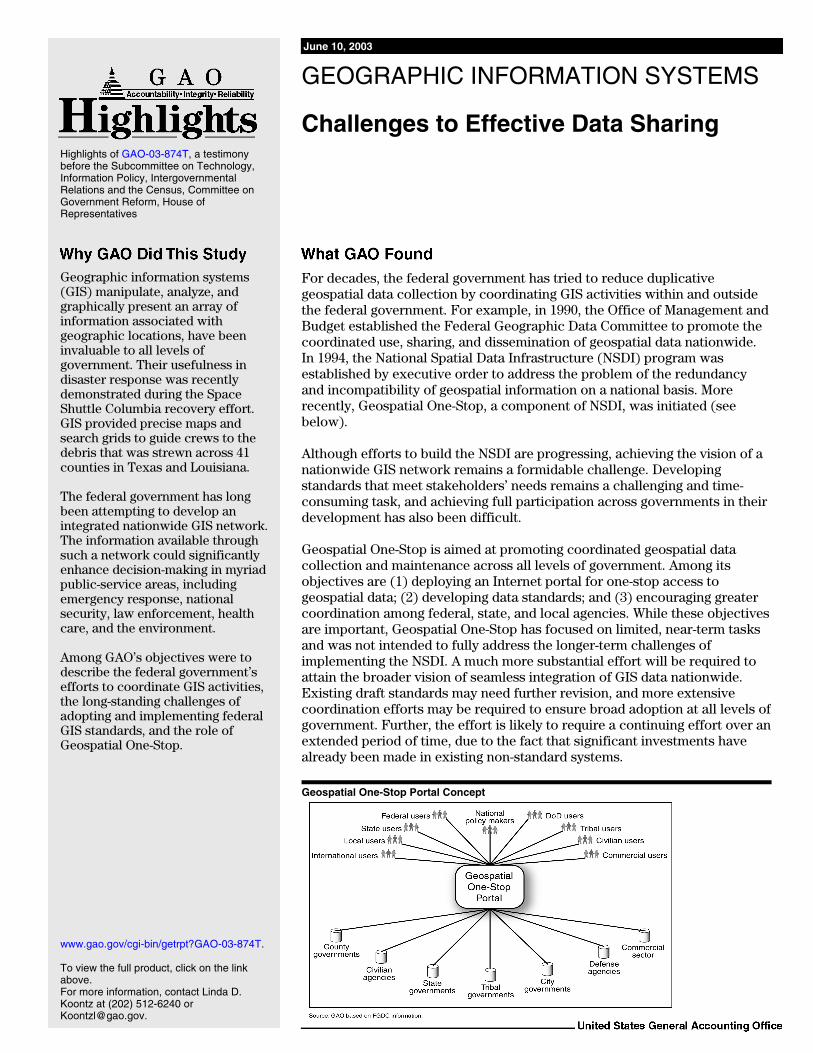
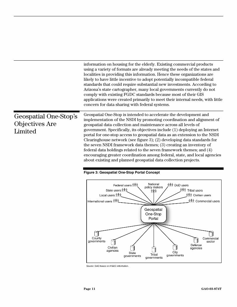
For decades, the federal government has tried to reduce duplicative geospatial data collection by coordinating GIS activities within and outside the federal government. For example, in 1990, the Office of Management and Budget established the Federal Geographic Data Committee to promote the coordinated use, sharing, and dissemination of geospatial data nationwide. In 1994, the National Spatial Data Infrastructure (NSDI) program was established by executive order to address the problem of the redundancy and incompatibility of geospatial information on a national basis. More recently, Geospatial One-Stop, a component of NSDI, was initiated (see below). Although efforts to build the NSDI are progressing, achieving the vision of a nationwide GIS network remains a formidable challenge. Developing standards that meet stakeholders’ needs remains a challenging and time-consuming task, and achieving full participation across governments in their development has also been difficult. Geospatial One-Stop is aimed at promoting coordinated geospatial data collection and maintenance across all levels of government. Among its objectives are (1) deploying an Internet portal for one-stop access to geospatial data; (2) developing data standards; and (3) encouraging greater coordination among federal, state, and local agencies. While these objectives are important, Geospatial One-Stop has focused on limited, near-term tasks and was not intended to fully address the longer-term challenges of implementing the NSDI. A much more substantial effort will be required to attain the broader vision of seamless integration of GIS data nationwide. Existing draft standards may need further revision, and more extensive coordination efforts may be required to ensure broad adoption at all levels of government. Further, the effort is likely to require a continuing effort over an extended period of time, due to the fact that significant investments have already been made in existing non-standard systems. Geospatial One-Stop Portal Concept
Geographic information systems (GIS) manipulate, analyze, and graphically present an array of information associated with geographic locations, have been invaluable to all levels of government. Their usefulness in disaster response was recently demonstrated during the Space Shuttle Columbia recovery effort. GIS provided precise maps and search grids to guide crews to the debris that was strewn across 41 counties in Texas and Louisiana. The federal government has long been attempting to develop an integrated nationwide GIS network. The information available through such a network could significantly enhance decision-making in myriad public-service areas, including emergency response, national security, law enforcement, health care, and the environment. Among GAO’s objectives were to describe the federal government’s efforts to coordinate GIS activities, the long-standing challenges of adopting and implementing federal GIS standards, and the role of Geospatial One-Stop.
www.gao.gov/cgi-bin/getrpt?GAO-03-874T. To view the full product, click on the link above. For more information, contact Linda D. Koontz at (202) 512-6240 or [email protected].
Highlights of GAO-03-874T, a testimony before the Subcommittee on Technology, Information Policy, Intergovernmental Relations and the Census, Committee on Government Reform, House of Representatives
June 10, 2003
GEOGRAPHIC INFORMATION SYSTEMS
Challenges to Effective Data Sharing
Page 2 GAO-03-874T
Mr. Chairman and Members of the Subcommittee:
I appreciate the opportunity to participate in the Subcommittee’s hearing regarding the challenges of developing an integrated nationwide network of geographic information systems (GIS). A GIS is a system of computer software, hardware, and data used to manipulate, analyze, and graphically present a potentially wide array of information associated with geographic locations. GIS’s powerful ability to integrate different kinds of information about a physical location can lead to better-informed decisions about public investments in infrastructure and services—including national security, law enforcement, health care, and the environment—as well as a more effective and timely response in emergency situations. However, long-standing challenges to data sharing and integration need to be addressed before the benefits of geographic information systems can be fully realized.
As requested, in my remarks today, I will discuss the many GIS activities under way throughout the federal government, the federal government’s efforts to coordinate these activities, and the long-standing challenges of adopting and implementing federal GIS standards. I will also discuss the role of Geospatial One-Stop, one of 25 high-profile e-government1 initiatives sponsored by the Office of Management and Budget (OMB). To supplement my remarks, I have included an attachment that lists examples of the numerous GIS activities led by various federal agencies.
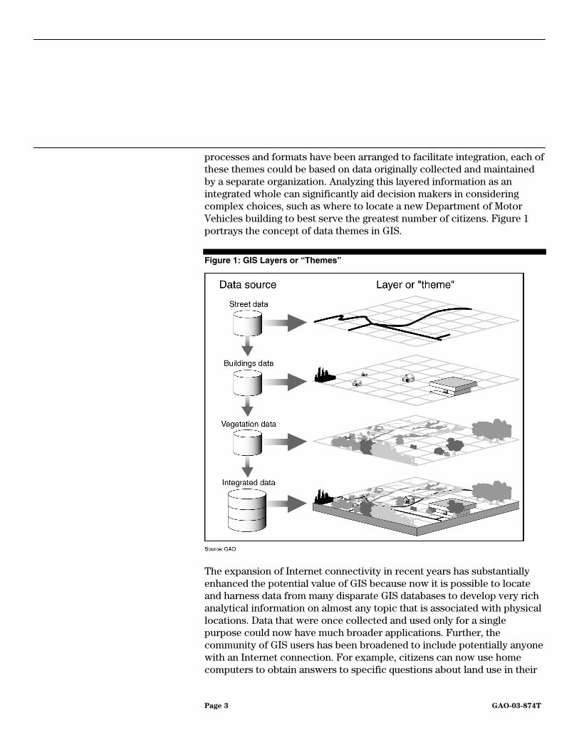
The primary function of a GIS is to link multiple sets of geospatial data and graphically display that information as maps with potentially many different layers of information. Assuming that all the information is at the same scale and has been formatted according to the same standards, users can potentially overlay spatial information about any number of specific topics to examine how the layers interrelate. Each layer of a GIS map represents a particular “theme” or feature, and one layer could be derived from a data source completely different from the other layers. For example, one theme could represent all the streets in a specified area. Another theme could correspond to all the buildings in the same area, and others could show vegetation or water resources. As long as standard
1E-Government or Electronic Government refers to the use of technology, particularly Web-based Internet applications, to enhance the access to and delivery of government information and services to citizens, business partners, employees, other agencies, and other entities.
Background
Page 3 GAO-03-874T
processes and formats have been arranged to facilitate integration, each of these themes could be based on data originally collected and maintained by a separate organization. Analyzing this layered information as an integrated whole can significantly aid decision makers in considering complex choices, such as where to locate a new Department of Motor Vehicles building to best serve the greatest number of citizens. Figure 1 portrays the concept of data themes in GIS.
Figure 1: GIS Layers or “Themes”
The expansion of Internet connectivity in recent years has substantially enhanced the potential value of GIS because now it is possible to locate and harness data from many disparate GIS databases to develop very rich analytical information on almost any topic that is associated with physical locations. Data that were once collected and used only for a single purpose could now have much broader applications. Further, the community of GIS users has been broadened to include potentially anyone with an Internet connection. For example, citizens can now use home computers to obtain answers to specific questions about land use in their
Page 4 GAO-03-874T
state or local jurisdiction. Commercial entrepreneurs can combine GIS data about zoning and tax-incentive areas to determine what parts of a city are best suited for establishing a new business.
Federal, state, and local government agencies are using GIS today to provide vital services to their customers. For example, local fire departments can use geographic information systems to determine the quickest and most efficient route from a firehouse to a specific location, taking into account changing traffic patterns that occur at various times of day. Highway departments use GIS to identify intersections that have had a significant number of personal injury accidents to determine needs for improved traffic signaling or signage. GIS can also be an invaluable tool in ensuring homeland security by facilitating preparedness, prevention, detection, and recovery and response to terrorist attacks.
Many federal departments and agencies use GIS technology to help carry out their primary missions. For example, the Department of Housing and Urban Development (HUD) worked with the Environmental Protection Agency (EPA) to develop E-MAPS, which combines information on HUD’s community development and housing programs with EPA’s environmental data. The program provides homeowners and prospective homebuyers with ready access to detailed local information about environmental hazards that otherwise would likely have been very difficult to obtain. In another example, the Department of Health and Human Services uses GIS technology to analyze data on population and topography (including roads, streams, and land elevation), as well as information gathered from residents. These data are used to track the spread of environmental contamination through a community, to identify geographic areas of particular health concern, and to identify susceptible populations, such as children or the elderly.
The usefulness of GIS in disaster response was demonstrated recently in connection with the Space Shuttle Columbia recovery effort. After the loss of Columbia on February 1, 2003, debris was spread over at least 41 counties in Texas and Louisiana. Analysis of GIS data was critical to the efficient recovery and documentation of that debris. The Texas state GIS program provided authorities with precise maps and search grids to guide field reconnaissance and collection crews. Officials in charge of the effort used maps of debris fields combined with GIS data about the physical terrain to carefully track every piece of debris found. This information not only contributed to an efficient recovery effort but also may help experts to refine theories about why Columbia perished.
Page 5 GAO-03-874T
In developing this testimony, our objectives were to describe the many GIS activities under way throughout the federal government and the federal government’s efforts to coordinate these activities, the long-standing challenges of adopting and implementing federal GIS standards, and the role of Geospatial One-Stop. To address these objectives, we obtained relevant documentation from the Department of the Interior and interviewed Geospatial One-Stop project officials as well as representatives from state agencies and private sector organizations involved in GIS activities with the federal government. We also analyzed the accomplishments and planned activities of the Geospatial One-Stop initiative in light of identified challenges to geospatial data sharing. We performed our work between May 2003 and June 2003, in accordance with generally accepted auditing standards.
According to the Department of the Interior, about 80 percent of all government information has a geospatial data component, such as an address or other reference to a physical location.2 It is not surprising, then, that a wide variety of geospatial data collection efforts are ongoing throughout the federal government, each established for a different purpose but often collecting and maintaining the same or similar information. In fact, according to the 2001 initial business case for Geospatial One-Stop, about 50 percent of the federal government’s geospatial data investment is redundant.
For every GIS application, federal agencies must manage the geospatial data that are at the heart of that application. In many cases, agencies maintain the same data that are referenced to the same geographic location. For example, both HUD and the Census Bureau maintain essentially the same geospatial data regarding congressional districts, city boundaries, railroads, interstate highways, and state highways. The two agencies maintain separate GIS systems for storing and analyzing this information.
In many cases, agencies independently collect data that, while not identical, is similar and potentially duplicative in many respects. For example, both the Department of Energy (DOE) and the Nuclear Regulatory Commission (NRC) collect and analyze information regarding
2Geospatial One-Stop, Office of Management and Budget Capital Asset Plan and
Business Case (Exhibit 300) (Jan. 27, 2003), p. 7.
Many Federal Government GIS Activities Overlap
Page 6 GAO-03-874T
uranium-milling facilities, and they both cover the same geographic areas. DOE concentrates on tracking the status of former uranium processing sites, whereas NRC gathers and maintains information on current uranium milling facilities in the same mid-western locations. In cases such as this, significant efficiencies may be gained by coordinating the two collection efforts.
In other cases, data may be collected in different resolutions or with different degrees of accuracy but still essentially cover the same theme over the same geographic area. Local governments often possess the most recent and highest resolution geographic data; however, these data often are collected to serve specific missions and may be difficult to use for other purposes. For instance, when the Forest Service created a national-level GIS for the forest ecosystem, it was faced with reconciling data from a variety of incompatible locally developed systems. Local agencies had used a variety of standards for each forest and district. In assembling these data into a unified, coherent database, the Forest Service had to adopt the lowest-resolution format in order to maintain full coverage of all forests. As a result, much of the higher-resolution content of the local data could not be used. Much of the effort in building this system was spent reconciling data sets to make them usable in an integrated database.
The biggest problem with collecting this duplicative geospatial data is its cost. According to a recent study, up to 80 percent of GIS costs are related to the collection and management of geospatial data.3 In 1993, OMB performed a data call in which it estimated that $4.1 billion was spent annually, at the federal level, on collection and management of geographically referenced data. In addition, state and local governments are estimated to spend twice that of the federal government on collection and management of geographic referenced data.4
3Center for Technology in Government, Sharing the Costs, Sharing the Benefits: The New
York State GIS Cooperative Project (2001).
4Office of Management and Budget, Geospatial One-Stop Capital Asset Plan and Business
Case (Exhibit 300) (Jan. 27, 2003).
Page 7 GAO-03-874T
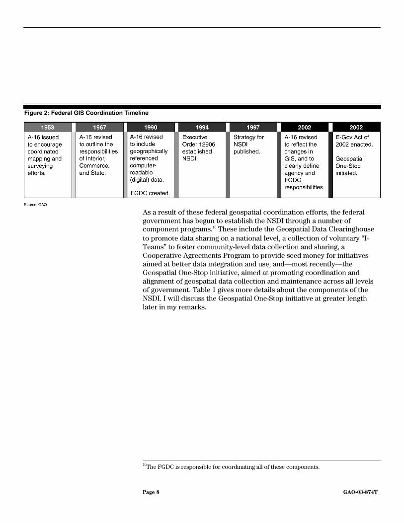
The federal government has tried for years to reduce duplicative geospatial data collection by coordinating GIS activities both within and outside the federal government. In 1953 the Bureau of the Budget first issued its Circular A-16, encouraging expeditious surveying and mapping activities across all levels of government and avoidance of duplicative efforts. More recently, the E-Government Act of 20025 directed the Office of Management and Budget to coordinate the development of standard protocols for sharing geographic information to reduce redundant data collection and promote collaboration and the use of standards. Although progress has been made over this 50-year span, much work still remains to be done.
Over the past several decades we and others, such as the National Research Council6 and the National Academy of Public Administration,7 have made a set of recommendations aimed at promoting the coordination of GIS efforts and data. In 1969, we recommended that mapping by state and local agencies under federal programs should be accomplished, where appropriate, in a manner enabling such work to contribute to the national mapping program.8 In 1982, we issued another report recommending interagency coordination to prevent duplicative computer-mapping programs.9 In response to this and other recommendations, OMB revised Circular A-16 in 1990, to, among other things, establish a Federal Geographic Data Committee (FGDC), chaired by the Department of the Interior, to promote the coordinated use, sharing, and dissemination of geospatial data nationwide. Building on that effort, a program was established by Executive Order 12906 in 1994 to develop a National Spatial Data Infrastructure (NSDI) to address the problem of the redundancy and incompatibility of geospatial information collected by many different organizations and stored and maintained at many different physical locations. Figure 2 provides a federal GIS coordination timeline.
5E-Government Act of 2002, P.L. 107-347 (Dec. 17, 2002).
6National Research Council, Mapping Science Committee, Toward a Coordinated Spatial
Data Infrastructure for the Nation (Washington, D.C.: National Academy Press, 1993).
7National Academy of Public Administration, Geographic Information for the 21st
Century: Building a Strategy for the Nation (Washington, D.C.: Jan. 1998).
8U.S. General Accounting Office, Opportunity for Savings and Better Service to Map Users
Through Improved Coordination of Federally Financed Mapping Activities, 759 Un317o (Washington, D.C.: Dec. 17, 1969).
9U.S. General Accounting Office, Duplicative Federal Computer-Mapping Programs: A
Growing Problem, GAO/RCED-83-19 (Washington, D.C.: Nov. 22, 1982).
Many Attempts Have Been Made to Coordinate GIS Activities
Page 8 GAO-03-874T
Figure 2: Federal GIS Coordination Timeline
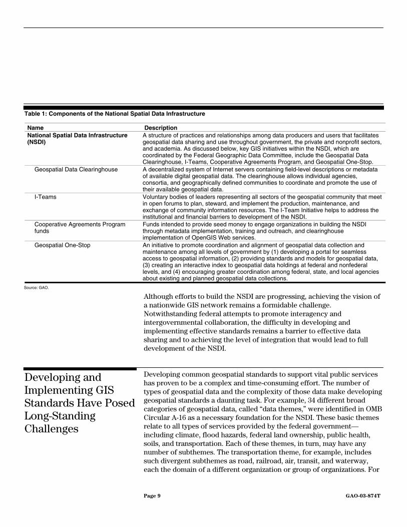
As a result of these federal geospatial coordination efforts, the federal government has begun to establish the NSDI through a number of component programs.10 These include the Geospatial Data Clearinghouse to promote data sharing on a national level, a collection of voluntary “I-Teams” to foster community-level data collection and sharing, a Cooperative Agreements Program to provide seed money for initiatives aimed at better data integration and use, and—most recently—the Geospatial One-Stop initiative, aimed at promoting coordination and alignment of geospatial data collection and maintenance across all levels of government. Table 1 gives more details about the components of the NSDI. I will discuss the Geospatial One-Stop initiative at greater length later in my remarks.
10The FGDC is responsible for coordinating all of these components.
Page 9 GAO-03-874T
Table 1: Components of the National Spatial Data Infrastructure
Name Description National Spatial Data Infrastructure (NSDI)
A structure of practices and relationships among data producers and users that facilitates geospatial data sharing and use throughout government, the private and nonprofit sectors, and academia. As discussed below, key GIS initiatives within the NSDI, which are coordinated by the Federal Geographic Data Committee, include the Geospatial Data Clearinghouse, I-Teams, Cooperative Agreements Program, and Geospatial One-Stop.
Geospatial Data Clearinghouse A decentralized system of Internet servers containing field-level descriptions or metadata of available digital geospatial data. The clearinghouse allows individual agencies, consortia, and geographically defined communities to coordinate and promote the use of their available geospatial data.
I-Teams Voluntary bodies of leaders representing all sectors of the geospatial community that meet in open forums to plan, steward, and implement the production, maintenance, and exchange of community information resources. The I-Team Initiative helps to address the institutional and financial barriers to development of the NSDI.
Cooperative Agreements Program funds
Funds intended to provide seed money to engage organizations in building the NSDI through metadata implementation, training and outreach, and clearinghouse implementation of OpenGIS Web services.
Geospatial One-Stop An initiative to promote coordination and alignment of geospatial data collection and maintenance among all levels of government by (1) developing a portal for seamless access to geospatial information, (2) providing standards and models for geospatial data, (3) creating an interactive index to geospatial data holdings at federal and nonfederal levels, and (4) encouraging greater coordination among federal, state, and local agencies about existing and planned geospatial data collections.
Source: GAO.
Although efforts to build the NSDI are progressing, achieving the vision of a nationwide GIS network remains a formidable challenge. Notwithstanding federal attempts to promote interagency and intergovernmental collaboration, the difficulty in developing and implementing effective standards remains a barrier to effective data sharing and to achieving the level of integration that would lead to full development of the NSDI.
Developing common geospatial standards to support vital public services has proven to be a complex and time-consuming effort. The number of types of geospatial data and the complexity of those data make developing geospatial standards a daunting task. For example, 34 different broad categories of geospatial data, called “data themes,” were identified in OMB Circular A-16 as a necessary foundation for the NSDI. These basic themes relate to all types of services provided by the federal government—including climate, flood hazards, federal land ownership, public health, soils, and transportation. Each of these themes, in turn, may have any number of subthemes. The transportation theme, for example, includes such divergent subthemes as road, railroad, air, transit, and waterway, each the domain of a different organization or group of organizations. For
Developing and Implementing GIS Standards Have Posed Long-Standing Challenges
Page 10 GAO-03-874T
data associated with the NSDI’s themes and subthemes to be effectively shared, standards must be developed that allow interoperability and integration of the many disparate formats of data that are currently collected for each theme and subtheme. Circular A-16 further identifies seven of the themes as the core set of most commonly used data, called “framework themes.”11 FGDC has been working to coordinate the development of these themes as well as other standards since it was established 13 years ago. Although FGDC has developed versions of several of these standards, it has not attempted to finalize a complete set of the seven framework standards. These framework standards would define the simplest level of geographic data commonly used in most geospatial data sets.
OMB Circular A-16 calls for a well-coordinated effort among federal, state, local, and tribal governments, academic institutions, and the private sector to build an effective NSDI.12 Yet in the capital asset plan for the Geospatial One-Stop project published in January 2003, the Department of the Interior noted that the risk was high that agencies would be unwilling to adopt framework data standards. Given that most federal agencies—including large agencies such as DOE, Justice, and Health and Human Services—have not participated in the NSDI framework standards development process, the risk is substantial that the proposed standards will not meet their needs. In addition, agencies could be faced with a potentially expensive effort at “migrating” to the new standard. Substantial investments have already been made to independently develop geospatial systems using formats and standards that meet the specific needs of the agencies that developed them. The potential for agencies to continue to deploy agency-specific, noninteroperable geospatial systems was another high risk identified by Interior in its January 2003 Geospatial One-Stop plan.
Many states and localities have established Web sites that provide a variety of location-related information services, such as updated traffic and transportation information, land ownership and tax records, and
11The seven framework themes are transportation, hydrography, government units, geodetic control, elevation, digital ortho imagery, and cadastral (relating to land ownership).
12OMB Circular A-16, Coordination of Geographic Information and Related Spatial Data
Activities, Revised August 19, 2002. The Circular applies to any executive agency that collects, produces, acquires, maintains, distributes, uses, or preserves paper maps or digital spatial data to fulfill its mission.
Page 11 GAO-03-874T
information on housing for the elderly. Existing commercial products using a variety of formats are already meeting the needs of the states and localities in providing this information. Hence these organizations are likely to have little incentive to adopt potentially incompatible federal standards that could require substantial new investments. According to Arizona’s state cartographer, many local governments currently do not comply with existing FGDC standards because most of their GIS applications were created primarily to meet their internal needs, with little concern for data sharing with federal systems.
Geospatial One-Stop is intended to accelerate the development and implementation of the NSDI by promoting coordination and alignment of geospatial data collection and maintenance across all levels of government. Specifically, its objectives include (1) deploying an Internet portal for one-stop access to geospatial data as an extension to the NSDI Clearinghouse network (see figure 3); (2) developing data standards for the seven NSDI framework data themes; (3) creating an inventory of federal data holdings related to the seven framework themes; and (4) encouraging greater coordination among federal, state, and local agencies about existing and planned geospatial data collection projects.
Figure 3: Geospatial One-Stop Portal Concept
Geospatial One-Stop’s Objectives Are Limited
Page 12 GAO-03-874T
• Deploying an Internet portal. This task was to design and implement an Internet portal to serve as a one-stop interface for users seeking links to geospatial data that were already available and cataloged in the NSDI clearinghouse. A demonstration version of the portal has been developed, and the first publicly available version is expected to be implemented by the end of June 2003. Plans are to begin adding new data to the portal, now that it has been developed. Project officials are also considering future enhancements to the functionality of the portal; however, no milestones have been set for any specific enhancements.
• Developing data standards. The specific objective was to draft the seven NSDI framework standards. Drafts of these seven framework standards, as well as five transportation subthemes and a base standard have now been completed. Project officials plan to submit these drafts to the American National Standards Institute by the end of September 2003.
• Creating an inventory of federal data holdings. To meet this objective, metadata13 for all relevant federal data sets must first be collected and made available in the NSDI Clearinghouse. Users need metadata to determine whether a data set is useful for their purposes and to be aware of any special stipulations about processing and interpreting the data. Accordingly, OMB Circular A-11 required that all federal data sets with a replacement value exceeding $1 million be documented in FGDC metadata and the metadata be accessible and searchable in the NSDI Clearinghouse network by February 10, 2003.
• Encouraging greater coordination among federal, state, and local
agencies. To support this objective, a process has been established to coordinate Geospatial One-Stop’s activities across these various government levels. According to the project’s cooperating states coordinator, eight federal agencies are participating in developing and implementing the initiative. In addition, an intergovernmental board of directors was established with two-thirds of the vote held by state, local and tribal representatives. The purpose of the board was to help ensure collaboration among potential stakeholders from all government sectors. According to the National States Geographic Information Council’s (NSGIC) representative, state, county, and municipal levels of government
13Metadata is information describing the content, quality, condition, and other characteristics of data.
Page 13 GAO-03-874T
are well represented and play a useful role in providing alternative views about the direction of the initiative.14 While Geospatial One-Stop’s objectives are important, they do not represent a significantly new or different approach to the GIS integration problem that the government has been struggling with for more than a decade. First, while developing and implementing an Internet portal may offer users additional functionality over the existing Clearinghouse, unless the underlying geospatial data offered through the portal are standardized across data providers, the additional functionality offered by the portal may be of limited value.
Second, the objective of finalizing the seven framework standards, while important, is limited. As I discussed earlier, a total of 34 data themes was identified in OMB Circular A-16 as a necessary foundation for the NSDI. Geospatial One-Stop’s objectives do not include plans to address any of the remaining 27 themes. Before the broader vision of a unified nationwide network of geospatial data and systems can be achieved, standards for all of NSDI’s foundation data themes will need to be established. Further, definition of the standards is only the first step in gaining their benefits; Geospatial One-Stop has not yet addressed the challenge of gaining consistent implementation of the standards across government, which I have already discussed. In order to attain the broader vision of seamless integration of GIS data on a nationwide basis, a longer-term effort will be required.
Third, creating a complete and useful inventory of federal data holdings will require much more substantial work than is planned through the Geospatial One-Stop initiative. For example, according to the FGDC Metadata Coordinator, the extent to which agencies have posted metadata about their geospatial data sets is unknown. In addition, obtaining complete metadata from all federal sources is likely to be very challenging. If the metadata were not created when the data were originally captured, they could be expensive and time-consuming to generate after the fact, and agencies may not have resources available for the effort. Accordingly, unless Geospatial One-Stop devotes more resources to working with
14The National States Geographic Information Council is an organization of states that promotes the adoption and use of geographic information technologies, including the NSDI and GOS. Members include state GIS coordinators, senior state GIS managers, and representatives from federal agencies, local government, the private sector, academia and other professional organizations.
Page 14 GAO-03-874T
agencies on generating and posting metadata, its objective of creating an inventory of federal data holdings may be delayed.
Finally, despite the creation of the Board of Directors, questions have been raised about the breadth of participation in Geospatial One-Stop. The chair of the board acknowledged that the small group of nonfederal representatives on the board may not be able to speak for all the states and thousands of local governments. It is also not known how well these representatives are disseminating information about the initiative and encouraging collaboration among the states and localities that are not directly represented. As with the initiative’s other objectives, limited actions have been taken aimed at achieving near-term results that only partially address the broader objective of building the NSDI. To fully achieve that broader objective, Geospatial One-Stop will need to better ensure that it has coordinated with all relevant governmental entities and that they understand the initiative and their role in it.
In summary, a coordinated nationwide network of geographic information systems offers many opportunities to better serve the public, make government more efficient and effective, and reduce costs. As a sophisticated decision making tool, GIS provides the capability to strengthen national security, enhance law enforcement, increase public health, and protect the environment. However, to date, the potential of GIS has not been fully realized. While steps have been taken to improve the coordination of government GIS efforts, much more work still needs to be done to round out a comprehensive set of standards and to ensure that they are being broadly applied. Geospatial One-Stop, in particular, while addressing useful near-term tasks, has not focused on the need for a longer-term strategy for facing the challenges of implementing the NSDI.
While it may be appropriate for many systems, especially at the state and local level, to retain non-standard approaches to geospatial data collection and analysis, priority should now be given to ensuring that the federal government promotes common GIS standards wherever practicable, facilitates participation by all stakeholders, and as a result reduces redundant systems and data collection efforts. Adoption of a core set of framework standards by the GIS community should lay the groundwork for achieving the goals of the NSDI. However, additional work may be needed. Existing draft standards may need revision to accommodate the needs of major federal agency users, and more extensive coordination efforts may be required to ensure broad adoption at all levels of government. Further, the effort is likely to require a continuing effort over
Page 15 GAO-03-874T
an extended period of time, due to the fact that significant investments have already been made in existing non-standard systems, and the task of replacing those systems and migrating their data to new standards cannot be accomplished overnight. Nevertheless, we believe that until these challenges are addressed, the goal of a single, coordinated, nationwide system of geospatial data will remain out of reach.
Mr. Chairman, this concludes my statement. I would be pleased to answer any questions that you or other members of the subcommittee may have at this time.
If you should have any questions about this testimony, please contact me at (202) 512-6240 or via E-mail at [email protected]. Other major contributors to this testimony included Shannin Addison, John de Ferrari, Sophia Harrison, and Elizabeth Roach.
Contact and Acknowledgements
Page 16 GAO-03-874T
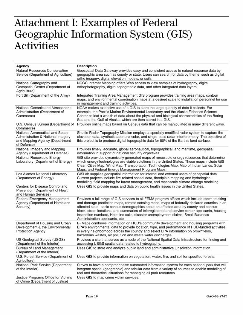
Agency Description Natural Resources Conservation Service (Department of Agriculture)
Geospatial Data Gateway provides easy and consistent access to natural resource data by geographic area such as county or state. Users can search for data by theme, such as digital ortho imagery, digital elevation models, or soils.
National Cartography and Geospatial Center (Department of Agriculture)
NCGC Internet Mapping offers Web access to view samples of hydrography, digital orthophotography, digital topographic data, and other integrated data layers.
Fort Sill (Department of the Army) Integrated Training Area Management GIS program provides training area maps, contour maps, and environmental coordination maps at a desired scale to installation personnel for use in management and training activities.
National Oceanic and Atmospheric Administration (Department of Commerce)
NOAA makes extensive use of a GIS to store the large quantity of data it collects. For example, the Pacific Marine Environmental Laboratory and the Alaska Fisheries Science Center collect a wealth of data about the physical and biological characteristics of the Bering Sea and the Gulf of Alaska, which are then stored in a GIS.
U.S. Census Bureau (Department of Commerce)
Provides online maps based on Census data that can be manipulated in many different ways.
National Aeronautical and Space Administration & National Imagery and Mapping Agency (Department of Defense)
Shuttle Radar Topography Mission employs a specially modified radar system to capture the elevation data, synthetic aperture radar, and single-pass radar interferometry. The objective of this project is to produce digital topographic data for 80% of the Earth’s land surface.
National Imagery and Mapping Agency (Department of Defense)
Provides timely, accurate, global aeronautical, topographical, and maritime, geospatial information in support of national security objectives.
National Renewable Energy Laboratory (Department of Energy)
GIS site provides dynamically generated maps of renewable energy resources that determine which energy technologies are viable solutions in the United States. These maps include GIS Clean Cities Map, Wind Map, Transportation Technologies Map, Map of Indian Lands, Solar Maps, and Federal Energy Management Program Maps.
Los Alamos National Laboratory (Department of Energy)
GISLab supplies geospatial information for internal and external users of geospatial data. Current projects include fire-related spatial data, floodplain mapping and hydrological modeling, field mapping for forest management, and mesoscale climate change modeling.
Centers for Disease Control and Prevention (Department of Health and Human Services)
Uses GIS to provide maps and data on public health issues in the United States.
Federal Emergency Management Agency (Department of Homeland Security)
Provides a full range of GIS services to all FEMA program offices which include storm tracking and damage prediction maps, remote sensing maps, maps of federally declared counties in an affected state, basic census demographics about an affected area by county and census block, street locations, and summaries of teleregistered and service center applicants, housing inspection numbers, Help-line calls, disaster unemployment claims, Small Business Administration applicants, etc.
Department of Housing and Urban Development & the Environmental Protection Agency
E- Maps combines information on HUD’s community development and housing programs with EPA’s environmental data to provide location, type, and performance of HUD-funded activities in every neighborhood across the country and select EPA information on brownfields, hazardous wastes, air pollution and waste water discharges.
US Geological Survey (USGS) (Department of the Interior)
Provides a site that serves as a node of the National Spatial Data Infrastructure for finding and accessing USGS spatial data related to hydrography.
Bureau of Land Management (Department of the Interior)
Uses GIS to store and analyze public land and administrative jurisdiction information.
U.S. Forest Service (Department of Agriculture)
Uses GIS to provide information on vegetation, water, fire, and soil for specified forests.
National Park Service (Department of the Interior)
Strives to have a comprehensive automated information system for each national park that will integrate spatial (geographic) and tabular data from a variety of sources to enable modeling of real and theoretical situations for managing all park resources.
Justice Programs Office for Victims of Crime (Department of Justice)
Uses GIS to map crime victim services.
Attachment I: Examples of Federal Geographic Information System (GIS) Activities
Page 17 GAO-03-874T
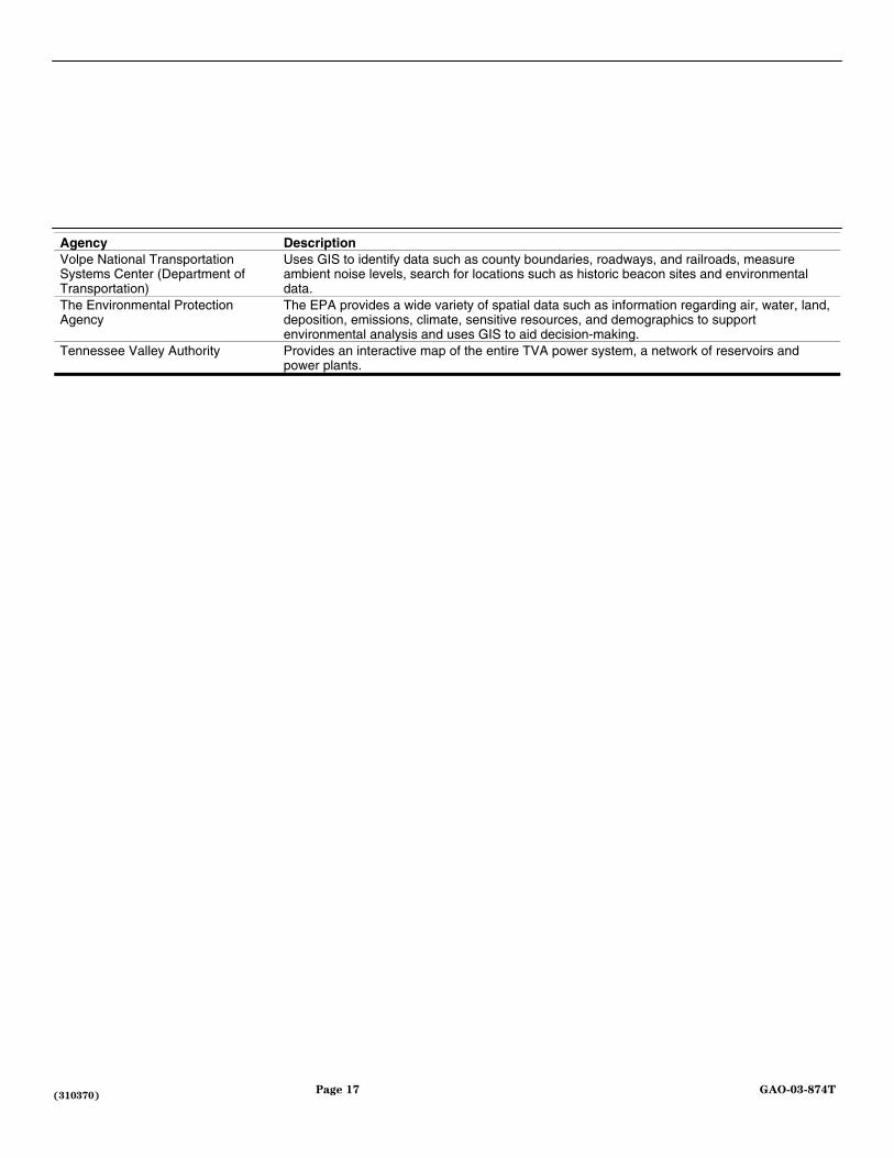
Agency Description Volpe National Transportation Systems Center (Department of Transportation)
Uses GIS to identify data such as county boundaries, roadways, and railroads, measure ambient noise levels, search for locations such as historic beacon sites and environmental data.
The Environmental Protection Agency
The EPA provides a wide variety of spatial data such as information regarding air, water, land, deposition, emissions, climate, sensitive resources, and demographics to support environmental analysis and uses GIS to aid decision-making.
Tennessee Valley Authority Provides an interactive map of the entire TVA power system, a network of reservoirs and power plants.
(310370)

This is a work of the U.S. government and is not subject to copyright protection in the United States. It may be reproduced and distributed in its entirety without further permission from GAO. However, because this work may contain copyrighted images or other material, permission from the copyright holder may be necessary if you wish to reproduce this material separately.
The General Accounting Office, the audit, evaluation and investigative arm of Congress, exists to support Congress in meeting its constitutional responsibilities and to help improve the performance and accountability of the federal government for the American people. GAO examines the use of public funds; evaluates federal programs and policies; and provides analyses, recommendations, and other assistance to help Congress make informed oversight, policy, and funding decisions. GAO’s commitment to good government is reflected in its core values of accountability, integrity, and reliability.
The fastest and easiest way to obtain copies of GAO documents at no cost is through the Internet. GAO’s Web site (www.gao.gov) contains abstracts and full-text files of current reports and testimony and an expanding archive of older products. The Web site features a search engine to help you locate documents using key words and phrases. You can print these documents in their entirety, including charts and other graphics.
Each day, GAO issues a list of newly released reports, testimony, and correspondence. GAO posts this list, known as “Today’s Reports,” on its Web site daily. The list contains links to the full-text document files. To have GAO e-mail this list to you every afternoon, go to www.gao.gov and select “Subscribe to daily E-mail alert for newly released products” under the GAO Reports heading.
The first copy of each printed report is free. Additional copies are $2 each. A check or money order should be made out to the Superintendent of Documents. GAO also accepts VISA and Mastercard. Orders for 100 or more copies mailed to a single address are discounted 25 percent. Orders should be sent to:
U.S. General Accounting Office 441 G Street NW, Room LM Washington, D.C. 20548
To order by Phone: Voice: (202) 512-6000 TDD: (202) 512-2537 Fax: (202) 512-6061
Contact:
Web site: www.gao.gov/fraudnet/fraudnet.htm E-mail: [email protected] Automated answering system: (800) 424-5454 or (202) 512-7470
Jeff Nelligan, Managing Director, [email protected] (202) 512-4800 U.S. General Accounting Office, 441 G Street NW, Room 7149 Washington, D.C. 20548
GAO’s Mission
Obtaining Copies of GAO Reports and Testimony
Order by Mail or Phone
To Report Fraud, Waste, and Abuse in Federal Programs
Public Affairs