garrett cellular tower application cases/2013-00370/20131202_east... · garrett cellular tower...
TRANSCRIPT

EAST KENTUCKY NETWORK, LLC d/b/a APPALACHIAN WIRELESS
GARRETT CELLULAR TOWER
APPLICATION
Floyd County, Kentucky P.S.C. Case # 2013-00370

C COMMONWEALTH OF KENTUCKY BEFORE THE PUBLIC SERVICE COMMISSION
0 ZI 047 C
4/
In the matter of:
THE APPLICATION OF EAST KENTUCKY NETWORK LIMITED LIABILITY COMPANY FOR THE ISSUANCE OF A CERTIFICATE OF PUBLIC CONVENIENCE AND NECESSITY TO CONSTRUCT A TOWER IN FLOYD COUNTY, KENTUCKY).
) CASE No 2013-00370
East Kentucky Network, LLC, d/b/a Appalachian Wireless, was granted authorization to
provide cellular service in the KY-9 Cellular Market Area (CMA451) by the Federal
Communications Commission (FCC). FCC license is included as Exhibit 1. East Kentucky
Network, LLC merger documents were filed with the Commission on February 2, 2001 in Case #
2001-022.
In an effort to improve service in Floyd County, East Kentucky Network, LLC pursuant to KRS
278.020 Subsection 1 and 807 KAR 5:001 Section 9 is seeking the Commission's approval to construct
a 300 foot self-supporting tower on a tract of land located off of Community Church Road, Garrett,
Floyd County, Kentucky (37°29'20.1"N 82°51'11.2"W). A map and detailed directions to the site can
be found in Exhibit 8.
Exhibit 2 is a list of all Property owners or residents according to the property valuation
administrator's record who reside or own property within 500 feet of the proposed tower in
accordance with the Public Valuation Administrator. No other properties are contiguous with East
Kentucky Network's property.
Pursuant to 807 KAR 5:063 Section 1 (1)(L) and Section 1(1)(n)(1) all affected property
owners according to the property valuation administrator's record who reside or own property
within 500 feet of the proposed Tower were notified by certified mail return receipt requested of
. East Kentucky Network, LLC's proposed construction and informed of their right to intervene.

They were given the docket number under which this application is filed. Enclosed in Exhibit 2 is
a copy of that notification.
Floyd County has no formal local planning unit. In absence of this unit the Floyd County
Judge Executive's office was notified by certified mail, return receipt requested of East Kentucky
Network Limited Liability Company's proposal and informed of their right to intervene. They
were given the docket number under which this application is filed. Enclosed in Exhibit 3 is a
copy of that notification.
Notice of the location of the proposed construction was published in the Floyd County
Times' November 27, 2013 edition. Enclosed is a copy of that notice in Exhibit 3. The Floyd
County Times is the newspaper with the largest circulation in Floyd County.
A geologist was employed to determine soil and rock types and to ascertain the distance to
solid bedrock. The geotechnical report is enclosed as Exhibit 4.
A copy of the tower design information is enclosed as Exhibit 5. The proposed tower has
been designed by engineers at Tower Innovations and will be constructed under their supervision.
Their qualifications are evidenced in Exhibit 5 by the seal and signature of the registered
professional engineer responsible for this project.
The tower will be erected by S & S Tower Services of St. Albans, West Virginia. S & S
Tower Services has vast experience in the erection of communications towers.
FAA and Kentucky Airport Zoning Commission applications are included as Exhibit 6.
No Federal Communications Commission approval is required prior to construction of this
facility. Once service is established from this tower we must immediately notify the Federal
Communications Commission of its operation. Prior approval is needed only if the proposed
facility increases the size of the cellular geographic service area. This cell site will not expand the
cellular geographic service area.

East Kentucky Network, LLC will finance the subject Construction with earned surplus in
its General Fund.
Estimated Cost of Construction
$ 350,000.00 Annual Operation Expense of Tower
$ 12,500.00
Two notice signs meeting the requirements prescribed by 807 KAR 5:063, Section 1(2),
measuring at least two (2) feet in height and four (4) feet in width and containing all required
language in letters of required height, have been posted, one at a visible location on the proposed
site and one on the nearest public road. The two signs were posted on October 9, 2013 and will
remain posted for at least two weeks after filing of this application as specified.
Enclosed in Exhibit 9 is a copy of East Kentucky Network LLC's deed to the site.
The proposed construction site is on a very rugged mountaintop some feet from the nearest
structure and is located in a reclaimed mining area.
Due to the steep hillside surrounding the proposed site, the property in close proximity is
unsuitable for any type of development. East Kentucky Network LLC's operation will not affect
the use of nearby land nor its value. No more suitable site exists in the area. A copy of the search
area map is enclosed in Exhibit 8. No other tower capable of supporting East Kentucky Network
LLC's load exists in the general area; therefore, there is no opportunity for co-location of our
facilities with anyone else.
Enclosed, and filed as Exhibit 10 is a survey of the proposed tower site signed by a
Kentucky registered professional engineer.
Exhibit 12 contains a vertical sketch of the tower supplied by Summit Engineering.

WHEREFORE, Applicant respectfully requests that the PSC accept the foregoing
Application for filing, and having met the requirements of KRS [278.020(1), 278.650, and
278.665] and all applicable rules and regulations of the PSC, grant a Certificate of Public
Convenience and Necessity to construct and operate the proposed tower.
The foregoing document was prepared by Lynn Haney, Compliance Coordinator for East
Kentucky Network, LLC d/b/a Appalachian Wireless. All related questions or correspondence
concerning this filing should be mailed to East Kentucky Network, LLC d/b/a/ Appalachian
Wireless, 101 Technology Trail, Ivel, KY 41642.
SUBMITTED BY:
Lynn Haney, Compliance Coordinator
APPROVED BY: 1,0
DATE: 0-2-A°13
W. A. Gillum, General Manager
CONTACT INFORMATION:
W. A. Gillum, General Manager Phone: (606) 477-2355, Ext. 111 Email: [email protected]
Lynn Haney, Compliance Coordinator Phone: (606) 477-2355, Ext. 1007 Email: [email protected]
Mailing Address:
East Kentucky Network, LLC d/b/a Appalachian Wireless 101 Technology Trail Ivel, ICY 41642

FAA & Kentucky Airport Zoning Commission Approvals
Audited Financial Statements
Driving Directions from County Court House and Map to Suitable Scale
Deed for Proposed Site
FCC License
Copies of Cell Site Notices to Land Owners
Notification of County Judge Executive and Newspaper Advertisement
Universal Soil Bearing Analysis
Tower Design
Survey of Site Signed/Sealed by Professional Engineer Registered in State of Kentucky
Site Survey Map with Property Owners Identified in Accordance with PVA of County
Vertical Profile Sketch of Proposed Tower

ULS License - Cellular License - KNKN880 - East Kentucky Network, LLC d/b/a Appala... Page 1 of 2
ULS License
Cellular License - KNKN880 - East Kentucky Network, LLC d/b/a Appalachian Wireless
E This license has pending applications: 0005928012
Call Sign KNKN880 Radio Service CL - Cellular
Status Active Auth Type Regular
Market
Market CMA451 - Kentucky 9 - Elliott Channel Block B
Submarket 0 Phase 2
Dates
Grant 08/30/2011 Expiration 10/01/2021
Effective 11/02/2013 Cancellation
Five Year Buildout Date
10/23/1996
Control Points
1 U.S. 23, HAROLD, KY
Licensee
FRN 0001786607
Licensee
East Kentucky Network, LLC d/b/a Appalachian Wireless 101 Technology Trail Ivel, KY 41642 ATTN W.A. Gillum, General Manager/CEO
Contact
Lukas, Nace, Gutierrez & Sachs, LLP Pamela L Gist Esq 8300 Greensboro Drive McLean, VA 22102
Type Limited Liability Company
P:(606)477-2355
P:(703)584-8665 F: (703)584-8695 E:[email protected]
Ownership and Qualifications
Radio Service Mobile Type
Regulatory Status Common Carrier Interconnected Yes
Alien Ownership The Applicant answered "No" to each of the Alien Ownership questions.
Basic Qualifications The Applicant answered "No" to each of the Basic Qualification questions.
http://wireless2.fcc.gov/U1sApp/U1sSearch/license.jsp?licKey=129178camp;printable 11/22/2013

ULS License - Cellular License - KNKN880 - East Kentucky Network, LLC d/b/a Appala... Page 2 of 2
Demographics
Race
Ethnicity
Gender
http://wireless2.fcc.gov/U1sApp/U1sSearch/licensejsp?licKey=12917&printable 11/22/2013
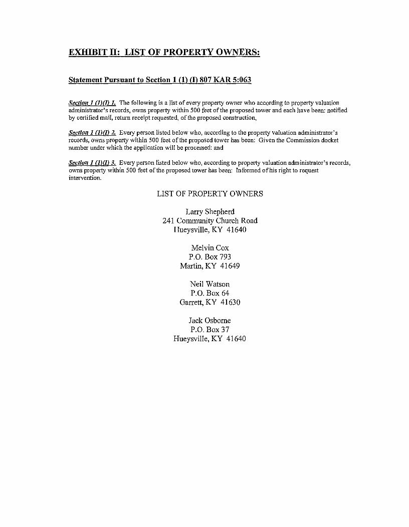
EXHIBIT H: LIST OF PROPERTY OWNERS:
Statement Pursuant to Section 1 (1) (I) 807 KAR 5:063
Section 1 (I)(I) 1. The following is a list of every property owner who according to property valuation administrator's records, owns property within 500 feet of the proposed tower and each have been: notified by certified mail, return receipt requested, of the proposed construction,
Section I (1)(I) 2. Every person listed below who, according to the property valuation administrator's records, owns property within 500 feet of the proposed tower has been: Given the Commission docket number under which the application will be processed: and
Section 1 (1)(I) 3. Every person listed below who, according to property valuation administrator's records, owns property within 500 feet of the proposed tower has been: Informed of his right to request intervention.
LIST OF PROPERTY OWNERS
Larry Shepherd 241 Community Church Road
Hueysville, KY 41640
Melvin Cox P.O. Box 793
Martin, KY 41649
Neil Watson P.O. Box 64
Garrett, KY 41630
Jack Osborne P.O. Box 37
Hueysville, KY 41640

EAST KENTUCKY NETWORK
101 TECHNOLOGY TRAIL
IVEL, KY 41642
PHONE: (606) 874-7550
FAX: (606) 874-7551
EMAIL: [email protected]
WEBSITE: WWW.EKN.COM EAST KENTUCKY NETWORK
U.S. CERTIFIED MAIL
November 22, 2013
Larry Shepherd 241 Community Church Road Hueysville, KY 41640
RE: Public Notice-Public Service Commission of Kentucky (Case No. 2013-00370)
East Kentucky Network, LLC d/b/a Appalachian Wireless is applying to the Public Service Commission of Kentucky for a Certificate of Public Convenience and Necessity to construct and operate a new facility to provide cellular telecommunications service in Floyd County. The facility will include a 300 foot self supporting tower with attached antennas extending upwards, and an equipment shelter on a tract of land located off of Community Church Road, Garrett, Floyd County, Kentucky. A map showing the location of the proposed new facility is enclosed. This notice is being sent to you because you may own property or reside within a 500' radius of the proposed tower.
The Commission invites your comments regarding the proposed construction. You also have the right to intervene in this matter. The Commission must receive your initial communication within 20 days of the date of this letter as shown above.
Your comments and request for intervention should be addressed to: Executive Director's Office, Public Service Commission of Kentucky, P.O. Box 615, Frankfort, KY 40602. Please refer to Case No. 2013-00370 in your correspondence.
If you have any questions for East Kentucky Network, LLC, please direct them to my attention at the following addresS: East Kentucky Network, LLC, 101 Technology Trail, Ivel, KY 41642 or call me at 606-477-2355, Ext. 1007.
Sincerely,
(4LA-e-Lk--
Lynn Haney Compliance Coordinator
Enclosure 1

EAST KENTUCKY NETWORK
101 TECHNOLOGY TRAIL
IVEL, KY 41642
PHONE: (606) 874.7550
FAX: (606) 874-7551
EMAIL: [email protected]
WEBSITE: WWW.EKN.COM EAST KENTUCKY
VIA: U.S. CERTIFIED MAIL
November 22, 2013
Melvin Cox P.O. Box 793 Martin, KY 41649
RE: Public Notice-Public Service Commission of Kentucky (Case No. 2013-00370)
East Kentucky Network, LLC d/b/a Appalachian Wireless is applying to the Public Service Commission of Kentucky for a Certificate of Public Convenience and Necessity to construct and operate a new facility to provide cellular telecommunications service in Floyd County. The facility will include a 300 foot self supporting tower with attached antennas extending upwards, and an equipment shelter on a tract of land located off of Community Church Road, Garrett, Floyd County, Kentucky. A map showing the location of the proposed new facility is enclosed. This notice is being sent to you because you may own property or reside within a 500' radius of the proposed tower.
The Commission invites your comments regarding the proposed construction. You also have the right to intervene in this matter. The Commission must receive your initial communication within 20 days of the date of this letter as shown above.
Your comments and request for intervention should be addressed to: Executive Director's Office, Public Service Commission of Kentucky, P.O. Box 615, Frankfort, KY 40602. Please refer to Case No. 2013-00370 in your correspondence.
If you have any questions for East Kentucky Network, LLC, please direct them to my attention at the following address: East Kentucky Network, LLC, 101 Technology Trail, Ivel, KY 41642 or call me at 606-477-2355, Ext. 1007.
Sincerely,
Lynn Haney Compliance Coordinator
Enclosure 1

EAST KENTUCKY NETWORK
101 TECHNOLOGY TRAIL
IVEL, KY 41642
PHONE: (606) 874-7550
FAX: (606) 874-7551
EMAIL: [email protected]
WEBSITE: WWW.EKN.COM EAST ETW
KE N6J iCzkl
VIA: U.S. CERTIFIED MAIL
November 22, 2013
Neil Watson P.O. Box 64 Garrett, KY 41630
RE: Public Notice-Public Service Commission of Kentucky (Case No. 2013-00370)
East Kentucky Network, LLC d/b/a Appalachian Wireless is applying to the Public Service Commission of Kentucky for a Certificate of Public Convenience and Necessity to construct and operate a new facility to provide cellular telecommunications service in Floyd County. The facility will include a 300 foot self supporting tower with attached antennas extending upwards, and an equipment shelter on a tract of land located off of Community Church Road, Garrett, Floyd County, Kentucky. A map showing the location of the proposed new facility is enclosed. This notice is being sent to you because you may own property or reside within a 500' radius of the proposed tower.
The Commission invites your comments regarding the proposed construction. You also have the right to intervene in this matter. The Commission must receive your initial communication within 20 days of the date of this letter as shown above.
Your comments and request for intervention should be addressed to: Executive Director's Office, Public Service Commission of Kentucky, P.O. BoX 615, Frankfort, KY 40602. Please refer to Case No. 2013-00370 in your correspondence.
If you have any questions for East Kentucky Network, LLC, please direct them to my attention at the following address: East Kentucky Network, LLC, 101 Technology Trail, Ivel, KY 41642 or call me at 606-477-2355, Ext. 1007.
Sincerely,
4c=r-vuur-- Lynn Haney Compliance Coordinator
Enclosure 1

EAST KENTUCKY NETWORK
101 TECHNOLOGY TRAIL
IVEL, KY 41642
PHONE: (606) 874-7550
FAX: (606) 874-7551
EMAIL: [email protected]
WEBSITE: WWW.EKN.COM EAST KEN6Jkk'
VIA: U.S. CERTIFIED MAIL
November 22, 2013
Jack Osborne P.O. Box 37 Hueysville, KY 41640
RE: Public Notice-Public Service Commission of Kentucky (Case No. 2013-00370)
East Kentucky Network, LLC d/b/a Appalachian Wireless is applying to the Public Service Commission of Kentucky for a Certificate of Public Convenience and Necessity to construct and operate a new facility to provide cellular telecommunications service in Floyd County. The facility will include a 300 foot self supporting tower with attached antennas extending upwards, and an equipment shelter on a tract of land located off of Community Church Road, Garrett, Floyd County, Kentucky. A map showing the location of the proposed new facility is enclosed. This notice is being sent to you because you may own property or reside within a 500' radius of the proposed tower.
The Commission invites your comments regarding the proposed construction. You also have the right to intervene in this matter. The Commission must receive your initial communication within 20 days of the date of this letter as shown above.
Your comments and request for intervention should be addressed to: Executive Director's Office, Public Service Commission of Kentucky, P.O. Box 615, Frankfort, KY 40602. Please refer to Case No. 2013-00370 in your correspondence.
If you have any questions for East Kentucky Network, LLC, please direct them to my attention at the following address: East Kentucky Network, LLC, 101 Technology Trail, Ivel, KY 41642 or call me at 606-477-2355, Ext. 1007.
Sincerely,
Lynn Haney Compliance Coordinator
Enclosure 1

Lommunitv rhurrh R. IlarrP
GPS Location
\ 37 29 2013, W 82 51 11.23
Appalachian Wireless Location Map
EAST KENTUCKY NETWORK
101 TECHNOLOGY TRAIL
IVEL, KY 41642
PHONE: (606) 874-7550
FAX: (606) 874-7551
EMAIL: [email protected]
WEBSITE: WWW.EKN.COM EAST KENTUCKY
NETWORK
VIA: U.S. CERTIFIED MAIL
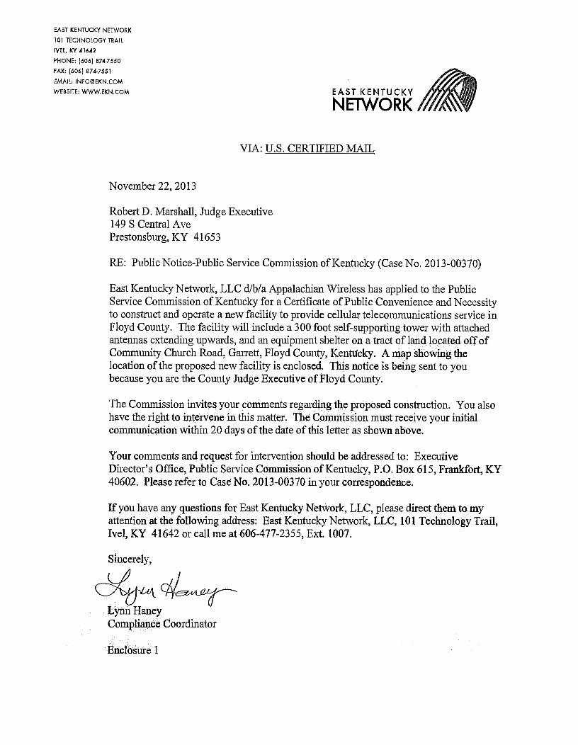
November 22, 2013
Robert D. Marshall, Judge Executive 149 S Central Ave Prestonsburg, KY 41653
RE: Public Notice-Public Service Commission of Kentucky (Case No. 2013-00370)
East Kentucky Network, LLC d/b/a Appalachian Wireless has applied to the Public Service Commission of Kentucky for a Certificate of Public Convenience and Necessity to construct and operate a new facility to provide cellular telecommunications service in Floyd County. The facility will include a 300 foot self-supporting tower with attached antennas extending upwards, and an equipment shelter on a tract of land located off of Community Church Road, Garrett, Floyd County, Kentucky. A map showing the location of the proposed new facility is enclosed. This notice is being sent to you because you are the County Judge Executive of Floyd County.
The Commission invites your comments regarding the proposed construction. You also have the right to intervene in this matter. The Commission must receive your initial communication within 20 days of the date of this letter as shown above.
Your comments and request for intervention should be addressed to: Executive Director's Office, Public Service Commission of Kentucky, P.O. Box 615, Frankfort, KY 40602. Please refer to Case No. 2013-00370 in your correspondence.
If you have any questions for East Kentucky Network, LLC, please direct them to my attention at the following address: East Kentucky Network, LLC, 101 Technology Trail, Ivel, KY 41642 or call me at 606-477-2355, Ext. 1007.
Sincerely,
Lynn Haney Compliance Coordinator
Enclosure 1

Appalachian Wireless Location Map
Site Name
harrett Community Church \ 37 29 2013 W 82 51 1123

dba Appalachian Wireless 101 Technology Trail Ivel, KY 41642 Phone: 606-477-2355 Fax: 606-791-2225
EAST KENTUCKY
NETWORK
To: Floyd County Times
Attn: Classifieds
From: Lynn Haney
Compliance Coordinator
Email: [email protected] Date: November 22, 2013
Re: PUBLIC NOTICE ADVERTISEMENT Pages: 1
Please place the following Public Notice Advertisement in the Floyd County Times November 27, 2013 edition.
PUBLIC NOTICE:
RE: Public Service Commission of Kentucky (CASE NO. 2013-00370)
Public Notice is hereby given that East Kentucky Network, LLC, dba Appalachian Wireless has applied to the Kentucky Public Service Commission to construct a cellular telecommunications tower on a tract of land located off of Community Church Road, Garrett, Floyd County, Kentucky. The proposed tower will be a 300 foot self-supporting tower with attached antennas. If you would like to respond to this notice, please contact the Executive Director, Public Service Commission, 211 Sower Boulevard, PO Box 615, Frankfort, Kentucky 40602. Please refer to Case No. 2013-00370.
If you have any questions about the placement of the above mentioned notice, please call me at 606-477-2375, ext. 1007.
Thank you,
Lynn Haney Compliance Coordinator
The message above and the information contained in the documents transmitted are confidential and intended only for the person(s) named above. Dissemination, distribution or copying of this communication by anyone other than the person(s) named above is prohibited. If you have received this communication in error, please notify us immediately by telephone and return the original message to us at the address listed above via regular mail. Thank you.
Next Generation Communications

WENDELL R. HOLMES, P.G. 424 Pear Street
Hazard, KY 41701 (606) 438-7250
October 11, 2013
Garrett Tower Site
Purpose:
A site assessment was conducted for Appalachian Wireless on a tract of land located in Floyd County near Garrett, Kentucky. The site of the proposed tower is now a reclaimed mountain top removal mine site. The purpose of this investigation was to determine the depth of material and of what type of rock the fill material consists.
Site Investigation:
Mine mapping and a site investigation was used to determine the type of material at the proposed tower site. There is approximately forty feet of mine spoil on which the tower will be located. The area was mined by the mountain top removal method and backfilled, with the material which was overlying the coal (overburden), approximately twenty years ago. The material consists of fragments of sandstone and shale which is generally associated with the overburden of the Peach Orchard coal bed. (See attached page for descriptions of materials encountered.) The terrain in Floyd County is moderately to very steep. The tower site is located on a ridge between Right Beaver Creek and Saltlick Creek, both being tributaries of the Levisa Fork of the Big Sandy, approximately one mile northwest of Garrett in Floyd County. The fill material below the tower site is approximately 40.00 feet thick, based on the information obtained from the site investigation, mine maps and geological maps of the area.
Conclusions:
The proposed tower site is located on a ridge in the area. The fill material has been in place for approximately twenty years. Tests were not conducted to determine the load-bearing strength of the fill material. However, it is apparent that the tower will be constructed on the fill material.
The field work for this site was performed by Wendell R. Holmes, using generally accepted methods in the practice of geological science.
Wendell R tskilidtego P.G.

WENDELL R. HOLMES, P.G.
424 Pear Street Hazard, KY 41701
606438-7260
Geologist Log
Location: Garrett Tower Site
Unit Thickness
Total depth
Strata Description
10.00'± 10.00,+ Mine Spoil Unconsolidated material containing large rocks
and dirt

r-- 2.0.
269'
4.00'
4.00'
0— 240' 4.00'
730'
0.55'
IGO' 10.00'
140'
ISO'
1130'
1.5.00'
1 00' 14.50'
EMBER. CHART.
76.0. 35 kin .5.44.
7.**,:23 kips
106 idol
MAX TOTAL
3
MAX INDIVIDUAL L.F.D LOADO
354 4175
6 6.7 .k los
41 255 kips
Fil5amo, Mtiet
177. I 0(11
1 11.6.11 3/12.. ApsAL11 war 46410 11531 41/32' ./sr touita 14L4141/1e
GOT P4
GRP
tte
I) SOME DETAIL HAS BEEN OMITTED FOR CLARITY OF ILLUSTRATION.
2) TOWER IS DESIGNED FOR A 70 MPH. BASIC WIND IN ACCORDANCE WITH. THE. TIA/EIA-222-F STANDARD,
3) TOWER IS ALSO DESIGNED FOR A 61 MPH BASIC W1110 WITH 1/2" ICE.
4) 'TOWER IS DESIGNED FOR STEP BOLTS A510 A SAFETY CLIMB.
5) TOWER DESIGNED FOR FEEDLINES TO BE (40UNTED ON CLIP-ON WAVEGUIDE LADDERS.
6) DOLTED SECTIONS A - L ARE 3-DAY X-BRACED. BOLTED SECTIONS - 0 ARE 4-DAY X-BRACED.
DESIGN & DRAWING NOTES:
titite11426 Of /9.
!Km
11113/13
N/13/13
11/13/13 Diva AD. REV
ELEVATION VIEW & MEMBER INFORMATION GARRETT, (FLOYD COUNTY) KY
6123-11
'I Dlt'CT
00 N01'SCALL 00101140'
PH/ (6112 853-0595 7A11(BIG 853-6632 3211 OW OWE 1/1689115101. IN 67630
N ER: E DER & (CONNECTION 0 LEGS) SECTION , ELEVATION FACE SIZE LEGS DIAGONALS HORIZONTALS
A - 20' 1130 - 2 4-1/
FLANGE CONNECTIONS
(6) OR (4.4) PER FLANGE
0' LLtv. (1-1/a• . 74) L5-1/ 3-1/2 I' 1/4 ( 4 1-3/41
• 20" 40' 1030' - 14,00' 4-1/4 L3-1/0 a 3-1/1 1/4 (3/12 r 1-1/41 20' cicv. (I-1/18 0) 11/ • 40' 111, • . 4-1/4 LSI 3. 15 1/4 (5/14 1-3/4) 0' 1 (1-1/20
10' Me 17.5 4-1/4 13 s 1/4 (SAY • 1•3/4) vo' Cl6V. (1-1/24 6) N/A Iroo' 14.50' /1. 50' LIEv. (I-1/2 6)
1 103' - 123' 1430' 13.00' III' III (10 4-3/4)
120' 140' 13.00' 1,50'
tl 13 3/15 (5/18 r 1-3/4)
.02-1 2 2-1 y /14 (5/30 • 1-1/4
1/3 1/14 Was .1-3/4 3.1/4 /4 120' La Or /4)
13.1/2 0-1y2 (s/a• v • 2/1 140 160' 140' DIV. (14 ,'4-3/4) 0/3 -3/4 11.50' - 10.00' ISO' - 50 10 -3/4) /04 /Et 2 2 3/16( 160 WY. (10 a 4-3/4)
- 7 Li- 430 - 7.00' 3-1/2 leo 2100. (10 r 4-3/4) /4 /4 . 1.3/4 V 3/13 OM 1-3/4
- 120' 7.00''- 0.05'
SECTION CURBING EIGHT (lbs.)
11.4 5500
nosti 5200
11017, 4500
10 4 47C0
010 4 3900
MOIL 4 3600
KM 4 320 110104 3102
01E. 4 2600
0010 4 7500
11014 7100
I IMIL: 2100
1401E1 4 000
11011.: 4 1450
- 740
/4
11/4 330' - 4.00'
3-1/4 203' 1117. (le 4-3/4) /4 • 1-0 • 3/15 We. • 1-3/4
2411' 36D• 4.00'
730 330' /4 0/16 .
200' 3 4.00' N/A 11010'4
3-1/4 023. (3.7Y, :i0 y 4-2/4) 1.1-314 1-5/4 3/11 (SA. v I-3/4 3 240' ELM III 7 4-3/4) 11-3/1 5 1-3/4 • 3/17 W*5 1-3/4
-1/2 750' IL17. (1 4-3/4 1.1-3/4 1-3/4 • 3/13
1-3/4 NW -It 40/20 1 3-17 2 1.1.3/ 1-314 A 3/ 0/ 1-3/4
ANTENNA INFORMATION
(10) 1-5/0 LINES —i TO 295' ELEV.
r'\.■5. (12) I-5/0 USES
/
rift( TO 275' ELM
7 d'\ V
6-// FACE C (
ke.).#
(12) -5/6 LINO-10 255' ELEV.
Fe5SIne Distribution Iniernsollon I) The Slot, 51r1clure Is Deslaseri
According To The Fledlins InformalIon Pmuide0.
ANTENNA ELEVATION UNE
(6) TYPICAL 4' PANELS * mu' (5) !...s/a
(3) 13' GATE MOUNTS 13 300 14/4 (II) TYPICAL 4' PANELS 0Z92' (12) 1-510
(3) 13' GATE sEDUSTS 17 292' N/A
(14 TOPICAL 4' PANELS * 2110* (12) I-5/B
(3) IS' GATE MOUNTS 0 280' 51/4
(5) TYPICAL 4' PANELS * 250' (0) 1-3/0
(3) 13' GATE MOUNTS 0 260' N/A
IS' STANDARD. PLUS RACINE W/DISH 0 220' (1) I-5/6
4' ST4110 PLUS 040014E /DISH * 200' (I) 1-5/0
6' 51ANDAR0 PLUS RADIUM W/51511 0 100' (1) 1-5/8
4' STANDARD PLUS RAODME /DISH 0 120' (1) 1-5/6
6' STANDARD PLUS ROOK 17/131511 0 100' (I) 1-5/0
6' STANDARD PLUS 0400 /DISH 0 00' (I) i-sis
MATERIAL SPEC CHART DESC. NAT'L SPEC. MIN. YIELD (40/)
0CL130 0-1111/CED SECTIONS 7 - o
LEGS 4-571 GRAM 00 50 101420 KU. 4-522 GRADE 00 5*
FLANGE PL 4-571 GRADE 30 55
LEG PAD Pl. A-30 36
--- 300' 4.00'
1630
17.50'
19.00'
20.30'
22.00'
FACE SIZE
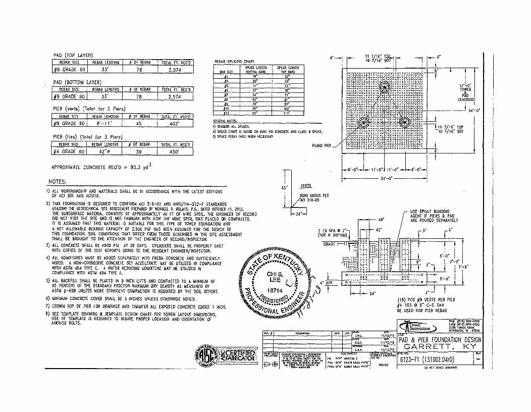
REBAR LENGTHS REBAR SIZE
33, #9 GRADE 60
DF REBAR REBAR SIZE I REBAR LENGTHS TOTAL FT. REO'D
OF ROAR I TOTAL FT. RED'S
78 1 2,574
39 #4 GRADE 601 42"0 430'
2,574 78
1 1 0" 11.-0"
34' 0"
owor ) 094 (812) 853-0595 rAl4 (812) 853-6652 3266 TOWER DRIVE NEWBURGH. IN 47635
PAD (TOP LAYER)
33' #9 GRADE 60
#9 GRADE 60 45 402'
APPROXIMATE CONCRETE REO'D = 93.3 yd 3
NOTES;
1) ALL WORKMANSHIP AND MATERIALS SHALL BE IN ACCORDANCE WITH THE LATEST EDITIONS OF ACI 301 AND AC1318.
2) THIS FOUNDATION IS DESIGNED TO CONFORM ACI 318-02 AND ANSI/TIA-222-F STANDARDS UTILIZING THE GEOTECHNICAL SITE ASSESSMENT PREPARED BY WENDELL R. HOLMES, P.G., DATED OCTOBER 11, 2013. THE SUBSURFACE MATERIAL CONSISTS OF APPROXIMATELY 40 FT OF MINE SPOIL. THE ENGINEER OF RECORD DID NOT VISIT THE SITE AND. IS NOT FAMILIAR WITH HOW THE MINE SPOIL WAS PLACED OR COMPACTED. IT IS ASSUMED THAT THIS MATERIAL IS SUITABLE FOR THIS. TYPE OF TOWER FOUNDATION AND A NET ALLOWABLE BEARING CAPACITY OF 2,500 PSF HAS BEEN ASSUMED FOR THE DESIGN OF THIS FOUNDATION. SOIL CONDITIONS THAT DIFFER FROM THOSE DESCRIBED IN THE SITE ASSESSMENT SHALL BE BROUGHT TO THE ATTENTION OF THE ENGINEER OF RECORD/INSPECTOR.
3) ALL CONCRETE SHALL BE 400D PSI AT 28 DAYS. CYLINDERS SHALL BE PROPERLY CAST WITH COPIES OF THE TEST REPORTS GOING TO THE RESIDENT ENGINEER/INSPECTOR.
4) ALL ADMIXTURES MUST BE ADDED SEPARATELY INTO FRESH CONCRETE AND SUFFICIENTLY MIXED. A NON-CORROSIVE CONCRETE SET ACCELERATE MAY BE UTILIZED IN COMPLIANCE WITH ASTM 494 TYPE C. A WATER REDUCING ADMIXTURE MAY BE UTILIZED IN COMPLIANCE WITH ASTM 494 TYPE A.
5) ALL BACKFILL SHALL BE PLACED IN 9 INCH LIFTS AND COMPACTED TO A MINIMUM OF 95 PERCENT OF THE STANDARD PROCTOR MAXIMUM DRY DENSITY AS MEASURED BY ASTM D-698 UNLESS MORE STRINGENT COMPACTION IS REQUIRED BY THE SOIL REPORT.
6) MINIMUM CONCRETE COVER SHALL BE 3 INCHES UNLESS OTHERWISE NOTED.
7) CROWN TOP OF PIER FOR DRAINAGE AND CHAMFER ALL EXPOSED CONCRETE EDGES 1 INCH.
8) SEE TEMPLATE DRAWING & TEMPLATE DESIGN CHART FOR TOWER LAYOUT DIMENSIONS, USE OF TEMPLATE IS REQUIRED TO INSURE PROPER LOCATION AND. ORIENTATION OF ANCHOR BOLTS.
IV.
4111; el„ ICERTIFIEDC ram
FAaRicAToR
*41\
2 ELI SPA 1D 2" (TOP & BOTT01,01
r- USE EPDXY BONDING / AGENT IF PIERS & PAD
48" / ARE POURED SEPARATELY
3" r_ 6"
II65G11111111
4" APP.
1uLL44881.5
0* 3/61' 468Ltst 5412 01.11' E30188 MALL tor 4110* rJuto 114111
OP. tAkIni J.W.L.
WAWA. O.R.P.
COI
TIE
24"
Mit 11/12/13
11/12/1S
11/12/13 LAIL
.1.-$ I- -0
(15) PCS #9 VERTS PER PIER #4 TIES W 9" C-C CAN BE USED FOR PIER REBAR
On N..
612341 (131002.04r0)
2,-a"
III ,._ Lli
REV 804r04 MICV7CM sa
root III
r
'A
1 7/16" TG2....1 10 7/16" BOT
12:41, 1-4-t-JJ.L.I.i.i 1-1-t-Lia..1.1. - 1-4-4-1-1-1,1,11..“..- ,,■-14-1,4-i 4+4,-4 H-1-H,-14 4., 4 F I- - ,- I-I-H-1-44- 1,1 t- I-' 1-,-I,,-1111r5:t-1-1-1,,,-111.2.7,1- rt-r-rt-111,-rrtr
nr1"1:11R:11 -1-
kg37
titl'h4111 :::;e" " FI-1-1-1-4
1.4 I., -I-v.:4
1--,-1,-4,* 1..fttili.1.14
I-I-I-1-1, .1.1.1.-r,t,,,, 7 t.',.. , 1-1.1.1
1,/rrr-rrr,-1,1,-IT,rrhrh1-1-H, ....'1_71111-rr-rrr:r7.r-n,z- rrErrrerril
/ATR114T;r41:-Pi-r-113-:444,' r-rrPPRT,'
CE-1-1.7 TTIEccr-aannutcco3- 3 im-) . Trir-rrrn-Fri-rmrrrni-rm
POUND PIER __,7 LC0J.LD.Lit:LLCD-11J.1.1.11/LLLLU",..1 1-1-1-1.1J.144.:11.1-1-LI--1-1.1.1111).1LLU-L.LIJ
SPLICING NOTES:
1) STAGGER ALL SPLICES. 2) SPLICE CHART IS BASED ON 4000 PSI CONCRETE AND CLASS B SPLICE, 3) SPLICE REBAR ONLY WHEN NECESSARY.
PAD (BOTTOM LAYER) REBAR SIZE REBAR LENGTHS 4 OF REBAR I TOTAL FT. REO'D
PIER (veils) (Total for 3 Piers)
REBAR SIZE REBAR LENGTHS 4 OF REBAR TOTAL FT. REO'D
PIER (lies) (Total for 3 Piers)
VERTS
BEND RADIUS PER ./ACI 318-06
1111E
PAD & PIER FOUNDATION DESIGN
GARRETT, KY
DO 3401 SCALE DRAWING.
640.66 080.814_,_ acirgo au Da*P;
INCHES
REBAR SPLICING CHART
BAR SIZE SPLICE LENGTH I 901T014 BARS i
SPLICE LENGTH TOP BARS
/3 19" I 26"
14 25" i 33" 16 31" 41" 16 37" 49" -17 54" I 71"
B , sr 81" 0 70" I 91"
1110 711" 102"
/II 65" 111"
1 17'-0" TOWER PL
CENTROID
34' 0"
_10 7/16" TOP ID 7/16".80T
6"

Notice of Proposed Construction or Alteration - Off Airport
https://oeaaa.faa.gov/oeaaa/external/eFiling/locationActionjsp?action=...
Federal Aviation Administration << OE/AAA
Notice of Proposed Construction or Alteration - Off Airport
Project Name: EAST -000256487-13
Sponsor: East Kentucky Network, LLC
Details for Case : Garrett
Show Project Summary
Case Status
ASN: 2013-ASO-10472-OE Date Accepted: 11/07/2013
Status: Accepted Date Determined:
Letters: None
Documents: 11/07/2013 In Garrett_lA Survey...
Public Comments: None
Project Documents: None
Construction / Alteration Information Structure Summary
Notice Of: Construction Structure Type: Tower
Duration: Permanent Structure Name: Garrett
if Temporary : Months: Days: NOTAM Number:
Work Schedule - Start: 12/15/2013 FCC Number:
Work Schedule - End: 12/20/2013 Prior ASN:
*For temporary cranes-Does the permanent structure require separate notice to the FAA? To find out use the Notice Criteria Tool. If separate notice is required, please ensure it is filed. If it is not filed, please state the reason in the Description of Proposal.
State Filing: Filed with State
Structure Details
Latitude:
Longitude:
Horizontal Datum:
Site Elevation (SE):
Structure Height (AGL):
Current Height (AGL): * For notice of alteration or existing provide the current AGL height of the existing structure. Include details in the Description of Proposal
Nacelle Height (AGL): * For Wind Turbines 500ft AGL or greater
Requested Marking/Lighting:
Other :
Recommended Marking/Lighting:
Current Marking/Lighting:
Other :
Nearest City:
Nearest State:
Description of Location: On the Project Summary page upload any certified survey.
Description of Proposal:
37° 29' 20.13" N
82° 51' 11.23" W
NAD83
1392 (nearest foot)
310 (nearest foot)
(nearest foot)
(nearest foot)
Dual-red and medium intensity
N/A Proposed Structure
Common Frequency Bands
Low Freq High Freq Freq Unit
698 806 MHz
806 824 MHz
824 849 MHz
851 866 MHz
869 894 MHz
896 901 MHz
901 902 MHz
930 931 MHz
931 932 MHz
932 932.5 MHz
935 940 MHz
940 941 MHz
1850 1910 MHz
1930 1990 MHz
2305 2310 MHz
2345 2360 MHz
Specific Frequencies
ERP 1000
500
500
500
500
500
7
3500
3500
17
1000
3500
1640
1640
2000
2000
ERP Unit
W W W W W W W W W
dBW W W W W W W
Garrett
Kentucky
Approx. 1.2 NW of Garrett (Floyd), KY
A new 300' tower with top-mounted antenna (overall height of 310' AGL)
1 of 2 11/7/2013 11:14 AIV

MatfidT4 TC 56-50E (Rev. 02/05)
Kentucky Transportation Cabinet, Kentucky Airport Zoning Commission, 200 Mero Street, Frankfort, KY 40622
APPLICATION FOR PERMIT TO CONSTRUCT OR ALTER A STRUCTURE INSTRUCTIONS INCLUDED
Kentucky Aeronautical Study Number
1. APPLICANT -- Name, Address, Telephone, Fax, etc. East Kentucky Network, LLC c/o Lukas, Nace, Gutierrez & Sachs, Chtd 8300 Greensboro Drive, Suite 1200 McLean, VA 22102 T: 703-584-8667 F: 703-584-8692
9. Latitude:
37 ° 29 . 20 13
10. Longitude: 82 ' 51 11 23
11. Datum: El NAD83 0
12. Nearest Kentucky City: Garrett
NAD27 CI Other
County Floyd
13. Nearest Kentucky public use or Military airport:
Pike County-Hatcher Field Airport 2. Representative of Applicant -- Name, Address, Telephone, Fax
Ali Kuzehkanani Lukas, Nace, Gutierrez & Sachs, Chtd 8300 Greensboro Drive, Suite 1200 McLean, VA 22102 T: 703-584-8667 F: 703-584-8692
14. Distance from #13 to Structure
15. Direction from #13 to Structure:
16. Site Elevation (AMSL):
17. Total Structure Height (AGL):
18. Overall Height (#16 + #17)
19. Previous FM and/or Kentucky
16.5 mi
WSW
00392.
1,392.00 Feet
310.00 Feet 3. Application for: X New Construction 0 Alteration 0 Existing
4. Duration: X Permanent 0 Temporary (Months Days 1,702.00 (AMSL): Feet
5. Work Schedule: Start 12/15/2013 End 12/20/2013 Aeronautical Study Number(s):
6. Type: X Antenna Tower ID Crane 0 Building 0 Power Line CI Landfill 0 Water Tank CI Other
7. Marking/Painting and/or Lighting Preferred:
0 Red Lights and Paint El Dual - Red & Medium Intensity White
0 White - Medium Intensity 0 Dual - Red & High Intensity White
El White - High Intensity 0 Other _
20. Description of Location: (Attach USGS 7.5 minute Quadrangle Map or an Airport layout Drawing with the precise site marked and any certified survey)
Site is located approx. 1.2 mi NW of Garrett (Floyd), KY
8. FM Aeronautical Study Number
21. Description of Proposal:
The structure will include a 300' tower with top-mounted antennas (overall height of 310' AGL). The ERP will be 500 watts.
22. Has a "NOTICE OF CONSTRUCTION OR ALTERATION" (FAA Form 7460-1) been filed with the Federal Aviation
0 No X Yes, When November 07, 2013 Administration?
CERTIFICATION: I hereby certify that all the above statements made by me are true,
All Kuzehkanani/ Dir of Engineering
complete and correct to the best
.., - './ ., .-_-'4
of my knowledge and belief,
11/7/2013
Printed Name and Title Si nature Date
PENALTIES: Persons failing to comply with Kentucky Revised Statutes (KRS 183.861 through 183.990) and Kentucky Administrative Regulations (602 KAR 050:Series) are liable for fines and/or imprisonment as set forth in KRS 183.990(3). Non-compliance with Federal Aviation Administration Regulations may result in further penalties.
Commission Action: 0 Chairman, KAZC 0 Administrator, KAZC
0 Approved
El Disapproved _Date

EAST KENTUCKY NETWORK, LLC DBA APPALACHIAN WIRELESS
FINANCIAL REPORT
December 31, 2012
Iona, 1Vale eirMattingly PLC

CONTENTS
INDEPENDENT AUDITOR'S. REPORT
Page
ON THE FINANCIAL STATEMENTS 1-2
FINANCIAL STATEMENTS
Balance sheets 3 Statements of income and comprehensive income 4-5 Statements of members' equity 6 Statements of cash, flows 7 Notes to financial statements 8-18
INDEPENDENT AUDITOR'S REPORT ON THE SUPPLEMENTARY INFORMATION 19
SUPPLEMENTARY INFORMATION
Staternents of income and comprehensive income detail 20 and 21
Jones, Nale Mattivgly PLC

JNM
Janes, Nale & Mattingly PLC
INDEPENDENT AUDITOR'S REPORT
Tothe Members East Kentucky Network, LLC dba Appalachian Wireless
Kentuoky
We have audited the accompanying financial statements of East Kentucky Network, LLC, dba Appalachian Wireless, which comprise the balance sheets as of Deceinber 31, 2012 and 2011, and the related statements of income and comprehensive income, members' equity and cash flows for the years then ended, and the related notes to the financial statements.
Management's Responsibility for the Financial Statements
Management is responsible for the preparation and fair presentation of these financial statements in accordance with accounting principles generally accepted in the United States of America; this includes the design,, implementation, and maintenance of internal control relevant to the preparation and fair presentation of financial statements that are free from material misstatement, whether due to fraud or error.
Auditor's Responsibility
_ Our responsibility is to express an opinion on these financial statements based on our audits. We conducted our audits in accordance with auditing standards generally accepted in the United States of America. Those standards require that we plan and perform the audit to obtain reasonable assurance about whether the financial statements are free from material misstatement.
An audit involves performing procedures to obtain audit evidence about the amounts and disclosures in the financial statements. The procedures selected depend on the auditor's judgment, including the assessment of the risks. of material misstatement of the financial statements, whether due to fraud or error. In, making those risk assessments, the auditor considers internal control relevant to the entity's preparation and fair presentation of the fmancial statements in order to design audit procedures that are appropriate in the circumstances, but not for the purpose of expressing an opinion on the effectiveness of the entity's infernal-control. Accordingly, we express-no such opinion. An audit also includes evaluating the appropriateness of accounting policies used and the reasonableness of significant accounting estimates made by management, as well as evaluating the overall presentation of the financial statements.
We believe that the audit evidence we have obtained iS sufficient and appropriate to provide a basis for our audit opinion.
Certified Public Accountapts and Advisors
642 South Fourth Street, Suite 300 Louisville, Kentucky 40202 tel: 502.583.0248 fax 502.589.1680 www.jnmcpa.com

Opinion
In our opinion, the financial statements referred to above present fairly, in all material respects, the financial position of East Kentucky Network, LLC, dba Appalachian Wireless as of December 31, 2012 and 2011, and the results of its operations and its cash flows for the years then ended in conformity with accounting principles generally accepted in the United States of America.
Louisville, Kentucky February 25, 2013
- 2 - Jo es, IVale 6. Mattingly PLC

EAST KENTUCKY NETWORK, LLC DBA APPALACHIAN WIRELESS
BALANCE SHEETS December 31, 2012 and 2011
ASSETS 2012 2011
CURRENT ASSETS Cash and cash equivalents 1,871,006 $ 18,579,633 Short-term investments (Note 10) 100,000 100,000 Accounts receivable, less allowance for doubtful
accounts of $1,584,590 in 2012 and $1,767,789 in 2011 10,448,793 9,830,698 Accounts receivable, members (Notes 6 and 7) 52,468 51,772 Inventory 7,775,126 4,427,993 Prepaid expenses 782,356 729,388
Total current assets $ 21,029,749 $ 33,719,484
PROPERTY, PLANT AND EQUIPMENT (Note 4) Plant in. service:
General support $ 38,394,685 $ 34,918,094 MTSO equipment 28,210,690 23;759;476 Cell equipment 72,167,197 61,652,026 Fiber ring 8,799,036 8,143,858
Unfinished plant 11,985,039 3,371,823 $159,556,647 $131,845,277
Less accumulated depreciation 63,337,515 52,192,758 $ 96,219,132 $ 79,652,519
ASSETS HELD FOR SALE (Note 12) $ 1,162,670 $ 1,564,624
OTHER ASSETS Investment in affiliated company, RTFC 112,712 $ 112,712 Intangible, assets, net of accumulated amortization
of $1,649,476 in 2012 and $1,354,066 in 2011 (Note 2) 1,809,459 1,850,851 $ 1,922,171 $ 1,963,563
$120,333,722 $116,900,190.
The Notes to Financial Statements are an integral part of these statements.
- 3 - Jones, Mk d' Mattingly PLC

LIABILITIES AND MEMBERS' EQUITY 2012 2011
CURRENT LIABILITIES Outstanding checks in excess of bank balance $ 275,186 $ Nbtes payable (Note 3) 4,000,000 Current maturities of long-term debt (Notes 4 and 10) 5,803,572 2,545,238 Accounts payable 4,628,654 3,440,389 Accounts payable, members (Notes 6 and 7) 2,408 33,855 Accrued expenses 1,710,395 1,909,347 Deferred revenue, advance, billings 2,797,246. 2,642,605 Customer deposits 547,104 539,245
Total current liabilities $ 19,764,565 $ 11,110,679
LONG-TERM DEBT, less current maturities (Notes 4 and 10) 2,068,730 $ 8,104,445
IN IhREST RATE SWAPS (Notes 9 and 10) $ 577,211 $ 931,120
MEMBERS' EQUITY Members' capital accounts $ 98,500,427 $ 97,685,066 Accumulated other comprehensive (loss) (577,211) (931,120)
$ 97,923,216 $ 96,753,946
$120,333,722 $116,900,190
Jbnat, Nile d'• Mattiligly PLC

EAST KENTUCKY NETWORK, LLC DBA APPALACHIAN WIRELESS
STATEMENTS OF INCOME AND COMPREHENSIVE INCOME Years Ended December 31, 2012 and 2011
REVENUE Retail Roamer Long distance Equipment sales, cellular Other
Total revenue
2012 2011
$ 56,305,095 25,111,532
89,777 1,367,159 7,600,397
$ 54,274,185 23,098,144
127,117 2,656,667 3,474,978
$ 90,473,960 $ 83,631,091
EXPENSES Cost of cellular service $ 19,341,261 $ 17,261,240 Cost of equipment sales, cellular 23,780,445 14,694,220 Customer service 1,636,032 1,624,578 Billing 1,819,521 1,861,761 Selling 6,377,064 5,814,292 Maintenance 3,696,507 3,065,832 Utilities 1,178,897 1,117,555 Bad debts 1,888,831 1,083,570 Cell site rental 466,570 372,666 Taxes and licenses 1,177,597 864,670 Advertising 5,061,129 4,322,032 General and administrative 5,683,526 4,357,440 Occupancy 573,178 527,989 Depreciation 11,243,764 9,723,879 Amortization 625,147 484,164
Total expenses $ 84,549,469 $ 67,175,888
Income front operations $ 5,924,491 $ 16,455,203
DISCONTINUED OPERATIONS, HELD FOR SALE, NET (Note 12) Paging revenue 257,947 $ 325,062 EquipMent sales, paging 23,548 34,248 Cost of paging service (253,758) (291,614) Cost of equipment sales, paging (15,507) (23,597) Depreciation (8,738) (127,289) Amoitization (393,216) (395,333)
(Loss) from discontinued operations (389,724) (478,523)
OTHER INCOME (EXPENSE) Interest income 20,960 $ 29,774 Interest expense (714,050) (n8,325) Universal Service Fund income (Note 8) 7,472,724 7,919,934
$ 6;779;634 $ 7,021,383
Net income (carried forward) $ 12,314,401 $ 22,998,063
The Notes to Financial Statements are an integral part of these statements.
- 4 - Jones, Nale &Mattingly PLC

EAST KENTUCKY NETWORK, LLC DBA APPALACHIAN WIRELESS
STATEMENTS OF INCOME AND COMPREHENSIVE INCOME (Continued) Years Ended December 31, 2012 and 2011
2012 2011
Net income (brought forward) $ 12,314,401 $ 22,998,063 Other comprehensive income, change in fair value
ofinterest rate swaps 353,909 370,478
Total comprehensive income $ 12,668,310 $ 23368,541
The Notes to Financial Statements are an integral part of these statements.
-5 - Jones, Nale at 'Mattingly PLC

EAST KENTUCKY NETWORK, LLC DBA APPALACHIAN WIRELESS
STATEMENTS OF MEMBERS' EQUITY Years Ended December 31, 2012 and 2011
Peoples Rural.
Telephone Gearhart Mountain Coop-
Cornmuni- Tele- Thacker- erative Cellular cations communi- Grigsby Corp, Services, Company, cations, Telephone oration,
LLC Inc. Inc. Co., Inc. Inc,
Total
Balance, January 1, 2011 $16,218,798 $16,218,798 $16,218,758 $16,218,798 $16,218,798 $81,093,990 Net income 4,599,613 4,599,612 4,599,612 4,599,613 4,599,613 22,998,063 Other comprehensive
income 74,096 74,096 74,096 74,096 74,096 370,480 Capital diStribUtien (1,541,717) (1,541,717) (1,541,718) (1,541,717) (1,541,718) (7,708,583)
Balance, December 31, 2011 $19,350,790 $19,350,789 $19,350,788 $19,350,790 $19,350,789 $96,753,946 Net income 2,462,880 2,462,880 2,462,880 2,462,880 2,462,881 1Z314,401 Other comprehensiVe
income 70,782 70,782 70,782 70,783 70,782 353,909 Capital distribution (2,299,807) (2,299,807) (2,299,808) (2,299,808) (2,299,808) (11,499,040)
Balance, December 31, 2012 $19,584,645 $19,584,644 $19,584,642 $19,584,645 $19,584,644 $97,923,216
The Notes to Financial Statements are an integral part of these statements.
-6- Jones, Nale tth. Magifigl y PLG'

EAST KENTUCKY NETWORK, LLC DBA APPALACHIAN WIRELESS
STATEMENTS OF CASH FLOWS Years Ended December 31, 2012 and 2011
2012 2011 CASH FLOWS FROM OPERATING ACTIVIIIES
Net income $ 12,314,401 $ 22,998,063 Adjustments to reconcile net income toilet cash provided
by operating activities: Depreciation 11,252,502 9,851,168 Amortization 1,018,363 879,497 Loss on disposition of property, plant, and equipment 180,749 440,743 Changes in assets and liabilities, net of the effects
of investing and financing activities: (Increase) in accounts receivable (618,095). (1,320,166) (Increase) decrease in accounts receivable, members. (696) 68,507 (Increase) deCrease in inventory (3,347,133) 1,045,608 (Increase) in prepaid expenses (52,968) (218,626) Increase in accounts payable 1,188,265 1,100,892 Increase (decrease) in accounts payable, members (31,447) 6,148 (Decrease) in accrued expenses (198,952) (60,818) Increase in deferred revenue, advance billings 154,641 188,348 Increase (decrease) in customer deposits 7,859 (31,130)
Net cash provided by operating activities $ 21,867,489 $ 34,948,234
CASH FLOWS FROM INVESTING ACTIVITIES Purchase of property, plant and equipment $ (28,574,881) $ (17,313,302) Proceed§ from sale of property, plant and equipment - - 45,000
Net cash (used in) investing activities. $ (28,574,881) $ (17,268,302)
CASH FLOWS FROM FINANCING ACTIVITIES Capital distributions $ (11,499,040) $ (7,708,583) Net proceeds on line of credit 4,000,000 Payments on long-term borrowings (2,777,381) (2,909,523) Outstanding checks in excess of bank balance 275,186
Net cash (used in) financing activities $ (10,001,235) $ (10,618,106)
Net increase (decrease) in cash and cash equivalents $ (16,708,627) $ 7,061,826
Cash and cash equivalents:, Beginning 18,579,633 11,517,807
Ending $ 1,871,006 $ 18,579.633
SUPPLEMENTAL DISCLOSURE OF CASH FLOW INFORMATION Cash payments for interest 724,807 979,424
The Notes to Financial Statements are an integral part of these statements.
- 7 - Jones., Nale &Mattingly PLC

EAST KENTUCKY NETWORK, LLC DBA _APPALACHIAN WIRELESS
NOTES TO FINANCIAL STATEMENTS
Note 1. Summary of Significant Accounting Policies
Nature of operations
East Kentucky Network, LLC, dba Appalachian Wireless, is a Kentucky limited liability company formed by the merger of Appalachian Cellular, LLC, Mountaineer Cellular, LLC and East Kentucky Network, LLC on January 1, 2000, The Company is engaged in cellular telephone communications and paging services to residential and commercial customers located in eastern Kentucky. The Company's five members consist of Cellular Services, LLC; Gearheart Communications Company, Inc.; Mountain Telecommunications, Inc.; Peoples:Rural Telephone Cooperative Corporation, Inc.; and Thacker-Grigsby Telephone Co., Inc.
Use of estimates
Management uses estimates and assumptions in preparing financial statements. Those estimates and assumptions affect the reported amounts of assets and liabilities, the disclosure of contingent assets and liabilities, and the reported revenues and expenses.
Cash and cash equivalents
For purposes of the statement of cash flows, the Company considers temporary investments having original maturities of three months or less to be cash equivalents. The Company maintains its cash balances, which may exceed the federally insured limit, with several financial institutions. These financial institutions have strong credit ratings and management believes that credit risk related to the accounts is minimal.
Short-term investments
Certificates of deposit baying original maturities between three and nine Months are classified as short term investments, are carried at cost, which approximates fair value, and are held to maturity. Fair value is determined by quoted prices for similar certificates of deposit in active markets (Level 2) as defined under U.S GAAP (see Note 10).
Accounts receivable
Accounts receivable are recorded at net realizable value consisting of the carrying amount less an allowance for uncollectible accounts, The Company uses the allowance method to account for uncollectible accounts receivable balances. Management charges off uncollectible receivables to the allowance when it is determined the amounts will not be realized.
Inventory
Inventory is composed primarily of cellular telephone equipment and accessories purchased forresale during the ordinary course of business. The inventory is valued at the lower of cost Or market, cost being determined by the first-in, first-ont (FIFO) method.
- 8 - Janes, Hale iMnrfthrgly PLC

NOTES TO FINANCIAL STATEMENTS
Note 1. Suntnary of Significant Accounting Policies (Continued)
Property, plant and equipment
Property, plant and equipment are recorded at cost. Depreciation is provided using the straight-line method over the estimated useful lives of the assets.
Assets held for sale
Assets held for sale consist primarily of paging equipment and intangible assets related to the Company's paging service.
Investment
The investment in affiliated company is composed of equity certificates in Rural Telephone Finance Cooperative and is reported at cost
Intangible assets
The customer lists, non-compete agreements, FCC licenses, bond issuance costs, loan fees and use of name are recorded at cost and are being amortized over the life of the asset by the straight-line Method,
Revenue recognition
Revenue consists primarily of charges for access, airtime, roaming, long distance; data and other value-added services provided to the Company's retail customers; charges to other cellular carriers whose customers use the. Company's network when roaming; and sales of phones and accessories.
Revenue from cellular service is recognized, monthly when earned, phone and accessory sales are recognized, at the point of sale, activation fees are recognized when activation of service occurs, and cancellation penalties are recognized at the time of disconnection from service. Deferred revenue consists of monthly access and feature charges billed one month in advance and recognized as revenue the following month.
The Company's sales contracts are considered multiple deliverable arrangements that generally involve delivery and activation of a cellular phone, plus phone service. Each is treated as a separate unit of accounting, Contracts are subject to one to two-year terms and require the customer to pay a cancellation fee if the customer cancels the contract. There is a one-time activation fee and a monthly fee for the ongoing service. All fees are nonrefundable. The Company uses estimated selling price to determine both the selling price of the phone and for the phone service. The phone and activation are delivered first, followed by the phone service (which is provided over the contract period). Delivery and activation of the phone are considered one element because activation is necessary for the functionality of the phone. Revenue from phone service is recognized separately over the life of the service arrangement.
JoneF; Nate 6. Maui?* _KC

NOTES TO FINANCIAL STATEMENTS
Note 1. Summary of Significant Accounting Policies (Continued)
Advertising
Advertising costs are expensed as incurred. At December 31, 2012 and 2011, these costs were $5,061,129 and $4,322,032, respectively.
Income taxes
Under existing provisions of the. Internal Revenue Code, the income or loss of a limited liability company is recognized by the members for income tax purposes. Accordingly, no provision for federal income taxes has been provided for in the accompanying financial statements.
The Company's accounting policy provides that a tax expense/benefit from an uncertain tax position may be recognized when it is more likely than not that the position will be sustained upon examination, including resolutions of any related appeals or litigation processes, based on the technical merits. Management believes the Company has no uncertain tax positions resulting in an accrual of tax expense or benefit.
The Company recognizes interest accrued related to unrecognized tax benefits in interest expense and penalties in operating expenses. The Company did not recognize any interest or penalties during the years ended December 31, 2012 and 2011.
The Company's federal and state income tax returns are subject to possible examination by the taxing authorities until the expiration of the related statutes of limitations on those tax returns. In general, the federal income tax returns have a three year statute of limitations, and the state income tax returns have a four year statute of limitations.
Comprehensive income
Comprehensive income consists of net income and other comprehensive income. Other comprehensive income inchides the change in fair value of interest rate swaps which is also recognized as a separate component of equity.
Subsequent events
Management has evaluated subsequent events through February 25, 2013, the date the financial statements were available to be issued.
- 10 Jones, Nak eb kfaitingly PLC

NOTES TO FINANCIAL STATEMENTS
Note 2. Intangible Assets
Intangible assets used in operations consist of the following at December 31, 2012:
Weighted Gross AccimiuMed Average.
Amount Amortization Life (in years)
FCC licenses 2,516,664 (951,160) 14 Other 942,271 (698,316) 7
$3,458,935 $ (1,649,476)
Intangible assets used in operations consist of the following at.December 31, 2011:
Weighted Gross Accumulated Average
Amount Amortization Life (in year$),
FCC licenses 2,262,647 (797,226) 14 Other 942,271 (556,840) 7
$3,204,918 $ (1,354,066)
Aggregate amortization expense related to these intangible assets for the years ended December 31, 2012 and 2011 totaled $295,410. and $290,765, respectively. The following represents the total estimated amortization of intangible assets for each of the succeeding five years:
Year ending December 31:
2013 $ 295,000 2014 295,000 2015 295,000 2016 275,000 2017 235,000
Jones, Mile. &Moil PLC
NOTES TO FINANCIAL STATEMENTS
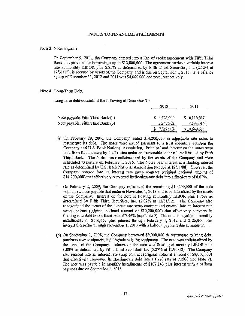
Note 3, Notes Payable
On September 9, 2011, the Company entered into a line of credit agreement with Fifth. Third Bank that provides for borrowings up to $12,000,000. The agreement carries a variable interest rate at' monthly LIBOR plus 2.25% as determined by Fifth Third Securities, Inc (2.52% at 12/31/12), is secured by assets of the Company, and is due on September 1, 2013. The balance due as of December 31, 2012 and 2011 was $4,000,000 and zero, respectively.
Note 4. Long-Term Debt
Long-term debt consists of the following at December 31: 2012 2011
Note payable, Fifth Third Bank (a) $ 4,625,000 $ 6,116,667 Note payable, Fifth Third Bank (b) 3,247,302 4,533,016
$ 7,872,302 $ 10,649,083
(a) On February 28 2006, the Company issued $14;200,000 in adjustable rate notes to restructure its debt. The notes were issued pursuant to a trust indenture between the Company and U.S. Bank National AssoCiation, Principal and interest on the notes were paid from funds drawn by the Trustee under an irrevocable letter of credit issued by Fifth Third Bank. The Notes were collateralized by the assets of the Company and were scheduled to mature on February 1, 2016, The Notes bear interest at a floating interest rate as determined by U.S. Bank National Association (4.60% at 12/31/08). However, the Company entered into an interest rate swap contract (original notional amount of $14,200,000) that effectively converted its floating-rate debt into a fixed-rate of 8.02%.
On February 2, 2009, the Company refinanced the remaining $10,200,000 of the note with a new note payable that matures November 1, 2013 and is collateralized by the assets of the Company. Interest on the note is floating at monthly LIBOR plus 1.75% as determined by Fifth Third Securities, inc. (2.02% at 12/31/12). The Company also renegotiated, the terms of the interest rate swap contract and entered into an interest rate swap contract (original notional amount of $10,200,000) that effectively converts its floating-rate debt into a fixed rate of 7.46% (see Note 9). The note is payable in monthly installments of $116,667 plus interest through February 1, 2012 and $125,000 plus interest.thereafter through November 1, 2013 with a balloon payment due at maturity.
(b) On September 1, 2008, the Company borrowed $9,000,000 to restructure existing debt, purchase new equipment and upgrade existing equipment The note was collateralized by the assets of the Company. Interest on the note was floating at monthly LIBOR plus 3.00% as determined by Fifth Third Securities, Inc (3.27% at 12/31/12), The Company also entered into an interest rate swap contract (original notional amount of $9,000,000) that effectively converted its floating-rate debt into a fixed rate of 7.20% (see Note 9). The note was payable in monthly installments of $107,143 plus interest with a balloon payment due on September 1, 2013.
- 12 - Jones, Nale &Mauuingly PLC

NOTES TO FINANCIAL STATEMENTS
Note 4. Long-Term Debt (Continued)
On March 31, 2012, the Company refinanced the remaining $4,318,730 of the note with a new note payable that matures August 1, 2015 and is collateralized by the assets of the Company. Interest on the note is floating at monthly LIBOR plus 2.50% (2.77% at 12/31/12). The Company also renegotiated the terms of the interest rate swap contract and entered into an interest rate swap contract (original notional amount of $4,318,730) that effectively converts its floating rate debt into a fixed rate of 6,21% (see Note 9), The note is payable in monthly installments of $107,143 plus interest.
Total interest cost for the years ended. December 31, 2012 and 2011 was. approximately $714,000 and $928,000, respectively.
Under terms of the Notes, the Company has also agreed, among other things, to limit distributions, to Maintain minimum fixed charge coverage ratios, and to maintain, minimum debt to earnings ratios. The Company was in violation of certain of these covenants as of December 31, 2012; however, these violations have been waived by the note holder.
Approximate maturities or payments required on principal under note payable agreements for each of the succeeding five years are as follows:
Year ending December 31; 2013 $ 5,803,572 2014 1,285,714 2015 783,015 2016 2017
$ 7,872,302
Note 5. Retirement Plans
The Company has a multiple-employer 401(k) plan for qualifying employees who have reached twenty-one years of age. Eligible employees are allowed to invest up to 15% of their compensation and the Company has agreed to match 100% of the first 3% of the employees' contribution and 50% of the employees' contribution between 3% and 5%. The Company contributed $156,598 and $148,041 in matching funds for its 401(k) plan during the years ended December 31, 2012 and 2011, respectively,
The Company also Offers an employer sponsored retirement savings plan for qualified employees who have reached twenty-one years of age. The Company has agreed to contribute 9% of the eligible employee's compensation, plus an. additional 5% of the original contribution.
The Conapany contributed $741,000 and $725,318 to its retirement savings plan during the years ended December 31, 2012 and 2011, respectively.
- 13 - Jones, Nale & Mattingly PLC

NOTES TO FINANCIAL STATEMENTS
Note 6. Related Party Transactions
The Company shares personnel with three of its members. The Company paid $254,438 and $383,149 for shared personnel during the years ended December 31, 2012 and 2011, respectively. The Company also leased offices and warehouse space from time members. The leases are for an unspecified length of time The annual lease expense related to these leases was $20,483 and $20,858 for the years ended December 31, 2012 and 2011, respectively,
The Company incurred interconnection, telephone, cable and internet access charges from its members aggregating $818,607 and $1,329,216 for the years ended December 31, 2012 and 2011, respectively.
The Company leases two cellular tower sites from the officers and majority shareholders of `a member. The annual lease expense related to these leases was $2,400 for both years ended DeceMber 31, 2012 and 2011. The leases are for an unspecified length of time The Company also pays part of an annual lease for sharing a tower with a member for an annual fee of $450. The Company leases cellular tower sites from the parent company of one of its other members, The annual lease expense related to these leases for years ended December 31, 2012 and 2011was $9,347 and $12,463 respectively. The leases are for five years with options to renew.
The Company 'pays fees to companies owned by its members for advertisement in telephone directories, television and on local billboards. The amount of advertising paid to related parties was $103,$45 and $40,120 for the years ended December 31, 2012 and 2011, reSpectively.
Note 7. Operating Leases
The Company has entered into operating leases with its members and other customers to provide fiber optic transmission capacity and ancillary services. The terms of these leases are fot 15 years. Total rental income earned from these operating lease commitments included in the statements of income was $858,920 and $1,016,885 for the years ended December 31, 2012 and 2011x respectively. Rental income earned from the Company's members from these leases was $617,218 and $846,249 for the years ended December 31, 2012 and 2011, respectively:.
Investments in operating leases are as follows at December 31:
2012. 2011
Fiber ring $ 8,799,036 $ 8,143,858 Accumulated depreciation (4,190,747) (3,643,160)
$ 4,608,289 $ 4,500,698
The future minimum rental payments expected to be received under these lease agreements for each of the succeeding five years are approximately $750,000 each year
- 14 - Jones, Nitle th'illiittindy PLC

NOTES TO FINANCIAL STATEMENTS
Note 7. Operating Leases (Continued)
The Company has also entered into lease agreements to obtain, fiber optic transmission and digital microwave transmission, services; and to rent retail office facilities. The terms of these leases are between 5 and 15 years. Total rental expense incurred from these operating lease commitments included in the statements of income was $1,518,640 and $1,195,368 for the years ended December 31, 2012 and 2011, respectively. Rental expense incurred from the Company's members from these leases was $778,599 and $464,544 for the years ended December 31, 2012 and 2011, respectively. The future minimum lease payments required under these lease agreements for each of the succeeding five years are approximately $1,600,000 each year.
Note 8. Eligible Telecommunication Carrier
During 2005, the Company was granted Eligible Telecommunication Carrier (ETC) status by the Kentucky Public Service Commission, As an ETC, the Company receives funding from the federal Universal Service Fund (USF) to support the high cost of providing local telephone service in rural areas. USF payments amounted to $7,472,724 and $7,919,934 for the years ended 1)ecember 31, 2012 and 2011, respectively.
Note 9. Derivative Financial Instruments, Interest Rate Swaps
The Company entered into two interest rate 5wap contracts with Fifth Third Bank for the purpose of converting floating-rate interest on its long-terin debt to fixed rates. The interest rate swap effectively fixed $10,200,000 at a rate of 7.46% until February 1, 2016 and fixed 4,318,730 at a rate of 6.21% until August 1, 2015.
Under the swap contracts, the Company pays interest at 5.71% and 3.71% on the notional amounts and receives interest at LIBOR observed monthly (0.27% at December 31, 2012). The interest rate swaps qualify as, and are designated as, cash flow hedges. The swaps are designed to hedge the risk of changes in interest payments of i the notes caused by changes in LIBOR. The notional amounts do not represent actual amounts exchanged by the parties, but instead represent the amounts on which the contracts are based.
The swaps were issued at market terms so that they had no fair value or carrying value at their inception. The carrying amount of the swaps> has been adjusted to their fair value at the end of the year, which because of changes in forecasted levels of LIBOR, resulted in reporting a liability for the fair value of the future net payments forecasted tinder the swap's. The swap contracts permit settlement prior to maturity only through termination by the Company. The settlement amounts are determined based on forecasted changes in interest rates required under fixed and variable legs of the swaps. The Company believes the settlement amounts are the best representation of the fair value of the swaps and has adjusted their carrying amounts to the settlement amounts at the end of the year.
-15- Jon . NaleerMMMattingyPLC

NOTES TO FINANCIAL STATEMENTS
Note 9. Derivative Financial Instruments, Interest Rate Swaps (Continued)
The carrying amounts of the swaps are classified as noncurrent since management does not intend to terminate the swaps during 2013. Since the critical terms of the swaps and the notes are approximately the same, the swaps are assumed to be effective as hedges, and none of the changes in fair values are included in income. Accordingly, all of the adjustment of the swaps' carrying amount is reported as other comprehensive income or loss in the accompanying statements of members' equity. If the swaps are terminated early, the corresponding carrying amount would be reclassified into earnings. The Coinpany does not hold or issue interest rate swaps or other financial instruments for trading purposes.
Note 10. Fair Values of Financial Instruments
U.S. GAAP provides a framework for fair value measurements. Fair value is defined as the price that would be received to sell an asset or paid to transfer a liability in an orderly transaction between market participants at the measurement date. The methodology for measuring fair value specifies a three-tier hierarchy of valuation techniques based upon whether the inputs to those valuation techniques are based on quoted prices of identical assets or liabilities (Level 1), significant other observable inputs (Level 2), or significant other unobservable inputs that reflect a company's own assumptions of market participant valuation (Level 3).
Financial instruments of the Company that are subject to fair value measurements are limited to short-term investments, long-term debt and interest rate swaps. Fair values of these financial instruments have been valued using a market approach and are measured using Level 2 inputs:
The fait value of short-tern investments approximates its carrying amount due to the Short-term nature of these instruments.
The fair valtie of long-term debt approximates its carrying amount because its variable rate terms are similar to market terms.
The fair value of the interest rate swaps are based on the approximation of market value derived from proprietary Models. This fair value takes into consideration the prevailing interest rate environment and the specific terms and conditions of the derivative financial instrument. The fair value was estimated by comparMg the Company's fixed swap rates with the current market rates on identical swaps for the remaining terms. The interest due on each remaining payment date is calculated at the existing swap rate and the current market rate, Fair market value is the present value of the difference between those payment streams. The value represents the estimated exit price the Company would pay to terminate the agreement,
-16- Jones; Niz4 &Mattingly PLC

NOTES TO FINANCIAL STATEMENTS
Note 11, Commitments
On November 4, 2011, the Company entered into an agreement with a vendor to purchase a minimum quantity of phones each year for the next three years. Under the terms of the agreement, among other things, the Company is required to purchase approximately 36,000 phones in addition to spending at least $200,000 per year for the next three years on eligible merchandising expenses related to the phones.
As of December 31, 2012, the remaining committed amounts due related to the purchase of the phones approximated the following:
2013 $ 7,800,000 2014 9,360,000
$ 17,160,000
On September 22, 2011, the Company entered into an agreement with Verizon Wireless ("Verizon") to construct and operate its Long Term Evolution ("LTE") technology in geographic territories in the Company's market. Under the terms of the agreement, among other things, the Company is required as part of the initial build-out phase to have the cell sites constructed and fully equipped for provision of LTE Service and ready to commence commercial service no later than December 31, 2013. Following the initial build-out phase, the Company will continue to build out its LTE System in accordance with a plan to be Mutually agreed by the Company and Verizon. The estimated cost of the total build-out is approximately $18,000,000. As of December 31, 2012, the Company has incurred build-out costs of approximately $5,500,000. The agreement expires on June 13, 2019 with an option for a ten year renewal term at the end of the agreement.
In addition, the Company entered into an agreement to lease the spectrum owned by Verizon in order to offer LTE. Service. This agreement also expires on June 13, 2019 with an option for a ten year renewal term at the end of the agreement. The lease expense is expected to be approximately $300,000 per year
Note 12. Discontinued Operations, Held for Sale
In July 2012, the Company committed to a plan to diScontinue its paging services, The Company is currently continuing to operate its paging services as management is evaluating whether to sell or dispose of the operating segment's assets. Management expects that the sale or disposal of the assets is probable and, expected to be completed in 2013. The paging assets meet the criteria for classification as held for sale and have been separately presented in the accompanying balance sheets. The related operating results have been separately presented in the.accompanying income statements as discontinued operations, held for sale.
Management believes that it is probable that the paging assets are impaired which would result in a loss on an anticipated sale or disposal. However, the amount of the loss cannot be reasonably estimated at this time; therefore, an impairment loss has not been included in the accompanying, financial statements.
-17- Jones, NaleMattingly PLC

NOTES TO FINANCIAL STATEMENTS
Note 13. Gain Contingency.
On September 27, 2012, the Company was awarded approximately $4,400,000 by the Federal Communications Commission related to the Mobility Phase One Auction in order to provide coverage and broadband services in certain territories. The award will be disbursed in three separate amounts and is contingent upon the Company demonstrating percentages of completion related to its coverage requirements indicated in the agreement No amounts have been recorded in the accompanying financial statements.
- 1 8 - Janes, Nile &Mattingly PLC

JNM
Janes,. Wale &Mattingly PLC
INDEPENDENT AUDITOR'S REPORT ON THE SUPPLEMENTARY INFORMATION
To. the Members East Kentucky Network, LLC dba Appalachian Wireless Prestonsburg, Kentucky 41653
We have audited the fmancial statements of East Kentucky Network, LLC dba Appalachian Wireless as of December 31, 2012 and 2011, and, our report thereon, dated February 25, 2013, which, expressed an unmodified opinion on those financial statements; 'appears on pages I and 2. Our audit was conducted for the purpose of forming ail opinion on the financial statements as a whole. The supplementary information found on pages 20 and 21, is presented for purposes of additional analysis and is not a required part of the financial statements. Such information is the responsibility of management and was derived from and relates directly to the underlying accounting and other records used to prepare the financial statements. The mforraation has, been subjected to the auditing procedures applied in the audit of the financial statements and certain additional procedures, including comparing and reconciling such information directly to the underlying accounting and other records used to prepare the financial statements or to the financial statements themselves, and other additional procedures in accordance with auditing standards generally accepted in the United States of America. In our opinion, the information is fairly stated in all Material respects in relation to the financial statements as a whole.
Louisville, Kentucky February 25, 2013
•
- 19 - Cartifiad ['LILAC Accountants and Advisors
642 Soda' Fourth Stfeat, suite 300 LOuisvilla, Kanto* 40202 tat 502.583.0248 fax:502.589.1680 www.inmcpa.com

EAST KENTUCKY NET LLC DBA. APPALACHIAN WIRELESS
STATEMENTS OF INCOME AND COMPREHENSIVE INCOME DETAIL
REVENUE
Year Ended December 31, 2012 RSA #9
Appalachian RSA #10
Mountaineer Fiber Ring PCS Totals
Retail $32,353,036 $ 20,337,871 $ $ 3,614,188 $56,305,055 Roamer 17,730,166 6,710,976 670,390 25,111,532 Long distance 59,855' 27,709 2,213 89,777 Equipment sales, cellular 822,163 371,870 173,126 1,367,159 Other 4,043,820 2,214,876 750,167' 591,534 7,600,397 Total revenues $55,009,040 $ 29,663,302 $ 750,167 $ 5,051,451 $90,473,960
EXPENSES Cost of cellular service $11,404,940 $ 7,077,280 859,041 $19,341,261 Cost of equipment sales, cellular 13,627,06 8,255,825 1,896,964 23,780,445 Customer service 977,297 606,403 52,332 1,636,032 Billing 1,057,413 652,638 69,470 1,819,521 Selling 3,645,723 2,574,883 156,458 6,377,064 Maintenance 2,144,462 1,280,977 69,654 201,414 3,696,507 Utilities 655,763 389,305 42,654 91,175 1,178,897 Bad debts 1,329,106 469,835 89,890' 1,888J31 Cell site rental 139,272 178,525 148,773 466,570 Taxes and licenses 705,940 308,284 70,138 93,235 1,177,597 Advertising 3,320,822 1,512,752 - 227,555 5,061,129 General. and administrative 3,296,134 2,055,51.3 138,854 193,025 5,683,526 Occupancy, 186,667 77,204 283,875 25,432 573,178 Depreciation 5,620,660 3,914,160 588,231 1,120,713 11,243,764 Amortization 327,647 187,638 13,307 96,565 625,147
Total, expenses $48,479,502 $ 29,541,222 $ 1,206,713 $ 5,322,032 $84,549,469
Income (loss) from operations $ 6,529,538 $ 122,080 $ (456,546) $ 270,581) $ 5,924,491
DISCONTINUED OPERATIONS, HELD FOR SALE, NET Paging revenue 152,119 $ 105,828 $ - $ 257,947 Equipment sales, paging 15,983 7,565 - - 23,548 Cost of paging service (112,267) (141,491) (253,758) Cost of equipment sales, paging (9,807) (5,700) (15,507) Depreciation (2,989) (5,749) -
(8,73$)
Amortization (72,380) (320,836) - -. (393,216) (Loss) from discontinued operations (29,341) $ (360,383) $ - - $ (389,724)
OTHER INCOME (EXPENSE) Interest income $ 12,528 $ 7,620 $ 203 $ 609 $ 20,960 Interest expense (426,153) (263,550) - - (24,347) (714,050) Universal Service Fund income 4,483,634 2,764,908 - - 224,182 7,472,724
$ 4,070,009 $ 2,508,978 203 $ 200,444 $ 6,779,634
Net income (loss) $10,570,206 $ 2,270,675 $ 056,343) $ (70,137) $12,314,401
-20- Jane; Mlle & Mattingly PLC
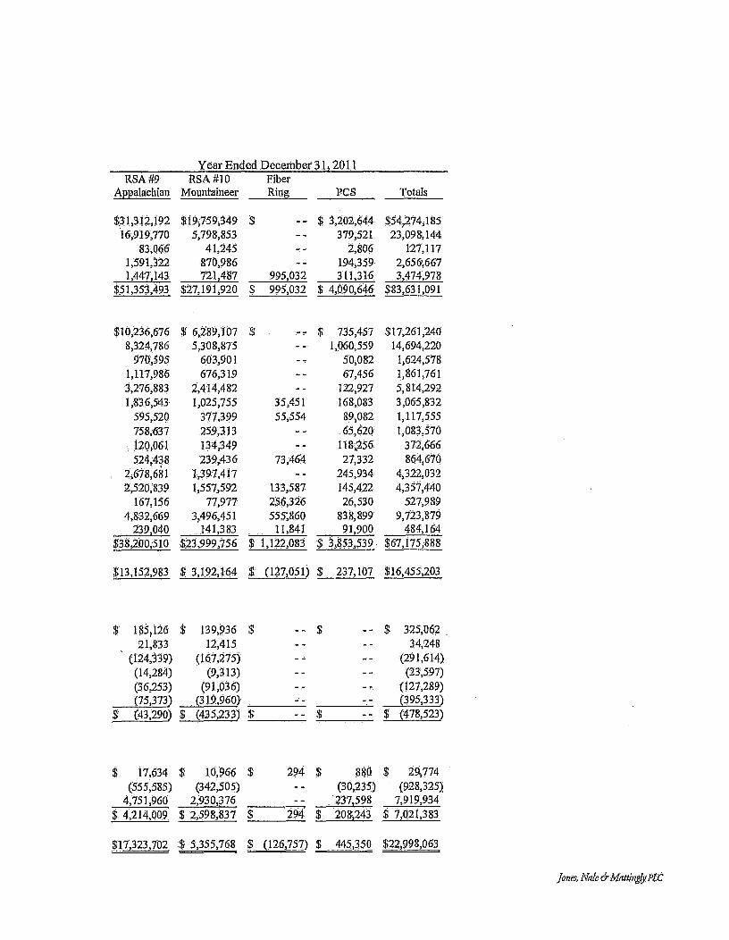
,
Year Ended December 31, 2011 RSA #9 RSA #10 Fiber
Appalachian Mountaineer Ring PCS Totals
$31,312,192 $19,759,349 $ $ 3,202;644 $54,274,185 16,919,770 5,798,853 379,521 23,098,144
83,066 41,245 2,806 127,117 1,591,322 870,986 194,359 2,656,667 1,447,143 721,487 995,032 311,316 3,474,978
$51,353,493 $27,191,920 $ 995,032 $ 4,090,646 $83,631,091
$10,236,676 $ 6,289,107 $ 735,457 $17,261,240 8,324,786 5,308,875 1,060,559 14,694,220
970,595 603,901 50,082 1,624,578 1,117,986 676,319 67,456 1,861,761 3,276,883 2,414,482 122,927 5,814,292 1,836,543 1,025,755 35,451 168,083 3,065,832
595,520 377,399 55,554 89;082 1,117,555 758,637 259,313 65,620 1,083,570 120,061 134,349 118,256 372,666 524,438 239,436 73,464 27,332 864,670
2,678,681 1,3.97,417 - - 245,934 4,322,032 2,520;839 1,557,592 133,587 145,422 4,357,440
167,156 77,977 256,326 26,530 527,989 4,832,669 3,496,451 555;860 838,899 9,723,879
239,040 141,383 11,841 91,900 484,164 $38,200,510 $23,999,156 $ 1,122,083 $ 3,853,539 $67,175,888
$13,152,983 $ 3,192,164 $ (127,051) $ 237,107 $16,455,203
$ 185,126 $ 139,936 $ - - $ 825,062 21,833 12,415 - - 34,248
(124,339) (167,275) (291,614) (14,284) (9,313) (23,597) (36,253) (91,036) (127,289) (75,373) (319,960) - - (395,333) (43,290) $ (435,233) $ - - $ (478,523)
$ 17,634 $ 10,966 $ 294 $ 880 $ 29,774 (555,585) (342,505) (30,235) (928,325)
4,751,960 2,930,376 237,598 7,919,934 $ 4,214,009 $ 2,598,837 $ 294 $ 208,243 $ 7,021,383
$17,323,702 $ 5,355,768 $ (126,757) $ 445,350 $22,998,063
Jones, "Vide thMattinglyiLC
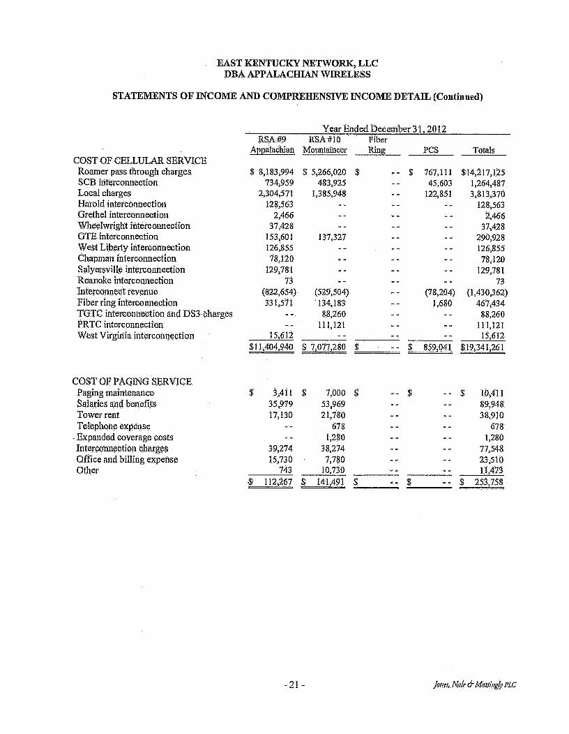
EAST KENTUCKY NETWORK, LLC DBA APPALACHIAN WIRELESS
STATEMENTS OF INCOME AND COMPREHENSIVE INCOME DETAIL (Continued)
COST OF CELLULAR SERVICE
Year Ended December 31,2012 RSA #9
Appalachian RSA #10
Mountaineer Fiber Ring PCS Totals
Roamer pass through charges $' 8,183,994 $ 5,266,020 $ $ 767,111 $14,217,125 SCB interconnection 734,959 483,925 45,603 1,264,487 Local charges 2,304,571 1,385,948 122,851 3,813,370 Hatold interconnection 128,563 - - 128,563 Grethel interconnection. 2,466 2,466 Wheelwright interconnection 37,428 - - 37,428 GTE interconnection 153,601 137,327 _ - - - 290,928 West Liberty interconnection 126,855 - - 126,855 Chapman interconnection 78,120 - - - - 78,120 Salyersville interconnection 129,781 129,781 Roanoke interconnection 73 - - 73 Interconnect revenue (822,654) (529,504) (78;204) (1,430,362) Fiber ring interconnection 331,571 134,183 1,680 467,434 TGTC interconnection and DS3 charges - - 88,260 88,260 PRTC interconnection 111,121 111,121 West Virginia interconnection 15,612 - - 15,612
$11,404,940 $ 7,077,280 $ 859,041 $19,341,261
COST OF PAGING SERVICE Paging maintenance $ 3,411 $ 7,000 $ $ 10,411 Salaries and benefits 35,979 53,969 89,948 Tower rent 17,130 21,780 38,910 Telephone expense 678 678
- Expanded coverage costs 1,280 - 1,280 Interconnection cjiargea 39,274 38,274 77,548 Office and billing expense 15,730 7,780 - 23,510 Other 743 10,730 11,478
112,267 $ 141,491 $ 253,758
- 21 - Jones, Nate e Mattingly PLC

Year. Ended December 31, 201.1 RSA #9 ABA #10
Appalachian Mountaineer Fiber Ring PCS Totals
$ 6,816,542 $ 4,399,137 $ 631,778 $11,847,457 676,267 437,079 42,526 1,155,872
2,440,298 1,471,954 129,386 4,041,638 184,527 - - 184;527
- - 54,515 - 54,515
148,505 133,237 281,742 182,700 182,700 116,428 116,428 269,914 269914
- - - - (848,387) (549,469) (72,066) (1,469,922) 178,540 130,230 3,833 312,603
- 115,510 -- 115,510 151,429 151,429
16,827 - 16,827 $10,236,676 $ 6,289,107 $ 735,457 $17,261,240 ,
9,298 $ 11,583 $ $ 20,881 37,457 56,186 93,643 24,235 41,488 65,723
- 608 608 1,186 1,186
40,482 38,500 78,982 12,485 8,185 20,670
382 9,539 9,921 124,339 $, 167,275 $ $ 291,614
Jones, 1Vde &Ali/stingy PLC

Directions To The Garrett Cell Tower Site
Starting in front of the court house in Floyd Co. KY. Starting on South Central Av.and Continue for .1 miles to the intersection of South Central Av. And South Lake Drive. Turn left onto South Lake Drive go 2.6 miles to the intersection of South Lake Drive and Old Water Gap Rd. Turn right onto Old Water Gap Rd. go 2.5 miles. To the intersection of Old Water Gap Rd and route 80. Stay Stright ahead on Route 80 and go 13 miles to the junction of Route 80 and HWY 7. Turn right onto HWY 7 and continue for 1.7 miles to the junction of HWY 7 and Community Church Rd. Sign is posted at this location. Continue on Community Church Rd. .4 miles Follow blue and white markers to site. Sign is posted at site
Direction's Written By
Daryl Bartley Project manager Appalachian Wireless 606-791-0310 Cell dbartleva,ekn.com
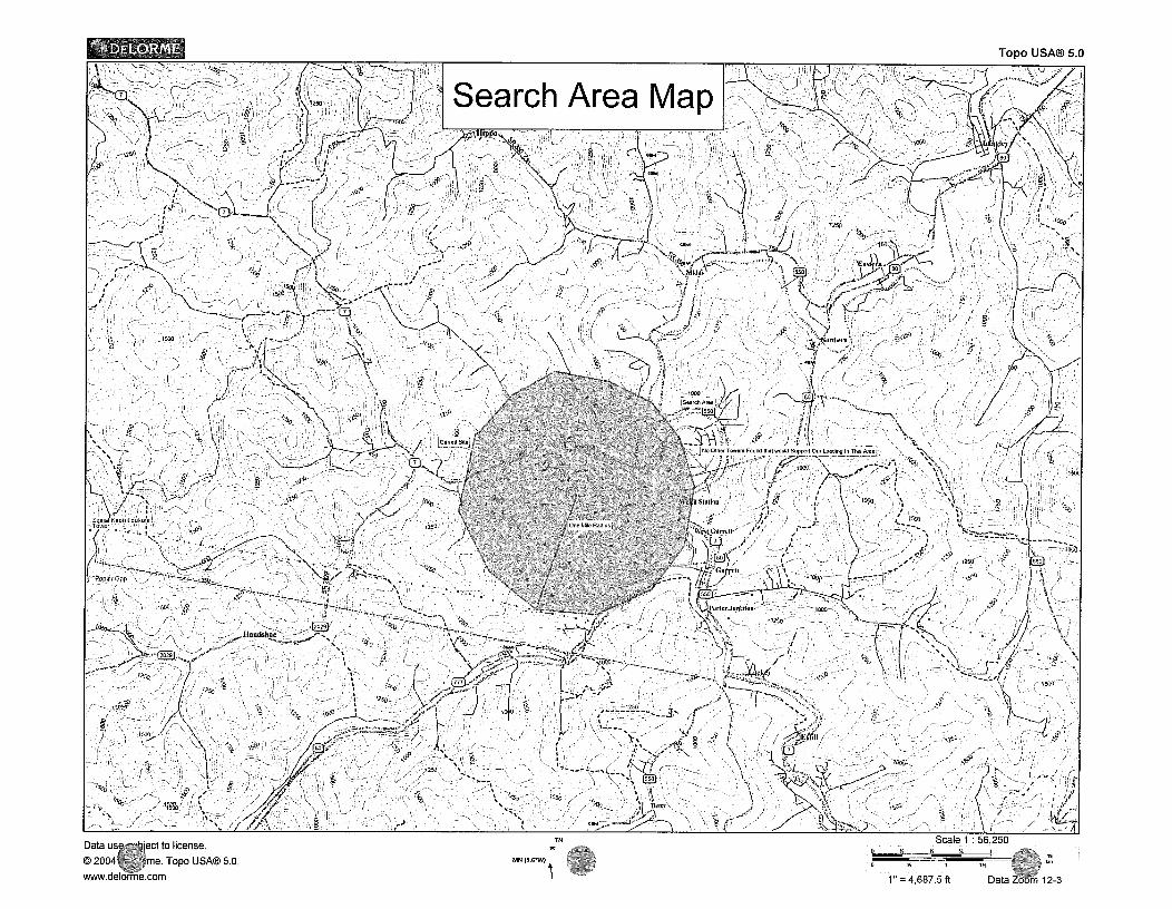
Topo USA® 5.0 0 DELORME
Fillera re
I ster,-,rea
- No orner Towers Found Met.. Support OrE Laed, In -1-r, Wee .
Stgnal Knob Ldolkov - net,',I: FWC:nw ‘10(
POPO,
...,Purler Aldan
Search Area Map
Data use 'eject to license.
© 2004 me. Topo USA® 5.0.
www.delorme.com
MN (8.6.W)
Scale 1 56,250
1" = 4,687.5 ft Data Zoom 12-3

Book 59a_Page____14.. THIS DEED OF CONVEYANCE, made and entered into
day Of 0 .--(c) ex , 20/, by and between
LARRY SHEPHERD, Single, of Opprv-I-t& 4jar..(re.SN. 141\001 /
“ae.,450k 1/'/ ( go , Party of the First Part, and
/ -
EAST KENTUCKY NETWORK, LLC, d/b/a APPALACHIAN
WIRELESS, of 101 Technology Trail, Ivel, Kentucky 41642, Party of
the Second Part.
W-I-T-N-E-S-S-E-T-H:
That for and in consideration of the sum of Twenty
Five Thousand ($25,000.00) Dollars, the receipt Of which is hereby
acknowledged, the Party of the First Part does hereby sell, grant
and convey unto the said Party of the Setohd Part, its successors
and. assigns forever, with Covenants of General Warranty, a certain
tract or parcel of land located in Floyd County, Kentucky, being
more particularly bounded and described as follows:
SEE ATTACHED EXHIBITS "A" AND 'El"
t$Oinq a patt of the same property conveyed to Georgia Shepherd, now deceased, and Larry Shepherd by survivorship deed dated June 9, 1992, recorded in Deed 800k 357, Page 705, Floyd County Clerk's Office.
In accordance With KRS 382.135, the address to which the current year property taxes may be sent is 101 Technology Trail, Ivel, Kentucky 41642.
this the

TO HAVE AND TO HOLD all of the above-described
real property together with the right, privileges, appurtenances
and improvements thereunto belonging unto the Party of the Second
Part, its successors and assigns forever, with Covenants of
General Warranty of title.
IN WITNESS WHEREOF, the Party of the First Part
has hereby set his hand the day and year first above written.
CERTIFICATE OF CONSIDERATION
The undersigned hereby Swear and affirM, under
penalty of perjury, that the consideration recited in the.
foregoing instrument is the full actual consideration paid or to.
be paid for the property transferred hereby.
EAST KENTUCKY NETWORK, LLC, d/b/a APPALACHIAN WIRELSS
_aewe/244
NOT AU Y PUBLIC
STATE OF KENTUCKY
COUNTY OF noy8
The fOregoing instrument and certificate of
consideration was acknowledged, subscribed and sworn to before me,
this the r_,2 004- day of Ovi,Ccse.r , 2012, by LARRY SHEPHERD. My Comtnissionapires
My Commission expires July14,2015
STATE OF KENTUCKY
COUNTY OF Floy4
The foregoing certificate of consideration was
acknowledged, sUbscribed and sworn to before me this the 02.2d day Of ( 9 0,4-0 , 012, by EAST KENTUCKY NETWORK, LLC, d/b/a
APPALACHIAN WIRELESS, BY: c7e.__Faid FM;ne.-44e.
ITS:
My Commis8ion expires My Commission Expitel -
July 14, 2015
THIS INSTRUMENT PREPARED BY:
HON. FRANK K. NALL ATTORNEY AT LAW P.O. BOX 1018 PIKEVILLE, KENTUCKY 41502

Description Garrett Tower
A certain tract of land located on Community Church Road in Garrett, Floyd County, Kentucky, more particularly described as follows:
Unless stated otherwise any monument referred to herein as a Re-Bar and Cap is a set le steel re-bar eighteen (18") in length, with a yellow plastic cap stamped Summit Engineering, PLS #3967. All bearings stated herein are referred to Kentucky State Plane Coordinate System South Zone. Control Network has Horizontal Datum based on NAD (1983)
Beginning at a Set Tack and Lead Plug in a rock, said point being located in the line between Larry Sheperd (DB 357 Pg 705) and Melvin Cox (DB 66 Pg 466)said point having state plane coordinates of North 2073973.97 and East 2480759.10; Thence leaving Cox and Severing Sheperd N 23°53'31" W a distance of 100.01' to a Set Re-Bar and Cap; Thence N 65°04'14" E a distance of 100.95' to a Set Re-Bar and Cap, said point being located in the line of Neil Watson (DB 519 Pg 358); Thence with the line of Watson up the point S 17°04'23" E a distance of 87.07' to a Set Re-Bar and Cap; Thence S 23°08'41" W a distance of 20.88' to a Set Re-Bar and Cap, said point being a corner to Melvin Cox and being the former location of a Knob; Thence with Cox S 65°14'31" W a distance of 75.30' to the point of beginning containing 0.22 Acres, according to a survey conducted by personal under direct supervision of Gary Christopher Slone, PLS #3967, with Summit Engineering, Inc. on 8-21-12 and being part of the same property conveyed to Larry Sheperd in Deed which is recorded in Deed Book 357 Page 705 in the records of the Floyd County Clerk's office.
Gafy Christopher Slone, PLS #3967 Date 09/06/2012
rnwmwmwilmmuump iinklEaKaTI1XXI
GARY C. SLONE
LICENSED PROFESSIONAL
LAND SURVEYOR isvaninittuninittimmat
3967

Neil Watson D.B. 519 PG. 358
Lorry Sheperd D.B. 357 PG. 705
East Kentucky Network DBA Appalachian Wireless
101 Technology Trail. Wel, KY Plat Showing
Garrett Tower Site Communi Churc salUick II.a,a 9 muhis. KY
SUIVINST 6t4OINP7RINC3,1NC.
131 Summit 41f13V0Flavin..t, K. 1
(ape.) 432-1447
kc' ,C!iario•sloriyev ClumnAmth",
WY V.•
DATE: 9/05/12
SCALE 1" = 40'
DRAWN BY: GCS
FILENAME:
DISK NO.
WITH $ a 6-0) TAX PAID ON SAME. I, CHRIS 'MEW Clock p Floyd County certify that the for ng was IT the
day of C. , 20147atitraciftlock ,m, lodged for record whereupon the same with the
foregoing. and this certificate havAbeert du ed in m
office. Wiliness my hand, pielkt day o 20 -,nilAtAttrau Marl. IIN fig
.fi r
rr 80
• O /
Owner Informdttbn East Kentucky Network 101 Technology Trail
Ivel, KY PVA 11020-00-00-,.041:
DD 357 PG 705
FAA CertIfIcatbrl
In ACcordance with FAA Order 8260.19E, Appendix 3; the I certify -that the Obstacle Accuracy Codes far the propos Tower Meets or exceeds accuracy IA 0.20 ft Horizontal_ and +3 ft Vertical).
Sur.vey, Date 4/25/12 5/01/12 6/28/12
Stone, PLS 43967 Date
Lorry Sheperd D.B. 357 PG. 705
P.O.B. N:2073973.97 E:2480759.10
ock and Lead Plug
%to N:2074041.36 E: 2480777.90
''Cr):At& LAT:37'29'20.1"w-- ut LON: 82'51'11.2"
120
Lorry Sheperd D.B. 357 PG. 705
9408J8 Sq. Feet 0222 Acres
, - ‘t 5.„,-
, -
Melvin Cox D.B. 066 PG. 466
trn
yullumumuumnimmur iSTATE of INTUCKY
............... z GARY C. SLE Lz,
LICENSED Lt PROFESSIONAL
LAND SURVEYOR bwommunwaimaimp
r/::2\-A V d US Maps
Not To Scale
Legenct
O 1/2' re-bar set with a plastic cap stamped Summit Engineering, L.S. #3967 unless otherwise noted.
▪ ••■ ••••••• Boundary Une
▪ Center of Ridge
A Proposed Tower Locatlon
I hereby certify that the survey shown hereon was performed by personal under my direct supervision by method of random traverse and radial survey. The unadjusted mathematical error of closure ratio of the traverse exceeds 1:10,000. This survey Is classified as a "Rural" Survey. The bearings and distances shown hereon are not based on an adjusted traverse. The basis of the bearings is based on Kentucky South State Plane Coordinates. This Plot of Survey represents a boundary survey and complies with 201 1f AR 18:150.
ristapher Slone, PLS #3967
Dole
THE TRACT OF AND SHOWN HEREON IS SITUATED ON THE WATERS
tar EommuNa CHURCH BR OF SALTUCK FRK OF BEAVER CREEK OF THE [.EVISdi FORK OF THE BIGSANDY RIVER. CONTOURS' OWN. HEREON GENERATED FROM L1DAR• DATA
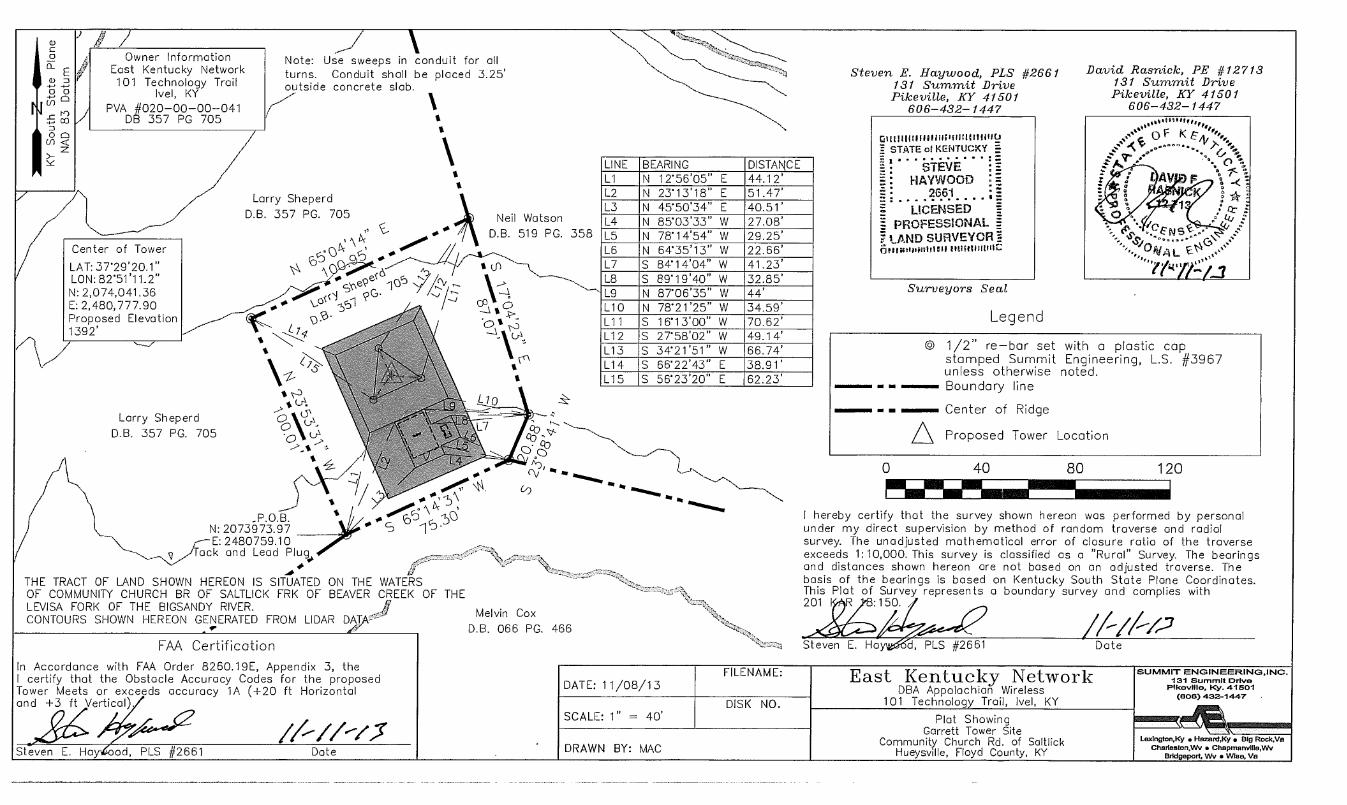
Owner Information East Kentucky Network 101 Technology Trail
Ivel, KY PVA #020-00-00-041
D 357 PG 705 I
David Rasnick, PE #12713 131 Summit Drive Pikeville, KY 41501
606-432-1447
E.N1S,^
S,0""..".' ‘ `O\ ,ss 11/ AL
lewp43
SUMMIT ENOINEERINO,INC. 131 Summit Drive
Pikeville, Ky. 41501 (5013) 432-1447
Laxington,Ky • Hazard,Ky • Big Rock,Va Charlaston,Wv • Choprnanviga,VN
Bridgeport, Wv • VVitia, Va
Legend
© 1/2" re—bar set with a plastic cap, stamped Summit Engineering, L.S. #3967 unless otherwise noted. Boundary line
Center of Ridge
A Proposed Tower Location
0 40
80 120
I hereby certify that the survey shown hereon was performed by personal under my direct supervision by method of random traverse and radial survey. The unadjusted mathematical error of closure ratio of the traverse exceeds 1:10,000. This survey is classified as a "Rural" Survey. The bearings and distances shown hereon are not based on an adjusted traverse. The basis of the bearings is based on Kentucky South State Plane Coordinates. This Plat of Survey represents a boundary survey and complies with 201 :150.
Neil Watson D.B. 519 PG. 358
Melvin Cox
Note: Use sweeps in conduit for all turns. Conduit shall be placed 3.25' outside concrete slab.
N: 2073973.97 E: 2480759.10
ack and Lead Plug.,
THE TRACT OF LAND SHOWN HEREON IS SITUATED ON THE WATERS OF COMMUNITY CHURCH BR OF SALTLICK FRK OF BEAVER CREEK OF THE LEVISA FORK OF THE BIGSANDY RIVER. CONTOURS SHOWN HEREON GENERATED FROM LIDA
R17
D.B. 066 PG. 466
/
7
Center of Tower
LAT: 37'29'20.1" LON: 82'51'11.2" N: 2,074,041.36 E: 2,480,777.90 Proposed Elevation 1392'
Larry Sheperd D.B. 357 PG. 705
FAA Certification
In Accordance with FAA Order 8260.19E, Appendix 3, the I certify that the Obstacle Accuracy Codes for the proposed Tower Meets or exceeds accuracy 1A (+20 ft Horizontal and +3 ft Vertical).
Steven E. Hay good, PLS #2661 Date
LINE BEARING DISTANCE L1 N 12'56'05" E 44.12' L2 N 23'13'18" E 51.47' L3 N 45'50'34" E 40.51' L4 N 85'03'33" W 27.08' L5 N 78'14'54" W 29.25' L6 N 64'35'13" W 22.66' L7 S 84'14'04" W 41.23' L8 S 89'19'40" W 32.85' L9 N 8706'35" W 44' L10 N 78'21'25" W 34.59' L11 S 16'13'00" W 70.62' L12 S 27'58'02" W 49.14' L13 S 34'21'51" W 66.74' L14 S 66'22'43" E 38.91' L15 S 56'23'20" E 62.23'
Steven E. Haywood, PLS #2661 131 Summit Drive Pikeville, KY 41501
606-432-1447
~IUUI silitic /twit, STATE of KENTUCKY =
STEVE F. HAYWOOD =
2661 LICENSED g,
PROFESSIONAL 7 LAND SURVEYOR Is
Surveyors Seal
Larry Sheperd D.B. 357 PG. 705
DATE: 11/08/13
SCALE: 1" = 40'
DRAWN BY: MAC
FILENAME:
DISK NO. Plat Showing
Garrett Tower Site Community Church Rd. of Saltlick
Hueysville, Floyd County, KY
Date -Steven E. Ha d, PLS #2661
East Kentucky Network DBA Appalachian Wireless
101 Technology Trail, Ivel, KY

Glittlittditttitutitittiliffitt.3 STATE of KENTUCKY . . . . .......
STEVE HAYWOOD
2661
LICENSED PROFESSIONAL Ei
7 LAND SURVEYOR nosiwitommut truinflittliz
wer Access Robd LEGEND
O 1/2" re—bar 18' inches in length set with a plastic cap stamped Summit Engineering, L.S. #3967 unless noted otherwise.
'41, Utility Pole
A Proposed Tower Location
ilk Gas Well
Boundary Line — This Survey
—ff— Property Line from PVA Office
Gas Line (Approx.)
OHP OHP OHP Electric/Telephone/Cable (Approx.)
14 W Water Line (Approx.)
Property Information
Larry Shepherd
U PVA #020-00-00-041.00 241 Community Church RD Hueysville, KY 41640
DB 357 PG 705
Mack Horne PVA #020-00-00-045.00 280 Community Church RD Hueysville, KY 41640
DB 385 PG 484
Beula Hughes PVA #020-00-00-044.00 769 Jefferson RD Hueysville, KY 41640
DB 225 PG 204
Neil Watson PVA #028-00-00-0124.05 P.O. Box 64 Garrett, KY 41630
DB 519 PG 358
Jack Osborne PVA #028-00-00-124.06 P.O. Box 37 Hueysville, KY 41640
DB 352 PG 363
Randolph Allen PVA #020-00-00-048.00
P.O. Box 297 Garrett, KY 41647 DB 384 PG 845
E 00
0- o <
0 0
(r) C 0
(--) 0 Lc 4—,
4—, D
0 (f)
Melvin Cox PVA #020-00-00-097.00
P.O. Box 793 Martin, KY 41649 DB 66 PG 466
The tract of land shown hereon is located on the watershed of an unnamed branch of Salt Lick Creek of Beaver Creek.
The proposed tower shown hereon is on a portion of the same tract of land conveyed to Larry Shepherd by Douglas & Stella Gearheart by deed of record in Deed Book 357 Page 705 of the records of The Floyd County Court.
Property lines shown hereon are based on a partial survey of the Larry Shepherd property, information from the Floyd County P.V.A office.
Access from the intersection of Kentucky State Route 550 and Kentucky State Route 7, continue on Kentucky State Route 7 for 1.7 miles to the intersection of Kentucky State Route 7 and Community Church Road. Continue on Community Church Road for 0.5 miles to the tower access road on the left.
Topography of the area surrounding the tower site is forest covered rolling hill terrain with slopes ranging from +19% — ±30%. Land use within the 500' radius is undisturbed forest, hillside property, and mountain top removal mined land.
Summit Engineering, Inc. makes no warranty as to the title or ownership of property.
Adjoining land owners listed are based on Property Valuation Administration (PVA) records issued by a representive from Floyd County, to be in compliance with all statutory and regualatory requirements before the Kentucky Public Service Commission and for telecommunication.
Proposed tower site IS NOT in the 100 year flood hazard area and has a average elevation of 1,392'. Firm Mop #2100690080, BFE = 697'
David Rasnick, PE #12,713 131 Summit Drive Pikeville, KY 41501
606-432-1447
File Name: Z:\East Ky Network\Gorrett Tower Site\Radius Map.dwg
Utility Contacts
Single Wide Mobile Home
Existing Road
4s,
Campier
Tower Access Road
LAT: 3T29'20.1" LON: 82°51'11.2" ELEV: 1,392'
500' \--°
Columbia Gas Transmission 6090 Hurricane Road Pikeville, KY 41501 (606) 478-6393
Birch Communications 3060 Peachtree Road NW Suite 105 Atlanta, GA 30305 (8886) 244-8999
Big. Sandy RECC 504 11th Street Paintsville, KY 41240 (606) 789-4095
Southern Water & Sewer P.O. Box 610 245 KY Route 680 McDowell, KY 41647 (606) 377-9296
Chespeake Energy 77 Industrial Drive Debord, KY 41214 (888) 460-0003
AT&T Jacky Salyer 102 Walters Road Pikeville, KY 41501 (606) 437-9032
0' 300'
GRAPHIC SCALE 1" .= 300'
600' 900'
Steven E. H ood, PLS #2661 Date
I hereby certify that the information depicted by this map is correct to the best of my knowledge and is in accordance with the record data as found in the office of the Property Valuation Administrator of Pike County, Kentucky, 1/7/2013.
Scale: 1" = 200'
Plot Date: 08 NOVEMBER 2013 — 8:13 AM
East Kentucky Network D/B/A Appalachian Wireless
101 Technology Trail, lye', KY 41642
Property/Radius Map Garrett Tower
Larry Shepherd Property
Drawn By: MAC
Chk By: MAC SEH
Apprvd. By:
SUMMIT ENDINEERING,INC. 131 SUMMIT DRIVE
PIKEVILLE, KY. 41501 (605) 432-1447
LexIngton,Ky • Hazard,Ky
Big Rock,Ve
South Charleston,VVV • Bridgeport, WV
PER. NO:
ATT:
Steven E. Haywood, PLS #2661 131 Summit Drive Pikeville, KY 41501
606-432-1447

Vicinity Map NTS
Graphic Scale 1" = 30'
k
RASNYCV
1.14," ".•00• •
°VA \‘10‘. , (0°
David Rasnick PE #12713
Lighting Rod
GARRETT TOWER VERTICAL PROFILE SKETCH
APPALACHIAN WIRELESS
300 FT Panel Antenna
285 FT Panel Antenna
270 FT Panel Antenna
255 FT 8' Solid Dish
240 FT 6' Solid Dish
Note: This is a vertical sketch of the tower indicating the proposed antenna and dish elevations. No design criteria was considered in the preparations of this drawing.
0' 30' 60' 90'
1410
1400
1390
1380
1370
0+00 0+10 0+20 0+30 0+40 0+50 0+60 0+70 0+80 0+90 1+00 1+10
22' —
36'
Proposelev. 1392'
DATE: 11/08/13 SCALE: 1"=30'
DRAWN BY: MAC
East Kentucky Network D/B/A/ Appalachian Wireless
101 Technology Trail, Ivel, KY 41642
Proposed Site Plan and Structure Location Garrett Tower
SUMMIT ENGINEERING,INC. 131 SUMMIT DRIVE
PIKEVILLE, KY. 41501 (6061 432-1447
LEXINGTON,KY GRLINOY,W. LOGAN,WV
CHARLESTDN,WV HAZARD,KY File Name: Ky Network\Garrett Tower Site Vower_ProNe.dwg