ganga river basin management plan - national mission for ... · this is the interim “ganga river...
TRANSCRIPT
IIT
Bombay IIT
Delhi IIT
Guwahati
IIT
BHU NIH CIFRI
Consortium of 7 “Indian Institute of Technology”s
Ganga River Basin
Management Plan
Interim Report
September
by
IIT
Guwahati IIT
Kanpur IIT
Kharagpur IIT
Madras
In Collaboration with
CIFRI NEERI JNU PU NIT-K
ISI
Kolkata Allahabad University
WWF India
Consortium of 7 “Indian Institute of Technology”s
Ganga River Basin
Management Plan
Report
September 2013
IIT
Roorkee
K DU
Consortium of 7 “Indian Institute of Technology”s (IITs)

• ii •
• iii •
Preface
In exercise of the powers conferred by sub-sections (1) and (3) of Section 3 of the
Environment (Protection) Act, 1986 (29 of 1986), the Central Government constituted
the National Ganga River Basin Authority (NGRBA) as a planning, financing, monitoring
and coordinating authority for strengthening the collective efforts of the Central and
State Governments for effective abatement of pollution and conservation of the Ganga
river. One of the important functions of the NGRBA is to prepare and implement a
Ganga River Basin Management Plan (GRBMP). A Consortium of 7 “Indian Institute of
Technology”s (IITs) was given the responsibility of preparing the GRBMP by the Ministry
of Environment and Forests (MoEF), GOI, New Delhi. A Memorandum of Agreement
(MoA) was signed between 7 IITs (Bombay, Delhi, Guwahati, Kanpur, Kharagpur, Madras
and Roorkee) and MoEF for this purpose on July 6, 2010.
This is the Interim “Ganga River Basin Management Plan”. The thrust of this Plan is to
relate the diverse environmental degradations occurring in the basin with their causal
factors, and thereby frame a roadmap for redeeming National River Ganga Basin’s
Environment. The task involved different thematic groups of experts from 7 IITs and
other premier organizations identifying different causal factors and assessing their
impacts on the basin to synthesize the findings and recommendations in fulfillment of
the important missions identified in the Plan. This report covers the main issues of
concern and recommends corrective measures. While major changes in the final Plan
are note foreseen, our studies have not achieved closure on all aspects; hence there
could be additional actionable recommendations in the final Plan.
The progress in preparing this Plan was affected by several factors. On the one hand, co-
ordination between experts working in different institutions was not always speedy. On
the other hand, the progress depended on obtaining relevant primary data from nodal
government agencies, which was often tardy and circuitous. This also affected the timely
co-ordination between related thematic groups. It is hoped that data availability in
future will become simpler and faster.
Many people contributed directly or indirectly to the preparation of this Plan. A wide
range of stakeholders were consulted through various workshops, seminars and
informal discussions, and many people freely gave their suggestions and comments on
many substantive issues. This document is therefore truly a collective effort that reflects
the cooperation of many people, particularly members of the IIT Team and keenly
interested members of the general population.
Dr Vinod Tare
Professor and Coordinator
Preparation of GRBMP
IIT Kanpur

• iv •
Lead Authors
1. Vinod Tare, IIT Kanpur [email protected]
2. Gautam Roy, IIT Kanpur [email protected]
3. Purnendu Bose, IIT Kanpur [email protected]
• v •
Executive Summary
Overview: National River Ganga, along with her many tributaries, has been the source of
physical and spiritual sustenance of Indian civilization for millennia, and consequently, her
well-being is of prime national concern. The physical environment of the National River
Ganga Basin (NRGB in short) is governed by a complex combination of natural and
manmade processes. With proliferation and diversification of human activities, the resulting
environmental degradation has greatly increased in recent decades. The Ganga River Basin
Management Plan (GRBMP) seeks ways and means to strengthen the basin environment
against the identifiable adverse impacts. It may be noted here that, since the aquatic
systems of NRGB – consisting mainly of rivers/ streams, groundwater and water bodies – are
hydraulically connected by groundwater flow (besides other hydrological and ecological
connections) in much of the basin, the GRBMP adopts the Ganga river system as the primary
environmental indicator of NRGB.
Anthropogenic Factors: Uncontrolled anthropogenic activities are a major cause of NRGB’s
environmental degradation in recent times. The degradations may be grouped under five
main heads: (i) over-withdrawal of fresh water from the basin; (ii) discharge of pollutants
into the aquatic environment; (iii) reduction in water-holding capacities and replenishment
rates into water bodies, aquifers and ecosystems; (iv) mutilation of rivers by piecemeal
engineering operations; and (v) changes in geological factors governing aquatic systems.
The major human activities affecting the aquatic environment of NRGB in modern times
may also be grouped under major heads as follows: Industrialization, Urbanization, Lifestyle
Changes, Agricultural and Other Rural Activities, and Deforestation/Denudation.
Key Features of NRGB: NRGB is the largest river basin in India, covering more than a
quarter of her land area, and hosting about 43% of her population. Annual rainfall in the
basin is quite high towards the east and north, but decreases progressively towards the
west. In terms of surface and ground water resources, NRGB is fairly rich. They include
many wetlands (including freshwater and saline lakes) spread across the basin, which
perform crucial ecosystem services for the basin. Besides, a highly productive multi-aquifer
system spread over much of the basin boosts the basin’s water yields. The river basin itself
was formed by alluvial deposits of Himalayan sediments since the rise of the Himalayan
mountains millions of years ago, and, even in present times, the Ganga river carries very
high sediment loads to the sea. The river network is characterized by deep gorges in the
Himalayan zone, meandering patterns in the plains, and braiding in the delta region. Ganga
river’s valley mapping shows significant diversity of valley widths and geomorphic features
in different reaches. Flora and fauna in the river also show significant biodiversity, indicating
variations in substrate, habitat, and trophic status in the river system.
Concepts and Objectives: National River Ganga – whose wholesome qualities have been
praised over the ages – has been flowing with her life-giving qualities since ancient times.
The wholesomeness of the river may be grasped in terms of four defining concepts: Aviral
• vi •
Dhara” (or “Continuous Flow”), “Nirmal Dhara” (or “Unpolluted Flow”), Geologic Entity, and
Ecological Entity. To plan the recovery of a wholesome National River Ganga, the task of
analyzing the basin status was broken up from the whole to its parts into eight Thematic
Groups, namely: Environmental Quality and Pollution; Water Resources Management;
Fluvial Geomorphology; Ecology and Biodiversity; Socio-economic and Socio-Cultural; Policy,
Law and Governance; Geo-Spatial Database Management; and Communication. Each
thematic study is conducted by select groups of IIT faculty members and allied experts, and
seven important missions were identified for focused interventions: “Aviral Dhara”, “Nirmal
Dhara”, “Ecological Restoration”, “Geological Safeguarding”, “Disaster Management”,
“Sustainable Agriculture”, and “Environmental Knowledge-Building and Sensitization”.
Based on the findings, action plans are formulated to counter harmful anthropogenic
activities in NRGB and promote helpful activities.
Mission Aviral Dhara: For a given geological-climatic setting, alluvial rivers achieve stability
through long-term balance between various parameters such as water and sediment flow
rates, temporal variations of flow, terrain gradient, and seepage flow rates. “Aviral Dhara”
emanates from this long-term balance of rivers. A direct violation of Aviral Dhara is due to
dams and barrages, which snap the longitudinal connectivity in rivers and alter river water
and sediment flows. However, since NRGB is hydraulically connected by ground water flow,
water withdrawals/recharges from different regions of the basin also affect the river. Thus,
while longitudinal connectivity in rivers is a prerequisite for Aviral Dhara, maintaining
Environmental Flows (or E-flows) needed for the sustenance of rivers also depends on
judicious management of the basin’s waters. Available data indicate that human water use
has been increasing rapidly of late, and probably increasing beyond the renewal capacity of
the basin. Hence, either (i) water availability in the basin must be increased through
increased storage, preferably by “distributed storage” in locally manageable and eco-
friendly water bodies and aquifers, and/or (ii) water demands must be reduced through
more efficient water use. These issues call for both technical interventions and changes in
government policies on NRGB’s water resources. For dams and other structures that disrupt
or change river flows, the maintenance of E-flows in the river network is essential, besides
fulfilling other safety criteria. The estimated E-Flows for select locations in the Upper Ganga
reach – which has many existing and potential hydropower sites – have been presented to
enable their inclusion in the design and operation of these dams and barrages.
Mission Nirmal Dhara: The Ganga river’s present-day water quality is abysmal due to
anthropogenic wastes polluting the river network in various ways. The main approach in
GRBMP has been to identify the types of pollutants, their sources of generation, and the
feasibility of collecting and treating them to the degree needed for reuse and/or safe
environmental disposal. Urban and industrial wastewaters are major point sources of
pollution that need immediate remediation. For municipal wastewaters it was found that it
is economically feasible to treat them to the point where they can be re-used for non-
contact purposes, the cost of such additional treatment being only about 1 paisa per litre at

• vii •
2010 price levels. It is therefore recommended that all Class 1 Towns of NRGB immediately
embark on such treatment through competent service providers under the Design-Build-
Finance-Operate model, whereby the service provider receives remuneration for providing
reusable-quality water over a reasonably long contract period. It is also recommended that
all fresh water withdrawals from the basin be priced at least 50% higher than the recycled
water, considering the minimum costs of full treatment in nature. For major polluting
industries (such as tanneries, pulp and paper units, distilleries and dyeing units) in NRGB, the
cost of treatment for reuse purposes are higher, but these costs are much less than the
damage caused to NRGB otherwise, justifiying the expenditure on such treatment.
Mission Ecological Restoration: The ecological balance in the Ganga river network has been
critically affected in recent times, with major indicator species (such as Dolphins, Trouts,
Carps and Hilsa fishes) having dwindled or disappeared. The analyses indicate that the
ecological status can be largely restored by adhering to the principles of “Aviral Dhara” and
“Nirmal Dhara” by ensuring river connectivity, unpolluted E-flows and variable flow regimes.
Additional measures needed are the protection of spawning and breeding grounds of native
species, elimination of competing exotic species from the Ganga river network, and
protection of rivers from resource overexploitation and human encroachments.
Mission Geological Safeguarding: Modern anthrpogenic activities – such as underground
explosions, excavations, tunneling, rock fracturing, and mining, and operation of large
reservoirs – can damage the geological formations supporting the basin’s aquatic systems.
Over-withdrawal of ground water from confined/ semi-confined aquifers may also create
unbearable overburden pressures, causing aquifer disintegration and land subsidence.
Geomorphologically, rivers and wetlands are vulnerable to various land-use stresses. Land-
uses needing immediate control are deforestation, construction activities on riverbanks and
fragile slopes, agricultural practices that increase soil erosion, sand mining from river beds,
urban, industrial and infrastructure projects that adversely affect drainage patterns, and
local flood control works and river bank modifications.
Mission Disaster Management: The main potential disasters arising from the Ganga River
network are floods and water-borne diseases. While the causes of floods in mountainous
reaches and in plains are different, floods are not entirely preventable, and protection of life
and valuables are the main option. Besides, flood waters carry valuable nutrient-rich silt to
floodplains, enhancing soil fertility. For control of floods in floodplains, natural flood
attenuation methods by vegetation and wetlands are preferable to ill-conceived structural
measures. On the other hand, water-borne diseases from rivers can be largely controlled by
the twin focus on Aviral Dhara and Nirmal Dhara in the Ganga River System.
Mission Sustainable Agriculture: Agriculture has grown tremendously in NRGB since the
1960’s, and irrigation water use has also increased concomitantly. Hence water depletion in
NRGB is significantly attributable to growing agricultural consumption, calling for more
efficient irrigation practices and alternate cropping patterns. Besides, agriculture is also a
major source of water pollution, especially due to chemical fertilizers and pesticides, many

• viii •
of which may be highly toxic, chemically stable, and/or biomagnifying through the food
chain. This necessitates the promotion of bio-fertilizers and bio-pesticides in place of
chemical fertilizers and pesticides.
Mission Environmental Knowledge-Building and Sensitization: Environmental planning and
management combines diverse fields such as water resources, land resources, biological
resources, river dynamics, geological phenomena and atmospheric processes as well as
traditional wisdom and grassroots knowledge. Hence, it is necessary to build a
comprehensive data bank to enable meaningful analyses and obtain quantitative indicators
of NRGB’s status. This data bank should also be accessible to citizens to inform and sensitize
them about NRGB’s environment and to enable people’s participation in the environmental
upkeep of NRGB. The data bank, therefore, needs to be complemented with community-
specific educational material and programmes on NRGB’s environment.
Conclusions: Specific anthropogenic activities that should be Prohibited, Restricted or
Promoted in NRGB have been identified in GRBMP. Their implementation and future
development would require the co-ordinated efforts and co-operation of government and
non-government institutions, key stakeholders and civil society. It is envisaged that only a
dedicated, knowledge-based, empowered and stakeholder-involving agency would be able
to pool in the collective knowledge and resources for environmental rejuvenation of NRGB.
The implementation, monitoring, review and evaluation of environmental problems and
interventions on a long-term basis are therefore recommended through an independent
Commission. The said Commission would need adequate resources and authority to co-
ordinate and oversee the activities of multiple sectoral organizations and informal sectors of
society for the conservation of NRGB in a transparent manner. GRBMP, therefore, includes
the functional requirements of the Commission proposed to be established by an Act of
Parliament to bring the Commission into effect.

• ix •
Contents
Preface
Executive Summary
1 Introduction 1
1.1 The Ganga River Basin in Environmental Perspective 1
1.2 Issues and Concerns of the NRGB Environment 3
2 Key Features of National River Ganga Basin 6
2.1 Hydrology 6
2.2 Geology 7
2.3 Wetlands 8
2.4 Geomorphology of National River Ganga 10
2.5 Biodiversity of National River Ganga 12
3 Philosphy, Vision and Conceptual Framework 13
3.1 Philosophy 13
3.2 Vision 13
3.3 Conceptual Framework 15
4 GRBMP Missions 17
4.1 Aviral Dhara 17
4.1.1 Water Storage 20
4.1.2 Water Use Efficiency 23
4.1.3 Policy Focus 23
4.1.4 Environmental Flows 24
4.2 Nirmal Dhara 35
4.2.1 ZLD and Reusable Water from Domestic Wastewaters 36
4.2.2 Additional Recommendations for Actions on Sewage Treatment 37
4.2.3 Recommendations for Actions on Urban River Management Plan
(URMP) for all Class I Towns
38
4.2.4 ZLD and Reusable Water from Industrial Wastewaters 39
4.3 Ecological Restoration 39
4.4 Geological Safeguarding 41
4.5 Disaster Management 42
4.6 Sustainable Agriculture 43
4.7 Environmental Knowledge-Building and Sensitization 44

• x •

• xi •
Contents
5 Recommendation of Interim GRBMP 46
5.1 Principles of Usage of Water in National River Ganga Basin 46
5.2 Prohibition of Environmentally Ruinous Activities in NRGB 46
5.3 Restriction of Environmentally Harmful Activities in National River
Ganga Basin
47
5.4 Promotion of Environmentally Beneficial Activities in National River
Ganga Basin
48
5.5 Implementation Mechanism 49
5.6 Legislation for NRGBMC 50
5.6.1 Comprehensive Legislation on Management of NRGB 50
5.6.2 Objective of NRGBMC 51
5.6.3 Envisaged Functions of Commission 51
5.6.4 Use of NRGB Fund Generated by Commission 53
5.7 Final Plan Document 53
Glossary of Technical Terms 55
References 57
Abbreviations and Acronyms 61
List of GRBMP Thematic Reports 63
Appendix I: Environmental Valuation: Examples from Murray-Darling Basin 65
Appendix II: Summaries of IIT_GRBMP Thematic Reports 69
Appendix III: The National River Ganga Basin Management Bill, 2013 93

• xii •
• xiii •
List of Figures
Figure
1.1 Illustrative Sketch of a Terrestrial Aquatic Environment [MSU, 2013] 2
1.2 Schematic of Hydraulic Connectivity between Water Resource Types in NRGB 3
1.3 Major Adverse Impacts of Anthropogenic Activities on the NRGB Environment 5
2.1a Main River Basins of India: The Ganga River Basin is the Yellow Region Marked as “2a” 6
2.1b Annual Rainfall during 1971–2005 in NRGB ” [India-WRIS, 2012] 7
2.1c Hydrological Importance of NRGB Relative to Indian Basins Combined 7
2.2 Aquifer Systems of NRGB [Adapted from: CGWB, 2012] 8
2.3a Major Lakes and Wetlands of NRGB [Adapted from: Rainwaterharvesting, 2013] 9
2.3b Significant Surface Water Bodies of NRGB [Adapted from: SAC, 2011] 10
2.4 Map of Ganga River with its Active Floodplain (based on AWIFS data). 11
2.5 Geomorphic Map of Ganga River Valley 11
3.1 GRBMP Vision and Missions 14
3.2 Flow Diagram of GRBMP Work Structure 16
4.1 Reservoir Evaporation, km3/year 20
4.2 Storm-water Runoff Storage Options – Concentrated and Distributed Storages 22
4.3 Location Map of Flow Monitoring Stations and E-Flows Sites 26
4.4 E-Flows Assessment – Conceptual Diagram 26
4.5 a E-Flows as Percentage of Mean Monthly Flows at Ranari, Dharasu 27
4.5 b Monthly E-Flows and River Flows as % of Annual Flows at Ranari, Dharasu 27
4.6 a E-Flows as Percentage of Mean Monthly Flows at Devprayag U/s 28
4.6 b Monthly E-Flows and River Flows as % of Annual Flows at Devprayag U/s 28
4.7 a E-Flows as Percentage of Mean Monthly Flows at D/s of Rudraprayag 29
4.7 b Monthly E-Flows and River Flows as % of Annual Flows at D/s of Rudraprayag 29
4.8 a E-Flows as Percentage of Mean Monthly Flows at CWC Monitoring Site “CWC-Z9” 30
4.8 b Monthly E-Flows and River Flows as % of Annual Flows at CWC Monitoring Site “CWC-Z9” 30
4.9 a E-Flows as Percentage of Mean Monthly Flows at U/s of Rishikesh 31
4.9 b Monthly E-Flows and River Flows as % of Annual Flows at U/s of Rishikesh 31
4.10 a E-Flows as Percentage of Mean Monthly Flows at CWC Monitoring Site, Rishikesh 32
4.10 b Monthly E-Flows and River Flows as % of Annual Flows at CWC Monitoring Site, Rishikesh 32
4.11 a E-Flows as Percentage of Mean Monthly Flows at D/s Pashulok Barrage 33
4.11 b Monthly E-Flows and River Flows as % of Annual Flows at D/s Pashulok Barrage 33
4.12 Some Existing and Under-construction Barrages in Upper Ganga 34
4.13 Anthropogenic Waste Generation in NRGB 36
4.14 Urban Wastewater Treatment for Reuse 37
5.1 Final GRBMP Documentation (Proposed) 53

• xiv •
• xv •
List of Tables
Table
4.1 A Water Resources Potential (approximate) in River Basins of India 18
4.1 B Projected Water Demand (in BCM i.e. billion m3) 18
4.2 Criteria for Permissibility of Dams and Other Projects on Rivers 21
4.3 Percentage of Virgin River Flow Required as E-Flows at Ranari, Dharasu 27
4.4 Percentage of Virgin River Flow Required as E-Flows at U/s of Devprayag 28
4.5 Percentage of Virgin River Flow Required as E-Flows at D/s of Rudraprayag 29
4.6 Percentage of Virgin River Flow Required as E-Flows at CWC Monitoring Site
“CWC-Z9”
30
4.7 Percentage of Virgin River Flow Required as E-Flows at U/s of Rishikesh 31
4.8 Percentage of Virgin River Flow Required as E-Flows at CWC Monitoring Site
“Rishikesh”
32
4.9 Percentage of Virgin River Flow required as E-Flows at D/s Pashulok Barrage 33
4.10 Biological Profile of National River Ganga 40

• xvi •
Interim GRBMP: IIT Consortium: Spetember 2013
• 1 •
1. Introduction
1.1. The Ganga River Basin in Environmental Perspective
Indian civilization grew up under the care of River Ganga for thousands of years, nourished
for generations by her generous bounties. River Ganga – along with her many tributaries –
provided material, spiritual and cultural sustenance to millions of people who lived in and
around her basin. And all through the ages, Indians held the munificent River Ganga as a
Divine Body who descends from the mysterious heights of the Himalayas and winds all the
way down to the sea, distributing her blessings to all and sundry. To the Indian mind, River
Ganga is not only the holiest of rivers and purifier of mortal beings, but also a living
goddess! Very aptly is she personified in Indian consciousness as “MOTHER GANGA”.
The religious and cultural pre-eminence of Ganga river in the Indian ethos since the ages
testifies to her centrality in Indian civilization. And this significance is so lasting that, even
today, River Ganga remains the physical and spiritual lifeline of India. It is fitting, therefore,
that the Ganga river was declared as India’s National River by the government in 2008. But
national concern about environmental degradation of the Ganga river and her basin had
also become serious by then. It was against this backdrop that the “Consortium of Seven
IITs” was assigned the task of preparing a Management Plan to restore and preserve the
Ganga River Basin. The Interim Plan (hereinafter GRBMP) is presented here.
The physical environment of National River Ganga Basin (hereinafter referred to as “NRGB”)
is governed by a complex combination of natural and manmade processes which have been
changing and evolving over time. With human activities multiplying and diversifying in the
industrial age, the resulting environmental consequences have also been pronounced in
recent times. Specifically, the aquatic environment – which governs human life and ecology
of the area to a large extent – is perceived by many to have already degraded to a critical
state. GRBMP focuses on the aquatic environment and the major factors affecting it –
especially the diverse anthropogenic activities, and seeks ways and means to strengthen the
environment against identifiable adverse impacts. GRBMP attempts to assess the critical
issues at stake and formulate a comprehensive plan to safeguard the aquatic environment
in the foreseeable future. For, only thus can we secure the environmental foundation of
NRGB for the good of one and all.
Human civilization has always considered its aquatic environment as an asset rather than a
liability – hence the term “water resource”, though the actual resources are much more
than only water. In fact, natural waters – intimately bound up with other environmental
goods – are an essential resource for human settlements and the ecology of an area. The
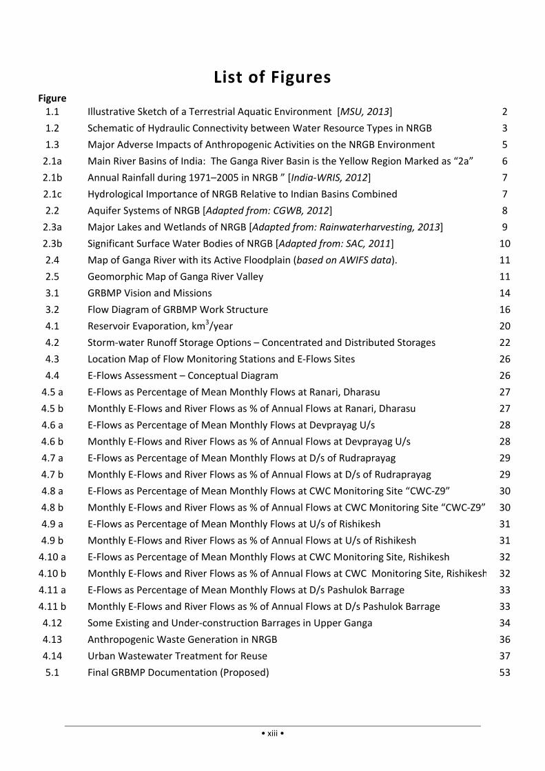
general features of terrestrial aquatic environments can be seen in Figure 1.1. In NRGB, the
water resources may be classified in three main groups, viz. surface water courses (e.g.
rivers, streams, and rivulets or gullies or “nala”s), surface water bodies (lakes, ponds, marsh-
lands and snow-packs), and ground water (water table and deep ground water). Among
these, ground water has been in extensive use over the last 5 or 6 decades (since the advent

Figure 1.1: Illustrative S
[Note: All lakes may not be of “drainage
on the other hand, big lakes usually have
of economic tube-well technologies), while surface sources have been
people since millennia, with rivers and streams fulfilling major water needs in much of the
NRGB. This is partly due to poor rainfall over
long dry periods of 8–9 months a year,
resulting in inadequate surface storage; but
it is also because the Ganga river flows
perennially, its head-streams and
tributaries being fed by snow
almost round the year (see Box 1.1). It
should be also noted here that, apart from
water, the Himalayan tributaries probably
also bring valuable minerals from glacial
mountain rocks in their upper reaches,
thereby providing long-term fertility
basin [Diamond, 2005]. H
therefore, the Ganga river system has been
the mainstay of civilization and ecology in
NRGB.
In surveying the above hydrological
NRGB, it is easily seen that, while the overall
water environment is a combination of three
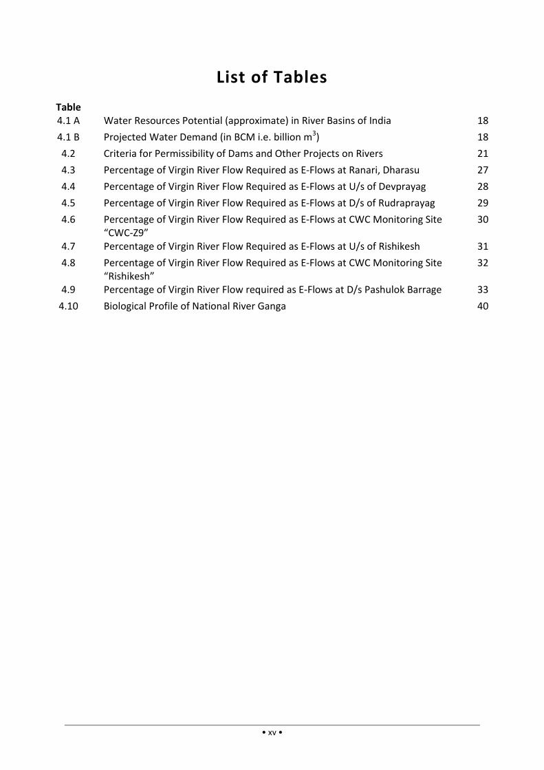
major types of water resource, these three types are not independent but are hydraulically
Interim GRBMP: IIT Consortium: Spetember 2013
• 2 •
Sketch of a Terrestrial Aquatic Environment
All lakes may not be of “drainage-type”, i.e. being drained by rivers as shown above;
big lakes usually have streams conveying surface runoff
well technologies), while surface sources have been more
with rivers and streams fulfilling major water needs in much of the
This is partly due to poor rainfall over
9 months a year,
resulting in inadequate surface storage; but
it is also because the Ganga river flows
streams and Himalayan
snow- and ice-melt
(see Box 1.1). It
should be also noted here that, apart from
water, the Himalayan tributaries probably
also bring valuable minerals from glacial and
mountain rocks in their upper reaches,
term fertility to the
basin [Diamond, 2005]. Historically,
the Ganga river system has been
the mainstay of civilization and ecology in
In surveying the above hydrological setup of
GB, it is easily seen that, while the overall
water environment is a combination of three
major types of water resource, these three types are not independent but are hydraulically
Box 1.1
The Himalayan (Mountain) Range has a
total area of 33,050 km2 of glaciers … with a
total ice volume of ca 3,421 km
which provides important short and long
term water storage facilities. … Water from
both permanent snow and ice and seasonal
snow is released by melting … In the
‘shoulder seasons’, before and after
precipitation from the summer monsoon,
snow and ice melt contribute about 70% of
the flow of the main Ganges
– [Eriksson et al., 2009]
Snow and glacier melt contribute 29% to
the annual flow at Devprayag. … Besides
Gangotri (glacier), other glaciers in the
headwaters region of Alaknanda, Yamuna,
Ghaghara, Kosi, etc. also contri
flow in the Ganga.
– [Jain, 2008]
Interim GRBMP: IIT Consortium: Spetember 2013
[MSU, 2013]
drained by rivers as shown above;
streams conveying surface runoff into them.]
more widely used by
with rivers and streams fulfilling major water needs in much of the
major types of water resource, these three types are not independent but are hydraulically
The Himalayan (Mountain) Range has a
of glaciers … with a
3,421 km3, (approx.)
which provides important short and long-
term water storage facilities. … Water from
both permanent snow and ice and seasonal
snow is released by melting … In the
s’, before and after
precipitation from the summer monsoon,
snow and ice melt contribute about 70% of
the flow of the main Ganges river.
Snow and glacier melt contribute 29% to
the annual flow at Devprayag. … Besides
, other glaciers in the
headwaters region of Alaknanda, Yamuna,
Ghaghara, Kosi, etc. also contribute to the
connected in most of the alluvial basin
ground water reservoirs are
water sources during the long dry periods depends much on the
water table aquifers – water-
suck out the surface waters (see
River Ganga (along with her tributaries
region’s water needs, but is also
whole. Hence, the GRBMP adopts the Ganga
indicator of NRGB.
Figure 1.2: Schematic of Hydraulic
1.2. Issues and Concerns of the NRGB Environment
Various anthropogenic factors have contributed directly to
aquatic environment in recent times. Broadly,
noticeable: (i) over-withdraw
consumption; (ii) discharge of pollutants
in quality of natural waters; (iii)
capacities of natural reservoirs
aquifers); (iv) mutilation of rivers
changes in geological factors
changes (such as change in
anthropogenic activities or indirectly
issues are often inadequately understood
from the scope of this phase of
The major human activities affecting the aquatic environment
and the reasons for their adverse effects, are
Interim GRBMP: IIT Consortium: Spetember 2013
• 3 •
in most of the alluvial basin by groundwater flow. Thus, while both surface and
are replenished by monsoon rains, the productivity of surface
during the long dry periods depends much on the contemporary
-filled aquifers boost their productivity, while depleted aquifers
see Figure 1.2). Directly and indirectly, therefore, the
tributaries and distributaries), not only is a major source of the
also a definitive indication of the aquatic health of the basin as a
adopts the Ganga River Network as the primary environmental
ydraulic Connectivity between Water Resource
Issues and Concerns of the NRGB Environment
Various anthropogenic factors have contributed directly to the degradation
in recent times. Broadly, five major types of degradation
withdrawal of natural waters due to growing industrial, urban and rural
discharge of pollutants into the aquatic environment causing
; (iii) reduction in the rate of replenishment and water
capacities of natural reservoirs (which include both surface water bodies and groundwater
of rivers by piecemeal engineering operations
factors governing the aquatic resources. Some
such as change in rainfall patterns) may also have been produced
indirectly by local anthropogenic activities. However, s
issues are often inadequately understood and/or not locally amendable,
phase of GRBMP.
The major human activities affecting the aquatic environment of NRGB
and the reasons for their adverse effects, are broadly identified as follows
Interim GRBMP: IIT Consortium: Spetember 2013
us, while both surface and
replenished by monsoon rains, the productivity of surface
contemporary state of
oductivity, while depleted aquifers
therefore, the National
a major source of the
a definitive indication of the aquatic health of the basin as a
as the primary environmental
esource Types in NRGB
degradation of NRGB’s
types of degradation factors are
growing industrial, urban and rural
causing deterioration
rate of replenishment and water-holding
surface water bodies and groundwater
by piecemeal engineering operations; and (v) possible
. Some environmental
been produced by external
However, since such
, they are excluded
GB in modern times,
follows:
Interim GRBMP: IIT Consortium: Spetember 2013
• 4 •
1) Industrialization: (i) Over-withdrawal of fresh water from surface and ground water
sources; (ii) discharge and dumping of industrial wastes and leakage of industrial
pollutants into the aquatic environment.
2) Urbanization: (i) Over-withdrawal of water from surface and ground water sources for
domestic, commercial and institutional activities; (ii) discharge of urban wastes and
pollutants (including eroded soils and construction debris) into water courses/ bodies;
(iii) reduction of surface water and ground water recharges; and (iv) changes in geo-
morphological parameters governing water resources due to land-use changes.
3) Lifestyle Changes: (i) Over-withdrawal of water from surface and ground water sources;
(ii) discharge of emerging contaminants into the aquatic environment.
4) Agricultural and Other Rural Activities: (i) Over-withdrawal of water from surface and
ground water sources; and (ii) discharge of agricultural and rural wastes (including
chemical fertilizers and pesticides) into the aquatic environment.
5) Deforestation/ Denudation Activities: Loss of vegetal cover due to deforestation,
overgrazing, etc. resulting in rapid surface runoff; hence: (i) reduced groundwater
recharge, (ii) increased runoff and soil erosion, with eroded soil eventually depositing in
water courses and water bodies, and (iii) changes in geo-morphological parameters
governing the region’s water resources due to land-use changes.
In addition to the environmental effects listed above, piecemeal river-based projects (for
hydropower, water supply, flood control, etc.) often directly infringe on river functioning,
thereby producing complex, basin-wide environmental repercussions. Finally, various
modern anthropogenic activities may also pose threats to geological formations governing
the basin’s water resources. Such activities include the depletion of deep aquifers, reservoir
operation, construction on fragile slopes, underground tunneling, excavations, and mining,
and hydraulic fracturing of rocks. Likewise, land-use/ land-cover changes due to urban/
industrial/ infrastructure projects may affect the natural drainage pattern or cause other
morphological changes, with consequent adverse effects on the aquatic environment. Since
geological damages may be compounded by natural earth processes and are, moreover, not
easily detected before they reach alarming proportions, these issues may need special
precautions and long-term monitoring. The major disruptive modern activities and the
consequent degradation factors are schematically shown in Figure 1.3.
The impact of environmental damages in NRGB on human beings may be gauged in terms of
“ecosystem service” losses, which are losses of the multiple benefits that we normally
derive from our environment (and which we often take for granted). “Ecosystem services”
are commonly categorized as: (i) provisioning services or products which are visible and
tradable items such as food, freshwater, fibres, and energy; (ii) regulating services e.g. flood
attenuation, groundwater recharge, prevention of salt water intrusion; (iii) supporting
services e.g. nutrient recycling, soil formation, biodiversity maintenance; and (iv) cultural
services e.g. recreation, spiritual fulfillment [UN-Water, 2013; Smith and Barchiesi, 2009].
Even without quantitative economic evaluation of the ecosystem service losses, it is fairly

Interim GRBMP: IIT Consortium: Spetember 2013
• 5 •
evident that all these ecosystem service categories have been significantly affected in the
NRGB, calling for urgent need to repair the environment.
Figure 1.3: Major Adverse Impacts of Anthropogenic Activities on the NRGB Environment
Among the five main types of environmentally significant human activities stated above, the
first three are related predominantly to profitable activities or activities of relatively affluent
sections of society. It must be eminently feasible, therefore, to review these activities and
modify them at some cost in order to minimize their adverse environmental impacts for
which the damages must be borne later. On the other hand, certain activities (such as the
fourth category above) often concern basic needs and livelihoods of relatively poor or
marginal sections of society, and attempts to modify them significantly can cause social and
financial distress. However, in such cases too, if the environmental impacts are significantly
adverse, then suitable means must be devised to abate the negative impacts and ensure a
wholesome environment in the NRGB. The GRBMP attempts to provide a viable roadmap to
mitigate such adverse impacts in the foreseeable future, and thereby enable human
communities to flourish and life to thrive in its myriad forms in the NRGB.

Interim GRBMP: IIT Consortium: Spetember 2013
• 6 •
2. Key Features of National River Ganga Basin
2.1. Hydrology
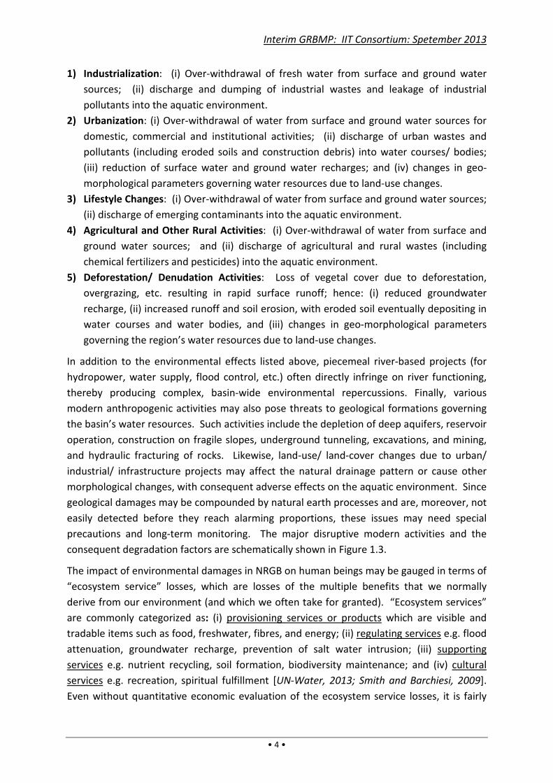
The Ganga River Basin, spread over four nations (India, Nepal, China and Bangladesh) covers
an area of about 1,080,000 sq.km of which the major part – the NRGB – of about 862,000
sq.km lies within India [Jain et al., 2007; Wikipedia, 2013]. The NRGB is the largest river
basin of India, covering more than 26% of her geographical area (see Figure 2.1a). The
region gets significant annual rainfall (apart from snowfall in higher reaches), but the rainfall
varies considerably over the catchment: it is much higher towards NRGB’s eastern and
northern ends than towards the west (see Figure 2.1b). As per government data [CWC,
2010; MoWR, 2002], out of the total surface and ground water availability of 1,869 km3/yr in
India, the total water availability of NRGB is estimated to be 525 km3/yr. Within India, only
the combined Brahmaputra-Barak basin has higher water availability of 585.6 km3/yr.
However, much of that “available water” cannot be tapped, often causing devastating
floods in some of the riparian states. Thus, the total surface water that can be utilized in
NRGB (250 km3/yr as per government estimate) is much higher than that of any other Indian
basin, making it the most water-rich basin in the country (vide Figure 2.1c) that supports a
staggering 43% of the Indian population [IIT-GRBMP Thematic Report Code:
015_GBP_IIT_SEC_ANL_01_Ver 1_Dec 2011].
Figure 2.1a: Main River Basins of India: The Ganga River Basin is the Yellow Region
Marked as “2a” [India-WRIS, 2012].
Interim GRBMP: IIT Consortium: Spetember 2013
• 7 •
Figure 2.1b: Average Annual Rainfall during 1971–2005 in NRGB” [India-WRIS, 2012].
Figure 2.1c: Hydrological Importance of NRGB relative to Indian Basins Combined
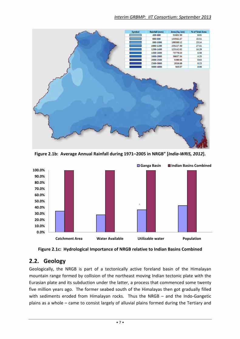
2.2. Geology
Geologically, the NRGB is part of a tectonically active foreland basin of the Himalayan
mountain range formed by collision of the northeast moving Indian tectonic plate with the
Eurasian plate and its subduction under the latter, a process that commenced some twenty
five million years ago. The former seabed south of the Himalayas then got gradually filled
with sediments eroded from Himalayan rocks. Thus the NRGB – and the Indo-Gangetic
plains as a whole – came to consist largely of alluvial plains formed during the Tertiary and
0.0%
10.0%
20.0%
30.0%
40.0%
50.0%
60.0%
70.0%
80.0%
90.0%
100.0%
Catchment Area Water Available Utilizable water Population
Ganga Basin Indian Basins Combined
`
Interim GRBMP: IIT Consortium: Spetember 2013
• 8 •
Quaternary periods by flood deposits of Himalayan rivers. Alluvial deposits of up to or more
than 1 km thick, interspersed with semi-confining or confining strata, span across much of
the basin, constituting large and highly productive multi-aquifer systems (Figure 2.2). The
aquifers of the NRGB, which extend westward well beyond the basin boundary, are thus a
major contributor to India’s estimated total ground water potential of 433 cu.km./yr
[CGWB, 2009; CGWB, 2012; CWC, 2010; Wikipedia, 2013].
Figure 2.2: Aquifer Systems of NRGB [Adapted from: CGWB, 2012]
The rivers in the upper and middle Ganga plains occupy narrow valleys separated by large
interfluves. Near the Himalayan front, valley formation and incision were affected by both
tectonic and climatic factors, whereas the strongly incised valley formation in the western
and southern plains are believed to have been controlled mainly by climatic factors. In
contrast, the fluvial morphologies in the lower Ganga plains and the deltaic region were
influenced significantly by sea level fluctuations, besides climate and tectonics [Sinha et al.,
2005]. It may be noted here that the Himalayan rivers of the Ganga River Network are not
only water conveyance systems, but also conduits for large amounts of sediment transfer
from the Himalayas to the river basin (by flooding) and to the Gangetic delta and the sea.
To quote Tandon et al. [2008], the “Ganga river system ranks 18th worldwide in terms of its
basin area (980,000 km2) and 2nd in terms of the total suspended load (524 mt/yr).”
2.3. Wetlands
There are many lakes, tanks and marshes in NRGB. Figure 2.3a shows the many surface
water bodies of NRGB including manmade reservoirs. Figure 2.3b shows some major fresh
water and saline lakes of NRGB. But besides big lakes, NRGB has a large number and variety
of wetlands spread across the basin – in the mountainous Himalayan region, the Himalayan
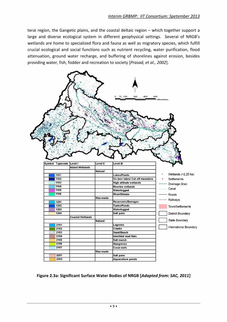
Interim GRBMP: IIT Consortium: Spetember 2013
• 9 •
terai region, the Gangetic plains, and the coastal deltaic region – which together support a
large and diverse ecological system in different geophysical settings. Several of NRGB’s
wetlands are home to specialized flora and fauna as well as migratory species, which fulfill
crucial ecological and social functions such as nutrient recycling, water purification, flood
attenuation, ground water recharge, and buffering of shorelines against erosion, besides
providing water, fish, fodder and recreation to society [Prasad, et al., 2002].
Figure 2.3a: Significant Surface Water Bodies of NRGB [Adapted from: SAC, 2011]

Interim GRBMP: IIT Consortium: Spetember 2013
• 10 •
Figure 2.3b: Major Lakes and Wetlands of NRGB [Adapted from: Rainwaterharvesting,
2013]
2.4. Geomorphology of National River Ganga
In keeping the primary focus of NRGB on River Ganga, it is essential to delineate the river
morphology clearly. River Ganga is defined herein as comprising of six main head-streams
originating in the Himalayas, namely the Alaknanda, Dhauli Ganga, Nandakini, Pinder,
Mandakini and Bhagirathi rivers starting from their feeding glaciers up to their respective
confluences at Vishnu Prayag, Nand Prayag, Karn Prayag, Rudr Prayag, Dev Prayag and
Rishikesh (together comprising the Upper Ganga segment), the subsequent main stem of
the river downstream from Rishikesh to Varanasi (the Middle Ganga segment) and the final
stretch from Varanasi to Ganga Sagar (the Lower Ganga segment). Among these segments,
the headstreams are fast-flowing mountainous rivers cutting through deep gorges and
narrow valleys, whereas the Middle Ganga stretch meanders through relatively flat plains,
with annual floods often covering vast expanses on both sides of the river. The lowermost
part of the Lower Ganga segment tends to be braided, especially in the delta region near the
Bay of Bengal where sea tides affect the river flow.
Since the most dynamic and vulnerable regions of a river include its active floodplains, a
river’s active floodplain needs to be included in the defining river space. In fact, the entire
river valley (including the active floodplain) is a sensitive geomorphic-ecological river space.
Based on remote sensing data and other inputs, the active floodplain of the Middle and
Lower Ganga stretches from Rishikesh to Farakka has been mapped as shown in Figure 2.4
[vide IIT-GRBMP Thematic Report Code: 005_GBP_IIT_FGM_DAT_01_Ver 1_Dec 2010].

Likewise, the valley margins for the same stretches are shown in
Thematic Report Code: 021_GBP_IIT_FGM_DAT_02_Ver 1_Dec 2011
in the report show significant diversity of valley width
reaches of the river, which
resource management, and ecological
Figure 2.4: Map of Ganga River
Figure 2.5
Interim GRBMP: IIT Consortium: Spetember 2013
• 11 •
Likewise, the valley margins for the same stretches are shown in Figure 2.
021_GBP_IIT_FGM_DAT_02_Ver 1_Dec 2011. Detailed maps
significant diversity of valley widths and geomorphic features in different
, which have strong implications for the hydrological regime
and ecological health of NRGB.
Figure 2.4: Map of Ganga River with its Active Floodplain (based on AWIFS data
5: Geomorphic Map of Ganga River Valley
Interim GRBMP: IIT Consortium: Spetember 2013
igure 2.5, vide IIT-GRBMP
. Detailed maps given
and geomorphic features in different
hydrological regime, water
based on AWIFS data).
Interim GRBMP: IIT Consortium: Spetember 2013
• 12 •
2.5. Biodiversity of National River Ganga
The biodiversity of National River Ganga is unique as it synthesizes three very different eco-
regions of India situated along climatic gradients, namely the Himalayas, the Gangetic plains
and the Deltaic regions [vide IIT-GRBMP Thematic Report Codes:
020_GBP_IIT_ENB_DAT_01_Ver_Dec 2011 and 027_GBP_IIT_ENB_DAT_04_Ver 1_Jun 2012].
The distribution of flora and fauna being largely dependent on the substrate, habitat and
trophic status, the presence or absence of a particular family, genus or species is indicative
of the conditions prevailing in the eco-region. The biodiversity in the Ganga river may be
grouped under seven heads, viz.: (i) Phytoplanktons (tiny free-floating living organisms that
drift with the water and constitute the main autotrophic base of the food chain in the Ganga
ecosystem); (ii) Periphytons (which, together with phytoplanktons, comprise 1176 Taxa of
attached and free-floating algal forms); (iii) Zooplanktons (comprising 294 Taxa of largely
macroscopic or assemblage of microscopic free-floating animals); (iv) Zoobenthos
(comprising 73 families of insects including higher forms that group under rocks and
boulders spending part of their life as larvae and those which live and grow on soft
substrate); (v) Fish (of 284 species plus 13 Chondrichthye species); (vi) Higher aquatic
vertebrates (comprising Reptiles, Amphibians and Mammals that include 13 species of hard
and soft turtles, besides the Gangetic dolphin, gharial, crocodile and porpoise); and (vii)
Macrophytes (which are higher forms of plants that grow free floating or submerged in
water bodies). Among these, periphytons, phytoplanktons and macrophytes are producers
while zooplanktons, zoobenthos, fish and higher aquatic vertebrates are consumers of the
food produced. Together, these micro- and macro-organisms, through their interplay with
the abiotic environment, represent the ecological status of National River Ganga.
Interim GRBMP: IIT Consortium: Spetember 2013
• 13 •
3. Philosophy, Vision and Conceptual Framework
3.1. Philosophy
This Plan rests on the premise that the NRGB environment is a common human heritage
which – depending on its status – can be either life-enhancing or life-damaging, and that the
latter can be a long-term or even permanent feature whereas the life-enhancing prospect
tends to be delicately balanced and tenuous. Now, as a common heritage, it is undeniably
our common goal that the environment should be life-enhancing; hence we must intervene
to salvage the environment whenever it threatens to become harmful. Moreover, if the
reasons for environmental changes are only partly known (e.g. when they are caused by
complex biotic processes or earth processes), then suitable interventions may need to be
devised experimentally along with efforts to better understand such processes; but, if the
environmental degradation is due to unrestrained anthropogenic activities, then the
interventions will have to: (i) curtail or regulate such activities, and (ii) introduce additional
measures for environmental restoration and strengthening.
The above premise underlying the recommendations proposed herein should clear the way
for judging the merit of the proposals in an unbiased manner. Conventionally, in debates
pitting “Environment versus Development”, Development is considered in economic terms
whereas Environment is not assigned any economic value. To make a meaningful
comparison, environmental positives must be considered as common human capital and
environmental negatives as common human liabilities, where environmental positives and
negatives (ecosystem gains and losses) include the build-up and/or depletion of valuable
resources and wastes. Since environmental positives and negatives have been historically
fairly stable on basin scales, they are often taken for granted, i.e. without considering their
economic importance. Their proper economic valuation in NRGB requires complex and
futuristic analysis of an intricate environmental system, which would need a time-span well
beyond the timeframe envisioned for preparing this GRBMP. However, to give an idea of
the economic value of river basin environments, some estimates for the Murray-Darling
Basin and the Yarra Valley in Australia have been given in Appendix I.
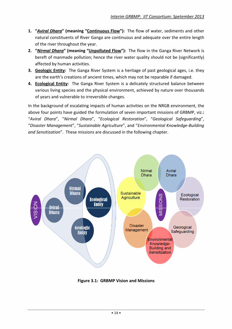
3.2. Vision National River Ganga, which epitomizes the environmental status of the National River
Ganga Basin, and around which human civilization flourished over millennia, has been
flowing ceaselessly since primeval times. In order to preserve and invigorate National River
Ganga, her essential character needs to be grasped in a holistic manner. After extensive
research and consultations, the “wholesomeness of National River Ganga”, viewed from a
dynamic perspective, was determined to be the sanctity of the river system imbibed in four
points as stated below. Out of these, the first two points are based on ancient Indian
concepts – a testimony to our ancient wisdom, while the latter two points derive from
modern scientific knowledge and understanding:
Interim GRBMP: IIT Consortium: Spetember 2013
• 14 •
1. “Aviral Dhara” (meaning “Continuous Flow”): The flow of water, sediments and other
natural constituents of River Ganga are continuous and adequate over the entire length
of the river throughout the year.
2. “Nirmal Dhara” (meaning “Unpolluted Flow”): The flow in the Ganga River Network is
bereft of manmade pollution; hence the river water quality should not be (significantly)
affected by human activities.
3. Geologic Entity: The Ganga River System is a heritage of past geological ages, i.e. they
are the earth’s creations of ancient times, which may not be reparable if damaged.
4. Ecological Entity: The Ganga River System is a delicately structured balance between
various living species and the physical environment, achieved by nature over thousands
of years and vulnerable to irreversible changes.
In the background of escalating impacts of human activities on the NRGB environment, the
above four points have guided the formulation of seven important missions of GRBMP, viz.:
“Aviral Dhara”, “Nirmal Dhara”, “Ecological Restoration”, “Geological Safeguarding”,
“Disaster Management”, “Sustainable Agriculture”, and “Environmental Knowledge-Building
and Sensitization”. These missions are discussed in the following chapter.
Figure 3.1: GRBMP Vision and Missions
3.3. Conceptual Framework
Based on the above vision and the awareness of social needs, the main objectives of
are identified as the following
a) Environmental Flows shall be maintained in all rivers and tributaries of Ganga
System to fulfill their geological, ecological, socio
b) Water quality in all rivers and tributaries of Ganga
their governing geological, ecological, socio
c) Water and other aquatic resources of the Ganga
to enable sustainable development in the entire NRGB.
d) All existing, ongoing and planned anthropogenic activities in NRGB
scrutinized in a transparent and inclusive manner
people and stakeholders) for the overall health of
With the above objectives in mind, the
Plans”) with built-in feedback mechanism
To fulfill these objectives, the need to set up a permanent nodal agency
implement the Action Plans and other needed measures in NRGB on a long
nodal agency is envisioned as an independent Commission
by an Act of Parliament. The basic approach in this
science and technology in conjunction with traditional wisdom.
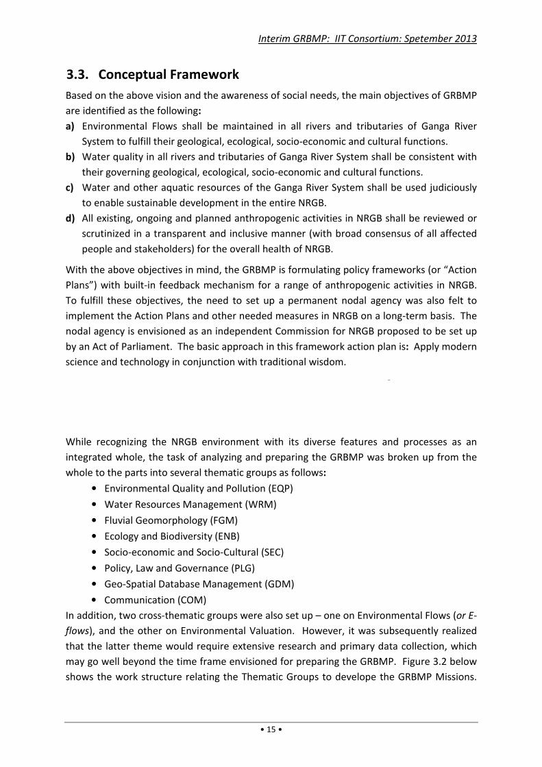
While recognizing the NRGB
integrated whole, the task of analyzing and preparing the
whole to the parts into several thematic groups as follows
• Environmental Quality and Pollution (EQP)
• Water Resources Management (WRM)
• Fluvial Geomorphology (FGM)
• Ecology and Biodiversity (ENB)
• Socio-economic and Socio
• Policy, Law and Governance (PLG)
• Geo-Spatial Database Management (GDM)
• Communication (COM)
In addition, two cross-thematic g
flows), and the other on Environmental Valuation.
that the latter theme would require extensive research and primary data
may go well beyond the time frame envisioned for preparing
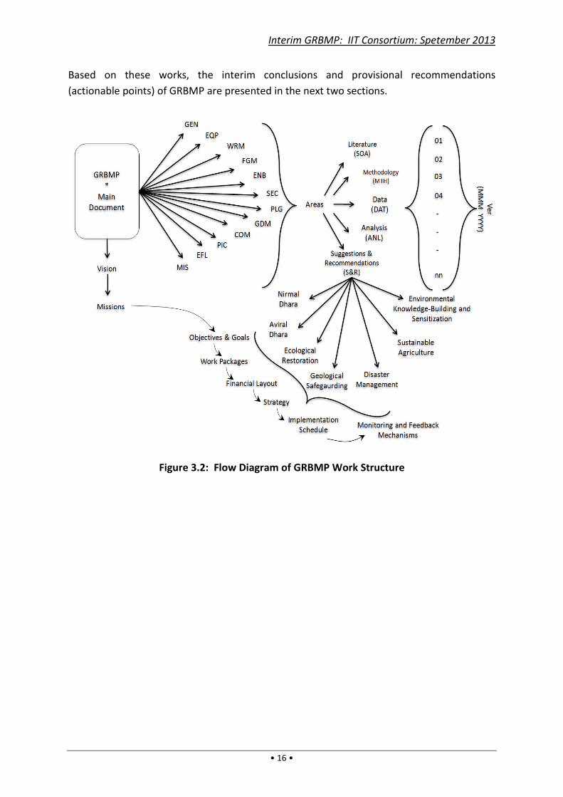
shows the work structure relating the Thematic Groups to
Interim GRBMP: IIT Consortium: Spetember 2013
• 15 •
Conceptual Framework
Based on the above vision and the awareness of social needs, the main objectives of
are identified as the following:
Environmental Flows shall be maintained in all rivers and tributaries of Ganga
eological, ecological, socio-economic and cultural functions.
Water quality in all rivers and tributaries of Ganga River System shall be consistent with
their governing geological, ecological, socio-economic and cultural functions.
c resources of the Ganga River System shall be used judiciously
to enable sustainable development in the entire NRGB.
All existing, ongoing and planned anthropogenic activities in NRGB shall be reviewed or
scrutinized in a transparent and inclusive manner (with broad consensus of all affected
people and stakeholders) for the overall health of NRGB.
With the above objectives in mind, the GRBMP is formulating policy frameworks (or “Action
in feedback mechanism for a range of anthropogenic
To fulfill these objectives, the need to set up a permanent nodal agency
implement the Action Plans and other needed measures in NRGB on a long
nodal agency is envisioned as an independent Commission for NRGB proposed
The basic approach in this framework action plan is
science and technology in conjunction with traditional wisdom.
NRGB environment with its diverse features and processes as an
integrated whole, the task of analyzing and preparing the GRBMP was broken up from the
whole to the parts into several thematic groups as follows:
Environmental Quality and Pollution (EQP)
Resources Management (WRM)
Fluvial Geomorphology (FGM)
Ecology and Biodiversity (ENB)
economic and Socio-Cultural (SEC)
Policy, Law and Governance (PLG)
Spatial Database Management (GDM)
Communication (COM)
thematic groups were also set up – one on Environmental Flows (
, and the other on Environmental Valuation. However, it was subsequently realized
would require extensive research and primary data
may go well beyond the time frame envisioned for preparing the GRBMP
shows the work structure relating the Thematic Groups to develope the
Interim GRBMP: IIT Consortium: Spetember 2013
Based on the above vision and the awareness of social needs, the main objectives of GRBMP
Environmental Flows shall be maintained in all rivers and tributaries of Ganga River
economic and cultural functions.
iver System shall be consistent with
economic and cultural functions.
iver System shall be used judiciously
shall be reviewed or
(with broad consensus of all affected
is formulating policy frameworks (or “Action
activities in NRGB.
To fulfill these objectives, the need to set up a permanent nodal agency was also felt to
implement the Action Plans and other needed measures in NRGB on a long-term basis. The
proposed to be set up
framework action plan is: Apply modern
environment with its diverse features and processes as an
was broken up from the
one on Environmental Flows (or E-
it was subsequently realized
would require extensive research and primary data collection, which
GRBMP. Figure 3.2 below
the GRBMP Missions.
Interim GRBMP: IIT Consortium: Spetember 2013
• 16 •
Based on these works, the interim conclusions and provisional recommendations
(actionable points) of GRBMP are presented in the next two sections.
Figure 3.2: Flow Diagram of GRBMP Work Structure

Interim GRBMP: IIT Consortium: Spetember 2013
• 17 •
4. GRBMP Missions
4.1. Aviral Dhara
For a given geological setting and climatic pattern, alluvial rivers – as characterized by their
morphologies, floodplain geometries and fluvial patterns – achieve stability through long-
term physical balance between various dynamic parameters such as water flow rates and
sediment loads (including seasonal and inter-year variations), terrain gradient, and river
influent/effluent rates. “Aviral Dhara” is a consequence of this long-term stability of rivers.
Anthropogenic activities have violated this aspect of river integrity in several ways – by
erecting obstacles to flow, by significant water withdrawals, by increased disposal of debris
in rivers, and by altering the natural water recharge/extraction. Regarding the last point, it
may be noted that, since alluvial basins are hydraulically connected by groundwater flow
(besides other hydrological connections), water withdrawals/ recharges are not only those
directly from/to the rivers but also from/to different regions of the basin. Thus, while
longitudinal connectivity in the river network is an essential first step to maintain “Aviral
Dhara”, having adequate river flows depends much on the basin’s overall water status.
Dams, barrages and other manmade structures
block or constrict rivers, thereby interrupting
the flow of water, sediments and aquatic
species. While the short-term and local benefits
of such structures can be reasonably estimated,
the long-term, basin-wide environmental losses
in terms of river stability, soil and water
fertility, ecological balance, flood events, health
effects, and other facets of basin performance
are difficult to predict [UNEP, 2008;
WWC,
2000]. Similar adverse effects are also caused
by anthropogenic activities that significantly
alter river flows or sediment loads. The UNEP
document cited in Box 4.1 discusses some of
these aspects in terms of “river fragmentation”
defined as “the interruption of a river’s natural
flow by dams, inter-basin transfers or water
withdrawal … by man.” However, it is not only
interruptions or changes in flow rate that cause physical imbalance in a river; the balance
may also be easily upset by alterations in sediment load as well as seepage inflow/ outflow
and overland inflow rates.
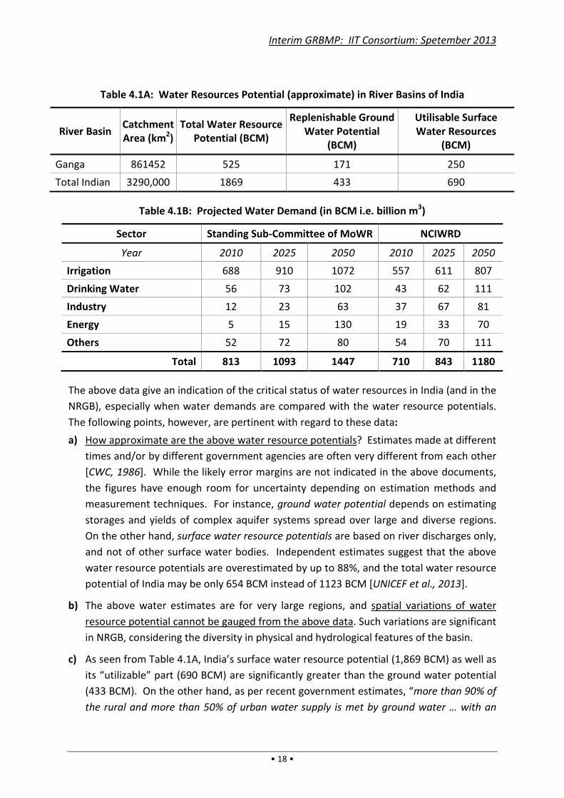
As mentioned earlier, India’s (and NRGB’s) water resources potential and water use have
been evaluated by nodal government agencies under MoWR, GOI. Some relevant data are
cited in Tables 4.1A and 4.1B [CWC, 2000; Jain et al., 2007; ADB, 2009]:
Box 4.1
“Damming and flood control can have
negative impacts (in rivers), such as
declining fish catches, loss of freshwater
biodiversity, increases in the frequency
and severity of floods, loss of soil
nutrients on floodplains, and increases in
diseases such as schistosomiasis and
malaria. ... On the Mississippi River, the
rising frequency and severity of flooding
– attributed to local flood control
structures – have reduced the river’s
ability to support native flora and fauna,
while a dramatic increase in floods on
River Rhine has been attributed to
increased urbanization, engineering, and
the walling off of the river from its
floodplain.”
– “Vital Water Graphics” [UNEP, 2008]
Interim GRBMP: IIT Consortium: Spetember 2013
• 18 •
Table 4.1A: Water Resources Potential (approximate) in River Basins of India
River Basin Catchment
Area (km2)
Total Water Resource
Potential (BCM)
Replenishable Ground
Water Potential
(BCM)
Utilisable Surface
Water Resources
(BCM)
Ganga 861452 525 171 250
Total Indian 3290,000 1869 433 690
Table 4.1B: Projected Water Demand (in BCM i.e. billion m3)
Sector Standing Sub-Committee of MoWR NCIWRD
Year 2010 2025 2050 2010 2025 2050
Irrigation 688 910 1072 557 611 807
Drinking Water 56 73 102 43 62 111
Industry 12 23 63 37 67 81
Energy 5 15 130 19 33 70
Others 52 72 80 54 70 111
Total 813 1093 1447 710 843 1180
The above data give an indication of the critical status of water resources in India (and in the
NRGB), especially when water demands are compared with the water resource potentials.
The following points, however, are pertinent with regard to these data:
a) How approximate are the above water resource potentials? Estimates made at different
times and/or by different government agencies are often very different from each other
[CWC, 1986]. While the likely error margins are not indicated in the above documents,
the figures have enough room for uncertainty depending on estimation methods and
measurement techniques. For instance, ground water potential depends on estimating
storages and yields of complex aquifer systems spread over large and diverse regions.
On the other hand, surface water resource potentials are based on river discharges only,
and not of other surface water bodies. Independent estimates suggest that the above
water resource potentials are overestimated by up to 88%, and the total water resource
potential of India may be only 654 BCM instead of 1123 BCM [UNICEF et al., 2013].
b) The above water estimates are for very large regions, and spatial variations of water
resource potential cannot be gauged from the above data. Such variations are significant
in NRGB, considering the diversity in physical and hydrological features of the basin.
c) As seen from Table 4.1A, India’s surface water resource potential (1,869 BCM) as well as
its “utilizable” part (690 BCM) are significantly greater than the ground water potential
(433 BCM). On the other hand, as per recent government estimates, “more than 90% of
the rural and more than 50% of urban water supply is met by ground water … with an

Interim GRBMP: IIT Consortium: Spetember 2013
• 19 •
estimated annual groundwater withdrawal of 221 BCM” [CGWB, 2012]. Thus,
groundwater usage is purportedly much higher than surface water usage, although
surface water potential is much higher than groundwater potential. This differential
usage pattern needs to be considered in framing India’s water resource policies.
d) The information cited in the above paragraph also shows that India’s estimated “water
usage” is much less than half (and perhaps as low as one-third) of the estimated “water
demand” of 710 BCM or 813 BCM in 2010 (vide Col.5 and Col.2 of Table 4.1B), which
suggests that India is already under severe water-stress/ water-scarcity. However, this
conclusion seems untenable if “water-stress” is based on the premise of per capita
water availability being less than 1000 m3/year [which seems to be the government
norm, whereas the international norm for “water stress” is when a nation’s per capita
water availability falls below 1700 m3/yr, vide FAO, 2012; UN-Water, 2013]. As per
government figures of 2006, the per capita water availability was expected to reduce to
below 1000 m3/yr only around 2025 [ADB, 2009]. But as per later CWC figures, the per
capita water availability in India was 1588 m3/yr (which was significantly higher in the
Ganga basin at almost 2000 m3/yr) in 2010 and is expected to reduce to 1434 m3/yr in
2025 [India-WRIS, 2012; CWC, 2010]. On the other hand, NIH states that India’s
“utilizable” per capita water availability reduced from 1,100 m3/yr in 1998 to 938 m3/yr
in 2010, and is expected to further reduce to 814 m3/yr in 2025 [NIH, 2013]. The term
“utilizable” is not quantitatively explained in the above documents, and this adds to
overall confusion about the significance of the data. While clarity on these data and
their interpretations are needed, it is likely that much of the country (including NRGB) is
under increasing water-stress, which certainly calls for major changes in how India’s
(and NRGB’s) waters are managed.
e) The projected water demands in Table 4.1B were evidently computed assuming the per
capita demand as being invariant over time and not by assessing the demand trend or
other factors. But given binding constraints on water availability, the growth in demand
must get constrained, implying a need for demand management [UNICEF, 2013].
f) The projected water demands are for human use only, and do not give any indication of
the environmental needs of the basin. In other words, the water needed for the survival
and health of India’s (and NRGB’s) aquatic system is unstated. From discussions with
various agencies, it appears that, generally, no attempt is made to reliably assess this
requirement and it is often ignored.
Thus the NRGB’s water status needs to be re-examined afresh and in considerably greater
detail in order to estimate its true potential and its spatial-temporal effect on river flows.
However, notwithstanding errors in the estimates quoted above, it is easily surmised that
human water demands have been increasing while dry-season river discharges and ground
water levels have been falling in many parts of the NRGB, which implies that the
hydrological status of NRGB is shifting relentlessly towards a state of critical imbalance. To
overcome this impending crisis, it is imperative therefore that either (i) water availability in
Interim GRBMP: IIT Consortium: Spetember 2013
• 20 •
0
50
100
150
200
250
300
1960 1970 1980 1990 2000 2010
Vo
lum
e,
km
3
Year
Industrial and domestic consumption
Evaporation from reservoirs
Figure 4.1: Reservoir Evaporation
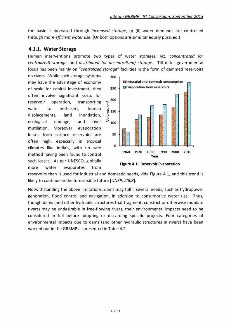
the basin is increased through increased storage, or (ii) water demands are controlled
through more efficient water use. (Or both options are simultaneously pursued.)
4.1.1. Water Storage
Human interventions promote two types of water storages, viz. concentrated (or
centralized) storage, and distributed (or decentralized) storage. Till date, governmental
focus has been mainly on “centralized storage” facilities in the form of dammed reservoirs
on rivers. While such storage systems
may have the advantage of economy
of scale for capital investment, they
often involve significant costs for
reservoir operation, transporting
water to end-users, human
displacements, land inundation,
ecological damage, and river
mutilation. Moreover, evaporation
losses from surface reservoirs are
often high, especially in tropical
climates like India’s, with no safe
method having been found to control
such losses. As per UNESCO, globally
more water evaporates from
reservoirs than is used for industrial and domestic needs, vide Figure 4.1, and this trend is
likely to continue in the foreseeable future [UNEP, 2008].
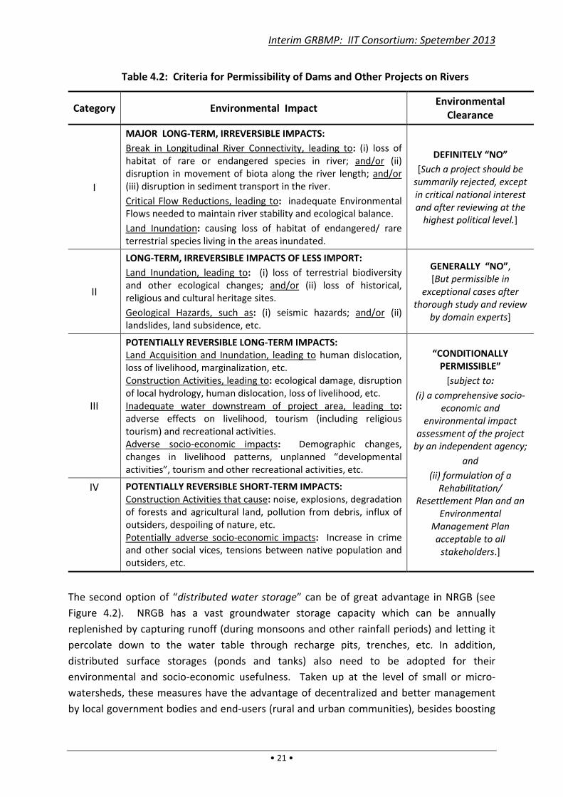
Notwithstanding the above limitations, dams may fulfill several needs, such as hydropower
generation, flood control and navigation, in addition to consumptive water use. Thus,
though dams (and other hydraulic structures that fragment, constrict or otherwise mutilate
rivers) may be undesirable in free-flowing rivers, their environmental impacts need to be
considered in full before adopting or discarding specific projects. Four categories of
environmental impacts due to dams (and other hydraulic structures in rivers) have been
worked out in the GRBMP as presented in Table 4.2.
Interim GRBMP: IIT Consortium: Spetember 2013
• 21 •
Table 4.2: Criteria for Permissibility of Dams and Other Projects on Rivers
Category Environmental Impact Environmental
Clearance
I
MAJOR LONG-TERM, IRREVERSIBLE IMPACTS:
Break in Longitudinal River Connectivity, leading to: (i) loss of
habitat of rare or endangered species in river; and/or (ii)
disruption in movement of biota along the river length; and/or
(iii) disruption in sediment transport in the river.
Critical Flow Reductions, leading to: inadequate Environmental
Flows needed to maintain river stability and ecological balance.
Land Inundation: causing loss of habitat of endangered/ rare
terrestrial species living in the areas inundated.
DEFINITELY “NO”
[Such a project should be
summarily rejected, except
in critical national interest
and after reviewing at the
highest political level.]
II
LONG-TERM, IRREVERSIBLE IMPACTS OF LESS IMPORT:
Land Inundation, leading to: (i) loss of terrestrial biodiversity
and other ecological changes; and/or (ii) loss of historical,
religious and cultural heritage sites.
Geological Hazards, such as: (i) seismic hazards; and/or (ii)
landslides, land subsidence, etc.
GENERALLY “NO”,
[But permissible in
exceptional cases after
thorough study and review
by domain experts]
III
POTENTIALLY REVERSIBLE LONG-TERM IMPACTS:
Land Acquisition and Inundation, leading to human dislocation,
loss of livelihood, marginalization, etc.
Construction Activities, leading to: ecological damage, disruption
of local hydrology, human dislocation, loss of livelihood, etc.
Inadequate water downstream of project area, leading to:
adverse effects on livelihood, tourism (including religious
tourism) and recreational activities.
Adverse socio-economic impacts: Demographic changes,
changes in livelihood patterns, unplanned “developmental
activities”, tourism and other recreational activities, etc.
“CONDITIONALLY
PERMISSIBLE”
[subject to:
(i) a comprehensive socio-
economic and
environmental impact
assessment of the project
by an independent agency;
and
(ii) formulation of a
Rehabilitation/
Resettlement Plan and an
Environmental
Management Plan
acceptable to all
stakeholders.]
IV POTENTIALLY REVERSIBLE SHORT-TERM IMPACTS:
Construction Activities that cause: noise, explosions, degradation
of forests and agricultural land, pollution from debris, influx of
outsiders, despoiling of nature, etc.
Potentially adverse socio-economic impacts: Increase in crime
and other social vices, tensions between native population and
outsiders, etc.
The second option of “distributed water storage” can be of great advantage in NRGB (see
Figure 4.2). NRGB has a vast groundwater storage capacity which can be annually
replenished by capturing runoff (during monsoons and other rainfall periods) and letting it
percolate down to the water table through recharge pits, trenches, etc. In addition,
distributed surface storages (ponds and tanks) also need to be adopted for their
environmental and socio-economic usefulness. Taken up at the level of small or micro-
watersheds, these measures have the advantage of decentralized and better management
by local government bodies and end-users (rural and urban communities), besides boosting

groundwater levels and river base flows. However, both field
relevant data (climatic, topographic, soil, water table, etc.) should be provided to user
communities by government agencies.
Figure 4.2: Storm-water Runoff
The “distributed storage” concept should also be applied to natural ecosystems of NRGB,
especially wetlands, forests
significantly to water conservation in the basin, besides
services. As noted by Pegram
fundamental to rivers, in terms of the goods and services that they provide, the cultural and
other social activities they support, and their inherent biodiversity value.
that once seriously degraded, these systems become difficult and costly to return to healthy
conditions. It is therefore critical for basin planning to incorporate an understanding of the
ecological limits, thresholds and interconnections of the entire basin water resources.
the case of wetlands, Prasad,
existing wetlands, adding that “
Ramsar sites, India ... so far managed to delineate a mere six sites
Ramsar wetlands in India subsequently increased to 25, but hundreds of other wetlands in
the country (including many in the NRGB)
[Dhandekar, 2011]. Forest cover
in the NRGB except in high altitude regions [
preservation of wetlands, forests and grasslands, combined with various water and soil
conservation measures, is an urgent need in
Interim GRBMP: IIT Consortium: Spetember 2013
• 22 •
groundwater levels and river base flows. However, both field-level technical help and
relevant data (climatic, topographic, soil, water table, etc.) should be provided to user
nities by government agencies.
unoff Storage Options – Concentrated and Distributed Storages
” concept should also be applied to natural ecosystems of NRGB,
sts and grasslands. Each of these ecosystems contributes
significantly to water conservation in the basin, besides providing other vital
As noted by Pegram et al. [2013] “healthy and functioning aquatic ecosystems are
fundamental to rivers, in terms of the goods and services that they provide, the cultural and
other social activities they support, and their inherent biodiversity value. …
degraded, these systems become difficult and costly to return to healthy
It is therefore critical for basin planning to incorporate an understanding of the
ecological limits, thresholds and interconnections of the entire basin water resources.
the case of wetlands, Prasad, et al. [2002] had emphasized the great need
, adding that “even a small country like UK could designate 161 wetlands as
Ramsar sites, India ... so far managed to delineate a mere six sites till date.
Ramsar wetlands in India subsequently increased to 25, but hundreds of other wetlands in
(including many in the NRGB) are in a state of pitiable degeneration
Forest cover and grasslands, too, have reached minuscule proportions
in the NRGB except in high altitude regions [India-WRIS, 2012]. Overall, the
preservation of wetlands, forests and grasslands, combined with various water and soil
measures, is an urgent need in NRGB.
Interim GRBMP: IIT Consortium: Spetember 2013
level technical help and
relevant data (climatic, topographic, soil, water table, etc.) should be provided to user
Concentrated and Distributed Storages
” concept should also be applied to natural ecosystems of NRGB,
. Each of these ecosystems contributes
other vital ecosystem
healthy and functioning aquatic ecosystems are
fundamental to rivers, in terms of the goods and services that they provide, the cultural and
… Experience shows
degraded, these systems become difficult and costly to return to healthy
It is therefore critical for basin planning to incorporate an understanding of the
ecological limits, thresholds and interconnections of the entire basin water resources.” In
e great need to protect the
even a small country like UK could designate 161 wetlands as
till date.” The number of
Ramsar wetlands in India subsequently increased to 25, but hundreds of other wetlands in
are in a state of pitiable degeneration
reached minuscule proportions
]. Overall, the restoration and
preservation of wetlands, forests and grasslands, combined with various water and soil

Interim GRBMP: IIT Consortium: Spetember 2013
• 23 •
4.1.2. Water Use Efficiency
While water is a renewable resource, the renewal capacity of NRGB is limited by the region’s
precipitation and various physiographic factors. That our fresh water usage may be nearing
the average annual water renewal capacity of the basin may not have been realized by the
general population (or even by major water-users), but this is a distinct possibility. Hence,
several measures are immediately required to ensure efficient water use, viz.:
i) Realistic pricing of fresh water (especially for commercial and affluent domestic
consumers) and disincentives for wastage of water.
ii) Techno-economic assistance and incentives for poor and marginal sections (such as
those engaged in subsistence agriculture) to improve water-use efficiencies.
iii) Allocation of water rights and entitlements to stakeholders.
iv) Direct reuse of water where possible, e.g. reuse of irrigation return flows.
v) Treatment and recycling/reuse of domestic and industrial wastewaters where feasible.
4.1.3. Policy Focus
The foregoing discussions strongly suggest that the government strategy on managing
NRGB’s water resources needs some major changes. The desired policy changes may be
stated as follows:
A) Government agencies usually deal with NRGB’s water resources independently of other
natural resources; but the basin waters are intimately linked with other vital resources
of the basin, such as soil/silt and its nutrients (organic and inorganic) and biotic
resources. It is imperative therefore that water resource management in NRGB should
be assimilated into a broader framework of natural resource management (or
environmental resource management) instead of the water-only approach.
B) Thus far, governmental emphasis on “development of water resources” has broadly
meant extracting increasingly more water and energy from the basin for human use.
This emphasis on water and energy abstractions has often led to the water resource
systems themselves being endangered (as evident from many vanishing wetlands and
streams). Thus, if “development” and “use” of water resources lead to their extinction,
then it is evident that government priority must shift from “conjunctive use” of surface
and ground water resources to their “conjunctive preservation” at the earliest.
C) As noted by many commentators, in recent decades, large-scale water (especially
groundwater) abstractions from the environment are being effected by water-users
themselves. Other aquatic resources are also directly tapped by users. Yet, users are
not entrusted with the maintenance of water resource systems, thereby creating a
contradiction between ownership and usage. The obvious need to give stakeholders the
rights and responsibilities to maintain water resource systems has been advocated by
many experts [e.g. ADB, 2009; Sen, 2009; Thakkar, 2012; UNICEF, et al., 2013]. Broadly
in line with these suggestions, it is suggested here that management of aquatic
resources should shift from “centralized government control” to “decentralized
stakeholder control” combined with “expert guidance and regulation”.
Interim GRBMP: IIT Consortium: Spetember 2013
• 24 •
4.1.4. Environmental Flows
Flow is the main driver of biodiversity in rivers, and a river’s flow regime – the variation of
high and low flows through the year as well as variation over the years – exerts great
influence on its ecosystem. Environmental Flows (or E-Flows) are a regime of flow in a river
that mimics the natural pattern of a river’s flow, so that the river can at least minimally
perform its natural functions such as transporting water and solids from its catchment,
maintaining its structural integrity, formation of land, self-purification, and sustenance of its
myriad systems along with sustaining cultural, spiritual and livelihood activities of the
people or associated population. Thus E-Flows describe the temporal and spatial variations
in quantity and quality of water required for freshwater and estuarine systems to perform
their natural ecological functions (including material transport) and support the spiritual,
cultural and livelihood activities that depend on them, vide IIT-GRBMP Thematic Report
Code: 022_GBP_IIT_EFL_SOA_01_Ver 1_Dec 2011.
After reviewing several different holistic methods of estimating E-Flows and in consultation
with stakeholders and expert groups, the Building Block Method (BBM) was found to robust
and most suitable for rivers, as explained in the above report. The BBM had been
developed in South Africa through numerous applications in water resources development
to address E-Flows requirements for riverine ecosystems under conditions of variable
resources. However, it is to be noted that Building Block is a misnomer and in practice it is a
Bigger Block that governs E-Flows and hence BBM henceforth could be taken as Bigger Block
Method. Based on this method, E-Flows were computed for some relevant sites on
Alaknanda and Bhagirathi rivers of the Upper Ganga Segment (considered to have high
hydropower potential) as shown in Figure 4.3. The procedure for computing E_Flows are
briefly stated here. The detailed procedure for computing E-Flows is described in a separate
Thematic Report by E-Flows Group under preparation. It should be noted here that the
method quantifies only the lower bound on flow rates required at different times to sustain
the river, and does not specify other conditions to be maintained in the river. One of these
conditions is, of course, the connectivity in river flow, but maintaining the water-sediment
balance is also an essential condition. In the absence of empirical data, it is recommended
that E-Flows should carry river sediments (suspended load and bed load) in approximately
the same proportions as present in the virgin flow of the river.
To compute E-Flows at the seven selected sites, the geomorphological and biological
features of the respective sites were analysed and the sites were physically surveyed to map
the river cross-sections. The virgin river flows at these sites were considered for the period
prior to construction of Tehri Dam for which the flow data of Alaknanda, Bhagirathi and
Ganga rivers were available from CWC namely, for the period 1972 to 1982 for Uttarkashi
(Lat 30°44'20"N, Long 78°21'23"E), Devaprayag Upstream (Lat 30°09'00"N, Long 78°35'54"E)
and Devprayag Downstream (Lat 30°08'00"N, Long 78°35'44"E) and Rishikesh (Lat
30°10'21"N, Long 78°18'30"E) Stations, and for the period 1977 to 1987 for Rudrapayag (Lat
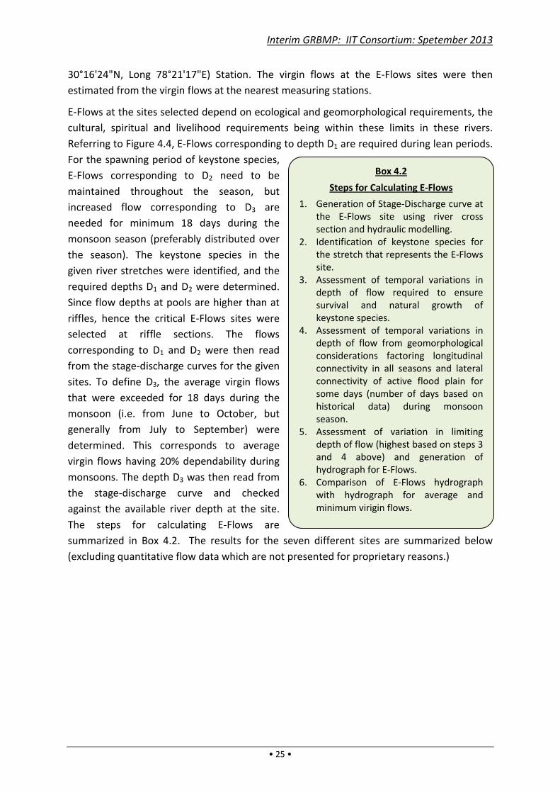
Interim GRBMP: IIT Consortium: Spetember 2013
• 25 •
30°16'24"N, Long 78°21'17"E) Station. The virgin flows at the E-Flows sites were then
estimated from the virgin flows at the nearest measuring stations.
E-Flows at the sites selected depend on ecological and geomorphological requirements, the
cultural, spiritual and livelihood requirements being within these limits in these rivers.
Referring to Figure 4.4, E-Flows corresponding to depth D1 are required during lean periods.
For the spawning period of keystone species,
E-Flows corresponding to D2 need to be
maintained throughout the season, but
increased flow corresponding to D3 are
needed for minimum 18 days during the
monsoon season (preferably distributed over
the season). The keystone species in the
given river stretches were identified, and the
required depths D1 and D2 were determined.
Since flow depths at pools are higher than at
riffles, hence the critical E-Flows sites were
selected at riffle sections. The flows
corresponding to D1 and D2 were then read
from the stage-discharge curves for the given
sites. To define D3, the average virgin flows
that were exceeded for 18 days during the
monsoon (i.e. from June to October, but
generally from July to September) were
determined. This corresponds to average
virgin flows having 20% dependability during
monsoons. The depth D3 was then read from
the stage-discharge curve and checked
against the available river depth at the site.
The steps for calculating E-Flows are
summarized in Box 4.2. The results for the seven different sites are summarized below
(excluding quantitative flow data which are not presented for proprietary reasons.)
Box 4.2
Steps for Calculating E-Flows
1. Generation of Stage-Discharge curve at
the E-Flows site using river cross
section and hydraulic modelling.
2. Identification of keystone species for
the stretch that represents the E-Flows
site.
3. Assessment of temporal variations in
depth of flow required to ensure
survival and natural growth of
keystone species.
4. Assessment of temporal variations in
depth of flow from geomorphological
considerations factoring longitudinal
connectivity in all seasons and lateral
connectivity of active flood plain for
some days (number of days based on
historical data) during monsoon
season.
5. Assessment of variation in limiting
depth of flow (highest based on steps 3
and 4 above) and generation of
hydrograph for E-Flows.
6. Comparison of E-Flows hydrograph
with hydrograph for average and
minimum virigin flows.
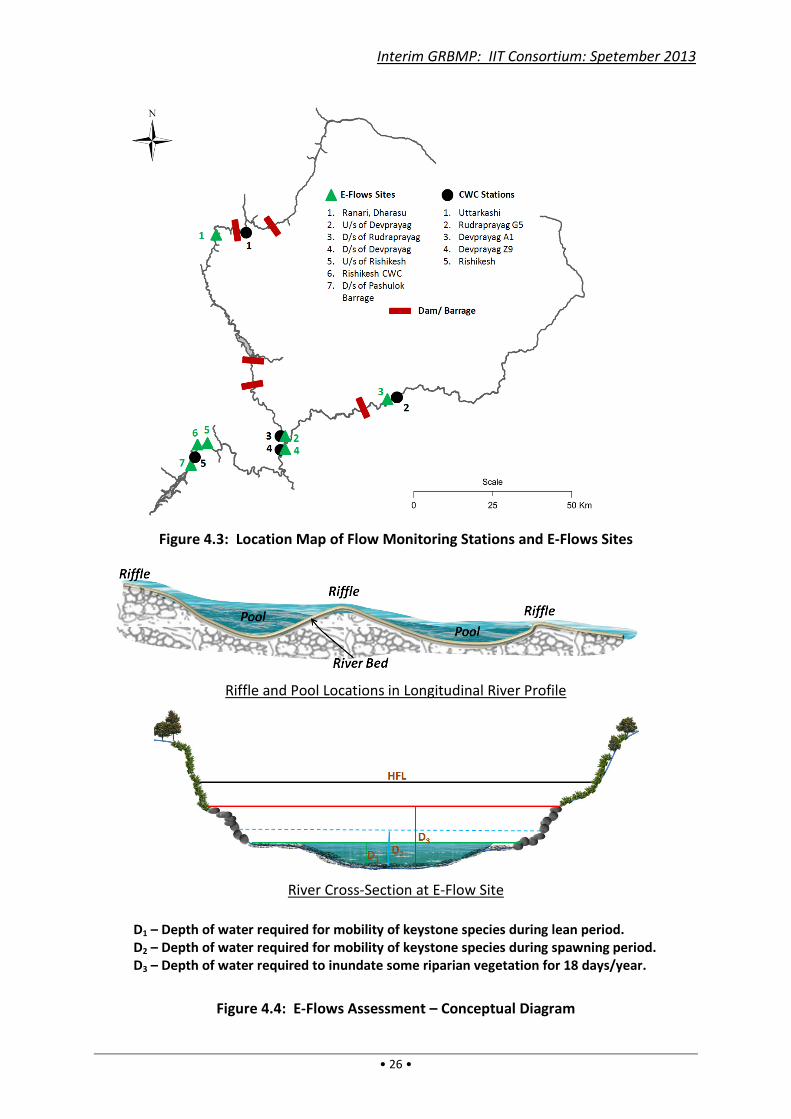
Interim GRBMP: IIT Consortium: Spetember 2013
• 26 •
Figure 4.3: Location Map of Flow Monitoring Stations and E-Flows Sites
Riffle and Pool Locations in Longitudinal River Profile
River Cross-Section at E-Flow Site
D1 – Depth of water required for mobility of keystone species during lean period.
D2 – Depth of water required for mobility of keystone species during spawning period.
D3 – Depth of water required to inundate some riparian vegetation for 18 days/year.
Figure 4.4: E-Flows Assessment – Conceptual Diagram
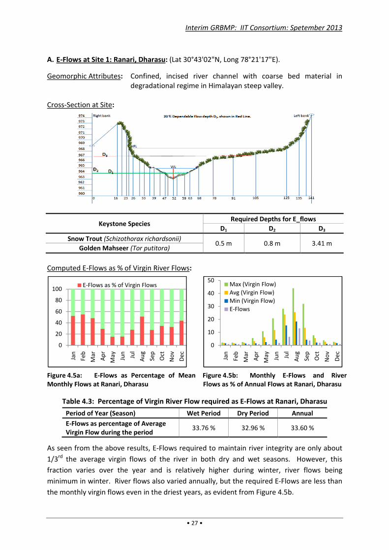
Interim GRBMP: IIT Consortium: Spetember 2013
• 27 •
A. E-Flows at Site 1: Ranari, Dharasu: (Lat 30°43'02"N, Long 78°21'17"E).
Geomorphic Attributes: Confined, incised river channel with coarse bed material in
degradational regime in Himalayan steep valley.
Cross-Section at Site:
Keystone Species Required Depths for E_flows
D1 D2 D3
Snow Trout (Schizothorax richardsonii) 0.5 m 0.8 m 3.41 m
Golden Mahseer (Tor putitora)
Computed E-Flows as % of Virgin River Flows:
Figure 4.5a: E-Flows as Percentage of Mean
Monthly Flows at Ranari, Dharasu
Figure 4.5b: Monthly E-Flows and River
Flows as % of Annual Flows at Ranari, Dharasu
Table 4.3: Percentage of Virgin River Flow required as E-Flows at Ranari, Dharasu
Period of Year (Season) Wet Period Dry Period Annual
E-Flows as percentage of Average
Virgin Flow during the period 33.76 % 32.96 % 33.60 %
As seen from the above results, E-Flows required to maintain river integrity are only about
1/3rd the average virgin flows of the river in both dry and wet seasons. However, this
fraction varies over the year and is relatively higher during winter, river flows being
minimum in winter. River flows also varied annually, but the required E-Flows are less than
the monthly virgin flows even in the driest years, as evident from Figure 4.5b.
0
20
40
60
80
100
Jan
Feb
Ma
r
Ap
r
Ma
y
Jun
Jul
Au
g
Sep
Oct
No
v
De
c
E-Flows as % of Virgin Flows
0
10
20
30
40
50
Jan
Feb
Ma
r
Ap
r
Ma
y
Jun
Jul
Au
g
Sep
Oct
No
v
De
c
Max (Virgin Flow)
Avg (Virgin Flow)
Min (Virgin Flow)
E-Flows
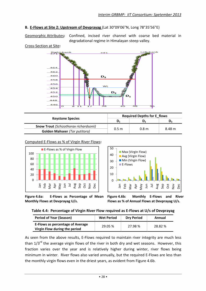
Interim GRBMP: IIT Consortium: Spetember 2013
• 28 •
B. E-Flows at Site 2: Upstream of Devprayag (Lat 30°09'06"N, Long 78°35'56"E)
Geomorphic Attributes: Confined, incised river channel with coarse bed material in
degradational regime in Himalayan steep valley.
Cross-Section at Site:
Keystone Species Required Depths for E_flows
D1 D2 D3
Snow Trout (Schizothorax richardsonii) 0.5 m 0.8 m 8.48 m
Golden Mahseer (Tor putitora)
Computed E-Flows as % of Virgin River Flows:
Figure 4.6a: E-Flows as Percentage of Mean
Monthly Flows at Devprayag U/s.
Figure 4.6b: Monthly E-Flows and River
Flows as % of Annual Flows at Devprayag U/s.
Table 4.4: Percentage of Virgin River Flow required as E-Flows at U/s of Devprayag
Period of Year (Season) Wet Period Dry Period Annual
E-Flows as percentage of Average
Virgin Flow during the period 29.05 % 27.98 % 28.82 %
As seen from the above results, E-Flows required to maintain river integrity are much less
than 1/3rd the average virgin flows of the river in both dry and wet seasons. However, this
fraction varies over the year and is relatively higher during winter, river flows being
minimum in winter. River flows also varied annually, but the required E-Flows are less than
the monthly virgin flows even in the driest years, as evident from Figure 4.6b.
0
20
40
60
80
100
Jan
Feb
Ma
r
Ap
r
Ma
y
Jun
Jul
Au
g
Sep
Oct
No
v
De
c
E-Flows as % of Virgin Flow
0
10
20
30
40
50
Jan
Feb
Ma
r
Ap
r
Ma
y
Jun
Jul
Au
g
Sep
Oct
No
v
De
c
Max (Virgin Flow)
Avg (Virgin Flow)
Min (Virgin Flow)
E-Flows
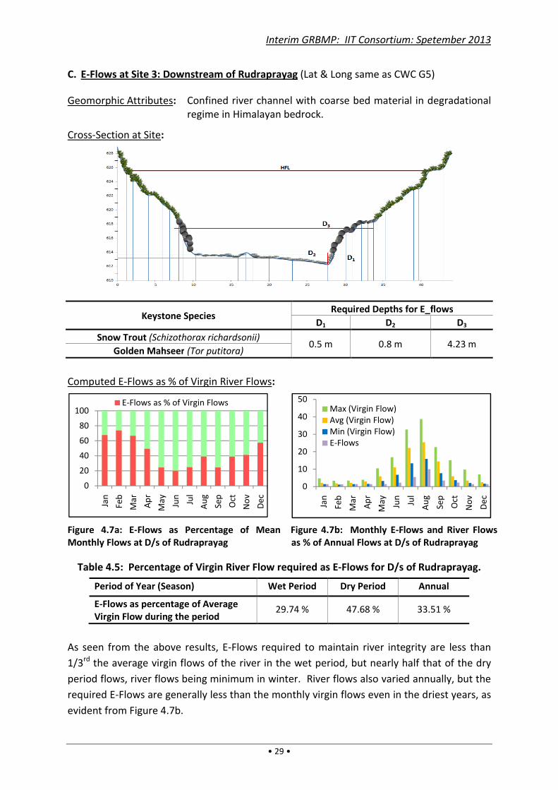
Interim GRBMP: IIT Consortium: Spetember 2013
• 29 •
C. E-Flows at Site 3: Downstream of Rudraprayag (Lat & Long same as CWC G5)
Geomorphic Attributes: Confined river channel with coarse bed material in degradational
regime in Himalayan bedrock.
Cross-Section at Site:
Keystone Species Required Depths for E_flows
D1 D2 D3
Snow Trout (Schizothorax richardsonii) 0.5 m 0.8 m 4.23 m
Golden Mahseer (Tor putitora)
Computed E-Flows as % of Virgin River Flows:
Figure 4.7a: E-Flows as Percentage of Mean
Monthly Flows at D/s of Rudraprayag
Figure 4.7b: Monthly E-Flows and River Flows
as % of Annual Flows at D/s of Rudraprayag
Table 4.5: Percentage of Virgin River Flow required as E-Flows for D/s of Rudraprayag.
Period of Year (Season) Wet Period Dry Period Annual
E-Flows as percentage of Average
Virgin Flow during the period 29.74 % 47.68 % 33.51 %
As seen from the above results, E-Flows required to maintain river integrity are less than
1/3rd the average virgin flows of the river in the wet period, but nearly half that of the dry
period flows, river flows being minimum in winter. River flows also varied annually, but the
required E-Flows are generally less than the monthly virgin flows even in the driest years, as
evident from Figure 4.7b.
0
20
40
60
80
100
Jan
Feb
Ma
r
Ap
r
Ma
y
Jun
Jul
Au
g
Sep
Oct
No
v
De
c
E-Flows as % of Virgin Flows
0
10
20
30
40
50
Jan
Feb
Ma
r
Ap
r
Ma
y
Jun
Jul
Au
g
Sep
Oct
No
v
De
c
Max (Virgin Flow)
Avg (Virgin Flow)
Min (Virgin Flow)
E-Flows
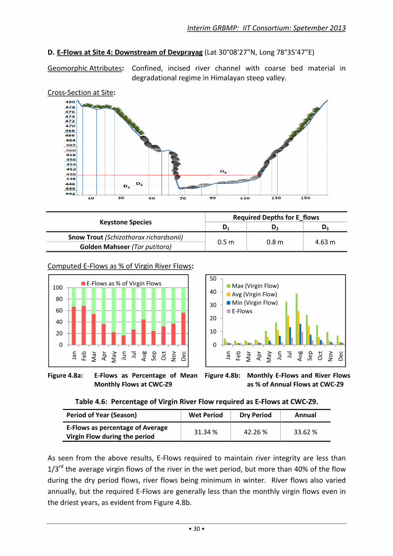
Interim GRBMP: IIT Consortium: Spetember 2013
• 30 •
D. E-Flows at Site 4: Downstream of Devprayag (Lat 30°08'27"N, Long 78°35'47"E)
Geomorphic Attributes: Confined, incised river channel with coarse bed material in
degradational regime in Himalayan steep valley.
Cross-Section at Site:
Keystone Species Required Depths for E_flows
D1 D2 D3
Snow Trout (Schizothorax richardsonii) 0.5 m 0.8 m 4.63 m
Golden Mahseer (Tor putitora)
Computed E-Flows as % of Virgin River Flows:
Figure 4.8a: E-Flows as Percentage of Mean
Monthly Flows at CWC-Z9
Figure 4.8b: Monthly E-Flows and River Flows
as % of Annual Flows at CWC-Z9
Table 4.6: Percentage of Virgin River Flow required as E-Flows at CWC-Z9.
Period of Year (Season) Wet Period Dry Period Annual
E-Flows as percentage of Average
Virgin Flow during the period 31.34 % 42.26 % 33.62 %
As seen from the above results, E-Flows required to maintain river integrity are less than
1/3rd the average virgin flows of the river in the wet period, but more than 40% of the flow
during the dry period flows, river flows being minimum in winter. River flows also varied
annually, but the required E-Flows are generally less than the monthly virgin flows even in
the driest years, as evident from Figure 4.8b.
0
20
40
60
80
100
Jan
Feb
Ma
r
Ap
r
Ma
y
Jun
Jul
Au
g
Sep
Oct
No
v
De
c
E-Flows as % of Virgin Flows
0
10
20
30
40
50
Jan
Feb
Ma
r
Ap
r
Ma
y
Jun
Jul
Au
g
Sep
Oct
No
v
De
c
Max (Virgin Flow)
Avg (Virgin Flow)
Min (Virgin Flow)
E-Flows

Interim GRBMP: IIT Consortium: Spetember 2013
• 31 •
E. E-Flows at Site 5: Upstream of Rishikesh (Lat 30°08'02”N, Long 78°20'11"E)
Geomorphic Attributes: Partly confined, moderately steep river channel with coarse bed
material in aggradational regime in Himalayan bedrock – alluvial
transition.
Cross-Section at Site:
Keystone Species Required Depths for E_flows
D1 D2 D3
Golden Mahseer (Tor putitora) 0.5 m 0.8 m 2.91 m
Computed E-Flows as % of Virgin River Flows:
Figure 4.9a: E-Flows as Percentage of Mean
Monthly Flows at U/s of Rishikesh
Figure 4.9b: Monthly E-Flows and River Flows as
% of Annual Flows at U/s of Rishikesh
Table 4.7: Percentage of Virgin River Flow required as E-Flows at U/s of Rishikesh
Period of Year (Season) Wet Period Dry Period Annual
E-Flows as percentage of Average
Virgin Flow during the period 32.29 % 53.09 % 35.56 %
As seen from the above results, E-Flows required to maintain river integrity are less than
1/3rd the average virgin flows of the river in the wet period, but more than half that of the
dry period flows, river flows being minimum in winter. River flows also varied annually, but
the required E-Flows are generally less than the monthly virgin flows even in the driest
years, as evident from Figure 4.9b.
0
20
40
60
80
100
Jan
Feb
Ma
r
Ap
r
Ma
y
Jun
Jul
Au
g
Sep
Oct
No
v
De
c
E-Flows as % of Virgin Flows
0
10
20
30
40
50
Jan
Feb
Ma
r
Ap
r
Ma
y
Jun
Jul
Au
g
Sep
Oct
No
v
De
c
Max (Virgin Flow)
Avg (Virgin Flow)
Min (Virgin Flow)
E-Flows
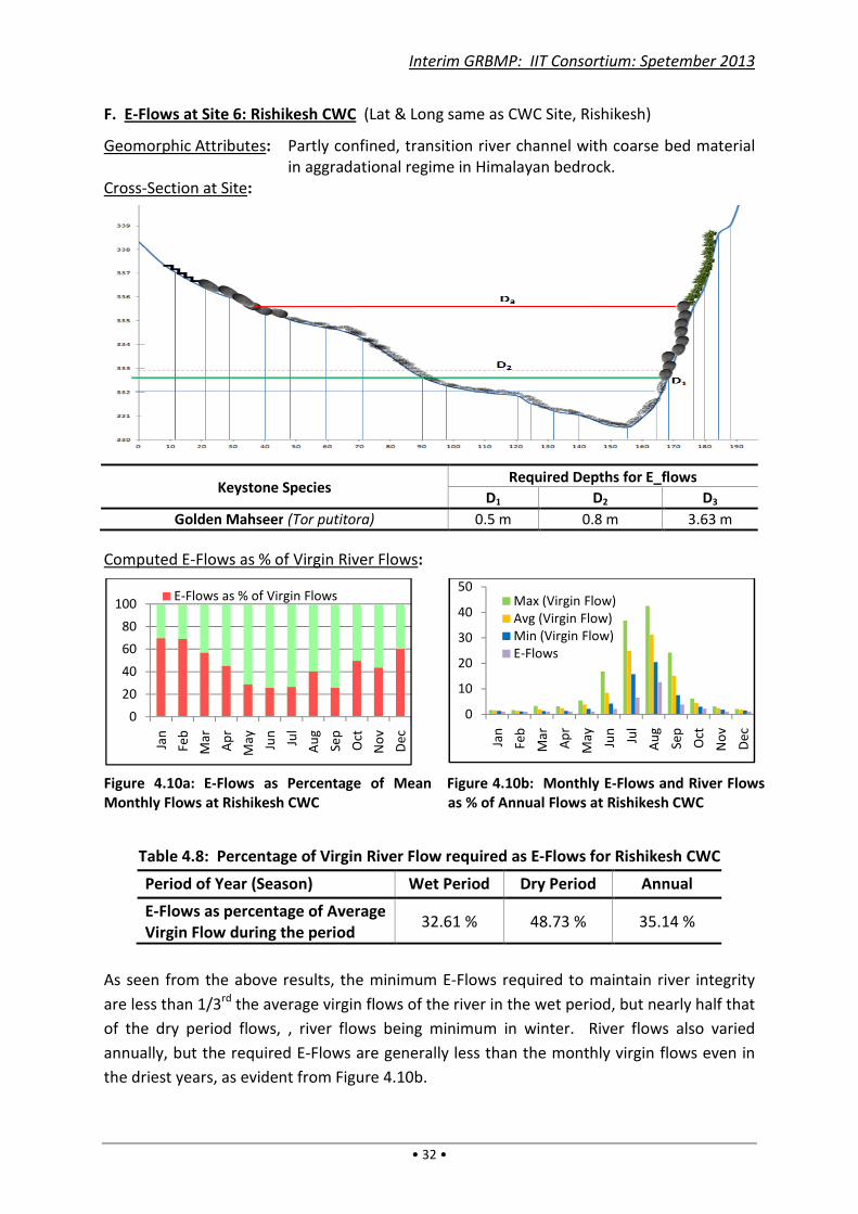
Interim GRBMP: IIT Consortium: Spetember 2013
• 32 •
F. E-Flows at Site 6: Rishikesh CWC (Lat & Long same as CWC Site, Rishikesh)
Geomorphic Attributes: Partly confined, transition river channel with coarse bed material
in aggradational regime in Himalayan bedrock.
Cross-Section at Site:
Keystone Species Required Depths for E_flows
D1 D2 D3
Golden Mahseer (Tor putitora) 0.5 m 0.8 m 3.63 m
Computed E-Flows as % of Virgin River Flows:
Figure 4.10a: E-Flows as Percentage of Mean
Monthly Flows at Rishikesh CWC
Figure 4.10b: Monthly E-Flows and River Flows
as % of Annual Flows at Rishikesh CWC
Table 4.8: Percentage of Virgin River Flow required as E-Flows for Rishikesh CWC
Period of Year (Season) Wet Period Dry Period Annual
E-Flows as percentage of Average
Virgin Flow during the period 32.61 % 48.73 % 35.14 %
As seen from the above results, the minimum E-Flows required to maintain river integrity
are less than 1/3rd the average virgin flows of the river in the wet period, but nearly half that
of the dry period flows, , river flows being minimum in winter. River flows also varied
annually, but the required E-Flows are generally less than the monthly virgin flows even in
the driest years, as evident from Figure 4.10b.
0
20
40
60
80
100
Jan
Feb
Ma
r
Ap
r
Ma
y
Jun
Jul
Au
g
Sep
Oct
No
v
De
c
E-Flows as % of Virgin Flows
0
10
20
30
40
50
Jan
Feb
Ma
r
Ap
r
Ma
y
Jun
Jul
Au
g
Sep
Oct
No
v
De
c
Max (Virgin Flow)
Avg (Virgin Flow)
Min (Virgin Flow)
E-Flows
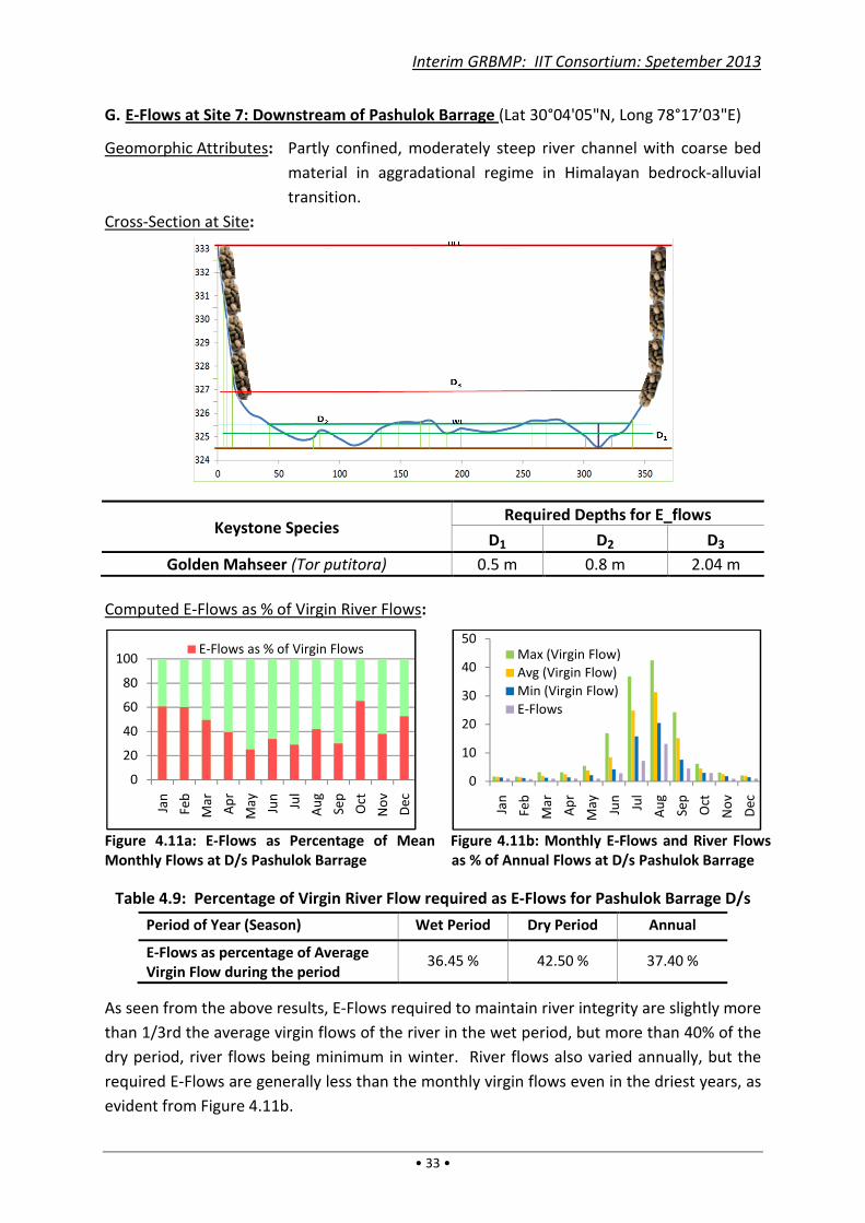
Interim GRBMP: IIT Consortium: Spetember 2013
• 33 •
G. E-Flows at Site 7: Downstream of Pashulok Barrage (Lat 30°04'05"N, Long 78°17’03"E)
Geomorphic Attributes: Partly confined, moderately steep river channel with coarse bed
material in aggradational regime in Himalayan bedrock-alluvial
transition.
Cross-Section at Site:
Keystone Species Required Depths for E_flows
D1 D2 D3
Golden Mahseer (Tor putitora) 0.5 m 0.8 m 2.04 m
Computed E-Flows as % of Virgin River Flows:
Figure 4.11a: E-Flows as Percentage of Mean
Monthly Flows at D/s Pashulok Barrage
Figure 4.11b: Monthly E-Flows and River Flows
as % of Annual Flows at D/s Pashulok Barrage
Table 4.9: Percentage of Virgin River Flow required as E-Flows for Pashulok Barrage D/s
Period of Year (Season) Wet Period Dry Period Annual
E-Flows as percentage of Average
Virgin Flow during the period 36.45 % 42.50 % 37.40 %
As seen from the above results, E-Flows required to maintain river integrity are slightly more
than 1/3rd the average virgin flows of the river in the wet period, but more than 40% of the
dry period, river flows being minimum in winter. River flows also varied annually, but the
required E-Flows are generally less than the monthly virgin flows even in the driest years, as
evident from Figure 4.11b.
0
20
40
60
80
100
Jan
Feb
Ma
r
Ap
r
Ma
y
Jun
Jul
Au
g
Sep
Oct
No
v
De
c
E-Flows as % of Virgin Flows
0
10
20
30
40
50
Jan
Feb
Ma
r
Ap
r
Ma
y
Jun
Jul
Au
g
Sep
Oct
No
v
De
c
Max (Virgin Flow)
Avg (Virgin Flow)
Min (Virgin Flow)
E-Flows
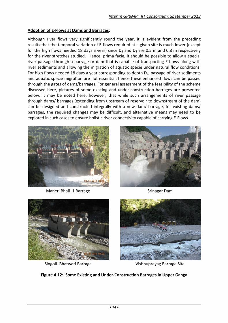
Interim GRBMP: IIT Consortium: Spetember 2013
• 34 •
Adoption of E-Flows at Dams and Barrages:
Although river flows vary significantly round the year, it is evident from the preceding
results that the temporal variation of E-flows required at a given site is much lower (except
for the high flows needed 18 days a year) since D1 and D2 are 0.5 m and 0.8 m respectively
for the river stretches studied. Hence, prima facie, it should be possible to allow a special
river passage through a barrage or dam that is capable of transporting E-flows along with
river sediments and allowing the migration of aquatic specie under natural flow conditions.
For high flows needed 18 days a year corresponding to depth D3, passage of river sediments
and aquatic specie migration are not essential; hence these enhanced flows can be passed
through the gates of dams/barrages. For general assessment of the feasibility of the scheme
discussed here, pictures of some existing and under-construction barrages are presented
below. It may be noted here, however, that while such arrangements of river passage
through dams/ barrages (extending from upstream of reservoir to downstream of the dam)
can be designed and constructed integrally with a new dam/ barrage, for existing dams/
barrages, the required changes may be difficult, and alternative means may need to be
explored in such cases to ensure holistic river connectivity capable of carrying E-Flows.
Maneri Bhali–1 Barrage
Singoli–Bhatwari Barrage
Srinagar Dam
Vishnuprayag Barrage Site
Figure 4.12: Some Existing and Under-Construction Barrages in Upper Ganga
Interim GRBMP: IIT Consortium: Spetember 2013
• 35 •
4.2. Nirmal Dhara
Ganga river’s water quality had been acclaimed in ancient times. Its life-giving and healing
qualities are evident from the following description in Rajanirghanta ( ~300 AD) meaning
“The qualities of Ganga water are: Coolness, sweetness, transparency, high tonic property,
wholesomeness, potability, ability to remove evils, ability to resuscitate from swoon caused
by dehydration, digestive property and ability to retain wisdom”:
The properties of Ganga river’s waters quoted above are remarkable, to say the least.
However, in present times the river water quality is abysmal, posing a grave environmental
threat to the region. The change in water quality may have been occurring over many
centuries. Ancient scriptures had cautioned against misusing the Ganga river. For instance,
the following edict in Sanskrit prohibited thirteen types of human actions, viz.: defecation;
ablutions; discharge of wastewater; throwing of used floral offerings; rubbing of filth; body
shampooing; frolicking; acceptance of donations; obscenity; offering of inappropriate praises
or even hymns in a incorrect way; discharging of garments; bathing and, in particular,
swimming across.
It is possible that such strictures got diluted over time. But, the environmental significance
of many of these precautions is obvious to the modern mind. And, what is equally
significant, they convey a sense of deep respect for National River Ganga.
The present-day deterioration in water quality is largely due to anthropogenic wastes
entering and polluting the river network in various ways, and it is imperative that the
original quality water is restored as much as possible. In attempting this, we already have
the example of the Thames river cleanup in UK. To quote the “World Water Vision” [WWC,
2000], “The industrial revolution turned the Thames into a stinking, black health hazard as it
ran through London in the late 19th
century. Major investments in wastewater treatment
and cleaner production have gradually restored its recreational and environmental value. …
(Hence) there is a critical need to integrate water and environmental management.” In
other words, “Aviral Dhara” must be combined with “Nirmal Dhara”, Geologic and Ecological
concepts to salvage the National River Ganga.
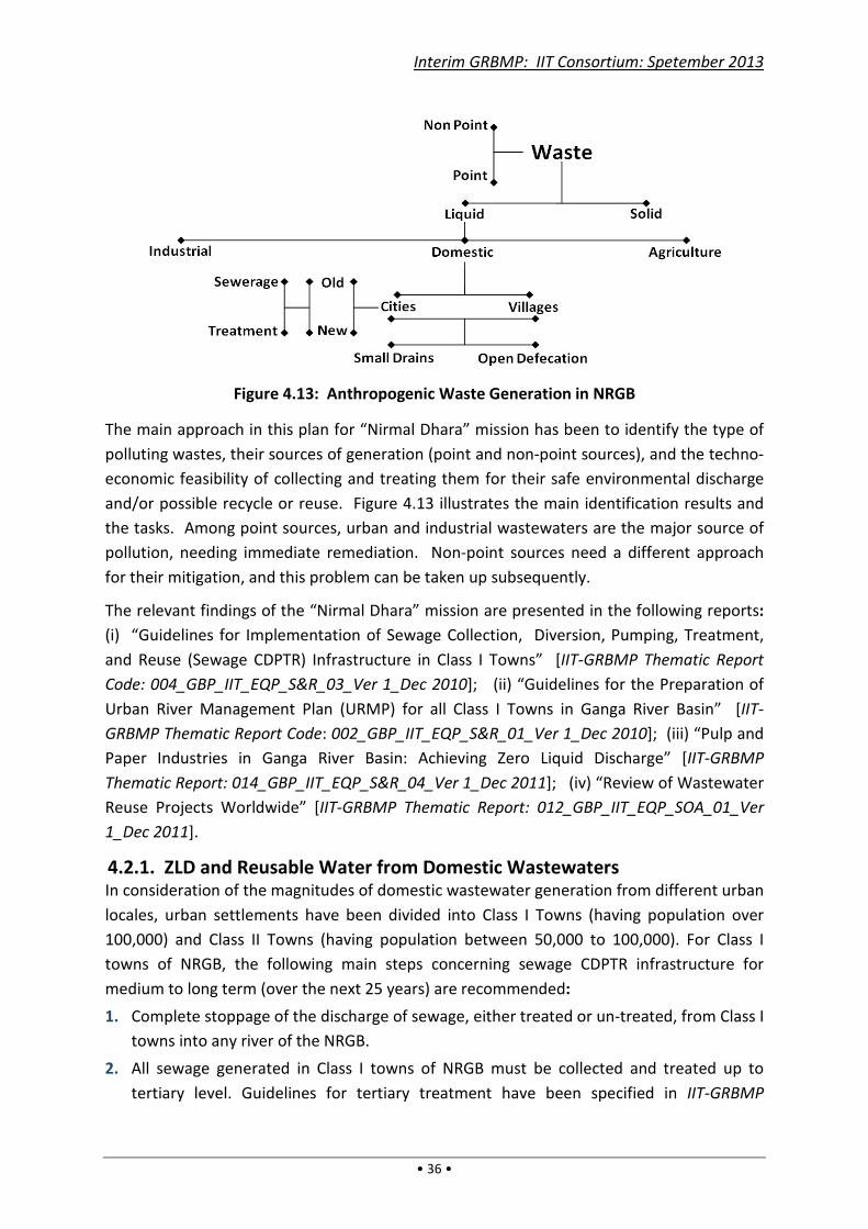
Interim GRBMP: IIT Consortium: Spetember 2013
• 36 •
Figure 4.13: Anthropogenic Waste Generation in NRGB
The main approach in this plan for “Nirmal Dhara” mission has been to identify the type of
polluting wastes, their sources of generation (point and non-point sources), and the techno-
economic feasibility of collecting and treating them for their safe environmental discharge
and/or possible recycle or reuse. Figure 4.13 illustrates the main identification results and
the tasks. Among point sources, urban and industrial wastewaters are the major source of
pollution, needing immediate remediation. Non-point sources need a different approach
for their mitigation, and this problem can be taken up subsequently.
The relevant findings of the “Nirmal Dhara” mission are presented in the following reports:
(i) “Guidelines for Implementation of Sewage Collection, Diversion, Pumping, Treatment,
and Reuse (Sewage CDPTR) Infrastructure in Class I Towns” [IIT-GRBMP Thematic Report
Code: 004_GBP_IIT_EQP_S&R_03_Ver 1_Dec 2010]; (ii) “Guidelines for the Preparation of
Urban River Management Plan (URMP) for all Class I Towns in Ganga River Basin” [IIT-
GRBMP Thematic Report Code: 002_GBP_IIT_EQP_S&R_01_Ver 1_Dec 2010]; (iii) “Pulp and
Paper Industries in Ganga River Basin: Achieving Zero Liquid Discharge” [IIT-GRBMP
Thematic Report: 014_GBP_IIT_EQP_S&R_04_Ver 1_Dec 2011]; (iv) “Review of Wastewater
Reuse Projects Worldwide” [IIT-GRBMP Thematic Report: 012_GBP_IIT_EQP_SOA_01_Ver
1_Dec 2011].
4.2.1. ZLD and Reusable Water from Domestic Wastewaters In consideration of the magnitudes of domestic wastewater generation from different urban
locales, urban settlements have been divided into Class I Towns (having population over
100,000) and Class II Towns (having population between 50,000 to 100,000). For Class I
towns of NRGB, the following main steps concerning sewage CDPTR infrastructure for
medium to long term (over the next 25 years) are recommended:
1. Complete stoppage of the discharge of sewage, either treated or un-treated, from Class I
towns into any river of the NRGB.
2. All sewage generated in Class I towns of NRGB must be collected and treated up to
tertiary level. Guidelines for tertiary treatment have been specified in IIT-GRBMP

Interim GRBMP: IIT Consortium: Spetember 2013
• 37 •
Thematic Report: 003_GBP_IIT_EQP_S&R_02_Ver 01_Dec 2010, the recommended
treated effluent standards being: BOD < 10 mg/L; SS < 5 mg/L; fully nitrified effluent;
P < 0.5 mg/L; FC < 230/100 mL.
3. The tertiary treated water should be reused for various non-potable purposes, such as
industrial, irrigation, horticultural, and non-contact/non-potable domestic use. Unused
treated water may be utilized for groundwater recharge but only via surface storages
and subsequent infiltration and percolation through soil.
4. The unit cost of the above tertiary treatment was worked out for Year 2010 price levels
at approx. Rs.10/- per m3 (or 1 paisa/litre). This cost should be borne by the users of
treated water, while the cost of fresh water should be at least 50% higher (considering
the minimum cost of full treatment of such wastewaters in the natural environment.)
These costs should be chargeable from water-users – especially urban and commercial
users – thereby ensuring economic use of water and safety of the environment. The
water pricing mechanism may be periodically reviewed.
The above proposals are essential to overcome the declining state of urban wastewater
management in NRGB. Although much money and effort has been spent in Ganga Action
Plan over the past few decades, the overall achievement has been limited. And, yet, the
same approach has persisted over the years, leading to general disillusionment and
cynicism. This attitudinal blockade is illustrated in Figure 4.14. But such despondency and
cynicism can be easily overcome if water is considered as a “resource” rather than as “dirt”.
By adequately treating wastewater and re-using it instead of dumping the untreated or
partially treated wastewater to sully the environment, urban wastewater treatment can
achieve “Zero Liquid Discharge” (or ZLD) and recover the value of water as a “resource”.
Figure 4.14: Urban Wastewater Treatment for Reuse
Unpolluted
Flow
Warrants Zero
Discharge
Arguments are STPs
Unsatisfactory
Cynical
Attitude
Expensive/
Unaffordable/Energy
Extensive
Urban Local
Bodies
cannot afford
1 Paisa per Liter for ZLD
Vs
Expensive Household
water treatment
Interim GRBMP: IIT Consortium: Spetember 2013
• 38 •
4.2.2. Additional Recommendations for Actions on Sewage Treatment To implement the above concept effectively, it is envisaged that the conversion of urban
sewage to usable (and saleable) water should be effected by independent agencies
contracted to supply and operate the required wastewater treatment systems for prolonged
periods. Such agencies (service providers) should be paid for the actual quantity of usable
quality water produced, and not for merely providing or running the treatment facilities.
The following steps have been formulated to fulfill this task in urban centers:
1. All new sewage treatment plants and their pumping stations should be constructed and
managed by the same agency, adopting the DBFO (Design–Build–Finance–Operate)
Model as per IIT-GRBMP Thematic Report Code 003_GBP_IIT_EQP_S&R_02_Ver 1_Dec
2010.
2. The sewage pumping and treatment infrastructure should be built in a modular fashion
such that the pumping and treatment capacity is approximately the same as the actual
sewage collected/available.
3. All new sewage treatment plants sanctioned in NRGB require treatment up to tertiary
level (as specified in IIT-GRBMP Thematic Report Code 003_GBP_IIT_EQP_S&R_02_Ver
1_Dec 2010) and should be funded by the DBFO model.
4. As per the proposed DBFO Model, payments will be made to the service provider in
annuities spread over the contract period during the operation and maintenance phase
of the project. The payments will be linked to the actual amount of treated sewage (of
specified quality) produced by the service provider.
5. All necessary clearances, permissions, etc. for funding of sewage pumping stations and
treatment plants using the DBFO model should be obtained from NGRBA.
6. The process of empanelment of qualified/reputed service providers interested in
construction, operation and maintenance of sewage treatment plants for usable water
quality production through the DBFO route should be started soon.
4.2.3. Recommendations for Actions on Urban River Management Plan
(URMP) for all Class I Towns A URMP should have ‘actionable’ items to ensure that the riverbank in the town is cleaned,
developed and beautified such that it is easily accessible to the citizens as a public space
suitable for various spiritual, religious, recreational, socio-cultural and other outdoor
activities. Furthermore, ‘actionable’ items to ensure prevention of discharge of treated or
untreated sewage into the river (either directly or indirectly) and ‘actionable items’ to
ensure that treated sewage is reused/ recycled should be a part of the URMP.
Important Points
1. Each Class I town of NRGB must prepare an URMP within the next 6–12 months.
2. An expert standing committee must be set up for vetting and approving the URMPs.
3. Only those project proposals (DPRs) prepared on the basis of ‘actionable’ items in URMPs
shall be eligible for funding in future.

Interim GRBMP: IIT Consortium: Spetember 2013
• 39 •
4.2.4. ZLD and Reusable Water from Industrial Wastewaters Effluents generated by industries are widely varying in nature, depending on the industry’s
products, raw materials used, processing technologies adopted, etc. While some industrial
wastewaters can be adequately treated for reuse very economically, others have dissolved
impurities that are more expensive or difficult to remove. Nonetheless, these impurities
(and other recalcitrant pollutants) are hazardous, and their removal is essential for reuse or
environmental disposal of the treated water. But once the wastewater is treated up to the
level of safe environmental discharge, there is little point in discarding the water rather than
reusing it (after some further tertiary treatment, if needed).
An attempt has been made in the GRBMP to assess technology options and work out the
indicative costs of the required effluent treatment for different types of industries. Since
the treatment level needed may be different for different industry types, the focus has been
on those effluent-generating industries with high pollution potential that have a significant
presence in the NRGB. These include Tanneries, Pulp and Paper Industries, Distilleries and
Textile and Dyeing Units. At present, the work for Pulp and Paper Industries has been
completed, while the others are in progress.
Pulp and paper Industries, particularly agro-based ones, are major polluters of rivers, e.g. of
Rivers Ramganga and Kali which lead to pollution of River Ganga in its middle stretch. The
results of existing effluent treatment practices have been highly unsatisfactory so far, and
National River Ganga continues to get polluted. The prevailing discharge standards are
based on the premise that the background river water quality is almost pristine and at least
10 times dilution water is available in the river. However, these conditions are not met in
many rivers including National River Ganga except during the monsoons. By adopting the
Zero Liquid Discharge criterion (full treatment and reuse of wastewater), not only will the
river water quality be saved from further deterioration, but groundwater abstractions will
also reduce significantly, enabling higher base flows in rivers during dry seasons.
The technology options and costs of treatment have been worked out for different types of
Pulp and Paper Manufacturing units, and presented in the IIT-GRBMP Thematic Report
Code: 014_GBP_IIT_EQP_S&R_04_Ver 1_Dec 2011. The analysis of costs for tertiary
treatment shows that if these costs are absorbed in production, then the production costs
for RCF-based manufacturing processes will increase by about 4–6%, whereas for agro-
based manufacturing the cost increase is in the range of 17–19%. In order to avoid grave
pollution of the aquatic environment, however, the ZLD standard is imperative; in other
words, the additional cost of tertiary treatment needs to be absorbed in the production cost
(hence, borne by manufacturers, consumers and/or the government).
4.3. Ecological Restoration The ecological balance in the Ganga river network has been critically affected in recent
times, with major indicator species (including fishes and dolphins) having dwindled or
disappeared from many river stretches in recent history. In order to assess the ecological
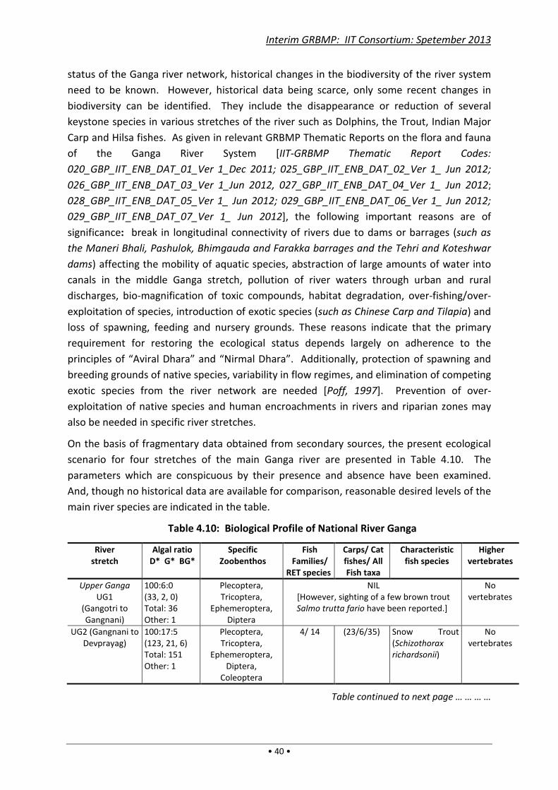
Interim GRBMP: IIT Consortium: Spetember 2013
• 40 •
status of the Ganga river network, historical changes in the biodiversity of the river system
need to be known. However, historical data being scarce, only some recent changes in
biodiversity can be identified. They include the disappearance or reduction of several
keystone species in various stretches of the river such as Dolphins, the Trout, Indian Major
Carp and Hilsa fishes. As given in relevant GRBMP Thematic Reports on the flora and fauna
of the Ganga River System [IIT-GRBMP Thematic Report Codes:
020_GBP_IIT_ENB_DAT_01_Ver 1_Dec 2011; 025_GBP_IIT_ENB_DAT_02_Ver 1_ Jun 2012;
026_GBP_IIT_ENB_DAT_03_Ver 1_Jun 2012, 027_GBP_IIT_ENB_DAT_04_Ver 1_ Jun 2012;
028_GBP_IIT_ENB_DAT_05_Ver 1_ Jun 2012; 029_GBP_IIT_ENB_DAT_06_Ver 1_ Jun 2012;
029_GBP_IIT_ENB_DAT_07_Ver 1_ Jun 2012], the following important reasons are of
significance: break in longitudinal connectivity of rivers due to dams or barrages (such as
the Maneri Bhali, Pashulok, Bhimgauda and Farakka barrages and the Tehri and Koteshwar
dams) affecting the mobility of aquatic species, abstraction of large amounts of water into
canals in the middle Ganga stretch, pollution of river waters through urban and rural
discharges, bio-magnification of toxic compounds, habitat degradation, over-fishing/over-
exploitation of species, introduction of exotic species (such as Chinese Carp and Tilapia) and
loss of spawning, feeding and nursery grounds. These reasons indicate that the primary
requirement for restoring the ecological status depends largely on adherence to the
principles of “Aviral Dhara” and “Nirmal Dhara”. Additionally, protection of spawning and
breeding grounds of native species, variability in flow regimes, and elimination of competing
exotic species from the river network are needed [Poff, 1997]. Prevention of over-
exploitation of native species and human encroachments in rivers and riparian zones may
also be needed in specific river stretches.
On the basis of fragmentary data obtained from secondary sources, the present ecological
scenario for four stretches of the main Ganga river are presented in Table 4.10. The
parameters which are conspicuous by their presence and absence have been examined.
And, though no historical data are available for comparison, reasonable desired levels of the
main river species are indicated in the table.
Table 4.10: Biological Profile of National River Ganga
River
stretch
Algal ratio
D* G* BG*
Specific
Zoobenthos
Fish
Families/
RET species
Carps/ Cat
fishes/ All
Fish taxa
Characteristic
fish species
Higher
vertebrates
Upper Ganga
UG1
(Gangotri to
Gangnani)
100:6:0
(33, 2, 0)
Total: 36
Other: 1
Plecoptera,
Tricoptera,
Ephemeroptera,
Diptera
NIL
[However, sighting of a few brown trout
Salmo trutta fario have been reported.]
No
vertebrates
UG2 (Gangnani to
Devprayag)
100:17:5
(123, 21, 6)
Total: 151
Other: 1
Plecoptera,
Tricoptera,
Ephemeroptera,
Diptera,
Coleoptera
4/ 14 (23/6/35) Snow Trout
(Schizothorax
richardsonii)
No
vertebrates
Table continued to next page … … … …

Interim GRBMP: IIT Consortium: Spetember 2013
• 41 •
… … … … Table continued from previous page
River
stretch
Algal ratio
D* G* BG*
Specific
Zoobenthos
Fish
Families/
RET species
Carps/ Cat
fishes/ All
Fish taxa
Characteristic
fish species
Higher
vertebrates
UG3 (Devprayag to
Haridwar)
100:14:13
(95, 13, 12)
Total: 123
Other: 3
Tricoptera,
Ephemeroptera,
Diptera,
Odonata
12/ 8 (25/7/42) Golden
Mahseer
(Tor putitora)
No
vertebrates
Middle Ganga
MG1-MG3
(Haridwar to
Fatehgarh)
100:36:15
(100, 36, 15)
Total: 154
Other: 3
Tricoptera,
Ephemeroptera,
Diptera,
Odonata
25/ 15 (46/14/109) Indian Major
carps, Catfishes
Soft & Hard
Turtles,
Ghariyals &
Gangetic
Dolphins
MG4-MG5
(Fatehgarh to
Varanasi)
100:67:36
(149,100,54)
Total: 322
Other: 119
Tricoptera,
Coleoptera
24/ 12 (34/28/92) Indian Major
Carps, Catfishes
Gangetic
Dolphins,
Turtles
Lower Ganga
LGA (Varanasi-
Farakka)
100:118:105
(81, 96, 85)
Total: 285
Other: 23
Tricoptera,
Ephemeroptera,
Diptera,
Coleoptera,
Annelids &
Mollusca
35/ 16 (41/31/121) Indian Major
carps, Catfishes
Dolphins,
Turtles
LGB (Farakka-
Ganga Sagar)
100:161:220
(127, 205,
279)
Total: 652
Other: 41
Thysanura,
Collembola,
Annelids,
Mollusca &
Echinoderms
37/ 12 (16/27/172) IMC, Catfishes,
Hilsa, Polynems
paradiseus,
Liza parsia,
Harpodon
neherus
Turtles,
Ghariyal,
Gangetic
Dolphins,
Porpoise,
Crocodile
Note: D* G* BG*= Diatoms, Green algae, Blue-Green algae.
4.4. Geological Safeguarding Modern anthropogenic ventures can threaten geological formations supporting the river
basin in new ways. Notable among these are underground explosions, excavations,
tunneling, mining and rock fracturing. Likewise, over-withdrawal of ground water from
confined/ semi-confined aquifers may create unbearable overburden pressures, causing the
aquifer matrix to (partially) collapse with consequent land subsidence. Another potential
threat is due to large reservoirs. Operation of such reservoirs – involving their filling up
during high flows and emptying during lean periods – produces significant variations in soil
water pressures, which build up additional cyclical stress patterns.
Geomorphological features of rivers and wetlands are more vulnerable than the underlying
geologic strata to both natural and manmade stresses. While natural phenomena such as
wind, storms, cloudbursts, seismic pressures, landslides and avalanches may not be
controllable, various land-use practices that are potentially geo-sensitive need to be
checked. These include land-uses that significantly affect the physical properties of
catchments such as denudation/ deforestation and construction activities on fragile slopes
and in floodplains, agricultural tillage and consequent soil erosion, sand mining from river
beds, embankments for flood control and river bank modifications for other purposes.
Interim GRBMP: IIT Consortium: Spetember 2013
• 42 •
Box 4.1
For Maharashtra farmers, drought has its uses!
by Rahul Wadke; Mumbai, April 29, 2012
The severe drought in Maharashtra is proving to
be a blessing in disguise for farmers in the
State. Dried-up rivers, lakes and ponds are
giving the farmers access to nutrient rich silt,
which usually settle at the bottom of these
water bodies. Silt is a fine granular material
derived from rocks and soil. ... It is spread over
the farms for enhancing soil fertility. Farmers
have to dig up the silt and cart it away to their
farm. However, the process of transporting the
silt is expensive. Banks, sensing a business
opportunity, have decided to offer loans of up
to Rs 1 lakh for every 2.5 acre of farmland. …
Progressive farmer and founder member of
Organic Farmers’ Association of India, Jayant
Barve, said that silt can enhance the farm yield
by a factor of ten. However, in the first year of
application, it does not replace the chemical
fertilisers. From the second year onwards, the
benefits can be reaped. The valuable manure
can be used for any kind of crop, he said.
– News Item in Hindu Businessline
[Accessed on 08-5-13 from: http://www.thehindubusinessline.com/news/states/for-maharashtra-farmers-drought-has-its-uses-after-all/article4667146.ece?ref=wl_industry-and-economy.]
It should be kept in mind that disruptions in existing geological features of a basin can be
due to natural earth processes, which may get compounded by anthropogenic threat factors
indicated above, together increasing the geological damage potential. Thus geological
monitoring of earth processes in sensitive areas is essential. For example, Himalayan
tributaries of the Middle Ganga segment – such as the Kosi and Gandak rivers – are known
to be highly dynamic, i.e. with significant tendency to shift their courses. With regular
monitoring of the dynamism of these rivers, timely checks can be imposed on destabilizing
anthropogenic activities along with precautions against impending fluvial changes.
Thus assessment and/or implementation of underground safety measures (to maintain the
geological integrity), land-use practices (to protect the geo-morphological features of rivers,
lakes and wetlands), and continuous geological monitoring (to forecast impending
geological events) are therefore essential for geologic housekeeping of NRGB. These
aspects need to be analyzed in greater detail subsequently.
4.5. Disaster Management The Ganga river network is capable of
extensive damage to life and property by
floods and water-borne diseases in many
areas of the basin. It is of prime concern
that such damages are controlled. While
these issues need to be worked out in
further detail, a brief summary of the
mission’s direction is given below.
In the Upper Ganga segment floods occur
mainly as flash floods due to cloud-bursts
and heavy rains, sometimes accompanied
by landslides leading to damming up of
rivers and later dam-bursts that pose grave
flood risks. The subsequent Ganga plains,
particularly the eastern parts, are prone to
more widespread flooding [Tandon et al.
2008] and are among the worst flood-
affected regions in the world. The floods
occur not only due to heavy rains but also
due to various geomorphic, neotectonic
and fluvial processes. While these
processes are not fully understood, floods
may be seen as natural phenomena that
cannot be entirely prevented. On the flip
side, floods clear excess deposits and
Interim GRBMP: IIT Consortium: Spetember 2013
• 43 •
sandbars from rivers. Besides, floods carry valuable nutrient-rich silt to flood-plains, which
otherwise may not reach the land except in unplanned ways (e.g. see Box 4.1). Hence, what
can be mainly done regarding floods is to curb their impact and minimize the damages
caused (without resorting to short-sighted flood control measures that interfere with river
processes). The emphasis should be on strengthening natural ecosystems (such as forests
and wetlands) and land-use control (slope stabilization, removal of permanent structures
from floodplains, etc.) Simultaneously, early warning and evacuation systems, along with
disaster mitigation provisions must be kept readily available.
Water-borne diseases are common in the NRGB, as in other tropical parts of the world.
However, when rivers, wetlands, and other components of NRGB’s aquatic system become
a major source of disease and disorder among human beings (and/or livestock), it is often
due to water quality degradation by anthropogenic causes. Thus, once again, by focusing on
Aviral Dhara and Nirmal Dhara, problems related to water-borne diseases can be largely
overcome. Until then, basic hygiene precautions among the population and emergency
healthcare services to prevent the outbreak of epidemics are essential.
4.6. Sustainable Agriculture India is a largely agricultural country, with most of her arable land (more than 60% of the
country’s landmass) being used for agriculture. This is unlike many other large, agriculturally
productive countries, much of whose arable land may be pastures. For instance, the United
States, which has more arable land than any other nation (and about 44–45% of her
landmass), uses more than half of her arable land for livestock grazing [World Bank, 2013;
US-EPA, 2013]. In NRGB most of the arable land lies in fertile alluvial plains with high annual
rainfall, and it has been mainly deployed for agriculture since long. With developments in
large-scale canal irrigation during British rule, increasingly more arable land was brought
under cultivation. Consequently, agriculture is the prime sectoral user of water in India,
accounting for more than 80% of her water use. Hence water resource depletion in India
and in NRGB may be significantly attributed to agricultural use, calling for efficient irrigation
practices. Simultaneously, agriculture is also a potentially major source of water pollution.
These two aspects underline the unsustainability of modern agricultural activity in NRGB.
The major growth of agriculture in NRGB in the last few decades and its impact on the
aquatic environment have been surveyed in accompanying Thematic Reports: Report Code:
015_GBP_IIT_SEC_ANL_01_Ver 1_Dec 2011 and Report Code: 013_GBP_IIT_EQP_SOA_02_
Ver 1_Dec 2011]. The basic conclusions of these reports are recounted below.
There has been a tremendous growth in agriculture in the past 40 to 50 years, with
agricultural output per district of NRGB increasing almost two to three fold from Rs. 1.97
billion during 1962-65 to Rs. 5.24 billion during 2003-06 at 1990-93 prices. Simultaneously,
despite considerable farm mechanisation since the 1980s, the average number of male
agricultural workers employed per 10 hectares of Net Sown Area in NRGB also increased
steadily from 11 during the period 1962-65 to around 26 during the period 2003-06. The
Interim GRBMP: IIT Consortium: Spetember 2013
• 44 •
total irrigated areas in NRGB also increased steadily, and the estimated irrigation water use
was more than 65 BCM in 2008. With the increasing use of tube-wells in recent times, much
of the present irrigation water use in NRGB may be from groundwater.
Agriculture (along with animal husbandry, aquaculture, etc.) can also be a major source of
contaminant discharge. Apart from traditional agro-residues, animal refuse and eroded soil,
modern chemical fertilizers and pesticides can be significant pollutant contributors to water
sources through surface runoff and percolation through soil [Misra and Mani, 1994].
Pollutants from fertilizers are mainly as nitrates, phosphates, and sometimes heavy metals
such as lead and cadmium. Pesticides have a wider range of polluting chemicals, which may
be highly toxic, chemically stable, and/or biomagnifying through the food chain. But
pesticides are used not only in agriculture; they are also used extensively for grain storage.
In any case, the actual usage data being scarce, only some general conclusions can be drawn
about fertilizers, and little about pesticides. From 1962-65, when the average level of
fertilizer consumption was 1,700 MT per district in NRGB, the fertilizer consumption grew
tremendously to 102,600 MT during 2003-06. It may be surmised that unless the usage is
efficient, these can significantly pollutie both surface and ground waters.
Overall, the main recommendations of efficient water use given under Mission “Aviral
Dhara” should apply for agriculture, along with realistic pricing of energy use and promotion
of organic farming and of bio-fertilizers and bio-pesticides instead of chemical fertilizers and
pesticides. Other measures frequently recommended by various agencies also need to be
pursued, such as rain-fed farming, changes in cropping patterns and systems of crop
intensification [Thakkar, 2012; UNICEF, 2013].
4.7. Environmental Knowledge-Building and Sensitization The primary goal of an effective plan for the NRGB is to ensure the environmental health of
the river basin as a whole, and of the Ganga River Network in particular. To achieve this,
one must take account of the diverse developmental pressures on NRGB’s environment,
which need in-depth understanding of relevant natural processes and their linkages. Such
understanding is directly dependent on building a comprehensive bank of environmental
data to enable meaningful analyses, thereby making it possible to arrive at quantitative
environmental indicators with some degree of certainty. The importance of such a
knowledge storehouse has been repeatedly stressed by various agencies and experts, such
as India’s “National Water Policy – 2002 (section on “Information System” for water-related
data)” [MoWR, 2002], “Comprehensive Mission Document on National Water Mission –
2011 (section on “Comprehensive Water Data Base in Public Domain”)” [MoWR, 2011],
World Bank Report on “India’s Water Economy” [Briscoe and Malik, 2006, pp 51–52],
WWC’s “Better Water Resource Management” [Sadoff and Muller, 2009], SANDRP’s “Water
Sector Options for India in Changing Climate” [Thakkar, 2012], United Nations’ “Water
Security and the Global Agenda, 2013” (Box 8, page 25) [UN Water Task Force, 2013],
UNICEF’s “Water in India: Situation and Prospects” [UNICEF, 2013], etc.
Interim GRBMP: IIT Consortium: Spetember 2013
• 45 •
While there is considerable data collection by national and state agencies focussing on
specific themes (such as water resources, forest resources, agriculture or industry),
comprehensive environmental assessment requires the integration of disparate themes into
a cohesive whole. In other words, basin planning and management must combine diverse
fields such as water resources, land resources and biological resources with river dynamics,
geological phenomena and atmospheric processes as well as traditional wisdom – the
experiential essence of generations of people who lived in NRGB. Thus, the environmental
data bank must be a multi-dimensional archive based on regularly collected environmental
data, intermittent monitoring data, as well as individual observations and interpretations
covering a wide and eclectic data field. In recent times, some water-related and other data
have been published by the government and/or are available on websites. However, as
discussed under Mission “Aviral Dhara”, some of the estimated data need clarifications,
while primary data are seldom available. Until such data are brought together and made
easily available to users, planning and monitoring of NRGB can only be a fickle endeavour.
The above data bank along with relevant scientific reports should be accessible to all citizens
for two important reasons, namely: (i) to inform and sensitize the populace about NRGB’s
environment, and (ii) to enable stakeholder and community participation in comprehensive
environmental management of NRGB. In this context, it should be emphasized that the
importance of environmental knowledge in sensitizing people is crucial. Just as good road
sense depends on familiarity with traffic rules, knowledge of “environmental rules” (or
environmental processes) is essential for true environmental sense. Moreover, since the
basin parameters need basin-wide monitoring, and sinec environmental issues are always
open to fresh insights, much can be gained from sensitizing people and motivating them to
participate in the environmental upkeep of NRGB. This can be achieved by complementing
the environmental data bank with target-specific educational material and programmes on
NRGB’s environment for community education and sensitization.
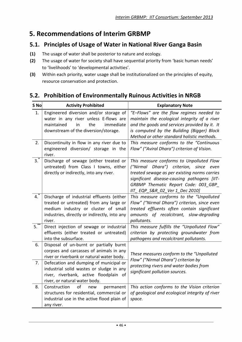
Interim GRBMP: IIT Consortium: Spetember 2013
• 46 •
5. Recommendations of Interim GRBMP
5.1. Principles of Usage of Water in National River Ganga Basin
(1) The usage of water shall be posterior to nature and ecology.
(2) The usage of water for society shall have sequential priority from ‘basic human needs’
to ‘livelihoods’ to ‘developmental activities’.
(3) Within each priority, water usage shall be institutionalized on the principles of equity,
resource conservation and protection.
5.2. Prohibition of Environmentally Ruinous Activities in NRGB
S No Activity Prohibited Explanatory Note
1. Engineered diversion and/or storage of
water in any river unless E-flows are
maintained in the immediate
downstream of the diversion/storage.
“E–Flows” are the flow regimes needed to
maintain the ecological integrity of a river
and the goods and services provided by it. It
is computed by the Building (Bigger) Block
Method or other standard holistic methods.
2. Discontinuity in flow in any river due to
engineered diversion/ storage in the
river.
This measure conforms to the “Continuous
Flow” (“Aviral Dhara”) criterion of Vision.
3.* Discharge of sewage (either treated or
untreated) from Class I towns, either
directly or indirectly, into any river.
This measure conforms to Unpolluted Flow
(“Nirmal Dhara”) criterion, since even
treated sewage as per existing norms carries
significant disease-causing pathogens [IIT-
GRBMP Thematic Report Code: 003_GBP_
IIT_ EQP_S&R_02_Ver 1_Dec 2010]
4.* Discharge of industrial effluents (either
treated or untreated) from any large or
medium industry or cluster of small
industries, directly or indirectly, into any
river.
This measure conforms to the “Unpolluted
Flow” (“Nirmal Dhara”) criterion, since even
treated effluents often contain significant
amounts of recalcitrant, slow-degrading
pollutants.
5.** Direct injection of sewage or industrial
effluents (either treated or untreated)
into the subsurface.
This measure fulfills the “Unpolluted Flow”
criterion by protecting groundwater from
pathogens and recalcitrant pollutants.
6. Disposal of un-burnt or partially burnt
corpses and carcasses of animals in any
river or riverbank or natural water body. These measures conform to the “Unpolluted
Flow” (“Nirmal Dhara”) criterion by
protecting rivers and water bodies from
significant pollution sources.
7. Defecation and dumping of municipal or
industrial solid wastes or sludge in any
river, riverbank, active floodplain of
river, or natural water body.
8. Construction of new permanent
structures for residential, commercial or
industrial use in the active flood plain of
any river.
This action conforms to the Vision criterion
of geological and ecological integrity of river
space.

Interim GRBMP: IIT Consortium: Spetember 2013
• 47 •
* Measures 3 and 4 are intended to curtail the present practice of discharging “treated”
wastewater into rivers, since these wastewaters are only partially treated, and are therefore
polluting. If they are fully treated, then they can be readily reused or used for other purposes
instead of consuming fresh water. Thus, complete treatment of the wastewater serves a dual
purpose of preventing pollution and saving on fresh water usage. The technological and
financial viabilities of complete treatment have been explained in Sections 4.2.1 and 4.2.2.
** Measure 5 envisages that, if treated wastewaters seep through the soil into the water table,
they can be purified by slow filtration and biochemical processes in the soil but not if they are
sent directly into groundwater. Hence, the treated wastewater should be held in an unlined
water body to allow for seepage into the soil. Moreover, the ponds/lagoons into which
treated wastewater is discharged should be in an accessible place for ready inspection or
monitoring at any time.
5.3. Restriction of Environmentally Harmful Activities in National
River Ganga Basin The following anthropogenic activities are potentially damaging for the NRGB environment.
Their allowance, prohibition or regulation should be based on their actual environmental
impacts assessed in specific situations as also their social and economic implications.
1. Discharge of sewage (either treated or untreated) from Class II Towns and smaller towns
and villages, directly or indirectly, into rivers.
2. Disposal of industrial/ municipal solid wastes and sludge (from treatment of sewage or
effluents) to be restricted everywhere except in secure landfill/ hazardous-waste sites.
3. Discharge of industrial effluents (either treated or untreated) from small scale industrial
units into rivers.
4. Disposal and/or discharge of mining and construction debris in any river flood plain, river
bank or in the river itself.
5. Construction of bridges and associated roads, jetties, ghats, ports and permanent
hydraulic structures (for water storage, diversion or control, or channelization) in rivers.
6. Withdrawal of ground water by electric/diesel operated shallow or deep tube wells.
7. Sand mining, dredging, stone crushing, sediment removal, and mining of other materials
from river beds.
8. Agricultural activities in river beds and active flood plains of rivers.
9. Commercial fishing or aquaculture in rivers.
10. Ritual immersion of idols, and floral and other offerings in rivers.
11. Washing of clothes, vehicles, etc. in rivers.
12. Deforestation of hill slopes, notified forests and other sensitive areas.
13. Hazardous or harmful emissions that can directly or indirectly affect terrestrial waters
(such as sulfur/ nitrous oxides, pulverized fuel ash or ‘fly ash’, etc).
14. Use of chemical fertilizers and pesticides in agriculture, horticulture, aquaculture, animal
husbandry, forestry, etc.
15. Use of pharmaceutical, cosmetic, personal care and other products of domestic or
institutional consumption that contribute harmful pollutants in natural waters.
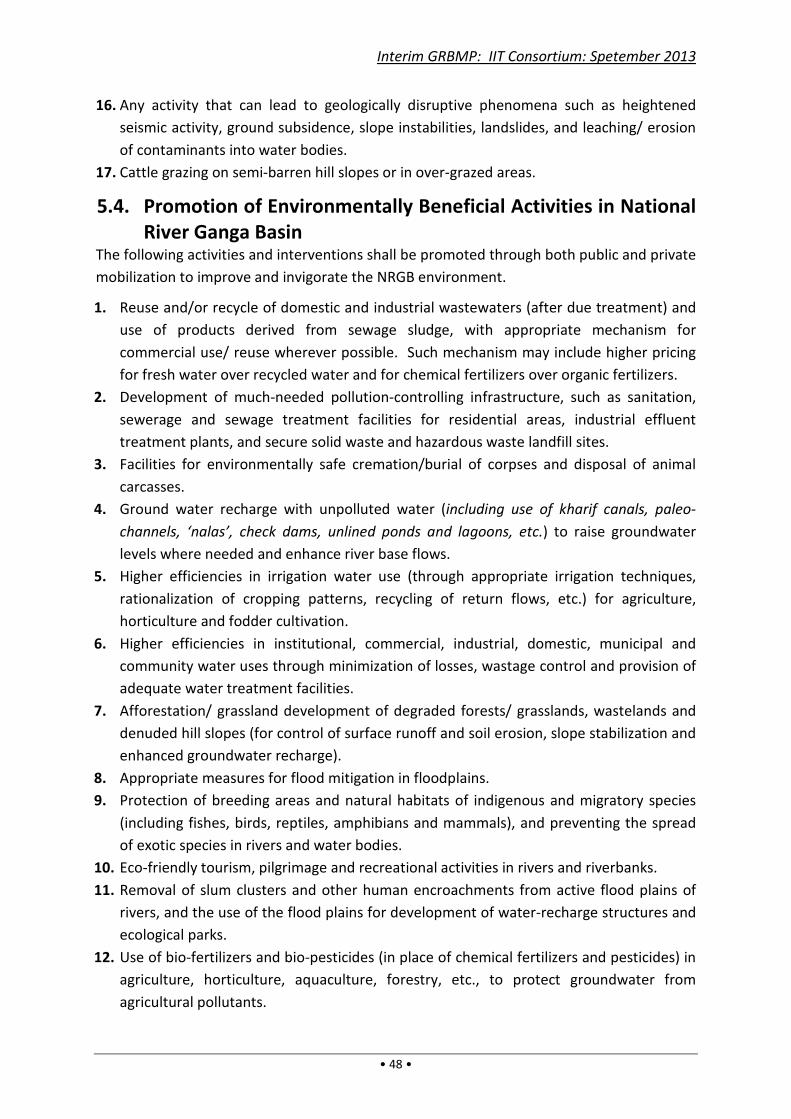
Interim GRBMP: IIT Consortium: Spetember 2013
• 48 •
16. Any activity that can lead to geologically disruptive phenomena such as heightened
seismic activity, ground subsidence, slope instabilities, landslides, and leaching/ erosion
of contaminants into water bodies.
17. Cattle grazing on semi-barren hill slopes or in over-grazed areas.
5.4. Promotion of Environmentally Beneficial Activities in National
River Ganga Basin The following activities and interventions shall be promoted through both public and private
mobilization to improve and invigorate the NRGB environment.
1. Reuse and/or recycle of domestic and industrial wastewaters (after due treatment) and
use of products derived from sewage sludge, with appropriate mechanism for
commercial use/ reuse wherever possible. Such mechanism may include higher pricing
for fresh water over recycled water and for chemical fertilizers over organic fertilizers.
2. Development of much-needed pollution-controlling infrastructure, such as sanitation,
sewerage and sewage treatment facilities for residential areas, industrial effluent
treatment plants, and secure solid waste and hazardous waste landfill sites.
3. Facilities for environmentally safe cremation/burial of corpses and disposal of animal
carcasses.
4. Ground water recharge with unpolluted water (including use of kharif canals, paleo-
channels, ‘nalas’, check dams, unlined ponds and lagoons, etc.) to raise groundwater
levels where needed and enhance river base flows.
5. Higher efficiencies in irrigation water use (through appropriate irrigation techniques,
rationalization of cropping patterns, recycling of return flows, etc.) for agriculture,
horticulture and fodder cultivation.
6. Higher efficiencies in institutional, commercial, industrial, domestic, municipal and
community water uses through minimization of losses, wastage control and provision of
adequate water treatment facilities.
7. Afforestation/ grassland development of degraded forests/ grasslands, wastelands and
denuded hill slopes (for control of surface runoff and soil erosion, slope stabilization and
enhanced groundwater recharge).
8. Appropriate measures for flood mitigation in floodplains.
9. Protection of breeding areas and natural habitats of indigenous and migratory species
(including fishes, birds, reptiles, amphibians and mammals), and preventing the spread
of exotic species in rivers and water bodies.
10. Eco-friendly tourism, pilgrimage and recreational activities in rivers and riverbanks.
11. Removal of slum clusters and other human encroachments from active flood plains of
rivers, and the use of the flood plains for development of water-recharge structures and
ecological parks.
12. Use of bio-fertilizers and bio-pesticides (in place of chemical fertilizers and pesticides) in
agriculture, horticulture, aquaculture, forestry, etc., to protect groundwater from
agricultural pollutants.
Interim GRBMP: IIT Consortium: Spetember 2013
• 49 •
13. Regular collection, compilation and dissemination of environmental data of NRGB
(including hydrological, geological, meteorological, land-use and pollution data) and
maintenance of a historical database in public domain for ready access by any person/
agency.
14. Continuous ground-level monitoring through competent non-profit/ for-profit agencies
of: (i) NRGB’s environmental status, and (ii) implementation of Prohibited, Restricted
and Promoted Activities.
15. Conducting regular educational programs – through competent non-profit/ for-profit
agencies and institutions – for: (i) public awareness of NRGB’s environmental problems
and their remediation, and (ii) developing a healthy civic sense of environmental
proprieties.
16. Periodic review of “GRBMP Action Plans and Their Implementation” with feedback from
all concerned individuals and agencies including rural and urban local bodies.
Note: Measures 13, 14 and 15 are not intended to duplicate the works being done by
specific government departments. Rather, they are aimed at enabling comprehensive
environmental management of the NRGB by: (i) pooling the knowledge and efforts of
government, private sector, academia, experts and common people, and (ii) environmental
capacity building through the spread of scientific understanding and technical competence
in both formal and informal sectors of society.
5.5. Implementation Mechanism As evident from the above, a long-term program for implementation, monitoring, review
and evaluation of environmental problems and interventions pertinent to NRGB are needed.
Since these measures cover a wide variety of activities involving continuous monitoring and
feedback from diverse sources, institutions and individuals, an independent agency is
essential to conduct these activities in a coordinated manner. It is therefore proposed that
a nodal agency, tentatively termed “National River Ganga Basin Management Commission”
(NRGBMC), with adequate resources and authority be set up to ensure the environmental
health of NRGB. The NRGBMC is proposed to be set up by an Act of Parliament (refer
Appendix III for the tentative draft of a Bill based on a separate GRBMP Thematic Report by
PLG Group under preparation). The NRGBMC should comprise Legal Luminaries, Technical
Experts, Government Functionaries and Civil Society Members.
The main task of the NRGBMC may be summarily stated as follows:
(1) The NRGBMC should take all measures necessary for the environmental conservation
and development of National River Ganga Basin in a transparent and inclusive manner.
(2) Such measures shall include the following:
(a) Ensuring that E-flows are maintained in all rivers of the Ganga River Network at
different locations and in different seasons.
(b) Protecting the geology and ecology of the National River Ganga Basin.
(c) Using of floodplains in appropriate manner, and after ensuring Environmental
Impact Assessment for approval of major projects in flood plains.

Interim GRBMP: IIT Consortium: Spetember 2013
• 50 •
(d) Ensuring both short-term and long-term measures for conservation and
improvement of aquatic resources in National River Ganga Basin.
(e) Monitoring, review and dissemination of the National River Ganga Basin’s
environmental status in the public domain.
Note: All actionable measures of the GRBMP may not be implementable at one go, and the
monitoring and review of environmental actions have to be a continuous process. The
Technical Reports, Database and Action Plans of this GRBMP (under finalization) can be
taken as a starting point for the proposed NRGBMC.
5.6. Legislation for NRGBMC
The need for a new legislation and the constitutional provisions enabling the establishment
of NRGBMC have been discussed in IIT-GRBMP Thematic Report Code:
011_GBP_IIT_PLG_DAT_01_Ver 1_Dec 2011 titled “Mapping of Legislations Applicable to
the Ganga River Basin”. Some of its conclusions are briefly recounted below as background
to the proposed legislation.
5.6.1. Comprehensive Legislation on Management of NRGB
India has failed to develop its water resources through integrated river basin development,
and inter-State conflicts over rivers have become common. But the Constitution has
provisions enabling the Union to regulate interstate rivers in public interest. The
Constitution gives full control over waters of a river to a State (List II entry 17), but the
State’s rights are subject to any law made by Parliament for the regulation and development
of interstate rivers to the extent the control of the Union is declared by Parliament by law to
be expedient in public interest (List I entry 56). This means that Parliament can make a law
taking over the regulation, development and management of an interstate river for the
common benefit of the States in national interest. The prevailing condition of National River
Ganga warrants the immediate attention of law-makers for such a law.
For enacting the proposed law, it is important to locate subject matters in List II which may
be seen as being in conflict with entry 56 of List I. Article 246 (1) confers exclusive
jurisdiction on the centre to enact laws on subject matters enlisted in List I, whereas clause
2 of Article 246 grants such exclusivity to the states to enact law on subject matters enlisted
in List II. Now Entry 56 of List I provides for “regulation and development of inter-state river
and river valleys to the extent to which such regulation and development under the control
of Union is declared by Parliament by law to be expedient in the public interest.” Thus, the
matter of regulation and development of interstate rivers may not be in conflict with the
legislative power of the states if the law refrains from impinging on matters within the
competence of state legislatures.
The provisions of various existing legislations (enacted by the centre and states) indirectly
affecting rivers and river basins relate to subjects on water, sanitation, irrigation,
agriculture, pollution, fishing, ecology and biodiversity, environment, etc. Under most of
these legislations, Authorities perform the necessary functions stated under the law, but
Interim GRBMP: IIT Consortium: Spetember 2013
• 51 •
interestingly no authorities are entitled to play a role in prevention of river pollution. In
fact, no concerted effort has been made till date on the legislative front against exploitation
of rivers in various ways. Many issues concerning river management do not fall within the
present legislative frame, such as maintenance of environmental flows, protection of a river
basin’s ecology and biodiversity, maintenance of ground water table, consolidated plans for
diversion of river waters in different stretches, discharge of sewage, obstructions to river
flows and loss of connectivity, use of floodplains and active floodplains, etc. It is desirable,
therefore, to adopt an integrated river basin management plan approach that focuses on
maintenance and restoration of wholesomeness of rivers of the Ganga basin. Accordingly,
the proposed Ganga River Basin Management Act should aim to prohibit and regulate
activities that affect the wholesomeness of rivers, and establish authorities or institutions to
regulate the activities thereon.
5.6.2. Objective of NRGBMC
The NRGBMC is intended to serve as a custodian of National River Ganga Basin (NRGB) and
work for its upkeep and improvement on the premise that health of National River Ganga is
a key indicator of the health of NRGB as a whole.
5.6.3. Envisaged Functions of NRGBMC
The Commission is envisaged to fulfil the following functions:
Information and Communication
• Procure primary and secondary data (both environment-related data as well as socio-
economic, cultural, developmental and other data of NRGB) from government and
non-government data collection agencies, and pre-process the data for possible errors
and inconsistencies.
• Compile the above data along with those obtained by NRGBMC itself through
environmental monitoring, and process them to obtain suitable representations in the
form of maps, charts, parametric values, etc.
• Compile all useful environmental reports obtained from various sources in easily
usable formats.
• Store all data and reports (soft- and hard-copies) in easily retrievable systems and
make them accessible to interested users.
Environmental Monitoring and Impact Assessments:
• Conduct regular field measurements of environment–related data in NRGB for such
information that are not regularly collected or available from other agencies. The data
may be procured through the Wing’s in-house facilities and through outsourced works
to technical and non-technical organizations and individuals (such as local governance
bodies, schools, colleges, NGOs, community organizations, etc.)
• Conduct random field measurements of environment–related data of NRGB for
specific or sporadic needs (such as to cross-check existing data or fill up gaps in data).
Interim GRBMP: IIT Consortium: Spetember 2013
• 52 •
The data may be procured through the Wing’s in-house facilities and through outsourced
works as above.
• Pre-process all data collected for subsequent archiving and use.
• Conduct Environmental Impact Assessments of on-going and future developmental and
infrastructural projects in NRGB as and when the need arises.
• Monitor developmental and infrastructural projects in NRGB for which EIA or preliminary
environmental approval was granted by Commission.
• Assist the NRGBMC, if required, in field measurements and monitoring that may be
needed for investigation purposes.
Investigation:
• Investigate issues regarding non-implementation of measures relating to specified
prohibition, restriction, conservation and promotion of activities.
• Investigate issues regarding non-compliance of policy decisions and guidelines issued by
NRGBMC for environmental preservation of the National River Ganga Basin.
• Investigate issues regarding continuance of existing practices in contravention of
NRGBMC’s strictures.
Research and Development
• Evaluate national and international research reports on river basins for their pertinence to
the NRGB environment.
• Conduct need-based applied research as may be possible by NRGBMC.
• Identify other major research needs of NRGB for communicating to the government.
• Conduct economic, sociological and cultural analyses pertinent to NRGBMC data bank as
well as other information procured from government or other sources.
• Review the impacts of anthropogenic activities in NRGB from time to time.
Policy and Governance
• Review governmental Policies and Plans (existing and under consideration)
• Frame suitable Policies to ensure that the environmental needs of NRGB are met.
• Formulate good governance guidelines.
Advocacy and Sensitization
• Promote overall awareness of NRGB’s environment and how NRGBMC’s measures help in
safeguarding and restoring it.
• Educate stakeholders (from rural communities to school students and urban interest
groups) on comprehensive understanding of complex environmental processes and their
interaction with anthropogenic activities. This will involve preparing special educational
material, training of field educators, and conducting regular educational programs and
feedback from various types of stakeholders.
• Conduct advanced interactive programmes with stakeholders and experts through
Seminars, Workshops, etc.
• Conduct special campaigns to sensitize and motivate people to participate in improving
the health of NRGB.
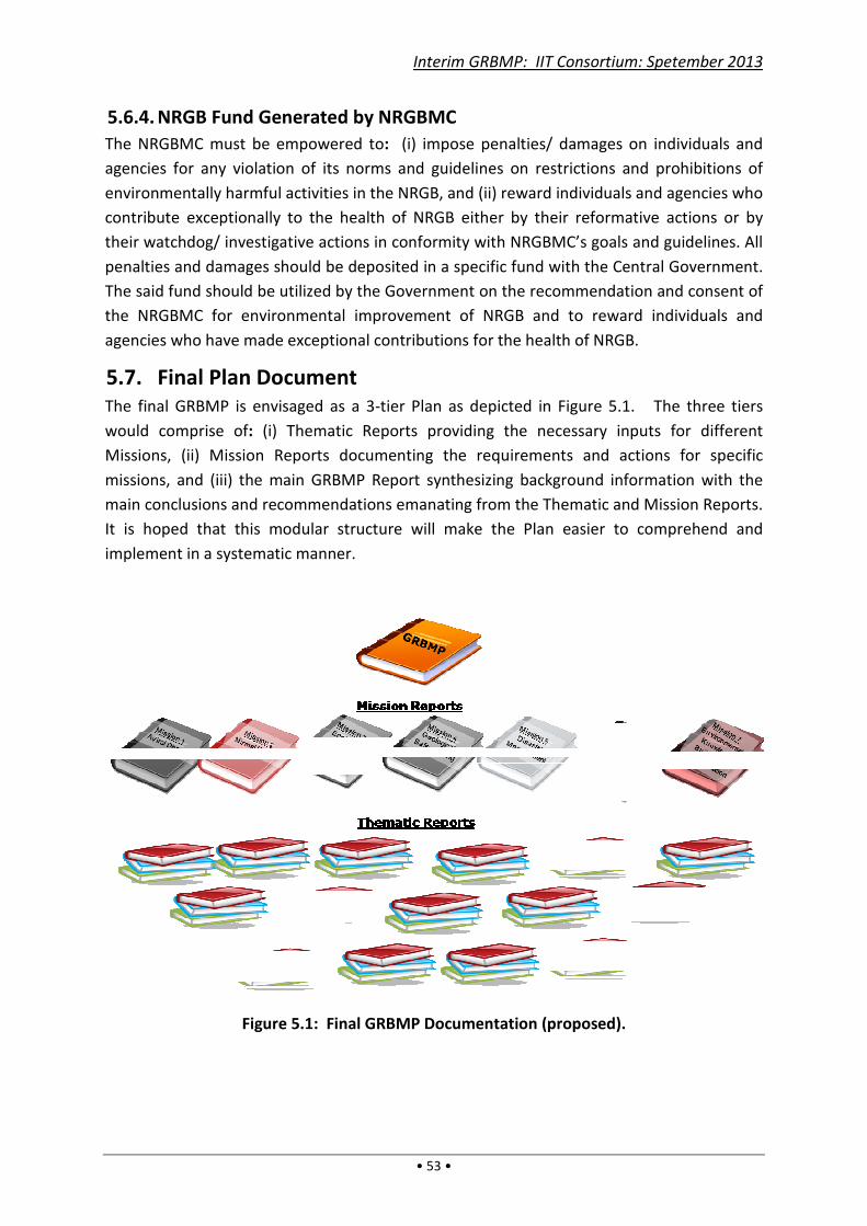
5.6.4. NRGB Fund Generated by
The NRGBMC must be empowered to
agencies for any violation of its norms and guidelines on restrictions and prohibitions of
environmentally harmful activities in the NRGB, and (ii) reward individuals and agencies who
contribute exceptionally to the health of NRGB either by their reformative actions or by
their watchdog/ investigative actions in conformity with
penalties and damages should be deposited in a specific fund with the Centr
The said fund should be utilized by the Government on the recommendation and consent of
the NRGBMC for environmental improvement of NRGB and to reward individuals and
agencies who have made exceptional contributions for the health of NRGB.
5.7. Final Plan Document
The final GRBMP is envisaged as a 3
would comprise of: (i) Thematic Reports providing the necessary inputs for different
Missions, (ii) Mission Reports documenting the requirements a
missions, and (iii) the main GRBMP Report synthesizing background information with the
main conclusions and recommendations
It is hoped that this modular structure will make the Plan easier to comprehend and
implement in a systematic manner.
Figure 5.1:
Interim GRBMP: IIT Consortium: Spetember 2013
• 53 •
enerated by NRGBMC
must be empowered to: (i) impose penalties/ damages on individuals and
agencies for any violation of its norms and guidelines on restrictions and prohibitions of
environmentally harmful activities in the NRGB, and (ii) reward individuals and agencies who
contribute exceptionally to the health of NRGB either by their reformative actions or by
their watchdog/ investigative actions in conformity with NRGBMC’s goals and guidelines. All
penalties and damages should be deposited in a specific fund with the Centr
The said fund should be utilized by the Government on the recommendation and consent of
for environmental improvement of NRGB and to reward individuals and
agencies who have made exceptional contributions for the health of NRGB.
inal Plan Document
The final GRBMP is envisaged as a 3-tier Plan as depicted in Figure 5.1. The three tiers
(i) Thematic Reports providing the necessary inputs for different
Missions, (ii) Mission Reports documenting the requirements and actions for specific
missions, and (iii) the main GRBMP Report synthesizing background information with the
main conclusions and recommendations emanating from the Thematic and Mission Reports.
It is hoped that this modular structure will make the Plan easier to comprehend and
implement in a systematic manner.
: Final GRBMP Documentation (proposed).
Interim GRBMP: IIT Consortium: Spetember 2013
(i) impose penalties/ damages on individuals and
agencies for any violation of its norms and guidelines on restrictions and prohibitions of
environmentally harmful activities in the NRGB, and (ii) reward individuals and agencies who
contribute exceptionally to the health of NRGB either by their reformative actions or by
goals and guidelines. All
penalties and damages should be deposited in a specific fund with the Central Government.
The said fund should be utilized by the Government on the recommendation and consent of
for environmental improvement of NRGB and to reward individuals and
agencies who have made exceptional contributions for the health of NRGB.
tier Plan as depicted in Figure 5.1. The three tiers
(i) Thematic Reports providing the necessary inputs for different
nd actions for specific
missions, and (iii) the main GRBMP Report synthesizing background information with the
from the Thematic and Mission Reports.
It is hoped that this modular structure will make the Plan easier to comprehend and

Interim GRBMP: IIT Consortium: Spetember 2013
• 54 •
Interim GRBMP: IIT Consortium: Spetember 2013
• 55 •
Glossary of Technical Terms
The following technical terms have been used in this document. They may be defined as
follows (in a simplified manner where possible for ease of understanding):
(a) “Active Flood Plain” is the area on the two sides of a river that gets inundated by a
flood having a mean recurrence interval of 2.33 years.
(b) “Afforestation” is the planting of trees to restore or re-establish forest cover.
(c) “Aviral Dhara” or “Continuous Flow” (in a river or stream) means continuity of flow in
both time and space, including connectivity of flow throughout the river.
(d) “Basin” means the entire catchment (of a water body or water course) including the
soil, water, vegetation and other natural resources in the area.
(e) “Catchment” (or “Drainage Basin”) is the entire land area whose runoff from rain,
snow or ice drains into a water body or a water course (before the water course joins
another river or discharges into a water body.)
(f) “Connectivity” (of a river) means continuity of flow in the three directions, viz.
longitudinal connectivity (along the length of the river), lateral connectivity (across the
width of river), and vertical connectivity (below the water surface in vertical direction).
(g) “Deforestation” means removal or reduction of forest cover, especially when caused
by anthropogenic activities.
(h) “Degraded Forest” means a forest having loss or reduction of native forest cover and/
or vegetation density.
(i) “Direct Injection” (of water) means injection or introduction (of water) directly into
subsurface waters through natural or artificial crevices, faults, channels or conduits
without the natural passage through porous soil strata.
(j) “Ecological Park” is a protected area for conservation of native, endangered species.
(k) “Ecology” is the totality of relations between organisms and their environment. It
includes the composition, distribution, amount, number and changing states of
organisms within and among ecosystems.
(l) “Ecosystem” is a community of organisms and their physical environment, considered
to function together as a unit, and characterized by a flow of energy that leads to
trophic (or nutritional) structure and material cycling.
(m) “E-Flows” means Environmental Flows (defined later);
(n) “Embankment” is a raised wall of earth, stone or other material to hold back water
within a water body or water course; it includes levees constructed on either side of a
river as a flood protection measure.
(o) “Engineered Diversion” means a structure or device constructed or installed to
transfer (part of) the river water into a canal or other engineering structure.
(p) “Environmental Flows” are the regime of flows required to maintain the ecological
integrity of a river and the goods and services provided by it, computed by Building
Block Method (or other standard holistic methods).

Interim GRBMP: IIT Consortium: Spetember 2013
• 56 •
(q) “Flood” means the overflowing of water from a water course or water body that
inundates normally dry land.
(r) “Flood Plain” is the land area susceptible to inundation by flood waters.
(s) “Flood Routing Channel” is a channel designed to carry the excess water of a water
course during high flows.
(t) “Geologic Entity” is an entity formed by ancient earth processes over geologic ages
(hence over long periods of time, usually millions of years).
(u) “Ground Water Recharge” is replenishment (in part or wholly) of water depleted from
ground water reservoirs.
(v) “Hydrologic Cycle” is the natural cyclic movement of water on earth (from oceans to
the atmosphere by evaporation, then onto land by rain and snow, and back to the
oceans by flow through rivers).
(w) “Irrigation Return Flow” means the returning of unused water from irrigation
applications to the water source from which they were taken. The source is usually a
natural water course, water body or groundwater.
(x) “National River Ganga” is the entire length of six head-streams in the state of
Uttarakhand namely, Rivers Alaknanda, Dhauli Ganga, Nandakini, Pinder, Mandakani
and Bhagirathi (starting from their originating glaciers up to their respective
confluences at Vishnu Prayag, NandPrayag, KarnPrayag, Rudrprayag and Dev Prayag)
as also the main stem of the river thereafter up to Ganga Sagar.
(y) “Nirmal Dhara” or “Un-polluted Flow” means flow in a river or stream that is not
(significantly) polluted by anthropogenic activities.
(z) “Paleo-Channel” is the remnant of an extinct river or stream that got filled with
sediments deposited in later periods.
(aa) “Water Body” (or “Surface Water Body”) is a depression on land or a lowland area
that usually holds water or remains saturated through most of the year, such as a lake,
tank, pond, marsh or swamp.
(bb) “Water Course” (or “Surface Water Course”) is an overland channel (natural or
manmade) through which water flows such as a river, stream, rivulet (“nala”) or canal.
(cc) “Watershed” is same as Drainage Basin. [Note: The term “watershed” is also used to
mean a “drainage divide” as per British usage, i.e. it is a ridge of high land dividing two
areas that are drained by different rivers or water bodies]
Interim GRBMP: IIT Consortium: Spetember 2013
• 57 •
References 1. ADB (Asian Development Bank), “Water Resources Development in India”, 2009.
[Accessed May 09, 2013 from: http://www.indiaenvironmentportal.org.in/reports-
documents/water-resources-development-india-critical-issues-and-strategic-options.
2. Briscoe, J. and Malik, RPS, “India’s Water Economy: Bracing for a Turbulent Future”,
The World Bank, 2006. [Accessed May 09, 2013 from: http://www-wds.worldbank.org/
external/default/WDSContentServer/WDSP/IB/2008/06/25/000333037_20080625020800/Re
ndered/PDF/443760PUB0IN0W1Box0327398B01PUBLIC1.pdf.
3. CGWB (Central Ground Water Board, MoWR, GOI), “Aquifer Systems of India”, 2012.
4. CGWB (Central Ground Water Board, MoWR, GOI), “Methodology for Assessment of
Development Potential of Deeper Aquifers”, 2009.
5. CWC (Central Water Commission), “Water and Related Statistics”, 2010. [Accessed
May 09, 2013 from: www.cwc.nic.in/ISO_DATA_Bank/W&RelatedStatatics_2010.pdf].
6. CWC (Central Water Commission, MoWR, GOI), “Ganga Basin Water Resources
Development – A Perspective Plan”, Vol. 1/1, 1986.
7. Diamond, J, “Collapse: How Societies to Choose to Fail or Succeed”, Viking, NY, 2005.
8. Dhandekar, P. et al., “India’s Wetlands in Peril”, South Asia Network on Dams, Rivers
and People, 2011. [Accessed May 06, 2013 from
http://www.sandrp.in/rivers/Indias_wetlands_in_peril_Feb_2011.pdf.]
9. Eriksson, Mats et al., “The Changing Himalayas – Impact of Climate Change on water
Resources and Livelihoods in the Greater Himalayas” , Intl. Centre for Integrated
Mountain Development (ICIMOD), Kathmandu, 2009. [Accessed March 19, 2013 from: http://www.worldwatercouncil.org/fileadmin/world_water_council/documents_old/Library/
Publications_and_reports/Climate_Change/PersPap_01._The_ChangingHimalayas .pdf]
10. FAO (Food and Agricultural Organization of the United Nations), “Coping with Water
Scarcity”, FAO Water Report No. 38, Rome, 2012. [Accessed June 11, 2013 from
http://www.fao.org/docrep/016/i3015e/i3015e.pdf.]
11. India-WRIS (MoWR, GOI), “River Basin Atlas of India – 2012”, RRSC-West, NRSC, ISRO,
Jodhpur, India, 2012.
12. Jain, SK, PK Agarwal and VP Singh, “Hydrology and Water Resources of India”, Springer
(Netherlands), 2007.
13. Jain, SK, “Impact of retreat of Gangotri glacier on the flow of Ganga River”, Current
Science, Vol.95, No.8, Oct. 2008.
14. MoWR (Min. of Water Resources, GOI), “National Water Policy 2002”. [Accessed May
09, 2013 from: http://wrmin.nic.in/writereaddata/linkimages/nwp20025617515534.pdf]
[Also: MoWR, “Draft National Water Policy 2012”. Available at:
http://wrmin.nic.in/writereaddata/linkimages/nwp20025617515534.pdf.]
15. MoWR (Min. of Water Resources, GOI), “Comprehensive Mission Document”, National
Water Mission, New Delhi, 2011. [Accessed May 09, 2013 from: http://wrmin.nic.in/
writereaddata/linkimages/Document_of_NWM_Vol_I_April%202117821020996.pdf]
16. Misra, S.G. and Mani, M., “Agricultural Pollution”, Vols 1 and 2, Ashish Pub. House,
New Delhi, 1994.
17. MSU (Michigan State University), Hydrogeology Website, 2013. [Accessed March 14,
2013 from: http://hydrogeology.glg.msu.edu/wordpress/wp-content/uploads/2008/1/
ILHM_conceptual_diagram_3D.png.]
18. NIH (National Institute of Hydrology), “Water Budget of India”. [Accessed April 01,
2013 from: http://www.nih.ernet.in/rbis/india_information/Water%C2%A0Budget.htm.]
Interim GRBMP: IIT Consortium: Spetember 2013
• 58 •
19. O’Connor, S, “Socioeconomics and the Murray Darling Basin: water allocation and
economic viability”, Australian Conservation Foundation, 2010. [Accessed July 30,
2013 from: http://www.acfonline.org.au/sites/default/files/resources/
Basin_Plan_economic_analysis_20-10-10_0.pdf]
20. Prasad, S.N. et al. “Conservation of Wetlands of India – A Review”, Tropical Ecology,
43(1): pp 173-186, 2002. [Accessed February 21, 2013 from:
http://www.ces.iisc.ernet.in/energy/water/paper/Conservation_of_wetlands_of_India.pdf]
21. Pegram, G. et al. “River Basin Planning: Principles, Procedures and Approaches for
Strategic Basin Planning”, UNESCO, Paris, 2013.
22. Poff, N.L. et al. “The Natural Flow Regime – A Paradigm for River Conservation and
Restoration”, Bioscience, 47(11): pp 769-784, 1997.
23. Rainwaterharvesting, “Database on Threatened Lakes”, 2013 [Accessed Feb.21, 2013
from: http://www.rainwaterharvesting.org/public_interest.htm.]
24. SAC (Space Application Centre, ISRO), “National Wetland Atlas”, Ahmedabad, 2011.
[Accessed May 10, 2013 from: http://www.indiawaterportal.org/sites/
indiawaterportal.org/files/NWIA_National_atlas.pdf.]
25. Sadoff, C.W. and Muller, M. (Global Water Partnership), “Better Water Resources
Management”, 2009. [Accessed March 19, 2013 from: http://www.worldwatercouncil.org/fileadmin/world_water_council/documents_old/Library/P
ublications_and_reports/Climate_Change/PersPap_04._Planning_Better_WRM.pdf]
26. Sen, S. “Water Resource Management: Social Discourse, Governance & Technology
Development”, Pre-Proceedings of Intl. Conference on Water Harvesting, Storage &
Conservation, IIT, Kanpur, Nov. 2009.
27. Sinha, R. et al., “Late Quaternary geology and alluvial stratigraphy of the Ganga basin”,
Himalayan Geol., Vol. 26(1), 2005.
28. Smith, D.M. and Barchiesi, S, “Environment as infrastructure: Resilience to climate
change impacts on water through investments in nature”, Intl. Union for Conservation
of Nature, Switzerland, 2009. [Accessed March 19, 2013 from: http://www.worldwatercouncil.org/fileadmin/world_water_council/documents_old/Library/P
ublications_and_reports/Climate_Change/PersPap_02._Environment_as_Infrastructure.pdf].
29. Tandon, et al., “Late Quaternary Evolution of the Ganga Plains”, Golden Jubilee
Memoir of GSI, No.66, 2008.
30. Thakkar, H., “Water Sector Options for India in a Changing Climate”, South Asia
Network on Dams, Rivers and People (SANDRP), 2012. [Accessed May 09, 2013 from:
http://sandrp.in/wtrsect/Water_Sector_Options_India_in_Changing_Climate_0312.pdf].
31. UNEP (United Nations Environment Program) “Vital Water Graphics”, 2nd Edn., 2008.
[Accessed May 10, 2013 from: http://www.unep.org/dewa/vitalwater/rubrique21.html]
32. UNICEF, FAO and SaciWATER, “Water in India: Situations and Prospects”, 2013.
[Accessed June 11, 2013 from: http://www.unicef.org/india/Final_Report.pdf.]
33. UN-Water (UN-Water Task Force on Water Security), “Water Security & the Global
Water Agenda”, United Nations University, Ontario, 2013. [Accessed April 01, 2013
from: http://www.unwater.org/downloads/watersecurity_analyticalbrief.pdf.]
34. USEPA, “Land Use Overview (in the United States)”. [Accessed May 09, 2013 from:
http://www.epa.gov/agriculture/ag101/landuse.html.
35. van Ast, L. et al., “White Paper: Valuing Water to Drive More Effective Decisions”,
Trucost, April 2013. [Accessed July 02, 2013 from: http://www.trucost.com/published-
research/95/white-paper-valuing-water-to-drive-more-effective-decisions]
Interim GRBMP: IIT Consortium: Spetember 2013
• 59 •
36. Wikipedia article on “Ganges river”, 2013. [Accessed May 10, 2013 from:
http://en.wikipedia.org/wiki/Ganges.]
37. World Bank, “Agricultural Land (% of land area)” [Accessed May 09, 2013 from:
http://data.worldbank.org/indicator/AG.LND.AGRI.ZS.]
38. WWC (World Water Council), “World Water Vision – Chap. 2: The Use of Water
Today”, 2000. [Accessed March 19, 2013 from: http://www.worldwatercouncil.org/
fileadmin/ world_water_council/documents_old/Library/WWVision/Chapter2.pdf.]

Interim GRBMP: IIT Consortium: Spetember 2013
• 60 •
Interim GRBMP: IIT Consortium: Spetember 2013
• 61 •
Abbreviations and Acronyms
1. ADB : Asian Development Bank.
2. BCM : Billion Cubic Metres.
3. BOD : Biochemical Oxygen Demand.
4. CDPTR : Collection, Diversion, Pumping, Treatment and Reuse
5. CGWB : Central Ground Water Board.
6. COD : Chemical Oxygen Demand.
7. CWC : Central Water Commission.
8. DBVO : Design–Build–Finance–Operate.
9. DPR : Detailed Project Report.
10. FAO : Food and Agricultural Organization.
11. FC : Fecal Coliform.
12. GRBMP : Ganga River Basin Management Plan.
13. MoEF : Ministry of Environment and Forests.
14. MoWR : Ministry of Water Resources.
15. NCIWRD : National Commission on Integrated Water Resources Development.
16. NGRBA : National Ganga River Basin Authority.
17. NRGB : National River Ganga Basin.
18. NRGBMC : National River Ganga Basin Management Commission.
19. NIH : National Institute of Hydrology (India).
20. P : Phosphorous.
21. RCF : Re-Cycled Fibre.
22. SS : Suspended Solids.
23. SANDRP : South Asia Network on Dams, Rivers & People.
24. UN : United Nations.
25. UNEP : United Nations Environment Programme.
26. UNESCO : United Nations Environmental, Social and Cultural Organization.
27. UNICEF : United Nations Children’s Fund.
28. ULB : Urban Local Body.
29. URMP : Urban Renewal Management Plan.
30. USEPA : United States Environmental Protection Agency.
31. WWC : World Water Council.
32. ZLD : Zero Liquid Discharge.

Interim GRBMP: IIT Consortium: Spetember 2013
• 62 •
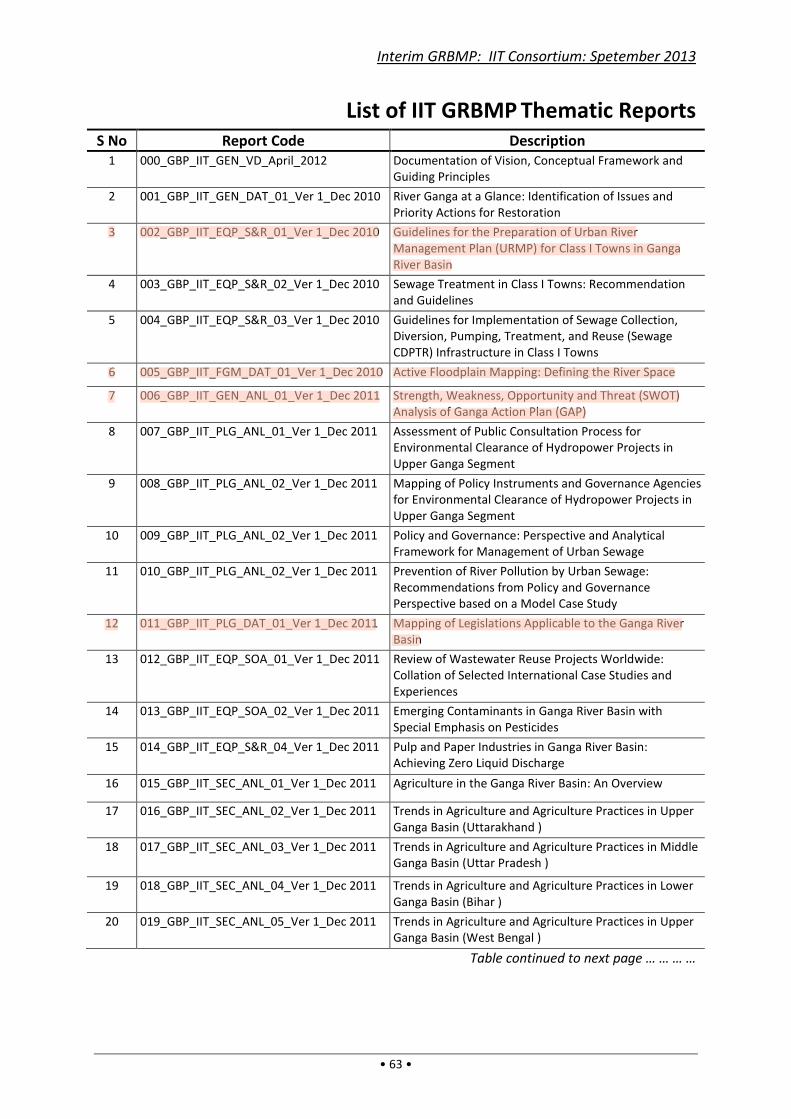
Interim GRBMP: IIT Consortium: Spetember 2013
• 63 •
List of IIT GRBMP Thematic Reports
S No Report Code Description
1 000_GBP_IIT_GEN_VD_April_2012 Documentation of Vision, Conceptual Framework and
Guiding Principles
2 001_GBP_IIT_GEN_DAT_01_Ver 1_Dec 2010 River Ganga at a Glance: Identification of Issues and
Priority Actions for Restoration
3 002_GBP_IIT_EQP_S&R_01_Ver 1_Dec 2010 Guidelines for the Preparation of Urban River
Management Plan (URMP) for Class I Towns in Ganga
River Basin
4 003_GBP_IIT_EQP_S&R_02_Ver 1_Dec 2010 Sewage Treatment in Class I Towns: Recommendation
and Guidelines
5 004_GBP_IIT_EQP_S&R_03_Ver 1_Dec 2010 Guidelines for Implementation of Sewage Collection,
Diversion, Pumping, Treatment, and Reuse (Sewage
CDPTR) Infrastructure in Class I Towns
6 005_GBP_IIT_FGM_DAT_01_Ver 1_Dec 2010 Active Floodplain Mapping: Defining the River Space
7 006_GBP_IIT_GEN_ANL_01_Ver 1_Dec 2011 Strength, Weakness, Opportunity and Threat (SWOT)
Analysis of Ganga Action Plan (GAP)
8 007_GBP_IIT_PLG_ANL_01_Ver 1_Dec 2011 Assessment of Public Consultation Process for
Environmental Clearance of Hydropower Projects in
Upper Ganga Segment
9 008_GBP_IIT_PLG_ANL_02_Ver 1_Dec 2011 Mapping of Policy Instruments and Governance Agencies
for Environmental Clearance of Hydropower Projects in
Upper Ganga Segment
10 009_GBP_IIT_PLG_ANL_02_Ver 1_Dec 2011 Policy and Governance: Perspective and Analytical
Framework for Management of Urban Sewage
11 010_GBP_IIT_PLG_ANL_02_Ver 1_Dec 2011 Prevention of River Pollution by Urban Sewage:
Recommendations from Policy and Governance
Perspective based on a Model Case Study
12 011_GBP_IIT_PLG_DAT_01_Ver 1_Dec 2011 Mapping of Legislations Applicable to the Ganga River
Basin
13 012_GBP_IIT_EQP_SOA_01_Ver 1_Dec 2011 Review of Wastewater Reuse Projects Worldwide:
Collation of Selected International Case Studies and
Experiences
14 013_GBP_IIT_EQP_SOA_02_Ver 1_Dec 2011 Emerging Contaminants in Ganga River Basin with
Special Emphasis on Pesticides
15 014_GBP_IIT_EQP_S&R_04_Ver 1_Dec 2011 Pulp and Paper Industries in Ganga River Basin:
Achieving Zero Liquid Discharge
16 015_GBP_IIT_SEC_ANL_01_Ver 1_Dec 2011 Agriculture in the Ganga River Basin: An Overview
17 016_GBP_IIT_SEC_ANL_02_Ver 1_Dec 2011 Trends in Agriculture and Agriculture Practices in Upper
Ganga Basin (Uttarakhand )
18 017_GBP_IIT_SEC_ANL_03_Ver 1_Dec 2011 Trends in Agriculture and Agriculture Practices in Middle
Ganga Basin (Uttar Pradesh )
19 018_GBP_IIT_SEC_ANL_04_Ver 1_Dec 2011 Trends in Agriculture and Agriculture Practices in Lower
Ganga Basin (Bihar )
20 019_GBP_IIT_SEC_ANL_05_Ver 1_Dec 2011 Trends in Agriculture and Agriculture Practices in Upper
Ganga Basin (West Bengal )
Table continued to next page … … … …

Interim GRBMP: IIT Consortium: Spetember 2013
• 64 •
… … … … Table continued from previous page
S No Report Code Description
21 020_GBP_IIT_ENB_DAT_01_Ver_Dec 2011 Floral and Faunal Diversity of Upper Ganga
22 021_GBP_IIT_FGM_DAT_02_Ver 1_Dec 2011 Delineation of Valley Margin and Geomorphic Mapping
along the Ganga River Basin and the Yamuna Sub-basin
23 022_GBP_IIT_EFL_SOA_01_Ver 1_Dec 2011 Environmental Flows: State-of-the-Art with special
reference to Rivers in the Ganga River Basin
24 023_GBP_IIT_EQP_ANL_01_Ver 1_June 2012 Water Quality in the Ganga River and Efficacy of Sewage
Treatment Processes in Coliform Removal: A Case for
Adopting Tertiary Treatment
25 024_GBP_IIT_ENB_DAT_02_Ver 1_Sep 2012
The Status of Sundari (H. fomes) an indicators species in
the Sunderbans
26 025_GBP_IIT_ENB_DAT_02_Ver 1_Jun 2012 Floral and Faunal Diversity of Middle Ganga
27 026_GBP_IIT_ENB_DAT_03_Ver 1_Jun 2012 Floral and Faunal Diversity of Lower Ganga: Part A –
Varanasi to Farakka
28 027_GBP_IIT_ENB_DAT_04_Ver 1_Jun 2012 Floral and Faunal Diversity of Lower Ganga: Part B –
Farakka to Ganga Sagar
29 028_GBP_IIT_ENB_DAT_05_Ver 1_Jun 2012 Status of Higher Aquatic Vertebrates in the Ganga River,
India
30 029_GBP_IIT_ENB_DAT_07_Ver_Jun 2012 Hilsa : An assessment in lower Ganga river basin, India
31 030_GBP_IIT_ENB_DAT_08_Ver 1_Jun 2012 Status of Fish and Fisheries of River Ganga
32 031_GBP_IIT_ENB_DAT_09_Ver 1_Jun 2012 Wetlands
33 032_GBP_IIT_ENB_DAT_10_Ver 1_Jun 2012 Riparian Floral Diversity in Ganga River Basin
34 033_GBP_IIT_ENB_DAT_11_Ver_Jun 2012 Floral and Fauna Diversity in Alaknanda River
35 034_GBP_IIT_ENB_DAT_12_Ver 1_Jun 2012 Floral and Faunal Diversity in Yamuna River
36 035_GBP_IIT_ENB_DAT_13_Ver 1_Jun 2012 Floral and Faunal Diversity in Ramganga River
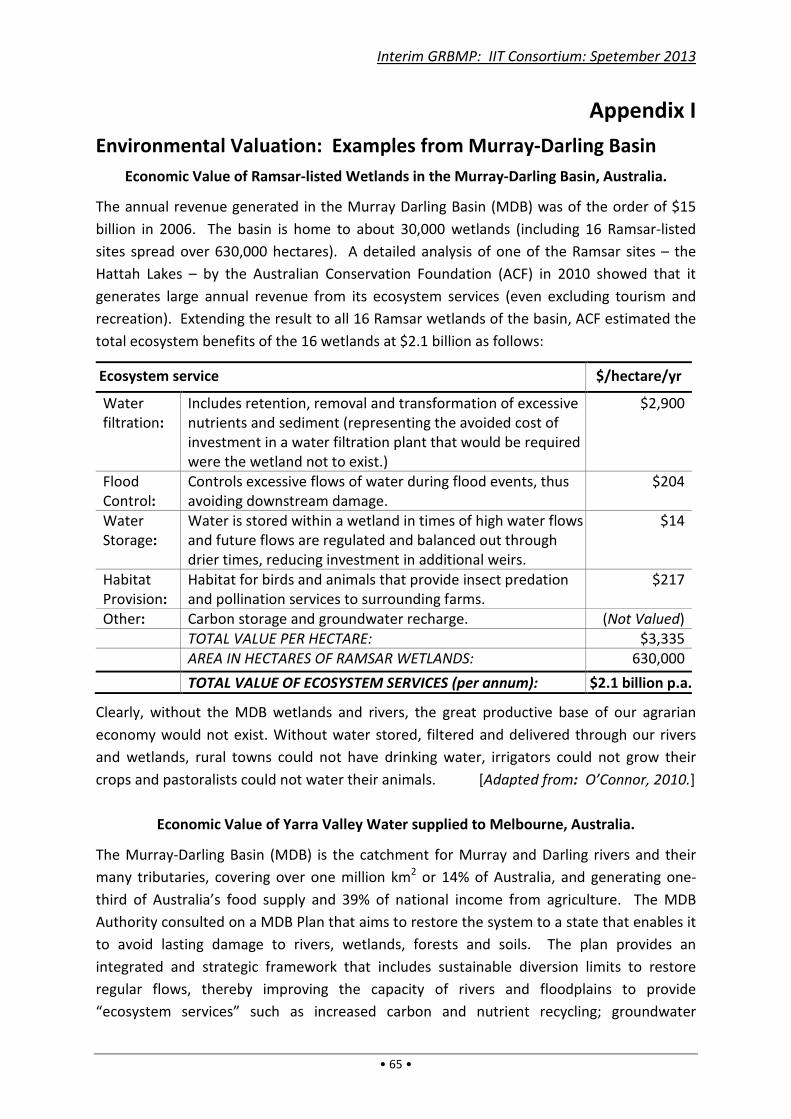
Interim GRBMP: IIT Consortium: Spetember 2013
• 65 •
Appendix I
Environmental Valuation: Examples from Murray-Darling Basin
Economic Value of Ramsar-listed Wetlands in the Murray-Darling Basin, Australia.
The annual revenue generated in the Murray Darling Basin (MDB) was of the order of $15
billion in 2006. The basin is home to about 30,000 wetlands (including 16 Ramsar-listed
sites spread over 630,000 hectares). A detailed analysis of one of the Ramsar sites – the
Hattah Lakes – by the Australian Conservation Foundation (ACF) in 2010 showed that it
generates large annual revenue from its ecosystem services (even excluding tourism and
recreation). Extending the result to all 16 Ramsar wetlands of the basin, ACF estimated the
total ecosystem benefits of the 16 wetlands at $2.1 billion as follows:
Ecosystem service $/hectare/yr
Water
filtration:
Includes retention, removal and transformation of excessive
nutrients and sediment (representing the avoided cost of
investment in a water filtration plant that would be required
were the wetland not to exist.)
$2,900
Flood
Control:
Controls excessive flows of water during flood events, thus
avoiding downstream damage.
$204
Water
Storage:
Water is stored within a wetland in times of high water flows
and future flows are regulated and balanced out through
drier times, reducing investment in additional weirs.
$14
Habitat
Provision:
Habitat for birds and animals that provide insect predation
and pollination services to surrounding farms.
$217
Other: Carbon storage and groundwater recharge. (Not Valued)
TOTAL VALUE PER HECTARE: $3,335
AREA IN HECTARES OF RAMSAR WETLANDS: 630,000
TOTAL VALUE OF ECOSYSTEM SERVICES (per annum): $2.1 billion p.a.
Clearly, without the MDB wetlands and rivers, the great productive base of our agrarian
economy would not exist. Without water stored, filtered and delivered through our rivers
and wetlands, rural towns could not have drinking water, irrigators could not grow their
crops and pastoralists could not water their animals. [Adapted from: O’Connor, 2010.]
Economic Value of Yarra Valley Water supplied to Melbourne, Australia.
The Murray-Darling Basin (MDB) is the catchment for Murray and Darling rivers and their
many tributaries, covering over one million km2 or 14% of Australia, and generating one-
third of Australia’s food supply and 39% of national income from agriculture. The MDB
Authority consulted on a MDB Plan that aims to restore the system to a state that enables it
to avoid lasting damage to rivers, wetlands, forests and soils. The plan provides an
integrated and strategic framework that includes sustainable diversion limits to restore
regular flows, thereby improving the capacity of rivers and floodplains to provide
“ecosystem services” such as increased carbon and nutrient recycling; groundwater
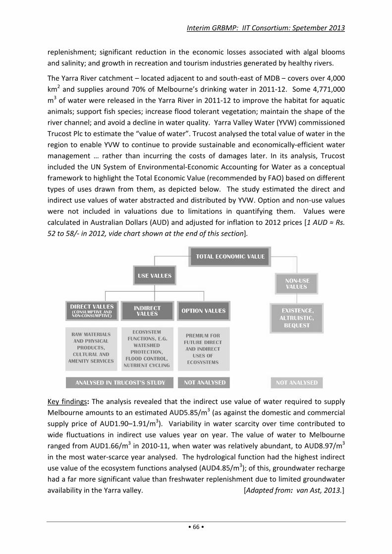
replenishment; significant reduction in the economic losses associated with algal blooms
and salinity; and growth in recreation and tourism industries generated by healthy rivers.
The Yarra River catchment – located adjacent to and south
km2 and supplies around 70% of Melbourne’s drinking water in 2011
m3 of water were released in the Yarra River in 2011
animals; support fish species; increase flood
river channel; and avoid a decline in water quality.
Trucost Plc to estimate the “value of water”. Trucost
region to enable YVW to continue to provide
management … rather than incurring the costs of damages later.
included the UN System of Environmental
framework to highlight the Total Economic Value
types of uses drawn from them
indirect use values of water abstracted and distributed by
were not included in valuations due to limitations in quantifying the
calculated in Australian Dollars (AUD)
52 to 58/- in 2012, vide chart
Key findings: The analysis revealed that the indirect use value of water required to supply
Melbourne amounts to an estimated AUD5.85
supply price of AUD1.90–1.91/
wide fluctuations in indirect use values year on year.
ranged from AUD1.66/m3 in 2010
in the most water-scarce year analysed.
use value of the ecosystem functions analysed (AUD4.85/m
had a far more significant value than freshwater replenishment
availability in the Yarra valley.
Interim GRBMP: IIT Consortium: Spetember 2013
• 66 •
replenishment; significant reduction in the economic losses associated with algal blooms
growth in recreation and tourism industries generated by healthy rivers.
located adjacent to and south-east of MDB –
around 70% of Melbourne’s drinking water in 2011-12.
of water were released in the Yarra River in 2011-12 to improve the habitat
upport fish species; increase flood tolerant vegetation; maintain the shape of the
channel; and avoid a decline in water quality. Yarra Valley Water (YVW)
“value of water”. Trucost analysed the total value of water in the
o continue to provide sustainable and economically
rather than incurring the costs of damages later. In its analysis, Trucost
included the UN System of Environmental-Economic Accounting for Water as
the Total Economic Value (recommended by FAO)
types of uses drawn from them, as depicted below. The study estimate
indirect use values of water abstracted and distributed by YVW. Option and non
t included in valuations due to limitations in quantifying the
calculated in Australian Dollars (AUD) and adjusted for inflation to 2012 prices
chart shown at the end of this section].
The analysis revealed that the indirect use value of water required to supply
amounts to an estimated AUD5.85/m3 (as against the domestic and commercial
1.91/m3). Variability in water scarcity over time contributed
wide fluctuations in indirect use values year on year. The value of water to Melbourne
in 2010-11, when water was relatively abundant, to AUD8.97/m
scarce year analysed. The hydrological function had the
use value of the ecosystem functions analysed (AUD4.85/m3); of this, groundwater recharge
a far more significant value than freshwater replenishment due to limited groundwater
. [Adapted from
Interim GRBMP: IIT Consortium: Spetember 2013
replenishment; significant reduction in the economic losses associated with algal blooms
growth in recreation and tourism industries generated by healthy rivers.
– covers over 4,000
12. Some 4,771,000
12 to improve the habitat for aquatic
tolerant vegetation; maintain the shape of the
(YVW) commissioned
analysed the total value of water in the
sustainable and economically-efficient water
In its analysis, Trucost
ounting for Water as a conceptual
(recommended by FAO) based on different
study estimated the direct and
. Option and non-use values
t included in valuations due to limitations in quantifying them. Values were
and adjusted for inflation to 2012 prices [1 AUD ≈ Rs.
The analysis revealed that the indirect use value of water required to supply
(as against the domestic and commercial
r scarcity over time contributed to
lue of water to Melbourne
abundant, to AUD8.97/m3
the highest indirect
, groundwater recharge
limited groundwater
Adapted from: van Ast, 2013.]
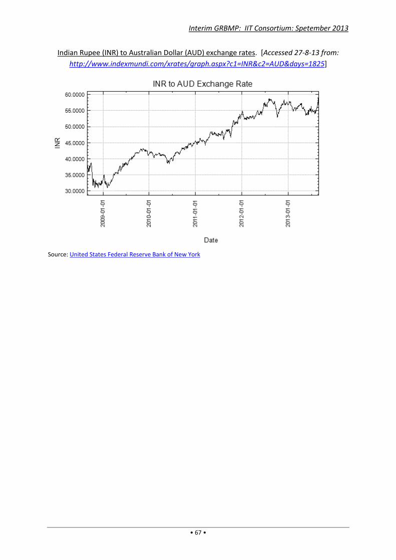
Indian Rupee (INR) to Australian Dollar (AUD) exchange rates
http://www.indexmundi.com/xrates/graph.aspx?c1=INR&c2=AUD&days=1825
Source: United States Federal Reserve Bank of New York
Interim GRBMP: IIT Consortium: Spetember 2013
• 67 •
Indian Rupee (INR) to Australian Dollar (AUD) exchange rates. [Accessed 27
http://www.indexmundi.com/xrates/graph.aspx?c1=INR&c2=AUD&days=1825
United States Federal Reserve Bank of New York
Interim GRBMP: IIT Consortium: Spetember 2013
Accessed 27-8-13 from:
http://www.indexmundi.com/xrates/graph.aspx?c1=INR&c2=AUD&days=1825]

Interim GRBMP: IIT Consortium: Spetember 2013
• 68 •

Interim GRBMP: IIT Consortium: Spetember 2013
• 69 •
Appendix II
Summaries of IIT_GRBMP Thematic Reports
001_GBP_IIT_GEN_DAT_01_Ver 1_Dec 2010
River Ganga at a Glance: Identification of Issues and Priority Actions for Restoration
River Ganga’s origin and subsequent course in the plains are described. The Ganga River
System is reviewed in three distinct fluvial segments. The Upper Ganga Segment from
Gaumukh to Haridwar is described and essential environmental actions needed are defined,
especially with regard to the effect of hydropower projects and tourism on the river
ecosystem. In the Middle Ganga Segment up to Varanasi, the chief environmental measures
needed are found to be complete stoppage of discharge of industrial and domestic
wastewaters (and hence their recycling), and the creation of a dolphin protection zone
below Garmukhteswar. The Lower Ganga Segment up to Ganga Sagar needs similar
pollution control measures as in Middle Ganga, besides detailed hydrological and geo-
morphological studies to deal with the high silt loads.
002_GBP_IIT_EQP_S&R_01_Ver 1_Dec 2010
Guidelines for the Preparation of Urban River Management Plan (URMP) for Class I Towns
in Ganga River Basin
Most Class I Towns of Ganga River Basin (GRB) are located near River Ganga or its
tributaries, and their sewage, solid wastes, riverbank encroachments, etc. harm the rivers.
Hence URMPs (Urban Renewal Management Plans) are needed for all Class I Towns of GRB
over a 25-year planning horizon for wastewater management and riverbank protection. The
URMPs, to be prepared immediately by individual towns, should include actionable items
such as removal of encroachments and beautification of riverbanks, banning/ restriction of
undesirable activities, sewage collection and diversion, pumping and treatment, and
storage, transport and reuse of treated sewage and sludge. The URMPs should be
implemented after approval by an expert committee of NGRBA, and funding for various
work packages should be made available through NGRBA by different ministries. Unlike
other city development plans the URMPs will be river-centric and not city-centric, thereby
preventing adverse urban impacts on rivers.
003_GBP_IIT_EQP_S&R_02_Ver 1_Dec 2010
Sewage Treatment in Class I Towns: Recommendation and Guidelines
Urban sewage is a major point source of pollution and also a source of recycled water.
Adequate sewage treatment for reuse – either in centralized STPs (Sewage Treatment
Plants) or small decentralized STPs – will minimize fresh water withdrawals. The costs,
process quality, reliability, environmental factors, land requirements, etc. of different
sewage treatment processes are compared. The treatment chain is considered in three
stages – Preliminary Treatment, Primary and Secondary Treatment, and Tertiary Treatment.

Interim GRBMP: IIT Consortium: Spetember 2013
• 70 •
Technological options for the second stage treatment are considered, and for eight different
treatment processes the unit treatment costs and footprint area of treatment plant are
derived. A decision matrix table of costs and different treatment parameters is presented.
Technological options for sludge management, flow measurement, and bio-assay tests (of
treated effluent) are explained. The importance of reusing the treated water, and thereby
enabling zero liquid discharge from treatment plants into the environment, is emphasized.
004_GBP_IIT_EQP_S&R_03_Ver 1_Dec 2010
Guidelines for Implementation of Sewage Collection, Diversion, Pumping, Treatment, and
Reuse (Sewage CDPTR) Infrastructure in Class I Towns
Currently, sewer networks and pumping facilities are absent or partial, treatment plants
malfunctioning or inadequate, and sludge disposal improper. ULBs (Urban Local Bodies)
responsible for operating these facilities have different concerns besides financial and other
constraints. The Sewage CDPTR Infrastructure for all Class I Towns of Ganga River Basin
(GRB) needed are: (i) complete stoppage of sewage discharge into rivers, (ii) sewage
treatment up to tertiary level, and (iii) reuse of treated sewage water for non-contact/ non-
potable purposes. Thus, all new Sewage Treatment Plants must treat up to tertiary level
and existing plants upgraded to this level. All Sewage CDPTR Infrastructure should be
funded by central and state governments and executed through private-public partnership
adopting a DBFO (Design-Build-Finance-Operate) Model, wherein a ULB may contract a
service provider for 5–15 years with annual payments against service rendered. Public
monitoring of such facilities through independent NGOs, CSOs, etc. is required.
005_GBP_IIT_FGM_DAT_01_Ver 1_Dec 2010
Active Floodplain Mapping: Defining the River Space
The “valley” and “active floodplain” of a river defines the space that it occupies for
performing its natural functions. “Floodplain” is an area that is inundated during flood.
“Valley” is a wider topographic low occupied by the river and its floodpalin over a longer
time. Standard hydrological criteria of defining “active floodplain” is the 2.33 year return
flood. Floodplain is ecologically most sensitive and supports a wide variety of vegetation and
life forms; its complete preservation is one of the prime indicators of good river health.
Landsat 4-5 TM (30 m resolution), IRS P6 AWIFS (56 m), SRTM data were processed in Arc
GIS to generate critical parameters for identifying floodpain and valley; and were validated
by cross consultation of MODIS and Google Earth flood times images.
In a basin scale, active floodplain of Ganga River can be divided into four stretches:
a. Hardiwar-Narora: As the river leaves its mountainous reaches it creates a wider (~ 28
km) floodplain that narrows (~10 km) downstream; reduces to ~5 km near the Narora
barrage;
b. Narora-Kanpur: Widens (~28 km) again after its confluence with Ramganga, reduces to
~15 km upstream of Kanpur and narrowest (~1 km) downstream of Kanpur.

Interim GRBMP: IIT Consortium: Spetember 2013
• 71 •
c. Kanpur-Buxar: Generally narrow; increasing to ~7.5 km near Allhabad; continues
unchanged downstream
d. Buxar-Farakka: Floodplain is widest (~42 km) downstream of Munger; near Farakka it is
~26 km
006_GBP_IIT_GEN_ANL_01_Ver 1_Dec 2011
Strength, Weakness, Opportunity and Threat (SWOT) Analysis of Ganga Action Plan (GAP)
This report is primarily aimed at presenting an analysis of the strengths, weaknesses,
opportunities and threats (SWOT) of Ganga Action Plans (GAP I and GAP II) and is primarily
based on the secondary data collected and literature review. The objective of this report is
to consolidate—in a systematic manner—the available knowledge and insights in order to
understand nuances and complexity involved in design, implementation and monitoring
aspects of the Ganga Action Plan (GAP). Several issues such as delays in implementation of
the program, confusion over funding, technological issues, operation and maintenance of
the assets do not only indicate typical governance failures but also clarify the gaps in policy
and program design. These gaps also highlight the weakness in program
planning/implementation/monitoring/evaluation, center-state coordination, state-ULB
coordination, etc. The issues such as multiplicity of institutions, especially at the local level
and their conflicting/overlapping roles place the need for a deeper institutional analysis.
Opaque implementation and low levels of citizen’s participation pose broader challenges for
the future design and intervention and demand greater transparency. It is equally important
to nuance this as problems with respect of to Ganga according to its three important
stretches viz., the upper, middle and lower stretches of its flow in order to design the future
course of action. Each of its stretch is characterized by different types of problems, having
different physical conditions as well as dynamics created by distinct political economy.
007_GBP_IIT_PLG_ANL_01_Ver 1_Dec 2011
Assessment of Public Consultation Process for Environmental Clearance of Hydropower
Projects in Upper Ganga Segment
After analyzing the governance structure in the earlier report (Report Code:
010_GBP_IIT_PLG_ANL_02_Ver 1_Dec 2011), this report focuses on a specific aspect of
governance – the Public Hearing and Consultation (PC) process which is mandatory for
hydropower projects (HPPs) to ensure transparency, accountability and participation in the
environmental clearance process. PC is an important vehicle in democratic environmental
decision making by developing an arena where the views and suggestions of public are
incorporated. Eight case studies of HPPs sampled for rivers Bhagirathi and Alaknanda were
undertaken to understand the issues in PC. There is no claim of representativeness of these
samples since it forma only a small proportion of the HPPs in the region. However, the in-
depth case studies illustrated issues in the microcosm, which is indicative of the macro
issues. Understanding the inadequacies and serious lacunae in the process, detailed analysis
is given in the report. Some important recommendations are summarised below:

Interim GRBMP: IIT Consortium: Spetember 2013
• 72 •
1. The public consultation process must be mandatory even for projects of less than 25
MW;
2. Should ensure informed (all aspects of the project written in local language to be
circulated) participation in gramsabhas with adequate time for interested people to
express their concerns and the must be recorded in the report
3. Implementation of transparency related provisions by making it mandatory for the PC
panel to be constituted a day before the meeting and oversee all such provisions;
4. Before the final EC decision, EAC should inform people about how their concerns and
suggestions are incorporated in the EC recommendations by making necessary
provision to strengthen each of the stakeholder’s right to challenge the EAC decision.
5. The Secretary, MoEF will be responsible for ensuring preparation and timely submission
of such compliance reports (in a prescribed format) and its dissemination to local
people through the offices of DM and DJ, and also through the MoEF websites.
008_GBP_IIT_PLG_ANL_02_Ver 1_Dec 2011
Mapping of Policy Instruments and Governance Agencies for Environmental Clearance of
Hydropower Projects in Upper Ganga Segment
While acknowledging the need for hydropower generation, the process of according
environmental clearances to hydropower projects on the basis of EIA studies is an essential
tool for safeguarding the ecological integrity and resulting livelihoods in the Upper Ganga
basin. Though the State has taken stringent provisions to make the EIA-EC practice
mandatory for hydropower projects, various stakeholders (especially from civil society
organisations) have expressed grievances about the lacunae in policy instruments and
performance of governing agencies leading to violations in practice. The objective of this
report is to systematically map the institutional structure (PIs and GAs) for environmental
governance in India and to suggest suitable changes to it. The following are the major
recommendations of this report:
1. Pre-environmental clearance based on EIA studies is to be made mandatory for
projects of all capacity/types including micro-mini- projects and small-medium-large
projects whether run-off-the river or otherwise. All of these project types are likely to
cause significant impact on local environment which must be studied.
2. An independent authority having required technical competence and supported
financially by a consortium of developers is to be established through MoEF. Such an
agency should design and conduct feasibility studies and location specific EIAs, if not
cumulative impact assessments under the regulation of MoEF. This proposition differs
from the consultancy services development mandate of the government and hence,
its merits and demerits are needed to be discussed in detail.
3. Independent professionals having required competence in their respective subjects
and adequate environmental credentials should be appointed as EAC members and
must be provided with adequate secretarial support to thoroughly appraise and

Interim GRBMP: IIT Consortium: Spetember 2013
• 73 •
evaluate findings of feasibility studies and EIAs, and to recommend for a clearance
through a public proceeding.
4. To ensure transparency and accountability in the environmental clearance decision
making process, it should be made mandatory for the concerned agencies to give
speaking justifications of their decisions and to share the proceedings in public
domain.
5. An independent authority should be established to monitor violations during post
clearance construction activities and ensure proactive compliances from the
developers.
009_GBP_IIT_PLG_ANL_02_Ver 1_Dec 2011
Policy and Governance: Perspective and Analytical Framework for Management of Urban
Sewage
After the analysis of GAP (Report Code: 006_GBP_IIT_GEN_ANL_01_Ver 1_Dec 2011), an
urgent need was felt to evolve and articulate a systematic, comprehensive, conceptually
sound, and internally consistent perspective—and an analytical framework based on it—
that is focused on the policies and governance. The ‘Policy and Governance Perspective’ and
the analytical framework developed in this report are built on the foundation of some
clearly defined basic concepts and terms. It also presents a conceptual schema—called as
the ‘Governance Grid’—which takes a comprehensive view of governance of an entire
sector. The perspective then presents a comprehensive and conceptually coherent schema
of the actual process of governance as it generally unfolds in reality. The schema begins with
the ground-level problems in any sector and helps the analyst identify the core governance
maladies of different types in the sector. To address these maladies, the analyst then can
evolve recommendations for appropriate changes in—or creation of new—policy
instruments and / or governing agencies. The perspective prompts an argument that such
core governance maladies cannot be cured by technical, financial, or managerial ‘fixes’. It
also makes a note that all governance problems cannot be addressed using the policy and
institutional ‘fixes’ either, as they cannot resolve such problems rooted in the ‘political
bottom-line’. In other words, the problems rooted in the adverse balance of political-
economic powers acting against the goals set for the governance of the sector can be
resolved only through political action by the sections of society supporting the goals set for
governance.
010_GBP_IIT_PLG_ANL_02_Ver 1_Dec 2011
Prevention of River Pollution by Urban Sewage: Recommendations from Policy and
Governance Perspective based on a Model Case Study
This report presents an analysis of the ground-level situation of the sewage conveyance and
treatment systems in the Kanpur city in Uttar Pradesh. The objective is to bring out
important policy and governance related lacunas in the sector, causing continued release of
partially treated or untreated sewage and faecal-matter in the river Ganga. This report

Interim GRBMP: IIT Consortium: Spetember 2013
• 74 •
broadly follows the template presented in the report titled: Policy and Governance
Perspective and Analytical Framework (009_GBP_IIT_PLG_ANL_03_Ver 1_Dec 2011) and
begins with the background information on the city of Kanpur with the focus on the
activities of the Ganga Action Plan (GAP) executed in two phases (GAP I and GAP II) in the
city. The findings focus on different deficiencies in the performance of the sewage system in
the city of Kanpur with the analysis of various Policy Instruments (PIs) and lacunas in the
Governing Agencies (GAs). The major observation is the proposed weakening of the UP Jal
Nigam (UPJN), the para-statal agency currently entirely responsible for carrying out the task
related to sanitation. The proposal to shift most of these functions to ULBs through 74th
Constitutional amendment act and in parallel encouraging private participation raises a
number of questions like huge capacity gaps in ULBs to undertake such functions. The
resistance from UPJN for the shift could also affect the smooth functioning of the future
pollution abatement activities. The regulatory functions of SPCB are currently severely
limited by political interference and resource constraints. It has been evident from the
efforts hitherto that sufficient level of experimentation has not taken place for
decentralized and in-situ sewage disposal techniques. There is a great need to incentivize
such techniques as well as their production and market development if such experiments
are to become successful. Such new techniques and practices could be used in the rapidly
developing peri-urban areas of large urban agglomerations such as Kanpur as well as to
smaller cities which do not have centralized systems for sewage collection, conveyance,
treatment, and disposal/reuse. Incentivizing market development for recycling and reuse is
another equally important area, especially for cities that are having centralized systems. The
shortage of freshwater increasingly faced by the industries in many part of the country
which have adequate financial strength to raise finance for undertaking reuse or purchasing
treated sewage for industrial use. This potential need to be assessed and pilots should be
undertaken at appropriate locations, especially in industrial towns after conducting
feasibility assessment of such pilots. However the larger question is whether all the sewage
could be absorbed by this mode which again brings in the question of a variety of modes of
disposal in the place of currently imagined centralized systems. Small towns would continue
to face the financial crisis; even after successful introduction of reforms, primarily because
of the smaller sizes of their local economies, which are almost stagnated. Such towns would
need continued state support. More case studies are required to be undertaken in the
framework of this report to identify the amendments and revisions in GAs and PIs, which
would be needed to address these lacunas and distortions. This, in effect, would help us
improve the governance of urban sanitation (or sewage) sector in different states along the
banks of river Ganga and her tributaries.

Interim GRBMP: IIT Consortium: Spetember 2013
• 75 •
011_GBP_IIT_PLG_DAT_01_Ver 1_Dec 2011
Mapping of Legislations Applicable to the Ganga River Basin
Using the Law as an instrument of the River Basin Management has never been within the
agenda of state and central legislative authorities; possibly, because it was thought that
river is a natural resource and could be exploited to the extent one wants and that river will
restore its system back in the natural process.
Because of the above underline thought, there are several legislations [Acts], regulations,
rules, order and by-laws enacted/frame, which either pertain to the activities within river
basin or have incidental impact over the same. Most of these legislations were enacted to
achieve certain specific goals wherein river basin management was never a prime objective.
But certain provision of these legislations has been used to regulate the activities on the
river bed i.e., water navigation; control pollution, establishment of burning ghat and water
sharing etc.
No concerted efforts have been made till date in legislative front against the exploitation of
river. Many issues concerning river management didn’t fail within the present legislative
frame; some of these are maintenance of e-flow; protection of basin’s ecology & species;
issues relating to the maintenance of ground water in nearby basin area; consolidated plans
for diversion of the river water in different stages of rivers; discharge of sewage;
obstructions on the river bed; use of floodplain & constructions on it; matter regarding the
amount of river water usage; the activities allowed within the river bed etc.
012_GBP_IIT_EQP_SOA_01_Ver 1_Dec 2011
Review of Wastewater Reuse Projects Worldwide: Collation of Selected International Case
Studies and Experiences
Unlike most of the river basins worldwide, the practice of treated wastewater reuse is
underdeveloped in the Ganga River Basin owing to mist of apprehensions as a result of
misconceptions, lack of knowledge and public perception, unclear policies and lack of
institutional capabilities. The report presents and reviews some selected case studies of
operating wastewater reuse installations worldwide and their associated environmental and
public health impacts, economics, community and public perception and participation in
order to introduce new ideas and exchange experience for promotion of wastewater reuse
in the Ganga River Basin. The plethora of successful case studies suggest that treated
wastewater reuse is a plausible option as part of integrated water resources management in
the Ganga River Basin. On following the case studies, the zero discharge municipality/city
concept by integrating the reuse of highly reclaimed wastewater adopting tertiary-level
advanced treatment for non-potable non-human contact uses, seasonal storage in surface
reservoir for groundwater recharge and irrigation is recommended as part of the river basin
management plan. Water quality standard or guidelines pertaining to wastewater reuse for
each beneficial uses must be developed. Moreover, the risk involved, if any must be
assessed for treated wastewater reuse schemes before implementation.
Interim GRBMP: IIT Consortium: Spetember 2013
• 76 •
013_GBP_IIT_EQP_SOA_02_Ver 1_Dec 2011
Emerging Contaminants in Ganga River Basin with Special Emphasis on Pesticides
Pesticide contamination poses significant risks to the environment and non-target
organisms include beneficial soil microorganisms, insects, plants, fish, birds and humans. A
limited number of studies have been conducted in the last three decades in Ganga river
basin where pesticide concentrations have been monitored in various environmental media.
In general, total DDT and total HCH concentrations have been reported at significant
concentrations by most researchers. Major findings are:
• Water: Pesticide levels in water samples from the Ganga River basin ranged from non-
detectable to a maximum total pesticide concentration of 13.1 micro-g/L in the city of
Varanasi. Only four of the fifteen studies reviewed here showed total pesticide
concentrations higher than the permissible levels of 1 micro-g/L.
• Sediments: Pesticide levels in sediments ranged from 0.05 ng/g to 240 ng/g.
• Fish: Significant and high pesticide levels have been reported in fish tissue with
maximum total DDT concentration of 7.5 micro-g/g in cat fish and maximum total HCH
concentration of 3.5 micro-g/g in cat fish. These results indicate that pesticides like DDT
and HCH bioaccumulate to significant levels in fish tissue. Health risks associated with
these levels of pesticides in food need to be examined in greater detail.
In order to control water pollution by these substances, domestic and industrial wastes
(both solid and liquid) should not be discharged/dumped into water bodies without proper
treatment.Further, constant monitoring and analysis of the most commonly used pesticides
in all environmental media is essential for a comprehensive risk assessment.
014_GBP_IIT_EQP_S&R_04_Ver 1_Dec 2011
Pulp and Paper Industries in Ganga River Basin: Achieving Zero Liquid Discharge
Pulp and Paper Mills, particularly agro-based ones, are a major source of pollution in Ganga
river. These mills also consume considerable fresh water. The need for reduced water
consumption through improved manufacturing processes and reuse of wastewater are
highlighted. Benchmark water consumption figures are indicated for different type of mills.
Feasibility of CETPs in place of individual ETPs was examined and found to be generally non-
advantageous. For base year 2010, the costs of tertiary treatment needed to produce
industry-grade water was worked out for different types of industries. It was found that for
complete water recycling, the production costs could increase by about 17–19% for agro-
based industries and by 4–6% for RCF-based industries. Practical means for achieving the
Zero Liquid Discharge target can be accomplished through a dedicated service provider
operating the wastewater treatment and recycling facilities on Design, Build and Operate
model.

Interim GRBMP: IIT Consortium: Spetember 2013
• 77 •
015_GBP_IIT_SEC_ANL_01_Ver 1_Dec 2011
Agriculture in the Ganga River Basin: An Overview
This report examines the trends in: agriculture land-use and cropping patterns; size of land
holdings; crop-diversification; sources of irrigation and status of ground water; use of
fertilizers, pesticides, and other inputs; and agricultural production and productivity. For
this purpose, the entire basin is divided into three stretches, namely, Upper Ganga Basin
(Uttarakhand), Middle Ganga Basin (Uttar Pradesh) and Lower Ganga Basin (Bihar and West
Bengal). The study finds that agricultural production in the basin has increased
tremendously during last four decades, albeit at varying rates across the states. Net sown
area (NSA has declined over time due to growing industrialization and urbanization, while
gross irrigated area (GIA) and the uses of other inputs like fertilizer and modern agricultural
equipments have increased over the period. Increase in irrigation facilities has resulted into
adoption of more water intensive cropping pattern. Although there is a good network of
canals, especially in Uttar Pradesh, nevertheless ground water has been the key sources of
irrigation in the basin. For instance, it shares 73% of GIA in Uttar Pradesh and Uttarakhand
(combined), 59% in West Bengal and 49% in Bihar and Jharkhand (combined).
Chemicalization of agriculture has also increased over the period in the basin. West Bengal
seems to have registered a tremendous growth in the use of chemical fertilizers from the
level of only 5 kg/hectare during 1962-65 to a level of 226 kg/hectare during 2003-06. Uttar
Pradesh also followed, more or less, the same level of growth throughout the period with a
level of only 4 kg/hectare during 1962-65 to 205 kg/hectare during 2003-06. Comparatively,
Bihar has registered a modest growth in the fertilizer consumption. Such an intensive use of
fertilizer may lead to disposal of high levels of nitrogen and phosphorus as part of the
agricultural runoff into surface water bodies.
016_GBP_IIT_SEC_ANL_02_Ver 1_Dec 2011
Trends in Agriculture and Agriculture Practices in Upper Ganga Basin (Uttarakhand )
This report examines the trends in agriculture and agriculture practices in Uttarakhand and
their implications for the Ganga River basin. The study, among others, focuses on land use
and cropping pattern, size of land holdings, input use, including irrigation and chemical
fertilizers, crop diversification, production and profitability. It is observed that although, the
Ganga and its tributaries flow across Uttarakhand, the use of river water in the agriculture is
largely confined to the plain areas because possibility of development of irrigation system
and adoption of modern input-intensive agriculture in hilly areas is quite limited due to
physical, environmental and economic reasons. The study finds that net sown area (NSA)
has declined in the recent years due to increasing land demand for non-agricultural uses,
particularly for industrialization and urbanization. Further, increasing marginalization of land
holdings may pose great threat to the sustainability and economic viability of the
agriculture. In the plain areas, cropping pattern is limited to only three water intensive
crops—sugarcane, wheat and rice. Huge quantity of water could be saved by changing the
cropping pattern from these crops to the less water consuming crops. It is also observed
Interim GRBMP: IIT Consortium: Spetember 2013
• 78 •
that the use chemical fertilizer in agriculture, especially in plain areas has increased
significantly. The study suggests that in order to maintain aviral and nirmal dhara in the
Ganga River, a two-fold strategy is to be adopted: First, the government policy should be
oriented towards making agriculture ecologically as well as economical sustainable which
could be done through incentivizing the farmers to adopt alternative farming system, such
as organic farming. Second, modern farm technology such as laser land leveling and water
saving technology may be promoted for increasing the water use efficiency in agriculture.
In order to improve the livelihood of farmers of hill regions, hill agriculture is to be
diversified from traditional crops to high value and low volume products. Primary processing
of these products can be done in the village itself and secondary and tertiary processing may
be done in the industrial clusters.
017_GBP_IIT_SEC_ANL_03_Ver 1_Dec 2011
Trends in Agriculture and Agriculture Practices in Middle Ganga Basin (Uttar Pradesh)
This study examines land-use pattern, occupational structure, size of land holdings, cropping
pattern, crop-wise production and yield, area under different sources of irrigation, irrigation
intensity, cropping intensity, use of chemical fertilizer and pesticides, status of groundwater
utilization, trends in value of agricultural output, costs and returns from major crops and
agricultural profitability in Middle Ganga Basin (Uttar Pradesh) which is divided into five
regions—North Upper Ganga Plains (NUGP), South Upper Ganga Plains (SUGP), Central
region (CR), Southern region (SR) and Eastern Region (ER). The study finds that paddy,
wheat, and sugarcane together shared 68.8 percent of total GCA, 83 percent of total GIA
and 75 percent of chemical fertilizers consumption in the state. Out of these three crops,
sugarcane and wheat continued to generate profits to the growers over the period, while
paddy did not consistently provide profits to them. The study reveals that the existing
cropping pattern and agricultural practices are economically and ecologically unsustainable.
The excessive use of chemical fertilizers and pesticides degrade soil and water and become
the major non-point source of pollution of river water. Exponential growth of tube-wells in
the basin has seriously depleted the ground water tables and consequently the quality of
water. The study suggests that there is strong need to the change the existing agricultural
practices and to encourage the farmers to adopt sustainable agricultural practices. Rice-
wheat-sugarcane system of farming would not be environmentally sustainable for a longer
period. Price signals and market conditions are main determinants of diversification which
can be influenced through appropriate agricultural price policy. Alternative agricultural
practices (such as organic farming) are not only required to generate more income and
employment in the rural areas on sustainable basis but also for improving river health and
consequently health of human, animals, and plants. In order to encourage farmers to adopt
organic farming, their net farm income may be insured at least for three years either though
providing subsidized inputs or through direct transfer of subsidies. This transfer could be
much lower than the environmental and health costs that the society bears due to
chemicalization of agriculture and pollution of rivers. The government may introduce a
Interim GRBMP: IIT Consortium: Spetember 2013
• 79 •
water credit system to encourage the farmers to make efficient use of irrigation water.
Irrigation literacy of farmers should be improved through electronic and print media to
optimize the water use in agriculture. Information database comprising information on
rainfall, groundwater recharge and utilization, water demand for difference purposes, land
use pattern, cropping intensity and cropping pattern, customary water rights, irrigation
system and practices, etc. may be collected annually and made available on-line.
018_GBP_IIT_SEC_ANL_04_Ver 1_Dec 2011
Trends in Agriculture and Agriculture Practices in Lower Ganga Basin (Bihar)
State of Agriculture in Bihar: Implications for the Ganga River Basin
Bihar has been an agrarian economy with 90 percent of its population living in rural areas.
The current report mainly examines the status of the agriculture in the bank and non bank
districts of Bihar in order to see the impact of Ganga on agriculture. The study finds that
over the years, the area sown more than once has shown declining trend in Bihar, even the
cropping intensity is also on declining phase. The current fallow land has increased and net
sown area has declined in non-bank districts. The marginal holdings (less than one ha)
account for 89.5 percent of the total land holdings in Bihar in 2005-06. Another alarming
finding is that average size of marginal holding is 0.24 ha in Bihar in 2005-06. Tube-well has
emerged as the most dominating source of irrigation in Bihar. In 2005-06, Tube-wells
irrigated 64.72 percent of the net irrigated area and 66.94 percent of the gross irrigated
area. Consumption of chemical fertilizers has increased substantially in Bihar agriculture
over the time period. The rise in consumption has been more in case of bank districts. The
area under rice cultivation has declined gradually over the years, but the area under wheat
is showing rising trend. Among the non-food grain crops, sugarcane and banana have shown
increase in area as well as production over the years. Looking at the cost and returns in
major crops in Bihar, sugarcane, wheat and masur are found to be the profitable crops for
farmers in Bihar whereas maize and paddy are not profitable for the farmers. The human
and animal absorption in agriculture is declining which has implications for employment and
use of animal waste as input in agriculture.
019_GBP_IIT_SEC_ANL_05_Ver 1_Dec 2011
Trends in Agriculture and Agriculture Practices in Lower Ganga Basin (West Bengal )
The study tries to examine the nature and pattern of agricultural activities in West Bengal
and their implications for the Ganga River basin. The broad objectives of the study are to
examine (a) the agricultural land use and land holding patterns in the state; (b) the trend of
growth of agricultural output according to major crops; (c) the sources of inputs used in
agriculture with special reference to water and fertilizers. It is observed that over the years,
with rise in population in the state, cropping intensity is on the rise and it is higher in the
river-bank districts. Rise in cropping intensity without proper crop diversification may lead
to unsustainable use of agricultural land indicating greater demand for fertilizers, pesticides
and insecticides, water etc. Average operational holding in the state has decreased

Interim GRBMP: IIT Consortium: Spetember 2013
• 80 •
significantly over time and considerable portions of farmers are turned out to be marginal
farmers. There has been a significant increase agriculture production in the state, thanks to
the introduction of high-yielding boro rice cultivation, enabling farmers to grow multiple
crops in a year. Amongst the traditional crops, the fertilizer consumption in rice and potato
cultivation is very high. There is thus a need to introduce crop diversification, which would
economize the use of all resources including chemical fertilizers. Over time, there has been
increase in the use of surface and ground water, thereby creating serious implications in
terms of ground water depletion and river ecosystem.
020_GBP_IIT_ENB_DAT_01_Ver_Dec 2011
Floral and Faunal Diversity of Upper Ganga
The Central Himalaya in the Uttarakhand offers unique topographical, climatic and
environmental features. The diversity of life was reviewed in the upper stretch of river
Ganga, Gangotri to Haridwar (294 km). This stretch was divided into three sub-stretches viz.,
Gangotri to Gangnani (36.9 km) (UG-1), Gangnani to Devprayag (152.76 km) (UG-2) and
Devprayag to Haridwar (89.24 km) (UG-3) based on differences in physical, chemical, and
biotic attributes. The biotic components of the system are represented by of phytoplankton,
periphyton, zooplankton and vertebrate population essentially consisting of fish.
The biotic component in the UG-1 stretch is represented by total 20 taxa of phytoplankton
(Bacillariophyceae 17 sp.; Chlorophyceae 02 sp.; Xanthophyceae 01 sp.), 16 taxa of
periphyton (Bacillariophyceae 16 taxa) and 25 taxa of zoobenthos (Ephemeroptera 06 sp.;
Trichoptera 02 sp.; Diptera 10 sp.; Plecoptera 05 sp.; Coleoptera 02 sp.) as the dominant
group. Zooplankton and fish are generally absent in the stretch while some workers
reported brown Trout (Salmo trutto fario) in the stretch.
In UG-2 stretch the biota consist of 49 taxa of phytoplankton (Bacillariophyceae 28 sp.;
Chlorophyceae 16 sp.; Cyanophyceae 04 sp.; Xanthophyceae 01 sp.), 119 taxa of periphyton
(Bacillariophyceae 104 sp.; Chlorophyceae 11 sp.; Cyanophyceae 04 sp.), 30 taxa of
zoobenthos (Ephemeroptera 8 sp.; Trichoptera 5 sp.; Diptera 8 sp.; Coleoptera 4 sp.;
Hemiptera 1 sp.; Odonata 1 sp.; Plecoptera 3 sp.) and 36 taxa of fish (Cyprinidae 23 sp.;
Balitoridae 6 sp.; Sisoridae 6 sp.; Schilbeidae 1 sp.). The most characteristic fish of this sub-
stretch is Trout (Schizothorax sp. and Schizothoraichthys sp.). Schizothorax richardsonii is
selected as a keystone species of this sub-stretch. Zooplankton is not conspicuous except
the occasional presence of ciliates viz. Colpidium and Paramecium sp.
The biota in UG-3 stretch constituted 72 taxa of periphyton (Bacillariophyceae 61 sp.;
Cyanophyceae 6 sp.; Chlorophyceae 5 sp.), 77 taxa of phytoplankton (Bacillariophyceae 52
sp.; Cyanophyceae 10 sp.; Chlorophyceae 12 sp.; Xanthophyceae 1 sp.; Euglenophyceae 2
sp.), 14 taxa of zoobenthos (Ephemeroptera 3 sp.; Trichoptera 2 sp.; Diptera 4 sp.;
Coleoptera 3 sp.; Odonata 2 sp.; presence of Plecoptera sp.) and 42 taxa of fish. Cyprinidae
is the most dominant family while the most critical species is Tor sp., which is restricted in
the upper region of Rishikesh. This species is known to migrate against water current up to
Interim GRBMP: IIT Consortium: Spetember 2013
• 81 •
the river Nayar, where it is known to spawn and rear. Mahseer is not spotted now
downstream of Rishikesh barrage. Nematodes and Molluscs also showed the presence in
form of zoobenthos in both UG-2 and UG-3 stretch. Zooplankton in UG-3 is scanty consisting
of ciliates.
021_GBP_IIT_FGM_DAT_02_Ver 1_Dec 2011
Delineation of Valley Margin and Geomorphic Mapping along the Ganga River Basin and
the Yamuna Sub-basin
Maps of valley margin and geomorphic features within the channel belt and active
floodplain of Ganga River is presented. Valleys margins mark the water divide for the river;
lateral hydrological connectivity and recharge of the basin takes place only within the valley
margin. The geomorphic features within the valley are direct reflection of the hydrological
processes operative within the channel and the adjacent floodplain and provide the physical
infrastructure of the ecological functions for the River. The satellite images and SRTM is the
data source.
Valley width is not uniform and based on valley width, its orientation and position of the
river within the valley (symmetrical, left/right margin) the river has been divided into 7
stretches. Maximum valley width varies from 11 to 39 km, while the minimum is 1 to13 km.
22 geomorphic elements have been mapped from Gomukh to Farakka. These include 6
types of in-channel bars, 4 types of secondary/floodplain channels, and 12 types of
floodplain features including variety of abandoned bars, levees, floodplain lakes.
River remains narrow confined by Himalayan hills up to Haridwar; downstream of Haridwar
it widens as it enters the plain and forms a braided stretch on a piedmont fan. Downstream
of Narora the valley is wide with abandoned braid bars, but channel flow is very narrow due
to Narora barrage. Ater Fategarh major tributaries join the river and it is incised at places.
Between Kanpur and Allahabad the river is straight with abundant bars. South of Dalamau
it becomes more stable, meandering. The sinuous course continues beyond Varanasi till
Gomti and Gaghghara joins and Ganga starts braiding with large stabilised alluvial islands.
Joining of large sediment-carrying tributaries (Gandak, Kosi, Mahananda) continues to feed
Ganga and the river is characterised by numerous in-channel and abundant braid bars till
Farakka.
022_GBP_IIT_EFL_SOA_01_Ver 1_Dec 2011
Environmental Flows: State-of-the-Art with special reference to Rivers in the Ganga River
Basin
This report explained the concept of E-Flows and its rationale. If further did a thorough
review of E-Flows work at a global level and also its relevance for Indian conditions, with
special reference to Ganga river system. The concept of Environmental Flows (E-Flows) is
defined in this repost, i.e.
Interim GRBMP: IIT Consortium: Spetember 2013
• 82 •
"A regime of flow in a river or stream that describes the temporal and spatial variation in
quantity and quality of water required for freshwater as well as estuarine systems to
perform their natural ecological functions (including sediment transport) and support the
spiritual, cultural and livelihood activities that depend on these ecosystems"
A comparative account of various set of E-Flows Assessment (EFA) methodologies has been
tabulated to provide comprehensive information about EFA methodologies.
The report also reviewed various initiatives for assessment of E-Flows across the country.
The notable among those ones included, the work of WQAA (Water Quality Assessment
Authority, Ministry of Water Resources, Government of India) and the study on E-Flows
assessment of Upper Ganga by WWF-India (World Wide Fund for Nature – India) and its
partners.
The report took a concerted view that for assessment of E-Flows for Ganga river system, the
Building Block Methodology (BBM) is the most appropriate methodology. The BBM is one of
the holistic set of methodologies and is known for being flexible to accommodate critical
local aspects, plus, this methodology works well in data-rich and data-deficient conditions.
023_GBP_IIT_EQP_ANL_01_Ver 1_June 2012
Water Quality in the Ganga River and Efficacy of Sewage Treatment Processes in Coliform
Removal: A Case for Adopting Tertiary Treatment
Various intervention and treatment schemes under the Ganga Action Plan (GAP) have been
implemented over the last few decades for abatement of pollution and maintaining the river
water quality. The report is aimed at analyzing water quality trend of the entire course of
the Ganga River since the implementation of GAP and critically reviewing the efficacy of
secondary-level sewage treatment technologies in removing microbial pollution and the
performance of commonly adopted techniques for disinfection of secondarily-treated
effluent. Water quality trend analysis suggests that the river is subjected to severely
increasing microbial pollution despite insignificantly higher organic pollution. Lean river flow
during most periods in a year due to prevailing climatic and monsoon characteristics in the
basin further aggravate the situation. Secondary-level sewage treatment techniques
adopted under GAP primarily target reduction in organic pollution and maintaining
aesthetics, whereas the reduction in coliforms has been purely incidental. Present paradigm
of wastewater treatment employing primary and secondary treatment is vastly ineffective
and thereby disinfection of secondarily-treated effluent is bound to be unsatisfactory. The
comprehensive analysis presented in the report suggests a case for adopting tertiary-level
wastewater treatment with multiple-barrier disinfection approach employing ozonation
followed by UV-treatment and/or chlorination in the Ganga River Basin.
Interim GRBMP: IIT Consortium: Spetember 2013
• 83 •
024_GBP_IIT_ENB_DAT_02_Ver 1_Sep 2012
The Status of Sundari (H. fomes) an indicators species in the Sunderbans
The Sundarbans area of Hooghly Matlah estuary of the Ganga basin has assumed the name
from the forests of Sundari (Heritiera fomes) and the exquisite and beautiful plants which
look “Sundar” in Vernacular. The trees belong to Phylum Tracheophyta, Family
Sterculiaceae. The forest covers an area of 14600 km2. In India, portion of the forest is poor
in growth due to high salinity and other biotic interactions and ecological succession. The
mangrove is buttressed by trees 10-25 m tall with dense pneumatophores about 50 cm
height. It prefers fresh water and is fast growing in low saline environment commonly found
along tidal creeks, channels of coastal swamps. They regenerate through seeds. IUCN has
categorized ‘Sundari’ as endangered and on the extinction threat. The Heritiera trees are
useful due to hardness of wood and are used in boat building and other domestic uses
including furniture.
The present status of ‘Sundari’ forests has reached due to drivers of change including past
alterations, salinity increase, industrial pollution especially of oil and gas exploration,
production and accidental release by large tankers. They cause defoliation and top drying.
Increase in salinity is due to reduced water flow, reduction in periodic inundation, sediment
and nutrient balance. Conservation and Management is necessitated by holistic
management approach including vegetative propagation.
025_GBP_IIT_ENB_DAT_03_Ver 1_Jun 2012
Floral and Faunal Diversity of Middle Ganga
The Ganga enters the plains at Haridwar and follows 800 km arching course and continues
its journey south east. The stretch of Ganga from Haridwar (downstream of Bhimgoda
barrage) down upto Varanasi has been referred as middle Ganga (MG). The stretch is
divided into five substretches (a. MG-1 Haridwar to Bijnor; b. MG-2 Bijnor to Narora; c. MG-
3 Narora to Fatehgarh; d. MG-4 Fatehgarh to Allahabad; e. MG-5 Allahabad to Varanasi).
The multipurpose barrages constructed at Rishikesh, Haridwar, Bijnor and Narora where
large abstractions of water for irrigation and generation of power takes place. The middle
Ganga stretch also having major diversions as Upper, Madhya and Lower Ganga canal. The
river bed is wide with extensive flood plains, meandering streams on sand and pebbles. The
water temperatures are moderate and velocities low 20-30 cm/sec. The river consists of
pools, riffles and run of the river. The water is clean up to Fatehgarh and thereafter receives
large pollution load from the tributaries and urban areas specially Kannauj, Kanpur,
Fatehpur, Allahabad and Varanasi.
The data of biota in the middle Ganga is very fragmentary. All components have not been
reported in all stretches, MG-1 to MG-5. Phytoplankton is represented by total of 355 taxa
(166 sp. of Bacillariophyceae, 113 sp. of Chlorophyceae, 56 sp. of Cyanophyceae, 9 sp. of
Euglenophyceae, 9 sp. of Dinophyceae, 1 sp. of Xanthophyceae and 1 sp. of Chrysophyceae)
are reported in the middle stretch from Haridwar to Varanasi. Periphyton consists of total

Interim GRBMP: IIT Consortium: Spetember 2013
• 84 •
114 taxa (75 sp. of Bacillariophyceae, 23 sp. of Chlorophyceae, 12 sp. of Cyanophyceae, 2 sp.
of Euglenophyceae and 2 sp. of Xanthophyceae) from MG-1, MG-3 and MG-4. In the middle
stretch of Ganga river, zooplankton were represented by 11 sp. of Protozoans, 28 sp. of
Rotifers, 2 sp. of Copepods, 18 sp. of Cladocerans and 4 miscellaneous taxa. Zoobenthos in
the middle Ganga region was represented by 7 orders of Insecta, Annelida and Mollusca.
Among the various group of organisms, the Insecta population was dominant in the entire
middle stretch and represented by Diptera and Trichoptera. The middle stretch is very
productive in fish resources and is represented by 126 species belonging to 27 families.
Cyprinidae is the most dominating fish family in all substretches. Higher vertebrates in the
stretch is represented by Ganga river dolphin (Platanista gangetica), gharials (Gavialis
gangeticus), soft (Aspideretes gangeticus, A. hurum, Chitra indica, Lissemys punctata,
Hardella thurji, Geoclemys hamiltoni and Melanochelys trijuga) and hard shell turtles
(Kachuga smithii, K. tecta, K. tentoria, K. dhongoka and K. kachuga).
026_GBP_IIT_ENB_DAT_04_Ver 1_Jun 2012
Floral and Faunal Diversity of Lower Ganga: Part A – Varanasi to Farakka
The lower segment comprises a fresh water zone (Varanasi to Farakka) 701 km (LG-A). The
LG-A spreads through three states Uttar Pradesh, Bihar and West Bengal and includes five
important towns Varanasi, Buxar, Patna, Bhagalpur and Farakka. The stretch LG-A is
characterized by the presence of number of tributaries and no obstruction and abstraction.
The river bed of this region is sandy in nature with 80-90% sand and low percentage of silt
and clay. But from Bhagalpur to Farakka, the sand contribution declines considerably with
54-69% sand and substantial increase in silt content. This stretch of lower Ganga supports
good growth of biological communities due to the presence of nutrients, higher
temperature and clean water with high velocity. Good solar radiation also supports the
primary productivity.
The biological profile of the Ganga in the stretch consists of phytoplankton, zooplankton,
zoobenthos including macro-invertebrates, fish and higher vertebrates. Phytoplankton is
represented by total of 270 taxa (91 sp. of Chlorophyceae, 81 sp. of Bacillariophyceae, 78 sp.
of Cyanophyceae, 8 sp. of Euglenophyceae, 3 sp. of Chrysophyceae, 3 sp. of Xanthophyceae,
2 sp. of Dinophyceae, 2 sp. of Rhodophyceae, 1 sp. of Cryptophyceae, 1 sp. of
Synurophyceae). Zooplankton comprises of Protozoans (8 sp.), Rotifers (26 sp.) and
Crustaceans (5 sp. of Copepods and 13 sp. of Cladocerans). In this stretch all groups are
represented though are low in specific composition. The stretch supports the zoobenthos
i.e. Insects (43%), Annelids (21%) and Molluscs (36%). Nematodes are also reported in the
stretch. Fish in the stretch is represented by total of 121 species belonging to 35 families.
Thirty five commercially important fishes are included in the taxa along with six invasive
species. Every third fish caught belongs to the family Cyprinidae. Beside the preponderance
of fish species in this zone, an aquatic mammal, Gangetic dolphin Platanista gangetica
gangetica, Indian Gangetic Gharials Gavialis gengeticus, Salt water crocodile Crocodylus
porosus and number of fresh water turtles have been reported in this stretch.
Interim GRBMP: IIT Consortium: Spetember 2013
• 85 •
027_GBP_IIT_ENB_DAT_05_Ver_Jun 2012
Floral and Faunal Diversity of Lower Ganga: Part B – Farakka to Ganga Sagar
Lower Ganga downstream of Farraka upto Gangasagar is named as LG-B (286 km). River
Ganga bifurcates near Farakka into a major offshoot Padma, which flows further eastwards
to Bangladesh and a minor offshoot Bhagirathi which flows southwards to Bay of Bengal
through deltaic region of West Bengal. Below the confluence of river Jalangi with Bhagirathi,
the river flows under the name of Hooghly, through Kolkata and Diamond Harbour and
finally reaches its destination (Bay of Bengal). In lower reaches it joined by several
tributaries like Ajay, Damodar, Roopnarayan, Haldi, Thakuran and river Matlah.
The Hooghly-Matlah estuarine system is the largest among the estuaries of Indian coast and
is characterized by mixing of freshwater and regular tidal influxes which create a steady
gradient of marine to freshwater conditions. Tides facilitate transportation of sediments,
replenishment of nutrients, flushing out of wastes and mixing of fresh and salt waters. LG-B
has been further subdivided into four stretches as the distributional pattern of both salinity
and biota clearly demarcated the different stretches of the estuary.
The biodiversity of the lower Ganga Basin is largely controlled by freshwater flux, nutrient
inputs and changing environmental condition like salinity, rainfall and temperature. Salinity
is the most important chemical factor which affects the diversity and abundance of the
biota of this basin directly. Depending on the different groups of animals and plants found in
the basin, the diversity can be differentiated between Phytoplankton, Zooplankton,
Macrobenthos, Nekton, Macrofauna and Angiosperms. Phytoplankton distribution in the
LG-B is represented by 641 algal species (Cyanophyceae 280 taxa; Chlorophyceae 206 taxa;
Bacillariophyceae 115 taxa; Rhodophyceae 17 taxa; Dinophyceae 14 taxa; Xanthophyceae 4
taxa; Euglenophyceae 3 taxa; Phaeophyceae 2 taxa) under 169 genera. The dominant algae
in lower Ganga is Cyanophyceae followed by Chlorophyceae. Most of the zooplankton
studies are centered on Hooghly estuary. Studies on zooplankton communities from the
upper stretches are very few. The zooplankton communities in lower Ganga basin are
represented by members of Cnidaria (25 taxa), Rotifera (102 taxa), Copepod (26 taxa),
Cladocerans (53 taxa) and larval forms of Decapods and Cyclopods. Only some species of
Chaetognaths under two genera, namely, Sagitta and Krohnnitta are reported from the
Hooghly-Matlah estuary. Macrobenthos and Macro-invertebrates constitute Annelida (90
taxa), Arthropoda (Total 476 taxa; 240 species of Crustaceans, 33 species of Arachnids, 201
species of insects and 2 species of Merostomata), Mollusca (Total 68 taxa) and
Echinodermata (17 taxa). The Ichthyo-fauna is represented by 175 species, out of which 103
species, under 69 genera and 37 families are strictly estuarine in nature. The higher aqatic
vertebrates of Hooghly-Matlah estuary is represented by turtles, crocodiles, mammals,
dolphin and porpoises. Angiosperms are represented by more than 1175 plant species in
680 genera under 154 families in LG-B.
Interim GRBMP: IIT Consortium: Spetember 2013
• 86 •
028_GBP_IIT_ENB_DAT_06_Ver_Jun 2012
Status of Higher Aquatic Vertebrates in the Ganga River, India
Besides 297 species of fish, river Ganga sustains twenty seven species of Reptiles including
Gharial, Crocodile, Soft and Hard shell Turtles and Dolphin as aquatic vertebrates. Two
species of river Dolphin (Platanista gangetica gangetica) and P. gangetica minor are found
in the Indian subcontinent. Ganga is the home of P. gangetica gangetica.
P. gangetica gangetica is exclusively riverine and occur in high densities where a river joins
areas of eddy current. They prefer deep waters with sand/ silt bars. Once believed to be in
tens of thousands are reduced to 1800 presently.
Dolphins are social animal and live in small groups associated with Crocodiles, Turtles and
Wetland Birds. Adults remain in couples. Calving can occur anytime but peaks in Dec-Jan
and March-May. Gestation lasts 10.5 months. Dolphin feed on several species of fish and
invertebrates.
Three species of Gharial, Mugger and salt water Crocodile are reported. Gharial (Gavialis
gangeticus) is endemic to India subcontinent. They are now becoming rare due to
modifications of river morphology loss of nesting sites and flow regulation.
Gharials are thoroughly aquatic, prefer deep pools and high sand bars and good stock of
fish. The mating season is Nov-Jan, egg laying takes place in dry season March-May. 30-50
eggs are deposited in holes dug in sand. Juveniles emerge in 90 days.
Five families of Turtles (Chelonians) are reported. In the Ganga river 12 species of fresh
water hard and soft shelled Turtles belonging to Kachuga (5 sp.), Aspideretes (2 sp.) Chitra
indica, Lissemys punctata, Hardella thurjii, are reported. Many of them are endangered and
vulnerable. They prefer muddy banks with sand bars for basking, feeding and nesting. They
lay egg in dry season which coincides with the Cucurbitaceous cropping in sandy banks.
029_GBP_IIT_ENB_DAT_07_Ver_Jun 2012
Hilsa : An assessment in lower Ganga river basin, India
The prized fish of Bengal Hilsa (Tenualosa ilisha) belongs to the Family Clupeidae, Subfamily
Alosinae, grows in marine environment but migrates to fresh water for breeding is
anadromus in nature. It tolerates variations in salinity and travels over 1200 km in inland
water for breeding upto Allahabad. The distribution in the sea coincides with Indian
monsoon. They are fast swimmers and move near the surface in sea while in inland water
prefer movement at depth (14-18 m). In the rivers they may rise upto 2 m on cool drizzling
day.
The Hilsa fish is heterosexual. Breeding appears to be with monsoon in July, peaks in
September-December. Second spawning is attributed to rise in temperature.
The construction of Farakka barrage has altered the behavior past 1975. Hilsa now travels
upto Farakka barrage and breeds in the entire fresh water area and gradient stretches of

Interim GRBMP: IIT Consortium: Spetember 2013
• 87 •
Hooghly. Thus there has been considerable increase in population/ catch in this area. The
average catch in Pre-Farakka period was 1457.1 tons. It has increased to 2126.2 tons (1975-
1978) and 2135 tons (1984-1994).
030_GBP_IIT_ENB_DAT_08_Ver_Jun 2012
Status of Fish and Fisheries of River Ganga
River Ganga supports a large number of indigenous and exotic species of fishes. The fish
population is constituted by large groups of carps and catfishes besides mullets, clupeids,
feather back and other miscellaneous species. The fresh water population from Gangnani to
Farakka is represented by 181 sp. under 89 genus and 37 families. The family Cyprinidae is
conspicuous by large numbers and species richness. The Hooghly Matlah estuary is
represented by 103 +72 species (72 sp. are common with fresh water), 69 genus and 37
families. The Chondrichthyes (cartilaginous fish) add up another 13 species. About 100
species have high commercial importance. These included Indian Major Carps (IMC),
Catfishes, other Carps, Clupeids while Hilsa, Polynemus, Liza, Pama and Harpodon.
The Himalayan segment is characterized by the presence of Trouts and Mahseer. The
substretch Gangotri to Gangnani is generally devoid of any fish through a few brown Trouts
have been sighted. The middle Indogangetic plains and lower Ganga upto Farakka is
represented by IMC and Catfishes. Some exotic fishes, common Carp (Cyprinus carpio) and
Tilapia (Oreochromis niloticus) have started competing with endemic species and have
assumed a bigger role down stream of Allahabad.
There has been a remarkable reduction in the production capacity of fresh water fishes due
to human indulgence, dams, withdrawal to large quantities of water and pollution due to
domestic/ industrial wastes and indiscriminate fishing.
The total catch has gone down significantly. The catch composition has also changed. The
IMC component has come down with increase in less economically important fishes and
marginal increase in catfishes.
The catch and catch composition in the Hooghly Matlah region has also changed. The fresh
water forms are now available upto Diamond Harbour. Change in salinity pattern has also
significantly altered the fish composition and availability.
Hilsa is now restricted in the estuarine zone only and its migration has been stopped in fresh
water zone beyond Farakka. Hilsa has completely disappeared from Bhagalpur, Patna,
Varanasi and Allahabad.

Interim GRBMP: IIT Consortium: Spetember 2013
• 88 •
031_GBP_IIT_ENB_DAT_09_Ver_Jun 2012
Wetlands
Wetlands are areas transitional between terrestrial and aquatic ecosystem, where water
table is usually at or near the surface. Ramsar convention (1971) has defined wetlands as
areas of marsh, fen, peat land or water whether natural or artificial, permanent or
temporary with static or flowing water, fresh, brackish or salt including areas of marine
water the depth of which at low tide does not exceed 6 m.
Wetlands are repository of vital information and services. They provide maintenance of food
web, habitat to aquatic flora and fauna, as well as to numerous birds, filtering of sediments
and nutrients from surface water, controlling floods, recharging ground water, provide
drinking water, fish, fodder, fuel and provide source of livelihood and recreation to local
populace.
India has 58.2 million hectares of land including areas under cultivation for paddy. Fresh
water wetlands alone support 20% of biodiversity in India. National Wetland Inventory and
Association (NWIA) report 103882 ha area under wetland in Uttrakhand, 124530 ha in Uttar
Pradesh, 403209 ha in Bihar, 1107907 ha in West Bengal, the major states in the Ganga
basin.
Uttrakhand has 58 wetlands covering 8532 ha in 3 districts Uttarkashi, Tehri Garhwal and
Haridwar. In Uttar Pradesh a large number of lakes, ponds and channels in 17 districts of
Ganga basin with cumulative area of 314775 ha in 25112 wetlands. The river and streams
account for 57.7% and 13.6% in water logged areas of the total wetland. In Bihar 12 districts
are related to Ganga basin including lakes/ponds and cut off meander river and water
logged areas. The river and stream related constitute 81.9% and the rest in small lakes and
ponds. Jharkhand with lone district of Sahibganj accounts for 555 wetlands with 16118 ha
area. The river and stream related wetlands represent 65% and small lakes and ponds
17.75%. Wetlands in West Bengal are many in seven districts related to Bhagirathi and
Hooghly river. Wetlands upto Maldah district (Farakka barrage) have been included in this
report. The Maldah district has 123 wetlands with aggregated area of 4608 ha.
Much of the information on biodiversity in wetlands is not available, however some of them
have been monitored viz. Banganga wetland, Jhilmil jheel, Tehri dam in Uttarakhand. Lake
Bahsri (Farrukhabad). Samaspur bird sanctuary (Balia) and Narora dam in Uttar Pradesh.
The wetlands are threatened due to encroachment for agriculture and buildings,
deforestation, pollution, overfishing, poaching of wild animals, introduction of exotic plants
and animals. Protection and conservation is the need of the hour. Sound conservation
methods are in place to achieve their continuation but a will to do is needed.
The Maldah district has 123 wetlands with aggregated area of 4608 ha have been included
in this report.

Interim GRBMP: IIT Consortium: Spetember 2013
• 89 •
032_GBP_IIT_ENB_DAT_10_Ver_Jun 2012
Riparian Floral Diversity of Ganga River
River bank vegetation ecologically termed as Riparian vegetation is highly dynamic linking
terrestrial and aquatic habitat under the influence of water ways. Riparian plant habitats
and communities are characterized by hydrophilic plants. They consist of macrophytes,
native grasses, sedges, climbers, shrubs and trees. Water current plays decisive role in
dispersal of vegetative propagates. They fulfill the demands of timber, fuel, fodder,
medicines and fruits of local populace. Riparian vegetation grows luxuriantly after floods
when conditions promote growth.
Krishnamurthi et al. (1991) have identified 475 species downstream Rishikesh including 49
types of tress with 16 having medicinal value with herbs 67%, shrubs 12%, climbers 6%,
trees 10%, sedges 2% and native grass 3%. The riparian flora in Gangotri to Narora
constitutes main vegetation as Primula, Stellaria, Elatostema, Geranium, Rhododendron,
Juniperus and Salix. Cedrus deodara borders the bed on both sides on the flood plain
deposit. The important families are Poaceae, Asteraceae, Euphorbiaceae, Moraceae and
Lamiaceae. The stretch Mirzapur to Farakka has 40 macrophytes. The genera represented
include Eclipta, Polygonum, Ipomea, Rumex, Saccharum, Scirpus and Tamarind. The Bihar
Diara lands harbor Acanthaceae, Polygonaceae, Apocynaceae, Asteraceae, Boraginaceae,
Amaranthaceae, Euphorbiaceae and Lamiaceae. West Bengal, with humid conditions has
212 macrophytes including the families of Acanthaceae, Acoraceae, Aizoaceae and
Amaranthaceae. The total angiosperms in the middle and lower Ganga include 154 families
and 680 genera (235 taxa of trees, 280 taxa of shrubs, 660 taxa of herbs, 680 taxa of weeds,
terrestrial 832 and cultivated 289 taxa). The canopy trees include Saal (Shorea robusta),
Teak (Tectona grandis), Sheesham (Dalbergia sissoo), Mango (Mangifera indica), Neem
(Azadirachta indica), Banyan (Ficus benghalensis), Peepal (Ficus religiosa), Jamun (Syzygium
cumini), Mahua (Madhuca longifolia) and Simal (Bombax sp.).
Degradation and Strategies to conserve are elucidated.
033_GBP_IIT_ENB_DAT_11_Ver_Jun 2012
Floral and Fauna Diversity in Alaknanda River
The Alaknanda basin is characterized by hilly terrain, deep gorges and river valleys. The
river originates at the water divide between Satopanth and Bhagirathi glacier (near
Vasudhara falls) flows eastward joins Saraswati river at Mana and then flows downstream
in south east direction to Joshimath where it meets Dhauliganga. It moves south west and
meets river Bhagirathi at Devprayag. Several rivulets in the Garhwal region merge with
Alaknanda at Panch Prayag i.e. Vishnuprayag (Dhauliganga), Nandaprayag (Nandakini)
Karanprayag (Pindar), Rudraprayag (Mandakini) and Devprayag (Bhagirathi). One hydro
electric project is under operation and 36 others are proposed as Run of the River Projects
(ROR).

Interim GRBMP: IIT Consortium: Spetember 2013
• 90 •
Rapids are major habitat type followed by riffles and ponds. Mature cobbles, pebbles and
boulders constitute the major substrate. Water is clear, cold with high velocities.
Alaknanda has been ecologically differentiated into two stretches (A) Mana to
Vishnuprayag and (B) Vishnuprayag to Devprayag. The biodiversity of stretch A is generally
unexplored attributed to very cold water and very high current. Diatoms (6 sp.), green
algae (1 sp.) and blue green algae (1 sp.) however has been reported. No fish has been
reported.
The stretch (B) has diatoms as dominant group with (145 sp.), green algae (11 sp.), blue
green algae (6 sp.) as phytoplankton and Periphyton. Protozoans (8 sp.), Rotifers (2 sp.) and
crustaceans (3 sp.) represented as zooplankton. Dipterans, Trichopterans and
Ephemeropterans constitute the Zoobenthos. Forty three species of fish belonging to
Cyprinidae (26 sp.), Sissoridae (7 sp.), Balitoridae (6 sp.), Cobitidae (3 sp.) and
Ambyceptidae (1 sp.) families have been reported. Trout is the characteristic species while
Snow Trout (Schizothorax richardsonii) has been identified as keystone sp.
034_GBP_IIT_ENB_DAT_12_Ver_Jun 2012
Floral and Faunal Diversity in Yamuna River
The river Yamuna, originates from Yamunotri glacier at Bandar Punch in the region of Simla
at 6387 m (amsl) in the lower Himalayas. After flowing through the Shivaliks it emerges on
the plains at Tajewala and flows down to south west to south through National Capital
Region, Delhi to Mathura, Agra, Etawah and merges with Ganga at Allahabad traversing a
distance of 1170 km. During its course the river joins Hindon, Chambal, Sind, Betwa, Ken and
Paisuni.
The course of Yamuna has been differentiated into five sub stretches: Himalyan, (YR1) origin
to Tajewala (172 km); Upper stretches, (YR2) Tajewala to Wazirabad barrage (224 km); Delhi
stretch (YR3) Wazirabad barrage to Okhla barrage (22 km); Eutrophic stretch, (YR4), Okhla
barrage to Chambal confluence (490 km); Diluted stretch, (YR5), Chambal confluence to
Ganga confluence (468 km).
The soils of Yamuna vary considerably as they have developed under different lithological,
climatic, and pedogenetic conditions. River bed is primarily sandy.
The biodiversity of river Yamuna varies profoundly due to obstruction of water, large
abstraction and indiscriminate addition of treated and untreated domestic and industrial
wastes. The ecological condition in (YR3), Delhi stretch is highly stressed. The poor
conditions prevail upto Agra downstream.
The phytoplankton is represented by 218 sp. in the entire stretch with Chlorophyceae as
dominant group (110 sp.), followed by diatoms, Bacillariophyceae (56 sp.) and blue green
algae, Cyanophycea (37 sp.), Euglenophyceae (7 sp.) and others (8 sp.). They include
sensitive and tolerant species. The Periphyton is more common and includes 394 sp. mostly
in YR1, YR2 and YR3. The Bacillariophycea, Chlorophyceae and Cyanophyceae constitute the
Interim GRBMP: IIT Consortium: Spetember 2013
• 91 •
major component of periphyton. The Zooplankton is constituted by Protozoans (97 sp.),
Rotifers (105 sp.), Crustaceans (42 sp.) and many others including Gastropoda, Nematoda,
Insecta and Annelida.
The Zoobenthos is represented by 3 orders of Arthropods, 9 orders of Insecta, 2 classes of
Mollusca, 4 classes/subclasses of Annelida and 1 order of Nematoda.
The distribution and status of fish fauna reported 139 species belonging to 78 genus and 33
families. A total of 88 species belonging to 47 genus and 21 families have been recorded
from YR1, while in YR2, 20 species belonging to 11 genus and 4 families have been reported.
In YR3 stretch 49 species belonging to 33 genus and 19 families have been reported. YR4 and
YR5 stretch represented by 50 species, 35 genus, 19 families and 67 species, 51 genus, 23
families, respectively. Cyprinidae continued to throng the river followed by Bagridae,
Sissoridae, Channidae and Siluridae. The catch is gradually getting reduced and composition
changing drastically. The carps are being reduced and catfishes increased.
035_GBP_IIT_ENB_DAT_13_Ver_Jun 2012
Floral and Faunal Diversity in Ramganga River
The river Ramganga originates as two streams as Western and Eastern Ramganga and flows
down in plains independently. Western Ramganga originates near Gairsain (Uttarakhand) of
Doodha Toli ranges in the lower Himalayas. The river flows down through Patli Dun of lower
Shivalik and flows through Corbett National Park, Moradabad, Rampur, Bareilly, Badaun and
Shahjahanpur and joins Ganga downstream of Farrukhabad. Eastern Ramganga merges with
river Sarju at Rameshwar ghat and finally confluences with river Kali and joins Ganga at
Farrukhabad adjacent and opposite Ramganga.
Phytoplankton constitutes the main producer component and comprise of three important
classes Bacillariophyceae (26 sp.), Chlorophyceae (9 sp.), Cyanophyceae (11 sp.) and
Xanthophyceae (1 sp.). The Periphyton is represented by Chlorophyceae (24.4-47.9%) and
Bacillariophyceae (52.1-75.6%) of total population.
The Zooplankton constitutes Protozoans (5 sp.) and 24-44.7% of total population and the
Rotifers (6 sp.) and Crustaceans (6 sp.) together constituting 59.1-76% of the total
population.
The Zoobenthos is represented by seven orders of Insecta viz. Ephemeroptera, Diptera,
Coleoptera, Trichoptera, Hemiptera, Plecoptera and Odonata.
The diversity of fish is rich and is supported by 49 sp. belonging to seven families under 22
genera. Family Cyprinidae is the most dominant group 28 sp. and 11 genera. The important
fishes are game fishes Trout (Schizothorax) and Mahseer (Tor sp.) and Labeo, Catla and
Puntius.
The variation in the number of genus and species under different families are mentioned as:
Cyprinidae (11/28) > Balitoridae (2/8) > Sisoridae (4/5) > Cobitidae (2/4) > Channidae (1/2)
> Belonidae and Mastacembelidae (1/1)*

Interim GRBMP: IIT Consortium: Spetember 2013
• 92 •
Interim GRBMP: IIT Consortium: Spetember 2013
• 93 •
Appendix III
THE NATIONAL RIVER GANGA BASIN MANAGEMENT BILL, 2013
(An ACT to provide for Regulation, Conservation and Development of the National River
Ganga Basin, and for the establishment of National River Ganga Basin Management
Commission and National River Ganga Basin Tribunal for effective and expeditious disposal
of matters affecting the River Basin with a view to restore and conserve the river basin and
for matters connected therewith or incidental thereto)
WHEREAS, the river Ganga is declared as the National River of India on November 5, 2008 by
the Government of India considering its unique position in Indian society and world’s
natural heritage.
AND WHEREAS, it shall be desirable to adopt an integrated river basin management
approach that focuses on maintenance and restoration of wholesomeness of rivers of the
Ganga Basin in public interest.
AND WHEREAS‘Wholesomeness’ in this context shall mean sanctity of the river system as
imbibed in the following points:
a. Continuous Flow (“Aviral Dhara”) in time and space including maintenance of
connectivity of flow in the river systems.
b. Un-polluted Flow (“Nirmal Dhara”) meaning that quality of river waters is not
significantly affected by human activities.
c. Rivers as Geologic Entities that is, rivers as the earth’s creations of ancient times
(over geological ages), which may not be recoverable if damaged.
d. Rivers as Ecological Entities that is, rivers as delicately structured ecological balance
between various living species and the physical environment achieved over
thousands of years and vulnerable to irreversible change.
AND WHEREAS ‘Public Interest’ in this context shall mean welfare or wellbeing of all beings
including the future generations.
AND WHEREAS, to attain the wholesomeness, it is mandated to adopt preventive and
corrective approach, the Act shall prohibit, restrict and promote activities that directly or
indirectly affect the wholesomeness of all rivers in the National River Ganga Basin.
AND WHEREAS, the Act shall establish appropriate authorities to achieve the objectives of
the Act and matters related thereto.
AND WHEREAS the Act shall be enacted to realize fundamental right guaranteed under
Article 21 and to give effect to provisions of the Directive Principles of State Policy under

Interim GRBMP: IIT Consortium: Spetember 2013
• 94 •
Articles 39(b), 48 A, 49 and the Fundamental Duties enshrine under Article 51A (f) and(g) of
the Constitution of India.
AND WHEREAS, the Act shall be enacted by Parliament by invoking legislative power under
Article 246 read with Entry 56 of the Union List of the Constitution of India.
CHAPTER I
PRELIMINARY
1. Short Title, Extent and Commencement
1) The Act may be called The National River Ganga Basin Management Act, 2012.
2) It shall extend to the whole National River Ganga Basin.
3) It shall come into force on such date as the Central Government may, by
notification in the Official Gazette, appoint and different dates may be appointed
for different States.
2. Definitions
In this Act, unless the context otherwise requires –
1) “Active Flood Plain” is the area on the two sides of a river that gets inundated by
a flood having a mean recurrence interval of 2.33 years;
2) Afforestation means plantation of trees to restore or reestablish the forest cover;
3) Authority means any authority, board, corporation, council, department,
institute, university or any other body corporate, established by or under any
Central, State or Provincial Act in force in the territory of India and includes,
a. The Central Government,
b. The State Governments,
c. A Department of the Government,
d. Local authorities;
4) “Aviral Dhara” (in a river or stream) means continuity of flow in both time and
space, including connectivity of flow throughout the river;
5) Basin includes land, water, vegetation and other natural resources on a
catchment basis;
6) “Basin” means the entire catchment (of a water body or water course) including
the soil, water, vegetation and other natural resources in the area;
7) “Catchment” (or “Catchment Area”, or “Watershed”, or “Drainage Basin”) is the
entire land area whose runoff from rain, snow or ice drains into a water body or
a water course (before the water course joins another river or discharges into a
water body);
8) Class I town means a town whose population is greater than 100,000;
Interim GRBMP: IIT Consortium: Spetember 2013
• 95 •
9) Class II town means a town whose population is greater than 50,000 and less
than 100,000;
10) “Commercial fishing” means large-scale fishing for commercial purposes by nets,
cyanide poisoning, or other modern fishing gear or methods.
11) Commission means National River Ganga Basin Management Commission;
12) “Connectivity” (of a river) means continuity of flow in the three directions, viz.
longitudinal connectivity (along the length of the river), lateral connectivity
(across the width of river), and vertical connectivity (below the water surface in
vertical direction).
13) “Deforestation” means removal or reduction of forest cover, especially when
caused by anthropogenic activities;
14) “Degraded Forest” means a forest having loss or reduction of native forest cover
and/ or vegetation density;
15) “Direct Injection” (of water) means injection or introduction (of water) directly
into subsurface waters through natural or artificial crevices, faults, channels or
conduits without the natural passage through porous soil strata;
16) “Ecological Park” is a protected area for conservation of native and endangered
species;
17) “Ecology” is the totality of relations between organisms and their environment.
It includes the composition, distribution, amount, number and changing states of
organisms within and among ecosystems;
18) “Ecosystem” is a community of organisms and their physical environment,
considered to function together as a unit, and characterized by a flow of energy
that leads to trophic (or nutritional) structure and material cycling;
19) “E-Flows” means Environmental Flows;
20) “Embankment” is a raised wall of earth, stone or other material to hold back
water within a water body or water course; it includes levees constructed on
either side of a river as a flood protection measure;
21) “Engineered Diversion” means a structure or device constructed or installed to
transfer the river water into a canal or other engineering structure;
22) “Environmental Flows” are the regime of flows including sediments and other
natural constituents required to maintain the ecological integrity of a river and
the goods and services provided by it, computed by Building (Bigger) Block
Method;
23) “Flood” means the overflowing of water from a water course or water body that
inundates normally dry land;
24) “Flood Plain” is the land area susceptible to inundation by flood waters;
25) “Flood Routing Channel” is a channel designed to carry the excess water of a
water course during high flows;
26) “Geologic Entity” is an entity formed by ancient earth processes over geologic
ages;
Interim GRBMP: IIT Consortium: Spetember 2013
• 96 •
27) “Ghat” is a sloping or cliffed part of a riverbank, often with artificially constructed
steps, used for providing easy human access to river water;
28) “Ground Water Recharge” is replenishment (in part or wholly) of water depleted
from ground water reservoirs;
29) Hazardous Solid Waste (HSW) includes as provided in the Act;
30) “Hydrological Cycle” is the natural cycle of change through which water moves
on earth;
31) Industrial Effluents includes as it is mentioned in the Act;
32) Kharif Canals means Irrigation canals used for crops grown in rainy season;
33) Landfills means a place used for disposal of solid waste on land;
34) Large Scale Industries provided in the Act;
35) Medium Scale Industries provided in the Act;
36) Municipal Solid Waste provided in the Act;
37) “National River Ganga” is the entire length of six head-streams in the state of
Uttarakhand namely, Rivers Alaknanda, Dhauli Ganga, Nandakini, Pinder,
Mandakani and Bhagirathi starting from their originating glaciers up to their
respective confluences at Vishnu Prayag, Nand Prayag, Karn Prayag, Rudra
Prayag and Dev Prayag as also the main stem of the river thereafter up to Ganga
Sagar including Prayag Raj;
38) “Nirmal Dhara” or “Un-polluted Flow” means flow in a river or stream that is not
significantly polluted by anthropogenic activities;
39) “Paleo-Channel” is the remnant of an extinct river or stream that got filled with
sediments deposited in later periods;
40) "person" includes—
a. an individual;
b. a Hindu undivided family;
c. a company;
d. a firm;
e. an enterprise;
f. an association of persons or a body of individuals, whether incorporated or
not, in India or outside India;
g. any corporation established by or under any Central, State or Provincial Act
or a Government company as defined in section 617 of the Companies Act,
1956 (1 of 1956);
h. any body corporate incorporated by or under the laws of a country outside
India;
i. a co-operative society registered under any law relating to cooperative
societies;
j. a local authority;
k. every artificial juridical person, not falling within any of the preceding sub-
clauses;
Interim GRBMP: IIT Consortium: Spetember 2013
• 97 •
41) Ritual Bathing means taking dip in the water for religious or spiritual purposes;
42) River Bed Farming includes seasonal agriculture/farming on the river bed during
low flows when the bed is exposed;
43) Rivers in National River Ganga Basin include, but is not restricted to, all major
and minor tributaries of the National River Ganga within the basin;
44) River Bank means the land at the side of a river which retains the river in its
natural channel, when there is the greatest flow of water;
45) River Bed means dried portion of the river, the place where the river run its
course; when it fills with water.
46) River Port means a place on a waterway with facilities for loading and unloading
ships;
47) River System means network of rivers rather than a single river;
48) Rivulets includes very small tributaries of a major river;
49) Sand Mining means large scale removal of river sand from the dried channel belt
or a part of it;
50) Sewage means as provided in the Act;
51) Small Scale Industries as provided in the Act;
52) Solid Waste as provided in the Act;
53) Sludge as provided in the Act;
54) Tribunal means the National River Ganga Basin Management Tribunal;
55) “Water Body” (or “Surface Water Body”) is a depression on land or a lowland
area that usually holds water or remains saturated through most of the year,
such as a lake, tank, pond, marsh or swamp;
56) “Water Course” (or “Surface Water Course”) is an overland channel (natural or
manmade) through which water flows, such as a river, stream, rivulet (or “nala”)
or canal;
57) Water Recharge Structures includes arrangements made for enhancement of sub
surface flow and storages of water;
CHAPTER II
DUTY TO ENSURE RESPECT AND DIGNITY OF NATIONAL RIVER GANGA
3. Respect and Dignity
Every person shall ensure utmost respect and dignity for the National River Ganga and
desist from activities prejudicial to her interests.
4. Duty of State and Citizen
It shall be the duty of the State and every other person to ensure the protection,
preservation, conservation and maintenance of wholesomeness of National River Ganga.

Interim GRBMP: IIT Consortium: Spetember 2013
• 98 •
CHAPTER III
USAGE OF WATER IN NATIONAL RIVER GANGA BASIN
5. Usage of water shall be determined in accordance with the following
1) The usage of water shall be posterior to nature and ecology.
2) The usage shall have sequential priority from ‘water for life’ to ‘livelihoods’ to
‘developmental activities’.
3) There shall be institutional arrangements for usage of water based on principles
of equity, resource-conservation, protection of water resources, and
harmonization of water use.
CHAPTER IV
PROHIBITION AND RESTRICTION OF ACTIVITIES
6. Prohibition of Activities relating to the National River Ganga Basin
Notwithstanding anything contained in any law whatsoever, no person or authority shall
indulge in any activity relating to any of the following:
1) engineered diversion and/or storage of water in any river unless E-Flows are
maintained in the immediate downstream of the diversion/storage; or
2) discontinuity in the flow due to engineered diversion/storage in any river; or
3) discharge of sewage (either treated or untreated) from Class I towns, either
directly or indirectly, into any river; or
4) discharge of industrial effluents (either treated or untreated) from any large,
medium or cluster of small industries, either directly or indirectly, into any river;
or
5) direct injection of sewage and industrial effluents (either treated or untreated)
into the subsurface; or
6) disposal of un-burnt and partially burnt corpses and animal carcasses in any river
or riverbank; or
7) open defecation and dumping of municipal/industrial solid wastes or sludge in
any river or its active flood plain; or
8) setting up of or continuation in dwellings or other encroachments in the river
banks or its active river flood plains; or
9) construction of new permanent structures for residential, commercial and
industrial purposes in the active flood plain of any river;
Provided that construction of bridges and associated roads, jetties/ghats/ports and
hydraulic structures for storage/ diversion/ control/ channelization of river
waters shall not be thereby prohibited.
10) any other like activities as may be prescribed by the commission.
Interim GRBMP: IIT Consortium: Spetember 2013
• 99 •
7. Restriction of Activities relating to the National River Ganga Basin
No person shall indulge in any of the following activities except in accordance with the rules
and regulations as may be laid down in this regard from time to time.
1) discharge of sewage (either treated or untreated) from Class II town and smaller
towns and villages, either directly or indirectly, into any river; or
2) disposal of sludge derived through treatment of sewage and industrial effluents
except in secure landfills/hazardous waste sites; or
3) discharge of industrial effluents (either treated or untreated) from small scale
industry into any river; or
4) disposal and/or discharge of mining and construction debris in any river’s flood
plain, river bank or the river itself; or
5) construction of bridges and associated roads, jetties, ghats, ports and permanent
hydraulic structures for storage/diversion/control/channelization of waters in
any rivers; or
6) withdrawal of ground water by electric/diesel operated shallow and deep tube
wells; or
7) sand mining, stone crushing, sediment removal and mining of other minerals
from the river bed of any river; or
8) dredging or any other excavation activity on river bed for any purposes
threatening the balance of the natural environment; or
9) river bed farming and agricultural activities in the active flood plain of any river;
or
10) commercial fishing or aqua culture in any river; or
11) ritual immersion of idols, and floral and other offerings in any river; or
12) wallowing of animals, washing of clothes, vehicles, etc., in any river; or
13) deforestation of hill slopes and notified forest and other sensitive areas; or
14) hazardous or harmful emissions into the atmosphere that can affect terrestrial
waters directly or indirectly in any river; or
15) use of chemical fertilizers and pesticides in agriculture, horticulture, aquaculture,
animal husbandry, forestry, etc. in any river; or
16) any activity that may lead to geologically disruptive phenomena such as
heightened seismic activity, ground subsidence, and leaching or erosion of
contaminants into water bodies; or
17) cattle grazing on erodible hill slopes and in over-grazed areas; or
18) any other like activities as may be prescribed by the commission.
Interim GRBMP: IIT Consortium: Spetember 2013
• 100 •
CHAPTER V
CONSERVATION, DEVELOPMENT OF NATIONAL RIVER GANGA BASIN
8. Conservation and Development
1) The appropriate authority shall take all measures necessary for the conservation
and development of the National River Ganga Basin.
2) Such conservation shall include measures relating to the following:
a. ensuring that E-Flows are maintained in all rivers at different locations and in
different seasons;
b. protecting both geology and ecology in the river basin;
c. using of floodplains in environmentally safe manner, and after ensuring
Environmental Impact Assessment for approval of flood plains projects;
d. ensuring both short-term and long-term measures for conservation and
improvement of natural resources in National River Ganga Basin;
Explanation - The term “appropriate authority” in this section and the
subsequent one shall be taken to include the Central Government or State
Government or such Local authorities responsible for implementation as the
context indicates;
e. monitoring, review and dissemination of the National River Ganga Basin’s
environmental status in the public domain.
9. Promotion of Activities relating to the National River Ganga Basin
The appropriate authority shall adopt special measures to promote the following activities
in the National River Ganga Basin:
1) reuse and recycle of treated domestic and industrial sewage and use of products
derived from sewage sludge, with mechanism for commercial use/ reuse where
feasible;
2) measures including construction of sewer lines, provision of sanitation services,
construction of wastewater treatment plants for municipal and industrial
effluents, construction of secure solid waste landfills, hazardous waste landfills
and other related facilities in the River Basin;
3) facilities for environmentally safe cremation/burial of corpses and measures for
disposal of animal carcasses;
4) ground water recharge with unpolluted water (including use of kharif canals,
paleo-channels, nalas, check dams, unlined ponds and lagoons, etc.) to increase
ground water levels and enhance river base flows;
5) higher efficiencies in irrigation water use (through appropriate irrigation
techniques, rationalization of cropping patterns, recycling of return flows, etc.)
for agriculture, horticulture, fodder cultivation, etc;

Interim GRBMP: IIT Consortium: Spetember 2013
• 101 •
6) higher efficiencies in institutional, commercial, industrial, domestic, municipal
and community water uses through minimization of losses, wastage control and
provision of adequate water treatment facilities;
7) afforestation and/or grassland development in degraded forest lands,
wastelands and denuded hill slopes (for control of surface runoff and erosion,
and for enhancing groundwater recharge);
8) activities related to flood control, including development of flood routing
channels, embankments and other methods for controlling sediment flows and
distribution;
9) protection of breeding areas and natural habitats of indigenous and migratory
species of fishes, birds, reptiles, amphibians and mammals, and the prevention of
the spread of exotic species;
10) eco-friendly tourism, pilgrimage, recreational and sporting activities in all rivers
and riverbanks;
11) use of the riverbank and active flood plains of rivers for development of water-
recharge structures and ecological parks;
12) use of bio-fertilizers and bio-pesticides (in place of chemical fertilizers and
pesticides) in agriculture, horticulture, aquaculture, forestry, etc., to protect
groundwater from agricultural pollutants;
13) any other like activities as may be prescribed by the commission.
CHAPTER VI
DUTIES OF CENTRAL AND STATE GOVERNMENTS
10. Duties of Central and State Governments
1) It shall be the duty of the Central Government to constitute the National River
Ganga Basin Management Commission to carry out the provisions of the Act.
2) The Central and State Governments shall render all assistance and cooperation
necessary for the effective implementation of the provisions of the Act.
3) The Central Government shall, in consultation with and concurrence of the
Commission, make rules and regulations necessary for the effective
implementation of the provisions of the Act.
4) In accordance with the directions of the Commission, the Central and the State
governments, as the case may be, shall take necessary measures towards
prohibition and restriction of activities in any river of the National River Ganga
Basin as well as conservation and development of the basin.
Interim GRBMP: IIT Consortium: Spetember 2013
• 102 •
CHAPTER VII
NATIONAL RIVER GANGA BASIN MANAGEMENT COMMISSION
CONSTITUTION, POWER AND FUNCTIONS
11. Establishment of Commission
1) With effect from such date as the Central Government may by notification
decide, there shall be established for the purposes of this Act, a Commission to
be called the “National River Ganga Basin Management Commission” hereinafter
referred to as the Commission.
2) The Commission shall be a body corporate by the name aforesaid having
perpetual succession and a common seal with power, subject to the provisions of
this Act, to acquire, hold and dispose of property, both movable and immovable
and to contract and shall, by the same name, sue of be sued.
3) The Head Office of the Commission shall be at such place as the Central
Government may decide from time to time.
4) The Commission may establish offices at other places in India.
12. Composition of Commission
1) The Commission shall consist of the following Members, namely:
a. A Chairperson,
b. A Retired or Sitting Judge of the High Court,
c. Five Independent Members of Civil Society/Academia/Experts having
expertise in requisite areas of river basin management.
2) The Chairperson shall be the Chief executive of the Commission and shall
exercise such powers and perform such duties, as may be prescribed and he shall
be responsible for the business of the Commission.
3) The Chairperson and other members of the Commission shall be persons of
ability, integrity and standing and who have special knowledge of and such
professional experience of not less than 15 years in scientific, technical, socio-
economic, legal or other pertinent areas of river basin management.
13. Selection of Chairperson and other members of the Commission
1) The Chairperson and Independent Members shall be appointed by the Central
Government from a panel of names recommended by a selection committee
consisting of
a. The Prime Minister of India: Chairperson
b. Leader of Opposition: Member
c. Cabinet Secretary, Central Government: Member Secretary
Interim GRBMP: IIT Consortium: Spetember 2013
• 103 •
2) The Retired or Sitting Judge of the High Court shall be selected by the Chief
Justice of India.
3) The term of the Selection Committee and the manner of selection of panel of
names shall be such as may be prescribed by the Central Government by way of
notification.
4) The Chairperson and every other member shall, before entering upon his office,
make and subscribe to an oath of office for secrecy and maintain integrity in such
form and manner as may be prescribed.
14. Term of Office of Chairpersons and Other Members
The term of office of the members shall be as follows:
1) The Chairperson and every other member shall hold office as such for a term of
five years from the date on which he enters upon his office but shall not be
eligible for reappointment.
Provided that the Chairperson and other members shall not hold office as such
after he has attained the age of 70 years.
2) A vacancy caused by the resignation or the removal of the Chairperson or any
other member or by death or otherwise shall be filled by fresh appointment in
accordance with the previous provisions.
3) The Chairperson and every other member shall, before entering upon his Office,
make and subscribe to an oath of office and of secrecy in such form, manner and
before such Commission as may be prescribed. In the event of the occurrence of
a vacancy in the Office of the Chairperson by reason of his death, resignation or
otherwise, the senior-most member shall act as the Chairperson till the new
Chairperson enters upon his Office.
4) When the Chairperson is unable to discharge his function owing to absence,
illness or any other cause, the senior-most member shall discharge the routine
functions of the Chairperson till the date on which the Chairperson resumes his
Office.
5) No person shall be appointed as Chairperson or member of the Commission who
shall have direct or indirect interest in any business or commercial activity
related to the River Basin.
15. Resignation, Removal and Suspension of Chairperson and other members
1) The Chairperson or any other member may, by notice in writing, address to the
Central Government resign from Office.
Provided that the Chairperson or any other member shall, unless he is permitted
by the Central Government to relinquish his Office sooner, continue to hold
Office until the expiry or three months from the date of receipt of such notice or
until a person duly appointed as his successor enters upon his Office or until the
expiry of his term of Office, whichever is the earliest.
Interim GRBMP: IIT Consortium: Spetember 2013
• 104 •
2) Notwithstanding anything contained above, the Central Government may, by
order, remove the Chairperson or any other member from his Office if such
Chairperson or Members, as the case may be:
a. Is or at any time has been, adjudged as an insolvent; or
b. Has engaged at any time, during his term of office, in any paid employment;
or
c. Has been convicted of an offence which, in the opinion of the Central
Government involved moral turpitude; or
d. Has acquired such financial or other interest as his likely to affect prejudicially
his functions of a member; or so abused his position as to render his
continuance in office prejudicial to public interest; or
e. Has become physically or mentally incapable as such.
3) Notwithstanding anything contained herein before, no member shall be removed
from his office unless the Supreme Court, on a reference being made to it in this
behalf by the Central Government, has on an enquiry, held by it in accordance
with such procedure as may be prescribed in this behalf by the Supreme Court,
reported that the Chairperson or the members, ought on such ground or grounds
to be removed.
16. Restrictions on Employment of Members in certain cases:
The Chairperson and every other member shall not, for a period of two years from the date
which he ceases to hold Office, accept any employment in, or be connected with the
Management or Administration of, any enterprise which has been a party to a proceeding
under the Act or associate in any capacity or establish any NGO in related field;
Provided that nothing in the section shall apply to any employment under the Central
Government or a State Government or Local Commission or in any statutory Commission or
any corporation established by or under any Central, State or Provincial Act or a
Government company as define in Section 617 of the Companies Act 1956 (1 of 1956).
17. Salary and Allowances and other terms and conditions of service of Chairperson
and other members
1) The salary and other terms and conditions of service, of the Chairperson and
other members including travelling expenses, house rent allowance and
conveyance facilities, sumptuary allowance and medical facilities shall be such as
may be prescribed.
2) The salary allowances and other terms and condition of service of the
Chairperson or any member shall not vary to his disadvantage after
appointment.

Interim GRBMP: IIT Consortium: Spetember 2013
• 105 •
18. Procedure for Transaction of Business
1) The Commission shall meet regularly at its Office at such time as the Chairperson
thinks fit, but four months shall not intervene between its last and next meeting.
2) All decisions shall be taken by majority;
Provided that in the case of equality of votes, the Chairperson or in his absence
the person presiding, shall have to exercise casting vote;
3) The Commission shall observe such rules of procedure in the transaction of its
business at a meeting, including the quorum at such meeting, as may be
prescribed by the Central Government under the Act;
4) All decisions of the Commission shall be authenticated by the Chairperson or any
other officer duly authorised in this behalf.
19. Duties, Powers and Functions of the Commission
1) The powers and function of the Commission shall relate to the following:
a. To formulate strategies, plans, programmes, policies and guidelines for the
due discharge of functions in furtherance of the object of the Act;
b. To review the working of the Commission and prepare Annual Report;
c. To review and monitor the working of the Wings under the Act;
d. To coordinate and strengthen the efforts of the Central and State
Governments for conservation and development of the National River Ganga
Basin, and prohibition, restriction and promotion of activities in National
River Ganga Basin in consonance with the object of the Act;
e. Issue Directions to the Central and State government;
f. To inquire and investigate into alleged contraventions of provisions of the
Act;
g. To direct such investigations and inquiries as may be necessary from time to
time;
h. To pass such orders or issue such directions as it may deem fit.
2) It shall be the duty of the Commission to take necessary steps for the elimination
of all practices prejudicial to the interests of the National River Ganga Basin and
promote the conservation and development of the Basin in consonance with the
object of the Act.
20. Power of Superintendence
The Chairperson of Commission shall have the powers of general superintendence direction
and control in respect of all matters of the Commission.
Provided that the Chairperson may, for the internal conduct of business of the Commission,
delegate such powers relating to administrative matters to any memberof the Commission,
including the power to monitor the working of the Wings, established under the Act, and
Interim GRBMP: IIT Consortium: Spetember 2013
• 106 •
such member shall coordinate with the Director, appointed hereinafter, with regard to
implementation of the policies of the Commission.
Provided that the Investigation Wing shall, at all times be monitored by the Retired or
Sitting Judge of the High Court as specified under Section 12 of the Act.
21. General Administration and Finance Division
1) There shall be a General Administration and Finance Division under the control of
the Chairperson of the Commission.
2) Such division shall
a) Undertake all activities pertaining to the internal management of the
Commission;
b) Create and maintain the National River Ganga Basin Management Fund to be
generated from the deposit of damages awarded by the Commission and
Tribunal from time to time;
c) Maintain proper accounts and relevant records;
d) Prepare annual reports and statement of accounts;
e) Audit Accounts as may be required by the Central Government.
22. Constitution of Wings
1) The Commission shall constitute the following Wings for the efficient discharge
of its duties and functions under the Act:
a. Information and Communication wing;
b. Environmental Monitoring and Impact Assessment Wing;
c. Investigation Wing;
d. Research and Development Wing;
e. Policy, Planning and Advocacy Wing.
2) The Commission may constitute such other regional or specialised units under
each of the wings, and at such places, as may be necessary from time to time.
23. Composition of Wings
1) Each wing shall consist of the following:
a. The Director;
b. Such other Officers and Employees as may be necessary for the efficient
performance of the functions under the Act;
2) The Wing shall be headed by the Director who shall be assisted by Additional,
Joint, Deputy and Assistant Directors and such other officers or employees as
may be decided by the Commission;
3) The Director shall be of the level of Joint Secretary or equivalent of the Central
Government;

Interim GRBMP: IIT Consortium: Spetember 2013
• 107 •
4) Regional units/branches shall be headed by the Joint Director and he shall report
to the Director on all matters relating to the unit/branch.
5) The Director and other officials shall be whole time members.
24. Powers and Functions of Wings
The wings shall discharge the necessary powers, functions and responsibilities in
furtherance of its specific subject matter.
1) The Investigation Wing shall investigate matters relating to:
a) Non-implementation of appropriate measures relating to prohibition,
restriction, conservation and promotion activities;
b) Non-compliance of policy decisions and guidelines in furtherance of
integrated River Basin Management;
c) Continuance of existing practices in contravention of the provisions of the
Act; and
d) Such other matters as the Commission may direct from time to time.
2) The Research and Development Wing shall
a) Identify research needs of National River Ganga Basin;
b) Undertake and/or outsource need based specific research;
c) Conduct economic, social and cultural analysis on National River Ganga Basin;
d) Prescribe scientific details on measures relating to prohibition, restriction,
conservation and promotion activities on National River Ganga Basin, as may
be necessary from time to time;
e) Provide technical know-how related to building of infrastructure on National
River Ganga Basin;
f) Such other matters as the Commission may direct from time to time.
3) The Environmental Monitoring and Impact Assessment Wing shall
a) Conduct regular and random field measurement of environment related data
on river basin;
b) Monitor developmental and infrastructure projects on the river basin
approved by the Government;
c) Coordinate developmental projects and anthropogenic activities on National
River Ganga Basin;
d) Conduct impact assessment of existing practices, activities and infrastructure
on National River Ganga Basin;
e) Such other matters as the Commission may direct from time to time.
4) The Information and Communication wing
Interim GRBMP: IIT Consortium: Spetember 2013
• 108 •
a) Procure all types of data relating to scientific, technological, economic, social,
cultural and such other forms as the commission may determine time to time
on river basin;
b) Preprocess all data collected referred to in clause (a);
c) Compile data and reports referred to in clause (a);
d) Store the data and reports in easily retrievable system;
e) Provide public access to all such data;
f) Such other matters as the Commission may deem fit.
5) The Policy, Planning and Advocacy Wing shall
a) Periodically review and frame the environmental strategies, plans,
programmes, policies and guidelines on National River Ganga Basin;
b) Formulate good governance guidelines;
c) Promote awareness of issues pertaining to National River Ganga Basin;
d) Conduct advanced interactive Programmes, including Seminars, Workshops
and Training of stakeholders;
e) Conduct special campaigns to sensitize and motivate people;
f) Prepare educational material; and
g) Such other matters as the Commission may deem fit.
25. Appointment and service conditions of Director, officers, inter alia of the
Commission
1) The Commission shall appoint the Director, Additional Director, Joint Director,
Deputy Director and Assistant Director, officers and other employees required to
assist the Commission in the discharge of its functions.
2) The terms and conditions of the service of the Director, Additional Director, Joint
Director, Deputy Director and Assistant Director, officers and other employees of
the Commission shall be made by the Chairperson in such manner as may be
prescribed.
3) The officers and other employees of the Commission shall discharge their
functions under the general superintendence of the Chairperson.
4) The salaries and allowances and conditions of service of the officers and other
employees of the Commission shall be such as may be prescribed.
26. Power and Functions of Director
The Director shall discharge the following:
a) Be responsible for the overall working of the Wing.
b) Control and Superintend the administration of the Wing
c) Implement the policies, programs, etc. of the Commission, as may be decided,
from time to time.
d) Report to the Commission, on regular basis, about the activities of the Wing.
Interim GRBMP: IIT Consortium: Spetember 2013
• 109 •
e) Coordinate with the individual member of the Commission, where so appointed
under Section 20, the working of the Wing.
f) Prepare Internal Report annually
g) Such other matters as may be decided by the Commission from time to time.
POWERS OF INQUIRY AND INVESTIGATION
27. Procedure for Inquiry and Investigation
1) On receipt of a complaint by any person or a reference from an Authority or on
its own knowledge or otherwise, if the Commission is of the opinion that there
exists a prima facie case, it shall direct the Director, Investigation to cause an
investigation to be made into the matter.
2) Where however the Commission is of the opinion that there exists no prima facie
case, it shall close the matter forthwith and pass such orders as its deems fit and
send a copy of its order to the Authority or the person concerned, as the case
may be.
3) The Director shall, on receipt of direction, submit a report on his findings within
such period as may be specified by the Commission.
4) The Commission may forward a copy of the report to the parties concerned;
Provided that in case the investigation is caused to be made based on a
reference from any authority, the Commission shall forward a copy of the report
to the authority as the case may be.
5) If the report of the Director recommends that there is no contravention of the
provisions of this Act, the Commission shall invite objections and suggestions
from the Authority or the person concerned or any other person, as the case may
be.
6) If, after consideration of the objections or suggestions, the Commission agrees
with the recommendation of the Director, it shall close the matter forthwith and
pass such orders as it deems fit and communicate its order to the Authority or
the persons concerned, as the case may be.
7) If, after consideration of the objections or suggestions referred to above the
Commission is of the opinion that further investigation is called for, it may direct
such further investigation in the matter by the Director or itself proceed with
further inquiry in the matter in accordance with the provisions of the Act.
8) On receipt of report of the Director or a further inquiry referred to above, the
Commission may close the matter forthwith and pass such orders as he deems fit
and communicate its order to the Authority or the persons concerned as the case
may be.

Interim GRBMP: IIT Consortium: Spetember 2013
• 110 •
28. Power of Commission to Regulate its own Procedure
1) The Commission shall not be bound by the procedure laid down by the Code of
Civil Procedure, 1908 (5 of 1908), but shall be guided by the principles of Natural
Justice and, subject to the provisions of these Act and of any rules made there
under, the Commission shall have powers to regulate its own procedure
including the places at which they shall have their sittings, duration of oral
hearings when granted, and times of its inquiry.
2) The Commission shall have, for the purposes of discharging its functions under
these Act, the same powers as are vested in a Civil Court under the Code of Civil
Procedure, 1908 (5 of 1908), while trying a suit.
3) Every proceeding before the Commission shall be deemed to be a judicial
proceeding within the meaning of sections 193 and 228 and for the purposes of
section 196 of the Indian Penal Code (45 of 1860) and the Commission shall be
deemed to be a civil court for the purposes of disposal of the matters pending
before it and shall be deemed to be civil court for the purposes of section 195
and Chapter XXVI of the code of Criminal procedure 1973 (2 of 1974).
4) The Commission may call upon such experts, from the field of Science and
Technology, Legal Affairs, Economics, Finance, Socio-Cultural, Faith Leaders as it
deems necessary, to assist the Commission in the conduct of any inquiry or
proceeding before it.
29. Power of Director, Investigation Wing
1) The Director, Investigation shall, when so directed by the Commission, assist the
Commission in investigating into any contravention of the provisions of these Act
or any rules or regulations made there under.
2) The Director shall have all the powers as are conferred upon the Commission
herein before stated.
3) The Director shall have power to direct every person/company/authority against
whom the enquiry/investigation is ordered to afford reasonable facilities for the
same.
30. Orders by Commission after Inquiry/ Investigation
Where after inquiry or investigation, the Commission finds that any act in
contravention of the provisions of the Act has been established on the part of any
person or authority, it may pass all or any of the following orders, namely:
a. Direct the immediate discontinuance of the act;
b. Order payment of damages;
c. Order restitution, restoration and such other remedial measures for the
conservation and protection of the National River Ganga Basin as may be
necessary in the circumstances;
d. Pass such other order as it may deem fit.

Interim GRBMP: IIT Consortium: Spetember 2013
• 111 •
31. Power to grant interim relief
1) Where during an inquiry or investigation before the Commission or under the
directions of the Commission, it is proved to the satisfaction of the Commission,
by affidavit or otherwise, that an act in contravention of the provisions of the Act
has been committed or continue to be committed or that such act is about to be
committed, the Commission may, by order, grant a temporary injunction
restraining any party from carrying on such act till the conclusion of the
inquiry/investigation or until further orders.
2) The provisions of rules 2A to 5 (both inclusive) of Order XXXIX of the first
Schedule to the Code of Civil Procedure, 1908, shall, as far as may be, apply to a
temporary injunction issued by the Commission under the Act, as they apply to a
temporary injunction issued by a civil court, and any reference in any such rule to
a suit shall be construed as a reference to any inquiry/investigation before the
Commission.
32. Appeal
Any person or authority aggrieved by any decision or order of the Commission may file an
appeal to the National River Ganga Basin Tribunal within sixty days from the date of
communication of the decision or order of the Commission;
Provided that the Tribunal may, if it is satisfied that the appellant was prevented by
sufficient cause from filling the appeal within the said period, allow it to be filed within a
further period not exceeding thirty days.
33. Execution of Orders of Commission
1) Any order passed by the Commission under this Act shall be enforced and
executable by the Commission in the same manner as if it were a decree or order
made by Civil Court in a suit pending therein and for that purpose the
Commission shall have all the executing powers of a civil court.
2) For the sake of expeditious disposal or otherwise the Commission if deems fit,
may transmit any order or award or decision made by it to a civil court having
local jurisdiction and such civil court shall execute it as a decree by that Court.
34. Penalty for failure to comply with orders of the Commission
Whoever fails to comply with any order made by the Commission, he shall be punishable
with imprisonment for a term which may extend to 3 years, or with fine which may extend
to ten crore rupees, or with both.
35. Members, Officers, etc. of Commission deemed to be Public Servants
All members, officers and other employees of the Commission shall be deemed, when
acting or purporting to act in pursuance of any of the provisions of this
Interim GRBMP: IIT Consortium: Spetember 2013
• 112 •
Act, to be public servants within the meaning of Section 21 of the Indian Penal Code (45 of
1860).
36. Protection of Action taken in good faith
No suit, prosecution or other legal proceedings shall lie against any member, officer or
employee of the Commission for anything done or intended to be done in good faith under
this Act or rules or regulations made thereunder.
37. Contravention of Order by Companies and Authorities
1) Where any contravention under this Act has been committed by a company,
every person, who, at the time, the contravention was committed was in charge
of, and was responsible to, the company for the conduct of the business of the
company, as well as the company itself, shall be deemed to be liable to be
proceeded against in accordance with the provisions of the Act.
Provided that nothing contained in this section shall render any such person
liable, if he proves that the contravention was committed without his knowledge
or that he had exercised all due diligence to prevent the commission of the
contravention and the contravention was an Act of God.
2) Notwithstanding anything contained above, where any contravention under this
Act has been committed with the consent or connivance of or is attributable to,
any neglect on the part of any director, manager, secretary or other officer of the
company, such person aforesaid shall be deemed to be liable for such
contravention and proceeded against.
Explanation: For the above purposes,
(a) “company” means any body corporate and includes a firm or other
association of individuals; and
(b) “Director” in relation to a firm, means a partner in the firm and proprietor in
a proprietorship firm and in case of trust, cooperative and society the person
responsible for management of the same.
3) Where any contravention under this Act has been committed by an authority,
every person, who, at the time, the contravention was committed was in charge
of, and was responsible to, for the conduct of the business of the authority, as
well as the authority itself, shall be deemed to be liable to be proceeded against
in accordance with the provisions of the Act.
Provided that nothing contained in this section shall render any such person liable, if
he proves that the contravention was committed without his knowledge or that
he had exercised all due diligence to prevent the commission of the
contravention and the contravention was an Act of God.
4) Notwithstanding anything contained above, where any contravention under this
Act has been committed with the consent or connivance of or is attributable to,
any neglect on the part of any superintendent, manager, secretary or other
Interim GRBMP: IIT Consortium: Spetember 2013
• 113 •
officer of the authority, such person aforesaid shall be deemed to be liable for
such contravention and proceeded against.
CHAPTER VIII
NATIONAL RIVER GANGA BASIN TRIBUNAL
38. Establishment of Tribunal
1) The Central Government shall, by notification, establish an Tribunal to be known
as National River Ganga Basin Tribunal:
a. to hear and dispose of appeals against any direction issued or decision made
or order passed by the Commission under the Act;
b. to adjudicate on claim for damages that may arise from the findings of the
Commission, or orders for the recovery of damages under this Act.
2) The Headquarter of the Tribunal shall be at such place as the Headquarter of the
Commission.
39. Jurisdiction of the Tribunal
Any person or authority, aggrieved by any direction, order or decision passed by the
Commission may prefer an appeal to the Tribunal.
40. Limitation
1) Every appeal under sub-section (2) shall be filed within a period of sixty days
from the date on which a copy of the direction or decision or order made by the
Commission is received by the authority or person referred to and it shall be in
such form and be accompanied by such fee as may be prescribed within the rules
so framed by the Commission;
2) The Tribunal may entertain an appeal after the expiry of the said period of sixty
days if it is satisfied that there was sufficient cause for not filing it within that
period.
41. Procedure of the Tribunal
1) On receipt of an appeal, the Tribunal may, after giving the parties to the appeal,
an opportunity of being heard, pass such orders thereon as it thinks fit,
confirming, modifying or setting aside the direction, decision or order appealed
against.
2) The Tribunal shall send a copy of every order made by it to the Commission and
the parties to the appeal.
3) The appeal filed before the Tribunal shall be dealt with by it as expeditiously as
possible and endeavor shall be made by it to dispose of the appeal within six
months from the date of receipt of the appeal and beyond that period on
recording the reasons.

Interim GRBMP: IIT Consortium: Spetember 2013
• 114 •
4) No appeal under clause (1) shall lie unless the memorandum of appeal is certified
with the copy of the order, direction or decision passed by the Commission and
with the grounds to the effect that the appellant has plausible defense to be
protected against such order. However, while admitting the appeal, the Tribunal
may direct to deposit a part or whole of the amount so payable under the
direction, order or decision appealed against.
5) The appellant shall get the deposited amount back, with rate of interest fixed by
nationalized bank during that time, in case he/it succeeds in the appeal.
42. Composition of Tribunal
The Tribunal shall consist of a Chairperson and at least one Judicial Member and other
members to be appointed by the Central Government from the panels of name so
recommended by the Selection Committee constituted for that purpose.
43. Qualifications for appointment of Chairperson and Members of Tribunal
1) The Chairperson of the Tribunal shall be a person, who is, or has been a Judge of
the Supreme Court of India.
2) The other members of the Tribunal shall be persons of ability, integrity and
standing having special knowledge of, and professional experience of not less
than twenty years in science and technology, environmental matters, law and
policy, public affairs or in any other matter which in the opinion of the Central
Government, may be useful to the Tribunal.
44. Selection Committee
1) The Chairperson and Members of the Tribunal shall be appointed by the Central
Government from a panel of names recommended by a Selection Committee
comprising of:
a. the Chief Justice of India, Chairperson;
b. the Cabinet Secretary, Central Government, Member Secretary
c. the Chairperson, Law Commission of India, Member
d. the Director of any National Institute of importance so nominated, Member
2) The terms of the Selection Committee and the manner of selection of panel of
names shall be such as may be prescribed.
45. Term of office of Chairperson and Members of Tribunal
The Chairperson or a member of the Tribunal shall hold office as such for a term of five
years from the date on which he enters upon his office, and shall be eligible for re-
appointment only for a period of two years and not afterwards;
Provided that no Chairperson or other member of the Tribunal shall hold office as such after
he has attained,
1) in the case of the Chairperson, the age of seventy years;
Interim GRBMP: IIT Consortium: Spetember 2013
• 115 •
2) in the case of any other member of the Tribunal, the age of sixty-seven years.
46. Terms and conditions of service of Chairperson and Members of Tribunal
1) The salaries and allowances and other terms and conditions of service including
the conditions of removal of the Chairperson and other members of the Tribunal
shall be such as may be prescribed by the rules so notified by the Central
Government.
2) The salaries, allowances and other terms and conditions of service of the
Chairperson and other members of the Tribunal shall not be varied to their
disadvantage after their appointment.
47. Vacancies
1) If, for any reason other than temporary absence, any vacancy occurs in the office
of the Chairperson of the Tribunal, the senior most Member shall act as
Chairperson until another person is so appointed by the Central Government in
the above stated manner to fill the vacancy and the proceedings may be
continued before the Tribunal from the stage at which the vacancy is filled by the
Tribunal with that new combination and there shall be no irregularity of law in
disposal of such matter pending before the Tribunal.
2) When the Chairperson of the Tribunal is unable to discharge his functions owing
to absence, illness or any other cause, the senior-most member or, as the case
may be, such one of the Members of the Tribunal, as the Central Government
may, by notification, authorize in this behalf, shall discharge the functions of the
Chairperson until the date on which the Chairperson resumes his duties.
48. Resignation of Chairperson and Members of Tribunal
The Chairperson or a member of the Tribunal may, by notice in writing under his hand
addressed to the Central Government, seek resignationfrom his office;
Provided that the Chairperson or a member of the Tribunal shall, unless he is permitted by
the Central Government to relinquish his office sooner, continue to hold office until the
expiry of three months from the date of receipt of such notice and until a person duly
appointed as his successor enters upon his office or until the expiry of his term of office,
whichever is earlier.
49. Removal and suspension of Chairperson and Members of Tribunal
1) The Central Government may, in consultation with the Chief Justice of India,
remove from office the Chairperson or any other member of the Tribunal, who;
a. has been adjudged an insolvent; or
b. has engaged at any time, during his term of office, in any paid employment;
or

Interim GRBMP: IIT Consortium: Spetember 2013
• 116 •
c. has been convicted of an offence which, in the opinion of the Central
Government, involves moral turpitude; or
d. has become physically or mentally incapable of acting as such Chairperson or
other Member of the Tribunal; or
e. has acquired such financial or other interest as is likely to affect prejudicially
his functions as such Chairperson or Member of the Tribunal; or
f. has so abused his position as to render his continuance in office prejudicial to
the public interest.
2) Notwithstanding anything contained above, no Chairperson or a Member of the
Tribunal shall not be removed from his office on the ground specified in clause
(e) or clause (f) of sub-section (1) except by an order made by the Central
Government after an inquiry made in this behalf by a Judge of the Supreme
Court in which such Chairperson or member had been informed of the charges
against him and given a reasonable opportunity of being heard in respect of
those charges.
50. Restriction on employment of Chairperson and other Members of the Tribunal
The Chairperson and other members of the Tribunal shall not, for a period of two years from
the date on which they cease to hold office, accept any employment in, or connected with
the management or administration of, any enterprise which has been a party to a
proceeding before the Tribunal under this Act, nor shall they associate or personally
establish any NGO in related field.
Provided that nothing contained in this section shall apply to any employment under the
Central Government or a State Government or Local authority or in any statutory authority
or any corporation established by or under any Central, State or Provincial Act or a
Government Company as defined in section 617 of the Companies Act, 1956 (1 of 1956).
51. Staff of Tribunal
1) The Central Government shall frame the rules by way of Notification, in
consultation with the Chairperson of the Tribunal, for providing the procedure of
appointment of such officers and other employees as it may think fit.
2) The salaries, allowances and conditions of service, including tenure and terms of
removal, of the officers and other employees of the Tribunal shall be such as may
be prescribed.
3) The officers and other employees of the Tribunal shall discharge their functions
under the general superintendence and control of the Chairperson of the
Tribunal.
52. Procedures and Powers of Tribunal
1) The Tribunal shall not be bound by the procedure laid down in the Code of Civil
Procedure, 1908 (5 of 1908), but shall be guided by the principles of natural

Interim GRBMP: IIT Consortium: Spetember 2013
• 117 •
justice and, subject to the other provisions of the Act and of any rules made by
the Central Government, the Tribunal shall have power to regulate its own
procedure including the places at which they shall have their sittings.
2) The Tribunal shall have, for the purposes of discharging its functions under this
Act, the same powers as are vested in a Civil Court under the Code of Civil
Procedure, 1908 (5 of 1908) while trying a suit in respect of the following
matters, namely:
a. summoning and enforcing the attendance of any person and examining him
on oath;
b. requiring the discovery and production of documents;
c. receiving evidence on affidavit;
d. subject to the provisions of Sections 123 and 124 of the Indian Evidence Act,
1872 (1 of 1872), requisitioning any public record or document or copy of
such record or document from any office;
e. issuing summons for the examination of witnesses or documents;
f. reviewing its decisions;
g. dismissing a representation for default or deciding it ex parte;
h. setting aside any order of dismissal of any representation for default or any
order passed by it ex parte;
i. any other matter which may be prescribed.
3) Every proceeding before the Tribunal shall be deemed to be judicial proceeding
within the meaning of Sections 193 and 228, and for the purposes of Section 196,
of the Indian Penal Code (45 of 1860) and the Tribunal shall be deemed to be a
Civil Court for the purposes of Section 195 (2 of 1974) and Chapter XXVI of the
Code or Criminal Procedure, 1973.
53. Execution of Orders of Tribunal
1) Every order made by the Tribunal shall be enforced by it in the same manner as if
it were a Court of appeal, and it shall be lawful for the Tribunal to send, in case of
its inability to execute such order, to the court within the local limits of whose
jurisdiction:
a. in the case of an order against a company, the registered office of the company is
situated; or
b. in the case of an order against any other person, place where the person
concerned voluntarily resides or carries on business or personally works for gain,
is situated.
2) Notwithstanding anything contained in sub-section (1), the Tribunal may
transmit any order made by it to a Court (civil or criminal, as the case may be)
having local jurisdiction and such Court shall execute the order as if it were the
orders passed by that court.
Interim GRBMP: IIT Consortium: Spetember 2013
• 118 •
54. Saving of inherent Powers of the Tribunal
Notwithstanding anything contained in this Act or any other provisions of any enactment in
force, nothing shall be deemed to limit or affect the inherent powers of the Tribunal as of
the powers of any High Court of India, to make such orders as may be necessary to give
effect to any order passed under this Act or to prevent abuse of the process of the Tribunal
or otherwise, to secure the ends of justice, needed to impart justice inconsonance of object
and reasons and effect to the enactment of the Act.
55. Suo-moto Powers of the Tribunal
Notwithstanding anything contained in this Act or any other provisions of any enactment in
force, nothing shall be deemed to limit or affect the Suo-moto powers of the Tribunal as of
the powers of any High Court of India or Supreme Court, to make such orders on its own
motion if the Tribunal feels in rarest of rare circumstances and on taking cognizance of the
facts to be taken by the Tribunal in the interest or relating to the National River Ganga, as
may be necessary to give effect to any order passed under this Act or to prevent abuse of
the process of the Tribunal or otherwise, to secure the ends of justice, needed to impart by
the Tribunal.
56. Power to Punish for Contempt
The Tribunal shall have, and exercise, the same jurisdiction, powers and authority in respect
of contempt of itself as a High Court has and may exercise and, for this purpose, the
provisions of the Contempt of Courts Act, 1971 (70 of 1971) shall have effect subject to
modifications that:
1) the reference therein to a High Court shall be construed as including a reference
to the Tribunal;
2) the references to the Advocate-General in Section 15 of the said Act shall be
construed as a reference to such Law Officer as the Central Government may, by
notification, specify in this behalf.
57. Contravention of Order of the Tribunal
Without prejudice to the Act, if any person or authority contravenes, any Order of the
Tribunal, he/it shall be liable for a damages not less than fifty crore or forfeiture of property
or imprisonment for a term upto ten years or with both.
58. Vacancy in Tribunal not to invalidate acts or proceedings
No act or proceeding of the Tribunal shall be questioned or shall be invalid merely on the
ground of existence of any vacancy or defect in the constitution of the Tribunal.
Interim GRBMP: IIT Consortium: Spetember 2013
• 119 •
59. Right to Legal Representation
1) A person or authority preferring an appeal to the Tribunal may either appear in
person or authorize one or more legal practitioners or any of its officers to
present his or its case before the Tribunal.
2) The Commission may authorize one or more legal practitioners or any of its
officers to act as presenting officers and every person so authorized may present
the case with respect to any appeal before the Tribunal.
60. Appeal to Supreme Court
Any person aggrieved by any decision, direction or order of the Tribunal, may, file an appeal
to the Supreme Court, within ninety days from the date of communication of the decision,
direction or order of the Tribunal, to him, on any one or more of the grounds specified in
Section 100 of the Code of Civil Procedure, 1908.
CHAPTER IX
MISCELLANEOUS PROVISIONS
61. Power of the Central Government to Make Rules
The Central Government may, by the notification in the Official Gazette, make rules for
carrying out the purposes of this Act, however such rules shall be framed only in
consultation with the Full House comprising of the Chairman and the Members of the
commission and only after confirmation.
62. Bar of Jurisdiction
No Civil Court shall have jurisdiction to entertain any suit or proceedings in respect of any
matter which the Tribunal constituted under this Act is empowered by or under this Act to
determine, and no injunction shall be granted by any court or other authority in respect of
any action taken or to be taken in pursuance of any power conferred by or under this Act.
63. Overriding effect
The provisions of this Act shall have effect notwithstanding anything inconsistent therewith
contained in any enactment other than this Act.
64. National River Ganga Basin Management Fund
1) Where any amount by way of damages is ordered to be paid under any order
made by the Commission or Tribunal, that amount shall be remitted to the
National River Ganga Basin Management Fund established under the Act;
2) The National River Ganga Basin Management Fund under sub-section (1) shall be
utilized by Central Government on the advice and with concurrence of the
Commission.
Interim GRBMP: IIT Consortium: Spetember 2013
• 120 •
3) The National River Ganga Basin Management Fund shall be used for,
a. Environmental development and improvement of National River Ganga Basin
b. Conduct of research on National River Ganga Basin
c. Institution of Award
d. Any other purpose as may be identified and advised by the Commission.
4) Restitution, Restoration and Rehabilitation of the Basin caused due to Natural
calamity or disaster shall be done by Government independent of funds being
available from the National River Ganga Basin Management Fund established
under the Act.
65. Institution of Award
The Central Government shall institute Monetary Rewards for exceptional contributors
including Researchers, Academicians, Institutes, Universities, Centres of Excellence and civil
society for conservation, development and improvement of the National River Ganga Basin,
in conformity with the Commission's goals and guidelines.