fwd: crossroads hollywood initial studycityplanning.lacity.org/eir/crossroadshwd/deir/deir_ex... ·...
TRANSCRIPT

Alejandro Huerta <[email protected]>
Fwd: Crossroads Hollywood Initial Study 1 message
Luciralia Ibarra <[email protected]> Fri, Sep 25, 2015 at 4:47 PMTo: Alejandro Huerta <[email protected]>
This is yours, yes?Luci
Forwarded message From: "Heidi Mekkelson" <[email protected]> Date: Sep 25, 2015 4:16 PMSubject: Crossroads Hollywood Initial StudyTo: "[email protected]" <[email protected]> Cc: "Stephanie EyestoneJones" <[email protected]>
Hi Luci –
Attached for your review is the 1st Screencheck Initial Study for the Crossroads Hollywood Project. I will send Figure A4 by Monday. We are excited to begin working with you on this one! Let me know if you have any questions orcomments, and what your timing is looking like. We also wanted to discuss with you whether October 17 is a workabledate for the scoping meeting from your perspective.
Thanks, and have a great weekend!
Heidi
Heidi Mekkelson Principal Planner
6701 Center Drive West, Suite 900
Los Angeles, California 90045
T (424) 2075333
F (424) 2075349
DIRECT (424) 2075346

Email [email protected]
Statement of Confidentiality. The contents of this email message and any attachments are confidential and are intended solely for addressee. Theinformation may also be legally privileged. This transmission is sent in trust, for the sole purpose of delivery to the intended recipient. If you havereceived this transmission in error, any use, reproduction or dissemination of this transmission is strictly prohibited. If you are not the intendedrecipient, please immediately notify the sender by reply email or phone and delete this message and its attachments, if any.
8 attachments
0.0 Cover.doc 68K
1 Initial Study Checklist.doc331K
A. Project Description.doc136K
B. Explanation of Checklist Determinations.doc191K
Fig A1_Project Location Map.pdf237K
Fig A2_Aerial Photograph of the Project Vicinity.pdf 995K
Fig A3_Existing Site Plan.pdf1119K
Fig A5_Conceptual Rendering of the Project from Sunset Blvd.pdf3148K

City of Los Angeles Department of City Planning Environmental Analysis Section
City Hall 200 N. Spring Street, Room 750 Los Angeles, CA 90012
SEPTEMBER 2015
WORKING DRAFT – Not for Public Review
INITIAL STUDY
HOLLYWOOD COMMUNITY PLAN AREA
Crossroads Hollywood
Case Number: ENV-XXXX-XXX-EIR
Project Location: 1540–1552 Highland Avenue; 6700–6760 Selma Avenue; 6663–6675 Selma Avenue; 1543–1553 McCadden Place; 1542–1546 McCadden Place; 1501–1573 Las Palmas Avenue; 1500–1570 Las Palmas Avenue; 1600–1608 Las Palmas Avenue; 6665–6713½ Sunset Boulevard, Los Angeles, California, 90028
Council District: 13
Project Description: CRE-HAR Crossroads SPV, LLC, the Project Applicant, proposes to construct a mixed-use development (the Project) across four City blocks in the Hollywood Community of the City of Los Angeles (the Project Site). The 8.0-acre (348,419-square-foot) Project Site is generally bounded by Selma Avenue to the north; the Blessed Sacrament Church and School and associated surface parking to the east; Sunset Boulevard to the south; and Highland Avenue to the west. The Project Site includes the Crossroads of the World complex, which is a designated City Cultural-Historic Monument and also appears on the National Register of Historic Places and the California Register of Historic Resources. The Project would retain, preserve, and rehabilitate Crossroads of the World, and integrate it into a new, mixed-use development that would include eight new mixed-use buildings with residential, hotel, commercial/retail, office, entertainment, and restaurant uses. Upon build-out, the Project (including existing uses to be retained) would include approximately 1,432,000 square feet of floor area consisting of 950 residential units, 308 hotel rooms, approximately 95,000 square feet of office uses, and approximately 185,000 square feet of commercial/retail uses. The proposed floor area ratio (FAR) would be approximately 4.69:1 averaged across the Project Site. The Project would remove all other existing on-site land uses that are not part of Crossroads of the World, including surface parking lots and approximately 86,947 square feet of existing floor area comprised of 84 residential units (including 80 multi-family dwelling units and two duplexes) and low-density commercial/retail and office uses.
APPLICANT: CRE-HAR Crossroads SPV, LLC
PREPARED BY: Eyestone Environmental
ON BEHALF OF: The City of Los Angeles
Department of City Planning Environmental Analysis Section

WORKING DRAFT – Not for Public Review
CITY OF LOS ANGELES OFFICE OF THE CITY CLERK
ROOM 615, CITY HALL LOS ANGELES, CALIFORNIA 90012
CALIFORNIA ENVIRONMENTAL QUALITY ACT
INITIAL STUDY AND CHECKLIST (Article IV B City CEQA Guidelines)
LEAD CITY AGENCY City of Los Angeles Department of City Planning
COUNCIL DISTRICT 13
DATE
RESPONSIBLE AGENCIES To be determined PROJECT TITLE/NO. Crossroads Hollywood
CASE NO.
PREVIOUS ACTIONS CASE NO.
DOES have significant changes from previous actions.
DOES NOT have significant changes from previous actions.
PROJECT DESCRIPTION: Crossroads Associates, LLC, the Project Applicant, proposes to construct a mixed-use development (the Project) across four City blocks in the Hollywood Community of the City of Los Angeles (the Project Site). The 8.0-acre (348,419-square foot) Project Site is generally bounded by Selma Avenue to the north; the Blessed Sacrament Church and School and associated surface parking to the east; Sunset Boulevard to the south; and Highland Avenue to the west. The Project Site includes the Crossroads of the World complex, which is a designated City Cultural-Historic Monument and also appears on the National Register of Historic Places and the California Register of Historic Resources. The Project would retain, preserve, and rehabilitate Crossroads of the World, and integrate it into a new, mixed-use development that would include eight new mixed-use buildings with residential, hotel, commercial/retail, office, entertainment, and restaurant uses. Upon build-out, the Project (including existing uses to be retained) would include approximately 1,432,000 square feet of floor area consisting of 950 residential units, 308 hotel rooms, approximately 95,000 square feet of office uses, and approximately 185,000 square feet of commercial/retail uses. The proposed floor area ratio (FAR) would be approximately 4.69:1 averaged across the Project Site.1 The Project would remove all other existing on-site land uses that are not part of Crossroads of the World, including surface parking lots and approximately 86,947 square feet of existing floor area comprised of 84 residential units (including 80 multi-family dwelling units and two duplexes) and low-density commercial/retail and office uses.
ENVIRONMENTAL SETTING: The irregular-shaped Project Site consists of 29 individual parcels totaling across four City blocks. Generally, the Project Site is bounded by Selma Avenue to the north; the Blessed Sacrament Church and School and associated surface parking to the east; Sunset Boulevard to the south; and Highland Avenue to the west. The surrounding area is highly urbanized and includes a mix of low- to high-rise buildings, historic and modern, occupied by neighborhood-serving commercial uses, tourist and entertainment-related commercial uses, offices, hotels, educational institutions, and single-family and multi-family residential uses. Immediately surrounding uses include the Blessed Sacrament Catholic Church and First Baptist Church, a plant nursery, commercial strip malls, a Rite-Aid pharmacy, Panavision, LA Recording School, a multi-story office building, and surface parking lots. Hollywood High School, Selma Avenue Elementary School, and the Larchmont
1 The Project Site includes the Las Palmas Avenue right-of-way between Selma Avenue and Sunset
Boulevard as well as perimeter sidewalks. These areas are not included in the calculation of Floor Area Ratio (FAR) pursuant to Los Angeles Municipal Code (LAMC) Section 12.03. For purposes of calculating FAR, the Project Site area is 303,444 square feet (approximately 7.0 acres).

WORKING DRAFT – Not for Public Review
Charter School West facility are located within 0.25 mile of the Project Site. Along the southern boundary of the Project Site, uses fronting Sunset Boulevard include a varied mix of commercial retail and restaurant uses, entertainment-related uses, and nightclubs. The Hollywood and Highland shopping center and entertainment complex is located less than 1,000 feet from the Project Site at the corner of Hollywood Boulevard and Highland Avenue. The Hollywood/Highland Red Line Station, part of the Los Angeles County Metropolitan Transportation Authority (Metro) rail system, is also located at this intersection.
PROJECT LOCATION 1540-1552 Highland Avenue; 6700-6760 Selma Avenue; 6663-6675 Selma Avenue; 1543-1553 McCadden Place; 1542-46 McCadden Place; 1501-1573 Las Palmas Avenue; 1500-1570 Las Palmas Avenue; 1600-1608 Las Palmas Avenue; 6665-6713 ½ Sunset Boulevard, Los Angeles, California, 90028 PLANNING DISTRICT Hollywood
STATUS: PRELIMINARY PROPOSED ______ _______ ADOPTED
EXISTING ZONING C4-2D-SN and C4-2D
MAX. DENSITY ZONING Please refer to Attachment A.
DOES CONFORM TO PLAN
PLANNED LAND USE & ZONE Regional Center Commercial
MAX. DENSITY PLAN Please refer to Attachment A.
DOES NOT CONFORM TO PLAN
SURROUNDING LAND USES Residential, commercial, office, and community-serving uses
PROJECT DENSITY Please refer to Attachment A.
NO DISTRICT PLAN
DETERMINATION (To be completed by Lead Agency)
On the basis of this initial evaluation:
I find that the proposed project COULD NOT have a significant effect on the environment, and a NEGATIVE DECLARATION will be prepared.
I find that although the proposed project could have a significant effect on the environment, there will not be a significant effect in this case because revisions on the project have been made by or agreed to by the project proponent. A MITIGATED NEGATIVE DECLARATION will be prepared.
I find the proposed project MAY have a significant effect on the environment, and an ENVIRONMENTAL IMPACT REPORT is required.
I find the proposed project MAY have a “potentially significant impact” or “potentially significant unless mitigated” impact on the environment, but at least one effect 1) has been adequately analyzed in an earlier document pursuant to applicable legal standards, and 2) has been addressed by mitigation measures based on earlier analysis as described on attached sheets. An ENVIRONMENTAL IMPACT REPORT is required, but it must analyze only the effects that remain to be addressed.
I find that although the proposed project could have a significant effect on the environment, because all potentially significant effects (a) have been analyzed adequately in an earlier EIR or NEGATIVE DECLARATION pursuant to applicable standards, and (b) have been avoided or mitigated pursuant to that earlier EIR or NEGATIVE DECLARATION, including revisions or mitigation measures that are imposed upon the proposed project, nothing further is required.
____________________________________________________
SIGNATURE
_____________________________________________________
TITLE

WORKING DRAFT – Not for Public Review
EVALUATION OF ENVIRONMENTAL IMPACTS: 1) A brief explanation is required for all answers except “No Impact” answers that are adequately
supported by the information sources a lead agency cites in the parentheses following each question. A “No Impact” answer is adequately supported if the referenced information sources show that the impact simply does not apply to projects like the one involved (e.g., the project falls outside a fault rupture zone). A “No Impact” answer should be explained where it is based on project-specific factors as well as general standards (e.g., the project will not expose sensitive receptors to pollutants based on a project-specific screening analysis).
2) All answers must take account of the whole action involved, including off-site as well as on-
site, cumulative as well as project-level, indirect as well as direct, and construction as well as operational impacts.
3) Once the lead agency has determined that a particular physical impact may occur, then the
checklist answers must indicate whether the impact is potentially significant, less that significant with mitigation, or less than significant. “Potentially Significant Impact” is appropriate if there is substantial evidence that an effect may be significant. If there are one or more “Potentially Significant Impact” entries when the determination is made, an EIR is required.
4) “Negative Declaration: Less Than Significant With Mitigation Incorporated” applies where the
incorporation of a mitigation measure has reduced an effect from “Potentially Significant Impact” to “Less Than Significant Impact.” The lead agency must describe the mitigation measures, and briefly explain how they reduce the effect to a less than significant level (mitigation measures from Section XVII, “Earlier Analysis,” cross referenced).
5) Earlier analysis must be used where, pursuant to the tiering, program EIR, or other CEQA
process, an effect has been adequately analyzed in an earlier EIR, or negative declaration. Section 15063 (c)(3)(D). In this case, a brief discussion should identify the following:
1) Earlier Analysis Used. Identify and state where they are available for review. 2) Impacts Adequately Addressed. Identify which effects from the above checklist
were within the scope of and adequately analyzed in an earlier document pursuant to applicable legal standards, and state whether such effects were addressed by mitigation measures based on the earlier analysis.
3) Mitigation Measures. For effects that are “Less Than Significant With Mitigation Measures Incorporated,” describe the mitigation measures which were incorporated or refined from the earlier document and the extent to which they address site-specific conditions for the project.
6) Lead agencies are encouraged to incorporate into the checklist references to information
sources for potential impacts (e.g., general plans, zoning ordinances). Reference to a previously prepared or outside document should, where appropriate, include a reference to the page or pages where the statement is substantiated
7) Supporting Information Sources: A sources list should be attached, and other sources used or
individuals contacted should be cited in the discussion. 8) This is only a suggested form, and lead agencies are free to use different formats; however,
lead agencies should normally address the questions from this checklist that are relevant to a

WORKING DRAFT – Not for Public Review
project’s environmental effects in whichever format is selected. 9) The explanation of each issue should identify:
1) The significance criteria or threshold, if any, used to evaluate each question; and 2) The mitigation measure identified, if any, to reduce the impact to less than
significance. ENVIRONMENTAL FACTORS POTENTIALLY AFFECTED:
The environmental factors checked below would be potentially affected by this project, involving at least one impact that is a “Potentially Significant Impact” as indicated by the checklist on the following pages.
Aesthetics
Greenhouse Gas Emissions
Population/Housing Agricultural and Forestry Resources
Hazards & Hazardous Materials
Public Services
Air Quality
Hydrology/Water Quality
Recreation Biological Resources
Land Use/Planning
Transportation/Traffic
Cultural Resources
Mineral Resources
Utilities/Service Systems Geology/Soils
Noise
Mandatory Findings of Significance
INITIAL STUDY CHECKLIST (To be completed by the Lead City Agency) BACKGROUND PROPONENT NAME CRE-HAR Crossroads SPV, LLC
PHONE NUMBER (323) 658-1511
PROPONENT ADDRESS 6363 Wilshire Boulevard, # 600, Los Angeles, CA 90048 AGENCY REQUIRING CHECKLIST City of Los Angeles, Department of City Planning
DATE SUBMITTED [TBD]
PROPOSAL NAME (If Applicable) Crossroads Hollywood
WORKING DRAFT – Not for Public Review
ENVIRONMENTAL IMPACTS
(Explanations of all potentially and less than significant impacts are required to be attached on separate sheets)
Potentially Significant
Impact
Potentially Significant
Unless Mitigation
Incorporated
Less Than Significant
Impact No Impact
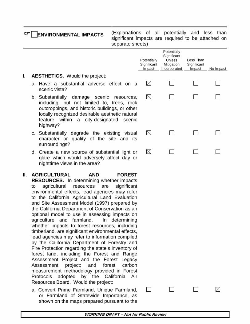
I. AESTHETICS. Would the project:
a. Have a substantial adverse effect on a scenic vista?
b. Substantially damage scenic resources, including, but not limited to, trees, rock outcroppings, and historic buildings, or other locally recognized desirable aesthetic natural feature within a city-designated scenic highway?
c. Substantially degrade the existing visual character or quality of the site and its surroundings?
d. Create a new source of substantial light or glare which would adversely affect day or nighttime views in the area?
II. AGRICULTURAL AND FOREST RESOURCES. In determining whether impacts to agricultural resources are significant environmental effects, lead agencies may refer to the California Agricultural Land Evaluation and Site Assessment Model (1997) prepared by the California Department of Conservation as an optional model to use in assessing impacts on agriculture and farmland. In determining whether impacts to forest resources, including timberland, are significant environmental effects, lead agencies may refer to information compiled by the California Department of Forestry and Fire Protection regarding the state’s inventory of forest land, including the Forest and Range Assessment Project and the Forest Legacy Assessment project; and forest carbon measurement methodology provided in Forest Protocols adopted by the California Air Resources Board. Would the project:
a. Convert Prime Farmland, Unique Farmland, or Farmland of Statewide Importance, as shown on the maps prepared pursuant to the

WORKING DRAFT – Not for Public Review
Potentially Significant
Impact
Potentially Significant
Unless Mitigation
Incorporated
Less Than Significant
Impact No Impact
Farmland Mapping and Monitoring Program of the California Resources Agency, to non-agricultural use?
b. Conflict with existing zoning for agricultural use, or a Williamson Act Contract?
c. Conflict with existing zoning for, or cause rezoning of, forest land (as defined in Public Resources Code section 12220(g)), timberland (as defined by Public Resources Code section 4526), or timberland zoned Timberland Production (as defined by Government Code section 51104(g))?
d. Result in the loss of forest land or conversion of forest land to non-forest use?
e. Involve other changes in the existing environment which, due to their location or nature, could result in conversion of Farmland, to non-agricultural use?
III. AIR QUALITY. Where available, the significance criteria established by the South Coast Air Quality Management District (SCAQMD) may be relied upon to make the following determinations. Would the project:
a. Conflict with or obstruct implementation of the South Coast Air Quality Management District (SCAQMD) Plan or Congestion Management Plan?
b. Violate any air quality standard or contribute substantially to an existing or projected air quality violation?
c. Result in a cumulatively considerable net increase of any criteria pollutant for which the air basin is non-attainment under an applicable federal or state ambient air quality standard?
d. Expose sensitive receptors to substantial pollutant concentrations?
e. Create objectionable odors affecting a substantial number of people?

WORKING DRAFT – Not for Public Review
Potentially Significant
Impact
Potentially Significant
Unless Mitigation
Incorporated
Less Than Significant
Impact No Impact
IV. BIOLOGICAL RESOURCES. Would the project:
a. Have a substantial adverse effect, either directly or through habitat modification, on any species identified as a candidate, sensitive, or special status species in local or regional plans, policies, or regulations by the California Department of Fish and Wildlife or U.S. Fish and Wildlife Service?
b. Have a substantial adverse effect on any riparian habitat or other sensitive natural community identified in the City or regional plans, policies, regulations by the California Department of Fish and Wildlife or U.S. Fish and Wildlife Service?
c. Have a substantial adverse effect on federally protected wetlands as defined by Section 404 of the Clean Water Act (including, but not limited to, marsh vernal pool, coastal, etc.) Through direct removal, filling, hydrological interruption, or other means?
d. Interfere substantially with the movement of any native resident or migratory fish or wildlife species or with established native resident or migratory wildlife corridors, or impede the use of native wildlife nursery sites?
e. Conflict with any local policies or ordinances protecting biological resources, such as tree preservation policy or ordinance (e.g., oak trees or California walnut woodlands)?
f. Conflict with the provisions of an adopted Habitat Conservation Plan, Natural Community Conservation Plan, or other approved local, regional, or state habitat conservation plan?
V. CULTURAL RESOURCES: Would the project:
a. Cause a substantial adverse change in significance of a historical resource as defined in State CEQA §15064.5?
b. Cause a substantial adverse change in significance of an archaeological resource
WORKING DRAFT – Not for Public Review
Potentially Significant
Impact
Potentially Significant
Unless Mitigation
Incorporated
Less Than Significant
Impact No Impact
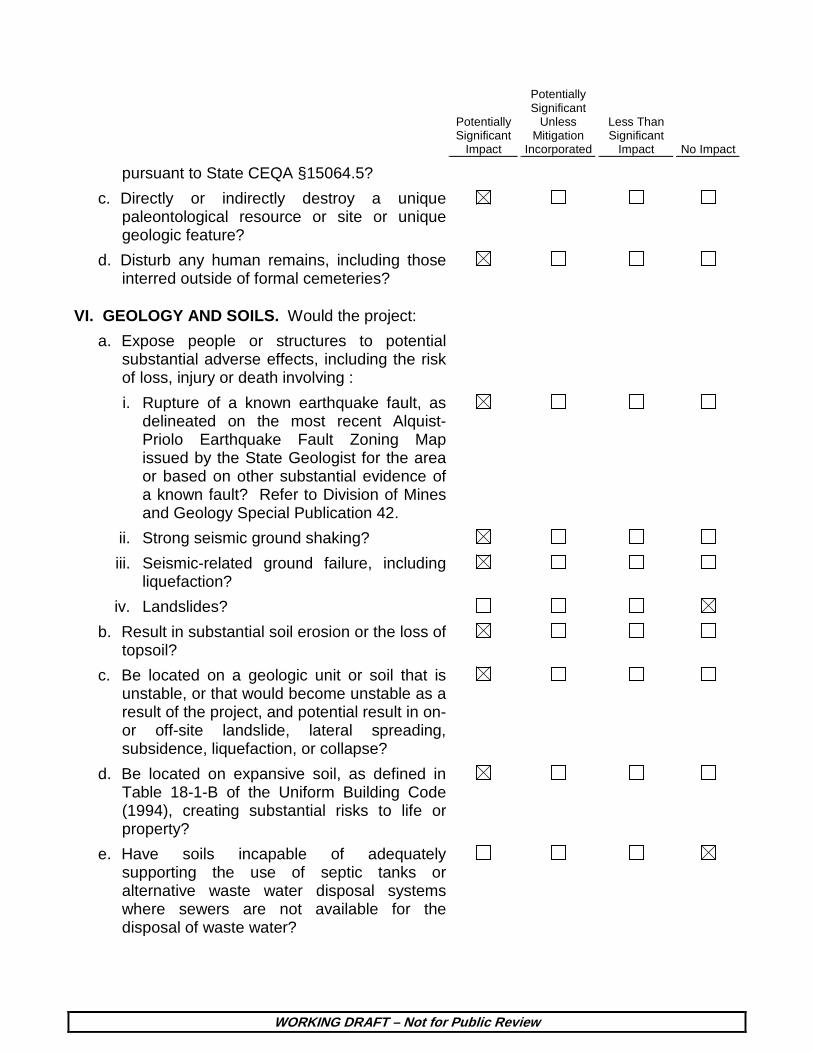
pursuant to State CEQA §15064.5? c. Directly or indirectly destroy a unique
paleontological resource or site or unique geologic feature?
d. Disturb any human remains, including those interred outside of formal cemeteries?
VI. GEOLOGY AND SOILS. Would the project:
a. Expose people or structures to potential substantial adverse effects, including the risk of loss, injury or death involving :
i. Rupture of a known earthquake fault, as delineated on the most recent Alquist-Priolo Earthquake Fault Zoning Map issued by the State Geologist for the area or based on other substantial evidence of a known fault? Refer to Division of Mines and Geology Special Publication 42.
ii. Strong seismic ground shaking?
iii. Seismic-related ground failure, including liquefaction?
iv. Landslides?
b. Result in substantial soil erosion or the loss of topsoil?
c. Be located on a geologic unit or soil that is unstable, or that would become unstable as a result of the project, and potential result in on- or off-site landslide, lateral spreading, subsidence, liquefaction, or collapse?
d. Be located on expansive soil, as defined in Table 18-1-B of the Uniform Building Code (1994), creating substantial risks to life or property?
e. Have soils incapable of adequately supporting the use of septic tanks or alternative waste water disposal systems where sewers are not available for the disposal of waste water?

WORKING DRAFT – Not for Public Review
Potentially Significant
Impact
Potentially Significant
Unless Mitigation
Incorporated
Less Than Significant
Impact No Impact
VII. GREENHOUSE GAS EMISSIONS. Would the project:
a. Generate greenhouse gas emissions, either directly or indirectly, that may have a significant impact on the environment?
b. Conflict with an applicable plan, policy or regulation adopted for the purpose of reducing the emissions of greenhouse gases?
VIII. HAZARDS AND HAZARDOUS MATERIALS. Would the project:
a. Create a significant hazard to the public or the environment through the routine transport, use, or disposal of hazardous materials
b. Create a significant hazard to the public or the environment through reasonably foreseeable upset and accident conditions involving the release of hazardous materials into the environment?
c. Emit hazardous emissions or handle hazardous or acutely hazardous materials, substances, or waste within one-quarter mile of an existing or proposed school?
d. Be located on a site which is included on a list of hazardous materials sites compiled pursuant to Government Code Section 65962.5 and, as a result, would it create a significant hazard to the public or the environment?
e. For a project located within an airport land use plan or, where such a plan has not been adopted, within two miles of a public airport or public use airport, would the project result in a safety hazard for people residing or working in the project area?
f. For a project within the vicinity of a private airstrip, would the project result in a safety hazard for the people residing or working in the area?

WORKING DRAFT – Not for Public Review
Potentially Significant
Impact
Potentially Significant
Unless Mitigation
Incorporated
Less Than Significant
Impact No Impact
g. Impair implementation of or physically interfere with an adopted emergency response plan or emergency evacuation plan?
h. Expose people or structures to a significant risk of loss, injury or death involving wildland fires, including where wildlands are adjacent to urbanized areas or where residences are intermixed with wildlands?
IX. HYDROLOGY AND WATER QUALITY. Would the project result in:
a. Violate any water quality standards or waste discharge requirements?
b. Substantially deplete groundwater supplies or interfere with groundwater recharge such that there would be a net deficit in aquifer volume or a lowering of the local groundwater table level (e.g., the production rate of pre-existing nearby wells would drop to a level which would not support existing land uses or planned land uses for which permits have been granted)?
c. Substantially alter the existing drainage pattern of the site or area, including through the alteration of the course of a stream or river, in a manner which would result in substantial erosion or siltation on- or off-site?
d. Substantially alter the existing drainage pattern of the site or area, including through the alteration of the course of a stream or river, or substantially increase the rate or amount of surface runoff in an manner which would result in flooding on- or off site?
e. Create or contribute runoff water which would exceed the capacity of existing or planned stormwater drainage systems or provide substantial additional sources of polluted runoff?
f. Otherwise substantially degrade water quality?

WORKING DRAFT – Not for Public Review
Potentially Significant
Impact
Potentially Significant
Unless Mitigation
Incorporated
Less Than Significant
Impact No Impact
g. Place housing within a 100-year flood plain as mapped on federal Flood Hazard Boundary or Flood Insurance Rate Map or other flood hazard delineation map?
h. Place within a 100-year flood plain structures which would impede or redirect flood flows?
i. Expose people or structures to a significant risk of loss, injury or death involving flooding, including flooding as a result of the failure of a levee or dam?
j. Inundation by seiche, tsunami, or mudflow?
X. LAND USE AND PLANNING. Would the project:
a. Physically divide an established community?
b. Conflict with applicable land use plan, policy or regulation of an agency with jurisdiction over the project (including but not limited to the general plan, specific plan, coastal program, or zoning ordinance) adopted for the purpose of avoiding or mitigating an environmental effect?
c. Conflict with any applicable habitat conservation plan or natural community conservation plan?
XI. MINERAL RESOURCES. Would the project:
a. Result in the loss of availability of a known mineral resource that would be of value to the region and the residents of the state?
b. Result in the loss of availability of a locally-important mineral resource recovery site delineated on a local general plan, specific plan, or other land use plan?
XII. NOISE. Would the project result in:
a. Exposure of persons to or generation of noise in level in excess of standards established in the local general plan or noise ordinance, or applicable standards of other agencies?

WORKING DRAFT – Not for Public Review
Potentially Significant
Impact
Potentially Significant
Unless Mitigation
Incorporated
Less Than Significant
Impact No Impact
b. Exposure of people to or generation of excessive groundborne vibration or groundborne noise levels?
c. A substantial permanent increase in ambient noise levels in the project vicinity above levels existing without the project?
d. A substantial temporary or periodic increase in ambient noise levels in the project vicinity above levels existing without the project?
e. For a project located within an airport land use plan or, where such a plan has not been adopted, within two miles of a public airport or public use airport, would the project expose people residing or working in the project area to excessive noise levels?
f. For a project within the vicinity of a private airstrip, would the project expose people residing or working in the project area to excessive noise levels?
XIII. POPULATION AND HOUSING. Would the project:
a. Induce substantial population growth in an area either directly (for example, by proposing new homes and businesses) or indirectly (for example, through extension of roads or other infrastructure)?
b. Displace substantial numbers of existing housing necessitating the construction of replacement housing elsewhere?
c. Displace substantial numbers of people necessitating the construction of replacement housing elsewhere?
XIV. PUBLIC SERVICES. Would the project result in substantial adverse physical impacts associated with the provision of new or physically altered governmental facilities, construction of which could cause significant environmental impacts, in order to maintain acceptable service ratios, response times or

WORKING DRAFT – Not for Public Review
Potentially Significant
Impact
Potentially Significant
Unless Mitigation
Incorporated
Less Than Significant
Impact No Impact
other performance objectives for any of the public services:
a. Fire protection?
b. Police protection?
c. Schools?
d. Parks?
e. Other governmental services (including roads)?
XV. RECREATION.
a. Would the project increase the use of existing neighborhood and regional parks or other recreational facilities such that substantial physical deterioration of the facility would occur or be accelerated?
b. Does the project include recreational facilities or require the construction or expansion of recreational facilities which might have an adverse physical effect on the environment?
XVI. TRANSPORTATION/TRAFFIC. Would the project:
a. Conflict with an applicable plan, ordinance or policy establishing measures of effectiveness for the performance of the circulation system, taking into account all modes of transportation including mass transit and non-motorized travel and relevant components of the circulation system, including but not limited to intersections, streets, highways and freeways, pedestrian and bicycle paths, and mass transit?
b. Conflict with an applicable congestion management program including, but not limited to, level of service standards and travel demand measures, or other standards established by the county congestion management agency for designated roads or highways?

WORKING DRAFT – Not for Public Review
Potentially Significant
Impact
Potentially Significant
Unless Mitigation
Incorporated
Less Than Significant
Impact No Impact
c. Result in a change in air traffic patterns, including either an increase in traffic levels or a change in location that results in substantial safety risks?
d. Substantially increase hazards to a design feature (e.g., sharp curves or dangerous intersections) or incompatible uses (e.g., farm equipment)?
e. Result in inadequate emergency access?
f. Conflict with adopted policies, plans, or programs regarding public transit, bicycle, or pedestrian facilities, or otherwise decrease the performance or safety of such facilities?
XVII. UTILITIES AND SERVICE SYSTEMS. Would the project:
a. Exceed wastewater treatment requirements of the applicable Regional Water Quality Control Board?
b. Require or result in the construction of new water or wastewater treatment facilities or expansion of existing facilities, the construction of which could cause significant environmental effects?
c. Require or result in the construction of new stormwater drainage facilities or expansion of existing facilities, the construction of which could cause significant environmental effects?
d. Have sufficient water supplies available to serve the project from existing entitlements and resource, or are new or expanded entitlements needed?
e. Result in a determination by the wastewater treatment provider which serves or may serve the project that it has adequate capacity to serve the project’s projected demand in addition to the provider’s existing commitments?
f. Be served by a landfill with sufficient permitted capacity to accommodate the

WORKING DRAFT – Not for Public Review
Potentially Significant
Impact
Potentially Significant
Unless Mitigation
Incorporated
Less Than Significant
Impact No Impact
project’s solid waste disposal needs? g. Comply with federal, state, and local statutes
and regulations related to solid waste?
h. Other utilities and service systems?
XVIII. MANDATORY FINDINGS OF SIGNIFICANCE.
a. Does the project have the potential to degrade the quality of the environment, substantially reduce the habitat of fish or wildlife species, cause a fish or wildlife population to drop below self-sustaining levels, threaten to eliminate a plant or animal community, reduce the number or restrict the range of a rare or endangered plant or animal or eliminate important examples of the major periods of California history or prehistory?
b. Does the project have impacts which are individually limited, but cumulatively considerable? (“Cumulatively considerable” means that the incremental effects of an individual project are considerable when viewed in connection with the effects of past projects, the effects of other current projects, and the effects of probable future projects).
c. Does the project have environmental effects which cause substantial adverse effects on human beings, either directly or indirectly?

WORKING DRAFT – Not for Public Review
DISCUSSION OF THE ENVIRONMENTAL EVALUATION (Attach additional sheets if necessary)
PREPARED BY Stephanie Eyestone-Jones Eyestone Environmental, LLC 6701 Center Drive, Suite 900 Los Angeles, CA 90045
TITLE President
TELEPHONE # (424) 207-5333
DATE September 2015

City of Los Angeles Crossroads Hollywood September 2015
Page A-1
WORKING DRAFT – Not for Public Review
Attachment A: Project Description
A. Introduction CRE-HAR Crossroads SPV, LLC, the Project Applicant, proposes to construct a
mixed-use development (the Project) across four City blocks in the Hollywood Community of the City of Los Angeles (the Project Site). The 8.0-acre (348,419-square-foot) Project Site is generally bounded by Selma Avenue to the north; the Blessed Sacrament Church and School and associated surface parking to the east; Sunset Boulevard to the south; and Highland Avenue to the west. The Project Site includes the Crossroads of the World complex, which is a designated City Cultural-Historic Monument and also appears on the National Register of Historic Places and the California Register of Historic Resources. The Project would retain, preserve, and rehabilitate Crossroads of the World, and integrate it into a new, mixed-use development that would include eight new mixed-use buildings with residential, hotel, commercial/retail, office, entertainment, and restaurant uses. Upon build-out, the Project (including existing uses to be retained) would include approximately 1,432,000 square feet of floor area consisting of 950 residential units, 308 hotel rooms, approximately 95,000 square feet of office uses, and approximately 185,000 square feet of commercial/retail uses. The proposed floor area ratio (FAR) would be approximately 4.69:1 averaged across the Project Site.1 The Project would remove all other existing on-site land uses that are not part of Crossroads of the World, including surface parking lots and approximately 86,947 square feet of existing floor area comprised of 84 residential units (including 80 multi-family dwelling units and two duplexes) and low-density commercial/retail and office uses.
B. Project Location and Surrounding Uses The Project Site is located in the Hollywood Community of the City of Los Angeles,
approximately 7 miles northwest of downtown Los Angeles and approximately 12 miles east of the Pacific Ocean. Primary regional access is provided by the US-101 Freeway
1 The Project Site includes the Las Palmas Avenue right-of-way between Selma Avenue and Sunset
Boulevard as well as perimeter sidewalks. These areas are not included in the calculation of Floor Area Ratio (FAR) pursuant to Los Angeles Municipal Code (LAMC) Section 12.03. For purposes of calculating FAR, the Project Site area is 303,444 square feet (approximately 7.0 acres).
Attachment A: Project Description
City of Los Angeles Crossroads Hollywood September 2015
Page A-2 WORKING DRAFT – Not for Public Review
(Hollywood Freeway), which runs southeast-northwest approximately 1 mile east of the Project Site. The major arterials providing regional and sub-regional access to the Project Site vicinity include Hollywood Boulevard to the north, Cahuenga Boulevard to the east, Sunset Boulevard to the south, and Highland Avenue to the west. A regional map of the Project area is provided in Figure A-1 on page A-3.
The irregular-shaped Project Site consists of 29 individual parcels across four City blocks. As shown in the aerial map in Figure A-2 on page A-4, the individual parcels are grouped into four Project areas referred to as Development Parcels A, B, C, and D. Generally, the Project Site is bounded by Selma Avenue to the north; the Blessed Sacrament Church and School and associated surface parking to the east; Sunset Boulevard to the south; and Highland Avenue to the west. Development Parcel D is located on the northeast corner of Selma Avenue and Las Palmas Avenue. The remaining Development Parcels are located south of Selma Avenue.
The surrounding area is highly urbanized and includes a mix of low- to high-rise buildings, historic and modern, occupied by neighborhood-serving commercial uses, tourist and entertainment-related commercial uses, offices, hotels, educational institutions, and single-family and multi-family residential uses. Immediately surrounding uses include the Blessed Sacrament Catholic Church and First Baptist Church, a plant nursery, commercial strip malls, a Rite-Aid pharmacy, Panavision, LA Recording School, a multi-story office building, and surface parking lots. Several school facilities are located within 0.25 mile of the Project Site, including Hollywood High School to the west, and Selma Avenue Elementary School and the Larchmont Charter School West facility (located within Selma Avenue Elementary School grounds) to the north. Along the southern boundary of the Project Site, uses fronting Sunset Boulevard include a varied mix of commercial retail and restaurant uses, entertainment-related uses, and nightclubs. The Hollywood and Highland shopping center and entertainment complex is located less than 1,000 feet from the Project Site at the corner of Hollywood Boulevard and Highland Avenue. The Hollywood/Highland Red Line Station, part of the Los Angeles County Metropolitan Transportation Authority (Metro) rail system, is also located at this intersection. The Project area is characterized by considerable pedestrian activity.
C. Existing Project Site Conditions As detailed below, the Project Site is currently developed with various uses including
low-density commercial and office uses in the historic Crossroads of the World property, two residential duplexes, two-story multi-family apartment buildings housing a total of 80 dwelling units, one- and two-story structures used for commercial office and retail uses, and surface parking lots. Existing on-site uses include a total of approximately 154,947 square feet of floor area. Intermittent landscaping is dispersed throughout the

Attachment A: Project Description
City of Los Angeles Crossroads Hollywood September 2015
Page A-3 WORKING DRAFT – Not for Public Review
Figure A-1 Project Location Map
Attachment A: Project Description
City of Los Angeles Crossroads Hollywood September 2015
Page A-4 WORKING DRAFT – Not for Public Review
Figure A-2 Aerial Photograph of the Project Vicinity
Attachment A: Project Description
City of Los Angeles Crossroads Hollywood September 2015
Page A-5 WORKING DRAFT – Not for Public Review
Project Site and generally consists of ornamental trees and shrubs. The existing site plan is provided in Figure A-3 on page A-6.
Specifically, existing development on Development Parcel A of the Project Site includes one- and two-story commercial/retail uses and surface parking areas. Existing development on Development Parcel B of the Project Site includes a single-story commercial use fronting McCadden Place, two residential duplexes on Selma Avenue, two two-story multi-family residential buildings along Selma Avenue and Las Palmas Avenue, a small single-story chiropractic office along Las Palmas Avenue, a one- to two-story building consisting of community-serving small retail shops along Sunset Boulevard, and a one- to three-story office building also along Sunset Boulevard. Existing development on Development Parcel C of the Project Site includes the Crossroads of the World, which is a designated City Cultural-Historic Monument (Monument #134) and also listed on the National Register of Historic Places and the California Register of Historic Resources. The approximate 68,000-square-foot complex consists of a series of one- and two-story office, retail and restaurant shops in a variety of architectural styles such as Streamline Moderne, French and Spanish influenced designs, English village style, and a Moorish building. The shops are connected by a series of landscaped walkways with pedestrian entrances on Sunset Boulevard, Las Palmas Avenue, and Selma Avenue. The complex was designed in 1936 to create an “Old World” Atmosphere as the City’s first outdoor pedestrian village and included a mix of shopping, dining, and entertainment uses. Development Parcel C of the Project Site also includes a two-story office/retail building west of Crossroads of the World and along Sunset Boulevard, one- and two-story office buildings along Las Palmas Avenue, and a surface parking lot serving Crossroads of the World. Existing development on Development Parcel D of the Project Site includes a two-story commercial/retail building and a surface parking lot.
1. Land Use and Zoning
(a) Hollywood Community Plan
The Project Site is located within the planning boundary of the Hollywood Community Plan (Community Plan), adopted in December 1988. The Project Site is designated as Regional Center Commercial by the Community Plan, which corresponds with the C2 (Commercial), C4 (Commercial), RAS4 (Residential/Accessory), R5 (Multiple Dwelling Residential), P (Automobile Parking—Surface and Underground), and PB (Parking Building) zones in the Los Angeles Municipal Code (LAMC).
The Project Site is also located within the Hollywood Center, which is generally located on both sides of Hollywood and Sunset Boulevards between La Brea Avenue and

Attachment A: Project Description
City of Los Angeles Crossroads Hollywood September 2015
Page A-6 WORKING DRAFT – Not for Public Review
Figure A-3 Existing Site Plan

Attachment A: Project Description
City of Los Angeles Crossroads Hollywood September 2015
Page A-7 WORKING DRAFT – Not for Public Review
Gower Street.2 The Community Plan calls for the Hollywood Center to function as: (1) the commercial center for Hollywood and surrounding communities; and (2) an entertainment center for the entire region. The Community Plan further states that development combining residential and commercial uses are especially encouraged in the Hollywood Center.
(b) City of Los Angeles Municipal Code
The Project Site is zoned by the LAMC as C4-2D (Commercial, Height District 2 with Development Limitation) and C4-2D-SN (Commercial, Height District 2 with Development Limitation, Signage Supplemental Use District). Specifically, the western parcels fronting Highland Avenue in Development Parcel A and the southern parcels fronting Sunset Boulevard in Development Parcel B are zoned C4-2D-SN, while the remainder of the Project Site is zoned C4-2D.
With some limitations (as identified in the LAMC), the C4 zone permits any land use permitted in the C2 zone, which in turn permits any land use permitted in the C1.5 and C1 zones. The Commercial zones permit a wide array of land uses such as retail stores, offices, hotels, schools, parks, and theaters. The C4 zone also permits any land use permitted in the R4 (Multiple Residential) zone, which includes one-family dwellings, two-family dwellings, apartment houses, multiple dwellings, and home occupations at a maximum density of 108 dwelling units per acre (a minimum lot area of 400 sf per dwelling unit). The C4 zone also permits residential development at the density permitted in the R5 zone (a maximum density of 217 dwelling units per acre, based on a minimum lot area of 200 sf per dwelling unit) when a mix of commercial and residential uses is being developed, pursuant to LAMC section 12.22.A.18(a). Height District 2 within the C4 zone does not impose a height limitation and has a maximum Floor Area Ratio (FAR) of 6:1. The Development “D” Limitation in the zoning prefix indicates that development shall not exceed a FAR of 2:1 and 3:1 unless certain approvals are received. The “SN” designation identified for the C4-2D-SN-zoned parcels in Development Parcels A and B indicates that these parcels are located in the Hollywood Signage Supplemental Use District.
(c) Other Applicable Land Use Regulations
The Project Site is located in the Hollywood Redevelopment Plan (Redevelopment Plan) and Hollywood Adaptive Reuse Incentive Area. As discussed above, certain individual parcels located within Development Parcels A and B are located within the
2 City of Los Angeles, Hollywood Community Plan, December 13, 1988, p. HO-2.

Attachment A: Project Description
City of Los Angeles Crossroads Hollywood September 2015
Page A-8 WORKING DRAFT – Not for Public Review
boundaries of the Hollywood Signage Supplemental Use District. Development Parcel D is located in the Hollywood Entertainment Business Improvement District.
D. Project Characteristics 1. Project Overview
The Project proposes to redevelop the Project Site with a cohesive, mixed-use development that blends the distinguishing character of Crossroads of the World with a collection of new buildings of modern design and creates an open-air pedestrian district with a mix of shopping, dining, and entertainment uses. In so doing, Crossroads of the World, which is a designated City Cultural-Historic Monument (Monument #134) and is also listed on the National Register of Historic Places and the California Register of Historic, would be retained, preserved, and rehabilitated as part of the Project. Existing on-site land uses not part of Crossroads of the World, including 84 residential units (including 80 multi-family dwelling units and two duplexes) and low-density commercial/retail and office uses, as well as surface parking lots, would be demolished and replaced with eight new mixed-use buildings that would include residential, hotel, commercial/retail, office, entertainment, and restaurant uses. Upon build-out, the Project would include approximately 950 residential units, 308 hotel rooms, approximately 95,000 square feet of office uses, and approximately 185,000 square feet of commercial/retail uses, totaling approximately 1,432,000 square feet of floor area (including existing uses to be retained). The Project would demolish a total of approximately 86,947 square feet of existing floor area. Therefore, the Project would result in an increase of approximately 1,345,053 square feet of net new floor area on the Project Site.
The Project also includes vehicular and pedestrian circulation improvements, including the re-alignment of Las Palmas Avenue at Sunset Boulevard. Currently, the Las Palmas Avenue street segment north of Sunset Boulevard lies easterly of its street segment south of Sunset Boulevard. The Project would realign the street so that Las Palmas Avenue would be a proper “thru” street at Sunset Boulevard. The Project also proposes to establish a new pedestrian passageway that would extend diagonally from Sunset Boulevard at the frontage of Crossroads of the World to the corner of Selma Avenue and McCadden Place.
The Project Site includes four areas referred to as Development Parcels A, B, C, and D. The Development Parcels include nine sub-areas: Parcel A includes Building A1; Parcel B includes Buildings B1, B2, B3, and B4; Parcel C includes Buildings C1, C2, and Crossroads of the World; and Parcel D includes Building D1. These sub-areas are discussed in further detail below. Table A-1 on page A-9 provides a summary of the types and sizes of land uses included in the Project. The proposed conceptual site plan is

Attachment A: Project Description
City of Los Angeles Crossroads Hollywood September 2015
Page A-9
WORKING DRAFT – Not for Public Review
Table A-1 Summary of the Proposed Development Areas
Development Area Land Use Proposed Developmenta
Development Parcel A Building A1 Hotel 348,500 sfb
(308 rm) Retail 10,500 sf Development Parcel A Subtotal
Hotel 348,500 sf b
(308 rm) Retail 10,500 sf Development Parcel B Building B1 Residential (Condominiums) 219,000 sf
(190 du) Retail 15,500 sf Building B2 Residential (Rental) 52,500 sf
(70 du) Retail 12,000 sf Building B3 Residential (Rental) 358,000 sf
(489 du) Retail 11,000 sf Building B4 Residential (Rental) 114,000 sf
(123 du) Retail 20,000 sf Development Parcel B Subtotal
Residential 743,500 sf (872 du)
Retail 58,500 sf Development Parcel C Building C1 Retail 27,000 sf Office 50,000 sf Building C2 Retail 16,500 sf Office 45,000 sf Crossroads of the World (existing)
Retail 68,000 sf
Development Parcel C Subtotal
Retail 111,500 sf
Office 95,000 sf Development Parcel D Building D1 Residential (Rental) 60,500 sf
(78 du) Retail 4,500 sf

Attachment A: Project Description
Table A-1 (Continued) Summary of the Proposed Development Areas
City of Los Angeles Crossroads Hollywood September 2015
Page A-10 WORKING DRAFT – Not for Public Review
Development Area Land Use Proposed Developmenta Development Parcel D Subtotal
Residential (Rental) 60,500 sf (78 du)
Retail 4,500 sf Total Residential (Condominiums + Rental)
804,000 sf 950 du
(190 du condominiums) (760 du rental units)
Total Retail 185,000 sf Total Office 95,000 sf Total Hotel 348,500 sf
(308 rm) Total Proposed Floor Areac 1,432,000 sfd
sf = square feet du = dwelling unit rm = hotel rooms a Square footages are rounded up to the nearest 500 square feet. b Hotel square footage includes approximately 39,000 square feet of hotel amenities. c Except where otherwise noted, square footage is calculated pursuant to the LAMC definition of
floor area for the purpose of calculating FAR. In accordance with LAMC Section 12.03, floor area is defined as: “[t]he area in square feet confined within the exterior walls of a building, but not including the area of the following: exterior walls, stairways, shafts, rooms housing building-operating equipment or machinery, parking areas with associated driveways and ramps, space for the landing and storage of helicopters, and basement storage areas.”
d Includes the existing Crossroads of the World complex, which would be retained. Source: Skidmore Ownings & Merrill, LLP / Rios Clementi Hale Studios, 2015.
included in Figure A-4 on page A-11. A conceptual rendering of the Project from Sunset Boulevard is illustrated in Figure A-5 on page A-12.
(a) Development Parcel A—Hotel Area (Building A1)
The Project would remove all existing land uses on Development Parcel A and construct Building A1 which would be located on the southeast corner of Selma Avenue and Highland Avenue. Building A1 would consist of an approximately 348,500-square-foot high-rise structure with a 308-room hotel, ancillary meeting rooms, a lobby lounge and bar, a rooftop bar and lounge, and ground floor restaurant and retail uses. Approximately 10,500 square feet of ground-floor commercial/retail uses would also be located in Building A1. Building A1 would be approximately 32-stories tall and would reach a maximum height of approximately 365 feet.

Attachment A: Project Description
City of Los Angeles Crossroads Hollywood September 2015
Page A-11 WORKING DRAFT – Not for Public Review
Figure A-4 Conceptual Site Plan
Attachment A: Project Description
City of Los Angeles Crossroads Hollywood September 2015
Page A-12 WORKING DRAFT – Not for Public Review
Figure A-5 Conceptual Rendering of the Project

Attachment A: Project Description
City of Los Angeles Crossroads Hollywood September 2015
Page A-13 WORKING DRAFT – Not for Public Review
(b) Development Parcels B and D—Mixed-Use Residential and Retail Area (Buildings B1, B2, B3, B4, and D1)
The Project would remove all existing land uses on Development Parcels B and D and construct a total of five mixed-use residential buildings with ground-floor commercial/retail uses: Buildings B1, B2, B3, B4, and D1. Development Parcel B, consisting of Buildings B1, B2, B3, and B4, would include a total of approximately 872 residential units and approximately 58,500 square feet of commercial retail uses. Specifically, Building B1 would consist of 190 residential units and approximately 15,500 square feet of ground-floor commercial/retail uses. Building B1 would consist of 30 floors and would reach a maximum height of approximately 402 feet above grade. Building B2 would consist of 70 residential units and approximately 12,000 square feet of ground-floor commercial/retail uses. Building B2 would consist of 6 floors and would reach a maximum height of approximately 90 feet above grade. Building B3 would consist of 489 residential units and approximately 11,000 square feet of ground-floor commercial/retail uses. Building B3 would consist of 32 floors and would reach a maximum height of approximately 390 feet above grade. Building B4 would consist of 123 residential units and approximately 20,000 square feet of ground-floor commercial/retail uses. Building B4 would consist of 6 floors in addition to a mezzanine floor and would reach a maximum height of approximately 95 feet above grade.
Development Parcel D consists of Building D1, which would include approximately 78 residential units and approximately 4,500 square feet of ground-floor commercial/retail uses. Building D1 would consist of 6 floors and would reach a maximum height of approximately 85 feet above grade.
In total, Development Parcels B and D would have 950 residential units and approximately 63,000 square feet of ground-floor commercial/retail uses. Of the 950 residential units proposed as part of the Project, 80 units would be affordable housing rental units, which would replace the existing 80 rent-stabilized units located in Development Parcel B that would be removed.
(c) Development Parcel C—Commercial Area (Buildings C1 & C2, Crossroads of the World)
The commercial portion of the Project consisting of creative office and retail/restaurant uses would be located in Development Parcel C located east of Las Palmas Avenue and directly adjacent to the historic Crossroads of the World site. As previously discussed, Crossroads of the World, which includes approximately 68,000 square feet of office and retail uses, would be retained, preserved, and rehabilitated as part of the Project. New development on Development Parcel C would include Buildings C1 and C2. Building C1 would consist of approximately 50,000 square feet of office uses and approximately

Attachment A: Project Description
City of Los Angeles Crossroads Hollywood September 2015
Page A-14 WORKING DRAFT – Not for Public Review
27,000 square feet of ground-floor retail uses. Building C1 would consist of 3 floors and would reach a maximum height of approximately 65 feet above grade. Building C2 would consist of approximately 45,000 square feet of office uses and 16,500 square feet of ground-floor retail uses. Building C2 would consist of two floors and would reach a maximum height of approximately 80 feet above grade. In total, Development Parcel C would consist of approximately 95,000 square feet of office uses and approximately 111,500 square feet of retail uses (including existing uses to be retained).
2. Setback and FAR The Project would include approximately 1,432,000 square feet of developed floor
area (including existing uses to be retained) corresponding with a total FAR of approximately 4.69:1 averaged across the Project Site.3 Setbacks for individual buildings across the Project Site would be provided in accordance with LAMC-required setbacks for the C4 zone. Specifically, the C4 zone does not require front, side, or rear yard setbacks for commercial uses. Residential uses in the C4 zone must provide setbacks corresponding with R4 zone requirements at the lowest residential story, which include 15-foot front and rear yards and 3- to 5-foot side yards.
3. Access, Circulation, and Parking The Project proposes the re-alignment of Las Palmas Avenue at Sunset Boulevard.
Currently, the Las Palmas Avenue street segment north of Sunset Boulevard lies easterly of its street segment south of Sunset Boulevard, thereby creating a dangerous and inefficient intersection. The Project proposes to re-align the street so that Las Palmas Avenue would be a “thru” street at Sunset Boulevard. This improved connectivity and integration would improve vehicular circulation, automobile and pedestrian safety, and the condition of the public right-of-way.
Vehicular access to the Project would be provided via several access points. Access to Development Parcel A would be via McCadden Place; residential parking for Development Parcel B would be accessible via McCadden Place, and Las Palmas Avenue; visitor parking for Development Parcel C would be accessible via two driveways on Las Palmas Avenue; and parking for Development Parcel D would be via a single driveway on Las Palmas Avenue. Loading areas would be located within Development Parcels B and C and would be accessible via Las Palmas Avenue. Valet drop-off would also be available along Las Palmas Avenue and handicap drop-off would be available on Las Palmas Avenue and Selma Avenue. The locations of the driveway cuts are new and would require
3 See Footnote 1 on page A-1.

Attachment A: Project Description
City of Los Angeles Crossroads Hollywood September 2015
Page A-15 WORKING DRAFT – Not for Public Review
review and approval by the Los Angeles Department of Transportation (LADOT) for placement, width, and spacing.
New, below-grade parking would be provided for all portions of the Project. Specifically, Development Parcels A, B, and C would have five levels of subterranean parking, while Development Parcel D would have three levels of subterranean parking. Development Parcel A would provide approximately 409 parking spaces for hotel and retail visitors, Development Parcels B and C would provide approximately 2,083 parking spaces, and Development Parcel D would provide approximately 104 parking spaces. In total, the Project would provide approximately 2,596 parking spaces for residents and visitors to the Project Site. Furthermore, Development Parcel A would provide approximately 40 bicycle parking spaces, Development Parcels B and C would provide approximately 1,149 bicycle parking spaces, and Development Parcel D would provide approximately 92 bicycle parking spaces. In total, approximately 1,281 bicycle parking would be provided to the residents and visitors of the Project.
The Project also proposes to establish a new pedestrian passageway that would extend diagonally from Sunset Boulevard at the frontage of Crossroads of the World to the corner of Selma Avenue and McCadden Place. The pedestrian passageway would be linked through additional landscaped public walkways and connect the entire Project Site while promoting access from Sunset Boulevard, Las Palmas Avenue, Selma Avenue, and McCadden Place.
4. Sewer System Improvements The Project includes on-site and off-site improvements to the existing sanitary sewer
system to serve the Project’s demand for wastewater conveyance. Specifically, the on-site 30-inch sewer main in Las Palmas Avenue from Selma Avenue to Sunset Boulevard would be removed and replaced with new sewer mains in the following off-site locations: Selma Avenue from Las Palmas Avenue to Cassil Place, Cassil Place from Selma Avenue to Sunset Boulevard, and Sunset Boulevard from Cassil Place to Las Palmas Avenue. New sewer mains would be constructed in accordance with Los Angeles Department of Public Works Bureau of Sanitation (BOS) requirements.
5. Landscaping and Open Space The Project would provide a variety of open space and recreational amenities. The
Project would include open space and green space, consisting of a series of integrated walkways that connect the dynamic mixed-use district with Hollywood neighborhoods. Proposed additional landscaped public walkways would also promote access and
Attachment A: Project Description
City of Los Angeles Crossroads Hollywood September 2015
Page A-16 WORKING DRAFT – Not for Public Review
connectivity from Sunset Boulevard, Las Palmas Avenue, Selma Avenue, and McCadden Place.
In addition, the Project would also include roofdecks and pools, community rooms, courtyards, landscaped gardens, common open space with gathering and seating areas, and active and passive recreational space. In total, approximately 120,500 square feet of open space would be provided, which would meet the requirements for open space provisions for new residential projects set forth in LAMC Section 12.21.G.
6. Lighting and Signage Project signage would be designed to be aesthetically compatible with the proposed
architecture of the site and other signage in the area. The types and extent of permitted signage would emphasize the commercial and entertainment-oriented aspect of the Project Site. Proposed signage would include monument or mounted project identity signage, building and commercial tenant signage, and general ground-level and wayfinding pedestrian signage, as permitted by the Hollywood Signage Supplemental Use District. Wayfinding signs would be located at parking garage entrances, elevator lobbies, vestibules, and residential corridors.
Exterior lighting along the public areas would include pedestrian-scale fixtures and elements. Project lighting would incorporate low-level exterior lights adjacent to buildings and along pathways for security and wayfinding purposes. In addition, low-level lighting to accent signage, architectural features, and landscaping elements would be incorporated throughout the Project Site. Project lighting would be designed to provide for efficient, effective, and aesthetically pleasing lighting solutions that would minimize light trespass from the Project Site. All on-site exterior lighting would be automatically controlled to illuminate only when required and would be shielded or directed toward areas to be illuminated and, thereby, limit spillover onto nearby residential areas. In addition, all interior lighting would be equipped with occupancy sensors that would automatically extinguish and/or dim lights when not in use.
All new street and pedestrian lighting within the public right-of-way would comply with applicable City regulations and would be approved by the Bureau of Street Lighting in order to maintain appropriate and safe lighting levels on both sidewalks and roadways while minimizing light and glare on adjacent properties.
7. Sustainability Features The Project would incorporate features to support and promote environmental
sustainability. “Green” principles are incorporated throughout the Project to comply with

Attachment A: Project Description
City of Los Angeles Crossroads Hollywood September 2015
Page A-17 WORKING DRAFT – Not for Public Review
the City of Los Angeles Green Building Code (Ordinance No. 181,480). These include energy conservation, water conservation, and waste reduction features. Furthermore, the Project Site is located less than 0.25 mile from the Metro Red Line Station at Hollywood Boulevard and Highland Avenue. As such, the Project Site’s location would support the use of public transportation and a reduction in vehicle miles traveled by Project residents. Additionally, as noted above, the Project would provide approximately 1,281 bicycle parking spaces for residents and visitors.
E. Project Construction and Scheduling Construction of the Project would be conducted in phases. Project construction
would commence with demolition of the existing buildings and surface parking lots, followed by grading and excavation for the subterranean parking garages. Building foundations would then be placed, followed by building construction, paving/concrete installation, and landscape installation. Project construction is anticipated to occur over approximately 48 months and be completed in 2022. It is estimated that approximately 707,500 cubic yards (cy) of soil would be hauled from the Project Site during the grading and excavation phase. As part of the Project, a Construction Traffic Management Plan and Truck Haul Route Program would be implemented during construction to minimize potential conflicts between construction activity and through traffic. The Construction Traffic Management Plan and Truck Haul Route Program would be subject to LADOT review and approval.
F. Necessary Approvals The City of Los Angeles has the principal responsibility for approving the Project.
Approvals required for development of the Project may include, but not limited to, the following:
• Zone and Height District change from C4-2D and C4-2D-SN to C4-2 and C4-2-SN;
• Site plan review;
• Major Development Project Conditional Use Permit pursuant to LAMC Section 12.24.U.14;
• Master Conditional Use Permit for the sale of alcoholic beverages and for live entertainment in connection with a total of 22 alcohol-related uses, connected with the Project’s proposed hotel and commercial uses;

Attachment A: Project Description
City of Los Angeles Crossroads Hollywood September 2015
Page A-18 WORKING DRAFT – Not for Public Review
• Conditional Use Permit to permit floor area and density averaging in a unified development;
• Zone variance to permit outdoor eating areas above the ground floor; and
• Other discretionary and ministerial permits and approvals that may be deemed necessary, including but not limited to temporary street closure permits, grading permits, excavation permits, foundation permits, and building permits.

City of Los Angeles Crossroads Hollywood September 2015
Page B-1 WORKING DRAFT – Not for Public Review
Attachment B: Explanation of Checklist Determinations
The following discussion provides responses to each of the questions set forth in the City of Los Angeles Initial Study Checklist. The responses below indicate those issues that are expected to be addressed in an Environmental Impact Report (EIR) and demonstrate why other issues would not result in a potentially significant environmental impact and thus do not need to be addressed further in an EIR. The questions with responses that indicate a “Potentially Significant Impact” do not presume that a significant environmental impact would result from the Project. Rather, such responses indicate those issues that will be addressed in an EIR with conclusions of impact reached as part of the analysis within that future document.
I. Aesthetics Would the project:
a. Have a substantial adverse effect on a scenic vista?
Potentially Significant Impact. A scenic vista is a view of a valued visual resource. The Project Site is currently developed with various uses including low-density commercial/retail and office uses, residential uses, and surface parking lots. The Project would develop eight new buildings with a maximum height of approximately 402 feet. The Project would retain, preserve, and rehabilitate Crossroads of the World, and integrate it into a new, mixed-use development that would include residential, hotel, commercial office, retail, and restaurant uses. The Project would develop eight new buildings that would range from 3 to 32 floors with a maximum height of approximately 402 feet. The proposed structures could be visible within scenic vistas of valued visual resources, including views from the Hollywood Hills located north of the Project Site looking towards the Project Site. Therefore, the EIR will provide further analysis of the Project’s potential impacts to scenic vistas.
b. Substantially damage scenic resources, including, but not limited to, trees, rock outcroppings, and historic buildings, or other locally recognized desirable aesthetic natural feature within a city-designated scenic highway?
Attachment B: Explanation of Checklist Determinations
City of Los Angeles Crossroads Hollywood September 2015
Page B-2 WORKING DRAFT – Not for Public Review
Potentially Significant Impact. The Project Site is not located in proximity to a City-designated scenic highway. Nonetheless, the Project could result in impacts to the views of historic buildings located near the Project Site. Furthermore, the Project Site includes the Crossroads of the World, which is a designated City Cultural-Historic Monument and also appears on the National Register of Historic Places and the California Register of Historic resources. Thus, the EIR will provide further analysis of the Project’s potential impacts to scenic resources or other locally recognized desirable aesthetic natural feature.
c. Substantially degrade the existing visual character or quality of the site and its surroundings?
Potentially Significant Impact. The Project would change the visual character of the Project Site and its surroundings by removing several buildings and developing eight new buildings that would range from 3 to 32 floors with a maximum height of approximately 402 feet. Therefore, the EIR will provide further analysis of the Project’s potential impacts to visual character.
d. Create a new source of substantial light or glare which would adversely affect day or nighttime views in the area?
Potentially Significant Impact. The Project Site currently generates artificial light and glare typical of urbanized areas. Light sources include low-level security lighting, vehicle headlights, interior lighting emanating from the existing residential, commercial, and office use buildings, signage and architectural lighting. Glare sources include glass and metal vehicle and building surfaces. The Project would introduce new sources of light and glare that are typical of an urban environment. Furthermore, as discussed above, the Project would include eight new structures that would range in height from 3 to 32 floors. As such, the Project would result in nighttime lighting and would have the potential to shade adjacent land uses. Therefore, the EIR will provide further analysis of the Project’s potential impacts with regard to light, glare, and shading.
II. Agricultural and Forest Resources In determining whether impacts to agricultural resources are significant environmental effects, lead agencies may refer to the California Agricultural Land Evaluation and Site Assessment Model (1997) prepared by the California Department of Conservation as an optional model to use in assessing impacts on agriculture and farmland. In determining whether impacts to forest resources, including timberland, are significant environmental effects, lead agencies may refer to information compiled by the California Department of Forestry and Fire Protection regarding the state’s inventory of forest land, including the Forest and Range Assessment Project and the Forest Legacy Assessment project; and

Attachment B: Explanation of Checklist Determinations
City of Los Angeles Crossroads Hollywood September 2015
Page B-3 WORKING DRAFT – Not for Public Review
forest carbon measurement methodology provided in Forest Protocols adopted by the California Air Resources Board. Would the project:
a. Convert Prime Farmland, Unique Farmland, or Farmland of Statewide Importance, as shown on the maps prepared pursuant to the Farmland Mapping and Monitoring Program of the California Resources Agency, to non-agricultural use?
No Impact. The Project Site is currently developed with various uses including low-density commercial/retail and office uses, residential uses, and surface parking lots. No agricultural uses or operations occur on-site. In addition, the Project Site and surrounding area are not mapped as Prime Farmland, Unique Farmland, or Farmland of Statewide Importance pursuant to the Farmland Mapping and Monitoring Program of the California Resources Agency. As such, the Project would not convert farmland to non-agricultural use. No impacts would occur and no mitigation measures would be required. No further evaluation of this topic in an EIR is required.
b. Conflict with the existing zoning for agricultural use, or a Williamson Act Contract?
No Impact. The Project Site is not zoned for agricultural use under the Los Angeles Municipal Code (LAMC). Furthermore, no agricultural zoning is present in the surrounding area. The Project Site and surrounding area are not enrolled under a Williamson Act Contract.1 Therefore, the Project would not conflict with any zoning for agricultural uses or a Williamson Act Contract. No impacts would occur and no mitigation measures would be required. No further evaluation of this topic in an EIR is required.
c. Conflict with existing zoning for, or cause rezoning of, forest land (as defined in Public Resources Code section 12220(g)), timberland (as defined by Public Resources Code section 4526), or timberland zoned Timberland Production (as defined by Government Code section 51104(g))?
No Impact. The Project Site is located in an urbanized area and does not include any forest or timberland. Additionally, the Project Site is not zoned for forest land. Therefore, the Project would not rezone forest land or timberland as defined by the Public Resources Code. No impacts would occur and no mitigation measures would be required. No further evaluation of this topic in an EIR is required.
1 City of Los Angeles Department of City Planning, Zone Information and Map Access System (ZIMAS),
Parcel Profile Report, http://zimas.lacity.org/, accessed March 24, 2015.

Attachment B: Explanation of Checklist Determinations
City of Los Angeles Crossroads Hollywood September 2015
Page B-4 WORKING DRAFT – Not for Public Review
d. Result in the loss of forest land or conversion of forest land to non-forest use?
No Impact. As discussed above, the Project Site is located in an urbanized area, and does not include any forest or timberland. Therefore, the Project would not result in the loss or conversion of forest land. No impacts would occur and no mitigation measures would be required. No further evaluation of this topic in an EIR is required.
e. Involve other changes in the existing environment which, due to their location or nature, could result in conversion of Farmland, to non-agricultural use?
No Impact. As described above, the Project Site is located within an urbanized area and is developed with a variety of uses. The Project Site and surrounding area are not mapped as farmland, are not zoned for farmland or agricultural use, and do not contain any agricultural uses. As such, the Project would not result in the conversion of farmland to non-agricultural use. No impacts would occur and no mitigation measures would be required. No further evaluation of this topic in an EIR is required.
III. Air Quality Where available and applicable, the significance criteria established by the South Coast Air Quality Management District (SCAQMD) may be relied upon to make the following determinations. Would the project:
a. Conflict with or obstruct implementation of the South Coast Air Quality Management District (SCAQMD) Plan or Congestion Management Plan?
Potentially Significant Impact. The Project Site is located within the 6,700-square-mile South Coast Air Basin (Basin). Within the Basin, the South Coast Air Quality Management District (SCAQMD) is required, pursuant to the federal Clean Air Act, to reduce emissions of criteria pollutants for which the Basin is in non-attainment (i.e., ozone, particulate matter less than ten microns in size [PM10],2 particulate matter less than 2.5 microns in size [PM2.5], and lead3). As such, the Project would be subject to the SCAQMD’s 2012 Air Quality Management Plan (AQMP). The AQMP contains a comprehensive list of pollution control strategies directed at reducing emissions and achieving ambient air quality standards. These strategies are developed, in part, based on regional population, housing, and employment projections prepared by the Southern 2 A redesignation request to Attainment for the 24-hour PM10 standard is pending with the United States
Environmental Protection Agency (USEPA). 3 Partial Nonattainment designation for the Los Angeles County portion of the Basin only.

Attachment B: Explanation of Checklist Determinations
City of Los Angeles Crossroads Hollywood September 2015
Page B-5 WORKING DRAFT – Not for Public Review
California Association of Governments (SCAG). SCAG is the regional planning agency for Los Angeles, Orange, Ventura, Riverside, San Bernardino and Imperial Counties, and addresses regional issues relating to transportation, the economy, community development and the environment.4 With regard to future growth, SCAG has prepared the 2012–2035 Regional Transportation Plan/Sustainable Communities Strategy (2012–2035 RTP/SCS) which provides population, housing, and employment projections for cities under its jurisdiction. The growth projections in the 2012–2035 RTP/SCS are based on growth projections in local General Plans for jurisdictions in SCAG’s planning area. The 2012–2035 RTP/SCS growth projections are utilized in the preparation of the air quality forecasts and consistency analysis included in the SCAQMD’s 2012 AQMP.
Construction and operation of the Project may result in an increase in stationary and mobile source air emissions. As a result, Project development could have an adverse effect on the SCAQMD’s implementation of the AQMP. Therefore, the EIR will provide further analysis of the Project’s consistency with the SCAQMD’s AQMP.
With regard to the Project’s consistency with the Congestion Management Program (CMP) administered by the Metropolitan Transportation Authority (Metro), see Checklist Question XVI.b, Transportation/Circulation, below.
b. Violate any air quality standard or contribute substantially to an existing or projected air quality violation?
Potentially Significant Impact. The Project would result in increased air pollutant emissions from the Project Site during construction (short-term) and operation (long-term). Construction-related pollutants would be associated with sources such as construction worker vehicle trips, the operation of construction equipment, site grading and preparation activities, and the application of architectural coatings. During Project operation, air pollutants would be emitted on a daily basis from motor vehicle travel, energy consumption, and other on-site activities. Therefore, the EIR will provide further analysis of the Project’s construction and operational air pollutant emissions.
c. Result in a cumulatively considerable net increase of any criteria pollutant for which the air basin is non-attainment under an applicable federal or state ambient air quality standard?
Potentially Significant Impact. As discussed above, Project construction and operation would emit air pollutants in the Basin, which is currently in non-attainment of
4 SCAG serves as the federally designated metropolitan planning organization (MPO) for the Southern
California region.

Attachment B: Explanation of Checklist Determinations
City of Los Angeles Crossroads Hollywood September 2015
Page B-6 WORKING DRAFT – Not for Public Review
federal and State air quality standards for ozone, PM10, PM2.5, and lead. Therefore, implementation of the Project could potentially contribute to air quality impacts, which could cause a cumulative impact when combined with other existing and future emission sources in the Project area. Therefore, the EIR will provide further analysis of cumulative air pollutant emissions associated with the Project.
d. Expose sensitive receptors to substantial pollutant concentrations?
Potentially Significant Impact. As discussed above, the Project would result in increased air pollutant emissions from the Project Site during construction (short-term) and operation (long-term). Sensitive receptors located in the vicinity of the Project Site include residential uses; community-serving uses; and educational facilities. Therefore, the EIR will provide further analysis of the Project’s potential to result in substantial adverse impacts to sensitive receptors.
e. Create objectionable odors affecting a substantial number of people?
Less Than Significant Impact. No objectionable odors are anticipated as a result of either construction or operation of the Project. Project construction would use conventional building materials typical of construction projects of similar type and size. Any odors that may be generated during construction would be localized and temporary in nature and would not be sufficient to affect a substantial number of people or result in a nuisance as defined by SCAQMD Rule 402.
According to the SCAQMD CEQA Air Quality Handbook, land uses associated with odor complaints typically include agricultural uses, wastewater treatment plants, food processing plants, chemical plants, composting, refineries, landfills, dairies, and fiberglass molding. The Project would not involve these types of uses. On-site trash receptacles used by the Project would have the potential to create odors. As trash receptacles would be contained, located, and maintained in a manner that promotes odor control, no substantially adverse odor impacts are anticipated. Thus, impacts would be less than significant and no mitigation measures would be required. No further analysis of this topic in an EIR is required.
IV. Biological Resources Would the project:
a. Have a substantial adverse effect, either directly or through habitat modification, on any species identified as a candidate, sensitive, or special status species in local or regional plans, policies, or

Attachment B: Explanation of Checklist Determinations
City of Los Angeles Crossroads Hollywood September 2015
Page B-7 WORKING DRAFT – Not for Public Review
regulations by the California Department of Fish and Wildlife or U.S. Fish and Wildlife Service?
Less Than Significant Impact. The Project Site is located within an urbanized area and is currently developed with various uses including low-density commercial/retail and office uses, residential uses, and surface parking lots. Due to the developed nature of the Project Site and the surrounding urban uses, species likely to occur on-site are limited to small terrestrial and avian species typically found in developed settings. Thus, the Project would not have a substantial adverse effect, either directly or through habitat modification, on any species identified as a candidate, sensitive, or special status species in local or regional plans, policies, or regulations by the California Department of Fish and Wildlife or U.S. Fish and Wildlife Service. Impacts would be less than significant and no mitigation measures would be required. No further evaluation of this topic in an EIR is required.
b. Have a substantial adverse effect on any riparian habitat or other sensitive natural community identified in the City or regional plans, policies, regulations by the California Department of Fish and Wildlife or U.S. Fish and Wildlife Service?
No Impact. As discussed above, the Project Site is located within an urbanized area and has been previously developed. No riparian or other sensitive natural community exists on the Project Site or in the surrounding area. Thus, the Project would not have a substantial adverse effect on any riparian habitat or other sensitive natural community. No impacts would occur and no mitigation measures would be required. No further evaluation in an EIR is required.
c. Have a substantial adverse effect on federally protected wetlands as defined by Section 404 of the Clean Water Act (including, but not limited to, marsh vernal pool, coastal, etc.) through direct removal, filling, hydrological interruption, or other means?
No Impact. As discussed above, the Project Site is located within an urbanized area and is developed with a variety of uses and surface parking areas. No water bodies or federally protected wetlands as defined by Section 404 of the Clean Water Act exist on the Project Site or in the vicinity. As such, the Project would not have an adverse effect on federally protected wetlands. No impacts would occur and no mitigation measures would be required. No further evaluation of this topic in an EIR is required.
Attachment B: Explanation of Checklist Determinations
City of Los Angeles Crossroads Hollywood September 2015
Page B-8 WORKING DRAFT – Not for Public Review
d. Interfere substantially with the movement of any native resident or migratory fish or wildlife species or with established native resident or migratory wildlife corridors, or impede the use of native wildlife nursery sites?
Less Than Significant Impact. The Project Site is located within an urbanized area and is currently developed with various uses including low-density commercial/retail and office uses, residential uses, and surface parking lots. There are no established native resident or migratory wildlife corridors on the Project Site or in the vicinity. Accordingly, development of the Project would not significantly impact any regional wildlife corridors or native wildlife nursery sites. Furthermore, no water bodies that could serve as habitat for fish exist on the Project Site or in the vicinity.
Although unlikely, on-site and street trees could potentially provide nesting sites for migratory birds. However, tree removal under the Project would comply with the Migratory Bird Treaty Act (MBTA), which regulates vegetation removal during the nesting season to ensure that significant impacts to migratory birds would not occur. In accordance with the MBTA, Project efforts would be made to schedule removal of mature trees between September 1 and February 14 to avoid the nesting season. If activities were to occur during the nesting season, all suitable habitats would be thoroughly surveyed for the presence of nesting birds by a qualified biologist prior to removal. If any active nests were detected, the area will be flagged, along with a minimum 50-foot buffer (this buffer may range between 50 and 300 feet, as determined by the monitoring biologist), and would be avoided until the nesting cycle has completed or the monitoring biologist determines that the nest has failed. With compliance with this existing regulatory requirement, impacts would be less than significant. No further evaluation of this topic in an EIR is required.
e. Conflict with any local policies or ordinances protecting biological resources, such as tree preservation policy or ordinance (e.g., oak trees or California walnut woodlands)?
Less Than Significant Impact. The City of Los Angeles Protected Tree Ordinance (Chapter IV, Article 6 of the LAMC) regulates the relocation or removal of all Southern California native oak trees (excluding scrub oak), California black walnut trees, Western sycamore trees, and California Bay trees of at least 4 inches in diameter at breast height. These tree species are defined as “protected” by the City of Los Angeles. Trees that have been planted as part of a tree planting program are exempt from the Protected Tree Ordinance and are not considered protected. The Protected Tree Ordinance prohibits, without a permit, the removal of any regulated protected tree, including “acts which inflict damage upon root systems or other parts of the tree...” and requires that all regulated protected trees that are removed be replaced on at least a 2:1 basis with trees that are of a protected variety. The City also requires that a report be prepared by a tree expert

Attachment B: Explanation of Checklist Determinations
City of Los Angeles Crossroads Hollywood September 2015
Page B-9 WORKING DRAFT – Not for Public Review
discussing the subject tree(s), their preservation, effects of the proposed construction, and mitigation measures pursuant to the removal or replacement thereof.
A Protected Tree Report (Tree Report) dated August 7, 2015, was prepared for the Project Site by Paul A. Lewis, Landscape Architect, and is provided as Appendix IS-1 to this Initial Study. According to the Tree Report, a total of 71 trees with trunk diameters of 8 inches or more are located on-site.5 Of the 71 trees identified, four are California live oaks (Quercus agrifolia). No other tree species subject to the Protected Tree Ordinance are located on-site. The Tree Report concludes that three of the California live oaks were planted, and as such, are not considered protected under the Protected Tree Ordinance. However, one California live oak may be native to the Project Site, and this tree would removed by the Project. The proposed removal of the on-site native tree would be implemented in compliance with applicable requirements of the City’s Protected Tree Ordinance. Furthermore, pursuant to Project Design Feature BIO-1, below, the Project would replace the removed native tree with 24-inch box trees on a 4:1 basis, which exceeds replacements requirements set forth in the Protected Tree Ordinance and is consistent with current Board of Public Works planning policy. Therefore, the Project would not conflict with the City of Los Angeles Protected Tree Ordinance (Chapter IV, Article 6 of the LAMC), and impacts with respect to compliance with this local ordinance would be less than significant.
The Tree Report also identifies 18 street trees located within and along the perimeter of the Project Site. The Project would remove some of the identified street trees, particularly those located along the segment of Las Palmas Avenue that would be realigned. The Project would replace removed street trees in accordance with the requirements of the City of Los Angeles Street Tree Division, including species, number, and spacing requirements. Final approval of tree species and sizes would be subject to approval by the Division. Replacement species would be selected based on their drought-tolerant and/or climate-adapted nature and would primarily require moist to dry soil conditions. In addition, smart irrigation systems with flow sensors and drip tubing delivery systems would be used. Therefore, impacts with respect to compliance with local policies related to street tree removal and replacement would be less than significant.
Based on the analysis above, the Project would not conflict with any local policies or ordinances protecting biological resources, such as a tree preservation policy or ordinance.
5 Includes one Quercus agrifolia with a trunk diameter of 5 inches. In accordance with the requirements of
the Urban Forestry Division of the Los Angeles Bureau of Street Services, the Tree Report surveyed all trees with a caliper of 4 inches or more that are protected by Chapter IV, Article 6 of the City of Los Angeles Protected Tree Ordinance (Chapter IV, Article 6 of the LAMC) and all non-protected trees with a caliper of 8 inches or more.

Attachment B: Explanation of Checklist Determinations
City of Los Angeles Crossroads Hollywood September 2015
Page B-10 WORKING DRAFT – Not for Public Review
Impacts would be less than significant and no mitigation measures would be required. No further evaluation of this topic in an EIR is required.
Project Design Feature BIO-1: The on-site native California live oak (Quercus agrifolia) identified in the Protected Tree Report included in Appendix IS-1 of this Initial Study shall be replaced at a minimum 4:1 basis with at least 24-inch box trees. The final tree selection shall be subject to approval by the City of Los Angeles Bureau of Street Services, Urban Forestry Division.
f. Conflict with the provisions of an adopted Habitat Conservation Plan, Natural Community Conservation Plan, or other approved local, regional, or state habitat conservation plan?
No Impact. As discussed above, the Project Site is located within an urbanized area and has been previously developed with a variety of uses and surface parking areas. As such, the Project Site does not support any habitat or natural community. Accordingly, no Habitat Conservation Plan, Natural Community Conservation Plan, or other approved habitat conservation plans apply to the Project Site. Thus, the Project would not conflict with the provisions of an adopted habitat conservation plan, natural community conservation plan, or other related plans. No impacts would occur and no mitigation measures would be required. No further evaluation of this topic in an EIR is required.
V. Cultural Resources Would the project:
a. Cause a substantial adverse change in significance of a historical resource as defined in State CEQA §15064.5?
Potentially Significant Impact. Section 15064.5 of the CEQA Guidelines generally defines a historic resource as a resource that is: (1) listed in, or determined to be eligible for listing in the California Register of Historical Resources (California Register); (2) included in a local register of historical resources (pursuant to Section 5020.1(k) of the Public Resources Code); or (3) identified as significant in an historical resources survey (meeting the criteria in Section 5024.1(g) of the Public Resources Code). Additionally, any object, building, structure, site, area, place, record, or manuscript which a lead agency determines to be historically significant or significant in the architectural, engineering, scientific, economic, agricultural, educational, social, political, military, or cultural annals of California may be considered to be an historical resource, provided the lead agency’s determination is supported by substantial evidence in light of the whole record. Generally, a resource shall be considered by the lead agency to be “historically significant” if the resource meets the criteria for listing on the California Register. The California Register

Attachment B: Explanation of Checklist Determinations
City of Los Angeles Crossroads Hollywood September 2015
Page B-11 WORKING DRAFT – Not for Public Review
automatically includes all properties listed in the National Register of Historic Places (National Register) and those formally determined to be eligible for listing in the National Register. The local register of historical resources is managed by the Los Angeles Historic Resources Office, which operates SurveyLA, a comprehensive program to identify significant historic resources throughout the City.
The Project Site is currently developed with low-density commercial/retail and office uses, residential uses, and surface parking lots. The Project Site includes the Crossroads of the World, which is a designated City Cultural-Historic Monument (Monument #134) and is listed in the National Register of Historic Places and California Register of Historic Resources. The Crossroads of the World would be retained and rehabilitated as part of the Project. The Project Site could also include other properties that are eligible for listing on the California or National Registers. Therefore, an analysis of the Project’s potential impacts on historic resources on the Project Site, as well as other potential historic resources in the Project vicinity, will be included in the EIR.
b. Cause a substantial adverse change in significance of an archaeological resource pursuant to State CEQA §15064.5?
Potentially Significant Impact. Section 15064.5(a)(3)(D) of the CEQA Guidelines generally defines archaeological resources as any resource that “has yielded, or may be likely to yield, information important in prehistory or history.” Archaeological resources are features, such as tools, utensils, carvings, fabric, building foundations, etc., that document evidence of past human endeavors and that may be historically or culturally important to a significant earlier community. The Project Site is located within a highly urbanized area and has been subject to grading and development in the past. Thus, surficial archaeological resources that may have existed at one time have likely been previously disturbed. Nonetheless, the Project would require grading, excavation, and other construction activities that could have the potential to disturb existing but undiscovered archaeological resources. Therefore, the EIR will provide further analysis of the Project’s potential impacts to archaeological resources.
c. Directly or indirectly destroy a unique paleontological resource or site or unique geologic feature?
Potentially Significant Impact. Paleontological resources are the fossilized remains of organisms that have lived in a region in the geologic past and whose remains are found in the accompanying geologic strata. This type of fossil record represents the primary source of information on ancient life forms, since the majority of species that have existed on earth from this era are extinct. Although the Project Site has been previously graded and developed, the Project would require grading and excavation to greater depths, which would have the potential to disturb undiscovered paleontological resources that may

Attachment B: Explanation of Checklist Determinations
City of Los Angeles Crossroads Hollywood September 2015
Page B-12 WORKING DRAFT – Not for Public Review
exist within the Project Site. Therefore, the EIR will provide further analysis of the Project’s potential impacts to paleontological resources.
d. Disturb any human remains, including those interred outside of formal cemeteries?
Potentially Significant Impact. As discussed above, the Project Site is located within an urbanized area and has been subject to previous grading and development. No known traditional burial sites have been identified on the Project Site. Nonetheless, as the Project would require excavation at depths greater than those having previously occurred on the Project Site, the potential exists for the Project to uncover human remains. Therefore, the EIR will provide further analysis of this topic.
VI. Geology and Soils Would the project:
a. Expose people or structures to potential substantial adverse effects, including the risk of loss, injury or death involving:
i. Rupture of a known earthquake fault, as delineated on the most recent Alquist-Priolo Earthquake Fault Zoning Map issued by the State Geologist for the area or based on other substantial evidence of a known fault? Refer to Division of Mines and Geology Special Publication 42.
Potentially Significant Impact. Fault rupture occurs when movement on a fault deep within the earth breaks through to the surface. Based on criteria established by the California Geological Survey (CGS), faults can be classified as active, potentially active, or inactive. Active faults are those having historically produced earthquakes or shown evidence of movement within the past 11,000 years (during the Holocene Epoch). Potentially active faults have demonstrated displacement within the last 1.6 million years (during the Pleistocene Epoch) while not displacing Holocene Strata. Inactive faults do not exhibit displacement younger than 1.6 million years before the present. In addition, there are buried thrust faults, which are faults with no surface exposure. Due to their buried nature, the existence of buried thrust faults is usually not known until they produce an earthquake.
The CGS establishes regulatory zones around active faults, called Alquist-Priolo Earthquake Fault Zones (previously called Special Study Zones). These zones, which extend from 200 to 500 feet on each side of the known fault, identify areas where a potential surface fault rupture could prove hazardous for buildings used for human occupancy. Development projects located within an Alquist-Priolo Earthquake Fault Zone are required to prepare special geotechnical studies to characterize hazards from any

Attachment B: Explanation of Checklist Determinations
City of Los Angeles Crossroads Hollywood September 2015
Page B-13 WORKING DRAFT – Not for Public Review
potential surface ruptures. Additionally, the City of Los Angeles designates Fault Rupture Study Areas along the sides of active and potentially active faults to establish areas of potential hazard due to fault rupture.
The Project Site is not within a currently established Alquist-Priolo Earthquake Fault Zone for surface fault rupture hazards and is not located within the City’s Fault Rupture Study Area.6,7 The closest active fault is the Hollywood Fault, which is located approximately 0.30 mile north of the Project Site. Therefore, the potential for surface rupture due to faulting occurring beneath the Project Site is considered low. Nonetheless, given the proximity of the Hollywood Fault, further analysis of this issue will be provided in the EIR.
ii. Strong seismic ground shaking?
Potentially Significant Impact. The Project Site is located in the seismically active Southern California region and could be subjected to moderate to strong ground shaking in the event of an earthquake on one of the many active Southern California faults. As previously stated, the closest active fault is the Hollywood Fault, which is located approximately 0.30 miles north of the Project Site. The Project would increase the amount of development on-site, thereby increasing the number of residents, employees, and visitors on-site. Therefore, additional people and structures would be exposed to potential adverse effects from ground shaking than under existing conditions. Although Project development must comply with the most current Los Angeles Building Code regulations, which specify structural requirements for different types of buildings in a seismically active area, further analysis of the potential for strong seismic ground shaking will be provided in the EIR.
iii. Seismic-related ground failure, including liquefaction?
Potentially Significant Impact. Liquefaction involves a sudden loss in strength of saturated, cohesionless soils that are subject to ground vibration and results in temporary transformation of the soil to a fluid mass. If the liquefying layer is near the surface, the effects are much like that of quicksand for any structure located on it. If the layer is deeper in the subsurface, it may provide a sliding surface for the material above it. Liquefaction typically occurs in areas where the soils below the water table are composed of poorly consolidated, fine- to medium-grained, primarily sandy soil. In addition to the requisite soil 6 California Geological Survey. Earthquake Zones of Required Investigation, Hollywood Quadrangle,
released November 6, 2014. Website: http://gmw.consrv.ca.gov/SHMP/download/quad/HOLLYWOOD/ maps/Hollywood_EZRIM/Hollywood_EZRIM.pdf, accessed July 2, 2015.
7 Los Angeles General Plan Safety Element, Exhibit A, Alquist-Priolo Special Study Zones & Fault Rupture Study Areas in the City of Los Angeles, page 47 (November 1996).

Attachment B: Explanation of Checklist Determinations
City of Los Angeles Crossroads Hollywood September 2015
Page B-14 WORKING DRAFT – Not for Public Review
conditions, the ground acceleration and duration of the earthquake must also be of a sufficient level to induce liquefaction.
The Seismic Hazards Maps of the State of California does not classify the Project Site as part of a potentially liquefiable area.8 This determination is based on groundwater depth records, soil type, and distance to a fault capable of producing a substantial earthquake. Additionally, the Project Site is not located in an area susceptible to liquefaction as mapped by the City of Los Angeles.9 Nevertheless, as the potential for seismic activity exists, the EIR will include a more detailed analysis of this issue.
iv. Landslides?
No Impact. The Project Site is characterized by a relatively flat topography with minimally sloping terrain. In addition, the Project Site is not located in a landslide area as mapped by the City of Los Angeles of CGS, or within an area identified as having a potential for slope instability.10 Therefore, no impacts would occur and no mitigation measures would be required. No further evaluation of this topic in an EIR is required.
b. Result in substantial soil erosion or the loss of topsoil?
Potentially Significant Impact. Development of the Project would require grading, excavation, and other construction activities that have the potential to disturb existing soils and expose soils to rainfall and wind, thereby potentially resulting in soil erosion. Thus, analysis of this issue will be provided in the EIR.
c. Be located on a geologic unit or soil that is unstable, or that would become unstable as a result of the project, and potentially result in on- or off-site landslide, lateral spreading, subsidence, liquefaction, or collapse?
Potentially Significant Impact. As discussed above, the Project Site is susceptible to ground shaking. Thus, lateral spreading, subsidence, liquefaction, and collapse will be 8 California Division of Mines and Geology, 1999, Seismic Hazard Zone Hollywood 7.5-Minute Quadrangle,
Los Angeles County, California. 9 Los Angeles General Plan Safety Element, Exhibit B, Areas Susceptible to Liquefaction, page 49
(November 1996). 10 California Geological Survey, “Landslide Inventory Map of the Hollywood Quadrangle, Los Angeles,
California, April 2013, ftp://ftp.consrv.ca.gov/pub/dmg/pubs/lsim/LSIM_Hollywood.pdf, accessed August 28, 2015.
City of Los Angeles, Bureau of Engineering, Navigate LA, http://navigatela.lacity.org/navigatela/, accessed August 28, 2015.

Attachment B: Explanation of Checklist Determinations
City of Los Angeles Crossroads Hollywood September 2015
Page B-15 WORKING DRAFT – Not for Public Review
addressed in the EIR. As discussed above in Response to Checklist Question No. VI(a)(iv) impacts associated with landslides would not occur as part of the Project.
d. Be located on expansive soil, as defined in Table 18-1-B of the Uniform Building Code (1994), creating substantial risks to life or property?
Potentially Significant Impact. Expansive soils are typically associated with fine-grained clayey soils that have the potential to shrink and swell with repeated cycles of wetting and drying. The Project Site could contain soils that are considered to have a high expansive potential and are classified as “expansive” based on the 2010 CBC Section 1803.5.3. Therefore, further analysis of this issue will be provided in the EIR.
e. Have soils incapable of adequately supporting the use of septic tanks or alternative waste water disposal systems where sewers are not available for the disposal of waste water?
No Impact. The Project Site is located within a community served by existing sewage infrastructure. The Project’s wastewater demand would be accommodated via connections to the existing wastewater infrastructure. As such, the Project would not require the use of septic tanks or alternative wastewater disposal systems. The Project would not result in impacts related to the ability of soils to support septic tanks or alternative wastewater disposal systems. No impacts would occur and no mitigation measures would be required. No further evaluation of this topic in an EIR is required.
VII. Greenhouse Gas Emissions Would the project:
a. Generate greenhouse gas emissions, either directly or indirectly, that may have a significant impact on the environment?
Potentially Significant Impact. Gases that trap heat in the atmosphere are called greenhouse gases, since they have effects that are analogous to the way in which a greenhouse retains heat. Greenhouse gases are emitted by both natural processes and human activities. The accumulation of greenhouse gases in the atmosphere regulates the earth’s temperature. The State of California has undertaken initiatives designed to address the effects of greenhouse gas emissions, and to establish targets and emission reduction strategies for greenhouse gas emissions in California. Activities associated with the Project, including construction and operational activities, would include associated human activity-related greenhouse gas emissions. Therefore, the EIR will provide further analysis of the Project’s greenhouse gas emissions.

Attachment B: Explanation of Checklist Determinations
City of Los Angeles Crossroads Hollywood September 2015
Page B-16 WORKING DRAFT – Not for Public Review
b. Conflict with an applicable plan, policy or regulation adopted for the purpose of reducing the emissions of greenhouse gases?
Potentially Significant Impact. As the Project would have the potential to emit greenhouse gas emissions, the EIR will include further evaluation of Project-related emissions and associated emission reduction strategies to determine whether the Project conflicts with an applicable plan, policy, or regulation adopted for the purpose of reducing the emissions of greenhouse gases (e.g., Assembly Bill 32, City of Los Angeles Green Building Code).
VIII. Hazards and Hazardous Materials Would the project:
a. Create a significant hazard to the public or the environment through the routine transport, use, or disposal of hazardous materials?
Potentially Significant Impact. The types and amounts of hazardous materials that would be used in connection with the Project would be typical of those used in the maintenance of commercial, office, and residential uses (e.g., cleaning solutions, solvents, pesticides for landscaping, painting supplies, and petroleum products). Construction of the Project would also involve the temporary use of potentially hazardous materials, including vehicle fuels, paints, oils, and transmission fluids. However, all potentially hazardous materials would be contained, stored, and used in accordance with manufacturers’ instructions and handled in compliance with applicable federal, State, and local regulations. Nonetheless, as the potential for the routine transport, use, and/or disposal of hazardous materials exists, the EIR will include a more detailed analysis of this issue.
b. Create a significant hazard to the public or the environment through reasonably foreseeable upset and accident conditions involving the release of hazardous materials into the environment?
Potentially Significant Impact. The Project Site is not located within a designated Methane Zone or Methane Buffer Zone mapped by the City.11 There are no oil wells located on the Project Site.12 Project construction would require demolition of the existing facilities and excavation activities. Based on the types and ages of the existing on-site structures, demolition of the existing on-site structures and excavation activities could expose asbestos containing materials (ACM) and/or lead-based paints (LBP), or result in
11 City of Los Angeles Department of City Planning, ZIMAS, http://zimas.lacity.org/, accessed July 8, 2015. 12 Navigate LA, http://navigatela.lacity.org/index01.htm, accessed March 24, 2015.
Attachment B: Explanation of Checklist Determinations
City of Los Angeles Crossroads Hollywood September 2015
Page B-17 WORKING DRAFT – Not for Public Review
other hazards to the public. Therefore, further evaluation of this topic will be included in the EIR.
c. Emit hazardous emissions or handle hazardous or acutely hazardous materials, substances, or waste within one-quarter mile of an existing or proposed school?
Potentially Significant Impact. The Project Site is located within a one-quarter mile radius of an existing school, including Hollywood High School to the immediate west and Selma Avenue Elementary School to the northeast. Therefore, further evaluation of this topic will be included in the EIR.
d. Be located on a site which is included on a list of hazardous materials sites compiled pursuant to Government Code Section 65962.5 and, as a result, would it create a significant hazard to the public or the environment?
Potentially Significant Impact. Based on the California Department of Toxic Substances Control EnviroStor database and the California Waterboards Geotracker dataset, the Project Site is not included on a list of hazardous materials sites compiled pursuant to Government Code Section 65962.5. Nonetheless, further evaluation of this topic will be included in the EIR. See Checklist Question VIII.b, Hazards and Hazardous Materials, above.
e. For a project located within an airport land use plan or, where such a plan has not been adopted, within two miles of a public airport or public use airport, would the project result in a safety hazard for people residing or working in the project area?
No Impact. The Project Site is not located within 2 miles of an airport or within an airport planning area. The closest airport to the Project Site, Bob Hope Airport in Burbank, is located approximately 7 miles north of the Project Site. Therefore, no impacts would occur and no mitigation measures would be required. No further evaluation of this topic in an EIR is required.
f. For a project within the vicinity of a private airstrip, would the project result in a safety hazard for the people residing or working in the area?
No Impact. The Project Site is not located within 2 miles of a private airstrip. Therefore, no impacts would occur and no mitigation measures would be required. No further evaluation of this topic in an EIR is required.

Attachment B: Explanation of Checklist Determinations
City of Los Angeles Crossroads Hollywood September 2015
Page B-18 WORKING DRAFT – Not for Public Review
g. Impair implementation of or physically interfere with an adopted emergency response plan or emergency evacuation plan?
Potentially Significant Impact. According to the Safety Element of the City of Los Angeles General Plan, the Project Site is not located along a designated disaster route.13 The nearest disaster route is Highland Avenue which is adjacent to Parcel A to the west. Nonetheless, emergency response will be further evaluated in the EIR.
h. Expose people or structures to a significant risk of loss, injury or death involving wildland fires, including where wildlands are adjacent to urbanized areas or where residences are intermixed with wildlands?
No Impact. The Project Site is not located within a City-designated Very High Fire Hazard Severity Zone (VHFHSZ).14 Therefore, the Project would not subject people or structures to a significant risk of loss, injury, or death as a result of exposure to wildland fires. No impacts would occur and no mitigation measures would be required. No further evaluation of this topic in an EIR is required.
IX. Hydrology and Water Quality Would the project:
a. Violate any water quality standards or waste discharge requirements?
Potentially Significant Impact. Construction activities associated with the Project would have the potential to result in the conveyance of pollutants into municipal storm drains, particularly during precipitation events. In addition, potential changes in on-site drainage patterns resulting from Project implementation and the introduction of new land uses could affect the quality of storm water runoff. While compliance with regulatory requirements would be expected to address potential water quality impacts, further analysis of this issue will be included in the EIR.
b. Substantially deplete groundwater supplies or interfere with groundwater recharge such that there would be a net deficit in aquifer volume or a lowering of the local groundwater table level (e.g., the
13 City of Los Angeles Department of Planning General Plan Safety Element—Critical Facilities and Lifeline
Systems, Exhibit H (November 26, 1996). 14 City of Los Angeles Department of City Planning, Zone Information and Map Access System (ZIMAS),
Parcel Profile Report, http://zimas.lacity.org/, accessed July 2, 2015. The VHFHSZ was first established in the City of Los Angeles in 1999 and replaced the older “Mountain Fire District” and “Buffer Zone” shown on Exhibit D of the Los Angeles General Plan Safety Element.

Attachment B: Explanation of Checklist Determinations
City of Los Angeles Crossroads Hollywood September 2015
Page B-19 WORKING DRAFT – Not for Public Review
production rate of pre-existing nearby wells would drop to a level which would not support existing land uses or planned land uses for which permits have been granted)?
Potentially Significant Impact. It is anticipated that the Project would result in a similar amount of on-site impermeable areas compared to existing conditions due to the nature of the existing site as predominately impervious. Nonetheless, the potential exists for existing percolation of rainwater and irrigation water into the water table to be diminished, which could affect groundwater recharge. In addition, the proposed demolition of the existing uses and excavation activities required during construction would have the potential to encounter groundwater. Therefore, further analysis of this topic will be included in an EIR.
c. Substantially alter the existing drainage pattern of the site or area, including through the alteration of the course of a stream or river, in a manner which would result in substantial erosion or siltation on- or off-site?
Potentially Significant Impact. The Project Site is currently developed with various uses including low-density commercial/retail and office uses, residential uses, and surface parking lots. No streams are located within the Project vicinity. The Project would involve the demolition of the existing uses, construction of new buildings, and the installation of new landscaped areas, which would have the potential to alter the direction of runoff from the Project Site. It is anticipated that future on-site development would result in a similar amount of on-site impermeable areas compared to existing conditions due to the nature of the existing site as predominately impervious. Nonetheless, existing drainage patterns may be affected by proposed development. Therefore, further analysis of this issue will be included in an EIR
d. Substantially alter the existing drainage pattern of the site or area, including through the alteration of the course of a stream or river, or substantially increase the rate or amount of surface runoff in a manner which would result in flooding on- or off site?
Potentially Significant Impact. See Checklist Question IX.c, Hydrology and Water Quality, above.
e. Create or contribute runoff water which would exceed the capacity of existing or planned stormwater drainage systems or provide substantial additional sources of polluted runoff?
Potentially Significant Impact. See Checklist Questions IX.a and IX.c, Hydrology and Water Quality, above.

Attachment B: Explanation of Checklist Determinations
City of Los Angeles Crossroads Hollywood September 2015
Page B-20 WORKING DRAFT – Not for Public Review
f. Otherwise substantially degrade water quality?
Potentially Significant Impact. See Checklist Question IX.a, Hydrology and Water Quality, above.
g. Place housing within a 100-year flood plain as mapped on federal Flood Hazard Boundary or Flood Insurance Rate Map or other flood hazard delineation map?
No Impact. The Project Site is not located within a 100-year flood plain as mapped by the Federal Emergency Management Agency (FEMA) or by the City of Los Angeles.15,16 According to FEMA, the Project Site is located within Zone X, which is an area determined to be outside the 0.2 percent annual chance floodplain. Thus, the Project would not place housing within a 100-year flood plain. No impacts would occur and no mitigation measures would be required. No further evaluation of this topic in an EIR is required.
h. Place within a 100-year flood plain structures which would impede or redirect flood flows?
No Impact. As discussed above, the Project Site is not located within a designated 100-year flood plain area. Thus, the Project would not place structures that would impede or redirect flood flows within a 100-year flood plain. No impacts would occur, and no mitigation measures would be required. No further evaluation of this topic in an EIR is required.
i. Expose people or structures to a significant risk of loss, injury or death involving flooding, including flooding as a result of the failure of a levee or dam?
Less Than Significant Impact. As stated above, the Project Site is not located within a designated 100-year flood plain. In addition, the Safety Element of the City of Los Angeles General Plan does not map the Project Site as being located within a flood control basin.17 However, the Project Site is located within the potential inundation area for the Hollywood Reservoir, which is held by the Mulholland Dam.18 The Mulholland Dam is a Los Angeles Department of Water and Power dam located in the Hollywood Hills 15 Federal Emergency Management Agency, Flood Insurance Rate Map, Panel Number 06037C1650F,
accessed July 2, 2015. 16 City of Los Angeles Department of City Planning, Zone Information and Map Access System (ZIMAS),
Parcel Profile Report, http://zimas.lacity.org/, accessed July 2, 2015. 17 Safety Element of the Los Angeles City General Plan, Exhibit G, City of Los Angeles, November 26, 1996. 18 Ibid.

Attachment B: Explanation of Checklist Determinations
City of Los Angeles Crossroads Hollywood September 2015
Page B-21 WORKING DRAFT – Not for Public Review
approximately 2.5 miles north of the Project Site. The Mulholland Dam was built in 1924 and designed to hold 2.5 billion gallons of water. This dam, as well as others in California, are continually monitored by various governmental agencies (such as the State of California Division of Safety of Dams and the U.S. Army Corps of Engineers) to guard against the threat of dam failure. Current design and construction practices and ongoing programs of review, modification, or total reconstruction of existing dams are intended to ensure that all dams are capable of withstanding the maximum considered earthquake for the site. Pursuant to these regulations, the Mulholland Dam is regularly inspected and meets current safety regulations. In addition, the Department of Water and Power has emergency response plans to address any potential impacts to its dams. Given the distance of the Mulholland Dam to the Project Site, the oversight by the Division of Safety of Dams, including regular inspections, and the Department of Water and Power’s emergency response program, the potential for substantial adverse impacts related to inundation at the Project Site as a result of dam failure would be less than significant. No further evaluation of this topic in an EIR is required.
j. Inundation by seiche, tsunami, or mudflow?
No Impact. A seiche is an oscillation of a body of water in an enclosed or semi-enclosed basin, such as a reservoir, harbor, lake, or storage tank. A tsunami is a great sea wave, commonly referred to as a tidal wave, produced by a significant undersea disturbance such as tectonic displacement associated with large, shallow earthquakes. Mudflows result from the downslope movement of soil and/or rock under the influence of gravity.
The Project Site is approximately 11 miles east of the Pacific Ocean and approximately 2.5 miles south of the Hollywood Reservoir. As previously discussed, the Project Site is located within a potentially inundation area related to the Hollywood Reservoir and Mulholland Dam. However, given the distance of the Hollywood Reservoir and Mulholland Dam to the Project Site, the oversight by the Division of Safety of Dams, including regular inspections, and the Department of Water and Power’s emergency response program, the risk for a seiche during severe seismic shaking is low. The Safety Element of the City of Los Angeles General Plan does not map the Project Site as being located within an area potentially affected by a tsunami.19 Furthermore, the Project Site is not positioned downslope from an area of potential mudflow. Therefore, no seiche, tsunami, or mudflow events are expected to impact the Project Site. No impacts would occur and no mitigation measures would be required. No further evaluation of this topic in an EIR is required.
19 Ibid.

Attachment B: Explanation of Checklist Determinations
City of Los Angeles Crossroads Hollywood September 2015
Page B-22 WORKING DRAFT – Not for Public Review
X. Land Use and Planning Would the project:
a. Physically divide an established community?
Potentially Significant Impact. The Project area is highly urbanized and includes a mix of low- to high-rise buildings occupied primarily by tourist and entertainment-related commercial uses and multi-family residential development. Generally, commercial development is focused along the major arterials of Sunset Boulevard and Highland Avenue, while lower density mixed-use areas interspersed with residential uses are located along Selma Avenue. The irregularly-shaped Project Site is comprised of numerous parcels within four development areas. Generally, the Project Site is bounded to the north by surface parking; the Blessed Sacrament Church and School and associated surface parking to the east, Sunset Boulevard to the south, and Highland Avenue to the west. The surrounding area is highly urbanized and includes a mixture of low- to high-rise buildings, historic and modern, occupied by neighborhood-serving commercial uses, tourist and entertainment-related commercial uses, offices, hotels, educational uses, single-family uses and multi-family uses.
The Project would retain, preserve, and rehabilitate Crossroads of the World, and integrate it into a new, mixed-use development that would include eight new mixed-use buildings housing residential, hotel, commercial office, retail, and restaurant uses. Upon build-out, the Project (including existing uses to be retained) would include approximately 1,432,000 square feet of floor area consisting of 950 residential units, 308 hotel rooms, approximately 95,000 square feet of office uses, and approximately 185,000 square feet of commercial/retail uses. The proposed uses would be consistent with the types of land uses already present in the surrounding area. All proposed development would occur within the boundaries of the Project Site. Nonetheless, the potential for the Project to physically divide, disrupt, or isolate an established community will be addressed in the EIR.
b. Conflict with applicable land use plan, policy or regulation of an agency with jurisdiction over the project (including but not limited to the general plan, specific plan, coastal program, or zoning ordinance) adopted for the purpose of avoiding or mitigating an environmental effect?
Potentially Significant Impact. The Project would be in conformance with the underlying General Plan land use designation for the Project Site. Nonetheless, as discussed in Attachment A, Project Description, the Project requests several discretionary approvals. Therefore, further evaluation of this topic will be included in the EIR.

Attachment B: Explanation of Checklist Determinations
City of Los Angeles Crossroads Hollywood September 2015
Page B-23 WORKING DRAFT – Not for Public Review
c. Conflict with any applicable habitat conservation plan or natural community conservation plan?
No Impact. The Project Site is located within an urbanized area that is currently developed with various uses including low-density commercial/retail and office uses, residential uses, and surface parking lots. As such, the Project Site does not support any habitat or natural community. Accordingly, no Habitat Conservation Plan, Natural Community Conservation Plan, or other approved habitat conservation plans apply to the Project Site. Thus, the Project would not conflict with the provisions of an adopted habitat conservation plan or natural community conservation plan. No impacts would occur and no mitigation measures would be required. No further evaluation of this topic in an EIR is required.
XI. Mineral Resources Would the project:
a. Result in the loss of availability of a known mineral resource that would be of value to the region and the residents of the state?
No Impact. No mineral extraction operations currently occur on the Project Site. The Project Site is located within an urbanized area and has been previously disturbed by development. As such, the potential for mineral resources to occur on-site is low. Furthermore, the Project Site is not located within a City-designated Mineral Resource Zone where significant mineral deposits are known to be present, or within a mineral producing area as classified by the California Geologic Survey.20,21 The Project Site is not located within a City-designated oil field or oil drilling area.22 Therefore, the Project would not result in the loss of availability of a mineral resource or a mineral resource recovery site. No impacts would occur and no mitigation measures would be required. No further evaluation in an EIR is required.
20 City of Los Angeles, Department of City Planning, Los Angeles Citywide General Plan Framework, Draft
Environmental Impact Report, January 19, 1995. Figure GS-1. 21 State of California Department of Conservation, California Geologic Survey, Map of California Principal
Mineral-Producing Localities 1990–2000. 22 Los Angeles General Plan Safety Element, Exhibit E, Oil Field & Oil Drilling Areas, page 55 (November
1996).

Attachment B: Explanation of Checklist Determinations
City of Los Angeles Crossroads Hollywood September 2015
Page B-24 WORKING DRAFT – Not for Public Review
b. Result in the loss of availability of a locally-important mineral resource recovery site delineated on a local general plan, specific plan, or other land use plan?
No Impact. See Checklist Question XI.a, Mineral Resources, above.
XII. Noise Would the project result in:
a. Exposure of persons to or generation of noise in level in excess of standards established in the local general plan or noise ordinance, or applicable standards of other agencies?
Potentially Significant Impact. The Project Site is located within an urbanized area that contains various sources of noise. The most predominate source of noise in the Project area is associated with traffic from roadways. Existing on-site noise sources primarily include vehicle noises associated with on-site circulation and parking areas, stationary mechanical equipment, and human activity. During Project construction activities, the use of heavy equipment (e.g., bulldozers, backhoes, cranes, loaders, etc.) would generate noise on a short-term basis. Additionally, as the Project would introduce new permanent residential, hotel, office, and commercial uses to the Project Site, noise levels from on-site sources have the potential to increase during Project operation. Additionally, traffic associated with the Project has the potential to increase noise levels along adjacent roadways. Therefore, further analysis of this topic in an EIR is required.
b. Exposure of people to or generation of excessive groundborne vibration or groundborne noise levels?
Potentially Significant Impact. Construction of the Project could generate groundborne noise and vibration in association with site grading, clearing activities, and construction truck travel. As such, the Project would have the potential to generate and expose people to excessive groundborne vibration and noise levels during short-term construction activities. Therefore, further analysis of this issue in an EIR is required
c. A substantial permanent increase in ambient noise levels in the project vicinity above levels existing without the project?
Potentially Significant Impact. As described above, traffic and human activity associated with the Project, have the potential to increase ambient noise levels above existing levels. Therefore, further analysis of this topic in an EIR is required.

Attachment B: Explanation of Checklist Determinations
City of Los Angeles Crossroads Hollywood September 2015
Page B-25 WORKING DRAFT – Not for Public Review
d. A substantial temporary or periodic increase in ambient noise levels in the project vicinity above levels existing without the project?
Potentially Significant Impact. As discussed above in Checklist Questions XII(a) and XII(b), construction activities associated with the Project would have the potential to temporarily or periodically increase ambient noise levels above existing levels. Therefore, further evaluation of this topic in an EIR is required.
e. For a project located within an airport land use plan or, where such a plan has not been adopted, within two miles of a public airport or public use airport, would the project expose people residing or working in the project area to excessive noise levels?
No Impact. The Project Site is not located within 2 miles of an airport or within an area subject to an airport land use plan. The closest airport to the Project Site, Bob Hope Airport in Burbank, is located approximately 7 miles north of the Project Site. Therefore, no impacts would occur and no mitigation measures would be required. No further evaluation of this topic in an EIR is required.
f. For a project within the vicinity of a private airstrip, would the project expose people residing or working in the project area to excessive noise levels?
No Impact. The Project Site is not located within the vicinity of a private airstrip. Therefore, no impacts would occur and no mitigation measures would be required. No further evaluation of this topic in an EIR is required.
XIII. Population and Housing Would the project:
a. Induce substantial population growth in an area either directly (for example, by proposing new homes and businesses) or indirectly (for example, through extension of roads or other infrastructure)?
Potentially Significant Impact. Upon build-out, the Project (including existing uses to be retained) would include approximately 1,432,000 square feet of floor area consisting of 950 residential units, 308 hotel rooms, approximately 95,000 square feet of office uses, and approximately 185,000 square feet of commercial/retail uses. As such, the Project would increase the residential population, housing supply, and employment opportunities in the Hollywood community of the City of Los Angeles. Therefore, further analysis of this topic in an EIR is required.

Attachment B: Explanation of Checklist Determinations
City of Los Angeles Crossroads Hollywood September 2015
Page B-26 WORKING DRAFT – Not for Public Review
b. Displace substantial numbers of existing housing necessitating the construction of replacement housing elsewhere?
Potentially Significant Impact. The Project Site is currently developed with various uses including low-density commercial/retail and office uses, residential uses, and surface parking lots. While the existing residential units would be removed to provide for the Project, the number of residential units would increase substantially under the Project. The EIR will provide further analysis of this issue.
c. Displace substantial numbers of people necessitating the construction of replacement housing elsewhere?
Potentially Significant Impact. See Checklist Question XIII.b, Population and Housing, above.
XIV. Public Services Would the project result in substantial adverse physical impacts associated with the provision of new or physically altered governmental facilities, construction of which could cause significant environmental impacts, in order to maintain acceptable service ratios, response times or other performance objectives for any of the public services:
a. Fire protection?
Potentially Significant Impact. Fire protection services for the Project Site areprovided by the Los Angeles Fire Department. The Project would introduce new residential and commercial uses to the site that would increase the density at the Project Site, generate new residential population, and increase the daytime population in the service area. This could result in the need for additional fire protection services and associated facilities. Therefore, the EIR will provide analysis of this issue.
b. Police protection?
Potentially Significant Impact. Police protection for the Project Site is provided by the City of Los Angeles Police Department. The Project would introduce new residential and commercial uses to the site that would increase the density at the Project Site, generate new residential population, and increase the daytime population in the service area. This could result in the need for additional police services and associated facilities. Therefore, the EIR will provide further analysis of this issue.

Attachment B: Explanation of Checklist Determinations
City of Los Angeles Crossroads Hollywood September 2015
Page B-27 WORKING DRAFT – Not for Public Review
c. Schools?
Potentially Significant Impact. The Project Site is located within the boundaries of the Los Angeles Unified School District. The Project would consist of the development of commercial and residential uses, which would generate a demand for educational services. Therefore, the EIR will provide further analysis of this issue.
d. Parks?
Potentially Significant Impact. The development of residential uses as part of the Project would generate a new residential population at the Project Site that could utilize nearby parks and/or recreational facilities. Thus, the EIR will provide further analysis of this issue.
e. Other governmental services (including roads)?
Potentially Significant Impact. The development of residential uses as part of the Project would generate a new residential population at the Project Site that would generate a demand for library services provided by the Los Angeles Public Library. Therefore, the EIR will provide further analysis of this issue.
No other public services would be notably impacted by the Project. Therefore, the Project would result in a less than significant impact on other governmental services. Further analysis of other governmental services in an EIR is not required.
XV. Recreation a. Would the project increase the use of existing neighborhood and
regional parks or other recreational facilities such that substantial physical deterioration of the facility would occur or be accelerated?
See Checklist Question XIV.d, Public Services, Parks, above.
b. Does the project include recreational facilities or require the construction or expansion of recreational facilities which might have an adverse physical effect on the environment?
Potentially Significant Impact. The Project would provide recreational amenities to Project residents, guests, and visitors. The potential environmental impacts of constructing these facilities will be further analyzed in the EIR for those topics where impacts could be potentially significant, as part of the overall Project.

Attachment B: Explanation of Checklist Determinations
City of Los Angeles Crossroads Hollywood September 2015
Page B-28 WORKING DRAFT – Not for Public Review
XVI. Transportation/Circulation Would the project:
a. Conflict with an applicable plan, ordinance or policy establishing measures of effectiveness for the performance of the circulation system, taking into account all modes of transportation including mass transit and non-motorized travel and relevant components of the circulation system, including but not limited to intersections, streets, highways and freeways, pedestrian and bicycle paths, and mass transit?
Potentially Significant Impact. The Project proposes development which has the potential to result in an increase in daily and peak-hour traffic within the Project vicinity. In addition, construction of the Project has the potential to affect the transportation system through the hauling of excavated materials and debris, the transport of construction equipment, the delivery of construction materials, and travel by construction workers to and from the Project Site. Once construction is completed, the Project’s residents, employees, and visitors would generate vehicle and transit trips throughout the day. The resulting increase in the use of the area’s transportation facilities could exceed roadway and transit system capacities. Therefore, further analysis of this issue will be included in the EIR.
b. Conflict with an applicable congestion management program including, but not limited to, level of service standards and travel demand measures, or other standards established by the county congestion management agency for designated roads or highways?
Potentially Significant Impact. The Metropolitan Transportation Authority (Metro) administers the Congestion Management Program (CMP), a State-mandated program designed to address the impacts urban congestion has on local communities and the region as a whole. The CMP provides an analytical basis for the transportation decisions contained in the State Transportation Improvement Project. The CMP for Los Angeles County requires an analysis of any Project that could add 50 or more trips to any CMP intersection or more than 150 trips to a CMP mainline freeway location in either direction during either the A.M. or P.M. weekday peak hours. Implementation of the Project would generate additional vehicle trips, which could potentially add more than 50 trips to a CMP roadway intersection or more than 150 trips to a CMP freeway segment. Therefore, further analysis of this topic in an EIR is required.

Attachment B: Explanation of Checklist Determinations
City of Los Angeles Crossroads Hollywood September 2015
Page B-29 WORKING DRAFT – Not for Public Review
c. Result in a change in air traffic patterns, including either an increase in traffic levels or a change in location that results in substantial safety risks?
Less Than Significant Impact. The Project Site is not located within the vicinity of any private or public airport or planning boundary of any airport land use plan. Additionally, the Project does not propose any uses that would increase the frequency of air traffic. The Project would have a maximum height of approximately 402 feet. As such, the Project would be required to comply with applicable Federal Aviation Administration (FAA) requirements regarding rooftop lighting for high-rise structures. In addition, the Project would be required to comply with the notice requirements imposed by the FAA for all new buildings taller than 200 feet, and would complete Form 7460-1 (Notice of Proposed Construction or Alteration). While no significant impacts to air traffic patterns are anticipated from the Project, further analysis of this issue will be included in the land use section of the EIR.
d. Substantially increase hazards to a design feature (e.g., sharp curves or dangerous intersections) or incompatible uses (e.g., farm equipment)?
No Impact. The roadways adjacent to the Project Site are part of the urban roadway network and contain no sharp curves or dangerous intersections. Furthermore, all roadway improvements would be implemented in accordance with City regulations. In addition, the residential and commercial uses proposed would be consistent with the surrounding uses in the Project vicinity. Therefore, no impacts would occur and no further analysis of this topic in an EIR is required.
e. Result in inadequate emergency access?
Potentially Significant Impact. Project construction would be primarily confined on-site; however, Project construction activities may cause the potential closure of travel lanes in adjacent off-site streets for the installation or upgrading of local infrastructure. Construction within these roadways has the potential to impede access to adjoining uses, as well as reduce the rate of flow of the affected roadway. The Project would also generate construction traffic, particularly haul trucks, which may affect the capacity of adjacent streets and highways. In addition, as part of the Project, existing site access would be modified. Therefore, further analysis of this topic in an EIR is required.

Attachment B: Explanation of Checklist Determinations
City of Los Angeles Crossroads Hollywood September 2015
Page B-30 WORKING DRAFT – Not for Public Review
f. Conflict with adopted policies, plans, or programs regarding public transit, bicycle, or pedestrian facilities, or otherwise decrease the performance or safety of such facilities?
Potentially Significant Impact. The Project Site is served by a variety of transit options, including the LA Metro. The Project proposes an increase in development that could increase demand for alternative transportation modes in the vicinity of the Project Site. Therefore, further analysis of this topic in an EIR is required.
XVII. Utilities Would the project:
a. Exceed wastewater treatment requirements of the applicable Regional Water Quality Control Board?
Potentially Significant Impact. The City of Los Angeles Department of Public Works provides wastewater collection and treatment services for the Project Site. As is the case under existing conditions, wastewater generated during operation of the Project would be collected and discharged into existing sewer mains and conveyed to the Hyperion Treatment Plant (HTP) in El Segundo. The Project would result in increased wastewater generation from the Project Site. Therefore, further analysis of this topic in an EIR is required.
b. Require or result in the construction of new water or wastewater treatment facilities or expansion of existing facilities, the construction of which could cause significant environmental effects?
Potentially Significant Impact. The Project would result in increased wastewater generation and increased water demand. As such, the Project would result in increased use of water and wastewater infrastructure and facilities. Therefore, further analysis of this topic in an EIR will be provided.
c. Require or result in the construction of new stormwater drainage facilities or expansion of existing facilities, the construction of which could cause significant environmental effects?
Potentially Significant Impact. See Checklist Question IX.c, Hydrology and Water Quality. As discussed therein, stormwater flows from the Project Site could increase with implementation of the Project. Therefore, the potential for the Project to require the construction of new stormwater drainage facilities will be analyzed further in an EIR.

Attachment B: Explanation of Checklist Determinations
City of Los Angeles Crossroads Hollywood September 2015
Page B-31 WORKING DRAFT – Not for Public Review
d. Have sufficient water supplies available to serve the project from existing entitlements and resource, or are new or expanded entitlements needed?
Potentially Significant Impact. As previously discussed, the water supply to the Project Site is provided by LADWP and construction of the Project would increase water demand. Therefore, further analysis of this topic in an EIR will be provided.
e. Result in a determination by the wastewater treatment provider which serves or may serve the project that it has adequate capacity to serve the project’s projected demand in addition to the provider’s existing commitments?
Potentially Significant Impact. See Checklist Question XVII.b, Utilities.
f. Be served by a landfill with sufficient permitted capacity to accommodate the project’s solid waste disposal needs?
Potentially Significant Impact. Various public agencies and private companies provide solid waste management services in the City of Los Angeles. Construction wastes would be generated by the demolition of existing on-site uses, the export of soil material, as well as from the byproducts of new construction. Upon build-out, the Project would increase the amount of development on-site, which would result in an increase in the amount of waste to be disposed of at landfills that serve the City. Therefore, further analysis of this topic in an EIR is required.
g. Comply with federal, state, and local statutes and regulations related to solid waste?
Potentially Significant Impact. As discussed above under Checklist Question XVII.f, Utilities, the Project would increase the amount of development on-site, which would result in an increase in the amount of solid waste generated as compared to existing conditions. Therefore, further analysis of this topic in an EIR is required.
h. Other utilities and service systems?
Potentially Significant Impact. The Project would increase the amount of development on-site, which would result in an increased demand for natural gas and electricity. Therefore, further analysis of this topic in an EIR is required.

Attachment B: Explanation of Checklist Determinations
City of Los Angeles Crossroads Hollywood September 2015
Page B-32 WORKING DRAFT – Not for Public Review
XVIII. Mandatory Findings of Significance a. Does the project have the potential to degrade the quality of the
environment, substantially reduce the habitat of fish or wildlife species, cause a fish or wildlife population to drop below self-sustaining levels, threaten to eliminate a plant or animal community, reduce the number or restrict the range of a rare or endangered plant or animal or eliminate important examples of the major periods of California history or prehistory?
Potentially Significant Impact. Based on the analysis contained in this Initial Study, the Project has the potential to result in significant impacts with regard to the following subject areas: aesthetics; air quality; cultural resources; geology and soils; greenhouse gas emissions; hazards and hazardous materials; hydrology and water quality; land use and planning; noise; population and housing; public services (police, fire, schools, libraries, parks); recreation; transportation/circulation; and utilities (water, wastewater, solid waste; and energy). Therefore, the Project has the potential to degrade the quality of the environment. An EIR will be prepared to analyze and document these potentially significant impacts. Feasible mitigation measures will be recommended to reduce identified significant impacts. As discussed above, the Project would not substantially reduce the habitat of fish or wildlife species, cause a fish or wildlife population to drop below self-sustaining levels, threaten to eliminate a plant or animal community, or reduce the number or restrict the range of a rare or endangered plant or animal.
b. Does the project have impacts which are individually limited, but cumulatively considerable? ("Cumulatively considerable" means that the incremental effects of an individual project are considerable when viewed in connection with the effects of past projects, the effects of other current projects, and the effects of probable future projects).
Potentially Significant Impact. The potential for cumulative impacts occurs when the independent impacts of the Project are combined with impacts from other development to result in impacts that are greater than the impacts of the Project alone. Located within the vicinity of the Project Site are other current and reasonably foreseeable projects whose development, in conjunction with that of the Project, may contribute to potential cumulative impacts. Impacts of the Project on both an individual and cumulative basis will be addressed in an EIR for the following subject areas: aesthetics; air quality; cultural resources; geology and soils; greenhouse gas emissions; hazards and hazardous materials; hydrology and water quality; land use and planning; noise; population and housing; public services (police, fire, schools, libraries, parks); recreation; transportation/circulation; and utilities (water, wastewater, solid waste; and energy).

Attachment B: Explanation of Checklist Determinations
City of Los Angeles Crossroads Hollywood September 2015
Page B-33 WORKING DRAFT – Not for Public Review
With regard to cumulative effects for the issues of agricultural resources, mineral resources, and biological resources, the Project would not combine with related projects or other cumulative growth to result in significant cumulative impacts. With respect to agricultural resources and mineral resources, the Project would have no impact to these resources, and therefore could not combine with other projects to result in cumulative impacts. With respect to biological resources, this resource area is generally site specific and would be evaluated within the context of each individual project. In addition, with compliance with regulatory requirements, the Project would not result in significant impacts to biological resources. Thus, cumulative impacts for these subject areas would be less than significant, and no further evaluation in an EIR is required.
c. Does the project have environmental effects which cause substantial adverse effects on human beings, either directly or indirectly?
Potentially Significant Impact. As indicated by the analysis above, the Project could result in potentially significant impacts with regard aesthetics; air quality; cultural resources; geology and soils; greenhouse gas emissions; hazards and hazardous materials; hydrology and water quality; land use and planning; noise; population and housing; public services (police, fire, schools, libraries, parks); recreation; transportation/circulation; and utilities (water, wastewater, solid waste, and energy). As a result, these potential effects will be analyzed further in an EIR.

Vine
Hollywood
Selma
Santa Monica
Hig
hlan
d
Ora
nge
Sunset
Hawthorn
De Longpre
Fountain
Lexington
La B
rea
Cah
ueng
a
Wilc
ox
Sch
rade
r
Mc
Cad
den
Mc
Cad
den
Las
Pal
mas
Che
roke
e
Sew
ard
Bro
nson
Gow
er
Col
e
Franklin
Bea
chw
ood
Cah
ueng
a
Franklin
Project Site
101
101
170
170
2
Source: LA County GIS; Eyestone Environmental, 2015.
Figure A-1Project Location Map
0 0.50.25Miles
N
NOT TO SCALE
405
101
91
1182
710
1
1
405
10
105
405
210
110
605
5
5
San Pedro
Encino Sherman Oaks
Van Nuys
Chatsworth
Carson
Santa Monica Mtns.
San Gabr ie l Mtns.
GlendaleHollywood
Santa Monica
Manhattan Beach
Redondo Beach
Torrance
Long Beach
Malibu
Woodland Hills
Simi Valley
Agoura Hills
Los Angeles
Pasadena
Project Site

N
125’ 250’ 500’ 0
DEVELOPMENTPARCEL D
DEVELOPMENTPARCEL D
DEVELOPMENTPARCEL C
DEVELOPMENTPARCEL C
DEVELOPMENTPARCEL B
DEVELOPMENTPARCEL B
DEVELOPMENTPARCEL A
DEVELOPMENTPARCEL A
dd Sd Sdhh h d Sddd chohhhhh oo
Blessed SacramentChurch and School
First BaBaaapBaph h ooooo lywooddd
First BaptistChurch ofHollywood
OOOfficeUse
Avy y yyy chochohhohooo
Selma AvenueElementary School
o lywwwwoodoododoodoo dggh hhh hohhhhoooo
HollywoodHigh School
o iRe Us
CommercialRetail Use
- yR dMulti-familyResidential
oo etail d Re ttCommercial Retail and Restaurant Uses
omom i R t d ReReRe ttt tCommercial Retail and Restaurant Uses
SUNSET BLVD
HIG
HLA
ND
AVE
N L
AS
PALM
AS
AVE
N M
CC
AD
DEN
PL
CA
SSIL
PL
SCH
RA
DER
BLV
D
SELMA AVE
HOLLYWOOD BLVD
N C
HER
OK
EE A
VE
Development ParcelBoundaryProject Site Boundary
Source: Google Earth, 2015; Skidmore Owings & Merril LLP and Rios Clementi Hale Studios, 2015.
Figure A-2Aerial Photograph of the Project Vicinity

361.5
361.2
351.6
357.1
360.8
365.8
365.5
367.2
366.6
366.7
362.7
354.2
357.2
359.6359.6
359.4
358.9
358.7
356.5
356.6
355.6355.4
353.5353.4
351.3
350.5
348.3 348.3 348.5 348.7 348.7
346.4
347.3
348.5
348.4
350.7350.6350.4350.2
349.6349.5349.4349.1
349.1
350.4
352.4
353.4
354.2
355.2
356.3
357.5
358.3
359.1
360.3
361.4362.7
361.1
355.7
356.4
357.3
355.6
356.4
357.5
358.6
359.5
358.6
355.6
357.4
356.6
356.4
357.3
358.4
363.3362.5 362.3 362.2 361.5 361.2 361.2
360.7 360.7 360.7 361.1 361.2 361.4 361.6 361.5 362.2 362.3 362.4362.7
366.4
365.6
364.4
363.1 363.3 363.4 363.5 363.8364.2
364.5364.2
364.8365.1
364.8
5 6701 SUNSET BLVD.SKIDMORE OWINGS & MERRIL LLP /
SCALE 1”=100’ SITE SURVEY
N
50’ 100’ 150’ 200’ 0
DEVELOPMENTPARCEL D
DEVELOPMENTPARCEL D
DEVELOPMENTPARCEL C
DEVELOPMENTPARCEL C
DEVELOPMENTPARCEL B
DEVELOPMENTPARCEL B
DEVELOPMENTPARCEL A
DEVELOPMENTPARCEL A
Development ParcelBoundaryProject Site Boundary
Source: Skidmore Owings & Merril LLP and Rios Clementi Hale Studios, 2015.
Figure A-3Existing Site Plan

INDEX
02 Zoning
03 Project Summary
05 Site Survey
06 Plot Plan
07 Ground Level Plan
08 Podium Level Plan
09 Lower Tower Plan
10 Upper Tower Plan
11 Project Diagram
12 P1
13 P2
14 P3
15 P4
16 P5
17 A1 Parcel
19 Mc Cadden Pl. West
20 N. Las Palmas Ave. East
21 N. Las Palmas Ave. West
22 Paseo North
23 Paseo South
24 Crossroads West
25 Crossroads East
26 Sunset Blvd. South
27 Selma Ave. North
28 D1 Parcel
29 Section A
30 Section B
31 Section C
32 Section D
33 Sections E & F
34 Landscape
36 Open Space
37 Typical Unit Plans
05/29/2015HARRIDGE DEVELOPMENT GROUP, LLC
6701 SUNSET BLVD.LOS ANGELES, HOLLYWOOD, CALIFORNIA
1 6701 SUNSET BLVD.SKIDMORE OWINGS & MERRIL LLP /
INDEX
Figure A-5Conceptual Rendering of the Project from Sunset Boulevard
Source: Skidmore Owings & Merril LLP and Rios Clementi Hale Studios, 2015.