format, font and styling - brisbane city council | · web viewprovides public footpaths to maximise...
TRANSCRIPT

7.2.3.7 City Centre neighbourhood plan code
7.2.3.7.1 Application
(1) This code applies to assessing a material change of use, reconfiguring a lot, operational work or building work in the City Centre neighbourhood plan area if:
(a) self-assessable or assessable development where this code is an applicable code identified in the assessment criteria column of a table of assessment for a neighbourhood plan (section 5.9); or
(b) impact assessable development.
(2) Land in the City Centre neighbourhood plan area is identified on the NPM-003.7 City Centre neighbourhood plan map and includes the following precincts:
(a) Retail heart precinct (City Centre neighbourhood plan/NPP-001);
(b) Customs House precinct (City Centre neighbourhood plan/NPP-002;
(c) St John’s Cathedral/northern gateway precinct (City Centre neighbourhood plan/NPP-003);
(d) North Bank precinct (City Centre neighbourhood plan/NPP-004);
(e) Town Reach precinct (City Centre neighbourhood plan/NPP-005);
(f) Central Station plaza precinct (City Centre neighbourhood plan/NPP-006);
(g) Petrie Bight precinct (City Centre neighbourhood plan/NPP-007);
(h) Countess Street and Roma Street Station vicinity precinct (City Centre neighbourhood plan/NPP-008):
(i) Countess Street a sub-precinct (City Centre neighbourhood plan/NPP-008a);
(ii) Countess Street b sub-precinct (City Centre neighbourhood plan/NPP-008b);
(iii) Parklands, Upper Albert Street sub-precinct (City Centre neighbourhood plan/NPP-008c);
(i) Pancake Manor, Charlotte Street precinct (City Centre neighbourhood plan/NPP-009);
(j) Elizabeth Street precinct (City Centre neighbourhood plan/NPP-010);
(k) George Street precinct (City Centre neighbourhood plan/NPP-011);
(l) City Hall precinct (City Centre neighbourhood plan/NPP-012);
Part 7 – Neighbourhood plans (City Centre) Effective 30 June 2014

(m)General Post Office precinct (City Centre neighbourhood plan/NPP-013);
(n) Ann Street, Masonic Temple precinct (City Centre neighbourhood plan/NPP-014);
(o) Edward Street precinct (City Centre neighbourhood plan/NPP-015);
(p) Edward Street warehouses precinct (City Centre neighbourhood plan/NPP-016);
(q) Charlotte House precinct (City Centre neighbourhood plan/NPP-017);
(r) Produce Markets precinct (City Centre neighbourhood plan/NPP-018).
(3) When using this code, reference should be made to section 1.5, section 5.3.2 and section 5.3.3 in Part 5.
Note—This neighbourhood plan includes a table of assessment with level of assessment variations to those in sections 5.5, 5.6, 5.7, 5.8 and 5.10. Refer to Table 5.9.17.A, Table 5.9.17.B, Table 5.9.17.C and Table 5.9.17.D.
7.2.3.7.2 Purpose
(1) The purpose of the City Centre neighbourhood plan code is to provide finer grained planning at a local level for the City Centre neighbourhood plan area.
(2) The purpose of the City Centre neighbourhood plan code will be achieved through overall outcomes.
(3) The overall outcomes for the City Centre neighbourhood plan area are:
(a) Compact, high density building forms are contained by the city loop of the Brisbane River, Spring Hill and Roma Street Parklands.
(b) The City Centre is further developed in its role as Queensland’s principal commercial and administration centre, and as an important national and international business city.
(c) The City Centre is a vibrant shopping heart centred on the Queen Street Mall.
(d) The City Centre is a vital, mixed use City Centre where the principal business and administration functions are complemented by retailing, entertainment, education, community and cultural facilities, tourism and residences.
(e) The City Centre contains a safe, vibrant, extensive, attractive, connected and inclusive public realm network.
(f) The City Centre takes advantage of its views and vistas, parks, heritage and river setting.
(g) The City Centre is pedestrian friendly, with adequate protection from the elements.
(h) There is a reduced dependence on private vehicle usage and increased reliance on public transport, cycling and walking.
Part 7 – Neighbourhood plans (City Centre) Effective 30 June 2014
(i) The City Centre has a distinct subtropical character.
(j) The City Centre is promoted for its role as Queensland’s largest office employment area, the location of the highest order of business and professional services and the centre for federal, State and local government administration.
(k) The City Centre is reinforced as the only major high-rise commercial area in the City, with no limit on the height of towers that may be built in non-sensitive areas, thereby maximising the return on significant existing and planned investments made in public transport, roads, commerce and other infrastructure.
(l) Where development includes or lies adjacent to a building or place with heritage significance, the new development integrates with the heritage place so as to maintain and enhance the utility of the heritage place.
(m) The design of development proposals responds to civic spaces and reinforces their community functions and utility value.
(n) The City Centre contains a number of areas where design features, built form or using existing buildings makes a strong contribution to the streetscape, character or functionality of an area — their unique characteristics are respected and the character of more traditional streetscapes is maintained and enhanced.
(o) A compact City Centre with built form characterised by high rise office and residential towers is complemented by higher order retail, entertainment, cultural and tourism facilities.
(p) Building forms of high density towers in most parts of the City Centre (and on all but small sites) include a low level building podium that occupies most of the site, with tower levels above that podium.
(q) The lowest levels of new developments are occupied by retail, commercial or community uses to provide City Centre activities close to the pedestrian public realm.
(r) Car parking is located underground and the design of podium levels facilitates occupation and activity that creates an attractive pedestrian environment in adjoining areas while promoting safety through use and casual surveillance.
(s) There will be larger towers rather than a greater number of smaller towers.
(t) Tower levels have low site cover, which together with adequate spacing between buildings allows light penetration, air circulation, views and vistas and protects privacy.
(u) Public transport is increasingly patronised by users of retail and office development concentrated in the City Centre.
Part 7 – Neighbourhood plans (City Centre) Effective 30 June 2014

(v) Buildings accommodate on-site servicing and vehicular access whilst parking does not compromise the walkability or activation of the street frontage.
(w) To reduce reliance on private motor vehicles, car parking in new development is limited and no additional public parking will be provided.
(x) Buildings, streetscapes and facilities will be designed to encourage cyclists and pedestrians according to the following principles:
(i) the high-quality pedestrian environment of the City Centre is enhanced by active street frontages, landscaping, pedestrian shelter, new arcades to increase permeability, and attractive and useable public spaces;
(ii) convenient pedestrian linkages are provided between office-based employment areas and the main retail parts of the City Centre, and from these areas to public transport terminals, parks, public spaces and the edge of the Brisbane River;
(iii) in general, all ground storey development in the City Centre provides active frontages to adjoining streets and public spaces;
(iv) important views and vistas are maintained from the public realm to the Brisbane River and Story Bridge, the Botanic Gardens and major public spaces, to City Hall and to other important landmark and heritage buildings;
(v) the placement of new podiums and towers maintains the openness of street vistas, including the sky space along major elements of the City grid;
(vi) large floor plates predominate in the lower, more accessible levels of developments, used for activities such as retailing, services, recreational, entertainment and community uses; active relationships exist at the interface between these levels and the public realm;
(vii) comfortable, convenient pedestrian environments are created with trees and continuous shelter along streets complemented by a system of arcades;
(viii) cross block links, arcades and laneways likely to be used by pedestrians are activated by adjoining retail and other publicly oriented spaces that provide surveillance and contribute interest;
(ix) the visual and physical impact of vehicles on the pedestrian environment is minimised by locating crossovers away from pedestrian-oriented streets, minimising the width of crossovers, minimising the vertical sectional area of vehicle entries to buildings, and locating car parking underground;
Part 7 – Neighbourhood plans (City Centre) Effective 30 June 2014

(x) there are continuous retail frontages in streets with large pedestrian flows;
(xi) the retail heart of the City Centre is focused on the Queen Street Mall and adjoining major pedestrian areas, with the pedestrian-level retail activities of these areas conveying that this is a major specialist retailing, service and entertainment locality with a high level of public amenity;
(xii) retail facilities cluster together in the retail heart, presenting a continuous frontage at pedestrian level, designed to maximise pedestrian safety and convenience;
(xiii) the amenity and vitality of the Queen Street Mall is protected by limiting the height of buildings on nearby sites;
(xiv) there are no amusement parlours or permanent residential uses on sites adjoining the Queen Street Mall;
(xv) while major retailing is focused on the Queen Street Mall, retailing tenancies extend through the compact City Centre;
(xvi) entertainment and community facilities, including restaurants, cinemas, multipurpose entertainment venues and community centres are spread throughout most of the City Centre, activating the adjoining public realm;
(xvii) the vitality of the City Centre continues after business hours as an area for social interaction and a convenient location for people to access restaurants, cafes, takeaway food outlets, theatres, cinemas, hotels, nightclub entertainment facilities, live music venues and other recreational activities and public spaces;
(xviii) open and civic spaces in the City Centre range from small spaces to large parks, such as the Botanic Gardens and Roma Street Parklands, which continue to play a key role in accommodating recreational, cultural and entertainment needs of city workers and visitors;
(xix) development within or close to open spaces respects and enhances their environmental quality and functionality;
(xx) where new development abuts cross block links, arcades or major pedestrian routes, additional space associated with that development is integrated into the public realm;
(xxi) although there are some exceptions, including sites along the river edge, the general form of development of City Centre sites involves podiums abutting the street to define street space at a human scale and supplying floor space for uses that activate the street;
Part 7 – Neighbourhood plans (City Centre) Effective 30 June 2014

(xxii) to assist in promoting these principles, new development (according to the context):
(A) links open spaces and attractions;
(B) relates positively to public spaces, including integrating ground storey spaces with adjoining public realm elements;
(C) includes land uses at ground storey that are compatible with, and promote use of public spaces;
(D) maximises the length and quality of active frontage to the public realm, especially at ground level, ideally by minimising the length of frontage occupied by vehicle entries, fire services, other services and blank walls;
(E) provides places for festivals and cultural and community events;
(F) is landscaped with subtropical vegetation;
(G) where located on the Brisbane River, maximises public use of the river and its edges;
(H) incorporates landscaping and lighting that promotes safety;
(I) conserves and enhances significant views and vistas;
(J) provides public art that integrates with the public realm;
(K) offers appropriate levels of shade and sunlight and is designed to:
maintain sun in public places;
control wind in public places;
positively impact on the Brisbane River and associated public spaces;
avoid adverse impacts on nearby heritage places;
use quality building materials;
have a human building scale at pedestrian level;
maximise outlook from buildings;
incorporate subtropical design.
(L) development at lower storeys exhibits a high standard of design, integrating factors relevant for the site to achieve a highly desirable outcome for the public pedestrian realm.
Part 7 – Neighbourhood plans (City Centre) Effective 30 June 2014

(y) The careful design of buildings and their surrounds ensures new buildings are appropriate to their context, fit responsively into the streetscape and riverscape and positively contribute to the overall city skyline and architectural quality of the City Centre. This particularly applies to very tall buildings, those next to heritage places, or public/civic spaces and those near the river.
(z) Building towers exhibit excellent architectural design, including in relation to roof form, interface with the public realm at ground level and in their relationship with nearby buildings and spaces.
(aa) The positioning of new towers maintains the openness of street vistas, including the sky space along major elements of the city grid.
(bb) A variety of high-density residential accommodation is provided throughout the City Centre where it clearly does not conflict with existing entertainment uses or development outcomes relating to office floor spaces.
(cc)High-density residential development:
(i) provides residents (including students) and visitors with a choice of accommodation convenient to the opportunities provided by the City Centre;
(ii) supports retail and entertainment activities and promotes a vibrant and economically strong City Centre;
(iii) creates after-hours activity that increases safety;
(iv) offers good proximity to facilities and parks.
(dd) The form and orientation of residential buildings and spacing between buildings achieves at least satisfactory standards of outlook and privacy.
(ee) Residential development is complemented by facilities and services that specifically cater to resident needs such as nearby convenience shopping and takeaway food, community facilities and parks.
(ff) Because of the vibrant, diverse and exciting 24-hour environment of the City Centre and because it continues to remain the centre of business and a major retail and entertainment heart, City Centre residents do not expect the peace, quiet or privacy of suburban living.
(gg) The design of residential buildings in the City Centre incorporates acoustic measures to mitigate noise from restaurants, hotels, nightclub entertainment facilities, railway operations and other recreational activities.
(hh) Only a moderate amount of on-site car parking is provided for City Centre apartments; inner-city residents should not expect the same provision of on-site car parking as in other residential areas of Brisbane, and should not have the same
Part 7 – Neighbourhood plans (City Centre) Effective 30 June 2014

need for private car use as residents of the other parts of the city less well served by facilities, employment and public transport.
(ii) The City Centre’s streetscapes, riverside boardwalks, parks and historical buildings form the basis of Brisbane’s unique subtropical character and identity.
(jj) The distinctive subtropical ‘river city’ character is enhanced by additional facilities for pedestrians and footpath diners, a green network of parks and buildings designed with a subtropical climate in mind and public spaces;
(kk)The City Centre style consists of shaded street level environments such as courtyards and structures with filtered light, shade and ventilation.
(ll) Buildings and spaces are designed to accommodate the relaxed and outdoor lifestyle that is available because of Brisbane’s subtropical climate.
(mm) Appropriate design ensures winter sun and summer shade in public spaces.
(nn) Buildings exhibit best-practice subtropical design including active podiums, activity at ground level, articulation and artwork.
(oo) Access to the river and river views is promoted and enhanced to provide reminders of the City Centre’s riverside location and the river’s significance to Brisbane.
(pp) In particular, views in the City Centre grid that lead to riverside landmarks like the Story Bridge and cliffs at Petrie Bight and Kangaroo Point are maintained and enhanced by new development;
(qq) Buildings are appropriately set back from the river’s edge and include elements that promote riverside activity, to ensure the river becomes a focus for pedestrian activity and leisure.
(rr) Development of a site in a precinct acknowledges and responds positively to the contextual circumstances of the site.
(ss)Development is of a height, scale and form which is consistent with the amenity and character, community expectations and infrastructure assumptions intended for the relevant precinct, sub-precinct or site and is only developed at a greater height, scale and form where there is both a community need and an economic need for the development.
(tt) Uses consistent with the outcomes sought include:
(i) if located in a zone in the Centre zones category and on a site within the Retail heart precinct (City Centre neighbourhood plan/NPP-001):
(A) indoor sport and recreation where an amusement parlour complying with car parking requirements and gross floor area and not fronting the Queen Street Mall;
Part 7 – Neighbourhood plans (City Centre) Effective 30 June 2014

(B) multiple dwelling complying with car parking requirements and gross floor area.
(ii) if in the Open space zone:
(A) food and drink outlet where not a drive through on a site not within Parklands, Upper Albert Street sub-precinct (City Centre neighbourhood plan/NPP-008c);
(B) club.
(uu) Uses not consistent with the outcomes sought include:
(i) Centre activities if:
(A) not complying with gross floor area or car parking requirements; or
(B) involving residential development below maximum podium height on a site not in the Petrie Bight precinct (City Centre neighbourhood plan/NPP-007).
(ii) building work outside the envelope on a site listed in Table 7.2.3.7.3.E;
(iii) parking station.
(4) Retail heart precinct (City Centre neighbourhood plan/NPP-001) overall outcomes are:
(a) Late 19th century and early 20th century buildings generally range from 2 to 3 storeys and provide an appropriate human scale to the edge of the Queen Street Mall as well as visual interest and a reminder of the Queen Street Mall’s history.
(b) The retail heart of the City Centre is focused on Queen Street Mall.
(c) The streetscape conveys to shoppers and tourists that this is a major specialist retailing, service and entertainment location with extremely good public amenity.
(d) Building design facilitates a high level of pedestrian amenity, safety and shopper convenience.
(e) Buildings at ground level are activated and include good surveillance for passing pedestrians.
(f) Buildings do not dominate or adversely impact on public pedestrian spaces around the mall by inappropriate overshadowing, adverse wind effects, overbearing facades or blank walls.
(g) The scale of the historical built form is maintained along the frontage of the mall. Any changes to facades of buildings fronting the Queen Street Mall ensure that ground-storey tenancies are activated and have strong visual connections with the mall, the external character of older buildings is preserved, and the podium
Part 7 – Neighbourhood plans (City Centre) Effective 30 June 2014

treatment of new or refurbished buildings complements the prevailing scale and design of buildings within the mall.
(h) The built to boundary character of Burnett Lane is preserved.
(5) Customs House precinct (City Centre neighbourhood plan/NPP-002) overall outcomes are:
(a) The most important building in the precinct is Customs House, representing a remnant of Brisbane's historic relationship with the river and Queen Street.
(b) Views of Customs House are preserved and reinstated from both the river and from Queen Street, despite more recent buildings restricting those views.
(c) Other places that contribute to the streetscape on the western side of Queen Street include the former ‘Queensland Country Life’ building facade at 424–426 Queen Street and the RACQ building at 470 Queen Street.
(d) Given the extent of historic streetscape along this section of Queen Street, an opportunity exists to complete the streetscape at podium level by filling in the recess at 444 Queen Street.
(e) The Petrie Bight retaining wall including the iron balustrade is a significant part of the former maritime use of the site; it must not be further hidden, reduced or breached.
(f) The potential to improve views to the river and Story Bridge also exists in the precinct.
(g) The setting of Customs House is highly significant.
(h) Redevelopment adjacent to Customs House must not prejudice the picturesque quality of this setting.
(i) Any further development of Customs House or sites adjoining or in close proximity must improve views associated with Customs House and views between Queen Street, the river and the Story Bridge.
(6) St John’s Cathedral/northern gateway precinct (City Centre neighbourhood plan/NPP-003) overall outcomes are:
(a) The location of the cathedral and its siting was carefully considered to allow it to dominate surrounding development, and to provide a setting similar to Gothic cathedrals throughout Europe.
(b) Other buildings including the heritage places of Church House, Webber House and St Martin’s Hospital and spaces in the immediate vicinity of the cathedral were designed to be an integral part of the cathedral site, but to be subservient to the actual cathedral.
Part 7 – Neighbourhood plans (City Centre) Effective 30 June 2014

(c) Whilst high-rise buildings have been established in the precinct, the principle of subservient development surrounding the cathedral remains appropriate for the precinct.
(d) The precinct represents a transition between the Fortitude Valley area and the City Centre.
(e) Any development in the precinct maintains the visual dominance of St John’s Cathedral, reflecting the character of the cathedral’s original intended relationship to its setting. Significant views to the cathedral along Ann Street from as far away as Gotha Street and across Cathedral Square are retained in the course of any new development in the precinct.
(f) Any development within the precinct is designed and sited in a manner that has appropriate regard for other heritage places within the precinct.
(7) North Bank precinct (City Centre neighbourhood plan/NPP-004) overall outcomes are:
(a) The North Bank development is a State Government initiative to integrate the City Centre with the river along the extent of the Riverside Expressway and to reinforce the connection between the City Centre and South Bank.
(b) Development in the precinct provides an economically viable, socially engaging and environmentally responsible development that integrates the City Centre with the river through a network of exciting, significant and useable public realm spaces.
(8) Town Reach precinct (City Centre neighbourhood plan/NPP-005) overall outcomes are:
(a) The precinct accommodates high-density waterfront development on sites with large public realm areas including plazas open to the Brisbane River.
(b) Further development of the Town Reach enhances the quality of the public realm in the space between the Brisbane River and Eagle Street.
(c) Tall towers in open plazas contribute to the dramatic visual presence of the City Centre adjacent to the river.
(9) Central Station plaza precinct (City Centre neighbourhood plan/NPP-006) overall outcomes are:
(a) The proposal for a new train line to Central Station and associated reconfiguration of the road network provides the opportunity for new public space and associated urban development to connect Spring Hill with the City Centre.
(b) Development provides pedestrian connections between the City Centre and Spring Hill in an open plaza supplemented by buildings containing retail and community uses and 1 or more major office buildings or a major hotel.
Part 7 – Neighbourhood plans (City Centre) Effective 30 June 2014
(c) Development involves a stepped, ramped set of spaces and landscapes that connect the upper Turbot Street and Spring Hill pedestrian areas with Ann Street.
(d) New development is designed to complement the heritage values of the Central Station building and the Ann Street, Masonic Temple precinct (City Centre neighbourhood plan/NPP-014) containing the Ann Street Masonic Temple, while capitalising on the area’s elevation over most of the city.
(e) Community service uses are well represented on this highly accessible site.
(10) Petrie Bight precinct (City Centre neighbourhood plan/NPP-007) overall outcomes are:
(a) The precinct contains a concentration of residential towers along the river, with complementary retail and commercial activities around Adelaide Street.
(b) Development in Petrie Bight is predominantly residential in nature, but not exclusively so.
(c) Ground storey spaces include retail and community facilities.
(d) A vista through to the river along Macrossan Street is maintained and improved.
(e) Pedestrian connection and public spaces are maintained adjacent to the river and enhanced by river-oriented activities.
(f) Residential amenity is protected by precluding nightclub entertainment facilities.
(11) Countess Street and Roma Street Station vicinity precinct (City Centre neighbourhood plan/NPP-008) overall outcomes are:
(a) The precinct is essential to implement the City west strategy, integrating the City Centre with Petrie Terrace, Normanby, Kelvin Grove and the inner north-western suburbs as well as forming a transition between inner urban heritage places and the City Centre.
(b) Development in the Countess Street a sub-precinct (City Centre neighbourhood plan/NPP-008a):
(i) provides important pedestrian and cycle connections from Normanby towards the City Centre;
(ii) ensures that building heights form a transition between the inner northern suburbs and City Centre;
(iii) ensures that significant views are maintained from the public realm in accordance with Figure b.
(c) Development in Countess Street b sub-precinct (City Centre neighbourhood plan/NPP-008b):
Part 7 – Neighbourhood plans (City Centre) Effective 30 June 2014

(i) provides for the transition of building heights between inner northern suburbs and the City Centre;
(ii) facilitates pedestrian access to the Petrie Terrace and Victoria Barracks area and for Suncorp Stadium patrons using Roma Street Station;
(iii) maintains significant views for pedestrians and protects view corridors indicated in Figure b.
(d) Development in the Parklands, Upper Albert Street sub-precinct (City Centre neighbourhood plan/NPP-008c):
(i) maintains pedestrian access associated with the Roma Street Parkland, existing restaurants and recreational facilities in the area.
(12) Pancake Manor, Charlotte Street precinct (City Centre neighbourhood plan/NPP-009) overall outcomes are:
(a) The precinct comprises a group of masonry buildings — the Pancake Manor (former Anglican Provincial Church), the Telstra Exchange building, John Reid and Nephews building, and John Mills Himself building, which represent a unique and interesting streetscape in Brisbane’s City Centre, with the Telecom Exchange building complementing the brick facades of the early 20th century buildings within the streetscape.
(b) The cultural significance of the individual heritage places in the precinct together with the collective streetscape is not diminished.
(13) Elizabeth Street precinct (City Centre neighbourhood plan/NPP-010) overall outcomes are:
(a) The precinct comprises the 1929 Queensland Teachers’ Union building at 81 Elizabeth Street, being Lot 1 on RP 607, and the Treasury Row terrace buildings at 47–79 Elizabeth Street.
(b) The Treasury Row terrace buildings present a continuous and uniform low-rise facade to the street between the historically significant Family Services building and the Queensland Teachers’ Union building.
(c) The Elizabeth Street streetscape between the Family Services building and the Teachers’ Union building is maintained such that development does not detract from nor diminish the significance to the City Centre and the streetscape of the Family Services building or the Teachers’ Union building.
(d) The front section of the Treasury Row buildings has been retained and a continuous podium exists up to the street alignment, reflecting the height, uniformity and fine detailing of the historical buildings along this frontage.
Part 7 – Neighbourhood plans (City Centre) Effective 30 June 2014

(14) George Street precinct (City Centre neighbourhood plan/NPP-011) overall outcomes are:
(a) The precinct contains a number of heritage places, dominated by the Family Services building and the Westpac building. The height of the Family Services building and the Westpac building is of a similar scale to the heritage-listed government buildings on the opposite side of George Street and the prevailing height of these buildings is appropriate for the precinct.
(b) Although the newer Casino Towers development at 145 George Street incorporates a tower above podium form, its podium height respects the dominance of the adjoining Family Services building.
(c) Development does not detract from or diminish the significance to the City Centre or the streetscape of the Family Services building or the Westpac building.
(d) There is no additional development on the sites of heritage places in the precinct.
(15) City Hall precinct (City Centre neighbourhood plan/NPP-012) overall outcomes are:
(a) Additional development in the precinct respects and maintains the setting of City Hall. Any new development at 69 Ann Street is appropriately separated from City Hall and any new tower is so positioned that it maintains the visual grandeur and significance of the City Hall tower.
(16) General Post Office precinct (City Centre neighbourhood plan/NPP-013) overall outcomes are:
(a) The precinct contains a number of Brisbane's most important buildings and civic spaces, including Central Railway Station, Anzac Square, Post Office Square, the General Post Office and Saint Stephen’s Cathedral.
(b) The combination of low-scale heritage buildings and open spaces in the precinct forms a large, continuous low open space in the heart of the City Centre. This space is a very important feature of the City Centre, providing visual relief from the high-rise forms in adjoining areas and a valuable setting for the various heritage places.
(c) Existing buildings along the length of the axis of this space exhibit a regularity that enhances the quality of the space.
(d) The low scale and spatial and visual relationship between the buildings and public spaces in the core of the precinct including Central Railway Station, Anzac Square, Post Office Square, the General Post Office and Saint Stephen’s Cathedral is preserved.
(e) The view across Anzac Square and Post Office Square to the General Post Office from Ann Street is protected.
Part 7 – Neighbourhood plans (City Centre) Effective 30 June 2014

(f) Any development around the low-scale space that encompasses the length of the axis maintains this low scale, is designed to respect the integrity and significance of this space, complement its qualities and the regularity of other buildings that abut the space.
(17) Ann Street, Masonic Temple precinct (City Centre neighbourhood plan/NPP-014) overall outcomes are:
(a) The precinct contains the heritage places of the Masonic Temple, Exton’s facade, St Andrew’s Church, Shell House and All Saints’ Church.
(b) The historical significance of the heritage buildings in the precinct, their setting in Ann Street and their contribution made to the Ann Street streetscape is maintained.
(18) Edward Street precinct (City Centre neighbourhood plan/NPP-015) overall outcomes are:
(a) The precinct comprises a relatively long streetscape of buildings of uniform height.
(b) Buildings contributing to the character of the precinct have a strong street presence, are built to the street alignment and are, or appear to be, predominantly masonry.
(c) Invicta House, Pioneer House and the Hotel Embassy are three inter-war buildings that are externally intact and these buildings form a group of buildings of similar character and scale, making a strong contribution to this part of Edward Street.
(d) The prevailing height of buildings in this part of Edward Street should be retained and reinforced by new buildings being built to the front alignment, podium heights reflecting current parapet levels and increased setbacks above podium level.
(e) Gross floor area in those podiums that exceed 15m in height in order to reflect the height of parapet levels of heritage buildings in the precinct, as identified herein, will be excluded from the allowable gross floor area for that development.
(19) Edward Street warehouses precinct (City Centre neighbourhood plan/NPP-016) overall outcomes are:
(a) The precinct contains the best remaining group of early warehouse buildings in the City Centre and together they make a strong streetscape contribution.
(b) Any new development within the precinct reinforces the scale and proportions of the existing warehouse buildings and other heritage places.
(c) Gross floor area in those podiums that exceed 15m in height in order to reflect the height of parapet levels of heritage buildings in the precinct, as identified herein, will be excluded from the allowable gross floor area for that development.
Part 7 – Neighbourhood plans (City Centre) Effective 30 June 2014

(20) Charlotte House precinct (City Centre neighbourhood plan/NPP-017) overall outcomes are:
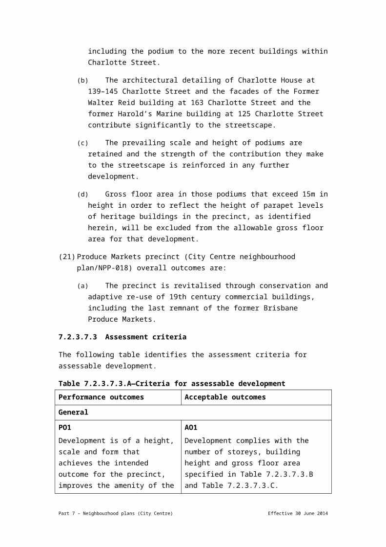
(a) The continuous height and scale of the building facades make a strong contribution to the streetscape, including the podium to the more recent buildings within Charlotte Street.
(b) The architectural detailing of Charlotte House at 139–145 Charlotte Street and the facades of the Former Walter Reid building at 163 Charlotte Street and the former Harold’s Marine building at 125 Charlotte Street contribute significantly to the streetscape.
(c) The prevailing scale and height of podiums are retained and the strength of the contribution they make to the streetscape is reinforced in any further development.
(d) Gross floor area in those podiums that exceed 15m in height in order to reflect the height of parapet levels of heritage buildings in the precinct, as identified herein, will be excluded from the allowable gross floor area for that development.
(21) Produce Markets precinct (City Centre neighbourhood plan/NPP-018) overall outcomes are:
(a) The precinct is revitalised through conservation and adaptive re-use of 19th century commercial buildings, including the last remnant of the former Brisbane Produce Markets.
7.2.3.7.3 Assessment criteria
The following table identifies the assessment criteria for assessable development.
Table 7.2.3.7.3.A—Criteria for assessable development
Performance outcomes Acceptable outcomes
General
PO1
Development is of a height, scale and form that achieves the intended outcome for the precinct, improves the amenity of the neighbourhood plan area, contributes to a cohesive streetscape and built form character and is:
(a) consistent with anticipated density and assumed infrastructure demand;
(b) aligned to community expectations
AO1
Development complies with the number of storeys, building height and gross floor area specified in Table 7.2.3.7.3.B and Table 7.2.3.7.3.C.
Note—Table 7.2.3.7.3.D provides the method for calculating maximum gross floor area.
Note—Neighbourhood plans will mostly specify a maximum number of storeys where zone outcomes have been varied in relation to building height. Some neighbourhood plans may also specify height in metres. Development must comply with both parameters where maximum number of storeys and height in
Part 7 – Neighbourhood plans (City Centre) Effective 30 June 2014

about the number of storeys to be built;
(c) proportionate to and commensurate with the utility of the site area and frontage width;
(d) designed so as not to cause significant and undue adverse amenity impact to adjoining development;
(e) sited to enable existing and future buildings to be well separated from each other and to not prejudice the development of adjoining sites.
Note—Development that exceeds the intended number of storeys or building height can place disproportionate pressure on the transport network, public space or community facilities in particular.
Note—Development that is over-scaled for its site can result in an undesirable dominance of vehicle access, parking and manoeuvring areas that significantly reduce streetscape character and amenity.
Note—Maximum gross floor area provisions do not apply within centres in the City Centre neighbourhood plan area.
metres are specified.
Note—Where sites are within the Airport environs overlay buildings must be consistent with the provisions of the State Planning Policy, Part D—Planning for Infrastructure; Strategic airports and aviation facilities, and obtain any other relevant approval as required regarding the safety and efficiency of operational airspace.
Note—Building heights must also comply with Figure h.
Building form, height, gross floor area and site cover
PO2
Development:
(a) on sites with a frontage wider than 20m comprises a low-level podium that covers most or all of the site, and a tower above the podium that has a low site cover;
(b) in the part of the city identified in Figure a as ‘tower in plaza’, new spaces and development provide a continuation of this identity, with substantial areas of the ground plane given over to public access and incorporating strong visual linkages between the street system and the river.
AO2
Development of a site with a principal frontage of at least 20m:
(a) provides buildings that exhibit a well-defined low-level podium covering the whole of the site and 1 or more towers above the podium;
(b) ensures that in the ‘tower in plaza’ area identified in Figure a, buildings are in the form of a tower with public plaza at street level with:
(i) building footprints not exceeding more than 50% of the site;
(ii) towers set back at least 10m from the inner edge of the river public promenade.
PO3 AO3
Part 7 – Neighbourhood plans (City Centre) Effective 30 June 2014

Development that is new protects or creates significant views and vistas, in particular:
(a) to St John’s Cathedral;
(b) along the Central Station to GPO axis;
(c) to the Kangaroo Point Cliffs from the upper levels of Edward Street;
(d) from Mary Street to the river and Story Bridge;
(e) between Riparian Plaza and Waterfront Place;
(f) from the Town Reach to the Kangaroo Point Cliffs beyond the river;
(g) along Macrossan Street to the river.
Development provides building siting, configuration and design that does not impinge on the significant views or vistas identified in Figure b.
PO4
Development on sites allocated transferable site area in Table 7.2.3.7.3.E conserve those sites without altering or modifying the building and its sites.
AO4
No acceptable outcome is prescribed.
Design issues relating to towers
Note—Achievement of the performance outcomes in this section can be illustrated by addressing the public realm engagement report section of this neighbourhood plan. Using 3-dimensional computer and scale modelling is also recommended to demonstrate built form, bulk and appearance; solar, view and wind impacts; and pedestrian and public realm outcomes.
General relationship with the public realm
PO5
Development optimises the relationship with the public realm experienced broadly, beyond the immediate street environment.
AO5
No acceptable outcome is prescribed.
Tower setbacks, building articulation and design
Part 7 – Neighbourhood plans (City Centre) Effective 30 June 2014

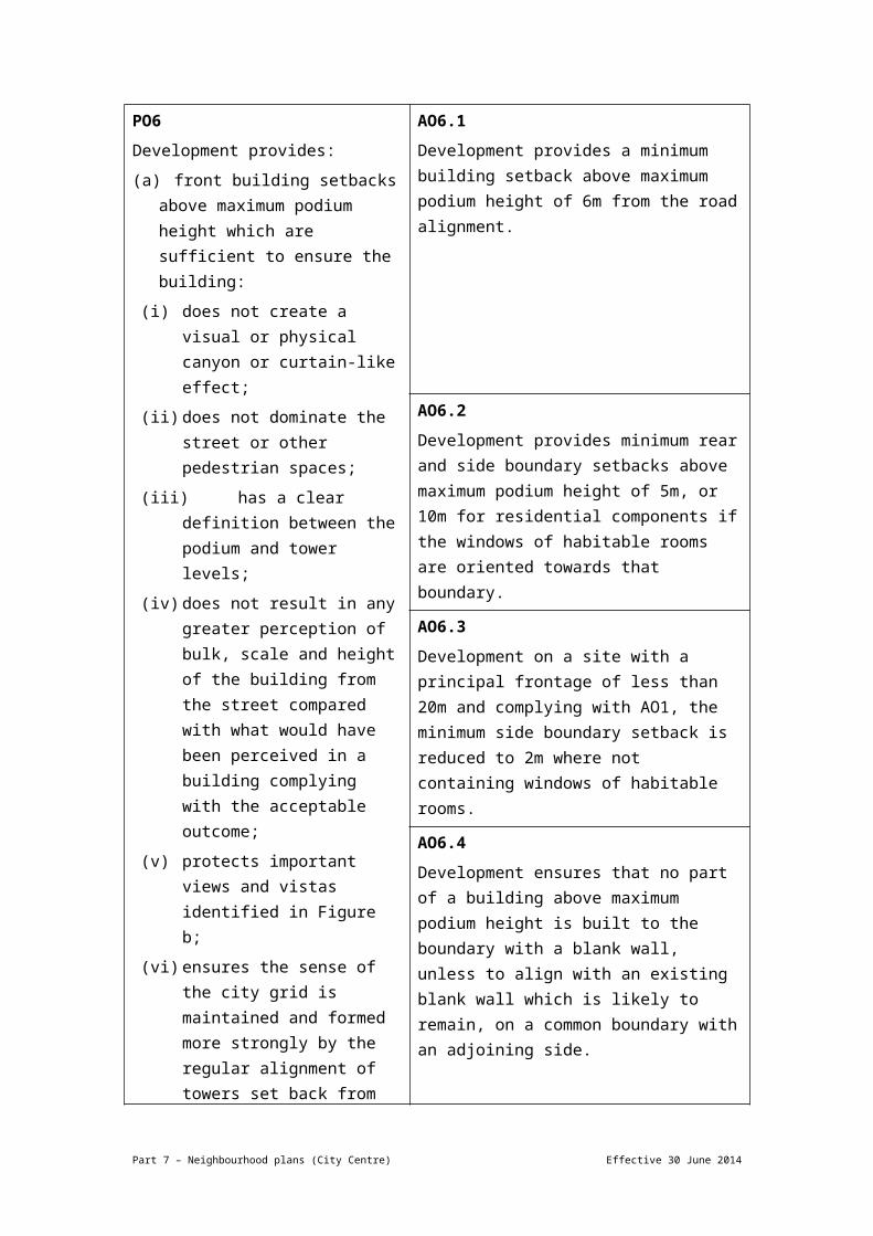
PO6
Development provides:
(a) front building setbacks above maximum podium height which are sufficient to ensure the building:
(i) does not create a visual or physical canyon or curtain-like effect;
(ii) does not dominate the street or other pedestrian spaces;
(iii) has a clear definition between the podium and tower levels;
(iv) does not result in any greater perception of bulk, scale and height of the building from the street compared with what would have been perceived in a building complying with the acceptable outcome;
(v) protects important views and vistas identified in Figure b;
(vi) ensures the sense of the city grid is maintained and formed more strongly by the regular alignment of towers set back from the street;
(vii) does not block view corridors identified in Figure b.
(b) rear and side setbacks above maximum podium height to ensure existing and any possible future buildings are well separated from each other to allow light penetration and air circulation, privacy, and ensure windows are not built out by adjoining buildings.
AO6.1
Development provides a minimum building setback above maximum podium height of 6m from the road alignment.
AO6.2
Development provides minimum rear and side boundary setbacks above maximum podium height of 5m, or 10m for residential components if the windows of habitable rooms are oriented towards that boundary.
AO6.3
Development on a site with a principal frontage of less than 20m and complying with AO1, the minimum side boundary setback is reduced to 2m where not containing windows of habitable rooms.
AO6.4
Development ensures that no part of a building above maximum podium height is built to the boundary with a blank wall, unless to align with an existing blank wall which is likely to remain, on a common boundary with an adjoining side.
Design issues affecting the street level environment
Note—Achievement of the performance outcomes in this section can be illustrated by addressing the public realm engagement report section of this neighbourhood plan.
General relationship with the public realm
PO7 AO7
Part 7 – Neighbourhood plans (City Centre) Effective 30 June 2014

Development optimises the relationship with the public realm experienced in the street environment.
No acceptable outcome is prescribed.
Podium
PO8
Development for a building with a podium ensures the podium height:
(a) is of a low scale such as 3 to 4 standard height storeys that maintains an interesting, pedestrian friendly and human-scale presence in the street;
(b) is another scale that exhibits a strongly positive relationship with the height of other nearby substantial buildings and their podium.
AO8
Development with a podium does not exceed maximum podium height of 20m.
PO9
Development:
(a) for a building with a podium is occupied with land uses that contribute both to the core functions of the City Centre being offices, shops, restaurants, entertainment, community uses and the vitality and visual attraction of the City Centre’s lower level public realm;
(b) locates parking in basements, unless the location of significant city-wide infrastructure or unresolvable geotechnical issues mean basement parking is inappropriate or unachievable.
AO9.1
Development provides a podium that is used for non-residential purposes.
AO9.2
Development provides minimum floor-to-floor height in the podium of 3.3m.
AO9.3
Development provides car parking spaces that are located below the ground storey.
PO10
Development for a building ensures podiums and other elements of the building design mitigate wind impacts at ground level on the site and in the surrounding area.
AO10
Development does not create adverse wind impacts.
Note—A wind study from a suitably qualified person can demonstrate that adverse wind impacts are not created, or how they can be mitigated through design.
The provision of quality pedestrian spaces
Part 7 – Neighbourhood plans (City Centre) Effective 30 June 2014

PO11
Development:
(a) ensures ground level setback provides continuity with adjoining setbacks, or appropriate transition where a difference exists with adjoining setbacks, and is complementary to the role and function of the street.
(b) provides a ground level setback from the street frontage to facilitate additional pedestrian space that is adjoining and integrated with the public footpath where appropriate.
AO11.1
Development provides buildings that are set back from the road alignment at ground level as indicated in Figure c.
AO11.2
Development accords with the ground level setback of the relevant diagram in Figure d.
PO12
Development provides arcades to facilitate pedestrian movement. Continuation of adjoining existing links creates an integrated and continuous through-block pedestrian network. New elements in the pedestrian network do not involve pedestrian bridges above the level of the street.
AO12.1
Development provides an arcade as follows:
(a) if an arcade is identified in Figure e for the site;
(b) if the site is an ‘adjoining’ or ‘nearby’ site to the link through block as indicated in Figure e as identified in Figure f, and the relevant arcade has not yet been provided;
(c) if the full arcade is not currently achievable as indicated in scenario 2 in Figure f, an arcade is to be partially provided with a design that enables future development of adjoining sites to continue the arcade;
(d) if an ‘existing partial link’ as indicated in scenario 3 in Figure f has been provided on an adjoining site, an arcade is to be provided to continue the existing partial link from street to street.
AO12.2
Pedestrian links do not cross streets other than at street level.
Continuity and activation of pedestrian space
PO13
Development ensures that the location and design of features such as vehicular access, refuse collection, fire egress and control room and building services are
AO13.1
Development of a site with a principal street frontage of less than 20m ensures:
(a) no new vehicular crossovers are created from the relevant frontage;
Part 7 – Neighbourhood plans (City Centre) Effective 30 June 2014

not a dominant element of any streetscape.
(b) on-site parking and service vehicle access is provided either from a laneway or another site.
AO13.2
Development maintains service vehicle openings fronting a primary or secondary pedestrian street shown in Figure e.
PO14
Development provides car parking and on-site vehicle servicing that minimise disruption to the pedestrian environment, and take advantage of alternative access opportunities on sites adjoining important pedestrian streets.
AO14.1
Development, if on a site with a frontage to a primary pedestrian street shown in Figure e that has a boundary to a laneway or to a street that is not a primary pedestrian street, does not have vehicle access that crosses the footpath located on the primary pedestrian street.
AO14.2
Development provides only 1 vehicle access point if amalgamating properties.
AO14.3
Development provides basement parking which enables joint use of access driveways by using or providing connections between adjoining buildings usually at the highest basement level.
AO14.4
Development provides access to parking and service vehicle areas by a driveway perpendicular to the street, and does not involve other ramps.
PO15
Development of pedestrian space:
(a) provides public footpaths to maximise pedestrian flow and safety, allows adequate waiting space and ensures that footpaths are free of obstruction that unduly impede pedestrian movement;
(b) ATMs are located to optimise safety and avoid conflict with other pedestrian gathering spaces.
Note—The location and extent of public dining on footpath areas is subject to the Footpath Dining Local Law 2011.
AO15.1
Development provides steps, escalators, ramps or lifts that are set back at least 1.2m from the ground level setback area (established in accordance with Figure c).
AO15.2
Development provides ATMs that are well illuminated at all times and set back at least 1.5m from the ground level setback area (which is to be established in accordance with Figure c).
Part 7 – Neighbourhood plans (City Centre) Effective 30 June 2014
Pedestrian shelter
PO16
Development provides footpaths and pathways that are protected from rain and sun by shelter that:
(a) is continuous and compatible with existing pedestrian shelter;
(b) allows for street trees and other landscaping;
(c) is safe and visually amenable.
AO16
Development provides pedestrian shelter as illustrated in Figure g, and where a specific setback area is required, the shelter is designed in accordance with the applicable diagram in Figure d.
Sun in public spaces
PO17
Development does not impinge on an equal choice of sunlight or shade at lunchtime in winter months in King George Square, Queensland Gardens, Anzac Square and Post Office Square.
Note—AO31.1 addresses height limits in the Retail heart precinct (City Centre neighbourhood plan/NPP-001) to maintain sunlight in the Queen Street Mall.
AO17
Development does not increase the extent to which sunshine is blocked between noon and 2pm on 21 June from King George Square, Queens Gardens, Anzac Square and Post Office Square.
Public artwork
PO18
Development provides artwork of a capital city quality, commensurate with the status and scale of the proposed development and site, and is designed:
(a) as an integral part of the project design;
(b) to be conceptually relevant to the context of the City Centre;
(c) to enhance the interest and vitality of the City Centre;
(d) to enhance the quality of life, cultural tourism and point of difference in the marketplace;
(e) to reflect and respond to the cultural values of the community;
(f) to promote local character in a planned and informed manner.
AO18
No acceptable outcome is prescribed.
Note—The Infrastructure design planning scheme policy provides information to assist in conceptualising artwork that is sited and designed in a contextually responsive manner. The Public art advisory panel outlined in the Infrastructure design planning scheme policy provides a mechanism to assist in the appropriate location and design of the artwork.
PO19 AO19.1
Part 7 – Neighbourhood plans (City Centre) Effective 30 June 2014

Development must integrate artwork with the development’s design response to the public realm and be visually accessible and safely incorporated.
Development locates artwork in the public realm to be accessible 24 hours 7 days a week and positioned such that it can be observed and appreciated by the public at all times.
AO19.2
Development maintains pedestrian and vehicular movement and safety that is not compromised by artwork.
Note—At the applicant’s discretion, artwork may be located off the site to enhance its visibility.
Landscape treatment
PO20
Development provides soft and hard landscape treatment that:
(a) is of a capital city standard;
(b) reflects and reinforces the subtropical image of the city and an informal aesthetic, including colourful striking foliage in bold colours;
(c) extends from the street into building foyers, onto podiums and verandahs and includes subtropical elements such as arbours.
AO20
No acceptable outcome is prescribed.
PO21
Development provides street trees that, together with companion planting in a subtropical palette, contribute to the creation of continuous and integrated subtropical boulevards.
AO21
Development provides street tree planting in accordance with the Infrastructure design planning scheme policy.
Residential development
PO22
Development accommodates a range of unit sizes that allow for a diversity of household types.
AO22
Development provides no more than 80% studio or one-bedroom units.
PO23
Development providing air conditioning ensures that it is an integral part of the building design and does not result in units that visually or acoustically detract
AO23
Development does not provide individual air-conditioning units on balconies or external walls.
Part 7 – Neighbourhood plans (City Centre) Effective 30 June 2014

from the building or its use.
PO24
Development for residential purposes is designed to promote safe movement between the building and the public realm.
AO24
Development provides pedestrian entrances and entry foyers to residential buildings that are well lit, clearly visible and directly accessible from the public realm which itself performs well in terms of crime prevention through environmental design principles.
Note—The crime prevention through environmental design planning scheme policy applies to all new development.
Other development parameters
If involving a site fronting or within 20m of the Brisbane River
PO25
Development ensures:
(a) open, inviting, publicly accessible pedestrian places predominate along the river edge with open plaza spaces linking the local street network to the river promenade;
(b) constructed space adjacent to the Brisbane River is suitable to accommodate activities that enliven and provide surveillance of the pedestrian promenade.
AO25.1
Development provides a public promenade along riverfronts, adjoined by public plazas, spaces and thoroughfares that are of a width and design that can accommodate emergency vehicle access.
AO25.2
Development includes plazas that create visual and physical pedestrian links between the street and the river and promote vistas to significant landmarks.
AO25.3
Development provides a visual connection through the site from the street to the river and associated public plazas, promenades and spaces for a majority of the ground storey of a building and the spaces around the building.
AO25.4
Development has free-standing structures and ground level podiums that provide for public access such as restaurants, retail and community uses.
AO25.5
Development provides a direct pedestrian connection 24 hours 7 days a week ensuring clear space is provided through the site from the street to the river with a minimum width of 4m.
Access, parking and servicing
Part 7 – Neighbourhood plans (City Centre) Effective 30 June 2014

PO26
Development:
(a) ensures vehicle access and increased vehicle movements do not adversely impact on pedestrian safety and amenity in the retail heart;
(b) is designed to enable the Council to monitor trends in car parking usage to ensure effective management of car parking in the City Centre.
AO26
Development for each site within the blocks bounded by Adelaide Street, Edward Street, Elizabeth Street and George Street ensures there is no net increase in the existing number of car parking spaces.
Note—As a condition of approval, an independent appropriately qualified person will be required to undertake a number plate audit of the car park and provide a copy to the Council. Records must also be maintained showing the duration and charge for each stay and such records shall be provided at no cost to the Council on request. Where the development is within primary or secondary pedestrian street or frontage identified in Figure e, evidence must be provided to the Council on request showing that the car park is operating with no financial or other incentive to long-term or commuter car parking, over short-term car parking, during retail heart retail trading hours (with the exception of Sunday).
PO27
Development providing parking and vehicular access must be designed to be convenient and safe, have minimum impact on the pedestrian environment and maintain an active street environment.
AO27.1
Development ensures the design of parking and vehicular access conforms to the transport, access, parking and servicing code unless conflicting with other provisions of this code.
AO27.2
Development provides vehicle access points that are located and designed to:
(a) minimise the loss of, or interference with bus stops, loading zones and taxi ranks;
(b) ensure no queuing occurs between the building and the roadway across pedestrian areas;
(c) maintain adequate sightlines from access driveways to pedestrian areas and the intersections of streets or lanes;
(d) minimise the number of access points to a site unless it is shown that dividing access reduces impact on the pedestrian environment.
AO27.3
Development ensures that any porte-cochere is located within the site/building with only the driveway entrance on the street frontage.
If involving demolition
Part 7 – Neighbourhood plans (City Centre) Effective 30 June 2014
PO28
Development involving demolition does not occur unless required to facilitate redevelopment.
AO28
Development involves demolition only if a development permit has been issued for building work for the redevelopment intended to replace the demolished building, and there is a committed program of work to undertake the development.
Note—A committed program can be demonstrated through a statutory declaration from the landowner that within 3 months of demolition, building work will commence on the site to implement an existing development permit.
PO29
Development ensures that following demolition if redevelopment does not eventuate, the resulting vacant site must be viable and accessible public open space suited to the needs of City Centre users.
AO29
Development involving the demolition of buildings ensures that if for whatever reason redevelopment is delayed for more than 3 months, the following site works are carried out to convert the site to temporary public parkland:
(a) the site is cleared of all rubble, debris and demolition materials;
(b) the site is levelled to the same level as the adjoining footpath and turfed so it can be mowed or otherwise fully landscaped or mulched;
(c) the site is planted with advanced specimens of fast-growing species in accordance with the Planting species planning scheme policy;
(d) drainage is provided to prevent ponding;
(e) the site is maintained so there is no sediment run-off onto adjacent premises, roads or footpaths;
(f) the site is maintained to ensure no nuisance to adjacent premises, roads or footpaths;
(g) public access to the site is provided if public safety can be maintained.
Note—The public art contribution specified in PO18 and AO18 may be provided in the form of artwork to animate the vacant site in lieu of this same contribution as part of the later development of the site.
If in a precinct
PO30
Development ensures the design
AO30
No acceptable outcome is prescribed.
Part 7 – Neighbourhood plans (City Centre) Effective 30 June 2014

treatment of new infill development for external materials and finishes and the scale of architectural detailing at podium level:
(a) complement and reinforce the existing streetscape of the precinct;
(b) complement and do not detract from or diminish the cultural significance of heritage places in the precinct;
(c) do not detract from the contribution to the streetscape made by heritage places in the precinct.
If in the Retail heart precinct (City Centre neighbourhood plan/NPP-001)
PO31
Development facilitates building design with a high degree of pedestrian amenity and shopper convenience that ensures:
(a) pedestrian safety and amenity is not impacted unduly by overshadowing and adverse wind effects;
(b) pedestrian spaces are not dominated by building facades above maximum podium height;
(c) a pleasant open streetscape is maintained, with visibility to the sky above podium level, good light and air circulation and any canyon-like or curtain-like effects are avoided;
(d) an appropriate setting of low scale for heritage places built in 1946 or before is provided, reflective of their traditional streetscape, and without tall buildings close to the mall;
(e) if above maximum podium height, development is set back a sufficient distance so that it:
(i) is not visually overbearing or imposing to open public and pedestrian areas;
(ii) ensures the scale and character
AO31.1
Development complies with the maximum building heights indicated in Figure h.
AO31.2
Development above maximum podium height is set back a minimum of 20m from Queen Street.
Part 7 – Neighbourhood plans (City Centre) Effective 30 June 2014

of the podium is the prevailing built form;
(iii) maximises vistas up and down the street.
PO32
Development enhances the appearance of a 24 hour 7 days a week shopping precinct. The image of the Queen Street Mall and the day and night animation, design, atmosphere, theme and amenity of the mall is not compromised.
AO32.1
Development provides clear glazing of frontages in the precinct.
AO32.2
Development ensures that no blank walls, roller shutters, security grills, grates or small panel concertina doors are visible from the street.
PO33
Development provides a safe and active urban space of high quality.
AO33.1
Development uses pre-finished, high-quality and sufficiently durable materials and finishes on the building frontage that withstand being in the public realm.
AO33.2
Development provides shopfronts that are detailed in a manner to avoid potential for injury to the public.
PO34
Development ensures that the retail focus of the precinct is not diminished.
AO34.1
Development provides at least the same amount of retail floor space as existed prior to that development.
AO34.2
Development for non-retail uses including banks is not located in mall-level tenancies.
PO35
Development ensures active uses address the street frontage and ground level tenancies fronting the mall have a strong visual connection with the mall and facilitate a high level of pedestrian convenience and safety.
AO35.1
Development ensures a retail frontage is uninterrupted by foyers and entrances to other uses.
AO35.2
Development provides access into buildings that is safe and convenient and minimises potential obstructions.
AO35.3
Development ensures that tenancy layout will not result in queuing into the mall or obstruction to pedestrian movement.
Part 7 – Neighbourhood plans (City Centre) Effective 30 June 2014

PO36
Development achieves a continuous and uniform streetscape that is conducive in scale and presentation to a pedestrian-friendly shopping and entertainment precinct, and reinforces the contribution of the late 19th century and early 20th century buildings to the streetscape and character of the mall.
AO36.1
Development below maximum podium height is built to the front street alignment to maintain a continuity of retail frontage and facades above.
AO36.2
Development has a podium level design that:
(a) retains existing pre-1945 facade detailing of buildings built in 1946 or before;
(b) demonstrates an appropriate scale of design detailing that unites and complements adjoining and nearby building facades in the streetscape;
(c) does not detract from, or diminish the significance of adjoining heritage places or the streetscape, ensuring any alteration to a building facade in the mall respects the appearance of any other buildings or structures on or abutting the mall.
If in the Customs House precinct (City Centre neighbourhood plan/NPP-002)
PO37
Development improves views of Customs House from the river and Queen Street:
(a) incorporating building design that is sympathetic to the visual aesthetics of Customs House;
(b) retaining the linkage of Customs House to the river and Queen Street.
AO37.1
Development protects river views of Customs House, and buildings do not extend towards the river unless they can maintain those views.
AO37.2
Development is appropriately designed or set back from the street to retain views to Customs House from Queen Street.
AO37.3
Development enhances views of Customs House and the river through design of podium storeys.
AO37.4
Development for new buildings is not between Customs House and the river or Customs House and Queen Street.
PO38
Development ensures the historic alignment of buildings along the western side of Queen Street is reinforced. The integrity of the Petrie Bight retaining
AO38.1
Development of buildings ensures podiums on the western side of Queen Street are built to the alignment and complement the existing heritage building scale.
Part 7 – Neighbourhood plans (City Centre) Effective 30 June 2014

wall on the eastern side of Queen Street is maintained.
AO38.2
Development ensures that the Petrie Bight retaining wall is not enclosed by any new building.
AO38.3
Development provides no further access points through the balustrade or wall.
AO38.4
Development maintains public access to, and visibility of the river side of the wall and buttresses.
PO39
Development of Lot 922 on CP899979 retains existing parkland to allow vistas across this site between Queen Street and the Brisbane River.
AO39
Development at the southern undeveloped portion of Lot 922 on CP899979 does not include any new buildings.
PO40
Development on the site of 443 Queen Street:
(a) preserves the historically and aesthetically significant setting of Customs House;
(b) increases visual permeability to the river and Story Bridge;
(c) allows pedestrian access to the river.
AO40
Development on the site of 443 Queen Street:
(a) ensures Customs House is visible from Queen Street in accordance with Figure b;
(b) maintains the visual setting and relationship of Customs House to the river;
(c) maintains the heritage and aesthetic significance of Customs House, including visibility and public access to the retaining wall;
(d) maintains an area of open space clear of buildings within 25m of the site’s southern boundary abutting the Customs House property;
(e) allows for a view from the frontage of 443 Queen Street towards the superstructure and both pylons of the Story Bridge in accordance with Figure b;
(f) provides safe and amenable pedestrian access through to the river and adjoining parkland, and maintains a favourable growing environment above and below ground for the large fig tree adjacent to Customs House.
Part 7 – Neighbourhood plans (City Centre) Effective 30 June 2014

PO41
Development creates no further obstruction to the visibility of Customs House across 175 Eagle Street from Queen Street or the Brisbane River as a result of new building work on the site of 175 Eagle Street.
AO41.1
Development ensures that no new buildings are erected on the site of 175 Eagle Street.
AO41.2
Development ensures that no further visual obstructions occur either in the outside plaza areas or the internal foyer.
If in the St John’s Cathedral/northern gateway precinct (City Centre neighbourhood plan/NPP-003)
PO42
Development:
(a) achieves a high level of design excellence and pedestrian amenity;
(b) enhances the public realm by providing better integration with the St John’s Cathedral site and connectivity between sites;
(c) allows for a better connection between the CBD and the Valley, particularly incorporating Centenary Place;
(d) is sympathetic and subordinate to the cathedral;
(e) is located to retain St John’s Cathedral’s significant views from Ann Street and enable future views to the cathedral;
(f) protects vistas to St Martin’s Hospital from Ann Street.
AO42.1
Development ensures building heights or bulk do not impact on existing views of the cathedral.
AO42.2
Development at the corner of Ann Street and Wharf Street, being 359 Ann Street, ensures:
(a) development below maximum podium height is set back from Ann Street a distance equal to or greater than the setback of St Martin’s Hospital;
(b) development above maximum podium height is set back a minimum of 10m from Ann Street and 6m from Wharf Street;
(c) awnings along the Ann Street frontage of this site are not required, and if proposed, must not detract from views to St John’s Cathedral.
PO43
Development:
(a) protects views to St John’s Cathedral from Gotha Street (along Ann Street), Queen Street and Boundary Street;
(b) enhances short range public views to the cathedral, in particular to the rose window;
(c) preserves the visual character of Clark Lane;
AO43
Development of the site adjoined by the Orient Hotel, Ann Street and Clark Lane, being 447–461 Ann Street:
(a) preserves a view to St John’s Cathedral from as far away as Gotha Street along Ann Street;
(b) ensures podium storeys of a building are built to the frontage with Clark Lane;
(c) ensures no building exceeds the eaves height of the Orient Hotel.
Part 7 – Neighbourhood plans (City Centre) Effective 30 June 2014

(d) is complementary in design to the Orient Hotel.
PO44
Development within Cathedral Square:
(a) is small-scale, sympathetic and subordinate to the cathedral;
(b) is sited and of a height that retains significant views across Cathedral Square to St John’s Cathedral;
(c) enhances pedestrian linkages across Cathedral Square to St John’s Cathedral;
(d) achieves a high level of design excellence and public amenity.
AO44
Development at Cathedral Square is maintained as public space, fully accessible to the community 24 hours 7 days a week and any new buildings:
(a) are for public uses that activate and enliven the Square;
(b) do not exceed 1 storey;
(c) cover no more than a total of 500m2 of Cathedral Square, within a series of small-scale buildings;
(d) maintain views across Cathedral Square, particularly from the corner of Turbot Street and Wharf Street and directly to the cathedral from Turbot Street.
PO45
Development in the vicinity of the Church of Christ, being 430 Ann Street maintains a vista to the Church of Christ building along Ann Street.
AO45
Development within 20m of the Church of Christ is set back from Ann Street at podium level a greater distance than the front wall of the Church of Christ building.
If in the North Bank precinct (City Centre neighbourhood plan/NPP-004)
PO46
Development:
(a) reinforces the existing north-east to south-west street grid;
(b) includes one or more new riverside plazas that integrate and improve the existing north-side pedestrian network through to the river and support public gatherings and events on the river;
(c) contributes to the identity of Brisbane through its design and development;
(d) avoids encroachment upon views of significant heritage places from the river;
(e) enhances riverside landscape character and provides a shady
AO46
No acceptable outcome is prescribed.
Part 7 – Neighbourhood plans (City Centre) Effective 30 June 2014

vegetated pedestrian environment along the riverfront;
(f) provides for improved legibility and connectivity from the Queen Street Mall to South Brisbane;
(g) ensures that the river becomes the central focus of Brisbane;
(h) enhances river-based public transport amenity and access;
(i) incorporates new high-quality pedestrian and cycle paths, promoting access to the Goodwill Bridge.
If in the Town Reach precinct (City Centre neighbourhood plan/NPP-005)
PO47
Development that is new:
(a) is of a very high quality and an interesting and exciting design, due to this area’s high visibility;
(b) enables the future provision of underground train and busway station and connected ferry terminal integrated with public realm.
AO47
No acceptable outcome is prescribed.
PO48
Development incorporates elements and vegetation that reinforce and complement the characteristics of the surrounding landscape.
AO48.1
Development includes acknowledgment or reinforcement of local landscape elements, specifically the river to the east and the fig trees to the west.
AO48.2
Development facilitates integration of the riverside pedestrian network with the ‘fig island’, Market Street and St Stephen’s Cathedral spaces.
If in the Central Station Plaza precinct (City Centre neighbourhood plan/NPP-006)
PO49
Development of the plaza area:
(a) allows for implementation of any new train network integrating with Central Station and provides for intermodal connection with any underground bus loop;
AO49
No acceptable outcome is prescribed.
Part 7 – Neighbourhood plans (City Centre) Effective 30 June 2014

(b) significantly improves the public realm and efficiently integrates public areas with the railway station and platforms;
(c) includes buildings, public spaces and landscaping that provide pedestrian and visual links between Turbot Street and Ann Street;
(d) ensures public space dominates while still allowing major building development that contributes to the core functions of the City Centre such as transport interchange, major office building, retail facilities and a major hotel;
(e) accommodates community service providers whose clients would benefit from services at a major transport interchange.
If in the Petrie Bight precinct (City Centre neighbourhood plan/NPP-007)
PO50
Development ensures podium storeys accommodate uses that complement surrounding development and the function of the street.
AO50
Development ensures podium storeys contain either residential or non-residential uses and need not conform to minimum floor-to-floor height standards for non-residential purposes, except that retail space is provided along any frontages to Queen Street, Macrossan Street and Adelaide Street.
PO51
Development ensures that inappropriate uses are excluded from areas intended predominantly for residential use.
AO51
Development does not locate nightclub entertainment facilities in this precinct.
If in the Countess Street and Roma Street Station vicinity precinct (City Centre neighbourhood plan/NPP-008)
If in the Countess Street and Roma Street Station vicinity precinct (City Centre neighbourhood plan/NPP-008), where in the Countess Street a sub-precinct (City Centre neighbourhood plan/NPP-008a)
PO52
Development links pedestrian and cycle connections to the Normanby Five Ways intersections to Roma Street Parkland
AO52.1
Development provides pedestrian and cyclist links in the indicative locations indicated in Figure e including a central pedestrian and cycle
Part 7 – Neighbourhood plans (City Centre) Effective 30 June 2014

Boulevard. link from the Normanby Five Ways intersection to Roma Street Parkland Boulevard, generally aligned with Albert Street.
AO52.2
Development provides for streets to connect Countess Street with Roma Street Parkland Boulevard in accordance with Figure e.
PO53
Development protects and enhances views from the Normanby Five Ways intersection to the City Centre and from Hardgrave Park and Victoria Barracks to the Roma Street Parkland and Spring Hill ridge.
AO53
Development retains and enhances views identified in Figure b.
PO54
Development protects and enhances views from the City Centre towards Red Hill.
AO54
Development maintains a visual corridor through the area to St Brigid’s Church at Red Hill on a George Street alignment in accordance with Figure b.
PO55
Development intensity is in keeping with the nature of adjacent areas, namely lower rise development in the west and the busy Normanby Five Ways intersection to the north; indicatively 4 to 20 storeys but any development exceeding 15 storeys must be located at the lowest part of the site and be in a parkland setting.
AO55
No acceptable outcome is prescribed.
PO56
Development in this precinct features mixed use development with active frontages to pedestrian ways and parkland.
AO56
No acceptable outcome is prescribed.
If in the Countess Street and Roma Street Station vicinity precinct (City Centre neighbourhood plan/NPP-008), where in the Countess Street b sub-precinct (City Centre neighbourhood plan/NPP-008b)
PO57
Development is indicatively between 4 to 25 storeys, in keeping with the nature of adjacent areas which range from
AO57
No acceptable outcome is prescribed.
Part 7 – Neighbourhood plans (City Centre) Effective 30 June 2014

lower scale heritage buildings in the Victoria Barracks area to the intensely developed City Centre.
PO58
Development provides for public realm features including a pedestrian network within the Roma Street Parkland and pedestrian connections with Petrie Terrace and the Victoria Barracks area and significant views are maximised.
AO58.1
Development provides for an internal pedestrian orientated public realm connecting to Countess Street and Roma Street Parkland Boulevard in accordance with Figure e.
AO58.2
Development includes a pedestrian link aligned with and extending the Roma Street Parkland to Victoria Barracks via a pedestrian bridge over Countess Street in accordance with Figure e.
AO58.3
Development retains and enhances views identified in Figure b.
If in the Countess Street and Roma Street Station vicinity precinct (City Centre neighbourhood plan/NPP-008), where in the Parklands, Upper Albert Street sub-precinct (City Centre neighbourhood plan/NPP-008c)
PO59
Development provides a pedestrian link to the City Centre, Roma Street Parkland and associated restaurants and recreational facilities.
AO59
Development maintains significant pedestrian connections between the City Centre, Roma Street Parkland and associated restaurants and recreational facilities.
If in the Pancake Manor, Charlotte Street precinct (City Centre neighbourhood plan/NPP-009)
PO60
Development preserves the cultural significance of the individual heritage places in the precinct together with the collective streetscape in its current form.
AO60
Development that is new in the precinct is not visible from Charlotte Street.
If in the Elizabeth Street precinct (City Centre neighbourhood plan/NPP-010)
PO61
Development on the Treasury Row site in Elizabeth Street achieves the following:
(a) a continuous podium of a scale that complements the adjoining heritage places;
AO61
Development on the Treasury Row site at 79, 79A and 79B Elizabeth Street retains at least the front 6m of the existing Treasury Row buildings, or:
(a) has a continuous podium to the front alignment that does not exceed the height of
Part 7 – Neighbourhood plans (City Centre) Effective 30 June 2014

(b) development above the podium is set back a sufficient distance from the front property alignment to reinforce a pedestrian-friendly scale podium to Elizabeth Street, and to preserve the view along Elizabeth Street, to the front line of windows along the northern side elevation of the Family Services building;
(c) development above the podium is set back sufficient distance from the northern side elevation of the Family Services building to enable all existing openings in this facade to be viewed from Elizabeth Street.
the sill of the second level windows of the adjoining Family Services building, which equates to the height of the top of the parapet of Treasury Row;
(b) part of a building above the podium is set back a minimum of 6m to the boundary of the Family Services building site.
PO62
Development ensures the design treatment for podium storeys on the Treasury Row site at 79, 79A and 79B Elizabeth Street:
(a) demonstrates uniformity and fine scale detailing reflective of the existing Treasury Row buildings;
(b) does not detract from or diminish the significance to the City Centre or the streetscape of the Family Services building or the Teachers’ Union building.
AO62
No acceptable outcome is prescribed.
PO63
Development retains the existing laneway between the Teachers’ Union building and the Treasury Row site to service existing properties with frontage to Charlotte House and to protect openings in the side elevation of the Teachers’ Union building.
AO63
Development does not encroach over the laneway.
If in the George Street precinct (City Centre neighbourhood plan/NPP-011)
PO64
Development ensures that:
(a) height, scale and setting on infill sites in this precinct maintain the dominance of the Family Services
AO64.1
Development on Lot 2 on RP 52526 adjoining the Westpac building satisfies the following:
(a) the podium of the new development is to the front property alignment and does not
Part 7 – Neighbourhood plans (City Centre) Effective 30 June 2014

building and Westpac building and reinforce their relationship with heritage places on the opposite side of George Street;
(b) overall height in new infill areas in this precinct does not detract from or compete with the setting and streetscape contribution of heritage places within this precinct and in the wider locality;
(c) for an infill site, a building contains a continuous podium of a scale that complements the adjoining heritage places;
(d) there are appropriate setbacks from adjoining heritage places to ensure the setting of such places is not compromised.
exceed the height of the parapet of the adjoining Treasury Chambers building at 189 George Street;
(b) development above the podium is set back from the front property boundary to align with the front of the lift core of the Westpac building.
AO64.2
Development on 127 George Street (Lot 3 on RP 619) at the corner of George Street and Charlotte Street satisfies the following:
(a) the overall height of new development does not exceed the height of the cornice line of the Land Administration building on the opposite side of George Street;
(b) the building is built to the front alignment;
(c) the development is set back a minimum of 3m from the common boundary with the adjoining Pancake Manor building.
If in the City Hall precinct (City Centre neighbourhood plan/NPP-012)
PO65
Development design and siting on the site of 69 Ann Street does not detract from the setting or streetscape contribution of City Hall and maximises pedestrian comfort and convenience through the site.
AO65.1
Development on the site of 69 Ann Street:
(a) is separated from City Hall by a minimum of 9m below maximum podium height and 15m above maximum podium height;
(b) is set back a minimum of 3m from George Street at ground level.
AO65.2
Development for more than 1 building on the site of 69 Ann Street ensures the buildings are positioned asymmetrically so they are not aligned with the City Hall Tower when viewed from King George Square on the axis to the City Hall entrance.
AO65.3
Development preserves a covered pedestrian link through the site.
If in the General Post Office precinct (City Centre neighbourhood plan/NPP-013)
PO66
Development for Post Office Square and
AO66
Part 7 – Neighbourhood plans (City Centre) Effective 30 June 2014

Anzac Square:
(a) retains their significance as important public open spaces and cross-city pedestrian links;
(b) maintains their role in preserving the view identified from Ann Street and Central Railway Station to the General Post Office;
(c) retains them as open areas that preserve the settings of Central Railway Station and the General Post Office.
Development for Post Office Square and Anzac Square maintains public spaces, fully accessible to the community 24 hours a day 7 days a week with no new buildings erected in Anzac Square or Post Office Square above existing ground level.
PO67
Development on the GPO site:
(a) preserves the character and functionality of the existing pedestrian laneway through the site;
(b) avoids interfering with the vista across the site to St Stephen’s Cathedral from Adelaide Street and from Ann Street and Central Station;
(c) complements the quality and integrity of this space in the heart of the City Centre.
AO67
Development on the GPO site:
(a) is no higher than the existing GPO building;
(b) preserves the existing laneway between Queen Street and Elizabeth Street, which remains open and unenclosed.
PO68
Development of any site abutting Anzac Square respects the scale and alignment of the low pre-war former government buildings abutting the space.
AO68
Development of any building within 10m of the edge of Anzac Square maintains the existing building line and does not exceed the height of pre-war buildings that abut the Square.
PO69
Development is designed to respect the integrity of the large space that comprises this axis, and the significance and features of the heritage buildings within that space.
AO69
No acceptable outcome is prescribed.
If in the Ann Street, Masonic Temple precinct (City Centre neighbourhood plan/NPP-014)
PO70
Development ensures external design and finishes complement the existing heritage places in this precinct.
AO70
Development:
(a) is of a masonry finish at podium level;
(b) does not include awnings over the Ann
Part 7 – Neighbourhood plans (City Centre) Effective 30 June 2014

Street footpath;
(c) does not include any new driveway crossovers.
PO71
Development does not detract from the contribution to the Ann Street streetscape of heritage places in this precinct.
AO71.1
Development does not occur on existing heritage place sites.
AO71.2
Development on the site behind Exton’s facade above the height of the facade is set back 6m from the existing facade and does not detract from the facade’s contribution to the street.
PO72
Development of the site between St Andrews Church and Shell House does not detract from the streetscape contribution of the adjoining heritage places or interfere with the side access to St Andrew’s Church.
AO72
Development of this site is restricted to a lightweight unenclosed structure and is located to maintain side access to St Andrew’s Church.
PO73
Development maintains the visual relationship between All Saints’ Church, Ann Street and other heritage places in this precinct.
AO73
Development on the All Saints’ Centre site is below the height of the existing All Saints’ Centre building.
If in the Edward Street precinct (City Centre neighbourhood plan/NPP-015)
PO74
Development retains the prevailing scale and height of buildings in this precinct which is reinforced through new buildings being built to the front alignment, podium heights reflecting current parapet levels and increased setbacks above podium level.
AO74.1
Development on land between Queen Street and Elizabeth Street:
(a) is built to the Edward Street alignment up to a height equivalent to the height of the top of the cornice of the Hotel Embassy building;
(b) that is above the height of the top of the cornice of the Hotel Embassy building is set back a minimum of 10m from the Edward Street alignment.
AO74.2
Development on land between Elizabeth Street and Charlotte Street:
(a) is built up to the Edward Street alignment to a height equivalent to the height of the top
Part 7 – Neighbourhood plans (City Centre) Effective 30 June 2014
of the parapet of Invicta House;
(b) above the height of the top of the parapet of Invicta House is set back a minimum of 10m from the Edward Street alignment.
PO75
Development:
(a) providing vehicular access avoids interfering with the original character and streetscape associated with the heritage places fronting Edward Street;
(b) maximises pedestrian comfort and safety in areas of high pedestrian usage by reducing pedestrian and vehicular conflict.
AO75
Development does not create additional driveway crossovers across the Edward Street footpath.
If in the Edward Street warehouses precinct (City Centre neighbourhood plan/NPP-016)
PO76
Development retains and reinforces the prevailing scale and height of the warehouse buildings in this precinct through new buildings being built to the front alignment, podium heights reflecting current parapet levels and increased setbacks above podium level.
AO76
Development on land between Mary Street and Margaret Street is built to the street alignment to a height equivalent to the height of the top of the cornice line of any adjoining warehouse buildings or heritage places and any new development above this height is set back a minimum 10m from the Edward Street alignment.
PO77
Development retains the original sections of the Exchange Hotel or Victory Hotel buildings in an appropriate setting.
AO77
Development incorporates podiums at the rear of the original Exchange Hotel or Victory Hotel buildings that are built to the front alignment of Charlotte Street and does not cantilever podiums over the hotel buildings.
PO78
Development:
(a) provides vehicular access that does not interfere with the original character and streetscape associated with the original Exchange Hotel or Victory Hotel buildings;
(b) maximises pedestrian comfort and safety in areas of high pedestrian
AO78
Development of any new driveway crossovers to the Exchange Hotel or Victory Hotel sites is provided in Charlotte Street.
Part 7 – Neighbourhood plans (City Centre) Effective 30 June 2014

usage by minimising potential pedestrian and vehicular conflict.
If in the Charlotte House precinct (City Centre neighbourhood plan/NPP-017)
PO79
Development retains the prevailing scale and height of podiums within this precinct.
AO79
Development podiums are built to the front property alignment to a height matching the podium height of adjoining buildings.
PO80
Development podium treatments in this precinct complement the architectural detailing of the existing pre-1920 building facades in the precinct.
AO80
No acceptable outcome is prescribed.
PO81
Development retains the facade of the former Harold’s Marine building and includes sufficient depth of the original building behind the facade to incorporate the remaining structure meaningfully into the new development.
AO81
Development retains and incorporates the front 10m of the former Harold’s Marine building.
If in the Produce Markets precinct (City Centre neighbourhood plan/NPP-018)
PO82
Development maintains and activates the original streetscape to Turbot Street and the heritage significance of the former market building is retained.
AO82
Development fronting Turbot Street may involve substantial redevelopment above the Produce Markets buildings and ensures:
(a) preservation of sufficient original fabric of the existing buildings to retain their heritage significance;
(b) creation of an active street frontage.
PO83
Development maintains the original streetscape to George Street.
AO83
Development on sites fronting George Street:
(a) preserves the original fabric of the existing buildings;
(b) has a podium height that aligns with adjacent original buildings;
(c) is confined to the rear of the site where of greater height than the podium of the original buildings;
(d) uses geometry and built form that maintain the rhythm of the street and its character.
Part 7 – Neighbourhood plans (City Centre) Effective 30 June 2014

Table 7.2.3.7.3.B—Maximum building height
Development Number of storeys (above maximum podium height)
Development of a site with a principal frontage less than 20m
8
Development of a site with a principal frontage equal to or greater than 20m
Number of storeys is not specified where gross floor area complies with Table 7.2.3.7.3.C.
Note—For a site with a principal frontage equal to or greater than 20m, building height is governed by the amount of gross floor area developable above maximum podium height. Gross floor area for that part of a building above maximum podium height must not exceed the development ratio multiplied by the area of the site calculated in accordance with the equation specified in Table 7.2.3.7.3.D.
Note—Achievement of these outcomes can be illustrated with a report as outlined in the Public realm engagement report section of this neighbourhood plan.
Note—Maximum podium height for the purpose of calculating gross floor area is 20m. Podiums are of a low scale – 3 to 4 standard height storeys that maintain an interesting, pedestrian friendly and human-scale presence in the street, or is another scale that exhibits a strongly positive relationship with nearby buildings and/or their podium. The minimum standard floor height in the podium is 3.3m.
Table 7.2.3.7.3.C—Maximum gross floor area
Development Site cover
(above maximum podium height)
Gross floor area
(above maximum podium height)
Development of a site with a principal frontage less than 20m
60% 4 x SA
Development of a site with a principal frontage equal to or greater than 20m
Not specified DR x SA
Note—Abbreviations used in the calculation of gross floor area in Table 7.2.3.7.3.C and Table 7.2.3.7.3.D are as follows:
GFA – gross floor area;
DR – development ratio;
CSC – city site cover;
SA – site area
STA – average area of storeys
Note—For calculation of STA: where 20 storeys or fewer, the average those storeys; where more than 20 storeys, the average of those storeys that have the largest areas (a storey being the area of a storey on a horizontal plane).
Note—STA calculation excludes any level:
Part 7 – Neighbourhood plans (City Centre) Effective 30 June 2014

with an area less than 25% of the site area, where the site area is less than 200m2; or
with an area less than 500m2, where the site area is not less than 2,000m2
Note—The storeys to be included in calculation of CSC are illustrated in Figure i:
A indicates storeys which measurements are included in the calculation of STA;
B indicates storeys which measurements are not included in the calculation of STA, as 20 other storeys of larger or equivalent measurements are taken as the basis of the calculations;
C indicates storeys too small to be included in the calculation of STA.
Note—The methodology to determine DR is specified in Table 7.2.3.7.3.D.
Note—Gross floor area is not limited where CSC is less than 0.45.
Table 7.2.3.7.3.D—Calculation of gross floor area
Step Process Equation
1 Determine SA Not applicable
2 Determine STA -
3 Calculate CSC CSC = STA / SA
4 Calculate DR DR = unlimited (where CSC is less than 0.45)
DR = 38–40*CSC (where CSC is between 0.45 and 0.55)
DR = 15–10*CSC (where CSC is 0.56 or more)
5 Calculate GFA DR x SA
Table 7.2.3.7.3.E —Sites allocated transferable site area
Name and address Real property description Transferable site area
Former Moon’s Building
43 Adelaide Street
Lots 1 and 2 and 3 (part) on RP747
1,009m2
Desmond Chambers
303–309 Adelaide Street
Lot 2 on RP886 and
Lot 1 on RP910
106m2
Former Castlemaine Perkins Building
418 Adelaide Street
Lots 11 and 12 on B32461 1,686m2
Former McLennan and Co /
Queensland Machinery Co Warehouse
142 Albert Street
Lot 9 on B118233 1,031m2
Perry House
167 Albert Street
Lot 54 on RP890830 946m2
William Cairncross Building Lot 1 (part) on SP140690 and 975m2
Part 7 – Neighbourhood plans (City Centre) Effective 30 June 2014

188–196 Albert Street
and former OK Building
117 Queen Street
Lot 10 (part) on RP516
Former Queensland Deposit Bank
245 Albert Street
Lot 3 on RP707 45m2
Shell House
301–309 Ann Street
Lot 77 on B123422 and
Lot 1 on RP158095
1,315m2
Former St Luke’s Church
10 Charlotte Street
Lot 2 on RP618 377m2
Former John Mills Himself Building
40 Charlotte Street
Lot 2 on RP614 346m2
Charlotte House
45 Charlotte Street
Lot 514 on B118215 951m2
Former F.H. Faulding Warehouse
168 Charlotte Street
Lot 2 on RP41710 283m2
Spencers Building
47 Edward Street
Lots 2 and 3 on RP56903 207m2
Spencers Building
51 Edward Street
Lot 1 on RP56903 207m2
Youngs Building
93–103 Edward Street
Lots 2 and 3 on RP1042 and
Lots 1 and 2 on RP46753
2,085m2
Former Henry Box and Son –
Coachbuilders Building
104 Edward Street
Lot 2 on RP628 392m2
Victory Hotel
127 Edward Street
Lot 1 (part) on RP191653 1,256m2
The Exchange Hotel
131 Edward Street
Lot 1 (part) on B12348 1,267m2
Former Edwards Dunlop Building –
The Catholic Centre
149 Edward Street
Lot 1 on RP41710 and
Lot 20 on B12348
1,426m2
Hotel Embassy
178 Edward Street
Lot 25 (part) on RP178618 738m2
People’s Palace Lot 31 on B123422 638m2
Part 7 – Neighbourhood plans (City Centre) Effective 30 June 2014

308 Edward Street
Former Queensland Teachers’ Union Building
81 Elizabeth Street
Lot 1 on RP607 222m2
Former John Bell Warehouse
151 Elizabeth Street
Lot 51 (part) on RP890812 295m2
Heckelman’s Building
171 Elizabeth Street
Lot 2 on RP845929 915m2
Tara House
179 Elizabeth Street
Lot 5 on B12349 944m2
Former Telecommunications House –
Commercial Travellers Association Building
283 Elizabeth Street
Lot 2 on RP143070 115m2
Walker Building
129 George Street
Lot 2 on SL11288 90m2
Sutton House
133 George Street
Lot 1 on SL11288 101m2
Treasury Hotel
175 George Street
Lots 3 to 6 on RP530 215m2
Treasury Chambers and St Francis House and Symons Building
181–191 George Street
(40 Elizabeth Street)
Lot 1 (part) on RP883066
Lot 2 on RP530 and
Lots 1 to 4 on RP532
411m2
Grosvenor Hotel
320 George Street
Lot 1 on RP217755 714m2
J.P.C. (Jenyns Patent Corset) Building
327 George Street
Lot 6 on RP847 86m2
Former Grosvenor Hotel and
Duncalfe and Co extension
332 George Street
Lots 2, 4 and 5 on RP776 337m2
Duncalfe and Co Building
338 George Street
Lots 1 and 5 on RP778 310m2
McDonnell and East Building
414 George Street
Lot 1 on SP148948 1,722m2
Part 7 – Neighbourhood plans (City Centre) Effective 30 June 2014

Langley's Building
440 George Street
Lots 1 and 2 on RP857991 583m2
Former Royal Bank of Queensland
458–460 George Street
Lots 1 and 2 on RP88494 218m2
TransContinental Hotel
468–482 George Street
Lot 1 on RP51625
Lot 1 on RP85358 and
Lot 2 on B361
983m2
Former Baby Clinic
51 Herschel Street
Lot 4 on B361 147m2
HB Sales Building
125 Margaret Street
Lot 2 on RP1076 1,106m2
Wenley House – Jewell's Building
20–28 Market Street
Lot 1 on RP197742 and
Lots 1 to 4 on RP179235
1,169m2
Mooney's Building
130 Mary Street
Lot 504 on B118215 1,070m2
Former Perkins Wine and Spirit Store
138 Mary Street
Lot 505 on B118215 1,144m2
Westpac Bank Building – Bank of NSW Building
33 Queen Street
Lot 2 on RP52526 942m2
ANZ Bank – Trustees Chambers
43 Queen Street
Lot 1 on RP52526 740m2
Former Colonial Mutual Chambers
62 Queen Street
Lot 3 on B3153 100m2
Palings Building
86 Queen Street
Lot 1 on RP722 271m2
Former Rutter and Sons Building
114 Queen Street
Lot 21 on B3153 93m2
Former Love's Auction Mart
116 Queen Street
Lot 12 on B118211 268m2
Former Edwards and Chapman Building
120 Queen Street
Lots 13,14 and 23 on B3513 407m2
Former Gaujard and Elson Building
125 Queen Street
Lot 5 on RP516 78m2
Former Beak House Lots 1 to 4 on RP517 70m2
Part 7 – Neighbourhood plans (City Centre) Effective 30 June 2014

127 Queen Street
Brisbane Arcade
160 and 166 Queen Street/117 Adelaide Street
Lots 1 to 4 on RP671 2,086m2
National Mutual Building – Metway Chambers
295–299 Queen Street
Lots 4 and 5 on B353 275m2
National Australia Bank – Queensland National Bank
308 Queen Street
Lots 8 to 10 on RP46027 2,286m2
Former RACQ Buildings
470 Queen Street
Lot 2 on RP1102 and
Lot 2 on RP1103
595m2
Hotel Orient
558–560 Queen Street
Lots 12 and 13 on RP864104 152m2
Former Drysdales Chambers
580 Queen Street
Lot 101 (part) on RP170326 568m2
King George Chambers
154–158 Roma Street
Lot 1 (part), Lot 2 (part) and
Lot 3 (part) on RP84756
1,712m2
Turbot House
65 Turbot Street
Lot 9 on RP 847 and
Lot 9 on RP853
86m2
Note—Table 7.2.3.7.3.E lists sites that may have been rescinded or sold. Council may approve transfers to these sites. Council maintains a transferable site area register that records:
the description of any site from which Council has approved any transferable site area;
the quantity of the transferable site area;
the description of the site to which any of the transferable site area has been added.
Refer to the register for the most current allocations affecting a site.
Note—If conservation of a heritage place is certain, the Council may approve the allocation of the transferable site area stipulated in Table 7.2.3.7.3.E, either in full or in part where not less than 300m2, at the request of the owner of the heritage place. This area may be transferred to another site within the neighbourhood plan area for the purpose of calculating the extent of development that may be carried out on that site. In determining whether to approve the allocation of transferable site area, the Council will have regard to the capacity of the site to accommodate the additional development, particularly site area, frontage and locational characteristics and the relative increase to development yield as a consequence of added transferable site area.
Note—Council may also approve the further transfer of transferable site area listed on the register, where not less than 300m2. Any additional transfer is to be notated in the register. The register should be referred to in determining the current allocations affecting a site.
Part 7 – Neighbourhood plans (City Centre) Effective 30 June 2014

Note—Where a heritage place has been substantially destroyed or has deteriorated beyond reasonable repair, the Council will not approve the adding of its transferable site area to another site. The site to which any transferable site area or part thereof may be added, shall not be, or include the land to which that transferable site area was originally allocated.
Note—Where transferable site area has been purchased and is attached to a site, that site retains the rights to any additional site area accrued under any superseded planning scheme.
Note—Transferable development rights (site area) – Where Council is satisfied that the conservation of a heritage place is assured, the Council may approve of adding the transferable site area stipulated in Table 7.2.3.7.3.E with respect to that heritage place, or part of that transferable site area generally not less than 300m2, to the area of some site nominated by the owner of that heritage place and in the City Centre neighbourhood plan area, for the purpose of calculating the extent of development that may be carried out on that site. In determining whether to approve the adding of transferable site area, the Council will have regard to the capacity of the site to accommodate an acceptable development proposal by the adding of that transferable site area, particularly considering the current area of the site, its frontage and the relative change to its development yield as a consequence of added transferable site area. Where transferable development rights under the superseded planning scheme have been purchased and are attached to a site, that site retains the rights to additional site area accrued under the superseded scheme. The transferable site area specified Table 7.2.3.7.3.E indicates the original allocations. Council may approve transfers to these allocations. Council will keep a transferable site area register that records: the description of any site from which the Council has approved any transferable site area; the quantity of the transferable site area; and the description of the site to which any of the transferable site area has been added.
7.2.3.7.4 Supporting information
(1) In order to assist the Council to efficiently assess the issues relevant to a development’s engagement with the public realm, a concise Public realm engagement report should be prepared and structured as follows:
(a) Details of the proposed development:
(i) This section should provide a general description of the proposed development and may detail the proposal by referring to sections of the planning report and development drawings accompanying the application.
(ii) The plans and elevations included or referred to will typically be:
(A) photo montages and/or diagrams, illustrations which demonstrate the relationship between proposals and the site context such as heritage buildings, footpath and other public spaces;
(B) plans of all levels that abut public open space, clearly showing floor layout, lift foyers, driveway accesses, service bays, refuse removal facilities, location of fire services and public space;
(C) large-scale elevations of all walls abutting public spaces clearly showing doors, windows and glazed areas;
(D) detailed plans, drawings, elevations and illustrations showing all proposed pavement treatments, including adjoining street, wall surfaces and glazed areas, landscaping proposals, tree-planting proposals, street furniture, lighting and public art proposals.
(b) General approach to engagement with the public realm:
Part 7 – Neighbourhood plans (City Centre) Effective 30 June 2014

(i) The purpose of this section is to give a brief illustrated discussion of the principles and strategy of the design.
(ii) It should demonstrate how the proposal achieves Council’s vision for the public realm in the CBD by providing excellent, innovative design outcomes for public open spaces.
(iii) These should be vibrant, exhibit a variable character to reinforce the different parts of the city, reflect a recognisably ‘Brisbane’ character, enhance the multiple qualities of the city and if possible, highlight buildings and structures that are civic focal points.
(c) Addressing the public realm:
(i) Illustrate how the proposal has addressed each relevant element of the City Centre neighbourhood plan;
(ii) 3.1 Broad/tower relationship with the public realm:
(A) Illustrate how the development optimises the relationship with the public realm experienced broadly, beyond the immediate street environment. This should have regard to:
location and design of the tower in relation to other nearby towers in terms of general urban design including height, texture, appearance, space, daylight and privacy — issues of privacy and outlook are particularly important in the case of residential components of City Centre towers;
impact in terms of protecting and enhancing important City Centre views and vistas and particularly in the case of tall towers above 30 storeys, the impact of proposals on the City Centre skyline as perceived from important viewing locations;
the architectural quality of the proposals that contribute to the impression of a well-designed City Centre environment;
whether development is appropriate in scale and design, taking into account its relationship to important City Centre spaces and buildings and its location in the City Centre, such as if in a gateway location.
(B) Provide visual modelling of tall buildings showing how the development will enhance the appearance of the city skyline, viewed from representative viewing locations.
(C) Analyse the relationship to important views and vistas identified in Figure b, including any opportunity to enhance public exposure to important views.
Part 7 – Neighbourhood plans (City Centre) Effective 30 June 2014

(iii) 3.2 Lower level relationship with the public realm:
(A) Illustrate how the development optimises its relationship with the public realm at lower levels, having regard to:
location of the building in relation to the street frontage, at ground level and at each of the lower levels of the building;
whether spaces are provided at ground level and at each of the lower levels of the building that adjoin the street, and any other public space which accommodates land uses that may provide surveillance and contribute vitality to the adjoining environment, especially public and open spaces;
whether additional open space is contiguous with existing open space;
whether spaces in the podium accommodate land uses which provide workplaces, facilities and services in the part of the City Centre closest to street level, including on the roof of any podium;
elements of the frontage that are non-active driveways, services, blank walls;
provision of public space at ground storey level;
provision of public art as part of an integrated design that relates to the site’s context;
integration of ground level site development with the adjoining footpath and/or public spaces;
public pedestrian shelter colonnades, awnings and other shelter;
tree planting and any other landscaping at ground level, on the roof of any podium, and elsewhere in the podium levels;
protection and enhancement of access to views and vistas;
the quality of architectural design exhibited in this part of the proposed development;
whether the form of the podium is appropriate in scale and design, taking into account its relationship to important City Centre spaces and buildings, including nearby heritage places.
(B) Illustrate the extent of additional shadowing of public spaces during winter months and the effects of wind.
Part 7 – Neighbourhood plans (City Centre) Effective 30 June 2014

(C) Where an alternative height is proposed to maximum podium height, set out the relationship between the podium and surrounding buildings which clearly demonstrates the superiority of the proposed podium height compared with a podium of standard height.
(D) When development occurs on a sloping site, demonstrate how the proposed relationship between the lowest levels of development and the adjoining public realm is optimised.
(E) Analyse opportunities to provide vehicle access and demonstrate how the design minimises impact on the pedestrian environment.
Part 7 – Neighbourhood plans (City Centre) Effective 30 June 2014

Part 7 – Neighbourhood plans (City Centre) Effective 30 June 2014

Part 7 – Neighbourhood plans (City Centre) Effective 30 June 2014

Part 7 – Neighbourhood plans (City Centre) Effective 30 June 2014

Part 7 – Neighbourhood plans (City Centre) Effective 30 June 2014

Part 7 – Neighbourhood plans (City Centre) Effective 30 June 2014

Part 7 – Neighbourhood plans (City Centre) Effective 30 June 2014

Part 7 – Neighbourhood plans (City Centre) Effective 30 June 2014

Part 7 – Neighbourhood plans (City Centre) Effective 30 June 2014