fore sight! page - fresno state geomatics sight! page 2 cover: antonio saldivar surveys around...
TRANSCRIPT

FORE SIGHT! Page

FORE SIGHT! Page 2
Cover: Antonio Saldivar surveys around Mammoth Reservoir
Contents
From the Editor, Warm Regards _____________ 2
-Stephen Castillo, Dr. Crossfield
Civil Engineering Knowledge in the
Surveying Profession ___________________ 3 -Corey Walker
The Importance of Recruiting Future Surveyors, Internship with PG&E __________ 4
-Antonio Saldivar, Ashley Aguirre
55th Geomatics Engineering Conference ______ 5
-Luz Garcia
Home Away from Home ___________________ 6 -Ryan Jackson
Internship with Guida Surveying , Letter from the Editor ________________________________ 7
-Jim Higgins, Stephen Castillo
In the Wild ____________________________ 8
-Antonio Saldivar
Internship with Kier & Wright ______________ 9 -Larry Empleo
ForeSight! CrossWord _____________________ 10 -Stephen Castillo
Acknowledgements ______________________ 11
-Fresno State Geomatics Program
Fore Sight! Staff
Advisors: Dr. Riadh Munjy, P.E. , Ph. D.
Dr. James Crossfield, L.S. , Ph. D. Editor: Stephen Castillo
Assistant Corey Walker Editor:
Hello Everyone! It is truly an honor to be the next in line as the editor of ForeSight! Magazine taking the reins from my mentor and previous edi-tor Corey Walker! I look forward to putting out quality material from our great Geomatics program here at Fresno State. With the magazine going digital I can only say that new things are always more enjoyable in a bundle and that the magazine will still be a great read regardless of the change! I can’t wait to put together the next magazine, and I hope you, as the reader, stay to join me in my time as the editor, and enjoy reading about all the successes we are having in our program. -Stephen Castillo, Editor, ForeSight! Magazine
From the Editor
Publication Statement
FORE SIGHT! is published by the Geomatics Engineering Program at California State University, Fresno. Opinions ex-pressed are those of the authors. Letters to the Editor may be sent to:
Dr. Riadh Munjy, P.E., Ph.D. Dept. of CGE,
California State University, Fresno Fresno, CA 93740-8030
E-mail: [email protected] Phone: 559.278.4828 Fax: 559.278.7002
Warm Regards by Dr. Crossfield, L.S., Ph. D.
As Dr. Crossfield will not be submitting an article this time around, he would just like to let the readers know that his thoughts are with all of you, and he wishes everyone the best.

FORE SIGHT! Page 3
When I first began my school career at Fresno State, I came in with a plan. My goal was to graduate as quickly as possible with bachelor’s degrees in both Geomatics and Civil Engineering. Now as I near the end of my time here at Fresno State, that goal is nearly reached. I’ve nev-er regretted my decision to be a dual major and instead have had the unique opportunity to see many different angles and applications of the Geomatics profession that few have the chance to observe. As most practicing professionals know, civil engineers who received their licenses after 1982 are not allowed to practice surveying unless they have also received licen-sure as a land surveyor. Before 1982, however, civil engi-neers were able to have enough knowledge to be able to perform surveying tasks. What happened to cause this change? Civil engineering and surveying both have be-come more and more specialized fields. Civil engineering now includes five different emphases ranging from water resources to structural while surveying is now seen as a composition of everything from traditional ground surveying to aerial photogrammetry and LiDAR. These two professions clearly cover distinct and separate fields of work. Yet for all the specialization that has hap-pened, it is unmistakable how reliant these two profes-sions are on each other. Take the typical design-construction process: Surveyors collect existing data of the project site, ownership information, etc. and give this to a civil engineer who then designs the site drainage, structures, foundations, and more. After the design is done, surveying crews return to the project site and place stakes for construction. Throughout this entire process there is constant communication between the survey crew and the design engineers. Many surveyors pick up a little bit of design knowledge after years of looking at plans and preparing construction stakes. Many engineers pick up a little bit of surveying knowledge after years of look-ing at parcel maps, final maps, and deeds. But this is not enough to fully understand what is going on. No one ex-pects a civil engineer to know how to resolve a boundary issue just like no one expects a surveyor to design a bridge, yet some knowledge of at least basic principles is essential for efficient and effective communication be-tween surveyors and engineers. In addition to my schooling, I’ve also worked for both civil engineering and surveying firms. In both of these areas, I’ve seen situations where some basic knowledge of the other profession saved hours of labor and caught mistakes that otherwise could have resulted in huge amounts of liability and risk. I know that it is hard to fully see the importance without examples, so due to space constraints, let me detail some areas to focus on for man-agers, professionals, and students alike.
Though simple, I have seen all of these facets of knowledge used by professionals. Considering how little time it takes to understand the basic concepts of these areas and how much time and cost it may save you in the future, I wholeheartedly recommend looking into these areas!
Civil Engineering Knowledge in the Surveying Profession by Corey Walker, Senior
Surveyors should know how…
Engineers do basic design for grading and utilities To interpret engineering plans to calculate grades Engineers use topographic data for design
Surveyors do basic coordi-nate transformations Surveyors will stake the final design Surveyors take measure-ments (e.g. manhole dips)
Civil Engineers should know how…
Pictured: Corey Walker
FORE SIGHT! Page 4
During a Saturday morning, Professor Peterson, Luz Gar-cia and I went recruiting college and high school students during a recruitment fair at Reedley College. This was my first time recruiting and presenting for the Geomatics En-gineering program at Fresno State. My confidence was partially boosted with all the fascinating instruments Dr. Peterson brought to present to the students. He took a the-odolite and total station of every kind that the school pos-sessed.
Once it was time to start presenting to the students I felt we were at a disadvantage because every student knew what the other presenters had brought or at least had an idea of what they did. In contrast, they had no clue as what we did or the equipment that we had brought with us. When they saw our equipment they thought it was a type of telescope or camera. Once Dr. Peterson explained to them what our instruments were and how we used them, the students became more excited about the presentation. Dr. Peterson’s presentation consisted of an introduction of how to use a total station and how vital it is for collecting data in a quick and efficient time.
What caught the students’ attention more though was the 3D segment of the presentation. The 3D presentation con-sisted of a couple of ortho-photos and a couple of intro-ductory videos about engineering. The technology present-ed to the students was the best that we could offer in the Fresno State Program and I think that is why we had issues attracting the students’ attention towards the engineering aspect of our presentation. We did get a couple of students interested in the actual implementation of said instruments into the engineering aspect but it was only because they had already been introduced to land surveying equipment before.
It is vital that our younger generations learn the basics of Geomatics Engineering at an early age. Kids believe that a measuring tape and their phone’s GPS can be used to ob-tain any type of measurement needed. Geomatics Engi-neering is a torch that has been shining its light on the en-gineering world for decades but if we don’t provide fuel to that torch it will soon die out.
The Importance of Recruiting
by Antonio Saldivar, Senior
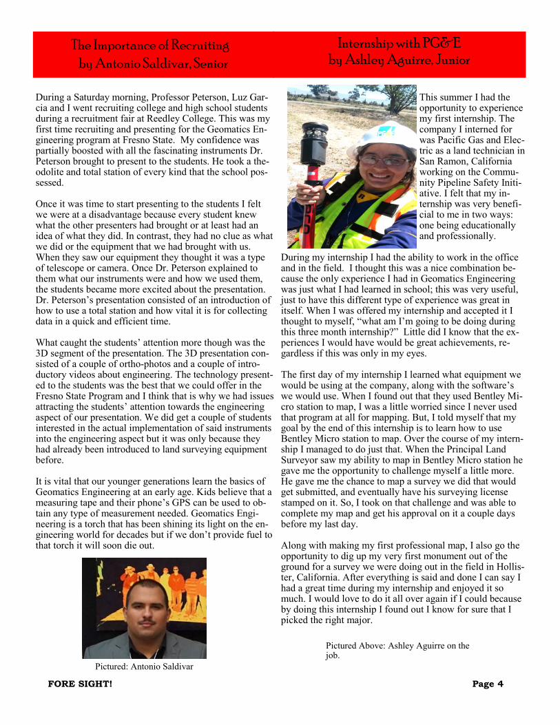
This summer I had the opportunity to experience my first internship. The company I interned for was Pacific Gas and Elec-tric as a land technician in San Ramon, California working on the Commu-nity Pipeline Safety Initi-ative. I felt that my in-ternship was very benefi-cial to me in two ways: one being educationally and professionally.
During my internship I had the ability to work in the office and in the field. I thought this was a nice combination be-cause the only experience I had in Geomatics Engineering was just what I had learned in school; this was very useful, just to have this different type of experience was great in itself. When I was offered my internship and accepted it I thought to myself, “what am I’m going to be doing during this three month internship?” Little did I know that the ex-periences I would have would be great achievements, re-gardless if this was only in my eyes. The first day of my internship I learned what equipment we would be using at the company, along with the software’s we would use. When I found out that they used Bentley Mi-cro station to map, I was a little worried since I never used that program at all for mapping. But, I told myself that my goal by the end of this internship is to learn how to use Bentley Micro station to map. Over the course of my intern-ship I managed to do just that. When the Principal Land Surveyor saw my ability to map in Bentley Micro station he gave me the opportunity to challenge myself a little more. He gave me the chance to map a survey we did that would get submitted, and eventually have his surveying license stamped on it. So, I took on that challenge and was able to complete my map and get his approval on it a couple days before my last day. Along with making my first professional map, I also go the opportunity to dig up my very first monument out of the ground for a survey we were doing out in the field in Hollis-ter, California. After everything is said and done I can say I had a great time during my internship and enjoyed it so much. I would love to do it all over again if I could because by doing this internship I found out I know for sure that I picked the right major.
Internship with PG&E
by Ashley Aguirre, Junior
Pictured: Antonio Saldivar
Pictured Above: Ashley Aguirre on the job.

FORE SIGHT! Page 5
The 55th Annual Geomatics Engineering Conference was huge success for the Geomatics Engineering Program at Fresno State. For the first time ever, a new registration system was introduced and it helped the conference im-mensely making the registration process quick and effi-cient. This year the conference had over 200 attendees, which is bigger than previous years. I’ve been involved in the conference for the past 4 years and I have not seen an audience this big until now. The main goal for this conference was to attract more at-tendees by incorporating a new schedule that could work for both exhibits and presentations, and introduction of a new venue. By the positive comments of several at-tendees, the venue was the change the conference needed. Double tree Hotel by Hilton gave the conference the pro-fessional and sophisticated environment it needed. The speakers, exhibitors, and banquet rooms were easy to ac-cess. and helped avoid any confusion among the at-tendees. The variety of topic presentations was also very helpful to attract the crowd. All the presentations were very informative and entertaining. Everyone seemed to enjoy the variety of topics in surveying, GIS, photogram-metry, UAS, and senior project presentations. Overall, the conference was more organized than previous years which helped the conference to become more enjoy-able. There are still some areas that need some extra work, but I think perfection can be achieve with practice. As the chair of this conference I felt very accomplished and proud of the outcome. I was happy to see the majority of the students contribute to the success of this event. Planning a conference is not an easy job but seeing that professionals and students enjoy the event, makes all the planning struggles worth it. The Geomatics Engineering program at Fresno State has several student involvement positions, and I want to en-courage students to take advantage of these opportunities because these leadership skills are essential for a success-ful career. I never imagined myself as president or a club, making recruitment presentations, or chairing a confer-ence during college. But hey! It only takes a step at a time to accomplish the impossible. Students take that first step and get involved! This years conference was a success, but you never know how great it could be without a little time and effort. I want to thank all the professionals that took time out of their busy schedules to travel to Fresno for the 55th Annu-al Geomatics Engineering Conference to support the Geo-matics Program and its students. Very special thanks to Kristy Comerer, Mike Hardly, all the speakers, exhibitors, donors and the Geomatics professors. This event couldn’t have been possible without your help.
And last but not least, thank you to all the students that volunteered hours of their time in the planning of the con-ference. Ryan Jackson thank you for your constant sup-port! Good luck in your new Chair role for the 56th Annu-al Geomatics Engineering Conference. You will do great! Save the date: January 27th and 28th, 2017 Chair: Ryan Jackson Co-Chairs: Emily Morrow and Hunter Stetson [email protected]
For more information about future conferences, visit our website at: http://www.fresnostategeomatics.com/
55th Annual Geomatics Engineering Conference by Luz Garcia, Senior
Pictured: Luz Garcia working with GPS
FORE SIGHT! Page 6
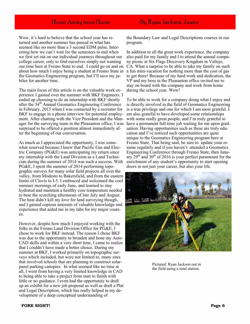
Home Away from Home By Ryan Jackson, Junior
Wow, it’s hard to believe that the school year has re-turned and another summer has passed in what has seemed like no more than a 3 second EDM pulse. Inter-esting how we can’t wait for the semesters to end when we first set out on our individual journeys throughout our college career, only to find ourselves simply not wanting our time here at Fresno State to end. I could go on and on about how much I enjoy being a student at Fresno State in the Geomatics Engineering program, but I’ll save my ju-bilee for another time. The main focus of this article is on the valuable work ex-perience I gained over the summer with BKF Engineers. I ended up choosing to do an internship with BKF shortly after the 54th Annual Geomatics Engineering Conference in February, 2015 when I was contacted by a recruiter for BKF to engage in a phone interview for potential employ-ment. After chatting with the Vice President and the Man-ager for the surveying team in the Pleasanton office, I was surprised to be offered a position almost immediately af-ter the beginning of our conversation. As much as I appreciated the opportunity, I was some-what reserved because I knew that Pacific Gas and Elec-tric Company (PG&E) was anticipating my return since my internship with the Land Division as a Land Techni-cian during the summer of 2014 was such a success. With PG&E, I spent the summer of 2014 performing topo-graphic surveys for many solar field projects all over the valley, from Modesto to Bakersfield, and from the eastern limits of Clovis to I-5. I embraced and welcomed the cool summer mornings of early June, and learned to stay hydrated and maintain a healthy core temperature needed to bear the scorching afternoons of late July and August. The heat didn’t kill my love for land surveying though, and I gained copious amounts of valuable knowledge and experience that aided me in my labs for my major cours-es. However, despite how much I enjoyed working with the folks in the Fresno Land Division Office for PG&E, I chose to work for BKF instead. The reason I chose BKF was due to the opportunity to broaden and hone my Auto-CAD skills and within a very short time, I came to realize that I couldn’t have made a better choice. During my summer at BKF, I worked primarily on topographic sur-veys which included, but were not limited to, many sites that involved schools that are planning to construct solar-panel parking canopies. In what seemed like no time at all, I went from having a very limited knowledge in CAD to being able to take a project from start to finish with little or no guidance. I even had the opportunity to draft up an exhibit for a new job proposal as well as draft a Plat and Legal Description, which has really helped in my de-velopment of a deep conceptual understanding of
the Boundary Law and Legal Descriptions courses in our program. In addition to all the great work experience, the company also paid for my family and I to attend the annual compa-ny picnic at Six Flags Discovery Kingdom in Vallejo, CA. What a surprise to be able to take my family on such a fun mini-vacation for nothing more than the cost of gas to get there! Because of my hard work and dedication, the VP and my boss in the Pleasanton office invited me to stay on board with the company and work from home during the school year. Wow! To be able to work for a company doing what I enjoy and is directly involved in the field of Geomatics Engineering is a true privilege and one for which I am most grateful. I am also grateful to have developed some relationships with some really great people, and I’m truly grateful to have a permanent full-time job waiting for me upon grad-uation. Having opportunities such as these are truly edu-cation and I’ve noticed such opportunities are quite unique to the Geomatics Engineering program here at Fresno State. That being said, be sure to update your re-sume regularly and if you haven’t attended a Geomatics Engineering Conference through Fresno State, then Janu-ary 29th and 30th of 2016 is your perfect paramount for the enrichment of any student’s opportunity to start opening doors in not just your career, but also your life.
Pictured: Ryan Jackson out in the field using a total station.
FORE SIGHT! Page 7
Internship with Guida Surveying
By Jim Higgins, Junior
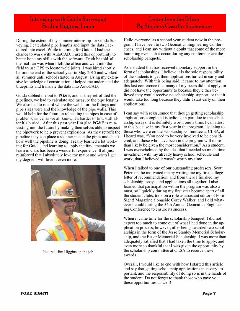
During the extent of my summer internship for Guida Sur-veying, I calculated pipe lengths and input the data I ac-quired into excel. While interning for Guida, I had the chance to work with AutoCAD. I used this opportunity to better hone my skills with the software. Truth be told, all the real fun was when I left the office and went into the field to use GPS to locate weld joints. I was hired shortly before the end of the school year in May 2015 and worked all summer until school started in August. Using my exten-sive knowledge of construction it helped me understand the blueprints and translate the data into AutoCAD. Guida subbed me out to PG&E, and as they retrofitted the pipelines, we had to calculate and measure the pipe lengths. We also had to record where the welds for the fittings and pipe sizes were and the knowledge of the pipe walls. This would help for the future in relocating the pipes in case of problems, since, as we all know, it’s harder to find stuff af-ter it’s buried. After this past year I’m glad PG&E is rein-vesting into the future by making themselves able to inspect the pipework to help prevent explosions. As they retrofit the pipeline they can place a scanner inside the pipes and check how well the pipeline is doing. I really learned a lot work-ing for Guida, and learning to apply the fundamentals we learn in class has been a wonderful experience. It all just reinforced that I absolutely love my major and when I get my degree I will love it even more.
Pictured: Jim Higgins on the job.
Letter from the Editor
By Stephen Castillo, Sophomore
Hello everyone, as a second year student now in the pro-gram, I have been to two Geomatics Engineering Confer-ences, and I can say without a doubt that some of the more humbling events that occur during any conference are the scholarship banquets. As a student that has received monetary support in the form of scholarships, I believe it is the sole responsibility of the students to get their applications turned in early and adequately. With this being said, it came to my attention this last conference that many of my peers did not apply, or did not have the opportunity to because they either be-lieved they would receive no scholarship support, or that it would take too long because they didn’t start early on their applications. I can say with reassurance that though getting scholarship applications completed is tedious, in part due to the schol-arship essays, it is definitely worth one’s time. I can attest to this because in my first year in the program, listening to those who were on the scholarship committee at CLSA, all I heard was, “You need to be very involved to be consid-ered, and those who have been in the program will more than likely be given the most consideration.” As a student, I was overwhelmed by the idea that I needed so much time investment with my already heavy school schedule and work, that I believed it wasn’t worth my time. When I talked to one of our outstanding professors, Scott Peterson, he motivated me by writing me my first college letter of recommendation, and from there I finished my scholarship essays, and applications all together. I also learned that participation within the program was also a must, so I quickly during my first year became apart of all the student clubs, took on a role as assistant editor of Fore-Sight! Magazine alongside Corey Walker, and I did what-ever I could during the 54th Annual Geomatics Engineer-ing Conference to ensure its success. When it came time for the scholarship banquet, I did not expect too much to come out of what I had done in the ap-plication process, however, after being awarded two schol-arships in the form of the Jesse Stanley Memorial Scholar-ship, and the Buser Memorial Scholarship, I was more than adequately satisfied that I had taken the time to apply, and even more so thankful that I was given the opportunity by the scholarship committee at CLSA to receive these awards. Overall, I would like to end with how I started this article and say that getting scholarship applications in is very im-portant, and the responsibility of doing so is in the hands of the student. Do not forget to thank those who gave you these opportunities as well!

FORE SIGHT! Page 8
During my summer I had an internship working on the USDA Sierra National Forest (“SNF”), for WRI, coordi-nated by all California State Universities including Fresno State, and funded by CSU San Bernardino. Due to my WRI association, I obtained the opportunity to work for a Sierra National Forest Hydrologist; Cliff Raley. For the entire duration of my internship, I was partnered with a fellow Fresno State student: Jovany Canchola, a geology major. The internship required us to have part-ners due to safety reasons. Mr. Raley taught my partner and I how to detect, track, and avoid nonpoint source pol-lution in water bodies located in the SNF. We used Best Management Practices (“BMPs”) derived from the USDA to check the quality of the water bodies within randomly select areas of the forest. To aid us in the documentation of the inspected sites, we used GPS units and photos to keep track of the locations and its current state. Jovany and I were an unbeatable team. As a geology student he could identify stream crossings, rillings, ground cover, erosion activity and areas susceptible to ponding a lot quicker than me. I contributed to the team by being able to access, sort, and implement our data collected into a more user friendly format due to my experience as an engineering student. In order to navigate through most of the SNF we used sever-al things. Since we couldn’t rely on our phone’s GPS due to loss of signal or our GPS unit due to the low battery life, we would always get a USGS topographic map. On the map we would la-bel our destination and locate visible references around the route we were going to take. Since most of the time we would be venturing into the deep ends of the SNF we always used the topographic map and a compass to guide us to our destination. Working in the SNF was a really great experience. During my internship I was able to implement my skills in surveying and GIS for an environmental advantage. I also experienced being in a professional environment and adjusting to it mainly due to all the friendly individuals in the office. Most im-portantly this internship helped me visualize that becom-ing an engineer would allow me to solve problems una-ware to the general public.
In the Wild By Antonio Saldivar, Senior
Pictured: Antonio Saldivar
Pictured: The Maxon Trail

FORE SIGHT! Page 9
This past summer, I had my very first internship experi-ence at Kier & Wright Civil Engineers and Surveyors, Inc. in Santa Clara, CA. I met Ryan Amaya, a Senior Sur-veyor P.L.S 8134, and Jackie Fang, a former CSU Fresno Geomatics Engineering student, at CSU Fresno’s 54th An-nual Geomatics Engineering Conference. He had an ex-hibit set up displaying the company’s previous projects. What caught my attention was the layout of Levi’s Stadi-um. I am a huge fan of the San Francisco 49ers, so I just had to talk about the project. Ryan informed me about other huge projects the company previously worked on and all the services provided from Kier & Wright. He also mentioned that they had an internship program. After the conference, I emailed Ryan about my interests in becom-ing an intern for the summer. We then scheduled an inter-view date. During the interview, Ryan and former em-ployee, Shane Barber, asked me about myself and what I want to expect to achieve from this internship. After-wards, Shane showed me around the office and introduced me to all the other employees. I started interning at Kier & Wright Civil Engineers and Surveyors, Inc. in Santa Clara, CA on June 1, 2015. I did not know what to expect on my first day of work. I started off by doing basic office work, then Ryan gave me a few legal descriptions to re-vise. Thereafter, I started getting maps to revise, in which I fi-nally got to use my skills on AutoCAD that I learned from school. It was a little frustrating at first trying to under-stand and memorize all of Kier & Wright’s shortcuts and procedures. All the employees of the Surveying depart-ment were highly knowledgeable and were willing to help me out with any difficulties I had. Ryan really wanted me to experience all aspects of surveying. Half the summer I spent drafting in the office, while the other half I got to do some field work. I really enjoyed being out in the field because I like doing hands-on tasks and especially being outdoors. Almost every day I was out in the field, I got to work on a different project and with a different party chief. The men of the Construction and Field departments are very skilled in their positions. They were always giv-ing me tips and tricks on how to better myself as a survey-or. They were also capable of keeping their cool whenev-er I made a mistake, in which I made plenty! I am pleased to work with these great guys; it felt like a brotherhood. August 14, 2015 was my last day of my internship at Kier & Wright. It was a bittersweet feeling. I got to meet all these wonderful people and gained additional knowledge about the surveying profession. I also got travel to places I had never been and do actual hands-on surveying tech-niques that I learned from school. This summer internship turned out exactly how I expected it to be.
I want to give a big thanks to Ryan Amaya and to the company of Kier & Wright for giving me this amazing experience. Hopefully I get the chance to come back and do it all again.
Internship with Kier & Wright By Larry Empleo, Senior
Pictured: Larry Empleo out in the field working with GPS

FORE SIGHT! Page 10
Across 3. a tree branch or other similar object stuck in the ground and flagged to mark a survey point. 5. Of or pertaining to, a shore, especially a seashore 6. honorary title given to retired professors 7. pertaining to anything connected with or adjacent to the banks of a stream or other body of water 8. The straight line connecting the end points of an arc. 9. monuments placed along water boundaries 10. bottom of a body of water 11. washing away of land by a stream of body of water 12. subtle build-up of soil along a riverbank Down 1. A survey line that connects a point to other surveyed lines. 2. lat, long 4. soil carried away through process of avulsion
ForeSight! CrossWord By Stephen Castillo

FORE SIGHT! Page 11
It is with great honor now that we like to acknowledge some of the generous donors and supporters of the Geo-matics Engineering program here at Fresno State.
Acknowledgements
From Fresno State Geomatics Program Across: 3. Riser 5. Littoral 6.Emeritus 7. Riparian 8.Chord 9.Meander Corner 10. Bed 11. Erosion 12. Accretion Down: 1. Tie line 2. Geodetic Coordinates 4. Alluvium
Leica for donation of equipment and time.
Seco for donation of safety vests.
California Surveying and Drafting Supply for donat-
ing time and instruction.
The Geomatics Advisory Council for promoting of
the Geomatics Engineering program as well as their
concern for the well being of the program.
Dr. D. E. Slavoj for his generous donation to the Geo-
matics Engineering program.
California State University Fresno admissions office
for allowing the Geomatics Engineering program to
recruit statewide.
Finally, we would like to thank all the donors who
make this program possible.
Answers to CrossWord