final project - studio fall semester 2012
DESCRIPTION
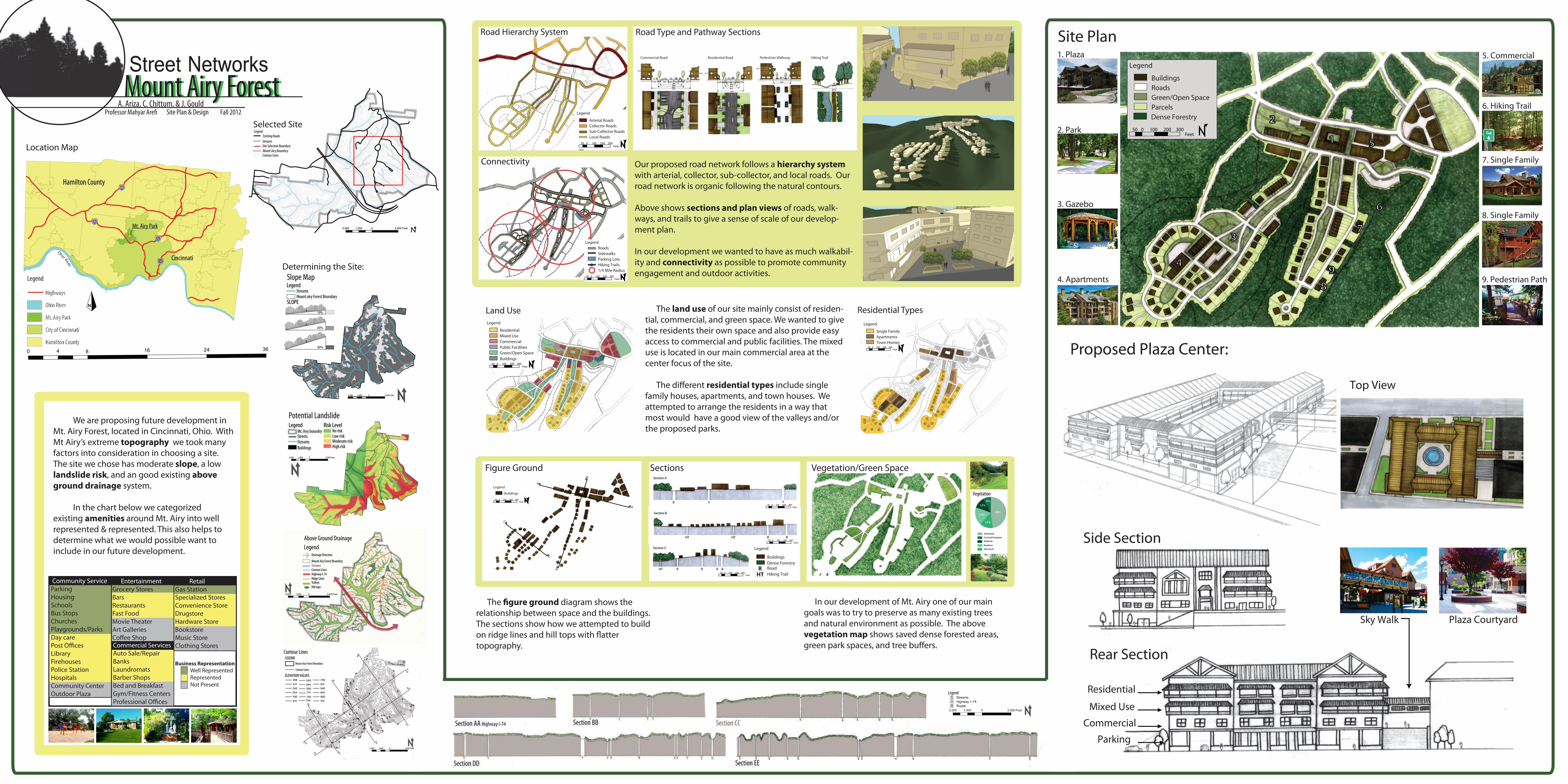
This poster shows the proposed development for our site chosen in Mount Airy Forest. My group consisted of threee people; Adrianne Ariza, Jeff Gould, and myself.TRANSCRIPT
Top View
Plaza Courtyard
Parking
Commercial
Mixed Use
Residential
Rear Section
Side Section
Sky Walk
N
Hamilton
0 8 16 24 364
Mt. Airy Park
Cincinnati
Hamilton County
Ohio River
71
74
275
75
Legend
Highways
Ohio River
Mt. Airy Park
City of Cincinnati
Hamilton County
Street NetworksMount Airy ForestMount Airy Forest
A. Ariza, C. Chittum, & J. Gould
1. Plaza
2. Park
3. Gazebo
4. Apartments
5. Commercial
6. Hiking Trail
7. Single Family
8. Single Family
9. Pedestrian Path
1
2
3
4
5
6
7
89
Legend
Green/Open Space
Buildings
Parcels
Roads
Dense Forestry
50 0 100 200 300Feet
A
A
B
B
C
C
Legend
Buildings
50 0 100 200 300Feet
50 0 100 200 300Feet
50 0 100 200 300Feet
50 0 100 200 300Feet
R R
Legend
Hiking TrailRoadDense ForestryBuildings
RHT
Figure Ground Sections Vegetation/Green Space
Proposed Plaza Center:
Legend
ApartmentsSingle Family
Town Homes50 0 100 200 300
Feet
Legend
Collector RoadsArterial Roads
Local RoadsSub-Collector Roads
50 0 100 200 300Feet
Legend
SidewalksRoads
Hiking TrailsParking Lots
1/4 Mile Radius50 0 100 200 300
Feet
Road Hierarchy System Road Type and Pathway Sections
Connectivity
Commercial Road Residential Road Pedestrian Walkway Hiking Trail
Legend
Mixed UseResidential
Public FacilitiesCommercial
BuildingsGreen/Open Space
50 0 100 200 300Feet
Land Use
Site Plan
EntertainmentGrocery StoresBarsRestaurantsFast FoodMovie TheaterArt GalleriesCo�ee Shop
Community ServicesParkingHousingSchoolsBus StopsChurchesPlaygrounds/ParksDay carePost O�cesLibraryFirehousesPolice StationHospitalsCommunity CenterOutdoor Plaza
RetailGas StationSpecialized StoresConvenience StoreDrugstoreHardware StoreBookstoreMusic StoreClothing StoresCommercial Services
Auto Sale/RepairBanksLaundromatsBarber ShopsBed and BreakfastGym/Fitness CentersProfessional O�ces
Business Representation Well Represented Represented Not Present
We are proposing future development in Mt. Airy Forest, located in Cincinnati, Ohio. With Mt Airy’s extreme topography we took many factors into consideration in choosing a site. The site we chose has moderate slope, a low landslide risk, and an good existing above ground drainage system.
In the chart below we categorized existing amenities around Mt. Airy into well represented & represented. This also helps to determine what we would possible want to include in our future development.
Residential Types
Location Map
Determining the Site:
Selected Site
Our proposed road network follows a hierarchy system with arterial, collector, sub-collector, and local roads. Our road network is organic following the natural contours.
Above shows sections and plan views of roads, walk-ways, and trails to give a sense of scale of our develop-ment plan.
In our development we wanted to have as much walkabil-ity and connectivity as possible to promote community engagement and outdoor activities.
The land use of our site mainly consist of residen-tial, commercial, and green space. We wanted to give the residents their own space and also provide easy access to commercial and public facilities. The mixed use is located in our main commercial area at the center focus of the site.
The di�erent residential types include single family houses, apartments, and town houses. We attempted to arrange the residents in a way that most would have a good view of the valleys and/or the proposed parks.
The �gure ground diagram shows the relationship between space and the buildings. The sections show how we attempted to build on ridge lines and hill tops with �atter topography.
In our development of Mt. Airy one of our main goals was to try to preserve as many existing trees and natural environment as possible. The above vegetation map shows saved dense forested areas, green park spaces, and tree bu�ers.
Site Plan & Design Fall 2012Professor Mahyar Are�