environmental impact assessment report for the … filedam, empangeni, kwazulu-natal executive...
TRANSCRIPT

Pylon Park Sugar Estate CC
ENVIRONMENTAL IMPACT ASSESSMENT REPORT FOR THE PROPOSED PENTLANDS DAM, EMPANGENI
File name: 2019-02-28_Pylon Park_EIAR-Draft for Rev-MH
720.16043.0001
April 2019
iii
ENVIRONMENTAL IMPACT ASSESSMENT REPORT FOR THE PROPOSED PENTLANDS
DAM, EMPANGENI, KWAZULU-NATAL
EXECUTIVE SUMMARY OF THE ENVIRONMENTAL IMPACT ASSESSMENT REPORT
1. INTRODUCTION
This Executive Summary provides a synopsis of the Environmental Impact Assessment Report (EIAR) prepared
as part of the Scoping and Environmental Impact Assessment (hereafter collectively referred to as “S&EIA”)
process that is being undertaken for the proposal by Pylon Park Sugar Estate CC (hereafter referred to as
“Pylon Park”) to develop an irrigation supply dam with a storage capacity of 211 000 m3 near Empangeni,
KwaZulu-Natal.
1.1 Opportunity to Comment
This Environmental Impact Assessment Report has been distributed for a 30-day comment period from 2 April
2019 to 4 May 2019 in order to provide interested and affected parties (I&APs) with an opportunity to
comment on any aspect of the proposed project and the findings of the S&EIA process. Copies of the full
report have been made available on the SLR Consulting (South Africa) (Pty) Ltd (SLR) website
https://slrconsulting.com/za/slr-documents.
Any comments should be forwarded to SLR at the address, telephone/fax numbers or e-mail address shown
below. For comments to be included in the updated Scoping Report, comments should reach SLR by no later
than 4 May 2019.
1.2 Project Background
In 2010 the (now) Department of Water and Sanitation (DWS) commenced with the roll out of the first
compulsory water use licensing programme in South Africa in terms of Section 43 of the National Water Act
(No. 36 of 1998) (NWA). The programme commenced in the uMhlathuze catchment in August 2010 and, in
compliance, Pentlands Sugar Estate CC (Pentlands), submitted a Water Use License (WUL) application for the
storage and abstraction of water on Portion 0 Lot 169 uMhlathuze No. 13943.
SLR Consulting (South Africa) (Pty) Ltd
Attention: Theo Wicks
2 Wattle Grove, Hilton, 3245
Tel: (033) 343 5826
Fax: (011) 467 0978
E-mail: [email protected]
Pylon Park Sugar Estate CC
ENVIRONMENTAL IMPACT ASSESSMENT REPORT FOR THE PROPOSED PENTLANDS DAM, EMPANGENI
File name: 2019-02-28_Pylon Park_EIAR-Draft for Rev-MH
720.16043.0001
April 2019
iv
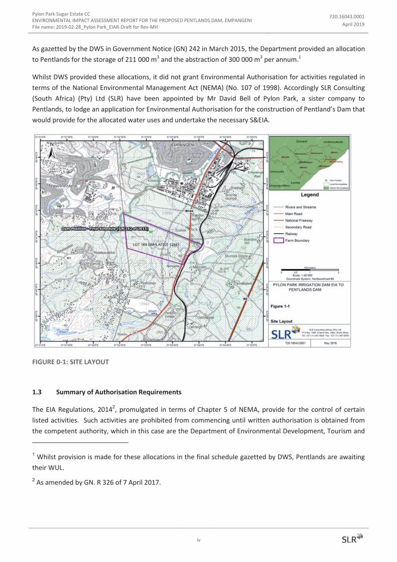
As gazetted by the DWS in Government Notice (GN) 242 in March 2015, the Department provided an allocation
to Pentlands for the storage of 211 000 m3 and the abstraction of 300 000 m
3 per annum.
1
Whilst DWS provided these allocations, it did not grant Environmental Authorisation for activities regulated in
terms of the National Environmental Management Act (NEMA) (No. 107 of 1998). Accordingly SLR Consulting
(South Africa) (Pty) Ltd (SLR) have been appointed by Mr David Bell of Pylon Park, a sister company to
Pentlands, to lodge an application for Environmental Authorisation for the construction of Pentland’s Dam that
would provide for the allocated water uses and undertake the necessary S&EIA.
FIGURE 0-1: SITE LAYOUT
1.3 Summary of Authorisation Requirements
The EIA Regulations, 20142, promulgated in terms of Chapter 5 of NEMA, provide for the control of certain
listed activities. Such activities are prohibited from commencing until written authorisation is obtained from
the competent authority, which in this case are the Department of Environmental Development, Tourism and
1 Whilst provision is made for these allocations in the final schedule gazetted by DWS, Pentlands are awaiting
their WUL.
2 As amended by GN. R 326 of 7 April 2017.

Pylon Park Sugar Estate CC
ENVIRONMENTAL IMPACT ASSESSMENT REPORT FOR THE PROPOSED PENTLANDS DAM, EMPANGENI
File name: 2019-02-28_Pylon Park_EIAR-Draft for Rev-MH
720.16043.0001
April 2019
v
Environmental Affairs (EDTEA). The proposed project triggers the need for a S&EIA process in order for EDTEA
to consider the application for Environmental Authorisation.
The proposed project includes activities listed in EIA Regulation Listing Notice 1 and 2 of 20143 (see Table 2-1),
thus it is necessary for the application for Environmental Authorisation to be assessed in terms of a Scoping
and EIA.
2. EIA METHODOLOGY
2.1 Scoping Phase
The Scoping Phase complied with the requirements of NEMA and the EIA Regulations 2014, as amended.
This involved a process of notifying I&APs of the proposed project and S&EIA process in order to ensure that all
potential key environmental impacts, including those requiring further investigation, were identified.
The Scoping Report, which was prepared in compliance with Appendix 2 of the EIA Regulations 2014, as
amended, was accepted by EDTEA on 10 February 2019.
2.2 EIA Phase
2.2.1 Specialist Studies
Two specialist studies were commissioned to address the key issues that required further investigation and
detailed assessment, namely an Ecological Assessment and a Heritage Impact Assessment.
2.2.2 Integration and Assessment
The specialist information and other relevant information was integrated into an Environmental Impact Report
(EIAR), which includes an Environmental Management Programme (EMPr). The EIAR has been released for a
30-day comment period and all I&APs on the project database have been notified of its availability.
After closure of the comment period, all comments received on the report will be incorporated and responded
to in a Comments and Responses Report. The draft report will then be updated to a final report, which will
include the Comments and Responses Report, and will be submitted to EDTEA for consideration and decision-
making.
3. NEED AND DESIRABILITY
While the economic benefits and security of supply are key motivations for proposed development of the
Pentlands Dam, the greater strategic context of the application speaks directly to the objective South Africa’s
Water Allocation Reform Strategy (WARs) and its intention to reform water allocation, promoting equitable
social and economic development with due consideration to Historically Disadvantaged Individuals (HDIs) and
gender inequality.
3 As amended by GN. R 327 and 325 of 7 April 2017

Pylon Park Sugar Estate CC
ENVIRONMENTAL IMPACT ASSESSMENT REPORT FOR THE PROPOSED PENTLANDS DAM, EMPANGENI
File name: 2019-02-28_Pylon Park_EIAR-Draft for Rev-MH
720.16043.0001
April 2019
vi
While the compulsory licencing process provided the basis for water allocation reform, the applicant has
committed to furthering the WARs objective through assisting the two initiatives within the Ndabayake
community where the applicant has committed financial, infrastructure and mentorship support.
4. PROJECT DESCRIPTION
The EIAR includes a general description of the proposed project and a comparative assessment of project
alternatives.
4.1 Summary of Property/Site Information
TABLE 0-1: LOCALITY DETAILS
Farm name(s): Portion 0 of Lot 169, uMhlathuze No. 13943 and Portion
0 of Lot 170 and uMhlathuze No. 13892
Surveyor General 21 digit code(s): N0GU00000001394300000 and
N0GU00000001389200000
Centre coordinates of dam: 28°47'24.83"S, 31°53'2.61
4.2 Dam wall design
The embankment has been designed as a zoned embankment with an upstream slope of 1:3.5 (v:h) and a
downstream slope of 1:2.5. A typical cross section of the embankment is illustrated in Figure 0-4 below.
Material for the outer shell zones will be obtained from the spillway cut and from within the dam basin. If rock
is found at a shallow depth during excavation in the spillway area it may be necessary to incorporate a rockfill
toe in the downstream shell zone to utilise this material. If a small quantum of rock is found it will be used as
rip rap to protect the upstream face from wave action erosion. Clay for the core is expected to be found in the
dam basin, and possibly from the deeper cuts in the spillway area.
An internal drainage system will be required as internal erosion protection. The drainage system will consist of
a chimney filter, a toe drain and a herringbone system of finger drains linking the chimney filter to the toe
drain. Local river sand, or commercial sand, should be suitable for the filters and drains. As the local sands can
be fine, it may be necessary to blend local sand with a coarser sand (that is imported) to create a suitable filter
medium.
To protect the embankment from wave action erosion, rip-rap will be placed from 2 m below Full Supply Level
(FSL) to 1 m above FSL. All exposed faces of the embankment will be topsoiled and grassed with runner grasses
(See Figure 0-1 for an illustration of the FSL). The crest will be capped with a 150 mm gravel layer.
Figure 0-2 and Figure 0-3 provide illustrations of the FSL and the embankment and spillway plans while Figure
0-4 provides a typical cross section of the embankment.

Pylon Park Sugar Estate CC
ENVIRONMENTAL IMPACT ASSESSMENT REPORT FOR THE PROPOSED PENTLANDS DAM, EMPANGENI
File name: 2019-02-28_Pylon Park_EIAR-Draft for Rev-MH
720.16043.0001
April 2019
vii
FIGURE 0-2: BASIN PLAN
4.3 Spillway design
As the capacity of the dam is small in comparison with the runoff from dam’s catchment, the spillway system
can be expected to work frequently, and for extended periods. Under these conditions it is expected that the
spillway could suffer erosion damage, unless the spillway is either founded on rock or is armoured (e.g. with
concrete).
To alleviate the pressure on the spillway it is proposed that a perennial flow outlet (with a minimum diameter
of 300 mm) be installed. This outlet will be set approximately 0.5 m lower than the spillway level to provide for
some flood storage and will be sized to pass normal and slight increases in flow from small rainfall events. The
perennial flow outlet will not have sufficient capacity for greater rainfall events and floods; under these
conditions the spillway will be utilised to pass the flow.
Concrete sills (ground beams) will be placed across the spillway to create a level control for water passing
through the spillway. These sills also have the benefit of distributing flow across the full width of the spillway,
and aiding in arresting any erosion that may develop. The spillway has been designed with a width of 40 m and
will be cut in to the spur on the right flank. The spillway will discharge to the river bed some 100 m
downstream of the dam.

Pylon Park Sugar Estate CC
ENVIRONMENTAL IMPACT ASSESSMENT REPORT FOR THE PROPOSED PENTLANDS DAM, EMPANGENI
File name: 2019-02-28_Pylon Park_EIAR-Draft for Rev-MH
720.16043.0001
April 2019
viii
FIGURE 0-3: EMBANKMENT AND SPILLWAY PLAN
FIGURE 0-4: TYPICAL EMBANKMENT SECTIONS

Pylon Park Sugar Estate CC
ENVIRONMENTAL IMPACT ASSESSMENT REPORT FOR THE PROPOSED PENTLANDS DAM, EMPANGENI
File name: 2019-02-28_Pylon Park_EIAR-Draft for Rev-MH
720.16043.0001
April 2019
ix
5. DESCRIPTION OF THE AFFECTED ENVIRONMENT
5.1. Climate
The site falls within a subtropical climate region, with hot, rainy summers and drier, mild winters. The table
below details the average temperatures and average rainfall per month.
TABLE 0-2: MONTHLY CLIMATIC AVERAGES
Jan Feb Mar Apr May Jun Jul Aug Sep Oct Nov Dec
Avg.
Temp (°C) 25.2 25 24.5 22.3 19.7 17.3 17.1 18.7 20.1 21.5 22.8 24.3
Min.
Temp (°C) 20.5 20.4 19.7 17.3 14.3 11.3 10.9 12.8 14.8 16.5 18.1 19.4
Max.
Temp (°C)
29.9 29.7 29.3 27.3 25.2 23.3 23.3 24.7 25.5 26.5 27.6 29.2
Precip /
Rainfall
(mm)
124 131 143 77 74 47 44 49 68 94 117 114
5.2. Biophysical characteristics
5.2.1. Geology and Soils
The King Cetshwayo District Municipality has a diverse range of geological forms and soil types due to the
variation in elevation. The coastal belt areas are underlain by Cainozic and Recent series which include sand
stones, shales and mudstones. This band is narrow to the south and widening northwards towards Mtubatuba.
The area being flat has low risk of erosion. The central area is underlain by the Ecca and Table series including
granite, sandstone, shales and limestones.
The Ecca derived soils are prone to slightly moderate erosion while the Table Mountain series is prone to
moderate to severe erosion. The extreme topographic characteristic of the western region is a result of the
underlying Table Mountain series and gneiss and granite of the Natal Monocline. Granite derived soils vary
considerably but are generally highly productive but are prone to erosion particularly when cultivated on a
slope.
Soils sampled at the proposed dam site were classified as a clayey sand making them suitable for outer shell
zones of the earth embankment. The material sampled from the left bank had a higher clay content and was
classified as clayey silt and would be suitable for use in the core.
5.2.2. Biodiversity and Ecology
The desktop review confirmed the following biodiversity and ecological features:
· Regional Vegetation Type. The original vegetation type in the vicinity of the development is
Maputaland Coastal Belt (CB 1) (Mucina and Rutherford, 2006).
· Today the vegetation landscape is composed of pockets of various forest types (separated into
different vegetation units), thickets, primary and secondary grasslands, extensive timber plantations

Pylon Park Sugar Estate CC
ENVIRONMENTAL IMPACT ASSESSMENT REPORT FOR THE PROPOSED PENTLANDS DAM, EMPANGENI
File name: 2019-02-28_Pylon Park_EIAR-Draft for Rev-MH
720.16043.0001
April 2019
x
and cane fields. The type is listed as being “Vulnerable” with only about 15% conserved while the
conservation target is 25%. At least 30%, including the bulk of this site, has been transformed by
various agricultural, industrial, urban, and semi-formal urban development.
· Ezemvelo KZN Wildlife Provincial Conservation Plan. The relevant Minset polygons are 143490,
157938, and 143491. None of these include any features of conservation significance.
· Transformation Status. The entire area is indicated as being transformed.
· Wetlands. The KwaZulu-Natal and National Freshwater Ecosystem Priority Areas databases shows a
single small wetland located on a minor tributary channel some 200 m upstream of the upper end of
one of the arms of the dam. Further interrogation suggests however that the area is now under sugar
cane.
Site investigation of the proposed preferred site occurred on 7 July and 19 September 2017. The following
outlines the findings thereof:
· Terrestrial Vegetation. The terrestrial vegetation in the vicinity off the dam site has been almost
entirely displaced by sugar cane plantations and growths of alien weeds. In addition, near the northern
end of the dam wall site is an existing borrow pit which is largely overgrown by weed species with a
small area that still appears to be in use. A number of small flowering forbs were present along the
smaller cane breaks and tracks and a few indigenous trees were present on the stream banks.
A number of alien weed plant species were recorded within the study area (35 species) of which 19
species are listed in terms of the Conservation of Agricultural Recourses Act (No. 43 of 1983) as
Category 1b invaders. The area also contains a single (1) Category 2 species and two (2) Category 3
species.
· Wetlands. No extant palustrine wetlands were found within the study area including a 500 m buffer
area. Since the entire site has been very extensively transformed from its original natural state, it is
possible that there may have once been some there.
· Watercourse. The stream which flows through the dam site is unnamed. At the proposed dam site, the
stream is deeply incised and the banks are very extensively covered by massed growths of alien weeds
interspersed by a few indigenous plants.
· Water Quality. At the time of the site visits, flows were low and the water was clear. Chemistry
readings did not indicate any evidence of pollution or other reduction in water quality.
· SASS Survey. A single SASS survey was undertaken at a site a short distance downstream of the
proposed dam wall site as stony habitats were available for sampling within the study area. The
survey classed the Present Ecological Status of the stream as E/F. Had stony habitats been available for
sampling it is expected that the site would have scored higher.
· Fish Survey. Approximately 100 m of stream channel was sampled but no fish were captured.
Considering the known abundance of fish in the Mhlathuze River system, this result was not expected.
However, the area had been through a prolonged period of drought conditions and it is possible that
the stream had dried out with a subsequent loss of the fish which might have previously been present.
· Terrestrial Vertebrates. The extensive transformation of the site made surveying for terrestrial
vertebrates superfluous with the exception of avifauna. Sixteen bird species were identified within the
study area.
Undoubtedly some mammal species will be present but it is unlikely that species of concern will be
present. The only reptile seen was a single Black Mamba (Dendroaspis polylepis).

Pylon Park Sugar Estate CC
ENVIRONMENTAL IMPACT ASSESSMENT REPORT FOR THE PROPOSED PENTLANDS DAM, EMPANGENI
File name: 2019-02-28_Pylon Park_EIAR-Draft for Rev-MH
720.16043.0001
April 2019
xi
5.2.3. Hydrology
5.2.3.1. Catchment
The site is located within quaternary catchment W12F which forms part of the Usuthu to uMhlathuze Water
Management Area. Quaternary catchment W12F has a surface area of ~400 km2 and has a Mean Annual
Precipitation (MAP) of 1 285 mm and Mean Annual Runoff (MAR) of 107 million m³. The localised catchment
within which the proposed Pentlands Dam is to be located has a catchment of approximately 3.4 km² and has a
MAR of 0.9 million m³.
The proposed Pentlands Dam is located on an unnamed tributary of the Empangeni Stream, below the
confluence of two second order streams. The Empangeni Stream is a tributary of the uMhlathuze River which
discharges into the uMhlathuze Lagoon, south of Richards Bay.
5.2.3.2. Flood hydrology
The results of the flood analysis are detailed in the table below:
TABLE 0-3: FLOOD ANALYSIS
Return Period Peak flow
1:10 yr 42 m³/s
1:20 yr 57 m³/s
1:50 yr 81 m³/s
1:100 yr 104 m³/s
RMF 225 m³/s 225 m³/s
The Recommended Design Flood (RDF) for any Category II dam (regardless of height and hazard rating) is the
1:100 year flood. Thus, for the proposed dam the RDF is 104 m³/s.
The Safety Evaluation Flood (SEF) for a medium sized dam with a significant hazard rating is the Regional
Maximum Flood (RMF); thus a SEF of 225 m³/s would be appropriate for this dam.
5.3. Socio-economic
The City of Mhlathuze LM is located in the King Cetshwayo DM (formally uThungulu DM) of the KwaZulu-Natal.
According to the Stats SA Census 2011, City of Mhlathuze contains over 19% of the King Cetshwayo DM’s
population with a total population of 364 464. The rate of growth within the LM increased over the period
2011-2016 to 21% with the Stats SA Community Survey calculating the total municipal population at 410 465.
The majority of the population resides with tribal/ traditional areas (58%) with the remainder living within
urban (39%) and farming areas (3%).
The gender split of the municipality and the ward (Ward 26) within which the proposed Pentlands Dam project
is located is detailed in Table 6-10.

Pylon Park Sugar Estate CC
ENVIRONMENTAL IMPACT ASSESSMENT REPORT FOR THE PROPOSED PENTLANDS DAM, EMPANGENI
File name: 2019-02-28_Pylon Park_EIAR-Draft for Rev-MH
720.16043.0001
April 2019
xii
TABLE 0-4: MUNICIPAL AND WARD GENDER BREAKDOWN
Area Male Female
Ward 26 5622 5901
City of uMhlathuze LM 177175 187287
The population age group <15 has been declining at the district and uMhlathuze LM level while the population
unit for the 15-64 age group has shown an increase at both the district and local municipality level between
2001 and 2011. The latter could be indicative of increased perceptions of employment opportunities in the
uMhlathuze area resulting in an in-migration into the area. An increase in the older age group (65+) is also
observed between 2001 and 2011. Such could be indicative of the elderly deciding to reside in the area upon
retirement or of improved health care facilities and an improved standard of living. Table 6-11 provides a
breakdown of the population age structure of the DM and LM.
TABLE 0-5: POPULATION AGE STRUCTURE
Population
Age Structure (Percentage % of Population)
<15 15-64 65+
2001 2011 2001 2011 2001 2011 2001 2011
King Cetshwayo DM 885965 907519 38.3 34.8 57.3 60.7 4.4 4.5
uMhlathuze LM 289190 334459 33.0 29.3 64.2 67.5 2.8 3.2
Relative to the provincial employment rates (21.9%), the DM and LM statistics are slightly higher at 26.5% and
24.6% respectively. Highest employment rates within the City of uMhlathuze LM are within the developed
urban areas and include wards 1, 2, 3, 9, 23, 26 (the project sites ward) and 29. Wards 6, 19 and 22, on the
urban periphery of eSikhaleni and Nseleni have the highest unemployment rates (City of uMhlathuze IDP,
2017).
Income levels and the number of dependents have a significant impact on the ability of an employed person to
meet the financial needs of his/her dependents. While ward 26 is one of the highest employment percentages,
the majority of those employed earn less than R 1600.00 per month (Table 6-12).
TABLE 0-6: INDIVIDUAL MONTHLY INCOME
Area 0 - R 1 600 R 1 601 - R12 800 R 12 801 - R102 400 > R 102 401 Unspecified
Ward 26 5 930 2 797 1 154 14 1 628
Municipality 229 905 46 306 17 893 639 39 707
5.4. Heritage Resources
A Heritage Impact Assessment, comprising a desktop assessment and site survey has been undertaken. The
following provides a brief as to the findings of this assessment:
5.4.1. Desktop review

Pylon Park Sugar Estate CC
ENVIRONMENTAL IMPACT ASSESSMENT REPORT FOR THE PROPOSED PENTLANDS DAM, EMPANGENI
File name: 2019-02-28_Pylon Park_EIAR-Draft for Rev-MH
720.16043.0001
April 2019
xiii
· National monuments, battlefields or historical cemeteries. No national monuments, battlefields or
historical cemeteries are on record as being located on or near to the site.
· Survey diagrams. The farm was first surveyed in 1909. No features of archaeological or cultural
significance are noted on the survey drawings.
· Historical aerial photography. The 1937 aerial photographs indicate that the land was under sugar
cane cultivation. The photograph also shows that location of the farmhouse and farm labourer’s
houses. The latter is downhill from the existing labourers’ houses. By 1953, these houses do not occur
on the map and have been moved further uphill to their current position.
· Palaeontology. The palaeontological sensitivity map shows the area to be grey and thus of no
significance.
5.4.2. Site investigation
A survey of the proposed dam site was undertaken in July 2017 with the hilltop areas specifically being
targetted. While the area was largely covered by sugarcane, the various access roads allowed for adequate
surveying to occur. No archaeological sites, nor artefacts, were noted during the survey.
The area noted during the desktop review as having farm labourers’ houses in 1937 now occurs in dense
vegetation and trees and was not surveyed. The area should be noted as having potential human graves due to
the original houses occurring here however, as it falls beyond the project site, is considered not to be at risk.
6. KEY PROJECT ISSUES AND SPECIALIST INPUT
6.1 Impact on Ecology
The proposed project could result in the following potential impacts on the biodiversity and ecology:
6.1.1 Impacts on terrestrial vegetation
The natural terrestrial vegetation in the project area is already significantly transformed and so it is anticipated
that the project will create few new impacts in this regard. Provided that rehabilitation of an area around the
final footprint of the dam and wall is done properly there should be a nett improvement in the vegetation of
the area.
There may be further impacts at the site of the borrow pit from which wall material is obtained, if that area is
not within the dam basin itself. Since there is an existing borrow pit which is located near the wall and within
the basin it should be used if the material is suitable. Such action would reduce the overall impacts of the
project.
6.1.2 Impacts on terrestrial fauna
The terrestrial fauna at the site is already severely depleted but the new water body may attract some further
mammals and reptiles and will definitely provide habitat for birds which are not resident there at present.
Other groups which will benefit from the dam include frogs, fish, and some invertebrates such as the
dragonflies and damselflies.
6.1.3 Impacts on wetlands and the stream

Pylon Park Sugar Estate CC
ENVIRONMENTAL IMPACT ASSESSMENT REPORT FOR THE PROPOSED PENTLANDS DAM, EMPANGENI
File name: 2019-02-28_Pylon Park_EIAR-Draft for Rev-MH
720.16043.0001
April 2019
xiv
There are no extant wetlands either in the dam basin or in the immediate vicinity. . Therefore there will be no
new impacts on wetlands.
Water flows in the stream will be reduced as the dam fills and when water abstractions cause the level to drop
below the spillway. The reduction in flows will persist as far as the Mpangeni River. Since the Mpangeni river
is a much larger system, the effect of the reduced stream flows will be limited and, by the time the river, with
inputs from other tributaries, reaches the Mpangeni Pan, there will be no discernible difference.
6.1.4 Impacts on frogs
Two frog species of concern are known to occur in the general area and could conceivably be present at the
site. The construction of the dam would have little effect on them and might even provide additional habitat of
a type (reedbeds in water) which is not available at present but which would suit Pickersgill’s Reed Frog. The
Natal Leaf-folding Frog, if present at all, is unlikely to be affected since none of the grassland component of its
habitat will be lost and breeding habitat will also remain.
Response: An ecological assessment was commissioned to assess the potential impacts on the terrestrial and
aquatic (including wetland) environments during construction and operation.
6.4 Impact on Heritage resources
The construction of the earth embankment and slipway could disturb cultural heritage artefacts while the
inundation of the dam basin would render any potential heritage resources lost to the national archive.
Response: A Phase 1 HIA was commissioned to inform both this Scoping and EIA process and the Section 38 (1)
NHRA notice to Amafa.
6.3 Water Resources availability
As discussed above, the proposed storage behind the Pentlands Dam has been approved by the DWS as part of
the Compulsory Licensing process undertaken for the uMhlathuze catchment. As part of this licensing process,
the DWS would have given due consideration to the water demands of the environment (i.e. ecological
reserve) and for basic human needs. As such, while it is necessary to acknowledge that there is a change in the
quantity of water available in the catchment, the significance of this impact has been considered as being
acceptable by the DWS in gazetting the Final Allocations (GN. 242 of 2015).
Response: Further consideration of this impact was considered unnecessary.
7. IMPACT ASSESSMENT CONCLUSIONS
A summary of the potential impacts associated with the proposed project is provided below and in Table 0-1.
Specialist input was sourced to assess likely impacts of the proposed project on the biophysical and cultural
aspects of the environment. The findings of the specialist studies and other relevant information have been
integrated and synthesised into this EIAR.
The mitigated assessment assumes that engineering design controls, as included in the project scope, together
with mitigation measures included in the EMPr would be included in the detailed design of the dam and

Pylon Park Sugar Estate CC
ENVIRONMENTAL IMPACT ASSESSMENT REPORT FOR THE PROPOSED PENTLANDS DAM, EMPANGENI
File name: 2019-02-28_Pylon Park_EIAR-Draft for Rev-MH
720.16043.0001
April 2019
xv
implemented when the plant is constructed and operated. As a result the majority of potential biophysical
impacts associated with the proposed Pentlands Dam would be short-term and limited either to the site or
neighbouring land. These include impacts on soils, terrestrial and aquatic habitat and ecological functioning.
The potential impacts on biophysical aspects are considered to be of LOW or VERY LOW significance with
mitigation.
TABLE 0-7: SUMMARY OF THE SIGNIFICANCE OF POTENTIAL IMPACTS ASSOCIATED WITH PROPOSED
PROJECT
Potential impact Significance of impacts
Without mitigation
With mitigation
Loss of soil resource through physical disturbance High Very Low to
Low
Impact on agricultural productivity Medium-Low Medium-
Low
Changes in river functionality and hydrology Very Low
Loss of terrestrial habitat and biodiversity through physical
transformation
Low Low (+)
Disturbances of aquatic habitat and related biodiversity through
changes in river morphology
Low Very Low
Economic impact Medium (+)
Social upliftment associated with Water Allocation Reform Low to
Medium (+)
Water resource availability to downstream users
Insignificant
Disturbance of ground resulting in damage to heritage resources No impact
(+) denotes a positive impact
Socio-economic benefits of the proposed dam relate to an increase in yield which translates to an increase in
revenue. The development of the dam also unlocks an opportunity for social upliftment in the nearby
Ndabayake community. These socio-economic benefits, assessed to have a MEDIUM and LOW TO MEDIUM
significance respectively, do not require mitigation and there is no further opportunity to extend on their
impact.
No impacts on heritage and cultural resources are expected as no heritage resources occur on the project site
and no impacts palaeontological resources are expected.
Proceeding with the project attracts socio-economic benefits and a combination of negative and positive
biophysical impacts. Not proceeding with the project retains the status quo, but with a loss increased
productivity/revenue and the conditional social upliftment opportunities being leveraged through the Water
Use Licensing process.

Pylon Park Sugar Estate CC
ENVIRONMENTAL IMPACT ASSESSMENT REPORT FOR THE PROPOSED PENTLANDS DAM, EMPANGENI
File name: 2019-02-28_Pylon Park_EIAR-Draft for Rev-MH
720.16043.0001
April 2019
xvi
7.1 Opinion of Environmental Assessment Practitioner
It is the opinion of SLR that in terms of the sustainability criteria described in this report, there is no reason why
the proposed project, with implementation of the proposed mitigation measures, should not receive a
favourable decision. The management and mitigation measures recommended for the proposed project are
detailed in the Environmental Management Programmes for construction and operation (see Appendix 7).