environmental impact assessment for the establishment of...
TRANSCRIPT

1
Environmental Impact Assessment for the Establishment of the Langhoogte Wind Farm,
Western Cape Province
Environmental Scoping Report
HERITAGE IMPACT ASSESSMENT Lita Webley & David Halkett ACO Associates cc 8 Jacobs Ladder St James 7945 Email: [email protected] Date: January 2011 Revised: January 2012

2
DECLARATION OF INDEPENDENCE
I, Lita Ethel Webley as duly authorised representative of the ACO Associates cc, hereby confirm my
independence (as well as that of ACO Associates cc) as the Heritage Specialist specialist
[Archaeology] for the Environmental Scoping Report: Establishment of the Langhoogte Wind Farm,
Western Cape and declare that neither I nor ACO Associates have any interest, be it business,
financial, personal or other, in any proposed activity, application or appeal in respect of which Arcus
GIBB was appointed as environmental assessment practitioner in terms of the National Environmental
Management Act, 1998 (Act No. 107 of 1998), other than fair remuneration for work performed in
terms of the NEMA, the Environmental Impact Assessment Regulations, 2010 and any specific
environmental management Act) for the Environmental Scoping Report: Establishment of the
Langhoogte Wind Farm, Western Cape. I further declare that I am confident in the results of the
studies undertaken and conclusions drawn as a result of it. I have disclosed, to the environmental
assessment practitioner, in writing, any material information that have or may have the potential to
influence the decision of the competent authority or the objectivity of any report, plan or document
required in terms of the NEMA, the Environmental Impact Assessment Regulations, 2010 and any
specific environmental management Act. I have further provided the environmental assessment
practitioner with written access to all information at my disposal regarding the application, whether
such information is favourable to the applicant or not. I am fully aware of and meet the responsibilities
in terms of NEMA, the Environmental Impact Assessment Regulations, 2010 and any other specific
and relevant legislation (national and provincial), policies, guidelines and best practice.
Signature:
Full Name: Lita Ethel Webley
Date: 6 February 2012
Title / Position: Principle Investigator
Qualification(s): PhD Archaeology
Experience (years/ months): 15 years
Registration(s): Association of Southern African Professional Archaeologists

3
EXECUTIVE SUMMARY
ACO Associates cc was appointed by Arcus Gibb (Pty) Ltd on behalf of the proponent (SAGIT Energy Ventures) to conduct a pre-feasibility heritage assessment of several farms situated on the R43 and N2 near Botrivier, Overberg, Western Cape Province. The proponent proposes to construct a wind energy facility of 40 - 65MW along with access roads and powerlines. Two alternative routes have been proposed for the powerlines which will connect with the sub-station at Botrivier. This proposal has triggered a full EIA process, this report being the pre-feasibility assessment (in lieu of Scoping) of the heritage component. At this early stage in the project the layout of the proposed facility has not been finalised. Heritage indicators identified during this pre-feasibility, desk top study:
The area is situated in the Bokkeveld group and is potentially fossiliferous. An independent desktop palaeontological impact assessment will be required as part of the EIA.
Surveys on adjoining properties have identified scatters of stone tools dating to the
Pleistocene and Holocene period and these may be impacted by the proposed activity. Depending on the outcome of the heritage survey, mitigation in the form of avoidance may be necessary where distributions are significant.
Preliminary archival research suggests that some of the farms may have formed part of the
early Dutch loan farm system. There is a possibility that farm buildings on these properties may be greater than 60 years of age and may therefore be protected in terms of Section 34 of the National Heritage Resources Act, No 25 of 1999. An archival and field survey is therefore needed to determine the historical significance of buildings within the proposed WEF. Recent authorisations by DEA with respect to Wind Farms have included the implementation of a 2km buffer around historic Grade 2 properties. This issue will need to be checked during the site inspection and addressed in the EIA.
Probable negative impacts to the cultural landscape and scenic routes such as the N2 and the
R43 are a serious concern. The construction of turbines around Botrivier may also result in a negative visual impact on the sense of gateway when descending the Houwhoek Pass to the Overberg landscape. Mitigation will require careful positioning of the turbines and it is recommended that they are placed to the east of the R43 and to the north of the N2 to minimize their potential impacts. The Visual Impact specialist should consider the impact of the facility on the cultural landscape during the EIA phase.
Although the present proposal is for a relatively small wind farm, the cumulative impact of several wind farms on adjoining properties in the Caledon area is potentially significant. However, it is important to note that there is still no clarity on how many of the wind energy facilities proposed for the Caledon area will receive official approval and the cumulative impacts are therefore difficult to measure.
4
ENVIRONMENTAL IMPACT ASSESSMENT FOR THE ESTABLISHMENT OF THE PROPOSED LANGHOOGTE WIND
FARM, WESTERN CAPE PROVINCE: ENVIRONMENTAL SCOPING REPORT
CONTENTS
Chapter Description Page
1 INTRODUCTION 8
1.1 Background 8 1.1.1 The proposal 8
1.2 Legislative and Policy Context 11 1.2.1 Provincial Wind Energy Policy and Guidelines 12 1.2.2 Permit requirements 12
1.3 Assessment Methodology 13 1.3.1 Restrictions and assumptions 13
2 DESCRIPTION OF AFFECTED ENVIRONMENT 14
3 IMPACTS AND ISSUES IDENTIFICATION 15
3.1 Potential Impacts on Palaeontology 15 3.1.1 Nature of Impacts 15 3.1.2 Extent of Impacts 15
3.2 Potential Impacts on Pre-Colonial and Colonial Archaeology 15 3.2.1 Nature of Impacts 16 3.2.2 Extent of Impacts 16
3.3 Potential Impacts on Built Environment 17 3.3.1 Nature of Impacts 17 3.3.2 Extent of the Impacts 18
3.4 Potential Impact on the Cultural Landscape 18 3.4.1 Nature of the Impact 19 3.4.2 Extent of Impacts 19
3.5 Potential Mitigation Measures 20
4 TERMS OF REFERENCE FOR THE IMPACT ASSESSMENT PHASE 21
4.1 Palaeontological Impact Assessment 21
4.2 Archaeological Impact Assessment 21
4.3 Unidentified archaeological material, human remains and fossils 21

5
4.4 Built Environment 21
4.5 Cultural Landscape 21
4.6 RECOMMENDATIONS FOR THE EIA 22
5 CONCLUSION 24
6 REFERENCES 25

6
TABLES Table 1: Impact Assessment on Pre-Colonial and Colonial Archaeology. Table 2: Impact Assessment on Built Environment. Table 3: Impact Assessment on the Cultural Landscape
FIGURES
Figure 1: Approximate location of the proposed Langhoogte Wind Energy facility between Botrivier and Caledon (1:500 000 map). Figure 2: Map (1:50 000 sheets 3419 AA and 3419 AB) showing the farms that comprise the wind energy facility and their location with respect to the N2 and Botrivier (map supplied by client). Figure 3: Map showing the two alternative powerline routes from the proposed facility to the Botrivier substation (map supplied by client). Figure 4: The Surveyor General’s map of Keissies Kraal 350 dating to 1832 (SG 232/1832). Portion 2 lies above the railway line and was initially named De Vley. Schulpads Gat (now Farm 348) initially formed part of this large, circular loan farm. Figure 5: The position of the four proposed wind energy facilities for the area.
ABBREVIATIONS
DEA Department of Environmental Affairs ESA Early Stone Age HIA Heritage Impact Assessment HWC Heritage Western Cape LSA Later Stone Age MSA Middle Stone Age NHRA National Heritage Resources Act SAHRA South African Heritage Resources Agency
GLOSSARY
Archaeology: Remains resulting from human activity which is in a state of disuse and are in or on land and which are older than 100 years, including artefacts, human and hominid remains and artificial features and structures. Archaeological site: A place or location where archaeological remains are found. Early Stone Age: The archaeology of the Stone Age between 2 500 000 and 700 000 years ago. Fossil: Mineralised bones of animals, shellfish, plants and marine animals. A trace fossil is the track or footprint of a fossil animal that is preserved in stone or consolidated sediment. Heritage: That which is inherited and forms part of the National Estate (Historical places, objects, fossils as defined by the National Heritage Resources Act No 25 of 1999).

7
Holocene: The most recent geological time period which commenced 10 000 years ago. Late Stone Age: The archaeology of the last 20 000 years associated with fully modern people. Middle Stone Age: The archaeology of the Stone Age between 300 000 and 20 000 years ago associated with early modern humans. National Estate: The collective heritage assets of the Nation. Palaeontology: Any fossilised remains or fossil trace of animals or plants which lived in the geological past, other than fossil fuels or fossiliferous rock intended for industrial use, and any site which contains such fossilised remains or trace. Pleistocene: A geological time period (3 million – 20 000 years ago). SAHRA: South African Heritage Resources Agency – the compliance authority which protects the National Estate. Structure (historic): Any building, works, device or other facility made by people and which is fixed to land, and includes any fixtures and equipment associated therewith. Protected structures are those which are over 60 years of age. Wreck (protected): A ship or an aeroplane or any part thereof that lies on land or in the sea within South Africa is protected if it is more than 60 years old.

8
1 INTRODUCTION
1.1 Background
ACO Associates was appointed by Arcus Gibb (Pty) Ltd to conduct a pre-feasibility heritage assessment of several farms adjoining the N2 between Botrivier and Caledon in the Overberg, Western Cape (Figures 1 & 2). The proponent (SAGIT Energy Ventures) proposes to construct a wind energy facility of 40 - 65MW along with supporting infrastructure. This proposal has triggered a full EIA process, this report being the pre-feasibility assessment (in lieu of Scoping) of the heritage component. At this early stage in the project the layout of the proposed facility has not been finalised.
Figure 1: Approximate location of the proposed Langhoogte Wind Energy facility between Botrivier and Caledon (1:500 000 map).
1.1.1 The proposal According to the background information supplied by the Arcus Gibb, the following farms are being considered for the placement of the turbines: The Remainder and Portion 1 of the Farm 791; Portion 1 of the Farm 348 (Schulpads Gat); The Remainder and Portion 2 of Farm 350 (Keissies Kraal); The Remainder of Farm 351; The Remainder and Portions 1 and 2 of the Farm 362 (Langhoogte); The Remainder and Portion 2 of the Farm 357 (Langhoogte); Farm 354; Farm 355 (Bruinklip); Farm 356; Portion 11 of the Farm 259 (Rietfontein); Farm 749; Portions 6 and 12 of the Farm 426; The Remainder of Farm 348.

9
Figure 2: Map (1:50 000 sheets 3419 AA and 3419 AB) showing the farms that comprise the wind energy facility and their location with respect to the N2 and Botrivier (map supplied by client).

10
The proponent has identified the site as being suitable as it is situated on elevated ridges within the rolling wheat lands of the Overberg. The rolling hills in this area allow high winds to be obtained. Infrastructure associated with the wind energy facility will include: The full phased project will be a 40 – 65MW Wind Energy Facility comprising 20 – 30
wind turbines; The study area is zoned agricultural. No re-zoning is required as the land will continue
to be used for agricultural purposes; Turbines typically require concrete foundations of 30 x 30 x 3m set in the ground
surface to support the turbine towers; Towers of 80 – 100m in height with blades of 40 – 50m in length resulting in turbines
of approximately 120m in height; Underground cables connect the turbines; A 132kV overheard power line feeding into the Eskom electricity network (see below); Access roads to the site from the main road (N2 & R43) within the area; Internal access roads to each wind turbine and to the substation/s; During the construction phase, corridors of landscape disturbance will occur as lay-
down areas will need to be prepared, heavy lift cranes and abnormal load trucks brought on to the site.
While specifications have yet to be determined, each turbine typically consists of a concrete foundation on to which a steel column (usually 80 – 100m high) is bolted. On top of each column is the nacelle and the turbine blades which would be 40 – 50m in length. Turbines will be optimally positioned to make the most of the wind conditions, but are generally spaced several hundred metres apart. Since wind turbines utilize such a small portion of the land surface, once the facility is established normal agricultural activity can continue on the land. The 132kv powerline will feed power from the windfarm to the grid at the existing Botrivier Sub-station immediately SW of Botrivier. The powerline structures will likely be monopoles. Two possible routes have been proposed for the powerline (Figure 3):
A southern route running from the proposed internal sub-station within the windfarm to the Bot Rivier sub-station. The line runs south of Bot Rivier, over a total distance of approximately 8km. The first approximately 3.5km will be new line strung on new 132kV structures on a new servitude; the last 4.5km will run along the same servitude as an existing 66kV line (Bot River SS to Caledon). Here the new 132kV line will run in parallel to the existing 66kV structures to the sub-station;
A northern route running also from the proposed internal sub-station within the
windfarm to the Bot Rivier sub-station. The line runs north of Bot Rivier, over a total distance of approximately 9.5km. Of this the first approximately 5km will be new line strung on new 132kV structures on a new servitude. Similar to the southern line, the last 4.5km will run along the same servitude as an existing 66kV line (Bot River SS to Viliersdorp). Here the new 132kV will run in parallel with the existing 66kV structures to the sub-station.

11
Figure 3: Map showing the two alternative powerline routes from the proposed facility to the Botrivier substation (map supplied by client).
1.2 Legislative and Policy Context
The basis for all heritage impact assessment is the National Heritage Resources Act No 25 of 1999 (NHRA) which in turn prescribes the manner in which heritage is assessed and managed. In the case of Environmental Impact Assessments in the Western Cape, the guidelines published by the Provincial Department of Environmental Affairs and Tourism (the Department of Environmental Affairs and Development Planning (DEA&DP)) are directly based on the provisions of the National Heritage Resources Act. The NHRA has defined certain kinds of heritage as being worthy of protection, by either specific or general protection mechanisms. In South Africa the law is directed towards the protection of human made heritage, although places and objects of scientific importance are covered. The National Heritage Resources Act also protects intangible heritage such as traditional activities, oral histories and places where significant events have happened. Generally protected heritage which must be considered in any heritage assessment includes:
Buildings and structures greater than 60 years of age; Archaeological sites greater than 100 years of age; Palaeontological sites and specimens; Shipwrecks and aircraft wrecks; Graves and Graveyards; Cultural Landscapes.

12
With respect to the last entry, the Visual Impact Assessment is being conducted by a VIA specialist. Nevertheless, in terms of Section 3 (2)(d) of the NHRA, No 25 of 1999, the national estate may include “landscapes and natural features of cultural significance”. It is important that the VIA specialist examines the impact of the development on the cultural landscape or consults with a heritage practitioner in this regard.
1.2.1 Provincial Wind Energy Policy and Guidelines
A pilot study commissioned by the Provincial Government of the Western Cape: “Towards a Regional Methodology for Wind Energy Site Selection in the West Coast Region”, is the only locally available policy guideline. The study considered landscape character rather than the “cultural landscape or heritage” but concluded that wind energy facilities can have a profound impact on the surrounding landscape in terms of the natural qualities of places. In terms of landscapes and heritage, there are no pro-active detailed local regional studies that can be consulted, however the Western Cape pilot study recognises that severe impacts can occur and suggests a buffer zone of 500m from heritage sites (although it is the opinion of the author of this report that this should not be a blanket provision but should take into account the heritage resources on a case by case basis). Neither the South African Heritage Resources Agency (SAHRA) nor any other heritage compliance organisation has developed a specific policy with regards to heritage and renewable energy, although the issue has received considerable attention in European countries. Two recent decisions by the Department of Environmental Affairs (DEA) with respect to Wind Energy Facilities are discussed below to illustrate the kinds of outcomes which may be anticipated: In the Environmental Authorisation (12/12/20/1581) for the “West Coast 1 Wind Energy Facility” on the Vredenburg Peninsula (2010), the DEA implemented a:
2 km buffer around the Provincial Heritage Site of Kasteelberg; and 2 km buffer along local roads, through the proposed wind energy facility, which have
high scenic value. A similar 2 km buffer has been implemented around the historic homestead of Boontjieskraal which is situated on the N2 between Botrivier and Caledon (Environmental Authorisation 12/12/20/1746). Boontjieskraal was identified by Heritage Western Cape as a site of potential Grade 2 (Provincial) heritage importance.
1.2.2 Permit requirements A permit, issued by Heritage Western Cape (HWC), will be required to:
Demolish any houses or structures such as barns, kraals, etc older than 60 years; and Destroy archaeological sites or material (see Glossary). Human remains are considered a national issue in terms of the NHRA. Section 36 of the NHRA and the regulations attached thereto are implemented by the SAHRA Burials Unit in Pretoria. They are the permitting authority and are responsible for the issuing of exhumation/grave relocation permits. If human remains are uncovered during the development they may only be excavated or exhumed with a permit issued by the SAHRA Burials Unit and a lengthy period for public comment applies.

13
1.3 Assessment Methodology
The study has been commissioned as a desk top pre-feasibility study that attempts to identify possible “fatal flaws” which may prevent the construction of the WEF on the proposed site. Initial studies in January 2011 were on a smaller number of farms. Subsequently, a number of additional properties have been added resulting in a revised report. A short site visit was undertaken by Jayson Orton on 19 August 2011. The information in this report draws on other studies in the Caledon area. Although there is little published information on the archaeology and built environment of the study area, primary and secondary sources of information with respect to the general area are readily available for consultation. Since the area is relatively unknown in heritage terms, a detailed survey will be necessary during the EIA phase.
1.3.1 Restrictions and assumptions The study area has not been subject to a field survey with the exception of a short visit by Jayson Orton of the ACO offices on the 19 August 2011. The fieldwork will be done during the course of the full EIA. The primary heritage resources that will require more detailed attention during the EIA phase are considered to be the following:
Palaeontology; Pre-colonial archaeology; Colonial period archaeology; The Built environment – farm houses, historic roads, graveyards, tree lines, etc; The Cultural Landscape – in particular the ability of the landscape to accommodate
the wind turbines in terms of the heritage values and scenic qualities of the area; and Scenic routes.

14
2 DESCRIPTION OF AFFECTED ENVIRONMENT
The study area is situated in the rolling wheat fields of the Overstrand region between Caledon and Botrivier and can be reached from the N2 and the R43 to Villiersdorp (Figures 1 & 2). The wind farm will be located on several farms (Figure 2) stretching in the west to Botrivier. Prior to the arrival of the first Dutch freeburgers, the land was settled by the Khoekhoen who moved across the landscape, following a transhumant cycle with their livestock. It was the attraction of trade with the Khoekhoen which prompted the establishment of a VOC outpost at Compagnies Drift (the present Beaumont Wine Estate) prior to 1745. The desktop study suggests that this area has been subject to generations of agriculture. The farm Botrivier, for example, was one of the earliest farms in the Overberg to obtain a licence for the sowing of wheat dating back to 1708 and merino sheep were being grazed on the farm of Boontjieskraal (midway between Botrivier and Caledon) by 1803. There are many historic farms in the area, some with buildings dating back to the 18th century. The entire surrounding area is rural in character with wheat and stock farming being the primary activities. The landscape has been transformed by generations of farming and represents an agricultural landscape (also termed “Rural Farmland Landscape”) of cultural significance. The area is also considered to have aesthetic value with high tourism potential, being situated on the N2 immediately adjacent the town of Botrivier. The western border of the facility is 1km to the east of the farm Compagnies Drift. It also straddles the scenic route (R43) to Villiersdorp. The facility is situated some 25km south-west from the historic Moravian mission settlement of Genadendal and 32km from Greyton, a popular small village situated in the foothills of the Riviersonderend Mountains. These towns are linked to the R43 by a scenic gravel road through the mountains. The historic farmhouse of Boontjieskraal is located 5km to the south-east of the facility. These heritage issues are discussed further below.

15
3 IMPACTS AND ISSUES IDENTIFICATION
3.1 Potential Impacts on Palaeontology
The study area is situated in an area characterised by shales of the Bokkeveld group which are potentially fossiliferous and may contain Devonian and Silurian period fossils. The upper layers of shales are generally quite degraded and the palaeontological potential is variable, however where solid rock is encountered the palaeontological potential is high, hence the study area is potentially sensitive. It will therefore be necessary to complete a palaeontological desktop assessment as part of the EIA process.
3.1.1 Nature of Impacts Palaeontological material is destroyed by bulk earth moving, cutting and mining operations; however, palaeontological resources tend to be extensive (depending on the resource) and may therefore be more resistant to impact than archaeological material. Because palaeontological material is often very deeply buried, palaeontologists often rely on human intervention into the land surface to collect data. Natural exposures e.g. due to erosion, open cast mines, quarries and deep road cuttings often present the only opportunities for palaeontologists to examine deep sediments. In short, provided that palaeontologists can use the opportunity arising from major construction works to adequately sample and record profiles and exposed material as part of the environmental management process, a potential negative impact can be transformed into a positive opportunity to increase the levels of knowledge about a locality and the presence of ancient species of fauna and flora.
3.1.2 Extent of Impacts In the case of the proposed wind energy facility, it is expected that the impacts will be quite limited (local) but nevertheless possible. There is a chance that the deep excavations for the tower bases could potentially impact buried fossil bearing shale strata. Excavation of shallower cable trenches and clearing of access roads is unlikely to impact material that is buried in the soil surface as this material is weathered and disturbed after at least 300 years of agriculture. Potential impacts caused by the erection of power lines and infrastructure such as sub-stations and access roads are similarly unlikely.
3.2 Potential Impacts on Pre-Colonial and Colonial Archaeology
It is expected that the study area will contain scattered Stone Age archaeological material dating from the Early, Middle and Late Stone Age periods. The survey by Webley & Halkett of the Caledon WEF, which adjoins the proposed Langhoogte WEF (Figure 5), identified at least nine scatters of Early Stone Age (ESA) material on ploughed lands. The stone tools included quartzite flakes, flaked cobbles, cores including discoid cores and some crude bifaces (handaxes). In his survey on the farms Klipheuwel and Dassiesfontein to the south of the N2, Hart also identified some scatters of ESA material. Kaplan has also undertaken surveys around the Botrivier area and found some ESA artefacts. Macfarlane made the following observation as early as 1949: “I have examined the high-level gravels at Napier, Swellendam and Riversdale and every deposit examined by me contains stone implements of a well-developed Pre-Stellenbosch culture of principally a Cromerian facies”. There is some disagreement as to whether this industry pre-dates the Acheulian (a component of the Early Stone Age) or is contemporary with it. Almost nothing is known about the archaeology of this area as archaeological research has concentrated on the coastal zone. Very little is known about the distribution of the Later Stone Age peoples (San and Khoekhoen) although it is known that Khoekhoen groups such as the Hessequa and Chainoqua frequented the Overberg before the advent of the colonial farming

16
period. As the free burgers moved into the Overberg in the early 18th century, the Khoekhoen were disposed of their land. They were presented with the option of entering into the service of the colonists or settling at mission stations such as Genadendal. The name of “Keissies Kraal” may be a reference to a Khoekhoen “kaptein” who lived in the area and according to du Toit the name Boontjieskraal is a reference to a Khoekhoen called “Jan Buntjie”.
3.2.1 Nature of Impacts The main cause of impacts to archaeological sites is physical disturbance of the material and its context. The heritage and scientific potential of an archaeological site is highly dependent on its geological and spatial context. This means that even though, for example, a deep excavation may expose archaeological artefacts, the artefacts are relatively meaningless once removed from the area in which they are found. Large scale excavations may damage archaeological sites, and construction of roads and laydown areas, injudicious use of off-road vehicles can also contribute to high levels of impact.
3.2.2 Extent of Impacts In the case of the proposed wind energy facility, it is expected that impacts on the pre-colonial archaeology will be quite limited (local) but nevertheless possible. There is a chance that the deep excavations for the tower bases could potentially impact buried archaeological material, similarly excavations of cable trenches and clearing of access roads could impact material that lies buried in the surface soils. Potential impacts caused by the power lines connecting to the existing Eskom sub-station as well as proposed access roads are similarly likely to be limited and local, however these will need to be physically searched and assessed during the EIA phase and the routes adjusted where necessary. Table 1 provides a preliminary impact assessment on Pre-Colonial and Colonial Archaeology. Potential mitigation measures are discussed in Section 3.5. It is, however, likely to primarily involve the avoidance of sensitive areas such as unploughed areas which have greater potential to contain in situ distributions of archaeological material. If it is not possible to avoid the destruction of an archaeological site by avoidance, then the collection of archaeological material or even the excavation of archaeological deposits (with a permit issued by HWC) may be necessary. Table 1: Impact Assessment on Pre-Colonial and Colonial Archaeology
Criteria Without Mitigation With MitigationNature Negative Neutral Extent Low Low Duration High (the destruction of
archaeological sites is permanent)
Low
Intensity Medium Low Reversibility High: Destruction of
archaeological sites in non-reversible
Low
Potential for impact on irreplaceable resources
High (archaeological sites cannot be replaced)
Low
Consequences Medium Low Probability Medium Low Significance Medium Low
17
3.3 Potential Impacts on Built Environment
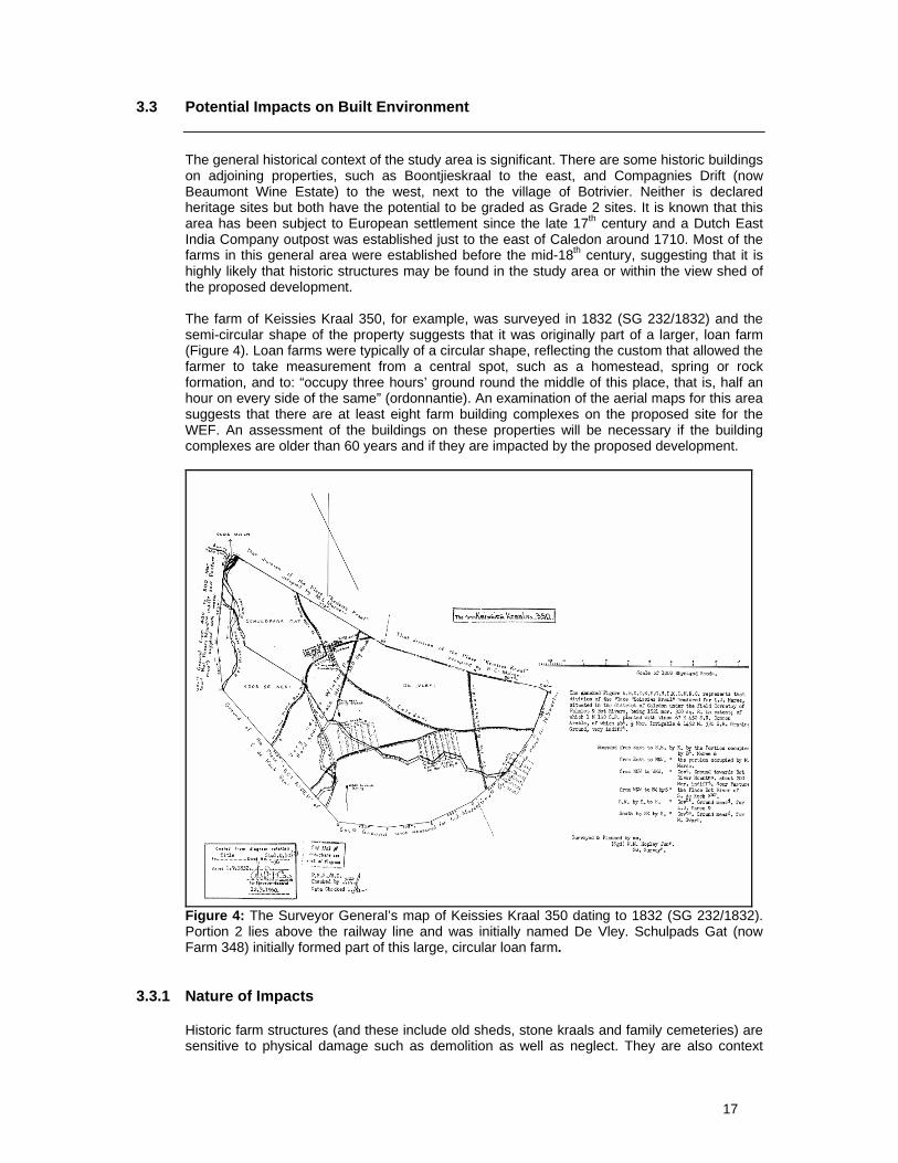
The general historical context of the study area is significant. There are some historic buildings on adjoining properties, such as Boontjieskraal to the east, and Compagnies Drift (now Beaumont Wine Estate) to the west, next to the village of Botrivier. Neither is declared heritage sites but both have the potential to be graded as Grade 2 sites. It is known that this area has been subject to European settlement since the late 17th century and a Dutch East India Company outpost was established just to the east of Caledon around 1710. Most of the farms in this general area were established before the mid-18th century, suggesting that it is highly likely that historic structures may be found in the study area or within the view shed of the proposed development. The farm of Keissies Kraal 350, for example, was surveyed in 1832 (SG 232/1832) and the semi-circular shape of the property suggests that it was originally part of a larger, loan farm (Figure 4). Loan farms were typically of a circular shape, reflecting the custom that allowed the farmer to take measurement from a central spot, such as a homestead, spring or rock formation, and to: “occupy three hours’ ground round the middle of this place, that is, half an hour on every side of the same” (ordonnantie). An examination of the aerial maps for this area suggests that there are at least eight farm building complexes on the proposed site for the WEF. An assessment of the buildings on these properties will be necessary if the building complexes are older than 60 years and if they are impacted by the proposed development.
Figure 4: The Surveyor General’s map of Keissies Kraal 350 dating to 1832 (SG 232/1832). Portion 2 lies above the railway line and was initially named De Vley. Schulpads Gat (now Farm 348) initially formed part of this large, circular loan farm.
3.3.1 Nature of Impacts Historic farm structures (and these include old sheds, stone kraals and family cemeteries) are sensitive to physical damage such as demolition as well as neglect. They are also context

18
sensitive, in that changes to the surrounding landscape will affect their significance. The impacts to the built environment are likely to be of a visual nature and this will need to be assessed during the site inspection by the heritage and visual specialist.
3.3.2 Extent of the Impacts Direct impacts are not expected on structures located in the study area. However, if the proposed activity results in changes to the way in which historic structures are utilized, or affects their context, then negative impacts may result. Impacts of an indirect nature such as the visual intrusion of turbines on the sense of place of certain historic buildings may result and will require investigation. Table 2 provides a preliminary assessment of the potential impact on the Built Environment. Mitigation is likely to include buffers around historic farm structures to avoid the visual impact of the turbines on the sense of place around the farm structures and family graveyard. Mitigation would also include recommendations around re-use of an historic structure, for example as an office, during the construction or operation of the facility. Table 2: Impact Assessment on Built Environment
Criteria Without Mitigation With MitigationNature Negative Neutral Extent Medium Low Duration High Low Intensity Medium Low Reversibility High (The destruction of a
historic building cannot be reversed)
Low
Potential for impact on irreplaceable resources
High Low
Consequences Medium Low Probability Medium Low Significance Medium Low
3.4 Potential Impact on the Cultural Landscape
International literature indicates that visual impact and changes to the sense of place or setting are among the most contentious issues that the wind energy industry has had to face in terms of finding social acceptability. The proliferation of wind energy facilities in South Africa, in the absence of heritage guidelines or policy, is a cause of concern in terms of cumulative impacts. Wind energy facilities which require vast amounts of landscape pose significant impacts in terms of loss of iconic vistas, and landscape character change, especially in the Cape Province where the identity of the region is strongly linked to its spectacular landscape character. The cultural landscape associated with the study area can be described as rural and agricultural. According to the Overstrand Heritage Landscape Group this landscape falls into a category termed “Rural Farmland Landscape”. The wheat fields which characterise the area between Botrivier and Caledon are the product of 300 years of land transformation. The rolling wheatfields are adjacent to some key scenic routes, particularly certain sections of the N2 and the R43. The R43 to Villiersdorp and the back gravel road to Genadendal and Greyton is
19
particularly sensitive. Further, any developments alongside the N2 at Botrivier will be visible from the Houwhoek Pass and this may be a significant visual intrusion impacting on motorists. According to the Overstrand Heritage Landscape Group “Settlements occur as nodes set into this dramatic rural landscape with the mountain sweep from crest to rocky shoreline establishing the predominant character of the landscape”. The heritage qualities of the area will need to be appraised by the Visual Impact specialist during the EIA phase to ensure that the proposed development will not impact negatively on the historical identity of the area.
3.4.1 Nature of the Impact Cultural landscapes are highly sensitive to cumulative impacts and large scale development activities that change the character and public memory of a place. The construction of a WEF may result in changes to the overall sense of place or a locality, if not a region. The proposed activity is essentially a visual intrusion that is very difficult to measure due to the fact that there is little reference material on which the sense of change can be gauged in a local context.
3.4.2 Extent of Impacts Massed wind turbines are without doubt the most conspicuous structures which will impact the sense of place of this section of the Overberg. While this impact may be considered local in terms of physical extent, there may be wider implications in terms of the change in “identity” of the area and the cumulative impacts this could have on future tourism potential. In terms of this study, it should be noted that a number of wind energy facilities are proposed for this region both around the R43 and to the south of the N2 (Figure 5). It is anticipated that any massing of turbines in the vicinity of Botrivier will impact negatively on the vistas of the rolling wheat fields experienced from the Houwhoek Pass, while turbines along the R43 will have a negative impact on the driving experience to Greyton and Genadendal via the Riviersonderend Valley as well as the scenic drive to Villiersdorp. This means that the potential for alteration to the cultural landscape and sense of place is considered an issue that will need further attention during the EIA phase. Close integration of the heritage study and the visual impact assessment will be required. Table 3 provides a preliminary impact assessment of the proposed development on the Cultural Landscape. It does not take into consideration the cumulative impacts of at least three other proposed wind energy facilities in this area. Mitigation is likely to include the avoidance of sensitive area (e.g. corridors along scenic routes) and the placement of turbines on prominent ridges. Table 3: Impact Assessment on Cultural Landscape
Criteria Without Mitigation With MitigationNature Negative Neutral Extent Medium Low Duration High (for the length of the
facility) Low
Intensity High Low Reversibility Medium Landscape returns to its
original state once turbines are removed.
Potential for impact on irreplaceable resources
Medium (cultural landscapes cannot be replaced)
Low
Consequences High Low Probability Medium Low Significance Medium to High Low

20
3.5 Potential Mitigation Measures
The most feasible mitigation measure, with regard heritage matters, would be the avoidance of sensitive areas. Sensitive areas in terms of archaeology can only be identified after the fieldwork component of the EIA has been completed. In situ archaeological material (i.e. significant archaeological material) is more likely to occur in undisturbed areas, in other words in those areas which have not been ploughed in the past. Mitigation should ideally consist of avoidance of sensitive areas. If this is not possible, then mitigation may include the collection of surface distributions of stone tools, or if archaeological deposit is present, then excavations of archaeological material may be required. Further work would require a permit from HWC and the costs of such mitigation would be for the developer. With regard the built environment, it is recommended that there is a buffer zone around historic farm structures that are older than 60 years. The extent of the buffer may vary, but is generally around 500m. A buffer of 2km has already been approved by DEA around the historic property of Boontjieskraal and this will impact the placement of turbines. A similar buffer may apply with respect the historic Compagnies Drift (Beaumont Wine Estate) at Botrivier. It is recommended that appropriate buffers around farmsteads are determined during the EIA phase. If the construction or operation of the facility results in the re-use of buildings (such as houses or sheds) older than 60 years, then a permit will be required from HWC for any alterations to the structure of the building. The mitigation of the proposed turbines on the cultural landscape will involve the avoidance of sensitive areas. These are likely to be the corridors alongside scenic routes, such as the N2 and the R43. The approach to Botrivier along the N2 from the Houwhoek Pass is also considered sensitive. Following a site visit on 19 August 2011, Orton has recommended that the turbines should be placed to the east of the R43 and north of the N2. This will reduce the impact on the landscape substantially. He has recommended that turbines should not be placed on Farms 791, 350 and 362 as this would result in negative impacts to the Botrivier area and to the sense of gateway experienced when descending the mountains to the Overberg.

21
4 TERMS OF REFERENCE FOR THE IMPACT ASSESSMENT PHASE
The following heritage indicators may need to be addressed during the EIA phase.
4.1 Palaeontological Impact Assessment
A Palaeontological Impact Assessment will be required during the EIA process. This is likely to comprise a desk-based assessment. During construction, particularly the excavation of the bases for the turbines, periodic monitoring of the excavations may be required.
4.2 Archaeological Impact Assessment
A field survey will be required to determine whether any pre-colonial or colonial period archaeological remains will be negatively impacted by the proposed activity. It is expected that much of the impact to surface archaeological heritage may be mitigated by the avoidance of sensitive areas. Micro-adjustment of turbine footings, moderate deviations in service trenches, road alignments or power line towers are expected to be all that will be required in terms of open pre-colonial/colonial sites. If for any reason mitigation by avoidance is not feasible, the usual process it to record and sample the archaeological site with a permit issued by HWC before destruction is permitted.
4.3 Unidentified archaeological material, human remains and fossils
There is always a chance that archaeological material, human remains and fossils may be exposed during bulk excavations for services and foundations. All archaeological material over 100 years of age is protected and may only be altered or removed from its place of origin under a permit issued by HWC. Similarly, if human remains are accidentally uncovered, work must cease in that area and SAHRA must be notified. A permit, obtained from the SAHRA Burials Unit, will be required to excavate/exhume human remains. Mitigation is at cost of the developer, while time delays and diversion of machinery/plant may be necessary until mitigation in the form of conservation or archaeological/palaeontological sampling is completed.
4.4 Built Environment
It is not expected that the built environment will be directly impacted by the proposal unless it becomes necessary to demolish structures that are greater than 60 years of age. It is possible that farm houses may change use as a result of the activity, in which case application of the requirements of the NHRA is appropriate, the responsibility for which falls on the landowner. However, impacts on farmhouses and related historic buildings may be of an indirect nature, affecting a sense of place. For example, farm buildings which are considered to have Grade 1, 2 or 3a status may require a buffer zone to secure their heritage significance. While the policy document of the Provincial Government of the Western Cape regarding the site selection for wind energy sites proposes a 500m buffer between turbines and heritage sites, this figure is considered a minimum value and may be increased by HWC.
4.5 Cultural Landscape
There is no doubt that the wind turbines will affect the landscape qualities of the area, however the degree of impact will be very closely related to the visual impacts of the proposed activity

22
(the Visual Impact Assessment will need to be separately addressed). The locating of infrastructure close to historical farmsteads and settlements may result in impacts to the quality of the place. From this perspective the layout of the facility will need to respond to the findings of the heritage impact component of the EIA, along with close input from the visual specialist. It is anticipated that there will be a visual impact on the R43 to Villiersdorp. This is a popular tourism route and the visual impact on the route will need to be carefully assessed. At least three other wind energy facilities have been proposed for the immediate vicinity of the Langhoogte WEF, and together these may have a significant cumulative impact on the cultural landscape of the area, if all are eventually granted permission to operate.
Figure 5: The position of the four proposed wind energy facilities for the area.
4.6 Recommendations for the EIA
The EIA needs to fulfil the requirements of heritage impact assessment as defined in Section 38 of the NHRA. This means that the assessment has to cover the full range of potential cultural heritage as defined as “cultural” contained in the NHRA. The following assessments are likely to be required:
A desktop palaeontological assessment; A survey by an archaeologist to determine the location of pre-colonial and colonial
archaeological remains. The significance of each find will need to be assessed along with the impacts of the proposed activity. Mitigation measures will need to be identified;
Proposed routes of linear infrastructure (access roads, underground services, power lines) will need to be ground-proofed to establish the impacts of the proposed activity and determine where mitigation (if any) will be required;

23
The colonial period history of the area will need to be established through archival research and the assessment of the built environment both within the study area, and within a 2km radius from the boundaries. This is to determine the impact of the proposed action to the historical significance of the place;
In terms of impacts on the cultural landscape, it is proposed that careful positioning of the turbines will be required within the study area to mitigate the visual impact. Close co-operation with the VIA specialist will be required; and
Follow up heritage work, such as monitoring of excavations by an archaeologist and/or palaeontologist, is may be required in the Environmental Management Plan.

24
5 CONCLUSION
The pre-feasibility study suggests that in terms of palaeontology, archaeology and the built environment, the impacts of the proposed activity are expected to be limited and controllable. In terms of the cultural landscape qualities of the area, impacts are expected. Although the present proposal is for a relatively small wind farm comprising 20-30 turbines, the cumulative impact of several wind farms on adjoining properties in the Caledon area is potentially severe. This is particularly so since the proposed activity is situated in a prominent and scenic area, in a region valued for its historical rural character and adjacent a scenic route. The degree and nature of the impact is going to depend on how the wind turbines are arranged on the landscape, and the ability of the topography to absorb their presence, an issue which will require close attention during the EIA. As there is still no clarity on how many of the wind energy facilities proposed for the Caledon area will receive official approval and be commissioned, the cumulative impact will be difficult to predict.

25
6 REFERENCES
Almond, J. & Pether, J. 2008. Palaeontological Heritage of the Western Cape. Interim Technical Handbook prepared for Heritage Western Cape. CNdv Africa Planning & Design. May 2006. Towards a Regional Methodology for Wind Energy Site Selection. Prepared for the Provincial Government of the Western Cape. Reports 1 & 6. Clarke, S. 2009. Balancing Environmental and Cultural Impact against the Strategic need for Wind Power. International Journal of Heritage Studies. Clift, H. 2001. A sortie into the archaeology of the Moravian mission station, Genadendal. Unpublished MA thesis: University of Cape Town. Du Toit, S.J. 2004. Spore oor die Overberg: Geskiedkundige anecdotes uit die Overberg. ABC Drukkers: Kaapstad. Hart, T. 2009. Scoping Heritage Impact Assessment of a proposed Wind Energy Facility to be situated within the Caledon district, South Western Cape. Unpublished report for Arcus Gibb (Pty) Ltd. Hart, T. 2010. Heritage Impact Assessment: Proposed Wind Energy Facility near Caledon comprising Klip Heuvel no. 410/5 (Remaining Extent) & 410/9; Klipheuvel no: 410/8 (alias Kruis Vley) & 410/10 (alias Haasjes Kop); portions 417/0 of the Farm Boontjieskraal and 418/0 (Remaining Extent) of Farm 418; Portion 1 (Remaining Extent) Huveltjes Kraal 426; Heuwelkraal a portion of the farm Pampoenkraal 843/0. Unpublished report for Savannah Environmental (Pty) Ltd. Kaplan, J. 2006. A Phase 1 Archaeological Impact Assessment: Proposed Development of Portion 5 of Farm 436 Caledon. An unpublished report by the Agency for Cultural Resources Management. Kaplan, J. 2006. Phase 1 Archaeological Impact Assessment: Proposed Housing Development on Portion 25 of the Farm Compagniesdrift 436 Caledon. An unpublished report by the Agency for Cultural Resource Management. Kaplan, J. 2007. Phase 1 Archaeological Impact Assessment: Proposed Overberg Gateway Development (Phase 1 and Phase 2) Portion of Farm 858 Caledon. An unpublished report by the Agency for Cultural Resource Management. Nienaber, GS. 1989. Khoekhoen se Stamname. HSRC: Pretoria Macfarlane, DR. 1949. A preliminary report on the age of the high-level gravels between Napier and Riversdale. The South African Archaeological Bulletin 4(15):95-97. Overstrand Heritage Landscape Group. December 2009. Overstrand Heritage Survey. Draft Report. Unpublished report prepared for the Overstrand Municipality. Webley, L. & Halkett, D. 2011. Heritage Impact Assessment for the Caledon Wind Farm, Western Cape Province. Unpublished report for Arcus Gibb (Pty) Ltd. Winter, S. & Bauman, N. 2005. Guidelines for involving heritage specialists in EIA process. Edition 1. CSIR Report No ENV-S-C 2005 053E. Provincial Government of the Western Cape: Department of Environmental Affairs and Development Planning. The Surveyor Generals Office, Cape Town. SG 232/1832