ensuring that structures built on fill in or near special...
TRANSCRIPT

FEDERAL EMERGENCY MANAGEMENT AGENCY
MITIGATION DIRECTORATE
Ensuring That Structures Built on Fill In or Near Special FloodHazard Areas Are Reasonably Safe From Floodingin accordance with theNational Flood Insurance Program
FIA-TB-10(5/01)
TechnicalBulletin
10-01

Any comments on the Technical Bulletins should be directed to:
Federal Emergency Management AgencyMitigation DirectorateProgram Policy and Assessment Branch500 C Street, SW.Washington, DC 20472
Wave design on cover based on the Japanese print The Great Wave Off Kanagawa, by Katsuchika Hokussai(1760–1849), Asiatic Museum of Fine Arts, Boston.
Key Word/Subject Index
This index allows the user to locate key words and subjects in this Technical Bulletin. TheTechnical Bulletin User’s Guide (printed separately) provides references to key words andsubjects throughout the Technical Bulletins. For definitions of selected terms, refer to theGlossary at the end of this bulletin.
Key Word/Subject Index Page
Basement construction, engineered option 19Basement construction, simplified approach 15Basement foundation in fill, not recommended 9Basement foundation in fill, vulnerability to subsurface flooding 1, 9Basement foundation, in fill placed above BFE 10Basement foundation, with lowest floor at or above BFE 10Basement foundation, with lowest opening above BFE 11Basement foundation, with lowest opening at BFE 12Community permitting, administrative options for 5Crawlspace foundation 7Fill, placed to remove land from the SFHA 1Fill, areas where prohibited 3Fill, proper placement of 5Foundation flood risk, summary table 13Freeboard, recommendations 6Insurance coverage for basement flooding, restrictions 9Professional certification 4Professional certification, sample form 4“Reasonably safe from flooding,” defined 2“Reasonably safe from flooding,” NFIP regulations concerning 2Slab-on-grade foundation 8Stem wall foundation 7Sump pump, requirements for simplified basement construction 15

TECHNICAL BULLETIN 10-01
Ensuring That Structures Built on Fill In or Near Special Flood Hazard AreasAre Reasonably Safe From Flooding
in accordance with the National Flood Insurance Program
Introduction
For the purpose of administering the National Flood Insurance Program (NFIP), FEMA identifies andmaps flood hazard areas nationwide by conducting flood hazard studies and publishing FloodInsurance Rate Maps (FIRMs). These flood hazard areas, referred to as Special Flood Hazard Areas(SFHAs), are based on a flood having a 1-percent probability of being equaled or exceeded in anygiven year (also referred to as the 100-year flood or Base Flood).
Structures within the SFHA in a community participating in the NFIP are subject to floodplainmanagement regulations that impact building standards and are designed to minimize flood risk. Forexample, Title 44, Part 60, Section 3(c)(2) of the Code of Federal Regulations—abbreviated as 44CFR 60.3(c)(2)—requires that the lowest floor of a residential structure, including basement, builtwithin the SFHA be at or above the Base Flood Elevation (BFE). In addition, flood insurance must bepurchased for these structures if they are used as collateral to secure a loan provided by a federallyregulated lender. Flood insurance coverage may be purchased for all eligible structures within aparticipating community. Insurance rates for structures located within the SFHA differ from the ratesfor structures located outside the SFHA.
When permitted under applicable Federal, state, and local laws, ordinances, and regulations, earthenfill is sometimes placed in an SFHA to reduce flood risk to the filled area. Under certain conditions,when engineered earthen fill is placed within an SFHA to raise the surface of the ground to or abovethe BFE, a request may be submitted to FEMA to revise the FIRM to indicate that the filled land isoutside of the SFHA. When such revisions are warranted, FEMA usually revises the FIRM by issuinga Letter of Map Revision based on fill (LOMR-F). After FEMA has revised the FIRM to show that thefilled land is outside the SFHA, the community is no longer required to apply the minimum NFIPfloodplain management standards to any structures built on the land and the mandatory floodinsurance purchase requirements no longer apply. It is worth noting that states and local communitiesmay have floodplain regulations that are more restrictive than the minimum requirements of the NFIPand may continue to enforce some or all of their floodplain management requirements in areas outsidethe SFHA.
Although a structure built on a site that has been elevated by the placement of fill may be removed byFEMA from the SFHA, the structure may still be subject to damage during the Base Flood andhigher-magnitude floods. Constructing the entire structure at or above the level of the BFE willminimize the flood risk from the Base Flood and is therefore the most prudent approach toconstructing on fill. Conversely, a structure with a basement (subgrade area) adjacent to or near thefloodplain may well be impacted by subsurface flooding brought on by surface flooding.
1

This bulletin provides guidance on the construction of buildings on land elevated above the BFEthrough the placement of fill. Several methods of construction are discussed, and the most prudent—those that result in the entire building being above the BFE—are recommended.
In some areas of the country, basements are a standard construction feature. Individuals may wish toconstruct basements on land after it has been removed from the floodplain by a FEMA revision.Buildings with basements built in filled areas are at an added risk of flooding when compared tobuildings on other types of foundations. However, there are two major ways to minimize thisadditional risk from subsurface flooding. First, the building should be located farther back from theedge of the fill closest to the flooding source. Second, the higher the basement floor is elevated, theless the risk. This technical bulletin provides guidance on how to determine that these buildings willbe reasonably safe from flooding during the occurrence of the Base Flood and larger floods. To bereasonably safe from flooding during the Base Flood condition, the basement must (1) be dry, nothave any water in it, and (2) be structurally sound, not have loads that either exceed the structuralcapacity of walls or floors or cause unacceptable deflections. In practice, this means that soils aroundthe basement must have low permeability to minimize or stop water infiltration to the basement walland floors. Any water that does permeate to the basement must be removed by a drainage layer on theoutside (soil side) of the basement. In addition, the foundation walls and floor slab must be designedand constructed for any increased loads that may occur during the Base Flood condition.
NFIP Regulations
Part of a community’s application to participate in the NFIP must include “a commitment to recognizeand duly evaluate flood hazards in all official actions in the areas having special flood hazards and totake other such official actions reasonably necessary to carry out the objectives of the program” [44CFR 59.22 (a)(8)].
NFIP regulations at 44 CFR 60 include Subpart A: Requirements for Flood Plain ManagementRegulations. Each community participating in the NFIP adopts a floodplain management ordinancethat meets or exceeds the minimum requirements listed in 44 CFR 60. Subpart A establishes specificcriteria for determining the adequacy of a community’s floodplain management regulations. Theoverriding purpose of the floodplain management regulations is to ensure that participatingcommunities take into account flood hazards, to the extent that they are known, in all official actionsrelating to land management and use.
One of the minimum requirements established by the regulations is set forth at 44 CFR 60.3 (a)(3),which states that, for all proposed construction or other development within a participatingcommunity, the community must “Review all permit applications to determine whether the proposedbuilding sites will be reasonably safe from flooding.” 44 CFR 59.1 defines “development” as
“…any manmade change to improved or unimproved real estate, including but notlimited to buildings or other structures, mining, dredging, filling, grading, paving,excavation or drilling operation or storage of equipment or materials,”
2

3
Floodways, V Zones, and Alluvial Fan Flood Hazard Areas
This bulletin does not apply to the following:
• Construction in the floodway. The NFIP prohibits encroachments into the floodway thatwould cause increases in flood stage.
• Construction in SFHAs designated Zone V, VE, or V1-V30 on FIRMs. The NFIP prohib-its the use of structural fill for support of buildings in V zones. Buildings constructed in aV zone must be constructed on an open foundation consisting of piles, piers, or posts andmust be elevated so that the bottom of the lowest horizontal structural member is at orabove the BFE. In addition, this bulletin strongly recommends that structural fill not beused to elevate buildings constructed in A zones in coastal areas. Detailed guidanceconcerning proper construction methods for buildings in coastal areas is presented inFEMA’s Coastal Construction Manual (FEMA 55) and in NFIP Technical Bulletin 5,Free-of-Obstruction Requirements.
• Construction in SFHAs subject to alluvial fan flooding (designated Zone A0 with depthsand velocities shown on FIRMs). The NFIP will not remove land from the floodplainbased on the placement of fill in alluvial fan flood hazard areas.
More Restrictive State and Local Requirements
NFIP Technical Bulletins provide guidance on the minimum requirements of the NFIPregulations. State or local requirements that exceed those of the NFIP take precedence. Designprofessionals should contact community officials to determine whether more restrictive state orlocal regulations apply to the building or site in question. All applicable standards of the state orlocal building code must be met for any building in a flood hazard area.
By issuance of this Technical Bulletin, FEMA is noting that residual flood hazards may exist in areaselevated above the BFE by the placement of engineered earthen fill. Residual risks in these areasinclude subsurface flood conditions and flooding from events that exceed the base flood. This bulletinis intended to guide local floodplain management officials in determining whether structures placed infilled areas are reasonably safe from flooding. FEMA will require that the jurisdiction havingauthority for floodplain management determine that an area is reasonably safe from flooding beforeremoving it from the SFHA.
Warning
Construction of a residential building in an identified SFHA with a lowest floor below the BFEis a violation of the floodplain management requirements set forth at 44 CFR 60.3(c)(2), unlessthe community has obtained an exception to NFIP requirements from FEMA and has approvedprocedures in place.

Notes for Local Officials
Professional Certification
As required by state and local floodplain management ordinances, a proposed development must bedetermined to be reasonably safe from flooding. The official having the authority to make thisdetermination should require all appropriate information for making the determination. This mayinclude a certification by a qualified design professional that indicates the land or structures to beremoved from the SFHA are reasonably safe from flooding, according to the criteria described in thistechnical bulletin. Such a professional certification may come from a professional engineer,professional geologist, professional soil scientist, or other design professional qualified to make suchevaluations. A sample of such a certification is shown in Figure 1.
4
Figure 1 Sample of professional certification form.
Address and Phone
Professional Seal
Project Name and Address
Type of License
Title
Signature Date
License Number
I, certify that the design for the aforementioneddevelopment is reasonably safe from flooding in accordance with the guidance provided within FEMA’sTechnical Bulletin 10-01 related to ensuring that structures are reasonably safe from flooding and inaccordance with accepted professional practices.
License Expiration Date

Administrative Options for Community Permitting
Communities may choose a variety of administrative procedures to assist them in gatheringinformation that can be used to determine whether a proposed development is reasonably safe fromflooding. Communities are encouraged to establish procedures that alert them to potential futuredevelopment of a filled area. These procedures should allow for the evaluation of future developmentand a means to determine whether it will be reasonably safe from flooding. The following areexamples of such procedures:
• Require building sites to be identified on final subdivision plats and evaluate those building sitesagainst the standards described in this Technical Bulletin.
• Require grading plans as a condition of issuing fill permits and require that those grading plansinclude building sites, and evaluate those building sites based on this Technical Bulletin.
• Require buffer zones or setback zones around the perimeter of fill pads or at the edge of the flood-plain and establish construction requirements within these buffer zones to ensure that buildings aresafe from residual risk.
• Require as a condition of final subdivision plat approval that the developer agree that no basementswill be built in any flood areas.
• Adopt or have regulations that control development of areas immediately adjacent to floodplainsthat would ensure that any construction is reasonably safe from flooding. For example, under theMinnesota State Building Code, communities designate areas outside of the floodplain as “Second-ary Flood Hazard Areas” where building officials evaluate plans for basements and can requiremodifications to the basement if an official believes there is a residual risk.
• When issuing a permit for the placement of fill only in the SFHA, stipulate that no buildings will bebuilt on the site without a subsequent building permit.
Placement of Fill
Properly placing fill requires an understanding of soil mechanics, local site conditions, the specificcharacteristics of the soils being placed, the methods used to place and compact the fill, and soiltesting procedures. Standard engineering and soil mechanics texts cover these subjects in detail. Theperformance of these filled areas should consider, but is not limited to, the following:
• the consolidation of the fill layers and any underlying layers
• the effect of this consolidation on either excessive settlement or differential settlement
• how the permeability of the soils affects water infiltration on any structures built on the site
5

6
Building on Land Removed From the SFHA by the Placement of Fill
The safest methods of constructing a building on filled land removed from the SFHA are those thatresult in the entire structure being above the BFE. Methods that place the lowest floor of the buildingat, rather than above, the BFE are at greater flood risk, and methods that result in the lowest floor(including a basement floor) below the BFE have the highest flood risk of all. Placement of the lowestfloor of these structures below the BFE, even through they are outside the SFHA, will result in anincreased threat from subsurface flooding and magnified damages from flooding that exceeds the BFE.
Loss of Storage and Conveyance
The placement of fill in the SFHA can result in an increase in the BFE by reducing the ability toconvey and store flood waters. This can result in increased flood damage to both upstream anddownstream properties. To prevent these possible results, some communities prohibit fill, requirecompensatory storage for filled areas, and/or identify a more restrictive floodway.
Risk of Flood Damage in Areas Adjacent to the SFHA
Areas adjacent to the SFHA may have residual risks of flood damage similar to those in areasremoved from the SFHA through the placement of fill. Both areas are subject to residual riskfrom subsurface water related to flooding and from floods greater than the Base Flood. Methodsof construction discussed in this bulletin should also be used in these areas.
The foundation types for buildings outside the SFHA described in the following sections are listed inorder of their increasing risk of flood damage.
Freeboard
Freeboard is an additional height used as a factor of safety in determining the elevation of a structure,or floodproofing, to compensate for factors that may increase the flood height (ASCE 24-98, FloodResistant Design and Construction). When fill is used to protect buildings from the Base Flood, thecommunity should consider whether freeboard should be required. This consideration shouldinclude whether better information exists or conditions have changed (from when the BFE wasoriginally established) that indicate that the BFE may be higher than originally expected. Oneexample of when the BFE may be higher is when a culvert or bridge is blocked by debris. Floodmodeling assumes an open channel or culvert. Even when the BFE is not expected to be higher,freeboard may be appropriate to provide increased protection from flood events less frequentthan the Base Flood or to account for future changes that may increase the BFE.

Non-Basement Foundations
Non-basement foundations consist primarily of stem wall, crawlspace, and slab-on-grade foundations.
Stem Wall Foundation
A stem wall foundation can be used to raise the lowest floor above the surrounding grade. After thestem walls have been constructed and extended to the desired elevation, the area enclosed by the stemwalls is filled with engineered compacted fill and a slab is poured on top (see Figure 2). Through theplacement of additional fill, the site may be elevated above the BFE. This approach providesfreeboard—an additional amount of elevation that helps protect against subsurface flooding and floodsthat exceed the Base Flood. Constructing a stem wall foundation and placing this additional fill on thesite provide the highest level of flood protection.
7
Crawlspace Foundation
Constructing a crawlspace beneath the first floor will raise the lowest floor of the structure above thesurrounding grade (see Figure 3). Openings in the foundation walls are recommended. If floodingreaches the building, the openings allow flood waters to enter the area below the lowest floor andequalize the hydrostatic pressure on the foundation walls (see NFIP Technical Bulletin 1, Openings InFoundation Walls).
The crawlspace alternative is less preferable than stem wall construction, which does not result in anenclosed area under the first floor and therefore requires no flood openings. Placing additional fill to alevel above the BFE provides freeboard that helps protect against subsurface flooding and floods thatexceed the Base Flood. Constructing a crawlspace foundation and placing additional fill on the siteprovide increased flood protection.
Figure 2 Structure on a stem wall foundation. The lowest floor is raised above the BFE. Thespace enclosed by the stem walls is filled with engineered compacted fill.

8
Slab-On-Grade Foundation
This method normally provides less flood protection than crawlspace construction because it does notelevate the house above the adjacent grade (see Figure 4). As a result, the lowest floor of the house canbe as low as the BFE and would be inundated by any flood greater than the BFE. Placing additionalengineered fill beneath the building to a level above the BFE would provide freeboard and thereforeincreased flood protection.
Figure 3 Structure on a crawlspace foundation. The lowest floor is raised above the BFE.Openings in the foundation walls allow water from floods higher than the fill elevationto enter the crawlspace and equalize the pressure on foundation walls.
Figure 4 Structure on a slab-on-grade foundation. The lowest floor is typically slightly higherthan the surrounding grade.
Basement Foundations
Although basements are a desired feature in some areas of the United States, NFIP minimumrequirements generally do not allow their construction in the SFHA, because of the increased risk offlood damages. The only instances where this is not the case are buildings for which FEMA hasgranted a special exemption to allow floodproofed basements. However, once land is removed fromthe SFHA through a map revision, these NFIP minimum requirements no longer apply. As a result,builders and property owners who build on land removed from the SFHA sometimes elect to installbasements, which are at a higher risk of flood damage than the foundation types described previously.
Constructing a basement on such land is not recommended, because the basement (i.e., lowest) floorand portions of the basement walls may well be subjected to subsurface flooding. The basement maytherefore be subject to seepage and lateral hydrostatic and uplift pressure caused by high groundwaterlevels associated with flooding in surrounding areas. Additionally, when flooding exceeds the BFE,the basement area may be totally inundated with floodwater. When builders and homeowners decideto accept the additional risk associated with basement construction on filled land, they need to ensurethat the basement and the rest of the house are reasonably safe from flooding.
9
Flood Insurance Coverage for Basements
It is extremely important to note that the NFIP offers only limited coverage for basementflooding. First, in order for a claim to be paid, there must be a general condition of overlandflooding where floodwaters come in contact with the structure. Secondly, the NFIP does notprovide coverage for finished nonstructural elements such as paneling and linoleum inbasement areas. Contents coverage is restricted to a limited number of items listed in the floodinsurance policy. Contact a local insurance agent for more information.
Warning
In filled areas adjacent to floodplains, floods can still greatly influence the groundwater at thefilled site. High groundwater at a site with a basement can result in water infiltrating thebasement or greatly increased hydrostatic pressures on the walls and basement slab that cancause failure or permanent deformation. Even when floods have not reached houses withbasements, FEMA has seen numerous examples of flooded basements, bowed basement floors,and collapsed basement walls that have resulted from the effects of high groundwater caused byflooding. In addition, the collapse of flooded basements has also occurred when water is rapidlypumped from basements surrounded by saturated soils whose pressure exceeds the capacity ofthe basement walls.

10
Four basement construction methods are described below in increasing order of flood risk.
Basement Foundation With Lowest Floor At or Above BFE
Placing the lowest floor of the basement at or above the BFE has the effect of eliminating flood-induced damage up to the BFE (see Figure 5). In general, the higher the basement floor is above theBFE the lower the risk of damage from seepage and hydrostatic pressure caused by flood-relatedgroundwater. Where possible, the basement should be built with its floor at or above the BFE. Anadded benefit is that floods that exceed the BFE will cause significantly less damage to a structurewith this type of basement than to structures with basements whose floors are at greater depths.
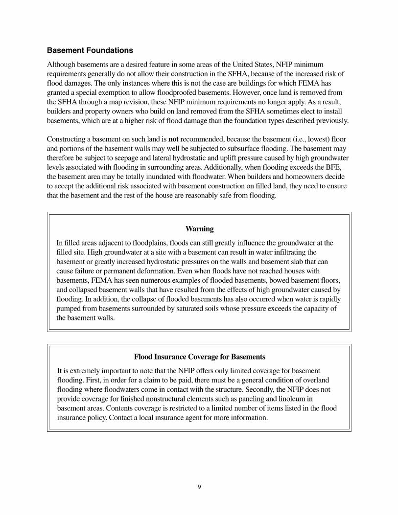
Basement Foundation in Fill Placed Above BFE
Placing fill to a level higher than the BFE has the effect of reducing the depth of the basement floorbelow the BFE (see Figure 6). It is recommended that fill be placed to a level at least 1 foot above theBFE. In general, the higher the basement floor the lower the risk of damage from seepage andhydrostatic pressure caused by flood-related groundwater. Where possible, enough fill should beproperly placed so that the lowest grade adjacent to the structure is raised to an elevation greater thanthe BFE. An added benefit of fill placed above the BFE is that it helps protect the building from floodsgreater than the Base Flood. These floods are less likely to reach the structure.
Figure 5 Basement foundation with lowest floor above the BFE. Damage from floods belowthe BFE is eliminated.
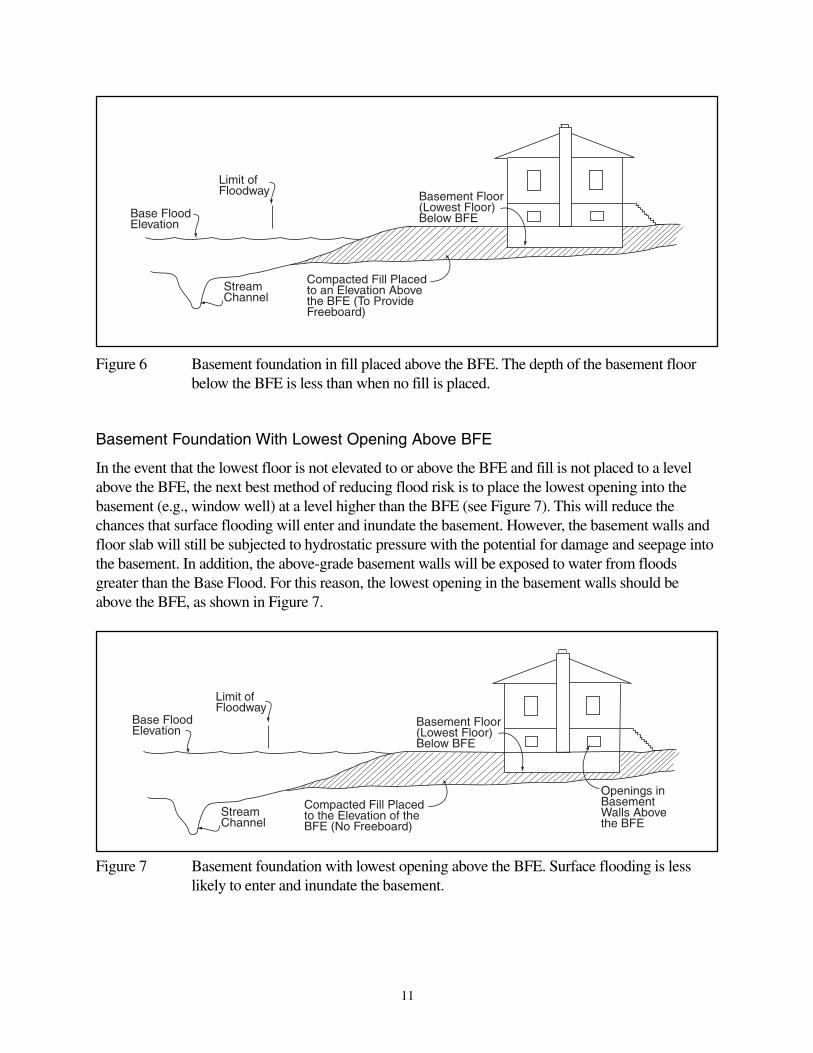
Basement Foundation With Lowest Opening Above BFE
In the event that the lowest floor is not elevated to or above the BFE and fill is not placed to a levelabove the BFE, the next best method of reducing flood risk is to place the lowest opening into thebasement (e.g., window well) at a level higher than the BFE (see Figure 7). This will reduce thechances that surface flooding will enter and inundate the basement. However, the basement walls andfloor slab will still be subjected to hydrostatic pressure with the potential for damage and seepage intothe basement. In addition, the above-grade basement walls will be exposed to water from floodsgreater than the Base Flood. For this reason, the lowest opening in the basement walls should beabove the BFE, as shown in Figure 7.
11
Figure 6 Basement foundation in fill placed above the BFE. The depth of the basement floorbelow the BFE is less than when no fill is placed.
Figure 7 Basement foundation with lowest opening above the BFE. Surface flooding is lesslikely to enter and inundate the basement.

Basement Foundation With Lowest Opening at BFE
This is the least preferable condition of all because it results in the highest flood risk and is notrecommended (see Figure 8). The lack of fill above the BFE, coupled with the lowest floor beingbelow BFE and lowest opening at the BFE, exposes the basement to flooding from both subsurfaceflooding and any flood greater than the Base Flood.
12
Figure 8 Basement foundation with lowest opening at the BFE. The basement is exposed toflooding from any flood greater than the Base Flood.

13
Flood Risk by Foundation Type
Table 1 summarizes the foundation construction methods described in this bulletin and ranks them inorder of increasing flood risk—the safest foundation types appear near the top; the less safefoundation types appear near the bottom. The foundation construction methods that result in abuilding that is reasonably safe from flooding are shown in the dark gray area of the table. If thebasement construction methods shown in the light gray area are used, the requirements described inthe following sections of this bulletin must be met in order for the building to be consideredreasonably safe from flooding.
Table 1 Flood Risk by Foundation Construction Method

14
Basement Construction Guidance
For those who have chosen to accept the additional risk associated with basement construction belowthe Base Flood on filled land that has been removed from the SFHA, this bulletin provides technicalguidance about measures that can be taken to protect basements and meet the requirement thatbuildings be made reasonably safe from flooding. A simplified approach, including the requirementsthat must be met for its use, is presented first. For buildings that do not meet the criteria for thesimplified approach, this bulletin provides technical guidance for the development of an engineeringdesign tailored to the site conditions.
Structural Design
Design of foundation elements is addressed in model building codes. This technical bulletin doesnot address the structural design of basement walls or foundations. Floors and slabs should bedesigned for the hydrostatic pressures that can occur from the Base Flood. For the structuraldesign, it is recommended that the full hydrostatic pressures be assumed unrelieved by thedrainage system. Foundation walls that have not been designed for hydrostatic pressures, such asunreinforced masonry or pressure-treated wood wall systems, should not be used (see Figure 9).
Figure 9 Failure of this unreinforced masonry basement during flooding in East GrandForks, MN, in 1997 caused approximately $32,000 in damage.

Simplified Approach
Design Requirements
If, for a building and building site, all the requirements listed below are met (see Figure 10), thebuilding is reasonably safe from flooding. If all of these requirements are not met, the more detailedanalysis described under Engineered Basement Option, on page 19 of this bulletin, should beperformed to determine whether the building is reasonably safe from flooding.
The ground surface around the building and within a defined setback distance from theedge of the SFHA (see next item) must be at or above the BFE.
The setback is the distance from the edge of the SFHA to the nearest wall of the basement.The minimum allowable setback distance is 20 feet.
The ground around the building must be compacted fill; the fill material—or soil ofsimilar classification and degree of permeability—must extend to at least 5 feet below thebottom of the basement floor slab.
The fill material must be compacted to at least 95 percent of Standard LaboratoryMaximum Dry Density (Standard Proctor), according to ASTM Standard D-698. Fill soilsmust be fine-grained soils of low permeability, such as those classified as CH, CL, SC, orML according to ASTM Standard D-2487, Classification of Soils for EngineeringPurposes. See Table 1804.2 in the 2000 International Building Code (IBC) fordescriptions of these soil types.
The fill material must be homogeneous and isotropic; that is, the soil must be all of onematerial, and the engineering properties must be the same in all directions.
The elevation of the basement floor should be no more than 5 feet below the BFE.
There must be a granular drainage layer beneath the floor slab, and a ¼-horsepower sumppump with a backup power supply must be provided to remove the seepage flow. Thepump must be rated at four times the estimated seepage rate and must discharge above theBFE and away from the building. This arrangement is essential to prevent flooding of thebasement or uplift of the floor under the effect of the seepage pressure.
The drainage system must be equipped with a positive means of preventing backflow.
Model building codes (such as the 2000 International Residential Code) also addressfoundation drainage (IRC Section R405) and foundation walls (IRC Section R404).Model building codes generally allow foundation drains to discharge through eithermechanical means or gravity drains. In addition, there is often an exception to therequirement for drainage systems in well-drained soils. However, in or near floodplains,well-drained soils can, in fact, help convey groundwater towards the building foundation.Therefore, this exception should not apply in or near floodplains.
15

In some cases in or near floodplains, even with standard drainage systems, hydrostaticpressures from groundwater against the basement can result. When a standard drainagesystem is unable to eliminate hydrostatic pressure on the foundation, model buildingcodes, including the 2000 International Residential Code (IRC Section R404.1.3), requirethat the foundation be designed in accordance with accepted engineering practice. Thesimplified approach contained in this Technical Bulletin assumes no hydrostaticpressure on the foundation and should be used only when a standard drainagesystem, discharged by a sump pump that is equipped with backup power and thatdischarges above BFE, is employed. For other drainage systems, the designer should usethe engineered basement option presented on page 19 of this bulletin and other appropriatebuilding code requirements.
16
Figure 10 Requirements for use of the simplified approach to basement construction.

17
Technical Background for the Simplified Approach
The simplified approach is based on the following conditions:
1. The area of the footprint of the basement is less than or equal to 1,200 square feet.
2. The soil is saturated; therefore, there is no time lag in the development of the seepage pattern with achange in flood water level. The groundwater table in floodplains is typically very shallow, and fine-grained soils have a substantial potential for maintaining saturation above the water table by capillaryrise.
3. The tailwater level is at the elevation of the BFE. For this bulletin, “tailwater” is defined as thegroundwater level beyond the structure, on the side away from the flood water surface. This is areasonably conservative assumption because the flood would raise the groundwater level in thegeneral area. In some cases, the tailwater level can be higher than the flood level because there ishigher ground, as a valley wall, that feeds the groundwater into the floodplain soils.
4. The effective elevation of the base of the seepage flow zone can be defined (see Figure 11). Thiselevation is needed to permit calculation of the quantity of seepage flow. If the base elevation is notknown, its depth below the base of the floor slab can be conservatively approximated as one-half ofthe building width most nearly perpendicular to the shoreline of the flood water. This wouldapproximate the boundary effects of the three-dimensional seepage flow, in that it would represent theflow coming in from all sides and meeting in the center beneath the floor slab. This approach assumesa constant soil type and density over the flow zone. If the site has stratified soil layers, the engineeredbasement option should be used (see page 19 of this bulletin).
5. The quantity of seepage flow can be calculated by a simplified method based on Dupuit’sassumption that equipotential lines are vertical. (The Dupuit method uses Darcy’s law with specificphysical characteristics. A more detailed description can be found in the first two references listedunder “Further Information,” on page 23 of this bulletin.) The elements of the method are presented inFigure 11. The entry surface, with hydraulic head “a,” is a vertical line extending downward from theedge of the flood surface. The exit surface, with hydraulic head “b,” is a vertical line extendingdownward from the side of the structure closest to the flood water’s edge. The length of the flow path,“L,” is the setback distance. Flow is assumed to be horizontal, and the horizontal coefficient ofpermeability is the effective permeability. For simplicity, the small inclined entry zone at the riverbank and the exit zone below the basement floor are ignored. This is a reasonably conservativemeasure. The phreatic line, or the line below which the seepage flow occurs under positive pressure,extends from the edge of the flood water to the elevation of the bottom of the basement floor slab. Ifthe exit zone below the basement floor were included, the hydraulic head at “b” would be higher. Asshown in Figure 11, the phreatic line is not a straight line, but within the limits of the assumedboundary values, it is close to a straight line.

The Dupuit equation for the quantity of seepage flow is:
q = k(a2 – b2)/2L
where: q is the flow in cubic feet per second for a 1-foot width of seepage zone
k is the soil permeability in feet per second (fps) (maximum value of k is 1x10⁻³ fps)
a and b are hydraulic heads in feet (a < b + 5)
L is the length of the flow zone in feet (L > 20 feet)
Figure 11 Method for calculation of seepage flow.
18

19
To obtain Q, the total seepage flow, in cubic feet per second, q must be multiplied by the lengtharound the periphery of the four sides of the structure. This is a simplifying approach that obviates theneed for a three-dimensional flow net calculation and is reasonably conservative.
It should be noted that the soil permeability does not affect the geometry of the seepage zone or thegeometry of the phreatic line. The permeability does have a significant effect on the quantity ofseepage that must be collected and discharged by the drainage layer and the sump pump. Thecalculation of the quantity Q provides a basis for the selection of a sump pump of adequate capacity.To allow for possible errors in the estimation of the soil permeability, the pump should have a capacityof at least four times the calculated value of Q. As noted in the requirements section, a standard sumppump of ¼ horsepower or greater will generally satisfy the requirements of seepage removal for theconditions described above.
Engineered Basement Option
If the requirements specified for the simplified approach are not met, a licensed soils engineer orgeologist should perform a detailed engineering analysis to determine whether the structure will bereasonably safe from flooding. The analysis should consider, but is not limited to, the issues describedin the following sections.
Depth, Soil Type, and Stratification of Subsurface Soils
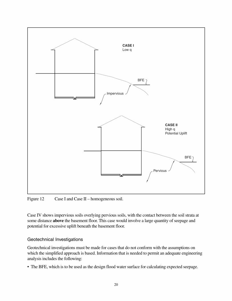
The depth, soil type, and stratification of the subsurface soils may be complex. Four potentialgeneralized scenarios are shown in Figures 12 and 13. Figure 12 shows two cases of homogeneoussoil. The depth of penetration of the basement and the depth of the flow zone are not limited to theassumptions on which the simplified approach is based. Case I represents a foundation consisting ofclayey soils, either fill or natural deposits or a combination, which are more or less homogeneousbecause they have similar engineering properties. If an adequate setback distance is provided, theseepage quantity would be relatively low, and uplift pressure beneath the slab could be controlled byan appropriately sized sump pump because of low permeability.
Case II represents a foundation consisting of sandy soils, either fill or natural soil deposits or acombination, which are more or less homogeneous because they have similar engineering properties.The seepage quantity would be fairly large, and more attention would have to be given to the setbackdistance and to the provision of an adequately sized sump pump to prevent excessive uplift pressurebeneath the floor slab because of high permeability.
Figure 13 shows two simple cases of stratified soils, with impervious clays overlying pervious sands.This is a common occurrence in natural floodplain deposits. In Case III, the contact between the twosoil strata is at some distance below the basement floor. This case would involve a moderate quantityof seepage, depending on the thickness, d, of the impervious stratum below the basement floor. Thereis also a potential for excessive uplift pressure beneath the floor, at the level of the bottom of the claystratum. If d is equal to h, the net hydraulic head between the flood level and the floor level, the safetyfactor against uplift would be approximately 1.0. If d is less than h, there would be excessive uplift,with a safety factor equal to less than 1.0.
20
Figure 12 Case I and Case II – homogeneous soil.
Case IV shows impervious soils overlying pervious soils, with the contact between the soil strata atsome distance above the basement floor. This case would involve a large quantity of seepage andpotential for excessive uplift beneath the basement floor.
Geotechnical Investigations
Geotechnical investigations must be made for cases that do not conform with the assumptions onwhich the simplified approach is based. Information that is needed to permit an adequate engineeringanalysis includes the following:
• The BFE, which is to be used as the design flood water surface for calculating expected seepage.
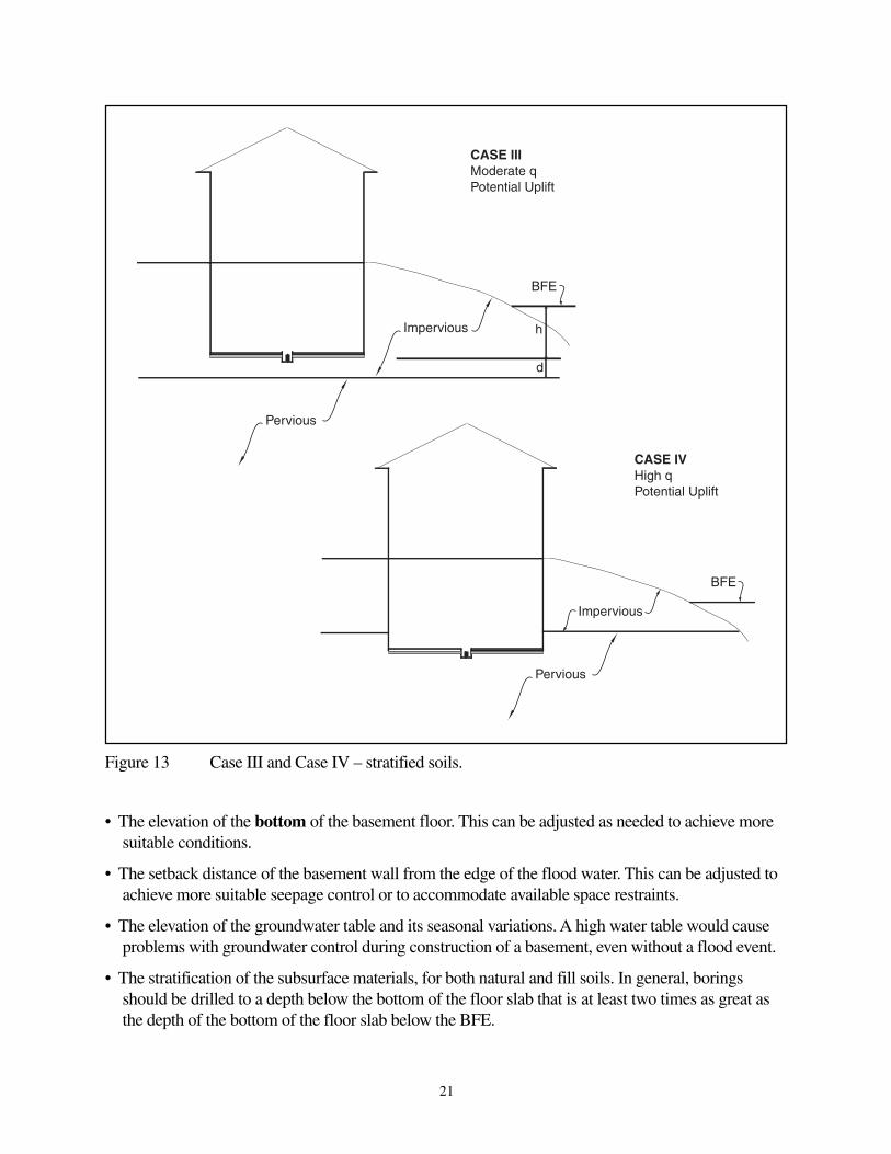
• The elevation of the bottom of the basement floor. This can be adjusted as needed to achieve moresuitable conditions.
• The setback distance of the basement wall from the edge of the flood water. This can be adjusted toachieve more suitable seepage control or to accommodate available space restraints.
• The elevation of the groundwater table and its seasonal variations. A high water table would causeproblems with groundwater control during construction of a basement, even without a flood event.
• The stratification of the subsurface materials, for both natural and fill soils. In general, boringsshould be drilled to a depth below the bottom of the floor slab that is at least two times as great asthe depth of the bottom of the floor slab below the BFE.
Figure 13 Case III and Case IV – stratified soils.
21
• The engineering classification of the soils, for both natural and fill soils. This must be done inaccordance with ASTM D2487, Classification of Soils for Engineering Purposes. This is theUnified Soil Classification System that is universally used throughout the United States. Local orcounty agricultural soil survey maps should not be used, because they do not give specificinformation about location and depth of soils, and their designations are not pertinent to civilengineering use.
• Subsurface conditions landward from the structure. This includes information about the location ofthe water table, whether it is higher or lower than the flood level, and information about anypenetrations of the soil, such as ponds. Attention should be given to the possibility that higherground, such as valley walls, could contribute to the groundwater level in the floodplain, eitherperennially or during periods of heavy rain.
• Information about any penetrations through the basement walls below the BFE, such as utility linesand other openings.
• Analysis of seepage quantity. The analysis can be made by the conservative simplified methoddescribed in Item 5 in the section titled Technical Background for the Simplified Approach(illustrated in Figure 11), or by the construction of a flow net that takes into account all of theboundary conditions more rigorously. A flow net may be required to permit analysis of upliftpressures. Uplift pressures may be more significant in laminated or stratified soil deposits.
Buildings in Existing Filled Areas
In evaluating buildings in existing filled areas, the two approaches already described—the simplifiedapproach or the engineered basement option—can be used. If the simplified approach is used, all therequirements for the use of this approach must be met. Some possible means for evaluating whetherthese requirements are met include soil tests and investigations, including soil borings and handaugers; field records from the time the fill was placed; and soil surveys. If the requirements for thesimplified approach are not met, a licensed soils engineer or geologist should perform a more detailedengineering analysis as described under Engineered Basement Option on page 19. More extensive soilinvestigations and testing may be required to complete the analysis.
The NFIP
The NFIP was created by Congress in 1968 to provide federally backed flood insurance coverage,because flood coverage was generally unavailable from private insurance companies. The NFIP is alsointended to reduce future flood losses by identifying floodprone areas and ensuring that new developmentin these areas is adequately protected from flood damage. The NFIP is based on an agreement betweenthe Federal government and participating communities that have been identified as floodprone. FEMA,through the Federal Insurance Administration (FIA), makes flood insurance available to the residentsof a participating community, provided the community adopts and enforces adequate floodplainmanagement regulations that meet the minimum NFIP requirements. The NFIP encourages communitiesto adopt floodplain management ordinances that exceed the minimum NFIP criteria set forth in Part60 of the NFIP Floodplain Management Regulations (44 CFR 60). Included in the NFIP requirements,found under Title 44 of the U.S. Code of Federal Regulations, are minimum building design andconstruction standards for buildings located in SFHAs. Through their floodplain management
22
ordinances or laws, communities adopt the NFIP performance standards for new, substantiallyimproved, and substantially damaged buildings in floodprone areas identified on FEMA’s FIRMs.
Technical Bulletins
This publication is one of a series of Technical Bulletins that FEMA has produced to provide guidanceconcerning the building performance standards of the NFIP. These standards are contained in 44 CFR60.3. The bulletins are intended for use primarily by state and local officials responsible forinterpreting and enforcing NFIP regulations and by members of the development community, such asdesign professionals and builders. New bulletins, as well as updates of existing bulletins, are issuedperiodically, as necessary. The bulletins do not create regulations; rather they provide specificguidance for conforming with the minimum requirements of existing NFIP regulations. Users of theTechnical Bulletins who need additional guidance concerning NFIP regulatory requirements shouldcontact the Mitigation Division of the appropriate FEMA regional office or the local floodplainadministrator. NFIP Technical Bulletin 0, the User’s Guide to Technical Bulletins, lists the bulletinsissued to date, provides a key word/subject index for the entire series, and lists addresses andtelephone numbers for FEMA’s 10 Regional Offices.
Ordering Information
Copies of FEMA Technical Bulletins can be obtained from the FEMA Regional Office that servesyour area. In addition, Technical Bulletins and other FEMA publications can be ordered from theFEMA Publications Distribution Facility at 1-800-480-2520. The Technical Bulletins are alsoavailable at the FEMA web site at www.fema.gov.
Further Information
The following publications contain information related to the guidance presented in this bulletin:
American Society of Civil Engineers. 1998. SEI/ASCE 24-98, Flood Resistant Design andConstruction.
Cedergren, H. R. 1977. Seepage, Drainage and Flow Nets. Wiley. New York.
Harr, M. E. 1977. Mechanics of Particulate Media. McGraw Hill. New York.
International Code Council. 2000. International Building Code. Birmingham, AL.
International Code Council. 2000. International Residential Code. Birmingham, AL.
U.S. Department of the Army, Corps of Engineers. 1986. EM 1110-2-1901, Seepage Analysis andControl for Dams. Washington, DC.
U.S. Department of the Army, Corps of Engineers. 1978. EM 1110-2-1913, Design and Constructionof Levees. Washington, DC.
23

Glossary
Base Flood – The flood that has a 1-percent probability of being equaled or exceeded in any givenyear (also referred to as the 100-year flood).
Basement – Any area of a building having its floor subgrade (below ground level) on all sides.
Community – Any state or area or political subdivision thereof, or any Indian tribe or authorizedtribal organization, or Alaska Native village or authorized native organization, which has the authorityto adopt and enforce floodplain management regulations for the areas within its jurisdiction.
Federal Emergency Management Agency (FEMA) – The independent Federal agency that, inaddition to carrying out other activities, administers the NFIP.
Federal Insurance Administration (FIA) – The component of FEMA directly responsible foradministering the flood insurance aspects of the NFIP.
Flood Insurance Rate Map (FIRM) – The insurance and floodplain management map issued byFEMA that identifies, on the basis of detailed or approximate analysis, areas of 100-year flood hazardin a community.
Floodprone area – Any land area susceptible to being inundated by flood water from any source.
Mitigation Directorate – The component of FEMA directly responsible for administering the floodhazard identification and floodplain management aspects of the NFIP.
New construction/structure – For floodplain management purposes, new construction meansstructures for which the start of construction commences on or after the effective date of a floodplainmanagement regulation adopted by a community and includes subsequent improvements to thestructure. For flood insurance purposes, these structures are often referred to as “post-FIRM”structures.
Special Flood Hazard Area (SFHA) – Area subject to inundation by the base flood, designated ZoneA, A1-30, AE, AH, AO, V, V1-V30, or VE.
24