emmen revisited - issues
TRANSCRIPT
Sjoerd Cusveller
Emmen Revisited
The space! Still a village ...
It is a gratifying sight to behold, a place approached from
a social perspective, where the building is carried out with
elan, with courage - a place which is often right on target
and where few architectural blunders are made.
Go and see it! Go see it and spread the word.'
Wieger Bruin, Forum, 11 (1956) no. 2/3
At the end of the 1950s, Em men caused a furore in the
Dutch architectural press. The architecture of the new facto
ry buildings, of the urban amenities and, last but not least,
of the new Emmermeer residential district all won great
admiration. This admiration was not so much based upon
their exceptionally high architectural quality as upon the
unassuming character of the experiment, the consistency
and the tempered modernism of the architecture and the
clarity and openness of the urban design. Above all, how
ever, the admiration was for the socio-cultural effort put into
transforming Emmen, a transformation of a rural town deep
in the Drenthe moorland with high unemployment and
abominable living conditions, into a modern place of indus
try. In the eyes of the people at the time, the miracle of cre
ating a new city was taking place in Emmen. Just as the
peat farmers had shaped the landscape of southeast
Drenthe in the past, the modern architects and urban
designers in the years following the Second World War gave
shape to the undoubtedly bright future of this forgotten part
of the Netherlands.
Emmen's transformation into a modern place of industry
began at the national level. The policy document De ver
spreiding van de bevolking in Nederland (The Distribution
of the Population of the Netherlands) from 1949 postulates
the need to stimulate new sources for suNival outside the
OASE 61
1 'De ruimte! Nog altijd een dorp ...
Het is weldadig een plaats tegen te komen, waar op
sociale grondslag zo wordt aangepakt, waar met elan, met
lef gebouwd wordt, - waar vaak in de roos wordt geschoten
en weinig architectonische bokken geschoten worden.
Gaat dat zien! Gaat dat a lies zien en publiceer het.'
Wieger Bruin, Forum, 11 (1956) nr. 2/3
Eind jaren vijftig maakt Emmen furore in de Nederlandse
architectuurpers. De architectuur van de nieuwe fabrieks
gebouwen, van de stedelijke voorzieningen en niet in de
laatste plaats van de nieuwe woonwijk Emmermeer oogstte
grote bewondering. Die bewondering is niet zozeer gestoeld
op de uitzonderlijk hoge architectonische kwaliteit, maar
vooral op het bescheiden karakter van het experiment,
de consistentie en het gematigde modernisme van de archi
tectuur en de helderheid en openheid van de stedenbouw
kundige opzet. De bewondering betreft echter bovenal
de sociaal-culturele inzet van de transformatie van Emmen,
een transformatie van een plattelandsgemeente diep in
I
het hoogveen van Drenthe met een hoge werkloosheid en
erbarmelijke woonomstandigheden, tot een moderne indu
strieplaats. In Emmen voltrekt zich in de ogen van tijdgeno-
ten het wonder van de creatie van een nieuwe stad. Zoals
de veenarbeiders het landschap van Zuidoost-Drenthe v66r
die tijd hebben gemaakt, zo geven de moderne architecten
en stedenbouwkundigen in de jaren na de Tweede Wereld
oorlog vorm aan de ongetwijfeld sprankelende toekomst
van dit vergeten deel van Nederland.
De transformatie van Emmen tot een moderne industrie
plaats begint op nationaal niveau. De beleidsnota De ver
spreiding van de bevolking in Nederland uit 1949 poneert
de noodzaak tot het stimuleren van nieuwe bestaansbron-
57
Randstad. *This argument was mainly supported by referring
to the overstressed pressure to urbanise in the western part
of the Netherlands and the loss of the traditional rural eco
nomy. In this context, a programme was quickly implement
ed for the expansion of the national road system and the
state offered the prospect of extra contributions for the spa
tial distribution of industry and for realising new urban
amenities such as schools, theatres, social amenities and
medical amenities. A few years previously, south-eastern
Drenthe had already been designated as a development
area. As a result of the disappearance of the peat farming
industry, the region was contending with an exceptionally
high structural unemployment rate among the peat farmers.
For this, too, the state had made funds available for pro
moting the establishment of new economic activity.
In the years just following the Second World War, the pro
motion of economic activity in southeastern Drenthe was
primarily understood to be a socio-economic measure for
reducing unemployment and poverty. The establishment of
new industry thus took place in the outer areas of Emmen
and not in the town centre. Unemployment was highest in
the surrounding villages and the new business establish
ments were able to merge almost seamlessly into the tradi
tional, rural society in the area. At the end of the 1950s, it
became evident that cheap and available labour alone was
not reason enough for a company to establish itself in
southeastern Drenthe. The negotiations surrounding the
establishment of the AKU (Aigemene Kunstzijde Unie or
Artificial Silk Maker's Union) illustrated that accessibility, the
amenities available and the housing market were at least as
important to being a truly attractive choice for the establish
ment of large industries, and thus also for drawing person
nel from outside the region. In its negotiations with the AKU,
Emmen's town council not only offered a site ready for
building at a reasonable price. The canal and the unloading
quays were also brought up to the required standards and
Em men would, at the request of the AKU, see to housing,
cultural amenities, sports accommodation, swimming pools
and other recreational amenities. All this was made finan
cially possible by a substantial state contribution to the local
authority and an investment subsidy for the AKU. Emmen
began to transform itself into a place of industry.
This kind of transformation from a socio-economically
underdeveloped region into a modern industrial centre is
exactly the sort of task in which social democracy, and by
extension the modern movement in architecture and urban
development, considers itself to have a high level of involve
ment. It is in fact a matter of the transformation of a tradi
tional, rural society into a modern, urban society. During the
*The Randstad is the urban agglo- four largest cities: Amsterdam,
meration in the western part of the The Hague, Rotterdam and Utrecht.
Netherlands, made up of the country's
Sjoerd Cusveller
nen buiten de Randstad. Dat wordt vooral verdedigd door te
wijzen op de overspannen verstedelijkingsdruk in het westen
van Nederland en de teloorgang van de traditionele platte
landseconomie. In het kader hiervan wordt in snel tempo
een programma voor de uitbreiding van het nationale
wegennet uitgevoerd en stelt het rijk extra bijdragen in het
vooruitzicht voor de spreiding van de industrie en voor de
realisatie van nieuwe stedelijke voorzieningen als scholen,
theaters, sociaal-maatschappelijke en medische voorzienin
gen. Enige jaren daarvoor is Zuidoost-Drenthe al
aangewezen als een ontwikkelingsgebied. De regia kampt
als gevolg van het verdwijnen van de veenindustrie met een
bijzonder hoge structurele werkloosheid onder de veenarbei
ders. Oak hier stelt het rijk gelden beschikbaar om
de vestiging van nieuwe bedrijvigheid te bevorderen.
In de jaren vlak na de Tweede Wereldoorlog wordt de
bevordering van bedrijvigheid in Zuidoost-Drenthe vooral
opgevat als een sociaal-economische maatregel ter vermin
dering van de werkloosheid en de armoede. De vestiging
van nieuwe nijverheid vindt dan oak met name plaats in
de buitengebieden van Emmen en juist niet in de kern�
meente. In de omringende dorpen is de werkloosheid het
grootst en de nieuwe bedrijfsvestigingen kunnen vrijwel
naadloos opgenomen worden in de traditionele, dorpse
samenleving ter plekke. Aan het eind van de jaren vijftig
blijkt dat goedkope en beschikbare arbeidskracht aileen voor
een bedrijf niet voldoende reden is om zich in Zuidoost
Drenthe te vestigen. De onderhandelingen over de vestiging
van de AKU (Aigemene Kunstzijde Unie) illustreren dat om
werkelijk aantrekkelijk te zijn voor de vestiging van grate
industrieen, en dus oak voor het aantrekken van personeel
van buiten de regia, de bereikbaarheid, het voorzieningen
niveau en het woningaanbod minstens zo belangrijk zijn. Het
gemeentebestuur van Emmen stelt bij de onderhandelingen
met de AKU niet aileen een bouwrijp terrein voor een schap
pelijk bedrag ter beschikking. Oak het kanaal en de
loskades zullen op peil worden gebracht en Emmen zal op
verzoek van de AKU zorgen voor huisvesting, culturele
voorzieningen, sportaccommodaties, zwembaden en andere
recreatiemogelijkheden. Een forse bijdrage van het rijk aan
de gemeente en een investeringssubsidie voor de AKU
maken een en ander financieel mogelijk. Em men begint zich
te transformeren tot een industrieplaats.
Precies deze transformatie van een in sociaal-economisch
opzicht achtergebleven regia tot een moderne industriekern
is een opgave waar de sociaal-democratie, met in het ver
lengde daarvan de moderne beweging in de architectuur en
stedenbouw, zich zeer betrokken bij voelt. In feite gaat het
om de transformatie van een traditionele, dorpse samenle
ving tot een moderne, stedelijke samenleving. Over de vorm
van zo'n moderne samenleving en over de ruimtelijke orga
nisatie van de moderne stad is al tijdens de oorlog op
58
war, comprehensive debates had already been carried out
on various fronts about the form such a modern society
should take and about the spatial organisation of the mod
ern city. Soon after the Second World War, the renowned
book De stad der toekomst De toekomst der stad. Een
stedebouwkundige en sociaa/-culturele studie over de
groeiende stadsgemeenschap (The City of the Future, the
Future of the City. An Urban Development and Socio-
Cultural Study on the Growing Urban Society) was pub
lished. In this publication, the wijkgedachte (neighbourhood
concept) is formulated as a model in which the socio-cultur
al organisation and the spatial organisation of the modern
city coincide. It is this 'neighbourhood concept' that defined
thinking on urban morphology well into the twentieth centu
ry. In Emmen, the 'neighbourhood concept' was given con
crete shape on a scale and to a degree of completeness
that are not often found. With a bit of good will, Emmen
can be labelled the only social democratic model city in the
Netherlands.
The first new residential district in Emmen, Emmermeer,
can still be seen as an experiment. It is this district about
which Wieger Bruin wrote so lyrically in 1956. Here, new
land divisions and new types of dwellings were tested for
their practicability. The footpath and the combination of vari
ous housing types into a reproducible spatial unit made
their entrance in urban design here. At the same time,
architects such as Van Tijen, Romke de Vries, Nicola·!,
Strikwerda, Dijkstra and Sterenberg introduced a new archi
tectural vocabulary for Emmen, a vocabulary that was also
employed for the new urban amenities that were built at
approximately the same time.
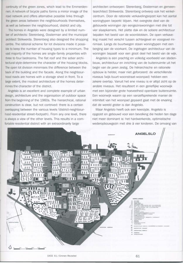
Angelslo is Emmen's second post-war residential district
and the first that was designed as a whole. The plan's prin
cipal author is Niek de Boer, but Andre de Jong also made a
contribution to the design that should not be underestimat
ed. From 1955, both were employed by the borough of
Emmen as urban designers. The district is a spatial unit
located on the eastern side of Emmen, between the
Emmerdennen and the later residential district of
Emmerhout to the north and a large industrial area to the
south. Emmen's ring road borders the district along its east
ern side.
Angelslo was designed at the end of the 1950s, accord
ing to the then commonly accepted notions of rationalism
and the 'neighbourhood concept', that is, according to the
idea of a phased and hierarchical construction of the district
from the point of view of the inhabitants and with the sepa
ration of the various urban amenities. In addition, and no
less important to understanding the current circumstances,
Angelslo was designed on the basis of the optimistic idea of
a mouldable and connected society.
All aspects of the district's phased and hierarchical con-
OASE 61 I Emmen Revi�ited
diverse fronten uitvoerig gedebatteerd. Vlak na de Tweede
Wereldoorlog verschijnt het roemruchte boek De stad der
toekomst De toekorhst der stad. Een stedebouwkundige en
sociaal-culturele studie over de groeiende stadsgemeen
schap. In deze publicatie is de wijkgedachte geformuleerd
als een model waarin de sociaal-culturele organisatie en de
ruimtelijke organisatie van de moderne stad met elkaar
samenvallen. Het is deze wijkgedachte die het denken over
de stadsvorm tot diep in de twintigste eeuw heeft vastge
nageld. In Emmen heeft het idee van de wijkgedachte daad
werkelijk gestalte gekregen op een schaal en in een mate
van volledigheid die niet vaak voorkomen. Met enige goede
wil kunnen we Emmen bestempelen als de enige sociaal
democratische modelstad van Nederland.
De eerste nieuwe woonwijk van Emmen, Emmermeer,
is nag te zien als een experiment. Het is deze wijk waar
Wieger Bruin in 1956 zo lyrisch over schrijft. Nieuwe
verkavelingen en nieuwe woonvormen worden hier getest
op hun bruikbaarheid. Het woonpad en het samenstelsel
van verschillende woonvormen tot een herhaalbare ruimte
lijke eenheid doen hier hun entree in het stedenbouwkundig
antwerp. Tegelijkertijd introduceren architecten als Van Tijen,
Romke de Vries, Nicola·!, Strikwerda, Dijkstra en Sterenberg
een nieuw architectonisch vocabulaire voor Emmen.
Een vocabulaire die oak wordt gehanteerd voor de nieuwe
stedelijke voorzieningen die vrijwel tegelijkertijd gebouwd
worden.
Angelslo is de tweede naoorlogse uitbreidingswijk van
Emmen en de eerste die in haar totaliteit ontworpen is.
De belangrijkste auteur van het plan is Niek de Boer, maar
oak Andre de Jong heeft een niet te onderschatten ·bijdrage
aan het antwerp geleverd. Beiden zijn vanaf 1955 als ste
denbouwkundigen werkzaam bij de gemeente Emmen.
De wijk ligt als een ruimtelijke eenheid aan de oostzijde
van Emmen, tussen de Emmerdennen en de latere uitbrei
dingswijk Emmerhout in het noorden en een groat industrie
gebied in het zuiden. De Rondweg van Emmen begrenst
de wijk in het oosten.
Angelslo is ontworpen aan het einde van de jaren vijftig,
volgens de dan algemeen aanvaarde denkbeelden van het
rationalisme en de wijkgedachte. Dat wil zeggen volgens de
ideeen van een getrapte en hierarchische opbouw van de
wijk vanuit de leefwereld van de bewoners en het uit elkaar
leggen van de verschillende stedelijke functies. Daarnaast,
en voor het begrip van de huidige omstandigheden niet
minder belangrijk, is Angelslo ontworpen vanuit het
optimistische idee van een maakbare en samenhangende
samenleving.
De getrapte en hierarchische opbouw van de wijk is in al
zijn facetten nag zeer goed afleesbaar. Een centrale zone
deelt de wijk in tweeen. In de centrale zone ligt de belang
rijkste toegangsweg, die aan de ene kant aansluit op de
59
struction are still extremely readable. A central zone divides
the district in two. The main access road is located in the
central zone, which leads to the centre of Emmen and the
urban amenities at one end and to Angelslo via the ring
road at the other end, as well as the industrial terrain and
the other Emmen residential districts. The road is marked
with high buildings. The Statenweg has a balanced spatial
composition, in which the course of the road and the adja
cent buildings are carefully designed in relation to one
another. The district's amenities are located along either
side of the central road: shopping centre, secondary
schools, cultural centre, churches, garages. The larger build
ings in terms of size and scale also give the central zone
the air of a town centre, the place where the district meets
the rest of the world. In contrast with this, the shopping
centre is turned inwards, designed as an intimate world
where the inhabitants of the district encounter one another
while shopping.
The central zone divides Angelslo into two residential
areas. The area north of the road is further divided into four
neighbourhoods, the area south of the road into two neigh
bourhoods. The neighbourhoods are accessible from the
Statenweg and only from the Statenweg. The connections
to the neighbourhood roads are marked with a distinctive
building in the central zone. The neighbourhood roads in the
northern section each dead-end at a six- to eight -storey
housing block on the edge of the neighbourhood/district
that has a rather desolate front area. Hidden connections
exist between adjacent neighbourhoods. The neighbourhood
roads have a fairly spacious character and provide access to
residential streets that end in cui-de-sacs. Their entrances
are marked with a small green square and a local amenity
such as a bus stop, telephone booth, gas distribution unit
or transformer kiosk. The homes are arranged along the res
idential streets. A long housing block is located on the
south side of the residential street running from east to
west and perpendicular to that is a series of shorter housing
blocks along footpaths. The first housing block perpendicu
lar to the residential street has its facade on the neighbour
hood road. The open lot division of the homes provides the
area with a wholesome amount of public green space. The
organisation of the outdoor space also has a carefully
designed, phased construction. The manner in which the
outdoor space is organised reinforces the open character of
the lot division; trees are absent from the streets.
Differences in ground level are given elegant solutions and
offer variation between the different neighbourhoods. A
broad green zone is located between the neighbourhoods.
Long, high housing blocks form the transition between the
neighbourhoods and the green zone. The primary schools
are located in the green zone. Although it is true that the
schools are thus safely accessible, they also break up the
Sjoerd Cusveller
kern van Emmen met de stedelijke voorzieningen en aan de
andere kant Angelslo via de Rondweg met het industrieter
rein en de andere wijken van Emmen verbindt. Hoge bebou
wing markeert de weg. De Statenweg heeft een afgewogen
ruimtelijke compositie, waarin het verloop van de weg en de
aanliggende gebouwen zorgvuldig ten opzichte van elkaar
zijn ontworpen. Aan weerszijden van de centrale weg liggen
de wijkvoorzieningen: winkelcentrum, middelbare scholen,
cultureel centrum, kerken, garages. De qua maat en schaal
grotere bebouwing geeft de centrale zone ook de allure van
een centrum, de plek waar de wijk de rest van de wereld
tegenkomt. In tegenstelling hiermee is het winkelcentrum
naar binnen gekeerd, ontworpen als een intieme wereld
waar de wijkbewoners elkaar al winkelend tegenkomen.
De centrale zone deelt Angelslo in twee woongebieden.
Het gebied ten noorden van de weg is verder opgedeeld in
vier buurten, het gebied ten zuiden van de weg in twee
buurten. Vanaf de Statenweg, aileen vanaf de Statenweg,
zijn de woonbuurten toegankelijk. De aansluiting op de
buurtwegen worden gemarkeerd door een bijzonder gebouw
in de centrale zone. De buurtwegen in het noordelijk deel
lopen dood op een woonblok van zes tot acht lagen aan de
rand van de buurt/wijk met een nogal desolaat voorgebied.
Tussen aanliggende buurten is er een verscholen verbinding.
De buurtwegen hebben een vrij ruim profiel en geven op
hun beurt toegang tot doodlopende woonstraten. De toe
gangen zijn gemarkeerd met een groen pleintje en een
buurtvoorziening, zoals een bushalte, telefooncel,
gasverdeelstation en transformatorhuisje. De woningen zijn
geordend rond de woonstraten. Een lang woonblok staat
aan de zuidzijde van de woonstraat in oostwestrichting en
loodrecht daarop staat een reeks van kortere woonblokken
aan woonpaden. Het eerste woonblok loodrecht op de
woonstraat heeft zijn voorgevel aan de buurtweg. De open
verkaveling van de woningen biedt ruimte voor een weldadi
ge hoeveelheid openbaar groen. Ook de inrichting van de
buitenruimte heeft een zorgvuldig ontworpen, getrapte
opbouw. De inrichting van de buitenruimte versterkt het
open karakter van de verkaveling, bomen in de straat zijn
afwezig. Niveauverschillen in het terrein zijn elegant opgelost
en bieden variatie tussen de verschillende woonbuurten.
Tussen de woonbuurten ligt een brede groenzone. Lange
en hoge woonblokken vormen de overgang tussen de
woonbuurten en de groenzone. In de groenzone liggen
de scholen voor basisonderwijs. De scholen zijn weliswaar
veilig bereikbaar, maar doorbreken ook de continu'lteit
van de groenzones naar met name de Emmerdennen.
Een fietspadennetwerk vormt het negatief van de wegen
structuur en biedt alternatieve verbindingsmogelijkheden
door de groengebieden tussen de buurten onderling en
tussen buurt, wijk en stad.
De woningen in Angelslo zijn door een beperkt aantal
60
continuity of the green zones, which lead to the Emmerden
nen. A network of bicycle paths forms a mirror image of the
road network and offers alternative possible links through
the green areas between the neighbourhoods themselves,
as well as between the neighbourhood, district and city.
The homes in Angelslo were designed by a limited num
ber of architects: Sterenberg, Oosterman and the municipal
architect Strikwerda. Sterenberg also designed the shopping
centre. The rational scheme for lot divisions made it possi
ble to keep the number of housing types to a minimum. The
vast majority of the homes are single-family properties with
three to four bedrooms. The flat roof and the sober archi
tectural style determine the character of the housing blocks.
The open lot division minimises the difference between the
back of the building and the facade. Along the neighbour
hood roads are homes with a storage shed in front. To a
large extent, the modest architecture of the homes deter
mines the character of the district.
Angelslo is an excellent and complete example of urban
design, architecture and the organisation of outdoor space
from the beginning of the 1960s. The hierarchical, rational
construction is clear, but not contrived: there is a certain
overlapping between the various levels (district-neighbour
hood-residential street-footpath). From any one level, there
is always a view of the other levels. This results in a com
fortable residential district with an extraordinarily large
OASE 61 I Emmen Revisited
architecten ontworpen: Sterenberg, Oosterman en gemeen
tearchitect Strikwerda. Sterenberg ontwierp ook het winkel
centrum. Door de rationele verkavelingsopzet kan het aantal
woningtypen beperkt blijven. Het overgrote deel van de
gebouwde woningen zijn eengezinswoningen met drie tot
vier slaapkamers. Het platte dak en de sobere architectuur
bepalen het beeld van de woonblokken. De open verkave
ling maakt het verschil tussen achtergevel en voorgevel mi
nimaal. Langs de buurtwegen staan woningtypen met een
berging aan de voorkant. De ingetogen architectuur van de
woningen bepaalt voor een groot deel het beeld van de wijk.
Angelslo is een prachtig en volledig voorbeeld van steden
bouw, architectuur en inrichting van de buitenruimte uit het
begin van de jaren zestig. De hierarchische en rationele
opbouw is helder, maar niet geforceerd: de verschillende
niveaus (wijk-buurt-woonstraat-woonpad) hebben een
zekere overlap. Vanuit het ene niveau is er altijd zicht op de
andere niveaus. Het resulteert in een gerieflijke woonwijk
met een bijzonder grote hoeveelheid openbare buitenruimte.
Een woonwijk waarin op een vanzelfsprekende manier de
intimiteit van het woonpad gepaard gaat met de ervaring
dat de wereld grater is dan Angelslo.
Maar Angelslo heeft ook een keerzijde. Angelslo is
opgezet en gebouwd voor een bevolking die heden ten dage
niet meer dominant is: het hardwerkende, optimistische
wederopbouwgezin met drie a vier kinderen. De omvang van
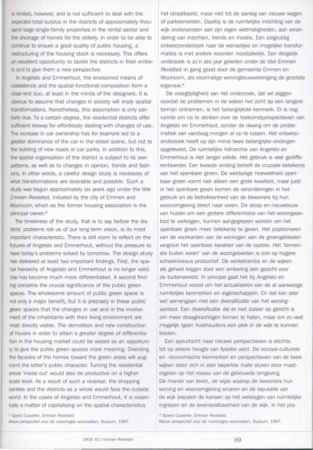
ANGELSLO
01,.:3 (lt'>I!J'i;O....,.-�.A�5CtMXlt'.Mn'K.I,..JUf�R-$(;'rlO(lil. P(:,l,..$ Pf'IQ''rCt.PtAI;).t:1lf'5C...OOt.Mf''ft(.U;I:O'fH'!OCHOOr.
1\K-1..-..$ AK t..A{'i.t:Hl\5Cli.00t ...w-1 ..CU'l,i11,\Jt$CHQ(Jt 1i &ctiOOt.-!lPOttfvnP
0 0\',.,..,AAl''!t'KlOMAAt.
st 04•ovOAJtc MAVQ at 0£1'Ak.H.AHO........,...., ....... t:H M�AO Sl MKl.AQUU'Tt:"""""""'"""""' \Jt t�;ltW .. ��"N V2 O�AQ(:!JlOMVVfN u.:t rnr.rOONct<NT"M.t A""tli0 .. .$1.-0- LMM:f.HriOVt W� Vf.f\t()j�I,..AY
W� Vfif'P\.I(c:JHUI$
• o•S.VE'fl:l)f!E\$1'41"\f)fll
A W1,Jt(.CI(NTRUM w�H�<na WUk<lf".&OUW t:H-M.::i:M':lcw C.&<N1'�
s .$.0DCE.N'mVM, WIMUl .•
61
amount of public outdoor space; a residential district in
which the intimacy of the footpath naturally accompanies
the experience that the world is bigger than Angelslo.
But Angelslo also has another side. Angelslo was planned
and built for a population that is no longer dominant today:
the hard-working, optimistic reconstruction-period family
with three to four children. Households are becoming small
er, the number of inhabitants is therefore falling, the aver
age age is increasing and the average income is decreasing.
Angelslo is no longer tailored to accommodate the current
diversity of households and lifestyles, each with their own
wishes and desires as regards their home and living environ
ment. The decline in the number of inhabitants and the
diversification of the type of households and lifestyles have
also had consequences for the amenities offered. Angelslo's
community centres have experienced a drastic decrease in
their support and are leading a marginal existence. The sup
port for the primary schools and churches is also decreas
ing, giving rise to their co�centration.
Angelslo's other side can also be expressed literally: the
neighbourhoods are situated with their rear sides facing the
de huishoudens wordt kleiner, het aantal inwoners neemt
daarom af, de gemiddelde leeftijd stijgt en het gemiddelde
inkomen daalt. Angelslo is niet Ianger toegesneden op de
huidige diversiteit van huishoudens en leefstijlen met elk
hun eigen wensen en verlangens ten aanzien van hun wa
ning en woonomgeving. De afname van het aantal inwoners
en de diversificatie van het type huishoudens en leefstijlen
hebben ook consequenties voor het voorzieningenniveau.
De buurtsteunpunten van Angelslo zien hun draagvlak
drastisch afnemen en leiden een marginaal bestaan. Ook
het draagvlak voor de basisscholen en de kerken neemt
af en dat vormt de aanleiding tot concentratie.
De keerzijde van Angelslo is ook letterlijk op te vatten:
de woonbuurten liggen met hun achterkanten naar de
groenzones en de Emmerdennen. Als er geen gevoel van
collectieve verantwoordelijkheid voor de groenzones meer is,
dan maakt dat het beheer, het onderhoud en de inrichting
erg kwetsbaar. Andersom gezien kunnen de woonbuurten
meer profijt trekken van het weldadige groen dan zij nu
doen.
green zones and the Emmerdennen. If a feeling of collective Emmerhout responsibility for the green zones no longer exists, this ren-
ders their management, maintenance and organisation
extremely vulnerable. Seen another way, the neighbour
hoods could make more of the wholesome green spaces
than is currently the case.
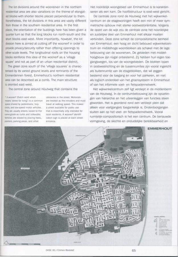
Emmerhout
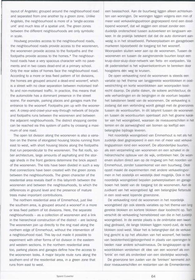
After Emmermeer and Angelslo, Emmerhout is the third
largest post-war new residential district in Emmen. Spatial.ly
speaking, the district is situated as an independent unit to
the east of Emmen, directly north of Angelslo. An extensive
forest complex, the Emmerdennen, is located between the
centre of Emmen and Emmerhout. Emmerhout was
designed at the beginning of the 1960s (1961-1966),
while the construction of Angelslo was in full swing. Here
too, Niek de Boer and Andre de Jong are the principal
authors. Just like Angelslo, Emmerhout was planned accord
ing to the concepts of rationalism and the 'neighbourhood
concept'. In Emmerhout, however, much greater emphasis
was put on a certain pragmatism and the laws of econom
ics. This c�n be seen in the increased height of the build
ings, the decrease in public green space in the residential
areas, the more severe divisions between the various urban
amenities and the stricter implementation of hierarchical
construction in the southern part of the district.
The district's character is determined by the drive from
the centre of Emmen through the Emmerdennen. The high
residential towers of the district shopping centre announce
the district's presence. Here, the road through the forest
Emmerhout is na Emmermeer en Angelslo de derde grate
Emmer uitbreidingswijk van na de oorlog. De wijk ligt
ruimtelijk gezien als een zelfstandige eenheid aan de oost
zijde van Emmen, direct ten noorden van Angelslo. Een
omvangrijk boscomplex, de Emmerdennen, ligt tussen het
centrum van Emmen en Emmerhout. Emmerhout is ontwor
pen aan het begin van de jaren zestig (1961-1966), toen
de bouw van Angelslo in valle gang was. Ook hier zijn Niek
de Boer en Andre de Jong de belangrijkste auteurs. Net als
Angelslo is Emmerhout opgezet volgens de denkbeelden van
het rationalisme en de wijkgedachte. In Emmerhout hebben
echter een zeker pragmatisme en ook economische wetten
een veel zwaarder gewicht gekregen. Dat is te zien aan de
toename van de gestapelde bouw, de afname van het open
bare groen in de woongebieden, het stringenter scheiden
van de verschillende stedelijke functies en het strenger
doorvoeren van de hierarchische opbouw in het zuidelijke
deel van de wijk.
Het karakter van de wijk wordt al duidelijk wanneer je
vanaf het centrum van Emmen door de Emmerdennen rijdt.
De hoge woontorens van het wijkwinkelcentrum kondigen de
wijk aan. Hier splitst de weg door het bos zich om in de
middenberm ruimte te maken voor het wijkwinkelcentrum.
Het wijkwinkelcentrum ligt als een benzinepomp aan de
Houtweg, centraal tussen de woonbuurten ten noorden en
ten zuiden van de weg. De weg voegt zich na het centrum
weer samen om aan te sluiten op de Rondweg. Op dit punt
spiegelt het bejaardencentrum De Schans zich in een grote
vijver. De Rondweg verbindt Emmerhout met de andere uit-
.l----------------------------------------------�------------------------------------------1 Sjoerd Cusveller 62
splits in order to make room in the median for the district
shopping centre. The district shopping centre sits like a
petrol station on Houtweg, centrally located between the
neighbourhoods to the north and south of the road. After
the centre, the road merges back together and joins up
with the ring road. At this point De Schans, a centre for
the elderly, is reflected in a large pond. The ring road links
Emmerhout with the other residential districts, business
parks, sport complexes and other urban amenities. The
ring road marks the transition between the sand and the
peat moor, between the city of Emmen and the outlying
areas.
The Houtweg is the most important structuring element
in Emmerhout and was designed as an 'urban motorway'.
The road provides a connection to the outside world, gives
shape to the district's central zone and gives access to
the residential areas. The district's amenities are located
along the road, emphasised by high-rise buildings. The road
defines the view of the Emmerhout district; the exteriors
of the district are the rear sides of buildings. On the south
ern side, between Emmerhout and Angelslo, is a badly
designed no man's land containing two schools, where
it is sporadically possible for bicycle and pedestrian traffic
to short-cut between the districts. On the northwestern side,
a neighbourhood access road forms a clear border between
the residential area and the surrounding landscape, just like
the ring road in the east.
On either side of Houtweg, as a sort of transition between
the concentrated building in the centre and the open resi
dential buildings, is a series of three- to four-storey housing
blocks running from east to west, alternated with primary
schools.
The situation is different for the cyclist. Automobile and
bicycle traffic are strictly separated from one another.
Houtweg is forbidden for non-motorised traffic. From the
Emmerdennen, the cyclist enters the labyrinthine world of
the neighbourhoods. Here, the spatial/functional composi
tion disintegrates. This extreme difference that simultane
ously exists between an unambiguous, hierarchical design
and an introverted labyrinth is a defining characteristic of
Emmerhout.
Emmerhout is composed of three zones: residential build
ings to the north and south containing primarily single-family
homes and a central zone containing Houtweg, the district's
shopping centre, amenities and buildings with flats and resi
dential towers.
The three zones are completely different from one an
other in their layout and image. In the southern residential
area, the oldest section, the hierarchical design of the dis
trict has been most consistently implemented. Within this
plan, it is possible to identify a further division into various
neighbourhoods. The neighbourhoods are analogous to the
OASE 61 I Emmen Revisited
breidingswijken, bedrijfsterreinen, sportcomplexen en andere
stedelijke voorzieningen. De Rondweg markeert de overgang
tussen het zand en het veen, tussen de stad Emmen en het
buitengebied.
De Houtweg is het belangrijkste structurerende element
van Emmerhout en is ontworpen als een 'urban motorway'.
De weg zorgt voor de verbinding met de buitenwereld, geeft
vorm aan de centrale zone van de wijk en biedt toegang tot
de woongebieden. Langs de weg liggen de wijkvoorzienin
gen, benadrukt door hoogbouw. De weg bepaalt het gezicht
van de wijk Emmerhout, de buitenkanten van de Wijk zijn
achterkanten. Aan de zuidkant, tussen Emmerhout en
Angelslo, ligt een slecht vormgegeven niemandsland met
twee scholen, waar voor langzaam verkeer sporadisch een
doorsteek tussen de wijken mogelijk is. Aan de noordwest
kant vormt een buurtontsluitingsweg een duidelijke grens
tussen het woongebied en het omringende landschap, net
als de Rondweg in het oosten.
Aan weerszijden van de Houtweg, als een soort overgang
tussen de geconcentreerde centrumbebouwing en de open
woonbebouwing, ligt een reeks woonblokken van drie
tot vier verdiepingen in oostwestrichting, afgewisseld met
basisscholen.
Voor de fietser geldt een ander verhaal. Het autoverkeer
en het fietsverkeer zijn strikt van elkaar gescheiden.
De Houtweg is verboden voor langzaam verkeer. Vanuit de
Emmerdennen komt de fietser in de labyrintische wereld
van de woonbuurten. De ruimtelijk/functionele compositie
valt hier uit elkaar. Dit extreme verschil tussen een een
duidige, hierarchische opzet en tegelijkertijd een in zichzelf
gekeerd labyrint is typerend voor Emmerhout.
Emmerhout is opgebouwd uit drie zones. In het noorden
en zuiden woonbebouwing met hoofdzakelijk eengezins
woningen en een centrale zone met de Houtweg, het
wijkwinkelcentrum, voorzieningen en bebouwing met etage
woningen en woontorens.
De drie zones zijn totaal verschillend van opzet en van
beeld. In het zuidelijke woongebied, het oudste deel, is de
hierarchische opzet van de wijk het meest consequent
doorgevoerd. In deze opzet is nog een opsplitsing in ver
schillende buurten te herkennen. De buurten zijn analoog
aan de opzet van Angelslo gegroepeerd rond de buurtweg
en van elkaar gescheiden door een groenzone. Anders dan
in Angelslo is de buurt echter meer een 'ontsluitingseen
heid' en veel minder een ruimtelijke eenheid. De groen
zones tussen de verschillende buurten hebben slechts een
symbolische omvang.
De Houtweg geeft toegang tot de buurtwegen, de
buurtweg geeft toegang tot de woonerven, de woonerven
geven toegang tot de woonpaden en de woonpaden geven
toegang tot de woningen. De buurtweg heeft een heel ruim
profiel zonder trottoirs en loopt in twee gevallen dood op
63
layout of Angelslo; grouped around the neighbourhood road
and separated from one another by a green zone. Unlike
Angelslo, the neighbourhood is more of a 'single-access
unit' and much less of a spatial unit. The green zones
between the different neighbourhoods are only symbolic
in scale.
Houtweg provides access to the neighbourhood roads,
the neighbourhood roads provide access to the woonerven,
the woonerven provide access to the footpaths and the
footpaths provide access to the homes.* The neighbour
hood roads have a very spacious character with no pave
ments and in two cases dead-end at a primary school.
Only the rear sides of homes face the neighbourhood road.
According to a more or less fixed pattern of lot divisions,
the homes are grouped around a dead-end woonerf, which
is a street with no clear separation between motorised traf
fic and non-motorised traffic. In practice, this means that
the automobile has a dominant presence in the street
scene. For example, parking places and garages mark the
entrance to the woonerf. Footpaths join up with the wooner
ven. A creep-and-crawl-your-way-through network of bicycle
and footpaths runs between the woonerven and between
the adjacent neighbourhoods. The district shopping centre
can be reached via this system of paths by crossing a maxi
mum of one road.
The open lot division along the woonerven is also a varia
tion on the theme of elongated housing blocks running from
east to west, with short housing blocks along the footpaths
that run perpendicular to the woonerven. The flat roofs, so
ber architecture, large amounts of asphalting and the stor
age sheds in the front gardens determine the brick aspect
of the woonerven. The lots have been divided in such a way
that connections have been created with the green zones
between the neighbourhoods. The green character of the
residential area reveals itself in this labyrinth between the
woonerven and between the neighbourhoods, to which the
differences in ground level and the presence of mature
trees make important contributions.
The northern residential area of Emmerhout, just like
the southern area, is grouped around a woonerf in a more
or less fixed pattern of lot divisions. Here, the separate
neighbourhoods- as a collection of woonerven and a link
in the hierarchical construction of the district- are lacking.
The woonerven join up directly to the ring road along the
northern edge of Emmerhout, without the intervention of
a neighbourhood road. This lay-out made it possible to
experiment with other forms of lot division in the eastern
and western sections. In the northern residential area
too, parking places and garages define how the access to
the woonerven looks. A major bicycle route runs along the
southern end of the residential area, in a green zone that
runs from east to west.
Sjoerd Cusveller
een basisschool. Aan de buurtweg liggen aileen achterkan
ten van woningen. De woningen liggen volgens een min of
meer vast verkavelingspatroon gegroepeerd rand een dood
lopend woonerf, dat wil zeggen een straat zonder een
duidelijk onderscheid tussen autoverkeer en langzaam ver
keer. In de praktijk betekent dat dat de auto dominant aan
wezig is in het straatbeeld. Parkeerplaatsen en garageboxen
markeren bijvoorbeeld de toegang tot het woonerf.
Woonpaden sluiten weer aan op de woonerven. Tussen de
woonerven en tussen de aangrenzende buurten loopt een
kruip-door-sluip-door-netwerk van fiets- en voetpaden. Via
dit padenstelsel is het wijkwinkelcentrum te bereiken door
hoogstens een weg te kruisen.
De open verkaveling rand de woonerven is steeds een
variatie op het thema van langgerekte woonblokken in oost
westrichting en korte woonblokken aan woonpaden lood
recht daarop. De platte daken, de sobere architectuur, de
vele verhardingen en de bergingen in de voortuin bepalen
het bakstenen beeld van de woonerven. De verkaveling is
zodanig dat een verbinding wordt gelegd met de groenzones
tussen de woonbuurten. In dit labyrint tussen de wooneNen
en tussen de woonbuurten openbaart zich het groene karak
ter van het woongebied, waaraan de niveauverschillen in het
terrein en de aanwezigheid van bomen op leeftijd een
belangrijke bijdrage leveren.
Het noordelijk woongebied van Emmerhout is net als het
zuidelijk deel gegroepeerd in een min of meer vast verkave
lingspatroon rand een woonerf. De afzonderlijke buurten,
als een verzameling van woonerven en een schakel in de
hierarchische opbouw van de wijk, ontbreken hier. De woon
erven sluiten direct aan op de ringweg om het noorden van
Emmerhout, zonder tussenkomst van een buurtweg. Deze
opzet maakt de experimenten met andere verkavelingvor
men in het oostelijk en westelijk deel mogelijk. Ook in het
noordelijk woongebied bepalen parkeerplaatsen en garage
boxen het beeld van de toegang tot de woonerven. Aan de
zuidkant van het woongebied ligt een belangrijke fietsroute
in een oost-west lopende groenzone.
De verkaveling rand de woonerven in het noordelijk
woongebied zijn ook steeds variaties op het thema van lang
gerekte blokken en kortere blokken daar loodrecht op. Toch
verschilt de verkaveling hemelsbreed van die in het zuidelijk
woongebied. In de eerste plaats is de orientatie een kwart
slag gedraaid, de lange blokken liggen noord-zuid, de korte
blokken oost-west. Maar het is belangrijker dat de verkave
ling gericht is op het afsluiten van het woonerf, het bieden
van beslotenheid/geborgenheid in plaats van openingen te
bieden naar andere schaalniveaus. De langskappen op de
woonblokken versterken dit idee van een woonerf als e en
'brink' en niet als onderdeel van een stedelijke woonwijk.
De groenzone ten zuiden van de 'brinken' kenmerkt zich
door niveauverschillen en restanten van de Emmerdennen.
64
The lot divisions around the woonerven in the northern
I Het noordelijk woongebied van Emmerhout is te karakteri-
residential area are also variations on the theme of elongat- seren als een kam. De hoofdstructuur is oost-west gericht.
ed blocks with shorter blocks placed perpendicular to them. De centrale zone rand de Houtweg met het wijkwinkel-
Nonetheless, the lot divisions in this area are vastly different
from those in the southern residential area. In the first
place, the orientation of the buildings here has been given a
quarter turn so that the long blocks run north-south and the
short blocks east-west. More importantly, however, the lot
division here is aimed at cutting off the woonerf in order to
provide privacy/security rather than offering openings to
other scale levels. The longitudinal roofs on the housing
blocks reinforce this idea of the woonerf as a 'village
square' and not as part of an urban residential district.
The green zone south of the 'village squares' is charac
terised by its varied ground levels and remnants of the
Emmerdennen forest. Emmerhout's northern residential
area can be described as a comb. The main structure
is oriented east -west.
The central zone around Houtweg that contains the
* A woonerf (Dutch word which
means 'street for living') is a common
space shared by pedestrians, bicy
clists, and low-speed motor vehicles.
They are usually streets raised to the
same grade as curbs and sidewalks.
Vehicles are slowed by placing trees,
planters, parking areas, and other
obstacles in the street. Motorists
are treated as the intruders and must
travel at walking speed. This makes
a street available for public use
that is essentially only intended for
local residents. A woonerf identifi
cation sign is placed at each street
entrance.
OASE 61 I Emmen Revisited
centrum en de etagewoningen heeft een min of meer sym
metrische opbouw met sterke oostwestorientatie. Volgens
de opzet van de wijk zou de centrale zone het noordelijke
en zuidelijke deel van Emmerhout met elkaar moeten
verbinden. Deze zone schept de compositorische eenheid
van Emmerhout: een hoog en dicht bebouwd wijkwinkelcen
trum en middelhoge woonblokken als schakel met de lage
bebouwing van de woonerven. De gebieden met middel
hoogbouw zijn nogal onbestemd. Zij hebben hun eigen toe
gangswegen, los van de woongebieden. De blokken lopen
in oostwestrichting en de tussenruimtes zijn vooral ingericht
I als buitenruimte van de etageblokken, dat wil zeggen
bestemd voor de toegang en voor het parkeren, en niet
als logisch onderdeel van het groensysteem in Emmerhout
of van het informele voet- en fietspadennetwerk.
Het wijkwinkelcentrum zelf ligt verdiept in de middenberm
van de Houtweg. In de centrumbebouwing zijn de opvattin
gen van hierarchie en het uiteenleggen van functies steen
geworden. Het is geordend rand een verdiept plein dat
aileen voor voetgangers toegankelijk is. Onderdoorgangen
sluiten aan op het voet- en fietspadennetwerk. Vooral
ruimtelijk-compositorisch is het een centrum. De benauwde
vormgeving, de slechte en onduidelijke bereikbaarheid en
EMMERHOUT
65
district's shopping centre and the flats is constructed more
or less symmetrically, with a pronounced east-west orienta
tion. According to the plan of the district, the central zone is
meant to connect the northern and southern sections of
Emmerhout. This zone creates the compositional unit of
Emmerhout: a high, densely-built district shopping centre
and mid-rise housing blocks as the link with the low-rise
construction of the woonerven. The areas containing mid
rise construction are rather undefined. They have their own
access roads, separate from the residential areas. The
building blocks run from east to west and the spaces in
between are primarily organised as outdoor spaces for the
blocks of flats, they are intended for access and for parking,
but not as a logical part of the green network in Emmerhout
or of the informal network of pedestrian and cycle paths.
The district's shopping centre itself is hidden in the
median of Houtweg. The views on hierarchy and the separa
tion of functions are set in stone in the construction of this
centre. It is organised around a recessed square that is only
accessible to pedestrians. Tunnels connect to the network
of pedestrian and cycle paths. It is a town centre primarily
in the spatial-compositional sense. The cramped design, the
poor and badly-signposted access and the limited, low level
of variation in amenities mean that this centre is not really
a binding element in Emmerhout. There is a high level of
turnover in the shops and the more marginal shops are
steadily gaining the upper hand.
Emmerhout's homes were primarily designed by three
architects: Oosterman, Nicola'! and Sterenberg, who togeth
er make up the Architectengroup Emmerhout. The rational
planning of .Emmerhout is reflected in the architecture of its
homes. There is a limited number of housing types: narrow
and deep for the north-south blocks, broad and shallow for
the east-west blocks. The vast majority of the dwellings are
spacious single-family homes with three to four bedrooms.
Depending upon the orientation of the building, the storage
sheds and kitchens are located at either the front or the
back. Separate single-storey flats for the elderly are located
in the green areas between the neighbourhoods in the
southern section of Emmerhout. In the southern residential
area, the flat roofs and the storage sheds at the front of the
homes define the image of the area. In the northern resi
dential area, the housing has the more traditional roof tim
bers and a wooden facing on the bedrooms. Just like
Angelslo, Emmerhout consists for the most part of single
family homes and flats. The proportion of flats is thirty per
cent, a bit higher than in Angelslo.
At first glance, Emmerhout seems to be a peaceful and
comfortable residential area with spacious homes and a
great deal of outdoor space. However, the composition of
the inhabitants and the manner in which the residents use
the district are changing very rapidly. In addition to tradition-
Sjoerd Cusveller
het lage peil en de geringe variatie van de voorzieningen
zorgen ervoor dat het niet echt een bindend element in
Emmerhout is. Het verloop in het winkelbestand is groat en
de meer marginale winkels krijgen steeds meer de over
hand.
De woningen van Emmerhout zijn in hoofdzaak ontworpen
door drie architecten: Oosterman, Nicola'! en Sterenberg. Zij
zijn verenigd in de Architectengroep Emmerhout. De ratione
le opzet van de Emmerhout weerspiegelt zich in de architec
tuur van de woningen. Er is een beperkt aantal woningty
pen: smalle en diepe voor de noordzuidblokken, brede en
ondiepe voor de oostwestblokken. Het overgrote deel van
de woningen zijn royale eengezinswoningen met drie tot vier
slaapkamers. Afhankelijk van de orientatie liggen de bergin
gen en keukens aan de voorkant of aan de achterkant van
de woningen. Aparte bejaardenwoningen van een laag lig
gen in de groengebieden tussen de woonbuurten in het
zuidelijk deel van Emmerhout. In het zuidelijk woongebied
bepalen de platte daken en de bergingen aan de voorkant
van de woningen het beeld. In het noordelijk woongebied
hebben de woningen de meer traditionele langskappen en
een houten beschoeiing van de slaapverdieping. Net als
Angelslo bestaat Emmerhout voor het overgrote deel uit
eengezinswoningen en etagewoningen. Het aandeel etage
woningen is met dertig procent nag wat hager dan in
Angelslo.
Emmerhout is op het eerste gezicht een rustig en com
fortabel woongebied met ruime woningen en veel buiten
ruimte. De samenstelling van de bevolking en de wijze
waarop de bewoners de wijk gebruiken zijn echter snel aan
het veranderen. De wijk wordt behalve door het traditionele
gezin in toenemende mate bewoond door alleenstaanden,
tweeverdieners, samenwonenden, jongeren, allochtonen en
senioren. De grate hoeveelheid eengezinswoningen en
appartementen voldoet niet Ianger aan de vraag op de
Emmer woningmarkt. De huidige bewoners zijn veel minder
gebonden aan de wijk, zo dat al het geval was, en maken
gebruik van de voorzieningen van heel Emmen. De wijk als
samenhangende eenheid is geen sociale werkelijkheid.
Emmerhout als strikt hierarchisch opgezette en uiteen
gelegde woonwijk heeft zichzelf overleefd. Dat komt op
ruimtelijk niveau het sterkst naar voren in de centrale zone
van de wijk. Het wijkwinkelcentrum is slecht bereikbaar, in
zichzelf gekeerd en voor niet-bewoners oak niet echt de
moeite waard. De scheiding tussen autoverkeer en fietsers
op de Houtweg is geforceerd en voor fietsers onbegrijpelijk.
Het gebied met middelhoogbouw vormt een onbestemde
zone tussen het wijkwinkelcentrum en de laagbouwbuurten.
De verbindingen tussen wijkwinkelcentrum en woongebieden
zijn voor het langzame verkeer niet goed. In de centrale
zone, de zone waar de wijk zich presenteert naar de buiten
wereld, keert de wijk zich met de rug naar diezelfde buiten-
66
al families, the district is increasingly becoming inhabited by
single people, double-income couples, unmarried couples,
young people, immigrants and senior citizens. The large
supply of single-family homes and flats no longer responds
wereld. Oat laatste speelt zich ook af op het lagere niveau
van de buurt. Langs de buurtwegen liggen de achterkanten
van de huizen en de toegangen tot de wooneNen worden
gedomineerd door garageboxen en parkeerplaatsen. In de
to the demand on Emmen's housing market. The current 1 beginjaren van de wijk droeg dat misschien bij aan een
residents are much less attached to the district, to the informeel karakter van de directe woonomgeving, vandaag
extent that they ever were, and make use of all of Emmen's zijn de wooneNen eerder een anoniem en onbestemd
amenities. The residential district as a cohesive unit is not a
social reality. Emmerhout has outlived itself as a strictly
hierarchically planned and widespread residential district. In
a spatial sense, this is most visible in the district's central
zone. The district's shopping centre is poorly accessible,
introverted and for non-residents is not really worth the
trouble. The division between motorised traffic and cyclists
on Houtweg is forced and unintelligible to cyclists. The area
containing the mid-rise buildings forms an undefined zone
between the local shopping centre and the low-rise neigh-
gebied, waar niemand zich eigenaar van voelt. De introver
sie speelt zich ook af op het niveau van de wijk als geheel.
De verbindingen met het omringende stadslandschap zijn
minimaal. De 'open groene stad' is in het geval van
I Emmerhout een gesloten, naar binnen gekeerde groene
stad.
Het rationele ontwerp, de hierarchische opbouw van de
wijk, de complementariteit van verkeersstructuur,
bebouwingsstructuur, groenstructuur en voorzieningenstruc
tuur, de open compositie, de integratie van landschappelijke
bourhoods. The connections between the shopping centre I elementen, het scheiden van verkeerssoorten en de
and the residential areas are not good for non-motorised verkaveling in woonhofjes en wooneNen hebben veel navel-
traffic. In the central zone, the zone in which the district ging gekregen - maar zelden zo consistent en volledig als in
presents itself to the outside world, it turns its back on that I Angelslo en Emmerhout.
very same outside world. The same is true in the lower level Op de compositorische helderheid en de ruimtelijkheid
of the neighbourhood. The rear sides of the houses face the van Angelslo en Emmerhout is vandaag de dag nog maar
neighbourhood roads and the entrances to the woonerven
are dominated by garages and parking spaces. In the dis
trict's early years, this may have contributed to creating an
informal character for the direct living environment, but
today the woonerven have become an anonymous and
undefined area for which no one feels ownership. The intro
version is also present at the level of the district as a whole.
The connections with the surrounding urban landscape are
minimal. In the case of Emmerhout, the 'open green city' is
a closed, introverted green city.
Rational design, the hierarchical construction of the dis
trict, the complementarity of traffic structure, building struc
ture, green structure and amenity structure, open composi
tion, the integration of elements of the landscape, the sep-
weinig af te dingen en de wijken doen nog steeds weldadig
aan. Op het eerste gezicht zijn deze wijken prachtige I woongebieden met relatief ruime en goedkope woningen,
veel openbaar groen, voldoende voorzieningen en niet te ver
van het centrum van Emmen. Slechts hier en daar is er een
glimp op te vangen van de problematiek achter de gevels:
leegstand, verwaarloosde tuinen, slijtage van de openbare
ruimte, afbraak van kerken en scholen, winkels met een
marginaal bestaan, verkoop van huurwoningen. De
aantrekkelijkheid als woongebied ten opzichte van meer
recent gerealiseerde woongebieden is duidelijk afgenomen.
Bewoners met wat hogere inkomens kiezen voor een koop
woning elders in Emmen of op het Drentse platteland. De
grote complexen eengezinshuurwoningen en de apparte-
aration of types of traffic and the division of lots into hous- menten zijn daardoor steeds moeilijker verhuurbaar.
ing clusters and woonerven: these have all been applied in De maatschappelijke ontwikkelingen hebben Angelslo en
many instances, but seldom with the consistency and com-
I
Emmerhout ingehaald. De eenzijdige woningvoorraad, de
pleteness of Angelslo and Emmerhout. inrichting van de buitenruimte en de voorzieningen zijn niet
Little can be said today against the compositional clarity meer toegesneden op de eigentijdse diversiteit aan
and the spatiality of Angelslo and Emmerhout, and the dis-
I huishoudens en woonculturen. Het optimistische wederop-
tricts still strike one as pleasant. At first sight, these districts bouwgezin maakt plaats voor de onderkant van de waning-
are beautiful residential areas with relatively spacious and markt. Het meest verontrustende is dat het 'sociale klimaat'
inexpensive homes, a large amount of public green space,
sufficient amenities and a location not too far from the cen
tre of Emmen. It is only occasionally possible to catch a
glimpse of the problems behind the facades: vacancy, neg
lected gardens, deterioration of the public spaces, the dem
olition of churches and schools, shops with a marginal exis
tence, the sale of rental homes. The district's attractiveness
OASE 61 I Emmen Revisited
vaak genoemd wordt als reden om te verhuizen. Het wonen
in Angelslo en Emmerhout dreigt steeds meer een nega
tieve keuze te worden.
Alarmerend is het nog niet, maar zonder maatregelen
zullen de bovengeschetste ontwikkelingen doorzetten en
echte problemen ontstaan. De problematiek in de wijken ligt
in de eerste plaats op het terrein van de volkshuisvesting.
67
as a residential area has clearly decreased in comparison to
more recently developed residential areas. Residents with
slightly higher incomes are opting for owner-occupied prop
erties elsewhere in Emmen or in the Drenthe countryside.
As a result, the large complexes of single-family rental prop
erties and flats are becoming increasingly difficult to let out.
Societal evolution has caught up with Angelslo and
Emmerhout. The one-sided housing supply, the organisation
of the outdoor space and the amenities are no longer tai
lored to the contemporary diversity of households and ways
of living. The optimistic post-war reconstruction family is giv
ing way to the bottom of the housing market. The most dis
quieting thing is that the 'social climate' is often cited as a
reason for moving. Living in Angelslo and Emmerhout is
threatening to become more and more of a negative choice.
The situation is not yet dire, but unless measures are
taken the developments outlined above will continue and
real problems will arise. The problems in the districts are
primarily related to public housing. The large supply of sin
gle-family rental properties and flats holds a particularly vul
nerable position in Emmen's slack housing market. They are
no longer tailored to meet market demand and are becom
ing increasingly difficult to let out. Until recently, differentia
tion of supply within the current housing stock was achieved
by selling rental homes or by allocating single-family homes
for other forms of cohabitation. The reach of this approach
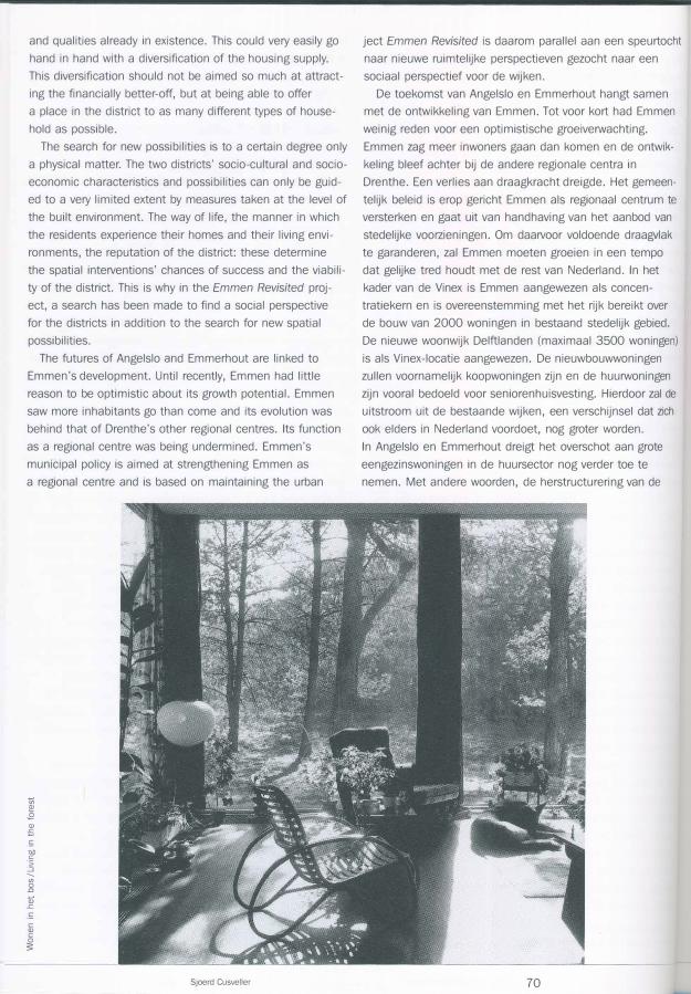
:::l 0
.r=
(ii E E
w
Sjoerd Cusveller
De grate hoeveelheid eengezinshuurwoningen en apparte
menten neemt een bijzonder kwetsbare positie in op de
ontspannen Emmer woningmarkt. Ze zijn niet Ianger toege
sneden op de vraag en steeds moeilijker te verhuren.
Binnen de aanwezige woningvoorraad is tot voor kort
gezocht naar differentiatie van het aanbod door huurhuizen
te verkopen of door eengezinshuizen aan andere samenle
vingsvormen toe te wijzen. De reikwijdte van deze aanpak
is echter beperkt en niet afdoende voor het verwachte
totale overschot in de wijken van zo'n duizend grate
eengezinswoningen in de huursector en het tekort aan
woningen voor ouderen. Om goede volkshuisvesting te kun
nen blijven garanderen is herstructurering van de woning
voorraad noodzakelijk. Dit biedt een uitgelezen kans om
de wijken in hun totaliteit aan te pakken en ze een nieuw
perspectief te geven.
In Angelslo en Emmerhout vormen de beoogde wijze van
samenleven en de ruimtelijk-functionele compositie een
hechte twee-eenheid, in elk geval in de hoofden van de
ontwerpers. Het ligt voor de hand om te veronderstellen dat
veranderingen in de samenleving ook ruimtelijke transfor
maties betekenen. Deze stelling is echter slechts gedeel
telijk waar. De wijken bieden tot op zekere hoogte vol
doende ruimte om veranderingen in het gebruik moeiteloos
op te nemen. De toename van het autobezit heeft bijvoor
beeld wei geleid tot een grotere dominantie van de auto in
68
is limited, however, and is not sufficient to deal with the
expected total surplus in the districts of approximately thou
sand large single-family properties in the rental sector and
the shortage of homes for the elderly. In order to be able to
continue to ensure a good quality of public housing, a
restructuring of the housing stock is necessary. This offers
an excellent opportunity to tackle the districts in their entire
ty and to give them a new perspective.
In Angelslo and Emmerhout, the envisioned means of
coexistence and the spatial-functional composition form a
close-knit duo, at least in the minds of the designers. It is
obvious to assume that changes in society will imply spatial
transformations. Nonetheless, this assumption is only par
tially true. To a certain degree, the residential districts offer
sufficient leeway for effortlessly dealing with changes of use.
The increase in car ownership has for example led to a
greater dominance of the car in the street scene, but not to
the building of new roads or car parks. In addition to this,
the spatial organisation of the district is subject to its own
patterns, as well as to changes in opinion, trends and fash
ions. In other words, a careful design study is necessary of
what transformations are desirable and possible. Such a
study was begun approximately six years ago under the title
Emmen Revisited, initiated by the city of Emmen and
Wooncom, which as the former housing association is the
principal owner.*
The timeliness of the study, that is to say before the dis
tricts' problems rob us of our long-term vision, is its most
important characteristic. There is still room to reflect on the
futures of Angelslo and Emmerhout, without the pressure to
have today's problems solved by tomorrow. The design study
has delivered at least two important findings. First, the spa
tial hierarchy of Angelslo and Emmerhout is no longer valid.
Use has become much more differentiated. A second find
ing concerns the crucial significance of the public green
spaces. The wholesome amount of public green space is
not only a major benefit, but it is precisely in these public
green spaces that the changes in use and in the involve
ment of the inhabitants with their living environment are
most directly visible. The demolition and new construction
of houses in order to attain a greater degree of differentia
tion in the housing market could be seized as an opportuni
ty to give the public green spaces more meaning. Orienting
the facades of the homes toward the green areas will aug
ment the latter's public character. Turning the residential
areas 'inside out' would also be productive on a higher
scale level. As a result of such a reversal, the shopping
centres and the districts as a whole would face the outside
world. In the cases of Angelslo and Emmerhout, it is essen
tially a matter of capitalising on the spatial characteristics
* Sjoerd Cusveller, Emmen Revisited.
Nieuw perspectief voor de naoorlogse woonwijken, Bussum, 1997.
OASE 61 I Emmen Revisited
het straatbeeld, maar niet tot de aanleg van nieuwe wegen
of parkeeNelden. Daarbij is de ruimtelijke inrichting van de
wijk onderworpen aan zijn eigen wetmatigheden, aan veran
dering van inzichten, trends en modes. Een zorgvuldig
ontwerponderzoek naar de wenselijke en mogelijke transfor
maties is met andere woorden noodzakelijk. Een dergelijk
onderzoek is zo'n zes jaar geleden onder de titel Emmen
Revisited in gang gezet door de gemeente Emmen en
Wooncom, als voormalige woningbouwvererJiging de grootste
eigenaar.*
De vroegtijdigheid van het onderzoek, dat wil zeggen
voordat de problemen in de wijken het zicht op een langere
termijn ontnemen, is het belangrijkste kenmerk. Er is nog
ruimte om na te denken over de toekomstperspectieven van
Angelslo en Emmerhout, zonder de dwang om de proble
matiek van vandaag morgen al op te lassen. Het ontwerp
onderzoek heeft op zijn minst twee belangrijke vindingen
opgeleverd. De ruimtelijke hierarchie van Angelslo en
Emmerhout is niet Ianger valide. Het gebruik is veel gediffe
rentieerder. Een tweede vinding betreft de cruciale betekenis
van het openbare groen. De weldadige hoeveelheid open
baar groen vormt niet aileen een grote kwaliteit, maar juist
in het openbare groen komen de veranderingen in het
gebruik en de betrokkenheid van de bewoners bij hun
woonomgeving direct naar voren. De sloop en nieuwbouw
van huizen om een grotere differentiatie van het woningaan
bod te verkrijgen, kunnen aangegrepen worden om het
openbare groen meer betekenis te geven. Het po�itioneren
van de voorkanten van de woningen aan de groengebieden
vergroot het openbare karakter van de laatste. Het 'binnen
ste buiten keren' van de woongebieden is ook op hogere ·
schaalniveaus productief. De winkelcentra en de wijken
als geheel krijgen door een omkering een gezicht voor
de buitenwereld. In principe gaat het bij Angelslo en
Emmerhout vooral om het actualiseren van de al aanwezige
ruimtelijke kenmerken en eigenschappen. En dat kan zeer
wei samengaan met een diversificatie van het woning
aanbod. Een diversificatie die er niet zozeer op gericht is
om meer draagkrachtigen binnen te halen, maar om zo veel
mogelijk typen huishoudens een plek in de wijk te kunnen
bieden.
Een speurtocht naar nieuwe perspectieven is slechts
tot op zekere hoogte van fysieke aard. De sociaal-culturele
en -economische kenmerken en perspectieven van de twee
wijken Iaten zich in zeer beperkte mate sturen door maat
regelen op het niveau van de gebouwde omgeving.
De manier van Ieven, de wijze waarop de bewoners hun
waning en woonomgeving eNaren en de reputatie van
de wijk bepalen de kansen op het welslagen van ruimtelijke
ingrepen en de levensvatbaarheid van de wijk. In het pro-
* Sjoerd Cusveller, Emmen Revisited.
Nieuw perspectief voor de naoorlogse woonwijken, Bussum, 1997.
69
and qualities already in existence. This could very easily go
hand in hand with a diversification of the housing supply.
This diversification should not be aimed so much at attract
ing the financially better-off, but at being able to offer
a place in the district to as many different types of house
hold as possible.
The search for new possibilities is to a certain degree only
a physical matter. The two districts' socio-cultural and socio
economic characteristics and possibilities can only be guid
ed to a very limited extent by measures taken at the level of
the built environment . The way of life, the manner in which
the residents experience their homes and their living envi
ronments, the reputation of the district: these determine
the spatial interventions' chances of success and the viabili
ty of the district. This is why in the Emmen Revisited proj
ect, a search has been made to find a social perspective
for the districts in addition to the search for new spatial
possibilities.
The futures of Angelslo and Emmerhout are linked to
Emmen's development. Until recently, Emmen had little
reason to be optimistic about its growth potential. Emmen
saw more inhabitants go than come and its evolution was
behind that of Drenthe's other regional centres. Its function
as a regional centre was being undermined. Emmen's
municipal policy is aimed at strengthening Emmen as
a regional centre and is based on maintaining the urban
tl � .2 Q) -s
-� '0.0 c
"5
2 (f) 0 .0
Q) .r::.
-� c Q) c 0 3
Sjoerd Cusveller
ject Emmen Revisited is daarom parallel aan een speurtocht
naar nieuwe ruimtelijke perspectieven gezocht naar een
sociaal perspectief voor de wijken.
De toekomst van Angelslo en Emmerhout hangt samen
met de ontwikkeling van Emmen. Tot voor kort had Emmen
weinig reden voor een optimistische groeiverwachting.
Emmen zag meer inwoners gaan dan komen en de ontwik
keling bleef achter bij de andere regionale centra in
Drenthe. Een verlies aan draagkracht dreigde. Het gemeen
telijk beleid is erop gericht Emmen als regionaal centrum te
versterken en gaat uit van handhaving van het aanbod van
stedelijke voorzieningen. Om daarvoor voldoende draagvlak
te garanderen, zal Emmen moeten groeien in een tempo
dat gelijke tred houdt met de rest van Nederland. In het
kader van de Vinex is Emmen aangewezen als concen
tratiekern en is overeenstemming met het rijk bereikt over
de bouw van 2000 woningen in bestaand stedelijk gebied.
De nieuwe woonwijk Delftlanden (maximaal 3500 woningen)
is als Vinex-locatie aangewezen. De nieuwbouwwoningen
zullen voornamelijk koopwoningen zijn en de huurwoningen
zijn vooral bedoeld voor seniorenhuisvesting. Hierdoor zal de
uitstroom uit de bestaande wijken, een verschijnsel dat zich
ook elders in Nederland voordoet, nog grater worden.
In Angelslo en Emmerhout dreigt het overschot aan grote
eengezinswoningen in de huursector nog verder toe te
nemen. Met andere woorden, de herstructurering van de
70
amenities currently on offer. In order to be able to ensure
sufficient support for this, Emmen will have to grow at
a pace that keeps up with the rest of the Netherlands .
Within the context of the Vinex, Emmen has been designat
ed as a focus area and has reached an agreement with the
State on the construction of 2000 homes within existing
urban areas. The new Delftlanden residential district (maxi
mum 3500 homes) has been designated as a Vinex loca
tion. The newly-built houses are primarily intended to
accommodate senior citizens. As a result of this, the outflow
from the existing districts, a phenomenon that is also taking
place elsewhere in the Netherlands, will become even larg
er. In Angelslo and Emmerhout, the surplus of large single
family properties in the rental sector threatens to increase
even further. In other words, the restructuring of the existing
housing supply and the new construction of homes are two
closely linked tasks. In relation to this, we must not only
consider the negative strategy of greatly limiting new
construction in favour of restructuring the existing supply.
It is in fact necessary to determine and take advantage
of the characteristics that could distinguish Angelslo and
Emmerhout from existing or future residential districts
in Emmen.
Translation: Gregory Ball
OASE 61 I Emmen Revisited
bestaande woningvoorraad en de nieuwbouw van woningen
vormen een sterk samenhangende opgave. Daarbij moet
niet aileen gedacht worden aan de negatieve strategie van
het sterk matigen van de nieuwbouw ten gunste van her
structurering van de bestaande voorraad. Het is juist
noodzaak om de kenmerken waarmee Angelslo en
Emmerhout zich kunnen onderscheiden van bestaande
of toekomstige woonwijken, in Emmen te formuleren en
uit te buiten.
71