dublin city centre transport study consultation … › sites › default › files ›...
TRANSCRIPT

Dublin City Centre Transport Study
Consultation Document June 2015
2
Contents
1 Introduction .................................................................................................................................... 4
1.1 Overview ................................................................................................................................. 4
1.2 Purpose of this Study .............................................................................................................. 6
1.3 Devising the Study................................................................................................................... 7
1.4 Structure of this Study ............................................................................................................ 8
2 Study Area and Context .................................................................................................................. 9
2.1 Overview ................................................................................................................................. 9
2.2 Existing Land Use Context ....................................................................................................... 9
2.3 Growth in Dublin ................................................................................................................... 11
2.4 Movement Context ............................................................................................................... 13
2.5 Planning and Policy Perspective ........................................................................................... 16
2.6 Summary ............................................................................................................................... 18
3 Challenges and Requirements for Transport within the City Centre ............................................ 19
3.1 Overview ............................................................................................................................... 19
3.2 The Pedestrian Environment ................................................................................................ 19
3.3 The Cycling Environment ...................................................................................................... 20
3.4 The Public Transport Environment ....................................................................................... 21
3.5 Introducing new Public Transport Options ........................................................................... 22
3.6 The Private Vehicle Environment .......................................................................................... 23
3.7 Goods Distribution and HGV Environment ........................................................................... 24
3.8 Safety and Environmental Improvements ............................................................................ 25
3.9 Summary ............................................................................................................................... 26
4 Development of the Transport Proposals ..................................................................................... 27
4.1 Overview ............................................................................................................................... 27
4.2 Guiding Principles ................................................................................................................. 28
4.3 Transport Network Assumptions .......................................................................................... 29
4.4 Developing a Network Approach .......................................................................................... 30
5 Traffic Network Proposals ............................................................................................................. 31
5.1 Overview ............................................................................................................................... 31
5.2 Proposals ............................................................................................................................... 33
5.3 Key Changes .......................................................................................................................... 33
5.4 Intended Outcomes .............................................................................................................. 40
6 Bus Network Proposals ................................................................................................................. 41
6.1 Overview ............................................................................................................................... 41
6.2 Proposals ............................................................................................................................... 42
6.3 Key Changes .......................................................................................................................... 42
6.4 Intended Outcomes .............................................................................................................. 46
7 Rail Network Proposals ................................................................................................................. 47
7.1 Overview ............................................................................................................................... 47
7.2 Proposals ............................................................................................................................... 47
7.3 Key Changes .......................................................................................................................... 47
7.4 Intended Outcomes .............................................................................................................. 49
8 Cycle Network Proposals .............................................................................................................. 50
3
8.1 Overview ............................................................................................................................... 50
8.2 Proposals ............................................................................................................................... 51
8.3 Key Changes .......................................................................................................................... 52
8.4 Intended Outcomes .............................................................................................................. 53
9 Pedestrian Network/Public Realm Proposals ............................................................................... 54
9.1 Overview ............................................................................................................................... 54
9.2 Proposals ............................................................................................................................... 54
9.3 Key Changes .......................................................................................................................... 55
9.4 Intended Outcomes .............................................................................................................. 56
10 Specific Measures ......................................................................................................................... 57
10.1 Overview ............................................................................................................................... 57
10.2 Core City Centre Measures ................................................................................................... 58
10.3 Interchange Locations ........................................................................................................... 67
10.4 Specific Improvement Schemes ............................................................................................ 71
11 Positive Outcomes for Dublin City ................................................................................................ 77
11.1 Overview ............................................................................................................................... 77
11.2 Future Proofing the City ........................................................................................................ 77
11.3 Facilitating New Transport Infrastructure ............................................................................ 77
11.4 Improved Efficiency .............................................................................................................. 77
11.5 Improved Environment ......................................................................................................... 78
11.6 Improved Urban Realm, Civic Space and Ambience ............................................................. 78
11.7 Tourism, Commercial and Retail Benefits ............................................................................. 79

4
1 Introduction
1.1 Overview
As Ireland’s economic recovery continues, it is essential that Dublin, as the main economic driver of
the state, is primed to cater for the consequential growth in activity. Before the economic downturn
Dublin’s transport network and urban environment were under severe pressure as a result of the
volume of people working, studying, visiting and living within the inner city. It is critical that Dublin
City does not return to the congestion levels experienced between 2004 and 2007. At its peak, in
2006, 207,000 people crossed the Canals during the morning peak commuting period (7-10am),
compared with 192,000 in 2014. As Dublin begins to grow again it is vital that plans are in place to
allow the city to avoid the problems which were experienced before, and to enable it to develop as a
major European Capital City.
Over the coming years Dublin City will have to meet the needs of a bigger resident population and a
larger workforce, as well as ensuring that Dublin is a desirable place for residents, students, visitors
and tourists. A key element of this is how people will travel to, move within, and interact with the
built and natural environment of Dublin’s city centre.
“In terms of economic development cities and city regions are kings. Dublin is
Ireland’s only city region of international scale. The Dublin economic region extends
beyond the boundary of Dublin and well into the adjoining counties of Meath Kildare
and Wicklow. Its importance in the national economy cannot be over emphasised,
the latest data shows that Greater Dublin area accounts for 49.6% of Irelands GDP.”
(Owen Keegan, Chief Executive Dublin City Council)
By 2023, it is anticipated that Dublin City Centre will have to cater for an additional 42,000 journeys
in the morning peak, an increase of over 20%. The city centre is intensifying as an employment, retail
and tourist destination. The expansion of employment in areas like the Docklands, particularly the
technology sector (Google et al.), coupled with increased retail investment in the city centre and
growth in Dublin tourism (Dublin had 4 million visitors in 2013) demonstrates that this growth is
already taking place.

5
Since 2006, when peak demand for travel into the city centre was observed, the city has continued
to evolve the transport offer serving Dublin City. Some of the key enhancements include:
Dublin Port Tunnel – opened in 2006;
HGV City Centre Cordon Ban – introduced in 2007;
Continuous Bus Lanes North Quays – constructed in 2007;
M50 Barrier Free Tolling - introduced in 2008;
College Green Bus corridor ( Bus Gate ) – introduced in 2009;
Luas C1 extension to Point Depot – opened in 2009;
Samuel Beckett Bridge – completed in 2009;
Dublin Bikes scheme – commenced operation in 2009;
Extension of Luas to Cherrywood – opened in 2010;
Clanbrasil Street Bus Corridor – completed in 2010;
M50 Upgrade scheme – completed in 2010;
Real Time Passenger Information - introduced in 2011;
Leap Card - introduced 2011;
Dublin Bus Network Direct – completed in 2012;
Phase 1 Canal segregated Cycleway – opened in 2012;
Rosie Hackett Bridge – completed in 2014;
Custom’s House Quay Contra-flow Bus Lane – opened in 2014;
Luas Cross City – works commenced in 2014; and,
Traffic management changes at Stephen’s Green – opened in 2014.
Despite these improvements, during the economic downturn, public transport lost substantial
passenger numbers, with passenger crossing the canals falling by more than 20,000 between the
peak of 2006 and 2011. While this trend has been somewhat reversed, the loss of capacity in the
public transport network as a result of declining passenger numbers, means that the current public
transport arrangements will not be able to cope with a return to the 2006 levels, let alone the
anticipated future growth in demand, without further investment and expansion.
For Dublin city to continue to grow and prosper, it is essential that a strategy is put in place now to
ensure that the increased demand for travel is met. At present, recurrent congestion is once again
becoming a feature of the City transport network, impinging on public transport reliability and the
ability of the City to withstand unforeseen traffic incidents.
The Dublin City Centre Transport Study (the ‘Study’) aims to set down a framework for how Dublin
City’s transport network can be redefined to cater for this increased usage, by better utilising the
existing infrastructure available, and by moving towards a more sustainable and efficient use of the
public realm within the city centre. The Study will facilitate Dublin with an opportunity to grow as a
city both physically and economically, whilst also creating a better public realm which can be
enjoyed by residents and visitors alike.
“In view of Dublin’s pivotal role in driving national growth and prosperity a strong
focus on maintaining and enhancing Dublin’s attractiveness as a location to do
business in and to live and work in is essential“ ( National Competitive Council)
6
1.2 Purpose of this Study
The Dublin City Centre Transport Study has been prepared to integrate the transport policies and
proposals of Dublin City Council and the National Transport Authority (NTA) and inform an agreed
framework for strategic investment.
Between 2010 and 2015, funding of approximately €97 million was provided by the NTA to Dublin
City Council for transport infrastructure in the city. A myriad of projects were delivered under this
funding programme, spanning bus infrastructure, road resurfacing, cycling and walking schemes,
along with Real Time Passenger Information (RTPI) and traffic management systems.
It is envisaged that over the lifetime of this Study, around €150 million will be made available to
Dublin City Council to enable the delivery of the proposals set out in this study. This is in addition to
the €368 million already committed to the Luas Cross City project and other projects such as rail
improvement and bus fleet investment.
This Study relates directly to the policies and objectives already set out in the Dublin City
Development Plan 2011-2017, and is influenced by the NTA’s Integrated Implementation Plan 2013-
2018. Working within the statutory planning framework of the City Council’s Development Plan
(outlined in section 2.5.1), this document examines the issues relating to the management and
movement of people and goods to, from and within Dublin City Centre, and proposes various
changes.
This Study, and the timely implementation of the proposals outlined in it, is critical to ensure that
the transport provision in Dublin can continue to function, and has the capacity to cater for Dublin’s
future growth. In essence, the current transport arrangements for each mode are reaching the limits
of their capacity as currently configured within the city centre. The introduction of Luas Cross City
will provide a critical north-south Luas alignment to complement and integrate with the current
east-west Luas red line. Luas Cross City will also complement the development of the core
pedestrian network within the city centre, particularly across the Liffey at O’Connell Bridge, one of
the most heavily used pedestrian routes in the city. This alignment is illustrated in figure 1.1.

7
Figure 1.1: The Luas Network in Dublin City Centre
As a result of the construction and future operation of Luas Cross City, the current transport
arrangements in the core city centre will no longer have the road space or junction capacity to
function in an efficient manner, and will require significant reconfiguration. There is also a pressing
need to reconfigure the public transport network to integrate the revised Luas network, and to
maximise the use, and capacity, of the public transport system as a whole. It is critical to ensure that
the improved public transport offer in the city will meet the demand for travel into the centre of
Dublin for work and shopping, as well as facilitating the City to grow into the future.
1.3 Devising the Study
The Study represents the accumulation of work undertaken by Dublin City Council and the NTA. It
proposes new traffic management arrangements, public transport infrastructure improvements, and
8
measures to encourage walking and cycling. The Study was motivated by a number of key issues and
concerns regarding the city centre, including the need to:
Build on the existing and future investment in public transport within the city, and ensure
that these assets are utilised appropriately into the future;
Guarantee the future development potential of the city centre, and improve confidence in
the ability of the city centre to be the key focus of future investment;
Ensure that the city develops in a way which will provide a better living and working
environment for residents and visitors alike;
Ensure that in operation, Luas Cross City can operate in an effective and efficient manner;
Formulate an agreed set of transport networks, which are integrated and complementary;
Develop a framework for infrastructural investment in the City Centre;
Improve the capacity for movement within the City Centre;
Improve accessibility to the City Centre;
Ensure that changes in the City Centre are matched by improvements in public transport
across the Dublin region. This will be covered by the forthcoming NTA Transport Strategy for
the Greater Dublin Area;
Improve the capacity, reliability and utilisation of public transport – in particular, addressing
poor journey times, bus congestion (especially around bus stops) and the negative impact of
bus activities on the public realm;
Improve the quality of service for cycling and walking, with a particular emphasis on the
‘core’ city centre; and,
Improve the management of private vehicle, delivery and service vehicle access to the
primary retail and business districts.
1.4 Structure of this Study
This Study begins by setting out the context for the study in Chapter 2. It spatially defines the area
designated as the City Centre for the purposes of this analysis, gives an overview of the existing
transport network and current commuting patterns into the city. This chapter also sets out the
principle policy objectives of Dublin City Council and the NTA which frame the direction of this plan.
Chapter 3 examines the current transport offer in the City Centre and highlights some of the key
challenges, both in providing for each mode of transport, as well as tackling site specific
impediments. Chapter 4 outlines the guiding principles of the study, and summarises the key
parameters and assumptions which need to be considered in the development of the transport
measures.
Chapters 5 to 9 outline the transport network measures as they relate to each mode, and Chapter 10
sets out a number of specific measures which are proposed as part of the overall transport
framework.
Chapter 11 summaries some of the key outcomes of the Study in relation to the future development
of Dublin City.

9
2 Study Area and Context
2.1 Overview
On average 500,000 people travel within Dublin City Centre every day. This is made up of circa.
235,000 work related trips, 45,000 education trips, and 120,000 visitors/tourists/shoppers. In
addition, the latest Census reports that around 122,000 people live within the canals. The City has
started to grow again now the economy is in recovery. If growth continues as predicted, by 2023 it is
likely that the City’s transport network will have to cater for an additional 42,000 commuter trips
coming into the City Centre each day, as well as 15,000 new residents living within the Canals, in
addition to an expanded retail and tourism market.
It is important to understand the current make-up of the city in terms of land uses and principal
attractions. These existing land uses and attractions are unlikely to change significantly, and will
continue to be the main reasons as to why people travel into and within the City Centre. The city is
also growing however, and identifying and catering for new growth areas both inside the canals and
within the city suburbs is key to ensuring that these areas are integrated into the existing land use
context of the city.
2.2 Existing Land Use Context
It was determined that in the context of this Study, the City Centre is defined spatially as the area
within the canals and North Circular / South Circular Roads.
It is important to understand and assess what land use types exist, and are planned for, within the
city centre. Dublin City Council, through their Development Plan and subsequent Public Realm
Strategy, has identified the land use characteristics of the city, including the key destinations for
retail/offices/residential/industrial/tourism. Other important considerations include the
conservation areas, listed buildings, and ‘Key Spaces and Connections’ which must be taken into
consideration in the design of any transport proposals.
10
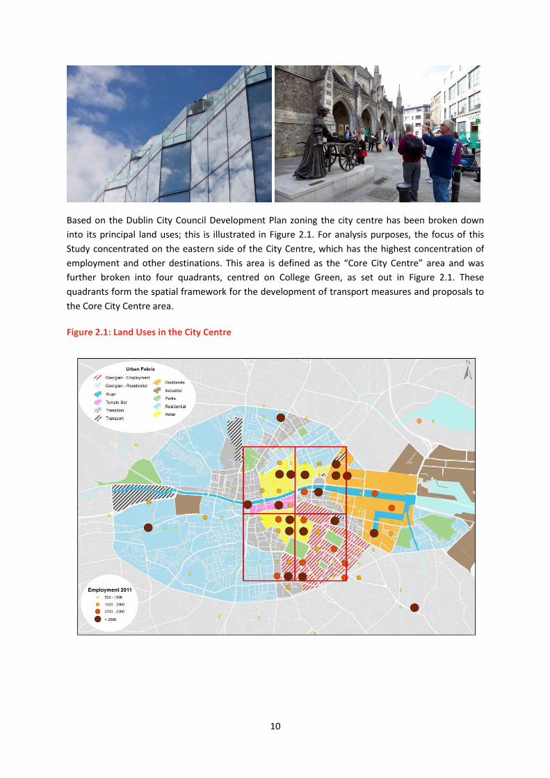
Based on the Dublin City Council Development Plan zoning the city centre has been broken down
into its principal land uses; this is illustrated in Figure 2.1. For analysis purposes, the focus of this
Study concentrated on the eastern side of the City Centre, which has the highest concentration of
employment and other destinations. This area is defined as the “Core City Centre” area and was
further broken into four quadrants, centred on College Green, as set out in Figure 2.1. These
quadrants form the spatial framework for the development of transport measures and proposals to
the Core City Centre area.
Figure 2.1: Land Uses in the City Centre

11
2.3 Growth in Dublin
A critical aspect of this Study is to ensure that Dublin City is ‘future proofed’ for anticipated growth.
The Dublin City Council Development plan provides for the expansion of Dublin City Centre as an
employment hub and principal destination, as well as a location for new residential development.
There are also significant residential developments planned outside Dublin City, and linkages to the
city centre employment areas from these new residential locations will be vital for Dublin to
continue to expand as Ireland’s primary economic centre.
2.3.1 Growth within the Canals
It is projected that population and employment will grow by significantly over the period of the
Study. Some of the major new development areas within Dublin City Centre are set out in Figure 2.2.
This highlights the locations of future growth in terms of employment, education and residential
development based on the objectives of the Dublin City Development Plan.
Figure 2.2: Locations of Development Areas in Dublin City Centre, based on NTA Analysis
2.3.2 Concentration of Employment in the City Centre
Looking at the distribution of travel to work demand (taken from the 2011 Census); it is noticeable
that the vast majority of trips entering the City Centre are going to the eastern side of the study
area. This is illustrated in Figure 2.3, which shows the intensity of employment on a colour coded

12
basis. It is anticipated that future growth in employment will lead to an intensification of this
pattern.
Figure 2.3: Employment Distribution within the City Centre, based on Census 2011 Data
2.3.3 Retail Activity in the City Centre
A survey carried out for the NTA by Millward Brown in October 2014 highlighted the importance of
public transport to the retail sector of the city. A total of 1,671 respondents answered questions on
why they came into the City Centre, how they travelled, how many times they had visited in the
previous four weeks and how much money they were spending in town that day, among other
things.
The mode of transport used by the shoppers surveyed is shown in Figure 2.4. Overall, 60% of
shoppers surveyed had travelled to the city by public transport, with walking accounting for 17% and
19% of shoppers travelling by car.
When the spending patterns over the prior four weeks of all of the shoppers surveyed were
calculated, the contribution of car based shopping accounted for €1 in every €5 of retail spend, while
public transport users accounted for almost three times this amount.

13
Figure 2.4: Mode of Transport Used by Shoppers in the City Centre
2.4 Movement Context
While it is useful to consider where future growth in population and employment will occur, and to
prepare for the increased demands on the transport network this growth will necessitate, it is
important to note the vast majority of transport demand already exists, with respect to the
residents, work force and visitors travelling around Dublin today. In this regard, it is beneficial to
look at the existing movement patterns within the city centre.
2.4.1 Changing Travel Habits
Dublin City Council, in conjunction with the NTA, carries out annual monitoring of traffic crossing the
canals. This survey takes place in November every year for the peak travel period of 7am to 10am,
and is referred to as the Canal Cordon Count. The information gathered from this survey work gives
a good insight into the changing travel habits of the public travelling into Dublin City for work,
education and other purposes on an average weekday morning. Table 2.1 provides details of the
number of vehicles crossing the Canal Cordon for the years 2006 to 2014. The information in Table
2.2 sets out the recorded person trips by mode crossing the Canal Cordon for the same years.
42%
3%
19%
15%
0%
4%
17%
0% 0%
5%
10%
15%
20%
25%
30%
35%
40%
45%
Bus Bicycle Car Luas Motorbike Rail/Dart Walking Other
Mo
de
Sp
lit

14
Table 2.1: Vehicles Crossing Canal Cordon - 2006 to 2014
Table 2.2: Person Trips by Mode Crossing Canal Cordon - 2006 to 2014
A review of the data presented in Tables 2.1 and Table 2.2 highlights some very important facts
about how people are travelling into the City Centre today compared to 2006.
In relation to public transport, the headline item from the analysis is the relative importance of bus
as a means of transport into the city centre. Bus is currently transporting five times more people
than travel by Luas, and over twice as many as rail system. It is also clear that the use of rail to access
the city centre has fallen significantly, from 33,500 to 25,000 trips or by 26% over the past decade.
This is partially explained by the general reduction in the overall number of people employed in the
city centre, but may also be related to reduced service frequency and capacity on the DART network
in particular.
In 2006 less than 5,000 people travelled into the city centre by bike, only 2.3% of total trips that
year; however in 2014 this figure has more than doubled to almost 10,500 journeys or 5.4% of total
trips – an increase of 114%.
Another notable trend is the steady decline in the use of the private car. The overall number of
people travelling into the city centre by car has fallen from 77,000 to 64,000 or a 17% decrease since
2006. However, it is useful to note that the actual number of cars travelling into the City Centre has
only declined by 5,000 during this period. The main reason for the reduction in overall recorded car
travel is due to a reduction in the numbers of people travelling in each car, down from an average
occupancy of 1.3 to 1.2.
Mode 2006 2007 2008 2009 2010 2011 2012 2013 2014
Bus 1,680 1,740 1,814 1,704 1,688 1,539 1,503 1,539 1,504
All Public
Transport1,680 1,740 1,814 1,704 1,688 1,539 1,503 1,539 1,504
Car 58,664 58,686 58,897 58,232 58,047 55,745 55,343 54,458 53,033
Taxi 3,825 4,583 5,079 4,980 4,809 4,862 5,277 5,458 4,955
Walk 17,114 18,594 18,360 14,618 15,092 14,551 17,070 17,495 19,711
Cycle 4,839 5,676 6,143 6,326 5,952 6,870 7,943 9,061 10,349
Goods 2,291 1,445 1,223 1,087 993 1,176 1,099 1,045 1,087
Motor Cycle 2,395 2,429 2,375 2,060 1,656 1,485 1,425 1,423 1,372
Totals 90,808 93,153 93,891 89,007 88,237 86,228 89,660 90,479 92,011
Means of
Travel2006 2007 2008 2009 2010 2011 2012 2013 2014
Bus 59,874 57,201 60,438 56,168 50,420 54,251 52,007 56,177 56,671
Rail 33,534 35,692 32,324 25,723 23,580 22,932 23,999 24,969 24,866
LUAS 9,029 9,171 9,242 8,776 9,111 9,949 10,014 10,835 11,670
All Public
Transport102,437 102,064 102,004 90,667 83,111 87,132 86,047 91,981 93,207
Car 76,850 71,597 67,732 71,043 71,978 69,681 68,626 68,072 64,169
Taxi 1,453 2,154 1,930 2,739 2,260 2,674 3,271 3,111 2,775
Walk 17,114 18,594 18,360 14,618 15,092 14,551 17,070 17,495 19,711
Cycle 4,839 5,676 6,143 6,326 5,952 6,870 7,943 9,061 10,349
Goods 2,291 1,445 1,223 1,087 993 1,176 1,099 1,045 1,087
Motorcycles 2,395 2,429 2,375 2,060 1,656 1,485 1,425 1,423 1,372
Total Person
Trips207,379 203,959 199,767 188,540 181,042 183,569 185,481 192,188 192,670

15
The overall mode share for car is now 33%, while 48% of people now travel into the city centre by
public transport and 16% walking or cycling. This trend is explored in more detail in the next section.
2.4.2 Travelling to Work in the City Centre
The following analysis is taken from CSO Census 2011 ‘Place of Work and Education Census of
Anonymised Records’ (POWSCAR) and Small Area Population Statistics (SAPs) data, and illustrates
some of the key facts about movement within Dublin City Centre. The census results are cross
referenced to the data extracted from the Canal Cordon Count to give a more complete overview of
the existing travel patterns observed in the City Centre.
In 2011 there were approximately 109,000 people with a stated place of work in the core City
Centre. Figure 2.5 sets out the mode split for these work trips. It is interesting that the breakdown
by mode is a relatively even split, with roughly a quarter of trips made by Private Car, by Bus, and
just less than a quarter travelling by Rail (21%) and on foot/bicycle (23%).
Figure 2.5: Mode Split for People Working in Dublin City Centre
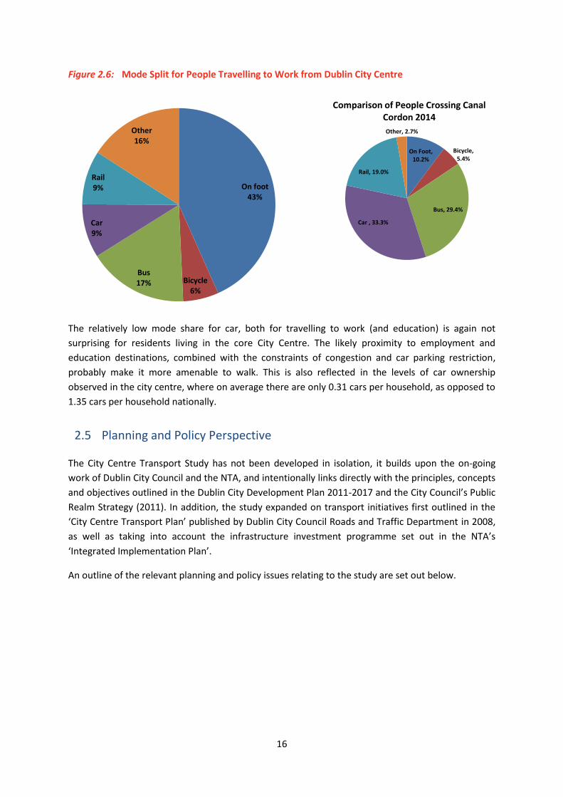
2.4.3 Living in the City Centre
In 2011 there were approximately 30,000 people living within the ‘core’ city centre quadrants (as
illustrated in Figure 2.1). The mode split to work and education has been extracted for these
residents. (It is worth noting that they do not necessarily have to work in the city centre (i.e. they
may be travelling out of the centre to employment/education elsewhere). Figure 2.6 sets out the
mode split for work trips originating within the core City Centre. It is clear, and perhaps unsurprising,
that the dominant mode is walking at 43%. (Nb. ‘Other’ includes ‘not stated’ responses).
On foot 16%
Bicycle 7%
Bus 26% Car
26%
Rail 21%
Other 4%
On Foot, 10.2%
Bicycle, 5.4%
Bus, 29.4%
Car , 33.3%
Rail, 19.0%
Other, 2.7%
Comparison of People Crossing Canal Cordon 2014
16
Figure 2.6: Mode Split for People Travelling to Work from Dublin City Centre
The relatively low mode share for car, both for travelling to work (and education) is again not
surprising for residents living in the core City Centre. The likely proximity to employment and
education destinations, combined with the constraints of congestion and car parking restriction,
probably make it more amenable to walk. This is also reflected in the levels of car ownership
observed in the city centre, where on average there are only 0.31 cars per household, as opposed to
1.35 cars per household nationally.
2.5 Planning and Policy Perspective
The City Centre Transport Study has not been developed in isolation, it builds upon the on-going
work of Dublin City Council and the NTA, and intentionally links directly with the principles, concepts
and objectives outlined in the Dublin City Development Plan 2011-2017 and the City Council’s Public
Realm Strategy (2011). In addition, the study expanded on transport initiatives first outlined in the
‘City Centre Transport Plan’ published by Dublin City Council Roads and Traffic Department in 2008,
as well as taking into account the infrastructure investment programme set out in the NTA’s
‘Integrated Implementation Plan’.
An outline of the relevant planning and policy issues relating to the study are set out below.
On foot 43%
Bicycle 6%
Bus 17%
Car 9%
Rail 9%
Other 16%
On Foot, 10.2%
Bicycle, 5.4%
Bus, 29.4%
Car , 33.3%
Rail, 19.0%
Other, 2.7%
Comparison of People Crossing Canal Cordon 2014

17
2.5.1 Dublin City Development Plan 2011-2017
Dublin City Council’s Development Plan explicitly supports the principles of sustainability, and at the
core of this policy position is the Council’s approach to the future provision of transport in the city.
The Development Plan states in Chapter 5:
“Transport has an important contribution to make in shaping and achieving a sustainable city. Less dependency on the private car for routine trips and replacement by public transport, walking and cycling will result in a reduction in consumption of non-renewable resources and CO2 emissions. Dublin City Council will seek to achieve modal share targets crossing the canals of 55% for public transport, 15% for cycling, 10% for walking and 20% for private car use in the annual cordon count by 2017.”
Dublin City Development Plan also states a number of specific objectives which the Council will strive
to meet during the plan period (2011-2017).
The Study takes these objectives into account, and the proposals outlined in the subsequent
chapters can facilitate their delivery. There is a clear and unambiguous policy platform expressed in
the Dublin City Development Plan which seeks to promote public transport, walking and cycling in
the city.
2.5.2 Your City, Your Space – Dublin City Public Realm Strategy
Dublin City Council’s Public Realm Strategy seeks to highlight how important the public realm is to
success of Dublin City as a place to live in, work in, or visit. The public realm is vital to city life and
the Public Realm Strategy identifies the most pressing issues and pinpoints key areas for
improvement. This plan has fully incorporated the philosophy and suggestions as set out in the
Public Realm Strategy, and has developed proposals which seek to facilitate the design policies
outlined in the Strategy.
2.5.3 Dublin City Council Roads and Traffic Department: City Centre Transport Plan
In 2008 Dublin City Council produced a City Centre Transport Plan to provide a framework and
context for movement in the city. The study identified the transport needs of the city, and looked at
options for public transport, walking and cycling, while maintaining vehicular access for commercial
and retail needs such as parking, deliveries etc. The initiatives and proposals presented in this
document have been incorporated into the City Centre Transport Study.
2.5.4 National Transport Authority: Integrated Implementation Plan 2013-2018
The Integrated Implementation Plan sets out the NTA’s programme of investment and development
in the Greater Dublin Area (Dublin, Meath, Kildare, and Wicklow) for the next five years. It has been
the subject of public consultation and has been statutorily approved by the Minister for Transport,
Tourism and Sport and now provides the framework for a capital and operational investment
amounting to almost €900 million. Funding up to 2016 is included as part of the Government’s
overall capital plan and funding for the remaining years of 2017 and 2018 will be addressed in the
18
next national capital investment plan. Again, the investment priorities outlined in this plan have
been integral in developing the City Centre Transport Study.
2.6 Summary
The projected growth in Dublin City, combined with the expected changes in the commuting
patterns into the city centre, will result in major challenges for the City, based on the current
utilisation of road space and transport infrastructure. To sustain economic growth within the city
centre, it is critical that the transport system has the capacity to bring people to and from work in a
timely and reliable manner. For Dublin to continue to grow as a dynamic European capital city, an
understanding of how more commuters, visitors and residents can be accommodated within the
limited street space, and how the road capacity can be managed to maximise the utility of this finite
space, needs to be agreed.
In the context of the Dublin City Development Plan it is critical that a re-evaluation of the current
transport environment to better reflect the future land use characteristics of Dublin City and its
catchment area takes place. This can have significant and lasting benefits. Not only will it facilitate
the further development of lands within the city centre, but it will also improve the accessibility of
the City Centre for current residents, shoppers, visitors and workers, improving transport options,
and more generally the streetscape and public realm of the city.

19
3 Challenges and Requirements for Transport within the City
Centre
3.1 Overview
The overarching objective of this Study is to develop a platform for the implementation of the
policies and objectives of Dublin City Council and the NTA, and achieve, as stipulated in Chapter 5 of
the City Council’s Development Plan, a modal share of 55% for public transport, 10% walking, 15%
cycling and 20% for private car. The key challenge of this Study is to ensure that the changes in the
transport environment required to achieve this modal shift will result in an increase in the overall
transport capacity within the city centre. These changes must guarantee that future growth within
the city can be facilitated by the revised transport system.
To address the needs of the overall transport network, it is firstly important to contextualise and
understand the challenges and requirements of each individual mode within Dublin City Centre.
3.2 The Pedestrian Environment
The pedestrian network is arguably the most important transport network in the City Centre as it has
to serve all users including residents, commuters, students, shoppers and tourists. Dublin City
Council, acting in conjunction with the NTA, has continued to improve pedestrian facilities across the
city, by implementing city wide improvements such as ‘Way Finder’ signage, which aid tourists and
locals alike. The City Council have also looked to improve the public realm, instigating schemes such
as Fade Street, and reinvesting in the pedestrianised shopping areas of Grafton Street and Henry
Street to improve the quality of the streetscapes.
20
Building on the investment already made in Dublin City Centre to improve the pedestrian
environment, it is important to note that challenges remain, and the recommendations of this Study
must address amongst other things:
The need for a defined ‘strategic’ pedestrian network that provides a consistently high
quality of service for pedestrian movement within the city;
The accumulation of unnecessary street clutter (such as redundant signposts) in parts of the
city centre impeding pedestrian movement; and
The relative lack of pedestrian friendly areas of public open space (as highlighted in the
Council’s Public Realm Strategy.
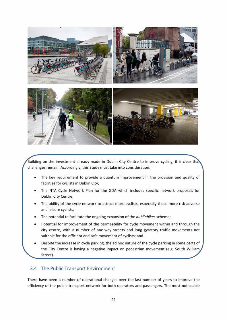
3.3 The Cycling Environment
The amount of cyclists on the streets of Dublin City Centre has increased dramatically over the last
number of years. To ensure that the number of cyclists travelling within, to and from the city centre
continues to rise, it is essential that this study addresses the need to expand and improve the
infrastructural requirements of an increased cycling community within Dublin City Centre.
Dublin City Council and the NTA have put significant effort and resources into improving the cycling
environment in Dublin City Centre, and initiatives such as the dublinbikes scheme have made cycling
a very visual mode of transport. The Grand Canal cycleway has created an important cycle route with
a high quality of service, which is an important step in attracting novice cyclists. The introduction of
new cycle parking facilities, particularly the 300 space facility at Drury Street car park, has also
encouraged cycling as a means of accessing the city centre. However, despite this investment, and
the significant increase in the number of cyclists, the current quality of service for cyclists both
within and travelling to and from the City Centre is poor. The current network lacks continuity and
coherence and the degree of priority provision varies greatly across the city.
21
Building on the investment already made in Dublin City Centre to improve cycling, it is clear that
challenges remain. Accordingly, this Study must take into consideration:
The key requirement to provide a quantum improvement in the provision and quality of
facilities for cyclists in Dublin City;
The NTA Cycle Network Plan for the GDA which includes specific network proposals for
Dublin City Centre;
The ability of the cycle network to attract more cyclists, especially those more risk adverse
and leisure cyclists;
The potential to facilitate the ongoing expansion of the dublinbikes scheme;
Potential for improvement of the permeability for cycle movement within and through the
city centre, with a number of one-way streets and long gyratory traffic movements not
suitable for the efficient and safe movement of cyclists; and
Despite the increase in cycle parking, the ad hoc nature of the cycle parking in some parts of
the City Centre is having a negative impact on pedestrian movement (e.g. South William
Street).
3.4 The Public Transport Environment
There have been a number of operational changes over the last number of years to improve the
efficiency of the public transport network for both operators and passengers. The most noticeable
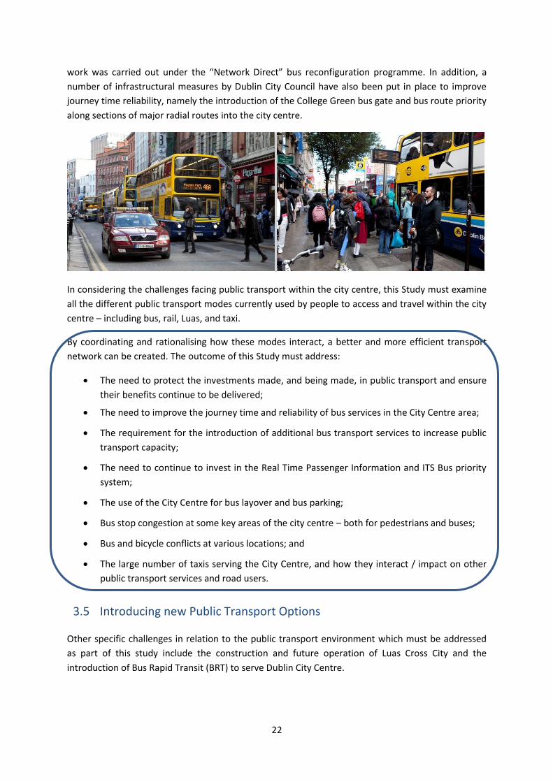
22
work was carried out under the “Network Direct” bus reconfiguration programme. In addition, a
number of infrastructural measures by Dublin City Council have also been put in place to improve
journey time reliability, namely the introduction of the College Green bus gate and bus route priority
along sections of major radial routes into the city centre.
In considering the challenges facing public transport within the city centre, this Study must examine
all the different public transport modes currently used by people to access and travel within the city
centre – including bus, rail, Luas, and taxi.
By coordinating and rationalising how these modes interact, a better and more efficient transport
network can be created. The outcome of this Study must address:
The need to protect the investments made, and being made, in public transport and ensure
their benefits continue to be delivered;
The need to improve the journey time and reliability of bus services in the City Centre area;
The requirement for the introduction of additional bus transport services to increase public
transport capacity;
The need to continue to invest in the Real Time Passenger Information and ITS Bus priority
system;
The use of the City Centre for bus layover and bus parking;
Bus stop congestion at some key areas of the city centre – both for pedestrians and buses;
Bus and bicycle conflicts at various locations; and
The large number of taxis serving the City Centre, and how they interact / impact on other
public transport services and road users.
3.5 Introducing new Public Transport Options
Other specific challenges in relation to the public transport environment which must be addressed
as part of this study include the construction and future operation of Luas Cross City and the
introduction of Bus Rapid Transit (BRT) to serve Dublin City Centre.

23
3.5.1 Luas Cross City
Dublin City Centre is getting a new Luas line which is due to come into operation in 2017. The railway
construction work along the alignment of this route will have a significant impact on the current
operations of the bus network servicing the City Centre in the short term. However, once complete,
the new Luas Cross City route will also have a significant impact on the current bus and vehicular
traffic movements in and around large areas of central Dublin (most notably O’Connell Street,
College Green and Dawson Street/Nassau Street). The new Luas Cross City will require the alteration
of junction signal timings, considerably decreasing the amount of green time available for other
modes, which in turn will seriously reduce road capacity in the core city centre.
3.5.2 Bus Rapid Transit (BRT)
The introduction of BRT routes to service high demand bus corridors is currently being considered by
the NTA. Specific changes to the transport arrangements currently operating in the city centre will
be needed to facilitate the introduction of these BRT routes in the short to medium term.
The introduction of new transport options into the city centre will significantly alter the current
configuration and capacity of the modes currently using the streets of the city centre. Accordingly, it
is important that the bus and private car networks within the core city centre are reconfigured to
ensure that the impacts of Luas Cross City /BRT are addressed.
3.6 The Private Vehicle Environment
The private car will continue to be an important choice of mode for people travelling to the City
Centre, particularly for shopping and other commercial activities. However, it is essential that the
current pattern of vehicular movement both through and within the City Centre is examined to
ensure that road space is utilised efficiently. Currently, both traffic travelling through the City Centre
and traffic with a destination in the city, rely heavily on major radial routes to access and leave the
centre. This results in traffic congestion, and also impacts on the efficiency and ease of movement
for other modes, particularly buses.
Dublin City Council has invested heavily in maintaining and improving the movement of vehicular
traffic within Dublin City Centre. The opening of the Port Tunnel and the Samuel Beckett Bridge have

24
improved vehicular accessibility to the east of the city centre as well as providing a direct link from
the city centre to the M50. The City Council have also invested in a Traffic Control Centre, and
computerised traffic management system to help control traffic movement. Variable Message
Signage (VMS) provides traffic updates and up to date car park availability information to motorists.
Building on the investment already made in Dublin City Centre to improve vehicular movement, it is
important to note that some challenges remain, and the outcome of this Study must address:
That there are many vehicles using the city centre as a through route, and which do not have
a destination in the City Centre. Such vehicles could be accommodated on alternative
routes, circumnavigating the central area;
To provide journey time information and route guidance via web and mobile devices, and to
make this data freely available for all navigation systems.
The current movement of traffic within the City Centre is dependent on a number of
gyratory systems – e.g. St Stephen’s Green, Westmoreland Street / D’Olier Street and
Beresford Place. The gyratories are prone to congestion and blocking back of traffic at peak
hours, with heavy flows of relatively fast-moving and weaving traffic in the off-peak periods.
Such arrangements do not give priority to pedestrians, cyclists or buses, and often force
them to deviate significantly from the most direct route; and,
That an appropriate level of private car vehicular access to the City Centre will be retained
for retail and commercial purposes.
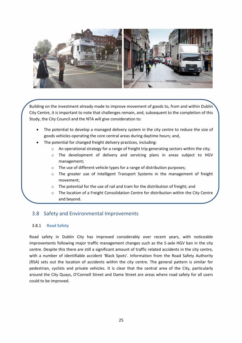
3.7 Goods Distribution and HGV Environment
Maintaining an efficient supply chain for goods and services into Dublin City Centre is essential to
the commercial life of the city. Dublin Port is also directly adjacent to the core city centre, and many
of the goods vehicles travelling within Dublin City Centre are moving between the city centre and the
Port. Dublin Port is Ireland’s largest port and is a primary trade hub for the country as a whole.
The construction of the Port Tunnel was a significant benefit to the goods distribution sector, and in
particular heavy goods vehicle operators, who can use the tunnel free of charge. The tunnel opened
in conjunction with the restriction on 5-axle vehicle access to the city centre. Access for these
vehicles now operates under a permit system, reducing congestion and improving the movement of
freight vehicles through the city centre.
25
Building on the investment already made to improve movement of goods to, from and within Dublin
City Centre, it is important to note that challenges remain, and, subsequent to the completion of this
Study, the City Council and the NTA will give consideration to:
The potential to develop a managed delivery system in the city centre to reduce the size of
goods vehicles operating the core central areas during daytime hours; and,
The potential for changed freight delivery practices, including:
o An operational strategy for a range of freight trip generating sectors within the city;
o The development of delivery and servicing plans in areas subject to HGV
management;
o The use of different vehicle types for a range of distribution purposes;
o The greater use of Intelligent Transport Systems in the management of freight
movement;
o The potential for the use of rail and tram for the distribution of freight; and
o The location of a Freight Consolidation Centre for distribution within the City Centre
and beyond.
3.8 Safety and Environmental Improvements
3.8.1 Road Safety
Road safety in Dublin City has improved considerably over recent years, with noticeable
improvements following major traffic management changes such as the 5-axle HGV ban in the city
centre. Despite this there are still a significant amount of traffic related accidents in the city centre,
with a number of identifiable accident ‘Black Spots’. Information from the Road Safety Authority
(RSA) sets out the location of accidents within the city centre. The general pattern is similar for
pedestrian, cyclists and private vehicles. It is clear that the central area of the City, particularly
around the City Quays, O’Connell Street and Dame Street are areas where road safety for all users
could to be improved.

26
Building on the investment already made in Dublin City Centre to improve road safety and reduce
environmental impact, this Study should continue to ensure that:
Any new transport proposals will reduce conflict between modes, making the streets safer
for all users; and,
The overall transport network will make Dublin City Centre a more environmentally friendly
place.
3.9 Summary
The key challenge of this Study is to ensure that the changes in the transport environment required
to achieve the desired modal shift will result in an increase in the overall transport capacity within
the city centre. These changes must guarantee that future growth within the city can be facilitated
by the revised transport system.
It is evident that, in general, the individual transport networks within Dublin City have benefited
significantly from the ongoing work and investment of Dublin City Council and the NTA. Despite this,
it is clear that the current provision for each mode is inadequate in some way, and does not fully
match the functional requirements of the mode either individually, or as part of the collective
transport network of Dublin City Centre.

27
4 Development of the Transport Proposals
4.1 Overview
Drawing on the facts set out in the previous sections of this Study, it is clear that there is a pressing
need to reassess how Dublin City’s transport options will operate into the future. Central to this
assessment is the critical need to ensure that Dublin City can cater for an anticipated growth of
approximately 20% in the number of trips coming into the City Centre each morning by 2023,
compared to the number observed in Census 2011. As illustrated in Chapter 3, that there are a
number of challenges to how the existing transport networks operate within the city centre, a
situation which will be made substantially more challenging when Luas Cross City further reduces
the capacity of the road network. In fact, given the road network changes over recent years, even
accommodating previous vehicle levels is not a feasible option.
Taking these details into account, and drawing on the land use and transport policies of Dublin City
Council and the NTA, in particular the target set out in the Development Plan to achieve a modal
share of 55% for public transport by 2017, a number of guiding principles were compiled. These
principles will be used to ensure that new transport proposals are consistent with the overriding aim
of the Study: to produce a transport system capable of catering for the existing and future travel
needs of Dublin City Centre. These principles are set out in Section 4.2.
It was also important to clarify some of the parameters within which the development of new
transport proposals will have to operate. These assumptions set out specific measures which are
already in existence, or at an advanced stage in their project development, and as such have been
considered as operational in relation to the formulation of this Study. These main assumptions are
set out in the Section 4.3.

28
4.2 Guiding Principles
The following principles will be used to ensure that new transport proposals are consistent with the
overriding aim of the Study. They are set out in the box below:
Principle 1: To protect the investment that already has been, and continues to be, made
in public transport in the city.
Principle 2: To increase the capacity for the movement of people and goods into and
within the City Centre, and facilitate efficient and effective goods delivery.
Principle 3: To develop a safer City Centre for all transport modes and users.
Principle 4: To improve accessibility and permeability to, and within, the City Centre for
pedestrians, cyclists and public transport users, while also maintaining an
appropriate level of access for vehicular traffic for commercial and retail
purposes.
Principle 5: To make it easier for people to use the transport networks.
Principle 6: To provide opportunities to enhance the Public Realm through transport
interventions in the City Centre.

29
4.3 Transport Network Assumptions
Following on from the establishment of the study principles, it was important to clarify some of the
parameters within which the development of new transport proposals will have to operate. The
following assumptions set out specific measures identified by the project team which are already in
existence, or at an advanced stage in their project development, and as such have been considered
as operational in relation to the formulation of this Study. They are set out in the box below:
Main Network Assumptions Underpinning City Centre Transport Proposals
The study will be aligned to the forthcoming NTA Transport Strategy for the Greater Dublin Area.
Greater priority will be given to pedestrians in the City Centre, particularly at conflict points, and areas where safety has been a problem.
The movement of pedestrians and cyclists in the city (in particular north - south across the River Liffey) and around public transport nodes will be improved.
Existing bus routes and frequencies will continue to be reviewed and modified as necessary.
Bus Rapid Transit services will operate through the City Centre in line with the proposals set out in the NTA Integrated Implementation Plan.
Bus routes should no longer terminate in the City Centre and there will be no parking/layover of buses in the City Centre.
Real Time Passenger Information displays will continue to be rolled out at key transport stops and Interchange points.
Interchange between public transport services will be significantly improved, and will support more people accessing more destinations via a single interchange within or close to the city centre.
Luas Cross City will be operational by the end of 2017, and the permanent traffic changes associated with its construction will commence during 2016.
To ensure the efficient operation of Luas Cross City through the City Centre, the movement of general vehicular traffic will be reduced or eliminated along sections of the route.
The Phoenix Park Tunnel will be opened by the end of 2016, bringing rail passengers from the Kildare line to the east of the city by serving Drumcondra, Connolly, Tara, Pearse and Grand Canal Dock stations.
The DART service will be increased to a 10 minute frequency in peak hours.
Integrated public transport ticketing (supporting faster boarding and alighting and facilitating easier passenger transfer between public transport services) will be further developed, including the introduction of simpler fare structures.
The success of the College Green bus gate in reducing the level of through car traffic in the core of the City Centre will be used as a template for further similar interventions.
Vehicular through traffic will be actively encouraged onto routes away from the City Centre, with appropriate signage arrangements provided, in order to protect public transport investment, remove through traffic, and free up the City Centre for other modes.

30
4.4 Developing a Network Approach
In order for specific transport proposals to be developed, it was necessary to establish an
overarching approach of how best to reconfigure Dublin’s transport network into an efficient and
effective system, capable of catering for the future transport needs of the city. In this regard the
project team developed a ‘Network Framework’. This Network Framework sets the scene within
which specific transport proposals will be developed. The Network Framework anticipates the
strategic requirements of each mode, and considers how modes will interact or conflict; this is to
ensure that the finalised transport proposals are not developed in isolation but rather as elements of
an integrated transport system for Dublin City Centre.
It should be noted that all schemes identified in this study will be subject to their own statutory
consent procedures prior to any implementation.
4.4.1 The Strategic Networks
The individual networks forming the overall ‘Network Framework’ are:
Vehicular Traffic;
Bus/BRT;
Rail;
Cycling; and,
Pedestrian;
Each of these networks is addressed in Chapters 5 to 9.
4.4.2 Site Specific Interventions
It was important to first establish and agree the overarching Network Framework for the
development of a new integrated and coordinated transport network for Dublin City. As the ideas of
how each mode will function within this Framework evolved, it became clear that to facilitate the
required revisions to the networks, as well as address some major constraints of the existing
network, a number of site specific interventions will also be required. These interventions are critical
to the Study, and while primarily aimed at improving how the transport network of Dublin City will
operate, the proposed alterations have the potential to transform the public image and
attractiveness of the city centre as a whole. These interventions are set out in Chapter 10.

31
5 Traffic Network Proposals
5.1 Overview
Traffic patterns in Dublin have changed over the last 10 years with new bridge and road
infrastructure in place, and with an increasing number of people now choosing public transport,
walking and cycling as their mode of transport. More people now reside within the City Centre, and
there is a strong desire to ensure that Dublin develops into a more liveable city, where the impact of
traffic is minimised.
With the economic upturn there is now evidence of increased volumes of traffic on the radial
approaches to Dublin and on the M50. As the economy continues its recovery and employment
rises, without positive intervention, increased congestion and longer journey times on the key routes
to Dublin City, and within the City Centre itself, will become an increasing feature of the City. In
addition, the delivery of the Luas Cross City project will impact on street and junction capacity in the
city core, which will require significant changes to the traffic network following its introduction.
It is estimated that by 2023, the transport network of Dublin City will be required to cater for a
further 42,000 journeys each morning, an increase of almost 20%. It is not possible to cater for this
increase by the private vehicles alone, as if even 20% of these additional trips were made by car it
would represent an increase of 8,500 cars on the road during the morning peak, effectively returning
the traffic volumes and congestion in the city to levels last seen in the early 2000s. This would also
have serious consequences for the operation and management of the public transport, cycling and
walking networks.
It is neither sustainable nor practical to attempt to cater for this volume of additional trips to the city
centre by car. As such, this Study considers how the road network can continue to function as a key
element of the transport network, whilst facilitating the needs and requirements of the other
modes, which will have to shoulder the responsibility of serving the increased demand coming into
the city centre.
Luas Cross City will also have a major impact on street and junction capacity of Dublin City and will
require significant changes to the traffic network during its construction and following the
commencement of passenger services in 2017. It will include extensive sections of shared running
from Dawson Street to O’Connell Street, and without careful design there is a danger that Luas

32
trams will be caught up in traffic congestion, and that the reliability of the service will be prone to
disruption due to general traffic. Similarly, only sections of the bus network in the City Centre are
segregated from general traffic. As such, there are frequently delays, with the reliability of the bus
network affected by any incidents, events or accidents which cause general traffic to be delayed.
A number of significant traffic management changes have occurred over the last number of years to
restrict north-south traffic movement in the city centre, such as the turn bans at Dawson Street and
Georges Street, and the introduction of the bus gate at College Green. East-west movement along
the Quays however, have remained relatively unchanged, and continue to act as a major
thoroughfare for traffic moving through the heart of the City Centre. Traffic volumes at the junctions
on both sides of O’Connell Bridge are in the order of 70,000 vehicles per day (this is 60% of the
volumes using the M50 per day and the same as the daily volume on the N3 at Blanchardstown).
This directly conflicts with pedestrian movements across the city at the Halfpenny Bridge and at
O’Connell Bridge, and is also contrary to the Development Plan objective of reducing through traffic
in the city centre.
To continue to cater for this level of through traffic while also providing a new Luas Line and
improved bus provision, wider footpaths and segregated cycling facilities will not be possible.
Indeed, if the current configuration of roads and traffic management is not altered within the city
centre, then the increased investment of Government resources in public transport will not be able
to achieve the gains in capacity, speed and reliability required to cater for future travel demand.
Providing Government funding for transport provision without ensuring the right environment in the
City Centre to allow it to function to its capacity is an inefficient use of limited resources.
A rebalancing of the available road space will be required on various streets to facilitate the
introduction of additional capacity for public transport, cycling and walking. Significant changes will
be required to the traffic network in the city centre, with the objective of ensuring that the overall
transport system is capable of operating efficiently and reliably, with consistent journey times. This
will ensure that:-
The existing and planned investment in public transport is protected, ensuring that public
transport can operate to its maximum capacity ;
Additional public transport capacity can be put in place which will be necessary to cater for
increased future demand;
The public transport network will operate efficiently and reliably even during the Luas Cross
City works; and,
Walking and cycling provision will be enhanced and that significant public realm
improvements can be advanced.
These objectives are reflected in the provisions of the Dublin City Development Plan, which requires
public transport trips across the canal cordon each day to increase to 55% (from 48% in 2014), and
the level of cycling to increase to 15% (from 5% in 2014), while car trips are required to decrease to
20% (down from 33% in 2014).

33
5.2 Proposals
Since the publication of the Dublin Transport Initiative (DTI) Strategy Report in the mid-1990s, the
overriding principle of transport strategies in the Dublin region has been to not increase road
capacity into or within Dublin City Centre for private vehicular traffic, but instead to prioritise public
transport, walking and cycling. The basis for this policy is a recognition that it unrealistic and
unsustainable to accommodate growth in travel demand across the region through car based
movement. Instead, growth must be accommodated by other modes, and the limited road space has
to be used optimally to cater for both car and non-car uses. The changes that will be needed by the
traffic network to ensure that the city can achieve the requirements of the City Development Plan
and cater for the anticipated future transport growth include:
Removal of through-traffic which currently traverses the central area, thereby releasing
certain road space to non-car modes of transport;
Reinforcement and enhancement of orbital traffic movement, starting as far out as the M50,
utilising orbital route options outside the canals, with the objective of reducing the amount
of traffic using the city centre to get to their destination;
An overall objective of ensuring that public transport can operate as efficiently as possible;
Conversion of certain streets to public transport/cycling/pedestrian access only to enable
improved bus, cycle and pedestrian movement around the central area;
Rationalisation of car parking access/egress and car park location, while retaining
appropriate and adequate car parking where possible for retail and commercial functions;
Expansion and associated rationalisation of City Centre taxi ranks. and,
Introduction of a City Centre Zone for managing deliveries within the city centre;
The following sections outline the details of the proposals set out above.
5.3 Key Changes
5.3.1 Orbital Movement
In order to release city centre road space for the delivery of the required additional public transport
capacity, new cycling corridors and pedestrian/public realm improvements, it is essential that traffic
which doesn’t need to pass through the city centre area or around the city centre area is facilitated
with appropriate arrangements for orbital movement beginning outside the M50. In general the new
arrangements will be facilitated by increased signage, particularly on the M50 (i.e. City South, City
North) and on strategic corridors with clear directional information, and information on car parking.
A key objective of this Study is to actively facilitate the movement of cross city traffic away from the
core of the city, and as such it is critical that appropriate orbital routing alternatives are provided to
cater for this traffic flow.

34
The reconfiguration of road space, improved signposting, increased use of mobile technology and
ITS, as well as improvements in the Variable Message Sign (VMS) Network on routes around the city
centre, will help to guide traffic to access the city centre at the most appropriate entry points
relative to its ultimate destination. In addition, on the east side of the city many of the available
routes are height constrained by railway bridges, such as Macken Street and Sandwich Street. It is
proposed that a study of the bridges and possible options for increasing the clearance under certain
of these bridges will be undertaken.
The improvements outlined above will facilitate and prioritise the orbital movement of traffic
around the central city area, while enabling traffic to access the city centre at the most appropriate
entry points relative to its ultimate destination. In turn, this enables the core of the city centre to be
re-designed to provide more physical space, junction priority and journey time reliability for public
transport, as well as making the city centre a safer and more pleasant environment for cyclists and
pedestrians.
As well as addressing the need for increased transport capacity by non-car modes, this reallocation
of road space will create the potential for a transformation of the urban fabric within the City
Centre, as set out in the City Council's Public Realm Strategy, enabling the creation of an improved
city centre, and increasing the vibrancy and vitality of Dublin as a commercial and retail centre.
5.3.2 Public Transport/Cycling/Pedestrian Only Streets
The current issue with rising levels of congestion for all modes in the City Centre (North and South
Quays as an example), together with the traffic network changes brought about by Luas Cross City,
and the need to cater for a growth in travel demand, will require the reallocation of road space on
certain streets from general traffic to sustainable transport modes. This will safeguard the critical
role of public transport, and will ensure that it is possible to transport more people in and out of the
City Centre.
One of the most successful traffic management changes introduced in recent years in Dublin City
was the College Green Bus Corridor. The introduction of the College Green Bus Corridor provided
significant benefits to public transport in particular. During its hours of operation, it reduces journey

35
times for buses by up to 20 minutes in the peak hour. It provided vastly improved journey time
reliability for buses using that route, and by removing large volumes of traffic from College Green,
Westmoreland Street and D’Olier Street, provided some improvements in the utility of the street
from the perspective of pedestrians and cyclists.
Building on the success of the College Green Bus Corridor, this Study proposes the introduction of a
number of other similar public transport focused links. These will include, in particular new bus
gates at:
Bachelors Walk Bus Gate – the diversion of general car traffic from Bachelors Walk between
its junction with Jervis Street and its junction with O’Connell Street; and
A Bus Gate on the south Quays at Aston Quay, Burgh Quay or Georges Quay – facilitating the
reduction of vehicular traffic in the vicinity of O’Connell Bridge.
Westmoreland Street/D’Olier Street
Each of these Bus Gate proposals and benefits are addressed separately in Chapter 10.
5.3.3 Reduced Private Vehicle Access Arrangements
As identified, one of the most successful traffic management changes introduced in recent years in
Dublin City was the College Green Bus Gate. Currently College Green/Dame Street operates with
two traffic lanes in each direction. However, the footpaths in College Green are narrow and
overcrowded and north-south pedestrian movement from the key O’Connell Street/Henry Street
area to the Grafton Street shopping area can be slow, difficult and frequently impeded. The current
street constraints at College Green have resulted in inadequate pedestrian provision at this key
location.
Additionally, the arrangements for cycling through this area are unsatisfactory and inadequate. As
cycling numbers continue to grow, this inadequacy will become more acute, particularly following
the placement of the new tracks for Luas Cross City.
To address these issues, it is intended to construct dedicated cycling routes through College Green
connecting Westmoreland Street and D’Olier Street to Dame Street. This will provide safer cycling
through this critical artery for the thousands of cyclists that are using this route each day. In tandem
with this cycling provision, wider footpaths will be incorporated, to the extent feasible, to improve
pedestrian movement through this area. Both of these changes will require additional road space to
be assigned for cycling and pedestrian use.
36
Separately, the introduction of Luas Cross City will impact on the vehicular capacity of College Green.
The impact of the Luas operations, together with the need to improve cycling and pedestrian
facilities, mean that it will be necessary to reduce the number of traffic lanes through College Green
to one lane in each direction. This is a significant change but one that is necessary if the streetscape
of College Green is to be radically improved, and if appropriate provision is to be made for both Luas
and non-vehicular modes of transport through this area.
The reduction to one lane in each direction will mean that the current prohibition of cars from
College Green during the bus gate hours of 7am to 10am and 4pm to 7pm will need to be extended
to operate on a 24 hour basis, with some allowance to be developed to facilitate deliveries.
Additionally, because of the volume of both buses and taxis using this link, a single lane in each
direction will not have the capacity to accommodate both vehicle types into the future. Given the
importance of this link in the bus network serving the city, it is proposed that buses only be
permitted to use the College Green Bus Gate and that taxis, due to the inability to cater for their
volume, will not be permitted to travel through this bus gate. A similar arrangement will also apply
to the bus gate on Pearse Street, leading into College Street. While buses only will be permitted to
use the above bus gates, cars and taxis will still be able to access, and service, D’Olier Street, College
Street and Westmoreland Street with access continuing to be available from the north end of D’Olier
Street.
Further details on the proposals for College Green, Westmoreland Street and D’Olier Street are
provided in Chapter 10.
5.3.4 Traffic Management Revisions
The reduction and redirection of traffic travelling through the city centre, will enable further traffic
management modifications to be carried out to benefit the general transport movement within the
city centre. In particular, this will facilitate a review of the current phasing of traffic lights at
signalised junctions, as well the use of gyratory traffic systems at certain locations within Dublin City
Centre.
Traffic gyratory systems are usually provided to enable more traffic capacity than might be available
through conventional two-way streets. However, while catering for vehicular traffic, they generally
disadvantage other road users. Buses can be particularly affected, with journey lengths and journey
times increased, often requiring the subsequent introduction of contra-flow bus lanes. Gyratory
systems are also difficult for cyclists, who are forced to mix with weaving vehicular traffic, as well as
being required to deviate away from the most direct route. The presence of network gyratories also
acts as a constraint on traffic signalling. Junction signals at such locations must be designed to avoid
the risk of traffic blocking-back to ensure gyratories do not lock up.
This Study proposes to review and revise as necessary the current traffic signal phasing, and traffic
arrangements of certain gyratory systems, within the city centre. This will rebalance the needs of
pedestrians, cyclists, buses and trams with other vehicular traffic, reducing overall junction delays
and improving safety for all road users.

37
5.3.5 Access to and from City Centre Car Parking
It is recognised that continued access by car is essential for sustaining retail and commercial activity
within the City. While it is important that growth in commuting is accommodated through increased
investment in, and use of public transport, walking and cycling, an appropriate level of car access
needs to be facilitated, together with related parking provision. This should primarily cater for non-
commuting activity, particularly for shopping related trips outside of peak commuting hours.
There are a large number of commercial and publicly owned multi-storey car parks in the city centre
(Figure 7.1), as well as a significant level of on-street parking. Access to and from these car parks,
and other private car parking facilities in the city centre has been a major influence in the routing
and configuration of road space in the City Centre.
Currently there are approximately 10,500 spaces in off-street commercial car parks. This is in
addition to circa 20,000 on-street car parking spaces. To improve management of access to the
commercial off-street car parking spaces, Dublin City Council have introduced real time Variable
Message Signs (VMS) on the main arterial routes into the city advising motorists on the availability of
car parking in multi-story car parks across the city. This has enabled better utilisation of these car
parks and the minimisation of on-street queuing for spaces. Similarly, the introduction of pay and
display together with an active clamping enforcement policy has also helped manage the availability
of on-street car parking within the city.
Figure 7.1: Location of City Centre Car Parking
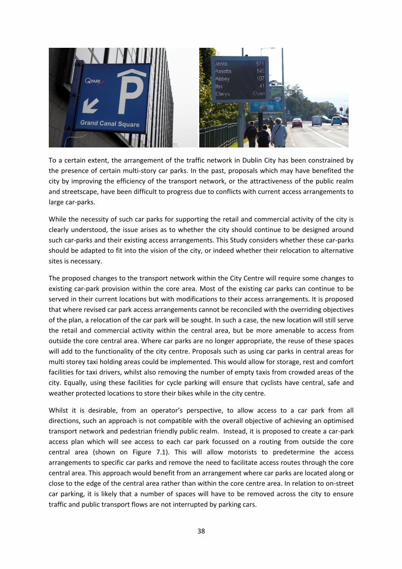
38
To a certain extent, the arrangement of the traffic network in Dublin City has been constrained by
the presence of certain multi-story car parks. In the past, proposals which may have benefited the
city by improving the efficiency of the transport network, or the attractiveness of the public realm
and streetscape, have been difficult to progress due to conflicts with current access arrangements to
large car-parks.
While the necessity of such car parks for supporting the retail and commercial activity of the city is
clearly understood, the issue arises as to whether the city should continue to be designed around
such car-parks and their existing access arrangements. This Study considers whether these car-parks
should be adapted to fit into the vision of the city, or indeed whether their relocation to alternative
sites is necessary.
The proposed changes to the transport network within the City Centre will require some changes to
existing car-park provision within the core area. Most of the existing car parks can continue to be
served in their current locations but with modifications to their access arrangements. It is proposed
that where revised car park access arrangements cannot be reconciled with the overriding objectives
of the plan, a relocation of the car park will be sought. In such a case, the new location will still serve
the retail and commercial activity within the central area, but be more amenable to access from
outside the core central area. Where car parks are no longer appropriate, the reuse of these spaces
will add to the functionality of the city centre. Proposals such as using car parks in central areas for
multi storey taxi holding areas could be implemented. This would allow for storage, rest and comfort
facilities for taxi drivers, whilst also removing the number of empty taxis from crowded areas of the
city. Equally, using these facilities for cycle parking will ensure that cyclists have central, safe and
weather protected locations to store their bikes while in the city centre.
Whilst it is desirable, from an operator’s perspective, to allow access to a car park from all
directions, such an approach is not compatible with the overall objective of achieving an optimised
transport network and pedestrian friendly public realm. Instead, it is proposed to create a car-park
access plan which will see access to each car park focussed on a routing from outside the core
central area (shown on Figure 7.1). This will allow motorists to predetermine the access
arrangements to specific car parks and remove the need to facilitate access routes through the core
central area. This approach would benefit from an arrangement where car parks are located along or
close to the edge of the central area rather than within the core centre area. In relation to on-street
car parking, it is likely that a number of spaces will have to be removed across the city to ensure
traffic and public transport flows are not interrupted by parking cars.

39
To complement these changes a comprehensive plan to inform motorists as to the access routing to
car parks will be put in place. This will utilise increased signage / VMS to channel vehicular traffic
accessing car parks along designated routes. By informing motorists in advance of the core central
area, decisions on car parking can be made in a predetermined manner, thus minimising the number
of entry routings necessary for vehicular access through the central area. The revised access
arrangements to car parks will be cognisant of the public transport, cycle and pedestrian networks
across the city, and will be designed to reduce conflict between the modes, reducing potential for
delays.
The improved management of car parking within the city centre will have a number of advantages.
Clearly defined routings to car parks will aid drivers’ decision making and reduce circulating traffic
looking for parking. This will reduce journey times and congestion in the core city centre for private
vehicles.
5.3.6 Improved Management and Control of City Centre Freight / Goods Movement
The supply chain for goods and services into Dublin must be carefully considered as an essential
element of a working City Centre.
Dublin City Council introduced a 5-axle Heavy Goods Vehicle (HGV) ban which covered most of the
area within the canals in 2007. This ban has reduced the number of HGVs within the city centre to,
on average, 30-40 per day. The main demand for HGV movements within or through the city centre
is to serve such areas as the City Fruit Markets, and certain large City Centre retailers and exporters.
The vast majority of goods vehicles serving the city centre however are light goods vehicles (LGVs)
and vans. The destination of these vehicles is dispersed, and although there is a predominance of
deliveries in the morning, the movement of goods has an all day trip pattern. Access to the shopping
areas and reliability of delivery are essential considerations of this Study.
The purpose of the Goods Management interventions is to ensure that the city has the capacity to
receive and distribute goods and services in accordance with the growing needs of the population
and economic centres, in an efficient and least disruptive manner. It is recommended that:
Consideration of and discussion with stakeholders should commence on the provision of a
managed delivery system in the City Centre utilising potentially a second HGV zone in the
city centre which includes all Commercial vehicles and where the emphasis will be on
provided timed deliveries within the city centre.
40
Ancillary management measures will also be considered, including;
o The potential for changed freight delivery practices, including a different approach to vehicle types / use of Intelligent Transport Systems / prioritised freight routes;
o The potential use and location of a Freight Consolidation Centre (possibly in the vicinity of Dublin Port or another city centre location);
o A determination of whether any legislative changes are required to allow deliveries only into Public Transport Streets at set times only;
o Noise management for city centre loading activity; and
o Move towards a vision of a CO2 free delivery system in the City Centre by 2023 utilising alternative vehicles and fuel types.
The enhanced management and regulation of freight movement and control of loading/unloading will:
Reduce the number of goods vehicles on the city streets, reducing congestion and improving the urban environment with less emissions, noise, and less weight damage to the roadways;
Greatly benefit cyclists, pedestrians and bus movements; and
Improve efficiency bringing benefits to freight operators and retailers with journey and delivery time reliability and potentially reduced costs by consolidation of deliveries.
5.4 Intended Outcomes
The proposed modifications to the existing road network are vital to the success of the Study. The
changes will allow the road network to be utilised more efficiently for all modes traversing and
accessing the city centre, and will facilitate the transformation of central places, such as College
Green and the Quays. The proposed revisions to the road network will ensure that the city remains
accessible by private vehicles, particularly in relation to access to car parking in the vicinity of the
north side and south side retail centres.
The reorientation of the roadways within the city centre will allow for the required expansion of
public transport services, ensuring that there is sufficient capacity across the transport networks to
accommodate the anticipated growth in demand for travel to Dublin City Centre. This will ensure
that the city can continue to grow as an economic driver of the State.

41
6 Bus Network Proposals
6.1 Overview
Key objectives of this Study are to safeguard the efficiency of the bus operating environment in the
context of Luas Cross City and increased congestion, as well as enabling the bus network to transport
a significantly increased number of commuters, shoppers and visitors into Dublin City each day.
These objectives reflect the intention of the City Development Plan 2011-2017, which sets the target
of increasing the public transport proportion of trips across the canal cordon each day.
To achieve these changes, it is necessary to increase the carrying capacity of the bus system and to
significantly enhance the efficiency of the bus network. Dublin Bus currently operates a network
catering for 115 million passenger journeys per annum, while Bus Eireann’s network of commuter
services within the Greater Dublin Area accounts for a further 10 million passengers per annum.
Numerous private operators also operate to and from Dublin City carrying an additional 13 million
passengers per annum.
While there has been significant development of bus lanes and bus corridors over the last decade,
the discontinuous nature of many of those bus lanes and the lack of priority at junctions has meant
that the average bus speed on many routes in the morning and evening peaks are as low as 10km/h.
This has a knock on effect on journey time reliability for some routes running through the city
centre, with significant variances between different times and days in many cases. This issue is
exacerbated in the event of a traffic accident or incident occurring on any of the key routes, which
frequently results in major delays across the full bus network. Overall, the lack of reliability and
predictably makes many bus journeys much less attractive than they should be for the travelling
public.
Appropriate bus infrastructure provision in the City Centre will be vital to increasing the overall
effectiveness of the bus network, and will be essential to achieving the increased bus targets set out
in the Development Plan. The attractiveness of bus is greatly influenced by the routes taken by
services through the City Centre, the location of stops, the opportunities for interchange, and the
overall bus journey times and reliability through the City Centre. Faster, more reliable and more
predictable journey times will enable bus travel to become the transport mode of choice for more
people.

42
6.2 Proposals
To achieve the objective of improving the operation, management and efficiency of the bus network
within Dublin City, it is intended:
To increase the passenger carrying capacity of the bus network, through the
enlargement of the bus fleet, with additional services to be provided on existing busy
routes, plus the introduction of new routes;
To maximise the performance of the bus network by ensuring that sufficient road
capacity and junction priority are provided to allow buses to operate efficiently, with
reliable and predictable journey times;
To introduce high capacity Bus Rapid Transit (BRT) style services along specific routes;
and,
To further optimise the routing of the bus corridors through the City Centre area,
improving interchange arrangements and optimising the efficiency of the service.
The proposed changes both in the City and the wider Greater Dublin Area will make public
transport, and in particular bus, a more viable option for many users, providing choice and
facilitating a mode shift away from the private car for all trip purposes, particularly commuting.
6.3 Key Changes
The following sections set out additional detail in relation to the above proposals.
6.3.1 Passenger Carrying Capacity of the Bus Network
In order to transport more passengers by bus, the capacity of the overall bus system needs to be
increased. This will require an expansion of the bus fleet. Dublin Bus currently operates just over 800
buses in the peak hours. Additional bus fleet will be required to provide increased capacity on
existing routes as well as to enable the introduction of new routes.
Related to the issue of fleet, the provision of enhanced bus priority along key routes will speed up
journey times. While the primary beneficiaries of faster journey times will be the passengers, an
important ancillary benefit is that faster bus speeds enable the same level of service to be operated
with fewer buses and at much reduced cost. If the average speed on a route can be increased, then
the same bus service can be provided with a reduced bus fleet. This enables the full bus fleet and
drivers to be assigned in a more efficient manner. Accordingly, the implementation programme for
bus priority measures will be important in determining fleet requirements.
6.3.2 Introduction of additional bus priority measures in the City Centre
In order to cater for the increased level of bus capacity and usage, and to ensure that bus services
can run efficiently and on time through the City Centre, extra provision for buses will be required,
primarily in terms of new / improved bus lanes and additional bus priority.

43
In tandem with this, the construction of Luas Cross City, and its commencement of passenger
services at end 2017, will result in significant traffic alterations in the City Centre. Luas Cross City
traverses the central spine of the city, passing through College Green, Westmoreland Street and
O’Connell Street, crossing the major traffic arteries of the north and south quays. Various traffic
movements that currently operate will not be possible after the completion of the Luas project. The
vehicular capacity at various junctions along the corridor, particularly on either side of O’Connell
Bridge and at College Green, will be significantly reduced in order to cater for the Luas service.
Having regard to the impacts of Luas Cross City, the targets set out in the Development Plan and the
need to enhance the efficiency of the bus network through the City Centre, the following proposals
are intended to be implemented during the period of this Study:
College Green bus lane hours to be extended to 24 hours each day – details of this are set
out in section 10.2.2;
New public transport / cycling only sections of streets in appropriate locations to ensure that
those modes can operate efficiently and without undue delay. These locations may include
short sections of the north and south quays, potentially at Bachelors Walk on the north
quays and at a corresponding location on the south quays). Details of this proposal are set
out in Section 10.2.7; and,
Reconfiguration of traffic signals at certain key junctions to provide a greater level of
prioritisation for public transport, in addition to rebalancing the needs of pedestrians,
cyclists, buses and trams with other vehicular traffic.
This improvement of bus movement through the central area will be complemented by additional
bus priority provision on the radial routes approaching the central area.
6.3.1 Quality Bus Corridors (QBC)
A number of the existing Quality Bus Corridors (QBCs) are not working to their carrying capacity due
to problems caused by congestion, resulting in speeds as low as 10km/h on some routes. Each
corridor will be assessed using detailed AVL data available on bus performance to identify pinch
points and slow sections. Measures will be brought forward to rectify these. It is intended to
provide, to the extent practicable, continuous bus lanes along the entire length of each QBC.
Advanced ITS will be used to ensure reliable operation at traffic signals and provide detailed reports
of journey times, this facilitate ongoing performance monitoring, and a quicker response to
problems. The enhanced operation of the QBCs will increase carrying capacity into the city centre
and, as new buses come on stream, will ensure they can be used to their maximum capacity.
Orbital bus route movements will also be reviewed and strengthened to cater for the anticipated
increase in demand.
6.3.2 Development of Bus Rapid Transit (BRT)
It is proposed to introduce a number of Bus Rapid Transit (BRT) type services on heavily used routes
into the City Centre. BRT is a high quality bus service providing faster journey times than
conventional buses. It will utilise high specification vehicles and high quality BRT stops which will
allow for off-board ticketing. Three initial routes have been identified:

44
1. Swords/Airport to City Centre;
2. Blanchardstown to UCD; and
3. Clongriffin to Tallaght.
The proposed BRT network will provide a high quality public transport service on appropriate
corridors where the likely passenger demand justifies a higher provision than a conventional bus
service. In order to facilitate the BRT network, provision needs to be made for its routing through
the City Centre area. The emerging preferred options within the City Centre area for the three
proposed routes forming the core network are shown below in Figure 5.1.
Figure 5.1: Swiftway BRT – City Centre Network Map
The implementation of the BRT proposals will require significant changes to the current traffic
arrangements within the city centre area and will impact on on-street parking provision. In the case
of the Swords/Airport to City Centre BRT, Parnell Square East and Cavendish Row will be required to
be made two-way for public transport.
The proposed Blanchardstown to UCD BRT will require significant changes to South Great Georges
Street, with reductions in general traffic. The Clongriffin to Tallaght BRT is likely to require a
contraflow BRT/bus lane to be introduced on Winetavern Street. Careful design and the application
of appropriate mitigating and compensatory measures will be an integral part of the development of
the overall BRT network.
Within the City Centre, the BRT system has been designed to provide intersecting routes which, in
combination with Luas and rail services, will deliver an integrated public transport network providing

45
high quality, higher capacity cross city linkages, which will be further complemented by the
conventional bus services.
6.3.3 Optimisation of Bus Routing and Operational Efficiency
It is intended that existing bus services will migrate from the current network to a future public
transport network based on the principles outlined below. These are described as follows:
6.3.3.1 Bus Network Changes
The introduction of the various proposals referred to in this Study will require a review of the overall
bus network in the City Centre area, and the routes approaching the City Centre. This review will be
undertaken by the NTA, in collaboration with the City Council and the bus operators, and its
objective will be to improve the overall efficiency of the bus system.
That review will also seek to increase the frequency of services on certain key routes and to promote
the concept of interchange (transfers between services) where it can deliver a more effective
system.
6.3.3.2 Removal of City Centre termination
Over the last number of years very significant progress has been achieved in removing bus
termination and bus layover from the central area. Only a small number of routes now terminate in
the City Centre. It is intended that the remaining core radial bus routes will be operated on a cross
city basis, eliminating the need for bus layover in the City Centre. Some of these services will be able
to utilise the existing and new City Centre bus gates, thereby improving the reliability and journey
times for these bus services.
6.3.3.3 Optimise the efficiency of the public transport network
To minimise delay in the City Centre, to facilitate a reliable public transport offer, and to improve the
smoothness of passenger movement, the efficiency of the public transport network will be further
optimised. This will include, inter alia, the following:
Further expansion and development of non-cash payments on buses, to require less interaction
with the driver and enabling faster boarding/ alighting of passengers;
Rationalisation of bus stops within the City Centre while ensuring sufficient bus stop capacity;
Enhanced waiting arrangements for passengers in the City Centre; and,
Optimising traffic signals, focussed on priority for public transport, pedestrians and cyclists.
6.3.3.4 On-Street Interchange
High quality, on-street passenger interchange points between public transport services will be
provided in a number of key locations in the City Centre. While further interchange facilities may be
developed, it is intended that the following locations will act as key public transport hubs:
Amiens Street /Store Street (Train/Bus/Luas/Taxi/dublinbikes/Car);
Westmoreland Street/D’Olier Street (Train/Bus/Luas/Taxi/dublinbikes); and
Heuston Station (Train/Bus/Luas/Taxi/dublinbikes/Car).

46
D’Olier Street and Westmoreland Street will be reconfigured to provide better interchange and
improved facilities for passengers. Enhancements will also be undertaken at Amiens Street / Store
Street to provide an improved level of connection between the largest railway station and the main
bus station in the city. At Heuston Station, there is significant potential for a greater level of
interchange between bus, car and Luas, which will also be developed during the period of this Study.
Details of the Amiens Street/Store Street and the Heuston Station proposals are set out in Chapter
10.
In addition, all of Dublin Bus and Bus Eireann stops have now been designated by the NTA as “shared
stops” under the relevant legislation. This will permit an amalgamation of bus stops, with more than
one operator being allowed to operate from these stops. As well as assisting with interchange
facilities, this will also facilitate a reduction in the number of on-street bus poles that have to be
accommodated on footpaths.
6.4 Intended Outcomes
The provision of additional bus capacity is essential for Dublin City to continue to function and
develop as the commercial and retail centre over the next decade and beyond. Without moving to
increase bus capacity and supporting infrastructure now, it will not be possible to accommodate the
anticipated increase in the number of commuters, shoppers and visitors coming into the city centre
each day.
The BRT system, once implemented, will form an integral part of the public transport network in the
City Centre. It will provide a high capacity and high quality service on some of the busiest bus
corridors approaching the city. As well as providing enhanced infrastructural and junction priority
measures along the routes for the BRT services, those improvements will also be utilised by the
conventional buses which will continue using these corridors, improving their performance and
reliability.
The revised bus network proposals will result in a more efficient and legible network, which will
ultimately ensure that the carrying capacity of bus is sufficient to meet the travel demands of the
future. The various measures proposed will also assist in protecting the investment to date in public
transport, in addition to future investment, and ensure that the benefits from those investments are
fully delivered.

47
7 Rail Network Proposals
7.1 Overview
Although the primary mode of public transport in the Dublin region is bus, rail based transport still
plays a significant role. Based on the 2014 Canal Cordon survey, 12.9% of the trips each morning are
by train (DART/Commuter) while 6.1% are by Luas. While proposals have been advanced for
underground rail/metro services, it is unlikely that such services will be operational during the
period of this Study. Nevertheless, rail transport will continue to play an important role in
transporting passengers into and out of the city each day.
7.2 Proposals
To support the implementation of improved rail provision, it is intended:
To facilitate the introduction of passenger services on Luas Cross City, currently under
construction;
To increase the frequency and carrying capacity of the DART Service;
To facilitate the introduction of passenger services on the Phoenix Park Tunnel Link,
which will become operational in 2016; and,
To enhance interchange opportunities between rail services and other public transport
modes.
7.3 Key Changes
The following sections set out additional detail in relation to the above proposals:
7.3.1 Luas Cross City
Luas Cross City is an extension of the existing Luas Green Line, which currently terminates at St.
Stephen’s Green. Extending from that stop, the new route travels north-south through the City
Centre before running along a disused railway line through Phibsboro and Cabra and terminating at
Broombridge Railway Station on the Maynooth Railway Line. The project is currently being
constructed and is expected to commence passenger operations in late 2017. It is anticipated that
this new route will add several million additional passengers to the Luas network each year, and will
offer a new cross city link which will serve, in particular, as a fast, convenient connection between
the retail centres on both sides of the River Liffey.
The delivery of the Luas Cross City project will impact on street and junction capacity in the City
Centre. Together with the need to improve bus priority, cycling and pedestrian provision, significant
changes will be required at various locations in the City Centre to enable the tram system to work
effectively in conjunction with delivering the other transport objectives.
48
Most of the required changes are dealt with in other sections of this Study. They include changes to
the layout and bus gate arrangements at College Green, alterations to traffic movements at
O’Connell Bridge as well street layout changes on Westmoreland Street and revised traffic signal
timings and turn bans at various junctions. This will substantially alter the use of a number of
transport routes in the City Centre.
7.3.2 Improved DART Services
The frequency and capacity of the DART network was reduced in line with the fall in demand
following the economic downturn in 2008. This cost saving measure will be reversed in 2016, and it
is anticipated that a vastly improved DART service will be operated. This will include an increase in
the usage of 8 car DARTs during the peak periods, as well as an increase in service frequency,
providing a DART every 10 minutes at peak times.
7.3.3 Phoenix Park Tunnel Link
The Phoenix Park Tunnel Link utilises an existing tunnel under the Phoenix Park to allow trains on the
Kildare Line to access Drumcondra, Connolly, Tara, Pearse and Grand Canal Dock stations. Services
on this link are expected to commence in the second half of 2016.
The operation of train services directly from the Kildare Line into the central city area will enable
direct access to the south east business area without the need for interchange to Luas, bus or bicycle
at Heuston Station. While no significant changes are required to facilitate the introduction of such
services, there may be a need to review the distribution arrangements of the Dublinbikes service as
some of the demand may move from Heuston Station to other locations.
7.3.4 Interchange Facilities
An important element of ensuring that public transport is viewed as a convenient, quick and efficient
method of getting into Dublin City Centre, relates to the ease at which passengers can access
transport services. The expanded rail and Luas network, in combination with revisions to the bus
network and the introduction of integrated ticketing and simplified fare structure, will facilitate and
encourage people to change between transport modes. In this regard, key interchange locations are
likely to become increasingly important to the overall operation and efficiency of Dublin’s transport
system.
It is proposed that redesigned and fit for purpose interchange facilities will be developed at Dublin’s
main transport hubs, namely at Connolly Station / Busaras and Heuston Station. It is also possible
that formal interchange arrangements at key commuter stations such as Tara Street and Pearse
Street station could be developed to facilitate easier rail-bus interchange. A more detail examination
of the potential to develop specific interchange facilitate is set out in Chapter 10.

49
7.4 Intended Outcomes
It is recognised that within the lifetime of this Study there will be no significant additional rail
infrastructure projects completed in Dublin City, other than Luas Cross City going into operation and
the opening of the Phoenix Park Tunnel Link. Despite this, it is acknowledged that for Dublin City to
maintain long term growth, Heavy Rail (DART/ Commuter) and Luas, with their greater passenger
carrying capacities, will play an essential part. In this regard, it is essential that the future
development of the transport network in Dublin builds on the existing rail infrastructure, and
ensures that the potential for the expansion of the rail system and new interchange locations, are
fully considered.
50
8 Cycle Network Proposals
8.1 Overview
While a significant proportion of the additional future travel demand into the city centre will be
accommodated by public transport, it is anticipated that an increasing percentage of trips will be
made by bicycle, particularly for medium and short distance journeys.
A number of important cycling schemes have been implemented in Dublin City in recent years,
notably the dublinbikes rental scheme, and dedicated cycle routes such as the Grand Canal cycle
track. Further development of a high quality, safe cycling network is a key objective of Dublin City
Council and the NTA, and there are a number of cycle way schemes already either in design or
moving to construction including:
Sutton to Sandycove;
Clontarf to City Centre;
Royal Canal Greenway (Sheriff Street Upper to Ashtown);
Grand Canal Route (Portobello to Blackhorse);
Dodder Greenway;
Clonskeagh to City Centre;
Blackrock to City Centre; and,
Liffey Cycle Route.
The acceleration of funding for the implementation of the projects listed above is an essential
component to fundamentally changing the perception of cycling in Dublin, and ensuing that it is seen
as a viable option for the majority of people travelling to and within the city centre. This is a key
element of this study, which aims to build on the growing numbers of cyclists in the city, as
evidenced by the increased use of cycling reported in the 2014 Canal Cordon Count referred to in
Chapter 2.
The core cycle network will provide high quality cycle facilities. It is intended that many of the key
cycling routes will be developed as segregated facilities, with cyclists separated from vehicular traffic
through the use of kerb separators or by having the cycleway at a higher level than the road
carriageway. Complementing these facilities will be a corresponding level of priority given to cycle
movements at junctions. This will all be carried out in accordance with the National Cycle Manual
and the Greater Dublin Area Cycle Network Plan.

51
8.2 Proposals
Many of the key cycling proposals are already underway, however it is critical that the following
measures are undertaken, including:
Development of key Primary Cycle Routes from the GDA Cycle Network Plan to form the
strategic cycle network for the City Centre area; this will be aligned with the development of
the overall GDA Cycle Network as illustrated in Figure 8.1;
Where appropriate, segregated cycleways (i.e. physically separated from traffic lanes) will be
developed, and when this is not possible, alternative measures will be implemented to
enhance the safety of cyclists (e.g. lower speed roads, vehicle restrictions etc.);
Where possible, one-way streets will be made two-way for cyclists, most likely through the
introduction of contraflow cycling;
Land use ‘cells’ within the city centre will be cycle friendly; and,
The location and security/design of cycle parking will be considered in the design of the City
Centre network.
The provision of additional cycle parking provision, including on street sites, and the
availability of real time cycle parking information.
Encourage the provision of cycle in multi storey off street parking facilities.
Development of high density cycle parks.
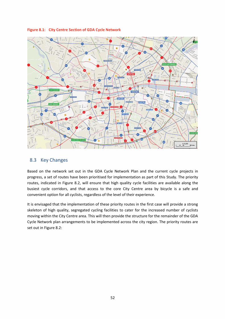
52
Figure 8.1: City Centre Section of GDA Cycle Network
8.3 Key Changes
Based on the network set out in the GDA Cycle Network Plan and the current cycle projects in
progress, a set of routes have been prioritised for implementation as part of this Study. The priority
routes, indicated in Figure 8.2, will ensure that high quality cycle facilities are available along the
busiest cycle corridors, and that access to the core City Centre area by bicycle is a safe and
convenient option for all cyclists, regardless of the level of their experience.
It is envisaged that the implementation of these priority routes in the first case will provide a strong
skeleton of high quality, segregated cycling facilities to cater for the increased number of cyclists
moving within the City Centre area. This will then provide the structure for the remainder of the GDA
Cycle Network plan arrangements to be implemented across the city region. The priority routes are
set out in Figure 8.2:

53
Figure 8-2: Priority Cycle Routes for Implementation
In addition to being able to cycle safely into and through the City Centre, it is important that
adequate secure and convenient cycle parking is available for cyclists. This will require the provision
of both on-street and off-street cycle parking facilities. On-street cycle parking will be reviewed and
rationalised to ensure that the volume of cycle parking required at key destinations is met, and that
‘casual’ cycle parking (on road signs/lampposts etc.) does not impede on the movement of other
road users, particularly pedestrians. Additional designated off-street cycle parking, such as that
currently provided at Drury Street carpark will also be implemented during the period of this Study.
8.4 Intended Outcomes
The accelerated implementation of the high quality cycle network that provides safe and attractive
access by bicycle to, and through, the City Centre will attract more cyclists into the City Centre,
reducing car dependency and congestion. As well as benefiting commuters, better cycle facilities will
increase the number of recreational and shopping trips made by bike, improving the vitality and
ambience of the City Centre. The improved facilities will also make cycling safer, and more amenable
to those with less cycling experience, providing an alternative mode for residents and visitors to
explore and enjoy the city.

54
9 Pedestrian Network/Public Realm Proposals
9.1 Overview
The pedestrian environment serves all users, including residents, commuters, tourists and shoppers.
It must also serve a range of needs, from legibility and design for those with mobility and visual
impairments, to serving visitors and residents who require space to enjoy the sights and sounds of
the City Centre. The pedestrian environment also caters for the heavy flows of commuters moving to
and from work every day. The need to grow the public transport network will increase the
pedestrian flows within the city centre, which will be further hampered by the need to facilitate
enhanced public transport stops, which will take up additional footpath space. Expanding the
capacity of the pedestrian environment is critical to allow the city to grow.
This Study has identified areas of the city which have significant pedestrian footfall. These areas, in
addition to a number of key street junctions, and a number of the Liffey bridges were highlighted as
points on the pedestrian network that need specific attention due to sheer volumes of pedestrians,
and the consequential safety issues.
The development of routes and areas that are designed primarily with the pedestrian in mind will
reduce delays and increase the comfort for those walking, visiting, socialising and living in the city
centre, as well as contributing significantly to the objectives in Dublin City Council’s Development
Plan and Public Realm Strategy. These measures will also provide the essential last link for all public
transport trips within the city, whereby almost all bus and rail users must use the pedestrian
network for the final leg of their journey.
9.2 Proposals
The core pedestrian network (as shown in Figure 9.1) is based on the network outlined in Dublin City
Council’s Development Plan. This network highlights the key strategic pedestrian corridors which
should be designed to prioritise the ease of pedestrian movement and activity. This core network,
and in particular the Central Priority Routes in the City Centre, will have to provide a high quality of
pedestrian facilities, with a corresponding level of priority given to pedestrian movements at
junctions. It is proposed that, as an outcome of this Study, the following measures will be
implemented:

55
Development of a defined ‘strategic’ pedestrian network, which sets out pedestrian priority
routes within the city centre pedestrian environment;
Wider footpaths at key locations;
Pedestrian priority at key junctions and locations;
Provision for tourists by linking key Dublin tourist destinations into the ‘strategic’ network;
Ensure that the needs of mobility impaired and disabled pedestrians are considered in the
design of new facilities;
Good signage, surfaces and lighting;
The removal of unnecessary street clutter to facilitate ease of movement for pedestrians and
the mobility impaired; and,
Where possible, pedestrian friendly areas of public open space to be established and
enhanced. This will be cognisant of the public open spaces identified in the City Council’s
Public Realm Strategy.
Figure 9.1: Proposed Pedestrian Routes – from Dublin City Council’s Development Plan
9.3 Key Changes
In general, the key change in relation to the pedestrian environment will be the reprioritisation of
space along streets and at junctions within the city centre to cater for the increased number of

56
commuters, shoppers, residents and tourists using the city streets. In line with this, the following
proposals are highlighted:
9.3.1 Development of strategic pedestrian routes
The core pedestrian network has been outlined in the Dublin City Development Plan (Figure 9.1),
and the implementation and development of these routes will allow for an improved pedestrian
environment which can function as part of an integrated transport network. The identified routes
will provide a high quality of pedestrian facilities, complemented by a corresponding level of priority
given to pedestrian movements at junctions.
The strategic network will be designed to attract pedestrians and will ensure good signage, surfaces
and lighting, and appropriate footpath width/pedestrianisation/shared space to cater for the
anticipated pedestrian movement. The strategic pedestrian network will be fully compliant with the
requirements and needs of those with mobility and visual impairments.
9.3.2 Development of complementary public spaces/pedestrian area
The implementation of the transport changes set out in this Study provides an opportunity for
further enhancement of the public realm and pedestrian areas across the city centre. The proposed
transport changes will open up spaces which have previously been traffic dominated, facilitating the
transformation of traffic thoroughfares into new places for shopping, tourism or simply public open
space. Examples of such a proposal are the pedestrianisation of Suffolk Street and of St. Stephen’s
Green North.
The introduction of Luas Cross City will necessitate the relocation of some bus services from Nassau
Street. Following the completion of Luas Cross City the residual bus services that were previously
routed along Suffolk Street could be accommodated on other streets, enabling Suffolk Street to be
pedestrianised. This will form a natural extension to the Grafton Street shopping area, and link the
main tourist office on Suffolk Street directly into the south inner city pedestrian zone. This proposal
and other site specific pedestrian improvement schemes are set out in more detail in the next
chapter.
9.4 Intended Outcomes
The proposed pedestrian network will provide a much more attractive environment for residents,
workers, shoppers and tourists to move around the City Centre more easily, safely and with less
delay. It will encourage greater numbers of people to walk as their preferred mode of travel within
the City Centre. The improved pedestrian network will also complement and enhance access to and
from the public transport serving the city.
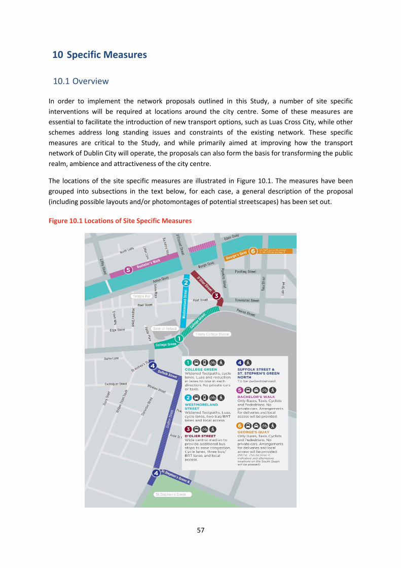
57
10 Specific Measures
10.1 Overview
In order to implement the network proposals outlined in this Study, a number of site specific
interventions will be required at locations around the city centre. Some of these measures are
essential to facilitate the introduction of new transport options, such as Luas Cross City, while other
schemes address long standing issues and constraints of the existing network. These specific
measures are critical to the Study, and while primarily aimed at improving how the transport
network of Dublin City will operate, the proposals can also form the basis for transforming the public
realm, ambience and attractiveness of the city centre.
The locations of the site specific measures are illustrated in Figure 10.1. The measures have been
grouped into subsections in the text below, for each case, a general description of the proposal
(including possible layouts and/or photomontages of potential streetscapes) has been set out.
Figure 10.1 Locations of Site Specific Measures
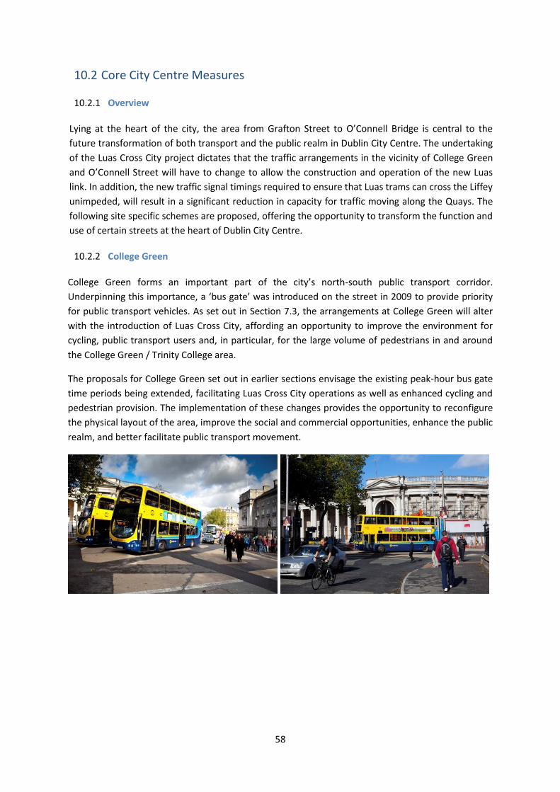
58
10.2 Core City Centre Measures
10.2.1 Overview
Lying at the heart of the city, the area from Grafton Street to O’Connell Bridge is central to the
future transformation of both transport and the public realm in Dublin City Centre. The undertaking
of the Luas Cross City project dictates that the traffic arrangements in the vicinity of College Green
and O’Connell Street will have to change to allow the construction and operation of the new Luas
link. In addition, the new traffic signal timings required to ensure that Luas trams can cross the Liffey
unimpeded, will result in a significant reduction in capacity for traffic moving along the Quays. The
following site specific schemes are proposed, offering the opportunity to transform the function and
use of certain streets at the heart of Dublin City Centre.
10.2.2 College Green
College Green forms an important part of the city’s north-south public transport corridor.
Underpinning this importance, a ‘bus gate’ was introduced on the street in 2009 to provide priority
for public transport vehicles. As set out in Section 7.3, the arrangements at College Green will alter
with the introduction of Luas Cross City, affording an opportunity to improve the environment for
cycling, public transport users and, in particular, for the large volume of pedestrians in and around
the College Green / Trinity College area.
The proposals for College Green set out in earlier sections envisage the existing peak-hour bus gate
time periods being extended, facilitating Luas Cross City operations as well as enhanced cycling and
pedestrian provision. The implementation of these changes provides the opportunity to reconfigure
the physical layout of the area, improve the social and commercial opportunities, enhance the public
realm, and better facilitate public transport movement.
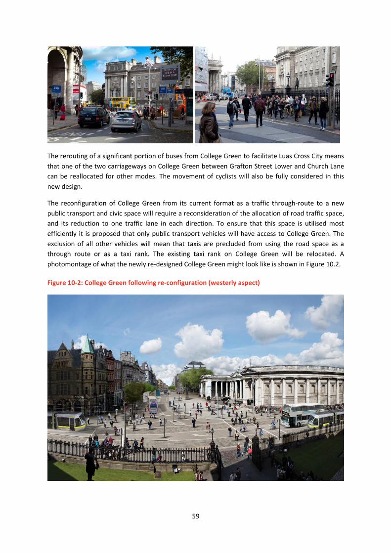
59
The rerouting of a significant portion of buses from College Green to facilitate Luas Cross City means
that one of the two carriageways on College Green between Grafton Street Lower and Church Lane
can be reallocated for other modes. The movement of cyclists will also be fully considered in this
new design.
The reconfiguration of College Green from its current format as a traffic through-route to a new
public transport and civic space will require a reconsideration of the allocation of road traffic space,
and its reduction to one traffic lane in each direction. To ensure that this space is utilised most
efficiently it is proposed that only public transport vehicles will have access to College Green. The
exclusion of all other vehicles will mean that taxis are precluded from using the road space as a
through route or as a taxi rank. The existing taxi rank on College Green will be relocated. A
photomontage of what the newly re-designed College Green might look like is shown in Figure 10.2.
Figure 10-2: College Green following re-configuration (westerly aspect)

60
The new design will provide an attractive pedestrian route for Dubliners and tourists to move from
the north of the city from O’Connell Street through the College Green area to St. Stephen’s Green in
a pleasant, safe and pedestrian friendly environment. Specifically, the new design will enable
pedestrians to move between Grafton Street and the Quays by negotiating only one short
pedestrian crossing.
The introduction of the proposed transport changes facilitating an improved public realm, will allow
people to enjoy some of the best of Dublin’s architectural heritage in comfort and space, and will
significantly raise the profile and attractiveness of the large retail premises facing onto College
Green. The new open space will provide opportunities to anchor the ‘Civic Spine’ of the City at the
front of Trinity College, creating a natural people gathering location.
10.2.3 Westmoreland Street
At present, the street cross-section provides for up to four lanes of traffic, with pedestrians confined
to a relatively narrow area containing trees, phone boxes, side road entrances, front-of-shop
promotions etc. There have also been a number of road fatalities on the street, due in part to the
high volume and mix of modes, particularly at the pedestrian crossing points.
The introduction of Luas Cross City, together with the changes at College Green, provides an
opportunity to reconfigure Westmoreland Street in line with Development Plan objectives and
targets. The redesign of Westmoreland Street will provide an improved environment for the
significant pedestrian flows moving along the street, as well as providing safer, segregated cycle
facilities. It will also facilitate and exploit the operation of Luas Cross City, and provide for a more
optimised bus stopping arrangement with a better overall environment for waiting passengers.
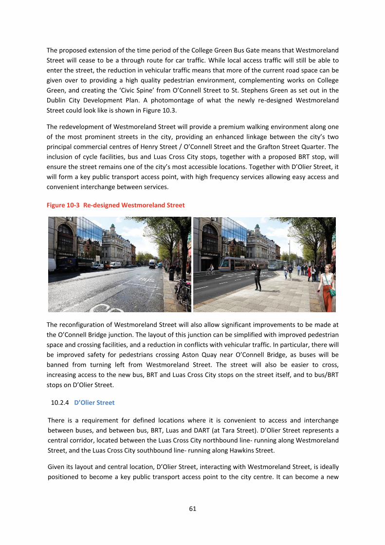
61
The proposed extension of the time period of the College Green Bus Gate means that Westmoreland
Street will cease to be a through route for car traffic. While local access traffic will still be able to
enter the street, the reduction in vehicular traffic means that more of the current road space can be
given over to providing a high quality pedestrian environment, complementing works on College
Green, and creating the ‘Civic Spine’ from O’Connell Street to St. Stephens Green as set out in the
Dublin City Development Plan. A photomontage of what the newly re-designed Westmoreland
Street could look like is shown in Figure 10.3.
The redevelopment of Westmoreland Street will provide a premium walking environment along one
of the most prominent streets in the city, providing an enhanced linkage between the city’s two
principal commercial centres of Henry Street / O’Connell Street and the Grafton Street Quarter. The
inclusion of cycle facilities, bus and Luas Cross City stops, together with a proposed BRT stop, will
ensure the street remains one of the city’s most accessible locations. Together with D’Olier Street, it
will form a key public transport access point, with high frequency services allowing easy access and
convenient interchange between services.
Figure 10-3 Re-designed Westmoreland Street
The reconfiguration of Westmoreland Street will also allow significant improvements to be made at
the O’Connell Bridge junction. The layout of this junction can be simplified with improved pedestrian
space and crossing facilities, and a reduction in conflicts with vehicular traffic. In particular, there will
be improved safety for pedestrians crossing Aston Quay near O’Connell Bridge, as buses will be
banned from turning left from Westmoreland Street. The street will also be easier to cross,
increasing access to the new bus, BRT and Luas Cross City stops on the street itself, and to bus/BRT
stops on D’Olier Street.
10.2.4 D’Olier Street
There is a requirement for defined locations where it is convenient to access and interchange
between buses, and between bus, BRT, Luas and DART (at Tara Street). D’Olier Street represents a
central corridor, located between the Luas Cross City northbound line- running along Westmoreland
Street, and the Luas Cross City southbound line- running along Hawkins Street.
Given its layout and central location, D’Olier Street, interacting with Westmoreland Street, is ideally
positioned to become a key public transport access point to the city centre. It can become a new

62
transport hub, where people interchange between bus, BRT, Luas and DART services at the nearby
Tara Station.
The redevelopment of D’Olier Street will see the wide tarmac dominated street divided with a
central median, enhancing the overall street environment and assisting in pedestrian movement
across the street. Bus stops will be located on this median, with a BRT stop located on the eastern
side of the street, together with footpath widening, tree planting and other improvements. Coupled
with the bus gate changes in College Green, and the reconfiguration of Bachelors Walk to a public
transport only link, car through traffic will be removed from D’Olier Street while local access will be
retained. A photomontage of what the newly re-designed D’Olier Street might look like is shown in
Figure 10.4.
Figure 10-4 D’Olier Street (Southerly Aspect)
In overall terms, D’Olier Street will become a vital hub for the City, with the convergence of various
public transport modes and cross city routes, coupled with the corresponding significant increase in
pedestrian movements on both sides of the street, making it one of the most active and accessible

63
streets in the city. Together with the reconfiguration of Westmoreland Street and College Green,
there is an opportunity to recreate the heart of the city centre, based on these three interlinked
streets. The redesign and changed function of the street will also bring an increased footfall into the
area, improving the vitality and vibrancy of the street, and raising the profile and attractiveness of
retail units and offices located there.
10.2.5 Suffolk Street
Prior to the commencement of Luas Cross City works, Suffolk Street and Church Lane were part of a
heavily used bus corridor linking the Dawson Street / Nassau Street / Kildare Street area to the
O’Connell Street / D’Olier Street / Westmoreland Street area. Suffolk Street and Church Lane are
narrow streets, with small footpaths on either side. While both streets were marked with two traffic
lanes, the turning difficulties from Suffolk Street to Church Lane effectively reduces the capacity to a
single lane.
Church Lane is an undesirable route for the large numbers of scheduled bus services and tourist
coaches currently using the street. Features such as the sharp turn entry, narrow footpaths, the
presence of many pedestrians and cyclists, and visibility issues exiting onto College Green all render
the route sub-optimal.
The construction of Luas Cross City requires the re-design and reorientation of street space in
College Green, Grafton Street Lower, and Dawson Street and will afford an opportunity to greatly
enhance the transport environment and public realm in this important area of the city. The
proposed reconfiguration of the movement of public transport opens up the opportunity of
pedestrianising Suffolk Street, extending and complementing the Grafton Street commercial area,
and significantly improving the pedestrian environment.

64
This proposal will see the extension of the Grafton Street pedestrianised area to of Suffolk Street
and the provision of widened footpath areas on Church Lane. This will extend the Grafton Street
shopping area, allowing a continuous pedestrianised space running from St. Stephens Green to
College Green.
A photomontage of what the newly re-designed Suffolk Street / Church Lane might look like is
shown in Figure 10.5.
Figure 10.5: Suffolk Street / Church Lane following potential re-configuration (westerly aspect)
The changes will provide a much more attractive environment for shoppers, and will bring major
benefits to retailers on these streets, as well as stores operating on Grafton Street Lower and Dame
Street who will be directly connected to an extended Grafton Street shopping area.

65
10.2.6 St Stephen’s Green North
The construction of Luas Cross City will necessitate a reconfiguration of the road layout at the
Grafton Street end of St. Stephen’s Green. Traffic management modifications have already been put
in place, including revised car park access arrangements to the RCSI and St Stephens Green Car Parks
via St Stephens Green South, which has reduced the traffic flow using St. Stephen’s Green North to
access this area. In addition, the Luas Cross City alignment will also require the relocation of the
existing taxi rank at St. Stephen’s Green.
Taken together, the above changes mean that that a large amount of the current carriageway on St.
Stephen’s Green North can be reallocated, allowing a new civic space to be created between the
junctions with Grafton Street and Dawson Street. A photomontage of what this may look like is set
out in Figure 10.6.
Figure 10.5: St Stephens Green North following potential re-configuration (Easterly aspect)
10.2.7 Bachelors Walk
The Quays currently form a major traffic artery through the central city area for eastbound and
westbound traffic movements. Because the primary function of the Quays is to facilitate vehicular
traffic movement, it causes a high degree of severance for north-south pedestrian movement. The
busiest pedestrian link in the city is the link from O’Connell Street to Westmoreland Street, crossing
Bachelors Walk and Aston Quay. The vehicular traffic flow along Bachelors Walk is a significant

66
barrier to pedestrian flow on this link, with large volumes of pedestrians frequently crowding, often
in an unsafe manner, on either footpath, awaiting the pedestrian signal phase.
From a public transport perspective, Bachelors Walk is a frequent source of delay to bus services.
Buses turning southwards towards D’Olier Street have to leave the bus lane on the north side of the
street and traverse two lanes of general traffic, frequently congested, to go southwards. In addition,
the need to cater for general traffic means that footpath widths and bus stopping arrangements
along this section are significantly below the optimal provision. Notwithstanding its current traffic
focus, Bachelors Walk is a very prominent location in the city centre. Its position, directly adjacent to
the O’Connell Street means it forms an integral part of the urban framework of the city centre.
The major construction elements of Luas Cross City, and the commencement of passenger services
at end 2017, will require significant changes to junction arrangements in the City Centre including at
O’Connell Street. In addition, the vehicular capacity at various junctions along the Luas Cross City
corridor, particularly on either side of O’Connell Bridge, will be significantly reduced in order to cater
for the Luas service.
Proposals are also now in place to develop the Liffey Cycle Route, connecting from Heuston Station
in the west to the Point in the east. This provision will impact upon the current road layout on
Bachelors Walk, requiring a reallocation of road space.
Given the need to cater for the new Luas service plus the development of the Liffey Cycle Route, and
reflecting the transport targets set out in the Development Plan, it is intended remove general car
traffic from Bachelors Walk and to reconfigure it as a public transport, cycling and pedestrian only
corridor. This will require the diversion of general car traffic from Bachelors Walk between its
junction with Jervis Street and O’Connell Street. The right turn from Bachelors Walk onto O’Connell
Bridge will be removed and buses will make this right turn at the new Rosie Hackett Bridge.
The removal of car traffic from this section of the north quays, together with corresponding changes
on the south Quays, will allow a more integrated central city area to develop, with a greater level of
connection between areas north and south of the river. It will also significantly enhance bus and
cycle arrangements along Bachelors Walk and resolve some of the major problems that currently
exist for those modes.

67
10.2.8 Aston Quay/Burgh Quay/Georges Quay
Similar to Bachelors Walk on the north side of the River Liffey, Aston Quay forms part of the major
south Quays traffic artery, traversing the central city area and catering for westbound traffic
movements. The vehicular traffic flow along Aston Quay is a significant barrier to pedestrian flow on
the busy O’Connell Street to Westmoreland Street pedestrian link. Mirroring the position on the
north side of the river, large volumes of pedestrians crowd on both footpaths of Aston Quay,
awaiting the pedestrian signal phase.
Addressing the severance issue on the north Quays without similarly addressing it on the south
Quays would diminish the benefits that will be gained by the Bachelors Walk bus gate – it would
concentrate the issue more acutely on the Aston Quay / Westmoreland Street junction. Similar to
Bachelors Walk, the need to cater for Luas Cross City, provide increased priority for bus and BRT
movement, plus the need to provide better and safer cycling facility in the central city area, all
require a reallocation of part of the south Quays to public transport and cycling use.
To achieve this it is proposed to introduce a public transport, cycling and pedestrian only link along
the south Quays, at either Aston Quay, Burgh Quay or Georges Quay, depending on the outcome of
more detailed analysis. General through traffic will be rerouted around the central area,
circumnavigating this currently congested area of the city.
Removing private vehicle traffic from this area will dramatically improve the environment of this
area, particularly for the 30,000 people per direction crossing each day at O’Connell Bridge. It will
enable footpaths to be widened, better crossing arrangements to be introduced, reduce traffic
pollution and allow the overall public realm to be improved. From a transport perspective, it will
deliver the additional priority for public transport and cyclists required at this location, and allow the
bus and Luas network to operate more efficiently.
Taken together with the proposed changes at Bachelors Walk, there will be more space available on
both sides of the Quays for pedestrians and tourists, thereby enabling the banks of the River Liffey to
become an attractive area in their own right, rather than the heavily trafficked thoroughfare they
are today.
10.3 Interchange Locations
10.3.1 Overview
This Study has set out how public transport within the city will develop into an integrated, legible
and user friendly system. Central to this is the concept of interchange, with passengers capable of,
and encouraged, to change between public transport services/modes to traverse Dublin City. To
facilitate this, some key locations will act as strategic public transport interchanges, where it will be
possible to transfer between several modes, including intercity rail services.

68
10.3.1.1 Connolly Station/Busaras
The area of Amiens Street and Store Street represents, informally, the biggest public transport hub
in the city, with Connolly Train and DART Station, Luas Red line and Busaras Intercity and Commuter
bus station all located at this focal point.
Connolly Station and Busaras are two of the main entry points to visitors coming to Dublin City. The
streetscape into which these visitors arrive however does not present a good first impression of the
city. The area is particularly difficult for pedestrians and cyclists, with the dominance and intensity of
traffic representing a significant barrier to movement between the Docklands and the north City
Centre.
Amiens Street in the vicinity of Connolly Station and Busaras is a busy thoroughfare for traffic from
the north east of the city, as well as backing onto the major employment centre of the IFSC. Amiens
Street has narrow footpaths, and the limited road space has primarily been given over to catering for
bus movement, Luas, and the high volumes of traffic. Pedestrians and cyclists are poorly served
along the street, especially given the volumes which traverse the area daily to access public
transport and work locations in the IFSC.
Beresford Place, fronting Bus Aras, is also heavily trafficked, acting as a weaving area for traffic
joining and leaving the road system at the back of the Custom House. Due to the presence of bridge
abutments north of Liberty Hall, there is considerable weaving of outbound traffic in order to be on
the correct side of the railway bridge abutment for Fairview or Dorset Street. This one-way gyratory
is prone to congestion every day, and especially in the evening peak. Despite the volume of bus and
coach movements, the road layouts provide no bus priority due to the necessity for all traffic
(private vehicles, buses, coaches and cyclists) to move between lanes to reach their required
junction.
Access to Busaras is complicated due to the one-way nature of the street layout. Coaches are
obliged to circle Busaras in order to enter the station, and then circle it again on departure. In
addition, the access and egress points from Busaras present significant conflict risks to pedestrians
and cyclists in the vicinity of the terminus.
The Luas stop at Connolly was the terminus stop for the Luas Red Line when it was opened in 2004.
However, the subsequent extension to the Point has meant that a split service operates, with some
trams stopping at Connolly and others not using the Connolly stop and traveling instead to the Point.
The ability of users to easily interchange between rail, bus and Luas services in this key area is
singularly poor. In particular, the connections between Connolly Station and Busaras / the Luas stop
on Store Street do not encourage easy and convenient movement between modes, which is a key
characteristic of a good transport system.

69
An opportunity exists to significantly enhance connectivity between the different transport modes at
this location. Options that could be considered include the removal of the Connolly Luas Stop,
potentially transforming the space into a Commuter Bus terminus. It may also be possible to provide
a new commercial space overhead, linking directly into Connolly Station and potentially linking via a
walkway into Busaras. This would have the added advantage of allowing Connolly passengers to
move directly into Busaras at grade, without having to cross Amiens Street at street level.
Given the significant potential that exists to properly connect all of the key transport modes in this
area, coupled with the public realm opportunities in this sensitive area of architectural heritage, it is
recommended that this element of the Study be developed further by way of a Masterplan, which
could be opened up to an international design competition. This will ensure adequate attention is
given to the design, implementation and subsequent delivery of this key element of the Study.

70
In tandem with this approach, consideration will be given to whether the one way traffic gyratory
system in the area of Beresford Place and Memorial Road, which currently presents a challenge for
all road users, could be modified to improve the efficiency and safety of movement within the area.
10.3.1.2 Heuston Station
Dublin City Council is currently preparing a Local Area Plan for the ‘Heuston Gateway’. Part of this
Study is to build on the existing public transport connectivity of Heuston Station and develop an
expanded Public Transport Interchange facility.
The proposed plan will see a new road link being constructed between Conyngham Road and
Heuston through the Dublin Bus garage to provide access by all modes into the rear of station. This
will improve permeability for pedestrians, cyclists and public transport users to the expanded
Interchange facility. The proposal would also provide access to a new multi-story car park which
would serve intercity train users as well as commuters accessing public transport options at Heuston
Station.
The new traffic arrangements may also be linked with a greater role for traffic travelling from the
west into the city. Instead of the majority of traffic continuing along St John’s Road West, vehicular
traffic could be diverted up South Circular Road onto Conyngham Road and Parkgate Street. This
would facilitate traffic wishing to use the proposed car parking at Heuston Station, and would also
reduce the amount of traffic crossing the front of Heuston Station, making the environment safer for
pedestrians and cyclists, and reducing the potential for delay to public transport services operating
out of the revised Heuston Station Transport Hub.

71
The provision of a car parking facility and public transport interchange at this edge of city centre will
offer the potential for private car traffic to avoid the city centre and use the range of public
transport options available at Heuston to undertake their onward journeys. This will help reduce the
overall quantum of traffic in the central core. The provision of a pedestrian link through the station
site from the Phoenix Park all the way through to the Irish Museum of Modern Art will provide a
seamless and safe link between some of the city’s principal tourist attractions. It will form part of the
wider pedestrian network of the city, and will be a significant improvement of the existing
environment for pedestrians and cyclists in the vicinity of Heuston Station.
10.4 Specific Improvement Schemes
10.4.1 Overview
A number of specific schemes are currently under consideration and fit into the context of this
Study. These schemes offer the opportunity to enhance the current arrangements of the mode in
question, whilst also improving the overall transport function of the city by rationalising or adding to
the transport network.
10.4.2 Liffey Cycle Route
The Liffey Quays are currently an unattractive place to cycle in the city centre. The heavy traffic
volumes and one-way traffic system mean that the roads fluctuate from congested slow moving
traffic to high speed traffic, depending on the time of day. The existing quality and provision for
cycling infrastructure along this route is low, especially given the high volume of cyclists moving
along this east-west axis.
In March 2015 a non-statutory public consultation process for four design options for the Liffey Cycle
Route was carried out. There was overwhelming backing for a segregated two way cycle track along
the river side of the northern quays, with 73% of the submissions supporting such a proposal. It is
proposed to progress the implementation of a two way segregated cycle track along the north quays
of the Liffey. This route is seen as critical to developing the cycle network across the city and will
form a central ‘spine’ for cyclists running from Heuston Station to the Docklands. This route will
cater for commuter and leisure cyclists, as well as providing a safe and convenient route linking
dublinbikes stands along the Quays.

72
The finalised plans for the route are still being developed, however a photomontage example of how
the scheme might look is illustrated in Figure 10.7.
Figure 10-7: Photomontage of proposed Liffey Cycle Route (Easterly Aspect)
10.4.3 Dockland Bridges
An Bord Pleanala approved the Docklands Strategic Development Zone (SDZ) planning scheme in
2013. This SDZ planning scheme prescribes the proposed build out of the lands within the SDZ lands,
including a detailed outline of associated infrastructural proposals. Three bridges have been
proposed; two pedestrian/ cycle only links across the River Liffey, and a road bridge over the River
Dodder between Sir John Rogerson’s Quay and Thorncastle Street.
The Liffey bridges will provide additional crossing points for pedestrians and cyclists, increasing
north-south accessibility in this rapidly developing part of the city, while the Dodder Bridge will
provide a key linkage from the Docklands eastwards to Poolbeg. This bridge will enable traffic to run
from the Poolbeg area along the south Quays serving the new developable lands, while also
providing an important pedestrian and cyclist link eastwards to link residents with Dublin Bay. These
new linkages are highlighted in Figure 10.8.

73
Figure 10.8: Docklands SDZ Transport Proposals
10.4.4 Coach Parking Facilities
There are a number of private coach operators running commuter services in the morning and
evening peak. Throughout the year tourist coaches also serve the City Centre ferrying tourists to
attractions such as Trinity College. At present, coach parking and layover takes place primarily on
streets across the City Centre, with a number of designated areas, such as Nassau Street and
Mountjoy Square being heavily used.
It is proposed that a Coach Parking Facility will be developed close to the City Centre, providing
secure bus parking and driver facilities off-street, within easy access of the main city
attractions/employment areas. A planning application is currently being prepared for such a facility
at a site in the Dublin Docklands area.
This facility will provide safe, secure parking for both commuter and tourist coaches within a short
distance of the city centre. It will also provide rest and convenience facilities for bus drivers. It is
anticipated that this facility will work in conjunction with short term set down Coach Stops within
the city centre, where passengers and tourists can be dropped off/picked up in close proximity to
their destination.

74
Such a facility will remove a large amount of bus layover from the city centre, which will have a
number of benefits for the city’s public realm, with the removal of stationary buses from the
streetscape, particularly in areas of architectural heritage (Mountjoy Square/Marlborough
Street/Merrion Square).
10.4.5 City Centre Taxi Ranks
There are currently in the region of 18,000 taxis authorised to operate nationally, and some 10,500
of these are registered in the Dublin area. The number of taxis serving the City Centre can, and has,
resulted in insufficient taxi rank space being available. This can mean that taxis queuing at a rank can
overspill into the carriageway at rank locations, or that taxis are forced to circulate around the
streets and bus lanes unnecessarily. In addition, taxis often park at inappropriate and unauthorised
locations, impacting traffic movements and causing safety issues.
There is a need for additional taxi rank capacity beyond what currently exists. Accordingly, it is
proposed to identify opportunities to extend taxi rank provision in the City Centre area, whether on
a full-time or night-time basis. The potential for the provision of alternative storage arrangements is
also to be considered.
There are certain locations in the centre of Dublin, such as O’Connell Street, St. Stephen’s Green
North and Dawson Street, which currently accommodate large, well utilised taxi ranks, which need
to be relocated due to the introduction of Luas Cross City. Other ranks may also be relocated to
better manage how taxis entering service will access the traffic network, while new ranks may be
located in areas such as Temple Bar/Drury Street/South William Street which currently have issues
with taxis circulating slowly while waiting for a fare.
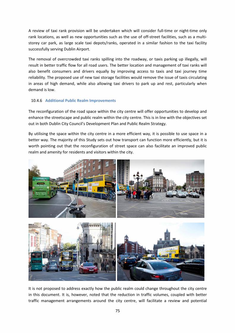
75
A review of taxi rank provision will be undertaken which will consider full-time or night-time only
rank locations, as well as new opportunities such as the use of off-street facilities, such as a multi-
storey car park, as large scale taxi depots/ranks, operated in a similar fashion to the taxi facility
successfully serving Dublin Airport.
The removal of overcrowded taxi ranks spilling into the roadway, or taxis parking up illegally, will
result in better traffic flow for all road users. The better location and management of taxi ranks will
also benefit consumers and drivers equally by improving access to taxis and taxi journey time
reliability. The proposed use of new taxi storage facilities would remove the issue of taxis circulating
in areas of high demand, while also allowing taxi drivers to park up and rest, particularly when
demand is low.
10.4.6 Additional Public Realm Improvements
The reconfiguration of the road space within the city centre will offer opportunities to develop and
enhance the streetscape and public realm within the city centre. This is in line with the objectives set
out in both Dublin City Council’s Development Plan and Public Realm Strategy.
By utilising the space within the city centre in a more efficient way, it is possible to use space in a
better way. The majority of this Study sets out how transport can function more efficiently, but it is
worth pointing out that the reconfiguration of street space can also facilitate an improved public
realm and amenity for residents and visitors within the city.
It is not proposed to address exactly how the public realm could change throughout the city centre
in this document. It is, however, noted that the reduction in traffic volumes, coupled with better
traffic management arrangements around the city centre, will facilitate a review and potential
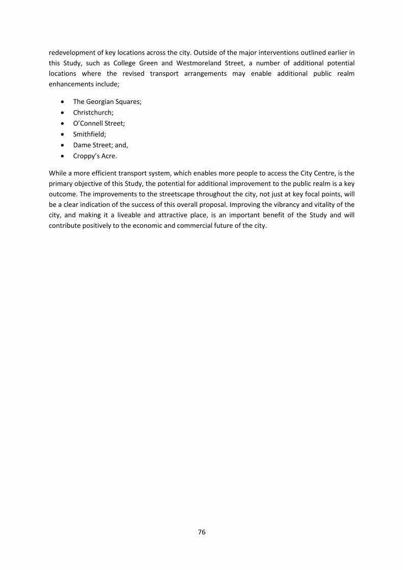
76
redevelopment of key locations across the city. Outside of the major interventions outlined earlier in
this Study, such as College Green and Westmoreland Street, a number of additional potential
locations where the revised transport arrangements may enable additional public realm
enhancements include;
The Georgian Squares;
Christchurch;
O’Connell Street;
Smithfield;
Dame Street; and,
Croppy’s Acre.
While a more efficient transport system, which enables more people to access the City Centre, is the
primary objective of this Study, the potential for additional improvement to the public realm is a key
outcome. The improvements to the streetscape throughout the city, not just at key focal points, will
be a clear indication of the success of this overall proposal. Improving the vibrancy and vitality of the
city, and making it a liveable and attractive place, is an important benefit of the Study and will
contribute positively to the economic and commercial future of the city.

77
11 Positive Outcomes for Dublin City
11.1 Overview
This Study has been developed to ensure that Dublin has the transport infrastructure and space to
grow as a city both physically and economically, whilst also creating a better public place to be
enjoyed by residents and visitors alike. The transport framework and proposed transport measures
outlined in the Study will have the cumulative effect of transforming how transport in the city
functions, facilitating better efficiency, increased usage and higher capacity. This chapter
summarises the positive benefits the implementation of this Study can bring to Dublin City.
11.2 Future Proofing the City
It is expected that Dublin City will continue to lead the way in terms of Ireland’s economic recovery,
and with this it is projected that the population and employment within Dublin City and suburbs will
continue to grow. It is anticipated that Dublin City Centre will have to cater for an additional 42,000
commuter trips into the city each day by 2023 in comparison the amount observed in Census 2011.
In this regard, the measures set out in this Study will ensure that this increase in demand can be
met, whilst also providing a solid foundation on which further improvement and investment in
Dublin’s transportation networks can be made. This will allow the future transport planning for
Dublin City Centre to be done on a proactive basis, and ensure that Dublin has the ability to deal
with unforeseen network interruptions, as well as having the capacity to facilitate growth of the city
for years to come.
11.3 Facilitating New Transport Infrastructure
The forecast growth in population and employment over the coming years will result in the more
people travelling in and out of the City each day. Most of these additional trips will be
accommodated by the Bus / BRT system. To cater for the increased capacity of the bus system, the
introduction of a BRT system, as well as the commencement of Luas Cross City services in 2017,
fundamental changes in the operation of the City Centre street system are required.
This Study has addressed these issues. Vehicular traffic which currently travels through the City
Centre will be re-routed around the central area. Bus gates will be introduced on the north and
south Quays, and the operational time period of the College Green bus gate will be extended. Faster
bus movement through the central area will be delivered, along with high quality, safer cycling
routes. Vehicular access to the city centre will however continue to be facilitated, particularly in
relation to the retail and commercial activity, where an appropriate level of parking provision will be
maintained.
11.4 Improved Efficiency
This Study has been developed to maximise the use of limited resources within Dublin City. Space
within the city centre is at a premium, and this Study ensures that the road space is used efficiently

78
to maximise the amount of people that can be moved. It is proposed to reconfigure and reroute bus
services, and utilise interchange both between buses, and with other modes, to allow more people
to access more parts of the city, more easily. By utilising the street space efficiently, it will also be
possible to improve the public realm, giving over space for residents and visitors to enjoy and move
around the city.
Most significantly, the measures proposed will protect the investments that have been, and
continue to be, made in public transport provision in the city, thus ensuring that the full benefits of
investment are realised.
11.5 Improved Environment
The reconfiguration of the streetscape within Dublin City Centre as proposed in this Study will mean
that some parts of the city centre have a vastly reduced level of traffic passing through or along
them. These areas, particularly at the heart of the city (Westmoreland Street – D’Olier Street –
College Green - the City Quays) will become much more pleasant places, with reduced noise and air
pollution due to the reduction in traffic. This will improve the overall natural and built environment
of the city centre.
11.6 Improved Urban Realm, Civic Space and Ambience
11.6.1 The Urban Realm
The reconfiguration of the movement of vehicular traffic away from the City Centre, and a
rationalisation of how public transport will serve the centre, will allow much more space to be
devoted to pedestrians, and facilitate the development of new landmark civic spaces such as at
College Green. This is in line with the Vision and Priorities outlined in the Dublin City Council
Development Plan and objectives of the Council’s Public Realm Strategy. The proposals will vastly
improve the ambience of the City Centre, transforming heavily trafficked thoroughfares into
pedestrian friendly streets, where people can walk, shop, socialise and appreciate their surroundings
in a stress free environment.
The proposed improvements to the urban realm will provide a much more attractive environment
for people choosing to live in the city centre. This in turn will assist the marketing of central Dublin
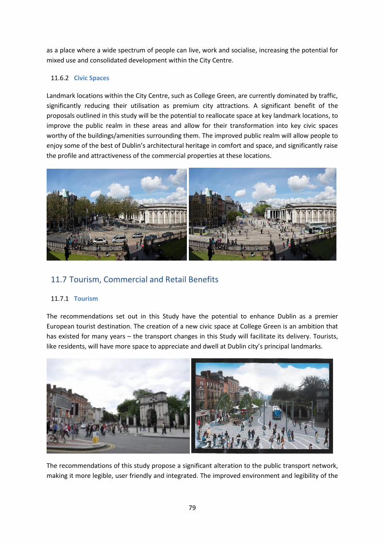
79
as a place where a wide spectrum of people can live, work and socialise, increasing the potential for
mixed use and consolidated development within the City Centre.
11.6.2 Civic Spaces
Landmark locations within the City Centre, such as College Green, are currently dominated by traffic,
significantly reducing their utilisation as premium city attractions. A significant benefit of the
proposals outlined in this study will be the potential to reallocate space at key landmark locations, to
improve the public realm in these areas and allow for their transformation into key civic spaces
worthy of the buildings/amenities surrounding them. The improved public realm will allow people to
enjoy some of the best of Dublin’s architectural heritage in comfort and space, and significantly raise
the profile and attractiveness of the commercial properties at these locations.
11.7 Tourism, Commercial and Retail Benefits
11.7.1 Tourism
The recommendations set out in this Study have the potential to enhance Dublin as a premier
European tourist destination. The creation of a new civic space at College Green is an ambition that
has existed for many years – the transport changes in this Study will facilitate its delivery. Tourists,
like residents, will have more space to appreciate and dwell at Dublin city’s principal landmarks.
The recommendations of this study propose a significant alteration to the public transport network,
making it more legible, user friendly and integrated. The improved environment and legibility of the

80
proposed pedestrian and public transport networks is of particular benefit to tourists and visitors
not familiar with the layout of the city.
11.7.2 Commercial/Retail
The proposed changes to the Public Transport network will considerably increase the potential
number of people who have quick and easy access to Dublin City Centre to work and to shop. These
improvements, in addition to the enhancements in the public realm and ambience of Dublin City
Centre will significantly boost the attraction of Dublin as a shopping destination.
The improved facilities for pedestrians, including the proposed pedestrianisation of Suffolk Street
and St. Stephen’s Green North, will greatly benefit the retailers operating on these streets, and in
adjacent areas like Lower Grafton Street and Dame Street. This will create a contiguous
pedestrianised shopping space, effectively extending the premium Grafton Street ‘shopping
precinct’.
In addition, the proposed improvement to the pedestrian environment along the central civic spine
of the city from O’Connell Street, via Westmoreland Street and College Green to Grafton Street,
coupled with the completion of Luas Cross City will provide a vastly improved link between the core
shopping areas on the north and south sides of the city. This will benefit the perceived retail offer of
Dublin City Centre as a whole, while also specifically raising the profile and attractiveness of the
retail premises along the central civic spine, benefitting in particular areas such as Westmoreland
Street, which has degraded badly over the years as a retail destination.