drayton management system standard rehabilitation and...
TRANSCRIPT
Rehabilitation and Offset Management Plan Page 1 of 48
Anglo Coal (Drayton Management) Pty Ltd Policies and Procedures
Rehabilitation and Offset Management Plan
Drayton Management System Standard
Rehabilitation and Offset Management Plan
Author: Name Brooke York
Title Environmental Officer
Signature (B York) Date (29.10.13)
Reviewer: Name Peter Forbes
Title SHE Manager
Signature (P Forbes) Date (30.10.13)
Authoriser: Name Clarence Robertson
Title General Manager
Signature (C Robertson) Date (1.11.13)
This document is controlled whilst it remains in the Drayton Intranet
Printed copies created from this document are deemed to be uncontrolled

Rehabilitation and Offset Management Plan Page 2 of 48
Revisions
Issue Issue Date Author Reviewer Authoriser
1 October 2009 D Robertson P Simpson M Heaton
2 January 2013 B Lavis P Forbes C Robertson
3 October 2013 B York P Forbes C Robertson

Rehabilitation and Offset Management Plan Page 3 of 48
Distribution List
Distributed to:
General Manager’s Office (current originals)
All Drayton Employees via Email or Toolbox Talks
Administration Central File (originals of previous versions)
Department of Planning and Infrastructure NSW
Muswellbrook Shire Council
Department of Trade and Investment – Resources and Energy

Rehabilitation and Offset Management Plan Page 4 of 48
Table of Contents
1 PURPOSE ...................................................................................................................................... 6
2 SCOPE ........................................................................................................................................... 6
3 DEFINITIONS ................................................................................................................................. 8
4 PROCEDURAL REQUIREMENT ................................................................................................... 8
4.1 Responsibilities .................................................................................................................. 8
4.2 Audit/Review Schedule ...................................................................................................... 8
4.3 Records Management ........................................................................................................ 9
4.4 Revision Status .................................................................................................................. 9
4.5 References ......................................................................................................................... 9
4.6 Description of Current Rehabilitation Areas.....................................................................10
4.7 Description of Offsets and Drayton Wildlife Refuge ........................................................10
4.7.1 Drayton Wildlife Refuge ......................................................................................10
4.7.2 Southern Offset Area ..........................................................................................11
4.7.3 Northern Offset Area ..........................................................................................12
4.8 Integration with Other Relevant Rehabilitation Strategies ...............................................17
4.8.1 Neighbouring Operations ....................................................................................17
4.8.2 Local Strategies ..................................................................................................17
4.8.3 Regional Strategies ............................................................................................18
4.8.4 Anglo American Metallurgical Coal Strategy ......................................................19
4.9 Drayton Rehabilitation and Offset Strategy .....................................................................19
4.9.1 Rehabilitation Objectives and Targets ................................................................19
4.9.2 Management of Existing Vegetation on Drayton Land .......................................19
4.9.3 Revegetation Strategy – Southern Offset ...........................................................19
4.9.4 Offset Maintenance Strategy – Southern Offset.................................................21
4.9.5 Offset Maintenance Strategy – Northern Offset .................................................21
4.9.6 Thomas Mitchell Drive Tree Screen ...................................................................22
4.9.7 Reduction of Visual Impacts ...............................................................................22
4.9.8 Rehabilitation and Aboriginal Cultural Heritage ..................................................22
4.9.9 Potential Risks ....................................................................................................23
4.9.10 Contingency Measures .......................................................................................23
Rehabilitation and Offset Management Plan Page 5 of 48
4.10 Establishment Techniques ...............................................................................................23
4.10.1 Landform Design and Construction ....................................................................23
4.10.2 Site Preparation ..................................................................................................24
4.10.3 Topsoil Management ..........................................................................................24
4.10.4 Species Selection ...............................................................................................25
4.10.5 Seed Collection and Propagation .......................................................................27
4.10.6 Seeding and Planting .........................................................................................27
4.10.6.1 Direct Seeding ....................................................................................................27
4.10.6.2 Tube Stock Planting ...........................................................................................28
4.10.7 Transfer of Structural Components ....................................................................28
4.11 Maintenance ....................................................................................................................28
4.11.1 Erosion Control ...................................................................................................29
4.11.2 Controlling Access ..............................................................................................29
4.11.3 Weed Control ......................................................................................................29
4.11.4 Feral Animal Control ...........................................................................................30
4.11.5 Vegetation Maintenance .....................................................................................31
4.12 Schedule of Works 2013 - 2015 ......................................................................................31
4.12.1 Rehabilitation 2013 - 2015 ..................................................................................31
4.13 Key Performance Indicators and Completion Criteria .....................................................34
4.14 Monitoring ........................................................................................................................36
4.14.1 Monitoring Design – Reference Sites .................................................................36
4.14.2 Monitoring Design – Fixed Monitoring Points .....................................................36
4.14.3 Monitoring Design – Monitoring Frequency ........................................................36
4.14.4 Monitoring Design – Methodology ......................................................................37
4.14.5 Monitoring Design – Fauna Surveys ..................................................................37
5 APPENDICES ..............................................................................................................................38
Rehabilitation and Offset Management Plan Page 6 of 48
Document Information
1 PURPOSE
The purpose of this document is to present a Rehabilitation and Offset Management Plan (ROMP) in compliance with Condition 39 of the Anglo Coal (Drayton Management) Pty Limited (Drayton) Project Approval (PA) 06_0202 (2008). Preparation of the original ROMP was undertaken by Cumberland Ecology with the approval of Department of Planning and Infrastructure (DoPI). The current ROMP has subsequently been updated by the operation in accordance with condition 41A PA 06_0202 (MOD2 2012) and the Anglo American Met Coal Rehabilitation Strategy Guideline. This ROMP is a comprehensive plan that sets out provisions for the rehabilitation and conservation management of offset and rehabilitation works for Drayton mine for the short, medium and long term. The ROMP sets out a 3-year plan for rehabilitation required by the Anglo American Met Coal Rehabilitation Strategy Guideline. The ROMP meets conditions 39, 39A and 41A of the PA 06_0202 (MOD2 2012), and includes:
Detailed description of the land and vegetation for offset and rehabilitation areas;
Maps of current offsets and of proposed habitat linkages;
Prescriptions for rehabilitation and conservation management;
A proposed schedule for works over the next three years;
Key performance indicators and completion criteria; and
Monitoring and maintenance prescriptions.
The objectives of the ROMP are to:
Describe the extent and management of areas set aside to offset vegetation disturbance from Drayton operation;
Describe measures to be undertaken in order to establish fully viable and self-sustaining ecological communities on rehabilitated land;
Implement assisted natural regeneration methods to increase the ecological integrity of offset areas and to enhance the native vegetation they contain;
Reduce impacts on biodiversity from known threats including weeds and feral animals;
Conserve land within a wildlife corridor;
Create and manage a substantial area of high quality habitat for native fauna that will be protected for conservation in the long term;
Achieve safe; stable; non-polluting; and self-sustaining areas of post-mining land; and
Achieve landform and vegetation to a standard which supports potential post-mining land uses consistent with surrounding land uses and acceptable for regulatory sign-off.
2 SCOPE
This procedure includes information relating to:
Approval Conditions
Current Rehabilitation and Offset Description
3-year Rehabilitation Plan
Integration with Other Strategies
Drayton Rehabilitation and Offset Strategy
Establishment Techniques
Maintenance and Monitoring
Schedule of Works
Key Performance Indicators and Completion Criteria
Reporting and Review
Rehabilitation and Offset Management Plan Page 7 of 48
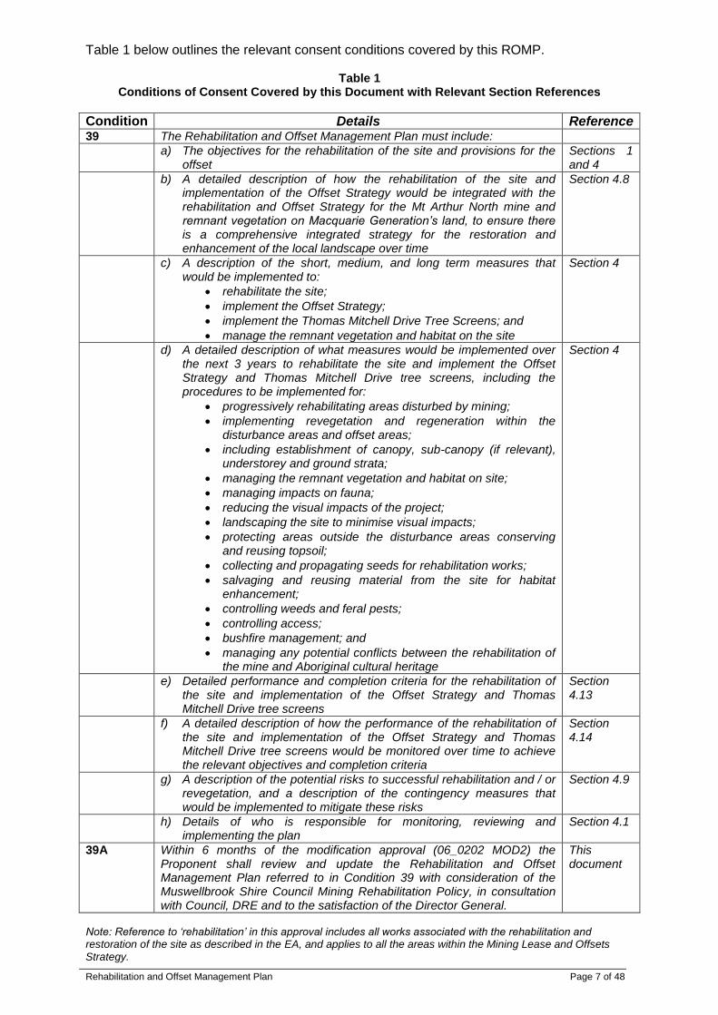
Table 1 below outlines the relevant consent conditions covered by this ROMP.
Table 1 Conditions of Consent Covered by this Document with Relevant Section References
Condition Details Reference 39 The Rehabilitation and Offset Management Plan must include:
a) The objectives for the rehabilitation of the site and provisions for the offset
Sections 1 and 4
b) A detailed description of how the rehabilitation of the site and implementation of the Offset Strategy would be integrated with the rehabilitation and Offset Strategy for the Mt Arthur North mine and remnant vegetation on Macquarie Generation’s land, to ensure there is a comprehensive integrated strategy for the restoration and enhancement of the local landscape over time
Section 4.8
c) A description of the short, medium, and long term measures that would be implemented to:
rehabilitate the site;
implement the Offset Strategy;
implement the Thomas Mitchell Drive Tree Screens; and
manage the remnant vegetation and habitat on the site
Section 4
d) A detailed description of what measures would be implemented over the next 3 years to rehabilitate the site and implement the Offset Strategy and Thomas Mitchell Drive tree screens, including the procedures to be implemented for:
progressively rehabilitating areas disturbed by mining;
implementing revegetation and regeneration within the disturbance areas and offset areas;
including establishment of canopy, sub-canopy (if relevant), understorey and ground strata;
managing the remnant vegetation and habitat on site;
managing impacts on fauna;
reducing the visual impacts of the project;
landscaping the site to minimise visual impacts;
protecting areas outside the disturbance areas conserving and reusing topsoil;
collecting and propagating seeds for rehabilitation works;
salvaging and reusing material from the site for habitat enhancement;
controlling weeds and feral pests;
controlling access;
bushfire management; and
managing any potential conflicts between the rehabilitation of the mine and Aboriginal cultural heritage
Section 4
e) Detailed performance and completion criteria for the rehabilitation of the site and implementation of the Offset Strategy and Thomas Mitchell Drive tree screens
Section 4.13
f) A detailed description of how the performance of the rehabilitation of the site and implementation of the Offset Strategy and Thomas Mitchell Drive tree screens would be monitored over time to achieve the relevant objectives and completion criteria
Section 4.14
g) A description of the potential risks to successful rehabilitation and / or revegetation, and a description of the contingency measures that would be implemented to mitigate these risks
Section 4.9
h) Details of who is responsible for monitoring, reviewing and implementing the plan
Section 4.1
39A Within 6 months of the modification approval (06_0202 MOD2) the Proponent shall review and update the Rehabilitation and Offset Management Plan referred to in Condition 39 with consideration of the Muswellbrook Shire Council Mining Rehabilitation Policy, in consultation with Council, DRE and to the satisfaction of the Director General.
This document
Note: Reference to ‘rehabilitation’ in this approval includes all works associated with the rehabilitation and restoration of the site as described in the EA, and applies to all the areas within the Mining Lease and Offsets Strategy.
Rehabilitation and Offset Management Plan Page 8 of 48
3 DEFINITIONS
ROMP – Rehabilitation and Offset Management Plan
DoPI – Department of Planning and Infrastructure
DRE – Department of Trade and Investment – Resources and Energy
MSC – Muswellbrook Shire Council
SHE – Safety Health and Environment
CHP – Coal Handling Plant
PA 06_0202 – Project Approval for Drayton Mine Extension (2008)
PA 06_0202 (MOD1 2009) – Approved modification to PA 06_0202 (2009)
PA 06_0202 (MOD2 2012) – Approved modification to PA 06_0202 (2012)
MOP – Mining Operations Plan
HLRF – Hunter Lowland Redgum Forest
EEC – Endangered Ecological Community
TSC Act – NSW Threatened Species Conservation Act 1995
4 PROCEDURAL REQUIREMENT
4.1 Responsibilities
The Drayton General Manager will be responsible for ensuring adequate budget is allocated to undertake all actions required under this Rehabilitation and Offset Management Plan (ROMP). The Drayton Safety, Health and Environment (SHE) Manager will be responsible for ensuring that all budget allocation required by the ROMP is brought to the attention of the General Manager. The Drayton Environmental Coordinator will be responsible for:
Monitoring and implementing the ROMP and preparation of the annual monitoring report for inclusion in the Annual Environmental Management Report (AEMR);
Coordinating, supervising and managing all works and correspondence with respect to this ROMP;
Allocation of establishment and management tasks to personnel in response to issues arising from monitoring results (e.g. plant losses/re-planting, weed control); and
Facilitating the review of the ROMP to the satisfaction of the Drayton SHE Manager and the General Manager.
The Drayton Environmental Officer will be responsible for coordinating, supervising and managing:
Primary, follow-up and maintenance planting and seeding;
Weed and feral animal control;
Demarcation and/or fencing;
Seed collection and plant propagation; and
Monitoring of the Drayton Wildlife Refuge, Northern and Southern Offset Areas, tree screens and rehabilitation areas.
All works will be undertaken by appropriately qualified and experienced personnel under the supervision of the Drayton Environmental Coordinator or Drayton Environmental Officer.
4.2 Audit/Review Schedule
An intermediate review of this ROMP will be undertaken by February 2014 to incorporate recommendations from the 2013 flora and fauna monitoring report. This ROMP is subject to review every three years. Monitoring results should be reviewed annually to assess the progress of the rehabilitation and maintenance programs. Monitoring results are presented in the AEMR. Establishment and maintenance works conducted in accordance with requirements of this ROMP will also be included in the AEMR.
Rehabilitation and Offset Management Plan Page 9 of 48
Each year, the survivorship of seedlings in the establishing woodland areas will be assessed and the requirements for further tube stock planting or other maintenance determined. If required, a botanist may be used to help determine which species are present, and which should be planted to achieve the target vegetation community. The annual reviews and the monitoring data may also be used to identify weed infestations and to target areas that need more input to achieve satisfactory results. The ROMP will be reviewed and adjusted every three years according to the response of the areas to revegetation and rehabilitation activities. Recommendations from annual monitoring for the previous period will be incorporated into the ROMP during these reviews. Relevant government departments will be asked to review and provide comment on any major changes to this ROMP.
4.3 Records Management
All records required by the ROMP will be kept and controlled by the Drayton SHE Department and are the responsibility of the Environmental Coordinator.
4.4 Revision Status
October 2009 – Original issue – This management plan was undertaken in consultation with Muswellbrook Shire Council (MSC) and Department of Trade and Investment – Resources and Energy (DRE) and approved by the Director General January 2013 – Update to include Project Approval 06_0202 (MOD 2 2012) requirements. Review provided to MSC and DRE and NSW Department of Planning and Infrastructure (DoPI) for comment. October 2013 – Include detailed 3-year rehabilitation plan in accordance with Anglo American Met Coal Rehabilitation Strategy Guideline. Review in accordance with Drayton 2013 EIP. Update incorporated comments received from DoPI.
4.5 References
Project Approval 06_0202 (2007, MOD1 2009 and MOD2 2012) Drayton Mine Extension, Minister for Planning, Sydney
Drayton Offset Strategy
Drayton Mining Operations Plan (MOP)
Drayton Mine Closure Plan (MCP)
Final Void Management Plan (FVMP)
Drayton Flora and Fauna Management Plan (FFMP)
Drayton Spontaneous Combustion Management Plan (SCMP)
Drayton Bushfire Management Plan (BMP)
Environmental Assessment, Drayton Mine Extension, August 2007, Hansen Bailey
Anglo American Erosion and Sediment Control Standard
Anglo American Met Coal Rehabilitation Strategy Guideline
Muswellbrook Shire Council (MSC 2012) Draft Mining Rehabilitation Policy
Department of Mineral Resources (1999) Synoptic Plan: Integrated Landscapes for Coal Mine Rehabilitation in the Hunter Valley of NSW Department of Primary Industries
Rehabilitation and Offset Management Plan Page 10 of 48
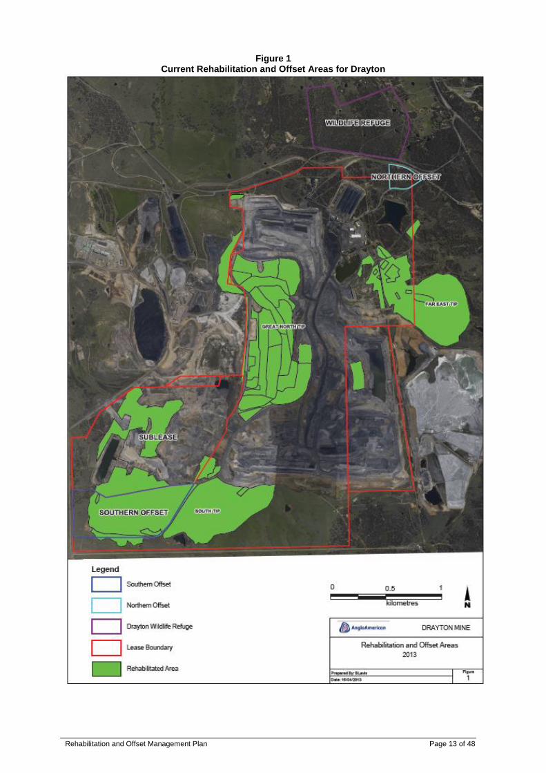
4.6 Description of Current Rehabilitation Areas
Drayton is committed to progressive rehabilitation of disturbed areas. Each year, Drayton targets an area to conduct rehabilitation works. The area targeted is guided by the final conceptual landform outlined in the Mining Operations Plan (MOP). Vegetation communities are re-established based on final land use and biodiversity conservation values outlined in this ROMP. The ROMP also describes rehabilitation establishment techniques, monitoring and maintenance conducted by Drayton to achieve safe; stable; non-polluting; and self-sustaining areas of post-mining land. Current rehabilitation areas cover approximately 563 ha including approximately 76 ha within the Mt Arthur sublease which is likely to be subject to future mining disturbance. Main rehabilitation areas include out-of-pit dumps at South Tip and Far East Tip, and post mining spoils of the Great North Tip as shown in Figure 1. The Southern Offset Area is also included as described in Section 4.7.2. Approximately 411 ha of existing rehabilitation is pasture and approximately 147 ha is being returned to native woodland, of which approximately 79 ha of woodland is located in the Southern Offset Area. In 2012 and 2013, approximately 27 ha of rehabilitated pasture areas were planted with native woodland species on the slopes visible from the New England Highway and Thomas Mitchell Drive. A further 18 ha of new rehabilitation on the slopes visible from the New England Highway and Thomas Mitchell Drive were direct seeded with a native woodland species mix. These areas have been targeted for return to high density trees (i.e. greater than 30 stems per hectare) in line with Muswellbrook Shire Council’s (MSC) Mining Rehabilitation Policy (discussed further in Section 4.8.2).
4.7 Description of Offsets and Drayton Wildlife Refuge
Drayton has developed an Offset Strategy in accordance with Schedule 3, Conditions 35, 35A and 36 of the PA 06_0202 (MOD1 2009). Drayton’s Offset Strategy was approved by the Director General in April 2010. The Offset Strategy is outlined below. Further details are included in the Drayton Offset Strategy. The Offset Strategy includes the following:
Manage 117 ha of native vegetation in Drayton Wildlife Refuge (gazetted 20/03/1987);
Revegetate 88 ha Southern Offset Area with native vegetation; and
Protect and manage existing 12 ha of native vegetation in Northern Offset Area. This ROMP details how these offsets will be managed in the long term and covers the management of existing native vegetation at Drayton.
4.7.1 Drayton Wildlife Refuge
Drayton was proclaimed a wildlife refuge in March 1987 with the following stated objectives:
To preserve approximately 290 ha of woodland;
To preserve and develop wildlife habitat associated with the Hunter Valley;
Establish and maintain genetic links between areas of natural vegetation within Drayton mine area and other Wildlife Refuges in the vicinity;
To develop and maintain existing and proposed dams as waterfowl habitat and wildlife water supply; and
To encourage the care, propagation, preservation, conservation and study of fauna, habitats and man’s relationship to them.
The declaration of the wildlife refuge encompassed the entire property owned by Drayton at the time and divided the property into three “zones” according to the major land use objectives:
Mining Area;
Grazing Area; and
Natural Area.

Rehabilitation and Offset Management Plan Page 11 of 48
A map showing these areas is available in the 2007 Environmental Assessment for the Drayton extension. Management practices for the “mining area” are still in place within the lease boundary and include the retention of native trees and shrubs around facilities and planting of indigenous native species in selected areas to provide habitat for wildlife. Progressive rehabilitation of post mining land was an integral part of the management practices outlined in the declaration and remains an important objective of the ROMP today. Erosion control, retention of existing tree stands and potential light grazing were proposed management practices for the “grazing area” of the property. The objectives of this zone were to provide refuge, food and water for native fauna (especially macropods) and retain agricultural value of the land for post mining land users. Today, this zone is made up of large areas of rehabilitated and remnant pasture to the south of the Drayton lease and grazing practices are restricted by the establishment of the Southern Offset Area and accessibility from neighbouring land holdings. In practice, only part of the “natural area” is now referred to as the Drayton Wildlife Refuge to reflect changing views on conservation practices since 1987. The Drayton Wildlife Refuge is approximately 117 ha of native woodland which is fully fenced and delineated from the surrounding land. Any damage to fencing is reported and rectified promptly to avoid damage from stock intrusion. The remaining 173 ha of “natural area” encompassed the woodland areas surrounding the CHP, administration offices and assess road dam infrastructure. This woodland is managed to retain existing trees where possible and weeds are controlled as needed. These remaining 173 ha of “natural area” are not fenced or demarcated but are managed by the site permit to disturb process. The following actions are currently undertaken in the Drayton Wildlife Refuge and should be continued:
Excluding grazing by stock whilst allowing access by native fauna;
Maintenance of native vegetation in the north and north-east to provide corridors for fauna movement and improve the effectiveness of the refuge as a conservation area;
Encouraging the re-establishment of natural vegetation succession; and
Making selected areas of the refuge available, by arrangement with Drayton, for use by groups for ecological research.
Monitoring should be undertaken for the Drayton Wildlife Refuge according to the methods outlined in Section 4.14. This should be undertaken annually for the life of this plan and beyond the life of this plan as required until the key performance indicators for rehabilitation are met.
4.7.2 Southern Offset Area
The land set aside as an offset for the approved Southern Offset Area (Figure 1) is located in the Saddlers Creek catchment to the South East of the mining lease. This is an 88 ha area of land that includes a mine rehabilitation area and the northern portion of Saddlers Creek. The land has been mined and rehabilitated with improved pasture species and includes north, south, east and west facing hillsides and a gully that drains towards part of the upper reaches of Saddlers Creek (Figure 2 and Figure 3). The Southern Offset is being progressively replanted to native vegetation communities. As it matures, this vegetation will create forest and woodland immediately adjacent to Saddlers Creek, which includes Endangered Ecological Community (EEC) vegetation, and numerous recorded occurrences of threatened birds and bats. The Southern Offset will augment the Saddlers Creek area and Mt Arthur Coal Conservation Area.

Rehabilitation and Offset Management Plan Page 12 of 48
Conditions 35 and 35A of PA 06_0202 (MOD2 2012) specify particular areas of each vegetation community to be planted within the 88 ha however a higher proportion of EEC vegetation is being planted due to its ecological significance. As specified in the Drayton Offset Strategy, the Southern Offset Area will contain:
26 ha of Narrow-leaved Ironbark woodland;
19 ha of Spotted Gum-Grey Box open forest woodland;
15 ha of Forest Red Gum open forest and woodland; and
24 ha of Yellow Box and Grey Gum woodland. The 15 ha of Forest Red Gum open forest and woodland is consistent with dominant species listed in the Hunter Lowland Redgum Forest (HLRF) EEC. The 24 ha of Yellow Box and Grey Gum woodland is consistent with dominant species listed in the Box-Gum Woodland EEC. The revegetated areas will be regularly monitored and maintained, and the goal for this area is that these plantings will form high quality examples of viable, self-sustaining native vegetation communities.
4.7.3 Northern Offset Area
The Northern Offset Area will complement the Southern Offset Area and the progressive rehabilitation of the Great North Tip by providing a connection to the Drayton Wildlife Refuge, located to the north of Thomas Mitchell Drive (see Figure 1). The Northern Offset Area contains significant areas of existing native vegetation, 6.3 ha of which conforms to the description of HLRF, which is an EEC listed under the Threatened Species Conservation (TSC) Act. This represents a greater than 2:1 offset ratio for the HLRF proposed to be cleared by MOD1 (2009). The Northern Offset Area provides sections of habitat for threatened species such as the Squirrel Glider (Petaurus norfolcensis), and is likely to provide suitable foraging habitat for a wide range of fauna species. Field surveys have recorded the threatened bird species, the Speckled Warbler (Pyrrholaemus saggitatus) within the Northern Offset Area (Figure 4 and Figure 5). Due to the existing ecological values of this area, the Offset Strategy objective in the Northern Offset Area is not to recreate ecological communities, but rather to protect, enhance and improve the condition of the vegetation that already exists. This will be achieved by utilising assisted natural regeneration. This technique involves the protection of existing native vegetation and encouraging natural regeneration, rather than revegetating large areas. Natural regeneration of seedlings from existing vegetation is encouraged by removing threats to their survival such as weeds and animals, both domestic and feral. Existing mature vegetation in the Northern Offset area acts as a seed source. Accordingly, weed and feral animal control will be undertaken within the Offset Area, to remove these pressures from regenerating native species. In more degraded areas that are devoid of canopy cover, natural recruitment of canopy species is unlikely to occur, and therefore selective replanting of native species will be conducted as needed in these areas to help the native canopy species establish (Cumberland Ecology 2009).
Rehabilitation and Offset Management Plan Page 13 of 48
Figure 1 Current Rehabilitation and Offset Areas for Drayton

Rehabilitation and Offset Management Plan Page 14 of 48
Figure 2 Southern Offset Area (Saddlers Creek)

Rehabilitation and Offset Management Plan Page 15 of 48
Figure 3 Southern Offset Area (Open Grassland Rehabilitation)

Rehabilitation and Offset Management Plan Page 16 of 48
Figure 4 Hunter Lowland Redgum Forest in the Northern Offset Area
Figure 5 Hunter Lowland Redgum Forest in the Northern Offset Area
Rehabilitation and Offset Management Plan Page 17 of 48
4.8 Integration with Other Relevant Rehabilitation Strategies
Drayton rehabilitation and offset areas will be integrated with local and regional rehabilitation strategies and have been designed to complement rehabilitation and offset strategies of neighbouring operations such as the Rehabilitation and Offset Strategy for Mt Arthur Coal and remnant native vegetation on Macquarie Generation’s land. The Drayton Rehabilitation and Offset Strategy (ROMP) is consistent with Muswellbrook Shire Council’s Mining Rehabilitation Policy M40/1 and Anglo American’s Rehabilitation Strategy Guideline.
4.8.1 Neighbouring Operations
Macquarie Generation owns and operates Bayswater and Liddell Power Stations, located to the southeast of Drayton. Macquarie Generation owns a substantial amount of buffer land around their operations which extend immediately adjacent to, and to the southeast of Drayton. No residences are located on their buffer land and a substantial amount of remnant vegetation is present on this land. Therefore, to the immediate south and east of Drayton there is a substantial area of native habitat, which will be linked to vegetation on Drayton land to provide valuable habitat corridors to facilitate fauna movement. Macquarie Generation’s land links to the Northern Offset Area and is in close proximity to the existing Drayton Wildlife Refuge. Taken together, this is a large area of woodland vegetation in close proximity that forms important corridors and habitat for native species. Mt Arthur Coal offset strategy includes establishment of an offset area north of Thomas Mitchell Drive surrounding the Muswellbrook Industrial Estate, to the west of the existing Drayton Wildlife Refuge. Opportunity exists to link Mt Arthur Coal’s Offset Area on Thomas Mitchell Drive and the existing Drayton Wildlife Refuge. This would result in a very good environmental outcome as the land to the west of the Drayton Wildlife Refuge contains good cover of native vegetation, intersected by Ramrod Creek and its tributaries and forming a wide corridor of native vegetation across the north of Drayton. This vegetation corridor consisting of the Drayton Northern Offset Area, the Drayton Wildlife Refuge and the Mt Arthur Coal Offset Area, and extending southwards via vegetation on Macquarie Generation’s land would provide habitat and potentially assist with wildlife movement between areas. The Mt Arthur Coal Saddlers Creek conservation area joins the Drayton Southern Offset Area in the south west. When the Southern Offset Area matures, it will provide additional benefits to native flora and fauna recorded from the Mt Arthur Coal Saddlers Creek conservation area, including additional foraging and nesting habitat for native fauna species and additional connectivity to areas of native vegetation to the north.
4.8.2 Local Strategies
DRE was consulted during the formulation of this ROMP in accordance with Condition 39A of Project Approval 06_0202 (MOD2 2012). The updated draft was provided via email to DRE on 16th August 2012, for comment. No response was received. In February 2012, Muswellbrook Shire Council (MSC) adopted a new Mining Rehabilitation Policy M40/1 (the Policy) which describes MSC’s objectives for mining rehabilitation. The Policy covers land use planning; water quality outcomes; final landform; and aesthetic considerations. The ROMP has been reviewed and updated with consideration of the Policy and in consultation with MSC, in accordance with Condition 39A of Project Approval 06_0202 (MOD2 2012). A draft of the ROMP was provided to MSC on 16th August 2012 and a meeting to discuss the ROMP was held between the Drayton Environmental Officer and MSC’s Environment and Natural Resources Manager on 24th September 2012. Drayton is committed to delivering high quality rehabilitation through the application of this ROMP. The ROMP covers final land use planning with respect to native vegetation connectivity and historical farming practices; aesthetic considerations of revegetation practices; and rehabilitation establishment techniques as outlined by the Policy. The Policy statement points 4 and 11 – 21 have been given consideration during development of this ROMP and all relevant and applicable statements are addressed within the current ROMP.
Rehabilitation and Offset Management Plan Page 18 of 48
Aspects of the Policy supported by documents other than the ROMP are those with respect to final landforms, water catchment and groundwater impacts. These aspects, detailed in the Policy statement points 5 – 10, are addressed by the following: the Drayton Mine Extension Environmental Assessment (Hansen Bailey 2007); the approved Drayton Mining Operations Plan (MOP); the approved Drayton Mine Closure Plan (MCP); and approved Drayton Final Void Management Plan (FVMP).
4.8.3 Regional Strategies
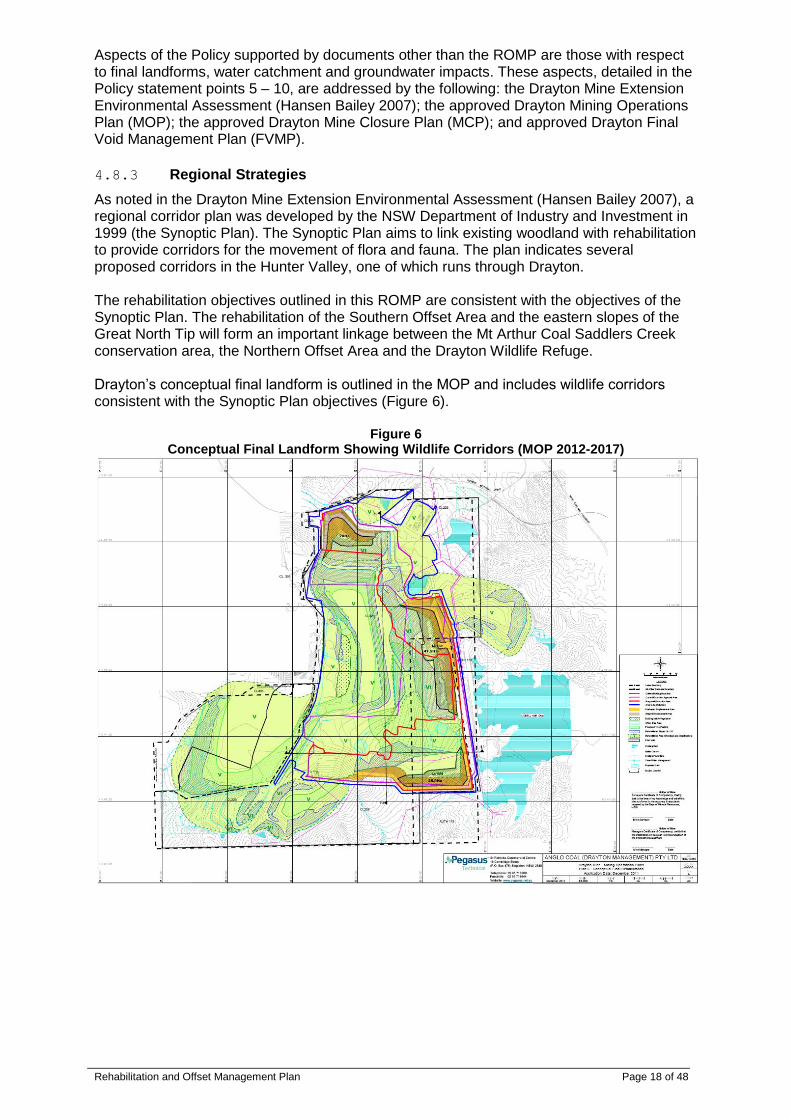
As noted in the Drayton Mine Extension Environmental Assessment (Hansen Bailey 2007), a regional corridor plan was developed by the NSW Department of Industry and Investment in 1999 (the Synoptic Plan). The Synoptic Plan aims to link existing woodland with rehabilitation to provide corridors for the movement of flora and fauna. The plan indicates several proposed corridors in the Hunter Valley, one of which runs through Drayton. The rehabilitation objectives outlined in this ROMP are consistent with the objectives of the Synoptic Plan. The rehabilitation of the Southern Offset Area and the eastern slopes of the Great North Tip will form an important linkage between the Mt Arthur Coal Saddlers Creek conservation area, the Northern Offset Area and the Drayton Wildlife Refuge. Drayton’s conceptual final landform is outlined in the MOP and includes wildlife corridors consistent with the Synoptic Plan objectives (Figure 6).
Figure 6 Conceptual Final Landform Showing Wildlife Corridors (MOP 2012-2017)

Rehabilitation and Offset Management Plan Page 19 of 48
4.8.4 Anglo American Metallurgical Coal Strategy
The Anglo American Met Coal Rehabilitation Strategy Guideline (the Guideline) 2012 supports Drayton’s ROMP by outlining expected standards for:
Setting Rehabilitation Objectives and Targets;
Rehabilitation Planning;
Rehabilitation Techniques;
Developing Completion Criteria; and
Rehabilitation Management and Monitoring Drayton’s ROMP is consistent with the Guideline and provides the initial three year progressive rehabilitation plan required by the Guideline.
4.9 Drayton Rehabilitation and Offset Strategy
4.9.1 Rehabilitation Objectives and Targets
The normal sequence of overburden emplacement, shaping, rehabilitation and revegetation will be continued. After mining is complete in an area, rehabilitation will be expedited with annual rehabilitation targets to reflect mining progression outlined in the Mining Operations Plan (MOP). The goal is to balance rehabilitation establishment rates against new disturbance to achieve zero net increase in disturbance area at Drayton. Beyond zero net increase in disturbance area, the goal is to reduce overall area disturbed by identifying and rehabilitating all disturbed areas no longer needed for active mining operations.
4.9.2 Management of Existing Vegetation on Drayton Land
Areas of native vegetation exist on Drayton outside of the offset areas that will be managed for conservation purposes. They include woodland vegetation consisting of Spotted Gum-Grey Box Open Forest and Hunter Lowlands Redgum Forest (HLRF) occurring on Drayton surrounding the rail loop, coal stockpiles and access road dam. Management measures for these areas will be:
Minimising vegetation clearance;
Weed control;
Feral animal control; and
Exclusion of stock. Areas of pasture on Drayton land are also managed to ensure that existing stands of woodland vegetation are retained where possible and vegetation regrowth is encouraged as a localised refuge for native fauna. All vegetation clearance is managed by a permit to disturb process. These management practices enhance the ecological value of these areas.
4.9.3 Revegetation Strategy – Southern Offset
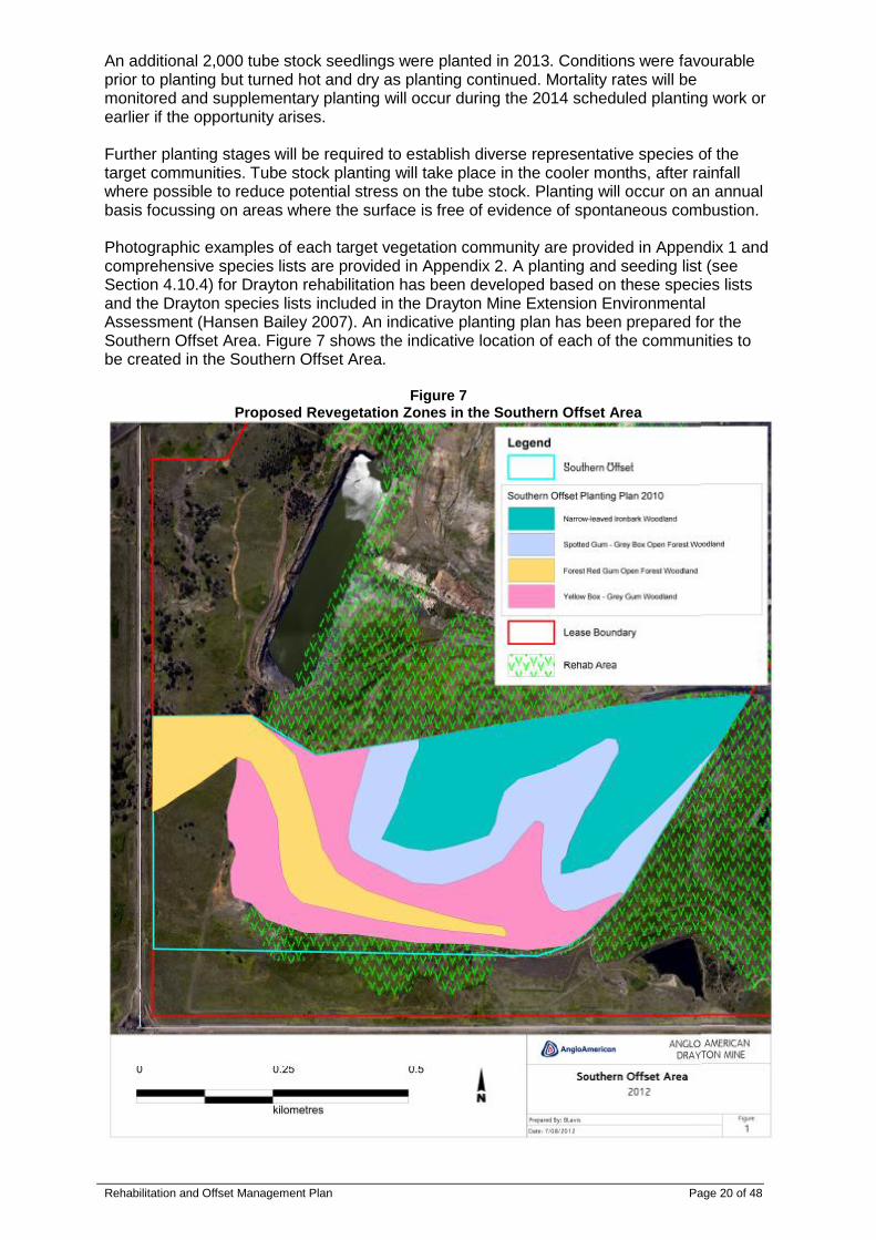
The revegetation strategy in the Southern Offset Area initially proposed the use of a combination of direct topsoiling and direct seeding techniques. The direct topsoiling technique was abandoned due to high failure rates expected from competition with existing exotic pasture species in the Southern Offset Area. The exotic pasture species and small areas of native trees and shrubs were originally direct seeded when the Southern Offset Area was rehabilitated, consistent with a final land use of grazing. This land is now in the process of being rehabilitated to native vegetation consistent with the Offset Strategy. The existing exotic pasture is expected to be controlled by the establishment of canopy as the native tube stock seedlings mature. A total of 30,000 tube stock seedlings were planted in 2010 to supplement canopy species. The planting plan generally followed the revegetation zones outlined in Figure 7. Establishment of tube stock seedlings has shown mixed success. Monitoring will continue to identify areas with low success rates and subsequent planting will occur in these areas until the required density is established.
Rehabilitation and Offset Management Plan Page 20 of 48
An additional 2,000 tube stock seedlings were planted in 2013. Conditions were favourable prior to planting but turned hot and dry as planting continued. Mortality rates will be monitored and supplementary planting will occur during the 2014 scheduled planting work or earlier if the opportunity arises. Further planting stages will be required to establish diverse representative species of the target communities. Tube stock planting will take place in the cooler months, after rainfall where possible to reduce potential stress on the tube stock. Planting will occur on an annual basis focussing on areas where the surface is free of evidence of spontaneous combustion. Photographic examples of each target vegetation community are provided in Appendix 1 and comprehensive species lists are provided in Appendix 2. A planting and seeding list (see Section 4.10.4) for Drayton rehabilitation has been developed based on these species lists and the Drayton species lists included in the Drayton Mine Extension Environmental Assessment (Hansen Bailey 2007). An indicative planting plan has been prepared for the Southern Offset Area. Figure 7 shows the indicative location of each of the communities to be created in the Southern Offset Area.
Figure 7 Proposed Revegetation Zones in the Southern Offset Area

Rehabilitation and Offset Management Plan Page 21 of 48
4.9.4 Offset Maintenance Strategy – Southern Offset
Implementing a successful revegetation strategy in the Southern Offset will require regular controls and maintenance to be put in place to manage potential risks as outlined in Section 4.9.9. The main, long-term risk to the successful establishment of vegetation in the Southern Offset is spontaneous combustion. Southern Offset monitoring in 2012 revealed several areas bare of vegetation and evidence of vegetation, both groundcover and planted tube stock, dying. Further investigations, including thermal imaging, during 2013 found evidence of spontaneous combustion affecting approximately 25 ha including:
Surface heating
Venting of steam
Surface discolouration
Lack of vegetation
Some areas where surface heating was found to be present were covered in either dead vegetation or resilient weeds such as Galenia. Affected areas have been mapped and the entire Southern Offset will be subject to annual thermal imaging to monitor the progress of remediation work and ensure a continuous reduction in affected areas until evidence of active spontaneous combustion is eliminated. Remediation will commence in 2013 with the worst affected areas being excavated and/or re-capped with a suitable material (e.g. clay) before being re-seeded to establish groundcover. Areas with minimal surface heating may be re-capped and re-seeded without excavation. All affected areas will then be monitored to ensure adequate control of surface heating prior to being re-planted with canopy species. Re-planting of canopy species in affected areas will not recommence until 2014 after thermal imaging has confirmed surface heating has been eliminated in the areas to be re-planted.
4.9.5 Offset Maintenance Strategy – Northern Offset
The rehabilitation strategy to be employed on the Northern Offset Area is known as “Assisted Natural Regeneration” (Cumberland Ecology 2009). To assist natural regeneration of the Northern Offset Area, rehabilitation will largely consist of three elements:
Protection;
Weed control; and
Supplementary planting (if necessary). Maintenance works, as detailed in Section 4.11, will ensure that the vegetation of the site continues to improve and be self-sustaining. All rehabilitation needs to be followed up by monitoring with reference to analogue sites. Prescriptions for monitoring are described in Section 4.14. The Northern Offset Area will enhance and improve the condition of approximately 6.3 ha of existing Forest Red Gum open forest and woodland.

Rehabilitation and Offset Management Plan Page 22 of 48
4.9.6 Thomas Mitchell Drive Tree Screen
A tree screen has been established along Thomas Mitchell Drive. Its primary role is to mitigate visual impacts of the mine on road users. It will secondarily provide some habitat to native species as the vegetation develops. It is located immediately to the west of the existing Drayton Rail Loop. The following procedures apply to the Thomas Mitchell Drive Tree Screen:
This area will be managed in order to maximise its value for wildlife;
Any tree that dies in the plantings will be replaced with a new specimen from tube stock, and the old tree will be left in situ to provide habitat for native species;
Annual review and replacement will be undertaken until mine closure;
If mowing is required to be undertaken, it should occur early in the spring when most exotic grasses are seeding, but will not damage the later maturing native species; and
This area will be monitored at the same time as monitoring is conducted on the Northern and Southern Offset Areas (see Section 4.14).
4.9.7 Reduction of Visual Impacts
Landscaping will be used throughout the site to reduce the visual impacts. This will primarily be aimed at reducing the impact to motorists travelling along nearby roads. The establishment of informal tree stands across the overburden emplacements areas, that reflect the scale and pattern of adjoining tree/grass areas will also be undertaken. These will consider the skyline location of the overburden emplacement areas and upon completion will reduce the visual impacts of the mine. In consideration of Muswellbrook Shire Council’s Mining Rehabilitation Policy (see Section 4.8.2), areas of the Great North Tip visible from the New England Highway and Thomas Mitchell Drive will be returned to “high density trees” (i.e. greater than 30 stems per hectare) consistent with native woodland stands present in the area and meeting the objectives of this ROMP. Despite these areas not being visible from either Muswellbrook or Denman as the Policy states, these areas have been targeted for high density tree planting for aesthetic reasons outlined in the Policy. The tree planting is also expected to expand and enhance the habitat corridor in consideration of the Synoptic Plan objectives and as outlined in the MOP. Dense tree planting along Thomas Mitchell Drive has been undertaken (see previous section), and as these trees mature they will assist in reducing visual impacts on the road.
4.9.8 Rehabilitation and Aboriginal Cultural Heritage
It is not expected that any conflict will occur between Aboriginal Cultural Heritage and mine rehabilitation, as all Aboriginal sites of high significance are cleared under the appropriate permits and in consultation with the local Aboriginal community, prior to any disturbance. Drayton has entered into discussions with the local Aboriginal community to develop a specific ‘Keeping Place’, located in the Southern Offset Area on non-disturbed land near Saddlers Creek. The Keeping Place is intended to be used to collate all artefacts collected through the Drayton Aboriginal Cultural Heritage salvage programs. It is envisaged that the Keeping Place will be established to balance ecological and Aboriginal Cultural Heritage aspects related to Drayton. In the Northern Offset Area there may be the potential for Aboriginal artifacts to occur. Limited works will take place in this area and it is therefore unlikely that any objects will be disturbed. If rehabilitation activities are to take place in an area with potential to contain Aboriginal artifacts, then an appropriately qualified Heritage consultant will be employed to survey the area and clearly mark these items to ensure they are not damaged. All workers will be briefed about the presence of sites of cultural significance prior to any works commencing to encourage due respect and awareness for the preservation and integrity of these areas.
Rehabilitation and Offset Management Plan Page 23 of 48
4.9.9 Potential Risks
The potential risks to successful rehabilitation and revegetation are mainly associated with plants not surviving in the revegetation areas. The success of the Southern Offset Area in particular is highly dependent on large scale survivorship of plants and seedlings. Failure of revegetation could occur through the following factors:
Drought – long periods without rainfall can dramatically reduce germination rates and survivorship of seedlings;
Bushfire – a bushfire passing through the rehabilitation area would destroy seedlings. Although Australian vegetation is adapted to periodic bushfires, plants are susceptible to fire prior to reproductive maturity;
Spontaneous combustion – managed in accordance with Drayton’s Spontaneous Combustion Management Plan;
Weed invasion – competition from weeds is a threat to the establishment of seedlings;
Feral animals and fauna – rabbits, hares and kangaroos have the potential to destroy young seedlings. Wild dogs, foxes and cats are a serious threat to biodiversity;
Stock access – inadvertent stock access can result in revegetation being trampled and eaten; and
Unviable seed – the quality of seed collected in the wild may be poor.
4.9.10 Contingency Measures
The main contingency measure for the risks outlined above is to continue to plant seedlings in the revegetation areas until the desired density is reached. Unplanned events are to be addressed on a case by case basis. In general however, the procedure would be to address the cause of the incident and if possible prevent it occurring again (e.g. by fencing the site to prevent stock access). The second action would be to rectify the situation by replacing lost plants. The procedures outlined in this plan such as seed collection, propagation and planting are intended to be ongoing, so that if an area of revegetation is lost, there are resources available to procure additional plant material to replace the lost stock. Some contingencies are difficult to prevent or to manage. The Southern Offset Area is too large for watering of seedlings to be a practical measure, and therefore the plants in this area are vulnerable to periods of drought. In the event of long periods of dry weather occurring, revegetation efforts would be suspended until climatic conditions became more suitable. Threat of bushfire is managed at Drayton through the implementation of the Bushfire Management Plan (BMP).
4.10 Establishment Techniques
Rehabilitation establishment techniques will vary from time to time as new techniques are trialled. General standards and techniques used at Drayton are outlined in this section and detailed in the Drayton Landscape Management Plan (LMP). Records of site preparation, topsoil handling and establishment works should be checked off and signed by the Drayton Environmental Coordinator. An example of a checklist proforma is provided in Appendix 4.
4.10.1 Landform Design and Construction
In general, final heights and gradients of landforms are outlined in the MOP. In 2013, Drayton commenced use of a new landform design software package named GeoFluvtm. The software is used to improve final landforms by providing designs that may feature greater stability against erosion; more “natural” landform function and appearance; and lower construction and maintenance costs. This new landform design methodology is expected to minimise the future use of contour/diversion banks for erosion control and surface water management.

Rehabilitation and Offset Management Plan Page 24 of 48
Diversion banks or contour banks may be constructed to maintain slope stability. Diversion banks are to be integrated into the overall surface water management plan for the site. Grades on all diversion banks must not exceed 1% and must not be less than 0.5%. Selected diversion banks may be removed after slope stability is achieved with established vegetation cover provided they are not needed for ongoing management of surface water movements. Drainage diversions, channels and discharge points shall be constructed to meet regulatory requirements and shall be generally sufficient to convey a 1:20 year average recurrence interval rainfall event. Spill areas will be designed to dissipate energy sufficient to minimise risk of erosion. Use of rock lined drainage diversions, channels and spillways will be determined by Anglo American’s Erosion and Sediment Control Standard.
4.10.2 Site Preparation
Inert capping material including clay is of paramount importance when carrying out rehabilitation at Drayton, due to the risk of spontaneous combustion. Stockpiling and utilisation of inert material is managed in accordance with the Spontaneous Combustion Management Plan (SCMP). All inert materials utilised as capping materials shall be inspected by a geologist to ensure any adverse characteristics are identified and that suitability as an adequate capping material can be determined. This shall include any forms of clay and overburden material considered appropriate for capping materials. All batters within proposed rehabilitation areas need to be assessed with regard to the possible occurrence of spontaneous combustion. If any treatments such as track rolling, additional compaction and spot treatments are required then these must be undertaken prior to the application of final capping materials. Erosion control measures must be undertaken on all areas of rehabilitation to ensure stability of slopes. Ripping to a depth of at least 400 millimetres (mm) along the contour will limit compaction and encourage water infiltration into the soil profile. This will reduce runoff and subsequent erosion potential, and encourage root development in establishing vegetation. Vigorous vegetative growth will further limit erosion potential by protecting the soil surface from high velocity rainfall.
4.10.3 Topsoil Management
Topsoil is a valuable commodity and must be conserved to ensure that adequate supplies are available for longer term rehabilitation requirements. A topsoil balance is completed annually as a component of the AEMR. This quantifies topsoil available for rehabilitation and identifies any topsoil deficit for future rehabilitation requirements. Strategic topsoil application will be implemented, whereby areas to be returned to native vegetation communities may be revegetated without the use of topsoil. These areas will require soil ameliorants to ensure development of soil structure and subsequent ground cover vegetation. Topsoil will be placed on selected areas to be rehabilitated, to a depth of not less than 100 mm. Topsoil stripping is generally restricted to one 50 to 60 metre wide strip in advance of mining. Direct placement of topsoil is utilised where possible and stockpiling times are minimised as native seed contained in topsoil resources degrades rapidly in stockpiles. Where available area permits, stockpiles should be restricted to a height of no more than three metres. All topsoil stockpiles must be shaped and revegetated as soon as they are completed to ensure soil erosion and weed development is minimised.

Rehabilitation and Offset Management Plan Page 25 of 48
4.10.4 Species Selection
Plant species will be selected that are representative and characteristic of target plant communities. Target plant communities have been outlined above in Section 4.9 and are generally consistent with existing local plant communities or plant communities being disturbed by mining. Plant species will be selected to expand existing flora populations and to provide appropriate foraging and nesting habitat for fauna species present and expected to occur on the site. Floristic and structural diversity will be maximised by:
Incorporating a range of plant species from all strata of each community that is being recreated;
Including species characteristic of each community that provide forage value for native fauna;
Including a range of nectar producing plants to ensure a supply of nectar for native fauna; and
Ensuring a diversity of ground cover vegetation and habitat components such as leaf litter and logs to provide habitat for animals including invertebrates which provide food for other animals.
Planting lists of recommended species are provided in Table 2 below which summarises the main species present in each stratum of the target vegetation communities. The list has been updated to include only species present on Drayton land according to the Drayton Mine Extension Environmental Assessment (Hansen Bailey 2007). Species characteristic of the target communities but not endemic to the area will not be included in rehabilitation. This approach will promote expansion and connection of existing flora populations within the surrounding areas. It is also designed to avoid establishment of unviable populations due to unsuitable climatic conditions and genetic isolation.
Table 2 Endemic Species Characteristic to Different Vegetation Communities
Species Narrow-leaved Ironbark
Woodland
Spotted Gum-Grey Box
Open Forest and Woodland
Forest Red Gum Open Forest and Woodland
(Hunter Lowland Redgum
Woodland)
Yellow Box and Grey Gum
Woodland (Box-Gum Woodland)
Overstorey
Allocasuarina luehmannii x x
Angophora floribunda x
Brachychiton populneus x
Eucalyptus albens # x
Eucalyptus blakelyi # x
Eucalyptus canaliculata x x
Eucalyptus crebra x x
Corymbia maculata x x
Eucalyptus melliodora x
Eucalyptus moluccana x x x
Eucalyptus punctata # x x
Eucalyptus tereticornis x x
Midstorey
Acacia decurrens
Acacia falcata x x
Acacia implexa x x
Acacia paradoxa x
Acacia salicina x
Breynia oblongifolia x
Daviesia ulicifolia x x
Hibbertia obtusifolia x

Rehabilitation and Offset Management Plan Page 26 of 48
Species Narrow-leaved Ironbark
Woodland
Spotted Gum-Grey Box
Open Forest and Woodland
Forest Red Gum Open Forest and Woodland
(Hunter Lowland Redgum
Woodland)
Yellow Box and Grey Gum
Woodland (Box-Gum Woodland)
Jacksonia scoparia x
Leucopogon juniperimus x
Maireana microphylla x x
Melichrus urceolatus x
Myoporum montanum x x x
Notelaea microcarpa x x x
Olearia elliptica x
Ozothamnus diosmifolius x x
Pultenaea microphylla x
Spartothamnella juncea x
Understorey
Aristida ramosa x x x x
Aristida spp. x
Austrodanthonia spp. x
Austrodantonia fulva x
Austrostipa verticillata x
Calotis cuneifolia x
Calotis lappulacea x x x Cheilanthes sieberi subsp. sieberi x x
Cheilanthes spp. x
Chloris ventricosa x x Chrysocephalum semipapposum x x x
Convolvulus erubescens x
Cymbopogon refractus x x x x
*Cynodon dactylon x x Danthonia racemosa var. racemosa x x
Danthonia spp. x x x
Desmodium brachypodum x x x
Desmodium varians x x x
Dianella longifolia x x
Dianella revoluta x x x
Dichondra repens x x
Digitaria brownii x
Digitaria diffusa x x x Echinopogon caespitosus var. caespitosus x
Einadia nutans x x
Eragrostis leptostachya x x x
Eremophila debilis x x x
Glycine canescens x x
Glycine spp. x x
Hardenbergia violacea x
Lomandra spp. x Microlaena stipoides var. stipoides x x
Pratia purpurascens x * Introduced species; # Drayton South species list
Rehabilitation and Offset Management Plan Page 27 of 48
4.10.5 Seed Collection and Propagation
Revegetation will use seed that has been locally sourced, where possible. Seed of required quantity and quality will be sourced as needed with seeds sourced from the Hunter Valley preferred. Provenance should be recorded for future reference. Examples of suitable on site seed sources include:
Local wholesale nurseries;
Northern Offset Area;
Drayton Wildlife Refuge; and
Selected vegetation that is being removed from pre-strip areas ahead of mining. Seed should be collected from all strata including grasses and groundcovers where suitable species are available. Suitable seed collection techniques include:
Brush harvesting, to obtain seeds from a diversity of understory species;
Suction or vacuum harvesting of grass species with less persistent seed (e.g. Microlaena stipoides); and
Hay strewing which may be appropriate in selected areas with low weed burden. Collected seed should be assessed for viability and germination rates of target species and weed species noted. Particular areas and/or plants with high seed viability of target species should be noted for future reference. Plant propagation will be undertaken by a professional horticulturalist, following recognised horticultural practices. All plants will be suitably disease and pest-free, hardened off and well-watered at the time of planting. Newly planted tube stock may be accompanied with tree guards to protect the fresh foliage from predation, and from possible spray drift resulting from maintenance weeding operations.
4.10.6 Seeding and Planting
For each species used in revegetation, the following information should be documented, were possible:
Seed provenance (source and location collected);
Date of harvest/collection and method;
Method of storage;
Any pre-treatment or scarification methods used;
Species germinated and germination rates;
Numbers and species propagated and by whom; and
Application method (e.g. tubestock, direct seeding, etc.).
4.10.6.1 Direct Seeding
The revegetation of areas will be undertaken using direct seeding techniques. Direct seeding should take place between September and May. Direct seeding may be undertaken using a range of techniques. The method chosen will be appropriate to the size and gradient of the area being revegetated. The surface is to be ripped as described in Section 4.10.2 above, then the seeds will be broadcast with mechanical spreaders (or by hand for small areas). Fertiliser may be spread mixed with the seed at a rate appropriate to the seed mixture and soil conditions. Broadcasting agents and soil ameliorants such as kitty litter or compost may also be spread with the seed as required. Fine or light seeds are particularly likely to require broadcasting agents to ensure an even distribution and protect against loss of windblown seed. Specific densities for direct seeding will be determined by available seed volumes and the target density of each stratum for the particular community being recreated. It is expected that natural ecological processes such as competition between germinated plants will determine which plants survive in any given area.
Rehabilitation and Offset Management Plan Page 28 of 48
Supplementary tube stock planting may be undertaken after direct seeding has taken place to fill any gaps in germination and to determine the final species composition if required.
4.10.6.2 Tube Stock Planting
The planting specifications for canopy (trees), mid-storey shrubs and groundcovers should be informed by monitoring data collected from the reference sites located within the Drayton Wildlife Refuge (see Section 4.14). Target densities are chosen so that the attainment of these targets allows rehabilitation to approach reference sites. Plant losses are to be replaced rather than being planted at higher densities to ensure an open canopy is retained in the long term. Planting and replacement planting should occur during the optimal seasonal conditions to ensure maximum plant retention. This is likely to be autumn and winter, as temperatures are cooler and rainfall is higher but may be year round, depending on local weather conditions in the months prior to planting. Tube stock planting of seedlings will be used to supplement assisted natural regeneration methods and to achieve the desired density of plants as needed. Tube stock plantings will be used largely to help establish a diverse canopy and mid-storey however, selected understory species may also be introduced via planting where direct seeding is ineffective for establishment of certain target species.
4.10.7 Transfer of Structural Components
Fauna habitat values should be preserved in the local environment by transferring key habitat components from clearance areas to rehabilitation and offset areas. Measures that are used to enhance fauna habitat values on rehabilitated areas include installing or transferring large habitat components such as:
Fallen logs and other large woody debris;
Large rocks;
Large mature tees (stags), particularly those with hollows; and
Nest boxes as artificial hollows. Transplanting understory plants to be cleared ahead of mining to the Southern Offset Area to promote faunal colonisation was recommended after initial establishment of canopy cover in the area. Considering the remaining areas to be cleared for mining at Drayton and the short period of time remaining for establishment of canopy cover, these understory species will be more appropriately sourced from local seed or tubestock sources noted previously in Section 4.10.5. Currently established, exotic groundcover species are expected to present a risk to establishment of native understory species through competition prior to establishment of canopy cover in the area.
4.11 Maintenance
Maintenance will focus on bringing the rehabilitation and offset areas to a standard that meets the objectives and targets. Rehabilitation areas will be safe, stable and self-sustaining. In practice, this means maintenance will be undertaken in response to issues identified by regular monitoring undertaken (see Section 4.14). Maintenance may include:
Management of erosion and maintenance of sediment control structures;
Fencing as needed or demarcating rehabilitation and offset areas;
Ongoing weed control measures;
Ongoing feral animal control measures; and
Replacement of dead or damaged native vegetation (seedlings). Section 4.12 contains a detailed schedule of works for ongoing maintenance of rehabilitation and offset areas.
Rehabilitation and Offset Management Plan Page 29 of 48
4.11.1 Erosion Control
Ongoing water quality monitoring assessing parameters, including total dissolved solids and suspended solids, will be maintained until such time as runoff quality is of an acceptable standard consistent with that present in applicable receiving waters. Surface water runoff from rehabilitated areas will be contained and managed onsite until such time as those areas are approved and signed of as acceptable by the DRE. Ongoing maintenance of installed structures may also be required from time-to-time to ensure continued protection against erosion and to ensure stability of slopes is maintained in accordance with Drayton’s existing Erosion and Sediment Control Plan.
4.11.2 Controlling Access
The Southern Offset Area has been delineated as a restricted work area. Access to the area is controlled by the OCE. Access is granted by Drayton only to authorised personnel for environmental and water management works. Increasing visible delineation via signage and boundary markers is under consideration. Further delineation will be installed as needed. Fencing of the Southern Offset Area is not considered necessary as the area is protected from unauthorised entry and is considered to be inaccessible to stock. Fencing will be reassessed in the event that either unauthorised access or stock encroachment onto this land becomes likely due to changes in surrounding land uses. This will enable regeneration of this area and will avoid degradation of the area associated with uncontrolled access.
4.11.3 Weed Control
Weed control efforts are essential to the success of the ROMP and will be ongoing in order to promote the establishment of native vegetation communities. Weed control is an important factor in the success or failure of revegetation plantings and is a large component of long term management in rehabilitation and offset areas, including the Drayton Wildlife Refuge. Weed control measures may include a combination of herbicide application, biological controls and manual weeding. A weed map for the site will be maintained on the Drayton GIS system and is to be updated biannually to assess the progress of weed control programs. Rehabilitation and offset areas are assessed for weeds and treated a minimum of twice per year in autumn and spring. All weeds treated onsite are mapped each year and the map is to be included in the AEMR. Broad scale herbicide application is not suitable in the Northern Offset Area or any part of the Southern Offset Area containing native vegetation. Where possible, weeding should be carried out in sympathy with seasonal variations in rainfall and weed growth, botanical flowering times and treatment affectivity. Weed outbreaks in the rehabilitation and offset areas are to be monitored and control measures undertaken are to be reported in the AEMR. Weed species are controlled on an ongoing basis as needed. All weeds should ideally be removed prior to flowering, or at flowering prior to seed set. Flowering or fruiting plants are high priority, particularly due to the connected nature of ecosystem components downstream. Preventing greater weed invasion offsite will be mitigated by the strategic efforts employed onsite.

Rehabilitation and Offset Management Plan Page 30 of 48
Table 3 presents a list of weed species that have been recorded on Drayton land. Occurrences of these species in the offset areas should be controlled as needed. In addition to the weeds recorded here, other species are likely to occur spontaneously from nearby areas and may also need to be controlled. Weed control efforts are currently focused on listed noxious species and/or highly invasive species with the potential to affect revegatation efforts through competition for resources. Weed control using herbicides is undertaken only as needed in recently established revegetation areas to minimise the risk of off target impacts from herbicide usage. When the canopy is established, some exotic pasture weed species are expected to be easier to control and may be reduced without the need for further removal efforts, due to a natural species dominance shift from areas receiving full sun to less intense sunlight under regenerated canopy.
Table 3 Weed Species Recorded from Drayton (Cumberland Ecology 2009)
Species Common Name
Bidens pilosa Farmers Friends
Bidens. subalternans
Callistemon viminalis cv. a Bottlebrush
Carthamnus lanatus Saffron Thistle
Chloris gayana Rhodes Grass
Cirsium vulgare Scotch Thistle
Conyza bonariensis a Fleabane
*Cynodon dactylon Couch Grass
Foeniculum vulgare Fennel
Galenia pubescens Galenia
Gomphocarpus fruticosus Milkweed
#Hypericum perforatum St John’s Wort
Juncus acutus
#Lycium ferosissimum African Boxthorn
Melinus repens Red Natal Grass
Modiola caroliniana Red-flowered Mallow
#Opuntia stricta Prickly Pear
Paspalum dilatatum Paspalum
*Pennisetum clandestinum Kikuyu
*Phalaris sp Phalaris
Plantago lanceolata Lambs Tongue
Prunus sp. Cherry
Romulea rosea
Senecio madagascariensis Fireweed
Setaria verticillata Slender Pigeon Grass
Sida rhombifolia Paddys Lucerne
Solanum nigrum Blackberry Nightshade
Spergularia sp.
Trifolium sp.
Verbena officinalis a Purpletop
Verbena stricta a Purpletop * Planted in pasture areas; # Noxious weeds
4.11.4 Feral Animal Control
Feral animals will be controlled in the offset areas according to the procedures and policies in the Drayton Flora and Fauna Management Plan (FFMP). Feral animals that may be targeted for control under the relevant codes of practice include:
Dogs and foxes;
Rabbits and hares;
Cats (where observed); and
Pigs and goats (if significant damage or sign is observed).
Rehabilitation and Offset Management Plan Page 31 of 48
Species will be targeted according to the results of monitoring in particular areas. It is expected that feral animal control will be undertaken regularly and will continue for the period of this ROMP at least twice per year while sightings continue. Kangaroos may also be controlled from time to time under appropriate licences and only when in sufficient numbers onsite as to present a risk to revegetation and/or health and safety.
4.11.5 Vegetation Maintenance
Following the initial establishment of rehabilitation areas by direct seeding, tube stock planting of native seedlings will be used to:
Supplement assisted natural regeneration as needed;
Achieve the desired density of plants;
Maximise diversity in rehabilitation areas; and
Replace species characteristic of the vegetation communities being established. Large area, single species clusters of plants germinating from the direct seeding may need hand thinning to achieve a species mix consistent with the community being replaced. Supplementary planting will be required where plant losses are experienced or plants are struggling to establish. The successive plantings will take this into account and since a number of tube stock are known to not be likely to survive, slightly larger numbers will be planted than are expected to live. The replacement planting should ensure an appropriate density of midstorey and canopy species, and that ground covers effectively cover the surface to maintain soil stability. Replacement planting should aim to create the densities of plants as per targets to be determined by reference sites within Drayton Wildlife Refuge. Replanting will occur annually, where required for the life of this ROMP and beyond until the target densities are achieved. Replanting measures taken, such as number of plants and types of species planted, fertilisers used and watering regime, should be documented throughout the program.
4.12 Schedule of Works 2013 - 2015
This ROMP covers work to be carried out over the next three years. The Plan will need to be reviewed after this time period and updated as appropriate.
4.12.1 Rehabilitation 2013 - 2015
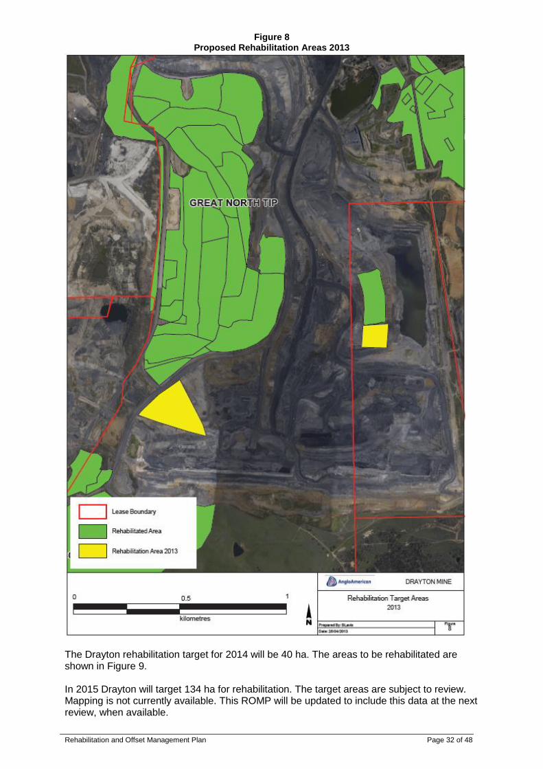
In 2013 Drayton will target 13 ha for rehabilitation. The areas to be rehabilitated are shown in Figure 8. All designs and scheduling for completion of these areas is complete and progress will be tracked via a monthly meeting beginning April 2013. To ensure delivery of the rehabilitation is on time and to standard, Production, Technical Services and Environmental Department focal points have been nominated.
Rehabilitation and Offset Management Plan Page 32 of 48
Figure 8 Proposed Rehabilitation Areas 2013
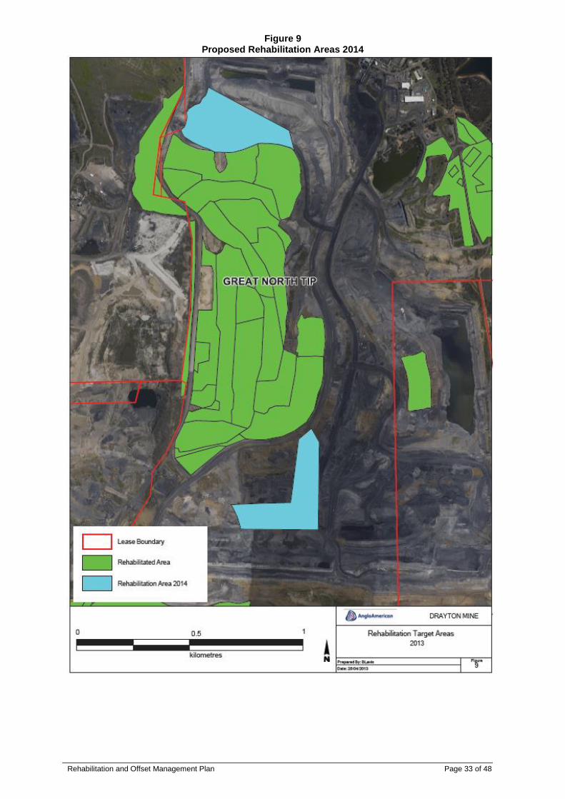
The Drayton rehabilitation target for 2014 will be 40 ha. The areas to be rehabilitated are shown in Figure 9. In 2015 Drayton will target 134 ha for rehabilitation. The target areas are subject to review. Mapping is not currently available. This ROMP will be updated to include this data at the next review, when available.
Rehabilitation and Offset Management Plan Page 33 of 48
Figure 9 Proposed Rehabilitation Areas 2014
Rehabilitation and Offset Management Plan Page 34 of 48
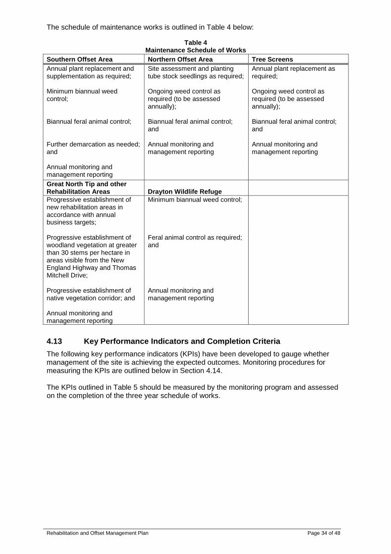
The schedule of maintenance works is outlined in Table 4 below:
Table 4 Maintenance Schedule of Works
Southern Offset Area Northern Offset Area Tree Screens
Annual plant replacement and supplementation as required;
Site assessment and planting tube stock seedlings as required;
Annual plant replacement as required;
Minimum biannual weed control;
Ongoing weed control as required (to be assessed annually);
Ongoing weed control as required (to be assessed annually);
Biannual feral animal control; Biannual feral animal control; and
Biannual feral animal control; and
Further demarcation as needed; and
Annual monitoring and management reporting
Annual monitoring and management reporting
Annual monitoring and management reporting
Great North Tip and other Rehabilitation Areas Drayton Wildlife Refuge
Progressive establishment of new rehabilitation areas in accordance with annual business targets;
Minimum biannual weed control;
Progressive establishment of woodland vegetation at greater than 30 stems per hectare in areas visible from the New England Highway and Thomas Mitchell Drive;
Feral animal control as required; and
Progressive establishment of native vegetation corridor; and Annual monitoring and management reporting
Annual monitoring and management reporting
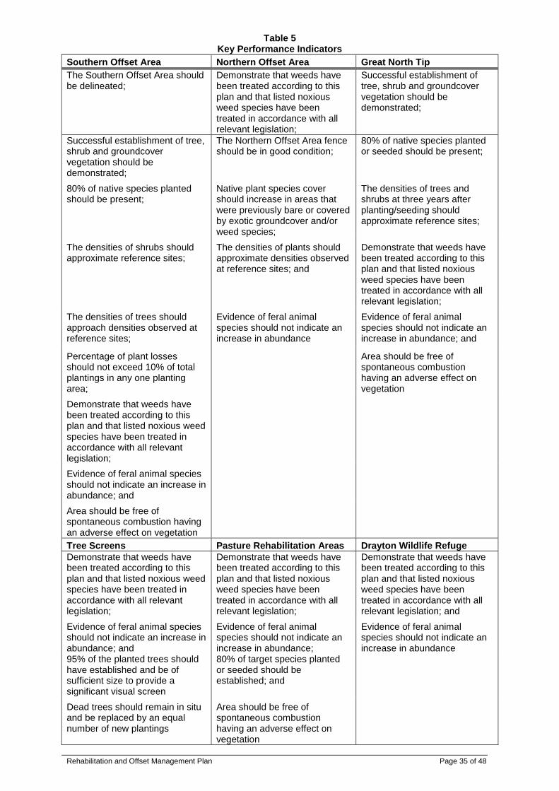
4.13 Key Performance Indicators and Completion Criteria
The following key performance indicators (KPIs) have been developed to gauge whether management of the site is achieving the expected outcomes. Monitoring procedures for measuring the KPIs are outlined below in Section 4.14. The KPIs outlined in Table 5 should be measured by the monitoring program and assessed on the completion of the three year schedule of works.
Rehabilitation and Offset Management Plan Page 35 of 48
Table 5 Key Performance Indicators
Southern Offset Area Northern Offset Area Great North Tip
The Southern Offset Area should be delineated;
Demonstrate that weeds have been treated according to this plan and that listed noxious weed species have been treated in accordance with all relevant legislation;
Successful establishment of tree, shrub and groundcover vegetation should be demonstrated;
Successful establishment of tree, shrub and groundcover vegetation should be demonstrated;
The Northern Offset Area fence should be in good condition;
80% of native species planted or seeded should be present;
80% of native species planted should be present;
Native plant species cover should increase in areas that were previously bare or covered by exotic groundcover and/or weed species;
The densities of trees and shrubs at three years after planting/seeding should approximate reference sites;
The densities of shrubs should approximate reference sites;
The densities of plants should approximate densities observed at reference sites; and
Demonstrate that weeds have been treated according to this plan and that listed noxious weed species have been treated in accordance with all relevant legislation;
The densities of trees should approach densities observed at reference sites;
Evidence of feral animal species should not indicate an increase in abundance
Evidence of feral animal species should not indicate an increase in abundance; and
Percentage of plant losses should not exceed 10% of total plantings in any one planting area;
Area should be free of spontaneous combustion having an adverse effect on vegetation
Demonstrate that weeds have been treated according to this plan and that listed noxious weed species have been treated in accordance with all relevant legislation;
Evidence of feral animal species should not indicate an increase in abundance; and
Area should be free of spontaneous combustion having an adverse effect on vegetation
Tree Screens Pasture Rehabilitation Areas Drayton Wildlife Refuge
Demonstrate that weeds have been treated according to this plan and that listed noxious weed species have been treated in accordance with all relevant legislation;
Demonstrate that weeds have been treated according to this plan and that listed noxious weed species have been treated in accordance with all relevant legislation;
Demonstrate that weeds have been treated according to this plan and that listed noxious weed species have been treated in accordance with all relevant legislation; and
Evidence of feral animal species should not indicate an increase in abundance; and
Evidence of feral animal species should not indicate an increase in abundance;
Evidence of feral animal species should not indicate an increase in abundance
95% of the planted trees should have established and be of sufficient size to provide a significant visual screen
80% of target species planted or seeded should be established; and
Dead trees should remain in situ and be replaced by an equal number of new plantings
Area should be free of spontaneous combustion having an adverse effect on vegetation
Rehabilitation and Offset Management Plan Page 36 of 48
4.14 Monitoring
The overall design of the monitoring program is firstly to establish baseline monitoring in reference sites within the Drayton Wildlife Refuge. Initial establishment monitoring should then be conducted within the rehabilitation and offset areas. This should be followed by long term monitoring to assess progress towards targets and objectives. The objectives of monitoring of rehabilitation in the Southern Offset Area, Northern Offset Area and Drayton Wildlife Refuge are to:
Identify specific problems to enable research on causes and appropriate solutions (e.g. failed plantings, loss of seedlings, low emergent numbers, loss of particular species);
Enable the assessment of and management of impacts on biodiversity and rare species (e.g. weed invasion);
Ascertain when the key performance indicators are being met in the rehabilitation areas; and
Provide feedback for continuous improvement of the rehabilitation program.
4.14.1 Monitoring Design – Reference Sites
The rehabilitation program should be carried out against replicate reference sites in the Drayton Wildlife Refuge. The establishment of the reference sites for the communities to be created in the Northern Offset Area should be chosen prior to the commencement of any revegetation works. In particular, the key indicators of self-sustainability, such as emergent rates, levels of recruitment and amount of seed set, can be compared against reference data, providing opportunity to improve rehabilitation techniques to achieve rehabilitation targets.
4.14.2 Monitoring Design – Fixed Monitoring Points
A minimum of three replicate reference sites for each community to be created or rehabilitated should be chosen from representative areas in the Drayton Wildlife Refuge to account for the variability of natural ecosystems. It is recommended that a minimum of two monitoring points be established in each of the vegetation communities being created in the Southern Offset Area and two in the Northern Offset Area. Fixed monitoring points will also be established which are representative of each vegetation community being recreated in the progressive rehabilitation areas.
4.14.3 Monitoring Design – Monitoring Frequency
Pre-establishment surveys should be conducted within reference sites in the Drayton Wildlife Refuge prior to the commencement of planting. Baseline data collected from reference sites will inform the planting density targets within rehabilitation sites and completion criteria for key indicator species in each vegetation community to be recreated/rehabilitated. Within the Northern Offset Area initial monitoring should be conducted at fixed monitoring points prior to weed control and planting activities in order to provide a reference point to which future monitoring can be compared. Rehabilitation and offset areas will be regularly checked for weed invasion and feral animal invasion and appropriate measures taken as per the procedures outlined in the Drayton Flora and Fauna Management Plan.
Rehabilitation and Offset Management Plan Page 37 of 48
Establishment within both offset areas should be checked regularly following initial works. The need for additional plantings should be identified and carried out. Quantitative data should be collected from all fixed monitoring points as per Section 4.14.4 after vegetation establishment in each area and prior to application for final sign off by DRE. Qualitative and quantitative monitoring will be undertaken annually to assess condition of existing rehabilitation and offset areas and determine actions necessary to meet completion objectives and criteria. Improvements in rehabilitation techniques should be identified and incorporated into the ROMP for implementation.
4.14.4 Monitoring Design – Methodology
Qualitative data collection will include photos taken annually from fixed monitoring points as well as regular inspections of rehabilitation and offset areas noting issues including weeds; feral animal sign; erosion; spontaneous combustion; and general observations of health and abundance of establishing vegetation communities. The procedures for collecting quantitative data at fixed monitoring points are outlined below. Establish a series of fixed monitoring points. Each monitoring point should be permanently marked with a star picket and its location recorded using a handheld geographic positioning system unit. The procedure for recording data from each monitoring point is outlined below:
Take photographs from each monitoring point to compare with photographs from previous years;
Use the photograph monitoring point to form a corner of a 20 m x 20 m quadrat at each monitoring point;
Record all weed species occurring in the quadrat and state relative abundance of weed species;
Record all native species occurring in the quadrat and state relative abundance of native species;
Note the species that are observed to be reproductive and record the reproductive phase;
Record the total projective foliage cover of native species in each stratum;
Record the height of each stratum; and
Note the extent of erosion (where applicable) and compare to previous photos. Within each 20 m x 20 m quadrat, sub-sampling should be completed using 25 smaller quadrats (1 m x 1 m) applied randomly throughout the larger quadrat. Each subsample should measure:
Numbers of failed plantings in each quadrat;
Species that failed to establish;
Number of emergent seedlings; and
Conduct a faecal pellet identification and count in each quadrat. Note any other weed outbreaks outside of established quadrats.
4.14.5 Monitoring Design – Fauna Surveys
In addition to the quadrat monitoring, fauna surveys should be undertaken at two yearly intervals in order to determine faunal usage of the Northern and Southern Offset Areas and the Drayton Wildlife Refuge and to determine how they change over time. Initially, this should only be conducted in the Northern Offset Area and the Drayton Wildlife Refuge, as few fauna species are likely to utilise the Southern Offset Area while the vegetation is still immature. Fauna monitoring of the Southern Offset Area should commence three years after first establishment of tree and shrub species.
Rehabilitation and Offset Management Plan Page 38 of 48
The fauna surveys will include:
Spotlighting survey for nocturnal fauna;
Diurnal survey for birds and reptiles;
Anabat survey for micro chiropteran bats;
Targeted fauna trapping survey for threatened species; and
Call playback for owls and gliders. The quadrat monitoring, fauna survey and the faecal pellet counts are not necessary in the Thomas Mitchell Drive tree screen as the goal in this area is to provide a visual barrier between traffic on the road and the mine.
5 APPENDICES
Appendices (Attached to Procedure) Appendix 1 – Photographs of Vegetation Communities to be Created Appendix 2 – Species Lists for Vegetation Communities (Cumberland Ecology 2009) Appendix 3 – Letter of Approval Appendices (Linked to Procedure) Appendix 4 – Check Sheet Proforma

Rehabilitation and Offset Management Plan Page 39 of 48
Appendix 1
Photographs of Vegetation Communities to be Created
Photograph A2-1
Narrow-leaved Ironbark Woodland
Photograph A2-2 Spotted Gum – Grey Box Open Forest and Woodland
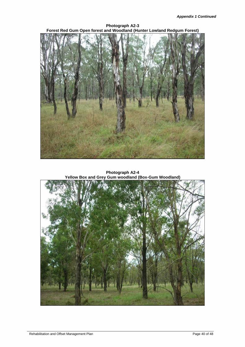
Rehabilitation and Offset Management Plan Page 40 of 48
Appendix 1 Continued
Photograph A2-3
Forest Red Gum Open forest and Woodland (Hunter Lowland Redgum Forest)
Photograph A2-4 Yellow Box and Grey Gum woodland (Box-Gum Woodland)

Rehabilitation and Offset Management Plan Page 41 of 48
Appendix 2
Species Lists for Vegetation Communities (Cumberland Ecology 2009)
Table A3-1
Narrow-leaved Ironbark Woodland species list
Family Scientific Name Common Name
Trees
Myrtaceae Angophora floribunda Rough-barked Apple
Myrtaceae Eucalyptus albens White Box
Myrtaceae Eucalyptus blakelyi Blakely's Red Gum
Myrtaceae Eucalyptus crebra
Narrow-leaved
Ironbark
Sterculiaceae
Brachychiton populneus subsp.
populneus
Small Trees
Pittosporaceae Pittosporum undulatum Sweet Pittosporum
Shrubs
Asteraceae
Olearia elliptica subsp.
elliptica
Asteraceae
Sigesbeckia orientalis subsp.
orientalis Indian Weed
Fabaceae
(Mimosoideae) Acacia paradoxa Kangaroo Thorn
Lamiaceae Spartothamnella juncea
Myoporaceae Myoporum montanum Western Boobialla
Oleaceae
Notelaea microcarpa var.
microcarpa
Phyllanthaceae Breynia oblongifolia Coffee Bush
Herbs - Dicots
Convolvulaceae Dichondra repens Kidney Weed
Asteraceae Senecio quadridentatus Cotton Fireweed
Apiaceae Daucus glochidiatus Native Carrot
Asteraceae Euchiton sphaericus Star Cudweed
Geraniaceae Geranium solanderi var. solanderi
Crassulaceae Crassula sieberiana
Australian
Stonecrop
Asteraceae Calotis lappulacea Yellow Burr-daisy
Herbs - Monocots
Poaceae Austrostipa scabra Speargrass
Poaceae Dichelachne micrantha
Shorthair
Plumegrass
Poaceae Echinopogon ovatus
Forest Hedgehog
Grass
Poaceae
Microlaena stipoides
var.stipoides
Weeping Meadow
Grass
Herbs - Ferns and
Allies
Adiantaceae Cheilanthes distans Bristly Cloak Fern
Adiantaceae
Cheilanthes sieberi subsp.
sieberi Rock Fern
Vines and Creepers
Fabaceae (Faboideae) Desmodium varians
Slender Tick-
trefoil
Fabaceae (Faboideae) Glycine clandestina Twining glycine
Fabaceae (Faboideae) Glycine tabacina Variable Glycine
Ranunculaceae
Clematis glycinoides var.
glycinoides

Rehabilitation and Offset Management Plan Page 42 of 48
Appendix 2 Continued
Table A3-2
Spotted Gum – Grey Box Open Forest and Woodland Species List
Family Scientific Name Common Name
Trees
Casuarinaceae Allocasuarina luehmannii Bulloak
Myrtaceae Corymbia maculata Spotted Gum
Myrtaceae Eucalyptus crebra
Narrow-leaved
Ironbark
Myrtaceae Eucalyptus fibrosa Red Ironbark
Myrtaceae Eucalyptus glaucina Slaty Red Gum
Myrtaceae Eucalyptus moluccana Grey Box
Myrtaceae Eucalyptus tereticornis Forest Red Gum
Small Trees
Fabaceae
(Mimosoideae) Acacia falcata
Fabaceae
(Mimosoideae) Acacia parvipinnula
Silver-stemmed
Wattle
Shrubs
Ericaceae Lissanthe strigosa Peach Heath
Ericaceae Melichrus urceolatus Urn Heath
Fabaceae (Faboideae)
Daviesia ulicifolia subsp.
ulicifolia Gorse Bitter Pea
Fabaceae (Faboideae) Pultenaea spinosa A Bush Pea
Myoporaceae Eremophila debilis Amulla
Phyllanthaceae Breynia oblongifolia Coffee Bush
Pittosporaceae Bursaria spinosa subsp. spinosa Native Blackthorn
Proteaceae Hakea sericea Needlebush
Herbs - Dicots
Acanthaceae Brunoniella australis Blue Trumpet
Anthericaceae Laxmannia gracilis Slender Wire Lily
Asteraceae Brachyscome multifida Cut-leaved Daisy
Asteraceae Calotis cuneifolia Purple Burr-Daisy
Asteraceae Chrysocephalum apiculatum Common Everlasting
Asteraceae Vernonia cinerea var. cinerea
Campanulaceae Wahlenbergia communis Tufted Bluebell
Campanulaceae Wahlenbergia gracilis Sprawling Bluebell
Clusiaceae Hypericum gramineum
Small St John's
Wort
Convolvulaceae Dichondra repens Kidney Weed
Lobeliaceae Pratia purpurascens Whiteroot
Rubiaceae Opercularia diphylla
Rubiaceae Pomax umbellata Pomax
Solanaceae Solanum prinophyllum Forest Nightshade
Stackhousiaceae Stackhousia viminea
Slender
Stackhousia
Herbs - Monocots
Lomandraceae
Lomandra multiflora
subsp.multiflora
Many-flowered Mat-
rush
Phormiaceae Dianella revoluta var. revoluta A Blue Flax Lily
Poaceae Cymbopogon refractus Barbed Wire Grass
Poaceae
Echinopogon caespitosus var.
caespitosus
Tufted Hedgehog
Grass
Poaceae Entolasia stricta Wiry Panic
Poaceae
Microlaena stipoides
var.stipoides
Weeping Meadow
Grass
Poaceae Paspalidium distans
Poaceae Themeda australis Kangaroo Grass
Herbs - Ferns and
Allies
Adiantaceae Cheilanthes sieberi subsp. Rock Fern

Rehabilitation and Offset Management Plan Page 43 of 48
sieberi
Vines and Creepers
Fabaceae (Faboideae) Desmodium varians
Slender Tick-
trefoil
Fabaceae (Faboideae) Glycine clandestina Twining glycine
Fabaceae (Faboideae) Glycine tabacina Variable Glycine
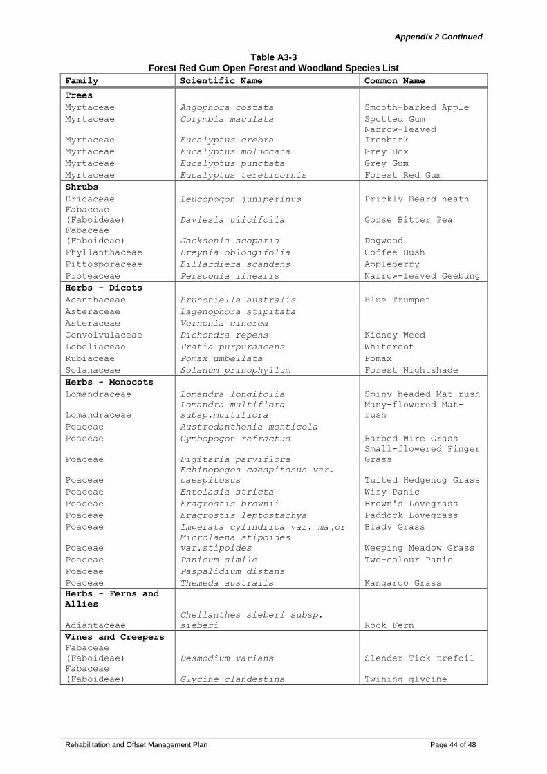
Rehabilitation and Offset Management Plan Page 44 of 48
Appendix 2 Continued
Table A3-3
Forest Red Gum Open Forest and Woodland Species List
Family Scientific Name Common Name
Trees
Myrtaceae Angophora costata Smooth-barked Apple
Myrtaceae Corymbia maculata Spotted Gum
Myrtaceae Eucalyptus crebra
Narrow-leaved
Ironbark
Myrtaceae Eucalyptus moluccana Grey Box
Myrtaceae Eucalyptus punctata Grey Gum
Myrtaceae Eucalyptus tereticornis Forest Red Gum
Shrubs
Ericaceae Leucopogon juniperinus Prickly Beard-heath
Fabaceae
(Faboideae) Daviesia ulicifolia Gorse Bitter Pea
Fabaceae
(Faboideae) Jacksonia scoparia Dogwood
Phyllanthaceae Breynia oblongifolia Coffee Bush
Pittosporaceae Billardiera scandens Appleberry
Proteaceae Persoonia linearis Narrow-leaved Geebung
Herbs - Dicots
Acanthaceae Brunoniella australis Blue Trumpet
Asteraceae Lagenophora stipitata
Asteraceae Vernonia cinerea
Convolvulaceae Dichondra repens Kidney Weed
Lobeliaceae Pratia purpurascens Whiteroot
Rubiaceae Pomax umbellata Pomax
Solanaceae Solanum prinophyllum Forest Nightshade
Herbs - Monocots
Lomandraceae Lomandra longifolia Spiny-headed Mat-rush
Lomandraceae
Lomandra multiflora
subsp.multiflora
Many-flowered Mat-
rush
Poaceae Austrodanthonia monticola
Poaceae Cymbopogon refractus Barbed Wire Grass
Poaceae Digitaria parviflora
Small-flowered Finger
Grass
Poaceae
Echinopogon caespitosus var.
caespitosus Tufted Hedgehog Grass
Poaceae Entolasia stricta Wiry Panic
Poaceae Eragrostis brownii Brown's Lovegrass
Poaceae Eragrostis leptostachya Paddock Lovegrass
Poaceae Imperata cylindrica var. major Blady Grass
Poaceae
Microlaena stipoides
var.stipoides Weeping Meadow Grass
Poaceae Panicum simile Two-colour Panic
Poaceae Paspalidium distans
Poaceae Themeda australis Kangaroo Grass
Herbs - Ferns and
Allies
Adiantaceae
Cheilanthes sieberi subsp.
sieberi Rock Fern
Vines and Creepers
Fabaceae
(Faboideae) Desmodium varians Slender Tick-trefoil
Fabaceae
(Faboideae) Glycine clandestina Twining glycine
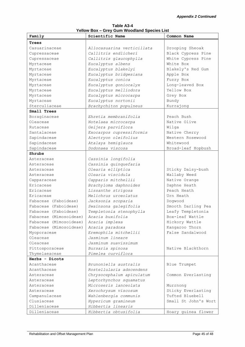
Rehabilitation and Offset Management Plan Page 45 of 48
Appendix 2 Continued
Table A3-4
Yellow Box – Grey Gum Woodland Species List
Family Scientific Name Common Name
Trees
Casuarinaceae Allocasuarina verticillata Drooping Sheoak
Cupressaceae Callitris endlicheri Black Cypress Pine
Cupressaceae Callitris glaucophylla White Cypress Pine
Myrtaceae Eucalyptus albens White Box
Myrtaceae Eucalyptus blakelyi Blakely's Red Gum
Myrtaceae Eucalyptus bridgesiana Apple Box
Myrtaceae Eucalyptus conica Fuzzy Box
Myrtaceae Eucalyptus goniocalyx Long-leaved Box
Myrtaceae Eucalyptus melliodora Yellow Box
Myrtaceae Eucalyptus microcarpa Grey Box
Myrtaceae Eucalyptus nortonii Bundy
Sterculiaceae Brachychiton populneus Kurrajong
Small Trees
Boraginaceae Ehretia membranifolia Peach Bush
Oleaceae Notelaea microcarpa Native Olive
Rutaceae Geijera parviflora Wilga
Santalaceae Exocarpos cupressiformis Native Cherry
Sapindaceae Alectryon oleifolius Western Rosewood
Sapindaceae Atalaya hemiglauca Whitewood
Sapindaceae Dodonaea viscosa Broad-leaf Hopbush
Shrubs
Asteraceae Cassinia longifolia
Asteraceae Cassinia quinquefaria
Asteraceae Olearia elliptica Sticky Daisy-bush
Asteraceae Olearia viscidula Wallaby Weed
Capparaceae Capparis mitchellii Native Orange
Ericaceae Brachyloma daphnoides Daphne Heath
Ericaceae Lissanthe strigosa Peach Heath
Ericaceae Melichrus urceolatus Urn Heath
Fabaceae (Faboideae) Jacksonia scoparia Dogwood
Fabaceae (Faboideae) Swainsona galegifolia Smooth Darling Pea
Fabaceae (Faboideae) Templetonia stenophylla Leafy Templetonia
Fabaceae (Mimosoideae) Acacia buxifolia Box-leaf Wattle
Fabaceae (Mimosoideae) Acacia implexa Hickory Wattle
Fabaceae (Mimosoideae) Acacia paradoxa Kangaroo Thorn
Myoporaceae Eremophila mitchellii False Sandalwood
Oleaceae Jasminum lineare
Oleaceae Jasminum suavissimum
Pittosporaceae Bursaria spinosa Native Blackthorn
Thymelaeaceae Pimelea curviflora
Herbs - Dicots
Acanthaceae Brunoniella australis Blue Trumpet
Acanthaceae Rostellularia adscendens
Asteraceae Chrysocephalum apiculatum Common Everlasting
Asteraceae Leptorhynchos squamatus
Asteraceae Microseris lanceolata Murrnong
Asteraceae Xerochrysum viscosum Sticky Everlasting
Campanulaceae Wahlenbergia communis Tufted Bluebell
Clusiaceae Hypericum gramineum Small St John's Wort
Dilleniaceae Hibbertia linearis
Dilleniaceae Hibbertia obtusifolia Hoary guinea flower

Rehabilitation and Offset Management Plan Page 46 of 48
Appendix 2 Continued
Family Scientific Name Common Name
Geraniaceae Geranium solanderi Native Geranium
Goodeniaceae Goodenia pinnatifida Scrambles Eggs
Haloragaceae Gonocarpus elatus
Malvaceae Sida corrugata Corrugated Sida
Oxalidaceae Oxalis perennans
Plantaginaceae Plantago debilis
Plantaginaceae Plantago gaudichaudii
Narrow-leaf
Plaintain
Polygonaceae Rumex brownii Swamp Dock
Rubiaceae Asperula conferta Common Woodruff
Stackhousiaceae Stackhousia monogyna Creamy Candles
Stackhousiaceae Stackhousia viminea Slender Stackhousia
Herbs - Monocots
Asphodelaceae Bulbine bulbosa Native Leek
Lomandraceae Lomandra filiformis Wattle Matt-rush
Orchidaceae Diuris dendrobioides Wedge Diuris
Phormiaceae Dianella longifolia A Blue Flax Lily
Phormiaceae Dianella revoluta Blue Flax-Lily
Poaceae Aristida behriana Bunch Wiregrass
Poaceae Aristida ramosa Purple Wiregrass
Poaceae Austrodanthonia auriculata Lobed Wallaby Grass
Poaceae Austrodanthonia bipartita Wallaby Grass
Poaceae Austrodanthonia racemosa
Poaceae
Austrodanthonia
richardsonii Wallaby Grass
Poaceae Austrostipa aristiglumis Plains Grass
Poaceae Austrostipa blackii
Poaceae Austrostipa nodosa
Poaceae Austrostipa scabra Speargrass
Poaceae Bothriochloa macra Red Grass
Poaceae Chloris truncata Windmill Grass
Poaceae Chloris ventricosa Tall Chloris
Poaceae Cymbopogon refractus Barbed Wire Grass
Poaceae Dichanthium sericeum Queensland Bluegrass
Poaceae Dichelachne micrantha Shorthair Plumegrass
Poaceae Echinopogon caespitosus Bushy Hedgehog-grass
Poaceae Elymus scaber Common Wheatgrass
Poaceae Eulalia aurea Silky Browntop
Poaceae Panicum queenslandicum Coolabah Grass
Poaceae Poa labillardierei Tussock Grass
Poaceae Poa sieberiana Snowgrass
Poaceae Sorghum leiocladum Wild Sorghum
Poaceae Themeda australis Kangaroo Grass
Herbs - Ferns and
Allies
Adiantaceae Cheilanthes sieberi Rock Fern
Vines and Creepers
Apocynaceae Parsonsia eucalyptophylla Gargaloo
Bignoniaceae Pandorea pandorana Wonga Wonga Vine
Fabaceae (Faboideae) Glycine clandestina Twining glycine
Fabaceae (Faboideae) Glycine tabacina Variable Glycine
Fabaceae (Faboideae) Glycine tomentella Woolly Glycine

Rehabilitation and Offset Management Plan Page 47 of 48
Appendix 3
Letter of Approval

Rehabilitation and Offset Management Plan Page 48 of 48