drayton south coal project
TRANSCRIPT

Sydney Office 78 George Street Redfern NSW Australia 2016 T +61 2 9319 4811
Canberra Office 2A Mugga Way Red Hill ACT Australia 2603 T +61 2 6273 7540
GML Heritage Pty Ltd ABN 60 001 179 362
www.gml.com.au
Drayton South Coal Project
Aboriginal Heritage Review
Report prepared for The Hunter Thoroughbred Breeders Association
September 2015

GML Heritage
Report Register
The following report register documents the development and issue of the report entitled Drayton
South Coal Project—Aboriginal Heritage Review, undertaken by GML Heritage Pty Ltd in
accordance with its quality management system.
Job No. Issue No. Notes/Description Issue Date
15-0309A 1 Final Report 29 August 2015
15-0309A 2 Revised Final Report 7 September 2015
15-0309A 3 + 4 Updated and Revised Final Report 9 September 2015
15-0309A 5 Updated and Revised Final Report 11 September 2015
Quality Assurance
GML Heritage Pty Ltd operates under a quality management system which has been certified as complying with the
Australian/New Zealand Standard for quality management systems AS/NZS ISO 9001:2008.
The report has been reviewed and approved for issue in accordance with the GML quality assurance policy and procedures.
Project Manager: Tim Owen Project Director & Reviewer: Sharon Veale
Issue No. 5 Issue No. 5
Signature
Signature
Position: Senior Associate Position: Partner
Date: 11 September 2015 Date: 11 September 2015
Copyright
Historical sources and reference material used in the preparation of this report are acknowledged and referenced at the end
of each section and/or in figure captions. Reasonable effort has been made to identify, contact, acknowledge and obtain
permission to use material from the relevant copyright owners. Unless otherwise specified or agreed, copyright in this report
vests in GML Heritage Pty Ltd (‘GML’) and in the owners of any Aboriginal traditional knowledge or pre-existing historic
source or reference material.
Moral Rights
GML asserts its Moral Rights in this work, unless otherwise acknowledged, in accordance with the (Commonwealth)
Copyright (Moral Rights) Amendment Act 2000. GML’s moral rights include the attribution of authorship, the right not to have
the work falsely attributed and the right to integrity of authorship.
Right to Use
GML grants to the client for this project (and the client’s successors in title) an irrevocable royalty-free right to reproduce or
use the material from this report, except where such use infringes the copyright and/or Moral Rights of GML or third parties.

GML Heritage
DSCP—Aboriginal Heritage Review, September 2015
Contents Page
1.0 Introduction ..................................................................................................................................................... 1
1.1 Introduction .................................................................................................................................................... 1
1.2 The PCWP and Provision of Cultural Knowledge to the PAC ................................................................... 1
1.3 Definitions ...................................................................................................................................................... 2
1.4 Key Aboriginal Informants ............................................................................................................................ 4
1.5 Work Undertaken to Prepare this Report .................................................................................................... 4
1.6 Spelling of Aboriginal Names ....................................................................................................................... 5
2.0 Aboriginal Sites, Places and Values ........................................................................................................... 6
2.1 Aboriginal Heritage in the Upper Hunter ..................................................................................................... 6
2.2 Aboriginal Cultural Aspects and Items ........................................................................................................ 6
3.0 Detailed Background to Aboriginal Sites, Places and Values ............................................................. 15
3.1 Native Title Registered Applicants ............................................................................................................. 15
3.2 Pre-European Arrival .................................................................................................................................. 16
3.2.1 Hungary Hill Tribe ................................................................................................................................ 16
3.2.2 Mount Yengo ........................................................................................................................................ 16
3.2.3 Lizard Mountain.................................................................................................................................... 16
3.2.4 Sentinel Mountain ................................................................................................................................ 16
3.2.5 Baiame Cave ........................................................................................................................................ 17
3.2.6 Burning Mountain ................................................................................................................................. 17
3.2.7 Dural Region ........................................................................................................................................ 17
3.2.8 Fire Song Line ...................................................................................................................................... 18
3.2.9 Initiation Song Line .............................................................................................................................. 18
3.2.10 Baiame Country Creation .................................................................................................................. 18
3.2.11 Living Sites Inside Project Area ........................................................................................................ 19
3.2.12 Pre-European Archaeology Inside Project Area ............................................................................. 20
3.2.13 Food and Resources Inside The Project Area ................................................................................ 21
3.2.14 Regional Archaeological Sites .......................................................................................................... 21
3.2.15 Boundaries of Country ....................................................................................................................... 22
3.2.16 View, Travelling Routes and Connection across Country .............................................................. 22
3.2.17 Laws and Customs ............................................................................................................................ 23
3.2.18 Caring for Country ............................................................................................................................. 23
3.3 Post European Arrival ................................................................................................................................. 23
3.3.1 Land dispossession ............................................................................................................................. 23
3.3.2 Merton ‘District’ and Mount Arthur ...................................................................................................... 24
3.3.3 Jackey Jackey ...................................................................................................................................... 25
3.3.4 Aboriginal Military Suppression and Massacre .................................................................................. 26
3.3.5 ‘Beer’ Lands ......................................................................................................................................... 27
3.3.6 Mount Olive .......................................................................................................................................... 27
3.3.7 William Billy Smith—King Billy ............................................................................................................ 27
3.3.8 Contact Period Archaeology Inside Project Area .............................................................................. 28
3.3.9 Food and Resources Inside The Project Area................................................................................... 28
3.3.10 Views and Connection Across Country............................................................................................ 29
3.3.11 Laws and Customs ............................................................................................................................ 29

GML Heritage
DSCP—Aboriginal Heritage Review, September 2015 2
4.0 Summary and Conclusion ......................................................................................................................... 30
4.1 Summary of Known and Potential Heritage Items .................................................................................. 30
4.2 Statement of Potential Impact To and Effects On Aboriginal Heritage .................................................. 32
4.3 Key Findings ............................................................................................................................................... 33

GML Heritage
DSCP—Aboriginal Heritage Review, September 2015 1
1.0 Introduction
1.1 Introduction
Located in the Upper Hunter Valley, within the Local Government Area of Muswellbrook, the Drayton
South Coal Project (DSCP) is proposed as an open cut mine with an operational life of 15 years. The
DSCP is an extension to the existing Drayton Mine which has been operating for over 30 years. The
Drayton South coal mine will produce thermal coal and the volume of the resource is expected to be
73.3 million tonnes. The DSCP was assessed under an Environmental Impact Statement (EIS) 2015,
which followed a prior Environmental Assessment in 2012.
GML Heritage Pty Ltd (GML) was commissioned by The Hunter Thoroughbred Breeders Association
(HTBA) to provide an overview of Aboriginal heritage values with regard to the DSCP area, the
surrounding Country and regional Aboriginal cultural landscape. To prepare this information GML
consulted with Mr Scott Franks (Plains Clans of the Wonnarua People [PCWP]) who provided relevant
Aboriginal cultural information, including in respect of Native Title claims on which he is a registered
party.
In preparing this statement the following documents are referred to:
PCWP Native Title Determination Application, Claimant Application, 19 August 2013. (NTDA
2013).
Tocomwall 2013. Beginning and Belonging: The traditional, historical & contemporary cultural
landscape of the Mount Owen Continued Operations Project Area: A Plains Clans of the
Wonnarua Peoples Perspective.
Brayshaw 1986. Aborigines of the Hunter Valley.
Gollan 1993. The Military Suppression of Wanaruah Resistance in the Upper Hunter 1826.
ERM 2004. Upper Hunter Valley Aboriginal Heritage Baseline Study.
The Beer family records, held by Ms Jeanette Beer.
Drayton South Coal Project, Environmental Impact Assessment, Volume 5—Section O
Aboriginal Archaeological and Cultural Heritage Impact Assessment, March 2015. (AECOM
2015)
Project SEARs in Hansen Bailey 2015: EIS Appendix C. (Hansen Bailey 2015)
Australia ICOMOS. The Burra Charter: The Australia ICOMOS Charter for Places of Cultural
Significance, 2013. (The Burra Charter)
The Burra Charter and Indigenous Cultural Heritage Management. Practice Note. Version 1:
November 2013 (the Burra Charter’s Indigenous Practice note).
1.2 The PCWP and Provision of Cultural Knowledge to the PAC
The PCWP have provided an overview of their people, historical lineage and connection to Country
(Tocomwall 2013). They state:

GML Heritage
DSCP—Aboriginal Heritage Review, September 2015 2
The PCWP are a registered Native Title Claimant group with extended familial or clan links to the hills and plains of the
central and upper Hunter Valley. The PCWP assert that these clan links provide a continuity of connection with the
Hunter Valley that extends back to the time at or before first sovereignty. This connection is based on well-established
societal norms including the recognition of spiritual beings, and places, rights and responsibilities in ‘Country’ and the
hunting, gathering and sharing of resources within the boundaries of ‘Wonnarua’ country.1
The PCWP consider that all aspects of their lives, tradition, lands, Country and culture are intertwined
and irrevocably linked. PCWP traditions, sites, places, Country and thus the associated values, should
not and cannot be recorded, viewed, understood or considered in isolation. To understand, change or
impact to one aspect of PCWP heritage will have a consequential impact or change another connected
heritage value. As such, this report provides a synopsis of PCWP heritage places (the definition of a
‘heritage place’ is provided below), which are linked to the DSCP coal project area. Some of these
places are located within the project area, some cross through the project area, some are located
outside the project area but are directly associated through intangible and aesthetic connections.
This document provides the Planning Assessment Commission (PAC) with an overview of some of the
important Aboriginal places and values which are connected either directly or indirectly to the project
area (Section 2). The NTDA 2013 was filed with the Federal Court of Australia 19 August 2013.
In the specific instance of the DSCP the PCWP have allowed the PAC access to their cultural
knowledge and property because they believe this project could pose a significant risk to their cultural
values, places and traditions. The PAC is asked to maintain the confidentiality of the cultural
knowledge presented.
In some instances further details, interviews and additional research has been with regard to identified
heritage items and/or cultural aspects. This research was subject to time and research cost
constraints. The quantity of material identified within a short space of time provides further evidence of
the extent of Aboriginal connection to the project area and wider cultural landscape. Relevant
research information and details are presented in Section 3.
1.3 Definitions
The definitions presented in the Burra Charter have provided the basis for definitions used in this
report. The Burra Charter’s Indigenous Practice note provides further guidance for application of the
Burra Charter to Aboriginal heritage. Of relevance are the following definitions:
Place
Place means a geographically defined area. It may include elements, objects, spaces and views. Place may have
tangible and intangible dimensions.2
‘Place’ includes locations that embody spiritual value (such as Dreaming places, sacred landscapes, and stone
arrangements), social and historical value (such as massacre sites), as well as scientific value (such as archaeological
sites). In fact, one place may be all of these things or may embody all of these values at the same time.3
1 Tocomwall 2013: 5. 2 Australia ICOMOS Inc., The Burra Charter: The Australia ICOMOS Charter for Places of Cultural Significance, 2013, Australia
ICOMOS Inc., Burwood VIC 2013, Article 1.1. 3 Burra Charter Practice Note 2013: p 2.

GML Heritage
DSCP—Aboriginal Heritage Review, September 2015 3
Cultural Significance
Cultural significance means aesthetic, historic, scientific, social or spiritual value for past, present or future generations.
Cultural significance is embodied in the place itself, its fabric, setting, use, associations, meanings, records, related
places and related objects. Places may have a range of values for different individuals or groups.4
Use
Use means the functions of a place, including the activities and traditional and customary practices that may occur at
the place or are dependent on the place.5
Compatible Use
Compatible use means a use which respects the cultural significance of a place. Such a use involves no, or minimal,
impact on cultural significance.
Setting
Conservation requires the retention of an appropriate setting. This includes retention of the visual and sensory setting,
as well as the retention of spiritual and other cultural relationships that contribute to the cultural significance of the
place.6
Places of significance to Indigenous people require a holistic approach to ‘setting’. ‘Setting’ may encompass the
broadest of experiential factors including a sense of ‘intrusion’ occasioned when people of the ‘wrong’ gender, age or
level of initiation trespass on defined areas, as well as auditory and visual intrusion.
For some Indigenous peoples, nature and culture are indivisible. The social significance and spiritual significance of a
place for Indigenous people may be wholly or partly dependent on the natural environment that the place forms a part
of, including aspects such as biodiversity, and totemic and resource species.7
Aesthetic Value
The Burra Charter defines that aesthetic value includes aspects of sensory perception for criteria
including the form, scale, colour, texture and material of a place, as well as the smells and sounds
associated with the place and its use.
Cultural Landscape
The OEH has issued a guide to assist in the identification and management of cultural landscapes. Of
relevance is the definition of cultural landscape:
The cultural landscape concept emphasises the landscape-scale of history and the connectivity between people, places
and heritage items. It recognises that the present landscape is the product of long term and complex relationships
between people and the environment.8
4 Australia ICOMOS Inc., The Burra Charter: The Australia ICOMOS Charter for Places of Cultural Significance, 2013, Australia
ICOMOS Inc., Burwood VIC 2013, Article 1.2. 5 Australia ICOMOS Inc., The Burra Charter: The Australia ICOMOS Charter for Places of Cultural Significance, 2013, Australia
ICOMOS Inc., Burwood VIC 2013, Article 1.10. 6 Australia ICOMOS Inc., The Burra Charter: The Australia ICOMOS Charter for Places of Cultural Significance, 2013, Australia
ICOMOS Inc., Burwood VIC 2013, Article 8. 7 Australia ICOMOS Inc., Burra Charter Practice Note 2013, Australia ICOMOS Inc., Burwood VIC 2013, p 5. 8 DECCW April 2010. What is an Aboriginal Cultural Landscape. Factsheet 2, Canberra.

GML Heritage
DSCP—Aboriginal Heritage Review, September 2015 4
1.4 Key Aboriginal Informants
This report has been informed by key Aboriginal informant Mr Scott Franks (PCWP), who provided oral
testament and record. Written records prepared for the PCWP Native Title Application have been
used to provide further Aboriginal cultural and traditional information.
1.5 Work Undertaken to Prepare this Report
On 3 August 2015 Mr Scott Franks (PCWP), Mr Chaz Czastka (Tocomwall), Dr Tim Owen (GML
Heritage) and Mr Sam Player (GML Heritage) met at GML’s office, to identify and document, GIS map
and record known Aboriginal sites, places, values etc associated with the south-western sector of
PCWP native title claim area.
On 10 and 11 August Mr Franks invited Dr Owen to his Country, where a number of sites, places and
heritage items were visited. The visit generally followed part of the Biami creation route, from Broke,
into the Merton and Mount Arthur regions. Mr Franks provided cultural information which was
photographed, GIS mapped, video and orally recorded. The cultural landscape was photographically
recorded, with views taken to and of the items Mr Franks identified as culturally significant. The DSCP
was inspected from the publically accessible Eddington Road only—at no point did either Mr Franks or
Dr Owen enter non-public land associated with the project area.
The visit to Mount Arthur was facilitated by BHP Billiton, who provided access across a mining road for
the purpose of a cultural inspection of Mount Arthur. During this visit Mr Franks informed Dr Owen of
the connection between the places visited south of Mount Arthur, and provides a whole of Country
description describing the Biami creation route, and the two song lines which flow through this region.
The visit to Mount Arthur was also used to understand and describe the process of historical period
land dispossession and the Aboriginal massacre which took place to the south of Mount Arthur.
It was noted that Mr Franks was not able to discuss many of the items unless he was on the relevant
Country, or understood the (non-visual) connection between the places through being in a culturally
appropriate location.
On 11 August, Mr Franks and Dr Owen met with Ms Jeanette Beer, who is a direct descendent of
Thomas Beer Senior (The Beer family formerly owned land to the immediate north of the DSCP). Ms
Beer provided information held by her family in relation to the region—on European land ownership,
the Aboriginal massacre, the connection between Mr Frank’s great grandfather and her great
grandfather. The interview with Ms Beer was recorded and the records she provided were
photographed.
This report provides a written record of the inspection, research and anthropological research
undertaken. The intention is to provide the PAC with an overview of Aboriginal heritage values and
places that have, for the most part, not been detailed in AECOM 2015—the region has a rich and
connected cultural landscape associated with the PCWP native title area. The aspects, places and
values are far more extensive that the archaeological record identified by AECOM 2015.
This report has been prepared by Dr Owen, GIS mapping was prepared by Mr Player. The report has
been reviewed by Ms Sharon Veale (Partner GML Heritage).

GML Heritage
DSCP—Aboriginal Heritage Review, September 2015 5
1.6 Spelling of Aboriginal Names
In this report the spelling of Aboriginal names for places and ancestral being has followed spelling
conventions from formal registered heritage lists. Quotes with different spellings for people, clans,
places and ancestral beings have not been altered.

GML Heritage
DSCP—Aboriginal Heritage Review, September 2015 6
2.0 Aboriginal Sites, Places and Values
2.1 Aboriginal Heritage in the Upper Hunter
The Upper Hunter contains the traditional lands of the Wonnarua Aboriginal peoples (Section 3.2.1).
These lands have been occupied for thousands of years and contain a dense and rich combination of
physical sites, places and intangible traditional song and initiation places and routes. Aboriginal
heritage, culture and tradition is lived by Wonnarua Aboriginal people, particularly the PCWP, it cannot
be considered a ‘relic’ of the past. The extent and importance of Aboriginal tradition to the PCWP has
been demonstrated by the acceptance for registration of their Native Title claims (Section 3.1).
The density and importance of Aboriginal culture in this region is formally recognised through statutory
listing of Aboriginal sites and places under both the OEH AHIMS register and the NSW State Heritage
Register.
As recent example of how the Aboriginal heritage of the region is recognised as important to the State
of NSW, Mr Mark Speakman (Minister for the Environment, Minister for Heritage and Assistant Minister
for Planning) announced on Friday 7 August, 2015, that the Baiami Cave had been listed on the NSW
State Heritage Register:
An Aboriginal rock art site of great rarity featuring a larger than life cave painting of a man – understood to be Baiame
the creator, ‘father of all’ and lawmaker – overlooking the Hunter Valley, which is located on a private farm in the Hunter
Valley, part of the traditional Wonnarua Nation.
Mr Speakman said that the State Heritage Listing of these three sites will provide each with the highest form of heritage
protection and recognition available under the NSW Heritage Act 1977.
“The Heritage Council of NSW will work with the land owners to care for each site ensuring the enjoyment by future
generations,” Mr Speakman said.
“The rare and beautiful Hunter Valley rock painting site is located on private farming land, whose owners have
had close relations with local Aboriginal people for three generations, making the site readily accessible for their
ceremonial and educational use.”9
2.2 Aboriginal Cultural Aspects and Items
Aboriginal culture across the region includes a combination of ancient, historical and continuing
traditions, reflected in the cultural landscape as physical sites, places and intangible traditional song
and initiation places and routes.
Table 1 provides a synopsis of PCWP cultural aspects and places associated with the Wonnarua
Country connected with the DSCP area. The connection of each Aboriginal aspect/place to the project
area is described as either ‘direct’ or ‘indirect’. Direct connection means that Aboriginal aspect/place is
located with the physical land of the project boundary, as shown in AECOM 2015: Figure 1. Where
possible these items have been GIS mapped at the local and regional level. The mapping
demonstrates the connection between each aspect, visually describing how PCWP tradition is linked
across Country. Photographs were taken to provide context to the descriptions and demonstrate the
connection between Aboriginal places.
9 NSW Government 2015. Three New Sites on State Heritage Register. Friday 7 August 2015. Access online.
http://www.environment.nsw.gov.au/resources/MinMedia/MinMedia15080702.pdf
GML Heritage
DSCP—Aboriginal Heritage Review, September 2015 7
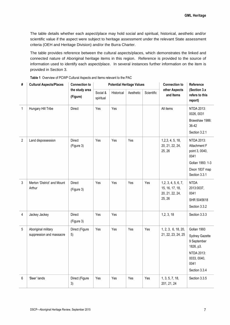
The table details whether each aspect/place may hold social and spiritual, historical, aesthetic and/or
scientific value if the aspect were subject to heritage assessment under the relevant State assessment
criteria (OEH and Heritage Division) and/or the Burra Charter.
The table provides reference between the cultural aspects/places, which demonstrates the linked and
connected nature of Aboriginal heritage items in this region. Reference is provided to the source of
information used to identify each aspect/place. In several instances further information on the item is
provided in Section 3.
Table 1 Overview of PCWP Cultural Aspects and Items relevant to the PAC
# Cultural Aspects/Places Connection to
the study area
(Figure)
Potential Heritage Values Connection to
other Aspects
and Items
Reference
(Section 3.x
refers to this
report)
Social &
spiritual
Historical Aesthetic Scientific
1 Hungary Hill Tribe Direct Yes Yes All items NTDA 2013:
0026, 0031
Brawshaw 1986:
36-42
Section 3.2.1
2 Land dispossession Direct
(Figure 3)
Yes Yes Yes 1,2,3, 4, 5, 18,
20, 21, 22, 24,
25, 26
NTDA 2013:
Attachment F
point 3, 0040,
0041
Gollan 1993: 1-3
Dixon 1837 map
Section 3.3.1
3 Merton ‘District’ and Mount
Arthur
Direct
(Figure 3)
Yes Yes Yes Yes 1,2, 3, 4, 5, 6, 7,
15, 16, 17, 18,
20, 21, 22, 24,
25, 26
NTDA
2013:0037,
0041
SHR 5045618
Section 3.3.2
4 Jackey Jackey Direct
(Figure 3)
Yes Yes 1,2, 3, 18 Section 3.3.3
5 Aboriginal military
suppression and massacre
Direct (Figure
5)
Yes Yes Yes Yes 1, 2, 3, 6, 18, 20,
21, 22, 23, 24, 25
Gollan 1993
Sydney Gazette
9 September
1826, p3.
NTDA 2013:
0033, 0040,
0041
Section 3.3.4
6 ‘Beer’ lands Direct (Figure
3)
Yes Yes Yes Yes 1, 3, 5, 7, 18,
201, 21, 24
Section 3.3.5

GML Heritage
DSCP—Aboriginal Heritage Review, September 2015 8
# Cultural Aspects/Places Connection to
the study area
(Figure)
Potential Heritage Values Connection to
other Aspects
and Items
Reference
(Section 3.x
refers to this
report)
Social &
spiritual
Historical Aesthetic Scientific
7 William Billy Smith—King
Billy
Direct Yes Yes Yes Yes 1, 3, 14, 16, 20,
25
NTDA 2013:
0072
Section 3.3.7
8 Mount Yengo Indirect Yes Yes Yes Yes 1, 9, 10, 11, 12,
13, 16, 17, 22,
23, 24, 25, 26
Registered
Aboriginal Place
NTDA 2013:
0033
Section 3.2.2
9 Lizard Mountain Indirect
Yes Yes Yes 1, 8, 16, 17, 23,
24, 25, 26
Section 3.2.3
10 Sentinel Mountain Indirect
Yes Yes 1, 8, 16, 17, 23,
24, 25, 26
Section 3.2.4
11 Baiame Cave Indirect SHR
listed
SHR
listed
SHR
listed
SHR
listed
1, 8, 16, 17, 22 SHR 01942
Section 3.2.5
12 Burning Mountain Indirect
Yes Yes Yes 1, 8, 15, 16, 17 NTDA 2013:
0077, 0093,
Attachment F4
32, 36, 37
Section 3.2.6
13 Dural Region Indirect
Yes Yes Yes 1, 8, 16, 17 NTDA
2013:0039
Section 3.2.7
14 Mount Olive Indirect Yes Yes Yes Yes 1, 7, 16, 17 NTDA
2013:0038
Tocomwall
2013: 104-106
Section 3.3.6
15 Fire song line Direct
(Figure 2)
Yes Yes Yes Yes 1, 3, 13, 16, 17,
18
NTDA
2013:0039,
0077, 0078,
Attachment F4
32
Brawshaw 1986:
22
Section 3.2.8

GML Heritage
DSCP—Aboriginal Heritage Review, September 2015 9
# Cultural Aspects/Places Connection to
the study area
(Figure)
Potential Heritage Values Connection to
other Aspects
and Items
Reference
(Section 3.x
refers to this
report)
Social &
spiritual
Historical Aesthetic Scientific
16 Initiation song line Direct
(Figure 2)
Yes Yes Yes Yes 1, 3, 7, 8, 9, 10,
11, 13, 14, 15, 16
Tocomwall
2013: Figure 19
NTDA 2013:
0035, 0039,
0077, 0078
Section 3.2.9
17 Baiame Country creation Direct Yes Yes Yes Yes 1, 3, 8, 9, 10, 11,
12, 13, 14, 15,
16, 18, 19, 20,
21, 22, 23, 24,
25, 26
NTDA 2013:
0032, 0033,
0076-0078
All
Section 3. 2.10
18 Living sites inside project
area
Direct Yes Yes Yes Yes 1, 2, 4, 5, 6, 15,
17, 19, 20, 21,
24, 25, 26
NTDA
2013:0037
Brawshaw 1986:
42-46
Section 3.2.11
19 Pre-European archaeology
inside project area
Direct Yes Yes Yes Yes 1, 17, 18, 21, 22,
24, 25, 26
NTDA
2013:0037
ERM 2004
AECOM 2015:
Figures 9 and
10
Section 3.2.12
20 Contact period archaeology
inside project area
Direct Yes Yes Yes Yes 1, 2, 3, 5, 6, 7,
17, 18, 21, 22,
24, 25, 26
Section 3.3.8
21 Food and resources inside
the project area
Direct Yes Yes Yes 1, 2, 3, 5, 6, 17,
18, 19, 20, 25, 26
NTDA 2013:
Attachment F
point 3, 0127-
0222
Section 3.2.13
Section 3.3.9
22 Regional archaeological
sites
Indirect Yes Yes Yes Yes 1, 2, 3, 5, 8, 11,
17, 19, 23, 24,
25, 26
Brawshaw 1986:
42-46
ERM 2004
Section 3.2.14
23 Boundaries of Country Direct Yes Yes 1, 5, 8, 9, 10, 17,
22, 24, 25
Section 3.2.15

GML Heritage
DSCP—Aboriginal Heritage Review, September 2015 10
# Cultural Aspects/Places Connection to
the study area
(Figure)
Potential Heritage Values Connection to
other Aspects
and Items
Reference
(Section 3.x
refers to this
report)
Social &
spiritual
Historical Aesthetic Scientific
24 View, travelling routes and
connection across Country
Direct (Figure
2)
Yes Yes 1, 2, 3, 5, 6, 8, 9,
10, 17, 18,19, 20,
22, 23, 25, 26
Section 3.2.16
Section 3.3.10
25 Laws and customs Direct Yes Yes Yes 1, 2, 3, 6, 7, 8, 9,
10, 17, 18, 19,
20, 21, 22, 23,
24, 26
NTDA 2013:
Attachment F
points 3-9
Section 3.2.17
Section 3.3.11
26 Caring for Country Direct Yes Yes Yes Yes 1, 2, 3, 8, 9, 10,
17, 18, 19, 20,
21, 22, 24, 25
NTDA 2013:
0032, 0033
Section 3.2.18

GML Heritage
DSCP—Aboriginal Heritage Review, September 2015 11
Figure 2 Ceremonial and song lines, as reported by Mr Franks 2015, and recorded in Tocomwall 2013: Figure 19. Also showing some key regional Aboriginal aspects, places and sites. Source: Scott Franks 2015, Tocomwall 2013, with GML 2015 additions

GML Heritage
DSCP—Aboriginal Heritage Review, September 2015 12
Figure 3 Pattern of early European land grants in the region (by 1837), showing residual land inhabited by the PCWP. Extract of Dixon’s map of the 19 counties of 1837 showing a portion of the County of Durham and the pattern of development lining the banks of the Hunter River. The grid pattern and the uniformity of the land grants are clearly discernible. Source: “This Map of the Colony of New South Wales” by Robert Dixon, engraved by J. C. Walker, dated 1837; National Library of Australia Map-Rm 831, with GML 2015 additions

GML Heritage
DSCP—Aboriginal Heritage Review, September 2015 13
Figure 4 Pattern of European land occupation, with key stations attacked by the Wonnarua in 1826. Those lands remaining available of Aboriginal habitation are defined. The Beer’s later land grants (c1860s) are shown. Source: GIS analysis from Figure 3, Beer family records and land titles, GML 2015 additions

GML Heritage
DSCP—Aboriginal Heritage Review, September 2015 14
Figure 5 GIS overlay showing the ‘key European stations attacked by the Wanaruah in 1826’. Showing the Merton District, those lands available for Aboriginal occupation in the 1820s. Source: Gollan 1993: Map 2, with GML 2015 additions

GML Heritage
DSCP—Aboriginal Heritage Review, September 2015 15
3.0 Detailed Background to Aboriginal Sites, Places and Values
AECOM 2015 presented a cultural heritage assessment of Aboriginal values associated with the
DSCP area. AECOM 2015 was prepared in response to the DSCP Project SEARs (Hansen Bailey
2015). In response to the project’s SEARs AECOM 2015 should present a complete analysis of all
scientific, aesthetic, historical and social/spiritual values connected with the DSCP area and connected
lands. The values analysis should be followed by a heritage impact assessment and consequential
Aboriginal heritage management. AECOM 2015 has been reviewed as a component of this report.
Further to the review of AECOM 2015, this report presents the results of a holistic regional Aboriginal
heritage synopsis and review, cornering on the DSCP area, detailing the known Aboriginal heritage
aspects; the results were presented in Section 2: Table 1. The 26 cultural aspects/items identified in
Table 1 have been detailed by a number of existing written reports and records. This section provides
information and evidence further to that cited in Table 1. This information includes first hand oral
testament provided by Mr Franks, as a Traditional Owner authorised to speak for Country, and a
member of the registered native title applicant.
Two short films were made of Mr Franks speaking about his Country—these were filmed at the
Baiame Cave and on top of Mount Arthur. The films are considered culturally restricted—permission
for the PAC to watch the films in the context of their review has been granted. The two films can be
viewed at:
https://youtu.be/yKQDkvXHnck
https://youtu.be/mGGSX7_lRzw
3.1 Native Title Registered Applicants
GML understands that the PCWP native title claim encompasses the DSCP area. With respect to
Native Title the following details are relevant to the PAC:
4 March 2011—AECOM wrote to the National Native Title Tribunal (NNTT) and Native Title
Service Corporation Limited (NTSCorp). In 2011 there was no registered Native Title claim that
encompassed the project boundary.
Since 2011 there has been no further documented attempt made by the proponent or their
consultants to ascertain whether the Native Title status has changed with respect to the project
area.
On 2 August 2012 a Native Title Claim (Tribunal File No: NC2012/004) was filed (Federal Court
File No: NSD1093/2012). The application name is the Plains Clans of the Wonnarua People #2.
The claim was entered on the Register of Native Title Claims on 14 September 2012.
On 13 May 2013 a Native Title Claim (Tribunal File No: NC2013/004) was filed (Federal Court
File No: NSD788/2013). The application name is the Plains Clans of the Wonnarua People. The
claim was entered on the Register of Native Title Claims on 13 June 2013.
On 19 August 2013 a Native Title Claim (Tribunal File No: NC2013/006) was filed (Federal Court
File No: NSD1680/2013). The application name is Scott Franks and Anor on behalf of the
Plains Clans of the Wonnarua People. The claim was entered on the Register of Native Title
Claims on 16 January 2015.
GML Heritage
DSCP—Aboriginal Heritage Review, September 2015 16
The DSCP area is located entirely within the Plains Clans of the Wonnarua People Native Title
claim area (NSD1680/2013).
On 25 March 2015 a revised Aboriginal archaeological and cultural heritage assessment was
released by Hansen Bailey. The revised Aboriginal heritage report asked the Aboriginal
stakeholders identified in 2011 to review and comment on the revised document. No recorded
consultation has been undertaken with the PCWP.
3.2 Pre-European Arrival
3.2.1 Hungary Hill Tribe
The traditional Wonnarua lands were occupied by numerous clans (NTDA 2013: Attachment F, 0026 &
0031). Historical records indicate the Kinkigyne or Hungary Hill Tribe occupied the land area in the
southwest of the PCWP native title claim, encompassing the DSCP area.
3.2.2 Mount Yengo
Mount Yengo is a component of the Baiame creation story. Mount Yengo can be seen from high
vantage points in PCWP Country, such as Mount Arthur.
Before our people were allowed to enter the lands known today as the Hunter Valley our creator Biami looked down
from the skies. He then stepped down onto Big Yengo with his son, Little Biami. As both then stepped onto Little
Yengo, Big Biami looked across the area and started to move the lands to make the valleys. As both then moved
across the area Biami opened up the lands and made the hills and streams and gave life to the area. As both moved
from Yango up into the Hunter valley, Biami and his son placed the animals in the lands and the birds in the skies.
(NTDA 2013: 0076)
Mount Yengo is a registered Aboriginal Place under the NSW National Parks and Wildlife Act 1974;
publically available information is presented through:
http://www.environment.nsw.gov.au/aboriginalplaces/MountYengo.htm
3.2.3 Lizard Mountain
A component of the Baiame creation story. Mr Franks stated:
Lizard Mountain is when Baiame came down from the mountains and opened the valley. He put a jewel neck lizard
with a frill neck and a yellow mount. Baiame sat him on top of the mountain. He is to warn the mobs from the coast not
to come into this country. He says that this is the creator’s country, where it all began. You can see the lizard from
across Country, from a long way away.
3.2.4 Sentinel Mountain
A component of the Baiame creation story. Mr Franks stated:
Sentinel Mountain was a warrior. He was changed into stone when Baiame left. He is a guard or an over seers. When
other mobs came into country, he would make a noise like a cyclone, a noise that was a warning to the Gomeroi or
Wiradjuri, that they were coming into Wonnarua country. Sentinel Mountain is like a watch tower.
There were four sentinels originally. The other three warriors were in front of Baiame Cave. They were iron bark trees.
They were in front of the cave site to guard it. They were removed when the platform and staircase was installed.

GML Heritage
DSCP—Aboriginal Heritage Review, September 2015 17
3.2.5 Baiame Cave
A component of the Baiame creation story. At the Baiame cave Mr Franks recorded a filmed
testament of the Baiame creation story, and its connection across Country (Franks Film #1).
The film can be viewed at:
https://youtu.be/yKQDkvXHnck
Mr Franks stated:
Baiame Cave—there were originally four sentinel trees. They were not like normal gum trees. They had spilt at ground
level and grown like a ball. This stopped you seeing in the cave if you walked past.
There is a burial in front of the Baiame cave. He is there to protect Baiame. The burial has a symbol carved on a rock
over his burial, like a checker board
Mr Franks provided a drawing of the symbol carved on the rock over the burial, but was reluctant to
provide an explanation as to its meaning.
3.2.6 Burning Mountain
NPWS provides the following detail on the Aboriginal tradition associated with Burning Mountain:
The Gumaroi people, north of the Liverpool Range, sent a raiding party south to steal Wanaruah women. The Wiradjuri
people to the west warned the Wanaruah, who sent their best warriors out for a great battle. One of the Wanaruah
wives decided to wait for her husband to return, settling down near the Liverpool Range. When he didn’t come back,
she was devastated. Crying, she asked Biami, the sky god, to take her life. Instead, he turned her into stone, and as
she did so, her tears became fire and set the mountain alight for all eternity. (NPWS Burning Mountain Nature Reserve
2015)10
In addition the PCWP detail the creation of the mountains and the connection to the fire song line:
Biami then grew the ranges and the mountains around the Valley and told our people not to cross them as other people
would be in those areas and it was their home not ours. As he built up the Liverpool Ranges some of our people
crossed into that area including six men from the one family. Biami saw this and the men were taken. One of the wives
started wailing and cried to Biami asking why he would take her man and Biami told her that all were warned. The wife
told Biami that she would sit and wait til her man returned. As she sat on a high rock waiting and crying Biami looked
down and turned her into stone forever as a warning to all our people. As she was turning into rock one of her tear
drops fell from her crying face and set a light a cave and Biami to this day has kept that fire burning. (This is Burning
Mountain). This area is known to be the border of our lands in the North. Biami told our people what he had done to
the woman and ordered them to use that fire, carry fire sticks and to make fire at all our campsites. He warned all not
to cross the ranges or risk what would happen. (NTDA 2013: 0077)
3.2.7 Dural Region
The Dural area is located due south of the DSCA area and Mount Arthur. The DSCA area and Mount
Arthur provide direct lines of sight to Dural. Mr Franks spoke about Dural with reserve, respect and
when on Eddington Road and Mount Arthur, Mr Franks frequently orientated himself with reference to
Dural. The visual connection between the project area and Dural is described as a major view
corridor, associated with ceremony and tradition, possessing social and aesthetic value.
10 http://www.nationalparks.nsw.gov.au/visit-a-park/parks/Burning-Mountain-Nature-Reserve/Learn-
More#E0103754C2F2480E9D57490504EA5563

GML Heritage
DSCP—Aboriginal Heritage Review, September 2015 18
On the road called Jones Reserve Road you travel out to Dural Cave. This cave has several charcoal paintings and
etchings contained within it for Ceremonial purposes. As a young boy the applicant would go there with his Uncle
Clyde and Ashley to visit this site. The applicant Scott Franks remembers being told that this area was extremely
important to our people and needs to be protected as it is one of the places the Boobat (young Boy) would start their
journey to become a man. (NTDA 2013:0039)
3.2.8 Fire Song Line
The fire song line commences in Burning Mountain and moves south through the PCWP territory,
connecting with the initiation song line (Figure 2). After creating Burning Mountain:
Biami told our people what he had done to the women [see Burning Mountain] and ordered them to use that fire, carry
fire sticks and to make fire at all our campsites…
Biami then turned his attention onto the lands in our country and to help our people move around the lands he gave
them ceremonial tracks and taught them how to walk through the land and tell stories of our people. He said
ceremonial tracks will be used to teach what is needed to live in your lands. (NTDA 2013:0077)
Mr Franks was very reserved about describing aspects associated with the Fire song line, merely
defining its route as holding an association with the Hunter River. It is noted that the fire song line
connects with the initiation song line and ceremony at Dural, which has been described as an
important ceremonial area. Mr Franks stated:
Route of trade and fire is from the Burning Mountain. This is men’s site and bora site. This is where the fire was
obtained from. It was also a meeting location. This is where people traded for fire. The path of the River represents
bring the resource from Burning Mountain to the camps—both fire and raw materials, such as grey chert.
This statement talks about the origin of fire at Burning Mountain and its movement through and out of
Wonnarua Country.
Burning Mountain is a men’s area. It is called Wingen, which means ‘fire’. It is where our people first got fire. They
also traded it with other mobs down the Putty, to get fire into Sydney. Our old people would always talk about how in
the early days someone would always be seen carrying a fire stick to keep the fire going. (NTDA Attachment F4 32)
GML has been previously informed, by a senior initiated Aboriginal elder, that the fire ceremony and
song lines are frequently associated with high levels of male initiation and cannot be told to those who
are not likewise initiated. This understanding accords with the information provided by Mr Franks
which associated Burning Mountain with male ceremony.
3.2.9 Initiation Song Line
The initiation song line is described in detail in Tocomwall 2013: 92-96. Part of the song
line/ceremonial track was plotted in 2013: Figure 19; the route has been reproduced in Figure 2—it
was noted that the recorded ceremonial track is incomplete because it extended beyond the area of
relevance to Tocomwall 2013.
The initiation song line flows through PCWP Country between Lake St Clair and Jerry’s Plain, which
includes an intersection with the DSCP area.
3.2.10 Baiame Country Creation
Wonnarua religious belief describes the creation of Wonnarua land and link the landscape with ancestors of the
Wonnarua people today. (NTDA 2013: Attachment F, 0032)

GML Heritage
DSCP—Aboriginal Heritage Review, September 2015 19
Baiame Country creation is presented in NTDA 2013: Attachment F, 0033, 0076-0078—the story tells
of how Big Baiame and Little Baiame came down onto Big Yengo and created the Country. Baiame’s
creation encompasses all land, places, water and food within Wonnarua Country.
Mr Franks stated:
Baiame pushed the mountains out to make the valley for our people. Baiame was the colour of the sun when he came
out.
At Mount Royal Baiame pushed his hand into the side of the mountain and started pulling out gold, to flood the creek to
make the gold ochre. This was then used in initiation. You had to be initiated and get to a specific stage of initiation,
which happened along Glennies Creek.
As Baiame opened up the creeks, he put the fresh water yabbies to eat all the dirt and clean the creeks up, so they had
fresh water.
3.2.11 Living Sites Inside Project Area
Habitation and living sites are the primary focus for identification by archaeologists, predominantly
through the identification of residual physical evidence. In the instance of the study area, the only
evidence for the long period of Aboriginal occupation and habitation has been stone artefacts (AECOM
2015). However, stone artefacts represent the end product of one mode of Aboriginal technology,
which are likely to be supplemented by other evidence from hearths, possibly ground ovens, grinding
grooves, scarred trees, possibly engraved art sites and burials (all of these site types have been
previously recorded in the immediate region).
The investigation and analysis of archaeological sites should not focus solely on recovering artefacts;
a good archaeological research design will attempt to understand the temporal and spatial dimensions
of the archaeological resource, eg how the archaeological record changed over time, both through its
technology and use of space by Aboriginal people. The physical record should then be interrogated in
terms of economic, social and demographic models, to infer patterns and changes in patterns
associated with Aboriginal use and occupation of the landscape. One way this can be achieved is
through the archaeological excavation of stratified sites on alluvial soil landscape (as identified by
AECOM 2015: Section 4.4). Another way is through a cultural landscape approach, which maps living
areas, possible habitation sites, connects these to ecological and resource gathering areas, to build a
picture of Aboriginal occupation in an area.
At the current time there has been little archaeological investigation into actual modes of Aboriginal
living and habitation across the DSCP area, as the focus has been on the identification of stone
artefacts in disturbed or eroded contexts. One important factor, which has not been given sufficient
archaeological weight in the analysis, is that the DSCP area contains two known sources of silcrete
cobbles (a primary material for manufacturing stone artefacts in this region, linked to a specific
technology at during specific time periods of the Holocene). The two sources of silcrete (which could
be described as quarry sites) are mapped by ERM 2004: Figure 2.2 and AECOM 2015: Section 4.3.
Quarry sites are important in terms of social and economic patterning, because frequently access to
such sites was restricted to authorised people/groups.
AECOM’s analysis of recorded stone material (AECOM 2015: Section 7.4.3) was assessed as a single
dataset. Discounting obvious bias in sample location soil visibility and disturbance, there is an
absence of time and space based understanding of material usage in the report. There is no evidence
of an understanding of the region social and potential economic influences on the pattern of stone use
and procurement. As the results and analysis were based on surface based material, which can

GML Heritage
DSCP—Aboriginal Heritage Review, September 2015 20
assume to be from disturbed and/or eroded contexts (rather than sealed archaeological deposits), the
interpretation is entirely preliminary and should not be used a basis for undertaking cultural inference
of Aboriginal landscape use. An analysis of the heritage values connected to these significant quarry
sites within the wider cultural landscape is missing from the reporting.
3.2.12 Pre-European Archaeology Inside Project Area
With respect to the extent of likely archaeological sites within the DSCP area, Mr Franks stated:
The DSCP area includes a huge quantity of manufacturing, spear heads, scrapers and blades. The site extends for
kilometres through and beyond the Drayton area. The sites are not visible from surface survey because they are buried
below the grass. A lot of archaeological test excavation would be required to identify the true extent of archaeology.
AECOM 2015 presents the results of archaeological pedestrian survey across the DSCP area. In
terms of survey the reporting is correctly presented and provides adequate coverage of the DSCP
area. Further pedestrian survey would be unlikely to identify further archaeological sites, unless sites
associated with ceremony or traditions have not been correctly identified, or significant ground
clearance or disturbance has occurred since the 2011 survey.
However, the visible extent of archaeological sites identifiable during a pedestrian survey is not
reflective of the true extent of actual archaeological evidence, because most archaeological evidence
becomes buried below soil and organic material, rendering its identification unlikely. This fact is clearly
reflected by contrasting AECOM Figure 9 ‘Aboriginal sites and artefacts’ against Figure 10
‘archaeological sensitivity’. Despite AECOM discounting the potential for any Aboriginal
archaeological sites to be located over 200m away from a creek (AECOM 2015: O-70 and Figure 10),
the extent of identified and assessed archaeological sites (AECOM 2015: Figure 9) is clearly less than
the land area identified as holding ‘high archaeological sensitivity… shown, through past excavation, to
contain significant cultural deposits” (AECOM 2015: O-70 and Figure 10). The areas of archaeological
sensitivity should have been archaeologically tested during the assessment process so that the true
nature and extent of archaeological deposits, and thus the impacts of the proposed open cut mine and
infrastructure, were fully understood. Indeed, the current DSCP assessment SEARs stipulate the need
for archaeological test excavation.
Project SEARs are presented in Hansen Bailey 2015: EIS Appendix C. Requirements for Aboriginal
heritage are detailed in OEH’s letter (19 December 2014) and Attachment A and project specific
Attachment B. The assessment was required to adhere to the most recent NSW government policy
and guidelines, along with the Burra Charter 2013.
Of particular note is OEH’s attachment B which states:
B. The assessment of cultural heritage values must include a surface survey undertaken by a qualified archaeologist in
areas with potential for subsurface Aboriginal deposits. The results of the surface survey is to inform the need for
targeted test excavation to better assess the integrity, extent, distribution, nature and overall significance of the
archaeological record. The results of surveys and test excavations are to be documents in the EIS.
As no archaeological test excavation has been undertaken, the known extent of Aboriginal
archaeological sites is based on visible surface evidence—the use of only survey data will bias the
consequential values or impact assessment, which is why the OEH have stated they require test
excavation to be completed.

GML Heritage
DSCP—Aboriginal Heritage Review, September 2015 21
Of further concern, with respect to the current assessment, would be the connection between
Aboriginal ceremonial routes, and possible areas of Aboriginal archaeological value, not located within
200m of watercourses. Such areas have been entirely discounted by the project EIS.
Additionally, given the history of land dispossession and records stating Aboriginal people occupied
and lived on land away from the Hunter river and major tributaries, which had not been granted to
Europeans (Gollan 1993: 5, Section 3.3.1), there is a good chance that the DSCP area contains
Aboriginal contact period sites, which could be consider to hold both rare and representative Aboriginal
heritage value (Section 3.3.9).
3.2.13 Food and Resources Inside The Project Area
The DSCP area would have provided the Wonnarua with a regular supply of water, fauna and flora.
In the 1820s the Upper Hunter was largely open land with little timber and no forests. It was dependent on rivers and
streams for water. There were gentle rolling hills with excellent grass pasture lands which had no doubt been created
and maintained by the traditional owners the Wanaruah people. This pasture land provided good plants and good
game and the riverways provided goof fish. (Gollan 1993: 3)
NTDA (2013) presents considerable details on the PCWP’s traditional use of natural resources and
foods. This analysis could be correlated with ecological mapping to determine the range and extent of
potential foods within the DSCP area; an understanding of ecological potential could inform the
process of Aboriginal cultural landscape and landuse mapping—providing evidence of natural
‘resource gathering sites’ (a site type under OEH AHIMS). This approach could present a further
predictive tool, additional to the stream order predictive modelling used by AECOM 2015: Section
5.2.3.
3.2.14 Regional Archaeological Sites
The range of regional archaeological sites is presented by ERM 2004: Chapter 3, with detailed
mapping of sites across the PCWP territory. ERM 2004: Figures 3.4 and 3.5 include the DSCP area
and surrounds. It is clear from the mapping of registered Aboriginal sites that Saddlers Creek, its
tributaries, land between these water course, and the area around Mount Arthur was subject to long
and extensive habitation by Aboriginal people, resulting in a dense and enduring archaeological
record. The variability in site types between landforms (the plains north of the Hunter River contrasted
against site types in the mountains) suggests considerable different landform function for Aboriginal
people, which corroborates with the PCWP Baiame creation story.
The pattern of recorded Aboriginal sites allows for preliminary interpretation of cultural landscape use.
As a premise, it can be hypothesised that areas subject to regular and repeated use will contain higher
levels of archaeological materials, a consequence of their repeated discard. Interpreting the pattern
and distribution of archaeological sites across ERM 2004: Figures 3.4 and 3.5, indicated an almost
linear path of Aboriginal sites, from the junction of Saddlers Creek and the Hunter River, north through
Mount Arthur, west of Muswellbrook and Aberdeen, were the density of mapping ceases. (A possible
bias in data collection, where more archaeological survey has been undertaken, may have created
more data points in some locations). The distribution of Aboriginal sites presents evidence for the use
of a linear travelling route through Country (Section 3.2.16), which general adheres to the pathways of
the two song lines described by Mr Franks.
Whilst an update of regional Aboriginal archaeological mapping is beyond the scope of this report,
some key Aboriginal archaeological sites have been included in Figure 2.

GML Heritage
DSCP—Aboriginal Heritage Review, September 2015 22
3.2.15 Boundaries of Country
The boundaries of Wonnarua and PCWP Country are defined by the hills and mountains, which in
relation to the DSCP, are located and within visible sight to the south, west and north. The boundary
to Country was created by Baiame and associated with his creation story, the initiation and fire song
lines. The boundaries of PCWP Country are visible on the horizon.
It was noted that every time Mr Franks spoke, he always highlighted the boundaries of his Country, to
present and provide context to other aspects of his culture. The boundaries of Country can therefore
be stated to hold both tangible and intangible values, with aesthetic and social value to the PCWP.
Given the nature of the landforms within PCWP Country, their boundaries were visible from most
locations within the southwest of the PCWP native title claim area, including the entire length of
Eddington Road. Consultation with Mr Franks determined that any large scale physical changes to the
natural landscape would result in a change to his ability to appreciate Country and its cultural values.
When passing existing open cut mines, with high bunds walls, and planted vegetation, in the Mount
Thorley to Walkworth area, Mr Franks commented that it was difficult to describe the pathway of the
initiation songline, and impossible to make the connection between places such as the Bulga bora site,
gold ochre site, Mount Olive and birthing place etc.
At the regional level, it would appear that the changes to landforms, landscape and their values (as a
consequence of open cut mining) have greatly impacted the local Aboriginal population through a loss
of Country and the ability to understand, read and teach about place. Mrs Maria Stocks provided a
testament describing the personal impact relating to a loss of place and the effect of mining (NTDA
2013: 0091), her statement is cited in Section 4.1.
3.2.16 View, Travelling Routes and Connection across Country
The wider cultural landscape contains view sheds, corridors and lines, as well as cultural connections
across Country (such as walking tracks and ceremonial routes). The views and connections fall under
the Burra Charter’s description of aesthetic value.
Regional travelling routes, that correlate with the song lines (Section 3.2.14), connect some of the
places with view corridors and follow the view lines. Travelling routes can be associated with everyday
living sites, and follow a route through Country which was governed by ceremony and law. The
travelling routes shown in Figure 2 should be considered preliminary and would require further
anthropological and archaeological research to define their path more accurately.
This report has recorded some of this Country’s aesthetic values, from seven locations (Figure B1).
Although only preliminary, the review highlights the visual and aesthetic significance and connection
between Aboriginal places and other aspects of heritage. The impact of mining on the Aboriginal
cultural landscape and its aesthetic values, through excavation, bund wall construction and planting,
and eventual land rehabilitation have yet to be explored through any heritage assessment. However,
an indication of impacts can be appreciated through an inspection of existing open cut mine sites.
View corridors from within and immediately outside the DSCP area (view locations 3, 4 and 5), provide
view corridors to the Dural (and its multitude of sites and values), the boundaries of Country, Mount
Arthur, and numerous specific places such as a bora site, Baiame creation route, and fire song line.
View corridors south from Mount Arthur (view location 6) provide an appreciation of the whole of
Country. Mr Franks noted the views south across the Drayton South Coal area to the Dural Mountains
areas. He stated that from Mount Arthur the view was particularly important:

GML Heritage
DSCP—Aboriginal Heritage Review, September 2015 23
From this land you can see all the important places in this Country: Barrington Top, Mount Olive, Liverpool Ranges,
Little and Big Black Jack, Yango (Big and Little Yango), Lizard Mountain, Yellow Rock, Mount Royal and Burning
Mountain.
3.2.17 Laws and Customs
PCWP laws and customs define the people, their creation and ability to live within their Country. The
laws and customs underpin most aspects of Aboriginal people and define their need to care for
Country. NTDA 2013 (Attachment F points 3-9) provides further detail on this complex and far
reaching matter.
3.2.18 Caring for Country
Under their laws and customs the PCWP have a cultural and legal responsibility to care for Country, to
maintain and transmit their cultural values. Further details on caring for Country are provided in NTDA
2013 (0032, 0033).
3.3 Post European Arrival
Following European arrival the Aboriginal cultural landscape changed forever through a process of
dispossession and alienation from land. The PCWP view themselves as custodians of their Country,
which should be passes on to future generations of both Aboriginal and non-Aboriginal people. To
date no analysis, assessment or understanding of the post European cultural landscape has been
undertaken for the DSCP or land affected by its proposed visual curtilage. Ideally a historic themes
framework should be used for identifying, documenting and interpreting Aboriginal people’s attachment
to post European arrival places and landscape. OEH’s guide to cultural landscapes11
provides a
historic themes framework which should be used as the basis of investigation.
This section provides a brief synopsis of the basic research undertaken to clarify that the DSCP area is
linked with numerous and significant historical events, people and history, which is of important to the
PWCP and the non-Aboriginal population of this region.
3.3.1 Land dispossession
Land dispossession commenced with the grant of land to Europeans beginning in the 1820s. Dixon’s
1837 map (Figure 3) shows the pattern of land grants across the region. This map is essential to
understanding the land remaining for Wonnarua occupation during the process of land dispossession.
By 1825 most of the river frontages and tributary streams had been taken up by the European interlopers and most of
the best land behind these grants had also been taken up [Figure 3]. There were extensive estates throughout the
Hunter employing a large convict labour force. The only area which was not taken up during this period and for many
years later was an area surrounding Mount Arthur to the south, east across to Bowman’s (between Salt Water Creek
and Foy Brook) and to the north-east along the ridge. (Gollan 1993: 3)
The official records of the Governor, Magistrates and Military, which are usually acknowledged to be conservative,
suggest that the Wanaruah numbered [in the 1820s] at least 500 men, women and children. The raids on stations were
carried out almost exclusively by the men and most of the Wanaruah who lived on the stations from time to time were
men. There must therefore have been some place or places within the valley which accommodated the majority of
people. (Gollan 1993: 5)
11 DECCW 2010. Cultural Landscapes. A Practical Guide for Park Management. South Sydney.

GML Heritage
DSCP—Aboriginal Heritage Review, September 2015 24
Figure 4 shows the pattern of land grants east of the Hunter River and the land which was not
occupied by Europeans—the ‘vacant’ lands are the only locations the Hungary Hill tribe could have
moved and inhabited following dispossession of other locations.
Importantly most of the DSCP area was not subject to land grants until later in the middle nineteenth
century. Therefore based on the descriptions and maps presented in Gollan 1993, it is understood
that the DSCP area and land north of the DSCP area was used by the Hungary Hill tribe for traditional
purposes and habitation and is likely to be a component in terms of Aboriginal resistance and
consequential massacre. Given that Saddlers Creek crosses the DSCP area, and is the only
substantial creek in the region not given to Europeans for land grants, it would appear very likely that
landforms adjacent to and connected with this creek and its tributaries were the primary locations for
Aboriginal habitation through the early decades of the nineteenth century.
3.3.2 Merton ‘District’ and Mount Arthur
Merton is listed on the NSW State Heritage Register (SHR) and can be associated with the first grant
in the region (to William Ogilvie) and the infamous Aboriginal man Jackey Jackey. The SHR listing for
Merton states:
Merton was a grant to Commander William Ogilvie who had served as a Midshipsman under Lord Horatio Nelson at the
Battle of Copenhagen and who retired from the Navy to Australia.
He arrived with his wife and four children in 1825 and almost immediately applied for a grant of land in the Hunter
Valley. He was allotted 4,000 acres near the present town of Denman, and named it Merton after the house of Lord
Nelson in Surrey.
The original Merton cottage built in 1826 was a small four-roomed cottage, whitewashed with an earthen floor. Later,
wooden floors were laid. Room partitions were made of wooden at first, was eventually thatched. Sandstone for the
cottage was quarried on the hillside behind.
This homestead became the centre of the first village in the Upper Hunter valley, possessing courthouse, church,
school, cemetery, etc. (Merton SHR Listing)
The area including and surrounding Ogilvie’s land grant became known as the Merton district, and has
been used to describe the birth place of Jackey Jackey.
Two mountains are present in the local area—Mount Ogilvie and, the substantially higher, Mount
Arthur. Mount Arthur and the surrounding area became associated with Aboriginal habitation following
land dispossession (Section 3.3.4) and the Aboriginal massacre in the 1820s (Section 3.3.4).
At Mount Arthur Mr Franks recorded a filmed testament of the connections in Country between Mount
Arthur, Dural and Baiame Cave (Franks Film #2).
Mount Arthur was a place known to Aboriginal people, as place where most of their Country could be
viewed, and where fresh water was available (from a natural spring, unknown to Europeans, the
location of which has been passed down through oral tradition and was described to the author by Mr
Franks). Mr Franks was reluctant to provide further information on Mount Arthur, and it is suggested
that Mount Arthur may hold further significance, which is restricted to Aboriginal persons. This
possible value was noted by AECOM 2015: Section 8.4.1, who reported that in 1977 Dyall had
recorded ‘suggests (of a very vague nature) that Mount Arthur itself was of special significance to
Aboriginies [sic]’.
Mount Arthur is also associated with at least one Aboriginal traditional burial; which was disturbed and
impacted by mining activity c.2002-2003. A report on this burial was detailed in a 2003 restrict report

GML Heritage
DSCP—Aboriginal Heritage Review, September 2015 25
by Denise Donlon and Peter Kuskie (Traditional Aboriginal burial at Mount Arthur North Hunter Valley,
NSW). This report has not been sighted by the author. Mr Franks provided oral testament on the
nature of this Aboriginal burial—he identified it was originally located to the south of Mount Arthur, in
the land which has been subsequently mined, north of the DSCP area.
3.3.3 Jackey Jackey
Jackey Jackey was an Aboriginal man belonging to the Aboriginal tribe occupying the ‘Merton District’.
This identified connection suggest he was a member of the Hungary Hill tribe; given the pattern of
European land occupation, his territory would have included the area surrounding Mount Arthur
(Figure 3), which includes the DSCP area.
Jackey Jackey (d.1854), Aboriginal guide, was a member of a tribe of the Merton district near Muswellbrook.
(Australian Dictionary of Biography)
Jackey Jackey became nationally known for his work as an Aboriginal guide for the explorer Edmund
Kennedy. His contribution to European exploration of Australia was recognised and rewarded by
Governor General Sir Charles FitzRoy, who formally recognised him through the award of a silver
breast plate, now held by the NSW State Library (Figure 6) and a government gratuity.
If assessed under the NSW heritage criteria, Jackey Jackey would probably be identified as an
individual who held a State level of significance under Criterion B (an item has strong or special
association with the life or works of a person, or group of persons, of importance in NSW’s cultural or
natural history).
Figure 6 Jackey Jackey’s silver breast plate. (Source: NSW State Library Image ID a928501h)

GML Heritage
DSCP—Aboriginal Heritage Review, September 2015 26
3.3.4 Aboriginal Military Suppression and Massacre
There are two different events detailed and associated with Aboriginal suppression and massacres—
Gollan 1993 and a second event recorded in the oral history of the Beer family.
The Beer family records state:
Uncle Ernie’s Story of Mount Arthur and Aboriginal Massacre
Ernie Beer has a story to tell about the very early days at Saddler’s Creek when “shepherds” could be hired from the
local gaols. It appears one such shepherd and his wife woke to find their child missin.
A great hunt was set up to search for the lost child.
The searchers discovered a group of Aborigines on Mount Arthur laughing and playing with a hand opening and closing
it by the sinews. It was presumed to be that of the child.
The story continued that several hundred Aborigines were taken and shot by rifle on Mount Arthur, by angry stockmen.
(Beer family records, viewed August 2015).
Of interest, was that prior to meeting Ms Beer, Mr Franks recalled on two occasions this same story,
which had been passed down through his family’s oral history.
The second Aboriginal massacre event is more widely documented and involved formal military
suppression. It came above because of the eviction of Aboriginal people from their traditional lands
prevented their access to traditional food water and practices. The consequence was Aboriginal
resistance against the European settlers, which involved raids on stations and the ambush of travellers
through the bush. Events appear to have come to a head in 1826. In 1993 Gollan investigated the
history and produced a detailed report on the ensuring massacre. Relevant quotes are provided here.
The resistance and its suppression ranged across the area from Muswellbrook across to Falbrook and south to the
Hunter. The whole of this area saw brutal killings of Wanaruah people and can be said to have significance in its own
right as an arena of war. Oral tradition and archaeological investigation would have to be used to identify the exact site
of massacres or murders. (Gollan 1993: 1)
Aboriginal resistance to European occupation commenced with attacks on the stations:
Most of the attacks on stations in the area by the Wanaruah radiate out from the area of Mount Arthur in a circle west,
east and north. (Gollan 1993: 6)
In 1826 the attack on Lethbridge’s Station resulted in the massacre of Aboriginal people near Mount
Arthur:
In august 1826 the Wanaruah mounted a series of attacks. They attacked Ogilivie’s to the west of Mount Arthur [it is to
the south west], leaving as soon as they were given corn. They then attacked Bowman’s spearing stockmen and an
overseer. They the attacked Lethbridge’s… Here they were not given the provisions that they appear to have
demanded and instead they attacked the overseer and stockmen. They killed 2 men and wounded 2 others breaking
down the house in the course of the attack. After this attack the Mounted Police arrives and persued the attackers but
did not find them. Two days later a party was formed consisting of a magistrate, 5 military, 5 Europeans and 4 Kooris
who worked for the Europeans. They rode about the area of the attacks, between Ogilvie’s, Bowman’s and
Lethbridge’s for approximately 20 miles until they came upon a group of Wanaruah who were identified as being
involved in the attack on Lethbridge’s. Wanaruah women were part of this group. A ‘skirmish’ took place. The local
Magistrates… reported that ‘it was supposed that two of the murders were killed and some more wounded’…
It is likely that this ‘skirmish’ was a full blow massacre… It is highly likely that there were in fact much higher numbers
killed and wounded…
GML Heritage
DSCP—Aboriginal Heritage Review, September 2015 27
The evidence suggest that Mount Arthur is the most likely place for this massacre to have taken place. The upper
Hunter was entirely taken up by European ‘settlers’ at this time other than the Mount Arthur area. It seems likely that
the Wanaruah had established a semi-permanent settlement or settlements in this area as it was the only available land
that could support human survival with minimal water and some meagre game. The group of Wanaruah who were
attacked by the Magistrates party included women thus suggesting that they were in a settlement rather than fleeing
independently. (Gollan 1993: 8-10)
Figure 5 provides a GIS overlay of Gollan 1993: Map 2, and contrast against the actual positon of
Ogilvie’s land grant (and the listed SHR location of Ogilvie’s farm house), correlated against the lands
where Aboriginal people lived, suggests lands to the south of Mount Arthur were instrumental in the
1826 events. Whilst the precise location of the massacre remains unknown, the connection between
the local area (including the DSCP area) and these events would be of local and possible State
significance.
3.3.5 ‘Beer’ Lands
On 1 August 1868 portion 54, a 40 acre block, in the Parish of Wynn, County of Durham was granted
to Thomas Beer (senior). The land title is annotated with the word ‘hut’ in the southwest corner of this
block (Beer family records, viewed August 2015). This hut was the Beer family’s slab hut and home
for 55 years.
By 1875 the Beer family had been granted 15 land portions immediately due north of George
Bowman’s grant, and the DSCP area. They held their land until 1923 when it was sold to Hector
McDonald. At this point the slab hut was moved to portion 153, further north on Eddington Road.
The Beer land passed through three generations of their family; who farmed and constructed a slab
hut on the land (Figure 7). The Beer family is locally known and their descendants remain in the district
of Muswellbrook.
A connection between the Beer family and local Aboriginal families existed, although this relationship
requires further investigation. Recent discussion with Ms Beer has provided evidence for the marriage
of Mr Franks great grandfather (William Billy Smith) on the Beer’s property (Section 3.3.7).
On the basis of current evidence, there is a historical connection between the Beer’s land grant, the
pattern of landownership, the alignment of Eddington Road, the local Aboriginal population and the
history of land use across the Beer’s land grants. If investigated and assessed these aspects would
likely hold historical value, in association with the place, setting and social values. The impact of the
proposed DSCP on these values has yet to be investigated. The re-alignment of Eddington Road
could directly impact any values connected with the Beer land grant.
3.3.6 Mount Olive
Mount Olive is part of the Frank’s family lands (NTDA 2013: 0038) and connected to several traditional
Aboriginal sites, and the initiation song line. Details and mapping are provided in Tocomwall (2013:
Section 5.3.2a (ii)).
3.3.7 William Billy Smith—King Billy
William ‘Billy’ Smith (1858-1908) is Mr Franks’ great grandfather, born at Sydenham at a traditional
birthing site (NTDA 2013: 0072; Tocomwall 2013: Section 5.2.1g). King Billy holds significance as a
local Aboriginal elder of renown, a law man and traditional cultural knowledge holder, who provided
maintained and passed on significant Aboriginal traditions.
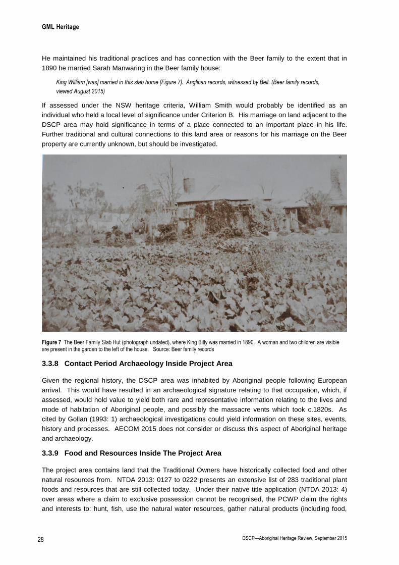
GML Heritage
DSCP—Aboriginal Heritage Review, September 2015 28
He maintained his traditional practices and has connection with the Beer family to the extent that in
1890 he married Sarah Manwaring in the Beer family house:
King William [was] married in this slab home [Figure 7]. Anglican records, witnessed by Bell. (Beer family records,
viewed August 2015)
If assessed under the NSW heritage criteria, William Smith would probably be identified as an
individual who held a local level of significance under Criterion B. His marriage on land adjacent to the
DSCP area may hold significance in terms of a place connected to an important place in his life.
Further traditional and cultural connections to this land area or reasons for his marriage on the Beer
property are currently unknown, but should be investigated.
Figure 7 The Beer Family Slab Hut (photograph undated), where King Billy was married in 1890. A woman and two children are visible are present in the garden to the left of the house. Source: Beer family records
3.3.8 Contact Period Archaeology Inside Project Area
Given the regional history, the DSCP area was inhabited by Aboriginal people following European
arrival. This would have resulted in an archaeological signature relating to that occupation, which, if
assessed, would hold value to yield both rare and representative information relating to the lives and
mode of habitation of Aboriginal people, and possibly the massacre vents which took c.1820s. As
cited by Gollan (1993: 1) archaeological investigations could yield information on these sites, events,
history and processes. AECOM 2015 does not consider or discuss this aspect of Aboriginal heritage
and archaeology.
3.3.9 Food and Resources Inside The Project Area
The project area contains land that the Traditional Owners have historically collected food and other
natural resources from. NTDA 2013: 0127 to 0222 presents an extensive list of 283 traditional plant
foods and resources that are still collected today. Under their native title application (NTDA 2013: 4)
over areas where a claim to exclusive possession cannot be recognised, the PCWP claim the rights
and interests to: hunt, fish, use the natural water resources, gather natural products (including food,

GML Heritage
DSCP—Aboriginal Heritage Review, September 2015 29
medicinal plants, timbre, stone, ochre and resin) according to traditional laws and customs, cultivate
and harvest native flora according to traditional laws and customs.
Mr Franks provided some details on the collection of foods and resources from the DSCP by his
family:
Around the Drayton (DSCP area) to Appletree area—there were berries, gose-berries, rock lilies have a vanilla smell,
Uncle Clyde would take us, and sing ‘spring time in the rockys’. Out at Drayton, Baiame made the firefly, so that our
people could see the fruit coming on, before the bird could get them.
He [Uncle Clyde] would go at night, make a fire, sit up and look. He would say ‘the fire fly will show me, cause Baiame
made them.’ In the morning he would walk right up to the fruit trees. It was the birds food, but we were allowed to eat
it. Uncle Clyde would always keep seeds, and drop some in the ground as he walked.
We were not allowed to touch koala, or eat a catfish. Catfish clean the creek too. They build a nest in the water. You
will see a cylindrical rock formation, the catfish will clean the nest and lay eggs. In 10m sq you will find 10 cat fish and
they protect their nests.
Dad and my uncle Clyde would trade in pelts, foxes rabbit roo skins, old Ashley used to skin sugar gliders and sell the
skins to a shop in scone.
3.3.10 Views and Connection Across Country
Further to those described in Section 3.2.16, the DSCP area is likely to have view corridors associated
with the historical cultural landscape, both Aboriginal and non-Aboriginal. An analysis of this
landscape and its views is beyond the scope of this report. In the least the connections are likely to
exist between the following themes: Aboriginal post-European contact heritage (as identified by this
report), the pattern of land grants and the alignment of Eddington Road, local farming and its
landscape, the history of horse husbandry and the numerous horse studs located to the south of the
proposed DSCP area.
3.3.11 Laws and Customs
Further to comments in Section 3.2.17, the PCWP have commented on their adherence to traditional
laws and customs since European arrival:
Despite the extensive violence visited upon the Wonnarua People at the hands of European settlers… the PCWP and
their ancestors were able to stay on or close to the territory of their forebears at and around the Hunter River and the
broader Singleton (Patricks Plains) region. They inherited a wide range of laws and customs about its walking tracks,
ceremonial places, stories and how to hunt and gather there, which have been continually practiced there over the
generations since settlement. NTDA 2013: Attachments F pp3.
Mr Franks provided the following statement relating to learning his laws and customs on Country:
“I took a lot of this for granted because it was just growing up in the bush. We were being taught; it wasn’t sit down and
learnt, you were taught by learning in the bush. It was for survival. We lived in the bush and headed to the mountains.
The walking around the scrub, was a cleansing purpose for Ashley and Uncle Clyde, and my dad. It was a way of
showing respect and checking, keeping the pathways open. Uncle Clyde, he would turn up 4-5 times a year and tell
you to go, and off you went. Mum used to get worried, but you had to go. It was never that he wanted company, he
was telling things and teaching you. Sometimes he never stopped talking, you couldn’t absorb any more, he knew
when you had switched off and would come back to them.” Scott Franks, 10 August 2015

GML Heritage
DSCP—Aboriginal Heritage Review, September 2015 30
4.0 Summary and Conclusion
4.1 Summary of Known and Potential Heritage Items
This report has found the region and DSCP area includes 26 inter-related, Aboriginal cultural aspects
and/or places (as defined by the Burra Charter). Of the 26 cultural heritage aspects/places, the project
EIS has identified nine, and provided an impact assessment for two.
Table 2 details the 26 Aboriginal cultural aspects and/or places and how they have been considered by
the DSCP EIA.
Table 2 Details of the 26 Aboriginal cultural heritage aspects and places identified as relevant to the DSCP area and whether these
were identified in AECOM 2015 and subject to a consequential impact assessment.
# Cultural Aspects/Places Detailed and/or Assessed Under the Project EIA (AECOM
2015)
Has the Impact
Assessed by the
Project EIA (AECOM
2015)?
1 Hungary Hill Tribe No No
2 Land dispossession Section 6.7 (detail only)
“The destruction, over time, of the complex systems of social
and territorial organisation that existed prior to contact has
likewise been attributed to such factors [land dispossession],
as has the collapse of traditional settlement and subsistence
regimes.
Today, modern Awabakal, Wonnarua and Worimi people
retain strong cultural connections to the Hunter Valley and are
actively involved in the protection and promotion of their
culture for future generations.”
No
3 Merton ‘District’ and Mount
Arthur
Section 8.4.1 (values assessment)
“In terms of Aboriginal cultural landscape, the Mount Arthur
landscape will include its immediate surrounds, its views,
vistas, and associated landscape features. The study area is
within the visual extent of the Mount Arthur landscape, with
views of the mountain available from several locations within
the study area, particularly north facing hillslopes and crests.
The principal landscape feature associated with the Mount
Arthur landscape and the study area is Saddlers Creek, which
is close to its northern boundary….
In field discussions between stakeholders and AECOM
archaeologists have indicated the importance of viewing the
study area in context that is, as a part of a broader cultural
landscape incorporating Saddlers Creek and more broadly
Mount Arthur.”
No
4 Jackey Jackey No No
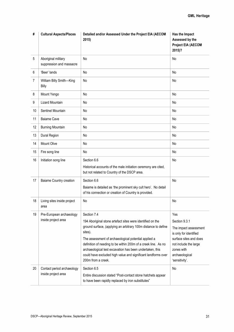
GML Heritage
DSCP—Aboriginal Heritage Review, September 2015 31
# Cultural Aspects/Places Detailed and/or Assessed Under the Project EIA (AECOM
2015)
Has the Impact
Assessed by the
Project EIA (AECOM
2015)?
5 Aboriginal military
suppression and massacre
No No
6 ‘Beer’ lands No No
7 William Billy Smith—King
Billy
No No
8 Mount Yengo No No
9 Lizard Mountain No No
10 Sentinel Mountain No No
11 Baiame Cave No No
12 Burning Mountain No No
13 Dural Region No No
14 Mount Olive No No
15 Fire song line No No
16 Initiation song line Section 6.6
Historical accounts of the male initiation ceremony are cited,
but not related to Country of the DSCP area.
No
17 Baiame Country creation Section 6.6
Baiame is detailed as ‘the prominent sky cult hero’. No detail
of his connection or creation of Country is provided.
No
18 Living sites inside project
area
No No
19 Pre-European archaeology
inside project area
Section 7.4
194 Aboriginal stone artefact sites were identified on the
ground surface, (applying an arbitrary 100m distance to define
sites).
The assessment of archaeological potential applied a
definition of needing to be within 200m of a creek line. As no
archaeological test excavation has been undertaken, this
could have excluded high value and significant landforms over
200m from a creek.
Yes
Section 9.3.1
The impact assessment
is only for identified
surface sites and does
not include the large
zones with
archaeological
‘sensitivity’.
20 Contact period archaeology
inside project area
Section 6.5
Entire discussion stated “Post-contact stone hatchets appear
to have been rapidly replaced by iron substitutes”
No

GML Heritage
DSCP—Aboriginal Heritage Review, September 2015 32
# Cultural Aspects/Places Detailed and/or Assessed Under the Project EIA (AECOM
2015)
Has the Impact
Assessed by the
Project EIA (AECOM
2015)?
21 Food and resources inside
the project area
Section 6.4
Details some food consumed by Aboriginal people in the
Hunter Valley.
No
22 Regional archaeological
sites
Section 5—focuses on stone artefact sites, but does not
examine the pattern of Aboriginal landuse at the regional level.
Section 10—the impact assessment uses the AHIMS register
to identify 2678 recorded Aboriginal sites in a 30km by 30km
region around the DSCP area. States that 154 sites inside the
DSCP will be impacted by the DSCP, representing 5.9% of
regional archaeology.
It was stated “Consideration of the above data suggests that
the loss of the 154 open artefact sites in question would not
constitute a significant adverse impact to the identified
Aboriginal heritage resource of the region.”
Yes
Impacts to identified
stone artefact sites are
discussed in Section 10.
No impact assessment to
non-stone sites or any
area with archaeological
potential.
23 Boundaries of Country No No
24 View, travelling routes and
connection across Country
Views—Section 8.4.1
Considered in the context of Mount Arthur only (refer above)
No
25 Laws and customs No No
26 Caring for Country No No
4.2 Statement of Potential Impact To and Effects On Aboriginal Heritage
The DSCP EIA (and Aboriginal heritage assessment by AECOM 2015) has not considered a number
of publically available resources which clearly state and map Aboriginal cultural values across the
region, including the project area—see Gollan 1993 and Tocomwall 2013.
It is clear that Aboriginal heritage values exist in connection to the DSCP area—these values extend
considerably beyond the stone artefact sites and areas of Aboriginal archaeological potential identified
by AECOM 2015. To date the majority of these heritage values have not been identified, assessed or
subject to an assessment of how the value would be changed, altered, or otherwise impacted by the
proposed DSCP.
During the preparation of this document, the PCWP expressed great concern that to-date the DSCP
area has primarily considered Aboriginal heritage through the prism of Aboriginal archaeology, giving
little regard to the non-scientific values. The PCWP made representation to Hansen Bailey during the
initial EA process, however, the oral information supplied was not referenced in the EIA (pers comm.
Scott Franks September 2015).
With reference to mining in the Hunter Valley and its impact on song lines, the PCWP state:
The development of the infrastructure for the mine in question will in fact and prevent our people from accessing the
song line, destroying the song line that runs within it. This is against Wonnarua law, the area needs to be protected and

GML Heritage
DSCP—Aboriginal Heritage Review, September 2015 33
before any more country in the Hunter Valley is destroyed by mining. Wonnarua people have very little of their
traditional country left intact, in the Hunter Valley. (NTDA 2013: 0035) [This was in reference to another Coal mine,
PCWP have stated this comment equally applies to the DSCP]
Mrs Maria Stocks (PCWP) commented on historical land use by non-Aboriginal people and current
impacts of mining on Aboriginal culture:
From my viewpoint it is a terrible thing that these actions of white people took away the human rights, dignity and
culture of some Aboriginal members of our community. They simply did not want to identify as Aboriginal because, at
least from their perspective, if you did you got no respect. What’s worse is that now 50-60 years down the track more
of our culture, and our special spots are being taken away as they dig it all up with the mines. Places like grinding
groove sites, fishing spots, ceremonial areas, story places, ancestral tracks, birth places, ‘natural hospital areas’,
spiritual places and prayer spots, are all being destroyed. (NTDA 2013: 0091)
Mrs Stocks described the impact mining had had on her and her culture:
For me and my family the land is not ours but a gift given to use to use because everything comes from the land….
When Annastazia and Jeremiah (my two youngest children) were about eight I took them for a drive to show them
about Glennies Creek where I grew up, rode horses and motorbikes and went fishing. When I got there I just gasped
and went “aargh’ because there was nothing to see. It was all gone. There was [a] big hole from mining. I sat there
and tears rolled down my cheeks. I couldn’t show my children anything. It was like a part of me had been deleted.
(NTDA 2013: 0091)
4.3 Key Findings
With reference to the DSCP area, the anthropological and traditional evidence summarised and cited
in the referred documents, and Sections 2 and 3 above, coupled with the Aboriginal archaeological
evidence (AECOM 2015: Figures 9 and 10), clearly demonstrate the PCWP have a long standing
connection in terms of occupation and use of the land and that the region contains numerous places
and values of cultural significance. The connections described extend back thousands of years and
continue to the present day.
The project’s EIA SEARs are yet to be achieved because:
there has been an absence of consultation with the PCWP;
the Burra Charter process has not been followed, with an absence of assessment considering
the cultural significance of the region, compatible land use, setting, social and aesthetic values;
and
a program of archaeological test excavation is required and this has not been undertaken.
This report finds that the Aboriginal heritage assessment component of the EIA has not considered the
impact of the DSCP on PCWP traditions or culture, heritage or connection to Country (Table 2). The
Aboriginal archaeological and cultural heritage assessment (AECOM 2015) has not considered the
value of, or impacts to, 25 of the 27 cultural heritage aspects identified in this report (Table 2).
The key finding in this report is that an accurate, comprehensive and adequate assessment of the
PCWP’s Aboriginal heritage values and assessment of Aboriginal heritage impact to Aboriginal values
has not been undertaken.
In heritage conservation, it is accepted professional practice that investigations and amendment must
be undertaken prior to decisions being made. This practice ensures that there are no unintended
impacts on significance cultural values. Given that the Aboriginal heritage values have not been fully

GML Heritage
DSCP—Aboriginal Heritage Review, September 2015 34
assessed as part of the EIA process, the potential impacts on Aboriginal cultural heritage within and in
the vicinity of the DSCP are unable to be determined at this time.