draft 2006 state forest management plan - michigan
TRANSCRIPT

Great Lakes, Great Times, Great Outdoors www.michigan.gov/dnr
Draft 2006 State Forest Management Plan
Michigan Department of Natural Resources Forest, Mineral and Fire Management
IC 4600 (07/24/2006)

2
MICHIGAN DEPARTMENT OF NATURAL RESOURCES MISSION STATEMENT
"The Michigan Department of Natural Resources is committed to the conservation, protection, management, use and enjoyment of the State's natural resources for current and future generations."
NATURAL RESOURCES COMMISSION STATEMENT
The Natural Resources Commission, as the governing body for the Michigan Department of Natural Resources, provides a strategic framework for the DNR to effectively manage your resources. The NRC
holds monthly, public meetings throughout Michigan, working closely with its constituencies in establishing and improving natural resources management policy.
The Michigan Department of Natural Resources provides equal opportunities for employment and access to Michigan's natural resources. Both State and Federal laws prohibit discrimination on the basis of race, color, national origin, religion, disability, age, sex, height, weight or marital status under the U.S. Civil Rights Acts of 1964 as amended, 1976 MI PA 453, 1976 MI PA 220, Title V of the Rehabilitation Act of 1973 as amended, and the 1990 Americans with Disabilities Act, as amended.
If you believe that you have been discriminated against in any program, activity, or facility, or if you desire additional information, please write: Human Resources, Michigan Department of Natural Resources, PO Box 30028, Lansing MI 48909-7528, or Michigan Department of Civil Rights, Cadillac Place, 3054 West Grand Blvd, Suite 3-600, Detroit, MI 48202, or Division of Federal Assistance, U.S. Fish and Wildlife Service, 4401 North Fairfax Drive, Mail Stop MBSP-4020, Arlington, VA 22203
For information or assistance on this publication, contact the Forest Resource Management Section, Forest, Mineral & Fire Management, Michigan Department of Natural Resources, P.O. Box 30452, Lansing, MI 48909-7952.
This publication is available in alternative formats upon request.
This information is available in alternative formats.
Printed By Authority of: The Michigan Department of Natural Resources Total Number Of Copies Printed
50 Total Cost:$ 1648.92 Cost Per Copy:$ 32.98
3
TABLE OF CONTENTS
Table of Contents ......................................................................................................................... 3 Table of Figures............................................................................................................................ 5 Table of Tables ............................................................................................................................. 6 Table of Appendices .................................................................................................................... 7 Executive Summary..................................................................................................................... 8 1 – COMPONENTS OF THE STATE FOREST PLAN......................................................... 11
1.1 - Purpose & Use of the Plan .......................................................................................... 11 1.2 - Plan Organization and Relationship to Other Plans ................................................ 11 1.3 - Plan Communications, Implementation & Review Requirements ......................... 12 1.4 – Mission, Vision and Strategic Goals for DNR-Managed Forest Lands................ 13
1.4.1 - DNR Mission and Vision for the State Forest.................................................... 13 1.4.2 - DNR Strategic Goals ............................................................................................. 13
1.5 –DNR State Forest Land Management System ......................................................... 14 1.6 - Use of Criteria and Indicators...................................................................................... 16 1.7 – Statewide Ownerships and Management Unit Boundaries ................................... 17
2 - FOREST HISTORY.............................................................................................................. 19 2.1 - Pre-European Settlement History (Glaciation to 1800’s)........................................ 19 2.2 - Post-European Settlement History (1600’s to 1900) ............................................... 25 2.3 - Contemporary History (1900 to the present) ............................................................ 28
3 - CURRENT FOREST CONDITIONS, USES AND TRENDS ......................................... 32 3.1 - General Land Cover and Forest Resource Base..................................................... 34
3.1.1 - State-wide Forest Conditions and Trends ......................................................... 34 3.1.2 - DNR-Owned Forest Land Conditions and Trends............................................ 43 3.1.3 - Timber Harvest Trends ......................................................................................... 58
3.2 - Forest Health Conditions and Trends ........................................................................ 64 3.3 - Wildlife Habitat Conditions and Trends ..................................................................... 75
3.3.1 - Forested Habitats................................................................................................... 75 3.3.2 - Grasslands .............................................................................................................. 81 3.3.3 - Wetlands ................................................................................................................. 81
3.4 - Water and Fisheries Conditions and Trends ............................................................ 82 3.5 - Socioeconomic Context - Human Uses and Trends ............................................... 83
3.5.1 Timber Production.................................................................................................... 83 3.5.2 Oil, Gas and Mineral Production............................................................................ 85 3.5.3 Forest Recreation and Tourism ............................................................................. 86 3.5.4 Public Research and Education............................................................................. 89
4 - STATEWIDE MANAGEMENT DIRECTION..................................................................... 89 4.1 – Desired Future Conditions, Goals, Objectives, Standards and Guidelines ........ 89
4.1.1 - Recreation Management ...................................................................................... 90 4.1.1.1 – Boating and Fishing Access Sites and Marinas/Harbors ........................ 90 4.1.1.2 – Recreational Trails ......................................................................................... 91 4.1.1.3 – State Forest Campgrounds .......................................................................... 93 4.1.1.4 – Hunting, Trapping, Fishing and Other Dispersed Recreation ................ 93 4.1.1.5 – Areas Managed for Hunting ......................................................................... 95

4
4.1.1.6 - Visual Management ....................................................................................... 96 4.1.2 - Vegetation Management....................................................................................... 97
4.1.2.1 - Biodiversity ...................................................................................................... 97 4.1.2.2 – Forest Resources .......................................................................................... 99 4.1.2.3 - Wildlife ............................................................................................................ 104 4.1.2.4 - Fisheries......................................................................................................... 106 4.1.2.5 - Rare Communities........................................................................................ 107
4.1.3 - Watershed Management .................................................................................... 108 4.1.3.1 - Soil Resources .............................................................................................. 108 4.1.3.2 - Riparian Areas & Wetlands ......................................................................... 109
4.1.4 – Rare Species ....................................................................................................... 111 4.1.4.1 - Federal and State Threatened and Endangered Species ..................... 111 4.1.4.2 – Species of Special Concern....................................................................... 113
4.1.5 - Land Ownership and Use Management........................................................... 115 4.1.5.1 - Easements ..................................................................................................... 115 4.1.5.2 - Use Permits and Surface Lease Uses ...................................................... 116 4.1.5.3 - Acquisition and Disposal ............................................................................. 116 4.1.5.4 - Boundary Designation and Signage .......................................................... 117
4.1.6 - Minerals & Geology ............................................................................................. 117 4.1.6.1 – Oil, Gas and Metallic and Non-Metallic Mineral Development............. 117 4.1.6.2 - Unique Geologic Formations ...................................................................... 119
4.1.7 - Forest Pest Management ................................................................................... 120 4.1.7.1 – Insects and Disease.................................................................................... 120 4.1.7.2 - Invasive Species........................................................................................... 122
4.1.8 - Fire Management ................................................................................................. 123 4.1.8.1 - Fuel Management......................................................................................... 123 4.1.8.2 - Prescribed Fire.............................................................................................. 124 4.1.8.3 - Fire Prevention.............................................................................................. 125 4.1.8.4 - Fire Suppression........................................................................................... 125
4.1.9 - Transportation System ........................................................................................ 127 4.1.9.1 - Road Maintenance ....................................................................................... 127 4.1.9.2 - Road Closure ................................................................................................ 128 4.1.9.3 – New Roads ................................................................................................... 129
4.1.10 - Law Enforcement ............................................................................................... 130 4.1.10.1 – General Law Enforcement ....................................................................... 130 4.1.10.2 - Contract Enforcement................................................................................ 131 4.1.10.3 - Trespass ...................................................................................................... 132
4.1.11 - Governmental and Stakeholder Relations ..................................................... 133 4.1.11.1 - Tribal............................................................................................................. 133 4.1.11.2 – Federal and Local Government............................................................... 134 4.1.11.3 - Non-Governmental Organizations ........................................................... 135
4.1.12 – Research and Education................................................................................. 137 4.1.13 – Department Administration.............................................................................. 138
5 - SPECIAL RESOURCE AREA MANAGEMENT DIRECTION ..................................... 139 5.1 - Special Conservation Areas ...................................................................................... 140
5.1.1 – Proposed/Nominated Natural Areas ................................................................ 140
5
5.1.2 – National Natural Landmarks.............................................................................. 141 5.1.3 – Potential Old Growth Areas............................................................................... 142 5.1.4 – Trout Streams and Trout Lakes ........................................................................ 143 5.1.5 – Springs, Wetlands, and Riparian Areas .......................................................... 144 5.1.6 - Large Landscape-Level Forests ........................................................................ 145 5.1.7 - Habitat Areas and Corridors............................................................................... 147 5.1.8 - Archaeological Sites ............................................................................................ 147 5.1.9 - Cultural and Customary Use Areas .................................................................. 148 5.1.10 - Visual Management Areas ............................................................................... 149 5.1.11 – Concentrated Recreation Areas ..................................................................... 150 5.1.12 - Mineral Resource Areas ................................................................................... 150 5.1.13 – Great Lakes Islands ......................................................................................... 151 5.1.14 – Contiguous Resource Areas ........................................................................... 152
5.2 - High Conservation Value Areas (HCVAs)............................................................... 153 5.2.1 – Legally Dedicated Natural Areas, Wilderness or Wild Areas....................... 153 5.2.3 - Natural Rivers ....................................................................................................... 154 5.2.4 - Critical Dunes ....................................................................................................... 155 5.2.5 - Dedicated Species Recovery Areas ................................................................. 157 5.2.6 - Dedicated Management Areas .......................................................................... 158 5.2.7 – Environmental Areas .......................................................................................... 158 5.2.8 - Biodiversity Stewardship Areas ......................................................................... 159
5.3 - Ecological Reference Areas (ERAs) ........................................................................ 161 6 - MONITORING, REVIEW & REVISION ........................................................................... 161
6.1 - Management Review System ................................................................................... 161 6.2 - Plan Monitoring ............................................................................................................ 162 6.3 - Plan Revision ............................................................................................................... 163
7 - APPENDICES ..................................................................................................................... 164 9 – LITERATURE CITED........................................................................................................ 217
TABLE OF FIGURES
Figure 1.1. A comparison of Management Strategies.................................................................. 15 Figure 1.2. Michigan’s Public Lands............................................................................................. 18 Figure 2.1. Regional Landscapes Ecosystems of Michigan. ....................................................... 20 Figure 2.2. Vegetation of Michigan circa 1800............................................................................. 20 Figure 2.2 Vegetation of Michigan circa 1800............................................................................. 21 Figure 2.3. Circa 1800 Landscape Cover Types......................................................................... 23 Figure 2.4. Area of Michigan Timberland by Ownership.............................................................. 31 Figure 3.1. Acreage and Volume of Michigan Forest from 1935-2003........................................ 34 Figure 3.2. Volume of Michigan Timber Growth and Removals for 1955 – 2003. ...................... 35 Figure 3.3. Land Cover of Michigan circa 2000. .......................................................................... 36 Figure 3.3 Land Cover of Michigan circa 2000. .......................................................................... 37 Figure 3.4. Acreage of circa 2000 Landscape Communities...................................................... 38 Figure 3.5. Area of commercial timberland by forest type group for 1935-2003. ....................... 38 Figure 3.6. Acreage of State Forest timber sold from 1944 to 2004........................................... 58 Figure 3.7. Volume of State Forest timber sold (cords) from 1945 to 2004. ............................... 58 Figure 3.8. Quarantined counties in Michigan with emerald ash borer populations in 2005. ..... 65
6
Figure 3.9. Extent of Beech Bark Disease in Michigan in 2005.................................................. 67 Figure 3.10. Extent of Eastern Larch Beetle in Michigan in 2005................................................ 68 Figure 3.11. Extent of Gypsy Moth in Michigan in 2005. ............................................................ 69 Figure 3.12. Counties in Michigan with oak wilt in 2005. ............................................................. 70 Figure 3.13. Extent of Jack Pine Budworm in Michigan in 2005. ............................................... 71 Figure 3.14. Extent of Spruce Budworm in Michigan in 2005..................................................... 72 Figure 3.15. Extent of Giant Hogweed in Michigan in 2005........................................................ 74 Figure F1. FMFM State Forest Management Units and Ecoregions........................................ 191 Figure F2. Wildlife Division Management Units. ........................................................................ 192 Figure F3. Fisheries Division Management Units. ..................................................................... 193 Figure F4. Parks and Recreation Division Management Districts............................................. 195 Figure F5. Law Enforcement Division Districts.......................................................................... 196
TABLE OF TABLES
Table 2.1. Circa 1800 Cover types by acreage and percent relative cover................................. 23 Table 2.2. Frequency of Association of Tree Species with Upland Landforms in the Northern
Lower Peninsula prior to European Settlement.................................................................... 24 Table 3.1. Hierarchy of Ecological Units. ..................................................................................... 33 Table 3.2. Change in acreage of forestland from circa 1800 to circa 2000................................ 39 Table 3.3. Volume of growth, mortality and removals by forest type in Michigan. ..................... 40 Table 3.4. Change in acreage by cover type of State Forest Land for 1988-2006. .................... 44 Table 3.5. Change in Cover Type circa 1800 to 2006 by acreage and relative cover. ............... 45 Table 3.6. Acreage of aspen size classes and stocking on State Forest Land for 1988 and
2006. ..................................................................................................................................... 45 Table 3.7. Acreage of primary understory types by deciduous cover type for 2006. ................. 46 Table 3.8. Volume of growth, mortality and removals by forest type on State Forest Land for
2003. ..................................................................................................................................... 47 Table 3.9. Acreage of northern hardwoods size classes and stocking on State Forest Land for
1988 and 2006. ..................................................................................................................... 48 Table 3.10. Acreage of basal area stocking of Northern Hardwoods on State Forest Land for
1988-2006. ............................................................................................................................ 48 Table 3.11. Acreage of primary understory types by conifer cover types for 2006. ................... 49 Table 3.12. Acreage of Jack Pine size classes and stocking on State Forest Land for 1988 and
2006. ..................................................................................................................................... 50 Table 3.13. Acreage of Red Pine size classes and stocking on State Forest Land for 1988 and
2006. ..................................................................................................................................... 51 Table 3.14. Acreage of Mixed Swamp Conifers size classes and stocking on State Forest Land
for 1988 and 2006. ................................................................................................................ 52 Table 3.15. Acreage of Oak size classes and stocking on State Forest Land for 1988 and 2006.
............................................................................................................................................... 53 Table 3.16. Acreage of Northern White Cedar size classes and stocking on State Forest Land
for 1988 and 2006. ................................................................................................................ 54 Table 3.17. Acreage of White Pine size classes and stocking on State Forest Land for 1988
and 2006. .............................................................................................................................. 55 Table 3.18. Acreage of Hemlock size classes and stocking on State Forest Land for 1988 and
2006. ..................................................................................................................................... 56 Table 3.19. Volume of timber sales of major cover types from 1997 to 2005. ........................... 59 Table 3.20. Volume of timber sales of minor cover types from 1997 to 2005. ........................... 60 Table E1. Tiered C&I Metrics...................................................................................................... 185
7
Table G-1. 2006 Northern Lower Peninsula Ecoregion Forest Types by Management Unit. .. 198 Table G-2. 2006 Eastern Upper Peninsula Ecoregion Forest Types by Management Unit. ... 199 Table G-3. 2006 Western Upper Peninsula Ecoregion Forest Types by Management Unit. .. 200
TABLE OF APPENDICES
Appendix A – Sustainable Forestry Act...................................................................................... 164 Appendix B - Excerpts of planning principles from the FSC Standards.................................... 167 Appendix C - Excerpts of planning objectives from the SFI Standards..................................... 171 Appendix D - List of DNR Forest Certification Work Instructions (8-09-05) .............................. 173 Appendix E – Core set of Statewide Criteria and Indicators...................................................... 174 Appendix F – DNR Management Unit Boundaries .................................................................... 191 Appendix G – Forest Type Composition of DNR Forest Land by Ecoregion. ........................... 198 Appendix H – Age Class Distributions by Forest Type on DNR Forest Land. .......................... 201 Appendix I – Michigan’s Natural Communities........................................................................... 206
8
EXECUTIVE SUMMARY
A primary objective for the landscape of northern Michigan during the 20th century was to restore the forest resource that was devastated during the over-exploitation in the late 19th century. This restoration has laid the basis for a rich array of opportunities for our forests in the 21st century. In 2006, Michigan’s forests are healthy and still growing, with many options for future uses. There are multiple objectives for our forests, including continuing with utilization and restoration within a framework of long-term sustainability, while also enabling an expanding diversity of uses. This plan is intended to focus upon the future management and use of one large part of Michigan’s forest resources: the State Forest system administered by the Michigan Department of Natural Resources. Part 525, Sustainable Forestry on State Forestlands, of the Natural Resources and Environmental Protection Act, 1994 PA 451, as amended, requires the Michigan Department of Natural Resources (DNR) to manage the State Forest in a manner that is consistent with the principles of sustainable forestry, and to prepare and implement a management plan that states long-term management objectives and the means of achieving these objectives. Components of the management plan include:
1. Identification of the interests of local communities, outdoor recreation interests, the tourism industry, and the forest products industry, which are addressed in Section 3 of the plan.
2. Identification of the annual production capability of the state forest and management goals based on that level of productivity, which are addressed in Sections 3, 4 and 5 of the plan.
3. Methods to promote and encourage the use of the state forest for outdoor recreation, tourism, and the forest products industry, which are addressed in Sections 3, 4 and 5 of the plan.
4. A landscape management plan for the state forest incorporating biodiversity conservation goals, indicators, and measures, which are addressed in Sections 4 and 5 of the plan.
5. Standards for sustainable forestry consistent with section 52502 of Part 525, Sustainable Forestry on State Forestlands, of the Natural Resources and Environmental Protection Act, 1994 PA 451, as amended, which are addressed in Sections 4 and 5 of the plan.
6. Identification of environmentally-sensitive areas, which is addressed in Section 5 of the plan.
7. Identification of the need for forest treatments to maintain and sustain healthy, vigorous forest vegetation and quality habitat for wildlife and environmentally sensitive species, which are addressed in Sections 4 and 5 of the plan.
Part 525 also required the DNR to seek and maintain third party certification of the management of the State Forest that satisfies sustainable forestry standards of at least one credible certification program. Subsequently, the DNR was certified under the standards of the Forest Stewardship Council (FSC) and the Sustainable Forestry Initiative (SFI). These standards require the DNR to write, implement, and maintain forest management plans. This 2006 State Forest Management Plan (SFMP), in conjunction with ecoregional management plans that are under development, is intended to achieve these planning requirements. The drafting of these plans are joint efforts by the DNR Forest, Mineral and Fire Management; Wildlife; Fisheries; Law Enforcement; and Parks and Recreation Divisions. The final approval authority of this document is the Director of the DNR.
9
The SFMP plan contains six major sections and three additional sections for appendices, a glossary and citation of literature. Section 1 begins with a discussion of the purpose and use of the planning process. The plan outlines approaches for implementing landscape ecosystem management, with a deliberate, multi-level and integrated approach to planning. This will provide centralized strategic planning and direction at both statewide and eco-regional levels, and also facilitates decentralized tactical planning at the Forest Management Unit level. When used with other plans, inventories and projects, it will provide multi-dimensional biological and social-economic data to forest managers, which will help shape management options. Section 1 also discusses the organization of the plans and its relationship to other DNR plans, plan communication and implementation, and DNR Strategic goals. Section 1 concludes with a description of the State Forest land management system, a discussion on the use of criteria and indicators in forest monitoring, and a discussion of divisional management unit boundaries on a statewide basis. Section 2 of the plan discusses the history of forests in Michigan and the genesis of the present State Forest system. To provide the backdrop for present management it is helpful to have an understanding of the composition, structure and natural ecological processes that were evident in the natural plant and animal communities that existed throughout the State prior to European settlement, and the condition of these communities following the subsequent period of large-scale extraction of the State’s natural resources in the late 19th and early 20th centuries. The present landscape of the State is a legacy of this period of resource extraction and, therefore, has direct bearing upon strategies employed in the present management of our natural plant and animal resources. These legacies include the recovery of the terrestrial landscape from deforestation, the recovery of aquatic systems from severe erosion and disruption of natural hydrological cycles, and continuing perturbations upon animal populations driven by recovery and change of habitat conditions. It is also important to understand the history of social and economic values that were, and continue, to be associated with the natural resources of the State. The extraction of natural resources in the form of timber and minerals was a dominant socio-economic system of northern Michigan in the late 19th and early 20th centuries. The collapse of the timber industry following the deforestation of the State (accompanied by a decline of mining industries) has now transitioned to a recovery of forest resources and more diversified and sustainable timber and recreation sectors. This recovery has occurred at different rates and degrees in different regions of the State. An understanding of history sets the stage for Section 3 of the plan which describes the current forest conditions and trends from the perspective of the forest resource, forest health, wildlife habitat, water and fish habitat, and socioeconomic or human uses – including timber production, wildlife habitat, oil, gas and mineral production, recreation and tourism, and research and education. Recent State Forest average harvests have been close to 52,000 acres per year, with a 20-year average of around 700,000 cords per year. Timber harvest trends differ by species, but have predominantly occurred in five cover types: aspen, jack pine, oak, red pine and northern hardwoods. Some significant trends can be noted since the mid-1990s for aspen, northern hardwoods, red pine, white pine and mixed swamp conifers. The number of acres of aspen sold gradually decreased after 1997 and reached a low in 2003. Throughout this period, aspen volumes per acres remained steady at close to 20 cords per acre. Volume of production from the northern hardwoods, red pine and white pine cover types have consistently increased since 1996. In contrast, production from mixed swamp conifers has dropped off sharply beginning in 2001, in part reflecting changes in coding. Thus, the composition of timber sales has changed over the past decade, with the most significant change being more acres of

10
selectively-harvested upland hardwoods sold as the number of clearcut aspen acres declined. This tradeoff has resulted in less aggregate volume harvested. Major trends in forest health include more non-native plant and animal species and diseases, which are increasing threats to the health of the State’s forest ecosystems. These pose potential major ecological consequences for the composition of native forest communities and substantial economic impacts. Epidemic pathogens such as Dutch elm disease, the emerald ash borer and beech bark disease pose threats across the entire landscape of the state. Statewide management direction is provided in Sections 4 and 5 for a host of resource values and uses (such as recreation, vegetation and watershed management) to facilitate achievement of long-term desired future conditions for the State Forest, and to guide operational decisions regarding State Forest management. Section 4 contains specific goals and objectives that are required to achieve stated desired future conditions. Standards and guidelines are provided as tools to facilitate the achievement of goals and objectives. Applicable criteria and indicators are also provided for use in monitoring the progress toward the achievement of goals and objectives and the achievement of sustainable, ecosystem-based management of DNR-managed forestlands. The stated desired future conditions, goals and objectives are intended for reference by ecoregional planning teams in the development of ecoregional management plans. The goals and objectives are not absolute, but are what the DNR envisions as desirable and necessary to achieve desired future conditions. Resource limitations and unanticipated future conditions may constrain their achievement. Section 5 contains management direction, standards and guidelines for designated special resource areas, which are spatial representations of specific areas of the State Forest that possess and are managed for distinct conservation values. These areas include special conservation areas (such as trout streams and archaeological site), high conservation value areas (such as dedicated natural areas and critical dune areas), and ecological reference areas (high quality representations of natural communities). Ecoregional management plans will include more detailed descriptions of such areas that are specific to each region as well as maps of their locations. The plan concludes with Section 6, which describes the monitoring and management review processes that are required for assessing the effectiveness of management plans, and for incorporation of the results of monitoring into the revision and implementation of future management plans and procedures. This includes descriptions of an internal audit process, annual forest certification surveillance audits, and field management reviews. Included in appendices is the text of Part 525, excerpts of the FSC and SFI standards, and a list of DNR Forest Certification Work Instructions. Also in the appendices are a list of criteria and indicators for use in the monitoring of sustainable forest management, reference tables and graphs for section 3, detailed descriptions of divisional management units, and a list of Michigan’s natural communities. APPROVED BY THE DIRECTOR: Rebecca A. Humphries Date
11
1 – COMPONENTS OF THE STATE FOREST PLAN
1.1 - Purpose & Use of the Plan
In 2004, the State Legislature enacted Part 525, Sustainable Forestry on State Forestlands, of the Natural Resources and Environmental Protection Act, 1994 PA 451, as amended (Appendix A). As defined by Part 525, sustainable forestry means forestry practices that are designed to meet present and future needs by employing a land stewardship ethic that integrates the reforestation, managing, growing, nurturing, and harvesting of trees for useful products with the conservation of soil, air and water quality, wildlife and fish habitat, and visual qualities. To foster sustainable forestry upon land owned by the Michigan Department of Natural Resources (DNR), Section 52503 of Part 525 requires the DNR to adopt a forestry development, conservation, and recreation management plan for state-owned lands. A primary purpose of this plan is to improve the sustainable management of the State Forest while also meeting the requirements of Part 525.
Section 52505 of Part 525 also required the DNR to seek and maintain a third party certification of the management of the state forest that satisfies the sustainable forestry standards of at least one credible certification program. Certification was required by January 1, 2006. The DNR sought forest management certification under two standards:
1. The Regional Forest Stewardship Standard for the Lake States-Central Hardwoods Region (USA), as approved by the Forest Stewardship Council (FSC)-US Board on February 7, 2002, and accredited by FSC International on August 5, 2002. Initial FSC certification was granted to the DNR on December 31, 2005.
2. The Sustainable Forestry Initiative (SFI) 2005-2009 Standard as adopted by the Sustainable Forestry Board, Inc. on January 10, 2005. Initial SFI certification was granted to the DNR on December 14, 2005.
Principle 7 of the FSC standard and Objective 1 of the SFI standard requires the development and maintenance of a forest management plan (Appendix B and C respectively). The certification standards require strategic, long-term, landscape planning. Thus, another purpose of this document is to satisfy these certification requirements.
The last statewide forest resources plan for the DNR was approved by the Natural Resources Commission on November 5, 1982 and is effectively known as the Statewide Forest Resources Plan of 1983. This document will update that portion of the 1983 plan concerning DNR Forest Lands.
1.2 - Plan Organization and Relationship to Other Plans
The DNR currently has many plans, programs, and activities that address management of individual or multiple natural resource elements, flora, fauna, watersheds, and/or ecosystems. The number of programs and the geographic scale of the State Forest system precludes the integration of all these plans into a single comprehensive plan. So in lieu of a comprehensive plan the DNR operates under a suite of management plans that when considered as a whole form a compendium of planning initiatives that represent an over-arching management program for the state’s natural resources. A summary of these
12
planning processes and the plans themselves are available upon the DNR Forest Certification website. A subset of this suite of plans includes:
• The 2006 State Forest Management Plan
• Ecoregional Management Plans (Presently being drafted)
• The Annual Plan of Work for prescribed forest treatments.
• The Wildlife Action Plan
• Conservation Area Management Guidelines
• River Assessment and River Management Plans
• DNR Silvicultural Guidelines
• Annual Management Review
The key planning components that will guide forest operations are the first three documents: the 2006 State Forest Management Plan, Ecoregional Management Plans, and the Annual Plan of Work that is derived from the 10-year planning cycle for annual compartment reviews. Each of these planning components incorporates specific division goals and objectives into an integrated management direction. The other listed documents support the plans by providing more detailed planning and guidance for specific resource areas.
The 2006 State Forest Management Plan contains management direction that provides landscape-level desired future conditions (DFCs), goals, objectives, standards and guidelines for the sustainable management of the State Forest System. These are intended for reference and adaptation by Ecoregional Teams (Eco-Teams) for drafting specific ecoregional management plans. Ecoregional statements of desired future conditions, goals and objectives will be consistent with statewide direction. The desired future conditions and goals outlined in the SFMP are intended for reference by stakeholders, other governmental units, and partners throughout the state and for adaptation and implementation by the managers of other State-owned resources.
The Annual Plan of Work is operationally implemented by Operations Inventory and Compartment Review Procedures, as contained in FMFMD Policy and Procedure 441 dated January 19, 2000. Annual compartment reviews by year of entry are conducted at the Forest Management Unit (FMU) level, and these reviews represent the tactical level of planning for forest operations. Proposed forest treatments that are considered during compartment review will be guided by desired future conditions, goals and objectives contained in ecoregional management plans.
1.3 - Plan Communications, Implementation & Review Requirements
This plan shall be communicated to all DNR staff, and made available to the general public via the DNR internet web site or upon request.
The plan will be considered to be implemented upon the effective date of signature the Director of the Michigan Department of Natural Resources.
13
As discussed further in Chapter 6, this plan will be reviewed for revision every 10 years.
1.4 – Mission, Vision and Strategic Goals for DNR-Managed Forest Lands
1.4.1 - DNR Mission and Vision for the State Forest
In the context of public trust responsibilities that consider interests of all current and future citizens in the State’s natural resources, the DNR has adopted the following mission statement: The Department of Natural Resources is committed to the conservation, protection, management, use, and enjoyment of the State’s natural resources for current and future generations. The DNR has a vision of the desired future conditions of DNR-managed forest lands that is related to long-term management objectives. When these objectives are achieved the State Forest will:
1. Sustain fundamental ecological processes and functions that, in turn support representative, diverse, and productive biological assemblages.
2. Provide for a variety of ecosystem services that help sustain human civilization, including purification of air and water, carbon storage, provision of habitat and moderation of drought and flood conditions.
3. Provide for a variety of sustainable human values that are derived from ecosystems, including economic, recreational and intrinsic values.
1.4.2 - DNR Strategic Goals
The DNR sets forth the following long-term strategic goals to guide our steps towards sustainable, ecosystem-based management of DNR-managed forest lands: Ecological Goals Goal 1. Practice Sustainable, Ecosystem-based Management. Resource planning and operations shall be conducted to maintain the long-term integrity, representation, diversity, and productivity of terrestrial and aquatic ecosystems; with recognition of valued human activities and uses derived from these systems. Fundamental processes, functions, and values of ecosystems shall be protected or rehabilitated. In doing so, the following set of objectives shall be followed:
Objective 1.1 – Conserve Geophysical Processes. Emphasize conservation and rehabilitation of geo-physical processes such as soils formation, geomorphic sediment dynamics, carbon dynamics, hydrologic dynamics, and nutrient dynamics. Such processes are the foundation of the habitat conditions required to sustain desired biological assemblages. Objective 1.2 – Conserve Biodiversity. Encourage the management of intact, functional landscapes, ecosystems, and communities that will achieve the conservation of representative biological assemblages, including rare species; maintaining statewide biological diversity at ecosystem, species, and genetic levels.

14
Objective 1.3 – Maintain Biotic Productivity. Manage lands in a manner to protect, maintain, and rehabilitate ecosystem processes and habitats to ensure sustainable production of desired forest, wildlife, and fishery resources.
Social-Economic Goals Goal 2. Maintain Essential Ecosystem Services. – Resource planning and operations shall ensure the variety of ecosystem services. Goal 3. Sustain Social-Economic Values. – Resource planning and operations shall encourage the efficient and sustainable production of desired forest, mineral, wildlife, and fishery resources to provide a range of social and economic benefits. Goal 4. Provide Public Access. Resource planning and operations shall protect and preserve the natural, historic, and cultural features of DNR-managed lands while providing appropriate public access to these resources. In doing so, the following set of objectives shall be followed:
Objective 4.1 Provide Recreational Opportunities. Provide for a variety of active and passive recreational opportunities, tailored to specific local ecological and social characteristics. Objective 4.2 Provide Educational Opportunities. Provide public educational programs and opportunities that help build public understanding and appreciation for the important processes linking landscapes, ecosystems, habitats, and biological assemblages, and the human values and services derived from these natural systems. Objective 4.3 Allow for Cultural Uses. Allow for cultural uses by indigenous peoples and others.
1.5 –DNR State Forest Land Management System
Traditional sustained yield management of forests became prominent in the United States in the late 19th century, and was generally adopted as management strategy by the present DNR in the early 20th century. There are a broad range of benefits and values that people desire from the State’s natural resource base that are codified in plans, programs, and activities. Natural resources and human needs change over time - the challenge of natural resource management is to adapt and adjust plans and management activities to align with these changes while ensuring continued natural resource health into the future. The development and implementation of policies for sustainable resources is based on a number of overarching principles and approaches. These principles take a holistic view of resources, pursue multi-stakeholder engagement, plan for the long term, address local impacts, and promote sustainable development and uses.
To meet these challenges the DNR began a shift toward ecosystem management in the year 2000 for the planning and managing of Michigan’s natural resources. In contrast to traditional sustained yield management, ecosystem management is a process that integrates biological, social and economic factors into a comprehensive strategy aimed at

15
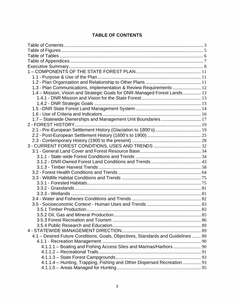
protecting and enhancing the sustainability, diversity and productivity of natural resources (Figure 1.1). The key objective of sustained yield management is the production of forest products for human needs under the constraint of the minimizing adverse environmental impacts. Ecosystem management differs in that it considers sustainable ecological processes themselves as the key objective and output which in turn governs the sustained yield of products for human uses. At the stand and compartment level this requires that FMU operations be integrally related to larger landscape and ecoregional considerations, whereby FMU operational decisions take into account landscape level concepts that are consistent with and support ecoregional and statewide goals and objectives. Some of the other differences between traditional sustained-yield and ecosystem management strategies were outlined by the Society of American Foresters in 1993 (Figure 1.1).
At the tactical level, ecosystem management is applied by Forest Management Units (FMUs), where operational decisions take into account landscape-level concepts that are consistent with and support ecoregional and statewide goals and objectives. FMUs are comprised of compartments, which are blocks of land that are 1,000-3,000 acres in size. An inventory process divides compartments into stands, generally ranging in size from 10-100 acres. Compartments are grouped by years-of-entry. Each year-of-entry contains approximately 10 percent of the compartments in a FMU. At the end of ten years, all of the compartments within an FMU will have been inventoried and reviewed.
Traditional Sustained-
yield Management Ecosystem Management
Objective Processes
Sustained flow of specific products to meet human needs,
constrained to minimize adverse effects .
Maintains ecological and desired forest condition within which the sustained-yield of
products to meet human needs are achieved.
Strategy for Accomplishment
Resembles the agricultural model.
Reflects patterns of natural disturbance.
System Character
Emphasizes production efficiency but within
environmental constraints.
Retains complexity and processes, provides
framework for the whole system.
Unit of Management Stands and
aggregations of stands within an ownership.
Landscapes and aggregations of landscapes across
ownerships.
Time Unit
Multi-rotations with rotation length
determined by land-owner objectives.
Multi-rotations with length reflecting natural disturbance,
although intensive management will cause some
to be shorter.
Current Status
In transition, new knowledge is bringing in new values. Remains a
valid strategy for portions of the
landscape.
Evolving, accepted for management on national and
state forest lands.
Figure 1.1. A comparison of Management Strategies.
(SAF, 1993)

16
The inventory and decision making process applied to compartments is governed by Forest Mineral and Fire Management Division Policy and Procedure No. 441, Operations Inventory and Compartment Review Procedures, dated January 19, 2000, which directs that inventory operations and associated compartment reviews be conducted using the “Operations Inventory Field Manual”.
Operations Inventory (O.I.) locates and identifies physical, biological, economic, and social information on each unit of land. It provides information for day-to-day operations relating to resource management issues such as timber, wildlife, forest recreation, water quality, reforestation, and land use. The O.I. system requires information that describes the composition of the stand, site factors, and a management prescription that supports State and Ecoregion goals and objectives for desired future conditions. In this process of integrated planning, it is critical that statewide and landscape level ecosystem considerations are incorporated in the development of management unit goals and objectives upon which compartment and stand prescriptions are then based. This is the primary means by which ecosystem-based management is achieved. Following a public open house, stand prescriptions are finalized at a multi-disciplinary compartment review to ensure a public and DNR-wide understanding of compartment and management unit goals.
As of 2005, the State Forest system is in the process of converting from O.I. to a new inventory system and GIS decision making environment known as, “Integrated Forest Monitoring, Assessment, and Prescription” (IFMAP). IFMAP’s design will facilitate multi-scaled, ecosystem-based decision making.
To facilitate the implementation of DNR management within the context of forest certification requirements, existing DNR policies and procedures for operational management have been supplemented by Forest Certification Work Instructions (Appendix D). These were written to allow the DNR to meet the requirements of sustainable forest management as defined in the SFI and FSC certification standards. A sub-set of these work instructions are directly pertinent to and is required to be used by field staff in the course of daily forest operations.
1.6 - Use of Criteria and Indicators
Criteria and Indicators (C&I) provide a framework for gathering data necessary for discussing the importance, status, and sustainability of forest management. Criteria define broad categories of capacity, goals or processes that are essential to sustainable forest management. Criteria address biological diversity, ecosystem condition and productivity, social, cultural and spiritual values, recreation values, ownership patterns, economic health, institutional processes that support forest conservation and sustainable management.
Indicators are "gauges" to monitor how a system operates or functions. Any indicator by itself provides limited information about the system as a whole. To effectively monitor a complex system, such as a forest many indicators are required. The different values held by people about the environmental, social, and economic spheres of forests also require a large and diverse set of indicators to depict the many facets of forests and forest management. The information derived from monitoring changes in common indicators contributes to an improved understanding of the consequences of earlier decisions, which leads to informed decision making processes for sustainable forest management.
Metrics are used to identify data needed to measure indicators. They provide the means to measure or describe various aspects of the indicators, and are a tool used for monitoring the

17
progress toward achieving sustainable forest management. Metrics therefore need to be discrete, explicit and easy to quantify. The non-achievement of a metric or a significant change in a trend measured by a metric provides an indication that management processes may need to be adjusted or changed to meet management goals and objectives necessary to achieve a sustainable desired future condition for a specific ecological, social or economic value.
No criterion, indicator or metric alone can provide an adequate measure of forest sustainability. All criteria considered together provide a comprehensive picture of the status of forests and their management. The C&I used will likely be adapted over time to reflect experience gained with their use, new research findings, advances in technology, and public understanding of forests.
A core set of C&I for the State Forest were developed to provide a standardized statewide basis for ecoregional planning and monitoring (Appendix E). The DNR will use existing data as much as possible to track the metrics for the C&I. These data will come from a variety of sources including the DNR and other government agencies. For measurement purposes the C&I are grouped into tiers which are related to the present availability of data and the frequency with which the DNR intends to measure specific metrics. The measurement of metrics may also be subject to DNR manpower and budgetary constraints. If necessary, the DNR may seek means to measure additional metrics or to remove metrics that do not provide an effective measure of an indicator. Each Eco-Team may also develop and adopt additional C&I and metrics as part of their specific ecoregional management plans.
At a minimum, the core set of C&I will be evaluated for revision in accordance with the plan review and revision requirements provided in Chapter 6.
1.7 – Statewide Ownerships and Management Unit Boundaries
Management of the natural resources of state public lands must be considered within the context of the land itself, the natural resource values that the lands provide, and the use of these natural resource values by people. Human or public interactions have a great impact upon the specific management purpose of DNR lands, whereby different areas of DNR land are managed for different natural resource values with different management purposes and objectives. Distinct management zones within DNR ownership are state forest lands, state parks, state game areas, and wildlife refuges and floodings, each with specific staff and resources necessary to accomplish their specific mission. Management of these distinct state-owned areas within a landscape-scale context must also take into consideration different interspersed ownerships (including private, corporate, conservancy and Federal lands).
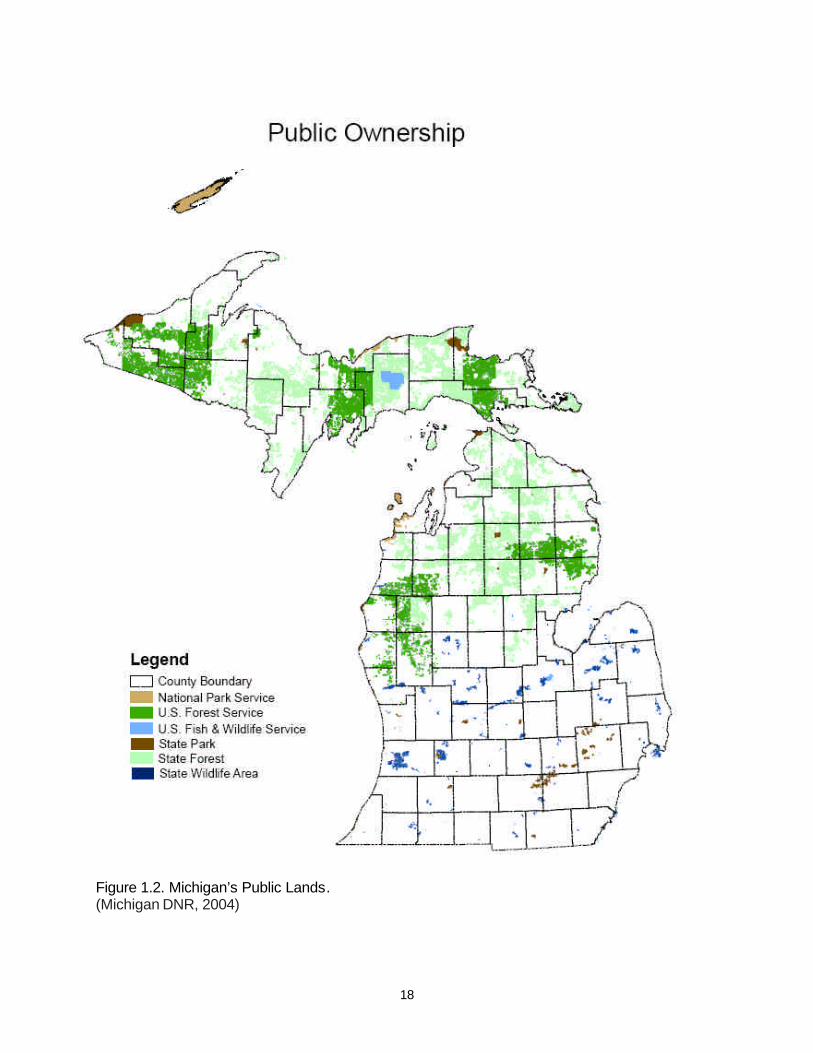
The DNR is the largest single land owner in the state, holding title to approximately 4.5 million surface acres of land and more than six million acres of subsurface mineral rights (Figure 1.2). A discussion of specific boundaries and administrative responsibilities for public and private land ownership and management are described in Appendix F.
18
Figure 1.2. Michigan’s Public Lands. (Michigan DNR, 2004)

19
2 - FOREST HISTORY
2.1 - Pre-European Settlement History (Glaciation to 1800’s)
The present physical geography of the State of Michigan is a direct result of the Wisconsinan glaciation of the Pleistocene Epoch, when the state was totally covered by ice. As the present inter-glacial period began and the ice sheet gradually receded, southern Lower Michigan became mostly ice free approximately 13,000 years before present (B.P.). Upper Michigan became ice free approximately 10,000 B.P. The present landform and soils of Michigan are the result of post-glacial lakes, rivers, erosion and soil development processes acting upon the glacial deposits, resulting in a diversity of terrain features including moraines, drumlins, eskers, kames, outwash plains and former lake beds that are interspersed with numerous lakes, streams and depressions, including four of the world’s largest freshwater lakes.
It was upon this landscape of raw post-glacial parent material that life gradually returned. The primary succession of plant life was heavily influenced by the nature of the parent material, the climate (that was still very much influenced by the receding ice sheets) and the formation and disappearance of proglacial lakes. Theories of the succession of plant life from barren soil to tundra, and the migration of forest tree species and some animal species from their glacial refugia are fairly well established (Davis 1981 and Pielou 1991). Post-glacial succession and development of forest and animal communities were first driven by a gradual warming of the climate, culminating in the hypsithermal of the current interglacial occurring approximately 7,000 B.P., and then by the subsequent and present cooling trend toward the next glaciation. The post-glacial landscape provided an abundance of habitat for a wide diversity of forest, savanna and aquatic plant and animal communities, which were distinctly influenced by Native American cultures that inhabited the two peninsulas, most notably through hunting and fishing activities and their interaction with the fire regimes of both savanna grasslands and pine lands. A comprehensive description of the complexity of the post-glacial climatic and anthropogenic interaction with plant and animal communities can be found in Pielou 1991.
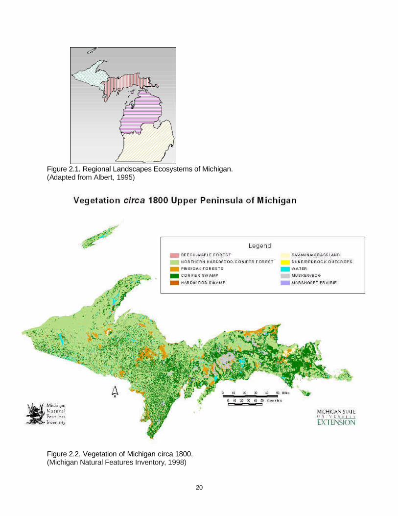
The present landscape of Michigan is comprised of four distinct eco-regions (Figure 2.1): Southern Lower Michigan; Northern Lower Michigan; Eastern Upper Michigan; and Western Upper Michigan. Each eco-region is distinct in its climate, physiography, soils and vegetation. These distinctions are a result of the peninsular configuration of the state, which dramatically affects the climatic differences of both peninsulas. The distinctiveness of warm, vegetatively diverse Southern Lower Michigan and cold Upper Michigan is largely due to their latitudinal positions and the continental land masses on their southern borders. The four Great Lakes that surround the state also provide a significant influence upon the climate in portions of both peninsulas (Albert 1995).
The pre-European settlement (circa 1800) vegetative patterns for the State are based upon an interpretation of the Federal General Land Office (GLO) surveys of 1816-1856 (Figure 2.2). Between 1816 and 1856 the State was surveyed by the Federal Government’s General Land Office (GLO), with surveys of the Lower Peninsula beginning in 1816 and surveys of the Upper Peninsula beginning in 1840. The interpretation of cover types on these maps is interpolated from section line and corner witness trees, similar landform, surface geology and soils data. Inclusions of dissimilar cover types that do not intersect a section line may not be reflected upon the maps. Despite these qualifications, the GLO survey maps provide a consistent landscape level perspective of the circa 1800 cover types
20
Figure 2.1. Regional Landscapes Ecosystems of Michigan. (Adapted from Albert, 1995)
Figure 2.2. Vegetation of Michigan circa 1800. (Michigan Natural Features Inventory, 1998)

21
Figure 2.2 (Continued). Vegetation of Michigan circa 1800. (Michigan Natural Features Inventory, 1998)

22
of the entire state. The maps are useful for assessing broad post-settlement trends for different cover types, the type and scale of pre-settlement disturbance regimes, and for consideration in the restoration of selected cover types.
The forest and other landscape communities that existed circa 1800 consisted of a mosaic of vegetative patterns ranging from remnant hypsithermal savanna grasslands and southern hardwood forests in Southern Lower Michigan, to northern hardwood and pine forests in Northern Lower Michigan and all of Upper Michigan (Figure 2.3 and Table 2.1). The pre-settlement landscape was dynamic and was comprised of a mosaic of community types in various stages of ecological succession, driven by long-term shifts in climatic conditions, and short-term natural and anthropogenic disturbance cycles. Four community types dominated the landscape at the time of the GLO surveys: the beech-sugar maple-hemlock northern hardwoods community; the beech-sugar maple southern hardwoods community; hemlock dominated communities; and the mixed conifer swamp community. Eight other sub-dominant communities occurred on the landscape: mixed oak savanna; oak/pine barrens; beech-sugar maple northern hardwoods - absent the hemlock component; mixed oak/hickory forest; mixed hardwood swamps; red/white pine forests; white pine/mixed hardwoods; and cedar swamps. Lesser communities were spruce/fir/cedar forests, seral aspen/birch forests, and black ash swamps.
As an aggregate group, pine communities covered 4.1 million acres or 11.8% of the forested landscape. These included pure white pine forests, pure red pine forests, pure jack pine forests, mixed red/jack pine forests , mixed pine/oak forests, and the previously cited red/white pine forests and white pine/mixed hardwood forests. The pine forest communities were fire-driven ecosystems, dependent upon occasional catastrophic stand-replacing fires for regeneration, and frequent low-intensity fires that eliminated competition from non-fire adapted tree species and that in the case of red and white pine maintained a relatively open structure on the forest floor. Conservative estimates of recurrence intervals for fires in jack pine forests in northern Michigan ranged from 59 to 140 years. For red and white pine stands, estimates of recurrence intervals in northern Michigan ranged from 130 - 240 years (Whitney 1986, Price 1994, Cleland et al. 2004).
The natural disturbance regime that maintained white pine communities was characterized by a repeating, cyclical sequence of catastrophic fires, with light surface fires occurring at shorter intervals (Frelich 1992). White pine occurred most abundantly in areas where catastrophic fire intervals were about 150 to 300 years. More frequent fires, towards the 100-150 year interval, tended to favor red pine while intervals greater than 300 years tended to succeed to northern hardwoods. As a mid-successional species, white pine occurred most frequently with red pine (Table 2.1) and most often followed jack pine (Frelich 1992). Non-catastrophic surface fires occurred at intervals of 20-40 years (Frissel 1973 as cited in Frelich 1992) and tended to kill hardwoods invading the understory. Gaps created by winds and surface fires created multi-modal diameter distributions and formed increasingly multi-aged stands. White pine stands may have been maintained in the old-multi-aged stage for one to several centuries (Heinselman 1981), until the occurrence of another catastrophic disturbance.
A view of the complexity of the landscape and the composition and structure of circa 1800 forests can also be gained through analysis of GLO data for the frequency of association of several major tree species within upland glacial landforms in Northern Lower Michigan (Table 2.2). Strong associations are evident between beech, sugar maple and hemlock

23
Circa 1800 Landscape Communities
0
1
2
3
4
5
6
7
Upland
Prairi
e
Mixed O
ak Sa
vanna
Oak/Pin
e Barre
ns
N. Ha
rdwood
s/Hem
lock
N. Ha
rdwood
s
South
ern Ha
rdwood
s
Mixed O
ak/Hick
ory
Aspe
n/Birch
Mixed H
ardwoo
d Swam
p
Black
Ash S
wamp
White Pi
ne
Red P
ine
Jack P
ine
Red/J
ack Pin
e
Red/W
hite Pi
ne
Mixed P
ine/Oak
White Pi
ne/Hard
woods
Spruc
e/Fir/ C
edar
Hemloc
k
Mixed C
onifer
Swam
p
Cedar
Swam
p
Bog/M
uskeg
/Peatla
nd
Shrub
-Carr W
etland
Emerg
ent W
etland
Wet/Lake
plain P
rairie
Sand
Dune
Bedro
ck/Alv
ar
Mill
ion
s o
f Acr
es
Figure 2.3. Circa 1800 Landscape Cover Types. (Michigan Natural Features Inventory, 1998) Table 2.1. Circa 1800 Cover types by acreage and percent relative cover. (Michigan Natural Features Inventory, 1998)
Cover Type Acreage Percent
N. Hardwoods/Hemlock 6,341,989 18.1
S. Hardwoods 5,845,677 16.7
Hemlock 4,714,602 13.5
Mixed Conifer Swamp 4,290,553 12.3
Mixed Oak/Hickory 2,306,373 6.6
Mixed Hardwood Swamp 1,421,462 4.1
Cedar Swamp 1,254,055 3.6
White Pine/Hardwoods 1,185,681 3.4
N. Hardwoods 1,161,644 3.3
Red/White Pine 1,132,097 3.2
Oak/Pine Barrens 1,101,424 3.1
Mixed Oak Savanna 1,061,564 3.0
Spruce/Fir/Cedar 823,253 2.4
Jack Pine 596,836 1.7
Mixed Pine/Oak 543,562 1.6
Red/Jack Pine 515,819 1.5
Aspen/Birch 292,266 0.8
Black Ash Swamp 280,705 0.8
Red Pine 70,889 0.2
White Pine 69,141 0.2
Totals 35,009,591 100
24
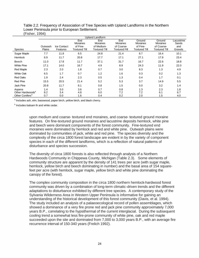
Table 2.2. Frequency of Association of Tree Species with Upland Landforms in the Northern Lower Peninsula prior to European Settlement. (Fisher, 1994)
Upland Landform End End End Ground Ground Lacustrine Moraines Moraines Moraines Moraines Moraines Sands Outwash Ice Contact of Fine- of Medium- of Coarse- of Fine- of Coarse- and Species Plains Features Textured Till Textured Till Textured Fill Textured Till Textured Till Gravels
Sugar Maple 7.7 11.8 6.5 24.8 21.4 8.7 16.4 10.1 Hemlock 6.9 11.7 20.8 17.7 17.1 27.1 17.9 23.4
Beech 11.0 17.8 11.7 37.1 31.7 16.7 22.6 18.8 White Pine 17.1 14.0 16.7 4.9 8.9 24.3 11.9 22.0 Red Maple 2.3 2.0 1.8 0.7 3.0 8.3 1.3 4.9
White Oak 6.5 1.7 0.7 1.2 1.6 0.3 0.2 1.3 Red Oaks 1.9 2.4 2.3 0.5 1.3 0.4 1.7 0.1 Red Pine 15.5 20.5 21.4 5.2 5.3 3.7 14.9 5.5
Jack Pine 20.8 11.7 8.1 0.8 1.5 0.0 3.2 1.4 Aspens 1.4 3.0 3.6 0.7 0.8 1.3 2.3 1.8 Other Hardwoodsa 8.2 3.4 4.8 6.0 7.2 7.2 6.1 6.7 Other Conifersb 0.7 0.0 1.6 0.4 0.2 2.0 1.5 4.0 a Includes ash, elm, basswood, paper birch, yellow birch, and black cherry. b Includes balsam fir and white cedar.
upon medium and coarse- textured end moraines, and coarse- textured ground moraine features. On fine-textured ground moraines and lacustrine deposits hemlock, white pine and beech were dominant components of the forest community. Fine-textured end moraines were dominated by hemlock and red and white pine. Outwash plains were dominated by communities of jack, white and red pine. The species diversity and the complexity of the circa 1800 forest landscape are evident in by the variety of component species in each of the different landforms, which is a reflection of natural patterns of disturbance and species succession.
The diversity of circa 1800 forests is also reflected through analysis of a Northern Hardwoods Community in Chippewa County, Michigan (Table 2.3). Some elements of community structure are apparent by the density of 141 trees per acre (with sugar maple, hemlock, yellow birch and beech dominating in number) and the basal area of 154 square-feet per acre (with hemlock, sugar maple, yellow birch and white pine dominating the canopy of the forest).
The complex community composition in the circa 1800 northern hemlock-hardwood forest community was driven by a combination of long-term climatic-driven trends and the different adaptations to disturbance exhibited by different tree species. A contemporary study of the Sylvania Wilderness Area in Western Upper Peninsula is informative for gaining an understanding of the historical development of this forest community (Davis, et al. 1994). The study included an analysis of a palaeoecological record of pollen assemblages, which showed a dominance of a very fire prone red and jack pine community approximately 7,000 years B.P., correlating to the hypsithermal of the current interglacial. During the subsequent cooling trend a somewhat less fire-prone community of white pine, oak and red maple succeeded upon the site and dominated from 7,000 to 3,000 years B.P., with an average fire recurrence interval of 150-340 years (Frelich 1992).

25
Table 2.3. Species density and dominance in the circa 1800 Northern Hardwoods Community of Chippewa County, Michigan.
(Price, 1994) Number Relative Total Relative Species of Trees Density Trees/Acre Basal Area1 Dominance BA1/Acre
Aspen 6 0.7 1.0 2.0 0.2 0.3
Beech 86 10.4 14.6 53.6 5.9 9.1
Balsam Fir 55 6.6 9.4 21.2 2.3 3.6
Black/Red Oak 2 0.2 0.3 5.9 0.7 1.0
Basswood 4 0.5 0.7 5.4 0.6 0.9
Hemlock 170 20.5 29.0 252.3 27.8 42.9
Ironwood 3 0.4 0.5 0.7 0.1 0.1
Red Maple 68 8.2 11.6 35.5 3.9 6.0
Red Pine 2 0.2 0.3 3.5 0.4 0.6
Sugar Maple 235 28.4 40.0 206.1 22.8 35.0
Spruce 30 3.6 5.1 21.3 2.4 3.6
White Birch 9 1.1 1.5 7.1 0.8 1.2
White Pine 42 5.1 7.2 136.7 15.1 23.2
Yellow Birch 116 14.0 19.8 154.7 17.1 26.3
Totals 828 100 141 906 100 154 1 Basal Area measured in square-feet.
Rapid increases in the abundance of hemlock and yellow birch became evident in the pollen record starting 3,200 years B.P. as the frequency of fires continued to decrease, with fire recurrence intervals extending to approximately 1,400-2,200 years (Whitney 1896, Price 1994). Sugar maple and basswood entered the forest soon after the invasion of hemlock and yellow birch, and windthrow gradually became the predominant form of disturbance, with recurrence intervals of approximately 1,200-2,200 years (Whitney 1986, Frelich and Lorimer 1991, Price 1994). Where the intervals between fires were long, the white pine-oak-red maple forest was succeeded by hemlock and yellow birch at some locations and by sugar maple, yellow birch and basswood at other locations (dependent upon different edaphic site conditions), giving rise to the mosaic of hemlock, sugar maple, yellow birch and white pine dominated the circa 1800 northern hardwood forests.
Before settlement, grasslands such as wet meadows, oak and pine barrens, dry sand prairies, and tall grass prairies were scattered throughout Michigan, but the largest acreage was in the southern Lower Peninsula. At least 39 grassland areas were present, totaling approximately 2.3 million acres. Fire was an important element in the establishment and maintenance of these grasslands. Whether caused by lightning or set purposely by Native Americans, fire stimulated grass and wildflower growth, reduced competition, and discouraged the encroachment of shrubs and trees.
2.2 - Post-European Settlement History (1600’s to 1900)
European settlement of the State began soon after the expeditions of the Great Lakes region in the 1600s by the French explorers Etienne Brule and Robert René Cavelier de La Salle, beginning with the establishment of Jesuit missions at Sault Ste. Marie in 1668 and at St. Ignace in 1671. The fur trade drove the early development of the State. Ease of access
26
for trading determined the location of other early French settlements in St. Joseph in 1679, present day Detroit in 1701 and at Fort Michilimackinac in 1715.
Michigan became established as a territory in 1805, and became the twenty-sixth state in the union in 1837. Following the GLO surveys in Southern Lower Michigan, land was cleared at a relatively slow, laborious pace for agriculture. However, it was the land surveys of the wilderness of Northern Michigan that led to the discovery of Michigan’s extensive pine forests, and fueled the subsequent rush by timber speculators beginning in the 1850s.
Early (mid-1830s) government figures from the surveyor’s findings estimated the volume of standing pine timber in Michigan to be 150 billion board-feet (at 2 cords per 1,000 bd-ft this is equivalent to approximately 300 million cords). The lumber boom started in the 1850s in the Saginaw River watershed, and quickly spread westward and northward. By 1897 it was estimated that more that 160 billion board-feet of pine had been cut, with only about six billion board-feet of standing timber remaining, mostly in the Upper Peninsula. In a mere 70 years most of the original pine and hardwood forests of Michigan were gone.
Following the logging of the forests, attempts were made to settle cut-over lands for farms. To prepare the land for agriculture vast amounts of residual slash had to be cleared from the landscape. The common practice to accomplish this was to burn it. This practice combined with the release of cinders from steam locomotives provided the sparks for a period of devastating wildfires, including the firestorm of October, 1871 which alone burned approximately 2.5 million acres. Fires occurred continuously over the following six decades, interspersed by additional large conflagrations in September of 1881 (over 1 million acres), October of 1908 (2.4 million acres) and in July of 1911 (156,480 acres). These fires consumed slash, homes and lives and also destroyed millions of trees and estimated 73 billion board-feet of timber that had previously been spared from logging. It is estimated that for every two trees that were cut for lumber, one additional tree was destroyed – mostly due to the wildfires (Dickman and Leefers 2003).
European settlement brought major degradation to inland lakes and streams and Great Lakes water resources. Land clearing for agriculture, logging, and settlement altered local stream flow patterns and volumes, eliminated some waters, and introduced pollutants into others. Huge quanitities of sediment from log drives and sawdust from sawmills were dumped into rivers. In one instance, the mouth of the Manistee River accumulated sawdust to the extent that it formed a delta of several square miles. At sawmill locations throughout the state, wherever sawdust was dispensed into the river, toxic and oxygen deprived conditions were created for fish. These detriments, combined with land clearing efforts that exacerbated soil erosion into rivers, significantly reduced the quality of fish habitat in rivers and drowned river mouths. Drainage of wetlands and shallow water tables for agriculture did likewise. Dam and road construction caused extensive fragmentation of formerly interconnected waters and contributed to the elimination or reduction of many highly-migratory fish populations. Dam construction also caused severe water quality changes and eliminated rare high-gradient river sections. Over-fishing of the most productive and larger water bodies eliminated or reduced fish populations.
Intensive commercial fisheries existed both in the Great Lakes and the large rivers tributary to the lakes and the numbers of commercial fishers increased through the mid 1800s (Garling et al. 1995). Interest in recreational fishing increased as people had more time to recreate and fishing equipment was developed. In 1859, 14 lower counties in Michigan prohibited fishing with nets (commercial fishing) in order to accommodate recreational
27
fishing. By the late 1800’s, recreational fishing was well established in inland waters, while commercial fishing still dominated in the Great Lakes. At the same time that habitat was compromised, enormous exploitation was also occurring.
The creation of the Michigan Fish Commission in 1873, the ancestor of the Department of Natural Resources – Fisheries Division, can be directly linked to the demand for more fish in Great Lakes waters and more “desirable food fish” in inland waters. To address this desire, Michigan implemented fish stocking as a management tool, and continued the practice for the next 133 years. From 1873 to 1897, the Michigan Fish Commission stocked millions of lake whitefish and lesser numbers of many other species into Great Lakes waters to address the rapid declines in commercially important fish. Many of these Great Lakes species and also numerous non-native fish species were also stocked in many inland waters. During this time, common carp (Carpio cyprinus) and other popular species such as brown trout (Salmo trutta) and rainbow trout (Oncorhynchus mykiss) and steelhead (the migratory form of rainbow trout) were introduced into inland waters.
Human activity during the post-European settlement period also had profound impacts upon terrestrial wildlife populations of the state. Since wildlife are inextricably connected to the habitat that supports them, large scale changes in vegetative cover such as timber harvest, fire, agricultural land conversion and subsequent reversions back to forest cover have been the nexus for many trends in wildlife populations. Some species benefited by these changes while others experienced declines. Examples of species that benefited from the change from the pre-settlement landscape to open plains and early successional aspen forests are white-tailed deer, sharp-tailed grouse (Tympanuchus phasianellus), ruffed grouse (Bonasa umbellus), and American woodcock (Scolopax minor). The forested landscape of pre-settlement Michigan did not support large numbers of these species, but each experienced population booms in the early through mid-twentieth century due to the availability of additional habitat which was the result of the clear cutting of forests. White-tailed deer populations were been greatly influenced by harvest pressures. By 1876, market hunters were killing 70,000 deer each year to supply the booming lumber camps, and shipped what they couldn’t sell locally to big cities such as Chicago and Detroit. At about the same time fires burned over large areas of early successional habitat, causing a loss of forage. Together, these two factors then caused a rapid decline in deer numbers.
The decline of other species can also be directly attributed to over-exploitation by hunting. As markets for wild meat developed, Michigan gained prominence as a source of wild meat for large eastern and mid-western markets. Market hunters removed large numbers of a wide variety of waterfowl, shorebirds and small game for meat, while other birds were taken for their plumage for stuffing or to adorn hats. Market hunting of the passenger pigeon (Ectopistes migratorius) alone killed approximately 1.5 million birds near Petoskey in the summer of 1878. As the United States population grew, the demand for wildlife as a food source also increased. This demand led to the overexploitation of many Michigan species and resulted in severe population declines for some species and the extirpation of other species.
Wildlife species extirpated during and following this period include the bison (Bison bison), elk (Cervus elaphus), woodland caribou (Rangifer tarandus), cougar (Felis concolor couger), wild turkey (Meleagris gallopavo), passenger pigeons, trumpeter swan (Cygnus buccinator), fisher (Martes pennanti), and American martin (Martes americana). Wildlife and invertebrate species nearly extirpated or greatly reduced in the state include beaver (Castor canadensis), gray wolf (Canus lupus), moose (Alces alces), black bear (Ursa americanus ),
28
American martin (Martes americana), Canada goose (Branta Canadensis), lake sturgeon (Acipenser fulvescens), piping plover (Charadrius melodus), Kirtland’s warbler (Dendroica kirtlandii), prairie warbler (Dendroica discolor), and Karner Blue (Lycaeides melissa samuelis), Frosted Elfin (Incisalia irus), Persius Duskywing (Erynnis persius), Dusted Skipper (Atrytonopsis hianna), Ottoe Skipper (Hesperia ottoe), Dukes' Skipper (Euphyes dukesi), and Mitchell’s Satyr (Neonympha mitchellii mitchellii) butterflies.
With the industrial age and the rise of modern agricultural methods the reliance on wildlife as meat and revenue sources declined. In many cases the wildlife population declines were so severe that they could no longer support commercial activities. As populations of wildlife declined or disappeared in the state from overexploitation, public attitudes began to change, and recovery began by increasing enforcement of laws and regulations protecting wildlife. The State began enacting a series of laws protecting various species of wildlife. The first salaried game warden in the country was appointed in 1887 and Michigan’s first deer hunting license was created in 1895. In 1897, a bill was introduced in the Michigan legislature in a futile attempt to establish a ten-year closed season on passenger pigeons. Toward the end of the nineteenth century the importance of wildlife as a commercial resource began to decline and the importance of wildlife as an economic commodity began to evolve. The value of an animal was no longer simply measured by the price it would attract in a market. The value became recreational, measured by the amount of money expended for the licenses, equipment and other amenities necessary for its pursuit. Sport hunting thus largely replaced commercial activity.
2.3 - Contemporary History (1900 to the present)
Many settlers found that the climate and the sandy, burned over soils of Northern Michigan were often marginally productive for farming and many areas were simply abandoned. The State of Michigan thereby inherited a large portion of the cut-over pine lands of Northern Michigan due to the non-payment of taxes during the early twentieth century. By 1907, almost half of homesteaded land had reverted to the state. Many of these lands tax reverted several times after being repeatedly sold by the state, and the question of what to do with these lands was a serious public policy issue.
One answer came through the rise of a new industry in northern Michigan in the early 1900s: that of recreation and tourism which provided a new use for the miles of Great Lakes shoreline, inland lakes and streams and other remaining natural resources. This trend was closely related to the growth of the automobile, the state highway system and a middle economic class in a large segment of the population, whose increasing wealth and free time resulted in greater demand for recreational opportunities. During this period it was recognized that re-growth of forests and the recovery of natural ecosystems was the foundation for the well-being of the recreation and tourism industry.
A Forestry Commission was established by the Forest Commission Act of 1899, which also authorized the withdrawal of abandoned cut-over lands for forest reserves. The Forest Reserve Act of 1903 authorized the Forestry Commission to establish a State Forest Reserve on about 34,000 acres in western Crawford and Roscommon Counties, which was the beginning of the present state forest system. The Forestry Commission was abolished in 1909 with the creation of the Public Domain Commission, which was charged with receiving tax-reverted lands and administration of the increasing public domain.

29
Concurrently, the Forest Reserve Act of 1891 gave the president the authority to establish national forests. The present Huron and Hiawatha Forests were subsequently established in 1909, the Ottawa National Forest in 1931 and the Manistee National Forest in 1938.
To stabilize the forest landscape it was recognized that protection from wildfire was required. The state legislature enacted the Forest Fire Act of 1903, which first authorized the designation of a Chief Fire Warden. The Chief Fire Warden was placed in general charge of a fire warden force that was in turn charged with preventing and controlling forest fires. Fire towers were constructed between 1912 and 1942 to provide a network for early detection of forest fires. When the State Department of Conservation (the precursor to the present Department of Natural Resources) was created in 1921, fire control was a primary responsibility upon the state forest reserves. The Forest Fire Law of 1923 authorized fire control outside of state lands.
Since 1935, the general stability in the area of forestland in Michigan can be attributed to forest fire control and activities dedicated to forest management, including forest regenereation. The Civilian Conservation Corps (CCC) was established in the early 1930s to help in this effort to revitalize tax-reverted cut-over public lands. Between 1933 and the start of World War II the CCC fought forest fires and planted approximately 485 million trees in Michigan, including extensive pine restoration plantings on 134,000 acres (Dickman and Leefers 2003).
Concurrently with the efforts of the CCC, work continued for the restoration of game species. In 1937, Congress passed the Federal Aid in Wildlife Restoration Act (Pittman-Robertson) to support state efforts in wildlife restoration. This program along with state hunting and fishing license revenues continues to support wildlife restoration activities in Michigan. Natural biotic succession was also occurring. In the early 1900s, the re-growth of burned over lands and restrictions for hunting allowed white-tailed deer numbers to rebound to approximately 1.5 million by 1949. However, as the regenerating forests matured and openings closed in, there was a decline in forage and an associated decline in deer numbers starting in the 1950s. An increase in the timber market in the 1970s along with a deer range improvement program reversed the downward trend and led to the highest deer numbers (approaching 2 million) in the history of Michigan in 1989. Disease concerns became a major issue with the discovery that bovine tuberculosis was endemic in a wild white-tailed deer population of northern Lower Michigan in 1994.
Other species of wildlife began returning to the state, either on their own or through dedicated restoration programs. Around 1907, moose migrated (probably over on winter ice from Ontario) to Isle Royale. In 1934-37, the (then) Michigan Department of Conservation undertook a project to reduce moose numbers on Isle Royale and replenish the mainland UP moose herd with animals from Isle Royale. Seventy-one moose were captured and relocated to mainland Michigan. In 1985 and 1987 an additional 59 additional moose were relocated from Ontario to Marquette and Baraga Counties. In 1918, seven elk were relocated from western states and released near Wolverine. The year 1918 also saw the enactment of the Migratory Bird Treaty Act, which stopped hunting of migratory bird species such as the piping plover. Turkeys were re-introduced into Michigan during the 1950s. Restoration of marten populations began around 1958, with the relocation of animals from Ontario into the Porcupine Mountains in the western Upper Peninsula. Additional releases were conducted in Upper Michigan in the 1970s and in northern Lower Michigan in 1985 to supplement existing populations. Fishers were first reintroduced in the 1960's on the Ottawa National Forest in western Upper Michigan. During the 1980s, Michigan began a

30
trumpeter swan reintroduction program as part of the North American Restoration Plan. Successes in the re-introduction of wildlife species was countered by the decline of other species. For example, by 1912, common loons (Gavia immer),were no longer as common in the more heavily settled areas of southern Michigan.
From 1897 through 1964, the Michigan Fish Commission (later called the Michigan Conservation Department) did not actively manage Great Lakes waters other than to regulate commercial harvest, though regulation was without a clear understanding of limits on fish productivity and the potential impacts of over-harvest. Essentially, commercial harvest was allowed to continue unencumbered by the regulations in place.
Large changes in the fishery community for both the great lakes and inland waters were underway. Arctic grayling were extinct by early the 1900’s in spite of efforts to produce the species in hatcheries. Several other species were deemed extinct due, at least partially, to overexploitation: blue pike (Sander vitreus glaucus), longjaw cisco (Coregonus alpenae), blackfin cisco (Coregonus nigripinnis), and deepwater cisco (Coregonus johannae) (Eagle et al. 2005). Sea lamprey (Petromyzon marinus) invaded the Great Lakes in the early 1900’s through the Erie Canal, with reproducing populations in high abundance by the mid-1900’s. With both an inland and great lake component to their life cycle, this parasitic lamprey was particularly devastating to lake trout populations. A sea lamprey control program was developed through the Great Lakes Fishery Commission in 1958 that continues today.
Another invasive species, alewife (Alosa pseudoharengus), became prominent in the Great Lakes in the 1950s. At this time, lake trout numbers were very low as a result of commercial exploitation and sea lamprey parasitism. Without an effective predator such as lake trout, alewife numbers swelled and dieoffs occurred in large magnitude along the shorelines of the lakes.
At the same time, a growing interest in recreational fishing opportunities on the Great Lakes became apparent to fisheries managers. The Department of Conservation followed by the Department of Natural Resources made a decision to introduce hatchery raised Pacific salmonids to control nuisance alewife populations and produce a sportfishery. A similar management philosophy led to stocking lake trout in Lake Superior to restore predator populations. The migratory salmonids have since adapted to reproduction in freshwater and use inland rivers to spawn and provide growing habitat for juveniles.
Environmental and fishery management practices since the mid 1900s assisted in rehabilitating many aquatic ecosystems. In particular, reforestation programs have stabilized forested landscapes, hydrologic and sediment processes, and waters therein. The federal Clean Water Act of 1972 removed the most serious water quality impairments and fishery management practices have rehabilitated many valued species of aquatic and terrestrial animal species. The ban of DDT and other similar persistent pesticides in the 1970s has contributed to a reduction in contaminant loading in fish and a significant rebound of some bird populations, such as bald eagles (Haliaeetus leucocephalus), osprey (Pandion haliaetus), peregrine falcons (Falco peregrinus), which were hard hit by the liberal use of pesticides shortly after World War II.
The importation of non-native insects and disease has had a counterbalancing effect upon the re-growth of Michigan’s forests, with exotics such as the chestnut blight, Dutch elm disease, gypsy moth in the 1900s and most recently the emerald ash borer causing declines in a number of native tree species.
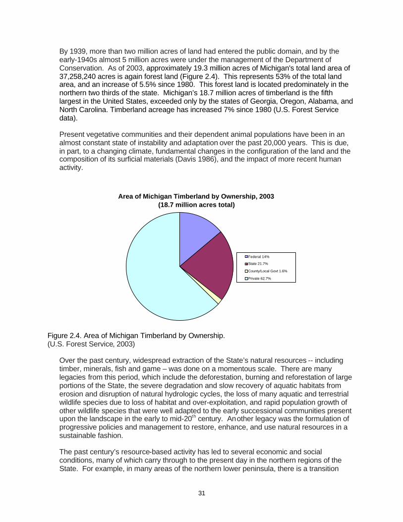
31
By 1939, more than two million acres of land had entered the public domain, and by the early-1940s almost 5 million acres were under the management of the Department of Conservation. As of 2003, approximately 19.3 million acres of Michigan's total land area of 37,258,240 acres is again forest land (Figure 2.4). This represents 53% of the total land area, and an increase of 5.5% since 1980. This forest land is located predominately in the northern two thirds of the state. Michigan’s 18.7 million acres of timberland is the fifth largest in the United States, exceeded only by the states of Georgia, Oregon, Alabama, and North Carolina. Timberland acreage has increased 7% since 1980 (U.S. Forest Service data).
Present vegetative communities and their dependent animal populations have been in an almost constant state of instability and adaptation over the past 20,000 years. This is due, in part, to a changing climate, fundamental changes in the configuration of the land and the composition of its surficial materials (Davis 1986), and the impact of more recent human activity.
Area of Michigan Timberland by Ownership, 2003
(18.7 million acres total)
Federal 14%
State 21.7%
County/Local Govt 1.6%
Private 62.7%
Figure 2.4. Area of Michigan Timberland by Ownership. (U.S. Forest Service, 2003)
Over the past century, widespread extraction of the State’s natural resources -- including timber, minerals, fish and game – was done on a momentous scale. There are many legacies from this period, which include the deforestation, burning and reforestation of large portions of the State, the severe degradation and slow recovery of aquatic habitats from erosion and disruption of natural hydrologic cycles, the loss of many aquatic and terrestrial wildlife species due to loss of habitat and over-exploitation, and rapid population growth of other wildlife species that were well adapted to the early successional communities present upon the landscape in the early to mid-20th century. Another legacy was the formulation of progressive policies and management to restore, enhance, and use natural resources in a sustainable fashion.
The past century’s resource-based activity has led to several economic and social conditions, many of which carry through to the present day in the northern regions of the State. For example, in many areas of the northern lower peninsula, there is a transition

32
going on from a predominately timber-based economy to a more diversified timber, recreation and agricultural-based socio-economic system. In the upper peninsula, changes have been more gradual, but a trend from a timber and mineral-based economy to a timber and recreation-based socio-economic system can be perceived.
The State will never again see vast forest acreages similar to those present in the circa 1800 period. Yet inventory data indicate that the forests of the state have been on a steady path towards recovery from the over-exploitation and fire devastation that took place at the end of the 19th Century and the beginning of the 20th Century. This indicates that timber and other natural resource-based industries will remain significant, contributing segments of the social and economic fabric of the state for the foreseeable future.
3 - CURRENT FOREST CONDITIONS, USES AND TRENDS
The present forests of the State are a legacy of the natural vegetative succession pathways and post-settlement practices. The landscape is mostly composed of second growth forests that have been heavily influenced by a variety of human-induced disturbances. This started with harvesting of white and red pine and many other species, followed by large-scale catastrophic wildfires fueled by the resulting slash, and then moving to a period of near total exclusion of fire from the landscape. Few of these secondary forests possess the structural characteristics of the circa 1800 forests. With the exception of some rare community types, the state’s present population levels, ownership patterns, and social and cultural values preclude the restoration of our remaining forests to circa 1800 conditions. Such restoration would necessitate dramatic changes in timber production, wildlife management and many forms of recreation. The re-growth of the forest resource has presented us with more choices for management of these resources, including timber production, many forms of recreation, the provision of terrestrial and aquatic wildlife habitat, and the provision of other ecosystem services (such as maintenance of water and air quality, soil conservation, and carbon sequestration). However, this has also made management of these resources much more contentious, as different interests compete to use the State’s forest resources for increasingly conflicting purposes. The capacity of forest resources to provide for these uses in a sustainable manner is finite. Since uses are not perfectly compatible, the forest cannot provide maximum use for all demands. Provision of one use is often constrained by demands for other competing uses for the same resource, and the capacity of the forest base to provide for these competing uses is infinite in its variability. Thus, the annual capacity of forest resources must be framed in terms of balancing competing uses. Emphasis should be on the means to enable uses to be compatible with other uses, with the recognition that at any one site one value or use may predominate over others. In order to effectively formulate appropriate management strategies in this environment, it is helpful to have an understanding of the changes in forest composition and structure that has occurred over the past 150 years and the ecological consequences of those changes. According to Noss (1999), it is difficult to develop a strategy to manage forests in a sustainable manner without identifying the specific structural and functional changes that have led to current conditions. An understanding of how historical events have led to current forest conditions, coupled with an analysis of current inventory data and current uses of the forest resource base can provide the foundation for present strategies and future structural changes that will support sustainable forest management. This section describes the current condition of DNR forest resources and the current capacity of its uses. It will also explore the ecological consequences of these uses in terms of changes in

33
composition and structure. The analysis of forest resources in this statewide-scope forest management plan and in each of the ecoregional management plans is based on an ecological classification system. Hierarchical systems use ecological factors for classifying land at varying geographical scales ranging from global to local land units (Table 3.1). The primary purpose for delineating ecological units is to identify land and water resources at different levels of resolution that have similar characteristics thereby implying similar management potential. Depending on scale, ecological units are designed to exhibit similar patterns in: (1) potential natural communities; (2) soils; (3) hydrologic function; (4) landform and topography; (5) lithology; (6) climate; and (7) natural processes such as nutrient cycling, productivity, succession, and natural disturbance regimes associated with flooding, wind, or fire (Cleland et al. 1997). Michigan has four ecoregions that are widely recognized (Figure 2.1). The four ecoregions are geographically based systems for organizing information about ecosystems and ecosystem responses to management. Each ecoregion provides a theoretical basis for science-based planning and adaptive management. The use of ecoregions often improves the accuracy of ecosystem models, projections of change, and predictions of desired future conditions. Ecological classifications in Michigan divide the state into progressively smaller ecological units, and watersheds can also be considered in this context. Within each ecoregion there are distinct identifiable subsections and watersheds that allow for a more strategic, multi-forest, multi-agency/ownership analysis and assessment of resources . Watershed analyses of the health of aquatic resources are parallel analyses that address aquatic community and habitat linkages across different terrestrial landscape attributes as well as provide the conduit and connection with the Great Lakes. Table 3.1. Hierarchy of Ecological Units. (Cleland et al., 1997)
Planning and Ecological Purpose, objectives, and general use
analysis scale Units Ecoregion Domain Broad applicability for modeling and sampling.
Global Division Strategic planning and assessment.
Province International planning.
Continental
Regional
Subregion Section Strategic, multiforest, statewide, and multiagency analysis and assessment
Subsection
Landscape Landtype Forest or area wide planning, and watershed analysis.
association
Land Unit Landtype Project and management area planning and analysis
Landtype phase
Hierarchy can be expanded Very detailed project planning by user to smaller geographical areas and more detailed ecological units if needed.
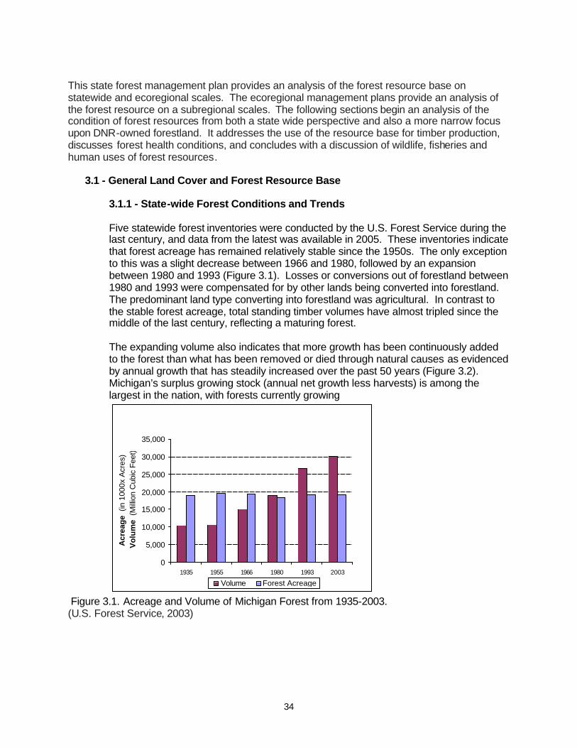
34
This state forest management plan provides an analysis of the forest resource base on statewide and ecoregional scales. The ecoregional management plans provide an analysis of the forest resource on a subregional scales. The following sections begin an analysis of the condition of forest resources from both a state wide perspective and also a more narrow focus upon DNR-owned forestland. It addresses the use of the resource base for timber production, discusses forest health conditions, and concludes with a discussion of wildlife, fisheries and human uses of forest resources.
3.1 - General Land Cover and Forest Resource Base
3.1.1 - State-wide Forest Conditions and Trends
Five statewide forest inventories were conducted by the U.S. Forest Service during the last century, and data from the latest was available in 2005. These inventories indicate that forest acreage has remained relatively stable since the 1950s. The only exception to this was a slight decrease between 1966 and 1980, followed by an expansion between 1980 and 1993 (Figure 3.1). Losses or conversions out of forestland between 1980 and 1993 were compensated for by other lands being converted into forestland. The predominant land type converting into forestland was agricultural. In contrast to the stable forest acreage, total standing timber volumes have almost tripled since the middle of the last century, reflecting a maturing forest. The expanding volume also indicates that more growth has been continuously added to the forest than what has been removed or died through natural causes as evidenced by annual growth that has steadily increased over the past 50 years (Figure 3.2). Michigan’s surplus growing stock (annual net growth less harvests) is among the largest in the nation, with forests currently growing
Exhibit 7. Michigan Forest Acreage and Volume, 1935 - 2003
0
5,000
10,000
15,000
20,000
25,000
30,000
35,000
1935 1955 1966 1980 1993 2003
Acr
eag
e (in
100
0x A
cres
)V
olu
me
(Mill
ion
Cub
ic F
eet)
Volume Forest Acreage
Figure 3.1. Acreage and Volume of Michigan Forest from 1935-2003. (U.S. Forest Service, 2003)
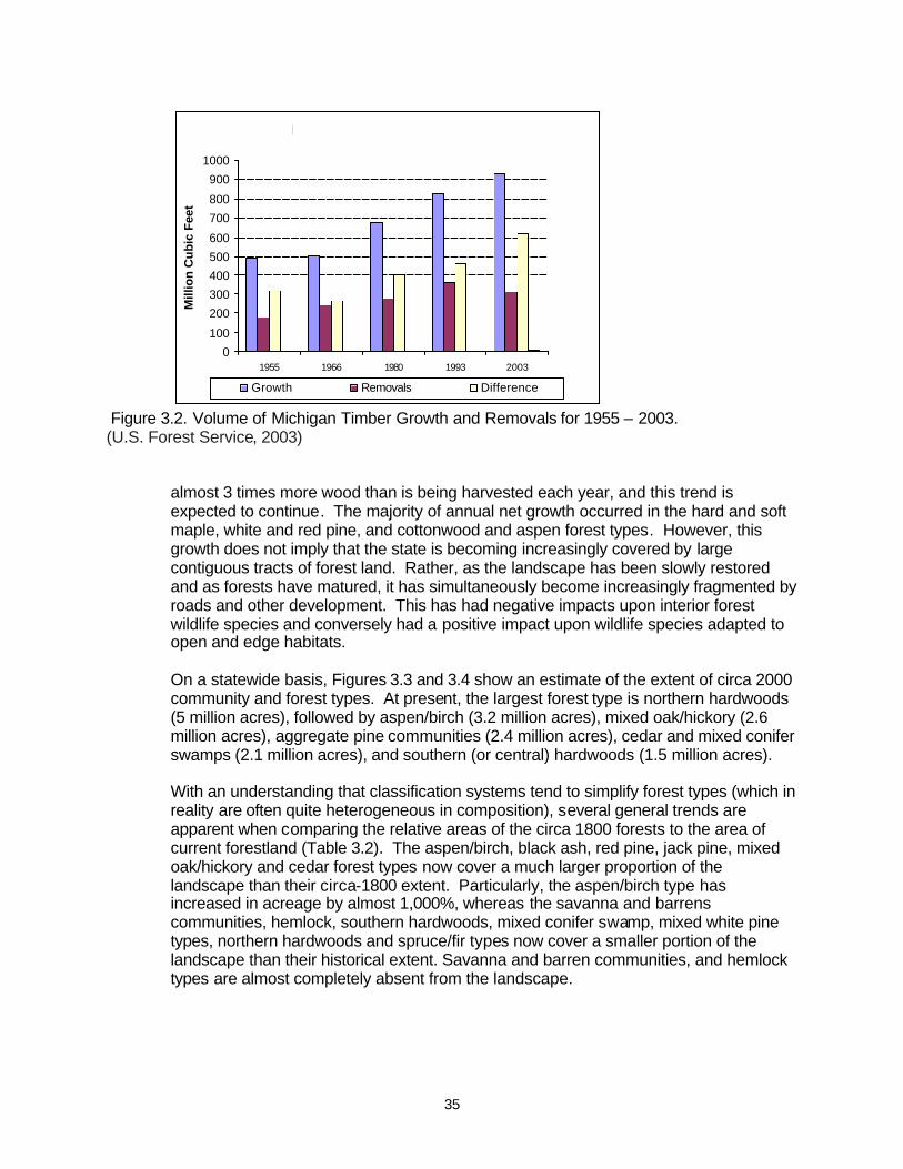
35
Exhibit 8. Michigan Timber Growth & Removals, 1955 - 2003
0
100
200
300
400
500
600
700
800
900
1000
1955 1966 1980 1993 2003
Mill
ion
Cu
bic
Fee
t
Growth Removals Difference
Figure 3.2. Volume of Michigan Timber Growth and Removals for 1955 – 2003. (U.S. Forest Service, 2003)
almost 3 times more wood than is being harvested each year, and this trend is expected to continue. The majority of annual net growth occurred in the hard and soft maple, white and red pine, and cottonwood and aspen forest types. However, this growth does not imply that the state is becoming increasingly covered by large contiguous tracts of forest land. Rather, as the landscape has been slowly restored and as forests have matured, it has simultaneously become increasingly fragmented by roads and other development. This has had negative impacts upon interior forest wildlife species and conversely had a positive impact upon wildlife species adapted to open and edge habitats. On a statewide basis, Figures 3.3 and 3.4 show an estimate of the extent of circa 2000 community and forest types. At present, the largest forest type is northern hardwoods (5 million acres), followed by aspen/birch (3.2 million acres), mixed oak/hickory (2.6 million acres), aggregate pine communities (2.4 million acres), cedar and mixed conifer swamps (2.1 million acres), and southern (or central) hardwoods (1.5 million acres). With an understanding that classification systems tend to simplify forest types (which in reality are often quite heterogeneous in composition), several general trends are apparent when comparing the relative areas of the circa 1800 forests to the area of current forestland (Table 3.2). The aspen/birch, black ash, red pine, jack pine, mixed oak/hickory and cedar forest types now cover a much larger proportion of the landscape than their circa-1800 extent. Particularly, the aspen/birch type has increased in acreage by almost 1,000%, whereas the savanna and barrens communities, hemlock, southern hardwoods, mixed conifer swamp, mixed white pine types, northern hardwoods and spruce/fir types now cover a smaller portion of the landscape than their historical extent. Savanna and barren communities, and hemlock types are almost completely absent from the landscape.
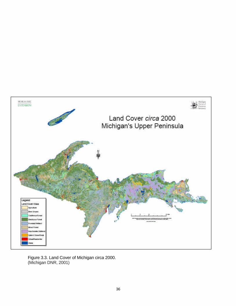
36
Figure 3.3. Land Cover of Michigan circa 2000. (Michigan DNR, 2001)

37
Figure 3.3 (Continued). Land Cover of Michigan circa 2000. (Michigan DNR, 2001)

38
Circa 2000 Landscape Communities
0
1
2
3
4
5
6
7
8
9
10
Urban/O
pen L
and
Farm
land
Upland
Prair
ie
Mixed O
ak Sa
vanna
Oak/Pin
e Barre
ns
N. Hard
woods
South
ern Ha
rdwood
s
Mixed O
ak/Hic
kory
Aspe
n/Birch
Mixed H
ardwoo
d Swam
p
Black
Ash S
wamp
White Pi
ne
Red Pi
ne
Jack P
ine
Exotic
Pine
/Spruc
e/Fir
Easte
rn Red
Cedar
Mixed Pin
e/Oak
White Pi
ne/Hard
woods
Spruc
e/Fir/ C
edar
Hemloc
k
Mixed C
onifer
Swam
p
Cedar
Swam
p
Bog/M
uskeg/
Peatla
nd
Shrub
-Carr W
etland
Emerg
ent W
etland
Wet/Lake
plain P
rairie
Sand
Dune
Bedro
ck/Alv
ar
Mill
ion
s o
f A
cres
Figure 3.4. Acreage of circa 2000 Landscape Communities. (U.S. Forest Service, 2003 and MDNR, 2001)
0
1
2
3
4
5
6
7
8
White/Red/Jack Pine Spruce/Fir/Cedar Oak/Hickory Elm/Ash/Cottonwood Maple/Beech/Birch Aspen/Birch
Mill
ions
of
Acr
es
1935
1955
19661980
1993
2003
Figure 3.5. Area of commercial timberland by forest type group for 1935-2003. (U.S. Forest Service, 2003)

39
The estimated extent of commercial timberland has changed significantly from 1935 through 2003 for forest type groups in Figure 3.5, from which some qualitative (but not quantitative) trends can be determined. A detailed discussion of trends for different forest types follows. The extent of the aspen/birch forest type has increased from less than 1 percent to over 16 percent of the forested landscape (Table 3.2). It is important to note that this comparison concerns larger, stand-level aspen communities. Aspen was historically a minor component of many circa 1800 forest communities and is likely under-represented in the reconstructed maps of the pre-settlement landscape. Regardless, the large increase in acreage can be attributed to the extensive areas of the state that repeatedly burned and where secondary succession of these two seral species occurred in the late 19th and early 20th centuries. Growth of aspen on a state-wide basis is estimated to be almost twice that of removals (Table 3.3). However, it is significant that mortality of aspen exceeds that of removals by a ratio of 1.5:1, suggesting that a large volume of aspen is not being harvested and is likely senescent in mixed stands that are succeeding to other forest types. The growth of birch is estimated to be over 1.5 times that of mortality and removals, but estimated birch mortality exceeds removals by a factor of 1.5 to 1. To a large degree, contemporary management practices have perpetuated the aspen community type. However, the aspen/birch type has been in decline since 1935
Table 3.2. Change in acreage of forestland from circa 1800 to circa 2000. (U.S. Forest Service, 2003, DNR, 2001 and Michigan Natural Features Inventory, 1998)
Michigan Circa 2000 Circa 2000 Circa 1800
Circa 1800 Change Change
Forestland Acreage Percent Acreage Percent in Acres in Percent
Aspen/Birch 3,163,200 16.5 292,266 0.8 2,870,934 982.3
Black Ash Swamp 680,700 3.6 280,705 0.8 399,995 142.5
Cedar Swamp 1,351,700 7.1 1,254,055 3.6 97,645 7.8
Eastern Red Cedar 11,500 0.1 0 0.0 11,500 0.1
Exotic Pine/Spruce/Fir 178,600 0.9 0 0.0 178,600 0.9
Hemlock 118,800 0.6 4,714,602 13.5 -4,595,802 -97.5
Jack Pine 715,300 3.7 596,836 1.7 118,464 19.8
Mixed Conifer Swamp 701,200 3.7 4,290,553 12.3 -3,589,353 -83.7
Mixed Hardwood Swamp 834,900 4.4 1,421,462 4.1 -586,562 -41.3
Mixed Oak Savanna 1,500 0.0 1,061,564 3.0 -1,060,064 -99.9
Mixed Oak/Hickory 2,612,500 13.7 2,306,373 6.6 306,127 13.3
Mixed Pine/Oak 352,700 1.8 543,562 1.6 -190,862 -35.1
N. Hardwoods 4,971,900 26.0 7,503,633 21.4 -2,531,733 -33.7
Oak/Pine Barrens 11,400 0.1 1,101,424 3.1 -1,090,024 -99.0
Red Pine 886,000 4.6 70,889 0.2 815,111 1149.8
Red/Jack Pine 0 0.0 515,819 1.5 -515,819 -100.0
S. Hardwoods 1,520,400 8.0 5,845,677 16.7 -4,325,277 -74.0
Spruce/Fir/Cedar 557,700 2.9 823,253 2.4 -265,553 -32.3
White Pine 278,600 1.5 69,141 0.2 209,459 302.9
White Pine/Mixed Hrdwoods 164,500 0.9 1,185,681 3.4 -1,021,181 -86.1
White/Red Pine 0 0.0 1,132,097 3.2 -1,132,097 -100.0 Totals 19,113,100 100 35,009,592 100 15,896,492 -45.4
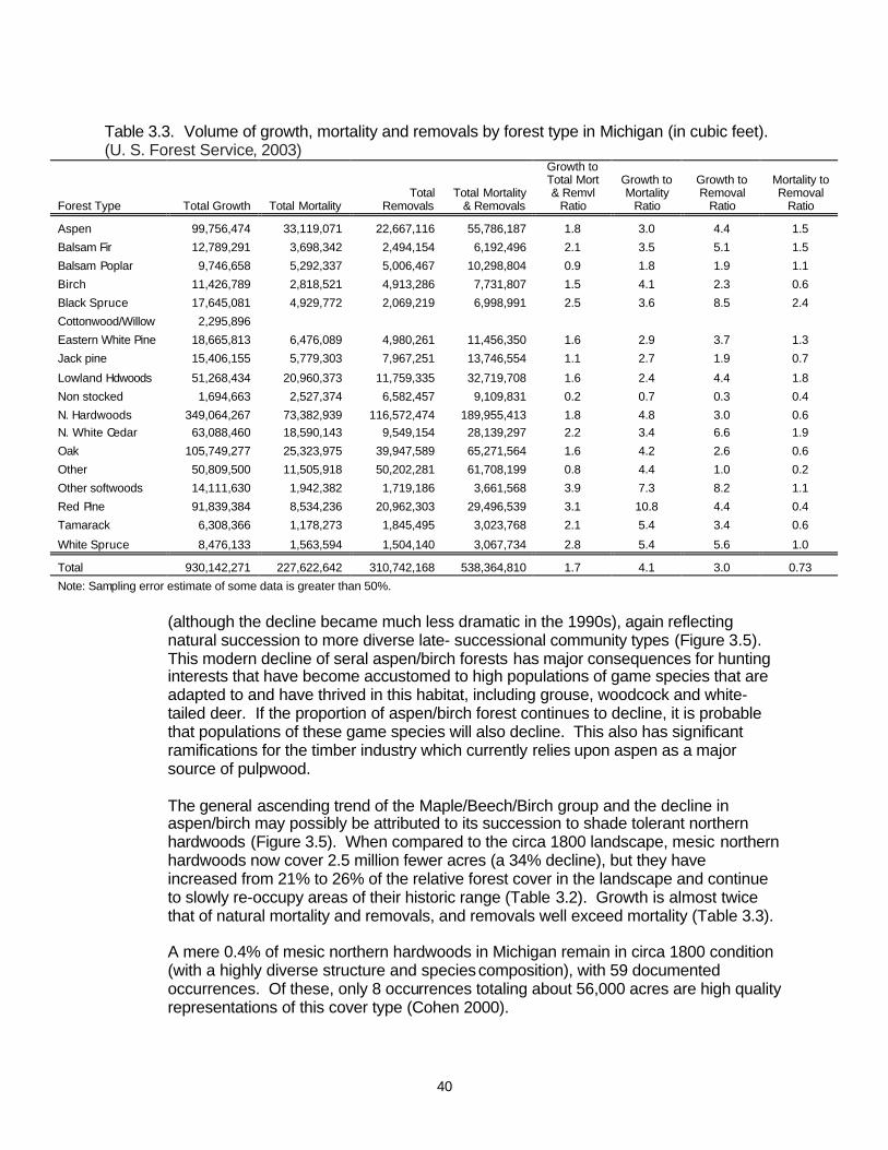
40
Table 3.3. Volume of growth, mortality and removals by forest type in Michigan (in cubic feet). (U. S. Forest Service, 2003)
Forest Type Total Growth Total Mortality Total
Removals Total Mortality
& Removals
Growth to Total Mort & Remvl
Ratio
Growth to Mortality
Ratio
Growth to Removal
Ratio
Mortality to Removal
Ratio
Aspen 99,756,474 33,119,071 22,667,116 55,786,187 1.8 3.0 4.4 1.5
Balsam Fir 12,789,291 3,698,342 2,494,154 6,192,496 2.1 3.5 5.1 1.5
Balsam Poplar 9,746,658 5,292,337 5,006,467 10,298,804 0.9 1.8 1.9 1.1
Birch 11,426,789 2,818,521 4,913,286 7,731,807 1.5 4.1 2.3 0.6
Black Spruce 17,645,081 4,929,772 2,069,219 6,998,991 2.5 3.6 8.5 2.4
Cottonwood/Willow 2,295,896
Eastern White Pine 18,665,813 6,476,089 4,980,261 11,456,350 1.6 2.9 3.7 1.3
Jack pine 15,406,155 5,779,303 7,967,251 13,746,554 1.1 2.7 1.9 0.7
Lowland Hdwoods 51,268,434 20,960,373 11,759,335 32,719,708 1.6 2.4 4.4 1.8
Non stocked 1,694,663 2,527,374 6,582,457 9,109,831 0.2 0.7 0.3 0.4
N. Hardwoods 349,064,267 73,382,939 116,572,474 189,955,413 1.8 4.8 3.0 0.6 N. White Cedar 63,088,460 18,590,143 9,549,154 28,139,297 2.2 3.4 6.6 1.9
Oak 105,749,277 25,323,975 39,947,589 65,271,564 1.6 4.2 2.6 0.6
Other 50,809,500 11,505,918 50,202,281 61,708,199 0.8 4.4 1.0 0.2
Other softwoods 14,111,630 1,942,382 1,719,186 3,661,568 3.9 7.3 8.2 1.1
Red Pine 91,839,384 8,534,236 20,962,303 29,496,539 3.1 10.8 4.4 0.4
Tamarack 6,308,366 1,178,273 1,845,495 3,023,768 2.1 5.4 3.4 0.6
White Spruce 8,476,133 1,563,594 1,504,140 3,067,734 2.8 5.4 5.6 1.0
Total 930,142,271 227,622,642 310,742,168 538,364,810 1.7 4.1 3.0 0.73
Note: Sampling error estimate of some data is greater than 50%.
(although the decline became much less dramatic in the 1990s), again reflecting natural succession to more diverse late- successional community types (Figure 3.5). This modern decline of seral aspen/birch forests has major consequences for hunting interests that have become accustomed to high populations of game species that are adapted to and have thrived in this habitat, including grouse, woodcock and white-tailed deer. If the proportion of aspen/birch forest continues to decline, it is probable that populations of these game species will also decline. This also has significant ramifications for the timber industry which currently relies upon aspen as a major source of pulpwood. The general ascending trend of the Maple/Beech/Birch group and the decline in aspen/birch may possibly be attributed to its succession to shade tolerant northern hardwoods (Figure 3.5). When compared to the circa 1800 landscape, mesic northern hardwoods now cover 2.5 million fewer acres (a 34% decline), but they have increased from 21% to 26% of the relative forest cover in the landscape and continue to slowly re-occupy areas of their historic range (Table 3.2). Growth is almost twice that of natural mortality and removals, and removals well exceed mortality (Table 3.3). A mere 0.4% of mesic northern hardwoods in Michigan remain in circa 1800 condition (with a highly diverse structure and species composition), with 59 documented occurrences. Of these, only 8 occurrences totaling about 56,000 acres are high quality representations of this cover type (Cohen 2000).
41
Since circa 1800, the acreage of mixed oak/hickory forests has increased by 300,000 acres (13%) and the relative area has doubled from 6.5% to 13.5% of the forested landscape (Table 3.2). This trend is also a legacy of turn of the century forest fires, to which the regeneration of oak is adapted. The ascending trend of the dry-mesic oak/hickory forest type may also be attributed to the general warming of the climate since the 1800s. Growth of oak is estimated to exceed that of mortality and removals by a ratio of 1.6:1, and removals well exceed natural mortality (Table 3.3). Since circa 1800, mixed hardwood swamps have decreased by 586,000 acres (41%) to 835,000 acres in overall area, but this loss has been partially offset by an increase in black ash swamps which increased by over 140% to 681,000 acres (Table 3.2). The acreage of lowland hardwoods has been on a general upward trend until the 1960s, with a slight decrease in acreage since that time, possibly attributed to increased pressure from development (Figure 3.4). Growth exceeds losses by mortality and removals by a ratio of 1.6:1. However, losses from mortality are almost twice that of removals (Table 3.3). As discussed further in the section on forest health, disease and pests have impacted the composition of lowland hardwood forests. American elm (Ulmus americana) was virtually eliminated by Dutch elm disease as a dominant overstory tree in many floodplain forests. The invasion of the emerald ash borer (Agrilus planipennis) threatens to further alter the species composition and structure of these forests. The hemlock component has precipitously declined in many forests of the state. Hemlock formerly covered 13.5% of the landscape and now comprises less than 1% of forest land, declining by over 97% from an area of 4.7 million acres to little more than 100,000 acres (Table 3.2). Hemlock was a co-dominant species in 6.3 million acres (85%) of the circa 1800 northern hardwood forests, both in terms of density and dominance (Tables 2.1 through 2.3). In the circa 1800 landscape there were four primary hemlock associations: pure hemlock (902,000 acres), hemlock/white pine (1,060,000 acres), hemlock/sugar maple (2,326,000 acres), and hemlock/yellow birch (295,000 acres). The decline in hemlock can be attributed to several factors, including climate, disturbance, land-use history and reproductive/life-history requirements of the species (Mladenoff and Sterns 1993). In the late 1800s, large areas of hemlock were harvested for the bark, which was used in tannin mills. The primary controlling factor governing rates of hemlock regeneration is likely the presence or absence of residual seed trees. Other factors are the shade-tolerant nature of hemlock, the historic occurrence of frequent destructive fires, the elimination of large-diameter woody debris nurse logs, and increased herbivore pressure, which have combined to inhibit the effective recruitment of hemlock throughout many portions of the landscape. Since circa 1800, the mesic southern hardwoods community type has declined by 4.3 million acres (74%) from almost 17% to 8% of the forested landscape (Table 3.2). In large part this loss is due to conversion of this forest type to farmland and progressively to urban/open land, which when combined now occupy over 15 million acres of the landscape (Figure 3.4). There are currently 39 documented occurrences totaling 2,505 acres of the mesic southern hardwoods community in Michigan. Of these, only six occurrences totaling less than 100 acres are high quality representations of this cover type (Cohen 2004). Mixed conifer swamps declined by almost 3.6 million acres (84%) since circa 1800, from over 12% to under 4 % of the forest landscape (Table 3.2). This loss can be

42
attributed to two primary factors: the historic clearing and draining of portions of this community type for agriculture, and the logging and conversion of the community to shrub-carr wetlands, which have increased in extent by almost three-quarter of a million acres. Conversely, the acreage of cedar swamps has increased by almost 8 percent since circa 1800, and has almost doubled its relative coverage of the landscape. Growth of cedar is more than twice the losses from mortality and removals (Table 3.3). However, natural mortality is almost twice the volume of cedar that is removed by harvest. Of note, the growth and mortality of black spruce is similar to that of cedar, with excessive losses due to mortality. There are three historic primary pine associations in Michigan: the mesic white/red pine forest, the dry northern forest dominated by jack and red pine, and the dry-mesic northern forest dominated by white pine and oak species. When considering the white pine communities (Table 3.2), the greatest changes are apparent in the various white pine communities, which have declined by over 80% (2.4 million acres in aggregate), from almost 7% to little more than 2% of the landscape. The mixed pine/oak forest type (82% of which historically consisted of white pine and white oak) has declined by almost 200,000 acres (35%) since circa 1800. These declines may be attributed to the historic loss of white pine seed trees from the landscape and repeated wildfires during the post-logging era, which greatly inhibited the natural reproduction of this species. Conversely, relatively pure red pine forests have increased by almost 300,000 acres (51%), and relatively pure jack pine communities have increased by over 118,000 acres (20%). However, even with this increase the proportion of pine dominated forests in the overall landscape has decreased by over 1.7 million acres. Remants of the dry northern and dry-mesic northern pine forests are among the rarest forest types in the Great Lakes region. Just over 0.2% of dry-mesic northern forest remains in presettlement condition in Michigan, with 34 documented occurrences. Of these, only 9 occurrences constituting just over 4,000 acres are of high quality (Cohen 2002a). There are 14 documented occurrences of the red pine variant of the dry northern forest in Michigan. Only 6 of these occurrences totaling over 600 acres are of high quality (with large boles and a more open, two-tiered canopy structure). The jack pine variant of the dry northern forest is more secure in Michigan, totaling over 333,000 acres (Cohen 2002b). Intensive re-forestation efforts in the early to mid 1900s have contributed to a doubling of the area of white, red and jack pine forests since 1935 (Figure 3.5) to around 2 million acres. Due to this effort, the restored pine forests are a resource that would have otherwise not existed in any significant volume. However, these efforts initiated the management of white, red and jack pine as monocultures, which have been perpetuated due to economic efficiency and demand. This requires less complicated silvicultural management techniques but also results in less landscape biodiversity. The complex composition and structure of circa 1800 dry northern, dry mesic, and pine and pine/oak barrens are barely represented in the current forest landscape. Furthermore, the modern exclusion of frequent and large scale fires from the forested landscape has greatly suppressed the natural regeneration of shade intolerant pine species. There is evidence that mid-shade tolerant white pine is regenerating in the understory of many current oak, red pine and aspen stands, portending a resurgence in the mixed pine/oak and mixed red/white pine forest types. This trend is discussed further in the next section.

43
The mixed oak savanna, oak/pine barrens and prairie communities were significant components of the circa 1800 landscape, occupying over 2.1 million acres in mostly the Southern Lower Peninsula (Table 3.2). Due to the suppression of wildfires and their ease of conversion to agricultural land, these communities have declined by over 99%, and are now only represented by small fragments that are scattered throughout the landscape. There have been major ecological consequences for plant and animal species that were adapted to savanna and prairie communities as they have also largely disappeared from the landscape and many remain imperiled as threatened and endangered species. In the Northern Lower Peninsula, circa-1800 pine barren communities covered almost 270,000 acres of the landscape. Today fewer than five high quality occurrences are known in Michigan, totaling only a few hundred acres. 3.1.2 - DNR-Owned Forest Land Conditions and Trends
The 3.9 million acres that are contained and managed by the DNR within the State Forest System (Figure 1.3) are largely non-contiguous tracts of forest that are scattered throughout the landscapes of the northern Lower Peninsula of Michigan and all of Upper Peninsula of Michigan. Over half (51.6%) of DNR-owned forestland is located in the Northern Lower Peninsula ecoregion. The Eastern Upper Peninsula and Western Upper Peninsula ecoregions contain 26.5% and 21.9% of forestland respectively (Appendix G). In contrast to the statewide landscape, the largest DNR community type is aspen at 885,000 acres (22 percent), followed by northern hardwoods at 508,000 acres (13 percent), jack pine at 367,000 acres (9 percent), red pine at 280,000 acres (7 percent), mixed swamp conifers at 261,000 acres (6 percent), oak at 244,000 acres (6 percent), and cedar swamp at 228,000 acres (6 percent) (Table 3.4). The current land base has changed significantly from circa-1800 conditions, where two community types were then dominant: northern hardwoods (26%) and mixed conifer swamps (22%) (Table 3.5). Two other major community types of the circa 1800 period were mixed red and white pine forests and jack pine forests, where both represented around 10% of the area that is now the State Forest. This section contains a more detailed discussion of the conditions and trends in the current cover types upon DNR-owned forest land. Aspen Consistent with statewide data, the acreage of aspen upon the State Forest is many times its historical acreage (Table 3.5), as a large number of acres of other cover types were converted to aspen after the logging era. There are more acres of aspen on the State Forest than any other type, and the acreage of this cover type has been fairly constant (Table 3.4). Nearly 60% of aspen is located in the Northern Lower Peninsula ecoregion (520,626 acres). Over a quarter (27.3%) of aspen (241,408 acres) is located in the Western Upper Peninsula ecoregion. Aspen is a relatively small component (13.9%) of the Eastern Upper Peninsula ecoregion with only 122,788 acres (Appendix G). Multiple markets began developing for Michigan aspen in the 1960s, and aspen fiber is now in strong demand by the forest products industry. Aspen also provides good habitat for a number of highly desired wildlife species (such as deer, grouse and woodcock). These species are adapted to and have been heavily favored by the preponderance of early successional forest types over the last century, and for which hunting groups and persons who simply enjoy viewing wildlife have an inherent
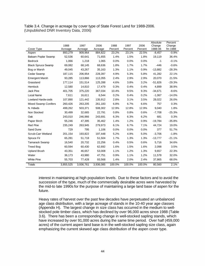
44
Table 3.4. Change in acreage by cover type of State Forest Land for 1988-2006. (Unpublished DNR Inventory Data, 2006)
Absolute Percent 1988 1997 2006 1988 1997 2006 Change Change Cover Type Acreage Acreage Acreage Percent Percent Percent 1988-06 fm 1988 Aspen 893,279 909,964 884,822 23.2% 23.1% 22.5% -8,457 -0.9% Balsam Poplar Swamp 52,536 60,641 71,655 1.4% 1.5% 1.8% 19,119 36.4%
Bedrock 1,066 1,218 1,065 0.0% 0.0% 0.0% -1 -0.1%
Black Spruce Swamp 69,082 68,145 68,636 1.8% 1.7% 1.7% -446 -0.6%
Bog or Marsh 49,045 43,267 35,163 1.3% 1.1% 0.9% -13,882 -28.3%
Cedar Swamp 187,115 206,954 228,397 4.9% 5.3% 5.8% 41,282 22.1%
Emergent Marsh 93,285 113,866 113,355 2.4% 2.9% 2.9% 20,070 21.5%
Grassland 177,114 151,514 125,288 4.6% 3.8% 3.2% -51,826 -29.3%
Hemlock 12,580 14,810 17,479 0.3% 0.4% 0.4% 4,899 38.9%
Jack Pine 401,705 375,220 367,034 10.4% 9.5% 9.3% -34,671 -8.6%
Local Name 7,611 16,611 6,544 0.2% 0.4% 0.2% -1,067 -14.0%
Lowland Hardw oods 107,890 121,442 135,912 2.8% 3.1% 3.5% 28,022 26.0%
Mixed Swamp Conifers 260,426 263,205 261,183 6.8% 6.7% 6.6% 757 0.3%
N. Hdwds 499,262 503,371 508,302 12.9% 12.8% 12.9% 9,040 1.8%
Non Stocked 30,499 32,665 22,791 0.8% 0.8% 0.6% -7,708 -25.3%
Oak 243,010 246,966 243,691 6.3% 6.3% 6.2% 681 0.3%
Paper Birch 55,246 47,395 35,462 1.4% 1.2% 0.9% -19,784 -35.8%
Red Pine 235,249 263,945 279,973 6.1% 6.7% 7.1% 44,724 19.0%
Sand Dune 729 795 1,106 0.0% 0.0% 0.0% 377 51.7%
Scrub-Carr Wetland 201,154 193,822 197,448 5.2% 4.9% 5.0% -3,706 -1.8%
Spruce Fir 65,281 51,718 51,504 1.7% 1.3% 1.3% -13,777 -21.1%
Tamarack Swamp 16,540 20,732 22,256 0.4% 0.5% 0.6% 5,716 34.6%
Treed Bog 60,594 60,430 62,692 1.6% 1.5% 1.6% 2,098 3.5%
Upland Brush 43,351 46,657 53,008 1.1% 1.2% 1.3% 9,657 22.3%
Water 36,173 43,980 47,751 0.9% 1.1% 1.2% 11,578 32.0%
White Pine 55,703 77,428 93,568 1.4% 2.0% 2.4% 37,865 68.0%
Totals 3,855,525 3,936,761 3,936,085 100.0% 100.0% 100.0% 80,560 2.1%
interest in maintaining at high population levels. Due to these factors and to avoid the succession of the type, much of the commercially desirable acres were harvested by the mid-to late 1990s for the purpose of maintaining a large land base of aspen for the future. Heavy rates of harvest over the past few decades have perpetuated an unbalanced age class distribution, with a large acreage of stands in the 10-40 year age classes (Appendix H). The largest change in size class has occurred in the medium to well-stocked pole timber class, which has declined by over 96,000 acres since 1988 (Table 3.6). There has been a corresponding change in well-stocked sapling stands, which have increased by over 91,000 acres during the same time period. Over half (459,000 acres) of the current aspen land base is in the well-stocked sapling size class, again emphasizing the current skewed age class distribution of the aspen cover type.

45
Table 3.5. Change in Cover Type circa 1800 to 2006 by acreage and relative cover. (Michigan Natural Features Inventory, 1998 and MDNR, 2006)
Cover Type C1800
Acreage C1800 Percent
2006 Acreage
2006 Percent
Change in Acres
Change in Percent
Aspen/Birch Forest 52,541 1.3 920,284 23.4 867,743 1651.6
Bedrock 1,174 0.0 1,065 0.0 -109 -9.3
Cedar Swamp 219,348 5.5 228,397 5.8 9,049 4.1
Grassland 3,715 0.1 125,288 3.2 121,573 3272.8
Hemlock (C1800 Hemlock/W Pine/Y Birch) 345,242 8.7 17,479 0.4 -327,763 -94.9
Jack Pine (C1800 JP/RP) Forest 400,793 10.1 367,034 9.3 -33,759 -8.4 Lake/River 24,025 0.6 47,751 1.2 23,726 98.8 Mixed Conifer Swamp (incl 2006 Blk Spr and Tam) 874,952 22.0 352,075 8.9 -522,877 -59.8 Mixed Hardwood and Black Ash Swamp 26,023 0.7 207,567 5.3 181,544 697.6 Mixed Pine-Oak Forest (2006 Oak) 72,176 1.8 243,691 6.2 171,515 237.6 Muskeg/Bog 124,775 3.1 97,855 2.5 -26,920 -21.6 Non-Stocked-Local Name 0.0 0.0 29,335 0.7 29,335 100.0
Northern Hardwoods 1 1,017,565 25.6 508,302 12.9 -509,263 -50.0 Oak-Pine Barrens 13,215 0.3 0.0 0.0 -13,215 -100.0
Pine Barrens 88,070 2.2 0.0 0.0 -88,070 -100.0
Red Pine Forest 20,798 0.5 279,973 7.1 259,175 1246.2
Red Pine-White Pine Forest 385,600 9.7 0.0 0.0 -385,600 -100.0 Sand Dune 202 0.0 1,106 0.0 904 447.1 Shrub Swamp/Emergent Marsh 56,808 1.4 310,803 7.9 253,995 447.1 Spruce-Fir (C1800 Spr-Fir-Cedar) Forest 136,148 3.4 51,504 1.3 -84,644 -62.2 Upland Brush 0.0 0.0 53,008 1.3 53,008 100.0 White Pine Forest 19,536 0.5 93,568 2.4 74,032 379.0
White Pine-Mixed Hardwood Forest 84,832 2.1 0.0 0.0 -84,832 -100.0
White Pine-White Oak Forest 3,096 0.1 0.0 0.0 -3,096 -100.0
Totals 3,970,634 100.0 3,936,085 100.0 -34,549 -0.9 1 Includes C1800 Beech-Sugar Maple-Hemlock, Sugar Maple-Basswood, Sugar Maple-Hemlock, and Sugar Maple-Yellow Birch Cover Types.
Table 3.6. Acreage of aspen size classes and stocking on State Forest Land for 1988 and 2006. (Unpublished DNR Inventory Data.)
Saw Timber Pole Timber Seedling-Sapling
Year of Entry Totals
Poorly Stocked (10-39
SQ_ FT_ BA)
Medium Stocked (40-69
SQ_ FT_ BA)
Well Stocked
(70+ SQ_ FT_
BA)
Poorly Stocked (10-39
SQ_ FT_ BA)
Medium Stocked (40-69
SQ_ FT_ BA)
Well Stocked
(70+ SQ_ FT_ BA)
Poorly Stocked (17%-39%)
Medium Stocked (40%-69%)
Well Stocked (70%+)
Non-Stocked (Less Then 17%)
1988 893,186 584 3,705 15,159 38,029 113,449 280,581 8,328 60,031 368,235 5085
2006 884,822 290 2,314 11,964 42,519 94,845 201,780 9,241 55,460 459,412 6997
Change -8,364 -294 -1,391 -3,195 4,490 -18,604 -78,801 913 -4,571 91,177 1912
% Change -0.9% -50.3% -37.5% -21.1% 11.8% -16.4% -28.1% 11.0% -7.6% 24.8% 37.6%

46
Given the monotypic clonal life cycle of aspen, compositional and structural diversity is low in these stands. However, consistent with state wide trends some aspen acres are becoming more diverse as they succeed to other cover types (Table 3.7). Without alternative management to the contrary, it is apparent that a substantial acreage of aspen has the potential to succeed to a spruce/fir community or to northern hardwoods. Lesser amounts of acreage are succeeding to white pine, oak and lowland hardwoods. These areas total over 325,000 acres, and represent almost 37% of the current 885,000 acre land base of aspen. Estimated mortality of aspen exceeds removals by a ratio of almost 2:1 (Table 3.8). However, estimated growth of aspen still exceeds mortality and removals by a similar 2:1 ratio, and young aspen is present in the understory of almost 20,000 acres of existing oak stands and on over 18,000 acres of current red pine stands. In a fifty-year rotation where acres were evenly distributed (what foresters refer to as having reached “regulation” or “area regulation”), 20% of the total acres would be in each ten-year age class. However, aspen harvests have fallen off so sharply in the past decade (due to heavy cutting in the prior decade) that the youngest (0-9) age class has slightly less than ten percent of the total acres. This is creating a “boom and bust” legacy problem for wildlife habitats and populations as well as for the wood products industry.
Table 3.7. Acreage of primary understory types by deciduous cover type for 2006. (Unpublished DNR Inventory Data)
Deciduous Cover Type:
Understory Type Aspen Balsam Poplar Oak
Paper Birch
Lowland Hardwoods
Northern Hardwoods
Not typed 43 Aspen 355,919 898 19,868 755 1,589 7,932 Balsam Poplar 355 13,466 329 77 Bedrock 55 Black Spruce 2,111 566 86 431 107 Bog or Marsh 770 46 182 4 18 Cedar Swamp 1,432 696 119 521 21 Emergent Marsh 158 411 14 811 130 Grassland 37,362 871 2,355 13 303 3,206 Hemlock 50 19 43 166 635 Jack Pine 6,760 51 8,431 39 496 Local Name 0 206 28 16 Lowland Hrdwds 21,356 5,470 6,855 296 73,833 513 Lowlnd Brush 14,434 15,526 70 795 21,018 203 Mxd Swmp Cnfr 1,785 6,848 20 978 10,823 325 N. Hardwoods 123,316 2,205 67,307 8,196 3,033 440,363 Non-Stocked 81,092 3,234 7,181 823 3,465 8,007 Oak 25,331 154 75,571 209 907 2,293 Paper Birch 656 93 51 1,170 12 110 Red Pine 4,476 59 3,725 120 3 320 Sand Dune 21 6 9 Spruce Fir 127,927 20,390 1,302 20,209 16,027 34,898 Tamarack Swmp 236 13 7 3 4 Treed Bog 23 45 Upland Brush 52,043 510 13,413 563 544 3,960 Water 0 190 White Pine 27,111 161 37,116 1,062 1,774 4,677
Totals 884,822 71,655 243,691 35,462 135,912 508,302

47
Table 3.8. Volume of growth, mortality and removals by forest type on State Forest Land for 2003 (in cubic feet). (U. S. Forest Service, 2003)
Forest Type State Growth State
Mortality State
Removals Total Mortality
& Removals
Growth to Total Mort & Remvl
Ratio
Growth to Mortality
Ratio
Growth to Removal
Ratio
Mortality to Removal
Ratio
Aspen 35,263,662 13,255,237 6,888,334 20,143,571 1.8 2.7 5.1 1.9
Balsam Fir 1,109,695 464,282 1,807,010 2,271,292 0.5 2.4 0.6 0.3
Balsam Poplar 2,972,021 134,548 134,548 22.1 22.1
Birch 901,710 136,841 136,841 6.6 6.6
Black spruce 6,748,311 1,370,791 288,190 1,658,981 4.1 4.9 23.4 4.8 Cottonwood / Willow 1,094,569
Eastern white pine 3,024,009 298,372 2,520,544 2,818,916 1.1 10.1 1.2 0.1
Jack pine 7,855,067 1,737,656 6,209,000 7,946,656 1.0 4.5 1.3 0.3
Lowland Hrdwoods 3,881,930 5,565,047 1,237,743 6,802,790 0.6 0.7 3.1 4.5
Non stocked 1,459,919 584,980 5,040,497 5,625,477 0.3 2.5 0.3 0.1
N. Hardwoods 47,330,507 8,919,055 18,409,438 27,328,493 1.7 5.3 2.6 0.5
N. White Cedar 8,835,188 6,088,584 6,088,584 1.5 1.5
Oak 11,904,777 5,818,525 14,130,589 19,949,114 0.6 2.0 0.8 0.4
Other 6,933,560 1,490,077 1,490,077 4.7 4.7
Other softwoods 655,748 167,161 167,161 3.9 3.9 0.0
Red Pine 18,534,527 3,002,901 4,594,272 7,597,173 2.4 6.2 4.0 0.7
Tamarack 2,754,434 520,184 520,184 5.3 5.3
White Spruce 1,780,917
Totals 163,040,552 49,387,081 61,292,779 110,679,860 1.5 3.3 2.7 0.8
Note: Sampling error estimate of most data is greater than 50%.
Northern Hardwoods The northern hardwoods cover type is the second-largest acreage on State Forest Land at over 508,000 acres or 13% of the land base. Since most northern hardwood stands are uneven-aged (Appendix H) and the tree species that compose the type have varying growth characteristics, total basal area is a better measure for northern hardwood conditions and treatment decisions than is the age class distribution. In the past decade, timber harvests in northern hardwoods (mostly single tree selection) have surpassed aspen in accounting for the most annual harvest acres. Northern hardwood acreage has increased only slightly since 1988 (Table 3.4). The Northern Lower Peninsula ecoregion has the largest (40.8%) acreage of northern hardwoods on state forestland at over 207,000 acres. The Western Upper Peninsula and the Eastern Upper Peninsula ecoregions have 171,749 (33.8%) and 129,254 (25.4%) acres of northern hardwoods forestland respectively (Appendix G). Consistent with statewide trends since circa 1800, the acreage of northern hardwoods decreased by over a half-million acres (-60%), with many of these acres having been converted to other cover types such as aspen, oak and red pine in the post-logging era (Table 3.5). Most northern hardwood acreage is in the well-stocked pole and saw size classes (Table 3.9). The largest changes in size class distribution occur with a 65,000 acres decline in pole timber and a 70,000 acre increase in saw timber classes,

48
Table 3.9. Acreage of northern hardwoods size classes and stocking on State Forest Land for 1988 and 2006. (Unpublished DNR Inventory Data)
Saw Timber Pole Timber Seedling-Sapling
Year of Entry Totals
Poorly Stocked (10-39
SQ_ FT_ BA)
Medium Stocked (40-69
SQ_ FT_ BA)
Well Stocked
(70+ SQ_ FT_
BA)
Poorly Stocked (10-39
SQ_ FT_ BA)
Medium Stocked (40-69
SQ_ FT_ BA)
Well Stocked
(70+ SQ_ FT_ BA)
Poorly Stocked (17%-39%)
Medium Stocked (40%-69%)
Well Stocked (70%+)
Non-Stocked (Less Then 17%)
1988 499,262 741 5,732 62,359 16,115 59,263 343,907 841 4,332 5,159 813
2006 508,302 1,553 6,984 130,612 8,382 38,885 306,692 1,011 5,321 8,750 112
Change 9,040 812 1,252 68,253 -7,733 -20,378 -37,215 170 989 3,591 -701
% Change 1.8% 109.6% 21.8% 109.5% -48.0% -34.4% -10.8% 20.2% 22.8% 69.6% -86.2%
Table 3.10. Acreage of basal area stocking of Northern Hardwoods on State Forest Land for 1988-2006. (Unpublished DNR Inventory Data)
Inventory Total Acres BA <60 BA 60
BA 70
BA 80
BA 90
BA 100 BA 110 BA 120 BA 130 BA 140 BA > 150
1979-1988 499,262 56,803 34,750 46,154 66,590 78,969 68,015 58,483 43,641 22,861 10,898 12,098 1988-1997 503,371 47,601 29,874 40,432 66,719 79,332 73,568 64,817 44,922 28,013 15,539 12,554
1997-2006 508,302 42,958 25,260 52,295 89,042 76,281 71,696 54,132 43,397 26,877 14,755 11,609
reflecting a continuing maturing of this cover type. The acres within each basal area class are relatively stable across the past three inventories (Table 3.10). Exceptions to this include the most recent inventory which has fewer acres in the two smallest basal area categories shown (<60 and 60) and fewer acres in the 110 basal area class. However, there are more acres in the 70 and 80 basal area categories, in line with increased harvests of this type since the early 1990s. Consistent with the life history characteristics of its component species, the estimated growth of northern hardwoods is one and a half times the volume of mortality and removals in the current acreage of the cover type (Table 3.8), and the understory type on 440,000 acres of northern hardwoods is predominately the same as the overstory species (Table 3.7). The only other significant understory recruitment is by the shade tolerant conifers white spruce and balsam fir on 35,000 acres. Interestingly, northern hardwoods are predominant in the understory of 123,000 acres of existing aspen stands, over 67,000 acres of existing oak stands, and over 44,000 acres of current red pine stands, indicating potential succession in the direction of the circa 1800 northern hardwoods cover type on these sites. Jack Pine The acreage of jack pine in the State Forest has been fairly consistent since circa 1800, having only slightly decreased (Table 3.5). This is not surprising given large areas of xeric, outwash soil types within the State Forest, to which the species is well adapted and competitive. Jack pine currently covers 367,000 acres of the State Forest, with a slight decline of 35,000 acres (8.6%) since 1988 (Table 3.4). The

49
greatest acreage (almost 234,000 acres or 63.7%) of jack pine upon state forestland is located in the Northern Lower Peninsula ecoregion. The Eastern Upper Peninsula ecoregion also contains a significant acreage (over 105,000 acres or 28.6% of the type) of jack pine. There is relatively little jack pine (28,000 acres or 7.7%) in the Western Upper Peninsula ecoregion (Appendix G). The Jack pine type is the only seral forest type that is somewhat balanced at approximately 40,000 acres per age class, although there is a moderate spike in the 0-20 year age classes (Appendix H). This reflects an emphasis upon salvage harvests of older age-classes of jack pine before they succumb to budworm infestations, and efforts to cut many older stands to preclude natural mortality. There remains a significant acreage of jack pine exceeding sixty years of age for which mortality from budworm continues to be a concern. Over 80% of jack pine stands are managed in even-aged 60-year rotations, although concerns over budworm and associated mortality are engendering considerations of a 50-year rotation. Consistent with the ecology of jack pine and the habitat type upon which it occurs there is little natural succession occurring in the community. Other than jack pine itself, the most prevalent understory species is oak upon 43,000 acres (Table 3.11). Estimated
Table 3.11. Acreage of primary understory types by conifer cover types for 2006. (Unpublished DNR Inventory Data)
Conifer Cover Type:
Understory Type Black Spruce
Cedar Swamp Hemlock Jack Pine
Mixed Swamp Conifers Red Pine Spruce Fir
Tamaracok Swamp White Pine
Not typed Aspen 132 768 107 9,531 698 18,229 2,660 3 7,312 Balsam Poplar 9 654 32 78 604 38 289 1 140 Bedrock 5 72 50 30 Black Spruce 46,394 2,786 121 13,524 6,824 5,062 344 2,055 2,799 Bog or Marsh 728 120 98 107 502 16 16 17 Cedar Swamp 426 57,248 248 29 7,209 1 146 929 32 Emergent Marsh 8 261 304 265 129 38 Grassland 151 389 104 10,590 1,343 3,341 1,556 45 514 Hemlock 41 2,787 203 63 106 Jack Pine 141 195,754 29 13,563 66 4 1,078 Local Name 175 10 Lowland Hrdwds 287 14,029 369 1,668 9,264 1,706 347 237 1,014 Lowlnd Brush 4,706 20,424 118 1,514 40,958 470 757 8,143 275 Mxd Swmp Cnfr 6,042 67,507 1,551 418 138,870 656 552 2,473 1,337 N. Hardwoods 231 1,263 3,270 11,979 2,818 44,432 1,896 167 10,562 Non-Stocked 3,259 16,578 1,763 41,007 7,882 53,380 4,389 619 3,110 Oak 48 3 42,743 23 25,762 14 1,113 Paper Birch 21 187 55 19 79 64 96 Red Pine 8,428 55,036 11 362 Sand Dune 12 59 Spruce Fir 5,835 45,156 6,331 6,148 42,489 13,255 37,104 1,331 21,067 Tamarack Swmp 34 359 44 192 35 35 6,000 7 Treed Bog 32 137 16 Upland Brush 87 553 54 10,065 861 7,743 1,004 62 974 Water 30 White Pine 65 24 624 12,673 450 36,560 268 28 41,585
Totals 68,636 228,397 17,479 367,034 261,183 279,973 51,504 22,256 93,568
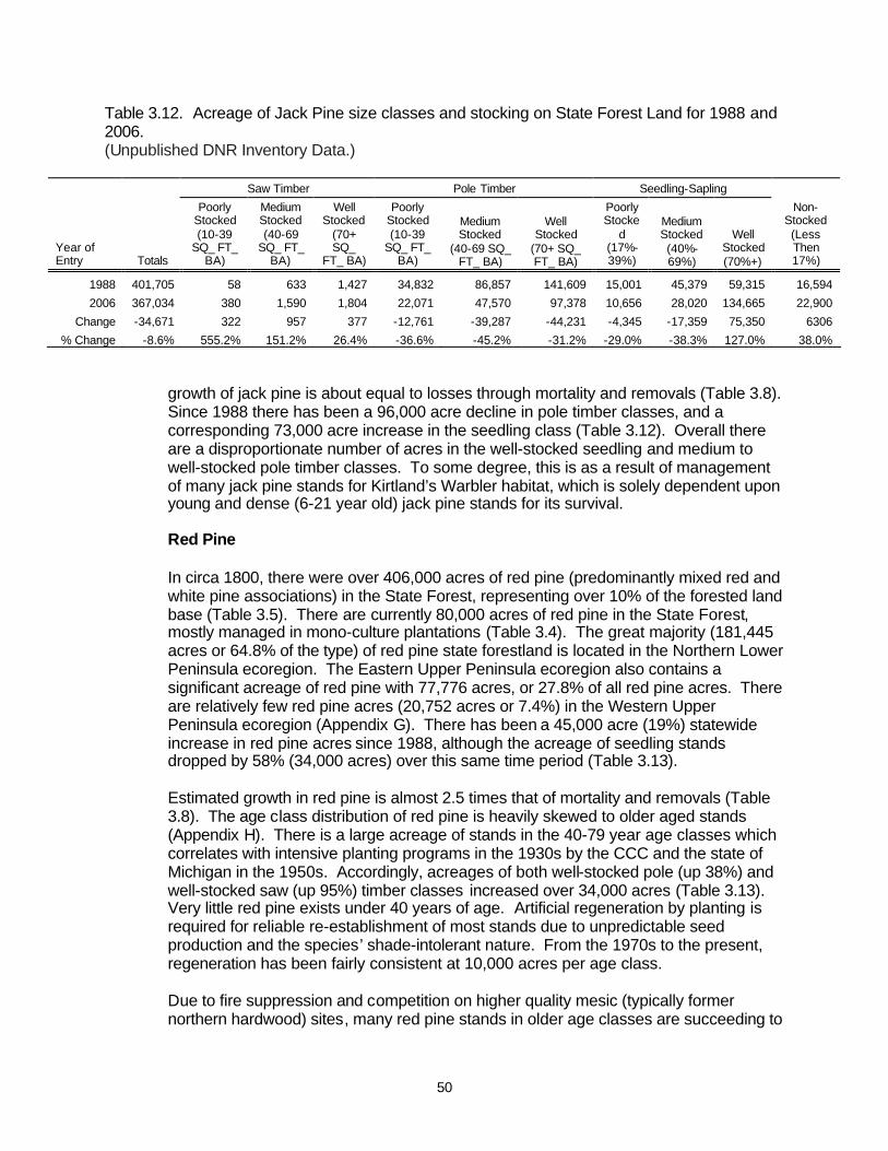
50
Table 3.12. Acreage of Jack Pine size classes and stocking on State Forest Land for 1988 and 2006. (Unpublished DNR Inventory Data.)
Saw Timber Pole Timber Seedling-Sapling
Year of Entry Totals
Poorly Stocked (10-39
SQ_ FT_ BA)
Medium Stocked (40-69
SQ_ FT_ BA)
Well Stocked
(70+ SQ_
FT_ BA)
Poorly Stocked (10-39
SQ_ FT_ BA)
Medium Stocked
(40-69 SQ_ FT_ BA)
Well Stocked
(70+ SQ_ FT_ BA)
Poorly Stocke
d (17%-39%)
Medium Stocked (40%-69%)
Well Stocked (70%+)
Non-Stocked (Less Then 17%)
1988 401,705 58 633 1,427 34,832 86,857 141,609 15,001 45,379 59,315 16,594
2006 367,034 380 1,590 1,804 22,071 47,570 97,378 10,656 28,020 134,665 22,900
Change -34,671 322 957 377 -12,761 -39,287 -44,231 -4,345 -17,359 75,350 6306
% Change -8.6% 555.2% 151.2% 26.4% -36.6% -45.2% -31.2% -29.0% -38.3% 127.0% 38.0% growth of jack pine is about equal to losses through mortality and removals (Table 3.8). Since 1988 there has been a 96,000 acre decline in pole timber classes, and a corresponding 73,000 acre increase in the seedling class (Table 3.12). Overall there are a disproportionate number of acres in the well-stocked seedling and medium to well-stocked pole timber classes. To some degree, this is as a result of management of many jack pine stands for Kirtland’s Warbler habitat, which is solely dependent upon young and dense (6-21 year old) jack pine stands for its survival. Red Pine In circa 1800, there were over 406,000 acres of red pine (predominantly mixed red and white pine associations) in the State Forest, representing over 10% of the forested land base (Table 3.5). There are currently 80,000 acres of red pine in the State Forest, mostly managed in mono-culture plantations (Table 3.4). The great majority (181,445 acres or 64.8% of the type) of red pine state forestland is located in the Northern Lower Peninsula ecoregion. The Eastern Upper Peninsula ecoregion also contains a significant acreage of red pine with 77,776 acres, or 27.8% of all red pine acres. There are relatively few red pine acres (20,752 acres or 7.4%) in the Western Upper Peninsula ecoregion (Appendix G). There has been a 45,000 acre (19%) statewide increase in red pine acres since 1988, although the acreage of seedling stands dropped by 58% (34,000 acres) over this same time period (Table 3.13). Estimated growth in red pine is almost 2.5 times that of mortality and removals (Table 3.8). The age class distribution of red pine is heavily skewed to older aged stands (Appendix H). There is a large acreage of stands in the 40-79 year age classes which correlates with intensive planting programs in the 1930s by the CCC and the state of Michigan in the 1950s. Accordingly, acreages of both well-stocked pole (up 38%) and well-stocked saw (up 95%) timber classes increased over 34,000 acres (Table 3.13). Very little red pine exists under 40 years of age. Artificial regeneration by planting is required for reliable re-establishment of most stands due to unpredictable seed production and the species’ shade-intolerant nature. From the 1970s to the present, regeneration has been fairly consistent at 10,000 acres per age class. Due to fire suppression and competition on higher quality mesic (typically former northern hardwood) sites, many red pine stands in older age classes are succeeding to
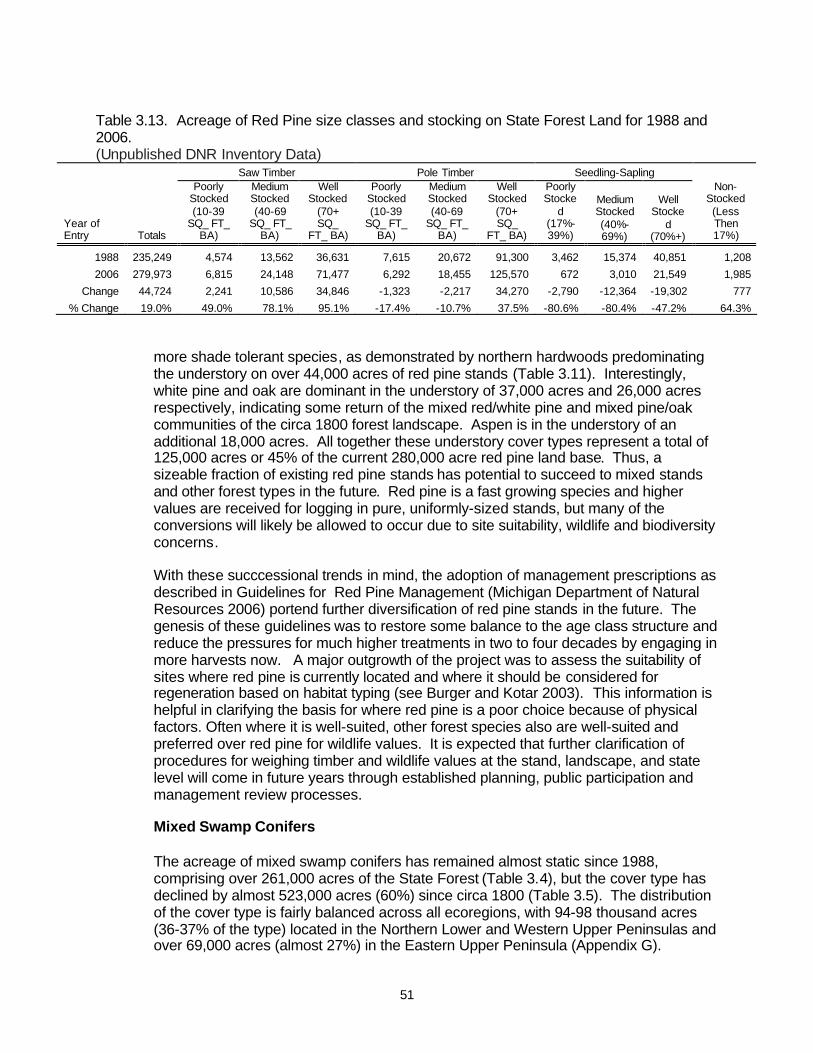
51
Table 3.13. Acreage of Red Pine size classes and stocking on State Forest Land for 1988 and 2006. (Unpublished DNR Inventory Data)
Saw Timber Pole Timber Seedling-Sapling
Year of Entry Totals
Poorly Stocked (10-39
SQ_ FT_ BA)
Medium Stocked (40-69
SQ_ FT_ BA)
Well Stocked
(70+ SQ_
FT_ BA)
Poorly Stocked (10-39
SQ_ FT_ BA)
Medium Stocked (40-69
SQ_ FT_ BA)
Well Stocked
(70+ SQ_
FT_ BA)
Poorly Stocke
d (17%-39%)
Medium Stocked (40%-69%)
Well Stocke
d (70%+)
Non-Stocked (Less Then 17%)
1988 235,249 4,574 13,562 36,631 7,615 20,672 91,300 3,462 15,374 40,851 1,208
2006 279,973 6,815 24,148 71,477 6,292 18,455 125,570 672 3,010 21,549 1,985
Change 44,724 2,241 10,586 34,846 -1,323 -2,217 34,270 -2,790 -12,364 -19,302 777
% Change 19.0% 49.0% 78.1% 95.1% -17.4% -10.7% 37.5% -80.6% -80.4% -47.2% 64.3% more shade tolerant species, as demonstrated by northern hardwoods predominating the understory on over 44,000 acres of red pine stands (Table 3.11). Interestingly, white pine and oak are dominant in the understory of 37,000 acres and 26,000 acres respectively, indicating some return of the mixed red/white pine and mixed pine/oak communities of the circa 1800 forest landscape. Aspen is in the understory of an additional 18,000 acres. All together these understory cover types represent a total of 125,000 acres or 45% of the current 280,000 acre red pine land base. Thus, a sizeable fraction of existing red pine stands has potential to succeed to mixed stands and other forest types in the future. Red pine is a fast growing species and higher values are received for logging in pure, uniformly-sized stands, but many of the conversions will likely be allowed to occur due to site suitability, wildlife and biodiversity concerns. With these succcessional trends in mind, the adoption of management prescriptions as described in Guidelines for Red Pine Management (Michigan Department of Natural Resources 2006) portend further diversification of red pine stands in the future. The genesis of these guidelines was to restore some balance to the age class structure and reduce the pressures for much higher treatments in two to four decades by engaging in more harvests now. A major outgrowth of the project was to assess the suitability of sites where red pine is currently located and where it should be considered for regeneration based on habitat typing (see Burger and Kotar 2003). This information is helpful in clarifying the basis for where red pine is a poor choice because of physical factors. Often where it is well-suited, other forest species also are well-suited and preferred over red pine for wildlife values. It is expected that further clarification of procedures for weighing timber and wildlife values at the stand, landscape, and state level will come in future years through established planning, public participation and management review processes. Mixed Swamp Conifers The acreage of mixed swamp conifers has remained almost static since 1988, comprising over 261,000 acres of the State Forest (Table 3.4), but the cover type has declined by almost 523,000 acres (60%) since circa 1800 (Table 3.5). The distribution of the cover type is fairly balanced across all ecoregions, with 94-98 thousand acres (36-37% of the type) located in the Northern Lower and Western Upper Peninsulas and over 69,000 acres (almost 27%) in the Eastern Upper Peninsula (Appendix G).

52
The age class distribution of mixed swamp conifers and black spruce are skewed to the older age classes (60 to 100+ years old) (Appendix H). There is relatively little active management of these community types, which has implications for increased forest health issues and natural mortality within the types. Most acreage of mixed swamp conifers is in the pole timber size class (Table 3.14), which increased by over 12,000 acres since 1988. Corresponding decreases were recorded in the acreage of the seedling-sapling size class. Other than in-kind recruitment, the only other association that is predominant in the understory is shade tolerant spruce/fir species on 42,000 acres (one-sixth) of the current acreage of the mixed swamp conifer cover type. An understory of mixed swamp conifers is present on over 67,000 acres of current cedar swamp cover type, reflecting a greater diversification of species within the cedar cover type (Table 3.11). For the black spruce component of this cover type, estimated growth is 4 times that of mortality and removals. However, natural mortality is estimated to be almost 5 times that of removals (Table 3.8).
Table 3.14. Acreage of Mixed Swamp Conifers size classes and stocking on State Forest Land for 1988 and 2006. (Unpublished DNR Inventory Data.)
Saw Timber Pole Timber Seedling-Sapling
Year of Entry Totals
Poorly Stocked (10-39
SQ_ FT_ BA)
Medium Stocked (40-69
SQ_ FT_ BA)
Well Stocked
(70+ SQ_ FT_ BA)
Poorly Stocked (10-39
SQ_ FT_ BA)
Medium Stocked (40-69
SQ_ FT_ BA)
Well Stocked
(70+ SQ_ FT_ BA)
Poorly Stocked (17%-39%)
Medium Stocked (40%-69%)
Well Stocked (70%+)
Non-Stocked (Less Then 17%)
1988 260,426 25 91 878 23,214 56,543 150,459 3,344 13,642 11,737 493
2006 261,183 30 139 1,441 22,576 59,333 160,181 1,364 6,045 9,692 382
Change 757 5 48 563 -638 2,790 9,722 -1,980 -7,597 -2,045 -111
% Change 0.3% 20.0% 52.7% 64.1% -2.7% 4.9% 6.5% -59.2% -55.7% -17.4% -22.5%
Oak The acreage of oak has remained fairly steady since 1988, covering 244,000 acres of the State Forest (Table 3.4). The overwhelming predominance of oak acreage (229,682 acres or 94.3% of the type) is located in the Northern Lower Peninsula ecoregion. There are very few acres of oak (only 2-4% of the type) in the Eastern and Western Upper Peninsula ecoregions (Appendix G). Oak species were often a component of mixed pine-oak cover types in the pre-settlement landscape of upper Michigan, but was only a relatively minor cover type (72,000 acres or 2%) of the Circa 1800 State Forest land base (Table 3.5). The age class distribution of current oak forests is greatly unbalanced, with approximately 65% of oak stands between 70 and 100 years of age and with to 32% concentrated in the 80 to 90 year old age class (Appendix H). The 0-70 year age classes are more balanced, with a consistent recruitment of about 10,000 acres for each class. The DNR uses a silvicultural rotation age of eighty years, which means that for stands older than eighty years of age a limiting factor must be coded into the inventory database if it is not prescribed for treatment. In the case of oak, the persistence of this cohort is a

53
result of intentional retention of oak species for hard mast production. Most of the acreage of oak lies in the medium and well-stocked pole and saw timber size classes (Table 3.15). There are relatively fewer acres of oak in the sapling size class, reflecting problems in achieving adequate regeneration of oak. However, percentage increases in sapling acres show an improving trend in regeneration. Of the major cover types on State Forest Land, oak is the only type in which estimated mortality and removals exceed growth, by an almost 2:1 ratio (Table 3.8). This is mostly due to removals, which alone exceed growth and which are more than twice that of estimated mortality. Oak-dominated stands common on moderate to low quality, sandy soil sites are anomalies which resulted from the removal of the pre-settlement pine forest and the unnatural catastrophic fires that followed. The 70-90 age cohort is a legacy of these large tracts of burnt over land, where in the early 1900s the regeneration of seral oak was favored over more shade tolerant species, and where historic seed sources of pine were then absent from the landscape. Maintenance of this cover type at its current level is not possible without replicating the events of the past – which will certainly not occur. Although some recruitment of oak is occurring in the understory of almost 76,000 acres of oak stands, the presence of other types in the understory indicates that much of the oak resource (124,000 acres (51%) of the current 244,000 acre oak land base) has the potential to succeed to other forest cover types (Table 3.7), with white pine and red maple on moderate to low quality sites, and to sugar maple-beech types on higher quality sites. The continued existence of an oak component on higher quality northern hardwood sites will require silvicultural practices that benefit oak’s mid-tolerant shade characteristics and that overcome its difficulty in out-competing more shade tolerant, northern hardwood species. The recruitment of white pine in the understory represents a return of the mixed pine/oak community, which was a significant community in the circa 1800 landscape. On a positive note, oak is present in the understory of 43,000 acres of existing jack pine stands, 26,000 acres of red pine stands, and over 25,000 acres of current aspen stands, representing a potential future oak component on these sites. Oak remains a valuable resource to maintain on the landscape, and on moderate and low- quality sites, silvicultural practices that encourage its establishment and recruitment as part of a mixed pine-oak cover type should be employed.
Table 3.15. Acreage of Oak size classes and stocking on State Forest Land for 1988 and 2006. (Unpublished DNR Inventory Data)
Saw Timber Pole Timber Seedling-Sapling
Year of Entry Totals
Poorly Stocked (10-39
SQ_ FT_ BA)
Medium Stocked (40-69
SQ_ FT_ BA)
Well Stocked
(70+ SQ_ FT_
BA)
Poorly Stocked (10-39
SQ_ FT_ BA)
Medium Stocked (40-69
SQ_ FT_ BA)
Well Stocked
(70+ SQ_
FT_ BA)
Poorly Stocked (17%-39%)
Medium Stocked (40%-69%)
Well Stocked (70%+)
Non-Stocked (Less Then 17%)
1988 243,010 6,077 15,159 22,306 9,168 48,458 119,916 2,689 9,230 7,342 2,665
2006 243,691 11,911 32,646 49,984 7,455 28,525 74,920 4,617 16,021 16,851 761
Change 681 5,834 17,487 27,678 -1,713 -19,933 -44,996 1,928 6,791 9,509 -1904
% Change 0.3% 96.0% 115.4% 124.1% -18.7% -41.1% -37.5% 71.7% 73.6% 129.5% -71.4%

54
Cedar Swamp Cedar swamps are present on 228,000 acres of State Forest land, having increased by over 41,000 acres (22%) since 1988 (Table 3.4). The majority of state forest cedar acreage is in the Eastern Upper Peninsula, at 99,510 acres or 43.6% of the type. The remaining acreage is split between the Northern Lower and Western Upper Peninsula ecoregions, with 67,548 and 61,339 acres respectively (Appendix G). The current acreage of cedar is fairly consistent with the pre-settlement acreage of 219,000 acres (Table 3.5). Some of the recent increase may be the result of succession from shrub-carr wetland, but may also be a result of more accurate mapping of forest compartments. Most acreage lies in the well stock pole timber size class (Table 3.16), which has increased by 35% during this same time period. Growth exceeds natural mortality by a ratio of 1.5:1 (Table 3.8). The age class distribution for cedar is skewed to older age classes (Appendix H), with the 100+ age class predominating. There is very little regeneration of cedar occurring, with declining acreages of sapling size classes. Regeneration problems in many areas are the result of severe browse damage caused by white-tailed deer populations, which prefer to utilize cedar swamps in the winter as both shelter and a food source. Cedar is predominant in the understory on 57,000 acres of cedar swamp (Table 3.11). However, this is exceeded by the mixed swamp conifer and spruce/fir forest types in the understory on 68,000 and 45,000 acres respectively, which portends future diversification of species upon almost half of the cedar swamp land base. White Pine White pine acreage increased by 38,000 acre (68%) since 1988, and the species presently covers an area of 94,000 acres of the State Forest (Table 3.4). On a percentage basis, this is the greatest rate of increase for any species, and understory data indicates that this trend is continuing. Most acres of white pine are located in the Northern Lower (45,229 acres or 48.3%) and Eastern Upper (36,902 acres or 39.4%) Peninsula ecoregions. There are currently relatively few acres of white pine (11,437 acres or 12.2%) in the state forestland of the Western Upper Peninsula ecoregion (Appendix G).
Table 3.16. Acreage of Northern White Cedar size classes and stocking on State Forest Land for 1988 and 2006. (Unpublished DNR Inventory Data)
Saw Timber Pole Timber Seedling-Sapling
Year of Entry Totals
Poorly Stocked (10-39
SQ_ FT_ BA)
Medium Stocked (40-69
SQ_ FT_ BA)
Well Stocked
(70+ SQ_
FT_ BA)
Poorly Stocked (10-39
SQ_ FT_ BA)
Medium Stocked (40-69
SQ_ FT_ BA)
Well Stocked
(70+ SQ_ FT_ BA)
Poorly Stocked (17%-39%)
Medium Stocked (40%-69%)
Well Stocked (70%+)
Non-Stocked (Less Then 17%)
1988 187,115 17 323 2,586 8,981 26,623 132,701 876 2,898 11,922 188
2006 228,397 56 306 5,944 9,026 23,734 179,241 294 1,981 7,526 289
Change 41,282 39 -17 3,358 45 -2,889 46,540 -582 -917 -4,396 101
% Change 22.1% 229.4% -5.3% 129.9% 0.5% -10.9% 35.1% -66.4% -31.6% -36.9% 53.7%

55
White pine was historically present not only in relatively pure stands (20,000 acres) but it was also a common species in several associations: the previously discussed mixed red-white pine type (386,000 acres); hemlock-white pine (314,000 acres); white pine-mixed hardwood forests (85,000 acres); and in white pine-white oak forests (3,100) acres (Table 3.5). By far, the mixed red-white pine, hemlock-white pine and white pine-mixed hardwood associations were the dominant pine communities in the circa 1800 landscape (Table 2.1, Table 3.2 and Table 3.5). There is a large acreage of stands older than 40 years and in uneven age classes, indicating some natural recruitment of white pine around the turn of the 19th century (Appendix H). Where potential seed trees remain much natural regeneration of white pine is currently occurring in the understory of hardwood and mixed pine stands. In addition to regeneration in the understory of existing white pine stands, the species is also recruiting in the understory of aspen (27,000 acres), red pine (37,000 acres) and oak (37,000 acres) stands (Tables 3.7 and 3.11). This reflects the moderate shade tolerance of white pine, and indicates a gradual return of the white pine-mixed hardwood and the mixed red-white pine communities to the state forest landscape. Shade tolerant northern hardwoods and spruce/fir are also in the understory of about 11,000 and 21,000 respective acres of existing white pine stands (Table 3.11). These are not unexpected occurrences, since white pine was historically present as a co-dominant species in mesic northern hardwoods (Table 2.3), and white spruce and balsam fir are commonly present in remaining old growth stands of white pine. Growth of white pine is essentially equal to removals (Table 3.8), and given the long-lived nature of the species it is not surprising that estimated mortality is low with growth approximately 10 times that of mortality. There have been large increases in pole and saw size classes since 1988, but declining regeneration in the seedling size class (Table 3.17). Hemlock As in the statewide landscape, hemlock was historically present in 345,000 acres of the State Forest land base in the form of hemlock-white pine and hemlock-yellow birch associations (Table 3.5). Hemlock was also a co- dominant component in the northern hardwoods cover type (Table 2.3 and Table 3.5). Today hemlock stands comprise just over 17,000 acres (0.4%) of the current State Forest land base, and it is the least
Table 3.17. Acreage of White Pine size classes and stocking on State Forest Land for 1988 and 2006. (Unpublished DNR Inventory Data)
Saw Timber Pole Timber Seedling-Sapling
Year of Entry Totals
Poorly Stocked (10-39
SQ_ FT_ BA)
Medium Stocked (40-69
SQ_ FT_ BA)
Well Stocked
(70+ SQ_ FT_
BA)
Poorly Stocked (10-39
SQ_ FT_ BA)
Medium Stocked (40-69
SQ_ FT_ BA)
Well Stocked
(70+ SQ_
FT_ BA)
Poorly Stocked (17%-39%)
Medium Stocked (40%-69%)
Well Stocked (70%+)
Non-Stocked (Less Then 17%)
1988 55,703 2,711 7,793 16,792 1,665 5,892 12,917 584 2,008 5,341 0
2006 93,568 3,882 11,412 26,628 3,586 11,654 30,418 373 1,675 3,917 23
Change 37,865 1,171 3,619 9,836 1,921 5,762 17,501 -211 -333 -1,424 23
% Change 68.0% 43.2% 46.4% 58.6% 115.4% 97.8% 135.5% -36.1% -16.6% -26.7%

56
represented of any native tree species both in terms of absolute and percentage of acreage (Table 3.4). Most state forest hemlock acres are located in the Western and Eastern Upper Peninsula ecoregions, with 8,762 acres (50.1%) and 7,130 acres (40.8%) respectively. There is very little hemlock (1,587 acres or 9.1%) in the Northern Lower Peninsula ecoregion (Appendix G). There has been very little hemlock regeneration over the past century, with most remaining hemlock in the 100+ year and uneven aged classes (Appendix H). Although regeneration is limited, it is still occurring. The acreage of hemlock has increased by 39% since 1988, by a total of 4,900 acres (Table 3.4). The low acreage and regeneration can be attributed to several factors, including climate, disturbance, land-use history and reproductive/life-history requirements of the species (Mladenoff and Sterns 1993). The primary controlling factor governing rates of hemlock regeneration is likely the presence or absence of residual seed trees. Other factors are the shade-tolerant nature of hemlock, the historic occurrence of frequent destructive fires, the elimination of large-diameter woody debris nurse logs, and increased herbivore pressure, which have combined to inhibit the effective reproduction of hemlock throughout many portions of the landscape. Most hemlock is located in the well stocked pole and saw timber size classes (Table 3.18). The vast majority of understory hemlock occurs in existing hemlock stands, with lesser amounts in northern hardwoods, mixed swamp conifers, lowland hardwood and white pine stands (Table 3.11). Within existing hemlock stands the predominant understory vegetation is comprised of shade tolerant spruce/fir, northern hardwoods, hemlock, and mixed swamp conifers. Thus, where residual seed trees remain, is appears that hemlock is slowly returning to the forest landscape. Lowland Hardwoods Lowland hardwood cover types include balsam poplar swamp and lowland hardwoods. The acreage of balsam poplar swamp has increased by over 36% since 1988 and is approaching 72,000 acres (Table 3.4). The acreage of lowland hardwoods has increased by 26% since 1988 and now covers almost 136,000 acres. Most of the acreage of balsam poplar (41,289 acres or 57.6%) and lowland hardwoods (92,942 acres or 68.4%) is located in the Northern Lower Peninsula ecoregion. Much lower acres of balsam poplar and lowland hardwoods are present in the Eastern Upper Peninsula ecoregion, with 22,426 acres (31.3%) and 20,554 acres (15.1%)
Table 3.18. Acreage of Hemlock size classes and stocking on State Forest Land for 1988 and 2006. (Unpublished DNR Inventory Data)
Saw Timber Pole Timber Seedling-Sapling
Year of Entry Totals
Poorly Stocked (10-39
SQ_ FT_ BA)
Medium Stocked (40-69
SQ_ FT_ BA)
Well Stocked
(70+ SQ_ FT_
BA)
Poorly Stocked (10-39
SQ_ FT_ BA)
Medium Stocked (40-69
SQ_ FT_ BA)
Well Stocked
(70+ SQ_
FT_ BA)
Poorly Stocked (17%-39%)
Medium Stocked (40%-69%)
Well Stocked (70%+)
Non-Stocked (Less Then 17%)
1988 12,580 32 353 5,239 42 457 6,270 64 123
2006 17,479 124 432 7,845 135 561 8,382
Change 4,899 92 79 2,606 93 104 2,112
% Change 38.9% 287.5% 22.4% 49.7% 221.4% 22.8% 33.7%
57
respectively. There are relatively fewer acres of balsam poplar and lowland hardwoods present in the Western Upper Peninsula ecoregion, with 7,940 acres (11.1%) and 22,416 acres (16.5%) respectively (Appendix G). Lowland hardwoods were historically a relatively minor component of the land base that now comprises the present State Forest landscape (Table 3.5). The age class distribution for balsam poplar swamp is highly variable, with spikes in the 10-30 year and 60-90 year age classes (Appendix H). The age class distribution for lowland hardwoods is skewed to older age classes, with a large number of acres classified as uneven-aged. Mortality of lowland hardwoods is a concern, with mortality greatly exceeding growth (Table 3.8). This mortality is due to a confluence of factors, such as forest pests, variations in ground and surface water levels, low commercial value that limits salvage cuts, accessibility concerns which limit active management, and regeneration concerns. The opposite is apparent for balsam poplar, where the growth to mortality ratio is by far the highest of any forest type. Lowland hardwoods are regenerating well in the understory of present stands, with spruce-fir and mixed swamp conifers also becoming established on approximately 20% of the acreage (Table 3.7). Spruce-fir is the dominant component in the understory of balsam poplar stands, with balsam poplar naturally regenerating on less than 20% of the acreage. Grasslands Grasslands are present upon 125,000 acres (3.2%) of the State Forest, and have declined by 52,000 acres (29%) since 1988 (Table 3.4). Almost half (60,147 acres) of all state forest grasslands are located in the Northern Lower Peninsula ecoregion. A significant acreage of grasslands is located in the Eastern Upper Peninsula ecoregion, with almost 42,000 acres or 33.5% of the cover type. There is a much smaller acreage of grassland in the Western Upper Peninsula ecoregion, with 23,146 acres or18.5% (Appendix G). Approximately 11,000 acres of grassland are co-located within the jack pine cover type. In the circa 1800 landscape of the Northern Lower Peninsula most grasslands were associated with pine and oak-pine barrens, which covered 88,000 and 13,000 acres respectively (Table 3.5). Aggregating barren habitat with the circa 1800 acreage for grasslands yields a pre-European settlement total of 105,000 acres, which is only somewhat less than the current total of 125,000 acres upon State Forest land. However, it is estimated that only approximately 1,460 acres of current DNR grassland lies within identified circa 1800 pine barren communities, so the vast majority of current grassland acres have shifted into other community types. Moreover, many additional acres of jack and red pine are currently located in areas of circa 1800 pine barren communities. There are presently less than 2,100 acres of identified pine barren remnants remaining in the state, and the community type is currently a rare occurrence upon the landscape.

58
3.1.3 - Timber Harvest Trends
The Michigan DNR has 60 years of historical information on timber sales. The number of timber acres sold over this period (with some variability from year to year in the number of timber acres sold) has increased appreciably, with almost 10,000 more acres being added in each successive decade (Figure 3.6). Declines in harvest over the period were followed by substantial increases. This was true of a decline between 1984 and 1989 which was followed by increases throughout most of the 1990s. Since 1999, the level of sales has dipped slightly, fluctuating between 45,000 and 58,000 acres, with an average of approximately 52,000 acres. Five cover types (aspen, jack pine, oak, red pine, and northern hardwoods) account for most (about 90%) of the timber sales from State Forests. Over the past 20 years the volume of timber sales has averaged around 700,000 cords per year (Figure 3.7). The When considering volume of timber sold for the five major and the ten minor cover types since the mid-1990s, some significant trends can be noted for aspen, northern hardwoods, red pine, white pine and mixed swamp conifers (Tables 3.19 and 3.20). Reflecting the concerted effort prior to the mid-90s to maintain the acreage of the aspen cover type, the number of acres of aspen sold gradually decreased after 1997 and reached a low in 2003. Beginning in the 2004, the acres of aspen sold have
MI State Forest Acres Sold
0
10,000
20,000
30,000
40,000
50,000
60,000
70,000
1944 1949 1954 1959 1964 1969 1974 1979 1984 1989 1994 1999 2004
Year
Acr
es
Figure 3.6. Acreage of State Forest timber sold from 1944 to 2004. (Unpublished DNR Timber Sale Data)
Michigan State Forest Volume Sold (cords)
0
100,000
200,000
300,000
400,000
500,000
600,000
700,000
800,000
1945-49
1950-54
1955-59
1960-64
1965-69
1970-74
1975-79
1980-84
1985-89
1990-94
1995-99
2000-04
Years
Vo
lum
e (C
ord
s)
Figure 3.7. Volume of State Forest timber sold (cords) from 1945 to 2004. (Unpublished DNR Timber Sale Data)

59
Table 3.19. Volume of timber sales (in cords) of major cover types from 1997 to 2005. (Unpublished DNR Timber Sale Data)
Volume (cords)
FY Total1 Aspen Jack Pine
N. Hdwds Oak
Red Pine
Sum of 5 Types
% of Total
1997 766,648 209,230 161,981 132,890 76,192 94,004 674,298 89%
1998 812,514 213,746 136,411 140,151 82,251 139,770 712,328 89%
1999 664,358 182,418 71,931 146,191 90,312 92,368 583,220 90%
2000 747,635 163,069 125,624 162,106 101,472 98,347 650,619 90%
2001 630,376 157,991 90,370 119,063 75,232 97,737 540,394 87%
2002 758,022 154,554 139,690 157,959 94,619 90,863 637,686 85%
2003 640,213 151,222 93,705 142,536 74,163 102,331 563,957 89%
2004 713,710 175,676 120,979 148,413 76,328 97,297 618,693 88%
2005 805,949 203,473 129,911 173,257 74,970 122,727 704,338 88%
Avg 726,603 179,042 118,956 146,952 82,838 103,938 631,726 87% % of
Total: 25% 16% 20% 11% 14%
Acres
FY Total1 Aspen Jack Pine
N. Hdwds Oak
Red Pine
Sum of 5 Types
% of Total
1997 56,972 11,312 11,182 14,319 6,715 7,866 51,394 92%
1998 58,316 10,670 8,591 15,543 7,156 10,297 52,256 91%
1999 52,036 9,246 6,267 15,687 6,958 8,215 46,372 92%
2000 58,241 8,724 9,379 17,979 7,552 8,361 51,994 92%
2001 45,608 7,943 6,094 11,414 6,003 8,022 39,477 88%
2002 57,687 7,847 11,267 16,090 7,377 7,109 49,690 87%
2003 46,318 7,673 6,216 15,254 4,917 7,050 41,110 90%
2004 49,057 9,119 8,246 13,492 6,540 7,170 44,565 92%
2005 55,606 10,064 8,776 15,990 6,638 8,257 49,726 90%
Avg 53,316 9,177 8,446 15,085 6,651 8,039 47,398 89% % of
Total: 17% 16% 28% 12% 15% Volume/Acre (cords/acre)
FY Total1 Aspen Jack Pine
N. Hdwds Oak
Red Pine
Sum of 5 Types
1997 13.5 18.5 14.5 9.3 11.3 12.0 13.1
1998 13.9 20.0 15.9 9.0 11.5 13.6 13.6
1999 12.8 19.7 11.5 9.3 13.0 11.2 12.6
2000 12.8 18.7 13.4 9.0 13.4 11.8 12.5
2001 13.8 19.9 14.8 10.4 12.5 12.2 13.7
2002 13.1 19.7 12.4 9.8 12.8 12.8 12.8
2003 13.8 19.7 15.1 9.3 15.1 14.5 13.7
2004 14.5 19.3 14.7 11.0 11.7 13.6 13.9
2005 14.5 20.2 14.8 10.8 11.3 14.9 14.2
Avg 13.6 19.5 14.1 9.7 12.5 12.9 13.3 1 Total of all major and minor cover types.

60
Table 3.20. Volume of timber sales (in cords) of minor cover types from 1997 to 2005. (Unpublished DNR Timber Sale Data)
Volume (cords)
FY Total1 Not
Coded Paper Birch Cedar
Swamp Hrdwds
Spruce Fir Hemlock
Lowlnd Poplr
Mxd Swmp Cnfr
Black Spruce Tamarack
White Pine
1997 766,648 12,718 11,565 1,616 6,829 14,176 3,792 15,664 12,853 2,848 9,394
1998 812,514 9,906 20,930 2,063 6,494 10,491 1,056 10,452 19,315 3,885 427 14,617
1999 664,358 14,963 14,959 945 10,096 7,317 7,065 14,306 353 9,912
2000 747,635 22,333 13,224 991 5,741 8,691 1,775 11,110 15,118 2,871 13,681
2001 630,376 10,847 11,370 2,562 10,139 11,176 2,330 10,601 7,135 7,059 445 15,569
2002 758,022 8,193 17,640 1,683 13,814 21,083 817 31,748 5,362 957 1,424 17,078
2003 640,213 7,731 13,279 484 10,946 12,613 1,148 9,099 7,308 2,924 429 9,016
2004 713,710 7,014 9,968 616 6,649 9,474 1,225 4,566 3,003 3,294 2,116 15,453
2005 805,949 3,545 13,420 940 8,241 11,383 438 10,918 5,762 8,451 2,737 11,746
Avg 727,111 10,805 14,040 1,322 8,772 11,822 1,572 12,358 10,018 3,627 1,263 12,941
Acres
FY Total1 Not
Coded Paper Birch Cedar
Swamp Hrdwds
Spruce Fir Hemlock
Lowlnd Poplr
Mxd Swmp Cnfr
Black Spruce Tamarack
White Pine
1997 56,972 1,280 717 96 445 768 222 839 249 199 692
1998 58,316 842 1,268 105 361 720 95 574 324 248 22 1,340
1999 52,036 1,451 1,081 65 780 474 412 305 145 772
2000 58,241 1,541 744 74 383 604 104 739 296 242 1,267
2001 45,608 812 651 197 800 582 164 710 383 500 19 1,244
2002 57,687 743 832 152 1,005 1,248 100 1,789 363 78 93 1,491
2003 46,318 470 675 27 710 781 125 534 491 202 49 704
2004 49,057 435 537 68 427 586 90 303 198 204 169 1,100
2005 55,606 432 767 61 691 720 29 639 362 591 194 783
Avg 53,178 890 808 94 622 720 116 727 330 268 91 1,044
Volume/Acre
FY Total1 Not
Coded Paper Birch Cedar
Swamp Hrdwds
Spruce Fir Hemlock
Lowlnd Poplr
Mxd Swmp Cnfr
Black Spruce Tamarack
White Pine
1997 13.5 9.9 16.1 16.9 15.3 18.4 17.1 18.7 51.6 14.3 13.6
1998 13.9 11.8 16.5 19.7 18.0 14.6 11.1 18.2 59.7 15.7 19.4 10.9
1999 12.8 10.3 13.8 14.5 12.9 15.4 17.1 47.0 2.4 12.8
2000 12.8 14.5 17.8 13.3 15.0 14.4 17.0 15.0 51.1 11.9 10.8
2001 13.8 13.4 17.5 13.0 12.7 19.2 14.2 14.9 18.6 14.1 23.4 12.5
2002 13.1 11.0 21.2 11.1 13.8 16.9 8.2 17.7 14.8 12.3 15.4 11.5
2003 13.8 16.5 19.7 17.7 15.4 16.2 9.2 17.0 14.9 14.5 8.8 12.8
2004 14.5 16.1 18.6 9.1 15.6 16.2 13.6 15.1 15.2 16.1 12.5 14.0
2005 14.5 8.2 17.5 15.5 11.9 15.8 15.1 17.1 15.9 14.3 14.1 15.0
Avg 13.7 12.1 17.4 14.1 14.1 16.4 13.6 17.0 30.4 13.6 13.9 12.4 1 Total of all major and minor cover types.

61
started to trend upward again. Throughout this period, aspen volumes per acre remained steady at close to 20 cords per acre. Volume of production from northern hardwoods, red pine and white pine cover types have been increasing since 1996, reflecting the increasing maturation of these cover types. In contrast, production from mixed swamp conifers has dropped off sharply beginning in 2001, in part reflecting changes in coding. DNR timber harvest trends differ by species. In the past decade, the acres of Michigan State Forest timber sales have leveled off at an average of around 52,000 acres (Table 3.19), and the composition of these sales have changed. More acres of upland hardwood were sold as the number of aspen acres declined. This tradeoff resulted in the loss of some volume and increased labor requirements due to increased selective cutting (single-tree marking in the place of clearcuts). The following discussion of specific cover types focuses upon harvest level trends for different cover types over the coming decade. Aspen: In comparison to the period of the 1960s to mid-1990s, there were less than half as many aspen acres that met commercial criteria for harvest in the past decade. Past DNR management of aspen has created a very large difference between the number of acres in the current 0-9 age class (86,986) and the 10-19 age class (195,327) (Appendix H). It will be another five to fifteen years before a large number of aspen acres recover to commercially desirable ages. When again available for harvests the DNR will need to work to balance the age class distribution of the aspen cover type. In order to avoid an even more skewed age class distribution and to assure long-term sustainability of the resource, sales of aspen need to increase in certain age classes. Younger stands in the 30 to 49 year age classes should be considered for prescriptive treatment on appropriate sites. In general, the 70 to 89 year age classes should also be prescribed for treatment or they will convert to later successional forest types. Given the number of acres in the older age (>80 years) classes, it is likely that acres of aspen will slightly decline. Assuming conversions drop the total acreage down towards 850,000 that would still leave 170,000 acres as the area regulation decade sum for five age classes or 17,000 acres annually. Annual aspen sales have averaged 9,177 acres since 1997, but they were generally falling over the period from 1997 to 2005 (Table 3.19). This should be reversed soon, with an emphasis on the balancing of age classes, rather than waiting for the next cohort in the age class structure to reach commercial maturity over the next ten to twenty years. In two to four decades, when the DNR has a large acreage of rotation-aged aspen, a closer examination at landscape, regional and state-wide scales is warranted to determine the appropriateness of maintaining the aspen cover type upon landforms where it is not well suited. Jack Pine: An accelerated rate of jack pine harvest has been necessary over the past two decades in order to avoid excessive mortality due to jack pine budworm infestations in over-mature stands, which were facing mortality and conversion to other forest types. The accelerated harvesting has resulted in a skewed age class distribution towards the 0-9 and 10-19 year age classes (Appendix H). This bias towards younger age classes is also accentuated in part by Kirtland’s Warbler (KW) habitat work which requires shorter rotations. Between efforts to reduce acres in older age classes and the continuing KW work, higher levels of harvests may be maintained
62
for a few more years or even up to a decade. However, given the age structure of jack pine overall timber sale harvests are expected to decline by 25% to 50% from their recent sales average of 8,446 acres (Table 3.19) for a period starting in the coming decade and lasting for at least three decades. This is simply because the age classes approaching commercial readiness for the next three decades are less than 40,000 acres each, or less than half the average amount which has been harvested in recent years. Even the current 60-69 year age class has less than 40,000 acres. Northern Hardwoods: Average northern hardwood sales for 1997 through 2005 have been 15,085 acres (Table 3.19). One possible source of an increase in acres would be for the DNR to operate outside of the 10-year compartment review cycle. The current process focuses attention on a particular year-of-entry (approximately one-tenth of the State Forest) rather than the entire forest. This tends to put upland hardwood stands on a twenty-year selection cut harvest schedule as the amount of growth in ten years is usually inadequate for a commercial sale. However, the additional basal area gained may be adequate at some time in the intervening years. To optimally time harvests with variable growth rates, the DNR would have to conduct inventory, prepare sales, and monitor much of the forest on a continual basis, rather than on the current 10-year cycle. The DNR does not have the resources that would enable a shift to a continual management cycle in the near-term, nor would it be necessarily desirable to do so, but with the advent of new plans and software tools such a shift may be possible in the future. Red Pine: To be balanced over the extent of its current acreage, the distribution of red pine should be at approximately 27,000 acres per age class. Between 1997 and 2005 an average of 8,039 acres of red pine were annually sold (Table 3.19). To date, most red pine harvests (approximately 80%) have entailed thinning stands rather than stand regeneration harvests. Thinning cuts tend to occur every 10-15 years, depending upon site quality and stand condition. Regeneration harvests generally occur between 60 and 90 years of age. Markets are currently best for utility pole-size stands, and the highest returns are on fourteen to sixteen inch trees. Bid values decline for larger size classes. Large acres of red pine are at or approaching the optimal 60-90-year age for regeneration harvest, and although the number of treated red pine acres may not increase during the next decade there should be a transition to more regeneration harvests. Thinning treatments will continue to outnumber regeneration harvests, but the ratio will fall from the current ratio of more than 8 to 1. Management guidelines for red pine have been in existence for several years, and increases in prescriptions for red pine regeneration harvests are beginning to occur. From an average of less than 700 acres for the previous decade regeneration harvests reached 1,552 acres in 2005 and were 1,136 acres in 2006. Regeneration harvests should increase by an average of 10% to 20% and double outputs to over 2,000 acres per year during the next decade. Volume outputs will increase as regeneration cuts provide two to four times the volume of thinning cuts. Increased level of harvests should continue for several decades, until a more balanced age class distribution of red pine is achieved. Oak: Sales of oak have averaged 6,651 acres from 1997 to 2005 (Table 3.19). Increased timber treatments within the oak cover type are likely, due to the concentration of acres in the 70-100 year range (Appendix H), and an increased understanding and acceptance of maintaining oak as a mixed pine-oak cover type. Most of these treatments will be with higher volume regeneration harvests. For the time being, however, the direction of oak harvests is not certain. Harvests are not
63
likely to decline in the near-term. Over the long-term (three or more decades from now), oak harvests are likely to decline as the number of acres decline and the species is more integrated with other species. Future opportunities to increase acres of oak also exist, but both resource professionals and the public need to understand and accept the fact that it will mostly exist as part of a mixed pine-oak cover type. To enhance the health and maintenance of the oak component for hard mast production in the State Forest, prescriptive treatments should no longer be delayed to the next decade. No minor forest cover type shown in Table 3.20 averages more than two percent of sales during the past decade and seldom does any other type reach 3 percent of the sales for any given year. There are many fewer acres of these forest types, and the average acres sold should be put within the context of current total State Forest sales of around 50,000 acres per year. A brief discussion of these minor cover types follows. Paper Birch: Annual sales of paper birch have remained low, averaging around 800 acres (Table 3.20). This is consistent with its overall decline in total acres for this type. Hemlock: Acres of hemlock sales have averaged around one-hundred acres per year (Table 3.20), with nearly all of the treatments being selection and shelterwood preparation cuts aimed at promoting regeneration of the species. These actions are consistent with a growing emphasis on restoring the mesic conifer component to many areas of the State Forest. The sale of hemlock as a significant commercial species is not probable for the foreseeable future. Lowland Hardwoods and Balsam Poplar : Lowland forest types have more factors that limit treatment on a greater number of acres than do upland types. These limiting factors range from access issues, best management practice concerns and environmental issues, through wildlife concerns, markets and regeneration issues. However, a need exists to adjust the harvest of balsam poplar stands with a goal of balancing the age class distribution of this cover type. A similar need exists to even out the age class distribution of lowland hardwoods, as well as to address the issue of excessive mortality within this cover type. Over the past decade an average of 622 acres of lowland hardwoods and 727 acres of balsam poplar were harvested per year (Table 3.20). It is expected that these acreages may increase for each type over the next decade. An exception to this is harvests in riparian zones which will be limited due to beaver management efforts and for the maintenance of habitat connectivity. Spruce-Fir: Sales of the spruce-fir cover type have averaged 720 acres per year as of 2005 (Table 3.20). Sales of this type are not anticipated to greatly increase due to a greater emphasis on increasing structural diversity of mesic conifers in community types such as northern hardwoods. Cedar and Tamarack: Acres of cedar sales have declined to around 60 acres per year (Table 3.20) and will likely continue to do so, reflecting regeneration concerns for the species. Acres of tamarack sales have likewise been low at less than 200 acres per year. It is anticipated that sales of both cedar and tamarack will be statistically insignificant for the foreseeable future. Mixed Swamp Conifers and Black Spruce: Combined sales for mixed swamp conifers and black spruce have averaged close to 600 acres per year (Table 3.20), but

64
have been trending slightly upward. A large increase in prescriptions within these lowland conifers is less likely than lowland hardwood cover types due to increased concern for the maintenance of wildlife habitat. Expansion of DNR activity in these types will receive extensive scrutiny by a wide array of interests and will need to be done in a very measured fashion. An aggressive effort will need to be made to develop criteria and standards to determine where and how it is viable to operate in these types. White Pine: There is potential for increased sales of white pine over the next seven decades, as many plantation stands approach a rotational age of 100 years. Over the past decade sales of white pine averaged 1,100 acres per year (Table 3.20). As it becomes an increasing component in mixed aspen, red pine and oak stands the potential production of white pine may become even greater in the future. Increased prescriptions within these minor forest types are not likely to elevate them to the level of prominence accorded to the major timber types at any time in the immediate future. Only modest increases in harvests will likely be experienced with some of these types, most notably for lowland hardwoods, balsam poplar, mixed swamp conifers and black spruce.
3.2 - Forest Health Conditions and Trends
Michigan faces several major forest health concerns. The introduction of non-native plant and animal species and diseases are a serious threat to the health of the State’s forest ecosystems, and can have major ecological consequences for the composition of native forest communities. Some epidemic pathogens such as Dutch elm disease, the emerald ash borer and beech bark disease pose threats across the entire landscape of the state. Others are more localized in the range of their impact. The current management strategy is to contain and eradicate newly identified pathogens, however some agents are now securely entrenched into ecosystems of the state. Some pathogenic agents are native to the state and cause infestations that are cyclical in nature. A general discussion of the more significant threats follows below.
Emerald Ash Borer
The introduction of the emerald ash borer (Agrilis planipennis) (EAB), a native of China, Korea, Japan, and far eastern Russia, is threatening Michigan’s ash resource. All varieties of ash trees appear susceptible. Evidence suggests that the insect has been active in Michigan since at least 1997. The small, green metallic beetles have infested or killed 15 million trees in 21 counties in Southeast Michigan, and there are outlying infestations in 31 other areas of the state (Figure 3.8). All counties in the Lower Peninsula are either quarantined or regulated. No hardwood firewood or ash tree parts or products can move from quarantined areas or out of the Lower Peninsula without MDA inspection and approval.
The discovery of remote, outlying EAB populations continues in Michigan. These outliers mostly represent pre-quarantine (e.g. year 2002 and earlier) spread of EAB. New EAB detections are the result of statewide trap tree surveys by the Michigan Department of Agriculture (MDA) and Michigan Technological University (MTU). The MTU survey is sponsored by the USDA Forest Service. Many of the new 2005 detections resulted from the MTU risk based survey. Risk was defined using maps of the state’s ash resources and state park databases showing visits from residents of EAB infested counties. Trap trees were

65
Figure 3.8. Quarantined counties in Michigan with emerald ash borer populations in 2005. (Unpublished DNR Data)

66
deployed in 135 high risk state and federal parks and campgrounds throughout Michigan and northern Wisconsin. The survey effort also included visual inspections of firewood and ash trees in these and adjacent areas.
The 2005 EAB detection at Brimley was the first in Michigan’s Upper Peninsula. The MDA and DNR acted quickly to remove this population. This was a 2002 introduction at Brimley State Park. It does not reflect on quarantine efforts to stop EAB at the Mackinac Bridge or DNR efforts banning the movement of ash onto state and federal lands, both of which began in 2005. No other EAB outliers have been detected in the Upper Peninsula.
The continuing spread of the emerald ash borer infestation portends a future decline of ash resources.
Beech Bark Disease
Beech Bark Disease (BBD) continues to threaten Michigan’s American beech resource. Beech is a component in 6.3 million acres of the Maple-Beech-Birch forest type. This represents 138 million beech trees in all size classes. Of these, 15 million larger beech (greater than 9-inch diameter) are highly vulnerable to tree mortality. The disease is caused by the interaction of an exotic scale insect (Cryptococcus fagisuga) and a native and exotic canker-causing fungus (Nectria spp.). Once infected by the fungus, trees usually decline and trunks may break at canker sites. BBD is presently killing beech trees in areas infested with beech scale for 10 years or more. Many hundreds of acres of American beech are being harvested in the killing front areas of the eastern Upper Peninsula.
The scale infestation is currently concentrated in two primary epicenters, Luce County in the Upper Peninsula and Mason County in the Lower Peninsula (Figure 3.9). The University of Michigan continues to expand the Beech Bark Disease Monitoring & Impact Analysis System (BBDMIAS) plot network. Data collected for the BBDMIAS and also field observations during summer 2005 revealed new beech scale infestations in several areas. Counties in the Lower Peninsula that had new or increasing infestations include Antrim, Emmet, Leelanau, Manistee, Newaygo, Otsego and Wexford Counties. In addition, field crews observed very light scale populations in Cheboygan County and on Bois Blanc Island.
Using data from the BBDMIAS, an effort was begun in 2004 to calculate the current and projected spread of beech bark disease in Michigan. The goal is to develop a model based on empirical data to predict how rapidly beech scale and beech bark disease will spread through Michigan and to determine if spread rates in Michigan are consistent with estimates from other regions of North America. To date it appears the spread rate of beech scale in Michigan is about double that published for the Northeast, or about 10-15 miles per year. Spread rates will vary from stand to stand since the beech resource in the Lower Peninsula is much more fragmented than the Upper Peninsula. The beech scale in the Upper Peninsula was already widely distributed before the initial detection in 2000. Most of Chippewa, Luce and Mackinac Counties are now included in the advancing front and several new areas of infestation were found west of the previous boundary, primarily in Schoolcraft and Alger Counties. Beech trees in a plot on Drummond Island were reported as having light scale but this has not been confirmed.
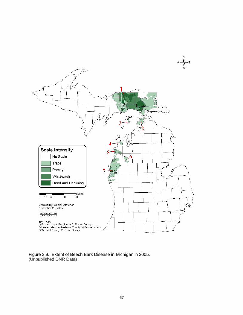
67
Figure 3.9. Extent of Beech Bark Disease in Michigan in 2005. (Unpublished DNR Data)

68
Mortality did not increase as dramatically as scale populations and most areas are still in the early stages of scale infestation. The most dramatic increase in beech mortality was in Tahquamenon Falls State Park on the Chippewa/Luce County border where over 90% of the beech overstory is either dead or severely declining.
The USDA Forest Service Research Facility in Delaware, Ohio continues to collect scions from resistant trees in Michigan to study BBD resistance. Scions from resistant American beech were again collected in December, 2005 and sent to the Delaware, OH USFS research facility. Michigan has also agreed to host 1 or 2 seed orchards for propagating resistant seed beginning in the fall, 2006.
Eastern Larch Beetle
Eastern larch beetle (Dendroctonus simplex), populations in Eastern and the South Central Upper Peninsula caused 25,717 acres of cumulative mortality that began in 2002 (Figure 3.10). This bark beetle became epidemic in tamarack (Larix laricina) trees stressed from the drought of 2000-2001 and repeated defoliation by the larch casebearer (Coleophora laricella).
The casebearer is an exotic needle-mining insect that was introduced to the Lake States in the early 1900s. Populations are usually brought under control within 2 years by natural parasitic enemies, but repeated heavy defoliation can cause branch dieback or tree mortality.
Figure 3.10. Extent of Eastern Larch Beetle in Michigan in 2005. (Unpublished DNR Data)
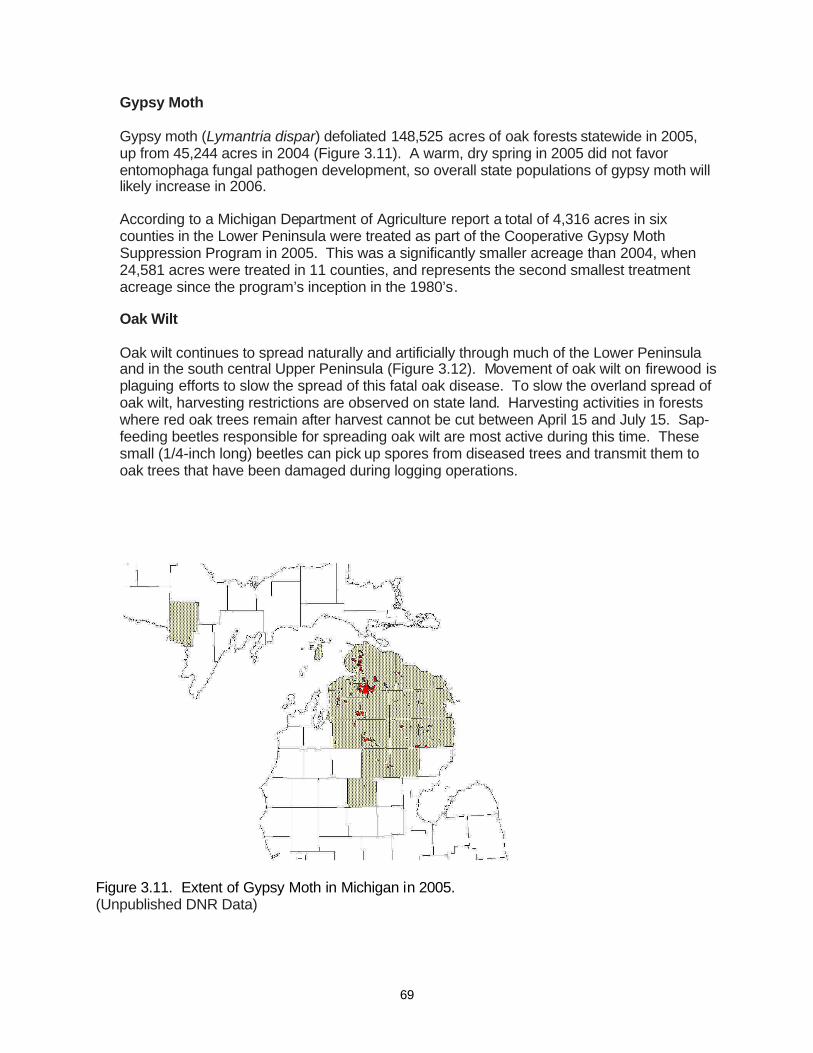
69
Gypsy Moth
Gypsy moth (Lymantria dispar) defoliated 148,525 acres of oak forests statewide in 2005, up from 45,244 acres in 2004 (Figure 3.11). A warm, dry spring in 2005 did not favor entomophaga fungal pathogen development, so overall state populations of gypsy moth will likely increase in 2006.
According to a Michigan Department of Agriculture report a total of 4,316 acres in six counties in the Lower Peninsula were treated as part of the Cooperative Gypsy Moth Suppression Program in 2005. This was a significantly smaller acreage than 2004, when 24,581 acres were treated in 11 counties, and represents the second smallest treatment acreage since the program’s inception in the 1980’s.
Oak Wilt
Oak wilt continues to spread naturally and artificially through much of the Lower Peninsula and in the south central Upper Peninsula (Figure 3.12). Movement of oak wilt on firewood is plaguing efforts to slow the spread of this fatal oak disease. To slow the overland spread of oak wilt, harvesting restrictions are observed on state land. Harvesting activities in forests where red oak trees remain after harvest cannot be cut between April 15 and July 15. Sap-feeding beetles responsible for spreading oak wilt are most active during this time. These small (1/4-inch long) beetles can pick up spores from diseased trees and transmit them to oak trees that have been damaged during logging operations.
Figure 3.11. Extent of Gypsy Moth in Michigan in 2005. (Unpublished DNR Data)

70
Figure 3.12. Counties in Michigan with oak wilt in 2005. (Unpublished DNR Data)
US Forest Service oak wilt suppression funds for detecting and treating oak wilt epicenters in Michigan’s Upper Peninsula were not available in 2005. However, detection efforts and landowners contacts continued in efforts to rid the Upper Peninsula of this threat to its oak resources.
Red-Headed Pine Sawfly
The red-headed pine sawfly (Neodiprion lecontei) periodically defoliates young red and jack pine. Sawfly populations have been active in the eastern Upper Peninsula and the northern Lower Peninsula beginning in 2002. Heaviest infestations are in pines growing under stress, particularly those at the edges of hardwood forests, on poor soils, and where there is heavy competitive vegetation. In general, it infests and damages trees less than 15 feet tall. Moderate to heavy defoliation stunts height growth of infested trees and forking may result from top kill. Complete defoliation usually kills the tree. Dimlin 4L was aerially applied to 480 acres of infested plantation red pine in 2005.
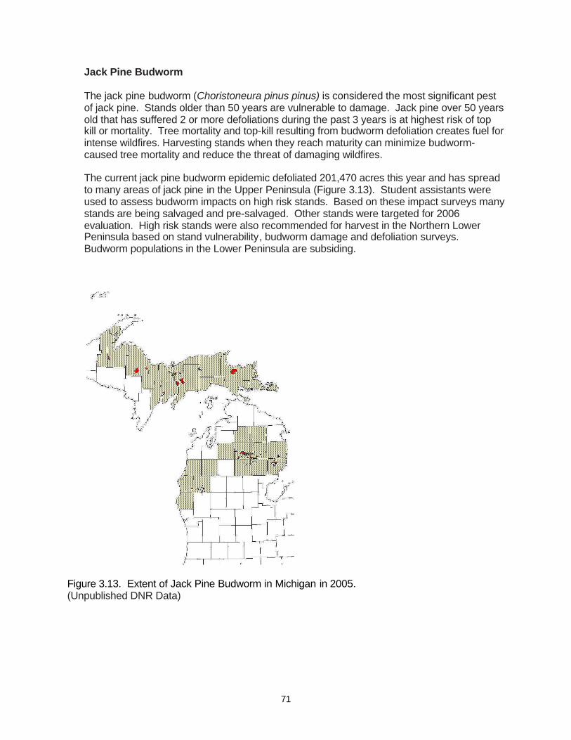
71
Jack Pine Budworm
The jack pine budworm (Choristoneura pinus pinus) is considered the most significant pest of jack pine. Stands older than 50 years are vulnerable to damage. Jack pine over 50 years old that has suffered 2 or more defoliations during the past 3 years is at highest risk of top kill or mortality. Tree mortality and top-kill resulting from budworm defoliation creates fuel for intense wildfires. Harvesting stands when they reach maturity can minimize budworm-caused tree mortality and reduce the threat of damaging wildfires.
The current jack pine budworm epidemic defoliated 201,470 acres this year and has spread to many areas of jack pine in the Upper Peninsula (Figure 3.13). Student assistants were used to assess budworm impacts on high risk stands. Based on these impact surveys many stands are being salvaged and pre-salvaged. Other stands were targeted for 2006 evaluation. High risk stands were also recommended for harvest in the Northern Lower Peninsula based on stand vulnerability, budworm damage and defoliation surveys. Budworm populations in the Lower Peninsula are subsiding.
Figure 3.13. Extent of Jack Pine Budworm in Michigan in 2005. (Unpublished DNR Data)

72
Spruce Budworm
Spruce budworm defoliated 9471 acres in several counties in Michigan’s Upper Peninsula (Figure 3.14). Areas of light budworm defoliation have been visible for the last few years. Areas of mature to over mature spruce/fir in the south central Upper Peninsula (south western Menominee County) have top kill and tree mortality caused by repeated defoliations.
Dutch Elm Disease
The non-native Dutch elm disease continues to cause extensive mortality of American elm within both upland and lowland hardwood communities. It is expected that stocks of American elm will continue to decline throughout the forest landscape.
Forest Tent Caterpillar
Only a few small scattered pockets of aspen and oak defoliation remain as evidence of the large scale Forest Tent Caterpillar (Malacosoma disstria) epidemic which began in 2000.
Sudden Oak Death
Sudden oak death (SOD), now known as Ramorum Blight (Phytophthora ramorum), has not been detected in Michigan’s nurseries, urban forests or forest lands.
Figure 3.14. Extent of Spruce Budworm in Michigan in 2005. (Unpublished DNR Data)
73
Black Ash Decline and Mortality
Black ash decline and mortality continues to be common in many parts of the state. This is related to past drought conditions. Trees growing in wet soils, such as black ash, often suffer during droughts. Wetland trees tend to develop shallow root systems that cannot cope with a prolonged drop in soil moisture. Rising water tables after a prolonged drought may also drown deeper roots developed as the tree sought moisture during the drought years.
White Ash Root Rot
A white ash root rot is causing extensive wind throw of mature ash in high quality northern hardwood stands in Northern Lower Michigan. Stresses from overstocking may be involved. University and USDA Forest Service forest pathologists and entomologists visited ash decline areas in Northern Lower Michigan. Ash yellows was diagnosed as one of the causal agents of decline. Armillaria and other root pathogens are also involved. Further study based on these finding will follow. Understanding ash health is paramount in assessing the susceptibility of ash resources to EAB.
Hemlock Woolly Adelgid
The hemlock woolly adelgid (Adelges tsugae) quarantine continues to restrict movement of eastern hemlock into Michigan from infested counties of other states. All eastern hemlock shipments require a phytosanitary certificate. This follows the interception of the insect at two Michigan nurseries in 2000. Hemlock woolly adelgid is dispersed by wind and by movement of infested firewood, and feeds on tree sap, killing needles, twigs and branches. Infested trees eventually die. Rapid early detection surveys for the adelgid were conducted statewide for the fourth straight year in hemlock stands and in areas adjacent to nurseries. This is part of a Forest Health Monitoring Evaluation project. No adelgids were found in 2005.
White Pine Weevil
The white pine weevil (Pissodes strobe) is a destructive insect of eastern white pine, jack pine and Norway spruce. The weevil breeds in and destroys the terminal leader of white pine, causing forking and crooking of the tree. In general it prefers open-grown trees from 2 to 20 feet tall, feeding on the previous year’s terminal in the spring and on lateral in the summer and fall. Stem deformities may result in wood defects such as compression wood and bark-encased knots that reduce the value of sawn lumber. This reduction in wood quality is considered the major impact of the white pine weevil. Detrimental impacts from the weevil can be avoided though recruitment of white pine through the understory of existing forest stands.
White Pine Blister Rust
White pine blister rust (Cronartium ribicola) is the only stem rust of white pines in North America. An apparent native of Asia, blister rust was introduced to eastern North America on eastern white pine (Pinus strobes) seedlings from nurseries in Germany in about 1898. Currants and gooseberries in the genus Ribes serve as an alternate host for the rust fungus that causes white pine blister rust. Blister rust and the white pine weevil have given eastern white pine a reputation as a difficult species to culture in forest stands, but the evidence of
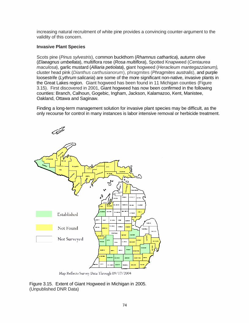
74
increasing natural recruitment of white pine provides a convincing counter-argument to the validity of this concern.
Invasive Plant Species
Scots pine (Pinus sylvestris), common buckthorn (Rhamnus cathartica), autumn olive (Elaeagnus umbellata), multiflora rose (Rosa multiflora), Spotted Knapweed (Centaurea maculosa), garlic mustard (Alliaria petiolata), giant hogweed (Heracleum mantegazzianum), cluster head pink (Dianthus carthusianorum), phragmites (Phragmites australis), and purple loosestrife (Lythrum salicaria) are some of the more significant non-native, invasive plants in the Great Lakes region. Giant hogweed has been found in 11 Michigan counties (Figure 3.15). First discovered in 2001, Giant hogweed has now been confirmed in the following counties: Branch, Calhoun, Gogebic, Ingham, Jackson, Kalamazoo, Kent, Manistee, Oakland, Ottawa and Saginaw.
Finding a long-term management solution for invasive plant species may be difficult, as the only recourse for control in many instances is labor intensive removal or herbicide treatment.
Figure 3.15. Extent of Giant Hogweed in Michigan in 2005. (Unpublished DNR Data)

75
The establishment of biological control organisms is also one area of interest. Presently, Scots pine is being systematically removed from state forestlands, and prescribed fire is being tried to reduce spotted knapweed populations in oak savannas in the south central Upper Peninsula. Cluster head pink was detected in the Upper Peninsula and efforts to eradicate are planned for 2006. The Seney National Wildlife Refuge continues to battle common buckthorn populations with herbicides and prescribed fire.
Recent successes with the release of two small leaf-feeding beetles on purple loosestrife have reinforced the positive benefits that a successful and carefully implemented biological control program can have. Purple loosestrife populations have declined in many areas where Galareucella beetles have been released.
Garlic mustard monitoring, management and eradication projects are gaining momentum in Michigan. Public and private organizations are cooperating in efforts to remove and keep garlic mustard from establishing in new areas of Upper Michigan and the Northwest Lower Peninsula. A seventy acre northern hardwoods site in the Eastern Upper Peninsula has a seven year prescribed burn plan which includes follow-up use of glyphosate herbicide to treat plants missed by fire. Treatments are designed to contain the spread of the plant and eventually eliminate garlic mustard. Additional monitoring of plant community response to burning and herbicide treatments is planned for 2006.
3.3 - Wildlife Habitat Conditions and Trends
Strategies on the conservation of wildlife species continued to evolve in step with the understanding of the tremendous impact that human development has had and continues to have upon the landscape of the state. It is known that the survival of wildlife species is inextricably linked to the habitat that supports them, and that the degradation or loss of habitat is often the primary threat to species viability. Based upon this premise the DNR has developed a Wildlife Action Plan (WAP) with the goal of providing a common strategic framework that will enable Michigan’s conservation partners to jointly implement a long-term holistic approach for the conservation of wildlife species. The WAP primarily uses a statewide coarse-filter approach based upon the habitat needs of wildlife to effectively conserve rare, declining and common species, and also provides a fine-filter approach that to address species that may not satisfactorily respond to habitat or ecosystem-based conservation approaches. Using both the species-based fine filter approach in concert with the habitat-based coarse filter approach will provide a more balanced strategy for the conservation of wildlife diversity.
There are currently 947 known vertebrate and invertebrate wildlife species in Michigan. It is estimated that there are an additional 15 to 20 thousand insect species in the State. Rather than discuss individual wildlife species in depth, this section of the plan discusses the major vegetative communities that support wildlife on State Forest land, and the characteristics of those communities that are important to maintain habitats for diverse and sustainable wildlife populations.
3.3.1 - Forested Habitats
The present forested communities of northern Michigan are very different from the pre-European settlement forest. Compared to pre-European settlement forests, today’s forests are relatively young and still in the process of recovering from the lumbering era
76
of the late 1800s. Even so, present forests are now older and have greater diversity and structure than forests of just 50 years ago. The value and relationship of a forest stand to wildlife is more complex than mere age, and is a function of both the structural attributes of the stand and the landscape mosaic in which the stand is located. Within stand attributes such as vegetative species composition, vertical structure, and ground cover and debris are attributes that wildlife managers attempt to manipulate to improve the value of a stand for wildlife. Attributes of the surrounding landscape mosaic such as habitat connectivity, patch size, and landscape diversity are often just as important as stand age in determining the value for wildlife habitat. Historically, wildlife evolved to the structural and compositional diversity of forests under conditions dictated by natural disturbance regimes such as fire, windthrow, periodic flooding and disease. These ecological processes have been altered or severely restricted by present management. The primary disturbance factors affecting Michigan’s State Forest are commercial timber harvesting, exotic and native forest pests and diseases, recreational activities, road building, and oil and gas development. These disturbance factors result in a young, relatively fragmented forest that favors wildlife adapted to early successional forest types and edge habitats. Habitat needs of interior wildlife populations are best served by forest management practices that mimic the structure and composition of the older, more contiguous pre-European settlement forest. Evaluating the condition of the major forest types in the state forest system helps clarify some of the major wildlife issues on these lands. Aspen The intensive logging associated with European settlement greatly expanded the extent of aspen, and it now covers 885 thousand acres or 22.5% of the State Forest. Aspen will continue to be a major forest type in Michigan as it is in demand both for fiber and as wildlife habitat for the principle game species (ruffed grouse, woodcock, and deer) of northern Michigan. Aspen is also very important habitat to a variety of non-game species such as chestnut-sided warbler and golden-winged warbler. Approximately seventy species of vertebrates use aspen forest as habitat in northern Michigan (Doepker et al. 2001). Long-term maintenance of aspen as wildlife habitat on state forest land will require a balancing of the age class distribution. A fifty year rotation for aspen harvest benefits those wildlife species that use the earlier age class aspen stands, but consideration must also be given the wildlife habitat values of older aspen stands. Old aspen trees provide a significant amount of large coarse woody debris and snags to the forested landscape. The value of aspen as wildlife habitat is also dependent on the productivity of the site. Productive sites that produce dense, young aspen stands with a variety of fruiting shrubs provide the best habitat for the greatest variety of aspen-dependent species. Nutrient poor, dry sites often produce less dense and diverse aspen stands with trees in poor health. It may be appropriate to convert these stands to pine types.

77
Northern Hardwoods The northern hardwoods cover type is the second-largest acreage on State Forest Land at over 508,000 acres or 13% of the land base. Northern hardwoods provide habitat for approximately 115 wildlife species (Doepker et al. 2001) including the northern flying squirrel and the barred owl. The value of northern hardwoods to wildlife is largely dependent upon structural and compositional diversity within the stand. The lumbering era and some present management have reduced the conifer component of northern hardwood stands. The Mesic Conifer Initiative in the Western Upper Peninsula ecoregion is partially restoring the conifer component to the northern hardwood forests of this region. Restoration of the conifer component should improve these stands as habitat for species like the blackburnian warbler and white-tailed deer. The current single tree selection method of harvest that is employed in uneven-aged management of this forest type, often reduced tree species diversity by selecting against the retention of low timber value deciduous and coniferous species. Large contiguous blocks of northern hardwood forest provide important habitat for area sensitive bird species and black bear, and maintaining habitat connectivity in this type is important. To enhance the value of northern hardwoods to wildlife, opportunities to preserve or enhance vegetative and structural diversity to the stand should be taken advantage of. Restoration of diversity in this type includes retention of some trees into older age classes as future den trees, snags, and coarse woody debris. Northern hardwoods are in the understory of 123,000 acres of existing aspen stands, over 67,000 acres of existing oak stands, and over 44,000 acres of current red pine stands. Active management of aspen for wildlife and fiber values will likely keep many aspen stands from succession to northern hardwoods. The difficulty in regenerating oak and the use of less chemical control of hardwoods on current red pine sites that are more ecologically suited for hardwoods, portends a future State Forest with more northern hardwood acres than currently exist. Jack Pine Jack pine is a dominant or associate tree species in several natural communities including interdunal wetland, poor conifer swamp, boreal forest, dry northern forest, oak-pine barrens, pine barrens, and Great Lakes barrens. The acreage of jack pine in the State Forest has been fairly consistent since circa 1800, having only slightly decreased (Table 7). This is not surprising given the large areas of xeric, outwash soil types within the State Forest, to which the species is well adapted and competitive. Jack pine currently covers 367,000 acres (9.3%) of the State Forest, but has declined by 35,000 acres (8.6%) since 1988. Jack Pine provides habitat for Approximately 65 species of vertebrates (Doepker et al. 2001) including the federally endangered Kirtland’s Warbler and the State endangered Prairie Warbler. Jack Pine is the dominant and best represented tree on the driest and least fertile soils in northern Michigan. On glacial outwash plains in the northern Lower Peninsula 92,000 acres of the State Forest are managed within dedicated Kirtland’s Warbler management areas. Plantation management using an opposing wave pattern has
78
contributed to a significant increase in the Kirtland’s Warbler population over the last 20 years. In the absence of stand replacing fire, it is important that even-age management clearcuts leave adequate snags and small openings for wildlife adapted to these habitat features. Red Pine Red pine is a dominant or associate tree species in several natural communities including boreal forests, dry-mesic northern forests, dry northern forests, oak barrens, oak-pine barrens, pine barrens, Great Lakes barrens, and bedrock glades. There are currently 280,000 acres of red pine in the State Forest, mostly managed in monoculture plantations. The age class distribution of red pine is heavily skewed to older aged stands. Red pine trees can function as nesting cover for numerous bird species including pine sisken, yellow-rumped warbler and pine warbler. Red Pine also provides habitat for approximately 55 vertebrate species (Doepker et al. 2001). Circa 1800, there were over 406,000 acres of red pine (predominantly mixed red and white pine associations) in the area of the present State Forest, representing over 10% of the forested land base. Today, red pine dominated natural communities such as dry-mesic northern forests, dry northern forests, and pine barrens are some of the rarest natural communities in the State. Wildlife species adapted to using red pine to fulfill important life requisites are adapted to the structural characteristics of red pine forest in these natural communities. Wildlife habitat values associated with red pine will be enhanced by management activities that restore red pine dominated natural communities. The DNR’s Red Pine Project developed guidelines for identifying the best sites on which to restore natural red pine communities and at the same time correct the heavily skewed age-class distribution in existing plantations. Mixed Swamp Conifers Mixed swamp conifers comprise over 261,000 acres of the State Forest (6.6%), but the cover type has declined by almost 523,000 acres (60%) since circa 1800. Mixed swamp conifer species (black spruce, cedar, tamarack, balsam fir) are most often associated with the Poor Conifer Swamp natural community. Mixed swamp conifers provide habitat for a variety of wildlife species including black bear, bobcat, moose, and deer. Mixed swamp conifers provide important thermal cover for deer. Mixed swamp conifers also provide habitat for approximately 70 vertebrate wildlife species (Doepker et al. 2001). Most acreage is in the pole timber size class, which increased by over 12,000 acres since 1988. Corresponding decreases were recorded in the acreage of the seedling-sapling size class. The vast majority of this cover type is older than 70 years on state forest land. The wildlife values associated with the younger age classes are rapidly disappearing, largely due to lack of harvest prescriptions and a concerted effort to reduce the scale and intensity of fire disturbance in the landscape. Lack of confidence in the ability to regenerate this cover type contributes to managerial reluctance to prescribe treatments in this type. While the wildlife values associated with the older

79
age classes are secure, more research into silvicultural techniques to regenerate this community needs to occur. Oak Oak forest covers 244,000 acres of the State Forest (6.2%). Oak species were often a component of naturally mixed pine-oak communities in the circa 1800 landscape of upper Michigan, but was only a relatively minor cover type (72,000 acres or 2%) of what is now the State Forest land base. The present oak-dominated stands that are common on moderate to low quality, sandy soil sites are anomalies which resulted from the logging of the circa 1800 pine forest and the unnatural catastrophic fires that followed. Oak forests now provide habitat for approximately 95 vertebrate wildlife species in northern Michigan including the eastern hognose snake, white-tailed deer, and wild turkeys (Doepker et al. 2001). Oak acorns, along with beechnuts, are the primary sources of hard mast for wildlife in the northern forest. Approximately half of the oak cover type in the State Forest is succeeding to other types. Maintenance of this cover type at its current level is not possible without replicating the events of the past – which will certainly not occur, or developing silvicultural techniques that are more reliable at regenerating oak. Land managers are currently faced with a dilemma: is it better to continue to retain oak in the 70 -100 year age class for its mast producing capability today, knowing that it will eventually die and succeed to other types; or is it more prudent to cut mature oak and aggressively experiment with different methods to regenerate oak. Developing the capability to successfully regenerate oak in the northern forests of Michigan is critical to maintaining healthy populations of some of the most popular game species on State Forest lands. Cedar Swamp Cedar swamps are present on 228,000 acres of State Forest (5.8%). This acreage is fairly consistent with the circa 1800 acreage of 219,000 acres. Cedar swamps are most often associated with the Rich Conifer Swamp natural community. Cedar swamps provide habitat for a variety of wildlife species including snowshoe hare, bobcat, elk, and deer. Cedar swamps are critical winter habitat for deer in the Upper Peninsula, providing both thermal cover and food. Cedar swamps also provide habitat for approximately 50 vertebrate wildlife species (Doepker et al. 2001). Most of the acreage of cedar swamp lies in the well stocked pole timber size class with an age class distribution that is highly skewed. More than 80% of cedar swamps are over 80 years old with the 100+ age class predominating. Cedar swamps over 80 years old were able to regenerate during a period of relatively low deer populations immediately following the peak of the lumbering era and the subsequent landscape level fires that followed (Pregitzer 1990). With a relatively young forest as compared to circa 1800 forest, the present summer range supports higher populations of deer. These deer are concentrated into a limited acreage of winter cover, severely restricting the ability to regenerate cedar swamps. The inability to successfully regenerate cedar, combined with the preponderance of other conifers and lowland hardwoods in the understory of the cedar type will likely lead to a State Forest with less cedar in the landscape and lower populations of those wildlife species dependant upon cedar swamps

80
White Pine White Pine-dominated forests cover approximately 94,000 acres of State Forest, which is a 68% increase since 1968. White pine is a dominant or associate tree species in several natural communities including boreal forests, dry-mesic northern forests, dry northern forests, mesic northern forests, oak-pine barrens, pine barrens, Great Lakes barrens, and bedrock glades. White pine provides habitat for Approximately 55 species of wildlife (Doepker et al. 2001), including the bald eagle (state threatened), and the merlin (state threatened). White pine trees are often wind-firm and individuals can be left as legacy trees. Super canopy and legacy trees are often used by raptors as perches and preferred by nesting bald eagles and osprey when they are located near bodies of water. Large mature trees with broken tops provide valuable habitat for cavity nesting wildlife. Fallen tops can provide cover for a variety of species, including snow-shoe hare. White pines have sturdy, creviced bark that black bear cubs can easily climb to escape danger and because of this are considered the preferred escape tree. Female bears will take their cubs year after year to the same tree. In addition, black bears will make dens under the root mass of uprooted trees. Mesic conifers, such as white pine, red pine, and hemlock commonly occurred in circa 1800 mixed conifer forest. These forest types are some of the rarest in the State Forest system. The mesic conifer initiative in the Western Upper Peninsula ecoregion has a goal to increase both the mesic conifer component in deciduous forest types and the amount of mixed conifer upland forest. As is being encouraged (and reflected in the understory data) natural regeneration of white pine is increasing in many forest types (particularly oak, aspen and red pine) in the State Forest system. For the foreseeable future, wildlife species dependent upon mixed pine and pine/hardwood communities will have significantly more habitat than presently exists. Hemlock Hemlock was historically present in 345,000 acres of the State Forest land base in the form of hemlock-white pine and hemlock-yellow birch associations. Hemlock was also a co-dominant component in the northern hardwoods cover type. Today, hemlock stands comprise just over 17,000 acres of the current DNR land base, and it is the least represented of any native tree species. Eastern hemlock is a dominant or associate tree species in several natural communities including mesic northern forests, dry-mesic northern forests, and hardwood-conifer swamps. Hemlock provides habitat for 69 species of wildlife (Doepker et al. 2001) including the red-shouldered hawk and the northern goshawk. Hemlock serves as an important source of thermal cover for white-tailed deer and moose. The historical value of hemlock as stands, groups of trees, and individual trees is well documented in this regard. It provides cover for porcupines, fisher, and marten, as well as nesting cavities for woodpeckers, flickers, and red squirrels. Hemlock is a long-lived species (600+ years), and individuals can be left as legacy trees to provide perches and cavities. Large over-mature trees eventually blow down, providing coarse woody debris on the forest floor which has value for foraging predators, amphibians, and forest regeneration as nurse logs.
81
Unlike white pine, the conditions required to successfully regenerate hemlock are not occurring naturally. There has been very little hemlock regeneration over the past century, with most remaining hemlock in the 100+ year and uneven aged classes. Successful regeneration of hemlock requires multiple favorable conditions, adding to the imperative of retaining seed trees. Under planting of hemlock is often required to return hemlock as a component of the landscape. The mesic conifer initiative is a useful tool to help expand the hemlock component within other forest types across the entire state forest system. 3.3.2 - Grasslands
Grasslands are present upon 125,000 acres of the current State Forest, but have declined by 52,000 acres since 1988. This is still many times the historic acreage of less than 4,000 acres. Almost half (60,147 acres) of all state forest grasslands are located in the Northern Lower Peninsula ecoregion. A significant acreage of grasslands is located in the Eastern Upper Peninsula ecoregion, with almost 42,000 acres or 33.5% of the cover type. There is a much smaller acreage of grassland in the Western Upper Peninsula ecoregion, with 23,146 acres (18.5%). Wildlife species associated with grasslands have experienced some of the greatest declines in population levels (Herkert 1995). Grasslands on the State Forest system fall into 3 broad categories. These categories are: maintained wildlife openings; natural grasslands that are part of barren or savanna communities; and old field grasslands. Maintained wildlife openings are actively managed openings within the forested landscape designed to enhance habitat components for wildlife. Most of these openings were created to provide herbaceous forage for deer and elk. Native grasslands that are part of barrens or savanna were historically maintained by fire disturbance. The suppression of fire in these landscapes has allowed trees to encroach on these grasslands. Restoration of these native grassland systems using prescribed fire is a key method of improving grassland wildlife habitat on State Forest lands. 3.3.3 - Wetlands
Wetlands on the state forest system fall into 2 major cover types, forested wetlands and non-forested wetlands. Forested types include the cedar swamps and lowland hardwoods already discussed, but also include tamarack swamps and treed bogs. Non-forested types include bogs, fens, emergent marshes, and scrub-carr wetlands. The non-forested wetlands are some of the least managed vegetation types on State Forest land except where they were created by the damming of streams and are managed as wildlife floodings. Wetlands are some of the most productive environments for a wide variety of wildlife species. Ephemeral wetlands such as vernal ponds within upland forest are critical breeding habitat for amphibians and also provide some of the earliest green vegetation in the spring for black bears. Generally, the amount of wetlands on state forest lands has remained the same between 1988 and 2006.

82
Wildlife habitat values associated with wetlands are generally best preserved or enhanced by maintaining or restoring natural hydrological regimes in the wetland, and maintaining or enhancing structural characteristics by leaving adequate snags and downed woody debris when managing forested wetland cover types.
3.4 - Water and Fisheries Conditions and Trends
Michigan is responsible for stewardship of 43% of the Laurentian Great Lakes, which hold over 20% of the world’s fresh water. The Great Lakes have extensive, diverse, and productive coastal wetland complexes along shorelines and at river mouths. These wetlands serve as spawning and nursery grounds for many Great Lakes fishes, and as feeding grounds for both fishes and water birds.
Extensive wetland ecosystems are supported inland by the humid and cool climate combined with widely distributed porous soils. Diverse hydrologic and geomorphic landscape settings provide an array of wetland types, supporting diverse and productive biological assemblages. Wetlands in northern Michigan are typified by strong groundwater sources and northern vegetative and animal species. Many wetlands are found at the interface of lakes, rivers and streams, and provide important ecological services to those systems as sources of high quality water and aquatic wildlife habitat.
Michigan contains over 10,000 lakes and 32,000 miles of rivers and streams that support a diversity of aquatic communities and fisheries typical of the range commonly found across northern North America. The forested landscapes of northern Michigan contain approximately half of these lakes, including a number of very large, often deep lakes (54 lakes greater than 1000 acres and up to 290 ft in depth). Due to colder climates, substantial groundwater inflows, drainage of unproductive soils, and often significant depths, many of these northern lakes are classified as oligotrophic (clear, cool or cold waters, relatively low levels of nutrients and plenty of oxygen for fish in the deeper waters), or mesotrophic (cool waters with moderate nutrients). These lakes support assemblages of aquatic plants and animals common to cold or cool waters in northern North America.
Northern Michigan is home to 49% of the state’s stream mileage. About 39% of northern streams and rivers drain hilly and porous landscapes, receive abundant groundwater inputs, and thus are typically cold or cool during summer. These streams support coldwater communities that include naturally-reproducing and stocked trout species. The remaining streams and rivers are warmer and support diverse aquatic communities, populated by a variety of minnow (Cyprinid), sucker (Catastomid), perch (Percid), and sunfish (Centrarchid) species. Streams that connect to the Great Lakes also provide seasonal spawning and rearing habitats for a variety of abundant, migratory Great Lakes fishes; these are typically fishes that prefer cold or cool water temperatures.
Fisheries habitats are categorized according to their unique features and roles that they play in the life cycle of fishes. Several categories of aquatic habitats have been identified in Eagle et al. 2005 and include: shoreline, nearshore, and offshore areas, ponds, lakes (small, medium, and large), headwaters and small tributaries (cold and cool), medium rivers (cold and cool), large rivers (cold and cool), very large rivers, bogs, fens, wetlands (ephemeral and emergent), swamps, and floodplains. Unique attributes can also be associated with each of the major habitat types such as nutrient status and dominant substrate. Each of these features and their status has been categorized by Great Lakes basin as part of the State Wildlife Action Planning efforts (Eagle et al. 2005).
83
Conservation needs related to aquatic habitat include addressing issues of invasive species and fragmentation of habitats. Displacement of native species populations by invasive species results in altered food webs, changes in nutrient dynamics, disruption of natural processes, and alterations in life cycles of the native species (Eagle et al. 1995). Habitat fragmentation is caused by changes in land use or by barriers to fish passage. This can be disruptive to both migratory species such as salmon and walleye as well as non-migratory species such as brook trout or smallmouth bass as fish are known to use multiple types of habitats and areas throughout their life cycles. Other habitat issues related to aquatic resources include the conversion of wetlands to other types of land use, dredging of near-shore areas, channelization, alterations to riparian zones, dams, erosion and altered sediment loads in streams, altered hydrologic regimes, and disease (Eagle et al. 2005).
As mentioned in the previous section, the Great Lakes waterways experienced an extremely high rate of invasive species introduction and establishment after the Welland Canal was opened, and from the ballast water of ocean-going ships. In addition to alewife and sea lamprey, several other ecologically disruptive introduced species include round goby, the zebra mussel (Dreissena polymorpha), quagga mussel (Dreissena bugensis), and spiny water flea (Bythotrephes cederstroemi), and the fishhook water flea (Cercopagis pengoi) have caused abrupt declines in economically important or rare species, massive changes in food webs, and considerable economic costs . Although PCB levels appear to be dropping in fish found in the Great Lakes, the bio-accumulation of methyl-mercury and PCBs continues to be of concern in the State. The Michigan Department of Community Health has issued a special advisory for all inland lakes in Michigan due to mercury levels in predatory fishes such as pike and smallmouth bass.
3.5 - Socioeconomic Context - Human Uses and Trends
Michigan’s forests are a significant component of the social, economic and environmental well-being of its citizens. The economic contribution of these forests include employment opportunities, wealth creation and the production of commodity and non-commodity products and values for the benefit of both the rural and urban population of the state. Wood products and forest-based recreation and tourism are the two primary elements of the overall forest-based economy, and both elements are beneficial for the development and maintenance of strong rural economies. During 2005, these two combined sectors are estimated to provide 150,000 jobs and contribute over $10 billion to the state economy. They form the economic backbone of much of the rural northern two-thirds of Michigan.
State Forest lands provide for a wide variety of human uses, including production of timber and fiber for the forest products industry, oil, gas and mineral production, hunting and fishing opportunities, recreation and tourism, and public education and research. Sustainable forest management is greatly influenced by the demands of each of these uses, and shapes the management direction of the State Forest.
3.5.1 Timber Production
Michigan has a relatively diverse timber products economy. This provides a strong economic foundation for the State as well as the means for managing a diverse forest. Three primary industrial categories of timber products are often identified: lumber and wood products, wood furniture and fixtures, and pulp and paper products. All three are well-represented within the State.

84
In recent decades, these sectors have experienced substantial changes in their markets similar to those affecting agriculture and manufacturing. Such changes have included new technologies and their accompanying costs, globalization impacts, and organizational restructuring. Despite the changes, the timber products industry remain vital to the economic wellbeing of Michigan communities and will continue to be so for decades to come. Besides the jobs they directly create, they are also responsible for many jobs and income in trade and transportation sectors, as well as additional indirect jobs from their economic activity. In total, Michigan’s timber products industry and related service and support sectors are estimated to sustain over 100,000 jobs and provide close to $8 billion of value added to the statewide economy. The lumber and wood products category includes sawmills, manufactured product mills (oriented strand board, etc.), millwork, and wood containers (pallets, etc.). Including logging, this category has close to 2000 businesses employing close to 15,000 people. Annual salaries exceed $400 million, and the value added to the state economy that is directly attributable to this category approaches $1 billion. Michigan’s office furniture industry is prominent on a global scale, employing more than 30,000 people with a payroll in excess of $1 billion. This industry’s roots can be traced back to an earlier logging era. Today, there remain close to 10,000 people engaged in wood furniture and fixtures manufacturing. Michigan has close to 200 pulp and paper establishments, producing a wide variety of products ranging from printing and writing paper, envelopes, paperboard containers and an assortment of other products. These companies employ over 16,000 people, with a payroll in excess of $700 million, and contributed over $2 billion (value added) to the state economy. Michigan’s timber industry is inextricably linked to both domestic and global markets, which has tremendous implications for the well-being of this sector of the state economy, and for the strength of many rural economies throughout the northern regions of the state. Although the state has a diverse timber products economy, it is a net importer of wood-based products, ranging from lumber, composite panel products, and veneer, through household and business furnishings, and paper products The annual demand for wood-based products is roughly equivalent to annual tree growth in all of the state’s forests. As of 2003, however, annual growth exceeded annual harvest by a ratio of 1.7 to 1 (Table 5). Excess demand is thereby being met by imports from other domestic, and increasingly global, markets. World-wide demand for wood products has continued to rise in recent years, reflecting growing economies both domestically and internationally. Domestically, the housing industry has been a primary driver of an increased demand for materials used in new home construction. Recent devastating hurricanes in the Gulf region of the United States should maintain increased housing industry demands for wood products for some years to come. Internationally, much attention has been paid to new large wood product demands coming from China. There are several factors that have a complex but direct bearing upon demand in both domestic and international markets. These are an increasing demand for wood

85
products that are internationally certified for production in a sustainable manner; greater efficiency and scale of timber and fiber production (including climatic factors and land and labor costs), federal tax policies; international trade agreements; and increasingly higher transportation costs. These factors have impacts upon the operation and profitability of both primary and secondary producers of forest products in Michigan and the Great Lakes region, which are reflected in recent shifts in corporate ownership, land ownership patterns and employment. Local or niche markets, which in large part are driven by transportation costs, may play an increasing role in the profitability of both primary and secondary producers of timber product in the state. Moreover, the state’s large positive growth balance in timber relative to other states may lead to additional expansion of its timber products economy. 3.5.2 Oil, Gas and Mineral Production
Part 5, Section 502, of the Natural Resources and Environmental and Protection Act (NREPA),1994 PA 451, as amended, authorizes the Department of Natural Resources (Department) to enter into contracts for the Metallic and Nonmetallic Mineral, Oil and Gas and Underground Gas Storage Leasing Programs. At the end of FY 2005, there were 48,647 acres under 203 State Metallic Minerals Leases resulting in revenue totaling $168,668, which was related to bonus and rentals. Mining for metals in Michigan in FY 2005 resulted in the production of iron ore along with a very small amount of copper and silver, all on private lands. Today, exploration efforts continue on the State-owned lands under lease, while applications for new leases are being received on a regular basis. At the end of FY 2005, there were 3,226 acres under 38 State Nonmetallic Minerals Leases, which resulted in $334,733 total revenue all from royalty payments. Special Leases were developed for Construction Sand, Gravel, Cobbles, Boulders, and Clay as well as one for Limestone or Dolomite. The production of nonmetallic minerals from State-owned land continues to be an important source of locally utilized materials for road and other construction purposes. At the end of FY 2005, there were 785,114 acres under 7374 State Oil and Gas Leases resulting in total revenue of $73,182,040, of which $62,220,262 was related to royalty. The December 2004 Oil and Gas Auction resulted in 96,764 acres being leased and the June 2005 Auction resulted in 70,845 acres being leased, for combined total revenues of over $10 million. By the end of FY 2005, the price of oil reached $56 per barrel and gas reached $9 per Mcf. At the end of FY 2005, there were 31,412 acres under 78 State Underground Gas Storage (UGS) Leases, which resulted in $73,468 in revenue. Sixteen leases totaling 18,446 acres do not have an annual rental, as all monies were paid in advance for the longer-term leases. Several Northern Niagaran Reef Trend oil and gas fields have been converted to UGS Fields. These fields, with the recycling of natural gas, produce additional liquid hydrocarbons, that otherwise would not be recovered. Revenue received in FY 2005 for all four programs was the second highest in the DNR’s mineral leasing history, which dates back to 1927. Given the current global conditions, FY 2006 mineral activity on State-owned lands, and the related revenues, is expected to remain high.

86
Since 1976, annual revenues from the development of State-owned mineral resources, largely oil and gas, continue to provide revenue to the Michigan Natural Resources Trust Fund (MNRTF), which provides financial assistance to local governments and the DNR for the purchase of lands for outdoor recreation and/or the protection of natural resources and open space. The MNRTF also assists in the appropriate development of land for public outdoor recreation. However by law, no more than 25 percent of the Trust Fund revenues available for appropriation each year can be used for development, therefore the majority of funding is allocated for acquisition projects. 3.5.3 Forest Recreation and Tourism
Michigan has the largest public land base for dispersed recreation east of the Mississippi River. Direct and secondary benefits from tourism and recreation in the state are estimated to have contributed around $16 billion to the state economy in the year 2000. Of this total, $3 billion was spent on outdoor recreation which supported approximately 50,000 jobs throughout the state. The State Forest contributes greatly to overall state recreation and tourism opportunities. In 2000 there were 3.6 million visits to developed State Forest recreation and trail facilities, totaling 22.2 million annual hours of recreation. There were an additional 9 million visits for dispersed recreation upon the State Forest totaling 23.5 million annual hours. Selected economic impacts of recreation and trail programs in the Forest, Mineral and Fire Management Division have significant economic impacts for Michigan’s local communities. Spending on overnight trips of greater than 100 miles from home generates $110 million in spending. Recreation equipment sales spending is $235 million. This supports 6,455 Michigan jobs. Traditional recreation and tourism activities such as camping, hunting, fishing, hiking and biking were focused primarily during summer and fall months. As the popularity has increased for many winter sports such as snowmobiling, skiing and ice fishing, forest recreation is now trending toward year-round use activity. This diversified activity provides year-round benefits to many local economies that were previously more seasonal in nature. The State Forest comprises 47 % of Michigan’s public land base. This large public hunting ground contributes significantly to the 8.9 million hunter days, enjoyed by 705,000 residents and 49,000 non-resident hunters. In 2001, the overall value of hunting to Michigan’s economy was estimated at 1.3 billion dollars, including: 670 million in retail sales, 326 million in wages and salaries, 103 million in tax revenues, and 12,144 jobs (IAFWA 2002). White-tailed deer hunting is the most popular game species hunted in Michigan and accounted for 506 million of the 1.3 billion dollars of economic activity associated with hunting in Michigan in 2001 (USDI and USDC 2001). The State Forest recreation program consists of an integrated system that includes developed facilities for camping, pathways for multipurpose motorized and non-motorized (hiking, skiing, biking, snowmobile, Off-Road Vehicle (ORV) and equestrian) trail recreation, and developed water access sites for boating and fishing, as well as undeveloped and dispersed recreational opportunities such as hunting, food gathering and wildlife viewing. In developing, operating, maintaining and promoting this recreation system, the DNR focuses on balancing the impacts these uses have upon the integrity of the whole forest system.

87
The state forest campground program was started in 1926 in response to increased unregulated camping in state forests. This use was jeopardizing the continued health and well being of the forest by increasing the risk of forest fires and causing user generated soil erosion problems. From its inception, state forest campgrounds focused on providing rustic camping opportunities with limited amenities, no programming, small campgrounds and large waterside sites. The forest is the main attraction of a state forest campground. In 2000, there were 149 campgrounds with 3,383 sites. All 149 are located on a lake or stream. Ninety have developed water access sites to facilitate boating and all 149 offer on-site fishing opportunities. Eleven are horse trail camps, attached to the Michigan Shore-to-Shore Riding Hiking Trail. Sixty one provide direct access to state forest pathways (non-motorized state forest trails) and seven have direct access to the ORV trail/route system. Developed water access sites to facilitate boating and fishing are maintained at 116 locations, 90 of which adjoin campgrounds. These sites include parking and a ramp to launch boats, and can include toilets. These primarily provide access for fishing and small water craft. Additional access is provided via forest road endings or crossings on the 7,500 miles of rivers and streams in the state forest system. These include much of the blue ribbon trout fishing opportunity in Michigan on streams such as the AuSable, Manistee, Jordan, Pine, Pere Marquette, Sturgeon, Maple, Thunder Bay and Escanaba Rivers. Extensive aquatic resources throughout the forests provide tremendous recreational opportunities to the large human population of Michigan and nearby states and provinces. Recreational and commercial fishing are known to be extremely valuable: approximately 1.4 million Michigan residents and 352,000 non-residents angled in Michigan in 2001. They fished over 19.3 million angler days, worth a conservative direct economic net value of $839 million. The overall value of this angling was estimated at $2.1 billion in retail sales, wages, tax revenues, and jobs. In 2001, Michigan ranked seventh nationally in economic value of recreational fishing. Commercial fishing in Michigan’s Great Lakes waters produced an annual total value of $16.3 million.About 2/3 of Michigan’s recreational angling occurs on inland waters. Walleye are sought by many anglers and occur in many of the northern lakes larger than 300 acres. There are good fisheries for lake trout and rainbow trout in several of the large, deep, oligotrophic lakes. Other gamefish targeted by lake anglers include smallmouth bass, largemouth bass, northern pike, muskellunge, and panfishes. Trout angling is avidly pursued on northern streams, with angling for walleye, northern pike, and smallmouth bass in the larger, cooler rivers. Major fisheries for Great Lakes fishes occur where rivers connect to the big lakes. Species targeted on northern rivers include Chinook and coho salmon, steelhead (rainbow trout), walleye, smallmouth bass, white and longnose sucker, and northern pike. The dispersed recreation opportunities provided by the state forests are exceptional, providing extensive areas for hunting, mushroom and berry picking, nature observation and dispersed camping. The state forests are a key reason why Michigan ranks nationally at or near the top, in hunting and fishing participation each year. The state forests provide fourteen times more public hunting area than the game area system on a statewide basis. This can potentially act to relieve crowding in Michigan’s game areas and state parks that are open to hunting, and provides a vast array of public hunting options. The forests provide the public access, quality habitat and clean watersheds to sustain these activities.

88
Non-motorized pathway/trails (multi-purpose recreational) provide an opportunity for hiking, bicycling, equestrian use, cross-country skiing and nature observation. They range in length from less than one quarter of a mile hikes, to scenic overlooks, to pathways hundreds of miles long. There are 66 state forest pathways stretching a total of 880 miles. More than one-quarter (242) of pathway miles are groomed to support cross-country skiing, receiving extensive use by local residents and tourists. Over a third of the miles are in the Michigan Shore-to-Shore Riding Hiking trail, which stretches from Oscoda to Empire and involves the cooperation of the Michigan Department of Natural Resources, the US Forest Service, the Michigan Trail Riders Association, equestrian associations, utilities, private land owners and local units of government. Another notable trail program is the 145 certified miles of the National Park Service North Country Scenic Trail, portions of which are located on Michigan state forests. The Trailways Program capitalizes on the infrastructure of inactive railroad rights-of-way which often provides a statewide connection from town to town, utilizing the rail bed and existing bridge structures for the trail. As active rail lines become inactive, these corridors present a one-time, limited window of opportunity to link communities, resources, culture and people. Much of the direction of the program is outlined in the 1993 Michigan Statewide Trails Initiative. Rail-Trail mileage in Michigan has grown from the first miles acquired in 1970 in the Upper Peninsula to a system approaching 1,200 miles. In 2006, there are 1,145 miles of Rail-Trails in Michigan, with 814 miles (71%) managed by Forest, Mineral and Fire Management, 198 miles by Parks and Recreation Bureau and 163 miles by local units of government. For the period of 2000 to 2005 there have been 300,000 annual visits to these trails. The ORV Trail program provides four types of trail riding opportunities; motorcycle trails, all-terrain vehicle (ATV) trails, ORV routes and scramble areas. There are 5 scramble areas, 2 of which are in state forests, St. Helen’s Motorsport Area and Black Lake Scramble Area. The ORV trail/route system currently covers 3,193 miles with 73% located in state forests. 40% of the system is dedicated to cycle trails, 43% to ATV trails and 17% to ORV routes. In the Lower Peninsula, the system is the only legal place to ride Non-Secretary of State licensed ORVs on public lands other than frozen waters. In the Upper Peninsula, it is legal for ORVs to operate on state forest roads as well as the designated trail system, unless a specific state forest road is posted closed to ORV use. There were 4.2 million annual use days in the period of 1998-1999. The number of ORV licenses has increased by 77% since 1998 to a 2004 total of almost 186,000. There were 6,216 miles of designated and groomed snowmobile trails in 2005, with approximately 25% of the designated trails on state forest lands. Both snowmobile and ORV trail systems rely upon the cooperative working relationship of the DNR with 65 non-profit groups and local units of government to perform trail maintenance and grooming activities, which are supported by user fees. 78% of all snowmobile use is on the designated trail system, of which 82% is by state residents and 18% is by our-of-state visitors. Snowmobile trail permits peaked in 2001 at almost 270,000 permits, and have declined slightly with a 2002-2005 average of 250,000 permits per year due to lower seasonal snowfall.

89
3.5.4 Public Research and Education
The Michigan Department of Natural Resources budgets approximately $8 million per year to support a wide variety of on-going forestry, wildlife and fisheries research projects that are designed to increase knowledge and to improve methods of sustainable management of Michigan’s public lands. Many of these research projects are accomplished in cooperation with State Universities through formal agreements (Partnership for Ecosystem Research and Management (PERM)) and on an as needed call for proposals for subjects of interest. The DNR produces an annual report to document the commitment to sustainable forestry research and to inform discussion on research needs and collaboration opportunities among the DNR Divisions. Products of research projects often include educational materials that serve to convey research findings to the public. Since almost 63% of timberland in the state is in private ownership (Figure 2.4), public education programs are a critical part of encouraging sustainable natural resource management throughout the state.
4 - STATEWIDE MANAGEMENT DIRECTION
4.1 – Desired Future Conditions, Goals, Objectives, Standards and Guidelines
This section contains specific statements of the desired future condition of the State Forest, and the goals and objectives through which the DNR’s long-term management objectives (as outlined in Section 1) can be achieved. The Department has a vision of the desired future conditions of DNR-managed forest lands, which is predicated upon a sustainable, ecosystem-based management philosophy. When achieved, the desired future conditions will:
1. Sustain fundamental ecological processes and functions that, in turn, support representative, diverse, and productive biological assemblages that provide a wide array of resource outputs.
2. Provide for a variety of ecosystem services that help sustain human civilization. Examples include purification of air and water, carbon storage, and moderation of drought and flood conditions.
3. Provide for a variety of sustainable human values that are derived from ecosystems; including economic, recreational, and intrinsic values.
4. Provide for a variety of forest-based products.
Standards and guidelines are included as tools for DNR staff to use in the achievement of these goals through the operational management of the State Forest. Where standards originate from higher authority, they retain higher precedence than the contents of this plan. Monitoring criteria are provided as a tool for assessing progress toward the achievement of goals, objectives and desired future conditions.
As previous discussed at the beginning of Section 3, there are many competing demands for human use of the State’s forest resources, and provision of one use is always constrained by demands for other competing uses for the same resource. The desired future conditions, goals and objectives that are laid out in the following sections for the many
90
uses of forest resource base are thus framed in terms of competing uses, where a particular use is adapted to become compatible with other uses. The content of this section should also be viewed within the context that budgetary and manpower resources may have an impact upon the ability of the DNR to work toward the achievement of goals and objectives within desired timeframes.
4.1.1 - Recreation Management
4.1.1.1 – Boating and Fishing Access Sites and Marinas/Harbors
Desired Future Condition: The State Forest system provides a variety of Great Lakes, inland lake and river access sites for various types and sizes of watercraft within the context of other ecological and socio-economic values. Goals:
1. Existing Great Lakes, inland lake and river access sites on State Forest lands will be maintained for public use.
2. New access sites will be developed in key areas of the State Forest. Objectives:
1. Evaluate and renovate existing water access facilities to meet the current ADA standards for handicap access.
2. Close river and stream access sites where unauthorized public use is causing harm to aquatic or terrestrial resources.
3. Evaluate the system for demand, uses and resource protection and where necessary to develop, renovate or close public access sites.
4. Determine key access locations for future acquisition or development. Standards:
1. DNR Natural Resource Commission Policy and Procedure 30.32-01, Rights-of-Way to Water Frontage, issued July 11, 2005.
2. DNR Natural Resource Commission Policy and Procedure 30.32-02, Fishing Sites – Development and Maintenance of, issued July 11, 2005.
3. Forest, Mineral and Fire Management Division Policy and Procedure 251, Sale and Removal of Timber, issued March 1, 2000.
4. DNR Forest Certification Work Instruction 1.5 – Social Impact Considerations and Public Involvement Processes
5. DNR Forest Certification Work Instruction 3.2 – Best Management Practices Non-Conformance Reporting Instructions
6. DNR Forest Certification Work Instruction 6.2 – Integrating Public Recreational Opportunities with Management on State Forest Lands
7. Design Handbook for Recreational Boating and Fishing Facilities (States Organization for Boating Access 1996)
8. Parks and Recreation Division Boating Access Site Design Guides (Michigan Department of Natural Resources 2003a).

91
9. Parks and Recreation Division Harbor Development Standards Guidance (Michigan Department of Natural Resources 2003b).
Monitoring Criteria: Statewide Criterion 4 - Recreation, Indicators 4.1, 4.5 4.1.1.2 – Recreational Trails
Desired Future Condition: The State Forest system provides a variety of motorized (ORV and snowmobile) and non-motorized (mountain bike, horse, skiing and hiking) recreation trails in a variety of settings, within the context of other ecological and socio-economic values. Non-motorized trails will include a variety of looped and linear trails that are connected with recreation resources such as campground trailheads, and will range in accessibility from wheel chair accessible to primitive hiking trails. Goals:
1. The existing trail system will be maintained, upgraded and further developed for continued use in a manner that meets program objectives, maintenance standards, provides safe access and use, connects with existing recreational resources and goods and service providers, promotes multiple use and minimizes resource damage and user conflicts.
2. Trails will be located in a variety of landscape settings. 3. All trails will be managed for multiple uses, while restricting specific uses
on designated trails in order to minimize resource damage or for user safety.
Objectives:
1. Conduct an assessment of trail use and users to determine concerns, data regarding the economic impacts of use, and suggestions to improve Michigan’s trail program.
2. Conduct trail and trailhead maintenance to DNR standards through DNR staff and through trail grant sponsors, volunteers and partners.
3. Enhance program effectiveness and efficiency. 4. Where ecologically expedient, expand and secure the system of land
and water trails to promote recreational, economic, transportation and health benefits through the use of partnerships, acquisition, easements or long-term leases.
5. Targeted expansion to link existing trails and form a cohesive network that includes effective use of existing forest roads and transportation corridors for compatible non-motorized and motorized recreation links.
6. Cooperate and partner with existing and new non-profit organizations (e.g. snowmobile and ORV organizations), other public land managers (U.S. Forest Service and National Park Service), and road management

92
agencies (MDOT and county road commissions) in the cooperative maintenance and development of trail systems.
7. Evaluate and renovate existing trail facilities and construct and manage new trails and trailheads to meet demand, use, resource protection and universal access standards and guidelines.
8. Have no net loss of trail length. 9. Prepare and conduct timber harvest prescriptions in a manner that
attempts to maintain aesthetic values along trails. 10. Close to public access and restore unauthorized access trails that cause
harm to terrestrial and aquatic resources. 11. Enable and execute a concerted monitoring effort to identify, document
and restore ORV damage to DNR-owned lands. Standards:
1. Part 711, Recreation Improvement Fund, of the Natural Resources and Environmental Protection Act, 1994 PA 451, as amended.
2. Part 721, Trailways System, of the Natural Resources and Environmental Protection Act, 1994 PA 451, as amended.
3. Part 811, ORV Trail System, of the Natural Resources and Environmental Protection Act, 1994 PA 451, as amended.
4. Part 821, Snowmobile Trail System, of the Natural Resources and Environmental Protection Act, 1994 PA 451, as amended.
5. Part 831, Integrated Forest Recreation System, of the Natural Resources and Environmental Protection Act, 1994 PA 451, as amended.
6. Forest, Mineral and Fire Management Division Policy and Procedure 251, Sale and Removal of Timber, issued March 1, 2000.
7. 2003-2007 Michigan Comprehensive Outdoor Recreation Plan. 8. Maintenance standards for ORV trails and routes are in accordance with
IC1850 “Recreational and Snowmobile Trail Grant Handbook”, IC1990 “ORV Trail Improvement Fund Procedures Manual”, IC 1991 “DNRORV Trail and Route Maintenance Handbook” and IC 3600 “ORV Trail Maintenance Grant Application Information”.
9. DNR Natural Resource Commission Policy and Procedure 37.25-04, Recreation-Trails, Off-Road Vehicles, and Snowmobile Affairs, issued July 11, 2005.
10. DNR Forest Certification Work Instruction 6.2 – Integrating Public Recreational Opportunities with Management on State Forest Lands
11. DNR Forest Certification Work Instruction 3.2 – Best Management Practices Non-Conformance Reporting Instructions.
Guidelines:
1. Consider interpretive signs, trails and other similar educational tools in forest management plans.
2. Explore cooperative projects with local conservation organizations. 3. Monitoring of the condition of the designated ORV system using random
annual audits.

93
Monitoring Criteria: Statewide Criterion 4 - Recreation, Indicators 4.2, 4.3 4.1.1.3 – State Forest Campgrounds
Desired Future Condition: The State Forest system provides designated and dispersed camping opportunities, located in a variety of settings, within the context of other ecological and socio-economic values. Goals:
1. State Forest Campgrounds will be continually evaluated for adequate accommodation based on demand, use and resource protection needs. The existing system will be maintained and improved for continued public use.
2. Continually evaluate and upgrade existing campground facilities to meet the current ADA standards for handicap access.
3. State Forest lands will be available for dispersed camping, except for within one mile of a State Forest campground or if in conflict with other management goals and objectives.
Standards:
1. Part 742, Camp Registration Cards, of the Natural Resources and Environmental Protection Act, 1994 PA 451, as amended.
2. Part 831, State Forest Recreation, of the Natural Resources and Environmental Protection Act, 1994 PA 451, as amended.
3. Forest, Mineral and Fire Management Division Policy and Procedure 251, Sale and Removal of Timber, issued March 1, 2000.
4. 2003-2007 Michigan Comprehensive Outdoor Recreation Plan. 5. DNR Forest Certification Work Instruction 6.2 – Integrating Public
Recreational Opportunities with Management on State Forest Lands Monitoring Criteria: Statewide Criterion 4 - Recreation, Indicator 4.4 4.1.1.4 – Hunting, Trapping, Fishing and Other Dispersed Recreation
Desired Future Condition: The State Forest system provides diverse opportunities for hunting, trapping, fishing, and other dispersed recreational opportunities (such as wildlife photography, birding, picking of wild fruit, etc.) for the public, within the context of other ecological and socio-economic values.

94
Goals:
1. Provide suitable dispersed areas to meet public desire for hunting and trapping activities for various game species.
2. Use hunting and trapping as game species population management tools.
3. Provide diverse public fishing opportunities, promote the value of recreational fishing, and contribute to public stewardship and understanding of natural resources.
4. Encourage fish habitat improvement projects at or near public access sites to improve fish populations and fishing opportunity.
5. Stock healthy fish as called for by fish management prescriptions. 6. Provide suitable areas to meet public desire for general dispersed
recreational activities such as bird watching, berry and mushroom picking, and other similar activities.
7. Provide both road and road-less area access to areas that support dispersed recreational activities.
Objectives:
1. Provide universal access opportunities for dispersed recreation. 2. Maintain habitat necessary to support wildlife populations that provide
opportunities for dispersed recreation. 3. Determining the kinds of angling provided by each inland lake, stream,
and Great Lakes port and direct Fisheries Division activities in each watershed management unit to provide for fishing opportunity.
4. Develop fishing regulations that best distribute angling benefits among anglers and balance fishing quality with fishing intensity.
5. Develop and maintain fish hatchery and rearing pond capacities which can reliably and efficiently produce fish at low cost and in the varieties, sizes, and numbers called for in fish stocking targets.
6. Maintain genetically diverse wild or captive broodstocks for the species and strains of fish needed for fishery management.
7. Produce and stock fish that are free of debilitating and lethal diseases, of good quality, and do not show symptoms of chronic stress.
8. Tag or mark a portion of fish produced to permit evaluation of fish performance and their contribution to fisheries of the Great Lakes region.
9. Stock or transfer fish according to fishery management plans and priorities in the manner and times which will produce optimal results at the lowest possible cost.
10. Develop informative materials (web or print based) related to fishing regulations, fishing access sites, fishery attributes, fish stocking locations.
Standards:
1. DNR Natural Resource Commission Policy and Procedure 30.32-02, Fishing Sites – Development and Maintenance of, issued July 11, 2005.
2. DNR Forest Certification Work Instruction 1.5 – Social Impact Considerations and Public Involvement Processes.

95
3. DNR Forest Certification Work Instruction 6.2 – Integrating Public Recreational Opportunities with Management on State Forest Lands.
4. Fisheries Division policies and procedures related to fish stocking, hatchery production, research and evaluation.
Guidelines:
1. Impacts on dispersed recreational activities should be considered in all management decisions.
Monitoring Criteria: Statewide Criterion 1 – Conservation of Biological Diversity, Indicators 1.2, 1.3 Statewide Criterion 2 – Water Quality, Indicators 2.1, 2.5 Statewide Criterion 3 – Social/Cultural/Spiritual, Indicators 3.1, 3.3 Statewide Criterion 4 – Recreation, Indicators 4.1, 4.3, 4.4, 4.5, 4.7 Statewide Criterion 5 – Ownership patterns, Indicator 5.2 4.1.1.5 – Areas Managed for Hunting
Desired Future Condition: The State Forest provides areas that are managed for hunting (such as floodings and grasslands) for the public, while also taking into consideration other ecological and socio-economic values. Goals:
1. Provide areas to address the public desire for hunting activities that require specialized management for the maintenance of suitable habitat.
Objectives:
1. Classify all areas managed primarily for hunting as special conservation areas, where hunting is the over-riding resource management value.
2. Identify properties purchased with Federal funds and to administer these areas in full compliance with Federal requirements.
3. Use native vegetation plantings in the creation, maintenance or restoration of managed areas.
Standards:
1. Part 413, Transgenic and Non-Native Organisms, of the Natural Resources and Environmental Protection Act, 1994 PA 451, as amended.
2. DNR Forest Certification Work Instruction 1.4 – Biodiversity Management on State Forest Lands
3. DNR Forest Certification Work Instruction 2.2 – Use of Pesticides and Other Chemicals on State Forest Lands
96
4. DNR Forest Certification Work Instruction 6.2 – Integrating Public Recreational Opportunities with Management on State Forest Lands
Monitoring Criteria: Statewide Criterion 1 – Conservation of Biological Diversity, Indicators 1.2, 1.3 Statewide Criterion 4 – Recreation, Indicator 4.1 Guidelines:
1. Design new waterfowl floodings as landscape features, with minimal maintenance or operational requirements.
2. Discourage the construction of waterfowl floodings through the damming of streams.
3. Encourage wetland restoration projects for the construction of new waterfowl floodings. The damming or diking of artificial drains in conjunction with small pushouts is the preferred method of construction.
4.1.1.6 - Visual Management
Desired Future Condition: Manage the visual and aesthetic character of the State Forest to present diverse scenic attributes while taking into consideration other ecological and socio-economic values. Goals:
1. Where possible in the management of the working forest, maintain or enhance the general natural aesthetic character of the State Forest, particularly in those areas associated with developed recreational facilities.
2. Evaluate and renovate existing overlook facilities to meet universal access standards and guidelines.
3. Maintain or enhance exceptional scenic vistas on roadsides, overlooks, waterfronts, and other special areas, and in the course of compartment review to appropriately code them as Special Conservation Areas.
Objectives:
1. Seek to establish, maintain or enhance vegetated buffer zones around campgrounds, access sites, and trails systems.
2. Increase use of techniques such as shelterwood, seed-tree, single-tree and group-tree selection methods, the employment of irregular timber sale boundaries, and retention of screens along roads to reduce to adverse impacts of timber harvest upon visual and aesthetic quality values.
3. Consider the impact of proposed management prescriptions upon exceptional scenic vistas.

97
Standards:
1. DNR Forest Certification Work Instruction 6.2 – Integrating Public Recreational Opportunities with Management on State Forest Lands
Monitoring Criteria: Statewide Criterion 3 – Social/Cultural/Spiritual, Indicators 3.2, 3.3 Statewide Criterion 4 – Recreation, Indicator 4.3 Statewide Criterion 5 – Recreation, Indicator 5.3 Guidelines:
1. Give aesthetic considerations to harvesting patterns, road placement, and landing designs where visual aesthetics are a concern (i.e. for scenic areas or vistas).
4.1.2 - Vegetation Management
4.1.2.1 - Biodiversity
Desired Future Condition: The State Forest System conserves, restores and protects native biodiversity by managing for diverse composition and structure in both forested and non-forested natural communities upon suitably adapted sites. Forested communities are healthy and sustainable, with natural ecological processes that are resilient to natural and human disturbances, supportive of a wide variety of terrestrial and aquatic wildlife species, and free of non-native invasive plant and animal species, while providing for other ecological and socio-economic values. Goals:
1. Manage the State Forest to encourage the maintenance of intact and functional landscapes, ecosystems, and communities that, within the context of the ecological potential on these scales, will provide healthy and sustainable habitat for the broad range of Michigan’s native plant and animal species.
2. Maintain a variety of successional states, diverse species composition, and balanced age and size class structure to enhance biological diversity.
3. Use community and species site suitability as a guiding principle for vegetation management.
4. Maintain, enhance and restore within-stand structural and compositional diversity, consistent with the suitability of the site.
5. Seek to maintain, enhance and restore habitat connectivity in forested landscapes, consistent with the inherent landscape potential.
6. Maintain, enhance and restore functioning landscape mosaics to provide wildlife habitat.
98
7. Where possible and prudent, seek to prevent the establishment of invasive plant and animal species, and to strive for eradication of invasive populations where feasible.
Objectives:
1. Identify the general distribution, quality, condition and functionality for each of the 75 Michigan Natural Features Inventory (MNFI) natural community types known to the State (Appendix I).
2. Assess the quality, condition and functionality of natural communities, their ecological processes and their potential for preservation into the next century, and to define conservation objectives and ecological criteria for each natural community type.
3. Identify social and economic trends and constraints to conserving biodiversity at the landscape level.
4. As budgetary resources are available, employ the MNFI to survey all State Forest lands to determine the location, quality and condition of natural community types.
5. Use the Kotar Habitat Type Classification System (Burger and Kotar 2003) to make informed decisions on the site suitability of upland vegetation. Where the Kotar system is not currently available, soils and other information will be used.
6. Increase structural and compositional diversity of native species of shrubs and trees within the associated landscape communities where they are naturally expected to be present, by emphasizing the retention of under-represented species in harvest areas.
7. Give special emphasis to the restoration of the mesic conifer component within mixed mesic conifer-deciduous communities.
8. Give special emphasis to the expansion and restoration of savanna communities (such as dry sand prairies, pine barrens, oak-pine barrens and Great Lakes barrens) within ecoregional landscapes.
9. Seek to achieve and maintain balanced age class distributions for even-aged managed cover types.
10. Seek to achieve and maintain adequate regeneration for uneven-aged cover types.
11. Maintain habitat corridors for wildlife species that are dependent upon habitat connectivity across a mosaic of cover types, or through contiguous cover by limiting fragmentation of forested landscapes.
12. Coordinate with other ownerships within regional landscapes on the conservation of High Conservation Value Areas.
Standards:
1. Part 413, Transgenic and Non-Native Organisms, of the Natural Resources and Environmental Protection Act, 1994 PA 451, as amended.
2. DNR Forest Certification Work Instruction 1.4 – Biodiversity Management on State Forest Lands.

99
Monitoring Criteria: Statewide Criterion 1 – Conservation of Biological Diversity, Indicators 1.1, 1.2, 1.3, 1.4 Statewide Criterion 2 – Ecosystem Condition and Productivity, Indicator 2.4 Guidelines:
1. Use DNR Conservation Area Management Guidelines (Michigan Department of Natural Resources, 2005b).
2. Promote the regeneration and maintenance of a variety of vegetative habitats that support a wide assemblage of plant and animal communities throughout the forested landscape.
3. Provide old field grassland habitat for various grassland-dependent species and species of greatest conservation need and consider maintaining open conditions in landscapes where open lands are lacking.
4. Use Guidelines for Red Pine Management (Michigan Department of Natural Resources 2006a) in incorporating biodiversity needs into plantation management plans.
5. In forested ecosystems, apply DNR Within-Stand Retention Guidelines (Michigan Department of Natural Resources 2006b) to all silvicultural prescriptions to maintain or foster spatial and temporal diversity and complexity of stand structure.
6. Use the “Process for Implementing Mesic Conifer Restoration on State Land” (Michigan Department of Natural Resources 2004a) when seeking to diversify species composition of deciduous forest cover types.
7. Strive to preserve viable pools of wild genetic stock, and to utilize a variety of genetically diverse and regionally adapted seed stock for reforestation and afforestation purposes.
8. Strive to ensure that ecological functions and values are maintained intact, enhanced or restored at the forest and stand level. Ecological functions include forest regeneration and succession, and natural carbon, nutrient, and hydrologic cycles that affect the productivity of both forest and aquatic ecosystems. Ecological values include large mature and declining trees, shade trees for aquatic systems, snags for den and nest trees, den logs, terrestrial coarse dead wood, tip-up mounds and nurse logs, aquatic large woody debris, soil organic matter, and minimal sediment input and adequate organic energy input into aquatic systems.
4.1.2.2 – Forest Resources
Desired Future Condition: The DNR works cooperatively with the forest products industry, other stakeholders, and other public agencies to manage a stable forest land base and to offer a diverse assemblage of community types, tree species, successional stages, age classes and forest products, while also providing for
100
the conservation of biological diversity, forest health and other ecological and socio-economic values. Goals:
1. Maintain up-to-date, comprehensive information on forest inventories and engage in efforts to keep abreast of market conditions at the local, state, national and international levels.
2. Actively manage the State Forest for stable, long-term, sustainable timber production.
3. Cooperate with the Michigan Department of Labor and Economic Growth and the Michigan Economic Development Council to promote and encourage forest products companies in Michigan, and attract new forest product companies to locate in the state.
4. Promote logger and other industry education programs, including education for new sustainable forestry practices.
5. For the purposes of providing a stable supply of fiber and diverse forest conditions, strive to achieve balanced age and size class distributions of commercial forest cover types across ecoregional landscapes (taking into account ERAs, HCVAs and in some cases SCAs).
6. Generally manage early-successional cover types (comprised of shade intolerant aspen, paper birch, jack and red pine, and black oak) as even-aged stands with balanced age class distributions across the landscape, consistent with the suitability of the site.
7. Generally manage mid-successional cover types (comprised of intermediate shade tolerant white pine, yellow birch, white and red oak and black spruce) as all-aged stands with all-aged class distributions across the landscape, consistent with the suitability of the site.
8. Generally manage late-successional cover types (comprised of shade tolerant sugar maple, beech, hemlock, balsam fir, white cedar, and white spruce) as all-aged stands with all-aged class distributions across the landscape, consistent with the suitability of the site.
9. Through silvicultural practices and applied prescriptions encourage regeneration that moves the forest toward the desired future condition.
10. Use site suitability of species as a guiding principle for forest vegetation management.
11. Consider the rates of growth and management objectives for pulpwood vs. sawlog production in the application of rotation lengths.
12. Provide ecosystem services (such as carbon sequestration, purification of air and water, and provision of habitat).
Objectives:
1. Projections and sustainability of harvests are based upon inventory growth and regeneration data, site index models, and desired future conditions, while also dependent upon changing market and resource product demands.
2. Use the Kotar Habitat Type Classification System (Burger and Kotar 2003) to make informed decisions on the site suitability of upland forest vegetation. Where the Kotar system is not currently available, soils and other information will be used.

101
3. Work toward balancing the age class distribution of the aspen cover type by increasing prescriptions in the 30-39 and 40-49 year age classes over the next decade.
4. Manage the northern hardwood cover type as all-aged stands, while balancing economic productivity and biodiversity demands.
5. Where adequate seed trees are present, encourage the natural regeneration of hemlock within northern hardwood communities and to encourage the restoration and expansion of mixed hemlock/white pine and mixed hemlock/yellow birch communities within regional landscapes, through the employment of nurse logs and soil scarification. Where inadequate seed trees remain in areas where hemlock was historically present and where browse pressure is within limits favorable for successful recruitment, to under-plant hemlock in mesic northern hardwood and white pine communities.
6. Reduce the stock of over-mature jack pine in the 70-79 and 80-89 year ages classes and to reduce the acreage of harvests in the jack pine cover type to within the area regulation decade sum of approximately 40,000 acres, while operating within the framework of the Kirtland’s Warbler Management Plan.
7. Balance the age class distribution of the red pine cover type at approximately 25,000 to 30,000 acres per class, by increasing regeneration harvests to over 2,000 acres per year over the next decade.
8. Work toward retaining the species and balancing the age class distribution of the oak cover type by increasing the number of regeneration cuts in the 70-79 and 80-89 year age classes.
9. Retain white pine or other mixed deciduous components in mixed oak stands.
10. Encourage the natural regeneration of the paper birch cover type where adequate seed trees are present, through the employment of patch clearcuts followed by prescribed fire for suitable seedbed preparation.
11. Balance the age class distributions of lowland hardwood and balsam poplar cover types, by increasing harvests within the 60-69, 70-79 and 80-89 year age classes for balsam poplar and the 70-79 and 80-89 year age classes of even-aged lowland hardwood stands.
12. Encourage the retention and regeneration of hemlock and yellow birch within the lowland hardwood cover types through the employment of nurse logs and soil scarification. This will be done within the context of other DNR objectives including beaver management policy and the maintenance of habitat connectivity in riparian management zones.
13. Work toward greater balance in the age class distribution of the spruce-fir cover type, through increased harvests within the 70-79 and 80-89 year age classes.
14. Encourage the retention, restoration and expansion of spruce and fir within other cover types based upon site suitability, landscape and wildlife habitat considerations.
15. Work toward recruiting younger age classes of the northern white cedar cover type by encouraging regeneration through the judicious use of prescribed fire, vegetative reproduction (layering) and other experimental methods.
102
16. Encourage regeneration and the recruitment of younger age classes for the tamarack cover type.
17. Balance the age class distribution of the black spruce cover type by increasing harvests in the 70-79 and 80-89 year age classes, within the context of other DNR objectives including the provision of winter wildlife habitat.
18. Work toward recruiting younger age classes of the black spruce cover type by encouraging regeneration through the judicious use of prescribed fire and vegetative reproduction (layering).
19. Balance the age class distribution of the mixed swamp conifer cover type by increasing harvests in the 70-79, 80-89, 90-99 and 100+ year age classes, within the context of other DNR objectives including the provision of winter wildlife habitat.
20. Work toward recruiting younger age classes of the mixed swamp conifer cover type by encouraging regeneration through the judicious use of prescribed fire and vegetative reproduction (layering).
21. Increase regeneration harvests of the white pine cover type as stands reach the 100+ year rotational age class over the next decade.
22. Allow the natural regeneration and recruitment of white pine within mixed oak, red pine, aspen and to a lesser extent jack pine stands. Where inadequate seed trees are present, to under-plant white pine in mesic northern hardwood and post-thinned red pine stands.
23. Once desired conditions of species composition and age-class structure have been achieved, demonstrate through harvest and growth records that the volume harvested during any 10-year span does not exceed the net growth accumulated over that same period.
24. Carry out biennial surveys of forest products firms to facilitate the compilation of USDA Forest Service timber product output (TPO) reports.
25. Meet with representatives of forest resource stakeholder groups and participate in associations of mutual interest (e.g. the USDA Forest Service, the Great Lakes Forestry Alliance and the Forest Management Advisory Council).
26. Participate in wood product utilization and marketing programs and meetings.
27. Maintain a wood products manufacturers’ directory. 28. Endeavor to advance sound forestry practices on private, non-industrial
lands through collaboration with and support for assistance programs for such lands.
29. Participate in the Sustainable Forestry Initiative’s (SFI) Statewide Implementation Committee.
30. Collaborate with other major land owners in landscape-level plans when such opportunities arise.
31. Evaluate local and regional economic impacts of DNR timber sales as part of DNR inventory and timber sale decision making processes.
32. Identify the nature and size of impacts from conflicts over forest uses and values and possible resolutions to minimize these conflicts.
33. Maintain and communicate realistic appraisals of timber inventories and harvest trends.
34. Communicate the social, economic, and ecological benefits of a working forest as part of its sustainable forestry management.

103
35. Encourage the development of uses for salvaged ash trees by industry.
Standards:
1. DNR Natural Resources Commission Policy and Procedure 32.22-06, Forest Type Mapping Instructions and Type Symbols, issued July 11, 2005.
2. DNR Natural Resources Commission Policy and Procedure 32.22-07, Forest Management, issued July 11, 2005.
3. Part 511, Commercial Forests, of the Natural Resources and Environmental Protection Act, 1994 PA 451, as amended, and the administrative rules thereof.
4. DNR Forest Certification Work Instruction 1.5 – Social Impact Considerations and Public Involvement Processes.
5. DNR Forest Certification Work Instruction 1.6 – Forest Management Unit Analysis.
6. DNR Forest Certification Work Instruction 1.7 – State Forest Timber Harvest Trends.
7. DNR Forest Certification Work Instruction 2.1 – Reforestation. Monitoring Criteria: Statewide Criterion 2 – Ecosystem Condition and Productivity, Indicators 2.1, 2.2, 2.6 Statewide Criterion 3 – Social/Cultural/Spiritual, Indicator 3.2 Statewide Criterion 5 – Ownership Patterns, Indicators 5.1, 5.3 Statewide Criterion 6 – Economic Health, Indicators 6.1, 6.2, 6.3 Statewide Criterion 7 – Institutional Processes, Indicator 7.1 Guidelines:
1. Include in the compartment review process an assessment of social,
biological and economic conditions to include: • Common vegetation cover types, animals and their habitats • Unique, vulnerable, rare and threatened plant communities • Sensitive, threatened and endangered species and their habitats • Water and fishery resources • Soil resources • Natural disturbance regimes • Habitat connectivity and Landscape-level Mosaics • Potential successional pathways, as identified using the Kotar
Habitat Type Classification System (Burger and Kotar 2003). 2. The current ecological conditions supported by these factors should be
compared with both historical conditions and desired future conditions within a landscape context. The assessment should be used to develop management options and silvicultural practices that will achieve long-term desired future conditions for social and economic values and maintenance of the ecological functions and productivity of the forest.
3. Consider that landform, localized climate, soils, topographic aspect, growth-limiting nutrient factors, localized precipitation rates and forest
104
canopy cover can create micro-climates that possess different hydrologic properties and support different forest communities across the forest landscape. The Kotar Habitat Type Classification System should be used to assist in determining site suitability when considering which tree species are best adapted to specific sites and local hydrologic conditions.
4. Manage red pine stands in accordance with the direction provided by Guidelines for Red Pine Management (Michigan Department of Natural Resources 2006a).
5. Promote prompt reforestation and manage both early and late successional forests to provide carbon sequestration service to the biosphere.
6. The rate of harvest of forest products should not exceed levels that can be biologically sustained. The sustainability of harvest levels is based upon growth and regeneration data and rates of harvest and removals (less mortality), and limits are modified by desired future conditions of the forest.
7. The average size of clearcut harvests over the State Forest system should not exceed 120 acres. Regeneration in clearcut stands should be at least 3-years old, or 5-feet high at desired stocking levels before adjacent stands are clearcut. Harvests in response to disease infestations or natural disturbances, or for special management areas (such as Kirtland’s Warbler habitat) are exceptions to these requirements.
4.1.2.3 - Wildlife
Desired Future Condition: The State Forest provides a diversity of wildlife habitat necessary for meeting the needs of common, declining and rare wildlife species as part of sustainable ecosystems, while also taking into consideration the conservation of biodiversity and the provision of commercial and non-commercial forest and timber products, recreational opportunities and other socio-economic benefits. Goals:
1. Use an ecosystem-based conservation approach to provide diverse age and size classes and successional states for the habitat needs of wildlife and to effectively conserve rare, declining and common species.
2. Provide healthy, sustainable populations of native wildlife species that support ecosystem functions and wildlife-based recreation.
Objectives: 1. Manage the State Forest in a fashion that maintains or enhances the
quality of terrestrial habitat for Species of Greatest Conservation Need (see Wildlife Action Plan) within the long-term ecological potential of the landscape.
2. Strive to restore natural barren and savanna grassland systems as critical habitat for grassland dependent wildlife with the context of site suitability and other socio-economic values.

105
3. Manage the vegetation on State Forest to provide high quality habitats for game species to support hunting, trapping, and wildlife viewing within the long-term ecological potential of the landscape.
4. Manage the State Forest to minimize the loss of habitat for early successional species (e.g. deer and grouse) by minimizing the loss of the aspen cover type over the next 10 years, within the context of site suitability and other socio-economic values.
5. Manage the State Forest so that there is representation of early successional forested habitat in riparian zones for woodcock and other species, within the context of other DNR objectives including beaver management policy, the maintenance of habitat connectivity in riparian management zones, site suitability and social-economic values.
6. Manage the State Forest to maintain production of hard mast in the landscape to support healthy wildlife populations.
7. Manage the cedar and lowland conifer cover types and adjacent uplands on State Forest as habitat for deer and other wildlife species.
8. Preserve, enhance, or restore wildlife habitat features associated with dead wood, legacy trees, riparian areas, seasonal wetlands, caves, and rocks.
9. Manage habitat for cervids on the State Forest to provide adequate browse for healthy populations of these species without significantly impacting the biodiversity, regeneration, composition and long-term sustainability of forest vegetation.
Standards:
1. DNR Natural Resource Commission Policy and Procedure 32.22-07,
Forest Management, issued July 11, 2005. 2. DNR Natural Resource Commission Policy and Procedure 39.21-08,
Wildlife Flooding Projects – Operation and Maintenance, issued July 11, 2005.
3. DNR Natural Resource Commission Policy and Procedure 39.21-18, Wildlife - Procedure on Flooding Projects for Fish or Wildlife, issued July 11, 2005.
4. DNR Natural Resource Commission Policy and Procedure 39.21-20, Beaver Management, issued July 11, 2005.
5. DNR Forest Certification Work Instruction 1.4 – Biodiversity Management on State Forest Lands.
6. DNR Forest Certification Work Instruction 2.1 – Reforestation. 7. DNR Forest Certification Work Instruction 3.1 – Forest Operations
Monitoring Criteria: Statewide Criterion 1 – Conservation of Biological Diversity, Indicators 1.2, 1.3 Statewide Criterion 2 – Ecosystem Condition and Productivity, Indicators 2.1, 2.4
106
Guidelines:
1. Use the DNR Wildlife Action Plan and Silvicultural Guidelines for developing management prescriptions for habitat of Species of Greatest Conservation Need.
2. Provide old field grassland habitat for various grassland-dependent species and species of greatest conservation need and consider maintaining open conditions in landscapes where open lands are lacking.
3. Manage multiple aspen age classes in close proximity to each other. Age classes should be balanced across ecological landscapes.
4. Commercial timber prescriptions should be the first option for manipulation of forest habitat, but non-commercial methods may be used on lands that have major wildlife values and needs.
4.1.2.4 - Fisheries
Desired Future Condition: Each watershed will provide ecological functions and processes that are sustainable, similar to those exhibited by watersheds in an unaltered state; aquatic habitats will have sustainable attributes that are important for maintaining aquatic life, similar to those exhibited by aquatic habitats in an unaltered state; aquatic habitats will support healthy and self-sustaining communities of plants and animals, in-turn leading to stable and appropriate ecosystem functions; and healthy and self-sustaining communities of plants and animals will provide desirable socio-economic benefits and services to current and future generations. Goals:
1. Protect and maintain aquatic communities and the habitats upon which
they depend, resulting in healthy populations of plants and animals. 2. Rehabilitate degraded aquatic communities and the habitats upon which
they depend, resulting in the re-establishment of healthy populations of plants and animals.
Objectives:
1. Conduct a comprehensive statewide survey of habitats, fishes, and
selected other aquatic species using a statistically sound ‘status and trends’ design.
2. Conduct ecological assessments of major fish stocks, defining discreteness of stocks, distributions, habitat preferences, movement patterns, survival rates, age structure, growth rates, reproductive rates, diet patterns, and occurrence and distribution of diseases.
3. Develop and manage databases and software in support of resource inventory surveys and fish stockings in Michigan’s waters that incorporate spatial information and technologies.
4. Develop, deploy, and manage ecological classifications for inland waters and the Great Lakes, based on geographic information systems,

107
to serve as a framework for inventories, management decision models, and reporting.
5. Develop measures to prevent losses of aquatic resources resulting from developmental projects and seek mitigation for any unavoidable losses.
6. Monitor occurrence and distribution of exotic species, evaluate their effects on aquatic communities, and cooperate in containment or control measures to avoid damages to aquatic resources.
7. Work with the departments of Environmental Quality and Community Health to monitor and minimize contaminant loads in fish, to minimize potential risks to publics, and to communicate risks clearly to publics.
8. Coordinate with the Michigan Department of Agriculture in regulating the aquaculture industry, and work to minimize impacts of accidental releases, spread of fish diseases, and importation of unwanted species.
9. Provide technical support and guidance to citizens' groups and local governments for aquatic habitat and community protection and rehabilitation projects.
10. Provide input to DEQ regulatory processes regarding permits and developments within aquatic habitats and riparian areas.
Standards:
1. DNR Natural Resource Commission Policy and Procedure 39.21-20,
Beaver Management, issued July 11, 2005. 2. DNR Forest Certification Work Instruction 1.4 – Biodiversity
Management on State Forest Lands. 3. DNR Forest Certification Work Instruction 3.1 – Forest Operations
Monitoring Criteria: Statewide Criterion 1 – Conservation of Biological Diversity, Indicator 1.3 Statewide Criterion 2 – Ecosystem Condition and Productivity, Indicators 2.1, 2.3, 2.5, 2.7 4.1.2.5 - Rare Communities
Desired Future Condition: The State Forest maintains, enhances and restores the viability of known rare communities within the context of other ecological and socio-economic values. Goals:
1. Maintain, enhance or restore natural species composition and ecological
functions in Ecological Reference Areas. 2. Develop and pursue strategies to conduct field surveys and
assessments for rare, threatened, and endangered species and communities on State Forestlands.
108
Objectives:
1. Conduct field surveys and assessments for rare, threatened, and endangered species and communities on State Forestlands.
2. Coordinate with other ownerships in the regional landscape on the conservation of High Conservation Value Areas.
Standards:
1. DNR Forest Certification Work Instruction 1.4 – Biodiversity
Management on State Forest Lands. 2. DNR Forest Certification Work Instruction 3.1 – Forest Operations.
Monitoring Criteria: Statewide Criterion 1 – Conservation of Biological Diversity, Indicator 1.1 Statewide Criterion 2 – Ecosystem Condition and Productivity, Indicator 2.4 Guidelines:
1. Use community abstracts developed by the Michigan Natural Features
Inventory as additional reference in the identification and management of rare communities.
4.1.3 - Watershed Management
4.1.3.1 - Soil Resources
Desired Future Condition: The State Forest System has soils that are identified and mapped. Forest uses conserve and improve soil resources to support diverse ecosystems, and do not exceed the resiliency capacity of soil resources to recover from disturbances resulting form particular ecological or socio-economic uses. Goals:
1. Manage the State Forest to maintain or improve the fertility and
productivity of soil resources. 2. Stabilize and restore sites with disturbed soil conditions.
Objectives:
1. Implement best management Practices (BMPs) for all intrusive operations where there is a potential for soil disturbance.
2. Consider the role that soil biomass serves as a global sink for carbon sequestration in forest management operations.
3. Manage riparian areas to minimize the erosion of soil into aquatic systems.
109
Standards:
1. Forest, Mineral and Fire Management Division Policy and Procedure 251, Sale and Removal of Timber, issued March 1, 2000.
2. DNR Forest Certification Work Instruction 3.1 – Forest Operations. 3. DNR Forest Certification Work Instruction 3.2 – Best Management
Practices Non-Conformance Reporting Instructions.
Monitoring Criteria: Statewide Criterion 2 – Ecosystem Condition and Productivity, Indicators 2.6, 2.8 Guidelines:
1. Follow BMP guidelines (Michigan Department of Natural Resources
2006c) to minimize the erosion of soil and organic matter, and the resultant loss in site productivity.
2. Improve soils by promoting the generation and maintenance of soil organic matter content, nutrient retention and cycling through the preservation of soil detritus upon the floor of forest stands, and avoid practices that erode or remove topsoil (O and A soil horizons).
3. Use soil maps and field investigation of possible soil inclusions to identify wet soils that are vulnerable to compaction and rutting, and avoid actions (such as harvesting during wet seasons) that will cause excessive soil disturbance.
4. Flag and buffer wetland areas from vehicle traffic.
4.1.3.2 - Riparian Areas & Wetlands
Desired Future Condition: The State Forest System has watersheds and wetlands that are identified and mapped. The wetlands are resilient to natural and human induced disturbances, and in addition to socio-economic uses they provide ecosystem services such as habitat, flood attenuation, sediment filtration, water purification and groundwater recharge. Goals:
1. Manage riparian management zones (RMZs) to maintain and enhance
natural aesthetic values and free-flowing conditions for warm, cool and coldwater streams, and for values to include water quality, aquatic habitat, recreation, forest products, wildlife habitats, travel corridors, threatened and endangered species, unique ecological communities and cultural resources.
2. Manage, restore and improve wetlands to ensure self-sustaining populations of associated fish and wildlife species.
110
Objectives:
1. Contribute to the statewide objective of restoring and/or creating 30,000 acres of wetlands contiguous with grasslands.
2. Identify naturally functioning wetland resources using Michigan Department of Environmental Quality inventory maps, and conserved, restored or enhanced, with specific priority given to the protection, restoration of Great Lakes coastal marsh, inland emergent marsh and wet prairie communities.
3. Advocate dam removal to restore rivers and streams to free-flowing conditions where non-productive or unsafe dams are present.
4. Manage beaver populations to sustain pond habitat while minimizing adverse effects upon coldwater stream habitats and road and trail crossings.
5. Manage riparian areas located within designated State Natural River systems in accordance with adopted Natural River Plans.
6. Manage riparian areas located within designated Federal Wild and Scenic River systems in accordance with Federal management plans.
7. Manage wetlands for water quality benefits, biodiversity values, wildlife habitat and timber production.
8. Maintain seasonal wetlands and to restore any degraded conditions.
Standards:
1. DNR Natural Resource Commission Policy and Procedure 39.21-20, Beaver Management, issued July 11, 2005.
2. Forest, Mineral and Fire Management Division Policy and Procedure 251, Sale and Removal of Timber, issued March 1, 2000.
3. Interim Guidelines for Evaluating Riparian Management Zones on State Lands (Michigan Department of Natural Resources 2004b).
4. DNR Forest Certification Work Instruction 3.1 – Forest Operations. 5. DNR Forest Certification Work Instruction 3.2 – Best Management
Practices Non-Conformance Reporting Instructions.
Monitoring Criteria: Statewide Criterion 2 – Ecosystem Condition and Productivity, Indicators 2.1, 2.5, 2.7, 2.8 Guidelines:
1. Conduct evaluation and management of RMZs using the guidelines
contained in “Evaluating Riparian Management Zones on State Lands” (Michigan Department of Natural Resources 2004b).
111
4.1.4 – Rare Species
4.1.4.1 - Federal and State Threatened and Endangered Species
Desired Future Condition: The State Forest provides sufficient habitat conditions suitable for the maintenance and expansion of Federal and State threatened and endangered species populations. This includes specific habitat needs for plant and animal species that do not satisfactorily respond to landscape or ecosystem-based habitat conservation approaches. Goals:
1. Cooperate with the U.S. Fish and Wildlife Service in the identification
and recovery of Federal listed threatened and endangered species that occur upon State Forest lands.
2. Provide habitat for the conservation, protection, restoration and propagation of all Federal and State listed threatened and endangered species, while also taking into consideration other uses of the forest.
3. Protect all known occurrences of Federally and State listed threatened and endangered species on state owned lands with primary emphasis directed toward the most viable occurrences.
4. Monitor the progress and status of all Federally and State listed threatened and endangered species on state owned lands.
5. Work toward identifying research needs on State Forest lands for Federally of State listed species.
6. Develop and distribute effective outreach and conservation tools to State Forest land stakeholders.
Objectives:
1. Avoid the taking of any Federal or State threatened or endangered
wildlife species in all situations, except under permit. 2. Identify, protect, maintain, and/or enhance critical habitat essential for
the health of threatened and endangered species populations. 3. Communicate known occurrences of Federal and State listed species to
land managers in all divisions prior to planned intrusive work activities. 4. Conduct field surveys of suitable habitats with other partners and
volunteers to identify new occurrences of Federal or State listed plant or animal species, evaluate recovery possibilities at discovered sites and verify extent and status of historically documented sites.
5. Determine population status and habitat requirements, and threats to Federally and State listed species.
6. Evaluate effectiveness of management actions that address threats to Federal and State listed species populations, such as habitat destruction and loss from increased development and recreation, industrial and agricultural impacts, disease, predation, inadequate protection by existing laws, pollution, hydrological disruptions, and competition from introduced non-natives.
112
7. Wherever possible, control competition and habitat alteration by invasive plants.
8. In association with partners, develop management guidelines or recovery plans for threatened and endangered species and their habitats.
9. Encourage the acquisition of lands to benefit the conservation and restoration of Federal and State listed threatened and endangered species.
10. Develop and maintain communication with Federal and State agencies, the Ontario Province of Canada, local governments, tribal agencies, private landowners, land conservancies, and private sector agencies regarding the known presence, maintenance, and restoration of all known Federal and State listed threatened and endangered species potentially occurring on their ownerships.
11. Provide training to DNR staff on threatened and endangered species identification and natural history.
Standards:
1. Part 365, Endangered Species Protection, of the Natural Resources and
Environmental Protection Act, 1994 PA 451, as amended. 2. The Endangered Species Act of 1973, Public Law 93-205, 87 Stat. 884 3. Any activity on state forestland that may take a Federal or State
threatened or endangered species must be coordinated with the DNR Endangered Species Coordinator. Permits are required for any activity that results in the take of a threatened or endangered species. Permits may be issued only for scientific, zoological, or educational purposes, or for propagation in captivity to ensure survival of a species. The DNR Endangered Species Program coordinates permit requirements for federally listed species with the U.S. Fish and Wildlife Service.
4. Specific location data of Federal and State threatened and endangered species cannot be provided to the public without express approval of the DNR Endangered Species Coordinator. All comments regarding T & E species for Compartment Review should be placed in “locked comments” in the Operations Inventory database.
5. DNR Forest Certification Work Instruction 1.4 – Biodiversity Management on State Forest Lands.
6. DNR Forest Certification Work Instruction 3.1 – Forest Operations
Monitoring Criteria: Statewide Criterion 1 – Conservation of Biological Diversity, Indicators 1.1, 1.2, 1.3 Guidelines:
1. Maintain identified habitats for Federal and State threatened and
endangered (T&E) species. 2. Consider restoration of degraded T&E habitat when such potential areas
are identified.

113
3. Prior to development of management plans or the implementation of management prescriptions, conduct surveys where identification of a community type indicates the probability of a Federal or State listed plant or animal being in or near a proposed forest treatment. Requests for survey work should be forwarded through the Forest Management Unit Manager to the Forest Resource Management Section Manager.
4. Report locations of newly discovered species and previously unknown occurrences of all special concern species to the Michigan Natural Features Inventory.
5. Use MNFI Species and Natural Community abstracts as additional reference in the identification and management of threatened and endangered species.
6. Refer conflicts, or potential conflicts, in the management of listed species to the DNR Endangered Species Program Coordinator for assistance.
7. Use the U.S. Fish and Wildlife Service, Region 9 Conservation Assessments and Approaches.
4.1.4.2 – Species of Special Concern
Desired Future Condition: The State Forest provides habitat suitable for the maintenance and expansion of Special Concern species populations, within the context of other ecological and socio-economic uses. This includes specific habitat needs for wildlife species that do not satisfactorily respond to landscape or ecosystem-based habitat conservation approaches. Goals:
1. Provide habitat for the conservation, protection, restoration and
propagation of species of special concern, while also taking into consideration other uses of the forest.
2. Protect all known occurrences of species of special concern and their habitats on all state-owned lands.
Objectives:
1. Identify, protect, maintain, and/or enhance critical habitat essential for
the health of special concern species. 2. Conduct field surveys of suitable habitats with other partners and
volunteers to identify new occurrences of Special Concern plant or animal species, evaluate recovery possibilities at discovered sites and verify extent and status of historically documented sites.
3. Determine population status and habitat requirements, and threats to species of special concern.
4. Evaluate effectiveness of management actions that address threats to special concern species species populations, such as habitat destruction and loss from increased development and recreation, industrial and agricultural impacts, disease, predation, inadequate

114
protection by existing laws, pollution, hydrological disruptions, and competition from introduced non-natives.
5. Communicate through MNFI comments and compartment reviews the known occurrences of species of special concern to land managers in all divisions prior to planned intrusive work activities.
6. Avoid the taking of any species of Special Concern. 7. Develop management guidelines for species of special concern and
their associated habitats using the best available science. 8. Eliminate competition from non-native species whenever and wherever
possible. 9. Provide training to DNR staff on species of special concern identification
and natural history.
Standards:
1. DNR Forest Certification Work Instruction 1.4 – Biodiversity Management on State Forest Lands.
2. DNR Forest Certification Work Instruction 3.1 – Forest Operations Monitoring Criteria: Statewide Criterion 1 – Conservation of Biological Diversity, Indicators 1.1, 1.2, 1.3 Guidelines:
1. When and where possible, treat Special Concern and Federal
Candidate Species with similar management consideration as threatened and endangered species (as appropriate to Federal or State listing).
2. When completed, consider Candidate Conservation Agreements with Assurances (CCAAs) in management planning and implement whenever applicable.
3. Maintain identified habitats for special concern species. 4. Consider restoration of degraded habitat when such potential areas are
identified. 5. Prior to development of management plans or the implementation of
management prescriptions, conduct surveys where identification of a community type indicates the probability of a special concern plant or animal being in or near a proposed forest treatment. Requests for survey work should be forwarded through the Forest Management Unit Manager to the Forest Resource Management Section Manager.
6. Report locations of newly discovered species and previously unknown occurrences of all special concern species to the Michigan Natural Features Inventory (MNFI).
7. Use MNFI Species and Natural Community abstracts as additional reference in the identification and management of species of special concern.
8. Use the U.S. Fish and Wildlife Service, Region 9 Conservation Assessments and Approaches.

115
4.1.5 - Land Ownership and Use Management
4.1.5.1 - Easements
Desired Future Condition: The State Forest is managed to provide reasonable access for public or private purposes in the form of easements, subject to other ecological and socio-economic uses of the forest resource. The DNR holds conservation easements upon private lands to maintain ecological values of landscape level forests and to provide public access to these lands for socio-economic purposes. Goals:
1. Maintain easements which have been purchased for the purpose
maintaining public access to forest lands or other facilities. 2. Preserve existing easements upon State Forest land for uses such as
private access and utility corridors. 3. Evaluate applications for new easements upon State Forest land for
fragmentation and biodiversity impacts. 4. Actively seek to acquire conservation easements upon large tracts of
forest lands, as well smaller parcels possessing significant ecological or social-economic values.
Standards:
1. DNR Natural Resources Commission Policy and Procedure 26.01-01,
Use Permits and “Department as Lessor” Leases – Question and Answer Reference, issued January 13, 2005.
2. DNR Natural Resource Commission Policy and Procedure 26.26-16, Permit and Easement Administration on State Lands, issued July 11, 2005.
3. DNR Natural Resource Commission Policy and Procedure 28.46-05, Easement for the Use of State Lands, issued July 11, 2005.
4. Utility easements shall not be granted on state land in legally dedicated wilderness, wild area or natural area, except in the case where a right-of-way or an easement for ingress and egress was granted on land prior to its dedication.
5. DNR Forest Certification Work Instruction 6.2 – Integrating Public Recreational Opportunities with Management on State Forest Lands
Monitoring Criteria: Statewide Criterion 5 – Ownership Patterns, Indicators 5.1, 5.2 Private lands conservation easement terms Guidelines:
1. Relinquished jurisdiction of either existing DNR roads or rights-of-way
for proposed roads or portions thereof to other agencies only through

116
"due process", as provided by law. Such procedure should include the proper encumbrance of State land records through the issuance by the DNR of a duly executed easement designating the right-of-way alignment and width along with other pertinent information.
4.1.5.2 - Use Permits and Surface Lease Uses
Desired Future Condition: The State Forest is managed to provide reasonable access for public or private purposes by use of use permits and surface leases, subject to other ecological and socio-economic values of the forest resource. Goals:
1. Subject to other management objectives, provide and maintain special
use permits for private use of the forest. Standards:
1. DNR Natural Resources Commission Policy and Procedure 26.01-01,
Use Permits and “Department as Lessor” Leases – Question and Answer Reference, issued January 13, 2005.
2. DNR Natural Resource Commission Policy and Procedure 26.04-04, Use of State-Owned Lands Administered by the Michigan Department of Natural Resources, issued February 1, 2006.
Monitoring Criteria: Statewide Criterion 4 – Recreation, Indicator 4.6 4.1.5.3 - Acquisition and Disposal
Desired Future Condition: Acquisition and disposal of land consolidates DNR ownership, improves access, habitat connectivity, and recreational opportunities, and protects unique natural resource and cultural values which are best held in long-term public ownership. Goals:
1. Review all lands lying outside of dedicated state forest boundaries to
determine which of those lands are not contributing sufficiently to the DNR mission to warrant their continued ownership by the DNR.
2. Exchange or sell those lands that are not contributing to the DNR mission for land of greater natural resource or recreational value, with proceeds used to purchase private land located within dedicated state forest boundaries.
3. Acquisition of private in-holdings is a priority.

117
Standards:
1. DNR Natural Resources Commission Policy and Procedure 26.01-01, Use Permits and “Department as Lessor” Leases – Question and Answer Reference, issued January 13, 2005.
Monitoring Criteria: Statewide Criterion 5 – Ownership Patterns, Indicators 5.2, 5.3 4.1.5.4 - Boundary Designation and Signage
Desired Future Condition: State Forest land has clearly defined boundaries which facilitate public land administration for all ecological and socio-economic values of the State Forest. Goals:
1. Manage the boundaries of the State Forest for the mutual respect of
both public and private lands.
Objectives:
1. Conduct surveys and place boundary signs clarifying the limits of concentrated recreation sites in order to prevent trespass upon private properties.
2. Provide notice of the area designation and of restricted activities by posting signs in appropriate locations along the borders of State Parks, wilderness areas, wild areas, and natural areas.
3. Designate timber sale boundaries adjacent to other ownerships with paint to avoid trespass.
4. Locate and survey all property corners on state land. 5. Protect surveyed property corners in the contract language of
commercial and non-commercial forest prescriptions.
Monitoring Criteria: Statewide Criterion 5 – Ownership Patterns, Indicators 5.2, 5.3
4.1.6 - Minerals & Geology
4.1.6.1 – Oil, Gas and Metallic and Non-Metallic Mineral Development
Desired Future Condition: The State Forest provides for the extraction of oil, gas and mineral resources for the benefit of people and the economy of the State without negatively impacting the sustainability of healthy ecosystems or other socio-economic values.

118
Goals:
1. Develop oil, gas and metallic and non-metallic minerals in a manner consistent with public interest and natural resource values and in a manner to ensure an optimum economic return to the State, competition for the acquisition of leases, and protection of the environmental, recreational and other uses of the land.
Objectives:
1. Manage state owned oil, gas and metallic and non-metallic minerals in a
manner that protects and enhances the public trust. 2. Encourage the private sector rather than the State to risk capitol in
exploration and development. 3. Seek to optimize revenue from State-owned oil, gas and metallic and
non-metallic resources, consistent with other natural resource management objectives and with consideration of other uses of the forest.
4. Maintain ecosystem integrity and function in areas of oil, gas and metallic and non-metallic development.
Standards:
1. DNR Natural Resource Commission Policy and Procedure 26.04-04,
Use of State-owned lands administered by the MDNR, issued February 1, 2006.
2. DNR Natural Resource Commission Policy and Procedure 26.50-02, Underground Gas Storage Leases – State-owned Lands, issued July 11, 2005.
3. DNR Natural Resource Commission Policy and Procedure 27.01-28, Retention of Mineral Rights, issued July 11, 2005.
4. DNR Natural Resource Commission Policy 27.23-01, Great Lakes Bottomlands Leases – Sand, Gravel, Stone and Fill Material, issued March 11, 2005.
5. DNR Natural Resource Commission Policy and Procedure 27.23-07, Gas Transmission and Distribution Lines – Reporting of Breaks in Gas Lines, issued July 11, 2005.
6. DNR Natural Resource Commission Policy and Procedure 27.23-08, Sale or Reservation of Mineral and Allied Rights in Tax-Reverted Lands, issued July 11, 2005.
7. DNR Natural Resource Commission Policy and Procedure 27.23-09, Nonmetallic Minerals on State Lands, issued July 11, 2005.
8. DNR Natural Resource Commission Policy and Procedure 27.23-12, Metallic Minerals Leasing Policy –State-Owned Lands, issued July 11, 2005.
9. DNR Natural Resource Commission Policy and Procedure 27.23-13, Oil and Gas Wellsite Applications – State-Owned Lands, issued July 11, 2005.
10. DNR Natural Resource Commission Policy and Procedure 27.23-14, Oil and Gas Leasing Procedure, issued July 11, 2005.

119
11. DNR Natural Resource Commission Policy and Procedure 27.23-15, Oil and Gas Lease Classification Procedure, issued July 11, 2005.
12. DNR Natural Resource Commission Policy and Procedure 27.23-16, Minerals Management Procedures, issued July 11, 2005.
13. DNR Natural Resource Commission Policy and Procedure 27.23-18, Oil and Gas Lease Maintenance Procedures, issued July 11, 2005.
14. DNR Forest Certification Work Instruction 3.1 – Forest Operations. 15. DNR Forest Certification Work Instruction 3.2 – Best Management
Practices Non-Conformance Reporting Instructions.
Monitoring Criteria: Statewide Criterion 2 – Ecosystem Condition and Productivity, Indicator 2.1 Statewide Criterion 6 – Economic Health, Indicators 6.1, 6.2 4.1.6.2 - Unique Geologic Formations
Desired Future Condition: Michigan’s geologic features (including waterfalls, Great Lakes fossil beds, karst features, sand dunes and the Lake Superior Syncline) provide an opportunity for education about the geology of Michigan and a variety of ecological and socio-economic values to the citizens of the State. Goals:
1. Manage for protection, preservation and the public trust identified unique geological features under State ownership.
Objectives:
1. Provide reasonable access to unique geological features while
protecting them for future generations. 2. Protect and manage unique geological features that are co-located upon
privately-owned property and upon DNR lands in a cooperative manner. 3. Recognize in ecoregional management plans unique geological features
that are located entirely upon other public or privately-owned properties within the landscape.
Standards:
1. DNR Forest Certification Work Instruction 3.1 – Forest Operations.
Monitoring Criteria: Statewide Criterion 3 – Social/Cultural/Spiritual, Indicator 3.2

120
Guidelines:
1. Use tools such as acquisition and purchase of development rights to protect unique geological formations that are co-located upon DNR and private property.
4.1.7 - Forest Pest Management
4.1.7.1 – Insects and Disease
Desired Future Condition: The State Forest is maintained in a healthy condition that minimizes loss of ecological and socio-economic productivity and values due to insect and disease infestations. Goals:
1. Protect forest health by using Integrated Pest Management (IPM)
principles to monitor, detect, evaluate and perform non-regulatory control of all forest pests on State lands, to reduce losses in forest productivity from reduced growth rates and increased mortality, and to improve the quality and quantity of forest resource commodity yields and non-commodity values by minimizing the negative impact of forest insects and disease.
2. Conduct pest detection, monitoring and evaluation programs on private land while assisting private forest landowners regarding the need for control and appropriate control efforts and procedures.
Objectives:
1. Promote healthy and productive forest conditions by using silvicultural
systems and prescriptions to lower natural susceptibility and vulnerability of timber stands to insect and disease outbreaks.
2. Tolerate endemic levels of pest populations in order to minimize the use of chemical pesticides and biological control agents in the achievement of management objectives.
3. Prescribe salvage cuts where forest stands are predisposed or subject to severe disease or insect infestations.
4. Identify potential pests and assess their potential effect upon identified key landownership values, State Forest management objectives, and the management needs of forest stands.
5. Use surveys on both state and private forestland to regularly monitor pest populations, symptoms of insects and disease in stand conditions, and stresses which may predispose stands to secondary pests. Economically and socially sound alternatives will be recommended to minimize the impact of insect or disease problems.
6. Use all appropriate tools and tactics in Forest Pest Management (FPM) to prevent economically significant pest damage without disrupting the environment.

121
7. Acquire and deliver pest management information that is credible, accurate, and scientifically valid to field staff.
Standards:
1. DNR Natural Resource Commission Policy and Procedure 28.46-03,
Pesticides and other Toxic and/or Persistent Chemicals – Use of in Department Programs, issued July 11, 2005.
2. DNR Forest Certification Work Instruction 2.2 – Use of Pesticides and other Chemicals on State Forest Lands.
3. DNR Forest Certification Work Instruction 2.3 – Integrated Pest Management and Forest Health.
4. FMFM Policy and Procedures No. 591, Forest Pest Management, dated June 14, 1988.
5. FMFM Policy and Procedures No. 592, Pesticide Use, dated October 26, 1999.
6. FMFM Policy and Procedures No. 593, Gypsy Moth Management Policy, dated June 14, 1988.
Monitoring Criteria: Statewide Criterion 2 – Ecosystem Condition and Productivity, Indicator 2.1 Guidelines:
1. Seek input from a variety of forest resource specialists and managers to
fully implement FPM. 2. Where disease infestation or fire/windthrow disturbance mortality is
extensive, pre-salvage or salvage of forest products may be appropriate within the limits necessary for the maintenance of nutrient cycles and diversity of stand structure.
3. Where non-native insects threaten the health and functioning of native ecosystems more immediate and proactive controls may be appropriate.
4. Utilize chemical pesticides when they are legal, reasonably cost effective, meet management objectives, and optimize the natural mortality factors in the ecosystem to reduce or maintain populations of organisms at tolerable or endemic levels. Economic, ecological, and social values will be used in determining tolerable levels.
5. Use alternatives to chemical pesticides when they are legal, reasonably cost effective, and available and meet management objectives. When chemical pesticides are used, the least-toxic, narrowest spectrum products labeled for the target species should be selected.
6. When using biological controls to kill pests, use only host specific predators, parasites and pathogens with proven effectiveness.
7. Use silvicultural management to manipulate the environment to make it more favorable for plant growth and less favorable for pest growth.
8. Use cultural controls, such as good site selection, harvesting trees before becoming over-mature, or planting resistant varieties, to prevent pest populations from building to unacceptable levels.

122
4.1.7.2 - Invasive Species
Desired Future Condition: The State Forest is free from invasive plant and animal species that degrade ecological and socio-economic values and productivity, or the biological impact of such species is mitigated to the extent possible. Goals:
1. Monitoring, detecting, evaluating and controlling the extent of non-
native, invasive plant and animal species on the State Forest.
Objectives:
1. Work to document the location, scope and type of invasive plant and animal species on the State Forest.
2. Use forest management prescriptions to control and eradicate undesired invasive plants and animals.
3. Where eradication of undesired invasive species is not possible, control such populations using chemical or species specific biological means.
4. Cooperate in detection, monitoring and evaluation programs on private lands while assisting private forest landowners regarding the need for control and appropriate control efforts and procedures.
5. The planting of native species is given preference over non-native tree and other plant species (which should be minimized and only planted after research documentation that they pose minimal ecological risk).
Standards:
1. Part 413, Transgenic and Non-Native Organisms, of the Natural
Resources and Environmental Protection Act, 1994 PA 451, as amended.
2. DNR Forest Certification Work Instruction 2.1 – Reforestation. 3. DNR Forest Certification Work Instruction 2.2 – Use of Pesticides and
other Chemicals on State Forest Lands. 4. DNR Forest Certification Work Instruction 2.3 – Integrated Pest
Management and Forest Health.
Monitoring Criteria: Statewide Criterion 2 – Ecosystem Condition and Productivity, Indicator 2.1 Guidelines:
1. Use prescribed fire and mechanical and herbicide treatments to
eradicate invasive plant species. 2. Use Policies and Procedures of the appropriate managing DNR division
to guide the management and control of specific invasive plant or animal species.
123
4.1.8 - Fire Management
4.1.8.1 - Fuel Management
Desired Future Condition: The State Forest is managed to maintain fuel loads within the range of natural specific ecosystem variability in order to minimize adverse impact to ecological and socio-economic values. Goals:
1. Reduce excessive fuel loads outside of the natural range of variability
for specific community types to reduce the hazard of catastrophic wildfires to forest resources and public and private facilities.
2. Work with other fire agencies and local units of government to encourage land owners and residents within the Wildland-Urban Interface to reduce excessive fuel loads and to establish “defensible space” landscapes around structures.
Objectives:
1. Prescribe salvage cuts where appropriate to reduce fuel loads in areas
with extensive mortality due to disease or insect infestations, while also considering the biodiversity values associated with snags and large woody debris.
2. Reduce the potential for large crown fires in conifer species by reducing the occurrence of fuel ladders, excessive basal area and inadequate crown spacing.
3. Identify “communities at risk” and “fire prone landscapes” as geographic areas of possible concern. These areas should have periodic fuel assessments done to determine if further action is warranted.
Standards:
1. Forest, Mineral and Fire Management Division Policy and Procedure
251, Sale and Removal of Timber, issued March 1, 2000.
Monitoring Criteria: Statewide Criterion 2 – Ecosystem Condition and Productivity, Indicators 2.1, 2.4 Guidelines:
1. Through forest management prescriptions, strive to balance the
retention of forest litter, large woody debris and snags with a reduction of excessive fuel loads that can contribute to catastrophic stand fires, which result in the loss of biomass and the alteration of carbon balances.
124
4.1.8.2 - Prescribed Fire
Desired Future Condition: The State Forest employs prescribed fire as a natural management tool, within the context of other ecological and socio-economic uses. Goals:
1. Use prescribed fire as a natural tool for maintaining healthy conditions in
fire-adapted ecosystems and landscapes. 2. Use prescribed fire to help maintain fuel breaks.
Objectives:
1. Prioritize all approved Department prescribed burns by October 1st of each year.
2. Use prescribed burning in the forest stands to reduce competition for the growth of desired herbaceous and woody vegetation and for site preparation for forest regeneration.
3. Use prescribed burning in grassland areas to control encroachment by brush and trees.
4. Use prescribed burning in dedicated State Natural Areas and other areas of the State Forest that contain communities where periodic fire is a natural ecologic process for the purpose of simulating natural conditions for the preservation or restoration of plant or wildlife species.
5. Use prescribed burning on other DNR-owned lands within the landscape (Parks Division and Wildlife Division managed areas).
6. As determined by OI/IFMAP prescriptions and within weather and budgetary constraints, attempt to conduct a minimum of 100 prescribed burns each year on the State Forest.
7. Use prescribed fire to maintain fuel breaks on a 3-4 year rotation. 8. Conduct on an annual basis as many priority one prescribed burns as
possible to restore or maintain needed habitat and to prepare sites for forest regeneration work.
Standards:
1. DNR Natural Resources Commission Policy and Procedure 33.42-08,
Prescribed Burning, issued July 11, 2005. 2. DNR Natural Resources Commission Policy and Procedure 33.42-09,
Wildfires in State Natural Areas, issued July 11, 2005. 3. FMFM Policy and Procedure 512, Annual Fire Plan, dated December
13, 1999. 4. FMFM Policy and Procedure 581, Prescribed Burning, undated.
Monitoring Criteria: Statewide Criterion 2 – Ecosystem Condition and Productivity, Indicator 2.1
125
Guidelines:
1. Judiciously use prescribed fire in order to maintain and restore species biodiversity in fire adapted ecosystems.
4.1.8.3 - Fire Prevention
Desired Future Condition: The State Forest is free from human-caused wildfire, in order to minimize adverse impact to ecological and socio-economic values. Goals:
1. Reduce the number of human caused wildfires. 2. Reduce the risk of large crown fires in conifer cover types.
Objectives:
1. Work in conjunction with other wildfire agencies to raise the public awareness of wildfire conditions during periods of high wildfire danger.
2. Use prescribed burns for the purpose of reducing fuel loads before hazardous conditions are reached, especially to reduce the potential for large crown fires in conifer cover types.
3. Reduce the number of human caused wildfires through public education and the regulation of open burning with the issuance of burn permits.
Standards:
1. FMFM Policy and Procedure 521, Forest Fire Law, dated June 16, 1981. 2. FMFM Policy and Procedure 522, Control of Open Burning, dated June
16, 1981. 3. FMFM Policy and Procedure 561, Smokey Bear Costume, dated
February 15, 2001. Monitoring Criteria: Statewide Criterion 2 – Ecosystem Condition and Productivity, Indicators 2.1, 2.4 4.1.8.4 - Fire Suppression
Desired Future Condition: The DNR protects the health and safety of the public by effectively coordinating the suppression of wildfires that occur upon all ownerships within a protection area, incorporating the need to protect private property and ecological and socio-economic values, and also ensuring the health and safety of firefighters.

126
Goals:
1. The DNR Forest, Mineral and Fire Management Division functions as the lead agency in wildfire management in the state.
2. Forest, Mineral and Fire Management Division field offices are staffed and equipped to provide wildfire suppression action as called for in Fire Management Plans.
3. Provide wildfire training to DNR fire officers and local fire department personnel per an agreement with the Michigan Fire Fighter’s Training Council. All DNR firefighters will be trained to National Wildfire Coordinating Group (NWCG) standards as laid out in the Forest, Mineral and Fire Management training standards.
4. Participate in state wide interagency wildfire organizations and the Great Lakes Forest Fire Compact.
Objectives:
1. Work in conjunction with other wildfire agencies to attempt to contain
most wildfires to10 acres or less in size. 2. Ensure that annual refresher training for DNR wildland firefighters
includes familiarization with assigned wildland fire equipment. 3. Promote efforts designed to increase the capability of local fire
departments, including programs such as the Volunteer Fire Assistance Program, Federal Excess Property Program, GSA Purchasing Program and FFTC Wildland Fire Training Programs.
4. Review employee training and qualification records annually to assure that they progress toward and maintain wildland fire suppression qualifications identified for them in the “Michigan Addendum to the National Wildfire Coordinating Group (NWCG) National Interagency Incident Management System (NIIMS) Wildland Fire Qualification System Subguide PMS 310-1”.
5. Encourage DNR FMFM land managers and other DNR employees to maintain wildland fire qualifications and CDL qualifications.
6. Conduct wildfire detection according to daily fire danger levels. 7. On each wildfire incident under DNR jurisdiction, implement the Incident
Command System (ICS) to guarantee safe and effective conduct of the suppression effort.
8. Ensure that the Incident Commander (IC) conducts an After Action Review (AAR) for all incidents that have at least 3 responding resources, and that the Marquette and Roscommon Incident Coordination Centers conduct an Administrative Fire Analyses for all Type 3 incidents managed by MDNR.
Standards:
1. DNR Natural Resources Commission Policy and Procedure 33.42-09,
Wildfires in State Natural Areas, issued July 11, 2005. 2. FMFM Policy and Procedure 111, Field Office Staff/Hours of Work for
Fire Control, dated May 19, 2004. 3. FMFM Policy and Procedure 141, Wildfire Training for Fire
Departments, dated October 22, 1999.
127
4. FMFM Policy and Procedure 161, Physical Fitness Standards, dated February 17, 2000.
5. FMFM Policy and Procedure 512, Annual Fire Plan, dated December 13, 1999.
6. FMFM Policy and Procedure 511, Five-Year Unit Management Planning, undated.
7. FMFM Policy and Procedure 513, Administrative Fire Analysis, undated. 8. FMFM Policy and Procedure 514, Incident Command System 9. FMFM Policy and Procedure 521, Forest Fire Law, dated June 16, 1981. 10. FMFM Policy and Procedure 542, Fire Operations Involving Structures,
dated March 24, 1988. 11. FMFM Policy and Procedure 572, Wildfires in State Natural Areas,
dated March 15, 2001. 12. DNR Forest Certification Work Instruction 8.1 – MDNR Staff Training for
State Forest Management.
Monitoring Criteria: Statewide Criterion 2 – Ecosystem Condition and Productivity, Indicator 2.1
4.1.9 - Transportation System
4.1.9.1 - Road Maintenance
Desired Future Condition: The forest road system will be maintained for operation within accepted safety and environmental standards, providing for a variety of socio-economic values of the State Forest. Goals:
1. Provide a means of inventorying road infrastructure and tracking the
maintenance needs of the State Forest road system. 2. Seek to minimize adverse effects upon inland stream, lake and wetland
resources during the maintenance of forest roads. 3. Minimize public safety hazards during the maintenance of forest roads.
Objectives:
1. Inventory and construct a GIS data layer for the entire DNR road system, to include a systematic number identification system for the entire network.
2. Implement a road maintenance database for use in reporting, prioritizing, tracking and repairing BMP violations and other road improvement needs.
3. Repair, re-route or close forest roads with soil erosion and sedimentation problems, failed bridges or culverts or other public safety issues.
4. Maintain State Forest roads in accordance with best management practices.
128
Standards: 1. DNR Forest Certification Work Instruction 3.1 – Forest Operations. 2. DNR Forest Certification Work Instruction 3.2 – Best Management
Practices Non-Conformance Reporting Instructions.
Monitoring Criteria: Statewide Criterion 2 – Ecosystem Condition and Productivity, Indicators 2.5, 2.8 Guidelines:
1. All road maintenance should conform with Water Quality Management
Practices on Forest Land (Michigan Department of Natural Resources 2006c).
4.1.9.2 - Road Closure
Desired Future Condition: The extent of the State Forest road system (both permanent and temporary roads) will be limited to that necessary to provide adequate access for management of the forest and for access for recreation and other ecological and socio-economic values. Goals:
1. To minimize fragmentation, litering and resource damage to the forest,
consider closure of roads that are not needed for access or management purposes and that are not part of a designated trail system.
2. Close or re-route roads that pose threats to threatened or endangered species, cultural and historic sites, or sensitive sites such as unique geological areas.
Objectives:
1. Identify roads that are significantly contributing to forest fragmentation,
public safety or environmental quality (persistent soil erosion and sedimentation to lakes, stream or wetlands).
Standards:
1. DNR Natural Resource Commission Policy and Procedure 26.26-22,
Closing of Logging Roads Constructed on State-Owned Land - Region I and II, issued July 11, 2005.
2. DNR Natural Resource Commission Policy and Procedure 26.26-24, Private and Public Roads; Road Closures Affecting use of State Lands; Reporting Road Closures, issued July 11, 2005.

129
3. DNR Forest Certification Work Instruction 3.2 – Best Management Practices Non-conformance Reporting Instructions.
4. DNR Forest Certification Work Instruction 3.3 – Road Closures.
Monitoring Criteria: Statewide Criterion 1 – Conservation of Biological Diversity, Indicator 1.2 Statewide Criterion 3 – Social/Cultural/Spiritual, Indicator 3.3 Statewide Criterion 4 – Recreation, Indicator 4.2 Guidelines:
1. An emergency road closure may be invoked when there is a public
safety and/or a significant environmental concern, which includes, but is not limited to: deep rutting or the potential for deep rutting, sediment flow into a stream, flooding, failure of a bridge, culvert failure that results in significant stream sedimentation, threats to threatened or endangered species, and threats to unique geological areas and special cultural or historic sites.
2. Discuss proposed non-emergency road closures in the public forum of compartment review process.
3. Restrict vehicle access on roads where there is a high potential for damage to natural resources.
4. A road constructed by a permittee on an old unused logging road or at a new location may be temporarily closed by the permittee for specific days during the period the timber sale permit is in force providing they do not use the road. If the permittee uses the road for any purpose, it shall be open to the public. A road which shows evidence of use before reconstruction or repair shall not be closed, even though it is repaired by the permittee. Lack of shrub or tree growth shall be considered evidence of use.
4.1.9.3 – New Roads
Desired Future Condition: The construction of new permanent and temporary roads in the State Forest will be limited to those necessary to provide adequate access for management of the forest and for access for recreation and other ecological and socio-economic values. Goals:
1. To prevent further fragmentation of currently intact forest areas,
minimize the number and length of new logging roads and skid trails and make such roads temporary in nature.
2. Discourage new permanent roads for use in accessing private holdings by crossing State Forest lands.
130
Objectives:
1. Consider the social and economic values associated with or impacted by new road construction, which include: utilization, forest health, fire protection, recreation, cultural uses, historical sites, and the administration of State lands to protect the public health and safety and private access.
2. Give consideration to long-term funding opportunities and obligations in the construction and maintenance of new roads.
3. Consider environmental impacts upon the maintenance of ecological processes, introduction of invasive species, effects on threatened and endangered species and areas of high unique biodiversity in new road planning.
4. Engineer and build new State Forest roads in accordance with best management practices.
Standards:
1. DNR Forest Certification Work Instruction 3.1 – Forest Operations. 2. DNR Forest Certification Work Instruction 3.2 – Best Management
Practices Non-Conformance Reporting Instructions.
Monitoring Criteria: Statewide Criterion 1 – Conservation of Biological Diversity, Indicator 1.2 Statewide Criterion 3 – Social/Cultural/Spiritual, Indicator 3.3 Statewide Criterion 4 – Recreation, Indicator 4.2 Statewide Criterion 5 – Ownership Patterns, Indicators 5.2, 5.3 Guidelines:
1. Construction of all new roads should conform with Water Quality
Management Practices on Forest Land (Michigan Department of Natural Resources 2006c).
4.1.10 - Law Enforcement
4.1.10.1 – General Law Enforcement
Desired Future Condition: Enforcement of natural resource laws protect human health and safety, educate the public, and maintain the sustainability of Michigan’s resources. Goals:
1. An adequate force of Conservation Officers is trained and equipped to
effectively enforce fish, game, and other environmental law and to provide hunting and recreational safety education programs throughout the state.

131
2. An adequate force of commissioned State Forest Officers is trained and equipped to provide additional law enforcement, public education and protection of natural resources upon the State Forest.
Objectives:
1. Enforce ORV certification requirements for riders (MCL 324.81129)
statewide once ORV safety education classes are readily available. 2. Strengthen enforcement of ORV laws by increased patrols by
conservation officers, Forest Service law enforcement, State Park officers and county sheriffs.
3. Provide ORV license dealers with a copies of ORV laws and safety information.
4. Review annual Forest Officer work plans with Law Enforcement Division work plans along with with other DNR Divisions and agencies.
5. Require that Forest Officers attend annual recertification and update sessions.
6. Ensure that Forest officers work cooperatively with local law enforcement agencies and DNR Law Enforcement Division Conservation Officers to provide additional support and to enhance the Forest Officer’s education and enforcement skills.
Standards:
1. DNR Natural Resources Commission Policy and Procedure 35.41-01,
Issuance of Law Enforcement Commissions to Department Employees other than Regular Conservation Officers, issued July 11, 2005.
2. DNR Natural Resources Commission Policy and Procedure 33.42-01, Enforcement of Forest Fire Laws, issued July 11, 2005.
3. DNR Natural Resources Commission Policy 2208, Off-Road Vehicle (ORV) Policy, issued June 9, 1994.
Monitoring Criteria: Statewide Criterion 7 – Institutional Processes, Indicator 7.1 4.1.10.2 - Contract Enforcement
Desired Future Condition: DNR contracts for ecological and socio-economic uses of the State Forest are legally constructed, competitively bid, promptly executed and expeditiously enforced. Goals:
1. Administration of timber sale contracts, contracts for the maintenance of
recreational trails, pathways and routes and other contracts is in accordance with DNR standards.
132
Objectives:
1. Employ multi-year, competitive bid options for ORV trail and route maintenance, including opportunities to allow for-profit entities to compete for trail maintenance contracts.
2. Prepare timber sale contracts (stumpage sales) in accordance with policy and procedure using the Timber Sale and the Vegetation Management System (VMS) programs.
3. Monitor and enforce timber sale preparation contracts are to ensure that the work meets the intent of the prescription, complies with safety requirements, and that the measurements meet the contract standards.
Standards:
1. DNR Forest Certification Work Instruction 7.1 – Timber Sale Preparation
and Administration Procedures. 2. DNR Forest Certification Work Instruction 7.2 – Legal Compliance and
Administration of Contracts. 3. Administrative Guide to State Government, Sections 500 and 600. 4. DNR Administrative Procedure 13.01 – Sections 1-19.
Monitoring Criteria: Statewide Criterion 7 – Institutional Processes, Indicator 7.1 4.1.10.3 - Trespass
Desired Future Condition: Incidents of trespass are minimized to reduce adverse impact upon the ecological and socio-economic values of the State Forest. Goals:
1. Identify, document and resolve incidents of trespass upon State Forest
lands through administrative remediation, compensation, or civil action in accordance with applicable procedures and statutes.
2. Law enforcement staff levels are adequate to effectively address trespass issues.
3. Improve methods of public education for land use rules. 4. DNR staff is aware of State Forest boundary locations.
Objectives:
1. Educate all DNR land management staff on dealing with trespasses and administering/enforcing State land use rules, policy and procedures and statutes.
2. Document and enter all trespasses into the Statewide Trespass Tracking System within 60 days of discovery, and to provide notification to trespassers within 90 days of discovery.

133
3. Within the constraints of fiscal resources, dedicate additional staff throughout the state to resolve pending trespass cases and other land use issues.
4. Cooperate with Law Enforcement Division and the Forest Officer program to increase law enforcement presence in addressing trespass cases.
5. Make publicly available in DNR offices copies of state land use rules, trespass procedures and applicable statutes.
Standards:
1. DNR Forest Certification Work Instruction 1.6 – Forest Management
Unit Analyses 2. DNR Forest Certification Work Instruction 6.1 – Implementing Public
Information and Education Opportunities on State Forests 3. DNR Forest Certification Work Instruction 7.2 – Legal Compliance and
Administration of Contracts 4. DNR Policy/Procedure: Section 26 (various), 28-46.05, 32-22.07 5. NRC Policy: 2207, 2612, 2702, 5501 6. FMFM Policy: 211-215
Monitoring Criteria: Statewide Criterion 7 – Institutional Processes, Indicator 7.1
4.1.11 - Governmental and Stakeholder Relations
4.1.11.1 - Tribal
Desired Future Condition: The DNR seeks input from Native American Tribes in the management of the ecological and socio-economic values of the State Forest. Goals:
1. Recognize Native American Tribes as sovereign governments with a
unique status as key partners in the protection and sustainable management of the natural resources and heritage of the State.
2. Honor all 1836 and 1842 treaty obligations with Native American Tribes, within a government to government relationship, and adhere to the provisions of all court rulings pertaining thereto.
3. Expand systematic coordination, cooperation and information sharing with tribal governments in the management of State Forest Lands, utilizing a wide array of stakeholder, focus groups and citizen advisory committees.

134
Objectives:
1. Expand systematic coordination, cooperation and information sharing with Native American Nations by inviting the tribes to fully participate in all ecoregional and forest planning processes.
2. Consider tribal rights reserved by treaty, spiritual, cultural values and practices, archaeological and heritage resources, and adjacent reservation lands and trust lands in eco-regional management plans.
Standards:
1. DNR Forest Certification Work Instruction 9.1 – Collaboration with
Tribes in regard to management of State Forest Lands. 2. All archeological, cultural, spiritual, and other sites of traditional interest
related to Michigan tribes are considered confidential and proprietary information.
Monitoring Criteria: Statewide Criterion 3 – Social/Cultural/Spiritual, Indicator 3.1 Statewide Criterion 7 – Institutional Processes, Indicator 7.2 Guidelines:
1. Notify and include Native American Tribes in eco-regional planning
processes, invited to all FMU open houses and notified of all compartment reviews.
4.1.11.2 – Federal and Local Government
Desired Future Condition: The DNR cooperates with Federal and local units of governmental organizations in the management of the ecological and socio-economic values of the State Forest. Goals:
1. Expand systematic coordination, cooperation and information sharing
with both Federal and local units of government in the management of State Forest Lands, utilizing a wide array of stakeholder, focus groups and citizen advisory committees.
2. Strive to strengthen and diversify local economies by supporting diversified forest uses and products. This should be accomplished efficiently and without compromising forest composition, structure, or ecological function.
Objectives:
1. Coordinate with Federal agencies and managers in the regional
landscape on the conservation of High Conservation Value Areas.
135
2. Encourage compliance by local units of government with Part 811, Off-Road Recreational Vehicles, of the Natural Resources and Environmental Protection Act, 1994 PA 451, as amended (MCL 324.81131), which limits ORV use and designated ORV trail/route/area access along streets and highways under local jurisdiction to the requirements of the state comprehensive ORV system plan.
3. Seek increased ORV funding for county sheriff departments to acquire appropriate ORV enforcement patrol equipment and to provide additional patrol hours.
Standards:
1. DNR Natural Resources Commission Policy and Procedure 33.42-02,
Extension of Federal Excess Property Program to Local Fire Departments, issued July 11, 2005.
2. DNR Natural Resources Commission Policy and Procedure Series 15 – Federal.
3. DNR Natural Resources Commission Policy and Procedure Series 20 – Grants Administration.
4. DNR Forest Certification Work Instruction 1.5 – Social Impact Considerations and Public Involvement Processes.
5. DNR Forest Certification Work Instruction 6.1 –Implementing Public Information and Educational Opportunities on State Forests.
Monitoring Criteria: Statewide Criterion 7 – Institutional Processes, Indicator 7.2, 7.3 Guidelines:
1. Encourage the efficient use of the forest’s multiple products and
services to ensure economic viability and a wide range of environmental and social benefits, while taking into account environmental, social, and operational costs of production, and ensuring the investments necessary to maintain the ecological productivity of the forest.
2. Encourage multiple uses of forests and, where economically competitive, local processing of forest products, in line with efficient and ecologically-sound management and in collaboration with partners, forest policy and procedures.
4.1.11.3 - Non-Governmental Organizations
Desired Future Condition: The DNR cooperates with non-governmental organizations and citizens groups in the management of the ecological and socio-economic values of the State Forest.

136
Goals:
1. Expand systematic coordination, cooperation and information sharing with non-governmental organizations in the management of State Forest Lands, utilizing a wide array of stakeholder, focus groups and citizen advisory committees.
2. Respond to public needs and concerns and capitalize on valuable public input to DNR initiatives. The effectiveness of the DNR’s programs will be amplified by developing and maintaining professional relationships.
Objectives:
1. Coordinate with non-governmental forest owners in the regional
landscape on the conservation of High Conservation Value Areas. 2. Seek additional cooperators as grant recipients for maintenance and
capital improvements of motorized ORV and snowmobile trail systems. 3. Continue to seek cooperative agreements with conservancies and other
similar organizations for the purpose of conserving forest lands and other natural resources having significant ecological or social-economic values.
Standards:
1. DNR Natural Resources Commission Policy and Procedure 17.01-03,
DNR Employee’s Involvement with Stakeholder and Public Working Groups, issued May 24, 2005.
2. DNR Natural Resources Commission Policy and Procedure Series 19 – Freedom of Information Act (FOIA).
3. DNR Natural Resources Commission Policy and Procedure Series 20 – Grants Administration.
4. DNR Forest Certification Work Instruction 1.5 – Social Impact Considerations and Public Involvement Processes.
5. DNR Forest Certification Work Instruction 6.1 –Implementing Public Information and Educational Opportunities on State Forests.
Monitoring Criteria: Statewide Criterion 7 – Institutional Processes, Indicators 7.2, 7.3 Guidelines:
1. Seek a diversity of public participation to measure and assess the social
impacts of forest management. Means of involvement range from routine FMU open houses, ongoing open compartment reviews through episodic and direct meetings by FMU staff with a wide array of stakeholders, focus groups and citizen advisory committees.
2. Where there is no conflict with operational management plans, encourage the conduct of basic scientific research on State Forest lands. Such research may be conducted by DNR research staff, or may be conducted in cooperation with public or private university staff and/or

137
students, Federal government agencies, or other private or non-profit organizations.
3. In addition to maintaining and distributing appropriate written informational brochures and publications, use web pages to provide information and links to other information sources.
4.1.12 – Research and Education
Desired Future Condition: The DNR works cooperatively with state universities and private organizations to fund research that will further develop knowledge and methods for sustainable management of the ecological and socio-economic values of the State Forest, and to promote public education and outreach opportunities regarding sustainable resource management. Goals:
1. Support and help fund research projects in the forestry, wildlife and
fisheries sciences that will further develop knowledge and methods for sustainable natural resource management.
2. Provide public educational programs and opportunities that help build public understanding and appreciation for the important processes linking landscapes, ecosystems, habitats, and biological assemblages, and the human values and services derived from these natural systems.
3. Develop education and outreach opportunities and materials that include a scientific understanding of collaborative and sustainable resource management issues, resulting in increased stewardship and conservation of the State’s aquatic resources by future generations.
Objectives:
1. Encourage and fund innovative and cooperative research for
experimental approaches to naturally regenerate hardwood tree species (such as oak, ash, and birch).
2. Prioritize research on Species of Greatest Conservation Need and their habitat relationships using the Wildlife Ac tion Plan for guidance.
3. Use the Wildlife Division's Request for Research Proposal Process and Wildlife Research Priorities list to prioritize funding of research on wildlife species and their habitat relationships.
4. Develop informative materials (web or print based) related to sustainable resource management, diseases and invasive species management, and other topics of public interest.
Standards:
1. DNR Natural Resources Commission Policy and Procedure 17.54-06,
Displays and Exhibits – Guidelines, issued July 11, 2005. 2. DNR Forest Certification Work Instruction 5.1 – Coordinated Natural
Resource Management Research.

138
3. DNR Forest Certification Work Instruction 6.1 – Implementing Public Information and Educational Opportunities on State Forests.
4. DNR Wildlife Action Plan (Michigan Department of Natural Resources 2005c).
5. DNR Wildlife Division, Request for Research Proposal Process. Monitoring Criteria: Statewide Criterion 4 – Recreation, Indicator 4.3 Statewide Criterion 7 – Institutional Processes, Indicator 7.2
4.1.13 – Department Administration
Desired Future Condition: The DNR has adequate administrative support to sustain the effectiveness of resource programs. Goals:
1. Provide administrative support to the resource programs.
Objectives:
1. Plan, manage, and report the DNR’s revenues, and expenditures to the general public and other governmental agencies as needed or requested.
2. Provide DNR-wide oversight related to planning, acquisition, maintenance, and reporting of DNR assets to the general public and other governmental agencies as needed or requested.
3. Hire qualified personnel who are representative of the work force. 4. Provide safe working conditions and appropriate training that facilitates
employee productivity. 5. Ensure each employee understands their role in achieving the DNR’s
goals and objectives. 6. Develop and maintaining information services and systems that provide
available information for required scientific management decisions and services.
Standards:
1. DNR Natural Resources Commission Policy and Procedure Series 01 –
General Administration. 2. DNR Natural Resources Commission Policy and Procedure Series 02 –
Revenue. 3. DNR Natural Resources Commission Policy and Procedure Series 03 –
Accounting. 4. DNR Natural Resources Commission Policy and Procedure Series 04 –
Inventory. 5. DNR Natural Resources Commission Policy and Procedure Series 05 –
Travel.

139
6. DNR Natural Resources Commission Policy and Procedure Series 08 – Records Management.
7. DNR Natural Resources Commission Policy and Procedure Series 13 – Procurement.
8. DNR Natural Resources Commission Policy and Procedure Series 14 – DNR-Owned (or Personal) Vehicles, Motorized Equipment, and Aircraft.
9. DNR Natural Resources Commission Policy and Procedure Series 16 – DNR Facilities Management.
10. DNR Natural Resources Commission Policy and Procedure Series 17 – Communications.
11. DNR Natural Resources Commission Policy and Procedure Series 18 – Automated Systems Security.
12. DNR Natural Resources Commission Policy and Procedure Series 21 – Personnel Manual.
13. DNR Natural Resources Commission Policy and Procedure Series 25 – Legal Services.
14. DNR Forest Certification Work Instruction 7.2 – Legal Compliance and Administration of Contracts.
Monitoring Criteria: Statewide Criterion 7 – Institutional Processes, Indicator 7.1
5 - SPECIAL RESOURCE AREA MANAGEMENT DIRECTION
This section provides a description of areas of the State Forest that are designated as special resources areas. Special resource areas are comprised of three primary categories: Special Conservation Areas (SCAs), High Conservation Value Areas (HCVAs), and Ecological Reference Areas (ERAs). SCAs are areas of the State Forest that have one or more identified special conservation objectives, interests or elements. They are a broad assemblage of areas that possess some inherent ecological, social or economic value, such as trout streams, archaeological sites or recreational areas. HCVAs are areas of the State Forest that have been recognized for their contribution to specific conservation objectives or attributes through a formal process such as legislation, administrative rule, or Director’s or Natural Resource Commission Orders. Designated HCVAs are located only upon State Forest lands, but within a landscape context it is important to coordinate conservation efforts of equivalent HCVA resources with other land owners throughout the landscape, including State Parks and wildlife areas, National Forests and Parks, and corporate and other private ownerships. ERAs are areas that serve as models of ecological reference within the State. They are high quality examples of functioning ecosystems that are primarily influenced by natural ecological processes, and they may be located upon any land ownership in the State. High quality natural communities recognized by NatureServe and the Michigan Natural Features Inventory (MNFI) as Global (G) or State (S) endangered (1), threatened (2), or rare (3) and with an Element Occurrence (EO) rank of A or B in the MNFI database serve as an initial base set of ERAs.
140
Additional information regarding these areas can be found in the document Conservation Area Management Guidelines. The Biodiversity Conservation Planning Process will be used to review nominations for additional HCVAs and ERAs on State Forest lands. Identified ERAs, HCVAs and SCAs will be managed to conserve, protect and/or to enhance the defined conservation objective or value. The methods used will vary depending upon the objective and type of designation. Land managers, field staff and stand examiners should use technical materials, program staff and/or other references when assessing management options that are suitable for the specific conservation objective. All areas will be managed to protect the immediate natural resource values and human health and safety. By definition, special conservation areas are spatial representations of specific portions of the State Forest. These areas are not mutually exclusive, and designated ERAs, HCVAs and SCAs may overlap one another. The DNR has developed maps that show the spatial extent of these areas across the landscape. The details of these maps lose clarity and meaning at a state-wide scale and are most clearly represented at an ecoregional scale. These maps are, therefore, only presented in ecoregional management plans.
5.1 - Special Conservation Areas
5.1.1 – Proposed/Nominated Natural Areas
Management Direction: Natural Areas (NAs) are a component of a statewide system of protected areas. This designation includes those NAs proposed and nominated for legal dedication, those cooperatively administered Nature Conservancy (TNC) Natural Areas Registry sites, and those administratively recognized by NRC resolution. There are currently 12 natural areas upon the State Forest that are nominated or proposed. There are 10 TNC registry sites and one NRC dedicated site on the State Forest. Proposed and nominated Natural Areas that have been evaluated through the formal Natural Areas review process and become legally dedicated will become HCVAs. For management purposes NAs that are proposed for legal dedication by the DNR Director will be managed and protected the same as legally dedicated NAs. Management of TNC Natural Area Registry sites will be in accordance with signed agreements between the DNR and TNC. Proposed/Nominated NAs have retained or redeveloped elements of their natural character, have unusual flora and fauna, or possess biotic, geologic, scenic or other similar features of educational or scientific value. The primary management objectives for NAs are for recreation and the preservation of flora and fauna, or biotic, geologic or scenic features of educational or scientific value. A thorough inventory of floral and faunal species composition and community structure and the identification of natural ecological processes are a priority in these areas. Stewardship activities include active maintenance and restoration, or simply allowing natural ecological processes to occur without interference. Active management methods and techniques may include prescribed burns, invasive species control, brush control, planting of native plant species, and other forms of ecological restoration. Monitoring of management activities is necessary to evaluate the effectiveness of stewardship activities. Not more than 10% of lands under the control of the DNR may be dedicated as Natural Areas.

141
Natural areas provide recreational sites for persons who appreciate such sites solely for their inherent or intrinsic value. NAs also provide valuable and important research and educational opportunities. Standards:
1. Part 351, Wilderness and Natural Areas, of the Natural Resources and Environmental Protection Act, 1994 PA 451, as amended, and the administrative rules thereof.
2. DNR Natural Resource Commission Policy and Procedure 26.27-04, Wilderness and Natural Areas, issued July 11, 2005.
3. Natural Areas Strategic Plan (Michigan Department of Natural Resources 2000).
4. DNR Forest Certification Work Instruction 1.4 - Biodiversity Management on State Forest Lands.
5. DNR Forest Certification Work Instruction 3.1 – Forest Operations. 6. Conservation Area Management Guidelines (Michigan Department of Natural
Resources 2005). 7. DNR Wildlife Division Process for Nomination, Review and Dedication of
Natural Areas, issued November 30, 2001. Guidelines:
1. Maintain or restore Natural Areas so as to preserve their natural ecological and social values.
2. Managing divisions develop site conservation and management plans for State Natural Areas and planned stewardship activities should be incorporated into annual work plans.
3. Employ the voluntary cooperation and support of interested citizens and conservation groups in the management of Natural Areas.
5.1.2 – National Natural Landmarks
Management Direction: The National Natural Landmarks (NNLs) Program recognizes and encourages the conservation of outstanding examples of our country's natural history. It is the only natural areas program of national scope that identifies and recognizes the best examples of biological and geological features in both public and private ownership. NNLs are designated by the U.S. Secretary of the Interior under cooperative agreements with public or private landowners and the program is administered by the National Park Service (NPS). There are currently two recognized national natural landmarks upon the State Forest, the Dead Stream Swamp NNL in the Cadillac and Roscommon Forest Management Units and Roscommon Red Pines NNL in the Roscommon Forest Management Unit. The Federal rules for NNLs do not dictate management activity, and the State of Michigan has included NNLs upon DNR managed lands as a core component in the statewide system of protected areas and habitat corridors. As such, management direction is similar to that of Natural Areas. NNLs have retained or redeveloped elements of their natural character, have unusual flora and fauna, or possess biotic, geologic, scenic or other similar features of

142
educational or scientific value. The primary management objectives for NNLs are to maintain and improve the quality of natural community condition and ecological function, to provide recreational opportunities, and to preserve flora and fauna, or biotic, geologic or scenic features of educational or scientific value. A thorough inventory of floral and faunal species composition and community structure and the identification of natural ecological processes are a priority in these areas. Stewardship activities include active maintenance and restoration, or simply allowing natural ecological processes to occur without interference. Active management methods and techniques may include wildlife habitat prescriptions, prescribed burns, invasive species control, brush control, planting of native plant species, and other forms of ecological restoration. Monitoring of management activities is necessary to evaluate the effectiveness of stewardship activities. Recreational activities such as camping, hiking, skiing, hunting, and wildlife and wildflower viewing are compatible with NNL designation. NNLs provide recreational sites for persons who appreciate such sites solely for their inherent or intrinsic value. NNLs also provide valuable and important research and educational opportunities. Standards:
1. DNR Forest Certification Work Instruction 1.4 - Biodiversity Management on State Forest Lands.
2. DNR Forest Certification Work Instruction 3.1 – Forest Operations.
Guidelines:
1. Use Conservation Area Management Guidelines (Michigan Department of Natural Resources 2005).
2. Maintain or restore NNLs so as to preserve their natural ecological and social values.
3. Develop site conservation and management plans for NNLs and planned stewardship activities and incorporate into annual work plans.
4. Employ the voluntary cooperation and support of interested citizens and conservation groups in the management of NNLs.
5.1.3 – Potential Old Growth Areas
Management Direction: Forest stands that are currently coded with stand condition 8 (as potential old growth) in the Operation Inventory will be assessed using the Biodiversity Conservation Planning Process (Michigan Department of Natural Resources 2005a) for possible inclusion as Biodiversity Stewardship Areas (see Section 5.2.8), or other categories of SCAs, HCVAs or ERAs, as appropriate. Until this assessment has been completed no vegetative treatments shall occur in these areas. Once all stand condition 8 designation areas are assessed and the transfer of the inventory system is complete (from Operations Inventory to Integrated Forest Monitoring, Assessment and Prescription (IFMAP)) this category of SCA will be deleted.
143
Standards:
1. DNR Forest Certification Work Instruction 1.4 - Biodiversity Management on State Forest Lands.
2. DNR Forest Certification Work Instruction 3.1 – Forest Operations. 3. Biodiversity Conservation Planning Process (Michigan Department of Natural
Resources 2005a) Guidelines:
1. Use Conservation Area Management Guidelines (Michigan Department of Natural Resources 2005b).
2. Activities to protect immediate natural resource values (such as eradication of invasive pests and wildfire suppression) or human health and safety may be undertaken in stands coded as Stand Condition 8.
5.1.4 – Trout Streams and Trout Lakes
Management Direction: The primary management direction for trout streams and trout lakes are for the maintenance and improvement of water quality, aquatic habitat, and the preservation of unique ecological and cultural resources. Inland lakes and streams are regulated by the Michigan Department of Environmental Quality. Active management activities may include the construction and maintenance of access sites, boating and fishing recreation, aquatic habitat improvement (including sand removal), and stream restoration (by removal of dams). Standards and guidelines apply to those streams and lakes designated as trout resources by the Fisheries Order 210.01 and Fisheries Order 200.02 respectively. Cold water fisheries provide recreational resources that are significant components of many regional and local economies. Economic benefits range from direct expenditures for equipment and related supplies to indirect support of local hotels, restaurants and other businesses. Many social and historical traditions are also associated with cold water resources and the maintenance and preservation of these resources for future generations is of importance to our society. Standards:
1. All management activities within Inland Lakes and Streams will comply with the requirements of Part 301, Inland Lakes and Streams, of the Natural Resources and Environmental Protection Act, 1994 PA 451, as amended.
2. DNR Forest Certification Work Instruction 3.1 – Forest Operations. 3. DNR Natural Resource Commission Policy and Procedure 39.21-20, Beaver
Management, issued July 11, 2005. 4. Forest, Mineral and Fire Management Division Policy and Procedure 251, Sale
and Removal of Timber, issued March 1, 2000. 5. Water Quality Management Practices on Forest Land (Michigan Department of
Natural Resources 2006). 6. State Natural River Plans.

144
Guidelines:
1. Use Interim Guidelines for Evaluating Riparian Management Zones on State Lands (Michigan Department of Natural Resources 2004b).
2. Use Conservation Area Management Guidelines (Michigan Department of Natural Resources 2005).
3. Forest management activities adjacent to trout streams and lakes comply with the above standards, while also taking into consideration other uses of these lands.
4. Management prescriptions adjacent to trout streams and lakes maintain and restore forest canopy cover over stream corridors (riparian management zones) and incorporate water quality best management practices (BMPs) to limit soil disturbance and biomass removal on high gradient sites where the potential for soil erosion and sedimentation into aquatic systems is high.
5.1.5 – Springs, Wetlands, and Riparian Areas
Management Direction: Springs, wetlands and riparian zones are often areas of high biodiversity that provide unique habitat for a large number of obligate bird, mammal, reptile, and amphibian wildlife species. The primary management direction is for the maintenance and improvement of water quality benefits, aquatic habitat, attenuation of flood flows, forest products, the preservation of unique ecological and cultural resources, and the provision of wildlife corridors and habitat connectivity. The general locations of wetlands and floodplains have been identified and are regulated by the Michigan Department of Environmental Quality (DEQ). Active management activities may include low-impact recreation, the management and harvest of timber, wildlife habitat improvement, and wetland restoration. BMP-related problems must be immediately identified and reported, and sufficient resources should be sought to take positive corrective actions. Permits may be required from the DEQ Land and Water management Division (LWMD) for certain dredging, draining, filling, and construction or development activities in wetlands or floodplains. A permit from the DEQ LWMD is always required form permanent or temporary bridges and culvert crossings of inland streams. Silvicultural practices and the harvesting for forest products in wetlands are exempt from permit requirements. The construction of forest roads in wetlands are exempt from permit requirements if there is no alternative road location and adverse effects upon wetlands are minimized. Springs, wetlands and riparian areas provide recreation sites that are of general high aesthetic quality. Riparian systems are recreational resources that are a significant component of many regional and local economies, particularly for the boating industries. Economic benefits range from direct expenditures for equipment and related supplies to indirect support of local hotels, restaurants and other businesses. Many social and historical traditions are associated with riparian resources, and the maintenance and preservation of these resources for future generations is of importance to our society. Wetlands also provide pollution treatment and abatement services that are of large economic value to society.

145
Standards:
1. DNR Forest Certification Work Instruction 3.2 – Best Management Practices Non-Conformance Reporting Instructions.
2. All management activities within wetlands will comply with the requirements of Part 303, Wetlands Protection, of the Natural Resources and Environmental Protection Act, 1994 PA 451, as amended.
3. All management activities below the ordinary high water mark of inland streams will comply with the requirements of Part 301, Inland Lakes and Streams, of the Natural Resources and Environmental Protection Act, 1994 PA 451, as amended.
4. All management activities within floodplains will comply with the floodplain regulatory authority found in Part 31, Water Resources Protection, of the Natural Resources and Environmental Protection Act, 1994 PA 451, as amended.
5. DNR Natural Resource Commission Policy and Procedure 39.21-20, Beaver Management, issued July 11, 2005.
6. Forest, Mineral and Fire Management Division Policy and Procedure 251, Sale and Removal of Timber, issued March 1, 2000.
Guidelines:
1. Management prescriptions in or adjacent to springs, wetlands or Riparian Management Zones assist in the maintenance of water quality, nutrient cycles, and habitat through conformance with Interim Guidelines for Evaluating Riparian Management Zones on State Lands (Michigan Department of Natural Resources 2004b).
2. Use Conservation Area Management Guidelines (Michigan Department of Natural Resources 2005).
3. Management prescriptions maintain and restore forest canopy cover over stream corridors (riparian management zones) and incorporate water quality best management practices (BMPs) to limit soil disturbance and biomass removal on high gradient sites where the potential for soil erosion and sedimentation into aquatic systems is high.
4. Strive to maintain and restore functional wetland habitats (including muskeg, bogs and vernal pools) within the matrix of the forest landscape.
5. Preserve and enhance wildlife habitat values associated with wetlands by maintaining, enhancing or restoring natural hydrological regimes, and structural characteristics such as adequate snags and downed woody debris.
5.1.6 - Large Landscape-Level Forests
Management Direction: Large landscape-level forest (LLLF) habitats are important for the purpose of providing suitable habitat where interior forest dwelling species do not have to directly compete for resources with edge-adapted species. The primary management objective for LLLFs is to maintain, improve, and where appropriate to expand contiguous tracts of largely un-fragmented natural communities. The threshold for a LLLF in the northern lower and upper peninsula ecoregions is 3,000 acres (based upon the statutory definition of a Wilderness Area – see Section 5.2.1). The threshold for a LLLF in the southern lower peninsula ecoregions is 1,000 acres (based upon the FSC standard for intact forests in the Central Hardwoods region).

146
LLLFs may be composed of a mosaic of natural communities. They may contain natural features (such as windfall gaps, burns and rivers and lakes) and be bisected by minimal artificial features such as two-track forest roads and recreational trails, where no appreciable break in the forest canopy or the natural community occurs. LLLFs may also contain inclusions of non-forested community types, as naturally occur within forest landscapes. Managers need to recognize and identify remaining intact and ecologically functional landscape-level forest ecosystems and areas of high ecosystem diversity across all ownerships in each ecoregion, with the goal of providing a minimum of one LLLF in each State Forest District. LLLFs will very often consist of a mosaic of ownerships (particularly with State and National Parks, and National Wildlife Refuges) and may contain inclusions of private ownership as long as the composition and structure of the communities upon the inclusions and the management thereof is consistent with the character of the DNR ownership. Landscape-level habitats are susceptible to degradation by development and fragmentation, and where landscape-level forests are present an effort shall be made through positive direct action or in cooperation with partners in the landscape to prevent and reverse degradation or fragmentation of LLLF resources and to restore and expand sufficient areas to provide habitat for interior forest species. Management prescriptions that do not cause unnatural fragmentation may be conducted in LLLFs. Examples include prescribed burning, salvage harvesting for forest health reasons, selective harvesting to simulate natural gap dynamics for the purpose of increasing compositional diversity of forests, and understory planting. Management prescriptions that would increase fragmentation and degrade habitat for interior forest species should be avoided. The existence and maintenance of large landscape-level forests have high intrinsic social value for a large segment of the public. Such areas provide unique opportunities for solitude or primitive and unconfined types of recreation and concomitant economic opportunities for local communities. They also provide valuable research and educational opportunities that are not found in smaller, more fragmented areas of the forest. Standards:
1. DNR Forest Certification Work Instruction 1.4 – Biodiversity Management on State Forest Lands.
2. DNR Forest Certification Work Instruction 1.6 – Forest Management Unit Analysis.
Guidelines:
1. Reference Michigan Natural Feature Inventory community abstracts for additional management guidance of natural communities within a LLLF.
2. Attempt to mimic ecological processes that maintain patch size within the natural range of variation for specific cover types.
147
5.1.7 - Habitat Areas and Corridors
Management Direction: Habitat areas provide some specific need for the life cycle of wildlife species. They range from winter deer yards in lowland conifer communities to grassland openings and savannas. Habitat areas are distinct from dedicated species recovery areas (such as Kirtland’s warbler or piping plover areas) in that they are more general in nature, are not primarily associated with threatened or endangered species, and are not covered by species recovery plans that are developed in cooperation with Federal agencies. The primary management direction for habitat areas is for the maintenance of existing habitat, the restoration of degraded habitats and the expansion of specific habitats (including mesic conifers and grasslands/savannas). Habitat corridors are often associated with lowland riparian and wetland communities. Corridors provide connective cover habitats between different community types that are used by a wide variety of wildlife species whose life cycles require multiple habitat needs. They are increasingly important to maintain connectivity in highly fragmented forested landscapes. The primary management direction for corridors is for the maintenance of existing corridors and the expansion or restoration of additional corridors in order to increase habitat connectivity within the landscape to the extent practical. High quality habitat areas and corridors are essential for maintaining populations of both game and non-game wildlife species, which is a primary social expectation of the public. This is particularly true for game species which form the basis for significant seasonal components of many regional and local economies. Economic benefits range from direct expenditures for equipment and related supplies to indirect support of local hotels, restaurants and other businesses. Many social and historical traditions are also associated with wildlife resources and the maintenance and preservation of these resources for future generations is of importance to our society. Standards:
1. DNR Forest Certification Work Instruction 1.4 – Biodiversity Management on State Forest Lands.
2. DNR Forest Certification Work Instruction 1.6 – Forest Management Unit Analysis.
Guidelines:
1. In already fragmented landscapes, maximize habitat connectivity to the extent possible at the landscape level, by creating habitat corridors and protecting riparian management zones, by maintaining variability in the size and patterns of harvests, and through restoration plantings.
2. Where possible, cooperate with partners in the landscape to maintain and restore habitat connectivity.
5.1.8 - Archaeological Sites
Management Direction: The primary management objective for archaeological sites is for the identification, protection and preservation of sites of cultural and historical significance. Such sites may be identified by natural heritage data from the State

148
Historic Preservation Office (SHPO). Potential sites may also be in previously unknown locations that are discovered in the course of normal field work. Archaeological sites have intrinsic social value. As such, their identification, protection and preservation are an important public interest in our society. Standards:
1. Forest, Mineral and Fire Management Division Policy and Procedure 251, Sale and Removal of Timber, issued March 1, 2000.
2. DNR Forest Certification Work Instruction 3.1 – Forest Operations. 3. Sites of archeological, historical or cultural interests are confidential in nature
and are protected from public disclosure, since they are exempt from the Freedom of Information Act.
Guidelines:
1. Heritage data from the State Historic Preservation Office can be used for identifying and protecting sites that possess unique historical, archeological qualities. Such information may be confidential in nature, and is not always appropriate for public disclosure. Where the integrity of the site will not be compromised by public disclosure, such areas may present educational opportunities.
2. Notify Tribal Historical Preservation Officers (THPO) of any activities which may affect tribal archeological sites or tribal cultural property.
3. Notify the State Historic Preservation Office of all compartment review plans or other activities that may affect sites of historical significance, and of all potential archaeological sites that are discovered by field staff.
4. Invite the participation of concerned groups in collaborative planning and implementation of forest management activities, so that cultural and historic sites may be protected from damage or interference.
5. Protect and maintain identified archaeological and historic features during the course of routine forest planning and operations, in order to provide continued public access to these resources.
5.1.9 - Cultural and Customary Use Areas
Management Direction: Cultural use areas include areas that possess and provide significant values and purposes for Native American tribes and other various ethnic or religious groups. Customary use areas are sites that have been traditionally used by the public for specific purposes, such as wild fruit and mushroom gathering habitats. The primary management objective for cultural use areas is to protect and maintain identified areas for public use. The primary management objective for customary use areas is to maintain and provide general areas for public use in the course of routine forest operations. Cultural and customary use areas have intrinsic social value, and the maintenance and preservation of these resources for future generations is of importance to our society.
149
Standards:
1. DNR Forest Certification Work Instruction 1.5 – Social Impact Considerations and Public Involvement Processes.
2. DNR Forest Certification Work Instruction 6.2 – Integrating Public Recreational Opportunities with Management on State Forest Lands.
Guidelines:
1. Consider general customary use areas (e.g. wild fruit and mushroom habitats) as secondary objectives in management plans, incidental to primary management objectives.
2. Protect and maintain identified cultural use areas during the course of routine forest planning and operations, in order to provide continued public access to these resources.
5.1.10 - Visual Management Areas
Management Direction: The primary management objective for visual management areas is for maintenance and improvement of aesthetic values. Examples include scenic vistas, scenic or natural beauty roads, and lakeshore areas. Management objectives of these areas should be for the maintenance, improvement or restoration of aesthetic values, as framed within the context of ecosystem management principles. The State Forest provides aesthetic values that have important social and economic benefits to many local communities. These include general social appreciation of areas such as exceptional scenic vistas. Fall color tours are also an important component of many regional and local economies, with significant direct support of local hotels, restaurants and other tourist related businesses. The maintenance and preservation of scenic resources for future generations is of importance to our society. Standards:
1. Part 357, Natural Beauty Roads, of the Natural Resources and Environmental Protection Act, 1994 PA 451, as amended.
2. Forest, Mineral and Fire Management Division Policy and Procedure 251, Sale and Removal of Timber, issued March 1, 2000.
3. DNR Forest Certification Work Instruction 1.5 – Social Impact Considerations and Public Involvement Processes.
4. DNR Forest Certification Work Instruction 6.2 – Integrating Public Recreational Opportunities with Management on State Forest Lands.
Guidelines:
1. Consider visual management areas as the primary objective for areas of exceptional aesthetic value.
2. Consider aesthetic factors and conditions in the general forest (especially in forested areas immediately adjacent to major public roads) in management plans.

150
5.1.11 – Concentrated Recreation Areas
Management Direction: Concentrated recreation areas are those facilities that are designed and maintained for routine or heavy use, including State Forest campgrounds, motorized and non-motorized trails, trailheads, staging areas and public access sites. The primary management objectives for concentrated recreation areas are for the maintenance and improvement of existing recreational facilities, public health and safety (through provision of potable water and sanitation facilities), resource protection and water quality (through erosion control and sanitation), and fire safety (through use of designated campground fire rings. Management of these areas should consider ecological, social and economic values and uses. When appropriate for ecological and social reasons concentrated recreation resources may be closed or relocated. Concentrated recreational resources provide the basis for significant components of many regional and local economies. Economic benefits range from direct expenditures for equipment and related supplies to indirect support of local hotels, restaurants and other businesses. Many social and historical traditions are also associated with recreational resources and the maintenance and preservation of these resources for future generations is of importance to our society. Standards:
1. Part 125, Campgrounds, of Article 12, Environmental Health, of the Public Health Code Act, 1978 PA 368, as amended.
2. Forest, Mineral and Fire Management Division Policy and Procedure 251, Sale and Removal of Timber, issued March 1, 2000.
3. DNR Forest Certification Work Instruction 6.2 – Integrating Public Recreational Opportunities with Management on State Forest Lands.
Guidelines:
1. Seek to maintain the number and improve the quality of concentrated recreation facilities for use by the public.
5.1.12 - Mineral Resource Areas
Management Direction: The primary management objective for mineral resource areas is to develop minerals in a manner which does not damage or impair the ecological functions and values in the surrounding area. Mineral extraction has a finite life. After extraction operations cease, restoration or reclamation of oil, gas and metallic and non-metallic mineral sites shall be accomplished in accordance with plans that are required as a condition of the lease. Mineral resources in the form of oil, natural gas, metallic and non-metallic minerals provide the basis for significant components of many regional and local economies, and also provide for a portion of the energy and resource needs of our society. Royalties from leases of such resources upon State-owned lands also provide a large amount of income for the Natural Resource Trust Fund, which provides the means for acquisition of properties containing significant natural resources or which are in-holdings within the larger matrix of the State Forest.

151
Standards:
1. See Section 4.2.6. Guidelines:
1. Use adequate reclamation plans to continue or return a mineral extraction site’s contribution to the ecological profile of adjacent areas.
5.1.13 – Great Lakes Islands
Management Direction: A considerable portion of the biological diversity unique to Michigan is supported by the nearly 600 islands contained within Michigan’s borders. Great Lakes Islands provide significant habitat for numerous other species, including many rare plants and animals, several of which are endemic or largely restricted to the Great Lakes region. Due to their isolation, islands provide good examples of many Great Lakes-associated natural communities and ecosystems, and thus have potential to provide insights for understanding the consequences of human disturbance on the increasingly fragmented ecosystems of the mainland. The primary management objectives for islands encompass a wide range of purposes, and are outlined in the standard below. These objectives range from the protection of ecological and natural functioning ecosystems with strict limitations on any human impacts; to the identification and management of significant historical and archaeological sites listed in or eligible for the National Register of Historic Places; to the provision of opportunities for intensive recreational and vegetation management activities. The degree of human impacts should decrease in proportion to the increasing ecological and/or historical sensitivity. The DNR will consider the economic impact of island development (or lack of development) on islands or nearby communities when developing management plans. In most instances, such consideration shall not override ecological or historical values. The human carrying capacity on State owned islands shall be considered in management plans. Management plans will be developed with formal opportunity for participation by other divisions within the DNR, as well as affected governmental agencies and local units of government, the Department of State, and citizens. The DNR shall coordinate planning activities across ownership boundaries, and shall also coordinate with the adjacent states and Canadian provinces near those islands being incorporated into a management plan. Standards:
1. DNR Natural Resource Commission Policy and Procedure 29.20-05, Management of State Owned Is land Properties, issued July 11, 2005.
Guidelines:
1. Use the series of Michigan Natural Features Inventory reports entitled “Biological Inventory for Conservation of Great Lakes Islands” as a basis for the
152
identification of community types and significant biodiversity areas in island management plans (Michigan Natural Features Inventory 1999, 2000a, 2000b, 2002a and 2002b).
2. Use community abstracts developed by the Michigan Natural Features Inventory as additional reference in the identification and management of Great Lakes Islands.
3. Manage historic and archaeological sites in accordance with section 5.1.8 of this plan.
5.1.14 – Contiguous Resource Areas
Management Direction: These are DNR-owned lands that are directly contiguous to adjacent ownerships that may be managed for similar or dissimilar purposes. Such lands include distinct but contiguous DNR-owned lands, such as State Parks, State Forest and Wildlife Areas. Such lands also include DNR-owned lands that are adjacent to other ownerships such as Federal Parks, National Forest wilderness areas, National Wildlife Refuges, conservancy lands, and private lands such as the Huron Mountain Club. These contiguous lands may often have dissimilar management goals and objectives that are directly related to the primary purpose of the different ownerships, which should be coordinated on a landscape-level basis. The primary management objective for State Forest lands contiguous with such ownerships is to manage them within a landscape context by having an awareness of the different objectives on each of the different land ownerships. This is particularly necessary where High Conservation Value Areas are located or co-located upon adjacent lands. The primary management objectives for State Forest lands contiguous with such ownerships is to unify management goals within a landscape context by coordinating similar management purposes and minimizing conflicts from dissimilar management purposes. This is particularly necessary where High Conservation Value Areas are located or co-located upon adjacent lands. An example of this is the Inland Buffer Zone (IBZ) that is established around the fee-title boundary of the Pictured Rocks National Lakeshore, where a specially zoned buffer area is recognized by both the National Parks Service and the DNR and is considered in management plans for both organizations. Public lands, forests and parks of all ownerships are resources that have a positive influence upon regional and local economies. These influences include the provision of raw material for the forest products industry as well as being a basis for regional recreational and tourism industries. Standards:
1. DNR Forest Certification Work Instruction 1.5 – Social Impact Considerations and Public Involvement Processes.

153
Guidelines:
1. Consider special management purposes, goals and objectives for contiguous lands in the management of contiguous State Forest lands, so that management goals may be complimentary where possible.
2. Consider proposed management within a landscape context.
5.2 - High Conservation Value Areas (HCVAs)
5.2.1 – Legally Dedicated Natural Areas, Wilderness or Wild Areas
Management Direction: Dedicated Natural Areas (NAs) have retained or redeveloped elements of their natural character, have unusual flora and fauna, or possess biotic, geologic, scenic or other similar features of educational or scientific value. NAs are a core component of a statewide system of protected areas and habitat corridors. There are currently six legally dedicated NAs upon the State Forest, totaling 2,865 acres: the Besser NA in the Atlanta Forest Management Unit, the three Bois Blanc Island NAs in the Gaylord Forest Management Unit; the Little Brevort Lake NA in the Sault Ste. Marie Forest Management Unit; and the Roscommon Red Pines NA in the Roscommon Forest Management Unit. There are six other legally dedicated NAs upon other DNR-managed lands in the northern Michigan landscape: the Laughing Whitefish Falls Scenic Area; the Porcupine Mountains Wilderness Area, the Presque Isle River and the Union Springs Scenic Sites in the Porcupine Mountains Wilderness State Park; the Thompson’s Harbor NA in the Thompson’s Harbor State Park; and the Wagner Falls Scenic Site. These NAs total 49,986 acres. The primary management objectives for NAs are for recreation and the preservation of flora and fauna, or biotic, geologic or scenic features of educational or scientific value. A thorough inventory of floral and faunal species composition and community structure and the identification of natural ecological processes are a priority in these areas. Stewardship activities include active maintenance and restoration, or simply allowing natural ecological processes to occur without interference. Active management methods and techniques may include prescribed burns, invasive species control, brush control, planting of native plant species, and other forms of ecological restoration. Monitoring of management activities is necessary to evaluate the effectiveness of stewardship activities. Wilderness areas are 3,000 or more acres in size, have been primarily affected by natural processes, and any human impacts are substantially unnoticeable. Such areas contain ecological, geological or other features of scientific, scenic, or natural history value. Wild areas are less than 3,000 acre in size, but possess one or more characteristics of a wilderness area. Wilderness and Wild Areas are core components of a statewide system of protected areas and habitat corridors. There are currently four wild areas located upon the State Forest, totaling 3,351 acres: the Little Presque Isle Wilderness Area in the Gwinn Forest Management Unit; the Dog Lake and the Grindstone Creek Wild Areas in the Pigeon River Country Forest Management Unit; and the Seiner’s Point Wild Area in the Sault Ste. Marie Forest Management Unit. There is currently one wilderness area that is co-located in the Gaylord Forest Management Unit and Wilderness State Park that is 4,492 acres in size. There are three other wilderness areas that are located upon other DNR lands in the northern Michigan landscape: the High Island and Hog Island Wilderness Areas in the Beaver
154
Island State Wildlife Research Area; and the Porcupine Mountains Wilderness Area in the Porcupine Mountains Wilderness State Park. These wilderness areas total 53,241 acres. The primary management objectives for wilderness or wild areas are for recreation, fish and wildlife habitat, and for aesthetic, historic, scientific and ecological values. Stewardship activities are minimal and generally limited to allowing natural ecological processes to occur without interference. Per statute, not more than 10% of lands under the control of the DNR may be dedicated as Natural, Wilderness, or Wild Areas. Natural Areas, Wilderness and Wild Areas provide recreational sites for persons who appreciate such undeveloped areas for their inherent or intrinsic ecological values, by offering unique opportunities for solitude or primitive and unconfined types of recreation. In this manner they can provide economic opportunities for local communities. They also provide valuable and important research and educational opportunities. Standards:
1. Part 351, Wilderness and Natural Areas, of the Natural Resources and Environmental Protection Act, 1994 PA 451, as amended, and the administrative rules thereof.
2. DNR Natural Resource Commission Policy and Procedure 26.27-04, Wilderness and Natural Areas, dated July 11, 2005.
3. Natural Areas Strategic Plan (Michigan Department of Natural Resources 2000).
4. DNR Forest Certification Work Instruction 1.4 - Biodiversity Management on State Forest Lands.
5. DNR Forest Certification Work Instruction 3.1 – Forest Operations. 6. DNR Wildlife Division Process for Nomination, Review and Dedication of
Natural Areas, issued November 30, 2001. Guidelines:
1. Use Conservation Area Management Guidelines (Michigan Department of Natural Resources 2005).
2. Maintain or restore Natural Areas, Wilderness and Wild Areas so as to preserve their natural ecological and social values.
3. Develop site conservation and management plans for State Natural Areas and incorporate planned stewardship activities into annual work plans.
4. Employ the voluntary cooperation and support of interested citizens and conservation groups in the management of Natural Areas, Wilderness and Wild Areas.
5.2.3 - Natural Rivers
Management Direction: The primary management objectives for Natural Rivers are for boating and fishing recreation, fish and wildlife habitat and corridors, and for aesthetic, floodplain and water quality values. Natural Rivers preserve, protect and enhance our state's finest river systems for the use and enjoyment of current and
155
future generations. Natural Rivers are located upon both public and privates lands. There are eleven Natural Rivers that are partially located in the State Forest: The Fox and Two Hearted Rivers in the Upper Peninsula; and the AuSable, Betsie, Boardman, Jordan, Pere Marquette, Pigeon, Pine, Rifle and Upper Manistee Rivers in the northern Lower Peninsula. Single tree selection is the only method of harvesting that may occur within the dedicated zone of Natural Rivers. Commercial harvest is not permitted within the required vegetated buffer in order to retain trees that provide cover, large woody debris and aesthetic values. The maintenance, enhancement, or restoration of tree cover in suitable habitat along rivers is crucial to provision of shade and large woody debris that sustain the ecological health of the stream system. Management planning needs to consider the unique aesthetic values of Natural Rivers, and should take positive action to ensure the protection and maintenance of these valuable resources. Management plans should maintain and enhance natural scenic values and free-flowing conditions. The maintenance of scenic recreational rivers is important for the recreational fishery and recreational boating industries, which are significant economic sectors for many areas of the state. Standards:
1. Part 305, Natural Rivers, of the Natural Resources and Environmental Protection Act, 1994 PA 451, as amended, and the administrative rules thereof.
2. DNR Natural Resource Commission Policy and Procedure 26.27-03, Natural Rivers, issued July 11, 2005.
3. DNR Natural Resource Commission Policy and Procedure 39.21-20, Beaver Management, issued July 11, 2005.
4. Forest, Mineral and Fire Management Division Policy and Procedure 251, Sale and Removal of Timber, issued March 1, 2000.
5. DNR Forest Certification Work Instruction 3.1 – Forest Operations. 6. State Natural River Plans.
Guidelines:
1. Recreational related structures should be limited within Natural River zones. 2. Use interim Guidelines for Evaluating Riparian Management Zones on State
Lands (Michigan Department of Natural Resources 2004b). 5.2.4 - Critical Dunes
Management Direction: Critical dunes are located upon both public and private lands throughout northern Michigan. There are 15 critical dune areas upon State Forest lands that provide a total of 9,289 acres of habitat, with additional acres located upon other public and private lands throughout northern Michigan. The primary management objectives for critical dunes are for low impact recreation and the preservation of rare habitats and species. Management of critical dune areas should recognize the special nature and ecological processes of unique sand dune
156
resources, which support more endemic and rare species and rare community types than any other Great Lakes ecosystem. Rare community types include open dunes, wooded dune and swale complexes, sand/gravel beaches, interdunal wetlands, and Great Lakes barrens. Management needs to recognize these rare communities and the type of dune (parabolic, perched, linear and traverse) as well as the ecological factors that are essential to the creation and maintenance of dunes, which include: a presence of abundant sand; strong winds blowing in a relatively consistent direction; water level fluctuation of Great Lakes; and vegetation to accumulate and stabilize sand. Activities that disrupt or destroy any of these factors can threaten the long-term viability of dune ecosystems. A permit from the Michigan Department of Environmental Quality is required for developmental (including contour changes), silvicultural and recreational activities in areas identified as critical dunes. Uses are prohibited on slopes measuring greater than 33 percent without a variance, and structures are prohibited on the first lakeward facing slope of a critical dune area. Commercial timber management and non-designated ORV use shall not occur within critical dune areas. Many State Parks, National Lakeshores and coastal areas of the State Forest contain exemplary occurrences of sand dunes. These features are a significant drawing force for many popular forms of recreation and the presence of these features are a considerable factor in many local economies throughout the state. Popular forms of recreation include camping, swimming, hiking, nature study and ORV use (in dedicated areas only). Where resource preservation is compatible with recreational uses, existing programs should be continued and new programs should be implemented to offer these social and economic services to the public. Standards:
1. Part 353, Sand Dunes Protection and Management, of the Natural Resources and Environmental Protection Act, 1994 PA 451, as amended, and the administrative rules thereof.
2. DNR Forest Certification Work Instruction 1.4 - Biodiversity Management on State Forest Lands.
3. DNR Forest Certification Work Instruction 3.1 – Forest Operations. Guidelines:
1. Protect, enhance and restore rare and imperiled natural communities located within critical dune areas.
2. Design recreational facilities for low impact use and should blend with the natural character of dune features.
3. Limit access trails and incorporate boardwalks and stairs for traversing areas sensitive to disruption or with high slopes that are prone to erosion.
4. Take positive action to control and direct pedestrian use which can cause severe disruption to natural dune processes.
5. Limit vegetation management in critical dunes to enhancement or restoration work.
6. Where significant disruption to ecological processes has occurred, take corrective action to restore natural processes.
157
7. Implement programs to eradicate invasive plants and animals which can cause severe disruption of natural dune processes.
5.2.5 - Dedicated Species Recovery Areas
Management Direction: For areas that have been dedicated for specific endangered species recovery habitat, the procedures for habitat management and protection and the appropriate silvicultural systems to be employed will be guided by the respective species recovery plan. These plans are often developed through periodic public processes in cooperation with the U.S. Fish and Wildlife Service (responsible for the recovery of Federally listed threatened and endangered species), and with other Federal land managing entities such as the U.S. Forest Service. Dedicated species recovery areas are designated for the Kirtland’s warbler and piping plover, both Federal and State endangered bird species. There are 17 Kirtland’s warbler management areas upon State Forest land, totaling 148,256 acres. There are 6 piping plover critical habitat areas upon State Forest land, totaling 1,508 acres. The primary management objective for these areas is for recovery of the populations of target species to levels and conditions where threats to their continued existence are satisfactorily mitigated. Secondary objectives, such as timber or other commodity production, are constrained by limitations and vegetative objectives as specified in the recovery plan. Significant economic potential for eco-tourism is often present in local communities in the vicinity of dedicated species recovery areas, particularly for endemic species such as the Kirtland’s warbler. Standards:
1. Part 365, Endangered Species Protection, of the Natural Resources and Environmental Protection Act, 1994 PA 451, as amended.
2. The Endangered Species Act of 1973, Public Law 93-205, 87 Stat. 884 3. The DNR will cooperate with the U.S. Fish and Wildlife Service and other
pertinent public and private organizations in the management of dedicated species recovery areas.
4. DNR Forest Certification Work Instruction 1.4 - Biodiversity Management on State Forest Lands.
5. DNR Forest Certification Work Instruction 3.1 – Forest Operations. 6. 1985 Kirtland’s Warbler Recovery Plan. 7. 2003 Piping Plover Recovery Plan. 8. 2006 (Draft) Karner Blue Habitat Conservation Plan. 9. 2006 (Draft) Eastern Massasauga Candidate Conservation Agreement with
Assurances. Guidelines:
1. Use species abstracts developed by the Michigan Natural Features Inventory as additional reference in the management of dedicated species recovery areas.
158
5.2.6 - Dedicated Management Areas
Management Direction: The designation of additional areas for dedicated management is not currently an active DNR program. Quiet Areas are one type of Dedicated Management Area. The Sand Lakes Quiet Area is the one such dedicated area in the State Forest. It is located in the Traverse City Forest Management unit, and it consists of 2,775 acres. The primary management objective for Dedicated Management Areas is a function of their dedicated purpose. For Quiet Areas this entails a prohibition from entry by public motorized vehicles and equipment, except for designated campground areas. Mineral development is also restricted. The primary use is for dispersed, non-intrusive recreation, such as watching wildlife, hiking, biking, or cross country skiing. These uses also have a positive influence upon the local economies in which they are located. Forest management prescriptions are permissible, within the consideration of all ecological and socio-economic values and uses. These also make a contribution to local economies in the form of forest products. The primary social-economic management objective for dedicated management areas is to continue to maintain and improve the quality of such resources is for non-motorized, dispersed recreation. Standards:
1. DNR Forest Certification Work Instruction 3.1 – Forest Operations. 2. DNR Forest Certification Work Instruction 6.2 – Integrating Public Recreational
Opportunities with Management on State Forest Lands 3. Sand Lakes Quiet Area Management Plan, dated December 21, 1982.
Guidelines:
1. Use permissions and limitations contained in dedicated charters and approved management plans to guide management activities within dedicated management areas.
5.2.7 – Environmental Areas
Management Direction: Environmental Areas (EAs) are located upon both public and private lands throughout the State. There are 33 dedicated EAs upon the State Forest. They are concentrated in Alpena, Mackinac, Chippewa, Delta and Baraga Counties, and total approximately 1,508 acres. The primary management objective for EAs is for fisheries and migratory bird habitat and for ecological values. Preservation of coastal marshes within EAs is important for the protection and maintenance of critical fisheries spawning and refuge habitat, as well as providing habitat for migratory and non-migratory bird species. Studies and surveys conducted by the Department and others have recorded over 25 fish species, 12 mammal species, and 131 bird species utilizing these valuable coastal habitats. In addition, typically unseen and overlooked species which are equally essential for maintaining healthy fish and wildlife populations are also provided protection under this coastal designation. Many EAs contain rare Great Lakes Marshes, but other important habitats such as upland ridges and islands are also included. In several instances, upland areas are designated for habitat protection for shore birds. Management
159
planning needs to consider the sensitive nature of coastal shore lands, and should take positive action to assure an increased level of protection over these valuable resources. The maintenance of viable populations of fish and bird species are important for the recreational and commercial fishery and recreational hunting industries, and for migratory bird watching, which are significant economic sectors for these and many other areas of the state. Standards:
1. Part 323, Shorelands Protection and Management, of the Natural Resources and Environmental Protection Act, 1994 PA 451, as amended, and the administrative rules thereof.
2. DNR Forest Certification Work Instruction 1.4 - Biodiversity Management on State Forest Lands.
3. DNR Forest Certification Work Instruction 3.1 – Forest Operations. 4. A permit from the Michigan Department of Environmental Quality is required for
dredging, filling, grading, other alterations of the soil, alterations of the natural drainage, alteration of vegetation utilized by fish or wildlife, or both, including timber harvest in identified colonial bird nesting areas and the placement of permanent structures in EAs. Activities which do not require a permit include maintenance of existing dikes, and timber harvest if outside a colonial bird nesting area.
5. Commercial timber management will not occur within EAs. Guidelines:
1. Where significant disruption to ecological processes has occurred, Take corrective action to restore natural processes.
2. Implement programs to eradicate invasive plants and animals in EAs, which can cause severe disruption of coastal wetland ecology.
3. Design recreational facilities for low impact use and blend them with the natural character of the shoreline.
4. Limit access trails and incorporate boardwalks for traversing areas sensitive to disruption.
5.2.8 - Biodiversity Stewardship Areas
Management Direction: Management emphasis has recently shifted from a narrow focus upon conserving or restoring native old growth forests to a more holistic view of conserving and restoring some portion of the native biological diversity of Michigan. This can be done by conserving and restoring functional representative native ecosystems, comprised of a natural mosaic of early-successional, mid-successional and late-successional or climax structural communities that provide the diverse habitats needed to support viable populations of native species. In this regard the management objective is to identify a system with multiple representation of all native species and MNFI natural community types, in sufficient number, distribution and quality to ensure their long-term persistence (for a minimum of 100 years). The means by which this system will be identified and designated is provided in the Biodiversity Conservation Planning Process (Michigan Department of Natural Resources 2005a.)
160
An area or landscape designated for biodiversity conservation management should be functional by maintaining focal species, communities, systems and supporting ecological processes within their natural ranges of variability. A balance must be maintained in the distribution of successional types, such that a mosaic of different types is present. Larger consolidated tracts of land minimize undesirable edge effects, while smaller dispersed tracts provide greater ecosystem diversity. Staff should seek to identify areas of high quality natural condition, including those areas having high abundance of rare, threatened or endangered species or natural communities, as well as areas having minimal human impact. If necessary, a consultation or field assessment with MNFI staff is appropriate. The maintenance of native biodiversity and functional ecosystems is vitally important for sustaining a host of social and economic values, ranging from ecosystem-based tourism to support of functional ecosystems from which many economic resources (e.g. vegetative fiber, wildlife, and fisheries) and social values (e.g. recreation, ecosystem services, cultural uses) are derived. Standards:
1. DNR Forest Certification Work Instruction 1.4 - Biodiversity Management on State Forest Lands.
2. DNR Forest Certification Work Instruction 3.1 – Forest Operations. 3. Biodiversity Conservation Planning Process (Michigan Department of Natural
Resources 2005a) Guidelines:
1. Conserve biological diversity and its associated values, water resources, soils and fragile ecosystems, and intact, high quality and functional landscapes [Ecological Reference Areas (ERAs), High Conservation Value Areas (HCVAs), and Special Conservation Areas (SCAs)] using Conservation Area Management Guidelines (Michigan Department of Natural Resources 2005b).
2. Use community and species abstracts developed by the Michigan Natural Features Inventory as additional reference in the identification and management of natural communities for biodiversity stewardship purposes.
3. Once assessment through the Biodiversity Conservation Planning Process has occurred, limit forest treatments in designated late-successional climax structural communities to those that will maintain, enhance or restore natural ecological structure and processes and native biodiversity values.
4. Use prescribed fire or other practices to maintain the cover type in areas dominated by early and mid-successional species, unless the management objective is to allow natural succession to another cover type occur.
5. Maintain early-successional areas that are large and dispersed enough to emulate natural disturbance patterns.
6. In general, the minimum desired tract size should be roughly proportional to the size of natural disturbance events.

161
5.3 - Ecological Reference Areas (ERAs)
Management Direction: ERAs serve as native reference systems concerning natural ecological conditions and processes. They are framed in the context of the Natural Community types that have been identified by the Michigan Natural Features Inventory, and that are presented in Appendix I. ERAs may occur upon any ownership – be they public or private lands. Public lands include Federal or state forests, parks or game areas/refuges. The primary management objectives for ERAs are to identify, assess, preserve and enhance/restore such resources. A thorough inventory of floral and faunal species composition and community structure and the identification of natural ecological processes are a priority in ERAs. Management activities or prescriptions in ERAs are highly restricted to those that maintain or enhance the defined attributes and values, and those activities that protect the immediate natural resources values or human health and safety. Management activities may include active maintenance and restoration, or simply allowing natural ecological processes to occur without interference. Active management methods and techniques may include prescribed burns, invasive species control, brush control, planting of native plant species, and other forms of ecological restoration. Monitoring of management activities is necessary to evaluate their effectiveness. Aside from their ecological values, ERA uses also include socio-economic uses such as recreation, research and education. Standards:
1. DNR Forest Certification Work Instruction 1.4 - Biodiversity Management on State Forest Lands.
Guidelines:
1. Use Conservation Area Management Guidelines (Michigan Department of Natural Resources 2005).
2. Encouraged and allowed to continue the function of natural ecological processes.
3. Where significant disruption to ecological processes has occurred, take corrective action to restore natural processes.
4. Implement programs to eradicate invasive plants and animals which can cause severe disruption to native communities.
5. Use community abstracts developed by the Michigan Natural Features Inventory as additional reference in the identification and management of ERAs.
6 - MONITORING, REVIEW & REVISION
6.1 - Management Review System
The DNR State Forest management review process is described in the Forest Certification Work Instruction 1.2 - Management Review Process for Continual Improvement in the Management of Forest Resources. The work instruction describes internal audit schedules,
162
annual Forest Certification Surveillance Audits, Field Management Reviews, and procedures for implementing improvements.
The Statewide Council will conduct an annual management review to evaluate the results of the annual State Forest operations audits. These reviews will evaluate the effectiveness of work instructions and areas of non-conformance, and determine what changes are necessary to continually improve operations. The review will be based upon the following:
1. Internal Audits of Forest Management Units (FMUs). All fifteen FMUs will receive an initial audit of their operations, and thereafter will receive internal audits on a 3-year cycle with five FMUs being audited per year, in accordance with a schedule to be issued by the DNR Statewide Council.
2. Annual Forest Certification Surveillance Audits will be conducted by certified FSC and SFI auditors.
3. Field Management Reviews of the Annual Forest Certification Audit results will be conducted for the Upper Peninsula and the Northern Lower Peninsula regions to evaluate field operations and DNR programs. A report will be drafted for submission to the SWC, addressing the conformance of DNR operations with the forest certification standards, and providing recommendations for improvement.
The SWC will approve changes necessary to continually improve conformance with work instructions. DNR Division Chiefs are responsible for implementing approved recommendations.
6.2 - Plan Monitoring
There are many existing planning processes that have varying degrees of monitoring components. Monitoring needs to be well-integrated at all levels of management, at statewide, ecoregional and management unit levels. Some are propelled by the annual budgetary process, including federal grants programs. Others are programmatically driven, such as the annual Timber Sale Preparation Plan of Work process, Criteria and Indicator monitoring, FMU analyses, the Biodiversity Conservation Planning Process, and annual fire plans. Some are ad hoc and project oriented or dependent upon the appointment and perpetuation of various teams.
Monitoring shall be conducted to assess the condition of the State Forest, compliance with forest certification standards for sustainability, the degree to which management goals, objectives and desired future conditions have been achieved, deviations from management plans, and the social and ecological impacts of management activities. To achieve this, statewide (Appendix E) and ecoregion-specific criterion, indicators and metrics will be utilized to monitor the following elements of forest management (as required by forest certification standards):
1. The yield of all forest products harvested (Statewide Criteria 1, 2, 4, 6).
2. Growth rates, regeneration and condition of the forest (Statewide Criteria 1, 2, 5, 6).
3. Composition and observed changes in flora and fauna (Statewide Criteria 1, 2).

163
4. Environmental and social impacts of harvesting and other operations (Statewide Criteria 2, 3, 4, 6).
5. Cost, productivity and efficiency of forest management (Statewide Criteria 2, 6, 7).
Forest Certification Work Instructions 1.6 - Forest Management Unit Analysis, and 1.7 - State Forest Timber Harvest Trends provide additional guidance for monitoring and reporting of these elements.
Measures of C&I metrics will be maintained in a living database that will initially compiled and then annually reviewed and updated as new data becomes available.
6.3 - Plan Revision
Management processes need to be adjusted or changed when the results of monitoring indicate that the management goals and objectives that are necessary for the attainment of a desired future conditions are not being achieved for a specific ecological, social or economic value. Required changes in management processes shall be incorporated into the revision and implementation of subsequent revisions of statewide, ecoregional and FMU management plans.
Operational components of statewide and ecoregional management plans will be reviewed and revised as necessary, but at a minimum of every five years. Strategic components of statewide and ecoregional management plans are to be reviewed and if necessary revised or updated at the completion of each 10-year compartment review cycle, or when other changes in management require revision.

164
7 - APPENDICES
Appendix A – Sustainable Forestry Act.
Act No. 125 Public Acts of 2004
Approved by the Governor May 28, 2004
Filed with the Secretary of State May 28, 2004
EFFECTIVE DATE: May 28, 2004
STATE OF MICHIGAN 92ND LEGISLATURE
REGULAR SESSION OF 2004 Introduced by Reps. Casperson, Stahl, Pastor, Sheen, Walker, Pappageorge, Shackleton, Amos, Nofs, Meyer, Huizenga, Nitz, Palsrok, Palmer, Emmons, LaJoy, Voorhees, Moolenaar, Ward, Bisbee, Hune, Farhat, Mortimer, Hummel, Caswell, Robertson, Shaffer, DeRoche, Julian, Taub, Richardville, Vander Veen, Brandenburg, Acciavatti, Drolet and Bradstreet
ENROLLED HOUSE BILL No. 5554 AN ACT to amend 1994 PA 451, entitled “An act to protect the environment and natural resources of the state; to codify, revise, consolidate, and classify laws relating to the environment and natural resources of the state; to regulate the discharge of certain substances into the environment; to regulate the use of certain lands, waters, and other natural resources of the state; to prescribe the powers and duties of certain state and local agencies and officials; to provide for certain charges, fees, and assessments; to provide certain appropriations; to prescribe penalties and provide remedies; to repeal certain parts of this act on a specific date; and to repeal certain acts and parts of acts,” by amending the heading to part 525 and section 52501 (MCL 324.52501), as added by 1995 PA 57, and by adding sections 52502, 52503, 52504, 52505, and 52506.
The People of the State of Michigan enact: PART 525 SUSTAINABLE
FORESTRY ON STATE FORESTLANDS
Sec. 52501. As used in this part: (a) “Breast height” means 4.5 feet from highest ground at the base of the tree. (b) “Certification” means a process where an independent third party organization assesses and evaluates forest management practices according to the standards of a certification program resulting in an issuance of a certificate of compliance or conformity. (c) “Certification program” means a program that develops specific standards that measure whether forest management practices are consistent with principles of sustainable forestry. (d) “Conservation” means the wise use of natural resources. (e) “Diameter class specifications” means a classification of trees based on the diameter at breast height. (f) “Plan” means the forestry development, conservation, and recreation management plan for state forests as provided for in section 52503. (g) “Reforestation” means adequate stocking of forestland is assured by natural seeding, sprouting, suckering, or by planting seeds or seedlings. (h) “Residual basal area” means the sum of the cross-sectional area of trees 4 inches or greater in diameter measured at breast height left standing within a stand after a harvest. (i) “State forest” means state land owned or controlled by the department that is designated as state forest by the director. (j) “Sustainable forestry” means forestry practices that are designed to meet present and future needs by employing a land stewardship ethic that integrates the reforestation, managing, growing, nurturing, and

165
harvesting of trees for useful products with the conservation of soil, air and water quality, wildlife and fish habitat, and visual qualities . Sec. 52502. The department shall manage the state forest in a manner that is consistent with principles of sustainable forestry and in doing so shall do all of the following: (a) Manage forests with consideration of its economic, social, and environmental values by doing all of the following: (i) Broaden the implementation of sustainable forestry by employing an array of economically, environmentally, and socially sound practices in the conservation of forests, using the best scientific information available. (ii) Promote the efficient utilization of forest resources. (iii) Broaden the practice of sustainable forestry by cooperating with forestland owners, wood producers, and consulting foresters. (iv) Plan and manage plantations in accordance with sustainable forestry principles and in a manner that complements the management of and promotes the restoration and conservation of natural forests. (b) Conserve and protect forestland by doing all of the following: (i) Ensure long-term forest productivity and conservation of forest resources through prompt reforestation, soil conservation, afforestation, and other measures. (ii) Protect the water quality in streams, lakes, and other waterbodies in a manner consistent with the department’s best management practices for water quality. (iii) Manage the quality and distribution of wildlife habitats and contribute to the conservation of biological diversity by developing and implementing stand and landscape-level measures that promote habitat diversity and the conservation of forest plants and animals including aquatic flora and fauna and unique ecosystems. (iv) Protect forests from wildfire, pests, diseases, and other damaging agents. (v) Manage areas of ecologic, geologic, cultural, or historic significance in a manner that recognizes their special qualities. (vi) Manage activities in high conservation value forests by maintaining or enhancing the attributes that define such forests. (c) Communicate to the public by doing all of the following: (i) Publicly report the department’s progress in fulfilling its commitment to sustainable forestry. (ii) Provide opportunities for persons to participate in the commitment to sustainable forestry. (iii) Prepare, implement, and keep current a management plan that clearly states the long-term objectives of management and the means of achieving those objectives. (d) Monitor forest management by promoting continual improvement in the practice of sustainable forestry and monitoring, measuring, and reporting performance in achieving the commitment to sustainable forestry. (e) Consider the local community surrounding state forestland by doing both of the following: (i) Require that forest management plans and operations comply with applicable federal and state laws. (ii) Require that forest management operations maintain or enhance the long-term social and economic well-being of forest workers and local communities. Sec. 52503. (1) The department shall adopt a forestry development, conservation, and recreation management plan for state owned lands owned or controlled by the department. Parks and recreation areas, state game areas, and other wildlife areas on these lands shall be managed according to their primary purpose. The department may update the plan as the department considers necessary or appropriate. The plan and any plan updates shall be consistent with section 52502 and shall be designed to assure a stable, long-term, sustainable timber supply from the state forest as a whole. (2) The plan and any plan updates shall include all of the following: (a) An identification of the interests of local communities, outdoor recreation interests, the tourism industry, and the forest products industry. (b) An identification of the annual capability of the state forest and management goals based on that level of productivity. (c) Methods to promote and encourage the use of the state forest for outdoor recreation, tourism, and the forest products industry. (d) A landscape management plan for the state forest incorporating biodiversity conservation goals, indicators, and measures. (e) Standards for sustainable forestry consistent with section 52502. (f) An identification of environmentally sensitive areas. (g) An identification of the need for forest treatments to maintain and sustain healthy, vigorous forest vegetation and quality habitat for wildlife and environmentally sensitive species. Sec. 52504. (1) After the plan is adopted under section 52503, the department shall harvest timber from the state forest and other state owned lands owned or controlled by the department in compliance with the plan and any plan updates.
166
(2) Unless otherwise dedicated by law, proceeds from the sale of timber from the state forest and other state owned lands owned or controlled by the department shall be forwarded to the state treasurer for deposit into the forest development fund established pursuant to section 50507. Sec. 52505. (1) The department shall seek and maintain third-party certification that the management of the state forest and other state owned lands owned or controlled by the department satisfies the sustainable forestry standards of at least 1 credible nonprofit, nongovernmental certification program and this part. (2) Beginning January 1, 2006, the department shall ensure that the state forest is certified as provided for in subsection (1). (3) Beginning the effective date of the amendatory act that added this section, the department shall commence a review and study to determine the appropriateness of certifying parks and recreation areas, state game areas, and other wildlife areas on state owned lands owned or controlled by the department. Not later than 1 year after the effective date of the amendatory act that added this section, the department shall report and recommend to the legislature the appropriateness and feasibility of certifying those lands. Sec. 52506. By January 1 of each year, the department shall prepare and submit to the commission of natural resources, the standing committees of the senate and the house of representatives with prim ary jurisdiction over forestry issues, and the senate and house appropriations committees a report that details the following from the previous state fiscal year: (a) The number of harvestable acres in the state forest as determined by the certification program under section 52506. (b) The number of acres of the state forest that were harvested and the number of cords of wood that were harvested from the state forest. (c) The number of acres of state owned lands owned or controlled by the department other than state forestlands that were harvested and the number of cords of wood that were harvested from those lands. (d) Efforts by the department to promote recreational opportunities in the state forest. (e) Information on the public’s utilization of the recreational opportunities offered by the state forest. (f) Efforts by the department to promote wildlife habitat in the state forest. (g) The status of the plan and whether the department recommends any changes in the plan. (h) Status of certification efforts required in section 52505 and, beginning in 2006, a definitive statement of whether the department is maintaining certification of the entire state forest. (i) A description of any activities that have been undertaken on forest pilot project areas described in section 52511. Enacting section 1. This amendatory act does not take effect unless all of the following bills of the 92nd Legislature are enacted into law: (a) Senate Bill No. 1023. (b) Senate Bill No. 1024. This act is ordered to take immediate effect.
167
Appendix B - Excerpts of planning principles from the FSC Standards.
PRINCIPLE 7 MANAGEMENT PLAN
A management plan -- appropriate to the scale and intensity of the operations -- shall be written, implemented, and kept up to date. The long-term objectives of management, and the means of achieving them, shall be clearly stated. 7.1. The management plan and supporting documents shall provide: a) Management objectives. b) Description of the forest resources to be managed, environmental limitations , land use and ownership status, socio -economic conditions, and a profile of adjacent lands. c) Description of silvicultural and/or other management system, based on the ecology of the forest in question and information gathered through resource inventories. d) Rationale for rate of annual harvest and species selection. e) Provisions for monitoring of forest growth and dynamics. f) Environmental safeguards based on environmental assessments. g) Plans for the identification and protection of rare, threatened and endangered species. h) Maps describing the forest resource base including protected areas, planned management activities and land ownership. i) Description and justification of harvesting techniques and equipment to be used. Applicability Note: The management plan may consist of a variety of documents not necessarily unified into a single planning document but which represents an integrated strategy for managing the forest within the ecological, economic, and social limitations of the land. The plan includes a description and rationale for management elements appropriate to the scale, intensity, and goals of management, and may include: Silvicultural systems Regeneration strategies Maintenance of structural and species diversity Pest control (disease, insects, invasive species, and vegetation) Soil and water conservation Methods and annual rates of harvest, by species and products Equipment and personnel needs Transportation system Fire management Prescribed fires Wildfires Fish and wildlife and their habitats (including non-game species) Non-timber forest products Methods and annual rates of harvest, by species and products Regeneration strategies Socioeconomic issues Public access and use Conservation of historical and cultural resources Protection of aesthetic values Employee and contractor policies and procedures Community relations

168
Stakeholder notification Public comment process For public forests, legal and historic mandates American Indian issues Protection of legal and customary rights Procedures for integrating tribal concerns in forest management Management of sites of special significance Special management areas High Conservation Value Forests Riparian management zone Set asides of samples of representative existing ecosystems Sensitive, rare, threatened, and endangered species protection Other protected areas Landscape level analyses and strategies 7.1.a. Management objectives 7.1.a.1. A written management plan is prepared that includes the landowner's short-term and long-term goa ls and objectives (ecological, social, and economic). The objectives are specific, achievable, and measurable. 7.1.a.2. The management plan describes desired future conditions that will meet the long-term goals and objectives and that determine the silvicultural system(s) and management activities to be used. 7.1.b. Description of forest resources to be managed, environmental limitations, land use and ownership status, socioeconomic conditions, and profile of adjacent lands 7.1.b.1. The management plan describes the timber, fish and wildlife, harvested nontimber forest products, soils, and non-economic forest resources. 7.1.b.2. The management plan includes descriptions of special management areas; sensitive, rare, threatened, and endangered species and their habitats; and other ecologically sensitive features in the forest. 7.1.b.3. The management plan includes a description of past land uses and incorporates this information into the vision, goals, and objectives. 7.1.b.4. The management plan identif ies the legal status of the forest and its resources (e.g., ownership, usufruct rights (see Glossary), treaty rights, easements, deed restrictions, and leasing arrangements). 7.1.b.5. The management plan identifies relevant cultural and socioeconomic issues (e.g., traditional and customary rights of use, access, recreational uses, and employment), conditions (e.g., composition of the workforce, stability of employment, and changes in forest ownership and tenure), and areas of special significance (e.g., ceremonial and archeological sites). 7.1.b.6. The management plan incorporates landscape-level considerations within the ownership and among adjacent and nearby lands, including major bodies of water, critical habitats, and riparian corridors shared with adjacent ownerships. 7.1.c. Description of silvicultural and/or other management system 7.1.c.1. Silvicultural system(s) and prescriptions are based on the integration of ecological and economic characteristics (e.g., successional processes, soil characteristics, existing species composition and structures, desired future conditions, and market conditions). (see also sub-Criterion 6.3.a) 7.1.c.2. Prescriptions are prepared prior to harvesting, site preparation, pest control, burning, and planting and are available to people who implement the prescriptions.
169
7.1.d. Rationale for the rate of annual harvest and species selection 7.1.d.1. Calculations for the harvests of both timber and non-timber products are detailed or referenced in the management plan and are based on net growth, yield, stocking, and regeneration data. (see also 5.6.b) 7.1.d.2. Species selection meets the social and economic goals and objectives of the forest owner or manager and leads to the desired future conditions while maintaining or improving the ecological composition, structures, and functions of the forest. 7.1.d.3. The management plan addresses potentially disruptive effects of pests, storms, droughts, and fires as they relate to allowable cut. 7.1.e. Provisions for monitoring forest growth and dynamics (see also Principle 8) 7.1.e.1. The management plan includes a description of procedures to monitor the forest. 7.1.f. Environmental safeguards based on environmental assessments (see also Criterion 6.1.) 7.1.g. Plans for the identification and protection of rare, threatened, and endangered species. (see also Criterion 6.3.) 7.1.h. Maps describing the forest resource base including protected areas, planned management activities, and land ownership. 7.1.h.1. The management plan includes maps of such forest characteristics as: relevant landscape-level factors; property boundaries; roads; areas of timber production; forest types by age class; topography; soils; riparian zones; springs and wetlands; archaeological sites; areas of cultural and customary use; locations of sensitive, rare, threatened, and/or endangered species and their habitats; and designated High Conservation Value Forests. 7.1.i. Description and justification of harvesting techniques and equipment to be used. (see also Criterion 6.5) 7.1.i.1. Harvesting machinery and techniques are discussed in the management or harvest plan and are specifically matched to forest conditions in order to minimize damage. 7.1.i.2. Conditions for each timber sale are established by a timber sale contract or written harvest prescription and accompanying timber sale map. 7.2. The management plan shall be periodically revised to incorporate the results of monitoring or new scientific and technical information, as well as to respond to changing environmental, social and economic circumstances. 7.2.a. Operational components of the management plan are reviewed and revised as necessary or at least every 5 years. Components of the long-term (strategic) management plan are revised and updated at the end of the planning period or when other changes in the management require it. (see also Criterion 8.4) 7.3. Forest workers shall receive adequate training and supervision to ensure proper implementation of the management plans. 7.3.a. The forest owner or manager assures that workers are qualified to implement the management plan (see also Criterion 4.2). 7.3.b. The management plan is understandable, comprehensive, and readily available to field personnel.

170
7.4. While respecting the confidentiality of information, forest managers shall make publicly available a summary of the primary elements of the management plan, including those listed in Criterion 7.1. Applicability Note: Forest owners or managers of private forests may withhold proprietary information (e.g., the nature and extent of their forest resource base, marketing strategies, and other financial information). (see also Criterion 8.5) 7.4.a. A management plan summary that outlines management objectives (from sub- Criterion 7.1.a.), whether on private lands or the land pool under a resource manager, is available to the public at a reasonable fee. Additional elements of the plan may be excluded, to protect the security of environmentally sensitive and/or proprietary information. 7.4.b. Managers of public forests make forestry-related information easily accessible (e.g., available on websites) for public review, including that required by Criterion 7.1.

171
Appendix C - Excerpts of planning objectives from the SFI Standards.
Objective 1. To broaden the implementation of sustainable forestry by ensuring long-term harvest levels based on the use of the best scientific information available. Performance Measure 1.1. Program Participants shall ensure that long-term harvest levels are sustainable and consistent with appropriate growth-and- yield models and written plans. Indicators: 1. A long-term resource analysis to guide forest management planning at a level appropriate to the size and scale of the operation, including a. a periodic or ongoing forest inventory; b. a land classification system; c. soils inventory and maps, where available; d. access to growth-and-yield modeling capabilities; e. up-to-date maps or a geographic information system (GIS); f. recommended sustainable harvest levels; and g. a review of nontimber issues (e.g., pilot projects and economic incentive programs to promote water protection, carbon storage, or biological diversity conservation). 2. Documentation of annual harvest trends in relation to the sustainable forest management plan. 3. A forest inventory system and a method to calculate growth. 4. Periodic updates of inventory and recalculation of planned harvests. 5. Documentation of forest practices (e.g., planting, fertilization, and thinning) consistent with assumptions in harvest plans. Objective 12. To broaden the practice of sustainable forestry by encouraging the public and forestry community to participate in the commitment to sustainable forestry and publicly report progress. Performance Measure 12.3. Program Participants with forest management responsibilities on public lands shall participate in the development of public land planning and management processes. Indicators: 1. Involvement in public land planning and management activities with appropriate governmental entities and the public. 2. Appropriate contact with local stakeholders over forest management issues through state, provincial, federal, or independent collaboration. Objective 13. To promote continual improvement in the practice of sustainable forestry and monitor, measure, and report performance in achieving the commitment to sustainable forestry. Performance Measure 13.1. Program Participants shall establish a management review system to examine findings and progress in implementing the SFI Standard, to make appropriate improvements in programs, and to inform their employees of changes. Indicators: 1. System to review commitments, programs, and procedures to evaluate effectiveness.

172
2. System for collecting, reviewing, and reporting information to management regarding progress in achieving SFI Standard objectives and performance measures. 3. Annual review of progress by management and determination of changes and improvements necessary to continually improve SFI conformance.
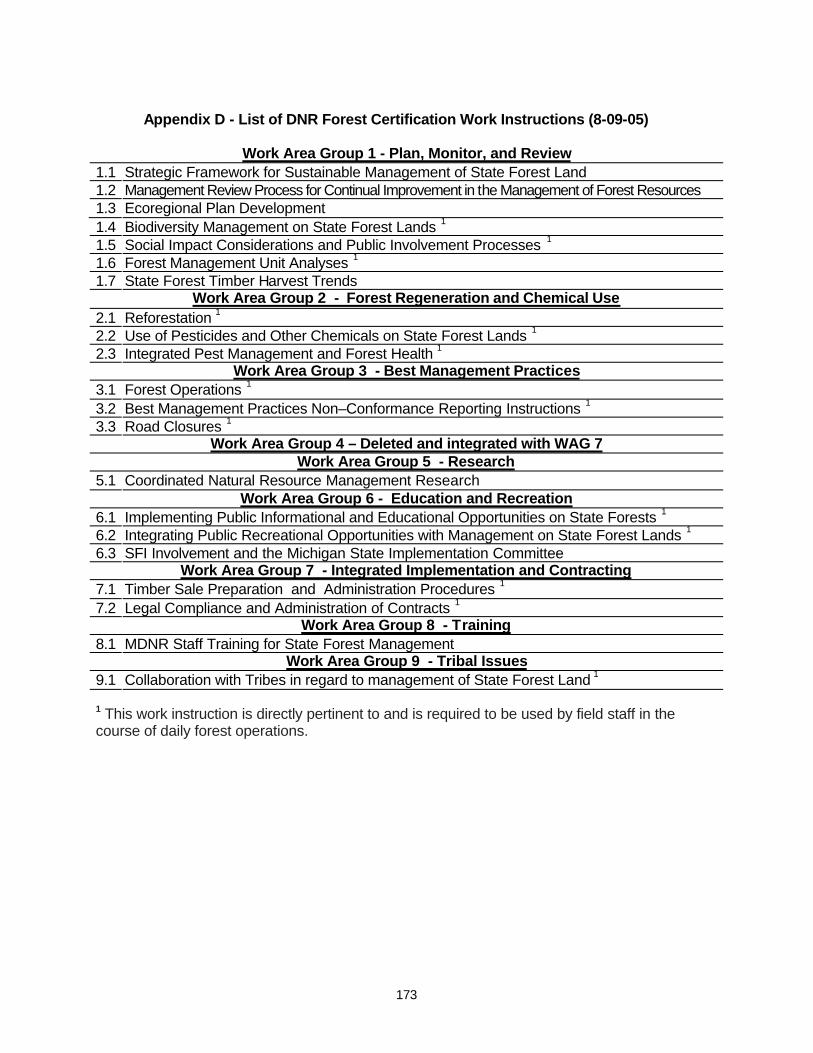
173
Appendix D - List of DNR Forest Certification Work Instructions (8-09-05)
Work Area Group 1 - Plan, Monitor, and Review 1.1 Strategic Framework for Sustainable Management of State Forest Land 1.2 Management Review Process for Continual Improvement in the Management of Forest Resources 1.3 Ecoregional Plan Development 1.4 Biodiversity Management on State Forest Lands 1 1.5 Social Impact Considerations and Public Involvement Processes 1 1.6 Forest Management Unit Analyses 1 1.7 State Forest Timber Harvest Trends
Work Area Group 2 - Forest Regeneration and Chemical Use 2.1 Reforestation 1 2.2 Use of Pesticides and Other Chemicals on State Forest Lands 1 2.3 Integrated Pest Management and Forest Health 1
Work Area Group 3 - Best Management Practices 3.1 Forest Operations 1 3.2 Best Management Practices Non–Conformance Reporting Instructions 1 3.3 Road Closures 1
Work Area Group 4 – Deleted and integrated with WAG 7 Work Area Group 5 - Research
5.1 Coordinated Natural Resource Management Research Work Area Group 6 - Education and Recreation
6.1 Implementing Public Informational and Educational Opportunities on State Forests 1 6.2 Integrating Public Recreational Opportunities with Management on State Forest Lands 1 6.3 SFI Involvement and the Michigan State Implementation Committee
Work Area Group 7 - Integrated Implementation and Contracting 7.1 Timber Sale Preparation and Administration Procedures 1 7.2 Legal Compliance and Administration of Contracts 1
Work Area Group 8 - Training 8.1 MDNR Staff Training for State Forest Management
Work Area Group 9 - Tribal Issues 9.1 Collaboration with Tribes in regard to management of State Forest Land 1 1 This work instruction is directly pertinent to and is required to be used by field staff in the course of daily forest operations.
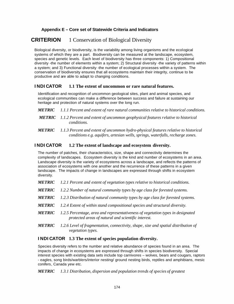
174
Appendix E – Core set of Statewide Criteria and Indicators
CRITERION 1 Conservation of Biological Diversity Biological diversity, or biodiversity, is the variability among living organisms and the ecological systems of which they are a part. Biodiversity can be measured at the landscape, ecosystem, species and genetic levels. Each level of biodiversity has three components: 1) Compositional diversity -the number of elements within a system; 2) Structural diversity -the variety of patterns within a system; and 3) Functional diversity -the number of ecological processes within a system. The conservation of biodiversity ensures that all ecosystems maintain their integrity, continue to be productive and are able to adapt to changing conditions.
INDICATOR 1.1 The extent of uncommon or rare natural features. Identification and recognition of uncommon geological sites, plant and animal species, and ecological communities can make a difference between success and failure at sustaining our heritage and protection of natural systems over the long run.
METRIC 1.1.1 Percent and extent of rare natural communities relative to historical conditions.
METRIC 1.1.2 Percent and extent of uncommon geophysical features relative to historical conditions.
METRIC 1.1.3 Percent and extent of uncommon hydro-physical features relative to historical conditions e.g. aquifers, artesian wells, springs, waterfalls, recharge zones.
INDICATOR 1.2 The extent of landscape and ecosystem diversity. The number of patches, their characteristics, size, shape and connectivity determines the complexity of landscapes. Ecosystem diversity is the kind and number of ecosystems in an area. Landscape diversity is the variety of ecosystems across a landscape, and reflects the patterns of association of ecosystems with one another and the recurrence of these patterns in a given landscape. The impacts of change in landscapes are expressed through shifts in ecosystem diversity.
METRIC 1.2.1 Percent and extent of vegetation types relative to historical conditions.
METRIC 1.2.2 Number of natural community types by age class for forested systems.
METRIC 1.2.3 Distribution of natural community types by age class for forested systems.
METRIC 1.2.4 Extent of within stand compositional species and structural diversity.
METRIC 1.2.5 Percentage, area and representativeness of vegetation types in designated protected areas of natural and scientific interest.
METRIC 1.2.6 Level of fragmentation, connectivity, shape, size and spatial distribution of vegetation types.
INDICATOR 1.3 The extent of species population diversity.
Species diversity refers to the number and relative abundance of species found in an area. The impacts of change in ecosystems are expressed through shifts in species biodiversity. Special interest species with existing data sets include top carnivores – wolves, bears and cougars, raptors - eagles, song birds/warblers/interior nesting/ ground nesting birds, reptiles and amphibians, mesic conifers, Canada yew etc.
METRIC 1.3.1 Distribution, dispersion and population trends of species of greatest
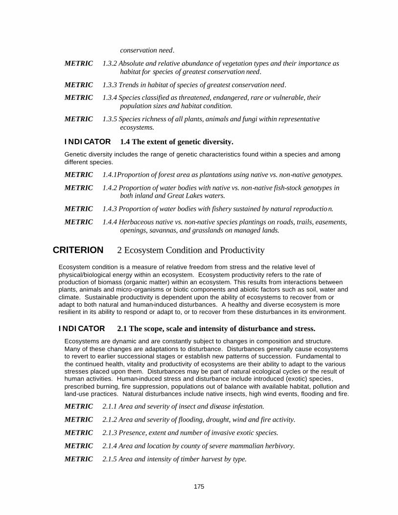
175
conservation need.
METRIC 1.3.2 Absolute and relative abundance of vegetation types and their importance as habitat for species of greatest conservation need.
METRIC 1.3.3 Trends in habitat of species of greatest conservation need.
METRIC 1.3.4 Species classified as threatened, endangered, rare or vulnerable, their population sizes and habitat condition.
METRIC 1.3.5 Species richness of all plants, animals and fungi within representative ecosystems.
INDICATOR 1.4 The extent of genetic diversity. Genetic diversity includes the range of genetic characteristics found within a species and among different species.
METRIC 1.4.1Proportion of forest area as plantations using native vs. non-native genotypes.
METRIC 1.4.2 Proportion of water bodies with native vs. non-native fish-stock genotypes in both inland and Great Lakes waters.
METRIC 1.4.3 Proportion of water bodies with fishery sustained by natural reproduction.
METRIC 1.4.4 Herbaceous native vs. non-native species plantings on roads, trails, easements, openings, savannas, and grasslands on managed lands.
CRITERION 2 Ecosystem Condition and Productivity
Ecosystem condition is a measure of relative freedom from stress and the relative level of physical/biological energy within an ecosystem. Ecosystem productivity refers to the rate of production of biomass (organic matter) within an ecosystem. This results from interactions between plants, animals and micro-organisms or biotic components and abiotic factors such as soil, water and climate. Sustainable productivity is dependent upon the ability of ecosystems to recover from or adapt to both natural and human-induced disturbances. A healthy and diverse ecosystem is more resilient in its ability to respond or adapt to, or to recover from these disturbances in its environment.
INDICATOR 2.1 The scope, scale and intensity of disturbance and stress. Ecosystems are dynamic and are constantly subject to changes in composition and structure. Many of these changes are adaptations to disturbance. Disturbances generally cause ecosystems to revert to earlier successional stages or establish new patterns of succession. Fundamental to the continued health, vitality and productivity of ecosystems are their ability to adapt to the various stresses placed upon them. Disturbances may be part of natural ecological cycles or the result of human activities. Human-induced stress and disturbance include introduced (exotic) species, prescribed burning, fire suppression, populations out of balance with available habitat, pollution and land-use practices. Natural disturbances include native insects, high wind events, flooding and fire.
METRIC 2.1.1 Area and severity of insect and disease infestation.
METRIC 2.1.2 Area and severity of flooding, drought, wind and fire activity.
METRIC 2.1.3 Presence, extent and number of invasive exotic species.
METRIC 2.1.4 Area and location by county of severe mammalian herbivory.
METRIC 2.1.5 Area and intensity of timber harvest by type.
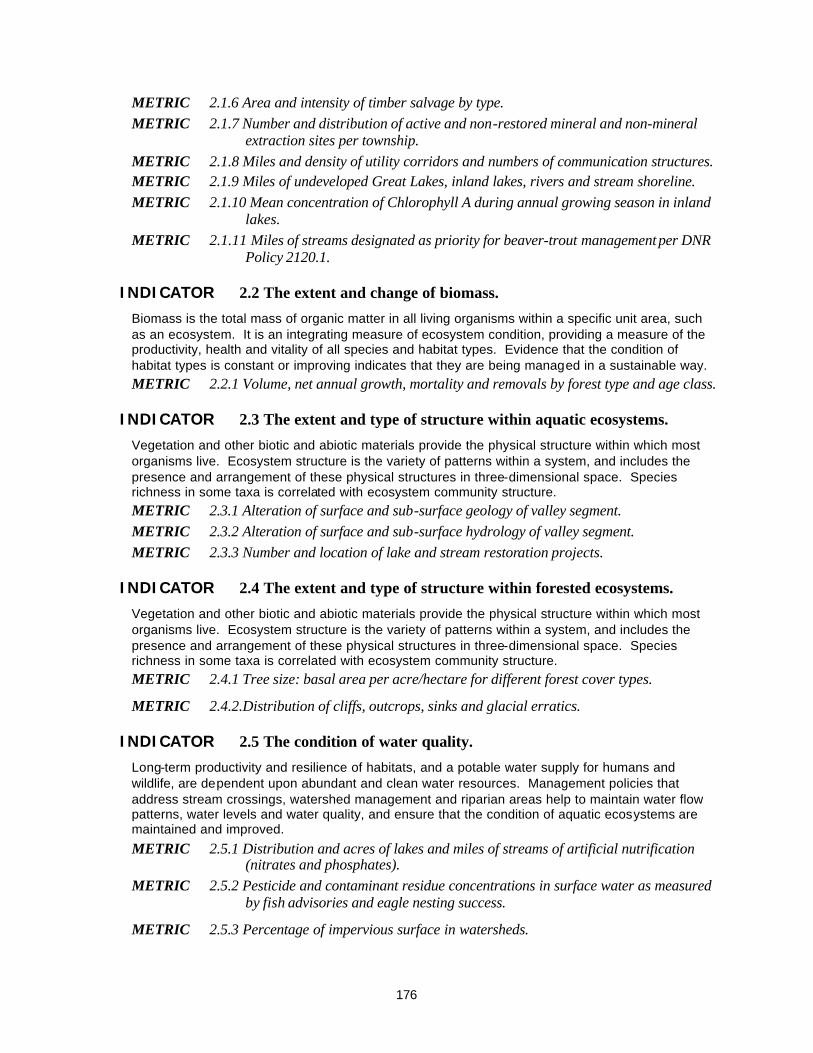
176
METRIC 2.1.6 Area and intensity of timber salvage by type. METRIC 2.1.7 Number and distribution of active and non-restored mineral and non-mineral
extraction sites per township. METRIC 2.1.8 Miles and density of utility corridors and numbers of communication structures. METRIC 2.1.9 Miles of undeveloped Great Lakes, inland lakes, rivers and stream shoreline. METRIC 2.1.10 Mean concentration of Chlorophyll A during annual growing season in inland
lakes. METRIC 2.1.11 Miles of streams designated as priority for beaver-trout management per DNR
Policy 2120.1.
INDICATOR 2.2 The extent and change of biomass. Biomass is the total mass of organic matter in all living organisms within a specific unit area, such as an ecosystem. It is an integrating measure of ecosystem condition, providing a measure of the productivity, health and vitality of all species and habitat types. Evidence that the condition of habitat types is constant or improving indicates that they are being managed in a sustainable way. METRIC 2.2.1 Volume, net annual growth, mortality and removals by forest type and age class.
INDICATOR 2.3 The extent and type of structure within aquatic ecosystems. Vegetation and other biotic and abiotic materials provide the physical structure within which most organisms live. Ecosystem structure is the variety of patterns within a system, and includes the presence and arrangement of these physical structures in three-dimensional space. Species richness in some taxa is correlated with ecosystem community structure. METRIC 2.3.1 Alteration of surface and sub-surface geology of valley segment. METRIC 2.3.2 Alteration of surface and sub-surface hydrology of valley segment. METRIC 2.3.3 Number and location of lake and stream restoration projects.
INDICATOR 2.4 The extent and type of structure within forested ecosystems. Vegetation and other biotic and abiotic materials provide the physical structure within which most organisms live. Ecosystem structure is the variety of patterns within a system, and includes the presence and arrangement of these physical structures in three-dimensional space. Species richness in some taxa is correlated with ecosystem community structure. METRIC 2.4.1 Tree size: basal area per acre/hectare for different forest cover types.
METRIC 2.4.2.Distribution of cliffs, outcrops, sinks and glacial erratics.
INDICATOR 2.5 The condition of water quality. Long-term productivity and resilience of habitats, and a potable water supply for humans and wildlife, are dependent upon abundant and clean water resources. Management policies that address stream crossings, watershed management and riparian areas help to maintain water flow patterns, water levels and water quality, and ensure that the condition of aquatic ecosystems are maintained and improved.
METRIC 2.5.1 Distribution and acres of lakes and miles of streams of artificial nutrification (nitrates and phosphates).
METRIC 2.5.2 Pesticide and contaminant residue concentrations in surface water as measured by fish advisories and eagle nesting success.
METRIC 2.5.3 Percentage of impervious surface in watersheds.

177
INDICATOR 2.6 Carbon cycle and greenhouse gas emissions.
The carbon cycle represents an important set of processes linking plant and animal communities with climate change. The release or removal of CO2 to and from the atmosphere impacts global ecological cycles. Forests, wetlands and water bodies can act as either sinks (a vigorous and growing forest) or sources for atmospheric carbon, depending on whether they are primarily storing carbon or releasing it. Knowledge of the influence of natural disturbances and human intervention on this role can indicate the type of forest practices required for sustainable management. METRIC 2.6.1 Area of forest permanently, semi-permanently, or temporarily converted to non-
forest land use (Also see Indicator 5.3 Land Use). METRIC 2.6.2 Changes in carbon pool in vegetative biomass. METRIC 2.6.3 Number of wildfire acres and fuels reported by county and township.. METRIC 2.6.4 Trends in metric tons of greenhouse gas emissions by region or county.
INDICATOR 2.7 The variance in and type of disruption of hydrological cycles. Hydrological cycles involve the movement of water from the atmosphere to the surface of the earth in the form of precipitation; from soils to streams to lakes to the atmosphere; and from soil to plants to the atmosphere. Because of their vast area in the state, forests play a major role in Great Lakes hydrological cycles. Changes in forestland cover and management influence the storage and movement of water and the timing of the various components of the hydrological cycle. Forests can influence stream and river hydrographs by regulating the flow of water into wetlands, streams and lakes. Consequently, sustainable forest management plays a crucial role in contributing to the regulation of the hydrological cycle. METRIC 2.7.1 Number, distribution and acres of impoundments affected by natural and
artificial water control structures.
METRIC 2.7.2 Surface area of lakes and wetland.
METRIC 2.7.3 Total flow data for rivers and streams.
INDICATOR 2.8 The effectiveness of soil conservation. The long-term productivity and resilience of forests and other habitats are dependent upon the maintenance of appropriate levels of soil oxygen, nutrients, organic matter and water. In order to ensure that terrestrial and aquatic ecosystems are maintained and improved, management policies must be implemented that provide for specific management practices or the protection of sensitive sites.
METRIC 2.8.1 Miles and width of vegetated riparian corridors.
METRIC 2.8.2 Number and location by county of soil erosion and sedimentation BMP violations.
METRIC 2.8.3 Number, location by county, type and funding for soil erosion and sedimentation restoration projects.
METRIC 2.8.4 Trends in soil quality as measured by pH by eco-region.
CRITERION 3 Social/Cultural/Spiritual
Social/Cultural: The Northern Lower and Upper Peninsula Eco-regions in which the State Forest is located are predominantly rural, natural resource rich regions of Michigan with large amounts of public forest land. Current social values rely on tourism, recreation, and resource extraction based on

178
the existing natural resources. Life styles and values of the people of this region are strongly connected to its natural resources. Therefore, sustainability of these natural resources is essential to the social and cultural fabric of the region.
Spiritual: Spiritual values or existence values are personal feelings and sentiments that natural resources stir within the human spirit. This criterion is concerned with the continued ability of the resources to provide these values. Because spiritual values are personal in nature and to a large degree intangible, the indicators pertain primarily to ecosystem features of that appeal to the senses or address the ability of people to use those resources.
INDICATOR 3.1 Extent of archaeological and historical sites. Resource management planning takes into account the identification and protection of known unique or significant Native American and Euro-American social, cultural and or spiritual sites. METRIC 3.1.1 Number of known archaeological sites. (More weight can be given to sites that
are on the National Register of Historic Places. This register includes prehistoric sites as well.)
METRIC 3.1.2. Number (presence, extent, location) of area(s) of historical/cultural significance. (Many times these areas may show no signs of their significance, e.g. a Native American Indian trail corridor where the trail is no longer visible, or a spot at which a meeting or discovery took place.)
INDICATOR 3.2 The extent of undeveloped natural resources. The existence and maintenance of large undeveloped forests or other similar resources at landscape scales are a significant influence upon social/cultural/spiritual values. METRIC 3.2..1 Number, acres and locations by county of designated wilderness areas, roadless
areas and natural resource parks.
INDICATOR 3.3 The extent and type of aesthetics landscapes. The visual or aesthetic quality of natural landscapes are a significant influence upon social/cultural/spiritual values. (Also see metrics under Indicator 2.1.)
METRIC 3.3.1 Number of designated access opportunities to view scenic vistas and/or wildlife.
METRIC 3.3.2 Miles of road by use class, distribution and density
CRITERION 4 Outdoor Recreation
The ability to maintain and strengthen the quality of leisure pursuits in the access of resources and amenities while minimizing social or environmental degradation.
INDICATOR 4.1 The type, extent and quality of hunting, trapping and fishing. Hunting, trapping and fishing are important forms of recreation that originate from historic needs for subsistence. These activities continue to exist for both purposes of subsistence and pure recreation. They serve as a significant basis for large segments of the state and many local economies, as well as for providing a foundation for traditional social well being.
METRIC 4.1.1 User days per activity.
METRIC 4.1.2 Number of animals testing positive for pathogens.

179
METRIC 4.1.3 Population density by species.
METRIC 4.1.4 Harvest number by species.
METRIC 4.1.5 Amount and locations by county of Commercial Forest (CF) lands, changes in status.
METRIC 4.1.6 Number of shooting preserves and game ranches by class.
INDICATOR 4.2 The extent of type and use of designated trails – motorized and non-motorized (hiking, ORV, snowmobile, skiing, equestrian).
Trails that are designated for authorized hiking, Off-road Vehicle, snowmobile, skiing and equestrian uses are significant locations for recreation that form a significant basis for large segments of the state and many local economies, as well as providing a foundation for traditional social well being.
METRIC 4.2.1 Amount of money and other resources (hours of staff and volunteer time) available for infrastructure and trail maintenance and development.
METRIC 4.2.2 User days per activity.
METRIC 4.2.3 Miles of trail systems by trail ownership and management type.
METRIC 4.2.4 Accident trends per activity per season.
INDICATOR 4.3 Nature Appreciation and Education One measure for nature appreciation and education is the existence of places where people can interact with natural communities that exist in perpetuity, and where natural processes occur to some degree, such as natural areas, wilderness areas, high conservation value areas and ecological reference areas.
METRIC 4.3.1 Miles of public Great Lakes, inland lakes and stream shoreline.
METRIC 4.3.2 Percentage, area and representativeness of vegetative types in areas of natural and scientific interest.
METRIC 4.3.3 Existence and level of nature oriented and eco-tourism activities, e.g. guiding and interpretive services for kayaking, canoeing, birding, elk viewing, wildlife viewing, hunting, fishing, photography, backpacking etc..
INDICATOR 4.4 The extent and the type of camping – including dispersed and designated site camping. (Refer also to social economic assessment contract.)
Camping is an important form of recreation that originates from historic needs for shelter while traveling through a natural setting. Camping activities of both forms are a significant basis for large segments of the state and many local economies, as well as providing a foundation for traditional social well being.
METRIC 4.4.1 Number, type and distribution of campground facilities – rustic, modern, semi-modern, cabin rentals.
METRIC 4.4.2 Number of campsites by type in public and private campgrounds.
METRIC 4.4.3 User days by campground and campsite.

180
METRIC 4.4.5. Number of dispersed camps per year.
INDICATOR 4.5 The extent and type of water recreation–motorized and non-motorized (including swimming, scuba diving, kayaking, etc.).
Water recreation is an important form of recreation that has roots in historic modes of transportation and for fulfilling needs for exercise and adventure. Both forms of water recreation are a significant basis for large segments of the state and many local economies, as well as providing a foundation for traditional social well being.
METRIC 4.5.1 Trends in water activity user days e.g. power/sail boating, jet-skis, canoes, rafting/tubing, kayaking, swimming, snorkeling, fishing, water skiing, boat races, cruise ships, sail boarding, etc.
METRIC 4.5.2 Trends in water recreation equipment sales and registrations.
METRIC 4.5.3 Trends in commercial water recreation operators.
METRIC 4.5.4 Number of water access sites and boat slips by type and capacity for watercraft and available amenities.
METRIC 4.5.5 Change in status of water body designation and use.
INDICATOR 4.6 The extent and type of traditional uses for cultural forest products (e.g. berries, syrup, mushrooms, black ash, cattails, etc.).
The use of cultural forest products is a form of recreation that originates from historic needs for subsistence. These activities continue to exist for both subsistence and pure recreation. While they do not serve as a significant basis for segments of the state and local economies, they do provide a foundation for traditional social well being. Level of participation and potential resource impacts are also important to consider.
METRIC 4.6.1 Number of traditional harvest festivals across the state – blueberry, morel mushrooms, thimbleberry etc.
METRIC 4.6.2 Number of special use permits, e.g. fire wood, Christmas greens (Lycopodium), seeds, cones.
METRIC 4.6.3 Extent of tribal gathering activities, e.g. black ash, bark, berries, medicinal plants, - commercial vs. subsistence.
METRIC 4.6.4 Amounts, kinds and impacts of medicinal plant gathering.
METRIC 4.6.5 Kinds of and numbers of membership in non-forest product producer organizations.
INDICATOR 4.7 Public land open to outdoor recreation.
Trends in all land open to outdoor recreation, not just forest land.
METRIC 4.7.1 Amount of public land open to outdoor recreation in Michigan, by agency.
CRITERION 5 Ownership Patterns
The pattern and distribution of ownership and use of lands greatly affects the ability to sustain natural resources. Management options, resource demand and ecological processes are affected by how

181
the land is managed, fragmented, and patterned. Successful sustainable management depends upon the degree of functional connectivity across ownerships, boundaries, and landscapes.
INDICATOR 5.1 The degree of stewardship. Stewardship is the practice of carefully managing land usage and associated resources to ensure natural systems are maintained or enhanced for use by future generations.
METRIC 5.1.1 Number, acres and distribution of private land management plans and percent of private ownership with management plans.
METRIC 5.1.2 Number of acres and location by county of private land with public conservation easements.
METRIC 5.1.2 Number, kinds, acres and by county of conservation easements.
METRIC 5.1.3 Number, kinds, and acres by county of cooperative planning “agreements” across ownerships, e.g. Clay Lake Plains Plan, Two Hearted River Watershed Plan, Les Cheneaux Economic Forum, Munuscong Watershed Plan, St. Mary’s River Plan.
METRIC 5.1.4 Numbers, acres, and percentage of forested lands certified by county for sustainable forestry by ownership.
INDICATOR 5.2 The extent of accessibility to public lands. The extent to which a parcel or area of land can be reached and used by people.
METRIC 5.2.1 Number by county of access easements to public lands.
METRIC 5.2.2 Number of acres and location by township of public land without access landlocked by private ownerships.
METRIC 5.2.3 Trends in numbers and location by county of barrier free facilities.
INDICATOR 5.3 The degree of stability of land use. The stability of land use or large-scale trends in land use can have direct effect upon the landscape resources base from which social/cultural/spiritual values are derived.
METRIC 5.3.1 Percent of forest land and non-forest land by county.
METRIC 5.3.2 Acres of forest land converted to developed land.
METRIC 5.3.3 Amount of ownership fragmentation and parcelization of land. METRIC 5.3.4. Number and size of forested parcels added to or removed from the Commercial
Forest Program. METRIC 5.3.5 Distribution of ownership by acres. METRIC 5.3.6 Percent change by ownership class.
CRITERION 6 Economic Health
A wide range of goods and services are derived by and from managing natural resources in the Northern Lower and Upper Peninsulas of Michigan. In addition to the traditional forest products sector, the resource base supports mining, commercial fishing and an ever-growing tourist and recreation industry. These goods and services create jobs and provide economic stability to the
182
region.
INDICATOR 6.1 The extent and trends of local and community economic health. Trends in planning and investment are important gauges of sustainable natural resource management and in local and community economic health. (Also see social economic assessment contract.)
METRIC 6.1.1 Number of local economic development plans.
METRIC 6.1.2 Describe job/income/employment/retirement data.
METRIC 6.1.3 Contribution of the resource use to gross domestic product (GDP) of all sectors of the economy.
METRIC 6.1.4 Diversity of forest economic activity.
METRIC 6.1.5 Capital outlay and investment trends.
INDICATOR 6.2 The extent of non-timber economic benefits of the forest. The extent of non-timber economic benefits are an important gauge of sustainable natural resource management and in local and community economic health. Also see social and economic assessment contract.
METRIC 6.2.1 Number of recreation and tourism jobs/economic activity.
METRIC 6.2.2 Total expenditures by individuals by select activity.
METRIC 6.2.3 Value and jobs/economic activity related to mineral, oil, and gas extraction.
INDICATOR 6.3 The extent and type of timber and wood products produced. The extent and type of timber and wood products are important gauges of sustainable natural resource management and in local and community economic health. Also see social and economic assessment contract.
METRIC 6.3.1 Timber volume, growth and mortality by county.
METRIC 6.3.2 Timber harvest by species by county.
METRIC 6.3.3 Value and volume of wood products by county.
METRIC 6.3.4 Number of jobs/economic activity, e.g. logging, hauling and mills.
CRITERION 7 Institutional Processes
Institutional processes address the legal and institutional framework for the application of ecosystem management. They address the policies, legislation, regulations and guidelines that drive and direct ecosystem practices; and direct how institutions cooperate with others in the application of ecosystem management. Institutional processes include the quality and quantity of opportunities for public involvement in ecosystem planning leading to resource management decisions.
INDICATOR 7.1 The extent of the legal framework for ecosystem management. The framework should include the existence and/or application of laws, regulations, policies and guidelines for land management. The framework should also consider and meet legal obligations with respect to duly established Native American treaty rights. (Note the metrics here are very
183
important to the public based on the public meetings that were held).
METRIC 7.1.1 Presence of and compliance with land management laws and regulations based on continued Forest Certification management review system, Natural Resource Commission(NRC) and other open meetings, and stake holder reports.
METRIC 7.1.2 Presence of and compliance with wildlife management laws and regulations.
METRIC 7.1.3 Presence of and compliance with recreation laws and regulations.
METRIC 7.1.4 Presence of and compliance with fisheries management laws and regulations.
METRIC 7.1.5 Presence of and compliance with Native American treaty rights.
METRIC 7.1.6 Presence of and compliance with Department and Division policies, procedures and guidelines.
METRIC 7.1.7 Number and extent of laws that reference ecosystem management.
INDICATOR 7.2 The extent of an institutional framework.
An effective institutional framework is necessary to implement ecosystem management processes effectively.
METRIC 7.2.1 Trends in public participation processes.
METRIC 7.2.2 The number of public advisory committees.
INDICATOR 7.3 The extent of resources allocated for ecosystem management values.
Sufficiency of resources is necessary to effectively implementation ecosystem management processes.
METRIC 7.3.1 Resources allocated within the Department for ecosystem management planning and monitoring.
METRIC 7.3.2 Participation in external planning efforts, e.g. National Forest plan revisions.
METRIC 7.3.3 Expenditure of resources and dedicated funds for implementation of “on-the-ground” projects.
METRIC 7.3.3 Expenditure of resources and dedicated funds for research in ecosystem management.

184
Data are not currently available for the effective measurement of all metrics. The above C&I metrics have been categorized into tiers based upon the availability of data (Table E1). There are four tiers of metric measurement:
Tier 1: Metrics for which the DNR or others have databases available, and that are measured with short periodicity. Examples include: USGS hydrologic data from stream gages, acres and volumes of forest timber, lake and stream surveys for status and trends.
Tier 2: Metrics for which the DNR or others have databases available, but which are measured at a longer periodicity (every 5-10 years). These could be items that are contracted out to Universities as graduate student research. Examples include: Forest Inventory Analysis (FIA) data, large lake surveys, stock-recruitment relationships of specific fish stocks.
Tier 3: Metrics for which the DNR or others have the means to measure, but the data is only partially available. Examples include: resource inventories and population distribution and trends.
Tier 4: Metrics that the DNR would like to measure, but does not currently have the means to do. These metrics would likely be measured or assembled by a contractor, University, or special project within the DNR. Examples include: large scale genetic or population investigations.
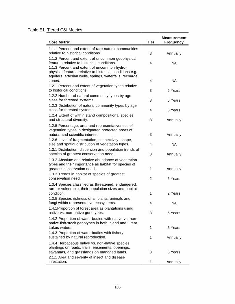
185
Table E1. Tiered C&I Metrics
Core Metric Tier Measurement
Frequency
1.1.1 Percent and extent of rare natural communities relative to historical conditions. 3 Annually 1.1.2 Percent and extent of uncommon geophysical features relative to historical conditions. 4 NA 1.1.3 Percent and extent of uncommon hydro-physical features relative to historical conditions e.g. aquifers, artesian wells, springs, waterfalls, recharge zones. 4 NA 1.2.1 Percent and extent of vegetation types relative to historical conditions. 3 5 Years 1.2.2 Number of natural community types by age class for forested systems. 3 5 Years 1.2.3 Distribution of natural community types by age class for forested systems. 4 5 Years 1.2.4 Extent of within stand compositional species and structural diversity. 3 Annually
1.2.5 Percentage, area and representativeness of vegetation types in designated protected areas of natural and scientific interest. 3 Annually 1.2.6 Level of fragmentation, connectivity, shape, size and spatial distribution of vegetation types. 4 NA 1.3.1 Distribution, dispersion and population trends of species of greatest conservation need. 3 Annually
1.3.2 Absolute and relative abundance of vegetation types and their importance as habitat for species of greatest conservation need. 1 Annually 1.3.3 Trends in habitat of species of greatest conservation need. 2 5 Years
1.3.4 Species classified as threatened, endangered, rare or vulnerable, their population sizes and habitat condition. 1 2 Years 1.3.5 Species richness of all plants, animals and fungi within representative ecosystems. 4 NA 1.4.1Proportion of forest area as plantations using native vs. non-native genotypes. 3 5 Years
1.4.2 Proportion of water bodies with native vs. non-native fish-stock genotypes in both inland and Great Lakes waters. 1 5 Years 1.4.3 Proportion of water bodies with fishery sustained by natural reproduction. 1 Annually
1.4.4 Herbaceous native vs. non-native species plantings on roads, trails, easements, openings, savannas, and grasslands on managed lands. 3 5 Years 2.1.1 Area and severity of insect and disease infestation. 1 Annually
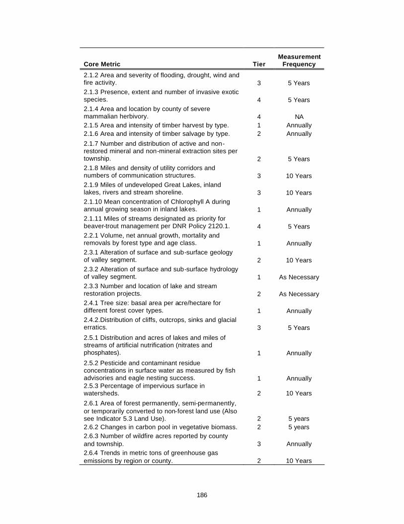
186
Core Metric Tier Measurement
Frequency
2.1.2 Area and severity of flooding, drought, wind and fire activity. 3 5 Years 2.1.3 Presence, extent and number of invasive exotic species. 4 5 Years 2.1.4 Area and location by county of severe mammalian herbivory. 4 NA 2.1.5 Area and intensity of timber harvest by type. 1 Annually 2.1.6 Area and intensity of timber salvage by type. 2 Annually
2.1.7 Number and distribution of active and non-restored mineral and non-mineral extraction sites per township. 2 5 Years 2.1.8 Miles and density of utility corridors and numbers of communication structures. 3 10 Years 2.1.9 Miles of undeveloped Great Lakes, inland lakes, rivers and stream shoreline. 3 10 Years 2.1.10 Mean concentration of Chlorophyll A during annual growing season in inland lakes. 1 Annually 2.1.11 Miles of streams designated as priority for beaver-trout management per DNR Policy 2120.1. 4 5 Years 2.2.1 Volume, net annual growth, mortality and removals by forest type and age class. 1 Annually 2.3.1 Alteration of surface and sub-surface geology of valley segment. 2 10 Years 2.3.2 Alteration of surface and sub-surface hydrology of valley segment. 1 As Necessary 2.3.3 Number and location of lake and stream restoration projects. 2 As Necessary 2.4.1 Tree size: basal area per acre/hectare for different forest cover types. 1 Annually 2.4.2.Distribution of cliffs, outcrops, sinks and glacial erratics. 3 5 Years
2.5.1 Distribution and acres of lakes and miles of streams of artificial nutrification (nitrates and phosphates). 1 Annually
2.5.2 Pesticide and contaminant residue concentrations in surface water as measured by fish advisories and eagle nesting success. 1 Annually 2.5.3 Percentage of impervious surface in watersheds. 2 10 Years
2.6.1 Area of forest permanently, semi-permanently, or temporarily converted to non-forest land use (Also see Indicator 5.3 Land Use). 2 5 years 2.6.2 Changes in carbon pool in vegetative biomass. 2 5 years 2.6.3 Number of wildfire acres reported by county and township. 3 Annually 2.6.4 Trends in metric tons of greenhouse gas emissions by region or county. 2 10 Years

187
Core Metric Tier Measurement
Frequency
2.7.1 Number, distribution and acres of impoundments with artificial water control structures. 3 10 Years 2.7.2 Surface area of lakes and wetlands. 2 10 years 2.7.3 Total flow data for rivers and streams. 1 Annually 2.8.1 Miles and width of vegetated riparian corridors. 4 NA 2.8.2 Number and location by county of soil erosion and sedimentation BMP violations. 1 Annually 2.8.3 Number, location by county, type and funding for soil erosion and sedimentation restoration projects. 1 Annually 2.8.4 Trends in soil quality as measured by pH by eco-region 4 NA
3.1.1 Number of known archaeological sites. (More weight can be given to sites that are on the National Register of Historic Places. This register includes prehistoric sites as well.) 3 5 Years
3.1.2. Number (presence, extent, location) of area(s) of historical/cultural significance. (Many times these areas may show no signs of their significance, e.g. a Native American Indian trail corridor where the trail is no longer visible, or a spot at which a meeting or discovery took place.) 3 10 Years
3.2..1 Number, acres and locations by county of designated wilderness areas, roadless areas and natural resource parks. 1 Annually 3.3.1 Number of designated access opportunities to view scenic vistas and/or wildlife. 3 10 Years 3.3.2 Miles of road by use class, distribution and density 1 Annually 4.1.1 User days per activity. 4 NA 4.1.2 Number of animals testing positive for pathogens. 1 Annually 4.1.3 Population density by species. 3 Annually 4.1.4 Harvest number by species. 3 Annually 4.1.5 Amount and locations by county of Commercial Forest (CF) lands, changes in status. 1 Annually 4.1.6 Number of shooting preserves and game ranches by class. 1 Annually
4.2.1 Amount of money and other resources (hours of staff and volunteer time) available for infrastructure and trail maintenance and development. 1 Annually 4.2.2 User days per activity. 3 10 Years 4.2.3 Miles of trail systems by trail ownership and management type. 1 Annually 4.2.4 Accident trends per activity per season. 1 Annually 4.3.1 Miles of public Great Lakes, inland lakes and stream shoreline. 3 10 Years

188
Core Metric Tier Measurement
Frequency
4.3.2 Percentage, area and representativeness of vegetative types in areas of natural and scientific interest. 3 5 Years
4.3.3 Existence and level of nature oriented and eco-tourism activities, e.g. guiding and interpretive services for kayaking, canoeing, birding, elk viewing, wildlife viewing, hunting, fishing, photography, backpacking etc.. 4 NA 4.4.1 Number, type and distribution of campground facilities – rustic, modern, semi-modern, cabin rentals. 1 Annually 4.4.2 Number of campsites by type in public and private campgrounds. 1 Annually 4.4.3 User days by campground and campsite. 1 Annually 4.4.5. Number of dispersed camps per year. 1 Annually
4.5.1 Trends in water activity user days e.g. power/sail boating, jet-skis, canoes, rafting/tubing, kayaking, swimming, snorkeling, fishing, water skiing, boat races, cruise ships, sail boarding, etc. 3 10 Years 4.5.2 Trends in water recreation equipment sales and registrations. 1 Annually 4.5.3 Trends in commercial water recreation operators. 4 NA
4.5.4 Number of water access sites and boat slips by type and capacity for watercraft and available amenities. 1 Annually 4.5.5 Change in status of water body designation and use. 2 5 Years 4.6.1 Number of traditional harvest festivals across the state – blueberry, morel mushrooms, thimbleberry etc. 2 5 Years 4.6.2 Number of special use permits, e.g. fire wood, Christmas greens (Lycopodium), seeds, cones. 1 Annually
4.6.3 Extent of tribal gathering activities, e.g. black ash, bark, berries, medicinal plants, - commercial vs. subsistence. 4 NA 4.6.4 Amounts, kinds and impacts of medicinal plant gathering. 4 NA 4.6.5 Kinds of and numbers of membership in non-forest product producer organizations. 4 NA 4.7.1 Amount of public land open to out door recreation in Michigan, by agency. 1 Annually
5.1.1 Number, acres and distribution of private land management plans and percent of private ownership with management plans. 2 5 Years 5.1.2 Number of acres and location by county of private land with public conservation easements. 3 5 Years 5.1.2 Number, kinds, acres and by county of conservation easements. 2 5 Years

189
Core Metric Tier Measurement
Frequency 5.1.3 Number, kinds, and acres by county of cooperative planning “agreements” across ownerships, e.g. Clay Lake Plains Plan, Two Hearted River Watershed Plan, Les Cheneaux Economic Forum, Munuscong Watershed Plan, St. Mary’s River Plan. 2 5 Years
5.1.4 Numbers, acres, and percentage of forested lands certified by county for sustainable forestry by ownership. 4 NA 5.2.1 Number by county of access easements to public lands. 2 5 Years
5.2.2 Number of acres and location by township of public land without access landlocked by private ownerships. 2 10 Years 5.2.3 Trends in numbers and location by county of barrier free facilities. 3 10 Years 5.3.1 Percent of forest land and non-forest land by county. 2 10 Years 5.3.2 Acres of forest land converted to developed land. 4 NA 5.3.3 Amount of ownership fragmentation and parcelization of land. 3 10 Years 5.3.4. Number and size of forested parcels added to or removed from the Commercial Forest Program. 1 Annually 5.3.5 Distribution of ownership by acres. 2 10 Years 5.3.6 Percent change by ownership class. 2 10 Years 6.1.1 Number of local economic development plans. 2 10 Years 6.1.2 Describe job/income/employment/retirement data. 2 10 Years 6.1.3 Contribution of the resource use to gross domestic product (GDP) of all sectors of the economy. 2 10 Years 6.1.4 Diversity of forest economic activity. 2 10 Years 6.1.5 Capital outlay and investment trends. 2 10 Years 6.2.1 Number of recreation and tourism jobs/economic activity. 2 10 Years 6.2.2 Total expenditures by individuals by select activity. 2 10 Years 6.2.3 Value and jobs/economic activity related to mineral, oil, and gas extraction. 2 10 Years 6.3.1 Timber volume, growth and mortality by county. 2 10 Years 6.3.2 Timber harvest by species by county. 2 10 Years 6.3.3 Value and volume of wood products by county. 2 10 Years 6.3.4 Number of jobs/economic activity, e.g. logging, hauling and mills. 2 10 Years
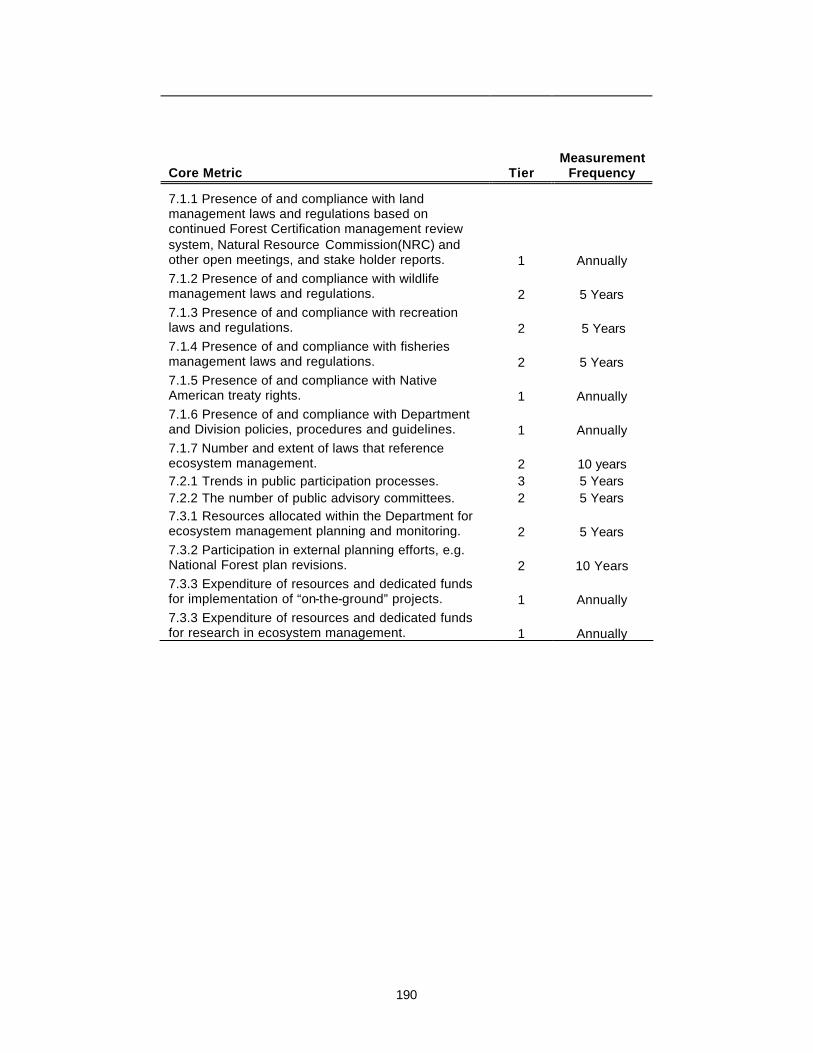
190
Core Metric Tier Measurement
Frequency
7.1.1 Presence of and compliance with land management laws and regulations based on continued Forest Certification management review system, Natural Resource Commission(NRC) and other open meetings, and stake holder reports. 1 Annually 7.1.2 Presence of and compliance with wildlife management laws and regulations. 2 5 Years 7.1.3 Presence of and compliance with recreation laws and regulations. 2 5 Years 7.1.4 Presence of and compliance with fisheries management laws and regulations. 2 5 Years 7.1.5 Presence of and compliance with Native American treaty rights. 1 Annually 7.1.6 Presence of and compliance with Department and Division policies, procedures and guidelines. 1 Annually 7.1.7 Number and extent of laws that reference ecosystem management. 2 10 years 7.2.1 Trends in public participation processes. 3 5 Years 7.2.2 The number of public advisory committees. 2 5 Years 7.3.1 Resources allocated within the Department for ecosystem management planning and monitoring. 2 5 Years 7.3.2 Participation in external planning efforts, e.g. National Forest plan revisions. 2 10 Years 7.3.3 Expenditure of resources and dedicated funds for implementation of “on-the-ground” projects. 1 Annually 7.3.3 Expenditure of resources and dedicated funds for research in ecosystem management. 1 Annually

191
Appendix F – DNR Management Unit Boundaries
DNR Forest, Mineral and Fire Management Division (FMFM)
The Mission of Forest, Mineral, and Fire Management Division is to provide for the protection, integrated management and responsible use of a healthy productive forest and mineral resource base for the social, recreational, environmental and economic benefit of the people of the State of Michigan. This includes direct day-to-day management of Michigan’s State Forest.
Operational management of the State Forest is largely conducted at the FMU level (Figure F1). There are 15 FMUs. Management planning is also conducted on an ecoregional basis, following political boundaries that roughly follow the ecoregional boundaries. There are three ecoregions that coincide with the area containing the State Forest System: the Northern Lower Peninsula; the Eastern Upper Peninsula; and the Western Upper Peninsula.
Figure F1. FMFM State Forest Management Units and Ecoregions.

192
DNR Wildlife Division
The mission of the Wildlife Division is to enhance, restore and conserve the state’s wildlife resources, natural communities and ecosystems for the benefit of Michigan’s citizens, visitors and future generations. Wildlife personnel have the primary responsibility for the management and regulation of bird and mammal populations and their habitats but also have the lead responsibility for rare species which include plants, insects, amphibians, reptiles and fish. There are eight Wildlife Division management units (Figure F2), five of which contain State Forest lands.
Figure F2. Wildlife Division Management Units.

193
DNR Fisheries Division
The mission of the Fisheries Division is to protect and enhance all forms of aquatic life and the habitats upon which they depend, and to provide for wise use of these resources for benefit of the people of Michigan.
The Fisheries Division is responsible for the management of all fish species, all other aquatic organisms and their habitats across the broad spectrum of all ownerships in the state. Because landscape processes are integrally linked with aquatic habitat and because of the biotic interdependency between upstream and downstream habitats, Fisheries Division is organized on the basis of basins and watersheds. There are four Great Lakes basins (Erie, Huron, Michigan, and Superior) and each of these basins is divided into Fisheries management units that are organized on the basis of watersheds boundaries (Figure F3).
Figure F3. Fisheries Division Management Units.

194
DNR Parks and Recreation Division
The mission of Parks and Recreation Division (PRD) is to acquire, protect, and preserve the natural, historic and cultural features of Michigan’s unique resources and provide public recreation and educational opportunities. The division is organized into eight management districts (Figure F4)
The PRD is the primary land manager of the State Park system, which consists of 97 parks covering 265,000 acres (Figure 1.2). PRD also owns and administers 15 Great Lakes public mooring facilities and approximately 738 inland waters boat-launching facilities statewide, and has helped fund the development of approximately 445 other inland waters boat launch sites operated by local units of government and other Divisions within the Department.
DNR Law Enforcement Division
The mission statement of the Law Enforcement Division is to protect Michigan's natural resources and the environment, and the health and safety of the public through effective law enforcement and education.
Law Enforcement Division is responsible for enforcement of fish and wildlife laws, and other enforcement activities to protect fish and wildlife resources and habitat, and to promote and maintain Michigan’s natural resources base, economy, and quality of life. Other enforcement activities include: 1) environmental protection, enforcement, and investigation; 2) habitat protection (e.g. protection of forests, wetlands, sand dunes, lakes and streams, and parks); 3) protection of recreation facilities and persons who recreate on DNR lands and facilities; 4) recreational safety education and enforcement; 5) protection of threatened and endangered species (plant and wildlife); and 6) oversight of those who seek to alter the environment. The Law Enforcement Division is organized into 10 Districts (Figure F5).
Federal Land Ownership
The major Federal lands in Michigan are principally comprised of the National Forests, National Parks, and National Wildlife Refuges, which are managed by the USDA Forest Service, the USDI Park Service and the USDI Fish and Wildlife Service respectively. The largest land holdings are the three National Forests, which total over 2.9 million acres. There are three major National Parks totaling approximately 674,000 acres and National Wildlife Refuges total over 112,000 acres.
These Federal lands are located adjacent to or in close proximity to extensive areas of state-owned lands (Figure 1.2), mostly in the northern two-thirds of Michigan. Effectively holistic management of lands on a landscape scale requires cooperation between State and Federal land managers. Interactions range from broad, long-range landscape-level planning (e.g. species recovery plans), through coordination of recreation infrastructure and policies (e.g. trail designation and use), to short-term tactical projects (e.g. fire prevention and suppression).
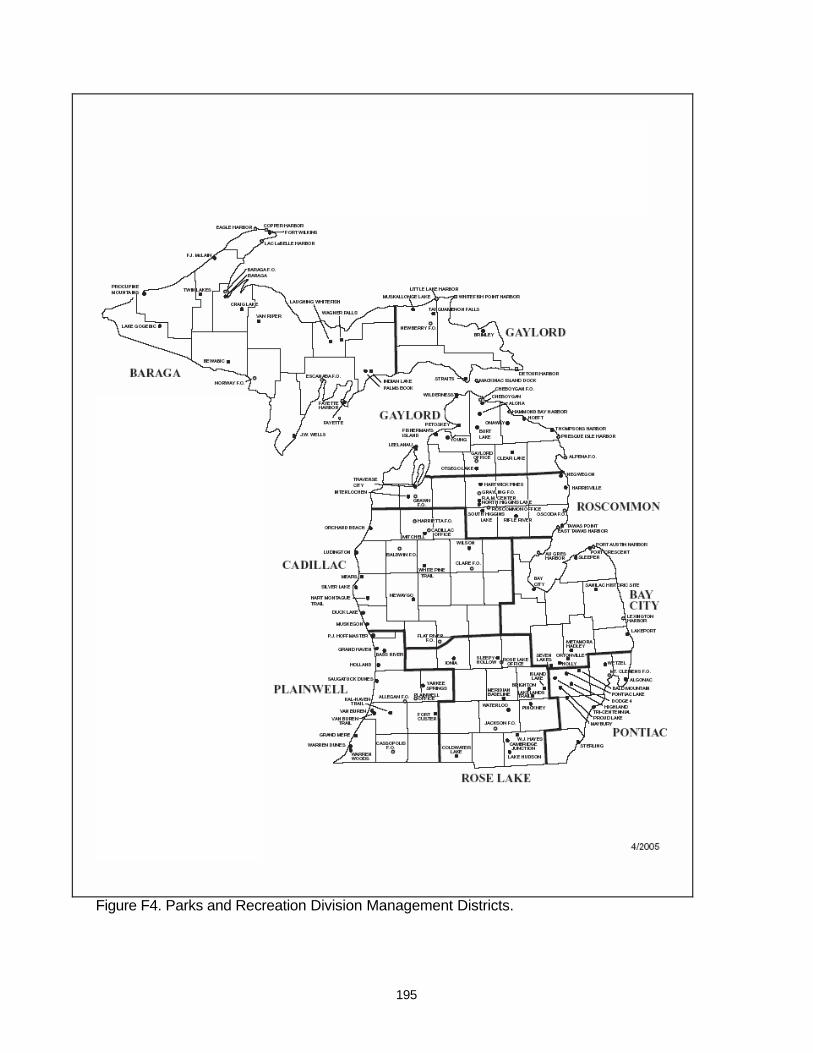
195
Figure F4. Parks and Recreation Division Management Districts.
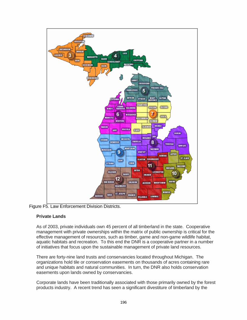
196
Figure F5. Law Enforcement Division Districts.
Private Lands
As of 2003, private individuals own 45 percent of all timberland in the state. Cooperative management with private ownerships within the matrix of public ownership is critical for the effective management of resources, such as timber, game and non-game wildlife habitat, aquatic habitats and recreation. To this end the DNR is a cooperative partner in a number of initiatives that focus upon the sustainable management of private land resources.
There are forty-nine land trusts and conservancies located throughout Michigan. The organizations hold tile or conservation easements on thousands of acres containing rare and unique habitats and natural communities. In turn, the DNR also holds conservation easements upon lands owned by conservancies.
Corporate lands have been traditionally associated with those primarily owned by the forest products industry. A recent trend has seen a significant divestiture of timberland by the

197
forest products industry and a corresponding increase in timberland under the ownership of timberland investment management organizations (TIMOs). The majority of these corporate lands are enrolled in the Commercial Forest Program.
The Commercial Forest Program provides a property tax reduction to individual or corporate private landowners as an incentive to retain and manage forestland for long-term timber production. Landowners in this program agree to provide public access for hunting, trapping and fishing and to develop, maintain and manage the land as commercial forest through planting, natural reproduction, or other silvicultural practices. There are approximately 2.2 million acres listed in this program under the ownership of nearly 1300 private landowners. Landowners include private individuals, clubs, forest industry, and other corporations.
The DNR has developed a Forest Stewardship Program that assists landowners with the development of Forest Stewardship Management Plans for their private forestlands. The Michigan Forestland Enhancement Program (FLEP) is an important tool that augments the Forest Stewardship Program by providing financial assistance for encouraging the long-term sustainability of non-industrial private forestlands.
Finally, the DNR Landowner Incentive Program (LIP) helps private landowners create and manage habitat for species that are rare and/or declining by providing advice, management plans, and funding to qualified individuals and organizations throughout the state.
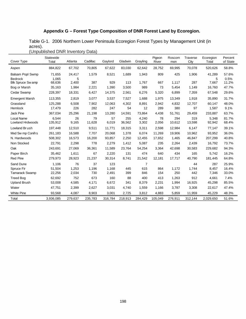
198
Appendix G – Forest Type Composition of DNR Forest Land by Ecoregion.
Table G-1. 2006 Northern Lower Peninsula Ecoregion Forest Types by Management Unit (in acres). (Unpublished DNR Inventory Data)
Cover Type Statewide
Total Atlanta Cadillac Gaylord Gladwin Grayling Pigeon River
Roscommon
Traverse City
Ecoregion Total
Percent of State
Aspen 884,822 67,702 70,805 67,622 83,030 62,642 28,752 69,995 70,078 520,626 58.8%
Balsam Popl Swmp 71,655 24,417 1,579 8,521 1,689 1,943 809 425 1,906 41,289 57.6% Bedrock 1,065 5 5 0.5% Blk Spruce Sw amp 68,636 2,400 387 929 113 1,767 667 1,117 287 7,667 11.2% Bog or Marsh 35,163 1,984 2,221 1,390 3,500 989 73 5,454 1,149 16,760 47.7%
Cedar Swamp 228,397 18,331 6,427 14,375 2,561 6,276 5,320 6,899 7,359 67,548 29.6%
Emergent Marsh 113,355 2,819 3,077 3,537 7,527 1,688 1,975 13,349 1,918 35,890 31.7%
Grassland 125,288 6,508 7,902 12,063 4,302 8,891 2,942 4,832 12,707 60,147 48.0% Hemlock 17,479 226 282 247 54 12 289 380 97 1,587 9.1%
Jack Pine 367,034 25,296 21,198 13,280 14,591 73,864 4,438 51,761 29,459 233,887 63.7%
Local Name 6,544 26 79 57 255 4,240 78 294 319 5,348 81.7% Lowland Hrdwoods 135,912 9,165 11,628 6,019 36,562 3,302 2,056 10,612 13,598 92,942 68.4%
Lowland Br ush 197,448 12,510 9,511 11,771 18,315 3,311 2,598 12,984 6,147 77,147 39.1%
Mxd Sw mp Conifrs 261,183 16,588 7,707 20,068 1,378 6,074 11,269 19,906 10,962 93,952 36.0% N. Hardwoods 508,302 16,573 16,200 93,857 2,250 12,455 17,652 1,465 46,847 207,299 40.8%
Non Stocked 22,791 2,298 778 2,279 1,412 5,087 235 2,264 2,439 16,792 73.7%
Oak 243,691 27,069 36,361 11,589 23,764 54,254 3,364 42,698 30,583 229,682 94.3%
Paper Birch 35,462 1,611 67 2,220 131 474 640 434 165 5,742 16.2% Red Pine 279,973 28,923 21,237 30,314 8,741 21,542 12,181 17,717 40,790 181,445 64.8%
Sand Dune 1,106 76 37 123 7 44 287 25.9% Spruce Fir 51,504 1,253 1,196 1,168 445 615 864 1,172 1,744 8,457 16.4% Tamarack Swamp 22,256 2,034 730 2,491 399 846 154 250 442 7,346 33.0%
Treed Bog 62,692 752 673 160 88 400 413 1,263 912 4,661 7.4% Upland Brush 53,008 4,585 4,171 6,672 341 8,379 2,231 1,994 16,925 45,298 85.5%
Water 47,751 2,399 2,627 3,031 4,740 1,559 1,166 3,787 3,308 22,617 47.4%
White Pine 93,568 4,087 8,903 3,001 2,725 3,812 4,883 5,859 11,959 45,229 48.3%
Total 3,936,085 279,637 235,783 316,784 218,913 284,429 105,049 276,911 312,144 2,029,650 51.6%

199
Table G-2. 2006 Eastern Upper Peninsula Ecoregion Forest Types by Management Unit (in acres). (Unpublished DNR Inventory Data)
Cover Type Statewide
Total Newberry
Sault Ste
Marie Shingleton Ecoregion
Total Percent of State
Aspen 884,822 22,764 65,435 34,589 122,788 13.9% Balsam Poplar Swamp 71,655 4,515 15,866 2,045 22,426 31.3% Bedrock 1,065 79 56 135 12.7% Black Spruce Swamp 68,636 11,272 10,003 15,578 36,853 53.7%
Bog or Marsh 35,163 3,438 5,784 2,785 12,007 34.1%
Cedar Swamp 228,397 19,034 51,801 28,675 99,510 43.6%
Emergent Marsh 113,355 23,275 8,809 37,677 69,761 61.5%
Grassland 125,288 4,743 12,486 24,766 41,995 33.5% Hemlock 17,479 2,249 1,822 3,059 7,130 40.8%
Jack Pine 367,034 59,823 1,750 43,432 105,005 28.6%
Local Name 6,544 253 80 232 565 8.6%
Lowland Hardwoods 135,912 7,540 5,724 7,290 20,554 15.1%
Lowland Brush 197,448 20,951 23,727 32,187 76,865 38.9%
Mixed Swamp Conifers 261,183 33,291 16,921 19,135 69,347 26.6%
N. Hardwoods 508,302 37,745 43,164 48,345 129,254 25.4%
Non Stocked 22,791 592 995 2,043 3,630 15.9%
Oak 243,691 1,968 1,188 1,704 4,860 2.0%
Paper Birch 35,462 3,915 9,344 4,160 17,419 49.1% Red Pine 279,973 23,880 16,197 37,699 77,776 27.8%
Sand Dune 1,106 504 137 138 779 70.4% Spruce Fir 51,504 2,921 8,136 3,339 14,396 28.0% Tamarack Swamp 22,256 1,480 3,495 3,106 8,081 36.3%
Treed Bog 62,692 33,154 7,069 4,291 44,514 71.0% Upland Brush 53,008 2,896 2,643 708 6,247 11.8%
Water 47,751 6,355 4,506 4,056 14,917 31.2%
White Pine 93,568 17,888 3,674 15,340 36,902 39.4%
Total 3,936,085 346,446 320,835 376,435 1,043,716 26.5%

200
Table G-3. 2006 Western Upper Peninsula Ecoregion Forest Types by Management Unit (in acres). (Unpublished DNR Inventory Data)
Cover Type Statewide
Total Baraga Crystal Falls Escanaba Gwinn
Ecoregion Total
Percent of State
Aspen 884,822 15,030 123,240 31,794 71,344 241,408 27.3% Balsam Poplar Swamp 71,655 1,967 3,902 2,071 7,940 11.1% Bedrock 1,065 74 536 1 314 925 86.9%
Black Spruce Swamp 68,636 2,292 6,043 4,202 11,579 24,116 35.1% Bog or Marsh 35,163 869 1,279 399 3,849 6,396 18.2%
Cedar Swamp 228,397 2,316 8,224 29,660 21,139 61,339 26.9%
Emergent Marsh 113,355 2,179 1,179 2,634 1,712 7,704 6.8%
Grassland 125,288 2,736 9,907 2,203 8,300 23,146 18.5% Hemlock 17,479 2,732 194 2,611 3,225 8,762 50.1%
Jack Pine 367,034 7,630 3,056 130 17,326 28,142 7.7%
Local Name 6,544 42 5 161 423 631 9.6% Lowland Hardwoods 135,912 2,537 2,408 8,468 9,003 22,416 16.5%
Lowland Brush 197,448 7,666 17,284 6,078 12,408 43,436 22.0%
Mixed Swamp Conifers 261,183 10,856 43,889 9,213 33,926 97,884 37.5%
N. Hardwoods 508,302 62,406 43,751 17,846 47,746 171,749 33.8%
Non Stocked 22,791 930 733 288 418 2,369 10.4%
Oak 243,691 1,545 1,469 2,807 3,328 9,149 3.8%
Paper Birch 35,462 3,999 2,864 504 4,934 12,301 34.7% Red Pine 279,973 496 9,280 3,524 7,452 20,752 7.4%
Sand Dune 1,106 12 28 40 3.6% Spruce Fir 51,504 7,423 7,090 4,750 9,388 28,651 55.6% Tamarack Swamp 22,256 1,716 648 3,728 737 6,829 30.7%
Treed Bog 62,692 5,087 744 3,208 4,478 13,517 21.6% Upland Brush 53,008 212 143 555 553 1,463 2.8%
Water 47,751 2,011 4,068 1,174 2,964 10,217 21.4%
White Pine 93,568 256 4,275 2,338 4,568 11,437 12.2%
Total 3,936,085 143,052 294,276 142,178 283,213 862,719 21.9%
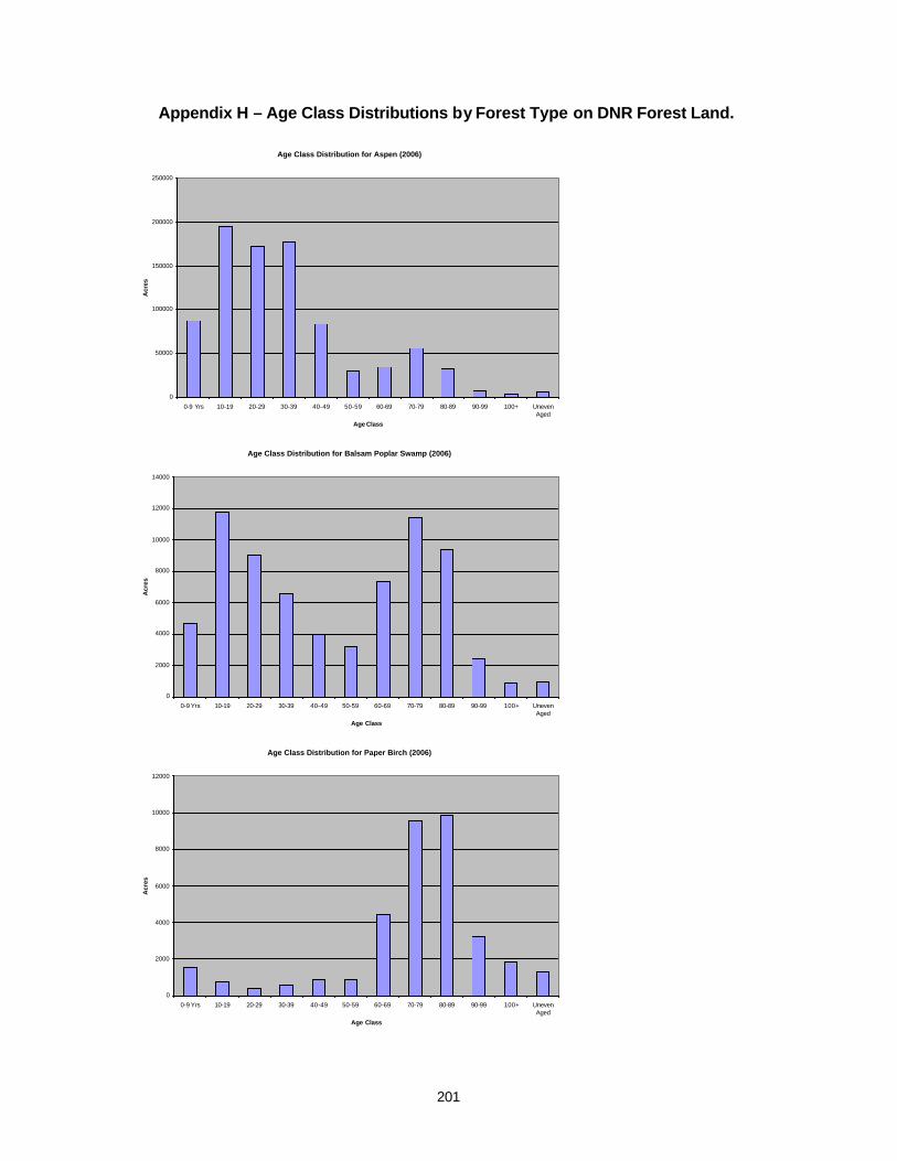
201
Appendix H – Age Class Distributions by Forest Type on DNR Forest Land.
Age Class Distribution for Aspen (2006)
0
50000
100000
150000
200000
250000
0-9 Yrs 10-19 20-29 30-39 40-49 50-59 60-69 70-79 80-89 90-99 100+ UnevenAged
Age Class
Acr
es
Age Class Distribution for Balsam Poplar Swamp (2006)
0
2000
4000
6000
8000
10000
12000
14000
0-9 Yrs 10-19 20-29 30-39 40-49 50-59 60-69 70-79 80-89 90-99 100+ UnevenAged
Age Class
Acr
es
Age Class Distribution for Paper Birch (2006)
0
2000
4000
6000
8000
10000
12000
0-9 Yrs 10-19 20-29 30-39 40-49 50-59 60-69 70-79 80-89 90-99 100+ UnevenAged
Age Class
Acr
es
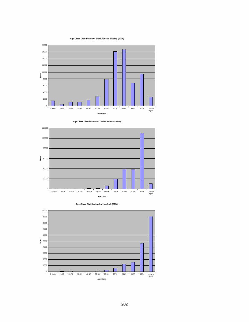
202
Age Class Distribution of Black Spruce Swamp (2006)
0
2000
4000
6000
8000
10000
12000
14000
16000
18000
0-9 Yrs 10-19 20-29 30-39 40-49 50-59 60-69 70-79 80-89 90-99 100+ UnevenAged
Age Class
Acr
es
Age Class Distribution for Cedar Swamp (2006)
0
20000
40000
60000
80000
100000
120000
0-9 Yrs 10-19 20-29 30-39 40-49 50-59 60-69 70-79 80-89 90-99 100+ UnevenAged
Age Class
Acr
es
Age Class Distribution for Hemlock (2006)
0
1000
2000
3000
4000
5000
6000
7000
8000
9000
10000
0-9 Yrs 10-19 20-29 30-39 40-49 50-59 60-69 70-79 80-89 90-99 100+ UnevenAged
Age Class
Acr
es

203
Age Class Distribution for Jack Pine (2006)
0
10000
20000
30000
40000
50000
60000
70000
80000
0-9 Yrs 10-19 20-29 30-39 40-49 50-59 60-69 70-79 80-89 90-99 100+ UnevenAged
Age Class
Acr
es
Age Class Distribution for Lowland Hardwoods (2006)
0
5000
10000
15000
20000
25000
30000
35000
40000
0-9 Yrs 10-19 20-29 30-39 40-49 50-59 60-69 70-79 80-89 90-99 100+ UnevenAged
Age Class
Acr
es
Age Class Distribution for Mixed Conifer Swamp (2006)
0
10000
20000
30000
40000
50000
60000
70000
0-9 Yrs 10-19 20-29 30-39 40-49 50-59 60-69 70-79 80-89 90-99 100+ UnevenAged
Age Class
Acr
es
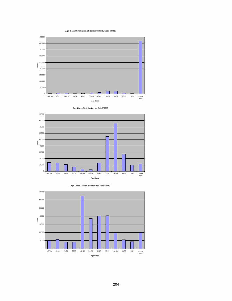
204
Age Class Distribution of Northern Hardwoods (2006)
0
50000
100000
150000
200000
250000
300000
350000
400000
450000
0-9 Yrs 10-19 20-29 30-39 40-49 50-59 60-69 70-79 80-89 90-99 100+ UnevenAged
Age Class
Acr
es
Age Class Distribution for Oak (2006)
0
10000
20000
30000
40000
50000
60000
70000
80000
90000
0-9 Yrs 10-19 20-29 30-39 40-49 50-59 60-69 70-79 80-89 90-99 100+ UnevenAged
Age Class
Acr
es
Age Class Distribution for Red Pine (2006)
0
10000
20000
30000
40000
50000
60000
70000
0-9 Yrs 10-19 20-29 30-39 40-49 50-59 60-69 70-79 80-89 90-99 100+ UnevenAged
Age Class
Acr
es
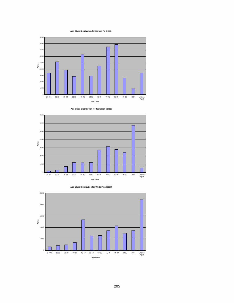
205
Age Class Distribution for Spruce Fir (2006)
0
1000
2000
3000
4000
5000
6000
7000
8000
9000
0-9 Yrs 10-19 20-29 30-39 40-49 50-59 60-69 70-79 80-89 90-99 100+ UnevenAged
Age Class
Acr
es
Age Class Distribution for Tamarack (2006)
0
1000
2000
3000
4000
5000
6000
7000
0-9 Yrs 10-19 20-29 30-39 40-49 50-59 60-69 70-79 80-89 90-99 100+ UnevenAged
Age Class
Acr
es
Age Class Distribution for White Pine (2006)
0
5000
10000
15000
20000
25000
0-9 Yrs 10-19 20-29 30-39 40-49 50-59 60-69 70-79 80-89 90-99 100+ UnevenAged
Age Class
Acr
es

206
Appendix I – Michigan’s Natural Communities.
Palustrine Marsh Communities
Submergent Marsh State Rank: S4 – Secure.
Emergent marsh State Rank: S4 – Secure.
Great lakes marsh State Rank: S3 – Rare or uncommon.
Northern wet meadow State Rank: S4 – Secure.
Southern wet meadow State Rank: S3 – Rare or uncommon.
Inland salt marsh State Rank: S1 – Critically imperiled because of extreme rarity.
Intermittent wetland State Rank: S3 – Rare or uncommon.
Coastal plain marsh State Rank: S2 – Imperiled because of rarity.
Interdunal wetland State Rank: S2 – Imperiled because of rarity.
Palustrine Prairie Communities
Lakeplain wet prairie State Rank: S1 – Critically imperiled because of extreme rarity.
Lakeplain wet-mesic prairie State Rank: S1 – Critically imperiled because of extreme rarity.
Northern wet-mesic prairie State Rank: S1 – Critically imperiled because of extreme rarity.
Wet prairie State Rank: S2 – Imperiled because of rarity.
Wet-mesic prairie State Rank: S2 – Imperiled because of rarity.
Palustrine Fen Communities
Prairie fen State Rank: S3 – Rare or uncommon.
Northern fen State Rank: S3 – Rare or uncommon.
Patterned fen State Rank: S2 – Imperiled because of rarity.
Poor fen State Rank: S3 – Rare or uncommon.
Palustrine Bog Communities
Bog State Rank: S4 – Secure.
207
Muskeg State Rank: S3 – Rare or uncommon.
Palustrine Forest Communities
Poor conifer swamp State Rank: S4 – Secure.
Rich conifer swamp State Rank: S3 – Rare or uncommon.
Relict conifer swamp State Rank: S3 – Rare or uncommon.
Hardwood-conifer swamp State Rank: S3 – Rare or uncommon.
Northern swamp State Rank: S3 – Rare or uncommon.
Southern swamp State Rank: S3 – Rare or uncommon.
Southern floodplain forest State Rank: S3 – Rare or uncommon.
Palustrine Shrub Communities
Northern shrub thicket State Rank: S5 – Demonstrably secure and essentially ineradicable under present conditions.
Southern shrub-carr State Rank: S5 – Demonstrably secure and essentially ineradicable under present conditions.
Inundated shrub swamp State Rank: S3 – Rare or uncommon.
Palustrine/Terrestrial Communities
Wooded dune and swale complex State Rank: S3 – Rare or uncommon.
Boreal forest State Rank: S3 – Rare or uncommon.
Terrestrial Forest Communities
Mesic southern forest State Rank: S3 – Rare or uncommon.
Dry-mesic southern forest State Rank: S3 – Rare or uncommon.
Dry southern forest State Rank: S3 – Rare or uncommon.
Mesic northern forest State Rank: S3 – Rare or uncommon.
Dry-mesic northern forest State Rank: S3 – Rare or uncommon.
Dry northern forest State Rank: S3 – Rare or uncommon.
Terrestrial Savanna Communities
Lakeplain oak openings State Rank: S1 – Critically imperiled because of extreme rarity.

208
Bur oak plains State Rank: SX – Apparently extirpated.
Oak openings State Rank: S1 – Critically imperiled because of extreme rarity.
Oak barrens State Rank: S1 – Critically imperiled because of rarity.
Oak-pine barrens State Rank: S2 – Imperiled because of rarity.
Pine barrens State Rank: S2 – Imperiled because of rarity.
Great lakes barrens State Rank: S2 – Imperiled because of rarity.
Northern bald State Rank: S1 – Critically imperiled because of extreme rarity.
Terrestrial Prairie Communities
Lakeplain mesic sand prairie State Rank: S1 – Critically imperiled because of extreme rarity.
Mesic prairie State Rank: S1 – Critically imperiled because of extreme rarity.
Hillside prairie State Rank: S1 – Critically imperiled because of extreme rarity.
Mesic sand prairie State Rank: S1 – Critically imperiled because of extreme rarity.
Woodland prairie State Rank: S2 – Imperiled because of rarity.
Dry sand prairie State Rank: S2 – Imperiled because of rarity.
Terrestrial Primary Communities
Open dunes State Rank: S3 – Rare or uncommon in the state.
Sand/gravel beach State Rank: S3 – Rare or uncommon.
Cobble beach State Rank: S3 – Rare or uncommon.
Alvar State Rank: S1 – Critically imperiled because of rarity.
Basalt bedrock glade State Rank: S2 – Imperiled because of rarity.
Igneous bedrock glade State Rank: S2 – Imperiled because of rarity.
Limestone bedrock glade State Rank: S2 – Imperiled because of rarity.
Sandstone bedrock glade State Rank: S2 – Imperiled because of rarity.

209
Volcanic conglomerate bedrock glade State Rank: S2 – Imperiled because of rarity.
Basalt bedrock lakeshore State Rank: S2 – Imperiled because of rarity.
Granitic bedrock lakeshore State Rank: S2 – Imperiled because of rarity.
Limestone pavement lakeshore State Rank: S2 – Imperiled because of rarity.
Metamorphic bedrock lakeshore State Rank: S2 - Imperiled because of rarity.
Volcanic conglomerate bedrock lakeshore State Rank: S2 – Imperiled because of rarity.
Dry non-acid cliff State Rank: S2 – Imperiled because of rarity.
Moist non-acid cliff State Rank: S2 – Imperiled because of rarity.
Dry acid cliff State Rank: S2 – Imperiled because of rarity.
Moist acid cliff State Rank: S2 – Imperiled because of rarity.
Basalt lakeshore cliff State Rank: S1 – Critically imperiled because of rarity.
Sandstone lakeshore cliff State Rank: S2 – Imperiled because of rarity.
Volcanic conglomerate lakeshore cliff State Rank: S1 – Critically imperiled because of rarity.
Sinkhole State Rank: S2 – Imperiled because of rarity.
Terrestrial Subterranean Communities
Cave State Rank: S1 – Critically imperiled because of rarity

210
8 – Glossary Acre: A measure of land that occupies 43,560 square feet; (about 207 feet X 207 feet.) There are 640 acres in a square mile.
Area Regulation: An indirect method of roughly determining the amount of forest product to be annually or periodically harvested, on the basis of the total stocked area.
Barrens: Land with poor soil and very few shrubs or trees.
Biodiversity: The spectrum of life forms and the ecological processes that support and sustain them. Biological diversity occurs at four interacting levels: genetic, species, community, and ecosystem. The variety of living organisms considered at all levels of organization, from genetics through species, to higher taxonomic levels, also; the term encompasses the variety of habitats and ecosystems supporting the organisms, as well as the processes occurring within those systems.
Carbon Sequestration: A term describing processes that remove carbon from the atmoshere. This can occur through a variety of means to artificially capture and store carbon, as well as enhancing natural sequestration processes in forests and oceans. These actions are intended to help mitigate global warming.
Cervid: An animal of the cervidae family, which in Michigan includes white-tailed deer, elk, and moose.
Community: An assemblage of species living together in a particular area, at a particular time, in a prescribed habitat. Communities usually bear the name of their dominant plant species, but include all the microbes, plants, and animals living in association with the dominant plant species at a given time. A grouping of organisms which exist in the same general place and have mutual interactions.
Compartment: Blocks of state forestland that range from 1500 to 3000 acres in size. The size of a compartment is designed to facilitate systematic examination and treatment on a regular basis.
Conserve, Conserving and Conservation: 1. Management of renewable natural resource with the objective of sustaining its productivity in perpetuity while providing for human use compatible with the sustainability of the resource; 2. The process and measures for restoring natural biological diversity through management efforts, in order to protect, restore, and enhance as much of the variety of native plant and animal species and communities as possible in quantities and distributions that provide for the continued existence and normal functioning of native species and communities, including the viability of populations throughout the natural geographic distributions of native species and communities.
DBH: Diameter at breast height (4½ feet) which is the standard height for measuring tree diameter.
Desired Future Condition: A statement that provides a broad vision for the future state of the forest.

211
Ecological Reference Areas (ERAs): Areas that serve as models of ecological reference within the state and may be located on any forest land ownership. They are high quality examples of functioning ecosystems that are primarily influenced by natural ecological processes. ERAs are defined as areas that have a natural community classification Global or State Rank of G1, G2, G3, S1, S2, S3 and an Element Occurrence (EO) Rank A or B.1 The initial set of ERAs is based on MNFI’s current list of known high quality natural community sites (See Conservation Area Management Guidance). Additional ERAs will be identified through the Biodiversity Conservation planning process.
Ecology: The study of the linkages of organisms or groups of organisms and their environment, both biotic and abiotic.
Ecosystem: A dynamic and natural complex of living organisms interacting with each other and with their associated nonliving elements in the environment.
Ecosystem Diversity: The distinctive assemblages of species and ecological processes that occur in difference physical settings of the biosphere.
Ecosystem management: A process that integrates physical, chemical, biological, and ecological principles, along with economic and social factors, into a comprehensive strategy aimed at protecting and enhancing sustainability, diversity, and productivity of a system.
Ecoregion: Areas of relatively homogeneous ecological systems. Ecoregions are usually based on patterns of land use, topography, present and potential natural vegetation and soils. Ecoregion designations are used by resource managers to develop logical, regional strategies for land acquisition and management.
Eco-unit: Geographic areas containing similar ecological patterns and processes whose boundaries closely align with Michigan’s Eco-Regions. They were established by the DNR for organizing and administering assessment, planning, facilitating, and updating of regional ecosystem management activities. Four eco-units were established: Western Upper Peninsula. Eastern Upper Peninsula, Northern Lower Peninsula, and Southern Lower Peninsula. These four eco-units apply to all Divisions. Representatives from each division will contribute to regional ecosystem planning, assessment, and monitoring at the eco-unit level.
Eco-Unit Team: A team of DNR employees composed primarily of Management Unit Supervisors from each division along with additional support personnel who are mandated to plan and coordinate management of an eco-unit utilizing ecosystem management principles.
Edaphic: Related to or caused by particular soil conditions.
Endemic: Indigenous to (native) or characteristic of a particular restricted geographical area.
1 Natural Community Rank and Element Occurrence in Michigan are determined by Michigan Natural Features Inventory using the internationally recognized heritage methodology.

212
Edge Habitat: The outermost band of habitat that surrounds a forest patch which has a species composition and structure that is significantly different from the interior of the patch. Edges can be a few to several hundred feet wide depending on environmental factors.
Endangered Species: Any plant or animal species defined through the Endangered Species Act of 1976 as being in danger of extinction throughout all or a significant portion of its range, and published in the Federal Register. A species facing imminent extinction or extirpation.
Forest: An ecosystem characterized by a more or less dense and extensive tree cover, often consisting of stands varying in characteristics such as species composition, structure, age class, and associated processes, and commonly including meadows, streams, fish, and wildlife. A plant community or predominantly trees and other woody vegetation growing more or less closely together, its related flora and fauna, and the values attributed to it.
Forest Patch: An area on the landscape differing in appearance from its surroundings. Patches may be due to natural (e.g. soil type) or anthropogenic (e.g. development) factors. Woodlots or residential development are examples of patches within a landscape.
Forest Road: A hard surface road, travel, or dirt road, or other route capable of travel by a 2-wheel drive, 4-wheel conventional vehicle designed for highway use, except an interstate, state, or county highway. Forest roads may be permanent or temporary, and include haul roads, logging trails and skid trails.
Forest Trail: A designated path or way capable of travel only by a vehicle less then 50 inches in width.
Forest Treatments: Activities taken to modify the composition or structure of a forest stand to meet management objectives; such activities include commercial thinning or clearcut harvests, prescribed burns, non-commercial mechanical removal of undesired species, regeneration or understory planting, and deliberate inaction.
Forest Type: A classification of forestland based on the species forming a plurality of live tree stocking.
Genetic Diversity: The differences in genetic composition within and among populations of a given species.
Geographic Information Systems or Science (GIS): A system designed for the collection, storage, and analysis of objects and phenomena where geographic location is an important characteristic. The study of this system is Geographic Information Science.
Goal: A concise statement which provides the means for the achievement of desired future conditions. Management goals may be short-term or long-term in nature. Long-term management goals are necessary to help achieve desired future conditions.
Guideline: A non-mandatory means by which goals are achieved.
Habitat: The place where an organism lives and its surrounding environment including its biotic and abiotic components. Habitat includes everything an organism needs to survive.

213
Habitat Type System: A classification that uses the floristic composition of plant community (understory species as well as trees) as an integrated indicator of those environmental factors that affect species reproduction, growth, competition, and therefore, community development.
High Conservation Value Areas (HCVAs): Areas (including ERAs) that have been recognized for their contribution to specific conservation objectives or attributes through a recognized DNR process such as legislation, administrative rule, Director’s and Natural Resource Commission Orders but not including the Open House/Compartment Review process. Examples of recognized processes include Dedicated Natural, Wilderness or Wild Areas, Natural Rivers, and Kirtland’s Warbler plan.
Hydric: Wet
Hypsithermal: The period of maximum climatic warmth during an interglacial period.
Interior Habitat: Habitat within the interior of a forest patch that is removed from edge habitat, that is necessary for the persistence of certain forest plant and animal species, by providing insulation from edge effects such as noise, wind, solar radiation, and increased predation.
Integrated Pest Management : The maintenance of destructive agents, including insects at tolerable levels, by the planned use of a variety of preventative, suppressive, or regulatory tactics and strategies that are ecologically and economically efficient and socially acceptable.
Karst: A type of terrain usually formed on carbonate rock (limestone and dolomite) where groundwater has dissolved the rock to enlarged openings and form a subsurface drainage system of caverns and sinkholes.
Lake Superior Syncline: A syncline is a geological term for a fold in the rocks of the Earth's crust in which the layers or beds dip inwards, thus forming a trough-like structure with a sag in the middle. The Lake Superior Syncline forms portion of the lake basin, extending from northern Wisconsin to the tip of the Keweenaw Peninsula of Michigan and into Ontario, Canada. The edges of the syncline are visible in the unique bedrock formations of the Keweenaw Peninsula and Isle Royale.
Landscape: An area composed of adjacent and interacting ecosystems that are related because of geology, land forms, soils climate, biota, and human influences.
Landscape Scale: The appropriate spatial or temporal scale for planning, analysis, and improvement of management activities to achieve ecosystem management objectives.
Lacustrine: Found or formed in lakes.
Legacy Tree: A mature tree that is retained on a site after harvesting or natural disturbance to provide a biological legacy.
Mesic: Moderately moist.
214
Monitoring: The daily, seasonal, annual or longer-term collection and analysis of environmental and social data.
Monitoring Criteria: A measure by which the progress toward the attainment of sustainable management goals and desired future conditions are assessed.
Moraine: A mass of rock, gravel and soil deposited directly by a glacier.
Objective: A concise, time-specific statement of measurable planned results that respond to pre-established goals. Objectives are more specific and concrete than goals.
Old Growth: As defined by the Natural Resources Commission on 12/8/94, old-growth forests are those that approximate the structure, composition, and functions of native forests. These native conditions generally include more large trees, canopy layers, standing snags, native species, and dead organic material, involve more complex ecological processes, and undergo more gradual change than do young or intensively managed forests. Native forest conditions in Michigan also included ecologically important unforested openings, early successional stages, and extensive areas of catastrophic or frequent disturbance.
Poletimber: A live tree of commercial species at least 5.0 inches DBH, but smaller than sawtimber size. Harvested poletimber is sometimes referred to as cordwood.
Potential Old Growth: Areas inventoried and designated with a stand condition code of 8 within Operations Inventory (OI) for consideration as old growth.
Public: A group of people sharing a common interest or common characteristic: snowmobilers, or residents of a county.
Rare Species: Species that have a limited range, or a limited number of individuals. This could include species found in very low numbers throughout their range, or species that may have rather large local populations, but only a handful of populations total.
Removal Cut: Removal of overstory trees from a small understory trees so as to release the understory stand that are less than 20 years of age.
Resource assessment: The determination of the significance, importance, or value of a resource or a set of resources.
Riparian Area: The area of transition between aquatic and terrestrial ecosystems in which the terrestrial ecosystem influences to aquatic and vice-versa.
Riparian Management Zone: The defined area consciously managed to protect functions and values of riparian areas. It may be a subset of, may equal, or may exceed beyond the riparian area.
Sapling: A live tree 1.0 to 5.0 inches DBH.
Sawtimber: A live tree of commercial species containing at least a 12-foot saw log or two noncontiguous saw logs 8 feet or longer and meeting regional specifications for freedom
215
from defect. Softwoods must be at least 9.0 inches DBH and hardwoods must be at least 11.0 inches DBH.
Seasonal Wetlands: Poorly drained, shallow depressions that may have standing water for a few weeks each year, but that are usually dry for much of the growing season.
Seed Tree Harvest: Most trees are removed from a stand, leaving a small number of designated seed trees.
Shelterwood Harvest: A cut designed to develop tree crowns in the remainder of the stand in preparation for another cut to be made in about ten years that will result in regeneration.
Silvicultural Criteria: The assemblage of abiotic and biotic factors (such as landform, soils, climate, life history characteristics of tree species, disease and insect pathogens) that when considered together govern establishment, growth, composition, health and quality of forests. In practical application, when silvicultural criteria are met they trigger a management action.
Site Index: A numerical indicator of site quality based on tree height at a specified age used as coordinates for interpolating site index from a specially prepared set of graphed curves for a given species of tree.
Spatial Scale: The geographical size of a community, ecosystem, or study. Spatial scale can range from a microsite such as an underside of a leaf on the forest floor, to a forest, to a larger landscape. Operationally, spatial scale refers to the geographic extent at which certain processes operate within the environment. This could be the scale at which nutrients recycle in a wetland to the patterns of deer migration in the Upper Peninsula.
Special Concern Species: Species that have a limited range, or a limited number of individuals so much so they are on the verge of becoming threatened or endangered.
Species: A group of individuals that can interbreed successfully with one another, but not with members of other groups. Plants and animals are identified as belonging to a given species based on similar morphological, genetic, and biochemical characteristics.
Special Conservation Areas (SCAs): Special Conservation Areas are areas of State Forest land that have had one or more conservation objectives, interests, or elements identified. The type and strength of recognition will vary depending on the process used to identify the conservation value. Some SCA designations will have the force of law, (such as areas identified in Land Use Orders of the Director), some will be by cooperative agreement (such as National Natural Landmarks with the National Park Service), some will be by department process or agreement (such as deer yards, POG, and riparian buffers), and some will be identified by an external group or organization (such as Audubon’s Important Bird Areas).
Species Diversity: The richness and variety of native species in an area. It includes not only the number of species in the area, but also their relative abundance and spatial distribution. Species richness is one component of species diversity, but not the only determinant.
216
Soil Detritus: Small pieces of dead and decomposing plants and animal that add organic matter, nutrients and structure to the organic surface horizon of soils.
Stakeholder: Individuals or groups impacted by and/or having an interest in the management of Michigan’s natural resources and DNR programs. State, tribal, and local government agencies, academic institutions, the scientific community, nongovernmental entities including environmental, agricultural, and conservation organizations, trade groups, commercial interests, and private landowners and citizens.
Standard: A standard is a mandatory means by which goals are achieved. The intended purpose for standards is to reference procedures and laws that provide existing direction for the achievement of goals
Stand Condition 8: One of many codes used in DNR Operations Inventory to describe the condition of a stand. Prior to the 2008 year of entry, the code stand condition 8 was used to designate forest areas as potential old growth. As of the 2008 year of entry, this designation has been changed to encompass other biodiversity values and includes areas designated as Special Conservation Areas (of which old growth is a component), High Conservation Value Areas, and Ecological Reference Areas.
Statewide Council (SWC): A team composed of all the DNR Division chiefs who meet periodically to plan and discuss policy, coordination, cooperation, and implementation of Department programs.
Succession: The natural change in vegetation over time in the absence of disturbance or the artificial change in vegetation due to natural or human-caused disturbance.
Sustainable/Sustainability: Maintenance of healthy, functioning ecosystems capable of providing goods, services, and processes upon which human welfare ultimately depends. Also, implied is the idea that the actions of the current generation will not diminish the resources and opportunities available to future generations.
Temporal scale: The time required to complete a study, a life history event or ecological process. Temporal scale can vary from a few seconds for biochemical reactions to thousands of years for ecosystem development. Operationally, temporal scale refers to the time extent certain processes operate in the environment. (The apparent spatial-operational scale of an ecological process will often change as the temporal-observational scale changes in the same process).
Threatened species: A plant or animal species likely to become endangered throughout all or a significant portion of its range within the foreseeable future.
Xeric: Dry or desert-like.

217
9 – LITERATURE CITED
Albert, D. A. 1995. Regional Landscape Ecosystems of Michigan, Minnesota, and Wisconsin: A Working Map and Classification. Gen. Tech. Rep. NC-178. St. Paul, MN: U.S. Department of Agriculture, Forest Service, North Central Forest Experiment Station. 250 pp.
Burger, T.L. and J. Kotar. 2003. A Guide to Forest Communities and Habitat Types of Michigan. Madison, Wisconsin: The University of Wisconsin.
Cleland, David T., P. E. Avers, W. H. McNab, M. E. Jensen, R. G. Bailey, T. King, and W. E. Russel. 1997. National Hierarchial Framework of Ecological Units. In M.S. Boyce and A. Haney (eds), Ecosystem Management Applications for Sustainable Forest and Wildlife Resources . Yale University Press. pp. 181-200.
Cleland, David T., T. R. Crow, S.C. Saunders, D. I. Dickmann, A. L. Maclean, J. K. Jordan, R. L. Watson, A. M. Sloan, and K. D. Brosofske. 2004. Characterizing historical and modern fire regimes in Michigan (USA): A landscape ecosystem approach. Landscape Ecology 18: 311-325.
Cohen, J. G. 2000. Natural community abstract for mesic northern forest. Michigan Natural Features Inventory, Lansing, MI. 7 pp.
Cohen, J. G. 2002a. Natural community abstract for dry-mesic northern forest. Michigan Natural Features Inventory, Lansing, MI. 12 pp.
Cohen, J. G. 2002b. Natural community abstract for dry northern forest. Michigan Natural Features Inventory, Lansing, MI. 14 pp.
Cohen, J. G. 2004. Natural community abstract for mesic southern forest. Michigan Natural Features Inventory, Lansing, MI. 12 pp.
Davis, M. B. 1981. Quaternary history and the stability of plant communities. In D. C. West, H. H. Shugart, and D. B. Botkin (eds), Forest succession: Concepts and application. Springer-Verlag, New York. pp 132-153.
Davis, M. B. 1986. Climatic instability, time lags, and community disequilibrium. In J. Diamond and T. J. Case (eds), Community Ecology. Harper and Row, New York,
Davis, M. B., S. Sugita, R. R. Calcote, J. B. Ferrari, and L. E. Frelich. 1994. Historical development of alternate communities in a hemlock-hardwood forest in Northern Michigan, USA. In P. J. Edwards, R. M. May, and N. R. Webb (eds), Large-Scale Ecology and Conservation Biology. The British Ecological Society and Blackwell Scientific Publications. 375 pp.
Doepker, R.V., L.E. Thomasma, and S.A. Thomasma. 2001. MIWildHab – Michigan Wildlife Habitats [Computer Program]. MDNR, Wildlife Division, Lansing MI and Two by Two Wildlife Consulting, Grand Rapids MI.
Dickman, D. I. and L. A. Leefers. 2003. The Forests of Michigan. Ann Arbor, MI: The University of Michigan Press. 297 pp.

218
Eagle, A. C., E. M. Hay-Chmielewski, K. T. Cleveland, A. L. Derosier, M. E. Herbert, and R. A. Rustem, 2005. Michigan’s Wildlife Action Plan. Michigan Department of Natural Resources. Lansing, Michigan. 1592 pp. http://www.michigan.ogv/dnrwildlifeactionplan
Fisher, J. H. 1994. Pre-European settlement forests of northern Lower Michigan: The role of landform in determining composition across the landscape. M.S. Thesis, Michigan State University.
Frelich, L. E. 1992. The relationship of natural disturbances to white pine stand development. White Pine Symposium: History, Ecology, Policy and Management, Duluth, MN Proceedings, NR-BU-6044. (Ed. By R.A. Stein and M.J. Baughman), pp. 27-37. Minnesota Extension Service, St. Paul, MN.
Frelich, L. E. and C. G. Lorimer. 1991. Natural Disturbance regimes in hemlock-hardwood forests of the upper Great Lakes region. Ecological Mongraphs 61(2): 145-164.
Garling, D., S. Dann, T. Edsall, T. Grischke, S. Miller, and L. Ramseyer. 1995. Status and potential of Michigan natural resources: fisheries. A special report prepared by the Michigan Agricultural Experiment Station, Michigan State University. Special Report 74. 39 pp.
Herkert, J.R. 1995. An Analysis of Midwestern Breeding Bird Population Trends: 1966 - 1993. American Midland Naturalist 134:41-50.
Heinselman, M. A.1981. Fire intensity and frequency as factors in the distribution and structure of northern ecosystems. Pages 374-405. in H. A. Mooney, T. M. Bonnicksen, N. L. Christensen, J. E. Lotan, and W. A. Reiners, editors. Fire regimes and ecosystem properties. United States Forest Service General Technical Report WO-26.
Michigan Department of Natural Resources, 1994. Water Quality Practices on Forest Land. 77 pp.
Michigan Department of Natural Resources, 2000. Natural Areas Strategic Plan. 16pp.
Michigan Department of Natural Resources. 2003a. Parks and Recreation Division Boating Access Site Design Guides.
Michigan Department of Natural Resources. 2003b. Parks and Recreation Division Harbor Development Standards Guidance. 56 pp.
Michigan Department of Natural Resources. 2004a. A Process for Implementing Mesic Conifer Restoration on State Land, Western Upper Peninsula, Michigan. 36 pp.
Michigan Department of Natural Resources. 2004b. Evaluating Riparian Management Zones of State Lands. 12 pp.
Michigan Department of Natural Resources. 2005a. Biodiversity Conservation Planning Process. 25 pp.
Michigan Department of Natural Resources. 2005b. Conservation Area Management Guidelines. 58 pp.

219
Michigan Department of Natural Resources. 2005c. Wildlife Action Plan. 1600 pp.
Michigan Department of Natural Resources. Northern Lower Michigan Ecoteam. 2006a. Guidelines for Red Pine Management based on Ecosystem Management Principles for State Forestland in Michigan. 56 pp.
Michigan Department of Natural Resources. 2006b. Within-Stand Retention Guidelines. 29 pp.
Michigan Department of Natural Resources. 2006c. Water Quality Management Practices on Forest Land. 51 pp.
Michigan Natural Features Inventory. 1999. Biological Inventory for Conservation of Great lakes Islands: 1998 Progress Report. MNFI Report Number 1999-01. 38pp.
Michigan Natural Features Inventory. 2000a. Biological Inventory for Conservation of Great lakes Islands: 1999 Progress Report. MNFI Report Number 2000-11. 68pp.
Michigan Natural Features Inventory. 2000b. Biological Inventory for Conservation of Great lakes Islands: Year 2000 Progress Report. MNFI Report Number 2000-15. 110 pp.
Michigan Natural Features Inventory. 2002a. Biological Inventory for Conservation of Great lakes Islands: Year 2001 Progress Report. MNFI Report Number 2002-21. 61 pp.
Michigan Natural Features Inventory. 2002b. Biological Inventory for Conservation of Great lakes Islands: 2002 Inventory and Final Report. MNFI Report Number 2002-27. 51 pp.
Mlandenoff, D. J. and F. Stearns. 1993. Eastern Hemlock Regeneration and Deer Browsing in the Northern Great Lakes Region: A Re-examination and Model Simulation. Conservation Biology 7(4), 1-12.
Noss, R. F. 1997. A Big-Picture Approach to Forest Certification: A Report for World Wildlife Fund’s Forest for Life Campaign in North America. World Wildlife Fund, Washington, DC, 69 pp.
Noss, R. F. 1999. Assessing and monitoring forest biodiversity: A suggested framework and indicators. Forest Ecology and Management 115, 135-146.
Pielou, E. C. 1991. After the Ice Age: The Return of Life to Glaciated North America. Chicago, Illinois: The University of Chicago Press. 366 pp.
Pregitzer, K.S. 1990. The Ecology of Northern White-Cedar. In Northern White-Cedar in Michigan, Workshop Proceedings. Michigan State University, Agricultural Experiment Station. Research Report 512. March 1991. Pages 8-14.
Price, D. L. 1994. An ecological study of the composition, structure and disturbance regimes of the pre-European settlement forests of western Chippewa County, Michigan. M.S. Thesis, Michigan State University.
Society of American Foresters. 1993. Task Force Report on Sustaining Long-Term Forest Health and Productivity. SAF 93-02. 83pp.

220
States Organization for Boating Access. 1996. Design handbook for Recreational Boating and Fishing Facilities. Prepared by K. Wilson, Public Sector Consultants, Lansing, MI. 133 pp.
U.S. Department of the Interior, Fish and Wildlife Service and U.S. Department of Commerce, U.S. Census Bureau. 2001 National Survey of Fishing, Hunting, and Wildlife -Associated Recreation.
Whitney, G. G. 1986. Relation of Michigan’s presettlement pine forests to substrate and disturbance history. Ecology 67(6), 1548-1559.