downtown columbia plan a general plan amendment · hereas, the attached downtown columbia plan, a...
TRANSCRIPT

DOWNTOWN COLUMBIA PLANA General Plan Amendment
Howard County, MarylandAdopted: February 1, 2010


ACKNOWLEDGMENTS
COUNTY EXECUTIVE
Ken Ulman, County Executive Jessica Feldmark, Chief of StaffJennifer Sager, Legislative Coordinator
COUNTY COUNCIL
Courtney Watson, Chairperson, District 1Dr. Calvin Ball, District 2Jen Terrasa, District 3 Mary Kay Sigaty, Vice Chairperson, District 4 Greg Fox, District 5
COUNTY PLANNING BOARD
Dave Grabowski, ChairGary Rosenbaum, Vice ChairTammy J. CitaraManisLinda A. DombrowskiPaul Yelder
DEPARTMENT OF PLANNING AND ZONING
Marsha S. McLaughlin, Director Tom Butler, PE, Deputy Director Kimberly Flowers, Deputy Director Steve Lafferty, Director of Special ProjectsCarl Balser, Chief, TransportationGeorge Beisser, Chief, Zoning Administration and Public ServiceJeff Bronow, Chief, ResearchChuck Dammers, Chief, Development EngineeringCindy Hamilton, Chief, Land DevelopmentElmina Hilsenrath, ASLA, Chief, Resource ConservationWilliam Mackey, AICP, Chief, Comprehensive and Community Planning and Project Manager
CONTRIBUTING STAFF
Dace BlaumanisRandy Clay, AICPBrad KillianSharon MelisSusan Overstreet, AICPBenjamin Pickar, AICP
CONTRIBUTING COUNTY AGENCIES
Arts CouncilCommunity CollegeEconomic Development AuthorityFire and RescueHealth DepartmentHousing and Community DevelopmentInspections, Licenses and PermitsLibraryOffice of Environmental SustainabilityPublic WorksRecreation and Parks
General Growth Properties, Inc.
Greg Hamm, Vice President Master Planned Communities, Columbia General ManagerRobert Jenkins, Vice President Construction and Design Gabrielle Koeppel, Senior Director of DevelopmentBarb Nicklas, Vice President, MarketingNancy Tucker, Manager, Community Relations
Consultants
ARUP, Matt McGibbonBiohabitats, Keith BowersCooper, Robertson & Partners, Jaquelin T. RobertsonDevelopment Management Group, LLC, Brian J. SpencerLinowes and Blocher LLP, Todd BrownLord Cultural Resources, Gail Dexter LordSasaki Associates, Inc., Alan WardWells & Associates, Marty Wells
County Executive and Council Bill Signing
Photos not expressly credited are courtesy of Howard County, General Growth Properties, Inc., ARUP, Biohabitats, Cooper, Robertson & Partners, Lord Cultural Resources, Sasaki Associates and Wells & Associates.
i

WHEREAS , Jim Rouse’s vision for Columbia established a quartet of main objectives:
1. To provide a real City – not just a better suburb, but a comprehensively balanced community…;
2. To respect the land. With sets of overlays we recorded the topography, the stream valleys, the forests, the southeastern slopes, the historic buildings, the special vistas, the quiet tree lined areas. We allowed the land to impose itself as a discipline on the form of the Community…;
3. To provide the best environment for the growth of people. It would seem elementary that cities should be planned for people… We want to allow these overlays, these insights about people, to influence the physical plan and the institutions we should seek to stimulate in the community just as we allow the plan to be influenced by the land itself…; and
4. Our fourth goal was profit. This was no residual goal, not something just hoped for. It was our primary objective;1 and
WHEREAS , on May 17, 1965, the Howard County Planning Commission, after public hearing, adopted a Supplement to the Text of the 1960 Howard County General Plan to guide the construction of New
Towns, New Communities and Large-Scale neighborhoods which guided the creation of the New Town floating district; and
WHEREAS , on July 13, 1965, the Board of County Commissioners of Howard County held a public hearing for the reclassification of 13,690 acres of land to the New Town District; and
WHEREAS, by Opinion and Order dated August 10, 1965, the Board of Commissioners granted the rezoning “in order to give maximum assurance to the developers and the public of our intention to do all we can to
see the project succeed”; and
WHEREAS , Columbia is a vibrant, diverse community which has achieved much of 30 Jim Rouse’s vision for Columbia as “the most livable, the most beautiful and the most effective city in America”; and
WHEREAS , Jim Rouse also understood that Columbia would “take a long time to complete, maybe never, we hope never”; and
WHEREAS , Article 66B of the Annotated Code of Maryland expressly states that each Charter County of the State shall enact, adopt, amend and execute a General Plan; and
WHEREAS, the most recently adopted 2000 Howard County General Plan includes, but is not limited to, policies and action plans for land use, regional coordination, transportation rural preservation,
infrastructure and the environment; and
1 See page 88ii

WHEREAS , the 2000 Howard County General Plan also sets forth a central theme of sustainable development through a series of visions which encompass, but are not limited to, quality of life, public
participation, community design, housing and economic development; and
WHEREAS , the 2000 Howard County General Plan also recognizes Downtown Columbia as the County’s largest and most urban mixed-use center and establishes a policy and implementing actions to encourage
Downtown Columbia’s continuing evolution and growth as the County’s urban center (Policy 5.5); and
WHEREAS , the 2000 Howard County General Plan has been amended a dozen times in accordance with County Council bill procedures; and
WHEREAS , in 2005, the Howard County Government led a week-long Charrette to gather thoughts from the community as to how Downtown Columbia should be redeveloped; and
WHEREAS , in 2005 and 2006, the Downtown Focus Group, a committee of community leaders, met 15 times with the Howard County Department of Planning and Zoning to discuss key issues and offer advice
regarding redevelopment of Downtown Columbia; and
WHEREAS , in 2007, after additional community input, the County Executive, through the Department of Planning and Zoning, released “Downtown Columbia: A Community Vision” which articulates planning
guidelines for the redevelopment of Downtown Columbia; and
WHEREAS , “Downtown Columbia: A Community Vision” provided that General Growth Properties would prepare a general plan amendment and zoning regulation amendment for submittal to the County
Council; and
WHEREAS , “Downtown Columbia: A Community Vision” also explicitly provided that the proposed amendments “would be introduced to the public at the same time, so that the relationship between the
downtown development master plan and its implementation through the Zoning Regulations would be clearly understood”; and
WHEREAS , on October 1, 2008, General Growth Properties formally submitted its Downtown Columbia redevelopment package consisting of a zoning regulation amendment and a general plan amendment,
along with the following supplemental documents:
1. Adequate Public Facilities Amendment (draft proposal)
2. Columbia Town Center Sustainability Framework;
3. Columbia Town Center Merriweather and Crescent Environmental Enhancements Study;
4. Columbia Town Center Design Guidelines (draft proposal);
5. Columbia Town Center Generalized Traffic Study;
6. Columbia Town Center Generalized Traffic Study, Technical Appendix; and
7. Best Management Practices for Symphony Stream and Lake Kittamaqundi Watersheds; and
iii

WHEREAS , the Howard County Planning Board, following advertisement for 30 days, held a series of public hearings/meetings and heard public testimony on December 11, 2008, January 8 and 22, 2009,
February 5, 2009 and March 5 and 19, 2009; and
WHEREAS , the Howard County Planning Board also conducted a series of public worksessions on April 13 and 30, 2009, May 14 and 27, 2009, June 11 and 25, 2009, July 9, 16 and 23, 2009, August 20, 2009 and September
2 and 3, 2009; and
WHEREAS , on September 17, 2009, the Planning Board recommended approval with recommended changes to the general plan amendment; and
WHEREAS , the attached Downtown Columbia Plan, a General Plan Amendment, is being considered together with a bill proposing the adoption of a zoning regulation amendment based on Zoning Regulation
Amendment 113 as amended pursuant to the recommendations of the Department of Planning and Zoning and the Planning Board; and
WHEREAS , the zoning regulation amendment is the principal means of implementing the revitalization and redevelopment plan for Downtown Columbia; and
WHEREAS , the attached Downtown Columbia Plan will be implemented by additional legislation, including but not limited to, Downtown Columbia Design Guidelines and amendments to the Adequate
Public Facilities Act, the Design Advisory Panel and the Green Buildings Law; and
WHEREAS , these implementing mechanisms will promote the ongoing evolution of Downtown Columbia in a manner that reflects its unique character and aspirations in order to become a model for smarter, more livable
communities.
NOW THEREFORE:
Section 1. Be it enacted by the County Council of Howard County, Maryland, that the Downtown Columbia Plan, a General Plan Amendment attached hereto, is adopted as the revitalization and redevelopment plan
for Downtown Columbia.
Section 2. Be it further enacted by the County Council of Howard County, that the Director of the Department of Planning and Zoning is authorized to publish this Plan adding covers, title pages and graphics to improve
readability.
Section 3. Be it further enacted by the County Council of Howard County, Maryland, that the Downtown Columbia Plan, a General Plan Amendment, shall become effective 61 days after its enactment.
iv

CONTENTS1 Introduction
3 Exhibit A. Downtown Columbia
5 Chapter 1: Making a Special Place
5 1.1 Rouse Vision6 1.2 Symbols7 1.3 Districts8 Exhibit E. The Neighborhoods15 1.4 Commercial Balance16 1.5 Diverse Housing19 1.6 Economic Activity23 1.7 Civic Life25 1.8 Arts and Culture28 1.9 Design31 Exhibit F. Maximum Building Height Plan32 Exhibit C. Street and Block Plan33 Exhibit D. Illustrative Master Plan
35 Chapter 2: Moving and Connecting People35 2.1 Multi-Modal System36 Exhibit H. Street Framework Diagram38 Exhibit J. Amendment to General Plan 2000 Transportation Map39 2.2 Traffic40 2.3 Pedestrians43 2.4 Transit45 Exhibit I. Bicycle and Pedestrian Circulation Plan47 2.5 Parking
49 Chapter 3: Sustaining the Environment49 3.1 Green Technology55 3.2 Nature58 3.3 Central Park59 3.4 Outdoor Spaces60 Exhibit G. Primary Amenity Space Framework Diagram61 Exhibit K. Downtown Open Space Preservation Plan
63 Chapter 4: Balancing and Phasing Growth63 4.1 General Plan69 4.2 Phasing71 Exhibit B. Land Ownership Plan73 Downtown Revitalization Phasing Progression*
73 Downtown CEPPA Implementation Chart79 4.3 Monitoring
81 Chapter 5: Involving Everyone81 5.1 Participation83 5.2 Collaboration
85 ExhibitDescriptions86 Technical Supplemental Document87 Errata* See page 87

Lake Kittamaqundi, Downtown Columbia

1A General Plan Amendment
Columbia has an active and engaged community that was born out of the progressive urban planning ideas of the late Jim Rouse, its founder, more than 40 years ago. Now Rouse’s pioneering planned community is embarking on a new phase in its growth and development, as its residents and officials seek to redesign and rebuild its unique downtown.
Rouse hoped to make Columbia a new kind of American community that would, through rational planning, avoid the problems associated with the decay that was settling upon America’s big cities and the unplanned and often unsightly sprawl that marked its ever-burgeoning suburbs. Though in part motivated by social concerns, Rouse also was a successful business man who knew that Columbia had to be profitable if it was to survive and thrive.
Almost since Columbia’s founding, its residents and officials have debated how to improve its downtown core. Most recently, in October 2005, residents gathered with Columbia and Howard County government officials for a week-long series of public meetings called a “charrette.” The meetings were designed to listen to the thoughts of the community on how Downtown Columbia should be redeveloped over the next 30 years and from the input, to develop a master plan to guide downtown’s continued evolution as the County’s economic and cultural center.
Officials of General Growth Properties, Inc. which acquired Columbia’s original developer, The Rouse Company, in 2004, and its affiliates, including The Howard Research and Development Corporation, participated in those meetings as a majority landowner in the plan to redevelop Downtown Columbia. General Growth Properties, its affiliates, any successor or assign, and/or any purchaser of equity interests or assets that continues to serve in the capacity of the community developer of Downtown Columbia, is hereinafter referred to as “GGP” even if unaffiliated with General Growth Properties, Inc.
The consensus of those meetings was that Downtown Columbia should become more vibrant and relevant to Columbia’s residents and that these goals could be achieved by increasing the number of people living downtown and by adding more residences, shops and recreational and
Introduction
Downtown Columbia Charrette
Gail Holliday Screen Print

Downtown Columbia Plan2
cultural amenities in Downtown Columbia, while also making downtown more attractive and easier for pedestrians to navigate.*
As a result of the charrette, County officials, with the assistance of residents and planning consultants, released a preliminary draft master plan in February of 2006 that proposed new residential, office, retail and cultural development downtown, along with reconfigured road and pedestrian networks. A community-based task force was formed by the County to provide feedback. They met between February and September of 2006 and provided feedback that the County utilized in the writing of their subsequent vision plan.
In late 2007, the County released a document entitled Downtown Columbia: A Community Vision, which lays out a series of planning guidelines that County officials recommend will lead to a redeveloped downtown that is lively, friendly to pedestrians and sensitive to the environment. The document makes clear that County officials consider that Rouse’s original goals for Columbia continue to be relevant and must guide any plan to rebuild downtown.
DOWNTOWN COLUMBIA PLAN, AN AMENDMENT TO THE HOWARD COUNTY GENERAL PLAN
This Plan for Downtown Columbia (“Plan”) in response to the guidance provided by Downtown Columbia: A Community Vision, is an amendment to the Howard County General Plan and creates a 30-year master plan for the revitalization and redevelopment of Downtown Columbia that is true to Jim Rouse’s original vision and adheres to the guidelines contained in Downtown Columbia: A Community Vision. It specifically takes each chapter and sub-section outlined in the County’s framework plan and provides a response.
This Plan reconfirms the recommendations of General Plan 2000 concerning the future of Downtown Columbia. It also provides additional recommendations about its future redevelopment. Both General Plan 2000 and Downtown Columbia: A Community Vision aim to continue the evolution of Downtown Columbia into a mixed-use urban center supported by a variety of open spaces and amenities in a pedestrian-friendly environment. This Plan focuses on Downtown Columbia specifically and recommends a number of policies and approaches to guide its redevelopment in the future.
This Plan does not attempt to modify existing language in General Plan 2000. Rather, the Plan is intended to provide a guide for creating the future of Downtown Columbia and recommends specific land use, transportation,
Introduction
Town Center and Village Concept
Colu
mbi
a A
rchi
ves

3A General Plan Amendment
Introduction
EXHIBIT A. DOWNTOWN COLUMBIA

Downtown Columbia Plan4
Introduction
environmental, community conservation and housing policies central to that guidance. This Plan is intended to be the controlling expression of planning policy for Downtown Columbia.
Unless otherwise provided in this Plan or other implementing documents, the drawings, sketches, photographs, and diagrams included in this Plan are for illustrative purposes only and are intended to convey a general sense of desirable future character rather than specific commitment.
The following recommendations for the revitalization and redevelopment of Downtown Columbia have been prepared to meet the demands and aspirations of today’s residents, businesses and visitors, while providing the flexibility necessary to assure that the future will also be served.
Lakefront Gathering Place, Downtown Columbia

5A General Plan Amendment
Chapter 1: Making a Special Place“Downtown Columbia will be a diverse, mixed-use, livable, physically distinctive and human-scaled place with a range of housing choices and recreational, civic, cultural and educational amenities.”
“Continue and enhance Jim Rouse’s vision of Columbia as a thriving, socially responsible and environmentally-friendly place for people of all ages, incomes and backgrounds.” Downtown Columbia: A Community Vision
Jim Rouse envisioned the planned community of Columbia as a socially responsible, environmentally-friendly and financially successful place in which people of all ages, incomes, and backgrounds could grow as individuals, neighbors and citizens. His strategic goals for what was to be a new kind of community included:
� Provide a real, comprehensive, balanced city
� Respect the land and allow the land to impose itself as a discipline on the form of the community
� Provide the best possible environment for the growth of people
� Realize a profit
Downtown Columbia will be a diverse, mixed-use, livable, physically distinctive and human-scaled place with a range of housing choices and recreational, civic, cultural and educational amenities. These goals remain as relevant today as they were 40 years ago, when Rouse first broke ground on Columbia. To achieve these goals, Rouse built Columbia as a series of nine interconnected residential villages, each with its own civic/service center, which surrounded a larger Downtown Columbia, intended to serve as Columbia’s downtown. Rouse’s new community was designed to provide a wide spectrum of retail, office, educational, recreational, and cultural uses, as well as a mix of residential offerings for people with a range of incomes. It has been successful in much of what was intended.
Despite the passage of four decades, however, Columbia’s downtown never developed the character one expects in the heart of a community. It is still primarily suburban in nature with relatively undistinguished office buildings and an enclosed shopping mall at its core. It is a sparsely populated, automobile-dependent area, with isolated amenities separated from one another by what has become a vehicular thoroughfare.
1.1 ROUSE VISION
James W. Rouse
Colu
mbi
a A
rchi
ves

Downtown Columbia Plan6
“Conserve symbols of Columbia’s past found throughout the downtown area, recognizing that they contribute to the authentic character of downtown and reinforce its qualities as a special place.” Downtown Columbia: A Community Vision
The planning challenge today is how best to complete Rouse’s vision of a “real city” by creating a vital Downtown Columbia in which residents can live, shop, work, entertain, exercise and enjoy cultural opportunities in an enriched natural setting. General Growth Properties intends to redevelop its property in Downtown Columbia and work with other property owners to create a dynamic, walkable downtown that lives up to its existing as well as future citizens’ needs and its founder’s expectations: a downtown that will serve as a strong new heart for Columbia.
Chapter 1 Making a Special Place
1.2 SYMBOLS
A revitalized and redeveloped Downtown Columbia will look to the future in its planning and design, as it preserves the culturally and historically important features of the built and natural landscape.*
Such art and artifacts as “The People Tree,” the statue of Jim Rouse and his brother Willard, the granite sculpture of “The Bear” and its cubs, as well as “The Hug,” a memorial to Columbia architect and planner Mort Hoppenfeld, and the plaque listing the names of Wilde Lake High School’s first graduating class are part of Columbia’s history and will be part of downtown’s future redevelopment.
Lake Kittamaqundi and Symphony Woods intended as the primary landscape elements of Downtown Columbia, were planned to become lasting and emblematic symbols in the region. The redevelopment of Downtown Columbia will fulfill the vision for these seminal places.
The former Rouse Company Headquarters building, located at the Lakefront Core and designed by renowned architect Frank Gehry, is recognized as an existing signature building in downtown. Many residents view the building as a symbol of Jim Rouse and a reminder of Columbia’s beginnings and growth as a planned community. This Plan recognizes the cultural significance of the building and recommends that it be a part of Columbia’s future, although some interior and/or exterior renovation may be needed to assure its economic viability.
It is therefore recommended that the concept plan submitted with the first Final Development Plan for the Lakefront and Lakefront Core Neighborhood include a feasibility study for the former Rouse Company Headquarters building. The feasibility study should be completed before the Downtown-wide Design Guidelines2 and should identify the best uses for the building and any architectural modifications that might be proposed. This Plan recommends that consideration be given in the feasibility study to how the building might integrate better with its surroundings and how to activatethe adjacent pedestrian spaces, including the existing open space plaza
Former Rouse Company Headquarters
Downtown Art: Bear and Nursing Cubs, The Hug, The Dealings
2 See page 88

7A General Plan Amendment
Chapter 1 Making a Special Place
at the Lake. The redevelopment of Downtown Columbia also creates the opportunity to raise the design standards of Columbia with attractive and distinctive office buildings, retail shops and housing, as well as with artisan-quality public benches and lighting, street furniture and signage, color and other elements to add diversity and interest for people of different ages and backgrounds and for visitors and residents alike.
1.3 DISTRICTS
“Shape new development to form well-defined districts within downtown; orient structures to the street, making them inviting to pedestrians; and establish bulk regulations, including height limits, appropriate to each district’s character.” Downtown Columbia: A Community Vision
THE NEIGHBORHOODS
This Plan includes six new and reconfigured downtown neighborhoods – Warfield, The Mall, The Lakefront and Lakefront Core, The Crescent, Merriweather-Symphony Woods and Symphony Overlook. The neighborhood structure for downtown encourages a greater mix of uses with the emphasis on certain uses varying between neighborhoods. As these new neighborhoods develop, it will be important to create convenient connections to the existing Town Center neighborhoods of Vantage Point, Banneker, Warfield Triangle and Lakefront. These connections along with the varied mix of uses and each neighborhood’s plan for amenity spaces will create a more cohesive community with distinctive identities for each neighborhood.
WARFIELD
A Traditional Mixed-Use Neighborhood for Families
Location: East of Governor Warfield Parkway and west to northwest of The Mall in Columbia.
Warfield will be directly adjacent to existing residential and retail areas. Future development will be compatible with these existing areas and will occur along streets connecting to The Mall. Mixed-use buildings will include up to seven stories of residential units and offices above retail
Residential Side Street, Warfield
Street Scene, Warfield

Downtown Columbia Plan8
Chapter 1 Making a Special Place
EXHIBIT E. THE NEIGHBORHOODS
-SYMPHONY WOODS*
9A General Plan Amendment
Chapter 1 Making a Special Place
shops.* Streets and sidewalks are expected to be active with both residents and shoppers. Parking will be provided both on-street and in garages. The sidewalks, parks, plazas, playgrounds and other public spaces in this distinctly urban residential neighborhood encourage interaction of residents and are activity centers for all ages.
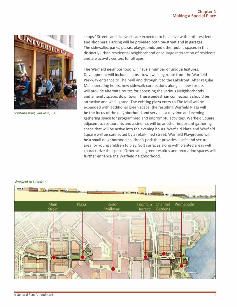
The Warfield neighborhood will have a number of unique features. Development will include a cross-town walking route from the Warfield Parkway entrance to The Mall and through it to the Lakefront. After regular Mall operating hours, new sidewalk connections along all new streets will provide alternate routes for accessing the various Neighborhoods and amenity spaces downtown. These pedestrian connections should be attractive and well lighted. The existing plaza entry to The Mall will be expanded with additional green space; the resulting Warfield Plaza will be the focus of the neighborhood and serve as a daytime and evening gathering space for programmed and impromptu activities. Warfield Square, adjacent to restaurants and a cinema, will be another important gatheringspace that will be active into the evening hours. Warfield Plaza and Warfield Square will be connected by a retail-lined street. Warfield Playground will be a small neighborhood children’s park that provides a safe and secure area for young children to play. Soft surfaces along with planted areas will characterize the space. Other small green respites and recreation spaces will further enhance the Warfield neighborhood.
Warfield to Lakefront
Santana Row, San Jose, CA

Downtown Columbia Plan10
THE LAKEFRONT AND LAKEFRONT CORE
Bringing Community Life and Activity Back to the Water’s Edge.
Location: Lake Kittamaqundi westward to The Mall and from Little Patuxent Parkway on the north to The Crescent on the south.
The Lakefront neighborhood will be a walkable community, connected and oriented to the Lakefront Core and Lake Kittamaqundi. The Lakefront and Lakefront Core should be designed to encourage access to Lake Kittamaqundi and the public spaces adjacent to the Lake. Design objectives for new construction in this area should include the creation of inviting and welcoming spaces and outdoor corridors to enhance visibility and access to the Lake. This is also the potential location for the development of additional signature buildings, in addition to the existing former Rouse Company Headquarters’ signature building. The Design Advisory Panel Review of proposed Neighborhood Design Guidelines will be particularly important in the Lakefront and Lakefront Core.
The recorded open space in the Lakefront Core will retain its identity as an important historic and symbolic gathering place. Although additional public amenities may be added to enhance this area, its character will be preserved. The remaining land in the Lakefront Core may be revitalized with new development that could include cultural, retail, restaurant, office, residential and hospitality uses adjacent to the amenity area that will help bring people to this part of Downtown Columbia and activate the Lake. Specific Design Guidelines for the Lakefront Core must be prepared to
Chapter 1 Making a Special Place
Fountain Terrace, The Lakefront
Illustrative Master Plan, The Lakefront

11A General Plan Amendment
Chapter 1 Making a Special Place
address building height, massing, scale, building orientation, pedestrian and vehicular access and amenity area appropriate for its lakefront location. Restoration of the area’s physical amenities and natural environment will also encourage more active use, as well as provide an enhanced setting for performances, festivals and other events.
The Lakefront area has been isolated from other areas of Downtown Columbia, and this Plan includes a variety of means to enhance connectivity. Three new amenity space corridors extending east to west will link The Lakefront neighborhood to other downtown destinations. The Mall will be connected to the central lakefront area by a series of terraces with fountains that descend down the slope to the water. The Symphony Overlook neighborhood will be linked to Lake Kittamaqundi by extending a major east/west retail street to a green park that slopes and terraces down to the water’s edge. To the north, a pedestrian promenade will extend from the Warfield neighborhood to the natural area north of Lake Kittamaqundi. Each of these connections to the lake crosses Little Patuxent Parkway which will be transformed into a more pedestrian-friendly street with sidewalks, crosswalks and signal timing for pedestrians to encourage walking between adjacent neighborhoods.
Additionally, this Plan encourages exploring the possibility of improving the existing pathway connection between the Lakefront and Symphony Woods or providing a new pedestrian connection between these two activity centers. This Plan further recommends completing the pedestrian pathway around Lake Kittamaqundi.
Cafe and Promenade, The Lakefront
Lakefront Event Space and Activities

Downtown Columbia Plan12
THE CRESCENT
Where New Urban Settings Face an Extensive Wooded Park
Location: East of Broken Land Parkway, south of Little Patuxent Parkway, west of South Entrance Road and south of the Merriweather-Symphony Woods neighborhood*
The Crescent neighborhood will have many distinctive features. Its greatest asset will be its natural setting amidst preserved and enhanced woodlands and tributaries to Symphony Stream and the Little Patuxent River. A new mixed-use neighborhood with residences, offices, shops, restaurants, and other uses, The Crescent will become a live-work location as well as an employment center. Maximum building heights of 15 to 20 stories will frame the Merriweather-Symphony Woods neighborhood in a distinctive curving arc.* A new street between The Crescent and Merriweather will provide an entry for these buildings. This curving street with sidewalks along building fronts and paths along the edge of the green space will connect The Crescent north to Symphony Overlook and The Lakefront. Paths will also connect The Crescent to Merriweather, which will allow parking built for office uses in The Crescent to be shared by patrons of Merriweather Post Pavilion.
Chapter 1 Making a Special Place
Weekend Market, The Crescent
Legacy, Plano TX
Park Side Residences, The Crescent

13A General Plan Amendment
Chapter 1 Making a Special Place
MERRIWEATHER-SYMPHONY WOODS
A Strengthened Tradition in a New Kind of Cultural Park
Location: South of Little Patuxent Parkway between The Crescent and Symphony Overlook
Merriweather-Symphony Woods will be a new kind of cultural park where the landscape becomes a setting for arts, cultural and civic uses. It will be anchored by an enhanced Merriweather Post Pavilion and Symphony Woods Park. These uses may have compatible commercial uses such as a café in the park or museum shop. A new system of paths and infrastructure will support festivals and other events in the park. Natural areas will be improved by removing invasive species, restoring stream corridors with native vegetation and the planting of up to 15,000 new trees in accordance with theColumbia Town Center Merriweather & Cresent Environmental Enhancement Study. Merriweather-Symphony Woods will be connected to the heart of Symphony Overlook along a new north/south axis from Market Square at The Mall. Pedestrians will cross Little Patuxent Parkway at a new entrance to Symphony Woods Park. This intersection, designed to allow for safe crossing of the Parkway, will lead to a new Fountain Plaza which connects to Merriweather Post Pavilion. The access through Merriweather-Symphony Woods that connects the civic and cultural uses will be compatible with the topography.
Santana Row, San Jose, CA
Cynthia Woods Mitchell Pavilion, The Woodlands, TX
Symphony Woods Park
Colu
mbi
a A
ssoc
iatio
n, Il
lust
ratio
n by
Eri
c H
yne
Downtown Columbia Plan14
SYMPHONY OVERLOOK
Where the New Downtown Meets Culture in the Park
Location: North of Little Patuxent Parkway and south of The Mall
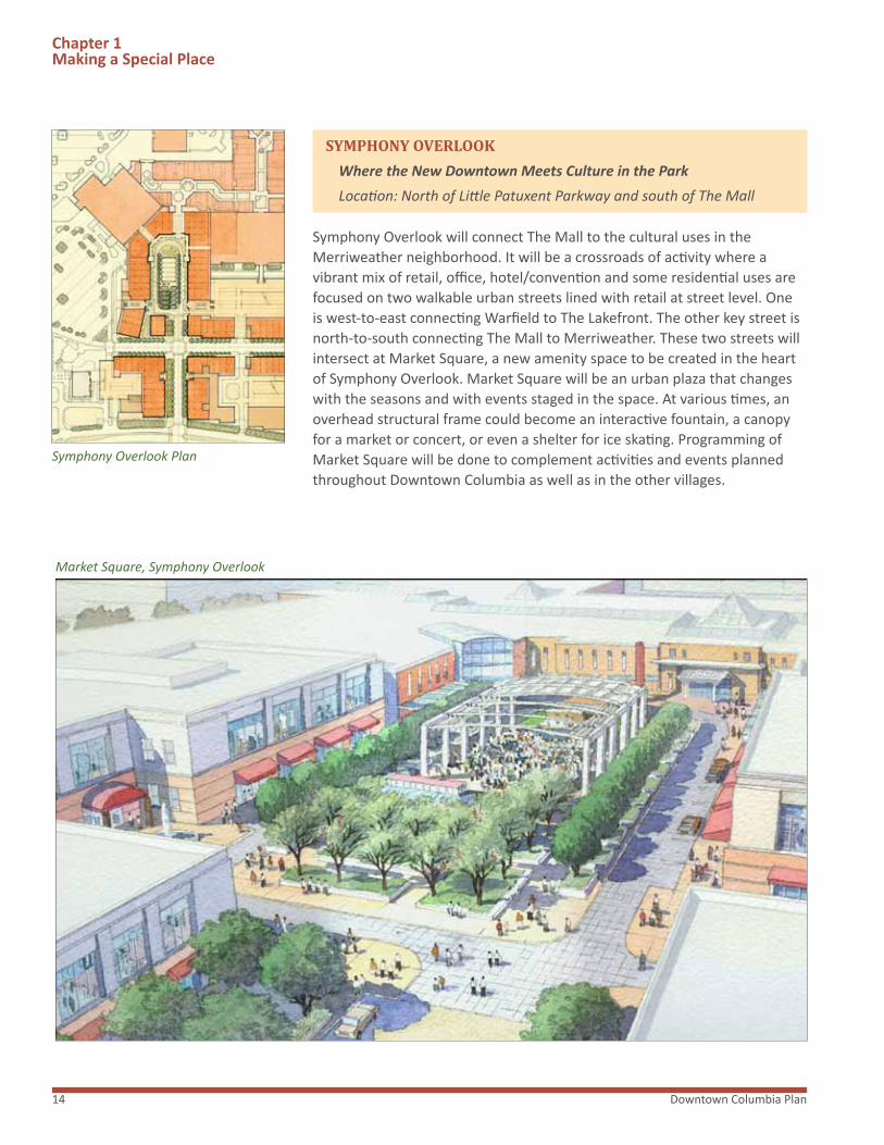
Symphony Overlook will connect The Mall to the cultural uses in the Merriweather neighborhood. It will be a crossroads of activity where a vibrant mix of retail, office, hotel/convention and some residential uses are focused on two walkable urban streets lined with retail at street level. One is west-to-east connecting Warfield to The Lakefront. The other key street is north-to-south connecting The Mall to Merriweather. These two streets will intersect at Market Square, a new amenity space to be created in the heart of Symphony Overlook. Market Square will be an urban plaza that changes with the seasons and with events staged in the space. At various times, an overhead structural frame could become an interactive fountain, a canopy for a market or concert, or even a shelter for ice skating. Programming of Market Square will be done to complement activities and events planned throughout Downtown Columbia as well as in the other villages.
Chapter 1 Making a Special Place
Market Square, Symphony Overlook
Symphony Overlook Plan
15A General Plan Amendment
Chapter 1 Making a Special Place
THE MALL
Where the community gathers to shop, eat and be entertained.
Location: Centered between Warfield, Symphony Overlook and the Lakefront neighborhoods
The Mall in Columbia is currently a successful regional center with five department stores, a movie theatre and a diverse collection of restaurants. To enhance the economic strength of the Mall and as a response to increased competition, special attention is given to the Mall in this Plan by placing the Mall in its own neighborhood. Any redevelopment of the Mall must comply with the Neighborhood Design Guidelines for The Mall.* Through the Design Guidelines, any redevelopment of the Mall will provide amenities including but not be limited to, improvements to underutilized areas around the Mall such as sidewalks, curbs, plantings and landscaping, street furniture and other streetscape improvements, lighting, public art, enhanced hardscaping, transit improvements and improved safety features. These improvements will strengthen linkages between the neighborhoods and will provide attractive, pedestrian-friendly environments around the Mall that will encourage businesses to locate and remain in Downtown. The Neighborhood Design Guidelines will also promote the Mall as acenter of social activity and economy for Howard County.
Easton Town Center, Columbus, OH
1.4 COMMERCIAL BALANCE
“Design a variety of downtown commercial activities that complement the flexible evolution of neighboring Village Centers in Oakland Mills and Wilde Lake, recognizing each center’s identity and role.” Downtown Columbia: A Community Vision
From the beginning, Jim Rouse intended to provide Columbia’s residents with a mix of amenities and activities that would appeal to people of different incomes and backgrounds.
Columbia’s earliest village centers, built in the late 1960’s and early 1970’s, reflected their times. Their retail operations were sometimes “mom and pop” stores that responded to basic needs of residents; each center usually included a barber shop, drycleaners, a neighborhood restaurant, as well as a grocery store. There were offices for dentists and accountants and other service providers. The Mall, on the other hand, has always included major department stores and a variety of smaller clothing and shoe stores, toys, books and record shops, and other popular stores.
Both the village centers and The Mall in Columbia have experienced changes over the years. Currently, the village centers, in particular, are in the throes of market change and economic pressures. Redevelopment of the older villages may occur as they seek to adapt to current economic conditions and consumer habits. However, the older village centers in particular are struggling with vacancies. Keeping the village centers economically strong is vital to Columbia and the redevelopment of Downtown Columbia Any redevelopment of village centers should be consistent with the Santana Row, San Jose, CA

Downtown Columbia Plan16
Chapter 1 Making a Special Place
village concept and should provide retail, services and community space designed to meet the local convenience needs of the village of which it is a part. Consequently, strong pedestrian orientation from and to the village neighborhoods and a mix of use types should be encouraged. The appropriate balance and intensity of uses should correspond to the individual village’s needs and character, and specific guiding principles and priorities should be developed for each village center. The Village Centers can also serve as important transit nodes in Columbia, and should be considered in developing County wide transit and parking strategies.
The redevelopment of Downtown Columbia will include the addition of many new shops, restaurants and cultural facilities, in addition to expansion at The Mall. As the downtown residential community grows, the needs for products and services will also grow, providing customers for current and future downtown retailers but also for retailers throughout the area. It is expected that village centers will experience an increase in business, particularly when improvements are made in the range of transportation services, including buses, shuttles, local taxis and shared cars that could bring them customers from other villages and Downtown Columbia.
Merchandising strategies for downtown and the village centers should be developed by property owners within the larger context of Columbia taking into consideration the current state of retail, restaurant and entertainment offerings; and the shifting needs of residents and other customers.
These factors must then be weighed against what the market is currently able to attract. The downtown should have a strong selection of restaurant and entertainment entities comprised of national and regional chains as well as locals that will complement offerings at the village centers. Retail and restaurants may be clustered to create areas of destination. This can serve as a strategy for attracting desired local commercial entities and for ensuring their success. The “balance” ahead will be afforded by customers who frequent both village centers and Downtown Columbia. A better market for one is a better market for all.
Santana Row, San Jose, CA
Bethesda Row, Bethesda, MD
1.5 DIVERSE HOUSING
“Provide a full spectrum and diverse mix of housing, ensuring that low-, moderate- and middle-income families have an opportunity to live in Downtown, thus continuing the original vision of Columbia as an inclusive community.” Downtown Columbia: A Community Vision
This Plan recognizes and celebrates the original vision of Jim Rouse to create a socially responsible city for people of all ages, incomes and backgrounds. The establishment of an ongoing mechanism to provide a full spectrum of housing into the future is an important social responsibility shared by us all. Of related but equal importance is encouraging within downtown Columbia itself the diversity of people that exists elsewhere in Columbia today. Realizing this diversity will be important to the social and economic success of the downtown, where the mixing of individuals with different

17A General Plan Amendment
Chapter 1 Making a Special Place
backgrounds and incomes will result in an ongoing exchange of ideas in an environment where residents, workers and visitors will have an opportunity to learn from one another and grow together as a community.
Downtown Columbia: A Community Vision recaptures the spirit of the Rouse vision for a complete city in which different types of people live together to create a fully realized community. In such respect, this Plan also recognizes the enrichment a community can experience through the diversity of its people. This Plan strives to achieve this objective through the provision of expanded residential opportunities for in-town living in both housing form and affordability, and through the establishment of a community housing fund which will be used to help meet the affordable housing needs of the community.
BACKGROUND
The need for affordable housing exists today and will likely continue to grow into the future. Significantly, however, what at times can be overlooked is the important relationship between reasonable opportunities for affordable housing and the economic health of the County. General Plan 2000 recognized this significance and identified the important relationship between the need for affordable housing and the County’s employment growth, and its demand for low and moderate-income workers. In this regard, General Plan 2000 recognized that to the degree low- and moderate-income workers can be housed in the County, the County’s economic development prospects are improved. In addition, General Plan 2000 further recognized that by providing more affordable housing it becomes possible for residents’ children and parents, as well as teachers, firemen and policemen to live in the County. The accommodation of work force housing is a goal shared by all.
General Plan 2000 (Policy 4.2) recommends providing affordable housing for existing low- and moderate-income residents and for the diverse labor force needed for continuing economic growth. Policy 4.2 also recommends that new funding sources be identified to enable the Office of Housing and Community Development to expand the supply of affordable housing to serve low- or moderate-income households, including seniors and persons with disabilities. In a similar context, Downtown Columbia: A Community Vision expands upon these objectives and suggests that new models for developing affordable housing in combination with mixed-use development should generate new and innovative techniques for achieving these objectives. It is with these policy statements in mind that this Plan proposes a means of providing a full spectrum of housing for Downtown Columbia.
Rockville Town Square, Rockville, MD
Legacy, Plano, TX

Downtown Columbia Plan18
Chapter 1 Making a Special Place
DOWNTOWN COLUMBIA COMMUNITY HOUSING FOUNDATION
A full spectrum housing program for Downtown Columbia should establish a flexible model that aspires to make new housing in downtown affordable to individuals earning across all income levels. In order to create an effective, flexible means of providing a full spectrum of housing for Downtown Columbia, GGP will establish the Downtown Columbia Community Housing Foundation (“DCCHF”), as detailed below. The intent of this full spectrum housing program for Downtown Columbia is to satisfy all affordable housing requirements for downtown.
Initial Source Fund
GGP will establish the DCCHF at its expense and will contribute $1.5 million to the DCCHF upon issuance of the first building permit for new housing in Downtown Columbia. GGP will contribute an additional $1.5 million upon issuance of a building permit for the 400th new residential unit in Downtown Columbia. Each payment will be contingent on expiration of all applicable appeal periods associated with each building permit without an appeal being filed, or if an appeal is filed upon the issuance of a final decision of the courts upholding the issuance of the permit.
Ongoing Developer Contributions
Each developer will provide a one-time, per unit payment to the DCCHF in the following amounts, to be imposed upon the issuance of any building permit for a building containing dwelling units. Payment will be contingent upon the expiration of all applicable appeal periods associated with each building permit without an appeal being filed, or if an appeal is filed upon the issuance of a final decision of the courts upholding the issuance of the permit:
1. $2,000/unit for each unit up to and including the 1,500th unit.
2. $7,000/unit for each unit between the 1,501st unit up to and including the 3,500th unit.
3. $9,000/unit for each unit between the 3,501st unit up to and including the 5,500th unit.
The amounts to be paid under 1, 2 and 3 above will be subject to annual adjustment based on a builder’s index, land value or other index provided in the implementing legislation.
Each owner of property developed with commercial uses pursuant to the Downtown Revitalization Zoning Regulations shall provide an annual payment to the DCCHF in the amount of five cents ($0.05) per square foot of Gross Leasable Area for office and retail uses, and five cents ($0.05) per square foot of net floor area for hotels. The payment will be made annually
Clingman Avenue Lofts, Asheville, NC
Pearl District, Portland, OR
The
Real
Est
ate
Cent
er

19A General Plan Amendment
Chapter 1 Making a Special Place
by the property owner, with the initial payment being made prior to the issuance of an occupancy permit for net new commercial development on the property. The amount of the charge will be subject to annual adjustment based on a builder’s index, land value, or other index provided in the implementing legislation.
DCCHF Notice of Sale
The DHCCF should be notified by the developer or joint venture, via first class mail, of land for or all residential units offered for initial sale in each new residential or mixed use building in Downtown Columbia. No later than 10 days after the sale of rental housing, the owner must provide written notice of the sale. The DCCHF also should be notified by the developer, via first-class mail, of all apartment units offered for rental in each new residential or mixed-use building containing rental units. In support of these objectives, GGP should involve DCCHF in meaningful discussion with land purchasers in Downtown Columbia in order to encourage full spectrum housing in each and every neighborhood.
DCCHF Organizational Structure
It is anticipated that Howard County, in consultation with GGP, will determine, by legislation, the organizational entity, organizational structure, membership, functions, and implementation of the DCCHF. The legislation should provide that, in order to be eligible to receive the funds provided for in this Plan, the DCCHF must be a non-profit entity organized for the purpose of providing full spectrum, below market housing in Downtown Columbia. Use of DCCHF funds is limited to providing full spectrum, below market housing in Downtown Columbia, which may include, but is not limited to, funding new construction; acquiring housing units; preserving existing homes; financing rehabilitation of rental housing; developing senior, family or special needs housing; providing predevelopment, bridge, acquisition and permanent financing; offering eviction prevention and foreclosure assistance.*
1.6 ECONOMIC ACTIVITY
“Support downtown’s function as a major financial and economic center for Columbia and for Howard County.” Downtown Columbia: A Community Vision
The continued role of Downtown Columbia as a major financial and economic center is dependent on enhancements to the variety and availability of land uses and activities. Currently the economic core of Columbia is supported by the office concentration, The Mall in Columbia and other retail, the Sheraton hotel, Merriweather Post Pavilion and the existing residential base. Economic activity in terms of employment, spending and tax revenue generation is woven throughout these uses.
The Woodlands, TX
Cherry Creek, CO

Downtown Columbia Plan20
Chapter 1 Making a Special Place
In order to sustain and increase this economic activity, this Plan provides strategies across a number of different areas and issues. The foundation underlying these strategies is the creation of a vibrant mixed-use environment where various economic drivers support each other. There are many relevant economic success stories of well-planned, mixed-use projects incorporating principles of new urbanism. Reston Town Center in Virginia, The Woodlands in Texas and Santana Row in California are three widely known examples of economically successful mixed-use projects.
Over recent years, the core of job growth in Columbia has shifted from Downtown Columbia to Gateway which features newer and higher quality office product and closer access to I-95. Downtown Columbia has been experiencing job loss with a current office vacancy rate of about 25 percent in it’s approximately 2.5 million square feet of office inventory. Comparatively, the county-wide office vacancy rate is about 16 percent and Gateway is at a relatively low eight percent. The current high vacancy rate of office space in Downtown Columbia is not a reflection of regional demand but of the absence of new class A office space integrated with a mixed-use setting. Negative occupancy trends in downtown have also begun to affect surrounding village centers in Columbia. If not corrected, this trend could threaten the economic life of the entire community.
Downtown Columbia, however, has multiple assets at its disposal which, if deployed properly, will create a dynamic environment for employers, employees, visitors and residents. Downtown Columbia still enjoys a strong retail environment and its centrally located mall attracts some 15 million visitors a year. This retail-driven vitality is often the hardest element to create in economically successful mixed use settings; therefore, downtown should be well-positioned to reverse negative economic trends. Additionally, Columbia is in the heart of a region which stands to benefit from changes to military operations. Job growth stemming from the relocation of many jobs related to the Base Realignment and Closure (BRAC) Act is expected to bring as many as 40,000 new jobs to the area approximate to Fort Meade. The lack of any significant nearby comprehensively planned area with a walkable vertical mixed-use component provides an opportunity for Downtown Columbia to regain its prominence as a major employment base. With Columbia optimally located between Baltimore and Washington D.C.,being relatively close to an international airport, and the additional jobs mentioned above as a result of BRAC, the demand for office product in Columbia should continue to increase into the future.
In terms of the creation of additional employment opportunities, this Plan designates a total of four million three hundred thousand square feet of new office space to be developed in phases over its 30-year time frame. As the office market continues to evolve, a redeveloped and
Reston Town center, Reston, VA
Downtown Columbia

21A General Plan Amendment
revitalized Downtown Columbia will be viewed as an attractive alternative for employers looking for high quality space within an amenity filled environment. Much of this office space will feature retail uses on the first floor, creating both convenient and vibrant streetscapes for employees, as well as the general public. In economic terms, by providing space for expansion of current employers and opportunities for new and relocated businesses, this additional office space will establish Downtown Columbia as a major economic center for the County and will generate significant new employment opportunities and millions of dollars in wages and tax revenues.
To support downtown’s function as a major financial and economic center, new businesses must be attracted to Downtown Columbia. These businesses will need quality hotel, meeting and conference facilities, preferably within walking distance to their offices. There are a number of downtown sites that are ideal for hotels, and 640 additional hotel rooms for Downtown Columbia is recommended in this Plan.
In addition to commercial uses, Downtown Columbia’s cultural amenities create economic benefits for not only Columbia, but the County as a whole. Currently, Merriweather Post Pavilion attracts thousands annually with a variety of concerts and events. In addition to direct spending at the venue, many patrons eat at local restaurants or shop at local stores before or after events.
This Plan calls for significant improvements to Merriweather Post Pavilion which will enhance the attractiveness of the venue and ultimately improve the economic benefit of this entity. Moreover, the enhanced pedestrian connections between Merriweather Post Pavilion and existing and new restaurant, retail and entertainment uses will increase synergy and economic activity throughout Downtown Columbia.
Along with cultural attractions, shopping venues draw people to Downtown Columbia, and The Mall in Columbia is one of Maryland’s top-performing regional malls. Non-enclosed, open-air expansions of The Mall in the areas surrounding the current mall complex will provide opportunity for adding many new retailers and uses. Additionally, retail, restaurant and service entities will be incorporated on the first floor of office, residential, hotel and, possibly, civic and cultural buildings throughout the redeveloped Downtown Columbia. These will provide ample opportunities for accommodating localmerchants and expanding the appeal and vibrant marketplace ambiance of the downtown area as a whole.
The existing residential base in Downtown Columbia also generates economic activity. Increased revenue to both the County and the Columbia Rockville Town Square, Rockville, MD
Pioneer Square, Portland, OR
Chapter 1 Making a Special Place

Downtown Columbia Plan22
Association are direct and immediate results of adding housing downtown. Residents will support the retail, restaurants, services and cultural facilities in the redeveloped Downtown Columbia and will be considered the primary customer base for these entities. In order to support the necessary conveniences desired in residential communities, a sufficient number of residences will need to be developed.
In the most basic sense, it is the mix of uses that will fuel the economic vitality of the area and enhance the experience and attractiveness of downtown for each use and occupant. Retail, restaurants and services will not be willing to locate in Downtown Columbia without a sufficient customer base. This usually entails office workers during the day; and residents at night and on weekends. By the same token, businesses will not be willing to locate to Downtown Columbia without strong amenity offerings including retail, restaurants, services and lodging within walking distance. It is this bundling of uses that will distinguish Downtown Columbia from other potential locations for businesses, residents, civic and cultural entities.
Chapter 1 Making a Special Place
Pentagon Row, Arlington, VA
Bethesda Row, Bethesda, MD

23A General Plan Amendment
“Expand civic, community and educational facilities to augment Columbia’s nationally recognized quality of life.” Downtown Columbia: A Community Vision
Civic life is one of the hallmarks of the Columbia experience. The redevelopment of Downtown Columbia affords a unique opportunity to enhance that experience and to actually help build a sense of community. In order to contribute to Columbia’s civic life, General Growth Properties plans to create a dynamic hub of community space that will encourage public engagement and enhance the local quality of life. This will be accomplished through thoughtful and creative urban planning and by strategically building facilities in Downtown Columbia that will house established and new civic organizations.
Howard County Library
The Howard County Library is one of the best library systems in the country. While its success as a public institution is irrefutable, it has the exciting opportunity, given the right tools, to grow further into a leader of library innovation. This Plan recommends that a new Central Library be built downtown. This new library complex could move the Howard County Library in the direction of an “Experience Library,” an intellectual, interactive learning center combining visual exhibitions with interesting architecture and typical library elements. The potential for a land swap could be explored as a means of facilitating construction of a new library complex and redevelopment of the existing library site.
Fire and Police Station
GGP will work with the County to determine a suitable location for an expanded fire station and a police substation in Downtown Columbia. Because the County owns the existing fire station, this Plan suggests that opportunities could be explored for a potential land swap if the County determines to relocate the fire station. The opportunity exists to utilize this facility as a community gathering and youth recreational space. Additionally, incorporating mixed-use and affordable housing into the new fire station are among the ideas to be considered when selecting its location.
Columbia Archives
The Columbia Archives is another important public institution that contributes to Columbia’s vibrant community-focused culture. The Archives plays a vital role in preserving the unique past of Columbia as well as educating the public about how the beginnings of Columbia affect its life today. This Plan recommends the construction of a Columbia Visitor Center in downtown. This center will serve as an informative resource center for visitors, house educational resources about the city, act as a vibrant community center and provide a new and more appropriate home for the Columbia Archives.
Chapter 1 Making a Special Place
1.7 CIVIC LIFE
Cerritos Library, Cerritos, CA
Archive & Exhibition Space Concept

Downtown Columbia Plan24
Public Spaces
In order to encourage community gathering and interaction, this Plan includes abundant public spaces both natural and planned. Water features, a sculpture park and garden, a children’s park and a dog park are a few of the concepts that could be included in these public spaces. These or similar features will provide an unexpected, unique, spontaneous and interactive experience that encourages community engagement and contributes to the quality of life in Columbia.
This Plan also recognizes the importance freedom of speech plays in civic life. The zoning regulation recommended by this Plan should require conveyance to the County of an outdoor amenity space containing at least 25,000 square feet. The site will be deeded to the County for public space and should be available to all for purposes of assembly and public discourse. The deeded site will be located in one of the future neighborhoods discussed in this Plan, although not in a predominantly residential area. The preferred site should also be located near existing or proposed activity areas where pedestrian activity is anticipated and encouraged. Identification of the specific site should wait for additional refinement of the redevelopment plans for downtown and its amenity areas so that an appropriate location in relation to surrounding uses and activities can be provided.
Educational Facilities
A complete community should incorporate design features and public facilities planning that respond to the needs and expectations of the community as it exists today and as it grows over time. Significant among these objectives is the ability to meet the educational needs of the community as it matures.
Public school students who live in downtown have typically attended Running Brook Elementary School, Wilde Lake Middle School or Wilde Lake High School. As the downtown develops, it is unknown what educational resources will be needed. As a way of assessing the educational needs, but not intending to limit the timing of redevelopment, this plan recommends that prior to issuance of the first building permit, the Howard County Public School System (HCPSS) and the Department of Planning and Zoning conduct and publish a Columbia Schools Analysis, subject to Howard County Board of Education approval, which will study all available options for school system needs and characterize the best options for a range of possible pupil yields. When 10 percent of the new residential units planned for Downtown Columbia are built and occupied, the HCPSS will consider updated student enrollments and, subject to Board of Education approval, select the most appropriate pupil yield ratio and associated option outlined in the Columbia
Chapter 1 Making a Special Place
The Woodlands, Woodlands, TX
Public Assembly
Child Development

25A General Plan Amendment
Schools Analysis for implementation. Prior to the Site Development Plan approval of 25 percent of the new residential units in downtown, the County will request the Board of Education to review their earlier identification of the best educational facility option to accommodate student population growth based on the observed and projected pupil yield ratio. Following on this review, GGP will work with HCPSS to identify and provide, if necessary, an adequate school site or equivalent location within the downtown, subject to Board approval.
Chapter 1 Making a Special Place
Public art and cultural activities play a vital role in sharing the life stories of the people who shaped the cultural history of Columbia. Merriweather and Toby’s Dinner Theatre have entertained Columbians for over 40 years. Local sculptures, including The People Tree, The Hug, The Bears and Willard and Jim Rouse, each tell a different part of Columbia’s story. As later additions, the James Rouse Theatre for the Performing Arts and the Horowitz Visual and Performing Arts Center have housed many local performing arts groups and given visual artists a venue for exhibitions. Columbia is also fortunate to have the professional Rep Stage as part of the arts scene.
This Plan envisions a dynamic and continuously increasing role for visual and performing arts in Downtown Columbia. In pursuit of this goal, this Plan calls for the formation of a Downtown Arts and Culture Commission, an independent non-profit organization, to oversee the planning, coordination and implementation of artistic and cultural activities, opportunities, events and works displayed in Downtown. The Downtown Arts and Culture Commission should complete a Cultural Master Plan that sets specific and measurable goals and identifies the means to achieve these goals for arts and cultural priorities identified for Downtown.* The Cultural Master Plan for Downtown Columbia will encompass the potential expansion of visual, performing and literary arts and the potential roles that Merriweather
“Enhance art and cultural offerings, providing new spaces and opportunities for an active arts community and for public art.” Downtown Columbia: A Community Vision
1.8 ARTS AND CULTURE
Rep Stage, Howard Community College
Visual Art

Downtown Columbia Plan26
Chapter 1 Making a Special Place
Post Pavilion, the Howard County Central Library, Howard Community College, other existing performing arts facilities and existing and new public spaces could play in creating a 21st century cultural identity for Downtown Columbia.
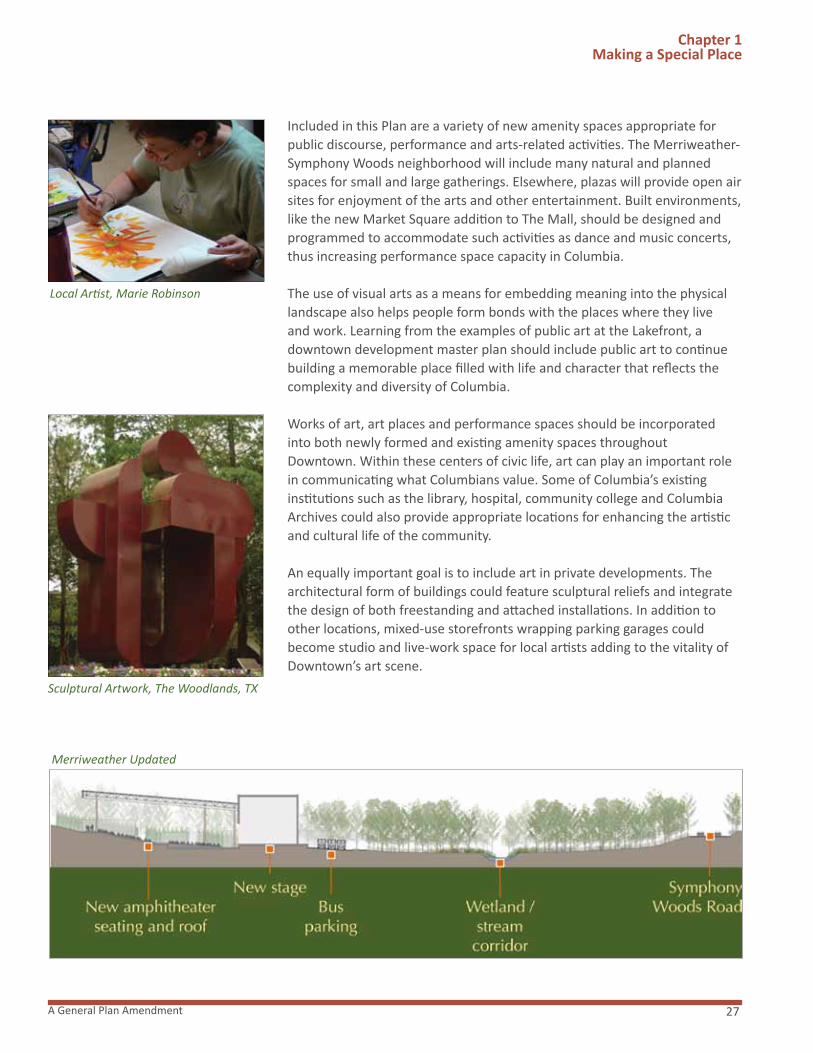
In support of the long history of arts and culture in Columbia, this Plan includes the renovation of Merriweather Post Pavilion. An icon of Columbia, Merriweather Post Pavilion was the community’s first performance venue and continues to be a major regional destination. As identified in the report by Howard County’s 2005 Citizen Advisory Panel on Merriweather Post Pavilion, the facility has long needed major renovation and capital repairs in order to continue bringing quality music and entertainment to the region. Merriweather Post Pavilion will be updated to become a state-of-the-art entertainment facility that should more effectively compete in attracting the most popular performers, better provide a suitable venue for a greater variety of artists in order to expand artistic and cultural offerings and serve as a catalyst for other new performance venues in Downtown Columbia. Recognizing the importance of this major community asset, this Plan also anticipates donation of Merriweather Post Pavilion to the Downtown Arts and Culture Commission in order to ensure its continued use as a performing arts center and premier regional concert venue.
Successful operation of the pavilion will require alternative customer parking arrangements when the adjacent land currently used for parking is either environmentally enhanced or developed. Alternatives which would be phased in through the development program implementation could include construction of shared use publicly owned parking facilities or agreements with existing facilities for off peak use of their garages and parking.
In addition, it may be desirable for various arts organizations to move their offices and/or operations downtown. Considering the popularity of Toby’s Dinner Theatre, opportunities should be explored for a new and improved facility for the theatre as well as the possibility of a new children’s theatre.
Wolftrap National Park for the Performing Arts, Vienna, VA
Boy With Hawk, The Woodlands, TX
Merriweather Post Pavilion
27A General Plan Amendment
Chapter 1 Making a Special Place
Included in this Plan are a variety of new amenity spaces appropriate for public discourse, performance and arts-related activities. The Merriweather-Symphony Woods neighborhood will include many natural and planned spaces for small and large gatherings. Elsewhere, plazas will provide open air sites for enjoyment of the arts and other entertainment. Built environments, like the new Market Square addition to The Mall, should be designed and programmed to accommodate such activities as dance and music concerts, thus increasing performance space capacity in Columbia.
The use of visual arts as a means for embedding meaning into the physical landscape also helps people form bonds with the places where they live and work. Learning from the examples of public art at the Lakefront, a downtown development master plan should include public art to continue building a memorable place filled with life and character that reflects the complexity and diversity of Columbia.
Works of art, art places and performance spaces should be incorporated into both newly formed and existing amenity spaces throughout Downtown. Within these centers of civic life, art can play an important role in communicating what Columbians value. Some of Columbia’s existing institutions such as the library, hospital, community college and Columbia Archives could also provide appropriate locations for enhancing the artistic and cultural life of the community.
An equally important goal is to include art in private developments. The architectural form of buildings could feature sculptural reliefs and integrate the design of both freestanding and attached installations. In addition to other locations, mixed-use storefronts wrapping parking garages could become studio and live-work space for local artists adding to the vitality of Downtown’s art scene.
Local Artist, Marie Robinson
Sculptural Artwork, The Woodlands, TX
Merriweather Updated

Downtown Columbia Plan28
Chapter 1 Making a Special Place
Additionally, the walls of buildings and parking garages could become the surfaces for murals and sculptural relief that tell the story of Columbia and its people. Common elements such as water fountains, bus shelters and signage could be transformed into objects of cultural meaning.
To support public art in Downtown Columbia, this plan envisions the creation of the Art in the Community program. To this end, the plan recommends that subsequent legislation be adopted to describe and establish the program. This program will be supported by a percentage of funding to be included in the total cost of construction for projects in the Downtown. It is anticipated that property owners in Downtown Columbia will either provide art as an integral part of their projects, work together with other owners to provide a more significant Art in the Community contribution, perhaps as part of one or more of the Downtown Community Commons or, if either of those choices is impractical, support the program with an in-lieu fee. This Plan also envisions the Downtown Arts and Culture Commission as playing a critical role in the administration and coordination of the Art in the Community Program.
Because this is a new program for Columbia, there could be an artist registry set up through the Howard County Arts Council that would assist owners in finding local or regional artists for their projects. There could also be multidisciplinary project teams including artists and landscape architects, together with the community, which would assist property owners with designing unique pieces of art that will become the hallmarks of Downtown Columbia.
“Improve the design of Downtown Columbia development through flexible design guidelines and a design review panel to ensure that buildings, streets, and public spaces will be aesthetically pleasing and contextually appropriate.” Downtown Columbia: A Community Vision
Howard County’s Downtown Columbia: A Community Vision recognizes that design is a critical dimension of any proposed development plan. The design of buildings, open spaces and landscapes establishes the physical character of a place, creating memorable places that people want to use and return to. Such places have lasting aesthetic and civic value. They also help provide places with “predictable futures” – a sense of what a place will look like over time – which, in turn, attracts people to invest, visit and live in those places.
Downtown Columbia: A Community Vision calls for Design Guidelines, to be considered and approved by the County Council. The Downtown-wide Design Guidelines will ensure that what is built in a downtown will be attractive, aesthetically coherent, practical and of beauty and value. Specifically, the guidelines will show how buildings and landscapes support and reinforce the physical, three-dimensional intentions of the Plan and create places containing pleasing proportions, scale and character that people will want to inhabit. The guidelines also lay out the framework for
1.9 DESIGN
Public Art

29A General Plan Amendment
Chapter 1 Making a Special Place
developing a community’s sense of place and its identity and connection to the region. Design rules (and how they are administered) are therefore very important. The plans and concepts included in this Plan will be executed across a long period of time and in light of continuous, contemporaneous assessment of community needs. Markets, public preferences and design trends will shift in unforeseeable ways. This requires that the guidelines beflexible enough to promote creativity and high-quality design over time.
THE NEW DESIGN GUIDELINES WILL CONTAIN SPECIFIC DIRECTION TO:
� Neighborhood Purpose and Character: Conformance with land use and density requirements, sustainability and transportation goals of this Plan.
� Site Design: Nature of surrounding spaces, softscape vs. hardscape, location of bus stops, public amenities, lighting, special features and building parcels, landscaping and how it relates to immediate neighbors and the overall amenity space plan for its neighborhood.
� Street Design: Street dimensions, layout plans, sections showing sidewalk widths and options for sustainable “green street” designs, accommodation for parking, planting, pedestrian crossings, lighting and curb cuts and service entries.
� Building Design: Height and setback, pedestrian-level zone, middle, top (including materials, horizontal regulating lines, skylines, fenestration, and mechanical equipment penthouses).
� Signature Buildings: Structures which require special architectural attention including the former Rouse Company Headquarters. Downtown-wide Design Guidelines will provide for the preservation of the former Rouse Company Headquarters building and specifically set forth criteria for acceptable alteration to the exterior of that building. The Guidelines will not prohibit interior alterations or future adaptive reuse that would better integrate the building into its surroundings and activate the adjacent pedestrian spaces as described in the guidelines and this Plan or prohibit reconstruction of the building in the event of casualty.
� Amenity Space: Guidelines to ensure that amenity space within both Downtown Columbia and the nearby open space respects the natural surroundings, enhances the site’s biodiversity and sense of place. The guidelines also uphold the community’s environmental ethic and commitment to environmental stewardship, as well as a commitment to high-quality design. All plant materials used in Downtown Columbia and open space landscaping are to come from the “approved plant list” and be indigenous to the Maryland Piedmont area.
As recognized by Downtown Columbia: A Community Vision, downtown building design review is undertaken by the developer of Columbia. In the future, this review will be augmented by Design Advisory Panel review at
The Woodlands, TX
Santana Row, San Jose, CA
Amenity Space
Cy P
aum
ier

Downtown Columbia Plan30
Chapter 1 Making a Special Place
the following three important decision points to provide design input:
1. After the submission by GGP of draft guidelines to the Design Advisory Panel as discussed below, the County Council should adopt downtown-wide broad design guidelines (“Downtown-wide Design Guidelines”) that will be used as a measure against which specific neighborhood design guidelines (“Neighborhood Design Guidelines”) will be developed for each of the neighborhoods (Warfield, Symphony Overlook, The Lakefront and Lakefront Core, The Mall, Merriweather-Symphony Woods, and The Crescent). The Neighborhood Design Guidelines will then be used to evaluate the design elements of specific projects downtown.
2. To assist the County Council in its review of the of the draft Downtown-wide Design Guidelines, the Design Advisory Panel Act should be amended to require Design Advisory Panel review of the draft Downtown-wide Design Guidelines and to provide the County Council with any suggested modifications for its consideration prior to its adoption of the Downtown-wide Design Guidelines. Thereafter, it is recommended that the petitioner submit proposed Neighborhood Design Guidelines, along with a Neighborhood Concept Plan, with each Final Development Plan. The Design Advisory Panel should then review the proposed Neighborhood Design Guidelines to evaluate their consistency with the Downtown-wide Design Guidelines adopted by the County Council. The Design Advisory Panel would provide its recommendations to the Planning Board, and the Planning Board would then be responsible for approving the final Neighborhood Design Guidelines along with the Final Development Plan.
3. During the Downtown Redevelopment process, petitioners are required to submit Site Development Plans to the Design Advisory Panel for review. The Design Advisory Panel is to make recommendations on Site Development Plans to the Planning Board. The Design Advisory Panel recommendation is to be made in accordance with the applicable provisions in Title 16, Subtitle 15 of the County Code and the Design Advisory Panel review of the Downtown-wide Design Guidelines and the Neighborhood Design Guidelines will assure a consistent and high level of design standard for Downtown Columbia.
Street Character
Example of Street Section
Mixed-Use Development Illustration

31A General Plan Amendment
Chapter 1 Making a Special Place
EXHIBIT F. MAXIMUM BUILDING HEIGHT PLAN
Downtown Columbia Plan32
Chapter 1 Making a Special Place
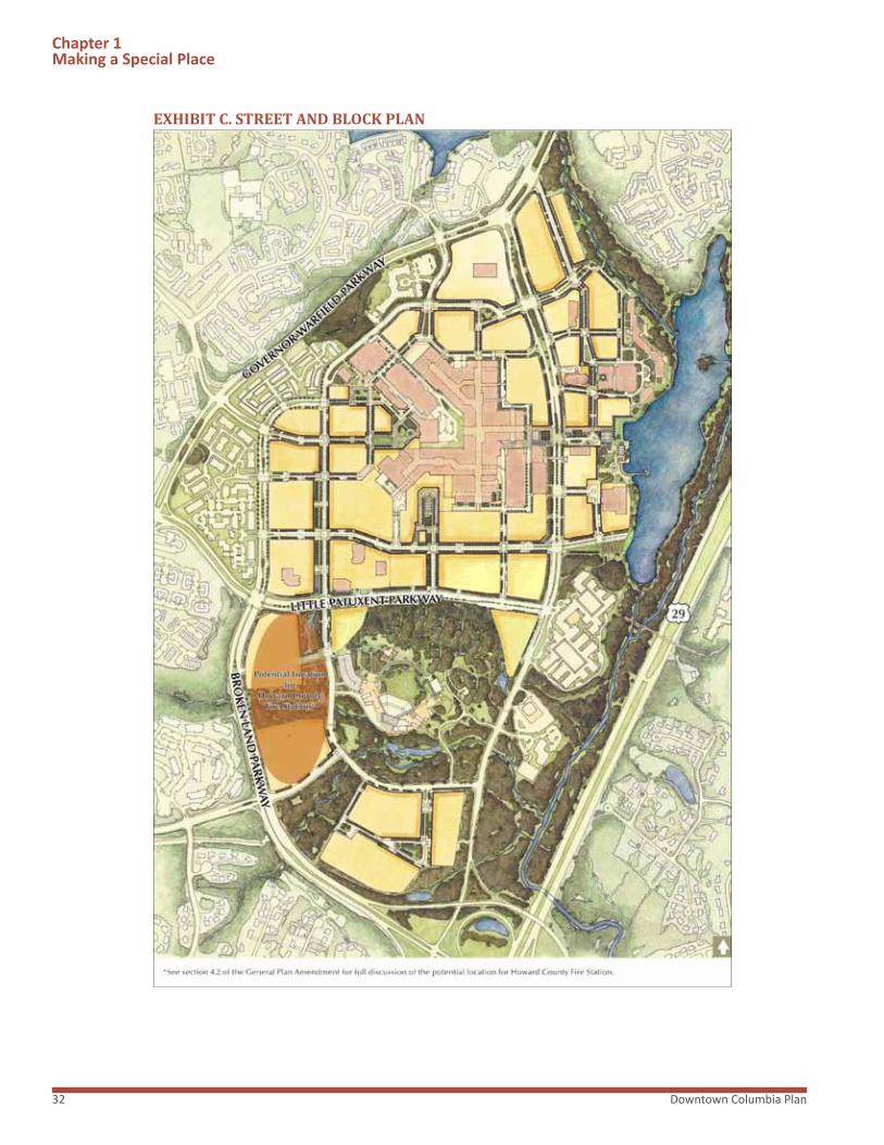
EXHIBIT C. STREET AND BLOCK PLAN

33A General Plan Amendment
Chapter 1 Making a Special Place
EXHIBIT D. ILLUSTRATIVE MASTER PLAN

Bus Hub, Downtown Columbia

35A General Plan Amendment
“Develop a multi-modal transportation system through investment in transit programs and roads that will provide a pedestrian- and bike-friendly environment.”* Downtown Columbia: A Community Vision
A balanced, multi-modal transportation system is one that will allow residents to move throughout a community without depending on automobiles. Such a system should include a connected network of local, collector and arterial streets; existing, new, and improved transit facilities and services; and a network of sidewalks, on-street bike lanes and off-street pedestrian/bike paths and trails. A successful system also should provide enough capacity to meet user demand during all phases of development. It also should be promoted by the community it serves.
CONNECTED STREET NETWORK
This Plan seeks to create a Downtown Columbia served by a connected street network that would offer more route choices, disperse traffic over a wider network, provide more capacity and result in shorter, more direct trips with less delay. This network will consist of existing streets, new streets in new alignments, and the transformation of the mall inner and outer ring roads and selected surface parking lot drive aisles into genuine streets. The Plan envisions that the new streets will be predominately public.
Route 29 will continue to be the principal road that links Columbia with Baltimore, Washington, and the region. Broken Land Parkway and Governor Warfield Parkway will continue to be intermediate arterials. Minor arterials will include Little Patuxent Parkway, Twin Rivers Road and a new east-west link to Route 29.
Major collector roads will include Broken Land Parkway north of Little Patuxent Parkway; the former outer ring road on the south side of The Mall; Hickory Ridge Road and its extension through The Crescent; and Little Patuxent Parkway extended to the Route 29/Broken Land Parkway
“Downtown Columbia will enhance multi-modal connectivity through a variety of safe, convenient and innovative transportation alternatives.”
2.1MULTI-MODALSYSTEM
Chapter 2: Moving and Connecting People
Shirlington Village, Arlington, VA

Downtown Columbia Plan36
Chapter 2 Moving&ConnectingPeople
EXHIBIT H. STREET FRAMEWORK DIAGRAM

37A General Plan Amendment
interchange. Minor collector roads will include the transformation of The Mall’s outer ring road. Local streets will include new links in Symphony Woods and the transformation of The Mall’s inner ring road and drive aisles into genuine streets.
“Complete streets” will be designed for motorists, transit passengers, bicyclists and pedestrians within the Downtown Columbia grid. These streets will be safe, comfortable and attractive to all users, including those in wheelchairs. Existing travel speeds will be reduced to those more compatible with the speeds traveled by pedestrians and bicyclists.
Major Intersection Improvements
Major improvements to existing intersections include:
� Construction of a fourth southbound through lane on Broken Land Parkway at Hickory Ridge Road
� Additional turn lanes at the Little Patuxent Parkway/Broken Land Parkway intersection
� Additional turn lanes at the Little Patuxent Parkway/Symphony Promenade intersection
� Re-configuration of Little Patuxent Parkway/Governor Warfield Parkway (North)
Interchange Improvements
A third, full-movement, grade-separated interchange at Route 29 is proposed approximately mid-way between the two existing interchanges with Broken Land Parkway and Little Patuxent Parkway (MD 175). This interchange could take one of several forms, depending upon the outcome of subsequent, detailed engineering studies. The interchange could link Route 29 to Downtown Columbia only or could directly link Oakland Mills, Route 29 and Downtown Columbia. The planning, design and funding of this interchange would be coordinated among the private sector, Howard County and the State.
Phasing
This network will be built over time as this Plan is implemented. Improvements to the existing transportation system, construction of new facilities and implementation of new services and programs will occur as required to adequately accommodate new travel demands. The phasing of these road improvements is related to the development density levels recommended by this Plan and is discussed in the Generalized Traffic Study included as a technical supplemental document. The final extent of the road improvements will be determined by the Adequate Public Facilities Act.
Chapter 2 Moving&ConnectingPeople
Portland, OR
Connectivity Improvements Diagram

Downtown Columbia Plan38
Chapter 2 Moving&ConnectingPeople
EXHIBIT J. AMENDMENT TO GENERAL PLAN 2000 TRANSPORTATION POLICIES MAP

39A General Plan Amendment
“Mitigate traffic congestion so that vehicles will be able to move smoothly into and around downtown without impeding pedestrian flow; encourage outside traffic to bypass downtown.” Downtown Columbia: A Community Vision
Funding
Responsibility for funding and constructing and implementing these improvements and programs will be shared among the private sector, public-private partnerships, Howard County (through the Adequate Public Facilities road excise tax and tax increment financing) and/or public sector capital budgets.
Design
To the extent necessary, the Howard County Design Manual should be modified to accommodate the design intent expressed in this Plan.
Chapter 2 Moving&ConnectingPeople
2.2 TRAFFIC
ADEQUATE ROAD FACILITIES TEST EVALUATION
This Plan will create adequate road capacity to accommodate peak traffic demands that will be generated by existing and future development in Downtown Columbia, in accordance with the Adequate Public Facilities Act of Howard County, as amended (APF). This new capacity will be provided in phases over time, prior to or concurrent with future development. A new level of service standard is needed to ensure that adequate street capacity and safe, efficient, convenient and comfortable pedestrian and bicycle facilities are provided to support existing and future development.
Constrained Facilities
Under current law, the APF Act includes what is known as the “Constrained Facilities” provision. This provision actually exempts intersections along Little Patuxent Parkway from the Adequate Public Facilities test. This means that, under current law, new development can proceed even if the intersections impacted by the development have failing levels of service. This Plan recommends changing the APF so that, in the future, all roads in Downtown Columbia will be subject to the test for APF. In addition, in the future all intersections within downtown should be subject to improvements that donot compromise pedestrian and bicyclist comfort and safety. To this end, this Plan recommends that the APF be amended to require preparation of a pedestrian impact statement as part of the APF traffic study to ensure safe and efficient pedestrian and bicycle access and circulation within downtown.
New Level of Service Standard
The level of service for all County-controlled intersections serving Downtown Columbia should reflect its more urban, pedestrian oriented character.
Street Character

Downtown Columbia Plan40
Therefore, this plan anticipates a higher critical lane volume (CLV) than exists in the rest of the County. The appropriate level of service standard will be established as part of the Adequate Public Facilities Ordinance legislation. This new standard is justified because:
� As recommended by General Plan 2000 and Downtown Columbia: A Community Vision, it directs development to Downtown Columbia where adequate road facilities exist and improvements can be made.
� Downtown Columbia is the focal point of transit facilities and services in Howard County. Unlike in many other areas of Howard County, residents, employees and visitors in Downtown Columbia have the choice of walking, bicycling or taking public transportation.
� Incentives to direct growth to areas served by public transportation would result in greater use of the County’s considerable investment in Howard Transit. It also would encourage further investment by the public and private sectors in non-auto modes of travel.
� It makes it possible for Downtown Columbia to become a more vibrant, mixed-use, walkable, transit-oriented place as recommended by General Plan 2000 and Downtown Columbia: A Community Vision.
� Multiple-levels-of-service standards can encourage smart growth, revitalize mixed-use centers and focus growth where recommended by the County’s General Plan.
Mitigation measures should include any intersection capacity improvements except grade separation of the roadways and ramps within the intersection or improvements to the through lanes of intermediate arterials and higher classified roads.
To consider the many recommended changes to the adequate public facilities ordinance, this plan envisions the filing of an amendment to the act within 120 days.
Chapter 2 Moving&ConnectingPeople
“Improve pedestrian connections throughout downtown, to surrounding villages and to nearby destinations to encourage strolling and human interaction.” Downtown Columbia: A Community Vision
Under this Plan, Downtown Columbia would become the heart and major destination of an expanded and improved pedestrian system in Columbia. The new grid pattern of blocks in Downtown Columbia that the Plan proposes would encourage pedestrian traffic along the streets through a network of sidewalks and crosswalks. These would logically connect to key destinations, such as entrances to The Mall and other retail destinations, as well as entrances to residential, hotel and office buildings. Sidewalks from Downtown Columbia would extend along promenades to connect to Symphony Woods and Lake Kittamaqundi. Howard Community College
2.3 PEDESTRIANS
Transportation Facilities
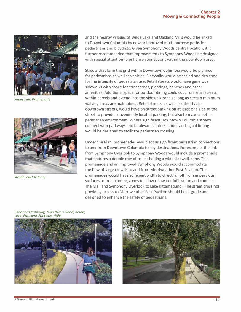
41A General Plan Amendment
Chapter 2 Moving&ConnectingPeople
and the nearby villages of Wilde Lake and Oakland Mills would be linked to Downtown Columbia by new or improved multi-purpose paths for pedestrians and bicyclists. Given Symphony Woods central location, it is further recommended that improvements to Symphony Woods be designed with special attention to enhance connections within the downtown area.
Streets that form the grid within Downtown Columbia would be planned for pedestrians as well as vehicles. Sidewalks would be scaled and designed for the intensity of pedestrian use. Retail streets would have generous sidewalks with space for street trees, plantings, benches and other amenities. Additional space for outdoor dining could occur on retail streets within parcels and extend into the sidewalk zone as long as certain minimum walking areas are maintained. Retail streets, as well as other typical downtown streets, would have on-street parking on at least one side of the street to provide conveniently located parking, but also to make a better pedestrian environment. Where significant Downtown Columbia streets connect with parkways and boulevards, intersections and signal timing would be designed to facilitate pedestrian crossing.
Under the Plan, promenades would act as significant pedestrian connections to and from Downtown Columbia to key destinations. For example, the link from Symphony Overlook to Symphony Woods would include a promenade that features a double row of trees shading a wide sidewalk zone. This promenade and an improved Symphony Woods would accommodate the flow of large crowds to and from Merriweather Post Pavilion. The promenades would have sufficient width to direct runoff from impervious surfaces to tree planting zones to allow rainwater infiltration and connect The Mall and Symphony Overlook to Lake Kittamaqundi. The street crossings providing access to Merriweather Post Pavilion should be at grade and designed to enhance the safety of pedestrians.
Street Level Activity
Enhanced Pathway, Twin Rivers Road, below, Little Patuxent Parkway, right
Pedestrian Promenade

Downtown Columbia Plan42
Columbia’s extensive system of off-road paths and trails would be extended to and from Downtown Columbia. New and enhanced pedestrian paths would connect to Howard Community College, Blandair Park, Wilde Lake and Oakland Mills.* The path from Wilde Lake would connect the Wilde Lake Village Center to Downtown Columbia on the south side of Twin Rivers Road. A lighted multipurpose path would expand an existing walk, overcome discontinuities in the current path and be designed for pedestrians and bicyclists. It would be setback from the road and laid out to avoid existing trees, curving amidst native plantings of grasses and shrubs. The walkway to and from Downtown Columbia to Oakland Mills would be upgraded to the same standards, extending from Lake Kittamaqundi to the pedestrian bridge over Route 29. This pathway would also be extended to Blandair Park to provide a direct connection to this regional park facility.
These improvements, taken together, would create a continuous pedestrian network. When coupled with a more interesting and active downtown, walking and bicycling would become a key part of movement and connection of people in Columbia.
It is recommended that the Access Committee of the County’s Commission on Disability Issues be consulted in the development of the pedestrian connections throughout Downtown Columbia.
Chapter 2 Moving&ConnectingPeople
Lake Edge Path To Oakland Mills, below, Woodland Path to College, right
Downtown-Blandair Connection Diagram
Oak
land
Mill
s Vi
llage
Cen
ter
Mas
ter
Plan
Com
mitt
ee

43A General Plan Amendment
“Improve and expand transit service, reinforcing downtown as the central hub for the local bus system, adding a downtown circulator shuttle and setting the stage for the possibility of future bus rapid transit and rail mass transit.” Downtown Columbia: A Community Vision
In order to reduce reliance on single-occupant vehicles as the predominant mode of transportation to and within Downtown Columbia, one of the key components of this Plan is to develop and implement alternative options for people to move around as well as to and from downtown. This will be one of the primary responsibilities of the Downtown Columbia Partnership.
TRANSPORTATION DEMAND MANAGEMENT PLAN (TDMP) This Plan recommends that the County develop a Transportation Demand Management Plan (TDMP) in conjunction with the Downtown Columbia Partnership, General Growth Properties, Howard Community College, Howard County General Hospital, the Columbia Association, and other employers in Downtown Columbia. It is envisioned that all of these parties will be engaged in implementation of the TDMP. As redevelopment progresses, the TDMP may be revised over time to reflect changing conditions.
The TDMP should include recommendations for programs aimed at increasing the use of transit, walking, bicycling and ride-sharing for both commute and non-commute trips. In developing these recommendations, the TDMP should consider both the short and long term transportation initiatives discussed in the remainder of this section. In addition, this TDMP could include such things as: (1) installation of physical facilities such as bike racks and way finding signage, information kiosks, bus stops and the new transit center; (2) services including promotion of flexible work hours, promotion of transit benefits programs, promotion of the use of ZIP cars, distribution of ridesharing and transit information, formation and maintenance of a ride matching database, development of websites, etc; and (3) parking management programs such as reserved carpool/vanpool parking, parking information systems and reduced parking ratios.
To maximize the effectiveness of the TDMP, it should be developed and implemented as early in the Downtown Columbia revitalization and redevelopment process as possible.
HIERARCHY OF SERVICES
This Plan also seeks to provide a hierarchy of new and improved transit facilities and services that would reduce auto use, improve mobility for people of all ages and physical abilities and support a more pedestrian-friendly and walkable environment. This hierarchy of services would help facilitate trips within Downtown Columbia and connect Downtown with other parts of Columbia, and Howard County, Washington, Baltimore and
Chapter 2 Moving&ConnectingPeople
2.4 TRANSIT
The Shirlington Transit Station, VA
Transportation Management Center
Sabr
a, W
ang
& A
ssoc
iate
s, In
c.

Downtown Columbia Plan44
Chapter 2 Moving&ConnectingPeople
the region. These services will converge at a new transit center where passengers could transfer between lines in a comfortable, attractive and interesting environment. This Plan therefore recommends that a suitable site be provided within the downtown area for a new transit center, and that the TDMP address the coordination of these various levels of service. Bicycle and Pedestrian Routes
Bicycle Routes may be incorporated into roadways, as part of a shared pedestrian pathway system, or as dedicated bikeways. As indicated in this Plan, new downtown infrastructure and bicycle routes will be developed by GGP and other developers as a part of their infrastructure frontage improvements. See Section 4.2 for a full discussion of bicycle improvement phasing, and Exhibit I for the proposed circulation plan.
As an integral component of the new Downtown-wide Design Guidelines, design standards will be prepared for sidewalks, bicycle lanes and multi-use pathways. While sidewalks and bicycle lanes will be part of the design for “complete streets” and the urban core of Downtown, multi-use pathways typically used by pedestrians, joggers, skaters and bicyclists as two-way facilities will extend to outlying areas. These pathways will offer an aesthetic experience that attracts cyclists and pedestrians while also connecting land-uses, such as businesses, shopping, downtown, schools, recreational facilities and other community destinations to allow for alternate commuting and transportation modes.
These multi-use pathways will strive to be separated from traffic and roadways by locating them within existing recreational pathway alignments through Columbia’s open space, and on existing County road rights-of-way adjacent to a roadway.* Where they are adjacent to roadways, there should be a minimum five foot or greater planting buffer, bio-swale or other physical barrier separating the path and edge of roadway.
Multi-use paths which are intended for two-way use by commuters and recreationists will be designed and built to a standard that accommodates the various users with minimal conflicts. The standard width of these paths will be ten feet with a two foot clear distance on both sides for safe operation.
Decorative light poles scaled appropriately for pedestrian usage will be placed along the path alignments to heighten visibility and safety of users. Shoulders will be widened at regular intervals for placement of benches and trash cans for user convenience and enhanced landscaping as well as enhanced landscaping and clearing of undergrowth on existing pathways to increase visibility to housing and businesses. Bicycle parking facilities should
Complete Street
©Re
gent
s of
the
Uni
v. o
f Min
neso
taM
etro
polit
an D
esig
n Ce
nter
Pathway Enhancement
Oak
land
Mill
s Vi
llage
Cen
ter
Mas
ter
Plan
Com
mitt
ee
Multi-Use Pathway

45A General Plan Amendment
Chapter 2 Moving&ConnectingPeople
EXHIBIT I. BICYCLE AND PEDESTRIAN CIRCULATION PLAN

Downtown Columbia Plan46
Chapter 2 Moving&ConnectingPeople
be provided at both the trip origin and trip destination locations and at intermediate facilities and points of recreational interest. Providing bicycle parking facilities is an essential element in an overall effort to promote bicycling and path usage.
As its initial pilot pathway program and after completion of the new Downtown-wide Design Guidelines, GGP will complete the first multi-use pathway from Blandair Park on Columbia’s east side, through Oakland Mills Village Center, linking Downtown Columbia, Symphony Woods and Howard Community College and Howard County General Hospital on Columbia’s west side. Inclusive in this program may be a renovation of the existing Route 29 bridge to include new decorative guard rails allowing clear sightlines to vehicular traffic, resurfacing of the surfaces, enhanced and decorative lighting, potential video security and other enhancements to assure greater aesthetics and security of path users.
Downtown Columbia Circulator Shuttle Service
A key component of this Plan is to ensure that a circulator system serving Downtown Columbia is developed and maintained as recommended by the shuttle feasibility study discussed in Community Enhancement, Program and Public Amenity (CEPPA) No.5. Shuttle service will reduce Downtown Columbia traffic as residents, employees and visitors “park once,” then walk or take the shuttle to other destinations in Downtown Columbia.* Frequent and attractive shuttle service could be provided along a double loop route. This service will provide easy access to all parts of Downtown Columbia. Shuttle stops will be co-located at Howard Transit stops and at parking garages to facilitate easy transfer. The shuttle may also include a route that provides service to Howard Community College and Howard County General Hospital.
Howard Transit Improvements
Future improvements by Howard County to existing Howard Transit service might include new bus routes, higher frequency of service and improved stops and service information. The new transit center could include sheltered waiting areas, bicycle parking facilities, transit information booth, realtime service information, adjacent cafes and convenience stores. Future enhancements may be made to the connections between Downtown Columbia and the Village Centers, Gateway, Fort Meade, and other areas outside of Downtown Columbia.
The downtown transit center should be appropriately located within Downtown Columbia, and preferably within a five-to-ten minute walk from each of the downtown neighborhoods. The center will form a key transfer point between a range of services, including the Downtown Columbia
Bicycle Parking Facility
Howard Transit Routes
Circulator Shuttle

47A General Plan Amendment
circulator shuttle, Howard Transit, existing commuter bus service and potential future regional transit.
Long Term Regional Improvements
As recognized by General Plan 2000, transit service requires significant public sector subsidies. To achieve even modest shifts from autos to transit requires a serious commitment of capital and operating funds from local and state governments.
In this regard, Columbia is not presently a strong market for potential rapid transit extensions due to its low density and dispersed single-land uses. However, the development recommended by this Plan and the anticipated private investment in Downtown Columbia would provide a strong incentive to the State and County to improve existing regional bus transit service and to implement new services due to the following:
� Mixed uses (providing strong passenger demand throughout the day in both directions)
� Higher intensity (providing many more people – employees and residents – within walking distance)
� Integrated local transit (Howard Transit and Downtown Columbia Circulator Shuttle)
� A relocated and enhanced transit center
By recommending additional development downtown and through the implementation of the recommended TDMP, Downtown Columbia Circulator Shuttle, improved pedestrian and bicycle linkages and new transit center, this Plan supports new and improved regional transit links to Columbia, including regional bus transit; bus rapid transit (BRT); light rail transit (LRT); and extension of the Baltimore and Washington Metro systems.
Chapter 2 Moving&ConnectingPeople
“Provide an appropriate level of parking fostering a park-once approach, substantially reducing or eliminating surface parking lots and integrating well-designed structured parking into downtown.” Downtown Columbia: A Community Vision
Downtown Columbia redevelopment should be served by a sufficient number of parking spaces in accordance with the shared parking methodology and parking ratios in the Parking Requirements section of the Zoning Regulation Amendment. Excess parking should be avoided in order to discourage auto use and encourage walking, bicycling and transit use.
This Plan proposes a compact, mixed-use Downtown Columbia development that presents numerous shared parking opportunities. Shared parking is the use of a parking space by vehicles generated by two or more individual land uses without conflict or encroachment. The ability to share parking spaces is
2.5 PARkING
Mass Transit Line
Town Center ShuttleVillage ConnectorRegional Link Bus/Bus Rapid TransitRegional Link Light Rail/Metro
Future Connectivity Diagram, Region

Downtown Columbia Plan48
Chapter 2 Moving&ConnectingPeople
the result of two conditions:
� Variations in the accumulation of vehicles by hour, by day, or by season for the individual land uses
� Relationships among the land uses that result in visiting multiple land uses on the same auto trip
Shared parking reductions of more than 40 percent have been measured at other mixed-use town centers as referenced in Table 3.5 of the Generalized Traffic Study included with this submission.
Additionally, to foster a “park once” approach strong pedestrian connections must be provided to link parking facilities with activity centers, retail and entertainment opportunities, work place and residences. Shuttle stops should be located adjacent to or near parking garages, which would allow drivers to park once and then walk or take a shuttle anywhere in Downtown Columbia.
As each parking structure is developed and constructed, consideration should be given to alternate forms of parking management systems to determine the most efficient means of utilizing shared parking concepts, and to assure efficient access and usage of all downtown garages. Systems could include “smart park” technologies, remote town wide space availability signage, paid parking systems and other means of assuring appropriate levels of service and inventory.
This Plan discourages the construction of large open surface parking lots in favor of attractively designed multi-level parking garages. Garage structures should be well-lit and designed for easy access and for the safety of users.Parking structures should be located and attractively designed so that they enhance the architecture of Downtown Columbia and, wherever possible, be located internal to the block. Parking structures which are located along a street should be “laminated” or “veneered” by residential, retail or commercial space on the ground floor facing the street, or the structures should be designed to be architecturally compatible with adjacent structures. Parking structures may also be located on building upper levels over ground floor uses.
Direct access to parking garages should be provided from collector or local streets, not arterial streets. Where feasible, multiple driveways should be provided to multiple parking levels in order to disburse traffic among several driveways and parking levels rather than concentrating it at a single driveway or on a single level.
Examples of Parking Structures Internal to Blocks and Faced by Buildings
Screened Multi-Level Parking Facility
Upper Level Parking Structure
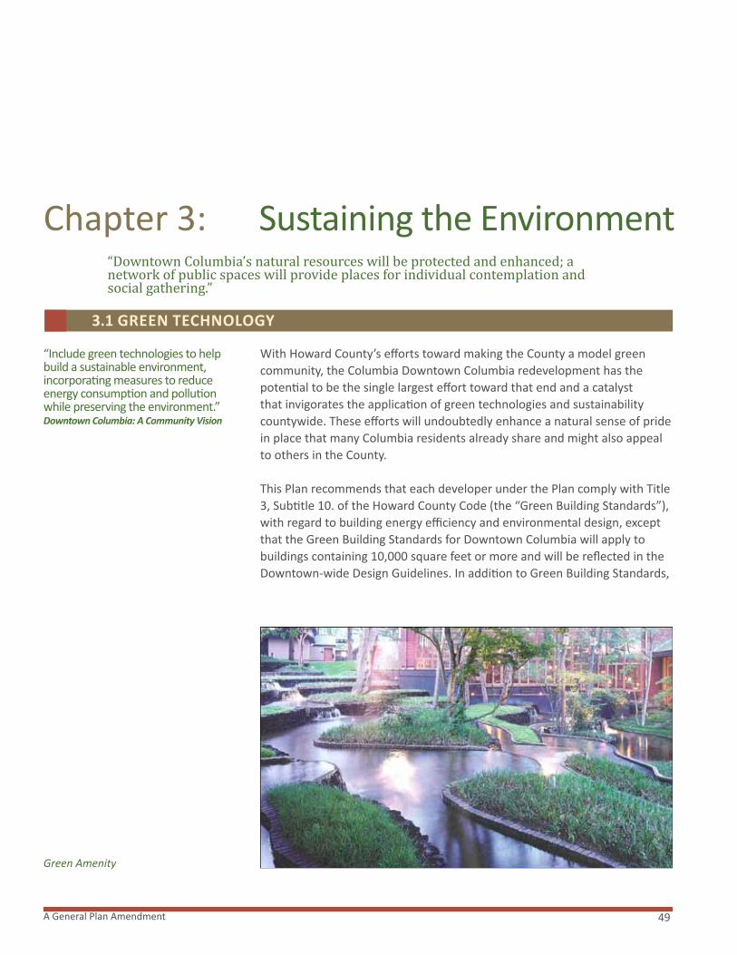
49A General Plan Amendment
Chapter 3: Sustaining the Environment“Downtown Columbia’s natural resources will be protected and enhanced; a network of public spaces will provide places for individual contemplation and social gathering.”
“Include green technologies to help build a sustainable environment, incorporating measures to reduce energy consumption and pollution while preserving the environment.” Downtown Columbia: A Community Vision
With Howard County’s efforts toward making the County a model green community, the Columbia Downtown Columbia redevelopment has the potential to be the single largest effort toward that end and a catalyst that invigorates the application of green technologies and sustainability countywide. These efforts will undoubtedly enhance a natural sense of pride in place that many Columbia residents already share and might also appeal to others in the County.
This Plan recommends that each developer under the Plan comply with Title 3, Subtitle 10. of the Howard County Code (the “Green Building Standards”), with regard to building energy efficiency and environmental design, except that the Green Building Standards for Downtown Columbia will apply tobuildings containing 10,000 square feet or more and will be reflected in the Downtown-wide Design Guidelines. In addition to Green Building Standards,
3.1 GREEN TECHNOLOGY
Green Amenity

Downtown Columbia Plan50
this Plan recommends development and implementation of the Downtown Columbia Sustainability Program that will be submitted simultaneously with the first final development plan proposing new development in Downtown Columbia. Submitted with this Plan is the Downtown Columbia Sustainability Framework which will guide final development of this program.
THE SUSTAINABILITY PROGRAM
The Sustainability Program is an ambitious effort to use whole systems thinking to guide further development of Downtown Columbia and the design of a livable community. A sustainable community is a place that promises a quality of life now, and into the future. For a community to be sustainable, it includes:
� Public spaces and amenities where residents can socialize, work, shop and play;
� An increased ease in mobility, where residents can walk to accommodations or access public transit more readily;
� Buildings that are energy-efficient;
� A healthy environment with clean water, clean air and increased connections to the natural environments.
A sustainable community is not an endpoint; rather it is a continuous process of adapting and improving, so that each generation can progressively experience a higher quality of life. Like nature, Columbia must have the resources and flexibility to adapt and evolve. Moving toward sustainability requires recognition that today’s practices may yet be improved. The Downtown Columbia redevelopment aims to address many needed improvements while planning for an enriching future.
This Plan strives to reach beyond green buildings and technology and consider all of the elements that comprise the fabric of the community. The Downtown Columbia Sustainability Program will serve as one of the primary guidance documents for the design, construction, operations and programming of Downtown Columbia. The intent of the Program is to fulfill a vision for a livable, socially, economically and environmentally sustainable urban community.
The Program’s Architecture Consists of Three Main Components:
1. Sustainability Framework
2. Implementation Plan
3. Institutional Framework
The Sustainability Framework submitted with this Plan provides the overarching components of the future Sustainability Program. The
Chapter 3 Sustaining the Environment
Sustainability Program
Natural Amenity
Storm Water Management
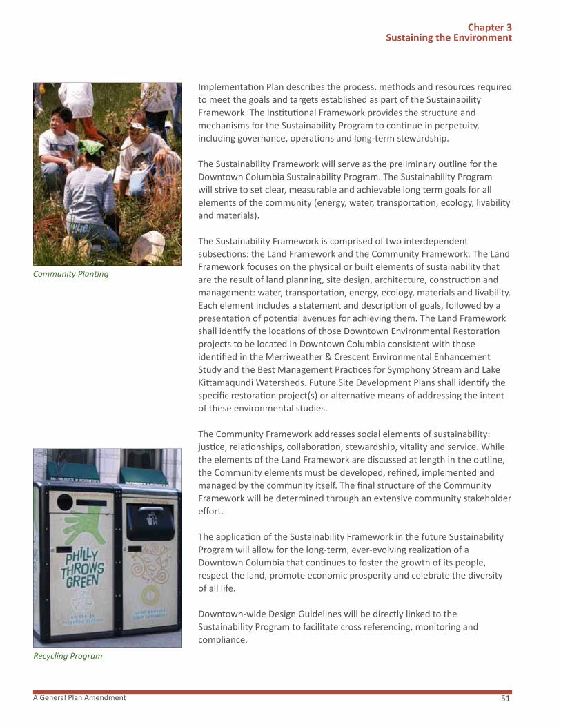
51A General Plan Amendment
Chapter 3 Sustaining the Environment
Implementation Plan describes the process, methods and resources required to meet the goals and targets established as part of the Sustainability Framework. The Institutional Framework provides the structure and mechanisms for the Sustainability Program to continue in perpetuity, including governance, operations and long-term stewardship.
The Sustainability Framework will serve as the preliminary outline for the Downtown Columbia Sustainability Program. The Sustainability Program will strive to set clear, measurable and achievable long term goals for all elements of the community (energy, water, transportation, ecology, livability and materials).
The Sustainability Framework is comprised of two interdependent subsections: the Land Framework and the Community Framework. The Land Framework focuses on the physical or built elements of sustainability that are the result of land planning, site design, architecture, construction and management: water, transportation, energy, ecology, materials and livability. Each element includes a statement and description of goals, followed by a presentation of potential avenues for achieving them. The Land Framework shall identify the locations of those Downtown Environmental Restorationprojects to be located in Downtown Columbia consistent with those identified in the Merriweather & Crescent Environmental Enhancement Study and the Best Management Practices for Symphony Stream and Lake Kittamaqundi Watersheds. Future Site Development Plans shall identify the specific restoration project(s) or alternative means of addressing the intent of these environmental studies.
The Community Framework addresses social elements of sustainability: justice, relationships, collaboration, stewardship, vitality and service. While the elements of the Land Framework are discussed at length in the outline, the Community elements must be developed, refined, implemented and managed by the community itself. The final structure of the Community Framework will be determined through an extensive community stakeholder effort.
The application of the Sustainability Framework in the future Sustainability Program will allow for the long-term, ever-evolving realization of a Downtown Columbia that continues to foster the growth of its people, respect the land, promote economic prosperity and celebrate the diversity of all life.
Downtown-wide Design Guidelines will be directly linked to the Sustainability Program to facilitate cross referencing, monitoring and compliance.
Community Planting
Recycling Program

Downtown Columbia Plan52
Chapter 3 Sustaining the Environment
Once the Sustainability Program goals have been established, the Downtown-wide Design Guidelines will be reviewed and revised through an integrated team process to articulate sustainability, green building and green neighborhood strategies and approaches that will help achieve the goals. Emphasis will be placed on allowing flexibility to accommodate future technologies as they emerge.
As part of the approval process for the Downtown-wide Design Guidelines, the Environmental Sustainability Board will be invited to review, evaluate and comment on the Sustainability Program. Their participation will ensure that the program fits the community’s unique needs and includes practices and standards that satisfy those needs.
Green Technologies
The emerging market for green technologies is driven by the increasing cost of energy and a heightened concern over pollution, especially greenhouse gas emissions and water quality. Improvements that focus on energy and water efficiencies are most commonly evident with the U.S. Green Building Council (USGBC) Leadership in Energy and Environmental Design (LEED) standards, which were approved for adoption by Howard County in 2007. Building/home energy use, along with transportation, are the largest contributors to greenhouse gas emissions, and it is within these systems that the latest green technologies will be applied.
Green Technologies, Market Square Green Roof Solar Array
Solar Powered Light

53A General Plan Amendment
Chapter 3 Sustaining the Environment
Additionally, the USGBC is in the process of developing LEED for Neighborhood Development (LEED ND), which gives credits to projects that are sited as infill, designed to be compact, complete and walkable, have good transit access and incorporate resource conservation and efficiency mechanisms. Downtown Columbia’s awareness and application of components of the LEED ND framework will support many of Downtown Columbia’s goals for a more livable, complete and environmentally intelligent community in the heart of Columbia.
Outlined below are a series of green building and Sustainability systems and technologies that may be used in Downtown Columbia development. As future technologies and the Downtown Columbia program develop, the County green building guidelines as well as the Downtown Columbia Sustainability Program will be used together to guide final system and programmatic solutions.
Energy
Green building standards allow for the application of a range of energy efficiency and production technologies, from low-tech passive solar orientation and the unique design of new buildings to the next generation of solar and wind power generation incorporated into roof and building design. Recent advances in lighting, insulation, water use, heating and cooling have been made that not only reduce energy use and carbon emissions but provide for significant cost savings over the life of the systems. The influence of trees as a natural energy saver should not be underestimated. In the summer, shade has been shown to lower building energy costs. In significant densities, trees can modify and cool the local area microclimate further reducing the cooling required during peak summer energy usage. The energy reductions from the broad application of these systems within and around new and old buildings in Downtown Columbia can be calculated in estimating the overall reduction of Downtown Columbia’s greenhouse gas emissions.
Sustainability Program Goals
Street Tree Plantings

Downtown Columbia Plan54
Water
Much of the Downtown Columbia landscape is impervious, with buildings, roads and parking lots blocking the natural infiltration and cleansing of stormwater through soil and plants. The construction of green roofs, where appropriate, could help address this problem. Flat-roofed buildings existing and planned within Downtown Columbia lend themselves to green or living-roof technology. This creative alternative to pitch or gravel roofs is attractive due to its multiple benefits. Green roofs can substantially reduce stormwater runoff through storage, vegetative uptake, evaporation and plant transpiration. Implementing measures that help to improve the water quality of Lake Kittamaqundi and the Little Patuxent River are important aspects of this Plan. By trapping, treating and reusing stormwater closer to its source, green roofs and other bioretention and water storage and treatment technologies would support improved water quality and reduced water usage.
Stormwater capture (harvesting) and treatment has gained greater acceptance and the reuse of stormwater for irrigation can provide significant cost savings as well as indirect reductions in energy use and carbon emissions. Green roofs also have been shown to reduce high ambient air temperatures associated with urban areas (Urban Heat Island) through evaporative cooling; provide insulation resulting in lower energy costs; improve air quality through carbon uptake and oxygen production; and provide habitat for birds and insects. Green roofs are aesthetically pleasing and can be a significant source of interest and pride to those living and working around them.
Other green technology solutions to water quality and quantity problems from roads, sidewalks and parking lots will be introduced with new construction or retrofitted into existing infrastructure. These include vegetated roadside infiltration swales, structured soil tree pits, stormwater planters, pervious paving, forested wetlands and vegetated buffer areas.
Chapter 3 Sustaining the Environment
Functional Landscape, Lakefront
Stormwater Art
Green Rooftop Treatment

55A General Plan Amendment
Appropriately incorporated into the redesign of Downtown Columbia, these green solutions have the potential to significantly address the water related impacts on Lake Kittamaqundi and the Little Patuxent River by mimicking natural soil retention and infiltration processes. The proper recognition of these best management practices (BMPs) within the community through interpretive signage also would foster an education in the environmental ethic in Downtown Columbia and adds to the existing community sense of pride.
Transportation
Transportation and the local and regional connectivity of Downtown Columbia is an integral part of the sustainability program. Making Downtown Columbia more efficiently served by mass transit through the use of a downtown shuttle, provision of a site for a new transit hub and establishment of a Transportation Management Association will reduce the negative impact to the natural environment on the area and increase the quality of life for all Columbians. Sustainable site design to encourage a “park once” goal for those residents and visitors using cars will create a fuller, more vibrant Downtown Columbia. With increased pedestrian activity will come a palpable sense of a town that is alive. Improved pedestrian connections between Downtown Columbia and the nearby villages would reduce vehicular trips and also would reinforce the local economy, significantly reducing the need to leave Columbia for services and entertainment.
Green Jobs
When fully realized, the application and concentration of green technologies on such a large scale should generate significant regional if not national interest. This favorable and timely attention could be capitalized upon by marketing to and attracting green businesses. If successful in attracting new jobs for the emerging green economy, Columbia would be able to reinvent and rightfully claim for itself something very few large towns can boast - the renewed realization of a progressive vision in town planning that has been 40 years in the making.
Chapter 3 Sustaining the Environment
Stream and Wetland Restoration
This Plan strives to enhance the ecological environment by restoring and maintaining the current Symphony Stream and Little Patuxent River riparian corridors. Stream and wetland restoration opportunities have been identified throughout Downtown Columbia as indicated in the Columbia Town Center Merriweather & Crescent Environmental Enhancements Study submitted
“Protect the natural resources and natural beauty of Downtown’s lake, streams and woodlands, forming them into a greenway system.”* Downtown Columbia: A Community Vision
3.2 NATURE
Circulator Shuttle
Stormwater Planter
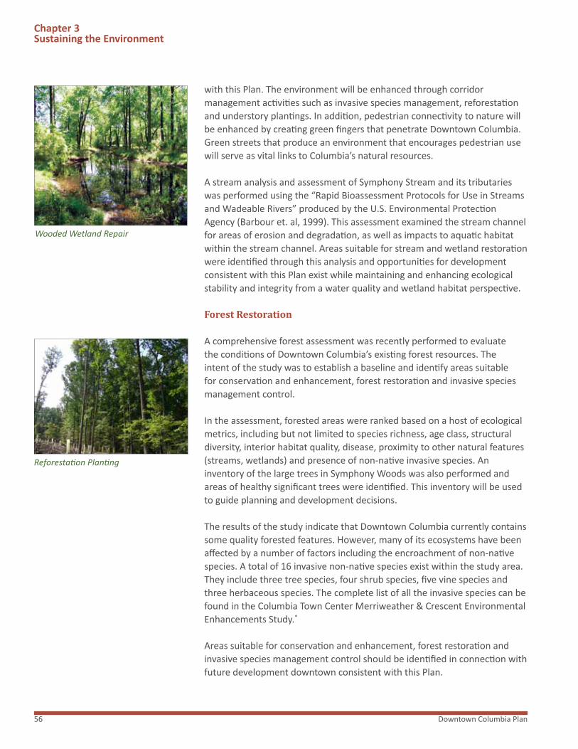
Downtown Columbia Plan56
Wooded Wetland Repair
with this Plan. The environment will be enhanced through corridor management activities such as invasive species management, reforestation and understory plantings. In addition, pedestrian connectivity to nature will be enhanced by creating green fingers that penetrate Downtown Columbia. Green streets that produce an environment that encourages pedestrian use will serve as vital links to Columbia’s natural resources.
A stream analysis and assessment of Symphony Stream and its tributaries was performed using the “Rapid Bioassessment Protocols for Use in Streams and Wadeable Rivers” produced by the U.S. Environmental Protection Agency (Barbour et. al, 1999). This assessment examined the stream channel for areas of erosion and degradation, as well as impacts to aquatic habitat within the stream channel. Areas suitable for stream and wetland restoration were identified through this analysis and opportunities for development consistent with this Plan exist while maintaining and enhancing ecological stability and integrity from a water quality and wetland habitat perspective.
Forest Restoration
A comprehensive forest assessment was recently performed to evaluate the conditions of Downtown Columbia’s existing forest resources. The intent of the study was to establish a baseline and identify areas suitable for conservation and enhancement, forest restoration and invasive species management control.
In the assessment, forested areas were ranked based on a host of ecological metrics, including but not limited to species richness, age class, structural diversity, interior habitat quality, disease, proximity to other natural features (streams, wetlands) and presence of non-native invasive species. An inventory of the large trees in Symphony Woods was also performed and areas of healthy significant trees were identified. This inventory will be used to guide planning and development decisions.
The results of the study indicate that Downtown Columbia currently contains some quality forested features. However, many of its ecosystems have been affected by a number of factors including the encroachment of non-native species. A total of 16 invasive non-native species exist within the study area. They include three tree species, four shrub species, five vine species and three herbaceous species. The complete list of all the invasive species can be found in the Columbia Town Center Merriweather & Crescent Environmental Enhancements Study.*
Areas suitable for conservation and enhancement, forest restoration and invasive species management control should be identified in connection with future development downtown consistent with this Plan.
Chapter 3 Sustaining the Environment
Reforestation Planting

57A General Plan Amendment
Bioswale
Watersheds and Stormwater Management
In an effort to increase community awareness of water quality issues outside the Downtown Columbia redevelopment area and their impacts to Chesapeake Bay, GGP also performed watershed assessments for the three sub watersheds of Symphony Stream, Wilde Lake and Lake Kittamaqundi located up stream of the Merriweather & Crescent Environmental Enhancements Study area. The Best Management Practices for Symphony Stream and Lake Kittamaqundi Watersheds assessment consisted of the compilation and analyses of existing information as well as field reconnaissance to identify stormwater retrofit and stream restoration opportunities.
GGP is committed to working with the County and various property owners located upstream from the Downtown Columbia redevelopment area to help coordinate and facilitate the enhancements identified in the Assessment referenced above. In this regard, GGP has participated with Howard County and The Columbia Association in a joint application to The Maryland Department of Natural Resources for Local Implantation grant funding from the Chesapeake and Atlantic Coastal Bays 2010 Trust Fund.
When implemented, upland stormwater retrofits should include structural practices installed in upland areas to capture and treat stormwater runoff at its source before it is delivered to the storm drainage and stream channel systems. Specific types of stormwater treatment options prescribed for the different retrofit locations vary but include bioretention practices, sand filters, swales and forested wetlands. These stormwater retrofits if undertaken will increase stormwater runoff quality and recharge, mitigate localized and downstream channel erosion, protect riparian corridor restoration sites and serve as demonstration and education sites.
This Plan anticipates that the upstream stormwater management retrofits discussed in the Best Management Practices for Symphony Stream and Lake Kittamaqundi Watersheds dated September 2008 (the “Assessment”) will be implemented over time. This Plan further recommends that the County consider; (i) recommendations in the Assessment when developing its annual capital budgets and (ii) how the County may incentivize upstream property owners to obtain their consent to, and participation with the County and State in the upstream stormwater management improvements program. With respect to the environmental enhancements in the downtown area that are identified in the Merriweather & Symphony Stream Environmental Enhancements Study, dated September 2008 (the “Report”), this Plan recommends their implementation by respective property owners in accordance with the Report.
Rooftop Stormwater Treatment
Chapter 3 Sustaining the Environment
Permeable Pavement

Downtown Columbia Plan58
“Identify Symphony Woods as Columbia’s “Central Park” area, which deserves special design and conservation measures.” Downtown Columbia: A Community Vision
What was once a healthy forest ecosystem, Symphony Woods unfortunately has been degraded through impacts to soil and plants under the aging tree canopy. Efforts to maintain a lawn below the trees at Symphony Woods have prevented the growth of beneficial native shrubs and herbaceous plants, impaired the growing ability of the soil, and eliminated future generations of trees, all important factors in a healthy, sustainable forest.
Under this Plan, environmentally sensitive areas in Symphony Woods should be restored and enhanced and Symphony Woods should remain a principle amenity space of Downtown Columbia with multiple purposes and functions from natural to cultural. It should become a place for contact with nature where the Symphony Stream and Little Patuxent River riparian ecology extends through low lying areas of Symphony Woods. It also should be a significant community and regional gathering space.
In the future, the Symphony Stream and Little Patuxent River watersheds and stream beds within Symphony Woods should be restored to a condition that will allow them to become rich habitats for animals, birds and aquatic life. Invasive species should be removed and thick vegetation established in this east-west corridor. This area should store and process runoff as part of a larger rainwater harvesting strategy for Downtown Columbia. This restoration to a more natural condition also should occur in corridors extending northward to filter rainwater runoff from impervious surfaces at higher elevations north of Symphony Woods. These natural areas of
3.3 CENTRAL PARk
Bryant Park, New York, NY
River Legacy Park, Plano, TX
Chapter 3 Sustaining the Environment

59A General Plan Amendment
“Require additional open space and amenity areas so that downtown will retain the character of a “city in a park” with plazas, greens, promenades, paths, public art, natural areas and street trees.” Downtown Columbia: A Community Vision
Columbia’s heritage as a city in a park will be carried forward with a series of outdoor spaces integrated into the fabric of Downtown Columbia. While Symphony Woods and Lake Kittamaqundi are the principal green spaces for Downtown Columbia, new parks or squares will be created as the focus for each neighborhood of the downtown. In addition, smaller parks and plazas will be an integral part of the pedestrian environment. This Plan proposes a Downtown Columbia consisting of a series of neighborhoods that will be organized around centrally located green spaces or plazas, typically within a five-minute walk of any location in the neighborhood. These outdoor spaces will be defined and framed by buildings and serve as the central gathering space for each neighborhood. The intensity of use will dictate how much green space is to be included. Typical activities in these spaces include informal recreation, lawn games and sunbathing, jogging, dog-walking and other casual activities. Neighborhoods with retail, restaurants and other commercial uses might have plazas as the neighborhood focus in combination with green spaces.
Outdoor spaces, including small plazas and urban parks, will be strategically located at the confluence of pedestrian paths, sightlines and streets. Alternatively, they may be an oasis or refuge along downtown streets. These small urban spaces will be easily accessible at street level and highly visible from adjacent streets and sidewalks. These spaces will be located at logical intervals between the main neighborhood squares and a newly designed Symphony Woods. When combined with street trees along sidewalks, double rows of trees along promenades and green neighborhood squares, Columbia will have a downtown that is truly a city in a garden.
To assure the continued viability of existing open space downtown, this Plan recommends the adoption of legislation creating distinct definitions for the different types of open spaces that either will be preserved or enhanced downtown. Spaces in particular that should be addressed include Symphony Woods, the existing recorded open space at the Lakefront, Merriweather Post Pavilion, and environmentally
Symphony Woods should create an aspect of wildness that will contrast with the community and social spaces in the groves of trees at higher elevations in the park.
In addition to the events at Merriweather Post Pavilion, a rich array of community and social activities can take place in Symphony Woods. The infrastructure at Merriweather Post Pavilion, including restrooms and food concessions, can be designed to open outward supporting other planned and programmed events in Symphony Woods. In the pre-design phase, a detailed program should be developed that defines the range of events that could be accommodated in Symphony Woods. Because of its central location, Symphony Woods should also be designed to enhance important connector functions between other downtown gathering spaces.
3.4 OUTDOOR SPACES
Children’s Play Area
Chapter 3 Sustaining the Environment
Greenacre Park, New York, NY
Outdoor Amenity Area

Downtown Columbia Plan60
EXHIBIT G. PRIMARY AMENITY SPACE FRAMEWORK DIAGRAM
Chapter 3 Sustaining the Environment
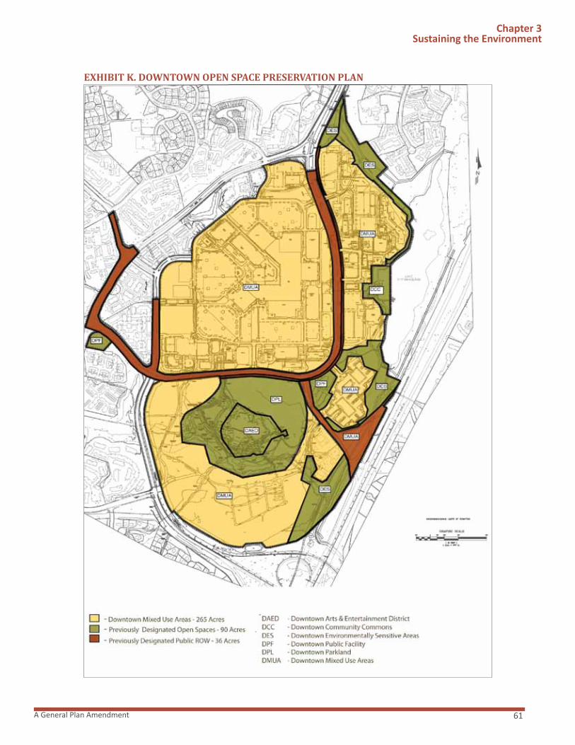
61A General Plan Amendment
EXHIBIT K. DOWNTOWN OPEN SPACE PRESERVATION PLAN
Chapter 3 Sustaining the Environment

Downtown Columbia Plan62
sensitive areas. Limited enhancements that are consistent with this Plan and consistent with the space’s functionality should be permitted. However, the character of these existing open spaces should be retained with the one exception discussed below.
With respect to Downtown Parkland, implementing legislation should require that new parkland be provided to replace any parkland lost to development. Improvements such as playgrounds, walks, gardens, and fountains and minimal structures such as gazebos, pavilions, cafes, outdoor stages and kiosks will not require replacement space to be provided. This Plan intends that open space shown on a Final Development Plan recorded under the existing NT District continues to count toward the overall Columbia open space requirements, thus the obligation to retain its character. This Plan also intends that environmentally sensitive areas located within the Crescent Neighborhood be protected and recorded as open space under the existing NT Regulations.
Chapter 3 Sustaining the Environment
Downtown Environmental Character
Legacy Park, Plano, TX

63A General Plan Amendment
“The development of Downtown Columbia will be served by public facilities provided in a timely manner.”
“Recognize and implement the General Plan 2000 policy to direct growth into Downtown as the largest of the County’s mixed-use centers.” Downtown Columbia: A Community Vision
General Plan 2000 addresses Downtown Columbia under Policy 5.5: Encourage Downtown Columbia’s continuing evolution and growth as the County’s urban center. This Plan builds on and reinforces this policy as discussed in detail in the following sections. The successful evolution and growth of Downtown Columbia as recommended in Downtown Columbia: A Community Vision and General Plan 2000 will depend on not only the addition of jobs and housing, but on the provision of a variety of high quality amenities and services that will attract new businesses, employees and homeowners to live, work and invest in downtown. Although most of the enhancements, amenities and services recommended by this Plan will be provided through private investment, a small portion of the public infrastructure (such as public parking garages) may be financed through alternative public or private mechanisms, such as, without limitation, tax increment financing (TIF) or Revenue Authority bonds.
Chapter 4: Balancing and Phasing Growth
4.1 GENERAL PLAN
Rockville Town Square, Rockville, MD

Downtown Columbia Plan64
More Downtown Columbia Residential Units
“Increase the number of housing units and people living in Town Center to maintain activity and support restaurants, shops and entertainment uses after normal office hours. Consider, in particular, the potential to address the growing market for active senior citizens.”
General Plan 2000
This Plan recognizes the need for additional housing in Downtown Columbia and recommends development of 5,500 additional units. This additional housing will be fundamental to the economic future of Columbia. The additional people living downtown will also be needed to provide an active pedestrian environment after normal office hours as well as customers for shops, restaurants and other entertainment uses. Additional housing will also help populate the streets downtown, enhancing the safety of residents, workers and visitors.
Development of additional housing units in downtown must provide increased housing opportunities for residents at different income levels and should provide a range of housing choices. Housing types could include among other possibilities, high and mid-rise multifamily; mixed-use high rise multifamily located above retail or office uses; loft-style housing located above retail or office space; single family attached housing; live-work housing with office or retail uses within a single housing unit; student housing; and mixed-income housing.
This Plan also recommends development of 640 additional hotel rooms in Downtown Columbia. With the recommended increases in commercial and residential uses, additional hotel resources will be necessary to serve the present and future needs of the community. The addition of a convention/conference center and exhibit space also will add to the demand for quality hospitality accommodations and services. Depending on market conditions, a variety of hotel product types could be desirable and should be permitted. Hotel uses should be available to serve all of the needs of Downtown Columbia’s residents, businesses and visitors.
Redevelopment of Older Properties
“Encourage the selective redevelopment of obsolete or underused properties for additional office, housing, retail, entertainment and cultural uses. Encourage property owners to seek vertical mixed uses, including residential, for Lakefront redevelopments as well as for currently undeveloped infill sites.”
General Plan 2000
This Plan recommends the redevelopment of older and obsolete properties to achieve the vision expressed in Downtown Columbia: A Community
Chapter 4Balancing & Phasing Growth
Carlyle, Alexandria, VA
Silver Spring, MD

65A General Plan Amendment
Vision. Many of downtown’s older office buildings were built 20 or more years ago. In many instances, the existing floor plates and mechanical systems of these buildings restrict marketing opportunities and the ability to attract Class A tenants. Furthermore, when these older buildings were constructed, the desirability of providing multiple vehicle and pedestrian links through Downtown Columbia was not fully recognized. This Plan, therefore, recommends the redevelopment of certain properties as necessary to implement the Downtown Columbia vision, including the vehicle and pedestrian connections recommended in this Plan.
To implement the General Plan 2000 recommendation for the continued evolution and growth of Downtown Columbia as the county’s urban center, this Plan further recommends development of approximately one million two hundred fifty thousand square feet of additional retail uses over the current approved Final Development Plans, and four million three hundred thousand square feet of additional office use.
Improve Pedestrian Connections
“Design new development and redevelopment to strengthen the connections between the Lakefront, The Mall and Town Center housing. Relieve traffic congestion without degrading pedestrian use or further dividing Town Center into isolated pockets. Replace the asphalt walkway around the outer perimeter of The Mall, Little Patuxent Parkway and Governor Warfield Parkway with a concrete sidewalk to improve pedestrian convenience and safety and to enhance the urban downtown ‘look.’ Use a joint public-private effort to replace this walkway.”
General Plan 2000
Chapter 4Balancing & Phasing Growth
Steps to the Lake, The Lakefront
Pentagon Row, Arlington, VA

Downtown Columbia Plan66
This Plan includes enhancements to the existing pedestrian circulation system, both in Downtown Columbia and to adjacent activity centers, such as Howard Community College. The pedestrian connections plans show potential connections and additional pathways that could be implemented as part of the redevelopment of Downtown Columbia. The exact location and nature of these pedestrian improvements must be shown on the Final Development Plan, which is required to conform with this Plan.
In addition, in order to improve walkability and develop more complete internal pedestrian connections and to avoid isolation for early residents, this Plan recommends development that promotes connectivity between the Mall, Lakefront, Merriweather and existing development.
As General Plan 2000 recognizes, further isolation of any portion of the downtown is to be avoided. This Plan forwards this policy by requiring enhanced pedestrian connections and a contribution toward the capital costs of funding a Downtown Columbia circulator shuttle at an appropriate time in the redevelopment. In general, pedestrian enhancements must be constructed as development occurs within each neighborhood of Downtown Columbia. Specific staging of pedestrian improvements and the Downtown Columbia Circulator Shuttle are discussed in the phasing recommendations in Section 4.2 of this Plan.
Transit Integration
“Improve the bus transfer point at the mall to complement The Mall’s design and to better serve transit patrons.”
General Plan 2000
This Plan recommends the Transit Center be located in an appropriate location downtown that is within comfortable, walking distance to public spaces, employment and housing uses. The timing for the relocation and enhancement of the bus transfer point is set forth in the staging recommendations included with this Plan in Section 4.2.
Open Space
“Enhance Town Center’s open space, such as the edges of Lake Kittamaqundi and Symphony Woods, to promote enjoyment by the growing numbers of Town Center residents and visitors. Work with Howard Research and Development Corporation, Columbia Association and the Town Center Village Board to continue the lakeside path either as a full loop around the lake or through bridge connections to the island in the lake.”
General Plan 2000
Chapter 4Balancing & Phasing Growth
Pedestrian Connection
Cy P
aum
ier
Potential Transit Center Location

67A General Plan Amendment
In order to support the additional residential and commercial possibilities recommended by this Plan, it will be necessary to enhance existing open spaces. The creation of additional open space and the implementation of improvements to the Downtown Columbia environment in the form of natural and man-made amenity areas will be important to the creation of a sustainable downtown and are discussed previously in this Plan.
Enhancing existing open space areas is also recommended to increase the level of amenity provided and to encourage regular use by residents, workers and visitors. The introduction of arts, cultural and community uses in certain areas would further this goal and could be achieved with positive environmental results. Arts, cultural and community uses could include such things as a new library, museums, a children’s theater, galleries, sculpture gardens and a public square for assembly and the exercise of free speech. Where appropriate, development may also include related infrastructure intended primarily to serve these designated uses including pedestrian and bicycle paths, parking, road connections, utilities, and storm drainage and stormwater management facilities.
This Plan recommends that each downtown neighborhood be provided with a significant amenity space to serve as a community gathering place or neighborhood square. Each neighborhood square shall contain not less than 25,000 square feet and should be compatible with existing and planned adjacent uses and improvements. One of these neighborhood squares should be deeded to Howard County for public land. These gathering spaces could include plazas, parks, promenades, greens, gardens, arts, cultural and community uses or other public spaces. With respect to the Merriweatherneighborhood, this recommendation may be satisfied by enhancing areas designated as open space on a previously approved Final Development Plan. This Plan also recommends incorporating additional amenity space where appropriate, including pedestrian and bicycle circulation systems, enhanced streetscapes and revitalizing environmentally sensitive areas as discussed elsewhere in this document. This Plan specifically recommends continuing the path around Lake Kittamaqundi to provide a complete loop around the lake.
Cultural Center
“Encourage efforts to develop Town Center as an art, cultural and civic center (including indoor facilities and outdoor/open space activities) in addition to its function as an employment and retail focal point.”
General Plan 2000
By encouraging efforts to develop Downtown Columbia as an art, cultural and civic center, this Plan recognizes and celebrates the power of art and
Chapter 4Balancing & Phasing Growth
Lakefront Amenity Area
Outdoor Gathering Space

Downtown Columbia Plan68
culture to regenerate our communities by renewing the human spirit through continuing exploration of great ideas.
The cultural vision for Downtown Columbia will be unique to Columbia. Inclusion of cultural amenities in Downtown Columbia will be based in significant part on input received from the community. In this respect, this Plan recognizes the critical importance of having community members participate in forging Downtown Columbia’s cultural and civic identity. The cultural infrastructure to be developed from the vision that emerges from this dialogue should fit comfortably within the environment of which it is to become a part. The potential for bundling cultural infrastructure in a central location that enhances the connection between various uses in Downtown Columbia, including retail, residential and civic uses, should continue to be explored. The cultural infrastructure of Downtown Columbia also must further the intent of this Plan to create a self-sustaining and walkable environment.
To this end, this Plan recommends the formation of the Downtown Arts and Culture Commission and that GGP’s cultural consultant should work with the Commission in guiding the development of a Cultural master Plan for Downtown Columbia.
Infrastructure
“Encourage the Columbia Association, Howard Research and Development Corporation, and other private property owners in Town Center to adhere to high maintenance standards for streets, medians, pedestrian ways, landscaped areas and street furniture. Encourage them to develop a program of well-designed directional signage to aid orientation to Town Center sites, facilities, amenities and activities.”
General Plan 2000
In order to create the sustainable environment needed to support the new Downtown Columbia, existing and future public spaces and amenities must be maintained to the highest standards. The standard of maintenance for open spaces, plazas, gardens, medians, pedestrian and bicycle systems and street furniture reflect the values of the community and therefore must be scrupulously maintained. As discussed elsewhere in this Plan, the potential creation of a Downtown Columbia Partnership among private landowners, the County, Columbia Association and other community entities should be considered as a means of assuring that the desired level of maintenance is achieved.
This Plan also recommends a comprehensive signage plan be developed for Downtown Columbia and recommends that the Access Committee of the County’s Commission on Disability Issues be consulted in the development
Chapter 4Balancing & Phasing Growth
Cultural Streetscape
Addison Circle, Dallas, TX
©20
07 R
TKL.
com
/Dav
id W
hitc
omb

69A General Plan Amendment
of this Plan. Clear signage will help orient residents, workers and visitors. Signage also can reflect the character of individual neighborhood within downtown, thus helping to establish local identity.
Symphony Woods
“Encourage measures that enhance Symphony Woods as an attractive, inviting open space in which families and individuals could enjoy natural beauty within the urban setting.”
General Plan 2000
As discussed above, this Plan recommends the creation of a cultural district in the Merriweather-Symphony Woods Neighborhood. Creation of a cultural district including pedestrian and multi-modal linkages to the Lakefront and Symphony Overlook neighborhoods would complement the renovation of Merriweather Post Pavilion, activate and enhance Symphony Woods and create a destination by bundling different opportunities for residents and visitors. However, the Merriweather-Symphony Woods Neighborhood is not the only potential location for additional cultural amenities Downtown. This Plan recognizes that selective development of arts, cultural and community uses might also occur at other locations, including near or at the Lakefront Core. The addition of cultural uses or amenities near the Lake could increase activity and use of the Lakefront open space that already exists and could (with the Lake) form an anchor for the Lakefront Connection depicted on the Primary Amenity Space Framework Diagram (Exhibit G). Such development would also conform with and would further the objectives of this Plan.
Pedestrian improvements to Little Patuxent Parkway between Broken Land Parkway and South Entrance Drive are recommended to enhance the pedestrian experience and pedestrian safety. Installation of a pedestrian crossing signal at these locations might also be desirable. These pedestrian improvements will improve access to and encourage further use of Symphony Woods.
Chapter 4Balancing & Phasing Growth
“Establish targets for commercial and housing development for a balance of land uses and public services. This ensures that development does not place undue burdens on existing residents, infrastructure or service providers.” Downtown Columbia: A Community Vision
Overview
This Plan at the end of this chapter recommends that the redevelopment of Downtown Columbia occur in three phases over an approximately thirty year period. The recommended phasing guidelines are based on currently anticipated absorption rates for the recommended land uses. Changing market conditions could result in actual absorption rates that differ from what is recommended in this Plan, and should be anticipated to some extent given the thirty-year estimated schedule for completion of the downtown.
4.2 PHASING
Washington Park, Portland, OR
District Identification

Downtown Columbia Plan70
Chapter 4Balancing & Phasing Growth
To create the special place downtown recommended by Downtown Columbia: A Community Vision, it will be necessary to assure an ongoing balance of uses downtown and the timely provision of new amenities and required infrastructure. Accordingly, legislation should be adopted that requires adherence to the CEPPAs and the flexibility provisions of this Plan.* The legislation should also provide that before land disturbance activities associated with any development can begin that: (i) the Community Enhancements, Programs and Public Amenities identified in the Downtown CEPPA Implementation Chart in section 4.2 must be provided; and (ii) building permits for at least the minimum levels of development for each of the land use types designated in the Downtown Revitalization Phasing Plan for each phase must have been approved. In addition, the requirements of the Adequate Public Facilities Act must be met for each individual development project, regardless of which phase the project is in.
Infrastructure
This Plan recommends that private developers, not current residents, be responsible for the cost to design, permit and construct, in addition to their own buildings and facilities, all necessary County roads, intersections and sidewalks, including upgrades to existing roads in accordance with the Adequate Public Facilities Act and new non-program sized sewer and water lines within Downtown Columbia.* Water and sewer system improvements should continue to be funded by user revenues paid to the Water and Sewer Enterprise Fund.
The use of structured parking would support the more compact, vertical development scheme of Downtown Columbia. The goal of this development effort is to provide a “park-once” approach, whereby visitors to Downtown Columbia will park upon arrival in centrally located parking structures and walk or take public transit to the retail and commercial uses, as well as parks and recreational facilities being provided throughout the area. The parking structures would replace the large, open, surface parking lots that exist today, making room for more compact, higher density development.
Geographic Phasing Relationships
This Plan recognizes that phasing can be related to both development levels and location. Although General Growth Properties controls a significant portion of the land in Downtown Columbia, there are a number of third party land owners. General Growth and its affiliates own about 240 acres. Third parties own the remainder, including the Columbia Association property at Symphony Woods and the Lakefront. In addition, the major department stores at the Mall in Columbia have certain contractual rights that could affect the timing of redevelopment activities on property located
Shirlington Village, Arlington, VA
Development Pattern Example

71A General Plan Amendment
Chapter 4Balancing & Phasing Growth
EXHIBIT B. LAND OWNERSHIP PLAN
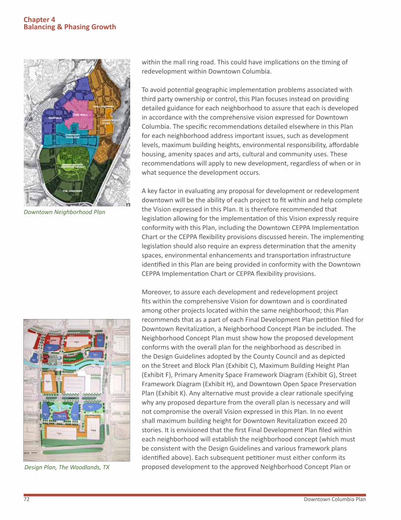
Downtown Columbia Plan72
Chapter 4Balancing & Phasing Growth
within the mall ring road. This could have implications on the timing of redevelopment within Downtown Columbia.
To avoid potential geographic implementation problems associated with third party ownership or control, this Plan focuses instead on providing detailed guidance for each neighborhood to assure that each is developed in accordance with the comprehensive vision expressed for Downtown Columbia. The specific recommendations detailed elsewhere in this Plan for each neighborhood address important issues, such as development levels, maximum building heights, environmental responsibility, affordable housing, amenity spaces and arts, cultural and community uses. These recommendations will apply to new development, regardless of when or in what sequence the development occurs.
A key factor in evaluating any proposal for development or redevelopment downtown will be the ability of each project to fit within and help complete the Vision expressed in this Plan. It is therefore recommended that legislation allowing for the implementation of this Vision expressly require conformity with this Plan, including the Downtown CEPPA Implementation Chart or the CEPPA flexibility provisions discussed herein. The implementing legislation should also require an express determination that the amenity spaces, environmental enhancements and transportation infrastructure identified in this Plan are being provided in conformity with the Downtown CEPPA Implementation Chart or CEPPA flexibility provisions.
Moreover, to assure each development and redevelopment project fits within the comprehensive Vision for downtown and is coordinated among other projects located within the same neighborhood; this Plan recommends that as a part of each Final Development Plan petition filed for Downtown Revitalization, a Neighborhood Concept Plan be included. The Neighborhood Concept Plan must show how the proposed development conforms with the overall plan for the neighborhood as described in the Design Guidelines adopted by the County Council and as depicted on the Street and Block Plan (Exhibit C), Maximum Building Height Plan (Exhibit F), Primary Amenity Space Framework Diagram (Exhibit G), Street Framework Diagram (Exhibit H), and Downtown Open Space Preservation Plan (Exhibit K). Any alternative must provide a clear rationale specifying why any proposed departure from the overall plan is necessary and will not compromise the overall Vision expressed in this Plan. In no event shall maximum building height for Downtown Revitalization exceed 20 stories. It is envisioned that the first Final Development Plan filed within each neighborhood will establish the neighborhood concept (which must be consistent with the Design Guidelines and various framework plans identified above). Each subsequent petitioner must either conform its proposed development to the approved Neighborhood Concept Plan or
Downtown Neighborhood Plan
Design Plan, The Woodlands, TX
-SYMPHONY WOODS*

73A General Plan Amendment
Chapter 4Balancing & Phasing Growth
provide a clear rationale specifying why any proposed departure from the approved Neighborhood Concept Plan is necessary and will not compromise the overall Vision expressed in this Plan.
Community Enhancements, Programs and Public Amenities (CEPPAS)
Of paramount importance to the neighborhood-by-neighborhood development approach and the success of Downtown Columbia, is the timely provision of Community Enhancements, Programs and Public Amenities to be implemented in phases consistent with the new commercial and residential development activity. The timely implementation of these features and their initiation will assure the creation of a culturally and environmentally enriched downtown.
This Plan requires that GGP or other developers provide these CEPPAs on a schedule corresponding to the implementation of new development as outlined in the Downtown Implementation CEPPA chart and CEPPA flexibility provisions included in this Plan.
Downtown Revitalization Phasing Progression
Development should not be allowed to proceed to a subsequent phase unless building permits have been approved for at least the minimum levels of development identified below for retail, office/conference, residential units and the number of hotel rooms for the preceding phase.
DOWNTOWN REVITALIZATION PHASING PROGRESSIONPHASE I PHASE II CUMMULATIVE PHASE III COMPLETION TOTAL
Use Type Min Max Use Type Min Max Use Type Up To
Units SF Units SF Units SF Units SF Units SF
Retail 300,000 676,446 Retail 429,270 1,100,000 Retail 820,730 1,250,000
Office/ Conf* 1,000,000 1,513,991 Office/ Conf* 1,868,956 2,756,375 Office/ Conf* 2,431,044 4,300,000
Hotel Rms** 100 640 Hotel Rms** 200*** 540*** Hotel Rms** 440 640
Residential** 656 2,296 Residential** 1,442 4,700 Residential** 4,058 5,500
* Office/conference includes hotel conference/banquet space greater than 20 sq ft per hotel room.** For zoning and phasing purposes, hotel rooms and residential development are tracked by unit. Actual square footage of hotel and residential development will be calculated for CEPPA compliance.*** The minimum number of hotel rooms required in Phase II is 100 unless more than 540 rooms were constructed in Phase I; the maximum number of hotel rooms for Phase II will be the difference between 640 and the number of rooms constructed in Phase I.
DOWNTOWN COMMUNITY ENHANCEMENTS, PROGRAMS AND PUBLIC AMENITIES (CEPPAs) IMPLEMENTATION CHART
The Downtown CEPPA Implementation Chart identifies the timing and implementation of the various specific CEPPAs to be provided. The Downtown Columbia Plan anticipates that GGP, as the principal property owner, will undertake many of the CEPPAs. However, the responsibility lies with all property owners undertaking development or redevelopment in Downtown Columbia. Moreover, in the event of any future fragmentation of ownership of GGP’s holdings, the CEPPAs must still be provided in accordance with the benchmarks established in this chart. Under such circumstances, the required CEPPAs could be funded by the developer(s) of individual parcels, a cooperative of developers or otherwise. In no case shall the obligation to provide a CEPPA be triggered: (i) by the development or construction of downtown arts, cultural and community uses, downtown community commons, or downtown parkland; or (ii) when the development of an individual parcel of land shown on a plat or deed recorded among the

Downtown Columbia Plan74
Chapter 4Balancing & Phasing Growth
County Land Records as of April 6, 2010 consists only of up to a total of 10,000 square feet of commercial floor area and no other development.* The timing and implementation of other amenities discussed in this Plan or shown in concept on the exhibits to this Plan will be governed by the zoning regulation recommended by this Plan.
If a specific CEPPA identified in the Downtown CEPPA Implementation chart cannot be provided because: (i) the consent of the owner of the land on which the CEPPA is to be located or from whom access is required cannot reasonably be obtained; (ii) all necessary permits or approvals cannot reasonably be obtained from applicable governmental authorities; or (iii) factors exist that are beyond the reasonable control of the petitioner, then the Planning Board shall: (i) require the petitioner to post security with the County in an amount sufficient to cover the cost of the original CEPPA; or (ii) approve an alternate CEPPA comparable to the original and appropriate timing for such alternate CEPPA or alternative timing for the original CEPPA. In approving an alternate comparable CEPPA or timing, the Planning Board must conclude the alternate comparable CEPPA and/or timing:(i) does not result in piecemeal development inconsistent with the Plan; (ii) advances the public interest; and (iii) conforms to the goals of the Downtown Plan.
Additionally, because development phasing is inextricably linked to market forces and third party approvals, it will be important for the zoning to provide sufficient flexibility to consider a Final Development Plan which takes advantage of major or unique employment, economic development or evolving land use concepts or opportunities, and to consider a Final Development Plan amendment that adjusts the location, timing or schedule of CEPPAs and/or the residential and commercial phasing balance to take advantage of these opportunities.
PRIOR TO SUBMISSION OF THE FIRST FINAL DEVELOPMENT PLAN
1. GGP completed at its expense an environmental assessment of the three sub-watersheds of Symphony Stream, Wilde Lake and Lake Kittamaqundi located upstream of the Merriweather & Crescent Environmental Enhancements Study area. GGP participated with Howard County and The Columbia Association in a joint application to the Maryland Department of Natural Resources for Local implementation grant funding from the Chesapeake and Atlantic Coastal Bays 2010 Trust Fund.
2. GGP will commission at GGP’s expense (i) the preparation of the Land Framework component of the Downtown Columbia Sustainability Program and (ii) a detailed outline for the Community Framework component of the Sustainability Program (Community Framework Outline). The Sustainability Program must be developed around the Sustainability Framework document referenced with this Plan. The Howard County Environmental Sustainability Board must be provided with a copy of the Sustainability Program, and will be invited to provide comments to the Design Advisory Panel concurrent with the Design Advisory Panel’s review of the Downtown-wide Design Guidelines (Guidelines).
3. GGP will commission at GGP’s expense in consultation with Howard County a study evaluating a new Downtown Columbia Route 29 interchange between Route 175 and Broken Land Parkway and options for a connection over Route 29 connecting Downtown Columbia to Oakland Mills, including potential bicycle, transit and multimodal improvements. The study will evaluate alternative alignments and geometry, capacity analysis, preliminary environmental assessments, right of way impacts, multimodal opportunities, interaction and options with regard to the Oakland Mills bridge connection, preliminary costs, design and implementation schedule. Once the study is completed, GGP will suggest funding mechanism(s) for the potential implementation of its recommendation(s). If the study concludes that enhancing the existing pedestrian bridge is not recommended, then the funding for the renovation of the existing bridge should be used for the alternative connection recommended by the study. In addition, the pathways described in CEPPA No. 12 should be realigned to match the recommended connection.
4. GGP will prepare at its expense Downtown-wide Design Guidelines inclusive of sustainability provisions from the Sustainability Program and a Comprehensive Signage Plan for Downtown for approval by the County Council.

75A General Plan Amendment
Chapter 4Balancing & Phasing Growth
PRIOR TO APPROVAL OF THE FIRST FINAL DEVELOPMENT PLAN
5. GGP will commission at GGP’s expense and in consultation with Howard County one or more feasibility studies for the following: (i) a new Broken Land Parkway/Route 29 north/south collector road connection to Little Patuxent Parkway and (ii) a new Downtown transit center and Downtown Circulator Shuttle. With regard to the collector road, the feasibility study will evaluate alternative alignments and geometry, capacity analysis, preliminary environmental assessments, right of way impacts, preliminary costs, design and phasing of construction for this connection. With regard to the transit center, the study will evaluate both long and short term transit expectations and needs both locally and regionally so that an appropriate location and facility program can be determined. Consideration shall be given to how the facility will operate initially as a free standing building, and in the future as a mixed use component of the Downtown Plan. Recommendations will be provided with regard to goals, management and operations. With regard to the Shuttle, the study will evaluate and determine appropriate levels of service and phasing in of service at various levels of development. As part of this, the study should examine the relationship between the shuttle and both long and short term, local and regional transit expectations and needs. The shuttle feasibility study will also analyze equipment recommendations, routes and stops, proposed vehicle types, and operational and capital costs. The feasibility study shall include an evaluation and recommendations regarding ownership, capital and operational funding opportunities, responsibilities and accountability to provide guidance to the Downtown Columbia Partnership and the County.
6. GGP and Howard County will jointly determine the functions, organizational structure, implementation phasing schedule consistent with the redevelopment phasing schedule, potential funding sources and projected funding needs of the Downtown Columbia Partnership, prior to GGP’s establishment of this Partnership. The Downtown Columbia Partnership’s role in promoting Downtown Columbia is outlined in Section 5.2 of the Plan. One of the primary responsibilities of the Downtown Columbia Partnership shall be the transportation initiatives outlined in the shuttle feasibility study and the promotion and implementation of the TDMP. As such, at least fifty percent (50%) of the revenue collected pursuant to CEPPA No. 25 shall be utilized for the implementation of transportation initiatives in the shuttle feasibility study or other direct transit services downtown. GGP will provide the Partnership’s initial operating funding as necessary to fund the initial efforts of the Partnership until other sources of funding and/or sufficient developer contributions are available to operate the Partnership. Funding provided by GGP to support initial start-up costs shall be in addition to funding provided for by CEPPA No. 23 and 25. However, after issuance of a building permit for the 500,000 square-foot of new commercial uses, GGP’s obligation as described in the previous two sentences shall end and thereafter the property owners developing pursuant to Section 125.A.9 of the Howard County Zoning Regulations, including but not limited to GGP, will contribute toward funding the permanent ongoing operations of the Downtown Columbia Partnership as set forth in CEPPA No. 25.
PRIOR TO APPROVAL OF THE FIRST SITE DEVELOPMENT PLAN
7. GGP will submit a phasing schedule for implementation of the restoration work on GGP’s property and a Site Development Plan for the first phase of the environmental restoration work as described in CEPPA No. 15.
8. GGP, in collaboration with the County, will establish the Downtown Arts and Culture Commission, an independent nonprofit organization, to promote and support Merriweather Post Pavilion’s revitalization in accordance with this Plan and the development of Downtown Columbia as an artistic and cultural center.

Downtown Columbia Plan76
Chapter 4Balancing & Phasing Growth
UPON ISSUANCE OF THE FIRST BUILDING PERMIT
10. GGP shall contribute $1.5 million in initial funding for the Downtown Columbia Community Housing Fund. Payment will be contingent upon the expiration of all applicable appeal periods associated with each building permit without an appeal being filed, or if an appeal is filed upon the issuance of a final decision of the courts upholding the issuance of the permit.
UPON ISSUANCE OF THE BUILDING PERMIT FOR THE 400th RESIDENTIAL UNIT
11. GGP shall contribute $1.5 million in additional funding for the Downtown Columbia Community Housing Fund. Payment will be contingent upon the expiration of all applicable appeal periods associated with each building permit without an appeal being filed, or if an appeal is filed upon the issuance of a final decision of the courts upholding the issuance of the permit.
PRIOR TO ISSUANCE OF A BUILDING PERMIT FOR THE 500,000th SF OF DEVELOPMENT
12. GGP will complete at its expense (i) the pedestrian and bicycle pathway from the existing Route 29 pedestrian bridge to Oakland Mills Village Center and to Blandair Park; (ii) the pedestrian and bicycle pathway from the existing Route 29 pedestrian bridge to the Crescent and Merriweather-Symphony Woods neighborhoods, inclusive of the pathway located between the Town Center Apartments and Route 29; and (iii) the pedestrian and bicycle pathway from the Crescent and Merriweather-Symphony Woods neighborhoods to Howard Community College and Howard County General Hospital.* The scope and design of new pedestrian and bicycle pathways in the Plan will be guided by the new Downtown-wide Design Guidelines, Adequate Public Facilities Ordinance, and as delineated in this Plan and its Exhibit I. GGP will develop at its expense recommended maintenance standards and responsibilities for a heightened level of design and security for the new pathway improvements. When GGP submits the first Site Development Plan under this Plan, GGP will also submit a Site Development Plan to facilitate implementation of these pathway improvements. In addition, GGP along with the County and community will develop a scope of work for renovation of the existing Route 29 pedestrian bridge and will solicit a minimum of two proposals from separate architectural design consulting firms for alternative design improvements to the bridge structure to enhance its appearance and pedestrian safety. The consultant responses will be provided to the County for its selection, in consultation with GGP, of appropriate near-term improvements to retrofit the existing bridge. GGP will contribute up to $500,000 towards the implementation of the selected improvements. If enhancement of the bridge is not recommended by the study in CEPPA No. 3, GGP shall either post security or cash with the County in the amount of $500,000 to be used in accordance with CEPPA No. 3.
13. GGP will enter into and record in the land records of Howard County, Maryland, a declaration of restrictive covenants that shall (1) prohibit the demolition of the former Rouse Company Headquarters building, and (2) prohibit the exterior alteration of the former Rouse Company Headquarters building, except as provided for in the Downtown-wide Design Guidelines. GGP shall provide a copy of the recorded declaration to the County. The declaration of restrictive covenants will not prohibit interior alterations or future adaptive reuse that would better integrate the building into its surroundings and activate the adjacent pedestrian spaces as described in the Downtown-wide Design Guidelines and this Plan or prohibit reconstruction of the building in the event of casualty.
PRIOR TO ISSUANCE OF THE FIRST BUILDING PERMIT
9. To facilitate the renovation of the Banneker Fire Station, GGP and the County shall cooperate to identify a site for the development of a temporary fire station while the Banneker Fire station is being renovated. GGP shall make the site available at no cost to the County on an interim basis but not longer than 30 months. GGP shall not be responsible for the development or construction costs associated with the temporary fire station. In the alternative, if prior to the issuance of the first building permit the County determines a new location for a fire station in Downtown Columbia is necessary and desirable, then GGP shall provide, subject to all applicable laws and a mutual agreement between the parties, a new location for a fire station within the Crescent Neighborhood as shown on Exhibit C by fee transfer at no cost to the County or by a long-term lease for a nominal sum.

77A General Plan Amendment
Chapter 4Balancing & Phasing Growth
PRIOR TO ISSUANCE OF A BUILDING PERMIT FOR THE 1,300,000th SF OF DEVELOPMENT
14. GGP in cooperation with Howard Transit shall identify a location in Downtown Columbia for a new Howard County Transit Center consistent with the recommendation(s) of the feasibility study (See CEPPA No. 5). GGP shall provide a location either by fee transfer at no cost or a long-term lease for a nominal sum subject to all applicable laws and regulations. Any contract of sale or lease may provide for the retention of air and subsurface development rights by GGP and allow for the co-location of public facilities or private development on the same parcel provided that any other use of any portion of the property does not interfere with the County’s ability to use, construct, or finance the facility in the manner most advantageous to the County.
15. GGP will complete, at GGP’s expense, environmental restoration projects, including stormwater management retrofit, stream corridor restoration, wetland enhancement, reforestation and forest restoration, on its property and on property included within GGP’s construction plans for the Merriweather-Symphony Woods and Crescent areas, as identified in the Land Framework of the Sustainability Program as referenced in Section 3.1 of this Plan.
16. GGP will complete Phase I of the Merriweather Post Pavilion redevelopment program based on the redevelopment program scope and phasing outlined below. The redevelopment program will generally follow the evaluation and conclusions outlined in the October 2004 Ziger/Sneed LLP Merriweather Post Pavilion Study, Section III “Evaluation of the Site and Structures” and Section IV “Conclusions” included in the 2004 Merriweather Citizens Advisory Panel report to Howard County. Final design and scope will be determined by GGP’s consultants, program and industry needs, operator recommendations, site and facility conditions and code requirements. Major components of the redevelopment program will include new handicapped parking accommodation; entrance and access modifications; restroom, concession and box office renovations and or replacement; utility systems replacement and additions; new roofs over the loge seating areas; reconfigured and replacement seating; renovated and new administration, back of house dressing and catering areas; code upgrades including fire suppression systems and handicapped ramps and pathway access. After development of preliminary renovation drawings, contractor input and schedule development, the program will be divided into three distinct phases to allow uninterrupted seasonal performances, staging and construction phasing.
PRIOR TO APPROVAL OF THE SITE DEVELOPMENT PLAN FOR THE 1,375th NEW RESIDENTIAL UNIT
17. GGP shall, if deemed necessary by the Board of Education, reserve an adequate school site or provide an equivalent location within Downtown Columbia.
PRIOR TO ISSUANCE OF A BUILDING PERMIT FOR THE 2,600,000th SF OF DEVELOPMENT
18. GGP will construct at its expense, the Wilde Lake to Downtown Columbia pedestrian and bicycle pathway. The scope and design of new pedestrian and bicycle pathways in the Plan will be guided by the new Downtown-wide Design Guidelines, Adequate Public Facilities Ordinance, and as delineated in this Plan and its Exhibit.
19. GGP will construct at its expense the Lakefront Terrace (steps to the Lake) amenity space and pedestrian promenade (see Item 9, on Plan Exhibit G) connecting the Symphony Overlook Neighborhood to the Lakefront and Lakefront pathway. The final design of the Lakefront Terrace will be determined at the time of Site Development Plan review.
20. GGP will complete Phase II redevelopment of Merriweather Post Pavilion based on the redevelopment program scope and phasing as outlined in CEPPA No. 16.
PRIOR TO ISSUANCE OF A BUILDING PERMIT FOR THE 3,900,000th SF OF DEVELOPMENT
21. GGP will complete Phase III redevelopment of Merriweather Post Pavilion based on the redevelopment program scope and phasing as outlined in CEPPA No. 16.
22. At least one Downtown Neighborhood Square as defined in the Zoning Regulations shall be completed and deeded to Howard County for public land.

Downtown Columbia Plan78
Chapter 4Balancing & Phasing Growth
PRIOR TO ISSUANCE OF A BUILDING PERMIT FOR THE 5,000,000th SF OF DEVELOPMENT
23. GGP will provide $1,000,000 towards the initial funding of a Downtown Circulator Shuttle.
24. Transfer of ownership of Merriweather Post Pavilion to the Downtown Arts and Culture Commission for zero dollar consideration.
PRIOR TO THE APPROVAL OF EACH FINAL DEVELOPMENT PLAN
25. Each owner of property developed with commercial uses pursuant to the Downtown Revitalization Zoning Regulations shall participate as a member in the Downtown Columbia Partnership established pursuant to CEPPA No.6 and provide an annual per-square-foot charge in an amount of twenty-five cents ($0.25) per square foot of Gross Leasable Area for office and retail uses and twenty-five cents ($0.25) per square foot of net floor area for hotels to the Downtown Columbia Partnership. Each Final Development Plan shall show a consistent means of calculating and providing this charge, and require that the first annual charge be paid prior to issuance of occupancy permits for those buildings constructed pursuant to that Final Development Plan and subsequent Site Development Plans under Downtown Revitalization. This per-square-foot charge shall be calculated at the time of Site Development Plan approval and shall include an annual CPI escalator to be specified in each Site Development Plan.
UPON ISSUANCE OF ANY BUILDING PERMIT FOR A BUILDING CONTAINING DWELLING UNITS
26. To fulfill an affordable housing obligation, each developer will provide a one-time, per unit payment to the DCCHF in the following amounts, to be imposed upon the issuance of any building permit for a building containing dwelling units. Payment will be contingent upon the expiration of all applicable appeal periods associated with each building permit without an appeal being filed, or if an appeal is filed upon the issuance of a final decision of the courts upholding the issuance of the permit:
1). $2,000/unit for each unit up to and including the 1,500th unit.2). $7,000/unit for each unit between the 1,501th unit up to and including the 3,500th unit.3). $9,000/unit for each unit between the 3,501st unit up to and including the 5,500th unit.
The amounts to be paid under 1), 2) and 3) above will be subject to annual adjustment based on a builder’s index, land value or other index provided in the implementing legislation.
ADDITIONAL CEPPA CONTRIBUTION
27. Each owner of property developed with commercial uses pursuant to the Downtown Revitalization Zoning Regulations shall provide an annual payment to the DCCHF in the amount of five cents ($0.05) per square foot of Gross Leasable Area for office and retail uses, and five cents ($0.05) per square foot of net floor area for hotels. The payment will be made annually by the property owner, with the initial payment being made prior to the issuance of an occupancy permit for net new commercial development on the property. The amount of the charge will be subject to annual adjustment based on a builder’s index, land value, or other index provided in the implementing legislation.

79A General Plan Amendment
“Monitor and evaluate implementation using a formal reporting process that will provide regular opportunity for public discussion and feedback, and that will allow for refinement as needed.” Downtown Columbia: A Community Vision
This Plan recommends continuing the County’s Development Monitoring System report as it relates to new development in Downtown Columbia. In addition, this Plan recommends preparation of a Downtown Columbia Revitalization monitoring report every five years. The five-year monitoring report should include a summary of the annual reporting discussed below by (i) each developer of a new project in Downtown Columbia; (ii) the umbrella organization for Downtown Columbia discussed in Section 5.2; and (iii) General Growth Properties. The five year report should also include a summary of the five year reassessment of traffic operations in Downtown Columbia as discussed below. The reporting process should monitor approved and in-process development plans by location, type and amount of development. The report also should include information on the provision of new housing in Downtown Columbia. Information on unit counts, type of unit and affordability should be included.
Although market conditions have and will continue to determine when specific development proposals move forward, each five year report should include information on the achievement of the development phasing objectives and targets recommended by this Plan.
In addition, as previously noted, this Plan focuses on the creation of a sustainable community. For the recommended mix of uses and walkable environment to be successful, an enhanced level of amenity must be achieved and maintained. To this end, the timely provision and maintenance of amenities should be monitored. This Plan recommends that each developer of land in Downtown Columbia and General Growth Properties provide an annual report to the Department of Planning and Zoning that identifies the status of approved development and the provision of the amenities required by the approved plans. The annual report would be due approximately 12 months after approval of a Site Development Plan. There should also be an annual report prepared that summarizes the activities of the Downtown Columbia Partnership during the previous year and identifies significant activities anticipated to be undertaken during the coming year.
In order to provide an opportunity for the public to review the annual reporting, this Plan recommends that the Downtown Columbia Partnership prepare a summary of the annual developer reports received during a given year and provide the information to the Department of Planning and Zoning for review and distribution at a public meeting annually.
As noted above, this Plan recommends that transportation operations downtown be reassessed every five years. A Transportation Reassessments study is recommended to be undertaken by the County. The study should
Chapter 4Balancing & Phasing Growth
4.3 MONITORING
General Plan Monitoring
Major Road Phasing Study, Columbia

Downtown Columbia Plan80
include an evaluation of the level of development, transportation strategies and improvements, and an operational assessment of key facilities. Potential methods for evaluation may include: traffic counts, patron/employee/resident surveys, transit ridership data, Critical Lane Volume analysis, and Pedestrian and/or Bicycle Level of Service evaluation. The Transportation Reassessment Study must recommend mitigation of any substandardfacility by identifying for potential acceleration of future transportation improvements construction, by recommending construction of additional transportation improvements or facilities, or by recommending new or expanded transportation demand management strategies.
Chapter 4Balancing & Phasing Growth
Community Meeting, Downtown Columbia Plan

81A General Plan Amendment
“The community will be actively engaged in decisions concerning the evolution of Downtown Columbia.”
“Enhance communication between citizens and County decision-makers through opportunities for public information and public participation, so that citizens are knowledgeable about the planning and development of Downtown and have multiple opportunities for input.” Downtown Columbia: A Community Vision
The process that has been undertaken to create this Plan began in the spring of 2005 with a series of Town Hall meetings hosted by General Growth Properties. This was followed in October of 2005, by a week long charrette, sponsored by Howard County, to further elevate the community engagement and conversation about the future of Downtown Columbia. The public release of Downtown Columbia: A Community Vision, the County’s resulting framework for the revitalization and redevelopment of Downtown Columbia, was accompanied by another set of public meetings. As GGP worked on the Downtown Columbia Plan, company representatives also met with a variety of civic and business organizations and other groups to gather information and guidance. Starting in March of 2008 and continuing through to the present, GGP has intensified its outreach, hosting an extensive series of community meetings.
THE COMMUNITY OUTREACH PROGRAM THAT GGP UNDERTOOK IN 2008 INCLUDED:
Community Forums
Evening events in the Spear Center, GGP Building, featuring GGP design and planning team members:
March 5th Alan Ward, Sasaki Associates, Inc., the project landscape designer
March 19th Gail Dexter Lord, Lord Cultural Resources, the project arts and culture consultant
April 2nd Keith Bowers, Biohabitats, the project environment and sustainability consultant
April 9th Jaquelin T. Robertson, Cooper, Robertson & Partners, the project master plan architect
Chapter 5Involving Everyone
Chapter 5: Involving Everyone
5.1 PARTICIPATION
Community Forum

Downtown Columbia Plan82
Many Voices; One Vision
� Draft Master Plan released April 28th
� Community presentation in the Spear Center, GGP Building, featuring Greg Hamm,
� Columbia’s General Manager for GGP, and GGP planning team members
Vision in Focus
Issue-based community forums held in the Spear Center, GGP Building, featuring GGP design and planning team members
May 6th Sustainability/Environment
May 7th Transit/Traffic
May 8th Culture
July 9th The Neighborhoods
Community Discussion Series
Village-based meetings to gather community comments and ideas relative to this Plan
May 12th - 22nd Dorsey Search, Harper’s Choice, Hickory Ridge, Kings Contrivance, Long Reach, Oakland Mills, Owen Brown, River Hill, Wilde Lake and Town Center
Vision in View
Exhibit showcasing key elements of the draft plan to revitalize and redevelop Downtown Columbia.
July 16th- July 24th The Spear Center, GGP Building*
These meetings engaged a wide variety of community members as participants in the planning process and contributors to the draft plans for the revitalization and redevelopment of Downtown Columbia.
Additionally, as the County detailed in its vision framework document, Downtown Columbia: A Community Vision, there are specific public processes – meetings where citizens can participate – included as part of the Planning Board and County Council review which will allow further community engagement and guidance.
It is only after this entire process is complete with all the requisite public meetings that the County Council will vote on the adoption of this Plan as an amendment to General Plan 2000 and the associated Zoning Regulation Amendment.
Chapter 5Involving Everyone
Downtown Plan Exhibit
Public Meeting Materials

83A General Plan Amendment
“Encourage a partnership in planning and implementation, realizing that many of the recommended strategies will depend on collaboration among the County, private property owners, residents, business owners and community organizations.” Downtown Columbia: A Community Vision
This Plan proposes the establishment of the Downtown Columbia Partnership (DCP), an independent nonprofit organization, to carry out important services and community functions in Downtown Columbia. The mission of the Downtown Partnership will include supporting transportation initiatives as described in Section 2.4 and in the feasibility study of the Downtown Columbia Circulator Shuttle. Its mission will also include marketing and promoting Downtown Columbia and its businesses; promoting public safety and providing security patrols; implementing downtown beautification and maintenance projects; initiating and sponsoring cultural arts programs and sustainability programs; and coordinating with the Columbia Association for programming public spaces.
It is envisioned the Downtown Columbia Partnership would be an independent nonprofit organization. The Downtown Columbia Partnership would be managed by a Board of Directors that could be comprised of representatives of the County, General Growth Properties, the Columbia Association and other representatives of businesses and individuals living within Columbia. The Downtown Partnership would be established prior to issuance of the first building permit under this Plan.
Each owner of property developed with new commercial uses pursuant to the Downtown Revitalization Zoning Regulations shall participate as a member in the Downtown Columbia Partnership It is envisioned that the Downtown Columbia Partnership will be funded in part by an annual per-square-foot charge in an amount of twenty-five cents ($0.25) per square foot of Gross Leasable Area to the Downtown Columbia Partnership assessed on each property developed with new commercial uses pursuant to the Downtown Revitalization Zoning Regulations.
Finally, even after the Plan is adopted, the review process will follow the zoning and subdivision regulations appropriate to each redevelopment phase, and at each step of that review there will be public meeting requirements and additional opportunity for community engagement.
The Downtown Columbia community outreach has involved an extensive community conversation and produced a plan that reflects an engaged community. It is clearly one vision as a result of many voices.
Chapter 5Involving Everyone
5.2 COLLABORATION
Gail Holliday Screen Print


85A General Plan Amendment
Exhibits
A. DOWNTOWN COLUMBIAThe Downtown Columbia plan graphically shows the approximate geographic area and limits of the Plan which is generally bound by Broken Land Parkway and Governor Warfield Parkway to the west and north, the western edge of Lake Kittamaqundi and Route 29 to the east, and Broken Land Parkway to the south.
B. LAND OWNERSHIP PLANOf the 364 total acres in Downtown Columbia, General Growth and its affiliates own or control about 240 acres. Third parties own the remainder, including the Columbia Association property at Symphony Woods and the Lakefront. This plan exhibit is provided as a reference to delineate the ownership areas of GGP and these third party owners.
C. STREET AND BLOCk PLANThe Street and Block Plan frames a possible layout and dimension of streets, blocks, open spaces, and illustrates how buildings, streets and landscape support and reinforce the urban grid of Downtown Columbia.
D. ILLUSTRATIVE MASTER PLANThe Downtown Columbia Illustrative Master Plan identifies possible locations and configurations of uses, the potential layout and dimension of streets, blocks and amenity spaces within the five distinctive neighborhoods.
E. THE NEIGHBORHOODSThis Plan exhibit defines the general limits of six new and reconfigured neighborhoods in Downtown Columbia – Warfield, The Lakefront, The Mall, The Crescent, Merriweather and Symphony Overlook.
F. MAXIMUM BUILDING HEIGHT PLANThe Maximum Building Height Plan illustrates maximum building heights by neighborhood and sub areas. It is intended to provide planning guidance as to maximum building heights, while recognizing that as the overall redevelopment proceeds the goal is to achieve variety in heights within a neighborhood.
G. PRIMARY AMENITY SPACE FRAMEWORk DIAGRAMThe Primary Amenity Space Framework Diagram suggests a network of Amenity Spaces, including parks, promenades, natural areas, squares, plazas, mews, and greens and paths that form a Downtown Columbia Amenity Space system.
H. STREET FRAMEWORk DIAGRAMThe Street Framework Diagram classifies and describes the intended street network based on the distinctive character of the roadway and sidewalks, which may be defined by the number of potential lanes, and the presence of medians or other special treatment of the vehicular and pedestrian ways.
I. BICYCLE AND PEDESTRIAN CIRCULATION PLANThe Bicycle Circulation Plan identifies a comprehensive bicycle circulation system for Downtown Columbia. The plan is based on the Street Framework Diagram, Street and Block Plan and Design Guidelines submitted with this Plan.
J. AMENDMENT TO GENERAL PLAN 2000 TRANSPORTATION POLICIES MAPThe Transportation Policies Map is amended to include a future full-movement, grade-separated interchange at Rt. 29 serving Downtown Columbia.
k. DOWNTOWN OPEN SPACE PRESERVATION PLANThe Downtown Open Space Preservation Plan is a graphic depiction of Downtown Columbia including existing open space, public rights of way and recommended mixed use areas.
EXHIBIT DESCRIPTIONS
Planning Documents
Included in this Section are eleven plan documents which describe the intended configuration, massing, layout and master planning intent of the Plan. These conceptual documents should be used as a guide for review and approval of future development plans, infrastructure and amenities.

Downtown Columbia Plan86
Supplemental Documents (bound separately)
TECHNICAL SUPPLEMENTAL DOCUMENT DESCRIPTIONS
Supplemental Documents
Seven technical documents were submitted with this Plan for informational purposes. Although they are not intended to be considered as a part of this Plan, they are referred to occasionally and in some instances will require legislative action. They should be recognized as integral components for the implementation of this Plan and are as follows:
ZONING REGULATION AMENDMENTIn accordance with the Master Plan & Zoning Approach recommended by Downtown Columbia: A Community Vision, the attached Zoning Regulation Amendment (ZRA) establishes maximum levels of office, retail, hotel and residential development for Downtown Columbia and imposes new amenity space requirements. The ZRA also establishes specific development review criteria. The ZRA further requires each developer to provide a significantly greater level of detail at the first stage of the development review process, instead of waiting until the end of the process. Because a greater level of detail will be provided initially, the Zoning Regulation also modifies the development review process to increase its efficiency, while maintaining multiple opportunities for public review and input.
ADEQUATE PUBLIC FACILITIES AMENDMENTThe amendment to the Howard County Adequate Public Facilities Act (APF) eliminates the “Constrained Facilities” provisions of the APF in Downtown Columbia so that in the future all roads serving Downtown Columbia will be subject to the APF. The amendment also establishes 1,600 critical lane volume as the level of service standard for evaluating all County-controlled intersections serving Downtown Columbia. To assure safe and efficient pedestrian and bicycle access and circulation, the APF amendment also imposes a new requirement to prepare a pedestrian impact study as a part of the APF Traffic Study.COLUMBIA TOWN CENTER DESIGN GUIDELINESThe Design Guidelines establish criteria for Downtown Columbia land development in order to ensure that new development contributes to the vision of Downtown Columbia as a sustainable, pedestrian-oriented environment with a desirable urban character through the design and placement of new buildings, streets and public amenity spaces. The Design Guidelines apply to all development within the boundaries of Downtown Columbia as depicted in this Plan.
COLUMBIA TOWN CENTER GENERALIZED TRAFFIC STUDY AND ITS TECHNICAL APPENDIXThis report presents the results of a Generalized Traffic Study of Downtown Columbia. Subsequent traffic studies will be submitted with each Final Development Plan application to satisfy the requirements of Howard County’s Adequate Public Facilities Act, as amended.
COLUMBIA TOWN CENTER SUSTAINABILITY FRAMEWORkThe Downtown Columbia Sustainability Program serves as one of the primary guidance documents for the design, construction, operations and programming of Downtown Columbia. The Sustainability Program is an ambitious effort to guide development of Downtown Columbia and the design of a livable, sustainable community. Submitted with this Plan is the Downtown Columbia Sustainability Framework which will provide the overarching components of the future program, and guide its final development.
COLUMBIA TOWN CENTER MERRIWEATHER AND CRESCENT ENVIRONMENTAL ENHANCEMENTS STUDYA natural resources assessment was performed on over 5000 linear feet of stream and 120 acres in the Merriweather & Crescent neighborhoods of Downtown Columbia. This report describes the findings of the assessment and articulates proposed environmental improvements to streambeds, wetlands, forests and vegetation management.
BEST MANAGEMENT PRACTICES FOR SYMPHONY STREAM AND LAkE kITTAMAQUNDI WATERSHEDSIn an effort to increase community awareness of water quality issues outside Downtown Columbia and their impacts to the Chesapeake Bay, GGP and its ecological consultant performed watershed assessments for the three sub watersheds of Symphony Stream, Wilde Lake and Lake Kittamaqundi located up stream of the Columbia Town Center Merriweather & Crescent Environmental Enhancements Study area. Watershed assessments were performed to target stormwater retrofits and riparian corridor restoration opportunities for the watersheds of the two streams flowing through Downtown Columbia.

87A General Plan Amendment
ERRATA SHEET - BILL NO. 58-2009
The following sections of text denoted by an asterisk (*) indicate a correction for grammar, punctuation or consistency with language adopted by amendment. Strikeout indicates material deleted; Underlining indicates material added.
Page Correction
Table of Contents: Balancing and Phasing Growth: Downtown Revitalization Phasing PlanProgression
2 Introduction (5th Paragraph): The consensus of those meetings was that Downtown Columbia should become more vibrant and relevant to Columbia’s residents and that these goals could be achieved by increasing the number of people living downtown and by adding more residences, shops and recreational and cultural amenities in Downtown Columbia, while also making downtown more attractive and easier for pedestrians to navigate.
6 1.2 Symbols (1st Paragraph): A revitalized and redeveloped dDowntown Columbia will look to the future in its planning and design, as it preserves the culturally and historically important features of the built and natural landscape.
7 1.3 Districts, Warfield (1st Paragraph): …Mixed-use buildings will include up to eightseven stories of residential units and offices above retail shops.
8 1.3 Districts, Exhibit E. The Neighborhoods: Merriweather-Symphony Woods
12 1.3 Districts, The Crescent (Location): East of Broken Land Parkway, south of Little Patuxent Parkway, west of South Entrance Road and south of the Merriweather-Symphony Woods neighborhood
12 1.3 Districts, The Crescent (1st Paragraph): …Maximum building heights of 15 to 20 stories will frame the Merriweather- Symphony Woods neighborhood in a distinctive curving arc.
15 1.3 Districts, The Mall (1st Paragraph): …Any redevelopment of the Mall must comply with the Neighborhood Design Guidelines for tThe Mall.
19 1.5 Diverse Housing, DCCHF Organizational Structure (1st Paragraph): …Use of DCCHF funds is limited to providing full spectrum, below market housing in Downtown Columbia, which may include, but is not limited to, funding new construction; acquiring housing units; preserving existing homes; financing rehabilitation of rental housing; developing senior, family or special needs housing; providing predevelopment, bridge, acquisition and permanent financing; offering eviction prevention and foreclosure assistance.
25 1.8 Arts and Culture, (2nd Paragraph): …The Downtown Arts and Culture Commission should complete a Cultural Master Plan that sets specific and measureable goals and identifies the means to achieve these goals for arts and cultural priorities identified for Downtown.
35 2.1 Multi-Modal System, Vision Statement: “Develop Aa multi-modal transportation system through investment in transit programs and roads that will provide a pedestrian- and bike-friendly environment.”
42 2.3 Pedestrians (4th aragraph): Columbia’s extensive system of off-road paths and trails would be extended to and from Downtown Columbia. New and enhanced pedestrian paths would connect to Howard cCommunity College, Blandair Park, Wilde Lake and Oakland Mills.
Errata

Downtown Columbia Plan88
44 2.4 Transit, Bicycle and Pedestrian Routes (3rd Paragraph): These multi-use pathways will strive to be separated from traffic and roadways by locating them within existing recreational pathway alignments through Columbia’s open space, and on existing County road Rrights-of-Wway adjacent to a roadway.
46 2.4 Transit, Downtown Columbia Circulator Shuttle Service (1st Paragraph): A key component of this Plan is to ensure that a circulator system serving Downtown Columbia is developed and maintained as recommended by the shuttle feasibility study discussed in Community Enhancement, Program and Public Amenity (CEPPA) No.5. Shuttle service will reduce Downtown Columbia traffic as residents, employees and visitors “park once,” then walk or take the shuttle to other destinations in Downtown Columbia.
55 3.2 Nature, Vision Statement: “Protect the natural resources and natural beauty of dDowntown’s lake, streams and woodlands, forming them into a greenway system.”
56 3.2 Nature, Forest Restoration (3rd Paragraph): …The complete list of all the invasive species can be found in the Columbia Town Center Merriweather & Crescent Environmental Enhancements Study..
70 4.2 Phasing, Overview (2nd Paragraph): Accordingly, legislation should be adopted that requires adherence to the Community Enhancements, Programs and Public Amenities (CEPPAs) and the flexibility provisions of this Plan.
70 4.2 Phasing, Infrastructure (1st Paragraph): This Plan recommends that private developers, not current residents, be responsible for the cost to design, permit and construct, in addition to their own buildings and facilities, all necessary County roads, intersections and sidewalks, including upgrades to existing roads in accordance with the Adequate Public Facilities Act and new non-program sized sewer and water lines within Downtown Columbia.
73-74 4.2 Phasing, Downtown Community Enhancements, Programs and Public Amenities (CEEPAs) Implementation Chart (1st Paragraph): …In no case shall the obligation to provide a CEPPA to be triggered: (i) by the development or construction of downtown arts, cultural and community uses, downtown community commons, or downtown parkland; or (ii) when the development of an individual parcel of land shown on a plat or deed recorded among the County Land Records as of (effective date)April 6, 2010 consists only of up to a total of 10,000 square feet of commercial floor area and no other development.
76 4.2 Phasing, Downtown Community Enhancements, Programs and Public Amenities (CEEPAs) Implementation Chart 12. (1st Paragraph): GGP will complete at its expense (i) the pedestrian and bicycle pathway from the existing Route 29 pedestrian bridge to Oakland Mills Village Center and to Blandair Park; (ii) the pedestrian and bicycle pathway from the existing Route 29 pedestrian bridge to the Crescent and Merriweather-Symphony Woods neighborhoods, inclusive of the pathway located between the Town Center Apartments and Route 29; and (iii) the pedestrian and bicycle pathway from the Crescent and Merriweather-Symphony Woods neighborhoods to Howard Community College and Howard County General Hospital.
82 5.1 Participation (Vision in View): July 16th- July 24th The Spear Center, GGP Building,
Page Endnote
ii Wheras Clauses: 1 Reproduced from “Downtown Columbia: A Community Vision”. (Source: “Great Cities for a Great Society,” speech given to the Chicago Chamber of Commerce and Industry and the Chicago Chapter of the American Institute of Architects on April 8, 1965. Provided courtesy of the Columbia Archives.)
6 1.2, Symbols (5th Paragraph): 2 Any reference in this Plan to Downtown Design Guidelines or Downtown Columbia Design Guidelines shall be a reference to the Downtown-Wide Design Guidelines as defined in the Howard County Zoning Regulations.
Errata


Downtown Columbia Plan90
For information or alternative formats contact:
Department of Planning and Zoning3430 Courthouse Drive
Ellicott City, Maryland 21043410-313-2350
howardcountymd.gov