
Special Purpose Local Option Sales Tax Program for Road Improvement Projects
R. J. (Pete) Amos, Chairman Jim Boff, Vice Chairman Brian R. Tam, Secretary Todd Levent, Member
Cindy Jones Mills, Member
Doug Derrer, County Manager Tim Merritt, Deputy County Manager
John Cunard, Director, Department of Engineering
October, 2013


• Asphalt - 1,084
• Gravel - 29
• State - 104
• City - 39

SPLOST III – SPLOST VI Road Improvement Summary
Since 1996, Forsyth County has completed • 4 New 4-Lane w/Median Roads –
– Market Place Boulevard, Freedom Parkway, Ronald Reagan Blvd & Windermere Parkway
• 10 Major Road Widenings – Veterans Memorial Boulevard, Castleberry Road, McFarland Parkway,
Mathis Airport Parkway, Kelly Mill Road, Old Atlanta Road, Bethelview Road, Majors Road, Hutchinson/North Old Atlanta Road & McGinnis Ferry Road

• Completed 87 state and county intersection projects • Resurfaced approximately 760 miles of county roads
– M ore m iles than the direct distance between Cum m ing and G reen B ay, W I
• Graded, based & paved 77 gravel roads – In 1987, there were 108 m iles of county gravel roads. Today,
there are 29 m iles. • 30 road reclamation projects
• Installed first county traffic signal in 1996 at the intersection of
McFarland Road and Union Hill Road • County maintains 69 traffic signals and 37 flashing school beacons

SPLOST VI Road Improvement Projects

SPLOST VI – New Roads
Project Name: Ronald Reagan Blvd Length of Project: 1.25 miles Project Description: 4 lanes, median

SPLOST VI – Road Widenings
Project Name: Road Widenings Completed: 2 • Kelly Mill Road – 1.53 • Old Atlanta Road – .54 Total Miles: 2.07

SPLOST VI - Intersections
Project Name: Intersection Projects Completed: 26 Projects

SPLOST VI – Bike/Pedestrian Projects
Project Name: Bike/Ped Projects Total Length: 8.2 miles

SPLOST VI – Grade, Base & Pave
Project Name: Unpaved Roads Completed: 9 Roads Total Miles: 3.00

SPLOST VI – Road Reclamation
Project Name: Road Reclamation Completed: 10 Projects Total Miles: 19.18 miles

SPLOST VI - Culverts
Project Name: Culverts Completed: 18

Project Name: SPLOST VI - 2008 Resurfacing Total Length: 64 miles Total Roads: 205

Project Name: SPLOST VI - 2009 Resurfacing Total Length: 54 miles Total Roads: 135

Project Name: SPLOST VI - 2010 Resurfacing Total Length: 62 miles Total Roads: 168

Project Name: SPLOST VI - 2011 Resurfacing Total Length: 60 miles Total Roads: 190

Project Name: SPLOST VI - 2012 Resurfacing Total Length: 55 miles Total Roads: 196

Project Name: SPLOST VI - 2013 Resurfacing Total Length: 46 miles Total Roads: 141

SPLOST VI - Traffic Safety Improvements • Striping - 500 miles • Guardrails – Installation & Replacement • Signs – Installation & Replacement • Intersection Improvements w/Traffic Signals – 5
– Bethelview Road at Bennett Parkway – Buford Dam at Samples Road – Hwy 9 at Castleberry Road/Carolene – McGinnis Ferry Road at Old Alpharetta Road – SR 141 at Stoney Point Road
• Culverts – 18 Projects • Sidewalks – 4
– Caney Road-Brookwood Road (Under Design) – James Burgess Road – McFarland Road/Shiloh Road/Shiloh Road East (Under Design) – Old Atlanta Sidewalk
• Reclamation – McGinnis Ferry Road – Bethany Bend to SR 400 – McGinnis Ferry Road Turn Lanes – SR 400 to Union Drive

SPLOST VII Transportation Projects
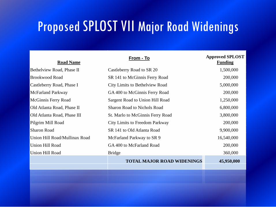
Proposed SPLOST VII Major Road Widenings
Road Name From - To
Approved SPLOST
Funding Bethelview Road, Phase II Castleberry Road to SR 20 1,500,000 Brookwood Road SR 141 to McGinnis Ferry Road 200,000 Castleberry Road, Phase I City Limits to Bethelview Road 5,000,000 McFarland Parkway GA 400 to McGinnis Ferry Road 200,000 McGinnis Ferry Road Sargent Road to Union Hill Road 1,250,000 Old Atlanta Road, Phase II Sharon Road to Nichols Road 6,800,000 Old Atlanta Road, Phase III St. Marlo to McGinnis Ferry Road 3,800,000 Pilgrim Mill Road City Limits to Freedom Parkway 200,000 Sharon Road SR 141 to Old Atlanta Road 9,900,000 Union Hill Road/Mullinax Road McFarland Parkway to SR 9 16,540,000 Union Hill Road GA 400 to McFarland Road 200,000 Union Hill Road Bridge 360,000
TOTAL MAJOR ROAD WIDENINGS 45,950,000

SPLOST VII – Old Atlanta Road, Phase II
Project: Old Atlanta Road, Phase II Sharon Road to Nichols Road Length of Project: .91 miles Project Description: 4 lanes, median

SPLOST VII – Old Atlanta Road, Phase III
Project Name: Old Atlanta Road, Phase III McGinnis Ferry Rd to Country Club Pkway Length of Project: .78 miles Project Description: 4 lanes, median

SPLOST VII – Sharon Road Widening
Project Name: Sharon Road Widening SR 141 to Old Atlanta Road Project Length: 1.21 miles Project Description: 4 lanes, median

SPLOST VII – Union Hill Road/Mullinax Road
Project Name: Union Hill Rd/Mullinax Rd McFarland Parkway to SR 9 Project Length: 2.54 miles Project Description: 4 lanes, median

SPLOST VII – McGinnis Ferry Road Widening
Project Name: McGinnis Ferry Road Widening Sargent Road to Union Hill Road Project Length: 4.58 miles Project Description: 4 Lanes, median

McGinnis Ferry Road Widening Concept Plan
Project Name: McGinnis Ferry Road Widening Length: 4.44 miles Est. Engineering-R/W Costs - $ 8,500,000 Est. Construction Cost - $27,500,000 Total Estimated Costs - $36,000,000

SPLOST VII – Bike/Pedestrian Sidewalks
Project Name: Bike/Pedestrian Sidewalks • Nichols Road – Old Atlanta Rd to Nichols Drive • Nichols Drive – Nichols Rd to James Burgess • Majors Road – Post Rd to Big Creek Greenway • Caney Road – Brookwood Rd to Old Alpharetta Rd • Old Alpharetta Rd – Caney Rd to SR 141 • Majors Rd – SR 141 to Ronald Reagan Blvd

SPLOST VII – Intersections
Project Name: Intersection Projects • John Burruss Rd at Karr Rd • Bannister Rd at Elmo Rd • Wallace Tatum Rd at Burnt Bridge Rd • Wallace Tatum Rd at Wright Bridge Rd • Holbrook Rd at Burnt Bridge Rd • SR 369 at SR 9 • Settingdown Rd at Martin Rd • SR 20 at Woodland Hill Drive


McGINNIS FERRY ROAD INTERCHANGE
Project Name: McGinnis Ferry Road Interchange Est. Engineering-R/W Costs - $15,752,557 Est. Construction Costs - $23,527,962 Total Project Costs - $39,260,519
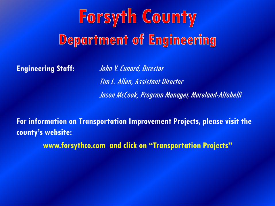
Engineering Staff: John V. Cunard, Director Tim L. Allen, Assistant Director Jason McCook, Program Manager, Moreland-Altobelli For information on Transportation Improvement Projects, please visit the county’s website:
www.forsythco.com and click on “Transportation Projects”


