w13b - ca.gov
TRANSCRIPT
California Coastal Commission June 2007 Meeting in Santa Rosa
Staff: D.Carl Approved by: MCO LCPA 1-07 (Measure A) stfrpt addendum 6.13.2007.doc
STATE OF CALIFORNIA – THE RESOURCES AGENCY ARNOLD SCHWARZENEGGER, Governor
CALIFORNIA COASTAL COMMISSION CENTRAL COAST DISTRICT OFFICE 725 FRONT STREET, SUITE 300 SANTA CRUZ, CA 95060 (831) 427-4863
Prepared June 12, 2007 (for June 13, 2007 hearing)
To: Commissioners and Interested Persons
From: Charles Lester, Deputy Director Dan Carl, Coastal Planner
Subject: STAFF REPORT ADDENDUM for W13b Monterey County Local Coastal Program Major Amendment Number 1-07 (Measure A)
Since completion of the June 1, 2007 staff report for the proposed Measure A Local Coastal Program (LCP) amendment, staff has received comments from the Pebble Beach Company and additional ex parte communication disclosures from Commissioners, and has identified various errata in the staff report. This addendum provides:
1. A response to the Pebble Beach Company’s (through their representatives) arguments regarding the Coastal Act’s conflict resolution provisions in a letter from the Company’s representatives dated June 7, 2007. This response takes the form of new findings to be added to the staff report dated prepared June 1, 2007. See Part 1 beginning on page 2 below.
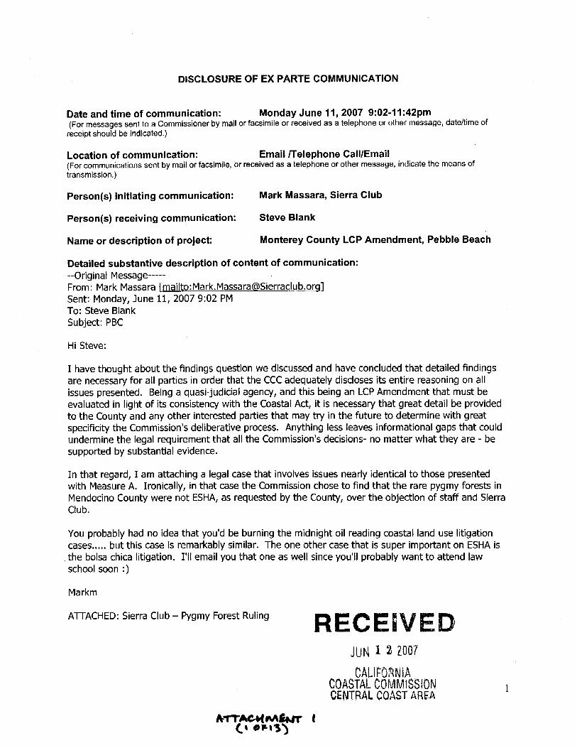
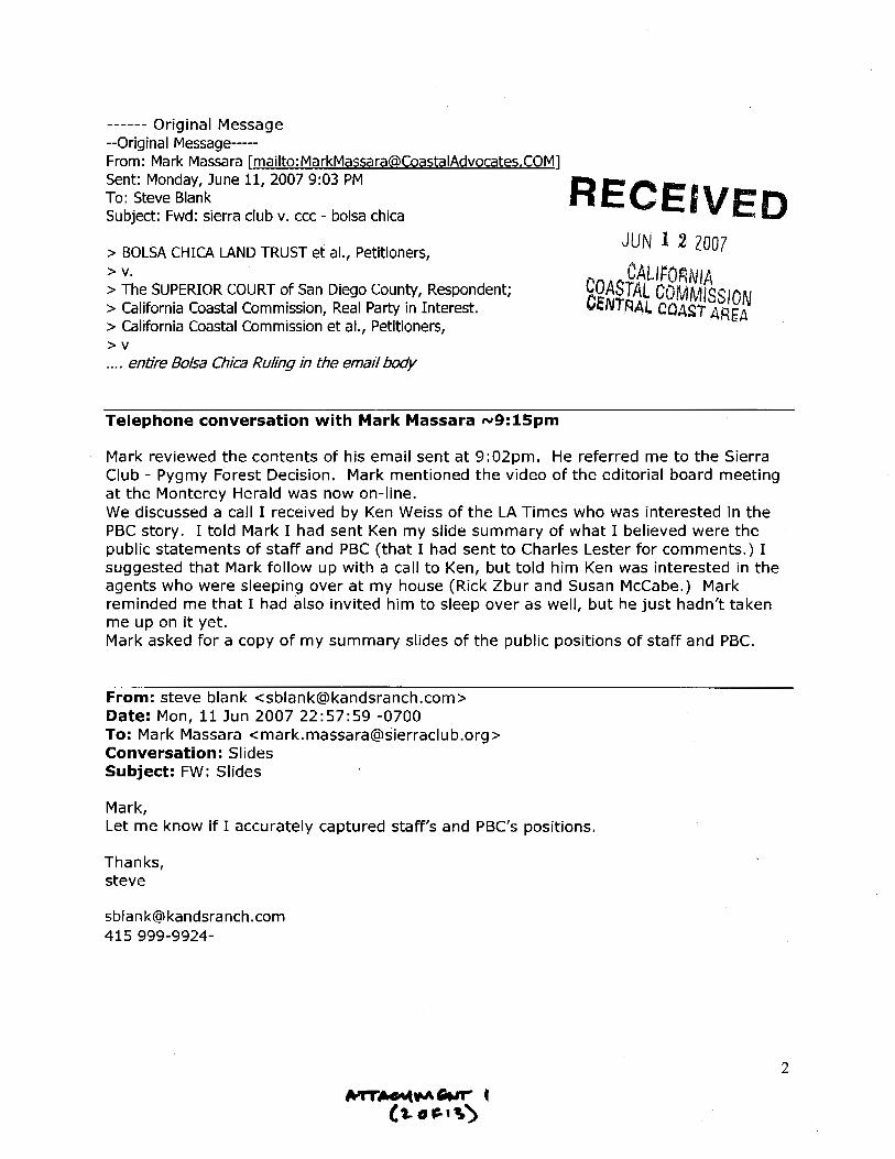
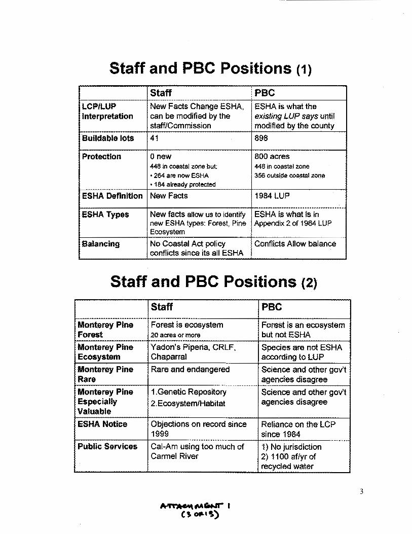
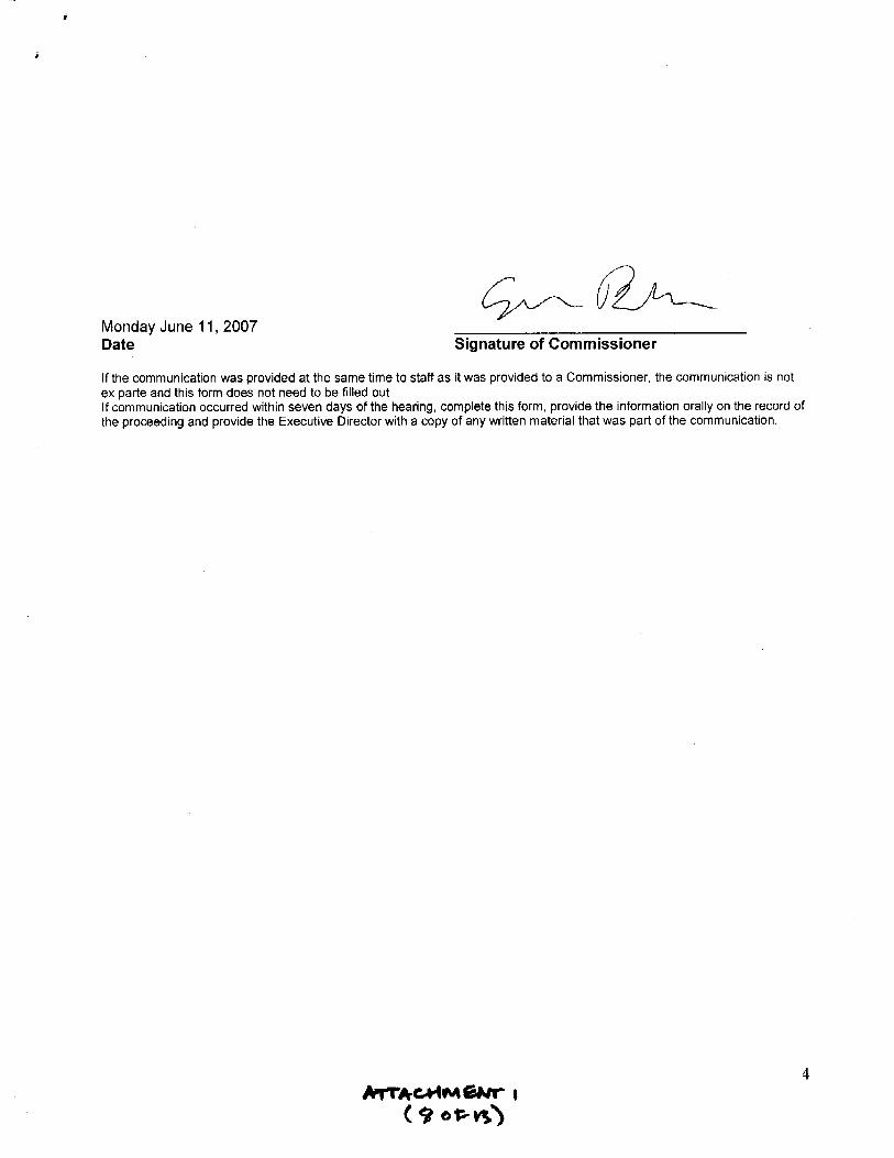
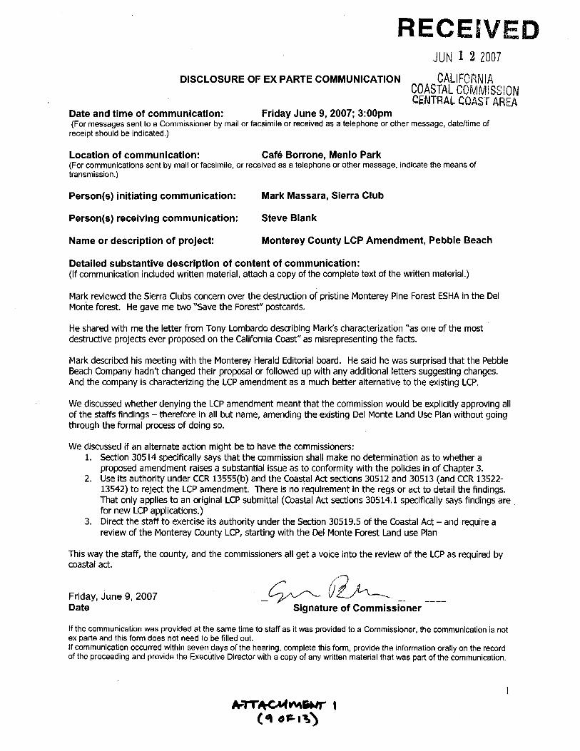
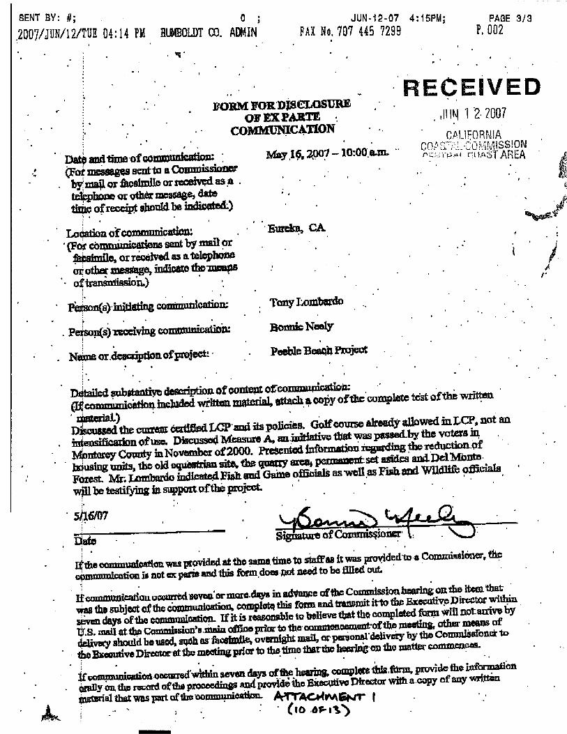
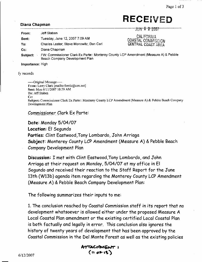
2. Coastal Commissioner ex parte disclosure forms received since the staff report was distributed June 1, 2007. These ex parte forms are attached to this addendum as attachment 1, and they are hereby added to the staff report dated prepared June 1, 2007 as part of Exhibit 15 (“Coastal Commissioner Ex Parte Communications”).
3. Clarifications and changes to the staff report (see Part 2 beginning on page 12 below).
In addition, staff notes that in the time since the staff report was distributed, the Commission has received additional correspondence from the Pebble Beach Company and their representatives, as well as additional correspondence from other interested parties. This correspondence has been added to correspondence previously received related to the Measure A amendment and/or the Pebble Beach Company’s project, and will be available for review at the hearing. Correspondence includes: (1) correspondence received from January 1, 2004 to June 12, 2006; (2) correspondence received from June 13, 2006 to June 12, 2007; (3) Pebble Beach Company correspondence; and (4) Sierra Club comments dated June 14, 2006. In terms of the Sierra Club comments, there are also two copies of an additional binder that has hard copy print outs representing the documents provided on the CD that came with the comments. In addition, more recent correspondence dating from March 2007 (when the Commission last met in Monterey) is provided separately in the District Director’s Report.
W13b
June 13, 2007 Staff Report Addendum
2 California Coastal Commission Central Coast District Office
Part 1 – Response to Pebble Beach Company Conflict Resolution Comments
The Pebble Beach Company argues in recent correspondence that if the Commission finds that Measure A is inconsistent with Coastal Act ESHA and wetland policies it may nonetheless approve the LCP amendment under the conflict resolution provisions of Coastal Act Sections 30007.5 and 30200(b) (see letter dated June 8, 2007 in recent correspondence). In response to this argument, staff recommends that the following finding be inserted immediately following Finding “E. Conclusion - Denial” on staff report page 170.
Conflict Resolution Introduction In adopting the Coastal Act, the legislature recognized that conflicts between one or more Chapter 3 policies of the Act (30210-30265.5) may occur in evaluating the consistency of LCPs with Chapter 3. The Act thus declares that when such conflicts occur, they should be resolved in a manner that is on balance most protective of significant coastal resources. It has been suggested that the denial of Measure A because of its inconsistency with Coastal Act Sections 30240 and 30231 will result in such a conflict with other Chapter 3 policies and further, that such a conflict should be resolved in favor of approving Measure A.1
As discussed below, denial of Measure A does not result in any conflict with other Chapter 3 policies. Therefore, the conflict resolution provisions of the Coastal Act are not applicable to this case. In addition, even if there was a conflict, the approval of Measure A would not, on balance, be the most protective of significant coastal resources. This is thoroughly documented in the Environmentally Sensitive Habitat, Wetlands, and Other Biological Resources Finding which clearly establishes that Measure A would lead to significantly greater impacts to coastal resources than would implementation of the LCP without the Measure A amendment.
A. Relevant Policy The Coastal Act contemplates that the Commission may encounter irreconcilable conflicts between Chapter 3 policies in implementing the provisions of the Coastal Act, including those relevant to the review of LCP amendments. In such situations Coastal Section 30200(b) directs the Commission to resolve such conflicts using Coastal Act Section 30007.5:
(b) Where the commission…in implementing the provisions of this division identifies a conflict between the policies of this chapter [Chapter 3], Section 30007.5 shall be utilized to resolve the conflict and the resolution of such conflicts shall be supported by appropriate findings setting forth the basis for the resolution of identified policy conflicts.
Coastal Act Section 30007.5 directs that such conflicts be resolved in a manner that is on balance most protective of significant resources:
30007.5. The Legislature further finds and recognizes that conflicts may occur between one or more policies of the division. The Legislature therefore declares that in carrying out the
1 Correspondence, Lombardo and Gilles to Commissioners, June 8, 2007.
June 13, 2007 Staff Report Addendum
Monterey County LCP Amendment 1-07 3 Measure A in the Del Monte Forest
provisions of this division such conflicts be resolved in a manner which on balance is the most protective of significant coastal resources. In this context, the Legislature declares that broader policies which, for example, serve to concentrate development in close proximity to urban and employment centers may be more protective, overall, than specific wildlife habitat and other similar resource policies.
In order to use the conflict resolution mechanism of Section 30007.5, the Commission must first identify a conflict between Chapter 3 policies of the Coastal Act. If there is no conflict between policies, Section 30007.5 is not applicable. Further, the conflict must be one that inevitably arises out of an attempt to meet another Chapter 3 policy. Thus, the Commission must find that in meeting the requirements of one Chapter 3 policy, it is impossible to meet the requirements of another Chapter 3 policy. More precisely, the Commission must find that denial of an LCP amendment due to a Chapter 3 inconsistency necessarily will itself result in an inconsistency with a Chapter 3 policy.2
In the event that a conflict is encountered, the Commission may resolve it in a manner that it finds is most protective of significant coastal resources. The classic example given in the text of Section 30007.5 observes that concentrating development in urban areas (i.e. transferring development potential from more sensitive rural areas to the already developed urban area) may be, on balance, more protective, even if it results in adverse impacts to sensitive habitats that may exist in the urban area.
B. Denial of Measure A does not result in any Conflicts with Chapter 3 Policies As detailed in previous findings, Measure A is inconsistent with the ESHA and wetland protection policies of the Coastal Act. Therefore, it must be denied. However, the Pebble Beach Company’s representative (Lombardo and Gilles) argues that denial of Measure A because of these inconsistencies would result in a conflict with other policies of the Chapter 3 of the Coastal Act:
… the refusal to certify Measure A conflicts with other Coastal Act policies which define visitor serving and recreational development and greater public access as priority uses, [sic] promote the concentration of development into existing development areas resulting in the aggregation and preservation of greater areas of natural and sensitive habitats.3
More specifically, Lombardo and Gilles cite conflicts with Coastal Act Sections 30001.5, 30221, 30222, and 30250. However, as discussed below, denial of Measure A would not result in a conflict with these policies such that the Commission might invoke Section 30007.5.
Coastal Act Section 30001.5 Lombardo and Gilles argue that denial of Measure A would conflict with Coastal Act Section 30001.5. However, this policy is not a Chapter 3 policy of the Act and therefore, Section 30007.5, as applied through Section 30200(b), does not apply to this policy. However, to the extent the goals of Coastal Act
2 The applicant’s representative confuses the legal construction of Section 30007.5 that requires a policy conflict stating, for example,
that past precedents have recognized that approval of an amendment “provides an opportunity to significantly advance certain Coastal Act goals and policies” and that the Commission has used conflict resolution “where denial of the amendment would frustrate the attainment of important Coastal Act goals…” Id. Pp. 9-10. The applicant’s representative also misquotes section 30007.5 by dropping the qualifying term “significant” in the phrase, “most protective of significant coastal resources.” Id. Pp. 9, 11.
3 Id, p. 9.
June 13, 2007 Staff Report Addendum
4 California Coastal Commission Central Coast District Office
Chapter 1 are relevant to the Commission’s consideration of Measure A, it is worth observing that the denial of Measure A does not result in any conflicts with these goals.
Section 30001.5 states the basic goals of the state for the coastal zone:
30001.5. The Legislature further finds and declares that the basic goals of the state for the coastal zone are to:
(a) Protect, maintain, and, where feasible, enhance and restore the overall quality of the coastal zone environment and its natural and artificial resources.
(b) Assure orderly, balanced utilization and conservation of coastal zone resources taking into account the social and economic needs of the people of the state.
(c) Maximize public access to and along the coast and maximize public recreational opportunities in the coastal zone consistent with sound resources conservation principles and constitutionally protected rights of private property owners.
(d) Assure priority for coastal-dependent and coastal-related development over other development on the coast.
(e) Encourage state and local initiatives and cooperation in preparing procedures to implement coordinated planning and development for mutually beneficial uses, including educational uses, in the coastal zone.
Denial of Measure A to protect ESHA and wetlands is consistent with the Section 30001.5(a) goal to protect and maintain overall quality of the natural resources of the coastal zone. As detailed in Finding 1 of Part 2 of this report, approval of Measure A would potentially result in significant adverse impacts to ESHA and wetlands, by providing for intensive recreational development in identified ESHA and wetland areas. Thus, it is approval of Measure A, not denial, that results in a conflict with this stated goal. In contrast, the certified LCP requires the protection of ESHA. As discussed previously, of the 448 acres of mitigation being offered by the Pebble Beach Company in the coastal zone, 184 acres or 41% of the total area is already protected by resource conservation zoning in the LCP. The remaining 264 acres are lands currently designated for residential land uses that would be largely protected by application of the ESHA policies of the LCP to any future residential development proposals. Moreover, denial of Measure A would not prevent the redesignation of other sensitive areas in Del Monte Forest to resource conservation.
Second, denial of Measure A does not conflict with the Section 30001.5(b) goal. There is no doubt that protecting the ESHA and wetland resources of the various areas affected by the Measure A LCP amendment will assure the conservation of coastal zone resources. In addition, the evaluation of Measure A in Finding 1 of Part 2 above identifies numerous and significant opportunities for development in the Del Monte Forest that could probably be found consistent with the Coastal Act absent their association with the parts of Measure A that are not approvable. These include the potential removal of the visitor-serving unit caps at Spanish Bay and Pebble Beach Lodge, and significant acreages not identified as ESHA that are suitable for development, including the old Spyglass quarry fill site and the Pebble Beach corporation yard area. Assuming that it was otherwise consistent with the
June 13, 2007 Staff Report Addendum
Monterey County LCP Amendment 1-07 5 Measure A in the Del Monte Forest
LCP, additional development at Spanish Bay and Pebble Beach alone would constitute substantial developments in the coastal zone of Del Monte Forest – clearly a case of orderly and balanced use and conservation of coastal zone resources. Denial of Measure A does not in any way prevent such land uses from being pursued in a future LCP amendment that does not also include fundamental inconsistencies with the Coastal Act. Finally, it is not clear in what manner the “social and economic needs of the people of the state” would be adversely impacted by the denial of Measure A. Generally speaking, the proposed recreational and residential land uses of Measure A would benefit a relatively narrow economic and social demographic of Californians that either can afford the higher residential market values of the Del Monte Forest, or that are equestrians or golfers. There does not appear to be an overriding social or economic need in California that would necessitate the provision of a ninth golf course in the Del Monte Forest in an identified ESHA.
Denial of Measure A also does not conflict with Section 30001.5(c). First, the public recreational developments that would be provided for by Measure A (a golf course, driving range, and equestrian center) would not provide public access to and along the coast. Each of them would be located at inland, not shoreline locations (see Figure 7). Second, to the extent that these land uses might be considered public recreational opportunities in the coastal zone, they cannot be provided as envisioned by Measure A “consistent with sound resources conservation principles.” Rather, as contemplated by Measure A, their provision would actually result in significant adverse impacts to ESHA and wetlands, not their sound conservation.
Nor would denial of Measure A conflict with the provision of maximum public access generally. First, as acknowledged by the Pebble Beach Company, the Del Monte Forest already provides significant opportunities for coastal recreation and visitation.4 Denial of Measure A would not adversely affect the provision of these opportunities or conflict with the Coastal Act goal to maximize such opportunities. This is because denial of Measure A does not preclude the future provision of maximum public access, that would not adversely affect ESHA, including such public access as low-intensity nature trails, improved trail connections and other lower-cost visitor-serving opportunities. As discussed in the staff’s preliminary Periodic Review of the Monterey County LCP, the Del Monte Forest LUP would benefit from an LCP amendment that addressed such needs, such as improved accommodation of the California Coastal Trail.5 In addition, to the extent that Measure A would provide increased opportunities for public recreation, for the most part they would not be lower cost opportunities for the general public.
Fourth, denial of Measure A also does not conflict with Section 30001.5(d). This goal speaks to assuring priority for coastal-dependent and coastal related development over other development on the coast. The intensive recreational developments contemplated by Measure A are not coastal-dependent.6 Nor are any other coastal-dependent uses contemplated by Measure A. And while the Del Monte Forest LUP describes the existing golf courses in the forest as “coastal-related”, it is not clear in what sense a new golf course, driving range, or equestrian center should be considered coastal-related under the Coastal
4 Correspondence, Lombardo and Gilles to Commissioners, June 8, 2007. 5 Draft Findings of the Monterey County Local Coastal Program Periodic Review, California Coastal Commission, December, 2003. 6 Coastal Act Section 30101 defines coastal dependent development or use as: any development or use which requires a site on, or
adjacent to, the sea to be able to function at all.
June 13, 2007 Staff Report Addendum
6 California Coastal Commission Central Coast District Office
Act, which is the standard of review for the Measure A LUP amendments.7 None of them meet the Coastal Act definition of coastal-related development.8 More fundamentally, this goal of the Coastal Act should not be misunderstood to provide priority of certain land uses over others at the expense of ESHA and wetlands. Rather, the intent of the Coastal Act is, all things being equal, to prioritize coastal-dependent and coastal-related development when such development can be accommodated consistent with other policies. This intent is well stated, in fact, in the DMF LUP itself, which speaks directly to the first four goals of Section 30001.5 in relation to the protection of natural resources:
Four basic goals of the California Coastal Act establish direction for land use planning proposals for the Del Monte Forest Area. They are: 1) Protect, maintain, and, where feasible, enhance and restore the overall quality of the Coastal Zone environment and its natural and man-made resources. 2) Assure orderly, balanced utilization and conservation of Coastal Zone resources, taking into account the social and economic needs of the people of the state. 3) Maximize public access to and along the coast and maximize public recreation opportunities in the Coastal Zone consistent with sound resource conservation principles and constitutionally protected rights of private property owners. 4) Assure priority for coastal-dependent and coastal- related development over other development on the coast.
In applying these goals, retention of the Del Monte Forest Areas unique natural character is paramount. The Del Monte Forest Area contains rich environmental resources. The long-term protection of these resources inevitably requires a cautious and thoughtful approach to planning decisions. The natural environment and its resources vary widely in their sensitivity to development. Environmentally sensitive areas such as the locations of rare and endangered species, wetlands, and riparian habitats need to be protected. Other areas, where potential constraints can be mitigated through careful site planning and development controls can be allowed to have appropriate levels of development.9[emphasis added]
Thus, denial of Measure A does not prevent the prioritization of and development of appropriate coastal-dependent and coastal-related land uses over residential uses in areas where new development can be accommodated consistent with other resource protection policies of the Coastal Act and the LCP. For example, redesignating the former Spyglass Quarry fill site from Residential to a higher priority use, such as visitor-serving commercial, or to open space forest to allow for public use and enjoyment of the natural resources of the surrounding coastal habitats would better meet the goals of the Coastal Act and is not prevented by the denial of Measure A.10
Finally, denial of Measure A does not conflict with Section 30001.5(e). On the contrary, denial of
7 Text of the DMF LUP observes: “The Del Monte Forest coastal area is also known for its variety of passive and active coastal-related
recreational opportunities available to visitors and residents. The Lodge at Pebble Beach, portions of 17-Mile Drive (and turnouts), and portions of several golf courses are currently considered coastal related uses. It is therefore necessary that priority be given to these coastal-related developments, as well as to similar uses which may be feasible at remaining undeveloped coastline locations. Other development should be located and planned to minimize conflicts with coastal-related uses in these locations as well as to avoid natural hazards which cannot be mitigated through design.” DMF LUP, pp. 38-39.
8 Section 30101.3 defines “Coastal-related development" as any use that is dependent on a coastal-dependent development or use. 9 DMF LUP, p. 34. 10 See discussion of Area 1 and 5 for more detail. It is not immediately clear what other coastal-dependent or coastal-related land uses
might be appropriate for this site.
June 13, 2007 Staff Report Addendum
Monterey County LCP Amendment 1-07 7 Measure A in the Del Monte Forest
Measure A to protect ESHA and wetlands would provide a foundation for new coordinated planning and development for land uses that are consistent with the Coastal Act. In particular, denial of Measure A does not prevent the planning and development of additional interpretive and educational facilities in the Del Monte Forest.
In conclusion, the Commission may not use Section 30007.5 to reconcile any conflicts with Coastal Act Section 30001.5 caused by denial of Measure A because Section 30001.5 is not a Chapter 3 policy. But even if it were, denial of Measure A to protect ESHA does create any conflicts with the basic goals of the Coastal Act. Rather, denial of the LCP amendment is consistent with, and would further these goals.
Coastal Act Section 30221 Lombardo and Gilles argue that denial of Measure A would conflict with Coastal Act Section 30221. However, the Commission cannot find any such conflict. Coastal Act Section 30221 states:
30221. Oceanfront land suitable for recreational use shall be protected for recreational use and development unless present and foreseeable future demand for public or commercial recreational activities that could be accommodated on the property is already adequately provided for in the area.
On its face this Chapter 3 policy concerns the protection of “oceanfront land” for recreational use and development. None of the areas proposed for intensive recreational use under Measure A constitute “oceanfront land.” In fact, with perhaps the exception of the seaward tip of LUP planning unit L (proposed for conservation), Measure A does not propose to change land use designations for any oceanfront lands in the Del Monte Forest (see Figure 5). In short, the denial of Measure A to protect ESHA and wetlands cannot, by the plain language of the Act, create a conflict with Coastal Act Section 30221.
Moreover, even if one could interpret Measure A as proposing to provide for recreational land uses on oceanfront land, Section 30221 must be understood within the broader context of Chapter 3, which requires that new development be consistent with other resource protection policies, regardless of the nature of the proposed use. Simply proposing recreational uses along the shoreline does not, for example, obviate the need to protect ESHA (30240), coastal views (30251), or sensitive cultural resources (30244). So, similar to the Coastal Act goal in Section 30001.5(d), this policy cannot be interpreted to allow impacts to ESHA or wetlands simply because a higher priority use, such as public recreation, is proposed. Therefore, the denial of Measure A, and thus the maintenance of existing residential land use designations, does not result in a conflict with Section 30221. As discussed above, this context for understanding Section 30221 also is supported by text of the DMF LUP itself, which recognizes the paramount importance of natural resources and the need to plan appropriately for development, whatever its relative priority, to avoid impacts to such resources.
Coastal Act Section 30222 Lombardo and Gilles argue that denial of Measure A would conflict with Coastal Act Section 30222. This section states:
30222. The use of private lands suitable for visitor-serving commercial recreational facilities designed to enhance public opportunities for coastal recreation shall have priority over private
June 13, 2007 Staff Report Addendum
8 California Coastal Commission Central Coast District Office
residential, general industrial, or general commercial development, but not over agriculture or coastal-dependent industry.
This section of the Coastal Act establishes a priority for recreational facilities designed to enhance “public opportunities for coastal recreation” on private lands in the coastal zone. Similar to Section 30221, denial of Measure A to protect ESHA and wetlands would not result in a conflict with this section. First, it cannot reasonably be asserted that the intensive recreational land uses contemplated by Measure A constitute opportunities for “coastal recreation.” The areas proposed for a golf course, driving range, and equestrian center are not on the shoreline, and the use of such facilities by the public would not afford any direct opportunity for coastal recreation, such as access to a beach. The only indirect benefit possibly would be the views of the ocean and shoreline available from the few proposed golf course holes in the vicinity of the Spyglass Quarry fill site. In distinct contrast to the Spanish Bay Golf and Pebble Beach Golf Links, which are aligned directly along on the shoreline, the contemplated facilities would be located at inland locations under Measure A.
And as observed above, none of the contemplated recreational uses meet the Coastal Act definitions of coastal-dependent or coastal-related land uses. Although the DMF LUP acknowledged in 1984 that the existing recreational facilities were “coastal-related,” it also clearly contemplated such status only for those developments or portions of existing and potential new facilities (i.e. Spanish Bay) at “coastline locations”:
The Lodge at Pebble Beach, portions of 17-Mile Drive (and turnouts), and portions of several golf courses are currently considered coastal related uses. It is therefore necessary that priority be given to these coastal-related developments, as well as to similar uses which may be feasible at remaining undeveloped coastline locations.11[emphasis added]
In short, given their inland locations and specific land use types, the proposed recreational uses are not coastal-related under the Coastal Act or the general discussion of the certified LUP.
Second, the context of interpreting Coastal Act Section 30222 is similar to that of Section 30221. Certain land uses have priority if they can otherwise be developed consistent with the resource protection policies of the Coastal Act. Again, proposing a public recreational land use does not override the protection of ESHA, wetlands, or other coastal resources. Such uses must be planned consistent with the policies that protect these resources. Moreover, as with Section 30221, denial of Measure A would not result in a conflict with the Coastal Act policy to prioritize public recreation. As discussed above, enhanced public recreation could be provided in Del Monte Forest without impacts to ESHA and wetlands. Thus, there is no policy conflict.
Coastal Act Section 30250 Lombardo and Gilles argue that denial of Measure A would conflict with Coastal Act Section 30250. This section states:
30250. (a) New residential, commercial, or industrial development, except as otherwise provided in this division, shall be located within, contiguous with, or in close proximity to, existing
11 DMF LUP, p. 38-39.

June 13, 2007 Staff Report Addendum
Monterey County LCP Amendment 1-07 9 Measure A in the Del Monte Forest
developed areas able to accommodate it or, where such areas are not able to accommodate it, in other areas with adequate public services and where it will not have significant adverse effects, either individually or cumulatively, on coastal resources. In addition, land divisions, other than leases for agricultural uses, outside existing developed areas shall be permitted only where 50 percent of the usable parcels in the area have been developed and the created parcels would be no smaller than the average size of surrounding parcels. (b) Where feasible, new hazardous industrial development shall be located away from existing developed areas. (c) Visitor-serving facilities that cannot feasibly be located in existing developed areas shall be located in existing isolated developments or at selected points of attraction for visitors.
Coastal Act Section 30250(a) states the policy to locate new development in existing developed areas with adequate public services, and where it will not have significant adverse effects, either individually or cumulatively, on coastal resources. Subsections (b) and (c) are not applicable to this analysis. With respect to subsection (a), denial of Measure A would not result in a conflict with this policy.
First, development on existing parcels, consistent with the certified LCP, would at worst concentrate development in a similar general pattern of development no less concentrated than would occur under Measure A, albeit at a much lower level of intensity, and with significantly fewer ESHA impacts, than Measure A. As shown in Figures 4 and 5, and as discussed in the specific area analyses in Finding 1 of Part 2 above, new development located and designed to meet the requirements of the LCP ESHA policies would result in development in the same general dispersed pattern throughout Del Monte Forest as is proposed under Measure A. This is because any residential development that may need to be approved (see Area discussions for detail) would likely be sited as close to existing development as possible to minimize impacts to ESHA.12 In fact, given the large expansions of intensive recreational development into currently undeveloped ESHAs that would be facilitated by Measure A, the development pattern under Measure A would be less concentrated. Thus, the development of an 18 hole course at Area 1 would be much less concentrated than would the clustering of any allowable residential development outside or on the edges of the identified ESHAs, such as immediately adjacent to the existing equestrian center. Similarly, the proposed driving range use in Area 2 would expand into the interior of a large, contiguous block of native Monterey pine forest. In contrast, development under the certified LCP could be clustered adjacent to existing developed areas in an optimum location along the perimeter of this area – a significantly more concentrated pattern of development. And with the proposed equestrian use at Sawmill Gulch under Measure A, there is no question that a more “dispersed” pattern of development would result in this area of the Del Monte Forest, as compared to the existing LCP, which designates Sawmill Gulch for Resource Conservation. In short, denial of Measure A would not result in a conflict with Coastal Act Section 30250. Rather, denial of the amendment to protect ESHA would establish a planning foundation for future LCP amendments or development proposals that could better locate and concentrate development to avoid impacts to ESHA and wetlands.
Second, and more generally, it should be observed that there is nothing inherent in the denial of Measure
12 Even if the lands in question could, theoretically, be subdivided to the maximum density identified in LUP Table A, the general pattern
of development in the DMF would be the same except, perhaps, in some of the Areas proposed for redesignation to resource conservation. To the extent one might argue that these areas would have a more concentrated pattern in the immediate vicinity under Measure A, the proposed expansion of a new equestrian center in the heart of the Huckleberry Hill Natural Habitat Area would cut the other way. Thus, the overall change in development pattern would not be significant.
June 13, 2007 Staff Report Addendum
10 California Coastal Commission Central Coast District Office
A that precludes the proposed down-zoning or other protective measures that could be argued to be more protective of sensitive resources. That is, the denial of Measure A does not result in an unavoidable conflict with Section 30250, which could be better implemented through a different LCP amendment that more appropriately concentrated development outside of ESHA.
Finally, Section 30250 requires that new development be located where it will not have adverse impacts, individually or cumulatively, on coastal resources. As analyzed in this report, the primary reason for denying the Measure A LCP amendment are the potential adverse impacts to ESHA and wetland resources from the development contemplated under Measure A. Thus, consistency with Section 30250 is best achieved through the denial of Measure A. In contrast, implementation of the existing LCP will result in significantly few direct, indirect, and cumulative impacts to coastal resources. In short, denial of Measure A does not conflict with Section 30250 but rather, supports its basic premise.
C. Approving the Measure A LCP Amendment would be Less Protective of Coastal Resources than the Certified LCP Even if a conflict between the denial of Measure A to protect ESHA and other Chapter 3 policies could be identified, approval of Measure A would not be, on balance, the most protective of significant coastal resources. As detailed in Finding 1 of Part 2 above, the approval of Measure A, and the most reasonably foreseeable development that would follow such approval, would result in substantially greater impacts to significant coastal resources than would denial of Measure A. As documented in this report, most of the areas affected by the proposed land use designations of Measure A contain significant ESHAs. Under Measure A, it is reasonable to expect significant impacts to these resources, including the loss of approximately 150 acres of native Monterey pine forest, 21% of the world’s known population of Yadon’s piperia, and at least 45 acres of central maritime chaparral (see Finding 1, Part 2 supra). Given that the lands affected by Measure A are not currently subdivided, and such potential subdivision is not an entitlement, application of the existing LCP to development on existing legal lots of record, including any possible subdivision of land outside of ESHA, would result in significantly fewer ESHA impacts.
Nor does Measure A and the mitigation proposed as part of the associated Pebble Beach Company development plan compensate for the potential impacts of development contemplated by Measure A. As discussed previously, the Commission does not have the ability to accept mitigation in order to rationalize avoidable impacts to identified ESHA. This proposition has been upheld in California’s courts.13 Moreover, in terms of the balance that would be “most protective” of significant coastal resources, of the 448 acres of land in the coastal zone proposed for protection under the Measure A project, 184 of them (41%) are already designated for resource conservation and thus protected by the LCP. In addition, the remaining 264 acres of land that would be “down-zoned” under Measure A would be substantially protected by the ESHA policies of the LCP if development were proposed today under the certified LCP (including by the Resource Constraint Area (B-8) overlay).14 In terms of specific areas, under Measure A, one of the largest remaining undeveloped areas of Monterey pine forest in Del Monte Forest would be developed with intensive recreational uses (a golf course). Under the certified LCP, this area would be mostly if not completely protected. Overall, the impacts to coastal resources under Measure A, as mitigated, would be greater than under the certified LCP. With respect to the
13 Bolsa Chica, Id. 14 And 51 acres would also be “upzoned” from resource conservation to development categories.
June 13, 2007 Staff Report Addendum
Monterey County LCP Amendment 1-07 11 Measure A in the Del Monte Forest
proposed mitigation outside of the coastal zone, this report previously observed that allowing impacts to resources in the coastal zone in exchange for the protection of resources outside of the coastal zone is in fundamental conflict with one of the basic premises of the Coastal Act. As the legislature has declared:
[T]he California coastal zone is a distinct and valuable natural resource of vital and enduring interest to all the people and exists as a delicately balanced ecosystem.15
If taken it to its logical end, accepting the proposed mitigation outside the coastal zone would result in the systematic loss of the coastal zone resources that the legislature has declared are a distinctly valuable natural resource.
In short, even if a conflict between one or more Chapter 3 policies could be identified as a result of the denial of Measure A, the Commission must resolve such a conflict in favor of the denial to protect ESHA and wetland resources.
Part 2 – Staff Report Clarifications and Changes
Since the staff report for the proposed Measure A LCP amendment was distributed, a number of typographical errors, ambiguities and internal inconsistencies have been discovered. Although these oversights are generally minor, staff has identified clarifications and changes to the staff report for enhanced clarity in this regard. None of the clarifications and changes alter the fundamental staff recommendation and conclusion, but serve to clarify the report for the record.
Accordingly, the staff report dated prepared June 1, 2007 is modified as shown in the table below. In the
15 Coastal Act Section 30001(a).
June 13, 2007 Staff Report Addendum
12 California Coastal Commission Central Coast District Office
table, “PP” refers to the page number, “P” refers to the paragraph within the cited page (where paragraph is in terms of any full or partial paragraphs on that page, not counting headings as paragraphs), “L” refers to the line of text within the cited paragraph (or the first line where multiple lines are involved), and “F” refers to footnotes (and by footnote number). As applicable, text in strikethrough notes text that is removed, and text in underline notes text that is to be added to the staff report. The pages, paragraphs and sentence lines correspond to the file copy of the staff report maintained in the Commission’s Central Coast District office in Santa Cruz. It is possible that the web version and/or copies printed elsewhere may slightly differ in terms of the location of the identified text within the staff report. Staff apologizes for any confusion, and is available to the extent there is any confusion in this respect.
PP P L Staff Report Change 2 4 6 Replace “LUP” with “LCP” 4 3 2 Replace “and” with “as well as” 4 7 13 “…the Measure A LCP amendment Measure A.” 6 2 4 Replace “must” with “most” 6 4 4 Replace “First” with “Most importantly” 6 4 5 Replace “land use” with “LUP” 6 4 10 “…evaluate the Land Use Plan…” 7 3 4 “…identified in the EIR…” 8 1 1 “…federally listed Threatened listed…” 8 5 3 “…reduced in habitat value overall, and subjected to increased negative edge
effects…” 8 6 2 “…native Monterey pine forest. The environmental conditions of native Monterey
pine forest have changed significantly , including in the time since the certification…”
8 6 4 “…pine pitch canker has emerged…” 9 1 3 “…Thus, there is also a…” 9 4 10 “…including what types of uses may be is appropriate for the non-ESHA areas)….”10 6 6 Add “Santa Cruz, CA 95060, Phone: 831-427-4863, E-mail: [email protected]” 13 - - Add “Exhibit 17: Site Visit Memos Regarding Central Maritime Chaparral” and
add attachment 2 to this addendum as Exhibit 17. 15 2 1 “…land use and implementation plans for 26 distinct areas encompassing over 600
acres in the Del Monte Forest segment of its Local Coastal Program (LCP) for 26 distinct areas encompassing over 600 acres in the Del Monte Forest LCP segment. The…”
16 2 2 “…held a hearing on March 9, 2006. The Coastal Commission was presented a preliminary analysis of Measure A at this hearing, and no…”
17 1 4 “…and Commission’s staff’s analysis…” 17 1 4 “…Subsequently, in In December 2006, …” 18 3 1 Replace “its” with “this” 18 3 2 “…setting identified in the LUP. Framed…”
June 13, 2007 Staff Report Addendum
Monterey County LCP Amendment 1-07 13 Measure A in the Del Monte Forest
PP P L Staff Report Change 18 3 11 Replace “mottled” with “mantled” 18 3 14 “…unique and valuable habitat ecosystems.” 20 - - F13: “…see Figure 23).…” 21 2 2 “…November 7, 2000 voters [sic]. This…” 22 - - F21: “…Monterey County conditions numbered 16 and 174.” 22 - - F22: “…PDP EIR, though…” 22 - - F23: “…See Figure 7 for a graphic showing the LCP amendment reference…” 23 2 10 “…see PDP project residential development (employee housing units) below…” 23 2 11 “…resource conservation and management component…” 24 2 14 “…this PDP project component includes…” 24 3 12 “…In total, the this PDP project Pebble Beach Lodge expansion component
includes…” 26 3 3 “…including Area 10 on Figure 15);…” 26 3 5 “…including all of Area 24, together with that portion of Pescadero Canyon that
would be developed residentially but omitting (Areas 15 and 16)….” 27 2 2 “…These per se inconsistencies…” 29 2 3 Add footnote at “The Spanish Bay permit” to state: “See Exhibit 6 for excerpts
from the Spanish Bay CDP.” 31 1 1 “…the first submittal Measure A submittal…” 31 3 11 “…process, through the original CDP decision process, and up to through and
including the…” 31 3 12 “…resolution (December 2006), the County…” 33 1 6 “…as Areas planning units A through Y….” 33 2 12 “…distinction between the two designations is almost exclusively primarily
locational (i.e., immediate shoreline versus inland areas). See Exhibit 7 for the LUP’s description of these land use designations.”
34 1 2 “…and the equestrian center (see pages 4 and 5 of Exhibit 7)….” 34 - - F64: “…Open Space Forest LUP land use…” 36 8 3 “…approximate 8-acre area portion…” 37 2 1 Replace “indicated” with “indicate” 37 2 2 Replace “zone” with “zoned” 37 3 5 “…could not be built under the existing LCP irrespective of resource constraints
because it conflicts with the Open Space Forest (RC) land use designation applicable to a portion of planning unit O, and the Resource Constraint Area (B-8) designation would not allow for it.”
37 6 2 “…see Exhibit 8 and Figure 9). The proposed driving range pending approval by the County could not be built under the existing LCP irrespective of resource constraints because the Resource Constraint Area (B-8) designation would not allow for it.”
38 2 4 “…absent the proposed LCP amendments irrespective of resource constraints because it conflicts with the Open Space Forest (RC) land use designation applicable to Sawmill Gulch.” Add footnote at end of sentence: “And it also could not be built absent amendments to the Commission’s Spanish Bay CDP (see also
June 13, 2007 Staff Report Addendum
14 California Coastal Commission Central Coast District Office
PP P L Staff Report Change previous Spanish Bay CDP findings).”
38 3 1 Replace “of” with “making up” 38 - - F71: “There is a mapping error in the Measure A figures that was as approved…” 39 2 8 Add footnote at end of paragraph: “Id; LUP Policy 116 previously cited.” 39 3 4 “…absent the proposed LCP amendments irrespective of resource constraints
because it is not allowed under the current land use and zoning designations, including the Resource Constraint Area (B-8) designation.”
39 5 7 “…without the proposed LCP amendment because they exceed the current LCP unit caps that apply to Spanish Bay and the Pebble Beach Lodge.” Add footnote at end of sentence: “And for Spanish Bay, they also exceed the unit counts specified in CDP 3-84-226, and thus they also could not be built absent amendments to the Commission’s Spanish Bay CDP (see also previous Spanish Bay CDP findings).”
40 3 7 Add footnote at end of sentence: “The subdivision is not allowed by the existing Resource Constraint Area (B-8) designation and could not proceed absent the proposed LCP amendment.”
40 - - F78: “…include additional development areas that may be needed for access to the building envelope area as well as and other ancillary…”
41 1 11 “…the proposed LCP amendment irrespective of resource constraints….” 41 2 12 “…the proposed LCP amendment irrespective of resource constraints….” 41 - - F83: “Id; same reasons as for Area 12 (planning unit F2).” 41 - - F84: “…commonly referred to as planning units I1 (for the northern two areas – see
Area 22 description) and I2.” 42 1 3 “…the proposed LCP amendment irrespective of resource constraints….” 42 2 11 “…the proposed LCP amendment irrespective of resource constraints….” 42 3 7 “…overlay where it applies. The proposed…” 42 3 13 “…the proposed LCP amendment irrespective of resource constraints….” 42 - - F85: “Id; same reasons as for Areas 12 and 13.” 42 - - F86: “Id; the Resource Constraint Area (B-8) does not allow for subdivision. In
the…” 42 - - F87: “Id; same reasons as for Area 15.” 43 2 4 Add footnote: “Id; same reasons as for Areas 12, 13, and 14 (and Areas 15 and 16,
with distinction at those areas being that they are not part of a legal lot acknowledged by the County).”
43 3 2 “…southern base of the Huckleberry Hill Natural…” 43 4 1 “The proposed amendment would also add text to the LUP’s text relative to the
LUP’s Huckleberry Hill planning area to make the text changes applicable to employee housing previously noted above.”
43 5 7 Add footnote at end of text that reads “…corporation yard commercial area.” Footnote to state: “That is, to the extent such units could be allowed within the Commercial land use and zoning designations.”
44 2 1 Replace “of” with “in” 44 5 1 Replace “of” with “making up” 46 5 7 Add footnote at end of text that reads “…and its maximum unit limitations).”
June 13, 2007 Staff Report Addendum
Monterey County LCP Amendment 1-07 15 Measure A in the Del Monte Forest
PP P L Staff Report Change Footnote to state: “Measure A also revises Table 22 of the Monterey County General Plan (“Suitable Sites for Low and Moderate Income Housing Development”) to reduce the number of potential units described in the table for moderate and above moderate income for Pebble Beach. This component of Measure A (see Exhibit 3) does not affect the LCP, and is not part of the proposed LCP amendment.”
47 2 3 “…51 acres are designated for resource conservation protection,…” 47 2 4 “…resource conservation protection (and…” 48 - - F96: “…all the areas directly affected by Measure A…” 48 F98: “…shows this area to be 29 acres.” 49 - - F100: “…application and review. The plan ultimately adopted…” 49 - - F102: “…specific analysis of various potential resource constraints. In addition,
subdivision is a conditional, as opposed to a principally permitted, use on residentially designated properties in the Del Monte Forest.”
50 2 7 “…denial of such a project based on this reason on a single…” 51 2 9 Replace “primarily” with “partially” 52 2 2 “…to residential development, but…” 52 3 15 “…a conditional use in residentially designated DMF areas also would not 53 - - Add footnote to “B. Development Expected Under the Amended LCP” heading:
“For more detail and specific descriptions regarding development expected under the amended LCP relative to each of the 26 areas, see the ESHA findings that follow.”
53 2 4 “…the amendment could would be expected to result…” 53 2 5 Add paragraph return starting with sentence “First, …” and change as follows:
“First, in terms of residential development, and depending on the conclusions…” 53 - - F117: “…or the intent of adding these IP sections., In fact, with respect to the IP
amendment that added golf courses as conditional uses in the MDR and LDR zoning districts (LCP amendment 1-95), the County initially only identified golf courses for the LDR zone, and it was only after Commission staff suggested that these provisions be deleted (as inconsistent with the LUP) that the Pebble Beach Company requested that golf courses be added as conditional uses in both districts and that these changes which were not initially proposed by the County in its LCP amendment submittal but rather, were adopted by the Commission as modifications at the request of the Pebble Beach Company.
53 - - F118: “…before assigning a unit count to them that would be inappropriate.” 53 - - F119: “…development of eight buildings in the corporation yard area.” 54 2 1 “Second, with respect to hotel units and related development, Measure A also 54 5 1 “Finally, and perhaps most importantly, with respect to recreational uses, the 54 5 2 “…uses in Areas 1 and…” 54 5 8 Add paragraph return starting with sentence “In short, …” 54 5 12 “…under the certified LCP. In this respect, the Pebble Beach Company’s PDP
projects are the reasonably foreseeable specific outcome of the proposed Measure A LCP amendment, and these PDP projects represent a significant level of
June 13, 2007 Staff Report Addendum
16 California Coastal Commission Central Coast District Office
PP P L Staff Report Change development for the directly affected land that would result in significant adverse coastal resource impacts (see also more specific description in the individual LCP amendment reference area analyses that follow). This concern…”
54 5 13 “…under the LCP amendment…” 55 2 3 “…for the PDP to date (i.e., easements over and resource management of this area),
356 acres…” 55 2 5 “…have direct authority over these lands and/or lands surrounding them, and thus” 55 2 10 Underline the word “in” 55 3 7 “…current land use designation…” 57 5 3 Replace “approval” with “approve” 60 1 2 “…by the California Department of Fish and Game…” 61 3 1 Delete 30233(a)(3) and renumber (a)(4) through (a)(8) as (a)(3) through (a)(7). 66 5 2 … LUP Appendix A and Figure 2 are not the standard of review and are have not
legally controlling relevance in that Coastal Act consistency analysis…” 67 3 8 “…concerning ESHA identification, in an effort to protect ESHA, and not to limit
the application of Coastal Act Section 30240… 67 3 10 Replace “known” with “determined” 67 6 2 “…Part One of the Title…” 69 6 4 “…what habitat areas can be protected as ESHA. In practice, given that the easily
disturbed or degraded criterion is, unfortunately, fairly readily met in most ESHA determination cases, the difference is fairly small. That said, the omission of this criterion means that the LUP’s general construct it should be considered at the least more expansive than the Coastal Act definition. LCP policies…”
70 2 6 Replace “known” with “determined” 70 2 10 “...that represents a non-exhaustive subset of a…” 70 3 6 “…They area not…” 74 1 2 Add footnote after text that reads “(such as the California red legged frog)” as
follows: “PDP EIR pages ES-17, 3.3-51, and 3.3-52, and mitigation measure BIO-D5-1.”
74 3 14 Add footnote after text that reads “…resources on the ground.” Footnote to state: “ESHA is required to be determined based on substantial evidence in the record, and specifically in terms of resources as they exist on the ground today as those resources are understood based on current assessment and evaluation, current conditions, and current understandings (see, for example, Sierra Club v. California Coastal Commission (1993) 12 Cal.App.4th 602, regarding pygmy forests in Mendocino County).
75 5 2 “…involving sensitive habitats that than would be…” 75 6 9 “…including designing the subdivision to avoid this habitat and to buffer the
habitat it with…” 76 4 2 “…the Coastal Act alone. LUP Appendix A is not the standard of review, and is has
not controlling relevance in …” 76 5 1 Replace “consistency” with “conformity” 76 5 3 Replace “examples” with “a non-exhaustive list”
June 13, 2007 Staff Report Addendum
Monterey County LCP Amendment 1-07 17 Measure A in the Del Monte Forest
PP P L Staff Report Change 80 2 9 “…that significant stands of native Monterey pine forest is are ESHA.” 82 4 6 “and the LUP (and the LCP).…” 82 - - F166: “…Cedros Islands off of Baja), the R-E-D…” 82 - - F168: “…Pine Forest Policy (March 1995); see Exhibit 11. 83 1 10 “…wildlife mortality. Human activities can also spread pathogens, such as pitch
canker (see also below) which can be spread by contaminated tree cutting tools as well as transport and/or use of infected materials (e.g., wood chips). In addition,…”
83 2 1 “…and development, significant stands of native Monterey pine forest meets the definition…”
83 - - F172: “…a finding more clearly perhaps most explicitly established…that CNPS List 1B species and their habitats be considered ESHA in DMF.
84 2 6 “…potential effects of adding a foreign species…” 86 - - F183: “…List (January 2006). See also Exhibit 10 for further explanation of
CNDDB codes.” 87 5 3 “…the growth of roots and leaf buds, and an unknown proportion…” 88 1 6 Add footnote after text that reads “…130,000 individuals” that states: “Note that
the 130,000 individuals estimated is for the DMF only. Rangewide (i.e., both in and out of the DMF), the most recent estimate of the overall Yadon’s piperia population is 172,513 individual plants (PDP EIR Table P2-2).
88 1 6 Replace “9,000” with “8,000” 88 - - F190: “Based on 2005 estimates of rates of production of flower spikes (17%),
proportion of spikes grazed (62%), avoidance of herbivory (38%), and proportion of grazed plants spikes that produced seed (11%), and loss of spikes to disease (7%); in McGraw et al. 2006. If these estimated rates of production were applied to the overall population estimate of 172,513, about 11,000 plants would be estimated to have flowered and produced seed.”
90 - - F207: Delete footnote 207 and references to it. 91 1 6 “…reduction on of habitat buffers…” 91 1 8 “…its habitat, including any identified dispersal corridors,…” 92 1 2 Replace “eight” with “seven” 92 3 1 “..the LCP amendment area, wetlands…” 93 3 7 Add footnote after text that reads “distributed.” as follows: “McMinn, H. E. 1942.
Ceanothus vol. II: a systematic study of the genus Ceanothus. Santa Barbara Botanical Garden, Santa Barbara, Calif. as cited in: N.J. Ritchie and D.D. Myrold. 1999. Geographic distribution and genetic diversity of Ceanothus-infective Frankia strains. Applied and Environmental Microbiology 65:1378-1383. The more recent Jepsen Manual lists 45 species of which 31 are endemic to California.”
93 - - F213: “Both the North Monterey County LCP and the Big Sur segments of the Monterey County LCP identify maritime chaparral as…”
93 - - F214: “…as a proxy in this report for identifying areas of central maritime chaparral… large areas of shaggy-barked manzanita not identified by the PDP EIR – see Exhibit 17),…”
94 1 11 “…In summary, areas of native Monterey pine forest may meets the definition of
June 13, 2007 Staff Report Addendum
18 California Coastal Commission Central Coast District Office
PP P L Staff Report Change ESHA under the Coastal Act and LCP for three reasons: the habitat is significant areas of relatively undisturbed Monterey pine forest are rare, it is such areas are especially valuable for its their special nature as areas that contribute significantly to the genetic repository conservation of the species, and it is many areas of Monterey pine forest are especially valuable for its their ecosystem role of providing habitat for other rare species and other rare biological communities.”
94 2 6 “…or aren’t part of a significant native forest area. Such cases…” 96 2 6 “…the nearby unoccupied forest areas also probably constitute…” 96 3 5 “…documented to occur. Currently, or where scientific studies (e.g., McGraw et
al.223) demonstrate the presence of are underway to determine the habitat elements that are necessary to support the species.” Add footnote: “It is possible in the future that piperia habitat might be further demonstrated by identifying the presence of documented constituent habitat elements, but that methodology has not been explicitly applied to the LCP amendment/PDP project area; at least partly because the County did not evaluate this area at the level of detail of such habitat elements.”
96 - - F221: “…native forest stand would could be considered ESHA independently for piperia in the forest area where the orchid was documented to occur given that the area of forest would be considered the area of Yadon’s piperia habitat (see also previous Yadon’s piperia findings, and see next finding below).”
98 1 3 “…Monterey pine as ESHA is are more…” 102 2 2 “…as an example of ESHA determined in 1984 or…” 103 3 16 “…that the significant stands of native Monterey pine forest is are rare and
especially valuable, and that it they meets the Coastal Act and LUP (and LCP) ESHA criteria”
103 3 18 Add footnote after text that reads “…and LUP (and LCP) ESHA criteria.” Footnote to state: “Id; Sierra Club v. California Coastal Commission (1993) regarding evaluation of pygmy forest in Mendocino.”
105 2 4 Add footnote after text that reads “The reader is directed to these preceding sections for additional information in that respect.” Footnote to state: “It is noted here that the staff report figures depict data provided to the Commission by the County and the Pebble Beach Company, and that this data is presented as is, without manipulation or alteration. Any apparent errors in positional accuracy of features are shown without correction. As such, some figure elements appear shifted slightly relative to planning unit and area boundaries. These offsets can be visually distracting, but they are generally minor, and they do not significantly affect the usefulness of the figures overall for analytic and illustrative purposes.”
107 2 14 “…similar size in Area combined planning unit PQR…” 107 3 4 “…Thus, given the extent of Yadon’s piperia within the The Monterey pine forest
boundaries at Area 1 (i.e., essentially all undeveloped area that is not coastal dune), it is clear that the forest area with piperia in it is are thus considered to be the Yadon’s piperia habitat boundaries as well.”
107 - - F261: “…higher elevations of planning unit N. See also Exhibit 17.” 107 - - F263: “PDP EIR Table P2-1. The area occupied by Piperia was based on one of
June 13, 2007 Staff Report Addendum
Monterey County LCP Amendment 1-07 19 Measure A in the Del Monte Forest
PP P L Staff Report Change several possible methods of estimating habitat boundaries. In this case, a 50-foot radius was drawn around each Piperia occurrence and the area summed. This results in a smaller estimate of habitat area than other common methods, such as connecting occurrence locations to create a maximum convex polygon.”
108 - - F265: “Also significant occurrences of shaggy-barked manzanita can also generally be used as a proxy for central maritime chaparral. The…”
108 - - F266: “…but this difference has not to date been quantified. Given the small area relative to the County’s delineation that is located outside of Area 1 (see, for example, Figure 8), the acreage difference would be minor.”
109 2 9 “…In conclusion and in a mapping sense, the area…” 110 1 6 Replace “eight” with “seven” 110 1 8 Replace “eight” with “seven” 111 2 3 “…that dictate a golf course management and maintenance standards for this
area…” 111 - - F281: “…This are area was not…” 112 4 6 “…not consistent with Coastal Act Sections 30240, 30231, or 30233.” 113 - - F295: “…In a PDP project takings scenario relative to the golf course site, the
Applicant is… that includes a total of 28 COC lots…ESHA issues. (If the Resource Constraint Area (B-8) overlay were removed through an LCP amendment, the development potential of the non-ESHA areas might be greater, and dependent on the underlying zoning and consistency with the policies of the LCP. However, this area is relatively small, and such potential increased density in non-ESHA areas does not alter the basic comparison premise.) That said…”
114 4 7 “…golf course or probably even a golf driving range…” 115 1 6 Add footnote after text that reads “and the coastal views.” Footnote to state: “One
of the alternatives considered for this location in the original Pebble Beach lot program applications (i.e., the PDP project’s predecessor) was a 34-room inn located in the fill area, with the surrounding dune/ESHA area, including that now proposed by the PDP project for golf holes, left alone.”
115 - - F308: “…to indicate that theses areas have the…” 118 3 1 “…as they relate to the Area 2…” 119 - - F326: “..wetland areas than have to date been delineated to date.” 120 2 6 “…understory). Clearly, restoration Restoration of such a difficult site is best
understood as a long-term…” 120 2 7 “…It has also suffered due…” 120 - - F330: “…who was also present during the May 2007 visit (see Exhibit 17). In…” 121 2 4 “…rare species such as Hooker’s manzanita and rare habitats such as central
maritime chaparral. It…” 122 3 1 “Although not entirely clear from the project County’s PDP EIR materials
presented to date (because of the way in which attempts have been made to distinguish between lack important details (e.g., delineation of forest areas that were planted and those that weren’t), as well a lack of clarity concerning and identification of potential impacts…”
June 13, 2007 Staff Report Addendum
20 California Coastal Commission Central Coast District Office
PP P L Staff Report Change 123 2 6 “…existing LCP is essentially nil…” 123 2 7 “…it is possible that some minor resource-dependent recreational use…” 124 2 1 “…as they relate to the Area 3…” 126 4 1 “…as they relate to the Area 4…” 128 2 1 “…as they relate to the Area 5…” 132 2 12 “…the proposed designation is at best the…” 133 4 1 “Area 9 is part of a larger area of native Monterey pine forest with a healthy native
understory and, as such, is rare. In addition, it Area 9 is also especially valuable because of its …”
135 3 1 “The undeveloped portion of Area 10 is part of a larger area of native Monterey pine forest with a healthy native understory and, as such, is rare. In addition, the The undeveloped portion of Area 10 is also especially valuable…”
137 4 7 “…the Commission in 1984 prior to just after certification of the LUP…” 137 - - F390: “Id; May 2007 site visit (see Exhibit 17).” 138 2 1 “Area 11 is part of a larger area of native Monterey pine forest with a healthy
native understory and, as such, is rare. In addition, it Area 11 is also especially valuable because of its …”
138 4 1 “…as reflected in the previously approved and now pending PDP project,…” 139 2 9 “…could be considered to be less protective…” 139 3 1 “…as they relate to the Area 11…” 140 1 2 “…Area 12 is accessed from Lopez Road and is opposite across the street from the
main entrance to Poppy Hills Golf Course (i.e., with the parking lot, clubhouse, etc.) and mostly”
140 3 5 “…As a result, all of Area 12 is considered central maritime chaparral and Yadon’s piperia is also present. habitat.403…”
140 - - F402: “Id; May 2007 site visit (see Exhibit 17).” 142 2 1 “…as they relate to the Area 12…” 143 1 1 “…Therefore, the understory is made up of central…” 143 3 1 “…the previously approved and now pending PDP project…” 143 - - F412: “Id; May 2007 site visit (see Exhibit 17).” 144 3 1 “…as they relate to the Area 13…” 146 - - F424: “…whether the LCP were amended or by Measure A or not…” 147 2 1 “…as they relate to the Area 14…” 147 5 11 “…includes PQR (and thus all of PQR) is…” 150 3 1 “…as they relate to the Area 15…” 150 - - F437: “…three conditional COCs that area are part of the PDP project.” 152 2 1 “…as they relate to the Area 16…” 153 4 9 “…degraded, including in Area 2.” 154 2 1 “…as they relate to the Area 17…” 154 3 4 Add footnote after text that reads “…should be designated as Open Space Forest.”
Footnote to state: “Again, more detailed analysis of the fill area west of the fire road would be appropriate (again, see Figure 22) and may factor into the
June 13, 2007 Staff Report Addendum
Monterey County LCP Amendment 1-07 21 Measure A in the Del Monte Forest
PP P L Staff Report Change appropriate designation for this small component of Area 17.”
157 - - Heading: “5. Resource Conservation Areas (Areas…” 159 1 5 Add footnote after text that reads “…and the LUP (and the LCP).” Footnote to
state: “Other than portions of the quarry reclamation replanting area previously described in relation to Area 18 that may be located partially in Area 20.”
159 3 4 “…Yadon’s piperia (and thus piperia habitat throughout). Other…” 159 5 2 “…and Yadon’s piperia habitats. Other special status species…” 160 1 1 “…and Monterey shrew and ringtail habitat in along the creeks…” 161 2 4 Replace “eight” with “seven” 162 - - Heading: “2. Area 26 (LUP Planning Unit XY)” 163 3 1 “…as they relate to the Areas 25 and 26…” 165 2 4 “…designated by virtue of Measure A (i.e., the 264 acres represents the combined
acreage of Areas 19 through 24)….” 165 2 5 “…notwithstanding their current land use designation (see previous Resource
Conservation Areas finding). This 264-acre area…” 165 2 12 “…facilitated by and are a reasonably foreseeable outcome of Measure A.” 166 4 2 “…the resource protection policies of the LUP. In other words, the proposed IP
changes cannot be found in conformity with and adequate to carry out the LUP for similar reasons as are described in the LUP amendment findings above (incorporated herein by reference). In sum,…”
168 4 1 “…proposed for a VSC IP designation (i.e., Area 5), the OR VSC district…” 177 5 3 “…other than development of a single home on existing legal lots of record…” 179 1 2 “…since it was initially submitted to the Commission in 2005…” 181 3 11 “…which is a required PDP EIR mitigation measure of the County’s approval,
should…” 182 2 16 “…understood, etc.. Again, in order…” 182 - - F531: “Monterey County, PDP, Conditions of Approval and Mitigation Monitoring
and Reporting Program, March 2005, p, III-95; and PDP FEIR, F-26 et seq.” 184 1 7 “…Carmel Bay is a State Ecological Reserve and as a State Water Quality
Protection Area, State Marine Conservation Area, and an Area of Special Biological Significance, and as a component of the Monterey Bay National Marine Sanctuary, and how…”
187 3 5 “…as described in the previous finding such is not the case. and, therefore, More broadly, the LUP amendment must be denied because it is not consistent with Coastal Act policies concerning ESHA. These inconsistencies are so pervasive that they cannot be easily remedied by “suggested modifications.” Because this is one amendment that must be denied for such reasons, this same observation applies to the whole of the Coastal Act analysis and no modifications…”
190 6 1 “As described in the Background finding above preceding Proposed LCP Amendment finding, the Del Monte Forest has significant scenic beauty, borders the Carmel Bay State Water Quality Protection Area/State Marine Conservation Area/Area of Special Biological Significance/Monterey Bay National Marine Sanctuary, and provides…”
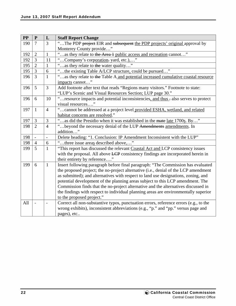
June 13, 2007 Staff Report Addendum
22 California Coastal Commission Central Coast District Office
PP P L Staff Report Change 190 7 3 “…The PDP project EIR and subsequent the PDP projects’ original approval by
Monterey County provide…” 192 2 1 “…as they relate to the Area 1 public access and recreation cannot…” 192 3 11 “…Company’s corporation. yard, etc.),…” 195 2 1 “…as they relate to the water quality…” 195 3 6 “…the existing Table A/LCP structure, could be pursued…” 196 3 1 “…as they relate to the Table A and potential increased cumulative coastal resource
impacts cannot…” 196 5 3 Add footnote after text that reads “Regions many visitors.” Footnote to state:
“LUP’s Scenic and Visual Resources Section; LUP page 30.” 196 6 10 “…resource impacts and potential inconsistencies, and thus . also serves to protect
visual resources….” 197 1 4 “…cannot be addressed at a project level provided ESHA, wetland, and related
habitat concerns are resolved.” 197 3 3 “…as did the Presidio when it was established in the mate late 1700s. By…” 198 2 4 “…beyond the necessary denial of the LUP Amendments amendments. In
addition…” 198 - - Delete heading: “1. Conclusion: IP Amendment Inconsistent with the LUP” 198 4 6 “…three issue areas described above,…” 199 5 1 “This report has discussed the relevant Coastal Act and LCP consistency issues
with the proposal. All above LCP consistency findings are incorporated herein in their entirety by reference….”
199 6 1 Insert following paragraph before final paragraph: “The Commission has evaluated the proposed project; the no-project alternative (i.e., denial of the LCP amendment as submitted); and alternatives with respect to land use designations, zoning, and potential development of the planning areas subject to this LCP amendment. The Commission finds that the no-project alternative and the alternatives discussed in the findings with respect to individual planning areas are environmentally superior to the proposed project.”
All - - Correct all non-substantive typos, punctuation errors, reference errors (e.g., to the wrong exhibits), inconsistent abbreviations (e.g., “p.” and “pp.” versus page and pages), etc..

STATE OF CALIFORNIA – THE RESOURCES AGENCY ARNOLD SCHWARZENEGGER, Governor
CALIFORNIA COASTAL COMMISSION CENTRAL COAST DISTRICT OFFICE 725 FRONT STREET, SUITE 300 SANTA CRUZ, CA 95060 (831) 427-4863
W13b Prepared June 1, 2007 (for June 13, 2007 hearing)
To: Commissioners and Interested Persons
From: Charles Lester, Deputy Director Dan Carl, Coastal Planner
Subject: Staff Recommendation for Denial of Monterey County LCP Amendment 1-07 (Measure A in the Del Monte Forest) to be presented for public hearing at the California Coastal Commission’s June 13, 2007 meeting at the Hyatt Vineyard Creek Hotel and Spa at 170 Railroad Street in Santa Rosa.
SUMMARY OF THE STAFF RECOMMENDATION
Synopsis Monterey County has submitted Measure A, approved by County voters in 2000, for Commission review under the California Coastal Act. Measure A proposes to amend County Local Coastal Program (LCP) policies, ordinances, text, and land use/zoning designations affecting approximately 600 acres in the Del Monte Forest, most of which is owned by the Pebble Beach Company (PBC). The core of the amendment is the proposed redesignation of 175 acres of residential land to intensive recreational and visitor-serving zoning, 50 acres of resource conservation land to recreational zoning, and 264 acres of residential land to resource conservation. It also proposes to remove a resource constraint overlay zone that currently prohibits most development on the land in question, based on limited water supply, wastewater, and traffic capacities.
Staff recommends that the Commission deny Measure A because it is inconsistent with Coastal Act policies that protect environmentally sensitive habitat areas (ESHAs) and wetlands. Much of the land affected by the amendment is ESHA as defined by the Coastal Act and the LCP. These ESHAs are dominated by undeveloped native Monterey pine forest in association with a variety of other sensitive species and habitats, including the federally listed Endangered Yadon’s piperia, Threatened California red-legged frog, local endemic plants, and significant areas of wetlands, dunes, and central maritime chaparral. Many of these species and habitats are quite rare and the areas that support them meet the definition of ESHAs independent of the presence of Monterey pine, which itself is listed by the California Native Plant Society as “rare, threatened or endangered in California.” Considered as a whole, the high diversity and species associations of the native Monterey pine forest underscores its special value in the overall native pine forest ecosystem.
Measure A partly recognizes the sensitivity of these natural resources by proposing conservation zoning for approximately 264 acres of ESHA. This is consistent with the habitat protection policies of the Coastal Act. However, Measure A also proposes land use designations and other plan changes that
California Coastal Commission June 2007 Meeting in Santa Rosa
Staff: D.Carl Approved by: W13b-6-2007.doc
June 13, 2007 Staff Report
would allow intensive recreational uses, such as a golf course, a driving range, and an equestrian center, and residential uses, in areas that are ESHA. Such land uses are not allowed in ESHA pursuant to Coastal Act Section 30240. Moreover, the proposed land use changes would potentially result in significant impacts to ESHA, also inconsistent with Section 30240. This includes the potential direct loss of approximately 150 acres of native Monterey pine forest (including approximately 15,000 individual pine trees), over 36,000 individual Yadon’s piperia plants, and at least 45 acres of maritime chaparral. It also includes the loss of 42 acres of ESHA at Sawmill Gulch which are currently protected by conservation easements required by the Commission as mitigation for the Spanish Bay Resort development approved in 1985.
These adverse impacts to ESHA are a reasonably foreseeable outcome of the proposed LCP amendment. This is because Measure A is project-driven, having been written to facilitate various projects currently proposed by a PBC development plan that includes an 18-hole golf course, golf driving range, equestrian center, resort facility expansions, 160 overnight units, 60 multi-family residential units, subdivision for 33 residential lots (and ultimately 36 residential units), as well as easements for approximately 450 acres of undeveloped land in the coastal zone. Monterey County has largely completed its review of the development plan, certified the EIR, and stated its intent to approve coastal development permits for the projects after review of Measure A by the Commission. It is necessary, therefore, for the Commission to look to the potential impacts documented in the project EIR as directly relevant examples of the types of coastal resource impacts that may be expected to follow from Measure A.
In addition to potential impacts identified in the development plan EIR, Commission staff field work has identified more wetland resources than those delineated by the County in its review of the development plan, and an intensive recreational land use (like an 18-hole golf course) in the area proposed for recreational zoning under Measure A appears extremely difficult without significant impacts to wetlands. There also appear to be larger areas of coastal dune and central maritime chaparral ESHA not identified by the County that would be potentially adversely impacted by the land uses contemplated under Measure A. In summary, the potential impacts of the development that would be allowed by the proposed LCP amendments cannot be reconciled with the Coastal Act requirements to protect ESHA and wetlands. The potential impacts of the contemplated development also are much more extensive than could be allowed under the existing LCP.
Finally, staff also recommends that the Commission deny Measure A because of inconsistencies with the Coastal Act Sections 30250 (public services), 30231 (riparian and groundwater protection), 30210, 30211 and 30214 (public access); and 30231 (water quality). These issues are clearly secondary to the ESHA and wetland inconsistencies of the proposed LCP amendment, and likely could be resolved through modifications. However, the amendment is presented as an integral whole, and is not amenable to approval with modifications beyond the necessary denial of the LUP amendments.
Additional Detail Measure A LCP Amendment Background and Description Monterey County proposes to amend the land use and implementation plans for 26 distinct areas encompassing over 600 acres in the Del Monte Forest segment of its Local Coastal Program (LCP). The
2 California Coastal Commission Central Coast District Office
June 13, 2007 Staff Report
Measure A LCP amendment proposal was previously before the Commission in 2006 (as LCP Major Amendment Number 1-05). The Commission held a public hearing on the item on March 9, 2006 in Monterey in order to maximize opportunities for public participation in the vicinity of Del Monte Forest, and it was subsequently scheduled for a June 14, 2006 hearing in Santa Rosa. On June 13, 2006, the day before the scheduled hearing, Monterey County withdrew the proposed LCP amendment. Measure A was resubmitted for Commission consideration in 2007. The current version of Measure A before the Commission is unchanged from the previous version.
Measure A: A Project-Driven LCP Amendment The Pebble Beach Company has been pursuing development on its remaining undeveloped land holdings in the Del Monte Forest (including on the land directly affected by this proposed LCP amendment) for many years. The most recent proposed project has its genesis in its predecessor known as the “Pebble Beach Lot Program” from the early 1990s. The Lot Program project included a 400-lot subdivision, an 18-hole golf course (first at Pescadero Canyon and then at the current proposed golf course site between Pebble Beach and the Signal Hill Dunes), and extensive related development throughout the Forest on almost 700 acres. Although the County completed substantial CEQA and other analytic work on the Lot Program project during the 1990s, the project was never approved. Ultimately, the Pebble Beach Company was acquired by the current owners in 1999, and the Company developed the current project.
The Pebble Beach Company’s projects, also referred to as the “Del Monte Forest Preservation and Development Plan” or PDP, were previously approved by Monterey County in March 2005. The approved project included an 18-hole golf course, golf driving range, equestrian center, resort facility expansions (215,000 new square feet and underground parking structures), 160 overnight units, 60 multi-family employee units, subdivision for 33 residential lots (and 36 residential units), Highway 1/68 interchange redevelopment, as well as easements for approximately 450 acres of undeveloped land in the coastal zone. The County’s 2005 approval was contingent upon the Commission’s approval of Measure A as submitted. Twenty-two appeals of the County’s CDP decisions were filed with the Commission in 2005. After the County’s withdrawal of Measure A, the Company requested that the County rescind its CDP approvals, and in December 2006 the County did so. The 2005 certification of the EIR, though, was unchanged. The County’s action had the effect of putting the application on hold, pending a final County decision on it. This action also rendered the previously approved CDPs null and void and of no further force and effect; the 22 previously filed appeals are now moot. At the same time that the County rescinded its CDP approvals for the pending project, it also adopted a resolution indicating the County’s intent to approve CDPs for the PDP projects in the future following Commission review of Measure A.
The proposed LCP amendment is designed to facilitate the Pebble Beach Company’s PDP project. Because of this, details of the PDP project provide a specific example of the reasonably foreseeable resource impacts of the LCP amendment. The staff recommendation organizes the evaluation of the LCP amendment around the 26 geographic areas most directly affected by the proposed amendment (and the corresponding PDP projects). Figure 7 graphically illustrates the 26 LCP areas. The 26 areas also are organized generally by the broader categories that track the proposed land uses of the LCP amendment as follows:
Monterey County LCP Amendment 1-07 3 Measure A in the Del Monte Forest
June 13, 2007 Staff Report
▪ Recreational. Areas 1, 2, 3, and 4 correspond to proposed Open Space Recreational land use designations and specific text changes that would allow for intensive recreational use. This includes LUP amendments directing that Areas 1, 2, and 3 be managed for golf course and equestrian center uses (corresponding to the PDP project golf course, driving range, and equestrian center components).
▪ Visitor Serving. Areas 5, 6, and 7 correspond to proposed visitor serving designations, text changes, and removal of existing caps on the number of units allowed at the Inn at Spanish Bay and Pebble Beach Lodge to provide for increased visitor-serving development (corresponding to the PDP project golf cottages, Inn at Spanish Bay and Pebble Beach Lodge area improvements).
▪ Residential. Areas 8, 9, 10, 11, 12, 13, 14, 15, 16, 17, and 18 correspond to existing and proposed residential designations and text changes to provide for residential development (corresponding to the PDP project residential development sites).
▪ Resource Conservation. Areas 19, 20, 21, 22, 23, and 24 correspond to proposed resource conservation designations in areas currently designated for residential land uses (corresponding to the PDP project easement and resource management sites).
▪ Other. Areas 25 and 26 correspond to LUP planning units X and Y, contemplated for residential land uses by the amendment (not related to the PDP project and not owned by the Pebble Beach Company).
Measure A also proposes to remove the existing “B-8” overlay from most of these areas. This overlay currently prohibits most new development, including subdivision, due to limited water, sewer, and transportation infrastructure.
Potential Changes in the Projects Associated with Measure A In the time since the County withdrew Measure A in 2006, the Pebble Beach Company has indicated to the County and Commission staff that it might pursue PDP project changes to reduce potential coastal resource impacts, including moving their proposed equestrian center development from the Sawmill Gulch site to the Company’s corporation yard site, and eliminating the 48 multi-family units that are currently proposed there as part of the PDP. However, to date the Pebble Beach Company has not provided any significant detail to the Commission on what such project changes would entail, and has not formally applied to the County to change its PDP project (nor has the County taken any related steps to process any such changes, including developing revised CEQA documents, etc.). In addition, the Pebble Beach Company has indicated to staff that the PDP project as proposed is still their preferred outcome. As such, the documented impacts of the project as currently pending remain a reasonably foreseeable outcome under the proposed LCP amendment for purposes of this Coastal Act review. Further, such changes to the PDP would not limit the greater development and impacts allowable under the LCP amendment Measure A.
Existing Versus Proposed Development Potential The County and the Pebble Beach Company claim that Measure A reduces development potential under the LCP (and thus better protects coastal resources in the Del Monte Forest). They conclude that the development potential for the Company’s land under the current LCP is 849 residential units, and that the recreational and residential development that would be allowed by Measure A represents a decrease in development intensity relative to what is currently allowed by the LCP. However, as detailed in the
4 California Coastal Commission Central Coast District Office
June 13, 2007 Staff Report
staff recommendation, much of the land in question is ESHA. The LCP currently protects these ESHAs from non-resource dependent uses and development, including prohibiting its subdivision.
Significantly, the PDP project areas have not been subdivided into 849 lots, and the LCP identifies these unit counts only as theoretical maximum densities where actual density depends on resource constraints, such as avoiding ESHA, that may be identified at the time of project review. According to the County, there are no more than 41 total legal lots of record in these areas at this time. The Pebble Beach Company has no legal entitlement to subdivide ESHA, let alone up to the theoretical maximum zoning densities of the LCP (i.e., 849 units). Nor does the Coastal Act or the LCP otherwise require the approval of a golf course (it would be the ninth in Del Monte Forest), or the other recreational and residential uses that are not resource-dependent, within an ESHA. Rather, the development potential of an area that is entirely ESHA is more appropriately measured in the context of a constitutional takings analysis that would focus on what reasonable investment-backed development expectations may exist for the property in question.
With no more than 41 legal lots, the development potential within the PDP project areas that are ESHA is significantly smaller than the 849 hypothetical units contemplated by the current residential zoning. It is not uncommon, for example, for the allowable development on a residentially-zoned legal lot that is entirely ESHA to be limited to a single residential use. The actual legal entitlements also could be much less depending on other takings factors that may apply. In addition, because 21 of the lots identified by the County underlie the non-ESHA Collins Field area of the existing equestrian center, the development potential for identified ESHA in the LCP amendment area could be limited to no more than 20 units. Any residential uses allowed to avoid a takings also would need to be sited and designed to minimize impacts to ESHA. Even if the ½ acre disturbance area of the residential units currently being contemplated by the PDP is assumed (and under a takings analysis, it is very likely that ½ acre of disturbance per unit significantly overstates the amount of ESHA disturbance that would ultimately be allowed), the total potential impact is no more than 10 acres.
In contrast, the development that may potentially occur under the LCP as amended by Measure A is substantial, and would potentially impact hundreds of acres of ESHA, particularly in the areas proposed for intensive recreational land uses (see below). This is evidenced by the EIR for the Pebble Beach Company projects pending County approval, which provides a good example of the reasonably foreseeable impacts of the proposed LCP amendment. In addition, Measure A also proposes to remove the resource conservation designation that currently applies to 51 acres of ESHA, and instead designate them for recreational and residential development. Given that the resource conservation designation currently protects these areas from such development, there is no question that such a proposal is an increase in development potential.
Easements And Resource Management As Mitigation Measure A does propose significant down-zoning of 264 acres of residential land to resource conservation. This aspect of the proposed amendment is consistent with the Coastal Act. It has also been argued, though, that the easement and resource management components of the proposed PDP projects that would follow from Measure A provide a compelling basis for the approval of the LCP amendment. By protecting these proposed mitigation areas in perpetuity, it is argued, the PDP facilitated by Measure A provides better and more certain long term protection of forest resources than would reliance on the
Monterey County LCP Amendment 1-07 5 Measure A in the Del Monte Forest
June 13, 2007 Staff Report
existing LCP. Overall, the PDP projects provide for such resource conservation measures for approximately 800 acres of land; 448 in the coastal zone and 356 acres outside of the coastal zone.
There is no question that the easement and resource management components of the PDP projects represent a significant commitment on the part of the Pebble Beach Company that would be beneficial to resources. However, the Coastal Act and the LCP do not allow the rationalization of impacts to ESHA based on mitigation that might protect resources elsewhere. Absent a Constitutional takings concern, ESHA must be avoided by non-resource dependent uses and development, regardless of any proposed mitigation. In this case, potential ESHA impacts can clearly be avoided and/or minimized, including through the use of land use designations more appropriate for ESHA protection or maintenance of the existing LCP. To the extent that development might be allowed to avoid a takings under the certified LCP, it would result in significantly fewer impacts than would the development that is reasonably foreseeable under the land use changes of Measure A. Such impacts would also require mitigation in proportion to the authorized impacts.
Finally, even if mitigation could be considered in the Commission’s evaluation of Measure A, its value in this case is not as straight-forward as it may appear on the surface. First, of the 804 acres of Monterey pine forest that has been offered and/or required as mitigation for the PDP to date, 356 acres are located outside of the coastal zone. Although these areas must certainly have resource value, the concept of allowing impacts in the coastal zone to be compensated for by the protection of resources outside the coastal zone suggests that coastal zone resources are somehow of less value. Taken to the extreme, such an argument would allow development to be concentrated inside the coastal zone as opposed to outside of it, whereas the Coastal Act clearly contemplates and requires an additional level of resource protection in the coastal zone. With respect to the 448 acres potentially put into protective easements in the coastal zone, approximately 184 of these acres (or 41%) are already designated by the existing LCP for resource conservation. Thus, these lands are already “protected” by the Open Space Forest (RC) designation. The remaining 264 acres is also already mostly protected because it is ESHA, subject only to potential impacts that might arise from development authorized through a necessary takings override of the Coastal Act or LCP requirements to protect ESHA.
ESHA: Applicable Policies and Standard of Review Measure A includes both LUP and IP amendment components. The standard of review for the proposed LUP changes is consistency with the Coastal Act. The standard of review for proposed IP changes is that they must conform with and be adequate to carry out the LUP.
Monterey County and the Pebble Beach Company arguments in support of Measure A and the PDP projects have relied heavily on an interpretation that LUP Appendix A, certified by the Commission in 1984, defines the complete and exhaustive list of ESHA for all time in the Del Monte Forest. This position cannot be reconciled with the Coastal Act or the LCP. First, it is undisputable that the proper standard of review of the proposed Measure A land use changes is the Coastal Act. This includes Coastal Act section 30240, which protects ESHA, and the Coastal Act definition of ESHA (Section 30107.5). In reviewing LUP amendments the Commission applies these standards to the circumstances present at the time of amendment review, including an evaluation of the biological resources on the ground. Even if it were true, then, that Appendix A was an exhaustive list of ESHA in the Del Monte Forest, this is not relevant to the Commission’s legal obligations to evaluate Land Use Plan amendment
6 California Coastal Commission Central Coast District Office
June 13, 2007 Staff Report
against the Coastal Act.
With respect to the IP changes proposed by Measure A, the standard of review is conformity with and adequacy to carry out the certified LUP. As detailed in the staff recommendation, while LUP Appendix A and the associated LUP Figure 2 may be relevant to an evaluation of an IP amendment, they do not identify a complete and final list of all ESHA in the Del Monte Forest for all time. Rather they represent ESHAs determined to be such at the time of LUP certification in 1984. Moreover, the methodology employed by the LUP to identify ESHA is much more inclusive and comprehensive than reliance on a static list for all time, both in terms of what constitutes ESHA and the required procedures to identify and protect ESHA. When the LCP is read as a whole, there is little material difference between the Coastal Act and LUP in this respect and the applicable LUP ESHA “definition” is essentially the same as Coastal Act Section 30107.5
ESHA, Wetlands and Other Biological Resources Commission staff have evaluated the resource conditions on the ground for each of the areas affected by Measure A, based on significant field work. Over 10 days were spent in the field by the Commission’s ecologist plus one or two other staff members, including 1 day with a taxonomic expert on manzanita and central maritime chaparral. Much of the land affected by the amendment is ESHA as defined by the Coastal Act and the LCP. These ESHAs are dominated by undeveloped native Monterey pine forest in association with a variety of other sensitive species and habitats, including the federally listed Endangered Yadon’s piperia, Threatened California red-legged frog, local endemic plants, and significant areas of wetlands, dunes, and central coast maritime chaparral. Many of these species and habitats are quite rare and the areas that support them meet the definition of ESHAs independent of the presence of native Monterey pine forest, which itself is listed by the California Department of Fish and Game as “rare community type” and “very threatened,” and by the California Native Plant Society as “rare, threatened, or endangered in California.” Considered as a whole, the high diversity and species associations of the native Monterey pine forest underscores its special value in the overall native pine forest ecosystem. Commission staff field work also has identified more wetland resources than those delineated by the County in its review of the development plan, and there also appear to be larger areas of coastal dune and maritime chaparral ESHA not identified by the County that would be potentially adversely impacted by the land uses contemplated under Measure A.
The staff report evaluates the specific resource conditions of each area affected by the LCP amendment, as well as the proposed changes to the LCP and the potential impacts reasonably expected from such changes. As summarized above, it is reasonable for the Commission to use the potential impacts identified the EIR for the pending Pebble Beach Company projects as an example of what impacts may reasonably be expected to flow from Measure A for purposes of evaluating the LCP amendment under the Coastal Act.
As documented in the PDP EIR and supporting information, the project would result in significant resource impacts, including significant impacts to a series of listed species, including:
▪ Loss of approximately 150 acres of native Monterey pine forest (including removing approximately 15,000 individual native Monterey pine trees), and residual degradation of additional forest not directly removed but indirectly impacted by such direct removal (e.g., remaining forest areas in between golf course fairways and along fringes of development sites).
Monterey County LCP Amendment 1-07 7 Measure A in the Del Monte Forest
June 13, 2007 Staff Report
▪ Loss of 18,000 trees overall – including the native Monterey pine in the 150 acres of forest described above, and including federally listed Threatened listed Gowen cypress, and Bishop pine and coast live oak.
▪ Loss over 36,000 individual Yadon’s piperia plants, a federally listed Endangered species – a loss equating to approximately 21% of the total known worldwide population.
▪ Loss of at least 45 acres of central maritime chaparral (and potentially more based on Commission staff fieldwork that has identified significantly more chaparral than was identified by the County), including removal of Hooker’s manzanita and Shaggy barked manzanita.
▪ Infringement and/or removal of wetlands and riparian corridors, and related degradation of habitat on a series of sensitive wildlife species, including the federally listed Threatened California red-legged frog.
The Company’s projects would also result in additional impacts beyond these listed above, including significant indirect impacts on the resource areas that aren’t removed but are fragmented by the projects, reduced habitat value overall, and increased negative edge effects. Overall, there are significant problems with the proposed amendment, as indicated by these reasonably foreseeable types of impacts, including the fact that intensive recreational and residential land uses are proposed for areas that are ESHA.
Native Monterey Pine Forest ESHA and Changed Circumstances Circumstances have changed significantly since the Commission first began dealing with the protection of native Monterey pine forest. The environmental conditions of native Monterey pine forest have changed significantly since the certification of most of the LCP’s that have protective policies for Monterey pine. For example, pine pitch canker has emerged as a serious threat to the remaining pine forest populations. By 1994, pitch canker had infected all three California populations and over the next several years this change in the environmental conditions of Monterey pine forest significantly heightened the general concern for the species. In addition to this threat, in Cambria and the Del Monte Forest, the cumulative impacts to remaining Monterey pine forest have been significant, notwithstanding the general ESHA designation of Monterey pine in San Luis Obispo County, and the comprehensive forest protection policies of the Del Monte Forest LUP/IP. As discussed in the Commission’s Periodic Reviews of the San Luis Obispo and Monterey County LCPs (the Monterey County report is not yet adopted by the Commission), much of this impact has been due to the cumulative impacts of residential build-out of existing legal lots of record, although some significant impacts are attributable to subdivision and, in Del Monte Forest, also to the visitor-serving developments of the Spanish Bay Resort project and the Poppy Hills Golf Course.
In addition to changing environmental conditions, our scientific knowledge of the Monterey pine has continued to grow. This includes increased attention and study of Monterey pine forest ecology, such as the work sponsored by the Department of Fish and Game in the mid-1990s, or the more recent focus on genetic conservation. Significant new information and understanding of the sensitivity of Monterey pine forest has also been developed. Most notably, CNPS listed native Monterey pine on its CNPS 1B list of rare and endangered species in 1994, citing threats from genetic contamination, development, and fragmentation, especially within the Cambria and Monterey peninsula stands. More generally, since
8 California Coastal Commission Central Coast District Office
June 13, 2007 Staff Report
1980, when the background work for the DMF LUP was being conducted, the number of sensitive plants in the DMF identified by the CNPS has grown from 10 to at least 44. Significant occurrences of sensitive species and biological communities, such as the endangered Yadon’s piperia and the areas of central maritime chaparral, are now identified in the DMF native Monterey pine forest. Thus, there is a greater appreciation of the biological diversity of native Monterey pine forests. The Commission’s approach to identifying and evaluating sensitive species habitats has also changed, with increasing understanding and development of ecological concepts, such as application of the principles of conservation biology at the landscape level. The net effect of such changing circumstances has been an increased understanding and heightened concern for native Monterey pine forest habitats in the coastal zone. This, in turn, has necessarily entailed changes in how the Commission evaluates Monterey pine forest as ESHA over time under the Coastal Act.
Other Coastal Act Issues Although the Measure A inconsistencies with the Coastal Act are primarily ESHA related, the proposed amendment also raises consistency issues with respect to other parts of Chapter 3, including that the LCP amendment could lead to negative impacts on public access, water quality, and visual resources, and that there do not appear to be adequate public services – primarily water – as would be required to allow for the changes proposed. These issues are not insurmountable, though, and mostly likely could be addressed through an alternative LCP amendment not associated with the more fundamental problems of Measure A.
The amendment also proposes a land use (and the Pebble Beach Company’s project proposes development) that is in conflict with the Commission’s Spanish Bay coastal development permit (CDP) approval and that would require a CDP amendment to undo the restoration mitigation at Sawmill Gulch required by the Commission in 1985. The proposal to undo the mitigation, restoration, and associated conservation easements that were required to be in perpetuity is not only inappropriate at the Sawmill Gulch site, but would set an adverse precedent for hundreds of similar restoration and easement situations throughout the coastal zone.
Commission Decision Options When the Commission denies an LUP amendment, it often approves a substitute version of it subject to modifications designed to bring it into conformance with the Coastal Act. In this case, the Coastal Act ESHA inconsistencies are so pervasive in the LUP amendment, and the gap so great between what has been proposed by the County and what might be consistent with the Coastal Act, that developing specific modifications would be impractical and would put the Commission in the position of essentially rewriting the LUP amendment. Although there are some ways to divide the amendment into approvable versus not approvable parts (for example, the resource conservation designations could probably be approved as submitted), and some ways to address some of the other inconsistencies (such as designating all of the ESHA areas for resource conservation), there are other issues raised that are more difficult (including what use is appropriate for the non-ESHA areas). Thus, a revised amendment that would better address Coastal Act requirements in light of existing conditions in Del Monte Forest is more appropriately developed in tandem with the County (and the Pebble Beach Company). Moreover, Measure A has been submitted as an integrated whole, for the purpose of facilitating a specific set of development projects. This project-driven element of the submittal, and the PDP project itself, raises fundamental conflicts with the Coastal Act and the LCP, which also counsels against investing
Monterey County LCP Amendment 1-07 9 Measure A in the Del Monte Forest
June 13, 2007 Staff Report
Commission time on specific modifications to Measure A.
Staff supports such an effort to develop a new LCP amendment package as a means to address coastal resource and planning issues in the Del Monte Forest in a comprehensive manner. The Del Monte Forest Land Use Plan is over twenty years old and in need of meaningful update to reflect changed resource and other conditions, and to provide more certainty regarding appropriate development patterns in light of these circumstances. Considerable information has been developed in support of Measure A and the Pebble Beach Company’s project, particularly concerning biological resources, that could also support a revised comprehensive amendment submittal. In addition, although not yet adopted by the Commission, the draft findings of the 2003 Monterey County LCP Periodic Review previously provided to the County could help with such an effort.
Staff Comment History (see Exhibit 5) For almost a decade, staff has attempted to provide its best professional advice to the County and the Pebble Beach Company regarding the issues associated with development of the subject lands, including with respect to Measure A and the PDP projects (and their predecessor projects). Since 1999, staff has advised that under the Coastal Act and the LCP, resources on the ground dictate presence or absence of ESHA; that ESHA and wetlands must be properly identified, avoided, and buffered; and that development of the subject lands would be heavily constrained by the presence of ESHA and wetland resources. Prior to the citizen vote on Measure A, staff reiterated these recommendations and provided the County and the Company with specific recommendations in terms of those issues as they related to Measure A, including specifically in terms of correctly framing existing versus proposed development potential under the existing LCP as compared to Measure A. More recently, before the County first submitted Measure A and before the County first approved the PDP projects, staff strongly advised the County and the Company that not only was there a lack of adequately developed information with which to consider the effects of Measure A and the PDP projects (including missing information and analysis under CEQA, and including a lack of adequate ESHA and wetland delineation, as described above), but that based on the information that was available it was clear that neither could be approved under the Coastal Act and the LCP.
Conclusion Staff Recommendation Staff recommends that the Commission deny the proposed Measure A LCP amendment. The motions and resolutions to implement this recommendation on located on page 14.
Staff Contact For additional information on the proposed Measure A LCP amendment and this report, please contact:
Dan Carl Coastal Planner California Coastal Commission Central Coast District Office 725 Front Street, Suite 300
10 California Coastal Commission Central Coast District Office

June 13, 2007 Staff Report
TABLE OF CONTENTS PAGE NUMBER Summary of the Staff Recommendation......................................................................................................1 I. Staff Recommendation – Motions and Resolutions.............................................................................14 II. Findings and Declarations ...................................................................................................................15 Part 1: Proposed LCP Amendment ............................................................................................................15 1. Procedural Background........................................................................................................................15 2. LCP Amendment Background.............................................................................................................17
A. Del Monte Forest Area ..................................................................................................................17 B. Measure A Context: Pebble Beach Company Project ...................................................................20 C. Measure A Initiative ......................................................................................................................27 D. Spanish Bay CDP...........................................................................................................................28 E. Processing Issues ...........................................................................................................................30 F. Conclusion .....................................................................................................................................31
3. LCP Amendment .................................................................................................................................32 A. Existing LCP Provisions ................................................................................................................32 B. Proposed LCP Amendment............................................................................................................35
1. LCP Amendment Reference Areas..........................................................................................35 2. LCP Amendment Description..................................................................................................36 3. General Effect of Proposed Amendment .................................................................................46
C. Commission Decision Scenarios....................................................................................................55 D. Procedure/Standard of Review for LCP Amendments ..................................................................56
Part 2: LCP Amendment Consistency Analysis ........................................................................................58 1. Environmentally Sensitive Habitat, Wetlands, and Other Biological Resources ................................58
A. Applicable Policies and Definitions ..............................................................................................58 1. Coastal Act Requirements .......................................................................................................58 2. LUP Requirements...................................................................................................................60 3. Applicable ESHA Definition for Review of Measure A .........................................................64 4. Applying the ESHA Definition: What Constitutes ESHA?.....................................................75
B. Resource Setting and Context........................................................................................................78 1. Introduction..............................................................................................................................78 2. Native Monterey Pine Forest and Associated Habitats ...........................................................79 3. Native Monterey Pine Forest as ESHA ...................................................................................93
C. LUP Amendment – Coastal Act Consistency Analysis...............................................................102 1. Introduction............................................................................................................................102 2. Recreational Areas (Areas 1 through 4) ................................................................................103 3. Visitor Serving Areas (Areas 5 through 7) ............................................................................125 4. Residential Areas (Areas 8 through 18).................................................................................129 5. Resource Conservation (Areas 19 through 24)......................................................................155 6. Other Areas (Areas 25 and 26) ..............................................................................................160 7. Conclusion: LUP Amendment Inconsistent with the Coastal Act.........................................161
D. IP Amendment – LUP Consistency Analysis ..............................................................................164
Monterey County LCP Amendment 1-07 11 Measure A in the Del Monte Forest
June 13, 2007 Staff Report
1. Because LUP Portion Denied, IP Portion Must Be Denied Too ...........................................164 2. IP Designations Not Compatible With LUP Designations and ESHA Standards .................165 3. Conclusion: IP Amendment Inconsistent with the LUP........................................................167
E. Conclusion – Denial.....................................................................................................................168 2. Public Services...................................................................................................................................169
A. Regulatory Setting .......................................................................................................................169 1. Coastal Act Requirements .....................................................................................................169 2. LUP Requirements.................................................................................................................170
B. Background..................................................................................................................................171 1. Water Supply .........................................................................................................................171 2. Wastewater Treatment and Disposal .....................................................................................174 3. Transportation Facilities ........................................................................................................174
C. LUP Amendment – Coastal Act Consistency Analysis...............................................................175 1. LUP Amendment Description................................................................................................175 2. Water Supply .........................................................................................................................175 3. Wastewater Treatment and Disposal .....................................................................................180 4. Transportation Facilities ........................................................................................................182 5. Conclusion .............................................................................................................................184
D. IP Amendment – LUP Consistency Analysis ..............................................................................185 3. Other Coastal Act Issues....................................................................................................................187
A. Regulatory Setting .......................................................................................................................187 1. Coastal Act Requirements .....................................................................................................187 2. LUP Requirements.................................................................................................................187
B. Resource Setting and Context......................................................................................................188 C. LUP Amendment – Coastal Act Consistency Analysis...............................................................188
1. Public Access and Recreation................................................................................................188 2. Water Quality.........................................................................................................................190 3. LUP Table A - Development Limitations Deleted ................................................................193 4. Visual Resources....................................................................................................................194 5. Cultural Resources.................................................................................................................195 6. Conclusion: LUP Amendment Inconsistent with the Coastal Act.........................................195
D. IP Amendment – LUP Consistency Analysis ..............................................................................196 1. Conclusion: IP Amendment Inconsistent with the LUP........................................................196
4. California Environmental Quality Act (CEQA) ................................................................................197 Part 3: Exhibits and Figures 1. Exhibits Exhibit 1: Measure A Withdrawal June 2006 Exhibit 2: Measure A Resubmittal 2007 Exhibit 3: Measure A (Proposed LCP Amendment) Exhibit 4: Monterey County Measure A Analysis Exhibit 5: Selected Commission Staff and Commission Correspondence Exhibit 6: Spanish Bay CDP Excerpts Exhibit 7: Del Monte Forest LUP Excerpts Exhibit 8: Pebble Beach Company PDP Project Plans Exhibit 9: Pebble Beach Company PDP Project CDPs Rescinded
12 California Coastal Commission Central Coast District Office
June 13, 2007 Staff Report
Exhibit 10: CDFG Natural Diversity Database (CNDDB) References Exhibit 11: CNPS Monterey Pine Forest Policy Exhibit 12: Distribution of Selected Special Status Species Exhibit 13: Commission Staff Comments on Proposed Yadon’s Piperia Critical Habitat Exhibit 14: Water Supply From Carmel River and Seaside Groundwater Basin Exhibit 15: Coastal Commissioner Ex Parte Communications Exhibit 16: LCP Amendment Reference Area Photos 2. Figures
Figure 1: Del Monte Forest LCP Segment Regional Map Figure 2: Del Monte Forest Area and Vicinity Figure 3: Del Monte Forest LCP Segment Planning Areas and Planning Units Figure 4: Existing LCP Designations For Properties Directly Affected By Measure A Figure 5: Proposed LCP Designations For Properties Directly Affected By Measure A Figure 6: Pebble Beach Company COC Lots Acknowledged by Monterey County Figure 7: Measure A LCP Amendment Reference Area Index Figure 8: LCP Amendment Reference Area 1 (Recreational/Golf Course) Figure 9: LCP Amendment Reference Area 2 (Recreational/Driving Range) Figure 10: LCP Amendment Reference Area 3 (Recreational/Equestrian Center) Figure 11: LCP Amendment Reference Area 4 (Recreational/Easement - 4 acres) Figure 12: LCP Amendment Reference Area 5 (Visitor Serving/Golf Cottages) Figure 13: LCP Amendment Reference Area 8 (Residential/1 Unit) Figure 14: LCP Amendment Reference Area 9 (Residential/1 Unit) Figure 15: LCP Amendment Reference Area 10 (Residential/1 Unit) Figure 16: LCP Amendment Reference Area 11 (Residential/1 Unit) Figure 17: LCP Amendment Reference Area 12 (Residential/10 Units) Figure 18: LCP Amendment Reference Area 13 (Residential/4 Units) Figure 19: LCP Amendment Reference Area 14 (Residential/11 Units) Figure 20: LCP Amendment Reference Area 15 (Residential/4 Units) Figure 21: LCP Amendment Reference Area 16 (Residential/3 Units) Figure 22: LCP Amendment Reference Area 17 (Residential/12 Units (MFR)) Figure 23: LCP Amendment Reference Area 18 (Residential/48 Units (MFR)) Figure 24: LCP Amendment Reference Area 19 (Resource Conservation/Easement - 14 acres) Figure 25: LCP Amendment Reference Area 20 (Resource Conservation/Easement - 33 acres) Figure 26: LCP Amendment Reference Area 21 (Resource Conservation/Easement - 24 acres) Figure 27: LCP Amendment Reference Area 22 (Resource Conservation/Easement - 29 acres) Figure 28: LCP Amendment Reference Area 23 (Resource Conservation/Easement - 19 acres) Figure 29: LCP Amendment Reference Area 24 (Resource Conservation/Easement - 145 acres) Figure 30: Known Observations of California Red-Legged Frog in Del Monte Forest LCP Segment Figure 31: Figures Legend and Information (Fold-Out - For Use In Reviewing All Figures)
Monterey County LCP Amendment 1-07 13 Measure A in the Del Monte Forest
June 13, 2007 Staff Report
I. STAFF RECOMMENDATION – MOTIONS
AND RESOLUTIONS Staff recommends that the Commission, after public hearing, deny the proposed LCP amendment. The Commission needs to make and act on two separate motions in order to implement this recommendation.
Motion 1: Denial of Land Use Plan Major Amendment Number 1-07 Staff recommends a NO vote on the motion below. Failure of this motion will result in denial of the LUP portion of the amendment and adoption of the following resolution and the findings in this staff report. The motion passes only by an affirmative vote of a majority of the appointed Commissioners.
Motion. I move that the Commission certify Major Amendment Number 1-07 to the County of Monterey Local Coastal Program Land Use Plan as submitted by the County of Monterey.
Resolution to Deny. The Commission hereby denies Major Amendment Number 1-07 to the County of Monterey Local Coastal Program Land Use Plan as submitted by the County of Monterey and adopts the findings set forth in this staff report on the grounds that the amendment does not conform with the policies of Chapter 3 of the Coastal Act. Certification of the Local Coastal Program Land Use Plan amendment would not comply with the California Environmental Quality Act because there are feasible alternatives or mitigation measures which could substantially lessen any significant adverse effect which the Local Coastal Program Land Use Plan Amendment may have on the environment.
Motion 2: Denial of Implementation Plan Major Amendment Number 1-07 Staff recommends a YES vote on the motion below. Passage of this motion will result in rejection of the IP portion of the amendment and the adoption of the following resolution and the findings in this staff report. The motion passes only by an affirmative vote of a majority of the Commissioners present.
Motion. I move that the Commission reject Major Amendment Number 1-07 to the County of Monterey Local Coastal Program Implementation Plan as submitted by the County of Monterey.
Resolution to Deny. The Commission hereby denies certification of Major Amendment Number 1-07 to the County of Monterey Local Coastal Program Implementation Plan as submitted by the County of Monterey and adopts the findings set forth in this staff report on the grounds that, as submitted, the Implementation Plan amendment is not consistent with and not adequate to carry out the certified Land Use Plan. Certification of the Implementation Plan amendment would not comply with the California Environmental Quality Act because there are feasible alternatives or mitigation measures which could substantially lessen any significant adverse effect which the Implementation Plan amendment may have on the environment.
14 California Coastal Commission Central Coast District Office
June 13, 2007 Staff Report
II. FINDINGS AND DECLARATIONS The Commission finds and declares as follows:
PART 1: PROPOSED LCP AMENDMENT
1. PROCEDURAL BACKGROUND Monterey County proposes to amend the land use and implementation plans for 26 distinct areas encompassing over 600 acres in the Del Monte Forest segment of its Local Coastal Program (LCP). The directly affected land is mostly owned by the Pebble Beach Company (PBC), which owns the Del Monte Forest roads, much of the land, and most of the undeveloped property within the Forest. The amendment is project-driven, having been conceived and developed to facilitate various projects currently proposed by a PBC development plan (known as the “Del Monte Forest Preservation and Development Plan” or PDP). These projects include an 18-hole golf course, golf driving range, equestrian center, resort facility expansions (215,000 new square feet and underground parking structures), 160 overnight units, 60 multi-family employee units, subdivision for 33 residential lots (and 36 units), and Highway 1/68 interchange redevelopment. The PBC development plan also proposes conservation easements for approximately 450 acres of undeveloped land in the coastal zone. In addition to being project-driven, the LCP amendment is also somewhat unique given that it is an initiative approved by County voters in 2000 (i.e., Measure A).
Measure A and the Pebble Beach Company development plans have long been controversial. Over the last decade, Commission staff have provided extensive comments to Monterey County and the Pebble Beach Company to help frame the coastal resource issues associated with development of the lands affected by Measure A and the PDP projects (see selected comment letters in reverse chronological order in Exhibit 5). These comments identified significant Coastal Act and LCP issues, and recommendations for resolving those issues. This includes specific comments concerning the appropriate definition of ESHA for evaluating both Measure A and development proposed under the LCP. Staff also provided comments to the Board of Supervisors concerning the proposed Measure A initiative (see Exhibit 5). Notwithstanding these early comments, Measure A was submitted to the voters and approved, and the development projects intended to implement Measure A have remained fundamentally unchanged.
Measure A and the related proposed projects have also been the subject of intense public interest. As of the date of this report, the Commission has received nearly 5,000 pieces of correspondence related to the
Monterey County LCP Amendment 1-07 15 Measure A in the Del Monte Forest
June 13, 2007 Staff Report
amendment and/or the project since January 2004, over 98% of which was in opposition to one or both.1 Due to the volume of materials received, including some comments of significant length (including at least one piece of correspondence several hundred pages long and six inches thick), this correspondence is not reproduced as part of this report. These materials will be available in binders for review at the June 13, 2007 public hearing on this matter, and are currently available for review at the Commission’s Central Coast District Office.
In light of the degree of interest, and as a means to maximize public participation at a hearing venue near to the Del Monte Forest, the Commission toured the Del Monte Forest on March 8, 2006 and held a preliminary analysis of Measure A at this hearing and no Commission action was taken. The Commission did take public testimony from approximately 65 speakers/groups. One of the reasons that the March 9, 2006 hearing was considered preliminary was because at that time the LCP amendment had not been deemed submitted (also more commonly referred to as “filed”).2 The reason for this was that Commission staff had identified the need for additional information to allow for a thorough and complete review (including missing information and analysis under CEQA, and a lack of adequate ESHA, dune, and wetland delineations). Ultimately, the County decided that it was not able to provide significant parts of this information and declined to do so. Rather than prolong the Commission’s filing review process, staff determined that in light of the County’s position, the larger public interest, and other factors, that the amendment could be filed. As staff wrote in reference to these information requests:
As we have made clear in this LCP amendment filing review process, we have not found the FEIR responses to be adequate with respect to these information requests. That said, and as we discussed in our November 4, 2005 meeting in Salinas, it appears that in all cases the information requested would require the County to develop new and/or newly synthesized information and materials. Although we continue to believe that such information would allow for a more thorough LCP amendment review, we also acknowledge both that the County may not agree with our conclusions regarding the adequacy of existing information, and that there appear to be significant resource constraints that affect the County’s ability to develop such information. In addition, as you know, we have since made efforts to develop some of this information independently (e.g., identification of dune and wetland areas). In light of these facts, and given the larger public interest in bringing this matter to timely resolution, we have concluded that we can now analyze the proposed LCP amendment with the information and materials that have been developed and provided to date (including by Commission staff). We will continue to work with the County to better understand these issue areas, including coordinating on such things as additional wetland review, but we do not believe it necessary to hold up amendment filing at this time. 3
The amendment was thus filed on March 15, 2006.
1 The remainder being about 1% in support, and less than 1% neutral. 2 The Coastal Act allows local governments to propose amendments to certified LCPs provided such amendment proposals include
“materials sufficient for a thorough and complete review” (Coastal Act Section 30510). When an amendment (and its supporting materials) is deemed by the Executive Director to be in proper order and adequate to meet that criteria, an amendment is “deemed submitted” (or “filed”) and a submittal (or filing) date is thus determined.
3 See March 16, 2006 filing letter in Exhibit 2.
16 California Coastal Commission Central Coast District Office
June 13, 2007 Staff Report
Measure A was then set for a June 14, 2006 hearing before the Commission. However, on June 13, 2006, Monterey County withdrew the proposed LCP amendment from Commission consideration, citing among other things confusion over what the Commission would be considering in relation to the connection between Measure A and the Pebble Beach Company’s projects, and the need for more time for the County to revisit Measure A and Commission’s staff analysis of it.4 In December 2006, at the request of the Pebble Beach Company, Monterey County rescinded its approvals of CDPs for the PDP projects. At the same time, the County also adopted a resolution indicating the County’s intent to approve CDPs for the PDP projects in the future following Commission certification of Measure A (see Exhibit 9). The County action in this respect has evinced a clear intent to approve the PDP projects, in advance of the Commission’s review of Measure A.
Measure A was subsequently resubmitted on February 5, 2007 (in the same form as the original submittal) for Commission consideration in 2007.5 The resubmittal was filed on February 21, 2007 (within a similar filing context as the March 2006 filing determination; see February 26, 2007 filing letter in Exhibit 2), and on April 11, 2007 the Commission extended the deadline under which it has to act on the LCP amendment to May 22, 2008.6 At that same April 11, 2007 hearing, the Commission also directed Commission staff to set the matter for a June 2007 hearing. Because the action deadline for Measure A is May 22, 2008, the Commission is under no obligation to act at the June 2007 hearing.
2. LCP AMENDMENT BACKGROUND The amendment proposes land use and implementation plan changes almost exclusively affecting over 600 acres of Pebble Beach Company-owned land in the Del Monte Forest. The amendment is project-driven, and includes specific provisions to provide for the Pebble Beach Company’s pending development plans for the Forest. This section provides contextual background on the Del Monte Forest and the Pebble Beach Company’s project, including the genesis of the amendment as “Measure A,” and the relationship of the project and the amendment to the Coastal Commission’s approval of the Company’s Spanish Bay resort in 1985.
A. Del Monte Forest Area The Del Monte Forest (DMF) area is located on the Monterey Peninsula (occupying much of the peninsula landform) and is bounded roughly by the cities of Pacific Grove and Monterey to the north and northwest, and Carmel to the south; State Highway One skirts the Del Monte Forest a couple of
4 See Monterey County withdrawal letter in Exhibit 1. 5 See Monterey County resubmittal documents in Exhibit 2. 6 The Coastal Act requires the Commission to take action on LCP amendments within 90 days of their filing date if such amendments
propose both LUP and IP changes, as is the case here. The 90th day following February 21, 2007 was May 22, 2007, and thus May 22, 2007 was the Commission action deadline for the proposed LCP amendment. However, Section 30517 of the Coastal Act also allows the Commission to extend this action deadline for up to a year for good cause, and the Commission extended this action deadline accordingly.
Monterey County LCP Amendment 1-07 17 Measure A in the Del Monte Forest
June 13, 2007 Staff Report
miles inland (see Figures 1 and 2). The Del Monte Forest has long been recognized for its natural beauty and is well known for its mostly craggy shoreline that extends through the bluff platform and large areas of dunes up through and into a sloped landform mantled by native Monterey pine forest. The Del Monte Forest is home to a variety of plant and animal species, including some that are exceptionally rare. As the Del Monte Forest Land Use Plan (LUP) describes:
The spectacular meeting of forest, land, and sea in the Del Monte Forest Area is not only an important scenic attraction of the Monterey Peninsula, for both residents and visitors, but vital habitat for a variety of vegetation and wildlife, including several rare and endemic species dependent on the unique ecosystem. That so much of the Forest’s natural and scenic resources remain unspoiled is also significant; it provides a sharp contrast to urban developments in the cities of Carmel, Pacific Grove, and Monterey.7
Perhaps the most compelling characteristic of the Del Monte Forest area is its spectacular physical setting. Framed by the Asilomar Dunes extending into Pacific Grove upcoast and the sands of Carmel Beach downcoast, the DMF shoreline includes the incredible white sand dunes and beaches at Spanish Bay, Fan Shell Beach, and Signal Hill, the craggy shoreline from Cypress Point to Pescadero Point, and the striking calm waters and sandy beaches of Stillwater Cove – part of the larger Carmel Bay State Marine Conservation Area8 and the Monterey Bay National Marine Sanctuary. Inland of the shoreline, the Del Monte Forest transitions through both developed and undeveloped areas containing a variety of streams and creeks towards the peak of the Monterey Peninsula. Much of the Del Monte Forest remains substantially mantled by forest cover; predominantly native Monterey pine forest, but also native Monterey cypress, Gowen cypress, Bishop pine, in both distinct and mixed groves of these species. Even the Forest’s developed areas are mottled to greater and lesser degrees (depending on the nature of the development and how much of the native flora was retained and protected) with forest cover to a certain extent. Several areas have been formally set aside for preservation, such as the over 350 acre Huckleberry Hill Natural Habitat Area with its unique and valuable habitat ecosystems.
At least 44 special-status plant species and 29 special-status wildlife species have the potential to occur in the Del Monte Forest and surrounding region.9 Of these, 19 special-status plant species and 4 special-status wildlife species have been positively identified in the affected area.10 This includes the federally listed endangered Yadon’s piperia that is found in the Del Monte Forest but almost nowhere else in the world, and the threatened California red-legged frog. The native Monterey pine forest within which these sensitive species reside is the dominant biological community and itself a special habitat – one of 7 Del Monte Forest Land Use Plan p. 11. 8 Carmel Bay is designated by the state as a State Marine Conservation Area (SMCA), a Water Quality Protection Area (WQPA), and
an Area of Special Biological Significance (ASBS). The Bay was also historically recognized as a state Ecological Preserve, and the LCP includes references to this designation as well, but the Ecological Preserve designation was replaced by the SMCA designation. In sum, Carmel Bay is recognized by a series of overlapping state designations that reflect its rich biological resources and overall value.
9 The “Pebble Beach Company’s Del Monte Forest Preservation and Development Plan” (PDP) final Environmental Impact Report (EIR) pages E-16 and E-26. Unless otherwise described, PDP EIR references that follow are references to the PDP EIR (SCH# 2002021130). The PDP EIR is made up of three main documents in multiple volumes: the February 2004 draft EIR, the September 2004 partial revision of the draft EIR, and the January 2005 final EIR. Together these documents constitute the EIR for the Pebble Beach Company’s project, and have been submitted by the County as supporting documents and analysis for the proposed LCP amendment.
10 PDP EIR Table E-8.
18 California Coastal Commission Central Coast District Office
June 13, 2007 Staff Report
only five such native pine forest occurrences in the world. It is also the largest and most extensive of these worldwide.
Within this extraordinary physical setting, the Del Monte Forest has also seen substantial development over time. It is now home to eight golf courses, two high-end resorts (the Inn at Spanish Bay and the Pebble Beach Lodge), one main commercial area (in Pebble Beach at and around the Lodge), mostly larger single-family homes on large lots, and a meandering interior road system. But even with this level of development much of the Forest remains undisturbed, which helps offset more intense developments (like the golf courses, and the more concentrated of the residential subdivisions), and contributes to an overall sense that there remains a forest in the Del Monte Forest – dominated by native Monterey pine and related natural resources – that has not been completely overtaken by development. Overall, the Del Monte Forest is well known for its blend of natural resources and its large, often mansion-like, homes. It is also well known as a golf destination (including being home to one of the most famous golf courses in the world, the Pebble Beach Company’s Pebble Beach Golf Links) through which winds the world-famous 17-Mile Drive, and in which lies Pebble Beach itself. The Del Monte Forest is often referred to as “Pebble Beach” more generically, particularly outside of the immediate Monterey Peninsula area even though Pebble Beach is just one area within the larger Del Monte Forest area.
The Del Monte Forest segment of the LCP is a very large land area that extends inland three to four miles in places and that is located along roughly 7 miles of central California shoreline. A circuitous private road system winds through the DMF. The Pebble Beach Company owns the roads and almost all of the undeveloped land in the Forest. The Company also owns and operates the two resorts in the Forest, much of the Pebble Beach Lodge-related commercial operations, as well as four of the eight DMF golf courses.11 The Company owns almost all of the land directly affected by the proposed LCP amendment. In addition to its resort and recreational resources, the Company generally maintains the road and related infrastructure for Del Monte Forest. The Pebble Beach Company’s predecessor, the Del Monte Properties Company, acquired all of the Del Monte Forest and much of the surrounding area in the early 1900s. Although the Company has obviously sold much of these original holdings, as evidenced by the other golf course properties and DMF’s existing residential stock held by others, it remains the predominant Del Monte Forest landowner and land management entity.
Access into the Forest is controlled by the Pebble Beach Company through five gates for which an entrance fee of $9.00 is required for the general public to gain vehicular access;12 bicyclists and pedestrians are allowed free entrance. Past the gates significant public access amenities have been developed in this private setting, including a series of public shoreline access points connected by miles of shoreline and interior pedestrian and equestrian trails supported by public parking areas. Many of these public access improvements were developed as part of the terms and conditions of the Commission’s approval of the Spanish Bay Resort and Golf Course development in 1985, and are operated and maintained by the Company for the general public. 11 The Company’s DMF golf courses are the Pebble Beach Golf Links, Spyglass Hill Golf Course, The Links at Spanish Bay, and the
Peter Hay (9-hole) Golf Course. All of these courses are open to the public. The Company also owns and operates the Del Monte Golf Course located in Monterey outside of the Del Monte Forest. The other four DMF golf courses that are owned and operated by entities other than the Company are the private Cypress Point Golf Club, the private Monterey Peninsula Country Club (two courses), and the public Poppy Hills Golf Course; the latter owned and operated by the Northern California Golf Association.
12 The fee structure – including allowable fee increases over time – is written into the LCP as LUP Policy 96, where the terms of LUP Policy 96 were also made part of the terms and conditions of the Commission’s approval of the Spanish Bay resort (CDP 3-84-226).
Monterey County LCP Amendment 1-07 19 Measure A in the Del Monte Forest
June 13, 2007 Staff Report
Almost all of the Del Monte Forest (and obviously all of the area affected by the proposed LCP amendment) is located within the California coastal zone.13 Because the entire Del Monte Forest coastal zone area is seaward of the first through public road, all coastal development decisions by the County within the Forest are appealable to the Coastal Commission.
B. Measure A Context: Pebble Beach Company Project Since its inception, Measure A has been directly associated with a development plan being pursued by the Pebble Beach Company. Understanding this relationship and the specific pieces of this development plan is important context for evaluating the Measure A LCP amendment. As detailed later in the Coastal Act consistency analysis, the potential impacts of the development plan, particularly as evidenced in the certified EIR for this plan, also provide directly relevant examples of the coastal resource impacts that might be anticipated under the proposed LCP amendment.
Measure A: A Project-Driven LCP Amendment The Pebble Beach Company has been pursuing development on its remaining undeveloped land holdings in the Del Monte Forest (including on the land directly affected by this proposed LCP amendment) for many years. The most recent proposed project has its genesis in its predecessor known as the “Pebble Beach Lot Program” from the early 1990s. The Lot Program project included a 400-lot subdivision, an 18-hole golf course (first at Pescadero Canyon and then at the current proposed golf course site between Pebble Beach and the Signal Hill Dunes), and extensive related development throughout the Forest on almost 700 acres.14 Although the County completed substantial CEQA and other analytic work on the Lot Program project during the 1990s, the project was never approved. Ultimately, the Pebble Beach Company was acquired by the current owners in 1999, and the Company developed the current project.
Measure A has been inextricably tied to the current Pebble Beach Company development plan (PDP) project since its inception. The measure was specifically designed in part to address the acknowledged inconsistencies of the PDP project with the certified LCP (see Measure A finding that follows for detail). In addition, the Measure A changes were primarily structured to directly affect the lands of one property owner (the Pebble Beach Company),15 and were designed to facilitate specific types of development projects on some of those lands. As such, the proposed amendment is a classic project- 13 The majority of the Country Club planning area within the Del Monte Forest is not in the coastal zone (see Figure 2). This area
includes the two Monterey Peninsula Country Club golf courses and related residential development downcoast from Spanish Bay and Pacific Grove and along the shoreline roughly from Point Joe to Bird Rock. The area was already substantially built-out when the coastal zone boundary was developed for this stretch of coast and it was mostly excluded from the zone. Only that portion of the Country Club area seaward of and including 17-Mile Drive is located in the coastal zone.
14 References to the Lot Program include those to “refined alternative 2” which emanated from the never completed Lot Program CEQA analysis and, among other things, reduced the number of proposed residential units to 364 and moved the proposed golf course location from Pescadero Canyon to the current proposed location. The Lot Program application was withdrawn in 1999. (PDP EIR, including p. ES-3, 1.0-2, etc.)
15 The LCP land use designation changes primarily directly affect Pebble Beach Company property, but they also directly affect land owned by others (e.g., LUP planning units X and Y). In addition, some of the changes affect all Del Monte Forest area land more broadly (e.g., the elimination of LUP Table A).
20 California Coastal Commission Central Coast District Office
June 13, 2007 Staff Report
driven LCP amendment whose relationship with the project is tightly interwoven.16 This is well summarized in the County’s initial study for the development plan pursuant to CEQA:
To obtain approval of the new plan, the new Pebble Beach Company owners sponsored a countywide voter initiative (Measure “A”), which passed on November 7, 2000 voters. This ballot measure provides land use plan/zoning designations and policies [sic] changes necessary to allow for all of the components of the Pebble Beach Company’s Development Proposal to proceed and identifies areas within Del Monte Forest for preservation.”17
In announcing the first scoping meeting for the Pebble Beach development proposal, the County further acknowledged the close link between the PDP project and Measure A:
The Pebble Beach Company proposes final build-out of Company’s [sic] lands in the Del Monte Forest. The current proposal relies heavily on an approved 2000 voter initiative which made a number of amendments to the County’s land use designations and policies. Specifically the project includes a new golf course and driving range, an expansion of the Pebble Beach Lodge and the Inn at Spanish Bay, a relocation of the existing equestrian center, residential development, trail and traffic improvements, and open space preservation.18
Given the close relationship between Measure A and the PDP, the County elected to process the coastal development permits for the PDP prior to submitting Measure A to the Commission, and to use the EIR process for the Pebble Beach PDP project as the method for developing the information necessary for the Commission’s review of Measure A. This is summarized in the Final PDP EIR:
While Measure A is not part of the Proposed Project, the applicant has designed it to be consistent with the LCP as codified by Measure A. Monterey County has chosen to complete the County review process on the applicant’s project before submitting Measure A to the CCC. Because Measure A and the Proposed Project are highly similar, the County intends that the DEIR and the FEIR provide much of the environmental information for Measure A requested by CCC staff.19
Once Measure A was approved by the voters, it also became a key framework for future County environmental and planning review of the PDP, further illustrating its project-driven nature. While acknowledging the clear inconsistencies of the PDP with the certified LCP, the County framed its analysis of the PDP against the LCP as it might be amended by Measure A. Ultimately, in March 2005, prior to sending the proposed Measure A amendment to the Commission for consideration, the County
16 LCP amendments typically respond to a known subset of factors. Some of these are when a local government makes a change that
responds to a very specific LCP problem that applies LCP-wide (e.g., grading parameters). Still others respond to a specific problem that affects a specific issue area or specific geographic region. Others respond to a specific topical issue (e.g., second units). Within this range of LCP amendments, a specific subset is referred to as “project driven.” These project driven LCP amendments do not typically emanate from some broad LCP issue area or broadly identified LCP conflict, but rather are developed to facilitate a specific project at a specific location (e.g., changing a land use designation from visitor serving to residential to allow a residential project to proceed). In the case of Measure A and this proposed LCP amendment, it is clearly the latter that applies.
17 Monterey County, Pebble Beach Company Development Proposal, Initial Study, February, 2002, p. 3. 18 Monterey County, Planning and Building Inspection Department, Correspondence to Commission, September 12, 2002. 19 PDP EIR, p. 2-10. See, also PDP EIR pp. 2-10, 2-11 and 2-13, and Chapter 3.1; and Monterey County Adopted Staff Report pp. 2-8
and 2-11 (March 2005).
Monterey County LCP Amendment 1-07 21 Measure A in the Del Monte Forest
June 13, 2007 Staff Report
approved coastal permits for the PDP project.20 Among other things, the County’s coastal permit approval was premised on the Measure A changes taking effect verbatim, and was conditioned on the Commission’s certification of Measure A as submitted.21 In the time since the County withdrawal of the originally submitted Measure A, the Company requested that the County rescind its CDP approvals for the PDP projects, and in December 2006 the County rescinded its CDP approvals (see Exhibit 9).22 The County’s action had the effect of putting the PDP project applications on hold at the County level, pending final County decisions on them. However, at the same time that the County rescinded its CDP approvals in late 2006, it also adopted a resolution indicating the County’s intent to approve CDPs for the PDP projects in the future following Commission certification of Measure A (again, see Exhibit 9). Through this action the County has evinced a clear intent to approve the PDP projects in the future, and it remains the reasonably foreseeable outcome of the proposed Measure A LCP amendment request.
Components of the Pebble Beach Company Development Plan The proposed Pebble Beach Company PDP project is multifaceted and includes recreational, visitor-serving, residential, infrastructure, resource conservation, and related components spanning multiple locations throughout the Forest. The primary PDP project components are described below. Each project component corresponds to a numbered LCP amendment reference area in the Del Monte Forest that is directly affected by the Measure A LCP amendments.23 These numbered LCP amendment reference areas are shown in Figure 7.
Golf Course (Area 1) The PDP golf course would be constructed within a mostly undeveloped area that includes almost all of Del Monte Forest planning units M, N, O, U, and V (commonly referred to as MNOUV), the existing Pebble Beach Equestrian Center, the existing Pebble Beach Driving Range, a portion of the Signal Hill Dunes, and a residential property adjacent to the Equestrian Center (see Figures 2, 3, 7, and 8). These areas total approximately 216 acres in and around LCP amendment reference Area 1. The golf course site is located northwest of the main Pebble Beach Lodge area, roughly between Fan Shell Beach/Signal Hill Dunes and the Lodge commercial area (and Peter Hay Golf Course). Adjacent to the golf course site are the Cypress Point Golf Club to the west, the Spyglass Hill Golf Course to the north, and residential and school (Robert Louis Stevenson School) areas further to the east. The golf course project includes demolition of the residential structures on the related residential property, demolition of the entirety of the existing Pebble Beach Equestrian Center,24 removal and relocation of several existing roads and trails, removal of about 63-acres of native Monterey pine forest and related resources (see ESHA section of this report for specifics), and grading (approximately 700,000 cubic yards of grading) for an 18-hole 20 Monterey County coastal permits CDPs PLN010254 and PLN010341. 21 Monterey County conditions numbered 16 and 174. 22 The County certification of the PDP, though, remains. 23 The proposed LCP amendment affects, and the PDP project components are located on, discontiguous areas spread throughout the
Forest. For ease of reference and for the purposes of this report, the directly affected areas have been mapped and numbered from 1 through 26. LCP planning units (e.g., M, N, O, U, V, etc.) are also used for reference (see description of LCP planning units in the findings that follow), but the LCP amendment reference areas are the primary reference used in this report for LCP amendment analysis. See Figure 7 for a graphic showing the LCP amendment reference Areas 1 through 26, and see LCP amendment description finding that follows for additional detail.
24 A new equestrian center would be constructed at Sawmill Gulch as a replacement facility. See PDP project equestrian center component description.
22 California Coastal Commission Central Coast District Office
June 13, 2007 Staff Report
golf course (and related cart paths, restrooms, and other amenities), a 29,000 square foot clubhouse with pro shop, restaurant, and lounge (roughly 14,000 square feet of which would be mostly underground), a 21,000 square foot underground maintenance building with a 15,000 square foot maintenance area atop it at ground level, expansion of the existing Pebble Beach Driving Range to make it bi-directional with 20 additional tees, a 138-space surface parking lot, and related infrastructure, landscaping, and other improvements; construction is estimated to take two years.25 This portion of the PDP project also includes a conditional certificate of compliance (subdivision) to recognize the larger golf course PDP project area as a legal lot, and division of the resultant lot into four lots (see also conditional certificate of compliance section of this finding).26 See PDP project golf course area plans in Exhibit 8.
Driving Range (Area 2) The PDP project driving range would be constructed just inland of 17-Mile Drive and the Inn at Spanish Bay within Area 2 on about 29 undeveloped acres (see Figures 2, 3, 7, and 9). The driving range project includes removal of approximately 17 acres of native Monterey pine forest and related resources (see ESHA section of this report for specifics) and grading (approximately 42,000 cubic yards of grading) for a bi-directional golf driving range facility with 40 hitting stations (18 and 22 stations on each side, respectively) arranged across an open, roughly 300-yard fairway, two putting greens, two surface parking lots with over 300 parking spaces, a teaching facility housed in an approximately 3,000 square foot 24-foot tall building, and related development (such as fences, paths, etc.).27 This portion of the PDP project also includes a 5-lot subdivision to create the driving range parcel, a residential parcel across Congress Road (see PDP project employee housing units below), two open space parcels (see PDP project resource conservation component below), and a road parcel over Congress Road itself.28 See PDP project driving range plans in Exhibit 8.
Equestrian Center (Area 3) The PDP project equestrian center would be constructed within the Sawmill Gulch restoration area29 that is adjacent to and part of the Huckleberry Hill Natural Habitat Area in Area 3 (see Figures 2, 3, 7, and 10). The equestrian center project includes removal of about 26 acres of restored Monterey pine forest and related resources (see ESHA section of this report for specifics) and grading (approximately 68,000 cubic yards of grading) for an equestrian facility including a clubhouse building, a two-story dormitory for overnight stays (for up to 36 children or 12 adults), a covered arena, several barn structures to accommodate 174 horses, hay barn, car storage facility, covered corral shelters, fenced training rings, two single family residences, one four-plex residential structure, and a temporary event area (in the lower Gulch) designed to accommodate outdoor equestrian events, other temporary events, overflow parking, and related activities, including a developed parking and turn-around for longer vehicles.30 The
25 PDP EIR; including pages 2.0-5, 3.7-8, and 3.7-11, and Tables 2.0-4, 3.3-1, 3.3-6, and F2-2; PDP plans (where “PDP Plans” refers to
Pebble Beach Company’s proposed “Preservation and Development Plan” (PDP) project plans dated July 4, 2002 (and stamped printed by WWD Corporation January 12, 2005) pages GC-1 through GC-13.
26 PDP plans page GF-2. 27 PDP EIR; including page 2.0-8 and Tables 2.0-4, 3.3-1 and 3.3-6; PDP plans pages SB-17 through SB-20. 28 PDP plans page BC-2. 29 The Coastal Commission required the Sawmill Gulch restoration area as mitigation for some of the impacts of the Spanish Bay resort
development; see Spanish Bay CDP findings that follow. 30 PDP EIR; including pages 2.0-6, 2.0-7, and 3.3-20, Tables 2.0-4, 3.3-1, and 3.3-6, and Figure 2.0-11.
Monterey County LCP Amendment 1-07 23 Measure A in the Del Monte Forest
June 13, 2007 Staff Report
project would also include routing utility lines to serve the new equestrian center through Huckleberry Hill Natural Habitat Area.31 See PDP project equestrian center plans in Exhibit 8.
Inn at Spanish Bay Expansion (Area 6) The PDP project includes expansion of facilities at the Inn at Spanish Bay located in the northern portion of the Del Monte Forest near the Pacific Grove gate (Area 6; see Figures 2, 3, and 7). The Spanish Bay expansion would take place in the existing parking and tennis court areas located inland of the resort facilities themselves and would include construction of: two, 38-foot tall, stand alone 3-story guest room buildings of about 45,000 square feet each (or about 90,000 square feet total) designed to accommodate a total of 86 units; a remodel of existing office space to provide an additional 5 units (i.e., a total of 91 new hotel units); a 45,000 square foot, 40-foot tall expansion of the main resort building to provide meeting space and related support facilities; an 1,800 square foot expansion to accommodate additional locker room and pool facilities; removal of the existing tennis courts to allow construction of a partially underground parking facility with 443 parking spaces; 8 new tennis courts, a basketball court, and a roughly 1,800 square foot, 26-foot tall tennis clubhouse facility on top of the new parking garage; and related road and parking area improvements, including a realigned entry to the resort itself separated from the adjacent condominium development located to the northeast directly adjacent to the resort.32 In total, this PDP project includes additional parking square footage (partially underground) and approximately 140,000 square feet of expanded facilities at the Inn at Spanish Bay. See PDP project Spanish Bay plans in Exhibit 8.
Pebble Beach Lodge Expansion (Area 7) The PDP project includes expansion of facilities at the Pebble Beach Lodge and in the Lodge commercial area located near Stillwater Cove in the southern portion of the Del Monte Forest in the heart of Pebble Beach (Area 7; see Figures 2, 3, and 7). The Pebble Beach Lodge expansion includes construction of a new building (the Colton building) that would be two-stories (about 30 feet tall) and approximately 20,000 square feet in size to provide 20 additional guest units in the area between the existing Morse building and the Pebble Beach Golf Links; demolition of the existing Fairway One House (and its 5 existing guest rooms) and the adjacent cart barn located between 17-Mile Drive and the Pebble Beach Golf Links and construction of a new Fairway One Complex providing 43 guest units (on top of a 154-space underground parking garage) in a series of two-story, 28-foot tall buildings totaling about 50,000 square feet (thus in total, including the Colton building, an addition of 58 guest units at the Lodge); and about 4,000 square feet of new meeting support facilities on the second floor of the existing Lodge meeting facilities.33 In total, the PDP project Pebble Beach Lodge expansion includes additional parking square footage (partially underground) and approximately 75,000 square feet of expanded facilities at the Lodge proper. In addition, the expansion in the Lodge area includes demolition of portions of the existing commercial area main parking lot (located opposite 17-Mile Drive from the Lodge proper) to add underground parking and to generally reconfigure this area to enhance vehicular and pedestrian circulation overall. See PDP project Pebble Beach Lodge area plans in Exhibit 8.
31 PDP Plans EQ-14, and PDP EIR page 3.3-11 and 3.3-12. 32 PDP EIR pp. 2.0-7 and 2.0-8. PDP Plans pages SB-6, SB-7, SB-8, SB-9, and SB-10. 33 PDP EIR including pages 2.0-9 and 2.0-10. PDP Plans including pages PB-7, PB-9, PB-13, and PB-16.
24 California Coastal Commission Central Coast District Office
June 13, 2007 Staff Report
Golf Cottages (Area 5) The PDP project includes the development of new visitor-serving units adjacent to the PDP golf course near the intersection of Stevenson Drive and Spyglass Hill Road opposite from the Spyglass Hill Golf Course (Area 5; see Figures 2, 3, 7, and 12). The PDP project golf suites include removal of an acre or so of Monterey pine forest and related resources (see ESHA section of this report for specifics) and grading for a series of eleven house-like golf suite units (ten that are one-story, 26-foot tall, and roughly 2,000 square feet, and one that is two-story, 30-foot tall, and roughly 3,000 square feet) with associated infrastructure and facilities (paths, fences, driveway access, parking, etc.).34 See PDP project golf cottage plans in Exhibit 8.
Residential Development (Areas 8-18) The PDP project includes a series of residential lots and development located in eleven different areas, partially for single-family residential (nine areas; see Areas 8 through 16) and partially for multi-family residential (employee) units (two areas; see Areas 17 and 18) (see Figures 2, 3, 7, and 13-23). With respect to the single-family residential component, in some cases, this PDP project residential development includes subdivisions to create residential lots and also includes road and related infrastructure development to serve the subdivision (five locations; Areas 12 through 16), in others it includes subdivision only (one location; Area 10), and in others it includes recognition of existing lots only (three locations; Areas 8, 9, and 11), but in all cases it includes building envelopes and other future development parameters for these areas, each of which (with limited exception35) is currently undeveloped.36 The PDP project does not include development of the actual residential units. See PDP project residential plans in Exhibit 8.
With respect to the multi-family residential component, the PDP project includes development of a 12-unit complex in Area 17 (near Spanish Bay) and a 48-unit complex in Area 18 (at the Company’s corporation yard in the LUP's Huckleberry Hill planning area) (see Figures 2, 3, 7, 22 and 23). The 12-unit multi-family component of the PDP project includes subdivision to create the residential lot,37 removal of about 2 acres of native Monterey pine forest and related resources (see ESHA section of this report for specifics) and grading (approximately 8,500 cubic yards of grading) to make way for four two-story buildings ranging from approximately 5,000 square feet to 10,000 square feet each with associated infrastructure and facilities (garages, parking areas, driveway access, paths, fences, etc.).38 The 48-unit multi-family component of the PDP project includes subdivision to create the lot, grading (approximately 64,000 cubic yards of grading) to make way for eight, approximately 10,000 square foot, two-story, 26-foot tall buildings with associated infrastructure and facilities (carports, parking areas, driveway access, paths, fences, etc.); about 80,000 square feet total building square footage.39 See PDP project multi-family residential plans in Exhibit 8.
The total expected number of residential units from the PDP project is 96: 36 single-family units and 60
34 PDP EIR including p. 2.0-5; PDP Plans including p. GC-16. 35 A small portion of Area 10 includes parking and related golf maintenance development on it. 36 See ESHA finding for each area for further information. 37 The same subdivision referenced in the PDP project driving range description. 38 PDP EIR; including page 2.0-8 and Tables 2.0-4, 3.3-1 and 3.3-6; PDP Plans. 39 PDP EIR; including page 2.0-11 and Table 2.0-4; PDP Plans.
Monterey County LCP Amendment 1-07 25 Measure A in the Del Monte Forest
June 13, 2007 Staff Report
multi-family units.
Conditional Certificates of Compliance The PDP project includes three conditional certificates of compliance that would recognize three larger areas as legal lots,40where these areas are: (1) a portion of Spyglass golf course and the adjacent area (including Area 10 on Figure 15); (2) all of Area 1, the Pebble Beach Equestrian Center, and the Signal Hill Dunes below the proposed PDP golf course; and (3) that portion of Pescadero Canyon that would have an easement dedicated over it (see also below) including all of Area 24, but omitting Area 15 and 16. See Exhibit 8
Highway 1/68/17-Mile Drive Interchange Improvements The PDP project includes improvements to the Highway 1/68/17-Mile Drive interchange. This portion of the PDP project includes: widening of the southbound Highway 1 off-ramp to Highway 68 to add a left-turn lane; a second eastbound lane from Beverly Manor to Highway 1; redevelopment of the Highway 1 gate into the Del Monte Forest; a right-turn merge lane from the Highway 1 gate to the Highway 1 on-ramp; reconfiguring the Highway 1 on-ramp from Highway 68, including a signalized Pebble Beach entrance.41 See PDP project Highway 1/68/17-Mile Drive interchange plans in Exhibit 8.
Resource Conservation and Management (Areas 19-24) The PDP project includes dedication of easements and resource management over approximately 800 acres, about 450 of which are located within the coastal zone.42 This area has been categorized by the PDP project as either “preservation” or “conservation” areas. Preservation areas are those not within PDP project development site boundaries that are to be managed for natural resources. Conservation areas are areas within development site boundaries that are to be managed for natural resources (see locations of these areas in Exhibit 8). Of the approximately 450 coastal zone acres to which the PDP project resource conservation and management measures would apply, approximately 184 acres (or 41%) are currently designated for resource conservation, and 264 acres would be designated resource conservation as part of Measure A (Areas 19 through 24; see Figure 7).43
Conclusion Although often described as a single project, the PDP “project” is actually a series of individual projects, some of which are major development projects individually in their own right, that are spread throughout the forest. All of them come under the umbrella of the PDP project.44 In this sense, Measure A is really a “projects-driven” amendment. See Figures 8 through 29, and Exhibit 8 for graphic depictions of the PDP project site plans and elevations. 40 A conditional certificate of compliance represents a new subdivision subject to currently applicable laws, including the LCP. 41 PDP EIR page 3.7-50 and 3.7-51. 42 PDP EIR, including Tables F2-1 and 2.0-3, and mitigation measure BIO-B1-2(C) (as revised by final adopted Monterey County
revisions to PDP EIR (Attachment E)). Roughly 804 total acres: 448 acres in the coastal zone and 356 acres outside of the coastal zone at the Old Capitol site (73 acres), the Aguajito site (266 acres), and the area near lower Sawmill Gulch and the Del Monte Park neighborhood in Pacific Grove referred to by the County as Area D (17 acres).
43 Id. Also PDP EIR Tables 2.0-3, F2-1, and ES-1. 44 Note that this report generally refers to each of the project components as a PDP project component, and all of the individual
components together as the PDP project or the PDP projects collectively.
26 California Coastal Commission Central Coast District Office
June 13, 2007 Staff Report
C. Measure A Initiative It is generally acknowledged that the PDP project cannot be found consistent with the existing certified LCP.45 These per se inconsistencies with the LCP include the following: (1) an equestrian center is not allowed in Sawmill Gulch in the Open Space Forest (RC) designation;46 (2) 149 new visitor-serving units exceed the limits on such units at the Inn at Spanish Bay and at the Pebble Beach Lodge; (3) 11 new golf course cottages are not allowed within LUP planning units M and N; (4) portions of the new golf course are not allowed within the existing Open Space Forest (RC) designation applicable to a portion of the proposed golf course site; and, more fundamentally, (5) the Resource Constraint (B-8) overlay prohibits new development beyond a single residence on each legal lot (thus prohibiting much of the PDP project).
As discussed above, the Measure A initiative developed by the Pebble Beach Company was designed in part to address the inconsistencies of the PDP project with the certified LCP, and to facilitate specific development projects on lands owned by the Pebble Beach Company. Measure A, though, also includes changes that would redesignate certain areas from residential land use to open space resource conservation. Specifically, as summarized above, Measure A also represents a significant commitment to designating a large area of land to resource conservation. This resource conservation goal is referenced in the text of Measure A itself.
Measure A was titled the “Del Monte Forest Plan: Forest Preservation and Development Limitations.” The purpose of Measure A is as follows:47
FINDINGS AND DECLARATIONS The people of the County of Monterey hereby find and declare the following:
a. Habitat for Monterey pine trees in Monterey County is diminishing and steps need to be taken to preserve additional natural stands of Monterey pine.
b. Areas of the Del Monte Forest, including the Pescadero Canyon area, provide critical habitat for the preservation of the Monterey pine.
c. The people of Monterey County desire a significant reduction in the amount of future residential development permitted in the Del Monte Forest area to reduce the impacts on Monterey pine habitat and a significant increase in open space to assist in the preservation of the Monterey pine.
d. Any future visitor-serving development should occur adjacent to existing visitor-serving or recreational facilities.
e. Any future development in the Del Monte Forest area must be consistent with the protections
45 See, for example, PDP EIR pp. 2-11 and 2-13, and Chapter 3.1; and Monterey County Adopted Staff Report pp. 2-8 and 2-11 (March
2005). Note that the County and Company have considered such inconsistencies to be land use designation inconsistencies as opposed to ESHA/resource inconsistencies.
46 More broadly, such development is not allowed at Sawmill Gulch by virtue of the terms and conditions of the Spanish Bay CDP; see below.
47 See Measure A attached as Exhibit 3.
Monterey County LCP Amendment 1-07 27 Measure A in the Del Monte Forest

June 13, 2007 Staff Report
currently provided by the California Coastal Act.
f. Any future development in the Del Monte Forest area must be subject to full and complete environmental review as well as public participation through the holding of public hearings.
PURPOSE AND INTENT The people of the County of Monterey hereby declare their purpose and intent in enacting the Initiative to be as follows:
a. To preserve additional Monterey pine trees and related habitat in the Del Monte Forest area of Monterey County.
b. To significantly reduce future residential development and increase open space in the Del Monte Forest area.
c. To encourage future visitor-serving development adjacent to existing visitor-serving or recreational facilities in the Del Monte Forest area.
d. To require that any future development in the Del Monte Forest area be consistent with the protections currently provided by the California Coastal Act.
e. To require that any future development in the Del Monte Forest area be subject to full and complete environmental review and include public participation through the holding of public hearings.
As a means to achieve these identified purposes,48 Measure A primarily relies on the LCP land use designation changes described in the LCP amendment description finding below. Thus, the core changes proposed by Measure A are the land use and zoning changes that are made through the amendment of LUP Figure 5 (the Del Monte Forest Land Use Map) and the corresponding IP zoning maps. In addition, the proposed changes to LCP text, and specifically the LUP OSAC changes proposed, provide additional specific direction for future land uses, such as the PDP proposed golf course, driving range, and equestrian center. The Measure A initiative was approved by Monterey County voters in November 2000.
D. Spanish Bay CDP In addition to the LCP changes necessary to allow for the Pebble Beach Company’s PDP projects, the PDP also cannot move forward absent amendments to the Coastal Commission’s Spanish Bay coastal development permit (CDP 3-84-226). The Spanish Bay permit was approved by the Commission in 48 The Commission has received comments questioning whether the voters understood the complexities of Measure A and what it would
provide for when it was voted upon, and whether the Measure’s implementing text and land use maps appropriately realize and respond to Measure A’s identified purpose and intent. The first comment is not material to the Commission’s statutorily prescribed review of the proposed LCP amendment because, whether or not voters understood the measure, it was approved and is now before the Commission. As to the second comment, clearly there are a variety of ways to achieve Measure A’s stated purpose and intent, and Measure A has chosen one particular way to do that. As a result, although there may be a debate about whether it could have done more or less in that respect, it too is not material to the Commission’s review.
28 California Coastal Commission Central Coast District Office
June 13, 2007 Staff Report
1985, and authorized the Inn at Spanish Bay, the Spanish Bay Golf Links in and around the dunes there, and condominium development located just inside of the entrance to the Forest from Pacific Grove adjacent to Asilomar State Beach (see Figure 2). The Spanish Bay project was a significant event with respect to the DMF LCP segment not only because it was the first large scale project to be approved following LUP certification,49 but also because the Commission required significant mitigation to offset the coastal resource impacts of the project, including a series of important public access facility improvements along the shoreline throughout the Del Monte Forest that formalized and enhanced the public’s ability to access this special area.
As part of the Spanish Bay project, the Commission also allowed the Company to reopen and mine the Sawmill Gulch site for sand to be used for the golf course and the accompanying dune restoration (see Area 3 on Figure 10). The mined sand was brought from Sawmill Gulch to the Spanish Bay shoreline by an extensive conveyor belt system. As partial mitigation for the impacts due to the Spanish Bay project (including the construction of a fifth gate and access road into the Forest, and those associated with using the Sawmill Gulch site for sand mining and the related conveyor belt transport system), the Spanish Bay CDP required that all of Sawmill Gulch be restored following sand mining, placed under conservation easement, and protected in perpetuity; including the upper portion being made a part of the Huckleberry Hill Natural Habitat Area surrounding Sawmill Gulch.50 In the years following, restoration at Sawmill Gulch commenced, and conservation easements were placed over the upper and lower portions of it. This restoration and preservation requirement was one of the mitigations designed to offset the significant coastal resource impacts associated with the development of the Spanish Bay resort, including the construction of the new access road through the designated forest ESHA of Huckleberry Hill Natural Habitat Area (see Exhibit 6 for excerpts of Spanish Bay CDP findings). But for these mitigation measures (which the Pebble Beach Company agreed to when it accepted the permit and has, in material respect, implemented) the Spanish Bay project CDP could not have been approved.
Despite these Sawmill Gulch permanent protection requirements, the Pebble Beach Company PDP project now seeks to develop the Sawmill Gulch site with a new equestrian center (to replace the existing Pebble Beach Equestrian Center that would be demolished to make way for the Company’s proposed golf course in and around Area 1).51 In addition to the known LCP land use/zoning inconsistencies of such a proposed project at Sawmill Gulch (that require certification of Measure A changes as discussed above), the PDP project component in Sawmill Gulch is in conflict with the terms and conditions of the Commission’s Spanish Bay CDP, most obviously because it seeks to undo easements and restoration that were required in perpetuity, and would require CDP amendments to be
49 Because the LCP IP was not yet certified at that time, the County had not yet assumed coastal permitting authority, and thus the
application for the CDP was made directly to the Commission. 50 CDP 3-84-226 Special Conditions 5 (requiring scenic and conservation easements over parts of Sawmill Gulch); 6c (requiring
rehabilitation and dedication of the upper Sawmill Gulch); 9g (requiring that all disturbed areas of Sawmill Gulch, including upper and lower Sawmill Gulch areas, be restored); and 28a (requiring rehabilitation of upper Sawmill Gulch). Also, by virtue of CDP 3-84-226 Special Condition 3, all relevant County conditions were incorporated as Coastal Commission CDP conditions. These incorporated conditions refer to the conditions of County permit PC-5040 as amended by PC-5405, including PC-5040 conditions 8, 9, and 10 providing for Sawmill restoration, and including PC-5405 conditions 13(s) and 13(t) providing for additional restoration and for scenic easement. Thus, the Commission’s approval (including the requirements of the incorporated County conditions) requires restoration of and easements over the entire Sawmill Gulch site. In addition, the upper portion of the restored and protected area was to be made part of the Huckleberry Hill Natural Habitat Area by virtue of the same cited conditions.
51 See also Area 3 (Sawmill Gulch) discussion in the ESHA finding.
Monterey County LCP Amendment 1-07 29 Measure A in the Del Monte Forest
June 13, 2007 Staff Report
approved by the Commission.52
E. Processing Issues Because of the inherent relationships between Measure A and the PDP projects, the processing order of the PDP project and Measure A by the County has been an ongoing issue. In particular, the Commission has been concerned about the County’s decision to move forward with its PDP project review, which is dependent on the approval of Measure A by the Commission, before actually submitting Measure A for Commission review. Similarly, the Commission has raised concern about reviewing the PDP project before addressing the need to amend the Spanish Bay permit. Thus, Commission staff long recommended to the County and the Company that the proposed Measure A LCP changes and potential amendments to the Spanish Bay CDP be resolved well before any County deliberations on the PDP project so as to be able to inform that process; ultimately the Commission itself recommended the same thing in a letter to the County in late 2004.53
Subsequently in March 2005, prior to sending the proposed Measure A amendment to the Commission for consideration and prior to any proposed Spanish Bay CDP amendment, the County approved coastal permits for the PDP project.54 Among other things, the County’s coastal permit approval was premised on the Measure A changes taking effect verbatim, and was conditioned on the Commission’s certification of Measure A as submitted and the Commission’s approval of the required Spanish Bay CDP amendments.55 On these points and others, 22 appellant groups appealed the County’s coastal permit decisions to the Commission.56 After the County’s withdrawal of the first submittal Measure A submittal in June 2006, the Company requested that the County rescind its CDP approvals, and in December 2006 the County rescinded its CDP approvals (see Exhibit 9). The County certification of the EIR for the PDP, though, remains. The County’s action had the effect of putting the PDP project applications on hold at the County level, pending final County decisions on them. The County’s action also had the effect of rendering the rescinded CDPs null and void and of no further force and effect, and mooting the 22 appeals (again, see Exhibit 9).
At the same time that the County rescinded its CDP approvals in late 2006, it also adopted a resolution
52 There are other amendments to the Spanish Bay coastal permit that would also be required to allow for the Company’s project to
proceed, including eliminating the 270-room cap, and potentially others (such as the proposed rooms and other additions at Spanish Bay itself). In addition, the County’s documents indicate that Haul Road may be used for construction access for the project (PDP EIR including pages 2-138 and 2.0-22; Monterey County Adopted Staff Report p. 2-4 (March 2005)). Haul Road was historically used for access through Huckleberry Hill Natural Habitat Area from Highway 68 to the Granite Construction quarry at the Company’s corporation yard site. The Spanish Bay CDP required that Haul Road be abandoned and restored. Thus, any use of Haul Road in this manner would likewise require an amendment to the Spanish Bay CDP.
53 See Exhibit 5 for correspondence. 54 Monterey County coastal permits CDPs PLN010254 and PLN010341. The County also approved application PLN040160 at the same
time, modifying conditions of approval that are part the Coastal Commission’s Spanish Bay CDP. However, because the Commission must approve such CDP changes, the County’s action on application PLN040160 was not a coastal development permit action for purposes of the Coastal Act and the LCP. See also Spanish Bay CDP description.
55 Monterey County conditions numbered 16 and 174. 56 Appeal Numbers A-3-MCO-05-044 and A-3-MCO-05-045 filed on June 27, 2005.
30 California Coastal Commission Central Coast District Office
June 13, 2007 Staff Report
indicating the County’s intent to approve CDPs for the PDP projects in the future following Commission certification of Measure A (see Exhibit 9). Through this action the County attempted to correct an aspect of the processing order issue by rescinding its previous CDP approvals. Still, the County nonetheless has evinced a clear intent to approve the PDP projects, in advance of the Commission’s review of Measure A. The Pebble Beach Company has not yet applied for amendments to the Spanish Bay CDP.
Significant investment in the review processes and decisions concerning specific development projects were contingent on future Commission LCP planning and permit decisions. Because of this approach, the Commission, the County, and other interested stakeholders have been precluded from considering potential DMF LCP amendments, pursuant to the Coastal Act, absent specific pending development projects. Because Measure A is an initiative adopted by the voters of Monterey County that the Board of Supervisors is not able to change, the County’s flexibility to consider other project options arguably has been constrained (although not prevented). The Commission also appreciates why the County would want to use the CEQA review process to help develop information both for the permit review and to support an LCP amendment submittal as a way to effectively use limited County resources on common questions. However, the Commission also notes that in maintaining the close relationship between Measure A and the PDP project through the EIR process, the original CDP decision process, and up to the “intent to approve” resolution, the County has further and inevitably intertwined the Measure A review process with the PDP project, and made the PDP project the most foreseeable outcome of Measure A.
F. Conclusion The proposed LCP amendment (Measure A) is a project-driven amendment originating in a voter initiative adopted in November, 2000. The Pebble Beach PDP projects are dependent on both the Commission’s certification of the Measure A changes as submitted, and on the Commission’s approval of the required Spanish Bay coastal permit amendments. If the Commission does not act precisely in these ways, then the PDP projects cannot be approved in their current form.57 These connections underscore the manner in which the PDP project and the proposed amendment are intertwined, and the manner in which this is clearly a project-driven LCP amendment. As detailed in the LCP amendment consistency finding below, the PDP project impacts analyzed by the County in the certified EIR for the project provide specific evidence of potential impacts for the Commission to consider in evaluating the consistency of Measure A with the California Coastal Act. Therefore, in order to fulfill its legal
57 On this point, County documents indicate that PDP project approval itself would be voided. For example, the PDP EIR indicates that
“if Measure A changes are not certified, then the project as a whole which had been approved by the County contingent on Measure A certification would be void” (PDP EIR 2-11). Likewise, the County’s adopted 2005 staff report for the PDP project indicates that “the County recognizes that if Measure “A” is not certified by the CCC, then any project approval would be void and the applicant would need to amend its application accordingly” (Monterey County Adopted Staff Report p. 2-8). County condition number 16 associated with the 2005 PDP project approvals states as follows: “The applicant shall submit evidence that the Coastal Commission has certified the Local Coastal Program changes contained within Measure A, as it was approved by the voters on November 7, 2000. Without this certification all project approvals will have no force or effect, and the applicant may apply for a permit amendment for County consideration.” It is not clear whether “void” in this sense means that the County’s approval would no longer be valid, but that is the implication of the County’s findings in this regard. In any event, it is clear that the PDP projects could not move forward if Measure A were not certified as submitted.
Monterey County LCP Amendment 1-07 31 Measure A in the Del Monte Forest
June 13, 2007 Staff Report
obligations, the Commission must include consideration of the PDP project when evaluating the foreseeable environmental effects of Measure A.
3. LCP AMENDMENT
A. Existing LCP Provisions Structure of the Monterey County LCP The certified Monterey County LCP has four geographic segments – the Del Monte Forest area is one of these segments.58 Each of these segments has its own LUP, and the four LUPs together form the LCP’s overall LUP. The Implementation Plan (IP) portion of the LCP is broken up into six sections that complement one another: the overall LCP component of the zoning code that applies to all of the segments (i.e., the coastal zone regulations in Title 20 of the County Code), four segment-specific IP sections that provide implementation detail for each of the four segments, and then a sixth part that includes other applicable County ordinances, the zoning district maps, and a series of other relevant appendices. The Coastal Commission certified the individual LCP LUP segments between 1982 and 1986; the Del Monte Forest LUP segment was certified in 1984. The complete LCP IP was effectively certified on January 12, 1988.59 On February 4, 1988, Monterey County assumed authority for issuing most coastal development permits in the County. Since that time at least two dozen LCP amendments have been submitted to the Commission, including ten LCP amendments specific to the Del Monte Forest. The Commission conducted a periodic review of the certified LCP in 2002-3, and transmitted preliminary staff recommendations (not adopted by the Commission) to the County.60
Structure of the Del Monte Forest LCP Segment Coastal development in the Del Monte Forest area is primarily governed by the DMF LUP, the DMF-specific IP segment (Chapter 20.147 of the County Code), and the zoning district maps that show the Forest (Sections 10 and 16 of the County Zoning Plan). The Del Monte Forest LUP is organized around eight planning areas: Spanish Bay, Country Club, Gowen Cypress, Spyglass Cypress, Middlefork, Huckleberry Hill, Pescadero, and Pebble Beach. Within portions of these eight planning areas, a series of planning units have been further delineated and identified alphabetically as Areas A through Y. The LCP amendment directly affects most of the alphabetically identified areas (see also below). See maps showing the planning areas and the alphabetical planning units in Figure 3.
The DMF LUP has three primary land use designations: Residential, Commercial, and Open Space. 58 The other three segments are North Monterey County, Carmel Area (excluding the City of Carmel), and Big Sur. 59 Portions of the Malpaso and Yankee Beach areas within the Carmel Area segment were not certified at that time and remain Areas of
Deferred Certification (ADCs) within which the Commission still retains direct coastal permitting authority. 60 The periodic LCP review effort was timed (and requested by the County) to coincide with the County’s General Plan update process,
a process that remains ongoing as of the date of this staff report. The Commission delayed action on the recommendations of the Periodic Review to allow the County adequate time to complete its General Plan update.
32 California Coastal Commission Central Coast District Office
June 13, 2007 Staff Report
Each of these designations are broken down into sub-designations. There are five residential land use designation sub-designations with densities ranging from a maximum of one unit per two acres up to a maximum of four units per acre.61 The Commercial designation has three sub-designations: Visitor-Service Commercial, General Commercial, and Institutional. These commercial designations are exclusively applied to the existing Spanish Bay and Pebble Beach Lodge areas, Robert Luis Stevenson High School, and the Pebble Beach Company corporation yard area (the latter two being non-visitor-serving). The Open Space designation includes three sub-designations as well: Open Space Recreational, Open Space Forest, and Open Space Shoreline. The Open Space Recreational designation applies exclusively to all existing golf courses and the Pebble Beach equestrian center. The Open Space Forest and Open Space Shoreline designations apply to resource conservation and protection areas, where the distinction between the two is primarily locational (i.e., immediate shoreline versus inland areas).
Open space lands in DMF are also further governed by the open space management categories of the LUP’s Management Plan for Open Space Property (LUP Chapter 7), also known as the OSAC Management Plan (OSAC Plan) in reference to its initial preparation for the Del Monte Forest Open Space Advisory Committee (OSAC) during the course of initial LUP development in the early 1980s. There are eleven DMF open space management categories and these are based on the type of open space resource being managed (e.g., natural reserve, open forest, etc.). Exhibit 7 contains excerpts from the OSAC Plan describing the open space management categories and depicting (on DMF maps) different areas in DMF to which various management categories and associated requirements apply.
Although similarly labeled, the LUP’s Open Space Recreational land use category encompasses very different types of land use from the other LUP open space categories, and a different type of land use than the phrase “Open Space” typically connotes. The Open Space Forest and Open Space Shoreline designations are resource protection land use designations (applied to rare species habitat, dunes, riparian areas, tide pools, shoreline, beaches, reserves, etc.) within which only very low intensity development is even allowed (e.g., public access trails). These designations are meant to protect resources as natural open space. For example, certain areas identified at the time of initial LUP certification as environmentally sensitive, such as the Huckleberry Hill Natural Habitat Area, are designated Open Space Forest.
In contrast, the LUP’s Open Space Recreational land use category is not a resource protection designation, but rather provides specifically and only for three development-intensive land uses: existing golf courses, the Beach and Tennis Club, and the equestrian center. These three allowed land uses thus provide for significant development, including structural development, such as the Beach and Tennis Club and the clubhouse at the Poppy Hills Golf Course, as well as areas used for high-intensity recreation, such as turfed golf course holes, horse corrals, and riding rings. The Open Space Recreational designation is currently only found on existing golf courses and the equestrian center in the certified DMF LUP.62 The difference between the open space land use designation categories is
61 The five designations are 1 unit/2 acres, 1 unit/1.5 acres, 1 unit/acre, 2 units per acre, and 4 units per acre. In addition, in a relatively
few number cases in the Forest, density per unit differs from these five sub-designation categories and is explicitly identified on LUP maps. The proposed LCP amendment only involves properties with one of the five base sub-designations.
62 The Beach and Tennis Club, the third use identified in the recreational designation, is actually designated Visitor Service Commercial.
Monterey County LCP Amendment 1-07 33 Measure A in the Del Monte Forest
June 13, 2007 Staff Report
important for understanding the Measure A amendment because the amendment proposes to designate large currently undeveloped areas as Open Space Recreational specifically to allow intensive development in certain areas (see description of proposed LCP amendment, below).
Finally, the LUP also includes several land use designation overlay categories. Chief among these is the Resource Constraint Area overlay that applies to the majority of the land involved in the proposed LCP amendment. Exhibit 7 contains an excerpt from the LUP further defining the three primary designation classifications, and it includes LUP Figure 5 showing land use designations as they are currently applied within the Forest.
With respect to zoning, the LCP IP zoning districts that apply to DMF essentially mimic the LUP land use designations. For those areas designated Residential in the LUP, the corresponding zoning districts are either Low Density Residential (LDR) or Medium Density Residential (MDR).63 For those areas designated Commercial in the LUP, the zoning districts are Visitor Service Commercial (VSC), Coastal General Commercial (CGC), or Institutional Commercial (IC). For those areas designated Open Space in the LUP, the zoning designations break down along two very different classifications that map to the resource protection and development sub-categories in the land use designations. The Open Space Forest and Open Space Shoreline designations are implemented by the Resource Conservation (RC) zoning district. RC is generally considered the most resource protective of the County’s LCP zoning designations. The Open Space Recreational land use category, on the other hand, is implemented by the Open Space Recreation (OR) zoning district; a district whose purpose is to provide for outdoor recreation (like golf courses), and not resource protection.64
With respect to secondary combining zoning designations, the Resource Constraint Area overlay that applies to the land use designations is implemented by the Building Site (B) combining zoning district which is further defined by eight variations, B-1 through B-8.65 The B-8 district, often referred to as the resource constraint overlay, applies to the majority of the land involved in the proposed LCP amendment, including all of the alphabetically lettered planning units and the Spanish Bay Resort area. Lands with a B-8 overlay cannot be subdivided and new development on them is almost entirely prohibited.66 All DMF land is also combined with the Design Control (D) combining zoning designations, a district meant to guide development with respect to size, scale, layout, appearance and other such elements of design meant to ensure compatibility and protect public viewsheds, among other things. Finally, all County coastal zone land, including that within the Del Monte Forest, includes the 63 In some cases, the LDR and MDR zoning designations are further defined by maximum density notations (e.g., LDR/2 means an LDR
district with a maximum density of 1 unit per 2 acres). 64 Throughout this report, land use designations are generally spelled out, followed by zoning districts in parentheses. For example
“Open Space Forest (RC/B-8)” represents the Open Space Forest land use designation and the Resource Conservation zoning district to which the B-8 resource constraint overlay also applies. For cases where the “B-8” district is shown, the Resource Constraint Area LUP designation also applies. For ease of reference, the Resource Constraint Area LUP designation is not generally spelled out in this report, but it is understood to apply to the property in question.
65 B-1 through B-5 identify specific site area and setback standards, and B-6 through B-8 include restrictions on development more generally. The B-8 district is often referred to as the “Resource Constraint Overlay” because it restricts development where there are public facility constraints; the majority of property involved in the LCP amendment is zoned with the B-8 combining district in addition to its underlying base district.
66 The B-8 designation has been applied almost exclusively to undeveloped DMF lands lacking a resource conservation land use designation (e.g., those undeveloped lands not designated Open Space Forest (RC)), and essentially allows only the first single family home on a legal residential lot.
34 California Coastal Commission Central Coast District Office
June 13, 2007 Staff Report
“(CZ)” coastal zone identifier (e.g., “RC (CZ)” identifies the Resource Conservation zoning district in the coastal zone).67
B. Proposed LCP Amendment The proposed LCP amendment includes some changes that would apply throughout the Del Monte Forest, but it primarily consists of specific changes that would apply to targeted areas within the Forest. In particular, the amendment includes a series of proposed changes to LUP and IP land use designations for most of the LUP alphabetical planning units mentioned above, as well as similar designation changes to a subset of areas that do not have an LCP alphabetical code. Together, these changes affect the 26 LCP amendment reference areas used by this report. Overall, Measure A proposes new land use designations for over 600 acres of property, the majority of which is currently undeveloped. All of this land, as well as the other areas most directly affected by the proposed amendment (such as the Inn at Spanish Bay and the Pebble Beach Lodge area), is owned by the Pebble Beach Company.68
1. LCP Amendment Reference Areas As discussed in the preceding findings, the proposed LCP amendment is designed to facilitate the Pebble Beach Company’s PDP project. Because of this, details of the PDP project provide a specific context for understanding the LCP amendment. In particular, given the County’s prior approval of the PDP, and its current resolution of intent to approve again the PDP projects following Commission review of Measure A, the specific anticipated resource impacts analyzed in the PDP certified EIR provide directly relevant examples of the kinds, locations, and intensities of land use and associated resource impacts that might result from the proposed amendment if certified. Accordingly, the LCP amendment description that follows is organized around the 26 geographic areas most directly affected by the proposed amendment (and by extension the PDP projects). The 26 areas are also organized generally by the broader categories that track the geographic and land use categories of the LCP amendment as follows:
▪ Recreational: Areas 1, 2, 3, and 4 corresponding to proposed Open Space Recreational areas (and corresponding to the PDP project golf course, driving range, and equestrian center components).
▪ Visitor Serving: Areas 5, 6, and 7 corresponding to proposed visitor serving areas (and corresponding to the PDP project golf cottages, Inn at Spanish Bay and Pebble Beach Lodge area improvements).
▪ Residential: Areas 8, 9, 10, 11, 12, 13, 14, 15, 16, 17, and 18 corresponding to proposed residential 67 For the purpose of this report and for clarity in presentation, the “(D)” and “(CZ)” designations are not included where zoning
designations are identified. In omitting this reference, it is acknowledged that each zoning designation in the DMF actually includes these identifiers; both in terms of the existing LCP and the proposed amendments to it.
68 The LCP amendment includes modifications that do not affect land use designations relating to Area X in the Pebble Beach planning area and to Area Y in the Pescadero planning area. Areas X and Y are not owned by the Pebble Beach Company.
Monterey County LCP Amendment 1-07 35 Measure A in the Del Monte Forest
June 13, 2007 Staff Report
areas (and corresponding to the PDP project residential development sites).
▪ Resource Conservation: Areas 19, 20, 21, 22, 23, and 24 corresponding to proposed resource conservation areas (and corresponding to the PDP project conservation easement and resource management sites).
▪ Other: Areas 25 and 26 corresponding to LUP Planning Units X and Y (not related to the PDP project).
Figure 7 graphically illustrates the 26 LCP areas. In addition to these project-driven land use changes, Measure A proposes broader LCP amendments that do not necessarily correspond to a specific geographic area (e.g., changes affecting the overall DMF area), and these are also described. In all cases, the LCP amendment area reference is given followed by the Measure A proposed land use category and the associated PDP project component in parenthesis. For example, “Area 1 (Recreational/Golf Course)” refers to LCP amendment reference Area 1 for which Measure A proposes a recreational land use designation and the related PDP project component is the PDP golf course.
2. LCP Amendment Description For the description that follows, please refer to Figure 3 for LUP planning units and Figure 7 for the LCP amendment reference areas. In addition, please refer to Figures 4 and 5 for the existing and proposed LCP land use and zoning designations under Measure A. For the PDP project components, please refer to the previous description of the project, including the site plan figures that apply to each LCP amendment reference area (i.e., Figures 8 through 29), and the PDP plans exhibit (Exhibit 8). Finally, the text of Measure A may be found in Exhibit 3.
A. Recreational Areas (LCP Amendment Reference Areas 1 through 4) Area 1 (Recreational/Golf Course) Area 1 is made up of LUP planning units M, N, O, U, and V (MNOUV) and a roughly 4-acre residential area adjacent to the existing equestrian center. Area 1 is approximately 146 total acres consisting of approximately 138 acres of land designated in the LUP as Residential and an approximate 8-acre area portion of LUP planning unit O that is designated Open Space Forest (RC). The Residential land is zoned for maximum densities ranging from 1 to 4 units per acre and designated in the IP as either LDR or MDR.69 With the exception of the 4-acre residential property and the 8 acres designated Open Space Forest, all of these areas are further designated as Resource Constraint Area (B-8). The proposed LCP amendment would designate all of Area 1 to Open Space Recreational (OR) and remove the Resource Constraint Area (B-8) overlay where it applies (see Figures 4 and 5). All of the proposed land use designations would be reflected in an amended LUP Figure 5 and the IP zoning maps. The amendment also would change the LUP’s OSAC Plan to specify that areas designated OR in combined LUP planning unit MNOUV, and the existing equestrian center are to be managed and maintained under OSAC Plan management category VI, which is specifically applicable to golf course uses and 69 Area M is designated 4 units/acre (MDR/B-8), N is designated 1 unit per acre (LDR/B-8), O (residential portion) is designated 2 units
per acre (MDR/B-8), U is designated 1 unit per acre (LDR/B-8), V is designated 2 units per acre (MDR/B-8), and the 4 acre residential property south of Area U (but not part of any lettered area) is currently designated residential, 1 unit per 1.5 acres, and zoned LDR/1.5.
36 California Coastal Commission Central Coast District Office
June 13, 2007 Staff Report
development.
Also for Area 1, the proposed amendment would amend LUP text to indicated that new recreational uses are planned for and may be allowed in appropriately zone areas, and modify LUP Figure 15 to include a note indicating that trails shown within LUP combined planning unit MNOUV on Figure 15 are illustrative, and to indicate that any final trail location and/or alignment is to be determined at the time of project approval in these areas. Finally, the amendment would delete the reference to planning unit M in LUP Policy 116, which states that planning unit M may accommodate affordable senior housing.70
With respect to the associated Pebble Beach Company PDP project, the amendments would facilitate the development of the proposed 18-hole championship golf course and related facilities on approximately 216 acres area in and around Area 1, and on the adjacent existing Pebble Beach Equestrian Center and a portion of the dunes at Signal Hill outside of planning unit MNOUV (see Exhibit 8, and see Figure 8) The proposed golf course pending approval by the County could not be built under the existing LCP.
Area 2 (Recreational/Driving Range) Area 2 encompasses LUP planning unit C, and is a total of 29 acres currently designated as Residential with a maximum density of 2 units per acre (MDR) and Resource Constraint Area (B-8). The proposed LCP amendment would designate all 29 acres of Area 2 to Open Space Recreation (OR), and would remove the Resource Constraint Area (B-8) overlay (see Figures 4 and 5). The proposed new land use designations would be reflected in an amended LUP Figure 5 and the IP zoning maps.
The proposed amendment would also add text indicating that a driving range and related facilities “are expected to be constructed” in planning unit C, and that “parking will be provided in a portion of Area C to accommodate visitor-serving facilities in Spanish Bay” (in the LUP’s land use section applicable to Spanish Bay, and in the Planned Circulation Improvements section of LUP Chapter 4). Similar to the amendment for Area 1, the amendment would also provide that all of planning unit C is to be managed and maintained pursuant to LUP OSAC Plan management category VI applicable to golf course uses and development.
In terms of the PDP project, Area 2 is the site of the proposed PDP project golf driving range and related facilities (see Exhibit 8 and Figure 9).
Area 3 (Recreational/Equestrian Center) Area 3 encompasses Sawmill Gulch, an approximately 42-acre area currently designated for resource conservation: Open Space Forest (RC).71 The proposed LCP amendment would redesignate all of Sawmill Gulch to Open Space Recreation (OR), and this new land use designation would be reflected in an amended LUP Figure 5 and the IP zoning maps (see Figures 4 and 5). In addition, the proposed LUP text indicates that Sawmill Gulch would be managed and maintained pursuant to LUP OSAC Plan 70 LUP Policy 116 currently states: “The housing goal for the Del Monte Forest Area, as with the rest of the County, is to ensure the
availability of adequate housing, at affordable prices, to persons of a broad range of economic means. Planning areas Spyglass M and Huckleberry G may accommodate housing for senior citizens at the same density.”
71 There is a mapping error in the Measure A figures that was approved by the voters and submitted by Monterey County as the proposed LCP amendment. Specifically, Measure A includes an exhibit showing what it purports to be the existing version of LUP Figure 5. This Measure A exhibit shows the Sawmill Gulch area as currently designated for Commercial-Institutional. However, the current LUP designation for Sawmill Gulch is Open Space Forest (see Exhibits 3 and 7).
Monterey County LCP Amendment 1-07 37 Measure A in the Del Monte Forest
June 13, 2007 Staff Report
management category VII (Other), and specifically within Category VII as “equestrian center”. Under the definitions in the OSAC Plan, this means that the area would be managed and maintained as an area that “do[es] not require specific open space management criteria,” and as an equestrian center use similar to the existing Collins Field equestrian center.72 Finally, the proposed amendment would also add text to the LUP’s land use text relative to the LUP’s Gowen Cypress planning area to indicate that existing previously mined areas can be used as an equestrian center.
In terms of the PDP project, Area 3 is the site of the proposed PDP project equestrian center and related facilities (see Exhibit 8 and Figure 10). Relocating the existing equestrian center to Sawmill Gulch makes way for the proposed 18-hole golf course in Area 1. This development, which is pending Monterey County approval, could not be built in Sawmill Gulch absent the proposed LCP amendments.
Area 4 (Recreational/Spyglass) Area 4 is an approximately 4-acre area of the northern portion of LUP planning unit K. It is currently designated Residential with a maximum density of 2 units per acre (MDR), but also designated Resource Constraint Area (B-8). The proposed LCP amendment would designate all of Area 4 to Open Space Recreational (OR) and would remove the Resource Constraint Area (B-8) overlay (see Figures 4 and 5). The proposed new land use designation would be reflected in an amended LUP Figure 5 and the IP zoning maps. In addition, the proposed amendment would also add text indicating that the portion of planning unit K designated “OR” would be managed and maintained pursuant to LUP OSAC Plan management category VI applicable to golf course uses and development.73 In terms of the PDP project, no development is currently proposed at Area 4, and the project includes an easement as opposed to recreational development (see Exhibit 8).74
B. Visitor Serving Areas (Areas 5 through 7) Area 5 (Visitor Serving/Golf Cottages – 11 units) Area 5 is made up of a 4-acre area straddling LUP planning units M and N near the intersection of Stevenson Drive and Spyglass Hill Road. This area is currently designated Residential with a maximum density ranging from 1 unit to 4 units per acre75 and Resource Constraint Area (B-8). The proposed LCP amendment would designate all of Area 5 to Visitor Service Commercial (VSC) and would remove the Resource Constraint Area (B-8) overlay (see Figures 4 and 5). The proposed new land use designation would be reflected in an amended LUP Figure 5 and the IP zoning maps.
The proposed amendment would also add text to the LCP indicating that up to 24 golf suites would be located within planning units M and N (the text would be added in the LUP’s commercial land use description and in IP Section 20.147.020(N)). As previously described, the amendment also would modify LUP Figure 15 to include a note indicating that trails shown within combined planning unit MNOUV (and thus this portion of planning units M and N as well) on Figure 15 are illustrative, and to indicate that any final trail location and/or alignment is to be determined at the time of project approval 72 LUP OSAC Plan page 12; see Exhibit 6. 73 Area 4 is not part of the PDP project golf course. 74 PDP EIR Tables 2.0-3, E-20b, and F2-1. 75 The portion in LUP planning unit M is designated 4 units per acre (MDR) and the portion in LUP planning unit N is designated 1 unit
per acre (LDR).
38 California Coastal Commission Central Coast District Office
June 13, 2007 Staff Report
in these areas; and delete the reference to planning unit M in LUP Policy 116 (regarding affordable housing).
In terms of the PDP project, Area 5 is the site of the 11 golf suite units and related development that would be constructed adjacent to the proposed PDP project golf course (see Exhibit 8 and Figure 12). This development, which is pending Monterey County approval, is contingent on the proposed on VSC designation and zoning and could not be built absent the proposed LCP amendments.
Area 6 and 7 (Visitor Serving/Inn at Spanish Bay and Pebble Beach Lodge Expansions) Area 6 refers to the Inn at Spanish Bay, and Area 7 refers to the Pebble Beach Lodge area. The LCP currently limits the number of units allowed at the Inn at Spanish Bay to 270 and at the Pebble Beach Lodge to 161. The proposed LCP amendment would modify LUP text applicable to the Spanish Bay and Pebble Beach LUP planning areas to eliminate the maximum unit references. In addition, the proposed LCP amendment would delete LUP Table A and all references to it (see also below), including the 270 units identified in LUP Table A for Spanish Bay planning unit A (i.e., for the Inn at Spanish Bay). Thus, the proposed LCP amendment eliminates the requirement that the number of units at these two facilities be kept below 161 and 270 units respectively, and does not propose any other unit caps (i.e., there would be no maximum number of units identified in the LCP). Other LCP land use designations applicable to the Lodge and Spanish Bay would not change.76
In terms of the PDP project, Area 6 is the site of the proposed facility expansion at the Inn at Spanish Bay (including 91 new units, and approximately 140,000 square feet of conference and other facility development, new underground parking facility, etc.). Area 7 is the site of proposed facility expansion at the Pebble Beach Lodge (including 58 new units, some 75,000 square feet of conference and other facility development, new underground parking facility, etc.). See Exhibit 8 for site plans and elevations of these PDP project components. The proposed room expansions, which are pending Monterey County approval, cannot be approved without the LCP amendment.
C. Residential Areas (Areas 8 through 18) Area 8 (Residential/1 unit) Area 8 is approximately 4 acres in the northeast portion of LUP planning unit J. It is currently designated Residential with a maximum density of 2 units per acre (MDR), but also designated as Resource Constraint Area (B-8). The proposed LCP amendment would designate Area 8 as Residential with a maximum density of 1 unit per 4 acres (LDR/4)77 and would remove the Resource Constraint Area (B-8) overlay. The proposed new land use designation would be reflected in an amended LUP Figure 5 and the IP zoning maps. In terms of the PDP project, Area 8 is the site of one future residential unit in a half-acre building envelope (see Exhibit 8 and Figure 13).78
76 The Pebble Beach Lodge and the Lodge area are currently designated Visitor Serving Commercial (VSC) and General Commercial
(CGC) respectively, and the Inn at Spanish Bay is currently designated Visitor Serving Commercial (VSC) and Resource Constraint Area (but not B-8).
77 Where the “4” indicates that the maximum allowed density would be 1 unit per 4 acres. In all LDR cases referred to after this, the number assigned (e.g., the “/4)” refers to the minimum number of acres required per one unit.
78 Unless otherwise specified, residential building envelopes referenced herein do not necessarily include additional development areas for access and other ancillary development that may be necessary for development of the residential site.
Monterey County LCP Amendment 1-07 39 Measure A in the Del Monte Forest
June 13, 2007 Staff Report
Area 9 (Residential/1 unit) Area 9 is approximately 5 acres in the southwest portion of LUP planning unit J. It is currently designated Residential with a maximum density of 2 units per acre (MDR), but also designated as Resource Constraint Area (B-8). The proposed LCP amendment would designate Area 9 as Residential with a maximum density of 1 unit per 2 acres (LDR/2) and would remove the Resource Constraint Area (B-8) overlay. The proposed new land use designation would be reflected in an amended LUP Figure 5 and the IP zoning maps. In terms of the PDP project, Area 9 is the site of one future residential unit in a half-acre building envelope (see Exhibit 8 and Figure 14).
Area 10 (Residential/1 unit) Area 10 is approximately 7 acres in the southern portion of LUP planning unit K. It is currently designated Residential with a maximum density of 2 units per acre (MDR), but also designated as Resource Constraint Area (B-8). The proposed LCP amendment would designate Area 10 as Residential with a maximum density of 1 unit per 6 acres (LDR/6) and would remove the Resource Constraint Area (B-8) overlay. The proposed new land use designation would be reflected in an amended LUP Figure 5 and the IP zoning maps. In terms of the PDP project, Area 10 is the site of a subdivision and one future residential unit in a half-acre building envelope (see Exhibit 8 and Figure 15).
Area 11 (Residential/1 unit) Area 11 is approximately 8 acres in the northern portion of LUP planning unit F (commonly referred to as F1).79 It is currently designated Residential with a maximum density of 2 units per acre (MDR), but also designated as Resource Constraint Area (B-8). The proposed LCP amendment would designate Area 11 as Residential with a maximum density of 1 unit per 4 acres (LDR/4) and would remove the Resource Constraint Area (B-8) overlay. The proposed new land use designation would be reflected in an amended LUP Figure 5 and the IP zoning maps. The proposed amendment would also add text to the LUP’s land use text relative to the LUP’s Gowen Cypress planning area indicating that “16 residential dwellings is [sic] planned in Area F.” In terms of the PDP project, Area 11 is the site of one future residential unit in a half-acre building envelope (see Exhibit 8 and Figure 16).
Area 12 (Residential/10 units) Area 12 is approximately 20 acres in the southwestern portion of LUP planning unit F (commonly referred to as F2).80 It is currently designated Residential with a maximum density of 2 units per acre (MDR), but also designated as Resource Constraint Area (B-8). The proposed LCP amendment would designate Area 12 as Residential with a maximum density of 1 unit per 1.5 acres (LDR/1.5) and would remove the Resource Constraint Area (B-8) overlay. The proposed new land use designation would be reflected in an amended LUP Figure 5 and the IP zoning maps. Similar and related to Area 11, the proposed amendment would also add text to the LUP’s land use text relative to the LUP’s Gowen Cypress planning area to indicate that “16 residential dwellings is [sic] planned in Area F.” In terms of the PDP project, Area 12 is the site of a subdivision, road and utility infrastructure to serve the subdivision, and ten future residential units in half-acre building envelopes (see Exhibit 8 and Figure 17). The proposed development, which is pending Monterey County approval, cannot be approved 79 Although the LCP does not differentiate between the three areas that make up planning unit F, these areas are commonly referred to
as planning units F1, F2, and F3. 80 Id; F1, F2, and F3.
40 California Coastal Commission Central Coast District Office
June 13, 2007 Staff Report
absent the proposed LCP amendment.81
Area 13 (Residential/4 units) Area 13 is approximately 17 acres in the eastern portion of LUP planning unit F (commonly referred to as F3).82 It is currently designated Residential with a maximum density of 2 units per acre (MDR), but also designated as Resource Constraint Area (B-8). The proposed LCP amendment would designate Area 13 as Residential with a maximum density of 1 unit per 4 acres (LDR/4) and would remove the Resource Constraint Area (B-8) overlay. The proposed new land use designation would be reflected in an amended LUP Figure 5 and the IP zoning maps. As with Areas 11 and 12, the proposed amendment would also add text to the LUP’s land use text relative to the LUP’s Gowen Cypress planning area to indicate that “16 residential dwellings is [sic] planned in Area F.” In terms of the PDP project, Area 13 is the site of a subdivision, road and utility infrastructure to serve the subdivision, and four future residential units in half-acre building envelopes (see Exhibit 8 and Figure 18). The proposed development, which is pending Monterey County approval, cannot be approved absent the proposed LCP amendment.83
Area 14 (Residential/11 units) Area 14 is approximately 19 acres in the southern portion of LUP planning unit I (commonly referred to as I2).84 It is currently designated Residential with a maximum density of 2 units per acre (MDR), but also designated as Resource Constraint Area (B-8). The proposed LCP amendment would designate Area 14 as Residential with a maximum density of 1 unit per 1.5 acres (LDR/1.5) and would remove the Resource Constraint Area (B-8) overlay. The proposed new land use designation would be reflected in an amended LUP Figure 5 and the IP zoning maps. The proposed amendment would also add text to the LUP’s land use text relative to the LUP’s Middlefork planning area to indicate that “open space and 11 lots for residential dwellings in Area I are the principal proposed land uses” in LUP planning unit I. In terms of the PDP project, Area 14 is the site of a subdivision, road and utility infrastructure to serve the subdivision, and 11 future residential units in half-acre building envelopes (see Exhibit 8 and Figure 19). The proposed development, which is pending Monterey County approval, cannot be approved absent the proposed LCP amendment.85
Area 15 (Residential/4 units) Area 15 is approximately 5.5 acres of the westernmost portion of LUP planning unit P. It is currently designated Residential with a maximum density of 1 unit per acre (LDR), but also designated as Resource Constraint Area (B-8). The proposed LCP amendment would designate Area 15 as Residential with a maximum density of 1 unit per acre (LDR/1) and would remove the Resource Constraint Area (B-8) overlay. The proposed new land use designation would be reflected in an amended LUP Figure 5 and the IP zoning maps. The proposed amendment would also add text to the LUP’s land use text 81 Because development past a single residence on each legal lot is prohibited by the Resource Constraint Area (B-8) overlay
designation, and Area 12 is made up of one legal lot as acknowledged by Monterey County. 82 Id; F1, F2, and F3. 83 Id. 84 Similar to LUP planning unit F, although the LCP does not differentiate between the three areas that make up planning unit I, these
areas are commonly referred to as planning units I1 and I2. 85 Id.
Monterey County LCP Amendment 1-07 41 Measure A in the Del Monte Forest
June 13, 2007 Staff Report
relative to the LUP’s Pescadero planning area indicating that “there will be 7 lots located on approximately 15 acres” in LUP combined planning unit PQR. In terms of the PDP project, Area 15 is the site of a subdivision, road and utility infrastructure to serve the subdivision, and 4 future residential units in half-acre building envelopes (see Exhibit 8 and Figure 20). The proposed development, which is pending Monterey County approval, cannot be approved absent the proposed LCP amendment.86
Area 16 (Residential/3 units) Area 16 is approximately 7.5 acres and includes the northern portions of LUP planning units P and R that are currently designated Residential with a maximum density of 1 unit per acre (LDR) but also designated as Resource Constraint Area (B-8). Area 16 also includes a small portion of the adjacent area to the south of planning units P and R that is currently designated Open Space Forest (RC). Together, Area 16 is about 7.5 acres. The proposed LCP amendment would designate Area 16 as Residential with a maximum density of 1 unit per 2 acres (LDR/2) and would remove the Resource Constraint Area (B-8) overlay. The proposed new land use designation would be reflected in an amended LUP Figure 5 and the IP zoning maps. Similar to Area 15, the proposed amendment would also add text to the LUP’s land use text relative to the LUP’s Pescadero planning area indicating that “there will be 7 lots located on approximately 15 acres” in LUP combined planning unit PQR. In terms of the PDP project, Area 16 is the site of a subdivision and 3 future residential units in half-acre building envelopes (see Exhibit 8 and Figure 21). The proposed development, which is pending Monterey County approval, cannot be approved absent the proposed LCP amendment.87
Area 17 (Residential/12 units (MFR)) Area 17 is approximately 4 acres of the westernmost portion of LUP planning unit B. It is currently designated Residential with a maximum density of 4 units per acre (MDR), but also designated as Resource Constraint Area (B-8). The proposed LCP amendment would designate Area 17 as Residential with a maximum density of 4 units per acre (MDR/4)88 and would remove the Resource Constraint Area (B-8) overlay. The proposed new land use designation would be reflected in an amended LUP Figure 5 and the IP zoning maps. In addition, the proposed amendment would also: add text in several LUP and IP locations explicitly identifying LUP planning unit B for employee housing, including proposing to replace LUP Policy 82 (identifying maximum unit counts in planning unit B premised on LUP Table A) with text indicating that “Area B may be used for up to 12 units of employee housing,” and including modifying LUP Policy 116 to change its reference from providing senior housing to providing employee housing, and change the areas to which LUP Policy 116 applies from planning units M and G to planning unit B; include text in Spanish Bay planning area LUP land use text indicating that “employee housing may be proposed in Area B;” add text to IP Section 20.147.090(B) (Land Use and Development Standards; Specific Development Standards) stating that “additional employee housing is permitted consistent with all other plan policies,” and that “up to 12 units of employee housing may be provided in a portion of Area B;” and change LUP Policy 78a and IP Section 20.147.090(B) to remove explicit
86 In the case of Area 15, it isn’t even part of any legal lots as recognized by Monterey County. 87 Id. 88 Unlike the IP LDR zoning district where the numerical identifier refers to the number of acres per unit (IP Section 20.14.060), the IP
MDR zoning district numerical identifier refers to the number of units per acre (IP Section 20.12.060). Thus, in this case, the MDR/4 refers to 4 units per acre (or 1 unit per quarter acre). In all MDR cases referred to after this, the number assigned (e.g., the “/4)” refers to the maximum number of units allowed per one acre.
42 California Coastal Commission Central Coast District Office
June 13, 2007 Staff Report
criteria limiting employee housing to be “in dormitory/bunkhouse or in temporary structures (i.e., former mobile homes).”
In terms of the PDP project, Area 17 is the site of a subdivision, road and utility infrastructure, twelve multi-family residential units in four buildings, and related residential development (garages, parking areas, driveway access, paths, fences, etc.) (see Exhibit 8 and Figure 22). The proposed development, which is pending Monterey County approval, cannot be approved absent the proposed LCP amendment.
Area 18 (Residential/48 units (MFR)) Area 18 is approximately 18 acres associated with the Pebble Beach Company’s office and corporation yard at the southern base of Huckleberry Hill Natural Habitat Area. This area is currently designated in two commercial categories: about 9 acres designated General Commercial (CGC) and about 9 acres designated Institutional Commercial (IC); all of which is further designated as Resource Constraint Area (B-8). The proposed LCP amendment would maintain these designations but would remove the Resource Constraint Area (B-8) overlay. These new land use designations would be reflected in an amended LUP Figure 5 and the IP zoning maps.
The proposed amendment would also add text to the LUP’s text relative to the LUP’s Huckleberry Hill planning area to make the text changes applicable to employee housing previously noted above.
Also applicable to this area, LUP Table A identifies the maximum allowed number of units (residential and visitor serving) in the Del Monte Forest. The proposed LCP amendment would delete LUP Table A and all references to it (see also below). Currently, the corporation yard area is not ascribed any units by Table A. As a result, the LUP does not provide for residential units and development in that area. By eliminating Table A and related LUP text, the LUP limitation on residential units and development there is also eliminated. In other words, by proposing to delete Table A, the amendment proposes to allow residential units and development in the corporation yard commercial area.
In terms of the PDP project, Area 18 is the site of a subdivision, road and utility infrastructure, 48 multi-family residential units in eight buildings, and related residential development (carports, parking areas, driveway access, paths, fences, etc.) (see Exhibit 8 and Figure 23). The proposed development, which is pending Monterey County approval, cannot be approved absent the proposed LCP amendment.89
D. Resource Conservation (6 Areas) Area 19 (Resource Conservation/Easement - 14 acres) Area 19 is approximately 14 acres of the eastern portion of LUP planning unit B. It is currently designated Residential with a maximum density of 4 units per acre (MDR), but also designated as Resource Constraint Area (B-8). The proposed LCP amendment would designate Area 19 as Open Space Forest (RC) and would remove the Resource Constraint Area (B-8) overlay (see Figures 4 and 5). The proposed new land use designation would be reflected in an amended LUP Figure 5 and the IP zoning maps. In terms of the PDP project, Area 19 would be managed for resource enhancement and
89 As is more broadly the case with Measure A’s proposed elimination of LUP Table A, the effect relative to Area 18 would be to
remove the residential unit cap that applies to this area. In particular, because existing certified LUP Table A does not assign any units to this area, no units are allowed in Area 18 absent the proposed LCP amendment.
Monterey County LCP Amendment 1-07 43 Measure A in the Del Monte Forest
June 13, 2007 Staff Report
would have a conservation easement placed over it (see Exhibit 8 and Figure 24).
Area 20 (Resource Conservation/Easement - 33 acres) Area 20 is approximately 33 acres encompassing LUP planning unit G. It is currently designated Residential with a maximum density of 2 units per acre (MDR), but also designated as Resource Constraint Area (B-8). The proposed LCP amendment would designate Area 20 as Open Space Forest (RC) and would remove the Resource Constraint Area (B-8) overlay (see Figures 4 and 5). The proposed new land use designation would be reflected in an amended LUP Figure 5 and the IP zoning maps. The proposed amendment would also add text to the LUP’s text relative to the LUP’s Huckleberry Hill planning area to state that “Elimination of residential units in Area G will result in preservation of approximately 965 acres of contiguous open space forest between the Gowen Cypress, Huckleberry Hill, Middle Fork and Pescadero Canyon areas.” In terms of the PDP project, Area 20 would be managed for resource enhancement and would have a conservation easement placed over it (see Exhibit 8 and Figure 25).
Area 21 (Resource Conservation/Easement - 24 acres) Area 21 is approximately 24 acres encompassing LUP planning unit H. It is currently designated Residential with a maximum density of 2 units per acre (MDR), but also designated as Resource Constraint Area (B-8). The proposed LCP amendment would designate Area 21 as Open Space Forest (RC) and would remove the Resource Constraint Area (B-8) overlay (see Figures 4 and 5). The proposed new land use designation would be reflected in an amended LUP Figure 5 and the IP zoning maps. In terms of the PDP project, Area 21 and the immediately surrounding area (currently designated Open Space Forest (RC)) would be managed for resource enhancement and would have a conservation easement placed over it (see Exhibit 8 and Figure 26).
Area 22 (Resource Conservation/Easement - 29 acres) Area 22 is approximately 29 acres of the northern portion of LUP planning unit I (commonly referred to as I1).90 It is currently designated Residential with a maximum density of 1 unit per acre (about 25 acres LDR) and 2 units per acre (about 4 acres MDR), but also designated as Resource Constraint Area (B-8). The proposed LCP amendment would designate Area 22 as Open Space Forest (RC) and would remove the Resource Constraint Area (B-8) overlay (see Figures 4 and 5). The proposed new land use designation would be reflected in an amended LUP Figure 5 and the IP zoning maps. In terms of the PDP project, Area 22 and the immediately surrounding area (currently designated Open Space Forest (RC)) would be managed for resource enhancement and would have a conservation easement placed over it (see Exhibit 8 and Figure 27).
Area 23 (Resource Conservation/Easement - 19 acres) Area 23 is approximately 19 acres made up of LUP planning unit L (about 18 acres) and an adjacent 1-acre property located across Stevenson Drive to the east of planning unit L. Area 23 is currently designated Residential with a maximum density of 2 units per acre for the 18-acre part (MDR) and MDR/2 for the 1-acre part. The 18-acre portion is also designated as Resource Constraint Area (B-8). The proposed LCP amendment would designate Area 23 as Open Space Forest (RC) and would remove
90 Id; planning units I1 and I2.
44 California Coastal Commission Central Coast District Office
June 13, 2007 Staff Report
the Resource Constraint Area (B-8) overlay (see Figures 4 and 5). The proposed new land use designation would be reflected in an amended LUP Figure 5 and the IP zoning maps. In terms of the PDP project, Area 23 would be managed for resource enhancement and would have a conservation easement placed over it (see Exhibit 8 and Figure 28).
Area 24 (Resource Conservation/Easement - 145 acres) Area 24 is approximately 145 acres made up of portions of LUP planning units P, Q, and R (commonly referred to as combined planning unit PQR), including the eastern portion of unit P, the southern portion of unit R, and all of unit Q. Area 24 is currently designated Residential with a maximum density of 1 unit per acre (LDR), but also designated as Resource Constraint Area (B-8). The proposed LCP amendment would designate Area 24 to Open Space Forest (RC) (see Figures 4 and 5). In terms of the PDP project, Area 23 and the portion of the Pescadero Canyon area that is owned by the Company and currently designated Open Space Forest (RC) would be managed for resource enhancement and would have a conservation easement placed over it (see Exhibit 8 and Figure 29).
E. Other Areas (2 Areas) Areas 25 and 26 (LUP Planning Units X and Y) Area 25 refers to LUP planning unit X and Area 26 refers to LUP planning unit Y. Area 25 is approximately 23 acres and Area 26 is approximately 20 acres. Both are currently designated Residential with a maximum density of 1 unit per acre (LDR), but also designated as Resource Constraint Area (B-8). As described previously, the proposed LCP amendment proposes to eliminate Table A and LCP references to it. Because Table A and the associated text identify the maximum number of units that are allowed within each LUP planning unit in the Forest, its proposed elimination would delete the maximum unit counts identified for planning units X and Y.91 In addition, the proposed LCP amendment includes language that would be added to the LUP’s land use text associated with the LUP’s Pebble Beach and Pescadero planning units indicating that “20 additional residential dwellings are planned on land in Area Y,” and “23 additional residential dwellings are planned for Area X.” In other words, for planning units X and Y (not owned by the Pebble Beach Company), the proposed amendment would ascribe a unit count to these areas where the number of units has been taken from the maximum figures in existing Table A. This unit count would no longer be specifically controlled by LUP language identifying these as maximums. The PDP project does not include Areas 25 and 26.
F. Other Amendment Components Resource Constraints Eliminated – Additional LCP Text In addition to the elimination of the Resource Constraint Area (B-8) overlay for each of the Areas as described above, the proposed LCP amendment would add text to the LUP and IP indicating that water, wastewater, and transportation constraints no longer apply for the above-described lettered areas (see Measure A in Exhibit 3).
Table A Deletion Eliminates Maximum Unit Thresholds As described above, the amendment proposes to delete Table A and references to it. In addition to the
91 And other LUP planning units and larger LUP planning areas; see also below.
Monterey County LCP Amendment 1-07 45 Measure A in the Del Monte Forest
June 13, 2007 Staff Report
ramifications detailed above, Table A and the references to it also currently identify the maximum number of units allowed for each LUP planning area, for each lettered LUP planning unit, and for the Del Monte Forest as a whole. Thus, its repeal is also a proposal to eliminate the cap on the number of units that are allowed within each planning area and unit, and within the Del Monte Forest overall. In other words, the amendment potentially allows additional units in LUP planning areas and/or LUP planning units where unit maximums either have already been reached, or would have been reached in the future under the existing Table A/LCP structure (including additional caretaker units, second units, etc.).
LUP’s Land Use Designation Figures The amendment proposes to change the way the LUP’s land use designation figures are displayed. Currently, the LUP’s land use designations are identified on LUP Figure 5, and Figure 5 is supplemented by LUP Figures 6a, 7a, 8a, 9a, 10a, 11a, 12a, and 13a. Figures 6a through 13a show the same information as LUP Figure 5, but each figure is “zoomed-in” to show each planning area at a finer scale. The proposed LCP amendment would delete the zoomed-in figures and references to them, and retain only LUP Figure 5 as amended. The proposed amendment would also modify LUP text applicable to the each LUP planning area to reflect the deletion of the zoomed figures and to reflect the proposed reliance instead on only the amended LUP Figure 5.
G. Summary Measure A is often described only in terms of it primary land use designation change elements. However, as detailed in the preceding finding, the proposed LCP amendment also includes proposed changes that reinforce those land use designation changes through modified LCP text and tables, including explicit references to development components, OSAC management measures, and residential unit counts associated with the PDP project. It also includes changes that more broadly affect other planning units and the Del Monte Forest as a whole (e.g., deletion of Table A and its maximum unit limitations).
3. General Effect of Proposed Amendment The LUP text and OSAC management standard amendments of Measure A described above are important, particularly as they indicate the various developments specifically contemplated by the Measure. But the primary components of the LCP amendment are the proposed land use and zoning designations for approximately 604 acres of Del Monte Forest land, almost all of which (approximately 575 acres) is currently undeveloped.92 Over the years, the County and the Pebble Beach Company have argued that the proposed LCP amendment should be considered more protective of coastal resources because instead of the existing LCP potentially resulting in hundreds of single-family homes under the current land use designations, the revised LCP would allow for a significantly reduced number of such
92 The 604 acre figure does not include Areas 25 and 26 as they are not subject to land use designation changes of measure A, but rather
are affected by other components of Measure A.
46 California Coastal Commission Central Coast District Office
June 13, 2007 Staff Report
potential residential developments and corresponding increase in open space/conservation zoning, along with a new golf course, equestrian center, and expanded visitor-serving development under recreational and visitor-serving zoning. In short, it is argued that Measure A is a significant down-zoning of currently vacant lands and thus more protective of coastal resources.
There is some validity to the observation that Measure A would result in a beneficial down-zoning of residentially-zoned land in Del Monte Forest. The vast majority of the affected acreage, approximately 535 acres, is currently designated residential; approximately 51 acres are designated resource protection, and 18 acres are designated commercial. All but the 51 acres of resource protection (and 4 acres of the residential) are also designated with the resource constraint overlay. Under the proposed amendment, the resource constraint overlay would be removed and the land use designation composition for these properties would change to approximately 264 acres resource protection, 221 acres recreational, 97 acres residential, 18 acres commercial, and 4 acres visitor serving.
The general effect of the proposed amendment, therefore, is to shift the DMF land use designations for the affected property from mostly residential (89%) to designations more evenly split between resource conservation (44%) and designations that would allow intensive development (56%) (i.e., residential, commercial, visitor serving, open space recreational).93 So, at a gross scale, the proposed changes in land use designations do result in a down-zoning of approximately 213 acres of land from residential to resource conservation.94 In the terms of the potential coastal resource impacts of the amendment, though, the reality of the proposed land use changes is considerably more complex and nuanced than this simple observation of general down-zoning. To fully evaluate the amendment for consistency with the Coastal Act, it is necessary to explain in more detail the development potential under the current LCP and the LCP as it would be amended under Measure A.
A. Measuring Development Potential Under the Current LCP Monterey County has indicated that the current development potential for the properties that are directly affected by the proposed amendment is 849 potential residential lots through subdivision95 (and presumably 849 associated single-family residential developments). The number of residential lots is derived from LUP Table A, which shows the maximum number of potential residential dwellings allowed in each of the unsubdivided alphabetical LUP planning units in the Del Monte Forest.96 The number 849 is the latest in a series of residential development potential numbers that have been used by the County and the Pebble Beach Company for purposes of comparing Measure A to existing conditions.97 LUP Table A, though, does not establish an adequate LCP “baseline” of development
93 37% recreational, 16% residential, 3% commercial, and less than 1% visitor serving. 94 The 264 acres going from residential to resource conservation as adjusted for the 51 acres proposed to go the opposite direction (from
resource conservation to intensive development categories). 95 Monterey County Measure A Analysis (March 2005); see Exhibit 4. Not including Areas 25 and 26. 96 Except for Spanish Bay planning unit A, which has since been subdivided and developed, and the Poppy Hills Golf Course
development (that included subdivision), all the areas affected by Measure A remain unsubdivided since the time LUP Table A was certified.
97 The numbers presented have ranged from 849 to 1,067 residential units. These differences appear to be related to the way in which residential potential for areas outside of lettered areas (and outside of the area directly affected by the proposed amendment’s new land use designations) are accounted for (e.g., within the existing equestrian center), and the way in which Table A residential
Monterey County LCP Amendment 1-07 47 Measure A in the Del Monte Forest
June 13, 2007 Staff Report
potential against which to evaluate the proposed amendment (or the PDP project). Commission staff have advised the County and the Pebble Beach Company since at least 2000 (when this argument first began to appear) that the actual development potential of the PDP project area lands is much lower than that which is derived by a simple reliance on the theoretical maximums of Table A for the reasons discussed in this staff recommendation (in short that LCP development potential necessarily must be adjusted downward to address natural resource constraints), particularly given the sensitive biological resources found in many of the areas in question (see Environmentally Sensitive Habitat, Wetlands, and other Biological Resources findings below), and that a more accurate representation of the development potential of the existing LCP is needed if Measure A and the PDP project it facilitates are to be evaluated in this way. To date, the County (and the Pebble Beach Company) have continued to represent development potential in terms of the Table A maximum unit counts without contemplating any reductions necessary to address the natural resource constraints identified in various planning units. See Commission staff selected correspondence to this effect in Exhibit 5.
LUP Table A LUP Table A identifies the theoretical maximum number of residential units that could be developed on any of the alphabetically lettered LUP planning units of the Del Monte Forest pursuant to new subdivision approvals (see LUP Table A in Measure A in Exhibit 3, and see the corresponding LUP planning units applicable to Measure A displayed in Figure 3). These residential unit maximums were originally derived by multiplying the maximum LUP residential densities shown in existing LUP Figure 5 by the estimated acreage of each lettered planning unit area. For example, because LUP planning unit C is 28 acres98 and it is shown as a maximum of 2-units per acre in LUP Figure 5, Table A identifies 56 units (2 x 28) as the theoretical maximum density in planning unit C. The Table A numbers thus represent simple arithmetic, and do not result from actual evaluation of development potential based on site-specific coastal resources constraints, such as would be required at the time of proposed subdivision. In recognition of this fact, the LUP clearly states that the LUP Table A unit counts are maximums:
The number of residential and visitor-serving units shown on Table A and the densities shown on Figure 5 and on the following land use plan maps for the various planning areas are maximum figures. The exact density is contingent upon natural resource constraints present and availability of public services as determined through project review.99
In short, LUP Table A presents a maximum theoretical buildout number for various areas of Del Monte Forest that were not subdivided at the time of certification, derived from multiplying plan densities by area acreage. The numbers assume that there would be no significant resource constraints identified at the time of proposed subdivision that would dictate a lower density (e.g., significant wetland areas that could not be developed). The LCP clearly states that actual development potential is contingent on
numbers for each alphabetical area are either included or excluded from the Table A total because (a) they are already developed with residences, and/or (b) they are deemed to not be directly affected by the proposed LCP amendment land use changes.
98 As originally estimated at the time of LUP certification. Updated mapping shows this are to be 29 acres. 99 Monterey County Del Monte Forest LUP page 48.
48 California Coastal Commission Central Coast District Office
June 13, 2007 Staff Report
natural resource constraints and the availability of public services (e.g., water, sewer, road capacity).100
LUP Table A thus represents a fairly common land use planning exercise found in many certified LCPs: maximum theoretical buildout numbers are established from the planned densities deemed appropriate given the general plan-level knowledge at the time. Ultimate development densities (as well as location and design) are dependent on future site-specific resource constraint and public services evaluations.101 It also is not uncommon for a planned buildout to become out-of-date due to changed circumstances, knowledge, and understanding of various planning issues over time. This is one reason why LCPs (and General Plans) should be updated. In the case of Del Monte Forest, no update has occurred since LUP Table A was first approved more than two decades ago. This fact underscores the inadequacy of using Table A as a baseline of existing conditions against which to evaluate the proposed LCP amendment. And even if these numbers are still generally valid at the plan level, to suggest that these numbers represent any sort of entitlement for subdivision or other development at the level indicated is antithetical to one of the most fundamental principles of an LCP – that actual development potential is contingent on an evaluation of site-specific conditions at the time of proposed development.102
Resource Constraints and Constitutional Takings Considerations Examining resource conditions on the ground more closely is a better method for establishing existing LCP development potential for comparison with a proposed amendment. As discussed in the LCP amendment consistency analysis findings below, the majority of the property for which Measure A proposes land use designation changes is both undeveloped and occupied by significant biotic resources in association with one another (e.g., native Monterey pine forest, Yadon’s piperia, central maritime chaparral, wetlands, dunes, etc.).103 At the very least, the affected area is highly constrained in terms of both subdivision and other development potential, such as intensive recreational uses. To the extent these resources might constitute ESHA the development potential would be even more strictly limited because, like the Coastal Act, the LCP does not allow non-resource dependent uses in ESHA.104 In light of the coastal resources documented in the LCP amendment areas, it is more accurate to state that the development potential of the directly affected lands under existing conditions is considerably lower than
100 The history of the LUP makes clear the intention of the County in proposing LUP Table A. For example, during the LUP review
process, County staff recommended to the Board of Supervisors that this point be made clear: In considering the appropriate build-out for Del Monte Forest, the Board should bear in mind that ultimate build-out is always an unknown that depends on the availability of public services and on-site constraints identified at the time of the actual development proposal and review. In Del Monte Forest, it seems that undue emphasis has been placed upon specific build-out numbers for the various subareas rather than allowing the appropriate build-out to be determined at the time of project application and review. The ultimately adopted by the Board should clearly state that permitted densities are maximum numbers and in no way represent a guaranteed build-out.
Report to Monterey County Board of Supervisors, Agenda Number 16, 2/02/82, page 16. 101 For example, see the San Mateo County LCP, which includes a buildout analysis certified in the 1980s based on the general
understanding of development potential at the time. Also, the San Luis Obispo County LCP anticipates a buildout in Cambria since acknowledged to be unrealistic in light of coastal resource constraints.
102 In this case, subdivision of the affected land is actually currently prohibited by virtue of the current resource constraint overlay and the B-8 zoning that must be removed through an LCP amendment for subdivision to be allowable. If the B-8 overlay could be lifted, subdivision potential would then be subject to site-specific analysis of various potential resource constraints.
103 See environmentally sensitive habitat, wetlands, and other biological resources findings that follow. 104 The LCP’s ESHA policies generally prohibit subdivision and are extremely protective of ESHA, mimicking the Coastal Act in that
respect. Again, see ESHA etc. findings that follow.
Monterey County LCP Amendment 1-07 49 Measure A in the Del Monte Forest
June 13, 2007 Staff Report
the theoretical maximums of LUP Table A.
For the existing resources that are determined to be ESHA, the development potential may depend on a Constitutional “takings” analysis.105 When required, such analyses usually occur at the development review stage when it is determined that new development is proposed on properties that do not have a development site outside of ESHA. Applying Constitutional takings analysis and the Monterey County LCP, the maximum development potential of a residentially zoned legal lot that is entirely ESHA is probably not more than a single house, and could be less, since the lots are not currently subdivided.106 Non resource-dependent residential use in ESHA is not allowed. But denial of such a project on a single legal lot may raise questions about whether such an action results in an unconstitutional “taking” of the applicant’s property without payment of just compensation, which the Commission cannot do. In order to avoid a takings, a single residential development that minimized ESHA impacts might be approved.107 In some cases, depending on the circumstances involved, it may be that there is no potential for a takings in such a denial, and the development potential is actually less than a single residence on a single legal lot. For example, given the specific facts of a parcel’s history, the reasonable expectation may be for something “less” than a residence or there may be something other than the proposed project that is approvable. The lot also may be aggregated with adjacent lots to determine total property against which the taking claim will be measured. In some cases it may be determined that development would constitute a public nuisance, thus overriding any takings consideration.
Given the significant biological resources in the areas directly affected by Measure A, the actual development potential under the LCP is thus more accurately a function of the number of legal lots present and where and how they are located in relation to ESHA and other resources and constraints.108 For example, LUP planning unit C, to which LUP Table A generally ascribed 56 potential units in 1984, is part of one larger legal lot recognized by the County (see Figures 6, 7, and 9) and it is entirely occupied by significant biotic resources that constitute ESHA (see also ESHA findings for Area 2 that follow). As a result, the maximum development potential for planning unit C/Area 2 is probably a single residential use, sited and designed to avoid ESHA as much as possible, and accompanied by mitigation for any unavoidable ESHA impacts (e.g., offsite mitigation to restore/protect similar ESHA resources elsewhere). In short, the development potential of the certified LCP against which to evaluate Measure 105 The Fifth Amendment of the United States Constitution provides that private property shall not “be taken for public use, without just
compensation.” Article 1, section 19 of the California Constitution provides that “[p]rivate property may be taken or damaged for public use only when just compensation…has first been paid to, or into court for, the owner.” Similarly, Coastal Act Section 30010 addresses takings and states as follows: “The Legislature hereby finds and declares that this division is not intended, and shall not be construed as authorizing the commission, port governing body, or local government acting pursuant to this division to exercise their power to grant or deny a permit in a manner which will take or damage private property for public use, without the payment of just compensation therefor. This section is not intended to increase or decrease the rights of any owner of property under the Constitution of the State of California or the United States.”
106 Each takings analysis is case specific, and the actual development potential of any particular property will depend on the transactional history of the parcel and surrounding parcels, applicable laws and regulations, development context, environmental constraints, etc. As a rule of thumb, land use regulation often relies on one residential unit per one legal lot as a point of reference. This analytic tool is generally appropriate within the LCP amendment/PDP project area because much of it is designated residential under the current LCP.
107 For example, the Commission has approved multiple new residences, each on a single legal lot, in the Asilomar dunes ESHA, using a Constitutional override under Coastal Act 30010. See, for example, Miller (CDP 3-96-081); Baldacci (CDP 3-01-013); Reinstedt (CDP 3-05-060); and Pletz (CDP 3-05-059).
108 This includes the Resource Constraint Overlay and the B-8 zoning designation that applies to almost all of the directly affected lands, prohibiting subdivision and prohibiting most other development absent removal of these constraints (see Public Service findings).
50 California Coastal Commission Central Coast District Office
June 13, 2007 Staff Report
A amendments for this area is considerably less than the maximum 56 units identified in LUP Table A.
Measuring Development Potential of the Certified LCP A general consideration of the existing pattern of legal lots in the areas of DMF affected by Measure A thus provides a better framework than does LUP Table A for comparing Measure A with the existing LCP. According to Monterey County, the Pebble Beach Company originally requested unconditional certificates of compliance (COCs) for 77 lots that cover the PDP project area.109 The County ultimately issued 41 COCs, 23 within the Measure A area and 18 in the PDP project area that are not directly or only partially affected by the land use designation changes of Measure A (see Figure 6).110 Of the 41 COC lots, 21 of them are located in the Collins Field portion of the Pebble beach equestrian center in an area that is not ESHA, and one additional lot is located partially in the old Spyglass quarry area in an area that is primarily not ESHA (again, see Figure 6). The remaining 19 lots are in areas that are entirely ESHA (see Figures 6 and 7 and the ESHA findings that follow).
Based on the legal lot analysis of the County, and assuming the existing B-8 overlay that prevents subdivision is not removed, one might reasonably conclude that the maximum development potential under the certified LCP is 41 residences, with 19 of them approved to avoid a takings.111 This assumes that none of the 19 ESHA lots already has an economic use. If the B-8 overlay were removed through an LCP amendment (see Public Services findings), the development potential of the non-ESHA areas would be greater, and dependent on the underlying zoning and consistency with the policies of the LCP. But, for purposes of understanding Measure A against the existing LCP, the main point is that a total of 41 homes in the PDP project area is more than an order of magnitude smaller than the 849 homes identified in the County’s analysis.
To date less attention has been focused on the potential for new visitor-serving development, as opposed to residential, but the proposed amendment also includes changes that would allow for additional visitor-serving development at the Pebble Beach Lodge, at the Spanish Bay Inn, and at Area 5 (adjacent to the site of the PDP project proposed golf course). With respect to Area 5, visitor-serving units are not currently allowed and thus this type of development potential is currently zero there. With respect to the 109 An unconditional certificate of compliance recognizes a lot as having been legally created pursuant to all applicable laws in effect at
the time of its creation. 110 Thus, the legal lots identified by Monterey County do not correspond precisely to areas directly affected by Measure A or the PDP in
all cases, and in some cases these areas themselves do not overlap. As part of their initial approval of the PDP projects in 2005, the County also approved the three PDP project conditional certificates of compliance (a conditional certificate of compliance represents a new subdivision subject to currently applicable laws, including the LCP) that recognized three larger areas as legal lots, and then approved subdivisions within the three areas to arrive at the final number and configuration of lots within the project area necessary to facilitate the Pebble Beach Company’s project.
111 The actual number of entitlements under a takings analysis could be considerably less depending on the circumstances of the various lot histories both individually and in relation to each other. As a threshold matter, before a taking claim can be analyzed it is necessary to define the property against which the taking claim will be measured. In some cases, this is not an issue because there is a single, readily identifiable property on which development is proposed. The issue is more complicated in cases where the landowner owns or controls adjacent or contiguous lots that are related to the proposed development. In these circumstances, courts will analyze whether the lots are sufficiently related so that they can be aggregated as a single lot for takings purposes. In determining whether lots should be aggregated, courts have looked to a number of factors such as unity of ownership, the degree of contiguity, the dates of acquisition and the extent to which the lots have been treated as a single unit (e.g., District Intown Properties, Ltd. v. District of Columbia (D.C.Cir.1999) 198 F.3d 874, 879-880 [nine individual lots treated as single parcel for takings purposes]; Ciampitti v. United States (Cl.Ct. 1991) 22 Cl.Ct. 310, 318). This line of reasoning would appear reasonable, at least as a threshold inquiry, in the case of the Pebble Beach Company land ownership in the Del Monte Forest.
Monterey County LCP Amendment 1-07 51 Measure A in the Del Monte Forest
June 13, 2007 Staff Report
Lodge and Inn, the LUP identifies maximum unit counts (161 and 270 respectively), and these facilities are already developed up to this maximum.112 In that respect, potential additional unit development at the Lodge and Inn is prohibited and this type of development potential is currently zero there as well.113
Finally, with respect to the proposed PDP golf course, the existing LCP does not anticipate any new golf course development beyond the Spanish Bay and NCGA (Poppy Hills) courses that have since been developed.114 As described in LCP Amendment finding above, the land use designations of the LUP clearly anticipate that golf courses would be located in the Open Space Recreational designation. This was the designation certified for the specific locations of the Spanish Bay and Poppy Hills courses and no other areas in DMF were so designated.115 Further, specific design and mitigation policies and ordinances, as well as OSAC standards, were certified for both Spanish Bay and Poppy Hills. Although LUP Policy 86 states that golf course development “may be permissible in areas shown for residential development” (assuming corresponding reductions in residential density), this policy seems to conflict with the overall structure and intent of the LUP. However, golf courses were added as conditional uses under the Monterey County IP subsequent to LUP certification.116 Given the existing biological resources in various residentially-zoned areas, and the extensive environmental impacts typically associated with a golf course, such a conditional use is a less likely outcome under the certified LCP as opposed to limited residential development, which is a principally-permitted use of these areas. The fact that golf courses are a conditional use also would not matter in cases such as the proposed PDP golf course in Area 1 which, as currently designed, requires the redesignation of 8 acres of resource conservation lands to go forward.117
B. Development Expected Under the Amended LCP Effect of Measure A Under the proposed amendment, a smaller area would be designated residential, and a larger area designated recreational relative to the existing LCP. As discussed previously, some of the amendment
112 The 270-room cap at Spanish Bay is also reflected in the underlying Spanish Bay CDP. 113 It may well be that additional facilities other than units could be developed at these sites consistent with the LCP otherwise, but the
scope of such facilities is speculative. That said, it appears likely that some amount of non-unit expansion could likely be found consistent with the LCP.
114 The Commission found that “the Spanish Bay hotel/golf course and NCGA golf course are the only new visitor-serving facilities proposed in the LUP.” DMF LUP Findings, December 2, 1982, page 9.
115 In certifying the LUP, the Commission found that “[t]here are very few opportunities for substantially augmenting visitor-serving facilities in the Del Monte Forest. Much of the land that would have been most suitable for visitor-serving facilities has already been committed to other private uses (homes, gold courses, stables). Most of the remaining vacant parcels that could be used for visitor-serving facilities either contain significant habitat areas or are next to residential areas where the introduction of heavily used visitor facilities would be intrusive and out of character.” DMF LUP Findings, December 2, 1982, page 30.
116 Monterey County IP sections 20.12.050(Z) (MDR) and 20.14.050(D) (LDR). These sections were added to the MCO IP in LCP amendment 1-95 in 1995 to implement Policy 86.
117 With respect to the more general policy, the legislative intent of Policy 86 is unclear inasmuch as it conflicts with the general land use designation scheme of the LUP and the specific land uses planned for various planning areas of the DMF LUP. Similarly, when golf courses were added as conditional uses to MDR and LDR zones, there was little discussion of Policy 86 or the intent of adding these sections, which were not initially proposed by the County in its LCP amendment submittal but rather, were adopted by the Commission as modifications at the request of the Pebble Beach Company. Overall, the LCP as amended by LCP Amendment 1-95 in 1995 is somewhat incoherent with respect to golf course use in residential areas given the clear intent of the LUP with respect to anticipated development at the time of certification.
52 California Coastal Commission Central Coast District Office
June 13, 2007 Staff Report
constitutes a down-zoning of existing residential designations, all things being equal. However, considered as whole, the amendment could result in increased resource impacts over the existing LCP. First, depending on the conclusions about existing resource constraints, Measure A could be read to provide for residential development beyond the certified LCP because it includes proposed LCP text and other changes which eliminate the existing policy that clearly makes development potential contingent on natural resource constraints. For example:
▪ The proposed amendment eliminates Table A and the language associated with it that indicated that the Table A figures were maximums. It then indicates that “20 additional residential dwellings are planned on land in Area Y,” and “23 additional residential dwellings are planned for Area X.” This unit count would no longer be clearly controlled by LUP language identifying these as maximums, and could be read to represent a stronger commitment in the LUP to 43 units, assuming that the B-8 overlay could be removed.118 In addition, development beyond even the current Table A maximums could be proposed.
▪ Currently, the Pebble Beach Company’s corporation yard area is not ascribed any units by Table A. As a result, the LUP does not provide for residential development in that area. By eliminating Table A and related LUP text, the LUP limitation on residential use there is also eliminated and development of units consistent with the LCP’s commercial designation otherwise would be allowed consistent with all other LCP standards.119
▪ The proposed LUP text indicates that “11 lots for residential dwellings” would go into Area 14, 7 lots into Areas 15 and 16, and indicates that 16 residential dwellings would go into Areas 11, 12, and 13. As with LUP planning units X and Y, this LUP text could be read to represent a stronger commitment to 34 units in these areas than would be the case under Table A and its related text.
▪ For Area 17, the proposed LUP text indicates that “employee housing may be proposed,” changes LUP Policy 116 to indicate that this area “may accommodate employee housing,” and indicates that this area “may be used for up to 12 units of employee housing.” Again, this LUP text could be read to represent an LUP commitment to that development.
Second, Measure A also removes the unit caps applicable to the Pebble Beach Lodge and the Spanish Bay Inn, thus opening the door to more development if it can be found consistent with the LCP otherwise. And similar to the residential discussion above, the amendment includes other LCP text that could be read to provide for additional development. For example:
▪ For Area 2, the proposed LUP text indicates that a driving range and related facilities “are expected to be constructed,” and indicates that “parking will be provided in a portion of Area C to accommodate visitor-serving facilities in Spanish Bay.” This LUP text could be read to represent an LUP commitment to that development.
118 In the case of Area X, there appear to be 3 existing lots, and all of these appear to be developed. Staff is unaware of any analysis
having been done to support a conclusion that additional development would be appropriate here. In the case of Area Y, this land is part of the larger Pescadero Canyon area near Area 24, it is undeveloped, and it appears to be covered by Monterey pine forest in association with other sensitive species. It appears unlikely that 23 units would be appropriate here. Thus, at a minimum, Areas X and Y need further evaluation before assigning a unit count to them that would be inappropriate.
119 The proposed PDP project provides for 48 housing units in a townhouse style development of eight buildings.
Monterey County LCP Amendment 1-07 53 Measure A in the Del Monte Forest
June 13, 2007 Staff Report
▪ For Area 5, the proposed LUP text indicates that up to 24 golf suites will be located in these areas. Again, this LUP text could be read to represent an LUP commitment to that development.
Finally, and perhaps most importantly, the proposed LUP text would require that the areas proposed for recreational uses Areas 1 and 2 be managed and maintained as golf courses, and in Area 3 (the Sawmill Gulch restoration area) as equestrian center. Thus, the LUP would ascribe a low resource value to these areas, and direct that they be used for these intensive uses.120 With respect to Sawmill Gulch, where the PDP equestrian center is proposed, the existing LCP protects this area with a resource conservation designation. In the areas of the proposed golf course and the driving range, the existing LCP might result in a low level of residential development, as opposed to the anticipated golf course under Measure A (see individual area analyses in ESHA findings that follow for more detail on these comparisons). In short, although an analysis of resources on the ground and potential takings would still generally apply, the proposed amendment includes text that could be read to represent LUP conclusions about natural resource values and corresponding commitments to specific intensities of development that, as a whole, far exceed the likely development under the certified LCP. This concern about expected development levels under LCP amendment is validated by the County’s previous approval of the PDP in 2005, and the December 2006 statement of intent to approve the PDP project.
Conservation Easements and Resource Management as Mitigation At times the arguments in support of the LCP as amended by Measure A have been commingled with observations about the mitigations being proposed as part of the Pebble Beach Company PDP. It is argued that despite the amended LCP allowing for significantly more development and coastal resource impacts in certain areas, such as the area of the PDP golf course, that the significance of the resource conservation portion of the PDP project mitigates and ultimately outweighs these impacts.
It is true that the PDP project easement and resource management elements are a significant commitment on the part of the Pebble Beach Company to protect these resource areas. But these easements must also be understood in the context of the Coastal Act and the LCP. As discussed in more detail in the ESHA findings that follow, the Coastal Act and the LCP require the avoidance of ESHA, and do not allow the use of mitigation to justify avoidable ESHA impacts.121 In this case, ESHA impacts can clearly be avoided, including through the use of appropriate land use designations as opposed to land use designations that would facilitate non-resource dependent development. In some areas affected by Measure A, it would only be to avoid a takings that some amount of ESHA impact might be allowed, and even then such impact would be minimized to the degree feasible. Measure A and the associated PDP projects they provide for clearly do not represent such a scenario, and the PDP project impacts to ESHA would be significantly worse than the development impacts that might be authorized even to avoid a takings. Although there would likely still be compensatory mitigation necessary for ESHA impacts in a takings case, and it may take the form of all or some of the proposed PDP project mitigation package, proposed mitigation does not permit adverse impacts to ESHA that might follow from Measure A. 120 For example, proposed Measure A states that the areas where the PDP golf course is proposed “shall be managed and maintained in
conformance with the objectives, classifications and policies for open spaces as indicated for Category VI (Golf Courses)….” See Exhibit 3.
121 Commission staff have advised the County and the Pebble Beach Company regarding these fundamental Coastal Act and LCP avoidance requirements since at least 1999 (see Exhibit 5).
54 California Coastal Commission Central Coast District Office
June 13, 2007 Staff Report
Finally, even if mitigation could be considered in the Commission’s evaluation of Measure A, its value in this case is not as straightforward as it may appear on the surface. First, of the 804 acres of Monterey pine forest that has been offered and/or required as mitigation for the PDP to date, 356 acres are located outside of the coastal zone. Although these areas certainly have resource value, the Commission does not have authority over these lands, and thus its ability to rely on and in the future manage such lands as mitigation for resource impacts in the coastal zone is limited. Moreover, the concept of allowing impacts in the coastal zone to be compensated for by the protection of resources outside the zone suggests that coastal zone resources are somehow of less value. Taken to the extreme, such an argument would allow development to be concentrated inside the coastal zone as opposed to outside of it, whereas the Coastal Act clearly contemplates and requires an additional level of resource protection in the coastal zone.
With respect to the 448 acres potentially to be put into protective easements in the coastal zone, approximately 184 of these acres (or 41%) are already designated by the existing LCP for resource conservation. Thus, these lands are already “protected” by the Open Space Forest (RC) designation. For purposes of the Coastal Act, therefore, the PDP mitigation essentially consists of 264 coastal zone acres that are not already designated for resource conservation by the existing LCP. But as detailed in the ESHA findings, these 264 acres are ESHA and thus also must be protected by the LCP, notwithstanding their current and use designation. More specifically, these 264 acres contain all or parts of six of the legal lots identified by Monterey County (see Figures 6 and 7). Considered in this way, the proposed mitigation results in the elimination of whatever development would be found appropriate on these six lots given their ESHA status. Although avoiding such impacts would be a clear resource benefit, it does not equate to the ESHA impacts associated with the PDP projects that would be facilitated by Measure A.
C. Commission Decision Scenarios With proposed LCP amendments, the Coastal Commission can either (1) approve the amendment as submitted; (2) deny the amendment as submitted; or (3) deny the amendment as submitted and then approve the amendment subject to the local government making changes to the amendment pursuant to Commission identified “suggested modifications” (sometimes referred to as a conditioned approval).122 However, concerning Measure A, there are at least two issues related to this range of potential Commission actions that warrant additional discussion.
First, the proposed Measure A LCP amendment includes language that voids the entire Measure if any portion is inconsistent with the Coastal Act. Specifically, Section 13 of Measure A (“Compliance with California Coastal Act”) states:
It is the intent of the voters of the County of Monterey that this Initiative be consistent with the California Coastal Act. In the event any section, sub-section, sentence, clause, phrase, or part of this Initiative is determined to be inconsistent with the Coastal Act by a final judgment of a court of competent jurisdiction, this Initiative and the whole thereof shall be of no further force or
122 In other words, if not approved as submitted, an LCP amendment must be denied whether the Commission chooses outright denial or
the Commission chooses to ultimately approve it in some different manner.
Monterey County LCP Amendment 1-07 55 Measure A in the Del Monte Forest
June 13, 2007 Staff Report
effect.
Thus, any inconsistency undoes the entire rest of the initiative: if one part is determined to be inconsistent by final Court judgment, then all of it is void.
Second, there is a separate but related issue about how a conditioned approval decision scenario would be legally implemented by the County.123 When the Commission denies and then approves an LCP amendment with suggested modifications, the local government must take legally adequate action within six months of Commission approval to make the changes required by the Commission’s suggested modifications.124 Once the local government has taken the appropriate actions, the Commission reviews the local government’s actions to determine if they are legally adequate to implement the suggested modifications. If so, the amended LCP is certified. Unlike the typical LCP amendment case where the County Board of Supervisors is charged with taking the appropriate actions, Measure A requires a vote of the people to allow any changes to it. Specifically, Section 11 of Measure A (“Amendments”) states:
1. Except as expressly provided herein, this initiative may be amended or repealed only by the voters at a County election.
2. The County of Monterey Board of Supervisors is hereby authorized and directed to amend provisions of the General Plan and Zoning Code, and other ordinances and policies not amended by this Initiative and in the manner and time required by State Law, if such amendments are necessary to ensure consistency between this Initiative and other elements of the County's General Plan, Zoning Code, and other County ordinances and policies.
Thus, if the Commission were to approve the LCP amendment subject to suggested modifications that amended the initiative in some way, then at a minimum County voters would have to approve the changes as part of the County’s legally adequate actions within six months (or a year past that if extended by the Commission for good cause).125 It is not known whether the County could or would arrange for a County election within such a time frame.
D. Procedure/Standard of Review for LCP Amendments Measure A was submitted as a single-part LCP amendment126 for purposes of Commission action. It includes both LUP and IP amendments that are subject to different review criteria and procedures. The standard of review for the proposed changes to the LUP is consistency with the Coastal Act. Section 123 A Commission approval of the amendment as submitted certifies the LCP as amended and a simple denial leaves the certified LCP
unamended; neither action requires the County to take further LCP action. 124 The Commission also has the authority to extend the six month deadline for acceptance of the suggested modifications by up to a year
(CCR Section 13535(c)). 125 Id. 126 Partially because local governments are limited to proposing only three LCP amendments in any one year, LCP amendments may be
submitted in multiple parts. Oftentimes local governments will avail themselves of this option when an LCP amendment submittal packages disparate proposed changes to an LCP in one amendment (e.g., a single LCP amendment proposing changes to the design review chapter of an IP at the same time as proposing separate changes to the LUP’s bluff setback requirements would likely be submitted as two parts of one LCP amendment). In this case, the proposed LCP amendment was not broken into parts.
56 California Coastal Commission Central Coast District Office
June 13, 2007 Staff Report
30512(c) states:
The commission shall certify a land use plan, or any amendments thereto, if it finds that a land use plan meets the requirements of, and is in conformity with, the policies of Chapter 3 (commencing with Section 30200). Except as proved in paragraph (1) of subdivision (a), a decision to certify shall require a majority vote of the appointed membership of the commission.
Under Coastal Act Section 30513, the standard of review for proposed changes to the IP is that they must conform with and be adequate to carry out the LUP. Thus, the amendment’s proposed LUP changes are subject to one set of criteria and a separate Commission vote, and the amendment’s proposed IP changes another set of criteria and another separate Commission vote. Within these LUP and IP components, however, the same “whole” review applies. Thus, if any one component of the LUP changes proposed must be denied, then all of the LUP changes proposed must be denied (and similarly with the IP changes). The Commission may propose modifications to the amendment to correct any inconsistencies in the LUP and IP that may be identified.
As described earlier, a substantial portion of Measure A is designed to facilitate a specific project proposed by the Pebble Beach Company that has already been approved once by the County and that the County intends to approval again pending the Commission decision. Thus, this PDP project represents a reasonably foreseeable development outcome if Measure A is approved as submitted. The Pebble Beach Company’s project is thus used in the findings below as an example of the type of development that might follow such LCP changes. To the extent the County has relied on the PDP project’s EIR as support for this LCP amendment, the PDP project is also directly relevant in that sense.127 That said, the PDP project is not before the Commission at this time. Although it can be used to help understand the implications of the amendment, and it obviously illuminates the coastal resource issues raised by Measure A, the Commission is charged at this time with reviewing the proposed LCP amendment only. Consideration of the merits of any appeals that may be filed on the County’s approval of the PDP project would follow at a future Commission hearing.
127 The County has indicated that the project EIR was and should be used for LCP amendment purposes.
Monterey County LCP Amendment 1-07 57 Measure A in the Del Monte Forest
June 13, 2007 Staff Report
PART 2: LCP AMENDMENT CONSISTENCY
ANALYSIS
1. ENVIRONMENTALLY SENSITIVE HABITAT, WETLANDS, AND OTHER BIOLOGICAL RESOURCES
A. Applicable Policies and Definitions
1. Coastal Act Requirements Under Coastal Act section 30512(c), the proposed Land Use Plan changes of Measure A must be consistent with the Coastal Act policies that protect biological resources. Specifically, Coastal Act Section 30240 protects environmentally sensitive habitat areas (ESHAs):
Section 30240.
(a) Environmentally sensitive habitat areas shall be protected against any significant disruption of habitat values, and only uses dependent on those resources shall be allowed within those areas.
(b) Development in areas adjacent to environmentally sensitive habitat areas and parks and recreation areas shall be sited and designed to prevent impacts which would significantly degrade those areas, and shall be compatible with the continuance of those habitat and recreation areas.
Coastal Act section 30107.5 defines environmentally sensitive area:
Section 30107.5: “Environmentally sensitive area” means any area in which plant or animal life or their habitats are either rare or especially valuable because of their special nature or role in an ecosystem and which could be easily disturbed or degraded by human activities and developments.
The Coastal Act thus establishes a high standard for protection of areas that are identified as environmentally sensitive. Only resource-dependent uses, such as habitat restoration, are allowed within an ESHA, and all development within or adjacent to an ESHA must be sited and designed to prevent significant disruption of ESHA.
The Coastal Act protections for ESHA differ in approach than certain other environmental laws. For
58 California Coastal Commission Central Coast District Office
June 13, 2007 Staff Report
example, the California Endangered Species Act, administered by the Department of Fish and Game, allows the “incidental take” of state-listed species if the impacts of the take are minimized, fully mitigated, and would not result in jeopardy to the species.128 Similarly, the U.S. Fish and Wildlife Service may issue incidental take permits under the federal Endangered Species Act for a sensitive species if the impacts are offset through a Habitat Conservation Plan.129 The Coastal Act, though, does not allow avoidable impacts to ESHAs, even with mitigation. If an ESHA is identified, it must be avoided unless the proposed development is dependent on the resource. This fundamental requirement of the Act was confirmed in the Bolsa Chica case, wherein the Court found:
Importantly, while the obvious goal of section 30240 is to protect habitat values, the express terms of the statute do not provide that protection by treating those values as intangibles which can be moved from place to place to suit the needs of development. Rather, the terms of the statute protect habitat values by placing strict limits on the uses which may occur in an ESHA....” 130
The Coastal Act also sets a high standard for wetlands protection that must be met by the proposed LCP amendment. First, Section 30121 defines wetlands generally:
Section 30121. “Wetland” means lands within the coastal zone which may be covered periodically or permanently with shallow water and include saltwater marshes, freshwater marshes, open or closed brackish water marshes, swamps, mudflats, and fens.
Second, Coastal Act Sections 30231 and 30233 protect wetland resources, including by limiting the kinds of uses that can occur in wetlands:
Section 30231. The biological productivity and the quality of coastal waters, streams, wetlands, estuaries, and lakes appropriate to maintain optimum populations of marine organisms and for the protection of human health shall be maintained and, where feasible, restored through, among other means, minimizing adverse effects of waste water discharges and entrainment, controlling runoff, preventing depletion of ground water supplies and substantial interference with surface water flow, encouraging waste water reclamation, maintaining natural vegetation buffer areas that protect riparian habitats, and minimizing alteration of natural streams.
Section 30233(a). The diking, filling, or dredging of open coastal waters, wetlands, estuaries, and lakes shall be permitted in accordance with other applicable provisions of this division, where there is no feasible less environmentally damaging alternative, and where feasible mitigation measures have been provided to minimize adverse environmental effects, and shall be limited to the following:
(1) New or expanded port, energy, and coastal-dependent industrial facilities, including commercial fishing facilities.
128 California Fish and Game Code 2081. 129 Federal Endangered Species Act, section 10. 130 Bolsa Chica Land Trust v. Superior Court 71 Cal.App.4th 493, 507. A limited exception to this rule potentially lies in Coastal Act
Sections 30200(b) and 30007.5, which allow the resolution of conflicts between Coastal Act Chapter 3 policies in a manner which on balance is most protective of significant coastal resources.
Monterey County LCP Amendment 1-07 59 Measure A in the Del Monte Forest
June 13, 2007 Staff Report
(2) Maintaining existing, or restoring previously dredged, depths in existing navigational channels, turning basins, vessel berthing and mooring areas, and boat launching ramps.
(3) In wetland areas only, entrance channels for new or expanded boating facilities; and in a degraded wetland, identified by the Department of Fish and Game pursuant to subdivision (b) of Section 30411, for boating facilities if, in conjunction with such boating facilities, a substantial portion of the degraded wetland is restored and maintained as a biologically productive wetland. . . .
(4) In open coastal waters, other than wetlands, including streams, estuaries, and lakes, new or expanded boating facilities and the placement of structural pilings for public recreational piers that provide public access and recreational opportunities.
(5) Incidental public service purposes, including but not limited to, burying cables and pipes or inspection of piers and maintenance of existing intake and outfall lines.
(6) Mineral extraction, including sand for restoring beaches, except in environmentally sensitive areas.
(7) Restoration purposes.
(8) Nature study, aquaculture, or similar resource dependent activities.
Section 30233(c). In addition to the other provisions of this section, diking, filling, or dredging in existing estuaries and wetlands shall maintain or enhance the functional capacity of the wetland or estuary…
As with the Act’s ESHA policies, California courts have also upheld the high Coastal Act standards for protecting wetlands. Thus, similar to the requirements of Section 30240, the requirements of Section 30233 cannot be met through off-site mitigation or conservation of wetlands unless a proposed use in a wetland is one of the allowed enumerated uses, and if the policy is otherwise met.131
2. LUP Requirements The standard of review for the IP portion of the proposed amendments is conformance with and adequacy to carry out the LUP. The LUP includes a wide range of policies that address ESHA, wetlands, and related habitat resources. The LUP ESHA policies most directly applicable to ESHA are found in the LUP’s ESHA section within LUP Chapter 2, primarily in LUP Policies 8 through 30, including:
LUP ESHA Policy Guidance Statement: The environmentally sensitive habitat areas of the Del Monte Forest Area are unique, limited, and fragile resources, which are important to the enrichment of residents and visitors alike. Accordingly, they shall be protected, maintained, and, where possible, enhanced and restored in accordance with the policies of this LUP and the associated policies and maintenance standards of the OSAC Plan. All categories of land uses,
131 Id: Bolsa Chica Land Trust v. Superior Ct. (1999) 71 Cal.App.4th 493.
60 California Coastal Commission Central Coast District Office
June 13, 2007 Staff Report
both public and private, shall be subordinate to the protection of these areas.
LUP Policy 8: Environmentally sensitive habitat areas that are not designated as rehabilitation areas shall be protected against any significant disruption of habitat values. Within environmentally sensitive habitat areas, new land uses shall be limited to those that are dependent on the resources therein. Land uses immediately adjacent to environmentally sensitive habitat areas shall be compatible with long-term maintenance of the resource; development shall be sited and designed to prevent impacts which would significantly degrade the protected habitat. In designated open space areas, conformance to the applicable OSAC Plan maintenance standards shall be considered the test of consistency with this policy.
LUP Policy 9: Improvements to facilitate recreational or visitor uses, including vegetation removal, excavation, grading, or filling in designated environmentally sensitive habitat areas shall be sited, designed and managed to avoid any significant disruption of the protected resources. Areas which are especially sensitive to recreational use include riparian, habitats, wetlands, and sites of known rare and endangered species of plants and animals. Bird rookeries, major roosting and haul-out sites, and other wildlife breeding or nursery areas identified in Figure 2 of this LUP are generally appropriate only for off-site observation. Any uses of these areas shall be mitigated consistent with OSAC maintenance standards for the affected area and shall be required to demonstrate enhancement of the affected habitat as part of the use proposal.
LUP Policy 10: New subdivisions which create commitment to development immediately adjacent to environmentally sensitive habitat areas shall be allowed only at densities compatible with protection and maintenance of these resources. New subdivisions may be approved only where potential adverse impacts to environmentally sensitive habitats can be prevented. Conformance to the applicable OSAC maintenance standards shall be required wherever open space lands would be affected. No residential subdivision shall be allowed unless it is first demonstrated that, for each new residential lot, normal residential development, including driveway and utility connections, is feasible without damage to any environmentally sensitive habitat.
LUP Policy 11: Contiguous areas of undisturbed land in open space uses shall be maintained wherever possible to protect environmentally sensitive habitat areas and associated wildlife values. To this end, development of parcels immediately adjacent to designated environmentally sensitive habitat areas shall be planned to keep development intensity immediately adjacent to the sensitive habitats as low as possible, consistent with other planning criteria (e.g., drainage design, roadway design, and public safety). Conformance to applicable OSAC maintenance standards shall be the test of consistency with this policy.
LUP Policy 12: Where development of any type, including subdivision of land for development purposes, is proposed in or near documented or expected locations of environmentally sensitive habitats, field surveys by qualified individuals shall be required in order to determine precise locations and to recommend mitigating measures to ensure protection of any sensitive species or habitat(s) present. Where OSAC maintenance standards have been prepared, these shall be observed in the preparation of such recommendations.
LUP Policy 14: Near environmentally sensitive habitat areas, the removal of indigenous
Monterey County LCP Amendment 1-07 61 Measure A in the Del Monte Forest
June 13, 2007 Staff Report
vegetation and land disturbance (grading, excavation, paving, etc.) shall be restricted to the minimum amount necessary to accommodate development. This policy shall not restrict the activities of the Del Monte Forest Foundation in implementing OSAC Plan maintenance standards.
LUP Policy 18: Uses of the remnant native sand dune habitat shall be limited to low-intensity scientific, educational, or recreational activities dependent on the resource…Particular attention shall be given to protection of rare and endangered plants from trampling. Conformance to the appropriate OSAC maintenance standards shall be the criteria for consistency with this policy. Such uses must be consistent with restoration and enhancement of the habitat.
LUP Policy 22: Land uses within or adjacent to the Gowen cypress/Bishop pine association shall be compatible with the objective of protection of the S.F.B. Morse Botanical Reserve. Residential and recreational development, such as golf courses, shall be carefully sited and restricted to a level consistent with the protection of these resources. Development proposed adjacent to the Gowen cypress habitat shall be planned in a manner to protect this rare species. Conformance to OSAC Plan maintenance standards shall be the test for consistency with this policy.
LUP Policy 24: Riparian plant communities shall be protected by establishing a setback of 100 feet from the centerline of the intermittent streams where such plant communities occur, or the outer edge of riparian vegetation, whichever is greater. The setback requirement may be reduced if it can be demonstrated that a narrower corridor is sufficient to protect riparian vegetation and associated wildlife values and enhancement is proposed. No significant disruption of the riparian habitat will be permitted in instances where projects propose the modification of existing riparian corridors. Where this criterion can be met, such projects may be approved, provided that they result in long-term habitat enhancement to offset the short-term loss. The long-term enhancement shall result in new habitat greater in value (qualitatively and quantitatively) than the existing habitat displaced. Examples of such cases include restoration of previously damaged riparian environments and replacement of fill by bridges.
LUP Policy 27: A setback of 100 feet from the landward edge of wetlands and from the mean high water line of the ocean shall be provided. No landscape alterations will be allowed in this setback area unless accomplished in conjunction with restoration and enhancement and unless it is demonstrated that no significant disruption of environmentally sensitive habitat will result.
LUP Policy 28: Previously subdivided land shall fall under the same development standards as new residential development or subdivision in areas A through X as shown on Figure 5 of this plan. Development, except as provided by Policy 74, shall be prohibited on any parcel which is entirely within an environmentally sensitive habitat area. Specific measures to preserve such parcels will be developed, as necessary, in the implementation plan. (Note that Policy 74 states: Environmentally sensitive habitat areas will remain undeveloped except for parking or similar access facilities. Access improvements shall be developed consistent with the site-specific recommendations of the LUP Access Maps (Appendix B).)
In addition, the LUP’s forest protection policies are also relevant, including:
62 California Coastal Commission Central Coast District Office
June 13, 2007 Staff Report
LUP Forest Resource Policy Guidance Statement: The natural beauty of the Del Monte Forest is one of its chief assets. The forest resource, in addition to its role in the areas natural environment, is a principal constituent of the scenic attractiveness of the area which should be preserved for the benefit of both residents and visitors. The Forest is more than an aggregate of trees. It is home to the areas wildlife and serves to moderate climatic extremes. Therefore, long-term preservation of the forest resource is a paramount concern.
LUP Policy 31: The natural forested character of Del Monte Forest shall, to the maximum feasible degree, be retained, consistent with the uses allowed by this plan. Accordingly, all tree removal, land clearing for development and forest management activities within native forest areas covered by this plan shall conform to LUP policies regarding water and marine resources, environmentally sensitive habitat areas, and scenic visual resources.
LUP Policy 32: Where LUP objectives conflict, preference should be given to long-term protection of the forest resource. When reviewing requests for tree removal environmental considerations shall include review of forest plant associations, native soil cover, and aesthetic values, as well as maintenance of the overall health of the stand….
LUP Policy 33: In reviewing requests for tree removal, land clearing, and other development, preservation of scenic resources shall be a primary objective….
LUP Policy 34: In considering potential development projects, project designs shall be required to minimize to the extent feasible the removal of vegetative cover or damage to soil resources. Land use concepts which minimize removal will be preferred….
LUP Policy 36: New residential development, including driveways and parking areas, shall be sited and designed to minimize cutting of trees….
Finally, the LUP’s land use policies are also relevant, including:
LUP Land Use Goals: Four basic goals of the California Coastal Act establish direction for land use planning proposals for the Del Monte Forest Area. They are:
1) Protect, maintain, and, where feasible, enhance and restore the overall quality of the Coastal Zone environment and its natural and man-made resources.
2) Assure orderly, balanced utilization and conservation of Coastal Zone resources, taking into account the social and economic needs of the people of the state.
3) Maximize public access to and along the coast and maximize public recreation opportunities in the Coastal Zone consistent with sound resource conservation principles and constitutionally protected rights of private property owners.
4) Assure priority for coastal-dependent and coastal- related development over other development on the coast.
In applying these goals, retention of the Del Monte Forest Areas unique natural character is paramount. The Del Monte Forest Area contains rich environmental resources. The long-term
Monterey County LCP Amendment 1-07 63 Measure A in the Del Monte Forest
June 13, 2007 Staff Report
protection of these resources inevitably requires a cautious and thoughtful approach to planning decisions. The natural environment and its resources vary widely in their sensitivity to development. Environmentally sensitive areas such as the locations of rare and endangered species, wetlands, and riparian habitats need to be protected. Other areas, where potential constraints can be mitigated through careful site planning and development controls can be allowed to have appropriate levels of development.
LUP Land Use Policy Guidance Statement: Open space designations in this LCP shall encompass environmentally sensitive habitat areas. Future development must clearly be consistent with protection of these environmentally sensitive areas and the use priorities of the California Coastal Act.
LUP Policy 69: Environmentally sensitive habitat areas shall be protected from both direct and indirect adverse impacts of development. Conformance with OSAC maintenance standards shall be the test of consistency with this policy, where appropriate.
LUP Policy 74: Environmentally sensitive habitat areas will remain undeveloped except for parking or similar access facilities. …
LUP Policy 79: Recreation in environmentally sensitive habitat areas such as residual dunes, wetlands, and areas with rare or endangered plants or animals shall be limited to passive, low-intensity recreation use dependent on and compatible with the sensitive resources. Conformance with the appropriate Site Specific Shoreline Public Access Design Criteria and OSAC maintenance standards shall be the test of consistency with this policy, where appropriate.
In addition, the LUP’s list of ESHAs (LUP Appendix A) and the mapping of these (LUP Figure 2) are also relevant. Finally, the LUP’s OSAC Plan is also relevant. See selected LUP excerpts, including Appendix A, Figure 2, and selected portions of the OSAC plan in Exhibit 7).
3. Applicable ESHA Definition for Review of Measure A Coastal Act Section 30240 and the Section 30107.5 definition of environmentally sensitive area are the required ESHA standards of review for evaluating the land use plan changes of Measure A under State law.132 However, Monterey County did not use the Coastal Act definition of ESHA to identify ESHAs in its evaluation of Measure A. In addition, the ESHA definition that the County did use is not adequate for evaluating the consistency of Measure A with the Coastal Act under existing resource conditions. Because ESHA issues are central to an evaluation of Measure A for consistency with the Coastal Act, an extended discussion of the applicable ESHA definition for evaluating Measure A is necessary.
A. LUP Appendix A Is Not Legally Relevant For Land Use Plan Amendments Monterey County did not use the correct legal definition of ESHA In evaluating the ESHA issues of the Measure A LCP amendment, Monterey County relied heavily on 132 Coastal Act Section 30512(c) cite supra.
64 California Coastal Commission Central Coast District Office
June 13, 2007 Staff Report
the LUP’s Appendix A list of ESHAs and corresponding LUP Figure 2 (which were included in the LUP at certification in 1984) as a definitive list of what constitutes ESHA in the Del Monte Forest, regardless of what an ESHA evaluation of resource conditions at the time that Measure A was being reviewed might yield. According to the County’s analysis of Measure A, if a resource is not identified in Appendix A, or not shown on the associated habitat mapping of LUP Figure 2, it cannot be ESHA:
ESHAs in the project area are defined in the DMF LUP: Figure 2 shows the location of areas in the Del Monte Forest that qualify as ESHAs and Appendix A of the LUP provides a complete list of ESHAs for the Del Monte Forest.133
This approach to defining ESHA in Del Monte Forest is not adequate nor legally appropriate for purposes of evaluating the land use amendments proposed by Measure A. As discussed above, Coastal Act Section 30512(c) unambiguously states that the standard of review for a land use plan amendment is the Chapter 3 of the Coastal Act and not the LUP. In the case of ESHA, this includes Coastal Act Section 30240 and by extension the Coastal Act definition of ESHA (Section 30107.5).134 Land use plan amendments thus must meet the requirements of and be in conformity with Coastal Act Section 30240 to be approved. If a land use plan amendment cannot be found consistent with Coastal Act Section 30240, using the Coastal Act definition of ESHA, then the amendment cannot be approved.
The Commission has reviewed many LUP amendments (and initial LUP submittals) for consistency with Coastal Act Section 30240, as required by Coastal Act 30512(c). Typically such reviews apply the Coastal Act Section 30107.5 ESHA definition to an evaluation of the resources on the ground at the time of amendment review.135 The Coastal Act does not constrain the Commission to any historical determination of what may have constituted ESHA at some time. Section 30240 requires the protection of ESHA whenever it is identified, based on current evidence. This focus on the status of existing resources on the ground at the time of review of an amendment or proposed development is an important component of the Commission’s approach to protecting ESHA given the dynamic nature of the environment and constant changes in our scientific understanding of biological resources, processes, values, and functions. It becomes particularly important in planning contexts such as this one, where the last in-depth assessment by the Commission of ESHA resources in specific areas of Del Monte Forest was over twenty years ago.
In summary, the standard of review for the proposed Measure A land use plan changes is the Coastal Act applied to current circumstances. LUP Appendix A and Figure 2 have no legally controlling relevance in that Coastal Act consistency analysis, and cannot be used to justify the proposed changes to the land use plan. Those changes must be evaluated against the Coastal Act’s ESHA policies and definition of ESHA.
133 Monterey County Measure A Analysis, March 2005, III-4 (see Exhibit 4). 134 Coastal Act section 30100 states that unless the context requires otherwise, the definitions of the Coastal Act Chapter 2 govern the
interpretation of the division, which would include Chapter 3 and Section 30240. 135 Recent examples include: Carlsbad LCP Amendment No. 1-03B (Habitat Management Plan (June 12, 2003); San Luis Obispo County
LCP Amendment 1-97 (North Coast Area Plan Update) Jan. 15, 1998; City of Watsonville LCP Amendment 1-99 (PVUSD High School) March 16, 2000; City of Marina, LCP Amendment 1-01 (Bruno, Holiday Inn); and SLO County 3-01 (Los Osos Wastewater Treatment Plant) Aug. 8, 2002.
Monterey County LCP Amendment 1-07 65 Measure A in the Del Monte Forest
June 13, 2007 Staff Report
B. LUP Appendix A Does Not Define ESHA In The DMF For All Time LUP Appendix A and Figure 2 are not legally relevant to the Coastal Commission’s required review of the Measure A land use plan amendments. They are relevant, though, to the Commission’s review of the related IP changes proposed because the proposed IP changes must be in conformance with and adequate to carry out the LUP. In addition, because Measure A is a project-driven LCP amendment (see previous findings above), it is important to understand exactly how Appendix A and Figure 2 may be relevant for development project reviews under the County’s LCP, particularly as it relates to evaluating development potential under the current LCP and under the LCP as it would be amended by Measure A.
As discussed in the following finding, it cannot reasonably be concluded that LUP Appendix A/Figure 2 alone define a complete and final list of all ESHA in the Del Monte Forest for all time.136 The methodology employed by the LCP to identify ESHA is much more inclusive and comprehensive than simple reliance on Appendix A or Figure 2 in terms of both the definition of ESHA and the required procedures to identify and protect ESHA. In particular, there is little material difference between the Coastal Act and LCP ESHA definitions, other than the LCP providing additional specificity and, if anything, broader application (not less). Like many LCPs, the Del Monte Forest LUP and IP provide additional specificity and criteria concerning ESHA identification, in an effort to protect ESHA, not limit the application of Coastal Act Section 30240. This includes providing the examples of ESHA known at the time of LUP certification that are listed in LUP Appendix A. The LCP does not limit what can and should be considered ESHA to a universe that is based on a static list from the early 1980s.
Coastal Act And LCP ESHA Definitions Are Essentially The Same As described above, Section 30107.5 of the Coastal Act defines environmentally sensitive areas as follows:
“Environmentally sensitive area” means any area in which plant or animal life or their habitats are either rare or especially valuable because of their special nature or role in an ecosystem and which could be easily disturbed or degraded by human activities and developments.
The Del Monte Forest LUP does not include a definitions section.137 The only explicit LCP definition sections are found in the LCP’s IP section that applies throughout the coastal zone (Part One of the Title 20), and the IP section that more specifically applies to the Del Monte Forest (Part 5, Chapter 20.147 of Title 20). The LCP IP definition for ESHA applicable throughout Monterey County’s coastal zone (in IP Part One) is essentially the same as the Coastal Act definition. IP Section 20.06.440 defines ESHA as follows:
Environmentally sensitive habitat means an area in which plant or animal life or their habitats are either rare or especially valuable because of their special nature or role in an ecosystem and which could be easily disturbed or degraded by human activities and developments. (See individual land use plan segments definitions for specific examples.)
136 Commission staff has advised Monterey County and the Pebble Beach Company since at least 1999 that limiting the LCP definition
of ESHA to only those species or habitats listed in LUP Appendix A is not legally adequate. See Exhibit 5. 137 It does include text that helps to define ESHA (see findings that follow), but it does not contain an explicit section of definitions that
could be consulted in this respect.
66 California Coastal Commission Central Coast District Office
June 13, 2007 Staff Report
This ESHA definition refers to the Del Monte Forest land use plan segment definitions for specific examples. Within IP Chapter 20.147 (“Regulations for Development in the Del Monte Forest Land Use Plan Area”). ESHA is further defined by IP Section 20.147.020(H) as follows:
Environmentally sensitive habitats: Environmentally sensitive habitat areas are those in which plant or animal life or their habitats are rare or especially valuable due to their special role in an ecosystem. These include rare, endangered, or threatened species and their habitats; other sensitive species and habitats such as species of restricted occurrence and unique or especially valuable examples of coastal habitats; riparian corridors; rocky intertidal areas; nearshore reefs; offshore rocks and islets; kelp beds; rookeries and haul-out sites; important roosting sites; and Areas of Special Biological Significance (ASBS).
This definition is supplemented by IP Section 20.147.020(AA), which defines the “rare and endangered species” identified in IP Section 20.147.020(H) as follows:
Rare and/or Endangered Species: Rare and Endangered Species are those identified as rare, endangered, and/or threatened by the State Department of Fish and Game, United States Department of Interior Fish and Wildlife Service, the California Native Plant Society and/or pursuant to the 1973 convention on International Trade in Endangered Species of Wild Flora and Fauna.
Notable in its absence in these definitions is any specific reference to LUP Appendix A or to LUP Figure 2. Rather, these LCP definitions indicate that an ESHA determination may apply to a wide range of habitat types and areas, mirroring the Coastal Act in that respect. The DMF IP also provides specific criteria applicable to the DMF segment for determining when a species is considered to be “rare and/or endangered” by the LCP, and thus by extension when the species or its habitat should be considered ESHA. Thus, similar to many other LCPs, these ESHA definitions build on the broad Coastal Act ESHA definition by providing more specific guidance on how to identify rare and endangered species in the Del Monte Forest. The Coastal Commission routinely takes this approach in LCP certifications in order to provide both strong protection of sensitive habitats over time and more direction and thus certainty to project planners and applicants as to what might constitute an ESHA in a particular case.138
Appendix A Is A List Of Examples of ESHA Identified At The Time Of LUP Certification Within the above-described definitional framework, DMF LUP Chapter 2 (“Resource Management Element”) provides additional ESHA guidance and introduction to ESHA within the DMF in the section entitled “Environmentally Sensitive Habitat Areas” as follows:
Environmentally sensitive habitat areas are those in which plant or animal life or their habitats are rare or especially valuable due to their special role in an ecosystem. These include rare, endangered, or threatened species and their habitats; other sensitive species and habitats such as species of restricted occurrence and unique or especially valuable examples of coastal habitats; riparian corridors; rocky intertidal areas; nearshore reefs; offshore rocks and islets; kelp beds; rookeries and haul-out sites; important roosting sites; and Areas of Special
138 See, for example, ESHA Policy 3.4 of the City of Malibu LCP, which includes a list of criteria, such as formal species lists, that
establish a presumption that ESHA is present.
Monterey County LCP Amendment 1-07 67 Measure A in the Del Monte Forest
June 13, 2007 Staff Report
Biological Significance (ASBS). The California Coastal Act provides unprecedented protection for environmentally sensitive habitat areas and within such areas permits only resource-dependent uses (e.g., nature education and research, hunting, fishing, and aquaculture). The Act also requires that any development adjacent to environmentally sensitive habitat areas be properly sited and designed to avoid impacts which would degrade such habitat areas.
In the Del Monte Forest Area, examples of terrestrial, aquatic, and riparian habitats which have been determined to be entirely or in part environmentally sensitive include: the rare Monterey cypress and endangered Gowen cypress forest communities, the endemic Monterey pine/Bishop pine association, remnants of the indigenous coastal sand dunes, riparian corridors, wetlands, and sites of rare and endangered plants and animals associated with these and other habitats. A complete listing is included as Appendix A of this Plan. The locations of these are shown in Figure 2.
The relevance of LUP Appendix A and LUP Figure 2 for defining ESHA in Del Monte Forest emanates from this textual introduction (the purpose of these references is not otherwise described in the LCP). As stated previously, Monterey County has interpreted Appendix A and Figure 2 as defining ESHA for all time in the Del Monte Forest, notwithstanding the clear language of the ESHA definitions in the IP. This interpretation, though, cannot withstand scrutiny.
To begin with, this introductory LUP ESHA text reiterates the broader Coastal Act definition of ESHA (that is also certified in the language of the LCP definitions sections cited above), identifies a series of examples of ESHAs that meet this definition (both broadly and specifically within the Del Monte Forest), refers back to the “unprecedented protection” afforded ESHA by the Coastal Act (including the requirements for uses in ESHA to be resource-dependent and for development adjacent to ESHA to avoid ESHA impacts), and concludes by introducing LUP Appendix A and LUP Figure 2 associated with it. Thus, the first paragraph of this text clearly describes a broad ESHA identification and protection framework consistent with Coastal Act definitions and requirements. In fact, the first sentence of the first paragraph provides the only relevant “definition” of ESHA to be found in the LUP. Specifically:
Environmentally sensitive habitat areas are those in which plant or animal life or their habitats are rare or especially valuable due to their special role in an ecosystem.
If anything, this definition is more protective of coastal resources than the Coastal Act definition because it omits the Coastal Act’s “easily disturbed or degraded” criterion (and thus only increases the range of areas that might be considered ESHA). That is, because an area wouldn’t need to meet the “easily disturbed or degraded” criterion, it is a more expansive identification of what habitat areas can be protected as ESHA. LCP policies can be more protective of coastal resources than the Coastal Act requires and still be approved as consistent with the Act (as occurred through LCP certification here).139 However, the converse is not true – such policies cannot be less protective than the Coastal Act requires and still be approved.
The second paragraph of the text builds on this expansive definition of ESHA by listing “examples” of
139 Coastal Act Section 30005(a).
68 California Coastal Commission Central Coast District Office
June 13, 2007 Staff Report
habitats “which have been determined” at that time to be ESHA in DMF that “include” the series of habitats then described. The second paragraph concludes by referring the reader to LUP Appendix A for a complete listing of such habitats (and Figure 2 for a mapping of them). The most reasonable way to understand the reference to Appendix A as “a complete listing” is as a listing of the examples of ESHA known at that time (c. 1984). This interpretation is supported by Appendix A itself, which again indicates in its introduction that “the environmentally sensitive habitats of the Del Monte Forest Area include the following” (emphasis added). This construction of Appendix A thus underscores that the list that follows is not a complete list. Rather, it is a listing of examples of ESHA determined at that time that represents a subset of a potentially broader universe of potential ESHAs.
Overall, it is clear that this LUP ESHA text indicates that ESHA in the Del Monte Forest is to be understood and protected in relation to the Coastal Act, and it further provides some examples of ESHA at a broad scale (e.g., “these include rare, endangered, or threatened species and their habitats”) and some examples of ESHA specific to the Del Monte Forest that were determined in 1984 based on available information. These examples are listed in LUP Appendix A and shown in LUP Figure 2 and meant to identify examples of ESHA known in 1984. They area not meant to provide an exclusive, static list (and figure) of ESHA for all time.
This construction of the LUP text also is consistent with the LCP’s ESHA definitions in at least four respects. First, like the text the general IP definition restates the Coastal Act’s ESHA criteria and refers to the “land use plan segments definitions for specific examples” (emphasis added; IP Section 20.06.440). Second, the IP also provides increasing definitional specificity down to again omitting the “easily disturbed or degraded” criterion of the Coastal Act for ESHA determinations in DMF (IP Section 20.147.020(H)). Third, the DMF IP definition also uses the term “include” when referring to specific habitat areas that are considered ESHA (and thus considers the examples following the term “include” to be a subset of a potential universe of such areas) (IP Section 20.147.020(H)). Finally, the DMF IP provides detailed criteria specific to the DMF for determining what the term “rare and/or endangered species” is understood to mean in the DMF, including with respect to the use of those terms in IP Section 20.147.020(H) (IP Section IP Section 20.147.020(AA)).
It is also significant that the IP ESHA definition sections were found in conformity with and adequate to carry out the DMF LUP when the IP was certified in 1988. This only further supports the interpretation that LUP Appendix A and Figure 2 can only be understood to identify known DMF ESHA examples in 1984. Furthermore, the fact that the definition in the first paragraph of the LUP’s ESHA text is repeated verbatim in the DMF IP definition, including duplicating the omission of the “easily disturbed” criterion, suggests that the match was purposeful and meaningful (and provides further evidence that the more expansive interpretation is correct). In the alternative, if LUP Appendix A and Figure 2 were instead originally intended to identify the universe of ESHA for all time, it stands to reason that these ordinance provisions would have specifically referred to such a list and indicated that that was how ESHA was to be defined for all time.
Finally, the LUP text above specifically refers to the list of examples as a list of species “which have been determined to be” environmentally sensitive. The use of the past tense in this section is important as it shows that the list of ESHA examples was being determined at a discrete point in time, and that it was not being made prospectively. The Commission’s findings and actions for the Del Monte Forest LUP clearly support this interpretation of the intent of Appendix A. First, Appendix A was actually
Monterey County LCP Amendment 1-07 69 Measure A in the Del Monte Forest
June 13, 2007 Staff Report
recommended for addition to the LUP as a modification by the Commission to address the fact that the LUP as submitted by the County did not adequately identify specific habitats known to be ESHA at the time. Thus, the Commission required Appendix A to be added to the LUP to assure that known ESHAs would be better protected, as required by Coastal Act section 30240. In the findings discussing this issue, it is clear that the Commission’s intent was to identify ESHAs known at that time, but not to preclude the future identification of additional areas as ESHA. The findings indicate that LUP Appendix A was added in order to provide certainty “that every presently-known environmentally sensitive habitat will be protected [emphasis added].”140 Similarly, the Commission’s findings make clear that LUP Figure 2 (the ESHA map) was intended to show, “to the maximum extent feasible…all known environmentally sensitive habitats [emphasis added].”141 This is appropriate given that the LUP was being reviewed at a broad land use plan review level where examples of ESHA were being determined based on information and understandings at that broad level and wide scale, but the plan was clearly structured to be flexible enough to allow other ESHAs to be determined in addition to those examples determined based on that broad level of review at that time.142 The intent was not to lock in a static universe of ESHAs for all time.
The LCP Requires Resources On The Ground To Dictate ESHA The County’s interpretation of Appendix A and Figure 2 also conflicts with the LCP’s clear embrace of the logic that resources found on the ground at the time of review are meant to govern resource evaluations, and that continued re-evaluation should occur. For example, Chapter 1 of the LUP indicates that LUP maps are to be continually updated based upon new information:
RELATION OF MAPS TO PLAN
In addition to the Del Monte Forest Land Use, Recreation Facilities and Public Access, and Circulation Maps, the Environmental Considerations and Environmentally Sensitive Habitat Areas maps are to be used as background resource material for decision-making.
The intended use of the Resource Maps which are available at a reduced and 600 scale, is to generally illustrate the basis of policies for purposes of planning or reviewing development proposals in the Coastal Zone. The County, in incorporating these maps into the plan, acknowledges that they are not definitive and may contain errors or inaccuracies or may be incomplete. Thus, there is no substitute for careful field checking by qualified persons to verify the location of coastal resources or other information represented. Challenges to the accuracy of the maps are encouraged by the County in a continuing effort to maintain the best database possible. As new or more accurate information becomes available, the 600 scale maps will be revised and updated, and decisions will accordingly be based on the new data.
Thus, per the LUP itself, LUP Figure 2: “generally illustrates” ESHA; it is acknowledged that it is “not
140 California Coastal Commission, Del Monte Forest Land Use Plan, Determination of Substantial Issue and Preliminary
Recommendation for the Meeting of December 1-3, 1982, November 15, 1982. 141 Commission findings for Del Monte Forest Segment, Land Use Plan, September 24, 1984. 142 Allowing that more intensive biological review (e.g., at a project review level) could possibly even have uncovered additional
examples in 1984, and/or at a minimum would allow for additional ESHAs to be determined in the future (in response to additional information, changed understandings, changed physical circumstances, etc.).
70 California Coastal Commission Central Coast District Office
June 13, 2007 Staff Report
definitive” and “may be incomplete;” requires “careful field checking by qualified persons to verify the location of coastal resources;” is meant to be continually updated “as new or more accurate information becomes available;” and decisions are to “be based on the new data” developed in that regard. Inasmuch as Figure 2 represents the habitat examples listed in LUP Appendix A, the same qualifications and limitations must have been thought to apply to LUP Appendix A.143
The LUP objective to evaluate resources on the ground at the time of development review is further embodied in specific policies. For example, LUP Policy 12 states:
Where development of any type, including subdivision of land for development purposes, is proposed in or near documented or expected locations of environmentally sensitive habitats, field surveys by qualified individuals shall be required in order to determine precise locations and to recommend mitigating measures to ensure protection of any sensitive species or habitat(s) present. Where OSAC maintenance standards have been prepared, these shall be observed in the preparation of such recommendations.
This policy requires field evaluation for both documented (such as Appendix A/Figure 2 examples) or expected (for other reasons) ESHA. Similarly, LUP Figure 17 states:
Prior to approval of development on existing legal lots of record, protection of rare, endangered, and sensitive native plant and animal habitats which potentially occur in the area shall be ensured by the following means:
- A site survey shall be conducted by a qualified botanist (or biologist in the case of animal habitat) for the purpose of determining the presence of rare, endangered, or unique plants and developing appropriate mitigation. This survey should be conducted in April or May, as it must be designed to detect the presence of any of the habitats listed in Appendix A of this Plan.
- Performance standards covering building locations, lot setbacks, roadway and driveway width, grading, and landscaping shall be established as a means of carrying out the recommendations of the site survey. The purpose of this is to isolate building sites from identified locations of rare or endangered plants or other environmentally sensitive habitat.
- Scenic or conservation easements covering the environmentally sensitive habitat shall be dedicated to the Del Monte Forest Foundation as provided by policy 13 above.
IP Section 20.147.040(A)(2) likewise states (emphasis added):
ENVIRONMENTALLY SENSITIVE HABITAT DEVELOPMENT STANDARDS.
Intent of Section: It is the intent of this section that the environmentally sensitive areas of the Del Monte Forest be protected, maintained, enhanced and restored in accordance with this
143 Evidence from the County deliberation of the original LUP submittal clearly indicates the concern among County planning staff that
they maintain an ability to update resource information as required. In a staff recommendation to the Board of Supervisors concerning drafted resource maps, staff notes: “…it is advisable to retain the County’s flexibility to revise these resource maps whenever new or improved data is available…” Monterey County, Staff Analysis and Recommendations on the Del Monte Forest Draft Land Use Plan, February 2, 1982, page 4.
Monterey County LCP Amendment 1-07 71 Measure A in the Del Monte Forest
June 13, 2007 Staff Report
implementation ordinance and the policies of the Del Monte Forest Area Land Use Plan. All categories of land uses, both public and private, shall be subordinate to the protection of environmentally sensitive areas.
A. Biological Survey Requirements. …2. A biological survey shall be required for all proposed development which can be described using one or more of the following criteria: a. the development is located within an environmentally sensitive habitat, as shown on Figure 2 “Environmentally Sensitive Habitat Areas” contained in the Del Monte Forest Land Use Plan or other current available resource information or through the planner's on-site investigation; (b) the development is potentially located within an environmentally sensitive habitat, according to available resource information and/or on-site investigation; (c) the development is or may potentially be located within 100 feet of an environmentally sensitive habitat and/or has the potential to negatively impact the long-term maintenance of the habitat as determined through project review or; there is disagreement between staff and the applicant as to whether the proposed development meets one of the above criteria.
The LCP thus clearly envisions that ESHAs listed in LUP Appendix A and shown in LUP Figure 2 represent a subset of potential ESHAs in DMF, and contemplates that additional ESHA areas may be identified based not only on identifying Appendix A ESHAs but also on “other current available resource information or through the planner’s on-site investigation.”
In fact, both the condition of natural resources in the Forest and our understanding of them have changed significantly since 1984, and LUP Figure 2 and Appendix A have not been updated to reflect these changes. Since 1984, new sensitive species have been listed (e.g., federally-listed endangered Yadon’s piperia (1998), federally-listed threatened California red-legged frog (1996)) and other species have been identified as more threatened and thus upgraded in their sensitivity ranking as a result (e.g., CNPS 1B species Hooker’s manzanita and Monterey pine).144 Although listed species habitat is, almost by definition, typically considered to be ESHA (see ESHA determination findings below), species listed since 1984 are not necessarily listed in LUP Appendix A or thus shown on LUP Figure 2, highlighting the clear deficiencies of Appendix A and Figure 2 for identifying ESHA. Indeed, based on current listings relevant to DMF, there appear to be at least nine sensitive plant species with new or elevated status that were not listed in Appendix A in 1982, which is when Appendix A was first proposed by the Commission as a modification to the DMF LUP.145 Similarly, the fact that Federal and California Endangered Species Act “take” authorization would be required for species that would be displaced by the Company’s PDP project but that are not listed in LUP Appendix A (such as the California red-legged frog) is a good indicator that relying on LUP Appendix A as the sole arbiter of ESHA would be completely inadequate for actually identifying ESHA in the Forest based on our current knowledge about existing resources.
Finally, evidence suggests that LUP Appendix A may have been inadequate even as a “complete” list of ESHA examples determined at the time of LUP certification. In the Commission’s November 1982 staff 144 In 1984, the CNPS identified Hooker’s manzanita on List 3 and it was upgraded to List 1B in 1994. Similarly, Monterey pine was List
4 in 1984, and upgraded to List 1B in 1994. See CNPS Inventory of Rare and Vascular Plants of California, 3rd Edition (1984) and 5th Edition (1994).
145 This includes: Monterey Indian paintbrush, Monterey spineflower, Hickman’s onion, Monterey pine, Hooker’s manzanita, Sand gilia, Beach layia, Yadon’s piperia, and Pine rose.
72 California Coastal Commission Central Coast District Office

June 13, 2007 Staff Report
report concerning the County’s submitted LUP, there is detailed discussion about the lack of specificity in the ESHA definition of the submitted LUP. This discussion includes specific mention of the “rare” Hooker’s manzanita, the “endemic” shaggy-barked manzanita, the “rare” Ceanothus rigidus, and the seaside painted cup as being environmentally sensitive.146 However, whether through an oversight or specific reconsideration, Hooker’s manzanita does not make it into the Appendix A that is proposed as a modification in the very same staff report, whereas the other three species do. As discussed in detail below, Hooker’s manzanita remains a sensitive species found in Del Monte Forest.147
The best available information today shows that the Del Monte Forest in general, and the proposed amendment and project area specifically, are home to a large number of sensitive species and several rare habitat types. There are at least nineteen species of plants in the LCP amendment/PDP project area that are considered to be rare and/or endangered, and at least nine of these that are state or federally listed as endangered or threatened. Similarly there exists habitat for at least thirteen special-status wildlife species in the LCP amendment/PDP project area, and at least four listed species have been positively identified in these areas to date. The County acknowledges, and the EIR for the Pebble Beach Company project documents, many of these resources. Whether or not they are ESHA must be determined by an application of the more general definitions of the Coastal Act (for LUP evaluation) and the LUP (for IP evaluations). To presume that only those habitats that were listed in 1984 in LUP Appendix A constitute ESHA for such evaluations lacks biological common sense, is legally incorrect (with respect specifically to the Coastal Act being the standard of review for the proposed LUP changes), and is inconsistent with the LCP’s ESHA definitions and the requirements for ongoing evaluation of resources on the ground.
LUP Appendix A As List Of DMF ESHA For All Time Cannot Be Harmonized With The Remainder Of LCP As just presented, the County’s interpretation that LUP Appendix A/LUP Figure 2 identifies all ESHA in DMF and that no other habitats could ever be considered ESHA conflicts with the larger body of ESHA policies and LCP text cited above. These cited policies, definitions, and other references are clearly premised on there being other habitats beyond those listed by LUP Appendix A that could be considered ESHA. The conflict between the County’s narrow interpretation and other provisions of the LCP is both internal to the LUP (including between the interpretation of Appendix A as a narrow list and the broader definitional text and LUP requirements for field evaluations, resource identification and information updating), and between the LUP and the IP (including in terms of the cited ESHA text and the cited definitions and field evaluation requirements). Of course, there is no conflict or inconsistency between provisions of the LCP because, as just detailed, the LUP is in harmony, and the LUP and IP are in harmony, when LUP Appendix A and Figure 2 are understood to identify a list of ESHAs determined to be such in 1984.
Nonetheless, to the extent that the County’s interpretation of Appendix A is plausible, it would establish various conflicts both internal to the LUP and between the LUP and IP. In such cases, the LCP directs
146 Del Monte Forest LUP Staff Recommendation, November 15, 1982, page 20. 147 Since LUP certification, the concern for the rarity of Hooker’s Manzanita has increased. In 1984 the 3rd edition of the CNPS
Inventory of Rare and Endangered Vascular Plants identified Hooker’s Manzanita as List 3, indicating that additional information was needed to ascertain its sensitivity. Its current CNPS status is 1B.2 (see findings that follow).
Monterey County LCP Amendment 1-07 73 Measure A in the Del Monte Forest
June 13, 2007 Staff Report
that such conflicts ultimately be resolved in favor of the Coastal Act. LCP IP Section 20.02.060(D) states:
In the event of a conflict or inconsistency between this Title and any County land use regulation the terms of the regulations listed highest on the following ladder shall prevail: 1. Coastal Act 2. Applicable Area Land Use Plan 3. Regulations For Development (Parts 2 through 6 of the Coastal Implementation Plan) 4. Title 20 (Part 1 of the Coastal Implementation Plan) 5. Any other regulation in the County
As summarized earlier, the Coastal Act’s ESHA policies require a site-specific evaluation of resources on the ground for the purposes of identifying and protecting ESHA. The Coastal Act does not constrain the Commission’s identification of ESHA to a static lists. As such, the narrow “Appendix A-only” argument fails on this basis as well.148
Past County and Commission ESHA Determinations Have Gone Beyond Appendix A in Monterey County Finally, there is evidence that Monterey County has previously applied (and the Commission has endorsed) a more expansive reading of its LCP to cases involving sensitive habitats that would be required by the currently proposed “narrow interpretation” of LUP Appendix A. As discussed in the Commission’s Preliminary Periodic Review of the implementation of the LCP, the County generally requires biological studies at the time of development proposals where warranted to support its decisions. Presumably this is to assure that sensitive biological resources that may not have been identified previously are identified and adequately protected.
A good example is LCP Major amendment 1-93 for a subdivision in Del Monte Forest. In approving this amendment, the County Board of Supervisors made findings that the specific boundaries of the subdivision were appropriate to provide protection of Hickman’s onion habitat, relying directly on the findings of the certified EIR for the project. This EIR, which was certified by the Board, included specific findings that while the LUP did not identify an ESHA on the site, that there was an environmentally sensitive habitat present (Hickman’s onion) that was identified in the biological review. The EIR thus notes that Hickman’s onion was identified as a rare plant listed by the CNPS; it was not, and still is not, listed in Appendix A. Monterey County went on to apply the ESHA policies to the subdivision with respect to the Hickman’s onion habitat, including designing the subdivision to avoid and buffer the habitat with a 100-foot setback.149
148 The Commission notes that the Pebble Beach Company has asserted that there is no conflict between the narrow reading of Appendix
A and other ESHA provisions of the LCP. As discussed in this finding, though, this assertion is not supported by the language of the LCP, the ESHA identification methodology contemplated by the LCP, the legislative history of the LUP or biological reason.
149 See Monterey County Board of Supervisors resolution 93-45, and certified EIR for LCP Major Amendment 1-93., p.22 and section 2.4. Two other examples that appear to not follow the “Appendix A only” line of thinking are found in the County’s actions on the recent Pebble Beach Community Services District expansion where protection of Yadon’s piperia (federally endangered, CNPS 1B.1), Hooker’s manzanita (CNPS 1B.2), and pine rose (CNPS 1B.2) were required, and with respect to the construction of a single-family home where protection of pine rose was required (see County CDPs 3-MCO-02-644 and 3-MCO-04-387 respectively). In the case of the latter, the County’s initial study indicates that because the pine rose is CNPS 1B, it is protected by the DMF LUP (p. 12).
74 California Coastal Commission Central Coast District Office
June 13, 2007 Staff Report
Subsequent to this County decision, the Coastal Commission then made findings in its review of the required LCP amendment to allow the subdivision that support the view that Appendix A is merely a list of ESHA examples known at the time of certification. Notably, the Commission evaluated the evidence of resources on the ground available at the time in support of its ESHA finding. Concerning Hickman’s onion, the Commission found:
…one understory species, a rare wildflower known as Hickman’s onion, qualifies for federal endangered species listing according to the CNPS Inventory of Rare and Endangered Vascular Plant of California. This occurrence was not known at the time the LUP was originally certified. The location of this rare plant habitat will be protected through dedication of a scenic easement, observance of minimum residential setback of at least 100 ft., and exclusionary fencing between the future home(s) and the rare plan habitat. The subdivision is also designed to yield a continuous forested open space buffer around the perimeter of the property, 0.43 acre larger than that previously approved; and, invasive exotics will be eradicated. Accordingly, the LUP as amended will conform with the requirements of Coastal Act Section 30240 [emphasis added].150
C. Applicable ESHA Definition for Review of Measure A - Conclusions The standard of review for the proposed Measure A LUP changes is the Coastal Act and the Coastal Act alone. LUP Appendix A has no controlling relevance in that Coastal Act consistency analysis. Those changes must be evaluated against the Coastal Act and the Coastal Act’s definition of ESHA and its ESHA policies. Thus, the applicable ESHA definition is Section 30107.5, and the applicable ESHA standard is consistency with that section and Section 30240.
In terms of the IP changes proposed by Measure A, the standard of review is consistency with and adequacy to carry out the certified LUP. As presented above, LUP Appendix A/Figure 2 do not identify a complete and final list of all ESHA in the Del Monte Forest for all time, but rather represent examples of such ESHAs determined based on evaluations in 1984. In fact, the methodology employed by the LUP to identify ESHA is much more inclusive and comprehensive than reliance on a static list for all time, both in terms of what constitutes ESHA and the required procedures to identify and protect ESHA. Indeed, there is little material difference between the Coastal Act and LUP in this respect and the applicable LUP ESHA “definition” is really the same as Coastal Act Section 30107.5 except that it doesn't require an “easily disturbed” finding and provides some additional specificity in terms of examples. As stated in the LUP, the applicable LUP ESHA “definition” for evaluating the consistency of the proposed IP changes with the LUP is:
Environmentally sensitive habitat areas are those in which plant or animal life or their habitats are rare or especially valuable due to their special role in an ecosystem.
4. Applying the ESHA Definition: What Constitutes ESHA? ESHA, as defined in Section 30107.5 of the Coastal Act, is “…any area in which plant or animal life or their habitats are either rare or especially valuable because of their special nature or role in an ecosystem
150 Monterey County LCP Amendment No. 1-93, page 24.
Monterey County LCP Amendment 1-07 75 Measure A in the Del Monte Forest
June 13, 2007 Staff Report
and which could be easily disturbed or degraded by human activities.” Thus, Section 30107.5 sets up a two part test for determining a ESHA. The first part is determining whether an area includes plants or animals or their habitats that are either: (a) rare; or (b) especially valuable because of their special nature or role in an ecosystem. If so, then the second part asks whether such plants, animals, or habitats could be easily disturbed or degraded by human activities. If so, then the area where such plants, animals, or habitats are located is deemed ESHA by Section 30107.5.
As described above, ESHA as defined by the LUP (for purposes of IP review) “are those [areas] in which plant or animal life or their habitats are rare or especially valuable due to their special role in an ecosystem.” Thus, the LUP definition is really a one part definition akin to the Coastal Act’s first part ESHA criterion. Namely, the LUP ESHA question is framed in terms of determining whether an area includes plants or animals or their habitats that are either: (a) rare; or (b) especially valuable because of their special role in an ecosystem; the Coastal Act’s second part criterion (i.e., easy disturbance/degradation) does not apply. The LUP ESHA section also provides some broad examples of DMF ESHA (e.g., riparian corridors, wetlands, dunes, etc.) and the LUP also includes a list of more specific examples in Appendix A, including both categorical lists and species-specific lists (e.g., Monterey cypress, shaggy-barked manzanita, etc.).
Thus, the Coastal Act and LUP definitions are very similar. Furthermore, it is clear that anything that is ESHA per the Coastal Act is ESHA per the LUP.
What constitutes “rare?” There are several types of rarity, but each of them are fundamentally related to threats to the continued existence of species that naturally occur in larger or more widespread populations. Increasing numbers of species have become absolutely rare, having been reduced to a few hundreds or thousands of individuals. The prognosis for these species is very poor. Another common pattern is for species to be globally rare but locally abundant. Such species only occur at a few places either as a result of natural processes or human perturbations. The relict forests of Monterey pine, for example, appear to be constrained in their natural distribution as a result of long-term climate change. Some species, such as Yadon’s piperia and Hooker’s manzanita, are characterized as “narrow endemics” because they have evolved adaptations to a very limited range of environmental variables (e.g., soil type, temperature, presence of fog, etc.), which restrict their spatial distribution. Many other species have restricted distributions as a result of human activities, especially agricultural and urban development that results in habitat loss. Many natural endemics have also suffered such habitat loss – compounding the risk to them. All these species may be abundant in the few areas where they still occur. However, regardless of the cause of their restricted distribution, the survival of these species is at elevated risk because localized impacts may affect a large proportion of the population with devastating effects. At the other end of the spectrum of rarity are species that are geographically widespread, but are everywhere in low abundance. Some species naturally occur in this pattern and have life-history characteristics that enable them to persist. However, naturally abundant species that have been reduced to low density throughout their range are at heightened risk of extinction, although their wide distribution may increase their opportunities for survival.
What constitutes “especially valuable?” All native plants and animals and their habitats have significant intrinsic value. However, the
76 California Coastal Commission Central Coast District Office
June 13, 2007 Staff Report
“especially valuable” language in the Coastal Act definition of ESHA makes clear that the intent is to protect those species and habitats that are out of the ordinary and special, even though they may not necessarily be rare. As in all ESHA determinations, this requires a case-by-case analysis. Common examples of habitats that are especially valuable due to their role in the ecosystem are those that support rare, threatened, or endangered species, and those that provide important breeding, feeding, resting or migrating grounds for some stage in the life cycle of animal species and that are in short supply (e.g., estuaries provide nursery habitat for many marine fishes such as the California halibut). Habitats may also be especially valuable because of their special nature. Examples include those rare instances of communities that have remained relatively pristine, areas with an unusual mix of species, and areas with particularly high biological diversity.
Are all examples of rare habitats or all areas supporting individuals of rare species ESHA? The reason ESHA analyses are all site-specific is that there is no simple rule that is universally applicable. For example, a plot of a rare habitat type that is small, isolated, fragmented and highly degraded by human activities would generally not meet the definition of ESHA because such highly impacted environments are so altered that they no longer fit the definition of their historical habitat type. Larger, less isolated, more intact areas that are close to or contiguous with other large expanses of natural habitat are more likely to have a special nature or role in an ecosystem and hence meet the ESHA definition, but “large,” “isolated,” “intact,” and “close to” are all terms that are relative to the particular species or habitat under consideration. What is spatially large to a Pacific pocket mouse is small to a mountain lion or bald eagle. What is isolated for a dusky footed woodrat may not be for a California gnatcatcher. Similarly, an area supporting one or a few individuals of a rare species might not meet the definition of ESHA because scattered individuals might be common and not significant to the species. However, this is relative to the actual distribution and abundance of the species in question. If a few individuals of a species previously thought to be extinct were found, the area would clearly meet the definition. Whereas, if the same number of individuals of a species with a population of 25,000 were found in an isolated, degraded location, the area would probably not meet the definition. A conclusion of whether an area meets the definition of ESHA is thus based on a site- and species-specific analysis that generally includes a consideration of community role, life-history, dispersal ability, distribution, abundance, population dynamics, and the nature of natural and human-induced impacts. The results of such analysis can be expected to vary for different species; for example, it may be different for pine trees than for understory orchids.
Identifying ESHA over time Case-by-case analysis of ESHA necessarily occurs at discrete moments in time. However, ecological systems and the environment are inherently dynamic. One might expect, therefore, that the rarity or sensitivity of species and their habitats will change over time. For example, as species or habitats become more or less abundant due to changing environmental conditions, they may become more or less vulnerable to extinction. In addition, our scientific knowledge and understanding of ecosystems, specific species, habitat characteristics and so forth is always growing. We discover large numbers of new species every year.151 The California Native Plant Society’s Inventory of Rare and Endangered Vascular
151 See, generally, E.O. Wilson, The Diversity of Life (W.W. Norton, New York, 1992).
Monterey County LCP Amendment 1-07 77 Measure A in the Del Monte Forest
June 13, 2007 Staff Report
Plants of California grew from approximately 1400 listings in 1974 to over 2100 listings in 2001.152 New legal requirements, such as the numerous environmental laws adopted in the 1970s, may be adopted that reflect changes in our values concerning the current conditions of natural resources. Consequently, ESHA evaluations may change over time. Areas that were once not considered ESHA may become ESHA.153 It is also possible that rare species might become less so, and their habitats may no longer be considered ESHA. Because of this inherent dynamism, the Commission must evaluate resource conditions as they exist at the time of the review, based on the best scientific information available.
B. Resource Setting and Context
1. Introduction The Del Monte Forest is a rich and dynamic natural environment. A wide variety of species and their habitats – some of them “rare” and “especially valuable” – are found there. Some of these species are endemic and limited almost exclusively to the Monterey Peninsula. Oftentimes, these different species and related habitats are found within the same ecological area in association with one another (e.g., native Monterey pine forest with central maritime chaparral and Yadon’s piperia). Although each habitat type individually has its own distinct status and value that can be described, they also function and exist as ecological units in association together. It is this rich ecological diversity that truly frames the resource setting for each LCP amendment area.
For the areas affected by the LCP amendment, the primary connecting biological thread is the native Monterey pine forest itself. The native Pinus radiata mantling the Monterey Peninsula is the defining characteristic of the Del Monte Forest. Majestic stands of pine forest as well as smaller groups of individual trees generally frame homes and other developed areas, and larger and more intact (and often more biodiverse) forest areas occupy most of the undeveloped remainder of the Forest. With limited exception (e.g., existing developed areas), the LCP amendment area is almost entirely occupied by native Monterey pine forest.
This section focuses on the native pine forest as the underlying and dominant biological resource setting for the LCP amendment review. At the same time, the section provides detail on the other individual species, biological communities, and habitat types associated with the forest – and their ecological associations with each another. The ESHA determination criteria detailed in the previous finding are then applied to the habitats described, and thus general categories of ESHA are determined. The section that follows this one then applies the general ESHA determinations to the individual LCP amendment areas to determine which portions of them should be considered ESHA for purposes of evaluating Measure A’s LUP components for consistency with the Coastal Act, and its IP components for consistency with and adequacy to carry out the LUP.
152 CNPS (http://www.cnps.org/programs/Rare_Plant/inventory/analyses.htm). 153 See, for example, California Coastal Commission, Staff Report Changed Circumstances and Project Amendments, A-4-STB-93-154-
CC and A-2 (Arco Dos Pueblos Golf Links).
78 California Coastal Commission Central Coast District Office
June 13, 2007 Staff Report
2. Native Monterey Pine Forest and Associated Habitats Monterey pine is the most widely planted pine tree in the world and is of great economic importance as a plantation species, forming the basis for a lumber and paper industry of world importance (e.g., in New Zealand, Chile, Australia, Spain, South Africa, Argentina, Uruguay, and Kenya).154 As a commercial species, Monterey pine trees can be found around the globe in great numbers; it has been estimated that there are some 10 million acres of plantation Monterey pine trees overall, primarily in the southern hemisphere. Notwithstanding this global distribution of the Monterey pine tree, though, native Monterey pine forest is extremely limited in distribution. Remaining native pine forests are also especially valuable as a habitat in association with wide diversity of other sensitive species. As discussed below, the rarity, and special value of the native Monterey pine forest supports a determination that native Monterey pine forest is ESHA.
A. Rarity Although locally abundant in the Del Monte Forest, native Monterey pine forest is extremely rare.155 The world’s remaining native Monterey pine forests are found in just five locations on the face of the globe: three in coastal California (in Año Nuevo, Cambria, and the Monterey peninsula) and two on Mexican islands off the coast of Baja California (the Guadalupe and Cedros Islands). The Monterey peninsula occurrence has always been and remains the largest of the native Monterey pine forests; it is also the native forest that has suffered the largest reduction over time, primarily due to residential and golf course development that have cut forest acreage roughly in half over time – a reduction of over 9,000 acres. The loss of forest in the Monterey peninsula stand represents nearly 90% of the overall reduction in native Monterey pine forest acreage worldwide.
Table: Historic Versus Present Extent of Native Monterey Pine Forest Stands156
Forest Stand Historic Acreage Present Acreage157 Reduction in Acreage Monterey Peninsula 18,324 9,289 -9,035 (49%)Cambria 3,500 2,300 -1,200 (34%)Año Nuevo 1,500 1,500 0
154 Jones and Stokes 1996; Rogers 2002. 155 As distinguished from planted and cultivated Monterey pine plantation “forests” and pine trees worldwide; see also below. 156 Acreages derived from Jones and Stokes 1996 (Jones and Stokes Associates, Inc. 1996. Monterey pine forest conservation strategy
report. Final. December. (JSA 96-041) Sacramento, CA. Prepared for California Native Plant Society, Sacramento CA, and California Department of Fish and Game, Sacramento CA); PDP EIR 2005, Table 3.3-2; and Rogers 2002 (Rogers, Deborah L. 2002. In situ genetic conservation of Monterey pine (Pinus radiata D. Don): Information and recommendations. Report No. 26. University of California Division of Agriculture and Natural Resources, Genetic Resources Conservation Program, Davis, CA USA).
157 The PDP EIR estimated total present acreage for the Monterey Peninsula stand as 9,289 acres while Jones and Stokes estimated 9,405 acres. The table uses the more current estimate (i.e., 9,289 acres). Also, Rogers describes 321 present acres for the Cedros Island stand based on 1988 estimates, while the PDP EIR and Jones and Stokes estimate 370 acres based on 1968 estimates; the more current acreage estimate is used here (i.e., 321 acres).
Monterey County LCP Amendment 1-07 79 Measure A in the Del Monte Forest
June 13, 2007 Staff Report
Cedros Island 370 321 -49 (13%)Guadalupe Island158 (400 trees) (220 trees) (-180 trees (45%))All Forest Stands Total 23,694 13,410 -10,284 (43%)
There exist a variety of well-established and accepted reference tools that are often used to identify rare species. In California, these include the State and Federal Endangered Species Acts, CDFG’s Natural Diversity Database (CNDDB), and the California Native Plant Society (CNPS) species lists.159 Although not the only arbiters, these tools are widely used and accepted by the scientific community as indicators of rarity. In the case of Monterey pine, it has not yet been listed formally under the State or Federal Endangered Species Acts.160 However, it has been described and listed by the CNDDB, CNPS and international conservation organizations.
The CNDDB is a program that inventories the status and locations of rare plants and animals in California. The CNDDB uses a global and state ranking system for these species where the global rank is a reflection of the overall condition of a species throughout its global range, and the state rank applies in the same way but is specific to the species in California.161 The CNDDB classifies Monterey pine as a G1 global rank and an S1.1 state rank, indicating that both globally and within California there are fewer than 6 viable “element occurrences” (G1 and S1) and that the species is considered “very threatened” (S1.1).162 There is no higher degree of rarity (or threat) in the CNDDB global or state rankings. In addition, the CNDDB designates Monterey Pine Forest as a rare community type.163
CNPS classifies Monterey pine as 1B.1.164 “1B” indicates that the species is considered “rare, threatened, or endangered in California and elsewhere.” The “0.1” modifier indicates that it is considered “seriously endangered in California (over 80% of occurrences threatened/high degree and immediacy of threat).” CNPS has no higher threat classification than 1B.165,166 CNPS first listed
158 Guadalupe Island estimates have been in relation to number of trees as opposed to acreage. Jones and Stokes estimated that
historically the Guadalupe Island stand included some 400 trees in 1964. Present estimates for the Guadalupe stand range from 45 trees noted in 1988 (Jones and Stokes, 1996) to 220 trees noted in 2001 (Rogers 2002). The table uses the more current estimate (i.e., 220 trees from 2001), and does not attempt to quantify this stand in terms of acreage. In any event, it is clear that the Guadalupe stand is very small in relation to the other four locations, and the acreage near 1 acre (the PDP EIR estimates it as less than 1 acre; PDP EIR Table 3.3-2).
159 CNPS’s Rare Plant Program operates under an MOU with CDFG designed to formalize cooperation on rare plant assessment and protection, data sharing, and information gathering in order to provide current, accurate information on the distribution, endangerment status, and ecology of California's rare flora. CNPS’s Rare Plant Program is housed in CDFG’s Natural Heritage Division.
160 CNPS submitted a petition to the State Fish and Game Commission in August 1999 to list Monterey pine as a Threatened Species under the California Endangered Species Act. The petition was withdrawn in part to address the large volume of comments received on it and has not yet been resubmitted.
161 See Exhibit 10 for explanations of the various CNDDB global and state rankings. 162 CNDDB Special Vascular Plants, Bryophytes, and Lichens List (April 2007). 163 CNDDB List of California Terrestrial Natural Communities Recognized by the California Natural Diversity Database (September
2003). 164 CNPS Inventory of Rare and Endangered Plants (2007). 165 CNPS does make use of another list that identifies plants that are “rarer” in a certain sense in that they have been extirpated and are
considered extinct (CNPS List 1A “Plants Presumed Extinct in California”). In other words they are rare because they are understood to no longer exist. Thus, List 1B represents plants with the highest degree of threat, and the classification “1B.1” is the highest degree of threat within that category.
80 California Coastal Commission Central Coast District Office
June 13, 2007 Staff Report
Monterey pine as 1B in 1994, citing threats from genetic contamination, development, and fragmentation, especially in Del Monte Forest and in San Luis Obispo County.167 In 1995 CNPS adopted a Monterey pine forest policy recommending that, because of habitat fragmentation and other cumulative impacts to Monterey pine forest, that there should be no further removal of healthy, non-hazardous native Monterey Pine trees, except for minimal removal on existing lots of record and to meet fire safety requirements.168
Finally, the species is also listed on the International Union for Conservation of Nature and Natural Resources (IUCN) Red List of Threatened Species.
In conclusion, it is widely acknowledged that native Monterey pine is a rare and threatened species, including by the CNPS and the California Department of Fish and Game’s Natural Diversity Database. Native Monterey pine forest exists in only a handful of disjunct locations. It has declined significantly from its historic extent, with the majority of the decline focused in the Monterey peninsula stand which is presently roughly half its historic extent. In summary, native Monterey pine forest is rare as that term is understood for purposes of Coastal Act Section 30107.5 and the LUP.169
Native Monterey pine forests also are easily disturbed and degraded by human activities and developments. The acreage of the Monterey peninsula stand is only half what it was historically – direct evidence of the fact that it is easily disturbed and degraded. This direct removal to make way for development results in little to no forest value and function in and around the removed areas – perhaps the most extreme form of disturbance and degradation – by virtue of both direct loss and residual indirect impacts (e.g., fragmentation of forest and forest function, increased edge effects, etc.). In addition to the actual removal of forest, human activities have also fundamentally degraded remaining forest areas. This degradation takes the form of vegetation clearing and thinning for fire safety and of disturbance from adjacent development (e.g., light, noise, domestic animals, etc.). Roads and other developed areas increase the risk of invasion by exotic species, introduction of pathogens, and increased wildlife mortality. In addition, development results in an alteration of the natural fire cycle, which is a critical element of many natural forest processes.170 In summary, native Monterey pine forest is easily
166 Until 2006, CNPS also used a system called the R-E-D code for sensitive species that indicates the overall level of conservation
concern for any particular species, based on its rarity, endangerment, and distribution. In the case of Monterey pine, the CNPS R-E-D code was 3-3-2, where R = Rarity: 1 - Rare, but found in sufficient numbers and distributed widely enough that the potential for extinction is low at this time; 2 - Distributed in a limited number of occurrences, occasionally more if each occurrence is small; 3 - Distributed in one to several highly restricted occurrences, or present in such small numbers that it is seldom reported. E = Endangerment: 1 - Not endangered; 2 - Endangered in a portion of its range; 3 - Endangered throughout its range. D = Distribution: 1 - More or less widespread outside California; 2 - Rare outside California; 3 - Endemic to California. Because of its limited number of restricted occurrences (only 5 locations, 3 in California), serious endangerment in California, and its rarity outside of California (but for the small pine forest populations on Guadalupe and Cedros Islands off of Baja, the R-E-D code for Monterey pine presumably would have been 3-3-3, the highest possible R-E-D threat level.
167 CNPS Inventory of Rare and Endangered Vascular Plants, Volume 5 (1994), page 227. Monterey pine was identified as “rare and not endangered” in the first (1974) and second (1980) editions of the CNPS Inventory (List “3” in 1980); List 4 in the third (1984) and fourth (1988) editions, and upgraded to List 1B in the fifth edition, where it has remained since.
168 CNPS, Monterey Pine Forest Policy (March 1995). 169 With respect to the LCP, as discussed previously, the LUP definition of ESHA mirrors Section 30107.5, and the DMF IP includes a
specific definition of rarity as including species listed by CNPS (DMF IP Section 20.147.020(AA)). 170 Protecting trees without protecting their habitat will result in the loss of the forest. Dawn redwood trees have been protected in China
since the 1940s, but human activities have degraded their habitat to the point that today only mature trees (the last generation) persist
Monterey County LCP Amendment 1-07 81 Measure A in the Del Monte Forest
June 13, 2007 Staff Report
disturbed and degraded by human activities as those terms are understood for purposes of Coastal Act Section 30107.5 definition of ESHA.171
Therefore, because it is rare, and easily disturbed and degraded by human activities and development, native Monterey pine forest meets the definition of ESHA under the Coastal Act and the LUP.172
B. Especially Valuable – Genetic Repository As summarized above, Monterey pine is the most widely planted pine tree in the world and is of great economic importance as a plantation species, forming the basis for a lumber and paper industry of world importance (e.g., in New Zealand, Chile, Australia, Spain, South Africa, Argentina, Uruguay, and Kenya).173 As a commercial species, Monterey pine trees can be found around the globe in great numbers; it has been estimated that there are some 10 million acres of plantation Monterey pine trees overall, primarily in the southern hemisphere.174 In terms of its commercial importance, Monterey pines are grown in plantations in many countries, but are especially significant in New Zealand, Australia, Chile, and South Africa. In 1998, it was reported that Monterey pine accounted for about 9% of New Zealand’s gross domestic product and for over 12% of the value of that country’s exports. Monterey pine has also contributed to international biological conservation by shifting tree harvesting from native forests to Monterey pine plantations. In the United States, Monterey pine is primarily used by the Christmas tree and landscape trades (a 1985 estimate of Monterey pines put the number of landscape trees in California at 50 million).
These commercial enterprises are dependent on the native Monterey pine forests as a natural genetic repository that can provide genetic variability for the selection of desirable traits, including resistance to disease. Thus, the genetic resources found in the remaining native stands must be maintained if Monterey pine is to remain an important commercial species, particularly in light the threat to the viability of both plantations and native populations posed by climate change and exotic disease.
Genetic conservation is also critical to the continued existence of the native forests themselves. The goal of genetic conservation is to maintain the adaptive potential of the species by preserving the patterns and amount of genetic diversity that historically have been present. Maintaining genetic diversity is important at the population level because it provides opportunities for adaptation to changing local conditions. At the ecosystem level, disturbances to genetic diversity can have cascading effects throughout the system analogous to the potential effects adding a foreign species.175 Thus, significant native stands of Monterey pine are especially valuable because of their special nature as the genetic
without being integrated into a natural ecosystem (M. Barbour. 1995. Letter to the editor. Fremontia 23:32-33 as cited in Roberts 2002).
171 For the purposes of the analysis that follows, this disturbance/degradation criteria is met in all cases, and is not further explicitly identified.
172 Also, native Monterey pine is specifically ESHA in terms of the LCP overall, a finding more clearly established by virtue of LCP Sections 20.147.020(H) and 20.147.020(AA) that together require that CNPS List 1B species be considered ESHA in DMF.
173 Jones and Stokes 1996; Rogers 2002. 174 Rogers 2002. 175 Rogers, D.L. 2002. In situ genetic conservation of Monterey pine (Pinus radiata D. Don): Information and recommendations. Report
26. University of California Division of Agriculture and Natural Resources, Genetic Resources Conservation Program, Davis, CA.
82 California Coastal Commission Central Coast District Office
June 13, 2007 Staff Report
repositories of the species.176 There are many stresses, such as the rapid climate change that is upon us, that must be met in place in developed environments where there is little room for populations to shift geographically in response to environmental trends. Widely distributed species may decline in some areas but persist or expand in others. However, local endemics like Monterey pine must generally evolve in place or perish. And these forests are not only hemmed in by past urban development, but they are also threatened by continuing loss of native populations, and the potential for genetic contamination from landscape trees, which have restricted genetic diversity.177
In addition, a specific and immediate threat to Monterey pine is pine pitch canker disease, which is caused by an exotic fungus (Fusarium subglutinans). This fungal disease spread rapidly after it was first observed in ornamental pines in 1986. By 1994, all three native Monterey pine forests in California were infected. Within an individual, each infection is localized and does not spread throughout the tree systemically. However, there are commonly multiple infections. Branches, shoots, cones, and exposed roots may all be infected and the infections result in die back of the tissues beyond the infected site. Infections reduce the fitness of the tree and severe infections may result in death. Based on observations of planted stands, it was initially predicted, and widely reported, that the pine pitch canker might result in 91% mortality of planted trees and up to 85% mortality in native forests. Later surveys have documented a lower mortality rate, particularly among trees in native forests. A small percentage of trees apparently never contract the disease. More importantly, about 27% of trees that were experimentally inoculated with the disease organism showed some level of resistance to the pathogen. It also appears that trees that were repeatedly inoculated may develop resistance, and some trees show signs of remission from the disease. The epidemiology of the disease is still far from known and pine pitch canker is still a serious threat to native forests; however, there appears to be genetically based resistance among a portion of the natural population. There is also genetic variability within the pathogen and a real concern is that, in the future, one of the known more virulent strains of F. subglutinans may be accidentally introduced by human activities, as was the existing strain. Conservation of the genetic resources of Monterey pine within each native population is critical to its ability to withstand these various environmental challenges.
In conclusion, significant native stands of Monterey pine forest are especially valuable due to their special nature as important genetic repositories of the species as those terms are understood in a Coastal Act and LUP context, and thus such stands of forest meet the definition of ESHA under the Coastal Act and LUP (and LCP), independent of their rarity.178
176 The existing natural populations of any species constitute its genetic repository. Therefore, this argument is tautological if applied to
all existing native Monterey pine trees. The tautology is removed if the argument is only applied to stands that are genetically significant. The PDP EIR (p. E-14) asserts that without a method of recognizing subtypes that could be prioritized for protection, all patches of forest must be considered sensitive and of equal importance to conservation. However, under most circumstances small areas of habitat contribute less to conservation than large areas and fragmentation has many negative effects, including increasing the effects of genetic drift and vulnerability to inbreeding depression. Based on these facts and the discussion that follows, the Commission finds that unfragmented stands of Monterey pine of 20-acres or more that have a healthy, mostly native understory are significant for the conservation of the genetic diversity of the species.
177 On the latter, the Monterey peninsula Monterey pine forest has been recognized by the Forest Resources Division of the Food and Agriculture Organization of the United Nations as endangered in terms of its genetic integrity due to planting that has led to contamination of its genetic gene pool (“Databook on Endangered Tree and Shrub Species and Provenances” 1986).
178 As required for the Coastal Act definition, it is also easily disturbed and degraded by human activities and development (as described above), and thus meets that criterion as well.
Monterey County LCP Amendment 1-07 83 Measure A in the Del Monte Forest
June 13, 2007 Staff Report
C. Especially Valuable – Monterey Pine Ecosystem and Associated Habitats Native stands of Monterey Pine are also especially valuable because of their special role in the overall native forest ecosystem of which they are an integral and dominant part. Moreover, many of the plants and animals that are part of these native pine forest ecosystems are themselves quite rare, and this habitat association intensifies the degree of sensitivity and value of these forest areas. In addition, some biological communities that are themselves categorically sensitive and/or protected in their own right (e.g., wetlands, central maritime chaparral) also exist in tandem with native Monterey pine forest, further distinguishing certain forest areas.
1. Ecosystem Diversity In addition to being significant in its own right as a species, Monterey pine is also important as the defining member of native Monterey pine forests, which provide habitat to approximately 200 species of plants and dozens of animal species (for example, a local ornithologist has documented some 74 species of birds within the Del Monte Forest179). On the Monterey peninsula, there is significant natural variability in the physical habitat that is a function of proximity to the coast, elevation, and soil type (e.g., the marine terraces and dune formations of different ages). There is some debate about whether these physical habitats are disjunctive in character (an “ecological staircase”) or whether they are simply part of a cline or gradient of habitat change. In either case, the variability in the physical environment of the Del Monte Forest appears to be mirrored in differences in the local characteristics of the Monterey pine (some of which may have a genetic basis) and in differences in community makeup that contribute to overall biological diversity. In addition, some of the species making up these ecosystems are quite rare. With respect to Monterey pine forests, twenty special-status plant species and eighteen special-status wildlife species currently are known to occur within these forested areas in the Monterey region.
2. Special Status Species Associations The Del Monte Forest area is home to a large number of rare species, including local endemics. At least 73 special-status species (44 plant species and 29 wildlife species) have the potential to occur in the Del Monte Forest and surrounding region.180 Of these, 23 special-status species (19 plant species and 4 wildlife species) have been recently documented in and around the lands affected by the proposed LCP amendment;181 17 of these in the native Monterey pine forest.182 The 23 recently documented special-status species and their status are listed in the tables below.
Table: Special Status Plant Species in the vicinity of the LCP Amendment Area183
179 Lists provided by Chris Tenney. 180 PDP EIR pages E-16 and E-26. 181 A 24th species, Seacliff buckwheat (also known as Point Lobos buckwheat), is present in the vicinity of the LCP amendment area.
Seacliff buckwheat is a host plant for the federally endangered Smith’s blue butterfly and is commonly considered special status as a result (it is also identified in the list of ESHA examples in LUP Appendix A).
182 Of the 23 species, only the six positively identified coastal dune plant species (i.e., Beach layia, Menzies’ wallflower, Monterey Indian paintbrush, Monterey spineflower, Sand gilia, and Tidestrom’s lupine) do not occur in Monterey pine forest per se, although the dune areas where these species have been documented is also stabilized by individual native Monterey pine and smaller stands in places.
183 EIR Table E-8; CNPS Inventory of Rare and Endangered Plants (2006); CNDDB Special Vascular Plants, Bryophytes, and Lichens List (January 2006).
84 California Coastal Commission Central Coast District Office
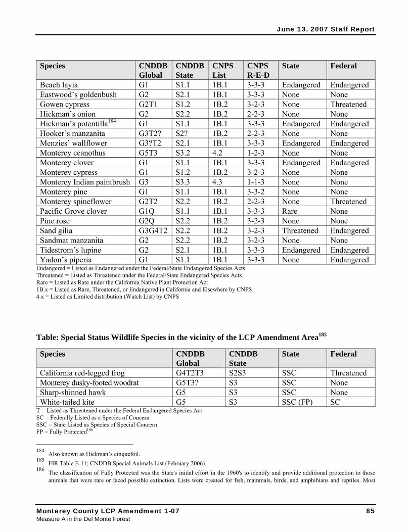
June 13, 2007 Staff Report
Species CNDDB Global
CNDDB State
CNPS List
CNPS R-E-D
State Federal
Beach layia G1 S1.1 1B.1 3-3-3 Endangered Endangered Eastwood’s goldenbush G2 S2.1 1B.1 3-3-3 None None Gowen cypress G2T1 S1.2 1B.2 3-2-3 None Threatened Hickman’s onion G2 S2.2 1B.2 2-2-3 None None Hickman’s potentilla184 G1 S1.1 1B.1 3-3-3 Endangered Endangered Hooker’s manzanita G3T2? S2? 1B.2 2-2-3 None None Menzies’ wallflower G3?T2 S2.1 1B.1 3-3-3 Endangered Endangered Monterey ceanothus G5T3 S3.2 4.2 1-2-3 None None Monterey clover G1 S1.1 1B.1 3-3-3 Endangered Endangered Monterey cypress G1 S1.2 1B.2 3-2-3 None None Monterey Indian paintbrush G3 S3.3 4.3 1-1-3 None None Monterey pine G1 S1.1 1B.1 3-3-2 None None Monterey spineflower G2T2 S2.2 1B.2 2-2-3 None Threatened Pacific Grove clover G1Q S1.1 1B.1 3-3-3 Rare None Pine rose G2Q S2.2 1B.2 3-2-3 None None Sand gilia G3G4T2 S2.2 1B.2 3-2-3 Threatened Endangered Sandmat manzanita G2 S2.2 1B.2 3-2-3 None None Tidestrom’s lupine G2 S2.1 1B.1 3-3-3 Endangered Endangered Yadon’s piperia G1 S1.1 1B.1 3-3-3 None Endangered
Endangered = Listed as Endangered under the Federal/State Endangered Species Acts Threatened = Listed as Threatened under the Federal/State Endangered Species Acts Rare = Listed as Rare under the California Native Plant Protection Act 1B.x = Listed as Rare, Threatened, or Endangered in California and Elsewhere by CNPS 4.x = Listed as Limited distribution (Watch List) by CNPS
Table: Special Status Wildlife Species in the vicinity of the LCP Amendment Area185
Species CNDDB Global
CNDDB State
State Federal
California red-legged frog G4T2T3 S2S3 SSC Threatened Monterey dusky-footed woodrat G5T3? S3 SSC None Sharp-shinned hawk G5 S3 SSC None White-tailed kite G5 S3 SSC (FP) SC
T = Listed as Threatened under the Federal Endangered Species Act SC = Federally Listed as a Species of Concern SSC = State Listed as Species of Special Concern FP = Fully Protected186
184 Also known as Hickman’s cinquefoil. 185 EIR Table E-11; CNDDB Special Animals List (February 2006). 186 The classification of Fully Protected was the State's initial effort in the 1960's to identify and provide additional protection to those
animals that were rare or faced possible extinction. Lists were created for fish, mammals, birds, and amphibians and reptiles. Most
Monterey County LCP Amendment 1-07 85 Measure A in the Del Monte Forest
June 13, 2007 Staff Report
As a general rule, the Commission considers federal, state, or CNPS 1B listing as evidence of rarity. Habitats that support these rare species and that are easily disturbed and degraded by human activities and developments meet the definition of ESHA.187 In addition, the LCP specifically requires that CNPS List 1B species be considered ESHA in the DMF.188 Therefore, habitat areas that support the species listed above are presumed to be ESHA in terms of both the Coastal Act and the LUP (and the LCP overall). The fact that many of these species occur within coastal dunes or Monterey pine forest, which are rare habitat types and that several of these species may be found together provides additional support for their ESHA designation in the Del Monte Forest.
Yadon’s piperia and the California red-legged frog are listed as Endangered and Threatened, respectively, under the Federal Endangered Species Act, and because of their sensitivity, the significance of regional populations, and the degree to which they are present in the LCP amendment/PDP project area, additional detail is provided.
Yadon’s Piperia Piperia yadonii, variously known as Yadon’s rein orchid or Yadon’s piperia, is a slender perennial orchid endemic to Monterey County that grows in Monterey pine forest or maritime chaparral at three main areas within about 6 miles of the coast (see Exhibit 12). In many cases in the LCP amendment area, piperia are found in a mixed Monterey pine/maritime chaparral setting.
Yadon’s piperia grows from a small tuber on an underground stem or rhizome. It is dormant, generally with no above ground tissue, from September to December. Winter rains stimulate the growth of roots and leaf buds and an unknown proportion of the population will each produce one or two basal leaves (the basis of population counts). However, only a small proportion of above-ground Yadon’s piperia produce a flower spike in a given season. Of these, most are lost to disease or herbivores. Fewer than 5% of plants with leaves successfully produced flower spikes during surveys in 1995 and 1996.
The orchid now known as Yadon’s piperia was first collected from Monterey pine forest in Pacific Grove in 1925, but it wasn’t until 1990, after certification of the DMF LUP, that it was recognized as a distinct species. Systematic range-wide surveys were first conducted in 1995 and 1996. The first estimated population size was about 83,000, of which about 70% were found in the Del Monte Forest.189 A more intensive 2004 census of potential development and mitigation areas in the Del Monte Forest documented the presence of about 130,000 individuals (of which only about 9,000 flowered and produced seed190). The difference in the two surveys was mainly in density; the location of the major
fully protected species have also been listed as threatened or endangered species under the more recent endangered species laws and regulations.
187 The Commission frequently looks to the species lists, including CNPS List 1B, as evidence of rarity, although ESHA determinations are ultimately based on site specific findings.
188 As discussed in preceding findings; see IP Sections 20.147.020(H) and 20.147.020(AA). 189 PDP EIR Appendix I, p.6. 190 Based on estimates of rates of production of flower spikes (17%), avoidance of herbivory (38%), and proportion of grazed plants that
produced seed (11%); in McGraw et al. 2006.
86 California Coastal Commission Central Coast District Office
June 13, 2007 Staff Report
areas in which the plants were found were very similar.191 Such year-to-year fluctuations in density are common among many plant species. However, no major new habitat areas have been documented to date, underlining the importance of the small areas of habitat that remain undeveloped. In fact, recent work has shown that within the DMF/PDP areas, Yadon’s Piperia is almost entirely confined to sandy soils west of Highway 1 with only a single location farther east.192
Within the Del Monte Forest area, Yadon’s piperia is abundant in portions of the PDP project/LCP amendment area. Indeed about 80% of the total known population of Yadon’s piperia is found within the Del Monte Forest.193 Most of that is in the two largest known piperia populations, one at the proposed golf course area (Area 1 – see Figure 8; 57,150 individuals) and one along Pescadero Canyon (Areas 15, 16, and 24 – see Figures 20, 21, and 29; 56,132 individuals). These two sites alone constitute approximately two-thirds of the total known population of the species.194 Yadon’s piperia is even more globally restricted and rare than is native Monterey pine. CNPS has classified Yadon’s piperia as list 1B.1, and under the prior CNPS classification system with a R-E-D code of 3-3-3. This indicates the highest level of rarity and highest degree of threat in the CNPS ranking system. The CNDDB classifies Yadon’s piperia as a G1 global rank and an S1.1 state rank, indicating that both globally and within California there are fewer than 6 viable “element occurrences” (G1 and S1) and that the species is considered “very threatened” (S1.1). There is no higher degree of rarity (and degree of threat) possible in the CNDDB global and/or state rankings. Yadon’s piperia was federally listed as an endangered species in 1998.195 The U.S. Fish and Wildlife Service is currently considering a critical habitat designation for the species.196
Yadon’s piperia is found almost exclusively in native Monterey pine forest and chaparral, which include its primary constituent habitat elements (including associated soils, climate, pollinators, etc.). Absent compelling evidence to the contrary, the boundaries of Yadon’s piperia habitat is considered to be coterminous with the boundaries of the chaparral and/or Monterey pine forest areas where piperia have been documented.
Yadon’s piperia is rare as that term is understood for purposes of Coastal Act Section 30107.5 and the DMF LUP (and the LCP overall). In addition, the species and its habitat are easily disturbed and degraded by human activities and development (by removal, fragmentation and edge effects, micro-
191 Comparison of the results of the two surveys should be qualified due to the fact that they employed different methodologies and
covered different areas. With respect to the area surveyed, the 1995/96 survey was range-wide, while the 2004 survey was limited to the Pebble Beach project and Measure A LCP amendment areas. Also, according to the PDP EIR, “the 2004 census methodology developed by EcoSystems West was more intensive for counting Yadon’s piperia and is judged to have resulted in a more precise count of individuals” relative to the PDP project area.
192 McGraw, J., R. Buck and W. Davilla. 2006. Habitat characterization for Yadon’s Piperia (Piperia yadonii) within the forested habitat of the Monterey Peninsula. A report to the County of Monterey.
193 PDP EIR Table P2-2. 194 PDP EIR Tables P2-1 and P2-2 195 See, Endangered and Threatened Wildlife and Plants; Final Rule Listing Five Plants From Monterey County, CA, as Endangered or
Threatened, Federal Register: August 12, 1998 (Volume 63, Number 155), Pages 43100-43116. 196 Endangered and Threatened Wildlife and Plants; Proposed Designation of Critical Habitat for Piperia Yadonii (Yadon's Piperia),
Federal Register: October 18, 2006 (Volume 71, Number 201), Pages 61545-61578. See Commission staff comments on the proposed critical habitat designation in Exhibit 13.
Monterey County LCP Amendment 1-07 87 Measure A in the Del Monte Forest
June 13, 2007 Staff Report
climatic changes, pesticide/herbicide drift, increased trampling, etc.).197 Thus, the species and its habitat meet the definition of ESHA under the Coastal Act and the LUP (and the LCP), independent of its association with other species and habitats.
California red-legged frog The California red-legged frog (Rana aurora draytonii) (CRLF) is the largest native frog in the western United States, ranging from 1.5 to 5 inches in length. It is commonly believed to have been the inspiration for the well-known Mark Twain story, “The Celebrated Jumping Frog of Calaveras County.” In 1865, when the story was first published, and extending into the early 1900s, California red-legged frogs were so plentiful that they were collected for food in great numbers – some 80,000 frogs per year. After their numbers declined in response to frog hunting and other environmental impacts, bullfrogs (Rana catesbiana) were introduced to help satisfy the demand for frog legs. The much larger bullfrog became a major predator of the CRLF, leading to further CRLF decline; the bullfrog remains a major threat to the red-legged frog’s existence today. Once common, the California red-legged frog has been eliminated from 70% of its historic range and is now limited primarily to the coastal drainages of central California. CRLF require a variety of habitat elements, including aquatic breeding areas within a larger ecological matrix of riparian and upland dispersal habitats.198 In terms of CRLF movements, evidence to date suggests CRLF tend to travel in straight lines between suitable locations; that is, they do not necessarily follow riparian corridors or other obvious wetland areas that may connect areas.199
Although identified by the USFWS as widespread in Monterey County, prior to 2002 the CNDDB did not identify any CRLF occurrences on the Monterey peninsula. However, more recent biological review as part of the PDP project and LCP amendment indicates that there is a CRLF population in the Del Monte Forest that is apparently centered on lower Seal Rock Creek; a creek that flows through the native Monterey pine forest (see Figure 30). In addition to the CRLF breeding sites and other occupied sites documented along Seal Rock Creek and its tributaries, CRLF have also been documented at two locations at the proposed PDP project golf course site (Area 1; LUP planning unit N – see Figures 7 and 8).200 Thus, there appears to be a mosaic of CRLF habitat in and around Seal Rock Creek that, at the least, extends to and includes at least the central portion of the PDP project golf course site in Area 1.
This CRLF population is currently the only known population on the Monterey peninsula,201 which increases its significance. Given that CRLF have been known to make straight line movements between suitable sites, and may travel as far as 2 miles or so between suitable locations,202 the area between occupied habitat sites may serve as dispersal corridors. In this respect, evidence to date suggests CRLF tend to travel in straight lines between suitable locations; that is, they do not necessarily follow riparian
197 Such indirect effects on Yadon’s are documented by the PDP EIR, including PDP EIR p.P2-8 and P2-9 198 Source USFWS: (1) Recovery Plan for the California Red-legged Frog (Rana aurora draytonii), U.S. Fish and Wildlife Service,
Portland, Oregon, (2002); (2) USFWS California Red-legged Frog (Rana aurora draytonii) “Creature Feature” profile (January 2001). 199 Bulger et al. Terrestrial activity and conservation of adult California red-legged frogs Rana aurora draytonii in coastal forests and
grasslands, Biological Conservation 110 (2003) 85-95. 200 PDP EIR Page E-27. 201 PDP EIR p.E-27. 202 U.S. Fish and Wildlife Service. 2002. Recovery Plan for the California Red-legged Frog (Rana aurora draytonii). U.S. Fish and
Wildlife Service, Portland, Oregon. viii + 173 pp.
88 California Coastal Commission Central Coast District Office
June 13, 2007 Staff Report
corridors or other obvious wetland areas that may connect such areas.203
USFWS indicates that “dispersal of individual California red-legged frogs plays an important role in metapopulation dynamics and therefore the persistence of populations.”204 USFWS has in the past typically recommended a minimum 300-foot width for CRLF corridors between breeding locations, but the precise distance recommended at the current time is somewhat unclear.205 That said, the relevant point at this juncture is not to identify the precise width that should be applied to a corridor, but rather the concept that dispersal habitat corridors, whether 200 feet or 300 feet or 100 meters or something else, are recognized as important components of CRLF habitat. As stated by USFWS:206
Many studies have attempted to elucidate the value and adequate size of dispersal routes or corridors as a means of maintaining ecological connectivity between areas of suitable habitat while avoiding negatively influencing individuals of various species (Beier and Noss 1998, Bulger et al 2003, Fahrig and Merriam 1994, Haddad 1999, Pope et al 2000, Semlitsch 1998, Semlitsch 2000, Semlitsch 2003, Vos and Chardon 1998). Designating or creating movement corridors to avoid adverse effects to California red-legged frog habitat in areas scheduled for development is problematic. However, when an obvious corridor exists between two aquatic sites, California red-legged frogs are likely to use that route (Bulger et al 2003).207
Applying such a corridor (for example, one that is 300 feet wide) to the straight-line movement phenomenon might mean that CRLF would potentially traverse a wide swath from the “point” locations of the known breeding habitats (and potentially other occupied and/or suitable habitat areas) (see Figure 30).
CRLF were listed as a threatened species under the Federal Endangered Species Act in 1996, and have been identified by CDFG as a state species of special concern.208 CRLF are rare as that term is understood for purposes of Coastal Act Section 30107.5 and the DMF LUP (and LCP), and the species and its habitat are easily disturbed and degraded by human activities (including by direct removal of wet habitat areas and dispersal corridors, and also indirectly, including by fragmentation and degradation of these areas and corridors by such things as increased urban runoff, reduction on habitat buffers, removal of hiding locations (and increased predation), impediments to dispersal (fences, buildings, roads, etc.), road and traffic, predation by domestic pets, etc.). Thus, CRLF and its habitat, including identified dispersal corridors, meets the definition of ESHA under the Coastal Act and the LUP (and the LCP). 203 Bulger et al. Terrestrial activity and conservation of adult California red-legged frogs Rana aurora draytonii in coastal forests and
grasslands, Biological Conservation 110 (2003) 85-95. 204 December 8, 2005 comment letter to the Commission regarding CRLF issues in and around the Terrace Point area in Santa Cruz. 205 For example, the Service’s April 2004 proposed critical habitat regulations for CRLF USFWS identified the 300-foot corridor width
(Federal Register Vol. 69, No. 71, April 13, 2004, Proposed Rules, Department of Interior, Fish and Wildlife Service, 50 CFR Part 17). Since that time, the USFWS has subsequently proposed to revise this guidance, and in the November 3, 2005 proposed revised rule has removed any specific reference to an appropriate width of dispersal habitat (Federal Register, Vol. 70, No. 212, November 3, 2005, Proposed Rules, Department of Interior, Fish and Wildlife Service, 50 CFR Part 17). That said, the recently proposed revised rule, which no longer cites a width, does not conflict with this previous guidance, and affirms the importance of dispersal habitat as a primary constituent element of CRLF critical habitat. The Commission has, in fact, applied the 300-foot width dispersal habitat guidance in certain cases (e.g., Lee (A-2-SMC-99-066) and Ailanto (A-1-HMB-022) in San Mateo County).
206 Id; USFWS December 8, 2005 letter. 207 Id; USFWS December 8, 2005 letter. 208 USFWS listing, May 31, 1996 (61 FR 25813).
Monterey County LCP Amendment 1-07 89 Measure A in the Del Monte Forest
June 13, 2007 Staff Report
3. Biological Community Associations
Wetlands Wetlands and associated areas are highly regarded because they perform a variety of habitat and other functions. Wetlands provide important resting, feeding, breeding, refuge and related habitat for migratory, seasonal and resident wildlife, including many birds, amphibians, reptiles, and other animals. In addition, wetlands often are an integral part of larger habitat areas (e.g., the native Monterey pine forest in the LCP amendment area), which increases their habitat value. Wetlands and associated uplands constitute some of most diverse ecosystems in the coastal zone. In addition to a huge variety of common species associated with wetlands (such as tree frogs, garter snakes, insects, birds, etc.), species protected by the Federal and State Endangered Species Acts are also often found in these areas (e.g., the federally threatened California red-legged frog in the LCP amendment area – see also list above).
In addition to their well-known habitat value, wetlands provide important hydrological and water-quality functions. One of these is the conveyance of water. This function is generally associated with linear wetland systems where the wetland is really part of a longer stream or riparian system (e.g., a pond or marsh along a creek channel). However, in some cases the drainage itself exhibits wetland characteristics. Second, wetlands often serve as collection basins that capture and retain flows, thus helping both to reduce the velocity and the volume downstream and, hence, to reduce the potential for flooding lower in the watershed. The retained water may then contribute to groundwater recharge. Finally, wetlands are well known for their ability to help improve water quality by removing sediment and by enabling the chemical transformation and biological uptake of certain pollutants (e.g., nitrogen, phosphorous, etc.).
More than 90% of California’s original wetlands have been lost over time – the largest percentage loss of any state in the nation.209 Although wetlands once occupied about five million acres in California, recent estimates of wetland acreage are about 450,000 acres.210 Environmental laws enacted in the 1970s – including the Coastal Act – have gone a long way towards preventing additional direct wetlands loss, as has the public’s changing perception of wetlands as valuable resources (as opposed to muddy bogs to be eliminated), but wetland areas continued to be threatened by development. In recognition of the rarity of wetlands and their important ecosystem function, the Coastal Act provides wetlands with categorical protection, allowing only a few specific uses (Coastal Act Section 30233 identifies a total of eight permitted uses in open coastal waters or wetlands).
In the LCP amendment area, many wetlands have been modified to some degree by human activities. For example, hydrology within the remaining native Monterey pine forest has been altered by surrounding development, increased runoff from impervious surfaces, fill of natural drainage courses, and creation of new drainages (e.g., downslope from culverts) that concentrate and direct runoff. These relatively permanent changes, including the new drainage courses, should be regarded as the new normal condition and are the basis under which LCP amendment review occurs.211 Most of the wetlands 209 Dahl, Thomas E. 1990. Wetlands losses in the United States 1780's to 1980's. U.S. Department of the Interior, Fish and Wildlife
Service, Washington, D.C. 210 Id; Dahl. 211 To the extent development that altered wetlands – hydrology or otherwise – was not appropriately permitted, then the underlying
analytic baseline may differ from the physical baseline. For example, if a wetland was filled without coastal permits, then the analytic baseline for project/LCP amendment review is not the filled area but rather the wetland that previously existed (because rectification
90 California Coastal Commission Central Coast District Office
June 13, 2007 Staff Report
within Monterey pine forest are seasonally inundated or saturated near the ground surface for weeks or months during most years and support mostly herbaceous vegetation dominated by wetland grasses, rushes and sedges. A few areas support emergent marsh that remains inundated for much of the year. These existing wetlands generally provide most of the functions characteristics of wetlands in this region, including aquatic habitat for the California red-legged frog and most do not appear to be substantially degraded by human activities.
In and around the LCP amendment wetlands are rare and especially valuable due to their important ecosystem functions as that term is understood in a Coastal Act and LUP (and LCP) context. They are also easily disturbed and degraded by human activities and development (including direct removal and indirectly in terms of removal of and/or degradation to wetland buffers, polluted runoff degradation, predation of wetland species by domestic pets, etc.). Wetlands in the LCP amendment/PDP project area also meet the definitions of ESHA in the Coastal Act and the LUP (and the LCP).
Coastal Sand Dunes Coastal sand dunes constitute one of the most geographically constrained habitats in California. They only form in certain conditions of sand supply and wind energy and direction. Dunes are a dynamic habitat subject to extremes of physical disturbance, drying, and salt spray and support a unique suite of plant and animal species adapted to such harsh conditions. Many characteristic dune species are becoming increasingly uncommon. Even where degraded, the Coastal Commission has found this important and vulnerable habitat to be ESHA due to the rarity of the physical habitat and its important ecosystem functions, including that of supporting sensitive species. In and around the LCP amendment area, such species include Beach layia, Menzies’ wallflower, Monterey Indian paintbrush, Monterey spineflower, Sand gilia, and Tidestrom’s lupine (see previous table). In addition, another special status species, native Monterey pine, is also found in areas of coastal dune. The Monterey pine/dune association is obvious at the intersection between sandy areas and forest, as at Signal Hill Dunes in Areas 1 and 5, see Figures 8). The dune substrate is less apparent where middle-aged and older dunes have been stabilized by native Monterey pine forest (e.g., near Spanish Bay).
Areas of coastal dune vegetation and sandy openings within the Monterey Peninsula are both rare and especially valuable due to their important ecosystem functions as those terms are understood in a Coastal Act and LUP (and LCP overall) context. Dunes are also easily disturbed and degraded by human activities and development (e.g., by conversion to residential use, sand extraction, fragmentation trampling of dune vegetation, etc.). In conclusion, dune areas meet the definition of ESHA under the Coastal Act and the LUP (and the LCP overall).
Maritime Chaparral Maritime chaparral habitats occur from San Diego to Sonoma County. The common features of these habitats are well-drained, generally sandy soils within the coastal fog zone, and a suite of shrubs that includes one to several endemic species of the genera Arctostaphylos (manzanita), Ceanothus (mountain lilac), or Quercus (oak). The actual community composition of maritime chaparral changes with latitude and southern, central, and northern maritime chaparrals are generally recognized. Within a geographical
of the unpermitted fill would be to at least restore the previous wetland function). In this sense, the “new normal” condition is that reflected on the ground today with the caveat that unpermitted development cannot be used to justify a “new normal” condition that includes reduced wetland area and function.
Monterey County LCP Amendment 1-07 91 Measure A in the Del Monte Forest
June 13, 2007 Staff Report
region, community composition is also variable on a smaller spatial scale. These habitats or community types are rare, are generally defined by individual shrub species that are themselves rare, and often support rare herbaceous species.
Central maritime chaparral is patchily distributed from Monterey County to northern Santa Barbara County. Although many species of shrubs are common to most locations, local stands are usually distinguished by the presence of one to several endemic species of Ceanothus or Arctostaphylos. There are about 60 species of manzanita in the world. All of these species are found in California and most are found nowhere else. Within California, many are endemic to small geographic areas. Similarly, of the 55 species of mountain lilac, about 40 are endemic to California and many of these are also not widely distributed. The central maritime chaparral in the LCP amendment area generally occurs as understory within native Monterey pine forest and is typically characterized by the presence of shaggy-barked manzanita (Arctostaphylos tomentosa), huckleberry (Vaccinium ovatum), blue blossom (Ceanothus thrysiflorus), and Hooker’s manzanita (Arctostaphylos hookeri). CDFG lists central maritime chaparral as a rare habitat type in the CNDDB. As individual species, Hooker’s manzanita is a low growing, mound forming, evergreen shrub endemic primarily to Monterey County. CNPS lists this species as 1B.2 (rare, threatened, or endangered) and considers it “fairly endangered.”212
Therefore, central maritime chaparral is rare and is also especially valuable due to its important ecosystem function of providing habitat for individual rare species, as those terms are understood in a Coastal Act and LUP (and LCP overall) context. Because it also is easily disturbed and degraded by human activities and developments (e.g., by conversion to residential or recreation use), it meets the definition of ESHA under the Coastal Act and the LUP (and the LCP).213 Although not explicitly mapped, there is a presumption that central maritime chaparral within the LCP amendment area includes, at a minimum, the mapped areas of Hooker’s manzanita.214
4. Conclusion (Especially Valuable – Monterey Pine Ecosystem and Associated Habitats) The native Monterey pine forest is especially valuable due to its special and central role in the native Monterey pine forest ecosystem. The native Monterey pine forest is habitat for other rare species (including most of the known population of the Federally endangered Yadon’s piperia, as well as 16 other documented special-status species) and often co-occurs with other rare biological communities such as central maritime chaparral or wetlands. Due to the presence of other rare species or biological communities, many parts of the DMF meet the definition of ESHA, irrespective of the native pine forest’s status in this regard. Thus, native Monterey pine forest is especially valuable because of its special ecosystem role part of providing necessary habitat for rare species and biological communities, as those terms are understood in a Coastal Act and LUP (and LCP) context. Because it is also easily
212 Where the 0.2 indicates “fairly endangered” status. 213 Both the North Monterey County LCP and the Big Sur LCP identify maritime chaparral as a sensitive plant community. See also
Periodic Review of Monterey County LCP for discussion of maritime chaparral in North Monterey County. 214 The PDP EIR indicates that central maritime chaparral is one of the major biological communities within the LCP amendment/PDP
project area, but central maritime chaparral was not independently mapped or specifically identified. It is not clear why this is the case. The only chaparral species mapped by the EIR was Hooker’s manzanita. This species is used as a proxy in this report for identifying area of central maritime chaparral. In light of the other chaparral species present in the LCP amendment/PDP project area (including as indicated by the PDP EIR, and based on Commission staff field work that has identified large areas of shaggy-barked manzanita not identified by the PDP EIR), it is clear that this proxy under-represents the extent of central maritime chaparral.
92 California Coastal Commission Central Coast District Office
June 13, 2007 Staff Report
disturbed and degraded by human activities and development, it also meets the definition of ESHA under the Coastal Act and LUP (and LCP) for this reason as well. In summary, native Monterey pine forest meets the definition of ESHA under the Coastal Act and LCP for three reasons: the habitat is rare, it is especially valuable for its special nature as the genetic repository of the species, and it is especially valuable for its ecosystem role of providing habitat for rare species and other rare biological communities.
3. Native Monterey Pine Forest as ESHA Native Monterey pine forest is best understood as a complex and dynamic habitat comprised of forest trees, understory vegetation, wildlife, soils, and climate and the interaction of all these elements. A forest is a complex, interdependent web of living organisms and physical habitat, and not just a noun describing a group of trees. Within this context, it is possible that site-specific analysis would conclude that some areas where native Monterey pines grow or used to grow would not be considered ESHA because they have no special nature or role in an ecosystem or aren’t part of a native forest. Such cases might include, for example, isolated areas where individual trees grow, very small, relict stands of forest, and areas within the native range of Monterey pine that retain other requisite characteristics of the habitat type, such as soils and climate, but where significant occurrences of trees are no longer present. The following sections provide additional factors to further define the circumstances under which a native Monterey pine forest is present and thus ESHA.215
A. Tree vs. Forest – Unit of ESHA Measurement Isolated or individual occurrences of Monterey pine may be determined not to be ESHA. It is as native forest, not individual trees, that native Monterey pine is rare and especially valuable. Thus, one relevant question in a Monterey pine ESHA determination is to what extent the Monterey pine trees at issue are part of a rare or especially valuable Monterey pine forest habitat area.
B. What Constitutes a Significant Pine Forest? Recognizing that the relevant ESHA focus is on native Monterey pine forest, is there a minimum area that can be used when considering more isolated or fragmented patches of forest to infer that it is of sufficiently high ecological value in and of itself that it is presumptively ESHA? In other words, is there a cut-off forest acreage size above which there is no question that such a native Monterey pine forest is ESHA, and below which additional analysis is required to make such an ESHA determination? Although the relationship between the area of an isolated forest stand and its ecosystem value is not well understood, biologists generally agree that larger, less fragmented or less isolated areas, with lower perimeter to habitat area ratios, have higher relative ecological value. The Commission acknowledged this recently in its adoption of the Malibu LCP, which included a general recognition that the Santa
215 This discussion is not intended to suggest that non-ESHA occurrences of Monterey pine forest are not important to protect otherwise
under the Coastal Act and the LCP for other coastal resource reasons. For example, the Monterey pine of the highly urbanized areas of Del Monte Forest still constitute native vegetation that may have some biological value as a genetic resource (assuming they are not planted trees of non-native provenance) in aiding connectivity between ESHA forest areas, providing direct use by some species, etc.. This is partly why the DMF LUP contains a comprehensive set of forest resource policies that require minimizing tree removal, mitigation of trees that are removed, preparation of a forest management plan for development in Monterey pine forest areas, etc.. The LUP also underscores the aesthetic significance of Monterey pine forest in DMF.
Monterey County LCP Amendment 1-07 93 Measure A in the Del Monte Forest
June 13, 2007 Staff Report
Monica Mountains ecosystem was rare and especially valuable, in part because of it was large, relatively pristine, and mostly unfragmented.216
With respect to forests, there is probably consensus that larger stands are more likely to maintain their natural ecosystem relationships and functions than small stands. For example, Jones & Stokes217 assessed the conservation value of various Monterey pine forest stands based on the geomorphic setting (e.g., middle aged dunes), management potential, presence of rare species, and degree of fragmentation. Based on the distribution of stands on the Monterey Peninsula, they considered forest stands greater than 40 acres to be large and continuous. Smaller stands were considered relatively fragmented and isolated, but no data were presented nor recommendations made regarding the relationship of size to ecological value. In contrast, Huffman and Associates218 defined natural forest stands as those at least 20 acres in size and concluded that such natural forests have significant intrinsic value for genetic conservation and the sustainability of each of the remaining three discrete forests in California (Año Nuevo, Cambria, and Monterey Peninsula). Similarly, CNPS219 indicates that “preservation efforts should be concentrated on stands 20 acres or larger and contiguous stands of smaller acreages that provide wildlife corridors, habitat connectivity, or occupy rare terrace soils.” Wikler et al220 defined “wildland” as relatively undisturbed stands larger than 16 acres and compared them to stands of pine adjacent to golf fairways, in small (generally less than about 4 acres) semi-natural open space termed “light urban” areas, and in “heavy urban” areas located on landscaped home sites. Wildland areas had lower levels of pitch canker disease than the more urbanized plots and the authors suggested that there may be more conservation value in protecting areas at least 16 acres in size rather than smaller fragmented parcels.
Based on these various observations concerning Monterey pine, and general principles of conservation biology, the Commission finds that relatively undisturbed stands of native Monterey pine forest that are 20 acres in size or larger are ESHA based on their rarity, their special nature as significant sources of genetic conservation, and on their especially valuable ecosystem function of providing the structural basis for a natural Monterey pine forest community. Stands of native Monterey pine forest less than 20 acres require additional analysis. Most important, perhaps, those smaller stands that provide specific documented ecosystem functions, such as the provision of habitat for rare species (e.g., Yadon’s piperia or Hooker’s manzanita) or rare communities (e.g., central maritime chaparral), or that are very close to or connected to large areas of forest may also qualify as ESHA because of their especially valuable ecosystem functions.221 Other factors that might be considered include the relative degradation or health 216 See Malibu Local Coastal Program, Adopted LUP Findings, September 12, 2002, including cited literature in support of the general
propositions. 217 Jones & Stokes Associates. December 1996. Monterey pine forest conservation strategy report. A report to the California Native Plant
Society and the Natural Heritage Division of the California Department of Fish and Game. 218 Huffman and Associates. February 1994. An evaluation of California’s native Monterey pine populations and the potential for
sustainability. A report to the Pebble Beach Company. 219 CNPS Monterey Pine Forest Policy (March 1995); see Exhibit 11. 220 Wikler, K., A.J. Storer, W. Newman, T.R. Gordon, and D.L. Wood. 2003. The dynamics of an introduced pathogen in a native
Monterey pine (Pinus radiata) forest. Forest Ecology and Management 179:209-221. 221 They may also qualify as ESHA independently, whether the native pine forest is considered ESHA or not (because of limited size,
fragmentation, isolation, etc.), because of the presence of these other rare species. For example, in the case of Yadon’s piperia, even a relatively small and isolated native forest stand would be considered ESHA independently for piperia given that the area of forest would be considered the area of Yadon’s piperia habitat (see also previous Yadon’s piperia findings, and see next finding below)
94 California Coastal Commission Central Coast District Office
June 13, 2007 Staff Report
of the understory, association with wetland or riparian resources, or the relative uniqueness of the stand itself. For example, the Commission has long recognized the Monterey pine-coastal dune and the endemic Monterey pine-Bishop pine associations in Del Monte Forest as a particularly unique ecological occurrences that constitute ESHA. More generally, Monterey pine growing in different physical settings tend to have different morphological characteristics (some of which may have a genetic basis) and produce forest stands with different community compositions. One hypothesis is that this is a function of the “ecological staircase”; others think it represents some type of gradient that is not completely understood.222 However, regardless of the causal basis, such diversity is important to conserve, and thus, the diversity value of a stand is another factor that needs to be assessed when conducting an ESHA analysis for smaller isolated native Monterey pine stands.
C. Native Monterey Pine Forest as Habitat for Other Sensitive Species In addition to defining both rare and/or especially valuable species as ESHA, Coastal Act Section 30107.5 and the LUP (and the LCP) also identify the “habitat” for such species as ESHA. In one sense, habitat for such species is clear: at a minimum, it is the area in which they are found. However, there may also be areas suitable for the species (habitat) but where the species isn’t necessary present at the particular time. For example, Yadon’s piperia is not uniformly distributed throughout the forest stands that it occupies, but the nearby unoccupied forest areas also constitute appropriate habitat based on the various characteristics of these areas which include its primary constituent habitat elements (including associated soils, climate, pollinators, etc.).
Therefore, the Commission finds that the boundaries of the habitat for a given species are conterminous with the boundaries of the vegetation community or physical habitat that provides the requirements for the species to live and reproduce. For example, the Commission considers the boundaries of Yadon’s piperia habitat to be conterminous with the boundaries of the chaparral and/or Monterey pine forest areas where this orchid has been documented to occur or where scientific studies (e.g., McGraw et al.223) demonstrate the presence of the habitat elements that are necessary to support the species.
D. The Commission’s Monterey Pine Planning and Regulatory History Apart from the biological analysis just presented, it is useful to understand generally the Commission’s planning and regulatory history concerning native Monterey pine. The Coastal Commission has a long history of concern for native Monterey pine forest. Beginning with the California Coastal Plan of 1975 there are references to the pines of Del Monte Forest as a natural feature to be protected, and there is direction to preserve the Cambria and San Simeon pine occurrences as a “restricted natural community” and “one of the last native Monterey-pine forests found in the world.”224 As the Commission began to review and certify LCPs along the Central Coast, the three populations of Monterey pine were generally recognized and described as sensitive habitat. As summarized in the table below, each of the seven
222 The Monterey ecological staircase concept has its genesis in reports prepared for CDFG in the mid-1990s defining six terraces and a
series of related geomorphic surfaces (e.g., young and old dunes, etc.) within the Monterey peninsula stand, each with differing Monterey pine forest characteristics, where it was suggested that the forest should be considered in terms of the sub-types (and representative stands of each preserved).
223 McGraw, J., R. Buck, and W. Davilla (Eco Systems West). October 9, 2006. Habitat characterization for Yadon’s piperia (Piperia yadonii) within the forested habitat of the Monterey peninsula. A report prepared for the County of Monterey.
224 California Coastal Plan, California Coastal Zone Conservation Commissions, December, 1975, pp. 232, 360.
Monterey County LCP Amendment 1-07 95 Measure A in the Del Monte Forest
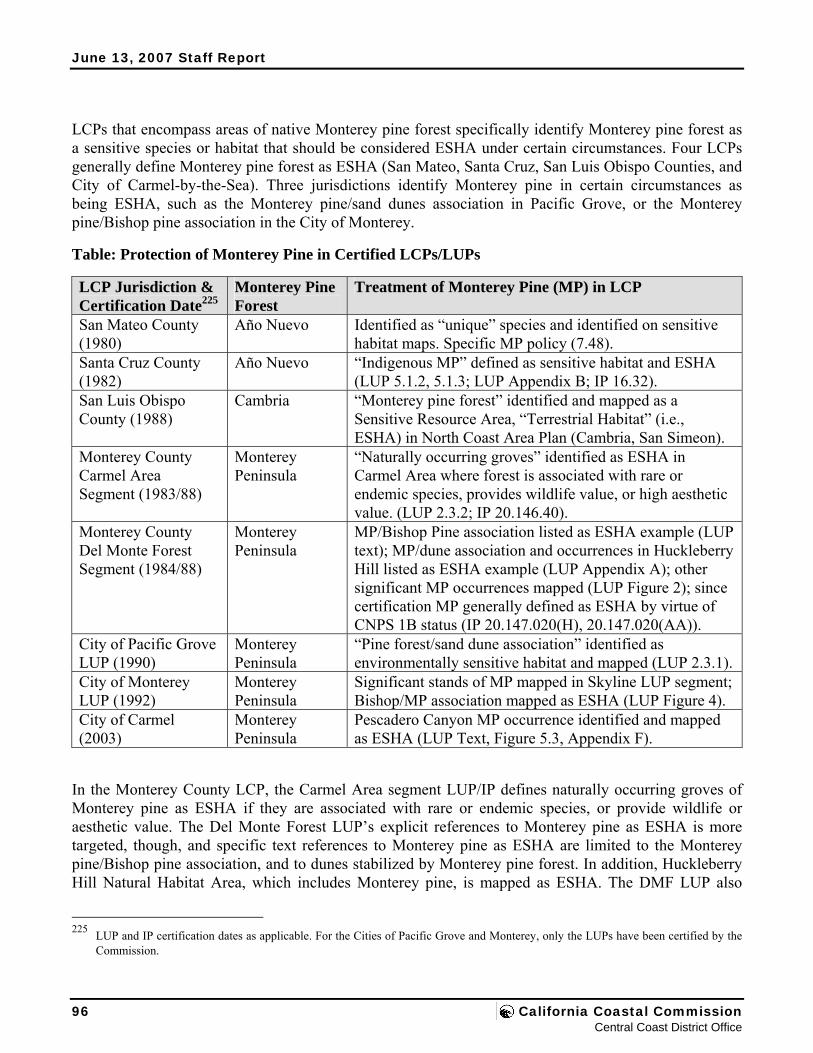
June 13, 2007 Staff Report
LCPs that encompass areas of native Monterey pine forest specifically identify Monterey pine forest as a sensitive species or habitat that should be considered ESHA under certain circumstances. Four LCPs generally define Monterey pine forest as ESHA (San Mateo, Santa Cruz, San Luis Obispo Counties, and City of Carmel-by-the-Sea). Three jurisdictions identify Monterey pine in certain circumstances as being ESHA, such as the Monterey pine/sand dunes association in Pacific Grove, or the Monterey pine/Bishop pine association in the City of Monterey.
Table: Protection of Monterey Pine in Certified LCPs/LUPs
LCP Jurisdiction & Certification Date225
Monterey Pine Forest
Treatment of Monterey Pine (MP) in LCP
San Mateo County (1980)
Año Nuevo Identified as “unique” species and identified on sensitive habitat maps. Specific MP policy (7.48).
Santa Cruz County (1982)
Año Nuevo “Indigenous MP” defined as sensitive habitat and ESHA (LUP 5.1.2, 5.1.3; LUP Appendix B; IP 16.32).
San Luis Obispo County (1988)
Cambria “Monterey pine forest” identified and mapped as a Sensitive Resource Area, “Terrestrial Habitat” (i.e., ESHA) in North Coast Area Plan (Cambria, San Simeon).
Monterey County Carmel Area Segment (1983/88)
Monterey Peninsula
“Naturally occurring groves” identified as ESHA in Carmel Area where forest is associated with rare or endemic species, provides wildlife value, or high aesthetic value. (LUP 2.3.2; IP 20.146.40).
Monterey County Del Monte Forest Segment (1984/88)
Monterey Peninsula
MP/Bishop Pine association listed as ESHA example (LUP text); MP/dune association and occurrences in Huckleberry Hill listed as ESHA example (LUP Appendix A); other significant MP occurrences mapped (LUP Figure 2); since certification MP generally defined as ESHA by virtue of CNPS 1B status (IP 20.147.020(H), 20.147.020(AA)).
City of Pacific Grove LUP (1990)
Monterey Peninsula
“Pine forest/sand dune association” identified as environmentally sensitive habitat and mapped (LUP 2.3.1).
City of Monterey LUP (1992)
Monterey Peninsula
Significant stands of MP mapped in Skyline LUP segment; Bishop/MP association mapped as ESHA (LUP Figure 4).
City of Carmel (2003)
Monterey Peninsula
Pescadero Canyon MP occurrence identified and mapped as ESHA (LUP Text, Figure 5.3, Appendix F).
In the Monterey County LCP, the Carmel Area segment LUP/IP defines naturally occurring groves of Monterey pine as ESHA if they are associated with rare or endemic species, or provide wildlife or aesthetic value. The Del Monte Forest LUP’s explicit references to Monterey pine as ESHA is more targeted, though, and specific text references to Monterey pine as ESHA are limited to the Monterey pine/Bishop pine association, and to dunes stabilized by Monterey pine forest. In addition, Huckleberry Hill Natural Habitat Area, which includes Monterey pine, is mapped as ESHA. The DMF LUP also
225 LUP and IP certification dates as applicable. For the Cities of Pacific Grove and Monterey, only the LUPs have been certified by the
Commission.
96 California Coastal Commission Central Coast District Office
June 13, 2007 Staff Report
generally maps other occurrences of Monterey pine in LUP Figure 2. Although not explicitly a text reference to Monterey pine, the LCP’s ESHA definitions in the DMF do categorically identify CNPS 1B species as ESHA by virtue of IP Sections 20.147.020(H) and 20.147.020(AA), and thus Monterey pine meets the LCP definition of ESHA.226 In addition to the more targeted ESHA treatment, the DMF LUP also has an extensive set of forest protection policies designed to protect the Del Monte Forest, whether or not particular areas are designated ESHA.227 Although native Monterey pine was not categorically defined as ESHA in the 1984 certification of Appendix A, a review of the record of decision leading up to LUP certification in 1984 and the various ways native Monterey pine was identified as ESHA or not suggests that such decisions were more nuanced than might be argued based on Appendix A only (see below).
Although generally identified as sensitive habitat in various LCPs, the Commission has still evaluated Monterey pine and ESHA issues in planning and regulatory matters case-by-case, based on an assessment of resources on the ground.228 Early in its history, the Commission did not strictly protect native Monterey pine forest areas impacted by development as ESHA. In at least one case, approval of the Poppy Hills Golf Course, this appears to be because Monterey pine was not determined to be ESHA.229 In another case, an LCP amendment to allow the Macomber residential subdivision in Pescadero Canyon, the Commission explicitly found that the Monterey pine on the site was not ESHA:
The highly endemic and disjunct Monterey pine habitat is well-represented on the project site. However, this species remains locally common within its indigenous range, and only portions of its habitat – not including this site – have been designated in the various LCP’s as environmentally sensitive.230
In other cases, the Commission made findings that the forest areas in question would not be significantly disrupted, but did not focus specifically on the Coastal Act requirement to limit development in ESHAs to resource dependent developments. Notably, in the coastal development permit for the Spanish Bay 226 Where Monterey pine was listed as CNPS 1B in 1994 after the original LCP certification. 227 In general these policies require maximum preservation of forest resources and the use of forest management plans for any
developments that would significantly impact Monterey pine forest. For example, Monterey pine is defined as a native tree species of the Del Monte Forest. The native pine forest making up the Del Monte Forest was to be preserved as a matter of “paramount concern” (LUP Policy Guidance Statement). Although the removal of individual pine specimens is allowed by the plan, the natural forest is to be retained “to the maximum feasible degree” (LUP Policy 31); projects are required to minimize tree removal (IP Section 20.147.050(D)(3)) with preference for design concepts which pursue this goal (LUP Policy 34); and, perhaps most importantly, “where LUP objectives conflict, preference should be given to long-term protection of the forest resource” (LUP Policy 32), likewise evident in IP Section 20.147.050(D)(1): “when standards conflict, preference shall be given to those which provide the greatest long-term protection to the forest resource.” Although these policies evince a clear intent to protect Monterey pine resources in Del Monte Forest, one of the preliminary staff recommendations of the Monterey County Periodic Review (not adopted by the Commission yet) was to strengthen the LCP by more clearly recognizing and protecting the habitat aspects of Monterey pine forest, as opposed to the “tree-centric” approach embedded in the current LUP emphasis on minimizing the removal of “significant trees” and mitigating through plantings of new trees.
228 In general, once identified as ESHA, each LCP – including Monterey County’s within the DMF segment – limits new development within Monterey pine forest areas to resource dependent development, similar to Coastal Act Section 30240.
229 See, Poppy Hills Golf Course (3-84-120), wherein the Commission recognized the significance of Gowen Cypress and Bishop pine occurrences in association with Monterey pine, but did not require strict avoidance of all such occurrences or otherwise identify the larger Monterey pine forest impacted by the project as ESHA.
230 LCP Amendment 1-93 (MacComber), May 28, 1993, p. 24. See, also Griffin (LCP Amendment 1-94), January 31, 1994, LCP amendment to allow residential subdivision in Del Monte Forest (no ESHA finding); and the Leimert subdivision in Cambria approved by the County but not appealed to the Commission (3-SLO-97-130).
Monterey County LCP Amendment 1-07 97 Measure A in the Del Monte Forest
June 13, 2007 Staff Report
Resort (CDP 3-84-226), the Commission found that the project would “undeniably and substantially impact a designated environmentally sensitive habitat” (Monterey pine forest in the Huckleberry Hill Natural Habitat Area designated as ESHA), but that this impact, as well as other impacts to biological resources, could be acceptably mitigated so that there would be a “net enhancement” in the ESHAs in Del Monte Forest (see Exhibit 6, for excerpted Monterey pine and other Spanish Bay CDP findings). Thus, the Commission found that the project as mitigated was consistent with Coastal Act Section 30240. Lacking some other Coastal Act basis, this is the type of mitigation trade-off that has since been found to be inappropriate under the Coastal Act.231
More recently, the Commission generally has not permitted new development in Monterey pine forest determined to be ESHA, except where necessary to avoid a takings of private property. For example, in the Pelle decision in Cambria (CDP A-3-SLO-02-074), the Commission approved a significantly reduced residential building envelope (12,458 square feet) on a 4.7 acre parcel in native Monterey pine forest determined to be ESHA, to avoid a takings, and required the remainder of the property, which included merger of several parcels, to be put into a conservation easement. Similarly, in the Seaberg permits (CDPs A-3-SLO-00-078 and A-3-SLO-00-079) the Commission limited new residential development footprint to 10,000 square feet, on an approximately 2.5 acre parcel determined to be entirely native Monterey pine forest ESHA (again in the Cambria stand). In San Mateo County, the Commission identified native Monterey pine forest ESHA in the Año Nuevo stand on an approximate 85 acre parcel, as well as other ESHA, and required that a new residential development avoid this forest area in order to comply with the San Mateo County LCP (Lee, CDP A-2-SMC-99-066).
In planning decisions, such as the North Coast Area Plan LCP Update for San Luis Obispo County (1998), the adopted Periodic Review of San Luis Obispo County LCP (2001), the City of Carmel LCP (2003), and the San Luis Obispo County major LCP amendment 1-04 Part 2 (2005), the Commission has continued to recognize native Monterey pine forest as ESHA and has adopted policies and/or recommendations to strengthen its protection under Coastal Act Section 30240. For example, in the circa 2003 City of Carmel LCP, the Commission found that the native Monterey pine forest in that portion of Pescadero Canyon within the Carmel city limits was ESHA (i.e., the portion of the larger Pescadero Canyon native Monterey pine forest stand along Pescadero Creek adjacent to the Del Monte Forest). Also for example, in the circa 2005 San Luis Obispo County major LCP amendment 1-04 Part 2, the Commission found that a 32 acre parcel was native Monterey pine forest ESHA in the Cambria stand, and adopted modifications, accepted by the County, requiring that the ESHA be protected with an Open Space designation rather than the proposed Agricultural designation.
Most recently, the Commission has found that “[o]verall, within the native range of Monterey pine, forest habitat areas that have not been substantially developed and urbanized meet the definition of ESHA under the Coastal Act” but has also emphasized the type of site-specific factors that should be evaluated in a Monterey pine forest ESHA determination (including the size, health, and biodiversity of the forest areas).232 For example, in the Community Hospital of Monterey Peninsula decision (CDP 3-03-068), the Commission found that “native Monterey Pine forests are rare and play a special role in ecosystems by providing necessary habitat for other rare and unusual species,” but also that in this case, 231 See discussion, supra, of Bolsa Chica case. 232 See, for example, Commission findings in 2005 for CDP A-3-SLO-05-017 for the Pine Knolls water tanks in Cambria (p. 29). Also,
see A-3-MCO-05-033 for the Moeller residence in the Carmel Highlands in 2006.
98 California Coastal Commission Central Coast District Office
June 13, 2007 Staff Report
the relatively small area of pine forest (3/4 acre) impacted by a necessary hospital facility expansion was not ESHA because of the relative disturbance and fragmentation, and thus arguable lower biological value, of this relatively small area of forest in the project area. The impacted area also did not contain other sensitive species in the understory. In contrast, the Commission recently found that an even smaller area of native Monterey pine forest (6,100 square feet) that would be impacted by a necessary water tank project for the Cambria Community Services District was ESHA, because the forest was part of much larger contiguous block of healthy forest and associated with other sensitive species. There was also evidence of pine regeneration (seedlings) on the project site. Although the Commission recognized the public health and safety aspect of the project (providing adequate fire fighting flows and access), the Commission nonetheless reduced the size of the project and allowed only the minimum encroachment into the native forest necessary to provide for the project, ultimately reducing the impact to 1600 square feet.233
E. Native Monterey Pine Forest ESHA and Changed Circumstances Since the Commission first began dealing with issues concerning the native Monterey pine forest, there have been significant changes in circumstances. First, the environmental conditions of native Monterey pine forest have changed significantly since certification of most of the LCP’s that have protective policies for Monterey pine. For example, pine pitch canker has emerged as a serious threat to the remaining pine forest populations. By 1994, pitch canker had infected all three California populations and over the next several years this change in the environmental conditions of Monterey pine forest significantly heightened the general concern for the species. In addition to this threat, in Cambria and the Del Monte Forest, the cumulative impacts to remaining Monterey pine forest have been significant, notwithstanding the general ESHA designation of Monterey pine in San Luis Obispo County, and the comprehensive forest protection policies of the Del Monte Forest LUP/IP. As discussed in the Commission’s Periodic Reviews of the San Luis Obispo and Monterey County LCPs (the Monterey County report is not yet adopted by the Commission), much of this impact has been due to the cumulative impacts of residential build-out of existing legal lots of record, although some significant impacts are attributable to subdivision and, in Del Monte Forest, also to the visitor-serving developments of the Spanish Bay Resort project and the Poppy Hills Golf Course. There have been significant impacts to and fragmentation of what once were much larger areas of contiguous forest. Due to this continued loss of native pine forest, concern for remaining habitat areas has increased. More generally, as with many other sensitive habitats, the prospect for long-term climate change injects new uncertainty into the habitat protection equation.
In addition to changing environmental conditions, our scientific knowledge of the Monterey pine has continued to grow. This includes increased attention and study of Monterey pine forest ecology, such as the work sponsored by the Department of Fish and Game in the mid-1990s, or the more recent focus on genetic conservation.234 Significant new information and understanding of the sensitivity of Monterey pine forest also has been developed. Notably, CNPS listed native Monterey pine on its CNPS 1B list of
233 Id. CDP A-3-SLO-05-017 approved site plans (2006). The forest area in question was also in a conservation easement held by the
Nature Conservancy. 234 For example, Rogers, In situ genetic conservation of Monterey pine (Pinus radiata D. Don): Information and recommendations
(2002).
Monterey County LCP Amendment 1-07 99 Measure A in the Del Monte Forest
June 13, 2007 Staff Report
rare and endangered species in 1994,235 citing a steady decline of the native Monterey pine forests over fifty years, and the continued threats from fire suppression, urban development, and fragmentation specifically within the Cambria and Monterey peninsula stands. More generally, since 1980, when the background work for the DMF LUP was being conducted, the number of sensitive plants in the DMF identified by the CNPS has grown from 10 to at least 44.236 Significant occurrences of sensitive species and biological communities, such as the endangered Yadon’s piperia and the areas of central maritime chaparral, are now identified in the DMF native Monterey pine forest. Thus, there is a greater appreciation of the biological diversity of native Monterey pine forests. The Commission’s approach to identifying and evaluating sensitive species habitats has also changed, with increasing understanding and development of ecological concepts, such as application of the principles of conservation biology at the landscape level. For example, much of the Commission’s early focus on Monterey pine emphasized significant tree avoidance, not necessarily pine forest habitat identification and avoidance.237 More recently, the Commission has continued to refine its methods for identifying native Monterey pine forest habitat areas that meet the Coastal Act ESHA definition.
The net effect of such changing circumstances has been an increased understanding and heightened concern for native Monterey pine forest habitats in the coastal zone. This, in turn, has necessarily entailed changes in how the Commission evaluates Monterey pine forest as ESHA under the Coastal Act.
Finally, it has been argued that the Commission shouldn’t find native Monterey pine forest in the Del Monte Forest to be ESHA because the policies of the LCP (circa 1984) do not categorically list it as an example of ESHA in the Del Monte Forest. However, such an argument is not persuasive. First, categorical lists and related mapping are always subject to updating as new and better information is developed, and our understanding of species and habitats increases. In the Del Monte Forest LUP/IP, this is both implicit and explicit (see, for example, the LUP Appendix A and Figure 2 discussion above). Moreover, in the case of the Del Monte Forest LCP segment LUP, the original list of ESHA examples in LUP Appendix A is over twenty years old and has not been updated. For example, Monterey pine was first listed by CNPS as rare, and endangered in 1994 – ten years after the LUP was certified. At the time of certification, Monterey pine was on List 4 – “Plants of Limited Distribution (A Watch List).”238
Second , the LCP contains direction for determining what is ESHA,239 and Monterey pine forest meets the established criteria – whether categorically listed in Appendix A as an example of ESHA in 1984 or not. In fact, whether or not it was listed as an example in 1984 is immaterial. The LCP (and Coastal Act) intent in this regard is not to be static but rather evolving, where evaluation is meant to be undertaken at the time of proposed development so as to respond to and reflect current biological evaluation and 235 See Exhibit 11 (CNPS Monterey Pine Forest Policy Statement, 1995). 236 PDP EIR pages E-16 and E-26, and Table E-8. Given that the PDP EIR was focused on the PDP project area, it may be that additional
special-status plants exist in DMF but outside of the PDP project area. 237 CCC, Draft Periodic Review of the Monterey County LCP, 2003. 238 The third edition of the CNPS Inventory notes for List 4 plants: “The 499 plants on List 4 are of limited distribution in California and
their vulnerability or susceptibility to threat appears low at this time. This roster is roughly equivalent to List 3 of the 1980 edition. While we cannot call these plants “rare”, they are uncommon enough that their status needs to be monitored regularly. Should the degree of endangerment or rarity of a plant change in our estimation, it will be transferred from this list to a more appropriate one.” (p.91).
239 See preceding finding specific to the question of what defines ESHA in the DMF.
100 California Coastal Commission Central Coast District Office
June 13, 2007 Staff Report
assessment, including our changing understanding of species, habitats, and biological communities. It is in this vein that the resource protective policies of the Act (and by extension the LCP) are to be understood (i.e., more protective rather than less; analysis of existing conditions; etc.).
Third, to the extent that the original LUP decisions concerning whether Monterey pine is ESHA may be important, the administrative record suggests considerably more nuance to the ultimate resolution of this question in 1984. For example, early versions of the LUP include more general references to Monterey pine in the list of examples of sensitive habitats in DMF. Thus, the November, 1980 draft of the LUP lists “significant stands of Monterey Pine” in the DMF as environmentally sensitive.240 Similarly, the December, 1980 draft data analysis supporting LUP development states that “special habitats in the Del Monte Forest area include…pure stands of Monterey Pine in the Spyglass Cypress, Middle Fork and Pescadero areas.”241 At this same time Monterey County had prepared resource maps showing both major plant communities, including Monterey pine, and identifying “significant stands of Monterey pine” as ESHA.242
The County thus clearly deliberated about whether or not Monterey pine should be more generally treated as ESHA (beyond its special associations with Bishop pine and in the dunes) at the time of LUP creation. In a staff report to the Board of Supervisors, staff wrote:
Designation of certain stands of Monterey pine as ESH areas is obviously somewhat of a subjective decision. On the other hand, although Monterey pine comprises the dominant forest cover on the Peninsula, the Monterey Peninsula together with Cambria are the only two locations [sic] where the Monterey pine naturally occurs; that is Monterey pine is endemic to these areas, and is therefore, of some scientific-educational value. Perhaps more importantly, the Monterey Pine forest in Del Monte Forest carries high open space and scenic value as one of the largest areas of remaining undisturbed forest in the Monterey Peninsula. Staff, however, limited the ESH designation to discrete stands of Monterey Pine…Protecting the best examples of Monterey Pine forest does not necessarily protect the habitat, but it at least partially protects those scenic/aesthetic values derived from the forest environment.243
Ultimately, County staff recommended that “significant stands of Monterey Pine” be designated as ESH areas or, in the alternative, that such stands be protected through a “strong policy in the Forestry Resources or Visual Resources Section of the Plan.”244 It was the latter alternative that was eventually adopted by the County and submitted to the Commission for certification. Thus, even though not explicitly called out in the LUP at the time, it is clear that there was a high concern for protecting not only unique and more limited occurrences of Monterey pine, but also more general and widespread stands of Monterey pine.
As discussed above, since LUP certification circumstances underlying the judgments about the
240 Monterey County, Del Monte Forest Area Local Coastal Program, Draft, November, 1980, p.11. 241 Monterey County, Del Monte Forest Area, 511 Locating and Planning New Development, Draft Data Analysis Report, December,
1980, p. 18. 242 Monterey County, Del Monte Forest Area, Resource Maps, Local Coastal Program, October, 1980. 243 Monterey County, Staff Analysis and Recommendations on the Del Monte Forest Draft Land Use Plan, February 2, 1982, p. 10. 244 Id, p. 15.
Monterey County LCP Amendment 1-07 101 Measure A in the Del Monte Forest
June 13, 2007 Staff Report
sensitivity of Monterey pine forest habitat have changed. In practice, the LCP has been applied inconsistently with respect to the protection of Monterey pine. Over five-hundred coastal permits have been approved by the County in the DMF in the time since the IP was certified in 1988, and a sampling of these shows that the broader question regarding the effect of such development on the native Monterey pine forest, including the cumulative effects has not been addressed.245 Rather, implementation of the forest protection policies of the LCP has clearly been tree-centric; focused on tree counts and offsetting tree replanting as opposed to the forest. In summary, the LCP implementation history with respect to Monterey pine has clearly not been focused on the question of pine forest, pine forest habitat, and whether or not native Monterey pine forest and its habitat is ESHA.246 However, this implementation history within the Del Monte Forest LCP segment is not binding nor indicative of what should happen under the law with respect to the remaining native Monterey pine forest. On the contrary, it provides context and background from which to learn and apply what is known today about the native Monterey pine forest. It also leads to a heightened sense of concern for the species given the impacts to pine due to DMF development over the time of the implementation history. What is clear is that an assessment of current conditions, in light of current understandings, leads to a conclusion that the native Monterey pine forest is rare and especially valuable, and that it meets the Coastal Act and LUP (and LCP) ESHA criteria.
C. LUP Amendment – Coastal Act Consistency Analysis
1. Introduction Although written and submitted as a coherent whole, the LCP amendment must be evaluated in two parts given the different standards of review that apply to the LUP and the IP components of it (as described earlier). Thus, the analysis is broken down into an LUP consistency analysis (as measured against the Coastal Act) and an IP consistency analysis (as measured against the LUP). This section provides the LUP analysis, and the section that follows provides the IP analysis.
In addition, as described earlier, the proposed LCP amendment is designed in part to facilitate the Pebble Beach Company’s PDP project. As such, PDP project details can help to provide context for the LCP amendment – including providing a reasonably foreseeable example of what the LCP, if amended, might engender. Given that the PDP project’s land use inconsistencies were a primary driving force behind the development of Measure A (as a perceived means to resolve such inconsistencies), and further given that the County has already approved the PDP project once, and has adopted a resolution of intent to approve it again, the County has further and inevitably intertwined the Measure A review process with the PDP project, and made the PDP project the most foreseeable outcome of Measure A.
245 Coastal Commission Draft Periodic Review. 246 Indeed, it has become clear that on-going loss of Monterey pine forest since LCP certification is not consistent with the Coastal Act
requirement to protect environmentally sensitive habitat areas. Although some of this loss can be attributed to natural causes, especially pine pitch canker, County (and Coastal Commission) coastal permits in DMF have authorized the removal of significant numbers of trees and habitat areas. Fragmentation of the forest has continued. The cumulative impact of this development on the forest has been significant.
102 California Coastal Commission Central Coast District Office
June 13, 2007 Staff Report
Accordingly, the analysis that follows is organized around the 26 directly affected geographic areas where the 26 areas are organized by the broader categories into which they fit as previously described, tracking the geographic and use categories of the relevant LCP amendment (and by extension PDP project) components to the degree feasible and appropriate (see Figure 7 for a graphic depiction of the 26 LCP amendment reference areas). The analysis is thus organized as follows:
▪ Recreational: Areas 1, 2, 3, and 4 corresponding to proposed Open Space Recreational areas (and corresponding to the PDP project golf course, driving range, equestrian center, and Spyglass easement area).
▪ Visitor Serving: Areas 5, 6, and 7 corresponding to proposed visitor serving areas (and corresponding to the PDP project golf cottages, Inn at Spanish Bay and Pebble Beach Lodge area improvements).
▪ Residential: Areas 8, 9, 10, 11, 12, 13, 14, 15, 16, 17, and 18 corresponding to proposed residential areas (and corresponding to the PDP project residential development sites).
▪ Resource Conservation: Areas 19, 20, 21, 22, 23, and 24 corresponding to proposed resource conservation areas (and corresponding to the PDP project conservation easement sites).
▪ Other: Areas 25 and 26 corresponding to Areas X and Y.247
In addition, broader changes affecting the overall DMF area are analyzed in a section following the specific area analyses. Finally, it is noted here that issues associated with water, wastewater, and transportation public services (including the Resource Constraint Area overlay) are detailed in the subsequent public services finding. Although there is some obvious overlap between the public services finding and this one, perhaps most specifically with water supply as it relates to Carmel River resources, those issues are analyzed in the public services finding.
Finally, the proposed PDP project and the proposed LCP amendment provisions were described in some detail in previous sections of this report. Although they are referenced and described in this section, they are not explained again in detail. The reader is directed to these preceding sections for additional information in that respect.
2. Recreational Areas (Areas 1 through 4) A. Area 1 (Golf Course) 1. Area 1 Resource Setting Area 1 is made up of most of LUP planning units M, N, O, U, and V (MNOUV) (see Figure 3) and a roughly 4-acre residential area adjacent to the existing equestrian center (see Figures 7 and 8). Together, these planning units (and the residential property) cover approximately 146 acres and straddle the LUP’s Spyglass Cypress and Pebble Beach planning areas. This area is located in the southwest of the Forest and is adjacent to the Cypress Point Golf Course, the dunes at Signal Hill rising up from Fan Shell 247 But not corresponding to any PDP project elements because Areas X and Y are not owned by the Pebble Beach Company, and are not
part of the PDP suite of projects.
Monterey County LCP Amendment 1-07 103 Measure A in the Del Monte Forest
June 13, 2007 Staff Report
Beach, the Spyglass Hill Golf Course, the Pebble Beach Equestrian Center, and existing developed residential properties (see Figure 2). Most of Area 1 is undeveloped. The developed area is limited to the roughly 5-acre Pebble Beach Driving Range located on a portion of planning unit V, two portions (roughly 2 acres total) of the existing Pebble Beach Equestrian Center located on portions of planning units U and V, the developed residential property of approximately 4 acres south of planning unit U (opposite the equestrian center from the middle of planning unit U), and the Pebble Beach Company’s roughly 5-acre fill/storage area at Signal Hill Dunes on a portion of planning unit M.248 The undeveloped portion of Area 1 includes the remaining portions of planning units M, U, and V, and all of planning units N and O. In all, there are approximately 16 developed and 130 undeveloped acres in Area 1.249 See annotated photos in Exhibit 16.
Coastal Dune ESHA The undeveloped 130 acres of Area 1 are primarily coastal dunes on the northernmost tip and native Monterey pine forest elsewhere.250 The dune area is part of the larger Signal Hill dune system rising from Fan Shell Beach to the west. The dunes at Area 1 are partially degraded having been impacted in some places by prior sand mining activities and on the edges by Pebble Beach Company fill/storage activities (see photos in Exhibit 16). Nonetheless, these dunes remain a valuable coastal dune system and are part of the larger Asilomar Dunes system that stretches from the Point Piños Lighthouse Reservation in Pacific Grove through to Cypress Point adjacent to Fan Shell Beach. The Commission has a long history of treating the coastal dunes of the Asilomar system as ESHA, even when the dune land form is significantly degraded.251 The dunes in Area 1 support several Endangered, Threatened, and CNPS 1B plant species (including Tidestrom’s lupine, Menzies’ wallflower, sand gilia, beach layia, Monterey spine flower and others); see Figure 8 for mapped locations of these sensitive dune species. Seacliff buckwheat, a known host plant for the endangered Smith’s blue butterfly, is also present in this area (though butterflies were not detected in surveys in 2000).252 The dunes provide habitat for other
248 Based on available data, it appears that the fill/storage area at the Signal Hill Dunes was historically part of a larger coastal dune area
(at least a portion of which still remains intact), and that this coastal dune was partially mined by the Company until 1965 (this area is also sometimes referred to as the old Spyglass Quarry site because of this activity). It also appears, based on an analysis of aerial photos, that the site has been partially filled, and that the filled area has expanded over time. The site has been and continues to be used as a storage and materials disposal area. Other than CDP A-3-MCO-97-037 (for the Pebble Beach Company’s Casa Palmero project) that acknowledged 26,000 cubic yards of excavated soils being placed at this location, no other coastal development permits have been authorized for this activity. However, research into reclamation of the former quarry, including the degree to which fill of it pre-dated coastal permit requirements, is inconclusive. As a result, it is difficult to determine with accuracy whether this area should be considered dunes (that were filled mostly without benefit of required coastal permits) or whether this area should be considered a fill area as a baseline for LCP amendment analysis. Likewise, the 1984 LUP provides inconclusive and conflicting guidance in this respect identifying this area as “sand or sand dunes” in LUP Figure 2a (Vegetation Cover), but not as a mapped example of a sensitive dune habitat on LUP Figure 2. The LUP also identifies this area as a “rehabilitation area due to prior mining” on LUP Figure 4 (Environmental Considerations) and LUP Figure 7 (Spyglass Cypress Planning Area Environmental Considerations), and includes policy direction that, in part, identifies former mines for more intensive development and in part for an intensive use that can also provide rehabilitation (LUP Policy 92). The LUP also identifies this area as being partially in the “Rare Plant” category and partially in the “Development” category (LUP OSAC Plan Figures 3 and 4). Given its status as a former quarry and absent compelling evidence to the contrary, the Commission has based this LCP amendment analysis on the elevated fill area being a fill area and not a dune.
249 There are also about 6 acres of paved roads and various equestrian/hiking trails that cross through Area 1 (PDP EIR p.2.0-4). 250 There is also some overlap at the transition between the dunes and the forest where Monterey pine is also present in dune areas. This
is an example of the previously discussed sensitive Monterey pine forest-dune habitat association. 251 See, for example, recent CDPs A-3-MCO-02-058 (Smith) and 3-03-029 (Kwiatkowski). 252 PDP EIR p. 2-37. Locations of Seacliff buckwheat were not mapped in the PDP EIR and thus are not shown on Figure 8.
104 California Coastal Commission Central Coast District Office
June 13, 2007 Staff Report
special status species as well (including species of special concern such as the black legless lizard, the silvery legless lizard, and the California horned lizard).253 The Commission finds that the dune area in Area 1 (mostly within planning unit M with a small portion of planning unit N) is ESHA pursuant to the Coastal Act and the LUP (and the LCP).254 Figure 8 shows the ESHA dune area in Area 1 as “Dune, Coastal Commission”255 as well as the locations of various sensitive plant species identified there by the County.
Monterey Pine Forest and Related Resources ESHA
Native Monterey Pine Forest The native Monterey pine forest in Area 1 is a mostly contiguous block of native pine forest256 covering approximately 116 acres in association with scattered Coast live oak and a variety of understory species (see photos in Exhibit 16).257 The Area 1 pine forest is one of the largest mostly contiguous and unfragmented portions of the remaining native Monterey pine forest in the Del Monte Forest. This is also one of the largest areas of native pine forest that would be directly affected by the proposed LCP amendment, and it is the largest area of native Monterey pine forest that would be impacted by the PDP project. Historically the forest at Area 1 was part of the large native Monterey pine forest that once covered most of the Monterey peninsula.258 Over time, the native Monterey pine forest on the Monterey peninsula has been diminished in size until it is now about one-half of its estimated historic size (see Exhibit 12). The losses on the Monterey peninsula represent nearly 90% of the total loss of native Monterey pine forest worldwide.259
Other Species And Their Habitats Within The Forest The Monterey pine forest is an ecosystem that includes a great variety of plant and wildlife species, including a significant number of special status species. In Area 1, these special status species include 253 PDP EIR Tables E-11 and E-13. 254 See also preceding findings, including findings regarding the definition of ESHA and the standard of review for LUP versus IP
amendments. 255 Monterey County’s dune delineation in this area is different from that identified based on fieldwork in February 2006 by the
Commission’s staff ecologist. The primary difference in dune area between the two is located along the eastern boundary of the dune delineation where the Commission’s staff ecologist identified more area of dune than was mapped by the County in the area between the County’s dune line and the aforementioned fill area (see Figure 8). Note that the County dune polygon on Figure 8 maps only those dune areas identified by the County within combined planning unit MNOUV, and doesn’t show those areas outside of MNOUV that were also delineated by the County. The reason for this is that the dune delineation GIS data that was provided to the Commission in support of the LCP amendment clipped the dune delineation at the edge of planning units M and N, whereas the County’s dune delineation with respect to the Pebble Beach Company’s project extended to the west of planning units M and N. The County’s dune delineation in and around planning units M and N that was developed as part of their review of the PDP project shows additional area to the west of planning units M and N as dune, and this additional area to the west is similar to the Commission’s dune polygon shown on Figure 8 in this respect.
256 Stevenson Drive and Drake Road, as well as a number of public access trails, cross the pine forest area. The forest canopy extends over the trails and parts of the roads. However, in terms of biological processes, such as providing connected habitat areas and maintaining ecological processes between various sub-areas, it remains intact as a coherent forest unit. The PDP EIR considers this area to be “undeveloped forest” that is “relatively intact as a forest patch” despite the existing roads and trails (see, for example, PDP EIR p. 2-54 and p. 3.3-19).
257 PDP EIR Table E-13. 258 Id. 259 Id.
Monterey County LCP Amendment 1-07 105 Measure A in the Del Monte Forest
June 13, 2007 Staff Report
several CNPS 1B species, such as Hooker’s manzanita260 (an approximately 2-acre patch mapped by the County), Hickman’s onion, and pine rose (which the County did not specifically map but did identify as being found here). In addition, it appears that there are additional areas of Hooker’s manzanita and shaggy-barked manzanita in Area 1 that were not mapped nor identified by the County.261 The forested area also provides suitable habitat for a variety of other native animal species, including for several sensitive wildlife species (e.g., Cooper’s hawk, ringtail, and pallid bat); although the presence of the latter has not been positively documented.262 California red-legged frog (CRLF) have also been observed in Area 1 (see also below). Area 1 also includes significant occurrences of Yadon’s piperia, which is federally Endangered and a CNPS 1B species. There are about 57,000 Yadon’s piperia in a 54-acre area spread throughout the heart of Area 1 (see Figure 8).263 This constitutes roughly one-third of the total population of the species. The special conservation significance of this population (and the population of similar size in Area PQR) is apparent in the fact that it is one or two orders of magnitude larger than any other known occurrences of the species.
Based on the fact that Yadon’s piperia is found almost exclusively in native Monterey pine forest and chaparral areas, absent compelling evidence to the contrary, the Commission considers the boundaries of Yadon’s piperia habitat to be coterminous with the boundaries of the chaparral and/or Monterey pine forest areas where piperia has been documented.264 The Monterey pine forest boundaries at Area 1 (i.e., essentially all undeveloped area that is not coastal dune) are thus considered to be the Yadon’s piperia habitat boundaries as well.
Other Significant Habitat Types Within The Forest In addition to the variety of special status species and their habitats found in the Area 1 pine forest, this native Monterey pine forest area also includes other significant biological habitat types in association with the forest; specifically wetlands and central maritime chaparral habitats. In terms of the latter, and as previously described, the area of Hooker’s manzanita mapped by the County (approximately 2-acres) can be used as a proxy for central maritime chaparral habitat.265
In terms of wetlands, Monterey County identified approximately 4.4 wetland acres in Area 1.266 260 In addition, as also previously described, more recent analysis of Hooker’s manzanita within DMF indicates that the DMF
occurrences may be a genetic variant that is even more rare. 261 Based on Commission staff field work in May 2007, additional areas in Area 1 include Hooker’s manzanita that were not mapped by
the County (and thus not shown in the PDP EIR or on Figure 8). In addition, some areas supporting shaggy-barked manzanita were also located that were also not mapped nor described by the County. These additional manzanita included patches roughly in the center of planning unit O, and patches below Stevenson Drive on the higher elevations of planning unit N.
262 PDP EIR Table E-11. 263 PDP EIR Table P2-1. 264 Recent work (McGraw et al. 2006) demonstrates that piperia is only found in Monterey pine forest and maritime chaparral, and only
where soils are sandy and relatively infertile. 265 Also significant occurrences of shaggy-barked manzanita. The PDP EIR indicates that central maritime chaparral is one of the major
biological communities within the LCP amendment/PDP project area, but central maritime chaparral was not independently mapped. At a minimum, central maritime chaparral within the project area is coextensive with the identified areas of Hooker’s manzanita (including mapped) and/or shaggy-barked manzanita (as significant occurrences identified from field work but not mapped).
266 The County’s wetland delineation was applied to the PDP project area. The PDP project area includes Area 1 and additional surrounding area. The additional surrounding area includes some area of wetland that were delineated by the County (see Exhibit 8). As a result, the County’s wetland acreage totals would be slightly lower within Area 1 as compared to the PDP project area, but this difference has not to date been quantified.
106 California Coastal Commission Central Coast District Office
June 13, 2007 Staff Report
Fieldwork by the Commission’s staff ecologist indicates that there is additional wetland acreage in Area 1 that should have been delineated as well (see Figure 8). It is noted that such fieldwork (in January 2005 and February 2006) was not intended to be a formal delineation, but rather a general review within specific areas of Area 1 (but not all of Area 1), particularly in areas near the edges of the County’s wetland delineation, that appeared to have at least some of the requisite indicators of wetland plants, soils, or hydrology. In this Commission review, two types of wetlands were identified: presumptive wetlands and potential wetlands. Presumptive wetlands are generally areas that appear to be inundated for long duration but were not delineated by the County, probably because the delineator considered them to be the result of human alterations. Potential wetlands are areas where the patterns of vegetation or soil saturation suggested the delineated area should be larger. Figure 8 shows these non-County delineated areas where wetland indicators were noted, particularly standing water or a water table within 12 inches of the surface on January 21, 2005 and/or on February 15, 2006.267
California Red-Legged Frog And Its Habitat Within The Forest The Area 1 wetlands include several ponds and watercourses, and portions of these areas provide documented habitat for the California red-legged frog. Recent reports indicate that the apparent center of the Del Monte Forest CRLF population is found in the lower Seal Rock Creek watershed, and that Area 1 includes both occupied foraging and dispersal habitat (i.e., CRLF having been documented in these wet areas in recent surveys) (see Figures 8 and 30). Within Area 1, there are also approximately 18 wet locations that are suitable aquatic foraging and dispersal habitat for CRLF from the Seal Rock Creek population.268 This CRLF population is currently the only known population on the Monterey peninsula,269 which increases its significance.
Conclusion: Area 1 Forest Area is ESHA Almost all of the Area 1 native Monterey pine forest, other than two small disturbed locations that are not functioning as forest,270 is ESHA pursuant to the Coastal Act and the LUP (and the LCP).271 The native Monterey pine forest here is an excellent example of a large, contiguous area of native Monterey pine forest with a healthy, mostly native forest understory. Such forest stands are rare. In addition, the Monterey pine forest in Area 1 is especially valuable,272 both for its special nature as a genetic repository and, especially, for its ecosystem function of providing habitat for several rare species and habitat types (such as Yadon’s Piperia, Hooker’s manzanita, Hickman’s onion, pine rose, the California red-legged frog, central maritime chaparral, and wetlands). These habitat areas are also ESHA
267 “Potential wetlands” is not meant to imply that the area so shown on Figure 8 is precisely the boundary of the area in question, but
rather simply indicates areas where additional fieldwork during the rainy season appears necessary to accurately describe Area 1 wetlands.
268 PDP EIR Appendix E. The occupied CRLF sites in Area 1 are identified on Figure 8, and the locations where CRLF have been positively identified in the LCP amendment/PDP project area overall are shown on Figure 30. The suitable aquatic foraging and dispersal habitat for CRLF were not mapped as part of the PDP EIR and are not shown on Figures 8 nor 30.
269 PDP EIR p.E-27. 270 The first area is a roughly 4-acre portion of this undeveloped acreage that is a part of planning unit V located at the intersection of
Stevenson Drive and Ondulado Road that is hemmed in by these roads and the Collins Field portion of the equestrian center, and the second is a roughly one-acre narrow undeveloped strip of land located between Forest Lake Road and the existing driving range and within about 500 feet of the intersection of Forest Lake and Stevenson Roads. See Figure 8.
271 See also preceding findings, including findings regarding the definition of ESHA. 272 Not that both are required for this are to be deemed ESHA.
Monterey County LCP Amendment 1-07 107 Measure A in the Del Monte Forest
June 13, 2007 Staff Report
independently as well. In other words, there are a variety of overlapping ESHAs in the Area 1 forest. In conclusion and in a mapping sense, the area shown as native Monterey pine in Figure 8, other than the two small disturbed areas noted above, is ESHA in Area 1.
Area 1 is Predominantly ESHA Combining the ESHA within the native Monterey pine forest with the dune ESHA, it is clear that most of Area 1 is ESHA (about 125 acres) (see biological resources mapped in Figure 8). This ESHA area essentially represents all of the undeveloped portions of Area 1 (i.e., all of Area 1 except for the driving range, the fill/storage area, the residential property, and the small portions of the developed equestrian center within the boundaries of Area 1), with the exception of the two small disturbed areas noted above.
2. Area 1 LUP Amendment Consistency Analysis The proposed LUP amendment would designate all of Area 1 as Open Space Recreational and would add complementary text to the LUP to indicate that this area is to be managed and maintained pursuant to the LUP’s golf course management category.273 Because the LUP’s Open Space Recreational land use designation is limited to golf courses and two existing uses (the beach and tennis club and the equestrian center) and the LUP’s OSAC golf course category is further specific to golf course rough management, the proposed LUP amendment would dictate a golf course use for Area 1.274 In fact, the Open Space Recreational designation is only found on existing golf courses and the equestrian center in the certified DMF LUP.275 The proposed land use changes are shown in Figures 4 and 5, and the proposed LUP text changes associated with Measure A are in Exhibit 3.
The proposed LUP changes cannot be found consistent with the Coastal Act276 because the majority of Area 1 is ESHA. Section 30240 prohibits all but resource-dependent use in ESHA, and only allows resource-dependent use if it does not significantly disrupt habitat values. Moreover, Section 30240 requires that development adjacent to ESHA not significantly degrade ESHA. Specific to wetlands, Section 30231 of the Act requires that their quality and productivity be maintained (and if feasible restored), and Section 30233 limits the allowed uses within wetlands to eight specific types of development, and only under very limited circumstances. The three allowed uses in the LUP Open Space Recreational category (including specifically the proposed golf course use) are not one of the eight allowed wetland uses and are not resource-dependent uses. Similarly, the proposed LUP OSAC management category does not protect natural resource areas (including ESHA)277 and is not appropriate to ESHA management.278 In addition and more specifically, many of the LCP’s ESHA policies indicate
273 The LUP’s Resource Constraint Area designation would also be removed (see Public Services finding). 274 See LUP land use designation and OSAC management category text in this regard in Exhibit 7. 275 The Beach and Tennis Club, the third use identified in the recreational designation, is actually designated Visitor Service
Commercial. 276 Again, the Coastal Act is the standard of review for the proposed LUP changes. 277 Examples of OSAC classifications that would protect natural resources are: OSAC classifications II “Protected Natural Resources,”
IV “Open Forest,” VIII “Riparian and Wetland,” IX “Scenic Buffer or Easement,” X “Sensitive Habitat,” and XI “Rare and Endangered Species.” See applicable LUP OSAC text in Exhibit 7.
278 The proposed LUP OSAC Plan changes raise other issues as well, including that they would introduce internal LCP consistency problems (e.g., introduced organizational conflict with the OSAC Plan itself and references to IP land use designations as opposed to
108 California Coastal Commission Central Coast District Office
June 13, 2007 Staff Report
that OSAC conformance is the test for policy consistency. For example, LUP Policy 8 states (emphasis added):
LUP Policy 8: Environmentally sensitive habitat areas that are not designated as rehabilitation areas shall be protected against any significant disruption of habitat values. Within environmentally sensitive habitat areas, new land uses shall be limited to those that are dependent on the resources therein. Land uses immediately adjacent to environmentally sensitive habitat areas shall be compatible with long-term maintenance of the resource; development shall be sited and designed to prevent impacts which would significantly degrade the protected habitat. In designated open space areas, conformance to the applicable OSAC Plan maintenance standards shall be considered the test of consistency with this policy.
The proposed land use designation (to Open Space Recreational) in tandem with the proposed OSAC maintenance standards (to manage and maintain this area pursuant to the LUP’s golf course management category) could be interpreted to indicate that such OSAC conformance (e.g., managing and maintaining the then designated Area 1 open space under Measure A as a golf course) means that such a golf course project would be consistent with the LUP policies to which such an OSAC conformance test is attached. For example, in terms of LUP Policy 8, such an interpretation if taken to its logical conclusion would imply that a golf course could be found consistent with LUP Policy 8 because it met the defined OSAC maintenance standard and not because it was resource-dependent and didn’t result in significant disruption of habitat values. Clearly the intent of the LUP OSAC plan and its maintenance standards (and the LCP broadly) is not to allow ESHA to be disrupted in this way for a golf course. That said, the proposed Measure A amendment would introduce this potential interpretation into the LUP, inconsistent with the Coastal Act’s clear requirements that such ESHA areas be protected.
In summary, the proposed Measure A LUP land use designation and related provisions, including the proposed OSAC standards, for Area 1 would facilitate non-resource dependent and non-wetland appropriate development and uses in an area that is almost entirely ESHA and made up of significant wetland areas, and these proposed Measure A provisions are inconsistent with the Coastal Act.
As discussed above, the PDP project provides a good example of the type of development and land use impacts that reasonably could be expected to occur under the proposed LUP changes in Area 1. Furthermore, in light of the specificity of the proposed OSAC management measures that dictate a golf course for this area, and in light of the specificity of the Open Space Recreational designation within the DMF that limits allowed uses in this respect to golf course and two other high intensity developments types, the PDP project golf course provides perhaps the clearest and most obvious example of the likely outcome of Measure A at Area 1. The PDP project includes an 18-hole golf course and related facilities that would be developed in and around Area 1 (see previous project description for details, and see Exhibit 8 for related site plans and elevations).279 Such a golf course project would directly remove most of Area 1 ESHA, and it would significantly fragment any remaining ESHA area that wasn’t directly removed for golf course use. ESHA habitat values thus would be both significantly disrupted and ESHA
LUP designations). While these issues are a part of the overall Coastal Act consistency problem, they are secondary and are not further elaborated here.
279 The PDP project also includes one of the three conditional certificates of compliance that would apply to Area 1 and the a portion of the surrounding area (see project description).
Monterey County LCP Amendment 1-07 109 Measure A in the Del Monte Forest
June 13, 2007 Staff Report
significantly degraded (see proposed golf course and related facilities superimposed over underlying biological resources on Figure 8). In fact, it is estimated that the PDP project golf course and related facilities would directly remove about 63 acres of native Monterey pine forest (and over 10,000 individual trees) and related understory, including the special status species and their habitats, and other biological community habitats present there (e.g., Yadon’s piperia, CRLF, Hooker’s manzanita, shaggy-barked manzanita, Hickman’s onion, pine rose, central maritime chaparral, etc.).280 Several acres of dune ESHA would also be converted to golf course use.281 With respect to Yadon’s piperia specifically, it is estimated that the PDP project golf course would directly remove roughly 36,000 individual plants, or 21% of the known population of this listed endangered species.282 As discussed in the PDP EIR, the USFWS Recovery Plan for the species calls for this population to be “protected to the maximum extent feasible.”283
The remainder of the forest and related resource ESHA that would not be directly removed for such golf course development would be substantially fragmented into a series of smaller, fragmented, and less viable (as part of an ecosystems or as individual ecosystems) forest patches (e.g., in between fairways, along the fringes of the course, etc.) and dune patches (around and adjacent to holes), thus significantly degrading the remaining forest and related resource ESHA and the dune ESHA. These types of indirect impacts are difficult to quantify. Indirect impacts include those associated with edge effects where more “edge” areas are created (leading to microclimatic changes, increased potential for invasive species, loss of cover, increased predation potential for wildlife, increased potential for pesticide/herbicide drift and related impacts, etc.) and those more broadly (e.g., changes in soils and hydrology from adjacent development, disturbance of root zones, etc.) that are often a function of forest and dune fragmentation. The most conservative approach to quantifying indirect impacts is to consider them direct impacts. For example, it is clear that the remaining Area 1 forest areas will be negatively impacted by these types of indirect/edge effects (e.g., see PDP EIR 3.3-18 and 2-58 through 2-65). In the case of a golf course where the remaining “forest” is primarily in between fairways and along its edge, such a conservative approach may make even more sense. In the case of the PDP project golf course, which is a good example of reasonably foreseeable impacts associated with Measure A, the remaining forest acreage in this respect is an additional 53 acres (i.e., 116 acres of forest minus the 63 acres directly removed); or rather a total potential impact of disrupting and degrading some 116 acres of native Monterey pine forest and related resource ESHAs. For the dune ESHA, quantifying such indirect impacts is slightly less clear,284 but it appears that such indirect impacts would be in the neighborhood of several acres in between holes and at the fringe of them (again, see Figure 8).
With respect to wetlands, and bracketing for a moment the ESHA impacts just discussed, it is unclear that a championship caliber 18-hole golf course could be sited in Area 1 without filling wetlands.285 Nor 280 PDP EIR Tables 3.3-1, 3.3-6, and F2-2. 281 With respect to the dune area identified by the Commission. This are was not mapped nor quantified by the PDP EIR, and thus only a
general estimate is provided in this respect. 282 PDP EIR Tables P2-1 and P2-2. 283 PDP EIR p. 2-91. 284 In part because they have not been quantified in the same way as forest resources by the PDP EIR or otherwise to date. 285 The PDP EIR requires the project to be revised to avoid all wetlands. However, because there appear to be additional wetland areas
that have yet to be delineated by the PDP EIR, and because the PDP EIR does not require additional delineation, presumably only those wetlands shown on the PDP EIR delineation would be avoided in that respect.
110 California Coastal Commission Central Coast District Office
June 13, 2007 Staff Report
would the LCP-required 100-foot wetland setbacks be achievable, even for County-delineated wetlands (e.g., the current design and prior County approval reduced buffers down to 25 feet in some cases).286 Other anticipated impacts include the removal of a pond area287 that is documented aquatic habitat for the CRLF, requiring USFWS take authorization.288
In any case, it is clear that no matter how it were designed, a golf course, which is a reasonably foreseeable outcome if Measure A is certified, could not be developed at Area 1 without destroying ESHA due to the extent of ESHA in Area 1.289
In short, based on the evidence of existing biological resources and ESHA in Area 1, Measure A is inconsistent with the Coastal Act because it proposes a land use that not only is not resource-dependent, but that could be expected to result in direct removal of significant acreages of ESHA and the fragmentation of the remaining Area 1 ESHA such that habitat values would be significantly disrupted and the areas significantly degraded. It could also reasonably be expected to result in significant impacts to wetlands, including direct fill. Such land use impacts are not consistent with Coastal Act 30240, 30231, or 30233.
Comparison with Certified LUP The County asserts that the proposed changes for Area 1 would be more protective of resources than the existing LUP. This argument boils down to a premise that a golf course, such as the one proposed in the PDP project, would be preferable to residential development in Area 1. However, as discussed generally in the LCP amendment description finding, this argument assumes a baseline condition for comparison purposes that is unlikely; namely, that Area 1 could be subdivided to provide up to the maximum number of residential developments theoretically possible under the LUP. As already shown, Area 1 is substantially ESHA. The LCP does not allow subdivision of ESHA, unless it can be demonstrated that normal residential development is feasible without damage to any ESHA.290 The realistic development potential of Area 1, therefore, is significantly less than the 233 homes that have been cited by the County and the Pebble Beach Company as the development potential of the combined planning unit MNOUV area.291 In fact, because of the extensive ESHA present here, the LCP would only allow the minimal amount of development necessary to avoid an unconstitutional takings of private property. For single legal parcels that are all ESHA, this generally equates to a single residential unit, although a case-specific taking analysis must always be conducted to determine actual development entitlements.292 For Area 1, an area that includes all or portions of ten lots recognized by COCs issued by the County (see Figure 6),293 the maximum development that might be expected in this scenario would be ten residential developments, sited and designed to provide maximum protection of ESHA. In fact, six of the ten COC
286 PDP EIR including p. ES-17. 287 Not delineated as wetland by the County. 288 PDP EIR p.3.3-51,52. 289 The PDP EIR does evaluate a smaller 9-hole alternative that would be constructed as an adjunct to Spyglass Hill golf course, but this
9-hole course too could not be developed without similar, albeit somewhat less, ESHA impacts. 290 See, for example, LUP Policies 8 and 10, and IP 20.147.040 et seq. 291 For example, Monterey County’s Measure A Analysis (p. IV-3); see Exhibit 4. 292 See also previous takings discussion. 293 The reminder of the area would be part of one of the three PDP project conditional certificates of compliance.
Monterey County LCP Amendment 1-07 111 Measure A in the Del Monte Forest
June 13, 2007 Staff Report
lots in Area 1 are located outside of ESHA areas and part of a seventh includes non-ESHA area.294 In other words, these seven lots could likely be developed without ESHA impacts. As to the remaining three lots, it is clear that that potential ESHA impacts would lead to a takings analysis. In that analysis, given the nature of the property ownership and transaction history (and its effect on takings; see also previous discussion), it is possible that less than three residential developments would occur. In sum, a total of ten residential units might be expected under the existing LCP in Area 1.
There is little doubt that ten (or less) residential developments (that are appropriately sited and designed to avoid ESHA to the maximum extent feasible) would have significantly less ESHA impacts than would the golf course provided for by the proposed LUP amendment (and the PDP project).295 In fact, even applying the PDP EIR construct of allotting ½ acre of disturbance per unit to identify a worst case scenario,296 this results a total impact of up to 5 acres. In other words, the existing LUP is far more protective of ESHA than the proposed LUP amendment.
In conclusion, the proposed LUP changes cannot be found consistent with the Coastal Act and thus the proposed LUP amendment must be denied.297
3. Area 1 Land Use Planning Measure A as submitted cannot be approved for Area 1. However, there is little question that the LUP could be amended to better reflect current resource conditions and Coastal Act requirements. The Commission has previously transmitted a draft Periodic Review to the County indicating some of the ways in which the LUP might be amended to better achieve consistency with the Coastal Act in light of changed circumstances.298As discussed in that document, with respect to ESHA areas, these areas would more appropriately be redesignated to Open Space Forest for the forested areas and to Open Space
294 The six non-ESHA COC lots frame the equestrian center’s Collins Field (4 near the intersection of Forest Lake, Ondulado, and
Stevenson; and 2 where the existing residential development is located to the southeast of Collins Field). The one lot that includes an area that is not ESHA overlaps the fill/storage area at the old Spyglass Quarry.
295 More broadly speaking, the PDP project area is larger than the LCP amendment area at Area 1, as previously described, and the PDP project area includes a conditional COC area. A total of 28 of the total 41 COCs issued by the County in the overall PDP project area are located in the larger PDP project area at and around Area 1 (again, see Figure 6). Twenty-one of these COC lots – or more than half of the COCs in the entire LCP amendment /PDP project area – are located at and adjacent to Collins Field, where it is not ESHA. In a PDP project takings scenario, the Applicant is applying for development on land (i.e., PDP project area) that is primarily ESHA that includes a total 28 COC lots, 21 of which are not ESHA, and one of which is partially not ESHA (at the fill site). Thus, in that larger PDP project area takings scenario, it may be that up to 28 residential developments are possible, where six of them would engender significant ESHA issues. That said, and for similar reasons – not the least of which is the location of the majority of the COC lots in existing developed and/or non-ESHA areas – it is possible that fewer residential developments might be allowed. In any case, even in that broader context, residential development in a takings scenario would be expected to have significantly less ESHA impacts than would the golf course provided for by the proposed LUP amendment (and the PDP project).
296 Under a takings analysis, it is very likely that ½ acre of disturbance per unit significantly overstates the amount of ESHA disturbance that would ultimately be allowed. At the same time, however, given there would also be driveway or other access necessary, and there may be fire clearance requirements that also require forest be removed (and these requirements may lead to further forest loss), the ½ acre is a reasonable estimation tool in this respect.
297 Whether any other proposed LUP changes can be found consistent with the Coastal Act from this point on is immaterial. The fact that the LUP changes must be denied for this reason means that all of the LUP changes as a whole must be denied. See also previous discussion regarding LCP procedures and standard of review.
298 At staff’s recommendation, the Commission did not yet formally adopt the Periodic Review that was transmitted to County, at the request of the County, so that the County’s General Plan Update process could continue to unfold.
112 California Coastal Commission Central Coast District Office
June 13, 2007 Staff Report
Shoreline for the dune areas.299 These LUP open space classifications are consistent with the Coastal Act and the resources on the ground, and indicative of the appropriate types, scales, and intensities of use allowed there. For the non-ESHA areas, including existing developed areas, the Open Space Recreational designation could probably be found consistent with the Coastal Act in most cases, particularly the areas occupied by the existing driving range and equestrian center and the non-ESHA areas at their margins that might provide for some limited expansion.
The existing fill/storage area on the dunes at planning unit M differs in this respect because, unlike the driving range and equestrian center areas, this area is not currently developed and used as (or part of) an existing recreational facility, and it is essentially surrounded by ESHA. In fact, a variety of potential uses could probably be found appropriate at this location provided they accounted for the relation of the fill site to the adjacent dune and forest ESHA areas. For example, an Open Space Recreational designation might be appropriate under certain circumstances, though the site is not large enough on its own to provide for a 18-hole (or even a 9-hole) golf course or even a golf driving range, and it isn’t clear to what extent it could be useful to adjacent courses in that respect.300 At the other end of the spectrum, an Open Space Shoreline designation might be appropriate for this area – particularly in light of its dune history and location surrounded by ESHA resources. Such a designation would account for the fact that this site is well suited for either restoration back to dune habitat and/or development of a public access destination point (both accommodated by the Shoreline designation).301 Different from either of those options, a Visitor Service Commercial designation might even be appropriate at this fill area to allow for a small overnight resort facility of some type that is designed to take advantage of opportunities for integrating such a facility into a unique setting that offers a relatively more “remote” location than found at other visitor serving facilities in the Forest (one that is somewhat separated from the hustle and bustle of the commercial areas at the Lodge and Spanish Bay), including taking advantage of the surrounding forest and dune setting, the nearby golf courses, and the coastal views.
B. Area 2 (Driving Range) 1. Area 2 Setting Area 2 is about 29 undeveloped acres of Monterey pine forest known as LUP planning unit C, located in the northernmost portion of the Del Monte Forest within the Spanish Bay planning area (see Figures 2, 3, 7, and 9). This area is located directly inland of the Spanish Bay Resort and 17-Mile Drive in the undeveloped and thickly forested Navajo Tract area, a portion of which is now maintained as a resource conservation area (including the eastern portion of planning unit B shown on LUP Figure 5 – see
299 See Commission draft Periodic Review of the Monterey County LCP. 300 For example, although it is located near to the Spyglass Hill and Cypress Point golf courses, it is physically and functionally
disconnected from these existing courses, including by ESHA, and it probably couldn’t be used for an expansion of Spyglass Hill or Cypress Point golf holes. It is possible that golf course related support use of some sort could be made to work at this location, but that depends in part on what type of use and the degree to which it were necessary to support existing courses.
301 In the latter case, the site is uniquely situated in and around significant resources for interpretation at a confluence of existing public trails, and it would appear an excellent location for a low-key trailhead facility with parking and related amenities that could be used as an internal jumping off point of sorts for the overall Del Monte Forest trails system. Such a facility could likely be successfully integrated into the surrounding ESHA, including through some restoration at its margins, and it could provide information for interpretation at the site an as well as to direct users to use of the trails. Such a trailhead facility is sorely lacking in the Del Monte Forest at this time.
Monterey County LCP Amendment 1-07 113 Measure A in the Del Monte Forest
June 13, 2007 Staff Report
Exhibit 7302).303 The Pacific Grove and Country Club gates into the Del Monte Forest frame this Navajo Tract area on the east, and Congress Road extends through the middle of it.304
Area 2 is made up of a dense stand of contiguous and unfragmented native Monterey pine forest in association with a variety of other species, including an abundant scattering of coast live oak (see photos in Exhibit 16 and Figure 9). The pine here are very large, some of the largest in the LCP amendment/PDP project area. Both overstory and understory are well developed and extremely dense, with few major openings in either overhead canopy or understory species. In addition, the County delineated roughly an acre of wetlands in the southwest portion of the site.305 Commission staff has also identified at least one additional area that might delineate as wetland based on evidence of hydrology and wetland vegetation.306 This additional wetland area is located within the southern portion of Area 2 roughly in the center of it (i.e., roughly half way between Majella Road and Congress Road).307 Wildlife habitat of note in Area 2 includes suitable breeding habitat for the federally threatened California red-legged frog308 as well as other sensitive species, including potential nesting raptor habitat and pallid bat habitat throughout the forest.309
Historically, the native Monterey pine forest and related habitat area at the Navajo Tract (including that at Area 2) was part of the much larger native pine forest area that mantled most all of the Del Monte Forest (and most all of the Monterey peninsula) that has been reduced to about one-half of its estimated historic size.310 The Area 2 forest area is a large stand representing a relatively unfragmented portion of the remaining DMF forest cover that is functionally and physically connected with other large remaining forest areas, including that of the Rip Van Winkle Open Space and the remainder of the Navajo Tract and forested areas to the northeast. Area 2 has been identified in the past as a high priority area for preservation.311
The Commission finds that Area 2 is ESHA pursuant to the Coastal Act and the LUP (and the LCP) because it is both rare and especially valuable due to its special nature as a significant area for genetic
302 The eastern portion of planning unit B has been dedicated to the Del Monte Forest Foundation as permanent open space. 303 The area nearest Congress Road (and including a portion of Area B) is known as the Rip Van Winkle Open Space that is managed by
the City of Pacific Grove and the Monterey Peninsula Regional Park District. 304 Originally an unimproved fire road, a new paved and improved road was cut through this forest area (new Congress Road) to provide
direct access to the entrance to the Spanish Bay Resort opposite 17-Mile Drive as part of the Spanish Bay permit. 305 PDP EIR Table E-15. 306 Field evaluation March 30, 2006 and April 20, 2006. Note that Commission staff did not systematically survey all of Area 2 for
potential wetlands, and there may be additional areas as well. It appears likely that there are more wetland areas than have been delineated by the County to date.
307 The exact boundaries of this area would require more systematic delineation and it is not shown on Figure 9. 308 As distinguished from the occupied CRLF habitat found at Area 1. In other words, CRLF have been positively identified in Area 1.
They have not been positively identified in Area 2, but suitable habitat for CRLF exists there; in this case, suitable breeding habitat has been identified (as distinguished from suitable foraging and dispersal habitat). Thus, where the term “suitable” is used, it is meant to indicate that theses areas have the requisite characteristics to support CRLF, but that frogs have not been observed there.
309 PDP EIR Tables E-11, E-12, and E-15. 310 Id; see graphic depiction in Exhibit 12. 311 Monterey Pine Forest Conservation Strategy Report (Jones & Stokes, 1996).
114 California Coastal Commission Central Coast District Office
June 13, 2007 Staff Report
conservation of the species.312 This area is a large (29-acre) intact native Monterey pine forest, that is adjacent to a much larger contiguous area of Monterey pine forest.313 It also includes wetlands and suitable habitat for sensitive species, including the CRLF (see biological resources mapped in Figure 9).
2. Area 2 LUP Amendment Consistency Analysis The proposed LUP amendment would designate all 29 acres of Area 2 as Open Space Recreational, and would also add LUP text indicating that a driving range and related facilities “are expected to be constructed,” that “parking will be provided in a portion of Area C to accommodate visitor-serving facilities in Spanish Bay,” and that this area is to be managed and maintained pursuant to the LUP’s golf course management category.314 See Figures 4 and 5, and Exhibit 3.
The proposed LUP changes for Area 2 cannot be found consistent with the Coastal Act for the same reasons presented for Area 1. In summary, the Coastal Act does not allow for the uses allowed by the Open Space Recreational land use designation within ESHA and wetland areas, and these uses would be expected to lead to development that would significantly disrupt habitat values and significantly degrade ESHA and wetlands in Area 2. Likewise, the proposed OSAC golf course management category cannot be found consistent with the Coastal Act for similar reasons as Area 1 as well. Finally, the proposed LUP text changes specifically identifying a driving range and parking for Area 2 cannot be found consistent with the Coastal Act because these uses and the development associated with them likewise don’t meet the Section 30231, 30233, and 30240 use and protection requirements.
The PDP project approved by the County provides a directly relevant example of the reasonably foreseeable type of development fostered by the proposed LUP changes in Area 2 (and the type of impacts expected from it). At Area 2, the PDP project includes an extensive double-sided golf driving range facility with twenty hitting stations at each side and two parking lots with over 300-spaces occupying most all of Area 2 (see previous project description for details, and see Figure 9 for the PDP project driving range layout in relation to the underlying forest resource with areas of disturbance noted). Such a golf driving range facility is not resource-dependent. Other than fringe forest areas that would remain along the perimeter, the majority of the forested ESHA area would be directly removed to make way for such a project. The County-delineated wetland areas would be left alone and buffered, but the potential wetland area identified by Commission staff but not delineated by the County to date (as well as any other wetland areas yet to be identified within the proposed development footprint in Area 2), would be removed to make way for the driving range and related development. In summary, the project like the one being contemplated in the PDP would result in direct removal of most of the Area 2 ESHA area, and would result in the fragmentation of the remaining ESHA area such that habitat values would be significantly disrupted and the areas significantly degraded.315 All told, approximately 17 acres of forest and related habitat, including almost 2,000 individual trees, potentially would be
312 See also preceding findings, including those detailing the methodology for determining ESHA, and the application of same within the
Del Monte Forest. 313 That is, extending to the north and west across Congress Road. 314 Id; see Public Services finding for discussion related to the LUP Resource Constraint Area. 315 Including similar indirect impacts to the remaining forest as were identified for Area 1 (see previous Area 1 discussion). As with Area
1, the most conservative quantification of these indirect impacts would be to identify them as direct impacts. In that scenario, the total impact at Area 2 would be 29 forest acres. Because the impacts at Area 2 also indirectly impact surrounding forest areas, the indirect impacts from development at Area 2 would be even larger in this respect.
Monterey County LCP Amendment 1-07 115 Measure A in the Del Monte Forest
June 13, 2007 Staff Report
removed.316 Remaining habitat values would be significantly degraded, particularly in the larger Navajo Tract area, which includes LUP planning unit B, and particularly in light of proposed changes and project elements associated with that area (see also Area 17 discussion later on in these findings below).
Notwithstanding the substantial resource impacts that would potentially result from the proposed LUP changes, it has been suggested that the proposed changes for Area 2 would be superior to implementation of the existing LUP. In short, this argument has been distilled down to the premise that a project such as the PDP project golf driving range course would be preferable to residential development in Area 2. However, this argument assumes a baseline condition for comparison purposes that is unlikely; namely, that Area 2 could be subdivided to provide up to the maximum number of residential developments theoretically possible under the LUP (the County and the Pebble Beach Company have attributed up to 56 potential units to this area).317 Because Area 2 is ESHA, it cannot be subdivided under the LCP and development of it would be strictly limited to what would be required to avoid a takings.318
In fact, under the current LUP, Area 2 has very low development potential. There are many potential development scenarios, but the two most relevant to this LCP discussion (given the proposed LCP amendment and the existing LCP frameworks) are associated with residential development and with golf course development. In the latter case, and specific to the Company’s proposed golf driving range project, the potential for residential development is interwoven inasmuch as the LUP allows golf course development as a conditional use in residentially designated areas within the DMF LCP segment.319 Residential development and golf course development are not resource dependent uses, they would result in significant habitat disruption and degradation, and they could not be developed within ESHA per the LUP. A proposed residential or golf driving range project that involved all of Area 2 could not meet these fundamental LUP ESHA tests and would need to be denied. Such a denial might engender “takings” issues. In that respect, at most there appears to be one legal lot in and around Area 2 corresponding to the one unconditional COC issued by the County spanning reference Areas 2, 17, and 19 (and LUP Planning units B and C and the surrounding area – see Figure 6). In such a case, it may be that the most that could be approved on Areas 2, 17, and 19 together would be one residential unit sited and designed to minimize impacts (e.g., clustering such development immediately adjacent to existing residential development to avoid habitat fragmentation to the degree feasible).
There is little doubt that one residential development would have significantly less ESHA impacts than would the golf driving range provided for by the proposed LUP amendment (and the PDP project). In other words, the existing LUP is more protective of ESHA than would be an amended LUP.
In conclusion, the proposed LUP changes as they relate to the Area 2 cannot be found consistent with the Coastal Act and thus the proposed LUP amendment must be denied.
3. Area 2 Land Use Planning The proposed LUP changes for Area 2 cannot be found consistent with the Coastal Act and must be 316 DEIR Tables 3.3-1 and 3.3-6. 317 For example, Monterey County’s Measure A Analysis (p. IV-3); Exhibit 4. 318 Id. 319 Id.
116 California Coastal Commission Central Coast District Office
June 13, 2007 Staff Report
denied. In the larger LUP planning context, it appears that LUP designation changes relative to Area 2 are warranted, but that such changes are different than have been proposed. Specifically, all of the Area 2 should be designated as Open Space Forest. This classification better reflects resources on the ground; is indicative of the appropriate types, scales, and intensities of use that would or could be allowed there; and would be more in keeping with the surrounding area also designated Open Space Forest. Such a designation would protect a significant area of Monterey pine forest and related habitats and it would reduce additional development in this area.
C. Area 3 (Equestrian Center) 1. Area 3 Setting Area 3 is the Sawmill Gulch area located in the northeastern part of the Del Monte Forest within the Gowen Cypress planning area (see Figures 2, 3, 7, and 10). The Gowen Cypress planning area contains the majority of the Huckleberry Hill Natural Habitat Area (HHNHA), and the S.F.B. Morse Botanical Reserve that is a part of HHNHA. Sawmill Gulch itself is located along the northwestern part of Gowen Cypress at the edge of the HHNHA framed in by two arms of Sawmill Gulch Creek. The majority of Sawmill Gulch is in the coastal zone, but a small portion of it near the intersection of Congress Road and S.F.B. Morse Drive (near the Del Monte Park neighborhood in Pacific Grove) is located outside the coastal zone (and thus is not a part of the proposed amendment).
HHNHA is one of the most important ecological systems on the Monterey Peninsula and the Del Monte Forest. This habitat area, roughly 369 acres,320 is home to such sensitive species as the planning area’s namesake Gowen Cypress (federally threatened, CNPS 1B.2; and part of the rare pygmy forest), Eastwood’s goldenbush (CNPS 1B.1), Hooker’s manzanita (CNPS 1B.2), Sandmat manzanita (CNPS 1B.2), Pine rose (CNPS 1B.2), and Monterey ceanothus (CNPS 4.2 “Watch List”). It is also largely populated by native Monterey pine (CNPS 1B.1) in association with Bishop pine and Yadon’s piperia (federally endangered, CNPS 1B.1). Significant wetland and creek areas are also found here in HHNHA, providing potential habitat for such protected species as California red-legged frog (state species of concern, federally threatened). The LCP categorically deems HHNHA to be ESHA,321 and it is within this HHNHA context that Area 3, Sawmill Gulch, must be understood.
The portion of Sawmill Gulch that is in the coastal zone is approximately 42 acres and is topographically divided into upper (roughly 18 acres) and lower (roughly 24 acres) segments (see photos in Exhibit 16 and see Figure 10). Historically, sand mining occurred in parts of both the upper and lower areas. Though degraded by such past mining activities, the 1984 LUP identified this area as Open Space Forest (RC), and assigned it to LUP OSAC management classification IV “Open Forest.” At the same time, the LUP indicated that this area could be used as a sand source for the then pending Spanish Bay project.322 Ultimately, portions of the Sawmill Gulch area were allowed to be mined for sand to be used for the Spanish Bay golf course and the associated dune restoration, including both reopening previously mined areas and new mining in a forested area. The mined sand was brought from Sawmill Gulch to the Spanish Bay shoreline by an extensive conveyor belt system. As partial mitigation
320 PDP EIR pages 2.0-5 and 2-67. 321 LUP Appendix A; see Exhibit 7. 322 Including by note reference on LUP Figure 5.
Monterey County LCP Amendment 1-07 117 Measure A in the Del Monte Forest
June 13, 2007 Staff Report
for the impacts caused by the project (associated with sand mining and sand transport, and the development of a new entrance road through HHNHA into the Del Monte Forest), the Spanish Bay CDP required that all of Sawmill Gulch be restored, placed under easement, and protected in perpetuity.323 As part of these CDP requirements, the upper Sawmill Gulch area was explicitly made a part of the HHNHA. Specifically, Condition 28(a)(1) of the CDP requires “rehabilitation of the Upper Sawmill Gulch quarry site, and its incorporation into the Huckleberry Hill Natural Habitat Area.”324
In years following, restoration at Sawmill Gulch commenced, and conservation easements were placed over the upper and lower portions of it. The easements restrict development there to restoration and low-intensity outdoor activities. The required restoration has been implemented. It is estimated that roughly 16 acres of native Monterey pine forest has taken hold (with approximately 25 acres in various stages of growth).325 In addition, wetlands have established themselves on the site (the County delineated about 1.5 acres of wetland),326 and the area provides suitable habitat for horned lizards, nesting raptors, and pallid bats (and the Sawmill Gulch Creek tributaries surrounding it include suitable aquatic habitat for CRLF).327 In addition, some special status species and species associations exist currently, including Gowen cypress that were planted as part of the restoration throughout Sawmill Gulch and the Monterey pine/Bishop pine association.328 Pine rose, a CNPS 1B species, is also present. In addition, some areas of Yadon’s piperia appear to exist at least along the margins of the area.329 Hooker’s manzanita occupies areas in the southeast portion of Area 3 (in the upper gulch), and both Hooker’s and shaggy-barked manzanita occupy large areas in the central gulch and the northern portion of the upper gulch. These areas of manzanita constitute central maritime chaparral habitat, but neither these species nor the chaparral community were mapped by the County in Sawmill Gulch,330 although Hooker’s manzanita
323 CDP 3-84-226 Special Conditions 5 (requiring scenic and conservation easement over parts of Sawmill Gulch); 6c (requiring
rehabilitation and dedication of the upper Sawmill Gulch); 9g (requiring that all disturbed areas of Sawmill Gulch, including upper and lower Sawmill Gulch areas, be restored); and 28a (requiring rehabilitation of upper Sawmill Gulch). Also, by virtue of CDP 3-84-226 Special Condition 3, all relevant County conditions were incorporated as Coastal Commission CDP conditions. These incorporated conditions refer to the conditions of County permit PC-5040 as amended by PC-5405, including PC-5040 conditions 8, 9, and 10 providing for Sawmill restoration, and including PC-5405 conditions 13(s) and 13(t) providing for additional restoration and for scenic easement. Thus, the Commission’s approval (including the requirements of it emanating from the incorporated County conditions) requires restoration of and easement over the entire Sawmill Gulch site. In addition, the upper portion of the restored and protected area was to be made part of the Huckleberry Hill Natural Habitat Area by virtue of the same cited conditions (again, see Exhibit 6).
324 See conditions of the Spanish Bay CDP in Exhibit 6. 325 PDP EIR Table E-14. 326 Commission staff has not surveyed the Sawmill Gulch area for wetlands. As with Areas 1 and 2, it is possible that there are more
wetland areas than have to date been delineated to date. 327 PDP EIR Table E-14. 328 PDP EIR pp. E-18 and 2-35. 329 See Figure 10. Note that it is not clear to what extent the mapping to date has captured the full extent of piperia found in the Sawmill
Gulch area. The County and Company indicate that Yadon’s piperia surveys prior to 2005 did not include the Sawmill Gulch area (and thus any piperia located there would not have been reflected in the January 2005 FEIR), but that the data layers transmitted to the Commission in support of the LCP amendment included 2005 surveys that did show piperia within Sawmill Gulch; presumably these piperia are those shown along the margin of the site shown in Figure 10.
330 Coastal Commission staff observed these manzanita species and the central maritime chaparral assemblage of plants throughout the central and upper gulch area during site visits in April 2006 and May 2007, the latter observations corroborated by manzanita/chaparral expert Mike Vasey who was also present during the May 2007 visit. In terms of the mapping, it is not clear why the PDP EIR and other data provided to the Commission by the County did not identify these manzanita/chaparral areas. In any case, they are not shown on Figure 10.
118 California Coastal Commission Central Coast District Office
June 13, 2007 Staff Report
has been mapped immediately adjacent to the upper gulch area. See Figure 10.331
Although the natural resources that are currently present are of significant value, the required restoration (to HHNHA-level value) has not yet been fully achieved. This is partly due to the difficulties of restoring a formerly active mine area and the issues that arise from trying to re-create soil profiles and properties. . It is also a function of restoration mistakes and setbacks (such as ongoing erosion wiping out upper soil horizons),332 and inadequate weed control (with such species as acacia and broom running rampant throughout the restoration area choking the forest and understory). Restoration of such a difficult site is long-term process. It has suffered due to a lack of adaptive management and coordination between the Permittee and the Commission. Nevertheless, significant restoration has been initiated and is ongoing. Perhaps most importantly, the restoration clearly has resource and ecosystem value, and its status is not nearly as dire as suggested by the County’s Measure A analysis.333 On the contrary, the Sawmill Gulch area is on its own merit a significant resource. It is in need of aggressive weed and erosion control, but it is hardly a failure.334
In any case, Sawmill Gulch was required to be restored to HHNHA-level value and preserved in perpetuity. This restoration and preservation requirement was one of the mitigations designed to offset the significant coastal resource impacts associated with the development of the Spanish Bay resort. These mitigation measures (which the Pebble Beach Company agreed to when it accepted the permit and has, in material respect, implemented) were and remain a fundamental part of the Spanish Bay project CDP that the Commission approved. The fact that restoration is not yet complete while the benefits of the Spanish Bay development have been realized means that Spanish Bay impacts remain unmitigated and is a call to re-double restoration efforts, and not, as the County has suggested, a reason to undo the previous mitigation and develop this restoration area.335 In other words, the fact that portions of the site require more aggressive restoration measures, including aggressive weed and drainage control, is a reason for the Pebble Beach Company to focus anew on measures necessary to fulfill its original mitigation commitments.
Within the above context, the Commission finds that all of Sawmill Gulch is considered protected habitat. Area 3 is especially valuable because of its special nature as an integral physical part of the HHNHA and as a designated mitigation area, and because of its important ecosystem function of supporting rare species such as Hooker manzanita. It is also easily degraded by human activities and
331 Also, locations of Gowen cypress, Monterey pine/Bishop pine association, and pine rose are not shown on Figure 10 because the data
layers provided to the Commission did not include the location of these species in the Sawmill Gulch area. Although the PDP EIR identifies their presence here, it did not map their locations either.
332 And including the removal of planted trees that were the wrong species. 333 The County concludes that the restoration is not anticipated to meet the level of expected reforestation. Measure A Analysis, III-3. 334 The Pebble Beach Company has recently indicated that they have intensified their restoration efforts in recent years, including weed
control, erosion control, and additional planting. Commission staff has not yet comprehensively evaluated the Company’s recent efforts in this regard, and, following Commission action on this LCP amendment, intends to follow up on this with the Pebble Beach Company to ensure that the Commission’s Spanish Bay requirements with respect to restoration here are fully achieved.
335 Such development would also require that weakening amendments to the Spanish Bay CDP be approved by the Commission (see previous Spanish Bay CDP section for detail).
Monterey County LCP Amendment 1-07 119 Measure A in the Del Monte Forest
June 13, 2007 Staff Report
therefore meets the definition of ESHA pursuant to the Coastal Act and the LUP (and the LCP).336
2. Area 3 LUP Amendment Consistency Analysis Area 3 (Sawmill Gulch), like all of the remainder of the larger HHNHA, is currently designated for resource conservation: the LUP designation is Open Space Forest and the IP designation is Resource Conservation (RC). The proposed LUP amendment would designate all of Area 3 to Open Space Recreational (see proposed LUP changes in Figures 4 and 5). In addition, the proposed LUP text indicates that Sawmill Gulch would be managed pursuant to the OSAC classification specific to OSAC management classification Category VII (Other), and specifically within Category VII as equestrian center (see proposed text changes associated with Measure A in Exhibit 3).
The proposed LUP changes for Area 3 cannot be found consistent with the Coastal Act for similar reasons as were presented above for Areas 1 and 2. In summary, the Coastal Act does not allow for the uses proposed by the Open Space Recreational land use designation within ESHA and wetland areas, and these uses would be expected to lead to development that would significantly disrupt habitat values and significantly degrade ESHA and wetlands in Area 3. In fact, the proposed LUP OSAC standards further narrow the use to an equestrian center use which, by LUP OSAC definition is applicable to open space areas that “do not require specific open space management criteria” and that cites as a reference for what is meant by equestrian center management the “Collins Field Industrial Horse Trail.”337 Equestrian centers are by their very nature fairly intensively developed areas for horses to be housed and ridden. This type of use and development is incompatible with habitat protection and restoration. As such, it does not adequately account for management of ESHA and the relationship of the Sawmill Gulch area to the larger HHNHA, including any special management measures necessary.
In terms of the larger HHNHA surrounding Sawmill Gulch, the Coastal Act and LUP specifically protect HHNHA as ESHA, and the LCP clearly recognizes the resource value of this area and articulates a preservation commitment to it. In that context, it is inappropriate to designate a 42-acre area incursion into the heart of the HHNHA for recreational/equestrian center development. Not only would there be direct effects from removal of this habitat area for such development, but the edge effects on the habitat surrounding the recreational development would be expected to be severe, both in terms of increased development itself (and the fact that the “edge” in this respect has been maximized by its configuration), but also by virtue of the equestrian center use and the corresponding expected increase in trail and other use and activity within HHNHA itself, estimated at over 9,000 annual additional horse trips in and around such a new facility per year.338 In addition, the upper portion of Sawmill Gulch is, by virtue of the Commission’s Spanish Bay CDP and the corresponding conservation easement, part of HHNHA (see HHNHA map in Exhibit 7 and Figure 10). A proposal to designate a portion of HHNHA itself for a recreational/equestrian center cannot be squared with the Coastal Act.
Finally, it is clear that the proposed amendments are designed to accommodate the Pebble Beach Company’s proposed equestrian center facilities at Sawmill Gulch, including by virtue of the explicit
336 See also preceding findings, including those detailing the methodology for determining ESHA, and the application of same within the
Del Monte Forest. 337 LUP OSAC Plan page 12; see Exhibit 7. 338 PDP EIR 3.3-14.
120 California Coastal Commission Central Coast District Office
June 13, 2007 Staff Report
OSAC changes in this respect.339 Such development is an example of the reasonably foreseeable type of development that might be expected at Sawmill Gulch were the LCP to be amended as proposed. The Company’s proposed project includes an extensive equestrian center facility including a clubhouse building, a two-story dormitory for overnight stays (for up to 36 children or 12 adults), a covered arena, several barn structures to accommodate 174 horses, hay barn, car storage facility, covered coral shelters, fenced training rings, two single family residences, and 1 four-plex residential structure; all of this development would be constructed in the upper Sawmill Gulch site. The proposed project also includes use of the lower Sawmill Gulch area for outdoor equestrian events, other temporary events, overflow parking, and related activities, including a developed parking and turn-around for longer vehicles. See Figure 10 for proposed project plans in relation to biological resources.340
Although not entirely clear from the project materials presented to date (because of the way in which attempts have been made to distinguish between forest areas that were planted and those that weren’t, as well a lack of clarity concerning potential impacts to restoration areas in progress), it is clear that the majority of upper Sawmill Gulch would be denuded and replaced with extensive development by a project such as that being considered in the PDP (see Figure 10). Similarly, the majority of the lower Sawmill Gulch site would be used and maintained as a turfed activity area, including for temporary structures and events. All told, it appears that the project would result in the potential removal of some 26 acres of forest, and some 3,200 individual trees, including Monterey pine (CNPS 1B.1), Gowen cypress (federally listed as a threatened species, CNPS 1B.2, listed on LUP Appendix A), coast live oak and Bishop pine (mixed and pure stands listed on LUP Appendix A).341 Given the area that would be given over to turf in the lower portion of the site, it appears that these numbers significantly underestimate total disturbance. Remaining habitat values in Sawmill Gulch, including wetland areas that appear to have less than the required 100-foot buffers,342 would be significantly degraded, particularly in relation to the larger HHNHA, and particularly in light of the incursion into that area.343 Furthermore, utility line development to support the new equestrian center would pass through HHNHA resulting in additional impacts. HHNHA is categorically ESHA in the DMF, as are Gowen cypress and Bishop pine forest stands.344
As with previous areas, notwithstanding the substantial anticipated resource impacts emanating from the proposed LUP changes and the PDP project they provide for, it has been suggested that the proposed changes for Area 3 would be superior to implementation of the existing LUP. For Area 3 this argument
339 Id. See also Area 1 and 2 analyses in this respect. 340 Note that the red shaded area on Figure 10 that shows the area of direct forest and related resource removal is only shown for the
upper gulch, and for the main access road in the lower gulch. The remainder of the lower gulch within which direct removal of such resources would occur is not shaded red. That is because the data set that was provided to the Commission by the County did not include this disturbance area in it. As a result, the site plan areas in white in the lower gulch should be understood as proposed direct removal areas as well.
341 Including some 3.2 acres of “native” forest removed and some 23.2 acres removed that the PDP EIR deems not “native” (PDP EIR Table 3.3-1; and p. 3.3-20); tree removal totals from PDP EIR Table 3.3-6.
342 See, for example, EIR Figure E-10. 343 Including similar indirect impacts to the remaining forest at Sawmill Gulch and HHNHA as were identified for Areas 1 and 2 (see
previous discussion). The most conservative quantification of these indirect impacts would be to identify them as direct impacts. In that scenario, the total impact at Area 3 would be 42 acres. Because the impacts at Area 3 also indirectly impact the surrounding HHNHA, the indirect impacts from development at Area 3 would be even larger in this respect.
344 By virtue of LUP Appendix A.
Monterey County LCP Amendment 1-07 121 Measure A in the Del Monte Forest
June 13, 2007 Staff Report
makes little sense inasmuch as this area is a mitigation restoration area that is protected by conservation easements and prior CDP requirements within which the current development potential under the existing LCP is nil.345 Under the current LUP, the Sawmill Gulch area is limited to open space forest uses (see LUP land use text excerpts in Exhibit 7). Under this designation, it is possible that some minor recreational use, such as a trailhead facility, could be developed here.346 Thus, only low-intensity development – if any at all – is possible. Such low-intensity development would be expected to have minor impacts that could be controlled through proper siting and design. By contrast, an equestrian center would entirely occupy the Sawmill Gulch site and directly remove most of the resources there, as well as significantly disrupt and degrade the habitat not directly removed both on site and in the remainder of the surrounding HHNHA. There is no question that there would be significantly less ESHA impacts under implementation of the current LUP than the equestrian center provided for by the proposed LUP amendment (and the PDP project). In short, the existing LUP is more protective of ESHA than would be an amended LUP.
It bears mentioning that although consistency with the Spanish Bay CDP is not the standard of review, the proposed LUP change is inconsistent with the requirements of that permit. The proposed LUP amendment proposes a land use and maintenance standard (and the Company’s PDP project proposes equivalent development) that is in direct conflict with the Commission’s Spanish Bay coastal development permit (CDP) approval, and that would require a CDP amendment to undo the restoration mitigation at Sawmill Gulch required by the Commission in 1985. The proposal to undo the mitigation, restoration, and associated conservation easements that were required to be in perpetuity is not only inappropriate at Sawmill, it would also set a significant adverse precedent for the numerous similar restoration/easement situations throughout the coastal zone.
In conclusion, the proposed LUP changes as they relate to the Area 3 cannot be found consistent with the Coastal Act and thus the proposed LUP amendment must be denied.
3. Area 3 Land Use Planning Unlike some other areas (e.g., Areas 1 and 2, etc.) where the proposed amendment provides an opportunity to appropriately plan for these coastal zone lands in a Coastal Act context for an area where the applicable LCP segment provisions are some two decades old, Sawmill Gulch is already designated Open Space Forest in recognition of its resource value and its location as part of and surrounded by the HHNHA. Likewise, this value has been recognized and preserved in perpetuity as mitigation for some of the impacts of the Spanish Bay resort development of some twenty years ago, and these requirements still apply. This area has little to no development potential as it has already been set aside as mitigation and appears to be part of one larger legal lot that encompasses much of the HHNHA as well as the
345 More broadly with respect to the PDP project overall, this argument distills down to the premise that the replacement mitigation
provided for by the conservation easement component of the PDP project is enough to make up for undoing the mitigation restoration at the Sawmill Gulch site. Trading ESHAs in this way is not consistent with the Coastal Act and the LCP; ESHA impacts are to be avoided, not mitigated. And even could such a trade-off be considered in that respect, as described in these findings, the areas to which conservation easements would be applied pursuant to the PDP project are already “protected” by virtue of the ESHA present there and the existing Resource Conservation land use designations. As a result, even if it could be considered, such mitigation value is not nearly enough to make up for the significant loss of the Sawmill Gulch restoration area and the other expected impacts form development under Measure A.
346 Of course, any such development would need to be consistent with the Commission’s Spanish Bay CDP as well. A minor trailhead facility could probably be developed consistent with the CDP and the conservation easements that apply.
122 California Coastal Commission Central Coast District Office
June 13, 2007 Staff Report
Company’s offices, corporation yard, and former quarry area.347 Given its ongoing use, including existing Company uses and development, and given that it is almost all ESHA outside of these developed areas, the development potential of this larger property has already been essentially realized, other than, perhaps, redevelopment of existing developed areas. In short, there is no need to amend the LUP for Sawmill Gulch as the current classification is consistent with the Coastal Act and the resources on the ground, its location relative to HHNHA, and is indicative of the appropriate types, scales, and intensities of use allowed there.
D. Area 4 (Easement) 1. Area 4 Setting Area 4 is approximately 4 undeveloped acres made up of the northern portion of LUP planning unit K located in the Spyglass Cypress planning area (see Figure 2, 3, 7, and 11). This area is located between Stevenson Drive and the 7th and 8th holes of the Spyglass Hill Golf Course. This area is densely forested with native Monterey pine with a variety of understory species, including areas of Yadon’s piperia. The site is relatively sloped towards the golf course and away from the road (to the northwest), and a riparian tributary to Seal Rock Creek extends through the center of it. See Figure 11, and see site photos in Exhibit 16.
The native Monterey pine forest at Area 4 is part of a much larger mostly contiguous348 block of native Monterey pine forest that includes LCP reference Areas 9, 10, and 23 and the Indian Village preservation area north of Area 23 through to the coastal zone boundary (see also Figures 7 and 30). Area 4 is an integral part of forest (LUP planning unit K) that supports a large (c. 5,900) population of Yadon’s piperia. Area 4 also includes significant CRLF habitat along Seal Rock Creek or its tributary. Red-legged frogs have been observed along this drainage on several occasions. This portion of Seal Rock Creek has been identified as the apparent center of the CRLF population within the Del Monte Forest, and the site of “Occupied Breeding and Other presumed CRLF Habitat” including for Area 4.349 CRLF breeding ponds are located just north and just east of Area 4 (see Figures 11 and 30), and potential dispersal corridors cross this area. Habitat for other sensitive species is also present in Area 4, including potential nesting raptor habitat and pallid bat habitat throughout the forest, and ringtail and Monterey shrew habitat in the wetter areas.350
The native Monterey pine forest and related habitat area at and around Indian Village including the remaining mostly contiguous forest (and including Area 4) was part of a much larger native forest area that once mantled most all of the Del Monte Forest, and most all of the Monterey peninsula.351 Over time, this forest area has been diminished in size until it is now about one-half of its estimated historic size. Area 4 is part of a large area of Monterey pine forest with a healthy native understory and, as such, is rare. In addition, it is especially valuable for its ecosystem role of providing habitat for rare species, including Yadon’s piperia and the California red-legged frog and is easily disturbed or degraded by
347 This larger lot was recognized as part of the Commission’s approval of the Poppy Hills Golf Course in 1984 (CDP 3-84-120). 348 Other than existing intervening roads, whose effect in this regard is somewhat mitigated by forest canopy that extends over them. 349 PDP EIR Table E-12, and p. E-27. 350 PDP EIR Table E-20b. 351 See Exhibit 12.
Monterey County LCP Amendment 1-07 123 Measure A in the Del Monte Forest
June 13, 2007 Staff Report
human activities. Therefore, the Commission finds that the undeveloped native Monterey pine forest at Area 4 meets the definition of ESHA pursuant to the Coastal Act and the LUP (and the LCP).352
2. Area 4 LUP Amendment Consistency Analysis The proposed LUP amendment would designate all 4 acres of Area 4 as Open Space Recreational, and would also add LUP text indicating that this area is to be managed and maintained pursuant to the LUP’s golf course management category (see LCP amendment description finding for more detailed information).353 See proposed LUP changes in Figures 4 and 5, and see proposed text changes associated with Measure A in Exhibit 3.
The proposed LUP changes for Area 4 cannot be found consistent with the Coastal Act for the same reasons as were presented for Area 1. In summary, the Coastal Act does not allow for the uses allowed by the Open Space Recreational land use designation within Area 4 ESHA, and these uses would be expected to lead to development that would significantly disrupt habitat values and significantly degrade ESHA in Area 4. Likewise, the proposed OSAC golf course management category cannot be found Coastal Act consistent for similar reasons as described in relation to the proposed OSAC text applicable to Area 1 as well.
Unlike other PDP project components, though, the PDP project at Area 4 does not match to the proposed LUP designation and thus does not provide a good example of the type of development fostered by the proposed LUP changes in this respect. In fact, the PDP project at Area 4 includes a conservation easement as opposed to recreational development.354 The objective in this respect is somewhat unclear. The uses proposed by the LUP amendment are still not allowed in ESHA, notwithstanding the PDP project conservation easement. Development associated with the Open Space Recreational land use designation would be expected to degrade and significantly disrupt ESHA, including at Area 4, and the indirect impacts of such development on the remainder of the forest resource (of which Area 4 is a part) were any of Area 4 ESHA to be removed would likewise significantly degrade and disrupt ESHA.
In terms of the comparison between what might be allowed under the current LUP versus an amended LUP, in both scenarios all of Area 4 is ESHA. Under the current LUP, any development proposed would not be consistent with the LCP and potentially trigger an analysis of whether a denial of the proposed development constituted a takings. In this case, Area 4 is part of a larger COC lot recognized by the County on which a portion of the Spyglass Hill Golf Course is situated (see Figure 6). As a result, it appears that the Company already has an economic use of the overall property and it is unlikely that any additional development of it (e.g., residential development, golf course expansion, etc.) would be allowed. Thus, under the current LUP there likely is no development potential beyond resource-dependent uses.
Under the proposed amended LUP and the PDP project associated with it, the same development potential and outcome for Area 4 would apply. In other words, Area 4 would still constitute ESHA. The PDP project’s proposed conservation easement would be appropriate for this area. Other than the mismatch between the proposed designation and the project component, the difference in potential 352 Id. 353 Id; see Public Services finding for discussion related to the LUP Resource Constraint Area. 354 Tables 2.0-3, E-20b, and F2-1.
124 California Coastal Commission Central Coast District Office
June 13, 2007 Staff Report
outcome between the existing and proposed amended LUP is minor.
In conclusion, the proposed LUP changes as they relate to the Area 4 cannot be found consistent with the Coastal Act and thus the proposed LUP amendment must be denied.
3. Area 4 Land Use Planning As with Areas 1 through 3, the proposed LUP changes for Area 4 cannot be found consistent with the Coastal Act and must be denied. In the larger LUP planning context, it appears that LUP designation changes relative to Area 4 are warranted, but that such changes are different than have been proposed. Specifically, all of Area 4 should be designated as Open Space Forest. This classification better reflects resources on the ground, and is indicative of the appropriate types, scales, and intensities of use that should or could be allowed there. Such a designation would protect an area of Monterey pine forest and related habitats that is part of a much larger Monterey pine forest area, and it would essentially restrict any development in this area to resource-dependent development (such as an interpretive trail).
3. Visitor Serving Areas (Areas 5 through 7) A. Area 5 (Golf Cottages – 11 units) 1. Area 5 Setting Area 5 is made up of a 4-acre site spanning LUP planning units M and N near the intersection of Stevenson Drive and Spyglass Hill Road opposite Spyglass Hill Golf Course (see Figures 2, 3, 7, and 12). This area is immediately adjacent to Area 1, and is made up of portions of the same dune, fill, and native Monterey pine forest areas described there (see also photos in Exhibit 16). For the same reasons as presented for Area 1, the Commission finds that the dune and forest areas on Area 5 are ESHA pursuant to the Coastal Act and the LCP, and the fill area is not.355 Thus, about half of Area 5 is ESHA (i.e., the southern half) and half is not.
2. Area 5 LUP Amendment Consistency Analysis As detailed previously, the proposed LUP amendment would designate all of Area 5 as Visitor Service Commercial, and would also add text to the LUP’s description of the Visitor Service Commercial category indicating that up to 24 golf suites could be located at Area 5 (see Figures 4 and 5, and Exhibit 3).
The proposed LUP changes for Area 5 cannot be found consistent with the Coastal Act. The Visitor Service Commercial land use designation (both the current designation and the designation as it is proposed to be amended to add the “golf suite” language) provides for intensive, non resource-dependent uses where development associated with them would likewise be expected to significantly disrupt habitat values (e.g., major hotel and inn accommodations, which the LUP states are the principal 355 See Area 1 finding.
Monterey County LCP Amendment 1-07 125 Measure A in the Del Monte Forest
June 13, 2007 Staff Report
uses in this land use designation category – see excerpted LUP text in Exhibit 7). More specifically, the proposed new LUP text specifically identifies up to 24 golf suites, where these are presumed to be similar to the hotel/inn accommodations identified in the existing LUP for this land use designation.356 The Coastal Act does not allow for the uses allowed by the Visitor Service Commercial land use designation within ESHA areas, and these uses would be expected to lead to development that would significantly disrupt habitat values and significantly degrade ESHA in Area 4 and in surrounding areas (i.e., in Area 1 ESHA). In addition, the proposed LUP text changes specifically identifying 24 golf suites for Area 5 cannot be found consistent with the Coastal Act as well because these uses and the development associated with them likewise don’t meet the Section 30240 use and protection requirements.
As with previous Area analyses, the PDP project provides a relevant example of the type of development and impacts that might reasonably be expected in Area 5 with the proposed LUP changes. The PDP project includes a series of eleven house-like golf suite units (ten that are one-story, 26-foot tall, and roughly 2,000 square foot, and one that is two-story, 30-foot tall, and roughly 3,000 square feet) with associated infrastructure and facilities (paths, fences, driveway access, etc.) in Area 5 (see Exhibit 8 for PDP project plans). These golf suites, which are not resource-dependent, would result in direct removal of ESHA such that habitat values would be significantly disrupted and the areas significantly degraded (see also Area 1 discussion that is also applicable to Area 4).357 See Figure 12 for biological resources in relation to PDP project golf suite plans.
In terms of the comparison between what might be allowed under the current LUP versus an amended LUP for Area 5, that analysis is basically subsumed within the analysis for Area 1 above. This is partially due to the fact that it appears that the there are no COC lots recognized by the County in Area 5, but also because the PDP project conditional COC (that applies to Area 1 and 5 and vicinity – see previous project description) takes into account Area 5. It is also partially due to the fact that the unit counts ascribed to combined planning units MNOUV include Area 5 within them. Nonetheless, it appears that roughly the northern half of Area 5 is not ESHA and could be developed under the current LUP (at the fill and entrance to it). Although there are any number of possible potential project permutations, there is little doubt that a residential project that occupied the northern half of Area 5 (the non-ESHA area) would have limited ESHA impacts, if any, whereas the 11 golf suites spread over all of Area 5 that are provided for by the proposed LUP amendment (and the PDP project) would have significant ESHA impacts. In other words, the existing LUP is more protective of ESHA than would be an amended LUP.
In conclusion, the proposed LUP changes as they relate to the Area 5 cannot be found consistent with the Coastal Act and thus the proposed LUP amendment must be denied.
356 The LCP does not define a “golf suite.” The County has indicated in its proposed LCP amendment submittal that a golf suite is
considered a visitor-serving unit intended for transient occupancy. The term “suite” implies that a golf suite includes multiple rooms, and the term golf implies that it is somehow associated with golf. Thus, and for purposes of this LCP analysis, a “golf suite” is presumed to be an overnight unit with multiple rooms similar to normal and typical hotel/inn accommodations that is located adjacent to and/or is functionally connected or associated with a golf use (e.g., located adjacent to a golf course).
357 The LUP changes specify up to 24 units, but the PDP project includes 11 units. Thus, it is possible that an additional 13 units could be proposed in the future in Area 5 (for the up to 24 units described in the LUP). If such a future project were to proceed, then additional and similar impacts might be expected. That said, the area would be substantially developed by virtue of the PDP project and it is not clear that there would be adequate space within which to site additional units in Area 5 in such a scenario.
126 California Coastal Commission Central Coast District Office
June 13, 2007 Staff Report
3. Area 5 Land Use Planning The proposed LUP changes for Area 5 cannot be found consistent with the Coastal Act and must be denied. In the larger LUP planning context, it appears that LUP designation changes relative to Area 5 are warranted, but that such changes are different than have been proposed. Appropriate changes under the Coastal Act at Area 5 would be similar to those associated with Area 1 as described above, and would include the same nuance with respect to the non-ESHA fill area as applied there. With respect to the ESHA area, it would more appropriately be designated to Open Space Forest/Shoreline. Such a designation would protect an area of Monterey pine forest, dune, and related habitats that is part of a much larger Monterey pine forest/dune area, and it would essentially restrict any development in this area to resource-dependent development (such as an interpretive trail). As to the fill area, it could probably be designated in a number of different LUP categories consistent with the Coastal Act (e.g., Open Space Recreational, Open Space Shoreline, Visitor Serving Commercial). However, these options are more appropriately developed in conjunction with the County and the Pebble Beach Company in a broader planning context.
B. Area 6 (Inn at Spanish Bay Expansion) 1. Area 6 Setting Area 6 refers to the Inn at Spanish Bay located in the northernmost portion of the Del Monte Forest within the Spanish Bay planning area seaward of 17-Mile Drive near the Pacific Grove gate and inland of the Moss Beach component of the Asilomar Dunes complex (see Figures 2, 3, and 7). The Inn, the golf course (The Links at Spanish Bay), the adjacent condominiums, and related development and infrastructure were all developed pursuant to the previously described Spanish Bay CDP approved in 1985. Area 6 is fully developed with a resort, parking lot, tennis court, and associated roads and other related development, and the developed area does not constitute ESHA pursuant to the Coastal Act or the LUP (or the LCP).
2. Area 6 LUP Amendment Consistency Analysis The proposed LUP amendment would remove the limit, currently set at 270 units, on the maximum number of units that could be developed within the Spanish Bay planning area.358
The proposed LUP changes for Area 6 can probably be found consistent with the Coastal Act. The cap on the number of units was based more on the number of units proposed by the Company as part of the initial Spanish Bay development as opposed to a comprehensive analysis of what number of units might be preferred or acceptable.359 Really, the number of units that can appropriately be accommodated at Spanish Bay is more appropriately a function of what would be consistent with the LUP otherwise (e.g.,
358 For Spanish Bay, the LUP’s Resource Constraint Area overlay would not be removed with the proposed amendment. See Public
Services finding for discussion related to the LUP Resource Constraint Area overlay. 359 Any development in excess of 270 units at Spanish Bay would also require an amendment to the Commission’s Spanish Bay CDP
because it requires the hotel “not to exceed 270 rooms” (CDP 3-84-226 Special Condition 1; see Spanish Bay CDP excerpts in Exhibit 6).
Monterey County LCP Amendment 1-07 127 Measure A in the Del Monte Forest
June 13, 2007 Staff Report
with respect to ESHA, views, public services, etc.).360 The LUP generally contains adequate policies (aside from the unit cap) applicable to resort expansion at Spanish Bay to ensure that development there does not negatively impact coastal resources, although as discussed later in this report, some policy areas, such as water quality protection, are in need of update. There also appears to be some space within the existing developed footprint to accommodate additional development provided it can meet all LUP tests. In addition, all things being equal, additional visitor serving units can increase opportunities for people to travel to and enjoy the coast; albeit at relatively higher-cost facilities in the case of Spanish Bay. Finally, areas designated visitor serving commercial in the Del Monte Forest, and areas that might be appropriately redesignated as visitor serving commercial, are extremely limited. Thus, areas where such relatively higher priority uses can be accommodated should be considered for additional development within the other planning constraints of the LUP.
In terms of a comparison between what might be allowed by the current LUP versus the amended LUP, it appears that the only real change would be with respect to the number of units allowed within an already developed area. In contrast to Area 1, for example, no land use change is proposed that would trigger ESHA or other Coastal Act concerns in light of existing conditions. Any development at Spanish Bay would need to be consistent with the LUP. Under the current LUP, no more units are allowed. Under the proposed amended LUP, additional units could be proposed and built, as long as they met the LUP requirements. The difference isn’t the development intensity per se, so much as the mix of development types (e.g., units versus some other visitor serving development associated with Spanish Bay).
Nevertheless, because other aspects of the proposed LUP amendment must be denied for other reasons, the overall proposed LUP amendment must be denied as well – including this component of it.361
3. Area 6 Land Use Planning It is likely that an approvable LUP amendment could be developed that included these types of unit cap changes applicable to Spanish Bay. However, these changes are not suggested here because the overall proposed LUP amendment must be denied in light of the fundamental Coastal Act consistency problems that have been described. A more appropriate vehicle for such changes would be a new LUP amendment accompanied by a permit amendment that is not integrally related to other more problematic changes, such as in Measure A. Such an amendment could be developed through County, Commission, and Company coordination. Preferably, such a new amendment package would be part of a more comprehensive update of the LUP overall given the current LUP is over twenty years old and does not in all cases reflect current LUP and resource conditions as they relate to the Del Monte Forest.
C. Area 7 (Pebble Beach Lodge Expansion)
360 There have been concerns raised, mostly among Forest residents, that there needs to be a unit cap to protect the quality of life for
residents within the Forest. Toward this end, the Company entered into an agreement with the Del Monte Forest Property Owners (the DMFPO) to limit the maximum number of additional hotel rooms within the Del Monte Forest to an additional 210 units in return for the DMFPO publicly supporting and endorsing Measure A. This agreement is a private agreement and has no controlling status in an LCP context for project review. In other words, if the LUP unit cap is eliminated, then there is no specified maximum number of units that could be accommodated within the Forest, whether the 210 identified in the Company-DMFPO agreement or some other number of units.
361 See also LCP amendment standard of review findings.
128 California Coastal Commission Central Coast District Office
June 13, 2007 Staff Report
1. Area 7 Setting Area 7 refers to the Pebble Beach Lodge area located in the southwestern portion of the Del Monte Forest within the Pebble Beach planning area (see Figures 2, 3, and 7). The Lodge area is the only commercial enclave in the Forest and is a primary visitor destination. A variety of small-scale shops and services are readily available to public coastal visitors and it is a popular stopping location for snacks, sundries, and for viewing the general lodge environs. In addition, the Lodge area is the embarkation point for both the Pebble Beach Golf Links and the Peter Hay Golf Course. The Beach and Tennis Club and Casa Palmero facilities are also located here. Stillwater Cove is located offshore, and public parking and public trails wind throughout the area. Although there remain some small undeveloped and vegetated areas (as well as more ornamentally landscaped areas), for the most part the Lodge area is fully developed and does not constitute ESHA pursuant to the Coastal Act or the LCP.
2. Area 7 LUP Amendment Consistency Analysis and Land Use Planning As with Area 6, the proposed LUP amendment would remove the limit, currently set at 161, on the maximum number of units that could be developed at the Lodge.362 As with Area 6, the proposed LUP changes for Area 7 can probably be found consistent with the Coastal Act for similar reasons. However, although approvable, they must be denied because they are part of a single integrated amendment that must be denied for other reasons.363 The applicable coastal resource concern at the Lodge is not the unit cap per se, but rather that development otherwise be consistent with the LUP. A large part of this LUP consistency analysis at the Lodge area, and probably more so than for Spanish Bay which is somewhat more isolated, is the manner in which development – units or otherwise – affects public access and recreation opportunities at and around this primary visitor destination in the Forest.
4. Residential Areas (Areas 8 through 18) A. Area 8 (1 unit) 1. Area 8 Setting Area 8 is comprised of about 4 undeveloped acres in the northeast part of the area known as LUP planning unit J located near the center of the Del Monte Forest within the Spyglass Cypress planning area (see Figures 2, 3, 7, and 13). Area 8 is bounded by Spyglass Woods Drive to the east, and two tributaries of lower Seal Rock Creek. Much of the area is steeply sloped towards each of the tributary streams. Area 8 consists of a relatively intact and thriving native Monterey pine forest that includes a number of oaks and dense manzanita in places (see site photos in Exhibit 16). LUP planning unit J supports a population of about 2,500 of the endangered Yadon’s piperia, a portion of which are found scattered in Area 8. Riparian species are found further down the slopes and into the stream areas. Although the connecting area is relatively narrow, the Monterey pine forest, riparian, and related habitat on Area 8 is a functional part of a larger swath of such habitat that extends to the west along the creek and towards the Indian Village preserve area (including Area 23). Seal Rock Creek has been identified as the apparent center of the CRLF population within the Del Monte Forest, and the area just downstream of the two tributaries has been identified as “Occupied Breeding and Other presumed CRLF
362 The LUP’s Resource Constraint Area overlay does not apply to the Lodge area. 363 Id.
Monterey County LCP Amendment 1-07 129 Measure A in the Del Monte Forest
June 13, 2007 Staff Report
Habitat”364 and it is possible that CRLF are present on Area 8.365 See Figure 30 for known observations of CRLF in this area.
Area 8 includes streams and riparian habitat that are rare in the Del Monte Forest, and is especially valuable for its ecosystem role of providing habitat for the Endangered Yadon’s piperia. Since it is also easily disturbed or degraded by human activities, the Commission finds that Area 8 is an ESHA pursuant to the Coastal Act and the LUP (and the LCP).
2. Area 8 LUP Amendment Consistency Analysis The proposed LUP amendment would designate all 4 acres of Area 8 as Residential, 1 unit per 4 acres (see Figures 4 and 5, and Exhibit 3).366 This proposed LUP designation cannot be found consistent with the Coastal Act. Specifically, Coastal Act Section 30240 only allows resource-dependent uses and associated development that will not significantly disrupt habitat values and will not significantly degrade ESHA otherwise. The proposed residential land use is not resource-dependent and would be expected to significantly disrupt and degrade ESHA contrary to the Act.
In terms of what might be expected to result from the proposed amendment, the PDP project provides a good example: one residential unit for Area 8. Because Area 8 was issued a COC by the County, the PDP project does not propose subdivision of Area 8. Rather, the Pebble Beach Company requested to be allowed to develop a single-family residential residence at this location.367 Ultimately, the PDP project EIR specifically identifies a building envelope and other future development parameters for this area.368 In summary, the expected outcome from the PDP project would be one residential unit on a building envelop of a half an acre, leading to direct removal of ESHA (up to one-half acre and any additional area necessary to gain access to the building envelope area from the adjacent street, and possibly to respond to fire safety buffer requirements) and indirect degradation for ESHA not directly removed.369 Such development, which is a distinct possibility under Measure A, would be expected to result in significant ESHA disruption and degradation. See biological resources mapped in relation to Area 8 and its building envelope in Figure 13.
With respect to a comparison between what might be expected under the current LUP versus an amended LUP, there would be little if any difference. The existing LUP designates this area for residential development at up to 2 units per acre. Because it is entirely ESHA, though, neither
364 PDP EIR Table E-12, and p. E-27. 365 PDP EIR 4.4-23. 366 Id; see Public Services finding for discussion related to the LUP Resource Constraint Area overlay. 367 Final adopted Monterey County revisions to PDP EIR (Attachment E, p. F-10). See also Company’s future development plans cited
on PDP EIR p. 6-3. 368 Including PDP EIR Mitigation Measures BIO-B1-2, BIO-B1-2(C), BIO-D1-3, and BIO-D5(C). Originally, the FEIR required
dedication of Area 8 for preservation in light of its habitat sensitivity, particularly in relation to CRLF (e.g., PDP EIR p. 4.4-24), but the dedication requirement was modified by the County Board of Supervisors when they certified the PDP EIR in March 2005.
369 More broadly speaking, unlike the recreational and visitor serving components previously described, the PDP project does not actually include the development of individual residential units, but rather it establishes the conditions necessary for future development of such units. In some cases, that includes subdivision or subdivision and infrastructure improvements, and in some cases (like at Area 8), it does not. The end result, in any case, is to allow for a certain amount of residential development for the residentially designated lots that are the subject of the proposed amendment. In the case of Area 8, one residential unit would be expected.
130 California Coastal Commission Central Coast District Office
June 13, 2007 Staff Report
subdivision nor residential development could be found consistent with the LUP’s ESHA policies. As a result, the LUP would require denial of a proposed residential project. To avoid a takings potentially engendered by such a denial, at the most one residential unit (sited and designed to minimize ESHA impacts to the maximum degree possible) likely would be allowed at Area 8.370 Under the proposed amended LUP, the same outcome would be expected both for the same reason and pursuant to the PDP project.371 If anything, the proposed amended LUP could be considered be less protective to the extent approval of Measure A could be argued to have confirmed a perceived development commitment for this location that does not exist otherwise without Measure A (and the relation of same to a takings analysis). Thus, the proposed designation at best the same as the existing LUP designation, and otherwise less protective of ESHA in terms of the perceived commitment it may establish.
In conclusion, the proposed LUP changes as they relate to Area 8 cannot be found consistent with the Coastal Act and thus the proposed LUP amendment must be denied.
3. Area 8 Land Use Planning The proposed LUP changes for Area 8 cannot be found consistent with the Coastal Act and must be denied. However, it appears that LUP designation changes relative to Area 8 are warranted, but that such changes are different than have been proposed. Specifically, all of the Area 8 should be designated as Open Space Forest. This classification better reflects resources on the ground, and is indicative of the appropriate types, scales, and intensities of use allowed there. Such a designation would protect an area of Monterey pine forest and related habitats, including Yadon’s piperia and CRLF, that is part of a larger habitat area extending off of Area 8, and it would essentially restrict any development in this area to resource-dependent development.
B. Area 9 (1 unit) 1. Area 9 Setting Area 9 comprises about 5 undeveloped acres that is made up of the southwest part of the area known as LUP planning unit J located near the center of the Del Monte Forest within the Spyglass Cypress planning area (see Figures 2, 3, 7, and 14). This area is located adjacent to Stevenson Drive and Spyglass Woods Drive and the 12th and 13th holes of the Spyglass Hill Golf Course. This area is densely forested with native Monterey pine with a variety of understory species. LUP planning unit J supports a population of about 2,500 Yadon’s piperia, a large proportion of which appear to occur within Area 9. The site is relatively sloped up towards the golf course, and contains and is bounded by tributaries of Seal Rock Creek. See biological resources mapped in Figure 14, and see site photos in Exhibit 16.
The native Monterey pine forest at Area 9 is part of the much larger mostly contiguous block of native Monterey pine forest that includes LCP reference Areas 4, 10, and 23 and the Indian Village preservation area north of Area 23 through to the coastal zone boundary (see Figures 2, 7, and 30). CRLF have been positively identified in two ponds just south of Area 9, with the one of the ponds 370 Pursuant to takings principals and related issues as previously described; including that site-specific facts might indicate that a denial
does not result in a takings (and thus there may be zero units allowed on a particular site). 371 It is not clear that the PDP project building envelope and related parameters associated with it would be indicative of the siting for a
unit that might be allowed pursuant to a takings, but it is sufficient for this comparison purpose at the LUP analysis level.
Monterey County LCP Amendment 1-07 131 Measure A in the Del Monte Forest
June 13, 2007 Staff Report
identified as a CRLF breeding location (see Figure 14). Red-legged frogs have also been observed within the tributary of Seal Rock Creek that passes through the southern portion of Area 9. Seal Rock Creek has been identified as the apparent center of the CRLF population within the Del Monte Forest, and the site of “Occupied Breeding and Other presumed CRLF Habitat” including the ponds just south of Area 9.372 Potential habitat for other sensitive species is also present in Area 9, including potential nesting raptor habitat and pallid bat habitat throughout the forest, and ringtail and Monterey shrew habitat in the wetter areas.373
Area 9 is especially valuable because of its ecosystem role of providing habitat for the Endangered Yadon’s Piperia and for the Threatened California red-legged frog. It is also easily disturbed or degraded by human activities and therefore meets the definition of ESHA pursuant to the Coastal Act and the LUP (and the LCP).
2. Area 9 LUP Amendment Consistency Analysis The proposed LUP amendment would designate all 5 acres of Area 9 as Residential, 1 unit per 2 acres (see Figures 4 and 5, and Exhibit 3).374 This proposed LUP designation cannot be found consistent with the Coastal Act. Specifically, Coastal Act Section 30240 only allows resource-dependent uses and associated development that will not significantly disrupt habitat values and will not significantly degrade ESHA otherwise. The proposed residential land use is not resource-dependent and would be expected to significantly disrupt and degrade ESHA contrary to the Act.
In terms of what might be expected to result from the proposed amendment in terms of the related PDP project driving it, a good example is provided by the PDP project which would specify one residential unit for Area 9.375 Such development would be expected to result in significant ESHA disruption and degradation. See biological resources mapped in relation to Area 9 and its building envelope in Figure 14.
With respect to a comparison between what might be expected under the current LUP versus an amended LUP, there would be little difference. The existing LUP designates this area for residential development at up to 2 units per acre. Because it is entirely ESHA, neither subdivision nor residential development could be found consistent with the LUP’s ESHA policies. As a result, the LUP would require denial of a proposed residential project. To avoid a takings potentially engendered by such a denial, at the most one residential unit (sited and designed to minimize ESHA impacts to the maximum degree possible) would be allowed at Area 9.376 Under the proposed amended LUP, the same outcome would be expected both for the same reason and pursuant to the PDP project.377 If anything, the proposed amended LUP could be considered to be less protective to the extent approval of Measure A
372 PDP EIR Table E-12, and p. E-27. 373 PDP EIR Table E-11. 374 Id; see Public Services finding for discussion related to the LUP Resource Constraint Area overlay. 375 In the same manner as it does for Area 8 (i.e., no subdivision, but a County COC lot with building envelope and related parameters
identified for future development). 376 Pursuant to takings principals and related issues as previously described; including that site-specific facts might indicate that a denial
does not result in a takings (and thus there may be zero units allowed on a particular site). 377 With the caveat that the PDP project building envelope and related parameters associated might be different, but not enough to
significantly change the comparison at the LUP analysis level.
132 California Coastal Commission Central Coast District Office
June 13, 2007 Staff Report
could be argued to have confirmed a perceived development commitment for this location that does not exist otherwise without Measure A (and the relation of same to a takings analysis). Thus, the proposed designation is at best the same as the existing LUP designation, and otherwise less protective of ESHA in terms of the perceived commitment it may establish.
In conclusion, the proposed LUP changes as they relate to Area 9 cannot be found consistent with the Coastal Act and thus the proposed LUP amendment must be denied.
3. Area 9 Land Use Planning The proposed LUP changes for Area 9 cannot be found consistent with the Coastal Act and must be denied. However, it appears that LUP designation changes relative to Area 9 are warranted, but that such changes are different than have been proposed. Specifically, all of Area 9 should be designated as Open Space Forest. This classification better reflects resources on the ground, and is indicative of the appropriate types, scales, and intensities of use allowed there. In addition, such a designation would be better reflective of the larger ESHA area of which Area 9 is a part, and would protect a significant area of Monterey pine forest and related habitats, including Yadon’s piperia and CRLF, including that extending off-site by essentially restricting any development in this area to resource-dependent development.
C. Area 10 (1 unit) 1. Area 10 Setting Area 10 covers about 7 undeveloped acres made up of the southern portion of LUP planning unit K located in the Spyglass Cypress planning area (see Figures 2, 3, 7, and 15). This area extends somewhat lengthwise about one-third of a mile between Stevenson Drive and the 11th hole of the Spyglass Hill Golf Course. This area is densely forested with native Monterey pine with a variety of understory species, including Yadon’s piperia. LUP planning unit K supports a population of about 5,900 Endangered Yadon’s piperia, a proportion of which grow within the boundaries of Area 10. The site is somewhat sloped towards the golf course though relatively flat above the road and riparian area, and a riparian tributary to Seal Rock Creek extends through the center of it. Although not delineated to date by the County, a presumptive wetland and associated watercourse area extends through the southwestern portion of this area, roughly through the building envelope identified for this area.378 The only developed portion of Area 10 consists of a small parking/golf course maintenance area and associated road access located in the northern portion of the site. See biological resources mapped over air photo base in Figure 15,379 and see site photos in Exhibit 16.
As with Area 9, the native Monterey pine forest at Area 10 is part of the much larger mostly contiguous block of native Monterey pine forest that includes LCP reference Areas 4, 9, and 23 and the Indian Village preservation area north of Area 23 through to the coastal zone boundary (see Figures 7 and 30). In addition to being significant habitat for Yadon’s piperia, Area 10 includes significant CRLF habitat along the tributaries to Seal Rock Creek. Seal Rock Creek has been identified as the apparent center of 378 The wetland and watercourse area was identified by the Commission’s staff ecologist during a March 30, 2006 site visit. This area is
made up of several interconnected ponds and associated areas of saturated soils extending from the golf course through to Stevenson Drive where it is collected and directed to the Seal Rock Creek tributary to the northeast.
379 Note that the presumptive wetland and watercourse areas identified by the Commission’s ecologist are not mapped in Figure 15.
Monterey County LCP Amendment 1-07 133 Measure A in the Del Monte Forest
June 13, 2007 Staff Report
the CRLF population within the Del Monte Forest, and on Area 10 the site of “Occupied Breeding and Other presumed CRLF Habitat.”380 The red-legged frog has been observed within the drainage that crosses Area 10. Habitat for other sensitive species is also present in Area 10, including potential nesting raptor habitat and pallid bat habitat throughout the forest, and ringtail and Monterey shrew habitat in the wetter areas.381
The undeveloped portion of Area 10 is especially valuable because of its ecosystem function of providing habitat for the Endangered Yadon’s piperia and the Threatened California red-legged frog. Since it is also easily disturbed or degraded by human activities, the Commission finds that Area 10 is an ESHA pursuant to the Coastal Act and the LUP (and the LCP).
2. Area 10 LUP Amendment Consistency Analysis The proposed LUP amendment would designate all 7 acres of Area 10 as Residential, 1 unit per 6 acres (see Figures 4 and 5, and Exhibit 3).382 This proposed LUP designation cannot be found consistent with the Coastal Act. Specifically, Coastal Act Section 30240 only allows resource-dependent uses and associated development that will not significantly disrupt habitat values and will not significantly degrade ESHA otherwise. Similarly, Coastal Act Sections 30231 and 30233 protect Area 10 wetlands and do not allow residential use and development within them. The proposed residential land use is not resource-dependent, is not one of the allowed uses in wetland otherwise, and would be expected to significantly disrupt and degrade ESHA and wetlands contrary to the Act.
In terms of what might be expected to result from the proposed amendment as reflected in the related PDP project already approved, the PDP project includes a subdivision to create a lot on the southern 3 acres of Area 10.383 It would specify one residential unit on a building envelope on the new lot, and this unit is a relevant example of what could be expected were the LUP to be amended (see also previous PDP project description findings).384 As with Areas 8 and 9 and for similar reasons, the development of a residential unit would be expected to result in significant ESHA disruption and degradation. For example, the PDP project EIR indicates that such residential development of Area 10 would result in the direct removal of some 2 acres of Monterey pine forest and related habitat, including about a quarter acre of Yadon’s piperia removal;385 indirect impacts were not quantified.386 In addition, residential
380 PDP EIR Table E-12, and p. E-27. 381 PDP EIR Table E-11 and E-20a. 382 Id; see Public Services finding for discussion related to the LUP Resource Constraint Area overlay. 383 The subdivision would be of the conditional COC area associated with Spyglass Hills Golf Course that is also part of the PDP project,
and would result in the 3-acre lot and a 95-acre golf course lot (PDP Plans Sheet K-2). 384 Technically, there would not be sufficient land area in the new lot to allow for residential development of it because the amended
LUP would require 6 acres for one unit, and the lot would be 3-acres. That said, the adjacent 4-acre area would also be designated residential and it appears likely that both (a) 3 acres of this additional area could be added to the 3-acre lot to make up 6 acres (given the ownership is the same) or (b) the amended LUP would be argued to have established a commitment to the PDP project it emanates from for a residential unit at the 3-acre lot notwithstanding the LUP density requirements. In the case of the latter, oftentimes individual residential lots are allowed a single residential unit despite inadequate land area (per required minimum lot area). Typically, however, such allowance is provided in existing developed areas where resource concerns are not paramount. In a case like this where the entire lot is ESHA, the outcome could be different (because of a buyer’s reasonable expectation for development, etc.). In any event, for the purposes of this analysis, it is presumed that the PDP project would result in a single residential unit at Area 10.
385 For example, PDP EIR Tables F2-2 and P2-1.
134 California Coastal Commission Central Coast District Office
June 13, 2007 Staff Report
development, particularly within the building envelope established, would potentially result in wetland loss and degradation as well on Area 10 given the presumptive wetland and watercourse area that is located in the building envelope area. These impacts would be to Area 10 as well as to the larger ESHA area of which it is a part. See biological resources mapped in relation to Area 10 and its building envelope in Figure 15.387
With respect to a comparison between what might be expected under the current LUP versus an amended LUP, the current LUP would not likely allow for any development of Area 10. Area 10 is part of the larger property almost entirely occupied by the Spyglass Hill Golf Course. Although the existing LUP designates Area 10 for residential development at up to 2 units per acre, neither subdivision nor residential development could be found consistent with the LUP’s ESHA policies. As a result, the LUP would potentially require denial of a proposed residential project. In light of the fact that the larger golf course property of which Area 10 is a part is significantly developed, it is unlikely that a takings argument would be persuasive.
Under the amended LUP and the associated PDP project, a residential unit would be expected at Area 10. This is further the case because once subdivided per the PDP project and sold to another party, the same takings analysis would probably no longer apply and one residential unit (sited and designed to minimize ESHA impacts to the maximum degree possible) would be likely. One residential unit on a building envelop of a half an acre would lead to direct removal of ESHA (up to one-half acre and any additional area necessary to gain access to the building envelope area from the adjacent street; potentially 2-acres per the PDP EIR) and indirect degradation for ESHA not directly removed, including the surrounding larger ESHA area of which Area 10 is a part. Such development would be expected to result in significant ESHA disruption and degradation.
In conclusion, the proposed LUP changes as they relate to Area 10 cannot be found consistent with the Coastal Act and thus the proposed LUP amendment must be denied.
3. Area 10 Land Use Planning The proposed LUP changes for Area 10 cannot be found consistent with the Coastal Act and must be denied. However, it appears that LUP designation changes relative to Area 10 are warranted, but that such changes are different than have been proposed. Specifically, the small developed area of Area 10 should be designated to Open Space Recreational to account for its ongoing use related to golf course maintenance and support, and the larger undeveloped area of Area 10 should be designated as Open Space Forest. These classifications better reflect resources on the ground, and are indicative of the appropriate types, scales, and intensities of use allowed in these areas. In addition, the Open Space Forest designation would be better reflective of the larger ESHA area of which the Area 10 ESHA is a part, and would protect a significant area of Monterey pine forest and related habitats, including Yadon’s piperia and CRLF, including that extending off-site, by essentially restricting any development in this area to resource-dependent uses and development.
386 A conservative approach is to quantify such indirect impacts as direct impacts, where something more than 2 acres of disturbance
would be the more conservative number. 387 Again, the apparent wetland area is not mapped on Figure 15.
Monterey County LCP Amendment 1-07 135 Measure A in the Del Monte Forest
June 13, 2007 Staff Report
D. Area 11 (1 unit) 1. Area 11 Setting Area 11 is about 8 undeveloped acres that is made up of the northern portion of LUP planning unit F (commonly referred to as F1)388 located near the center of the Del Monte Forest within the Gowen cypress planning area (se Figures 2, 3, 7, and 16). Forest Lake reservoir is located northwest of Area 11 across Congress Road, the Poppy Hills Golf Course is located adjacent to Area 11 on the south and southeast, and the S.F.B. Morse Botanical Preserve portion of the Huckleberry Hill Natural Habitat Area (HHNHA) is located directly adjacent to the north. Area 11 is one of the remainder parcels from the Poppy Hills coastal permit approved by the Commission in 1984 prior to certification of the LUP.389
Area 11 is densely forested with native Monterey pine with a variety of understory species, including significant areas of endangered Yadon’s piperia and Hooker’s manzanita (CNPS 1B.2), indicative of central maritime chaparral, particularly in the southern portion of the site. In addition, recent site work by the Commission’s ecologist has identified much more central maritime chaparral understory in Area 11, primarily associated with shaggy-barked manzanita. This understory assemblage dominates the northern portion of Area 11 as well.390 In other words, Area 11 appears to be dominated in the understory by a central maritime chaparral community. In addition, the federally threatened and CNPS 1b.2 (and LUP Appendix A) Gowen cypress are also found interspersed in the pine forest on the northern portion of Area 11. See biological resources mapped in Figure 16,391 and see site photos in Exhibit 16.
Area 11 is especially valuable because of its ecosystem function of providing habitat for the Endangered Yadon’s piperia, the CNPS 1B Hooker’s manzanita, and the Threatened Gowen’s cypress. Area 11 also contains a significant central maritime chaparral understory. Moreover, it is functionally and physically connected with much larger surrounding Open Space Forest-designated habitat areas along Congress Road to the west and the significant biological resources of the S.F.B. Morse Botanical Preserve (and HHNHA) extending through to the north. Since it is also easily disturbed or degraded by human activities, the Commission finds that Area 11 is an ESHA pursuant to the Coastal Act and the LUP (and the LCP).
2. Area 11 LUP Amendment Consistency Analysis The proposed LUP amendment would designate all 8 acres of Area 11 as Residential, 1 unit per 4 acres, and would add text to the LUP’s land use text relative to the Gowen Cypress planning area to indicate that “16 residential dwellings is [sic] planned in Area F” (see Figures 4 and 5, and Exhibit 3).392 This proposed LUP designation and text cannot be found consistent with the Coastal Act. Specifically, Coastal Act Section 30240 only allows resource-dependent uses and associated development that will not significantly disrupt habitat values and will not significantly degrade ESHA otherwise. The 388 Although the LCP does not differentiate between the three areas that make up planning unit F, these areas are commonly referred to
as planning units F1, F2, and F3. 389 CDP 3-84-120. 390 Id; May 2007 site visit. 391 Note that the manzanita species identified on the May 2007 site visit, and the corresponding area of chaparral, are not mapped on
Figure 16. Rather, Figure 16 shows the Hooker’s manzanita data that was provided by the County for Area 11. 392 Id; see Public Services finding for discussion related to the LUP Resource Constraint Area overlay.
136 California Coastal Commission Central Coast District Office
June 13, 2007 Staff Report
proposed residential land use is not resource-dependent and would be expected to significantly disrupt and degrade ESHA contrary to the Act, particularly in light of its explicit recognition of a specific number of residential units for LUP planning unit F where this number of units cannot be accommodated consistent with the LUP’s ESHA policies (see also Area 12 and 13 findings that follow).
In terms of what might be expected to result from the proposed amendment as reflected in the approved PDP project, the PDP project would specify one residential unit for Area 11.393 Such residential development would be expected to result in significant ESHA disruption and degradation. In the case of Area 11, up to an acre of direct removal is expected,394 and additional indirect impacts would be expected as well; particularly if the location of the identified building envelope directly in the middle of Area 11 is used because it appears sited in a manner that would maximize impacts to habitat surrounding it. In addition, such development would also indirectly impact HHNHA of which Area 11 is a functional part.
With respect to a comparison between what might be expected under the current LUP versus an amended LUP, as with Areas 8 and 9 there would be little difference. The existing LUP designates this area for residential development at up to 2 units per acre. Because it is entirely ESHA, neither subdivision nor residential development could be found consistent with the LUP’s ESHA policies. As a result, the LUP would require denial of a proposed residential project at Area 11. To avoid a takings potentially engendered by such a denial, at the most one residential unit (sited and designed to minimize ESHA impacts to the maximum degree possible) would be allowed at Area 11.395 Under the proposed amended LUP, the same outcome would be expected both for the same reason and pursuant to the PDP project.396 If anything, the proposed amended LUP could be considered be less protective to the extent approval of Measure A could be argued to have confirmed a perceived development commitment for this location that does not exist otherwise without Measure A (and the relation of same to a takings analysis). Thus, the proposed designation is at best the same as the existing LUP designation, and otherwise less protective of ESHA in terms of the perceived commitment it may establish.
In conclusion, the proposed LUP changes as they relate to the Area 11 cannot be found consistent with the Coastal Act and thus the proposed LUP amendment must be denied.
393 In the same manner as it does for Areas 8 and 9 (i.e., no subdivision, but a County COC lot with building envelope and related
parameters identified for future development). Note that the proposed LUP text specifies 16 units for LUP planning unit F overall, and the PDP project specifies 15 (1 at Area 11(F1), 10 at Area 12 (F2), and 4 at Area 13 (F3)). It is not clear to what extent an additional residential unit (i.e., the 16th per the proposed LUP text) would be contemplated for planning unit F in the future. Presumably, given that the PDP project includes subdivision at Areas 12 and 13 that would define 14 developable lots, and doesn’t include subdivision at Area 11, it is possible that future subdivision of Area 11 for a second lot could be pursued. The fact that the proposed LUP designation is 1 unit per 4 acres and Area 11 is 8 acres is informative in that regard. That said, the Company has indicated that it intends to pursue one residential lot at Area 11 (including PDP EIR p. P6-3). Although presumably subdivision might be pursued to allow the 16th lot and/or one or two units might be pursued on the one Area 11 lot, for the purposes of this analysis it is presumed that one residential unit is the proposed outcome overall for Area 11.
394 PDP EIR mitigation measures BIO-B1-2(C) specifies an area of up to an acre for residential development with a one-half acre building envelope for Area 11 (Final adopted Monterey County revisions to PDP EIR (Attachment E, p. F-10)).
395 Pursuant to takings principals and related issues as previously described; including that site-specific facts might indicate that a denial does not result in a takings (and thus there may be zero units allowed on a particular site).
396 With the caveat that the PDP project building envelope and related parameters associated might be different, but not enough to muddle the comparison at the LUP analysis level.
Monterey County LCP Amendment 1-07 137 Measure A in the Del Monte Forest
June 13, 2007 Staff Report
3. Area 11 Land Use Planning As with previous ESHA areas, the proposed LUP changes for Area 11 cannot be found consistent with the Coastal Act and must be denied. However, it appears that LUP designation changes relative to Area 11 are warranted, but that such changes are different than have been proposed. Specifically, all of Area 11 should be designated as Open Space Forest. This classification better reflects resources on the ground, and is indicative of the appropriate types, scales, and intensities of use allowed there. In addition, such a designation would protect a significant area of Monterey pine forest and related habitats (including Yadon’s piperia, Hooker’s/shaggy barked manzanita/maritime chaparral, Gowen cypress, etc.) and would be better reflective of the larger ESHA area, including HHNHA, of which Area 11 is a part – including mimicking the Open Space Forest of this surrounding area at HHNHA and the forested area along the northwest of the site.
E. Area 12 (10 units) 1. Area 12 Setting Area 12 is comprised of about 20 undeveloped acres that is made up of southwestern portion of LUP planning unit F (commonly referred to as F2)397 located near the center of the Del Monte Forest within the Gowen Cypress planning area (see Figures 2, 3, 7, and 17). Area 12 is accessed from Lopez Road and is opposite the street from Poppy Hills Golf Course clubhouse, and mostly surrounded by the back nine (other than the 17th and 18th holes) of the golf course otherwise. This area is basically flat, although some small hillocks and depressions are present. As with Area 11, Area 12 is also one of the remainder parcels from the Commission’s Poppy Hills coastal permit.
Portions of Area 12 have been cleared and graded along two road alignments extending through the native Monterey pine forest, and this cleared and graded area is actively being used by the Pebble Beach Company for storage of materials (e.g., large containers, metal railings, large potted plants, PVC piping, bricks, etc.) and an active nursery operation (see photos in Exhibit 16). This cleared and graded area appears to be functioning as a linear corporation/storage yard of sorts. The Commission’s Poppy Hills CDP did not authorize such development in Area 12, and was premised on this area being managed as forest.398 The Commission has not to date identified any coastal development permits (by the County or the Commission) authorizing the clearing, grading, and continued use of this linear corporation/storage yard area, and is currently monitoring this development as unpermitted and as a potential violation of the Poppy Hills CDP.399 For purposes of LCP amendment analysis, the baseline resource setting applied in this sense is that this linear corporation/storage yard does not exist, and rather that the area remains
397 Id; F1, F2, and F3. 398 Pursuant to a forest management plan; CDP 3-84-120 Special Condition 1. 399 In light of the larger and intertwined issues associated with the proposed LCP amendment and the PDP project, and the manner in
which Commission LCP amendment (and PDP project) decisions will affect the appropriate resolution relating to such development in Area 12, Commission staff and the Pebble Beach Company have agreed to wait to until after Commission action on the LCP amendment to pursue resolution of this matter.
138 California Coastal Commission Central Coast District Office
June 13, 2007 Staff Report
undeveloped and managed according to the Poppy Hills CDP.400
Area 12 is densely forested by native Monterey pine (despite the linear corporation/storage yard). The entire understory has been described as including Hooker’s manzanita401 (with sandmat manzanita (CNPS 1B.2) also present). Recent site work by the Commission’s ecologist has identified significant areas of shaggy-barked manzanita as well.402 The understory includes a population of about 500 Yadon’s piperia (see Figure 17). As a result, all of Area 12 is considered central maritime chaparral and Yadon’s piperia habitat.403 In addition, other sensitive species are scattered throughout the site including Gowen cypress (federally threatened, CNPS 1B.2, LUP Appendix A), Bishop pine (LUP Appendix A), and the CNPS 1B.2 species pine rose. Potential habitat for nesting raptors and pallid bat is found in this area as well. In sum, Area 12 is a good example of a large (20 acres) and especially valuable native Monterey pine forest ecosystem that supports endangered and other sensitive species habitat in association with it, including central maritime chaparral and Yadon’s piperia. Area 12 is a large area of native Monterey pine forest and central maritime chaparral that is rare. It is also especially valuable because of its ecosystem role of providing habitat for rare species, such as the Endangered Yadon’s piperia the Threatened Gowen cypress. Since it is also easily disturbed or degraded by human activities, the Commission finds that Area 12 is an ESHA pursuant to the Coastal Act and the LUP (and the LCP).404 See biological resources mapped for Area 12 in Figure 17.
2. Area 12 LUP Amendment Consistency Analysis The proposed LUP amendment would designate all 20 acres of Area 12 as Residential, 1 unit per 1.5 acres, and would add text to the LUP’s land use text relative to the Gowen Cypress planning area to indicate that “16 residential dwellings is [sic] planned in Area F” (see Figures 4 and 5, and Exhibit 3).405 As with Area 11, this proposed LUP designation and text cannot be found consistent with the Coastal Act. Specifically, Coastal Act Section 30240 only allows resource-dependent uses and associated development that will not significantly disrupt habitat values and will not significantly degrade ESHA otherwise. The proposed residential land use is not resource-dependent and would be expected to significantly disrupt and degrade ESHA contrary to the Act, particularly in light of the proposed explicit recognition of a specific number of residential units for LUP planning unit F where this number of units cannot be accommodated consistent with the LUP’s ESHA policies (see also Area 11 and 13 findings).
In terms of what might be a reasonably foreseeable outcome of the proposed amendment as reflected in the approved PDP project driving it (i.e., a relevant example of what could be expected were the LUP to be amended), the PDP project includes a subdivision to take the one COC lot recognized by the County (all of Area 12) and create 13 lots (10 residential lots and 3 other parcels), and includes construction of
400 This is a common analytic tool with respect to unpermitted development, and is essentially the same as the baseline used by the PDP
EIR in this sense (e.g., PDP EIR p. E-40, Table E-17, etc.). 401 PDP EIR Figure E-13. 402 Id; May 2007 site visit. 403 See also previous ESHA criteria and other discussion, including that regarding the Monterey pine forest-chaparral connection to
Yadon’s piperia habitat, in preceding findings. 404 Id; See also previous ESHA criteria finding, including discussion of the LCP definition of ESHA. In fact, even if the linear
corporation/storage yard were to be considered existing permitted development (which it is not) the remaining area would still be ESHA.
405 Id; see Public Services finding for discussion related to the LUP Resource Constraint Area overlay.
Monterey County LCP Amendment 1-07 139 Measure A in the Del Monte Forest
June 13, 2007 Staff Report
an access road and related infrastructure in support of the lots created; 10 residential building envelopes would be established to result in 10 residential units (see previous PDP project description findings).406 As with previous PDP project residential development and for similar reasons, the development of ten residential units would be expected to result in significant ESHA disruption and degradation at Area 12. For example, the PDP project EIR indicates that such residential development of Area 12 would result in the direct removal of some 12.4 acres of Monterey pine forest and related habitat (including maritime chaparral and Yadon’s piperia habitat).407 Thus, the majority of Area 12 ESHA potentially would be removed, and the ESHA that was left would be expected to be significantly degraded by the direct losses as well as the indirect effects, including by virtue of being located in a residential subdivision not conducive to ESHA.408 See project subdivision and lot layout in relation to underlying biological resources in Figure 17.
Notwithstanding the substantial anticipated resource impacts emanating from the proposed LUP changes and the reasonably foreseeable PDP project they provide for, it has been suggested that the proposed changes for Area 12 would be superior to implementation of the existing LUP. In short, this argument has been distilled down to the premise that the PDP project residential development would be preferable to the allowable residential development under the current LUP. However, this argument assumes a baseline condition for comparison purposes that is unlikely; namely, that Area 12 could be subdivided to provide up to the maximum number of residential developments theoretically possible under the LUP (the County and Company have attributed some 86 potential units to planning unit F overall; roughly 40 of which are attributable to Area 12 (F2)).409 Although the existing LUP designates Area 12 for residential development at up to 2 units per acre, neither subdivision nor residential development could be found consistent with the LUP’s ESHA policies. As a result, the LUP would require denial of a proposed subdivision and/or residential project. To avoid a takings potentially engendered by such a denial, at the most one residential unit (sited and designed to minimize ESHA impacts to the maximum degree possible) would be allowed on the legal lot at Area 12. In comparison, under the amended LUP and the associated PDP project, 10 residential units (and the above-described significant ESHA disruption and degradation impacts) would be reasonably foreseeable at Area 12. The one residential development allowed under the current LUP is more protective of ESHA than would be the amended LUP and PDP project.
In conclusion, the proposed LUP changes as they relate to the Area 12 cannot be found consistent with the Coastal Act and thus the proposed LUP amendment must be denied.
3. Area 12 Land Use Planning The proposed LUP changes for Area 12 cannot be found consistent with the Coastal Act and must be denied. However, it appears that LUP designation changes relative to Area 12 are warranted, but that such changes are different than have been proposed. Specifically, all of Area 12 should be designated as 406 Of the three non-building envelope lots, one is allotted to the PDP project road/infrastructure development, and two have been called
“open space” lots (PDP EIR p. 2.0-10). It is not clear how the “open space” designation would be implemented for these lots, but for purposes of this analysis, it is presumed that residential development would not be pursued on these remainders in the future, and ten residential units is the reasonably foreseeable outcome for Area 12.
407 For example, PDP EIR Table F2-2. 408 Id. 409 For example, Monterey County’s Measure A Analysis (p. IV-3); see Exhibit 4.
140 California Coastal Commission Central Coast District Office
June 13, 2007 Staff Report
Open Space Forest. This classification better reflects resources on the ground, and is indicative of the appropriate types, scales, and intensities of use allowed there.
F. Area 13 (4 units) 1. Area 13 Setting Area 13 is about 17 undeveloped acres that is made up of the eastern portion of LUP planning unit F (commonly referred to as F3)410 located near the center of the Del Monte Forest within the Gowen cypress planning area. Area 13 is bounded by Lopez and Sunridge Roads to the south and southwest, the 10th and 11th holes of Poppy Hills Golf Course to the west and northwest, and HHNHA (and S.F.B. Morse Botanical Preserve) to the north and northeast. As with Areas 11 and 12, Area 13 is also one of the remainder parcels from the Commission’s Poppy Hills coastal permit.
Area 13 slopes downward from Sunridge Road and toward the golf course and HHNHA, and is part of a dense area of native Monterey pine forest that covers all of it and extends into the S.F.B. Morse Botanical Preserve and HHNHA. Although Monterey pine forest predominates, the forest area also includes a variety of sensitive species and habitats. In fact, the entire understory has been described as including Hooker’s manzanita,411 and sandmat manzanita (CNPS 1B.2) and shaggy-bark manzanita are also present.412 Therefore, the understory made up of central maritime chaparral. The understory also supports a small (135) population of Yadon’s piperia. In addition, other sensitive species are scattered throughout the site including the federally threatened (and CNPS 1B) Gowen cypress, the CNPS 1B species pine rose and Hickman’s onion, and the Bishop pine forest (both Gowen cypress and Bishop pine are categorically ESHA per the LUP). Potential habitat for nesting raptors and pallid bat is found in this area as well. Area 13 is part of a large stand of native Monterey pine forest that is contiguous with the forest making up the HHNHA and has an understory of central maritime chaparral and is therefore rare. It is also especially valuable for its ecosystem function of providing habitat for at least six species of rare plants. Since it is also easily disturbed or degraded by human activities, the Commission finds that Area 13 is an ESHA pursuant to the Coastal Act and the LUP (and the LCP). See biological resources mapped over an air photo for Area 13 in Figure 18, and see photos of Area 13 in Exhibit 16.
2. Area 13 LUP Amendment Consistency Analysis The proposed LUP amendment would designate all 17 acres of Area 13 as Residential, 1 unit per 4 acres, and would add text to the LUP’s land use text relative to the Gowen Cypress planning area to indicate that “16 residential dwellings is [sic] planned in Area F” (see LCP amendment description finding for more detailed information, and see Figures 4 and 5, and Exhibit 3).413 As with Areas 11 and 12, this proposed LUP designation and text cannot be found consistent with the Coastal Act. Specifically, Coastal Act Section 30240 only allows resource-dependent uses and associated development that will not significantly disrupt habitat values and will not significantly degrade ESHA otherwise. The proposed residential land use is not resource-dependent and would be expected to significantly disrupt and degrade ESHA contrary to the Act, particularly in light of its explicit 410 Id; F1, F2, and F3. 411 PDP EIR Figure E-14. 412 Id. May 2007 site visit. 413 Id; see Public Services finding for discussion related to the LUP Resource Constraint Area overlay.
Monterey County LCP Amendment 1-07 141 Measure A in the Del Monte Forest
June 13, 2007 Staff Report
recognition of a specific number of residential units for LUP planning unit F where this number of units cannot be accommodated consistent with the LUP’s ESHA policies (see also Area 11 and 12 findings).
In terms of what might be a reasonably foreseeable outcome of the proposed amendment, the approved PDP project for Area 13 is similar to that for Area 12 except that for Area 13 there would be a 7 lot subdivision of one COC lot (where 4 of the lots would accommodate residential development, 2 would be “open space,”414 and one allotted to the road right-of-way) resulting in 4 residential building envelopes to result in 4 residential units (see previous PDP project description findings). Unlike Area 12, the PDP project at Area 13 includes an easement over 9 of the open space acres. As with previous PDP project residential development and for similar reasons, the development of 4 residential units would be expected to result in significant ESHA disruption and degradation at Area 13. For example, the PDP project EIR indicates that such residential development of Area 13 would result in the direct removal of some 5 acres of Monterey pine forest and related habitat (including maritime chaparral and Yadon’s piperia habitat).415 In other words much of Area 13 ESHA would be directly removed, and the ESHA that was left would be expected to be significantly degraded by the direct losses as well as the indirect effects, including by virtue of being located in a residential subdivision not conducive to ESHA otherwise. See project subdivision and lot layout in relation to underlying biological resources in Figure 18.
Despite these substantial anticipated ESHA impacts emanating from the proposed LUP changes, it has been suggested that the proposed changes for Area 13 would be superior to implementation of the existing LUP. In short, this argument has been distilled down to the premise that the PDP project residential development would be preferable to the allowable residential development under the current LUP. As with previous areas, however, this argument assumes a baseline condition for comparison purposes that is unlikely; namely, that Area 13 could be subdivided to provide up to the maximum number of residential developments theoretically possible under the LUP (the County and Company have attributed some 86 potential units to planning unit F overall; roughly 34 of which are attributable to Area 13 (F3)).416 Although the existing LUP designates Area 13 for residential development at up to 2 units per acre, neither subdivision nor residential development could be found consistent with the LUP’s ESHA policies. As a result, the LUP would require denial of a proposed subdivision and/or residential project. To avoid a takings potentially engendered by such a denial, at the most one residential unit (sited and designed to minimize ESHA impacts to the maximum degree possible) would be allowed on the legal lot at Area 13.417 In comparison, under the amended LUP and the reasonably foreseeable associated PDP project, 4 residential units (and the above-described significant ESHA disruption and degradation impacts) would be expected at Area 13. The one residential development allowed under the current LUP is more protective of ESHA than would be the amended LUP and associated PDP project.
In conclusion, the proposed LUP changes as they relate to the Area 13 cannot be found consistent with the Coastal Act and thus the proposed LUP amendment must be denied.
414 Id. 415 For example, PDP EIR Table F2-2. 416 For example, Monterey County’s Measure A Analysis (p. IV-3); see Exhibit 4. 417 Id; takings principals and related issues also apply, including the effect of ownership and use of surrounding property with respect to
the appropriate unit of analysis for takings purposes.
142 California Coastal Commission Central Coast District Office
June 13, 2007 Staff Report
3. Area 13 Land Use Planning The proposed LUP changes for Area 13 cannot be found consistent with the Coastal Act and must be denied. However, it appears that LUP designation changes relative to Area 13 are warranted, but that such changes are different than have been proposed. Specifically, all of Area 13 should be designated as Open Space Forest. This classification better reflects resources on the ground, and is indicative of the appropriate types, scales, and intensities of use allowed there, and even more appropriate given the functional and physical relationship of Area 13 to the larger HHNHA, including the S.F.B. Morse Botanical Preserve component of it.
G. Area 14 (11 units) 1. Area 14 Setting Area 14 is comprised of about 19 undeveloped acres that is made up of the southern portion of LUP planning unit I (commonly referred to as I2),418 located near the center of the Del Monte Forest within the LUP’s Middlefork planning area (see Figures 2, 3, 7, and 19). Area 14 extends along Viscaino and Ronda Roads and is located between these roads and Poppy Hills Golf Course. As with Areas 11, 12, and 13, Area 14 was also one of the remainder parcels from the Commission’s Poppy Hills coastal permit.
As with Area 13, Area 14 is a part of a dense area of native Monterey pine forest that covers all of it and extends into adjacent habitat areas. In the case of Area 14, this forest area exists as a linear “finger” of a larger contiguous area that extends from HHNHA and encompasses Area 14 as well as Areas 13, 20, and 21 and surrounding habitat areas, and that is broken only by roadways (see also Figures 2 and 7). The forest understory is central maritime chaparral including the rare Hooker’s manzanita in association with shaggy-barked manzanita,419 and includes a small (c. 200) population of Yadon’s piperia. Also present is the pine rose (CNPS 1B.2), and potential habitat exists for nesting raptors and pallid bats as well.420 In addition, portions of Area 14 exhibit wetland characteristics, including ponding, algal mats, and wetland indicator species (e.g., juncus), and it is possible that areas of wetland are present at Area 14 (none were delineated by the County).421 Area 14 is part of a large area of native Monterey pine with an understory of central maritime chaparral and is therefore rare. In addition, it is especially valuable because of its ecosystem function of providing habitat for rare species such as the Endangered Yadon’s piperia and the CNPS 1B Hooker’s manzanita. Since it is also easily disturbed or degraded by human 418 Similar to LUP planning unit F, although the LCP does not differentiate between the three areas that make up planning unit I, these
areas are commonly referred to as planning units I1 (in two pieces) and I2. 419 Where the shaggy-barked manzanita wasn't mapped by the County, but was identified during the May 2007 field work. In addition,
the Commission's staff ecologist identified scattered individuals of Hooker’s manzanita in the northwest portion of the site during field work April 2006 and May 2007 that had not been delineated by the County. These areas (and the shaggy-barked manzanita areas) are not mapped on Figure 19 as Figure 19 represents the biological data layers forward by the County.
420 PDP EIR Table E-19. 421 The Commission's staff ecologist identified potential wetland areas during fieldwork on March 30, 2006. These areas included a linear
watercourse/pond system on the western portion of Area 14 extending somewhat parallel to the road nearest the golf course that would require additional more systematic delineation to confirm its status. In addition, a watercourse system runs roughly parallel and near the road in the eastern portion of the site as well. This eastern watercourse appears to be a deep erosional feature mostly lacking vegetation that is deeply incised in some places (extending from 5 to 10 feet below grade), but that includes some ponding and other features as part of it and extends offsite to the south. Again, additional more systematic delineation would be needed to confirm its status. In any case, these areas are not mapped on Figure 19 as Figure 19 represents the biological data layers forwarded by the County.
Monterey County LCP Amendment 1-07 143 Measure A in the Del Monte Forest

June 13, 2007 Staff Report
activities, the Commission finds that Area 14 is an ESHA pursuant to the Coastal Act and the LUP (and the LCP). See biological resources mapped over an air photo for Area 14 in Figure 19, and see photos of Area 14 in Exhibit 16.
2. Area 14 LUP Amendment Consistency Analysis The proposed LUP amendment would designate all 19 acres of Area 14 as Residential, 1 unit per 1.5 acres, and would add text to the LUP’s land use text relative to the LUP’s Middlefork planning area to indicate that “open space and 11 lots for residential dwellings in Area I are the principal proposed land uses” in Area 14 (see Figures 4 and 5, and Exhibit 3). This proposed LUP designation and text cannot be found consistent with the Coastal Act. Specifically, Coastal Act Section 30240 only allows resource-dependent uses and associated development that will not significantly disrupt habitat values and will not significantly degrade ESHA otherwise. Similarly, Coastal Act Sections 30231 and 30233 protect any wetland areas and do not allow residential use and development within them. The proposed residential land use is not resource-dependent (and is not one of the allowed uses in wetland if they are present), and would be expected to significantly disrupt and degrade ESHA (and wetlands) contrary to the Act, particularly in light of the LUP amendment’s explicit recognition of a specific number of residential units for LUP planning unit I where this number of units cannot be accommodated consistent with the LUP’s ESHA policies.422
In terms of what might be a reasonably foreseeable outcome of the proposed amendment, a directly relevant example is the PDP project for Area 14. The PDP project in this area is similar to that for Areas 12 and 13, except that in Area 14 the PDP project provides for a 15-lot subdivision of one COC lot (where 11 of the lots would accommodate residential development and 4 would be “open space”423 with a road easement across two of the open space lots) resulting in 11 residential building envelopes to result in 11 residential units (see previous PDP project description findings).424 As with previous PDP project residential development and for similar reasons, the development of 11 residential units would be expected to result in significant ESHA disruption and degradation at Area 14. For example, the PDP project EIR indicates that such residential development of Area 14 would result in the direct removal of some 10 acres of Monterey pine forest and related habitat (including maritime chaparral and Yadon’s piperia habitat).425 In other words most of Area 14 ESHA would be directly removed, and the ESHA that was left would be expected to be significantly degraded by the direct losses as well as the indirect effects, including by virtue of being located in a residential subdivision not conducive to ESHA otherwise. See project subdivision and lot layout in relation to underlying biological resources in Figure 19.
422 The remainder of LUP planning unit I is Area 22 (commonly referred to as I1). Area 22 is also ESHA, and would be designated for
resource conservation as part of the proposed amendment (see Area 22 findings below), and thus the explicit LUP text reference to 11 units in planning unit I would imply that all 11 would be in Area 14.
423 Id. 424 Note that the PDP project also extends slightly east of the boundary of Area 14 (i.e., in the area between Areas 14 and 21). This area
is not part of LUP planning unit I, and not part of the proposed LUP amendment. Per the LCP, this area is designated Open Space Forest (Resource Conservation) and it doesn't appear that this portion of the PDP project could be rectified to those underlying LCP designations whether the LCP were amended or Measure A or not. That said, for the purposes of this analysis, that issue is bracketed, and the 15-lot subdivision and 11 residential building envelopes (and ultimately units) are considered the reasonably foreseeable outcome (including because lots could be shifted to account for this discrepancy, etc.).
425 For example, PDP EIR Table F2-2.
144 California Coastal Commission Central Coast District Office
June 13, 2007 Staff Report
As with previous areas, it has been suggested that the proposed changes for Area 14 would be superior to implementation of the existing LUP. In short, this argument has been distilled down to the premise that the PDP project residential development would be preferable to the allowable residential development under the current LUP. As with previous areas, however, this argument assumes a baseline condition for comparison purposes that is unlikely; namely, that Area 14 could be subdivided to provide up to the maximum number of residential developments theoretically possible under the LUP (the County and Company have attributed some 83 potential units to planning unit I overall; roughly 38 of which are attributable to Area 14 (I2)).426 Although the existing LUP designates Area 14 for residential development at up to 2 units per acre, neither subdivision nor residential development could be found consistent with the LUP’s ESHA policies. As a result, the LUP would require denial of a proposed subdivision and/or residential project. To avoid a takings potentially engendered by such a denial, at the most one residential unit (sited and designed to minimize ESHA impacts to the maximum degree possible) would be allowed on the County-recognized legal lot at Area 14 under the current LUP.427 In comparison, under the amended LUP and the associated PDP project, 11 residential units (and the above-described significant ESHA disruption and degradation impacts) would be the reasonably foreseeable outcome at Area 14. The one residential development allowed under the current LUP is more protective of ESHA than would be the amended LUP and associated PDP project.
In conclusion, the proposed LUP changes as they relate to the Area 14 cannot be found consistent with the Coastal Act and thus the proposed LUP amendment must be denied.
3. Area 14 Land Use Planning The proposed LUP changes for Area 14 cannot be found consistent with the Coastal Act and must be denied. However, it appears that LUP designation changes relative to Area 14 are warranted, but that such changes are different than have been proposed. Specifically, all of Area 14 should be designated as Open Space Forest. This classification better reflects resources on the ground, and is indicative of the appropriate types, scales, and intensities of use allowed there, and even more appropriate given the functional and physical relationship of Area 14 to the larger ecosystem of which it is part that extends through into HHNHA.
H. Area 15 (4 units) 1. Area 15 Setting Area 15 covers 5.5 undeveloped acres. It is made up of the northwest portion of LUP planning unit P located in the LUP’s Pescadero planning area that is located in the southeast portion of the Del Monte Forest (see Figures 2, 3, 7, and 20). Area 15 is located at the end of Griffin Road and is a small portion of the much larger area made up of LUP planning units P, Q, and R; a larger area that is commonly referred to as combined LUP planning unit PQR (see Figures 3 and 7). Area 15 and the larger PQR area are themselves part of the still larger, mostly steeply sloped and undeveloped, Pescadero Canyon area that extends on both sides of Pescadero Creek (see Figure 2). Area 15 is best understood in this larger context.
426 For example, Monterey County’s Measure A Analysis (p. IV-3); see Exhibit 4. 427 Id; takings principals and related issues also apply, including the effect of ownership and use of surrounding property with respect to
the appropriate unit of analysis for takings purposes.
Monterey County LCP Amendment 1-07 145 Measure A in the Del Monte Forest
June 13, 2007 Staff Report
The larger LUP planning unit PQR area (and the forested area of Pescadero Canyon surrounding it) includes one of the largest areas of unfragmented native Monterey pine forest (in association with other sensitive species) within the Del Monte Forest; this area is several hundred acres (or about the size of the HHNHA) of which approximately 158 acres are located within LUP planning unit PQR. This area also includes wetlands (1.7 acres), tributaries to Pescadero Creek, riparian corridors, and an array of sensitive species including 29 acres of Hooker’s manzanita (CNPS 1B.2), almost 6 acres of Hickman’s onion (CNPS 1B.2)), and sandmat manzanita (CNPS 1B.2, LUP Appendix A).428 In addition, it includes some 43 acres of the federally endangered (and also CNPS 1B.1) Yadon’s piperia and some 56,000 individuals.429 This PQR-area piperia occurrence is the second largest in the world (second only to that at Area 1) and constitutes about one-third of the total known worldwide population.430 Thus, the forested area that includes PQR (and thus all of PQR) is Yadon’s piperia habitat. Similarly, the Hooker’s manzanita area is central maritime chaparral habitat. This area provides suitable habitat for other sensitive wildlife species, including potential nesting raptor and pallid bat habitat throughout the area, suitable Monterey shrew and ringtail habitat in riparian areas, and six active Monterey dusky-footed woodrat nests;431 areas containing suitable aquatic and breeding habitat for the federally threatened California red-legged frog are also present.432 Finally, the Pescadero Canyon/PQR forested area is functionally and physically connected to HHNHA through a forested habitat corridor extending between Area 16 and Area 20 (where Area 20 extends to HHNHA proper).433 Thus, LUP planning unit PQR is perhaps the most obvious example in the LCP amendment area of a very large and intact native Monterey pine forest ecosystem that supports endangered and other sensitive species habitat in association with it and that is functionally and physically part of a much larger forest ecosystem – of which connected portions are biologically significant in their own right (HHNHA). Planning unit PQR is one of the largest areas of intact native Monterey pine forest and as such is very rare. In addition, it supports a central maritime chaparral understory, which is itself rare. Finally, PQR is especially valuable because of its ecosystem function of providing necessary habitat for a host of native species, including rare species such as the Endangered Yadon’s piperia. Since it is also easily disturbed or degraded by human activities, the Commission finds that all of this Pescadero Canyon forested area, including Areas 15, 16, 24, and 26, is ESHA pursuant to the Coastal Act and the LUP (and the LCP).
Area 15 is indicative of this larger habitat context, and includes significant areas of central maritime chaparral (where Hooker’s manzanita is used as a proxy to identify the minimum boundary of this area) and some scattered Yadon’s piperia. This area is relatively flatter than most of Pescadero Canyon, but it is still slightly sloped. It is densely forested, a mostly even-aged stand, where the understory is somewhat less developed than more central parts of Pescadero Canyon, but still provides associative habitat functions. Evidence of Monterey pine sapling recruitment in this area is significant. In addition, 428 PDP EIR Tables, E-21 and E-28. Note that the habitat acreage totals and occurrences are related to planning units P, Q, and R and the
immediately surrounding area that is part of the PDP project. This area is a subset of the larger Pescadero Canyon area in DMF, and thus the acreage and occurrence information should be considered minimum amounts/species.
429 PDP EIR Table P2-1. 430 PDP EIR Tables P2-1 and P2-2. 431 All of these species are State and/or Federal Species of Special Concern or Fully Protected Species (i.e., ringtail). 432 EIR Appendix E; EIR Tables E-21, E-28, P2-1 and P2-2. 433 This connection between HHNHA and Pescadero Canyon is acknowledged by proposed LUP text stating that the designation of LUP
planning unit G (Area 20) to Open Space Forest (see findings that follows) “will result in preservation of approximately 965 acres of contiguous open space forest between the Gowen Cypress, Huckleberry Hill, Middle Fork and Pescadero Canyon areas.”
146 California Coastal Commission Central Coast District Office
June 13, 2007 Staff Report
the southern portions of Area 15 may exhibit wetland characteristics, and it is possible that areas of wetland are present at Area 15 (none were delineated by the County).434 See biological resources mapped over an air photo for Area 15 in Figure 20, and see photos of Area 15 in Exhibit 16.
2. Area 15 LUP Amendment Consistency Analysis The proposed LUP amendment would designate all 5.5 acres of Area 15 as Residential, 1 unit per acre, and would add text to the LUP’s land use text relative to the LUP’s Pescadero planning area indicating that “there will be 7 lots located on approximately 15 acres” in combined planning unit PQR (see Figures 4 and 5, and see Exhibit 3). As with previous areas, this proposed LUP designation and text cannot be found consistent with the Coastal Act. Specifically, Coastal Act Section 30240 only allows resource-dependent uses and associated development that will not significantly disrupt habitat values and will not significantly degrade ESHA otherwise. Similarly, Coastal Act Sections 30231 and 30233 protect any wetland areas and do not allow residential use and development within them. The proposed residential land use is not resource-dependent (and is not one of the allowed uses in wetland if they are present on Area 15), and would be expected to significantly disrupt and degrade ESHA (and wetlands) contrary to the Act, particularly in light of the LUP amendment’s explicit recognition of a specific number of residential units for LUP combined planning unit PQR where this number of units cannot be accommodated consistent with the LUP’s ESHA policies.
In terms of what might be considered a reasonably foreseeable outcome of the proposed amendment, the PDP project for Area 15 would provide for a 5 lot subdivision (where 4 of the lots would accommodate residential development and 1 would be allotted to road/infrastructure improvements at the end of Griffin Road) and road/ infrastructure construction extending from Griffin Road into the subdivided area; ultimately, the result would be 4 residential building envelopes to result in 4 residential units (see previous PDP project description findings). As with previous PDP project residential development and for similar reasons, the development of 4 residential units would be expected to result in significant ESHA disruption and degradation at Area 15. For example, the PDP project EIR indicates that such residential development of Areas 15 and 16 (see also Area 16 finding below) would result in the direct removal of some 10 acres of Monterey pine forest and related habitat overall (including Yadon’s piperia habitat) including some 4 acres of maritime chaparral habitat.435 In other words most of Area 15 ESHA would be directly removed, and the ESHA that was left would be expected to be significantly degraded by the direct losses as well as the indirect effects, including by virtue of being located in a residential subdivision not conducive to ESHA otherwise. See project subdivision and lot layout in relation to underlying biological resources in Figure 20.
As with previous areas, it has been suggested that the proposed changes for PQR would be superior to
434 The Commission's staff ecologist identified potential wetland areas during fieldwork on April 19, 2006. Given field work limitations
however, it was not possible to verify the location of the wetlands relative to Area 15, including whether the wetlands were within Area 24 and not Area 15. In any case, these additional areas are not mapped on Figure 20 as Figure 20 represents the biological data layers forward by the County.
435 For example, PDP EIR Table F2-2 and Revised Table 3.3-4. The PDP EIR did not break down the disturbance area between the PDP project subdivision at Area 15 and that at Area 16, thus the estimated disturbance area together is provided. That said, it is presumed that most all of Area 15 ESHA would be removed to make way for the project (see Figure 20). In addition, Area 15 includes all of the Hooker’s manzanita/maritime chaparral loss identified.
Monterey County LCP Amendment 1-07 147 Measure A in the Del Monte Forest
June 13, 2007 Staff Report
implementation of the existing LUP. In short, this argument has been distilled down to the premise that the PDP project residential development and conservation easements would be preferable to the allowable residential development under the current LUP. As with previous areas, however, this argument assumes a baseline condition for comparison purposes that is unlikely; namely, that PQR could be subdivided to provide up to the maximum number of residential developments theoretically possible under the LUP (the County and Company have attributed some 154 potential units to PQR overall; 5 of which are attributable to Area 15).436 Although the existing LUP designates PQR for residential development at up to 1 unit per acre, neither subdivision nor residential development within PQR could be found consistent with the LUP’s ESHA policies. As a result, the LUP would require denial of a proposed subdivision and/or residential project. At that point, it would need to be determined whether a takings was potentially engendered by such a denial, and whether some approval was necessary. Within that portion of the larger Pescadero Canyon area owned by the Pebble Beach Company (including all of PQR, and including Area 15), the County has recognized one COC lot (see Figure 6).437 Accordingly, to avoid a takings potentially engendered by such a denial, based on the County’s review of legal lots, at the most one residential unit (sited and designed to minimize ESHA impacts to the maximum degree possible) would appear to be allowed at PQR under the current LUP, and the remainder could not be developed.438
In comparison, under the amended LUP and the associated PDP project, 7 residential units (and the above-described significant ESHA disruption and degradation impacts) would be expected at Areas 15 and 16. The PDP project would also dedicate conservation easements over the remainder of PQR (i.e., Area 24 – see related finding below) and an adjacent forested area in Pescadero Canyon already designated Open Space Forest. However, the one residential development allowed under the current LUP is more protective of ESHA than would be the amended LUP and associated PDP project.
In conclusion, the proposed LUP changes as they relate to the Area 15 cannot be found consistent with the Coastal Act and thus the proposed LUP amendment must be denied.
3. Area 15 Land Use Planning The proposed LUP changes for Area 15 cannot be found consistent with the Coastal Act and must be denied. However, it appears that LUP designation changes relative to Area 15 are warranted, but that such changes are different than have been proposed. Specifically, all of Area 15 and all of combined LUP planning unit PQR should be designated as Open Space Forest. This classification better reflects resources on the ground, and is indicative of the appropriate types, scales, and intensities of use allowed there. In addition, such a designation would protect a significant area of Monterey pine forest and related habitats (including Yadon’s piperia, Hooker’s manzanita/maritime chaparral, etc.) and would be better reflective of the larger ESHA area, including the forested area of Pescadero Canyon and extending into HHNHA, of which Area 15 is a part – including mimicking the Open Space Forest designation currently applied to this area surrounding planning unit PQR.
436 For example, Monterey County’s Measure A Analysis (p. IV-3); see Exhibit 4. 437 The remainder of this area is part of the one of the three conditional COCs that area part of the PDP project. 438 Id; takings principals and related issues also apply, including the effect of ownership and use of surrounding property with respect to
the appropriate unit of analysis for takings purposes.
148 California Coastal Commission Central Coast District Office

June 13, 2007 Staff Report
I. Area 16 (3 units) 1. Area 16 Setting Area 16 is about 7.5 undeveloped acres that is made up of the northern portions of LUP planning units P and R located in the LUP’s Pescadero planning area that is located in the southeast portion of the Del Monte Forest (see Figures 2, 3, 7 and 21). Area 16 is located south of Sunridge Road and, like Area 15, is a small portion of the much larger ESHA area made up of PQR and the remainder of the undeveloped Pescadero Canyon area that is best understood in this larger resource context (see previous finding and see Figures 2 and 7).
Area 16 is very densely forested with very tall native Monterey pine sloping down away from Sunridge Road. This area has a dense and vigorous understory as well, including a significant area of Yadon’s piperia in the eastern two-thirds of it, and areas of significant pine recruitment. Not mapped by the County to date, there are also two watercourses extending through Area 16 down the slope; one in the western third of the area and a second roughly in the center of the area.439 There has been significant forest canopy damage in the west of this area, but not so significant as to undo the forest resource value overall.440 The Commission finds that all of Area 16 and the larger forested area of which it is a part is ESHA pursuant to the Coastal Act and the LUP (and the LCP).441
2. Area 16 LUP Amendment Consistency Analysis The proposed LUP amendment would designate all 7.5 acres of Area 16 as Residential, 1 unit per 2 acres, and would add text to the LUP’s land use text relative to the LUP’s Pescadero planning area indicating that “there will be 7 lots located on approximately 15 acres” in combined planning unit PQR (see Figures 4 and 5, and see Exhibit 3). As with Area 15, this proposed LUP designation and text cannot be found consistent with the Coastal Act. Specifically, Coastal Act Section 30240 only allows resource-dependent uses and associated development that will not significantly disrupt habitat values and will not significantly degrade ESHA otherwise. The proposed residential land use is not resource-dependent, and would be expected to significantly disrupt and degrade ESHA contrary to the Act, particularly in light of the LUP amendment’s explicit recognition of a specific number of residential units for LUP combined planning unit PQR where this number of units cannot be accommodated consistent with the LUP’s ESHA policies.
As described in the Area 15 finding above, in terms of what might be expected to result from the proposed amendment, the approved PDP project for Area 16 would provide for a 3-lot subdivision 439 These areas were identified by Commission staff during field visits on April 19, 2006. The second watercourse area (to the east)
appears to be the more significant of the two, and appears to be an extension of the watercourse mapped by the County to date (see Figure 21) that is the logical extension of this watercourse through to Sunridge Road through Area 16. Neither this watercourse extension nor the watercourse in the western part of Area 16 are mapped in Figure 21.
440 A portion of the pine forest in Area 16 has apparently had the tops of the forest canopy removed (or “topped”), and it appears that this topping has been going on for some time as the trees in this area have responded with very dense lower branch growth atypical of taller pine. This topped area is limited to the westernmost portion of Area 16, and appears to partially be associated with trimming for overhead utility lines (located along the western edge of Area 16) and partially associated with a private view corridor. Commission staff is unaware of any CDPs authorizing the topping in this area, and is pursuing this as a violation. The Company has indicated that they have not been involved with the topping of trees at this location. In any event, the topping has no bearing on the overall ESHA determination – both by virtue of the baseline for LUP analysis being the pre-violation forest condition, and by virtue of the habitat value that remains despite the violation.
441 See also Area 15 finding.
Monterey County LCP Amendment 1-07 149 Measure A in the Del Monte Forest
June 13, 2007 Staff Report
expected to result in 3 residential building envelopes to accommodate 3 residential units (see previous PDP project description findings). As described for Area 15 above and for similar reasons, the development of 3 residential units would be expected to result in significant ESHA disruption and degradation at Area 16. In summary, most of Area 16 ESHA would be directly removed, and the ESHA that was left would be expected to be significantly degraded by the direct losses as well as the indirect effects, including by virtue of being located in a residential subdivision not conducive to ESHA otherwise. See project subdivision and lot layout in relation to underlying biological resources in Figure 21.
In terms of a comparison of the what would be expected under the current LUP as compared to the proposed amended LUP and PDP project, the existing LUP would allow for one residential development within the larger forested Pescadero Canyon area owned by the Company (of which Area 16 is a part) that is sited and designed to minimize ESHA impacts, whereas the amended LUP would provide an expectation for 7 residential units with significant ESHA impacts in Areas 15 and 16 (see also preceding Area 15 finding for detail), and 3 units would be the reasonably foreseeable outcome at Area 16. In summary, the one residential development allowed under the current LUP is more protective of ESHA than would be the amended LUP and associated PDP project.
In conclusion, the proposed LUP changes as they relate to the Area 16 cannot be found consistent with the Coastal Act and thus the proposed LUP amendment must be denied.
3. Area 16 Land Use Planning The proposed LUP changes for Area 15 cannot be found consistent with the Coastal Act and must be denied. However, it appears that LUP designation changes relative to the non-Open Space Forest portion of Area 16 are warranted,442 but that such changes are different than have been proposed. Specifically, all of Area 16 and all of area PQR should be designated as Open Space Forest. This classification better reflects resources on the ground, and is indicative of the appropriate types, scales, and intensities of use allowed there. In addition, such a designation would protect a significant area of Monterey pine forest and related habitats (including Yadon’s piperia, Hooker’s manzanita/maritime chaparral, etc.) and would be better reflective of the larger ESHA area, including the forested area of Pescadero Canyon and extending into HHNHA, of which Area 16 is a part – including mimicking the current Open Space Forest designation of this area surrounding LUP planning unit PQR.
J. Area 17 (12 units (MFR)) 1. Area 17 Setting Area 17 covers 4 undeveloped acres that makes up the westernmost portion of the area referred to by the LUP as planning unit B that is located in the northernmost portion of the Del Monte Forest within the Spanish Bay planning area (see Figures 2, 3, 7, and 22). This area is located directly inland of the Spanish Bay Resort and 17-Mile Drive in the undeveloped and thickly forested Navajo Tract area, a portion of which is now maintained as a resource conservation area (including the eastern portion of planning unit B shown on LUP Figure 5 – see Exhibit 7). The Pacific Grove and Country Club gates
442 The portion of Area 16 currently designated Open Space Forest is a small part of Area 16 located at the southern portion of it roughly
surrounding the central watercourse feature; this area appears to be less than an acre. See also Figure 4.
150 California Coastal Commission Central Coast District Office
June 13, 2007 Staff Report
into the Del Monte Forest frame this Navajo Tract area on the east, and Congress Road extends through the middle of it.443
Most of Area 17 falls within a dense stand of contiguous and unfragmented native Monterey pine forest in association with a variety of other species, including Yadon’s piperia, that is part of a much larger densely forested area surrounding Area 17. The forest is bisected by a fire road extending between 17-Mile Drive and Congress Road adjacent to which is a small (+-10,000 square foot) clearing that appears to be an historic fill area of sorts.444 Wetlands delineated by the County are found in the northwestern portion of Area 17. Wildlife habitat of note in Area 2 includes potential nesting raptor habitat and pallid bat habitat throughout the forest.445 See biological resources mapped in Figure 22.
Historically, the native Monterey pine forest and related habitat area at the Navajo Tract (including that at Area 17) was part of the much larger native pine forest area previously described that has been reduced to about one-half of its estimated historic size. The Area 17 forest area is still part of a large stand that is a relatively unfragmented portion of the remaining DMF forest and that is functionally and physically connected with other large remaining forest areas, including that of the Rip Van Winkle Open Space and the remainder of the Navajo Tract and forested areas surrounding it – mostly to the south and east – including Area 2 (i.e., PDP project driving range site). Area 17 is part of a larger area (including Area 2 as well) that has been identified in the past in a report to CDFG as a high priority area for preservation.446 These forested areas have a distinctive understory with a high portion of coast live oak. The Commission finds that the portion of Area 17 that is an integral part of the relatively undisturbed forest to the east is ESHA pursuant to the Coastal Act and the LUP (and the LCP) because it is both rare and especially valuable due to its special nature as a significant area for genetic conservation of the species.447
2. Area 17 LUP Amendment Consistency Analysis The proposed LUP amendment would designate all 4 acres of Area 17 as Residential, 4 units per acre, and would add LUP text specifying employee housing for Area 17, including that this area “may be used for up to 12 units of employee housing” (see LCP amendment description in preceding findings) (see Figures 4 and 5, and Exhibit 3). This proposed LUP designation and text cannot be found consistent with the Coastal Act. Specifically, Coastal Act Section 30240 only allows resource-dependent uses and associated development that will not significantly disrupt habitat values and will not significantly degrade ESHA otherwise. The proposed residential land use is not resource-dependent, and would be expected to significantly disrupt and degrade ESHA contrary to the Act, particularly in light of the LUP amendment’s explicit recognition of a specific number of residential units for this area where this number of units cannot be accommodated consistent with the LUP’s ESHA policies.
In terms of what might be expected to result from the proposed amendment, the PDP project for Area 17 443 Id; this section of Congress Road was developed as part of the Spanish Bay permit. 444 Commission staff is unaware of any CDPs authorizing fill at this location, and it is unclear at what time the fill occurred. Further
research is required to determine whether the fill was properly permitted or whether it should be considered a Coastal Act violation. 445 PDP EIR Tables E-11 and E-16. 446 Monterey Pine Forest Conservation Strategy Report (Jones & Stokes, 1996). 447 The edge of Area 17 to the west at the fire road is degraded by fill. More detailed analysis might be required here at the time of
proposed development.
Monterey County LCP Amendment 1-07 151 Measure A in the Del Monte Forest
June 13, 2007 Staff Report
is a reasonably foreseeable project that includes 12 units of employee housing448 in four two-story buildings ranging from approximately 5,000 square feet to 10,000 square feet each with associated infrastructure and facilities (garages, parking areas, driveway access, paths, fences, etc.) (see PDP project layout with respect to underlying biological resources in Figure 22). Although the delineated wetland area within the 4-acre site would be left alone and buffered, the proposed project would result in direct removal of over 2-acres of forest ESHA habitat (and some 264 individual trees).449 By cutting a hole out of the larger contiguous forest ESHA of which it is a part, habitat values of adjacent areas would be significantly degraded, including in Area 2.
It has been suggested that the amended LUP and the PDP project would be more protective of coastal resources than would be the existing LUP. However, as with other areas, this argument assumes a baseline condition for comparison purposes that is unlikely; namely, that Area 17 could be subdivided to provide up to the maximum number of residential developments theoretically possible under the LUP (the County and Company have attributed some 21 potential units to LUP planning unit B, 16 of which are attributable to Area 17).450 Because Area 17 is ESHA, neither subdivision nor residential development could be found consistent with the LUP’s ESHA policies. As a result, the LUP would require denial of a proposed subdivision and/or residential project. At that point, it would need to be determined whether a takings was potentially engendered by such a denial, and whether some approval was necessary. In that respect, at most there appears to be one legal lot in and around Area 17 corresponding to the one unconditional COC issued by the County spanning reference Areas 2, 17, and 19 (and LUP Planning units B and C and the surrounding area – see Figure 6). In such a case, it may be that the most that could be approved on Areas 2, 17, and 19 together would be one residential unit sited and designed to minimize impacts (e.g., clustering such development immediately adjacent to existing residential development to avoid habitat fragmentation to the degree feasible). There is little doubt that one (or less) residential development would have significantly less ESHA impacts than would the 12 units of employee housing provided for by the proposed LUP amendment (and the PDP project).451 In other words, the existing LUP is more protective of ESHA than would be an amended LUP.
In conclusion, the proposed LUP changes as they relate to the Area 17 cannot be found consistent with the Coastal Act and thus the proposed LUP amendment must be denied.
3. Area 17 Land Use Planning The proposed LUP changes for Area 17 cannot be found consistent with the Coastal Act and must be denied. In the larger LUP planning context, it appears that LUP designation changes relative to Area 17 are warranted, but that such changes are different than have been proposed. Specifically, all of Area 17 should be designated as Open Space Forest. This classification better reflects resources on the ground; is indicative of the appropriate types, scales, and intensities of use allowed there; is more consistent with the surrounding forest area currently designated Open Space Forest; and would be more in keeping with
448 It is not clear by what regulatory/LCP means such housing might be restricted to employees and not allowed to enter into the open
housing market. 449 PDP EIR Tables 2.0-4, 3.3-1 and 3.3-6. 450 For example, Monterey County’s Measure A Analysis (p. IV-3); see Exhibit 4. 451 And the PDP project driving range in the broader framework corresponding to the one County COC lot inasmuch as it encompasses
Area 2 as well.
152 California Coastal Commission Central Coast District Office
June 13, 2007 Staff Report
the surrounding area larger ESHA area including the forested area of which Area 17 is a part.452
K. Area 18 (48 units (MFR)) 1. Area 18 Setting Area 18 is made up of about 18 acres associated with the Pebble Beach Company’s office and corporation yard tucked below the southern base of Huckleberry Hill Natural Habitat Area in the eastern portion of the Del Monte Forest within the LUPs Huckleberry Hill planning area (see Figures 2, 3, 7, and 23). The southern half of Area 18 is occupied by the Pebble Beach Company’s offices and related facilities (e.g., garage, nursery, etc.). The other half is made up of two parts: the first part is the more western portion that is currently used by the Company as a materials storage and processing area (for vegetative debris, etc.), a portion of which occurs atop an elevated fill slope.453 The second part is the portion north and east of the Company’s offices and this area is the site of the former Granite Construction quarry operation that recently ceased operations. The flatter portion of this former quarry is fill and is essentially devoid of vegetation, while the slope extending south and east towards Area 20 has been terraced and is in the midst of Monterey pine forest restoration as part of the quarry reclamation. The Haul Road restoration area extends from the northern corner of Area 18 to Highway 68.454 See photos of this area in Exhibit 16 and see an air photo of it in Figure 23.
For the most part, Area 18 is either developed or filled due to previous quarry operations. Forest areas on Area 18 are primarily limited to two pine forest areas that are functionally and physically part of the surrounding native forest areas extending into HHNHA (i.e., west of the access road from Sunridge Road into the corporation yard/offices, and south of the Company’s facilities), and the ongoing forest slope restoration along the edge of Area 18 adjacent to Area 20 (LUP planning unit G). The existing native Monterey pine forest in these areas is ESHA as part of its functional and physical connection to these larger habitat areas. The reforested quarry slope may eventually become part of this larger ESHA, but at the moment is mostly an undevelopable (i.e., steep slopes, pine forest restoration area, etc.) buffer to it. A detention pond in the quarry fill area has been deemed to contain suitable aquatic habitat for CRLF, but frogs have not been identified there to date.455
2. Area 18 LUP Amendment Consistency Analysis The proposed LUP amendment would delete LUP Table A and references to it, and would remove the resource constraint area designation for Area 18 (see LCP amendment description finding for more detailed information) (see Figures 4 and 5, and see Exhibit 3).456 As is more broadly the case with the proposed elimination of LUP Table A, the effect relative to Area 18 would be to remove the residential unit cap that applies to this area. In particular, because Table A does not assign any units to this area, its 452 Including that the areas between Area 17 and Congress Road and 17-Mile Drive that are already designated Open Space Forest, and
the area adjacent to it (Area 19) that is proposed to be designated Open Space Forest in recognition of its habitat value in this respect. 453 It a appears that some portion of this fill slope actually extends into HHNHA (see Figure 23). 454 As described earlier, Haul Road was historically used for access through HHNHA from Highway 68 to the Granite Construction
quarry. The Spanish Bay CDP required that Haul Road be abandoned and restored. The restoration is actively underway. 455 PDP EIR Table E-12. 456 See also Public Services finding related to removal of the Resource Constraint Area overlay.
Monterey County LCP Amendment 1-07 153 Measure A in the Del Monte Forest
June 13, 2007 Staff Report
elimination would mean that the LUP does not restrict residential development here per se.457
In both cases (the existing LUP and the amended LUP), any residential units would need to be consistent with the LUP’s commercial land use designation. In that respect, residential units could only be found consistent with the LUP if they were compatible with this designation. It may be that certain types of residential uses, including perhaps employee housing that supports the provision of community services, could be found consistent (see LUP land use categories defined in Exhibit 7).
Other than ESHA and restoration areas for which the designated commercial use is inappropriate, mostly the proposed LUP changes for Area 18 can probably be found consistent with the Coastal Act. Other than the aforementioned ESHA and restoration areas that cannot be developed consistent with the Act, the remainder of Area 18 is a former quarry area that is not ESHA. The Table A restriction on the number of units appears to have been based on the fact that none were contemplated at the time of LUP certification, as opposed to a comprehensive analysis of what number of units might be LUP preferred or acceptable. Provided there is an adequate amount of commercially designated land in the Forest such that commercial operations are not forced to move into areas not so designated (and not able to accommodate them), really, the number of units that can appropriately be accommodated at Area 18 is probably more a function of what otherwise would be consistent with the LUP (e.g., with respect to ESHA, views, public services, etc.). In that context, the more important resource question is the manner in which such units might be integrated into the site (including in relation to the Company’s facilities) and the surrounding habitat area to ensure these areas are not significantly degraded.
In terms of what might be expected to result from the proposed amendment, the PDP project that implements Measure A for Area 18 includes 48 units of employee housing458 in eight approximately 10,000 square foot two-story buildings with associated infrastructure and facilities (carports, parking areas, driveway access, paths, fences, etc.) (see PDP project layout with respect to underlying biological resources in Figure 23). With the exception of the quarry detention pond (and its potential for providing CRLF habitat), the employee housing area would have negligible direct habitat impacts, and indirect impacts could probably be effectively mitigated by project design (e.g., controlling lighting to avoid impacts into ESHA).459
In terms of a comparison between what might be allowed by the current LUP versus the amended LUP, the current LUP would allow for some amount of commercial development that met the LUP tests in Area 18. Similarly, under the amended LUP, a similar scale and intensity of development would be allowed, but residential units that met the LUP’s commercial land use designation tests could also be part of the land use mix. Thus, there is little material coastal resource difference between the current LUP and the proposed amendment LUP with respect the amount of development possible at the corporation yard.
However, similar to the potentially approvable LUP changes discussed above, because other aspects of 457 Other than the fact the area is designated for commercial as opposed to residential use. 458 It is not clear by what regulatory/LCP means that such housing might be restricted to employees and not allowed to enter into the
open housing market. 459 There is the question of the Open Space Forest land use inconsistency at the northwest portion of the proposed units inasmuch as this
area is not designated by the LUP for residential development. This area is also not a part of the proposed amendment, and is not a part of Area 18 (see Figures 7 and 23).
154 California Coastal Commission Central Coast District Office
June 13, 2007 Staff Report
the proposed LUP amendment must be denied for other reasons, the overall proposed LUP amendment must be denied as well – including this component of it.460
3. Area 18 Land Use Planning It is likely that an approvable LUP amendment could be developed that applied to Area 18, but it is probably more tailored than that proposed to date. For example, all of the ESHA and forest restoration areas should be designated as Open Space Forest to reflect their resource function and connection to surrounding habitat areas. In addition, if the intent is to provide for a specific type of use that is not clearly commercial, then the area meant to accommodate that use should be designated to that use, or the commercial land use designation explicitly adjusted to account for it. Also, complementary changes to the area underlying the fill slope that extends to the northwest (and outside of) Area 18 would probably be appropriate. Specifically, this fill slope area is currently designated Open Space Forest and is located in the HHNHA. However, this area clearly lacks the type of resource value applicable to these designations and would more appropriately be designated to account for the specific type of use anticipated; whether residential or otherwise.
More broadly, of all of the land that is part of the proposed LCP amendment and PDP project, the level fill and developed area at Area 18 (and the fill area extending to the northwest of it) is probably the most appropriate for development. This area is highly disturbed and is already highly developed with the Company’s facilities. The true test for the appropriate level of development here probably has less to do with ESHA impacts (other than compatibility with the adjacent forest and related resource areas) than it does with the Company’s existing developed facilities. Thus, from a coastal resource standpoint, fairly intensive development could probably be accommodated here assuming public services and other LUP requirements were adequately addressed. In large measure, the Company’s needs in this respect will be directive as well. It may be that the need is for an expansion of corporation yard/storage area, particularly if changes are made that identify a higher priority use for the Signal Hill dunes fill/storage area (see Area 1 finding) and these facilities need to be accommodated elsewhere, and particularly in light of the need to eliminate unpermitted storage facilities present in Area 12 (see Area 12 finding). It may also be that the identified need is for some sort of recreational facility, such as the Company’s more recent suggestion that an equestrian center might best be accommodated at Area 18. In any event, it is clear that such an evaluation includes a wide variety of permutations that are better understood in relation to the Company’s needs as a whole in light of the outcome of this LCP amendment. The main point for Area 18 is that this area can accommodate intensive development while most of the other LCP Amendment/PDP project areas cannot.
5. Resource Conservation (Areas 19 through 24) A. Resource Conservation Areas Resource Setting 1. Area 19 (14 Acres) Area 19 is about 14 undeveloped acres that makes up the central portion of the area referred to by the LUP as planning unit B that is located in the northernmost portion of the Del Monte Forest within the Spanish Bay planning area (see Figures 2, 3, 7, and 24). This area is located directly inland of the 460 See also LCP amendment standard of review findings.
Monterey County LCP Amendment 1-07 155 Measure A in the Del Monte Forest
June 13, 2007 Staff Report
Spanish Bay Resort and 17-Mile Drive in the undeveloped and thickly forested Navajo Tract area, a portion of which is now maintained as a resource conservation area (including the eastern portion of planning unit B shown on LUP Figure 5 – see Exhibit 7). The Pacific Grove and Country Club gates into the Del Monte Forest frame this Navajo Tract area on the east, and Congress Road extends through the middle of it.461
Area 19 is made up of a dense stand of contiguous and unfragmented native Monterey pine forest in association with a variety of other species, including Yadon’s piperia. It is part of a much larger densely forested area surrounding Area 19. A well-defined riparian creek corridor (sometimes referred to as Majella Creek) extends along long its northeastern boundary; ponds in Majella Creek have been designated as providing suitable aquatic and breeding habitat for the threatened CRLF.462 Suitable habitat for other sensitive species is also provided, including potential nesting raptor habitat (including sharp-shinned hawk having been observed nesting in this area) and pallid bat habitat throughout the forest, and Monterey shrew and ringtail habitat in the riparian/creek area. All of these species are State and/or Federal Species of Special Concern or Fully Protected Species (i.e., ringtail).463 See photos of Area 19 in Exhibit 16, and see an air photo with biological resource identified in Figure 24.
Historically, the native Monterey pine forest and related habitat area at the Navajo Tract (including that at Area 19) was part of the much larger native pine forest area that has been reduced to about one-half of its estimated historic size. The Area 19 forest area is part of a large stand representing a relatively unfragmented portion of the remaining DMF forest cover that is functionally and physically connected with other large remaining forest areas, including that of the Rip Van Winkle Open Space and the remainder of the Navajo Tract and forested areas to the northeast and southwest, including Area 2 (i.e., PDP driving range site) and Area 17. Area 19 is part of a larger area (including Areas 2 and 17 as well) that has been identified in the past in a report to CDFG as a high priority area for preservation.464
The Commission finds that Area 19 is ESHA pursuant to the Coastal Act and the LUP (and the LCP). Area 19 is part of a larger forest area that represents the type of large intact native Monterey pine forest described earlier that includes a creek and sensitive species habitat, including Yadon’s piperia, that is ESHA.
2. Area 20 (33 Acres) Resource Setting Area 20 is about 33 undeveloped acres that makes up the area referred to by the LUP as planning unit G that is located in the LUP’s Huckleberry Hill planning area (see Figures 2, 3, 7, and 25). This area is located east and above the slope of the corporation yard area (Area 18).
Area 20 is made up of a dense stand of contiguous and unfragmented native Monterey pine forest in association with a variety of other species that is part of a much larger densely forested area including the adjacent HHNHA to the north. It too is part of the historic range and current remainder of the Monterey stand of the native Monterey pine forest. The northern third of this area (near HHNHA) was burned in a 1987 fire, and a relatively even aged and extremely dense stand of pine are now present in 461 Id; this section of Congress Road was developed as part of the Spanish Bay permit. 462 PDP EIR Table E-12. 463 PDP EIR Tables E-11 and E-16. 464 Monterey Pine Forest Conservation Strategy Report (Jones & Stokes, 1996).
156 California Coastal Commission Central Coast District Office
June 13, 2007 Staff Report
that area.465 Also present in this northern portion is a large area, approximately 8 acres, of the federal and state-listed endangered Monterey clover.466 Central maritime chaparral is extensive in Area 20, as mapped by the Hooker’s manzanita occupying most of the area. Endangered Yadon’s piperia is also spread throughout the area, and thus Area 20 is piperia habitat as well. Other special status species present include pine rose (CNPS 1B.2) and Hickman’s onion (CNPS 1B.2). Suitable habitat for sensitive wildlife species is also provided, including potential nesting raptor habitat and pallid bat habitat. In summary, Area 20 is extremely biologically rich, and it is physically and functionally part of the larger HHNHA to the north as well as adjacent forested areas at and around Area 21 to the west and Pescadero Canyon to the southeast. In summary, the Commission finds that Area 20 is a prime example of a native Monterey pine forest ecosystem that is rare and especially valuable and that is ESHA pursuant to the Coastal Act and the LUP (and the LCP). See photos of Area 20 in Exhibit 16, and see an air photo with biological resource identified in Figure 25.
3. Area 21 (24 Acres) Resource Setting Area 21 is about 24 undeveloped acres in four pieces that make up the area referred to by the LUP as planning unit H located in the LUP’s Middlefork planning area (see Figures 2, 3, 7, and 26). These four portions of Area 21 are roughly arranged around a fire road and are located east of Poppy Hills Golf Course, west of the southern portion of Area 20, and south of Area 13.
Area 21 is part of a larger pine forested area that extends from HHNHA through Areas 13 and 20 and into Area 14 that is also connected to the larger Pescadero Canyon area. Although the pine is dominant, Area 21 also includes a large area of central maritime chaparral (by the Hooker’s manzanita proxy) and Yadon’s piperia (and thus piperia habitat throughout). Other special status species present include sandmat manzanita, pine rose and Hickman’s onion, and suitable habitat for sensitive wildlife species is also provided, including potential nesting raptor habitat and pallid bat habitat.467 In addition, there is delineated wetland and at least two creek areas in Area 21.468 As with Area 20, the Commission finds that Area 21 is also an excellent example of a native Monterey pine forest ecosystem that is rare and especially valuable and that is ESHA pursuant to the Coastal Act and the LUP (and the LCP). See photos of Area 21 in Exhibit 16, and see an air photo with biological resource identified in Figure 26.
4. Area 22 (29 Acres) Resource Setting Area 22 is about 29 undeveloped acres in two pieces that make up the northern portion of the area referred to by the LUP as planning unit I (commonly referred to as I1).469 Area 22 is located in the center of the Del Monte Forest in the LUP’s Middlefork planning area. Located nearby are the Pebble Beach Community Services District station and offices and Forest Lake reservoir to the north, Spyglass Hills Golf Course and Robert Luis Stevenson School facilities to the west and southwest, and Poppy Hills Golf Course to the east. See Figures 2, 3, 7, and 27.
465 Monterey pine being a species that responds well to fire inasmuch as competitors are burned and soils prepared for the carpet of seeds
that are dispersed when the cones burst open in response to the heat. 466 PDP EIR Table 23. 467 PDP EIR Table E-24. 468 These appear to be watercourse areas that feed into and/or are part of the upper portion of the Seal Rock Creek system. 469 Id; planning units I1 and I2.
Monterey County LCP Amendment 1-07 157 Measure A in the Del Monte Forest
June 13, 2007 Staff Report
Area 22 is densely forested in Monterey pine along with substantial areas of central maritime chaparral and Yadon’s piperia habitats Other special status species present include Hooker’s manzanita, sandmat manzanita, pine rose and Hickman’s onion. This area is sloped in the southern portion of the site in two areas where the northern and southern arms of Seal Rock Creek extend through it. Seal Rock Creek is the apparent center of the CRLF population in the Forest, and this area has been deemed to be suitable CRLF aquatic and breeding habitat in the in-stream ponds.470 Suitable habitat for other sensitive wildlife species is also provided, including potential nesting raptor habitat and pallid bat habitat in forested areas and Monterey shrew and ringtail habitat in the creeks.471 In summary, the Commission finds that Area 22 is large and intact native Monterey pine forest area that is rare and especially valuable and that is ESHA pursuant to the Coastal Act and the LUP (and the LCP). See photos of Area 22 in Exhibit 16, and see an air photo with biological resources identified in Figure 27.
5. Area 23 (19 Acres) Resource Setting Area 23 is about 19 undeveloped acres in two pieces that is made up of LUP planning unit L (about 18 acres) and an unlettered (i.e., no planning unit letter has been assigned to it) 1-acre area opposite Stevenson Drive from planning unit L. Area 23 is located in the center-west of the Del Monte Forest in the LUP’s Spyglass Cypress planning unit, and extends from near the shoreline along Spyglass Hill Golf Course (to the south) and the Indian Village Preserve area (to the north). See Figures 2, 3, 7, and 28.
Area 23 is a primarily native Monterey pine forest with a small area of dunes in the westernmost portion of it nearer the shoreline. This area is part of a much larger mostly contiguous472 block of native Monterey pine forest and related habitat that also includes LCP amendment reference Areas 4, 9, and 10 and the Indian Village preservation area north of Area 23 through to the coastal zone boundary (see Figures 2 and 30). This larger pine forest area has a dense and thriving understory and overstory, and includes a number of special status species. There is also significant CRLF habitat areas along Seal Rock Creek and its tributaries in this area. This portion of Seal Rock Creek has been identified as the apparent center of the CRLF population within the Del Monte Forest, and the site of “Occupied Breeding and Other presumed CRLF Habitat” including for Area 23 where CRLF have been documented in recent surveys (see Figure 28).473 Delineated wetlands are found at the 1-acre piece of Area 23 (where the two creek areas extending from Area 8 meet). In addition to CRLF, white-tailed kite (a California Fully Protected Species) have been observed nesting in this area, and habitat for other sensitive wildlife species is also present, including suitable Smith’s blue butterfly habitat in the dune areas, potential nesting raptor habitat and pallid bat habitat throughout the forest, and ringtail and Monterey shrew habitat in the wetter areas.474 Other special status plants identified in Area 23 include pine rose and, in the dune areas, Monterey spineflower and Monterey Indian paintbrush.
Area 23 is another example of dunes and a native Monterey pine forest that is part of a larger intact and thriving native Monterey pine forest ecosystem that is rare and especially valuable and that is ESHA pursuant to the Coastal Act and the LUP (and the LCP). See photos of Area 23 in Exhibit 16, and see an
470 PDP EIR Table E-12. 471 PDP EIR Table E-25. 472 Other than existing intervening roads, whose effect in this regard is somewhat mitigated by forest canopy that extends over them. 473 PDP EIR Table E-12, and p. E-27. 474 PDP EIR Table E-27.
158 California Coastal Commission Central Coast District Office
June 13, 2007 Staff Report
air photo with biological resources identified in Figure 28.
6. Area 24 (145 Acres) Resource Setting Area 24 is about 145 undeveloped acres that is made up of portions of LUP planning units P and R, and all of planning unit Q that are a part of the LUP’s Pescadero planning area that is located in the southeast portion of the Del Monte Forest (see Figures 2, 3, 7, and 29). Area 24 is part of a larger native Monterey pine forest and related habitat area in and around Pescadero Canyon that is one of the largest and most significant remaining within the Del Monte Forest (see findings for Areas 15 and 16 that are incorporated herein by reference). The Commission finds that this entire area, including Area 24, is ESHA pursuant to the Coastal Act and the LUP (and the LCP). See photos of Area 24 in Exhibit 16, and see an air photo with biological resource identified in Figure 29.
B. Resource Conservation Areas LUP Amendment Consistency Analysis The proposed LUP amendment would designate all of Areas 19, 20, 21, 22, 23, and 24 to Open Space Forest (see Figures 4 and 5, and Exhibit 3).475 The Coastal Act protects ESHA areas, including requiring that uses in them to be resource-dependent, and requiring that development not significantly disrupt their habitat values. The Coastal Act also protects wetlands against all but eight uses and requires that unavoidable impacts are minimized. The LUP’s Open Space Forest land use designation is appropriate for the above-described areas.476 This land use designation reflects resources on the ground, and is indicative of the appropriate types, scales, and intensities of use allowed there. However, because other aspects of the proposed LUP amendment must be denied for other reasons, the overall proposed LUP amendment must be denied as well – including this component of it.477
C. Resource Conservation Areas Land Use Planning Although the current LUP amendment overall cannot be found consistent with the Coastal Act, the portion of it that includes designating ESHA areas to Open Space Forest (and Open Space Shoreline for the shoreline/dune areas) would be approvable. In fact, it would be appropriate for any subsequent LUP amendment package to include such designations for Areas 19 through 24. This LUP designation provides substantial resource protection,478 and could likely be found consistent with the Coastal Act for this reason.
475 It would also remove the Resource Constraint Area designation (discussed in Public Services finding), and it would add LUP text
relative to the LUP’s Huckleberry Hill planning area to state that “Elimination of residential units in Area G will result in preservation of approximately 965 acres of contiguous open space forest between the Gowen Cypress, Huckleberry Hill, Middle Fork and Pescadero Canyon areas.”
476 Although the Open Space Shoreline designation is probably more appropriate for the dune area on Area 23, the Open Space Forest designation provides a similar level of resource protection and can be found approvable for this reason.
477 See also LCP amendment standard of review findings. 478 On this point it is noted that the PDP project includes dedication of conservation easements over these Area 19-24 areas as well as
other areas already designated Open Space Forest. In fact, almost half (41%) of the acreage proposed for such easements is already designated Open Space Forest and already protected in this manner.
Monterey County LCP Amendment 1-07 159 Measure A in the Del Monte Forest
June 13, 2007 Staff Report
6. Other Areas (Areas 25 and 26) A. Areas 25 and 26 Resource Setting 1. Area 25 (LUP Planning Unit X) Area 25 is about 23 acres referred to by the LUP as planning unit X that is located just inland of Pescadero Point and 17-Mile Drive in the LUP’s Pebble Beach planning area (see Figures 2, 3, and 7). At least a portion of this property is developed with a residential development, but it is unclear to what extent.479 The southern half of this area is within the mapped extent of the native Monterey cypress (CNPS List 1B.2) habitat that is categorically identified as ESHA by the LUP.480 The PDP EIR indicates that pallid bat may be present in this area, and that other sensitive resources may also be present.481 However, this area has not been surveyed in a manner similar to the previous areas for the purposes of LCP amendment and/or PDP project analysis to date. It is unclear to what extent portions of this area may be ESHA, although the LUP resource mapping is presumptive with respect to the potential presence of at least Monterey cypress. See photos of this area in Exhibit 16.
2. Area 26 (LUP Planning Unit X) Area 26 is about 20 acres referred to by the LUP as planning unit Y that is located within the Pescadero Canyon area within the LUP’s Pescadero planning area (see Figures 2, 3, 7, and 29). As with Area 25, this area was also not surveyed in a manner similar to the previous areas for the purposes of LCP amendment and/or PDP project analysis to date.482 Area 26 is functionally and physically connected to the larger native Monterey pine forest area that makes up the Pescadero Canyon forested area which is ESHA (see previous findings relative to Areas 15, 16, and 24). In addition, unlike Area 25, the PDP EIR includes relevant observations regarding Area 26 indicating that it as covered by native Monterey pine forest, it may have a sizeable Yadon’s piperia population, and Hooker’s manzanita and a significant occurrence of sandmat manzanita are likely present.483 The manzanita are indicative of central maritime chaparral, and the Yadon’s piperia is indicative of piperia habitat in the pine forest and chaparral areas. Given the resources identified in the surrounding area, including immediately adjacent to Area 26, and the observations regarding Area 26 to date, it is likely that all of Area 26 is a part of the larger Pescadero Canyon ESHA area. See photos of this area in Exhibit 16.
B. Other Areas LUP Amendment Consistency Analysis The proposed LUP amendment would eliminate LUP Table A and associated LUP references to it (see Exhibit 3). Because Table A and the associated text identify the maximum number of units that are allowed within each LUP planning unit in the Forest, its proposed elimination proposes to delete the
479 LUP planning unit X was not considered by the County to be directly affected by the proposed amendment, and there is limited
information in the file regarding its resource setting. 480 LUP Figure 2. 481 PDP EIR pp. 4.4-10 and 4.4-26. 482 LUP planning unit Y was similarly not considered by the County to be directly affected by the proposed amendment. 483 PDP EIR including pp. 2-85, 4.4-10, P6-7, and P7-8.
160 California Coastal Commission Central Coast District Office
June 13, 2007 Staff Report
LUP’s maximum unit counts identified for planning units X and Y.484 In addition, the proposed LCP amendment includes language that would be added to the LUP’s land use text associated with the LUP’s Pebble Beach and Pescadero planning units indicating that “20 additional residential dwellings are planned on land in Area Y,” and “23 additional residential dwellings are planned for Area X.” In other words, for planning units X and Y (not owned by the Pebble Beach Company), the proposed amendment would ascribe a unit count to these areas where the number of units has been taken from the theoretical maximums in existing LUP Table A where this unit count would no longer be controlled by LUP language identifying these as maximums.
At a minimum, it is not appropriate for the LUP to identify a specific unit count as proposed for these areas absent more comprehensive analysis of their capacity to provide for that amount of development in light of resource conditions on the ground. More importantly, as seen above, Area 25 may be at least partially ESHA, and Area 26 is likely to be completely ESHA. The proposed LUP language may establish a perceived commitment to the number of units specified, when in fact the number of units that might be appropriate is probably less than that, and more likely to be based on a takings analysis. For Area 26, it appears likely that at most one unit (and not 23) would be allowed to avoid a takings if it were determined to be entirely ESHA.485 For Area 25, the outcome of an ESHA (and potential takings cases) is less clear, but at a minimum it is clear that the LUP should not identify a unit count (and potentially establish a perceived commitment to same) without a more thorough assessment of Area 25 resource and other constraints. It appears likely that residential development in the amount specified by the proposed amendment would significantly degrade and disrupt ESHA contrary to the Act.
In conclusion, the proposed LUP changes as they relate to the Areas 25 and 26 cannot be found consistent with the Coastal Act and thus the proposed LUP amendment must be denied.
7. Conclusion: LUP Amendment Inconsistent with the Coastal Act The proposed LUP amendment is inconsistent with the Coastal Act’s ESHA and wetland policies, and thus the proposed LUP amendment must be denied. The amendment is fundamentally flawed in that it does not adequately recognize and respond to the underlying ESHA resources present in the majority of the LCP amendment areas. Although there are some portions of the amendment that are probably approvable (for example, the proposed Open Space Forest land use designations), the majority of the proposed land uses cannot be found consistent with the Coastal Act. This is well-illustrated by the specific PDP project components that represent a reasonably foreseeable outcome of Measure A. The PDP project is indicative of what might be expected to follow the LCP amendment, and its direct and indirect ESHA and wetland impacts, which are substantial, provide a directly-relevant example of why the LUP amendment is inconsistent with the Coastal Act.
In addition, under the existing LCP, the development potential of areas that are largely or entirely ESHA is more appropriately measured in the context of a constitutional takings analysis that would focus on,
484 And other LUP planning units and larger LUP planning areas; see also separate Table A finding below. 485 And possibly less dependent on the fact set that applies at the time of such analysis. As far as the Commission understands at current
time, all of Area 26 is owned by a single entity, as is all of Area 25.
Monterey County LCP Amendment 1-07 161 Measure A in the Del Monte Forest
June 13, 2007 Staff Report
among other things, the number of legal lots. With approximately 41 legal lots (the actual legal entitlements could be much less depending on other takings factors that may also apply), the actual development potential within the LCP amendment/PDP project area could be 41 units or fewer.486 Because 21 of the lots so identified underlie the non-ESHA Collins Field area of the existing equestrian center, the development potential with respect to the ESHA land area probably does not exceed 20 units. If twenty units (or less, depending on specific legal facts) were allowed to avoid a takings, the coastal resource impacts would be limited as much as possible through ESHA-sensitive siting and design. Even using the PDP EIR construct of allotting ½ acre of disturbance per unit,487 this is a total impact of up to 10 acres. In distinct contrast, the development facilitated by the approval of Measure A, which is specifically designed to implement the Company’s PDP project, is substantial, and includes ultimately providing for 36 single-family residential units, 60 multi-family residential units, 160 guest units, a golf course, a driving range, an equestrian center, resort expansion, and other related development that would negatively impact hundreds of acres of ESHA. Measure A would result in significantly more impacts to coastal resources than would implementation of the existing LCP without Measure A.
On this point, the County and the Pebble Beach Company have suggested the resource conservation component of the PDP project mitigates for and ultimately outweighs the resource impacts from development contemplated under Measure A. At a base level, the argument advanced is that by protecting these mitigation areas in perpetuity, the PDP mitigation package provides an appropriate trade off for the impacts associated with the PDP development. Overall, the PDP projects provide for such resource conservation measures for approximately 800 acres of land; 448 acres in the coastal zone and 356 acres outside of the coastal zone.
Although the easement and resource management components of the PDP projects represent a significant commitment on the part of the Pebble Beach Company that would be beneficial to resources, applying a mitigation framework to ESHA is inconsistent with the Coastal Act and the LCP. Fundamentally, the Coastal Act and the LCP require ESHA avoidance, and do not allow for mitigation of avoidable ESHA impacts. In this case, ESHA impacts can clearly be avoided, including through the use of land use designations appropriate for ESHA as opposed to land use designations that would provide for intensive non-resource dependent development. It would only be to avoid a takings that some amount of ESHA impact might be allowed, and even then such impact would be minimized to the degree feasible. Measure A and the PDP projects they provide for clearly do not represent such a scenario, and PDP project ESHA impacts would be significantly worse than development in a takings situation with up to approximately 20 legal lots in ESHA (see also above). Although there would likely still be compensatory mitigation necessary for ESHA impacts in a takings case, and it may take the form of all or some of the PDP project mitigation package, the concept of approving Measure A and allowing the PDP projects because of the perceived value of the PDP mitigation package as a trade-off for avoidable impacts is inconsistent with the Coastal Act and the LCP.
486 To the extent that non-ESHA areas could potentially be subdivided without adverse coastal resource impacts, and assuming the B-8
overlay were lifted, the development potential in these non-ESHA areas could be greater than the number of lots acknowledged by the County to date. However, this possibility does not change the overall comparison of potential impacts to ESHA under the existing LCP and the LCP as would be amended by Measure A.
487 Under a takings analysis, it is very likely that ½ acre of disturbance per unit significantly overstates the amount of ESHA disturbance that would ultimately be allowed.
162 California Coastal Commission Central Coast District Office
June 13, 2007 Staff Report
Even if such a mitigation trade-off could be considered,488 its value must be understood in context. First, 356 mitigation acres are located outside of the coastal zone. Although these areas must certainly have resource value, the concept of allowing impacts in the coastal zone to be compensated for by the protection of resources outside the coastal zone suggests that coastal zone resources are somehow of less value. Taken to the extreme, such an argument would allow development to be concentrated inside the coastal zone as opposed to outside of it, whereas the Coastal Act clearly contemplates and requires an additional level of resource protection in the coastal zone.
In terms of the 448 acres in the coastal zone, approximately 184 of these acres (or 41%) are already designated by the existing LCP for resource conservation. Thus, the PDP mitigation boils down to 264 coastal zone acres that are not already designated for resource conservation by the existing LCP being so designated by virtue of Measure A. These 264 acres are ESHA and thus already protected by the LCP, notwithstanding their current land use designation. This area contains all or parts of six of the legal lots identified by Monterey County. In other words, the true offsetting coastal zone value associated with the PDP mitigation acreage is more akin to taking up to six units (or less), that might be allowed at the end of a taking analysis, off the table and thus protecting against the resource impacts from those units. Although avoiding ESHA impacts in a takings scenario for up to six units (or up to 3 acres of ESHA loss using the aforementioned ½ acre disturbance model) would be a resource benefit, it pales in comparison to the ESHA impacts reasonably foreseeable under Measure A, as evidenced by the PDP projects that are facilitated by and a reasonably foreseeable outcome of Measure A.
In summary, overall the existing LUP is more protective of coastal resources than would be the amended LUP, the PDP project would result in far more resource impacts than would development under the existing LCP, and the PDP project resource dedications are not adequate to overcome these resource impacts.
In conclusion, the proposed Measure A LUP changes cannot be found consistent with the Coastal Act and thus the proposed LUP amendment must be denied.
When the Commission denies an LUP amendment, it often approves a substitute version of it subject to modifications designed to bring it into Coastal Act conformance. In this case, the Coastal Act ESHA inconsistencies are so pervasive in the LUP amendment, and the gap so great between what has been proposed by the County and what might be consistent with the Coastal Act, that developing specific modifications would be impractical and would put the Commission in the position of essentially rewriting the LUP amendment. Although there are some ways to divide the amendment into approvable versus not approvable parts (for example, the resource conservation designations could probably be approved as submitted), and some ways to address some of the other inconsistencies (such as designating all of the ESHA areas for resource conservation), there are other issues raised that are more complex (including what use is appropriate for the non-ESHA areas). Thus, a revised amendment that would better address Coastal Act requirements in light of existing conditions in Del Monte Forest is more appropriately developed in tandem with the County (and the Pebble Beach Company). Moreover, 488 The Coastal Act does not allow for such mitigation trades.. This was confirmed in the Bolsa Chica case, wherein the Court found:
“Importantly, while the obvious goal of section 30240 is to protect habitat values, the express terms of the statute do not provide that protection by treating those values as intangibles which can be moved from place to place to suit the needs of development. Rather, the terms of the statute protect habitat values by placing strict limits on the uses which may occur in an ESHA... .” Bolsa Chica Land Trust v. Superior Court 71 Cal.App.4th 493, 507.
Monterey County LCP Amendment 1-07 163 Measure A in the Del Monte Forest
June 13, 2007 Staff Report
Measure A has been submitted as an integrated whole, for the purpose of facilitating a specific set of development projects. This project-driven element of the submittal, and the PDP project itself, raises fundamental conflicts with the Coastal Act and the LCP, which also counsels against investing Commission time on specific modifications to Measure A.
The Commission supports the efforts to address coastal resource and planning issues in the Del Monte Forest in a comprehensive manner. The Del Monte Forest Land Use Plan is over twenty years old and it would be appropriate to update it to reflect changed resource and other conditions. More certainty regarding appropriate development patterns in light of these changed circumstances is needed. The Commission has developed considerable information through its review of Measure A, particularly concerning extant biological resources, that could support a revised comprehensive amendment submittal. The Commission also transmitted the staff’s draft findings of the 2003 Monterey County LCP Periodic Review to the County that included recommendations for Del Monte Forest. Although not yet adopted by the Commission, this planning document could also support development of a revised amendment for the Del Monte Forest that would better meet Coastal Act objectives, perhaps in the context of the County’s on-going General Plan Update process. Finally, although the Commission supports the efforts to enhance visitor-serving land uses in Del Monte Forest, such land uses must be consistent with the Coastal Act. Measure A as a whole does not achieve this goal.
D. IP Amendment – LUP Consistency Analysis The standard of review for the proposed IP portion of the proposed amendment is that it must be consistent with and adequate to carry out the LUP. In particular, because the proposed LUP changes must be denied (as described above), the standard of review is the current, un-amended, LUP. With respect to ESHA, wetlands, and related biological resources, the current LUP protects these areas against inappropriate development in a similar manner as does the Coastal Act.489 As seen in the preceding LUP consistency finding, all of the ESHA identified above under the Coastal Act as the standard of review is also ESHA under the LUP.490
1. Because LUP Portion Denied, IP Portion Must Be Denied Too The proposed IP amendment simply mirrors the proposed LUP amendment (for example, where an Open Space Recreational LUP designation is proposed, an “OR” Open Space Recreation IP designation is also proposed). In other words, the IP amendment is designed to follow the LCP’s land use organizational methodology whereby the Open Space Recreational LUP designation is implemented by the OR (Open Space Recreation) IP designation, the Residential designation by the LDR/MDR (Low/Medium Density Residential) designation, the Visitor Service Commercial by the VSC (Visitor Serving Commercial) designation, and the Open Space Forest designation by the RC (Resource Conservation) designation. These one-to-one relationships reflect the manner in which the LUP is implemented in the Del Monte Forest LCP segment. Because the rezonings identified in the IP
489 See preceding findings. 490 See previous ESHA definition analysis in preceding text.
164 California Coastal Commission Central Coast District Office
June 13, 2007 Staff Report
amendment do not correspond to the land use designations in the current LUP, the IP amendment is inconsistent with and inadequate to carry out the LUP.491
In addition, the IP amendment would rezone land to allow uses and development that are incompatible with the resource protection policies of the LUP. In sum, the proposed IP amendment must be denied because it proposes land use zoning changes that would facilitate development that is not consistent with the certified LUP’s ESHA, wetland, forest, and related habitat policies and thus, it cannot adequately implement the LUP with respect to the LUP requirements to protect these resources.492
2. IP Designations Not Compatible With LUP Designations and ESHA Standards A brief evaluation of various IP amendment components against the current LUP also shows that the proposed IP amendment is not in conformance with nor adequate to carry out the LUP.
IP’s OR and LDR Designations Not Compatible With LUP’s Open Space Forest Designation and ESHA Standards The clearest example of the conflict between the LUP and proposed IP involves ESHA land currently designated by the LUP as Open Space Forest at Area 1 and Area 3, and a small portion of Area 16 (see Figure 4 and previous findings regarding Areas 1, 3, and 16). With respect to Areas 1 and 3, the uses allowed within the proposed OR designation are much broader than the RC (Resource Conservation) designation that generally implements the Open Space Forest LUP designation (and currently applies in these cases). Expanding the types of uses that might be allowed in this area via the proposed OR designation would add a range of uses that are not resource dependent and that would be expected to significantly disrupt habitat values in these areas (e.g., athletic fields, golf courses, etc.). To do so could also establish a false expectation that this additional range of uses could be found consistent with the LCP in an area designated Open Space Forest that is ESHA, which they cannot. Therefore, the proposed IP is not adequate to carry out the LUP.
Likewise, with respect to the small portion of Area 16 currently designated Open Space Forest, the proposed LDR IP designation is totally incompatible with the LUP’s Open Space Forest designation. It would provide for incompatible and non-resource dependent uses, and potential impacts from them, that do not recognize the ESHA resources present there. In sum, the LDR designation is neither consistent with nor adequate to carry out the LUP’s Open Space Forest designation.
Further, as seen above, the PDP project that would be fostered by the proposed IP changes and that would be a reasonable foreseeable outcome of them (including any perceived commitment to its LCP consistency by virtue of approval of IP changes required to allow it) would result in significant disruption and degradation to ESHA, including direct and indirect impacts that would be inconsistent with the previously cited LUP sections and policies (see also Area 1, 3, and 16 findings above). Likewise, the current IP designation for these areas (RC, resource conservation) would be far more
491 In addition, the proposed IP amendment are part of the single Measure A amendment package that itself does not appear severable in
this manner; see also preceding Measure A findings. 492 See also Public Services finding with respect to the proposed elimination of the IP’s B-8 resource constraint combining district.
Monterey County LCP Amendment 1-07 165 Measure A in the Del Monte Forest
June 13, 2007 Staff Report
protective than would be the proposed OR designation.
Thus, these proposed IP changes cannot be found consistent with nor adequate to carry out the certified LUP and thus the proposed IP amendment must be denied.493
OR Designation Not Compatible With LUP’s Residential Designation and ESHA Standards In terms of the residentially designated areas proposed for an OR IP designation (i.e., Areas 1 (i.e., the portion not designated Open Space Forest), 2, and 4), the OR district cannot be found consistent with nor adequate to carry out the LUP for residentially designated ESHA areas. First, employee housing is the only type of residential use that is allowed by the IP in the OR category, and thus this designation is rather limiting and thus not adequate to carry out the LUP for areas designated by the LUP for residential development. More importantly, applying the OR designation as a proxy for identifying employee housing as the specific use is inappropriate because employee housing is not resource dependent and would be expected to significantly disrupt and degrade ESHA inconsistent with the LUP.
Second, although not identified in the LUP’s residential land use designation discussion (see LUP text in Exhibit 7), the LUP indicates that “golf course development may be permissible in areas shown for residential development.”494 Inasmuch as the OR designation in the IP could implement the LUP in that respect for Areas 1 (portion), 2, and 4, it could be perceived to have established a commitment that a golf course could be found appropriate here even though it didn’t follow the appropriate LCP structure.495 However, a golf course is not a resource-dependent use, and would be expected to result in significant disruption and degradation to ESHA, including direct and indirect impacts that would be inconsistent with the previously cited LUP sections and policies; and the current residential IP designation for these areas would be more protective than would be the proposed OR designation.
Thus, these proposed IP changes cannot be found consistent with nor adequate to carry out the certified LUP and thus the proposed IP amendment must be denied.
VSC Designation Not Compatible With LUP’s Residential Designation and ESHA Standards In terms of the residentially designated areas proposed for a VSC IP designation (i.e., Area 5), the OR district cannot be found consistent with nor adequate to carry out the LUP for residentially designated ESHA areas. First, there is a fundamental mismatch between the purpose and intent of the VSC district and the residential LUP designation. These two are not compatible on a broader LCP planning level. At 493 Whether any other proposed IP amendment components can be found consistent with the Coastal Act from this point on is immaterial.
The fact that the IP amendment must be denied for this reason means that all of the IP amendment components as a whole must be denied. See also previous discussion regarding LCP procedures and standard of review.
494 LUP Policy 86. 495 The LCP’s land use designation system is clearly premised on a structure whereby golf course areas are designated by the LUP as
recreational (hence the aforementioned specific identification of golf courses under the LUP’s open space recreational land use designation and nowhere else in the LUP land use designations), and zoned OR; all existing DMF golf courses are so designated by the LCP currently. Likewise and conversely, residential properties are designated and zoned residential. A narrow interpretation that LUP Policy 86 alone means that an OR zoning designation is appropriate is not compelling because it ignores the rest of the LUP in this respect, and it ignores the fact that LUP Policy 86 is not definitive in this respect (i.e., golf courses may be permissible, but then again may not). In fact, under both the existing LCP and the proposed LCP amendment, golf courses and related facilities are not principally permitted anywhere within the DMF, but rather are only allowed in certain circumstances as conditional uses. In sum, it is clear within a broader LUP and LCP context that residentially designated land is meant to be implemented by residential zoning, and recreational by recreational, and so on.
166 California Coastal Commission Central Coast District Office
June 13, 2007 Staff Report
a finer level, although both single family residential and employee housing are allowed in the VSC district, these proposed uses are not resource-dependent and cannot be found consistent otherwise with the LUP’s ESHA policies.
Thus, these proposed IP changes cannot be found consistent with nor adequate to carry out the certified LUP and thus the proposed IP amendment must be denied.
LDR/MDR Designation Not Compatible With LUP’s ESHA Standards In terms of the residentially designated areas proposed for an LDR or MDR designation (i.e., Areas 8 through 18), the proposed LDR/MDR designations are adequate to implement the residential LUP designation, but cannot be found consistent with the LUP’s ESHA policies. These areas are almost entirely ESHA, and the residential use is not resource-dependent and cannot be found consistent otherwise with the LUP’s ESHA policies.
Thus, these proposed IP changes cannot be found consistent with nor adequate to carry out the certified LUP and thus the proposed IP amendment must be denied.
Proposed RC Designation In terms of the residentially designated areas proposed for a RC IP designation (i.e., Areas 19 through 24), the RC IP designation more accurately reflects the resources on the ground and might be approvable (see also Area 19 through 24 findings above). However, it too creates an internal inconsistency between the LUP designation and the IP zoning that could result in confusion and false expectations.496
3. Conclusion: IP Amendment Inconsistent with the LUP The proposed IP amendment is inconsistent with and inadequate to carry out the certified LUP because it does not adequately implement the LUP’s land use designations, and it cannot be found consistent with the LUP’s ESHA, wetland, and related habitat resource protection policies (see previously cited policies). In addition, the proposed IP changes directly correspond to and are designed to implement the proposed LUP changes that themselves must be denied because they are inconsistent with the Coastal Act. As a result, the proposed IP amendment must be denied. The amendment is fundamentally flawed in that is does not adequately recognize and respond to the underlying ESHA resources present in the majority of the LCP amendment areas. Although there are some portions of the IP amendment that are probably approvable (for example, the proposed RC, resource conservation, land use designations), it also includes many aspects that cannot be found consistent with the LUP. In addition, the PDP project provides a reasonable foreseeable example of the substantial direct and indirect ESHA and wetland impacts that could be expected from the proposed changes, well-illustrating why the IP amendment cannot be found consistent with nor adequate to carry out the certified LUP.
In terms of land use planning for the Del Monte Forest, and as previously described in terms of the LUP, it is clear that the IP too is in need of update, that the update would be significantly different from that that has been proposed, and that such an effort is more appropriately undertaken separate from the
496 As previously described, these areas are better designated in the LUP as Open Space Forest.
Monterey County LCP Amendment 1-07 167 Measure A in the Del Monte Forest
June 13, 2007 Staff Report
current proposed LCP amendment. Although the Commission is supportive of IP changes relative to the Del Monte Forest, such changes must be adequately reflective of the resources present in the proposed LCP amendment area, and must be consistent with and adequate to carry out the LUP, to be approvable.
E. Conclusion – Denial The Commission finds the proposed LUP portion of the amendment is inconsistent with the Coastal Act, and finds the proposed IP portion of the amendment is not in conformity with and is not adequate to carry out the certified LUP. Accordingly, the Commission denies the proposed LCP amendment. In taking this action the Commission notes that the preceding analysis indicates that changes relative to the areas directly affected by the proposed land use designation changes are warranted in light of existing resource conditions, and that these should be pursued in a new amendment by the County that better protects the substantial ESHA resources known to exist in the Forest at this time.
168 California Coastal Commission Central Coast District Office
June 13, 2007 Staff Report
2. PUBLIC SERVICES Measure A proposes to remove Del Monte Forest Land Use Plan “Resource Constraint Area” (RCA) overlays and corresponding zoning restrictions. These were originally certified by the Commission due to inadequate public water, wastewater, and transportation capacity to support intensified new development in the locations affected by Measure A. Removal of the RCAs must be consistent with the Coastal Act. Removal of the zoning restrictions must be in conformance with and adequate to carry out the Land Use Plan. As discussed below, Measure A must be denied as submitted because the Land Use Plan amendment is not fully consistent with Coastal Act Sections 30250 and 30231. Because the LUP amendments must be denied, the proposed Implementation Plan amendments are not adequate to carry out or in conformance with the certified Land Use Plan and thus must be denied as well. These inconsistencies, though, are not insurmountable, and could be addressed through a revised future amendment of the LCP.
A. Regulatory Setting
1. Coastal Act Requirements The Coastal Act requires that new development be concentrated in areas with adequate public services and where it will not have significant adverse effects on coastal resources:
Section 30250(a): New residential, commercial, or industrial development, except as otherwise provided in this division, shall be located within, contiguous with, or in close proximity to, existing developed areas able to accommodate it or, where such areas are not able to accommodate it, in other areas with adequate public services and where it will not have significant adverse effects, either individually or cumulatively, on coastal resources….
Section 30254:…Where existing or planned public works facilities can accommodate only a limited amount of new development, services to coastal dependent land use, essential public services and basic industries vital to the economic health of the region, state, or nation, public recreation, commercial recreation, and visitor-serving land uses shall not be precluded by other development.
As detailed below, public service providers in Del Monte Forest have a direct impact on both Carmel Bay (wastewater is discharged there) and the Carmel River and Seaside groundwater basin (water is withdrawn from these resources). Therefore, Coastal Act requirements to protect these resources are also relevant:
Section 30230: Marine resources shall be maintained, enhanced, and where feasible, restored. Special protection shall be given to areas and species of special biological or economic significance. Uses of the marine environment shall be carried out in a manner that will sustain
Monterey County LCP Amendment 1-07 169 Measure A in the Del Monte Forest
June 13, 2007 Staff Report
the biological productivity of coastal waters and that will maintain healthy populations of all species of marine organisms adequate for long-term commercial, recreational, scientific, and educational purposes.
Section 30231: The biological productivity and the quality of coastal waters, streams, wetlands, estuaries, and lakes appropriate to maintain optimum populations of marine organisms and for the protection of human health shall be maintained and, where feasible, restored through, among other means, minimizing adverse effects of waste water discharges and entrainment, controlling runoff, preventing depletion of ground water supplies and substantial interference with surface water flow, encouraging waste water reclamation, maintaining natural vegetation buffer areas that protect riparian habitats, and minimizing alteration of natural streams.
In addition, the previously cited ESHA and wetland policies are also relevant in some cases as well.
2. LUP Requirements The standard of review for the IP portion of the proposed amendments is conformance with and adequacy to carry out the LUP. The most directly relevant LUP policies are the RCAs themselves, and Policy 113, detailed below, which establishes the basic RCA mechanism of the LUP. Other relevant LUP policies are cited in the discussion below as well.
LUP Policy 109. The County shall reserve an adequate volume from its Cal-Am water allotment to supply the proposed Spanish Bay hotel complex, condominiums, and golf facilities and the NCGA golf course facility. Non-priority residential subdivisions shall not be approved until water is assured for these coastal-priority, visitor-serving facilities.
LUP Policy 111. In reviewing development applications, the Monterey Peninsula Water Management District will be consulted to determine that water connections are available.
LUP Policy 112. The County shall reserve water from its allotment for present lot owners. Water not set-aside for coastal priority uses or existing legal lots of record may be used as the source for new subdivisions.
LUP Policy 113. The developments listed in Table B, as first priority developments shall have first priority for the use of available water and sewer capacity. Both water from the County’s current allotment of unused water from California- American Water Company (as allotted by the Monterey Peninsula Water Management Agency), and sewage treatment plant capacity as provided by the Carmel Sanitary District have been reserved for such development.
All other development in Del Monte Forest area shall be shown on the Land Use Map with an Open Space/Resource Constraint overlay category over the designated land use because sewage capacity is currently unavailable for new development. The Resource Constraint Area designation shall be removed only when water and sewer capacity sufficient to serve such development becomes available and that highway capacity and circulation solutions have been agreed upon and adopted. Until such time that resource problems are solved, there shall be no development other than existing lots of record. The County shall cease issuing coastal development permits for developments which would generate wastewater when the appropriate
170 California Coastal Commission Central Coast District Office
June 13, 2007 Staff Report
treatment and disposal facilities reach a capacity threshold or when Pebble Beach Sanitary District will not approve a connection.
B. Background
1. Water Supply Del Monte Forest is within the California American Water Company (Cal-Am) service area. The distribution and use of Cal-Am water is regulated by the Monterey Peninsula Water Management District (MPWMD), which allocates water among various cities and the County, who in turn decide how to distribute their allocations. Cal-Am’s water is drawn from the Carmel River and the Seaside Coastal groundwater basin (see Exhibit 14 showing the locations of these sources in relation to DMF).
At the time of LUP certification, the Commission found that existing Cal-Am water supplies could support only a limited amount of new development in Del Monte Forest. The LUP thus contains policies that require the reservation of available water for single-family homes on existing vacant legal lots of record and certain uses that were determined to be of higher priority.497 Any remaining water could be used as a source for new subdivisions.498 Given the lack of sewage capacity (see below), the LUP also required that all remaining areas that were not then developed and not designated for resource conservation be shown on the Land Use Map with a Resource Constraint Area (RCA) overlay that prohibited all development other than on existing legal lots of record. The RCA could be removed through an LCP amendment only after sufficient water and sewer capacity became available to serve new development, and after transportation capacity solutions had been adopted.499 Notably, it was also thought at the time that Cal-Am would have an “assured” water supply of 22,000 acre-feet per year with the full development of the Cal-Am supply. Demand for Cal-Am water on the Monterey Peninsula in 1980 was estimated at 16,000 acre-feet.500
Water supply conditions for the Del Monte Forest have changed significantly since LUP certification. Current Cal-Am water withdrawals have significant adverse impacts on the Carmel River.501 The river, which lies within the approximate 250 square mile Carmel River watershed, flows 35 miles northwest from the Ventana wilderness in Big Sur to the Ocean (see Exhibit 14). Surface diversions and withdrawals from the river’s alluvial aquifer have had significant impacts on riparian habitat and associated species, particularly in the lower reaches.502 This includes adverse impacts to two federally threatened species, the California red-legged frog (Rana aurora draytonii), listed in 1996, and the
499 LUP Policy 113.
497 These included the Spanish Bay hotel complex, condominiums, and golf facilities, and the NCGA golf course (Poppy Hills). See LUP Policies 109, 112, and 113.
498 LUP Policy 112.
500 Monterey County LUP p. 92. 501 This is recognized by the PDP EIR that states that “existing development has already resulted in a level of withdrawal by Cal-Am that
adversely affects biological resources in the Carmel River” (PDP EIR p. 2-111) 502 See, for example, Instream Flow Needs for Steelhead in the Carmel River: Bypass flow recommendations for water supply projects
using Carmel River Waters, National Marine Fisheries Service, June 3, 2002.
Monterey County LCP Amendment 1-07 171 Measure A in the Del Monte Forest
June 13, 2007 Staff Report
Steelhead (Oncorhynchus mykiss), listed in 1997. In particular, water diversions and withdrawals reduce the stream flows that support steelhead habitat and the production of juvenile fish, especially during dry seasons.
In 1995 the State Water Board issued Order 95-10, in response to complaints alleging that Cal-Am did not have a legal right to divert water from the river and that the diversions were having an adverse affect on the public trust resources of the river. The Board found that Cal-Am has a legal right only to withdraw about 3,376 af/yr, and that the Cal-Am diversions were having an adverse effect on the lower riparian corridor of the river, the wildlife that depend on this habitat, and the steelhead and other fish inhabiting the river. The Board thus ordered Cal-Am to extract no more than 11,285 af/yr from the River, and to implement measures to minimize harm to public trust resources and to reduce its withdrawals. Although Cal-Am withdrawals in recent years have stabilized (see Exhibit 14), existing withdrawals continue to have adverse effects on the coastal resources of the river. Unfortunately, it has not been determined what the “safe yield” of the Carmel River might be so as to assure protection of the River’s habitat resources.503 Various agencies and stakeholders are actively pursuing alternative water supply projects, including several desalination project options for the Monterey peninsula, so that withdrawals from the Carmel River could be reduced or perhaps even be eliminated.
Cal-Am water withdrawals are also adversely impacting the Seaside Coastal groundwater basin. A recent technical report completed for the MPWMD shows consistently declining water levels and deficit water budgets over an 8-year period, indicating that the Basin is in a state of overdraft since groundwater extractions exceed the sustainable yield (see Exhibit 14). Because it is being overdrafted, the basin is at risk of seawater intrusion, as well as other negative outcomes such as basin subsidence, chronically declining groundwater levels, and water quality degradation.504 According to the MPWMD-sponsored report, in the event of a prolonged drought, storage in the Seaside Basin could not be relied upon to sustain current levels of production for very many years in row.505 Most recently, existing and potential withdrawals from the basin have been adjudicated in the Superior Court of Monterey County.506 The Court concluded that the “natural safe yield” of the Seaside basin is between 2,581 to 2,913 af/yr, but that total groundwater production withdrawals over the last five years ranged between approximately 5,100 and 6,100 af/yr, or roughly twice the safe yield of the basin. The Court concludes that while there is some uncertainty, all parties were in agreement that continued production from the basin beyond the safe yield will ultimately result in seawater intrusion and deleterious effects to the basin in the foreseeable future. The Court also appointed a special water master to implement a long-term management program to reduce production from the basin over time to the natural safe yield. Under the general schedule set out by the Court, withdrawals from the basin would have to be reduced 10% every three years after the first three years. All things being equal, at this rate of reduction, the basin would reach equilibrium in approximately 20 years.
Given the state of both the Carmel River and the Seaside basin, there is little water to allocate for new development. Consequently, Monterey County (as well as the cities within the Cal-Am service area) 503 Neither Cal-Am’s legal right (3,376 af/yr) nor the Order 95-10 maximum (11,285 af/yr) is meant to imply safe yield. 504 Yates, Eugene, Martin Feeney & Lewis Rosenberg, Seaside Groundwater Basin: Update on Water Resources Conditions April 2005
for MPWMD. Estimated sustainable yield is about 2,880 af/yr while average extractions are about 5,600 af/yr. 505 Id. p. 28. 506 California American Water v. City of Seaside, Monterey County Superior Court Case M66343.
172 California Coastal Commission Central Coast District Office
June 13, 2007 Staff Report
maintains a waiting list for new water hookups. There is an exception, though, for properties in Del Monte Forest either owned by the Pebble Beach Company, or owned by others who may have bought a water allocation from the Pebble Beach Company. This exception derives from a wastewater recycling project constructed in 1994 with financing mostly from the Pebble Beach Company. Since 1994, the Carmel Area Wastewater District (CAWD) and the Pebble Beach Community Service District (PBCSD) have provided recycled water for use in irrigating golf courses and open spaces in the Del Monte Forest area. Under an agreement with the MPWMD, the Pebble Beach Company was granted a water entitlement of 365 acre-feet per year of additional potable water for use on its properties because of its participation in funding the recycled water project.507 The total projected offset of potable water use with recycled water was intended to be at least 800 af/yr in a dry year, with at least 400 af/yr of saved potable water benefiting the public.508 In practice, this production number has rarely been reached due to lack of adequate storage and unanticipated water quality issues with the original project design. According to the CAWD, on average, 670 af/yr of recycled water has been applied to golf courses that previously would have been irrigated with potable water from Cal-Am.509
To address the shortcomings in terms of the expected capacity of the original recycled water project, recommended improvements to it were identified, and these are collectively known as the “Phase II” improvements. The purpose of Phase II is to augment the recycled water project so as to achieve its original objectives. Phase II improvements include upgrading the DMF Forest Lake Reservoir to enhance storage capacity for recycled water and to provide treatment of it prior to it being placed back into the distribution system, as well as the construction of a de-salting component at the Carmel Wastewater Treatment Plant so that more recycled water could be used for irrigation.510 The reservoir component has been completed and is now providing recycled water to various golf courses in the Forest. The de-salting component is expected to be operational in 2007. When fully implemented, the design production capacity of the upgraded project is expected to be approximately 1.8 mgd or over 2000 af/yr of recycled water to DMF.
As of 2004, the Pebble Beach Company had used only approximately 10 acre-feet of its original entitlement, leaving a balance of 355 af/yr. However, under a 2004 amended agreement with the MPWMD, the Pebble Company now is allowed to sell up to 175 acre feet of its entitlement to residential properties in the Forest that are not owned by the Pebble Beach Company.511 This provides a mechanism for the Pebble Beach Company to recoup the costs of the Phase II improvements to the recycled water project that it has agreed to finance.512 According to the Pebble Beach Company, the Company thus far
507 See MPWMD Ordinance 39, February 13, 1989; and Wastewater Reclamation PDP project Fiscal Sponsorship Agreement between
the MPWMD and Pebble Beach Company, October 3, 1989. Two other parties participated in the agreement as well: J. Lohr Properties Inc. received 10 af/yr and the Hester Hyde Griffin Trust received 5 af/yr, for a total of 380 af/yr of entitlements granted.
508 That is, 400 af/yr of entitlements were offered in exchange for funding participation in the recycled water project. If the 400 af/yr were used, and the 800 af/yr in potable savings were realized, a net benefit to the public of 400 af/yr would apply.
509 This represents approximately 70% of all irrigation use, leaving an average of 280 af/yr of potable water still supplied by Cal-Am for use on public and private golf courses and other open spaces, such as recreational playing fields. See, Final Mitigated Negative Declaration, Salinity Management PDP project, CAWD, January, 2006.
510 Due to high salt content in the reclaimed water currently produced, the water quality is not sufficient to irrigate golf courses 100% of time. Thus, the courses need to be periodically “flushed” with potable water.
511 Monterey Peninsula Water Management District, Ordinance 109, 2004. 512 And that it is required to finance pursuant to PDP EIR mitigation measure PSU-D1.
Monterey County LCP Amendment 1-07 173 Measure A in the Del Monte Forest
June 13, 2007 Staff Report
has transferred 110 acre-feet of the entitlement to other Del Monte Forest property holders, leaving the Company with approximately 245 acre-feet in its entitlement.513
2. Wastewater Treatment and Disposal Wastewater treatment and disposal for the Del Monte Forest is provided by the PBCSD through a contract with the CAWD. The CAWD wastewater treatment plant is located south of Carmel on the Carmel River Lagoon. The plant has a total treatment capacity of approximately 3 million gallons per day (mgd) with existing flows ranging between approximately 1.5 and 1.9 mgd. Of the total capacity, 1.0 mgd is allocated to the PBCSD for service in the Del Monte Forest. Currently, PBCSD is using about 500,000-600,000 gallons per day or approximately one half of its allotted capacity.514
The plant treats wastewater to secondary and tertiary levels. As discussed above, some of the treated water is reclaimed and piped to Del Monte Forest for irrigation use. The remainder is discharged into Carmel Bay, pursuant to a permit from the State Water Resources Control Board. Carmel Bay is designated by the state as a State Marine Conservation Area (SMCA), a Water Quality Protection Area (WQPA), and an Area of Special Biological Significance (ASBS). The Bay was also historically recognized as a state Ecological Preserve, and the LCP includes references to this designation as well, but the Ecological Preserve designation was replaced by the SMCA designation. In sum, Carmel Bay is recognized by a series of overlapping state designations that reflect its rich biological resources and overall value.
Although wastewater discharges are prohibited into ASBSs, State law includes a specific exemption for Carmel Bay to continue receiving treated effluent. There is little published information about the Bay’s water quality and whether the objectives of its special designations are being met.
At the time of LUP certification, the Commission found that existing wastewater capacity was severely limited, and could support only a certain amount of new development in Del Monte Forest. The LUP thus required that all remaining developable areas be shown on the Land Use Map with a Resource Constraint Area (RCA) overlay that prohibited all development other than on existing legal lots of record. The RCA could be removed only after sufficient water and sewer capacity became available to serve new development, and after transportation capacity solutions had been adopted.515
3. Transportation Facilities Del Monte Forest is served by a private internal road system, including the world-famous 17-Mile Drive. Access to the Forest area is provided by five gates: the Pacific Grove and Country Club gates from Pacific Grove, S.F.B. Morse Gate from Highway 68, Highway One Gate from the Highway One/68 interchange, and the Carmel Gate from the City of Carmel. Major roads leading to these gates include Highway One, Highway 68, Sunset Drive and 17-Mile Drive in Pacific Grove, and Ocean Avenue to North San Antonio Avenue/Carmel Way in Carmel-by-the Sea.
513 E-mail communication, M. Stilwell, Pebble Beach Company, to Charles Lester, Coastal Commission staff, May 25, 2006. 514 Monterey County Planning and Building Department, 2005. 515 LUP Policy 113.
174 California Coastal Commission Central Coast District Office
June 13, 2007 Staff Report
Roads within the Forest and the gates all operate at acceptable Levels of Service (“C” or better).516 Some intersections in the vicinity of Del Monte Forest operate at lower levels of service in peak times, most notably Highways 68/1 southbound off ramp, Highway 68/Skyline Forest Drive, Highway 68/Beverly Manor, Highway 68/Aguajito Road, and Highway One Southbound on-ramp/17-Mile Drive which operate at Level of Service F (over-capacity) at some times. The Land Use Plan’s target service level is at least “D” (Policy 106).
At the time of LUP certification, the Commission found that existing transportation facilities could support only a certain amount of new development in Del Monte Forest. The LUP required that all remaining developable areas be shown on the Land Use Map with a Resource Constraint Area (RCA) overlay that prohibited all development other than on existing legal lots of record. The RCA could be removed only after sufficient water and sewer capacity became available to serve new development, and after transportation capacity solutions had been adopted.517
C. LUP Amendment – Coastal Act Consistency Analysis
1. LUP Amendment Description The proposed LUP amendment would remove the LUP’s “Resource Constraint Area” (RCA) overlay from LCP reference Areas 1, 2, 4, 5, and 8 – 24.518 Measure A also proposes adding text to the LUP explaining why water supply, wastewater, and transportation are no longer constraints to additional development allowed by the land use plan, including the development that is contemplated by the proposed amendment (see proposed text in Exhibit 3).
As discussed above, the existing RCA overlay (and its corresponding B-8 zoning overlay in the Implementation Plan) does not allow intensified development such as residential subdivision or other development that would require additional services, other than development of single home on existing legal lots of record. Removal of the RCA’s would allow intensified development to proceed, assuming other LCP policies could be met. The question for the Commission under Coastal Act 30250 is whether there is sufficient factual and legal basis to support a finding that there is adequate water supply, wastewater capacity, and transportation infrastructure to support new development in Del Monte Forest at the proposed sites and thus, that the RCA’s could be removed.
2. Water Supply With regard to water supply, the proposed Measure A LUP text that would be used to justify the
516 Levels of Service range from “A” (the best) to “F” (the worst) 517 LUP Policy 113. 518 Although the PDP project previously approved by Monterey County included 91 new visitor units and related development at the
Spanish Bay Lodge, the submitted amendment does not propose removing the RCA for this area. Unlike other RCA areas, though, Spanish Bay is not designated B-8 in the existing (or proposed amended) IP.
Monterey County LCP Amendment 1-07 175 Measure A in the Del Monte Forest
June 13, 2007 Staff Report
removal of the Resource Constraint Area overlay states:
Water Supply. At the time of adoption of the DMF LUP, Monterey County’s allocation of water from the California-American Water Company system, allocated by the Monterey Peninsula Water Management District, was insufficient to permit water service to all development planned in Del Monte Forest based on the priorities established by Monterey County. Subsequently, the owner of the Properties received a dedicated water entitlement of 365 acre feet annually, independent of Monterey County’s allocation under the Monterey Peninsula Water Management District (MPWMD) jurisdictional water allocation program. As a result of the owner’s financial guarantee of the cost of the CAWD/PBCSD Wastewater Reclamation PDP project, there is sufficient water for the land uses allowed by this Plan on the Properties so this constraint has been removed.
Measure A thus relies on the Pebble Beach Company water entitlement as a basis for concluding that there is sufficient water to serve the development that would be facilitated by removing the Resource Constraint Area overlays.
Monterey County has provided a similar rationale for removing the overlays in its Measure A analysis (see Exhibit 4):
Given the redesignation of over 400 acres from residential to open space fore [sic] and recreational open space uses, the overall effect of Measure “A” is a reduction in potential potable water demand for new development. Estimated water demand would be within the water entitlement granted to the Pebble Beach Company by the Monterey Peninsula Water Management District. Thus, the analysis provides evidence that the resource constraint overlay can be removed regarding water capacity.519
The County thus concludes that Measure A is consistent with the Coastal Act because the Pebble Beach Company’s water entitlement exceeds the estimated water demand of the anticipated land uses under Measure A.
It is true that at the time Measure A was adopted by the voters in 2000 that the remaining Pebble Beach Company legal water entitlement was greater than current estimates of potable demand of the various Measure A land uses. As summarized in the PDP EIR, the total potable Cal-Am water demand of the PDP project, which implements Measure A, ranges from 164 to 346 acre-feet/year, assuming continued use of the recycled water historically available. PDP EIR Table P1-4 indicates
PDP EIR Table P1-4. Summary of PDP project Water Demand (AFY)520
Scenario Total Water Demand Recycled Water Potable Water Wet Year +232 +68 +164 Average Year +273 +82 +191 Dry Year +302 +15 +287
519 Monterey County, DMF LCP Amendment Measure “A” Analysis, IV-18. 520 PDP EIR p. P1-11.
176 California Coastal Commission Central Coast District Office
June 13, 2007 Staff Report
Very Dry Year +379 +34 +346
It is also true that both the Company’s entitlement and existing water supply conditions have changed since Measure A was approved by the voters and since it was submitted to the Commission in 2005. As mentioned, the Pebble Beach Company has now transferred 110 acre-feet of its entitlement to other residential properties in the Forest to help fund Phase II of the Recycled Water PDP project (leaving the Company with 265 af/yr). In addition, the Forest Lake reservoir component of the Phase II improvements is complete, and the enhanced treatment of wastewater at the Carmel Wastewater Treatment Plant (desalting) is expected to be operational in 2007. When 100% complete, the Phase II project is expected to provide approximately 1.8 mgd or over 2,000 af/yr of reclaimed non-potable water that can replace irrigation demand for potable water.
Apart from these changed conditions, the relevant question for the Commission to address under the Coastal Act is whether there is adequate water supply to support the anticipated land uses of the proposed amendment and thus, sufficient justification to remove the RCAs of the certified LCP. First, as discussed above, there is little dispute that both of the Cal-Am water sources – the Carmel River and the Seaside Coastal groundwater basin – are being adversely affected by current water withdrawals. From a coastal resource protection standpoint both water sources are over-drafted. The effects of this over-drafting include significant impacts to riparian habitat in the river, especially for the sensitive Steelhead species, and potential seawater intrusion and continued degradation of the Seaside basin. Any new water withdrawals from these over-drafted sources thus will adversely affect coastal resources. More to the point, given what we now know about conditions in the Carmel River and the Seaside groundwater basin, the water supply situation for the Del Monte Forest is significantly worse than in 1984 when the LUP was certified with the RCAs. The evidence shows that not only should there not be any new withdrawals from these resources, existing withdrawals should be significantly reduced. Effectively, there is no water available for new development that would be consistent with Coastal Act sections 30250 and 30231.521
In situations where water supplies are limited, or so over-taxed that they are essentially not available for new development, the Commission has adopted LCP policies or recommendations that set clear limits on new development, or that otherwise require certain performance standards to be met before additional water withdrawals can be made from the source. In the case of Del Monte Forest, such restrictions originally took the form of the RCAs on remaining non-resource protection, undeveloped and unsubdivided lands, although at that time the RCAs were driven more perhaps by the lack of wastewater capacity than by the limited water supplies. In the case of North Monterey County, though, where there was acknowledged overdraft situation, the Commission certified LUP policies that, among other things, recognized the existing groundwater overdraft situation, put a cap on future development, and required that a long-term sustainable water supply be identified before allowing any development beyond the cap. The overdrafted supply in North Monterey County has also become a much greater
521 Notably, the PDP EIR concludes that the projects anticipated under Measure A would result in significant impacts to the Carmel
River and Seaside groundwater basin water supplies. PDP EIR, P1-14.
Monterey County LCP Amendment 1-07 177 Measure A in the Del Monte Forest
June 13, 2007 Staff Report
concern in recent years as new information has only shown the problem to be getting worse.522 In Big Sur, where coastal streams are the main supply of water to development, the LUP requires that the County insure that adequate water is retained in the stream system to provide for the maintenance of the natural community of fish, wildlife, and vegetation during the driest expected year.523
The Commission has taken a similar approach to water policy in other counties. In Sonoma County, for example, the LCP includes policies that prohibit new connections to groundwater supply systems that are not meeting certain baseline conditions.524 In San Luis Obispo County, the LCP’s North Coast Area Plan contains specific requirements to assure that instream flows for anadromous fisheries in the Arroyo de la Cruz and San Carpoforo watersheds are protected before water can be allocated to serve new visitor-serving development on the Hearst Ranch.525 Most recently, the Commission has closely examined the use of Santa Rosa and San Simeon Creeks, which both provide Cambria’s water supply, but that are also important coastal riparian habitats. In its review of the North Coast Area Plan Update and the Periodic Review, the Commission adopted policy recommendations that would require the completion of instream flow studies to establish basic riparian habitat requirements, prior to allowing any more significant development in Cambria.526 Since these LCP actions, the Commission also has worked with the Cambria Community Services District and the County through the review of individual coastal permits to both effectively limit any new development beyond the finite number of projects that were “in the pipeline” and to establish a “no-net increase” in water use policy for these pipeline projects. This policy has resulted in the required retro-fitting of existing development to offset the projected water use of the new “pipeline” projects.
In the case of the Del Monte Forest LCP there are no specific policy requirements to assure that water withdrawals will not have adverse impacts on the Carmel River or the Seaside Basin. Nor does the Commission have the ability to comprehensively manage the water supply problem and the impacts on coastal resources. For example, when the Commission was addressing a new groundwater well proposed for outdoor irrigation at the Carmel River Inn, while the project was designed to replace potable Cal-Am water with non-potable well water, the Commission had no ability to guarantee that this new well would actually result in a decreased withdrawal from the Carmel River.527 Rather, the Commission relies on the MPWMD, which has the necessary regulatory jurisdiction for directly managing the use and distribution of Cal-Am water, to assure that water savings that may result from new projects will be allocated to benefit the River (such as water savings accruing from the recycled water project). According to the MPWMD, any water freed up from the use of recycled water is, in fact, reserved for environmental purposes. And, since 1995, other agencies have taken lead roles in assuring the protection of the public trust resources of the Carmel River, including the State Water Resources Control Board, the Department of Fish and Game, the National Marine Fisheries Service, and the USFWS. The Commission still plays an important role, and it has been actively involved in various aspects of 522 For example, significant water supply problems have been encountered within the Granite Ridge and Springfield Terrace sub areas,
including the failure of existing wells in both of these areas, and the presence of seawater intrusion within the Springfield Terrace sub area.
523 Big Sur LUP Key Policy 3.4.1. See also Policy 3.4.2.B.7 524 Sonoma County LUP Policy VII-31 6. 525 North Coast Area Plan, Hearst Ranch Area Standard 10, 8-11. 526 For example, San Luis Obispo County LCP Periodic Review, Recommendation 2.13. 527 A-3-MCO-01-100, Adopted July 12, 2002.
178 California Coastal Commission Central Coast District Office
June 13, 2007 Staff Report
managing the coastal resources of the Carmel River, particularly at the Lagoon where it retains coastal development permitting authority. But it does not have the regulatory basis for including comprehensive water supply policies in the DMF LUP that might prohibit withdrawals from the Carmel River or Seaside basin until the resource problems were addressed, such as has been certified in certain other jurisdictions.
Having acknowledged this, the Commission must assure that new water withdrawals to serve coastal zone development do not result in a worsening of the existing over-drafted conditions of the Carmel River and the Seaside groundwater basin, pursuant to Coastal Act Sections 30231, 30240, and 30250. In fact, the DMF LUP currently has three policies that move in this direction. LUP Policy 110 requires any reclaimed water that becomes available to be used on golf courses in order to conserve potable water for domestic use. Policy 111 requires the County to consult with the MPWMD to determine that water connections are available for new development. Policy 114 requires new development to use water conservation to the greatest possible extent, including retaining native plants and using drought-tolerant landscaping. However, there is no specific policy requirement in the LUP nor in the amendment to assure that new development does not result in an increased withdrawal on the Carmel River or the Seaside basin or at the very least, that there will be no net increase in water use due to new development. In light of this fact, and given that there currently is no water available for new development that would not result in adverse impacts to coastal resources, the proposed removal of the RCA’s in the DMF LUP is not consistent with Coastal Act Sections 30250, 30231, and 30240. Removal of the constraint overlays could result in significant new development with substantial demands on the Cal-Am system, including on the already over-drafted Carmel River and the Seaside groundwater basin.
At the same time the Commission acknowledges the efforts made by the Pebble Beach Company to address not only its existing Cal-Am water use but also the estimated demand from the various developments that would occur under the proposed amendment. Although Phase I of the reclaimed water project has not performed as originally planned, it has delivered an average of 670 acre-feet a year since 1994 while at the same time Pebble Beach has used very little of its entitlement. Thus, the public water system has been receiving a beneficial offset for a decade or more.528 More recently, the Company has been leveraging its water entitlement by selling portions of it to other uses in the Forest in order to finance Phase II of the reclamation project. As discussed, by 2007 it is projected that there will be up to 1,100 af/yr of reclaimed water of sufficient quality available for irrigating golf courses and other open spaces.529 According to the PDP EIR, implementation of the Phase II project, which is a required mitigation measure of the County’s approval, should completely offset the projected demand of the PDP except for in very dry years and in the summer season of wet years.530 That is, assuming that reduced Cal-Am water use due to Phase II coming on-line results in less water being withdrawn from the Carmel River, the PDP project facilitated by Measure A should not result in increased impacts on the river except in a few scenarios.
528 The Commission presumes that this reduction in Cal-Am potable water use has been allocated to the benefit of the River, although
given the complexity of the water management system it is difficult to establish a direct correlation between reduced demand from Cal-Am and reduced withdrawals from the river.
529 PDP EIR p.3.5-28. 530 While it seems counterintuitive, the water supply impacts of the PDP include the increased potable water demand of the Phase II
residential “investors” which cannot be completely offset by irrigation use of recycled water in wet years, when less irrigation water is needed. See PDP EIR, P1-15-18.
Monterey County LCP Amendment 1-07 179 Measure A in the Del Monte Forest
June 13, 2007 Staff Report
Still, were significant new development such as that contemplated by the proposed amendment to go forward, the LUP does not assure that the water demand from such development would be completely offset. Such an assurance is necessary under Coastal Act 30250 and 30231. First, the reclaimed water project is not yet complete. Nor are the offsets from this project guaranteed. As Phase I has illustrated, projected supplies are not necessarily achieved due to unanticipated factors. The LUP’s RCA’s should not be removed without a corresponding policy that requires a finding to be made at the time of new development approval that there is, in fact, adequate water available at the time of development approval that would not result in new withdrawals from the over-drafted sources. Second, there is some uncertainty as to how, exactly, new potable water demand will be offset in conditions where the Phase II project is not sufficient. Thus, the final adopted mitigations of the PDP EIR provide for three different options that might offset increased water withdrawals, including providing tertiary water from the CAWD wastewater treatment plant into Carmel Lagoon, reducing consumption of potable water in DMF through such measures as retrofitting existing water devices or temporary suspension of potable water using activities such as swimming pools, and by extending additional reclaimed water pipelines to other DMF locations to replace current potable irrigation water.531 Each one of these options is yet to be fully developed, feasibility analyzed, impacts understood, etc. Again, in order to remove the RCA’s, the LUP should contain policies that require new development to show how new potable water demand will be offset prior to permit issuance. Third, existing LUP policies do not fully mandate the use of reclaimed water on the recreational projects facilitated by Measure A.532 Again, in order to remove the RCA’s, the LUP itself needs stronger assurances that reclaimed wastewater will be available and will always be used for irrigation. Fourth, as discussed there is gap between the current limit on Carmel River water withdrawals (11,285 af/yr) and the amount of water that Cal Am has legal rights to withdraw (only 3,376 af/yr). Withdrawing 11,285 af/yr (or even less) still results in adverse impacts to coastal resources, and “safe yield” for the River has not been determined. Various programmatic responses are being considered to address this gap, such as a regional desalination plant to substitute ocean water for River water as Cal Am’s supply source. Whether any such responses would necessitate the participation of existing water customers is unknown at this time. But the possibility should not be precluded that additional water savings/water reuse measures would be required of both existing and future water users in order to prevent continued overdrafts. Until the specific measures needed to halt existing overdrafts are understood, it is premature to remove the RCA’s without adding policies that ensure the protection of coastal watersheds among other ways by prohibiting any net increase in water withdrawals.
3. Wastewater Treatment and Disposal With regard to wastewater treatment and disposal, Measure A proposes the following LUP textual justification for the removal of the Resource Constraint Area overlay:
Sewer. At the time of adoption of the DMF LUP, the Carmel Sanitary District (now Carmel Area Wastewater District or CAWD) sewage treatment plant had an authorized capacity of 2.4 million gallons per day (MGD). One third of the CAWD Treatment Plant capacity (800,000 MGD at the time) is owned by the Pebble Beach Community Services District (PBCSD), which is responsible
531 Monterey County, PDP, Conditions of Approval and Mitigation Monitoring and Reporting Program, March 2005, p, III-95; and PDP
FEIR, F-26 et seq. 532 Although the PDP EIR requires that the PDP project golf course, driving range, and equestrian center use recycled water for irrigation
(PDP EIR p. P1-18).
180 California Coastal Commission Central Coast District Office

June 13, 2007 Staff Report
for sewage collection in Del Monte Forest. Based on the then-existing flows, the remaining PBCSD capacity at the CAWD Plant was insufficient to serve all of the development planned for Del Monte Forest.
Subsequent improvements to the CAWD treatment plant have raised its authorized capacity to 3.0 MGD, of which the PBCSD share is 1.0 MGD. With this increased capacity, there is sufficient capacity to handle the additional sewage generated by the land uses contemplated in this Plan on the Properties so this constraint has been removed.
This proposed added text is true and thus its inclusion (minus the last phrase) in the land use plan is acceptable. County staff has indicated:
Using per capita wastewater generation figures provided by CAWD and future potential land use intensity under Measure A, potential development under the post-Measure A is expected to result in wastewater generation of approximately 0.056 mgd which is within the remaining PBCSD allotted capacity of 0.4 - 0.5 mgd. Cumulative development in Del Monte Forest on properties not affected by Measure A (approximately 191 residential units) is estimated to generate an additional 0.060 mgd for a total of 0.116 mgd which is within remaining wastewater treatment capacities and allotments. The fact that the plant has adequate capacity to serve Del Monte Forest was also confirmed by CAWD in a letter to the Monterey County Planning and Building Inspection Department.
The County thus concludes in its Measure A analysis:
Given the redesignation of over 400 acres from residential to open space forest and recreational open space uses, the overall effect of Measure “A” is a reduction in potential potable water demand for new development. The overall effect of Measure “A” is a reduction in potential wastewater generated by new development. Estimated wastewater generation demand would be within the wastewater treatment plant capacity that is allocated to Pebble Beach Community Services District. Thus, the analysis provides evidence that the resource constraint overlay can be removed regarding sewer capacity.
Reliance on these facts to remove the Resource Constraint Area overlay is also acceptable, but removal of the Resource Constraint Area overlay absent other policy language to guide wastewater disposal is not fully consistent with the Coastal Act. As noted, the wastewater treatment plant discharges into sensitive Carmel Bay. Although the discharge is allowed by the State’s Waste Discharge permit (and by Coastal Commission permits), it is not fully consistent with the objectives of these designations and hence may not be fully consistent with the portion of Coastal Act Section 30230 that states, “Special protection shall be given to areas and species of special biological or economic significance.” The existing discharge could increase by about 10% (i.e., an estimated 56,000 gpd) from new development facilitated by the proposed amendment. As noted, little comprehensive data is available on the specific water quality impacts that the wastewater and other discharges may have on the protected Bay waters. Thus, at this point in time, the next logical step is to develop a better understanding of the Bay and its watersheds in order to determine whether an increase in treated wastewater discharges is consistent with Coastal Act Section 30230 and the designation of Carmel Bay is a State Ecological Reserve and a State Water Quality Protection Area, and how such discharges must be managed in order to ensure
Monterey County LCP Amendment 1-07 181 Measure A in the Del Monte Forest
June 13, 2007 Staff Report
consistency with these provisions. A policy requiring that such issues be resolved prior to the approval of development that will increase wastewater discharges is needed to ensure consistency with Coastal Act Section 30230. However, no such policy is contained in the submittal. As a result, the proposed removal of the RCA’s is inconsistent with this section of the Coastal Act
Similar issues are raised by the proposed increase in wastewater recycling, which, as noted above in the water supply analysis, is a necessary component of allowing any new major water-using development in Del Monte Forest. Reclaiming wastewater for irrigation use has the potential benefit of reducing wastewater discharges into Carmel Bay, provided the reclaimed water treatment process does not result in unacceptable Bay discharges (an issue currently being studied by the Wastewater District) and the reclaimed water application onto golf courses does not result in unacceptable non-point source runoff into the Bay. Current Land Use Plan policy is supportive of reclamation (policy 115) and requires use of available reclaimed water to irrigate golf courses (policy 110). The potential impacts associated with an increase in use of reclaimed water has not, however, been adequately analyzed, and the amendment lacks the policies needed to ensure that such impacts will be effectively addressed.
4. Transportation Facilities With regard to transportation facilities, Measure A proposes the following textual justification for the removal of the Resource Constraint Area overlay:
Traffic and Circulation. Policies 98 and 99 of the DMF LUP govern the traffic and circulation improvement requirements of new development. Policy 99 requires an independent engineering study to establish an arterial system, changes to Highway 68 and access gates in order to provide for the increased traffic and traffic controls. These requirements were satisfied by the County’s acceptance of the Transportation Engineering Study for the Del Monte Forest, prepared by Burton N. Crowell and the Goodrich Traffic Group (commonly referred to as the “Crowell Report”), which established all of the indicated requirements.
Under Policy 99, new development must either bear the incremental costs of necessary improvements to Highway 68 and Highway 1 required as a result of traffic generated by the development, or pay into a fund that will be administered by the County for the incremental costs of the necessary improvements.
The highway capacity and circulation improvements identified in the Crowell Report under Policy 99, and the funding mechanisms established by Policy 98, have been agreed upon and adopted as required by Policy 113 in the Del Monte Forest Transportation Policy Agreement between Monterey County and the owner of the Properties. The traffic elements of Policy 113 have therefore been satisfied with respect to the Properties so this constraint has been removed.
In its Measure A analysis the County concludes:
The overall effect of Measure “A” is to reduce development potential and traffic generation. As described above, the requirements for highway capacity and circulation improvements have been agreed to and adopted. Thus the analysis provides evidence that the resource constraint overlay can be removed regarding traffic.
182 California Coastal Commission Central Coast District Office
June 13, 2007 Staff Report
Reliance on these facts to remove the Resource Constraint Area overlay is also acceptable, but removal of the Resource Constraint Area overlay absent revised policy language to guide transportation mitigation is not fully consistent with the Coastal Act. There is some, but not completely adequate, policy base in the land use plan to ensure that studies are updated and appropriate mitigation measures are required for new residential and hotel development’s traffic impacts, as explained by County staff:
The traffic engineering report (“Crowell Report”) was completed in 1984 and sets forth a list of road improvements within Del Monte Forest, a new gate into the forest (which has been completed), and a series of localized improvements along Highway 68, all of which would be funded by the Pebble Beach Company. The Crowell Report also addressed the future longer-range widening of Highway 68 between Highway 1 and Community Hospital of Monterey Peninsula (CHOMP), but indicated that this improvement and financing should be shared with City of Monterey and Caltrans.
The October 1987 “Del Monte Forest Transportation Policy Agreement” between Monterey County and the Pebble Beach Company specifies that the Pebble Beach Company will finance the specified improvements in the Crowell Report and contribute to the longer-range improvement of Highway 68. Pursuant to this Transportation Agreement, each development project in the Del Monte Forest would be conditioned to contribute a pro-rata share of the cost of necessary traffic and circulation improvements in accordance with this agreement. As a matter of note, the Pebble Beach Company has already contributed toward the Highway 68 improvement costs with the development of The Spanish Bay Resort.
Furthermore, Caltrans has adopted a planning study for the longer range Highway 68 improvements which are undergoing environmental review by the City of Monterey. Subsequent development projects considered under the post-Measure A LCP would be required to contribute fair share funding to the cost of these improvements. …
Furthermore, pursuant to Policy 106, which is not changed by Measure A, all future development proposals would be subject to project-specific traffic analyses in which additional improvements may be required and a project contribution to the improvements warranted for cumulative conditions would be required. Currently, the County has set up accounts and collected impact fees for the addition of a lane on Highway 1 south of Carmel (completed) and for improvements along the Monterey-Salinas segment of Highway 68. The Transportation Agency for Monterey County (TAMC) has been working with local jurisdictions to develop and implement a regional traffic impact fee for specified regional roadway improvements, including the Holman Highway segment of Highway 68533 (see discussion below).
With regards to existing traffic conditions, recent traffic analyses indicate that all of the existing five gates into Del Monte Forest and internal Del Monte Forest roads and intersections operate at acceptable traffic levels of service.534 Some road segments and intersections along Highway 68 between Highway 1 and CHOMP do currently operate at unacceptable levels. Caltrans
533 DKS Associates, May 14, 2004. “Final Report Nexus Study for a Regional Development Impact Fee.” Prepared for Transportation
Agency for Monterey County. 534 Monterey County Planning and Building Inspection Department, February 2004. Draft Environmental Impact Report Pebble Beach
Company’s Del Monte Forest Preservation and Development Plan.
Monterey County LCP Amendment 1-07 183 Measure A in the Del Monte Forest
June 13, 2007 Staff Report
completed and approved a “project study report” (PSR) for this segment of Highway 68 in 2000. This study identified a number of improvements including several Highway 1 on- and off-ramp improvements, providing a second eastbound lane on Highway 68 from Beverly Manor to the intersection with Highway 1, and redesign of the Highway 1/Del Monte Forest gate access. Currently the City of Monterey is preparing an environmental document that addresses these improvements and others, including widening this segment of Highway 68 to either a 3 or 4-lane road.
Thus, the City of Monterey, in cooperation with Caltrans, and the County public works Department is currently studying options for the Highway 68 improvement project, and environmental review is underway. The improvement is projected to be complete in the year 2012.535 The currently proposed Pebble Beach Company development project, which includes Measure A sites, includes development of the Phase 1B improvements of the overall improvement program for the affected segment of Highway 68. The applicant’s fair share cost of these improvements for this element of the planned improvements and the fair-share cost requirements adopted for any previous project for Highway 68 improvements consistent with the 1987 Del Monte Forest Transportation Policy Agreement between the applicant and Monterey County (1987) will be taken into account.
However, the cited policy 99 does not apply to golf course, equestrian center, or other open space recreational uses that might generate substantial traffic. Also, the cited policy 106 refers to funding for new traffic facilities, as opposed to also specifying funding for improvements to existing facilities. In summary these are incomplete transportation mitigation requirements in the LUP commensurate with the level of new development facilitated by the proposed amendment.
Perhaps more importantly, and akin to the water supply issue, the Coastal Act question is whether there currently exists adequate transportation capacity to accommodate the range of development that might be fostered by the proposed amendment. As before, the PDP project is a relevant example of what would be expected were the amendment to be approved. According to the PDP EIR, and even with the Highway 68/Highway 1/17-Mile Drive (Phase 1b) improvement component of the PDP project, there are over a dozen significant impacts requiring mitigation and fair share fees. The fact that the PDP project requires additional transportation capacity mitigation measures is evidence that there is not currently adequate capacity to serve the amount of development contemplated by the proposed amendment.
5. Conclusion In conclusion, the proposed land use plan amendment is not fully consistent with the Coastal Act. While the proposed amendment includes a factual update to the current plan, it fails to completely ensure that new development and its attendant service requirements will be consistent with all Coastal Act policies. The current LCP’s RCA overlay ensures that no major new development will occur absent adequate services. If that construct is to be eliminated, as proposed, then it must be replaced with guarantees of adequate services consistent with resource protection. With regard to water, the amendment fails to
535 Transportation Agency for Monterey County (TAMC), 2004. “Route 68 Holman Highway (Access to CHOMP);”
http://www.tamcmonterey.org/prog_hwyproj/hwy68-holman.html.
184 California Coastal Commission Central Coast District Office
June 13, 2007 Staff Report
ensure that the Carmel River habitat will be protected. With regard to wastewater, it fails to completely ensure that the Carmel Bay ASBS will be protected. With regard to transportation services, it fails to completely ensure that traffic-generating recreational facilities will be required to adequately mitigate traffic impacts. In sum, it is not clear that there currently exists adequate water, sewer, and transportation capacity to serve the amount of development that would be allowed by the amended LUP, and the amendment does not include adequate measures to ensure that adequate capacity is in place prior to any development project approval (or at least construction). The proposed amendment cannot be found consistent with Coastal Act Sections 30250, 30254, 30231, and 30240.
In conclusion, the proposed LUP changes as they relate to public services cannot be found consistent with the Coastal Act and thus the proposed LUP amendment must be denied.
If certain new water-utilizing/wastewater-generating/traffic-generating developments could be built in the Forest consistent with other ESHA protection, then policy revisions and additions to the current land use plan could also allow some such developments to go forward in a manner that would be consistent with River and Bay ESHA and water quality protection and with adequate traffic mitigation as well. But, as described in the previous finding such is not the case and, therefore, no modifications are appropriate to suggest at this time in conjunction with the public service components of the subject amendment.
D. IP Amendment – LUP Consistency Analysis 1. Applicable Policies The standard of review for the proposed IP amendment is that it be consistent with and adequate to carry out the land use plan. Of most relevance in this respect are the LUP’s RCA overlays discussed above. In addition to these being mapped on Figure 5, there is also text in the LUP describing them, their justification, and criteria for their removal (Policy 113). There is also a series of other policies (e.g., LUP Policies 96 through 115) addressing the various public services, some of which are cited in the above part of the finding. In general these policies seek to ensure that there will be adequate public services available in Del Monte Forest.
2. IP Amendment Description The proposed Implementation Plan amendment includes (1) corresponding text indicating that the Resource Constraint Area designation has been removed over the said properties and (2) removal of the B-8 overlay zoning designation over the said properties. The “B-8” zone implements the Resource Constraint designation and LUP policy 113. Implementation regulations restrict subdivision of properties through the “B-8” combined zoning district and allow removal of the Open Space/Resource Constraint overlay for further subdivision only when the applicant demonstrates that he/she has met minimum requirements in respect to a number of public service capacity factors. Reclassification can be considered when all resource constraints are alleviated (IP 20.42.030.H.4).
3. Analysis and Conclusion
Monterey County LCP Amendment 1-07 185 Measure A in the Del Monte Forest
June 13, 2007 Staff Report
Because the LUP amendment must be denied, the existing LUP remains in effect. In that scheme, the existing RCAs likewise remain in effect. Thus, the IP amendment proposes to remove the B-8 IP designation on land that is designated by the LUP as Resource Constraint. To do so would eliminate the additional specificity brought to bear with respect to land use designations by the provisions of the B-8 district. Although on one level the LUP RCAs would still govern, the lack of the B-8 would, at a minimum, introduce confusion and potentially an expectation (e.g., a residentially designated RCA property zoned MDR without the B-8 might be considered developable past a single unit on a single legal lot). On a second level, because it would provide no implementations of it, the IP would no longer adequately carry out the LUP’s RCA designation. On a broader level, because the proposed LUP amendment must be denied (and thus the LUP remains unchanged in this respect), and because the proposed IP changes directly correspond to and are designed to implement the proposed LUP changes, the proposed IP changes must be denied as well.536 In other words, the proposed IP changes cannot be found consistent with and adequate to carry out the LUP for similar reasons as are described in the LUP finding above (incorporated herein by reference). In sum, the proposed IP changes must be denied because they are not consistent with the certified LUP’s public services policies and cannot adequately implement the LUP with respect to public services otherwise.
Thus, these proposed IP changes cannot be found consistent with nor adequate to carry out the certified LUP and thus the proposed IP amendment must be denied.
As suggested above, it would be possible to approve an LCP amendment that replaced the RCAs and hence the B-8 zoning with an alternative construct that ensured adequate public services consistent with resource protection. This would require some revisions or additions to the current IP that would have to be addressed in any subsequent discussion with the County (and the Company) as to what might constitute an approvable LCP amendment.
536 In addition, the proposed IP changes are part of the single Measure A amendment package that itself does not appear severable in this
manner; see also preceding Measure A findings.
186 California Coastal Commission Central Coast District Office
June 13, 2007 Staff Report
3. OTHER COASTAL ACT ISSUES It is clear from the previous findings that the proposed LUP amendment is fundamentally inconsistent with the Coastal Act and, for the IP component, inconsistent with and inadequate to carry out the certified LUP. These inconsistencies are not minor. Rather, the proposed amendment is significantly out of balance with the Coastal Act and LUP ESHA and wetland policies, and inconsistent with the Coastal Act and LUP public services policies. The amendment does raise other coastal resource issues, but they are secondary to the ESHA, wetland, and public service inconsistencies that require denial of the amendment. Consequently, this section only briefly evaluates these other coastal resource issues. Were the proposed amendment otherwise approvable, additional analysis beyond that provided here might be appropriate.
A. Regulatory Setting
1. Coastal Act Requirements The standard of review for the LUP portion of the amendment is the Coastal Act. Almost all other Coastal Act policy groups are relevant to the amendment. These include the following Coastal Act sections:
Sections 30210-14 that protect and promote maximum public access;
Sections 30220-30223 that protect and promote maximum recreational opportunities;
Section 30230-30232 that promote and protect marine and coastal water quality;
Section 30244 that protects archaeological resources;
Section 30250 that directs growth to areas with adequate public services;
Section 32051 that protects visual resources;
Section 30253 that minimizes risks in hazard areas; and
Section 30253 that also promotes energy conservation.
2. LUP Requirements The standard of review for the IP portion of the proposed amendments is conformance with and adequacy to carry out the LUP. The LUP includes a wide range of policies that address all of the above Coastal Act requirements; in fact almost all of the LUP policies – including those specifically quoted above – would help carry out one or more of the above-cited Coastal Act policies. The DMF LUP broadly summarizes these policies, with respect to land use in the coastal zone, as follows:
Monterey County LCP Amendment 1-07 187 Measure A in the Del Monte Forest
June 13, 2007 Staff Report
LUP Land Use Goals: Four basic goals of the California Coastal Act establish direction for land use planning proposals for the Del Monte Forest Area. They are:
1) Protect, maintain, and, where feasible, enhance and restore the overall quality of the Coastal Zone environment and its natural and man-made resources.
2) Assure orderly, balanced utilization and conservation of Coastal Zone resources, taking into account the social and economic needs of the people of the state.
3) Maximize public access to and along the coast and maximize public recreation opportunities in the Coastal Zone consistent with sound resource conservation principles and constitutionally protected rights of private property owners.
4) Assure priority for coastal-dependent and coastal-related development over other development on the coast.
B. Resource Setting and Context As described in the Background finding above, the Del Monte Forest has significant scenic beauty, borders the Carmel Bay State Water Quality Protection Area, and provides substantial public access opportunities. The subject area lies entirely seaward of the nearest public road paralleling the sea. Del Monte Forest is also archaeologically sensitive.
C. LUP Amendment – Coastal Act Consistency Analysis Many existing Del Monte Forest Land Use Plan policies are adequate to address the potential resource impacts (other than impacts to ESHA, wetlands, and public services) that could result from the Measure A land use changes. The PDP project EIR and subsequent approval by Monterey County provide an example of how these policies might be applied and result in conditions of approval of a series of projects. There are, however, some discrete components of Measure A that amend the LUP in a manner that it may no longer be consistent with the Coastal Act, at least without some modification. Examples concerning public access, water quality, and development limitations are presented herein:
1. Public Access and Recreation A. Public Access Not Adequately Protected in Area 1 LUP Figure 15 depicts a series of trails that wind throughout the Forest like an intricate maze (see Exhibit 7). According to the LUP, this trail system has been and is available for general public access use, and remains one of the most significant public access facilities within the Forest. It allows its users to navigate through the Forest almost exclusively separated from vehicular roads and along alignments that dip into and out of significant natural resource areas. It offers a more natural trail experience as well as opportunities to enjoy Forest resources first hand. Use is limited to hikers and equestrians, who, using
188 California Coastal Commission Central Coast District Office
June 13, 2007 Staff Report
a good trail map, can find their circuitous way from Asilomar Dunes in Pacific Grove through to Carmel Beach in Carmel in an afternoon. In fact, this trail system is the de facto California Coastal Trail (CCT) connection between Asilomar Dunes State Beach and Carmel Beach, and the CCT requires and is dependent upon the trails through the Forest in this respect.
Although Figure 15’s depiction of the trails would not be altered, the LCP amendment proposes to add the following text to LUP Figure 15:
Trails shown within Areas M, N, O, U, and V of the Spyglass Cypress planning area are illustrative. Location and alignment will be determined at the time of development project approval.537
The public trails within combined planning unit MNOUV (i.e., LCP amendment reference Area 1) are highly used, particularly by equestrians; at least in part because the equestrian center is immediately adjacent to this area and a main riding trail emanates from the equestrian center through the heart of the Monterey pine forest. These trails provide significant public access and recreation opportunities, particularly for forest and other habitat interpretation.
The proposed LUP Figure 15 note seems somewhat innocuous at first glance, particularly when considered in relation to LUP Policy 124 (the only LUP Policy to specifically reference LUP Figure 15) that protects these designated trail routes. LUP Figure Policy 124 states:
New development should be sited and designed to avoid encroachment on to designated trail routes (see Figure 15). Trail dedications consistent with LUP policies and site specific access recommendations shall be required as a condition of development approval. If, due to habitat or safety constraints, development entirely outside the trail route is not feasible, the route shall be realigned. Approved realignments shall be generally equivalent to the original route.
However, the proposed note raises Coastal Act concerns. First, the note attempts to identify the trails shown on LUP Figure 15 as “illustrative” when in fact these trails are existing and currently used for public access. The implication is that if the trails shown on LUP Figure 15 are only illustrative, then they could be considered to not be present in a development review context, and thus offered a lesser level of protection as a result.
Second, although it is possible that these public access trails could be protected if the note were added to LUP Figure 15, particularly when considered in context with LUP Policy 124, it is more likely that these trails would be re-routed, and that the resultant re-routed trails might provide a degraded public access and recreation experience over what exists currently. This prospect is illustrated by the context of the overall LCP amendment (and the project driving it). The LCP amendment is geared towards
537 The proposed text is confusing inasmuch as it refers to planning units M, N, O, U, and V within the Spyglass Cypress planning area,
but only planning units M, N, and O are located within that planning area; planning units U and V are located within the Pebble Beach planning area. One interpretation is that the note is meant to refer to only those portions of MNOUV in Spyglass Cypress, but that conflicts with reference to all of MNOUV. Another interpretation is that the note applies to all of MNOUV, but that conflicts with the reference only to the Spyglass Cypress planning areas. In either case, the proposed text includes a technical flaw in this respect that would need correction if the amendment were to be approved. It is presumed here that the County meant for the note to apply to all of combined planning unit MNOUV because the LCP amendment is driven by a project that would displace trails within all of MNOUV to allow golf course construction.
Monterey County LCP Amendment 1-07 189 Measure A in the Del Monte Forest
June 13, 2007 Staff Report
accommodating an 18-hole golf course and related amenities on and around Area 1. The proposed golf course would displace the trails within this area, and the re-routed trails, except for one trail segment running from the Signal Hill dunes to Stevenson Drive near the PDP project golf cottages, would be re-routed around the new course. The result would be a diminished public access amenity inasmuch as the trails would no longer extend through natural areas but would rather skirt a developed golf course, mostly along vehicular roadways. This potential impact to existing public access and recreational trails is inconsistent with the Coastal Act’s Public Access and Recreation Policies, including Sections 30210, 30211, and 30213.
In conclusion, the proposed LUP changes as they relate to the Area 1 cannot be found consistent with the Coastal Act and thus the proposed LUP amendment must be denied.
B. Public Access and Recreation Land Use Planning More generally, the proposed amendment may also result in profound changes with respect to the nature of the land uses and the resultant travel patterns and visitor uses in the Forest. From one perspective, proposed land use redesignations to recreational uses can be seen as positively contributing to fulfilling Coastal Act access and recreational policies. However, from another Coastal Act perspective, it would be prudent to examine the types, locations, and adequacies of public access in light of the new development facilitated by the proposed LUP amendment, given that the bulk of public access provisions in the LUP were conceived of and implemented two decades ago. A proposed LUP amendment that provided for a significant intensification of use within the Forest (e.g., accommodating additional development at Spanish Bay and the Pebble Beach Lodge, allowing for Coastal Act priority use of existing fill areas at Signal Hill Dunes and the former Granite Construction Quarry at the Company’s corp. yard, etc.), may also result in significant changes to the nature of the land uses and the resultant travel patterns and visitor uses within the Forest. The Commission is aware through staff’s draft Periodic Review Report of Monterey County Local Coastal Program that there remain some inadequacies in the public access system established by the LUP.538 It may be that the LUP needs to provide specificity on the types of compensatory public access measures that may be necessary to ensure that public access and recreational opportunities overall are not diminished by bringing additional persons into the Forest and thus impacting existing supply. In the Del Monte Forest, this is particularly relevant in terms of ensuring that adequate low-cost visitor serving facilities and opportunities are provided along with any intensification of high-end resort or other facilities. Thus, commensurate consideration for public access and recreational facilities and enhancements, and specifically low-cost facilities, would be appropriate in any such LUP amendment.
2. Water Quality A. Water Quality at Risk from New Equestrian Center and Golf Course Runoff from storm events is part of the natural hydrologic process: rain water that does not infiltrate into the ground will flow by the force of gravity into water bodies such as lakes, streams, rivers, and oceans. In a developed setting, natural drainage patterns have been altered and this storm water runoff, as well as non-storm discharge (e.g., irrigation water, accidental spills, washdown water, etc.), picks up 538 Staff Report, November 2003, pp. 61 –67; Draft Findings, December 2003, pp. 289-290, 307; Appendix B, Table PA-10c; Appendix
C, Table PA-11b. Available at http://www.coastal.ca.gov/recap/rctop.html.
190 California Coastal Commission Central Coast District Office
June 13, 2007 Staff Report
sediments and contaminants from land surfaces, and transports these pollutants into surface and groundwater. This type of runoff is known as polluted runoff which, because it does not originate from a distinct “point” source (e.g., an industrial discharge pipe), is also described as nonpoint source pollution.
Increased development, as would be allowed by the proposed amendment, could negatively impact water quality by contributing additional urban contaminants to the coastal waters, streams, wetlands, and ultimately the Carmel Bay and the Monterey Bay National Marine Sanctuary (MBNMS). Such increased polluted runoff can result in significant adverse impacts to aquatic ecosystems, public use, and human health including ground and surface water contamination, damage to and destruction of wildlife habitat, decline in fisheries, and loss of recreational opportunities. Urban runoff is known to carry a wide range of pollutants including nutrients, sediments, trash and debris, heavy metals, pathogens, petroleum hydrocarbons, and synthetic organics such as pesticides. Urban runoff can also alter the physical, chemical, and biological characteristics of water bodies to the detriment of aquatic and terrestrial organisms.539
The LUP’s approach to nonpoint source pollution prevention is generally a coverage limitation approach, supplemented by policies to reduce runoff and maintain vegetation. For example:
LUP Water and Marine Resource Policy Guidance Statement. The water quality of the Del Monte Forest Areas coastal streams, open coastal waters, Carmel Bay State Ecological Reserve, and Carmel Bay Area of Special Biological Significance shall be protected and maintained. This requires adherence to comprehensive management practices, including appropriate combinations of stream setbacks, stream flow maintenance, protection of riparian vegetation, and careful control of grading to minimize erosion and sedimentation.
LUP Policy 1. New development in the Pescadero watershed, and the smaller unnamed watersheds of the Pebble Beach planning area which drain into the Carmel Bay Area of Special Biological Significance (ASBS), as well as the watersheds of Seal Rock Creek and Sawmill Gulch, shall be sited and designed to minimize runoff, site disturbance, erosion, and sedimentation. All new development shall be designed to conform to site topography. New residential driveways and other road surfaces shall be kept to the minimum length and width to provide simple, direct access. Other paved areas shall be limited to the minimum required to meet daily (not occasional) parking needs. This policy shall not be read to preclude safe bicycle lanes nor adequate parking for commercial visitor-serving development and access points.
LUP Policy 2. Non-point sources of pollution to the Carmel Bay ASBS, rocky intertidal areas, and wetlands shall be minimized through careful attention to drainage and runoff control systems. The criteria of the AMBAG 208 Water Quality Management Plan shall apply in watersheds affecting these resources.540
539 Pollutants of concern found in urban runoff include, but are not limited to: sediments; nutrients (nitrogen, phosphorous, etc.);
pathogens (bacteria, viruses, etc.); oxygen demanding substances (plant debris, animal wastes, etc.); petroleum hydrocarbons (oil, grease, solvents, etc.); heavy metals (lead, zinc, cadmium, copper, etc.); toxic pollutants; floatables (litter, yard wastes, etc.); synthetic organics (pesticides, herbicides, PCBs, etc.); and physical changed parameters (freshwater, salinity, temperature, dissolved oxygen).
540 The most relevant criterion is, “6. In sensitive water quality impacting areas, institute provisions in local zoning ordinances which control site coverage and limitations of impervious surface.”
Monterey County LCP Amendment 1-07 191 Measure A in the Del Monte Forest
June 13, 2007 Staff Report
As is often typical of older LUPs with respect to water quality, the DMF LUP does not provide specific prescriptions or specific requirements to ensure that coastal water quality is assured. In many cases, this lack of specificity may not prove problematic as oftentimes water quality can be maintained – and even enhanced – through the application of an appropriate range of BMPs targeted to specific project elements. However, absent specificity in the LUP, the possibility always exists that the more general policies may not prove adequate to ensure that adequate water quality measures are made part of development projects.
In the case of the proposed amendment and the PDP project it facilitates, this possibility is present. This is particularly the case given that the explicitly identified land uses, in particular the golf course and equestrian center uses, are both known to be associated with specific adverse water quality impacts. The LUP is not specifically targeted towards golf course or equestrian projects thus rendering policy application challenging. The fact that the Carmel Bay ASBS/SMCA/WQPA, and the MBNMS, are offshore only heightens this sensitivity.541
The PDP project approved by the County that implements Measure A includes a range of water quality BMPs. At a broad scale, these include directing golf course runoff away from the ASBS. At a more micro level, these include a series of project-specific BMPs designed to protect water quality (including vegetated swales and filter strips, wet and dry detention basins, equipment washdown areas, street sweeping, manure management, fertilizer and nutrient management, integrated pest management, monitoring to meet Ocean Plan and Basin Plan standards, etc.). The Commission has not evaluated these project-level water quality measures because the amendment must be denied for other reasons.
The Commission notes, though, that much has been learned about nonpoint source pollution since the LUP was written, with resultant new and improved policy directives at all levels of government. Specific BMPs are available for horse stables, for example.542 The Commission is also aware through staff’s draft Periodic Review Report of Monterey County LCP that Pebble Beach Company has voluntarily partnered with the U.S. EPA to reduce pesticide risk from golf course applications.543 However, actual requirements to do so are lacking in the LUP.
Thus, although the Commission is not making a finding regarding the adequacy of the PDP project water quality provisions, it is clear that an LUP amendment that facilitates golf course and equestrian center development should include complementary LUP policies directed at those two known sources of nonpoint source pollution.544 Lacking these types of provisions, and on a broader LUP planning level, the proposed LUP amendment cannot be found consistent with Coastal Act Sections 30230 and 30231 541 Carmel Bay was designated an ASBS in 1975. Pursuant to 2001 Ocean Plan amendments, waste discharge to an ASBS is prohibited
(SWRCB Order No. WQ 2001-08 clarified that stormwater disagree were subject to this ASBS discharge prohibition as well). In early 2005, the RWQCB considered draft Cease and Desist Orders, including with respect to the Pebble Beach Company, regarding discharge to the Carmel Bay ASBS. Pursuant to the draft Cease and Desist Order, the Company would be required to file for an exception to the ASBS discharge prohibition or cease all wet weather discharges no later than January 1, 2008 (Draft CDO R3-2005-021). The Company has indicated that it intends to pursue an exception. (source PDP EIR pp. F-38 through F-40). The status of the exception is not clear as of the date of this staff report.
542 U.S. Environmental Protection Agency, Guidance Specifying Management Measures for Sources of Nonpoint Pollution in Coastal Waters, 1993, pp. 2-43- 2-52.
543 Draft Findings, December 2003, p. 257. Available at http://www.coastal.ca.gov/recap/rctop.html. 544 See, for example, Recommendation WQ-9.5 in the draft Periodic Review: Staff Report, November 2003, p. 61. Available at
http://www.coastal.ca.gov/recap/rctop.html.
192 California Coastal Commission Central Coast District Office
June 13, 2007 Staff Report
with respect to water quality. Of course, such policies could fairly readily be amended to the LUP were the Commission otherwise recommending modifications to the proposed amendment.
In conclusion, the proposed LUP changes as they relate to the water quality cannot be found consistent with the Coastal Act and thus the proposed LUP amendment must be denied.
3. LUP Table A - Development Limitations Deleted LUP Table A currently summarizes the maximum development potential in areas of the Forest that are the subject of this LCP amendment. Table A also, by extension, provides a maximum unit cap within each planning unit, each planning area, and the Del Monte Forest.545 The amendment proposes to delete Table A and LUP references to it. As a result, the maximum unit caps would no longer apply and additional residential development that exceeded the caps that either have already been reached, or would have been reached in the future under the existing Table A/LCP structure could be pursued.
In addition, corresponding references in the IP with regard to caretaker units are not deleted. The current Land Use Plan has the following caretaker and other second unit provisions under Residential Land Use Designations on page 42):
…Caretakers units, servants quarters, and other separate houses, but not senior citizen units, are considered units of residential development for the purpose of calculating density. The County shall not approve such units in excess of the density allocated by this plan for each planning area.
The proposed LUP amendment repeals LUP Table A. Since IP Section 20.64.180.E provides that caretakers units in the Del Monte Forest are subject to overall buildout (i.e., LUP Table A), the table’s repeal could affect future approval of caretaker units. A reading of this provision could imply that any limit on caretaker units is lifted under the proposed LUP amendment. This would be an inaccurate reading of what Measure A does, because, as shown above, Table A does not provide complete buildout numbers. However, Measure A could be read to mean that within planning units, there is no limit on the number of caretaker units (short of one per parcel). This would mean that Measure A represents an increased intensity of development over the current LCP for those planning units still slated for subdivision after Measure A.
The proposed LUP amendment raises similar issues with respect to senior citizen units. The LCP treats senior citizen units in somewhat the same manner as it does caretaker units in some respects and differently in other respects.546 As noted, Table A only gives buildout numbers for unsubdivided areas. It is unclear how the reference to Table A would apply. Currently, these areas are zoned with a B-8 overlay that prohibits senior citizen units. Since Measure A lifts the B-8 and deletes Table A, it could lead to more senior units and attendant concerns with resource protection and public service capacity.
At a minimum, the deletion of LUP Table A without a clarification with respect to the appropriate unit
545 Because it identifies the maximum amount of potential development by planning unit and by existing (at the time of certification) lots
of record. In other words, a tally of the two for any particular LUP planning unit identifies a maximum unit count. 546 The current LCP is actually more ambiguous for senior units; saying both that they do not count when calculating density, but also
referring to Table A.
Monterey County LCP Amendment 1-07 193 Measure A in the Del Monte Forest
June 13, 2007 Staff Report
caps within the Forest (and sub-units of it) and the manner in which the LCP will thereafter treat caretaker and senior citizen units would result in internal confusion, and may more broadly result in the development of additional units in areas with resource constraints (such as ESHA, visual resources, public services, etc) contrary to the LCP otherwise leading to cumulative impacts inconsistent with Coastal Act Section 30250.
In conclusion, the proposed LUP changes as they relate to the Table A cannot be found consistent with the Coastal Act and thus the proposed LUP amendment must be denied.
More generally, the concept of having a buildout calculation, such as Table A, in the LCP, is helpful, although not mandatory. Presumably, the LUP’s residential density designations could be used for this purpose on their own (i.e., without an accounting akin to Table A), but to do so would require it to be clear that all units qualify as units for the purposes of density calculation, and would require that the densities applied were Coastal Act consistent otherwise (see, for example, previous ESHA finding). In that way, provided an Applicant had adequate land area, and the proposed additional unit could otherwise be found consistent with all other LUP policies (including ESHA, public services, visual resources, etc), then the LUP densities would govern buildout for that site.547 Any future LUP update should include clarification on this unit point, whether that includes deletion of Table A as part of it or not.
4. Visual Resources The Del Monte Forest represents an important scenic resource for the Monterey Peninsula. As described in the LUP, “ridgeline vistas, coastline panoramas, tree-lined corridors, and unique trees and rock formations are all appreciated by the regions many visitors.” The LUP specifically encourages improvements which complement the natural scenic attributes of the area and enhance the public’s enjoyment of them.
The proposed amendment and the PDP project it facilitates have the potential to result in degradation of public views. In fact, golf course, driving range, and equestrian center development by its nature requires large clearings that have the potential to negatively impact views. However, the LUP includes substantial visual resource protection policies, including by extension the manner in which the LUP’s Forest and ESHA policies interact with these visual policies by protecting natural resources that are inherent to the visual landscape within the Forest. These existing LUP policies appear to be adequately protective of visual resources as required by the Coastal Act. Central to that finding is the fact that the proposed LCP amendment must be denied because it is inconsistent with the Coastal Act and LUP’s ESHA and wetland policies, and such denial also serves to limit the type of development that could lead to visual resource impacts and potential inconsistencies.
also serves to protect visual resources. As a result, although the Commission has not evaluated PDP project-level visual impacts because the amendment must be denied for other reasons, it does not appear that the proposed LUP amendment raises significant Coastal Act concerns relative to visual resources that cannot be addressed at a project level.
547 For example, on a 2-acre property that was designated one unit per acre and that was developed with a single unit, a second unit could
be accommodated (provided it met all other LCP tests) because the property retained additional density by virtue of its designation.
194 California Coastal Commission Central Coast District Office
June 13, 2007 Staff Report
5. Cultural Resources Background548
The Del Monte Forest area is located within the territory of the Ohlone Indians (also known as Costanoan Indians). The Ohlone are believed to have inhabited the Del Monte Forest area since A.D. 500 or earlier. In the PDP project/LCP amendment area specifically, the Rumsen group of Ohlone lived. The Rumsen were hunter-gathers who relied heavily on the native flora and fauna for survival. Some forms of resource management akin to agriculture were used by the Ohlone, including pruning and re-seeding plants. Controlled burns were also carried out to promote seed growth and to increase grazing area for deer, elk, and antelope.
Monterey Bay was also the focus of several Spanish expeditions after it was first discovered by Juan Cabrillo in 1542. The Franciscans founded three missions in Monterey County that became the hub of local activity, as did the Presidio when it was established in the mate 1700. By the early 1800s, an agrarian economy had emerged in Monterey County, with Monterey as a central focus of trade and commerce. This was further emphasized by the California gold rush of the 1850s. By the late nineteenth century, Monterey County had become a tourist area, and by the early 1900s, the Pebble Beach area had become a popular resort destination. Residential and resort development soon followed and during the 1910s and 1920s the Del Monte Lodge, the Pebble Beach Golf Links, and a series of luxury residences had been developed, setting the stage for the current Del Monte Forest built environment.
No Archaeological Resources Present All of the LCP amendment/PDP project area was investigated for the presence of archeological resources and these investigations found that although there are numerous recorded sites in the Del Monte Forest, none are found in the affected area.549
No Historical Resources Present Potential historic resources present in the LCP amendment/PDP project area are limited to the equestrian center and Pebble Beach Lodge area. With respect to the equestrian center, there are three buildings in excess of 50 years old (the Collins Cottage, the Collins Studio, and Building Number 9), but none of these have been deemed to be historically significant by the PDP EIR. Likewise at the Lodge, the Fairway One House and the Lodge Annex (the areas affected by the PDP project) are over 50 years old, but they too are not considered historically significant by the PDP EIR.550
In conclusion, it does not appear that the proposed LUP amendment raises Coastal Act concerns relative to cultural resources.
6. Conclusion: LUP Amendment Inconsistent with the Coastal Act As noted above, the proposed LUP amendment is inconsistent with the Coastal Act’s ESHA, wetland, 548 Source PDP EIR pp. 3.10-6 though 3.10-9. 549 PDP EIR p. 3.10-9. 550 PDP EIR pp. 3.10-10 and 3.10-11.
Monterey County LCP Amendment 1-07 195 Measure A in the Del Monte Forest
June 13, 2007 Staff Report
and public service policies, and thus the proposed LUP amendment must be denied. The amendment is presented as an integral whole, and as discussed above, is not amenable to approval with modifications beyond the necessary denial of the LUP Amendments. In addition, the above analysis indicates that the proposed amendment raises Coastal Act consistency issues with respect to public access and recreation, water quality, and cumulative development. As a result, these represent additional Coastal Act inconsistencies and reasons for denial of the LUP amendment
D. IP Amendment – LUP Consistency Analysis
1. Conclusion: IP Amendment Inconsistent with the LUP As previously described, the standard of review for the proposed IP portion of the proposed amendment is that it must be consistent with and adequate to carry out the LUP. In particular, because the proposed LUP changes must be denied (as described above), the standard of review is the current, un-amended, LUP. With respect to the noted Coastal Act topics, the current IP generally ensures that corresponding LUP policies are carried out.
The proposed IP changes generally mimic the proposed LUP changes. Implementation provides an opportunity to more precisely guide development based on LUP policies. In that sense, because the proposed LUP amendment in total must be denied (and thus the LUP remains unchanged in this respect), and because the proposed IP changes in total directly correspond to and are designed to implement the proposed LUP changes, the proposed IP changes must be denied as well.551 However, in terms of the three issue area described above, there are actually no corresponding IP changes. Thus, these do not contribute additional reasons for denial on these three points explicitly. They do suggest that any future LCP amendment account for them in an IP context
551 In addition, the proposed IP changes are part of the single Measure A amendment package that itself does not appear severable in this
manner; see also preceding Measure A findings.
196 California Coastal Commission Central Coast District Office
June 13, 2007 Staff Report
4. CALIFORNIA ENVIRONMENTAL QUALITY ACT
(CEQA) Section 15042 (CEQA Guidelines) of Title 14 of the California Code of Regulations (14 CCR) and Public Resources Code (CEQA) Sections 21080(b)(5), and Sections 15270(a) state in applicable part:
CEQA Guidelines (14 CCR) Section 15042. Authority to Disapprove Projects. [Relevant Portion.] A public agency may disapprove a project if necessary in order to avoid one or more significant effects on the environment that would occur if the project were approved as proposed.
Public Resources Code (CEQA) Section 21080(b)(5). Division Application and Nonapplication. …(b) This division does not apply to any of the following activities: …(5) projects which a public agency rejects or disapproves.
CEQA Guidelines (14 CCR) Section 15270(a). Projects Which are Disapproved. (a) CEQA does not apply to projects which a public agency rejects or disapproves.
This report has discussed the relevant LCP consistency issues with the proposal. All above LCP consistency findings are incorporated herein in their entirety by reference. As detailed in the findings above, the proposed LCP amendment would have significant adverse effects on the environment as that term is understood in a CEQA context. The mitigation proposed in the LCP amendment would be inadequate to mitigate the adverse environmental effects of the LCP amendment.
Pursuant to CEQA Guidelines (14 CCR) Section 15042 “a public agency may disapprove a project if necessary in order to avoid one or more significant effects on the environment that would occur if the project were approved as proposed.” The Commission finds that denial, for the reasons stated in these findings, which are incorporated herein by reference, is necessary to avoid the significant effects on coastal resources, and thus, on the environment, that would occur if the project (Measure A) were approved as proposed. The Commission further finds, that the significant adverse effects on the environment that the project (Measure A) as proposed would have, are not adequately mitigated by the mitigation measures described in the proposed action.
Monterey County LCP Amendment 1-07 197 Measure A in the Del Monte Forest