voyages & travel - maggs bros
TRANSCRIPT
MAGGS BROS LTDMAGGS BROS. LTD.
Voyages & TravelCATALOGUE 1503
MAGGS BROS. LTD.
Voyages & TravelCATALOGUE 1503
Africa . . . . . . . . . . . . . . . . . . . . . . . . . . . . . . . . . . . . 1
Egypt, The Near East & Middle East . . . . . . . . . . . 19
Europe, Russia, Turkey . . . . . . . . . . . . . . . . . . . . . . 36
India, Central Asia & The Far East . . . . . . . . . . . . . 58
Australia & The Pacific . . . . . . . . . . . . . . . . . . . . . . 82
Central & South America . . . . . . . . . . . . . . . . . . . 107
North America . . . . . . . . . . . . . . . . . . . . . . . . . . . 120
Alaska & The Poles . . . . . . . . . . . . . . . . . . . . . . . . 139
MAGGS BROS. LTD. 48 BEDFORD SQUARE LONDON WC1B 3DR
Telephone: ++ 44 (0)20 7493 7160 Email: [email protected]
© Maggs Bros. Ltd. 2019Printed by Latimer Trend, PlymouthDesign by Radius Graphics
CONTENTS
Cover illustration; item 53, Saunders .
1
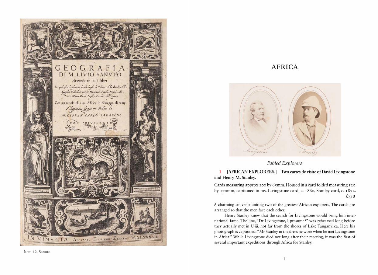
Item 12, Sanuto
AFRICA
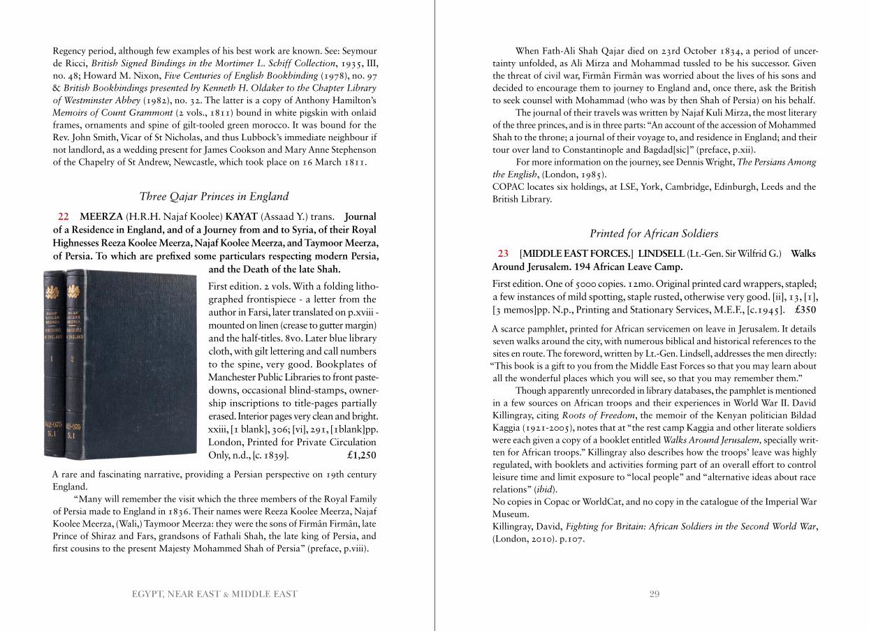
Fabled Explorers
1 [AFRICAN EXPLORERS.] Two cartes de visite of David Livingstone and Henry M. Stanley.
Cards measuring approx 100 by 65mm. Housed in a card folded measuring 120 by 170mm, captioned in ms. Livingstone card, c. 1860, Stanley card, c. 1872. £750
A charming souvenir uniting two of the greatest African explorers. The cards are arranged so that the men face each other.
Henry Stanley knew that the search for Livingstone would bring him inter-national fame. The line, “Dr Livingstone, I presume?” was rehearsed long before they actually met in Ujiji, not far from the shores of Lake Tanganyika. Here his photograph is captioned: “Mr Stanley in the dress he wore when he met Livingstone in Africa.” While Livingstone died not long after their meeting, it was the first of several important expeditions through Africa for Stanley.
3AFRICA
Disrupting the Slave Trade
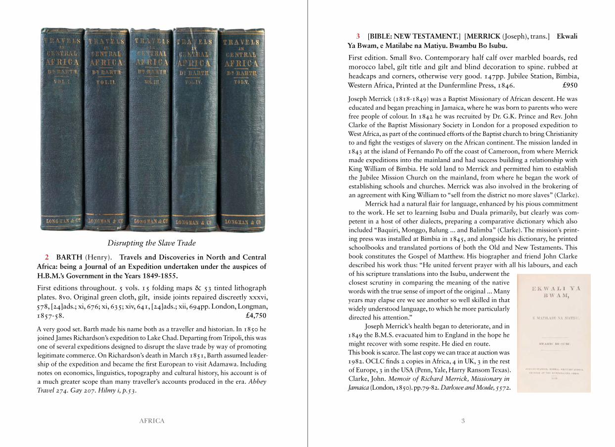
2 BARTH (Henry). Travels and Discoveries in North and Central Africa: being a Journal of an Expedition undertaken under the auspices of H.B.M.’s Government in the Years 1849-1855.
First editions throughout. 5 vols. 15 folding maps & 53 tinted lithograph plates. 8vo. Original green cloth, gilt, inside joints repaired discreetly xxxvi, 578, [24]ads.; xi, 676; xi, 635; xiv, 641, [24]ads.; xii, 694pp. London, Longman, 1857-58. £4,750
A very good set. Barth made his name both as a traveller and historian. In 1850 he joined James Richardson’s expedition to Lake Chad. Departing from Tripoli, this was one of several expeditions designed to disrupt the slave trade by way of promoting legitimate commerce. On Richardson’s death in March 1851, Barth assumed leader-ship of the expedition and became the first European to visit Adamawa. Including notes on economics, linguistics, topography and cultural history, his account is of a much greater scope than many traveller’s accounts produced in the era. Abbey Travel 274 . Gay 207 . Hilmy i, p .53 .
3 [BIBLE: NEW TESTAMENT.] [MERRICK (Joseph), trans.] Ekwali Ya Bwam, e Matilabe na Matiyu. Bwambu Bo Isubu.
First edition. Small 8vo. Contemporary half calf over marbled boards, red morocco label, gilt title and gilt and blind decoration to spine. rubbed at headcaps and corners, otherwise very good. 147pp. Jubilee Station, Bimbia, Western Africa, Printed at the Dunfermline Press, 1846. £950
Joseph Merrick (1818-1849) was a Baptist Missionary of African descent. He was educated and began preaching in Jamaica, where he was born to parents who were free people of colour. In 1842 he was recruited by Dr. G.K. Prince and Rev. John Clarke of the Baptist Missionary Society in London for a proposed expedition to West Africa, as part of the continued efforts of the Baptist church to bring Christianity to and fight the vestiges of slavery on the African continent. The mission landed in 1843 at the island of Fernando Po off the coast of Cameroon, from where Merrick made expeditions into the mainland and had success building a relationship with King William of Bimbia. He sold land to Merrick and permitted him to establish the Jubilee Mission Church on the mainland, from where he began the work of establishing schools and churches. Merrick was also involved in the brokering of an agreement with King William to “sell from the district no more slaves” (Clarke).
Merrick had a natural flair for language, enhanced by his pious commitment to the work. He set to learning Isubu and Duala primarily, but clearly was com-petent in a host of other dialects, preparing a comparative dictionary which also included “Baquiri, Monggo, Balung ... and Balimba” (Clarke). The mission’s print-ing press was installed at Bimbia in 1845, and alongside his dictionary, he printed schoolbooks and translated portions of both the Old and New Testaments. This book constitutes the Gospel of Matthew. His biographer and friend John Clarke described his work thus: “He united fervent prayer with all his labours, and each of his scripture translations into the Isubu, underwent the closest scrutiny in comparing the meaning of the native words with the true sense of import of the original ... Many years may elapse ere we see another so well skilled in that widely understood language, to which he more particularly directed his attention.”
Joseph Merrick’s health began to deteriorate, and in 1849 the B.M.S. evacuated him to England in the hope he might recover with some respite. He died en route.This book is scarce. The last copy we can trace at auction was 1982. OCLC finds 2 copies in Africa, 4 in UK, 3 in the rest of Europe, 3 in the USA (Penn, Yale, Harry Ransom Texas).Clarke, John. Memoir of Richard Merrick, Missionary in Jamaica (London, 1850). pp.79-82. Darlowe and Moule, 5572 .
5AFRICA
Beautiful Contemporary Calf
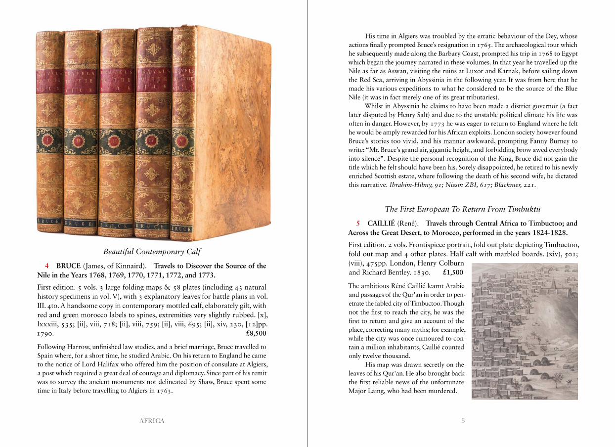
4 BRUCE (James, of Kinnaird). Travels to Discover the Source of the Nile in the Years 1768, 1769, 1770, 1771, 1772, and 1773.
First edition. 5 vols. 3 large folding maps & 58 plates (including 43 natural history specimens in vol. V), with 3 explanatory leaves for battle plans in vol. III. 4to. A handsome copy in contemporary mottled calf, elaborately gilt, with red and green morocco labels to spines, extremities very slightly rubbed. [x], lxxxiii, 535; [ii], viii, 718; [ii], viii, 759; [ii], viii, 695; [ii], xiv, 230, [12]pp. 1790. £8,500
Following Harrow, unfinished law studies, and a brief marriage, Bruce travelled to Spain where, for a short time, he studied Arabic. On his return to England he came to the notice of Lord Halifax who offered him the position of consulate at Algiers, a post which required a great deal of courage and diplomacy. Since part of his remit was to survey the ancient monuments not delineated by Shaw, Bruce spent some time in Italy before travelling to Algiers in 1763.
His time in Algiers was troubled by the erratic behaviour of the Dey, whose actions finally prompted Bruce’s resignation in 1765. The archaeological tour which he subsequently made along the Barbary Coast, prompted his trip in 1768 to Egypt which began the journey narrated in these volumes. In that year he travelled up the Nile as far as Aswan, visiting the ruins at Luxor and Karnak, before sailing down the Red Sea, arriving in Abyssinia in the following year. It was from here that he made his various expeditions to what he considered to be the source of the Blue Nile (it was in fact merely one of its great tributaries).
Whilst in Abyssinia he claims to have been made a district governor (a fact later disputed by Henry Salt) and due to the unstable political climate his life was often in danger. However, by 1773 he was eager to return to England where he felt he would be amply rewarded for his African exploits. London society however found Bruce’s stories too vivid, and his manner awkward, prompting Fanny Burney to write: “Mr. Bruce’s grand air, gigantic height, and forbidding brow awed everybody into silence”. Despite the personal recognition of the King, Bruce did not gain the title which he felt should have been his. Sorely disappointed, he retired to his newly enriched Scottish estate, where following the death of his second wife, he dictated this narrative. Ibrahim-Hilmy, 91; Nissin ZBI, 617; Blackmer, 221 .
The First European To Return From Timbuktu
5 CAILLIÉ (René). Travels through Central Africa to Timbuctoo; and Across the Great Desert, to Morocco, performed in the years 1824-1828.
First edition. 2 vols. Frontispiece portrait, fold out plate depicting Timbuctoo, fold out map and 4 other plates. Half calf with marbled boards. (xiv), 501; (viii), 475pp. London, Henry Colburn and Richard Bentley. 1830. £1,500
The ambitious Réné Caillié learnt Arabic and passages of the Qur'an in order to pen-etrate the fabled city of Timbuctoo. Though not the first to reach the city, he was the first to return and give an account of the place, correcting many myths; for example, while the city was once rumoured to con-tain a million inhabitants, Caillié counted only twelve thousand.
His map was drawn secretly on the leaves of his Qur'an. He also brought back the first reliable news of the unfortunate Major Laing, who had been murdered.
7AFRICA
Notes on the Emperor’s Son
6 C[OTTON] (C[ornelia].) Anecdotes of Alamayu, the late KingTheodore’s son.
First edition. Original photographic frontispiece. 12mo. Original cloth, lettered on the upper cover, spine sunned, a.e.g. 72pp. London, William Hunt & Co., 1870. £1,250
A lovely work by Cornelia Cotton, who with her husband, Captain Speedy, spent six months taking care of the orphaned Alamayu.
After the fall of Magdala, Emperor Theodore’s widow and son, Alamayu (1861-79), were to be sent to India under the watchful eye of Captain Speedy, the linguist and traveller, who had played an important role in the campaign. However, before leaving the continent the Empress died of consumption, and the boy faced
exile alone. Queen Victoria decided the child should be brought to England with Captain Speedy and his wife. They arrived in 1869 and were imme-diately housed on the Isle of White and presented to the Queen, who took a great shine to the boy. This little book which includes an original photograph of the child by Hughes & Mullins of Ryde, commemorates his stay on the island. In 1869, the Speedys continued to look after him while they were in India, though it was decided he would be better educated in England. Alamayu would attend Rugby and later entered the Royal Military College at Sandhurst.Scarce: OCLC locates seven copies.
The Annexation of Swaziland
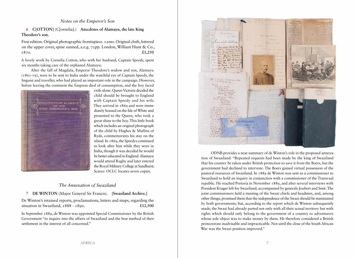
7 DE WINTON (Major General Sir Francis). [Swaziland Archive.]
De Winton’s retained reports, proclamations, letters and maps, regarding the situation in Swaziland, 1888 - 1890. £12,500
In September 1889, de Winton was appointed Special Commissioner by the British Government “to inquire into the affairs of Swaziland and the best method of their settlement in the interest of all concerned.”
ODNB provides a neat summary of de Winton’s role in the proposed annexa-tion of Swaziland: “Repeated requests had been made by the king of Swaziland that his country be taken under British protection to save it from the Boers, but the government had declined to intervene. The Boers gained virtual possession of the pastoral resources of Swaziland. In 1889 de Winton was sent as a commissioner to Swaziland to hold an inquiry in conjunction with a commissioner of the Transvaal republic. He reached Pretoria in November 1889, and after several interviews with President Kruger left for Swaziland, accompanied by generals Joubert and Smit. The joint commissioners held a meeting of the Swazi chiefs and headmen, and, among other things, promised them that the independence of the Swazi should be maintained by both governments; but, according to the report which de Winton subsequently made, the Swazi had already parted not only with all their actual territory but with rights which should only belong to the government of a country to adventurers whose sole object was to make money by them. He therefore considered a British protectorate inadvisable and impracticable. Not until the close of the South African War was the Swazi position improved.”
9AFRICA
On the Swazi side, in February 1887, Mbandzeni had appointed Theophilus Shepstone Resident Advisor and Agent. Shepstone was well-experienced in affairs of Empire – in 1877 he had overseen the British annexation of the Transvaal. Swaziland proved to be a more complex situation as there was some confusion over the extent and permanence of the concessions (on mining and agriculture) made to the white population. To complicate matters further, Mbandzeni died in October 1889.
The Joint Commission comprised: Colonel Francis de Winton as British Commissioner; Colonel Richard Martin, Representative for Swaziland; Theophilus Shepston; and Captain Robert Baden Powell. Also present were Generals Smit and Joubert representing Pretoria; and Mr. Van Alpen as joint secretary. Smit and Martin had already conducted some preliminary inquiries into the question. “The principal task of the commission was to make recommendations on the future governance of Europeans in Swaziland. It moved with reasonable speed; by late November the ‘white committee’ was dissolved and its former powers transferred to the commis-sion ... The work of the commission was somewhat inhibited because of the king’s death and the customary year of mourning that normally followed ... three propos-als were made that had important consequences for the situation in the kingdom. First, a system of courts should be set up, based on Roman-Dutch law as practiced in the Republic; second, a newly established High Court should be empowered to deal with the initial validity of concessions; and third, if the proposed governmental arrangements did not work out, sole responsibility for the kingdom should be given to the South African Republic” (Gillis).
In addition to his own notes, the group comprises items from many of the major players in the Joint Commission as well as vested parties. The material pro-vides much added insight into the workings of the committee, the ambitions of, and
complications faced by, each party, as well as valu-able unpublished first-hand testimony. Importantly, it includes two documents by Robert Baden Powell, namely, a 10pp. letter titled, “Sketch of Swaziland Question.” Similarly, there is a six-page letter from W.S. Pigg, “Reasons why England should take over Swaziland”, plus Frank Adcock’s “Views on the Swaziland Question.” Then there are letters from De Winton to his father, plus correspondence between De Winton and Transvaal President Paul Kruger.
A more detailed list of these can be provided on request.Provenance: from the private papers of Major General Sir Francis de Winton GCMG CB FRGS and by descent.Gillis, D. Hugh, The Kingdom of Swaziland: Studies in Political History (Praeger, 1999), p.66.
Beautiful And Unusual Educational Artwork
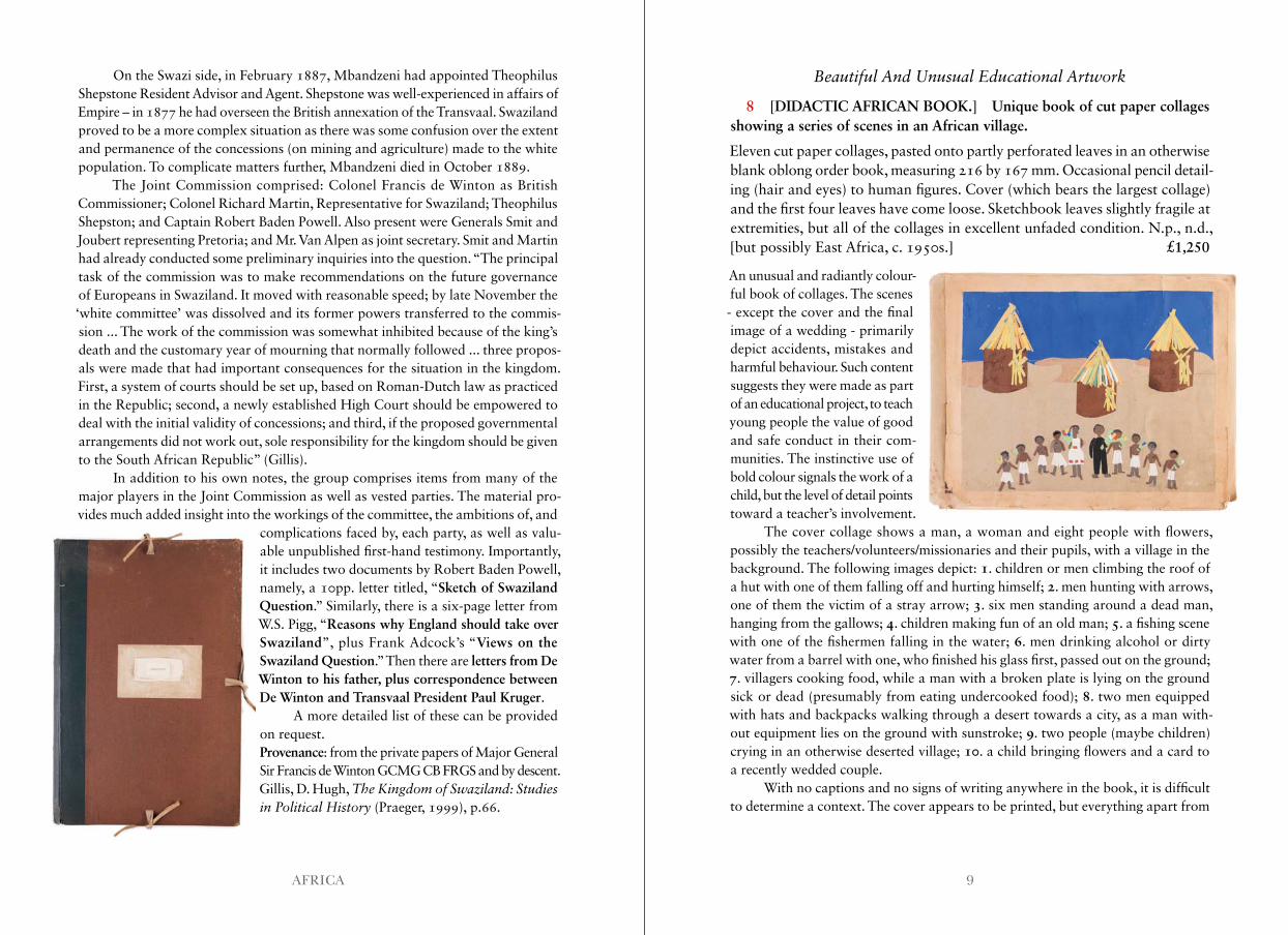
8 [DIDACTIC AFRICAN BOOK.] Unique book of cut paper collages showing a series of scenes in an African village.
Eleven cut paper collages, pasted onto partly perforated leaves in an otherwise blank oblong order book, measuring 216 by 167 mm. Occasional pencil detail-ing (hair and eyes) to human figures. Cover (which bears the largest collage) and the first four leaves have come loose. Sketchbook leaves slightly fragile at extremities, but all of the collages in excellent unfaded condition. N.p., n.d., [but possibly East Africa, c. 1950s.] £1,250
An unusual and radiantly colour-ful book of collages. The scenes - except the cover and the final image of a wedding - primarily depict accidents, mistakes and harmful behaviour. Such content suggests they were made as part of an educational project, to teach young people the value of good and safe conduct in their com-munities. The instinctive use of bold colour signals the work of a child, but the level of detail points toward a teacher’s involvement.
The cover collage shows a man, a woman and eight people with flowers, possibly the teachers/volunteers/missionaries and their pupils, with a village in the background. The following images depict: 1. children or men climbing the roof of a hut with one of them falling off and hurting himself; 2. men hunting with arrows, one of them the victim of a stray arrow; 3. six men standing around a dead man, hanging from the gallows; 4. children making fun of an old man; 5. a fishing scene with one of the fishermen falling in the water; 6. men drinking alcohol or dirty water from a barrel with one, who finished his glass first, passed out on the ground; 7. villagers cooking food, while a man with a broken plate is lying on the ground sick or dead (presumably from eating undercooked food); 8. two men equipped with hats and backpacks walking through a desert towards a city, as a man with-out equipment lies on the ground with sunstroke; 9. two people (maybe children) crying in an otherwise deserted village; 10. a child bringing flowers and a card to a recently wedded couple.
With no captions and no signs of writing anywhere in the book, it is difficult to determine a context. The cover appears to be printed, but everything apart from
11AFRICA
one word “Bestell” (‘order’ in German) is covered by a collage. This, along with the perforations, strongly suggest it is a German order book. This connection could mean that the collages depict East Africa, and were potentially made there. In addition, the mosque in the ninth collage suggests a country with a large Muslim population such as Tanzania.
Extremely Rare Report On African Decolonization
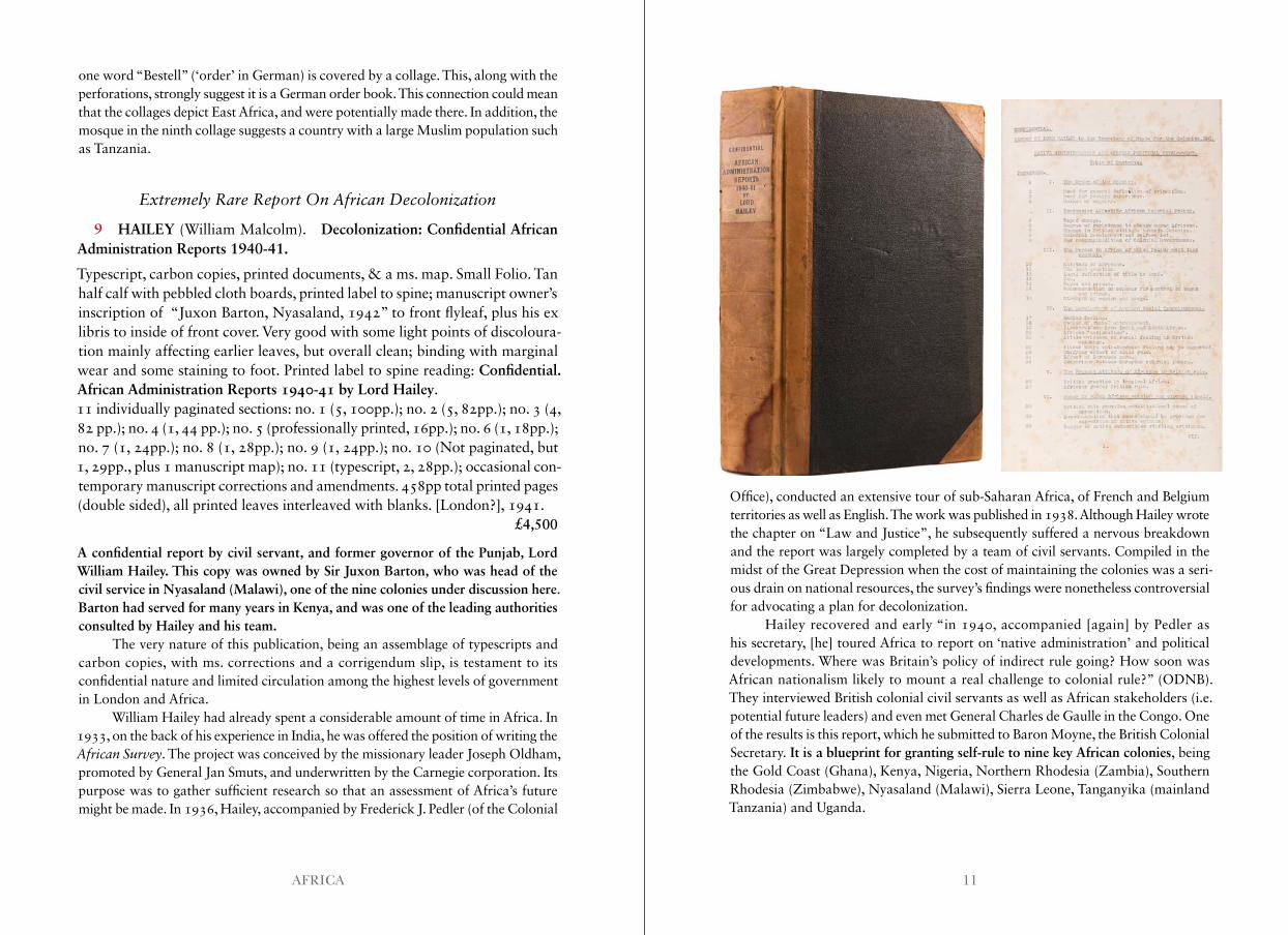
9 HAILEY (William Malcolm). Decolonization: Confidential African Administration Reports 1940-41.
Typescript, carbon copies, printed documents, & a ms. map. Small Folio. Tan half calf with pebbled cloth boards, printed label to spine; manuscript owner’s inscription of “Juxon Barton, Nyasaland, 1942” to front flyleaf, plus his ex libris to inside of front cover. Very good with some light points of discoloura-tion mainly affecting earlier leaves, but overall clean; binding with marginal wear and some staining to foot. Printed label to spine reading: Confidential. African Administration Reports 1940-41 by Lord Hailey.11 individually paginated sections: no. 1 (5, 100pp.); no. 2 (5, 82pp.); no. 3 (4, 82 pp.); no. 4 (1, 44 pp.); no. 5 (professionally printed, 16pp.); no. 6 (1, 18pp.); no. 7 (1, 24pp.); no. 8 (1, 28pp.); no. 9 (1, 24pp.); no. 10 (Not paginated, but 1, 29pp., plus 1 manuscript map); no. 11 (typescript, 2, 28pp.); occasional con-temporary manuscript corrections and amendments. 458pp total printed pages (double sided), all printed leaves interleaved with blanks. [London?], 1941. £4,500
A confidential report by civil servant, and former governor of the Punjab, Lord William Hailey. This copy was owned by Sir Juxon Barton, who was head of the civil service in Nyasaland (Malawi), one of the nine colonies under discussion here. Barton had served for many years in Kenya, and was one of the leading authorities consulted by Hailey and his team.
The very nature of this publication, being an assemblage of typescripts and carbon copies, with ms. corrections and a corrigendum slip, is testament to its confidential nature and limited circulation among the highest levels of government in London and Africa.
William Hailey had already spent a considerable amount of time in Africa. In 1933, on the back of his experience in India, he was offered the position of writing the African Survey. The project was conceived by the missionary leader Joseph Oldham, promoted by General Jan Smuts, and underwritten by the Carnegie corporation. Its purpose was to gather sufficient research so that an assessment of Africa’s future might be made. In 1936, Hailey, accompanied by Frederick J. Pedler (of the Colonial
Office), conducted an extensive tour of sub-Saharan Africa, of French and Belgium territories as well as English. The work was published in 1938. Although Hailey wrote the chapter on “Law and Justice”, he subsequently suffered a nervous breakdown and the report was largely completed by a team of civil servants. Compiled in the midst of the Great Depression when the cost of maintaining the colonies was a seri-ous drain on national resources, the survey’s findings were nonetheless controversial for advocating a plan for decolonization.
Hailey recovered and early “in 1940, accompanied [again] by Pedler as his secretary, [he] toured Africa to report on ‘native administration’ and political developments. Where was Britain’s policy of indirect rule going? How soon was African nationalism likely to mount a real challenge to colonial rule?” (ODNB). They interviewed British colonial civil servants as well as African stakeholders (i.e. potential future leaders) and even met General Charles de Gaulle in the Congo. One of the results is this report, which he submitted to Baron Moyne, the British Colonial Secretary. It is a blueprint for granting self-rule to nine key African colonies, being the Gold Coast (Ghana), Kenya, Nigeria, Northern Rhodesia (Zambia), Southern Rhodesia (Zimbabwe), Nyasaland (Malawi), Sierra Leone, Tanganyika (mainland Tanzania) and Uganda.
13AFRICA
Building on the findings of the African Survey, Hailey concluded “that indi-rect rule was going nowhere, that nationalism seemed to be less advanced than he had expected, that it would certainly come, and that Africans should be appointed at every level of the bureaucracy, including the central governments” (ibid). This would lead to a gradual transition toward self-rule and independence. While the report naturally opens with some broad-stroke advice – following the rule of law, eschewing extreme ethno-nationalism while recognising moderates – it outlines 23 major factors necessary for the development of the proposed native-led regimes: The Forces in Africa of which Policy must take into account; The Development of African Racial Consciousness; The Present Attitude of Africans to British Rule; Growth of the Middle Class; The Utilization of Traditional Native Authorities; Urban and Industrialized Areas; The Native Authorities as Part of the general machinery of government; The Planning of Future Political Developments and The relative importance of Political Advance and Economic and Social Development. However, its real value is in the polity-specific advice given in each section. Indeed, it proved highly influential in guiding Whitehall’s policy towards its progressively de-accessioned African empire over the succeeding generation.
The tone of the report is cool and dispassionate. Hailey generally preferred to state the facts as he came across them rather than editorialising, though he might be accused, as in section 5 concerning the amalgamation of colonies in Rhodesia and Nyasaland, of arranging the evidence in order to encourage the reader towards a particular conclusion.
The impact of the report was recognised immediately: “In February 1941, shortly after returning to London, Lord Hailey handed in the report on ‘Native Administration and Political Development,’ which he and Pedler had completed in the Congo. In some ways it was his most significant publication, outranking even the African Survey, for it helped set the framework for British official thinking on African affairs through the rest of the war and anticipated the early stages of decolo-nization. It contained a long introduction, country-by-country examinations, and a survey of Southern Rhodesia … an edited version was distributed to members of the colonial service…” (Cell, 254). Indeed, an abridged version of the present report (removing some of the more controversial subjects that offended conservatives) was published under the title Native Administration and Political Development in British Tropical Africa: Report, 1940-42 (London, HMSO, 1944). It was also designated Confidential and intended only for the eyes of senior officials.
The report was taken up with enthusiasm by the newly-elected Labour govern-ment in 1945 and, when Churchill returned to power in 1951, continued to implement its recommendations. Hailey himself elaborated on this report and later published the five volume Native Administration in the British African Territories, 1951-3.
Of course, establishing government policy is one thing, implementation on the ground is quite another. The Mau Mau Uprising in 1952 caused a near complete breakdown in civil order in Kenya which inevitably involved the British colonial
government. Not least, elsewhere Jomo Kenyatta (Kenya), Kwame Nkrumah (Ghana), and Julius Nyerer (Tanzania) were determined to break free from English oversight as quickly as possible.While there may be other copies of this report in government archives, we locate just a single example of the original 1941 report in the National Archives: CO 847/106; Cf. John W. Cell, ‘Lord Hailey and the Making of the African Survey’, African Affairs, vol. 88, No. 353 (October, 1989), pp. 481-505; John W. Cell, Hailey: A Study in British Imperialism, 1872-1969 (Cambridge, U.K., 2002), esp. pp. 254–265.
Tswana Language
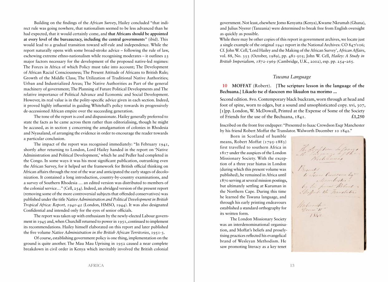
10 MOFFAT (Robert). [The scripture lesson in the language of the Bechuana.] Likaelo tse el tlaocoen mo likualon tsa morimo ...
Second edition. 8vo. Contemporary black buckram, worn through at head and foot of spine, worn to edges, but a sound and unsophisticated copy. xvi, 307, [1]pp. London, W. McDowall, Printed at the Expense of Some of the Society of Friends for the use of the Bechuana, 1841. £1,250
Inscribed on the front free endpaper: “Presented to Isaac Crewdson Esqr Manchester by his friend Robert Moffat the Translator. Walworth December 10 1842.”
Born in Scotland of humble means, Robert Moffat (1795-1883) first travelled to southern Africa in 1817 under the auspices of the London Missionary Society. With the excep-tion of a three year hiatus in London (during which this present volume was published), he remained in Africa until 1870 serving at several mission postings, but ultimately settling at Kuruman in the Northern Cape. During this time he learned the Tswana language, and through his early printing endeavours established a standard orthography for its written form.
The London Missionary Society was an interdenominational organisa-tion, and Moffat’s beliefs and prosely-tising practices reflected his evangelical brand of Wesleyan Methodism. He saw promoting literacy as a key tenet
15AFRICA
of his mission to “civilise” the non-Christian people of Africa, and unlike other branches of the LMS, he kept converted black members of his congregations in relatively subjugated roles. This paternalistic approach made him a compliant liaison between the British administration in the Cape Colony and the tribal chiefs of the interior.
His first publication in the Tswana language was a spelling book, printed in London in 1826. Next, using the Government Press in Cape Town, he printed his Gospel of St Luke in 1830. He returned to Kuruman with a hand press, which he personally operated to make small editions of his translation works. The first edition of the present work was printed on the Kuruman press in 1833, copies of which we have traced only at the National Library and Parliamentary Information Center of South Africa. The pagination of the first edition is: xvi, 433pp. Though we have not been able to consult a copy, this would suggest significant differences to the second edition.
Frustrated with the limited edition size achievable with the hand press, in 1839 Moffat returned to Cape Town hoping to be able to use the Government Press once again to print more of his works. This was not possible, and in June of that year he and his wife ended up returning to London.
Whilst in London, Moffat produced the following second edition of his Tswana scriptural lessons. The title-page attests to the fact that the production was “printed at the expense of some of The Society of Friends”, and this particular copy is personally inscribed by Moffat to Isaac Crewdson, the Quaker secessionist who authored the controversial Beacon to the Society of Friends (1835) and was at the head of the Beaconite schism. Crewdson was also an abolitionist, and attended the 1840 World Anti-Slavery Convention.Though the print run of this edition was 5000 copies, it is extremely scarce. By virtue of its intended purpose, the majority of copies were no doubt distributed to Tswana-speaking people in Africa, with very few surviving in institutional collections. OCLC finds copies at NYPL, The American Bible Society Library, SOAS, Waseda Japan and 3 in South Africa.
A Rare Study of a North African Language
11 [RICHARDSON (James).] Touarick Alphabet, with the Corresponding Arabic and English Letters.
First edition. Illustrations to text. Folio. Self-wrappers, stitched as issued. Old folds, docketed on final blank in ms. 8, [4]pp. London, T.R. Harrison, 1847. £2,500
This rare pamphlet is prefaced with a note from Richardson to John Bidwell at the Foreign Office. “I think I may say without hesitation, that the enclosed Alphabet is
the most remarkable, as well as the most interesting contribution to the Science of Philology which has been brought into Europe during the present year.”
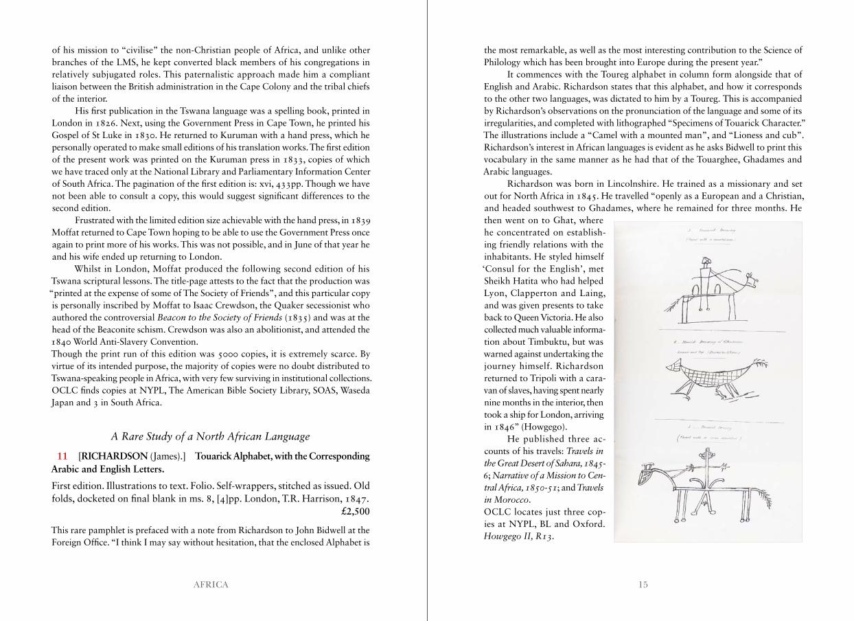
It commences with the Toureg alphabet in column form alongside that of English and Arabic. Richardson states that this alphabet, and how it corresponds to the other two languages, was dictated to him by a Toureg. This is accompanied by Richardson’s observations on the pronunciation of the language and some of its irregularities, and completed with lithographed “Specimens of Touarick Character.” The illustrations include a “Camel with a mounted man”, and “Lioness and cub”. Richardson’s interest in African languages is evident as he asks Bidwell to print this vocabulary in the same manner as he had that of the Touarghee, Ghadames and Arabic languages.
Richardson was born in Lincolnshire. He trained as a missionary and set out for North Africa in 1845. He travelled “openly as a European and a Christian, and headed southwest to Ghadames, where he remained for three months. He then went on to Ghat, where he concentrated on establish-ing friendly relations with the inhabitants. He styled himself ‘Consul for the English’, met Sheikh Hatita who had helped Lyon, Clapperton and Laing, and was given presents to take back to Queen Victoria. He also collected much valuable informa-tion about Timbuktu, but was warned against undertaking the journey himself. Richardson returned to Tripoli with a cara-van of slaves, having spent nearly nine months in the interior, then took a ship for London, arriving in 1846” (Howgego).
He published three ac-counts of his travels: Travels in the Great Desert of Sahara, 1845- 6; Narrative of a Mission to Cen-tral Africa, 1850-51; and Travels in Morocco.OCLC locates just three cop-ies at NYPL, BL and Oxford. Howgego II, R13 .
17AFRICA
The First Printed Atlas of Africa
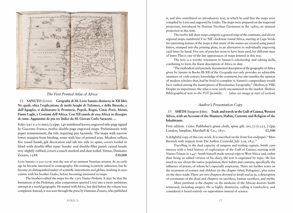
12 SANUTO (Livio). Geografia di M. Livio Sanuto distincta in XII libri. Ne quali, oltra l’esplicatione di molti luoghi di Tolomeo, e della Bussola, e dell’Aguglia, si dichiarano le Prouincie, Popoli, Regni, Città; Porti, Monti, Fiumi Laghi, e Costumi dell’Africa. Con XII tauole di essa Africa in dissegno di rame. Aggiuntiui de piu tre Indici da M. Giovan Carlo Saraceni. ...
Folio (397 x 270 mm); [32]pp, 146 numbered leaves; engraved title-page signed by Giacomo Franco, twelve double-page engraved maps. Preliminaries with paper reinstatement, the title requiring pen facsimile. The maps with narrow lower margins from binding, some with loss of printed area. Modern vellum, five raised bands, gilt decoration and ink ms. title to spine, covers tooled in blind with double-fillet outer border and double-fillet panel; raised bands very slightly rubbed, covers a touch marked and dust-soiled. Venice, Damiano Zenaro, 1588. £30,000
Livio Sanuto (1520-1576) was the son of an eminent Venetian senator. At an early age he became interested in cosmography. His training is entirely unknown, but he became an distinguished maker of scientific instruments and globes, working in asso-ciation with his brother Giulio, before becoming interested in maps.
The brothers edited the maps for the 1561 Venice Ptolemy. It may be that the limitations of the Ptolemaic atlas composition spurred Livio into a more ambitious attempt at a world geography. He started with Africa, but died before the volume was completed. Instead, it was seen through the press by Damiano Zenaro, who published
it, and also contributed an introductory text, in which he said that the maps were compiled by Livio and engraved by Giulio. The maps were prepared on the trapezoid projection, introduced by Donnus Nicolaus Germanus in the 1480s, an unusual projection at this time.
The twelve full sheet maps comprise a general map of the continent, and eleven regional maps, numbered ‘I’ to ‘XII’ clockwise round Africa, starting at Cape Verde. An interesting feature of the maps is that many of the names are created using punch letters, stamped into the printing plate, as an alternative to individually engraving each letter by hand. Five sets of punches seem to have been used, for different sizes of letter. This is one of the last appearances of maps lettered in this way.
The text is a worthy testament to Sanuto’s scholarship and editing skills, combining to form the finest description of Africa to date.
“The methodical and precisely documented description of the geography of Africa given by Sanuto in Books III-XII of the Geografia not only provides an admirable summary of 16th-century knowledge of the continent, but also justifies the opinion of modern scholars that, had he lived to complete it, Sanuto’s compendium would have ranked among the masterpieces of Renaissance Geography.” (Skelton, p. VIII).Despite its importance, the atlas is now rarely encountered on the market. Skelton: Bibliographical note to the TOT facsimile . [also: see image at start of section]
Author’s Presentation Copy
13 SMITH (Surgeon John). Trade and travels in the Gulf of Guinea, Western Africa, with an Account of the Manners, Habits, Customs and Religion of the Inhabitants.
First edition. 12mo. Publisher’s green cloth, spine gilt. xvi, [17]-223, [1]pp. London, Simpkin, Marshall & Co., 1851. £1,500
A delightful copy of this rare work. It is inscribed on the front free endpaper: “Miss Barwick with respects from The Author. Coxwold, July 21st, 1851.”
Travelling in the dual capacity of surgeon and trading captain, Smith com-mences with a brief history of exploration of the Gulf of Guinea, starting with Nunno Tristan in 1447. Smith himself made several trips to West Africa and, rather than being an edited version of his diary, the text is organised by topic. He has much to say about the native population, their habits and customs, specifically the influence of priests, of whom he’s especially suspicious. There are further notes on the treatment of women and children (in the chapter titled, Polygamy), plus notes on the slave trade. There are two chapters devoted to fetish and ju-ju, a description of ceremonies of the dead and chapters on sacrifices, human sacrifices, and myths.
More pertinent is the chapter on the medicine of the African doctors Smith witnessed, including surgery. He is highly dismissive, calling it tomfoolery, and considered it based entirely on superstition instead of science.
19AFRICA
EGYPT, NEAR EAST & MIDDLE EAST
Drawn by an Eye-Witness
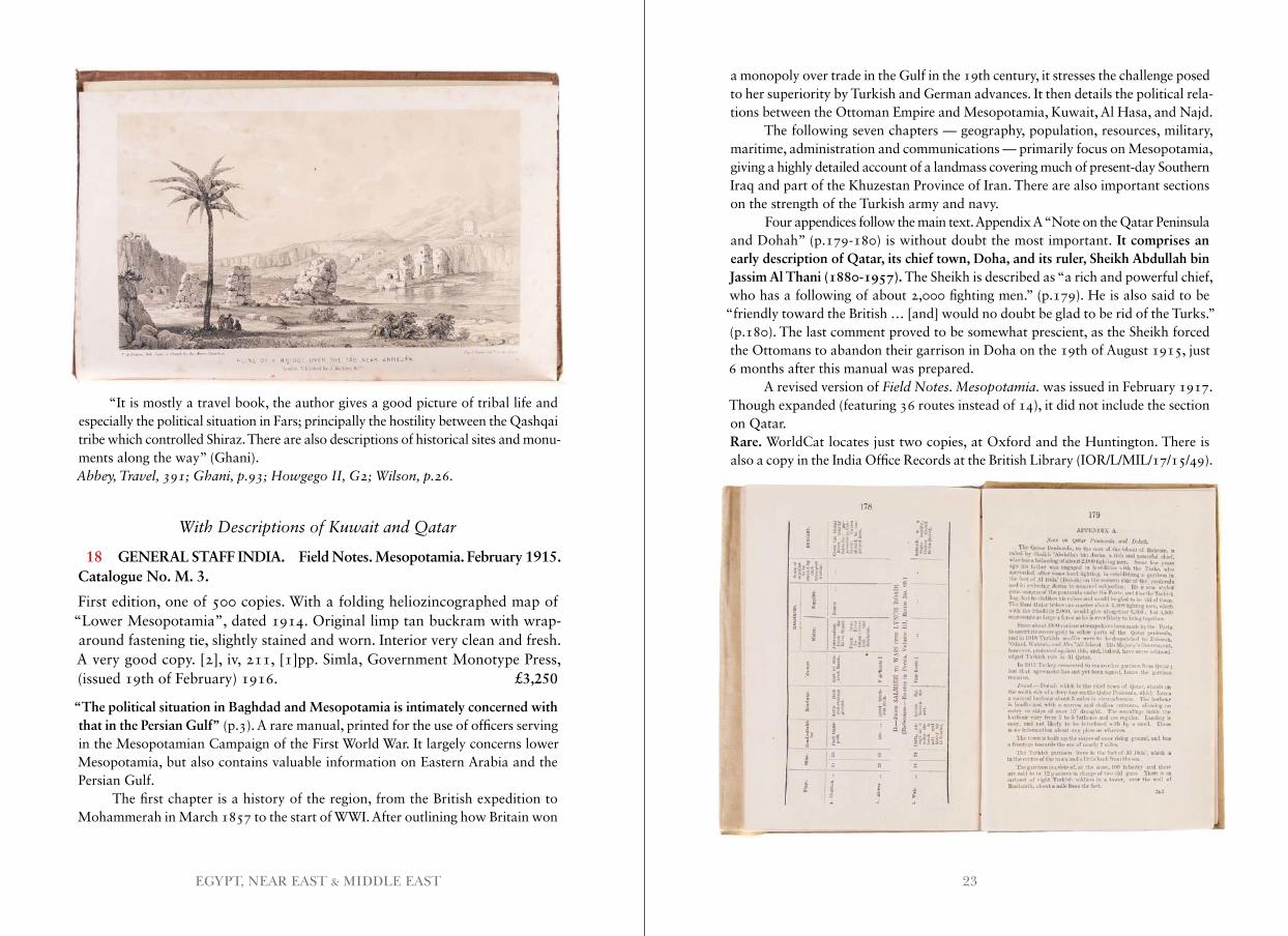
15 [ANON.] Plan of the Camp at Djouni [Jounieh, Syria] by [illegible monogramme: ‘JTY’?].
Manuscript map. Pencil, ink and watercolour on paper. Slightly spotted, extremities fragile with a few areas of chipping, three closed tears and one section (4cm across and 1cm deep) of loss. [1840]. £600
A plan of the joint Anglo-Turkish Camp at Djouni when an Anglo-Austrian fleet was sent to help defend Turkish possessions in Syria (Lebanon) against Egyptian depreda-tions, forming the Second Egyptian–Ottoman War or Second Turko–Egyptian War (1839-1841). The plan is a simple sketch of the fortifications, the interior divisions and the Turkish quarter, marking also the field of defensive fire that HMS Princess Charlotte and Powerful and her steamers could bring to bear on any attackers. The plan was evidently drawn by an eyewitness, but the illegible signature prevents identification.
The work was read by Richard Burton, who quotes from it in his 1860 work, The Lake Regions of Central Africa (vol. 2, p.348).OCLC locates a single copy in South Africa. Franklin Brooke-Hitching did not own a copy.
A Rare Broadside
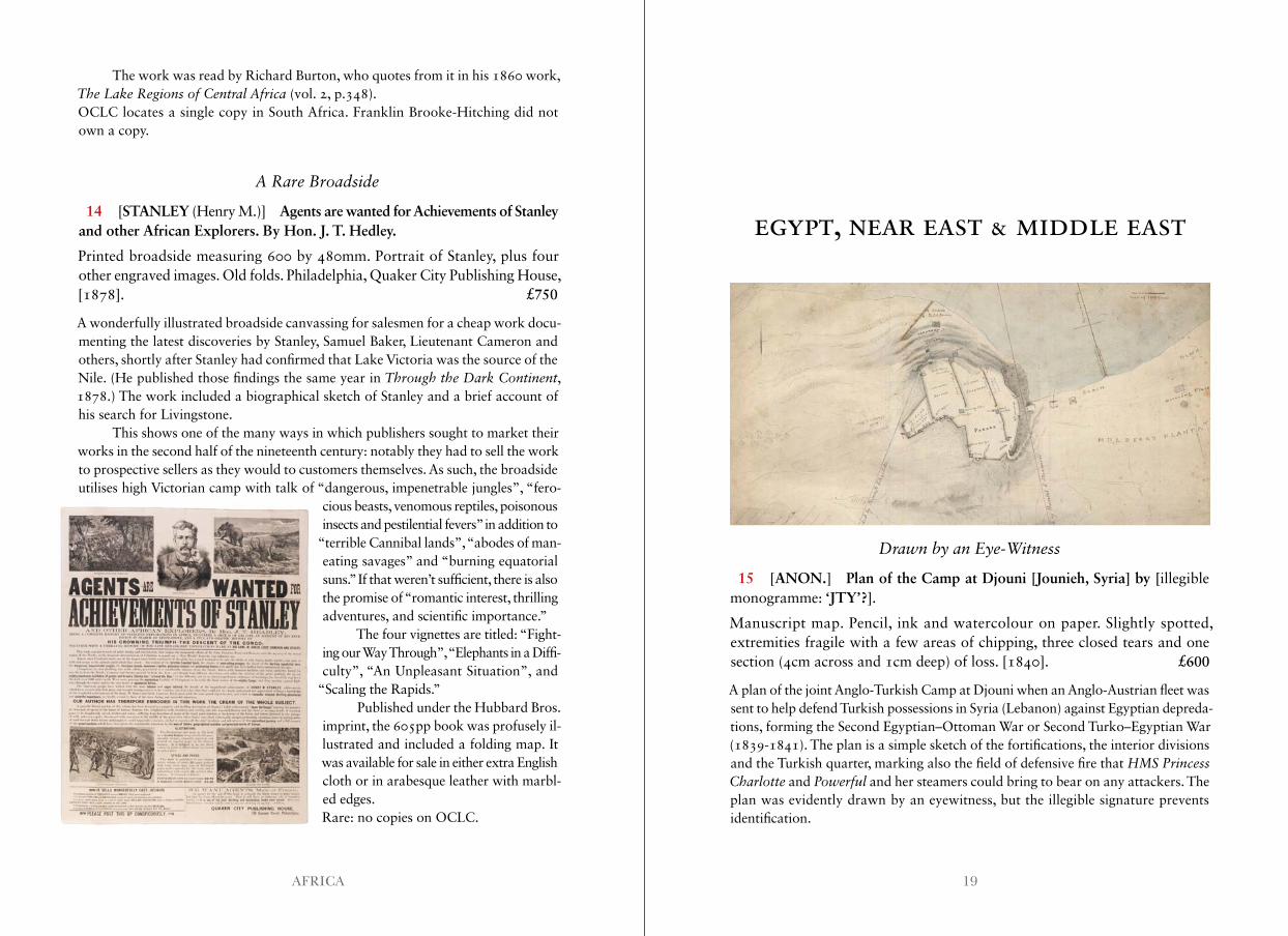
14 [STANLEY (Henry M.)] Agents are wanted for Achievements of Stanley and other African Explorers. By Hon. J. T. Hedley.
Printed broadside measuring 600 by 480mm. Portrait of Stanley, plus four other engraved images. Old folds. Philadelphia, Quaker City Publishing House, [1878]. £750
A wonderfully illustrated broadside canvassing for salesmen for a cheap work docu-menting the latest discoveries by Stanley, Samuel Baker, Lieutenant Cameron and others, shortly after Stanley had confirmed that Lake Victoria was the source of the Nile. (He published those findings the same year in Through the Dark Continent, 1878.) The work included a biographical sketch of Stanley and a brief account of his search for Livingstone.
This shows one of the many ways in which publishers sought to market their works in the second half of the nineteenth century: notably they had to sell the work to prospective sellers as they would to customers themselves. As such, the broadside utilises high Victorian camp with talk of “dangerous, impenetrable jungles”, “fero-
cious beasts, venomous reptiles, poisonous insects and pestilential fevers” in addition to
“terrible Cannibal lands”, “abodes of man-eating savages” and “burning equatorial suns.” If that weren’t sufficient, there is also the promise of “romantic interest, thrilling adventures, and scientific importance.”
The four vignettes are titled: “Fight- ing our Way Through”, “Elephants in a Diffi- culty”, “An Unpleasant Situation”, and
“Scaling the Rapids.”Published under the Hubbard Bros.
imprint, the 605pp book was profusely il-lustrated and included a folding map. It was available for sale in either extra English cloth or in arabesque leather with marbl- ed edges.Rare: no copies on OCLC.

21EGYPT, NEAR EAST & MIDDLE EAST
An Essential Work on Western Persia
17 DE BODE (The Baron C.A.). Travels in Luristan and Arabistan.
First edition. Two vols. With 15 engraved and lithographed plates (incl. two frontispieces and two folding) and two folding maps. 8vo. Original reddish-brown blind decorated cloth, lettered in gilt; very slight wear to extremities of spine, a few faint marks to boards. As with most copies, some of the plates are browned and spotted (especially the frontis. of vol. II), rest of interior very clean and fresh. Overall, a very good copy indeed. xx, 404; xii, 400pp. London, J. Madden and Co., 1845. £1,500
The author arrived in Persia as a member of the Russian legation to Tehran, and resided there in the early 1840s. From there, he visited myriad cities, towns and archaeological sites, including Isfahan, Persepolis, Shiraz, Kazerun, Shooshtar, Borujerd, Susa and Khorramabad. The present work concerns his travels in western Persia, which saw him progress up through the modern-day provinces of Fars, Khuzestan and Lorestan. Though other Europeans had traversed those parts, de Bode “filled some empty spaces in existing maps” (Howgego).
An Early Map of the Holy Land
16 BERLINGHIERI (Francesco di Niccolo). Palestina Moderna et Terra Sancta.
Double-page engraved map, 375 x 500 mm; minor repairs to the centrefold, the lower margin narrow and chipped. [Florence, for Francesco di Niccolo Berlinghieri, 1482.] £7,000
Francesco di Niccolo Berlinghieri completed the Septe Giornate della Geografia in about 1479, as a paraphrase of Ptolemy’s geographical text in Italian verse, in which he combined classical and contemporary texts. He illustrated the text with thirty-one maps, twenty-seven based on Ptolemy, with four modern maps. The volume was printed in 1482, and is regarded as the third printed atlas of the world, after the 1477 Bologna and 1478 Rome editions.
This is Berlinghieri’s modern map of the Holy Land, drawn on Marinus’ plane projection, and takes precedence as only the second modern printed map of the region. This example appears to be from the third issue, circa 1500, but all printings are rare.Campbell, Earliest Printed Maps, 170 .
23EGYPT, NEAR EAST & MIDDLE EAST
“It is mostly a travel book, the author gives a good picture of tribal life and especially the political situation in Fars; principally the hostility between the Qashqai tribe which controlled Shiraz. There are also descriptions of historical sites and monu- ments along the way” (Ghani).Abbey, Travel, 391; Ghani, p .93; Howgego II, G2; Wilson, p .26 .
With Descriptions of Kuwait and Qatar
18 GENERAL STAFF INDIA. Field Notes. Mesopotamia. February 1915. Catalogue No. M. 3.
First edition, one of 500 copies. With a folding heliozincographed map of “Lower Mesopotamia”, dated 1914. Original limp tan buckram with wrap-around fastening tie, slightly stained and worn. Interior very clean and fresh. A very good copy. [2], iv, 211, [1]pp. Simla, Government Monotype Press, (issued 19th of February) 1916. £3,250
“The political situation in Baghdad and Mesopotamia is intimately concerned with that in the Persian Gulf” (p.3). A rare manual, printed for the use of officers serving in the Mesopotamian Campaign of the First World War. It largely concerns lower Mesopotamia, but also contains valuable information on Eastern Arabia and the Persian Gulf.
The first chapter is a history of the region, from the British expedition to Mohammerah in March 1857 to the start of WWI. After outlining how Britain won
a monopoly over trade in the Gulf in the 19th century, it stresses the challenge posed to her superiority by Turkish and German advances. It then details the political rela-tions between the Ottoman Empire and Mesopotamia, Kuwait, Al Hasa, and Najd.
The following seven chapters — geography, population, resources, military, maritime, administration and communications — primarily focus on Mesopotamia, giving a highly detailed account of a landmass covering much of present-day Southern Iraq and part of the Khuzestan Province of Iran. There are also important sections on the strength of the Turkish army and navy.
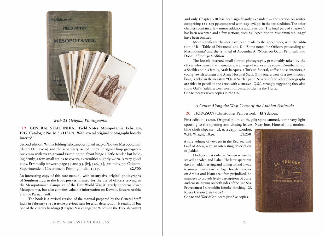
Four appendices follow the main text. Appendix A “Note on the Qatar Peninsula and Dohah” (p.179-180) is without doubt the most important. It comprises an early description of Qatar, its chief town, Doha, and its ruler, Sheikh Abdullah bin Jassim Al Thani (1880-1957). The Sheikh is described as “a rich and powerful chief, who has a following of about 2,000 fighting men.” (p.179). He is also said to be
“friendly toward the British … [and] would no doubt be glad to be rid of the Turks.” (p.180). The last comment proved to be somewhat prescient, as the Sheikh forced the Ottomans to abandon their garrison in Doha on the 19th of August 1915, just 6 months after this manual was prepared.
A revised version of Field Notes . Mesopotamia . was issued in February 1917. Though expanded (featuring 36 routes instead of 14), it did not include the section on Qatar.Rare. WorldCat locates just two copies, at Oxford and the Huntington. There is also a copy in the India Office Records at the British Library (IOR/L/MIL/17/15/49).
25EGYPT, NEAR EAST & MIDDLE EAST
and only Chapter VIII has been significantly expanded — the section on routes comprising 121-269 pp. compared with 123-178 pp. in the 1916 edition. The other chapters contain a few minor additions and revisions. The final part of chapter V has been rewritten and a few sections, such as ‘Expedition to Muhammerah, 1857’ have been omitted.
More significant changes have been made to the appendices, with the addi-tion of B - ‘Table of Distances’ and D - ‘Some notes for Officers proceeding to Mesopotamia’ and the removal of Appendix A (’Notes on Qatar Peninsula and Doha’) of the 1916 edition.
The loosely inserted small-format photographs, presumably taken by the officer who owned the manual, show a range of scenes and people in Southern Iraq: a Sheikh and his family, Arab barques, a Turkish funeral, coffee house interiors, a young Jewish woman and Army Hospital Staff. Only one, a view of a town from a boat, is titled in the negative “Qalat Saleh 1918”. Several of the other photographs are titled in pencil on the verso with a cursive “Q.S.”, strongly suggesting they also show Qal’at Saleh, a town north of Basra bordering the Tigris.Copac locates seven copies in the UK.
A Cruise Along the West Coast of the Arabian Peninsula
20 HODGSON (Christopher Pemberton). El Ydaiour.
First edition. 12mo. Original plum cloth, gilt; spine sunned, some very light spotting to the opening and closing leaves. Near fine. Housed in a modern blue cloth slipcase. [2], ii, 252pp. London, W.N. Wright, 1849. £1,250
A rare volume of voyages in the Red Sea and Gulf of Aden, with an interesting description of Jeddah.
Hodgson first sailed to Yemen where he stayed at Aden and Lahej. He later spent ten days at Jeddah, trying and failing to find a way to surreptitiously join the Hajj. Though his views on Arabia and Islam are often prejudiced, he manages to provide lively descriptions of ports and coastal towns on both sides of the Red Sea.Provenance: 1). Franklin Brooke-Hitching. 2). Roger Casson (1943-2016).Copac and WorldCat locate just five copies.
With 25 Original Photographs
19 GENERAL STAFF INDIA. Field Notes. Mesopotamia. February, 1917. Catalogue No. M.3. (11349). [With several original photographs loosely inserted.]
Second edition. With a folding heliozincographed map of ‘Lower Mesopotamia’ (dated Oct. 1916) and the separately issued index. Original limp grey-green buckram with wrap-around fastening tie, front hinge a little tender but hold-ing firmly, a few small stains to covers, extremities slightly worn. A very good copy. Errata slip between page 34 and 35. [iv], 326, [1], [xx index]pp. Calcutta, Superintendent Government Printing, India, 1917. £2,500
An interesting copy of this rare manual, with twenty-five original photographs of Southern Iraq in the front pocket. Printed for the use of officers serving in the Mesopotamian Campaign of the First World War, it largely concerns lower Mesopotamia, but also contains valuable information on Kuwait, Eastern Arabia and the Persian Gulf.
The book is a revised version of the manual prepared by the General Staff, India in February 1915 (see the previous item for a full description). It retains all but one of the chapter headings (Chapter V is changed to ‘Notes on the Turkish Army’)
27EGYPT, NEAR EAST & MIDDLE EAST
In a Remarkable Provincial English Binding
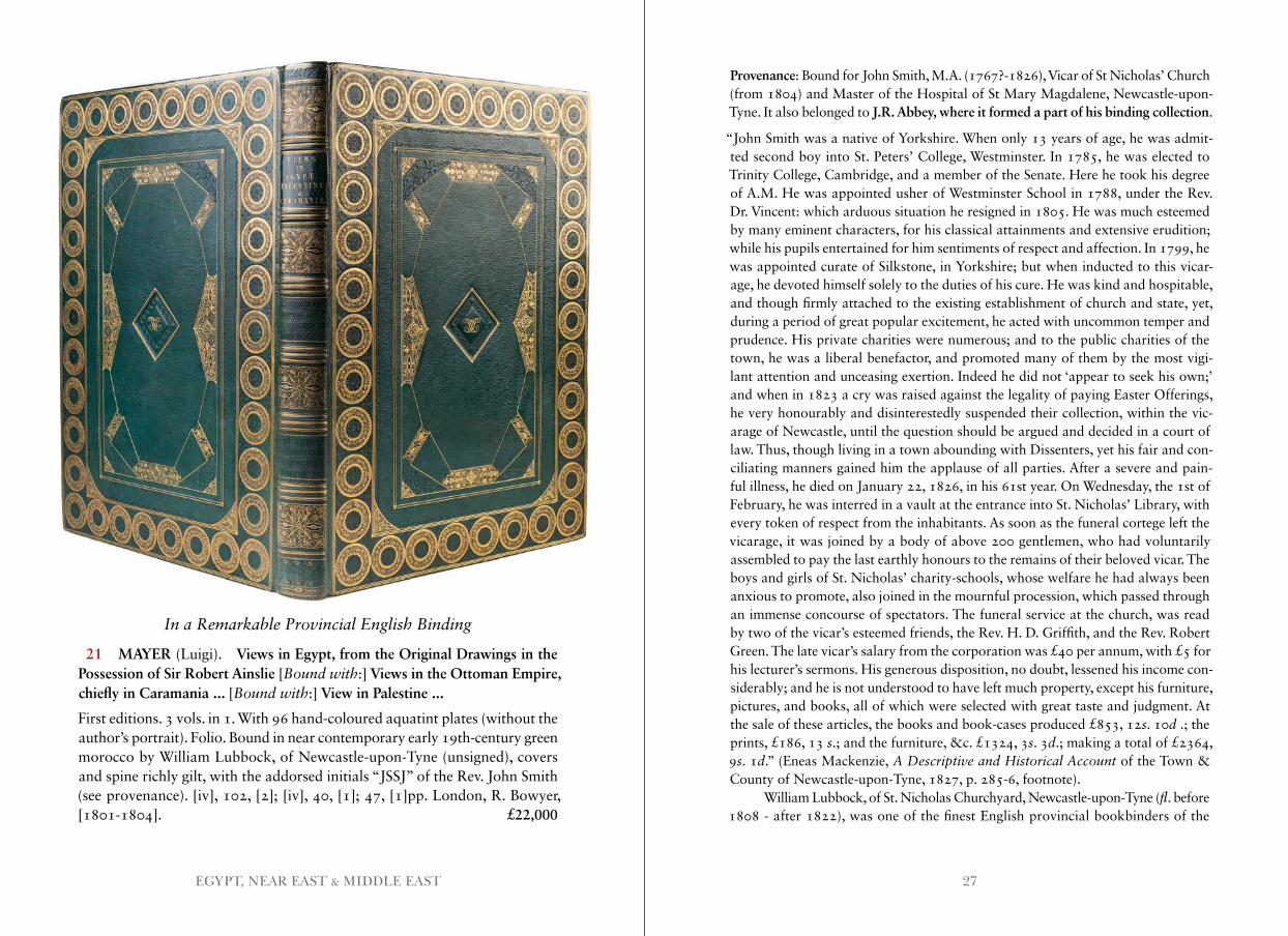
21 MAYER (Luigi). Views in Egypt, from the Original Drawings in the Possession of Sir Robert Ainslie [Bound with:] Views in the Ottoman Empire, chiefly in Caramania ... [Bound with:] View in Palestine ...
First editions. 3 vols. in 1. With 96 hand-coloured aquatint plates (without the author’s portrait). Folio. Bound in near contemporary early 19th-century green morocco by William Lubbock, of Newcastle-upon-Tyne (unsigned), covers and spine richly gilt, with the addorsed initials “JSSJ” of the Rev. John Smith (see provenance). [iv], 102, [2]; [iv], 40, [1]; 47, [1]pp. London, R. Bowyer, [1801-1804]. £22,000
Provenance: Bound for John Smith, M.A. (1767?-1826), Vicar of St Nicholas’ Church (from 1804) and Master of the Hospital of St Mary Magdalene, Newcastle-upon-Tyne. It also belonged to J.R. Abbey, where it formed a part of his binding collection.
“John Smith was a native of Yorkshire. When only 13 years of age, he was admit-ted second boy into St. Peters’ College, Westminster. In 1785, he was elected to Trinity College, Cambridge, and a member of the Senate. Here he took his degree of A.M. He was appointed usher of Westminster School in 1788, under the Rev. Dr. Vincent: which arduous situation he resigned in 1805. He was much esteemed by many eminent characters, for his classical attainments and extensive erudition; while his pupils entertained for him sentiments of respect and affection. In 1799, he was appointed curate of Silkstone, in Yorkshire; but when inducted to this vicar-age, he devoted himself solely to the duties of his cure. He was kind and hospitable, and though firmly attached to the existing establishment of church and state, yet, during a period of great popular excitement, he acted with uncommon temper and prudence. His private charities were numerous; and to the public charities of the town, he was a liberal benefactor, and promoted many of them by the most vigi-lant attention and unceasing exertion. Indeed he did not ‘appear to seek his own;’ and when in 1823 a cry was raised against the legality of paying Easter Offerings, he very honourably and disinterestedly suspended their collection, within the vic-arage of Newcastle, until the question should be argued and decided in a court of law. Thus, though living in a town abounding with Dissenters, yet his fair and con-ciliating manners gained him the applause of all parties. After a severe and pain-ful illness, he died on January 22, 1826, in his 61st year. On Wednesday, the 1st of February, he was interred in a vault at the entrance into St. Nicholas’ Library, with every token of respect from the inhabitants. As soon as the funeral cortege left the vicarage, it was joined by a body of above 200 gentlemen, who had voluntarily assembled to pay the last earthly honours to the remains of their beloved vicar. The boys and girls of St. Nicholas’ charity-schools, whose welfare he had always been anxious to promote, also joined in the mournful procession, which passed through an immense concourse of spectators. The funeral service at the church, was read by two of the vicar’s esteemed friends, the Rev. H. D. Griffith, and the Rev. Robert Green. The late vicar’s salary from the corporation was £40 per annum, with £5 for his lecturer’s sermons. His generous disposition, no doubt, lessened his income con-siderably; and he is not understood to have left much property, except his furniture, pictures, and books, all of which were selected with great taste and judgment. At the sale of these articles, the books and book-cases produced £853, 12s. 10d .; the prints, £186, 13 s.; and the furniture, &c. £1324, 3s. 3d.; making a total of £2364, 9s. 1d.” (Eneas Mackenzie, A Descriptive and Historical Account of the Town & County of Newcastle-upon-Tyne, 1827, p. 285-6, footnote).
William Lubbock, of St. Nicholas Churchyard, Newcastle-upon-Tyne (fl. before 1808 - after 1822), was one of the finest English provincial bookbinders of the
29EGYPT, NEAR EAST & MIDDLE EAST
Regency period, although few examples of his best work are known. See: Seymour de Ricci, British Signed Bindings in the Mortimer L . Schiff Collection, 1935, III, no. 48; Howard M. Nixon, Five Centuries of English Bookbinding (1978), no. 97 & British Bookbindings presented by Kenneth H . Oldaker to the Chapter Library of Westminster Abbey (1982), no. 32. The latter is a copy of Anthony Hamilton’s Memoirs of Count Grammont (2 vols., 1811) bound in white pigskin with onlaid frames, ornaments and spine of gilt-tooled green morocco. It was bound for the Rev. John Smith, Vicar of St Nicholas, and thus Lubbock’s immediate neighbour if not landlord, as a wedding present for James Cookson and Mary Anne Stephenson of the Chapelry of St Andrew, Newcastle, which took place on 16 March 1811.
Three Qajar Princes in England
22 MEERZA (H.R.H. Najaf Koolee) KAYAT (Assaad Y.) trans. Journal of a Residence in England, and of a Journey from and to Syria, of their Royal Highnesses Reeza Koolee Meerza, Najaf Koolee Meerza, and Taymoor Meerza, of Persia. To which are prefixed some particulars respecting modern Persia,
and the Death of the late Shah.
First edition. 2 vols. With a folding litho-graphed frontispiece - a letter from the author in Farsi, later translated on p.xviii - mounted on linen (crease to gutter margin) and the half-titles. 8vo. Later blue library cloth, with gilt lettering and call numbers to the spine, very good. Bookplates of Manchester Public Libraries to front paste-downs, occasional blind-stamps, owner-ship inscriptions to title-pages partially erased. Interior pages very clean and bright. xxiii, [1 blank], 306; [vi], 291, [1blank]pp. London, Printed for Private Circulation Only, n.d., [c. 1839]. £1,250
A rare and fascinating narrative, providing a Persian perspective on 19th century England.
“Many will remember the visit which the three members of the Royal Family of Persia made to England in 1836. Their names were Reeza Koolee Meerza, Najaf Koolee Meerza, (Wali,) Taymoor Meerza: they were the sons of Firmân Firmân, late Prince of Shiraz and Fars, grandsons of Fathali Shah, the late king of Persia, and first cousins to the present Majesty Mohammed Shah of Persia” (preface, p.viii).
When Fath-Ali Shah Qajar died on 23rd October 1834, a period of uncer-tainty unfolded, as Ali Mirza and Mohammad tussled to be his successor. Given the threat of civil war, Firmân Firmân was worried about the lives of his sons and decided to encourage them to journey to England and, once there, ask the British to seek counsel with Mohammad (who was by then Shah of Persia) on his behalf.
The journal of their travels was written by Najaf Kuli Mirza, the most literary of the three princes, and is in three parts: “An account of the accession of Mohammed Shah to the throne; a journal of their voyage to, and residence in England; and their tour over land to Constantinople and Bagdad[sic]” (preface, p.xii).
For more information on the journey, see Dennis Wright, The Persians Among the English, (London, 1985).COPAC locates six holdings, at LSE, York, Cambridge, Edinburgh, Leeds and the British Library.
Printed for African Soldiers
23 [MIDDLE EAST FORCES.] LINDSELL (Lt.-Gen. Sir Wilfrid G.) Walks Around Jerusalem. 194 African Leave Camp.
First edition. One of 5000 copies. 12mo. Original printed card wrappers, stapled; a few instances of mild spotting, staple rusted, otherwise very good. [ii], 13, [1], [3 memos]pp. N.p., Printing and Stationary Services, M.E.F., [c.1945]. £350
A scarce pamphlet, printed for African servicemen on leave in Jerusalem. It details seven walks around the city, with numerous biblical and historical references to the sites en route. The foreword, written by Lt.-Gen. Lindsell, addresses the men directly:
“This book is a gift to you from the Middle East Forces so that you may learn about all the wonderful places which you will see, so that you may remember them.”
Though apparently unrecorded in library databases, the pamphlet is mentioned in a few sources on African troops and their experiences in World War II. David Killingray, citing Roots of Freedom, the memoir of the Kenyan politician Bildad Kaggia (1921-2005), notes that at “the rest camp Kaggia and other literate soldiers were each given a copy of a booklet entitled Walks Around Jerusalem, specially writ-ten for African troops.” Killingray also describes how the troops’ leave was highly regulated, with booklets and activities forming part of an overall effort to control leisure time and limit exposure to “local people” and “alternative ideas about race relations” (ibid).No copies in Copac or WorldCat, and no copy in the catalogue of the Imperial War Museum. Killingray, David, Fighting for Britain: African Soldiers in the Second World War, (London, 2010). p.107.
31EGYPT, NEAR EAST & MIDDLE EAST
A Very Early Report on Travels in Persia
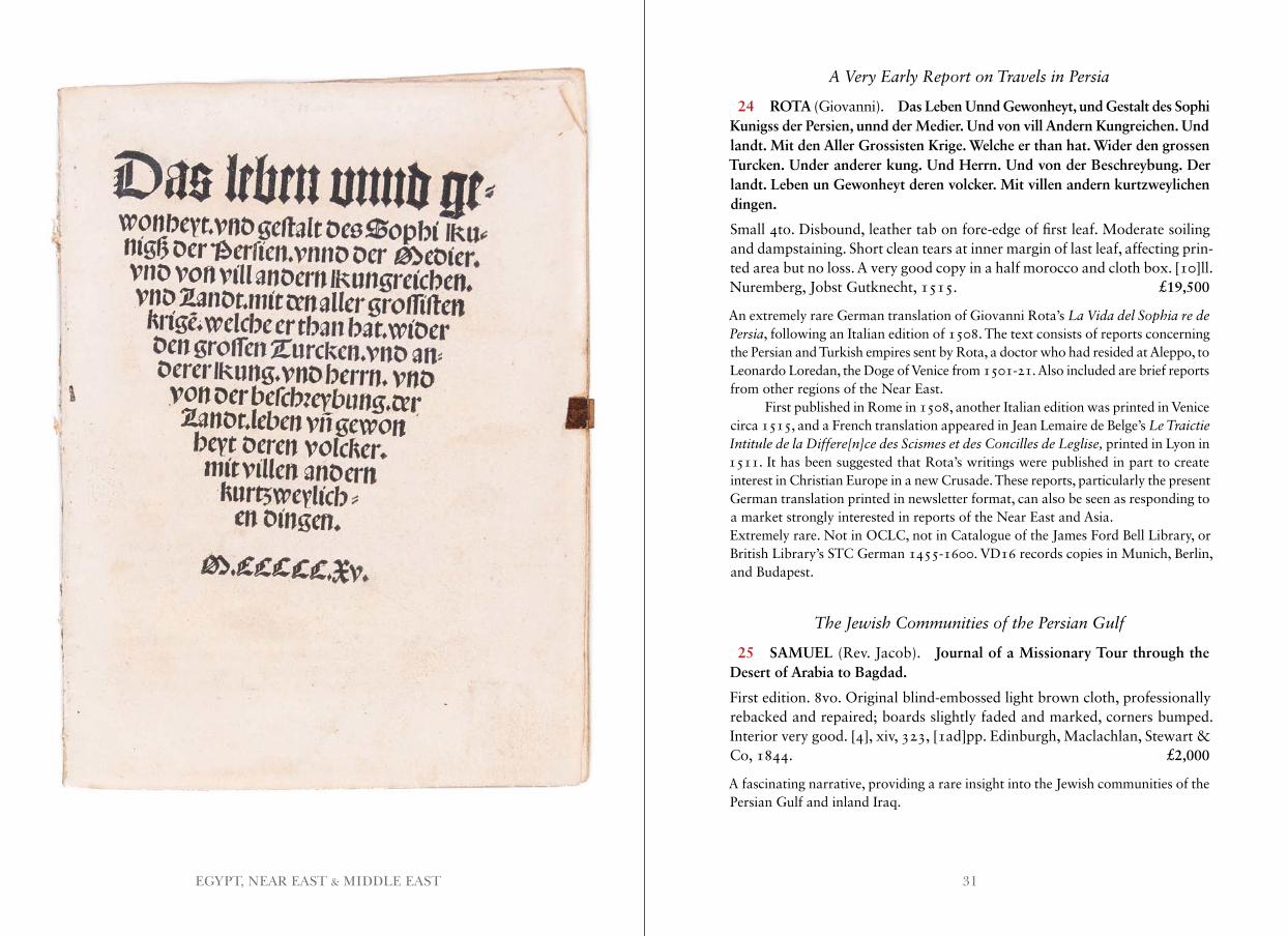
24 ROTA (Giovanni). Das Leben Unnd Gewonheyt, und Gestalt des Sophi Kunigss der Persien, unnd der Medier. Und von vill Andern Kungreichen. Und landt. Mit den Aller Grossisten Krige. Welche er than hat. Wider den grossen Turcken. Under anderer kung. Und Herrn. Und von der Beschreybung. Der landt. Leben un Gewonheyt deren volcker. Mit villen andern kurtzweylichen dingen.
Small 4to. Disbound, leather tab on fore-edge of first leaf. Moderate soiling and dampstaining. Short clean tears at inner margin of last leaf, affecting prin-ted area but no loss. A very good copy in a half morocco and cloth box. [10]ll. Nuremberg, Jobst Gutknecht, 1515. £19,500
An extremely rare German translation of Giovanni Rota’s La Vida del Sophia re de Persia, following an Italian edition of 1508. The text consists of reports concerning the Persian and Turkish empires sent by Rota, a doctor who had resided at Aleppo, to Leonardo Loredan, the Doge of Venice from 1501-21. Also included are brief reports from other regions of the Near East.
First published in Rome in 1508, another Italian edition was printed in Venice circa 1515, and a French translation appeared in Jean Lemaire de Belge’s Le Traictie Intitule de la Differe[n]ce des Scismes et des Concilles de Leglise, printed in Lyon in 1511. It has been suggested that Rota’s writings were published in part to create interest in Christian Europe in a new Crusade. These reports, particularly the present German translation printed in newsletter format, can also be seen as responding to a market strongly interested in reports of the Near East and Asia.Extremely rare. Not in OCLC, not in Catalogue of the James Ford Bell Library, or British Library’s STC German 1455-1600. VD16 records copies in Munich, Berlin, and Budapest.
The Jewish Communities of the Persian Gulf
25 SAMUEL (Rev. Jacob). Journal of a Missionary Tour through the Desert of Arabia to Bagdad.
First edition. 8vo. Original blind-embossed light brown cloth, professionally rebacked and repaired; boards slightly faded and marked, corners bumped. Interior very good. [4], xiv, 323, [1ad]pp. Edinburgh, Maclachlan, Stewart & Co, 1844. £2,000
A fascinating narrative, providing a rare insight into the Jewish communities of the Persian Gulf and inland Iraq.
33EGYPT, NEAR EAST & MIDDLE EAST
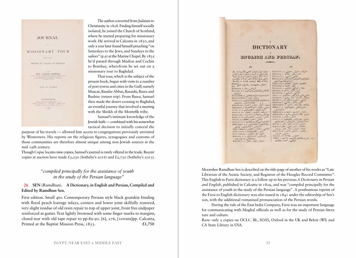
Moonshee Ramdhun Sen is described on the title-page of another of his works as “Late Librarian of the Asiatic Society, and Registrar of the Hooglee Record Committee”. This English to Farsi dictionary is a follow up to his previous A Dictionary in Persian and English, published in Calcutta in 1829, and was “compiled principally for the assistance of youth in the study of the Persian language”. A posthumous reprint of the Farsi to English dictionary was also issued in 1841 under the editorship of Sen’s son, with the additional romanised pronunciation of the Persian words.
During the rule of the East India Company, Farsi was an important language for communicating with Mughal officials as well as for the study of Persian litera-ture and culture.Rare: only 5 copies on OCLC. BL, SOAS, Oxford in the UK and Beloit (WI) and CA State Library in USA.
The author converted from Judaism to Christianity in 1828. Finding himself socially isolated, he joined the Church of Scotland, where he started preparing for missionary work. He arrived in Calcutta in 1830, and only a year later found himself preaching “on Saturdays to the Jews, and Sundays to the sailors” (p.9) at the Marine Chapel. By 1835 he’d passed through Madras and Cochin to Bombay, wherefrom he set out on a missionary tour to Baghdad.
That tour, which is the subject of the present book, began with visits to a number of port towns and cities in the Gulf; namely Muscat, Bandar Abbas, Basaidu, Basra and Bushire (return trip). From Basra, Samuel then made the desert crossing to Baghdad, an eventful journey that involved a meeting with the Sheikh of the Montefik tribe.
Samuel’s intimate knowledge of the Jewish faith — combined with his somewhat tactical decision to initially conceal the
purpose of his travels — allowed him access to congregations previously unvisited by Westerners. His reports on the religious figures, synagogues and customs of those communities are therefore almost unique among non-Jewish sources in the mid 19th century.Though Copac locates nine copies, Samuel’s journal is rarely offered in the trade. Recent copies at auction have made £3,250 (Sotheby’s 2016) and £2,750 (Sotheby’s 2015).
“compiled principally for the assistance of youth in the study of the Persian language”
26 SEN (Ramdhun). A Dictionary, in English and Persian, Compiled and Edited by Ramdhun Sen.
First edition. Small 4to. Contemporary Persian style black goatskin binding with floral peach lozenge inlays, corners and lower joint skilfully restored, very slight residue of old resin repair to top of upper joint, front free endpaper reinforced at gutter. Text lightly browned with some finger marks to margins, closed tear with old tape repair to pp.89-90. [6], 276, [1errata]pp. Calcutta, Printed at the Baptist Mission Press, 1833. £1,750
35EGYPT, NEAR EAST & MIDDLE EAST
With a Description of Muscat
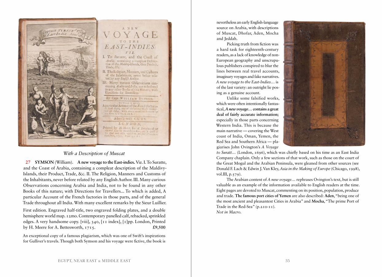
27 SYMSON (William). A new voyage to the East-indies. Viz. I. To Suratte, and the Coast of Arabia, containing a compleat description of the Maldivy-Islands, their Product, Trade, &c. II. The Religion, Manners and Customs of the Inhabitants, never before related by any English Author. III. Many curious Observations concerning Arabia and India, not to be found in any other Books of this nature; with Directions for Travellers... To which is added, A particular Account of the French factories in those parts, and of the general Trade throughout all India. With many excellent remarks by the Sieur Luillier.
First edition. Engraved half-title, two engraved folding plates, and a double hemisphere world map. 12mo. Contemporary panelled calf, rebacked, sprinkled edges. A very handsome copy. [viii], 340, [11 index], [1]pp. London, Printed by H. Meere for A. Bettesworth, 1715. £9,500
An exceptional copy of a famous plagiarism, which was one of Swift’s inspirations for Gulliver’s travels. Though both Symson and his voyage were fictive, the book is
nevertheless an early English-language source on Arabia, with descriptions of Muscat, Dhofar, Aden, Mocha and Jeddah.
Picking truth from fiction was a hard task for eighteenth-century readers, as a lack of knowledge of non- European geography and unscrupu-lous publishers conspired to blur the lines between real travel accounts, imaginary voyages and fake narratives. A new voyage to the East-Indies… is of the last variety: an outright lie pos- ing as a genuine account.
Unlike some falsified works, which were often intentionally fantas-tical, A new voyage… contains a great deal of fairly accurate information; especially in those parts concerning Western India. This is because the main narrative — covering the West coast of India, Oman, Yemen, the Red Sea and Southern Africa — pla-giarises John Ovington’s A Voyage to Suratt… (London, 1696), which was chiefly based on his time as an East India Company chaplain. Only a few sections of that work, such as those on the court of the Great Mogul and the Arabian Peninsula, were gleaned from other sources (see Donald F. Lach & Edwin J. Van Kley, Asia in the Making of Europe (Chicago, 1998), vol.III, p.579).
The Arabian content of A new voyage… rephrases Ovington’s text, but is still valuable as an example of the information available to English readers at the time. Eight pages are devoted to Muscat, commenting on its position, population, produce and trade. The famous port cities of Yemen are also described: Aden, “being one of the most ancient and pleasantest Cities in Arabia” and Mocha, “The prime Port of Trade in the Red-Sea” (p.210-11).Not in Macro .
37EUROPE, RUSSIA, TURKEY
EUROPE, RUSSIA, TURKEY
Rare Archangelsk Imprint
28 [AMERICAN CONSULATE IN ARKHANGEL’SK.] Liga narodov.
First edition. 8vo. Original printed wrappers, spine replenished, a little chipped, de-accession stamp to upper wrapper. 18pp. Arkhangel’sk, Gubernskaia Tipografiia, 1919. £750
This pamphlet was published during the Polar Bear Expedition, which saw an American Expeditionary Force of about 5000 troops fight the Red Army as a part of the civil war immediately after the October Revolution in 1917. It reprints the proto-cols established at the 1919 Paris Peace Conference, which led to the formation of the League of Nations. It also includes several addresses by President Woodrow Wilson.
Benjamin Rhodes summarises the expedition: “Inspired and led by the British, this ill-conceived venture had as its primary objective the restoration of the eastern front against Germany. In November 1917, the Bolsheviks had easily seized power from the pro-Western provisional government, and a few months later Lenin and Trotsky betrayed the West by signing a separate peace with Germany and leaving the war. The British idea, therefore, was to invade Russia through its northern ports of Murmansk and Archangel, take possession there of the extensive military supplies sent to the provisional government, and reorganize the eastern front with the assistance of Russian volunteers.” A separate contingent, the American Expeditionary Force in Siberia, had been sent to Vladivostok. The expedition was
unsuccessful and Wilson had the forces evacuate in early 1919.OCLC locates copies at Columbia, Yale, UC San Diego and the NLA.Rhodes, Benjamin D., “The Anglo-American Intervention at Archangel, 1918-1919: the Role of the 339th Infantry” in The International History Review, Vol. 8, No.3, (August, 1986), pp.367-388.
News of the Ottoman-Safavid War
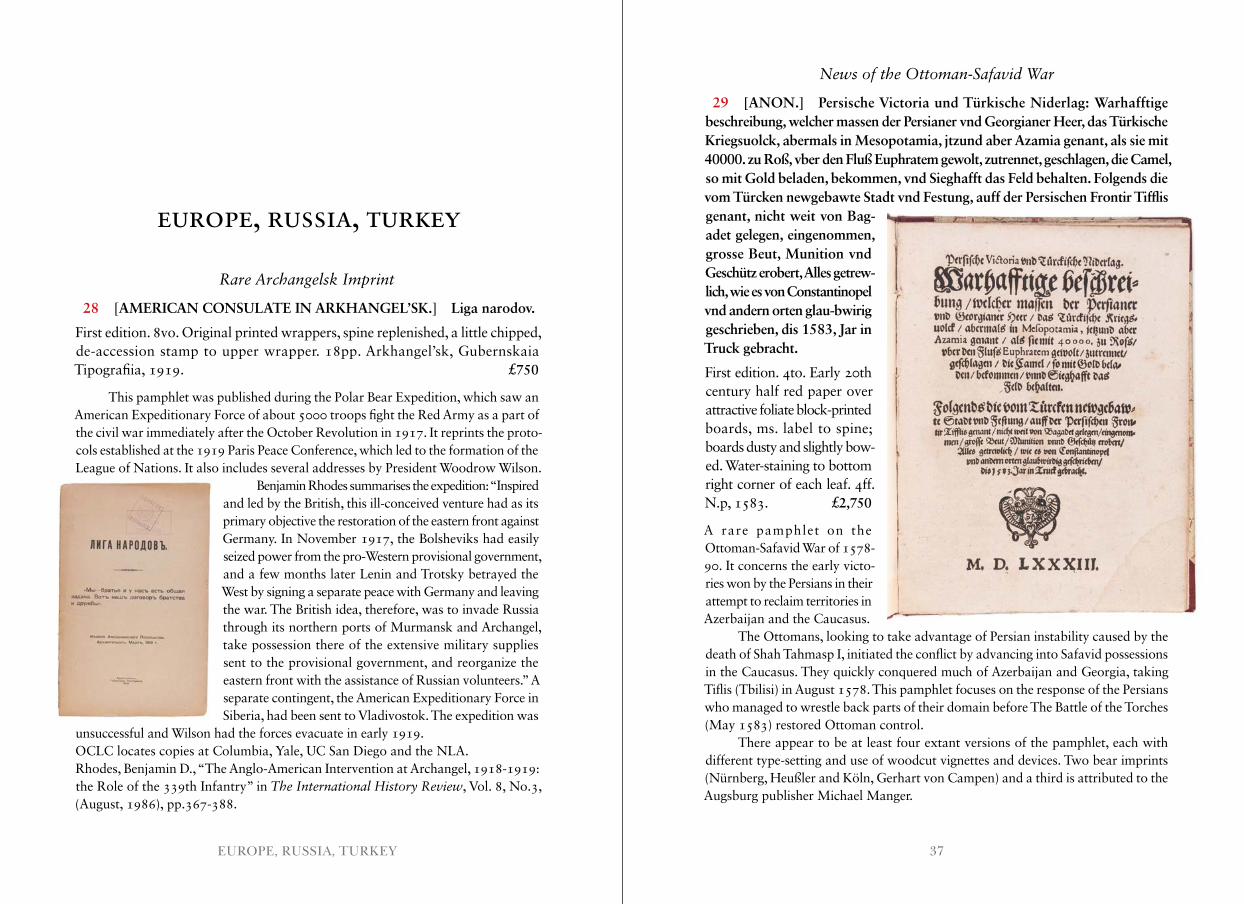
29 [ANON.] Persische Victoria und Türkische Niderlag: Warhafftige beschreibung, welcher massen der Persianer vnd Georgianer Heer, das Türkische Kriegsuolck, abermals in Mesopotamia, jtzund aber Azamia genant, als sie mit 40000. zu Roß, vber den Fluß Euphratem gewolt, zutrennet, geschlagen, die Camel, so mit Gold beladen, bekommen, vnd Sieghafft das Feld behalten. Folgends die vom Türcken newgebawte Stadt vnd Festung, auff der Persischen Frontir Tifflis genant, nicht weit von Bag- adet gelegen, eingenommen, grosse Beut, Munition vnd Geschütz erobert, Alles getrew- lich, wie es von Constantinopel vnd andern orten glau-bwirig geschrieben, dis 1583, Jar in Truck gebracht.
First edition. 4to. Early 20th century half red paper over attractive foliate block-printed boards, ms. label to spine; boards dusty and slightly bow-ed. Water-staining to bottom right corner of each leaf. 4ff. N.p, 1583. £2,750
A rare pamphlet on the Ottoman-Safavid War of 1578-90. It concerns the early victo-ries won by the Persians in their attempt to reclaim territories in Azerbaijan and the Caucasus.
The Ottomans, looking to take advantage of Persian instability caused by the death of Shah Tahmasp I, initiated the conflict by advancing into Safavid possessions in the Caucasus. They quickly conquered much of Azerbaijan and Georgia, taking Tiflis (Tbilisi) in August 1578. This pamphlet focuses on the response of the Persians who managed to wrestle back parts of their domain before The Battle of the Torches (May 1583) restored Ottoman control.
There appear to be at least four extant versions of the pamphlet, each with different type-setting and use of woodcut vignettes and devices. Two bear imprints (Nürnberg, Heußler and Köln, Gerhart von Campen) and a third is attributed to the Augsburg publisher Michael Manger.
39EUROPE, RUSSIA, TURKEY
Scarce on the market, with no copies located in auction records. We locate ten insti-tutional holdings in Europe (including copies at Edinburgh and the British Library), seven of which bear no information regarding place of publication or publisher. Only the copy at the University of Wroclaw has the same type-setting as our copy.Göllner, 1760-1762 (listing three versions); Hammer-Purgstall, 1080; Ternaux-Compans, 531 . Not in Atabey, Blackmer, Diba or Wilson .
Rare Pamphlet on the Treaty of Hünkâr Iskelesi
30 [ANON.] Thoughts on the occurrences in the year 1832 [or rather, 1833] at Constantinople, between Russia and Turkey. In a letter to Sir --- M.P.
First edition. 8vo. Recent quarter calf with marbled paper-covered boards, four raised bands and red morocco label with gilt lettering to spine. Title-page and final blank slightly dusty with a few small marginal tears, interior otherwise clean and fresh. Ink presentation inscription to title-page. 75, [1]blank pp. London, J. Hatchard and Son, 1834. £550
A fascinating pamphlet on the Treaty of Hünkâr Iskelesi, which was signed between the Ottoman Empire and the Russian Empire on the 8th of July 1833, after the Russians were the first European power to answer Mahmud II’s call for military assistance against the advancing Egyptian army. The anonymous author chides the English for their unwillingness to help the Ottomans, highlighting the moral flaw of abandoning an important ally and the grave tactical error of opening the door to Russian encroachments.Copac locates six copies. WorldCat adds just one more, at NYPL. Rare in commerce, with no copies appearing in auction records.Not in Atabey or Blackmer .
Two Early Works on Constantinople
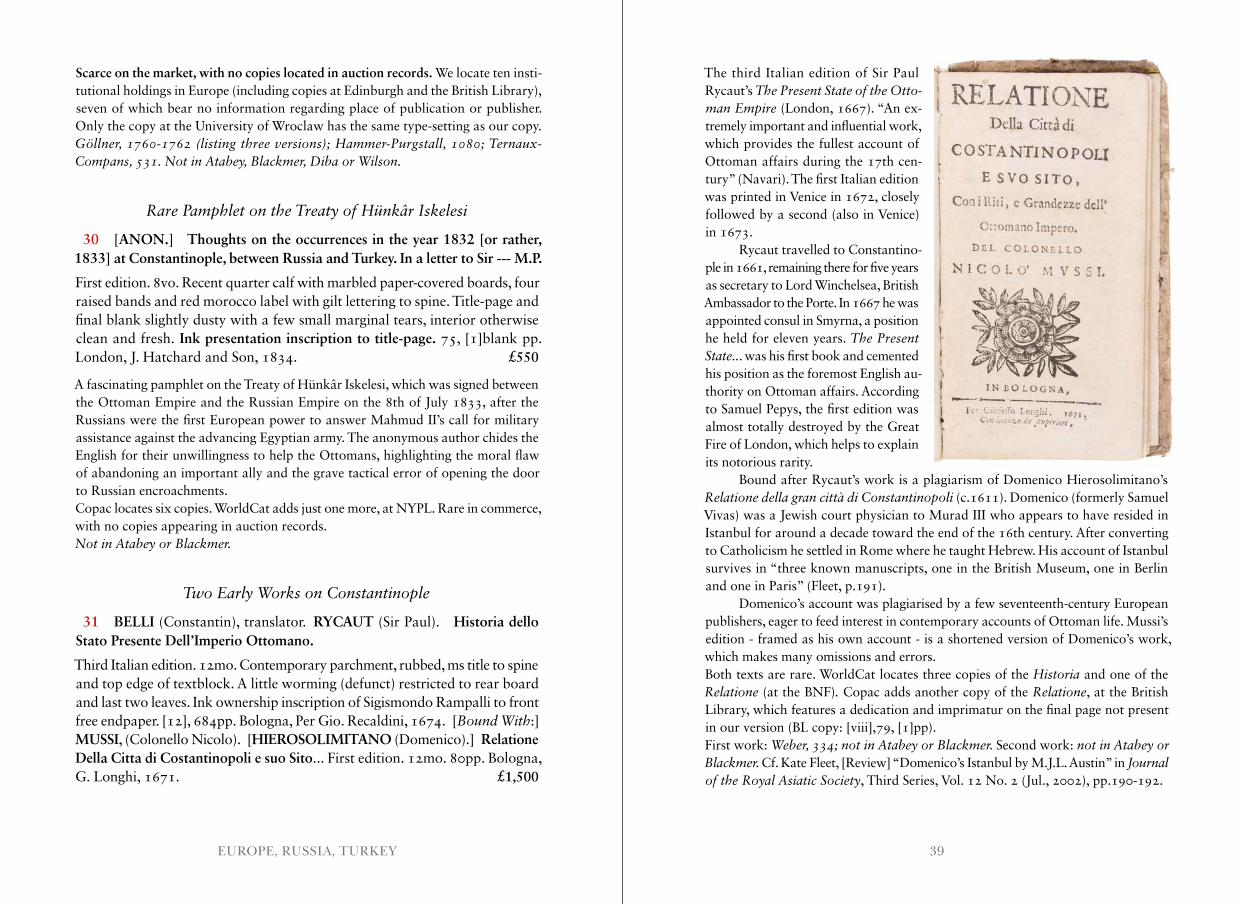
31 BELLI (Constantin), translator. RYCAUT (Sir Paul). Historia dello Stato Presente Dell’Imperio Ottomano.
Third Italian edition. 12mo. Contemporary parchment, rubbed, ms title to spine and top edge of textblock. A little worming (defunct) restricted to rear board and last two leaves. Ink ownership inscription of Sigismondo Rampalli to front free endpaper. [12], 684pp. Bologna, Per Gio. Recaldini, 1674. [Bound With:] MUSSI, (Colonello Nicolo). [HIEROSOLIMITANO (Domenico).] Relatione Della Citta di Costantinopoli e suo Sito... First edition. 12mo. 80pp. Bologna, G. Longhi, 1671. £1,500
The third Italian edition of Sir Paul Rycaut’s The Present State of the Otto-man Empire (London, 1667). “An ex-tremely important and influential work, which provides the fullest account of Ottoman affairs during the 17th cen-tury” (Navari). The first Italian edition was printed in Venice in 1672, closely followed by a second (also in Venice) in 1673.
Rycaut travelled to Constantino-ple in 1661, remaining there for five years as secretary to Lord Winchelsea, British Ambassador to the Porte. In 1667 he was appointed consul in Smyrna, a position he held for eleven years. The Present State . .. was his first book and cemented his position as the foremost English au-thority on Ottoman affairs. According to Samuel Pepys, the first edition was almost totally destroyed by the Great Fire of London, which helps to explain its notorious rarity.
Bound after Rycaut’s work is a plagiarism of Domenico Hierosolimitano’s Relatione della gran città di Constantinopoli (c.1611). Domenico (formerly Samuel Vivas) was a Jewish court physician to Murad III who appears to have resided in Istanbul for around a decade toward the end of the 16th century. After converting to Catholicism he settled in Rome where he taught Hebrew. His account of Istanbul survives in “three known manuscripts, one in the British Museum, one in Berlin and one in Paris” (Fleet, p.191).
Domenico’s account was plagiarised by a few seventeenth-century European publishers, eager to feed interest in contemporary accounts of Ottoman life. Mussi’s edition - framed as his own account - is a shortened version of Domenico’s work, which makes many omissions and errors.Both texts are rare. WorldCat locates three copies of the Historia and one of the Relatione (at the BNF) . Copac adds another copy of the Relatione, at the British Library, which features a dedication and imprimatur on the final page not present in our version (BL copy: [viii],79, [1]pp).First work: Weber, 334; not in Atabey or Blackmer . Second work: not in Atabey or Blackmer . Cf. Kate Fleet, [Review] “Domenico’s Istanbul by M.J.L. Austin” in Journal of the Royal Asiatic Society, Third Series, Vol. 12 No. 2 (Jul., 2002), pp.190-192.
41EUROPE, RUSSIA, TURKEY
Beautiful Views of Venice
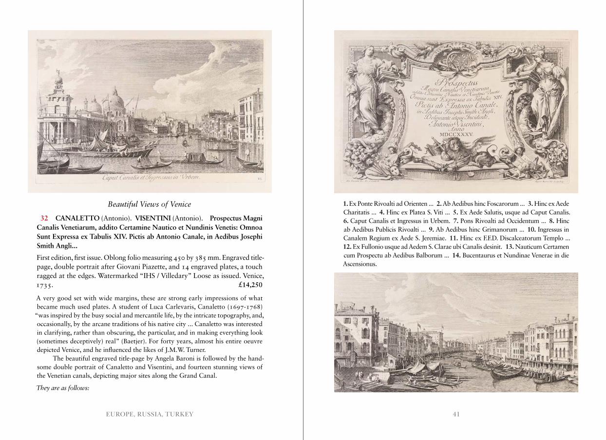
32 CANALETTO (Antonio). VISENTINI (Antonio). Prospectus Magni Canalis Venetiarum, addito Certamine Nautico et Nundinis Venetis: Omnoa Sunt Expressa ex Tabulis XIV. Pictis ab Antonio Canale, in Aedibus Josephi Smith Angli...
First edition, first issue. Oblong folio measuring 450 by 385 mm. Engraved title- page, double portrait after Giovani Piazette, and 14 engraved plates, a touch ragged at the edges. Watermarked “IHS / Villedary” Loose as issued. Venice, 1735. £14,250
A very good set with wide margins, these are strong early impressions of what became much used plates. A student of Luca Carlevaris, Canaletto (1697-1768)
“was inspired by the busy social and mercantile life, by the intricate topography, and, occasionally, by the arcane traditions of his native city ... Canaletto was interested in clarifying, rather than obscuring, the particular, and in making everything look (sometimes deceptively) real” (Baetjer). For forty years, almost his entire oeuvre depicted Venice, and he influenced the likes of J.M.W. Turner.
The beautiful engraved title-page by Angela Baroni is followed by the hand-some double portrait of Canaletto and Visentini, and fourteen stunning views of the Venetian canals, depicting major sites along the Grand Canal.
They are as follows:
1. Ex Ponte Rivoalti ad Orienten ... 2. Ab Aedibus hinc Foscarorum ... 3. Hinc ex Aede Charitatis ... 4. Hinc ex Platea S. Viti ... 5. Ex Aede Salutis, usque ad Caput Canalis. 6. Caput Canalis et Ingressus in Urbem. 7. Pons Rivoalti ad Occidentum ... 8. Hinc ab Aedibus Publicis Rivoalti ... 9. Ab Aedibus hinc Grimanorum ... 10. Ingressus in Canalem Regium ex Aede S. Jeremiae. 11. Hinc ex F.F.D. Discalceatorum Templo ... 12. Ex Fullonio usque ad Aedem S. Clarae ubi Canalis desinit. 13. Nauticum Certamen cum Prospectu ab Aedibus Balborum ... 14. Bucentaurus et Nundinae Venerae in die Ascensionus.
43EUROPE, RUSSIA, TURKEY
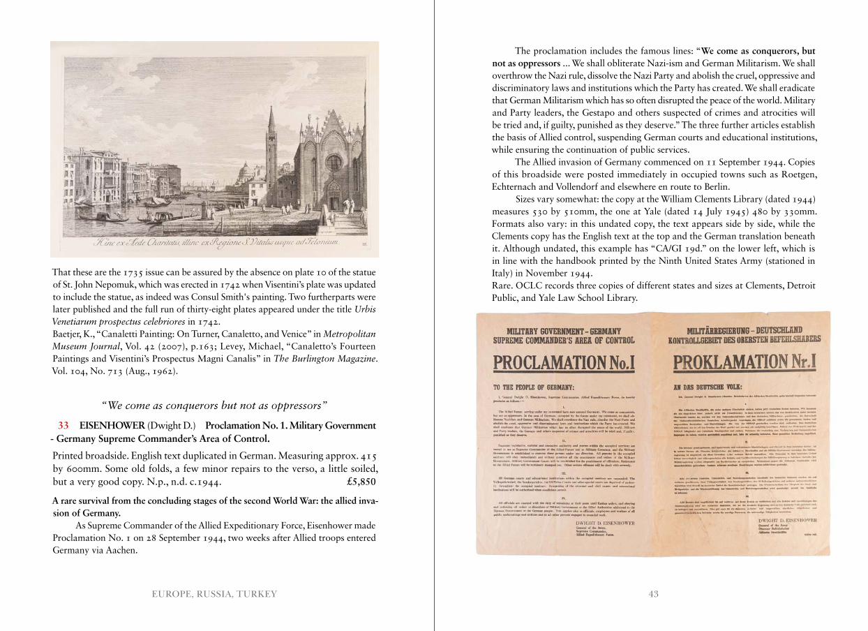
The proclamation includes the famous lines: “We come as conquerors, but not as oppressors ... We shall obliterate Nazi-ism and German Militarism. We shall overthrow the Nazi rule, dissolve the Nazi Party and abolish the cruel, oppressive and discriminatory laws and institutions which the Party has created. We shall eradicate that German Militarism which has so often disrupted the peace of the world. Military and Party leaders, the Gestapo and others suspected of crimes and atrocities will be tried and, if guilty, punished as they deserve.” The three further articles establish the basis of Allied control, suspending German courts and educational institutions, while ensuring the continuation of public services.
The Allied invasion of Germany commenced on 11 September 1944. Copies of this broadside were posted immediately in occupied towns such as Roetgen, Echternach and Vollendorf and elsewhere en route to Berlin.
Sizes vary somewhat: the copy at the William Clements Library (dated 1944) measures 530 by 510mm, the one at Yale (dated 14 July 1945) 480 by 330mm. Formats also vary: in this undated copy, the text appears side by side, while the Clements copy has the English text at the top and the German translation beneath it. Although undated, this example has “CA/GI 19d.” on the lower left, which is in line with the handbook printed by the Ninth United States Army (stationed in Italy) in November 1944.Rare. OCLC records three copies of different states and sizes at Clements, Detroit Public, and Yale Law School Library.
That these are the 1735 issue can be assured by the absence on plate 10 of the statue of St. John Nepomuk, which was erected in 1742 when Visentini’s plate was updated to include the statue, as indeed was Consul Smith's painting. Two furtherparts were later published and the full run of thirty-eight plates appeared under the title Urbis Venetiarum prospectus celebriores in 1742.Baetjer, K., “Canaletti Painting: On Turner, Canaletto, and Venice” in Metropolitan Museum Journal, Vol. 42 (2007), p.163; Levey, Michael, “Canaletto’s Fourteen Paintings and Visentini’s Prospectus Magni Canalis” in The Burlington Magazine. Vol. 104, No. 713 (Aug., 1962).
“We come as conquerors but not as oppressors”
33 EISENHOWER (Dwight D.) Proclamation No. 1. Military Government - Germany Supreme Commander’s Area of Control.
Printed broadside. English text duplicated in German. Measuring approx. 415 by 600mm. Some old folds, a few minor repairs to the verso, a little soiled, but a very good copy. N.p., n.d. c.1944. £5,850
A rare survival from the concluding stages of the second World War: the allied inva-sion of Germany.
As Supreme Commander of the Allied Expeditionary Force, Eisenhower made Proclamation No. 1 on 28 September 1944, two weeks after Allied troops entered Germany via Aachen.
45EUROPE, RUSSIA, TURKEY
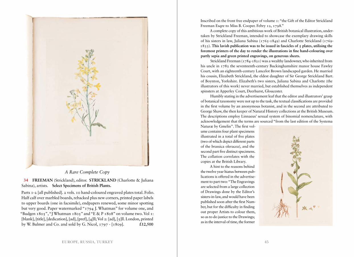
A Rare Complete Copy
34 FREEMAN (Strickland), editor. STRICKLAND (Charlotte & Juliana Sabina), artists. Select Specimens of British Plants.
Parts 1-2 [all published]. 2 vols. 10 hand-coloured engraved plates total. Folio. Half calf over marbled boards, rebacked plus new corners, printed paper labels to upper boards (one in facsimile), endpapers renewed, some minor spotting but very good. Paper watermarked “1794 J. Whatman” for volume one, and
“Budgen 1805”, “J Whatman 1805” and “E & P 1808” on volume two. Vol 1: [blank], [title], [dedication], [ad], [pref], [4]ll; Vol 2: [ad], [5]ll. London, printed by W. Bulmer and Co. and sold by G. Nicol, 1797 - [1809]. £12,500
Inscribed on the front free endpaper of volume 1: “the Gift of the Editor Strickland Freeman Esqre to Miss B. Cooper. Febry 12, 1798.”
A complete copy of this ambitious work of British botanical illustration, under-taken by Strickland Freeman, intended to showcase the exemplary drawing skills of his sisters in law, Juliana Sabina (1765-1849) and Charlotte Strickland (1769-1833). This lavish publication was to be issued in fascicles of 5 plates, utilising the foremost printers of the day to render the illustrations in fine hand-colouring over partly sepia and green printed engravings, on generous sheets.
Strickland Freeman (1784-1821) was a wealthy landowner, who inherited from his uncle in 1782 the seventeenth-century Buckinghamshire manor house Fawley Court, with an eighteenth-century Lancelot Brown landscaped garden. He married his cousin, Elizabeth Strickland, the eldest daughter of Sir George Strickland Bart. of Boynton, Yorkshire. Elizabeth’s two sisters, Juliana Sabina and Charlotte (the illustrators of this work) never married, but established themselves as independent spinsters at Apperley Court, Deerhurst, Gloucester.
Humbly stating in the advertisement leaf that the editor and illustrators’ grasp of botanical taxonomy were not up to the task, the textual classifications are provided in the first volume by an anonymous botanist, and in the second are attributed to George Shaw, the then keeper of Natural History collections at the British Museum. The descriptions employ Linnaeus’ sexual system of binomial nomenclature, with acknowledgement that the terms are sourced “from the last edition of the Systema Naturæ by Gmelin”. The first vol-ume contains four plant specimens illustrated in a total of five plates (two of which depict different parts of the brassica oleracea), and the second part five distinct specimens. The collation correlates with the copies at the British Library.
A hint to the reasons behind the twelve year hiatus between pub-lications is offered in the advertise-ment to part two: “The Engravings are selected from a large collection of Drawings done by the Editor’s sisters-in-law, and would have been published soon after the first Num-ber, but for the difficulty in finding out proper Artists to colour them, so as to do justice to the Drawings; as in the interval of time, the former
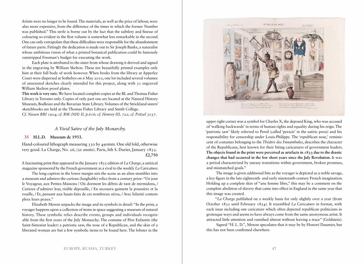
47EUROPE, RUSSIA, TURKEY
Artists were no longer to be found. The materials, as well as the price of labour, were also more expensive, from the difference of the times in which the former Number was published.” This strife is borne out by the fact that the subtlety and finesse of colouring so evident in the first volume is somewhat less remarkable in the second. One can only extrapolate that these difficulties were responsible for the abandonment of future parts. Fittingly the dedication is made out to Sir Joseph Banks, a naturalist whose ambitious vision of what a printed botanical publication could be famously outstripped Freeman's budget for executing the work.
Each plate is attributed to the sister from whose drawing it derived and signed in the engraving by William Skelton. These ten beautifully printed examples only hint at their full body of work however. When books from the library at Apperley Court were dispersed at Sothebys on 6 May 2010, one lot included several volumes of annotated sketches clearly intended for this project, along with 31 engraved William Skelton proof plates.This work is very rare. We have located complete copies at the BL and Thomas Fisher Library in Toronto only. Copies of only part one are located at the Natural History Museum, Bodleian and the Bavarian State Library. Volumes of the Strickland sisters’ sketchbooks are held at the Thomas Fisher Library and Smith College.Cf . Nissen BBI 1904; cf . BM (NH) II, p .616; cf . Henrey III, 722; cf . Pritzel 3037.
A Vivid Satire of the July Monarchy .
35 H.L.D. Museum de 1933.
Hand-coloured lithograph measuring 330 by 490mm. One old fold, otherwise very good. La Charge, No. 26, (2e annèe). Paris, lith S. Durier, January 1833. £2,750
A fascinating print that appeared in the January 1833 edition of La Charge, a satirical magazine sponsored by the French government as a rival to the weekly La Caricature.
The long caption in the lower margin sets the scene as an alien stumbles into a museum and admires the curious (laughable) relics from a century prior: “Un jour le Voyageur, aux Petites-Maisons / Où dorment les débris de tant de mirmidons, / Curieux d’admirer leur, risible dépouille, / En secouera gaiment la poussière et la rouille, / Et, pensant aux hauts-faits de ces nombreux zéros, / Avec hilarité contem-plera leurs peaux.”
Elizabeth Menon unpacks the image and its symbols in detail: “In the print, a voyager happens upon a collection of items in space suggesting a museum of natural history. These symbolic relics describe events, groups and individuals recogniz-able from the first years of the July Monarchy. The costume of Père Enfantin (the Saint-Simonist leader) a patriotic saw, the nose of a Republican, and the skin of a liberated woman are but a few symbolic items to be found here. The lobster in the
upper right corner was a symbol for Charles X, the deposed King, who was accused of ‘walking backwards’ in terms of human rights and equality during his reign. The ‘patriotic saw’ likely referred to Persil (called ‘perscie’ in the satiric press) and his responsibility for censorship under Louis-Philippe. The ‘republican nose,’ reminis-cent of costumes belonging to the Théâtre des Funambules, describes the character of the Republicans, best known for their biting caricatures of government leaders. The objects found in the print were perceived as artefacts in 1833 due to the drastic changes that had occurred in the few short years since the July Revolution. It was a period characterized by uneasy transitions within government, broken promises, and mismatched goals.”
The image is given additional bite as the voyager is depicted as a noble savage, a key figure in the late eighteenth- and early nineteenth-century French imagination. Holding up a complete skin of “une femme libre,” this may be a comment on the complete abolition of slavery that came into effect in England in the same year that this image was created.
“La Charge published on a weekly basis for only slightly over a year (from October 1832 until February 1834). It resembled La Caricature in format, with each issue including one caricature which often depicted republican politicians in grotesque ways and seems to have always come from the same anonymous artist. It attracted little attention and vanished almost without leaving a trace” (Goldstein).
Signed “H. L. D.”, Menon speculates that it may be by Honoré Daumier, but this has not been confirmed elsewhere.
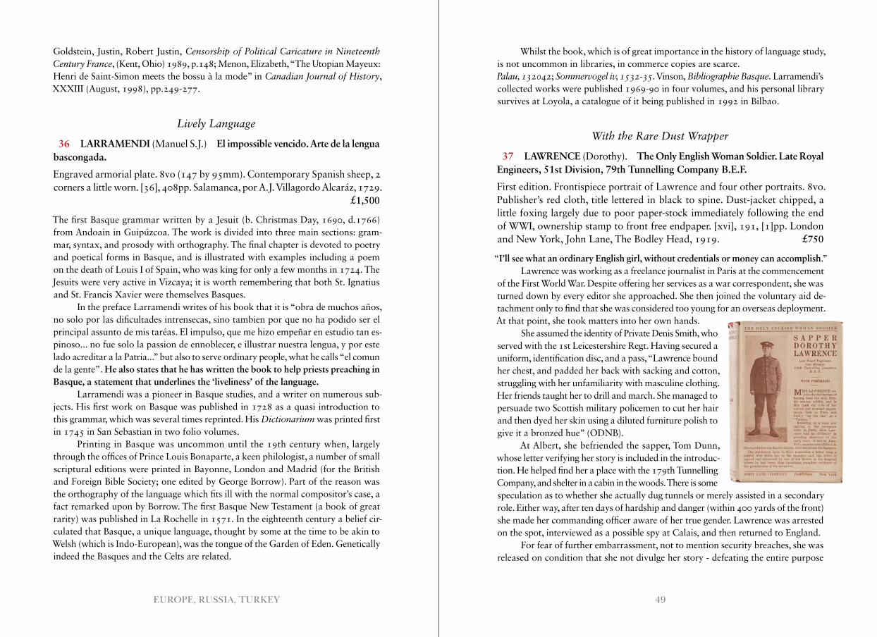
49EUROPE, RUSSIA, TURKEY
Goldstein, Justin, Robert Justin, Censorship of Political Caricature in Nineteenth Century France, (Kent, Ohio) 1989, p.148; Menon, Elizabeth, “The Utopian Mayeux: Henri de Saint-Simon meets the bossu à la mode” in Canadian Journal of History, XXXIII (August, 1998), pp.249-277.
Lively Language
36 LARRAMENDI (Manuel S.J.) El impossible vencido. Arte de la lengua bascongada.
Engraved armorial plate. 8vo (147 by 95mm). Contemporary Spanish sheep, 2 corners a little worn. [36], 408pp. Salamanca, por A.J. Villagordo Alcaráz, 1729. £1,500
The first Basque grammar written by a Jesuit (b. Christmas Day, 1690, d.1766) from Andoain in Guipúzcoa. The work is divided into three main sections: gram-mar, syntax, and prosody with orthography. The final chapter is devoted to poetry and poetical forms in Basque, and is illustrated with examples including a poem on the death of Louis I of Spain, who was king for only a few months in 1724. The Jesuits were very active in Vizcaya; it is worth remembering that both St. Ignatius and St. Francis Xavier were themselves Basques.
In the preface Larramendi writes of his book that it is “obra de muchos años, no solo por las dificultades intrensecas, sino tambien por que no ha podido ser el principal assunto de mis taréas. El impulso, que me hizo empeñar en estudio tan es- pinoso... no fue solo la passion de ennoblecer, e illustrar nuestra lengua, y por este lado acreditar a la Patria...” but also to serve ordinary people, what he calls “el comun de la gente”. He also states that he has written the book to help priests preaching in Basque, a statement that underlines the ‘liveliness’ of the language.
Larramendi was a pioneer in Basque studies, and a writer on numerous sub-jects. His first work on Basque was published in 1728 as a quasi introduction to this grammar, which was several times reprinted. His Dictionarium was printed first in 1745 in San Sebastian in two folio volumes.
Printing in Basque was uncommon until the 19th century when, largely through the offices of Prince Louis Bonaparte, a keen philologist, a number of small scriptural editions were printed in Bayonne, London and Madrid (for the British and Foreign Bible Society; one edited by George Borrow). Part of the reason was the orthography of the language which fits ill with the normal compositor’s case, a fact remarked upon by Borrow. The first Basque New Testament (a book of great rarity) was published in La Rochelle in 1571. In the eighteenth century a belief cir-culated that Basque, a unique language, thought by some at the time to be akin to Welsh (which is Indo-European), was the tongue of the Garden of Eden. Genetically indeed the Basques and the Celts are related.
Whilst the book, which is of great importance in the history of language study, is not uncommon in libraries, in commerce copies are scarce.Palau, 132042; Sommervogel iv, 1532-35. Vinson, Bibliographie Basque . Larramendi’s collected works were published 1969-90 in four volumes, and his personal library survives at Loyola, a catalogue of it being published in 1992 in Bilbao.
With the Rare Dust Wrapper
37 LAWRENCE (Dorothy). The Only English Woman Soldier. Late Royal Engineers, 51st Division, 79th Tunnelling Company B.E.F.
First edition. Frontispiece portrait of Lawrence and four other portraits. 8vo. Publisher’s red cloth, title lettered in black to spine. Dust-jacket chipped, a little foxing largely due to poor paper-stock immediately following the end of WWI, ownership stamp to front free endpaper. [xvi], 191, [1]pp. London and New York, John Lane, The Bodley Head, 1919. £750
“I’ll see what an ordinary English girl, without credentials or money can accomplish.”Lawrence was working as a freelance journalist in Paris at the commencement
of the First World War. Despite offering her services as a war correspondent, she was turned down by every editor she approached. She then joined the voluntary aid de-tachment only to find that she was considered too young for an overseas deployment. At that point, she took matters into her own hands.
She assumed the identity of Private Denis Smith, who served with the 1st Leicestershire Regt. Having secured a uniform, identification disc, and a pass, “Lawrence bound her chest, and padded her back with sacking and cotton, struggling with her unfamiliarity with masculine clothing. Her friends taught her to drill and march. She managed to persuade two Scottish military policemen to cut her hair and then dyed her skin using a diluted furniture polish to give it a bronzed hue” (ODNB).
At Albert, she befriended the sapper, Tom Dunn, whose letter verifying her story is included in the introduc-tion. He helped find her a place with the 179th Tunnelling Company, and shelter in a cabin in the woods. There is some speculation as to whether she actually dug tunnels or merely assisted in a secondary role. Either way, after ten days of hardship and danger (within 400 yards of the front) she made her commanding officer aware of her true gender. Lawrence was arrested on the spot, interviewed as a possible spy at Calais, and then returned to England.
For fear of further embarrassment, not to mention security breaches, she was released on condition that she not divulge her story - defeating the entire purpose
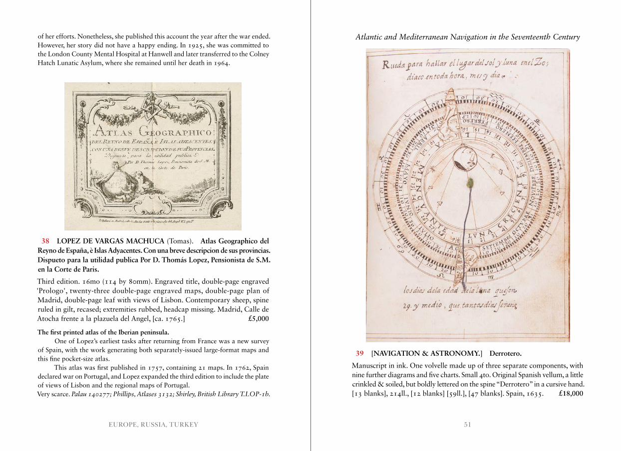
51EUROPE, RUSSIA, TURKEY
of her efforts. Nonetheless, she published this account the year after the war ended. However, her story did not have a happy ending. In 1925, she was committed to the London County Mental Hospital at Hanwell and later transferred to the Colney Hatch Lunatic Asylum, where she remained until her death in 1964.
39 [NAVIGATION & ASTRONOMY.] Derrotero.
Manuscript in ink. One volvelle made up of three separate components, with nine further diagrams and five charts. Small 4to. Original Spanish vellum, a little crinkled & soiled, but boldly lettered on the spine “Derrotero” in a cursive hand. [13 blanks], 214ll., [12 blanks] [59ll.], [47 blanks]. Spain, 1635. £18,000
38 LOPEZ DE VARGAS MACHUCA (Tomas). Atlas Geographico del Reyno de España, è Islas Adyacentes. Con una breve descripcion de sus provincias. Dispueto para la utilidad publica Por D. Thomás Lopez, Pensionista de S.M. en la Corte de Paris.
Third edition. 16mo (114 by 80mm). Engraved title, double-page engraved 'Prologo', twenty-three double-page engraved maps, double-page plan of Madrid, double-page leaf with views of Lisbon. Contemporary sheep, spine ruled in gilt, recased; extremities rubbed, headcap missing. Madrid, Calle de Atocha frente a la plazuela del Angel, [ca. 1765.] £5,000
The first printed atlas of the Iberian peninsula.One of Lopez’s earliest tasks after returning from France was a new survey
of Spain, with the work generating both separately-issued large-format maps and this fine pocket-size atlas.
This atlas was first published in 1757, containing 21 maps. In 1762, Spain declared war on Portugal, and Lopez expanded the third edition to include the plate of views of Lisbon and the regional maps of Portugal.Very scarce. Palau 140277; Phillips, Atlases 3132; Shirley, British Library T .LOP-1b .
Atlantic and Mediterranean Navigation in the Seventeenth Century
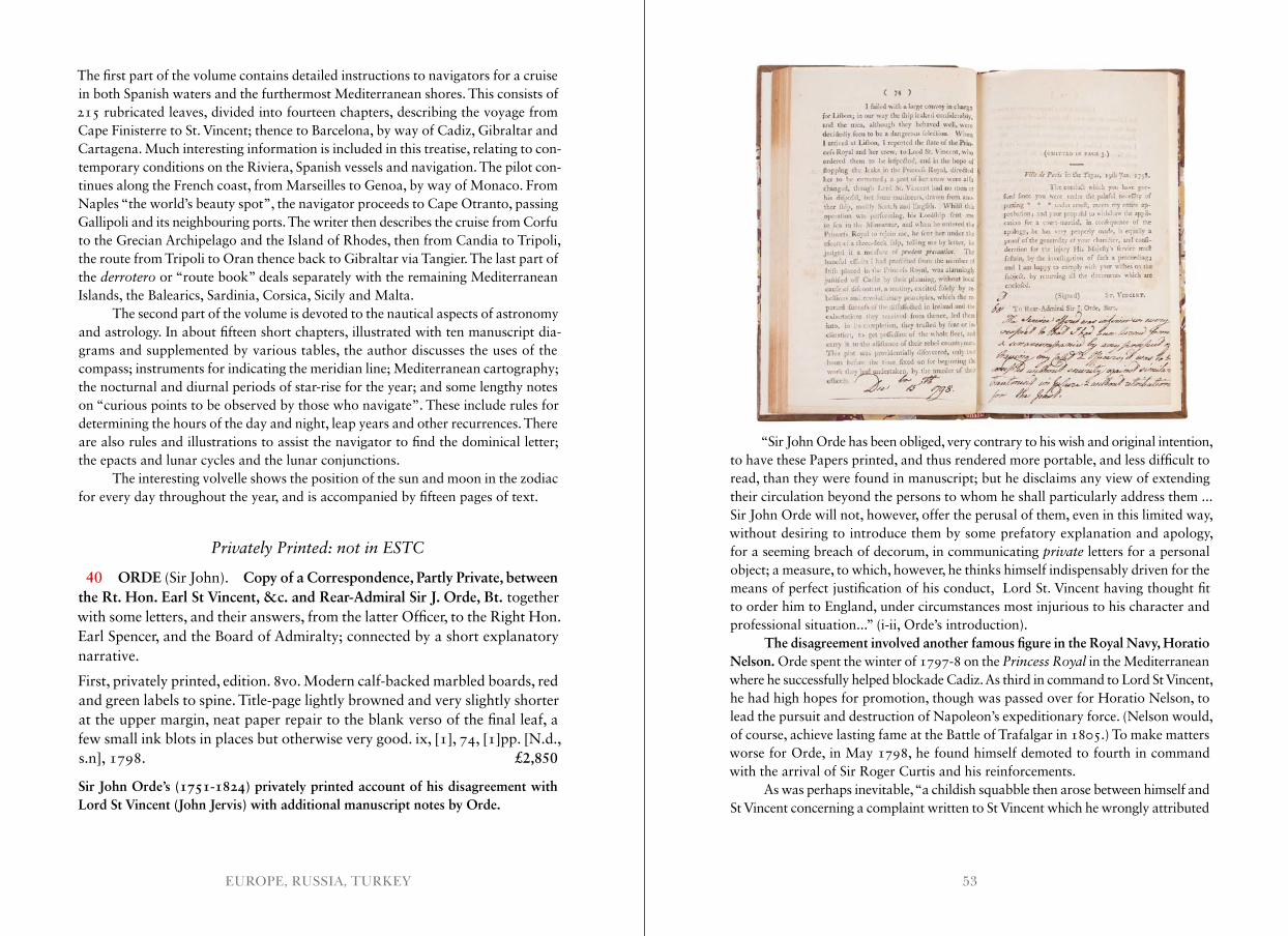
53EUROPE, RUSSIA, TURKEY
The first part of the volume contains detailed instructions to navigators for a cruise in both Spanish waters and the furthermost Mediterranean shores. This consists of 215 rubricated leaves, divided into fourteen chapters, describing the voyage from Cape Finisterre to St. Vincent; thence to Barcelona, by way of Cadiz, Gibraltar and Cartagena. Much interesting information is included in this treatise, relating to con-temporary conditions on the Riviera, Spanish vessels and navigation. The pilot con-tinues along the French coast, from Marseilles to Genoa, by way of Monaco. From Naples “the world’s beauty spot”, the navigator proceeds to Cape Otranto, passing Gallipoli and its neighbouring ports. The writer then describes the cruise from Corfu to the Grecian Archipelago and the Island of Rhodes, then from Candia to Tripoli, the route from Tripoli to Oran thence back to Gibraltar via Tangier. The last part of the derrotero or “route book” deals separately with the remaining Mediterranean Islands, the Balearics, Sardinia, Corsica, Sicily and Malta.
The second part of the volume is devoted to the nautical aspects of astronomy and astrology. In about fifteen short chapters, illustrated with ten manuscript dia-grams and supplemented by various tables, the author discusses the uses of the compass; instruments for indicating the meridian line; Mediterranean cartography; the nocturnal and diurnal periods of star-rise for the year; and some lengthy notes on “curious points to be observed by those who navigate”. These include rules for determining the hours of the day and night, leap years and other recurrences. There are also rules and illustrations to assist the navigator to find the dominical letter; the epacts and lunar cycles and the lunar conjunctions.
The interesting volvelle shows the position of the sun and moon in the zodiac for every day throughout the year, and is accompanied by fifteen pages of text.
Privately Printed: not in ESTC
40 ORDE (Sir John). Copy of a Correspondence, Partly Private, between the Rt. Hon. Earl St Vincent, &c. and Rear-Admiral Sir J. Orde, Bt. together with some letters, and their answers, from the latter Officer, to the Right Hon. Earl Spencer, and the Board of Admiralty; connected by a short explanatory narrative.
First, privately printed, edition. 8vo. Modern calf-backed marbled boards, red and green labels to spine. Title-page lightly browned and very slightly shorter at the upper margin, neat paper repair to the blank verso of the final leaf, a few small ink blots in places but otherwise very good. ix, [1], 74, [1]pp. [N.d., s.n], 1798. £2,850
Sir John Orde’s (1751-1824) privately printed account of his disagreement with Lord St Vincent (John Jervis) with additional manuscript notes by Orde.
“Sir John Orde has been obliged, very contrary to his wish and original intention, to have these Papers printed, and thus rendered more portable, and less difficult to read, than they were found in manuscript; but he disclaims any view of extending their circulation beyond the persons to whom he shall particularly address them ... Sir John Orde will not, however, offer the perusal of them, even in this limited way, without desiring to introduce them by some prefatory explanation and apology, for a seeming breach of decorum, in communicating private letters for a personal object; a measure, to which, however, he thinks himself indispensably driven for the means of perfect justification of his conduct, Lord St. Vincent having thought fit to order him to England, under circumstances most injurious to his character and professional situation...” (i-ii, Orde’s introduction).
The disagreement involved another famous figure in the Royal Navy, Horatio Nelson. Orde spent the winter of 1797-8 on the Princess Royal in the Mediterranean where he successfully helped blockade Cadiz. As third in command to Lord St Vincent, he had high hopes for promotion, though was passed over for Horatio Nelson, to lead the pursuit and destruction of Napoleon’s expeditionary force. (Nelson would, of course, achieve lasting fame at the Battle of Trafalgar in 1805.) To make matters worse for Orde, in May 1798, he found himself demoted to fourth in command with the arrival of Sir Roger Curtis and his reinforcements.
As was perhaps inevitable, “a childish squabble then arose between himself and St Vincent concerning a complaint written to St Vincent which he wrongly attributed
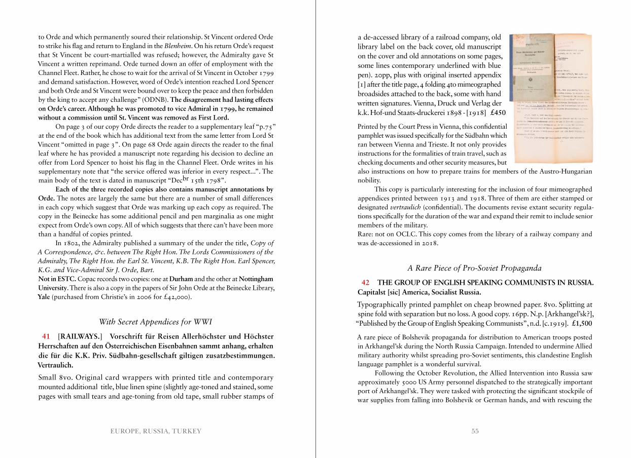
55EUROPE, RUSSIA, TURKEY
to Orde and which permanently soured their relationship. St Vincent ordered Orde to strike his flag and return to England in the Blenheim. On his return Orde’s request that St Vincent be court-martialled was refused; however, the Admiralty gave St Vincent a written reprimand. Orde turned down an offer of employment with the Channel Fleet. Rather, he chose to wait for the arrival of St Vincent in October 1799 and demand satisfaction. However, word of Orde’s intention reached Lord Spencer and both Orde and St Vincent were bound over to keep the peace and then forbidden by the king to accept any challenge” (ODNB). The disagreement had lasting effects on Orde’s career. Although he was promoted to vice Admiral in 1799, he remained without a commission until St. Vincent was removed as First Lord.
On page 3 of our copy Orde directs the reader to a supplementary leaf “p.75” at the end of the book which has additional text from the same letter from Lord St Vincent “omitted in page 3”. On page 68 Orde again directs the reader to the final leaf where he has provided a manuscript note regarding his decision to decline an offer from Lord Spencer to hoist his flag in the Channel Fleet. Orde writes in his supplementary note that “the service offered was inferior in every respect...”. The main body of the text is dated in manuscript “Decbr 15th 1798”.
Each of the three recorded copies also contains manuscript annotations by Orde. The notes are largely the same but there are a number of small differences in each copy which suggest that Orde was marking up each copy as required. The copy in the Beinecke has some additional pencil and pen marginalia as one might expect from Orde’s own copy. All of which suggests that there can’t have been more than a handful of copies printed.
In 1802, the Admiralty published a summary of the under the title, Copy of A Correspondence, &c . between The Right Hon . The Lords Commissioners of the Admiralty, The Right Hon . the Earl St . Vincent, K .B . The Right Hon . Earl Spencer, K .G . and Vice-Admiral Sir J . Orde, Bart .Not in ESTC. Copac records two copies: one at Durham and the other at Nottingham University. There is also a copy in the papers of Sir John Orde at the Beinecke Library, Yale (purchased from Christie’s in 2006 for £42,000).
With Secret Appendices for WWI
41 [RAILWAYS.] Vorschrift für Reisen Allerhöchster und Höchster Herrschaften auf den Österreichischen Eisenbahnen sammt anhang, erhalten die für die K.K. Priv. Südbahn-gesellschaft giltigen zusatzbestimmungen. Vertraulich.
Small 8vo. Original card wrappers with printed title and contemporary mounted additional title, blue linen spine (slightly age-toned and stained, some pages with small tears and age-toning from old tape, small rubber stamps of
a de-accessed library of a railroad company, old library label on the back cover, old manuscript on the cover and old annotations on some pages, some lines contemporary underlined with blue pen). 20pp, plus with original inserted appendix [1] after the title page, 4 folding 4to mimeographed broadsides attached to the back, some with hand written signatures. Vienna, Druck und Verlag der k.k. Hof-und Staats-druckerei 1898 - [1918] £450
Printed by the Court Press in Vienna, this confidential pamphlet was issued specifically for the Südbahn which ran between Vienna and Trieste. It not only provides instructions for the formalities of train travel, such as checking documents and other security measures, but also instructions on how to prepare trains for members of the Austro-Hungarian nobility.
This copy is particularly interesting for the inclusion of four mimeographed appendices printed between 1913 and 1918. Three of them are either stamped or designated vertraulich (confidential). The documents revise extant security regula-tions specifically for the duration of the war and expand their remit to include senior members of the military.Rare: not on OCLC. This copy comes from the library of a railway company and was de-accessioned in 2018.
A Rare Piece of Pro-Soviet Propaganda
42 THE GROUP OF ENGLISH SPEAKING COMMUNISTS IN RUSSIA. Capitalst [sic] America, Socialist Russia.
Typographically printed pamphlet on cheap browned paper. 8vo. Splitting at spine fold with separation but no loss. A good copy. 16pp. N.p. [Arkhangel’sk?],
“Published by the Group of English Speaking Communists”, n.d. [c.1919]. £1,500
A rare piece of Bolshevik propaganda for distribution to American troops posted in Arkhangel’sk during the North Russia Campaign. Intended to undermine Allied military authority whilst spreading pro-Soviet sentiments, this clandestine English language pamphlet is a wonderful survival.
Following the October Revolution, the Allied Intervention into Russia saw approximately 5000 US Army personnel dispatched to the strategically important port of Arkhangel’sk. They were tasked with protecting the significant stockpile of war supplies from falling into Bolshevik or German hands, and with rescuing the
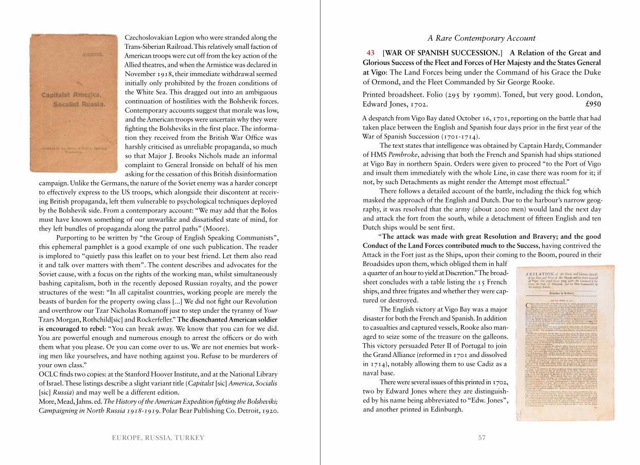
57EUROPE, RUSSIA, TURKEY
Czechoslovakian Legion who were stranded along the Trans-Siberian Railroad. This relatively small faction of American troops were cut off from the key action of the Allied theatres, and when the Armistice was declared in November 1918, their immediate withdrawal seemed initially only prohibited by the frozen conditions of the White Sea. This dragged out into an ambiguous continuation of hostilities with the Bolshevik forces. Contemporary accounts suggest that morale was low, and the American troops were uncertain why they were fighting the Bolsheviks in the first place. The informa-tion they received from the British War Office was harshly criticised as unreliable propaganda, so much so that Major J. Brooks Nichols made an informal complaint to General Ironside on behalf of his men asking for the cessation of this British disinformation
campaign. Unlike the Germans, the nature of the Soviet enemy was a harder concept to effectively express to the US troops, which alongside their discontent at receiv-ing British propaganda, left them vulnerable to psychological techniques deployed by the Bolshevik side. From a contemporary account: “We may add that the Bolos must have known something of our unwarlike and dissatisfied state of mind, for they left bundles of propaganda along the patrol paths” (Moore).
Purporting to be written by “the Group of English Speaking Communists”, this ephemeral pamphlet is a good example of one such publication. The reader is implored to “quietly pass this leaflet on to your best friend. Let them also read it and talk over matters with them”. The content describes and advocates for the Soviet cause, with a focus on the rights of the working man, whilst simultaneously bashing capitalism, both in the recently deposed Russian royalty, and the power structures of the west: “In all capitalist countries, working people are merely the beasts of burden for the property owing class [...] We did not fight our Revolution and overthrow our Tzar Nicholas Romanoff just to step under the tyranny of Your Tzars Morgan, Rothchild[sic] and Rockerfeller.” The disenchanted American soldier is encouraged to rebel: “You can break away. We know that you can for we did. You are powerful enough and numerous enough to arrest the officers or do with them what you please. Or you can come over to us. We are not enemies but work-ing men like yourselves, and have nothing against you. Refuse to be murderers of your own class.”OCLC finds two copies: at the Stanford Hoover Institute, and at the National Library of Israel. These listings describe a slight variant title (Capitalst [sic] America, Socialis [sic] Russia) and may well be a different edition.More, Mead, Jahns. ed. The History of the American Expedition fighting the Bolsheviki; Campaigning in North Russia 1918-1919 . Polar Bear Publishing Co. Detroit, 1920.
A Rare Contemporary Account
43 [WAR OF SPANISH SUCCESSION.] A Relation of the Great and Glorious Success of the Fleet and Forces of Her Majesty and the States General at Vigo: The Land Forces being under the Command of his Grace the Duke of Ormond, and the Fleet Commanded by Sir George Rooke.
Printed broadsheet. Folio (295 by 190mm). Toned, but very good. London, Edward Jones, 1702. £950
A despatch from Vigo Bay dated October 16, 1701, reporting on the battle that had taken place between the English and Spanish four days prior in the first year of the War of Spanish Succession (1701-1714).
The text states that intelligence was obtained by Captain Hardy, Commander of HMS Pembroke, advising that both the French and Spanish had ships stationed at Vigo Bay in northern Spain. Orders were given to proceed “to the Port of Vigo and insult them immediately with the whole Line, in case there was room for it; if not, by such Detachments as might render the Attempt most effectual.”
There follows a detailed account of the battle, including the thick fog which masked the approach of the English and Dutch. Due to the harbour’s narrow geog-raphy, it was resolved that the army (about 2000 men) would land the next day and attack the fort from the south, while a detachment of fifteen English and ten Dutch ships would be sent first.
“The attack was made with great Resolution and Bravery; and the good Conduct of the Land Forces contributed much to the Success, having contrived the Attack in the Fort just as the Ships, upon their coming to the Boom, poured in their Broadsides upon them, which obliged them in half a quarter of an hour to yield at Discretion.” The broad- sheet concludes with a table listing the 15 French ships, and three frigates and whether they were cap- tured or destroyed.
The English victory at Vigo Bay was a major disaster for both the French and Spanish. In addition to casualties and captured vessels, Rooke also man-aged to seize some of the treasure on the galleons. This victory persuaded Peter II of Portugal to join the Grand Alliance (reformed in 1701 and dissolved in 1714), notably allowing them to use Cadiz as a naval base.
There were several issues of this printed in 1702, two by Edward Jones where they are distinguish-ed by his name being abbreviated to “Edw. Jones”, and another printed in Edinburgh.
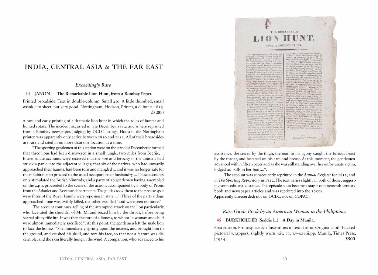
59INDIA, CENTRAL ASIA, FAR EAST
INDIA, CENTRAL ASIA & THE FAR EAST
Exceedingly Rare
44 [ANON.] The Remarkable Lion Hunt, from a Bombay Paper.
Printed broadside. Text in double-column. Small 4to. A little thumbed, small wrinkle to sheet, but very good. Nottingham, Hodson, Printer, n.d. but c. 1813. £3,000
A rare and early printing of a dramatic lion hunt in which the roles of hunter and hunted rotate. The incident occurred in late December 1812, and is here reprinted from a Bombay newspaper. Judging by OCLC listings, Hodson, the Nottingham printer, was apparently only active between 1810 and 1813. All of their broadsides are rare and cited in no more than one location at a time.
“The sporting gentlemen of this station were on the 22nd of December informed that three lions had been discovered in a small jungle, two miles from Beerije; ... Intermediate accounts were received that the size and ferocity of the animals had struck a panic into the adjacent villages; that six of the natives, who had unwarily approached their haunts, had been torn and mangled ... and it was no longer safe for the inhabitants to proceed to the usual occupations of husbandry ... These accounts only stimulated the British Nimrods; and a party of 16 gentlemen having assembled on the 24th, proceeded to the scene of the action, accompanied by a body of Peons from the Adaulet and Revenue departments. The guides took them to the precise spot were three of the Royal Family were reposing in state ...”. Three of the party’s dogs approached - one was swiftly killed, the other two fled “and were seen no more.”
The account continues, telling of the attempted attack on the lion particularly, who lacerated the shoulder of Mr. M. and seized him by the throat, before being scared off by rifle fire. It was then the turn of a lioness, to whom “a woman and child were almost immediately sacrificed”. At this point, the gentlemen left the male lion to face the lioness. “She immediately sprung upon the nearest, and brought him to the ground, and crushed his skull, and tore his face, so that not a feature was dis-cernible, and the skin literally hung in the wind. A companion, who advanced to his
assistance, she seized by the thigh, the man in his agony caught the furious beast by the throat, and fastened on his arm and breast. At this moment, the gentlemen advanced within fifteen paces and as she was still standing over her unfortunate victim, lodged 20 balls in her body...”.
The account was subsequently reprinted in the Annual Register for 1813, and in The Sporting Repository in 1822. The text varies slightly in both of those, suggest-ing some editorial distance. This episode soon became a staple of nineteenth-century book and newspaper articles and was reprinted into the 1850s.Apparently unrecorded: not on OCLC, not on COPAC.
Rare Guide Book by an American Woman in the Philippines
45 BURKHOLDER (Seddie L.) A Day in Manila.
First edition. Frontispiece & illustrations to text. 12mo. Original cloth-backed pictorial wrappers, slightly worn. xiv, 71, xv-xxviii.pp. Manila, Times Press, [1924]. £500
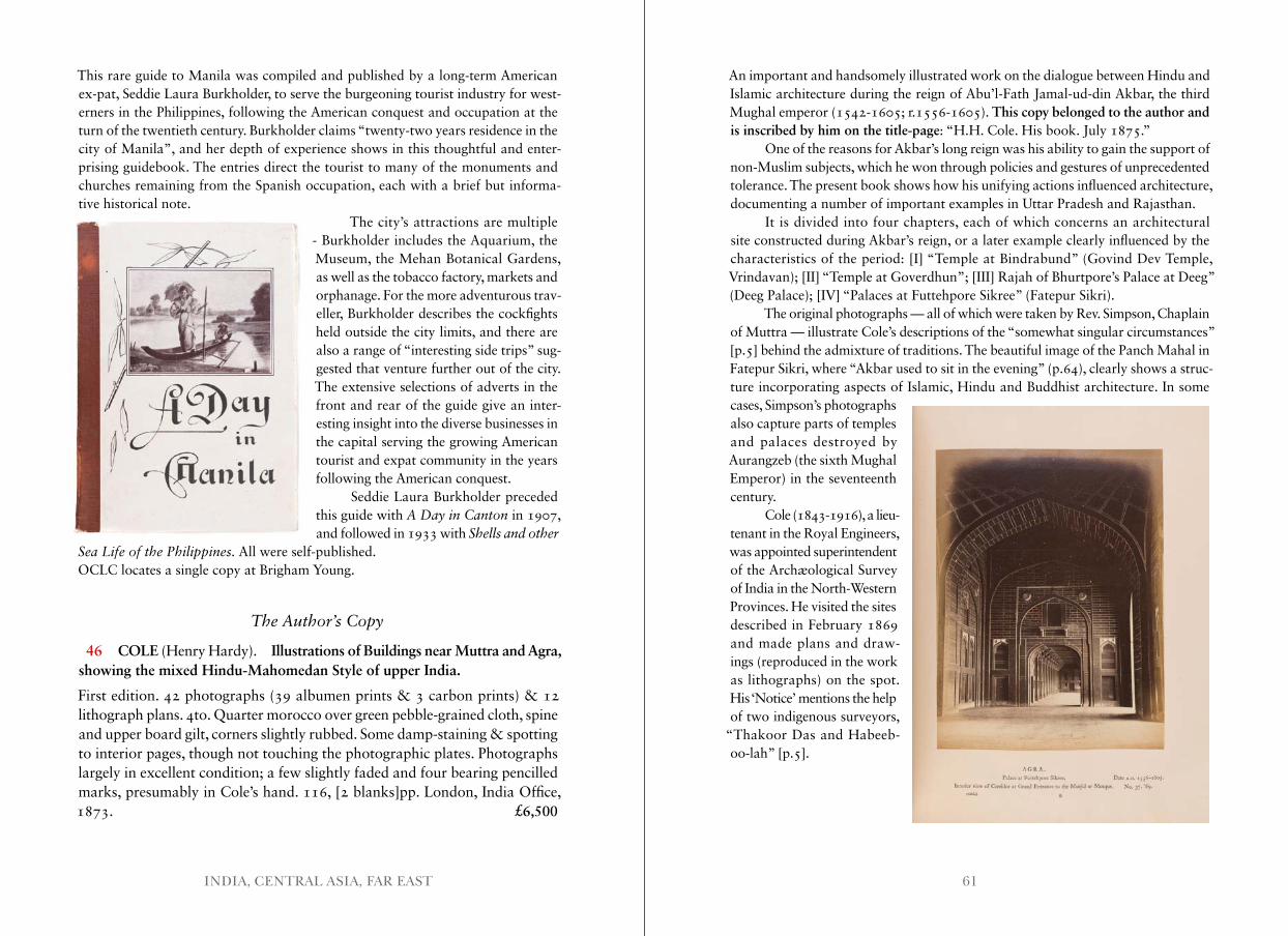
61INDIA, CENTRAL ASIA, FAR EAST
This rare guide to Manila was compiled and published by a long-term American ex-pat, Seddie Laura Burkholder, to serve the burgeoning tourist industry for west-erners in the Philippines, following the American conquest and occupation at the turn of the twentieth century. Burkholder claims “twenty-two years residence in the city of Manila”, and her depth of experience shows in this thoughtful and enter-prising guidebook. The entries direct the tourist to many of the monuments and churches remaining from the Spanish occupation, each with a brief but informa-tive historical note.
The city’s attractions are multiple - Burkholder includes the Aquarium, the Museum, the Mehan Botanical Gardens, as well as the tobacco factory, markets and orphanage. For the more adventurous trav-eller, Burkholder describes the cockfights held outside the city limits, and there are also a range of “interesting side trips” sug-gested that venture further out of the city. The extensive selections of adverts in the front and rear of the guide give an inter-esting insight into the diverse businesses in the capital serving the growing American tourist and expat community in the years following the American conquest.
Seddie Laura Burkholder preceded this guide with A Day in Canton in 1907, and followed in 1933 with Shells and other
Sea Life of the Philippines . All were self-published.OCLC locates a single copy at Brigham Young.
The Author’s Copy
46 COLE (Henry Hardy). Illustrations of Buildings near Muttra and Agra, showing the mixed Hindu-Mahomedan Style of upper India.
First edition. 42 photographs (39 albumen prints & 3 carbon prints) & 12 lithograph plans. 4to. Quarter morocco over green pebble-grained cloth, spine and upper board gilt, corners slightly rubbed. Some damp-staining & spotting to interior pages, though not touching the photographic plates. Photographs largely in excellent condition; a few slightly faded and four bearing pencilled marks, presumably in Cole’s hand. 116, [2 blanks]pp. London, India Office, 1873. £6,500
An important and handsomely illustrated work on the dialogue between Hindu and Islamic architecture during the reign of Abu’l-Fath Jamal-ud-din Akbar, the third Mughal emperor (1542-1605; r.1556-1605). This copy belonged to the author and is inscribed by him on the title-page: “H.H. Cole. His book. July 1875.”
One of the reasons for Akbar’s long reign was his ability to gain the support of non-Muslim subjects, which he won through policies and gestures of unprecedented tolerance. The present book shows how his unifying actions influenced architecture, documenting a number of important examples in Uttar Pradesh and Rajasthan.
It is divided into four chapters, each of which concerns an architectural site constructed during Akbar’s reign, or a later example clearly influenced by the characteristics of the period: [I] “Temple at Bindrabund” (Govind Dev Temple, Vrindavan); [II] “Temple at Goverdhun”; [III] Rajah of Bhurtpore’s Palace at Deeg” (Deeg Palace); [IV] “Palaces at Futtehpore Sikree” (Fatepur Sikri).
The original photographs — all of which were taken by Rev. Simpson, Chaplain of Muttra — illustrate Cole’s descriptions of the “somewhat singular circumstances” [p.5] behind the admixture of traditions. The beautiful image of the Panch Mahal in Fatepur Sikri, where “Akbar used to sit in the evening” (p.64), clearly shows a struc-ture incorporating aspects of Islamic, Hindu and Buddhist architecture. In some cases, Simpson’s photographs also capture parts of temples and palaces destroyed by Aurangzeb (the sixth Mughal Emperor) in the seventeenth century.
Cole (1843-1916), a lieu-tenant in the Royal Engineers, was appointed superintendent of the Archæological Survey of India in the North-Western Provinces. He visited the sites described in February 1869 and made plans and draw-ings (reproduced in the work as lithographs) on the spot. His ‘Notice’ mentions the help of two indigenous surveyors,
“Thakoor Das and Habeeb-oo-lah” [p.5].
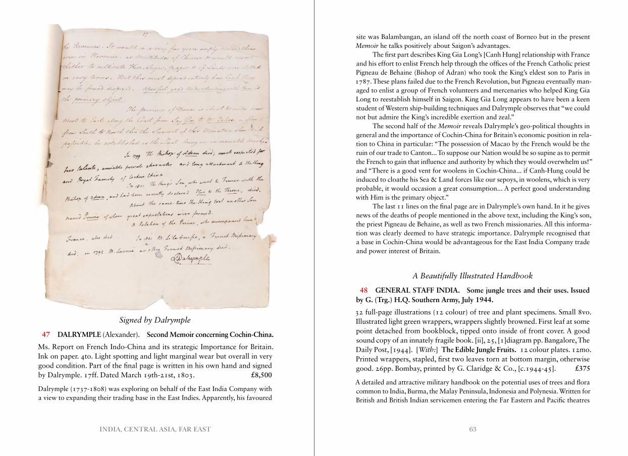
63INDIA, CENTRAL ASIA, FAR EAST
Signed by Dalrymple
47 DALRYMPLE (Alexander). Second Memoir concerning Cochin-China.
Ms. Report on French Indo-China and its strategic Importance for Britain. Ink on paper. 4to. Light spotting and light marginal wear but overall in very good condition. Part of the final page is written in his own hand and signed by Dalrymple. 17ff. Dated March 19th-21st, 1803. £8,500
Dalrymple (1737-1808) was exploring on behalf of the East India Company with a view to expanding their trading base in the East Indies. Apparently, his favoured
site was Balambangan, an island off the north coast of Borneo but in the present Memoir he talks positively about Saigon’s advantages.
The first part describes King Gia Long’s [Canh Hung] relationship with France and his effort to enlist French help through the offices of the French Catholic priest Pigneau de Behaine (Bishop of Adran) who took the King’s eldest son to Paris in 1787. These plans failed due to the French Revolution, but Pigneau eventually man-aged to enlist a group of French volunteers and mercenaries who helped King Gia Long to reestablish himself in Saigon. King Gia Long appears to have been a keen student of Western ship-building techniques and Dalrymple observes that “we could not but admire the King’s incredible exertion and zeal.”
The second half of the Memoir reveals Dalrymple’s geo-political thoughts in general and the importance of Cochin-China for Britain’s economic position in rela-tion to China in particular: “The possession of Macao by the French would be the ruin of our trade to Canton... To suppose our Nation would be so supine as to permit the French to gain that influence and authority by which they would overwhelm us!” and “There is a good vent for woolens in Cochin-China... if Canh-Hung could be induced to cloathe his Sea & Land forces like our sepoys, in woolens, which is very probable, it would occasion a great consumption... A perfect good understanding with Him is the primary object.”
The last 11 lines on the final page are in Dalrymple’s own hand. In it he gives news of the deaths of people mentioned in the above text, including the King’s son, the priest Pigneau de Behaine, as well as two French missionaries. All this informa-tion was clearly deemed to have strategic importance. Dalrymple recognised that a base in Cochin-China would be advantageous for the East India Company trade and power interest of Britain.
A Beautifully Illustrated Handbook
48 GENERAL STAFF INDIA. Some jungle trees and their uses. Issued by G. (Trg.) H.Q. Southern Army, July 1944.
32 full-page illustrations (12 colour) of tree and plant specimens. Small 8vo. Illustrated light green wrappers, wrappers slightly browned. First leaf at some point detached from bookblock, tipped onto inside of front cover. A good sound copy of an innately fragile book. [ii], 25, [1]diagram pp. Bangalore, The Daily Post, [1944]. [With:] The Edible Jungle Fruits. 12 colour plates. 12mo. Printed wrappers, stapled, first two leaves torn at bottom margin, otherwise good. 26pp. Bombay, printed by G. Claridge & Co., [c.1944-45]. £375
A detailed and attractive military handbook on the potential uses of trees and flora common to India, Burma, the Malay Peninsula, Indonesia and Polynesia. Written for British and British Indian servicemen entering the Far Eastern and Pacific theatres
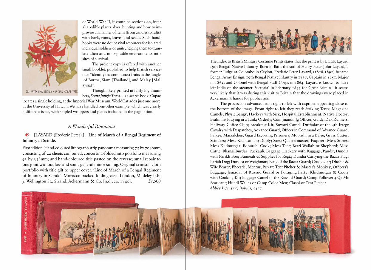
65INDIA, CENTRAL ASIA, FAR EAST
of World War II, it contains sections on, inter alia, edible plants, dyes, hunting and how to im- provise all manner of items (from candles to rafts) with bark, roots, leaves and seeds. Such hand- books were no doubt vital resources for isolated individual soldiers or units; helping them to trans- late alien and inhospitable environments into sites of survival.
The present copy is offered with another small booklet, published to help British service- men “identify the commonest fruits in the jungle of Burma, Siam [Thailand], and Malay [Mal- aysia]”.
Though likely printed in fairly high num-bers, Some Jungle Trees . . . is a scarce book. Copac
locates a single holding, at the Imperial War Museum. WorldCat adds just one more, at the University of Hawaii. We have handled one other example, which was clearly a different issue, with stapled wrappers and plates included in the pagination.
A Wonderful Panorama
49 [LAYARD (Frederic Peter).] Line of March of a Bengal Regiment of Infantry at Scinde.
First edition. Hand-coloured lithograph strip panorama measuring 75 by 7040mm, consisting of 22 sheets conjoined, concertina-folded into portfolio measuring 93 by 338mm; and hand-coloured title pasted on the reverse; small repair to one joint without loss and some general minor soiling. Original crimson cloth portfolio with title gilt to upper cover: ‘Line of March of a Bengal Regiment of Infantry in Scinde’. Morocco backed folding case. London, Madeley lith., 3, Wellington St., Strand. Ackermann & Co. [n.d., ca. 1840]. £7,500
The Index to British Military Costume Prints states that the print is by Lt. F.P. Layard, 19th Bengal Native Infantry. Born in Bath the son of Henry Peter John Layard, a former Judge at Colombo in Ceylon, Frederic Peter Layard, (1818-1891) became Bengal Army Ensign, 19th Bengal Native Infantry in 1838; Captain in 1851; Major in 1862; and Colonel with Bengal Staff Corps in 1864. Layard is known to have left India on the steamer ‘Victoria’ in February 1843 for Great Britain - it seems very likely that it was during this visit to Britain that the drawings were placed in Ackermann’s hands for publication.
The procession advances from right to left with captions appearing close to the bottom of the image. From right to left they read: Striking Tents; Magazine Camels; Physic Bangy; Hackery with Sick; Hospital Establishment; Native Doctor; Brahmins Praying in a Tank; Orderly; Com[mandin]g Officer; Guide; Dak Runners; Halfway Coffee Club; Breakfast Kit; Sowari Camel; Duffadar of the 4th Irregr. Cavalry with Despatches; Advance Guard; Officer in Command of Advance Guard; Palkee; Massalchee; Guard Escorting Prisoners; Moonshi in a Bylee; Grass Cutter; Scindees; Mess Khansaman; Dooly; Saes; Quartermaster; Faqueer; Mess Stores; Mess Kudmutgar; Boburchi Cook; Mess Tent; Berri Wallah or Shepherd; Mess Cattle; Bhangi Burdar; Puckauli; Baggage; Hackery with Baggage; Pandit; Dundia with Nirikh Boo; Bunneah & Supplies for Regt.; Dundia Carrying the Bazar Flag; Pariah Dog; Dundea or Weighman; Naik of the Bazar Guard; Cruokedar; Dhobie & Wife Bearer; Bheestie; Mentur; Private Tent Pitcher & Master’s Monkey; Officers’s Baggage; Jemadar of Russud Guard or Foraging Party; Khidmutgar & Cooly with Cooking Kit; Baggage Camel of the Russud Guard; Camp Followers; Qr Mr. Searjeant; Hundi Wallas or Camp Color Men; Clashi or Tent Pitcher.Abbey Life, 515; Bobins, 5477 .
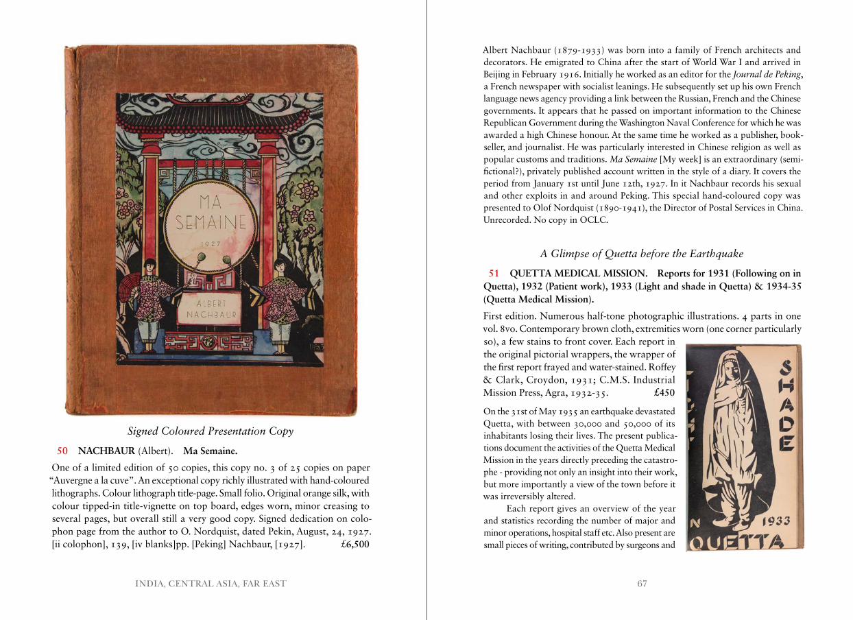
67INDIA, CENTRAL ASIA, FAR EAST
Signed Coloured Presentation Copy
50 NACHBAUR (Albert). Ma Semaine.
One of a limited edition of 50 copies, this copy no. 3 of 25 copies on paper “Auvergne a la cuve”. An exceptional copy richly illustrated with hand-coloured lithographs. Colour lithograph title-page. Small folio. Original orange silk, with colour tipped-in title-vignette on top board, edges worn, minor creasing to several pages, but overall still a very good copy. Signed dedication on colo-phon page from the author to O. Nordquist, dated Pekin, August, 24, 1927. [ii colophon], 139, [iv blanks]pp. [Peking] Nachbaur, [1927]. £6,500
Albert Nachbaur (1879-1933) was born into a family of French architects and decorators. He emigrated to China after the start of World War I and arrived in Beijing in February 1916. Initially he worked as an editor for the Journal de Peking, a French newspaper with socialist leanings. He subsequently set up his own French language news agency providing a link between the Russian, French and the Chinese governments. It appears that he passed on important information to the Chinese Republican Government during the Washington Naval Conference for which he was awarded a high Chinese honour. At the same time he worked as a publisher, book-seller, and journalist. He was particularly interested in Chinese religion as well as popular customs and traditions. Ma Semaine [My week] is an extraordinary (semi- fictional?), privately published account written in the style of a diary. It covers the period from January 1st until June 12th, 1927. In it Nachbaur records his sexual and other exploits in and around Peking. This special hand-coloured copy was presented to Olof Nordquist (1890-1941), the Director of Postal Services in China. Unrecorded. No copy in OCLC.
A Glimpse of Quetta before the Earthquake
51 QUETTA MEDICAL MISSION. Reports for 1931 (Following on in Quetta), 1932 (Patient work), 1933 (Light and shade in Quetta) & 1934-35 (Quetta Medical Mission).
First edition. Numerous half-tone photographic illustrations. 4 parts in one vol. 8vo. Contemporary brown cloth, extremities worn (one corner particularly so), a few stains to front cover. Each report in the original pictorial wrappers, the wrapper of the first report frayed and water-stained. Roffey & Clark, Croydon, 1931; C.M.S. Industrial Mission Press, Agra, 1932-35. £450
On the 31st of May 1935 an earthquake devastated Quetta, with between 30,000 and 50,000 of its inhabitants losing their lives. The present publica-tions document the activities of the Quetta Medical Mission in the years directly preceding the catastro-phe - providing not only an insight into their work, but more importantly a view of the town before it was irreversibly altered.
Each report gives an overview of the year and statistics recording the number of major and minor operations, hospital staff etc. Also present are small pieces of writing, contributed by surgeons and
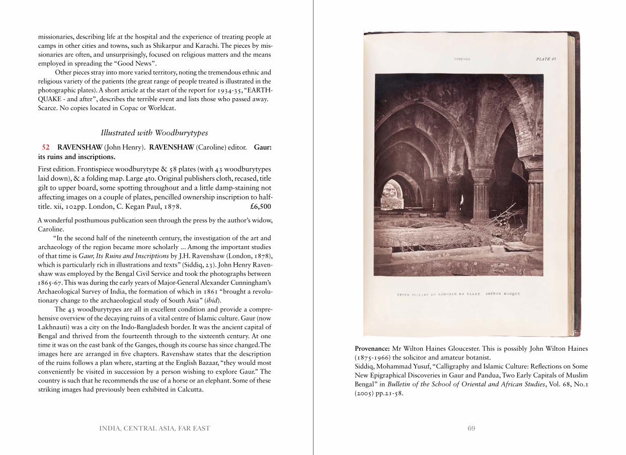
69INDIA, CENTRAL ASIA, FAR EAST
missionaries, describing life at the hospital and the experience of treating people at camps in other cities and towns, such as Shikarpur and Karachi. The pieces by mis-sionaries are often, and unsurprisingly, focused on religious matters and the means employed in spreading the “Good News”.
Other pieces stray into more varied territory, noting the tremendous ethnic and religious variety of the patients (the great range of people treated is illustrated in the photographic plates). A short article at the start of the report for 1934-35, “EARTH-QUAKE - and after”, describes the terrible event and lists those who passed away.Scarce. No copies located in Copac or Worldcat.
Illustrated with Woodburytypes
52 RAVENSHAW (John Henry). RAVENSHAW (Caroline) editor. Gaur: its ruins and inscriptions.
First edition. Frontispiece woodburytype & 58 plates (with 43 woodburytypes laid down), & a folding map. Large 4to. Original publishers cloth, recased, title gilt to upper board, some spotting throughout and a little damp-staining not affecting images on a couple of plates, pencilled ownership inscription to half- title. xii, 102pp. London, C. Kegan Paul, 1878. £6,500
A wonderful posthumous publication seen through the press by the author’s widow, Caroline.
“In the second half of the nineteenth century, the investigation of the art and archaeology of the region became more scholarly ... Among the important studies of that time is Gaur, Its Ruins and Inscriptions by J.H. Ravenshaw (London, 1878), which is particularly rich in illustrations and texts” (Siddiq, 23). John Henry Raven- shaw was employed by the Bengal Civil Service and took the photographs between 1865-67. This was during the early years of Major-General Alexander Cunningham’s Archaeological Survey of India, the formation of which in 1861 “brought a revolu-tionary change to the archaeological study of South Asia” (ibid).
The 43 woodburytypes are all in excellent condition and provide a compre-hensive overview of the decaying ruins of a vital centre of Islamic culture. Gaur (now Lakhnauti) was a city on the Indo-Bangladesh border. It was the ancient capital of Bengal and thrived from the fourteenth through to the sixteenth century. At one time it was on the east bank of the Ganges, though its course has since changed.The images here are arranged in five chapters. Ravenshaw states that the description of the ruins follows a plan where, starting at the English Bazaar, “they would most conveniently be visited in succession by a person wishing to explore Gaur.” The country is such that he recommends the use of a horse or an elephant. Some of these striking images had previously been exhibited in Calcutta.
Provenance: Mr Wilton Haines Gloucester. This is possibly John Wilton Haines (1875-1966) the solicitor and amateur botanist.Siddiq, Mohammad Yusuf, “Calligraphy and Islamic Culture: Reflections on Some New Epigraphical Discoveries in Gaur and Pandua, Two Early Capitals of Muslim Bengal” in Bulletin of the School of Oriental and African Studies, Vol. 68, No.1 (2005) pp.21-58.
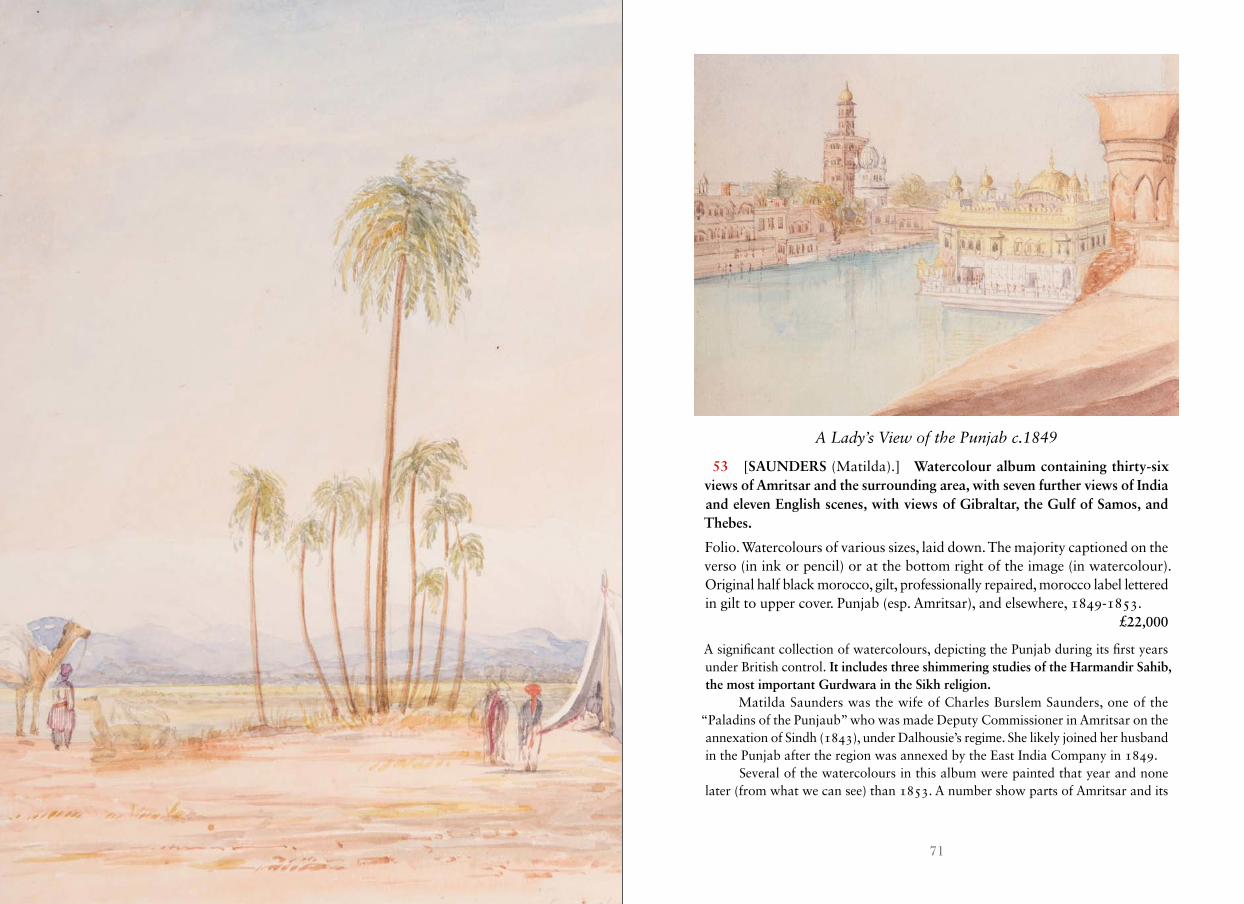
71INDIA, CENTRAL ASIA, FAR EAST
A Lady’s View of the Punjab c .1849
53 [SAUNDERS (Matilda).] Watercolour album containing thirty-six views of Amritsar and the surrounding area, with seven further views of India and eleven English scenes, with views of Gibraltar, the Gulf of Samos, and Thebes.
Folio. Watercolours of various sizes, laid down. The majority captioned on the verso (in ink or pencil) or at the bottom right of the image (in watercolour). Original half black morocco, gilt, professionally repaired, morocco label lettered in gilt to upper cover. Punjab (esp. Amritsar), and elsewhere, 1849-1853. £22,000
A significant collection of watercolours, depicting the Punjab during its first years under British control. It includes three shimmering studies of the Harmandir Sahib, the most important Gurdwara in the Sikh religion.
Matilda Saunders was the wife of Charles Burslem Saunders, one of the “Paladins of the Punjaub” who was made Deputy Commissioner in Amritsar on the annexation of Sindh (1843), under Dalhousie’s regime. She likely joined her husband in the Punjab after the region was annexed by the East India Company in 1849.
Several of the watercolours in this album were painted that year and none later (from what we can see) than 1853. A number show parts of Amritsar and its
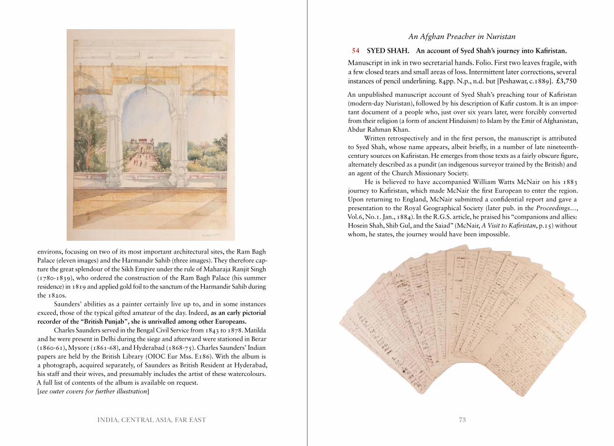
73INDIA, CENTRAL ASIA, FAR EAST
environs, focusing on two of its most important architectural sites, the Ram Bagh Palace (eleven images) and the Harmandir Sahib (three images). They therefore cap-ture the great splendour of the Sikh Empire under the rule of Maharaja Ranjit Singh (1780-1839), who ordered the construction of the Ram Bagh Palace (his summer residence) in 1819 and applied gold foil to the sanctum of the Harmandir Sahib during the 1820s.
Saunders’ abilities as a painter certainly live up to, and in some instances exceed, those of the typical gifted amateur of the day. Indeed, as an early pictorial recorder of the “British Punjab”, she is unrivalled among other Europeans.
Charles Saunders served in the Bengal Civil Service from 1843 to 1878. Matilda and he were present in Delhi during the siege and afterward were stationed in Berar (1860-61), Mysore (1861-68), and Hyderabad (1868-75). Charles Saunders’ Indian papers are held by the British Library (OIOC Eur Mss. E186). With the album is a photograph, acquired separately, of Saunders as British Resident at Hyderabad, his staff and their wives, and presumably includes the artist of these watercolours.A full list of contents of the album is available on request. [see outer covers for further illustration]
An Afghan Preacher in Nuristan
54 SYED SHAH. An account of Syed Shah’s journey into Kafiristan.
Manuscript in ink in two secretarial hands. Folio. First two leaves fragile, with a few closed tears and small areas of loss. Intermittent later corrections, several instances of pencil underlining. 84pp. N.p., n.d. but [Peshawar, c.1889]. £3,750
An unpublished manuscript account of Syed Shah’s preaching tour of Kafiristan (modern-day Nuristan), followed by his description of Kafir custom. It is an impor-tant document of a people who, just over six years later, were forcibly converted from their religion (a form of ancient Hinduism) to Islam by the Emir of Afghanistan, Abdur Rahman Khan.
Written retrospectively and in the first person, the manuscript is attributed to Syed Shah, whose name appears, albeit briefly, in a number of late nineteenth-century sources on Kafiristan. He emerges from those texts as a fairly obscure figure, alternately described as a pundit (an indigenous surveyor trained by the British) and an agent of the Church Missionary Society.
He is believed to have accompanied William Watts McNair on his 1883 journey to Kafiristan, which made McNair the first European to enter the region. Upon returning to England, McNair submitted a confidential report and gave a presentation to the Royal Geographical Society (later pub. in the Proceedings…, Vol.6, No.1. Jan., 1884). In the R.G.S. article, he praised his “companions and allies: Hosein Shah, Shib Gul, and the Saiad” (McNair, A Visit to Kafiristan, p.15) without whom, he states, the journey would have been impossible.
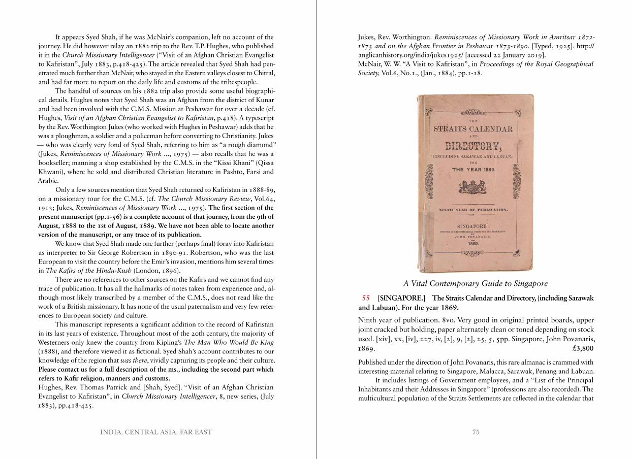
75INDIA, CENTRAL ASIA, FAR EAST
It appears Syed Shah, if he was McNair’s companion, left no account of the journey. He did however relay an 1882 trip to the Rev. T.P. Hughes, who published it in the Church Missionary Intelligencer (“Visit of an Afghan Christian Evangelist to Kafiristan”, July 1883, p.418-425). The article revealed that Syed Shah had pen-etrated much further than McNair, who stayed in the Eastern valleys closest to Chitral, and had far more to report on the daily life and customs of the tribespeople.
The handful of sources on his 1882 trip also provide some useful biographi-cal details. Hughes notes that Syed Shah was an Afghan from the district of Kunar and had been involved with the C.M.S. Mission at Peshawar for over a decade (cf. Hughes, Visit of an Afghan Christian Evangelist to Kafiristan, p.418). A typescript by the Rev. Worthington Jukes (who worked with Hughes in Peshawar) adds that he was a ploughman, a soldier and a policeman before converting to Christianity. Jukes — who was clearly very fond of Syed Shah, referring to him as “a rough diamond” (Jukes, Reminiscences of Missionary Work ..., 1975) — also recalls that he was a bookseller; manning a shop established by the C.M.S. in the “Kissi Khani” (Qissa Khwani), where he sold and distributed Christian literature in Pashto, Farsi and Arabic.
Only a few sources mention that Syed Shah returned to Kafiristan in 1888-89, on a missionary tour for the C.M.S. (cf. The Church Missionary Review, Vol.64, 1913; Jukes, Reminiscences of Missionary Work ..., 1975). The first section of the present manuscript (pp.1-56) is a complete account of that journey, from the 9th of August, 1888 to the 1st of August, 1889. We have not been able to locate another version of the manuscript, or any trace of its publication.
We know that Syed Shah made one further (perhaps final) foray into Kafiristan as interpreter to Sir George Robertson in 1890-91. Robertson, who was the last European to visit the country before the Emir’s invasion, mentions him several times in The Kafirs of the Hindu-Kush (London, 1896).
There are no references to other sources on the Kafirs and we cannot find any trace of publication. It has all the hallmarks of notes taken from experience and, al- though most likely transcribed by a member of the C.M.S., does not read like the work of a British missionary. It has none of the usual paternalism and very few refer-ences to European society and culture.
This manuscript represents a significant addition to the record of Kafiristan in its last years of existence. Throughout most of the 20th century, the majority of Westerners only knew the country from Kipling’s The Man Who Would Be King (1888), and therefore viewed it as fictional. Syed Shah’s account contributes to our knowledge of the region that was there, vividly capturing its people and their culture.Please contact us for a full description of the ms., including the second part which refers to Kafir religion, manners and customs.Hughes, Rev. Thomas Patrick and [Shah, Syed]. “Visit of an Afghan Christian Evangelist to Kafiristan”, in Church Missionary Intelligencer, 8, new series, (July 1883), pp.418-425.
Jukes, Rev. Worthington. Reminiscences of Missionary Work in Amritsar 1872-1873 and on the Afghan Frontier in Peshawar 1873-1890. [Typed, 1925]. http://anglicanhistory.org/india/jukes1925/ [accessed 22 January 2019].McNair, W. W. “A Visit to Kafiristan”, in Proceedings of the Royal Geographical Society, Vol.6, No.1., (Jan., 1884), pp.1-18.
A Vital Contemporary Guide to Singapore
55 [SINGAPORE.] The Straits Calendar and Directory, (including Sarawak and Labuan). For the year 1869.
Ninth year of publication. 8vo. Very good in original printed boards, upper joint cracked but holding, paper alternately clean or toned depending on stock used. [xiv], xx, [iv], 227, iv, [2], 9, [2], 25, 5, 5pp. Singapore, John Povanaris, 1869. £3,800
Published under the direction of John Povanaris, this rare almanac is crammed with interesting material relating to Singapore, Malacca, Sarawak, Penang and Labuan.
It includes listings of Government employees, and a “List of the Principal Inhabitants and their Addresses in Singapore” (professions are also recorded). The multicultural population of the Straits Settlements are reflected in the calendar that
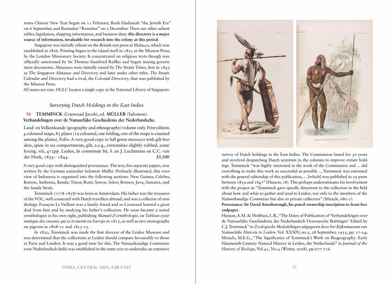
77INDIA, CENTRAL ASIA, FAR EAST
notes Chinese New Year began on 11 February, Rosh Hashanah “the Jewish Era” on 6 September, and Ramadan “Ramalan” on 5 December. There are other salient tables, legislation, shipping information, and business data: this directory is a major source of information, invaluable for research into the colony at this period.
Singapore was initially reliant on the British-run press at Malacca, which was established in 1806. Printing began in the island itself in 1823 at the Mission Press, by the London Missionary Society. It concentrated on religious texts though was officially sanctioned by Sir Thomas Stamford Raffles and began issuing govern-ment documents. Almanacs were initially issued by The Straits Times, first in 1845 as The Singapore Almanac and Directory and later under other titles. The Straits Calendar and Directory had a rival, the Colonial Directory, that was published by the Mission Press.All issues are rare. OCLC locates a single copy at the National Library of Singapore.
Surveying Dutch Holdings in the East Indies
56 TEMMINCK (Coenraad Jacob), ed. MÜLLER (Salomon). Verhandelingen over de Natuurlijke Geschiedenis der Nederlandsche.
Land- en Volkenkunde (geography and ethnography) volume only. First edition. 4 coloured maps, 85 plates (19 coloured, one folding, one of the maps is counted among the plates). Folio. A very good copy in full green morocco with gilt bor-ders, spine in six compartments, gilt, a.e.g., extremities slightly rubbed, some foxing. viii, 472pp. Leiden, In commissie bij. S. en J. Luchtmans en C.C. van der Hoek, 1839 - 1844. £5,500
A very good copy with distinguished provenance. The text, five separate papers, was written by the German naturalist Salomon Müller. Profusely illustrated, this over-view of Indonesia is organised into the following sections: New Guinea; Celebes, Boeton, Amboina, Banda; Timor, Rotti, Sawoe, Solor; Borneo; Java, Sumatra, and the Sunda Strait.
Temminck (1778-1858) was born in Amsterdam. His father was the treasurer of the VOC, well connected with Dutch travellers abroad, and was a collector of orni- thology. François Le Vaillant was a family friend and so Coenraad learned a great deal from him and by studying his father’s collection. He soon became a noted ornithologist in his own right, publishing Manuel d’ornithologie, ou Tableau systé-matique des oiseaux qui se trouvent en Europe in 1815, as well as two monographs on pigeons in 1808-11 and 1813-15.
In 1820, Temminck was made the first director of the Leiden Museum and was determined that the collections at Leiden should compare favourably to those in Paris and London. It was a good time for this. The Natuurkundige Commissie voor Nederlandsch-Indië was established in the same year to undertake an extensive
survey of Dutch holdings in the East Indies. The Commission lasted for 30 years and involved despatching Dutch scientists to the colonies to improve extant hold-ings. Temminck “was highly interested in the work of the Commission and ... did everything to make this work as successful as possible ... Temminck was entrusted with the general editorship of this publication, ... [which] was published in 29 parts between 1839 and 1847” (Husson, 18). This perhaps underestimates his involvement with the project as “Temminck gave specific directions to the collectors in the field about how and what to gather and send to Leiden, not only to the members of the Natuurkundige Commissie but also to private collectors” (Miracle, 680-1).Provenance: Sir David Attenborough, his pencil ownership inscription to front free endpaper.Husson, A.M. & Holthuis, L.B., “The Dates of Publication of ‘Verhandelingen over de Natuurlijke Geschiedenis der Nederlandsch Overzeesche Beittingen’ Edited by C.J. Temminck” in Zoologische Mededelingen uitgegeven door het Rijksmuseum van Natuurlijke Historie te Leiden. Vol. XXXIV, no.2, 28 September, 1955, pp. 17-24; Miracle, M.E.G., “The Significance of Temminck’s Work on Biogeography: Early Nineteenth Century Natural History in Leiden, the Netherlands” in Journal of the History of Biology, Vol.41, No.4 (Winter, 2008), pp.677-716.
79INDIA, CENTRAL ASIA, FAR EAST
Unrecorded Photographs
57 TOURTIN (Emile). La Chine a l’Exposition Universelle de Paris 1878.
19 original albumen prints (each measuring ca. 300 by 240mm) mounted on cardboard with printed captions. Preserved in an Imperial folio cloth slipcase, gilt title, measuring 630 by 480mm. Faded, some occasional wear/minor stain-ing to boards, but overall a very good set. Paris, Emile Tourtin, 1878. £22,500
The third Paris World Fair was held from 1 May through to 10 November 1878 in the Champ de Mars as well as the Trocadero Gardens on the north side of the Seine. Both venues had to be created from scratch and the Chinese built two compounds, one representing the Northern austere style of urban architecture, the other repre-senting the Southern, more flamboyant style. All of the building materials and the content had to be imported from China and due to ingenious Chinese construction methods the buildings were completed in record time. On the south side China occupied a central section on the Street of Nations within the massive ‘Palace of Industry’, between Spain and Japan. The sign above the entrance still proclaims China as the ‘Great Country of Qing’ and inside a vast array of ceramics, furniture,
carved ivory objects as well as lacquer ware was exhibited. Pyramids of colourful export porcelain surround the model of a large pagoda made from tiles. Another room is devoted to Chinese food as well as pharmaceutical products - it also includes a selection of model junks. The building complex in the Parc du Trocadero features domestic architecture and interior design of Southern China set inside a garden on the banks of the Seine. Over the entrance to the garden are three Chinese characters
“Xi yuan men” meaning the “Gate to the magistrate of the West”.All of the images are credited to Emile Tourtin (active 1873-1885) who was
operating out of 8 Boulevard des Italiens in Paris and specialised in portraiture. The photographs cover both locations featuring both the inside and the outside of the pavilions. Unrecorded.Provenance: The album belonged to Prosper Giquel (1835-1886), a French naval officer who joined the Imperial Maritime Customs Service in 1861 as director of the Ningpo office, where he resided until 1864. Later he became a key figure in the movement to modernise the Chinese Fleet and he became a highly respected diplomat negotiating between China, Russia and Japan. Passed by descent to the previous owner.Together with: Chine. Douanes maritimes impériales. III. Série générale n° 5. Catalogue spécial de la collection exposée au palais du Champ de Mars, Exposition Universelle,
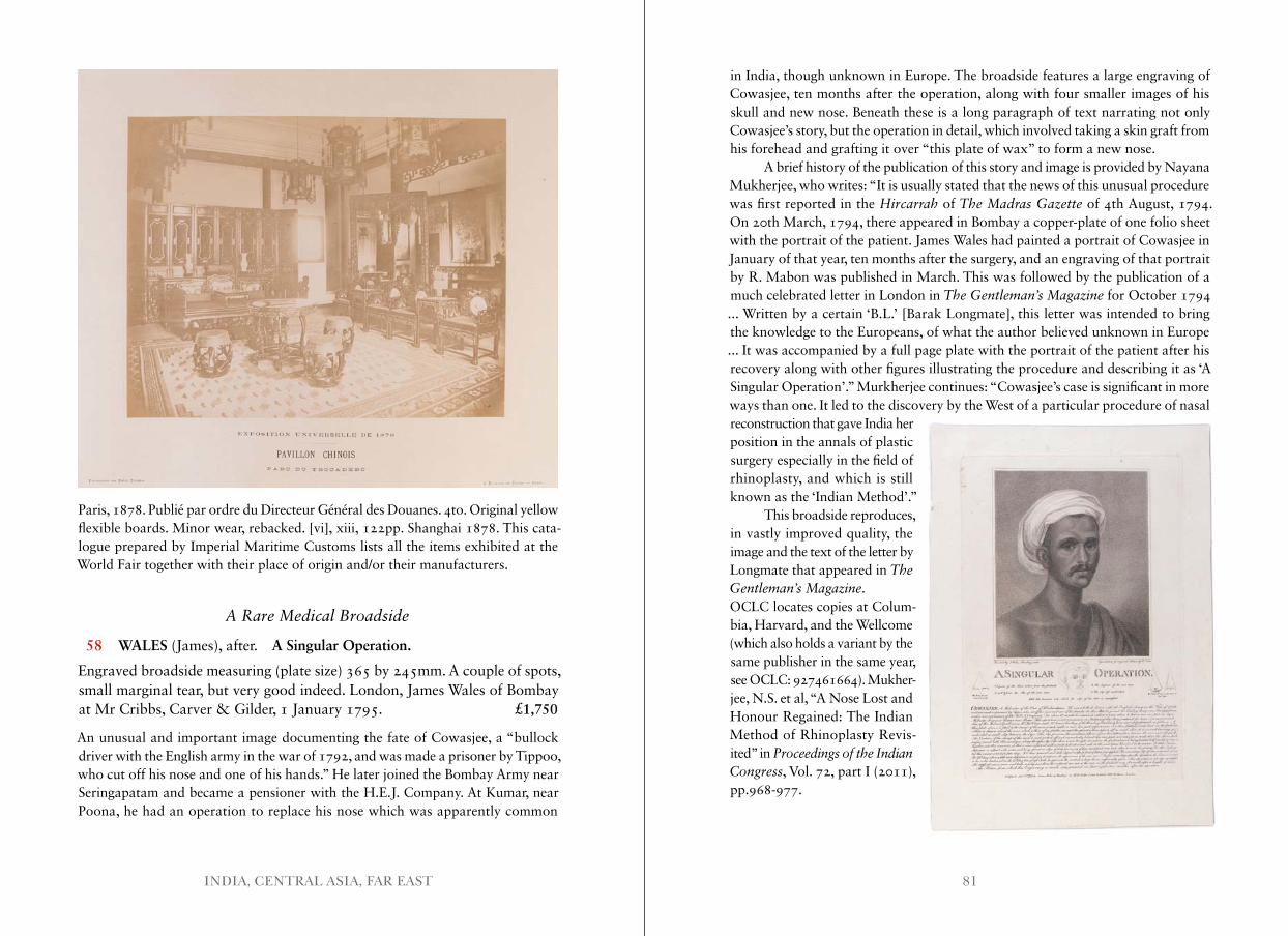
81INDIA, CENTRAL ASIA, FAR EAST
Paris, 1878. Publié par ordre du Directeur Général des Douanes. 4to. Original yellow flexible boards. Minor wear, rebacked. [vi], xiii, 122pp. Shanghai 1878. This cata- logue prepared by Imperial Maritime Customs lists all the items exhibited at the World Fair together with their place of origin and/or their manufacturers.
A Rare Medical Broadside
58 WALES (James), after. A Singular Operation.
Engraved broadside measuring (plate size) 365 by 245mm. A couple of spots, small marginal tear, but very good indeed. London, James Wales of Bombay at Mr Cribbs, Carver & Gilder, 1 January 1795. £1,750
An unusual and important image documenting the fate of Cowasjee, a “bullock driver with the English army in the war of 1792, and was made a prisoner by Tippoo, who cut off his nose and one of his hands.” He later joined the Bombay Army near Seringapatam and became a pensioner with the H.E.J. Company. At Kumar, near Poona, he had an operation to replace his nose which was apparently common
in India, though unknown in Europe. The broadside features a large engraving of Cowasjee, ten months after the operation, along with four smaller images of his skull and new nose. Beneath these is a long paragraph of text narrating not only Cowasjee’s story, but the operation in detail, which involved taking a skin graft from his forehead and grafting it over “this plate of wax” to form a new nose.
A brief history of the publication of this story and image is provided by Nayana Mukherjee, who writes: “It is usually stated that the news of this unusual procedure was first reported in the Hircarrah of The Madras Gazette of 4th August, 1794. On 20th March, 1794, there appeared in Bombay a copper-plate of one folio sheet with the portrait of the patient. James Wales had painted a portrait of Cowasjee in January of that year, ten months after the surgery, and an engraving of that portrait by R. Mabon was published in March. This was followed by the publication of a much celebrated letter in London in The Gentleman’s Magazine for October 1794 ... Written by a certain ‘B.L.’ [Barak Longmate], this letter was intended to bring the knowledge to the Europeans, of what the author believed unknown in Europe ... It was accompanied by a full page plate with the portrait of the patient after his recovery along with other figures illustrating the procedure and describing it as ‘A Singular Operation’.” Murkherjee continues: “Cowasjee’s case is significant in more ways than one. It led to the discovery by the West of a particular procedure of nasal reconstruction that gave India her position in the annals of plastic surgery especially in the field of rhinoplasty, and which is still known as the ‘Indian Method’.”
This broadside reproduces, in vastly improved quality, the image and the text of the letter by Longmate that appeared in The Gentleman’s Magazine.OCLC locates copies at Colum-bia, Harvard, and the Wellcome (which also holds a variant by the same publisher in the same year, see OCLC: 927461664). Mukher-jee, N.S. et al, “A Nose Lost and Honour Regained: The Indian Method of Rhinoplasty Revis-ited” in Proceedings of the Indian Congress, Vol. 72, part I (2011), pp.968-977.
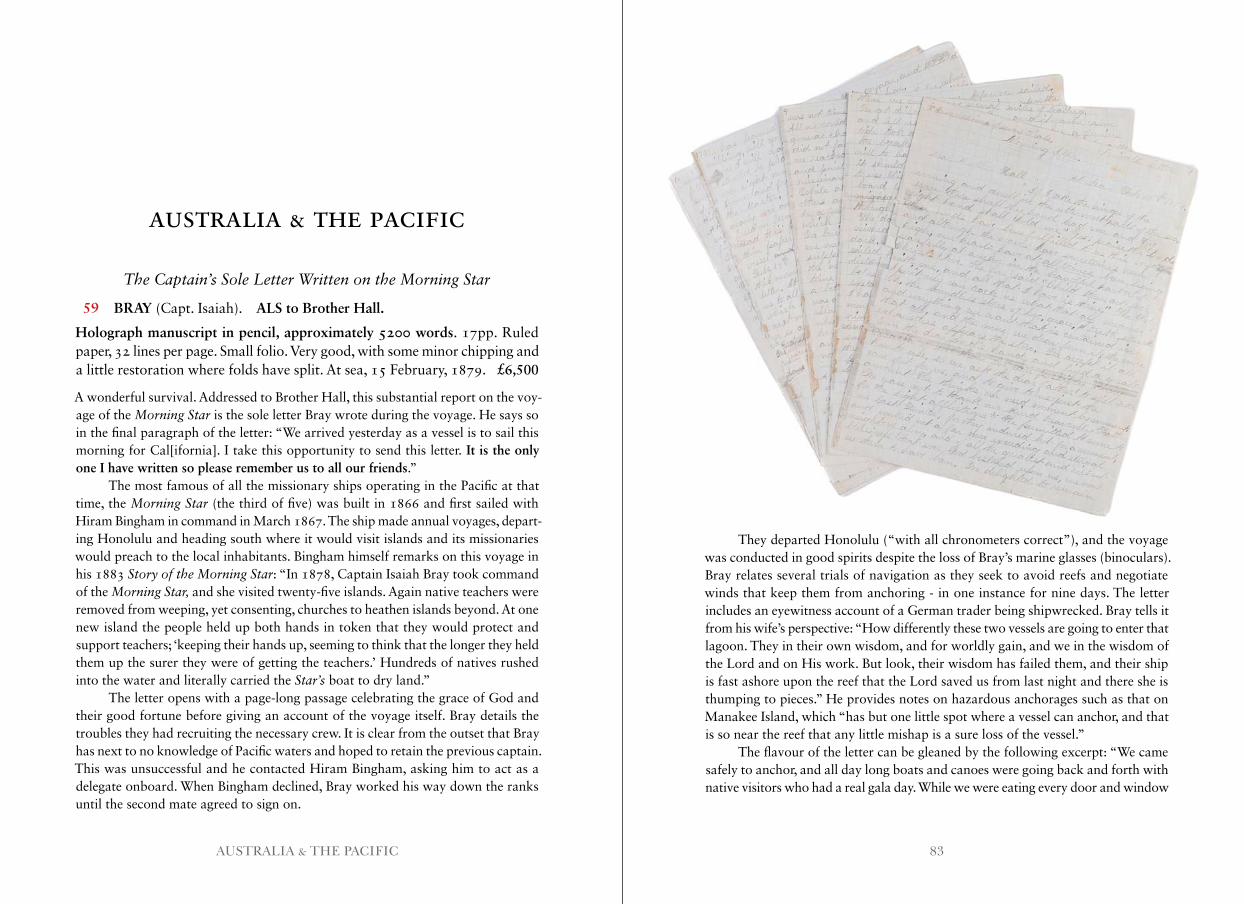
83AUSTRALIA & THE PACIFIC
The Captain’s Sole Letter Written on the Morning Star
59 BRAY (Capt. Isaiah). ALS to Brother Hall.
Holograph manuscript in pencil, approximately 5200 words. 17pp. Ruled paper, 32 lines per page. Small folio. Very good, with some minor chipping and a little restoration where folds have split. At sea, 15 February, 1879. £6,500
A wonderful survival. Addressed to Brother Hall, this substantial report on the voy-age of the Morning Star is the sole letter Bray wrote during the voyage. He says so in the final paragraph of the letter: “We arrived yesterday as a vessel is to sail this morning for Cal[ifornia]. I take this opportunity to send this letter. It is the only one I have written so please remember us to all our friends.”
The most famous of all the missionary ships operating in the Pacific at that time, the Morning Star (the third of five) was built in 1866 and first sailed with Hiram Bingham in command in March 1867. The ship made annual voyages, depart-ing Honolulu and heading south where it would visit islands and its missionaries would preach to the local inhabitants. Bingham himself remarks on this voyage in his 1883 Story of the Morning Star: “In 1878, Captain Isaiah Bray took command of the Morning Star, and she visited twenty-five islands. Again native teachers were removed from weeping, yet consenting, churches to heathen islands beyond. At one new island the people held up both hands in token that they would protect and support teachers; ‘keeping their hands up, seeming to think that the longer they held them up the surer they were of getting the teachers.’ Hundreds of natives rushed into the water and literally carried the Star’s boat to dry land.”
The letter opens with a page-long passage celebrating the grace of God and their good fortune before giving an account of the voyage itself. Bray details the troubles they had recruiting the necessary crew. It is clear from the outset that Bray has next to no knowledge of Pacific waters and hoped to retain the previous captain. This was unsuccessful and he contacted Hiram Bingham, asking him to act as a delegate onboard. When Bingham declined, Bray worked his way down the ranks until the second mate agreed to sign on.
They departed Honolulu (“with all chronometers correct”), and the voyage was conducted in good spirits despite the loss of Bray’s marine glasses (binoculars). Bray relates several trials of navigation as they seek to avoid reefs and negotiate winds that keep them from anchoring - in one instance for nine days. The letter includes an eyewitness account of a German trader being shipwrecked. Bray tells it from his wife’s perspective: “How differently these two vessels are going to enter that lagoon. They in their own wisdom, and for worldly gain, and we in the wisdom of the Lord and on His work. But look, their wisdom has failed them, and their ship is fast ashore upon the reef that the Lord saved us from last night and there she is thumping to pieces.” He provides notes on hazardous anchorages such as that on Manakee Island, which “has but one little spot where a vessel can anchor, and that is so near the reef that any little mishap is a sure loss of the vessel.”
The flavour of the letter can be gleaned by the following excerpt: “We came safely to anchor, and all day long boats and canoes were going back and forth with native visitors who had a real gala day. While we were eating every door and window
AUSTRALIA & THE PACIFIC
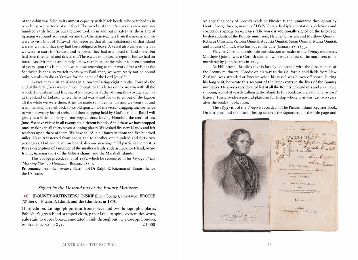
85AUSTRALIA & THE PACIFIC
of the cabin was filled to its utmost capacity with black heads, who watched us in wonder as we partook of our food. The wrecks of the other vessels were not two hundred yards from us but the Lord took us in and out in safety. At the island of Apaiang we found some natives and the Christian teachers from the next island we were to visit (that of Yarawa) who reported that all the inhabitants of that island were at war, and that they had been obliged to leave. A vessel also came in the day we were to start for Yarawa and reported they had attempted to land there, but had been threatened and driven off. These were not pleasant reports, but we had on board Rev. Mr Haina and family – Hawaiian missionaries who had been a number of years upon this island, and were now returning to their work after a visit at the Sandwich Islands, so we felt to say with Paul, that, ‘we were ready not be bound only, but also to die at Yarawa for the name of the Lord Jesus’.”
In fact, they visit 26 islands in a journey lasting eight months. Towards the end of the letter, Bray writes: “I could lengthen this letter out to tire you with all the wonderful dealings and leading of my heavenly Father during this voyage, such as at the island of Luknor, where the wind was ahead for us to go out of the lagoon all the while we were there. After we made sail, it came fair and we went out and it immediately hauled back to its old quarter. Of the vessel dragging anchor twice to within twenty feet of reefs, and then stopping held by God’s hand ... [But] I will give you a little summary of our voyage since leaving Honolulu the tenth of last June. We have visited in all twenty six different islands. At all these we have stopped once, making in all thirty seven stopping places. We visited five new islands and left teachers upon three of them. We have sailed in all fourteen thousand five hundred miles. Have transferred from one island to another, one hundred and forty-two passengers. Had one death on board also one marriage.” Of particular interest is Bray’s description of a number of the smaller islands, such as Lucknor Island, Atene Island, Apaiang (part of the Gilbert chain), and the Marshall Islands.
This voyage precedes that of 1884 which he recounted in his Voyage of the “Morning Star” to Honolulu (Boston, 1885).Provenance: from the private collection of Dr Ralph R. Ritzman of Illinois, thence the US trade.
Signed by the Descendants of the Bounty Mutineers
60 [BOUNTY MUTINEERS.] INSKIP (Lieut George), annotator. BRODIE (Walter). Pitcairn’s Island, and the Islanders, in 1850.
Third edition. Lithograph portrait frontispiece and two lithographic plates. Publisher’s green blind-stamped cloth, paper label to spine, extremities worn, pale stain to upper board, annotated in ink throughout. iv, 5-260pp. London, Whittaker & Co., 1851. £4,000
An appealing copy of Brodie’s work on Pitcairn Island: annotated throughout by Lieut. George Inskip, master of HMS Virago. Inskip’s annotations, deletions and corrections appear on 62 pages. The work is additionally signed on the title-page by descendants of the Bounty mutineers, Fletcher Christian and Matthew Quintal: Rebecca Christian, Victoria Quintal, Augusta Quintal, Susan Quintal, Maria Quintal, and Louisa Quintal, who has added the date, January 28. 1853.
Fletcher Christian needs little introduction as leader of the Bounty mutineers. Matthew Quintal was a Cornish seaman, who was the last of the mutineers to be murdered by John Adams in 1799.
As Hill attests, Brodie’s text is largely concerned with the descendants of the Bounty mutineers: “Brodie on his way to the California gold fields from New Zealand, was stranded at Pitcairn when his vessel was blown off shore. During his long visit, he wrote this account of the later events in the lives of the Bounty mutineers. He gives a very detailed list of all the Bounty descendants and a valuable shipping record of vessels calling at the island. In this book are a great many visitors’ letters.” This provides a natural platform for Inskip whose visit was just two years after the book’s publication.
The 1853 visit of the Virago is recorded in The Pitcairn Island Register Book. On a trip around the island, Inskip secured the signatures on the title-page and
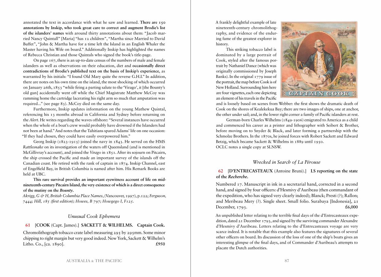
87AUSTRALIA & THE PACIFIC
annotated the text in accordance with what he saw and learned. There are 150 annotations by Inskip, who took great care to correct and augment Brodie’s list of the islanders’ names with around thirty annotations about them: “Jacob mar-ried Nancy Quintall” [Maria] “has 12 children”, “Martha since Married to David Buffet”, “John & Martha have for a time left the Island in an English Whaler the Master having his Wife on board.” Additionally Inskip has highlighted the names of Rebecca Christian and those Quintals who signed the book’s title-page.
On page 167, there is an up-to-date census of the numbers of male and female islanders as well as observations on their education, diet and occasionally direct contradictions of Brodie’s published text on the basis of Inskip’s experience, as warranted by his initials: “I found Old Mary quite the reverse G.H.I.” In addition, there are notes on his own time on the island, the most shocking of which occurred on January 26th, 1853 “while firing a parting salute to the ‘Virago’, it [the Bounty’s old gun] accidentally went off while the Chief Magistrate Matthew McCoy was ramming home the cartridge lacerating his right arm so much that amputation was required...” (see page 83). McCoy died on the same day.
Furthermore, Inskip updates information on the young Mathew Quintal, referencing his 13 months abroad in California and Sydney before returning on the Alert. He writes regarding the waves offshore: “Several instances have occurred when the whole of a boat’s crew would probably have drowned if the Islanders had not been at hand.” And notes that the Tahitians spared Adams’ life on one occasion:
“If they had chosen, they could have easily overpowered him.”Georg Inskip (1823-1915) joined the navy in 1843. He served on the HMS
Rattlesnake on its investigation of the waters off Queensland (and is mentioned in McGillivray’s account), and joined the Virago in 1851. After its sojourn on Pitcairn, the ship crossed the Pacific and made an important survey of the islands off the Canadian coast. He retired with the rank of captain in 1874. Inskip Channel, east of Engelfield Bay, in British Columbia is named after him. His Remark Books are held at UBC.
This rare survival provides an important eyewitness account of life on mid-nineteenth-century Pitcairn Island, the very existence of which is a direct consequence of the mutiny on the Bounty.Akrigg, G & H, British Columbia Place Names, (Vancouver, 1997), p.122; Ferguson, 7444; Hill, 185 (first edition); Howes, B 797; Howgego I, F125 .
Unusual Cook Ephemera
61 [COOK (Capt. James).] SACKETT & WILHELMS. Captain Cook.
Chromolithograph tobacco crate label measuring 295 by 295mm. Some minor chipping to right margin but very good indeed. New York, Sackett & Wilhelm’s Litho. Co., [ca. 1890]. £950
A frankly delightful example of late nineteenth-century chromolithog-raphy, and evidence of the endur-ing fame of the greatest explorer in history.
This striking tobacco label is dominated by a large portrait of Cook, styled after the famous por-trait by Nathaniel Dance (which was originally commissioned by Joseph Banks). In the original 1779 issue of the portrait, the map before Cook is of New Holland. Surrounding him here are four vignettes, each one depicting an element of his travels in the Pacific and is loosely based on scenes from Webber: the first shows the dramatic death of Cook on the shores of Kealekekua Bay; there are two images of ships, one at anchor, the other under sail; and, in the lower right corner a family of Pacific islanders at rest.
German-born Charles Wilhelms (1849-1906) emigrated to America as a child and commenced his career as a printer and lithographer with Seibert & Brother, before moving on to Snyder & Black, and later forming a partnership with the Schmolze Brothers. In the 1870s, he joined forces with Robert Sackett and Edward Betzig, which became Sackett & Wilhelms in 1889 until 1950.OCLC notes a single copy at SLNSW.
Wrecked in Search of La Pérouse
62 [D’ENTRECASTEAUX (Antoine Bruni).] LS reporting on the state of the Recherche.
Numbered 17. Manuscript in ink in a secretarial hand, corrected in a second hand, and signed by four officers: d’Hesmivy d’Auribeau (then commandant of the expedition, who has signed very clearly indeed); Blanck; Presti (?); Rallon; and Meribeau Mery (?). Single sheet. Small folio. Surabaya [Indonesia], 21 December, 1793. £6,000
An unpublished letter relating to the terrible final days of the d’Entrecasteaux expe-dition, dated 21 December 1793, and signed by the surviving commander Alexandre d’Hesmivy d’Auribeau. Letters relating to the d’Entrecasteaux voyage are very scarce indeed. It is notable that this example also features the signatures of several other officers on board. Its discussion of the loss of one of the ship’s boats gives an interesting glimpse of the final days, and of Commander d’Auribeau’s attempts to placate the Dutch authorities.
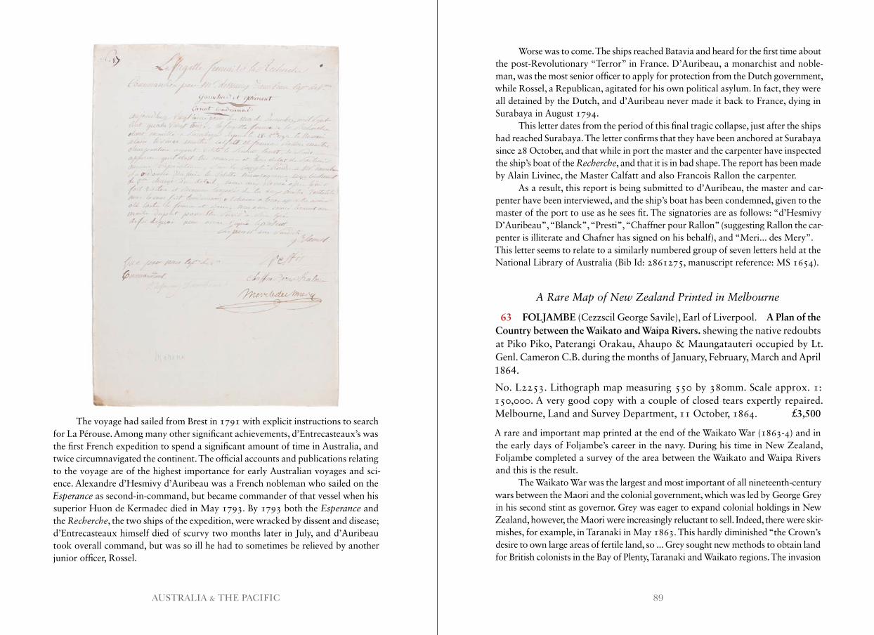
89AUSTRALIA & THE PACIFIC
The voyage had sailed from Brest in 1791 with explicit instructions to search for La Pérouse. Among many other significant achievements, d’Entrecasteaux’s was the first French expedition to spend a significant amount of time in Australia, and twice circumnavigated the continent. The official accounts and publications relating to the voyage are of the highest importance for early Australian voyages and sci-ence. Alexandre d’Hesmivy d’Auribeau was a French nobleman who sailed on the Esperance as second-in-command, but became commander of that vessel when his superior Huon de Kermadec died in May 1793. By 1793 both the Esperance and the Recherche, the two ships of the expedition, were wracked by dissent and disease; d’Entrecasteaux himself died of scurvy two months later in July, and d’Auribeau took overall command, but was so ill he had to sometimes be relieved by another junior officer, Rossel.
Worse was to come. The ships reached Batavia and heard for the first time about the post-Revolutionary “Terror” in France. D’Auribeau, a monarchist and noble- man, was the most senior officer to apply for protection from the Dutch government, while Rossel, a Republican, agitated for his own political asylum. In fact, they were all detained by the Dutch, and d’Auribeau never made it back to France, dying in Surabaya in August 1794.
This letter dates from the period of this final tragic collapse, just after the ships had reached Surabaya. The letter confirms that they have been anchored at Surabaya since 28 October, and that while in port the master and the carpenter have inspected the ship’s boat of the Recherche, and that it is in bad shape. The report has been made by Alain Livinec, the Master Calfatt and also Francois Rallon the carpenter.
As a result, this report is being submitted to d’Auribeau, the master and car-penter have been interviewed, and the ship’s boat has been condemned, given to the master of the port to use as he sees fit. The signatories are as follows: “d’Hesmivy D’Auribeau”, “Blanck”, “Presti”, “Chaffner pour Rallon” (suggesting Rallon the car- penter is illiterate and Chafner has signed on his behalf), and “Meri... des Mery”.This letter seems to relate to a similarly numbered group of seven letters held at the National Library of Australia (Bib Id: 2861275, manuscript reference: MS 1654).
A Rare Map of New Zealand Printed in Melbourne
63 FOLJAMBE (Cezzscil George Savile), Earl of Liverpool. A Plan of the Country between the Waikato and Waipa Rivers. shewing the native redoubts at Piko Piko, Paterangi Orakau, Ahaupo & Maungatauteri occupied by Lt. Genl. Cameron C.B. during the months of January, February, March and April 1864.
No. L2253. Lithograph map measuring 550 by 380mm. Scale approx. 1: 150,000. A very good copy with a couple of closed tears expertly repaired. Melbourne, Land and Survey Department, 11 October, 1864. £3,500
A rare and important map printed at the end of the Waikato War (1863-4) and in the early days of Foljambe’s career in the navy. During his time in New Zealand, Foljambe completed a survey of the area between the Waikato and Waipa Rivers and this is the result.
The Waikato War was the largest and most important of all nineteenth-century wars between the Maori and the colonial government, which was led by George Grey in his second stint as governor. Grey was eager to expand colonial holdings in New Zealand, however, the Maori were increasingly reluctant to sell. Indeed, there were skir-mishes, for example, in Taranaki in May 1863. This hardly diminished “the Crown’s desire to own large areas of fertile land, so ... Grey sought new methods to obtain land for British colonists in the Bay of Plenty, Taranaki and Waikato regions. The invasion
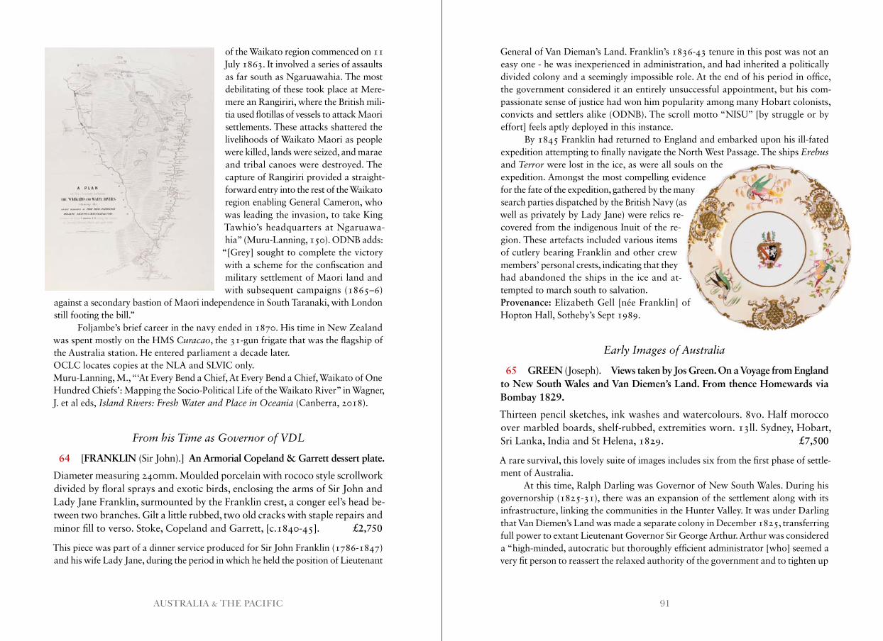
91AUSTRALIA & THE PACIFIC
of the Waikato region commenced on 11 July 1863. It involved a series of assaults as far south as Ngaruawahia. The most debilitating of these took place at Mere-mere an Rangiriri, where the British mili-tia used flotillas of vessels to attack Maori settlements. These attacks shattered the livelihoods of Waikato Maori as people were killed, lands were seized, and marae and tribal canoes were destroyed. The capture of Rangiriri provided a straight-forward entry into the rest of the Waikato region enabling General Cameron, who was leading the invasion, to take King Tawhio’s headquarters at Ngaruawa-hia” (Muru-Lanning, 150). ODNB adds:
“[Grey] sought to complete the victory with a scheme for the confiscation and military settlement of Maori land and with subsequent campaigns (1865–6)
against a secondary bastion of Maori independence in South Taranaki, with London still footing the bill.”
Foljambe’s brief career in the navy ended in 1870. His time in New Zealand was spent mostly on the HMS Curacao, the 31-gun frigate that was the flagship of the Australia station. He entered parliament a decade later.OCLC locates copies at the NLA and SLVIC only.Muru-Lanning, M., “‘At Every Bend a Chief, At Every Bend a Chief, Waikato of One Hundred Chiefs’: Mapping the Socio-Political Life of the Waikato River” in Wagner, J. et al eds, Island Rivers: Fresh Water and Place in Oceania (Canberra, 2018).
From his Time as Governor of VDL
64 [FRANKLIN (Sir John).] An Armorial Copeland & Garrett dessert plate.
Diameter measuring 240mm. Moulded porcelain with rococo style scrollwork divided by floral sprays and exotic birds, enclosing the arms of Sir John and Lady Jane Franklin, surmounted by the Franklin crest, a conger eel’s head be-tween two branches. Gilt a little rubbed, two old cracks with staple repairs and minor fill to verso. Stoke, Copeland and Garrett, [c.1840-45]. £2,750
This piece was part of a dinner service produced for Sir John Franklin (1786-1847) and his wife Lady Jane, during the period in which he held the position of Lieutenant
General of Van Dieman’s Land. Franklin’s 1836-43 tenure in this post was not an easy one - he was inexperienced in administration, and had inherited a politically divided colony and a seemingly impossible role. At the end of his period in office, the government considered it an entirely unsuccessful appointment, but his com-passionate sense of justice had won him popularity among many Hobart colonists, convicts and settlers alike (ODNB). The scroll motto “NISU” [by struggle or by effort] feels aptly deployed in this instance.
By 1845 Franklin had returned to England and embarked upon his ill-fated expedition attempting to finally navigate the North West Passage. The ships Erebus and Terror were lost in the ice, as were all souls on the expedition. Amongst the most compelling evidence for the fate of the expedition, gathered by the many search parties dispatched by the British Navy (as well as privately by Lady Jane) were relics re-covered from the indigenous Inuit of the re-gion. These artefacts included various items of cutlery bearing Franklin and other crew members’ personal crests, indicating that they had abandoned the ships in the ice and at-tempted to march south to salvation.Provenance: Elizabeth Gell [née Franklin] of Hopton Hall, Sotheby’s Sept 1989.
Early Images of Australia
65 GREEN (Joseph). Views taken by Jos Green. On a Voyage from England to New South Wales and Van Diemen’s Land. From thence Homewards via Bombay 1829.
Thirteen pencil sketches, ink washes and watercolours. 8vo. Half morocco over marbled boards, shelf-rubbed, extremities worn. 13ll. Sydney, Hobart, Sri Lanka, India and St Helena, 1829. £7,500
A rare survival, this lovely suite of images includes six from the first phase of settle-ment of Australia.
At this time, Ralph Darling was Governor of New South Wales. During his governorship (1825-31), there was an expansion of the settlement along with its infrastructure, linking the communities in the Hunter Valley. It was under Darling that Van Diemen’s Land was made a separate colony in December 1825, transferring full power to extant Lieutenant Governor Sir George Arthur. Arthur was considered a “high-minded, autocratic but thoroughly efficient administrator [who] seemed a very fit person to reassert the relaxed authority of the government and to tighten up
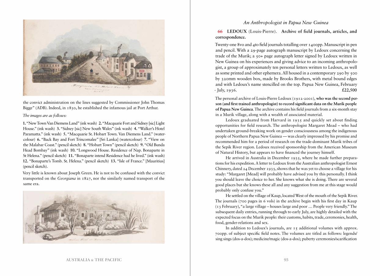
93AUSTRALIA & THE PACIFIC
the convict administration on the lines suggested by Commissioner John Thomas Bigge” (ADB). Indeed, in 1830, he established the infamous jail at Port Arthur.
The images are as follows:
1. “New Town Van Diemens Land” (ink wash) 2. “Macquarie Fort and Sidney [sic] Light House.” (ink wash) 3. “Sidney [sic] New South Wales” (ink wash) 4. “Walker’s Hotel Paramatta.” (ink wash) 5. “Macquarie St. Hobart Town. Van Diemens Land.” (water-colour) 6. “Back Bay and Fort Trincomalee” [Sri Lanka] (watercolour) 7. “View on the Malabar Coast.” (pencil sketch) 8. “Hobart Town” (pencil sketch) 9. “Old Bunda Head Bombay” (ink wash) 10. “Longwood House. Residence of Nap. Bonaparte in St Helena.” (pencil sketch) 11. “Bonaparte intend Residence had he lived.” (ink wash) 12. “Bonaparte’s Tomb. St. Helena.” (pencil sketch) 13. “Isle of France.” [Mauritius] (pencil sketch).
Very little is known about Joseph Green. He is not to be confused with the convict transported on the Georgiana in 1827, nor the similarly named transport of the same era.
An Anthropologist in Papua New Guinea
66 LEDOUX (Louis-Pierre). Archive of field journals, articles, and correspondence.
Twenty-one 8vo and 4to field journals totalling over 1400pp. Manuscript in pen and pencil. With a 29-page autograph manuscript by Ledoux concerning the trade of the Murik; a 50+ page autograph letter signed by Ledoux written in New Guinea on his experiences and giving advice to an incoming anthropolo-gist, a group of approximately ten personal letters written to Ledoux, as well as some printed and other ephemera. All housed in a contemporary 290 by 500 by 320mm wooden box, made by Brooks Brothers, with metal bound edges and with Ledoux’s name stencilled on the top. Papua New Guinea, February - July, 1936. £22,500
The personal archive of Louis-Pierre Ledoux (1912-2001), who was the second per-son (and first trained anthropologist) to record significant data on the Murik people of Papua New Guinea. The archive contains his field journals from a six-month stay in a Murik village, along with a wealth of associated material.
Ledoux graduated from Harvard in 1935 and quickly set about finding opportunities for field research. The anthropologist Margaret Mead – who had undertaken ground-breaking work on gender consciousness among the indigenous people of Northern Papua New Guinea — was clearly impressed by his promise and recommended him for a period of research on the trade-dominant Murik tribes of the Sepik River region. Ledoux received sponsorship from the American Museum of Natural History, but appears to have financed the journey himself.
He arrived in Australia in December 1935, where he made further prepara-tions for his expedition. A letter to Ledoux from the Australian anthropologist Ernest Chinnery, dated 24 December 1935, shows that he was yet to choose a village for his study: “Margaret [Mead] will probably have advised you by this personally. I think you should leave the choice to her. She knows what she is doing. There are several good places but she knows these all and any suggestion from me at this stage would probably only confuse you.”
He settled on the village of Kaup, located West of the mouth of the Sepik River. The journals (700 pages in 6 vols) in the archive begin with his first day in Kaup (13 February), “a large village – houses large and poor … People very friendly.” The subsequent daily entries, running through to early July, are highly detailed with the expected focus on the Murik people: their customs, habits, trade, ceremonies, health, food, gender-relations and sex.
In addition to Ledoux’s journals, are 15 additional volumes with approx. 700pp. of subject specific field notes. The volumes are titled as follows: legends/sing sings (dos-a-dos); medicine/magic (dos-a-dos); puberty ceremonies/scarification
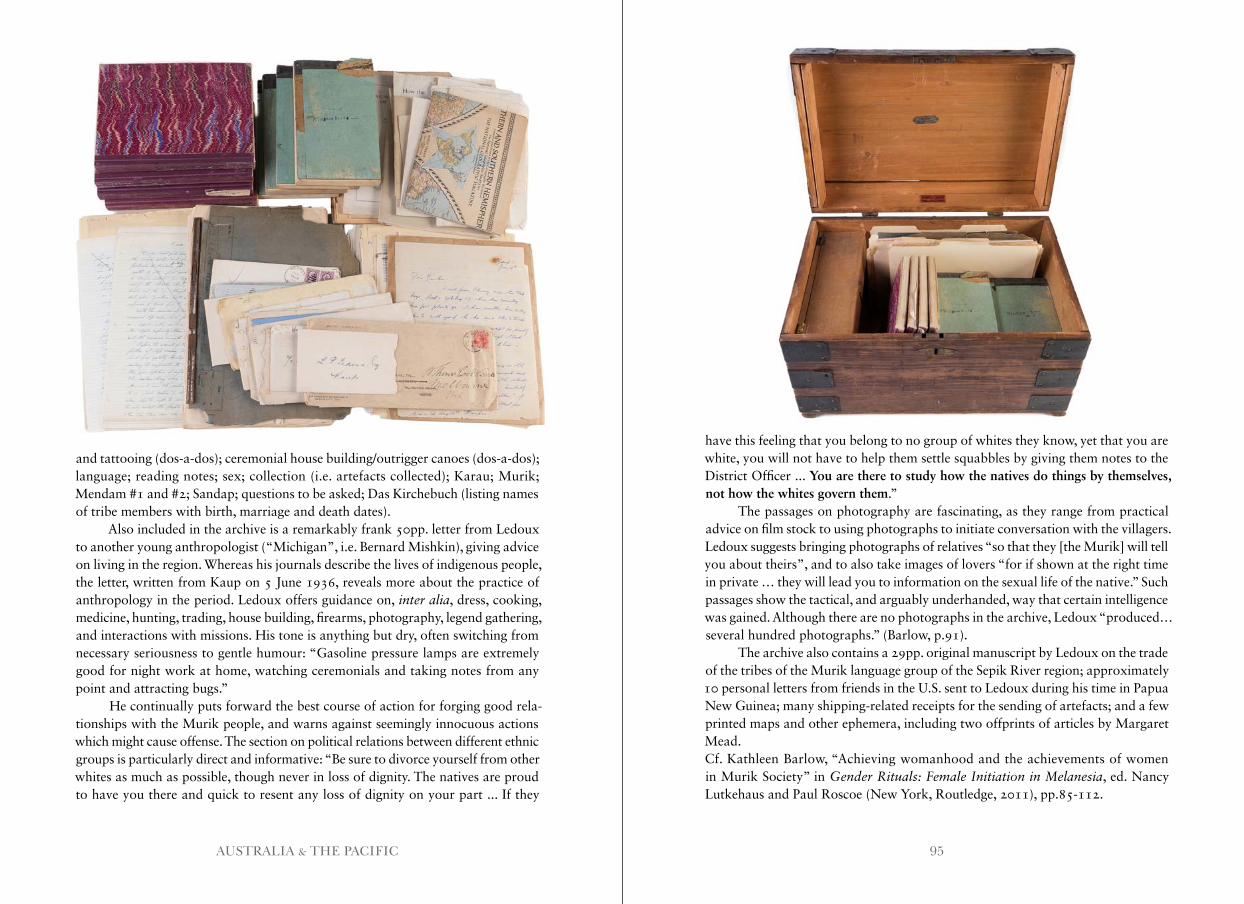
95AUSTRALIA & THE PACIFIC
and tattooing (dos-a-dos); ceremonial house building/outrigger canoes (dos-a-dos); language; reading notes; sex; collection (i.e. artefacts collected); Karau; Murik; Mendam #1 and #2; Sandap; questions to be asked; Das Kirchebuch (listing names of tribe members with birth, marriage and death dates).
Also included in the archive is a remarkably frank 50pp. letter from Ledoux to another young anthropologist (“Michigan”, i.e. Bernard Mishkin), giving advice on living in the region. Whereas his journals describe the lives of indigenous people, the letter, written from Kaup on 5 June 1936, reveals more about the practice of anthropology in the period. Ledoux offers guidance on, inter alia, dress, cooking, medicine, hunting, trading, house building, firearms, photography, legend gathering, and interactions with missions. His tone is anything but dry, often switching from necessary seriousness to gentle humour: “Gasoline pressure lamps are extremely good for night work at home, watching ceremonials and taking notes from any point and attracting bugs.”
He continually puts forward the best course of action for forging good rela-tionships with the Murik people, and warns against seemingly innocuous actions which might cause offense. The section on political relations between different ethnic groups is particularly direct and informative: “Be sure to divorce yourself from other whites as much as possible, though never in loss of dignity. The natives are proud to have you there and quick to resent any loss of dignity on your part ... If they
have this feeling that you belong to no group of whites they know, yet that you are white, you will not have to help them settle squabbles by giving them notes to the District Officer ... You are there to study how the natives do things by themselves, not how the whites govern them.”
The passages on photography are fascinating, as they range from practical advice on film stock to using photographs to initiate conversation with the villagers. Ledoux suggests bringing photographs of relatives “so that they [the Murik] will tell you about theirs”, and to also take images of lovers “for if shown at the right time in private … they will lead you to information on the sexual life of the native.” Such passages show the tactical, and arguably underhanded, way that certain intelligence was gained. Although there are no photographs in the archive, Ledoux “produced… several hundred photographs.” (Barlow, p.91).
The archive also contains a 29pp. original manuscript by Ledoux on the trade of the tribes of the Murik language group of the Sepik River region; approximately 10 personal letters from friends in the U.S. sent to Ledoux during his time in Papua New Guinea; many shipping-related receipts for the sending of artefacts; and a few printed maps and other ephemera, including two offprints of articles by Margaret Mead.Cf. Kathleen Barlow, “Achieving womanhood and the achievements of women in Murik Society” in Gender Rituals: Female Initiation in Melanesia, ed. Nancy Lutkehaus and Paul Roscoe (New York, Routledge, 2011), pp.85-112.
97AUSTRALIA & THE PACIFIC
Determining Longitude
67 MASKELYNE (Nevil), editor. The Nautical Almanac and Astronomical Ephemeris, for the year 1767.
First edition. 8vo. [viii], 167, [1]pp. London, W. Richardson and S. Clark, 1766. [Bound with:] COMMISSIONERS OF LONGITUDE. Tables Requisite to be used with the Astronomical and Nautical Ephemeris ... First edition. 2 folding tables. 8vo. Period-style quarter calf over marbled boards, red morocco label to spine, gilt. 16, 162, [2index], [2errata]pp. London, W. Richardson and S. Clark, 1766. £6,500
Scarce on the market, this important almanac was compiled at the behest of Nevil Maskelyne, who had been appointed Royal Astronomer in 1765. The Royal war-rant (8 Feb 1765) included specific instructions to attack the problem of Longitude:
“forthwith to apply yourself with the most exact Care and Diligence to the rectifying the Tables of the Motions of the Heavens, and the Places of the fixed Stars, in order to find out the so much desired Longitude at Sea, for perfecting the Art of Navigation.”
The Longitude Act of 1714 offered “to reward anyone who could provide a method for deter-mining longitude at sea within certain prescribed limits” (ODNB). Compet-ing methods of calculating longi-tude, such as Harrison’s chronometer, were trialled on voyages to Jamaica and later on Capt. James Cook’s voyages. In fact, the method of calcu-lation on Cook’s first voyage was based on Dr Maskelyne’s Method in which “certain observations of lunar position … could be compared, by means of the Nautical Almanac (which first appeared [as here] in 1767) with corresponding positions predicted for Greenwich, and so give the number of degrees from that centre” (Beaglehole).
“The annual Nautical Almanac and Astronomical Ephemeris and its companion Tables Requisite were undoubtedly Maskelyne’s greatest
contribution to the improvement of navigation and astronomy and to science as a whole. It was almost entirely through his efforts and persistence that they came to be published in the first place—for the year 1767—and he was the first editor. As such he superintended the complex calculations, the precision of which was improved year by year as a result of work by mathematicians and astronomers throughout Europe with whom, despite the bellicose state of that period, Maskelyne kept in touch. He was entirely responsible for the first forty-nine issues of the almanac, from 1767 to that for the year 1815, published in 1811, the year of his death; and for three editions of the Tables Requisite, published in 1766, 1781, and 1801. He also had to oversee the production of some eighteen other works published by the board of longitude” (ODNB).
In a Contemporary Morocco Binding
68 [ROSS (James).] The Van Diemen’s Land Anniversary and Hobart-Town Almanack for the year 1831.
8 plates (1 folding, 1 hand coloured), 2 engraved title-pages. 16mo. Full red mor- occo, expertly rebacked with gilt tooling to spine. xii, xxxiii, 296pp. Hobart-Town, Van Diemen’s Land, James Ross, 1831. £1,750
A very good copy of this scarce almanac by the government printer. An ownership in- scription on the title-page reads: “G.H. Hutchins. 4th Novr 1831. Macquarie Hotel. Horbart Town.”
The plates, engraved by C. Bruce, are as follows: “Chart of Sulivan’s Cove”, “Outline of the Settled Parts of Van Diemen’s Land”, “Outline of the Streets of Ho-
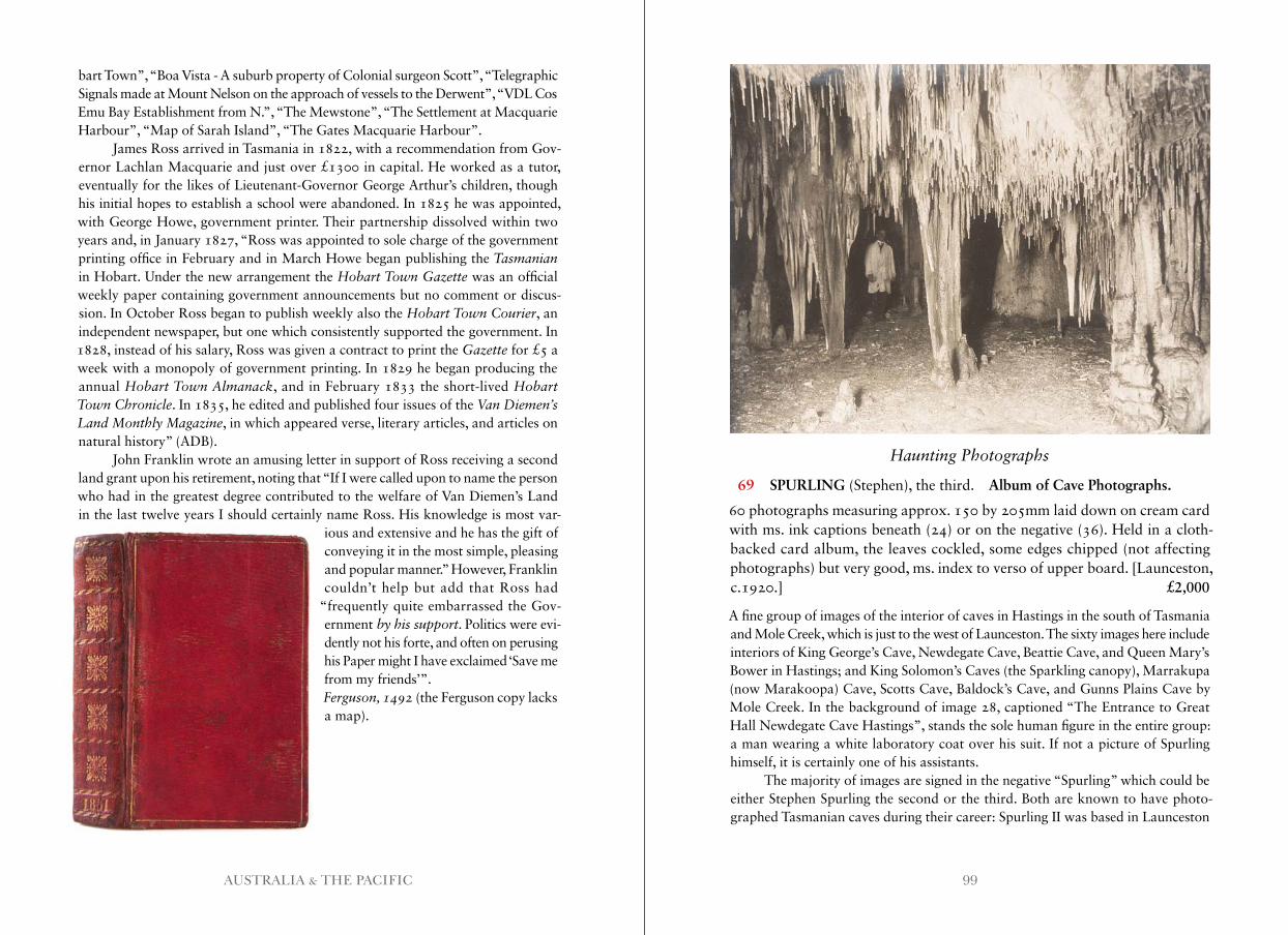
99AUSTRALIA & THE PACIFIC
bart Town”, “Boa Vista - A suburb property of Colonial surgeon Scott”, “Telegraphic Signals made at Mount Nelson on the approach of vessels to the Derwent”, “VDL Cos Emu Bay Establishment from N.”, “The Mewstone”, “The Settlement at Macquarie Harbour”, “Map of Sarah Island”, “The Gates Macquarie Harbour”.
James Ross arrived in Tasmania in 1822, with a recommendation from Gov-ernor Lachlan Macquarie and just over £1300 in capital. He worked as a tutor, eventually for the likes of Lieutenant-Governor George Arthur’s children, though his initial hopes to establish a school were abandoned. In 1825 he was appointed, with George Howe, government printer. Their partnership dissolved within two years and, in January 1827, “Ross was appointed to sole charge of the government printing office in February and in March Howe began publishing the Tasmanian in Hobart. Under the new arrangement the Hobart Town Gazette was an official weekly paper containing government announcements but no comment or discus-sion. In October Ross began to publish weekly also the Hobart Town Courier, an independent newspaper, but one which consistently supported the government. In 1828, instead of his salary, Ross was given a contract to print the Gazette for £5 a week with a monopoly of government printing. In 1829 he began producing the annual Hobart Town Almanack, and in February 1833 the short-lived Hobart Town Chronicle. In 1835, he edited and published four issues of the Van Diemen’s Land Monthly Magazine, in which appeared verse, literary articles, and articles on natural history” (ADB).
John Franklin wrote an amusing letter in support of Ross receiving a second land grant upon his retirement, noting that “If I were called upon to name the person who had in the greatest degree contributed to the welfare of Van Diemen’s Land in the last twelve years I should certainly name Ross. His knowledge is most var-
ious and extensive and he has the gift of conveying it in the most simple, pleasing and popular manner.” However, Franklin couldn’t help but add that Ross had
“frequently quite embarrassed the Gov-ernment by his support. Politics were evi-dently not his forte, and often on perusing his Paper might I have exclaimed ‘Save me from my friends’”.Ferguson, 1492 (the Ferguson copy lacks a map).
Haunting Photographs
69 SPURLING (Stephen), the third. Album of Cave Photographs.
60 photographs measuring approx. 150 by 205mm laid down on cream card with ms. ink captions beneath (24) or on the negative (36). Held in a cloth-backed card album, the leaves cockled, some edges chipped (not affecting photographs) but very good, ms. index to verso of upper board. [Launceston, c.1920.] £2,000
A fine group of images of the interior of caves in Hastings in the south of Tasmania and Mole Creek, which is just to the west of Launceston. The sixty images here include interiors of King George’s Cave, Newdegate Cave, Beattie Cave, and Queen Mary’s Bower in Hastings; and King Solomon’s Caves (the Sparkling canopy), Marrakupa (now Marakoopa) Cave, Scotts Cave, Baldock’s Cave, and Gunns Plains Cave by Mole Creek. In the background of image 28, captioned “The Entrance to Great Hall Newdegate Cave Hastings”, stands the sole human figure in the entire group: a man wearing a white laboratory coat over his suit. If not a picture of Spurling himself, it is certainly one of his assistants.
The majority of images are signed in the negative “Spurling” which could be either Stephen Spurling the second or the third. Both are known to have photo-graphed Tasmanian caves during their career: Spurling II was based in Launceston
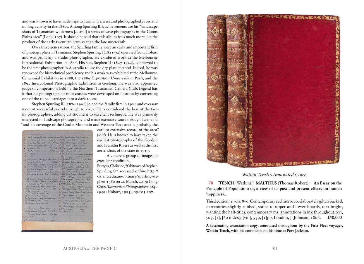
101AUSTRALIA & THE PACIFIC
and was known to have made trips to Tasmania’s west and photographed caves and mining activity in the 1880s. Among Spurling III’s achievements are his “landscape shots of Tasmanian wilderness [... and] a series of cave photographs in the Gunns Plains area” (Long, 107). It should be said that this album feels much more like the product of the early twentieth century than the late nineteenth.
Over three generations, the Spurling family were an early and important firm of photographers in Tasmania. Stephen Spurling I (1821-92) operated from Hobart and was primarily a studio photographer. He exhibited work at the Melbourne Intercolonial Exhibition in 1866. His son, Stephen II (1847-1924), is believed to be the first photographer in Australia to use the dry-plate method. Indeed, he was renowned for his technical proficiency and his work was exhibited at the Melbourne Centennial Exhibition in 1888, the 1889 Exposition Universelle in Paris, and the 1895 Intercolonial Photographic Exhibition in Geelong. He was also appointed judge of competitions held by the Northern Tasmanian Camera Club. Legend has it that his photographs of train crashes were developed on location by converting one of the ruined carriages into a dark room.
Stephen Spurling III (1876-1962) joined the family firm in 1902 and oversaw its most successful period through to 1937. He is considered the best of the fam-ily photographers, adding artistic merit to excellent technique. He was primarily interested in landscape photography and made extensive tours through Tasmania,
“and his coverage of the Cradle Mountain and Western Tiers area is probably the earliest extensive record of the area” (ibid). He is known to have taken the earliest photographs of the Gordon and Franklin Rivers as well as the first aerial shots of the state in 1919.
A coherent group of images in excellent condition.Burgess, Christine, “Obituary of Stephen Spurling II” accessed online http:// oa.anu.edu.au/obituary/spurling-ste-phen-1580 on 20 March, 2019; Long, Chris, Tasmanian Photographers 1840-1940 (Hobart, 1995), pp.105-107.
Watkin Tench’s Annotated Copy
70 [TENCH (Watkin).] MALTHUS (Thomas Robert). An Essay on the Principle of Population; or, a view of its past and present effects on human happiness...
Third edition. 2 vols. 8vo. Contemporary red morocco, elaborately gilt, rebacked, extremities slightly rubbed, stains to upper and lower boards, text bright, wanting the half-titles, contemporary ms. annotations in ink throughout. xvi, 505, [1], [60 index]; [viii], 559, [1]pp. London, J. Johnson, 1806. £50,000
A fascinating association copy, annotated throughout by the First Fleet voyager, Watkin Tench, with his comments on his time at Port Jackson.
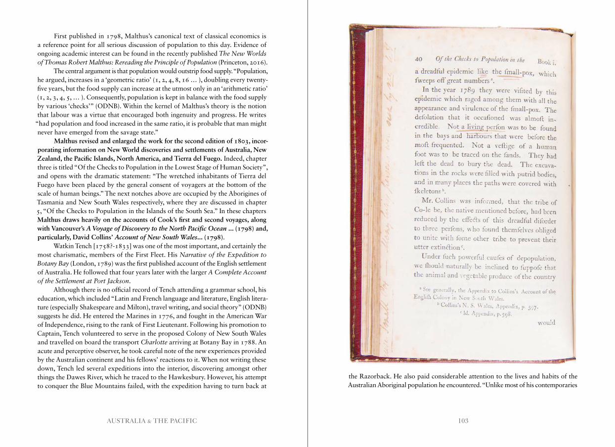
103AUSTRALIA & THE PACIFIC
First published in 1798, Malthus’s canonical text of classical economics is a reference point for all serious discussion of population to this day. Evidence of ongoing academic interest can be found in the recently published The New Worlds of Thomas Robert Malthus: Rereading the Principle of Population (Princeton, 2016).
The central argument is that population would outstrip food supply. “Population, he argued, increases in a ‘geometric ratio’ (1, 2, 4, 8, 16 … ), doubling every twenty-five years, but the food supply can increase at the utmost only in an ‘arithmetic ratio’ (1, 2, 3, 4, 5, … ). Consequently, population is kept in balance with the food supply by various ‘checks’” (ODNB). Within the kernel of Malthus’s theory is the notion that labour was a virtue that encouraged both ingenuity and progress. He writes
“had population and food increased in the same ratio, it is probable that man might never have emerged from the savage state.”
Malthus revised and enlarged the work for the second edition of 1803, incor-porating information on New World discoveries and settlements of Australia, New Zealand, the Pacific Islands, North America, and Tierra del Fuego. Indeed, chapter three is titled “Of the Checks to Population in the Lowest Stage of Human Society”, and opens with the dramatic statement: “The wretched inhabitants of Tierra del Fuego have been placed by the general consent of voyagers at the bottom of the scale of human beings.” The next notches above are occupied by the Aborigines of Tasmania and New South Wales respectively, where they are discussed in chapter 5, “Of the Checks to Population in the Islands of the South Sea.” In these chapters Malthus draws heavily on the accounts of Cook’s first and second voyages, along with Vancouver’s A Voyage of Discovery to the North Pacific Ocean ... (1798) and, particularly, David Collins’ Account of New South Wales... (1798).
Watkin Tench [1758?-1833] was one of the most important, and certainly the most charismatic, members of the First Fleet. His Narrative of the Expedition to Botany Bay (London, 1789) was the first published account of the English settlement of Australia. He followed that four years later with the larger A Complete Account of the Settlement at Port Jackson.
Although there is no official record of Tench attending a grammar school, his education, which included “Latin and French language and literature, English litera-ture (especially Shakespeare and Milton), travel writing, and social theory” (ODNB) suggests he did. He entered the Marines in 1776, and fought in the American War of Independence, rising to the rank of First Lieutenant. Following his promotion to Captain, Tench volunteered to serve in the proposed Colony of New South Wales and travelled on board the transport Charlotte arriving at Botany Bay in 1788. An acute and perceptive observer, he took careful note of the new experiences provided by the Australian continent and his fellows’ reactions to it. When not writing these down, Tench led several expeditions into the interior, discovering amongst other things the Dawes River, which he traced to the Hawkesbury. However, his attempt to conquer the Blue Mountains failed, with the expedition having to turn back at
the Razorback. He also paid considerable attention to the lives and habits of the Australian Aboriginal population he encountered. “Unlike most of his contemporaries
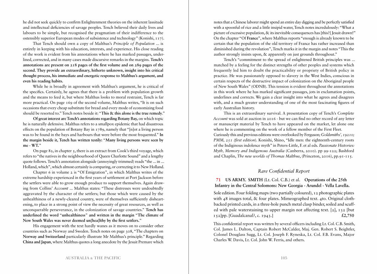
105AUSTRALIA & THE PACIFIC
he did not seek quickly to confirm Enlightenment theories on the inherent lassitude and intellectual deficiencies of savage peoples. Tench believed their daily lives and labours to be simple, but recognised the pragmatism of their indifference to the ostensibly superior European modes of subsistence and technology” (Konishi, 117).
That Tench should own a copy of Malthus’s Principle of Population ... is entirely in keeping with his education, interests, and experience. His close reading of the work is evident from his annotations where he has marked passages, under-lined, corrected, and in many cases made discursive remarks in the margins. Tench’s annotations are present on 218 pages of the first volume and on 289 pages of the second. They provide an extraordinary, hitherto unknown, insight into his critical thought process, his immediate and energetic response to Malthus’s argument, and even his reading habits.
While he is broadly in agreement with Malthus’s argument, he is critical of the specifics. Certainly, he agrees that there is a problem with population growth and the means to feed it, but where Malthus looks to moral restraint, Tench is far more practical. On page 169 of the second volume, Malthus writes, “It is on such occasions that every cheap substitute for bread and every mode of economizing food should be resorted to.” Tench notes beside it: “This & this alone is the true remedy.”
Of great interest are Tench’s annotations regarding Botany Bay, on which topic he is naturally defensive. Malthus refers to a smallpox epidemic that had disastrous effects on the population of Botany Bay in 1789, namely that “[n]ot a living person was to be found in the bays and harbours that were before the most frequented.” In the margin beside it, Tench has written testily: “Many living persons were seen by me - WT.”
On page 82, in chapter 5, there is an extract from Cook’s third voyage, which refers to “the natives in the neighbourhood of Queen Charlotte Sound” and a lengthy quote follows. Tench’s annotation alongside (annoyingly trimmed) reads “the ... in ... Holland, which”, which almost certainly is comparing, or correcting it to New Holland.
Chapter 6 in volume 2 is “Of Emigration”, in which Malthus writes of the extreme hardship experienced in the first years of settlement at Port Jackson before the settlers were able to grow enough produce to support themselves. Again draw-ing from Collins’ Account ... Malthus states: “These distresses were undoubtedly aggravated by the character of the settlers; but those which were caused by the unhealthiness of a newly-cleared country, were of themselves sufficiently disheart-ening, to place in a strong point of view the necessity of great resources, as well as unconquerable perseverance, in the colonization of savage countries.” Tench has underlined the word “unhealthiness” and written in the margin “The climate of New South Wales was never deemed un[hea]lthy by the first settlers.”
His engagement with the text hardly wanes as it moves on to consider other countries such as Norway and Sweden. Tench notes on page 308, “The chapters on Norway and Switzerland particularly illustrate Mr Malthus’s principle.” Regarding China and Japan, where Malthus quotes a long anecdote by the Jesuit Premare which
notes that a Chinese laborer might spend an entire day digging and be perfectly satisfied with a spoonful of rice and a little insipid water, Tench notes incredulously: “What a picture of excessive population, & its inevitable consequences has [this?] Jesuit drawn!” On the chapter “Of France”, where Malthus reports “enough is already known to be certain that the population of the old territory of France has rather increased than diminished during the revolution”, Tench marks it in the margin and notes “This the author strongly insists upon, & apparently on just grounds throughout.”
Tench’s “commitment to the spread of enlightened British principles was ... matched by a feeling for the distinct strengths of other peoples and systems which frequently led him to doubt the practicability or propriety of British policy in practice. He was passionately opposed to slavery in the West Indies, conscious in certain respects of the destructive impact of colonization on the Aboriginal people of New South Wales” (ODNB). This tension is evident throughout the annotations in this work where he has marked significant passages, jots in exclamation points, underlines and corrects. We gain a clear insight into what he agrees and disagrees with, and a much greater understanding of one of the most fascinating figures of early Australian history.
This is an extraordinary survival. A presentation copy of Tench’s Complete Account was sold at auction in 2016 - but we can find no other record of any letter or manuscript material by Tench to have appeared on the market, let alone one where he is commenting on the work of a fellow member of the First Fleet.Curiously this and previous editions were overlooked by Ferguson; Goldsmiths’, 19210; PMM, 251 (first edition). Konishi, Shino, “Idle men: the eighteenth-century roots of the Indiginous indolence myth” in Peters-Little, F. et al eds . Passionate Histories: Myth, Memory and Indigenous Australia (Canberra, 2010). pp 99-122; Bashford and Chaplin, The new worlds of Thomas Malthus, (Princeton, 2016), pp.91-115.
Rare Confidential Report
71 US ARMY. SMITH (Lt. Col. C.B.) et al. Operations of the 25th Infantry in the Central Solomons: New Georgia - Arundel - Vella Lavella.
Sole edition. Four folding maps (two partially coloured), 12 photographic plates with 48 images total, & four plates. Mimeographed text. 4to. Original cloth- backed printed cards, in a three-hole punch metal clasp binder, soiled and scuff- ed with pale waterstaining to upper margin not affecting text. [2], 132 [but 152]pp. [Guadalcanal?, c. 1943.] £2,750
This confidential report was written by several officers including Lt. Col. C.B. Smith, Col. James L. Dalton, Captain Robert McCalder, Maj. Gen. Robert S. Beightler, Colonel Douglass Sugg, Lt. Col. Joseph F. Ryneska, Lt. Col. F.B. Evans, Major Charles W. Davis, Lt. Col. John W. Ferris, and others.
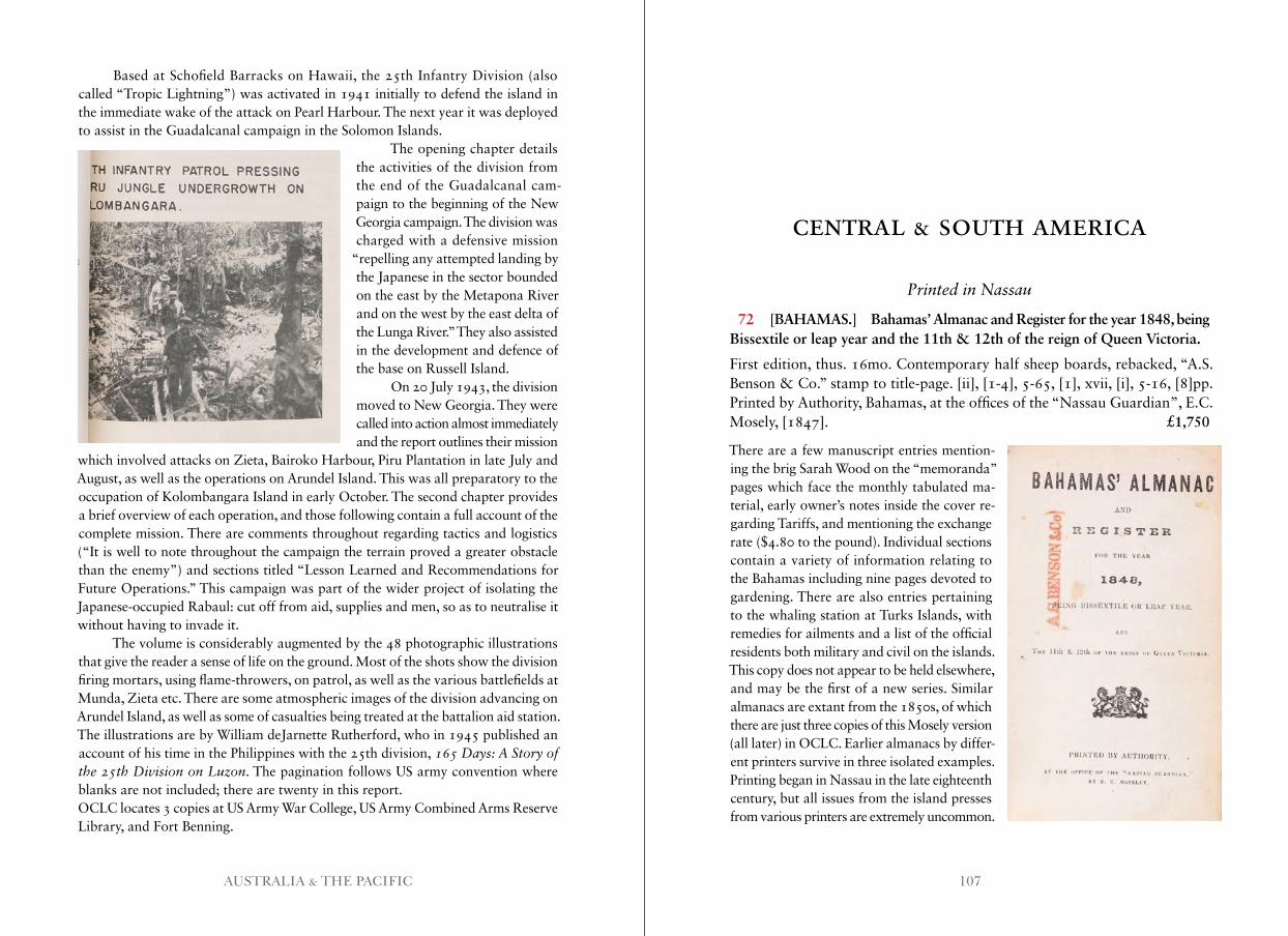
107AUSTRALIA & THE PACIFIC
CENTRAL & SOUTH AMERICA
Based at Schofield Barracks on Hawaii, the 25th Infantry Division (also called “Tropic Lightning”) was activated in 1941 initially to defend the island in the immediate wake of the attack on Pearl Harbour. The next year it was deployed to assist in the Guadalcanal campaign in the Solomon Islands.
The opening chapter details the activities of the division from the end of the Guadalcanal cam-paign to the beginning of the New Georgia campaign. The division was charged with a defensive mission
“repelling any attempted landing by the Japanese in the sector bounded on the east by the Metapona River and on the west by the east delta of the Lunga River.” They also assisted in the development and defence of the base on Russell Island.
On 20 July 1943, the division moved to New Georgia. They were called into action almost immediately and the report outlines their mission
which involved attacks on Zieta, Bairoko Harbour, Piru Plantation in late July and August, as well as the operations on Arundel Island. This was all preparatory to the occupation of Kolombangara Island in early October. The second chapter provides a brief overview of each operation, and those following contain a full account of the complete mission. There are comments throughout regarding tactics and logistics (“It is well to note throughout the campaign the terrain proved a greater obstacle than the enemy”) and sections titled “Lesson Learned and Recommendations for Future Operations.” This campaign was part of the wider project of isolating the Japanese-occupied Rabaul: cut off from aid, supplies and men, so as to neutralise it without having to invade it.
The volume is considerably augmented by the 48 photographic illustrations that give the reader a sense of life on the ground. Most of the shots show the division firing mortars, using flame-throwers, on patrol, as well as the various battlefields at Munda, Zieta etc. There are some atmospheric images of the division advancing on Arundel Island, as well as some of casualties being treated at the battalion aid station. The illustrations are by William deJarnette Rutherford, who in 1945 published an account of his time in the Philippines with the 25th division, 165 Days: A Story of the 25th Division on Luzon. The pagination follows US army convention where blanks are not included; there are twenty in this report.OCLC locates 3 copies at US Army War College, US Army Combined Arms Reserve Library, and Fort Benning.
Printed in Nassau
72 [BAHAMAS.] Bahamas’ Almanac and Register for the year 1848, being Bissextile or leap year and the 11th & 12th of the reign of Queen Victoria.
First edition, thus. 16mo. Contemporary half sheep boards, rebacked, “A.S. Benson & Co.” stamp to title-page. [ii], [1-4], 5-65, [1], xvii, [i], 5-16, [8]pp. Printed by Authority, Bahamas, at the offices of the “Nassau Guardian”, E.C. Mosely, [1847]. £1,750
There are a few manuscript entries mention-ing the brig Sarah Wood on the “memoranda” pages which face the monthly tabulated ma-terial, early owner’s notes inside the cover re-garding Tariffs, and mentioning the exchange rate ($4.80 to the pound). Individual sections contain a variety of information relating to the Bahamas including nine pages devoted to gardening. There are also entries pertaining to the whaling station at Turks Islands, with remedies for ailments and a list of the official residents both military and civil on the islands.This copy does not appear to be held elsewhere, and may be the first of a new series. Similar almanacs are extant from the 1850s, of which there are just three copies of this Mosely version (all later) in OCLC. Earlier almanacs by differ-ent printers survive in three isolated examples. Printing began in Nassau in the late eighteenth century, but all issues from the island presses from various printers are extremely uncommon.
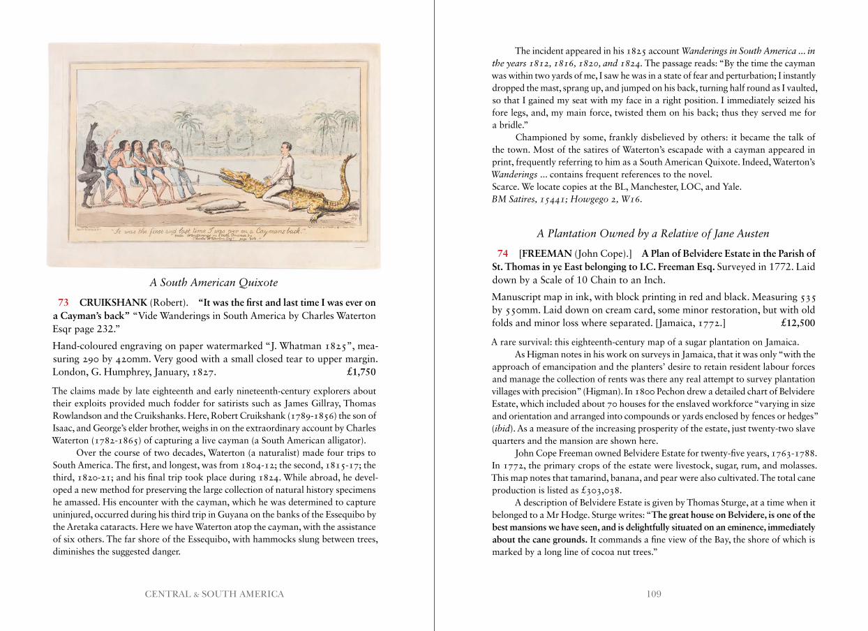
109CENTRAL & SOUTH AMERICA
A South American Quixote
73 CRUIKSHANK (Robert). “It was the first and last time I was ever on a Cayman’s back” “Vide Wanderings in South America by Charles Waterton Esqr page 232.”
Hand-coloured engraving on paper watermarked “J. Whatman 1825”, mea-suring 290 by 420mm. Very good with a small closed tear to upper margin. London, G. Humphrey, January, 1827. £1,750
The claims made by late eighteenth and early nineteenth-century explorers about their exploits provided much fodder for satirists such as James Gillray, Thomas Rowlandson and the Cruikshanks. Here, Robert Cruikshank (1789-1856) the son of Isaac, and George’s elder brother, weighs in on the extraordinary account by Charles Waterton (1782-1865) of capturing a live cayman (a South American alligator).
Over the course of two decades, Waterton (a naturalist) made four trips to South America. The first, and longest, was from 1804-12; the second, 1815-17; the third, 1820-21; and his final trip took place during 1824. While abroad, he devel-oped a new method for preserving the large collection of natural history specimens he amassed. His encounter with the cayman, which he was determined to capture uninjured, occurred during his third trip in Guyana on the banks of the Essequibo by the Aretaka cataracts. Here we have Waterton atop the cayman, with the assistance of six others. The far shore of the Essequibo, with hammocks slung between trees, diminishes the suggested danger.
The incident appeared in his 1825 account Wanderings in South America . . . in the years 1812, 1816, 1820, and 1824 . The passage reads: “By the time the cayman was within two yards of me, I saw he was in a state of fear and perturbation; I instantly dropped the mast, sprang up, and jumped on his back, turning half round as I vaulted, so that I gained my seat with my face in a right position. I immediately seized his fore legs, and, my main force, twisted them on his back; thus they served me for a bridle.”
Championed by some, frankly disbelieved by others: it became the talk of the town. Most of the satires of Waterton’s escapade with a cayman appeared in print, frequently referring to him as a South American Quixote. Indeed, Waterton’s Wanderings ... contains frequent references to the novel.Scarce. We locate copies at the BL, Manchester, LOC, and Yale.BM Satires, 15441; Howgego 2, W16 .
A Plantation Owned by a Relative of Jane Austen
74 [FREEMAN (John Cope).] A Plan of Belvidere Estate in the Parish of St. Thomas in ye East belonging to I.C. Freeman Esq. Surveyed in 1772. Laid down by a Scale of 10 Chain to an Inch.
Manuscript map in ink, with block printing in red and black. Measuring 535 by 550mm. Laid down on cream card, some minor restoration, but with old folds and minor loss where separated. [Jamaica, 1772.] £12,500
A rare survival: this eighteenth-century map of a sugar plantation on Jamaica.As Higman notes in his work on surveys in Jamaica, that it was only “with the
approach of emancipation and the planters’ desire to retain resident labour forces and manage the collection of rents was there any real attempt to survey plantation villages with precision” (Higman). In 1800 Pechon drew a detailed chart of Belvidere Estate, which included about 70 houses for the enslaved workforce “varying in size and orientation and arranged into compounds or yards enclosed by fences or hedges” (ibid). As a measure of the increasing prosperity of the estate, just twenty-two slave quarters and the mansion are shown here.
John Cope Freeman owned Belvidere Estate for twenty-five years, 1763-1788. In 1772, the primary crops of the estate were livestock, sugar, rum, and molasses. This map notes that tamarind, banana, and pear were also cultivated. The total cane production is listed as £303,038.
A description of Belvidere Estate is given by Thomas Sturge, at a time when it belonged to a Mr Hodge. Sturge writes: “The great house on Belvidere, is one of the best mansions we have seen, and is delightfully situated on an eminence, immediately about the cane grounds. It commands a fine view of the Bay, the shore of which is marked by a long line of cocoa nut trees.”
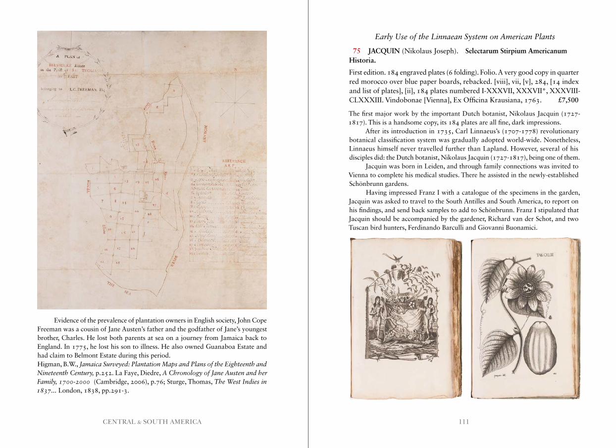
111CENTRAL & SOUTH AMERICA
Evidence of the prevalence of plantation owners in English society, John Cope Freeman was a cousin of Jane Austen’s father and the godfather of Jane’s youngest brother, Charles. He lost both parents at sea on a journey from Jamaica back to England. In 1775, he lost his son to illness. He also owned Guanaboa Estate and had claim to Belmont Estate during this period.Higman, B.W., Jamaica Surveyed: Plantation Maps and Plans of the Eighteenth and Nineteenth Century, p.252. La Faye, Diedre, A Chronology of Jane Austen and her Family, 1700-2000 (Cambridge, 2006), p.76; Sturge, Thomas, The West Indies in 1837 . . . London, 1838, pp.291-3.
Early Use of the Linnaean System on American Plants
75 JACQUIN (Nikolaus Joseph). Selectarum Stirpium AmericanumHistoria.
First edition. 184 engraved plates (6 folding). Folio. A very good copy in quarter red morocco over blue paper boards, rebacked. [viii], vii, [v], 284, [14 index and list of plates], [ii], 184 plates numbered I-XXXVII, XXXVII*, XXXVIII-CLXXXIII. Vindobonae [Vienna], Ex Officina Krausiana, 1763. £7,500
The first major work by the important Dutch botanist, Nikolaus Jacquin (1727-1817). This is a handsome copy, its 184 plates are all fine, dark impressions.
After its introduction in 1735, Carl Linnaeus’s (1707-1778) revolutionary botanical classification system was gradually adopted world-wide. Nonetheless, Linnaeus himself never travelled further than Lapland. However, several of his disciples did: the Dutch botanist, Nikolaus Jacquin (1727-1817), being one of them.
Jacquin was born in Leiden, and through family connections was invited to Vienna to complete his medical studies. There he assisted in the newly-established Schönbrunn gardens.
Having impressed Franz I with a catalogue of the specimens in the garden, Jacquin was asked to travel to the South Antilles and South America, to report on his findings, and send back samples to add to Schönbrunn. Franz I stipulated that Jacquin should be accompanied by the gardener, Richard van der Schot, and two Tuscan bird hunters, Ferdinando Barculli and Giovanni Buonamici.
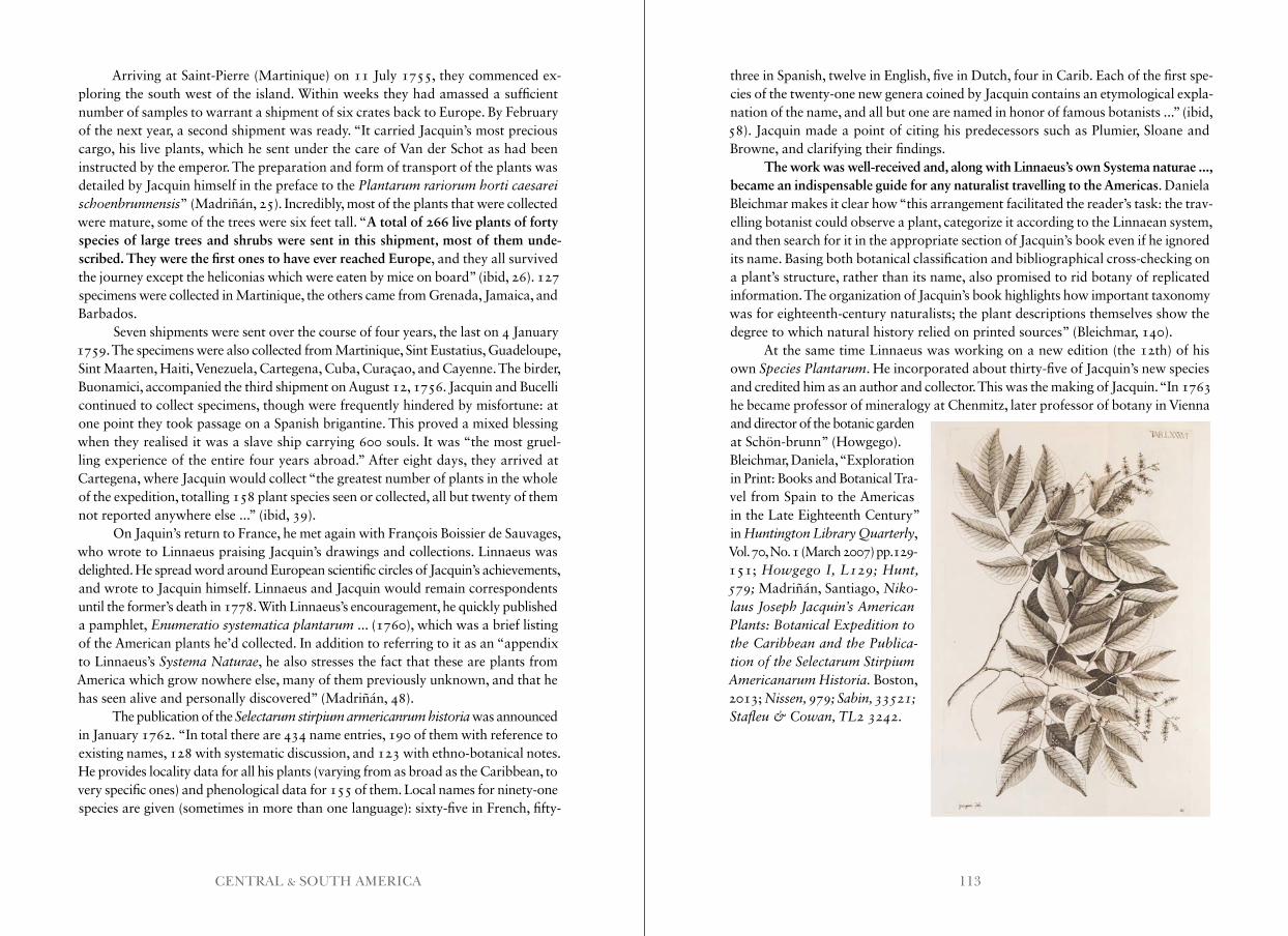
113CENTRAL & SOUTH AMERICA
Arriving at Saint-Pierre (Martinique) on 11 July 1755, they commenced ex-ploring the south west of the island. Within weeks they had amassed a sufficient number of samples to warrant a shipment of six crates back to Europe. By February of the next year, a second shipment was ready. “It carried Jacquin’s most precious cargo, his live plants, which he sent under the care of Van der Schot as had been instructed by the emperor. The preparation and form of transport of the plants was detailed by Jacquin himself in the preface to the Plantarum rariorum horti caesarei schoenbrunnensis” (Madriñán, 25). Incredibly, most of the plants that were collected were mature, some of the trees were six feet tall. “A total of 266 live plants of forty species of large trees and shrubs were sent in this shipment, most of them unde-scribed. They were the first ones to have ever reached Europe, and they all survived the journey except the heliconias which were eaten by mice on board” (ibid, 26). 127 specimens were collected in Martinique, the others came from Grenada, Jamaica, and Barbados.
Seven shipments were sent over the course of four years, the last on 4 January 1759. The specimens were also collected from Martinique, Sint Eustatius, Guadeloupe, Sint Maarten, Haiti, Venezuela, Cartegena, Cuba, Curaçao, and Cayenne. The birder, Buonamici, accompanied the third shipment on August 12, 1756. Jacquin and Bucelli continued to collect specimens, though were frequently hindered by misfortune: at one point they took passage on a Spanish brigantine. This proved a mixed blessing when they realised it was a slave ship carrying 600 souls. It was “the most gruel-ling experience of the entire four years abroad.” After eight days, they arrived at Cartegena, where Jacquin would collect “the greatest number of plants in the whole of the expedition, totalling 158 plant species seen or collected, all but twenty of them not reported anywhere else ...” (ibid, 39).
On Jaquin’s return to France, he met again with François Boissier de Sauvages, who wrote to Linnaeus praising Jacquin’s drawings and collections. Linnaeus was delighted. He spread word around European scientific circles of Jacquin’s achievements, and wrote to Jacquin himself. Linnaeus and Jacquin would remain correspondents until the former’s death in 1778. With Linnaeus’s encouragement, he quickly published a pamphlet, Enumeratio systematica plantarum ... (1760), which was a brief listing of the American plants he’d collected. In addition to referring to it as an “appendix to Linnaeus’s Systema Naturae, he also stresses the fact that these are plants from America which grow nowhere else, many of them previously unknown, and that he has seen alive and personally discovered” (Madriñán, 48).
The publication of the Selectarum stirpium armericanrum historia was announced in January 1762. “In total there are 434 name entries, 190 of them with reference to existing names, 128 with systematic discussion, and 123 with ethno-botanical notes. He provides locality data for all his plants (varying from as broad as the Caribbean, to very specific ones) and phenological data for 155 of them. Local names for ninety-one species are given (sometimes in more than one language): sixty-five in French, fifty-
three in Spanish, twelve in English, five in Dutch, four in Carib. Each of the first spe- cies of the twenty-one new genera coined by Jacquin contains an etymological expla- nation of the name, and all but one are named in honor of famous botanists ...” (ibid, 58). Jacquin made a point of citing his predecessors such as Plumier, Sloane and Browne, and clarifying their findings.
The work was well-received and, along with Linnaeus’s own Systema naturae ..., became an indispensable guide for any naturalist travelling to the Americas. Daniela Bleichmar makes it clear how “this arrangement facilitated the reader’s task: the trav- elling botanist could observe a plant, categorize it according to the Linnaean system, and then search for it in the appropriate section of Jacquin’s book even if he ignored its name. Basing both botanical classification and bibliographical cross-checking on a plant’s structure, rather than its name, also promised to rid botany of replicated information. The organization of Jacquin’s book highlights how important taxonomy was for eighteenth-century naturalists; the plant descriptions themselves show the degree to which natural history relied on printed sources” (Bleichmar, 140).
At the same time Linnaeus was working on a new edition (the 12th) of his own Species Plantarum. He incorporated about thirty-five of Jacquin’s new species and credited him as an author and collector. This was the making of Jacquin. “In 1763 he became professor of mineralogy at Chenmitz, later professor of botany in Vienna and director of the botanic garden at Schön-brunn” (Howgego).Bleichmar, Daniela, “Exploration in Print: Books and Botanical Tra-vel from Spain to the Americas in the Late Eighteenth Century” in Huntington Library Quarterly, Vol. 70, No. 1 (March 2007) pp.129- 151; Howgego I, L129; Hunt, 579; Madriñán, Santiago, Niko-laus Joseph Jacquin’s American Plants: Botanical Expedition to the Caribbean and the Publica-tion of the Selectarum Stirpium Americanarum Historia . Boston, 2013; Nissen, 979; Sabin, 33521; Stafleu & Cowan, TL2 3242 .
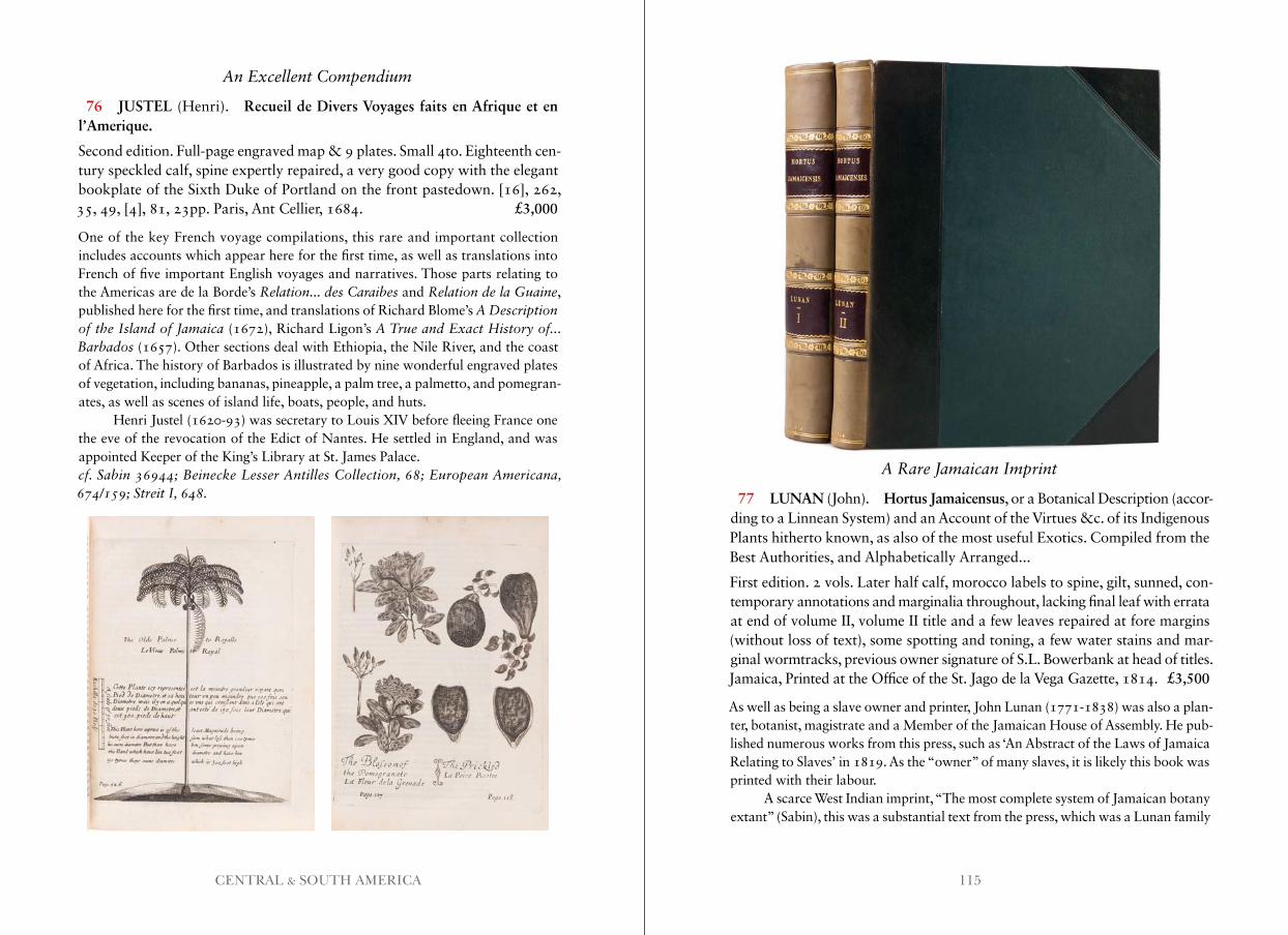
115CENTRAL & SOUTH AMERICA
An Excellent Compendium
76 JUSTEL (Henri). Recueil de Divers Voyages faits en Afrique et en l’Amerique.
Second edition. Full-page engraved map & 9 plates. Small 4to. Eighteenth cen-tury speckled calf, spine expertly repaired, a very good copy with the elegant bookplate of the Sixth Duke of Portland on the front pastedown. [16], 262, 35, 49, [4], 81, 23pp. Paris, Ant Cellier, 1684. £3,000
One of the key French voyage compilations, this rare and important collection includes accounts which appear here for the first time, as well as translations into French of five important English voyages and narratives. Those parts relating to the Americas are de la Borde’s Relation . . . des Caraibes and Relation de la Guaine, published here for the first time, and translations of Richard Blome’s A Description of the Island of Jamaica (1672), Richard Ligon’s A True and Exact History of . . . Barbados (1657). Other sections deal with Ethiopia, the Nile River, and the coast of Africa. The history of Barbados is illustrated by nine wonderful engraved plates of vegetation, including bananas, pineapple, a palm tree, a palmetto, and pomegran-ates, as well as scenes of island life, boats, people, and huts.
Henri Justel (1620-93) was secretary to Louis XIV before fleeing France one the eve of the revocation of the Edict of Nantes. He settled in England, and was appointed Keeper of the King’s Library at St. James Palace.cf . Sabin 36944; Beinecke Lesser Antilles Collection, 68; European Americana, 674/159; Streit I, 648 .
A Rare Jamaican Imprint
77 LUNAN (John). Hortus Jamaicensus, or a Botanical Description (accor-ding to a Linnean System) and an Account of the Virtues &c. of its Indigenous Plants hitherto known, as also of the most useful Exotics. Compiled from the Best Authorities, and Alphabetically Arranged...
First edition. 2 vols. Later half calf, morocco labels to spine, gilt, sunned, con-temporary annotations and marginalia throughout, lacking final leaf with errata at end of volume II, volume II title and a few leaves repaired at fore margins (without loss of text), some spotting and toning, a few water stains and mar-ginal wormtracks, previous owner signature of S.L. Bowerbank at head of titles. Jamaica, Printed at the Office of the St. Jago de la Vega Gazette, 1814. £3,500
As well as being a slave owner and printer, John Lunan (1771-1838) was also a plan- ter, botanist, magistrate and a Member of the Jamaican House of Assembly. He pub-lished numerous works from this press, such as ‘An Abstract of the Laws of Jamaica Relating to Slaves’ in 1819. As the “owner” of many slaves, it is likely this book was printed with their labour.
A scarce West Indian imprint, “The most complete system of Jamaican botany extant” (Sabin), this was a substantial text from the press, which was a Lunan family
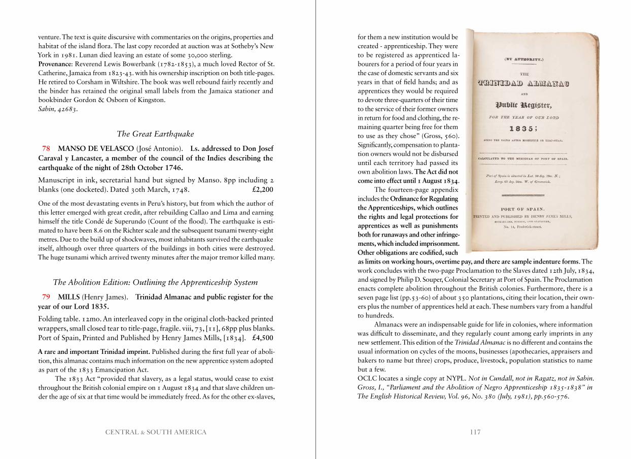
117CENTRAL & SOUTH AMERICA
venture. The text is quite discursive with commentaries on the origins, properties and habitat of the island flora. The last copy recorded at auction was at Sotheby’s New York in 1981. Lunan died leaving an estate of some 30,000 sterling.Provenance: Reverend Lewis Bowerbank (1782-1853), a much loved Rector of St. Catherine, Jamaica from 1823-43. with his ownership inscription on both title-pages. He retired to Corsham in Wiltshire. The book was well rebound fairly recently and the binder has retained the original small labels from the Jamaica stationer and bookbinder Gordon & Osborn of Kingston.Sabin, 42683 .
The Great Earthquake
78 MANSO DE VELASCO (José Antonio). Ls. addressed to Don Josef Caraval y Lancaster, a member of the council of the Indies describing the earthquake of the night of 28th October 1746.
Manuscript in ink, secretarial hand but signed by Manso. 8pp including 2 blanks (one docketed). Dated 30th March, 1748. £2,200
One of the most devastating events in Peru’s history, but from which the author of this letter emerged with great credit, after rebuilding Callao and Lima and earning himself the title Condé de Superundo (Count of the flood). The earthquake is esti-mated to have been 8.6 on the Richter scale and the subsequent tsunami twenty-eight metres. Due to the build up of shockwaves, most inhabitants survived the earthquake itself, although over three quarters of the buildings in both cities were destroyed. The huge tsunami which arrived twenty minutes after the major tremor killed many.
The Abolition Edition: Outlining the Apprenticeship System
79 MILLS (Henry James). Trinidad Almanac and public register for the year of our Lord 1835.
Folding table. 12mo. An interleaved copy in the original cloth-backed printed wrappers, small closed tear to title-page, fragile. viii, 73, [11], 68pp plus blanks. Port of Spain, Printed and Published by Henry James Mills, [1834]. £4,500
A rare and important Trinidad imprint. Published during the first full year of aboli-tion, this almanac contains much information on the new apprentice system adopted as part of the 1833 Emancipation Act.
The 1833 Act “provided that slavery, as a legal status, would cease to exist throughout the British colonial empire on 1 August 1834 and that slave children un-der the age of six at that time would be immediately freed. As for the other ex-slaves,
for them a new institution would be created - apprenticeship. They were to be registered as apprenticed la-bourers for a period of four years in the case of domestic servants and six years in that of field hands; and as apprentices they would be required to devote three-quarters of their time to the service of their former owners in return for food and clothing, the re- maining quarter being free for them to use as they chose” (Gross, 560). Significantly, compensation to planta-tion owners would not be disbursed until each territory had passed its own abolition laws. The Act did not come into effect until 1 August 1834.
The fourteen-page appendix includes the Ordinance for Regulating the Apprenticeships, which outlines the rights and legal protections for apprentices as well as punishments both for runaways and other infringe-ments, which included imprisonment. Other obligations are codified, such as limits on working hours, overtime pay, and there are sample indenture forms. The work concludes with the two-page Proclamation to the Slaves dated 12th July, 1834, and signed by Philip D. Souper, Colonial Secretary at Port of Spain. The Proclamation enacts complete abolition throughout the British colonies. Furthermore, there is a seven page list (pp.53-60) of about 350 plantations, citing their location, their own-ers plus the number of apprentices held at each. These numbers vary from a handful to hundreds.
Almanacs were an indispensable guide for life in colonies, where information was difficult to disseminate, and they regularly count among early imprints in any new settlement. This edition of the Trinidad Almanac is no different and contains the usual information on cycles of the moons, businesses (apothecaries, appraisers and bakers to name but three) crops, produce, livestock, population statistics to name but a few.OCLC locates a single copy at NYPL. Not in Cundall, not in Ragatz, not in Sabin . Gross, I ., “Parliament and the Abolition of Negro Apprenticeship 1835-1838” in The English Historical Review, Vol . 96, No . 380 (July, 1981), pp .560-576 .
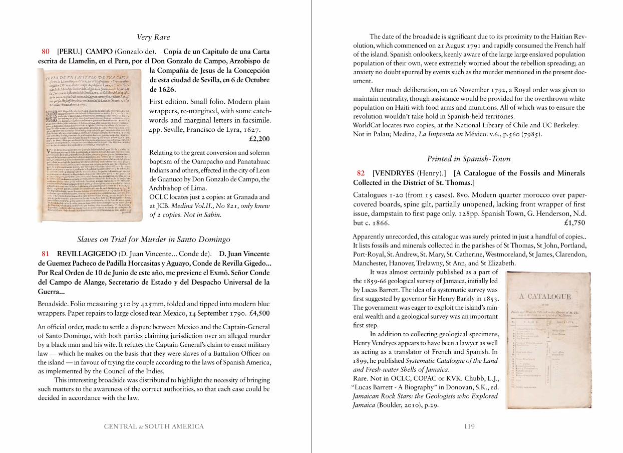
119CENTRAL & SOUTH AMERICA
Very Rare
80 [PERU.] CAMPO (Gonzalo de). Copia de un Capitulo de una Carta escrita de Llamelin, en el Peru, por el Don Gonzalo de Campo, Arzobispo de
la Compañía de Jesus de la Concepción de esta ciudad de Sevilla, en 6 de Octubre de 1626.
First edition. Small folio. Modern plain wrappers, re-margined, with some catch-words and marginal letters in facsimile. 4pp. Seville, Francisco de Lyra, 1627. £2,200
Relating to the great conversion and solemn baptism of the Oarapacho and Panatahuac Indians and others, effected in the city of Leon de Guanuco by Don Gonzalo de Campo, the Archbishop of Lima.OCLC locates just 2 copies: at Granada and at JCB. Medina Vol .II ., No 821, only knew of 2 copies . Not in Sabin .
Slaves on Trial for Murder in Santo Domingo
81 REVILLAGIGEDO (D. Juan Vincente... Conde de). D. Juan Vincente de Guemez Pacheco de Padilla Horcasitas y Aguayo, Conde de Revilla Gigedo... Por Real Orden de 10 de Junio de este año, me previene el Exmô. Señor Conde del Campo de Alange, Secretario de Estado y del Despacho Universal de la Guerra...
Broadside. Folio measuring 310 by 425mm, folded and tipped into modern blue wrappers. Paper repairs to large closed tear. Mexico, 14 September 1790. £4,500
An official order, made to settle a dispute between Mexico and the Captain-General of Santo Domingo, with both parties claiming jurisdiction over an alleged murder by a black man and his wife. It refutes the Captain General’s claim to enact military law — which he makes on the basis that they were slaves of a Battalion Officer on the island — in favour of trying the couple according to the laws of Spanish America, as implemented by the Council of the Indies.
This interesting broadside was distributed to highlight the necessity of bringing such matters to the awareness of the correct authorities, so that each case could be decided in accordance with the law.
The date of the broadside is significant due to its proximity to the Haitian Rev- olution, which commenced on 21 August 1791 and rapidly consumed the French half of the island. Spanish onlookers, keenly aware of the large large enslaved population population of their own, were extremely worried about the rebellion spreading; an anxiety no doubt spurred by events such as the murder mentioned in the present doc- ument.
After much deliberation, on 26 November 1792, a Royal order was given to maintain neutrality, though assistance would be provided for the overthrown white population on Haiti with food arms and munitions. All of which was to ensure the revolution wouldn’t take hold in Spanish-held territories.WorldCat locates two copies, at the National Library of Chile and UC Berkeley.Not in Palau; Medina, La Imprenta en México. v.6., p.560 (7985).
Printed in Spanish-Town
82 [VENDRYES (Henry).] [A Catalogue of the Fossils and Minerals Collected in the District of St. Thomas.]
Catalogues 1-20 (from 15 cases). 8vo. Modern quarter morocco over paper-covered boards, spine gilt, partially unopened, lacking front wrapper of first issue, dampstain to first page only. 128pp. Spanish Town, G. Henderson, N.d. but c. 1866. £1,750
Apparently unrecorded, this catalogue was surely printed in just a handful of copies.. It lists fossils and minerals collected in the parishes of St Thomas, St John, Portland, Port-Royal, St. Andrew, St. Mary, St. Catherine, Westmoreland, St James, Clarendon, Manchester, Hanover, Trelawny, St Ann, and St Elizabeth.
It was almost certainly published as a part of the 1859-66 geological survey of Jamaica, initially led by Lucas Barrett. The idea of a systematic survey was first suggested by governor Sir Henry Barkly in 1853. The government was eager to exploit the island’s min- eral wealth and a geological survey was an important first step.
In addition to collecting geological specimens, Henry Vendryes appears to have been a lawyer as well as acting as a translator of French and Spanish. In 1899, he published Systematic Catalogue of the Land and Fresh-water Shells of Jamaica.Rare. Not in OCLC, COPAC or KVK. Chubb, L.J.,
“Lucas Barrett - A Biography” in Donovan, S.K., ed. Jamaican Rock Stars: the Geologists who Explored Jamaica (Boulder, 2010), p.29 .
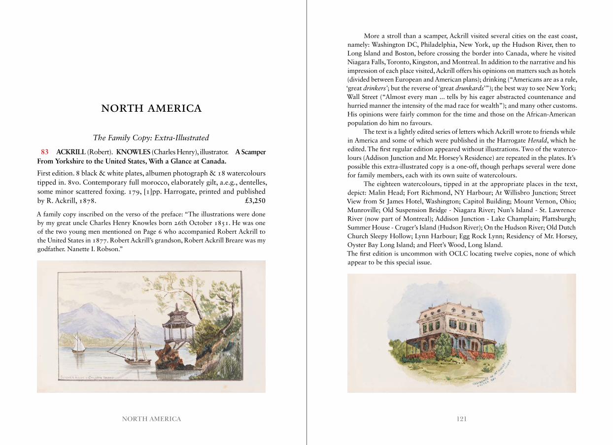
121NORTH AMERICA
NORTH AMERICA
The Family Copy: Extra-Illustrated
83 ACKRILL (Robert). KNOWLES (Charles Henry), illustrator. A Scamper From Yorkshire to the United States, With a Glance at Canada.
First edition. 8 black & white plates, albumen photograph & 18 watercolours tipped in. 8vo. Contemporary full morocco, elaborately gilt, a.e.g., dentelles, some minor scattered foxing. 179, [1]pp. Harrogate, printed and published by R. Ackrill, 1878. £3,250
A family copy inscribed on the verso of the preface: “The illustrations were done by my great uncle Charles Henry Knowles born 26th October 1851. He was one of the two young men mentioned on Page 6 who accompanied Robert Ackrill to the United States in 1877. Robert Ackrill’s grandson, Robert Ackrill Breare was my godfather. Nanette I. Robson.”
More a stroll than a scamper, Ackrill visited several cities on the east coast, namely: Washington DC, Philadelphia, New York, up the Hudson River, then to Long Island and Boston, before crossing the border into Canada, where he visited Niagara Falls, Toronto, Kingston, and Montreal. In addition to the narrative and his impression of each place visited, Ackrill offers his opinions on matters such as hotels (divided between European and American plans); drinking (“Americans are as a rule, ‘great drinkers’; but the reverse of ‘great drunkards’”); the best way to see New York; Wall Street (“Almost every man ... tells by his eager abstracted countenance and hurried manner the intensity of the mad race for wealth”); and many other customs. His opinions were fairly common for the time and those on the African-American population do him no favours.
The text is a lightly edited series of letters which Ackrill wrote to friends while in America and some of which were published in the Harrogate Herald, which he edited. The first regular edition appeared without illustrations. Two of the waterco-lours (Addison Junction and Mr. Horsey’s Residence) are repeated in the plates. It’s possible this extra-illustrated copy is a one-off, though perhaps several were done for family members, each with its own suite of watercolours.
The eighteen watercolours, tipped in at the appropriate places in the text, depict: Malin Head; Fort Richmond, NY Harbour; At Willisbro Junction; Street View from St James Hotel, Washington; Capitol Building; Mount Vernon, Ohio; Munroville; Old Suspension Bridge - Niagara River; Nun’s Island - St. Lawrence River (now part of Montreal); Addison Junction - Lake Champlain; Plattsburgh; Summer House - Cruger’s Island (Hudson River); On the Hudson River; Old Dutch Church Sleepy Hollow; Lynn Harbour; Egg Rock Lynn; Residency of Mr. Horsey, Oyster Bay Long Island; and Fleet’s Wood, Long Island.The first edition is uncommon with OCLC locating twelve copies, none of which appear to be this special issue.
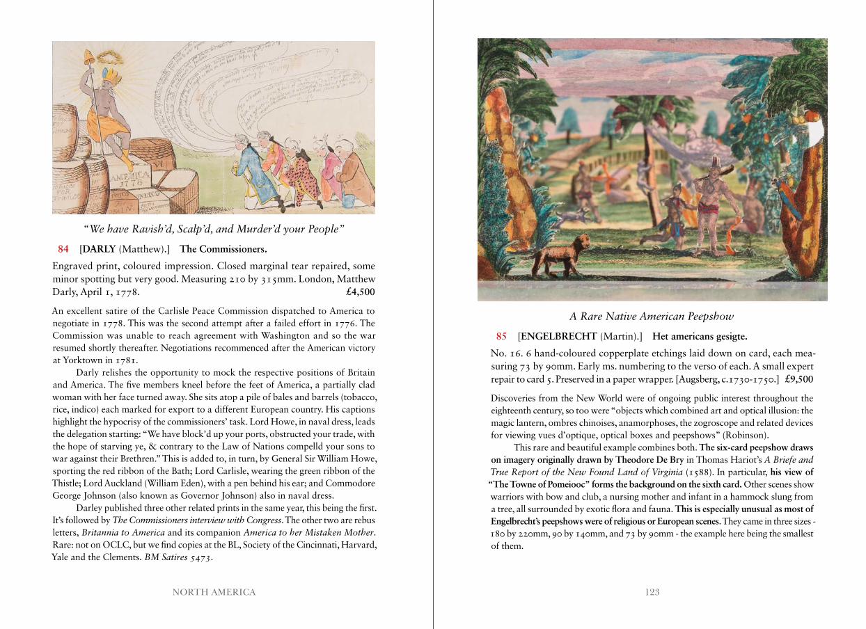
123NORTH AMERICA
“We have Ravish’d, Scalp’d, and Murder’d your People”
84 [DARLY (Matthew).] The Commissioners.
Engraved print, coloured impression. Closed marginal tear repaired, some minor spotting but very good. Measuring 210 by 315mm. London, Matthew Darly, April 1, 1778. £4,500
An excellent satire of the Carlisle Peace Commission dispatched to America to negotiate in 1778. This was the second attempt after a failed effort in 1776. The Commission was unable to reach agreement with Washington and so the war resumed shortly thereafter. Negotiations recommenced after the American victory at Yorktown in 1781.
Darly relishes the opportunity to mock the respective positions of Britain and America. The five members kneel before the feet of America, a partially clad woman with her face turned away. She sits atop a pile of bales and barrels (tobacco, rice, indico) each marked for export to a different European country. His captions highlight the hypocrisy of the commissioners’ task. Lord Howe, in naval dress, leads the delegation starting: “We have block’d up your ports, obstructed your trade, with the hope of starving ye, & contrary to the Law of Nations compelld your sons to war against their Brethren.” This is added to, in turn, by General Sir William Howe, sporting the red ribbon of the Bath; Lord Carlisle, wearing the green ribbon of the Thistle; Lord Auckland (William Eden), with a pen behind his ear; and Commodore George Johnson (also known as Governor Johnson) also in naval dress.
Darley published three other related prints in the same year, this being the first. It’s followed by The Commissioners interview with Congress. The other two are rebus letters, Britannia to America and its companion America to her Mistaken Mother.Rare: not on OCLC, but we find copies at the BL, Society of the Cincinnati, Harvard, Yale and the Clements. BM Satires 5473.
A Rare Native American Peepshow
85 [ENGELBRECHT (Martin).] Het americans gesigte.
No. 16. 6 hand-coloured copperplate etchings laid down on card, each mea-suring 73 by 90mm. Early ms. numbering to the verso of each. A small expert repair to card 5. Preserved in a paper wrapper. [Augsberg, c.1730-1750.] £9,500
Discoveries from the New World were of ongoing public interest throughout the eighteenth century, so too were “objects which combined art and optical illusion: the magic lantern, ombres chinoises, anamorphoses, the zogroscope and related devices for viewing vues d’optique, optical boxes and peepshows” (Robinson).
This rare and beautiful example combines both. The six-card peepshow draws on imagery originally drawn by Theodore De Bry in Thomas Hariot’s A Briefe and True Report of the New Found Land of Virginia (1588). In particular, his view of “The Towne of Pomeiooc” forms the background on the sixth card. Other scenes show warriors with bow and club, a nursing mother and infant in a hammock slung from a tree, all surrounded by exotic flora and fauna. This is especially unusual as most of Engelbrecht’s peepshows were of religious or European scenes. They came in three sizes - 180 by 220mm, 90 by 140mm, and 73 by 90mm - the example here being the smallest of them.
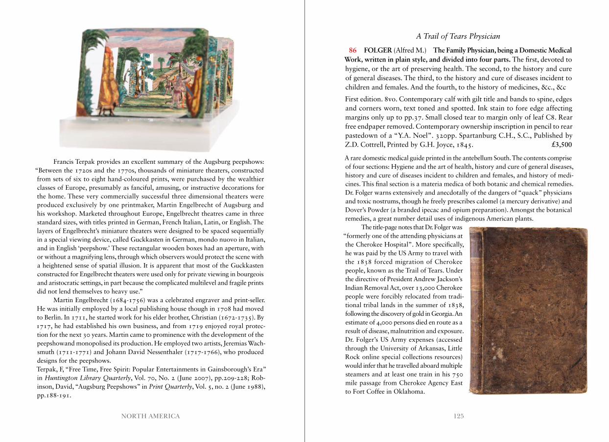
125NORTH AMERICA
Francis Terpak provides an excellent summary of the Augsburg peepshows: “Between the 1720s and the 1770s, thousands of miniature theaters, constructed from sets of six to eight hand-coloured prints, were purchased by the wealthier classes of Europe, presumably as fanciful, amusing, or instructive decorations for the home. These very commercially successful three dimensional theaters were produced exclusively by one printmaker, Martin Engelbrecht of Augsburg and his workshop. Marketed throughout Europe, Engelbrecht theatres came in three standard sizes, with titles printed in German, French Italian, Latin, or English. The layers of Engelbrecht’s miniature theaters were designed to be spaced sequentially in a special viewing device, called Guckkasten in German, mondo nuovo in Italian, and in English ‘peepshow.’ These rectangular wooden boxes had an aperture, with or without a magnifying lens, through which observers would protect the scene with a heightened sense of spatial illusion. It is apparent that most of the Guckkasten constructed for Engelbrecht theaters were used only for private viewing in bourgeois and aristocratic settings, in part because the complicated multilevel and fragile prints did not lend themselves to heavy use.”
Martin Engelbrecht (1684-1756) was a celebrated engraver and print-seller. He was initially employed by a local publishing house though in 1708 had moved to Berlin. In 1711, he started work for his elder brother, Christian (1672-1735). By 1717, he had established his own business, and from 1719 enjoyed royal protec-tion for the next 30 years. Martin came to prominence with the development of the peepshowand monopolised its production. He employed two artists, Jeremias Wach-smuth (1711-1771) and Johann David Nessenthaler (1717-1766), who produced designs for the peepshows.Terpak, F, “Free Time, Free Spirit: Popular Entertainments in Gainsborough’s Era” in Huntington Library Quarterly, Vol. 70, No. 2 (June 2007), pp.209-228; Rob-inson, David, “Augsburg Peepshows” in Print Quarterly, Vol. 5, no. 2 (June 1988), pp.188-191.
A Trail of Tears Physician
86 FOLGER (Alfred M.) The Family Physician, being a Domestic Medical Work, written in plain style, and divided into four parts. The first, devoted to hygiene, or the art of preserving health. The second, to the history and cure of general diseases. The third, to the history and cure of diseases incident to children and females. And the fourth, to the history of medicines, &c., &c
First edition. 8vo. Contemporary calf with gilt title and bands to spine, edges and corners worn, text toned and spotted. Ink stain to fore edge affecting margins only up to pp.37. Small closed tear to margin only of leaf C8. Rear free endpaper removed. Contemporary ownership inscription in pencil to rear pastedown of a “Y.A. Noel”. 320pp. Spartanburg C.H., S.C., Published by Z.D. Cottrell, Printed by G.H. Joyce, 1845. £3,500
A rare domestic medical guide printed in the antebellum South. The contents comprise of four sections: Hygiene and the art of health, history and cure of general diseases, history and cure of diseases incident to children and females, and history of medi-cines. This final section is a materia medica of both botanic and chemical remedies. Dr. Folger warns extensively and anecdotally of the dangers of “quack” physicians and toxic nostrums, though he freely prescribes calomel (a mercury derivative) and Dover’s Powder (a branded ipecac and opium preparation). Amongst the botanical remedies, a great number detail uses of indigenous American plants.
The title-page notes that Dr. Folger was “formerly one of the attending physicians at the Cherokee Hospital”. More specifically, he was paid by the US Army to travel with the 1838 forced migration of Cherokee people, known as the Trail of Tears. Under the directive of President Andrew Jackson’s Indian Removal Act, over 13,000 Cherokee people were forcibly relocated from tradi-tional tribal lands in the summer of 1838, following the discovery of gold in Georgia. An estimate of 4,000 persons died en route as a result of disease, malnutrition and exposure. Dr. Folger’s US Army expenses (accessed through the University of Arkansas, Little Rock online special collections resources) would infer that he travelled aboard multiple steamers and at least one train in his 750 mile passage from Cherokee Agency East to Fort Coffee in Oklahoma.

127NORTH AMERICA
The extraordinary hardships undergone by the victims of this removal are occasionally hinted at through anecdote in this work. For example, under the uses of Slippery Elm, Ulmus Rubra, Folger writes: “During my attendance in the Cherokee Hospital, the dysentery prevailed to a great extent, and finding many Cherokees opposed to taking any medicine with which I could supply them, I directed to take slippery elm bark, make an infusion, and drink freely. This pleased them, and they would get the bark, make a decoction, and use it in large quantities -- and many cases were cured in a short time with this remedy alone.” (pp.266-267)OCLC locates five copies at Yale Medical Library, Harvard, Appalachian State, Michigan and AAS. No copies found in auction records.
Illustrated Letters to his Son
87 HAYMAN (William E. B.) Sketchbook of St Augustine, Florida.
39 pen and ink and pencil drawings, 5 watercolours tipped into a blue cord tied album. Small 4to. Titled ‘Scrap Book’ in gilt to upper board. Pages gener-ally brittle, a few detached, most chipped at the edges, but none affecting the images. Some loose. 1884 - 1887. £5,000
A wonderful record of St Augustine comprised of letters and drawings. The text is nearly as vivid as the images.
Hayman was an artist, decorator, and painter of frescoes. Although his business was registered in Newport Rhode Island, he worked in St. Augustine for three years from 1884, and drew these charming sketches to entertain (and possibly console) his son Willie who remained in Rhode Island. He clearly liked it there as a land office record indicates that William E.B. Hayman purchased approximately 150 acres of public land on 25 May, 1885.
It evidently took some time to design the house he wanted built, though another image (the largest in the group) bears the triumphant message: “The Plan of our House to be built as soon as possible. I completed the contract last evening with the builder Mr. Canfield, Dec. 1st, 1887.” The recto actually has a front view of the proposed building. Hayman notes that the “porch is not in the contract” and also that “I have sketch[ed] you and Clara on the balcony outside your room, one of you in the ham-mock”. The floor plan of the house is on the verso. The left hand side shows the first floor rooms, though for the interest of Willie, the right shows the second floor with all the bedrooms. There is another image of the house in watercolour, which gives the address of 1102 Blanco St., St Augustine. While there remains a Blanco Street, the numbers no longer go that high.
There is also a map of the area where he’d purchased land, which is just to the south of St Augustine proper. The plot is just south of Moses Creek which feeds off the Matanzas River and is banked by Anastasia Island. On the verso of the map,
Hayman writes “I have made you a rough sketch of the land it will locate you enough for the present. I have it so fixed now that no difficulty will be found in locating it any time without the aid or assistance from surveyor. I have found out that the tramway runs right through it probably not quite as I have drawn the line on the plan ... I do hate those marshes but I am in hopes a railway before long will open up all this country until then I believe it will amount to much.”
The best image is a dramatic scene of him hunting, dated 21 February 1887, which he captions: “This is the worst scrape I got into you have heard of quick sand. This was quick mud. How it would pack around my legs and seem to draw one in deeper each step. The place was only about 15 or 20 feet wide and to look at it was simple enough. I think I was an hour getting out ...”
“I don’t think I shall ever forget my adventures and the trip generally. There are a large quantity of oysters but very small, also clams, crabs and fish, in abundance at Moses Creek and aligators [sic], also otters, coons, possums, wild cats. Deer are scarce so are bears and panthers and snakes ... Somebody shot an alligator last Wednesday and bought it into Vedden it was 9 feet long.”
There are several sketches exploring Moses Creek (“crossing Misfortune’s Branch, one of the forks that lead into Moses Creek”), “Picnick Branch leading to Moultrie Creek”, “The first bridge at Moultrie Creek”, “The upper bridge at Moultrie Creek”, “Six miles up Moses Creek” (Saw lots of fresh places made by gators on the bank. They hear us coming and slide off into the water.”)
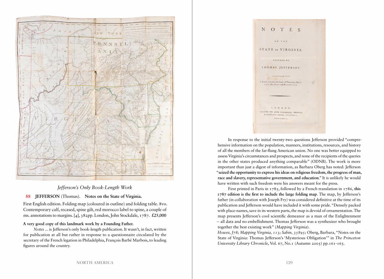
129NORTH AMERICA
Jefferson’s Only Book-Length Work
88 JEFFERSON (Thomas). Notes on the State of Virginia.
First English edition. Folding map (coloured in outline) and folding table. 8vo. Contemporary calf, recased, spine gilt, red morocco label to spine, a couple of ms. annotations to margins. [4], 382pp. London, John Stockdale, 1787. £25,000
A very good copy of this landmark work by a Founding Father.Notes ... is Jefferson’s only book-length publication. It wasn’t, in fact, written
for publication at all but rather in response to a questionnaire circulated by the secretary of the French legation in Philadelphia, François Barbé Marbois, to leading figures around the country.
In response to the initial twenty-two questions Jefferson provided “compre-hensive information on the population, manners, institutions, resources, and history of all the members of the far-flung American union. No one was better equipped to assess Virginia’s circumstances and prospects, and none of the recipients of the queries in the other states produced anything comparable” (ODNB). The work is more important than just a digest of information, as Barbara Oberg has noted: Jefferson
“seized the opportunity to express his ideas on religious freedom, the progress of man, race and slavery, representative government, and education.” It is unlikely he would have written with such freedom were his answers meant for the press.
First printed in Paris in 1785, followed by a French translation in 1786, this 1787 edition is the first to include the large folding map. The map, by Jefferson’s father (in collaboration with Joseph Fry) was considered definitive at the time of its publication and Jefferson would have included it with some pride. “Densely packed with place-names, save in its western parts, the map is devoid of ornamentation. The map presents Jefferson’s cool scientific demeanor as a man of the Enlightenment -- all data and no embellishment. Thomas Jefferson was a synthesizer who brought together the best existing work” (Mapping Virginia).Howes, J78; Mapping Virginia, 113; Sabin, 35895; Oberg, Barbara, “Notes on the State of Virginia: Thomas Jefferson’s ‘Mysterious Obligation’” in The Princeton University Library Chronicle, Vol. 67, No.1 (Autumn 2005) pp.161-165 .
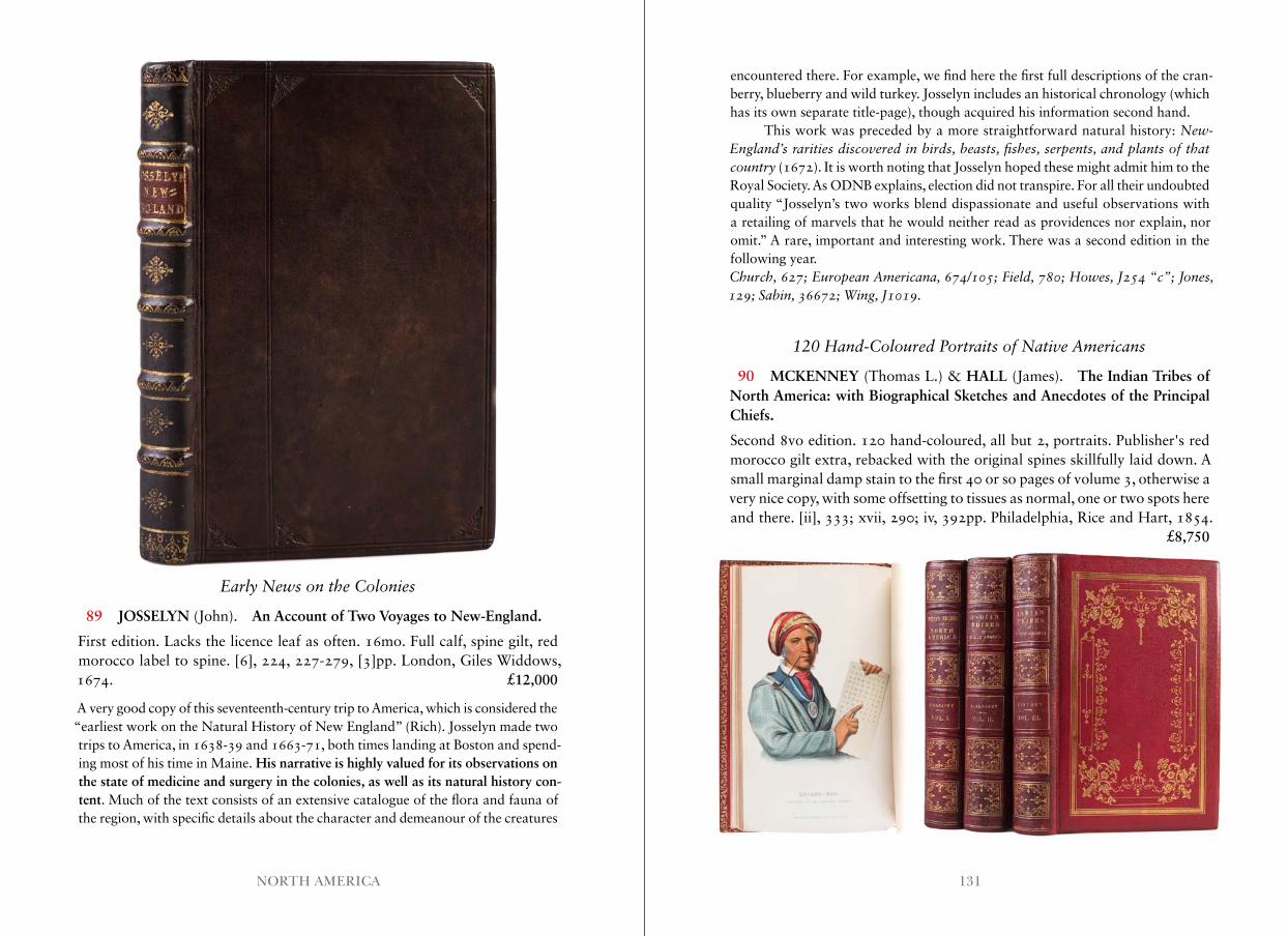
131NORTH AMERICA
Early News on the Colonies
89 JOSSELYN (John). An Account of Two Voyages to New-England.
First edition. Lacks the licence leaf as often. 16mo. Full calf, spine gilt, red morocco label to spine. [6], 224, 227-279, [3]pp. London, Giles Widdows, 1674. £12,000
A very good copy of this seventeenth-century trip to America, which is considered the “earliest work on the Natural History of New England” (Rich). Josselyn made two trips to America, in 1638-39 and 1663-71, both times landing at Boston and spend- ing most of his time in Maine. His narrative is highly valued for its observations on the state of medicine and surgery in the colonies, as well as its natural history con-tent. Much of the text consists of an extensive catalogue of the flora and fauna of the region, with specific details about the character and demeanour of the creatures
encountered there. For example, we find here the first full descriptions of the cran-berry, blueberry and wild turkey. Josselyn includes an historical chronology (which has its own separate title-page), though acquired his information second hand.
This work was preceded by a more straightforward natural history: New-England’s rarities discovered in birds, beasts, fishes, serpents, and plants of that country (1672). It is worth noting that Josselyn hoped these might admit him to the Royal Society. As ODNB explains, election did not transpire. For all their undoubted quality “Josselyn’s two works blend dispassionate and useful observations with a retailing of marvels that he would neither read as providences nor explain, nor omit.” A rare, important and interesting work. There was a second edition in the following year.Church, 627; European Americana, 674/105; Field, 780; Howes, J254 “c”; Jones, 129; Sabin, 36672; Wing, J1019 .
120 Hand-Coloured Portraits of Native Americans
90 MCKENNEY (Thomas L.) & HALL (James). The Indian Tribes of North America: with Biographical Sketches and Anecdotes of the Principal Chiefs.
Second 8vo edition. 120 hand-coloured, all but 2, portraits. Publisher's red morocco gilt extra, rebacked with the original spines skillfully laid down. A small marginal damp stain to the first 40 or so pages of volume 3, otherwise a very nice copy, with some offsetting to tissues as normal, one or two spots here and there. [ii], 333; xvii, 290; iv, 392pp. Philadelphia, Rice and Hart, 1854. £8,750
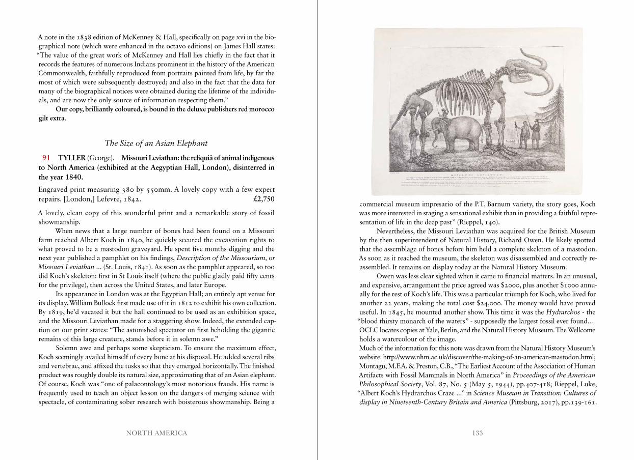
133NORTH AMERICA
A note in the 1838 edition of McKenney & Hall, specifically on page xvi in the bio-graphical note (which were enhanced in the octavo editions) on James Hall states:
“The value of the great work of McKenney and Hall lies chiefly in the fact that it records the features of numerous Indians prominent in the history of the American Commonwealth, faithfully reproduced from portraits painted from life, by far the most of which were subsequently destroyed; and also in the fact that the data for many of the biographical notices were obtained during the lifetime of the individu-als, and are now the only source of information respecting them.”
Our copy, brilliantly coloured, is bound in the deluxe publishers red morocco gilt extra.
The Size of an Asian Elephant
91 TYLLER (George). Missouri Leviathan: the reliquiâ of animal indigenous to North America (exhibited at the Aegyptian Hall, London), disinterred in the year 1840.
Engraved print measuring 380 by 550mm. A lovely copy with a few expert repairs. [London,] Lefevre, 1842. £2,750
A lovely, clean copy of this wonderful print and a remarkable story of fossil showmanship.
When news that a large number of bones had been found on a Missouri farm reached Albert Koch in 1840, he quickly secured the excavation rights to what proved to be a mastodon graveyard. He spent five months digging and the next year published a pamphlet on his findings, Description of the Missourium, or Missouri Leviathan ... (St. Louis, 1841). As soon as the pamphlet appeared, so too did Koch’s skeleton: first in St Louis itself (where the public gladly paid fifty cents for the privilege), then across the United States, and later Europe.
Its appearance in London was at the Egyptian Hall; an entirely apt venue for its display. William Bullock first made use of it in 1812 to exhibit his own collection. By 1819, he’d vacated it but the hall continued to be used as an exhibition space, and the Missouri Leviathan made for a staggering show. Indeed, the extended cap-tion on our print states: “The astonished spectator on first beholding the gigantic remains of this large creature, stands before it in solemn awe.”
Solemn awe and perhaps some skepticism. To ensure the maximum effect, Koch seemingly availed himself of every bone at his disposal. He added several ribs and vertebrae, and affixed the tusks so that they emerged horizontally. The finished product was roughly double its natural size, approximating that of an Asian elephant. Of course, Koch was “one of palaeontology’s most notorious frauds. His name is frequently used to teach an object lesson on the dangers of merging science with spectacle, of contaminating sober research with boisterous showmanship. Being a
commercial museum impresario of the P.T. Barnum variety, the story goes, Koch was more interested in staging a sensational exhibit than in providing a faithful repre- sentation of life in the deep past” (Rieppel, 140).
Nevertheless, the Missouri Leviathan was acquired for the British Museum by the then superintendent of Natural History, Richard Owen. He likely spotted that the assemblage of bones before him held a complete skeleton of a mastodon. As soon as it reached the museum, the skeleton was disassembled and correctly re-assembled. It remains on display today at the Natural History Museum.
Owen was less clear sighted when it came to financial matters. In an unusual, and expensive, arrangement the price agreed was $2000, plus another $1000 annu-ally for the rest of Koch’s life. This was a particular triumph for Koch, who lived for another 22 years, making the total cost $24,000. The money would have proved useful. In 1845, he mounted another show. This time it was the Hydrarchos - the
“blood thirsty monarch of the waters” - supposedly the largest fossil ever found...OCLC locates copies at Yale, Berlin, and the Natural History Museum. The Wellcome holds a watercolour of the image.Much of the information for this note was drawn from the Natural History Museum’s website: http://www.nhm.ac.uk/discover/the-making-of-an-american-mastodon.html; Montagu, M.F.A. & Preston, C.B., “The Earliest Account of the Association of Human Artifacts with Fossil Mammals in North America” in Proceedings of the American Philosophical Society, Vol. 87, No. 5 (May 5, 1944), pp.407-418; Rieppel, Luke, “Albert Koch’s Hydrarchos Craze ...” in Science Museum in Transition: Cultures of display in Nineteenth-Century Britain and America (Pittsburg, 2017), pp.139-161.
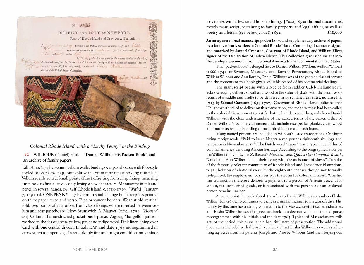
135NORTH AMERICA
Colonial Rhode Island: with a “Lucky Penny” in the Binding
92 WILBOUR (Daniel) et al. “Daniell Willbor His Packett Book” and an archive of family papers.
Tall 16mo. (175 by 80mm) vellum wallet binding over pasteboards with folk-style tooled brass clasps, flap-joint split with 40mm tape repair holding it in place. Vellum evenly soiled. Small points of rust offsetting from clasp fixings incurring 4mm hole to first 3 leaves, only losing a few characters. Manuscript in ink and pencil in several hands. 16, 34ff. Rhode Island, c.1710-1759. [With:] January 7, 1791 1d. ONE PENNY. 47 by 70mm small change bill letterpress printed on thick paper recto and verso. Type ornament borders. Wear at old vertical fold, two points of rust offset from clasp fixings where inserted between vel-lum and rear pasteboard. New-Brunswick, A. Blauvet, Print., 1791. [Housed in:] Colonial flame-stitched pocket book purse. Zig-zag “bargello” pattern worked in shades of green, yellow, pink and indigo wool. Pink linen lining over card with one central divider. Initials E.W. and date 1763 monogrammed in cross-stitch to upper edge. In remarkably fine and bright condition, only minor
loss to ties with a few small holes to lining. [Plus:] 85 additional documents, mostly manuscript, pertaining to family property and legal affairs, as well as poetry and letters (see below). 1748-1892. £10,000
An intergenerational manuscript pocket book and supplementary archive of papers by a family of early settlers in Colonial Rhode Island. Containing documents signed and notarised by Samuel Cranston, Governor of Rhode Island, and William Ellery, signer of the Declaration of Independence. This collection gives rich insight into the developing economy from Colonial America to the Continental United States.
This “packett book” belonged first to Daniell Wilbour(/Wilbur/Willbor/Wilber) (1666-1741) of Swansea, Massachusetts. Born in Portsmouth, Rhode Island to William Wilbour and Ann Barney, Daniel Wilbour was of the yeoman class of farmer and the contents of this book give a valuable record of his commercial dealings.
The manuscript begins with a receipt from saddler Caleb Hallandworth acknowledging delivery of calf and wood to the value of 3L4S, with the promissory return of a saddle and bridle to be delivered in 1710. The next entry, notarised in 1713 by Samuel Cranston (1659-1727), Governor of Rhode Island, indicates that Hallandworth failed to deliver on this transaction, and that a witness had been called to the colonial Government to testify that he had delivered the goods from Daniel Wilbour with the clear understanding of the agreed terms of the barter. Other of Daniel Wilbour’s commercial memoranda include receipts for planks, cider, wood and butter, as well as boarding of men, hired labour and cash loans.
Many named persons are included in Wilbour’s listed transactions. One inter-esting receipt reads: “Paid to Isaac Negers seven pounds eighteenth shillings and ten pence in November 1714”. The Dutch word “neger” was a typical racial slur of colonial America denoting African heritage. According to the biographical note on the Wilber family in Lynne Z. Bassett’s Massachusetts Quilts: Our Common Wealth, Daniel and Ann Wilber “made their living with the assistance of slaves”. In spite of the famously tolerant community of Rhode Island and Providence Plantations’ 1652 abolition of chattel slavery, by the eighteenth century though not formally re-legalised, the employment of slaves was the norm for colonial farmers. Whether this transaction therefore denotes a payment to a person of African descent for labour, for unspecified goods, or is associated with the purchase of an enslaved person remains unclear.
At some point the pocketbook transfers to Daniel Wilbour’s grandson Elisha Wilbor (b.1726), who continues to use it in a similar manner to his grandfather. The family by this time has a strong connection to the Massachusetts textiles industries, and Elisha Wilbor houses this precious book in a decorative flame-stitched purse, monogrammed with his initials and the date 1763. Typical of Massachusetts folk arts of the period, this purse is in a beautiful state of preservation. The additional documents included with the archive indicate that Elisha Wilbour, as well as inher-iting 24 acres from his parents Joseph and Phoebe Wilbour (and then buying out
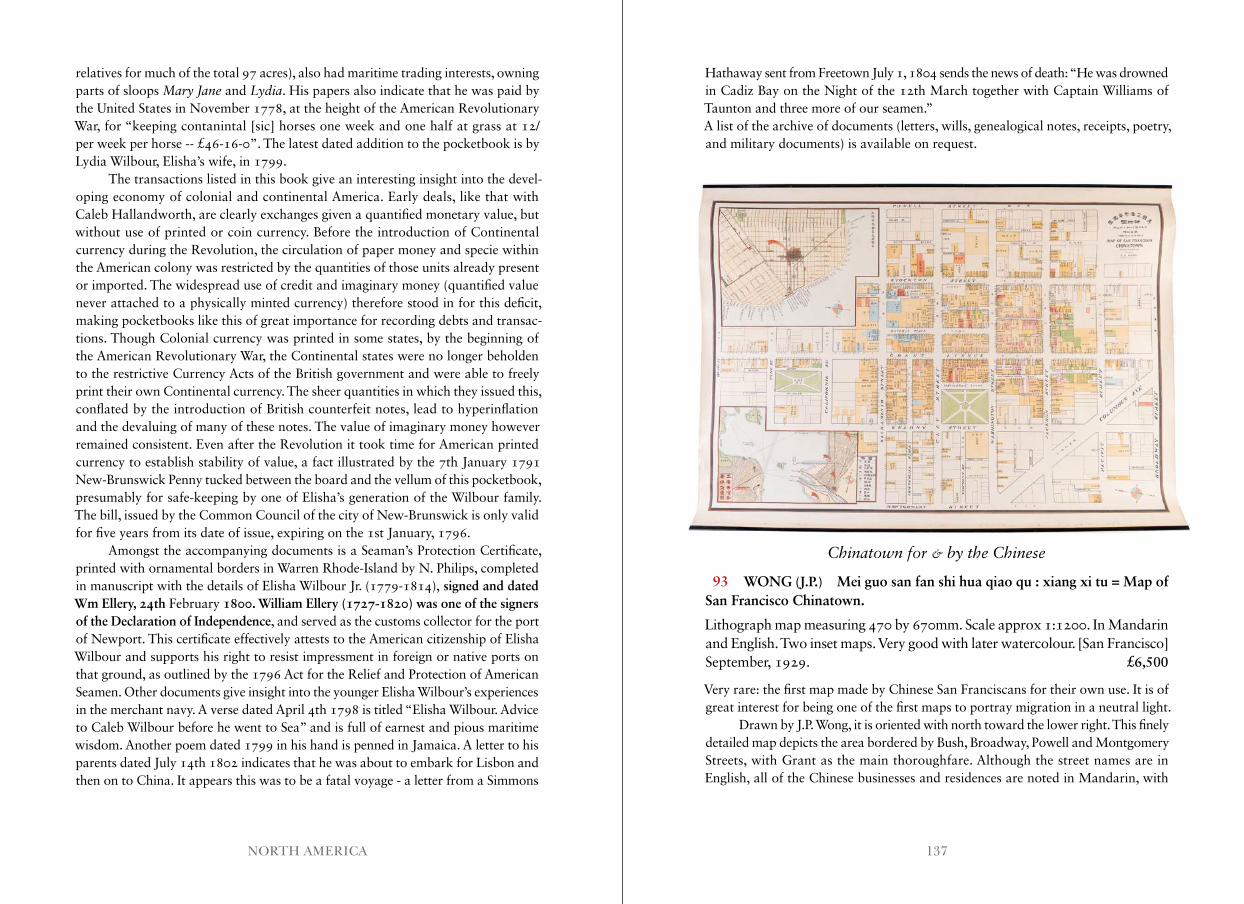
137NORTH AMERICA
relatives for much of the total 97 acres), also had maritime trading interests, owning parts of sloops Mary Jane and Lydia. His papers also indicate that he was paid by the United States in November 1778, at the height of the American Revolutionary War, for “keeping contanintal [sic] horses one week and one half at grass at 12/ per week per horse -- £46-16-0”. The latest dated addition to the pocketbook is by Lydia Wilbour, Elisha’s wife, in 1799.
The transactions listed in this book give an interesting insight into the devel-oping economy of colonial and continental America. Early deals, like that with Caleb Hallandworth, are clearly exchanges given a quantified monetary value, but without use of printed or coin currency. Before the introduction of Continental currency during the Revolution, the circulation of paper money and specie within the American colony was restricted by the quantities of those units already present or imported. The widespread use of credit and imaginary money (quantified value never attached to a physically minted currency) therefore stood in for this deficit, making pocketbooks like this of great importance for recording debts and transac-tions. Though Colonial currency was printed in some states, by the beginning of the American Revolutionary War, the Continental states were no longer beholden to the restrictive Currency Acts of the British government and were able to freely print their own Continental currency. The sheer quantities in which they issued this, conflated by the introduction of British counterfeit notes, lead to hyperinflation and the devaluing of many of these notes. The value of imaginary money however remained consistent. Even after the Revolution it took time for American printed currency to establish stability of value, a fact illustrated by the 7th January 1791 New-Brunswick Penny tucked between the board and the vellum of this pocketbook, presumably for safe-keeping by one of Elisha’s generation of the Wilbour family. The bill, issued by the Common Council of the city of New-Brunswick is only valid for five years from its date of issue, expiring on the 1st January, 1796.
Amongst the accompanying documents is a Seaman’s Protection Certificate, printed with ornamental borders in Warren Rhode-Island by N. Philips, completed in manuscript with the details of Elisha Wilbour Jr. (1779-1814), signed and dated Wm Ellery, 24th February 1800. William Ellery (1727-1820) was one of the signers of the Declaration of Independence, and served as the customs collector for the port of Newport. This certificate effectively attests to the American citizenship of Elisha Wilbour and supports his right to resist impressment in foreign or native ports on that ground, as outlined by the 1796 Act for the Relief and Protection of American Seamen. Other documents give insight into the younger Elisha Wilbour’s experiences in the merchant navy. A verse dated April 4th 1798 is titled “Elisha Wilbour. Advice to Caleb Wilbour before he went to Sea” and is full of earnest and pious maritime wisdom. Another poem dated 1799 in his hand is penned in Jamaica. A letter to his parents dated July 14th 1802 indicates that he was about to embark for Lisbon and then on to China. It appears this was to be a fatal voyage - a letter from a Simmons
Hathaway sent from Freetown July 1, 1804 sends the news of death: “He was drowned in Cadiz Bay on the Night of the 12th March together with Captain Williams of Taunton and three more of our seamen.”A list of the archive of documents (letters, wills, genealogical notes, receipts, poetry, and military documents) is available on request.
Chinatown for & by the Chinese
93 WONG (J.P.) Mei guo san fan shi hua qiao qu : xiang xi tu = Map of San Francisco Chinatown.
Lithograph map measuring 470 by 670mm. Scale approx 1:1200. In Mandarin and English. Two inset maps. Very good with later watercolour. [San Francisco] September, 1929. £6,500
Very rare: the first map made by Chinese San Franciscans for their own use. It is of great interest for being one of the first maps to portray migration in a neutral light.
Drawn by J.P. Wong, it is oriented with north toward the lower right. This finely detailed map depicts the area bordered by Bush, Broadway, Powell and Montgomery Streets, with Grant as the main thoroughfare. Although the street names are in English, all of the Chinese businesses and residences are noted in Mandarin, with
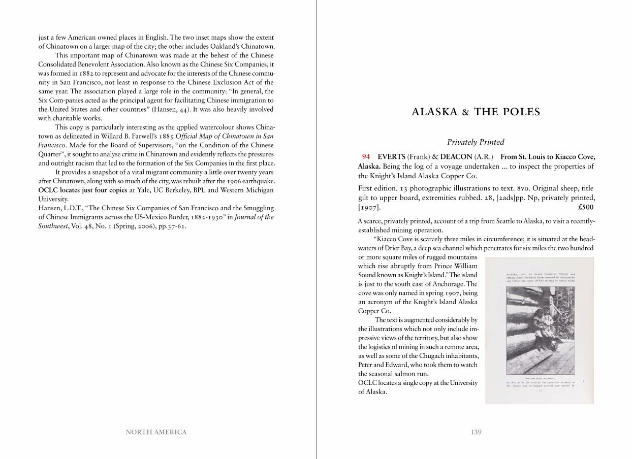
139NORTH AMERICA
just a few American owned places in English. The two inset maps show the extent of Chinatown on a larger map of the city; the other includes Oakland’s Chinatown.
This important map of Chinatown was made at the behest of the Chinese Consolidated Benevolent Association. Also known as the Chinese Six Companies, it was formed in 1882 to represent and advocate for the interests of the Chinese commu- nity in San Francisco, not least in response to the Chinese Exclusion Act of the same year. The association played a large role in the community: “In general, the Six Com-panies acted as the principal agent for facilitating Chinese immigration to the United States and other countries” (Hansen, 44). It was also heavily involved with charitable works.
This copy is particularly interesting as the qpplied watercolour shows China-town as delineated in Willard B. Farwell’s 1885 Official Map of Chinatown in San Francisco. Made for the Board of Supervisors, “on the Condition of the Chinese Quarter”, it sought to analyse crime in Chinatown and evidently reflects the pressures and outright racism that led to the formation of the Six Companies in the first place.
It provides a snapshot of a vital migrant community a little over twenty years after Chinatown, along with so much of the city, was rebuilt after the 1906 earthquake.OCLC locates just four copies at Yale, UC Berkeley, BPL and Western Michigan University.Hansen, L.D.T., “The Chinese Six Companies of San Francisco and the Smuggling of Chinese Immigrants across the US-Mexico Border, 1882-1930” in Journal of the Southwest, Vol. 48, No. 1 (Spring, 2006), pp.37-61.
ALASKA & THE POLES
Privately Printed
94 EVERTS (Frank) & DEACON (A.R.) From St. Louis to Kiacco Cove, Alaska. Being the log of a voyage undertaken ... to inspect the properties of the Knight’s Island Alaska Copper Co.
First edition. 13 photographic illustrations to text. 8vo. Original sheep, title gilt to upper board, extremities rubbed. 28, [2ads]pp. Np, privately printed, [1907]. £500
A scarce, privately printed, account of a trip from Seattle to Alaska, to visit a recently-established mining operation.
“Kiacco Cove is scarcely three miles in circumference; it is situated at the head-waters of Drier Bay, a deep sea channel which penetrates for six miles the two hundred or more square miles of rugged mountains which rise abruptly from Prince William Sound known as Knight’s Island.” The island is just to the south east of Anchorage. The cove was only named in spring 1907, being an acronym of the Knight’s Island Alaska Copper Co.
The text is augmented considerably by the illustrations which not only include im-pressive views of the territory, but also show the logistics of mining in such a remote area, as well as some of the Chugach inhabitants, Peter and Edward, who took them to watch the seasonal salmon run.OCLC locates a single copy at the University of Alaska.
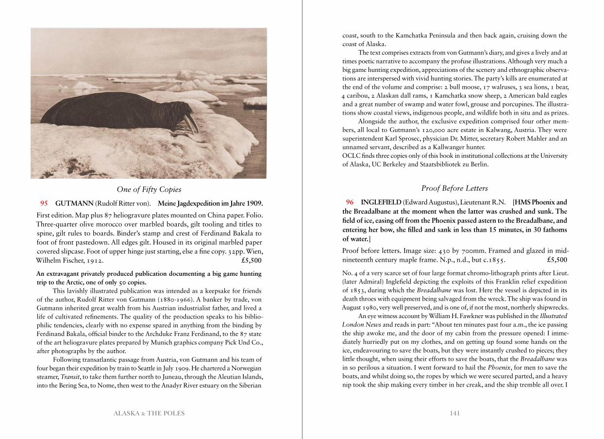
141ALASKA & THE POLES
One of Fifty Copies
95 GUTMANN (Rudolf Ritter von). Meine Jagdexpedition im Jahre 1909.
First edition. Map plus 87 heliogravure plates mounted on China paper. Folio. Three-quarter olive morocco over marbled boards, gilt tooling and titles to spine, gilt rules to boards. Binder’s stamp and crest of Ferdinand Bakala to foot of front pastedown. All edges gilt. Housed in its original marbled paper covered slipcase. Foot of upper hinge just starting, else a fine copy. 32pp. Wien, Wilhelm Fischer, 1912. £5,500
An extravagant privately produced publication documenting a big game hunting trip to the Arctic, one of only 50 copies.
This lavishly illustrated publication was intended as a keepsake for friends of the author, Rudolf Ritter von Gutmann (1880-1966). A banker by trade, von Gutmann inherited great wealth from his Austrian industrialist father, and lived a life of cultivated refinements. The quality of the production speaks to his biblio-philic tendencies, clearly with no expense spared in anything from the binding by Ferdinand Bakala, official binder to the Archduke Franz Ferdinand, to the 87 state of the art heliogravure plates prepared by Munich graphics company Pick Und Co., after photographs by the author.
Following transatlantic passage from Austria, von Gutmann and his team of four began their expedition by train to Seattle in July 1909. He chartered a Norwegian steamer, Transit, to take them further north to Juneau, through the Aleutian Islands, into the Bering Sea, to Nome, then west to the Anadyr River estuary on the Siberian
coast, south to the Kamchatka Peninsula and then back again, cruising down the coast of Alaska.
The text comprises extracts from von Gutmann’s diary, and gives a lively and at times poetic narrative to accompany the profuse illustrations. Although very much a big game hunting expedition, appreciations of the scenery and ethnographic observa-tions are interspersed with vivid hunting stories. The party’s kills are enumerated at the end of the volume and comprise: 2 bull moose, 17 walruses, 3 sea lions, 1 bear, 4 caribou, 2 Alaskan dall rams, 1 Kamchatka snow sheep, 2 American bald eagles and a great number of swamp and water fowl, grouse and porcupines. The illustra-tions show coastal views, indigenous people, and wildlife both in situ and as prizes.
Alongside the author, the exclusive expedition comprised four other mem-bers, all local to Gutmann’s 120,000 acre estate in Kalwang, Austria. They were superintendent Karl Sprosec, physician Dr. Mitter, secretary Robert Mahler and an unnamed servant, described as a Kallwanger hunter.OCLC finds three copies only of this book in institutional collections at the University of Alaska, UC Berkeley and Staatsbibliotek zu Berlin.
Proof Before Letters
96 INGLEFIELD (Edward Augustus), Lieutenant R.N. [HMS Phoenix and the Breadalbane at the moment when the latter was crushed and sunk. The field of ice, easing off from the Phoenix passed astern to the Breadalbane, and entering her bow, she filled and sank in less than 15 minutes, in 30 fathoms of water.]
Proof before letters. Image size: 430 by 700mm. Framed and glazed in mid-nineteenth century maple frame. N.p., n.d., but c.1855. £5,500
No. 4 of a very scarce set of four large format chromo-lithograph prints after Lieut. (later Admiral) Inglefield depicting the exploits of this Franklin relief expedition of 1853, during which the Breadalbane was lost. Here the vessel is depicted in its death throes with equipment being salvaged from the wreck. The ship was found in August 1980, very well preserved, and is one of, if not the most, northerly shipwrecks.
An eye witness account by William H. Fawkner was published in the Illustrated London News and reads in part: “About ten minutes past four a.m., the ice passing the ship awoke me, and the door of my cabin from the pressure opened: I imme-diately hurriedly put on my clothes, and on getting up found some hands on the ice, endeavouring to save the boats, but they were instantly crushed to pieces; they little thought, when using their efforts to save the boats, that the Breadalbane was in so perilous a situation. I went forward to hail the Phoenix, for men to save the boats, and whilst doing so, the ropes by which we were secured parted, and a heavy nip took the ship making every timber in her creak, and the ship tremble all over. I
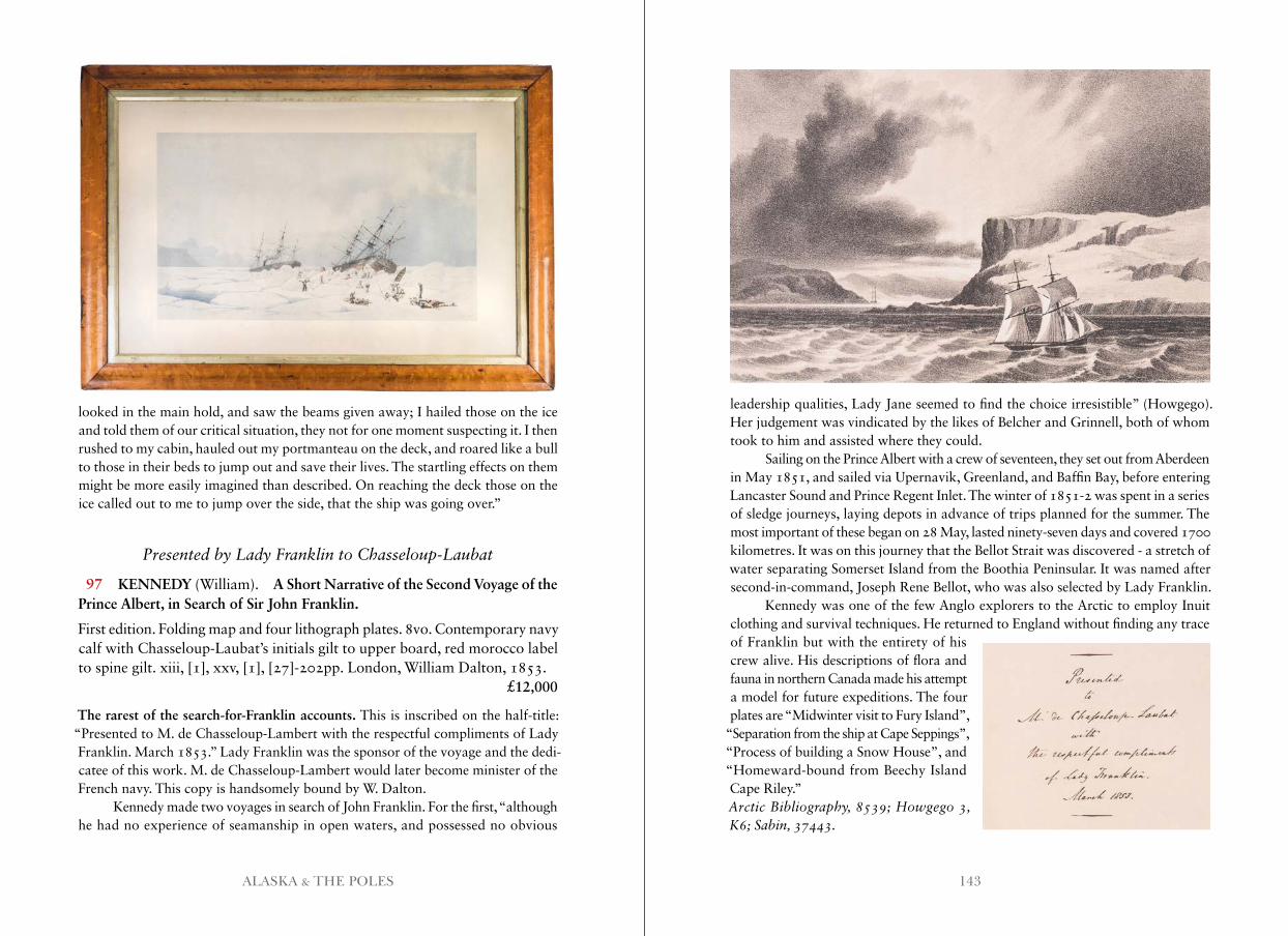
143ALASKA & THE POLES
looked in the main hold, and saw the beams given away; I hailed those on the ice and told them of our critical situation, they not for one moment suspecting it. I then rushed to my cabin, hauled out my portmanteau on the deck, and roared like a bull to those in their beds to jump out and save their lives. The startling effects on them might be more easily imagined than described. On reaching the deck those on the ice called out to me to jump over the side, that the ship was going over.”
Presented by Lady Franklin to Chasseloup-Laubat
97 KENNEDY (William). A Short Narrative of the Second Voyage of the Prince Albert, in Search of Sir John Franklin.
First edition. Folding map and four lithograph plates. 8vo. Contemporary navy calf with Chasseloup-Laubat’s initials gilt to upper board, red morocco label to spine gilt. xiii, [1], xxv, [1], [27]-202pp. London, William Dalton, 1853. £12,000
The rarest of the search-for-Franklin accounts. This is inscribed on the half-title: “Presented to M. de Chasseloup-Lambert with the respectful compliments of Lady Franklin. March 1853.” Lady Franklin was the sponsor of the voyage and the dedi-catee of this work. M. de Chasseloup-Lambert would later become minister of the French navy. This copy is handsomely bound by W. Dalton.
Kennedy made two voyages in search of John Franklin. For the first, “although he had no experience of seamanship in open waters, and possessed no obvious
leadership qualities, Lady Jane seemed to find the choice irresistible” (Howgego). Her judgement was vindicated by the likes of Belcher and Grinnell, both of whom took to him and assisted where they could.
Sailing on the Prince Albert with a crew of seventeen, they set out from Aberdeen in May 1851, and sailed via Upernavik, Greenland, and Baffin Bay, before entering Lancaster Sound and Prince Regent Inlet. The winter of 1851-2 was spent in a series of sledge journeys, laying depots in advance of trips planned for the summer. The most important of these began on 28 May, lasted ninety-seven days and covered 1700 kilometres. It was on this journey that the Bellot Strait was discovered - a stretch of water separating Somerset Island from the Boothia Peninsular. It was named after second-in-command, Joseph Rene Bellot, who was also selected by Lady Franklin.
Kennedy was one of the few Anglo explorers to the Arctic to employ Inuit clothing and survival techniques. He returned to England without finding any trace of Franklin but with the entirety of his crew alive. His descriptions of flora and fauna in northern Canada made his attempt a model for future expeditions. The four plates are “Midwinter visit to Fury Island”,
“Separation from the ship at Cape Seppings”, “Process of building a Snow House”, and “Homeward-bound from Beechy Island Cape Riley.”Arctic Bibliography, 8539; Howgego 3, K6; Sabin, 37443 .
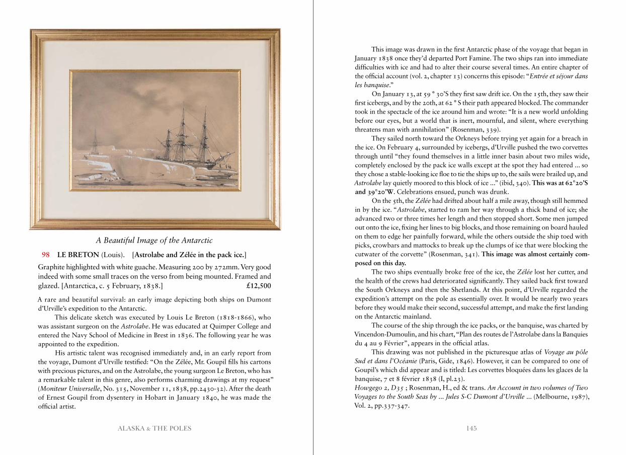
145ALASKA & THE POLES
A Beautiful Image of the Antarctic
98 LE BRETON (Louis). [Astrolabe and Zélée in the pack ice.]
Graphite highlighted with white guache. Measuring 200 by 272mm. Very good indeed with some small traces on the verso from being mounted. Framed and glazed. [Antarctica, c. 5 February, 1838.] £12,500
A rare and beautiful survival: an early image depicting both ships on Dumont d’Urville’s expedition to the Antarctic.
This delicate sketch was executed by Louis Le Breton (1818-1866), who was assistant surgeon on the Astrolabe. He was educated at Quimper College and entered the Navy School of Medicine in Brest in 1836. The following year he was appointed to the expedition.
His artistic talent was recognised immediately and, in an early report from the voyage, Dumont d’Urville testified: “On the Zélée, Mr. Goupil fills his cartons with precious pictures, and on the Astrolabe, the young surgeon Le Breton, who has a remarkable talent in this genre, also performs charming drawings at my request” (Moniteur Universelle, No. 315, November 11, 1838, pp.2430-32). After the death of Ernest Goupil from dysentery in Hobart in January 1840, he was made the official artist.
This image was drawn in the first Antarctic phase of the voyage that began in January 1838 once they’d departed Port Famine. The two ships ran into immediate difficulties with ice and had to alter their course several times. An entire chapter of the official account (vol. 2, chapter 13) concerns this episode: “Entrée et séjour dans les banquise.”
On January 13, at 59 ° 30’S they first saw drift ice. On the 15th, they saw their first icebergs, and by the 20th, at 62 ° S their path appeared blocked. The commander took in the spectacle of the ice around him and wrote: “It is a new world unfolding before our eyes, but a world that is inert, mournful, and silent, where everything threatens man with annihilation” (Rosenman, 339).
They sailed north toward the Orkneys before trying yet again for a breach in the ice. On February 4, surrounded by icebergs, d’Urville pushed the two corvettes through until “they found themselves in a little inner basin about two miles wide, completely enclosed by the pack ice walls except at the spot they had entered ... so they chose a stable-looking ice floe to tie the ships up to, the sails were brailed up, and Astrolabe lay quietly moored to this block of ice ...” (ibid, 340). This was at 62°20’S and 39°20’W. Celebrations ensued, punch was drunk.
On the 5th, the Zélée had drifted about half a mile away, though still hemmed in by the ice. “Astrolabe, started to ram her way through a thick band of ice; she advanced two or three times her length and then stopped short. Some men jumped out onto the ice, fixing her lines to big blocks, and those remaining on board hauled on them to edge her painfully forward, while the others outside the ship toed with picks, crowbars and mattocks to break up the clumps of ice that were blocking the cutwater of the corvette” (Rosenman, 341). This image was almost certainly com-posed on this day.
The two ships eventually broke free of the ice, the Zélée lost her cutter, and the health of the crews had deteriorated significantly. They sailed back first toward the South Orkneys and then the Shetlands. At this point, d’Urville regarded the expedition’s attempt on the pole as essentially over. It would be nearly two years before they would make their second, successful attempt, and make the first landing on the Antarctic mainland.
The course of the ship through the ice packs, or the banquise, was charted by Vincendon-Dumoulin, and his chart, “Plan des routes de l’Astrolabe dans la Banquies du 4 au 9 Février”, appears in the official atlas.
This drawing was not published in the picturesque atlas of Voyage au pôle Sud et dans l’Océanie (Paris, Gide, 1846). However, it can be compared to one of Goupil’s which did appear and is titled: Les corvettes bloquées dans les glaces de la banquise, 7 et 8 février 1838 (I, pl.23).Howgego 2, D35 ; Rosenman, H., ed & trans. An Account in two volumes of Two Voyages to the South Seas by . . . Jules S-C Dumont d’Urville ... (Melbourne, 1987), Vol. 2, pp.337-347.
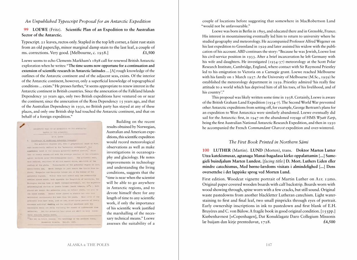
147ALASKA & THE POLES
An Unpublished Typescript Proposal for an Antarctic Expedition
99 LOEWE (Fritz). Scientific Plan of an Expedition to the Australian Sector of the Antarctic.
Typescript. 21 leaves, rectos only. Stapled in the top left corner, a faint rust stain from an old paperclip, minor marginal damp stain to the last leaf, a couple of ms. corrections. Very good. [Melbourne, c. 1938.] £1,500
Loewe seems to echo Clements Markham’s 1898 call for renewed British Antarctic exploration when he writes: “The time seems now opportune for a continuation and extension of scientific research in Antarctic latitudes ... [A] rough knowledge of the outlines of the Antarctic continent and of the adjacent seas, exists. Of the interior of the Antarctic continent, however, only a superficial knowledge of topographical conditions ... exists.” He presses further, “it seems appropriate to renew interest in the Antarctic continent in British countries. Since the annexation of the Falkland Islands Dependency 30 years ago, only two British expeditions have ventured on or near the continent; since the annexation of the Ross Dependency 15 years ago, and that of the Australian Dependency in 1930, no British party has stayed at any of these places, and only one British ship had touched the Antarctic continent, and that on behalf of a foreign expedition.”
Building on the recent results obtained by Norwegian, Australian and American expe-ditions, this scientific expedition would record meteorological observations as well as make investigations in oceanogra-phy and glaciology. He notes improvements in technology and understanding the living conditions, suggests that the
“time is near when the scientist will be able to go anywhere in Antarctic regions, and to devote himself there for any length of time to any scientific work, if only the importance of his scientific work justified the marshalling of the neces-sary technical means.” Loewe assesses the suitability of a
couple of locations before suggesting that somewhere in MacRobertson Land “would not be unfavourable.”
Loewe was born in Berlin in 1895, and educated there and in Grenoble, France. His interest in mountaineering eventually led him to return to university where he studied geography and meteorology. He accompanied Professor Alfred Wegener on his last expedition to Greenland in 1929 and later assisted his widow with the publi-cation of his account. ABD continues the story: “Because he was Jewish, Loewe lost his civil-service position in 1933. After a brief incarceration he left Germany with his wife and daughters. He investigated (1934-37) meteorology at the Scott Polar Research Institute, Cambridge, England, where contact with Sir Raymond Priestley led to his emigration to Victoria on a Carnegie grant. Loewe reached Melbourne with his family on 1 March 1937. At the University of Melbourne (M.Sc., 1959) he established the meteorology department in 1939. Priestley admired ‘his really fine attitude to a world which has deprived him of all his toes, of his livelihood, and of his country’.”
This proposal was likely written some time in 1938. Certainly, Loewe is aware of the British Graham Land Expedition (1934-7). The Second World War prevented other Antarctic expeditions from setting off, for example, George Bertram’s plans for an expedition to West Antarctica were similarly abandoned. Loewe eventually did sail for the Antarctic: first, in 1947 on the abandoned voyage of HMS Wyatt Earp, being the first Australian National Antarctic Research Expedition, and then in 1950 he accompanied the French Commandant Charcot expedition and over-wintered.
The First Book Printed in Northern Sámi
100 LUTHER (Martin). LUND (Morten), trans. Doktor Marten Lutter Utza katekismusaz, agtanaga Manai-bagadasa kirko oppalattamin [...] Same-gieli buindjalum Marten Lundest. [facing title:] D. Mort. Luthers Liden eller mindre catechismus, Med børne-lærdoms visitats i almindelighed [...] Dens oversettelse i det lappiske sprog ved Morten Lund.
First edition. Woodcut vignette portrait of Martin Luther on A1r. 12mo. Original paper covered wooden boards with calf backstrip. Boards worn with wood showing through, spine worn with a few cracks, but still sound. Original waste pastedowns from another blackletter Lutheran catechism. Light water-staining to first and final leaf, two small pinpricks through eyes of portrait. Early ownership inscriptions in ink to pastedown and first blank of E.H. Bruyéres and C. von Bülow. A fragile book in good original condition. [155pp.] Kiøbenhavnest [=Copenhagen], Dat Konuklagatz Daro Collegium Missonis læ baijam dan kirje prenteduvut, 1728. £4,500
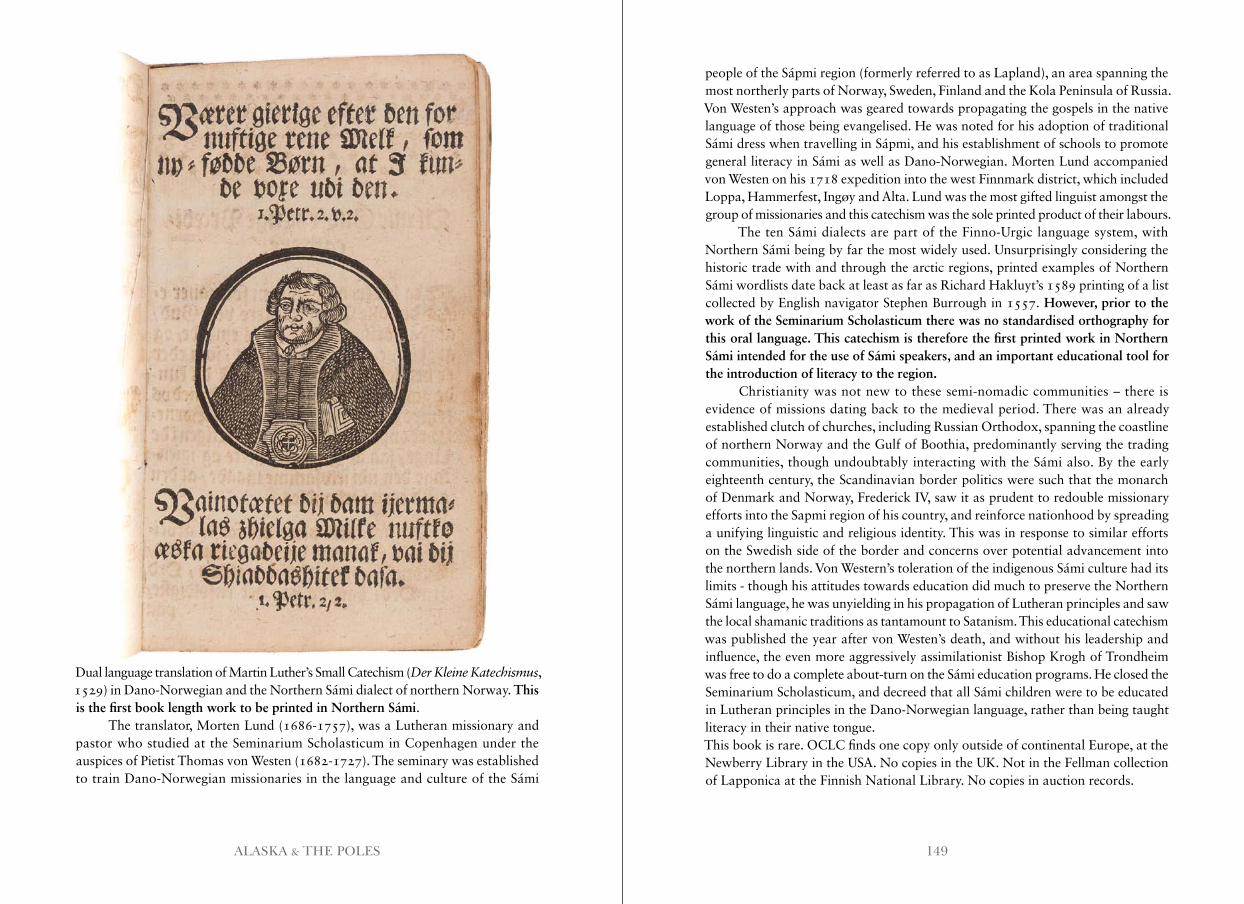
149ALASKA & THE POLES
Dual language translation of Martin Luther’s Small Catechism (Der Kleine Katechismus, 1529) in Dano-Norwegian and the Northern Sámi dialect of northern Norway. This is the first book length work to be printed in Northern Sámi.
The translator, Morten Lund (1686-1757), was a Lutheran missionary and pastor who studied at the Seminarium Scholasticum in Copenhagen under the auspices of Pietist Thomas von Westen (1682-1727). The seminary was established to train Dano-Norwegian missionaries in the language and culture of the Sámi
people of the Sápmi region (formerly referred to as Lapland), an area spanning the most northerly parts of Norway, Sweden, Finland and the Kola Peninsula of Russia. Von Westen’s approach was geared towards propagating the gospels in the native language of those being evangelised. He was noted for his adoption of traditional Sámi dress when travelling in Sápmi, and his establishment of schools to promote general literacy in Sámi as well as Dano-Norwegian. Morten Lund accompanied von Westen on his 1718 expedition into the west Finnmark district, which included Loppa, Hammerfest, Ingøy and Alta. Lund was the most gifted linguist amongst the group of missionaries and this catechism was the sole printed product of their labours.
The ten Sámi dialects are part of the Finno-Urgic language system, with Northern Sámi being by far the most widely used. Unsurprisingly considering the historic trade with and through the arctic regions, printed examples of Northern Sámi wordlists date back at least as far as Richard Hakluyt’s 1589 printing of a list collected by English navigator Stephen Burrough in 1557. However, prior to the work of the Seminarium Scholasticum there was no standardised orthography for this oral language. This catechism is therefore the first printed work in Northern Sámi intended for the use of Sámi speakers, and an important educational tool for the introduction of literacy to the region.
Christianity was not new to these semi-nomadic communities – there is evidence of missions dating back to the medieval period. There was an already established clutch of churches, including Russian Orthodox, spanning the coastline of northern Norway and the Gulf of Boothia, predominantly serving the trading communities, though undoubtably interacting with the Sámi also. By the early eighteenth century, the Scandinavian border politics were such that the monarch of Denmark and Norway, Frederick IV, saw it as prudent to redouble missionary efforts into the Sapmi region of his country, and reinforce nationhood by spreading a unifying linguistic and religious identity. This was in response to similar efforts on the Swedish side of the border and concerns over potential advancement into the northern lands. Von Western’s toleration of the indigenous Sámi culture had its limits - though his attitudes towards education did much to preserve the Northern Sámi language, he was unyielding in his propagation of Lutheran principles and saw the local shamanic traditions as tantamount to Satanism. This educational catechism was published the year after von Westen’s death, and without his leadership and influence, the even more aggressively assimilationist Bishop Krogh of Trondheim was free to do a complete about-turn on the Sámi education programs. He closed the Seminarium Scholasticum, and decreed that all Sámi children were to be educated in Lutheran principles in the Dano-Norwegian language, rather than being taught literacy in their native tongue.This book is rare. OCLC finds one copy only outside of continental Europe, at the Newberry Library in the USA. No copies in the UK. Not in the Fellman collection of Lapponica at the Finnish National Library. No copies in auction records.
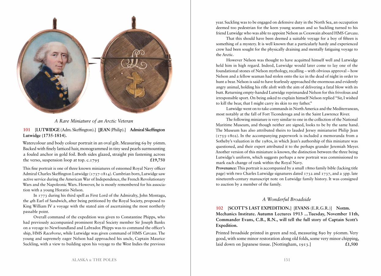
151ALASKA & THE POLES
A Rare Miniature of an Arctic Veteran
101 [LUTWIDGE (Adm. Skeffington).] [JEAN (Philip).] Admiral Skeffington Lutwidge (1735-1814).
Watercolour and body colour portrait in an oval gilt. Measuring 69 by 56mm. Backed with finely latticed hair, monogrammed in tiny seed pearls surmounting a fouled anchor in gold foil. Both sides glazed, straight pin fastening across the verso, suspension loop at top. c.1795 £19,750
This fine portrait is one of three known miniatures of esteemed Royal Navy officer Admiral Charles Skeffington Lutwidge (1737-1814). Cumbrian born, Lutwidge saw active service during the American War of Independence, the French Revolutionary Wars and the Napoleonic Wars. However, he is mostly remembered for his associa-tion with a young Horatio Nelson.
In 1773 during his third spell as First Lord of the Admiralty, John Montagu, the 4th Earl of Sandwich, after being petitioned by the Royal Society, proposed to King William IV a voyage with the stated aim of ascertaining the most northerly passable point.
Overall command of the expedition was given to Constantine Phipps, who had previously accompanied prominent Royal Society member Sir Joseph Banks on a voyage to Newfoundland and Labrador. Phipps was to command the officer’s ship, HMS Racehorse, while Lutwidge was given command of HMS Carcass. The young and supremely eager Nelson had approached his uncle, Captain Maurice Suckling, with a view to building upon his voyage to the West Indies the previous
year. Suckling was to be engaged on defensive duty in the North Sea, an occupation deemed too pedestrian for the keen young seaman and so Suckling turned to his friend Lutwidge who was able to appoint Nelson as Coxswain aboard HMS Carcass.
That this should have been deemed a suitable voyage for a boy of fifteen is something of a mystery. It is well known that a particularly hardy and experienced crew had been sought for the physically draining and mentally fatiguing voyage to the Arctic.
However Nelson was thought to have acquitted himself well and Lutwidge held him in high regard. Indeed, Lutwidge would later come to lay one of the foundational stones of Nelson mythology, recalling – with obvious approval – how Nelson and a fellow seaman had stolen onto the ice in the dead of night in order to hunt a bear. Nelson is said to have fearlessly approached the enormous and evidently angry animal, holding his rifle aloft with the aim of delivering a fatal blow with its butt. Returning empty-handed Lutwidge reprimanded Nelson for this frivolous and irresponsible sport. On being asked to explain himself Nelson replied “Sir, I wished to kill the bear, that I might carry its skin to my father.”
Lutwidge went on to take commands in North America and the Mediterranean, most notably at the fall of Fort Ticonderoga and in the Saint Lawrence River.
The following miniature is very similar to one in the collection of the National Maritime Museum, and though neither are signed, looks to be by the same hand. The Museum has also attributed theirs to lauded Jersey miniaturist Philip Jean (1755-1802). In the accompanying paperwork is included a memoranda from a Sotheby’s valuation in the 1980s, in which Jean’s authorship of this miniature was questioned, and their expert attributed it to the perhaps grander Jeremiah Meyer. Another version of this miniature is known, the distinction between the three being Lutwidge’s uniform, which suggests perhaps a new portrait was commissioned to mark each change of rank within the Royal Navy.Provenance: This portrait is accompanied by a small 18mo family bible (lacking title page) with two Charles Lutwidge signatures dated 1732 and 1737, and a 3pp. late nineteenth-century manuscript note on Lutwidge family history. It was consigned to auction by a member of the family.
A Wonderful Broadside
102 [SCOTT’S LAST EXPEDITION.] [EVANS (E.R.G.R.)] Nottm.Mechanics Institute. Autumn Lectures 1913 ...Tuesday, November 11th, Commander Evans, C.B., R.N., will tell the full story of Captain Scott’s Expedition.
Printed broadside printed in green and red, measuring 890 by 560mm. Very good, with some minor restoration along old folds, some very minor chipping, laid down on Japanese tissue. [Nottingham, 1913.] £1,500
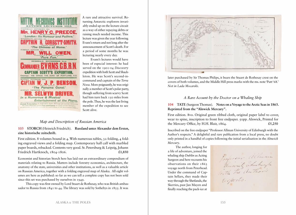
153ALASKA & THE POLES
A rare and attractive survival. Re- turning Antarctic explorers invari-ably ended up on the lecture circuit as a way of either repaying debts or raising much needed income. This lecture was given the year following Evans’s return and not long after the announcement of Scott’s death. For a period of some months he was lecturing nearly every day.
Evans’s lectures would have been of especial interest: he had served on the 1901-04 Discovery expedition with both Scott and Shack- leton. He was Scott’s second-in-command and captain of the Terra Nova . More poignantly, he was origi- nally a member of Scott’s polar party, though suffering from scurvy Scott had him turn back 150 miles from the pole. Thus, he was the last living member of the expedition to see Scott alive.
Map and Description of Russian America
103 STORCH (Heinrich Friedrich). Russland unter Alexander dem Ersten, eine historische zeitschrift.
First edition. 8 volumes bound in 4. With numerous tables, 32 folding, 4 fold-ing engraved views and a folding map. Contemporary half calf with marbled paper boards, rebacked. Contents very good. St. Petersburg & Leipzig, Johann Friedrich Hartknoch, 1804-1806. £1,850
Economist and historian Storch here has laid out an extraordinary compendium of materials relating to Russia. Matters include forestry economics, architecture, the anatomy of the state, universities and other institutions, as well as a valuable article on Russian America, together with a folding engraved map of Alaska. All eight vol-umes are here as published: so far as we can tell a complete copy has not been sold since this set was purchased by ourselves in 1949.
This copy was first owned by Lord Stuart de Rothesay, who was British ambas-sador to Russia from 1841 to 44. The library was sold by Sothebys in 1855. It was
later purchased by Sir Thomas Philips, it bears the Stuart de Rothesay crest on the covers of both volumes, and the Middle Hill press marks with the ms. note ‘Putt ‘68.’Not in Lada Mocarski .
A Rare Acount by the Doctor on a Whaling Ship
104 TATE (Surgeon Thomas). Notes on a Voyage to the Arctic Seas in 1863. Reprinted from the “Alnwick Mercury”.
First edition. 8vo. Original green ribbed cloth, original paper label to cover, wear to spine, inscription to front free endpaper. 50pp. Alnwick, Printed for the Mercury Office, by H.H. Blair, 1864. £5,250
Inscribed on the free endpaper “Professor Allman University of Edinburgh with the Author’s respects.” A delightful and rare publication from a local press, no doubt only printed in a handful of copies following the initial serialisation in the Alnwick Mercury.
The author, longing for a life of adventure, joined the whaling ship Dublin as Acting Surgeon and here recounts his observations on their 1863 voyage north from Peterhead. Under the command of Cap-tain Sellars, they made their way through the Shetlands, the Skerries, past Jan Mayen and finally reaching the pack-ice at
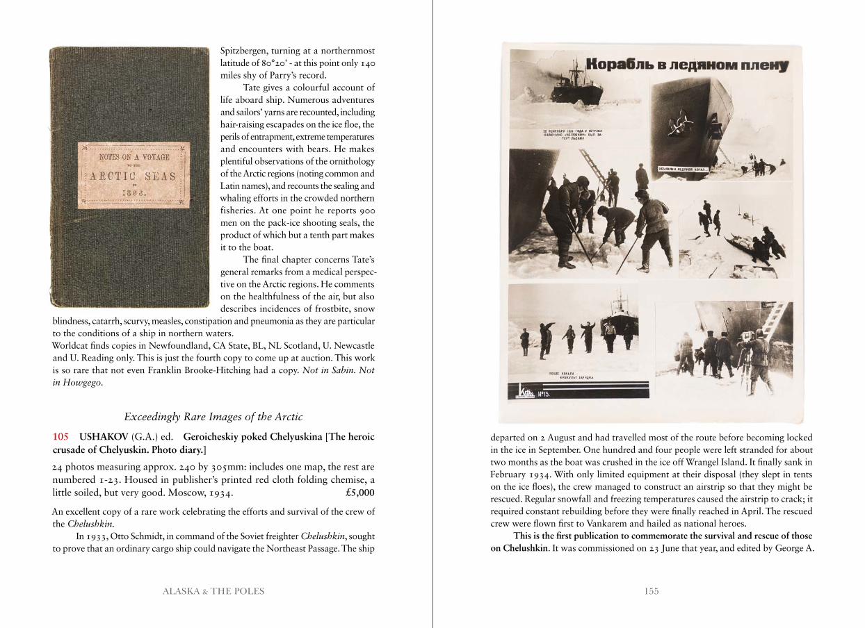
155ALASKA & THE POLES
Spitzbergen, turning at a northernmost latitude of 80°20’ - at this point only 140 miles shy of Parry’s record.
Tate gives a colourful account of life aboard ship. Numerous adventures and sailors’ yarns are recounted, including hair-raising escapades on the ice floe, the perils of entrapment, extreme temperatures and encounters with bears. He makes plentiful observations of the ornithology of the Arctic regions (noting common and Latin names), and recounts the sealing and whaling efforts in the crowded northern fisheries. At one point he reports 900 men on the pack-ice shooting seals, the product of which but a tenth part makes it to the boat.
The final chapter concerns Tate’s general remarks from a medical perspec-tive on the Arctic regions. He comments on the healthfulness of the air, but also describes incidences of frostbite, snow
blindness, catarrh, scurvy, measles, constipation and pneumonia as they are particular to the conditions of a ship in northern waters.Worldcat finds copies in Newfoundland, CA State, BL, NL Scotland, U. Newcastle and U. Reading only. This is just the fourth copy to come up at auction. This work is so rare that not even Franklin Brooke-Hitching had a copy. Not in Sabin . Not in Howgego .
Exceedingly Rare Images of the Arctic
105 USHAKOV (G.A.) ed. Geroicheskiy poked Chelyuskina [The heroic crusade of Chelyuskin. Photo diary.]
24 photos measuring approx. 240 by 305mm: includes one map, the rest are numbered 1-23. Housed in publisher’s printed red cloth folding chemise, a little soiled, but very good. Moscow, 1934. £5,000
An excellent copy of a rare work celebrating the efforts and survival of the crew of the Chelushkin .
In 1933, Otto Schmidt, in command of the Soviet freighter Chelushkin, sought to prove that an ordinary cargo ship could navigate the Northeast Passage. The ship
departed on 2 August and had travelled most of the route before becoming locked in the ice in September. One hundred and four people were left stranded for about two months as the boat was crushed in the ice off Wrangel Island. It finally sank in February 1934. With only limited equipment at their disposal (they slept in tents on the ice floes), the crew managed to construct an airstrip so that they might be rescued. Regular snowfall and freezing temperatures caused the airstrip to crack; it required constant rebuilding before they were finally reached in April. The rescued crew were flown first to Vankarem and hailed as national heroes.
This is the first publication to commemorate the survival and rescue of those on Chelushkin. It was commissioned on 23 June that year, and edited by George A.
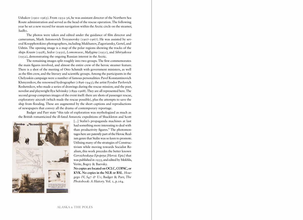
ALASKA & THE POLES
Ushakov (1901-1963). From 1932-36, he was assistant director of the Northern Sea Route administration and served as the head of the rescue operation. The following year he set a new record for steam navigation within the Arctic circle on the steamer, Sadko.
The photos were taken and edited under the guidance of film director and cameraman, Mark Antonovich Troyanovsky (1907-1967). He was assisted by sev-eral Koopphotokino photographers, including Mukhanov, Zagoriansky, Gertel, and Ushtin. The opening image is a map of the polar regions showing the tracks of the ships Krasin (1928), Sedov (1930), Lomonosov, Malygina (1931), and Sibiryakova (1932), demonstrating the ongoing Russian interest in the Arctic.
The remaining images split roughly into two groups. The first commemorates the main figures involved, and almost the entire crew of the heroic steamer feature. There is a shot of the meeting of Otto Schmidt with government ministers, as well as the film crew, and the literary and scientific groups. Among the participants in the Chelyuskin campaign were a number of famous personalities: Pavel Konstantinovich Khmyznikov, the renowned hydrographer (1896-1943); the artist Fyodor Pavlovich Reshetnikov, who made a series of drawings during the rescue mission; and the poet, novelist and playwright Ilya Selvinsky (1899-1968). They are all represented here. The second group comprises images of the event itself: there are shots of passenger rescue, exploratory aircraft (which made the rescue possible), plus the attempts to save the ship from flooding. These are augmented by the short captions and reproductions of newspapers that convey all the drama of contemporary reportage.
Badger and Parr state “this tale of exploration was mythologized as much as the British romanticized the ill-fated Antarctic expeditions of Shackleton and Scott
[...] Stalin’s propaganda machines at last had something more interesting to deal with than productivity figures.” The photomon-tages here are patently part of the Heroic Real- ism genre that Stalin was so keen to promote. Utilising many of the strategies of Construc-tivism while moving towards Socialist Re-alism, this work precedes the better known Geroicheskaya Epopeya [Heroic Epic] that was published in 1935, and edited by Mekhlis, Verite, Bogvy & Baevsky.No copies are located on OCLC, COPAC, or KVK. No copies in the NLR or RSL. How- gego IV, S47 & U1; Badger & Parr, The Photobook: A History. Vol. 1, p.164.

48 BEDFORD SQUARE LONDON WC1B 3DR48 BEDFORD SQUARE LONDON WC1B 3DR