sailing illicit voyages: colonial smuggling operations
TRANSCRIPT
University of Massachusetts Amherst University of Massachusetts Amherst
ScholarWorks@UMass Amherst ScholarWorks@UMass Amherst
Doctoral Dissertations Dissertations and Theses
December 2020
Sailing Illicit Voyages: Colonial Smuggling Operations between Sailing Illicit Voyages: Colonial Smuggling Operations between
North America and the West Indies, 1714-1776 North America and the West Indies, 1714-1776
Carl A. Herzog University of Massachusetts Amherst
Follow this and additional works at: https://scholarworks.umass.edu/dissertations_2
Part of the Other History Commons, and the United States History Commons
Recommended Citation Recommended Citation Herzog, Carl A., "Sailing Illicit Voyages: Colonial Smuggling Operations between North America and the West Indies, 1714-1776" (2020). Doctoral Dissertations. 2026. https://doi.org/10.7275/18003509 https://scholarworks.umass.edu/dissertations_2/2026
This Open Access Dissertation is brought to you for free and open access by the Dissertations and Theses at ScholarWorks@UMass Amherst. It has been accepted for inclusion in Doctoral Dissertations by an authorized administrator of ScholarWorks@UMass Amherst. For more information, please contact [email protected].
SAILING ILLICIT VOYAGES: COLONIAL SMUGGLING OPERATIONS
BETWEEN NORTH AMERICA AND THE WEST INDIES, 1714-1776
A Dissertation Presented
by
CARL A. HERZOG
Submitted to the Graduate School of the
University of Massachusetts Amherst in partial fulfillment
of the requirements for the degree of
DOCTOR OF PHILOSOPHY
September 2020
History

© Copyright by Carl A. Herzog 2020
All Rights Reserved
SAILING ILLICIT VOYAGES: COLONIAL SMUGGLING OPERATIONS
BETWEEN NORTH AMERICA AND THE WEST INDIES, 1714-1776
A Dissertation Presented
by
CARL A. HERZOG
Approved as to style and content by:
____________________________________
Barry J. Levy, Chair
____________________________________
Marla R. Miller, Member
____________________________________
Daniel Gordon, Member
____________________________________
Dane Morrison, Member
____________________________________
Audrey L. Altstadt, Chair
Department of History

DEDICATION
To Laurie, whose love, support, and perpetual encouragement made this possible.
v
ACKNOWLEDGMENTS
This project would not have been completed without the support and influence of a broad
community of resources.
I could not have asked for a better committee for this project. Each of the members
contributed in ways I could not have foreseen at the outset, and I am grateful for their
patience, insight, and guidance. My advisor, Barry Levy pointed me in the initial
direction of this topic and encouraged my contribution to this historiography. Throughout
the process he continued to provide much needed direction and nuance. Marla Miller’s
detailed editing and organizational guidance were particularly invaluable at a pivotal
moment.
I am grateful to the many ships and crews I have sailed with who gave me the firsthand
knowledge and the underway experience that deeply informs this work. I am also deeply
honored by the long friendship, encouragement and keen analysis of Professors Matthew
MacKenzie and Timothy Walker. Their insights over long discussions of this and
associated topics as well as shared experiences at sea gave me new ways of assessing this
story and my contribution to it. My parents, Phil and Marge Herzog, both passed away
during this degree process, but their enthusiasm and pride that I was pursuing this was all
a son could ask for.
Lastly, but most importantly, this project and its associated mid-life career shift would
not have started, nor ever finished, without the love, support, and long sacrifice of my
wife, Laurie Weitzen.
vi
ABSTRACT
SAILING ILLICIT VOYAGES: COLONIAL SMUGGLING OPERATIONS
BETWEEN NORTH AMERICA AND THE WEST INDIES, 1714-1776
SEPTEMBER 2020
CARL A. HERZOG, B.A., UNIVERSITY OF FLORIDA
M.A., UNIVERSITY OF RHODE ISLAND
Ph.D., UNIVERSITY OF MASSACHUSETTS AMHERST
Directed by: Professor Barry Levy
This dissertation examines colonial smuggling in the mid-eighteenth century between
British North America and the Caribbean from the operational perspective of the captains
and crews of the coastwise merchant vessels engaged in that trade. In doing so, this work
seeks to recast these particular smuggling mariners as agents of a unique professional
maritime skillset, whose expertise created paths for upward mobility in their communities
and careers. Returning the mariners’ skills and core occupation to their historical identity
refines and corrects arguments about mariners’ perceived attitudes toward the Navigation
Acts, smuggling, and the American Revolution. Focusing on operational skills
differentiates the coastwise mariners engaged in the trade between British North America
and the West Indies trade from trans-oceanic mariners, navy crews and other shoreside
maritime professions during this period. The success of the coastwise smuggling trade
further situates these smuggling mariners in the eighteenth-century historiography of
advances in navigation, ship construction, and rigging design.
vii
TABLE OF CONTENTS
Page
ACKNOWLEDGEMENTS .................................................................................................v
ABSTRACT ....................................................................................................................... vi
LIST OF FIGURES ......................................................................................................... viii
INTRODUCTION: THE SMUGGLERS’ PURSUIT .........................................................1
CHAPTER
1: WHY SMUGGLING? ...................................................................................................32
Economy of North America ...................................................................................32
The Volatile Caribbean ..........................................................................................37
Who Were the Smugglers? ....................................................................................43
Mariners’ Accounts ....................................................................................45
Coastwise Characteristics ..........................................................................49
Merchant, Mariner Relationships...............................................................59
Perceptions of Criminality .....................................................................................62
2: SKILLS AND TOOLS OF THE SMUGGLING MARINER .......................................69
Navigational Methods: Coastal Piloting and Ocean Navigation ...........................73
The Chart and Pilot Book ..........................................................................83
The Smugglers’ Use of the Combined Approach ......................................87
Shipbuilding and Rigging Design ..........................................................................93
Vessel Supply.............................................................................................95
Vessel Improvements .................................................................................96
Outfitting and Economy .............................................................................99
Ships as Trade Items ................................................................................100
3: CONDUCT OF SMUGGLING ...................................................................................103
Routing and Deception .......................................................................................108
Neutral Stops ......................................................................................................118
Flags of Truce .....................................................................................................121
Arrivals and the Complicit Actors Ashore .........................................................127
4: CAREER TRAJECTORIES ........................................................................................135
CONCLUSION ................................................................................................................148
BIBLIOGRAPHY ............................................................................................................152
viii
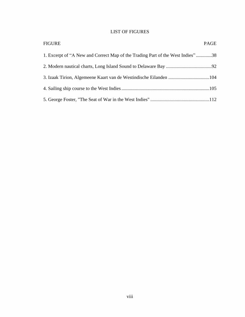
LIST OF FIGURES
FIGURE PAGE
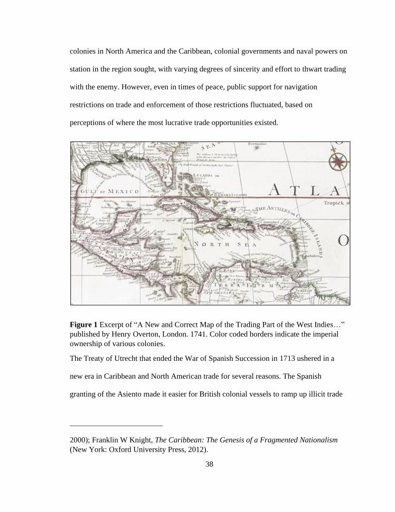
1. Excerpt of “A New and Correct Map of the Trading Part of the West Indies” .............38
2. Modern nautical charts, Long Island Sound to Delaware Bay ......................................92
3. Izaak Tirion, Algemeene Kaart van de Westindische Eilanden ..................................104
4. Sailing ship course to the West Indies .........................................................................105
5. George Foster, "The Seat of War in the West Indies" .................................................112
1
INTRODUCTION
THE SMUGGLERS’ PURSUIT
On January 21, 1764, Capt. George Hopkins received a package of papers from the
Providence merchant Nicholas Brown. Hopkins was a long-time crew aboard Brown's
trading vessels, and earlier in the month had officially signed on as captain of Brown's
sloop, Nancy -- then sitting in Providence harbor and preparing to depart for the West
Indies. Among the papers were two nearly identical bills of lading, listing the cargo to be
carried on the voyage, and two different sets of orders.1 The only difference between the
two bills of lading was the destination. One indicated that the Nancy was bound for the
British island of Barbados, and the other said the ship was going to the Dutch colony of
Surinam in South America.
Although Hopkins would not have been at all confused by this, any question he may have
had was clearly spelled out in the two sets of orders. One set directed Hopkins to sail to
Barbados, sell the goods on board, buy molasses and return. The other set of orders,
however, countermanded that and laid out another plan: "Our orders to you are to proceed
immediately to Surinam Taking particular care to get well to windward while you are
Northward,” the orders read. In the copy of these orders that Brown kept in his own file,
he had then written “So as to Past Barbados by your reckoning at least.” That phrase is
crossed out, and instead Brown specified, “At least 1000 miles more thn Dif L (than
1Nicholas Brown, “Orders to George Hopkins on Sloop ‘Nancy’,” January 21, 1764, Box
469 Folder 6, Nicholas and John Brown Co. Archive, John Carter Brown Library.
2
difference in longitude)."2 This specific phrasing was a nautical order to Hopkins to set
an initial course from New England to the southeastern Caribbean that would give all
appearances that he was bound for Barbados, but one that would put him much further
east of the islands once he was at that latitude.3
In this season—winter 1764—British naval ships were patrolling the waters on the
eastern approaches to the islands, looking to block illicit trade. Brown’s bogus bill of
lading for Barbados would ensure that the Nancy would look legitimate if stopped, but
Brown’s deceptive routing orders to Hopkins were designed to ensure that the Nancy
would avoid interdiction in the first place.
Once in Surinam, Hopkins was to meet up with Abraham Whipple, then the captain of
another of Brown's ships, the brig George. After leveraging Whipple's greater experience
in disposing of the cargo, Hopkins was to load the Nancy with Dutch molasses and sail to
Dominica, an island that had formally transferred from French to British control just a
few months earlier as a result of the treaty ending the Seven Years War. There, Hopkins
was “to Indeavor in as best and safe a manner you can to get a complete set of English
papers for your Molasses cargo Specifying Molasses to be of English produce or duties
paid." In the event Hopkins could not acquire the falsified papers in Dominica, he was
2Ibid.
3 Longitude was not measured from a universally accepted prime meridian, but frequently
as a difference from the longitude of the starting point of the vessel. Ordering Hopkins to
proceed 1,000 miles more than the difference in longitude was to indicate that he was
pass Barbados that far to the east of the island. He may have meant 100 miles, which still
would have had the effect putting Hopkins out of range of the patrolling British ships.
3
instructed to continue working his way up the chain of Caribbean islands until he had
acquired such paperwork, before returning to Providence. A small amount of additional
high-end merchandise had been loaded aboard, along with an additional cash allowance,
to help Hopkins buy the papers as needed.4
Eight months later, after a successful voyage and a summer visit to Surinam, Hopkins set
off to sail back, and on September 7, wrote to Brown that the Nancy had arrived in the
Dutch island of St. Eustatia. From there, Hopkins planned to send a small boat over to
Anguilla where, he assured Brown, he would be able to purchase the falsified papers for a
nominal fee.5
The success of complex smuggling operations like Hopkins’ depended on a variety of
factors, including the sailing skills of the captain and crew and their ability to tap into
networks of support on shore. Hopkins had to be familiar with the coastal environments
of South America, the West Indies and his New England destination, as well as be able to
navigate long distances offshore. Small vessels with a single mast, sloops like the Nancy
were common in the coastal and West Indian trade and could sail with as few as five
crew: the captain, a mate, and three sailors. With so few crew, a captain like Hopkins
relied on his mate to share the ability to navigate both offshore and along the coast. He
4Nicholas Brown, “Orders to George Hopkins on Sloop ‘Nancy’,” January 21, 1764, Box
469 Folder 6, Nicholas and John Brown Co. Archive, John Carter Brown Library.
5George Hopkins, “From Sloop ‘Nancy’ in St. Eustatia,” September 7, 1764, Box 674
Folder 3, Nicholas and John Brown Co. Archive, John Carter Brown Library.
4
relied on each of his crew to have solid seamanship and small boat skills, as well as the
ability to make repairs as necessary during the voyage.
But demonstrating these skills was only one step in a long voyage that included getting
outbound cargo out of the colonies en route to a destination it was not supposed to legally
go to and return with contraband that had to find a way past customs authorities on shore.
For most of the eighteenth century leading up to the American Revolution, British North
American colonial captains like Hopkins honed these skills smuggling British resources
to the West Indian colonies of other European nations, and bringing back French, Spanish
and Dutch cargoes in violation of the British Navigation Acts.
Approach and Goal of this Dissertation
This dissertation seeks to examine colonial smuggling from the perspective of those who
were conducting the voyages that carried contraband cargo – the captains and crews of
the merchant trading ships. Though their role was critical to the very existence of the
trade, their actual work has remained in the background of colonial historiography while
they themselves have become caricatures of an outsized reputation based on their time
ashore.
But these were not the hedonistic drunken sailors of popular imagination, nor unskilled
labor merely pulling on ropes.6 Operating relatively small vessels as part of a minimal
6 For a survey of popular depictions of the hedonistic sailor, see Juliann Reineke, “Three
Sheets to the Wind: The Jolly Jack Tar and Eighteenth-Century British Masculinity”
(Dissertation, Carnegie Mellon University, 2018). For sailors as a homogeneous labor
force, see Marcus Rediker, Between the Devil and the Deep Blue Sea: Merchant Seamen,

5
crew through hazardous waters while evading legal authorities, the coastwise merchant
mariner harnessed a diverse knowledge of coastal piloting, offshore navigation, vessel
maneuvering and shoreside networking in order to succeed. Those who demonstrated
competence found vertical mobility on the ship’s crew, creating careers that led to
positions of command, and often translated their seagoing skills to positions ashore.
To recast these regional mariners as the agents of a unique skillset and an extra-colonial
business model, I focus on the operational details of smuggling voyages and the broader
coastwise trade between the North American colonies and the colonies of the greater
Caribbean basin. Understanding the practice of seamanship, its demands on coastwise
mariners, and the complications that smuggling added to that pursuit provides a context
for explaining how and why mariners were able and willing to continue trading
throughout the tumultuous decades leading up to the American Revolution. Returning the
mariners’ skills and core occupation to their historical identity further helps refine and
correct arguments about mariners’ perceived attitudes toward the Navigation Acts,
smuggling, and the American Revolution.
By addressing mariners’ evolving acquisition and use of specialized skills, this study also
situates mariners within the broader historiography of the development of seafaring,
navigational knowledge, and ship and boat design during this time period. The coastwise
and Caribbean trade and its tools that I focus on here were dramatically influenced during
the eighteenth century by the growth of the global maritime trading economy, the
Pirates and the Anglo-American Maritime World, 1700 - 1750 (Cambridge University
Press, 1987), particularly Chapter 2: “The Seaman as Collective Worker”, 77.
6
scientific achievements of the Enlightenment, and substantial advances in ship design and
construction. These broader events contributed to the development of seafaring as a much
more sophisticated, organized and documented pursuit, in which the role of the mariner
becomes much more than merely a labor occupation.
Identifying mariners by their work, this dissertation also differentiates actively sailing
coastwise merchant mariners from myriad other maritime occupations with which they
are frequently conflated. Because the average merchant mariner left less written record
behind, navy sailors, pirates and dockworkers have often been used as a proxy for the
broader sailing profession that also blurs distinct periodizations.7 However, the shipboard
cultures, motives, and activities of each of these groups is notably distinct from much of
the merchant marine profession, and particularly the less studied, less romanticized
coastal merchant mariner. In this study, I seek to consider those coastwise merchant
mariners engaged in smuggling as a distinctly skilled group operating with agency at an
international level. By doing so, this dissertation serves as a corrective and reassessment
of historiographical depictions of mariners as either rabble rousers on the waterfront or as
proletariats in a shipboard collective.8
7 Marcus Rediker, Between the Devil and the Deep Blue Sea: Merchant Seamen, Pirates
and the Anglo-American Maritime World, 1700 - 1750 (Cambridge University Press,
1987); Peter Linebaugh and Marcus Rediker, The Many-Headed Hydra: Sailors, Slaves,
Commoners, and the Hidden History of the Revolutionary Atlantic (Beacon Press, 2001);
See Paul A Gilje, Liberty on the Waterfront: American Maritime Culture in the Age of
Revolution (Philadelphia, Pa.; Bristol: University of Pennsylvania Press, 2007).
8 In addition to the above, see Niklas Frykman et al., “Mutiny and Maritime Radicalism
in the Age of Revolution,” International Review of Social History 58 (2013): 1–14;
Johnathan Thayer, “Sailors Ashore in New York’s Sailortown,” in City of Workers, City
7
In drawing this distinction, I also argue that the average mariners who were sailing on
smaller vessels along the coast and to the islands carried a greater individual
responsibility within the vessels’ smaller crews. Consequently, this responsibility
demanded that those crew had to have a greater skill level than many crew members
serving on larger trans-oceanic vessels in which more discrete task assignments and
redundancy allowed for greater participation by less skilled individuals.
Additionally, the type of seamanship and navigational skill conducted on sloops and
ketches maneuvering among shallow reefs and poorly marked coastlines was quite
different, and in many ways more challenging than that of the larger, less maneuverable
naval warships and merchant vessels involved in long-distance voyages across open
oceans. In making this distinction, I seek to clarify the challenges facing mariners on
board and identify critical differences in the skillsets that made the coastwise mariner
particularly well-suited for the specific demands of smuggling operations between the
West Indies and the North American colonies.
Smaller crew sizes and broader responsibilities on shorter voyages also produced a
shipboard social structure with fewer hierarchical layers and more direct contact among
all members of the crew than those of navy ships and larger trans-oceanic traders. As a
result, this social environment and the relationships of the crew with each other and with
the authority of command provided less opportunity for conflicts to remain unresolved or
of Struggle, ed. Joshua Freeman, How Labor Movements Changed New York (Columbia
University Press, 2019), 38–51; Paul A Gilje, “On the Waterfront: Maritime Workers in
New York City in the Early Republic, 1800 – 1850,” New York History 77, no. 4 (1996):
395–426.
8
fester to the point of challenging the authority of command. Small vessel captains were
more familiar with every member of their crew and more likely to be working alongside
them sharing similar hardships both in the normal course of operations as well as in times
of crisis. In clarifying this shipboard structure, I seek to refine historiography that has
relied on accounts of larger crews and vessels, often in different time periods or in
military settings, for broad assessments of shipboard culture and the role of mariners as
labor within that structure.9
The navigation and seamanship skills required of the coastwise mariners were further
amplified and compounded for those involved in illicit trade. In order to evade
enforcement authorities (naval forces, customs officers and privateers), smuggling ships'
captains and crews relied on specific knowledge of local conditions and geography.
Putting this knowledge to use depended on the ability of the crews to maneuver sailing
vessels in and out of diverse and often remote locales to receive and offload cargo.
To load and offload cargo in many of these small ports also required access to small boats
and small boat operators who were willing and able to transfer cargo from ship to shore
in areas where there were no wharves capable of accommodating even the smaller
Caribbean trading vessels. This meant that smugglers also relied on networks of coastal
residents who owned small boats as well as other complicit actors ashore such as customs
agents and other government representatives willing to provide false paperwork that gave
9 See, for example, W. Jeffrey Bolster, Black Jacks (Harvard University Press, 1998),
Chapter 3: “The Way of a Ship”; Rediker, Between the Devil and the Deep Blue Sea,
Chapter 4: The Seaman as Plain Dealer; Gilje, Liberty on the Waterfront, Chapter 3: “A
Sailor Ever Loves to Be in Motion.”
9
legal cover to cargo and voyages. For mariners involved in the trade, the constantly
shifting colonial status of Caribbean colonies, the on-and-off nature of 'trading with the
enemy', the widespread participation of markets ashore, and cultural perceptions of such
trade as a victimless crime dampened the perceptions of imperial loyalty imposed on
discussions of smuggling operations.
As employees of the merchants who often owned the ships, mariners frequently acquired
a dual identity as international free traders by vocation, while still members of their town
communities. Particularly in the more insular communities of New England, mariners
often remained invested in the highly localized political economies where they came
from and where their merchant employers lived and conducted business. Yet at the same
time, mariners were uniquely removed from that structure to some degree by virtue of
their work in distant places evading the framework of broader imperial political
economies. This duality contributed to shaping mariners’ understanding and response to
the English navigation acts and similar trade restrictions of other European nations whose
West Indian colonies served as critical trading partners to New England.
Smuggling Defined
At its core, smuggling is the illegal movement of goods across a political border. In the
study of colonial smuggling, however, definitions vary depending on what aspects of
smuggling are under consideration. In studies considering the impacts of the British
Navigation Acts on the British North American colonies, smuggling is considered only
10
that transport that broke those particular laws.10 If smugglers were breaking other
nations’ importation laws with the cargo they were delivering to West Indies islands, that
may not have been considered. Nor was trading with the enemy during wartime
necessarily considered smuggling as it broke a separate set of laws.11
This dissertation, however, is less concerned with which nation’s specific laws were
being broken by any given voyage. My focus is on the operational efforts and maritime
skills that were required to successfully pursue these illicit voyages in the first place. To
that end, I define smuggling as any trading voyage that required additional consideration
in planning and execution in order to evade legal consequences of illicit cargo. This
includes how the voyage itself was conducted; how and where cargo was taken on board;
how and where it was offloaded; and, to a lesser degree, what the cargo was.
Smuggling in this definition took place among all American colonies as well as between
European nations and the Americas. For purposes of this study though, I restrict the
discussion to smuggling by British American colonial ships transiting the eastern North
American coast and the greater Caribbean basin. As will be discussed, this parameter
reflects the operational nature of coastwise voyaging and considers the Caribbean as an
10 Thomas C. Barrow, Trade and Empire: The British Customs Service in Colonial
America (Harvard University Press, 1967); O. M. Dickerson, The Navigation Acts and
the American Revolution (Philadelphia: University of Pennsylvania Press, 1951); James
F. Shepherd and Gary M. Walton, Shipping, Maritime Trade and the Economic
Development of Colonial North America, Reissue edition (Cambridge: Cambridge
University Press, 2011), 91; Peter Andreas, Smuggler Nation: How Illicit Trade Made
America, 1 edition (Oxford University Press, 2014), Chapter 2: “The Smuggling Road to
Revolution.”
11 Dickerson, The Navigation Acts and the American Revolution, 82.
11
extension of that coastwise operating area – distinct from the longer trans-Atlantic
voyages of European and African traders.
The West Indies colonies of both England and other European nations provided critical
markets for the North American colonies. Timber, iron, livestock, flour, and other
agricultural provisions provided the infrastructure and sustenance needed by the
burgeoning plantation economies on the islands in the early to mid-eighteenth century.
Smuggling mariners were able to meet that demand while circumventing British
navigation acts and similar trade restrictions imposed by other countries. Their success in
doing this through times of both war and peace secured North American merchants’
perception of being part of an international business propriety, and solidified an
expectation of access to those markets. Smuggler sailors were the linchpin in an economy
that became central to the issues leading up to the American Revolution, yet their role has
not been explored in terms of the skills that made their success as a group possible, or the
individual mariner’s ability to translate the development of those skills into upward
mobility.
Finding the Smugglers
In part, neglecting to recognize mariners from an occupational perspective stems from the
difficulty in obtaining records of their activities. Like most illicit activity, smuggling
tended to leave few written records, at least when it was successful. Court records can
provide only a biased window into an assessment of smuggling operations in that they
restrict study to those smugglers who got caught. The standards, skills, and activities of
unsuccessful smugglers thus shapes the overall view of the activity.
12
Unlike many other illicit pursuits, the remote nature of maritime trade is, in itself, a
hinderance to study. By definition, working mariners are on board the ship when it leaves
port, but it is also at that very moment that much of the societal paper trail historians rely
on (newspaper accounts, court and government documents, etc.) disappears. The ship’s
deck logbook provided the primary record of the daily activities on any merchant ship.
Relatively few commercial logbooks survive compared to naval or whaling logbooks, and
even fewer when compared to the numbers of voyages that occurred. This phenomenon is
only exacerbated by the additional secrecy accompanying a smuggling operation.
At the same time, however, it is the very commonality of smuggling in the mid-
eighteenth century that offers windows into the methods and skills at work. Smuggling
was taken so much for granted that it occasionally lacks some of the constraints on
communication one would otherwise expect of an illegal activity.
This dissertation relies on a mix of anecdotal evidence of individual smuggling voyages,
much of it in the form of communication between smuggling captains and their merchant
shipowners. This correspondence tends to survive in the records of the merchants. These
letters often offer a window in the professional frustrations of the captains over vessel
conditions, as well as descriptions of market conditions they were finding in foreign
ports, difficulties with weather, crew, and threats from customs enforcement and
privateers. That merchants kept captains’ correspondence as well as copies of their
direction to the ships and the responses from the ships indicates the sense of normality
that surrounded the operations. So much so, that it raises substantive questions about
broader community perceptions. Smuggling may have been illegal, but many smugglers
were not viewed as criminal. Some shipping business papers also survive, but these tend
13
to be for larger ships with more complex finances. The smaller coastwise schooners and
ketches were simpler and fewer official papers outside of correspondence survive.
However, all captains not operating their own vessel received orders from the merchant
shipowner, and some merchants kept copies of these in their records. In cases of
smuggling with dual sets of orders providing a guise for illicit activity, some merchants
kept both sets of orders in their records, some of which have survived in archival records.
I have also turned to the marine insurance records of Ezekiel Price, housed at the Boston
Athenaeum.12 This unique archive includes the records of insurance contracts written on
specific individual voyages between 1759 and 1781, nearly all of which were sailing
either to or from New England ports. Price began his work as an insurance broker in 1759
and continued until his retirement in 1783.13 Following the revolution he worked as clerk
of the court for Suffolk County and served on the board of selectmen for Boston.14 His
surviving insurance records for voyages during Seven Years War provide a window into
the trade for French goods through Monte Christi or trading with the Dutch either in the
islands or in Dutch Surinam, as well as what the primary dangers and likeliness of
success were. Of the nearly 1,100 policies issued by the firm between 1759 and 1762,
420 were for vessels likely smuggling contraband or trading with the enemy in the
Caribbean by virtue of their destination (In categorizing policies by likelihood of
12 Ezekiel Price, “Marine Insurance Policies, 1756-1781”, Boston Athenaeum.
13 Edward Rochie Hardy, Reports of 1888-1900, with An Account of the Early Insurance
Offices in Massachusetts, from 1724 to 1801 (Insurance Library Association of Boston,
1901), 41.
14 Hardy, 42.
14
smuggling, my focus remained on the North American-Caribbean trade. Of the remaining
policies not included in the 420 likely Caribbean smugglers, there are a number of
voyages from New England to Europe and West Africa that may have included
contraband cargo of one type or another, but not meet the coastwise North American
trade focus of this study.) Marine insurance at the time was not issued in a blanket policy.
Individual voyages were insured for the value of specific elements of the voyage. Usually
these elements were the vessel and cargo, but often separate policies were written to
cover the value of any currency that was being carried on board. During the period for
which records are extant, there are numerous voyages for which multiple policies were
written.
Specific exclusions to coverage and discounts to premiums for specific actions provide
insight into the courses taken and the threats that underwriters expected would be faced
on specific routes to specific destinations. These distinctions help paint a picture of where
and what the hazards were that smugglers were facing from enforcement authorities and
foreign privateers.
Argument for Skills and Profession
In this dissertation, I have chosen to use the term “professional” to refer to those mariners
who established themselves and their expertise through their skillset. While this does not
reflect the traditional definitions of profession, it does reflect a more common, modern
use of the term to indicate someone whose occupation is part of a career that is based on
the development of a specific skillset, performed to some accepted (if not necessarily
15
formalized) standards.15 I argue that successful mariners not only developed skills
individually, but participated in the aggregate development of skills akin to that of a
modern professional community. As individuals they were expected to maintain certain
standards of performance and conduct, and those who performed particularly well were
able to translate their success into new opportunities among competing employers in a
somewhat open job market.
Smuggling increased the value of the opportunities but also the demands. Mariners
engaged in smuggling operations needed an even greater degree of skill to successfully
load contraband, evade authorities and offload the cargo without incident.
Positioning mariners in the context of labor has long been difficult. The actual work of
the mariner, by definition, took place at sea. The shipboard environment removed
mariners from the abundance of societal record keeping that provides insight into many
other forms of work ashore. One result of this is that perceptions of mariners are largely
driven by the records of their activities ashore, when they were often engaged in interim
work or leisure that was unrelated to their skills as shipboard sailors. Those skills,
however, were very distinct and very much set the mariner apart from other occupations
he may have been conflated or confused with during his time ashore. Actively sailing
mariners were not the same as dockworkers.
15 Frank Marutello, “Thesemantic Definition of a Profession,” Southern Review of Public
Administration 5, no. 3 (1981): 246–57; Morris L. Cogan, “The Problem of Defining a
Profession,” The Annals of the American Academy of Political and Social Science 297
(1955): 105–11.
16
Sailing mariners were not unskilled labor. The skills needed to operate a small trading
vessel as a member of the crew were often even more substantive than those required for
a comparable crew member on a larger ship. They earned their skills mostly through
experience along the coast and at sea, rising up to positions of more responsibility and
authority on deck. Although specific and detailed knowledge was required, particularly in
the area of navigation, little of this education took place in formalized settings, nor was it
was managed, certified or qualified by any governmental or trade organizations until the
19th century.16 It is not, however, accurate to refer to them as being members of an
apprentice trade, and nor were they artisans. Mariners starting out were not necessarily
indebted to a master for an extended time of study as in a more traditional apprentice
relationship. Many young seamen may have received promises of positions through
family, and expectations from captains that they youth would stay, but there is little
evidence that this was a formalized system.
Mariners were performing a service: the delivery of goods via a uniquely complex
vehicle, which the mariner was tasked with operating. Although elements of their work
resonate with the role of artisans such as blacksmiths, carpenters, and tailors, mariners
did not create a product. They were not craftsmen, but many of the tasks required of them
did entail craftwork in the form of necessary repair and replacement of rigging, sails, and
hull parts. Nor do they meet the formal definition of professionals. Their roles were not to
16 Early skill-based certification of mariners followed tests of the federal authority to
regulate interstate commerce but were driven by the advent of steam technology. A spate
of boiler explosions led to vessel inspections and federal licensing of pilots and engineers
in 1838 and 1852. See John G. Burke, “Bursting Boilers and the Federal Power,”
Technology and Culture 7, no. 1 (1966): 1–23, https://doi.org/10.2307/3101598.
17
provide counsel or advice, and they were not trained through a formal certification
process.17 However, as an individual mariner’s skills matured and developed, he could
reach a point of becoming an expert at what he did. And like other modern professions,
that expertise was often quite deep, if also narrow in its scope of application.
Experiential knowledge and the historical enterprise
I come to this topic with a firsthand appreciation of the complexities of sailing
eighteenth- and nineteenth-century ships along the East Coast and Caribbean. Prior to
entering graduate school, I spent a long career as a professional mariner serving on a
variety of traditionally rigged sailing vessels engaged in experiential education. I hold a
500-ton Ocean Master’s license from the United States Coast Guard with a sail
endorsement, and have spent about 50,000 nautical miles underway as a deck officer and
instructor. This work has included sailing several different replicas of eighteenth-century
square-rigged ships and gaff-rigged sloops, original nineteenth-century gaff-rigged
schooners, and numerous modern vessels with traditional gaff and square rigs. About
two-thirds of my experience has been sailing between New England and the Caribbean
islands, with the remaining time spent in the Pacific Ocean. When not at sea, I also
served as editor of a series of navigation handbooks and nautical almanacs used by ship
17 For the transition of professionalism to a modern era, see T. H. Marshall, “The Recent
History of Professionalism in Relation to Social Structure and Social Policy,” The
Canadian Journal of Economics and Political Science / Revue Canadienne
d’Economique et de Science Politique 5, no. 3 (1939): 325–40.
18
captains that included tide and current tables, coastal piloting and sailing instructions, and
celestial navigation data.
When I began to explore eighteenth-century maritime smuggling, the perspective of my
experiences drew me to operational aspects of the trade. The significance of what
coastwise smuggling mariners were able to accomplish and how they did so struck me as
being overlooked by historians less familiar with the challenges of maneuvering such
vessels as well as navigating them along the coast and among the Caribbean islands. My
experiences in the same waters on vessels much like theirs informs my readings of their
logbooks and correspondence, and contributes to shaping my interpretations of their
operations in ways that I believe have been overlooked by historians without the same
practical background.
Historiography
This dissertation is situated at the intersection of several different Early American and
Atlantic World historiographies: the study of the navigation acts and their enforcement,
mariners as a social force, perceptions of law and illegality in maritime commerce, and
the role of science in the development of navigation and nautical architecture. In these
histories, depictions of coastal mariners have tended to be neglected in favor of better
documented, or more dramatic participants. Even when these mariners are featured, their
actual work, operating underway sailing vessels, is relegated to the background in favor
of better documented or dramatic roles and activities on shore.
The historiography of the Navigation Acts and their enforcement has long been a central
focus of Early American historians seeking to understand the causes of the American
19
Revolution. For much of the twentieth century, historians tended to work from the
perspective of official government policies, or from the perspective of the colonial
merchants and authorities who opposed the regulations. An early modern foundational
work on this was George Louis Beer's British Colonial Policy, 1754-1765, published in
1907.18 Addressing the intent and shortcomings of the British efforts during and
immediately after the Seven Years' War, Beer's work focused on the motivations of the
crown in creating the acts, and the methods of enforcement that were used. Writing in the
years preceding World War I, Beer saw the navigation acts as a logical extension of
paying for the unquestioned imperative of defending the empire. Although his specific
arguments and opinions may seem anachronistic today, his work has continued to be
cited regularly by later generations of historians of smuggling due to the depth of his
research.
In the 1930s, Richard Pares created the seminal work on the topic, War and Trade in the
West Indies, 1739-1763.19 In this highly detailed exploration, Pares analyzed the conflicts
associated with ongoing trade between the island colonies, the European imperial centers,
and the North American colonies. Pares details the types of trade that were occurring
among the various parties and focuses on the political implications for the imperial
interests. Although Pares considers the operational specifics of how trade was conducted,
his sources and focus restrict these mentions to explanations of how imperial enforcement
18 George Louis Beer, British Colonial Policy, 1754-1765. (Macmillan Company, 1907).
19 Richard Pares, War and Trade in West Indies, 1739-1763 (London: Frank Cass & Co
Ltd, 1963).
20
efforts were being conducted and thwarted.20 Pares did extensive research into naval
efforts to protect trade during wartime, focusing on competing strategies and policy
debates that were occurring within the English government. Like Beer, Pares has
continued to serve as a resource for newer authors working on the West Indies trade. But
also like Beer, Pares focused on politics, economics and naval involvement – mostly with
regard to trade between England and the islands. So like Beer, Pares' focus on
institutional involvement in trans-oceanic trade neglects the view of the West Indies as an
extension of the North American coastwise trade.
As a correction to this, Pares followed his pivotal work with a more detailed look strictly
at the nature of trade between the English North American colonies and the West Indies.
Yankees and Creoles, published in 1956, is more strictly an analysis of the balance of
trade between the mainland and island colonies, with explanations of what products were
headed in each direction.21 In Yankees and Creoles, Pares addresses the role of
smuggling, but it is largely in the context of smuggled goods' impacts on overall trade. To
the extent that he explores the operational details of the trade, it is strictly in order to
understand the relative market values and sources of the various products and materials
being traded. Like other economic works, Yankees and Creoles does inform research as a
resource for understanding the enticements of the smuggling trade and its distinct
localized forms in various parts of the American colonies. This work is complemented by
20Pares, ch.IX.
21 Richard Pares, Yankees and Creoles; the Trade Between North America and the West
Indies Before the American Revolution. (Cambridge: Harvard University Press, 1956).
21
elements of McCusker and Menard's The Economy of British America, 1607-1789, which
sought to create an even more detailed statistical analysis of the trade.22
In 1951, Oliver Dickerson connected the Navigation Acts specifically to the American
Revolution, arguing that opposition to the acts and the evasion of the acts served as
impetus to war. While Beer and Pares had included trading with the enemy during times
of war as an element of smuggling, Dickerson’s The Navigation Acts and the American
Revolution made clear distinctions among three different kinds of resistance: evasion of
those acts that predated 1700, trading with the enemy during wartime, and opposition to
the revenue-generating acts that imposed fees on specific cargo. Dickerson specifically
exempted trading with the enemy in wartime, citing it as a temporary change in otherwise
legitimate markets, rather than an element of a permanent system, which made it less of a
concern to merchants.23
Because Dickerson considered these issues from a strictly political and economic
perspective, this structure may make sense, but it is also an example of why the
perspective of the mariners necessitates a different approach. Unlike merchants and
politicians, the captains and sailors may have been less concerned with the long-term
status of trade than with the immediate consequences to themselves and their ships if
seized. More significantly, the mechanisms for evading seizure were often the same, and
22 John J. McCusker and Russell R. Menard, The Economy of British America, 1607-
1789 (Chapel Hill: University of North Carolina Press, 1985).
23Dickerson, The Navigation Acts and the American Revolution.
22
relied on the same skills, producing much less of a distinction among the various types of
prohibitions.
Thomas Truxes differed with Dickerson in his 2008 monograph, Defying Empire:
Trading with the Enemy in Colonial New York.24 Truxes' work on the topic had begun
with the publication in 2001 of his comprehensively edited and annotated Letterbook of
Greg & Cunningham, a New York firm with partners in Ireland that had been actively
involved in wartime smuggling to French colonies in the West Indies.25 In Defying
Empire, Truxes began to unveil some of the methods and logistics of wartime trade, but
his thematic focus remained on the citywide conspiracy among merchants to keep the
illicit trade intact throughout the Seven Years' War. By connecting smuggling operations
and merchants' attitudes though, Truxes does begin to identify an international trading
culture that relied on dispassionate skilled professionals to fulfill its agenda regardless of
the political environment.
Carl Ubbelohde's The Vice-Admiralty Courts and the American Revolution argued that
the enforcement of the navigation acts through the mechanism of the Vice Admiralty
courts served as a persistent contribution to the causes of the Revolution.26 Ubbelohde
assessed the relationship between merchants and the court systems, comparing the
24Thomas M. Truxes, Defying Empire: Trading with the Enemy in Colonial New York
(New Haven: Yale University Press, 2008).
25Thomas M. Truxes, ed., Letterbook of Greg & Cunningham, 1756-57: Merchants of
New York and Belfast, 1 edition (Oxford ; New York: Oxford University Press, 2001).
26Carl Ubbelohde, The Vice-Admiralty Courts and the American Revolution (University
of North Carolina Press, 1960).

23
common law courts and the vice admiralty courts – either of which were often viable
avenues for resolving contract and customs disputes. Ubbelohde demonstrates the fluidity
of the court system in practice in the colonies and how the merchants were able to
leverage it to their advantage.
The work of Ubbelohde and the earlier work of Elizabeth Hoon also makes clear that in
cases of seizures, it was the vessel's owner rather than the professional crew that often
suffered the greatest consequences for illegal actions. Mariners were even able to access
the same vice-admiralty courts for redress of unpaid wages by the ships they had worked
on while illegal commerce was being conducted.27
John Tyler's Smugglers and Patriots expanded greatly on the role of the smuggling
merchants in shaping their own circumstances. Tyler's quest to identify specific
merchants as definite smugglers helped him cast light on the logistics of specific
smuggling operations, but he did so only for the purposes of connecting those identified
merchants to their revolutionary tendencies. In doing so, he avoids much consideration of
the mariners themselves. However, Tyler's work is notable for his use of insurance
records and attention to operational details as a gauge for determining whether specific
merchants were, in fact, engaging in smuggling.28
27Elizabeth Evelynola Hoon, Organization of the English Customs System, 1696-1786
(New York: Agustus M. Kelly, 1968).
28John W. Tyler, Smugglers & Patriots: Boston Mechants and the Advent of the
American Revolution (Boston: Northeastern University Press, 1986).
24
Tyler's work also highlights a notable pattern among political and economic historians.
When discussing smugglers, it is the merchants bankrolling the operations who are
identified as the "smugglers", not the crew doing the actual transporting. As has been
indicated, this perspective has contributed to a historiography in which one of the most
fundamental elements – the people actually doing the work – has been largely dismissed.
While mariners themselves have generally not shown up in works dedicated to
smuggling, they do show up in much greater frequency in works dedicated to social
impacts and political activism. Jesse Lemisch’s pivotal 1968 article, “Jack Tar in the
Streets”, sought to reassess mariners as political activists in the lead-up to the American
Revolution.29 Paul Gilje’s Liberty on the Waterfront sought to revise that view, depicting
mariners as more self-interested.30 Both of these works, however, conflate a variety of
maritime professions ranging from dockworkers to navy seamen to merchant mariners.
Gilje, in particular, openly rejects any discrimination among roles, periods, or ship vs.
shore work, to “emphasize a larger unified American maritime culture, rather than focus
on the differences.” But as this dissertation argues, smuggling merchant mariners had a
skill set and professional relationships that distinguished them from other maritime
groups and influenced their attitudes toward free trade and imperial law.
29 Jesse Lemisch, “Jack Tar in the Streets: Merchant Seamen in the Politics of
Revolutionary America,” The William and Mary Quarterly 25, no. 3 (1968): 371–407.
30 Paul A Gilje, Liberty on the Waterfront: American Maritime Culture in the Age of
Revolution (Philadelphia, Pa.; Bristol: University of Pennsylvania Press, 2007).
25
The role of mariners on shore has also been considered in the many studies of individual
colonial communities along the New England coast. In Commerce and Culture: The
Maritime Communities of Colonial Massachusetts, 1690-1750, Christine Heyrman
looked at the role of maritime trade on smaller New England coastal communities.31
Refuting the Puritan declension view of New England communities, Heyrman argued that
in Gloucester and Marblehead, religious and social order rose in conjunction with the
towns’ growth. However, the mariners in her narrative are mostly fishermen with debts
on shore, and the higher maritime profile in the community belongs to the merchants and
other community elites who benefitted from trade. Similarly, Daniel Vickers’ Farmers
and Fishermen: Two Centuries of Work in Essex County, Massachusetts, 1630-1830
considers the maritime influences on community development, but does so by contrasting
the fates of young men seeking a livelihood as fishermen with those who sought to inherit
or acquire farmland.32 In both of these works, wage-earning mariners operating vessels
engaged in inter-colonial trade are nominally represented as members of the communities
studied.
Mariners have also been studied as members of their shipboard communities and in the
context of global seagoing communities. Here too, however, their skills acquisition and
actual work is often subsumed by depictions of social relationships on board, or political
identities in the broader world. Seminal among these works is Marcus Rediker’s Between
31 Christine Leigh Heyrman, Commerce and Culture: The Maritime Communities of
Colonial Massachusetts, 1690-1750 (New York: Norton, 1984).
32 Daniel Vickers, Farmers & Fishermen: Two Centuries of Work in Essex County,
Massachusetts, 1630-1850 (The University of North Carolina Press, 1994).
26
the Devil and the Deep Blue Sea, which cast American mariners as a labor class.33
Rediker and Peter Linebaugh expanded on this notion in The Many-Headed Hydra,
which lumped together merchant mariners, pirates and slaves as global agents of revolt
against capitalist authorities.34
In Black Jacks: African American Seamen in the Age of Sail, Jeffrey Bolster produced a
pivotal work on the role of black seafarers in the late eighteenth and early 19th centuries.
Bolster depicted a shipboard meritocracy that, while limited, allowed black seaman to
rise in respect and reputation above what they may have been likely to achieve on shore.
These opportunities were born in part by somewhat less racially driven culture at sea, but
also by perceptions among whites that western Africans had a seagoing heritage that
made them inherently good boatmen. Either way, Bolster depicted black sailors’ struggle
with shoreside prejudice, as well as their efforts to use money earned at sea to give
themselves better lives ashore.35
In addition to being studied as part of their own social communities, mariners have more
recently begun to be seen as proxies for the creation of a broader American identity in the
wake of the Revolution. In his 2015 volume Citizen-Sailors, Nathan Perl-Rosenthal
explores the political identity of American merchant mariners between the American
revolution and the War of 1812. Though Perl-Rosenthal’s study is outside the
periodization of this dissertation, his work demonstrates the push and pull of national
33 Rediker, Between the Devil and the Deep Blue Sea.
34 Linebaugh and Rediker, The Many-Headed Hydra.
35 Bolster, Black Jacks.
27
identity as a factor in the development of mariners as operatives in an international trade
network. Facing prospects of impressment by the British Navy and seizure by French
privateers, American merchant mariners clamored for a way to prove their citizenship
status, leading to the government’s creation of the Seaman’s Protection Certificate. Perl-
Rosenthal argues that the certificates served as America’s first form of national
citizenship papers and represented the racially diverse makeup of the ships’ crews and
cemented a national identity among them while they voyaged to far-flung ports around
the world.36
Somewhat in parallel to Perl-Rosenthal, in True Yankees: The South Seas and the
Discovery of American Identity, Dane Morrison argues that an international American
identity was established through the shared experiences of American mariners and
merchants exploring the Pacific and developing the East Indies and China trade in the
early 19th-century.37
Two notable exceptions to globetrotting characterizations of mariners have been Daniel
Vickers’ Young Men and the Sea: Yankee Seafarers in the Age of Sail, and Barry Levy’s
Town Born.38 Developing his own database of mariners from Salem, Massachusetts,
36 Nathan Perl-Rosenthal, Citizen Sailors: Becoming American in the Age of Revolution,
1 edition (Cambridge, Massachusetts: Belknap Press: An Imprint of Harvard University
Press, 2015).
37 Dane A. Morrison, True Yankees: The South Seas and the Discovery of American
Identity (JHU Press, 2014).
38 Daniel Vickers and Vince Walsh, Young Men and the Sea: Yankee Seafarers in the
Age of Sail (New Haven: Yale University Press, 2005); Barry Levy, Town Born: The
28
Vickers tracked the career arcs of successful coastwise mariners demonstrating their
ability to move up the ranks in their field rising to roles as shipmaster and merchant
within their community on shore. Barry Levy’s Town Born looked at mariners from the
perspective of the political economy of the towns they came from. Levy argues that in the
small coastal New England colonial towns where most coastwise mariners came from,
societal controls played a substantial role in the initial opportunities mariners had to find
jobs on local vessels. Moreover, those strict controls prevent mariners ashore from being
the transient workforce depicted in other work.
Levy and Vickers succeed in characterizing mariners as having a sense of personal career
ambitions, built on the development of their professional skills and tied to their roles and
status in their communities. This fundamentally distinguishes those mariners from the
from the footloose adventurers of a later period depicted by Gilje, but also separates them
from the downtrodden labor class of Rediker. This seems particularly true of coastwise
mariners engaged in shorter back-and-forth voyages on smaller, locally owned and
operated vessels, including many of those participating in the West Indies trade.
Several historians have approached smuggling in the Americas from the perspective of
localized studies of illicit activity in specific regions. Lance Grahn’s The Political
Economy Of Smuggling: Regional Informal Economies In Early Bourbon New Granada
looked at the impacts of smuggling in New Granada, the Spanish territory along the
Caribbean coast of South America, arguing that while smuggling eroded social order and
Political Economy of New England from Its Founding to the Revolution, Early American
Studies (Philadelphia: University of Pennsylvania Press, 2009).
29
government control, it boosted the economy in ways that gave smugglers an authority.39
Jesse Cromwell’s Smugglers’ World takes a similar look at the Venezuelan coastline in a
different period.40 In Borderland Smuggling, Joshua Smith looked at how smuggling
continued across Passamaquoddy Bay between Maine and Canada even after the
American Revolution, similarly stirring up local conflicts over political order and
loyalism vs the economic demands of the local economy. In the remote rural area of the
borderland in northern Maine, Smith argued, the practical benefits overrode any distant
government authority, even if it was no longer an imperial authority, but that of the new
United States.41
All these studies have demonstrated at various local levels that the economic impacts of
smuggling on local economies dampened perceptions of smuggling as a crime.
Smugglers may have eroded the rule of law, but were accepted, particularly when they
were already members of the community benefiting from the smuggling. This interaction
of economics and local authority tends to be less documented by macro-economic
historians relying on official statistics for their assessments of the impacts of smuggling
on broader colonial economy. In their otherwise comprehensive work, Shipping,
39 Lance Grahn, The Political Economy Of Smuggling: Regional Informal Economies In
Early Bourbon New Granada (Boulder, Colo: Westview Press, 1997).
40 Jesse Cromwell, The Smugglers’ World: Illicit Trade and Atlantic Communities in
Eighteenth-Century Venezuela (Williamsburg, Virginia : Chapel Hill: Omohundro
Institute and University of North Carolina Press, 2018).
41 Joshua M. Smith, Borderland Smuggling: Patriots, Loyalists, and Illicit Trade in the
Northeast, 1783-1820, New Perspectives on Maritime History and Nautical Archaeology
(Gainesville: University Press of Florida, 2006).
30
Maritime Trade and the Economic Development of Colonial North America, James F.
Shepherd and Gary M. Walton specifically caution that their calculation of the value of
imports to the colonies fails to include smuggled commodities from other nations and
colonies, particularly in the West Indies, because it remains an “unknown factor.”42
As I’ve reviewed here, the historiography of smuggling has a gaping hole in the middle.
It is largely missing the mariners who conducted the smuggling voyages. At the same
time, the historiography of mariners in this period has a similar gap at its heart in that it is
missing much assessment of the actual work and skills that defined being a mariner.
These gaps have dismissed and deflected questions about how smuggling was
successfully conducted and who the mariners were that were responsible for that success
on board ships carrying contraband cargo. By approaching this topic from a shipboard
perspective, this dissertation begins to fill those gaps and create a fuller picture of the
mariners operating at the heart of the colonial maritime economy.
Summary of Organization
Chapter 1 of this dissertation, “Why Smuggling?” argues that smuggling was an result of
North American and Caribbean colonial economies that did not function effectively in the
context of mercantilist protection paradigm, and a social demography that provided the
tools to subvert that paradigm through smuggling. In this, I seek to distinguish the
coastwise colonial merchant mariners from the other mariners and maritime trades along
the waterfront, arguing that the motivations and skills of the mariners doing the
42 Shepherd and Walton, Shipping, Maritime Trade and the Economic Development of
Colonial North America, 206.
31
smuggling must be differentiated in order to understand how and why smuggling was
able to succeed. This chapter also considers that the absence of a consensus within the
colonies on the criminality of smuggling eroded the effectiveness of enforcement
mechanisms, contributing to community endorsement of smuggling mariners. Chapter 2
places the mariners in the context of a broader historiography of navigation, seamanship
and shipbuilding, arguing that these developments of the era were crucial to the
development of skills and opportunities that made smuggling successful. Chapter 3
examines the specific tactics used by smuggling mariners to evade authorities and get
contraband to market. Chapter 4 considers the career trajectories of several successful
smugglers, considering how their participation in the trade affected later pursuits both at
sea and on shore.
32
CHAPTER 1
WHY SMUGGLING?
Economy of North America
Smuggling was inevitable in the American colonies. Mercantilist notions that colonies
would solely benefit their European metropoles constituted an economic management
regime that was incompatible with the geography and colonial economies of North
America and the Caribbean. The demand for provisions and infrastructure supplies in the
West Indies plantations created ideal markets for the bounty of raw materials and
agricultural products that could readily be harvested in nearby North America. The
strength of this market overwhelmed most definitions of national identity in the colonies
of the West Indies, particularly where colonial ownership of islands was regularly
changing.43
But even in the best of circumstances, an economic market is only as valuable as one’s
ability to deliver goods to and from it. The geography of North America and the
43 This section draws on the following variety of secondary literature for a summary
synthesis of the maritime economy and coastal culture of colonial North America and its
interactions with the West Indies: Alex Roland, W. Jeffrey Bolster, and Alexander
Keyssar, The Way of the Ship: America’s Maritime History Reenvisoned, 1600-2000
(John Wiley & Sons, 2007); Benjamin W. Labaree et al., America and the Sea: A
Maritime History, First edition (Mystic, Conn.: Mystic Seaport Museum, 1998); Samuel
Eliot Morison, The Maritime History of Massachusetts, 1783-1860 (Boston, New York :
Houghton Mifflin Company, 1921); Cathy Matson, Merchants and Empire: Trading in
Colonial New York (Baltimore: The Johns Hopkins University Press, 1997); Ralph Davis,
The Rise of the Atlantic Economies (Cornell University Press, 1973); J. H. Elliott,
Empires of the Atlantic World: Britain and Spain in America 1492-1830 (Yale University
Press, 2020).
33
Caribbean amplified the likelihood of inter-imperial trade, but a maritime culture and
infrastructure was paramount to making it a reality. The Caribbean trade with the North
American colonies, legal or not, could not have come to exist without the rise and support
of a vibrant coastwise shipping industry and maritime culture. Americans’ relationship to
the shore and the sea was the backbone of smuggling that fueled the economy of the West
Indies.
All along the American seaboard in the early eighteenth century, colonists were in the
business of shipping. In coastal communities from Boston to Charleston, life on the
waterfront involved working on the water in some way, shape or form. As the coastal
colonies grew during the seventeenth and early eighteenth century, the growing demands
for trade and transport required access to vessels and skills in using them. Small
rowboats, skiffs and sailboats served as inshore fishing vessels and transport along the
shoreline, in bays, sounds and up rivers. Everyone who owned a boat found multiple uses
for it. Enterprising boatmen often rented themselves and their vessels out to passengers,
but also bought local products in one town and sailed to another to sell them. Milled
timber, grains, livestock and fish were among their cargoes. As self-sufficiency gave way
to production economies in the colonies, coastwise trade rose in accordance. Inter-
colonial trade demanded larger vessels and a more detailed understanding of the vagaries
of the coastal geography and weather. Demands on the coastal maritime skillset were
rising, but created opportunities that were different from those of the trans-oceanic
shippers who were carrying raw materials and goods from the American colonies to
Europe and back.
34
Coastal maritime trade demanded smaller, more maneuverable, shallower draft boats that
could navigate the fickle winds along the shore and work their way into the tight
approaches to inland waterways. Manning these boats demanded detailed knowledge of
local conditions and quick response to changing conditions that was quite different from
that needed for the offshore voyages of larger ships riding the tradewinds across the
Atlantic.
At the same time, the growth of West Indian colonies in the Caribbean and the rising
rancor of conflicts between European nations, particularly Britain and France, began
contributing to a demand in trade that required the sophisticated navigation and
shiphandling skills of the coastwise mariners. The demand for goods in these colonies
clashed with mercantilist notions of colonies exclusively serving their mother countries --
a distinction that was only exacerbated by war. The development of the West Indian
colonies into plantation economies dictated that every acre of the precious island land
was to be dedicated to growing highly profitable exports. But that business model left
those same islands turning toward the bounty of the North American colonies for much
else they needed -- including timber, livestock, iron ore, food, and even boats and ships
of their own.
For American mariners, voyages to the Caribbean islands were an extension of the
coastwise trade already being conducted among the colonies on the eastern seaboard. A
trip from Boston to the island of Hispaniola, though still about 1,400 miles in distance,
was less precarious and nearly half the length of a voyage from Boston to London. For
the New England merchants underwriting those Caribbean voyages, smaller vessels
requiring fewer crew for a shorter voyage meant that money was not tied up as long at
35
sea, and the barriers to entry by ambitious merchants were lower. The culmination of a
variety of factors - economic, geographic, political, technological, and social -- caused
vessel traffic between the North American British colonies and the West Indies to boom
in the first half of the eighteenth century. Much of it, however, was illegal under the
imperial trade policies of Britain, France, and Spain. In the decades leading up to the
American Revolution, British North American colonial merchants and mariners
increasingly flouted the imperial mercantilist policies of their own nation as well as those
of the colonies they traded with. In times of war, they continued their voyages, regularly
trading with Britain's enemies.
Popular history has generally asserted that merchants succeeded in this illicit trade largely
due to the neglect to enforce the British Navigation Acts by British customs officials and
naval forces in North America and the Caribbean.44 Then, following the Seven Years
War, duties were raised by the Crown as a revenue generator, enforcement of those duties
was ramped up, and the ensuing outrage led to the American Revolution. Colonial
American merchants and merchant captains have frequently been viewed as having
tended toward anti-colonial sentiment, leading the early revolutionary effort to cast off
the yoke of British authority.45 By extension, working sailors and the maritime
44 Jeff Wallenfeldt, “Salutary Neglect,” Encyclopedia Britannica, June 25, 2019,
https://www.britannica.com/topic/salutary-neglect.
45 Andreas, Smuggler Nation, 19.
36
professions have been cast as fomenters of revolution on the waterfront beginning with
the Boston Massacre.46
While that narrative gives captains and their crews a degree of political agency, it has
also saddled them with an ideological fervor that deprives them of their professional
agency. That deprivation has been compounded by separate social narratives that have
viewed mariners in general as some combination of unskilled labor collective and self-
serving hedonists in need of societal protection.47 In part, these narratives have persisted
because of fundamental misunderstandings about the mariners' skillset and the conflation
of diverse maritime roles into singular stereotypes.48
In the decades of the eighteenth century leading up to the American Revolution, the
coastwise North American mariners who were conducting much of the trade between
New England and the Caribbean developed into a maritime profession with unique
navigational and vessel handling skillsets which the captains and crew successfully used
to evade capture or seizure in both times of war and peace. In myriad ports, they
cultivated networks of critical smuggling and trade connections amid the turbulent
imperial exchange of Caribbean islands and in the parochial economies of small New
46 Gilje, Liberty on the Waterfront, 99; Linebaugh and Rediker, The Many-Headed
Hydra, 211.
47 Rediker, Between the Devil and the Deep Blue Sea, Chapter 2 “The Seaman as
Collective Worker”; Gilje, Liberty on the Waterfront.
48 In particular, Gilje in Liberty on the Waterfront openly rejects any discrimination
among roles, periods, or ship vs. shore work, to “emphasize a larger unified American
maritime culture, rather than focus on the differences.”(xii).
37
England towns. As a result, they were able to and did continue to sail illicit voyages,
trading with all nations' colonies in the Caribbean all the way up to the revolution.
While their individual political self-identities may have varied, smugglers were not, as a
group, wedded to any particular ideological political outcome. Utilizing a sophisticated
professional skillset they worked in a business that deftly maneuvered around a
constantly changing political and economic landscape. Mercantilist regulations and
wartime hostilities became little different than storms at sea or shallow reefs: they were
circumstances and hazards to be navigated around. As a result, the professional pursuits
of merchant captains and their crews cannot be seen as hewing to a colonial or anti-
colonial mindset. Rather, they had become extra-colonial. They existed within the
system, but operated not so much in defiance of it, but with ambivalent dismissal of it.
The Volatile Caribbean
Restrictions on trade imposed by British authorities and those of other European nations
changed constantly throughout the long eighteenth century, driven most significantly by
the shifting status of war and peace among the primary imperial powers in the Caribbean
- English, French, Spanish and Dutch.49 (See Figure 1) As wars in Europe spilled over to
49 There is a vast literature on empire and colonialism in the Caribbean, covering the
influences of European politics and economics as well as the massive social history of
slavery that contributed to Caribbean culture, demographics and later nation-building. For
introductory syntheses, see Eric Williams, From Columbus to Castro: The History of the
Caribbean 1492-1969, 1st Vintage Books ed (Vintage, 1984); Frank Moya Pons, History
of the Caribbean: Plantations, Trade, and War in the Atlantic World (Markus Wiener
Publishers, 2013); Eric Eustace Williams, Capitalism & Slavery (Chapel Hill [u.a.: Univ.
of North Carolina Press, 2007); Andrew Jackson O’Shaughnessy, An Empire Divided:
The American Revolution and the British Caribbean (University of Pennsylvania Press,
38
colonies in North America and the Caribbean, colonial governments and naval powers on
station in the region sought, with varying degrees of sincerity and effort to thwart trading
with the enemy. However, even in times of peace, public support for navigation
restrictions on trade and enforcement of those restrictions fluctuated, based on
perceptions of where the most lucrative trade opportunities existed.
Figure 1 Excerpt of “A New and Correct Map of the Trading Part of the West Indies…”
published by Henry Overton, London. 1741. Color coded borders indicate the imperial
ownership of various colonies.
The Treaty of Utrecht that ended the War of Spanish Succession in 1713 ushered in a
new era in Caribbean and North American trade for several reasons. The Spanish
granting of the Asiento made it easier for British colonial vessels to ramp up illicit trade
2000); Franklin W Knight, The Caribbean: The Genesis of a Fragmented Nationalism
(New York: Oxford University Press, 2012).
39
with Spanish colonies in the Caribbean. At the same time, the British Navy shifted its
approach to enforcing regulations and protecting commerce. Additionally, the sugar
plantation economies of all the European colonies in the West Indies reached an apex of
production, increasing demand for provisions, and infrastructure goods from North
America.50 This combination of improved access to new markets, illicit or not, and
changes in enforcement attitudes allowed merchants and mariners new opportunities for
trade from British North America to the Caribbean.
As part of the Treaty of Utrecht, the granting the Asiento, Spain's license for the transport
and sale of enslaved people to Spanish colonies in the West Indies, to England was
considered a concession in the wake of the war that would allow England to benefit from
the trade. But it created debate in both England and Spain. Spanish colonies were fearful
that opening the door to the trade would open up broader avenues of trade that threatened
to continue unchecked in the future.51 The Asiento went specifically to the British South
Sea Company and although there are indications that its agents allowed additional
contraband trade goods in some ships, it remained within the South Sea Company.52
Other American merchants involved in the coastwise trade did also participate in the
slave trade from West Africa to the Caribbean, but few of the same vessels were used.
50 Philip D Curtin and American Council of Learned Societies, The Rise and Fall of the
Plantation Complex: Essays in Atlantic History (Cambridge, UK; New York: Cambridge
University Press, 1998), 76.
51Adrian Finucane, The Temptations of Trade: Britain, Spain, and the Struggle for
Empire, Early Modern Americas (Philadelphia: University of Pennsylvania Press, 2016),
29.
52Finucane, Temptations of Trade 89.
40
The nature of the voyages from West Africa to the Caribbean was very different from the
coastwise trade, and created unique demands on the vessels and crews.
The Treaty of Utrecht and the granting of the Asiento did not end the conflicts between
Spain and Britain, but concerns about protecting the British South Sea Company did
cause a shift in naval policy and approach. Rather than continuing to seek to seize
Spanish silver shipments and send expeditions in Spanish America, the British Navy
sought to accommodate the South Sea Company trade with Spanish colonies.53 Conflicts
did continue with the blockade of Porto Bello and Cartegena in 1726-1729, but the
presence of British factors in Spanish colonies and the arrival of ships as part of the
Asiento also opened trade opportunities throughout the Caribbean basin. Jamaica
benefited as a result of trade goods that could be trans-shipped through the island to
Spanish America.54
British focus on Spanish America and the western Caribbean also served to reduce naval
enforcement of the British Navigation Acts for British colonial vessels. At the same time,
however, Spanish seizures of English vessels carrying Spanish goods began in the form
the Guarda Costa, whose seizures gave rise to the War of Jenkins Ear beginning in 1739.
53Shinsuke Satsuma, Britain and Colonial Maritime War in the Early Eighteenth
Century: Silver, Seapower and the Atlantic (Woodbridge, Suffolk ; Rochester, NY,
2013), 222.
54Nuala Zahedieh, “Commerce and Conflict: Jamaica and the War of the Spanish
Succession,” in The Caribbean and the Atlantic World Economy: Circuits of Trade,
Money and Knowledge, 1650–1914, ed. A. B. Leonard and David Pretel, Cambridge
Imperial and Post-Colonial Studies Series (London: Palgrave Macmillan UK, 2015), 68–
86.
41
Famously named for Robert Jenkins, the British captain who claimed that the Guarda
Costa had cut off his ear when they seized his ship in 1731, the war with Spain did not
end the illicit trade between British and Spanish colonies in the Caribbean and North
America. If anything, it was highlighted by the Act of Parliament that specifically only
forbid trade with continental Spain, providing an implied permission for ongoing trade
among the colonies. English privateers continued to raid both Spanish and English ships
that were trading, but in some cases continued to even worked with smugglers to stop
Spanish authorities from disrupting trade. 55
For British-American merchant captains, this overall situation created a murky, shifting
set of circumstances to navigate. Merchant captains potentially had to evade both English
and Spanish naval forces on station and privateers on cruises patrolling other regions,
while at the same time being constrained to certain routes among the islands by the
prevailing winds and currents. By virtue of staying far to the east and upwind of the
Spanish centers of Cuba and Hispaniola, ships trading with English, French and Dutch in
the Antilles were able to avoid much of this conflict, but lost out on the markets created
by Spanish trade.
During the period between the end of the war with Spain in 1748 and the beginning of the
war with France in 1756, North American merchants were able to leverage the general
disregard for navigation acts at home by trading with every country's colonies in the West
Indies. The merchant Philip Wilkinson's sailing orders to Captain Richard Penmure for
55Pares, War and Trade in West Indies, 1739-1763, 117–19.
42
the voyage of the Charming Polly in 1752 demonstrate the willingness to trade with
whomever was able to offer the best deals: Wilkinson instructed to Penmure to sail from
Rhode Island to the British island of St. Vincent to unload his cargo. What he could not
sell there, he was to take to the island of Dominica, then controlled by the French. Any
remaining cargo and any cargo he was forced to accept in payment at those two islands,
he was then to take to the Dutch island St. Eustatia. Having been expected to empty his
holds in these stops, and be laden with cash of various forms, he was to proceed to
French Hispaniola, the exact port not specified, and load up with "good Molasses, best
Muscovado sugars and Indigoe." Penmure was paid in a commission on the goods he sold
in St. Vincent and Dominica, as well as a monthly wage, and ten hogsheads in privilege
(an allowance of space in the ship's hold to carry cargo he could purchase and sell for
himself).56
As this dissertation explores, Penmure’s tactics were among several in use by smugglers
both at the receiving end in the West Indies and upon return to the North American
colonies that were designed to evade the Molasses Act and other customs fees in the
eighteenth century. The choice of tactics used by captains to get contraband cargo into
and out of ports may have varied with the state of war, peace and enforcement at either
end, but can essentially be categorized as involving plans at the port of departure, evasion
56Sailing Agreement between Philip Wilkinson & Co. and Richard Penmure, Newport,
Rhode Island, December 1, 1752, as published in Commerce of Rhode Island 1726-1800
Vol. 1, vol. 1; 1726–1774, Collections of the Massachusetts Historical Society, Seventh;
vol. IX (Boston: Massachusetts Historical Society, 1914), 60–61.
43
underway between ports, and some form of deception at the port of arrival. Any or all of
these could contribute to a successful voyage.
Who Were the Smugglers?
Efforts to define and characterize colonial mariners have long suffered from some
fundamental confusion about who were and were not actually the sailors manning the
ships involved in the trade. In both popular imagination and historical studies, a wide
variety of very different types of mariners and shore-based maritime laborers have often
been conflated. Navy sailors, pirates, privateers and trans-oceanic merchant mariners are
often lumped together with coastal mariners to create broad-brush images of who
mariners were. But the tasks and work environments of each of these as well as the skills
needed to succeed could vary widely. Because the work varied, so too did the types of
vessels and social environments on board them.57
Compounding this over-simplification of shipboard worlds, a variety of other shoreside
maritime industries, dockworkers and waterfront trades, are often conflated with actual
sailors in the efforts to explain the political allegiances and activism of the urban
waterfronts in towns like Boston, New York and Philadelphia. In Liberty on the
Waterfront, for example, Paul Gilje seeks to explain the meanings and motivations of
57 Authors such as Jesse Lemisch have recognized these differences in explaining why
merchant sailors avoided impressment, but Lemisch fails to extend these differences to
his modeling of shipboard culture. Jesse Lemisch, “Jack Tar in the Streets: Merchant
Seamen in the Politics of Revolutionary America,” The William and Mary Quarterly 25,
no. 3 (July 1, 1968): 371–407.
44
sailors’ search for liberty, but unabashedly expands his tableau to all of American
maritime culture, a wildly broad inclusion that fails to recognize mariners’ skillsets or
even how mariners chose the voyages they participated in.58
Coastal life and culture certainly existed within an ecotone that encouraged diverse
occupations occurring both on shore and water, and even successful mariners did
transition between sea and shore over the course of their careers.59 But longer voyages
between further ports crafted mariners into a skilled group that had its own distinctions
based on voyage length, vessel size, and the nature of the waters being transited.
Part of the phenomenon of defining mariners by their activities on shore is due to the
reliance on written records created on shore. Broader society only saw the mariner when
he was ashore. Consequently, it was there that much of the written record and public
perception of him was born. But it was also there that mariners were most likely to be
lumped in with other social and labor groups along the urban waterfront.
Mariners were known to cross over to related shoreside professions as necessary or when
other circumstances such as age prevented their continued sailing.60 But as previously
58 See Gilje, Liberty on the Waterfront, xii.
59 For a study of the coast as a cultural ecotone transitioning sea and shore, see John R
Gillis, The Human Shore: Seacoasts in History (Chicago: The University of Chicago
Press, 2012). For a look at mariners transitioning to shoreside life and activities, see
Daniel Vickers and Vince Walsh, Young Men and the Sea: Yankee Seafarers in the Age
of Sail (New Haven: Yale University Press, 2005), chapter 5: “Maritime Society Ashore”.
60 Vickers’ detailed tracking of mariners from Salem, Massachusetts suggests that those
who failed to rise up in the ranks either left the field early or died in the process. Vickers
and Walsh, Young Men and the Sea, 118.
45
noted, even in these cases, mariners with a background in coastwise commercial work
likely had accrued specific skills and expertise that they were able to leverage to their
advantage ashore. Ashley Bowen, an active sailor and ship captain in the early part of his
life, turned to doing sail repairs and making rigging when jobs were scarce. These highly
specialized skills were honed during his time doing regular ship's maintenance at sea. He
went full-time to those jobs later in life, working as an independent contractor for
shipowners that needed specific projects done.61 Bowen's career trajectory and work
experience indicate that he was not unskilled labor.
Mariners’ Accounts
By definition, mariners were the people on board when their vessels left port. It is in their
roles on board at sea that they are defined. But unlike life on shore, when a vessel left
port, there was rarely anyone else present to observe or record the activities and lives of
the crew. Official records of commercial shipboard activities are particularly sparse
compared to the wealth of government and business documents recording the minutiae of
life and society on shore. For most ships, both commercial and naval, the deck logbook is
the primary if not only official daily account, and it is sparse in its own right. Standards
for logkeeping varied widely from captain to captain, depending on the nature of a given
voyage, the navigational methods being used, and the expectations of where the logbook
may have ended up.
61See Chapters VIII and IX Philip Chadwick Smith, ed., The Journals of Ashley Bowen
(1728-1813) of Marblehead (Salem, Mass.: Peabody Museum of Salem, 1973).
46
The two primary roles of the commercial ship's log were to record weather and position.
Regular observations of the wind speed, direction and strength allowed the crew to
crudely predict local weather based on recent patterns. The logbook similarly allowed
position to be determined, recreated, and predicted as a product of deduced reckoning
when sailing out of sight of land. Dead reckoning used time, speed and compass heading
to determine distance and direction traveled, allowing an ongoing track of the vessel's
movement to be plotted on a navigational chart. On vessels piloting along the coast, the
captain would note the times of sighting various landmarks and an estimation of the
distance off of them, which served to confirm his position and progress against his own
established knowledge of the region.62
Notes about other occurrences were also recorded in the log, but the standards for what
justified entry vary widely. For many captains, notes about occurrences served to validate
decisions the captain made, or describe hardships that he deemed out of his control, both
of which could serve as a source of reporting back to the ship's merchant owners in the
event of any incidents that damaged the ship or cargo, or delayed the voyage. In the
Caribbean, it could also serve as evidence of his route and actions for the benefit of
insurance agents, whose premiums were often set based on specific voyage criteria that
62For an example of this form of coastwise tracking, see John Morke, “Log of the Sloop
Albany, 1729-1733” (Massachusetts Historical Society.), Microfilm record P-363, Reel
12. Vol. 12.4, Pre-Revolutionary Diaries at the Massachusetts Historical Society, 1635-
1790 for his passage from Boston to Albany, NY via Long Island Sound and back with
stops in New York City, from August to October, 1729.
47
occasionally included rebates if certain conditions were met. The log could be backed up
by affidavits collected from ship's officers after the voyage.63
As narrative historical records, however, even the most thorough accountings tend to be
written in very matter-of-fact styles, bereft of emotion or excessive description -- even
when it is clear that the events being described must have been quite dramatic. Fires,
dismastings, groundings and flooding are all among the events that would have
threatened the ship and lives of the crew and can be found in the extant logbooks of
commercial mariners.64 The ephemeral nature of their purpose contributes to the reason
63 The Ezekiel Price insurance policies include numerous examples of this. The sloop
Fox, sailing from Surinam to Boston in March, 1760, was insured by Price with the
provision that eight percent of the premium would be returned if the vessel stayed to
leeward of the islands. Upon his arrival in Boston on April 25, 1761, Captain John
Phillips provided an affidavit to the company that he had passed to the west of Puerto
Rico, indicating that he had sailed through the Caribbean basin rather than to windward
or east of the Lesser Antilles (policy No. 675). The brig Maria, sailing from Jamaica to
London in September, 1763, was insured by the Ezekiel Price company under two
separate premiums; one that covered the ship's departure from the Caribbean and one that
covered the ship in a trans-Atlantic convoy to England. An affidavit from the captain of
an accompanying vessel testified that the Maria safely joined the convoy north of the
Bahamas for the transit (policy No. 1174). The sloop Batchelder, transiting from Surinam
to Newport, Rhode Island in October, 1759, was insured with the provision that three
percent of the premium would be returned as long as the captain stayed to leeward of the
islands. Unfortunately, Batchelder was seized by the French within sight of St. Eustatia,
and Price had to pay the policy. (policy No. 1125). The Schooner Friendship, sailing
from Boston to St. Kitts or St. Eustatia was insured with the provision that if the vessel
was leeward (west) of Antigua when it reached latitude 20° and stayed to leeward, 11
percent of the premium would be returned. A note on the policy indicates the vessel
arrived safely and the premium returned (policy No. 677). All policies records and
accompanying affidavits are bound in Ezekiel Price, “Marine Insurance Policies, 1756-
1781”, Boston Athenaeum.
64 See for example, the single logbook of the brig William, which sailed from Barbados
to Plymouth, Massachusetts and back to the West Indies in the fall of 1769 and the spring
48
that relatively few commercial logbooks, especially those of coastwise ships regularly
retreading the same route, do still exist today. Those that have survived tend to have been
bound in notebooks kept by individual captains over numerous voyages and co-mingled
with copies of business correspondence.65
In contrast to the sparse commercial logs, whaling and naval logbooks tended to include
much more other data relevant to their unique missions. Locations of whale sightings and
captures helped whalers return to fruitful grounds.66 For naval vessels, detailed accounts
of encounters with other ships could provide intelligence useful to broader war efforts
and could improve tactical approaches. Accounts of seizures were necessary to later
prove rightful claims to prizes in an admiralty court, while accounts of battles celebrated
crews' successes and justified their failures. As a result of these broader, durable
functions, far more whaling and naval logbooks were archived after a voyage, and have
of 1770. In two to four sentences for each event, Captain Thomas Nicolson provided
accounts of the main topmast breaking in a squall off Block Island, Rhode Island
(October 23, 1769); a crew member mistakenly casting off the wrong line and causing the
ship’s main boom to fall to the deck destroying the railing (June 1, 1770); and an account
of a pot of tar being boiled down to pitch for sealing deck seams catching fire and
splattering on the deck, setting the ship on fire “which by good luck we extinguished.”
(April 17, 1770). Thomas Nicolson, “Log of Brig William,” 1769-1770. Rhode Island
Historical Society.
65 See, for example, Christopher Pinkham, “Log of Various Voyages, 1754-1763”, Pre-
Revolutionary Diaries at the Massachusetts Historical Society, 1635-1790.
66 Whaling logbooks included detailed documentation of times and places where whales
were caught, often including illustrations. For examples, see Michael P. Dyer, O’er the
Wide and Tractless Sea: Original Art of the Yankee Whale Hunt, 1st edition (New
Bedford Whaling Museum, 2017).
49
survived than merchant ship logs.67 But the size of the ships, the size of the crews, the
routes traveled, and the challenges faced were very different for commercial mariners,
and especially so for those along the coast and islands.
Coastwise Characteristics
Trade going on along the North American East Coast was largely the province of
coastwise mariners operating in smaller, predominantly fore-and-aft rigged craft, whose
greater maneuverability was critical among shoreline hazards. For inter-colonial mariners
used to sailing along the East Coast of North America, voyages to the Caribbean islands
were considered an extension of the coastal trade. The trips were shorter and manageable
in smaller vessels with fewer crew. Consequently, coastwise and Caribbean trade meant
less cost and overhead which in turn led to fewer barriers to entry. Shorter trips with less
exposure to weather over distance meant lower risk as well.
But smaller crews meant that each member of the crew played an outsized role in terms
of teamwork and the skillset required to sail the vessel. There was no room for
landlubbers-in-training on a boat whose crew frequently consisted of fewer than a dozen
crew navigating along hazardous reefs, shoals, and through tropical weather. Every
person on board needed to at least be familiar with the basics of seamanship and sailing.
A navy ship's crew, by contrast, included dozens of crew members in ancillary
67 For a survey of the available British Royal Navy logbooks, see Clive Wilkinson,
British Logbooks in UK Archives 17th-19th Centuries, 2009 These are now also finding
new interest among researchers seeking to use historical weather observations from ships
to document historical trends in climate change.
50
responsibilities that didn't require a knowledge of the ship's operation, and included a
level of redundancy in other tasks to account for losses in battle.68
Because of this standard, it appears that many mariners engaged in coastwise trade may
have already served in lower responsibility positions on board oceanic transports with
larger crews, or had developed their seamanship skills in other maritime industries and
pursuits -- which were common among coastal communities. Ashley Bowen, for
example, grew up along the coast, but first went to sea in a trans-Atlantic trading ship. He
shifted to coastwise voyages, where he had a chance at command, and later declared at
one point that he was specifically looking for a smuggler to work with.69
Though he was not known to have been involved in the smuggling trade, Joshua
Hempstead of New London, Connecticut, recorded extensive use of small sailing craft for
transporting cargo and goods among the small towns along the Connecticut and Long
Island shorelines of Long Island Sound. Among the many boats he reported owning
during his life, Hempstead acquired a whaleboat in 1717, which he used to extend his
trade in rum to nearby communities. With the comparatively stable craft, he was able to
negotiate the rough waters of the Race (the eastern entrance to Long Island Sound),
carrying barrels of rum to Easthampton by himself.70 In July, 1717, Hempstead loaded up
68 For survey of British navy crew organization, see Brian Lavery, Nelson’s Navy,
Revised and Updated: The Ships, Men, and Organization, 1793-1815, Revised and
Updated edition (Annapolis, MD: Naval Institute Press, 2012), Part IX, Shipboard Life.
69Smith, The Journals of Ashley Bowen (1728-1813) of Marblehead, 29.
70Joshua Hempstead, Diary of Joshua Hempstead of New London, Connecticut: Covering
a Period of Forty-Seven Years, from September 1711, to November, 1758; Containing
51
the sloop Plainfield, in which he owned an interest, with 16,260 feet of planks from the
mill at 4 Mile River and sailed for New York via Long Island Sound and through the
treacherous Hell Gate – the confluence of the East River, Harlem River and Long Island
Sound. Still considered treacherous today, Hell Gate was particularly dangerous in
Hempstead's time when tidal waters still rushed over and around extensive rocky shoals
that were not cleared from the passage until the mid-nineteenth century. In the city,
Hempstead reported selling the timber and the sloop, and returned to New London in a
pirogue – a small flat-bottomed sailing canoe presumably purchased in New York.
Hempstead's small boat voyages are indicative of the nearshore seamanship skills and
intimate knowledge of local conditions that were required of boatmen in the New
England colonies. It is this type of skillset that merchants sought out and valued when
attempted to surreptitiously land illicit cargo at unoccupied islands and up small rivers
beyond the reach of customs or naval authorities.
The inter-colonial trader's smaller crew with a broader skillset also created changes in the
shipboard culture. Although a clear-cut hierarchy still existed between captain, mate and
crew, there were far fewer levels of command and less formal social structure than on any
comparably sized naval ship. Crew of different ranks on a small ship were frequently
forced to work together in comparable capacities through difficult circumstances in order
to assure their mutual survival. On March 8, 1761, following an arduous voyage from
Valuable Genealogical Data Relating to Many New London Families, References to the
Colonial Wars, to the Shipping and Other Matters of Interest Pertaining to the Town and
the Times, with an Account of a Journey Made by the Writer from New London to
Maryland (New London County Historical Society, 1901), 67.
52
Rhode Island to Monte Christi on Hispaniola, Captain George Crosswall wrote a
frustrated note to his vessel's owners, Redwood and Champlin, describing one such
experience. After departing, Crosswall and his crew had found the ship's sails to be in
abysmal shape, in need of constant repair throughout the voyage. At the height of a bad
squall halfway through the trip, their mainsail split, leaving the vessel unable to
maneuver in the rolling seas. Unlike a naval ship that would have had both replacement
sails and a dedicated sailmaker with sailmaker's mates to conduct such repair work,
Crosswall and his entire crew huddled together on the ship's quarterdeck in the pouring
rain and wind to repair the tattered sail. While they were doing so, a large wave crashed
over the middle section of the ship's deck, washing away the ship's boat and stove.
Crosswall wrote to the ship's merchant owners that, "had that same sea broke in on the
Quarter Deck where every soull of us wase att work on the mainsaill we must have all
gone as our boatt went."71
Crosswall's experience demonstrates his reliance on the skills of his crew, the flattening
of the heirarchy of the crew, and the importance of the condition of the vessel to the
success of the voyage. His letter continues to note that, "So Gentlemen you see the bad
consequence in send'g a vesell to sea without sails sufficient for when others wase
crouding for a merket I wase lying rouling in the trough of the sea, amending our shaterd
71George Crosswall to Redwood and Champlin, Monte Christo, March 8, 1761 as
published in Commerce of Rhode Island 1726-1800 Vol. 1, 1; 1726–1774:87.
53
rags. I shall gett some Canvass and putt my sails in good order before I leave this
place."72
Mariners on smaller coastwise vessels did not necessarily see themselves in opposition to
the ship's merchant owners or the ship’s master. To the extent that they shared in profits
of the journey, it was frequently via "privilege", the dedication of some amount of space
in the hold for an amount of personal cargo they were free to sell. The brig George,
sailing from Providence, Rhode Island to Surinam in the fall of 1764 had a crew of only
eight: the captain, a mate, a cooper, and five seamen (noted in the portage bill as
"sailers"). All of them had some privilege, ranging from 10 hogsheads for the captain to 2
barrels for seaman Ezekiel Durfey. However, Durfey's four fellow seamen were all
getting twice as much or more than him. William Field(s) got 7 barrels; Richard Carson
got 5 barrels, and William Pearce and Ruben Brown each got 4 barrels.73 This disparity
suggests that each "sailer", though uniform in rank, brought a different level of skill,
experience or value to the vessel, and was recognized differently through this bonus
system.
The profits derived from privilege depended on the cargo bought and sold by the
individual crew member to fill his space. Privilege was not a share of cargo being bought
or sold by the merchant or the captain. It was an individual opportunity, but success
relied on the individual mariner's initiative in purchasing, securing and later selling his
72George Crosswall to Redwood and Champlin, Monte Christo, March 8, 1761 as
published in Commerce of Rhode Island 1726-1800 Vol. 1, 1; 1726–1774:88.
73Nicholas Brown, “Portage Bill Brig George” (March 1765), Box 469 Folder 1,
Nicholas and John Brown Co. Archive, John Carter Brown Library.
54
own cargo. Privilege was also not the primary compensation for service. All mariners still
received a wage, although some sailors were paid partially in kind in commodities. John
Bannister recorded payments to his mariners that were in combinations of both cash and
rum.74 Crew were still beholden to the ship's captain, and captains were beholden to the
ship's merchant owners in the cases where the vessel was not being captained by its
merchant owner. As Crosswall discovered, the success of a voyage depended on the
competent management of the vessel's ownership. As such, mariners frequently stuck
with a ship's master or owners over numerous voyages, if they were appropriately
compensated and had good working conditions.
Working for a merchant who owned several ships, some captains attained their position
by rising up through the ranks within the organization, and the organization saw value in
that. The Nicholas Brown company of Rhode Island owned several vessels engaged in
the West Indies trade, and there are indications of several crew members who started as
mates or deckhands then rose to the rank of captain. Peter Ritto, for example, worked for
the Nicholas Brown company through several trips between Dutch Surinam and Boston,
largely smuggling molasses. After serving as a mate on the sloop Nancy, Ritto was
assigned as Master of the the Flying Fish, returning to Surinam. On that voyage he had
been ordered to make contact with Abraham Whipple, a longtime captain and partner
with the Browns. Ritto was already developing a familiarity with the Surinam trading
partners, and with Whipple's help, he was able to continue gaining more experience with
74Marian Mathison Desrosiers, John Banister of Newport: The Life and Accounts of a
Colonial Merchant (Jefferson, North Carolina: McFarland & Company, Inc., Publishers,
2017), 129–30.
55
illicit trading partners that was valuable to the firm. Brown's captains often acted largely
on their own accord in terms of making buying and selling decisions abroad on behalf of
the firm, making Ritto's rise a significant indication of trust.75
Others carried their reputation with them from merchant to merchant, and merchants
sought out successful masters. Masters in turn sought out competent crew, particularly
those serving as mates. Assigned to different watches over a 24-hour period, the mates
were relied upon by the captain for safe navigation and operation of the vessel while he
was sleeping or engaged in other tasks. Good mates were highly valued, but also moved
around within a merchant's fleet. Merchants and captains who hired incompentent or
unruly mates suffered for it.
The loss of any crew members underway, either from disease, injury or falling overboard,
could mean losing a critical component to the voyage's success and left the captain trying
to replace crew in foreign ports. Benjamin Wright, the long-time associate and Jamaica
agent for Newport, Rhode Island, merchant Aaron Lopez, appeared to have had a
particularly difficult time with crewing of Lopez's ships in the West Indies in 1771.76
Writing to Lopez, Wright described a crewing dispute and hiring decisions that were
having a disastrous trickle-down effect on the voyage's success. The first mate left the
ship, apparently following a dispute with the captain, and took two sailors with him. In
75James Blaine Hedges, The Browns of Providence Plantations, vol. 1 (Providence:
Brown University Press, 1968), 28.
76For more on the relationship between Wright and Lopez, see Stanley F. Chyet, “Aaron
Lopez: A Study in Buenafama,” American Jewish Historical Quarterly 52, no. 4 (1963):
301.
56
other circumstances, this may have been an opportunity for the second mate to rise up
into the role, however, as Wright wrote, "I can but express my Surprize that you and
Capt. Buckly should ship a Second Mate which doth not understand Navigation, which is
the case as I am inform'd, and how I shall provide a Mate is more than I can at present
advise you as yet." Wright predicament was further compounded by that fact that,
"London Ships offer Sixteen Guineas for Seamen for the Run. Should I be drove to that
Extremity it will reduce the freight Bill much."77
Wright's predicament illuminates the control mariners were able to exert over their
professional fates. It is likely that Wright's departing first mate, who was never referred
to by name, had already secured a position on another vessel departing Jamaica --
possibly earning the higher pay rate that Wright referenced for joining the voyage to
London instead of returning to North America. There certainly may have been
disadvantages to such an approach depending on his personal situation. He'd have a
longer voyage to undertake, and the need to find a berth on a return voyage, if he, in fact,
had reason or desire to return to Rhode Island. Regardless of his choice, that fact that he
had a choice - that he was able to jump ship in Jamaica and presumably find other work
(based on the two others that joined him) - suggests that while company men existed,
when it wasn't working out, there was an open market for seeking alternative
employment. The mariner was a professional for hire, willing and able to leverage the
competition for his services. The ability to dictate terms would have been even more
77 Benjamin Wright to Aaron Lopez, April 28, 1771, as published in Commerce of Rhode
Island 1726-1800 Vol. 1, 1; 1726–1774:365.
57
valuable to mariners participating in illicit trades, if they knew they could slide in and out
of those opportunities as necessity or circumstances dictated.
Thus, it was incumbent on the vessel's management to create dependable crew
relationships and demonstrate the value of service, competence and loyalty. For Wright,
replacing Captain Buckley's first mate, meant doing a crew shuffle among company
vessels, while still defending his hiring decisions to Lopez back in Newport. After the
mate on the schooner departed, Wright transferred the mate from a company brig under
the command of a Captain Ambrose, to the schooner and advanced payment to another
mate, William Keen, to become a mate on the company's brig. Keen, who was from
Newport, Rhode Island, where the brig was bound, appears to have recognized Wright's
dire, immediate need and leveraged it to his advantage, securing 16 pounds 2 shilling
Jamaican currency as an advance for taking the position. In writing to Lopez on June 2,
1770, to explain the circumstances, Wright bemoaned, "I have been under the
disagreeable necessity of advancing considerable... ", however he assured Lopez that
Keen would remain in Lopez' employ once the brig reached Newport, in order to work
off the advance. Why Wright chose to take Ambrose's mate rather than simply taking
Keen as his own remains unexplained in Wright's correspondence, though Wright
implied a lack of confidence in Ambrose's abilities to handle the return trip without the
backup of a solid mate. "I did not think it safe to send the Brig home with Ambrose
alone for reasons best none (known) to myself," Wright wrote. In the same letter, Wright
also reported showing care for other employees, advancing a dollar to a seaman named
Ephraim Smith, and giving a hogshead of molasses to the carpenter, "he being a faithful
58
servant", who had been too busy working throughout the port stop to secure his own
allowance of cargo that would fulfill his privilege. 78
Wright's various efforts to stabilize the crews of both vessels, indicate the complex
employer-employee relationships that were at play on even small coastwise brigs and
schooners in the West Indies, and the importance of service and competence. Wright's
negotiations with both Keen, Smith and the carpenter point to a value system in which
professionalism and loyalty to the firm's vessels was prized by the owners, and that
working relationships and pay mattered to the mariner. This shared space of negotiation
indicates the degree to which mariners were able to exert individual professional agency.
Wright was clearly aware of the possibility of losing crew and recognized that the
circumstances of the Jamaican market for mariners heading to London could put him in a
tight situation. Similarly, it is clear that mariners like Keen and the departing mate
recognized their own negotiating power and sought to leverage their position to get the
pay and other benefits they wanted.
These mariners were not acting as a collective to obtain these results, however. Each
mariner in this negotiation had a different value to offer and made a unique individual
choice to seek out compensation and benefits based on his personal professional value on
a stage of global options. Wright and Lopez, in turn, made individual arrangements and
suffered when the partnership chose or acted poorly. Wright's predicament may have
been quite simplified if Buckley had managed to mollify the outgoing crew, or if
78Benjamin Wright to Aaron Lopez, June 2, 1770, as published in Commerce of Rhode
Island 1726-1800 Vol. 1, 1; 1726–1774:330–31.
59
Ambrose's second mate knew navigation, or if Ambrose himself had been competent to
sail with a reduced crew. Had the carpenter felt neglected and chose to leave as well,
Wright's predicament could have been even worse.
The contingencies in Wright's predicament reflect professional decisions involving his
negotiations with skilled individuals on whom he was dependent for the safety and
success of his business. And it is clear from the mariners' decisions and negotiating
stances that those with skills recognized their value and counted it in their negotiations.
That Wright was having these conversations in Jamaica also indicates the degree to
which mariners as professionals realized the portability of their skillset. In contrast with
waterfront workers whose livelihood depended on demand at a fixed location, mariners
could and did transfer jobs at various locations -- including the ports of the West Indies.
Also notable from this and other hiring examples in the islands is that it defies the
popular perceptions of strict enforcement of ship's articles as a contract backed up by
corporal punishment. As noted previously, the necessary hierarchy and enforcement
mechanisms for such a system were not feasible on the smaller coastwise vessels of the
Caribbean-North American trade.
Merchant-Mariner Relationships
Opportunities for individual professional autonomy like that displayed by Wright's crew
did not however discount the possibility of crew dedication to one captain or merchant
firm. Loyalty to the firm and the expectation of longer term reward becomes more
significant when crew are carrying contraband, seeking to avoid authorities, or defending
against threats to their employment situation. This became the case in the summer of
60
1772, when the British schooner HMS Gaspee arrived in Narragansett Bay to enforce the
British Navigation Acts by intercepting colonial merchant ships suspected of smuggling.
When the Gaspee attempted to stop the packet sloop Hannah, sailing from Newport to
Providence, the Hannah's captain, Benjamin Lindsey, refused to be boarded. Instead,
Lindsey laid on sail and made for Providence. The Gaspee gave chase, but Lindsey was
intimately familiar with Narragansett Bay and the Providence River. Feigning a change in
course, Lindsey maneuvered around a shoal off Namquid Point and lured the pursuing
Gaspee up onto the shallow bank where she promptly ran aground.79 When the Hannah
reached Providence, word spread about the grounded British vessel and a group of locals
quickly organized to raid the ship before it could free itself from the shoal with the
incoming tide. While still aground on the shoal, the Gaspee was burned to the waterline
during the night by a group of colonists that had rowed out in longboats.
Historiography of this incident has tended to focus on its meaning in the context of events
leading up to the Revolution. That meaning has shifted in more recent studies from
depictions of an outright revolt against oppressive colonial authorities toward an
interpretations that see the incident and its aftermath as an imperial intrusion on the
negotiated authority between colonists and customs agents – an interpretation that Peter
79 Firsthand account of Col. Ephraim Bowen of the Gaspee’s crew, August 29. 1839. As
published in William Read Staples, The Documentary History of the Destruction of the
Gaspee (Knowles, Vose, and Anthony, 1845), 8.
61
Messer has referred to as a “vernacular vision of empire.”80 In concert with this shift,
earlier historical interpretation of the event that tended to frame the colonial arsonists as a
populist mob mobilized in anger from the taverns of Providence has given way to the
recognition that invested merchants were among the group that set out to sink the
Gaspee.81 Leading the attack was Abraham Whipple, a West Indies and coastal ship
captain who had been the lead captain for Providence merchant John Brown and his
family. Brown himself was also on board. The Browns were notorious as merchants
engaged in the smuggling trade and Whipple was the captain who had brought much of
the Browns' contraband into Rhode Island in 1760s. With him was Paul Allen, another
captain in the employ of the Browns. Leading another longboat from Bristol was Simeon
Potter, a captain with a reputation for violence who was actively involved in the slave
trade.82
The Gaspee raiders included these and other maritime men who made their living on the
water, knew the region's coastline intimately and had made regular use of that knowledge
to surreptitiously land contraband cargoes on behalf of the merchants they worked for.
Their decision to row out and rid themselves of the Gaspee was a defense of their income
earned as smugglers, and a defense of the merchant employers who provided those
opportunities.
80 Peter C. Messer, “A Most Insulting Violation: The Burning of the HMS ‘Gaspee’ and
the Delaying of the American Revolution,” The New England Quarterly 88, no. 4 (2015):
584.
81 Messer, 591.
82 William Read Staples, The Documentary History of the Destruction of the Gaspee, 17.
62
In the process, mariners like those involved in the Gaspee burning were demonstrating a
form of loyalty that was not bound to national, imperial or monarchial identity, but was
also not a form of ideological opposition. Their actions as professional mariners reflected
a trans-national attitude that valued the professional opportunity over mercantilist
patriotism. This is not to say that mariners did not also see themselves through the lens of
country, but they clearly were able to divorce that aspect of their identity from their roles
as mariners engaged in trade. They were willing to support governments where it
supported their interests, and willing to overlook any philosophical conflict in defying
national governments where it did not support their interests. North America's
commercial mariners were as a group neither ideological activists nor hedonists in pursuit
of freedom from society's dictates. In particular, the coastwise mariners trading in the
Caribbean were part of a profession whose actual work occurred largely outside the view
of the general public.
Perceptions of Criminality
Smuggling in violation of the navigation acts was, by definition, a violation of the law,
and much of the history of the coastwise trade in the British colonies has been viewed
through the lens of legal authority and its opposition. But neither colonial communities in
North America, nor the mariners working in the trade necessarily viewed the activity as
criminal.
Perceptions of criminality by both the individual and the society shaped the mariners'
view of themselves as well as their communities' views of them and their business. As
discussed, the economic and operational dynamics of the American and West Indian
63
colonies made the trade a viable and beneficial pursuit for both smugglers and consumers
and consequently was often widely supported.83 Social acceptance of smuggling went
beyond a begrudging acceptance of economic necessity. Smuggling may have been
illegal, but it didn't make you a criminal.
Nor, however, was it necessarily perceived as an overt and intentional rejection of
imperial authority. This proposition is reinforced by the fact that smuggling did not end
with the American Revolution, but continued to be extensive among American merchants
and mariners through the War of 1812.84
The challenges of criminalizing trade laws may have been further compounded by a
deeper sense that, as a maritime pursuit, ocean trade was by its nature and tradition
beyond the reach of government and society's social frameworks for law and order. Guy
Chet has argued that piracy as well as smuggling were not violations of accepted social
norms, but rather that government's attempt to impose a new legal regime over older
customs and traditions of seagoing trade was itself the violation of accepted norms.85
That argument provides a framework for Chet's explanations of public opposition to the
83 Thomas Truxes takes up this theme, pointing out that long established patterns of
neglect by the British to enforce the law left merchants and mariners feeling as if they
were “play[ing] by the rules as they understood them.” Truxes, Defying Empire, 204.
84 Enforcement of Thomas Jefferson’s embargo was a challenge for the early U.S.
customs authorities, but smuggling that benefitted specific local economies, such as that
along the Maine-Canada border continued as well. See Gautham Rao, National Duties
(Chicago: University Of Chicago Press, 2016), Chapter Five; Smith, Borderland
Smuggling.
85Guy Chet, The Ocean Is a Wilderness: Atlantic Piracy and the Limits of State
Authority, 1688-1856 (Amherst: University of Massachusetts Press, 2014), xii.
64
enforcement authorities, but it also resonates with the depiction of mariners as
internationally operating professionals, who were able to divorce their activities at sea
from their loyalties ashore.
Moreover, neither the British nor the later U.S. customs service and customs houses,
were exerting a unilateral authority over trade. Despite the establishment of the British
customs service and the vice-admiralty courts, customs officials were not able to rigidly
enforce rules and assert authority in an environment where that authority could not be
backed up with force and where the rules failed to serve the community they were being
enforced upon. Smugglers benefited from the fact that in many districts, customs
enforcement cases were heard by local common-law courts rather than vice-admiralty
courts. The result was that even if a collector attempted to pursue a case, it would be
heard by a jury of local, like-minded traders who were highly unlikely to decide against
smugglers. Even if the case went to a vice-admiralty court, colonial authorities were
frequently preventing fines and fees from being collected by the admiralty courts and
were even authorizing fines against collectors who took shipmasters to the admiralty
court.86
Seemingly spontaneous mobs of people acting in opposition to enforcement efforts are
reported in some cases, but details of the accounts suggest that at least some of them were
the organized responses of captains who could quickly call upon a network of labor to
dispense of a cargo before customs collectors could condemn it. In October, 1724, for
86Barrow, Trade and Empire, 88.
65
instance, the ship Fame arrived in Philadelphia from Holland, ostensibly to bring in
several families who planned to settle in the area. But the ship also had a large mixed
load of cargo from Holland, East Indies goods, and European manufactured items totaling
£20,000. The local customs collector seized the ship and placed four men on it as guards,
During the night, however, an organized group overpowered the guards, cut the ship
loose and floated it downriver from the city to the village of Newcastle, where the
contraband cargo was unloaded.87 The collector notified the lieutenant governor of the
action; when the lieutenant governor arrived there two days later, the merchant was on
board and asserted politely that his paperwork was in order. This particular incident later
led to a fierce political debate between the Lt. Governor and the collector over how the
case was handled, but more significantly, it raised questions about the supposed mob
response. The complicit involvement of the merchant and the crisp manner in which
contraband cargo was neatly disposed of suggests it was not some randomly assembled
rabble-rousing crowd the rescued the Fame, but rather a group of professional mariners
and longshoremen experienced with just such operations and working in the employ of
the ship's merchant owner.
Although, by its very nature, mariners' work took them from their towns for extended
periods, the communities still had a vested interest in locals engaged in the trade. As
Barry Levy argues in Town Born, this was often a codified aspect of the political
economy of the town, with constraints on both shipbuilding and crews as local labor.88
87Barrow, Trade and Empire 91–92.
88Levy, Town Born, chap. 2.
66
These depictions begin to help erode the stereotype of the mariner as an outsider, and
simultaneously give rise to the perception of the mariner as a member of the community
with at least some concern and vested interest in community perceptions of law and
criminality. As Daniel Vickers noted in Young Men and the Sea, connections to
community were stronger among mariners in the seventeenth and eighteenth century than
the more stereotypically depicted nineteenth century of Melville and Dana, when
urbanization and industrialization had diluted the sense of community on the working
waterfront of the coastal towns, and most sailors were outsiders from elsewhere.89
Thus, local mariners working on coastwise trading vessels leveraged a dual identity as
both international trader as well as rooted local resident. Their knowledge of specific
routes and reliability as a local quantity allowed them to develop long-term employment
relationships with specific merchants/shipowners in which they could move up the ranks
into higher positions of greater authority. As they did so, their employers became more
and more reliant on the mariners' skills and knowledge to successfully prosecute the
smuggling trade. The mariners, in turn, trusted that merchants would not only provide a
wage, but offer individual opportunities to participate in the success of the trade through
"privilege" shares of cargo, and generally assured the mariners that in the event they were
caught, the merchant would do his best to secure the release of the ship and cargo,
hopefully insuring the future of the mariners themselves in the process. In this light, it is
possible to consider these relationships in the context of traditional patronage. In King
and People of Massachusetts, Richard Bushman argues that one reason for the
89Vickers and Walsh, Young Men and the Sea, 247.
67
Revolution was the collapse of the traditional systems of patronage that had marked the
monarchial society. The North American colonies, Bushman wrote, were a monarchial
culture without the underpinnings of a monarchial society in which there was an
hierarchy of dependencies.90 Bushman argued that the pursuit of free trade and the willful
defiance of customs authorities represented a rejection of traditional monarchial
arrangements.
While many captains and mariners demonstrated a professional agency in the pursuit of
free trade, the mariners who stuck with one firm developed a form of micro patronage in
which they came to rely on the merchant and his profile in the community for their own
continued social and economic status. Patronage still existed, but was evolving into a new
trade-centric model in which the merchants themselves were becoming the social
authority whom their steady employees relied on. That relationship reinforced the
motivation to support the merchants' interests when called upon to do so as in the cases of
Gaspee and Fame.
The paradox of mariners as internationally operating professionals who were still
connected to their communities is likewise reflected in the broader relationships mariners
and the communities had with imperial authority over international and intercolonial
trade. In essence, these merchants advocated for and practiced (legally or not) a form of
free trade across international borders, while the mariners working for them pursued
these voyages with a professional duty to their often-local employers that also
90Richard L. Bushman, King and People in Provincial Massachusetts (Univ of North
Carolina Pr, 1992), 85.
68
transcended a sense of duty to the crown. Not only would those mariners have been
unlikely to consider themselves criminals; both they and their communities were more
likely to consider strong enforcement authorities to be criminal. Guy Chet began to
examine the social stature of smuggling in The Ocean is a Wilderness, although his
primary focus was on the limits of state authority at sea. Chet argued that efforts to create
and enforce smuggling and piracy laws represented a shift away from traditional attitudes
about commerce at sea toward the development of the new concept of a nation-state. Chet
argues that in this context, smuggling enforcement authorities could be seen as a form of
state-sponsored piracy infringing on traditional trade.91 This position is backed up by
Thomas Truxes, whose central theme in Defying Empire is the citywide conspiracy to
derail smuggling enforcement in New York.92 To illustrate the conviction of the public
support for this conspiracy, Truxes showcases the dismal fate of George Spencer, the
merchant who unsuccessfully sought to inform on the smuggling merchants he was
competing with in New York, but found himself imprisoned instead.
If this was the sentiment toward merchants, who, as indicated, were considered the most
responsible for their vessels' conduct, then certainly the ships' crews were also not
considered criminals by the members of the communities. Like Spencer, in at least one
case, a ship's crew were beaten by a public mob after testifying against their smuggling
employer in court.93
91 Chet, The Ocean Is a Wilderness, 42.
92Truxes, Defying Empire, 2.
93Barrow, Trade and Empire, 89.
69
CHAPTER 3
SKILLS AND TOOLS OF THE SMUGGLING MARINER
In order to position smuggling mariners as uniquely qualified and skilled professionals,
we must assess the nature of the skills and tools used by them. In doing so, this
dissertation situates the history of illicit colonial trade alongside the histories of advances
in marine navigation, vessel and rig design, and the rise of shipbuilding in British North
America.
Smugglers navigating along the North American coast and the Caribbean uniquely
benefitted from a combination of advances and developments in navigation.
Improvement in methods, education, and information distribution provided mariners with
access to the knowledge needed to reach diverse destinations. At the same time, the
evolution of naval architecture and rig design, and the rise of shipbuilding in the North
American colonies provided coastwise mariners with more maneuverable vessels that
were capable of safely operating with fewer crew. This combination of skills, information
and equipment formed the smuggler’s toolkit, the application of which is the definition of
seamanship.
Unfortunately, the role of seamanship tends to be neglected in broader maritime
historiography, or glossed over in a flat periodization of "the age of sail".94 The histories
94 Although references to the “Age of Sail” are myriad throughout literature, popular
culture, historical study and social sciences, the term is rarely given any clear definition
or boundary beyond being used to evoke a sense of a more discrete period. See for
example, the diverse periods considered in the essays collected in The Market for Seamen
70
of vessel and rigging evolution and the concurrent development of navigation methods
have broadly focused on underpinning theoretical advances, while neglecting the trickle-
down impacts of that progress on ships and sailors. Helped by Enlightenment-era
advances in science and astronomy, improvements in navigation and cartography
contributed to better navigational tools and methods that helped improve the success
levels of individual voyages. Improved application of hydrodynamic principles created
sleeker hulls with improved performance and reliability. At the same time, mariners'
skillsets were becoming more sophisticated and professional, driven by adaptation to
these newer tools and methods. But just because something was possible didn't
necessarily make it practical in all situations. Sailors selectively adopted new technology
and methods over time, based on the individual demands of their geographical operating
areas.95 Myriad political and economic factors contribute to the desire for international
in the Age of Sail (Liverpool University Press, 1994). However, considered through a
military lens, it may be bounded by the Battle of Lepanto in 1571, the last major conflict
of oared galleys, and the Battle of Hampton Roads in 1862 when a steam-powered
ironclad defeated two sailing ships, or as the beginning of fleet line tactics in 1650 to the
end of sailing fleet warfare in 1815. See John Harland, Seamanship in the Age of Sail: An
Account of the Shiphandling of the Sailing Man-of-War 1600-1860, Based on
Contemporary Sources (Annapolis, Md: Naval Institute Press, 2016); or Brian Tunstall,
Naval Warfare in the Age of Sail: The Evolution of Fighting Tactics, 1650-1815, ed.
Nicholas Tracy (Edison, N.J.: Wellfleet Press, 2001).
95 For example, despite the creation of means of determining longitude in the 1760s,
logbooks and correspondence suggest that coastwise and Caribbean traders still relied on
estimates of longitude derived from dead reckoning into the 19th century. Matthew
MacKenzie argues that it was not until trade moved more aggressively into the Pacific
that widespread use of astronomical determinations of longitude were adopted. Matthew
McKenzie, “Vocational Science And The Politics of Independence: The Boston Marine
Society, 1754-1812” (PhD diss., University of New Hampshire, 2003), 207.
71
trade, but throughout the long eighteenth century, trade was made possible by the
capability of mariners and their vessels to deliver on these desires.
Mariners’ growing sophistication, however, was not reflected in the public perception of
the mariner. Rather than developing a reputation as a profession or a craft, mariners and
their occupation became both infantalized and romanticized.96 This is, in part, the
caricature of Jolly Jack Tar, the carefree, globetrotting sailor who was always drunk in
port and unable to adapt to life ashore. The social historiography of mariners leans on
these contemporary public perceptions of the mariner in port for its analysis.97 As noted
in Chapter 2, this is an understandable constraint, in that, once the commercial mariner
actually went to sea, there were far fewer records created underway to account for his
nature, performance or ability. But in the process, the merchant mariner has become
confused with other waterfront workers, or with naval sailors -- neither of whom serve as
adequate proxies for commercial mariners, particularly the coastwise commercial
mariners who conducted the bulk of the smuggling between the North American colonies
96 For an assessment of contemporary popular depictions of American mariners, see Paul
A. Gilje, To Swear like a Sailor: Maritime Culture in America, 1750-1850, Reprint
edition (New York, NY: Cambridge University Press, 2016), Chapter 7, Tar Stained
Images; For an analysis of popular British depictions of British mariners, see Juliann
Reineke, “Three Sheets to the Wind: The Jolly Jack Tar and Eighteenth-Century British
Masculinity” (Dissertation, Carnegie Mellon University, 2018).
97 Gilje, Liberty on the Waterfront, Chapter 1, “The Sweets of Liberty”; Jesse Lemisch,
Jack Tar vs. John Bull: The Role of New York’s Seamen in Precipitating the Revolution,
1 edition (New York: Routledge, 1997), Chapter 3, “Jack Tar on the Beach: The Birth of
the Mob.”
72
and the West Indies in the mid-eighteenth century.98 While commercial mariners
occasionally shifted in and out of the navy, the nature of the work underway as well as
the shipboard culture and hierarchy were very different. Merchants staffing a commercial
ship had fewer resources or need to man large numbers of guns and had an interest in
keeping operating costs low by manning ships with the minimum number of crew
needed. In contrast, naval vessels needed to man guns while still swiftly adjusting sails
underway to maneuver in battle, as well as provide a level of redundancy for possible
losses - all of which meant manning ships with much larger crews.99 As previously noted,
commercial reliance on fewer men meant that it was more important for each one of them
to have a well-rounded seamanship skill set. In contrast, the discrete divisions of labor
and more focused task assignments of the navy allowed for less individually proficient
workers to find a role.
These distinctions are dramatically amplified when one begins to compare these other
maritime jobs with the coastwise colonial mariner. Sailing smaller vessels through more
hazardous terrain with a barebones crew, these captains and sailors benefited from
improvements in cartography and naval architecture, spread through networks of
98 On waterfront workers and the revolution, see Benjamin L Carp, Rebels Rising: Cities
and the American Revolution (Oxford; New York: Oxford University Press, 2007); Carl
Bridenbaugh, Cities in Revolt (Alfred a Knopf Inc, 1955).
99 On navy crews, see N. A. M Rodger, The Wooden World: An Anatomy of the Georgian
Navy (New York: Norton, 1996); Lavery, Nelson’s Navy, Revised and Updated.
73
vocational knowledge like marine societies which bridged the gap between individual
training relationships and elite institutions of academic knowledge.100
This knowledge and the path to acquiring it gave the merchant mariner an agency more
commonly associated with a professional class. As we have seen, contrary to depictions
of being at the mercy of shipowners, competent mariners set their own conditions,
negotiating for pay, seeking better opportunities when they were unhappy and making
individual decisions about the voyages and vessels they were willing to work with. From
the smuggling perspective, this characterization is an important recognition that mariners
working on vessels that were engaged in smuggling operations knew what they were
getting into and made conscious decisions to participate. Bolstered by an increasingly
sophisticated set of skills and tools, these mariners and their choices were the final
expression of a much larger history of scientific development in navigation and naval
architecture.
Navigational Methods: Coastal Piloting and Ocean Navigation
Navigation was one of the most significant areas for technological advancement in the
maritime industry in the eighteenth century. Both techniques and tools improved
dramatically in two separate areas of navigation: method-based offshore navigation, and
empirically based coastal piloting. By necessity, the merchant mariners of British North
100 The Boston Marine Society was particularly active in this. William A. Baker, A
History of the Boston Marine Society, 1742-1967, First Edition edition (Boston Marine
Society, 1968); McKenzie, “Vocational Science And The Politics of Independence: The
Boston Marine Society, 1754-1812.”
74
America engaging in coastwise inter-colonial trade and trade with the West Indies
merged these two techniques and made particular use of that merger in the pursuit of
smuggling. Methodological navigation was critical to long passages offshore out of sight
of land, while coastal piloting was required to maneuver inshore. Piloting in a broad array
of coastlines along North America and the Caribbean demanded a specific knowledge of
the coastline that mariners developed through experience and through the use of charts
and coast pilots, whose publication accelerated in the eighteenth century.
Navigational methods and technology advanced dramatically during the long eighteenth
century, but in many ways served as a culmination of imperial patterns that began in the
late-fifteenth and early sixteenth centuries. These origins are significant in that they mark
the division between offshore navigation methods and coastal piloting knowledge – two
branches necessarily recombined by smuggling coastwise mariners. The European
discovery of the Americas as well as the discovery of a maritime route eastward around
Africa and across the Indian Ocean allowed the establishment of regular trans-oceanic
trading routes by Europeans in the Atlantic and Indian Oceans. For these to become
viable ongoing enterprises however, new improvements were required in a navigational
science that was quite different from the skills that had dominated navigation within the
Mediterranean and along the coastlines of Europe for thousands of years before that.
There, intimate knowledge of local landmarks and the hazards between them had allowed
relatively reliable point-to-point travel in good visibility. That largely memorized
knowledge of specific areas was accrued through extensive experience, beginning under
75
the guidance of someone else who also knew the region.101 For short distances beyond
the sight of land or in poor visibility, a ship's course could be maintained with a magnetic
compass, first invented in the twelfth century, and a general sense of how long and how
fast the vessel had been sailing relative to an expected landfall.102 But reliable voyaging
over long distances of open ocean demanded a means of tracking position and progress in
the absence of visible landmarks.
The solution was to track one's position and progress relative to an artificial grid of
latitude and longitude imposed upon a nautical chart or map of the ocean. Concepts of
latitude and longitude had long been understood, but practical application of them by
mariners on the difficult platform of a rolling ship at sea was another matter. Several
iterations of tools were developed in the second half of the sixteenth century to determine
latitude at sea by measuring the height of either Polaris or the sun above the horizon.
Determination of latitude could provide the mariner with a rough estimate of his position
north and south, but determining position east or west continued to be a challenge into the
eighteenth century. The log and line, or chip log, developed in the late-sixteenth century
provided mariners with a speedometer that could be used to gauge how far a ship had
101 See Gillian Hutchinson, Medieval Ships and Shipping (Rutherford: Fairleigh
Dickinson Univ Press, 1994), Chapter 10: "Pilotage and Navigation"; George F. Hourani
and John Carswell, Arab Seafaring: In the Indian Ocean in Ancient and Early Medieval
Times, Expanded edition with a New introduction, notes, and bibliography by John
Carswell edition (Princeton, N.J: Princeton University Press, 1995), Chapter 1: "Trade
Routes in the Pre-Islamic Era".
102 W. E May, “The History of the Magnetic Compass,” Mariner’s Mirror 38, no. 3
(August 1952); Gillian Hutchinson, Medieval Ships and Shipping (Rutherford: Fairleigh
Dickinson Univ Press, 1994), Chapter 10: "Pilotage and Navigation".
76
traveled over a given period of time, allowing sailors to track their progress in any
direction, based on the compass course being steered.103
Deduced reckoning--the method of tracking position through calculations of distance
traveled based on speed over time and direction traveled by compass--remains a
fundamental technique for navigation even today, but it has limitations. It fails to account
for the impacts of ocean currents on either the direction or distance traveled. Similarly, it
fails to account for leeway, the sideways slipping of a vessel sailing across the wind.
These factors cause errors in the final position as determined by dead reckoning, and
those errors continue to accrue the longer that a vessel relies on the method without being
able to correct it through another source of information. Over the course of a couple days,
this may not be very much, but over the weeks of a trans-oceanic voyage, the difference
between one's plotted position and actual location could easily be tens or hundreds of
miles.104
To mitigate the impacts of this built-in error, offshore mariners resorted to a navigational
technique known as "plane sailing", which used a simple trigonometric calculation to
estimate latitude and longitude based on the direction and distance traveled according to
the log.105 By using the daily ability to determine latitude at local noon, a ship's captain
could generally calculate how far north or south he had had gone over the previous day,
103 Nathaniel Bowditch, American Practical Navigator, vol. 1 (Defense Mapping
Agency, 1984), 11.
104 Bowditch, 1:260–69.
105 D. W. Waters, The Art of Navigation in England in Elizabethan and Early Stuart
Times (New Haven, Conn.: Yale University Press, 1958), 350–52.
77
and refine his estimated location. The ability to determine latitude more accurately than
longitude made it possible for a ship approaching shore or rounding a point of land to
hold to a known line of latitude that was free of hazards and had a landfall whose
characteristics the mariner would recognize. This was obviously inefficient, however, and
still rife with disastrous room for error. In 1707, Sir Clowdisley Shovel's Royal Navy
fleet was decimated when, returning from Gibraltar, they failed to accurately estimate the
approach to the English Channel and were run up on the Scilly Rocks at the south end of
England. Four ships sank with a loss of nearly 2,000 men, including Shovel. Modern
analysis of the 35 different logs being kept by midshipmen and officers in the fleet
indicated that not only did they vary widely in their estimate of the fleet's longitude but
also its latitude, suggesting that there were significant errors in both their observations
and their dead reckoning.106
It is into this operational environment that both North American and European ships were
beginning to dramatically ramp up their trade with and within the West Indies. While a
voyage across the Atlantic or from North America to the Caribbean was perhaps not as
potentially hazardous or long as a voyage from western Europe to the East Indies, the
exponentially rising number of these Atlantic voyages being undertaken drove up the
likelihood of losses, and contributed to the need for better navigational knowledge.
Spurred on by prize money from the British Crown, the quest to invent a means of
calculating longitude reliably at sea has been celebrated as one of the central scientific
106W. E May, “The Last Voyage of Sir Clowdisley Shovel,” Journal of the Institute of
Navigation 13, no. 3 (July 1960): 324–32.
78
pursuits of the eighteenth century, but it did not occur in a vacuum.107 Demands of
imperial trade drove the need for better navigation, among other things, but the ensuing
possible solutions occurred in the context of Enlightenment approaches to science and
nature. The ongoing discoveries of new lands and peoples had exposed natural
philosophers to a broader world that was difficult or impossible to reconcile within
prevailing Christian paradigms of creation and they challenged existing theories of
natural science. At the same time, the desire to capitalize on new resources in newly
discovered areas propelled research around the globe.108
Together these factors contributed to more detailed understanding of navigational
astronomy and the development of improved methods of determining latitude as well as
advances in oceanographic research and understanding. Many of the most well-known
exploring missions and expeditions had diverse objectives that were, at once, scientific,
political, and economic. James Cook's voyages to the South Pacific, for example, served
a means of laying claim to new territory, and discovering the value of that territory, while
also pursuing scientific projects, that had both pure research goals and practical
implications for maritime trade and naval operations.109 On his voyage, in 1769, Cook
107 See Richard Dunn and Rebekah Higgitt, Ships, Clocks, and Stars: The Quest for
Longitude (Harper Collins, 2014); Eric G. Forbes, The Birth Of Scientific Navigation:
The Solving In The 18th Century Of The Problem Of Finding Longitude At Sea
(Greenwich, London: National Maritime Museum, 1974).
108For relationships between scientific development and imperial expansion and the
shifting historiography of this phenomenon, see James Delbourgo and Nicholas Dew,
Science and Empire in the Atlantic World (New York: Routledge, 2008).
109 For the relationship between Cook’s voyages and imperial expansion, see Brian
Richardson, Longitude and Empire: How Captain Cook’s Voyages Changed the World,
79
went to Tahiti to observe the transit of Venus across the face of the sun. Measuring and
timing this astronomical phenomenon was considered a possible means of establishing
the astronomical unit as a measurement of distance in astronomy, but also served the dual
ambition of serving as a means of determining longitude.110
Like many similar proposals, this one proved to be too delicate for practical application
on ships. Eventually two solutions to determining longitude at sea presented themselves,
but both had substantive drawbacks that prevented immediate or widespread adoption.
The seagoing chronometer was a mechanical clock that was specifically designed to keep
accurate time over long periods despite the debilitating motion of a ship, and the extreme
changes in temperature, humidity and atmospheric pressure that were a hallmark of life
on board. But it remained prohibitively expensive, especially for the commercial fleet.111
The second method, lunar distances, essentially used the moon's relationship to the sun as
a clock, but to produce a viable result, it required particularly adept and accurate
measurements with a sextant, as well as extensive mathematical calculations in which
minor arithmetic errors could invalidate the entire process.112
Paperback edition (Vancouver: UBC Press, 2006); Andrew Martin, “Dangerous Liaisons
in the South Pacific Surfing the Revolution: The Fatal Impact of the Pacific on Europe,”
Eighteenth-Century Studies 41, no. 2 (2007): 141–47.
110 Charles E. Herdendorf, “Captain James Cook and the Transits of Mercury and
Venus,” The Journal of Pacific History 21, no. 1 (1986): 39–55.
111 Bowditch, American Practical Navigator, 1:34–37.
112 Squire Thonton Stratford Lecky, Wrinkles In Practical Navigation (London: George
Philip & Son, 1881), 127.
80
As a result of this timing of the longitude advance, as well as the practical disadvantages
of the techniques, adoption of these methods was not as widespread, nor their impact as
immediate, as the history of their creation would imply. Use of a method for determining
longitude, other than deduced reckoning, became critical to expansion into the Pacific,
where the distances between landfalls were much farther, but the methods took longer to
be adopted in the shorter distances along the American Atlantic coastline and Caribbean.
Rather than determinations of longitude by celestial means, logs and correspondence
suggest that mariners relied on dead reckoning as the core of their data.113 The tools,
training and skill required to do this were not egregious, but had to be combined with a
clear understanding of the coastline and the islands. When land came into view, dead
reckoning and noon sights for latitude took a back seat to visual observations of the
shoreline and measurements of water depth. The coast pilots provided detailed
descriptions of the shoreline, telling mariners what to expect to see when they arrived at a
113 Original logbooks of American coastwise mariners consulted for this study ranged
from 1707 to 1781. Despite publication of the Nautical Almanac in 1767 providing a
means of determining longitude by celestial observation, none of the logs consulted
demonstrated use of that technique. Even as late as the War of 1812, logbooks of the
United States Navy frigate Constitution, patrolling the Atlantic from Nova Scotia to
Brazil, show no indication of celestial determination of longitude. A list of coastal trade
logbooks consulted for this work is included in the bibliography. For more on the
development of the Nautical Almanac, see National Maritime Museum (Great Britain),
Man Is Not Lost: Record of Two Hundred Years of Astronomical Navigation with the
“Nautical Almanac”, 1767-1967 (London: The Stationery Office Books, 1968). For
transcriptions of the logbooks of USS Constitution during the War of 1812, see “1812
Cruises”, USS Constitution Museum, https://ussconstitutionmuseum.org/discover-
learn/history/1812-cruises/
81
given approach to the shoreline.114 Prior the spread of accurate published coast pilots,
this knowledge had to be obtained solely through extended experience.
This is not to suggest, however, that coastwise mariners like those involved in the
colonial smuggling trade did not benefit from the innovations in longitude determination,
which also contributed to advances in cartography. The success of plane sailing and many
other navigation and piloting techniques depended on the mariners' ability to rely on
accurate navigational charts of the land he expected to see when he thought he had gotten
close enough. If the coastline was poorly charted, either in terms of the details of its
features or in terms of how those details aligned with the latitude and longitude markings
on the chart, a navigator could have a tough time identifying the land they were seeing.
When Goveurnor Morris traveled across the Atlantic from England to Newport, Rhode
Island in 1793, he kept his own track of the voyage.115 The ship was supposed to arrive in
New York, but adverse weather appears to have pushed them much further to the east
than they realized. Based on a reconstruction of the voyage’s course, it appears there was
also an issue with the sextant being for observations of latitude, and the ship’s
determination of distance traveled according to the log.116 As they were approaching the
114 See, for example, the coast descriptions and piloting advice in Cyprian Southack, The
New England Coasting Pilot, 1734; John Seller, English Pilot, Fourth Book, 1767;
William Gerard De Brahm, The Atlantic Pilot, 1772.
115 Carl Herzog, Mary Malloy, and Stephen Tarrant, “The Voyage Home,” in The Diaries
of Gouverneur Morris: European Travels, 1794-1798, by Gouverneur Morris, ed.
Melanie Randolph Miller, annotated edition (University of Virginia Press, 2011), xxxiii–
xxxvi.
116 In this context, “log” refers not to the logbook, but to the “common log” or “chip log”,
a tool used to measure vessel speed through the water.
82
American coast, Morris's own estimates of longitude by dead reckoning, combined with
the mate’s observations for latitude would have placed the ship in the vicinity of
Pittsburgh if accurate.117 But the measurement is meaningless without any context on a
navigational chart that accurately plots the details of the coastline in reference to an
accurate longitude grid. When the ship first sighted land, the captain and Morris thought
they were approaching Montauk Point at the end of Long Island. However, they would
soon realized they were actually east of there, seeing the entrance to Narragansett Bay in
Rhode Island. Once the confused crew confirmed the ship's actual location, they were
able to make their way into Newport. The modern difference in longitude between
Montauk and Newport is within the margin of error for determinations made underway at
the time.118 The ability to confirm details in the visible coastline, including expected
water depths, would have been an additional source of information that mariners looked
to in order to confirm their suspicions about their perceived location.
Improvements in the accuracy of celestial navigation, therefore, depended on accurate
navigational charts. Fortunately, the development of navigation went hand-in-hand with
the development of hydrography and cartography, which benefited every mariner sailing
offshore. Better methods of determining location obviously contributed to better mapping
of the relationships between locations. Ship captains were better able to employ
117 See the graphical reconstruction of Morris’ calculated path in Figure 15 of
Gouverneur Morris, The Diaries of Gouverneur Morris: European Travels, 1794-1798,
ed. Melanie Randolph Miller, annotated edition (University of Virginia Press, 2011), 646.
118 The modern difference in longitude between the two passes is 31.5 minutes, or about
23.5 nautical miles. In addition, the entrance to Narragansett Bay is 10 minutes of
latitude, or 10 nautical miles, north of the entrance to Long Island Sound.
83
surveying methods that had been built on the backs of newly learned skills in celestial
navigation and coastal piloting.
The Chart and the Pilot Book
To find their way in areas they were not already intimately familiar with, mariners over
the course of the eighteenth century increasingly came to rely on two primary sources of
information: the pilot book, and the navigational chart.119 Benefiting from the science
mentioned above, the ability to produce these tools improved dramatically over the long
eighteenth century, but they continued to depend on private publication, and regular
releases remained spotty.120 Broad government sponsorship of navigational data as a
function of supporting commerce did not substantively develop until the late eighteenth
and early nineteenth centuries.121 Analogous to the options in today's point-to-point
internet mapping services, the pilot book was a set of written sailing directions that
described the coastline's features and outlined the recommended routes into various
primary ports of call. In essence, it provided step-by-step directions. The navigational
119 For a survey of these in New England, see William P. Cumming, “The Colonial
Charting of the Massachusetts Coast,” in Seafaring in Colonial Massachusetts (Boston:
The Colonial Society of Massachusetts, 1980).
120 These are reviewed in Harold L Burstyn, At the Sign of the Quadrant: An Account of
the Contributions to American Hydrography Made by Edmund March Blunt and His
Sons, Marine Historical Association Publication, no. 32 (Mystic, Conn: Marine Historical
Association, 1957), 14–15.
121See G. S Ritchie, The Admiralty Chart; British Naval Hydrography in the Nineteenth
Century (New York: American Elsevier Pub. Co, 1967).
84
chart was the map of the surrounding area that provided a visual array of landmarks and
features while placing them all in context to each other and to the latitude/longitude grid.
Navigational resources, like navigational techniques, had been in development since the
sixteenth century, when the Spanish Casa de la Contratacíon had begun cultivating, as
well as attempting to control, information in the early Spanish Atlantic empire. The
distinctions discussed above between piloting and ocean navigation influenced the
information that Spain and other governments were either willing to share or attempting
to keep secret. Small scale mapping and charting of places relative to latitude and
longitude they were willing to share because this knowledge helped governments assert
dominion over territories. But large scale, more detailed charting of approaches and
passages along the coastlines and inshore were the province of pilots whose local
knowledge the Spanish in particular wanted to keep secret. This was a measure advocated
by pilots themselves as a means of protecting proprietary knowledge, but it was pursued
by the state as a means of restricting commerce from intrusion by smugglers, and
protecting port and harbor details from falling into the hands of antagonist navies. These
goals did not prevent information from being generated, but it did dictate who the
information could be shared with and how.122
As a result of the differences in the nature of the information as well as how it was being
used and disseminated, detailed piloting information developed predominately in the
122Alison Sandman, “Controlling Knowledge: Navigation, Cartography and Secrecy in
the Early Modern Spanish Atlantic,” in Science and Empire in the Atlantic World (New
York: Routledge, Taylor and Francis Group, 2008).
85
form of written directions rather than graphical charts. Text pilot books could be easily
copied from one mariner to another and understood by coastal captains regardless of
whether they had learned to navigate offshore. They also disseminated this vocational
knowledge through organized professional associations and institutions like the marine
societies. Teaching new knowledge and methods in order to assure safer passages was a
task assumed in Massachusetts by the Boston Marine Society. Though largely recognized
for its philanthropic goals in helping families of mariners lost at sea, the Boston Marine
Society also served as clearinghouse for charts, pilot books and the exchange of
information critical to safe navigation.123 In doing so, the society was creating a
storehouse of exactly the knowledge needed for successfully smuggling, and, whether
knowingly or no, provided a guise for the dissemination of that information to the
society's members.
The simplicity of textual descriptions also allowed for-profit publishers to expand
distribution of navigational knowledge more readily than they could with graphical
nautical charts, which had more complex production and printing requirements. Private
publishers provided most navigational data, and with little in the way of intellectual
property rights law, information was frequently cribbed from one book to another with
little in the way of repercussions and even less in the way of assuring data integrity. For
the North American coast and the Caribbean, a long lineage of pilot books appeared over
the course of the eighteenth century, each showing evidence of having stolen information
123 McKenzie, “Vocational Science And The Politics of Independence: The Boston
Marine Society, 1754-1812,” 13–15.
86
from one another, presumably without any verification for accuracy, since text was being
copied and often reprinted by publishers in England.124 However, the mere presence of
these proliferating volumes also suggests methods of sharing information were changing
in conjunction with the development of navigational techniques that favored
methodology over pre-existing local knowledge gained through personal experience.
Competing interests in acquiring and disseminating knowledge posed a paradox for
mariners seeking a competitive advantage over other traders, as well as the means to
evade enemy privateers, and, in the case of smugglers, customs authorities. On one hand,
mariners had a vested interest in protecting information and keeping things secret, but at
the same time, there was a desire to increase and leverage one's own knowledge. John
Maher was the mate of the sloop Mary in 1701, when the ship, under the command of
John Cox, made an illicit voyage from Quebec to Boston via the St. Lawrence. Maher
kept a private log of the voyage, making detailed observations of the distances traveled
between significant islands and headlands, issues of tides, and anchoring locations – all
of which suggests that he was developing his own knowledge of the route for use in
future ventures.125
Unfortunately for him and the sloop's merchant owner, Samuel Vetch, not only did Mary
fail to reach her destination, but Maher's personal log exposed their plan. In Quebec, the
124Burstyn, At the Sign of the Quadrant.
125 John Maher and E. B. (Edmund Bailey) O’Callaghan, Journal of the Voyage of the
Sloop Mary, from Quebeck : Together with an Account of Her Wreck off Montauk Point,
L.I., Anno 1701 (Albany, N.Y.: J. Munsell, 1866).
87
Mary loaded up with a diverse cargo of French goods and set out for the return voyage to
New York, with Vetch on board. After clawing through treacherous fall weather across
the Gulf of St. Lawrence and through the Strait of Canso, the Mary made numerous stops
at anchorages along the New England coast before arriving at Block Island, where the
crew was forced to abandon ship in a gale. The ship, however, drifted away intact,
eventually beaching itself on Montauk, Long Island, where its cargo was seized by
officials. Maher's log was found in a chest of his personal belongings when the ship was
salvaged by customs officials, who were then able to use the evidence against Vetch
since Maher's descriptions of the French cargo taken on Quebec matched that found on
the grounded Mary.126
The Smugglers’ Use of a Combined Approach
The distinct navigational paradigms observed on the open ocean and along the coastline
come together in the smuggling arena. For short distances along the coastline, mariners
relied extensively on local knowledge to track to their progress along the coastline -
whether via a memorized familiarity with a given area, or one learned through coast pilot
publications. This skillset allowed small boatmen to conduct operations within sight of
land while maintaining pretty high confidence in the knowledge of where they were. But
travel over longer distances, particularly offshore, out of sight of land, relied on a
methodology for determining location relative to a manufactured grid (latitude and
longitude) on a nautical chart with no discernible characteristics. Trans-oceanic sailing,
126 Maher and O’Callaghan, 7–8, 30–32.
88
therefore, while requiring some similar basic seamanship skills, leaned on a different
method of navigation than that of the inshore mariner. As Morris's account demonstrates,
the trans-oceanic ship could make a mistaken landfall and still manage to find its way to
safe harbor, but such a ship was not expected to transit along extended portions of the
coastline in close quarters.
Frequently, unfamiliarity with a coastline or uncertainty about position, often
compounded by weather, could force a captain to delay an arrival in port, or shift their
port of call altogether in order to avoid the prospect of wrecking the ship among
unknown shoals or shore. On January 11, 1775, Charles Lyell wrote to his business
associate, Christopher Champlin in Rhode Island, pleading for help in cleaning up the
consequences of one such uncertain voyage. "I left London the 13 November in a Brig
belonging to Providence bound to Salem.," Lyell wrote. "The Master was not acquainted
to the Eastward which occasioned our tumbling about in the Bay a fortnight and were at
last obliged to put into Nantucket last Saturday Evening where I left her."127 The ship's
captain may have been quite familiar with the approach to Narragansett Bay, at the head
of which is Providence, Rhode Island, but lacking previous orders or reason to sail into
Salem, located at the north end of Massachusetts Bay, he did not have the local
knowledge needed to get there. Though the distance between these ports is only about 50
miles over land, sailing between them was a voyage of more than 250 miles around Cape
Cod. If the captain was not familiar with the shifting shoals of Nantucket Sound, the
127 Charles Lyell to Christopher Champlin, January 11, 1775 as published in Commerce
of Rhode Island, 1726-1800 Vol. 2 (The Society, 1915), 1.
89
voyage could easily exceed 300 miles by going south offshore around Nantucket. Lyell
does not describe the weather conditions, but to have spent two weeks "tumbling about"
in Massachusetts Bay suggests that heavy weather may have further eroded the captain's
confidence about making a successful landfall, and he was waiting for it to pass before
approaching the shoreline. Lyell's experience demonstrates the operational constraints of
trans-oceanic captains with limited local knowledge. Lyell's ship and its captain were
capable of navigating across thousands of miles of open Atlantic Ocean but were
thwarted from reaching their final destination by ignorance of the last 30 miles to port.
Once the captain decided to sail into Nantucket, which he was presumably more familiar
with, Lyell had gotten a Nantucket schooner to carry him to Martha's Vineyard, from
where he wrote the letter. There, he wrote, he had found a small local boat belonging to a
"Capt. Ayscough", who was willing to take him across Vineyard Sound to Falmouth on
Cape Cod. From there, he planned to continue on land to Boston, but he had had his and
his servant's belongings ("three Trunks and two Boxes and a large painted canvas bag
with Beding") sent with Coffin's schooner from the Vineyard to Providence, Rhode
Island, where he hoped Champlin would forward them to Boston.128 That he chose to
ship his baggage separately through a longer path suggests that Capt. Ayscough's boat
may have been too small to carry everything. Lyell's solution to his conundrum
demonstrates the value and role of local maritime connections. Coastwise vessel captains
and inshore small boat owners developed a more intimate and consequently reliable
128 Charles Lyell to Christopher Champlin, January 11, 1775 as published in Commerce
of Rhode Island, 1726-1800 Vol. 2, 3.
90
knowledge of the coastline's intricacies. At the same time, their smaller, more
maneuverable vessels were better suited to the task of navigating in tighter waterways
among the shoreline's hazards.
Successful smuggling mariners often mastered a distinct merger of local knowledge,
coastal piloting techniques and offshore methodology. This skillset allowed them to carry
illicit cargo from the open ocean through relatively narrow sounds and bays into smaller
coastal towns, where contraband could be offloaded with the help of complicit or absent
customs agents. Once this occurred, the crew carried on toward the main urban wharves
where larger naval enforcement and less forgiving customs officers may have been
waiting. When naval and customs enforcement rose, it became even more important for
captains and crew to be comfortable and knowledgeable in a variety of approaches to
patrolled areas as well as passage past them.
On June 14, 1756, for instance, Waddell Cunningham of New York City was forced to
pass on bad news to Isaac and Zachary Hope, merchants in Rotterdam whose goods
Cunningham was to have received. The goods, all illegal imports under British law, had
been seized by customs officers in New York. Cunningham was apologetic but did not
personally take the blame for the loss. At issue, Cunningham wrote the Rotterdam
merchants, was the small boat captain whom they had charged with sneaking the goods
into the port of Philadelphia, where Cunningham had expected to be able to find more
accommodating customs officials. The Hopes' ships had been offloaded in Stanford,
Connecticut to a small boat run by Captain Daniel O'Brien. O'Brien was to sail around
the outside of Long Island and deliver the goods to Philadelphia. "But like a madman, he
91
came down the Sound to pass this place (New York City), by which means he got our
goods Seized, his boat and himself ruined," wrote Cunningham. 129
The specific rationale for O'Brien's decision remains a mystery, but his options and result
reflect the mix of skills and knowledge required. The passage down the Sound through
New York required a substantive degree of local knowledge, but cut the offshore portion
of a trip to Philadelphia in half compared to exiting back out the eastern end of Long
Sound and making the offshore passage straight to the entrance to Delaware Bay (the
maritime approach to Philadelphia). With very few safe harbors along the south shore of
Long Island or along the coast of New Jersey, O'Brien would have been committed once
he departed the Sound. However, that routing rationale had to be balanced with the risk to
being seized in New York. (See Figure 2)
129 Wadell Cunningham to Isaac and Zachary Hope, June 14, 1756, as published in
Thomas M. Truxes, ed., Letterbook of Greg & Cunningham, 1756-57: Merchants of New
York and Belfast (New York: Oxford University Press, USA, 2001), 110.
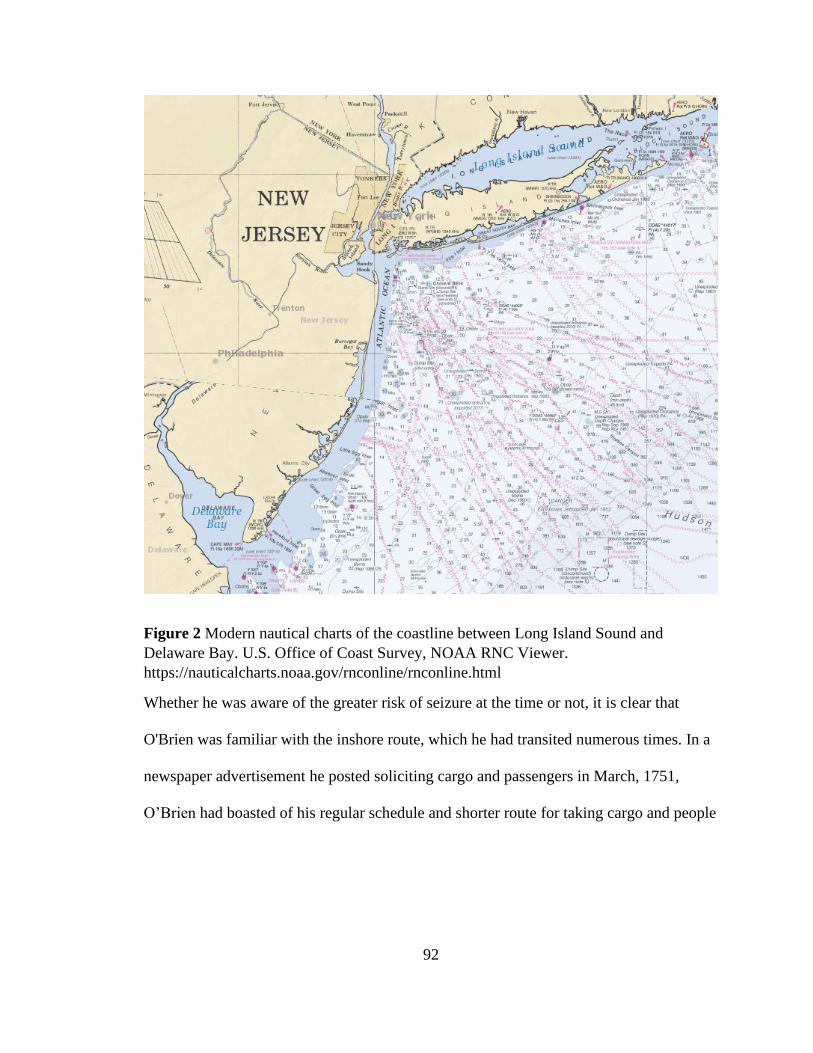
92
Figure 2 Modern nautical charts of the coastline between Long Island Sound and
Delaware Bay. U.S. Office of Coast Survey, NOAA RNC Viewer.
https://nauticalcharts.noaa.gov/rnconline/rnconline.html
Whether he was aware of the greater risk of seizure at the time or not, it is clear that
O'Brien was familiar with the inshore route, which he had transited numerous times. In a
newspaper advertisement he posted soliciting cargo and passengers in March, 1751,
O’Brien had boasted of his regular schedule and shorter route for taking cargo and people
93
from New York to Philadelphia.130 He may have been unaware of the greater risk of
seizure passing through New York harbor, or he may have made a conscious decision to
balance that risk against the risk of possibly less familiar offshore route. Either way, he
had clearly not communicated his plan to Cunningham. There is no further reference to
O’Brien in newspaper advertising or shipping news, suggesting that he did lose his
business. It is clear that success or failure was not only pivotal to merchants like
Cunningham, but also the captains themselves if they were the vessel owner.
Although individual mariners may have developed both piloting and offshore navigation
skillsets over the course of different seagoing jobs, few if any other maritime tasks
demanded the unique application of both skills in a single passage. In the absence of such
a skilled captain on board, merchants like Cunningham were forced to tap into networks
of small boatmen and coastal craft in the same way that Lyell did, only with boatmen
willing to take on contraband. As discussed, this was easily done, though not so
necessary, in the period's limited times of total peace. However, during periods of war
and when British enforcement tightened up after 1763, it became more important for
merchants to be able to find such networks or employ mariners and vessels that could do
the whole job.
Shipbuilding and Rigging Design
Coastwise traders and smugglers relied on some distinct vessel designs and vessel
availability that were products of advances in naval architecture and the rise of a robust
130 "Advertisement." New-York Gazette, or Weekly Post-Boy (New York, New York),
no. 427, March 25, 1751.
94
shipbuilding industry along the American coast. At the turn of the eighteenth century,
shipbuilding began to blossom in the North American colonies.131 The wealth of timber
in the American hinterland combined with a growing expertise in design and construction
in shipyards along the coast. The rising number of vessels being built was both fueled by
the demand for and contributed to the creation of new opportunities for inter-colonial
trade along the eastern seaboard and with the colonies of the Caribbean. Larger ships
capable of trans-Atlantic voyages to Europe and Africa also began being produced,
particularly in larger cities. However, far more sloops, schooners and brigs were being
built than the larger tonnage snows and ships. At the same time, these fore-and-aft rigged
coastal trading vessels experienced a more substantial evolution of rig and hull design
that contributed to improvement in performance and safety while still needing fewer
crew.
The burgeoning colonial shipbuilding industry provided the hulls that conveyed the trade
between the British North American colonies and the West Indies, but merchants wove
the shipbuilding industry into their trade operations with a broad array of Caribbean
island colonies. Vessels built in the colonies by New England merchants were not only
the method of transit for trade, but became themselves objects of trade, both fueling and
fueled by contraband from other nations' colonies.
131 For data on the rise in construction at the beginning of the 18th century, see Bernard
Bailyn and Lotte Bailyn, Massachusetts Shipping, 1697-1714: a Statistical Study
(Cambridge, Mass.: Harvard University Press, 1959); The most comprehensive review of
construction, vessel types being built and the markets for them is Joseph A. Goldenberg,
Shipbuilding in Colonial America, 1st Edition (Charlottesville, Va.: University of
Virginia Press, 1976).
95
Vessel Supply
Rising demand for cargo vessels, particularly for the intercolonial trade along the North
American coast and the Caribbean, drove the surge in shipbuilding that began in colonial
North America in the early eighteenth century.132 Massachusetts quickly became the
center of the industry producing the most vessels and the most tonnage.133 That growth
was fueled by the demands of merchants, particularly in Boston. While many of the
vessels being built were going directly into service under the ownership of colonial
merchants who commissioned their construction, the low cost of ship production in the
colony also made it an attractive export to both Britain and other colonies in North
America and the Caribbean.134 Massachusetts produced 83.5 percent of the recorded
colonial tonnage between 1674 and 1696, but that only amounted to a total of 144
vessels, or 6,708 tons. From 1697 to 1714, Massachusetts produced 91 percent of the
colonial tonnage, but the total number of vessels registered had risen to 321, or 18,329
tons. Of those registered in the second period, 95 were sloops carrying an average of 29.1
tons per vessel; 58 were ketches carrying 32.7 tons each; and 52 were brigs carrying 44.9
tons each. By comparison, 94 ships were built, averaging 108.6 tons per ship. A brig
could be a feasible alternative to a ship rig for trans-oceanic transit, but the lower cargo
132 Goldenberg, Shipbuilding in Colonial America, 97.
133 Goldenberg, 30; Bailyn and Bailyn, Massachusetts Shipping, 1697-1714, 102–5.
134 Goldenberg, Shipbuilding in Colonial America, 99.
96
capacity reduced the efficiency of making the long voyage. This was similarly true of the
less popular bark, of which only 22 were built at an average of 50.8 tons.135
The growth in production of these smaller vessels indicate that, even before the end of the
war of Spanish Succession in 1713, New England merchants were producing more and
more vessels for inter-colonial trade along the coast and in the Caribbean. Registration of
vessels within the British North American colonies began in 1696 with the passage of the
"Act for Preventing Frauds and Regulating Abuses in the Plantation Trade," an updated
navigation act which required owners of all vessels trading in or with the colonies to
provide information of the vessel's ownership, description, date and place of construction,
and to assert that there was no foreign ownership interest in the vessel.136 While the
mercantilist goal of the act was to ensure British trade was happening on British hulls, it
failed to recognize the extent to which British American hulls would become engaged in
the smuggling trade with Spanish, French and Dutch colonies in the Caribbean. The
extent of the trade between North America and Caribbean colonies (whether British or
not) was made possible by this dramatic growth of shipbuilding in New England.
Vessel Improvements
In addition to the sheer quantity of appropriate vessels that were being built in the British
American colonies, evolutions in rigging design that began in Europe in the seventeenth
century began being adopted by shipbuilders and mariners in America in the early
135Goldenberg, 133, 137.
136Bailyn and Bailyn, Massachusetts Shipping, 1697-1714, 4.
97
eighteenth century. Improvements in hull design began in both commercial ships and
naval warships, but trickled down to smaller coastal craft and trading ships. However, I
argue that it was the evolution of fore-and-aft rigging design, and specifically the
development and adoption of the gaff rig, that produced the most dramatic changes in the
craft being used by coastwise American mariners. Sleeker designs combined with more
efficient sailing rigs led to more versatile craft that were able to navigate in tighter areas
while still carrying more cargo. Additionally, the changes in rigging design allowed
captains to set more sail area with fewer crew while still maintaining a level of safety.
Development of the gaff rig as a replacement for other, more cumbersome rigs
contributed to this and shaped the skill set of mariners who used it.
Shepherd and Walton, in their study of shipping productivity, argued that fewer crew
were needed because the pirates had been cleared out of the Caribbean by the beginning
of the 1700s, and the rise of trade between in the West Indies coincides with the
elimination of piracy threats.137 Self -defense, however, seems less of an influencing
factor on the manning of sloops and schooners in which space was already at a premium.
Additionally, that explanation for fewer crew fails to account for the ongoing threats from
other nations’ privateers in times of war throughout the century. The capability of fewer
crew to carry more cargo was, instead, tied to the more efficient and less laborious
rigging they were adopting.
137Shepherd and Walton, Shipping, Maritime Trade and the Economic Development of
Colonial North America, 84.
98
A variety of different types of rigs, including lug, spritsail, and lateen rigs, all evolved in
Europe from the simple square rig, in which a rectangular-shaped sail was hung from a
horizontal spar that was itself suspended from a vertical mast.138 The gaff rig did away
with the forward half of that spar, replacing it with the gaff, whose forward end
connected to the mast. This seemingly simple difference allowed the ship to maneuver
relative to the wind without having to lower the entire yard and raise it on the other
opposite side of the mast. Not only did this require much less labor, it was less likely to
cause difficulties if caught aback in a squall. At the same time, connecting the leading
edge of the sail to the mast allowed it to be held tight against the wind for a wider variety
of wind angles. The combination of these factors produced much more efficient rigs
requiring fewer crew.
The gaff rig is generally credited with originating in Holland, where it appears to have
initially been used on smaller personal craft, but the steps to its evolution occurred
throughout Europe in the seventeenth century.139 The design evolved in conjunction with
hull shapes that were better suited to it and eventually migrated through the rest of
Europe and to America. A variety of lug and spritsail rigs can still be seen on images of
American harbors and remained common on inshore utility boats into the early nineteenth
century, but for cargo transport along the coast and to the Caribbean the gaff rig
dominates the seascape by the early eighteenth century, showing up on single-masted
138 For a review of the development of these rigs, see Edward Keble Chatterton, Fore and
Aft: The Story of the Fore & Aft Rig from the Earliest Times to the Present Day (J.B.
Lippincott, 1912).
139For a detailed survey of this evolution, see Chatterton, Chapter IV.
99
sloops and double-masted schooners.140 The combination of less labor and greater
maneuverability made the gaff rig the fundamental choice of coastwise merchant craft.
Many of these designs continued to carry square sails as well for downwind power, but
the sails were not necessary to work upwind.
Outfitting and Economy
Construction of the actual hull of the vessel was far from the only element that went into
building a ship. A diverse array of manufactured gear was required to outfit a ship under
construction and prepare it for sea. Much of this material required specialized skills from
a variety of individual tradesmen whose own employment tends to be neglected in
assessments of the impact of ship construction. Ropemakers were needed for initial
production of line used in the rigging of a ship, but specialized riggers were needed to
turn the line into the custom measured stays that held up masts and controlled the sails on
any given ship. Similarly, the unique measurements of every vessel and the need for
precise fits meant that sailmakers often had to produce custom work for any given
vessel.141 Blacksmiths produced the specialized ironwork for fittings on deck as well as
part of the hull, and other specialty manufacturers were needed to produce wooden parts
such as the deadeyes and blocks (pulleys) that provided mechanical advantage in
controlling the sails and rigging. The susceptibility of wood to rotting and wooden ships
140Karl Heinz Marquardt, “The Origin of Schooners,” The Great Circle 10, no. 1 (1988):
43.
141For examples of the precision required to fit rigging from vessel to vessel, see Smith,
The Journals of Ashley Bowen (1728-1813) of Marblehead, Appendix 1, Rigging
Schedules.
100
to leaking meant another entire industry was producing waterproofing solutions from
cultivating pine tree sap and boiling it down to tar and pitch.142
All of these trades and industries were just as involved in the regular repair and refitting
of existing ships as well. The deterioration of these natural materials meant extensive
regular maintenance and frequent replacement. The work kept shipyards and their
associated trades busy and fueled the economy of waterfront towns far beyond the
shipyard.143 The diversity of skills and trades that contributed to the creation of any given
ship is also notable in that the operating crew was often tasked with using the same skills
in the underway maintenance of the vessels in between visits to a shipyard. Developing
these skills expanded their professional value and often provided avenues to full-time
work ashore in these trades later in life.
Ships as Trade Items
The availability of cheaply built ships in the American colonies created another export
potential to the island colonies in the West Indies. Vessels built in New England that
entered the trade made their way legally to markets in the British West Indies, but also
were used by smugglers in New England not only as a tool for smuggling but as an object
142 Known collectively as “naval stores,” production of these pine-derived products in
colonial North America had been encouraged by the British, seeking to reduce their
previous dependence on the Baltic states to provide this key component of shipbuilding.
Mikko Airaksinen, “Tar Production in Colonial North America,” Environment and
History 2, no. 1 (1996): 115–25; Robert B. Outland, Tapping the Pines: The Naval Stores
Industry in the American South (Baton Rouge: Louisiana State University Press, 2004).
143For an assessment of the financing and economic impacts of shipbuilding and
outfitting, see Steven J. Pitt, “Building and Outfitting Ships in Colonial Boston,” Early
American Studies 13, no. 4 (2015): 881–907.
101
of smuggling. In 1764, Abraham Whipple and Nicholas Brown contracted with
Providence builder William Smith to build a small cargo ship for Surinam trader Jacob
Bogman. Measuring only 38 feet on deck, the Flying Fish was a small boat by the
standards of the trade, but would have more than suitable for Bogman to make runs from
Surinam to the Leeward islands. With only a 5'9" draft, it would also have been
maneuverable enough to make its way up the Surinam River to sugar plantations where
cargoes could have been loaded directly on board. Whipple and Brown paid Smith for
construction of the Flying Fish entirely in molasses: 900 gallons on keel laying, 900
gallons on completion of deck and remainder at completion.144 In so doing, they directly
transferred their molasses into the economy for a vessel that was then sold to Bogman in
exchange for more molasses. The boat was outfitted with members of Brown's regular
crew for the delivery to Surinam. Leveraging the delivery for the opportunity of
additional trade, Brown loaded the boat with cargo for Surinam.
Brown had another vessel built by Barnard Eddy beginning in December 1768, which
was also paid for in molasses. It was specified to be a flush deck sloop with a 50-foot
long keel. The agreed upon value was eight dollars per ton, but to be paid in molasses.
That winter, Jonathan Ellis was contracted to do the ironwork for the new vessel, and
specified his payment in a mixed form of barter, equaling "two tons bar iron at 80 dollars
144Nicholas Brown, “Abraham Whipple to William Smith” (n.d.), Box 469 Folder 3,
Nicholas and John Brown Co. Archive, John Carter Brown Library.
102
per ton, one (hogshead) of New Eng Rum at 2/lawful money per gallon, and the
remainder in any goods I want by retail at the cash price."145
As early as 1730, Massachusetts agent Jeremiah Dunbar reported to the British
House of Commons that New England merchants who had developed trading
relationships in the islands were frequently acting as agents for French merchants who
commissioned new vessel construction from New England shipyards. Even warships of
as much as 40 guns were being built for French islands and paid for with French rum and
molasses, according to Dunbar.146 With the rare exceptions of meticulous records like
those kept of the Flying Fish, it is difficult or impossible to trace the movement of
individual vessels built in New England and shipped to the West Indies during the mid-
eighteenth century. There is certainly a good chance that some of these vessels could have
become privateers, pursuing English shipping during the Seven Years War.
The development of shipbuilding trades and the shipbuilding industry in the North
American colonies provided the abundance of small coastwise vessels that made the
Caribbean trade possible. But it also created its own financial system and economy that
was both fed by and fed into the Caribbean smuggling trade, particularly that of molasses
from opposing French colonies and neutral Dutch colonies.
145Nicholas Brown, “Correspondence with Barnard Eddy, Jonathan Ellis, and Nicolas
Clarke & Co.” (March 1765), Box 674 Folder 6,7, Nicholas and John Brown Co.
Archive, John Carter Brown Library.
146Joseph A. Goldenberg, Shipbuilding in Colonial America, 1st Edition (Charlottesville,
Va.: University of Virginia Press, 1976), 106.
103
CHAPTER 4
CONDUCT OF SMUGGLING
The nature of the greater Caribbean basin and its myriad islands has always made
shipping and its defense a challenge. Strong easterly prevailing winds dictate how sailing
ships both approach the region and pass through it. The powerful Gulf Stream current is
created in part by the wind along the southern half of the basin, but then turns around
Cuba into the Gulf of Mexico for which it is named and heads against the wind around
Florida and up the southeastern coast of North America.147 The large islands of Cuba,
Hispaniola, and Puerto Rico mark the dividing line of these two regions. At the eastern
edge of the region, the Bahamas, the Virgin Islands and the long string of the lesser
Antilles form a border between the Atlantic Ocean and the greater Caribbean. (See Figure
3.)
For sailing ships, navigation among these islands was dictated foremost by the ability of
ships to sail upwind and work their way through the narrow passages among the many
islands. Eighteenth-century merchant captains had myriad environmental and geographic
hindrances to negotiate, but also dealt with a constantly fluctuating set of man-made
147 For a summary of prevailing wind and currents in the greater Caribbean basin, see
National Geospatial Intelligence Agency, Pub. 140 Sailing Directions (Planning Guide)
North Atlantic Ocean and Adjacent Seas, 17th ed. (Springfield, Virginia: National
Geospatial Intelligence Agency, 2019); National Geospatial Intelligence Agency, Pub.
147 Sailing Directions (Enroute) Caribbean Sea Volume 1, 16th ed. (Springfield,
Virginia, 2018).
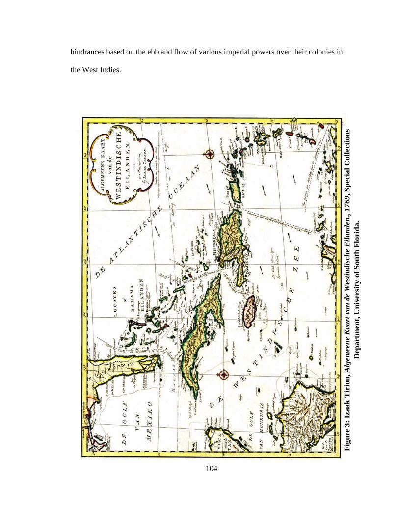
104
hindrances based on the ebb and flow of various imperial powers over their colonies in
the West Indies.
Fig
ure
3:
Izaak
Tir
ion
, A
lgem
een
e K
aart
van
de
Wes
tin
dis
che
Eil
an
den
., 1
769
, S
pec
ial
Coll
ecti
on
s
Dep
art
men
t, U
niv
ersi
ty o
f S
ou
th F
lori
da.
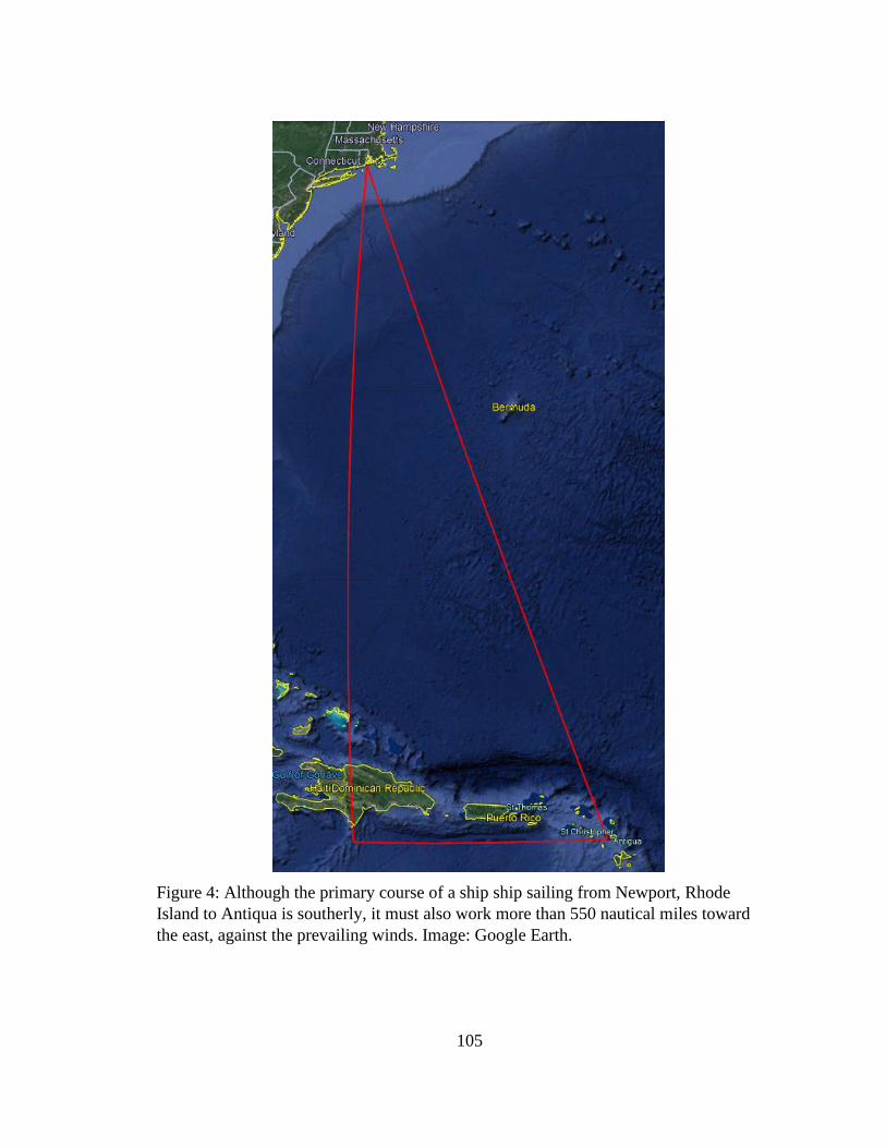
105
Figure 4: Although the primary course of a ship ship sailing from Newport, Rhode
Island to Antiqua is southerly, it must also work more than 550 nautical miles toward
the east, against the prevailing winds. Image: Google Earth.
106
The routes and voyage planning done by merchant vessels within the Caribbean basin
varied widely depending on where they were going and what they were doing.
Small-scale mercator projection charts tend to produce the illusion that the voyage from
New England to the Caribbean is largely a passage due south, but to avoid the contrary
Gulf Stream current and make it to the Windward and Leeward islands, ships were
required to make a substantial push to the east against the prevailing. (Figure 4). A
captain's decision on how to make that approach was dictated by both his final
destination and his intent. Smugglers avoiding enforcement authorities in times of peace
and privateers in times of war could have a particularly more precarious time of avoiding
opposing forces.
As we shall see, evidence from insurance records and correspondence between captains
and their merchant shipowners provide insight not only to who was smuggling, but to the
routes and rationales for their methods as well. Exclusions and inclusions on the
standardized coverage of the policies suggest specific threats that particular voyages may
have faced. Many of the policies specifically provide for discounts to the premiums to be
returned if a vessel met certain conditions during the voyage. Occasionally these
conditions involved not stopping at specific islands or avoiding specific routes.
Richard Pares in War and Trade in the West Indies addressed the details of how navies
during the wars of the eighteenth century attempted to grapple with illicit trade, but much
of his focus was on the strategies employed by those navies to either protect their own
107
trade or to raid the trade of opposing nations.148 The Ezekiel Price papers housed at the
Boston Athenaeum provide a window from the other perspective, that of the merchant
vessels seeking to evade those navies.149
There were essentially three elements to each voyage in which authorities could pose
problems: at the receiving port, underway between ports, and at the destination port. In
some cases, smugglers were violating the law in both the disembarking port and the
destination port. Underway in between, they could be subject to enforcement from either
nation's authorities. Complicating matters further, the two-way nature of trade meant that
the same port of call was likely both a destination and departure point. However,
differing national trade laws on incoming and outgoing goods meant that captains could
face different threats in each direction.150
The degree to which captains went out of their way to avoid authorities depended on the
severity of enforcement efforts at any given time. Enforcement of navigation acts
fluctuated dramatically during the eighteenth century, and during some years, smuggling
was able to occur completely in the open with little or no fear of legal reprisal.151
Enforcement methods varied as well. The strategies of European authorities for dealing
with smuggling changed depending on the political personalities setting policy as well as
148 Richard Pares, War and Trade in the West Indies.
149 Ezekiel Price, “Marine Insurance Policies, 1756-1781”, Boston Athenaeum.
150 For examples of the French rules and colonial motivations to break them, see Pares,
War and Trade in West Indies, 1739-1763, 326, 345.
151 Barrow, Trade and Empire, 87–88, 136.
108
the focus and goals of the enforcement. However, smuggling voyages occurring during
years of minimal enforcement still prepared mariners for later evasion by acquainting
them with local navigation requirements, and establishing relationships with authorities
and accomplices in various ports where enforcement later arose.
Smugglers pursued several overarching voyage strategies that can be summarized in three
main categories: vessel routing that allowed smugglers to evade authorities and land
goods; making trades at intermediary neutral ports that served to circumvent restrictions
based on nationality; and establishing relationships with complicit traders and authorities.
Routing and Deception
The environmental dynamics of the greater Caribbean basin had a huge effect on the
broad patterns of shipping and trade, as well as the discrete operational decisions that had
to be made by individual merchant captains, navy squadrons seeking to patrol the region,
and privateers seeking to capture commercial shipping. Prevailing winds and currents
created clearly optimal routes for traders. Smugglers sailing outside the obvious courses
risked raising suspicion, and utilized several means of deception to both avoid authorities
and be able to convincingly proclaim their innocence if interdicted. I argue that
successful Caribbean smugglers were those traders with a solid knowledge of the
geography as well as the prevailing sea conditions throughout the Caribbean basin.
Prevailing wind patterns across the Caribbean and Atlantic are driven by global oceanic
circulation cells located over specific latitudes. In the Caribbean latitudes, this means
prevailing winds cross the Atlantic from the east/northeast and enter the Caribbean basin
from the east very strongly. The winds continue toward the west from the Antilles islands
109
to Central America and Mexico. The Northern Equatorial current is an ocean current that
follows a similar path from the east to the west at the latitude of the Caribbean basin. As
it reaches the easternmost islands of the Caribbean, the current splits, becoming the
Antilles Current, which follows along the outside edge of the Caribbean past the islands,
and the Caribbean current, which passes through the islands and picks up volume and
speed in the open Caribbean Sea proper. After passing south of the major islands of
Puerto Rico, Hispaniola, Jamaica and Cuba, the current turns north through the Yucatan
passage into the Gulf of Mexico where it becomes the Gulf Stream current, flushing
between Florida and Cuba, up through the Straits of Florida and along the southeastern
coastline of North America.
Scientific recognition of the ocean currents, particularly the Gulf Stream, was not widely
disseminated until Benjamin Franklin published his first maps of the Gulf Stream. Those
maps, however, were based on the expert knowledge of American ship captains who had
been making use of those currents for many years.152
In his 1740 series of maps to promote the idea of war with Spain during the early phases
of the War of Jenkins' War, George Foster published maps of the greater Caribbean basin
as well as excerpts of the approaches to several key ports and strongholds. Both on the
maps and in detailed notations throughout his margins, Foster drew and described the
152 For details on the balance between mariners’ expertise and the authority of scientific
elite voices like Franklin, see Joyce E Chaplin, “Knowing the Ocean: Benjamin Franking
and the Circulation of Atlantic Knowledge,” in Science and Empire in the Atlantic World,
ed. James Delbourgo and Nicholas Dew (New York: Routledge, Taylor and Francis
Group, 2008).
110
prevailing wind patterns as well as the currents. He gave particular note to the Gulf
Stream: "The Current Setting Strongly between Cuba & New Spain into the G.of Mexico,
is turned N. by ye opposite Land & Sweeping round by Florida, passes out again with
great Violence between that Coast Cuba & ye Bahama Islands in the Ocean. The Current
also Sets N. tho' ye Windward Passage and some of ye Leeward Islands. Hence, tho' ye
Wind blows forceibly at N. & N.E. into the G. of Florida, all Ships bound for Jamaic, as
well as from Carolina &c as Europe, are obliged to get to Antigoa or St. Kits for sake of
ye Trade Winds & Currents."153 (See Figure 5)
Arguing for war with Spain, Foster produced the map showing prevailing winds,
currents, and Spanish shipping, “in order to demonstrate that the Havana is the only Place
the possession of which can possibly secure our Trade with the West Indies, and prevent
the Spanish depredations.”154 But his descriptions of the Gulf Stream and the winds
uncover a key facet of the approaches to the Caribbean. The massive ocean current driven
into the basin by the prevailing winds was then forced to flush its way among the islands
before funneling into the outlet between Florida and the Bahamas. This ocean circulation
pattern combined with the prevailing winds made it very difficult for sailing ships
153 See text insert over inland North America on George Foster, The Seat of War in the
West Indies, Containing New & Accurate Plans of the Havana, La Vera Cruz, Cartagena
and Puert Bello-- Also of San Augustin (London, 1740),
https://jcb.lunaimaging.com/luna/servlet/detail/JCBMAPS~1~1~3109~101434:The-seat-
of-war-in-the-West-Indies,.
154 See description at top of map. Foster; For a discussion of British interest in seizing
Havana, see Elena A. Schneider, “Imagining the Conquest,” in The Occupation of
Havana, War, Trade, and Slavery in the Atlantic World (University of North Carolina
Press, 2018), 17–62.
111
coming from New England or the Carolinas to get to the western Caribbean by making
their way south along the coastline off Florida. The "great Violence" of the current was
caused not only by speed, but that winds from the east (and more northeasterly in the
winter months) blew against the current, giving rise to steep waves of short wavelength
that could overcome vessels struggling against them. These conditions dictated that
approaching vessels had to first beat their way eastward toward the northernmost of the
lesser Antilles - Antiqua - before turning westward with the wind and current toward
destinations such as Jamaica, Hispaniola, Cuba, Puerto Rico, or destinations in the
Spanish mainland colonies such as Cartegena and Porto Bello.
For ships departing from New England this geography meant ships were often fighting
against the wind for much of the trip. As noted in the discussion above, these demands
helped dictate the type of vessels that were being built in the colonies: frequently fore-
and-aft rigged ships better able to sail efficiently upwind.
However, for ships outbound in the opposite direction, the same flushing current
provided a push against the winds and could ride the Gulf Stream along the northern
coast of Cuba and up the eastern seaboard of the North America. This pattern dictated the
routes of the Spanish flota and galleon fleets that left from Vera Cruz and Cartegena, and
rallied in Havana before carrying the Gulf Stream current out of the region.155
155 A. Lugo-Fernández et al., “Analysis of the Gulf of Mexico’s Veracruz-Havana Route
of La Flota de La Nueva España,” Journal of Maritime Archaeology 2, no. 1 (2007): 32,
40.
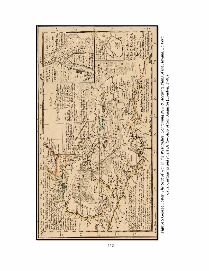
112
Fig
ure
5 G
eorg
e F
ost
er,
The
Sea
t of
War
in t
he
Wes
t In
die
s, C
onta
inin
g N
ew &
Acc
ura
te P
lans
of
the
Hava
na, L
a V
era
Cru
z, C
art
ag
ena a
nd P
uer
t B
ello
-- A
lso o
f San A
ugust
in (
Lo
ndon, 1740)
113
Antigua, then, becomes a readily identifiable demarcation point for the division of
shipping traffic that is either continuing to windward along the outside of the island
chain, or turning west and heading downwind into the basin. [Barbuda is actually a bit
further north and east of Antigua, but as a waypoint, Antigua's well-known harbor town,
St. John's, made it more recognizable.] Ships that had easterly destinations may have still
chosen to turn downwind at Antigua and continue along the western side of the island
chain. The natural conditions that could make this preferable included the prospects of
calmer seas in the shadow of the islands, but it could also be dictated by the human
factors, including the stationing of British and French navy ships offshore in Atlantic
approaches on the windward or eastern side of the islands. At stations off Martinique and
Barbados, both French and British naval ships were stationed in the expectations of
intercepting ships arriving from Europe.
This fork in the voyage paths becomes significant as a marker for determining and
predicting vessels' destinations and intents. Captains' adherence to these also serve to
demonstrate their acquired tactics for utilizing the prevailing natural forces to circumvent
the man-made forces that might be waiting for them.
The complexity of the region and the variety of routing choices demanded that captains
have a knowledge of the area or be able to acquire the information needed. The former
was achieved through first-hand experience, usually in a lower ranking position, sailing
in the region. The latter was passed on through interaction with others who sailed in the
region or through the coast pilots and charts.
114
This discrete knowledge of the region and the variety of ways in which the region could
be transited was crucial to smugglers’ ability to evade customs authorities, unfriendly
navies and hostile privateers on their way to load and unload goods. Knowledge of the
geography and the prevailing sea conditions underpins nearly all the smuggling tactics
discussed below.
Vessels departing British North American colonies for the West Indies were laden with
mixed cargoes that were needed on all the plantation islands. Particularly during the
Seven Years' War and under increased British enforcement after the war, a captain might
receive two sets of orders from the merchant shipowner. One set outlined a legitimate
voyage to a British colony such as Barbados, while another set delineated the secret, but
true, destination of the vessel - a port colony of some other European nation where the
markets for the products were more lucrative. The first set of orders provided a written
pretense that could be presented to a navy ship or privateer seeking to seize smugglers;
the second served as the actual agreement between merchant and captain. As noted in the
case of George Hopkins, detailed in the introduction of this dissertation, this practice is
known only because some merchants kept copies of both sets of orders in their own
records. But successfully executing this ruse depending on more than the captain and
crew being able to talk their way out of a seizure after being boarded. The route of the
vessel contributed to the likelihood that a vessel would be even be seen in the first place,
and if it was, its location relative to its false and true destinations provided an indication
of where it was really headed.
Ships headed from New England to the western and central Caribbean frequently got
similar orders, usually for the British island of Jamaica. Joseph Kinnicutt, for example,
115
Master of the Obidiah Brown's sloop Speedwell got orders and a bill of lading that
indicated a mixed cargo bound for Jamaica. Kinnicutt's real orders, however, were to go
to Hispaniola, landing at “Ocoya” or “Port Leuca” on the south side of the island.156
Although neither destination as spelled by Brown exists on either contemporary or
current charts of the island's south coast, either or both names most likely refer to the
French port of Aux Cayes, known today as Les Cayes, in modern Haiti.
In Kinnicutt's case, like Hopkins', a bill of lading accurately showed the cargo on board,
but the vessel and its cargo were really destined for Hispaniola rather than Jamaica, as the
paperwork indicated. The ship’s hold contained 202 barrels of flour; 1,100 feet of boards;
800 hoops, 927 bunches of onions; 20 boxes of spermicetti candles; 4 desks, 8 barrels of
oil; 6 horses; 3 barrels of pork, 3 barrels of beef; and 700 weight of bread. Brown had
suggested Kinnicutt come back with sugar, molasses, coffee, indigo or cotton.157
Kinnicutt's voyage routing would have been much easier than Hopkins'. He had a number
of options for making the approach to the southern coast of Hispaniola from New
England. Some of them would have had him passing that coastline prior to approaching
Jamaica and could have easily been seen as being on the normal course to Jamaica. Thus,
he would have had no issues explaining his course or location to any authorities
156 Orders to Joseph Kinicutt, Sloop Speedwell” (n.d.), Box 468 Folder 4, Nicholas and
John Brown Co. Archive, John Carter Brown Library. Copies of both sets of orders
survive.
157Obidiah Brown, “Orders to Joseph Kinicutt, Sloop Speedwell” (n.d.), Box 468 Folder
4, Nicholas and John Brown Co. Archive, John Carter Brown Library.
116
underway. Nor, if he approached from the east along the southern shoreline, was he likely
to encounter the naval station off Jamaica, where British naval ships were patrolling.
The destination and that safer route from the east did, however, require a more detailed
understanding of the southern coastline of Hispaniola, and familiarity with the port
approaches there. Les Cayes is so named because of its location north of Ille de Vache
and an archipelago of smaller surrounding keys with connecting shoals. Approaching and
navigating through Canal de l'Est, the narrow passage between the cays and the mainland,
required a solid knowledge of the area. It is likely Kinnicutt had been there before,
though there is no proof of that in Brown’s papers. If he had never been there, he may
have been able to consult a combination of coast pilots and charts of the coastline to
provide some guidance, but more importantly he relied on the ability of his crew to
manage the vessel. Sailing in unfamiliar waters along a coastline required sharp lookouts
and watchstanders to sight the shoreline in the distance, recognize the changes in the
patterns and color of the water that could indicate shallows or shifts in current. As noted
previously, on a small trading vessel with a limited crew, it serves as another example of
the importance of each crew member's contribution to the success of the voyage and
refutes the notion that crew were a homogeneous commodity, particularly in cases where
the voyage routing required a closer approach to the shoreline, away from naval
squadrons on station.
The balance between navigational safety and evading seizure is highlighted in the Ezekiel
Price insurance records’ contingencies for invalidation of the policy, and the benefits for
premium rebates if certain conditions were met. These conditions help craft a framework
for understanding the operational risks and exposures to seizure. To mitigate the risk of
117
losses, the underwriters frequently promised a rebate on the premiums if the insured
vessel did not "go to windward", or to the east of the Antilles where stationed naval
vessels increased the risk of capture during the Seven Years' War. This was true even for
vessels transiting between Dutch Surinam and New England, suggesting that passage
along the leeward side of the Antilles islands then along the coast of South America to
Surinam was deemed safer. Such a circuitous route, however, would have demanded
additional navigational prowess of the captain, who needed to be familiar with the
approaches along the South American coastline. This direction from insurance providers,
however, contrasts with the routing Obidiah Brown gave to George Hopkins on the
Nancy in 1764 after the war had ended. Brown telling Hopkins to sail well to windward
to evade authorities suggests a change in the expectation of enforcement methods and
locations in the wake of the war.
Even ships that were not necessarily carrying any illicit cargo often sought out particular
routes and timing to conceal their arrivals and departures and intentions from competing
vessels in the chaotic Caribbean markets. This resulted in few vessels being willing
participate in convoys, one of the primary means of protecting merchant shipping from
attack by enemy vessels during war. This facet of trade in the Caribbean particularly
confounded navy squadrons as well as politicians who were seeking to establish a viable
strategy for either protection of shipping or raiding of enemy shipping.158
158From Pares, War and Trade in West Indies, 1739-1763, 288: “they swarmed about the
seas, scuttling imprudently from island to island in pursuit of the last half-penny of
profit.”
118
Neutral Stops
During both the War of Jenkins Ear and the Seven Years' War, New England merchant
mariners continued to traffic in contraband from European colonies belonging to nations
that were at war with Britain. Roaming enemy privateers certainly added a level of
hazard to any shipping during this time, and war had the added impact of creating more
volatile markets. Merchants, generally, and more so the mariners they employed, did not
look forward to the prospect of war.159 However, once war came, they sought to make the
most of trade opportunities by finding the best markets at the lowest operational and
financial risk.
Seeking out neutral ports that could act as transshipment points was among the most
popular strategy even after Britain attempted to clamp down on it with the “Rule of
1756” which forbid trade through neutrals.160 During the Seven Years' War between
Britain and France, key ports for ongoing neutral trade included the Dutch island of St.
Eustatius, and Spanish port of Monte Christi on the north coast of Hispaniola.161
159As Boston merchant Stephen W. Greenleaf wrote in June 1756 to Wilkinson and
Ayrault in Rhode Island, “Whether a war will operate to our advantage or not must be left
to the event; but if the trade does not revive, we have but one way to save ourselves, and
that is to retrench our expensive living.” Stephen W. Greenleaf to Wilkinson and Ayrault,
Boston, June 29, 1756. R. I. Hist. Soc. Commerce of Rhode Island 1726-1800 Vol. 1.
160 For a concise summary of the rule and its later impacts, see James Farrant, “Modern
Maritime Neutrality Law” (Masters, Durham University, 2015), 53,
http://etheses.dur.ac.uk/11006/.
161 Pares, War and Trade in West Indies, 1739-1763, 383, 388.
119
Monte Christi had the benefit of being just over the French/Spanish border on Hispaniola.
There was little in the way of a sheltered harbor there, and less in the way of goods
originating there. As a Spanish port, however, it was considered neutral in the conflict
between France and Britain, and served both French and British American ships, who
traded with each other there. As a strategy for evasion, Monte Christi did not escape the
attention of the Royal Navy for long though.
British authorities believed that the degree of trade with France that was occurring
through Monte Christi was a detriment to the war effort, shoring up the economy of the
enemy. Even as the war was beginning British naval vessels began seizing American
ships trading through Monte Christi and other neutral ports, particularly the Dutch
islands. On a single day, August 3, 1759, five vessels were seized coming out of Monte
Christi and sent to Jamaica for condemnation. Increased enforcement did raise the risks
for captains, but merchants' successes in litigating seizures in the admiralty courts
encouraged the trade to continue.162
How much the trade through Monte Christi swayed the economy one way or the other is
unclear. The number and diversity of ships from different colonies made for a volatile
market whose prices were constantly in flux based on momentary spikes and collapses in
demand that were driven by an equally diverse set of circumstances. French colonies
during the war were more eager to trade with American merchants who supplied them
with critical provisions like flour, than they were with British West Indian merchants who
162Tyler, Smugglers & Patriots, 29–32.
120
were importing dry goods and exporting indigo.163 With mixed cargos arriving, the
discrete makeup of any individual cargo could spell the difference between success or
failure. Cash flow from the sales of these goods in the islands was used largely to buy
French molasses.
All of which assumed one actually made it to market. Writing in November, 1759, from
Monte Christi to Rhode Island merchant Chistopher Champlin, captain W. Grant
reported, "There is now in the Roade about 45 sail and eight or ten Ready to sail, so we
have a prospect of very good Times. Markets Rises and produce falls at a prodigious
Rate, in particular Mollasses which is to be got now for 19 ps. 8/8. The Brigg Hawk from
Antigua has Taken two Sloops and a Snow outward Bound and Carried them to port,
which I believe will be attended with very Bad Consequence in case their are
Condemned, as there is two or three more here and only Waite to hear of the fate of those
already Carried to port, before they begin to make Reprisals."164 Grant's note suggests
that the market could hinge on whether on or not captains perceived that they were at risk
-- not necessarily risk of seizure as much as risk of condemnation and loss of cargo in
Jamaica. As noted, naval captains were forced to prosecute their claims in court, but it
was usually the merchant and his legal representative that provided the defense, not the
smuggling captain. Naval captains were not guaranteed of success, which hinged on their
own understanding of the law, the success of a professional legal defense, and the
163Pares, War and Trade in West Indies, 1739-1763, 357.
164 W. Grant to Christopher Champlin, November 28, 1759, as published in Commerce of
Rhode Island 1726-1800 Vol. 1, 1; 1726–1774:79.
121
tendencies of the local court. That combination of factors contributed to the risk
assessment of captains with a vessel full of contraband, and added to the myriad other
factors in considering what they carried as well as when and where they sailed.
Trade continued despite the volatility of the circumstances. Despite British efforts at
shutting down Monte Christi as well as the Dutch neutral trade through St. Eustatius,
illicit trade continued. In part, this was a willingness on the part of mariners to sail even
when they risked seizure.
Flags of Truce
The exchange of prisoners in wartime necessitated sending ships carrying those prisoners
to enemy ports. This was achieved under a "flag of truce," which allowed a non-military
vessel to arrive at a port, discharge prisoners, and depart without fear of being held
captive. For British North American and French colonial merchants, however, this system
also offered a means of reaching lucrative ports for trade that were off limits during
wartime, under the guise of dropping off prisoners. As a technique for illicit trade, flags
of truce became notoriously popular, vexing British authorities who were trying to reign
in trading with the enemy.165 A letter on board signed by a colonial governor or other
customs representative was designed to serve as a permit to sail, while also providing
proof of how many prisoners were on board, along with the number of crew and amount
165 Pares, War and Trade in West Indies, 1739-1763, 389, 446–52.
122
of provisions to feed the ship's complement for the voyage.166 However, colonial officials
were frequently willing to issue false or specious documents, and mariners would also
keep the permits on board at length, conducting multiple voyages under the protection of
one Flag of Truce letter.167 Deputy Governor William Denny of Pennsylvania, for
instance, became particularly well known for selling Flag of Truce letters to merchants
trading from Philadelphia to the islands. Officials like Denny helped spread out the
opportunities for such trade as well, by dividing up prisoners to be returned into groups of
as little as a single prisoner on an outgoing ship. Frequently, none were on the return
trip.168
Relative to other smuggling strategies, flags of truce offered a logistical simplicity.
British vessels were able to cut out the middlemen in neutral ports, going right to the
French islands that wanted their produce. At the same time, the voyage itself was
simplified. Evasion came in the form of documentation that could be presented in the
case of a boarding, rather than the more arduous task of sailing hundreds of miles out of
the way to avoid the prospect of being boarded in the first place. In one eighteen-month
period between 1747 and 1748 (during Queen Anne's War), 60 ships were reported to
166See example affidavit of Flag of Truce from William Read for Thomas Remington,
captain of the schooner Wind-Mill, Commerce of Rhode Island 1726-1800 Vol. 1, 1;
1726–1774:78.
167William Smith McClellan, Smuggling in the American Colonies at the Outbreak of the
Revolution: With Special Reference to the West Indies Trade (Department of Political
Science of Williams College, 1912), 50.
168Beer, British Colonial Policy, 1754-1765..., 90–91.
123
have sailed from New England to the French islands under flags of truce.169 John
Bannister, a merchant in Newport, Rhode Island, made numerous voyages under flags of
truce, heading to a variety of Spanish and French ports that included Monte Christi and
the Bay of Honduras.170
Wartime pressures on other sources of supplies made this trade particularly lucrative for
the Americans.171 If the merchant were found to have been trading in the enemy port, the
ship and cargo could be condemned, but it appears from records of seizures that there was
rarely substantive punishment for the captain and crew if they were seized.
In the summer of 1758, Captain Paul Tew, in command of Nicholas Brown's brigantine,
Prudent Hannah, was seized by the British warship Chesterfield off the coast of Virginia
while en route from Rhode Island to Hispaniola under a flag of truce. Having escorted a
English squadron to the Chesapeake Bay from England, Chesterfield, under the command
of Julian Legge, was conducting a patrol off the American coast looking for both enemy
vessels and other ships ostensibly breaking trade laws.172 This was a lucrative pursuit in
that Legge stood to receive a portion of the value of seized ships and goods in the form of
prize money.
169Barrow, Trade and Empire, 161.
170Desrosiers, John Banister of Newport, 53.
171Pares, War and Trade in West Indies, 1739-1763, 356,388.
172 George Reese, “A Case of 1758 in the Vice-Admiralty Court of Virginia,” The
Virginia Magazine of History and Biography 89, no. 4 (1981): 406.
124
On board Prudent Hannah were fifteen French prisoners being returned to Port Au Prince
with the expectation of exchanging them for English prisoners held there. Also on board,
however, was a substantial load of cargo. Tew's bill of lading showed only five barrels of
pork and 30 barrels of flour, presumably a legitimate amount for the sustenance of the
crew. However, in the hold of the Prudent Hannah were 47 barrels of flour, 37 of beef
and pork, hogsheads of fish, firkins of butter, bread, and 1,000 bunches of onions.173 This
was considered by Legge to be clear evidence that Tew was planning to use the
proclaimed prisoner swap as an excuse to do a substantive amount of trading with the
enemy in violation of the law.
The ship was taken to Williamsburg, Virginia in Chesapeake Bay where Tew wrote to
Brown of his predicament. Brown immediately sent back letters of credit to cover Tew's
expenses and promised that the firm would defend against the charges. Tew had initially
pleaded with Legge to return him to a New England port such as Providence, where
undoubtedly he felt he would have a more receptive audience with a local judge who
would have been familiar with the Browns.174 In less sympathetic Virginia, however, the
ship and cargo were condemned, taken by the court and ordered to be sold off.175
173Matthew Parker, The Sugar Barons: Family, Corruption, Empire, and War in the West
Indies, Reprint edition (New York: Walker Books, 2012), 306.
174Paul Tew, “Capt Paul Tew to Nicolas Brown, Re: Seizure of the Brigantine ‘Prudent
Hannah’” (letter, n.d.), Box 674, Folder 2, Nicholas and John Brown Co. Archive, John
Carter Brown Library.
175“Dateline: Williamsburg,” Boston Evening-Post, October 7, 1758.
125
Tew argued in court that he held legitimate paperwork from Rhode Island that authorized
his voyage and its authenticity. His argument was rejected by the court. Despite the loss
of the ship and cargo, Tew and his crew returned to Providence.
Tew's success with getting credit from his merchant shipowner indicated the firm's
confidence at the time that they would be able to recover their assets as well as protect
their employees. However, their treatment in Virginia also exposes the regional
distinctions that occurred among Britain’s North American colonies.
Common law courts as well as admiralty courts could hear seizures like that of the
Hannah, but each of those courts faced different local pressures on their decisions that
affected how they were likely to decide. The common courts favored the merchants, but
only local merchants. Vice-Admiralty courts, like the one in Virginia that Tew was
facing, were expected to be more resistant to local pressure, but even those courts’
officers were living locally in the colonies and subject to the mores of that community.176
For a Rhode Islander like Tew in Virginia, his chances in either court were diminished. It
is understandable that he pleaded for return to a court in New England. Tew was shocked
and exasperated by the attitude he received from Legge of the Chesterfield, who
denounced Tew as a traitor to his country, a response that indicates the degree to which
smuggling mariners were able to mentally divorce attitudes about allegiance from the
business of trade that was operating outside that allegiance
176 For a detailed review of the differences between the courts and their influences on
trade, see Ubbelohde, The Vice-Admiralty Courts and the American Revolution.
126
A Flag of Truce for a vessel whose cargo was intended for trade rather than the
consumption of the crew and prisoners on board essentially constituted a false set of
paperwork attesting to the legitimacy of the cargo, which ostensibly prevented outright
seizure during times of war for vessels that were trading with the enemy. However, on
their return to the colonies, those ships faced a secondary issue regarding the cargoes
coming back to the North American colonies that had to face the scrutiny of British
customs officials. Captains then faced either outright seizure for illicit cargo, or faced
steep duties that could render cargos less profitable, if at all. One solution to this was to
seek out false paperwork verifying the cargo on board as being British.
Fraudulent clearance paperwork was particularly easy with the bulk of cargo being
brought back to New England from the French and Dutch colonies of the Caribbean.
Sugar and molasses made up much of the cargo coming into New England from the
Caribbean, and getting paperwork saying it was the product of a British sugar producing
colony like Barbados was made easier by the homogeneous nature of the commodity.177
As long as the captain was able to pay an official ashore to generate the paperwork, it
would be difficult to impossible for customs authorities at the receiving port to
specifically discern the origin of the sugar or molasses. As in other situations, the shifting
imperial controls over the islands appears to have contributed to the ease with which
captains were able to obtain fraudulent paperwork.
177 Shepherd and Walton, Shipping, Maritime Trade and the Economic Development of
Colonial North America, 229.
127
Arrivals and the Complicit Actors Ashore
The Flag of Truce phenomenon indicates the degree to which smuggling mariners were
able to conduct their trade with the participation of complicit officials ashore.
Notwithstanding condemnations of vessels like the Hannah, it appears that many traders
were able to secure illicit Flags of Truce and make successful voyages. And in the event
they were caught, many mariners successfully relied on courts that defended their
practices. Alliances with shoreside conspirators and assistants was not unique to Flags of
Truce, though.
Through complicit customs officials, and inshore mariners with support vessels,
smuggling mariners were able to get contraband ashore, particularly on the North
American receiving end once efforts at enforcement ramped up after the end of the Seven
Years War. Smaller fore-and-aft rigged vessels were able to maneuver against the wind,
but needed mariners on board who were comfortable with sailing into tight sounds, bays,
and harbors where the space to maneuver and get out to safer, deeper water in the event
of a problem were limited. But the problem with smaller locales was that they often
lacked the infrastructure to unload cargo. Without a wharf to sail up to, even small
vessels were obligated to lighter cargo ashore in small boats. The average coastwise
merchant vessel had neither the crew manpower nor the boats to do this on their own, so
help from ashore was necessary.
Transferring cargo to small, very localized craft also provided potential cover for that
cargo in port. But success at this ruse required local mariners who could pull it off. The
nature of the small boats used for transporting cargo to shore was such that these vessels
128
were locally owned and operated, as they could not either be transported over land or
sailed any great distance. In addition to being willing to conspire with smugglers, those
local boat owners needed to be intimately familiar with the coastal geography where
cargo was being brought in. Alternatively, or sometimes in conjunction with this the
assistance of these local transports, smugglers needed to find a local customs official
willing to overlook this activity and/or provide appropriate clearance paperwork.
Customs officials in small towns, where local circles of people were smaller and
smuggling's contributions to the local economy were larger, were more likely to be
enticed in participating in illicit clearances.178
In the 1760s, as revenue cutters and naval vessels began patrolling the areas around major
ports and harbors, smugglers were forced to make more aggressive use of their local
knowledge to get to places. In 1765, Captain Abraham Whipple (later of Gaspee fame)
received very specific directions from his employer and from the ship's owner, Nicholas
Brown of Providence, Rhode Island. Returning to Narragansett Bay from Surinam,
Whipple was told to explicitly avoid passing by the port of Newport at the mouth of the
Bay, where customs officers were stationed. Instead, Brown provided Whipple with
several contingency options depending on the weather and the ship's possible
detection.179 All of these options demanded that Whipple have a sound knowledge of the
passages of the bay, their tides and currents, and other hazards.
178Barrow, Trade and Empire, 141.
179 Nicholas Brown & Co. to Abraham Whipple, 13 January 1765. As quoted in Peter R.
Schmidt and Stephen Mrozowski, "Documentary Insights into the Archaeology of
129
Compounding Brown's concern was the rapidly changing level of enforcement that
merchants were experiencing. Smugglers had been regularly landing cargo at Conanicut
Island in the middle of the Bay across the passage from Newport, but Brown was
uncertain how much the situation would have changed by the time Whipple arrived. So
instead, he instructed Whipple to either sail up the western passage into Narragansett
Bay, on the other side of Conanicut Island from Newport, or up the Sakonnet River to the
east of Newport. Either way, he was to proceed as quickly as possible directly to
Providence. If weather prevented Whipple from being able to sail up either passage, he
was to send his mate ashore as a messenger.:"...Lett your mate Mr. Hopkins on Shore to
proceed to us as fast as possible, not stopping for Nite nor foul weather nor telling no
person from wenth he Come and we will meet the Brig in schows and as many hands as
needful to unload."180
The use of scows - flat-bottomed barge-like boats - was common for transferring cargo
from ships to shore as well as transporting cargo from point to point within sheltered
inland waters like Narragansett Bay. Scows were simple to build and utilized by coastal
residents for a variety of purposes.181
Smuggling," in Documentary Archaeology in the New World, ed. Mary C. Beaudry
(Cambridge University Press, 1993), 38.
180 Nicholas Brown & Co. to Abraham Whipple, 13 January 1765. As quoted in Peter R.
Schmidt and Stephen Mrozowski, "Documentary Insights into the Archaeology of
Smuggling," in Documentary Archaeology in the New World, ed. Mary C. Beaudry
(Cambridge University Press, 1993), 38.
181 For a history of scows and related designs, see Howard I. Chapelle, American Small
Sailing Craft: Their Design, Development and Construction (New York: W. W. Norton
& Company, 1951).
130
If weather stymied Whipple from getting up the bay, the success of Brown's operation
would have depended on his ability to call upon a network of local boats, manned by
experienced crew capable of sailing the boats and doing the work, but also discreet
enough to be trusted with the furtive operation. That Brown felt comfortable being able to
muster such resources if necessary suggests that merchants did indeed rely upon a wide
network of local mariners to support their smuggling operations at the receiving end.
Waddell Cunningham in New York also had access to a similar such a network in Long
Island Sound.182 But in the vague scheduling of sailing ships, attempting to orchestrate a
clandestine offshore meeting was still difficult at best, as noted by the arrival of the ship
Prince of Wales in July 1756. In a series of detailed letters beginning in May,
Cunningham provided directions to several different contacts in Long Island Sound, New
York and Philadelphia – laying out instructions and contingency plans. His letters
included numerous missives to Capt. John Nealson of the Prince of Wales, who
presumably would have already been on route across the Atlantic. Exactly where he
dispatched these letters and how he hoped they would reach Nealson remain unclear from
the text of the letters as recorded in firm's letterbook.
On May 29, Cunningham wrote to Nealson, informing him that officers were actively
seizing cargo. His instructions were to have Nealson send word as soon as he arrived in
the colonies and Cunningham would "send up Sloops to take in Our goods & proceed
182 Truxes, Letterbook of Greg & Cunningham, 1756-57, 2001.
131
with them to Philadelphia Where I am well informed they may be lodged with Safety.”183
Cunningham was fearful that the Customs Service officials were acting more
aggressively throughout New England and suggested that Nealson may be better off
entering in North Carolina. This contingency suggests that the reach of Cunningham's
network of smuggling accomplices extended well beyond the Long Island-Philadelphia
corridor in which the firm seemed to usually operate. It is doubtful that Cunningham
would have been prepared to transfer the cargo overland back to New England, but rather
that Charleston served as an alternative market for contraband goods or that another
coastwise vessel could return the cargo.
Consequently, Cunningham’s direction also points to the importance of inter-colonial
trading sloops as participants in trans-shipping smuggled goods among the North
American colonies. Sloops (small fore-and-aft rigged vessels with a single mast and often
a crew of fewer than a half-dozen) arriving from the southern colonies would not have
raised the suspicions of the customs officers in New York or Philadelphia, ostensibly
making the effort of the additional shipping worthwhile to merchants like Cunningham.
That same day, he wrote to John Lloyd, a boat captain in Stamford, Connecticut. Lloyd
owned two sloops, but also served as a preventive officer for the British Customs Service.
Preventive officers were assigned to smaller towns between the major ports of entry.
They had the authority to clear in and clear out coasting vessels in inter-colonial trade,
183 Waddell Cunningham to Capt. John Nealson, master of the snow Prince of Wales,
May 29, 1756, as published in Truxes.
132
but the specific goal of the role was thwarting the landing of illicit goods in those
towns.184
Cunningham instructed Lloyd to expect Nealson on the Prince of Wales, and made clear
in no uncertain terms that Lloyd would be taken care of. "I has her entirely under you
care & as you direct the Captain, he will proceed," Cunningham wrote. "What money you
may want let me know as soon as you can, & I shall send it, & I shall do as handsomly
for you & your officers as any that has been yet with you."185
This promise of a payoff better than "any that has been yet with you" to not only Lloyd
but an untold number of his officers suggests that Cunningham had leveraged this
connection before. The collusion of small town customs officers like Lloyd was another
link in the network that allowed merchants to safely enter contraband goods. In such
towns, customs work was not a full-time position and officers frequently owned their
own boats or also worked as captains aboard other boats. As in the case of Lloyd, they
may not have only just looked the other way, but also actively participated in getting
contraband goods distributed ashore. Joseph Chew in New London, Connecticut, was
another merchant who doubled as a local customs official and smuggler.186 On July 7,
Cunningham wrote to Chew, imploring him to assist Nealson by intercepting the Prince
of Wales in Long Island Sound and helping Nealson safely deliver his illicit cargo. "For
184 Barrow, Trade and Empire, 78.
185 Waddell Cunningham to John Lloyd, Stanford, May 29, 1756. As published in
Truxes, Letterbook of Greg & Cunningham, 1756-57, 2001, 131.
186 Truxes, Defying Empire, 41–42.
133
Godsake, dont neglect to keep the Boats out & to make them pursue the Vessel till they
can come up with her," Cunningham wrote.187 Here, Cunningham was explicitly looking
to a local customs officer to provide the same type of underway offloading to scows that
Brown had anticipated using with Whipple.
Two weeks later, despite apparently receiving assurances from Lloyd, Cunningham wrote
another cautionary note to Nealson, warning him of regular seizures and providing more
detailed instructions on how to specifically evade the authorities. "You must be upon
your Gard to let no Boats Board your Vessel, & if you find any danger at Stamford after
Landing the goods on freight, proceed directly with our own Goods into Philadelphia
River &, without stopping, go within Ten Miles of the Town & send A Letter to Messrs.
Scott & McMichael who will be prepared to dispatch you."188
John Scott and John McMichael were an Irish firm in Philadelphia that regularly worked
with Cunningham receiving goods and organizing shipments.189 Whether Scott and
McMichael themselves would have come out to meet Nealson, or whether the firm would
have hired local boatmen to transfer cargo from the Prince of Wales is uncertain.
But even this contingency plan did not appear to soothe Cunningham's fears. By the next
day, he was writing yet again to Chew, this time letting him know that Captain William
187 Waddell Cunningham to Joseph Chew, New London, July 7, 1756, as published in
Truxes, Letterbook of Greg & Cunningham, 1756-57, 2001, 168.
188 Waddell Cunningham to Capt. John Nealson, Captain of the snow Prince of Wales,
June 14, 1756 as published in Truxes, 137.
189 See Waddell Cunningham to John Scott and John McMichael, August 9 1756, and
August 13, 1756 for additional examples of agreements between them. Truxes, 192, 194.
134
Dobbs was being sent in a sloop to interdict Nealson and guide the Prince of Wales to a
landing spot safe from seizure. Two weeks later, he wrote to Captain Charles Stewart, yet
another sloop owner, directing him to attempt to locate the Prince of Wales as well, take
on cargo and deliver it to Scott and McMichael in Philadelphia.
Later letters suggest that Nealson did arrive in New London on about July 21, and
managed to offload cargoes to various places with several different merchants and
contacts that prevented anything from being seized by authorities.
As this chapter demonstrates, smugglers employed a variety of tactics to successfully
transport contraband cargo successfully to market. The routes they chose relied on solid
understandings of the waters in which they were sailing and the skill to navigate and
maneuver through those waters. The ports of departure and arrival that they chose relied
on geographical knowledge as well as the ability to connect to networks of complicit
actors who could provide cover in the form of paperwork, or in the form of
surreptitiously landing contraband cargo in small towns away from more diligent customs
officials.
Honing these diverse methods and adapting those methods to changing circumstances
over time made smugglers a unique qualified subset of colonial mariners.
135
CHAPTER 5
CAREER TRAJECTORIES
The career trajectories and family relationships of the smuggling mariners reflect the
complex nature of the mariner as a skilled international conduit while also a locally
grounded and often deeply connected member of his community. This combination of
factors led to mariners having allegiances and career paths that were more in line with
what benefitted themselves and their immediate communities, rather than what benefitted
the British Crown or its colonial authorities - two sets of objectives that were often not
aligned. The mariner who was trading with the enemy one year, could the next year
become a privateer taking enemy ships as prizes for the Crown. Often these shifts were
driven by changes in opportunity for better or worse. Similarly, when opportunities arose
ashore, mariners frequently translated their unique mix of maritime skills and commercial
networking into later life careers back in the communities they came from.
When Paul Tew’s ship Prudent Hannah was seized by the British off the Chesapeake for
carrying a full load of cargo to the French Caribbean under a Flag of Truce, he seemed
the indignant, unrepentant smuggler. But just a year before, Tew had been commanding a
sloop out of Providence that had participated with two other privateers in seizing a
French privateer laden with cargo.190 Tew was clearly someone motivated by
190 "Boston." Boston Evening-Post (Boston, Massachusetts), no. 1157, October 31, 1757: [3].
136
opportunity, but by 1761, Tew had taken a up a more landbound life, having begun
serving as Sheriff of Providence County.191
In that position he was responsible for handling the sale and disposition of property
seized by privateers.192 As such, he made a percentage of the assets that were sold and
distributed. While his primary motivation for moving to a life onshore is unrecorded, his
pursuit of condemnations could not help but be colored by his own experience at the
hands of authorities. He also served as the commissioner for several insolvent estates and
bankruptcies.193 By June, 1777, he had retired and moved to Woodstock, Connecticut,
where he died on August 3, 1784.194 Tew serves as another example of a mariner who
had developed a reputation locally and was able to translate that reputation to a position
of affluence and authority ashore that also leveraged his skill set and cemented his role in
the community. In Tew’s case, it is likely that his late life retirement to Woodstock was
driven by the presence of a daughter living there.
191 Diary of Thomas Vernon, as published in Rhode Island Historical Tracts (Sidney S.
Rider, 1879). 100.
192 “Advertisement for Sale of Prize Ship Eagle and Cargo”, Providence Gazette, August
31, 1776, as published in United States Naval History Division, Naval Documents of the
American Revolution: American Theatre: Aug. 1, 1776-Oct. 31, 1776. European Theatre:
May 26, 1776-Oct. 5, 1776 (Naval History Division, Department of the Navy, 1972). 316.
193 "Advertisement." Boston Gazette (Boston, Massachusetts), no. 217, May 28, 1759:
[3]. "Advertisement." Providence Gazette (Providence, Rhode Island) IV, no. 166, March
14, 1767: [4].
194 Rhode Island, Act and Resolves At the General Assembly of the State of Rhode Island
and Providence Plantations ... July, 1776-Oct. 1800, v. 2 1777 (J. Carter, 1777). 22
137
William Dobbs, captain of the sloop Liverpool, whom Cunningham had implored to
intercept the Prince of Wales in 1756, is another mariner who was able to translate his
international experience and ties to the maritime community into a coveted local position
that leveraged his deep local knowledge. Dobbs conducted voyages to the West Indies in
the 1750s as well as being involved in the coastal trade throughout the 1760s. According
to shipping news reports, Dobbs had already been captain of Liverpool in 1754, two years
before his service to Cunningham, and sailed the ship to Jamaica.195 He later became a
channel pilot for the port of New York and conducted reconnaissance for George
Washington during the American Revolution, two positions that testify to his mastery of
the local coastline and waterways as well as his support for the Revolution.196
By the mid-eighteenth century, many mariners traced their American lineage back several
generations and had never even set foot in England. They were instead the progeny of
other mariners and traders from whom they were developing a separate tradition of free
trade throughout the Caribbean basin. George Hopkins, captain of the Nancy, is a prime
example of the family ties and relationships among merchants in the maritime trade that
gave rise to generational careers. George was one of three sons of Stephen Hopkins. A
fourth-generation Rhode Islander, Stephen Hopkins had become involved in shipbuilding
as partners with Nicholas Brown and Brown's brothers, and had begun trading in the
195“New York Shipping News,” The New-York Mercury (New York, August 12, 1754);
“New York Shipping News,” New-York Mercury, November 25, 1754.
196Truxes, Letterbook of Greg & Cunningham, 1756-57, 170, letter 98n1.
138
West Indies in the early 1740s.197 In 1745, Stephen Hopkins became part owner in a
privateer during King George's War. Between the 1750s and 1770s, he served four terms
as governor of Rhode Island and three terms as Chief Justice of the Rhode Island
Supreme Court. Despite this, he also continued to be involved with Brown in the
smuggling trade throughout this period.
His son, George, born in 1739, began sailing to the Caribbean on Brown-owned vessels
as a teenager. Based on portage bills for crews hired by Nicholas Brown and Co.
throughout the 1750s and '60s, it appears that George worked his way up rapidly from
deckhand to mate to captain by the time he was 20 years old. In 1759, he and his brother,
Rufus were accused of trading with the enemy, when a political nemesis of their father
publicly claimed that the brothers had been seen on separate ships delivering cargo to the
French in Port-au-Prince under an illegitimate flag of truce.198 Though undoubtedly true,
the assertion was part of a larger, unrelated political feud and no consequential legal
action took place. In May, 1761, while en route from Barbados back to Providence,
George Hopkins and his ship were taken by a French privateer and later ransomed
back.199 At that time, he was sailing for Daniel Jenckes, another prominent Rhode Island
merchant shipowner and captain. George had married into the Jenckes family. Three
197Thomas Williams Bicknell, The History of the State of Rhode Island and Providence
Plantations (American Historical Society, 1920), 880.
198Elisha Brown, “Providence, September 22, 1759,” Boston Gazette, September 24,
1759.
199“New-Port, May 19,” New-York Mercury, May 25, 1761.
139
years later, George Hopkins was once again sailing for the Browns on the Nancy to
Surinam. He died at sea off the coast of Charleston, South Carolina in 1775.
Though his life was cut short at an early age, George Hopkins' experience provides
evidence of the myriad international experiences in maritime trade that shaped the
outlook of many similar American merchants and mariners. Raised in an environment
that placed an implicit value on shipping and free trade, Hopkins both traded directly
with Britain's enemy, was taken hostage by that same enemy, and violated navigation acts
by smuggling from Dutch colonies. From Hopkins' perception, it would have been very
hard to self-identify as a participant in a colonial relationship destined to serve the
economic benefit of a distant metropole. Even if he had some economic incentive to do
so, his life and interactions with French, Dutch, English, and Spanish mariners
throughout the West Indies were far more likely to cause him to see himself as a citizen
of a broader world. However, his father’s involvement in positions of authority in Rhode
Island suggest that the family saw themselves as deeply rooted in the community and
invested in its long-term success and stability.
Abraham Whipple, the captain whom George Hopkins was to meet up with in Surinam, is
another example of this development carried substantially further. Like the Hopkins
brothers and others, Whipple had a long career as an established smuggler and mariner.
Unlike George Hopkins, however, Whipple stayed alive through the American
Revolution, during which time he earned the position of the first Commodore of the
Continental Navy. The trajectory of Whipple's career and life also reflects the lack of any
sense of imperial loyalty. Born in Providence, Whipple began sailing at an early age and
led a highly successful privateering cruise in 1758. Whipple had no problem taking ships
140
belonging to the enemies of the empire. But his identity remained as an independent free
trader operating outside the colonial constraints of empire. Whipple participated in
extensive smuggling voyages for the Brown family through the 1760s, and became the
leader of the Gaspee affair that demonstrated an early rejection of imperial authority
among local vessels and crews.
Whipple’s role as first Commodore of the Continental Navy and his heroics only
enhanced his reputation as a patriot. He was taken as a prisoner of war, and when he was
paroled at the end of the war, he anticipated returning to a maritime career made even
more lucrative by the new trading environment promised by the successful revolt.
Unfortunately, recession plagued Rhode Island in the immediate post-war years, and
Whipple struggled to repay debts he had incurred during the war.200 Ironically, despite
having helped end imperial hold on American and West Indies trade, Whipple was unable
to reclaim the extra-colonial status of free-trading merchant mariner that he had held for
so long under colonial rule. Whipple eventually was forced by finances to relocate to
Ohio in 1789 and lived out the remainder of his days as a farmer. He died in 1819.201
Ezekiel Durfey had been one of the young sailors on board the Brig George sailing to
Surinam in 1765. Born in 1748 in Rhode Island Durfey was only 17 when he joined the
crew of the brig George. It is possible that that was Durfey’s first voyage, given the
nominal privilege allotted him in the voyage. However, he was still early in a career that
200Sheldon S. Cohen, Commodore Abraham Whipple of the Continental Navy: Privateer,
Patriot, Pioneer (University Press of Florida, 2010), 134–37.
201 Ibid, 155.
141
would be marked by multiple seizures, amid continuing efforts to ply the trades routes he
learned early on. Durfey was on board the ship Tracy when it was seized by the British
on September 14, 1780, during the height of the American Revolution. Durfey and his
shipmates were sent to the Old-Mill Prison to wait out the war. In 1792, he was back to
trading in Surinam.202
He was still engaged in that trade in 1796, serving as the captain of the schooner Happy
Return. Durfey left Newport, Rhode Island for Surinam on October 2, 1796 but weather
conditions caused him to seek safe harbor in the port of Demerara, Guiana. Demerara had
been a Dutch colony, but when the French occupied the Netherlands in 1795, Britain sent
an expeditionary force from Barbados to formally seize the the port colonies of Demerara
and Essequibo. They met no resistance and control of the Dutch colony shifted to the
British. This occurred just a few months prior to Durfey’s arrival and it is uncertain he
knew about the circumstances before deciding to land there. According to records from
the U.S. Court of Claims, Durfey remained in Demerara until the Spring, then set sail to
return to Newport, Rhode Island. Off of Anguilla, he and his ship were seized by a
French privateer. Happy Return and its cargo were condemned based on the French
assertion that Durfey had visited a British port, Demerara.203 Durfey was initially
confined in the then-French-occupied Dutch colony of Groot Baai (today’s Sint Maarten),
202 "Commanders; State; Rhode Island; February; Surrinam; Captains". Columbian
Centinel (Boston, Massachusetts) XVII, no. 15, May 2, 1792: 58.
203 Greg H. Williams, The French Assault on American Shipping, 1793-1813: A History
and Comprehensive Record of Merchant Marine Losses (McFarland, 2009), 170.
142
but must have been returned to Demerara by the French. He was reported to have died
there in May, 1797.204
For Durfey, the Dutch colonies had become a clear extension of the American colonies,
and he had developed relationships there that allowed him to continue trading
successfully for many years. Relationships forged before the American Revolution
continued after the establishment of the United States. Even the English occupation of
Dutch Guiana did not appear to affect this trade. During his winter stay in Demerara, he
traded on the account of Happy Return’s Seekonk, Massachusetts owner, Simeon Martin,
selling his outbound cargo and acquiring a mixed cargo of sugar, rum, coffee, and
cotton.205 But those relationships did not protect him from enforcement of international
trade restrictions by France when he was seized.
Durfey’s oldest son, also named Ezekiel Durfey, appears to have continued in his father’s
maritime career. In September, 1799, he was preparing the sloop Lydia for a voyage from
Providence to Rhode Island to Charlestown, South Carolina for at least the second time.
In addition to offering to take passengers and freight, he advertised that he had
Charlestown tobacco he wanted to sell and was looking to purchase a variety of New
England agricultural produce, “Butter, Cheese, Apples, Cider, Potatoes and Oats.”206
Ezekiel Durfey Jr.’s pursuit of a mariner’s career, despite his father’s tumultuous
204 "Mortuary Notice." United States Chronicle (Providence, Rhode Island) XIV, no. 695,
May 11, 1797, 3.
205 Williams, The French Assault on American Shipping, 1793-1813, 170.
206 "Advertisement." Providence Journal, and Town and Country Advertiser (Providence,
Rhode Island) I, no. 38, September 18, 1799, 1.
143
experiences, suggests the degree to which the maritime culture and attitudes toward trade
were passed on from generation to generation. However, based on his coastwise work
with the Lydia, the younger Durfey may have chosen to avoid the hazards of the West
Indies trade. At the same time, Durfey was also benefitting from a less restrictive
coastwise trade that came in wake of the American Revolution.
Benjamin Wanton was another mariner whose family relationships likely influenced his
decision to take to sea. Born in 1732 in Newport, Rhode Island, Wanton was the nephew
of Joseph Wanton, who would later serve as governor of the Rhode Island colony during
the Gaspee incident, similarly rose up through the ranks to captain. Both Benjamin and
his younger brother, Brenton Wanton, became ship captains, but by June of 1757
Benjamin took command of a privateer, the brig George, being bankrolled by Rhode
Island merchant, Christopher Champlin. Under Wanton’s command, the George was
extremely successful, capturing two French ships by October. Wanton went on to
command another privateer, the Defiance in 1758 and participated with several other
ships in another seizure of French ships.207 Benjamin’s fate is unknown, but his brother
Brenton continued to sail in the West Indies trade as captain of a sloop into the 1770s.208
The Wantons were another example of the ways in which local connections and roots
207 "Boston." Boston Evening-Post (Boston, Massachusetts), no. 1153, October 3, 1757:
4. "Portsmouth, June 16." New-York Gazette, or Weekly Post-Boy (New York, New
York), no. 817, August 28, 1758: 2. "Advertisement." Newport Mercury (Newport,
Rhode Island), no. 28, December 26, 1758: 3.
208 Benjamin Wright to Aaron Lopez, Salamarr (Savana-la-Mar, Jamaica), April 28, 1771
as published in Commerce of Rhode Island 1726-1800 Vol. 1, 1; 1726–1774:365.
144
connected them with international trading opportunities and careers at sea that accrued to
lives ashore.
While Benjamin Wanton came to specialize in privateering, no doubt lured to stay in it
through the war as a result of his successes, James Duncan made the shift to privateering
as a result of failure in the smuggling trade. Seized off of Jamaica in 1760, Duncan failed
to secure a claim for his ship or cargo and was forced to return to New York to face the
merchants who had lost so much in his venture: Metcalf Bowler and Chris Champlin. The
capture and failure of the trading voyage convinced Duncan to become a privateer
himself, however he was dedicated to the idea of capturing Jamaican merchants who
were trading with Spain. Duncan’s motivation was not service to the British economy or
its navigation acts, but revenge on those who had deprived him of his success while
pursuing the very same smuggling operations themselves. Duncan wrote to Bowler and
Champlin that he was "truly sensible of your loss as well as my own and know of no
other way to get Satisfaction but to fitt out a small Vessell against the Jamaica men who
have at least 40 Sail of Vessells runing up and down to Hispaniola."209 In 1762, Duncan
had become captain of the privateer, Defence, owned by Bowler, one of the same
merchants whose cargo he'd been forced to surrender two years early.210
209James Duncan to Bowler and Champlin, New York, December 24, 1760 as published
in Commerce of Rhode Island 1726-1800 Vol. 1, 1; 1726–1774:87.
210Robert Grieve, The Sea Trade and Its Development in Rhode Island and Providence
Plantations: With an Account of the Evolution of Travel and Transportation by Land and
Water, 1902.
145
Unlike Duncan and Wanton, Peter Ritto, who rose up through the ranks from Mate to
Master working for the Brown family, was another coastwise mariner and smuggler who
shifted to working as a privateer in wartime. In 1757, during the height of the Seven
Years War, Ritto was working as a seaman on the sloop Providence. In April 1758, he
was also named prize master on that vessel, a task in which he would be responsible for
captaining captured vessels back to port under a skeleton crew.
This responsibility several years before his work with the Browns suggests that he had
already begun developing skills that would propel him along on a maritime career beyond
that of a seaman deckhand, but also points to his flexibility in finding work both in
support of and in defiance of the Crown.
Ritto continued to work as a captain in the coastwise and West Indies trades throughout
the second half of the 1760s and into the 1770s, including ongoing trips to Monte Christi,
the clearinghouse for French and Spanish cargoes.211 Ritto made enough through his
active trading to acquire property and a home in Providence. It is unclear what role, if
any, he chose to play in the Revolution; he is not listed among Rhode Island’s naval or
211 "Extract of a Letter, & C." Newport Mercury (Newport, Rhode Island), no. 412, July
28, 1766: 3. "Shipping News." Newport Mercury (Newport, Rhode Island), no. 431,
December 8, 1766, 3. "Shipping News." Newport Mercury (Newport, Rhode Island), no.
723, July 13, 1772, 3. "Shipping News." Newport Mercury (Newport, Rhode Island), no.
791, November 1, 1773, 3.
146
military participants. He died on February 23, 1786.212 He was believed to have been
about 66 years old, and left a moderate estate behind for his wife, Mary213
William Rhodes was another who demonstrated the ability to shift back and forth –
working as a smuggling merchant mariner as well as a privateer for the Crown during the
Seven Years War. From at least 1764 to 1767, he was captain of the sloop Sally and Polly
sailing short voyages along the coast between New York and Rhode Island.214 By 1768,
he had developed enough coastwise expertise to share his knowledge of the approaches to
Plymouth harbor, Massachusetts, as the head of a committee for the Boston Marine
Society.215
From 1771 through 1774, despite the increase in customs enforcement, Rhodes had
shifted from the northeast coast to the West Indies trade. In September 1772, as captain
of the brig Spywood, Rhodes and his vessel were seized in Newport, Rhode Island upon
his return from a voyage to West Indies. While Rhodes may have fought the legality of
the customs claim in a common court or Vice-Admiralty Court, he also chose to file
charges in Rhode Island’s Superior Court against Robert Keeler, captain of the HMS
212 James Newell Arnold, Rhode Island Vital Extracts, 1636–1850. 21 volumes.
Providence, R.I.: Narragansett Historical Publishing Company, 1891–1912, 227.
213 Providence (Rhode Island) Court of Probate, Wills and Index, Vol 7, 1785-1797. 35-
38.
214 "Shipping News." New-York Mercury (New York, New York), no. 655, May 14,
1764:3. "Shipping News." New-York Gazette, or Weekly Post-Boy (New York, New
York), no. 1269, April 30, 1767: 3. 215 "Directions for Sailing in and out of Plymouth Harbour; Taken by Moses Bennet,
William Rhodes.” SUPPLEMENT to the Boston-Gazette, &c. (Boston, Massachusetts),
no. 703, September 19, 1768: 2.
147
Mercury. Rhodes charged Keeler with trespass and for assaulting him and imprisoning
him aboard his ship for 16 hours after he arrived in Newport. Rhodes’ mate, Seth Wiley,
filed similar charges but was apparently held on board for 12 days. The court decided in
Rhodes’ and Wiley’s favor, charging Keeler a total of 105 pounds plus court costs.216 In
September, 1774, Rhodes sailed out of Rhode Island again on his way to Hispaniola.217 It
appears that he drowned after falling overboard during a gale on that voyage.218
Despite his unfortunate end, Rhodes’ career demonstrates the nearly seamless shift from
the American coastline to the Caribbean. Rhodes successfully defied customs authorities
while shipping goods among both British and other West Indies colonies. At the same
time, he remained ingrained in his local community, serving the Boston Marine Society
with his local knowledge of the coastline he frequented for the benefit of other mariners.
This diverse sampling of the career trajectories of merchant mariners engaged in the
smuggling trade demonstrates the variety of ways in which mariners were able to develop
specialized maritime skills and leverage those skills for their career advancement,
whether by remaining in traditional ship captain roles, serving as privateers, or translating
their maritime knowledge to positions of authority and affluence ashore.
216 "Providence, March 20." Providence Gazette (Providence, Rhode Island) X, no. 480,
March 20, 1773:3.
217 "Shipping News." Newport Mercury (Newport, Rhode Island), no. 837, September 19,
1774: 3.
218 "Providence, Feb. 18." Newport Mercury (Newport, Rhode Island), no. 859, February
20, 1775: 3.
148
CONCLUSION
When George Hopkins accepted his duplicitous smuggling orders for the sloop Nancy in
1764, he was acknowledging not only a willingness to violate the British Navigation
Acts, but a confidence that his own diverse skill set would see him through to success in
that endeavor. He knew he would have to navigate far offshore to sail his small vessel
outside the range of British patrolling naval vessels off Barbados to reach Dutch Surinam.
He knew he would have to maneuver diplomatically among the merchants, traders and
plantation owners of Surinam. He counted on his knowledge of the West Indies islands
and their fluctuating political control to not only get his vessel to those ports, but to
acquire the false paperwork he needed to carry his Dutch cargo back to the British Rhode
Island colony.
Hopkins had the support of fellow captains and traders like Abraham Whipple
collaborating in support of his success. Hopkins appears to have successfully landed his
illicit cargo, based on the lack of any records of opposition or objection, but as Whipple’s
experience in Narragansett Bay demonstrated, landing cargos could often be the most
arduous element of a smuggling voyage, particularly after the rise in tariffs and
enforcement that followed the Seven Years War through the beginning of the Revolution.
These coastwise merchant mariners and the others depicted in this dissertation
demonstrate a sophisticated set of professional skills and a complex array of social
characteristics that help redefine them as participants in imperial maritime trade and in
the opposition to the restrictions on that trade that accompanied the rise to revolution in
the British American colonies.
149
New England’s coastwise trading vessels were often single-masted sloops or two-masted
ketches and schooners that employed nominal crews who worked together in a far flatter
shipboard hierarchy than naval ships or even the larger trans-oceanic merchant ships.
Every crew member’s skill on deck was critical in this environment, and captains
occupied a far more egalitarian position in which they were directly sharing in work and
its hazards.
The captain relied on himself and his mate to practice a uniquely wide range of
navigational techniques that crossed the disciplines of coastal piloting practiced by the
purely inshore vessels, and ocean navigation practiced by the trans-Atlantic ships. To
evade enforcement authorities, smuggling mariners were forced to be even more highly
adept at mastering both arts.
The periodization of this dissertation is largely driven by the rise of the West Indies
markets and the rise of smuggling to meet those markets. But this trade could not have
become the lucrative, illicit pursuit that it did without the concurrent advancement in
navigational sciences and the development of more maneuverable vessels able to conduct
the trade over a wide range of sea conditions and circumstances. In that sense, this is not
only a story of the collapse of imperial control over colonial trade, but a tangent to the
history of sciences and the enlightenment as it applied to the maritime trades.
The combination of skills and attributes that made for a successful smuggler in this arena
also made for something of a paradox. As their international connections and knowledge
of farflung island geography and Caribbean navigation grew, the ensuing trade
opportunities depended in part on their deepening affiliation with a local political
150
economy at home. They crafted ongoing employment and business relationships with the
local merchant shipowners who they worked for. They relied on networks of support in
the form of complicit customs agents and local boats to help land contraband cargo and
get it to market. And they depended on intimate navigational knowledge of their own
local coastlines, harbors and bays to thwart enforcement authorities when necessary. In
the process, these relationships often led mariners to form even more in-depth local
connections in the form of shoreside positions of authority later in their careers.
In short, the more they succeeded as illicit international traders, the more locally
entrenched many of them became. And at the same time, the more they were able to
successfully leverage their local assets, the greater the opportunities became for them to
succeed as smugglers across an array of international colonial borders.
This paradox created a nuanced and complex demographic. Their experiences shaped
their views of the world in myriad ways. They were locals with a refined international
perspective and saw the Caribbean, if not the rest of the world, as their backyard and
workplace. In the end, this complex relationship appears to have led many of them to side
with the American rebellion against the Crown. But these mariners also demonstrate that
their motivations cannot be reduced to simplistically expressed desires for freedom and
liberty by an unskilled labor force. They were equally as willing to serve as privateers in
support of the Crown during the Seven Years War as they were to trade with the enemies
of the Crown at the same time. They were opportunists who were developing a new
loyalty to localized commercial networks and relationships that trumped any allegiance to
a distant metropole that many of them had never seen. They were, in that sense, crafting
the beginning of a new American identity both at home and abroad decades before the

151
Revolution. In the process they created the roots of a maritime trade that continued to
grow in operational sophistication and global reach during the decades that followed the
American Revolution.
152
BIBLIOGRAPHY
Allen, Gardner Weld. Captain Hector McNeill of the Continental Navy, 1922.
———. Massachusetts Privateers of the Revolution. Massachusetts Historical Society.
Publications,v. 77. Boston: The Massachusetts historial society, 1927.
Alsop, James. “South Carolina in the Caribbean Correspondence of Secretary of State
Sunderland, 1706-1710.” The South Carolina Historical Magazine 83, no. 1 (1982): 12–
14.
Andreas, Peter. Smuggler Nation: How Illicit Trade Made America. 1st edition. Oxford
University Press, 2014.
Ashburton, Alexander Baring. An Inquiry Into the Causes and Consequences of the Orders in
Council: And an Examination of the Conduct of Great Britain Towards the Neutral
Commerce of America. J.M. Richardson, 1808.
Bailyn, Bernard, and Lotte Bailyn. Massachusetts Shipping, 1697-1714: A Statistical Study.
Cambridge, Mass.: Harvard University Press, 1959.
Baker, William Avery. “Vessel Types of Colonial Massachusetts.” In Seafaring in Colonial
Massachusetts. Boston: The Colonial Society of Massachusetts, 1980.
Barbieri, Katherine, and Jack S. Levy. “Sleeping with the Enemy: The Impact of War on
Trade.” Journal of Peace Research 36, no. 4 (1999): 463–79.
Barrow, Thomas C. Trade and Empire: The British Customs Service in Colonial America. 1st
ed. Harvard University Press, 1967.
Beer, George Louis. British Colonial Policy, 1754-1765. Macmillan Company, 1907.
Benton, Lauren A. Law and Colonial Cultures: Legal Regimes in World History, 1400-1900.
Studies in Comparative World History. Cambridge, UK ; New York, NY: Cambridge
University Press, 2002.
Bicknell, Thomas Williams. The History of the State of Rhode Island and Providence
Plantations. American Historical Society, 1920.
Bigelow, Bruce. “The Commerce of Rhode Island with the West Indies Before the American
Revolution.” PhD diss., Brown University, 1930.
“Bill of Lading, Sloop Speedwell, 1760,” Box 468 Folder 4. Nicholas and John Brown Co.
Archive, John Carter Brown Library.
Boston Evening-Post.
153
Bowditch, Nathaniel. American Practical Navigator. Vol. 1. Defense Mapping Agency, 1984.
Bridenbaugh, Carl. Cities in Revolt. Alfred a Knopf Inc, 1955.
Brown, Elisha. “Providence, September 22, 1759.” Boston Gazette, September 24, 1759.
Brown, Nicholas. “Abraham Whipple to William Smith,” Box 469 Folder 3. Nicholas and
John Brown Co. Archive, John Carter Brown Library.
———. “Correspondence with Barnard Eddy, Jonathan Ellis, and Nicolas Clarke & Co.,”
March 1765. Box 674 Folder 6,7. Nicholas and John Brown Co. Archive, John Carter
Brown Library.
———. “Orders to George Hopkins on Sloop Nancy,” January 21, 1764. Box 469 Folder 6.
Nicholas Brown & Co. records; John Carter Brown Library, Providence, R.I.
———. “Orders to George Hopkins on Sloop ‘Nancy,’” January 21, 1764. Box 469 Folder 6.
Nicholas and John Brown Co. Archive, John Carter Brown Library.
———. “Orders to Peter Ritto, Flying Fish,” December 1764. Box 469 Folder 3. Nicholas and
John Brown Co. Archive, John Carter Brown Library.
———. “Portage Bill Brig George,” March 1765. Box 469 Folder 1. Nicholas and John
Brown Co. Archive, John Carter Brown Library.
Brown, Obidiah. “Orders to Joseph Kinicutt, Sloop Speedwell,” Box 468 Folder 4. Nicholas
and John Brown Co. Archive, John Carter Brown Library.
Brunsman, Denver. “Subjects vs. Citizens: Impressment and Identity in the Anglo-American
Atlantic.” Journal of the Early Republic 30, no. 4 (2010): 557–86.
Burke, John G. “Bursting Boilers and the Federal Power.” Technology and Culture 7, no. 1
(1966): 1–23. https://doi.org/10.2307/3101598.
Burnard, Trevor, and John Garrigus. “The Seven Years’ War in the West Indies.” In The
Plantation Machine, 82–100. Atlantic Capitalism in French Saint-Domingue and British
Jamaica. University of Pennsylvania Press, 2016.
Burstyn, Harold L. At the Sign of the Quadrant: An Account of the Contributions to American
Hydrography Made by Edmund March Blunt and His Sons. Marine Historical
Association Publication, no. 32. Mystic, Conn: Marine Historical Association, 1957.
Campbell, I. C. “The Lateen Sail in World History.” Journal of World History 6, no. 1 (1995):
1–23.
Chapelle, Howard I. American Small Sailing Craft: Their Design, Development and
Construction. New York: W. W. Norton & Company, 1951.
154
Chapin, Howard M., and Rhode Island Historical Society. Rhode Island in the Colonial Wars:
A List of Rhode Island Soldiers & Sailors in the Old French & Indian War, 1755-1762.
Providence, R.I. : Printed for the Society, 1918.
Chapin, Howard Millar. Rhode Island Privateers in King George’s War, 1739-1748. Rhode
Island Historical Society, 1926.
Chard, Donald F. “The Price and Profits of Accommodation: Massachusetts-Louisbourg
Trade, 1713-1744.” In Seafaring in Colonial Massachusetts. Boston: The Colonial
Society of Massachusetts, 1980.
“Charles-Town, S. Carolina, June 14.” Boston News-Letter, July 17, 1760.
Chatterton, Edward Keble. King’s Cutters and Smugglers, 1700-1855. University of Michigan
Library, 1912.
———. Fore and Aft: The Story of the Fore & Aft Rig from the Earliest Times to the Present
Day. J.B. Lippincott, 1912.
Chet, Guy. The Ocean Is a Wilderness: Atlantic Piracy and the Limits of State Authority,
1688-1856. Amherst: University of Massachusetts Press, 2014.
Chyet, Stanley F. “Aaron Lopez: A Study in Buenafama.” American Jewish Historical
Quarterly 52, no. 4 (1963): 295–309.
Coatsworth, John H. “American Trade with European Colonies in the Caribbean and South
America, 1790-1812.” The William and Mary Quarterly 24, no. 2 (1967): 243–66.
Cogan, Morris L. “The Problem of Defining a Profession.” The Annals of the American
Academy of Political and Social Science 297 (1955): 105–11.
Coggins, Jack. Ships and Seamen of the American Revolution. Harrisburg, Penn.: Stackpole
Books, 1969.
Cohen, Sheldon S. Commodore Abraham Whipple of the Continental Navy: Privateer, Patriot,
Pioneer. University Press of Florida, 2010.
Cole, W. A. “Trends in Eighteenth-Century Smuggling.” The Economic History Review 10,
no. 3 (1958): 395–410.
Colonial Society of Massachusetts. Seafaring in Colonial Massachusetts: A Conference Held
by the Colonial Society of Massachusetts, November 21 and 22, 1975. Boston: The
Society, 1980.
Commerce of Rhode Island 1726-1800 Vol. 1. Vol. 1; 1726–1774. Collections of the
Massachusetts Historical Society, Seventh; vol. IX. Boston: Massachusetts Historical
Society, 1914.
Commerce of Rhode Island, 1726-1800 Vol. 2. The Society, 1915.
155
Cromwell, Jesse. The Smugglers’ World: Illicit Trade and Atlantic Communities in
Eighteenth-Century Venezuela. Williamsburg, Virginia : Chapel Hill: Omohundro
Institute and University of North Carolina Press, 2018.
Cueto, Emilio. “Cuban Cartography, 1500–1898.” Cuban Studies 27 (1998): 140–244.
Cumming, William P. “The Colonial Charting of the Massachusetts Coast.” In Seafaring in
Colonial Massachusetts. Boston: The Colonial Society of Massachusetts, 1980.
Boston Evening-Post, October 7, 1758. October 2, 1758.
De Vries, Jan. “The Limits of Globalization in the Early Modern World.” The Economic
History Review 63, no. 3 (2010): 710–733.
“Deposition of Levi Whipple, Chief Mate Sloop Charlotte.,” Box 674 Folder 5. Nicholas
Brown & Co. records; John Carter Brown Library, Providence, R.I.
Desrosiers, Marian Mathison. John Banister of Newport: The Life and Accounts of a Colonial
Merchant. Jefferson, North Carolina: McFarland & Company, Inc., Publishers, 2017.
Dunn, Richard, and Rebekah Higgitt. Ships, Clocks, and Stars: The Quest for Longitude.
Harper Collins, 2014.
Dunn, Richard, Rebekah Higgitt, and National Maritime Museum (Great Britain). Finding
Longitude. Collins, 2014.
Egnal, Marc. New World Economies: The Growth of the Thirteen Colonies and Early Canada.
Oxford University Press, USA, 1998.
Elliott, J. H. Empires of the Atlantic World: Britain and Spain in America 1492-1830. Yale
University Press, 2020.
Farrant, James. “Modern Maritime Neutrality Law.” Masters, Durham University, 2015.
Fischer, Lewis R., ed. Maritime History as Global History. Liverpool University Press, 2010.
Finucane, Adrian. The Temptations of Trade: Britain, Spain, and the Struggle for Empire.
Early Modern Americas. Philadelphia: University of Pennsylvania Press, 2016.
Forbes, Eric G. The Birth Of Scientific Navigation: The Solving In The 18th Century Of The
Problem Of Finding Longitude At Sea. Greenwich, London: National Maritime Museum,
1974.
Foster, George. “The Seat of War in the West Indies, Containing New & Accurate Plans of the
Havana, La Vera Cruz, Cartagena and Puert Bello-- Also of San Augustin.” London,
1740.
Frese, Joseph R. “Smuggling, the Navy, and the Customs Service, 1763-1772.” In Seafaring in
Colonial Massachusetts. Boston: The Colonial Society of Massachusetts, 1980.
156
Frykman, Niklas, Clare Anderson, Lex Heerma van Voss, and Marcus Rediker. “Mutiny and
Maritime Radicalism in the Age of Revolution.” International Review of Social History
58 (2013): 1–14.
Gaspee Days Committee. “Welcome to Gaspee Days,” http://www.gaspee.com/.
Gilje, Paul A. Liberty on the Waterfront: American Maritime Culture in the Age of Revolution.
Philadelphia, Pa.; Bristol: University of Pennsylvania Press ; University Presses
Marketing [distributor], 2007.
Gilje, Paul A. “Loyalty and Liberty: The Ambiguous Patriotism of Jack Tar in the American
Revolution.” Pennsylvania History: A Journal of Mid-Atlantic Studies 67, no. 2 (2000):
165–93.
———. To Swear like a Sailor: Maritime Culture in America, 1750-1850. New York, NY:
Cambridge University Press, 2016.
Goebel, Dorothy Burne. “The ‘New England Trade’ and the French West Indies, 1763-1774:
A Study in Trade Policies.” The William and Mary Quarterly, Third Series, 20, no. 3
(July 1, 1963): 332–72.
Goldenberg, Joseph A. Shipbuilding in Colonial America. 1st Edition. Charlottesville, Va.:
University of Virginia Press, 1976.
Grahn, Lance. The Political Economy Of Smuggling: Regional Informal Economies In Early
Bourbon New Granada. Boulder, Colo: Westview Press, 1997.
Hardy, Edward Rochie. Reports of 1888-1900, with An Account of the Early Insurance Offices
in Massachusetts, from 1724 to 1801. Insurance Library Association of Boston, 1901.
Harland, John. Seamanship in the Age of Sail: An Account of the Shiphandling of the Sailing
Man-of-War 1600-1860, Based on Contemporary Sources. Annapolis, Md: Naval
Institute Press, 2016.
Harman, Joyce Elizabeth, and St. Augustine Historical Society. Trade and Privateering in
Spanish Florida, 1732-1763. St. Augustine, Fla.: St. Augustine Historical Society, 1969.
Hedges, James Blaine. The Browns of Providence Plantations. Vol. 1. Providence: Brown
University Press, 1968.
Hempstead, Joshua. Diary of Joshua Hempstead of New London, Connecticut: Covering a
Period of Forty-Seven Years, from September 1711, to November, 1758; Containing
Valuable Genealogical Data Relating to Many New London Families, References to the
Colonial Wars, to the Shipping and Other Matters of Interest Pertaining to the Town and
the Times, with an Account of a Journey Made by the Writer from New London to
Maryland. New London County Historical Society, 1901.
Heyrman, Christine Leigh. Commerce and Culture: The Maritime Communities of Colonial
Massachusetts, 1690-1750. New York: Norton, 1984.
157
Hitchings, Sinclair. “Guarding the New England Coast: The Naval Career of Cyprian
Southack.” In Seafaring in Colonial Massachusetts. Boston: The Colonial Society of
Massachusetts, 1980.
Hoon, Elizabeth Evelynola. Organization of the English Customs System, 1696-1786. New
York: Agustus M. Kelly, 1968.
Hopkins, George. “From Sloop ‘Nancy’ in St. Eustatia,” September 7, 1764. Box 674 Folder
3. Nicholas and John Brown Co. Archive, John Carter Brown Library.
Hopkins, Stephen. An Essay on the Trade of the Northern Colonies of Great Britain in North
America. Printed at Philadelphia. London: reprinted for T. Becket and P. A. de Hondt,
near Surry-Street in the Strand, 1764.
Hughson, Shirley Carter. Carolina Pirates and Colonial Commerce 1670-1740. Ams Pr Inc,
1999.
Hutchinson, Gillian. Medieval Ships and Shipping. Rutherford: Fairleigh Dickinson Univ
Press, 1994.
Island, Rhode. Act and Resolves . At the General Assembly of the State of Rhode Island and
Providence Plantations . July, 1776-Oct. 1800. J. Carter, 1776.
Johnson, Victor L. “Fair Traders and Smugglers in Philadelphia, 1754-1763.” The
Pennsylvania Magazine of History and Biography 83, no. 2 (April 1, 1959): 125–49.
Kelly, Samuel. Samuel Kelly,: An Eighteenth Century Seaman, Whose Days Have Been Few
and Evil, to Which Is Added Remarks, Etc., on Places He Visited during His Pilgrimage
in This Wilderness. Frederick A. Stokes Company, 1925.
Kendrick, John. “The Evolution of Shipbuilding in the Eighteenth Century.” In Enlightenment
and Exploration in the North Pacific, 1741-1805, edited by Stephen Haycox, James K.
Barnett, and Caedmon A. Liburd, 88–102. University of Washington Press, 1997.
Kenny, Robert. “Sea Captains Carousing in Surinam.” Rhode Island History 36, no. 4
(November 1977): 107–17.
Kinkel, Sarah. “The King’s Pirates? Naval Enforcement of Imperial Authority, 1740–76.” The
William and Mary Quarterly 71, no. 1 (2014): 3–34.
Klooster, Wim. Illicit Riches: Dutch Trade in the Caribbean, 1648-1795. KITLV Press, 1998.
———. “Inter-Imperial Smuggling in the Americas, 1600–1800.” In Soundings in Atlantic
History, edited by Bernard Bailyn and Patricia L. Denault, 141–80. Harvard University
Press, 2009.
Kwass, Michael. “The Making of a Smuggler.” In Contraband, 70–86. Harvard University
Press, 2014.
158
Law, Marc T., and Sukkoo Kim. “Specialization and Regulation: The Rise of Professionals
and the Emergence of Occupational Licensing Regulation.” The Journal of Economic
History 65, no. 3 (2005): 723–56.
Lemisch, Jesse. Jack Tar vs. John Bull: The Role of New York’s Seamen in Precipitating the
Revolution. 1 edition. New York: Routledge, 1997.
Leonard, Adrian, and D. Pretel, eds. The Caribbean and the Atlantic World Economy: Circuits
of Trade, Money and Knowledge, 1650-1914. 2015 edition. Houndmills, Basingstoke,
Hampshire ; New York, NY: Palgrave Macmillan, 2015.
Lever, Darcy. The Young Sea Officer’s Sheet Anchor: Or a Key to the Leading of Rigging and
to Practical Seamanship. Courier Corporation, 1808.
Levy, Barry. Town Born: The Political Economy of New England from Its Founding to the
Revolution. Early American Studies. Philadelphia: University of Pennsylvania Press,
2009.
Lewis, James A. The Spanish Convoy of 1750: Heaven’s Hammer and International
Diplomacy. New Perspectives on Maritime History and Nautical Archaeology.
Gainesville, FL: University Press of Florida, 2009.
Library of Congress, Washington, D.C. 20540 USA. “A Map of the British Empire in America
with the French and Spanish Settlements Adjacent Thereto.” Image. Accessed August 3,
2019.
Loring, Augustus P. “The Atlantic Neptune.” In Seafaring in Colonial Massachusetts. Boston:
The Colonial Society of Massachusetts, 1980.
Lugo-Fernández, A., D. A. Ball, M. Gravois, C. Horrell, and J. B. Irion. “Analysis of the Gulf
of Mexico’s Veracruz-Havana Route of La Flota de La Nueva España.” Journal of
Maritime Archaeology 2, no. 1 (2007): 24–47.
MacInnes, Allan I. “Scottish Circumvention of the English Navigation Acts in the American
Colonies 1660-1707.” In Making, Using and Resisting the Law in European History.
Pisa: PLUS-Pisa University Press, 2008.
Maher, John, and E. B. (Edmund Bailey) O’Callaghan. Journal of the Voyage of the Sloop
Mary, from Quebeck : Together with an Account of Her Wreck off Montauk Point, L.I.,
Anno 1701. Albany, N.Y.: J. Munsell, 1866.
Marutello, Frank. “Thesemantic Definition of a Profession.” Southern Review of Public
Administration 5, no. 3 (1981): 246–57.
Massachusetts Historical Society, Commerce of Rhode Island 1726-1800 Vols. 1 & 2.
Collections of the Massachusetts Historical Society, Seventh; vol. IX. Boston:
Massachusetts Historical Society, 1914.
159
McClellan, William Smith. Smuggling in the American Colonies at the Outbreak of the
Revolution: With Special Reference to the West Indies Trade. Department of political
science of Williams college, 1912.
McCusker, John J., and Russell R. Menard. The Economy of British America, 1607-1789.
Chapel Hill: University of North Carolina Press, 1985.
McInnis, Maurie D. “Little of Artistic Merit? The Problem and Promise of Southern Art
History.” American Art 19, no. 2 (June 1, 2005): 11–18.
McKenzie, Matthew. “Vocational Science And The Politics of Independence: The Boston
Marine Society, 1754-1812.” PhD diss., University of New Hampshire, 2003.
Mendes, Abr’m Pereira, Lea Mendes, and L. M. Friedman. “Aaron Lopez’s Family Affairs
from ‘The Commerce of Rhode Island.’” Publications of the American Jewish Historical
Society, no. 35 (1939): 295–304.
Messer, Peter C. “A Most Insulting Violation: The Burning of the HMS ‘Gaspee’ and the
Delaying of the American Revolution.” The New England Quarterly 88, no. 4 (2015):
582–622.
Middleton, Richard, and Anne Lombard. Colonial America: A History to 1763. 4 edition.
Chichester, West Sussex, U.K. ; Malden, MA: Wiley-Blackwell, 2011.
Miller, Marla R. The Needle’s Eye: Women and Work in the Age of Revolution. Amherst:
University of Massachusetts Press, 2006.
Morgan, Kenneth. “Shipping Patterns and the Atlantic Trade of Bristol, 1749-1770.” The
William and Mary Quarterly, Third Series, 46, no. 3 (July 1, 1989): 506–38.
Morke, John. “Log of the Sloop Albany, 1729-1733.” Massachusetts Historical Society,
Microfilm record P-363, Reel 12. Vol. 12.4. Pre-Revolutionary Diaries at the
Massachusetts Historical Society, 1635-1790.
Morrison, Dane A. True Yankees: The South Seas and the Discovery of American Identity.
JHU Press, 2014.
National Geospatial Intelligence Agency. Pub. 140 Sailing Directions (Planning Guide) North
Atlantic Ocean and Adjacent Seas. 17th ed. Springfield, Virginia: National Geospatial
Intelligence Agency, 2019.
———. Pub. 147 Sailing Directions (Enroute) Caribbean Sea Volume 1. 16th ed. Springfield,
Virginia, 2018.
National Maritime Museum (Great Britain). Man Is Not Lost: Record of Two Hundred Years
of Astronomical Navigation with the “Nautical Almanac”, 1767-1967. London: The
Stationery Office Books, 1968.
160
“Navy vs Customs in New England over Smuggler Seizure Benefits. The Navy Moved in and
Was Taking Vessels, Preventing Cust.”
The New-York Mercury. August 12, 1754. November 25, 1754. May 25, 1761. September 30,
1754. August 25, 1755.
Norton, Louis A. Captains Contentious: The Dysfunctional Sons of the Brine. Studies in
Maritime History. Columbia, S.C: University of South Carolina Press, 2009.
Norton, Mary Beth. “The Seventh Tea Ship.” The William and Mary Quarterly 73, no. 4
(2016): 681–710.
Olsberg, R. Nicholas. “Ship Registers in the South Carolina Archives 1734-1780.” The South
Carolina Historical Magazine 74, no. 4 (1973): 189–299.
O’Shaughnessy, Andrew Jackson. An Empire Divided: The American Revolution and the
British Caribbean. University of Pennsylvania Press, 2000.
Özveren, Y. Eyüp. “Shipbuilding, 1590-1790.” Review (Fernand Braudel Center) 23, no. 1
(2000): 15–86.
Pares, R. “The Manning of the Navy in the West Indies, 1702-63.” Transactions of the Royal
Historical Society 20 (1937): 31–60.
Pares, Richard. Colonial Blockade and Neutral Rights: 1739-1763. The Clarendon press,
1938.
———. War and Trade in West Indies, 1739-1763. London: Frank Cass & Co Ltd, 1963.
———. Yankees and Creoles; the Trade Between North America and the West Indies Before
the American Revolution. Cambridge: Harvard University Press, 1956.
Parker, Matthew. The Sugar Barons: Family, Corruption, Empire, and War in the West Indies.
Reprint edition. New York: Walker Books, 2012.
“Pedro Rodriguez de Campomanes -- Statesman Arguing against Mercantilism in The Spanish
Empire.,” n.d.
Perkins, Bradford. “Sir William Scott and the Essex.” The William and Mary Quarterly 13,
no. 2 (1956): 169–83.
Perl-Rosenthal, Nathan. Citizen Sailors: Becoming American in the Age of Revolution. 1
edition. Cambridge, Massachusetts: Belknap Press: An Imprint of Harvard University
Press, 2015.
Pincus, Steve. “Rethinking Mercantilism: Political Economy, the British Empire, and the
Atlantic World in the Seventeenth and Eighteenth Centuries.” The William and Mary
Quarterly 69, no. 1 (2012): 3–34.
161
Pitman, Frank Wesley. The Development of the British West Indies, 1700-1763. New Haven,
Yale Univ. Press, 1917.
———. The Development of the British West Indies, 1700-1763. Yale University Press, 1917.
Pitt, Steven J. “Building and Outfitting Ships in Colonial Boston.” Early American Studies 13,
no. 4 (2015): 881–907.
———. “Cotton Mather and Boston’s ‘Seafaring Tribe.’” The New England Quarterly 85, no.
2 (2012): 222–52.
Pomeroy, Earl S. “Mercantile Aims and British Expansion in the Lesser Antilles, 1713-1730.”
The Historian 5, no. 2 (1943): 119–23.
Price, Ezekiel. “Marine Insurance Policies, 1756-1781,” Boston Athenaeum.
“Providence, Sept, 22, 1759.” Boston Gazette, September 24, 1759.
Rao, Gautham. National Duties. Chicago: University of Chicago Press, 2016.
Rediker, Marcus. Between the Devil and the Deep Blue Sea: Merchant Seamen, Pirates and
the Anglo-American Maritime World, 1700 - 1750. Cambridge University Press, 1987.
Reineke, Juliann. “Three Sheets to the Wind: The Jolly Jack Tar and Eighteenth-Century
British Masculinity.” Dissertation, Carnegie Mellon University, 2018.
Rhode Island Historical Tracts. Sidney S. Rider, 1879.
Rodgers, William Ledyard. “Appendix 1 to Chapter 3: Aeschylus’ Account of Salamis.” In
Greek and Roman Naval Warfare; a Study of Strategy, Tactics, and Ship Design from
Salamis (480 B.c.) to Actium (31 B.C.). Annapolis, Md: United States Naval Institute,
1964.
Sandman, Alison. “Controlling Knowledge: Navigation, Cartography and Secrecy in the Early
Modern Spanish Atlantic.” In Science and Empire in the Atlantic World. New York:
Routledge, Taylor and Francis Group, 2008.
Satsuma, Shinsuke. Britain and Colonial Maritime War in the Early Eighteenth Century:
Silver, Seapower and the Atlantic. Woodbridge, Suffolk ; Rochester, NY, 2013.
———. “Changes in Naval Policy after 1714:: From Conquest to Security of Trade.” In
Britain and Colonial Maritime War in the Early Eighteenth Century, 222–43. Silver,
Seapower and the Atlantic. Boydell and Brewer, 2013.
Saunders, Richard H., and Ellen Gross Miles. American Colonial Portraits 1700-1776. First
Edition. Washington: Smithsonian, 1987.
Schmitt, Casey S. “Virtue in Corruption: Privateers, Smugglers, and the Shape of Empire in
the Eighteenth-Century Caribbean.” Early American Studies 13, no. 1 (2015): 80–110.
162
Schneider, Elena A. “Imagining the Conquest.” In The Occupation of Havana, 17–62. War,
Trade, and Slavery in the Atlantic World. University of North Carolina Press, 2018.
Shepherd, James F., and Gary M. Walton. Shipping, Maritime Trade and the Economic
Development of Colonial North America. Reissue edition. Cambridge: Cambridge
University Press, 2011.
Smith, Joshua M. Borderland Smuggling: Patriots, Loyalists, and Illicit Trade in the
Northeast, 1783-1820. New Perspectives on Maritime History and Nautical Archaeology.
Gainesville: University Press of Florida, 2006.
———. “Patterns of Northern New England Smuggling 1789-1820.” In The Early Republic
and the Sea: Essays on the Naval and Maritime History of the Early United States, edited
by William S. Dudley and Crawford, 1st edition. Washington, D.C: Potomac Books Inc,
2001.
Smith, Philip Chadwick, ed. The Journals of Ashley Bowen (1728-1813) of Marblehead.
Salem, Mass.: Peabody Museum of Salem, 1973.
Omohundro Institute of Early American History and Culture. “Smuggling, the American
Revolution, and the Riverine Highway,” November 21, 2017.
Stavridis, James. Sea Power: The History and Geopolitics of the World’s Oceans. New York:
Penguin Press, 2017.
Strum, Harvey. “Smuggling in Maine During the Embargo and the War of 1812.” Colby
Quarterly 19 (1812): 9.
Tew, Paul. “Capt Paul Tew to Nicolas Brown, Re: Seizure of the Brigantine ‘Prudent
Hannah.’” Letter. Box 674, Folder 2. Nicholas and John Brown Co. Archive, John Carter
Brown Library.
———. “Seizure of Prudent Hannah to Nicholas Brown,” August 14, 1758. Box 674 Folder 2.
Nicholas and John Brown Co. Archive, John Carter Brown Library.
Thayer, Johnathan. “Sailors Ashore in New York’s Sailortown.” In City of Workers, City of
Struggle, edited by Joshua Freeman, 38–51. Columbia University Press, 2019.
The New England Historical & Genealogical Register and Antiquarian Journal. S.G. Drake,
1865.
Thompson, Mack E. “The Ward-Hopkins Controversy and the American Revolution in Rhode
Island: An Interpretation.” The William and Mary Quarterly 16, no. 3 (July 1, 1959):
363–75.
Truxes, Thomas M. Defying Empire: Trading with the Enemy in Colonial New York. New
Haven: Yale University Press, 2008.
163
———. “Dutch-Irish Cooperation in the Mid-Eighteenth-Century Wartime Atlantic.” Early
American Studies 10, no. 2 (2012): 302–34.
———, ed. Letterbook of Greg & Cunningham, 1756-57: Merchants of New York and Belfast.
1 edition. Oxford ; New York: Oxford University Press, 2001.
Tyler, John W. Smugglers & Patriots: Boston Mechants and the Advent of the American
Revolution. Boston: Northeastern University Press, 1986.
Ubbelohde, Carl. The Vice-Admiralty Courts and the American Revolution. University of
North Carolina Press, 1960.
United States Naval History Division,. Naval Documents of the American Revolution:
American Theatre: Aug. 1, 1776-Oct. 31, 1776. European Theatre: May 26, 1776-Oct. 5,
1776. Naval History Division, Department of the Navy, 1972.
Vickers, Daniel. Farmers & Fishermen: Two Centuries of Work in Essex County,
Massachusetts, 1630-1850. The University of North Carolina Press, 1994.
Vickers, Daniel, and Vince Walsh. Young Men and the Sea: Yankee Seafarers in the Age of
Sail. New Haven: Yale University Press, 2005.
Walton, Gary M. “Sources of Productivity Change in American Colonial Shipping, 1675-
1775.” The Economic History Review 20, no. 1 (1967): 67–78.
Ward, Edward. The Wooden World Dissected:In the Character of a Ship of War: As Also, the
Characters of All the Officers, from the Captain to the Common Sailor ... To Which Is
Added, the Better to Illustrate the Character of a Sailor, Two Very Interesting and
Entertaining Stories Never yet Printed in Any of the Former Editions; and Containing
More in Quantity than Any Ever yet Published. The seventh edition. London, 1760.
Williams, Greg H. The French Assault on American Shipping, 1793-1813: A History and
Comprehensive Record of Merchant Marine Losses. McFarland, 2009.
Zahedieh, Nuala. “Commerce and Conflict: Jamaica and the War of the Spanish Succession.”
In The Caribbean and the Atlantic World Economy: Circuits of Trade, Money and
Knowledge, 1650–1914, edited by A. B. Leonard and David Pretel, 68–86. Cambridge
Imperial and Post-Colonial Studies Series. London: Palgrave Macmillan UK, 2015.
———. “Making Mercantilism Work: London Merchants and Atlantic Trade in the
Seventeenth Century.” Transactions of the Royal Historical Society 9 (January 1, 1999):
143–58.
———. “The Merchants of Port Royal, Jamaica, and the Spanish Contraband Trade, 1655-
1692.” The William and Mary Quarterly 43, no. 4 (October 1, 1986): 570–93.
———. “Trade, Plunder, and Economic Development in Early English Jamaica, 1655-89.”
The Economic History Review 39, no. 2 (May 1, 1986): 205–22.