volcanic materials as mulches for water conservation
TRANSCRIPT
www.elsevier.com/locate/geoderma
Geoderma 117 (2003) 283–295
Volcanic materials as mulches for water conservation
M. Tejedor*, C. Jimenez, F. Dıaz
Departamento de Edafologıa y Geologıa, Universidad de La Laguna, Tenerife, Spain
Abstract
Arid regions are characterised by a limited rainfall, a circumstance that acts as a barrier to dryland farming. Lanzarote in the
Canary Islands (Spain) is one of the most arid regions in Europe, with less than 150 mm annual rainfall and potential
evapotranspiration in excess of 2000 mm. A traditional farming system developed on the island has led to a diversified and
productive form of agriculture that uses no irrigation. The system utilizes a layer of 10–20 cm of tephra, covering the natural
soil. The tephra acts as mulch and is highly effective for soil water conservation.
In this work, we present the results of a 3-year monitoring of soil moisture content in three plots covered with two types of
basaltic tephra with different grain sizes. The results are compared to those obtained on adjacent plots that were not covered
with the mulch. Sampling was conducted once a month every 10 cm, up to a depth of 1 m. Compared to the noncovered soils,
the tephra-covered soils managed to retain eight times more water in the surface layer during the driest months. At a depth of 1
m, twice the amount of water was retained in the tephra-covered plots. This positive effect was explained by the tephra’s
physical properties, particularly its low water retention capacity and high porosity, enhancing water infiltration and reducing
evaporation rates. Differences observed in the water conservation depending on the mulch type was explained largely by grain
size. The pyroclastic materials proved to be very effective for soil water conservation under arid conditions.
D 2003 Elsevier Science B.V. All rights reserved.
Keywords: Soil moisture; Mulching; Tephra; Water conservation; Canary Islands
1. Introduction eral cases nowadays, they still survive in some
Arid regions, where rainfall is extremely scarce,
irregular and torrential, are characterised by low
biological productivity. Dryland farming is often
difficult, if not impossible. In view of its scarcity,
water is a precious resource and conservation tech-
niques are therefore vital. Advisable in such regions
are water harvesting and soil use techniques that
reconcile conservation with satisfactory agricultural
output. Some such techniques have existed since
time immemorial and, although abandoned in sev-
0016-7061/$ - see front matter D 2003 Elsevier Science B.V. All rights re
doi:10.1016/S0016-7061(03)00129-0
* Corresponding author. Fax: +34-922-318311.
E-mail address: [email protected] (M. Tejedor).
parts of the world. An example of such a technique
is the use of mulch or surface layers of inorganic
materials.
The role played by such coverings in water con-
servation is an aspect that has attracted much attention
in the literature on mulching. Most of this literature
has been based on laboratory experiments (Benoit and
Kirkham, 1963; Corey and Kemper, 1968; Unger,
1971; Modaihsh et al., 1985). Much rarer are articles
based on actual fieldwork, particularly when no irri-
gation is used.
In arid and semi-arid regions, inorganic mulches
are deemed effective for soil water conservation,
although the degree of effectiveness varies greatly
served.
M. Tejedor et al. / Geoderma 117 (2003) 283–295284
depending on the characteristics of the mulch, partic-
ularly thickness, type of material and grain size. Some
authors attribute the increased moisture content to the
reduction in evaporation (Benoit and Kirkham, 1963;
Modaihsh et al., 1985; Groenevelt et al., 1989; Kamar,
1994) whereas others point to the improvement pro-
duced in terms of permeability, with increased infil-
tration velocity, reduced runoff and, consequently, a
reduction in soil loss (Goor and Barney, 1976; Poesen
et al., 1990; Valentin and Casenave, 1992; Kamar,
1994). There is general agreement that surface mulch
is more effective than mulch used sub-surface (Groe-
nevelt et al., 1989; Unger, 1971) and also that the
more soil surface covered, the less water loss. How-
ever, there is no general consensus as to the adequate
thickness of the mulch. Modaihsh et al. (1985) and
Kemper et al. (1994) find that a layer of mulch of 5–6
cm is more effective than similar mulch 1–2 cm thick.
Perez (1991) arrived at a similar conclusion with
layers of 20–25 cm, compared to 10–15 cm. How-
ever, other authors conclude that thicknesses above 5
cm are not beneficial, a circumstance they put down to
the mulch’s water retention capacity and its intercep-
tion of the scarce rainfall (Perez, 2000). Inorganic
materials used as mulch should, therefore, possess low
water retention capacity. The most widely used are
gravel and sands, with volcanic materials much less
common. Using gravel and sand mulches, Corey and
Kemper (1968), noted that the former was more
effective. Groenevelt et al. (1989) compared volcanic
ash, zeolite and sand mulches, and found the sand to
be the most effective. Regarding grain size, there is a
general agreement that in order to produce a buffer
effect the mulch layer has to be coarser than the soil
underneath. Perez (1998) considers that it is not
merely a matter of grain diameter but also porosity:
capillary flow is interrupted if the soil pores are
smaller than the mulch pores.
Lanzarote, in the Canary Islands, is an arid region
with less than 150 mm annual rainfall. Since the 18th
century, it has been home to a number of soil and water
conservation techniques which have permitted a pro-
ductive and diversified system of dryland farming. The
most widespread of these involves the use of layers of
tephra on the soil.
Bibliographical references to the use of volcanic
materials as mulch are rare. Othieno (1980), who
experimented for over a year with crushed volcanic
rock sieved to 1.25 cm, in a zone with rainfall of
around 700 mm, noted an increase of 16% in soil
moisture content in the uppermost centimetres of the
soil, but this difference fell to just 1% at 30–40 cm.
Doolittle (1998), in a geographical work containing
virtually no data, compared maize production using
layers of pyroclastic mulch of 25, 50 and 75 mm
were used, and concluded, surprisingly, that 25 mm
was the most effective. Fernandez and Tejedor
(1987), in an earlier study lasting 6 months (which
did not include the driest period) and limited to the
uppermost layer of soil, found that moisture content
was 15% higher in the mulched soils. Chesworth et
al. (1994) conducted a study during the crop season
in Ethiopia, in conditions of annual rainfall of 755–
723 mm, potential evapotranspiration of around 1000
mm and ustic water regime. Using mulch consisting
of basaltic ash and pumice, with grain size of 2–20
mm and layers of between 3 and 6 cm, they found
that water content at 40 cm in the mulched soils was
10% larger than in the unmulched soils. Moreover,
the basaltic ash mulch with a thickness of 6 cm was
the most effective. A recent work examines the
influence of the modified soil moisture regime of
mulched soils on the classification of such soils
(Tejedor et al., 2002).
The objective of the present article is to outline the
results of 3 years’ monitoring of moisture content in
soils in three tephra-covered agrosystems. The results
are compared to those obtained in adjacent uncovered
soils and we endeavour to explain the mechanisms at
play in the mulch system and discuss why it proves
effective in increasing soil moisture.
2. Materials and methods
2.1. Site description
The study was conducted in Lanzarote, an island
in the Canaries, Spain, situated 110 km of the west-
ern coast of Africa, at 29j north latitude and 13j37Vwest longitude. It has a land area of 862 km2.
Lanzarote is considered to be one of the most arid
parts of the European Union, with the following
climate features: annual rainfall below 150 mm,
torrential rain which falls very heavily but briefly,
high relative air humidity (around 75% on average),
M. Tejedor et al. / Geoderma 117 (2003) 283–295 285
high potential evapotranspiration (in excess of 2000
mm in an evaporimetric tank), annual average tem-
perature of around 20jC, with large fluctuations
between day and night, and strong trade winds.
Monthly and annual rainfall data at the study sites
are listed in Table 1.
Like the other Canary Islands, Lanzarote is of
volcanic origin. Its geological history is well docu-
mented (Fuster et al., 1968; Abdel Monem et al.,
1971; Carracedo et al., 1992). Of all the islands,
Lanzarote has suffered the most prolonged recent
eruptions: six consecutive years of permanent erup-
tion between 1730 and 1736 covered the island with
basaltic outcrops and pyroclasts, with olivine-augites
predominant. Most of soils of the Lanzarote volcanic
ecosystem are characterized by low contents of short-
range-ordered materials but large amounts of carbo-
nates, leading to rather compact soil structures, with
bulk density values larger than 0.9 g cm� 3. These soil
properties are attributed to the hyperthermic and aridic
temperature and moisture regimes occurring in Lan-
zarote. The most common natural soils have therefore
been classified as Aridisols and Entisols (Soil Survey
Staff, 1999), while those covered by tephra, given that
their water regime has been modified, have been
Table 1
Monthly and annual precipitation (mm) for the study area
Period/year J F M A M
Site 1
P (mm) (1982–2000) 20.2 14.2 14.8 3.3 1.3
Standard deviation 18.0 23.3 14.5 6.1 1.7
P (mm) 1998 31.1 10.3 6.2 0.0 0.0
P (mm) 1999 35.4 1.6 4.9 0.0 0.0
P (mm) 2000 19.6 4.3 0.0 8.4 0.0
Site 2
P (mm) (1982–2000) 24.3 13.0 30.6 9.6 2.4
Standard deviation 24.9 15.8 43.5 8.6 3.1
P (mm) 1998 56.9 13.6 7.5 2.3 0.0
P (mm) 1999 52.6 4.4 14.9 0.7 0.0
P (mm) 2000 13.0 4.5 0.0 10.5 3.2
Site 3
P (mm) (1982–2000) 25.3 12.6 16.8 2.7 1.7
Standard deviation 30.2 21.9 14.5 4.0 4.8
P (mm) 1998 44.4 9.2 4.0 0.0 0.0
P (mm) 1999 49.0 2.4 14.4 1.8 0.0
P (mm) 2000 11.2 2.8 0.0 6.7 1.9
included in the Inceptisol order, as proposed by
Tejedor et al. (2002).
The study was conducted in soils of three land
use representative fields of the island. These fields,
referred as sites 1, 2 and 3, were located in different
parts of the island. Each site was chosen to have
adjacent mulched plot (10–12 cm of tephra) and
unmulched plot. The plots had an extension about
2000 m2. The tephra was placed some 30 years ago
on all plots, although in site 3 it was renovated a
decade ago. During the years preceding our study,
the mulched plots were used in similar fashion,
mainly onion crops. No cultivation took place during
the study period. Natural vegetation, in accordance
with the aridity, was very sparse and limited to
ephemeral grasses and scattered xerophytic shrubs.
The crops grown around our study area, in the some
soil type, were onions, potatoes, pumpkins, beans
and lentils.
2.2. Methods
Soil samples for gravimetric moisture content
determination were taken monthly using an auger,
every 10 cm to a depth of 1 m, from April–May 1998
J J A S O N D Total/
mean
0.3 0.0 0.0 1.7 11.9 19.5 32.4 124.1
0.8 0.0 0.0 2.4 14.8 23.7 34.5 11.7
2.8 0.0 0.0 1.3 0.0 0.0 56.1 107.8
0.0 0.0 0.0 1.6 41.2 12.4 22.4 119.5
0.0 0.0 0.0 0.0 2.3 0.0 30.8 65.4
1.0 0.1 0.0 4.0 15.8 20.1 46.5 164.5
1.9 0.3 0.1 5.0 24.0 25.5 39.6 16.0
0.5 0.0 0.0 0.4 0.8 0.0 42.7 124.7
0.0 0.0 0.5 6.6 32.2 32.3 34.8 179.0
0.0 0.0 0.0 2.2 9.0 2.3 32.5 77.2
0.0 0.0 0.0 0.8 13.5 21.7 33.8 144.4
0.0 0.0 0.0 2.0 20.1 22.3 31.4 12.6
0.0 0.0 0.0 0.0 0.0 0.0 52.0 109.6
0.0 0.0 0.0 2.7 49.5 14.2 28.0 162.0
0.0 0.0 0.0 0.0 1.9 3.5 35.2 63.2
M. Tejedor et al. / Geoderma 117 (2003) 283–295286
until March–April 2001. Samples were taken every
month from both the mulched soils and the adjacent
unmulched soils. Spatial variability was assessed to
test if the differences in moisture content between the
mulched and unmulched soils were significant. This
was done using a further sampling at different points
(n between 3 and 6) in each of the plots and also in the
adjacent unmulched soils. Two nonparametric statis-
tical tests for related data were used (Wilcoxon’s test
and sign test).
Grain-size distribution of the tephra was per-
formed by mechanical sieving. Solid density and
pore-size distribution of the mulch were measured
using mercury porosimetry. Soil bulk density was
measured by obtaining undisturbed cored samples,
at field moisture conditions, with three replicates.
Total porosity was determined from bulk and solid
densities. Mulch and soil water retention curves
were recorded using the pressure plate apparatus
method (U.S. Salinity Laboratory Staff, 1954).
Particle-size distribution (particles < 2 mm) was
determined after samples were dispersed in Na
hexametaphosphate solution and shaken on a hori-
zontal reciprocating shaker for 12 h using the
densimetric method (Day, 1965). Water infiltration
rates were measured using a double ring infiltrom-
eter (Bouwer, 1986); with three replications. Runoff
was estimated in the laboratory using a raindrop
simulator with the following characteristics: area
600 cm2, soil height 5 cm, mulch height 5 cm,
slope 6.67%, average rain intensity 78 mm h� 1. A
clayey-textured soil (Haplocambids from the same
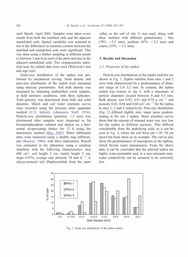
Fig. 1. Grain size distributio
valley as the soil of site 1) was used, along with
three mulches with different granulometry : fine
(78% < 3.2 mm), medium (47% < 3.2 mm) and
coarse (19% < 3.2 mm).
3. Results and discussion
3.1. Properties of the tephra
Particle-size distributions of the tephra mulches are
shown in Fig. 1. Tephra mulches from sites 1 and 2
were both characterized by a predominance of diam-
eter range of 1.0–3.2 mm. In contrast, the tephra
mulch was coarser in site 3, with a maximum of
particle diameters located between 4 and 6.3 mm.
Bulk density was 0.95, 0.91 and 0.79 g cm� 3 and
porosity 0.63, 0.64 and 0.68 cm3 cm� 3 for the tephra
in sites 1, 2 and 3 respectively. Pore-size distribution
(Fig. 2) differed slightly also, larger pores predom-
inating in the site 3 tephra. Water retention curves
show that the amount of retained water was very low
for the tephra at different suctions. This differed
considerably from the underlying soils, as it can be
seen in Fig. 3, where the soil from site 1 (0–30 cm
layer) has been taken as an example. The curves also
show the predominance of macropores in the tephras,
which favour water transmission. From the above
data, it can be concluded that the selected tephra are
highly water-permeable and, in a non-saturated state,
water conductivity can be assumed to be extremely
low.
n of the tephra mulch.
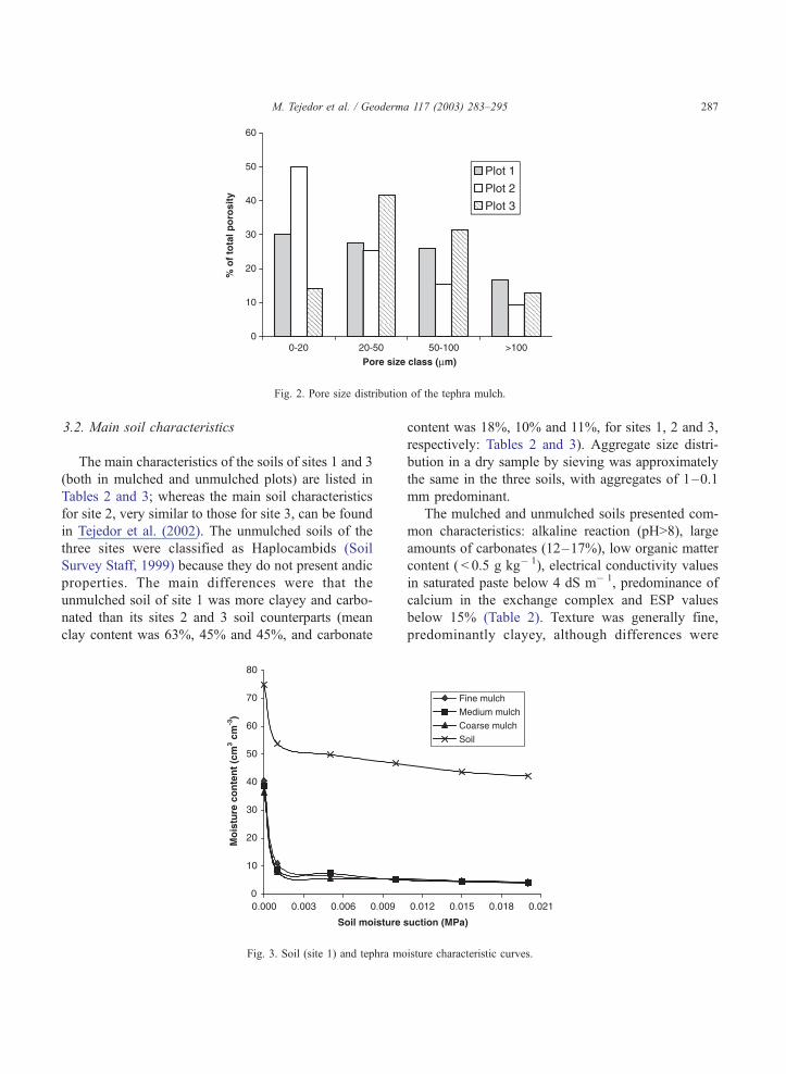
Fig. 2. Pore size distribution of the tephra mulch.
M. Tejedor et al. / Geoderma 117 (2003) 283–295 287
3.2. Main soil characteristics
The main characteristics of the soils of sites 1 and 3
(both in mulched and unmulched plots) are listed in
Tables 2 and 3; whereas the main soil characteristics
for site 2, very similar to those for site 3, can be found
in Tejedor et al. (2002). The unmulched soils of the
three sites were classified as Haplocambids (Soil
Survey Staff, 1999) because they do not present andic
properties. The main differences were that the
unmulched soil of site 1 was more clayey and carbo-
nated than its sites 2 and 3 soil counterparts (mean
clay content was 63%, 45% and 45%, and carbonate
Fig. 3. Soil (site 1) and tephra mo
content was 18%, 10% and 11%, for sites 1, 2 and 3,
respectively: Tables 2 and 3). Aggregate size distri-
bution in a dry sample by sieving was approximately
the same in the three soils, with aggregates of 1–0.1
mm predominant.
The mulched and unmulched soils presented com-
mon characteristics: alkaline reaction (pH>8), large
amounts of carbonates (12–17%), low organic matter
content ( < 0.5 g kg� 1), electrical conductivity values
in saturated paste below 4 dS m� 1, predominance of
calcium in the exchange complex and ESP values
below 15% (Table 2). Texture was generally fine,
predominantly clayey, although differences were
isture characteristic curves.
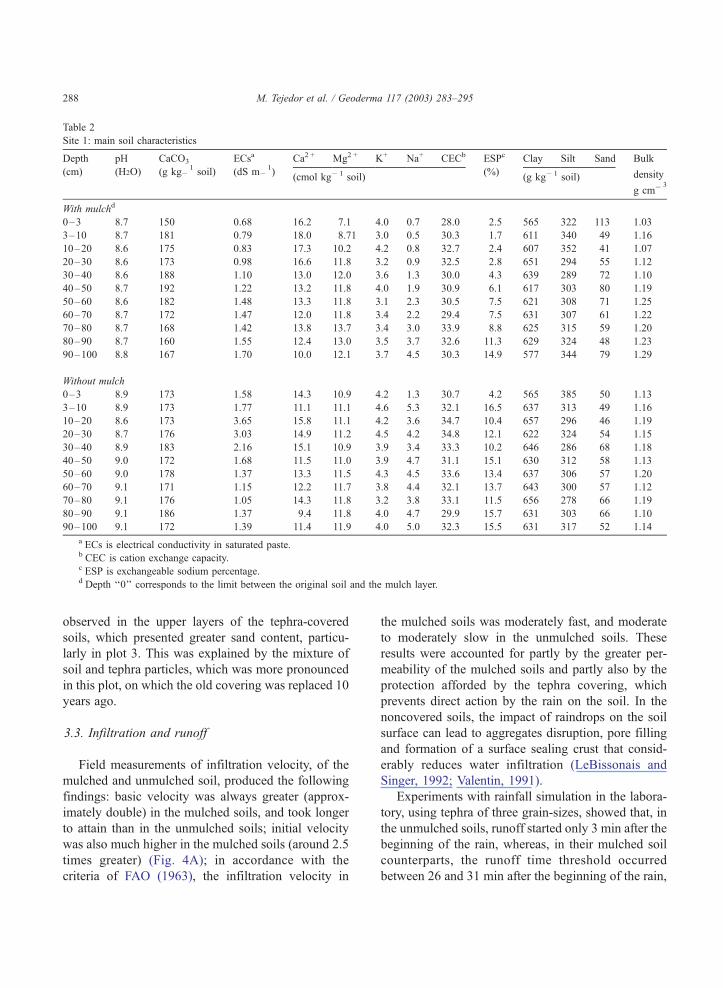
Table 2
Site 1: main soil characteristics
Depth pH CaCO3 ECsa Ca2 + Mg2 + K+ Na+ CECb ESPc Clay Silt Sand Bulk
(cm) (H2O) (g kg�1soil) (dS m�
1)
(cmol kg� 1 soil)(%)
(g kg� 1 soil) density
g cm� 3
With mulchd
0–3 8.7 150 0.68 16.2 7.1 4.0 0.7 28.0 2.5 565 322 113 1.03
3–10 8.7 181 0.79 18.0 8.71 3.0 0.5 30.3 1.7 611 340 49 1.16
10–20 8.6 175 0.83 17.3 10.2 4.2 0.8 32.7 2.4 607 352 41 1.07
20–30 8.6 173 0.98 16.6 11.8 3.2 0.9 32.5 2.8 651 294 55 1.12
30–40 8.6 188 1.10 13.0 12.0 3.6 1.3 30.0 4.3 639 289 72 1.10
40–50 8.7 192 1.22 13.2 11.8 4.0 1.9 30.9 6.1 617 303 80 1.19
50–60 8.6 182 1.48 13.3 11.8 3.1 2.3 30.5 7.5 621 308 71 1.25
60–70 8.7 172 1.47 12.0 11.8 3.4 2.2 29.4 7.5 631 307 61 1.22
70–80 8.7 168 1.42 13.8 13.7 3.4 3.0 33.9 8.8 625 315 59 1.20
80–90 8.7 160 1.55 12.4 13.0 3.5 3.7 32.6 11.3 629 324 48 1.23
90–100 8.8 167 1.70 10.0 12.1 3.7 4.5 30.3 14.9 577 344 79 1.29
Without mulch
0–3 8.9 173 1.58 14.3 10.9 4.2 1.3 30.7 4.2 565 385 50 1.13
3–10 8.9 173 1.77 11.1 11.1 4.6 5.3 32.1 16.5 637 313 49 1.16
10–20 8.6 173 3.65 15.8 11.1 4.2 3.6 34.7 10.4 657 296 46 1.19
20–30 8.7 176 3.03 14.9 11.2 4.5 4.2 34.8 12.1 622 324 54 1.15
30–40 8.9 183 2.16 15.1 10.9 3.9 3.4 33.3 10.2 646 286 68 1.18
40–50 9.0 172 1.68 11.5 11.0 3.9 4.7 31.1 15.1 630 312 58 1.13
50–60 9.0 178 1.37 13.3 11.5 4.3 4.5 33.6 13.4 637 306 57 1.20
60–70 9.1 171 1.15 12.2 11.7 3.8 4.4 32.1 13.7 643 300 57 1.12
70–80 9.1 176 1.05 14.3 11.8 3.2 3.8 33.1 11.5 656 278 66 1.19
80–90 9.1 186 1.37 9.4 11.8 4.0 4.7 29.9 15.7 631 303 66 1.10
90–100 9.1 172 1.39 11.4 11.9 4.0 5.0 32.3 15.5 631 317 52 1.14
a ECs is electrical conductivity in saturated paste.b CEC is cation exchange capacity.c ESP is exchangeable sodium percentage.d Depth ‘‘0’’ corresponds to the limit between the original soil and the mulch layer.
M. Tejedor et al. / Geoderma 117 (2003) 283–295288
observed in the upper layers of the tephra-covered
soils, which presented greater sand content, particu-
larly in plot 3. This was explained by the mixture of
soil and tephra particles, which was more pronounced
in this plot, on which the old covering was replaced 10
years ago.
3.3. Infiltration and runoff
Field measurements of infiltration velocity, of the
mulched and unmulched soil, produced the following
findings: basic velocity was always greater (approx-
imately double) in the mulched soils, and took longer
to attain than in the unmulched soils; initial velocity
was also much higher in the mulched soils (around 2.5
times greater) (Fig. 4A); in accordance with the
criteria of FAO (1963), the infiltration velocity in
the mulched soils was moderately fast, and moderate
to moderately slow in the unmulched soils. These
results were accounted for partly by the greater per-
meability of the mulched soils and partly also by the
protection afforded by the tephra covering, which
prevents direct action by the rain on the soil. In the
noncovered soils, the impact of raindrops on the soil
surface can lead to aggregates disruption, pore filling
and formation of a surface sealing crust that consid-
erably reduces water infiltration (LeBissonais and
Singer, 1992; Valentin, 1991).
Experiments with rainfall simulation in the labora-
tory, using tephra of three grain-sizes, showed that, in
the unmulched soils, runoff started only 3 min after the
beginning of the rain, whereas, in their mulched soil
counterparts, the runoff time threshold occurred
between 26 and 31 min after the beginning of the rain,
Table 3
Site 3: main soil characteristics
Depth pH CaCO3 ECsa Ca2 + Mg2 + K+ Na+ CECb ESPc Clay Silt Sand Bulk
(cm) (H2O) (g kg� 1
soil) (dS m� 1
)(cmol kg� 1 soil)
(%)(g kg� 1 soil) density
(g cm� 3)
With mulchd
0–3 8.9 105 0.94 14.4 7.7 4.9 0.8 27.8 2.9 456 345 199 1.11
3–10 9.0 90 0.72 16.1 6.1 3.5 0.7 26.4 2.7 466 319 216 1.12
10–20 9.0 120 0.96 19.6 7.3 2.4 1.3 31.9 4.1 519 340 144 1.14
20–30 8.7 132 2.06 18.8 9.0 2.6 2.3 32.7 7.0 544 423 33 1.00
30–40 8.6 125 2.93 17.9 9.5 2.0 2.4 31.8 7.5 541 450 9 1.01
40–50 8.6 120 3.00 18.3 9.9 2.3 3.4 33.9 10.0 555 430 15 0.98
50–60 8.6 124 2.96 19.2 9.5 2.6 2.2 33.5 6.6 541 447 12 0.99
60–70 8.7 125 2.83 14.4 9.8 3.3 4.6 32.1 14.3 506 476 17 1.00
70–80 8.8 126 2.67 16.8 10.3 2.9 3.0 33.0 9.1 455 520 25 1.03
80–90 8.9 121 2.47 15.3 10.9 2.9 4.1 33.2 12.3 407 538 55 1.02
90–100 8.9 115 2.27 16.4 11.1 3.4 3.6 34.5 10.4 406 521 73 1.01
Without mulch
0–3 8.9 142 0.62 19.1 8.8 4.6 0.6 33.1 1.8 368 615 17 1.10
3–10 9.1 141 0.91 16.1 9.6 3.3 1.8 30.8 5.8 453 540 7 1.11
10–20 9.1 135 1.38 15.5 9.1 2.6 2.5 29.7 8.4 467 526 7 1.18
20–30 8.8 128 2.82 17.5 9.3 2.9 2.5 32.2 7.8 472 522 6 1.20
30–40 8.8 129 2.85 18.0 9.6 2.5 2.4 34.6 6.9 492 502 5 1.20
40–50 8.7 121 2.99 18.4 10.1 2.8 2.9 34.2 8.5 519 474 7 1.13
50–60 8.7 125 2.80 19.0 9.6 2.8 2.5 33.9 7.4 508 482 70 1.21
60–70 8.8 125 2.54 16.9 10.0 3.2 2.6 32.7 8.0 442 543 15 1.09
70–80 8.9 113 2.21 17.0 9.6 3.4 3.5 33.5 10.4 397 562 41 1.11
80–90 9.0 100 2.14 17.3 10.3 3.2 3.4 34.1 9.9 357 556 87 1.20
90–100 8.8 117 2.42 16.5 11.0 3.6 3.8 34.9 10.9 497 467 37 1.15
a ECs is electrical conductivity in saturated paste.b CEC is cation exchange capacity.c ESP is exchangeable sodium percentage.d Depth ‘‘0’’ corresponds to the limit between the original soil and the mulch layer.
M. Tejedor et al. / Geoderma 117 (2003) 283–295 289
depending on the tephra grain size. Fig. 4B gives the
results of the rainfall simulation using a mulch of
medium grain size and a soil taken from the same
valley as that of site 1. The experimental results lead to
the same conclusion as that reached in the field,
namely, that the tephra covering exerts a protective
effect on the soil, reducing the impact of raindrops,
preventing sealing crust formation and reducing run-
off.
3.4. Soil moisture content dynamics
The results of the soil moisture measurements for
the mulched and unmulched soils are shown for the
various soil depths and different sampling dates in
Figs. 5 and 6 for sites 1 and 3, respectively. These
results are as follows.
First, soil moisture vertical variability was low,
with coefficients of variation of the means up to a
depth of 1 m as follows: 0.7%, 2.3% and 1.3% in the
mulched soils of sites 1, 2 and 3, respectively; 0.9%,
1.0% and 0.6% in the unmulched plots, respectively.
Second, as already mentioned, soil moisture verti-
cal distribution was very similar in both sites 1 (Fig.
5) and 2 (Tejedor et al., 2002), despite the difference
in the clay percentage. This can be attributed to the
fact that the site 1 soils were richer in clays but
received less annual precipitation (Table 1) than their
site 2 soil counterparts.
Third, taking the moisture distribution throughout
the mulched and unmulched soils separately, differ-
ences were very often found between site 3, on one
hand, and sites 1 and 2, on the other hand (Figs. 5 and 6).
In the latter two sites, a high degree of regularity was
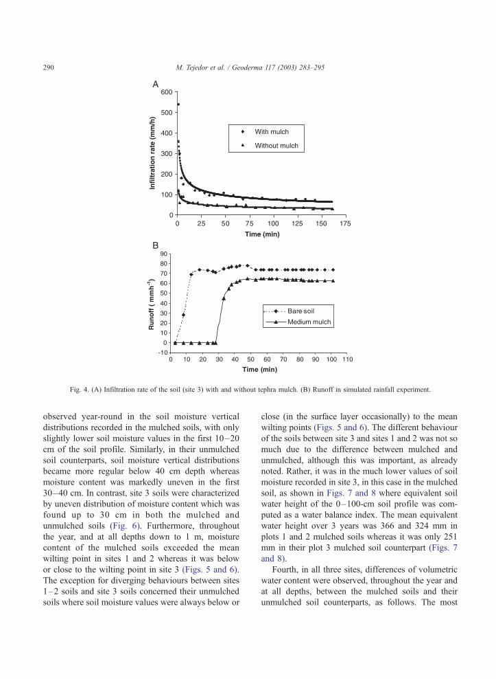
Fig. 4. (A) Infiltration rate of the soil (site 3) with and without tephra mulch. (B) Runoff in simulated rainfall experiment.
M. Tejedor et al. / Geoderma 117 (2003) 283–295290
observed year-round in the soil moisture vertical
distributions recorded in the mulched soils, with only
slightly lower soil moisture values in the first 10–20
cm of the soil profile. Similarly, in their unmulched
soil counterparts, soil moisture vertical distributions
became more regular below 40 cm depth whereas
moisture content was markedly uneven in the first
30–40 cm. In contrast, site 3 soils were characterized
by uneven distribution of moisture content which was
found up to 30 cm in both the mulched and
unmulched soils (Fig. 6). Furthermore, throughout
the year, and at all depths down to 1 m, moisture
content of the mulched soils exceeded the mean
wilting point in sites 1 and 2 whereas it was below
or close to the wilting point in site 3 (Figs. 5 and 6).
The exception for diverging behaviours between sites
1–2 soils and site 3 soils concerned their unmulched
soils where soil moisture values were always below or
close (in the surface layer occasionally) to the mean
wilting points (Figs. 5 and 6). The different behaviour
of the soils between site 3 and sites 1 and 2 was not so
much due to the difference between mulched and
unmulched, although this was important, as already
noted. Rather, it was in the much lower values of soil
moisture recorded in site 3, in this case in the mulched
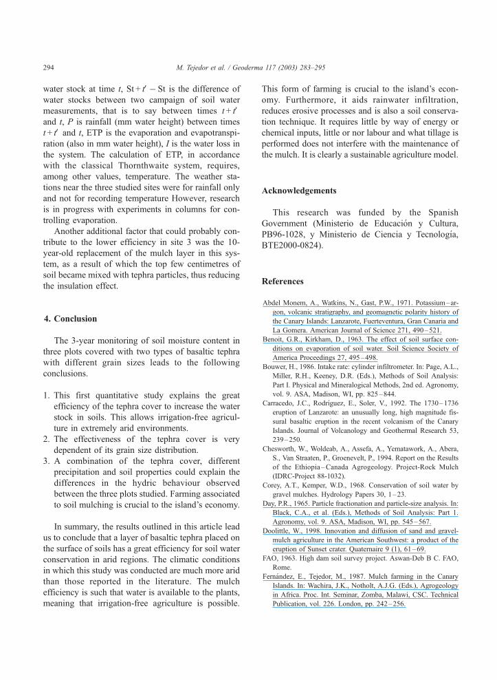
soil, as shown in Figs. 7 and 8 where equivalent soil
water height of the 0–100-cm soil profile was com-
puted as a water balance index. The mean equivalent
water height over 3 years was 366 and 324 mm in
plots 1 and 2 mulched soils whereas it was only 251
mm in their plot 3 mulched soil counterpart (Figs. 7
and 8).
Fourth, in all three sites, differences of volumetric
water content were observed, throughout the year and
at all depths, between the mulched soils and their
unmulched soil counterparts, as follows. The most
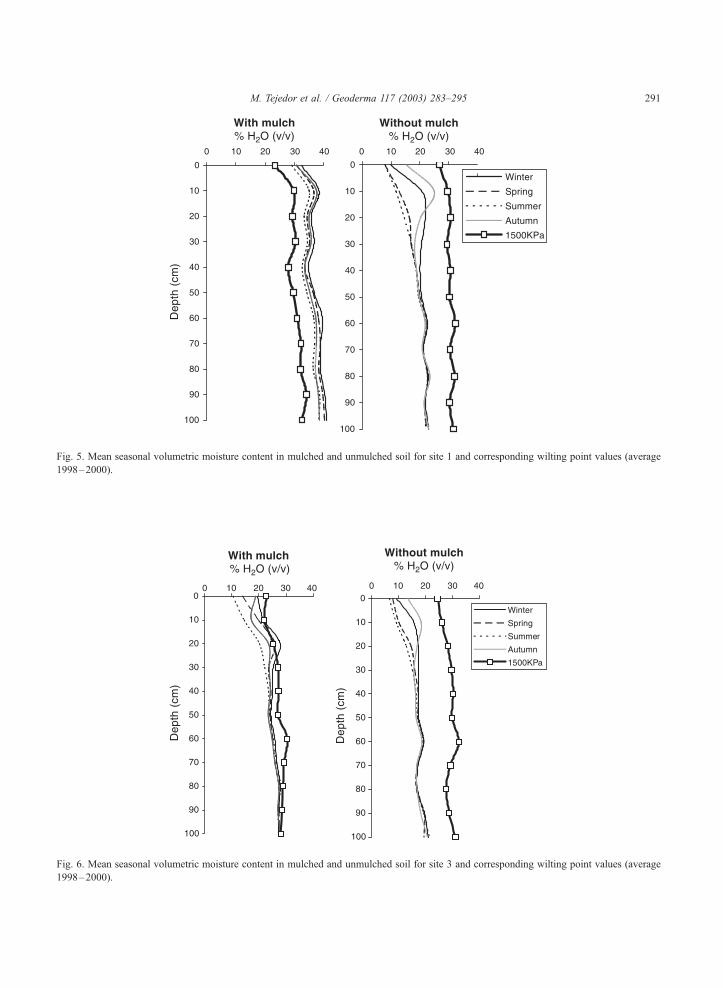
Fig. 5. Mean seasonal volumetric moisture content in mulched and unmulched soil for site 1 and corresponding wilting point values (average
1998–2000).
Fig. 6. Mean seasonal volumetric moisture content in mulched and unmulched soil for site 3 and corresponding wilting point values (average
1998–2000).
M. Tejedor et al. / Geoderma 117 (2003) 283–295 291

Fig. 7. Rainfall and equivalent soil water depth to 100 cm (mm) in mulched and unmulched soil for site 1 and corresponding wilting point
values.
M. Tejedor et al. / Geoderma 117 (2003) 283–295292
pronounced discrepancies were observed in both sites
1 and 2, particularly in the uppermost soil layers and
during the driest months (Fig. 5). Further down,
differences were less marked, although, at 1 m depth,
13% more water was recorded in the mulched soil
compared to its unmulched soil counterpart (Fig. 5).
In site 3, with the same clay percentage as the soil of
site 2 in the profile overall, the differences were less
pronounced, particularly at 10–20 cm (Fig. 6), where
there is a mixture of soil and tephra. In sites 1 and 2,
the differences in moisture content between mulched
and unmulched soils were significant at the 99%
probability level for all the months and depths studied
(up to 1 m). In the case of site 3, the differences were
also significant ( p = 0.01) below 20 cm, whereas
between 0 and 20 cm, in the mixed tephra–soil layer,
significance level was only 95% and at times non-
significant.
Finally, it was worth noting that despite the con-
siderably lower rainfall in the third year, the figures
for moisture content in the three mulched soils were
still high.
The results obtained show that coverings of pyro-
clastic materials on soils can be very effective for soil
water conservation and also that there were differ-
ences between the studied plots (between site 3 and
sites 1 and 2). We will now account for these results
and will discuss on the underlying processes which
should explain the tephra mulch efficiency and the
discrepancies observed between the studied sites, as
follows.
The degree of effectiveness observed greatly excee-
ded the range given in the literature for inorganic
materials (Corey and Kemper, 1968; Othieno, 1980;
Chesworth et al., 1994) and was attributed to the
characteristics of the studied tephra and their mulching
effects. The basaltic tephra used had a very low water
retention capacity, a larger grain size than that of the
adjacent soils, a large porosity, large water infiltration
capacity and hydraulic conductivity when wet but low
hydraulic conductivity when dry, a low heat capacity
and a poor thermal conductivity (Gonzalez et al.,
1964). All these properties make it an excellent mulch.
Hence, full advantage is taken of the scarce rainfall,
which is usually very intense. Conversely, on the
noncovered soils nearby the frequent presence of a
sealing crust reduces infiltration and contributes to
water loss through run-off. Once the heavy rainfall
periods end, the considerable evapotranspiration leads
to rapid water loss in the tephra layer, the pores
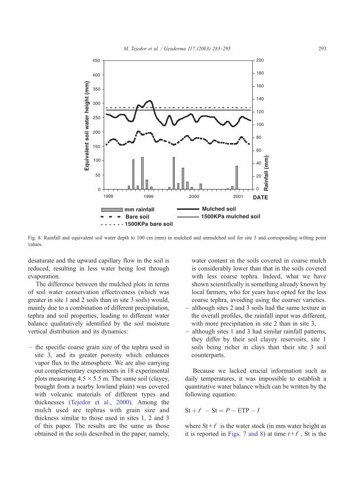
Fig. 8. Rainfall and equivalent soil water depth to 100 cm (mm) in mulched and unmulched soil for site 3 and corresponding wilting point
values.
M. Tejedor et al. / Geoderma 117 (2003) 283–295 293
desaturate and the upward capillary flow in the soil is
reduced, resulting in less water being lost through
evaporation.
The difference between the mulched plots in terms
of soil water conservation effectiveness (which was
greater in site 1 and 2 soils than in site 3 soils) would,
mainly due to a combination of different precipitation,
tephra and soil properties, leading to different water
balance qualitatively identified by the soil moisture
vertical distribution and its dynamics:
– the specific coarse grain size of the tephra used in
site 3, and its greater porosity which enhances
vapor flux to the atmosphere. We are also carrying
out complementary experiments in 18 experimental
plots measuring 4.5� 5.5 m. The same soil (clayey,
brought from a nearby lowland plain) was covered
with volcanic materials of different types and
thicknesses (Tejedor et al., 2000). Among the
mulch used are tephras with grain size and
thickness similar to those used in sites 1, 2 and 3
of this paper. The results are the same as those
obtained in the soils described in the paper, namely,
water content in the soils covered in coarse mulch
is considerably lower than that in the soils covered
with less coarse tephra. Indeed, what we have
shown scientifically is something already known by
local farmers, who for years have opted for the less
coarse tephra, avoiding using the coarser varieties.
– although sites 2 and 3 soils had the same texture in
the overall profiles, the rainfall input was different,
with more precipitation in site 2 than in site 3,
– although sites 1 and 3 had similar rainfall patterns,
they differ by their soil clayey reservoirs, site 1
soils being richer in clays than their site 3 soil
counterparts.
Because we lacked crucial information such as
daily temperatures, it was impossible to establish a
quantitative water balance which can be written by the
following equation:
Stþ tV� St ¼ P � ETP� I
where St + tV is the water stock (in mm water height as
it is reported in Figs. 7 and 8) at time t+ tV, St is the
M. Tejedor et al. / Geoderma 117 (2003) 283–295294
water stock at time t, St + tV� St is the difference of
water stocks between two campaign of soil water
measurements, that is to say between times t + tVand t, P is rainfall (mm water height) between times
t+ tV and t, ETP is the evaporation and evapotranspi-
ration (also in mm water height), I is the water loss in
the system. The calculation of ETP, in accordance
with the classical Thornthwaite system, requires,
among other values, temperature. The weather sta-
tions near the three studied sites were for rainfall only
and not for recording temperature However, research
is in progress with experiments in columns for con-
trolling evaporation.
Another additional factor that could probably con-
tribute to the lower efficiency in site 3 was the 10-
year-old replacement of the mulch layer in this sys-
tem, as a result of which the top few centimetres of
soil became mixed with tephra particles, thus reducing
the insulation effect.
4. Conclusion
The 3-year monitoring of soil moisture content in
three plots covered with two types of basaltic tephra
with different grain sizes leads to the following
conclusions.
1. This first quantitative study explains the great
efficiency of the tephra cover to increase the water
stock in soils. This allows irrigation-free agricul-
ture in extremely arid environments.
2. The effectiveness of the tephra cover is very
dependent of its grain size distribution.
3. A combination of the tephra cover, different
precipitation and soil properties could explain the
differences in the hydric behaviour observed
between the three plots studied. Farming associated
to soil mulching is crucial to the island’s economy.
In summary, the results outlined in this article lead
us to conclude that a layer of basaltic tephra placed on
the surface of soils has a great efficiency for soil water
conservation in arid regions. The climatic conditions
in which this study was conducted are much more arid
than those reported in the literature. The mulch
efficiency is such that water is available to the plants,
meaning that irrigation-free agriculture is possible.
This form of farming is crucial to the island’s econ-
omy. Furthermore, it aids rainwater infiltration,
reduces erosive processes and is also a soil conserva-
tion technique. It requires little by way of energy or
chemical inputs, little or nor labour and what tillage is
performed does not interfere with the maintenance of
the mulch. It is clearly a sustainable agriculture model.
Acknowledgements
This research was funded by the Spanish
Government (Ministerio de Educacion y Cultura,
PB96-1028, y Ministerio de Ciencia y Tecnologıa,
BTE2000-0824).
References
Abdel Monem, A., Watkins, N., Gast, P.W., 1971. Potassium–ar-
gon, volcanic stratigraphy, and geomagnetic polarity history of
the Canary Islands: Lanzarote, Fuerteventura, Gran Canaria and
La Gomera. American Journal of Science 271, 490–521.
Benoit, G.R., Kirkham, D., 1963. The effect of soil surface con-
ditions on evaporation of soil water. Soil Science Society of
America Proceedings 27, 495–498.
Bouwer, H., 1986. Intake rate: cylinder infiltrometer. In: Page, A.L.,
Miller, R.H., Keeney, D.R. (Eds.), Methods of Soil Analysis:
Part I. Physical and Mineralogical Methods, 2nd ed. Agronomy,
vol. 9. ASA, Madison, WI, pp. 825–844.
Carracedo, J.C., Rodrıguez, E., Soler, V., 1992. The 1730–1736
eruption of Lanzarote: an unusually long, high magnitude fis-
sural basaltic eruption in the recent volcanism of the Canary
Islands. Journal of Volcanology and Geothermal Research 53,
239–250.
Chesworth, W., Woldeab, A., Assefa, A., Yematawork, A., Abera,
S., Van Straaten, P., Groenevelt, P., 1994. Report on the Results
of the Ethiopia –Canada Agrogeology. Project-Rock Mulch
(IDRC-Project 88-1032).
Corey, A.T., Kemper, W.D., 1968. Conservation of soil water by
gravel mulches. Hydrology Papers 30, 1–23.
Day, P.R., 1965. Particle fractionation and particle-size analysis. In:
Black, C.A., et al. (Eds.), Methods of Soil Analysis: Part 1.
Agronomy, vol. 9. ASA, Madison, WI, pp. 545–567.
Doolittle, W., 1998. Innovation and diffusion of sand and gravel-
mulch agriculture in the American Southwest: a product of the
eruption of Sunset crater. Quaternaire 9 (1), 61–69.
FAO, 1963. High dam soil survey project. Aswan-Deb B C. FAO,
Rome.
Fernandez, E., Tejedor, M., 1987. Mulch farming in the Canary
Islands. In: Wachira, J.K., Notholt, A.J.G. (Eds.), Agrogeology
in Africa. Proc. Int. Seminar, Zomba, Malawi, CSC. Technical
Publication, vol. 226. London, pp. 242–256.
M. Tejedor et al. / Geoderma 117 (2003) 283–295 295
Fuster, J.M., Fernandez, S., Sagredo, J., 1968. Geologıa y Volca-
nologıa de las Islas Canarias, Lanzarote. Instituto Lucas Malla-
da, C.S.I.C., Madrid.
Gonzalez, F., Kress, M., Garcıa, J., Higueras, A., 1964. El ‘‘mulch’’
en los cultivos enarenados de Canarias. Instituto de Hidrologıa
Centro de Estudios Hidrograficos, pp. 1–22.
Goor, A.Y., Barney, C.W., 1976. Forest tree planting in arid zones
Ronald Press, New York. 504 pp.
Groenevelt, P.H., Van Straaten, P., Rasiah, V., Simpson, J., 1989.
Modifications in evaporation by rock mulches. Soil Technology
2, 279–285.
Kamar, M.J., 1994. Advances in GeoEcology 27, 163–179.
Kemper, W.D., Nicks, A.D., Corey, A.T., 1994. Accumulation of
water in soils under gravel and sand mulches. Soil Science
Society of America Journal 58, 56–63.
LeBissonais, Y., Singer, M., 1992. Crusting, runoff and erosion
response to soil water content and successive rainfalls. Soil
Science Society of America Journal 56, 1898–1903.
Modaihsh, A.S., Horton, R., Kirkham, D., 1985. Soil water evap-
oration suppression by sand mulches. Soil Science 139 (4),
357–361.
Othieno, C.O., 1980. Effects of mulches on soil water content and
water status of tea plants in Kenya. Experimental Agriculture
16, 295–302.
Perez, F.L., 1991. Soil moisture and the distribution of giant An-
dean rosettes on talus slopes of a desert paramo. Climate Re-
search 1, 217–231.
Perez, F.L., 1998. Conservation of soil moisture by different stone
covers on alpine talus slopes (Lassen, California). Catena 33,
155–177.
Perez, F.L., 2000. The influence of surface volcaniclastic layers
from Haleakala (Maui, Hawaii) on soil water conservation. Cat-
ena 38, 301–332.
Poesen, J., Ingelmo-Sanchez, F., Mucher, H., 1990. The hydrolog-
ical response of soil surfaces to rainfall as affected by cover and
position of rock fragments in the top layer. Earth Surface Pro-
cesses and Landforms 15, 653–671.
Soil Survey Staff, 1999. Soil Taxonomy: a basic system of soil
classification for making and interpreting soil surveys, 2nd ed.
USDA-SCS Agric. Handb., vol. 436. U.S. Govt. Print. Office,
Washington, DC. 869 pp.
Tejedor, M., Jimenez, C.C., Dıaz, F., 2000. Optimizacion del espe-
sor y tipo de mulch de cenizas volcanicas en la conservacion del
agua del suelo. Resultados preliminares. 11th International Soil
Conservation Organization Conference, Buenos Aires.
Tejedor, M., Jimenez, C.C., Dıaz, F., 2002. Soil Moisture regime
changes in tephra-mulched soils: implications for Soil Taxono-
my. Soil Science Society of America Journal 66 (1), 202–206.
Unger, P.W., 1971. Soil profile gravel layers: I. Effect on water
storage, distribution, and evaporation. Soil Science Society of
America Proceedings 35, 631–634.
U.S. Salinity Laboratory Staff, 1954. In: Richards, L.A. (Ed.), Di-
agnosis and improvement of saline and alkali soils. U.S. Dept.
of Agric. Handb., vol. 60. U.S. Govt. Print. Office, Washington,
DC. 172 pp.
Valentin, C., 1991. Surface crusting in two alluvial soils of northern
Niger. Geoderma 48, 201–222.
Valentin, C., Casenave, A., 1992. Infiltration into sealed soils as
influenced by gravel cover. Soil Science Society of America
Journal 56 (6), 1667–1673.