utilizing the full potential of dredging works: ecologically enriched extraction sites
TRANSCRIPT

ABSTRACT
Marine extraction sites alter the morphology
of the seabed and in doing so offer unique
opportunities to create a new environment in
these locations. A new physical lay-out means
deeper waters and different currents and
sediment characteristics, which offer
conditions to develop a new ecosystem or
a sanctuary for certain fish species. This
potential has been tested in a full-scale pilot
project in an extraction site in the North Sea
within the Building with Nature research
programme.
The necessity for this pilot project on utilising
the potential of new extraction sites is
evident. Rising sea levels and increasing
pressure on available coastal lands lead to
the need for new land reclamations for ports,
cities, nature and recreation, but also sand
nourishments for sustainable coastal safety.
These are only a few of the many projects
that are expected to take place in the future,
which will need significant amounts of sand
from offshore sources, thus creating extensive
extraction sites. These extraction operations
should be seen as an opportunity to manage
these sites and create an overall increase in
natural value of the seabed.
The research done here derived from the
premise: Instead of focussing on minimising
negative effects let’s create opportunities to
maximise positive effects. This article describes
efforts to do this during the design process,
construction and monitoring programme by
creating a landscaped extraction site in the
North Sea. It provides an overview of the
preliminary results, focussing on the added
value of landscaped extraction sites. It also
describes when they are most effective; it is
important to realise that the choice for an
ecological landscaping design should be based
on both the potential for development of a
new ecosystem and the economic workability
of the extraction itself (main function of the
site).
This article is based on a paper presented at
the 33rd PIANC World Congress, San
Francisco, California, in June 2014, which
received first prize for the PIANC Young
Professional Award for outstanding technical
paper and presentation authored by a young
professional. It is reprinted here in a slightly
adapted form with the permission of PIANC.
INTRODUCTION
Coastal development and management
along sandy coasts, such as those in the
Netherlands, is heavily based on dynamic sand
nourishment programmes, often combined
with new (seawards) land development.
Depending on the coastline development,
expected sea level rise can require an
up-scaling of nourishment activities to be
able to maintain current safety levels.
Ideally, these nourishments are combined
with quality enhancement of the coastal living
communities, recreational sites and protected
nature areas.
In the case of the Netherlands, coastal experts
expect that the current 12 million m3 of sand
needed to maintain the coast each year may
rise to 40-80 million m3/year (Aarninkhof et al.
2012). This large amount of sand will be
dredged from sand extraction sites in the
North Sea (Figure 1). The expected increase in
volume demands more and larger extraction
sites.
Although in the short term the dredging will
affect the local seabed and its inhabitants
(they are effectively removed), the increase of
the dimensions of the extraction sites offers
unique opportunities to develop these sites
for more than just extraction of sand.
UTILISING THE FULL POTENTIAL OFDREDGING WORKS: ECOLOGICALLY ENRICHED EXTRACTION SITES
D.C. RIJKS, M.F. DE JONG, M.J. BAPTIST AND S.G.J. AARNINKHOF
Above: Using a beam trawl, 4.5-m wide made with
80 mm mesh to monitor for demersal fish – fish living
and feeding on or near the seabed; the net filled with
fish attracts a variety of gulls. Repetitive monitoring is a
critical part of ecologically enriching extraction sites.
Utilising the Full Potential of Dredging Works: Ecologically Enriched Extraction Sites 5

6 Terra et Aqua | Number 136 | September 2014
for extraction would have increased as a result
of longer sailing distances.
Ecological Landscaping Building with Nature took this innovative
extraction site a step further and designed
and constructed landscaped bed forms in the
seabed of the extraction site. The design,
inspired by locally occurring sand waves,
aimed at creating maximum gradients for
water depth and current velocities, hence
seabed sediments. This yielded a diverse
environment for a variety of habitats whilst
taking into account that the created slopes
and depths would not induce oxygen
depletion in the site.
The artist’s impressions in Figure 2 summarises
this concept: in contrast to extraction areas
with a flat seabed (a), which after dredging
yield an ecologically poor habitat (b), seabeds
with natural bed forms, with landscaped
mining areas (c) are hypothesised to
encourage re-colonisation and promote higher
biodiversity and productivity (d) after
completion of the dredging operations.
The subsequent monitoring focussed on
determining whether this innovative sand
extraction site design with a higher habitat
INNOVATIVE SAND EXTRACTIONAlthough traditionally sand extraction in
the Netherlands is permitted in the upper
2 metres of the seabed and in designated
areas below the 20-metres depth contour
(usually at least 12 nautical miles from the
coastline), the permit for the sand extraction
site for Maasvlakte 2 allowed for deep
extraction (20 m below the seabed) reducing
the extraction site size, and thus the impact
on the seabed, by a factor of ten. In fact, if a
(traditional) 2-m deep extraction had been
required, the area needed for the extraction
of sand for Maasvlakte 2 would have
measured about 11 km by 30 km and costs
The research described here tests the premise
that instead of focussing on minimising
negative effects, opportunities can be created
to maximise positive effects. Using an
ecosystem-based approach through an
ecological design and using natural processes,
the traditional ‘ecological threats’ can be
turned into sustainable opportunities.
This philosophy was tested in the Building
with Nature research programme (see box),
through a large scale pilot project prepared
and carried out in the 240 million m3 sand
extraction site for the Maasvlakte 2 Port of
Rotterdam expansion project.
Figure 1. Coastal replenishment and management along sandy coasts is based on dynamic sand nourishment
programmes and demands many millions of cubic metres of sand each year.
INNOVATION PROGRAMME ‘BUILDING WITH NATURE’
‘Building with Nature’ is a five-year
innovation and research programme (2008-
2012) carried out by the Foundation
EcoShape (www.ecoshape.nl). This € 30
million programme is an initiative of the
Dutch dredging industry, whilst partners
represent academia, research institutes,
consultancies and public parties.
The programme aims to develop
knowledge for the sustainable development
of coasts, deltas and rivers by combining
practical hands-on experience with state-of-
the-art technical and scientific knowledge
on the functioning of the ecosystem and its
interaction with infrastructures. Key is that
infrastructure solutions are sought that
utilise and at the same time enhance the
natural system, such that ecological and
economic interests strengthen each other.
This approach is reflected in the five
objectives that were established for the
programme:
1. Develop ecosystem knowledge enabling
‘Building with Nature’
2. Establish how to bring the BwN concept
forward in society and make it happen
3. Develop scientifically sound design rules
and norms
4. Develop expertise to apply the BwN
concept
5. Make the concept tangible using
practical BwN examples
The core of the programme is centred on
four real-world cases (the Holland Coast,
Southwest Delta and the Marker and IJssel
Lakes in the Netherlands, plus a case in
Singapore in a tropical environment).
Generic research on governance-related
topics and nature sciences is carried out by
a group of 19 PhD researchers. Throughout
the programme the interaction between
disciplines is promoted, involving ecologists,
engineers and policy makers. The lessons
learnt from these cases are used to
formulate generic guidance for the design
and implementation of these types of
solutions, in the Netherlands as well as
abroad. All results of the programme
became available through a public wiki as
per January 1, 2013. (https://publicwiki.
deltares.nl/display/BWN/Building+with+Nature).

DAAN RIJKS
works at Hydronamics bv., the in-house
engineering department of Boskalis as an
engineering manager and marine
environment and morphological expert in
international projects on Dredging, Ports,
Waterways and Navigation. At Boskalis
he is member of the corporate Taskforces
Eco-Engineering and Energy Management
(Emissions). He is also actively involved as
a Board member of the Central Dredging
Association CEDA and secretary of the
PIANC EnviCom WG150 on Sustainable
Ports.
MAARTEN DE JONG
is a marine ecologist and currently
finishing his PhD project “Modelling the
ecological potential of sand extraction”.
The project is part of the EcoShape /
Building with Nature programme and
focusses on the short-term impacts of
large-scale and deep sand extraction and
ecological landscaping on organisms on
the seabed, bottom fish and the change of
sediment characteristics, bathymetry and
hydrodynamics.
MARTIN BAPTIST
is a marine ecologist with a PhD in
hydraulic engineering. He has extensive
experience with hydrodynamic and
morphodynamic models, as well as
biological measurements and statistical
models. He is a member of the programme
committee of the EcoShape/Building with
Nature programme as well as a researcher
at IMARES Wageningen UR, Professor at
Van Hall Larenstein University of Applied
Sciences and Senior Research Associate at
Waddenacademie.
STEFAN AARNINKHOF
received both his degree as a civil engineer
in 1996 and later his PhD from Delft
University of Technology. After 10 years at
Delft Hydraulics (now Deltares), he joined
Hydronamic’s Marine Environment and
Morphology group in 2006, where he is
now Deputy Manager. Until recently, he
was in the Management Team of the
EcoShape/Building with Nature programme
and is presently responsible for the
Environmental Engineering Group amongst
other things.
Utilising the Full Potential of Dredging Works: Ecologically Enriched Extraction Sites 7
heterogeneity results in a faster
re-colonisation, higher biodiversity, higher
productivity of benthic and demersal fauna
and overall economic benefits.
Mutual Benefits The ultimate goal of the pilot was to prove
the added value of combining ecology
(nature) and economy thereby creating mutual
benefit. The project searched for the best
ways to design and construct landscaped bed
forms to study the potential of the ecological
development (increase in biodiversity) when
extraction is finished and therefore, the
ecosystem can optimally benefit from the
resultant underwater landscape. By actually
creating the landscaped forms and monitoring
the ecological development, the theory and
design could be tested in a real-life situation,
thus ensuring that the final Building with
Nature design guidelines are realistic and
technically feasible. Based on involvement of
stakeholder with ecologists, morphologists,
permitting authorities, port representatives
and contractors, requirements and technical
parameters needed for the design,
construction and monitoring were determined
and listed. This process created understanding
and awareness, thereby contributing to
acceptance of the innovation (combining
ecology and economy) by all parties involved
(Figure 3).
Figure 3. Involvement of stakeholders and international experts was an integral part of the project’s initial phase and
continued through the planning and design phase.
(a)
(c)
(b)
(d)
Figure 2. Artist’s impression of the concept of seabed landscaping in extraction sites: (a) traditional extraction areas
with a flat seabed yield poor habitats (b), whereas the BwN landscaped areas (c) encourage biodiversity
(d). https://publicwiki.deltares.nl/display/BWN/Case+-+Ecosystem-oriented+Landscaping+of+Sand+Extraction+Sites

8 Terra et Aqua | Number 136 | September 2014
DEVELOPMENT PROCESSThis article describes the phases followed from
idea to construction:
1. Initiation Phase
a. Definition of ecological benefits:
Based on the idea of landscaping sand
extraction sites, brainstorm on aspects/
benefits that are considered to be
important (biodiversity) and how design
and location can be chosen to achieve
this;
b. Literature research on previous studies to
be used as reference, lessons learnt and
background data in the project;
c. Study on policy and juridical opportunities
and restrictions to determine if and how
the landscaping could be implemented in
new or existing permits;
d. Search for a suitable location;
e. Stakeholder involvement. After the
preliminary stages, a workshop was held
to involve stakeholders and (international)
experts in the project. The chosen aim,
location, approach and expected results
were discussed and were adapted where
necessary based on experiences and expert
judgement of the stakeholders.
2. Planning and Design Phase
a. Selection of extraction site for pilot
locations (together with stakeholders);
b. Determination of design parameters and
points of departure;
c. Design landscape shapes (bed forms) in
consultation with ecologists and
contractors;
d. Positioning of chosen designs in
extraction site;
e. Execution of morphological modelling for
stability and development through time;
f. Discussion of results with stakeholders;
g. Finalisation of design.
3. Construction Phase
a. Through active involvement, acceptance
pilot project in extraction site by
permitting authorities;
b. Integration of final design in contractor
dredging plan;
c. Execution and surveying of construction
of bed forms in site;
d. Lessons learnt in discussion with all
stakeholders including contractor and
captains of the dredging vessels on
workability (practical experiences).
4. Monitoring Phase
a. Detailed short- and long-term monitoring
plan including bathymetric survey,
sediment characteristics, density and
biomass of benthos and fish;
b. Execution of monitoring works;
c. Analysis of results and drafting
conclusions and recommendations.
DESIGNING LANDSCAPED EXTRACTION SITES The combination of dredging and ecological
development has been recognised over
a longer period of time. In many cases,
dredging and managed disposal of dredged
material are used as tools to create new
environments for nature development.
However, these were often dedicated projects
that aimed at the actual development of
nature. Moreover, never before has an
ecologically enriched extraction site of this
scale been realised.
Initiation and Concept In recent years, the perception or design
approach of coastal development and water-
related infrastructure projects has changed.
It started with stakeholders and engineers
searching for additional opportunities that
could be integrated in a project to enhance
the final quality without compromising the
main ‘function’ of the project. Examples are
coastal nourishments in combination with
natural dune development or harbour
expansion projects in combination with beach
Figure 4. Relationship between the number of species and densities of macrobenthic organisms in the trenches and on the tidal bars (Van Dijk et al. 2012).
Densities m2
Figure 5. Flow chart showing the process used to
accumulate requirements for designing the bed forms at
the existing extraction site.
Technical parameters (Dredging)
What kind of equipment is available
and what extraction techniques are
possible?
Ecological parametersWhat kinds of ecological habitats can
exist in these situations based on
certain key ecological indicators
(benthos / fish)?
Physical parameters (Modelling)Which types of bottom morphology
(shape and size) will remain in the pit
without being affected by natural
morphological dynamics?
Utilising the Full Potential of Dredging Works: Ecologically Enriched Extraction Sites 9
recreation and fish migration routes.
‘Working’ or ‘Building with Nature’ goes a
step further. In addition to looking at
opportunities to enhance the natural value of
the project, it searches for ways to actually
build with nature, i.e., use natural processes
and organisms in construction and operation
to the benefit of the project.
This philosophy led to interesting discussions
on the potential of the new physical
characteristics of the extraction sites once
sand mining was finished. The main discussion
concerned the choice for ‘rehabilitating’ or
‘recovering’ the original seabed habitat versus
developing new habitats after the extraction
was finished. The main question is whether or
not it is better to return the site to its original
situation or to create a potential for a
different ecological development with the
possibility to enhance local biodiversity and
increase biomass.
This pilot was set up to demonstrate that the
second option (create a potential for a
different ecological development) may be the
best option, and that extraction sites can be
designed in such a way that they create a
new environment for ecological habitat
development with potential benefits for a
variety of functions:
• Nature/ecology (benthos, fish, birds, sea
mammals)
a. Development of the seabed and its
accompanying communities;
b. Increased biodiversity in the area;
c. Protection of threatened or endangered
species by creating tailor-made resting
and spawning areas;
• Social/Recreation
d. Creating attractive diving or sport fishing
sites;
• Economy
e. Fisheries: creating habitats that attract
specific types of commercially interesting
fish and shellfish (productive fishing
grounds);
f. Mining: mine only specific pockets
containing desired types of sand, gravel,
ore, and such and leave behind bed
forms containing unusable materials.
Ecological Design and Embedding in Extraction SiteDifferent habitats exist in a seabed, related to
variations in morphology, hydrodynamic
conditions, water depth and sediment
composition. Ecological research on tidal sand
bars and sand waves has shown that there are
significant differences in the benthic
community composition and macrozoobenthic
assemblages of the trough, slope and crest of
natural occurring sand waves (Figure 4)
(Baptist et al. 2006; Van Dijk et al. 2012).
Resulting from discussions between engineers
and marine ecologists, the choice was made
to create bed forms with variations of water
depth that have a positive effect on the
biodiversity and biomass. The gradients should
be made large enough to accentuate any
potential for differences. This assists in
determining the actual effects of the bed
forms with a higher level of accuracy and
significance.
The design process then started with the
accumulation of requirements needed for the
bed forms, which were translated into an
integrated design. In this project, the design
needed to be fitted into an existing extraction
site with ongoing dredging works. This asked
for flexibility in the design and careful
coordination with the contractor, the client
and the permit-issuing authority. The
requirements for the design were therefore
focussed on what was practically possible in
the chosen extraction site. The process of
accumulating the requirements is shown in
the flow chart (Figure 5).
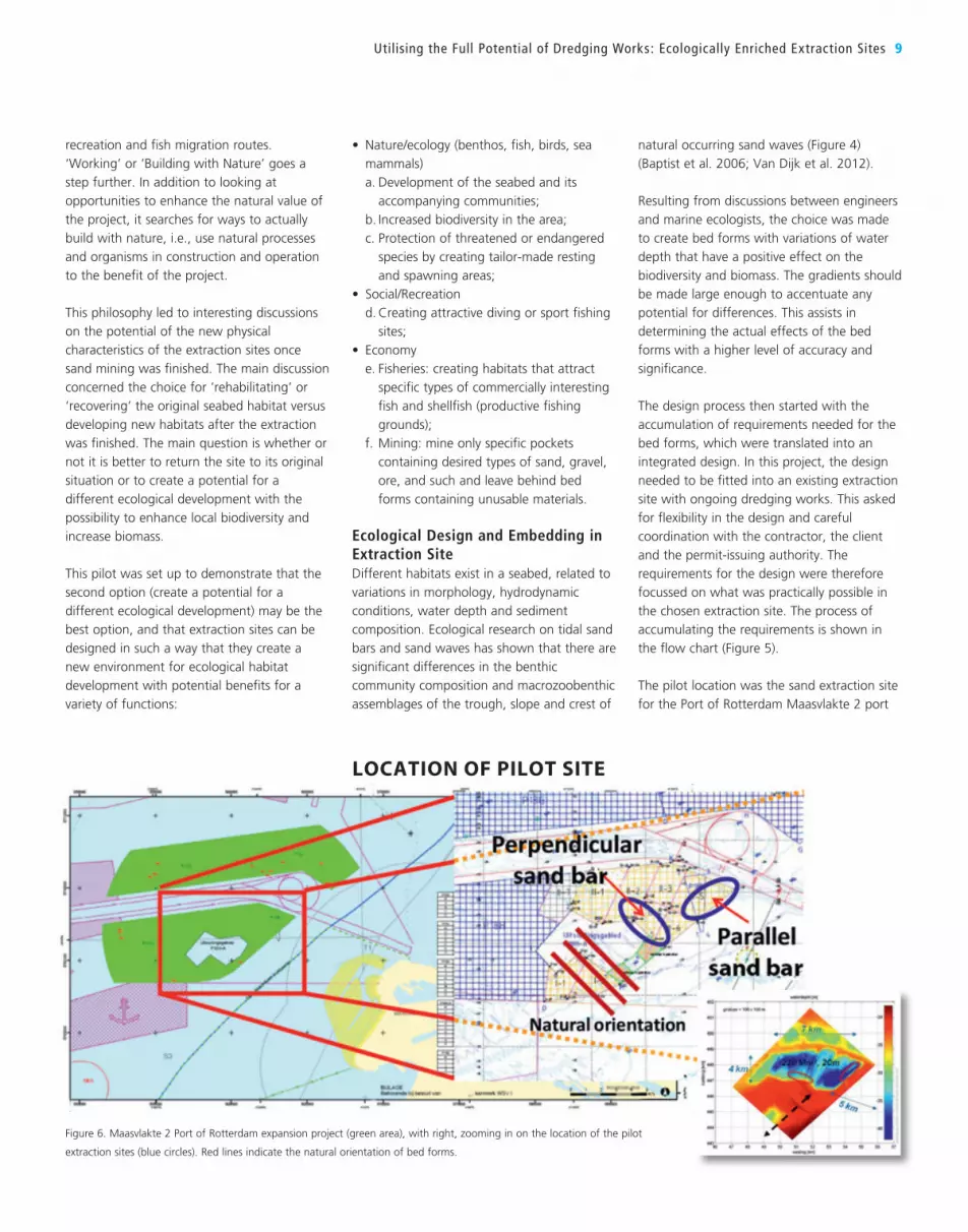
The pilot location was the sand extraction site
for the Port of Rotterdam Maasvlakte 2 port
Figure 6. Maasvlakte 2 Port of Rotterdam expansion project (green area), with right, zooming in on the location of the pilot
extraction sites (blue circles). Red lines indicate the natural orientation of bed forms.
LOCATION OF PILOT SITE

10 Terra et Aqua | Number 136 | September 2014
expansion/land reclamation project. The site
lies about 20 km offshore from the Port of
Rotterdam. It is the largest extraction site
along the Dutch Coast. The sides have a
minimum slope of ca. 1:7-1:10 and the
extraction depth is between NAP -40 and
-42m (20 m below seabed). It had sufficient
capacity (>250 million m3) to create two large-
scale bed forms.
The choice for large-scale bed forms was
made as a result of first order morphological
models that showed that they are expected to
be morphologically stable long enough for
colonisation to take place.
Furthermore, the permit for the extraction site
allowed for deep sand mining to an average
depth of at least 10 m below the existing
seabed. Both the size and depth were
important aspects, especially as future
extraction sites are expected to increase to
similar sizes.
Figure 6 shows the geographical location in
the North Sea (green area) of Rotterdam
harbour and zooms in on the location of the
two pilot areas in the extraction site itself
(blue circles). The natural orientation of bed
forms in the area, parallel to the tidal current,
is shown as a reference (dark red lines).
DESIGN PARAMETERSBased on detailed discussions between marine
ecologists, engineers, permitting authorities
and dredging contractors, the following
design parameters were identified for use in
the design of the landscaped bed forms (Rijks
et al. 2011):
Technical parametersAlthough dredging contractors can create
almost any shape, several aspects have to be
taken into account to ensure that no
unnecessary high costs and loss of time occur:
- Dredging depth of available dredging
vessels;
- Manoeuvrability of the vessels, since sharper
or more detailed contours take more time
to create;
- Capacity (dredging volume) of the ships:
too small or too large shapes increase
dredging effort;
- Hydraulic conditions in and around the
extraction site, shapes lying oblique to the
main tidal current limit dredging capacity of
vessels (Figure 7).
Physical parametersPhysical parameters are described here and in
Figure 8:
• Orientation and size in relation to
morphological (in)stability;
• Grain size distribution: fine sediments in
trough, more coarse sediment on the top;
• Currents: bed forms can minimise current
speeds for optimal ecological development
or enhance hydraulic dynamics and, e.g.,
related transport of nutrients;
Ecological parametersWhen determining the desired ecological
habitat, the most important criteria are the
basic physical characteristics of the sand
extraction site. This includes depth, availability
of slopes and of course sediment
characteristics after sand extraction has
finished. For example, some benthos species
appear to prefer quiet environments with
higher content of fines, while others are more
likely to be found in higher energy
environments with moderate to large grain
sizes. The first can be found in the troughs of
the bed forms, the second at the slopes and
crests. Ecological habitats can be chosen on
the basis of these parameters, taking into
account the natural habitats in the area.
A higher diversity is usually appreciated/
valued more, both for benthos and for fish.
Several design requirements and preferences
that determine these gradients and
subsequent ecological development for the
sand bars in this large scale extraction site are:
• Sufficient amplitude, 10 m height difference
was chosen;
• Large enough to be able to carry out a
monitoring programme;
• Orientation: parallel to the dominant
current direction (easy to dredge) and
oblique to this current (difficult to dredge);
• Constructed before the spawning season;
• Untouched for a period of about 4-6 years;
• Differences in sediment characteristics.
CONSTRUCTION OF LANDSCAPED EXTRACTION SITESConstruction PreparationAfter the design was finalised, dredging of
the sand bars started. In this pilot project, the
locations of the sand bars were situated
within an active sand extraction site. This
meant that a special dredging plan had to be
made to ensure that the regular work was not
hindered.
The following steps were taken:
1. The local bathymetry in the extraction site
was studied in more detail together with
the contractor to determine exactly where
the sand bars could be made;
2. Based on expert judgement concerning
hydraulics, morphology and ecology, a
choice was made for the preferred
locations. In both cases, the sand bars were
positioned near the existing slopes of the
sand extraction site to ensure an extra slope
and trough in the total design;
3. The contractor designated a temporary
buffer around the preferred locations
Figure 7. Computer image of
skewing effect of currents on
dredging operations.

exempting the area from sand extraction
until the final position and design was
determined;
4. The design was integrated into the existing
sand extraction GIS database containing the
bathymetry and sediment composition data.
Based on a GIS calculation, total dredging
volumes and grain size were determined;
5. The designs, volumes and related grain sizes
were integrated into the overall contractor
dredging plans and the on-board GIS
dredging systems (Figure 9). Captains
received instructions on how to dredge the
sand bars;
6. The temporary exemption areas were
removed and the ships were asked to create
the sand bars.
Dredging EquipmentThe sand bars were constructed using several
trailing suction hopper dredgers (TSHDs) that
removed sand around the sand bar itself
during a period of several months (Figure 10).
These ships are able to dredge to large depths
with high precision. The TSHDs approached
the chosen locations in various ways
depending on the currents, waves, presence
of other ships and overall dredging plan. In all
cases, they aimed to sail a pattern that was as
efficient as possible.
It is clear that landscaping of extraction sites
requires modern equipment; dredgers have to
be well instructed and the shapes have to be
checked by the contractor beforehand so as
to ensure that they can be realised with the
equipment at hand.
The parallel sand bar bed form was finished in
June 2010 and after a detailed survey,
monitoring immediately started to determine
the presence of benthos and fish. As the
orientation of the sand bar lies in the same
direction as the normal/preferred dredging
operations, the dredging was carried out
without any difficulties.
The oblique sand bar was much more difficult
to dredge as the vessels could only dredge
along the bar during slack tides when the
currents were low. With higher currents, the
vessel could be swept over the dredging arm
Utilising the Full Potential of Dredging Works: Ecologically Enriched Extraction Sites 11
Figure 8. Different
alternatives for the design
and scheme of dredging
volume.
Figure 9. GIS positioning and bathymetric systems (left = oblique, right = parallel).

12 Terra et Aqua | Number 136 | September 2014
occurrence of biodiversity in relation to water
depth, position on the sand bar, median grain
size distribution, fraction of fines, silt and
organic matter and time for re-colonisation.
The results of the monitoring are used to
determine which design parameters are
important to take into account; both to
achieve higher biodiversity and biomass and
to keep the extraction works economically
feasible.
Preparation of Monitoring PlanDuring the design and preparation phases,
a monitoring plan was defined focussing on
benthic infauna and epifauna, before and
after sand mining, and both inside and
outside the ecological extraction site.
Analysis was carried out on the 2006 and
2008 surveys for the baseline study of the
Environmental Impact Assessment (EIA) for
the construction of Maasvlakte 2 to enable
The sand bar parallel to the main current
direction is shown in Figure 11. The first pilot
location was chosen in the north-eastern part
of the extraction site and lies between the
edge of the site and the adjacent plateau (see
Figure 6). The second sand bar is oblique to
main current direction. This second pilot
location lies along the southern edge of the
sand extraction site (see also Figure 6) and it
has a natural orientation oblique to the main
current direction (Figure 12).
MONITORING ECOLOGICAL DEVELOPMENTAn intensive multiyear monitoring programme
was set-up to investigate the changes in
benthos and fish. Surveys were carried out in
the spring of 2010, 2011 and 2012 with the
aim to investigate and compare the presence
of benthos and fish inside and outside (as a
reference) of the extraction site. The analysis
of the monitoring results concentrated on the
and cause considerable damage and danger
to the vessel.
Integration of Design in Extraction SiteThe final design found an optimal
combination between the new physical
circumstances at the bottom of the extraction
site, suitable ecological habitats of species
present in the surrounding area and
(reasonable) workability of the dredging
vessels.
In the pilot project, two large-scale sand bars
were created of about 1.25 million m each, 10 m
high (from ca. -30 m to ca. -40 m), and 750 m
long with slopes of ca. 1:7-1:10 (Figure 8).
One sand bar was created parallel to the main
current direction, the other almost
perpendicular to the main current in order to
study differences, if any, in the alignment.
Figure 10. TSHDs creating the parallel sand bar. In the
photo left the sand bar lies to the port side of the vessel.
Figure 11. Parallel sand bar profile design (left) and survey of final result (right).

Significant differences between the crests and
troughs of the sandbars were detected (De
Jong et al. 2014).
The increased biomass of demersal fish was
closely linked to increased biomass of white
furrow shell (Abra alba) that flourished in the
fine sediments of the extraction site (De Jong
et al. 2014; Tonnon et al. 2013).
This increase in fish is a key outcome of the
project, indicating that the environmental
impacts of sand extraction areas are not
necessarily negative. Moreover, the high fish
density may yield economic potential for
re-development of the pit as fishing grounds
for local communities. Although the data
show that the highest densities of fish are
found near the artificially created bed forms,
it remains to be investigated what processes
drive this. Can it be explained:
- by the shape of the applied seabed
landscaping creating diverse habitats, or
- as a secondary effect of an increase in
benthic food in or near the bed forms, or
- is it owing to the fact that the seabed
remained untouched after dredging, or
- is it a combination of all three.
4.5-m wide trawl with 80 mm mesh size in
the net (see opening photo).
In addition to biological data, supportive
physical data on bed elevation (multi-beam
survey), sediment characteristics,
hydrodynamic variables and time after
cessation of sand extraction were collected.
Table I shows the number of sampling points/
tracks per year during the monitoring
campaign.
For benthos and demersal fish sampling, the
surveys distinguished between those in the
reference area (crests and troughs of sand
waves) and in the extraction site the edge, the
deep part and the crests and troughs of the
sand bars.
Results and Observations of Monitoring Preliminary monitoring results showed that
benthos and pelagic and demersal fish quickly
entered the extraction site. The monitoring
revealed a four to five time increase of fish
density inside the 20 m deepened borrow pit
at a comparable species diversity compared to
the reference locations (De Jong et al. 2014).
comparisons with the situation prior to the
large-scale sand extraction (Kaag and
Escaravage, 2007; Craeymeersch and
Escaravage, 2010; De Jong et al. in prep. a,
Borst et al. 2012).
Finally the monitoring activities were planned
in anticipation of the sand extraction activities.
Execution of Monitoring The monitoring programme consisted of three
types of ecological measurements with
different equipment (Figure 13):
1. Box core measurements involved sampling
with sediment cores of the upper 20-30 cm
of the seabed, to assess all infauna (animals
living in the seabed) larger than 1 mm, and
sediment;
2. Bottom dredge measurements involved
sampling for infauna and epifauna (animals
living in or on the seabed) larger than
0.5 cm and smaller than 10 cm, using a
bottom-cutting dredge over a relatively
large sampling area (10 cm deep, 10 cm
wide and 150 m long tracks);
3. Beam trawl measurements involved fishing
for demersal fish (living and feeding on or
near the seabed) and epifauna using a
Utilising the Full Potential of Dredging Works: Ecologically Enriched Extraction Sites 13
Figure 12. Oblique sand bar profile design (left) and survey of final result (right).
Figure 13. Left to right: Monitoring with a box core; box corer sampling in the dredge; sample from the seabed in the reference area with epifauna and fish; and the sample sorted.

Without their support this pilot project
could not have been realised so quickly and
on such a scale. A special thanks to the
captains of the dredging ships involved in
creating the sand bars and for their
feedback concerning the workability of the
designs and suggestions for improvements;
• The Port of Rotterdam is responsible for the
construction of the Maasvlakte 2 and kindly
allowed the pilot to take place in their
extraction site. They actively took part in
the technical and juridical discussions and
put their considerable expertise, knowledge
and data on the coastal area in and around
the extraction site at our disposal;
• The Ministry of Transport, Public Works and
Water Management, Directorate-General
for Public Works and Water Management
(Rijkswaterstaat Dienst Noordzee), the
responsible entity for granting the permits
in the extraction area. They also made their
impressive knowledge on the Dutch coastal
and ecological system and (legal) permit
requirements available;
• EcoShape for assisting in organising the
workshops, inviting stakeholders, making
the BwN information available and in
providing office support and facilities.
Finally, the many other experts from within
and outside the Building with Nature
Programme that joined the technical
workshops and contributed to the brainstorm
sessions must be acknowledged.
The results of the bathymetric multi-beam
surveys showed that the ecologically designed
sand bars were stable and allowed for longer-
term development of ecosystems in the
extraction site.
Figure 14 shows the bathymetry of the sand
extraction site in 2010 with superimposed the
observed average demersal fish species density
and composition in the extraction site and
reference area in 2010, 2011 and 2012. The
parallel sand bar is visible in the north-western
and the oblique sand bar in the southern part
of the extraction site. Maximum water depth
in 2010 was found in the area around the
parallel sand bar.
ACKNOWLEDGEMENTSThe work presented here was carried out as
part of the innovation programme Building
with Nature. The Building with Nature
programme (2008-2012) is funded from
several sources, including the Subsidieregeling
Innovatieketen Water (SIW, Staatscourant nrs
953 and 17009) sponsored by the Dutch
Ministry of Infrastructure and the
Environment, and partner contributions of the
participants to the Foundation EcoShape.
The programme receives co-funding from the
European Fund for Regional Development
EFRO and the Municipality of Dordrecht.
The team would like to thank all parties
involved in making the pilot project possible.
The positive collaboration and contributions,
technical feedback, innovative suggestions
and great efforts made by the stakeholders
were essential in making this project a
success.
The stakeholders involved are:
• The Contractor PUMA (Joint Venture
Boskalis and Van Oord) for making the
Maasvlakte 2 extraction site available and
assisting in making a realistic design for the
sand bars and for creating the sand bars.
14 Terra et Aqua | Number 136 | September 2014
Table I. The number of sampling points/tracks per year during the monitoring campaign.
Year 2010 2011 2012
Box core 45 45 63
Bottom dredge 26 26 32
Sediment characteristics 45 45 63
Beam trawl (4.5 m, 80 mm mesh) 4 outside / 6 inside 7 outside / 13 inside 4 outside / 10 inside
Hydrodynamic modelling First order - In- and outside extraction site
Figure 14. Summary of
findings from demersal
fish monitoring
campaigns 2010-2012.
plaice
dab
hooknose
bull-rout
tub gurnard
Nilsson’s pipefish
whiting
sole
solenette
scaldfish
turbot
flounder
brill
bib
Reference
Pit
depthHigh : -18.4Low : -44.7

REFERENCES
Aarninkhof, S.G.J., Allewijn, R., Kleij, A.M., Stive,
M.J.F. and Baptist, M.J. (2012). “Sustainable
development of land reclamations and
shorelines, full scale experiments as a driver for
Public-Private Innovations”. CEDA Dredging Days
2012, Abu Dhabi.
Baptist, M.J., Van Dalfsen, J.A., Weber, A.,
Passchier, S. and Van Heteren, S. (2006). “The
distribution of macrozoobenthos in the southern
North Sea in relation to meso-scale bedforms”.
Estuar. Coast. Shelf Sci. 68, 538-546.
Borst, W., and Vellinga, T. (2012). “The
monitoring programme for the Maasvlakte 2
construction at the Port of Rotterdam”. Terra et
Aqua 129, 16-29.
CEDA (2013). “Ecosystem Services and Dredging
and Marine Construction” Information paper, May.
Craeymeersch, J.A. and Escaravage, V. (2010).
Effecten zandwinning aanleg Maasvlakte 2:
vaarrapport nulmeting rekolonisatie benthos
2008, C030/10. IMARES Wageningen UR,
Institute for Marine Resources & Ecosystem
Studies.
De Jong, M.F., Baptist, M.J., van Hal, R., De
Boois, I., Lindeboom, H.J. and Hoekstra, P.
(2014). Impact on demersal fish of a large-scale
and deep sand extraction site with ecosystem-
based landscaped sandbars. Estuar. Coast. Shelf
Sci. 146, 83-94.
De Jong, M.F., Baptist, M.J., Lindeboom, H.J. and
Hoekstra, P. (2014 in prep) a. Environmental
influences on macrozoobenthos in an intensively
used area of the Dutch coastal zone.
De Jong, M.F., Baptist, M.J., Lindeboom, H.J. and
Hoekstra, P. (2014 in prep) b. Development of
macrozoobenthos in a deep and large-scale sand
extraction site on the Dutch continental shelf.
Kaag, N.H.B.M. and Escaravage, V. (2007).
Datarapportage Nulmeting Maasvlakte 2,
IMARES rapport C026/07.
Rijks, D. (2011). HK2.1 “Ecological landscaping
of a seabed”, EcoShape guideline.
Monitor Taakgroep (2010). Sampling on the
edge, boxcorer bemonstering in het kader van
het project “Building with Nature” –
Vaarrapport, Monitor Taskforce Publication Series
2010-08
Tonnon, P.K., Borsje, B. and De Jong, M. (2013).
BwN HK2.4 “Eco-morphological design of
landscaped mining pits”, pp. 1-86. https://www.
researchgate.net/publication/263477730_BwN_
project_HK_2.4_Eco-Morphological_Design_of_
Landscaped_Mining_Pits
Van Dijk, T.A.G.P., van Dalfsen, J.A., van
Lancker, V., van Overmeeren, R.A., van Heteren,
S., Doornenbal, P.J., Peter, T.H. and Elaine, K.B.
(2012). “Benthic Habitat Variations over Tidal
Ridges, North Sea, the Netherlands, Seafloor
Geomorphology as Benthic Habitat”. Elsevier,
London, pp. 241-249.
Utilising the Full Potential of Dredging Works: Ecologically Enriched Extraction Sites 15
CONCLUSIONS
This article describes the preparation,
design and results of a pilot for an
ecologically enriched extraction site.
Based on the results of the monitoring
programme, it proves that the concept of
ecological landscaping has high potential.
Furthermore, the stakeholders involved in
the project have changed their perception
of extraction sites from being a traditionally
negative issue into a positive view on
opportunities for ecological development
and added value for the local environment.
In the case of sand extraction sites, it is
therefore advisable to use ‘establishment of
habitats’ instead of ‘recovery of habitats’.
In addition, the following conclusions can
be drawn:
• Designing an ecologically enriched
extraction site should be:
- Based on existing ecosystem and local
physical conditions;
- Linked to the size and volume of the
extraction site;
- Done in cooperation with ecologists,
morpho- and hydrodynamic experts,
the fishing industry and dredging
contractors;
- Discussed with permitting authorities
beforehand to define requirements
(if any);
- Take place preferably before dredging
works start, to allow the contractor to
make a cost-efficient dredging work
plan.
• Constructing the landscaped seabed:
- If designed correctly and in
consultation with dredging contractor,
has no influence on production rates
and thus time and cost;
- Can be beneficial especially if different
kinds of sediments/grain sizes are
needed within the same extraction
area.
This work puts sand mining for land
reclamations, coastal safety, port
development and other uses in a new
perspective. Rather than adopting the
traditional focus on negative, direct
environmental impacts caused by seabed
removal, this work shows the potential and
opportunities for ecological and economic
benefits of sand extraction.
In fact, data from monitoring surveys show
an increased density of demersal fish that
can be attributed to the presence of the
deepened sand extraction site itself plus
additional benefits owing to the realisation
of landscaped bed forms within the site.
These new insights can make an important
contribution to improved (sustainable)
designs for marine and navigation
infrastructure, hence to reduce lead times
of future projects in marine environments
through a Working and Building with
Nature ecosystem-services approach.