uga_lab_series_22.pdf - uga archaeology
TRANSCRIPT

This document has been checked for information on Native American burials. No images considered to be culturally insensitive, including images and drawings
of burials, Ancestors, funerary objects, and other NAGPRA material were found.


.,
Athens 1981
UNIVERSITY OF GEORGIA Labora tory of Archaeology Series
Report No. 22
Archaeology and Historica l Geography of the
Savannah River Floodplain near Augusta, Georgia
By
Daniel Elliott, Archaeo l ogist
and
Roy Doyon, Historical Geographer
Principal Investigator: W. Dean Wood
Southeastern Wildlife Services, Inc. 113 Hoyt Street
Athens, Georgia 30601
L ,)If;kl Arcnaeol " .
Site File logIcal
ManUscript No.~

,.-.
· \
I I I

PREFACE
These investigations were originally carried out under contract [RR-OOOI (001)] with the Georgia Department of Transportation for the Augusta Railroad Relocation Project. The original contract report was prepared by Southeastern Wildlife Services, Inc., Athens, Georgia and is presented here with minimal deletions and editorial changes. It is our feeling that contract archaeologists have an obligation as scientists to present the results of their research. Therefore, we are very happy that Dr. David J. Hally, editor of the Laboratory of Archaeology Series has choosen to publish this report and thereby make it widely available to interested individuals.
W. Dean Wood Principal Investigator
iii

ACKNOWLEDGEMENTS
The contributions of various individuals during this testing project did not go unnoticed. The unsung archaeological heroes: the diggers, the screeners, the baggers, the mappers, and the washers are graciously thanked for their help. Thank you unsung heroes.
To the people of Augusta, we thank you for opening up your doors and fast food restaurants to us during our ever-so-brief stay. During our visit it became quite clear why the locality has been a preferred setting for human occupation throughout prehistory.
Special thanks to George Lewis of the Augusta Archaeological Society for his enthusiastic support and sincere interest in the prehistory of the Augusta area. Special thanks to Pam Smith for her patience in typing and retyping the report. Special thanks to Joyce Subler for her excellent analysis of the materials. Special thanks to Mike Griffin and John Doolin, two excellent field archaeologists. Without their skills in excavation and artifact in~erpretation, key elements of the archaeological record may have been overlooked.
For their knowledgeable contributions to this research, we would like to thank Glen Hanson, Jim Michie and Dr. Albert Goodyear at the University of South Carolina, Dr. William Gardner of Thunderbird Research Corporation, and Steven Brandt at the University of Georgia.
Special thanks to Leslie Swann and Jan Coyne for their beautiful graphics and Dr. June Cooley for her editing. We would also like to thank the people at the Georgia Department of Transportation, especially Rowe Bowen, Pete Malphurs, and Toni Gardner, for their assistance in our research.
This project could not have been undertaken without the consent and help from Dr. Lewis Larson, State Archaeologist, and Dr. Elizabeth Lyon, State Historic Preservation Officer.
iv
I I
1
., I
. I
I
I

TABLE OF CONTENTS
Page
ABSTRACT. • • • • • • • • • • • • • • ". • • • • • • •• i
PREFACE • • • • •
ACKNOWLEDGEMENTS.
LIST OF TABLES.
LIST OF FIGURES
LIST OF PLATES.
INTRODUCTION
ENVIRONMENTAL SETTING
CULTURAL HISTORY •••
HISTORICAL GEOGRAPHY.
HISTORIC LAND USE • • •
PREVIOUS ARCHAEOLOGICAL RESEARCH.
RESEARCH DESIGN • • • • • • • • •
METHODS
RESULTS
DISCUSSION.
. . . . . . . . . . . . . . . . . . . . . .
SUMMARY AND CONCLUSIONS
LITERATURE CITED. • • •
APPENDICES
A.
B.
Pollen Analysis ••
Granular Analysis.
v
ii
iii
v
vi
ix
1
4
14
18
49
52
57
59
62
151
172
174
186
190

LIST OF TABLES
1. Stratigraphic Relationships, 9Ri45, Test Pit 4.
2. Site 9Ri86, Test Pit 1.
3. Site 9Ri86, Test Pit 2. . . 4. Site 9Ri86, Test Pit 3.
5. Site 9Ri86, Test Pit 4 ••
6. Site 9Ri86, Test Pit 5. . . . . . . . . . . 7. Site 9Ri86, Test Pit 6.
8. Selected Diagnostic Points from 9Ri86 • . . . . . 9. Artifacts from Test Excavations at 9Ri88.
10. Selected Points from 9Ri88 •••
11. Size Ranking of Debitage, 9Ri89, Test Pit 7 • •
12. Artifacts from 9Ri89, Test Pit 7 •••••
13.
14.
15.
Selected Diagnostic Points from 9Ri89 • • • .
General Stratigraphy, 9Ri89 •• . . . . Chipped Stone Tool Types and Frequency from Undisturbed Cultural Levels at 9Ri89 ••••
16. Late Archaic Trait Comparison at Selected Sites
B-L Granular Analysis, 9Ri86, Test Pit 6 ••
B-2. Granular Analysis, 9Ri89, Test Pit 9.
vi
Page
70
84
. . 87
89
90
92
96
• • 106
118
• 122
• 133
• 134
• • 148
• • 152
• • 153
• 158
• • 192
• 193
I -
I --~
I
'-J' , . , I I I

LIST OF FIGURES
Page
1. Project Area and Vicinity ••• 2
2. Project Area • 3
3. Fort Moore 21
4. DeBrahm's 1757 Map, New Windsor-Augusta. • 22
5. Placement of Old River Channel and Ft. Moore Superimposed on 1941 Aerial Photo. • • • • • 23
6. Harris Plat 26
7. McGillivray and Clark Plat • 30
8. Old Town of Augusta. • • • • • 34
9. 1779 Hinton Map · • • • • • 35
10. "Notice" of Opening of Tobacco Road and Twiggs Warehouse. . . . . . · · · · · · · . · · · · · · · · · 37
II. Sturges 1818 Map, Section Illustrating Richmond County. Arrow Points to Twiggs Warehouse (WH) • · · · · 38
12. Study Area in 1908 . · · · . · · · · · · · · · 41
13. Plat of Cason Estate · · · · · 43
14. Plat of Taylors Hi 11 · · · · · · · · · · · · 44
15. 1835 Plat of Sand Bar Ferry Road and Vicinity. · 46
16. Location of Sites Mentioned in Text · · · · 53
17. 9Ri45 Site Plan 63
18. 9Ri45 Area Tested. 64
19. 9Ri45 Controlled Surface Collection, Total Prehistoric Artifacts. 65
20. 9Ri45 Test Pit 2 East Profile •• 67
vii

viii
Page
2l. 9Ri45 Test Pit 4 East Profile. · · · · · 69
22. 9Ri85 Site Plan and Surface Collection 72
23. 9Ri85 Test Pit 2 East Profile. · · · · · · 73
24. 9Ri86 Site Plan · · · · · · 75
25. 9Ri86 Area Tested. · · · • · 76
26. 9Ri86 Controlled Surface Collection, Projectile r Points . · · · · · · · · · · · · · · · · · · 77 I 4
27. 9Ri86 Controlled Surface Collection, Lithic Debitage · · · · · · · · · · · · · · · · · · · 78
28. 9Ri86 Controlled Surface Collection, Soapstone · 79
29. 9Ri86 Controlled Surface Collection, Fiber Tempered I Pottery. · · · · · · · · · · · · · · · · · · · 80
30. 9Ri86 Controlled Surface Collection, Grit Tempered I Pottery. · · · · · · · · · · · · · · · · · · · · · · 81
3l. 9Ri86 Controlled Surface Collection, Clay Pellets. · 82
32. 9Ri86 Test Pit 1 East and South Profiles · · · · · · 83
33. 9Ri86 Test Pit 2 East Profile. · · · · · · · · · 86 I 34. 9Ri86 Test Pit 3 East Profile. · · · · · · · 88
I ,
35. 9Ri86 Test Pit 5 East Profile. 91 · .. 36. 9Ri86 Backhoe Trench East Profile. · 93
37. 9Ri86 Test Pit 6 North Profile · · · · · · 95
38. 9Ri86 Artifact Frequencies Test Pit 6. · 98 I 39. 9Ri86 Test Pit 6 Base of Level XII, Feature 11 · 100
I 40. 9Ri87 Site Plan and Surface Collection · · · · · 108
4l. 9Ri87 Test Pit 1 East Profile. · · · · · · · · · · · 109 I 42. 9Ri87 Test Pit 2 East Profile. · · · · · · · · 111
I ·1

ix
Page
43. 9Ri88 Site Plan. .114
44. 9Ri88 Test Pit 6 South Profile. • • .115
45. 9Ri88 Test Pit 12 North Profile. .116
46. 9Ri88 Surface Collectio~ Total Prehistoric Artifacts · · · · · · · · · .117
47. 9Ri88 Excavation Area A. . . . · · · · · · .120
48. 9Ri89 Site Plan. · · · · · · · .124
49. 9Ri89 Surface Collection, Total Prehistoric Artifacts ..... . . . . . • . • • • • • . • • . 125
50. 9Ri89 Surface Collection, Diagnostic Bifaces · · · .126
5l. 9Ri89 Surface Collection, Check Stamped Ceramics · .127
52. 9Ri89 Surface Collection, Simple Stamped Ceramics. • 128
53. 9Ri89 Test Pit 6 East Profile. · · · · · · .130
54. 9Ri89 Examples of Flake Tools. · · · · · • 131
55. 9Ri89 Fluted Projectile Points · · . .. . • 149
56. Fragments of a Winged Atlatl Broken during Manufacture . . · · · · . . . · · . . . · · · · · • 160

LIST OF PLATES
1. View of 9Ri45, facing south ••
2. View of 9Ri85, facing west •
3. View of 9Ri86, facing west ••
4. Oxbow lake east of 9Ri86
5. Backhoe trench at 9Ri86, facing north •••
6. North profile of Test Pit 6 and Feature 11, 9Ri86.
7. Savannah River preforms from Test Pit 6, 9Ri86
8. Selected ceramic artifacts from 9Ri86.
9. Selected projectile points from 9Ri86 •••
10. Selected projectile points from 9Ri86 •••
11.
12.
13.
14.
View of 9Ri87, facing east.
View of 9Ri88, facing south. of Augusta levee • • • • • •
Photo taken from summit
West profile of Feature 10, 9Ri88.
View of 9Ri89, facing north.
Page
194
194
195
195
196
196
197
197
198
198
199
199
200
200
15. Selected soapstone artifacts from 9Ri86 and 9Ri88. 201
16. Selected stone drills from 9Ri86 ••••••••• 201
x
I a I
J
1
1
I j
J
I I I I I I I I I

INTRODUCTION
Six archaeological sites were tested by Southeastern Wildlife Services, Inc. (SWS), under contract with the Georgia Department of Transportation (DOT) as part of the Augusta Railroad Relocation Project. This project was designed to alleviate traffic congestion and to revitalize downtown Augusta. The project will include relocating rail lines of the Southern and Seaboard Coast Line Railroads through a portion of the Savannah River bottoms (Figure 1).
The six sites tested, 9Ri45, 9Ri85, 9Ri86, 9Ri87, 9Ri88, and 9Ri89, included both prehistoric and historic components lying within the path of the proposed Southern Railroad line (Figure 2). Four of these sites, 9Ri86, 9Ri87, 9Ri88, and 9Ri89, were located during a survey for the Bobby Jones Expressway, which parallels the proposed rail line (Ferguson and Widmer 1976). The other two sites, 9Ri45 and 9Ri85, were located by Bowen (1979) during the initial archaeological survey for the railroad relocation project. As a result of Bowen's survey, these six sites were placed on the National Register of Historic Places as part of a discontiguous district. Of the twenty-nine sites within this district, the six sites tested during this project and eight other sites, not yet tested, were determined to be of such significance to warrant some form of mitigation.
The major contract goal of this testing project was the determination of the research potential at these sites. Our research went beyond this contract goal to present a contribution to archaeology in the Savannah River region. This report describes the environmental setting, previous archaeological research, research design, methodology, historical geography, testing results at these sites.
1

Pro
ject
A
rea
and
V
icin
ity
GEXl
RG
IA
Pie
dm
on
t Coa
stal
Pla
in
Sou
rce:
US~S To
p.
Shee
t,
Aug
usta
Qua
dran
gle,
19
21.
o , K
ilo
me
ters
Fig
ure
1
. P
roje
ct
Are
a an
d V
icin
ity
.
2 ,
Roy
Doy
on
19
60
----
----
----
-
N
---

3
o
PROJECT AREA
'Om
.... P lOURCl
, .. , AUGUSTA lAST, I . c.. - OA .
J .I uaas OUADRANQLE
Figure 2. "ect Area. Pro]

ENVIRONMENTAL SETTING
A description of the contemporary environment and an attempt at reconstruction of the paleoenvironment of the Augusta area is vital for understanding man's interaction with nature. The most intensive research on all facets of the environment has been conducted at the Savannah River Plant. A synthesis of this research is provided by Langley and Marter (1973) and an extensive bibliography of environmental studies in the Savannah River Plant and immediate vicinity has been prepared (U. S. Energy Research and Development Administration 1975). Although the Savannah River Plant lies 25 km southeast of the project ar ea, much of this research is directly applicable to this study. Environmental research also has been conducted in the immediate project area (Hillestad 1977; Hurst et ale 1966; Ferguson and Widmer 1976; Bowen 1979) providing a basic framework for this discussion.
Physiographic Description
The project area is located south and east of Augusta and includes the Savannah River first bottoms and first terrace (Figures 1 and 2). All six sites are located on the U. S. Geological Survey (USGS) 7.5 minute Augusta East topographic map. Sites 9Ri86, 9Ri87 , 9Ri88, and 9Ri89 are located in the present floodplain of the Savannah River and sites 9Ri45 and 9Ri85 are located on the first terrace or second bottoms adjacent to Butler Creek.
All six sites lie within the Fall Line Hills subprovince of the Coastal Plain physiographic province. The Fall Line Hills subprovince near Augusta is a narrow, irregular strip less than 15 km wide lying between the crystalline rocks to the northwest and plateaus of sedimentary rocks to the southeast. Along this strip streams have cut deeply i nto the sedimentary deposits exposing the older crystalline rocks (Hurst et ale 1966:9-10). The northern boundary of the Fall Line Hills passes through Augusta and the southern boundary is along Spirit Creek. Because contact between the c.oastal sediments and the piedmont crystalline r ock is irregular, it is difficult to fix a sharp boundary between these two zones (Laforge 1925:42). The fall line as a distinct line does not exist and the lowland hills are nearly as rugged as the piedmont hills. There are striking differences in rock structure, soil, vegetation, and land use on either side of this fall zone.
The morphology of the Savannah River varies considerably near the project area. Bushnell described these changes:
4

Where the Savannah Valley has been carved through the resistant Piedmont material the flanking bottoms are narrow and the river pursues a fairly straight course from the northwestern corner of the county to Sand Bar Ferry. The fall is rather great and the current strong; the bottom is rock, and shoals occur as far south as Augusta. Below this point, the valley is cut through soft Coastal Plain materials, and the bottom and terraces are 2-6 miles wide on the Georgia side. Here the current becomes more sluggish and the river meanders in great oxbow loops cut through the soft alluvium. It has reached base level here and after heavy rains overflows the bordering bottoms. The elevation of the Savannah first bottoms at Augusta is about 130 feet above the flood plains.
The Savannah River has practically no first bottom above Augusta, but below the city bottoms 3 or 4 miles wide lie between the river and the higher terraces except for a short distance just below the mouth of Butler Creek, where the older terraces extend to the river channel (Bushnell and Snyder 19l5) •
5
A few miles north of the project area, the Savannah is characterized by fairly steep valley walls and exposed bedrock creating numerous shoals in the river bed. The Savannah is navigable up to these shoals, a fact partly responsible for the location of Augusta as a transhipment point for inland trade. The falls or rapids along streams in the fall zone were important factors in prehistoric and historic settlement (Renner 1927:278).
The flow of the Savannah changes at Augusta from an entrenched channel in the resistant piedmont rocks to a meandering course through the softer sedimentary coastal plain deposits. The dynamic nature of the Savannah has created many oxbow lakes and extinct meander channels in the project area. The exact ages of these extinct channels are unknown and there is some evidence that these oxbows can be cut off quite rapidly during periods of flooding (Ledbetter et al. 1980:38-39).
The project area is periodically subjected to flooding although the levee, drainage ditches, agriculture, and urban development have significantly affected the patterns of stream flow. Culturally accelerated sedimentation due to erosion from large areas in the Piedmont under cultivation during the past 150 years may be responsible for many structural changes in the Savannah River morphology (Trimble 1969). The enlargement of the naturally formed Phinizy Swamp is partially a result of this culturally accelerated sedimentation.

- --- ---- -------------------------------- - --- - - -
6
Soils
The soils for the six tested sites have been described in detail by the U. S. Department of Agriculture (USDA) Soil Conservation Service, although this information is presently unpublished (Philip Hadarits, USDA Soil Conservation Service, Augusta, personal comIDunication).
Sites 9Ri86, 9Ri87, 9Ri88, and 9Ri89 have Riverview silt loam soil. It is a deep, well drained, nearly level soil that occurs on floodplains near creeks and rivers. The soil is low in natural fertility and organic matter content and is highly acidic throughout. The root zone is deep and easily penetrated by plant roots. The soil is well suited to farming. Brief periods of flooding in winter and early spring are expected except in areas protected by the levee; the levee has reduced the probability of flooding making this soil more suitable for urban uses.
In a typical profile the surface layer of Riverview soil is dark brown silt loam about 18 cm thick. The subsoil extends to a depth of 84 cm and is reddish brown loam overlying several centimeters of dark brown silt loam. The underlying material, to a depth of about 1.6 m, is predominately dark brown loamy fine sand.
Site 9Ri45 has Altavista sandy loam soil . This soil is a deep, moderately well drained, nearly level soil located on stream terraces slightly downstream from the uplands o f the Piedmont. This soil is prone to occasional, very brief spring f looding. It is poorly suited to most urban uses and well suited to fa r ming although limited by wetness for farming except where ditches and buried drains have overcome this problem. The soil is low in natural fertility and organic matter content, highly acidic throughout, and has a deep root zone.
In a typical profile, the surface layer is dark grayish brown sandy loam about 20 cm thick. The subsoil is sandy clay loam and extends to a depth of about 104 cm.
Site 9Ri85 contains Goldsboro sandy loam soil. This soil is a moderately well drained, nearly level soil which occurs on broad interstream divides in uplands of the southern Coastal Plain. The soil is well suited to farming and moderately suited to urban uses. It is low in natural fertility and organic matter content, highly acidic throughout, has a deep root zone, and is not subject to flooding.
In a typical profile, the surface layer is very dark gray sandy loam about 20 cm thick. The subsurface layer is light yellowish brown loamy sand and extends to a depth of 28 cm. The subsoil, to a depth of 141 cm, is sandy clay loam.

The subsoil a t sites 9Ri86, 9Ri87, 9Ri88, and 9Ri89 have been deposited since the beginning of the Pleistocene and the subsoil at sites9Ri85 and 9Ri45 are Cretaceous in age (Hurst et al. 1966). Granular analysis of soil samples from 9Ri86 and 9Ri89 indicate that these soils are alluvial rather than aeolian.
Lithic Resources
7
Sites within the present Savannah River floodplain, 9Ri86, 9Ri87, 9Ri88, 9Ri89, are located on alluvium deposited since the beginning of the Quaternary. These deposits consist of stream sands and gravels, aeolian sands, and floodplain sands, gravels, and clays (Hurst et al. 1966). Sites 9Ri45 and 9Ri85 are located on Tusaloosa sand formations which are Upper Cretaceous in age. Lithic resources immediately available to inhabitants on these sites~~reextremely limited. An extinct meander channel west of Taylors Hill in Phinizy Swamp contained large quartz and metavolcanic gravels, some of which were of sufficient size and quality for the manufacture of small bifaces, flake tools, and hammerstones. However, there were no rock outcrops on the six sites tested.
Rock outcrops available for exploitation were abundant and diversified in the vicinity of the project area. According to White (1849:506), novaculite, a fine grained sedimentary chert, outcropped near Sand Bar Ferry. This outcrop would be the closest documented chippab1e stone to the project area, lying less than 2 km northeast.
The next nearest known outcrops of chippable stone are found to the north in crystalline piedmont rock deposits. Outcrops of stone suitable for chipping (quartz. rhyolite. gneiss, tuff. slate, quartzite, phyllite. amphibolite, felsite, aplite, diabase, sericite schist. and other rock types) are abundant throughout the piedmont physiographic province.
According to geologist Rich Wedemeyer (Geology Department, University of Georgia, personal communication), the identification of rocks occur:ting in the piedmont is a complex problem, one which cannot be solved by simple visual classification. At present, rocks from the Piedmont cannot be pinpointed to anyone source location. Even simple identifications that archaeologists have taken for granted, such as slate, or rhyolite, are not simple _for geologists.
Further complicating this already complex problem is the fact that jasper, agate, and cherts also occur in the piedmont region to a limited extent. These occurrences cause confusion for archaeologists working in the area since these small outcrops have not been documented geologically.

8
The identification of piedmont cherts or chertlike rocks requires sophisticated techniques such as X-ray spectroscopy, thin section, neutron ac tivation, or other identification methods.
The identification and specific source location of chipped stone raw material types, other than on the most general level, is beyond the scope of this report. By perusing the archaeo l ogical literature on raw material descriptions, particularly in reference to the Late Archaic p-eriod of the eastern United States, the confusion becomes apparent. The problem is that archaeologists avoid the complexity of piedmont geology and seek simplified, f alse generalizations in their geological discussions. Rhyolite often becomes a catch-all term for any problematic,unidentifiable piedmont rock. This is unfortunate and creates special problems for those interested in raw material procurement and lithic resource utilization.
For this report the categories used for mineral identification are light chert, metavolcanic rock, dark ridge and valley chert, and a very characteristic sandstone. Light chert includes all the coastal plain cherts and may include some piedmont cherts, jaspers, or agates. The colors in the chert include yellow, white, variable colored agates and fossiliferous types, dark yellow-brown, salmon, pink, red, purple, blue, green, brown, dark gray, and light gray. Some of the cherts have been thermally altered thus changing their colo~. The division between heat treated cherts and naturally colored cherts was not attempted in this analysis.
Much of this chert may come from deposits located approximately 20 km south of the project area. Closer outcrops of coastal plain chert may occur but are not well documented geologically (Goad 1979:82). These chert deposits, belonging to the Barnwell Formation, are white to yellow, vitreous, and fossiliferous. Two chert layers are described in western Burke County:
The lower chert pinches out in western Burke County. The upper chert continues along strike into Jefferson County, and up-dip into Glascock, Warren and Richmond Counties. The up-dip facies of this shell horizon thins gradually to a few feet and grades into a fossiliferous sandstone (Hurst et al. 1966:71).
The cherts in this upper layer are silicified limestones containing macro-fossils and coquina zones. The cherts are usually vitreous and yellow but leach out to a white or tan.
Boulders of dense yellow vitreous chert also occur approximately 50 km south of the project area along Brier Creek and the Savannah River in Burke and Screven Counties (Veatch and Stephenson 1910:323; McCallie 1910:25; Hurst et al. 1966:66-67).
I

9
Major aboriginal chert quarries have been identified in this area with one large exposure and workshop area covering many acres at the confluence of Chandler Mill Branch at Brier Creek (George Lewis, Augusta Archaeological Society, personal communication). Excellent quality chert is abundant along navigable water routes at various points 20-50 krn south of the"pxoject area and "even c loser outcrops would not be unexpected.
Quartz and the complex metavolcanic rocks may occur at many locations in the adjacent piedmont area and a multitude of nonlocalized quarries undoubtedly exist. Many outcrops and quarries have been identified in the Piedmont of Georgia, but tracing artifacts to these sources would be an extremely difficult and costly undertaking given the current state of the data. Nearby outcrops of these rock types occur in northeastern Richmond County and Columbia County, Georgia, and in Edgefield County, South Carolina.
Soapstone, a category which includes several varieties of ultramafic metamorphic talc-bearing rocks, is also of widespread occurrence in the piedmont region of Georgia and South Carolina (Hopkins 1914; Sloan 1908). Recent research in the Wallace Reservoir on the Oconee River has shown that outcrops of soapstone occur more generally in the central Georgia Piedmont than previously perceived (Elliott 1980). One reason for this previous false perception is due to the limitations of geologic mapping; many small rock outcrops are not included. Research has shown that many of these uncharted outcrops exhibit evidence of aboriginal quarrying (Elliott 1980).
Geologic research has identified several soapstone outcrops in the general vicinity of the project area. It is highly likely, based on the Wallace evidence, that many unmapped soapstone outcrops and quarries exist north of the project area. The documented outcrop of soapstone nearest to the project area is approximately 13 krn west in Richmond County along Rae's Creek (White 1849:506). The next nearest documented outcrop is located approximately 27 km northeast near Horns Creek in Edgefield County, South Carolina (Sloan 1908:119). It is not known if these outcrops were quarried aboriginally of if they still exist.
The nearest documented aboriginal soapstone quarries are located in the vicinity of Pollard's Corner in Columbia County, Georgia, approximately 30 krn north of the project area (Hopkins 1914: map inset; McLemore 1965; Hurst et ale 1966; Steiner 1899; George Lewis,personal communication). Although much of the surface evidence of aboriginal quarrying at 9Cb23 has been obscured by artifact collectors and rockhounds (Georgia Lewis, personal communication), Steiner's description of the area in 1899 indicates that aboriginal quarrying in this area was intensive:

10
Within the village area near Kiokee Creek is a quarry of steatite, from which were manufactured many useful objects, such as mortars, pitted stones, sinkers, pipes, rubbing stones, ornaments. The material can be heated, and put in pot to boil water or rubbed over hides to take off any irregularities, could also be used in polishing wood or making plates to bake bread upon, and it being a Trust, in the hands of one tribe or nation, could be an industry of intertribal communal interest in the way of barter and exchange. Many of the objects were obtained in the rough to be taken away and finished according to the fancy of the purchaser ••• The hammers, large and small, and the picks for getting the material from the quarry are all found here. The work of preparing the material, roughing it, was confined to the quarry. Quartz crystals of various sizes were used as tools in its manufacture, as well as jasper, chert, and quartz knives, and rubbing stones of various dimensions and forms (Steiner 1899:380).
The outcrops at 9Cb23 were visited briefly during this testing project and selective rock samples w.ere taken for neutron activation analysis. An unfinished soapstone bowl still attached to the boulder from Columbia County was also observed in the collection of the Augusta Museum. George Lewis reports evidence of stone bowl manufacture at 9Cb23.
I
I I 1
Other documented soapstone quarries are located farther from J the project area in Wilkes County, Georgia (Wauchope 1966), Elbert County, Georgia (James Rudolph, University of Georgia,. Department of Anthropology, personal communication), Union County, Georgia (Elliott 1980), I Wallace Reservoir (Elliott 1980), and near Spartanburg, South Carolina (Ferguson n.d.; Lowman and Wheatley 1970; Overton 1969).
Soapstone quarries are found throughout the eastern United States and neutron activation research (Holland et al. · n. · <;l.; Allen 1975) has shown that quarries nearest to the sites were not the only resources exploited. In some cases where much closer sources were available, artifacts were :transpor t ed great "distances.
Other lithic materials present in the piedmont region adjacent to the project area that were utilized prehistorically include granite, gneiss, and amphibolite. Other materials from the Coastal Plain include ferruginous sandstone, red and yellow ochre.
I I I I I I

Climate
The project area is characterized by a humid, subtropical climate with short mild winters and extended warm, humid summers. Precipitation averages 154 cm per year and is highest in March and lowest in November (Langley and Marter 1973:73).
11
The average summer temperature is 80°F and the average winter temperature is 48°F with an annual average of 65°F. The record maximum temperature is 106°F and the record minimum is 3°F (Langley and Marter 1973:65).
The prevailing wind for October through May 15 is from the northwest. For June through August the prevailing wind is from the south and in September it is from the east (Langley and Marter 1973:80).
The area enjoys a long growing season and damage from hurricanes and tornadoes is minimal. During the winter of this testing project, early morning fog in the river floodplain was not uncommon.
Flora
The flora in the project area is at the ecotone between the OakPine Piedmont Forest region and the Southeastern Evergreen Coastal Plain Forest region (Braun 1950:262). Three major tree species occur in the first bottoms of the Savannah River: bald cypress, black gum, and tupelo gum. This vegetation predominates in the swamp environments of the oxbow lakes and Phinizy Swamp (Hillestad 1977:2).
The first terrace of the Savannah River contains bottomland hardwood forests. Hillestad (1977:6) identified the dominant overstory trees in this environment to be sweetgum and water oak. Other overstory trees include black oak, southern red oak, willow oak, overcup oak, swamp chestnut oak, ash, Carolina silverbell, sugarberry, boxelder, Georgia hackberry, Carolina buckthorn, American elm, yellow poplar, sycamore, Eastern hop-hornbeam, red mulberry, and bitternut hickory. Understory vegetation include paw paw, red maple, buckeye, switch cane, and palmetto.
Away from the project area in the sand hills, long leaf pine and scrub oak dominate over a variety of shrubs and herbs (Ferguson and Widmer 1976:15).
Although this list is greatly abbreviated, it is clear that a variety of plants were available for exploitation within the project area. A wide range of floral habitats in a small geographical area results in a corresponding wide variety of animal resources.

12
Fauna
Many species of furbearers, birds, fish, reptiles, amphibians, shellfish, and insects inhabit the area. For certain species, occupation is seasonal while others are permanent residents. To the prehistoric resident of the project area, abundant diverse faunal resources would have permitted year round occupation of the area.
Ledbetter et ale (1980) have summarized the faunal resources in the project area, fhe Russell Reservoir on the Upper Savannah, and the Savannah River Plant. Available furbearers include white-tailed deer, bobcat, river otter, striped skunk, weasels, raccoon, black bear, gray fox. red fox, dog, muskrat, eastern wood rat, beaver, gray squirrel, fox squirrel, pocket gopher. marsh rabbit, eastern cottontail, marsh rice rat, flying squirrel, cougar, and oppossum. Birds include permanent residents and migratory species. Turkey, quail, mourning dove, wood duck, turkey vulture, black vulture, great blue heron, hawks, owls, and numerous smaller birds inhabit the area year round. Migratory birds include loons, grebes, whistling swan, Canada goose, ducks, mergansers, hawks, herons, and other shore birds.
Fish species include permanent residents such as catfish, sucker, bowfin, longnose gar, sunfish, bluegill, crappi~ and largemouth bass. Anadromous species include American shad, hickory shad, striped bass, and Atlantic sturgeon.
Freshwater mussels identified archaeologically at the Rabbit Mount site include Elliptio complanatus, ~ crassidens, ~ icterinus, and ~ laceolatus (Stoltman 1974:137). Two freshwater gastropods, Campeloma lima and Viriparus georgianus, were also identified in the midden.
Reptiles and amphibians presently available during warm weather include alligator, box turtle, soft shell turtle, painted turtle, snapping turtle, musk turtle, mud turtle, chicken turtle, rat snake, king snake, water snake, mud snake, garter snake, black racer, copperhead, water mocassin, canebreak, rattlesnake, pigmy rattlesnake, bull frogs, tree frogs, leopard frogs, toads, lizards, and salamanders (Bowen 1979).
These animal resources and doubtless many others were utilized prehistorically for food, clothing, ornamental, medicinal, and ceremonial purposes. Unfortunatel~ bone preservation in the project area is generally poor. Most bone fragments were too fragmentary to be identified.
Paleoenvironment
Based on information from southeastern North Carolina and northwestern Georgia (Whitehead 1965; Watts 1970), vegetation in the Southeast

13
during the Pleistocene glaciation was probably boreal with spruce, pine, and firs dominating. During the late glacial, 13,000-8,000 B.C., the boreal forests were replaced in southeastern North Carolina by oak, hickory, birch, beech, elm, and other species (Whitehead 1965:430).
Environmental evidence is sketchy in the Georgia Coastal Plain until 6500 B.C. From 6500 to 3000 B.C. the Coastal Plain of Georgia had a mosaic vegetation of sclerophyllous oak woodlands and small areas of prairie. From 3000 B.C. to the present t he upland herb communities were eliminated, long leaf pine replaced the oaks, and rising water tables created vast cypress swamps (Watts 1971:686).
The small prairie/oak savannah environment would have provided favorable habitat for large grazing and browzing animals and animals previously thought to be extinct by 9000 B.C. may have continued in the Coastal Plain until the environment became less favorable around 3000 B.C. (Watts 1971:687). However, there is no clear association of man with extinct megafauna in the southeast.
According to the fire climax theory, (Watts 1971~ the continued dominance of long leaf pine in the Coastal Plain from 3000 B.C. would have been due to repeated fires caused by natural and/or cultural agents. Small charcoal fragments occurring continually in pollen samples from these time periods offer some support to this theory (Watts 1971:687).
Paleoenvironmental reconstruction in the project area is currently quite sketchy and future attempts should be made to recover data pertaining to this problem.

CULTURAL HISTORY
Paleo-Indian Period (15,000-8.000 B.C.)
The Paleo-Indian period marks the introduction of man into the Southeast. During this period, bands of nomadic hunter-gathers exploited a varity of plant and animals foods including now extinct forms of megafauna: mammoth, mastodon, sloth, horse, camel, and bison. Fluted projectile point forms are considered a diagnostic indicator of this period .
In Georgia and South Carolina, information about this time period is slight. Fewer than 15 Paleo-Indian sites are known in the Savannah River drainage (Caldwell 1952; Fish 1976; Ledbetter et al. 1980; Brockington 1971; Williams 1968). These sites, mostly surface finds, occur within the Coastal Plain, the fall line, and the Piedmont, apparently in close association with the larger stream systems. Intact Paleo-Indian assemblages have yet to be documented. Paleo-Indian material was recovered in a partially stratified context at the Theriault site (Brockington 1971) in Burke County, but the data were not adequately reported.
Archaic Period (8,000-1,000 B.C.)
With the end of glaciation many environmental changes occurred. Presumably adaptation to these changes in climate, flora, and fauna allowed for subsistence within smaller territoral areas. Increasing sedentism, ground stone technology, changes in lithic technologies, and finally the development of pottery occurred within this period.
Traditionally, the Archaic period has been subdivided into three periods based on changes in tool assemblages that reflected changes in man's adaptation in the environment.
Early Archaic (8.000-6000 B.C.). Many of the tool types present during the Paleo-Indian period continued into the Early Archaic with the exception of fluted points (Gardner 1974). Tool assemblages included Dalton, side and corner notched tools, end scrapers, side scrapers, gravers, and " a variety of other flaked tools. There is little indication of ground stone technology during this time period.
14
I I
I I
! I I I I I I I I I I I I

Fish (1976) suggested a strong association between large stream systems and Early Archaic sites in the Coastal Plain of Georgia. An extensive upland, interriverine Early Archaic occupation is indicated for the Piedmont in South Carolina (House and Ballenger 1976) and in the Wallace Reservoir area of Geor gia.
A continued hunter-gatherer subsistence with an increase in utilization of newly available plant foods and the disappearance of the Pleistocene me gafauna is presumed, although good evidence for the disappearance of the megafauna is lacking for the southeastern Coastal Plain (Watts 1971). The few dates which do exist for ex tinct forms in this area are surprisingl y late, further complicating the problem. Very few sites from this time period have been excavated in Georgia and South Carolina.
Middle Archaic Period (6,000-3,000 B.C.). This period is marked
15
by changes in tool types but is generally seen as a continuation of the hunting-gathering subsistence. Middle Archaic tool assemblages included atlatl weights, projectile points, unifacial tools, and an increase in bifacial tools. The beginnings of ground stone technology occurred during this period.
Few sites of the Middle Archaic period have been excavated in the general area, although recent excavations in the proposed Richard B. Russell Reservoir area show some promise for elucidating this time period in the Savannah River region. The Middle Archaic appears to be poorly represented in the Georgia Coastal Plain, possibly relating to shifts in the lithic preference from chert to quartz in the piedmont region. Data from the Wallace Reservoir indicates this shift began with Kirk points, approximately 50% chert and 50% quartz, and was fully manifest with the Morrow Mountain points (Lisa O'Steen, Anthropology Department, University of Georgia, personal communication). In the project area and in the Coastal Plain in general, the Middle Archaic is characterized by continued use of chert. In the Piedmont there is evidence of increasing population density in the interriverine uplands. In the Savannah River Plant area, Hanson (1978:21) noted that Middle Archaic sites can be expected to occur in almost any environment with moderate resource potential.
Late Archaic Period (3,000-1,000 B.C.). This period was a time of many developmental changes including increased sedentism, the introduction of pottery, earliest indications of agriculture, and, at some sites along the Savannah River, utilization of riverine shellfish. Settlement during this period was concentrated along stream and river systems with little

16
evidence of occupation in the uplands. Non-coastal shell midden sites from this period include Stallings Island, Lake Springs, and Rabbit Mount (Stoltman 1972), although it appears that shellfish use at these sites was primarily associated with the fiber tempered ceramic components.
Stoltman (1972, 1974) has synthesized Late Archaic settlement in the Savannah River region, but it is evident this synthesis is in need of revision. Late Archaic data from the Wallace Reservoir (Elliott 1980) indicates occupation concentrated along the stream systems with no evidence of riverine shellfish utilization. Recent evidence from the Russell Reservoir also suggests an absence of shellfish utilization.
Stoltman (1974) has tentatively divided the Late Archaic in the Savannah River region into three phases: Stallings I, II, and III. Stallings I was preceramic with diagnostic Savannah River large stemmed projectile points. Stallings II had predominantly plain fiber tempered ceramics, and decorated ceramics became more common during Stallings III phase.
Other associated artifacts of the Late Archaic period include soapstone bowls, soapstone perforated stones, winged bannerstones, and grooved axes. A shift in lithic preference from quartz tometavolcanics occurred between the Middle Archaic and Late Archaic periods. Another shift occurred within the Late Archaic (Bullen and Greene 1970) from primarily metavolcanics to quartz, chert, and metavolcanics. Within most of the Coastal Plain, chert was the predominant lithic resource utilized during the Late Archaic. Stoltman (1972) feels that raw material use during this period related strongly to the local availability of these resources.
The Late Archaic is not well understood in terms of economics and social organization. Subsistence is seen as a continuation of the hunter-gatherer pattern with the addition of incipient agriculture. The degree of importance of agriculture at this time probably was minimal. The possibility of permanent village sites is suggested, although good direct evidence of permanent structures has not been found in the Savannah River region.
Woodland Period (1,000 B.C.-l,OOO A.D.). Traditionally, the Woodland period is characterized by the widespread use of ceramics, mound ceremonialism, and the increasing importance of agriculture. Within the project area a smooth transition from the Late Archaic period was seen in ceramic technologies with fiber tempering being replaced by sand and grit tempering while surface decoration remained essentially unchanged. Stemmed projectile point types were replaced by medium sized triangular points.
I ,
I

I
Ceramics within the Woodland period experienced several phases. Earliest pottery types, Thom's Creek and Refuge, in the Savannah River region were followed by the poorly known Dunlap fabric impressed type. The Middle Woodland is characterized by Wilmington heavy cord marked and Swift Creek complicated stamped ceramics. The Late Woodland period was a transition period towards Miss i ssippian lifeways.
17
Savannah fine cordmarked and complicated stamped ceramics are characteristic of this period. Smaller triangular points are associated with Late Woodland and Mississippian pottery.
Settlement within the Savannah drainage system during the Thom's Creek phase was similar to that of the Late Archaic (Hanson et al. 1978: 23). According to St oltman (1974:237), Deptford period occupation in the Groton Plantation area was distributed equal ly between the Savannah River floodplain and uplands. Hanson et al . (1978:24) described the Early Woodland in the Savannah River region as a period of transition from Late Archaic floodplain oriented subsistence to a more diffuse subsistence more evenly distributed over the landscape.
Occupation during the Middle and Late Woodland is poorly represented in the project area.
Mississippian Period (1,000-1,700 A.D.). This period is characterized by mound ceremonialism, increasing significance of agriculture, small triangular points, and incised and complicated stamped ceramics.
Ceremonial mounds, large villages, small hamlets, and small hunting camps representing a broad range of settlement types have all been identified for this period in the Wallace Reservoir. Mississippian settlement within the central Savannah River region may have been confined more to isolated ceremonial mound sites with few supporting habitation sites (Glen Hanson, University of South Carolina, Department of Anthropology, personal communication).

HISTORICAL GEOGRAPHY
Research Objectives
The objectives of this historical survey were both general and specific. The general objective was to review and to assess the significance of the history of the project area. The specific objectives were to assess the historical events, personalities, and landscapes that will be impacted by the proposed project.
Archival Sources
The conventional historical literature, while providing a basic historical overview of the Augusta vicinity, generally provides little precise locational information. To overcome this problem, historical maps were consulted and were a vital source of information. The map collections perused included the holdings of the libraries of the University of Georgia, the excellent collection of the Surveyor~General (Surveyor-General's Department, Archives Building, Atlanta), and the collection of Professor Louis De Vorsey (Geography Department, University of Georgia). Professor De Vorsey's map collection contains copies of maps from the Public Records Office, London, from the Library of Congress, and from other collections of rare maps and was especially useful in the examination of the colonial period.
The land records (deeds and plats) of Richmond County were used to reconstruct the record of land holdings in the study area. These were supplemented by the land records for the colonial period held at the Surveyor-General's Department in Atlanta. An additional source of information for land holdings is the Richmond County Tax Digest. The Tax Digests are available on microfilm at the State Archives in Atlanta for selected years.
Additional sources reviewed were the census schedules, early newspapers, and the aerial photographs of the Agricultural Stabilization and Conservation Services (ASCS). Several interviews were also conducted with residents living within the project area.
Geographic Setting
Geographic factors may often profoundly influence the development of an area. In the case of Augusta, the fall zone location and the proximity of the Savannah River had considerable influence on Augusta's historic development.
18
I
I I I I I I I I I I I I I I I I I

The wide river valleys and the decreased stream gradient below the fall line have resulted in river overflow during periods of heavy rainfall. Floods or freshets had the po t ential to radically change the course of the river and to deposit large quantities of alluvium in some areas while scouring out large a r eas elsewhere. Hence the river is two-faced, rejuvenating the soil with new deposits while concurrently moving large quantities inexorably seaward. All occupants of this region, past and present, have had to cope with this feature of the river. The fall line also marks the northernmost point of river navigation, a factor which led to the development of Augusta as a gateway between the Coastal Plain and the Piedmont. This position as transshipment or break of bulk point for commerce has been a main feature of Augusta's his t ory since colonial times.
Results
Colonial Period. During the colonial period the major European powers attempted to stake out claims in the New Worlrl. Spain, the foremost power of the sixteenth century, was the first
19
to send its representatives to the southeastern region of America. Following their successful discoveries and exploitation of the mineral wealth of Mexico and South America, the conquistadors directed their insatiable greed northward. Hoping to replicate the treasures found by Cortes and Pizarro, the Spanish King authorized the De Soto expedition in 1540. Although De Soto failed to find the anticipated sources of wealth, he did come into contact with the declining Mississippian cultures of the Southeast. The precise path of De Soto's expedition is still a matter of debate, though it is generally believed that his travels brought him near Silver Bluff, approximately twentyfive miles south of Augusta (Jones 1883 : 55). Though Spain made several attempts to establish a presence in the territory later to become Georgia, the Spanish influence, except on a few of the Sea Islands, was minimal.
The English were the first Europeans to establish themselves solidly in the Southeast. They established the colony of South Carolina in 1670 in a region dominated by the Creek Indians. At that time the Creeks were a loose confederation of tribes nominally united by a common language and culture. By 1674 the British established contact with the fall zone Indians along the Savannah River and arranged trading agreements with the Creek tribes. In return for furs and deerskins, the Indians received woolens, axes, pots, kettles, guns, ammunition, and a variety of decorative items (Corkran 1970:8). The firearms supplied to the Creeks facilitated the extension of Creek control into western Alabama and the vast interior was bought into the trading market.

20
After 1680 the Indian trade was centered at Savannah Town, located on the west bank of the Savannah River, about four miles southeast of present Augusta (Ivers 1970:50). Goods brought to Savannah Town were carried overland to Charles Town. The Indians, however, were unaccustomed to European trade procedures, particularly in the use of credit. They readily overextended their credit and when payment was demanded by the traders they refused or simp~y could not pay their debts. The traders responded by beat i ng them or selling them or members of their family into slavery. Tensions mounted and in 1715 the Indians formed a loose alliance and murdered many of the traders in their territories. After a considerable struggle the British reestablished their control. In 1716 Fort Moore was built by the British near the abandoned site of Savannah Town. Its purpose was to guard against invasion from the v7estern side of the Savannah River and to protect local traders. Fort Moore (Figure 3) was constructed on the top of a bluf f overlooking the Savannah River and was near New Windsor which had replaced Savannah Town as the new trading center. Although structures probably associated with the fort have been located archaeologically (Joseph 1971; Polhemus 1971), the exact location of the fort itself has not been determined.
William DeBrahm's A Map of South Carolina and a Part of Georgia, 1757, shows the general locatio~of both Fort Moore and Fort Augusta (Figure 4). It also portrays the course of the Savannah River following a different course than it presently does, with Fort Moore located on the southern side of a cut-off loop. William Cumming , dean of early American cartography, evaluated the veracity of DeBrahm's map as follows:
For the first time, for any large area in the Southern colonies, a map possesses topographical accuracy based on scientific surveys. For the coastal region and up the larger rivers as far as the settlements ex tent, care and detail in surveying is evident (Cumming 1958:227).
DeBrahm was appointed surveyor for the colony of Georgia in 1754 by the King and in 1764 was promoted to Surveyor General of the Southern District of North America. The DeBrahm map is the only map found that shows the cut-off loop north of Fort Moore (Ft. Moor on the DeBrahm map). That the river traversed a course similar to that shown on the DeBrahm map, however, is verified by 1941 aerial photography (ASCS 1941:LH 3B 149), which indicates the presence of meander scars north of the bluff where Fort Moore was located (Figure 5). Using the DeBrahm map as a guide, Figure 5 has been annotated to show the probable course of the river in 1757 and the genera l location of Fort Moore. While the location of the meander s car adjacent to the bluf f is convincing evidence of the

fonT " OORr~ 17:!' I :ur<l on :,(r;od oJ .. -crirti<ln •.
Sour ce : Ivers 1970 ; 29
Figure 3. Fort Moore.
21

22
Figure 4. DeBrahm's 1757 Map, New Windsor-Augusta.

w
••
-•
Lo
cati
on
of
Sav
ann
ah R
iver
Ch
ann
el a
nd F
ort
Mo
ore
Bas
ed o
n D
eBra
hm
Map
of
1757
SC
AL
E
1 :2
0,0
00
Figu
re
5.
Pla
cem
ent
of
Old
R
ive
r Ch
ann
el
and
Ft
. M
oore
Su
perim
po
sed
on
19
41
Aer
ial
Ph
oto
.
N
W

24
prior channel location, the generalized location of Fort Moore is speculative. The bluff is located, both at present and as shown by Debrahm's map, on the outside or convex bank of a meander. This is the zone of greatest erosional activity and the soil upon which the fort at Fort Moore once stood may now be in the Atlantic Ocean.
Cut-off loops are generally short lived and there is no precise evidence of when this particular cut-off loop was formed or sealed off to form an oxbow lake. DeBrahm, however, drew a revision of the 1757 map in 1780 and the cut-off loop is no longer present (both DeBrahm maps are in the collection of the Surveyor General, Archives Building, Atlanta). The most dramatic changes in the course of the river occurred ~uring floods or freshets. Mark Catesby, an early eighteenth century naturalist, witnessed the effects of one such flood in this area in 1722:
The rivers springing from the mountains are liable to great inundations •••• When great rains fallon the mountains these rapid torrents are very sudden and violent: an instance of which may give a general idea of them and their ill consequences. In September, 1722, at Fort Moore, a little fortress on the Savannah River about midway between the sea and mountains, the waters rose twenty~nine feet in less than forty hours •••• It come rushing down the rivers so suddenly, and with that impetuosity that it not only destroyed all their grain, but sweeped away and drowned the cattle belonging to the garison. Islands were formed, and others joined to the land and in some places the course of the river was turned. A large and fertile tract of low land, lying on the south side of the river opposite to the fort, which was a former settlement of the Savannah Indians, was covered with sand three feet in depth, and made unfit for cultivation. This sterile land was not carried from the higher grounds, but was washed from the steep banks of the river (Quoted in DeVorsey 1979:5-6).
As was indicated earlier, freshets are a common occurrence in this area. The "Yazoo" freshet of 1796, the "Harrison" freshet of 1840, and the freshets of 1852, 1865, 1887, 1888, and 1908 are the most prominent and well documented. These freshets present specific problems for both the archaeologists and the historians. The forces of the floods have both destroyed and preserved aboriginal and historical artifacts. Interpretation of archaeological and historical
I I I I I I
I I

sites is made more difficult by the dynamic history of the landscape. The utility of using land records (i. e., deeds and plats) to locate sites is more difficult because major reference points, especially along the river, have been altered or destroyed by the river's migrations across the floodplain.
Within the project area the difficulty in documenting the location of New Savannah Island is illustrative of the site location difficulties created by the river's continually changing course. In 1764 a land grant of 500 acres was made to George Galphin, John Rae, and Lachlan McGillivray, well known Indian traders and surviving partners of Brown, Rae, and Company (Hemperley 1974:125). Part of this grant was on "New Savannah Island," an island no longer in existence. However, a community of New Savannah existed for some time in the vicinity of New Savannah Bluf f. New Savannah Island was probably located between New Savannah Bluff and a little northwest of Cason Dead River which is an oxbow lake (Figure 1). The 1941 aerial photography (ASCS 1941: LH 3B 111) shows the presence of several meander scars westward of Cason Dead River. A plat dated 1759 (Figure 6) of a grant to Arthur Harris shows the Savannah River east of Butler Creek at a distance of 3300 ft. The distance between Butler Creek and Cason Dead River measured from the topographical map used in Figure 1 is 4900 ft. Using the 1941 aerial photographs, the distance between the westernmost meander scar from Cason Dead River to Butler Creek was measured and equalled
25
3385 ft. This measurement supports the t opographical veracity of the 1759 Harris plat (Figure 6). The deed records indicate that the land within this meander also has been called Watkin's Island and after '1830 is referred to as Bruner's Island (Richmond County Reality Books BB-34l and DD-8l). This evidence supports the view that New Savannah Island was the result of a meander developing into a cut-off loop north of New Savannah Bluff. Although the land records indicate that known Indian traders once owned part of New Savannah Island, there is no direct evidence to veri fy that they ever resided there or that a trading post was ever established there. However, a local resident, Dennet Crandall, stated that he has heard of an old trading post in the vicinity of Cason Dead River.
There was one important geographical advantage to be gained in locating a trading post adjacent to New Savannah Bluff. Because of numerous sand bars and the seasonal distribution of rainfall, Augusta was not navigable year around until the dam and lock was built at New Savannah Bluff during the New Deal era. From New Savannah Bluff, however, year around river traffic was possible.
Georgia and the Indian trading era. In 1733 the colony of Georgia was established. From the beginning , James Oglethorpe was cognizant of the importance of Indian alliances and during the first

26
Plat of an Early Crown Grant on Butler Creek
0Y~JJ/. ~ L1 , 'f ~ \~;e j ~~~~ ~+s?"r?( ~
Source: Plat Book C, pg. 81 and 3ER.
Surveyor-General' s Dept., Archives Bl dg.
Atlant a, Georgia. \
Figure 6. Harris Plat.
Roy Doyon 198C

27
year he negotiated the Treaty of Friendship and Commerce with Tomochichi, chieftain of the Creeks (De Vorsey 1961:138). Oglethorpe's aim was to monopolize the Indian trade with the Creeks and he established procedures, including the licensing of all South Carolinian traders working in Georgia , to attain that goal. The Creeks, unhappy with the conduct of the South Carolinian traders, cooperated with the Georgians to end the Carolina monopoly . Carolina protested Oglethorpe's tactics and appealed to the home government. The English authorities, however, ruled that the trade should be open to both colonies. South Carolina and Georgia thereby agreed to divide the trade, with Carolina trading mostly with the upper Creeks and Georgia with the Lower Creeks.
In 1735 Ogle t horpe ordered the construction of Fort Augusta to defend the frontier and to develop the lucrative Indian trade. Augusta quickly superseded the nearby South Carolinian trading towns and during the next forty years became the focus of trade and increased colonial settlement (Holder 1973:89).
The importance of the Indian trade, not merely to the development and growth of Augusta but to the economy of the entire colony, is not generally appreciated. Crane states that "even as late as the midcentury [1750] shipments of deerskins exceeded in value the combined returns from indigo, cattle, beef, pork, lumber, and naval stores" (Crane 1959:110). The Indian trade was a matter of international concern as the English, French, and Spanish intrigued and fought over the control of the trade in the Southeast (De Vorsey 1961:60). In the period from 1699 to 1715 the average annual importation of deerskins into England from Carolina was nearly 54,000 (Crane 1959:111). The peak year within that period was in 1707 when 121,355 deerskins were exported to England. The main beneficiaries of the trade in the colonies were the Charles Town merchants whose peak years were between 1730 and 1750. Even after Augusta assumed the ascendency of the Indian trade in 1740, the bulk of the trade bypassed Savannah and went to Charles Town (Crane 1959:112).
The Indians did not fair as well as the Charles Town merchants. The enormous quantities of exported pelts "represented a tremendous slaughter of deer comparable to the great wastage, by a later generation of the buffalo of the Great Plains" (Crane 1959:116). As one Indian lamented "the deer have become so scarce we can hardly feed or clothe our wives and children" (Quoted in De Vorsey 1961:117). Crane assessed the damage to Indian society in dramatic terms. He stated that the trade produced an economic and a social revolution among the Indians (Crane 1959:116). With the availability of English goods, traditional native industries fell into disuse, resulting in Indian dependency on the Europeans. In addition to these problems the introduction of smallpox greatly reduced the Indian population and the sale of liquor proved equally destructive to Indian institutions.

28
The destruction of the Indian population was hastened by the sale of arms and ammunitions to the Indians, coupled with encouragement by the European powers for attacks by the Indians allied to them against those Indians who were not.
The Indian trade was chiefly responsible for Augusta's early growth. The importance of Augusta in this early trading period is reflected in the many trading paths that terminated at Augusta. The Upper Cherokee Path followed the Savannah River from the northeastern corner of the state and terminated in Augusta. The Middle Cherokee Path ran from what later became Tennessee to Augusta. The High Tower Trail came from Alabama through the Piedmont to Augusta. The Upper Creek Path ran from Alabama into Georgia, near present day La Grange, traversed the Piedmont, and terminanted at Augusta. The Lower Creek Path, the Uchee Trail, and the Trail to the Forks also terminated at Augusta (Hemperley 1979). From Augusta the pelts were shipped down the Savannah to either Charles Town or Savannah. In 1740 Oglethorpe ordered the construction of a road from Savannah to Augusta to facilitate two-way traffic between the two towns. This route is now known as the Old Savannah Road.
Anxious to foster good relations with the Indians and at the same time promote the lucrative Indian trade, the colonial government cooperated with the Indian traders. The establishment of Fort Augusta and of the planned town of Augusta was one means used by the early government to foster the trade. There are no surviving tax records or census reports from the early colonial period to help reconstruct an accurate account of Augusta. However, the early land records coupled with the historical literature provide a partial view of early Augusta.
From manuscripts originally belonging to the Earl of Egmont, first President of the Trustees for Establishing the Colony of Georgia in America, Say and Coulter (1949) compi l ed a list of the early settlers of Georgia in the period of 1733 to 1741. Eleven of the names listed are designated as Indian traders. Of these eleven, four were described as located in Augusta. The Augusta traders from this list are given below:
Samuel Brown--Indian trader, who on 14 June 1736 had orders from Mr. Oglethorpe for a 500 acre lot and home in Fort Augusta.
Geo. Curry--Indian trader; arrived 1736. He had a house and 500 acres mark'd out for him at Augusta 1736 14th June and is an Indian trader.
Cornel Dockharty--Indian trader. On 14 June Mr. Oglethorpe ordered him a 500 acre lot and house in Fort Augusta.
j I

Lachlans Macbane--Indian trader. On 14 June 1736 Mr. Oglethorpe order1d him a 500 acre lot & a house in Fort Augusta. In the colony at the end of the year 1746. (Saye and Cou;lter 1949)
The list also included the following entry:
Tho. Goodale--Indian trader: lot 185 in Savannah. His lot was granted him 1736. In the colony end of the year 1746.
Thomas Goodale was also an earlier inhabitant of Augusta but is not included in the list of Indian traders compiled by Jones in his Memorial History of Augusta (Jones 1890:28). Another entry on the list compiled by Saye and Coulter is:
29
Lachlan Macgilivray, Age 16; servant to Jo. Mackintosh ••• ; arrived 10 Jan. 1735-6.
Lachlan McGillivray later became a prominent Indian trader and citizen of Augusta. In 1761 he was elected representative for St. Paul Parish in the first Colonial Assembly (White 1849:513). Adair described McGillivray as "a trader mainly to the Creeks, and many reports of his on Indian Affairs are to be found in the South Carolina Archives" (Williams 1930:228). According to Adair, McGillivray lived near Augusta and assisted in its early defense. In his own name, McGillivray owned 900 acres in the vicinity of Augusta, including Town Lot number · 11, 20, and 40 (Hemperley 1974:123-124). In partnership with other known Indian traders he owned 1500 acres, including Town Lot number 17. Part of this land consisted of New Savannah Island and a 500 acre tract that bounded Butler Creek on the north and the Savannah River on the East (Hemper1ey 1974:125). If the confluence of Butler Creek and the Savannah River was at the same point as at present, this property would consist of the land now called New Savannah Bluff. Figure 7 includes a plat of a 550 acre lot granted jointly to McGillivray and Daniel Clark (a trader originally from South Carolina) in 1756 (Phillips 1892:opposite pg. 7). The northeastern segment of Figure 6 is approximately at present day 15th Street and Reynolds Street. Arriving as a servant at the age of sixteen in the mid-1730s" , McGillivray did remarkedly well and is one of the several prominent men to own land within the project area. There is no evidence, however, that McGillivray actually resided within the project area.
Jones used a 1743 manuscript to compile lists of early traders and residents of Augusta (Jones 1890:27-28). Of the twelve men Jones lists as traders who "only pass through or by Augusta bn their way to

30
Figure 7. HcGillivray and Clark Plat.

31
the Creek Nation," two, Daniel Clark and George Galphin owned land in and near Augusta. In St. Paul Parish, Galphin owned, in his name only, 3898 acres of land plus Town Lots number 4 and 10 in Augusta (Hemperley 1974:62-65). He was also joint owner of New Savannah Island. Adair credits Galphin, along with McGillivray, as playing a major role in the defense of the Augusta vicinity in the early years of that settlement (Williams 1930:288). There is no direct evidence to show that Galphin resided within the project area, in fact, his large trading post was located at Silver Bluff, 40 km south of Augusta. Nevertheless he did own property in the project area, specifically the jointly held tract at New Savannah Island and he played a major role in the early development of the city as a trading center.
Jones also listed thirteen traders that were employed from Augusta:
George Mackay Henry Elsey Messrs. Facey and Macqueen John Wright John Gardner William Calabern Th~Andrews
Thomas Daval John Cammell Paul Rundall Nicholas Chinery William Newberry (Jones 1890:28)
The Entry of Claims for Georgia Lando~mers, 1733-1755 (Bryant 1975) and the English Crown Grants in St. Paul Parish in Ge6rgia, 1755-1775 (Hemperley 1974) were checked against the above list to ascertain if any of them owned land within the project area with negative results.
The historical literature indicated that the trading firm of McCartin and Campbell (Francis and Martin, respectively) also operated an Indian trading firm in Augusta. The land records (Hemperley 1974: 26-27) indicate that they claimed two tracts of land in 1755, one 50 acre tract and a 499 acre tract originally granted to Thomas Goodale. In addition they received Crown Grants which included three 50 acre Township Lots (numbers 9, 17, and 23) and a one acre Town Lot (number 4). They also received a 500 acre lot in 1766 which is within the project area. This later tract of 500 acres bounded the Savannah River on the east and Thomas Bassees lands on the north (SurveyorGeneral's Department, Plat Book M-77). There is no evidence that Campbell or McCartin ever resided on this tract. Evidence does exist, however, to indicate the extent of the trading operation of McCartin and Campbell (Moore 1973). Records exist of the duty (i. e., taxes) paid by the exporters of deerskins from Charles Town in the

32
period from 1735-1775. A six pence duty was paid on all "Indian drest" deerskins weighing a pound or more. A t hree pence tax was levied on all skins weighing less than one pound. Crane stated that most deerskins exported to England weighed about two pounds (Crane 1959:111). By dividing the total duty levied by six pence, the approximate number of deerskins exported by each trading firm can be derived. Between 1743-1763, McCartin and Campbell paid 3,375 pounds, 2 shillings in tax. In this twenty year period they exported about 135,004 deerskins or about 6750 hides per year (Moore 1973:147). Only five firms paid more export tax than McCartin and Campbell. In addition, the firm of McCartin, Campbell and Son paid 336 pounds, 2 shillings, 3 pence tax for the years 1764-1773. This computes to about 13,444 deerskins over a nine year period for an annual average of 1493 deerskins. For the period of 1743-1773 this firm exported a total of 14&448 deerskins or an average of 5118 hides per year. Two other Augustan traders are included in the list of exporters. Lachlan McGillivray in 1759 exported about 9500 deerskins and Patrick Brown and Company in 1749 exported about 5875 deerskins. The list of exporters includes a total of 176 firms and throughout the period of 1735-1775 McCarten and Campbell were one of the largest exporters of deerskins.
The Indian trade era is perhaps the most colorful period in the evolution of Augusta. The traders, as exemplified by George Galphin and Lachlan McGillivray, were seemingly larger than life. Not all the traders, however, worked as hard as these two men to maintain the peace between the Europeans and the Indians. There are numerous tales of drunken traders and incapacitated Indians from excessive doses of rum. Certainly there were atrocities enough committed by both traders and Indians. Some Indians were enslaved and some Europeans scalped. The contact between the two culture groups also facilitated the passage of small pox, a disease to which the Indians were particularly susceptible. In the end both Indian hunting grounds and the Indian population were depleted. Excessive indebtedness incurred during the trade resulted in Indian land cessions. The frontier moved westward and the prospect of cheap land appealed . to the populations of the older colonies who were already faced with soil depletion problems in Virginia and the Carolinas.
The Sand Bar Ferry was one of the earliest migration routes into the colony of Georgia from the older colonies (Marion Hemperley, Deputy Surveyor-General, personal communication). Opened in 1736 the immigrants passed near Fort Moore, crossed into Georgia on the Sand Bar Ferry, and then traveled the Sand Bar Ferry Road to Augusta. Some stayed near Augusta while others, enticed by the frontier, pushed onward to the Broad River Valley and beyond. These new Georgians brought with them the knowledge of tobacco cul tivation which would replace the Indian trade as the primary economic activity. I
I ; I

There is sparse information, besides the most general kind, concerning the trading era and the evolution of the frontier. Augusta was an excellent example of a frontier town, a focus of
33
both the Indian trade and of westward migration of a colonizing population. But Augusta hides its secrets well. There are no readily visible traces of the scores of warehouses and trading posts that lined the river on either side of Fort Augusta. How much has been destroyed and how much has been preserved by layers of alluvium is difficult to ascertain. The historical literature provides only general information and the land records are fragmentary. The archaeologists have the best chance of filling the gaps in the historical records.
The grounds of St. Paul's Church are on the National Register of Historic Places, signifying its considerable importance. The spatial demands of the city have through time infringed upon the original grounds of Fort Augusta. The site, which give birth to the city and which witnessed battles between the American Patriots and British Loyalists (Robertson 1974), has been reduced to a fraction of its original size. Inside the church grounds the grave markers are crumbling with age. The area adjacent to St. Paul's Church should be considered archaeologically sensitive based on its past historical associations, and landscape modifying projects should be carefully monitored to protect or to gather hidden evidence of Augusta's past. Figure 8 shows the approximate location of Fort Augusta within the context of the Old Town of Augusta (Cashin 1978).
The Tobacco Era. Figure 9 depicts Georgia in 1779 and shows the towns of Augusta and New Savannah and the major Indian trails. At this time the population of Georgia was concentrated in the counties adjacent to the Savannah River and the city of Augusta maintained its position as gateway between the Piedmont and the Coastal Plain. In the aftermath of the War of Independence, the emergence of tobacco as the chief money crop of the Piedmont allowed Augusta to continue to develop as a commercial center and transshipment point. The tobacco harvested in the interior was loaded into large wooden casks called hogsheads which weighed 950 pounds and rolled via a number of tobacco roads to various points along the Savannah River for inspection and shipment to Savannah. The era of tobacco lasted from about the Revolutionary War to approximately 1810. Though short lived, the tobacco era had a significant impact on the study area. The state's best known tobacco road, made famous by Erskine Caldwell's novel Tobacco Road, passed through the southern section of the project area and terminated at New Savannah Bluff (Figure 1). The bulk of the tobacco from the Piedmont passed through the warehouses at Augusta or at New Savannah Bluff. No specific locational information is available about the warehouses in Augusta.
In the 21 March 1789 edition of the Georgia State Gazette the text of a recently passed "Act to Regulate the Inspection of Tobacco"

34
THE OLD CI ACA 173~
Figure 8.
..
/. (;0111111011 /.
TOWN OF AUGUSTA
\~ . .-.... --:. . .
SOURCE: CACHIN 1978
Old Town of Augusta.

Figure 9. 1779 Hinton Map.

36
appeared. Among the nine inspection stations throughout the state for the inspection of tobacco authorized by this act, two were at New Savannah. The text described the location of these as "on the land of General John Twiggs, at New Savannah, near the mouth of Butler's Creek, and on the lands of Henry Arrington at the same place" (Georgia State Gazette, 21 March 1789, 111:3). Figure 10 is a copy of an advertisement announcing the opening of Tobacco Road and of John Twiggs' warehouse and inspection station (Georgia State Gazette, 27 November 1789, IIl:4). In this ad, Twiggs highlighted the major advantage of the New Savannah location, its ability to ship goods year round, an advantage not matched by Augusta.
In 1798 John Twiggs placed a notice in the paper which stated:
Notice is hereby given, to the Tobacco Planters in general that my Ware-House having for some time lain idle, is now complete for the reception of Tobacco; every attention will be paid by the inspectors to planters, and business done without delay.
The above Ware-House is situated on a high bluff, out of -reach of all freshes, as it was ten feet higher than the big freshes which overflowed the streets of Augusta. I have a boat for the convenience of which planters as wish to ship their produce, which will be always at their service.
John Twiggs (The Augusta Chronicle, 24 November 1798)
In the above advertisement, Twiggs highlighted a second locational advantage of his warehouse - its height above flood waters - not an inconsequential advantage given the vulnerability of Augusta, his nearest competitor.
There is no indication of when the warehouse at New Savannah stopped operating. The Sturges' Map of the State of Georgia, published in 1818 (Figure 11), shows the location of the Twiggs warehouse. The locations of the warehouses at New Savannah Bluff are presently occupied by a kaolin mining operation that has destroyed all evidence of the early warehouses and wharfs that once established New Savannah as a thriving connnunity. The warehouses were probably ill-suited to the conversion to cotton warehouses because they were not close enough to the cotton market (i. e., Augusta). This factor probably led to the decline of New Savannah operations and the name New Savannah which

Notice. T HE l\AbCeriber 8ives notice totfle Pla4\te'l'l
of Tobacco, that he hOlt a luge. com. modious, and feeure Ware-houf(:, at Hew Savannah, a little below the mouth Iff But· ler's Creek, fit for the reception, and ~ver, thing re3dy for the infpedion of that alticle. Hc hat it in his power aUo to inforlD them, thac there is 3 sood {and hill road, juu opened, from Mr. Ifaae LowI's to the Warehaufe, from which ic is diftant onl, 'deen miles; and will demand and t'lke only a Cluarter of d dollar for ftorase. which i~ much \Ander tbe e.ablilhed fates. He caMot but mentioft one advanta8e which is peculiar +0 this filu3lion. The lugett boau may t8ke in their loading, and proceed down 1M rille,. three months longer in the year, than can be done {rom any of the upper infpections.
JOHN TWIGGS.
New·S""CJf1T1rJh, N04I. :a1. 1,89'
Figure 10. "Notice" of Opening of Tobacco Road and Twiggs Warehouse.
37

38
"''' .' ' ",' 4.- . \ , . ... ~ ,, ~I\"II II}, : \f"'l"" . · -
: -,; ,/ \ H . I . (~.J.! ' -:" U
~ .. .. :-:< ~ 1 \J'. .-~- ;!. .....,..--.~~-
>. ~ \... ~ 'i JI;J. .• ".",I ."" ... . ,. '. , -~ .\ ~ I / ", :
~ ... ·! -; r ~ __ .-/t - -.~ , (/ ~ Jr~:"'" -~ "'7 ""J-).4,- - ' .J.~ ,~ .~
- \~l " -
Figure 11. Sturges Un8 Map, Section Illustrating Richmond County. Arrow Point s to Twiggs j']arehouse O-TH).

39
first appeared on cartographic sources in the l760s, no longer appears after 1800. John Twiggs acquired the land at New Savannah in the aftermath of the Revolutionary War. The land had belonged to John Jameison but was confiscated during the war because of Jameison's Loyalist affliations. The Revolutionary Records of Georgia contain the following descriptions of the sales of confiscated lands in Richmond County:
10 Sept. 1782, John Twiggs 450 Acres late John Jameison's known by New Savannah.
Nov. 1783, John Twiggs 450 acres land late John Jemison New Savannah Plantation
(Revolutionary Records of Georgia, Vol. 1:556)
During the tobacco era several other prominient Georgians resided at New Savannah. John Walton, who served on Governor Treutlen's executive council, was a delegate to the Continental Congress, and signed the Articles of Confederation, lived at New Savannah (Richmond COunty Realty Book 1: 13-16). George Walton also resided at New Savannah (Edwin Bridges, Assistant Director, State Archives, personal communication). Walton was a signer of the Declaration of Independence, Governor of Georgia on two separate occasions, Chief Justice, served two terms in the state legislature, and served in the U. S. Senate. He resided in New Savannah in the early l790s and later moved into Augusta.
The Cotton Era. During the cotton era Augusta assumed a primary role as a transshipment point and cotton marketing center. A thriving cotton textile industry also developed in the city. By the close of the third decade of the nineteenth century, Georgia acquired its present ter ritorial limits. Across the Piedmont the regime of King Cotton imposed its will and the plantation system became both the mainstay and the ideal of the South.
Between 1800 and 1860 the population of Richmond County increased from 5475 to 21,284 with almost 59 per cent of that total residing in Augusta. Forty-two per cent of Richmond County's population was black in 1860 and, in this respect, the county mirrored the rest of the state. Though there were numerous cotton plantations in the county, the marketing functions provided by Augusta were the central features of the economy.

40
In the study area the central feature was, as in most of the Piedmont, the cotton economy. In 1790 George Walton sold 100 acres of the New Savannah Plantation for 1000 pounds of indigo (Richmond County Realty Book B-2:l04). That sale marked the beginning of the Rowell Plantation that would become the most prominent feature of the study area during the cotton era. Rowell died in 1830 and his estate was acquired in the next decade by Turner Clanton. Clanton accumulated additional contiguous land until the plantation contained 2209 acres. Born in Virginia (Census Schedule, Richmond County, 1850), Clanton owned additional land in Columbia and Doughtery Counties. The 1850 Census Schedule indicates that Clanton was 57 years old, a planter by occupation, had a wife, Mary, six children, and an estate valued at $75,000.
The Richmond County Tax Digest, 1856 indicates that Clanton's wealth was considerable. His land was valued at $91,000 and he held 85 slaves valued at $34,000 (average valu~-$400). The aggregate value of all his property (i. e., in Richmond County) was $141,000. He was the fifth wealthiest individual in Richmond County in 1856.
In 1856 Clanton bought the "New Savannah Tract" at New Savannah Bluff, formerly owned by George Twiggs and the site of John Twiggs' tobacco warehouse. The sale included 356 acres, but excluded from the sale a cemetf!ry known as the "Arrington Cemetery" (Richmond County Realty Book 2X:15). This cemetery is presently called the New Savannah Cemetery. Clanton died in 1864 and the Warrants of Appraisement (Superior Court, Richmond County) detail the extent of his estate. In Columbia County, Clanton owned four plantations: (1) the Hicks Plantation, 1854 acres, 50 slaves; (2) the Roads Place, 954 acres, 22 slaves; (3) the Cummings Place, 235 acres, 75 slaves; and (4) the Tubman Place, 580 acres, 43 slaves. In addition, he owned a large plantation in Dougherty County consisting of 3157 acres and 81 slaves. In the study area, Clanton owned the Rowell Plantation which contained 2209 acres and had a labor force of 92 slaves. He also kept 30 slaves at his luxurious home in Augusta (Thomas Heard Robertson, Augusta resident, personal connnunication). Clanton's total holdings in plantation acreage consisted of 8989 acres with a combined slave labor force of 363 or one slave per 25 acres. Counting the 30 slaves held in the city of Augusta, Clanton owned 393 slaves and, according to the 1860 Census, only seven people in the state of Georgia owned as many slaves.
The Clanton estate was partitioned in 1874 by his heirs. Most of the estate remained in the family for a number of years. Figure 12 is a map of the project area showing property ownership and other cultural features. This map presents a general view of the extent of Clanton's estate. On the eastern side starting at Clanton's Bar, adjacent to the Savannah River, the estate ran along the river south to Tobacco Road, west to the New Savannah Road, and north to just below the point where Butler Creek veers to the west, then east to
1
1

41
I
Figure 12. Study Area in 1908.

42
Cason Dead River. Figure 13 is a plat of the Estate of Emory Cason which was partitioned from the Clanton Estate and delineated its northern boundary.
Though the estate became partitioned in 1874, the plantation continued to operate throughout the nineteenth and into the twentieth century. The names "Clanton's Bar" and "Clanton Place" still appear in 1908 (Figure 12). The 1941 aerial photographs (ASCS 1941: LH 3B 112) show the remaining structures of the plantation and indicate a fragmented plantation occupance form typical of the Post-Bellum period (Prunty 1955:466).
The project area contained many plantations, especially along the banks of the Savannah River where the recurring floods would rejuvenate the soil. That the early settlers were aware of the river's power of rejuvenation is indicated in Figure 12. The term "Egypt" northeast of Cason Dead River is an acknowledgement of the power of the river to add fertility during floods. The term "Egypt" was the name of the plantation established by Samuel Bugg. The earliest use of that name in the deed records was in 1831 (Richmond County Realty Book U:69l). The Egypt plantation was divided into quarters by his heirs and in 1833 became part of Enoch Knight's River Plantation, which also included one-half of the Taylor Tract. It changed hands several times until 1887 when it was bought by Timothy White and shortly thereafter was called "White Plains" (Richmond County Realty Book 8H:39). In 1915 the property was sold and a plat originally drawn in 1865 accompanies the deed (Figure 14). This plat shows what has been referred to as Taylor-Hill, though on this plat is called Taylors Hill. The settlement at Taylors Hill, based on the arrangement of buildings and the presence of the saw mill across the road, is a lumbering camp. The location for such a camp is ideal given the abundant supply of lumber in the swamp and the proximity to a major market (i. e., Augusta) as well as proximity to a major shipping route (i. e., the Savannah River). The newspapers were reviewed for additional information concerning Taylor-Hill but no information could be found. The 1928 Summers'map (1928) of property ownership in Richmond County indicates that the Savannah River Lumber Company owned the adjacent lot of 1993 acres to the west, indicating a large scale lumbering operation.
A large (725 acres) plantation called the "Forrest Hall Pla~e" was located north of Butler Creek between New Savannah Road and the Central of Georgia Railroad tracks. Within this tract archaeological site 9Ri45 is located. Aerial photographs CASCS 1941: LH 3B 111) indicate the Post-Bellum fragmented occupance form. It is probably the cropper subtype, indicating that the sharecroppers were working for half the crop, supplies were provided by the management, and the plantation was tightly controlled by management as to the nature of
I
I
I I I .1 '
I~ I

43
North"
0 800
Feel
.; u
;; '" D
E
" -'
./ Mo~e
Anderson
PLAT of E. CASON ESTATE 1923.
PARTITIONED from CLANTON
ESTATE in 1874.
Source Rlcnmond COlJ nty Rea /ty Book 100 . pg 3S Ro y Doyon
Figure 13. Plat of Cason Estate .

44
7 J t JI a~'U.J ,
'" ' .. ' .. :~ ~)" ,;'.
<;::0, ··...c....,.c '-.
.: '
.. j~-- - - - -----\ ~ ,
'1,>0.:'-./ ,.' -
~'.
' .\ ''0.., ~;', ~\
-- -b ':. "" •
~:>-,Q ..... .. <:.-.
,''i>'-_
/'y" ';; '-:r'::-' '-.:.: ~
"' .' ..
Figure 14. Pl a t of Taylor s Hill.
';'-.;::- , 0 '-
r
r
I I

crops grown (Prunty 1955:467-474). The one aGre plot, donated by W. K. Miller to be used as a school for Negroes, is seen on the west side of New Savannah Road just after crossi ng Butler Creek going north (Richmond County Realty Book 6W:323).
An intensive search was conducted in the land records in an attempt to locate information helpful to the interpretation of the historic materials found at sites 9Ri86 and 9Ri87. Figure 15 was the earliest plat found for this area (Richmond County Realty Book W:270). The accompanying tex t indicated that this property was originally granted to Thomas Red in 1757. In 1774 it was leased for one year by a Savannah merchant (Richmond County Realty Book D:480). In 1823 it wa s purchased by Wade Hampton (Reconstruction Governor of South Carolina) who sold it to Abner Whatley (Richmond County Realty Book W:269). It changed hands several times and by 1928 was owned by Claude Fleming . The deed records and plats provided no information to aid in the interpretation of these latter two sites.
Augusta during the Civil War. The l andscape of Augusta was unscathed by the Civil War. No battles were fought near or in Augusta, though the cities, factories, and armanents industries helped supply the war effort. For defensive purposes, an earthwork was constructed on the periphery of the city but no evidence of this exists within the project area.
A characteristic of the section of the project area below the city proper should be the evidence from deposition of alluvium from recurrent floods. If Trimble's thesis is correct there should be a greater incidence of flooding and hence alluvial deposition due to culturally accelerated sedimentation after 1800 as well as an increase in the size of the back river swamp. This is partially supported by two reports by engineers. Jones quotes one report regarding the Savannah River conducted in 1879 (Jones 1890:441-442). The report described the filling in of the stream channel with increased sediments from the end of the fall line shoals to Twiggs Bar (Figure 1). He stated that this build up of sediment created shoals in the river:
Men now living remember when these shoals did not exist. Their growth has been caused by clearing off the hillsides of the upper country. The soil thus exposed and loosened by the plow is transported by rains and f loods in vast quantities into the swift current of the stream. When the gentle slope below the falls retards the current this detritus of sand and gravel stops and chokes up the channel •••• In later years the increase of these obstructions has caused enormous losses to farmers by elevating the bed of the river so that at moderate high water lands are flooded •••• (Jones 1890:441-42).
45

46
7,J6 t , ,,;.... ...
2 ,;. c-./......." /', cl' d
Figure 15. 1835 Plat of Sand Bar Ferry Road and Vicinity.

47
A report prepared in 1874 by the City Engineer, William Phillips, attempted to assess the reasons for the increased flood damage in the low lying areas below the city. Several of the residents of the lower areas were blaming the city for the increased flooding occurring below the city proper. The City Engineer, however, put the blame on the landowners that had built levees between their properties and the city. He stated their efforts were creating the opposite effect from what they desired. Phillips, however, neglected to consider the effects of increased sedimentation in the river channel. In the latter half of the nineteenth century Augusta was inundated by a number of large floods. The early twentieth century also witnessed t he visitation of several freshets like the one illustrated on the Front Cover. The layers of sediment in the project area should reflect the incidence and intensity of flooding and data derived from the archaeological sites could be used to test the veracity of Trimble's thesis.
The Decline of Cotton and the Depression. The cultivation of cotton in the Augusta area declined in the second quarter of the twentieth century, hastened by the boll weevil, the Black Migration, the decline of cotton prices, and other socioeconomic factors. The Great Depression of the thirties affected the Augusta area as it did other areas of the country. Coupled with the decline of cotton was a general decline in agricultural prices and attendant economic hardships. The textile industry throughout the depression years experienced a decline in employment and wages. During this time Erskine Caldwell, a former reporter of The Augusta Chronicle, painted a dismal, if unforgetable, picture of the rural South with such novels as Tobacco Road and God's Little Acre. These and other novels made Caldwell one of the most widely read authors of the twentieth century and informed millions of Americans of conditions in the South.
World War II and Beyond. In addition to revitalizing the textile industry, World War II brought an end to the depression and significant change to the Augusta area. Vast amounts of money entered the local economy through military contracts and from expanded military facilities. Following the war, Fort Gordon was designated a permanent base (1957) and with its population of about 30,000 and annual payroll of $42,000,000, it has become a major factor in the area's economy (Cashin 1978:92).
Of the industrial concerns presently operating in Augusta, the brick industry is certainly one of the oldes t continuously operating industrial activities. The brick industry has long played a significant role in Augusta and its environs, especially below the city proper. This

48
mining activity is not surprising since the fall zone is an area containing the oldest sedimentary layers of the Coastal Plain; these layers are characterized by a high clay content and often, as is the case near Augusta, contains high quality kaolin. The Augusta topographic maps (Figure 2) indicate numerous clay pits and kilns with the project ~rea and along the fringes of Phinizy Swamp. Evidence of brick works also can be found on Whaley's map (1908), which indicates a concentration of this type of activity along the northwestern section of Phinizy Swamp. Summer's map of 1928 also indicates extensive activity in the brick industry with such companies as Hagler Brick, McKenzie Brick, Dunbar Brick, Independent Brick, The Electric City Brick Company, and others. The brick industry has provided many jobs and has historically been an economic asset for the area. However, because it is an extractive industry the effects on the landscape have been dramatic. Clay pit scars are in evidence all through the study area and, as was the case along New Savannah Bluff, considerable sections of the landscape have been modified or greatly disturbed. The result has been to make the empirical reconstruction of past historical or aboriginal landscapes in some sections of the project area either difficult or impossible.
The post-war era has witnessed an influx of industry into Augusta. Continental Can ,Proctor and Gamble, Babcock and Wilcox, and Columbia Nitrogen are outstanding examples of this industrial reawakening. In 1977 the number of industrial jobs in Augusta was 36,000 while the cities of Macon and Savannah combined had only 32,000 indistrial jobs.
The eastern section of the project area is assuming the appearance of an industrial park. Traveling through the study area today both visual and olfactory senses alert the viewer that the area below the Sand Bar Ferry Road is a transitional z.one slowly pushing aside older agricultural lands. If present land use conditions continue, this section of the study area will become increasingly occupied by industrial firms.
I
I I I I I I I I I

HISTORIC LAND USE
Industry, agriculture, flood contro l structures, logging, mechanical land modification, and other urban development in the Augusta area have greatly affected the archaeological sites.
The area containing the six sites has long been utilized for agriculture, the transition being from plantation farming to share cropping to agribusiness, and most of the well drained nonindustrial land is under cultivation. Large machines are used for plowing and harvesting and plowing to a depth of 30 cm is common. Prior to the popularity of soybeans and winter wheat as cash crops, cotton and corn were important products. Large, multiple toothed mule driven plows at Taylors Hill reflect t he past economic importance of agriculture in the area.
At the time of testing,four of the sites (9Ri86, 9Ri87, 9Ri88, 9Ri89) were under cultivation in soybeans and winter wheat. Site 9Ri85 was in a fallow soybean field. Site 9Ri45 was in weeds and pine seedlings after having been recently bulldozed.
Continual cultivation has had significant effects on the archaeological sites both favorable and unfavorable. Plowing and erosion have caused erosion of virtually all midden layers on the low ridges. Some remnant patches of midden and subsurface features are preserved. Artifacts in the plowzone have been churned and broken. Continual plowing has also resulted in large amounts of artifacts being removed from the sites by collectors. The long term favorable effects of farming are the protection of some sites by slope wash and increased alluvial sediments. However, the construction of the levee has reduced the amount of alluvial deposit due to farming in this century~
Far more destructive to archaeological sites than farming has been the brick industry in Augusta. Hundreds of acres of soil have been removed for brick clays and large areas adjacent to the clay quarries are covered by huge spoil heaps. Undoubtedly, much archaeological information has been l ost as a result of this activity. The brick industry began in the late nineteenth century and, prior to the Depression, there were twelve brick companies in the Augusta area. Merry Brother's Brick Company was the only one to survive the Depression and is still in operation today (Hurst et al. 1966). These brick operations were described in 1931 by Richard Smith
The alluvial clays of the Augusta District underlie the second bottom or terrace of the Savannah River. This terrace, which is about
49

two miles in width and some 30 to 40 feet above low water level of the river , is underlain by sand with local pockets of gravel and irregular deposits of sandy and plastic clays, The workable clay gnerally has a thickness of 6 to 12 feet although a thickness of 32 feet at one place has been reported. The deposits often show rapid variations in the sand content and at places are frequently interrupted by narrow curved "channels" filled with sand .
These clays have long been the center of a thriving building brick and, in recent years, structural tile industry. They can be fired to a somewhat porous but very durable dark- red product. At the present time there are six plants on the Georgia side of the river with a conbined capacity of about 650,000 brick and 300 tons of tile per day. These plants are all clustered on the outskirts of Augusta between the Central of Georgia Railway and the Charleston and Western Carolina Railway. Their clay pits are on the northern edge of the Phinizy Swamp. It is not known whether or not such clays are underlying the similar terraces on the New Savannah Road and the Central of Georgia Railway west and south of the swamp (Smith 1931: 316).
The areas affected by brick quarrying are shown on Figure 2.
Levee construction has had an effect on archaeological sites. The first attempt at controlling floodwaters in the Augusta area was during the latter 19th century. By 1892, many small levees had been built ' by individual landowners but the exact location of t hese earthworks is not recorded (Phillips 1892). In 1912, plans were made by the City of Augusta to construct a levee to protect t he town from flooding. The construction was virtually complete by 1916 (Garlington 1934). According to a local informant, Mr. R.A. Prior, the levee was built using a train car and mules and much of the fill dirt was hauled in from North Augusta. During 1929, the levee was damaged slightly by flooding, after which the height of the levee was increased by adding to the already existing s tructure (Garlington 1934). Borrow pits are present on either side of the levee indicating that local fill was utilized in subsequent levee construction.
Flooding was a serious problem in Augusta. Water levels were recorded first in 1875. Between 1875 and 1905 the highest
50

51
water recorded was 11.8 m (38.7 ft) in 1888. During this flood, the entire city was submerged, 10 people drowned, and property damage was $2,000,000 (Hall and Hall 1907:39). The maximum flood known occurred in 1796 (Speer and Gamble 1964:318). Construction of Clark Hill Lake upriver from Augusta has essentially eliminated the threat of flooding. In addition, the construction of the Augusta canal providing water power for Augusta's factories, the dam at Big Stevens Creek, and the Clark Hill and Lake Hartwell Dams have changed the original flow of the Savannah River. Many drainage ditches have been constructed in the area, the largest two being Phinizy Ditch and Beaverdam Ditch.
The project area has been logged repeatedly with the only large trees remaining in the low swampy areas. Logging is still going on in some areas of Phinizy Swamp. Large cypress stumps in an oxbow lake near 9Ri86 attest to the economic significance of logging in the area. The Taylor Hill area evidently was a logging community in the mid-nineteenth century and the saw mill used there was steam powered.
The large industrial operation of Columbia Nitrogen, associated businesses, and rail lines have influenced the archaeological sites even further. Pollution from this complex has affected both the land and air quality in the area. Also sewage from the city flows into Phinizy Ditch, Butler Creek, and the Savannah River.
Other historic land modifications in the area include sand and gravel quarrying, and the construction of Bush Field airport, the lock and dam at New Savannah Bluff, numerous roads, a residental housing project, and numerous small businesses.

PREVIOUS ARCHAEOLOGICAL RESEARCH
Scientific archaeological investigation in the central Savannah River region was first recorded in the works of Charles C. Jones (Jones 1873, l880a, l880b), who collected from sites and conducted excavations in the area in the latter nineteenth century. Other nineteenth century research includes Steiner's (1899) observations of aboriginal settlement in the Kiokee Creek area in Columbia County and mound explorations south of the project area (Jones l873~ Thomas 1894; Moore 1898).
Twentieth century archaeological research in the Savannah River region includes the continued fixation with mounds and exotic sites and, more recently, examination of less exotic habitation sites at the other end of the settlement spectrum (Figure 16). Much of the research has been directed at Late Archaic period sites and a picture of Late Archaic settlement patterns is beginning to form.
The nearest mound complex to the project area was the Mason Mound group (Jones l873),which probably was located across the river from Bush Field in South Carolina. Moore (1898) reported that these mounds were completely destroyed by the Savannah River.
Aboard his boat, "The Gopher", the infamous C. B. Moore surveyed the Indian mounds up to Augusta on the Savannah River. Moore identified two types of mounds, namely, low sand burial mounds located on high ground and habitation mounds in the swamp. Also worthy of note is Moore's observation that no shell heaps were seen on the river banks below Augusta (Moore 1898:167).
Moore wrote despairingly of the mounds along the Savannah as they were generally lacking in museum show pieces. He noted that mos t of the mounds were either domicilary mounds, looted mounds, or natural features. He added this note in reference to the mounds: "Therefore, we did not pursue our usual custom, totally to demolish each mound discovered as we had done, as a rule, in Florida and on the Georgia Coast" (Moore 1898:167). .
Investigations at Hollywood Mound, 9Ril, south of Augusta by the Smithsonian Institution uncovered exo t ic artifacts associated with the Southern Cult Mississippian phenomenon (Thomas 1894).
Twentieth century mound exploration includes work at White's Mound, 9Ri4, south of Augusta (Phelps and Bur gess 1964; Phelps 1968), the Hollywood Mound (Debaillou 1965), Rember t Mound in the Clark Hill Reservoir (Miller 1948) and the Irene Mound in Chatham County (Caldwell et al. 1941).
52
I I
I I I I I
I
I I I I I I

53
,/'- - ....... r------------."J-- ---", L ____ _
" , CAROLINA '\
GEORGIA
\ . \
o 100 200 - -- -kilometers
A. PROJECT AREA J . SITE 38An29
B. STALLINGS ISLAND , 9Cbl K. RABBIT MOUNT
C. SOAPSTONE QUARRY , 9Cb23 L. REMBERT MOUND
D. MASONS MOUND GROUP M. IRENE MOUND
E . SAVANNAH RIVER PLANT N. CHERT QUARRIES
F. TAYLOR SITE O. WHITES MOUND, 9Ri4
G. WALLACE RESERVOIR P. HOLLYWOOD MOUND, 9Ril
H. CLARK HILL RESERVOIR Q . LAKE SPRINGS , 9Cb22
I. RUSSELL RESERVOIR R. SILVER BLUFF
Figure 16. Location of Sites Mentioned in Text.
t

54
One site that has been continually sampled by archaeologists and looters alike is the Stallings Island shell mound, 9Cb1. Since the investigations by Jones (1873), excavations have been reported at this site by Claflin (1931), Fairbanks (1942), Bullen and Greene (1970), and Crusoe and Depratter (1976). Despite the multiple excavations at this Late Archaic site, the site is still poorly understood in terms of function, resource utilization, and temporal relationships.
Other Late Archaic shell middens besides Stallings Island are known to exist • . Steiner (1899) reported a large linear shell site at the mouth of Big Kiokee Creek upstream from Stallings Island and Jones (1873) noted a shell midden on Price's Island in South Carolina across the river from Stallings Island. Claflin (1931) noted several shell sites downstream from Stallings Island. Upstream from Stallings Island at the Lake Springs site, 9Cb22, salvage work was conducted at a Late Archaic shell midden innundated by Clark Hill Reservoir (Miller 1948, 1949; Caldwell 1951). This site shared many similar traits with Stallings Island but also had an earlier "Old Quartz" component beneath four feet of sterile sand (Caldwell 1951, 1954). Late Archaic shell middens in Allendale County, South Carolina, south of the project area have been excavated at Rabbit Mount (Stoltman 1974).
Aboriginal stone quarries and workshops were also recognized by nineteenth century investigators. Moore (1898) noted a large chert workshop at Stony Bluff landing in Burke County, Georgia. Soapstone quarry workshops in Columbia County, Georgia,were described by Steiner (1899). Jones (1873) noted the abundance of chipped stone workshops all along the Savannah. From these early archaeological descriptions it is obvious that archaeological sites in the region had already undergone much destruction by freshets, farming, looters, and amateur artifact collectors.
Important historic sites that have been excavated include Fort Moore, 38Ak4 and 38Ak5, in South Carolina across the river from the project area near Sand Bar Ferry (Joseph 1971; Polhemus 1971) and the Ga1phin Trading post at Silver Bluff, 38Ak7 and 38Ak42, South Carolina, south of the project area (Neill 1968).
Important surveys that have been conducted near the project area include the survey for the Augusta Railroad Relocation Project (Bowen 1979); the Bobby Jones Expresswa~which will parallel the proposed railroad line (Ferguson and Widmer 1976); the proposed Butler Creek sewer line, which crosses perpendicular to the proposed railroad (Ledbetter et a1. 1980); Groton Plantation, a large plantation in South Carolina, south of Augusta (Stoltman 1974; Peterson 1971); the Clark Hill Reservoir (Miller 1948); and the
I
I I I I
I I I
I I I I
I I I
---------------------------------------------------~

55
Savannah River Plant (Hanson et al. 1978).
The Bobby Jones Expressway survey (Ferguson and Widmer 1976) crossed several diverse environmental zones including the sand hills, upper and middle terraces, and Savannah River floodplain. Twenty-five sites were located by this survey including four of the sites tested during our project. Ferguson and Widmer (1976:106-113) made several observations concerning settlement location over time and raw material utilization. They reported that Early Archaic sites in the area were confined to the middle terrace and the sandy alluvial deposits of the floodplain. They noted three different raw material modes: a predominately chert assemblage; a predominately quartz assemblage; and a mixed, high quartz, moderate metavolcanic, and low chert assemblage. They suggested that the predominately chert assemblage has an Early Archaic association and the mixed assemblage has a Late Archaic association.
The more recent Butler Creek sewage pipeline survey examined nine sites along the first terrace and one site in the floodplain (Ledbetter et al. 1980:94). This survey revealed an abundance of Early Archaic through Early Woodland aboriginal material as well as considerable eighteenth and nineteenth century historic material possibly associated with the New Savannah community. Ledbetter et ale (1980) examined raw material frequencies for diagnostic points and obtained results somewhat different from those observed by Ferguson and Widmer (1976).
The archaeological survey for the Augusta Railroad Relocation Project (Bowen 1979) included visits to all the sites tested by our project. Bowen revisited many of the sites located earlier by Ferguson and Widmer (1976) in the Bobby Jones Expressway survey. He located thirty-six historic and prehistoric archaeological sites and nominated twenty-nine of these sites for the National Register of Historic Places as a district. Bowen noted that the most intensive occupation of the floodplain appeared to be during the Late Archaic period. Testing at one of these sites, 9Ri(DOT) 3, revealed a preceramic Late Archaic component in a non-shell midden context.
The Augusta Archaeological Society has recorded numerous sites in the area and has worked closely with professional archaeologists in the region. The University of North Carolina also has conducted survey and testing in the area although the specifics of this research are not documented. The Institute of Archaeology and Anthropology at the University of South Carolina is currently conducting an artifact collector survey on the South Carolina side of the project area. Several artifact collections on the Georgia side were recorded by Ledbetter et al. (1980) during the Butler Creek survey.
Present excavations at a wide range of sites in the Richard B. Russell Reservoir (Figure 16) promise to further enhance the regional

56
archaeological picture by emphasizing settlement and resource procurement systems.
Recent research in the Wallace Reservoir (Figure 16), or Lake Oconee, has contributed greatly to our understanding of prehistoric settlement. This area has been examined archaeo1ogica11y by extensive excavations and by a thorough surface survey. Elliott (1980) examined the spatial distributions of soapstone artifacts with respect to distance from soapstone quarries. This research focused on Late Archaic resource procurement and movement patterns and the resul t s suggest social organization below the chiefdom level during the Late Archaic in this area.
Research dealing with the Mississippian occupation indicates an extremely high concentration of sites in both riverine and upland environments in the Wallace area. Ongoing analysis of the Early Archaic settlement also promises to show interesting results (Lisa O'Steen, Anthropology Department, University of Georgia, personal communication). I
I I I I I I I
I I I

RESEARCH DESIGN
The primary objective of this testing project was to determine the need for further research at the six sites to be impacted by the railroad relocation project. All six sites had been previously located and examined with varying degrees of intensity. For the Bobby Jones Expressway, sites 9Ri86 , 9Ri88, and 9Ri89 were surface collected and truck auger tested and site 9Ri87 was surface collected (Ferguson and Widmer 1976). During the initial railroad relocation survey, these four sites were recollected; site 9Ri45 was surface collected and shovel tested, and site 9Ri85 was surface collected (Bowen 1978, 1979). Site 9Ri45 also was recently surface collected and tested for a proposed sewer line (Ledbetter et ale 1980).
This testing project was designed to sample portions of these six sites within the railroad right of way corridor using consistent systematic methods. In achieving this objective it was necessary to recover data by controlled surface collection and limited excavation. Field and laboratory analysis of this data provided the basis for which site research potential vas determined. Within the constraints of the testing phase, it was hoped that relevant problem oriented research could be conducted.
The overall research objectives were
1) to determine site stratigraphy and identify temporal relationships
2) to examine resource procurement strategies
3) to define occupation intensities
4) to conduct site specific analysis to determine research potential
We believed that sites 9Ri86 and 9Ri89 were stratified and had potential for addressing temporal problems. This testing was designed to ascertain the stratigraphy of all six sites by tight vertical control on all excavation units.
Ferguson and Widmer (1976) noted the differences in lithic raw material frequencies at sites 9Ri86 and 9Ri88 and this research was designed to more accurately monitor these differences. By observing the abundance of the various raw materials, we hoped to gain insight into the resource procurement strategies in operation. These strategies were seen as partially conditioned by factors of social organization
57

58
and group mobility. We planned to examine the frequencies of raw material types with specific reference to their spatial availability. Emphasis was placed on geologic information in order to pinpoint the potential rock sources.
We also wanted to know how intensively these sites were occupied. To accomplish this goal, the test units were carefully excavated to reveal any possible evidence of structures, features, or postmolds.
Preliminary artifact analysis was performed within a consistent format for all six sites followed by a more intensive site specific analysis. This analysis was geared towards the specific research problems that were identified. At sites 9Ri86 artd 9Ri88 emphasis was placed on Late Archaic occupation, while at 9Ri89 emphasis was placed on the Early Archaic and Paleo-Indian occupations.
I I
I I I
I I I I I I I I I I I

METHODS
Fieldwork for this project began in November 1980 and was completed in January 1981. Mr. W. Dean Wood served as the project's principal investigator and Mr. Daniel Elliott acted as field director. Mr. Thomas Gresham and Mr. John Doolin served as assistant field directors. Other crew members included Ms. Joyce Subler, Ms. Jean Spencer, Ms. Joan Doolin, Ms. Patricia Daley, and Mr. Bill Johnson. Part time volunteer help was provided by Mr. George Lewis, Mr. Mike Griffin, and Mr. Mark Subler. The field house/laboratory was located approximately 5 km from the project area in ,Augusta and much of the washing and preliminary artifact sorting was accomplished there. The field crew generally worked as one ', unit but occassionally divided for special tasks to increase efficiency.
After gaining access to the sites, the boundaries were staked and plowed. Plowing was done by the DOT except at sites 9Ri88 and 9Ri89. Site 9Ri88 had been recently plowed and planted in winter wheat and the wheat had not yet sprouted. Site 9Ri89 had adequate ground visibility between the soybean rows so that plowing was unnecessary.
Testing of these sites included controlled surface collection site mapping, and random stratified test excavation units based on the results of the surface collection. Arbitrary grid systems were superimposed onto all sites. All bags were labeled using grid coordinates. An attempt was made to keep the time of collecting in each square to 20 minutes. All cultural materials were collected including unmodified rocks and debitage. After the surface collection was completed the field crew washed artifacts and conducted the preliminary analysis to determine the distributions of various components, raw material types, pottery, tools, and debitage. The high, medium, and low surface density areas were identified by this process , and were mapped accordingly.
Arbitrary datum was established at all sites. A temporary bench mark was established using a transit at all sites except 9Ri85. The grid system at 9Ri85 was established using a compass. Site grids were established using a transit. Surface collection conditions, although systematic, varied somewhat between sites. Four of the six sites (9Ri45, 9Ri86, 9Ri88, and 9Ri89) were collected by 10 m squares. At the remaining two sites, 9Ri85 and 9Ri87, the density of surface materials was so low that individual artifacts were plotted on a map. Site 9Ri86 was plowed, rained on, and collected before any amateur collectors could visit
59

the site. Sites 9Ri45 and 9Ri88 were only minimally rained on but due to t ime limitations were collected anyway. At site 9Ri89, although the artifact visibility was excellent, certain diagnostics may have been removed from the site over the summer by artifact collectors. The systematic surface collecting was confined to the DOT right of way corridor. Portions of the site extending beyond this right of way were not collected.
Test pit locations were selected in a stratified random manner where clusters of artifacts indicated cultural activity. At sites 9Ri85 and 9Ri87, test pits were located in the vicinity of low density artifact clusters. One test pit each was located in low density areas at 9Ri45 and at 9Ri89.
A total of 40 (2 by 2 m) hand excavated pits, one (1 by 1 m) hand excavated pit, and one 15 m backhoe trench were excavated. In certain instances the 2 by 2 m test pits were expanded to increase our understanding of the sites. The .backhoe trench was excavated in the low density area of 9Ri86 and a 2 by 2 m test pit (Test Pit 6) was placed adjacent to its northern end. The purpose of this trench and test pit was to better define the midden deposit. At site 9Ri86, Test Pit 6 was excavated in 5 cm levels to improve vertical provenience and to permit a more rigorous analysis of stratigraphic relationships.
All test pits were dug using natural levels and arbitrary levels within natural levels. The thickness of each level was usually 10 cm except for the plowzone layer which was removed as one level. Artifacts from the general levels were recovered by 1/4 inch hardware mesh, hand operated screens.
60
All features were excavated when encountered except for Feature 8 at 9Ri86 which was not excavated due to time constraints. All features and at least one profile from each test pit and the profile of the backhoe trench were mapped and recorded. A photographic record of the features, test pits, and site environs was maintained.
Excavation at each site extended well into the sterile soil. All excavation units were backfilled by DOT personnel under the supervision of an SWS archaeologist thus insuring minimal damage to the sites. All excavated cultural materials except for the backhoe trench fill and several p10wzone levels at 9Ri88 were saved and catalogued for analysis by laboratory personnel.
Field notes and maps will be curated at the University of Georgia's Department of Anthropology in Athens. Records of this testing project include feature forms, excavation level forms, provenience sheets, photographic forms, site plan maps, analysis sheets, photographs, and a field notebook.

61
The artifacts from all six sites were washed and analyzed in the laboratory. Aboriginal ceramics were grouped by type; lithics were grouped by raw material type and were classified by chipped stone tools, ground stone tools, and debitage. Miscellaneous rock including firecracked rock, pebbles, and unmodified rock was weighed and recorded in grams. Historic artifacts were classified into brick, glass, ceramic, and metal categories. Temporally diagnost i c aspects of the historic artifacts were noted.
Diagnostic projectile points, soapstone artifacts, and the flake tools from site 9Ri89 were examined in more detail following the preliminary analysis. Collections from Stallings Island and Rabbit Mount were examined and the soapstone artifacts from these sites were studied.
Pollen samples from sites 9Ri86, 9Ri 88,and 9Ri89 were submitted for analysis (see Appendix A). Soil samples from sites 9Ri86 and 9Ri89 were submitted for granular analysis (see Appendix B).

RESULTS
Site 9Ri45
Site 9Ri45 is situated on the first terrace of the Savannah River adjacent to Butler Creek. The site, occupying a minimum of 20.24 ha, was originally located by Bowen (1978, 1979), was named 9Ri(DOT)5, and was recently tested by Ledbetter et al. (1980) for a proposed sewer line. The portion of the site tested for the railroad line was to the southwest of the previously tested area.
The site is at an elevation of 38-39 m above sea level. Phinizy Swamp is located to the east and Butler Creek is located to the south (Figure 17). The exact limits of 9Ri45 are not known. The site is bisected by New Savannah Road and a section of it was in t he process of being destroyed by highway construction at the time of testing. Artifacts from the site have been regularly gleaned and several of these collections were recorded by Ledbetter et al. (1980) during the sewer line project.
The portion of the site tested for the railroad project has been greatly disturbed by earthmovers in preparation for an industrial development (Plate 1). In conversation with a nearby landowner, Mr. R. A. Prior, we learned that this portion of the site had been extensively graded a few years ago in preparation for the construction of a chemical plant. Due to financial difficulties the plant was never built and the site became overgrown in weeds and pine seedlings.
Our crew surface collected a 9400 m2 area and excavated four test pits (2 by 2 m) within the railroad right of way (Figure 18). Historic artifacts recovered from the surface included two decorated porcelain sherds, two glass fragments, and one metal fragment. No aborigi nal pottery was recovered from the right of way. Aboriginal artifacts recovered from the surface (Figure 19) included
1 chert Big Sandy point 1 chert Morrow Mountain point 1 quartz Morrow Mountain point 1 chert point fragment 1 chert multipurpose tool with bifacial edge,
small unifacial spokeshave are~ and low angle unifacial end scraper edge
1 unifacial chert low angle denticulate/gravel tool 5 utilized chert flakes 1 utilized metavolcanic flake
32 pieces quartz debitage
62

.. .u
........
-
o 10
0 ..
.
9R
I45
S
ITE
P
LAN
... '"
----
----
,-------,~-------
[ Si
te
limit
\ \ \ , \ \ \ \ \ , , , , ""
;I
· ""
'--'
"j' /
Rel
ocat
ion
of
New
S
Q,c
moh
Ri' .I /
lOO
",
New
Sav
anna
h R
ood
Sew
age
Treo
1men
t Pi
;]nt
08
Fig
ure
17
. 9R
i45
Sit
e P
lan
.
.. ...
• 1M
.
.... ..
-•
PHIN
IZY
S
WA
MP
.. ...
.... JI
• ...
... ..-
JIlt
A
... -
.a.
-....
.. ....
.&
... ...
..
So
urc
e:
Le
db
ett
er
et
al
.19
80

----
-ft.
--
, I
9 R
I45
I
I I
, I
I
Bo
un
da
ry
01
cle
ari
ng
---
Te
rra
ce
/ --50
11 c
ha
ng
e
.r.
46"4
1'
~v
• T
el'
PI!
o .... wt
::52 °il ...
....
... 5 ,o
ME
TE
RS
Fig
ure
18
. 9
Ri4
5 A
rea
Test
ed
.
----
----
----
--

., ..
...
. .. -
1130
N
1120
N
1110
N
1100
N
10
90
N
1080
N ~
~.
c,.)
o m
3
1 1
5 9
5 3
6 9
7 2
~
-4
U
1 o m 9 10
3 9 2 5
-4
-4
cn
o m
2 1 3 1 1
,
~ ~
~
o m 2 1 1 2
2 1
~
*w
rp
z
•
9 R
I45
CO
NT
RO
LL
ED
SU
RF
AC
E
CO
LL
EC
TIO
N
Tot
al
Pre
his
tori
c A
rtif
act
s
-4
-4
(D
o m 3 2 1
~
~
o o m o
3 1 1
~
~
~
o m 1 1 1 1 1
1 1 2-
~
~
c,.)
o m
10
20
ME
TE
RS
2 2
1
2 2
1
1 1 -
50
-4
~
en
o m
,
2 3 6
1 3 7 8
-4
~
Q) o m 3 3 3 2
2 2 1
~
c,.)
o o m 1
J:
46°4
1'
Fig
ure
1
9.
9Ri4
5 C
on
tro
lled
S
urf
ace
Co
llecti
on
, T
ota
l P
reh
isto
ric A
rtif
acts
.
-4
c,
.)
-4
o m

66
5 quartz cores 126 pieces chert debit age
4 pieces metavolcanic debit age 1 unusual soapstone pitted/grooved object 2 possible ground stone objects
ferrugineous sandstone
Test Pit 1 contained five chert flake tools, five pieces quartz debitage, 62 pieces chert debitage, three pieces metavolcanic debitage, and one small soapstone fragment. Artifacts occurred in this test pit to a depth of 32 cm below surface. The test pit was excavated to a depth of 47 cm below surface. The soil consisted of a light brown sandy loam in Levelland coarse yellow-orange sandy clay in Levels II-VI.
Test Pit 2 contained the most artifacts found at 9Ri45 and also exhibited the greatest amount of bulldozer disturbance (Figure 20). This test pit was excavated to a depth of 98 cm below the surface. Aboriginal and historic materials occurred mixed throughout the test pit as a result of bulldozer disturbance.
Historic artifacts recovered from this test pit included
2 plain whiteware sherds 9 glass fragments 2 lead bullets 4 cut nails 1 wire nail 6 unidentifiable nail fragments
15 metal fragments
Aboriginal artifacts included
2 plain grit tempered sherds 1 chert Big Sandy fragment 2 chert biface fragments
19 chert tools 2 quartz tools
14 pieces quartz debitage 268 pieces chert debit age
2 pieces metavolcanic debitage
Test Pit 3 consisted of a shallow,medium gray-brown humus layer approximately 10 cm thick overlying sterile, orange-yellow sandy clay. Test Pit 3 contained the least amount of artifacts for site 9Ri45 including
1 quartz tool 5 chert tooJ_s

• • D
DIIJ - EJ
IZJ
E=:
"=:J
L=
-.=..:
I
~ ~ ~
D···
. .
..
--
-
Bro
wn
sa
nd
y lo
am
Lig
ht
gra
y sa
nd
m
ott
led
w
ith
p
ink c
lay
Bla
ck s
an
d
Da
rk g
ray s
an
d
Bla
ck
sa
nd
m
ott
led
w
ith
p
ink c
lay
Lig
ht
gra
y s
an
d
mo
ttle
d
wit
h o
ran
ge
cla
y
Me
diu
m g
ray sa
nd
Ora
ng
e c
lay
Da
rk
gra
y s
an
d
mo
ttle
d w
ith
ora
ng
e c
lay
Lig
ht
gra
y s
an
d
Lig
ht
gra
y s
an
d m
ott
led
w
ith
ora
ng
e
cla
y
an
d b
lack s
an
d
Bla
ck l
oa
m
•
o
9R
I45
T
ES
T P
IT 2
E
ast
Pro
file
20
ce
nti
me
ters
Fig
ure
2
0.
9Ri4
5 T
est
Pit
2
Eas
t P
rofi
le.
98
.50
10
0

68
6 pieces quartz debitage 38 pieces chert debitage 1 brick fragment 1 metal fragment
Test Pit 4 showed the least disturbance of all the t~st pits (Figure 21). No surface artifact indi.cations were seen at this portion of the site; only two artifacts were found in Level I. Unfortunately, no diagnostic aboriginal materials were recovered from this test pit. The stratigraphic relationship is presented in Table 1. Historic material was confined to Levels I apd II. Three historic artifacts were recovered from this test pit including one shotgun shell casing, one glass fragment, and one rubber fragment.
No aboriginal ceramics or groun!i stone were found in tbis test pit and most of the lithic mater:f;al wa.s chert debitage. Almost all of the debitage flakes of each material were small retouch flakes. No cores were recovered from this test pit. The chert exhibited some evidence of heat treatment. The only tools were of chert including two utilized flakes and two. acute angle unifaces.
The quartz debitage t~nded to contain larger flakes than the chert. Three small pieces of metavolcanic debitage and one piece of characteristic sandstone were also recovered. A circular medium brown feature containing charred material and one chert flake was excavated in Test Pit 4. The feature was loc~ted in the southeastern portion of the test pit at a depth of 68 cm below s~rface. The feature measured. 35 cm in diameter and was 39 cm deep. This feature was . interpreted as a tree disturbance. The feature was the only one located in the portion of the site tested by this project.
Site 9Ri85
This site was originally located by Bowen (19,79) and named 9Ri(DOT)19. He identified the site as a scatter of Woodland check stamped pottery, lithic debitage, and Paleo-Indian/Early Archaic scrapers on a 2.02 ha area. As the site was den~ely covered in soybeans at that time, Bowen recommended additional collecting and testing to determine site significance. A portion of the site was tested during this project.
The site is located on a bluff on . the second bottoms of the Savannah River (Plate 2). Butler Creek is located to the north of the site and a small, intermittant drainage is located to the east. The Savannah first bottoms are located to the north and east (Figure 2). The elevation of the site is approximately 46 m above se~ level.

Datum 98 .16
9 RI 45 TEST PIT 4
East Profile
[]] Dark brown loam
I/.:\;/:\::~l Dark gray sandy loam
rn Medium gray sandy loam
D Light gray sandy loam
t i Yellow and white mottled sand
~ Yellow clay
o 20 100
cent imete rs
Figure 21. 9Ri45 Test Pit 4 East Profile.
69

Tab
le 1
. S
trati
gra
ph
ic R~lationships,
Ri4
5.
Tes
t P
it
4.
Ch
ert
Lev
el
Too
l Q
uart
z C
her
t M
etav
olc
anic
S
and
sto
ne
His
tori
c M
ater
ial
I 1
1
II
2 2
11
1 1
2
III
1 1
6
IV
3 5
V
4 12
1
VI
4 5
1
VII
9
13
VII
I 1
2 3
IX
1
TOTA
L 5
26
55
3 1
3
----
----
----
----
---

2 A total of 9000 m were surface collected and two 2 by 2 m
test pits were excavated (Figure 22). The density of artifacts was quite low. A total of 36 artifacts were recovered on the surface.
Historic artifacts recovered from the surface included mortar, brick, an early twentieth century, clear glass bottle neck, alkaline slip glazed stoneware, glass, and plain whiteware.
The aboriginal artifacts recovered from the surface included
1 steep angle unifacial chert end and side scraper 1 low angle unifacial chert side scraper with graver 1 unifacial chert spokeshave 1 steep angle unifacial chert side scraper 2 low angle unifacial chert side scraper 1 undiagnostic quartz biface 1 small possibly utilized chert core 1 chert thinning flake 1 quartz thinning flake
possibly worked ferrugineous sandstone
Two test pits were excavated at opposite ends of the site.
71
Artifacts in these test pits were confined to the plowzone. No aboriginal artifacts were recovered.
Test Pit 1 contained one button fragment, one plain whiteware sherd, and three glass fragments. Test Pit 2 contained two plain whiteware sherds, two cut nail fragments, and one glass fragment. Test Pit 2 was excavated to a maximum depth of 34 cm below surface. Three levels were excavated with artifacts present only in the uppermost level. Level 1 consisted of a gray-brown sandy clay plowzone containing small natural clay concretions. Level II was a light gr'ay-brown sandy clay representing the interface between the plowzone and the sterile subsoil. Level III was a sterile, yellow sandy clay subsoil. The stratigraphy of the site is indicated in Figure 23.
The light scatter of historic artifacts probably date to the very late nineteenth or early twentieth century. No concentrations of artifacts were found that would indicate a structure. If such a structure existed on the site, it probably was peripheral to the railroad right of way.
The light scatter of aboriginal lithic tools and debris indicates that this site was not a major locus of prehistoric activity. The artifacts recovered suggest a short term Paleo-Indian or Early Archaic association. Tools far outnumbered debris indicating that tool manufacture and resharpening was not a major activity at this site. The tools recovered suggest wood or bone working and hide preparation activities. A broad range. of flake tools were represented for this small sample size. No

72
gRla5 SITE PLAN
AND SURFACE COLLECTION
01020 j !
mete"
HISTORIC ARTIFACTS Ww WIIlt_re AS AlnUne St_ G a .... 8 BricIc M Mort.r
ABORIGINAL ARTIFACTS CT Chert Tool CD Chert DebIt ... QT Quertz TOOl ·
QD Quertz Debl'"
Figure 22. 9Ri85 Site Plan and Surface Collection.
I I I I I I I I I I I I I I I I I I I

~ 0_--- --- - - -
D
9RI85 Test Pit 2
East Profile
Plowzone, yellow - brown, very sandy loam
Yellow- orange, very coarse sandy clay
Root or rodent disturbance
o 20 100
centimeters
Figure 23. 9Ri85 Test Pit 2 East Profile.
73
'I
,I
I

74
concentration of aboriginal artifacts were observed that might indicate the presence of subsurface features.
·Site 9Ri86
This site (Figure 24) was first recorded by Ferguson and Widmer (1976) who surface collected and dug machine auger holes identifying
. the site as stratified Late Archaic. They named the site 9Rd8 and suggested that further investigations be made. This site was subsequently surface collected by Bowen (1979) who suggested that extensive excavation be performed.
The site is situated on two connected sandbar ridges and in the slight valley between the ridges on the inside loop of an extinct river meander (Plate 3). These ridges continue west from the edge of the oxbow lake (Plate 4), but cultural material is concentrated on the eastern portion of the ridges. Abundant material is present on the surface and the site is frequently visited by artifact collectors. The site is in cultivation and we were able to identify its spatial limits.
For this testing project, a total of 10,500 m2 were surface collected and six (2 by 2 m ) test pits and a 15 m long backhoe trench were excavated (Figure 25). Test Pits 1, 2, 4, and 5 were located on the ridge tops and Test Pits 3 and 6 were located along the ridgeslope. Selected surface artifact distributions are shown in Figures 26~31.
The soil stratigraphy varied across the site. On the ridgetops, cultural material generally was contained in the upper 50 cm except where subsurface features were present. Remnant traces of midden deposit were occasionally visible but material for the most part was located within the plowzone. The backhoe trench cut across a large, thick midden located between the two ridges. This midden appeared to be the product of both natural and human depositions.
Beneath the cultural deposits on the ridge tops were at least a meter of sterile sand. Beneath the midden deposits between the ridges was sterile sandy clay. Excavations were dug well into the sterile sands in Test Pit 1 and Test Pit 2. Within the sterile sand layer in both test pits, thin 1ame1le bands were visible.
Test Pit 1 stratigraphy consisted of a brown loam p10wzone overlying a medium brown sand, which graded into a steril~ lighter brown sand (Figure 32). Two aboriginal features (Features 3 and 4) were encountered at the base of the plowzone. The features are discussed in more detail in the feature section. The contents of Test Pit 1 are listed in Table 2. Test Pit 1 was excavated to a depth of 120 cm below surface.
I
I I I
I I I I ~ I
I I I I I I

ROW
gRla6 SITE PLAN
o 100 200
METERS
? SITE BOUNDARY
MAP SOURCE: FERGUSON AND WIDMER 1976.
Figure 24. 9Ri86 Site Plan.
75

~
0 10
2
0
I I
42
-3
0'
ME
TE
RS
co.r
nou.
. A
T ao
e.
'M'I
"YM
.I
I
.. 30
N
,-10
50H
1O
O0N
.. IO
N
,--
,-"-
-+
~ \\
\ \+
+
+
~ "'I>
-+
moe
+
"IO
E
+
l1H
1!
,,-+~4
10 "'l.
....
E
" .. E
"l!!!;
Fig
ure
25
. 9R
i86
Are
a T
este
d.
~-_ .....
........ _-
_ .... --------~~------
--
-_ ....
........
-....
........
... .-~ ~ ~
9R
I86
A
RE
A
TE
ST
ED
• T
EIT
~I
T
./ ..
MIT
a 0
' IU
R'A
CE
M
ATE
RIA
&.
/"
'UII
N
, /
RIG
HT
M
WA
Y .
otJ
ND
U'f
,
,-"_
1110
N
.:!---~+_-_+ __
_ +
--
=t.
+
..
·.o~

'·W
.-
• •
10
80
E
10
90
E
1100
E
1110
E
1120
E
1130
E
11
40
E
1150
E ... o w
o z
... 0 ,. 0 z
2 2
..
'-=
••• ~.
"W'
• -
..
9 R
I86
C
ON
TRO
LLED
SU
RFA
CE
CO
LLEC
TIO
N
Pro
ject
ile
Poi
nts
... ...
... ...
... ...
.. ...
.. ..
0 0
0 0
0 ...
.. ..
... ..
... ...
.. ...
... ...
UI
01
.....
(X)
10
0 ...
III
Co)
,. U
I 01
.....
0
0 0
0 0
0 0
0 0
0 0
0 0
z z
z z
z z
z z
z z
z z
z
1 1
1
1 1
1 1
1
1 1
1 ~
~~
2 1
1 1
2 1
1
1 1
l/s"1
~y
1 2
1 /5
/ 1
[/3
/
2 2
1 1
2 ~~
o
10
20
me
ters
Fig
ure
26
. 9R
i86
Co
ntr
oll
ed
Su
rfac
e C
oll
ecti
on
, P
roje
cti
le P
oin
ts.
.. .. (X)
0 z
1 1

9 R
IB6
C
ON
TR
OL
LE
D
SU
RF
AC
E
CO
LL
EC
TIO
N
LIT
HIC
D
EB
ITA
GE
.. ..
.. ..
... ..
... ...
... ...
... ...
... ...
... ...
0 0
0 0
0 0
0 ...
... ...
... ...
... ...
... ...
to!
'" CI
I 01
.....
CD
10
0
... ..,
Co)
'" CI
I 01
.....
CD
0
0 0
0 0
0 0
0 0
0 0
0 0
0 0
0 z
z z
z z
z z
z z
z zr'
z
z z
z z
1080
E
-4
2 3
1 1
1 1
1 1
1 3
2 1
09
0 E
12
7 3
3 1
1 2
.3
9 6
4 6
1 11
00 E
41
27
19
9 1
5 9
22
14
9 5
3 2
5 4
1110
E
1120
E
1130
E
11
40
E
1150
E ~@ ~!
~{~ ~
(( /a
t 42
21
10
18
~~
~ 35
50
29
5
4 ~//h /~j
~/
;~ '
//,~ /s
y ~ ~f ~?
~/ ~@ rr
{~ ««
~~ ~
11~
30
19
42
44
4 5
~)'~
~)% /
/ /
/ '.Y:
~//~ t/
///:
~/:«
~;~ 1/
/
t::{
/ ://
~(0 ~
/8{
Va! ~(~ V~
~ 1
/62
/ 41
20
30
18
16
7
1 V
/ //
~//~
~/
/~
/// V~ //;
'» 1/
/
~/ ~~
V5{
41
17
19
44
9 33
24
30
44
26
4
4 V
/":
V//
o 10
20
!
i m
ete
rs
(23
> 50
. ~ >
100
·.4
,. ..
.. -
... ~.....
-

• E
U
w
va •••••
1080
E
1090
E
1100
E
1110
E
1120
E
1130
E
1140
E
1150
E ... o ~
o z
-a
u
'W ........
• :w
..
.. ~
ww
...
e.
....
_
=w
9 R
I86
C
ON
TR
OL
LE
D
SU
RF
AC
E
CO
LL
EC
TIO
N
So
ap
sto
ne
... ...
... ...
... ...
... ...
... ...
... ...
... ...
0 0
0 0
0 0
... ...
... ...
... ...
... ...
,. (,
/I
0'1
" CD
10
0
... N
Co
) ,.
(,/I
0'1
"
0 0
0 0
0 0
0 0
0 0
0 0
0 0
z z
z z
z z
z z
z z
z z
z z
1
2 1
1 1
1 1
1 1
/;/
r/)j
1
1 3 V~
1
V
/ 3
1
1 2
3 2
1 1
1 1
3 2
2 ~~
1 ~j 1
1 3
3 2
3 3
1
o 10
20
me
ters
Fig
ure
28
. 9R
i86
Co
ntr
oll
ed
Su
rfac
e C
oll
ecti
on
So
apst
on
e.
.....
.....
(I)
0 z
..
.....,
\0

10
80
E
10
90
E
11
00
E
1110
E
1120
E
1130
E
11
40
E ~
o (0) o z
2
~
0 • 0 z
~
0 til
0 z .
~
~/~ ~
V/~
~/
10
/ ///
4
9 2
3 1
11
50
E
~
0 Ol
0 z
2 1
2 3
3
9 R
IB6
CO
NT
RO
LL
ED
S
UR
FA
CE
C
OL
LE
CT
ION
Fib
er
Tem
per
ed
Po
tte
ry
~
~
~
~
~
~
~
... 0
0 0
... ~
... ~
~
-.j
())
<0
0 ...
..., (0
) •
0 0
0 0
0 0
0 0
z z
z z
z z
z z
---
--
2 1
4 4 V~
[/,
/ ~%
~/
,~
3
2 5 ~~
~/~
5 ~%
~/,~
~0
~))i
1
~./;
5 2
3 1
5 /7
'/
//
1 3
2 5
o 10
20
met
ers
~ >
10
~.
00
o
~
~
~
... ~
... .....
...
til
Ol
-.j
(I)
0 0
0 0
z z
z z
1 1 1
1
2 6
Fig
ure
29
. 9R
i86
Co
ntr
oll
ed
Su
rfac
e C
oll
ecti
on
, F
iber
Tem
pere
d P
ott
ery
. __
__ ,_
. __ ..
__ ,
__ , _
,i., _._
, __ ,_
--
--
-~-~--~---------------------

£ sa
•
Q
•
... o (oj o z
1080
E
10
90
E
11
00
E
1110
E
1120
E
1130
E
11
40
E
11
50
E
1 4 2
... o A o Z
1 1 2
... o UI o z
1 3 2 2
... o C7l o z
; #
•
9 R
IB6
CO
NT
RO
LL
ED
S
UR
FA
CE
C
OL
LE
CT
ION
G
rit
Te
mp
ere
d
Po
tte
ry
1
... o """ o z
~
t/, '/
1 1
... o CD
o z
1 4
... ...
o ..
.. CD
0
o 0
z z
.1
~~
~
j
2
2 4 1 2
... ... ... o z
4 1 1
... ... I\) o z
3 2 1 2
... ... (oj o z
2 1 5 5 2
... ... A o Z
o 10
20
me
ters
1Zj. >
5
2
... ... UI o z
1 1 1
... ... CI o Z
... ... """
o z
Fig
ure
30
. 9R
i86
Co
ntr
oll
ed
Su
rfac
e C
oll
ecti
on
, G
rit
Tem
pere
d P
ott
ery
.
--
--
--
--
--
... ... CD
o z

- --
I n as
s
,
10
80
E
10
90
E
11
00
E
1110
E
1120
E
1130
E
11
40
E
11
50
E ... o Co
) o z
1
... 0 ~
-0 z
v:/
~~
3
1 3 1 1
. 9
RIB
6
CO
NTR
OLL
ED
SURF
ACE
C
OLL
ECTI
ON
C
lay
Pe
llets
... .
... ...
... ...
... ...
... ...
... ...
... ...
... ...
0 0
0 0
0 ...
... ...
... ti
l 0
) ti
l 0
) ...,
CD
ID
0 ...
I\)
Co)
~
0 0
0 0
0 0
0 0
0 0
0 0
z z
z z
z z
z z
z z
z z
1 -1
1 4
3 1
~~j [7~ v,
~ 2
1 1
3 /6
/ [/
10
/'/ 1
/ /
Vs/
/~
3 ~/
I/~
3 4 ~/
)~
2
1
o 10
20
me
ters
-F
igu
re
31
. 9R
i86
Co
ntr
oll
ed
S
urf
ace C
oll
ecti
on
, Cl~e11ets.
----
'.-
.. --
o !
•
... ...
... ...
..., CD
0
0 z
z ,-- -
-C/O
N
.-

Da
tum
9
9.9
0
Da
tum
9
9.9
0
Eas
t P
rofi
le
Sou
t h
Pro
fi Ie
o illIIIII
ll
D-- --
---
D ~
9R
I86
T
ES
T P
IT 1
Plo
w zo
ne
, m
ediu
m
bro
wn
sa
ndy
loam
Fea
ture
, d
ark
b
row
n
loam
Med
ium
b
row
n
sand
Lig
ht
bro
wn
sa
nd
La
me
"ae
sa
nd
s
o 20
10
0
cen
tim
eter
s
Fig
ure
32
. 9R
i86
Test
P
it
1 E
ast
and
So
uth
Pro
file
s.
co
w

Tab
le
2.
Sit
e
9Ri8
6.
Tes
t P
it 1
.
Chi
E2e
d S
tone
T
oo
ls
Deb
itag
e G
rol!
ndst
one
Cer
amic
s
Het
a-H
eta-
So
aEst
on
e H
amm
er-
Pla
in
Pla
in
Dec
ora
ted
L
evel
Q
uar
tz
Ch
ert
vo
lcan
ic
Qu
artz
C
her
t v
olc
anic
P
erf
ora
ted
D
ebri
s S
herd
st
on
e F
iber
G
rit
Gri
t
I 0
-20
cm
6
9 5
295
84
301
7 50
1
2 68
42
3
II
20-3
0 cm
1
2 20
7
17
1 1
4
III
30-4
0 cm
1
2 4
4
VI
40-5
0 em
1
1 3
1
V
50
-60
em
1
1 1
5

In Test Pit 2, the natural stratigraphy (Figure 33) consisted of a brown loam plowzone overlying Feature 5 in the south half of the square and light colored sand containing few artifacts in the north half of the square. The test pit was excavated to a depth of 160 cm below surface. The artifacts recovered from this pit in their stratigraphic context are listed in Table 3.
Test Pit 3 was located at the edge of the midden deposit between the two ridges. The midden widmed rapidly as it progressed south in this test pit. A brown loam plowzone overlay ; this dark brown midden. Beneath the midden was sterile sand (Figure 34). The contents of this test pit viewed stratigraphically are listed on Table 4.
Test Pit 4 contained artifacts (Table 5) within the plowzone. This test pit was excavated to sterile sand at a depth of 33 cm below surface.
Test Pit 5 contained artifacts within the plowzone and in Feature 6. Sterile sand was encountered at t he base of Feature 6. The test pit was excavated to a depth of 32 cm below surface (Figure 35) and the artifacts from this pit are listed on Table 6.
A backhoe trench 15 m in length was excavated between the two ridges on the site (Figure 25, Plate 5). This trench was excavated after Test Pit 3 indicated the possible presence of the midden deposit in the low area of the site. Since the first five test pits did not strongly support the contention that 9Ri86 was a stratified site and much of the time allocated for testing this site was expended, it was decided to rapidly excavate a trench through this low area to see if the site was indeed stratified as indicated by Ferguson and Widmer (1976). The results from this backhoe trench proved that portions of the site were stratified. Test Pit 6 was later excavated adjacent to the backhoe trench to accurately identify t he stratigraphic relationships.
The profile of this backhoe trench is shown on Figure 36. In this figure, Zones A, B, and C probably represent plow disturbed soils. Some of the soil in these levels could also be slope wash caused by intensive cultivation upslope. Zone D, a light brown sandy loam with fiber tempered pottery, faded into Zone E. Zone E was a dark brown sandy loam midden deposit. This layer thickened towards the north. Soapstone was present in Zcnes E and F but fiber tempered pottery was present only in the upper part of Zone E. An atlatl drill core fragment was recovered approximately midway down in Zone E. A cruciform drill was recovered from the base of Zone E. Zone F, a darker clayey loam, contained more abundant artifacts than Zone E. A fossilized dirt dauber nest and a whole atlatl drill core were recovered from this zone. Zone G was composed of sterile sand and clay.
85

86
[Z]
ITIIIIll1
m····· _ ... -... _ ..
D B
Datum 100.04
9RI86 TEST PIT 2 East Profile
Plowzone, medium brown sandy loam
Feature
Mott led yellow - orange sand
Light brown sand
Lamellae sands ' centimeters
Figure 33. 9Ri86 Test Pit 2 East Profile.
.'

Tab
le
3.
Sit
e 9
Ri8
6.
Tes
t P
it
2.
Chi
EE
ed
Sto
ne T
oo
ls
Deb
itag
e Gr
QUn9
:iit
QD~
Cer
amic
s
Met
a-M
eta-
Soa
Est
one
Ham
mer
-P
lain
P
lain
D
eco
rate
d
Dec
ora
ted
L
evel
Q
uar
tz
Ch
ert
vo
lcan
ic
Qua
rtz
Ch
ert
vo
lcan
ic
Per
fora
ted
D
ebri
s st
on
e fi
ber
Gri
t F
iber
G
rit
I 0-
15 c
m
14
7 31
2 43
33
3
4 13
9 15
3
II
15-2
5 cm
13
5
115
20
10
4 41
16
3
1
III
25-3
0 em
5
1 1
93
5 3
4 4
1 49
4
2
IV
30-4
0 cm
10
2
1 31
8 39
22
3
7 1
21
24
2 6
V
40-5
0 C
D
6 11
4 29
9
13
3 17
15
2
VI
50-6
0 cm
1
3 2
1
VII
60
-70
cm
2 1
1 1
VII
I 70
-80
cm
3 1
2 14
4

88
9 RI 86 TEST PIT 3 East Profile
Datum 99.20
[Z] Plowzone, med ium brown sandy loam
Midden, dark brown loam
D Sterile, light brown sand
o 20
centimeters
Figure 34. 9Ri86 Test Pit 3 East Profile.
\ .

-•
•
Tab
le 4
. S
ite
' 9R
186.
T
est
Pit
3.
Chi
EE
ed
Sto
ne T
ools
D
eblt
alle
S
oaE
ston
e O
ther
Gro
unds
tone
C
eram
ics
)let
a-H
eta-
Gro
oved
H
amm
er A
tlatl
D
rill
B
it
Pla
in
Pla
in
Dec
ora
ted
D
eco
rate
d
Lev
el
Qu
aru
C
hert
v
olc
anic
Q
uart
z C
hert
v
olc
anic
P
erfo
rate
d
Deb
ris
Wei
ght
Sto
ne
frag
. fl
ug
l'1
ber
Gri
t F
iber
G
rit
I 0-
25 C
III
13
8 8
862
100
243
4 35
14
3 24
4
I
II
25-3
5 cm
2
5 85
37
26
5 6
23
1 1
36
III
35-4
5 cm
1
4 80
31
38
5 6
19
1 10
IV
45-5
5 em
2
47
38
324
7 31
1
1 1
2 2
V
55-6
5 cm
2
5 17
22
21
4 9
19
I
VI
65-7
5 em
1
3 3
I 2
I I

--
Tab
le 5
. S
ite 9
Ri8
6.
Tes
t P
it
4.
Gro
UJi
dsto
ne
Chi
pped
S
tone
Too
ls
Deb
itag
e S
oap
sto
ne
Cer
amic
s D
rill
H
amm
er-
Bit
P
lain
P
lain
Lev
el
Met
aQ
uart
z C
her
t v
olc
anic
Q
uar
tz
Met
aC
her
t v
olc
anic
P
erf
ora
ted
D
ebri
s st
on
e P
lug
M
ano
Fib
er
Gri
t
I 0
-23
cm
II
23-3
3 cm
--.
29
5
1
-
1 55
5
3 41
- --
.
34
34
2 4
142
7
3 1
3
5 6
----
-- -
Dec
ora
ted
F
iber
1 - -
1.0 o
-

•
9 RI86 TEST PIT 5 East Profi Ie
Datum 99,71
~ ~
D
Plowzone, medium brown sandy loam
Midden, dark brown loam
Sterile, light brown sand
o 20
centimeters
Figure 35. 9Ri86 Test Pit 5 East Profile.
91
\ '

Tab
le 6
. S
ite 9
Ri8
6,
Tes
t P
it. 5
•.
Gro
unds
tone
Chi
pped
S
ton
e T
oo
ls
Deb
itag
e
Soa
psto
ne
Cer
amic
s D
rill
M
eta-
Met
a-H
amm
er·
Bit
P
lain
P
lain
D
eco
rate
d
Lev
el
Qu
artz
C
her
t v
olc
anic
Q
uar
tz
Ch
ert
vo
lcan
ic
Per
fora
ted
D
ebri
s st
on
e P
lug
M
ano
Fib
er
Gri
t F
iber
I 0
-18
em
8
4 8
219
109
292
27
39
1 1
1 20
1 29
II
18
-22
em
1
2 2
46
31
72
7 25
1
III
22-3
2 em
3
3 19
15
62
1
4
• --

w;
11M
"
, O
.. 'U
M_
M .•
, ,,,
aN
,
... N
,
E
9R
I86
BA
CKH
OE
TREN
CH
E
AIT
PR
OFI
LE
toM
" , ... '"
,
~.'N
AlB
-
---
-_
'''===
==_:::
;--:::
:C=::'
>.====
~":::_::~
::=:
----::
" -""
---
---~
_ B __
___
___ ,
--
---.
;.---
--"~
~'N
, .... , ... ,.
,
E -" ,
G
. I
,.
I
I A
: ,. .: . ,
.: E'.-
.:...-.:
·.··, ...
.: :...
: .. .
.. .
, G
ST
RA
TIG
RA
PH
IC
ZO
NE
S:
It.
PL
OW
ZO
NE
, M
ED
IUM
B
RO
WN
SA
ND
Y
LO
A ..
• R
ED
DIS
H B
RO
WN
IA
ND
Y
LO
""
C
DA
RK
BR
OW
N
SA
NO
Y
LO
AM
OU
GH
T B
RO
WN
S
AN
DY
L
OA
M
o I .1
IIn
llll
l
G
MID
DE
N,
DA
RK
B
RO
WN
S
AN
OY
L
O"M
MID
DE
N.
YE
AY
D
AR
K
BR
OW
N C
LA
YE
Y
LO
A"
Q
ST
ER
ILE
L
IGH
T
BR
OW
N
CL
AY
AN
D
SA
ND
Fig
ure
3
6.
9Ri8
6 B
ackh
oe
Tre
nch
E
ast
Pro
file
.

94
Test Pit 6 was excavated on the eastern side of the northern end of the backhoe trench (Figure 25, Figure 36). The visible stratigraphy in this test pit was generally well defined (Plate 6, Figtl~e 37). The strata consisted of a loose plowzone layer overlying a transitional plowzone/midden level. The transitional plowzone/midden zone was mottled, indicating that it had experienced plow disturbance and it was generally darker than the upper plowzone. Beneath the plowzone was a sloping, dark brown loam midden zone. The upper portion of this zone contained fiber tempered ceramics although there was no visible soil distinction between the preceramic and ceramic layers. This midden zone corresponded to Zone E on the backhoe trench profile (Figure 36). Beneath this loam midden was a darker brown clay loam generally higher in artifact content. This zone corresponded to Zone F on the backhoe trench profile. This midden zone leached into a sterile, light brown clay.
The upper 27 em of plowzone were excavated as Levell. Levels II through XX were excavated in 5 em levels. The artifacts recovered from this test pit are summarized by level in Table 7 and Figure 38. In the upper three levels, which were plow disturbed, Stallings Tsland. fiber tempered plain and punctate and Thom's Creek grit tempered plain pottery were found. By Level VI, Thom's Creek plain grit tempered pottery ceased to occur and plain fiber tempered pottery continued to occur though Level X. Levels X through XX contained preceramic Late Archaic materials.
A small sample of diagnostic projectile points were recovered from this test pit. Points were quite sparse in the upper ten pottery levels so that nothing definite can be said about changes in point types within the test pit. The two diagnostic points from Level I were similar to the ceramic Late Archaic Type 3 reported by Bullen and Greene (1970) from stratigraphic tests at Stallings Island. A chert preform was also recovered from Level I. Quartz was the predominant chipped stone debitage in the upper three levels. Metavolcanic rocks were the next most common followed by coastal chert. Quartz tools also predominated over metavolcanic and chert in Levels I through III.
Beginning with Level IV and still within the Stallings plain fiber tempered levels, the metavolcanic rocks became dominant and this domination continued to the base of the test pit. The predominance of metavolcanic rocks were seen both in tools and in debitage. All of the diagnostic projectile points within Levels VI through XV were of the Savannah River type (Plate 7) (Coe 1964). No diagnostic points were re~overed from Levels XVI through XX. The majority of Savannah River points occurred below the fiber tempered pottery levels indicating a possible temporal separation.
Soapstone perforated objects occurred tht:oughout Test Pit 6 indicating that these artifacts are associated with both the preceramic and ceramic Late Archaic. A small grooved weight from Level I and
~------------------------------------------------ ------- --
J
J

-.....
. _ .. ,...-. ...
... _--
----
----
----
----
-.. _-
------
-.----
.... -..... --. ------------------~
;---------
Da
tum
98
.85
No
rth
P
rofi
le
9 R
I86
T
ES
T
PIT
6
D
. . . .
. ..
. . . .
...
. . . .
.
Plo
wzo
ne
, b
row
n s
an
dy
loa
m
Tra
nsit
ion
al
plo
wzo
ne
Mid
de
n,
da
rk b
row
n
loa
m
Fe
atu
re,
very
da
rk
cla
y
loa
m
De
nse
co
nce
ntr
ati
on
of
art
ifa
cts
Ste
rile
, lig
ht
bro
wn
cla
y
• S
oa
pst
on
e a
rtif
acts
•
Me
tavo
lca
nic
to
ol
• F
i be
r te
mp
ere
d
she
rds
o 10
10
0
ce
nti
me
ters
Fig
ure
37
. 9R
i86
Tes
t P
it
6 N
ort
h P
rofi
le.

Tab
le
7.
Sit
e 9R
i86,
T
est
Pit
6
.
Oth
er
Chi
EE
ed
Sto
ne T
ools
D
ebit
ase
S08
Est
one
Gro
unds
tone
C
eram
ics
Po
ints
D
rill
H
eta-
Ke
ta-
Gro
oved
H
allif
ter
Atl
at1
B
it
Pla
in
Pla
in
Pla
in
Dec
orat
ed S
avan
nah
Ty
pe
3 L
evel
Q
uart
z C
hert
v
olc
anic
Q
uart
z C
hert
v
olc
anic
P
erfo
rate
d
Deb
ris
Wei
ght
Sto
ne
Fra
g.
Plu
g F
iber
G
rit
Fib
er/G
rit
Fib
er
!liv
er
I 0-
27
c·m
44
1337
18
9 22
9 5
44
130
40
9
II
27-3
2 cm
.2
32
6 41
50
3
4 21
21
III
22
49
9 3
16
32-3
6 em
2
128
IV
36-4
2 cm
3
57
18
73
4 10
1
V
42-4
7 em
1
4 34
16
47
16
2
VI
47-5
2 cm
2
16
5 50
4
12
1
Vll
52
-57
cm
2 16
9
64
9 1
8 3
VII
I 6
57-6
2 C
WI
1 3
14
15
63
8 10
IX
62-6
7 cm
30
9
103
10
12
9 3
X
67-7
2 em
3
16
26
113
10
17
Xl
72-7
7 C
lft
6 20
19
17
7 18
15
Xll
77
-82
cm
1 12
22
26
32
6 25
----
----
- -- -
----
---

:;
• •
•
Tab
le
7.
SH
e 9R
i86.
T
est
Pit
6. O
ther
Cht
12ed
S
ton
e T
ools
~b
1t·S
'"
Soa
pst
one
Cro
un
dl5
tr'f
'le
Ce
r"",
iCfI
ro
inta
titt
a-
Ket
.-r.
r(K
\"fp
A
Le'
tel
QlN
lTtr
. C
her
t .,
olc
.... l
c s.
.nd
eto
ne
Qt •
• rtI
C
h""
yo
lceT
'Ilc
Pf
!:tf
~r.t
.. d
o
.hrh
V
eh
ht
R..
-.e
t-A
thtl
D
ttl1
P
bln
F
IaJ
n
Ph
tn
DC
CO
f,ll
t ..
.,.
s .. ,V
8""
:Ih
R
lvt.'
t .t
....
. ft
"".
~1t
Flu
. rt
k-r
r.
tH
rt~r/Crtt
ftb
er
rntn
t ty
pf'
1
utt
e2
-1I1
e-
17
)6
.. 85
2 12
Z
'
UV
(1
7-9
2 e-
27
86
741
14
n
XV
92-~7
f:1I
IZ
Z6
40
15
1 'Z
O
25
16
XVI
'4-1
02
all
20
~4
547
\I
" X
VII
102-
107
c-
15
14
15
' 10
XV
III
10
1-1
10
aI
Z4
187
III
1I0
0\l
Z .
..
10
n 112-
122
eM
TOTA
l. 69
"
112
2159
(1
01
4979
17
0 28
3 10
19
8 48
70
1
0

98
70
10
to
. '0
~ .. ~ c:i 10 z
10
10
10
'0
10
10
.... i 10
a i 10
9RIS6 ARTIFACT FREQUENCIES
TEST PIT.
'IIIED CLAY 'ALLI
•••••• ' •• 1O"UUM •• "~.~ LnlL
BOAPITONE
CEIIAItIICI
• 10 11 '2 13 tot 11 tI '" ,. " JO LIVIL
, ••••• ' •• 1O"nUMu."~.~ LlftL
'0
10
10
'0 . ;
:10
~ Ci .0 K
'0
so
~JO IS 10
i
10
'0
'0 . ~ to
~ to
Ci z •• :10
10
.0
OUARTZ DE'ITAOE
12 J' I."" '101' 121S .. , •• 17."2O
LlYIL.
CHERT DElITAGE
1 2 J 4 I • ,. •• ~" U 0 M •• ~. 1120
LIVI&.
METAYOLCANIC DE'ITACII
•••••• ' •• 1O" •• M~."~.1O LlYIL
Figure 38. 9Ri86 Artifact Frequencies Test Pit 6.
I I
I

another from Level XIV suggest that these artifac~may also be associated with the preceramic and ceramic Late Archaic. No soapstone vessel sherds were recovered from this test pit. Within this test pit the intensity of soapstone use declined generally coinciding with the introduction of fiber tempered ceramics (Figure 38). Possibly with the introduction of pottery there was a decreased need for large amounts of soapstone. If soapstone was not used intensively for cooking then fiber tempered bo~_smay have served as a functional alternative. However, the continued presence of soapstone perforated objects during the ceramic Late Archaic indicates that these objects were not totally obsolete.
Examination of the thickness of perforated objects from the ceramic and preceramic levels indicates no noticeable changes through time. One characteristic possibly having temporal significance was the reuse of broken perforated objects as evidenced by multiple perforations. Two examples of double holed perforated objects were recovered from near the base of the preceramic deposits in Levels XVII and XVIII. All examples from the levels above this had single perforations only. This suggests that there may have been greater emphasis on soapstone conservation and reuse during the perceramic Late Archaic.
Evidence of atlatls were found in both ceramic and preceramic levels. Direct evidence of atlatl manufacture was seen in Levels VIII and XI. Chipped stone drill fragments were present in ceramic and preceramic levels although they were more abundant in the preceramic levels. Both drill bases and drill tips were recovered from this test pit.
Fired clay balls (Plate 8A and B) were recovered in large quantities throughout the ceramic and preceramic levels (Figure 38). A probable cooking function is inferred for these artifacts. The
99
frequency of these artifacts diminished somewhat following the introduction of pottery.
Small, unidentified bone fragments, small hickory nuts, and other charcoal fragments were present throughout the test pit. A dense lense of metavolcanic debitage, Feature 11, was encountered in Levels XI through XVI. In certain areas this deposit was almost solid debitage (Figure 39). Broken cruciform drills, broken Savannah River points, and Savannah River point preforms (Plate 7) were located within this debitage lense. This lense indicates rather intense chipping activity although few cores were found.
Unifacial flake tools and utilized flakes were found throughout the test pit. However, bifacial and unifacial flake tools and utilized flakes were concentrated in the preceramic levels. Large quantities of

100
9RI86 TEST PIT 6. BASE OF LEVEL XII
FEATURE 11
1100 N 1120.7 E
1098 N 1120.7 E
ZONE C
ZONE D
ZONE A
1100N 1122.7 E
1098 N 1122.7 E
ZONE A Concentration of Metavolcanic Debitage in Very Dark
Brown Loam
B Dark Brown Loam
C Brown Loam
D Very Dense Concentration of Metavolcanic Debitage
Figure 39. 9Ri86 Test Pit 6 Base of Level XII, Feature 11.
I I

101
red and yellow ochre fragments were recovered from the preceramic levels. These rocks were probably used as decorative pigment.
A chipped, hafted metavolcanic axe or hoe was recovered from the preceramic levels. This artifact along with the one example from the surface was the only evidence of axes at 9Ri86.
Two hammers tones were recovered from the ceramic levels and eight hammerstones were recovered from the preceramic levels. Other possibly ground stone fragments were also present in the test pit.
From the description of the artifacts recovered from this test pit, it is apparent that a wide range of activities was represented. Overall, materials were much more dense in the pre ceramic levels. Certain activities, i.e., soapstone use, drill use, stone knapping, atlatl manufacture, fired clay ball use, appeared as occurring regularly through time. The intensity of stone knapping apparently was greater at this particular location in the preceramic Late Archaic than during the ceramic Late Archaic. For the most part, these artifacts were broken and were probably waste products. Whether these waste products were primarily or secondarily deposited in this spot is unclear. The area between the two ridges where the midden is located is on a very slight slope. The location probably would have been suitable for occupation. This midden deposit may represent a dump site to the side of the main occupation area. A much larger area needs to be examined before this midden area can be understood.
Features. A total of 11 features, all of which were cultural, were located during testing of 9Ri86. Seven aboriginal features and three historic postmold features were identified. Feature 1 overlay two features, Feature~ 3 arid 4, and was a mixtur~ of plow dragged fill from the two features. Feature 8 was mapped but not excavated due to time limitations.
Feature 5 was a large feature partially excavated by Test Pit 2 (Figure 33). The feature measured a minimum of 2 m by 1 m, was encountered 35 cm below the surface, and was 46 cm thick. The fill of the feature was dark brown loam and the edge of the feature was not well defined, blending in with the surrounding matrix. Based on limited auger testing, this feature probably extends beyond the DOT right of way boundary.
Artifacts recovered from this feature included
107 quartz debitage 2 stemmed quartz points 1 quartz biface fragment 1 quartz bifacial/unifacial flake tool

102
21 chert debitage 5 metavolcanic debitage 1 stemmed metavolcanic point 3 soapstone debris 1 quartz hammers tone 1 possible ground stone
17 plain fiber tempered sherds 15 plain grit tempered sherds
2 punctate grit tempered sherds many clay balls
Feature 2, also located in Test Pit 2, was a historic postmold measur i ng 22 cm by 25 cmwith a depth of 15 cm. The feature contained dark brown fill and artifacts including
5 pieces glass 1 piece brick 8 square nails 3 pieces unidentifiable metal 1 large unidentifiable bone
Feature 2 was quite similar to Feature 7 in Test Pit 3 and Feature 9 in Test Pit 6. All three were probably historic fence posts associated with an early nineteenth century house site located 175 meters northwest of the site. This house site lies at the edge of the right of way and would be indirectly impacted by railroad construction.
Features 3 and 4 were both oval basin shaped pits with dark brown sandy l oam fill located in Test Pit 1 (Figure 32). Both features were approxi mately 90 cm in diameter. Feature 3 was 15 cm thick and Feature 4 was 15 cm thick. These features resembled burial pits, minus the burial.
Feature 3 contained
2 quartz debitage 6 chert debitage 3 metavolcanic debitage 1 soapstone debris
clay balls small bone fragments
Feature 4 contained
24 quartz debitage 2 utilized quartz flakes 7 chert debit age 1 stemmed chert point (Bullen and Greene Type 3)

46 metavolcanic debitage 4 soapstone debris 4 fiber tempered sherds 4 grit tempered sherds
clay balls small bone fragments
103
Feature 6 was located in Test Pit 5 (Figure 35) and was probably the edge of two overlapping circular features. The fill of the feature was dark brown sandy loam. The feature measured a minimum of 2 m by 1 m and was 35 cm thick. The feature contained
8 quartz debitage 4 chert debit age
33 metavolcanic debitage 1 metavolcanic point tip 1 metavolcanic cruciform drill base 1 metavolcanic unifacial tool 7 soapstone debris 1 fiber tempered sherd
clay balls small bone fragments
Feature 10, located at the base of Level X in Test Pit 6, was a circular light brown sandy stain in a darker brown matrix. The feature measured 24 cm by 20 cm and was 31 cm deep. The feature contained
3 quartz debitage 1 unifacial quartz tool 2 chert debitage
15 metavolcanic debitage 1 metavolcanic cruciform drill base 1 worked soapstone fragment 1 soapstone debris 2 clay balls
Feature 11, also located in Test Pit 6 (Figures 37 and 39), was the most noteworthy feature at the site. It was a dense cluster of Late Archaic lithic debris between Leve~XI and XVI (Table 7). The feature measured a minimum of 90 cm by 100 cm although much of the feature lay beyond the test pit. The feature was 23 cm thick and contained
7 quartz debitage 8 chert debitage 1 utilized chert flake
212 metavolcanic debit age 2 metavolcanic Savannah River point bases 1 metavolcanic circular biface

104
1 other metavolcanic tool 3 utilized metavolcanic flakes 1 winged banners tone fragment 1 bannerstone drill core 1 perforated soapstone fragment 4 worked soapstone fragments 2 soapstone debris 2 metavolcanic ground stone
clay nodules small bone fragments
Diagnostic Ceramics. Diagnostic ceramics from 9Ri86 included fiber tempered and grit tempered wares. The most prevalent types recovered were Stallings Island fiber tempered (Sears and Griffin 1950) (Plate 8 E,F) and Thorn's Creek grit tempered ceramics (Phelps 1968) (Plate 8 C,])). Other wares mini.mally represented were Deptford check stamped and unidentified simple stamped.
It was often quite difficult to distinguish between the fiber tempered and sand tempered wares because many of the sherds contained both types of temper. The variable proportions of fiber tempering present among the Stallings Island fiber tempered series was recognized by Sears and Griffin (1950), but it is not yet known if this proportion has any temporal significance.
The surface finish of the fiber tempered wares varied from roughly smoothed to well smoothed. No evidence of the coil ceramic manufacturing technique was observed and these vessels were probably molded from a single clay mass. Surface decorations were of two types--plain and punctate. Punctations were in parallel horizontal rows and no significant difference was observed between the fiber tempered punctate decorations and the Thorn's Creek punctate.
Thorn's Creek wares were also molded from a single clay lump and both plain and punctate decorations were present. The Thorn's Creek sherds were in a decomposed state thus preventing any statements concerning surface finish. A vessel size estimate based on a sample size of seven fiber tempered rim sherds yielded a diameter of 34 cm. Due to the small size of the Thorn's Creek sherds, no vessel size estimates could be made.
Vessel shapes for both the Stallings Island and Thorn's Creek wares were all open bowls. Rim profiles for both wares were consistent with the previously reported types (Phelps 1968; Sears and Griffin 1950). No whole or reconstructab1e vessels were recovered and sherds were generally small. Plain sherds were the most

abundant. One possible example of Stallings Island incised ware was also recovered from the site.
10'5--
Diagnostic Projectile Points. Projectile points from 9Ri86 included Savannah River stemmed points (Coe 1964), or Bullen and Greene's Type 1 stemmed point, and later contracting stemmed forms (Plate 9 and 10). Bullen and Greene (1970:13-14) identified two distinct types among these later stemmed forms although the characteristics of these types are not well defined. Both of these types, Type 3 and Type 4, were present at 9Ri86. These types probably relate to the Otarre stemmed point as defined by Keel (1976:194-196), who felt this Late Archaic point type was a lineal descendant of the Savannah River point.
The majority of the Savannah River points from 9Ri86 are made of metavolcanic stone. Eleven points generally correspond to Bullen and Greene's Type 3. Type 3 points from 9Ri86 i ncludffisix of quartz and four of chert. Type 3 points appear to be older than Type 4 points from stratigraphic excavations at Stallings Island (Bullen and Greene 1970:14). At 9Ri86 nine points generally correspond to Type 4. Type 4 points from 9Ri86 included four of chert, four of quartz, and one of sandstone. Types 3 and 4 points at Stallings Island were associated with ceramic levels (Bullen and Greene 1970:14). At Stallings Island, Type 1 points were predominantly metavolcanic, Type 3 points were predominantly quartz, and Type 4 points were predominatly chert. The poirttsfrom 9Ri86, Test Pit 6, generally reflected a similar trend. Measurements of selected whole points from 9Ri86 are shown in Table 8.
Other Tools. Thirty-four chipped stone drill fragments were recovered from 9Ri86. Chipped stone tools recovered other than drills and projectile points included biface fragments, undiagnostic ovate and amorphous bifaces, bifacial and unifacialflake tools, chipped axes, utilized flakes, whole preforms, broken preforms, and spokeshaves. Most of the flake tools exhibited a minimum of shaping.
Non-chipped stone tools from 9Ri86 included quartz manos, quartz hammerstones, metavolcanic hammers tones , grooved soapstone weights, perforated soapstone weights, edge use implements, and atlatl fragments. Atlatls, drills, notched weights, and perforated weights are described in more detail in the discussion section.
Site 9Ri87
This site was recorded and collected by the Augusta Archaeological Society and Ferguson and Widmer (1976:76-77) for the Bobby Jones Expressway

t-'
0 '" Tu
bl"
8
. Se
lec
ted
Dla
gDo9
tic
Po
ints
fr
om
9Ri8
6.
Mea
sure
men
ts
(mrn
) R
aw
Mat
eria
l P
oin
t !l
Ee
Sho
uld
er
Ste
m
Base
H
eta-
Typ
e T
ype
Typ
e 1
-Sa
vann
ah
Loc
ati
on
Leng
th'
\/id
th
Leng
th
llid
th
Thi
ckn
ess
Chert
Q
uart
z v
olc
anic
S
ands
tone
3
4 R
iver
po
int
Sur
face
68
40
13
29
9
X
X
76
38
17
24
11
X
X
30
29
10
18
6 X
X
45
33
14
11
11
X
X
45
33
15
15
10
X
X
30
23
12
18
9 I
X
53
33
17
16
12
X
X
43
34
18
16
10
X
X
46
32
16
22
10
X
X
50
34
14
21
11
X
X
44
29
17
18
11
X
X
34
30
12
19
9 X
X
62
30
19
16
13
X
X
50
36
11
21
9
X
X
Tes
t Pi
t Le
vel
II
Fea
ture
4
56
34
16
15
7 X
X
Leve
l II
59
37
17
15
10
X
X
2 IV
48
34
15
15
12
X
X
2 IV
53
34
19
10
X
X
V
58
31
10
15
X
X(l
)
3 53
37
16
27
9
X
X
II
40
33
14
19
8 X
X
6 59
36
18
13
10
X
X
6 47
42
15
17
12
X
X
6 XV
51
33
14
20
9
X
X
x •
Pre
sen
t

107
survey. At the time of survey, the site was densely covered in soybeans and Ferguson and Widmer recommended a more thorough investigation to establish its significance • .. The sitev7as revisited by Baylen. . (1979) and was described as a sparse scatter of nineteenth century debris.
The site is located on a slight ridge in a soybean field immediately north of the Seaboard Cost Line Railroad Yard and west of several small businesses associated with the Columbia Nitrogen plant (Figure 2, Plate U). Only that portion of the site south of Gwinnett Street Extension and within the railroad right of way was tested. The site is at an elevation of 40 m above sea level. An oxbow lake lies approximately 400 m south and the Savannah River is approximately 1.3 km to the east.
Evidently the aboriginal component of the site noted by Ferguson and Widmer (1976) lies predominantly outside the right of way as only six aboriginal artifacts (four from the surface and two from excavations) were recovered during testing.
Aboriginal artifacts from the surface includErl one quartz flake and three possibly modified quartz cobbles. Material was sparsely scattered over the right of way and no artifact clusters suggestive of subsurface features were l0cated.
2 A total of 54,400 m were surface collected and four ( 2 by 2 m)
test pits were excavated to a maximum depth of 75 cm below surface (Figure 40). Historic artifacts recovered from the surface included
1 hand painted pearlware 3 alkaline slip glazed stoneware 1 blue cut-sponge printed whiteware 1 blue edgewhiteware-reduced relief 2 ivory tinted glazed whiteware 1 gothic molded whiteware-foot ring 1 blue-green transfer. printed whiteware 5 plain whiteware 1 burned unidentified ceramic 2 white bodied undecorated porcelain 6 glass fragments 2 roofing slate fragments
13 brick fragments 1 coal fragment 7 oyster shells 1 clam shell
Test Pit 1 stratigraphy consisted of two brown loarn,artifact bearing plowzone layers overlying a sterile, yellow-brown clay loam subsoil (Figure 41). This test pit was excavated to a depth of 42 cm below surface after encountering two sterile levels. One plain grit tempered pottery sherd was recovered from this test pit. This find

D8
::: 0 '" 0 0
", ",
1650N +
1600N - r' . ' .. . .
'" ~I ~ o·
;1 .Sw ~
1550N -
~r2 g -8 z o · ..
1500 N -~I
.8
1450N - i'S
I'SW .8
·Sh Sw . 1400N -
1350N - .Sh
.w
1300N -
1250N -
Figure 40.
~ ~ ~ 0 '" 0 0 0 0
", ", ",
'i.
, . .. ... ....
,w
,c 8 , ,8
,8
G.
G.
.w
' ",
I~ ' 0
I~ Ig
z ·0
,S
.,'
9RI87
SITE PLAN
SURFACE MATERIAL
B BRICK
C COAL
F FLAKE
G GLASS
P PORCELAIN
S SLATE
Sh SHELL
Sw STONEWARE
W WHITEWARE
• TEST PIT
0 50
i METERS
9Ri87 Site Plan and Surface Collection.
100
I~

I
t I
I
I
Datum
m' · " . . . """ .,., ......
D
99 .70
9 RI 87 TEST PIT 1 East Profile
Plowzone, light brown silty, sandy loam
Plowzone, dark brown silty, clayey loam
Yellow - brown clayey loam
o 20 100
centimeters
Figure 41. 9Ri87 Test Pit 1 East Profile.
109

110
constitutes one half of the aboriginal artifacts recovered from excavation. Historic artifacts recovered from Test Pit 1 included
3 alkaline slip glaze stoneware 4 plain whiteware 1 yellow ware 1 unidentified ceramic 1 kaolin pipe bowl fragment
10 unidentified metal fragments 19 brick fragments
3 coal fragments 2 slag fragments 9 square cut nails
oyster shell fragments glass fragments
The depositional character of Test Pit 2 was quite different from the other three test units. This pit provided evidence of more than one historic flooding episode. A rapid initial flooding incident is indicated by the fact that plowed crop rows were distinctly visible both horizontally and in profile. This buried evidence of agriculture was well preserved beneath a 45 cm thick layer of flood deposited sands (Figure 42). Historic artifacts were confined mainly to the top 37 cm plowzone layer. The artifacts from the upper zone would suggest a late nineteenth or early twentieth century association.
Historic artifacts from the upper plowzone included
1 plain whiteware 1 brown salt glazed stoneware 6 glass fragments 2 slate fragments
16 brick fragments 10 unidentifiable nail fragments 11 unidentifiable metal fragments 21 coal fragments
8 slag fragments
Near the surface of the buried plowzone underneath the sterile floodplain sands were two historic artifacts--a very small brick fragment and a very small slag fragment. The artifacts from the buried plowzone are largely undiagnostic historic artifacts but the presence of slag suggests industrial development. It would appear that this level dates from the late eighteenth or nineteenth century. Prior to construction of the leve~ flooding was not uncommon in Augusta (cover photo). The sand deposition in Test Pit 2 may relate to major freshets recorded in 1887 and 1888. Beneath the buried plowzone was compac~ sterile, orange sandy clay subsoil.
I ~

Datum 99.84
9 RI87 TEST PIT 2 East Profile
Plowzone, brown silt
Compact plowzone
Flood lain sandy silts:
D light brown
Flood lain silty sands:
reddish
m---- - -- - -- -- mottled yellow-brown I I light gray
~ Buried plow zone
o 20
Red-orange clay centimeters
Figure 42. 9Ri87 Test Pit 2 East Profile.
111
100

112
Test Pit 3 stratigraphy consisted of an artifact bearing plowzone overlying a sterile subsoil. This test pit was excavated to a depth of 53 cm below surface. One plain grit tempered pottery disc was recovered from Level 1. Historic artifacts included
1 annular pearlware 2 blue transfer printed pearlware 1 plain pearlware 1 yellow \-lare 4 plain whiteware 1 ivory tinted whiteware (or creamware) 2 alkaline slip glazed stoneware 1 unidentified stoneware 1 clay flower pot fragment
28 glass fragments " 16 brick fragments
1 unidentified metal fragment 5 slate fragments
22 coal fragments 1 slag fragment
Stratigraphy at Test Pit 4 consisted of a brown silty loam, artifact bearing plowzone overlying a sterile,yellow-brown sandy clay loam. The pit was excavated to a depth of 35 cm below surface. Historic artifacts recovered from this excavation included
3 plain whiteware 1 common blue edged whiteware 1 whiteware with yellow tinted exterior 2 possible creamware
12 glass fragments 6 slate fragments
25 brick fragments 6 unidentifiable metal fragments
11 unidentifiable nail fragments 3 coal fragments 3 slag fragments
shell fragments
The general low density yet consistent distribution of historic artifacts suggests that these artifacts had been evenly spread over the site by continual plowing. Nothing that would suggest structures or historic features was found. It is possible that such features may exist upslope to the west of the right of way, but dense soybean litter ob~cured artifact.visibility in this area. Excellent archaeological eVldence of -a burled plowzone is a direct indicator that the site has a long history of . cultivation~ ~ This confirms the historical research of past land use at the site • .
1

113
The aboriginal artifacts recovere~ incl uding undiagnostic lithics and the two unidentified grit tempered ceramics, suggest that this portion of the site was not heavily utilized in prehistory. Historic debris may date as early as the late eighteenth century with several sherds recovered resembling creamware. The more numerous pearlware sherds suggest early nineteenth century activity at the site. The majority of artifacts recovered from the site date from the mid nineteenth to the very early twentieth century as evidenced by the whitewares and cut nails. This evidence confirms the late nineteenth century association assigned by Bowen (1979) and Ferguson and Widmer (1976).
Site 9Ri88
This site was first recorded by Ferguson and Widmer (1976) and later revisited by Bowen (1979). Testing in the form of controlled surface collection and test excavation was recommended for the site.
The site occupies a low ridge in the Savannah River floodplain near the present channel of the river (Figure 2, Plate 12, Figure 43). The Augusta Levee is located on the northeastern edge of the sit~ and it is likely that an unknown portion of the site was destroyed by levee construction. A deep borrow pit parallel to the levee lies between the site and the levee. Artifacts occurred up to the edge of this borrow pit.
A modern trash dump dating to the mid-twentieth __ century is located on the eastern portion of the site. This dump appears to have been bulldozed towards the edge of the tree line. A gully is located east of the trash dump. The site had been recently planted in winter wheat at the time of testing. The elevation of the site is approximately 40 m above sea level.
2 A total of 11,400 m were surface collected and 13 (2 by 2 m) test pits were excavated (Figure 43). The site contained aboriginal and historic artifacts on the surface and in the plowzone and areas of remnant midden and buried humus irregularly distributed throughout the profiles (Figurm44 and 45). Well defined aboriginal features were present. A small amount of animal bone was present in Features 6, 9, and 11.
The total prehistoric artifact surface distribution at the site is presented in Figure 46. The test pits did not indicate any obvious identifiable stratification. Table 9 shows the artifact totals from each test pit. Plowzone layers for Test Pi ts 3, 4, 5, 7, 8, 12, and 13 were removed without complete screening . Soil removed from Test Pits 1, 2, 6, 9, 10, and 11 was completely screened.

--
.-
--/ /
'1 T
E e
OU
HD
AR
Y
./
RIG
HT
O
F W
AY
BO
UN
DA
RY
LIM
IT O
f S
UR
FA
.
CE
C
OL
LE
CT
ION
o T
IIT
'IT
-EX
CA
VA
TIO
N
AR
EA
Til
l "". 1
.,.
4 ••
••• :
.
laC
AV
Al I
ON
A
ft
TIl
t "
ITt
to
fA
• . 1
l.n
.lI
2.
•• II
ET
ER
S
Fig
ure
4 3
~
9R
ISS
SIT
E
PL
AN
:'-
'
,
'350
M
I
... _.-
/ ,
9Ri8
8 s·
lte
Pla
n , .
~.
-IIO
OE

I
9 RISS TEST PIT 6
South Profile
Datum 99 .78
-;==-=~-~--=~-~-~-~-~-=-~-~-=-;---~------ ---
Plowzone, brown sandy loam
' ....... . .... . . " ........ 1'>" ~ "" . . .... ..
Midden, dark brown sandy loam
D Light brown sand
U--- -- - - Medium brown silt
o 20 100
centimeters
Figure 44. 9Ri 88 Test Pit 6 South Prof ile.
115

116
9 RI88 TEST PIT 12
North Profile
Datum 100.34
Plowzone, medium brown silty, sandy 10alT'
Midden, dark brown silty, clayey loam
Sterile, I ight brown sand
Ster.ile, light brown clay
• Quartz mano
o 20 100
centimeters
Figure 45. 9Ri88 Test Pit 12 North Profile. I I
I 1

1460N
1450N
1440N
1430N
1420N
1410N
1400N
1390N
1380N
1370N
1360N 1
1350N 2
1340N
1330N
1320N
1310N
1300N w 0 ,..... 0 ~
1
1
1 1 2
2 3 2 8
4 4 6 7
6 4 1 1
8 2 5 1
2 6 4 1
1 1 1
2 1 1
1
1
w w w w w w 0 0 0 0 0 0 co Cl 0 ~ ('oj M 0 0 ,.... ~ ~ ,.... T"" T"" T"" T"" T"" T""
1
2
2
1
1 4
3
1
1 1
2
w 0 "1" ,.... T""
SURFACE C 9RI88
OLLECTION RIC ARTIFACTS TOTAL PREHISTO
~
19·
2
1 1 1
3 2
2 1 . 1
1 1
o 10 20 i '
meters
w w w w 0 0 0 0 In co ,..... co ,.... T"" T"" T"" T"" T"" T"" T""
Figure 46. 9Ri88 Surface Collection , Total Prehistoric Artifa c ts.
117

Tab
le
9 A
rtif
acts
fr
om
Tes
t E
xca
vat
ion
s at
9Ri8
8.
Too
ls
Oeb
iCag
e G
roun
dsto
ne
Cer
amic
s
Dep
tfo
rd
Fab
ric
Tas
t P
it
Qu
artz
C
her
t M
etav
olc
anic
Q
uart
z C
bert
M
etav
olca
nic
San
dsto
ne
Soa
psto
ne
Oth
er
Pla
in
Che
ck
Stam
ped
!'lar
ked
Cor
dmar
ked
Stam
ped
2 35
3
133
213
81
34
46
48
1
2 9
74
60
32
17
4 12
1
6 23
49
26
2
9
4 10
1
35
56
29
24
30
1 2
5 16
2
52
99
59
21
29
11
1
6 3
34
6 94
13
1 31
10
8
10
19
3
7 12
44
52
28
14
4
1 4
8 12
36
48
21
5
15
1 5
1
9 2
26
47
48
27
5 3
25
10
6 42
18
0 18
0 99
87
10
9 8
23
1
11
5 18
4
149
100
37
126
78
24
12
14
2 47
96
20
25
64
3
6
13
17
9 14
5 18
6 25
31
41
22
TOTA
L 18
25
1 31
10
59
1318
51
5 39
3 45
5 41
20
1 6
---
~---
.;
• -
. ...
&.-
--
--
-_
......
......
.... "---
----
----
----
----
----
----
----
----
----
----
----
----
----
----
----
----
~

119
Features. Within Excavation Area A (Figure 47), composed of Test Pits 1, 3, 4, 5, 6, 7, and 8, nine features were located at the base of the midden remnant. Features3, 4, 5, 7, and 8 were ill defined, shallow, light brown stains of which ' only Feature 3 contained any artifacts--a single metavolcanic flake, a clay ball, and several small rocks.
Feature 6 (Figure 47) was a circular basin shaped pit with dark brown sandy loam fill 33 cm in depth. A darker intrusive pit was located within this feature containing well preserved turtle, fish, mammal, and bird bones which could rtot be precisely dated. The feature contained a mixture of Woodland ceramics of different ages. Artifacts recovered from Feature 6 included
3 quartz debitage 10 chert debitage
2 utilized flakes 13 sandstone debitage 10 metavolcanicdebitage
1 hammers tone 1 soapstone debris 6 plain grit tempered sherds 6 fabric marked sherds 1 Swift Creek curvilinear complicated stamped
scalloped rim
Feature 9 (Figure 47) was a circular depression that contained' gray-brown loam to a depth of 22 cm. Artifacts from this feature included
1 chert debitage 1 sandstone debitage 1 hammers tone 1 possible groundstone fragment
clay balls small bone fragments
Feature 10 (Plate 13, Figure 47) was a well defined circular basin shaped pit that was 30 cm in depth. The fill of the feature was reddish orange sandy loam suggesting that the feature had been used as a fire pit. Artifacts from the feature included
15 quartz debitage 25 chert debitage
1 chert biface fragment 3 sandstone debit age 4 metavolcanic debitage 1 soapstone debris
clay balls

9R
ISS
E
XC
AV
AT
ION
A
RE
A
A
TE
ST
PIT
S
1.3.
4.5.
6,
7, •
•
0.2
.5
-
LIG
HT
B
RO
WN
&A
ND
ME
TE
RS
e L
IGH
T
BR
OW
N
SA
ND
FE
AT
UR
E'
10
8
Fig
ure
4
7.
--
+
14
00
H
1124
E
LIG
HT
BR
OW
N
lAN
D
DA
RK
B
RO
WN
SA
ND
DA
RK
B
RO
WN
Ii
AN
D
9Ri8
8 Ex
cav
ati
on
Are
a A
.
/ ;
"..,...
--....
....
,
fEA
TU
RE
11
, , "
I-'
N
(.;)
~_~
.•
_ ..
....
... -0
0111
....
....
.. ~ ..
... _-......
.....IL.
...oI _
__
__
__
__
__
__
__
__
__
__
__
__
__
__
__
__
_

121
Feature 11 (Figure 47) was an oval basin shaped pit 32 cm in depth. This feature of probable Early Woodland age contained a dark brown sandy loam fill and artifacts including
3 plain grit tempered sherds 1 Deptford check stamped sherd 8 quartz debitage 1 utilized quartz flake 2 chert debitage
several bone fragments
Features were also found in test pits other than Excavation Area A. Both Feature 2, located in Test Pit 2, and Feature 13, located in Test Pit 10, were' undiagnostic.
Feature 2 was a stratified, oval basin shaped pit located at the base of the plowzone. This feature measured 95 cmby 85 cm and was 35 cm in depth. Stratigraphy in the feature consisted of a light colored sandy loam layer overlying a dark brown sandy loam layer. Artifacts were concentrated in the upper layer and they included
4 quartz debitage 1 chert debit age 1 chert flake tool 2 clay pellets
Feature 13 was a reddish orange ill defined stain measuring 45 cm by 50 cm and 20 cm in depth. The feature contained rocks, one chert debitage, and fired clay balls indicating it may have been a hearth.
Soapstone. Soapstone perforated objects, 2 soapstone hollow cane drill cores, and soapstone debris were recovered from the site. All but one of the perforated stones were fragmentary and three decorated examples were recovered.
Diagnostic Points. Diagnostic points from 9Ri88 included four metavolcanic Savannah River points (Table 10). Two of these corresponded to Bullen and Greene's Type 1 variety and two corresponded to the expanding stem Type 2 variety (Bullen and Greene 1970:13). Bullen and Greene noted that the Type 2 variety may be later than Type 1 but it is still perceramic.
Several other unidentified stemmed chert points and bases with parallel sides and flat bases also were recovered from 9Ri88 • . This point type waS not identified by Bullen and Greene, but may be of the Savannah River type (Coe 1964). It is most likely of preceramic Late Archaic 'age but a much

Tab
le
10
•
Lo
cati
on
H
easu
rem
ents
(n
un)
Sh
ou
lder
St
em
Bas
e
Tes
t P
it
Lev
el
Len
gth
Wid
th
Len
gth
Wid
th
I 58
29
1
) 24
54
39
12
17
6 33
22
12
12
IV
32
29
9 20
I 48
38
8
20
10
III
46
37
12
21
10
III
66
38
11
20
11
52
30
10
17
Su
rfa
ce
75
39
11
21
X -
Pre
sen
t
Sel
ecte
d P
oin
ts
froo
o .9
Ri8
8.
Raw
Hate
rial
Thi
ckne
ss
Ch
ert
Qu
artz
M
eta
vo
lca
nic
9 X
10
X.
9 X
10
X
10
X
8 X
9 X
8 X
9 X
Po
int
Typ
e
Unl
deh
t if
ied
s
tem
me
d
lIn
ideh
tifi
ed
stem
med
Un
idel
ltif
ied
st
emm
ed
Bul
lel,
an
d G
reen
e Ty
pe
2.
Un
ideM
ifie
d
stem
med
Un
iden
tifi
ed
ste
mm
ed
Sav
aOll
ah
Riv
er
Bu
llen
an
d G
reen
e T
ype
Sava
nnah
R
iver
B
ull
en
and
Gre
ene
Typ
e
Bu
llen
an
d G
reen
e T
ype
t-'
N
N

17.3
larger sample is needed before its significance can be recognized.
Diagnostic Ceramics. Aboriginal ceramics were very sparsely distributed at 9Ri88 on the surface and in the plowzone. No fiber tempered ceramics were recovered at the site. Grit tempered ceramics recovered from the general excavations included cordmarked, fabric marked, and Deptford check stamped decorations. Sherds recovered from features included Swift Creek complicated stamped, fabric marked, and Deptford check stamped.
Grooved Axe. A full-grooved diabase axe was recovered from the surface at 9Ri88. This axe has a blade length of 48 mm, a blade width of 59 mm, and a total length of 86 mm. This was the only example of this artifact type recovered during this testing project. This artifact probably has a Late Archaic association.
Contact Period Occupation. The only artifacts attributable to the historic contact period were three glass trade beads recovered from the surface. One bead, a circular medium blue large seed bead, was recovered from the recent trash dump area and may have been recently introduced to the site. The other two beads, one blue and one cream colored cylindrical bugle bead, were recovered approximately 15 m northeast of Excavation Area A. These beads were quite similar to several examples from the Fort Moore collection in the Augusta-Richmond County museum.
Ferguson and Widmer (1970) also reported finding a blue glass trade bead and contact period shell tempered pottery at the site. No shell tempered ceramics were recovered by this testing project. No features were found dating to this time period, although the persistent presence of trade beads at the site reported by a local collector suggests these features may be present. No beads were recovered during excavation of the site either by 1/4 inch screening or by lJ16 inch sample screening.
Site 9Ri89
The Taylor Hill area was originally surface collected by the Augusta Archaeological Society and was test augered by Ferguson and Widmer (1976) for the Bobby Jones Expressway survey. They identified

124
the site (9Rd4) as stratified and recommended additional testing to determine the nature of the stratification. They decided to view all of the discrete areas in this large field at Taylor Hill as one site. The Augusta Archaeological Society originally located the sites in the Taylor Hill area although they did not locate that portion of the site tested by this projec.t. .The 19 dHferent proveniences identified in the Taylor Hill area have since been issued separate state site numbers.
Site 9Ri89, approximately 36 m above sea level, is located on a series of four gently undulating low sand knolls on the eastern edge of Phinizy Swamp in the slightly elevated Taylor Hill vicinity (Figure 2, Plate 14). The site was planted in soybeans at the time of testing, but due to the well drained nature of the sand knolls, growth was poor over much of the field.
2 For this testing project 18,100 m were surface collected, and eleven 2 by 2 m and one 1 by 1 m test pits were excavated. The test pit locations are shown on the site plan (Figure 48) and selected artifact surface distributions are shown in Figures 49 through 52.
Artifacts collected from the surface included quartz, chert and metavolcanic lithics, soapstone, fire cracked rock, fiber and grit tempered ceramics, brick, glass, cinders, metal, and historic ceramics. Chipped stone artifacts recovered from the surface included whole points, broken points, flake tools, utilized flakes, percussio~ and retouch flakes. Diagnostic lithics from the surface included
1 complete chert Hardaway/Dalton point 1 sandstone Dalton midsection 1 broken chert Big Sandy point 1 whole, 3 broken chert corner notched points 6 whole, 1 broken chert Morrow Mountain point 1 whole, 1 broken quartz Morrow Mountain point 1 metavolcanic Morrow Mountian point 1 stemmed chert point base 1 whole, 1 broken small triangular point
Aboriginal ceramics recovered from the surface included
11 Deptford check stamped sherds 21 Deptford simple stamped sherds
1 plain fiber tempered sherd 90 unidentified grit tempered sherds
Natural stratigraphy at the site generally consisted of a loose brown sandy loam plowzone approximately 20 cm thick above a compact reddish brown sandy loam approximately 10 cm thick. Beneath the compact reddish brown layer was a layer of brown sand approximately 40 cm thick.
I l
1
1
1-

1300N-
1250N-
1200N-
1150N -
1100 N-
10S0N + .. o N
51
. J rr !
" C Z ::>
gl ~ I ~ I o .... '
~ I .. o on 51
5
Fi gure 48 .
PHINIZY SWAMP
.. o 51
9Ri89 Site Plan.
.. o
E
125
9RI89 SITE PLAN
o 10 20
meters
• TEST PITS

126
1300N
1290N
1280N
1270N
1280N
12S0N
1240N
1230N
1220N
1210N
1200N
1190N
1180N
1110N
1180N
11S0N
1140N
1130N
1120N
1110N
1100N
1090N
1080N
1070N
1080N
Figure 49.
4
4
26
64
23
8
1
12
40
72
89
36
8
8
3
8
w o o
9
41
85
43
5
1
4
1
3
4
46
39
17
13
10
6
7
9
9Ri89
w o N
5!
1
15
31
52
19
10
3
4
1
4
8
19
5
7
5
29
77
54
29
4
35
11
21
19
4
5
2
2
4
1
2
5
11
8
5
22
229
405
232
74
w w o 0 M .. ~ ~
2
3
7
7 1
7
3
2
1 4
6 7
5 2
4 17
5 _ 24
6 16
5 4
5 7
5 1
1 4
34 9
181 72
243 86
108
w o CD
5!
1
3
8
6
6
24
59
52
27
16
8
1
3
4
w o .... 5!
1
2
5
23
110
122
131
95
40
15
3
1
48
93
94
52
40
16
3
9RI89 SURF ACE COLLECTION
EHISTORIC ARTIFACTS TOTAL PR
0 10 20 i
meters
7
26 1
69 16
39 3
24 3
7
... ... g ~ ... ...
Surface Collection, Total Prehistoric Artifacts.
I J
I I I
I I I
! I ~
I~ - ~

t .
l300N
l290N
l280N
l210N
l2eON
l250N
l240N
l230N
l220H
l2l0H
l200N
l190N
l180N
l170N
neON
l150N
l140N
ll30N
1l20N
lll0N
1100N
lOgON
10eOH
1070N
10eOH
'" o o ~
MA
Figure 50.
'" o ;:;
MA
MA
'" o N
~
EA
LA
'" o ..., o
MA
EA
'" o .. ~
MA
'" o on $2
'" o <0
~
MS
'" o ..... o
MA
MA
MA
MA
MA
'" o
'" ~
MA
127
9RI89 SURF ACE COLLECTION
OSTIC BIFACES DIAGN
EA
MA
LA
MS
'" o o -
0 10 20 I
meters
E
L
arly Archaic
Middle Archaic
ate Archaic
Mississippian
9Ri89 Surface Collec tion, Dia gnostic Bifaces.
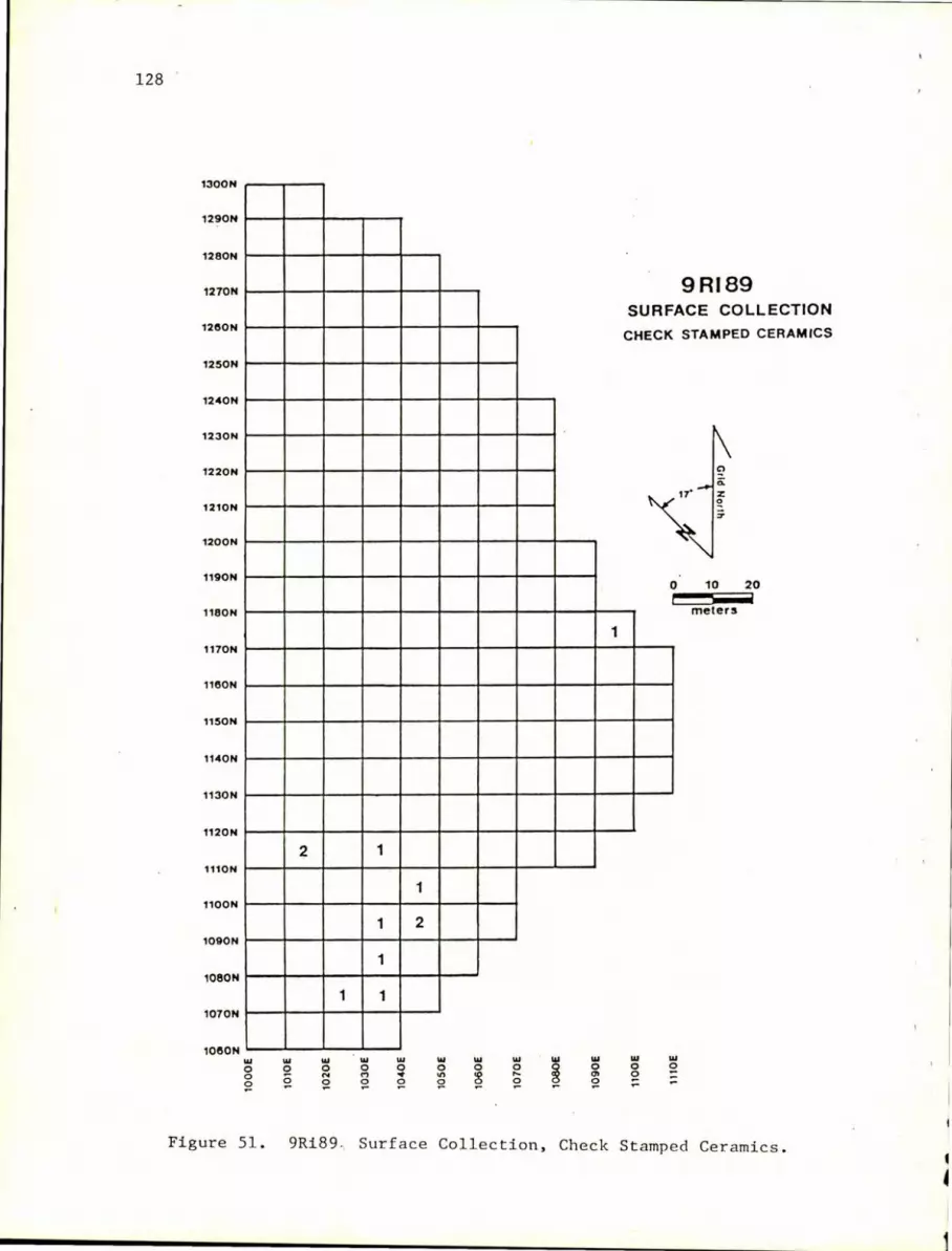
128 '
1300N
1290N
1280N
1270N
1280N
1250N
1240N
1230N
1220N
1210N
1200N
1190N
1180N
1170N
1180N
1150N
1140N
1130N
1120N
1110N
nOON
1090N
1080N
1070N
1080N w o o o
Figure 51.
w o o
2
w o '" o
1
w o M
~
1
1
1
1
w o • Q
1
2
w o on ~
w o ~
w o ... ~
w o '" ~
1
9RI89 SURF
CHECK
ACE COLLECTION
STAMPED CERAMICS
w o o -
0 i
w o
10 20
meters
9Ri89 , Surf a ce Collection, Check Stampe d Cer amics.

1300N
1290N
1280N
1270N
1280N
1250N
1240N
1230N
1220N
1210N
1200N
1190N
1180N
1170N
1180N
1150N
1140N
1 1130N
1 1120N
1110N
1100N
1090N
1 1080N
1070N
1000N ... 0 0
S!
Figure 5 2 .
2
1
1
1
3 2
1
1
... ... ... ... ... ... ... S! 0 0 0 0 0 0
N M • '" '" .... 0 S! S! S! S! S! S!
... ... ~ a: S! S!
11 29
9RI89 SURF ACE COLLECTION
STAMPED CERAMICS SIMPLE
17·
0 10 20 i
meters
5
... ... g 0 .. ..
9Ri 8 9 Surface Col l e ction , Simple St amp e d Ce r amics.

130
Beneath the brown sand was light brown sand. Aboriginal material occurred abundantly in the top zone, greatly diminished in the second compact zone, occurred abundantly in the brown sand, and faded out quickly in the light brown sand. Historic materials and post Archaic aboriginal materials were confined to the two uppermost zones. The brown sand zone was essentially undisturbed by plowing although aboriginal activity, tree roots, and burrowing animals were responsible for some artifact mixing.
A thin layer of clay pellets was encountered in Test Pits 6 and 10. It is unclear whether these pelJets were due to natural or cultural agents. In both cases, the amount of cultural material increased markedly beneath this irregularly distributed clay layer. It is possible that this clay deposit was the product of a climatic event. This deposit needs to be analyzed to determine its origin. A typical soil profile of the site is presented in Figure 53.
Artifacts from undisturbed levels of all test pits, that is, the brown sand layer, were intensively analyzed. Chipped stone artifacts were reexamined to identify any indications of use. We constructed a crude tool typology to facilitate description of these tools. While recognizing the inadequacy of this typology, we hoped that general statements concerning tool function and ultimately site function could be made based on this analysis. The tool categories were determined by the tool assemblage and a certain amount of subjectivity was involved in defining the tool types. .
Brief definitions of these tool categories are provided here. End scrapers are formal, unifacial tools that have the worked edge concentrated on the narrow end of the flake (Figure 54 A and B). Many of these tools were probably hafted. Side scrapers are formal unifacial tools made on a flake with the worked edge concentrated on the long axis of the flake. End and side scrapers were broken down according to shallow (less than 45°) and steep (greater than 45°) edge angles. Utilized flakes are flakes exhibiting an absolute minimum of use wear retouch. These tools were undoubtedly used once and discarded. Unifacia1 flake tools exhibit more intentional flaking than utilized flakes but much of the retouch could also be due to use wear. These tools are not prepared enough to be classified as side or end s cr apers. Graver refers to a pointed appendage on a flake or flake tool which would be suited for perforating (Figure 54C). Spokeshave refers to a concave usually unifacia1 flaked edge on a flake or flake tools. Gravers and spokeshaves frequently occur as composite tools with other flaked tools. Bifacial flake tool refers to a bifacia1ly worked edge on an obvious flake. Bifacia1 flake tools are not to be confused with a complete biface or biface fragment. Bifaces are bifacia11y worked tools with no evidence of hafting. These include small ovate bifaces, irregular bifaces, and bifacia1 knife tools. Broken bifaces are fragments of these tools. Projectile points are formal hafted bifaces. Projectile point fragments are grouped into tips,

t
9 RI89 TEST PIT 6
East Profile
Datum 100.26
--------- - ---- ~~-zt;--~--~-~---------------------------- - - - _ .. :,:- ...... : ....... . ---------------------- ---
- - - - - -- - - - - - - - - - - - - - - - - -
~ ~
U----- - --- - - - -- - - --
Plowzone, medium brown sandy loam
Compacted plowzone, reddish brown sandy loam
Brown sand
Concentration of clay pellets
D Sterile light brown sand
o 20
centimete rs
Figure 53. 9Ri89 Test Pit 6 East Profile.
lJ]

132
A B c
o
F G
E
o 2
~ cm
A. End scraper, top D. Polyhedral core, top
B. End scraper, side E. Polyhedral core, side
c. Graver F. Microblade biface, top
G. Microblade biface, side
Figure 54. 9Ri89 Examples of Flake Tools.

13~
hafts, and midsections. The distinction between bifaces and projectile points was somewhat subjective.
Polyhedral cores are turtle shell shaped cores from which small blades are removed (Figure 54 D and E). These cores may have been used to produce the microblade bifaces. Microblade bifaces are bifacially worked tools made on microblades (Figure 54 F and G). These tools are very small and finely retouched.
In addition to the chipped stone tools that were intensively analyzed, samples of debitage were also closely examined. It was difficult to determine what particular flaking technique had been used in creating the debitage as many of the flakes produced by soft hammer percussion could be confused with pressure retouch flakes. To resolve this problem, debitage was grouped by size into three categories. Small pieces were less than 20 mm in size, medium pieces were 20 to 40 mm in size, and large were greater than 40 mm in size. The results of this ranking is shown in Table 11.
The stratigraphic relationships of the lithic tools and debitage and breakdown by raw material type for each test pit are presented in Table 12. Two test pits, Test Pit 7 and 9, excavated adjacent to each other contained diagnostic artifacts in a stratified context. Four diagnostic points in Test Pit 7 and three in Test Pit 9 reinforcffithe interpretation of the stratified nature of the sand deposits :at 9Ri89 and these two test pits are described in detail.
Test Pit 7 had the best stratigraphic evidence of anyone of the test units at 9Ri89. Level I, the loose plowzone, contained brick fragments, cinders, weathered grit tempered ceramics , lithics, and miscellaneous rock. This was the only level containing aborigi nal ceramics or historic artifacts. Level I contained a total of 36 quartz, cher~ and metavolcanic lithics. Diagnostic lithics within this level includffia metavolcanic Dalton projectile point. The presence of this Dalton point indicates that a certain amount of mixing between strata had occurred although this mixing was probably not due to plowing.
Level II contained miscellaneous rock and 119 pieces of lithic material. No diagnostic artifacts were recovered from this level. The lithics from this level included quartz, chert, and metavolcanic material with the addition of a characteristic sandstone. One of the Dalton points from the surface at 9Ri89 was made from this sandstone. In the Wallace Reservoir, a similar type of sandstone showed a close association with Early Archaic projectile points (Lisa O'Steen, Department of Anthropology, University of Georgia, personal communication). Judging from the stratigraphic evidence at 9Ri89, this stone also has a late Middle Archaic and Early Archaic association. However, at site 9Ri88 this sandstone apparently was also in use during the Late Archaic.

134
Table 11. Size Ranking of Debitage. 9R189. Test -Pit 7.
Small Medium Large TOTAL
Chert 1574 208 6 1788
Quartz 68 5 0 73
Metavolcanic 39 12 2 53
Sandstone 42 3 2 47
TOTAL 1723 228 10 1961
~----_________________________ t

esc
.....
•
Tab
le
12
. A
rtif
acts
fr
om
9R
i89
, T
est
P
it
1.
To
ols
D
ebit
age
D:I.a
sno
s t i
c A
rtif
acts
H
isto
ric
Pre
his
tori
c
Lev
el
Qu
artz
C
her
t M
etav
olc
anic
Q
uar
tz
Ch
ert
Met
avo
lcan
ic
San
dst
on
e A
rtif
acts
P
ott
ery
I X
a 0-
25
cm
1 12
0
30
417
7 1
X
II
25-3
5 cm
10
2
5 42
8
X
III
35-4
5 cm
1
12
IV
45-5
5 cm
4
V
55-6
5 cm
TOTA
L 1
22
2 36
47
5 15
1
X
X
aX=
pre
sen
t

t-'
W
0\
Tab
le
12
(co
nq
nu
ed)
• A
rtif
acts
fr
om
9R
i89
, T
est
Pit
2.
To
ols
D
ebit
age
Dia
gn
ost
ic A
rtif
acts
H
isto
ric
Big
San
dy
Dal
ton
L
evel
Q
uar
tz
Ch
ert
Met
avo
lcan
ic
Qu
artz
C
her
t M
etav
olc
anic
S
and
sto
ne
Art
ifacts
P
oin
t P
oin
t
I 0
-22
cm
4
16
132
2 X
II
22-3
2 cm
1
32
174
5
III
32-4
2 cm
31
14
31
9 7
1
IV
42-5
2 cm
5
1 6
87
1
V
52-6
2 cm
1
3 27
VI
62-7
2 cm
2
1 9
VII
72
-82
cm
3
TOTA
L 44
1
72
751
14
X
1 1
«

• -
-•
..
Tab
le
12 ~continued);
Art
ifacts
fr
on
9~i89.
Tes
t P
it
3.
To
ols
D
ebit
a:;e
D
iag
no
stic
A
rtif
acts
Lev
el
His
tori
c
Pre
his
tori
c
~orrov
Mnt
. Q
uar
tz
Ch
ert
Met
avo
lcan
ic
Qu
artz
C
her
t M
etav
olc
anic
Sa
nd
sto
ne
Art
ifacts
P
ott
ery
S
oap
sto
ne
Po
int
I 0
-20
cm
3
8 2
54
251
14
4 X
X
X
1
Il
20-3
0 cm
1
11
1 42
70
7 28
4
X
III
30-4
0 C
III
3 21
26
64
5 16
IV
40-5
0 cm
2
1 10
4
V
50-6
0 cm
11
VI
60-7
0 cm
VII
70
-80
em
4
VII
I 80
-90
cro
IX
90-1
00
em
TOTA
L 42
3
124
1724
58
8
X
X
X

Tab
le
12
(co
ntl
n·ue
d).
Art
ifact.
fr
om
9R18
9.
Tes
t P
it
4.
Too
ls
Deb
itag
e D
iall
nos
tic A
rtif
acts
P
'reh
isto
rie
Stem
med
P
alm
er
Lev
el
Qu
artz
C
her
t M
etav
olc
anic
Q
uart
z C
her
t He
tav
olc
anlc
S
ands
tone
F
ott
ery
S
oap
sto
ne
Po
int
Po
int
I 0
-20
em
3
14
52
12
X
X
1
II
20-3
0 em
5
17
119
16
III
30-3
8 cm
27
20
2 38
6
IV
38-4
8 em
30
1
42
333
44
44
V
48-5
8 em
12
1
22
250
25
13
n 56-6
9 em
12
12
1 10
VII
69
-79
em
33
VII
I 79
-89
em
4
IX
89-9
9 em
TOTA
L 65
13
6 11
16
147
68
X
X

• ••
• w
•
4 •
Tab
le
12
(co
nti
nu
ed).
A
rtif
acts
fr
om
9Ri8
9.
Tes
t P
it
6.
Tools
D
ebit
age
Dia
gn
osti
c A
rtif
acts
H
isto
ric
Pre
his
tori
c
Pal
eo-I
nd
ian
Le
vel
Q
uara
Ch
ert
M
eta
vo
lcan
ic
Qu
artz
C
her
t M
eta
vo
lcan
ic
San
dst
on
e A
rtif
acts
Po
ttery
So
apst
on
e P
"in
t
I 0
-20
em
8
12
123
14
X
X
II
20-3
0 cm
5
27
4 X
X
X
III
30-4
0 cm
8
17
98
17
IV
40-5
0
cm
23
9 16
0 21
V
50-6
0 em
10
11
5
VI
60-7
0 cm
21
VII
7
0-8
0 C
Ol
VII
I 80
-90
em
TOTA
L 3
49
51
544
61
X
X
X

Tab
le
12
(con
tin
ued
) .
Art
ifacts
fr~
9Ri8
9.
Tes
t P
it
7.
Too
ls
Debi
ta)t
e D
iag
no
stic
Art
ifacts
H
isto
ric
Pre
his
tori
c
Dal
ton
H
aCor
kle
Pal
eo-I
nd
ian
L
evel
Q
uart
z C
her
t M
eta
vo
lca
nic
Q
uart
z C
her
t M
eta
vo
lca
nic
S
and
ston
e A
rtif
acts
P
ott
ery
P
oin
t P
oin
t P
oin
t
I 0-
18
CO
l 23
X
X
11
18-2
8 cm
15
90
1
1
III
28-4
0 cm
8
40
19
243
16
10
IV
40-5
0 cm
66
26
68
0 14
V
50-6
0 cm
16
6
339
VI
60-7
0 cm
10
5
VII
70
-80
cm
11
VlI
I 80
-90
cm
TOTA
l. 14
12
6 70
14
93
38
24
X
X
• •
• •

....
u ..
Tab
le
12
(cn
nlt
uu
ed)
. A
rtif
.cts
fr
om
9R18
9. r~st
PI
t 9
.
To
ols
D
ebi ta~e
Dia
gn
ost
ic A
rtif
acts
H
isto
ric
Preh
isto
ric
P
alm
er
Big
S
andy
L
evel
Q
uar
tz
Ch
ert
Me
tav
olc
an
ic
Qua
rtz
Ch
ert
Het
itv
olc
anlc
S
an
dst
on
e P.rt
ifacts
P
ott
ery
S
oap
stl)
ne
Po
int
Po
int
I 0
-16
cm
14
68
X
X
X
II
16-
26
C
II
41
8 X
III
26
-36
C
II
IV
36
-46
C
II
11
30
V
46
-57
C
II
13
25
13
7 1
9
Vi
57-
67
C
II
27
69
J 64
15
VII
6
7-7
3
em
11
35
64
VII
I 7
3-7
8 C
lO
21
48
8
IX
78-
88
C
II 6
X
88
-10
0
c:n
TOTA
L 60
18
7 5~9
74
X
1 X

f-' ~
tv
T,b
le
12
(co
nti
nu
ed)
• A
rtif
Act.
rr~
9RI8
9,
Tes
t rlt
9
.
To,
,!s
Deb
it.g
e D
bg
l1o
.t I
e ~rtiCaet9
Kir
k
Ho
rro
,",
Htn
. S
te",
",ed
B
Ig
S"nr
ly
Level
Qu
artz
. C
her
t lf
et:
\vo
lc.1
nlc
Q
uar
tz
Ch
ert
Met
av
olc
an
ic
San
dst
one
Po
int
Po
int
rnin
t P
oin
t
I 0
-22
eM
Il
22
-24
em
9
III
24-
28
em
27
15
IV
28
-)4
em
8
52
1)
V
)4-)
9 e
m
3 6
7~
VI
39
-46
em
1
)
15
309
14
Vll
4
6-5
1
elD
6 18
9 6
V[I
I 5
1-5
7
em
10
9 19
0
U
57
-63
cm
II
10
5 4
J(
63
-69
em
42
Xl
69
-79
em
22
79
-8?
em
T'lT
AI.
42
72
1
0)1
36
3
)

~----~IEEb
....
~"
.. r.'
2 .. ~-'..,
.. r.~~~.-'",
.. ~CD"~--~~tp~----------------w.~~--------------~ .. ~ ...
......
......
......
......
......
......
......
......
......
......
......
......
......
. ..
Tab
le
12
(co
nti
nu
ed).
A
rtif
acts
fr
om
9Ri8
9,
Tes
t P
it 1
0.
To
ols
D
ebit
age
Dia
gno
sti
c A
rtif
acts
H
isto
ric
Pre
his
tori
c Pa
lme
r L
evel
Q
uar
tz
Ch
ert
Met
avo
lcan
ic
Qu
artz
C
her
t M
etav
olc
anic
S
ands
tone
A
rtif
acts
P
ott
ery
So
apst
one
P
oin
t
I 0
-16
cm
1
5 77
8
X
X
X
II
16-2
6 cm
3
9 X
X
III
26-3
1 cm
2
2 31
3
IV
31-3
6 cm
6
10
129
9
V
36-4
1 cm
15
5
216
4
VI
41-4
6 cm
10
1
5 26
0 6
1
VII
46
-52
cm
5 3
138
VII
I 52
-57
cm
2 23
IX
57-6
2 cm
1
13
X
62-6
6 cm
4
1
XI
66-7
1 cm
4
TOTA
L 40
1
36
904
31
X
X
X
2 f-
' .p
. W

Tab
le
12.
(co
nti
nu
ed).
A
rtif
acts
fr
om
9Ri8
9,
Tes
t P
it
11.
To
ols
D
ebit
ar,e
D
iag
no
stic
A
rtif
acts
H
isto
ric
Pre
his
tori
c
Kir
k
Lev
el
Qu
artz
C
her
t H
etav
olc
anic
Q
uar
tz
Ch
ert
~Ietavolcanic
San
dst
on
e A
rtif
acts
P
ott
ery
S
oap
sto
ne
Po
int
I 0
-16
em
1
8 74
7
X
X
X
II
16-2
7 em
2
1 49
10
X
III
27-3
7 cm
30
3
9 28
2 14
IV
37-4
2 em
2
13
6
333
22
V
42-4
7 em
4
1 5
112
1
VI
47-5
2 em
1
4 38
VII
52
-57
em
1 2
18
2
VII
I 57
-63
em
8
IX
63-6
7 em
TOTA
L 2
52
4 36
91
5 56
X
X
X
--.....
.
-

c ••• w
aG
_
• W
. •
·0
• •
Tab
l.e
12
(co
nti
nu
ed
).
Art
ifacts
fr
om
9R
i89
, T
est
Pit
1
2.
To
ols
D
ebit
age
Dia
gn
ost
ic A
rtif
acts
H
isto
ric
Pre
his
tori
c
Lev
el
Qu
artz
C
her
t M
etav
olc
anic
Q
uar
tz
Ch
ert
Met
avo
lcan
ic
San
dst
on
e A
rtif
acts
P
ott
ery
S
oap
sto
ne
I 0
-19
cm
1
2 7
40
2 X
X
X
II
19
-28
cm
1
1 10
X
III
28-3
8 cm
4
17
1 X
IV
38-4
8 em
25
23
31
3 14
X
V
48-5
8 cm
9
7 16
1 3
VI
58
-68
em
32
VII
6
8-7
8 e
m
1
TOTA
L 36
2
42
574
20
X
X
X

146
Level III contained 337 pieces of quartz. chert. metavolcanic. and characteristic sandstone lithics and miscellaneous rock. One MacCorkle bifurcated base metavolcanic projectile point was recovered from this level and in the adjacent Test Pit 9, a chert Kirk point and a metavolcanic Morrow Mountain point were recovered from corresponding levels. This level and all levels beneath it showed no evidence of plow disturbance. Within I,evels III and IV was Feature 3. a probable dispersed hearth. This feature was the only one observed within this test pit. Flake tools recovered from this level included
2 bifacial fragments 1 bifacial tool 1 graver/unifacial tool 1 shallow angle side scraper/graver 6 unifacial tools
38 utilized flakes
Level IV contained 793 pieces of quartz. chert. metavolcanic. and sandstone lithics; one large. possibly ground metavolcanic rock; and miscellaneous rock. A metavolcanic Dalton projectile point was recovered from this level. In a corresponding level in the adjacent Test Pit 9. a quartz Big Sandy projectile point was found. Flake tools recovered from this level included
7 biface fragments 1 bifacial/unifacial flake tool 1 graver 8 unifacial tools
53 utilized flakes
Level V contained 365 pieces of quartz. chert. and metavolcanic and sandstone lithics and six grams of miscellaneous rock. A fluted chert Paleo-Indian point (Figure 55 A and B) was recovered from this level. No other diagnostic projectile points were found below this in Test Pit 7 or in corresponding levels of adjacent Test Pit 9. Flake tools from this level included
2 bifacial fragments 2 steep angle end scrapers/gravers 1 graver/unifacial tool 1 unifacial tool
10 utilized flakes
Level VI contained a quartzite hammerstone. 105 pieces of chert debitage. and one utilized chert flake. Level VII contained 11 pieces of chert debitage. one utilized chert flake, and 4 g miscellaneous rock. Level VIII contained only two small pieces of chert debitage.
The plowzone. Level I. contained mixed materials from a wide time range. However. most of the materials from this level post date

147
the Archaic period. Middle Archaic material definitely associated with Level III, the compac4reddish brown sandy loam, was clearly above the brown sand culture bearing strata. Within the brown sand culture bearing zone (mainly Levels IV, V, and VI), Early Archaic, transitional PaleoIndian, and Paleo-Indian materials were found. Many of the artifacts in Levels VII and VIII, judging by their small sizes, apparently trickled downward in the sand from higher levels.
In all levels, chert was by far the predominant lithic material. In all levels except Level I, quartz lithics were next in order of dominance. Metavolcanics and sandstone were the least utilized raw materials. Other than in diagnostic projectile points, no great differences were observed between the debit age and flaked tool types from the MacCorkle, Dalton, and fluted point levels. However, it must be stressed that some mixing between levels had occurred and the samples obtained from this site were much too small to make definitive statements on the various tool assemblages for each time period.
Features. Eight subsurface features were identified during testing at 9Ri89. Four of these features were identified as tree root disturbances and the remaining four were identified as cultural.
Feature 1, located in Test Pit 1, was a circular aboriginal postmold 28 cm in diameter and 50 cm in depth. The feature contained gray sandy fill and no cultural artifacts.
Feature 2, located in Test Pit 4, was an oval dark brown sandy stain 64 cm long, 52 cm wide, and 34 cm in depth. The top of the feature was 24 cm below surface. Artifacts from the feature included
2 quartz debitage 44 chert debitage
1 side scraper 1 utilized flake 2 metavolcanic debitage 6 sandstone debitage
Feature 3, located in Test Pit 7, was a scattered cluster of three large rocks, three chert debitage, and one utilized flake. No associated stains were visible. The feature measured 30 cm in diameter and was 18 cm in depth. This feature, interpreted as a dispersed hearth, was located in Levels III and IV of this test pit.
Feature 8, located in Test Pit 8, was also a cluster of rocks and artifacts and probably also represented a dispersed hearth. The feature measured 40 cm by 20 cm and was 12 cm in depth. The top of this feature was 55 cm below the surface. No associated stains were visible. Artifacts from the feature included

148
1 quartz debitage 1 chert debitage 2 utilized flakes 1 unifacial flake tool 1 metavolcanic debitage 1 grooved sandstone abrador
Diagnostic Points. Many diagnostic the surface and excavated areas at 9Ri89. descriptions,and other characteristics for the excavation pits are presented in Table
points were recovered from Key measurements, raw material selected points recovered from 13.
A fluted point was recovered from Level V in Test Pit 7 (Figure 55 A and B). This point has a single flute extending slightly more than halfway up the point on one side. Multiple flutes, extending approximately halfway up the point, are present on the opposite side. The base and sides had been ground reminiscent to a Dalton point (Cambron and Hulse 1969:32). Dr. Albert Goodyear (Institute of Archaeology and Anthropology, University of South Carolina, personal communication),who is quite familiar with Dalton point technology, described this point as a fluted Dalton.
The broken base of a fluted point preform was recov.ered from Level V in Test Pit 6 (Figure 55 C and D). This preform has a single flute on one side and multiple flutes on the opposite side. This point base was examined by several authorities on Paleo-Indian lithic technology in the eastern United States. Dr. William Gardner, noted for his Paleo-Indian research in Virginia (Gardner 1974), felt that it was of the Clovis type. However, Dr. Albert Goodyear, noted for his transitional Paleo-Indian Early Archaic research in Arkansas (Goodyear 1974), felt this artifact was a Dalton point perform. With no datable context currently available for these two artifacts and with considerable disagreement over the exact age of these points, one can say only that they are fluted points of Paleo-Indian or transitional Paleo-Indian/Early Archaic age.
Diagnostic Ceramics. Diagnostic ceramics recovered from 9Ri89 included fiber tempered and grit tempered wares. Generally pottery was sparsely distributed over the site being confined to the surface and plowzone l evels. All of the sherds were so small that little can be said about vessel size, vessel form, or other attributes. One fiber tempered sherd was recovered from the surface. Fiber tempered pottery, both plain and punctate, was recovered from Test Pits 8 and 10.
Deptford check stamped and unidentified s i mple stamped sherds were recovered from the surface (Figures 51 and 52). Grit tempered
I I

p s· ..
-_
v e
os:w
: -
• W
' -
Tab
le
13
Sele
cte
d
Dia
sno
stic
P
oin
ts
from
9R
i89
.
:-:ea5Ur~:
:lc:
1:s
(=
)
~aw ~teri3.1
Sh
oul:
:!er
H
a: t
3a5'
::
~eta-
Tt!
s:'
?:
:"t
Le:
vel
Len
gth
lI
idth
L
e:l.g
th
T.J
idth
I~ic:<ness
Ch
ert
Qua
rtz
v
olc
an
ic
Sa
nd
sto
ne
Po
int
Ty
pe
III
54
30
13
30
X
Big
S
and
y
~
29
13
10
11
X
Ste
",_"
.d
IV
60
~4
12
' , _4
X
Big
Sa~d:J
[II
52
30
I!.
10
X
Ste~e':
V
52
35
X
elu
ted
?
ale
o-I:
1c:3
.n ?r
~:-
;):-
:1
!o1
22
17
23
X
Dal
ten
III
43
24
11
15
X
~acC0rkle
IV
43
20
12
25
X
Da
l to
n
V
51
24
11
n X
F
lute
d
?a
leo
-!r
.c::
t.n
?oin
t
a V
I 34
19
13
6
X
?"al
r.Je
r (?
)
VII
52
25
11
27
X
B
ig
San
dy
9 IV
40
23
1
,\
1.\
6 X
~orro\J ~ounc:atn
IV
39
21
13
21
8 X
K
irk
'J[
40
28
15
13
X
St~
,""::
'Ict
!
[I)
IV
3c
.. 13
21
X
?al~.er
'J[
45
2:'
13
19
9 X
Po
L-.e
r
11
IV
41,
} 1
17
e)
:0
x S ter-~~ed
Kir
k

150
A B
c o
o 2
~
A. Fluted chert point, obverse
B. Fluted chert point, reverse
A,B. Test pit 7, Level V
cm
c. Fluted chert preform, obverse
D. Fluted chert preform, reverse
C, D. Test pit 6, Level V
Figure 55. 9Ri89 Fluted Projectile Points.
I
I ~ I
. I
I I

ceramics recovered from the test pits included Deptford check stamped, Savannah cordmarked, and unidentified rectilinear complicated stamped wares.
151

DISCUSSION
This testing project recovered information relevant to several currently important anthropological research topics. The most significant information from these sites concerns the Early Archaic/Paleo-Indian and Late Archaic periods. Information from other time periods is sketchy and is of limited archaeological utility.
Early Archaic/Paleo-Indian
Early Archaic and possible Paleo-Indian materials have been recovered from three sites, 9Ri45, 9Ri85, and 9Ri89. Material at 9Ri85 was quite sparse and limited to the plowzone and material at 9Ri45 was in a severely disturbed context. Site 9Ri89 has the best preserved assemblage of this time period from any site thus far recovered in Georgia. Although considerable artifact mixing had occurred in the upper layers, the lower levels were relatively undisturbed and were vertically stratified (Table 14).
Despite the lack of certain types of data at site 9Ri89, i.e., environmental information and subsistence information, the site has the potential to increase our understanding of the transition from PaleoIndian to Early Archaic culture. A smooth transition is indicated with the continuation of a complex flake tool technology present well into the Early Archaic. An overall summary of the flake tool types from the undisturbed cultural levels at 9Ri89 is presented in Table 15.
This site is physiographically similar to Early Archaic sites below the fall line near Columbia, South Carolina. Both areas are located within the broad floodplains of major rivers at the immedjate junction of the Piedmont and the Coastal Plain. Collections from 9Ri89 could be compared with material from the Taylor site and the Manning site to obtain a better picture of Early Archaic/Paleo-Indian ecotonal settlement (Michie 1971). The site must have provided optimal habitation throughout man's occupation in the region as virtually every time period is represented. The abundance of game in the area today attests to the reasons this site was continually selected for habitation.
This site shares many characteristics in common with other transitional Paleo-Indian sites in the Southeast. Comparison with the Brand site (Goodyear 1974), a Dalton site in northeast Arkansas, reveals many similarities and differences. Like the Brand site, 9Ri89 contained Dalton points in the preform, initial, and advanced resharpened stage. End scrapers, side scrapers, spokeshaves, gravers, microblade bifaces, and other flake tools were present at both sites. Also present at both
152

Table 14. General Stratigraphy , 9Ri89.
Depth Below Surface Diagnostics
0-30 cm Historic. Archaic, Woodland, Missis~ippian pottery; soapstone sherds; Morrow Mountain, Kirk, Dalton points; microblade bifaces.
30-40 cm Aboriginal pottery; small soapstone fragments; MaoCorkle,Palmer, and Big Sandy points; microblade bifaces; hafted unifac.es; polyhedral cores.
153
40-50 cm 1 soapstone fragment; bifurcated base, Palmer, Big Sandy, Dalto~ and unidentified laneeolate points.
50-60 cm 1 Palmer point, 1 fluted point, 1 fluted point preform base.
60-70 em 1 Big Sandy point, 1 possible fluted point midsection , 2 microblade bifaces, 1 hafted endscraper.

Tab
le 1
5.
Chi
pped
S
ton
e T
oo
l T
ypes
an
d F
req
uen
cy.
from
U
nd
istu
rbed
C
ultu
ral
Lev
els
at
9Ri8
9.
Sin
gle
Fu
nct
ion
To
ols
M
ult
ifu
ncti
on
al
To
ols
S
hal
low
end
sc
rap
er
w/s
mal
l sp
ok
esh
ave
no
tch
1
Sh
allo
w e
nd
scra
per
Ste
ep
end
scra
per
Sh
allo
w s
ide sc
rap
er
Ste
ep si
de sc
rap
er
Gra
ver
Un
ifacia
l fl
ak
e
too
l
Spo
kesh
ave
Uti
lized
fl
ak
e
Bif
acia
l fl
ak
e
too
l
Mic
rob
lad
e to
ol
Com
plet
e p
roje
cti
le p
oin
t
Pro
jecti
le p
oin
t ti
p
Pro
jecti
le p
oin
t b
ase
Pro
jecti
le p
oin
t m
idse
ctio
n
Oth
er
com
ple
te b
iface
Un
cla
ssif
ied
bif
acia
l fr
agm
ent
Po
lyh
edra
l co
re
Po
lyh
edra
l co
re
thu
mb
nai
l sc
rap
er
TOTA
L
5 10
10 5 2 71 2
336 9 5 15
1 2 3 6 51 1 1
535
Ste
ep e
nd
scr
aper
w/g
rav
er
4
Ste
ep
end
scra
per
w/u
nif
acia
l ed
ge
3
Ste
ep
end
scra
pe
r w
/bif
acia
l ed
ge
1
Sh
allo
w s
ide
scra
per
w/g
rav
er
2
Ste
ep sid
e sc
rap
er
w/u
nif
acia
l ed
ge
1
Gra
ver
w/u
tili
zed
fl
ake
to
ol
6
Gra
ver
w/b
ifacia
lly
wor
ked
edge
1
Gra
ver
w/u
nif
acia
lly
wor
ked
edg
e 6
En
d/s
ide
scra
per
1
Sp
ok
esh
ave/
gra
ver
/sh
allo
w s
ide
scra
per
1
En
d/s
ide
scra
per
and
adze
1
Bif
acia
l/u
nif
acia
l fl
ak
e
tool
2
TOTA
L 30
... -

155
were grooved sandstone abradors and sandstone abradors with flat worked faces. MacDonald (1971:34) suggested that these tools were used for grinding point bases and the edges of biface preforms. Notably absent from 9Ri89 but present at the Brand site were pebble cores, bipolar flakes, "Pieces Esquillees" tools, and the chopper/ hammer/ anvil cobble tools. Dalton adzes were also uncommon at 9Ri89.
During the analysis, chipped stone tools were grouped into size categories. Out of a sample of 564 chipped stone tools from undisturbed levels at the site, 197 tools were small, 291 tools were medium, and 76 tools were large. This size distribution suggests that most of the raw materials brought t o the site were conservatively utilized.
Multisea s ona l repeated occupation as a base camp during the late Paleo-Indian and Early Archaic periods is suggested at 9Ri89. The range of artif acts suggests activi ties involving both males and females within bands. Tools were being manufactured, maintained, and discarded. Although no evidence of postmolds or structures were seen, the area examined was too small to rule out their presence.
Artifacts recovered from limited testing at this site included a wide range of flaked tools and debitage, ground stone tools, and dispersed hearth areas. The types of tools and artifacts recovered from this site represent a variety of activities. Tool manufacture, resharpening, wood and/or bone working, hide preparation, cutting, plant food processing, and the use of fire for knapping and possibly cooking are all indicated at this site. By examining the assemblage from 9Ri89, we can gain insight into the level of technology , activities, terriorial range and resource procurement systems; and inferences can be made as to how this site functioned in the settlement system.
The complex flaked stone tool assemblage suggests a well developed lithic technolo gy. Finely flaked microblade bifaces, gr avers, and scrapers reflect the knapping skills of these early Georgi ans. Although these tools have been subject to analysis for this report, a more intensive analysis of the t ypological attributes, flaking techniques, and microwear pa tterns would be ex tremely fruitful.
Most of the tools from 9Ri89 represent what Gould (1979) refers to as instant tools, that is, tools subject to no great modification before use and then discarded immediately after use. Other tools experienced a longer use life by resharpening or modification. Evidence of resharpening is seen on Dalton, Big Sandy, Palmer, and Kirk poi.nts. Other projectile points were discarded without resharpening. Several of the scraper tools exhibit ex treme wear polish indicating they were heavily used. The presence of spokeshaves suggest that bone or wood artifacts were being finished or sharpened.

156
Most flaked tools recovered were single function as opposed to multifunctional composite tools. Edge angles on scraper tools were roughly grouped into two groups: shallow (less than 45°) and steep (greater than 45°). Wilmsen (1970) has postulated that steep angled scraper tools were associated with bone and woodworking whereas shallow angle scrapers were associated with cutting and hide preparation. Of 43 scraper tools from 9Ri89, 24 were steep angled and 19 were shallow angled. If one accepts Wilmsen's idea, then tasks at the site were more or less equally divided between bone/wood working and butchering activities. Preparation of wild vegetables is evidenced by hand grinding stones from Test Pit 7 and Test Pit 12.
Fire-cracked quartz rock fragments were common at 9Ri89. These rocks were generally well scattered although in two instances clusters occurred. These clusters probably represent hearths which have been dispersed.
The most abundant artifact at the site was lithic debitage. Debitage of quartz, chert, and metavolcanics were present but chert was by far the most abundant. Cortex was not present on the majority of flakes which suggests that the cores being brought to the site already had much of the cortex removed.
Most of the chert debit age was small (less than 20 mm in maximum dimension) retouch flakes and shatter. Medium sized retouch flakes and percussion flakes (20-40 mm) were the next most abundant type of debitage. Non-utilized percussion flakes above 40 mm in size were uncommon. Only two small (less than 40 mm) chert cores were recovered from 9Ri89. Quartz and metavolcanic exhibited similar evidence of raw material conservation. Most debitage of these raw · materials was quite small (less than 20 mm) and no large quartz or metavolcanic cores were recovered. Sandstone debit age was also primarily small (less than 20 mm) and no cores were found. However, much of the sandstone debitage was cortical which suggests that unmodified cores were reduced at the site.
Heat treatment of chert was practiced at 9Ri89. Heat treating coastal plain cherts results in color change from yellow or white to purple, pink, or dark red. Some of the debit age also exhibited heat spalls and heat fracturing. Most of the debitage bore no evidence of heat treatment but the dynamics of heat treatment need to be better understood before this subject can be intelligently discussed.
I

157
Late Archaic
The Late Archaic period is represen t ed at sites 9Ri45, 9Ri86, 9Ri88, and 9Ri89. Fiber tempered pottery was present at 9Ri86 and 9Ri89. Late Archaic stemmed points were recovered from 9Ri86 and 9Ri88.
Late Archaic occupation at 9Ri45 is evidenced by the presence of soapstone. In the area of the site tested by Ledbetter et al. (1980), soapstone sherds and perforated stones were present. Neither were recovered by our testing, thus Late Archaic occupation at this site likely was not very intensive.
Late Archaic occupation at 9Ri89 also was not intensive. A light scatter of plain and incised fiber tempered pottery, two articulating soapstone sherds, small fragments of perforated soapstone, and lithic debitage comprised the Late Archaic component.
Much more intensive Late Archaic utilization is indicated at sites 9Ri86 and 9Ri88. Occupation at 9Ri86 was almost exclusively Late Archaic/Transitional Early Woodland; both preceramic and ceramic Late Archaic occupation is represented. Site 9Ri88 appears to be strictly preceramic Late Archaic with the presence of later Woodland ceramics (Deptford check stamped and Swift Creek complicated stamped).
Sites 9Ri86 and 9Ri88 are similar in many respects. Both are in approximately the same environmental zones although 9Ri88 is slightly closer to the present river channel. Both sites contained abundant features indicating that the sites were intensively occupied. The amount of artifacts recovered also indicates long term occupation of these two sites. Both sites contained broken and whole projectiie points, flake tools, and debitage. Fire cracked rocks were also present at both sites. Fired clay balls, possibly associated with cooking, were abundant on both sites. These fired clay balls are of various sizes and show no great care in their manufacture unlike the clay balls seen in the Poverty Point region (Webb 1977).
Both sites contained an abundance of perforated soapstone objects. In both cases the artifacts were always broken and the breakage was frequently along the perforation. Plain and decorated perforated objects were found on both sites with decorated forms present in very low frequency. At site 9Ri86, perforated soapstone objects were present prior to and during the use of pottery al t hough the frequency of soapstone declined somewhat with an increase in pottery. This could be interpreted as a decreased need for soapstone in cooking with the introduction of pottery. No fiber tempered pottery was recovered from site 9Ri88. At site 9Ri88 the reuse of broken soapstone perforated objects as evidenced by multiple perforations was more common than at site 9Ri86.
Evidence of food processing and consumption was seen at 9Ri86 and 9Ri88. Manos, small unidentifiable bones, charred hickory nut fragments,

158
and acorns were recovered from both sites. Lithic tool manufacture and utilization were major activities at both sites. Stone tools were made at both sites from chert, quartz, and metavolcanics.
Although sites 9Ri86 and 9Ri88 are both Late Archaic non-shell midden sites in similar environmental zones, several obvious differences occur between the two. These differences are in raw material preference and artifact inventories. At 9Ri88, chert was the dominant raw material, whereas at 9Ri86 quartz and metavolcanics were the preferred raw materials. Whether this difference was functional, social, or temporal is not known. Differences in lithic preference at the two sites were discussed by Ferguson and Widmer (1976). Differences in lithic resource ratios seen by Ferguson were confirmed during this testing project.
Stone drills well evidenced at 9Ri86 were absent at 9Ri88. Also absent at 9Ri88 were the stone atlatl hollow cane drill cores found at 9Ri86. The abundantly present red and yellow ochre at 9Ri86 occurred minimally at 9Ri88. At 9Ri86 there appeared to be more emphasis on certain exotic materials, i. e., atlatls and ochre, than at 9Ri88. Site 9Ri88, on the other hand, had higher amounts of chert lithics than 9Ri86 and chert would require more effort to transport than quartz and metavolcanics.
Some of the observed differences between these two sites may be a result of the small sample size but it seems clear that major differences do exist between the two sites. Many of the activities persistently occurring through time at 9Ri86 were not seen at 9Ri88. It seems unusual that two sites almost within sight of each other could maintain distinct functions over such a long time period. What mechanisms, for example, would cause one site to be a locus of atlatl manufacture over several hundred years while no such activity occurred at other nearby habitations? These questions cannot be answered based on the data from this testing project, but may be answered by future excavations.
A brief comparison of 9Ri86, 9Ri88, Stal lings Island, Lake Springs, and Rabbit Mount is presented in Table 16. From this table it is clear that these sites share many common traits. The absence of shell at 9Ri86 and 9Ri88 probably accounts for the absence of burials and bone tools. Acid ·soils without mussel shell to neutralize them play havoc on bone and other organic materials.
Atlatl Manufacture. Site 9Ri86 testing revealed evidence of intensive atlatl manufacture. A total of four atlatl body fragments and f i ve atlatl drill cores were recovered from the site. Two of the drill cores were recovered while troweling the backhoe trench, one 1

••
• a
• ••
..
-•
i$C
..
Tab
le
16
Lat
e A
rcha
ic T
rait
C
ompa
riso
n'a
t S
elec
ted
S
ites
.
Pla
in
Dec
ora
ted
T
ho
rn's
S
avan
nRh
Bon
e o
r Sh
ell
P
erf
ora
ted
S
oa
pst
on
e !f
iber
F
iber
!
Ore
ek
. R
iver
. A
tlatl
G
roov
ed
, C
lay
. A
nt l
er
'Ud
den
So
apst
one
S
her
d
'!'e
mp
ere
d
Tem
pere
d Pu
nc-t
ate
D
rill
s
Po
ints
W
eigh
ts
Ax
Ball
s B
uri
als
~-
Fea
ture
s T
oo
ls
9Ri8
6 X
X
X
X
X
X
X
X
X
X
9Ri8
8 X
X
X
X
X
Sta
llin
gs
Isla
nd
X
X
X
X
X
X
X
X
X
X
X
X
Lak
e S
pri
ng
s X
X
X
X
X
X
X
X
X
X
X
X
Rab
bit
M
ount
X
X
X
X
X
X
X
X
X
X
X

160
from Zone E and one from Zone F (Figure 36). Two atlatl cores were recovered from Test Pit 6, one of which matched ,.7ith one-half of a broken unfinished winged bannerstone. These two artifacts were recovered in situ and careful comparison indicated that the two artifacts were previously joined (Figure 56). Three smaller atlatl body fragments were recovered from Test Pit 6. Single drill core fragments were recovered from Test Pit 3 and from Test Pit 5 (Figure 25). It is reasonable to expect that many more drill cores are contained in the midden deposits at 9Ri86.
The atlatl drill core is a rare but not unknown artifact type in the eastern United States. This artifact type has been reported in a Woodland context at Hiwassee Island (Lewis and Kneberg 1949:118), in an Early Archaic context in Alabama (Cambron and Hulse 1964:250), and in a Late Archaic context at the Bent site in New York State (Ritchie 1969:127). Steve Kowalewski (Department of Anthropology, University of Georgia, personal communication) noted that onyx bead cores, smaller but similar in form, have been recovered in Mesoamerica. Jim Michie (Institute of Archaeology and Anthropology, University of South Carolina, personal communication) reported having seen one example of this artifact type in anamat~ur's collection from the Clark Hill Reservoir. In Plate .46 of The Stallings Island report, Clafin (1931) depicts a broke~ unfinished atlatl weight with the initial stage of formation of a drill core evident. We examined collections from Stallings Island and Rabbit Mount for evidence of drill core pins with negative results.
A brief discussion of the drilling technology producing these artifacts based on examination of these artifacts and informal replicative experiments is included here. Archaic drilling technologies have been discussed at some length by Webb (1974:268-269) at Indian Knoll in Kentucky. He observed that both the hollow cane technique and the stone drill bit were used in making atlatls at the Indian Knoll site. Soapstone atlatl fragments from site 9Ri89 in the project area were also manufactured by the hollow cane technique.
These cores are narrowest at the starting point and gradually widen and are widest at the completion point. They were produced by a hollow bone or cane drill bit as the bit cut its way into t he atlatl. By replicative experiments it was noticed that initially the drill bit was unstable, irregularly bouncing on the atlatl preform. As t he drill hole deepened and the bit began to take hold, a small nipple was formed. This nipple enlarged as the drill bit stabilized. Experiments were conducted using soapstone and catlinite. With soapstone, the drill core never progressed beyond the nipple format ion stage. Due to the soft nature of the rock, the drill cores became unstable beyond this point and crumbled. One should generally not expect these artifacts to occur in rocks below 3 and on the Moh's hardness scale. One possible soapstone drill core fragment was recovered from site 9Ri88. All of the drill cores from 9Ri86 were of a harder unidentified green stone, and only two were complete while the others were small fragments.
I I
~ I

o 2
~ em
/ ( , I { ; ( I I \
" )
r---'-, \ '" \ "'-I "-I \
\ 1 "", \ \ \ I I
/
1 \
161
......
( I
\ \ I t '\
I ( ) I
I I
I / \ - / \-"'----/'----- '"'-/
Figure 50. Fragments of a Winged At1at1 Broken during Manufacture.

162
Experiments with the catlinite produced several small drill core segments. Each time a segment would break a new nipple would be formed. Each time the drill bit was removed to clean out the rock dust a small amount of sand was added to increase drilling efficiency. Striations were created on the drill core each time the drill bit was removed for cleaning. The width of the drill core continued to increase as the drill bit became more stabilized. A self sharpening effect on the cane drill bit was observed as drilling progressed. It was also noted that heat tempering the tip of the cane increased drilling efficiency.
Drilling the hole in an atlatl by this method creates a striation pattern on the interior of the atlatl hole and on the drill core which can be matched up. This fact has far reaching significance in discussions of trade and exchange since atlatls can be directly linked with drill cores from the manufacturing site. Sites with abundant evidence of atlatl manufacture would be key sites in identifying the patterns of exchange. Atlatls in private collections, museums, and from excavated sites could be included in a study of this type. Even if the two artifacts could not be linked by analysis of the drilling pattern, petrological analysis could be utilized to link the two.
The significance of atlatl cores for approaching topics of exchange has not been addressed, yet its utility seems obvious. One possible reason for the neglect of this artifact may be its rarity. The , ability to match these artifacts had not been realized prior to recovering the two in situ artifacts which matched at 9Ri86.
The Possibility of Atlatl Craft Specialization. Raw materials were easily accessible to the inhabitants of sites in the project area. No geographical barriers prevented access to these rocks. Any restrictions on resource availability would have been social in nature. Ethnographic evidence of access controls to rock outcrops among primitive peoples does exist (Heizer and Treganza 1962:290-302). Among hunter-gatherers these controls were not completely limiting, rather, they involved asking permission of the outcrop "owner" and usually having that permission granted. Rocks could be obtained through either direct access or through exchange. Free access to materials prehistorically in the Augusta area cannot be assumed and is a problem that can conceivably be tested archaeologically.
The development of atlatl craft specialization would probably have resulted in increasing restrictions to preferred outcrops. This increased specialization accompanied , increasing social complexity above the tribal level and according to Service (1971:134), craft specialization was present among groups of lower social complexity but was limited. Identification of craft specialization in the early stages of development is possible archaeologically (Evans 1978).

l
163
This topic is particularly relevant for Late Archaic research in the Southeast. The development of a group of craft specialists may have occurred during this period. Sites in the Poverty Point region are indicative of a chiefdom-like social organization but this area is generally viewed as the exception rather than the rule.
The identification of craft specialization in the Augusta area would suggest a chiefdom-like organization. If craft specialization in the project area were present, then according to Evans (1978:115) one should expect to find:
1) Workshops: specialized areas for craft activities 2) Tool kits: specialized tools for craft activities 3) Storage facilities and/or hoards: delimited locations
for storing completed craft products 4) Resource exploitation: regular exploitation of
particular resources 5) Exchange and trade: distribution of resources of
craft products 6) Differential distributions
The abundant atlatl manufacturing debris and drills in Test Pits 3, 5, and 6 at 9Ri86 identify this area of the site as being a workshop. This activity along with many others were conducted at this site. The specialized tool kits needed to produce these artifacts were not identified. Hollow cane drills would not be preserved in the archaeological record. One should expect to find grinding or abrador stones for finishing the atlatls. These tools were not recognized. No storage facilities or hoards of atlatls were located. Such features could well be present in unexcavated portions of the site.
Lithic resources from the Piedmont were consistently utilized for atlatl manufacture at 9Ri86. The distribution of atlatls produced at 9Ri86 is currently unknown.
It is still unclear if atlatl manufacture at 9Ri86 was a specialized activity controlled by a special group. The abundance of drill cores and lack of finished atlatl weights suggest that these items were being produced for exchange purposes. The absence of evidence of atlatl manufacture at 9Ri88 suggests that these people obtained their atlatls as finished products. Sites with evidence of atlatl manufacture are not common in Georgia suggesting that this activity was specialized.
Perforated Soapstone Objects. Perforated soapstone slabs are commonly found at Late Archaic sites in Georgia and South Carolina (Claflin 1931; Neill 1966; Miller 1949; Bowen 1979), yet there is no

164
agreement on the function of these artifacts. Many such artifacts were recovered by this testing project (Plate 15) but no solution to the problem of functional identification was achieved. Many pertinent observations were made concerning these artifacts during analysis and these characteristics have been discussed and related to perforated slabs f~om Stallings Island, Rabbit Mount, and other sites in Georgia and South Carolina which were examined.
The bverwhelming majority of perforations were produced by a stone drill bit. Such a bit generally produces a biconical hole in the perforated slab as the hole is started on one side and then flipped and drilled on the other side. In a very few cases straight sided drill holes indicative of the hollow cane drilling technique were observed. Perforated soapstone objects are irregularly shaped with rounded edges. No obvious attempt was made to center the perforation on the slab and upon breakage additional holes were drilled. Several examples of multiple hole perforations indicating reuse of broken artifacts were found at sites 9Ri86 and 9Ri88. Some artifacts exhibited wear smoothing within the perforation while others exhibited no wear. The artifacts frequently were broken along the perforation. No evidence of intentional battering on the edges of these artifact was observed.
Three examples of incised decorated perforated objects were recovered from 9Ri88 (Plate 15C) and one example was recovered from 9Ri86 (Plate l5A). One possibly incised example was observed from Stallings Island and one incised decorated example was observed from Rabbit Mount.
Two types of perforated stones in the testing project were quanitatively identified--a thick (Plate lSA) and a thin (Plate lSC) variety. The average thickness of perforated stones, measured at the perforation, from site 9Ri86 was l8mrn. The average thickness from 9Ri88 was 12 mm. The average thickness at Stallings Island was l8mmand the average thickness at Rabbit Mount was 17.5 mm. The thin artifacts appear to be less common than the thicker variety and site 9Ri88 appears to have an atypical perforated stone assemblage. We do not know if this difference is due to temporal, functional, or social factors. It apparently is not due to spatial factors as sites in the same vicinity, sites nearer the quarries, and sites far from the quarries all had thicker perforated objects on the average. The higher amount of thin perforated objects at 9Ri88 may be a statistical fluke and a larger sample is needed to determine this.
Evidence from stratigraphic information at several Late Archaic sites would tend to rule out a temporal explanation. No significant difference was observed in perforated stone thicknesses bet~Teet. the prepottery and pottery levels in Test Pit 6 at 9Ri86. A decrease in

165
the frequency of perforated soapstone objects following the introduction of pottery was indicated from this test pit and this relationship needs additional examination.
A functional difference may be responsible for the variation in thickness. The diameters of the holes are narrower in the thinner variety but quantiative analysis of a much larger sample is needed before significant statements can be made about hole diameter.
The reuse of broken soapstone objects evidenced by multiple perforations appears to have increased with increasing distance from the outcrop. At Stallings Island, which is quite near soapstone quarry, 9Cb23, only two examples of double perforations were observed. Slightly further from the outcrops in the project area, sites 9Ri86 and 9Ri88 had five examples each of multiple perforations, a much higher proportion than at Stallings Island. An even higher proportion of multiple hole perforations was observed in collections from the lower Coastal Plain. Three examples of multiple perforations were observed in the Rabbit Mount collection. A higher proportion of multiple hole to single hole artifacts was also observed in collections from the Fennel Hill site, 38A12, approximately 19 km northwest of Rabbit Mount. This distribution suggests that with reduced access to raw materials, conservation of existing soapstone artifacts was increased. Rather than obtaining new artifacts, broken artifacts were reused.
The functional interpretation of soapstone perforated objects is still basically unresolved. These objects are commonly found on Late Archaic sites in broken form. Only one complete perforated piece (Plate 14B) was recovered by this testing project. This artifact from 9Ri88 had been perforated twice previously. Most of the discarded fragments were too small to be reperforated and probably represent waste material. Whole perforated objects were also uncommon at Stallings Island, Rabbit Mount, and in the Wallace Reservoir, indicating that these artifacts were not carelessly discarded.
Evidence of unfinished drill holes were seen in five examples from Stalling Island, three examples from 9Ri86, and two examples from 9Ri88, suggesting that the hole drilling took place at these sites. Medium sized, unworked hunks of soapstone present at Stallings Island were not seen at 9Ri86, 9Ri88, or Rabbit Mount. In general the worked waste pieces at Stallings Island were larger than at 9Ri86, 9Ri88, and Rabbit Mount, suggesting that there was less emphasis on conservation at Stallings Island due to its closer proximity to the quarries at 9Cb23. These relationships of raw material conservation that was spatially determined deserve further study. Most of the unworked waste soapstone pieces from 9Ri86 and 9Ri88 were quite small and probably represent small fragments of broken perforated artifacts.

166
During analysis the soapstone artifacts from 9Ri86 and 9Ri88 were arranged so that cross mends between levels or test pits could be observed. If the soapstone artifact had been discarded immediately upon breakage, then one might expect a certa in amount of cross mends. A1Inost no matches were observed, however, and the matches which were seen were almost exclusively recent shovel breaks. This observation suggest that upon breaking, the smal ler pieces were discarded and the larger pieces were reused.
The present information suggests that both primary and secondary reduction from raw soapstone hunks was accomplished at sites less than 4 km from the quarries, i. e., Stallings Island, while only secondary reduction and redri11ing occurred at sites fur t her away, i. e., 9Ri86 and 9Ri88. Nothing from Rabbit Mount or the Fennel site would suggest that anything except finished products were transported that far south in the Coastal Plain.
Soapstone Sherds. Three soapstone vessel sherds were recovered by this testing project. All three were small finished body sherds. One was recovered from the p1owzone of Test Pit 1 at 9Ri86 and two which fit together were recovered from the p10wzone of Test Pit 4 at 9Ri89. No soapstone sherds were recovered from 9Ri88 and soapstone sherds were also absent at Stallings Island and Rabbit Mount.
Soapstone sherds were recovered fr om 9Ri45 during testing by Ledbetter et a1. (1980) although none were recovered by this testing project.
While soapstone vessels are present in the Savannah River region, they appear to be much less common than in the Wallace Reservoir area where soapstone sherds were the most common identifiable soapstone artifact (Elliott 1980).
Small Soapstone Weights. Four examples of small, grooved soapstone weights were recovered from 9Ri86. One grooved weight was recovered from Test Pit 1, one from Test Pit 3, and two from Test Pit 6. Although grooved weights have been reported from Stallings (Claflin 1931:31), the grooved weights from 9Ri86 are much smaller in size. These artifacts average 18.25 mm in length and 14 mm in width.
The function of these artifacts is unknown. No similar artifacts were observed at Stallings Island, Rabbit Mount, or the Wallace Reservoir.
I

167
Intensity of Late Archaic Soapstone Use
Soapstone artifacts were recovered f rom four of the sites tested, 9Ri45, 9Ri86, 9Ri88,and 9Ri89. The intensity of soapstone use based on amount and total weight of soapstone artifacts recovered from each site was estimated. In order of decreasing intensity the sites were
Site Number of Artifacts Total Weight (gm)
9Ri86 919 8150 9Ri88 473 2662 9Ri89 39 882 9Ri45 5 234
The intensit y of soapstone used when viewed spatially can provide insight into the ex change systems in operation during the Late Archaic. Soapstone is heavy rock requiring considerable energy for its movement. The flow of soapstone from the outcrops was tempered by the modes of exchanges. These exchange mechanisms creatmartifact patterning that is potentially interpretable. Recent attempts at interpreting these patterns in the Wallace Reservoir (Elliott 1980) showed that the bulk of soapstone artifacts tend to occur in relatively close proximity to soapstone outcrops. The sites in this area with the greatest intensity of soapstone use, evidenced by abundance and diversity of soapstone artifacts, occurred within a few kilometers of the soapstone outcrops. Beyond this zone the frequency of soapstone dropped off drastically. This fall-off in artifact abundance suggests that exchanged items were not being channeled through a redistribution center in the Wallace Reservoir area. Such may not have been the case in the Poverty Point area where large quanities of soapstone were exchanged long distances from the souree. It mi ght be expec t ed that analysis of soapstone fall-off in the Poverty Point area would produce anomalies indicative of a redistribution center. In the Augusta area, the topic of intensity of soapstone use has only been minimally addressed by Stoltman (1972). Stoltman observed that soapstone use decreased with increasing distance from the source. The data from this testing project generally supports his statement, however, quantitative soapstone data from many sites in the region is needed before spatial patterns can emerge. At present too few Late Archaic sites have been located to adequately discuss the exchange relationships.
Sites in the Augusta area would be logical locations to expect a redistribution center. The ecotonal situa tion on a major river trade route would be a common meeting ground for groups from the Piedmont and the Coastal Plain with resources from these two zones traded there. The importance of this area as an Indian trading center is ethnographically documented. Many major Indian trails also converged in Augusta.. The importance of Augusta, historically, as a transshipment point for commerce is well known and it seems reasonable to expect that the environmental conditions making Augusta an important exchange center historically would also have been operating during the Late Archaic.

168
Tentatively, these sites can be placed in regional perspective by comparison with other well known sites. It would appear that the intensity of soapstone use was much greater at Stallings Island than at all of our sites tested. Soapstone use at 9Ri86 and 9Ri88 appears to have been more intense than at Lake Springs or Rabbit Mount. Soapstone use at 9Ri86 and 9Ri88 was also more intense than at 38An29, a recently tested Late Archaic site in the Russell Reservoir. In comparison with sites in the Wallace Reservoir, sites9Ri86 and 9Ri88 had a greater abundance of soapstone than the non-quarry Wallace Reservoir Late Archaic sites. However, some sites in the Wallace Reservoir area had a greater diversity of soapstone artifact types. Thus, sites in the Augusta area have large amounts of limited types of soapstone artifacts whereas sites nearer the quarries in the Piedmont appear to have a wider range of soapstone artifact types. Exactly what this means in terms of the exchange mechanisms is not clear. It may be that large amounts of soapstone artifacts were being used and consumed at the sites. Alternatively, the final stages of artifact manufacture may have occurred at these sites. Fairly large amounts of soapstone at these sites could be the product of a redistribution system.
This topic should be addressed in future research in the Southeast. Identifying the nature of Late Archaic exchange also reveals information about the social organization of Late Archaic societies.
Stone Drills. Thirty-four stone drill artifacts were recovered from the surface and subsurface at 9Ri86 (Plate 16). With t he exception of one metavolcanic drill, none were whole. In to t al, there were seventeen drill bases, fourteen drill tips, and ,three midsections. Twenty-one of the drill fragments were of chert, twelve were metavolcanic, and one was sandstone. No drills made of quartz were recovered. No cross mends were observed with any of the drill fragments at 9Ri86.
The most predominant drill form was the cruciform drill although the expanded base form was also present. All the drills probably were hafted although the method used to turn the drills is unknown. Replicative experiments using a hand-held cruciform chert drill revealed that a biconical hole could be drilled in a soapstone slab approximately 20 mm thick in less than 20 min. With a more efficient drill technique, i. e., pump drill or bow drill, this drilling time could be reduced. Drilling patterns on several of the soapstone perforation holRs from 9Ri86 suggest that a cruciform. drill was used in .their manu.:€acture.
I I I
1

These stone drills also could have been employed in drilling materials other than stone. Examination of the drill bits revealed slight to moderate wear. The drill bits were frequently broken near the base suggesting that drilling stress was the cause of breakage. Stratigraphic evidence from Test Pit 6 indicates drilling activity occurred at the site bQth pri.or to and after .the introduction of pottery .
Evidence of drilling , abundantly seen at 9Ri86, at Stallings Island, and to a lesser degree at Rabbit Mount was not seen at 9Ri88. Ferguson and Widmer (1976) reported one drill from this site but
169
none were found by our testing. A possible soapstone hollow cane dri l l core and two unfinished soapstone drill holes were the only evidence of drilling seen at 9Ri88. Obviously there was much greater emphasis on drilling a t 9Ri86 than at 9Ri88. Drilling holes in soapstone perforated stones, atla tls, and presumably other objects were activities which persisted through time at site 9Ri86.
Ceramic Vessels. Aboriginal sherds recovered were generally so fragmentary that little can be said regarding vessel size or vessel form. An estimated vessel diameter of 34 cm is based on seven fiber tempered rim sherds from excavations at 9Ri86. Fiber tempered vessel forms appear to be straight sided bowls. Rim styles are similar to those reported from Stallings Island.
Decorated fiber tempered pottery from 9Ri86 and 9Ri89 include incised and punctated. The punc tate decorative style continues on the Thom's Creek grit tempered ceramics from 9Ri86. More plain than decorated fiber tempered and grit tempered sherds were recovered.
Many of the sherds recovered from 9Ri86 defied classification based on tempering material. Many sherds had a mix ture of fiber and grit tempering. A gradual transition in ceramic tempering technology seems to be indicated at this site. The mixed fiber and grit tempered sherds were also decorated by punctation.
Fired Clay Balls. Multitudes of f i red clay balls were recovered from 9Ri86 and 9Ri88. These balls or, more appropriately, blobs were well distributed in the plowzone and midden at these two sites. No great care was shown in their manufacture. The balls are irregularly shaped and irregularly fired and all are grit tempered. The balls vary in size from less than 10 mm to 50 mm in diameter. Many of the balls were extremely weathered and may represent weathered daub or Thom's Creek ceramics.

170
Many were intentionally molded into blobs as evidenced by finger impressions. The abundance of these artifacts and the lack of care taken in their manufacture strongly suggest that the function of these balls was utilitarian. A function associated with cooking much like that postulated for Poverty Point clay balls (Webb 1977) does not seem unreasonable.
Much less care was taken in the manufacture of the clay balls at 9Ri86 and 9Ri88 than in the Poverty Point area, thus these artifacts should not be used as evidence supporting contact between the two areas.
Fossil Dirt Dauber Nest. At the base of the midden of the backhoe trench in Zone ~an unusually well preserved ecofact was recovered. The ecofact, a whole dirt dauber nest, was recovered from the preceramic level during troweling to the trench wall. This fully emerged, burned nest was identified as being built by the species Sceliphron caementarium. This species also inhabits the area today and the nests are commonly associated with human dwellings or structures. This species requires a dry space with enough overhang to protect the nest from the elements. It may also build its nest under rock shelters and underneath sheltered tree limbs. The species builds two nests a year in early and in late summer. The grubs develop and emerge from the nest in several months (Dr. Robert Matthews, Department of Entomology, University of Georgia, personal communication).
The presence of this ecofact has several important archaeological implications. The fact that the nest was whole, burned, and in the midden suggests that it may have been on a structure which burned. The back side of the nest showed that it had been attached to some irregular surface such as bark or thatch. The fact that the grubs within the nest had emerged indicated that it had remained undisturbed for at least several months in the summer or early fall.
This nest can thus be interpretated as probably associated with a human dwelling standing at least long enough for the mud dauber to build a nest and hatch its young. This evidence is indirect and the possib1ity exists that this nest was brought to the site and discarded in the midden and was not associated with a structure.
Lithic Preference
Lithic preference definitely changed over time and space in the Savannah River region. Coastal plain cherts predominated during the Paleo-Indian and Early Archaic periods in the Piedmont as well as the Coastal Plain. A variety of other raw materials including
I I
1

171
quartz, metavolcanics, valley and ridge chert, and sandstone were also used during this time period but in smaller amounts. The reasons for chert preference are not well understood. Certain task requirements of the chipped rock material may have excluded the non-chert rock types, although many of the tool types made of chert were also made of other raw materials. The use of certain raw material types may have been linked with the mobility required by a hunter-gatherer subsistence. Exploitation of mobile resources, especially highly mobile browsers and grazers, indicates that these people came in contact with many rock types in many environmental zones and that they had their choice of raw materials. Chert may have been preferred for the simple reason that it was recognized as being better than other rock types. '
A shift from chert to quartz occurred during the Middle Archaic in the Piedmont of Georgia. In the Wallace Reservoir the shift began with Kirk points and was almost total with Morrow Mountain points (Lisa O'Steen, Department of Anthropology, University of Georgia, personal communication). In the Augusta area, Ferguson and Widmer (1976) observed a similar shift from chert to quartz during the Middle Archaic, although examination of large numbers of diagnostic points from the first terrace area by Ledbetter et al. (1980) has shown that this shift was not as drastic as the shift observed in the Piedmont. In the lower Coastal Plai~ chert was the main raw material utilized for chipping in the Middle Archaic. It is not understood why this shift in lithic preference in the Piedmont and along the fall zone ecotone occurred. It may reflect changes in settlement patterns, environmental exploitation, or patterns of mobility.
In the project area, the use of chert during the Middle Archaic was well represented at sites 9Ri89 and 9Ri45. The intensity of occupation may have decreased during the Late Middle Archaic period in the Georgia coastal plain but the reasons for this are not clear. With less traffic through the area, there would be less opportunity for people to obtain Coastal Plain chert. In essence, in order to obtain coastal plain chert, groups would have had to go "out of their way." If the subsistence base did not include travel into the area during the late Middle Archaic, the opportunity to procure chert while "passing through" would have been greatly reduced.
Raw material preference shifted again in the Late Archaic period from quartz to a variety of metavo l canic rocks. Quartz and chert use continued but was greatly dwarfed by the metavolcanics. Another shift in lithic preference roughly coinciding with the introduction of pottery has been reported in stratigraphic tests at Stallings Island (Bullen and Greene 1970). They noted a shift from primarily metavolcanics to a diverse use of chert, quartz, and metavolcanic. Stratigraphic data from Test Pit 6 at 9Ri86 corroborate such a shift.

172
The decreasing dependence on metavolcanics could possibly be related to an increasingly complex social exchange system. As social ties were strengthened between groups in different environmental zones, supplies of raw materials exchanged between zones also increased. In terms of lithic resources in Georgia and South Carolina, this exchange appears to have been unidirectional with very little quartz or metavolcanics trickling into the chert rich localities.
Additional shifts in raw material preference in the project area following the Late Archaic cannot be discussed adequately using the data from this testing project. No large Woodland triangular points were recovered during testing but the two small Late Woodland/Mississippian triangular points recovered from 9Ri89 were both made of coastal plain chert.
! I I

SUMMARY AND CONCLUSIONS
Six archaeological sites, to be impacted by railroad construction near Augusta, Georgia, were tested and the results of this testing have been presented in this report. Three of these sites, 9Ri86, 9Ri88, and 9Ri89, contained very important archaeological information concerning the Late Archaic, Early Archaic, and Paleo-Indian culture periods of the southeastern United States. The other three sites, 9Ri45 , 9Ri85, and 9Ri87 are of minimal archaeological significance due to their disturbed nature.
Site 9Ri86 contained Late Archaic material in the plowzone, subsurface features, and in a stratified midden context. Six test pits and a backhoe trench were excavated. The site contained highly significant information concerning Late Archaic temporal relationships, exchange systems, craft activities, and social organization. This site, intensively occupied, represents an obviously important, previously undescribed segment of the Late Archaic settlement system.
Site 9Ri88 also contained important Late Archaic data as well as later components. The site was collected and 13 test pits were excavated. A remnant midden and features were present. Many similarities and differences were observed between 9Ri88 and 9Ri86.
Site 9Ri89 is a multicomponent, stratified site. Lower levels contained Early Archaic and Paleo-Indian lithic artifacts. The surface of the site was collected and 12 test pits were excavated. This site was probably a repeatedly occupied, multiseasonal base camp. It contained a well preserved lithic assemblage from a time period that is poorly understood in Georgia.
Site 9Ri45 is a multicomponent site , portions of which have been devastated by land grading. The site was surface collected and four test units were excavated. The artifacts recovered suggests repeated temporary occupation of the site. More intact portions of the site were previously tested and reported by Ledbetter et al. (1980).
Site 9Ri85 contained a light surface scatter of early twentieth century historic material and Early Archaic or Paleo-Indian lithic material. The site was surface collected and two test units were excavated. Material was confined to the plowzone. An unusually high proportion of tools to debitage was observed. Aboriginal and historic occupation was minimal.
173
- --------------------------------------------------

174
Site 9Ri87 contained scattered nineteenth century historic artifacts and a few aboriginal artifacts on a ridge in a large soybean field. The site was surface collected and four test pits were excavated. Artifacts were confined to the p1owzone in three of these tests, but a buried p1owzone containing historic artifacts was located in one of the pits. No evidence of historic structures or features were located.
I I I

LITERATURE CITED
Allen, R. o. 1975 The application of instrumental neutron activation analysis
to a study of prehistoric steatite artifacts and source materials. Archaeometry 1:69-83.
Agricultural Stabilization and Conservation Service 1941 Richmond County, LH-3B-lll to 114 and LH-5B-02 to 04. 1963 Richmond County, LH-4EE-222 to 225 and LH-5EE-2 to 5.
The Augusta Chronicale Dates vary. On microfilill, University of Georgia Library, Athens, Georgia.
Bonner, William G. 1855 Bonner's pocket map of the state of Georgia. Photo copy
in Professor Louis De Vorsey's nistoricalilap file, Geography Department, University of Georgia, Athens~ Georgia.
Bowen, William R. 1978 An archaeological survey of S. R. 56 relocation (Georgia
DOT Project #PESP - 56 Loop & RP 865) in Richmond County, Georgia. Ms. on file, Georgia Department of Transportation, Tennille.
1979 Augusta railroad relocation demonstration project (Vol. II). Intensive archaeological survey: identification of resources and assessment of impacts. Ms. of file, Georgia Department of Transportation, Atlanta.
Braun, E. L. 1950 Deciduous forests of eastern North America. Hafner,
New York.
Brockington, Paul 1971 A preliminary investigation of an early knapping site
in southeastern Georgia, University of South Carolina Report 3 (2).
Brown, Ralph 1948 Historical geography of the United States. Harcourt,
Brace, & World, New York.
175

176
Bryant, Pat 1975 Entry of claims for Georgia landowners, 1733-1755
Printing Office, Atlanta .
Bullen, 1970
Ripley P.,and Bruce H. Greene Stratigraphic tests at Stallings Island, Georgia. Florida Anthropologist 23:18-28.
Bushnell, T. M., and J. M. Snyder 1915 Soil survey of Richmond County, Georgia.
Joseph R.
State
Caldwell, 1951 Preliminary report. Lake Springs shell heap, Columbia
County, Georgia. Ms. number 26 on file, Department of Anthropology, University of Georgia, Athens.
1952
1954
The archaeology of eastern Georgia and South Carolina. Archaeology of eastern United States, Edited by Griffin, J. B., pp. 312-321. University of Chicago Press, Chicago.
The Old Quartz industry of Piedmont Georgia and South Carolina. Southern Indian Studies 5:37-39.
Caldwell, Joseph, Catherine McCan~ and Frederick S. Hulse 1941 Irene Mound site, Chatham County, Georgia. University
of Georgia Press, Athens.
Campbell, Archibald 1780 Sketch of the northern frontiers of Georgia. Original
in DeRenne Collection, University of Georgia, Athens
Cambron, James W., and David C. Hulse 1964 The transitional Paleo-Indian in north Alabama and
south Tennessee. In The first ten years of the Journal of Alabama Archaeology. pp. 225-251. Alabama Archaeological Society , The University of Alabama , Tuscaloosa.
1969 Handbook of Alabama archaeology. Part I. Point types. Archaeological Research Association of Alabama, Inc., Moundville.
Candler, Allen D. (compiler) 1904-1916 The . colonial records of the state of Georgia.
26 vols. · Printers·vary, Atlanta.
1908 The revolutionary records of the state of Georgia. 3 vols :~ .. Franklin-Turner, Atlanta.

I
I
Carter, Horace 1969 Climates of the states: Georgia. In Climatography of
the United States, No. 60-9. U. S. Department of Commerce, Washington, D. C.
Cashin, Edward 1978 An informal history of Augusta. Richmond County Board
of Education, Augusta, Georgia.
Claflin, 1931
William H. The Stalling's Island mound, Columbia County, Georgia. Papers of the Peabody Museum of American Archeology and Ethnology, Harvard University, XIV (1).
Coe, Joffre L. 1964 The formative cultures of the Carolina Piedmont.
Transactions of the American Philosophical SocietY -54(5).
Coleman, Kenneth 1958 The American revolution in Georgia: 1763-1789.
The University of Georgia Press, Athens.
Corkran, David 1970 The Carolina Indian frontier. The University of
South Carolina Press, Columbia,
Crane, Verner 1959 The Southern frontier: 1670-1732. Ann Arbor Paperbacks,
The University of Michigan Press, Ann Arbor.
Crusoe, Donald L., and Chester B. Depratter 1976 A new look at the Georgia coastal shell mound Archaic.
Florida Anthropologist 29:1-22.
Cumming, William 1958 The Southeast in early maps. The University of North
Carolina Press, Chapel Hill.
Debai1lou, C. 1965 A test excavation of the Hollywood Mound (9Ril), Georgia.
Southern Indian Studies 17:3-11.
DeBrahm, William
171
1757 A map of South Carolina and a part of Georgia. Photo copy in Surveyor-General's Department, Archives Building, Atlanta.
1780 A map of South Carolina and a part of Georgia. Photocopy in Surveyor-General's Department, Archives Building, Atlanta.

178
DeVorsey, Louis, Jr. 1961 The Indian boundary in the southern colonies, 1763-1775.
The University of North Carolina Press, Chapel Hill.
1966 The colonial Southeast on "An accurate general map." The Southeastern Geographer 6.
1974 North America at the time of the Revolution, part II. Harry Margary, Lympne, Castle. Kent.
1979 Dating the emergence of a Savannah River island: an hypothesis in forensic historical geography. Proceedings of The Southern Studies Session. Southeastern Division, Association of American Geographers, Nashville. pp. 1-13.
Elliott. Daniel Thornton 1980 Soapstone use in the Wallace Reservoir: a tool for
interpreting prehistory. Unpublished Masters thesis. University of Georgia. Athens. ,
Evans. Robert K. 1978 Early craft specialization: an example from the Balkan
Chalcoli thic .. '1n Social ,archeology: beyond subsistence and dating, edited by Charles Redman. Academic Press. New York.
Fairbanks, Charles H. 1942 The taxonomic position of Stallings Island, Georgia.
Ferguson, 1976
American Antiquity 7:223-231.
Leland G .• and Randolph J. Widmer Archeological examination of a transect through the middle Savannah River Valley: The Bobby Jones Expressway. Richmond County. Georgia. Institute of Archeology and Anthropology. University of South Carolina, Manuscript Series 89.
Ferguson. T. A. n.d. ' Archa.icexp16ita.ti6nofsoapstoneintheSoutheast: ' an
' exa.mplefr6m 'northwestSouthCarolina. Paper presented at 1976 Southeastern Archaeological Conference. Tuscaloosa~ Alabama.
Fish. Paul R. 1976 Patterns of prehistoric site distribution in Effingham and
Screven Counties • . G~Q1;"gia. University of Georgia,Laboratory of Anthropology ' Series Report 2:, 22-23.
I

179
Gardner, William M. (editor) 1974 The Flint Run Paleo-Indian complex: a preliminary report
1971-73 seasons. Occasional Publication Number 1, Archeology Laboratory, Department of Anthropo l ogy, The Catholic University of America. Washington, D.C.
Garlington, C 1934 Syllabus of Report on Levee Work a t Augusta, Ga. Ms. on
file, Corps of Engineers, Savannah, Georgia.
Georgia State Gazette Dates vary On microfilm, University of Georgia Library, Athens,
Georgia.
Goad, Sharon I. 1979 Chert resources in Georgia: archaeological and geological
per spec t i ves • _U-::n-::i_v_e_r_s_i_t ... y,--o_f_G_e_o_r_g~i_a_L_a_b_o_r_a_t_o_r-"-y_o_f_A_r_c_h_a_e_o_1_o_g",,y,,Series. Report 21.
Goodyear, A. C. 1974 The Brand site: a techno-functional study of a Dalton site
in northeast Arkansas. Arkansas Archeological Survey, Research Series 7.
Gould, R. A. 1979 The anthropology of human residues. American Anthropologist
80:815-835.
Hall, B. M., and M. R. Hall 1907 Water resources of Georgia. U. S. Geological Survey Water
Supply Paper 197.
Hanson, 1978
Heizer, 1962
Glen T., Jr., Rachel Most and David G. Anderson The preliminary archaeological inventory of the Savannah River plant, Aiken and Barnwell Counties, South Carolina. Institute of Archeology and Anthropology, University of South Car61ina~ Research Manuscript Series 134.
R. F., and A. E. Treganza Mines and quarries of the Indians of California. The California Indians. Heizer, R. F., and Whipple, M. A. eds. University of California, Berkeley, pp. 290-302.
Hemper1ey, Marion 1974 English crown grants in St. Paul Parish in Georgia: 1755-1775.
State Printing Office, Atlanta.
1979 Georgia, Early roads and trails: circa 1730-1850. Georgia Department of Transportation, Atlanta.
Hillestad, Hilburn o. 1977 An ecological survey of proposed corridor alignments G/S-3,
G/S-5, and S/C5 of the Augusta Railroad Demonstration Project. Ms. on file, Southeastern Wildlife Services, Inc., Athens, Georgia.
180
Holder, Gerald 1973 The fall zone towns of Georgia: an historical geography.
Unpublished Ph D. dissertation, Department of Geography, University of Georgia, Athens, Georgia .
Holland, C. G., S. E. Pennell, and R. O. Allen n.d. Geographical distribution of soapstone artifacts from
twenty-one aboriginal quarries in the Eastern United States. Ms. obtained f rom C. G. Holland.
Hopkins, Oliver B. 1914 'A report on asbestos, talc and soapstone deposits of
Georgia. Geological Survey of Georgia, Bulletin 29.
House, John H. and David L. Ballenger 1976 An archaeological survey of the interstate 77 route
in the South Carolina Piedmont. Institute of Archeology and Anthropology, University of South Carolina, Manuscript Series 104.
Hurst, Vernon J., Thomas J. Crawford, and John Sandy 1966 Mineral resources of the central Savannah River area.
U. S. Department of Commerce, Washington, D. r..
Ivers, Larry 1970 Colonial forts of South Carolina: 1670-1775.
The University of South Carolina Press, Columbia.
Jones, C. C. 1873 Antiquities of the southern Indians, particularly of the
Georgian tribes. Appleton, New York.
1880a
1880b
Centers of primitive manufacture in Georgia. Magazine of American History with notes and queries 5:347-350.
Primitive manufacture of spear and arrow points along the line of the Savannah River. Smithsonian Institution Annual Report 1879: 376-382.
1883 The History of Georgia. 2 Vo1s. Houghton, Mifflin and Co., Boston.
1890 Memorial history of Augusta, D. Mason Syracuse, New York
Joseph, J. Walter, Jr. 1971 Excavations near the site of Fort Moore, Aiken County,
South Carolina. · ·Notebook · Qf · the · Institute · of Archeology and Anthropology, Uni versity of South Carolina 3(5):111-133.
Keel, Bennie C. 1976 Cherokee archaeology: a study of the Appalachian Summit.
University of Tennessee Press, Knoxville.
I I

Laforge, Laurence 1925 Physical geography of Georgia. Geological Survey of
Georgia, Bulletin 42.
Langley, 1973
T. M., and W. L. Marter
Ledbetter, 1980
The Savannah River Plant site. Commission Report DP-1323.
U. S. Atomic Energy
Robert Jerald, Roy Doyon, and W. Dean Wood A cultural resource survey of a proposed Butler Creek sewage pipeline corridor. M& submitted to Besson and Pope, Consulting Engineers, Inc., Augusta.
Lewis, Thomas M. N., and Madeline Kneberg 1949 Hiwassee I sland. University of Tennessee Press,
Knoxville .
Lowman, D. W., and S. L. Wheatley 1970 Archaic soapstone quarries in upper South Carolina.
Notebook of the Institute of Archeology and Anthropology, University of South Carolina, 2(6/7):6-12 •.
MacDonald, George F. 1971 A review of research on Paleo~Indian in eastern North
Am~rica, 1961)-1970. · · Arctic · Anthropology 8(2): 32-41.
McCallie, S. H. 1910 A preliminary report on the mineral resources of Georgia.
G~ologit~l · S~rv~y of · G~orgia,Bull~tin 23.
McLemore, W. H. 1965 The G~ologyof Pollard'sC6rrt~r · Area, Columbia County,
Georgia. UnDublished Master thesis, University of Georgia.
Michie, J. L.
181
1971 Excavations at the Taylor site. Southeastern Archaeological Conference Bulletin 13:47-48.
Miller, Carl 1948 Appraisal of the archeological resources of the Clark Hill
Reservoir area, South Carolina and Georgia. M&. number 74 on file, Department of An~bropology, University of Georgia, Athens.
1949 The Lake Spring site, Columbia County, Georgia. American Antiquity 15:38-51.

182
Moore, Clarence B. 1898 Certain aboriginal mounds of the Savannah River.
Journal of the Academy of Natural Sciences of Philadelphia, second series, Vol. 11, pp. 162-172.
Moore, W. 1973
0., Jr. The largest 1735-1775. 74:144-150.
Mouzon, Henry
exporters of deerskins from Charles Town The South Carolina Historical Magazine
1775 An accurate map of North and South Carolina with their Indian frontiers . . • R. Sayers and J. Bennett, London.
Neill, W. T. 1966 Westo Bluff, a site of the Old Quar t z culture in Georgia.
Florida Anthropologist 19:1-10 .
1968 The Galphin trading post site at Silver Bluff, South Carolina. Florida Anthropologist 21.
Overton, J. M. 1969 A survey of soapstone quarry sites. Notebook of the
Institute of Archaeology and Anthropology, University of South Carolina, Columbia, 1(4):6-7.
Peterson, D. 1971 Time and settlement in the archeology of Groton
Plantation, South Carolina. Unpublished Ph. D. dissertation, Harvard University.
Phelps, D. S. 1968 Thom's Creek ceramics in the central Savannah River
locality. Florida Anthropologist 21:17-30.
Phelps, D. S., and R. Burgess 1964 A possible case of cannibalism in the Early Woodland
period of eastern Georgia. American Antiquity 30:199-202.
Phillips, William 1892 The topography and hydrography in the vicinity of Augusta,
Georgia and the history of the currents of the Savannah River in times of freshets. John M. Weigls and Co., Augusta.
Phillips, U. B. 1963 Life and labor in the Old South. Little, Brown and Co.,
Boston.
I

- - - - ------------
Polhemus, R. 1971 Excavations at Fort Moore-Savano Town (38AK4 & 5).
The Notebook of the Institute of Archeology and Anthropology, Universit~ of South Carolina, III (6).
Prunty, Merle, Jr. 1955 The renaissance of the southern plantation.
The Geographical Review 45:459-491.
Renner, George T., Jr. 1927 The physiogr aphic interpretation of the Fall Line.
Geographical Review 17:278-286.
Richmond County varies Richmond County realty books, in County Court House,
Augusta.
Richmond County tax digests, on microfilm at Sta te Archives, Atlanta.
Ritchie, W. A. 1969 The archaeology of New York state. Natural History
Press, New York.
Robertson, Heard 1974 The second British occupation of Augusta, 1780-1781.
The Georgia Historical Quarterly 58 (4):422-446.
Robertson, Thomas H., and Thomas Heard Robertson 1976 A bicentennial map of Augusta, Georgia and surroundings:
1735-1781. County Board of Education, Augusta.
Roman, B. 1776 A general map of the southern British colonies in America.
Reprinted in 1937 by U. S. Geologic Survey.
Saye, Albert, and Merton Coulter 1949 A list of the early settlers of Georgia. The University
of Georgia Press, Athens.
Sears, W. 1950
H., and J. B. Griffin Type descriptions: Fiber tempered pottery. In Prehistoric pottery of the Eastern United States, edited by J. B. Griffin. University of Michigan, Museum of Anthropology.
Service, E. R. 1971 Primitive social organization. Random House, New York.
183

184
Sloan, Earle 1908 A catalogue of the mineral localities of South Carolina.
South Carolina Geological Survey, Series IV, Bulletin 2.
Smith, Richard W. 1931 Shales and brick clays of Georgia. Geological Survey
of Georgia, Bulletin 45.
Speer, P. R. and C. R. Gamble 1964 Magnitude and frequency of floods in the United States
Part Z-A. South Atlantic slope basins, James River to
Steiner, R. 1899
Savannah River. U. S. Geolo gical Survey Water Supply Paper 1673.
Prehistoric settlement, Big Kiokee Creek, Georgia. American Association for the Advancement of Science, Proceedings, pp. 379-382.
Stoltman, James B. 1972 The Late Archaic in the Savannah River region. Florida
Anthropologist 25:37-62.
1974 Groton Plantation, an archaeological study of a South Carolina locality. Monographs of the Peabody Museum, No. ~ Harvard University, Cambridge.
Sturges, 1818
Daniel Map of state of Georgia, published by Eleazer Early. Photo copy Professor Louis De Vorsey's Historical Map File, Geography Department, University of Georgia, Athens, Georgia.
Summers, George 1928 Plat map of Richmond County; in Richmond County Courthouse,
Augusta.
Thomas, C. 1894
Trimble, S. 1969
Report on the mound explorations of the Bureau of American Ethnology. Bureau of American Ethnology, 12th Annual Report for 1890-1891, pp. 3-730.
Cil1tura11y accelerated sedimentation on the middle Georgia Piedmont. Unpublished Masters thesis, University of Georgia.
U. S. Energy Research and Development Administration 1975 Environmental studies at the Savannah River Plant and
immediate environs, a bibliography. National Technical Information Service. U. S. Department of Commerce. Springfield, Virginia.
I I I

U. S. Geological Survey 1921 South Carolina-Georgia, Augusta Quadrangle. Scale 1:62500.
1943 Georgia-South Carolina, Augusta East Quadrangle. Scale 1:125,000.
1971 Georgia-South Carolina, Mechanic Hill and Augusta East Quadrangles. Scale 1:24,000.
Veatch, 1910
Otto, and L. W. Stephenson Preliminary report on the geology of the Coastal Plain in Georgia. Geological survey of Georgia, Bulletin 26.
Watts, W. A. 1970 The full-g l acial vegetation of northwestern Georgia.
Ecology 51:17-33.
1971 Postglacial and interglacial vegetation history of southern Georgia and central Florida. Ecology 52:676-690.
Wauchope, 1966
R.
Webb, C. H.
Archaeological survey of northern Georgia. Antiquity, Memoir 21.
American
1977 The Poverty Point culture. Geoscience and Man. Vol.
Webb, W. S.
XVII. School of Geoscience. Louisiana State University, Baton Rouge.
1974 Indian Knoll. University of Tennessee Press, Knoxville.
Whaley, C. L.
185
1908 Map of Richmond County, Georgia, published by Hudging Co., Atlanta, Georgia. On file at Surveyor-General's Department, Atlanta.
White, George 1849 Statistics of the state of Georgia, W. Thorne Williams,
Savannah.
Whitehead, Donald R. 1965 Palynology and Pleistocene phytogeography of unglaciated
eastern North America. In The Quaternary of the United States. edited by H. E. Wright, Jr., and D. G. Frey, pp. 417-432. Princeton University Press, Princeton.

186
Williams, Samuel C. (editor) 1930 AdaitshistotYoftheAmerican Indians, Promontory Press,
New York.
Wi1msen, Edwin N. 1970 Lithic analysis and cultural interference: a Paleo-Indian
case. University of Arizona. Anthropological Papers 16.
Wright, 1769
Thomas A map of Georgia and F1orida ••• Fi1ed at the Public Records Office, London. Photo copy in Professor De Vorsey's Historical Map file, Geography Department, University of Georgia, Athens, Georgia.
Yonge, Henry~and William DeBrahm 1763 A map of the sea coast of Georgia and inland parts •••
Original in William L. Clements Library, Ann Arbor Michigan. Photo copy in Professor De Vorsey's Historical Map File, Geography Department, University of Georgia, Athens, Georgia.
I I I

APPENDIX A
POLLEN ANALYSIS
182

188
Three archaeological pollen samples from Archaic sites 9Ri86, 9Ri88, and 9Ri89 near Augusta, Georgia,were processed at the Quaternary Paleoecology Laboratory, Department of Geography and Anthropology, Louisiana State University. The purpose of the analysis was to determine the potential for reconstructing the paleoenvironment at these sites.
The extraction procedure consisted of two steps: (1) sediment deflocculation and pollen concentration and (2) matrix destruction.
In the first step the sand and larger size particles were r~moved from the disaggregated sample by straining the sediment through a 100-mesh sieve or by suspending the fine fraction in distilled water, decanting the suspension,and retaining the fines. This fraction was then placed in a 50 ml centrifuge tube where it was washed with distilled water and trisodium phosphate, a detergent to deflocculate clays. [hen 25 ml of 10% hydrochloric acid (HCl) was slowly added, followed by a wash of 36% HCl to assure that all calcium carbonate ~sremoved and deflocculation was complete.
After washing the sample with distilled water, 30 ml of 48% hydrofluoric acid (HF) was added to digest silicates and the sample was allowed to stand for 24 hr. The sample was then centrifuged and the remaining HF was decanted. This step was then repeated and at the end of the second 24 hr period, the sample was boiled for 30 min. After two boiling distilled water washes, the sample was treated with 30 ml of 20% nitric acid for 10 min , followed by more washes and the addition of 30 ml of 36% HCl. Finally, 5% potassium hydroxide was added to suspend organic colloids, which then were washed out leaving a residue.
The residue was examined with a bfuonularmicroscope at 100x , or occasionally 800x. Only samples having a total pollen grain count of 200 were considered significant.
Two of the samples processed were from Late Archaic archaeological sites: 9Ri86 (Test Pit 6, Level VII, Feature 11) and 9Ri88 (Test Pit 12, Level IV). Neither of these samples contained identifiable fossil pollen. A few small eroded fragments of pollen exine were present along with an abundance of other oxidized organics. Such carbon residue is typical of archaeological pollen samples.
The third sample, from an Early Archaic site, 9Ri8.9 (Test Pit 10, Level VI), was also barren of fossil pollen but did contain a number of pollen grains which were obvious contaminates. Besides being whole, unbroken grains, about half of the pollen observed in this sample residue contained traces of cytoplasm. Cytoplasm is an unmistakable indication that this pollen was the result of modern contamination, which could occur either naturally by percolation of pollen through the sandy sailor
I I I
I
I
I I

189
accidentally during collection or processing of the sample.
The environmental dynamics of the southeastern United States during the Archaic Period (roughly 8000 to 3000 years B.P.) remain an enigma. There is a general hiatus in the regional pollen record during this period. That data which is available indicates that a major vegetational change, the rise of the southern evergreen forest, probably occurred around 5000 years B.P. (De1court 1979; Delcourt et al. 1980; Watts 1980; Watts and Stuiver 1980). However, the forces behind the evolution and biogeographical history remain unclear. The interaction of man with his environment during this period is a critical problem for both archaeologists and paleoecologists. The goal of this work was the clarification of this problem. Unfortunately, the three samples processed were barren of fossil pollen.

190
LITERATURE CITED (APPENDIX)
De1court, Hazel 1979 Late Quaternary vegetation history of the Eastern
Highland rim and adjacent Cumberland Plateau of Tennessee. Ecological Monographs 49 : 255-280.
De1cour t, Laurence
1980
Paul A., Hazel R. De1court, Ronald C. Brister, and E. Lackey Quaternary vegetation history of the Mississippi Embayment. Quaternary Research 13:111-132.
Watts, W. A. 1980 Late-Quaternary vegetation history at White Pond
of South Carolina. Quaternary Research 13:187-199.
Watts, W. 1980
A., and M. Stuiver Late Wisconsin climate of Northern Florida and the origin of species-rich deciduous forest. Science 210:325-327.
I I I I I I I I
I~ I

APPENDIX B
GRANULAR ANALYS I S
191

192
Eighteen soil samples from 9Ri86, Test Pit 6, and seven samples from 9Ri89, Test Pit 9, were submitted to the Geotechnical Engineering Bureau of the Georgia Department of Transportation for granular analysis. The goals of this analysis were to determine the depositional character of the soils and to identify any stratigraphic divisions which were not visibly apparent.
For this analysis the samples were passed through a series of five graduated sieves. The percentages of material passing through each sieve was recorded. This data provided a gradation distribution from which the depositional character of the soil was identified. The results of the granular analysis are presented in Tables B-1 and B-2.
Soils at both sites appear to be alluvial rather than aeolian. Windblown deposits are generally composed of a uniform size material whereas the soil tests from all levels at 9Ri86 and 9Ri89 showed these samples to be graded. These findings have significance regarding the research potential of these sites. In essence, continual alluvial deposition has served to seal the culture bearing strata. Extreme mixing of materials of different age as is found in aeolian deposits would not be expected.
At 9Ri86, within Test Pit 6, the midden deposit increased in clay content with depth. At 9Ri89, clay content decreased with increasing depth. Various interpretations of these changes are subject to debate. However, the changes may relate to shifts in the active river channel or to settling and leaching of the soil. Human deposition at the site could also account for some of the change. Obviously, the sedimentary history in the area warrants closer examination.
I I I I I
I I
I I I I
~ I

193
'fabl(! B-1. Granular Analysis, 9Ri86, Test Pit 6.
Level
ILl IV V VI VII VIII IX X XI
% Passing 84 Sieve 99.2 100 98.0 100 100 100 100 100 100
% Passing 810 Sieve 99.1 100 97.0 100 100 100 100 100 100
% Passing 840 Sieve 89.0 86.S 85.0 88.5 87.2 85.9 86.5 85.5 86.6
% Passing 860 Sieve 75.6 72.8 69.6 74.2 · 72.6 70.1 73.1 71.2 72.6
% 1'o>;<;inl; 0200 Sieve 37.6 34.6 32.7 33.1 32.8 35.6 35.8 35.3 35.7
% Clay 18.0 16.3 14.0 14.5 14.2 13.0 14.9 15.0 14.7
Level
XII XIII XVI XV XVI XVII XVIII XX
% Passing #4 Sieve 100 100 100 100 100 100 100 100
% Passing 810 Sieve 100 100 100 100 100 100 100 100
% Passing #40 Sieve 85.5 88.3 94.0 92.9 97.4 94.8 93.7 97.4
% Passing 1160 Sieve 71.3 75.4 84.4 83.0 91.6 86.3 85.3 92.1
% Passing 6200 Sieve 35.7 38.4 48.3 47.1 56.8 49.9 51. 7 57.9
% Clay 15.0 16.5 20.5 20.5 24.0 20.3 21.5 24.0

Tab
le B
-2.
Gra
nu
lar
An
aly
sis,
9R
i89,
T
est
Pit
9.
Lev
el·
III
IV
V
VI
VII
V
III
IX
% P
;tss
ing
fl4
Sie
ve
100
100
100
100
100
100
100
% P
assi
ng
fl1
0 S
ieve
10
0 10
0 10
0 9
9.3
10
0 10
0 1
00
% P
assi
ng
fl4
0 S
ieve
71
. 7 .
68
.8
66
.9
66
.9
64
.9
59
.1
66
.4
% P
assi
ng
060
S
ieve
38
.6
36.5
6
2.4
3
0.1
26
.4
23.2
2
5.1
% P
assi
ng
fl2
00
Sie
ve
29.5
27
.7
23
.1
20
.5
15
.8
13
.8
12
.6
% C
lay
17
.8
16
.9
14
.5
12
.9
10
.7
9.5
8
.5
---
----
--

Plate 1. View of 9Ri45, facing south.
I
Plate 2 . View of 9Ri85, facing west .

Plate 3. View of 9Ri86, facing west.
Plate 4. Oxbow lake east of 9Ri86.
I I ~
J

Plate 5. Backhoe trench at 9Ri86, facing north.
Plate 6. North profile of Test Pit 6 and Feature 11, 9Ri86.

I I I I I I I I I
Plate 7. Savannah River preforms from Test Pit 6, 9Ri86. I
A
o o 2 ..::J c"'
F
Plate 8. Selected ceramic artifacts from 9Ri86.
I

Plate 9. Selected projectile points from 9Ri86.
Plate 10. Selected projectile points from 9Ri86.

Plate 11. View of 9Ri87, facing east.
Plate 12. View of 9Ri88, facing south. Photo taken from summit
of Augusta levee.
I I I I I I
I
I I I

Plate 13. West profile of Feature 10, 9Ri88.
Plate 14. View of 9Ri89, facing north.

• 2
-.;:J
c B
Plate 15. Selected soapstone artifacts from 9Ri86 and 9Ri88.
Plate 16. Selected stone drills from 9Ri86.
