tumbes and talara basins hydrocarbon evaluation - perupetro
TRANSCRIPT
PERUPETRO S. A.
TUMBES AND TALARA BASINS HYDROCARBON EVALUATION
by
Basin Evaluations Group Exploration Department
Elmer Martínez Senior Coordinator Justo Fernández (Project Leader/
Senior Petroleum Geologist) Elmer Martínez (Senior Geophysicist)
Ysabel Calderón (Geologist) Wilber Hermoza (Structural Geologist) Carlos Galdos (Geophysicist)
December 2005
1
TABLE OF CONTENTS TABLE OF CONTENTS.............................................................................................. 1 FIGURES..................................................................................................................... 3 TABLES ...................................................................................................................... 7 ENCLOSURES ............................................................................................................ 7 APPENDICES.............................................................................................................. 8 EXECUTIVE SUMMARY......................................................................................... 10 1.0. INTRODUCTION ............................................................................................... 12
1.1. Regional Basin Description.............................................................................. 14 1.2. Bathymetry ...................................................................................................... 15
2.0. PREVIOUS WORK IN THE STUDY AREA ...................................................... 16 2.1. Talara Basin ..................................................................................................... 16 2.2. Tumbes Basin .................................................................................................. 16
3.0. DATA GATHERING .......................................................................................... 18 3.1. Database .......................................................................................................... 18
4.0. SCOPE OF PROJECT ......................................................................................... 19 5.0. GEOLOGY OF THE TALARA AND TUMBES BASINS .................................. 21
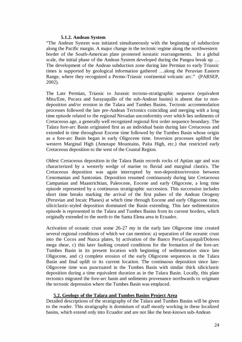
5.1. Regional Geology ............................................................................................ 21 5.1.1. Pre-Andean System ................................................................................... 21 5.1.2. Andean System ......................................................................................... 24
5.2. Geology of the Talara and Tumbes Basins Project Area ................................... 24 5.2.1. Basement .................................................................................................. 26 5.2.2. Paleozoic................................................................................................... 26 5.2.3. Cretaceous................................................................................................. 26 5.2.4. Cenozoic ................................................................................................... 34
5.2.4.1. Tertiary............................................................................................... 34 5.2.4.2. TALARA BASIN............................................................................... 34 5.2.4.3. TUMBES BASIN............................................................................... 38
5.3. Regional Tectonics Settings ........................................................................ 39 5.3.1. Geometric and structural analyses of the Talara and Tumbes forearc basins40
5.3.1.1. Tumbes Basin ..................................................................................... 41 5.3.1.2. Talara Basin ....................................................................................... 44 5.3.1.3. Posters................................................................................................ 46
6.0. GEOPHYSICS .................................................................................................... 47 6.1. Seismic Data .................................................................................................... 47 6.2. Airmagnetometry and Air gravity..................................................................... 48
7.0. PETROLEUM GEOLOGY.................................................................................. 50 7.1.Geochemistry.................................................................................................... 50
7.1.1. General Discussion.................................................................................... 50 7.1.2. Source Rocks and Maturity ....................................................................... 51
7.1.2.1. Tertiary............................................................................................... 52 7.1.2.2. Cretaceous.......................................................................................... 53 7.1.2.3. Paleozoic ............................................................................................ 54
7.1.3. Talara Basin .............................................................................................. 54 7.1.3.1. Sample Analyses ................................................................................ 54 7.1.3.2. Hydrocarbon Analyses........................................................................ 57 7.1.3.3. Oil Families........................................................................................ 58 7.1.3.4. Oil-Oil and Oil-Source Rock Correlations .......................................... 59 7.1.3.5. Migration and Remigration of Hydrocarbons ...................................... 60
2
7.1.3.6. Hydrocarbon Kitchens ........................................................................ 60 7.1.3.7. Hydrocarbon Occurrences and Petroleum Systems ............................. 61 7.1.3.8. Reservoirs, Seals and Traps ................................................................ 62
7.1.4. Tumbes Basin............................................................................................ 62 7.1.4.1. Sample Analyses ................................................................................ 62 7.1.4.2. Hydrocarbon Analyses........................................................................ 64 7.1.4.3. Oil Families........................................................................................ 65 7.1.4.4. Migration and Remigration of Hydrocarbons ..................................... 65 7.1.4.5. Hydrocarbon Kitchens ........................................................................ 65 7.1.4.6. Hydrocarbon Occurrences and Petroleum Systems ............................. 66 7.1.4.7. Reservoirs, Seals and Traps ................................................................ 66
7.1.5. Temperature Gradient................................................................................ 67 7.2. Thermal Maturity And HC Generation Modeling. ............................................ 70
7.2.1. Introduction............................................................................................... 70 7.2.2. Data Input and Modeling........................................................................... 70 7.2.3. Talara Basin .............................................................................................. 72
7.2.3.1. Well Lomitos 3585, Negritos Talara High .......................................... 73 7.2.3.2. Well Lomitos 3835, Negritos Talara High .......................................... 76 7.2.3.3. Well La Casita 55X, Bayovar Bay ...................................................... 78 7.2.3.4. Well SBXA, Bayovar Bay .................................................................. 82
7.2.4. Tumbes Basin............................................................................................ 84 7.2.4.1. Barracuda 15-4X Well ........................................................................ 84 7.2.4.2. Corvina 40X Well............................................................................... 86 7.2.4.3. Pseudowell 1 ...................................................................................... 88
8.0. PROSPECTS AND LEADS IN THE TALARA AND TUMBES FOREARC BASINS ..................................................................................................................... 91
8.1. New Prospects and Leads................................................................................. 92 8.1.1. Tumbes Basin............................................................................................ 94
8.1.1.1. Atun Prospect ..................................................................................... 94 8.1.1.2. Banco Peru Prospective Area.............................................................. 96 8.1.1.3. Chita Prospect .................................................................................... 99 8.1.1.4. Corvina type lead associated to Chita Prospect ..................................101 8.1.1.5. Deeper Delfin Lead ...........................................................................103 8.1.1.6. Espada Lead ......................................................................................104 8.1.1.7. Jurel Lead..........................................................................................106 8.1.1.8. Lenguado Lead..................................................................................107 8.1.1.9. Merluza Lead ....................................................................................108 8.1.1.10. Paiche Prospect................................................................................109 8.1.1.11. Perico Lead .....................................................................................110 8.1.1.12. Raya Prospect..................................................................................111 8.1.1.13. Toyo Prospect..................................................................................113 8.1.1.14. Zorritos-Piedra Redonda Lead .........................................................116
8.1.2. Talara Basin .............................................................................................116 8.1.2.1. Calamar Lead ....................................................................................117 8.1.2.2. Caballa Prospect................................................................................118 8.1.2.3. Tortuga Prospect................................................................................118 8.1.2.4. Deeper Lobitos Paleozoic Lead..........................................................120 8.1.2.5. Mero Lead.........................................................................................120 8.1.2.6. Tiburon lead ......................................................................................121 8.1.2.7. Other prospects..................................................................................122
3
8.2. Previously Defined Prospects and Leads .........................................................123 9.0. CONCLUSIONS ...........................................................................................124
9.1. General ...........................................................................................................124 9.2. Stratigraphy ....................................................................................................124 9.3. Tectonics ........................................................................................................124 9.4. Petroleum Systems and Basin Modeling..........................................................125 9.5. Prospects and Leads ........................................................................................126
10.0. SELECTED REFERENCES.............................................................................128
FIGURES Figure 1. Location Map. NW Coastal Basins with location of the Talara and Tumbes
Basins................................................................................................................. 13 Figure 2. Stratigraphic Column of the Talara Basin. Figure modified from old IPC
files..................................................................................................................... 22 Figure 3. Stratigraphic Column of the Tumbes Basin. Figure modified from OXY
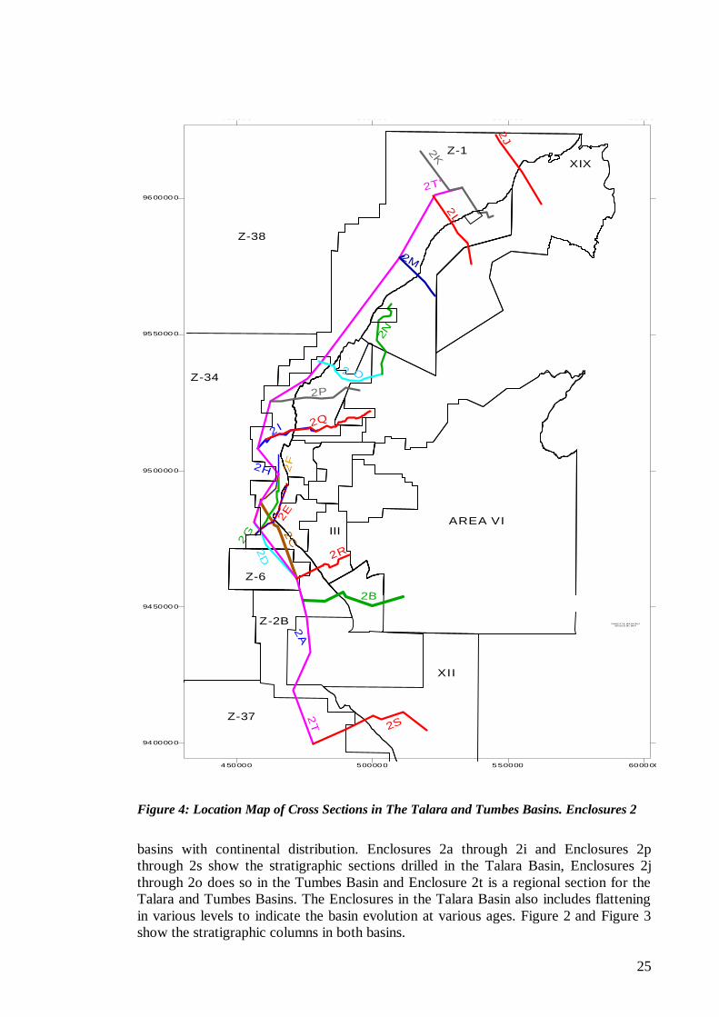
(2000). ................................................................................................................ 23 Figure 4: Location Map of Cross Sections in The Talara and Tumbes Basins.
Enclosures 2....................................................................................................... 25 Figure 5. Paleozoic and Cretaceous in well EA 1875 in the Laguna Oil Field.......... 27 Figure 6. Paleozoic and Cretaceous in well EA 2114-P in the Laguna Oil Field...... 28 Figure 7. Paleozoic and Cretaceous in well EA 1885 in the Laguna Oil Field.......... 29 Figure 8. Paleozoic and Cretaceous in well EA 2294 in the Laguna Oil Field.......... 30 Figure 9. Paleozoic and Cretaceous in well EA 2323-E in the Laguna Oil Field...... 31 Figure 10. Stratigraphic relationship in formations of early Tertiary age in the Talara
Basin. ................................................................................................................. 37 Figure 11: Morphological and structural configuration in the Andean Cordillera,
showing the Talara and Tumbes forearc basins. ............................................... 40 Figure 12. Geological and structural map of the onshore portions of the Tumbes and
Talara basins and adjacent areas, showing the location of interpreted seismic lines in red and regional cross sections, referred to in this chapter. .................. 41
Figure 13. Structural map of the Tumbes basin and northern part of the Talara basin. For more details see Appendix 3 and Enclosure 3m................................ 42
Figure 14. Seismic interpretation of the line PC 99-01, showing the gravitational structures associated with the Corvina and Barracuda structures. In the Corvina structure note, the importance of the rock units subcropping the base of the Cardalitos unconformity with respect to hydrocarbon exploration. More details can be found in Appendix 3 and Enclosure 3a. ................................................. 42
Figure 15. Seismic interpretation of the line AIP 92-49, showing the Delfin structure with its deeper Lead and the Lenguado lead. More details can be found in Appendix 3 and Enclosure 3c. ........................................................................... 43
Figure 16. Seismic interpretation of the regional seismic line RIB 93-01, showing the main tectonic elements of the Tumbes Basin. The Banco Peru is on the left and the Tumbes Basin on the right. This seismic interpretation shows two potential prospective structures, the Chita and Paleozoic Banco Peru leads. More details can be found in Appendix 3 and Enclosure 3c................................................... 43
Figure 17. Seismic interpretation of the line AIP 92-30, showing the Zorritos Piedra Redonda High to the right, the Deep Piedra Redonda Lead associated with the Eocene series and the Perico and Raya leads to the left. According to the structural and seismic interpretation, the Zorritos – Piedra Redonda High is part
4
of a present-day SW- NE horst structure. The western flank (offshore) of this feature is defined by the SW-NE trending Tumbes and Piedra Redonda normal listric faults. The eastern flank (onshore) of this structure is defined by the SW- NE trending Tronco Mocho, Cardalitos and Carpitas normal fault system, which dips to the SE. This fault system is related to the ancient structural configuration of the Paleogene Talara basin that was reactivated during the Neogene........... 43
Figure 18. Seismic interpretation of the line AIP 92-12, shows the western boundary of the Zorritos Piedra Redonda High and the Jurel and Perico leads. These structures appear to have considerable potential as exploration targets. More information can be found in Appendix 3 and Enclosure 3e............................... 44
Figure 19. Seismic interpretation of the line RIB 93-01. This section shows the shallow and deep platforms, where the Merluza and Mero rollover structures developed with high potential for exploration. More details can be found in Appendix 3 and Enclosure 3g. ........................................................................... 45
Figure 20. Seismic interpretation of the line RIB 93-08, showing the potential of the offshore tectonic structures in the shallow and deep marine platforms. The Deeper Lobitos lead is defined to target the Paleozoic series in direct contact with potential Cretaceous and Lower Tertiary source rocks. The Tiburon lead corresponds to new structural leads in ultra deep waters. More details can be found in Appendix 3 and Enclosure 3h.............................................................. 45
Figure 21. Seismic interpretation of the regional line RIB 93-16, showing the tectonic elements of the Talara basin. On the left, the subduction trench is seen where the oceanic crust pass under the continental crust. On the right, the shallow platform shows the Calamar rollover structure and the Paleozoic lead. Potential exploration targets in interpreted kitchen areas. More details can be found in Appendix 3 and Enclosure 3i. ............................................................................ 45
Figure 22. Seismic interpretation of the line RIB 93-21, showing the Bayovar Bay bounded by the Illescas and Paita Highs. The Bayovar Bay illustrates the many structures associated to rollover anticline structures. According to seismic and structural interpretations, these structures show high potential for exploration. More details can be found in Appendix 3 and Enclosure 3j............................... 46
Figure 23. Seismic interpretation of the line PTP 99-23, located in an area where the Talara to Sechura Basin merge. It shows the San Pedro and East San Pedro structures. More details can be found in Appendix 3 and Enclosure 3k. ........... 46
Figure 24. Seismic interpretation of the line PTP 99-24, this section is located in an area where the Talara merges with the Sechura Basin. It also shows the San Pedro and East San Pedro structures. More details can be found in Appendix 3 and Enclosure 3l. ............................................................................................... 46
Figure 25. Seismic reference map. ............................................................................ 47 Figure 26. High Density Basement Map in NW Peru (Petrotech, 2001). .................. 49 Figure 27. Correlation between GCMS of a representative oil sample from the Talara
Basin and from an extract of a cutting sample of the Heath Formation in the Piedra Redonda Field (Fildani, 2005)................................................................ 51
Figure 28. Gray shales of the Talara Shale offer good visual source rock character in the Mancora area in two sites distanced some 20 Km. away. ............................. 53
Figure 29. Total Organic Carbon in the Talara Basin, DGSI Data. ......................... 55 Figure 30. Total Organic Carbon in the Talara Basin, Previous Reports. ................ 55 Figure 31. Oil composition in the Talara and Tumbes Basins based on LC.............. 57 Figure 32. Total Organic Carbon in the Tumbes Basin, data from DGSI................. 63 Figure 33. Total Organic Carbon in the Tumbes Basin, data Perupetro Files. ......... 64
5
Figure 34. Hydrocarbon occurrences in wells in the offshore Tumbes Basin. .......... 66 Figure 35. Temperature Gradient.............................................................................. 68 Figure 36. Basin Modeling in the Talara (La Casita 55X. Lomitos 3585 & 3835 wells)
and Tumbes Basins (Barracuda 154X, Corvina 40X & Pseudowell 1). ............. 70 Figure 37. Pre- Cretaceous and post-Cretaceous Maturity burials in the Lomitos
3585 Well. .......................................................................................................... 74 Figure 38. Post-Cretaceous Maturity burial in the Lomitos 3585 Well. .................... 74 Figure 39. Maturity Vs. Depth. 1D Modeling in the Negritos High in the Talara
Basin. ................................................................................................................. 75 Figure 40. Post-Cretaceous Maturity burial in the Lomitos 3835 Well. The Upper
Cretaceous in the Late Mature Window, the early Eocene interval in the mid-mature oil window and younger Formations in the early-mature oil window.... 77
Figure 41. Maturity versus Time plot in the Barracuda Lomitos 3835 Well.............. 77 Figure 42. Maturity versus Depth plot in the Lomitos 3835 Well. ............................ 78 Figure 43 and Figure 44. Burial history in Well SBX-A shows the base of the
Cretaceous Formation in the Mid Mature Window stage of the oil window and the overlying section in the early mature window. ............................................. 80
Figure 45. Maturity Vs. Depth in Well La Casita 55X............................................... 81 Figure 46. Maturity Vs. Time in Well La Casita 55X. ............................................... 81 Figure 47. Burial history in Well SBX-A shows the base of the Muerto/Pananga
formations in the early stages of the oil window and the immature overlying section. ............................................................................................................... 83
Figure 48. Maturity Vs Depth diagram in well SBX-A shows two major burial histories.............................................................................................................. 83
Figure 49. Maturity burial in the Barracuda 15-4X Well shows the possible early Eocene interval in the mid-mature oil window and the late Eocene and the Mancora and Heath Formations in the early-mature oil window...................... 85
Figure 50. Maturity versus Time plot in the Barracuda 15-4X Well.......................... 85 Figure 51. Maturity burial in the Corvina 40X Well shows the bottom possible early
Eocene interval in the mid-mature oil window and the late Eocene and the Mancora and Lower Heath Formations in the early-mature oil window........... 87
Figure 52. Maturity versus Time plot in the Corvina 40X Well. ................................ 87 Figure 53. Maturity burial in the Pseudowell 1 shows modeled stratigraphic units
from possible Eocene interval in the Main Gas Generation Window to immature units from the upper Tumbes Formation to younger units. ............................... 89
Figure 54. Maturity versus Time plot in the Corvina 40X Well. ................................ 89 Figure 55: Prospects and Leads in Tumbes and North Talara Basin........................ 93 Figure 56: Two-way time structural map on the top Cardalitos Formation, showing
the Atun Prospect............................................................................................... 94 Figure 57: Seismic line OXY98-114 showing the east culmination of the Atun
structure. ............................................................................................................ 95 Figure 58: Seismic line OXY98-115a showing the west culmination of the Atun
structure. ............................................................................................................ 95 Figure 59: Two-way time structural map on the top Zorritos Formation, showing the
Banco Peru Prospective area. ............................................................................ 96 Figure 60: West to East seismic line Rib 93-01 across the Banco Peru Prospective
area .................................................................................................................... 97 Figure 61: Seismic line RIB 93-01 flattened on Zorritos Formation, showing the
Banco Peru structure and Tumbes basin ........................................................... 97 Figure 62: Seismic line RIB 93-02 across the Banco Peru structure ........................ 98
6
Figure 63: NW to SE seismic lines OXY 98-221 across the Banco Peru Structure. .. 98 Figure 64. Chita prospect defined by seismic line RIB 93-01, showing the principal
exploration targets. More details can be found in Appendix 3 and Enclosure 3p............................................................................................................................ 99
Figure 65: Two-way time structural map on the top Zorritos Formation, showing the Chita Prospect...................................................................................................100
Figure 66: NW to SE seismic line PC 99-09 across the Chita Prospect....................100 Figure 67: Seismic line AIP 92-29 showing the Chita Prospect and the Barracuda
structure. ...........................................................................................................101 Figure 68: Structural 2WT on the top Zorritos Formation map, showing the Chita
stratigraphic prospect........................................................................................102 Figure 69: Composite seismic profile A-A1, showing the Chita stratigraphic lead...102 Figure 70: Isopach map of the Corvine Type lead on Zorritos Formation associated to
Chita Prospect...................................................................................................103 Figure 71: Deeper Delfín Lead defined by seismic line AIP 92-49, showing the
potential structural configuration and explorations targets. More detail can be found in Appendix 3 and Enclosure 3p.............................................................104
Figure 72: Two-way time structural map on top Zorritos Formation showing the Espada Lead......................................................................................................105
Figure 73: NW to SE seismic lines AIP92-66 showing the Espada Lead. ................105 Figure 74: Jurel Lead defined by seismic line AIP 92-12, showing the potential
structural configuration and explorations targets.............................................106 Figure 75 Lenguado Lead defined by seismic line AIP 92-49, showing the potential
structural configuration and explorations targets.............................................107 Figure 76. Merluza Lead defined by seismic line RIB 93-05, showing the potential
structural configuration and explorations targets. More detail can be found in Appendix 3 and Enclosure 3p. ..........................................................................108
Figure 77: Two-way time structural map on the top Zorritos Formation, showing the Paiche Prospect.................................................................................................109
Figure 78: NW to SE seismic lines OXY 98-210 showing the Paiche Structure.......110 Figure 79. Perico Lead defined by seismic line AIP 92-12, showing the potential
structural configuration and explorations targets. More detail can be found in Appendix 3 and Enclosure 3p. ..........................................................................111
Figure 80: Two-way time structural map on the top Cardalitos Formation, showing the Raya Prospect..............................................................................................112
Figure 81: Seismic line AIP 92-32 across the Raya Structure..................................113 Figure 82: North to South seismic line AIP 92-10 showing the Raya Structure ......113 Figure 83: Two-way time structural map on the top Cardalitos Formation, showing
the Toyo Prospect..............................................................................................114 Figure 84: SW to NE seismic line PC 99-16 across the Toyo Structure. ..................115 Figure 85: Seismic line AIP 92-41 showing the Toyo Prospect. ...............................115 Figure 86. Zorritos-Piedra Redonda Lead................................................................116 Figure 87. Calamar Lead defined by seismic line RIB 93-16, showing the potential
structural configuration and explorations targets. More detail can be found in Appendix 3. .......................................................................................................118
Figure 88: Two-way time structural map on top of Paleozoic Basement, showing the in the east the Tortuga prospect and in the west part, the Caballa structure.....119
Figure 89: West to East seismic line PTP 98-17, showing the Tortuga and Caballa structure. See location on Figure 34. ................................................................119
7
Figure 90. Deeper Lobitos Paleozoic Lead defined by seismic line RIB 93-08, showing the potential structural configuration and explorations targets. More detail can be found in Appendix 3 and Enclosure 3p. .......................................................120
Figure 91. Mero Lead defined by seismic line RIB 93-05, showing the potential structural configuration and explorations targets. More detail can be found in Appendix 3 and Enclosure 3p. ..........................................................................121
Figure 92: Tiburon Lead defined by seismic line RIB 93-08, showing the potential structural configuration and explorations targets. More detail can be found in Appendix 3 and Enclosure 3p. ..........................................................................122
TABLES
Table 1. Geochemical analyses in the Tumbes Basin. .............................................. 63 Table 2. Porosity and Permeability of Zorritos Formation in the Tumbes Basin. ..... 67 Table 3. Production tests in offshore wells in the Tumbes Basin............................... 67 Table 4. Heat Flow in the Talara.............................................................................. 71 Table 5. Well Sandino 6020 in the Talara Basin. ...................................................... 72 Table 6. Well Lomitos 3585 in the Talara Basin........................................................ 73 Table 7. Well Lomitos 3835 in the Talara Basin........................................................ 76 Table 8. Well La Casita 55X, Bayovar Bay. ............................................................... 79 Table 9. Well SBX-A Formations and Events............................................................ 82 Table 10. Well Barracuda 15-4X in the Tumbes Basin.............................................. 84 Table 11. Well Corvina 40X in the Tumbes Basin. .................................................... 86 Table 12. Pseudowell 1 in the Tumbes Basin............................................................. 88 Table 13: List of Prospect and Leads in Tumbes Basin and South Talara Basins .... 92
ENCLOSURES Enclosure 1a. Tumbes – Talara Basins Base Map, North. Enclosure 1b. Tumbes – Talara Basins Base Map, South Enclosure 1c. Talara Basin Base Map, South Enclosure 1d. Tumbes – Talara Basins Geological Map Enclosure 2a. N-S Structural-Stratigraphic Cross Section Enclosure 2a-1 and 2. N-S Flattened Stratigraphic Cross Sections Enclosure 2b. E-W Structural-Stratigraphic Cross Section Enclosure 2b-1, 2, 3 and 4. E-W Flattened Stratigraphic Cross Sections Enclosure 2c. NW-SE Structural-Stratigraphic Cross Section Enclosure 2c-1. Flattened NW-SE Stratigraphic Cross Section Enclosure 2d. NW-SE Structural-Stratigraphic Cross Section Enclosure 2d-1 and 2. NW-SE Flattened Stratigraphic Cross Sections Enclosure 2e. NE-SW Structural-Stratigraphic Cross Section and Enclosure 2e-1 Flattened NE-SW Stratigraphic Cross Section Enclosure 2f. NE-SW Structural-Stratigraphic Cross Section Enclosure 2f-1 and 2. NE-SW Cross Sections Enclosure 2g. NE-SW Structural-Stratigraphic Cross Section Enclosure 2g-1, 2 and 3. NE-SW Flattened Stratigraphic Cross Sections Enclosure 2h. NW-SE Structural-Stratigraphic Cross Section Enclosure 2i. WSW-ESE Structural-Stratigraphic Cross Section Enclosure 2i-1, 2 and 3. WSW-ESE Flattened Stratigraphic Cross Sections
8
Enclosure 2j. NW-SE Structural Cross Section S1-S1’ Enclosure 2k. NW-SE Structural Cross Section S2-S2’ Enclosure 2l. NW-SE Structural Cross Section S3-S3’ Enclosure 2m. NW-SE Structural Cross Section S4-S4’ Enclosure 2n. N-S Structural Cross Section S5-S5’ Enclosure 2o. W-E Stratigraphic Cross Section S6-S6’ Enclosure 2p. W-E Structural Cross Section S7-S7’ Enclosure 2q. W-E Structural Cross Section S8-S8’ Enclosure 2r. SW-NE Structural Cross Section S9-S9’ Enclosure 2s. W-E Structural Cross Section S10-S10’ Enclosure 2t. SW-NE Regional Cross Section R1-R1’ Enclosure 3a. Seismic interpretation line PC 99-01 Enclosure 3b. Seismic interpretation line AIP 92-49 Enclosure 3c. Seismic interpretation line RIB 93-01 Enclosure 3d. Seismic interpretation line RIB 93-30 Enclosure 3e. Seismic interpretation line AIP 92-12 Enclosure 3f. Seismic interpretation line AIP 92-60 Enclosure 3g. Seismic interpretation line RIB 93-05 Enclosure 3h. Seismic interpretation line RIB 93-08 Enclosure 3i. Seismic interpretation line RIB 93-16 Enclosure 3j. Seismic interpretation line RIB 93-21 Enclosure 3k. Seismic interpretation line PTP 99-23 Enclosure 3l. Seismic interpretation line PTP 99-24 Enclosure 3m. Regional cross section A-A’ Enclosure 3o. Regional cross section B-B’ Enclosure 3p. Regional cross section C-C’ Enclosure 3q. Leads and Structures Map of The Tumbes and North of Talara Basins Enclosure 4a. Top Middle Eocene (North) Tumbes Basin, TWT Structure Map Enclosure 4b. Top Middle Eocene (South) Tumbes Basin, TWT Structure Map Enclosure 4c. Top Middle Eocene (North - South) Tumbes Basin, TWT Structure Map Enclosure 4d. Top Muerto Fm.(Talara Basin), TWT Structure Map Enclosure 4e. Top Zorritos Fm., TWT Structure Map Tumbes Basin Enclosure 4f. Top Cardalitos Fm., TWT Structure Map Tumbes Basin Enclosure 4g. Cardalitos Fm., TWT Isochrone Map. Enclosure 4h. Top Middle Eocene (North), Prospects and Leads TWT Map Enclosure 4i. Top Middle Eocene (South), Prospects and Leads TWT Map. Enclosure 5a. Digital Elevation Model (DEM to 90m) Peruvian Basins. Enclosure 5b. Morphological/Structural Configuration in the Andean Cordillera. Enclosure 5c. Tumbes and Talara Forearc Basin Geometry and Structural Style, I Enclosure 5d. Tumbes and Talara Forearc Basin Geometry and Structural Style, II Enclosure 5e. Tumbes and Talara Forearc Basin Geometry and Structural Style, III Enclosure 6. 1 CD containing Digital Data:
a. Report: Text and figures in A4 & A3 format b. Enclosures 1 through 6 in various formats c. Appendices 1 through 5

9
APPENDICES
1. Compilation: Geochemical Database for the Talara and Tumbes Basins and adjacent Lancones and Sechura Basins.
2. Report: “Reconocimiento Geológico. Área Máncora: Quebrada Seca, Fernández-Máncora, Cabo Blanco”, Ysabel calderón, May 2005.
3. Report: “Análisis de la Geometría y Estilo de Deformación de las Cuencas Talara y Tumbes: Nuevos Leads de Exploración”, Wilber Hermoza, December 2005.
4. Summary of Previously Defined Prospects and Leads in the Tumbes Basin, after “Occidental Petrolera del Perú, Inc., Sucursal del Perú, Departamento de Exploración, Cuenca Progreso – Tumbes, Perú, Block Z-3, Reporte Final, Diciembre 2001“.
5. Spread sheet of Wells Logs with LAS format in the Talara and Tumbes Basins.
10
EXECUTIVE SUMMARY The Talara and Tumbes Basins has been the site of extensive hydrocarbon exploration and exploitation since the XIX century. The first well in Peru was spudded in Zorritos in 1863 and by year 1920 nearly 1000 wells had been drilled in the basins. To date, eighteen wells have been drilled in the offshore Tumbes Basin and some 13,200 wells in the Talara Basin, including near 1,300 offshore wells. Cumulative production is about 1.4 BBO and 1.7 TCF, mainly from the Talara Basin. Published literature establishes a mean estimated recoverable undiscovered hydrocarbons in the Talara Basin in the range between 2.2 to 1.71 BBO, 5.84 to 4.79 TCFG, and 255 MMB of NGL, of which between 85% to 70% are offshore and between 15% to 30% onshore. Mean estimated recoverable undiscovered oil, gas and natural gas liquids in the Tumbes (Peru) and bordering Progreso Basin (Ecuador) is to 237 MMBO, 255 BCFG, and 32 MMB of NGL. Over 90% of the oil produced come from areas did not count with seismic data. There is a high hydrocarbon potential in the unexplored shallow and deep water for Eocene as well as for the pre-Eocene objectives in the Talara Basin and in the numerous undrilled prospects and leads to target the Oligocene and Miocene objectives in the largely unexplored Tumbes Basin. All hydrocarbon exploration and development in both basins have been performed on the onshore and in the offshore portions of the basins in water depths of less than 120m. The 2005 year San Pedro oil discovery in Paleozoic metamorphic rocks in the Bayovar Bay testifies the exploration potential for the undiscovered reserves. The Tumbes and Talara Basins have excellent potential with a variety of opportunities that remain as untested prospects and leads to target extensive stratigraphic columns. In the course of this geophysical and geological evaluation six of them in the Talara Basin and thirteen in the Tumbes Basin have been documented in Chapter 8, in the Regional Tectonic Settings in Chapter 5.3 and in Appendix 3. The areas adjacent to some of them also offer additional exploration opportunities of the pre-Eocene section as the border of the shallow and deep platforms in the Talara Basin. The attractiveness for hydrocarbon exploration of potential Cenozoic and Paleozoic sections in the Banco Peru had never been recognized. This feature has poor seismic definition and it is larger than the Talara Negritos High, which has a cumulative production of over 600 MMBO, most of which was produced in areas with no seismic data. Additionally, oil discovery in the San Pedro 1X well renewed hydrocarbon exploration of the Paleozoic rocks in the whole NW Peruvian basins. Although most areas in these basins are under different exploration stages, there exist prospects and leads of especial interest for future promotion as those defined in open areas or in areas under PEA’s (Block Z-34) or under negotiations (Blocks Z-37 and Z-38) where license contracts will be signed. Previous studies defined other potential prospects and leads, but with a different untested petroleum system as defined in the present study (Appendix 4). The Talara and Tumbes Basins are two fore-arc basins genetically related to plate tectonics, the action of the South American and the Nazca plates overriding the
11
subduction oceanic crust. Presence of good siliciclastic reservoirs, excellent quality source rocks, trapping mechanism and abnormal high temperature gradient created particular conditions to form a unique giant oil basin. The Talara and Tumbes Basins include thick sedimentary stratigraphic sequences of sediments of Paleozoic to Tertiary age that extend offshore and onshore along the Coastal region. Both basins constitute two fore-arc basins each with very thick sedimentary sections of Paleogene and Neogene ages. Sediment source to the east deposited up to 9,700 m. of sediments of Paleocene, Eocene and early Oligocene ages overlying the Cretaceous in 35 my in the Talara Basin. Thickness of the late Oligocene to Pliocene age in the Tumbes Basin reaches 7100 m., all the sections deposited in approximately 30 my. A major petroleum system accounts for most hydrocarbons in the Talara Basin. Oleanane biomarkers in oils and extracts define source rocks of late Cretaceous to Tertiary age. Formations of Eocene age constitute the main siliciclastic reservoirs with shale seals. Basin modeling interprets the presence of hydrocarbon kitchens originally connected to the area now occupied by the Negritos - Talara High and supposedly similar kitchens must have been connected to the Lobitos and El Alto - Peña Negra Structural Highs. Hydrocarbon generation and migration occurred from possibly offshore kitchens to the west, where source rocks should have better organic contents, since late Eocene to Oligocene time prior to the major complex block faulting with sealing faults characterizing these highs. The extension of the petroleum system to the deep offshore portion of the basins is unknown. Other potential kitchens have been previously defined in the oil and gas windows in the adjacent deep Lagunitos, Malacas and Siches grabens bordering the three major structural highs. A more complex petroleum system, or more than one, is interpreted to be present in the Tumbes Basin to account for the oil produced, the various oil and gas tests and the numerous hydrocarbon shows detected in the Oligocene and Miocene stratigraphic sequences. Source rocks and siliciclastic reservoirs of these ages are documented in the whole section possible superimposed on older petroleum systems. The geochemical analyses, hydrocarbon occurrences and basin modeling indicates the presence of active kitchens in deeper portions of the basin where the various source rocks acquired maturity enough to generate and expulse hydrocarbons. The assemblage of 9,814.55 km. of offshore 2D seismic lines in SEG-Y format and a well database in LAS format of 785 onshore and offshore wildcat and development wells constitute notable accomplishment of this study. 37 synthetic seismograms were created for wells in the Talara and Tumbes Basins. An Excel geochemical database compiled with newly acquired data and all available data of the coastal basins in the Perupetro files is also included in the report as Appendix 1.
12
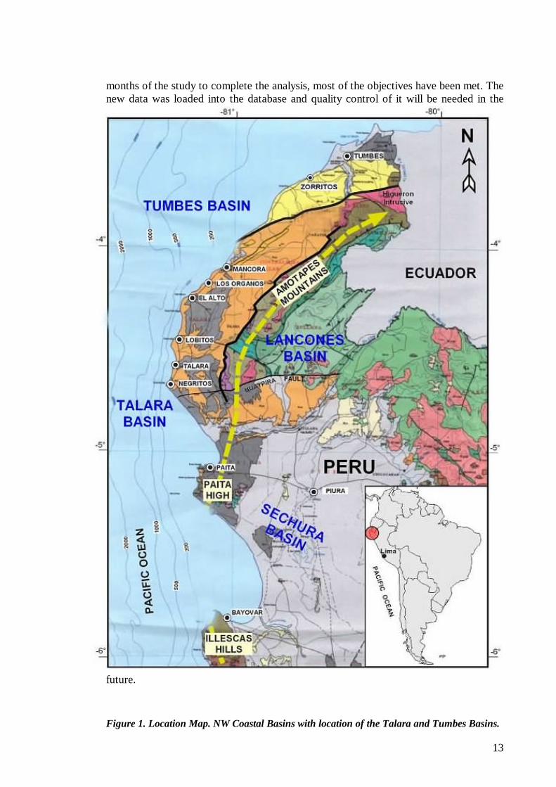
1.0. INTRODUCTION The Talara and Tumbes Basins are located on the NW coast of Peru (Figure 1). Drilling in these basins started a few years after Colonel Drake drilled its first well in Titusville, USA in the XIX century. Before oil production from the Marañon Basin reached the coast in the mid 70’s, all hydrocarbon production was from the Talara Basin. Primary interest to initiate this study is the acknowledgment of the potentiality of the undiscovered hydrocarbons reserves in Talara and Tumbes Basins. As an example of what can be accomplished with very active shallow drilling was provided by the primary production obtained by the intense infill drilling between 1978 and 1982 with Helico and Echino Formations as objectives and secondary recovery afterwards in what is basically the present Block X in the Talara Basin (Organos, Patria, Somatito, Central, Carrizo, Cruz and Folche fields). Under a contract with Petroperu S.A., OXY drilled almost 1,000 wells, which represented completion of one well per day. The oil production for the block increased from 6,500 to 21,000 BOPD. Additionally, both the Talara and Tumbes Basins offshore have not been drilled in water depths deeper than 120 m. There is a high potential in the unexplored deep water in the Talara Basin for Eocene as well as for the pre-Eocene objectives and in the numerous undrilled prospects and leads in the largely unexplored Tumbes Basin.. According to the USGS (Higley, 2001), Mean estimated recoverable undiscovered oil, gas and natural gas liquids in the Talara Basin amounts to 1.71 BBO, 4.79 TCFG, and 255 MMB of NGL. These values represent the mean confidence level, mainly from Eocene-age sandstones and turbidites. Eighty-five percent of the undiscovered resources are in the offshore portion of the basin. “Oil production is dominant, but excellent potential is indicated for offshore gas discoveries. Gas resources are mostly untapped because of the limited markets and gas infrastructure”. Cumulative Production in the basin to 2003 is 1.416 BBO and 1.7 TCFG. Offshore operator Petrotech numbers are even higher placing the proven undeveloped and undiscoverable recoverable reserves in 2.2 BBO and 5.84 TCFG, of which 70% is offshore and 30% onshore (Gonzales and Alarcon, 2002). Mean estimated recoverable undiscovered oil, gas and natural gas liquids in the Tumbes (Peru) and Progreso (Ecuador) basins amounts to 237 MMBO, 255 BCFG, and 32 MMB of NGL. These are also figures from the USGS (Higley, 2001). The Peruvian Ministry of Energy and Mines groups hydrocarbon statistics for the coastal onshore and offshore producing basins, basically the Talara and Tumbes Basins. MEM total undeveloped, probable and possible reserves amount to 1.35 BBO and 5.3 TCF. Cumulative production for year 2003 in Perupetro S.A. files is set to 1.4 BBO and 1.7 TCF, mainly from the Talara Basin. The emphasis on the current work has been on well and seismic data gathering, quality controlling and correcting the data and in presenting the stratigraphic and structural framework of the basin. The present report is as complete an evaluation of the Talara and Tumbes Basins as the data permitted to accomplish. This study represents an excellent starting point to be continued with a more detailed examination of the basin. Despite receiving additional data sets needed for the interpretation within the last two
13
months of the study to complete the analysis, most of the objectives have been met. The new data was loaded into the database and quality control of it will be needed in the
future.
Figure 1. Location Map. NW Coastal Basins with location of the Talara and Tumbes Basins.
14
The SEGY seismic and LAS well data utilized in this project was supplied originally by Perupetro and by the operators of the various licenced blocks involved. The Basin Evaluations Funtional Group of Perupetro S.A. performed the current report.. The 2D seismic was interpreted primarily utilizing Schlumberger Geoframe UNIX based seismic interpretation software. On the geological side, Geographix and DigiRule software were used extensively for mapping, well log editing and cross-section construction.
1.1. Regional Basin Description Peru is divided into four main morphological regions, three onshore and one offshore. The three onshore regions include the Andes Cordillera Region in the center, the Sub-Andean Region to the east of the Andean Cordillera and the Coastal Region to the west bordering the Pacific Ocean. The Offshore Region encompasses the Pacific Ocean. Nineteen sedimentary basins extend in all these regions with current hydrocarbon production in all including the Andes Region. The Coastal Region is a narrow land strip separating the Andes from the Pacific Ocean. This region incorporates 11 sedimentary basins some of which extend to the Offshore Region as one single basin and others are separated by inferred regional faults parallel to the shoreline. This report will concentrate on the northwestern Coastal Region and NW Offshore Region, which has been the site of extensive hydrocarbon activities for over 130 years in the known Talara and Tumbes Basins. The Talara Basin trends NE-SW parallel and to the W and NW of the Amotape Mountains (Figure 1). The basin is limited to the south at the Paita High by the western extension of the continental E-W trending Huancabamba deflection fault system at its Pacific Ocean termination. The Huancabamba Deflection is a mega-shear running approximately all its way to the east along the Amazon River to the Atlantic Ocean. At its southern border and to the southeast in the Bayovar Bay, the site of the 2005 San Pedro oil discovery, the Talara Basin is partially connected with the Sechura Basin. Further to the north, the basin is bordered by the Amotape Mountains to the east and northeast; these mountains separate the Talara Basin from the Lancones Basin. The Talara Basin merges north into the Tumbes Basin in the Punta Sal Beach area, located some 15 Km. north of the Mancora City. The onshore Talara Basin extends offshore with a topographic character defined below in the Bathymetry section of this report. The bathymetry defines a shallow and a deep platform caused by the listric Talara Fault, a regional mostly NS fault that creates the major rollover anticlinal lead with Cenozoic, Mesozoic and possibly Paleozoic sediments (Enclosure 3p). The Talara Fault extends north to the south end of the Banco Peru Fault. The bulk of drilling and production is focused in the three major structural highs Peña Negra, Lobitos and Talara/Negritos in the Talara Basin. Some 14,000 wells established a cumulative production and the additional proved, probable and possible reserves mentioned above, mostly from Tertiary lower Eocene reservoirs.
15
The Tumbes Basin is a tectonic depression with a similar NE-SW trend as the Talara Basin. The basin continues north into Ecuador as the Progreso Basin. The east and NE onshore border approximately coincides with the Zorritos-Piedra Redonda High (Enclosure 3p). This high is limited to the west by a fault system formed by the Piedra Redonda and Tumbes Faults and to the east by a listric fault system that includes the Carpitas and Tronco Mocho faults. The NW border of the Tumbes Basin includes the Banco Peru Structure. This feature is described as a sea mound or tectonic high with a remarkable topographic expression with shallowest expression of some 50 km2 in water depths less than 100 m. and whose composition and origin remains to be established. The Banco Peru Structure is larger than the Talara Negritos High, the largest tectonic high in the Talara Basin. A chaotic sedimentary section of possible Cenozoic and Paleozoic age is present in deep waters west of the Banco Peru Structure (Enclosure 3c).
1.2. Bathymetry The sea bottom was mapped from topographic data acquired from the seismic campaigns (Enclosures 1a, 1b, 1c and 1d). In the Tumbes Basin at the Peru/Ecuador border the 500 m. isobaths extends 100 km. from the coastline west past the western slope of the Banco Peru (Enclosure 1a). Some 50 km2 of the shallow Banco Peru lies above the 100 m. isobaths. The deepest portion of the Tumbes Basin is located to the SE and S of the Banco Peru in water depths that increase from 500 to over 1000m. West of Punta Sal at the southern border of the basin the 500, 1000 m. and 2000 m. isobaths extend 20, 30 and 50 km. from the coastline. All wells in the offshore Tumbes Basin were drilled in water depths shallower than 120 m. Most of the offshore Talara Basin shows two major platforms (Enclosures 1b and 1d). The first platform with water depths shallower than 200 m. extends 8 to 12 km. from the coastline in front of the three main structural highs El Alto/Peña Negra, Lobitos and Talara/Negritos. All wells drilled in the offshore Talara Basin are located on this platform. The second platform is 40 km long by 15 km. wide in water depths in the range between 2200 m. and 3000 m. The eastern border of this platform is located some 20 km. west of the El Alto/Lobitos/Talara coastline. An elongated N-S slope separates the two platforms where the sea bottom drops rapidly from 200 to 2200 m. In the southern Talara Basin, the sea bottom widens conspicuously in front of the Lagunitos, Paita High, Chira Bay and Bayovar Bay (Enclosure 1c). On these bays the 500 m. isobaths extends 20, 30 and 35 km offshore. from the coastline and drops more rapidly beyond this water depth. The same 500 m. isobaths is narrow in front of the offshore extension of the onshore Paita and Illescas Highs.
16
2.0. PREVIOUS WORK IN THE STUDY AREA The onshore Talara and Tumbes Basins has been the site of extensive hydrocarbon exploration and exploitation since the XIX century by several companies. Fabrica de Gas de Lima spudded the first well in Peru in Zorritos in the Tumbes Basin on November 2, 1863. The first cable well was drilled in Negritos in the Talara Basin in 1874 and by year 1920 nearly 1000 wells had been drilled (Travis, 1953).
2.1. Talara Basin Drilling in the Talara Basin started in the late XIX century. In the late half of the XX century active oil companies were Compañia Petrolera Lobitos, the state oil company Empresa Petrolera Fiscal and Exxon’s International Petroleum Company until 1970. IPC acquired the “Concesiones Lima” from the Compañia Petrolera Lobitos in the 1950’s. The state oil company Petroleos del Peru S.A., Petroperu S.A. took over all onshore upstream and downstream operations in NW Peru in the late 60’s. Petroperu abandoned the upstream hydrocarbon business in the 90´s. OXY also operated several onshore oil fields between 1978 and 1996 as a secondary recovery project. Production in NW Peru comes mainly from the offshore and onshore Talara basin fields and minor production from small onshore Tumbes Basin fields. Old onshore fields were compartmentalized as smaller production units from the 80´s and are currently operated by several oil companies. These companies include the following (Enclosures 1a, 1b, 1c and 1d):
1. Petrobras Energia Peru S.A. in Block X, 2. Sapet Development Peru Inc., Sucursal Del Peru in Blocks VI and VII, 3. Graña y Montero Petrolera S.A. in Blocks I, and V, 4. Petrolera Monterrico S.A. in Blocks II, XV and XX, 5. Empresa Petrolera Unipetro ABC S.A.C. in Block IX, 6. Cia. Petrolera Rio Bravo S.A. in Block IV, 7. Mercantile Peru Oil & Gas in Block III, 8. Petrotech Peruana S.A. in offshore Block Z-2B 9. Graña y Montero Petrolera in Block XIV, onshore Tumbes Basin,
The offshore extension of the Talara Basin has been in exploration and production since the 1970´s as the first offshore operation in South America. Belco Petroleum Corporation originally operated the Talara Basin offshore; Petromar S.A. followed it from the late 1980’s and by Petrotech Peruana S.A from the mid 1990’s. Total 2D seismic amounts to 12,004 Km. and 1584 Km. of 3D seismic. Petrotech currently has the only offshore hydrocarbon producing operation in Peru in Block Z-2B and holds an exploration license with no production in Block Z-6 in the south Talara Basin.
2.2. Tumbes Basin The state oil company Empresa Petrolera Fiscal (Empresa Petrolera Fiscal) carried out extensive field geology work and exploratory and development drilling in the border with the Talara Basin until the late 1960’s. In the early 1960’s there was gravity and aeromagnetic data acquisition by Empresa Petrolera Fiscal in the Los Organos area in the Talara and Tumbes Basins. Graña y Montero Petrolera S.A. also acquired 2D
17
seismic and conducted wildcat and development drilling since the early 1990’s in old Block V in this area. The offshore Tumbes Basin has been covered by several 2D seismic campaigns. In the early 1970’s Petroperú and the Joint Venture Petroperú & Tenneco-Unión- Champlin acquired 2300 and 1612 Km of 2D seismic. The Joint Venture drilled 9 wells in 4 structures. Belco Petroleum Corporation joined the group, acquired 600 Km of 2D seismic in 1976 and drilled 10 wells (one was a deepening). Belco established oil production in the Albacora field in the early 1980’s. Of the eighteen wells drilled in this period, gas was discovered in the Piedra Redonda and Corvina structures and oil in the Albacora field near the Ecuadorian border. A small oil production was established in the Albacora field and was later abandoned by Belco. All drilling was carried out in maximum water depths of 120m. Gas was also discovered north of Albacora in the Amistad field across the border in Ecuador. Interest in the offshore Tumbes Basin was resumed in the 1990’s. American International Petroleum Company acquired 1850 Km of 2d seismic in 1991. Occidental Petrolera del Peru Inc., Sucursal Del Peru acquired 1759 km of 2D Seismic in 1998 in modern Block Z-3 . OXY made a Geological/Geophysical evaluation of the ex-Block Z-3 in 1998 based on new and reprocessed 2D seismic all tied to existing well data in Block Z-1. The 1759 Km. of new 2D seismic covers the westernmost extension of the Tumbes Basin including the Banco Peru; the seismic was spaced 2 Km apart for both the dip lines and the perpendicular tie lines. Additionally, OXY reprocessed 387.55 and 680.1 Km. of seismic acquired by Belco Petroleum Corp. in 1982 km and by AIP between 1992-93, respectively. Good correlation of seismic events tied to stratigraphic units was established in the most of the Z-3 block. Time to Depth conversion was not attempted and was recommended to perform with the future 3D seismic. OXY’s evaluation defined a series of Prospects and Leads, which with additional data gathered in the present study are included in Appendix 4. Perez Companc S.A. acquired 1014 Km and reprocessed 1044 km of 2d seismic in modern Block Z-1 in 1999. BPZ holds current exploration licensees in onshore Block XIX and offshore Block Z-1. Most of the remaining areas in the Talara and Tumbes Basins are under either exploration licensees, negotiations for license contracts, TEA’s or PEA’s. BPZ Energy Inc., Sucursal Peru has currently Block Z-1 under an exploration license in the offshore Tumbes Basin. Present operations in Block Z-1 is to develop existing certified proven gas reserves in the old Corvina and Piedra Redonda gas discoveries to build an electrical plant to generate 160 MW and to export gas to Ecuador. BPZ also holds Area XIV in the Tumbes Basin under a TEA, Gold Oil PLC holds a PEA in Area Z-34 in the offshore Talara Basin. Blocks Z-38 in the main body of the Tumbes Basin and Block Z-37 in front of and to the south of the Bayovar Bay are under negotiations for exploration license contracts.
The Sechura and Lancones basins adjacent to the present study have been the subject of exploration and/or TEA’s requests in the past 10 years. Most notably are the commercial operations developing dry gas by Olympic Peru Inc., Sucursal del Peru, in Block XIII in the Sechura Basin. Petrotech’s oil discovery in the Bayovar bay has renewed interest to target the Paleozoic metamorphic rocks in the area and its landward continuation in the Sechura Basin.
18
3.0. DATA GATHERING 3.1. Database
A digital database was prepared using available data from various seismic campaigns and wells. A wide range of appropriate seismic coverage of the Talara and Tumbes Basins was thus obtained with all these campaigns. Seismic used in this evaluation includes 9,814.550 Km of digital data in SEG-Y format from the following eight 2D seismic campaigns:
1. AIPGCP92LZ1 (American International Petroleum Corp.) 2. RIBDGC93LZ1 (Ribiana) 3. OXYWG98LZ3 (Occidental Sucursal del Perú). 4. PETPMS98LZ2B (Petro-Tech Peruana) 5. PCOWG99LZI (Perez Companc) 6. PETPET99LZ2B (Petro-Tech Peruana) 7. PETPET00LZ2B (Petro-Tech Peruana) 8. PETPET01LZ2B (Petro-Tech Peruana)
Digital wire-line well logs in LAS format were very limited in the Perupetro files. Numerous wells were not available in digital format for the present evaluation. The Perupetro S.A. Geological and Geophysical Evaluation Group (GFEGG) obtained additional data throughout several requests to the local companies and loaded a total of 785 onshore and offshore wildcat and development wells in its database. In fact, some companies still lack digitized wire-line logs and work only with hard copies and others have 5-6 digitized logs in blocks with several hundred wells. Additionally, only some 50% of the obtained digitized wire-line logs were QC’d in time to incorporate them to the project. Some wells lacked several curves completely and others were partially digitized, so that mainly the GFEC completed digitizing them with some Schlumberger support. Perupetro S.A. obtained very good support from the operating companies in both basins. The geological map presented in the northern base maps is a compilation of BPZ data, currently active in the NW Coastal Region (Enclosures 1a and 1b). Some discrepancies are present on the topographic compilations of the seismic and surface geology with mismatch of different sets of data increasing from north to south. We can attribute these discrepancies to the coordinate systems used and possibly to the scanning procedure of the geological map.
19
4.0. SCOPE OF PROJECT This project was intended to be a regional geological and geophysical evaluation of the Talara and Tumbes Basins focusing on the identification of new deep pre-Eocene play types supported by seismic data. The focus was to examine the basins through the interpretation of digital seismic and well data sets, with each being tied to one another, using previously completed well datasets. However, reliable well data availability restricted our analysis to newly acquired and newly quality controlled datasets by the group in the offshore region, tied in as many places as possible with onshore well data. A more complete tie was obtained in the Tumbes Basin with seismic data of good quality and all wells completed in LAS format. Based on our past experience with the PARSEP Projects, the more time consuming aspects of this evaluation was the standardization and quality control of the data. Digital curve data was compiled and edited for the available digital wells especially wildcats in the Basin (Enclosures 1a, 1b and 1c). A composite log for each well was constructed, which if available included a Caliper, SP, Gamma Ray, Deep and Shallow Resistivity, Density, Neutron and Sonic curves. These composite logs are available as a LAS file as part of this report. A series of 20 stratigraphic and structural cross-sections shown in Figure 4 were constructed across the basins to standardize and reveal the stratigraphic relationships in the southern and northern Talara Basin and the Tumbes Basin (Enclosures 2a through 2t). Several flattened X-sections were prepared from these stratigraphic-structural cross sections in the Talara Basin and presented as part of these Enclosures. A standardized well database in Access was developed with standardized well tops, well data and other information when available, but it has not been completed on this stage of the project.
Regional and detailed geological and geophysical analyses that defined prospects and leads in the Talara and Tumbes Basins were prepared as part of the report. The Regional Tectonic settings in chapter 5.3 of this report is a summary of a more complete and detailed analysis of the tectonics presented in Spanish as Appendix 3. This regional context is a geometric and structural analysis of the two fore-arc basins based on the interpretation of 13 offshore seismic lines, three of which are tied to onshore seismic, well and surface geological data in the area north of the Mancora city (Enclosures 3a through 3p). The detailed seismic interpretation mapped five seismic horizons (Enclosures 4a through 4g) to define the Prospects and Leads Chapter 8.0 in conjunction with the prospects and leads also defined by the regional tectonics mentioned above. A total of 13 and 6 Prospects and Leads are documented with either the appropriate regional geological interpretations of seismic lines and/or seismic structural maps in the Tumbes and Talara Basins, respectively (Figures 55 to 92). In the Petroleum Geology in Chapter 7.0 the report includes a general discussion of available Geochemical data sets used also for burial modeling and attempting to define the petroleum systems. Hydrocarbon occurrences, maturity and analyses of potential source rocks in the different Cretaceous, Paleogene and Neogene formations are described. Reservoir, seals and traps and potential kitchen areas are also discussed. Thermal maturity and hydrocarbon generation modeling were conducted on four wells in the Talara Basin and two wells and a Pseudowell in the offshore Tumbes Basin
20
(Figure 36). Appendix 1 includes a Geochemical database for the Talara and Tumbes Basins and the adjacent Lancones and Sechura Basins. The assemblage of these entire seismic, well, Geochemical data sets is one of the more notable accomplishments of this study. The geophysical analysis counted with good quality modern seismic. The eight surveys of 2D SEG-Y Digital Seismic Data represent coverage throughout most of the Basins (Figure 25 and Enclosures 1a, 1b and 1c). Additionally, the group edited 37 synthetic seismograms for wells in Talara and Tumbes Basins (1 onshore only). The 3D seismic analysis was not performed on the present evaluation.
21
5.0. GEOLOGY OF THE TALARA AND TUMBES BASINS
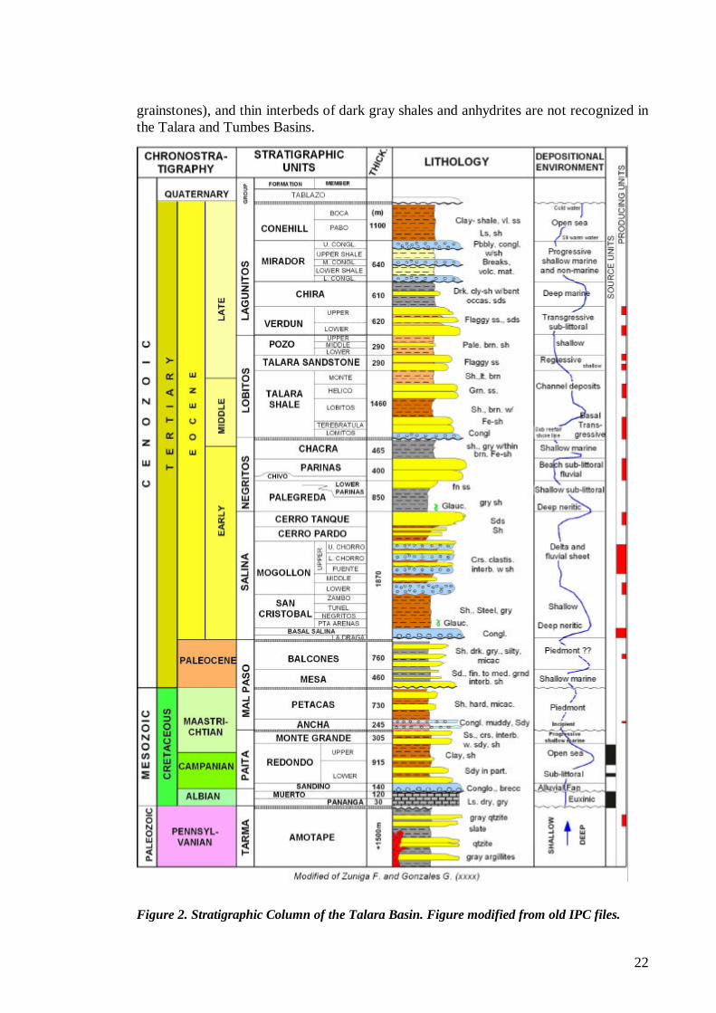
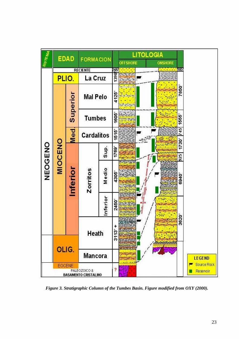
5.1. Regional Geology The Talara and Tumbes Basins include thick sedimentary stratigraphic sequences of sediments of Paleozoic to Tertiary ages that extend offshore and onshore along the Coastal region far beyond the present basins. They merge and are part of the regional sedimentary succession characterizing all the Peruvian territory that eventually pinch out onto the Brazilian and Guyana Shields. The complex geological evolution of all these sequences is controlled by two regional tectonic systems recognized in the basins of Peru. The first, the pre-Andean System, encompasses three cycles of Ordovician, Devonian and Permo-Carboniferous ages overlying the Precambrian basement of the Guyana and Brazilian Shields. The second, the Andean System, was initiated with the beginning of subduction along the western margin of Peru. It encompasses several mega-stratigraphic sequences and numerous minor sedimentary cycles, ranging from Late Permian to the Present. The stratigraphic columns that have been used in the present report are representative of all NW Peru and are presented in Figure 2 and Figure 3. They show distinctive imprint of the tectonics and/or sedimentation history that dominated the NW coastal area greatly influenced by various pulses dominating the plate tectonics in this region. The base map presented as Enclosure 1d includes a surface geological map of the Talara and Tumbes Basins, north of the Chira River. This map has been provided by BPZ a current exploration company with licensees in the onshore north Talara Basin, onshore and offshore Tumbes Basin and negotiating a license contract for the whole Lancones Basin.
5.1.1. Pre-Andean System
The pre-Andean tectonic cycle includes Ordovician, Silurian, Devonian and the Permo-Carboniferous cycles all overlying crystalline/metamorphic Basement. This tectonic system preserved discontinuous successions of Ambo/Cabanillas/Contaya and a more continuous Tarma/Copacabana/ and Ene/Red Bed Groups, which reveal complex tectonics. This tectonism includes a possible pre-Cabanillas rifting and peneplanation and a late Permian uplift and erosional episode (PARSEP, 2002). Of all these successions only a portion of the Paleozoic represented by the Tarma Group consisting of 1,500 m. of quartzite, quartzitic sandstones, argillites and slate is preserved in NW Peru, possibly overlying a crystalline Basement. The Permo-Carboniferous cycle overlies unconformable the Devonian and/or Ordovician Cycles and Basement in the uplifted areas. This cycle has a widespread distribution throughout most of the Peruvian basins and neighboring basins bordering the Guyana and Brazilian shields. In the Peruvian basins, the earliest Carboniferous sedimentation is represented by the Ambo Group, which was deposited as continental to shallow marine, fine-grained sandstones, interbedded siltstones, gray shales, and occasional thin coal beds. These sediments are followed vertically by the thin transgressive, clastic-rich Tarma Formation, which is usually conformably overlain by the normally thick, massive dark gray, fossiliferous, shelf carbonates of the Copacabana Formation. The thick sequence of Copacabana limestones (wackestones, packstones and
22
grainstones), and thin interbeds of dark gray shales and anhydrites are not recognized in the Talara and Tumbes Basins.
Figure 2. Stratigraphic Column of the Talara Basin. Figure modified from old IPC files.
23
Figure 3. Stratigraphic Column of the Tumbes Basin. Figure modified from OXY (2000).
24
5.1.2. Andean System “The Andean System was initiated simultaneously with the beginning of subduction along the Pacific margin. A major change in the tectonic regime along the northwestern border of the South-American plate promoted isostatic rearrangements. In a global scale, the initial phase of the Andean System developed during the Pangea break up … The development of the Andean subduction zone during late Permian to early Triassic times is supported by geological information gathered … along the Peruvian Eastern Range, where they recognized a Permo-Triassic continental volcanic arc.” (PARSEP, 2002). The Late Permian, Triassic to Jurassic tectono-stratigraphic sequence (equivalent Mitu/Ene, Pucara and Sarayaquillo of the sub-Andean basins) is absent due to non-deposition and/or erosion in the Talara and Tumbes Basins. Tectonic accommodation processes followed the late pre-Andean Tectonics coinciding and merging with a long time episode related to the regional Nevadan unconformity over which lies sediments of Cretaceous age, a generally well recognized regional first order sequence boundary. The Talara fore-arc Basin originated first as an individual basin during late Cretaceous and extended in time throughout Eocene time followed by the Tumbes Basin whose origin as a fore-arc Basin began in early Oligocene time. Inversion processes uplifted the western Marginal High (Amotape Mountains, Paita High, etc.) that restricted early Cretaceous deposition to the west of the Coastal Region. Oldest Cretaceous deposition in the Talara Basin records rocks of Aptian age and was characterized by a westerly wedge of marine to fluvial and marginal clastics. The Cretaceous deposition was again interrupted by non-deposition/erosion between Cenomanian and Santonian. Deposition resumed continuously during late Cretaceous Campanian and Maastrichtian, Paleocene, Eocene and early Oligocene, a long time episode represented by a continuous stratigraphic succession. This succession includes short time breaks marking the arrival of the first pulses of the Andean Orogeny (Peruvian and Incaic Phases) at which time through Eocene and early Oligocene time, siliciclastic-styled deposition dominated the Basin extending. This late sedimentation episode is represented in the Talara and Tumbes Basins from its current borders, which originally extended to the north to the Santa Elena area in Ecuador. Activation of oceanic crust some 26-27 my in the early late Oligocene time created several regional conditions of which we can mention: a) separation of the oceanic crust into the Cocos and Nazca plates, b) activation of the Banco Peru/Guayaquil/Dolores mega shear, c) this later faulting created conditions for the formation of the fore-arc Tumbes Basin in its present location with beginning of sedimentation since late Oligocene, and c) complete erosion of the early Oligocene sequences in the Talara Basin and final uplift to its current location. The continuous deposition since late-Oligocene time was punctuated in the Tumbes Basin with similar thick siliciclastic deposition during a time equivalent duration as in the Talara Basin. Locally, this plate tectonics migrated the fore-arc basin and sediments provenance northwards to originate the tectonic depression where the Tumbes Basin was emplaced.
5.2. Geology of the Talara and Tumbes Basins Project Area Detailed descriptions of the stratigraphy of the Talara and Tumbes Basins will be given to the reader. This stratigraphy is dominium of staff mostly working in these localized basins, which extend only into Ecuador and are not like the best-known sub-Andean
25
Z-1XIX
III
Z-6
Z-2B
XII
2I
2H
2C 2
D
2G
2F
2E
2B
2A
2T
2T'
2S
2R
2Q
2P
2 O 2
N
2M 2L
2K
2J
TUMBES-T AL ARA BASINSGEOLOGI CAL MAP
450000
450000
500000
500000
550000
550000
600000
600000
9600000 9
9550000 9
9500000 9
9450000 9
9400000 9
Z-34
Z-38
Z-37
AREA VI
Figure 4: Location Map of Cross Sections in The Talara and Tumbes Basins. Enclosures 2
basins with continental distribution. Enclosures 2a through 2i and Enclosures 2p through 2s show the stratigraphic sections drilled in the Talara Basin, Enclosures 2j through 2o does so in the Tumbes Basin and Enclosure 2t is a regional section for the Talara and Tumbes Basins. The Enclosures in the Talara Basin also includes flattening in various levels to indicate the basin evolution at various ages. Figure 2 and Figure 3 show the stratigraphic columns in both basins.
26
Sediments of Paleozoic, Mesozoic and Cenozoic age must rest over crystalline Basement. Since Paleozoic produce oil in two fields in the Talara Basin, we cannot define Paleozoic as economic Basement in the basin. Locally, it may be considered an effective Basement.
5.2.1. Basement
Granites drilled by wells PL-X-2 and PL-X-3 in the Carpitas area in the border of the Talara and Tumbes Basins and in the La Casita 55X in the Bayovar Bay in the south Talara Basin are assumed to correspond to the crystalline Basement.
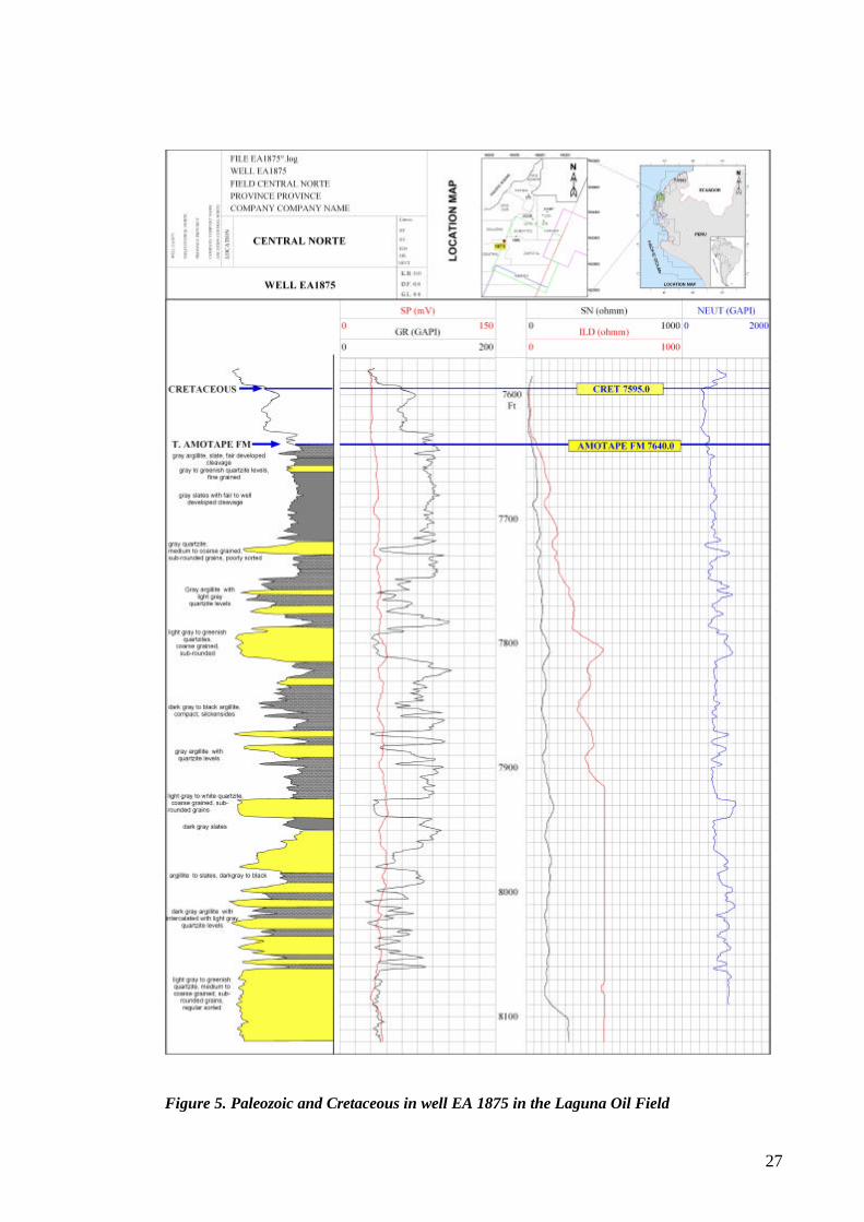
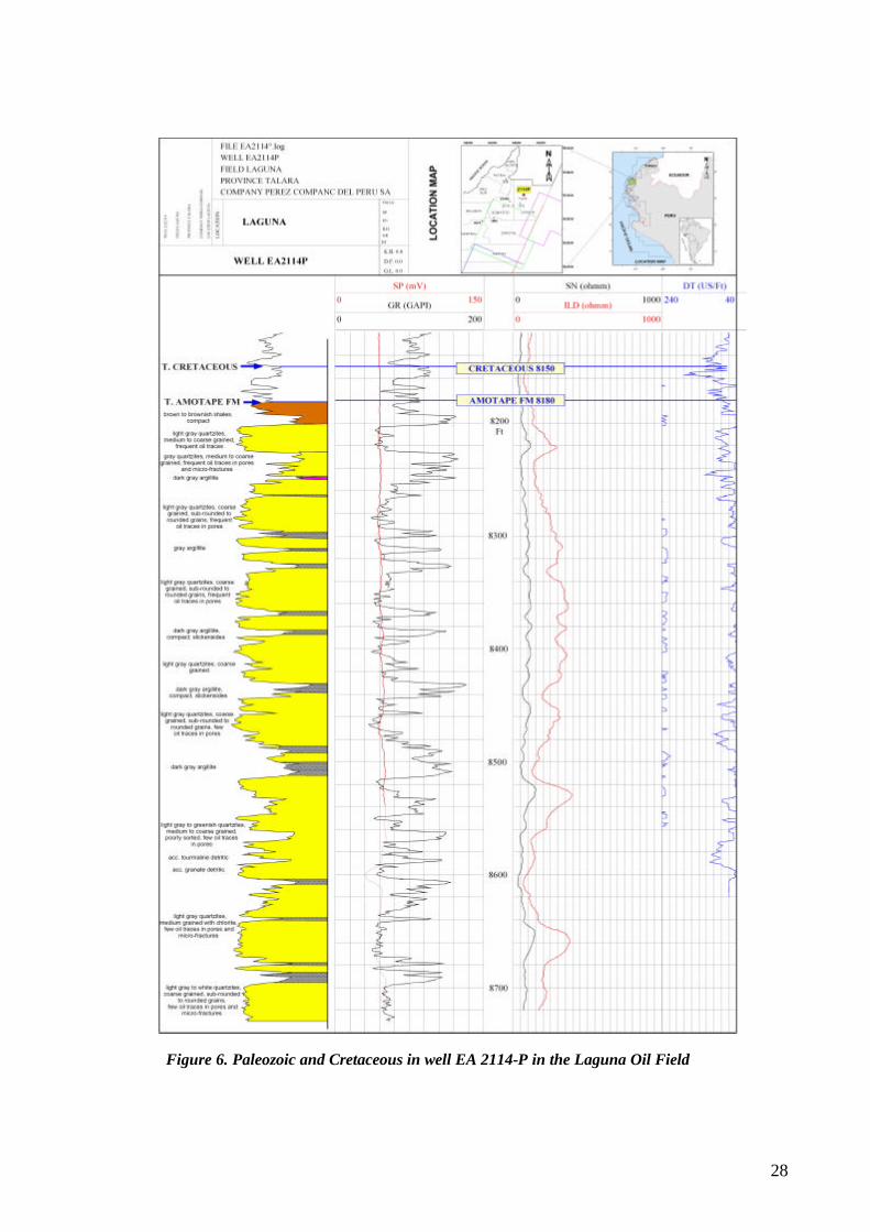
5.2.2. Paleozoic Paleozoic metamorphic rocks and sediments are exposed in the Amotape Mountains and are known by drilling in the subsurface of the Talara Basin in as far locations as the Chira sub-basin and Bayovar Bay to the south and the Carpitas area to the north. The Paleozoic is locally named the Amotape Formation of Pennsylvanian age, possibly correlating with the Tarma Group of other Peruvian localities. The Paleozoic Sequence is made up of quartzite, slates and argillites intruded by granite in the Amotape Mountains. Prolific reservoirs were found in the Paleozoic section. Production from Paleozoic mainly fractured reservoirs was established on far extreme onshore locations on the north Laguna oil field in the Peña Negra High and south on the Portachuelo oil field and in the recent offshore San Pedro discovery. Detailed descriptions of the Paleozoic drilled in the Laguna Norte oil field were made since early field development in the 70’s due to the excellent producing capacity of the metamorphosed Paleozoic sediments. Paleozoic is covered by shales of Cretaceous age in both onshore Paleozoic fields. Figure 5, Figure 6, Figure 7, Figure 8, and Figure 9 record the detailed Cretaceous and Paleozoic sediments drilled in the Laguna Norte oil field. Quartzites are light gray to white, very coarse to fine grained, sub rounded to subangular grains, fair sorting, with common quartz overgrowths and quartz veins, locally sugary with primary porosity, common micro fractures. Oil shows are observed in micro fractures, geodes and pores. Locally presence of metamorphosed poorly sorted greywacke, dark gray, coarse grained with silicified detrital matrix. Argillite is black to dark gray, normally with slickensides. Slate is gray to dark gray, dark gray green with fair to well developed cleavage. Paleozoic thickness is over 1,500 m. of which 280 m. were drilled in well 2294 the Laguna Norte oil field (Figure 8).
5.2.3. Cretaceous Sediments of Cretaceous age are known from outcrops and subsurface. They outcrop on lapping Paleozoic on the flanks of the Amotape Mountains, bordering the Lancones Basin and are known in subsurface from drilling in all the Talara Basin. Sediments of Cretaceous age have been drilled in the Talara Basin since several decades ago, onshore and offshore. Figure 5, Figure 6, Figure 7, Figure 8, and Figure 9 record the detailed Cretaceous and Paleozoic sediments drilled in the Laguna Norte oil field. In the Carpitas area to the north Cretaceous has not been found, since sediments of early Eocene rest unconformable over sediments of Paleozoic age.
27
Figure 5. Paleozoic and Cretaceous in well EA 1875 in the Laguna Oil Field
28
Figure 6. Paleozoic and Cretaceous in well EA 2114-P in the Laguna Oil Field
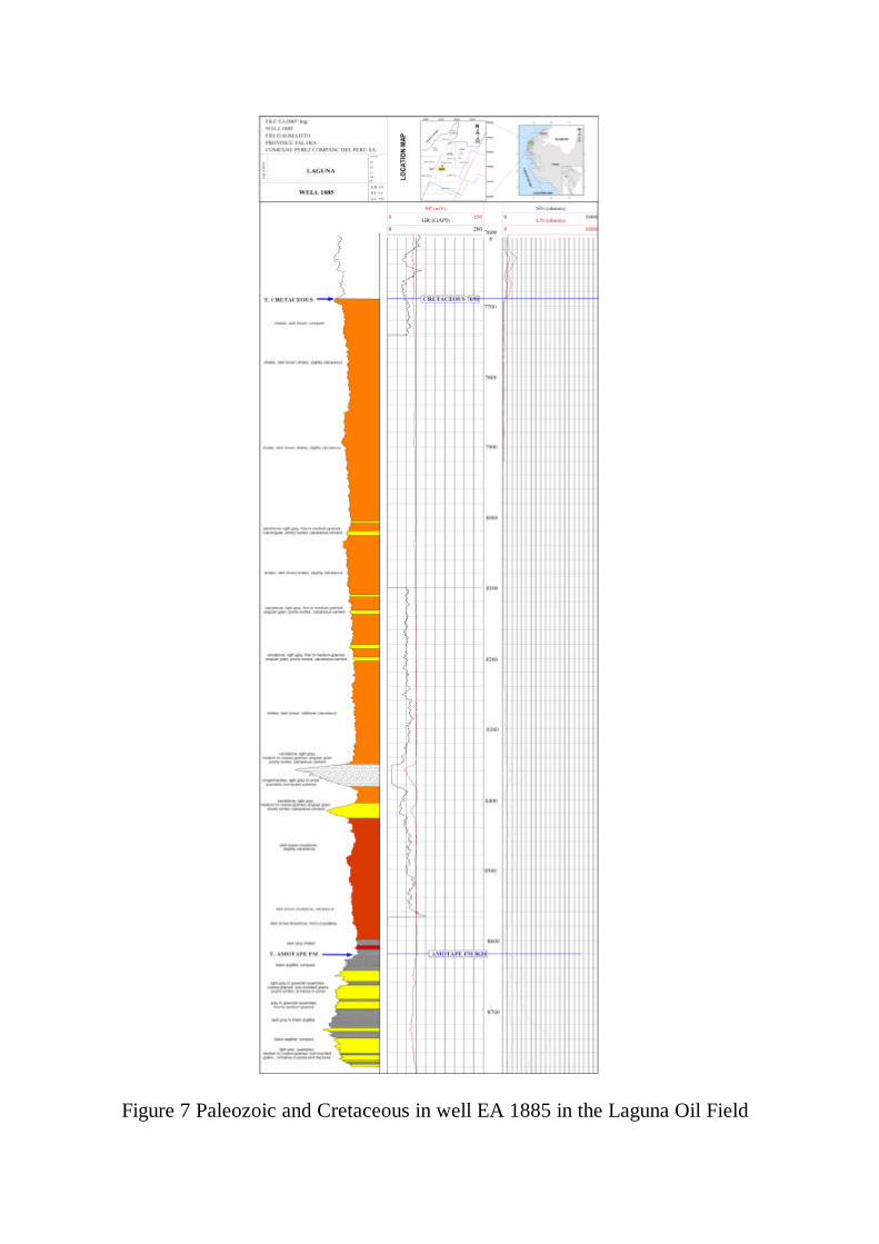
Figure 7 Paleozoic and Cretaceous in well EA 1885 in the Laguna Oil Field
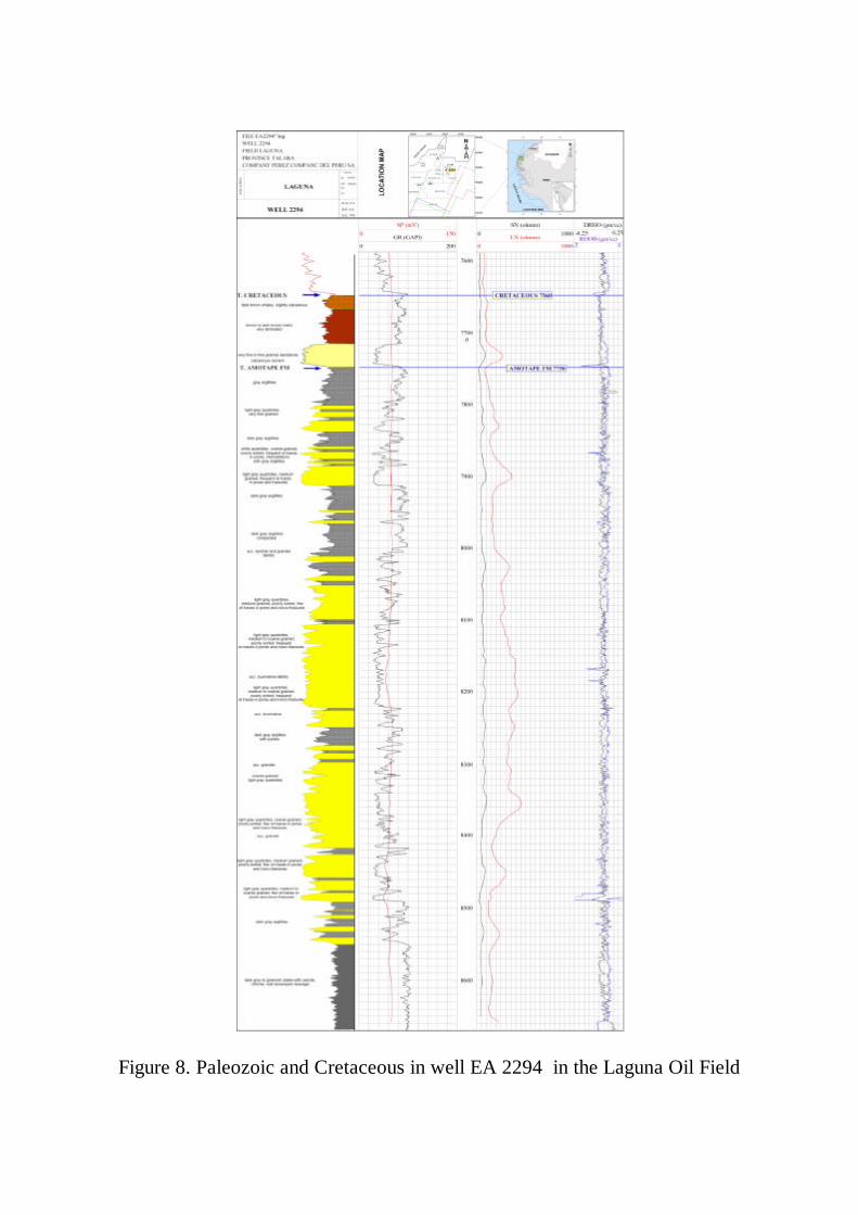
Figure 8. Paleozoic and Cretaceous in well EA 2294 in the Laguna Oil Field
Figure 8. Paleozoic and Cretaceous in well EA 2294 in the Laguna Oil Field
32
The sediments of Cretaceous age were deposited in five stratigraphic sequences widely distributed in most of the Peruvian territory. In the Coastal Region, marine to continental and volcanic sequences separated from the eastern Cretaceous sub-Andean sequences by the Marañon Geanticline represent the Cretaceous succession. It is interpreted that the western extension of the Cretaceous sediments in the Coastal Region was partially controlled by a Paleozoic and pre-Cambrian? Marginal high, presently exposed or known as the La Brea/Amotape Mountains, Paita High, Illescas Mountains and several offshore islands. An incomplete organic rich carbonaceous and siliciclastic Cretaceous succession with a composite thickness of some 2500 m. extends west of the Marginal High in the area now occupied by the Talara Basin. The sediments of Cretaceous age are best known from outcrops in the Amotape Mountains Pazul Creek (Enclosure 1b), from drilling in the south offshore Chira sub-Basin (Enclosures 2a and 2b), in the offshore Bayovar Bay (Enclosure 2s) and from scattered drilling in the remaining onshore and offshore Talara Basin (Enclosure 2i). A mainly shale Cretaceous unit with calcareous imprint constitutes the seal for Paleozoic reservoirs in the Laguna oil field. Maximum drilled thickness amounts to 283 m. in this field. Similar dark brown shale with carbonates and conglomerates attributed to the Redondo Formation covers the Paleozoic Amotape Formation in the Portachuelo oil field. Three stratigraphic cycles are recognized in the Talara Basin or the NW Coastal Region west of the Marginal high. Each sequence starts with a basal conglomerate and shallows upward. The earliest Cretaceous sequence is absent. The oldest sequence in the basin is Sequence II represented by a regional transgression that deposited the Muerto Pananga Formations of Albian age. The Pananga Formation onlaps sediments of Paleozoic age, as observed in the Amotape Mountains. It is made of a basal calcareous sandstone and conglomerate unit with quartzite and slate boulders changing to reef-type fossiliferous and neritic crystalline limestones. The sequence culminates with development of widespread anoxic euxinic conditions characterizing the carbonate Muerto Formation. The Muerto Formation is characterized by deposition of black, argillaceous, fossiliferous limestones with strong petroleum odor on fractures and also with pelagic forams. Total thickness for this sequence amounts to 250 m. representing some 15 my. of Albian time deposition. Similar organic rich limestones are also observed in the southern Coastal Region (Pariatambo Formation). It should be mentioned here that the Raya Formation in the sub-Andean basins correlates regionally in age with the sediments of the Muerto Pananga Formations. Black shales, sandstones, occasional black limestones and volcanic rocks of the Copa Sombrero Formation represent sequence III of late Albian/Cenomanian/Turonian/ Coniacian age. This sequence is restricted to the Lancones and Sechura Basins in northwestern Peru, east of the Marginal High. A condensed section could represent sequence III in the Talara Basin. The Muerto Pananga Formations are separated by an unconformity and overlain by Sequence IV and V of Campanian/Maastrichtian age representing a transgression that marks the end of Cretaceous deposition in NW Peru. This upper Cretaceous section is made up of a siliciclastic interval that starts with the basal conglomerate Sandino Formation with round shale pebbles in a red to dark brown sandstone matrix underlying the black to gray and dark brown fossiliferous shales of the Redondo Formation. Sequence IV ends with deposition of sandstones and shales of the Monte Grande Formation. Some thicker sandstone and conglomerate units are interbedded with this
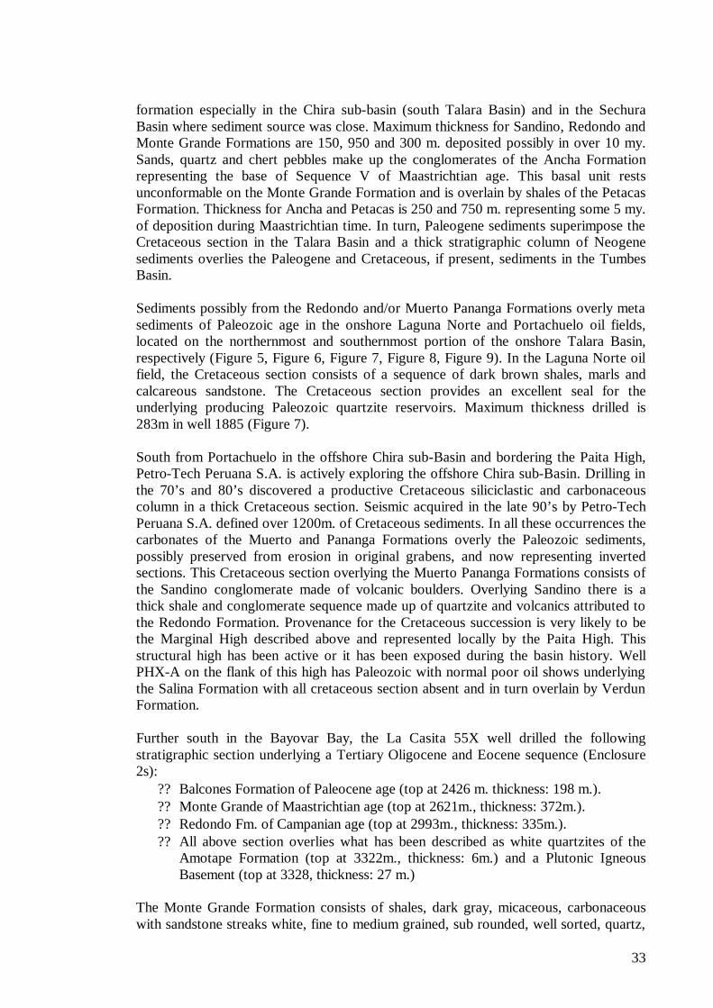
33
formation especially in the Chira sub-basin (south Talara Basin) and in the Sechura Basin where sediment source was close. Maximum thickness for Sandino, Redondo and Monte Grande Formations are 150, 950 and 300 m. deposited possibly in over 10 my. Sands, quartz and chert pebbles make up the conglomerates of the Ancha Formation representing the base of Sequence V of Maastrichtian age. This basal unit rests unconformable on the Monte Grande Formation and is overlain by shales of the Petacas Formation. Thickness for Ancha and Petacas is 250 and 750 m. representing some 5 my. of deposition during Maastrichtian time. In turn, Paleogene sediments superimpose the Cretaceous section in the Talara Basin and a thick stratigraphic column of Neogene sediments overlies the Paleogene and Cretaceous, if present, sediments in the Tumbes Basin. Sediments possibly from the Redondo and/or Muerto Pananga Formations overly meta sediments of Paleozoic age in the onshore Laguna Norte and Portachuelo oil fields, located on the northernmost and southernmost portion of the onshore Talara Basin, respectively (Figure 5, Figure 6, Figure 7, Figure 8, Figure 9). In the Laguna Norte oil field, the Cretaceous section consists of a sequence of dark brown shales, marls and calcareous sandstone. The Cretaceous section provides an excellent seal for the underlying producing Paleozoic quartzite reservoirs. Maximum thickness drilled is 283m in well 1885 (Figure 7). South from Portachuelo in the offshore Chira sub-Basin and bordering the Paita High, Petro-Tech Peruana S.A. is actively exploring the offshore Chira sub-Basin. Drilling in the 70’s and 80’s discovered a productive Cretaceous siliciclastic and carbonaceous column in a thick Cretaceous section. Seismic acquired in the late 90’s by Petro-Tech Peruana S.A. defined over 1200m. of Cretaceous sediments. In all these occurrences the carbonates of the Muerto and Pananga Formations overly the Paleozoic sediments, possibly preserved from erosion in original grabens, and now representing inverted sections. This Cretaceous section overlying the Muerto Pananga Formations consists of the Sandino conglomerate made of volcanic boulders. Overlying Sandino there is a thick shale and conglomerate sequence made up of quartzite and volcanics attributed to the Redondo Formation. Provenance for the Cretaceous succession is very likely to be the Marginal High described above and represented locally by the Paita High. This structural high has been active or it has been exposed during the basin history. Well PHX-A on the flank of this high has Paleozoic with normal poor oil shows underlying the Salina Formation with all cretaceous section absent and in turn overlain by Verdun Formation. Further south in the Bayovar Bay, the La Casita 55X well drilled the following stratigraphic section underlying a Tertiary Oligocene and Eocene sequence (Enclosure 2s):
? ? Balcones Formation of Paleocene age (top at 2426 m. thickness: 198 m.). ? ? Monte Grande of Maastrichtian age (top at 2621m., thickness: 372m.). ? ? Redondo Fm. of Campanian age (top at 2993m., thickness: 335m.). ? ? All above section overlies what has been described as white quartzites of the
Amotape Formation (top at 3322m., thickness: 6m.) and a Plutonic Igneous Basement (top at 3328, thickness: 27 m.)
The Monte Grande Formation consists of shales, dark gray, micaceous, carbonaceous with sandstone streaks white, fine to medium grained, sub rounded, well sorted, quartz,
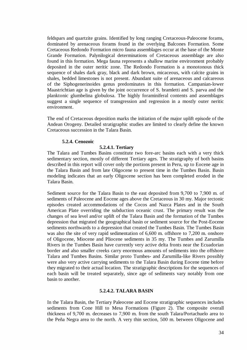
34
feldspars and quartzite grains. Identified by long ranging Cretaceous-Paleocene forams, dominated by arenaceous forams found in the overlying Balcones Formation. Some Cretaceous Redondo Formation micro fauna assemblages occur at the base of the Monte Grande Formation. Palynilogical determinations of Cretaceous assemblage are also found in this formation. Mega fauna represents a shallow marine environment probably deposited in the outer neritic zone. The Redondo Formation is a monotonous thick sequence of shales dark gray, black and dark brown, micaceous, with calcite grains in shales, bedded limestones is not present. Abundant suite of arenaceous and calcareous of the Siphogenerinoides genus predominates in this formation. Campanian-lower Maastrichtian age is given by the joint occurrence of S. bramletti and S. parva and the planktonic glumbelina globulosa. The highly foraminiferal contents and assemblages suggest a single sequence of transgression and regression in a mostly outer neritic environment. The end of Cretaceous deposition marks the initiation of the major uplift episode of the Andean Orogeny. Detailed stratigraphic studies are limited to clearly define the known Cretaceous succession in the Talara Basin.
5.2.4. Cenozoic
5.2.4.1. Tertiary The Talara and Tumbes Basins constitute two fore-arc basins each with a very thick sedimentary section, mostly of different Tertiary ages. The stratigraphy of both basins described in this report will cover only the portions present in Peru, up to Eocene age in the Talara Basin and from late Oligocene to present time in the Tumbes Basin. Basin modeling indicates that an early Oligocene section has been completed eroded in the Talara Basin. Sediment source for the Talara Basin to the east deposited from 9,700 to 7,900 m. of sediments of Paleocene and Eocene ages above the Cretaceous in 30 my. Major tectonic episodes created accommodations of the Cocos and Nazca Plates and in the South American Plate overriding the subduction oceanic crust. The primary result was the changes of sea level and/or uplift of the Talara Basin and the formation of the Tumbes depression that migrated the geographical basin or sediment source for the Post-Eocene sediments northwards to a depression that created the Tumbes Basin. The Tumbes Basin was also the site of very rapid sedimentation of 6,600 m. offshore to 7,200 m. onshore of Oligocene, Miocene and Pliocene sediments in 35 my. The Tumbes and Zarumilla Rivers in the Tumbes Basin have currently very active delta fronts near the Ecuadorian border and also smaller creeks carry enormous amounts of sediments into the offshore Talara and Tumbes Basins. Similar proto Tumbes- and Zarumilla-like Rivers possibly were also very active carrying sediments to the Talara Basin during Eocene time before they migrated to their actual location. The stratigraphic descriptions for the sequences of each basin will be treated separately, since age of sediments vary notably from one basin to another.
5.2.4.2. TALARA BASIN In the Talara Basin, the Tertiary Paleocene and Eocene stratigraphic sequences includes sediments from Cone Hill to Mesa Formations (Figure 2). The composite overall thickness of 9,700 m. decreases to 7,900 m. from the south Talara/Portachuelo area to the Peña Negra area to the north. A very thin section, 500 m. between Oligocene and
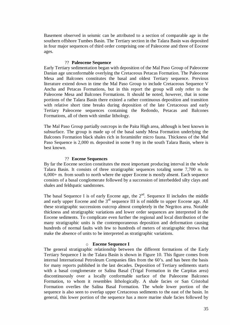
35
Basement observed in seismic can be attributed to a section of comparable age in the southern offshore Tumbes Basin. The Tertiary section in the Talara Basin was deposited in four major sequences of third order comprising one of Paleocene and three of Eocene ages.
? ? Paleocene Sequence Early Tertiary sedimentation began with deposition of the Mal Paso Group of Paleocene Danian age unconformable overlying the Cretaceous Petacas Formation. The Paleocene Mesa and Balcones constitutes the basal and oldest Tertiary sequence. Previous literature extend down in time the Mal Paso Group to include Cretaceous Sequence V Ancha and Petacas Formations, but in this report the group will only refer to the Paleocene Mesa and Balcones Formations. It should be noted, however, that in some portions of the Talara Basin there existed a rather continuous deposition and transition with relative short time breaks during deposition of the late Cretaceous and early Tertiary Paleocene sequences containing the Redondo, Petacas and Balcones Formations, all of them with similar lithology. The Mal Paso Group partially outcrops in the Paita High area, although is best known in subsurface. The group is made up of the basal sandy Mesa Formation underlying the Balcones Formation black shales rich in foraminifer micro fauna. Thickness of the Mal Paso Sequence is 2,000 m. deposited in some 9 my in the south Talara Basin, where is best known.
? ? Eocene Sequences By far the Eocene section constitutes the most important producing interval in the whole Talara Basin. It consists of three stratigraphic sequences totaling some 7,700 m. to 6,000+ m. from south to north where the upper Eocene is mostly absent. Each sequence consists of a basal conglomerate followed by a succession of interbedded silty clays and shales and feldspatic sandstones. The basal Sequence I is of early Eocene age, the 2nd. Sequence II includes the middle and early upper Eocene and the 3rd sequence III is of middle to upper Eocene age. All these stratigraphic successions outcrop almost completely in the Negritos area. Notable thickness and stratigraphic variations and lower order sequences are interpreted in the Eocene sediments. To complicate even further the regional and local distribution of the many stratigraphic units is the contemporaneous deposition and deformation causing hundreds of normal faults with few to hundreds of meters of stratigraphic throws that make the absence of units to be interpreted as stratigraphic variations.
o Eocene Sequence I The general stratigraphic relationship between the different formations of the Early Tertiary Sequence I in the Talara Basin is shown in Figure 10. This figure comes from internal International Petroleum Companies files from the 60’s. and has been the basis for many reports published in the last decades. Deposition of Tertiary sediments starts with a basal conglomerate or Salina Basal (Trigal Formation in the Carpitas area) discontinuously over a locally conformable surface of the Paleocene Balcones Formation, to whom it resembles lithologically. A shale facies or San Cristobal Formation overlies the Salina Basal Formation. The whole lower portion of the sequence is also seen to overlap upper Cretaceous sediments to the east of the basin. In general, this lower portion of the sequence has a more marine shale facies followed by
36
the sandier upper facies of the Salina Formation. The Salina Formation with sandy and shale character in the south Talara Basin becomes the coarse and conglomerate Mogollon Formation of the north Talara Basin. Conformable overlying the Salina Formation is the Palegreda Formation, a thick dark, soft, weathering to pink color, fossiliferous shales and few sandstone interbeds, which also changes to a more sandstone character to the north as the Ostrea Formation (Figure 10). Terminating deposition of Sequence I are the Pariñas and Chacra Formations overlying the Palegreda Formation. The Pariñas Formation extends south down to the offshore Chira sub-Basin (well NPXB-24X, Enclosure 2a), where the Pariñas wedge is fault controlled by the post-Cretaceous North Paita Fault (Petro-Tech, 1999). This is a NW dipping fault trending SW-NE offshore; the Pariñas wedge extends onshore and crosses the NW portion Portachuelo Field. The Pariñas sands are fine to conglomeratic, quartzose, with good sorting, with few shales interbeds; petrified fossil logs 0.5m. in diameter and 6 m. long were found in this formation. This unit may be subdivided into two units. The main difference is the shale character of the lower unit with poorer reservoir quality. In the northern Talara Basin the Pariñas Formation is time equivalent to the Clavel and Cabo Blanco Formations. This latter formation is characterized by a fluvial-deltaic facies of coarse sandstone and conglomerates deposited in channels caved on the Clavel Formation. The end of Sequence I is marked by deposition of the Chacra Formation conformably overlying the Pariñas Formation. The Chacra Formation consists of dark green gray shales wit a fossiliferous lower section capping conformably the Pariñas Formation. The formation changes to a sandy facies to the north, where the Echinocyamus Formation was deposited as the end of Sequence I. Total composite thickness for sequence I amounts to 2,700 m. in the south increasing considerably to 4,500 m. to the north Talara Basin. This considerable thickness defines a period of rapid sedimentation in 5 my during early Eocene time.
o Eocene Sequence II Sequence II of Middle Eocene and early upper Eocene age is made of the Talara Group unconformable overlying the Chacra Formation and on lapping all the lower Eocene units in different parts of the basin. The group has the basal Lomitos Conglomerate/ Terebratula Sandstone Member discontinuously distributed over the basin and overlain by the thick Talara Shale, a fossiliferous unit with characteristic rubble zone produced by contemporaneous deformation. The Talara Shale carries the imprint of gravity sliding of enormous blocks, episodes that created zones with common repetition of various formations. The Talara Shale grades upwards into the sand and shale unit of the Talara Sandstone and finally the light gray shales Pozo Shale ends the sequence. The turbidite sandstone and conglomerate Helico Member develops as a prolific oil producer in some areas as the Carrizo pool in current Block X. Thickness of Sequence II reaches 2000 m. deposited in 12 my in the south Talara Basin; this thickness decreases to 600 to the north, where the Talara Sandstone and the Pozo Shale are absent after a period of considerable erosion at the end of the middle Eocene.
o Eocene Sequence III Sequence III consisting of the basal Verdun Formation overlain by the Chira Group characterizes the end of Eocene deposition. The coarse quartzose sandstones of the Verdun Formation was deposited unconformable and on lapping the Talara Group and it is overlain by the basal unit of the Chira Group or Chira Formation, with good exposure in the Chira River valley to the south of the Talara Basin. The lower section of
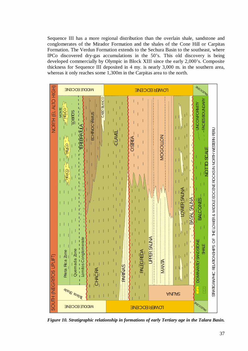
37
......
......
......
......
......
......
......
......
......
......
......
......
......
......
......
....
......
......
......
......
......
......
......
......
......
......
......
......
......
......
......
......
......
....
......
.....
......
......
......
......
......
......
......
......
......
......
......
......
......
......
......
......
......
......
......
......
......
......
......
......
......
....
......
......
......
......
......
......
.....
......
......
......
......
......
......
......
......
......
......
......
......
......
......
.
......
......
......
......
......
......
......
......
......
......
......
......
......
......
......
......
......
......
......
......
......
......
......
......
......
......
......
....
..... .
......
......
......
......
......
......
......
......
......
......
......
......
......
......
......
......
......
......
......
......
......
......
......
......
......
......
......
......
.....
......
......
......
......
......
......
......
......
......
......
......
......
....
......
......
......
......
......
......
......
......
......
......
......
......
.....
......
......
......
......
......
......
......
......
......
......
......
......
.....
......
......
......
......
......
......
......
......
......
......
.
......
......
......
......
......
......
......
......
......
......
......
......
.....
Prie
ta R
ica
Zone
Que
mad
a Z
one
Lom
itos C
ongl
omer
ate
Talara Shale
FAC
IES
BOUN
DAR
YNO
T TO
SC
ALE
BALC
ONES
DO
MIN
ANTL
Y SA
ND
STO
NE
ECHI
NO
CYA
MUS
HELIC
O
MIDDLE EOCENE
CHA
CRA
PARI
ÑAS
PALE
GRE
DA
UPPE
R SA
LINA
MAN
TA
LOW
ER S
ALIN
A
BASA
L SA
LINA
LOWER EOCENE
SALINA
MO
GO
LLO
N
OST
REA
CLA
VEL
CAB
O B
LANC
O
UNC
ONFO
RMITY
SHAL
E
PALEO
CENE
PALEO
CENE
LOWER EOCENEMIDDLE EOCENE
HELIC
OHE
LICO
MO
NTE
LOBI
TOS
TERE
BRAT
ULA
STRA
TIGRA
PHIC
REL
ATIO
NSH
IPS
OF
THE
LO
WER
& M
IDDLE
EO
CEN
E RO
CKS
IN N
ORT
H W
ESTE
RN P
ERU
Sequence III has a more regional distribution than the overlain shale, sandstone and conglomerates of the Mirador Formation and the shales of the Cone Hill or Carpitas Formation. The Verdun Formation extends to the Sechura Basin to the southeast, where IPCo discovered dry-gas accumulations in the 50’s. This old discovery is being developed commercially by Olympic in Block XIII since the early 2,000’s. Composite thickness for Sequence III deposited in 4 my. is nearly 3,000 m. in the southern area, whereas it only reaches some 1,300m in the Carpitas area to the north.
Figure 10. Stratigraphic relationship in formations of early Tertiary age in the Talara Basin.
38
? ? Pleistocene The Tablazo Formation caps the Tertiary sediments west of the Amotape Mountains in the whole Talara Basin. This formation consists of marine calcareous, coquina and very fossiliferous sands overlying sediments of Paleozoic, Cretaceous and Tertiary age. It represents the last stages of sea level changes that left marked erosion surfaces. The Tablazo forms the Talara and Mancora Tablazos, two main distinctive flat to almost horizontally lying topographic units bordering the southern Amotape Mountains east and northeast of the Lagunitos Graben and east of the Negritos Talara High, as seen on the geologic map (Enclosure 1d). The Tablazos are interpreted to absorb most sound waves that causes poor seismic response in the basin.
5.2.4.3. TUMBES BASIN The Tumbes Basin extends onshore and offshore to the north and adjacent to the Talara Basin and continues past the country border as the Progreso Basin in Ecuador. Sediments of late Oligocene, Miocene and Pliocene age are more representative of the Tumbes Basin, where a thick stratigraphic column outcrops completely and it is known by drilling and seismic data to extend offshore (Figure 3). Sediments were deposited in at least five stratigraphic sequences resting unconformable over Eocene sediments. The oldest sequence is observed to outcrop onlapping progressively older formations of late and middle Eocene age and Amotape Formation from the Mancora area to the northeast. The Higueron Intrusive intrudes the Tertiary sediments and the Paleozoic Amotape Formation in the NE border of the basin. Thickness of the Oligocene to Pliocene column varies from 7100 m. onshore to 6200 m. offshore, all the section deposited in approximately 30 my. The Banco Peru is seen as a high-density sea mound based on gravity anomaly analysis with dolomite on its margins and evidence of seismic stratification (Shepherd and Moberly, 1981). Presences of a Cenozoic section and possibly a Paleozoic section have been interpreted on Seismic on the current report (Figure 16). Commercial oil occurrence in metamorphic Paleozoic reservoirs in extreme localities in the south and north Talara Basin makes this tectonic feature larger than the Talara Negritos High (over 600 MMBO produced) extremely important for hydrocarbons exploration.
? ? Oligocene and Miocene The basal Sequence I represents a major transgression episode that deposited littoral, near shore and deltaic sediments. This sequence is characterized by great basin subsidence or high sea level rise on the current onshore portion of the basin; thickness onshore greatly exceeds thickness offshore. It starts with deposition of the Mancora Formation of late Oligocene to early Miocene age followed by the Heath Formation of early Miocene age. The Mancora Formation consists of sandstones and shales with a basal unit or Plateritos Member made up of a 40-m. thick quartzose and quartzitic sandstone and conglomerate unit with medium to coarse friable sand matrix and varicolored shales. Sequence I ends with deposition of the organic-rich dark brown to light gray shales, siltstones and some limestones and marls in the upper part of the Heath Formation overlying the Mancora Formation in transitional contact. Sequence I thickens considerably onshore and is considered one of the main objectives in the Tumbes Basin.
39
The Zorritos Formation of early Miocene age constitutes Sequence II that ends a period of rapid thick deposition with minor time breaks. The unit is characterized by deposition of coarse fluvial, deltaic and near shore sandstones and conglomerates with subordinated varicolored shales. This unit is the main reservoir in the basin and also in the offshore Amistad field across the border in Ecuador. The end of deposition of Sequence II during late early Miocene time is followed by a period of sea level fall and erosion of the exposed Zorritos Formation. Deep incised valleys and channel fill sediments are readily distinguished by seismic to correspond to shales of the overlying Cardalitos Formation, or Sequence III deposited unconformable over the Zorritos Formation. Shales of Sequence III were deposited over a very distinctive erosional unconformity, readily distinguished in the basin by proliferation of numerous deep channels. Deltaic and littoral sediments make up the Tumbes and Mal Pelo Formations overlying unconformable the Cardalitos Formation. Each of these formations shows certain degree of erosion or unconformable contact with each other making up individual sequences IV and V. The Tumbes Formation or Sequence IV makes, a marine shallow water coarse clastic deposits onshore grading to fine sands and shales offshore. The late Miocene Sequence VI or Mal Pelo Formation is characterized by deposition of a thick coarse clastic section. The Tumbes Basin is capped by deposition of shale of the Pliocene La Cruz Formation or Sequence VII. This sequence shows local erosion over structurally high areas of the underlying Sequence VI at the base of this formation and the development of sintectonic deposition over growth faults.
5.3. Regional Tectonics Settings This chapter summarizes a more detailed geological and geophysical analysis of the Talara and Tumbes Basins included in Spanish as Appendix 3 (Análisis de la Geometría y Estilo de Deformación de las Cuencas de Antepais Talara y Tumbes).
The Talara and Tumbes basins correspond to a forearc basin system developed along the northern coastal Peruvian Andes during Paleogene and Neogene times. The modern structural configuration is related to a complex geodynamic history associated with the interaction of the tectonics, eustatic and sedimentary processes that is controlled by the direction and velocity of the relative subduction of the oceanic crust, the aseismic subduction ridge and principally by the Andes Mountain building.
The Tumbes basin is bounded on its ocean ward side by a subduction complex wedge and on its landward side by the Amotape Mountains (Figure 11). The main tectonic elements that control the tectono-sedimentary evolution of the Tumbes basins are as follows: i) the western regions of the Tumbes basin is controlled by the Banco Peru structure, whose eastern border is limited by the Banco Peru fault, a southern projection of the Dolores Guayaquil - Puna Pallantanga megashear. ii) the eastern region of the Tumbes Basin is controlled by the Zorritos – Piedra Redonda High and the Amotapes Mountains (Figure 11).
The eastern limit of the Paleogene Talara Basin is given by the La Brea Hill and Amotape Mountains, which separates the basin from the Lancones basin. The southeast boundary corresponds to the transition of the Neogene Sechura Basin. In the offshore, the western portion of the Talara Basin is comprised of two marine platforms (deep and shallow platforms), controlled by listric normal faults and ends in an accretionary wedge adjacent to the oceanic trench.
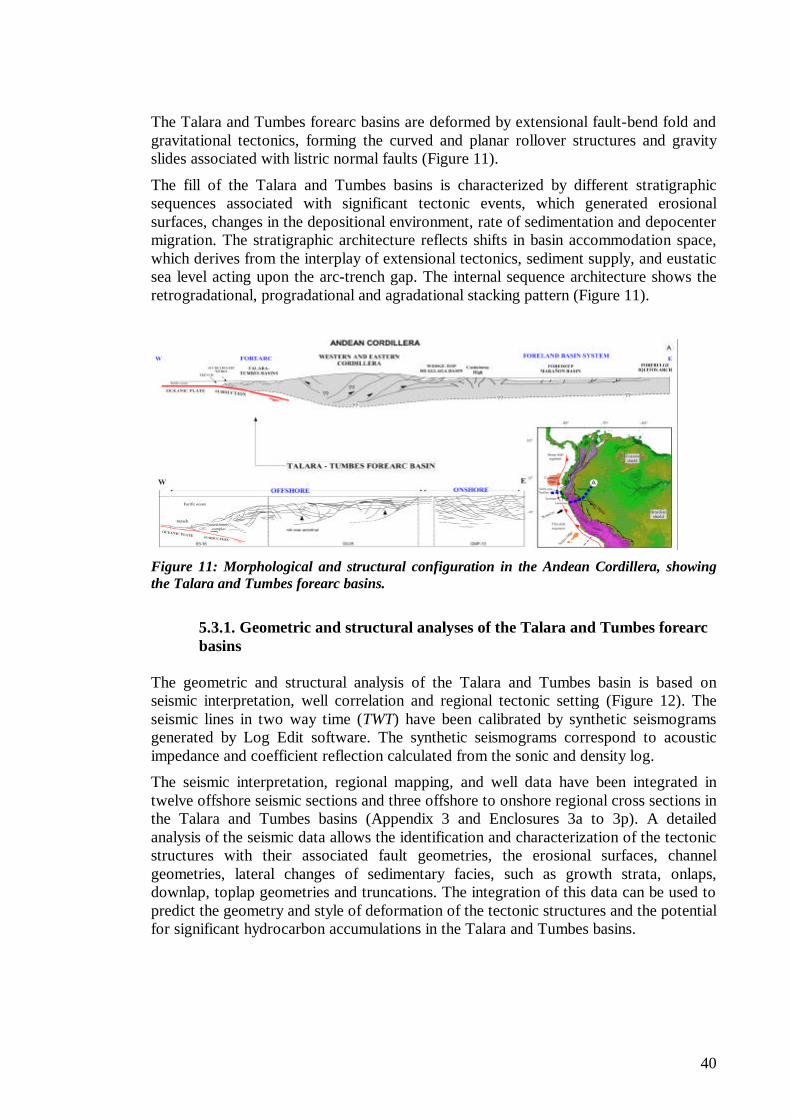
40
The Talara and Tumbes forearc basins are deformed by extensional fault-bend fold and gravitational tectonics, forming the curved and planar rollover structures and gravity slides associated with listric normal faults (Figure 11).
The fill of the Talara and Tumbes basins is characterized by different stratigraphic sequences associated with significant tectonic events, which generated erosional surfaces, changes in the depositional environment, rate of sedimentation and depocenter migration. The stratigraphic architecture reflects shifts in basin accommodation space, which derives from the interplay of extensional tectonics, sediment supply, and eustatic sea level acting upon the arc-trench gap. The internal sequence architecture shows the retrogradational, progradational and agradational stacking pattern (Figure 11).
Figure 11: Morphological and structural configuration in the Andean Cordillera, showing the Talara and Tumbes forearc basins.
5.3.1. Geometric and structural analyses of the Talara and Tumbes forearc basins
The geometric and structural analysis of the Talara and Tumbes basin is based on seismic interpretation, well correlation and regional tectonic setting (Figure 12). The seismic lines in two way time (TWT) have been calibrated by synthetic seismograms generated by Log Edit software. The synthetic seismograms correspond to acoustic impedance and coefficient reflection calculated from the sonic and density log.
The seismic interpretation, regional mapping, and well data have been integrated in twelve offshore seismic sections and three offshore to onshore regional cross sections in the Talara and Tumbes basins (Appendix 3 and Enclosures 3a to 3p). A detailed analysis of the seismic data allows the identification and characterization of the tectonic structures with their associated fault geometries, the erosional surfaces, channel geometries, lateral changes of sedimentary facies, such as growth strata, onlaps, downlap, toplap geometries and truncations. The integration of this data can be used to predict the geometry and style of deformation of the tectonic structures and the potential for significant hydrocarbon accumulations in the Talara and Tumbes basins.
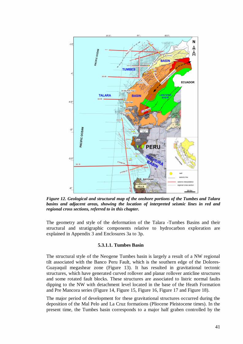
41
Figure 12. Geological and structural map of the onshore portions of the Tumbes and Talara basins and adjacent areas, showing the location of interpreted seismic lines in red and regional cross sections, referred to in this chapter.
The geometry and style of the deformation of the Talara -Tumbes Basins and their structural and stratigraphic components relative to hydrocarbon exploration are explained in Appendix 3 and Enclosures 3a to 3p.
5.3.1.1. Tumbes Basin The structural style of the Neogene Tumbes basin is largely a result of a NW regional tilt associated with the Banco Peru Fault, which is the southern edge of the Dolores-Guayaquil megashear zone (Figure 13). It has resulted in gravitational tectonic structures, which have generated curved rollover and planar rollover anticline structures and some rotated fault blocks. These structures are associated to listric normal faults dipping to the NW with detachment level located in the base of the Heath Formation and Pre Mancora series (Figure 14, Figure 15, Figure 16, Figure 17 and Figure 18).
The major period of development for these gravitational structures occurred during the deposition of the Mal Pelo and La Cruz formations (Pliocene Pleistocene times). In the present time, the Tumbes basin corresponds to a major half graben controlled by the
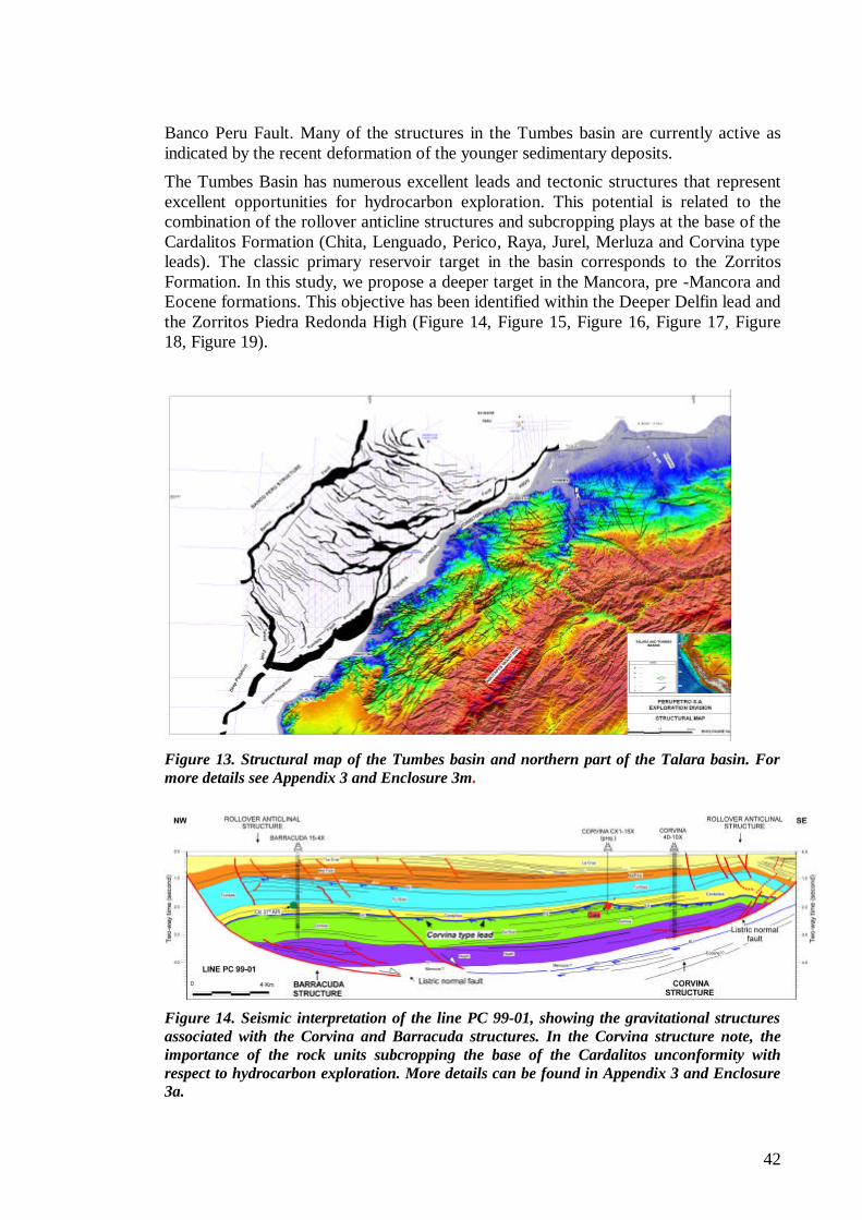
42
Banco Peru Fault. Many of the structures in the Tumbes basin are currently active as indicated by the recent deformation of the younger sedimentary deposits.
The Tumbes Basin has numerous excellent leads and tectonic structures that represent excellent opportunities for hydrocarbon exploration. This potential is related to the combination of the rollover anticline structures and subcropping plays at the base of the Cardalitos Formation (Chita, Lenguado, Perico, Raya, Jurel, Merluza and Corvina type leads). The classic primary reservoir target in the basin corresponds to the Zorritos Formation. In this study, we propose a deeper target in the Mancora, pre -Mancora and Eocene formations. This objective has been identified within the Deeper Delfin lead and the Zorritos Piedra Redonda High (Figure 14, Figure 15, Figure 16, Figure 17, Figure 18, Figure 19).
Figure 13. Structural map of the Tumbes basin and northern part of the Talara basin. For more details see Appendix 3 and Enclosure 3m.
Figure 14. Seismic interpretation of the line PC 99-01, showing the gravitational structures associated with the Corvina and Barracuda structures. In the Corvina structure note, the importance of the rock units subcropping the base of the Cardalitos unconformity with respect to hydrocarbon exploration. More details can be found in Appendix 3 and Enclosure 3a.
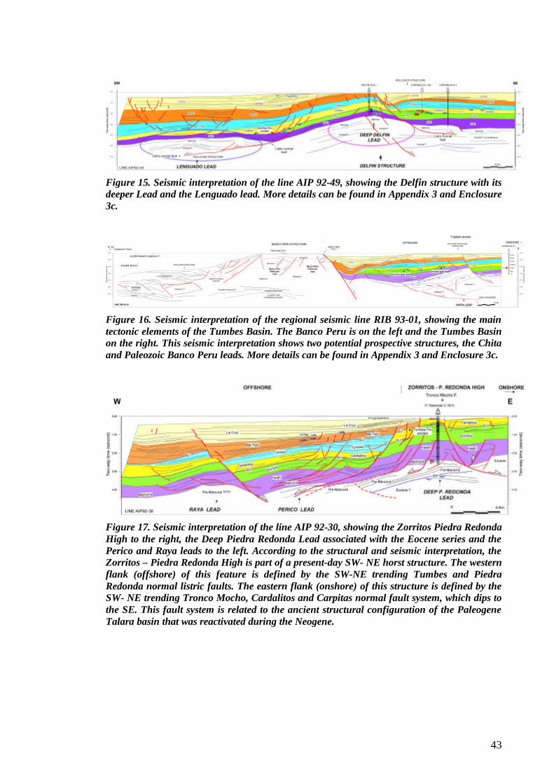
43
Figure 15. Seismic interpretation of the line AIP 92-49, showing the Delfin structure with its deeper Lead and the Lenguado lead. More details can be found in Appendix 3 and Enclosure 3c.
Figure 16. Seismic interpretation of the regional seismic line RIB 93-01, showing the main tectonic elements of the Tumbes Basin. The Banco Peru is on the left and the Tumbes Basin on the right. This seismic interpretation shows two potential prospective structures, the Chita and Paleozoic Banco Peru leads. More details can be found in Appendix 3 and Enclosure 3c.
Figure 17. Seismic interpretation of the line AIP 92-30, showing the Zorritos Piedra Redonda High to the right, the Deep Piedra Redonda Lead associated with the Eocene series and the Perico and Raya leads to the left. According to the structural and seismic interpretation, the Zorritos – Piedra Redonda High is part of a present-day SW- NE horst structure. The western flank (offshore) of this feature is defined by the SW-NE trending Tumbes and Piedra Redonda normal listric faults. The eastern flank (onshore) of this structure is defined by the SW- NE trending Tronco Mocho, Cardalitos and Carpitas normal fault system, which dips to the SE. This fault system is related to the ancient structural configuration of the Paleogene Talara basin that was reactivated during the Neogene.
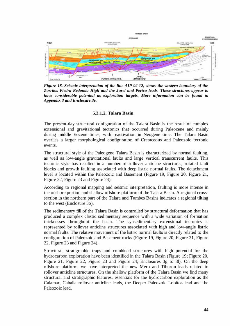
44
Figure 18. Seismic interpretation of the line AIP 92-12, shows the western boundary of the Zorritos Piedra Redonda High and the Jurel and Perico leads. These structures appear to have considerable potential as exploration targets. More information can be found in Appendix 3 and Enclosure 3e.
5.3.1.2. Talara Basin
The present-day structural configuration of the Talara Basin is the result of complex extensional and gravitational tectonics that occurred during Paleocene and mainly during middle Eocene times, with reactivation in Neogene time. The Talara Basin overlies a larger morphological configuration of Cretaceous and Paleozoic tectonic events.
The structural style of the Paleogene Talara Basin is characterized by normal faulting, as well as low-angle gravitational faults and large vertical transcurrent faults. This tectonic style has resulted in a number of rollover anticline structures, rotated fault blocks and growth faulting associated with deep listric normal faults. The detachment level is located within the Paleozoic and Basement (Figure 19, Figure 20, Figure 21, Figure 22, Figure 23 and Figure 24).
According to regional mapping and seismic interpretation, faulting is more intense in the onshore portion and shallow offshore platform of the Talara Basin. A regional cross-section in the northern part of the Talara and Tumbes Basins indicates a regional tilting to the west (Enclosure 3o).
The sedimentary fill of the Talara Basin is controlled by structural deformation that has produced a complex clastic sedimentary sequence with a wide variation of formation thicknesses throughout the basin. The synsedimentary extensional tectonics is represented by rollover anticline structures associated with high and low-angle listric normal faults. The relative movement of the listric normal faults is directly related to the configuration of Paleozoic and Basement rocks (Figure 19, Figure 20, Figure 21, Figure 22, Figure 23 and Figure 24).
Structural, stratigraphic traps and combined structures with high potential for the hydrocarbon exploration have been identified in the Talara Basin (Figure 19; Figure 20, Figure 21, Figure 22, Figure 23 and Figure 24; Enclosures 3g to 3l). On the deep offshore platform, we have interpreted the new Mero and Tiburon leads related to rollover anticline structures. On the shallow platform of the Talara Basin we find many structural and stratigraphic features, essentials for the hydrocarbon exploration as the Calamar, Caballa rollover anticline leads, the Deeper Paleozoic Lobitos lead and the Paleozoic lead.
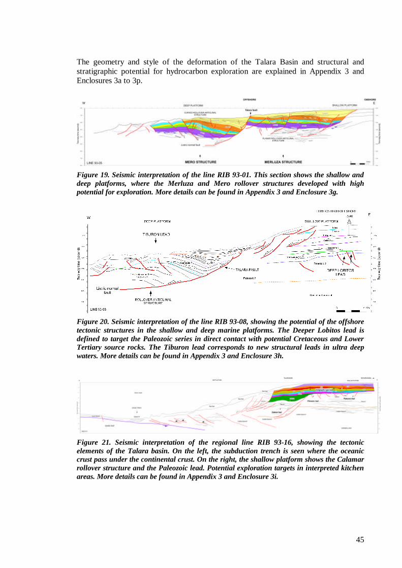
45
The geometry and style of the deformation of the Talara Basin and structural and stratigraphic potential for hydrocarbon exploration are explained in Appendix 3 and Enclosures 3a to 3p.
Figure 19. Seismic interpretation of the line RIB 93-01. This section shows the shallow and deep platforms, where the Merluza and Mero rollover structures developed with high potential for exploration. More details can be found in Appendix 3 and Enclosure 3g.
Figure 20. Seismic interpretation of the line RIB 93-08, showing the potential of the offshore tectonic structures in the shallow and deep marine platforms. The Deeper Lobitos lead is defined to target the Paleozoic series in direct contact with potential Cretaceous and Lower Tertiary source rocks. The Tiburon lead corresponds to new structural leads in ultra deep waters. More details can be found in Appendix 3 and Enclosure 3h.
Figure 21. Seismic interpretation of the regional line RIB 93-16, showing the tectonic elements of the Talara basin. On the left, the subduction trench is seen where the oceanic crust pass under the continental crust. On the right, the shallow platform shows the Calamar rollover structure and the Paleozoic lead. Potential exploration targets in interpreted kitchen areas. More details can be found in Appendix 3 and Enclosure 3i.
1.66
DELF B 11CD
1.35
38351.64
ALV OVE 3885
2.26
40001.67
40152.81
41202.64
4690
1.30
FONDO 48001.51
ALV OVE 4835
1.22
48751.66
50801.25
MISC SAL 5135
1.64
53251.49
5340
1.35
55051.36
5565
1.72
H7 X3
1.70LO10-7X
1.11
PIEDRA RED 14X
1.74
1540
1.5715451.62
15551.85
15701.74
1740
1.68
1860
1.40
18651.46
18751.80
19101.30
20101.85
PIEDRA RED 13X
1.17
2239
PLATER PL X2
1.37
131
PLATER PL X3
5630
1.5356551.53
56651.89
5668
1.53
56801.32
CORRAL EPRCX1
1.35
TRIGAL TRX1
0.79
LA CRUZ Z52051.55
C U 5 51.73
DD 12X
1.44
EE X31.54
CC X151.07
SICH 61X
LL 1151.34
A1 5X
1.74
A5 9X1.57
XX 11X0.55
A4 19X1.45
A3 22X1.67
LO1 9X2.51
EX6 2XEX6 8X
1.79
EX6 6X
1.77
PN1 12X
LO3 22X1.07
EX4 15X
1.52
1.18
PVX8 13X1.991.53
MLX9 15X1.08
A1 8X
1.55
PVX13 6
2.06
NHX1 19X1.25
PN2 8X1.87
LT8 11X1.84
NHX1 7X
1.32
A1 6X
0.78
NHX 20.78
NHX 6.67
NHX 51.28
NHX 70.54
NHX 40.61
LO6 13X1.84LO10 20A1.28
LO5 13X1.43
PN3 11X1.34
PN8 17X1.52
ORXA 13X
1.33
PV15 101.63
P26B X12.13
1.10
6B X1
1.461.57
7B X11.46
8A X1
1.590.64
B 3 X4
7B X2
1.08
H9A X1
0.91
H5S X101.53
AA 18X0.99
BARRANCO BAX1
CEREZAL CEX1
CAPILLA CX 1
CAPILLA CX 2
OLLOCOS OX- 2
T14 1
1.64
53801.67
6035
2.46
CARPITAS C115
2.23
T 171.41
1.26
TX 35 1.42
1725
1855
1.24
1940
1.49
CARRIZO 1980
1.48
DELF B 5X1.44
6060
AX251.20
ATASCADERO 1X
1.19
NPXB-24X
1.25
ZORRITOS RT481.87 RT50
2.20
RT59
2.05
RX67
1.84
10 0 10 20 30 km
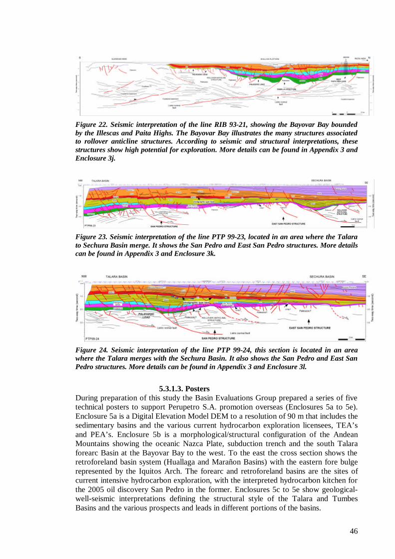
46
Figure 22. Seismic interpretation of the line RIB 93-21, showing the Bayovar Bay bounded by the Illescas and Paita Highs. The Bayovar Bay illustrates the many structures associated to rollover anticline structures. According to seismic and structural interpretations, these structures show high potential for exploration. More details can be found in Appendix 3 and Enclosure 3j.
Figure 23. Seismic interpretation of the line PTP 99-23, located in an area where the Talara to Sechura Basin merge. It shows the San Pedro and East San Pedro structures. More details can be found in Appendix 3 and Enclosure 3k.
Figure 24. Seismic interpretation of the line PTP 99-24, this section is located in an area where the Talara merges with the Sechura Basin. It also shows the San Pedro and East San Pedro structures. More details can be found in Appendix 3 and Enclosure 3l.
5.3.1.3. Posters
During preparation of this study the Basin Evaluations Group prepared a series of five technical posters to support Perupetro S.A. promotion overseas (Enclosures 5a to 5e). Enclosure 5a is a Digital Elevation Model DEM to a resolution of 90 m that includes the sedimentary basins and the various current hydrocarbon exploration licensees, TEA’s and PEA’s. Enclosure 5b is a morphological/structural configuration of the Andean Mountains showing the oceanic Nazca Plate, subduction trench and the south Talara forearc Basin at the Bayovar Bay to the west. To the east the cross section shows the retroforeland basin system (Huallaga and Marañon Basins) with the eastern fore bulge represented by the Iquitos Arch. The forearc and retroforeland basins are the sites of current intensive hydrocarbon exploration, with the interpreted hydrocarbon kitchen for the 2005 oil discovery San Pedro in the former. Enclosures 5c to 5e show geological-well-seismic interpretations defining the structural style of the Talara and Tumbes Basins and the various prospects and leads in different portions of the basins.
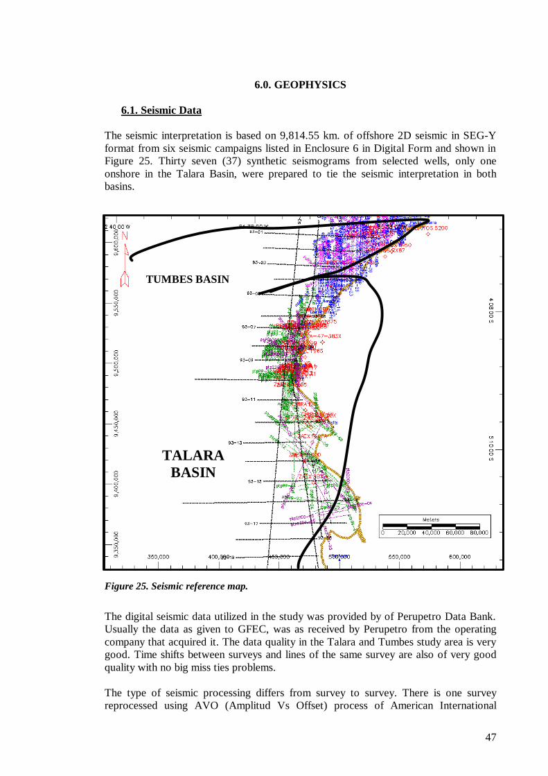
47
6.0. GEOPHYSICS
6.1. Seismic Data The seismic interpretation is based on 9,814.55 km. of offshore 2D seismic in SEG-Y format from six seismic campaigns listed in Enclosure 6 in Digital Form and shown in Figure 25. Thirty seven (37) synthetic seismograms from selected wells, only one onshore in the Talara Basin, were prepared to tie the seismic interpretation in both basins.
Figure 25. Seismic reference map.
The digital seismic data utilized in the study was provided by of Perupetro Data Bank. Usually the data as given to GFEC, was as received by Perupetro from the operating company that acquired it. The data quality in the Talara and Tumbes study area is very good. Time shifts between surveys and lines of the same survey are also of very good quality with no big miss ties problems. The type of seismic processing differs from survey to survey. There is one survey reprocessed using AVO (Amplitud Vs Offset) process of American International
TUMBES BASIN
TALARA BASIN
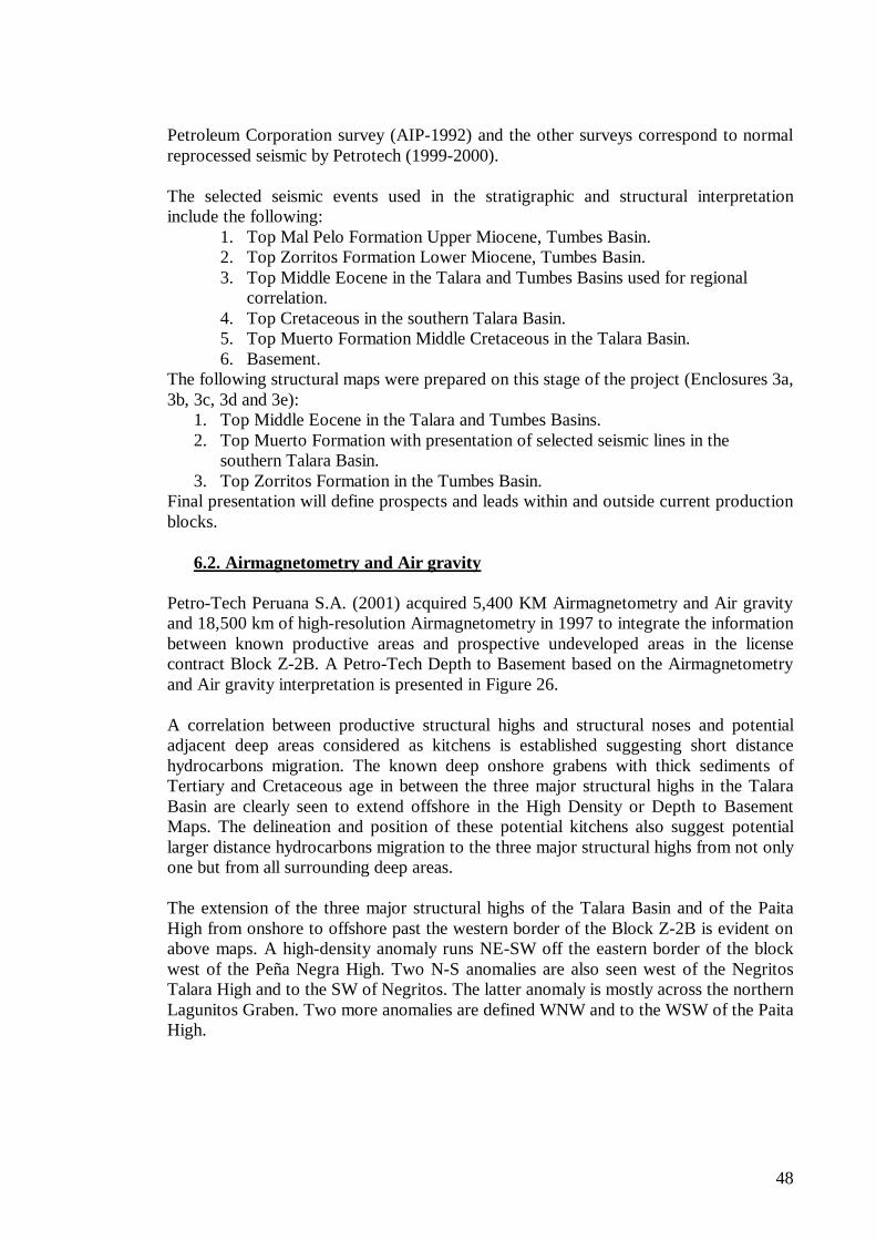
48
Petroleum Corporation survey (AIP-1992) and the other surveys correspond to normal reprocessed seismic by Petrotech (1999-2000). The selected seismic events used in the stratigraphic and structural interpretation include the following:
1. Top Mal Pelo Formation Upper Miocene, Tumbes Basin. 2. Top Zorritos Formation Lower Miocene, Tumbes Basin. 3. Top Middle Eocene in the Talara and Tumbes Basins used for regional
correlation. 4. Top Cretaceous in the southern Talara Basin. 5. Top Muerto Formation Middle Cretaceous in the Talara Basin. 6. Basement.
The following structural maps were prepared on this stage of the project (Enclosures 3a, 3b, 3c, 3d and 3e):
1. Top Middle Eocene in the Talara and Tumbes Basins. 2. Top Muerto Formation with presentation of selected seismic lines in the
southern Talara Basin. 3. Top Zorritos Formation in the Tumbes Basin.
Final presentation will define prospects and leads within and outside current production blocks.
6.2. Airmagnetometry and Air gravity Petro-Tech Peruana S.A. (2001) acquired 5,400 KM Airmagnetometry and Air gravity and 18,500 km of high-resolution Airmagnetometry in 1997 to integrate the information between known productive areas and prospective undeveloped areas in the license contract Block Z-2B. A Petro-Tech Depth to Basement based on the Airmagnetometry and Air gravity interpretation is presented in Figure 26. A correlation between productive structural highs and structural noses and potential adjacent deep areas considered as kitchens is established suggesting short distance hydrocarbons migration. The known deep onshore grabens with thick sediments of Tertiary and Cretaceous age in between the three major structural highs in the Talara Basin are clearly seen to extend offshore in the High Density or Depth to Basement Maps. The delineation and position of these potential kitchens also suggest potential larger distance hydrocarbons migration to the three major structural highs from not only one but from all surrounding deep areas. The extension of the three major structural highs of the Talara Basin and of the Paita High from onshore to offshore past the western border of the Block Z-2B is evident on above maps. A high-density anomaly runs NE-SW off the eastern border of the block west of the Peña Negra High. Two N-S anomalies are also seen west of the Negritos Talara High and to the SW of Negritos. The latter anomaly is mostly across the northern Lagunitos Graben. Two more anomalies are defined WNW and to the WSW of the Paita High.
49
Figure 26. High Density Basement Map in NW Peru (Petrotech, 2001).
50
7.0. PETROLEUM GEOLOGY 7.1.Geochemistry
7.1.1. General Discussion Few modern Geochemical studies have been conducted in the Talara and Tumbes Basins and in the neighboring Trujillo, Sechura and Lancones Basins in an attempt to define the petroleum systems present in the northern Peruvian coastal basins. The effort so far is incomplete to clearly recognize all the elements responsible for the giant oil accumulation in the Talara Basin and the different hydrocarbon occurrences in the Tumbes Basin. Presence of multiple reservoirs in the stratigraphic column mainly in the Eocene sediments of the Talara Basin, the main producing interval in the coastal basin, made the studies to be considered of less importance until the 90’s. Several companies, among them Perupetro (1999), Perez Companc (2000), Repsol (1996), UPPPL (1993), Mobil (1993), Petro-Tech Peruana S.A., and more recently a group of researchers of Stanford University with logistic support from Petrobras (operator of Block X in the onshore Talara Basin) have performed Geochemical analyses on oil samples and outcrops in northwestern Peru (Fildani, A. et.al. 2005). The Perupetro study made a good attempt to fill a major gap conducting its modern Geochemical evaluation that included all coastal and offshore basins. The studies cover geochemistry analyses to evaluate potential source rocks and oil characterization to make oil-oil and oil-source rock correlations and some basin modeling to establish maturity levels and timing of hydrocarbons generation and migration. For a more comprehensive understanding and for detailed information of these reports the reader is referred to the Geochemical reports and database in the Perupetro technical archives. This technical archive contains listing of the Geochemical reports in its files produced by the several oil companies that were active in exploration and development in these various basins in the last decades. Detailed results of all these Geochemical studies are incorporated below, since the present study has not performed any of these analyses. Among the several uncertainties drawn from the major conclusions from these reports are:
1) There is no general agreement as to the identification of the active source rocks for the oils in both basins; oil-source rock correlation with samples from wells and their outcrops in the basins and with outcrops from neighboring basins have provided good and in some cases disappointing results. An exceptional good match is found for the correlation between a Gas Chromatograms from a representative oil sample of the Talara Basin and from a bitumen extract of the Heath Formation of the Piedra Redonda C-13X well interpreted as part of the Tumbes Basin (Figure 27).
2) There is also no well-defined knowledge of the location of hydrocarbons kitchens and timing and migration routes for the known hydrocarbon occurrences in both basins. Maturity levels and organic matter distribution imply a medium to long-range migration routes from the source rock kitchen areas to reservoirs for the accumulations found to date. The geological events placed in assumed local kitchens as in the Lagunitos and Siches grabens do not fully account for the hydrocarbons found in the three major tectonic highs in the
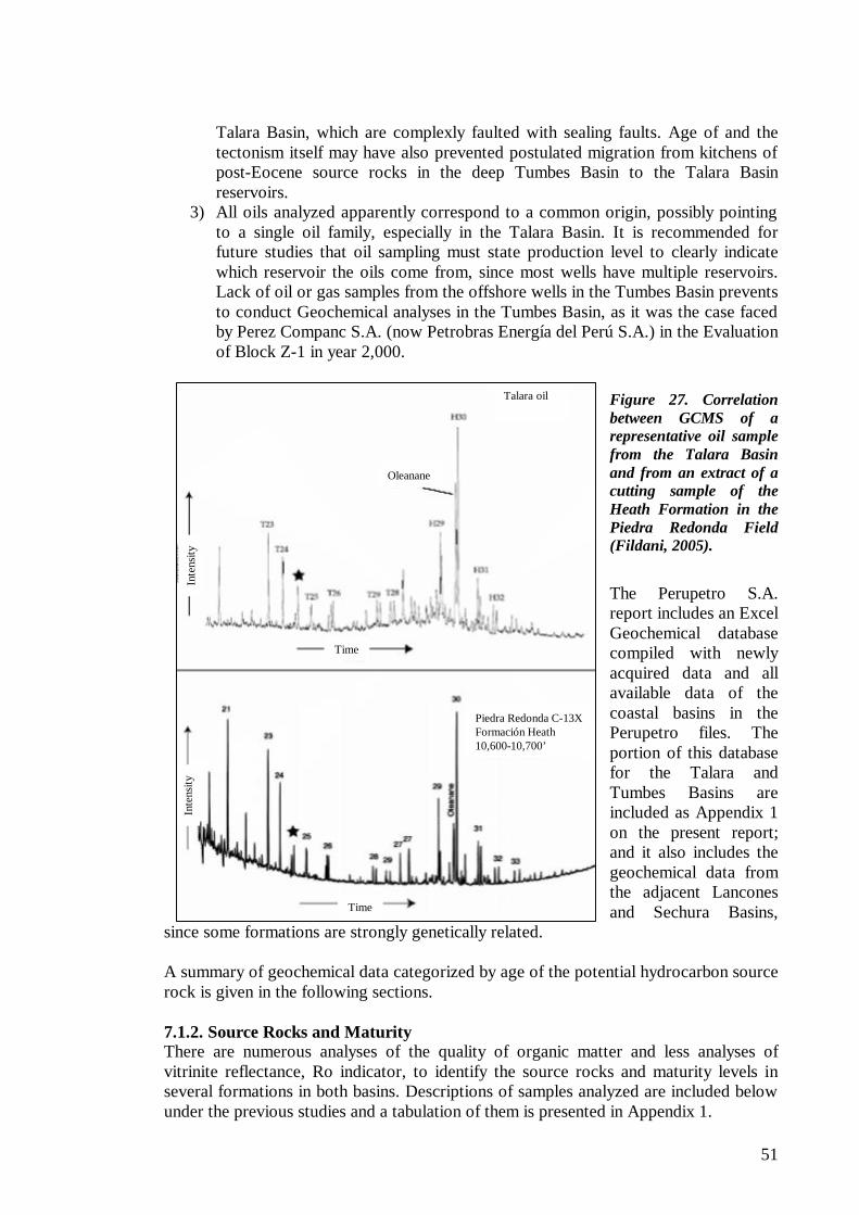
51
Talara oil
Oleanane
Piedra Redonda C-13XFormación Heath10,600-10,700’
Time
Time
Inte
nsity
Inte
nsity
Talara oil
Oleanane
Piedra Redonda C-13XFormación Heath10,600-10,700’
Time
Time
Inte
nsity
Inte
nsity
Talara Basin, which are complexly faulted with sealing faults. Age of and the tectonism itself may have also prevented postulated migration from kitchens of post-Eocene source rocks in the deep Tumbes Basin to the Talara Basin reservoirs.
3) All oils analyzed apparently correspond to a common origin, possibly pointing to a single oil family, especially in the Talara Basin. It is recommended for future studies that oil sampling must state production level to clearly indicate which reservoir the oils come from, since most wells have multiple reservoirs. Lack of oil or gas samples from the offshore wells in the Tumbes Basin prevents to conduct Geochemical analyses in the Tumbes Basin, as it was the case faced by Perez Companc S.A. (now Petrobras Energía del Perú S.A.) in the Evaluation of Block Z-1 in year 2,000.
Figure 27. Correlation between GCMS of a representative oil sample from the Talara Basin and from an extract of a cutting sample of the Heath Formation in the Piedra Redonda Field (Fildani, 2005).
The Perupetro S.A. report includes an Excel Geochemical database compiled with newly acquired data and all available data of the coastal basins in the Perupetro files. The portion of this database for the Talara and Tumbes Basins are included as Appendix 1 on the present report; and it also includes the geochemical data from the adjacent Lancones and Sechura Basins,
since some formations are strongly genetically related. A summary of geochemical data categorized by age of the potential hydrocarbon source rock is given in the following sections. 7.1.2. Source Rocks and Maturity There are numerous analyses of the quality of organic matter and less analyses of vitrinite reflectance, Ro indicator, to identify the source rocks and maturity levels in several formations in both basins. Descriptions of samples analyzed are included below under the previous studies and a tabulation of them is presented in Appendix 1.
52
Based on available geochemical information the following formations from Cretaceous to Tertiary age can be identified as main potential source rocks in the Talara and Tumbes Basins. Tertiary
? ? Miocene Cardalitos Formation in the Tumbes Basin. ? ? Miocene Zorritos Formation in the Tumbes Basin ? ? Oligocene/Miocene Heath Formation in the Tumbes Basin ? ? Oligocene Mancora Formation in the Tumbes Basin ? ? Eocene Formations in the Talara and Tumbes (?) Basins. ? ? Paleocene Formations in the Talara Basin
Cretaceous
? ? Redondo Formation of Campanian-Maastrichtian age in the Talara Basin ? ? Muerto Formation of Albian age in the Talara Basin and Lancones Basin. ? ? The extension of the Cretaceous section into the Tumbes Basin is unknown.
Paleozoic
? ? The Paleozoic sedimentary section consists mainly of a metamorphosed with clear indication of post-maturity conditions.
7.1.2.1. Tertiary
Potential source rocks of Tertiary age are limited to the Paleocene and Eocene sequences in the Talara Basin and from the Eocene (?) to Miocene sequences in the Tumbes Basin. Oligocene sequences are likely to constitute the final sedimentation episodes in the Talara Basin before major sediment provenance shifted north into the Tumbes Basin, possibly due to sea level retreat and/or major uplift of the basin. The Oligocene sequences have been completed eroded off in most of the Talara Basin. Vitrinite reflectance data in the Eocene section, however, indicates a maturity degree reached with this post-Eocene overburden. Source rocks from formations of Early Tertiary age, i.e. Eocene and Paleocene, may have contributed to the hydrocarbon accumulation in the Talara Basin from still undrilled deep areas to the west where they may have both better organic contents and best maturity conditions than in the known drilled portions of the basin. Presence of Oleanane in oil samples is indicative of late Cretaceous and/or Tertiary source rocks. Presence of other biomarkers may tend to identify a post-Eocene age for the source rocks in the basin; however, the post-Eocene sequences could have hardly achieved sufficient maturity to generate hydrocarbons in the Talara Basin. Geochemical Analyses of other unknown potential source rocks in the area are in progress. In a recent field trip Perupetro geologist Y. Calderon, a member of our team, visited a 100+ meter-thick dark gray shale outcrop with source rock potential attributed to the Talara Formation in the Mancora Town area (Figure 28 A). This area is some 30 Km to the south of the site modeled by offshore Pseudowell 1; this shale unit also outcrops 20 Km to the east of the Mancora Town preserving its lithological character (Figure 28 B). The geological reconnaissance work is described in Appendix 3 of this report (Y. Calderon, 2005). Geochemical analysis of this unit is in progress by Mr. P. Baby’s Perupetro-IRD Group (personal communication).
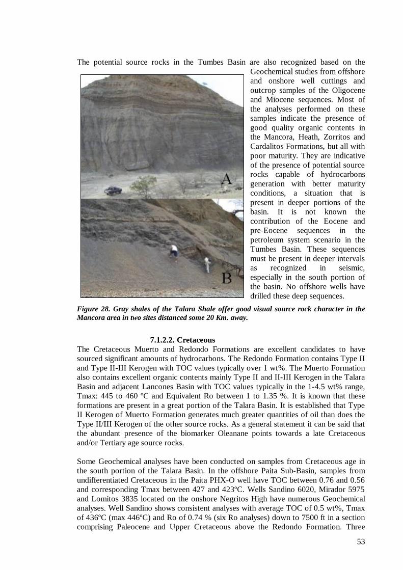
53
The potential source rocks in the Tumbes Basin are also recognized based on the Geochemical studies from offshore and onshore well cuttings and outcrop samples of the Oligocene and Miocene sequences. Most of the analyses performed on these samples indicate the presence of good quality organic contents in the Mancora, Heath, Zorritos and Cardalitos Formations, but all with poor maturity. They are indicative of the presence of potential source rocks capable of hydrocarbons generation with better maturity conditions, a situation that is present in deeper portions of the basin. It is not known the contribution of the Eocene and pre-Eocene sequences in the petroleum system scenario in the Tumbes Basin. These sequences must be present in deeper intervals as recognized in seismic, especially in the south portion of the basin. No offshore wells have drilled these deep sequences.
Figure 28. Gray shales of the Talara Shale offer good visual source rock character in the Mancora area in two sites distanced some 20 Km. away.
7.1.2.2. Cretaceous
The Cretaceous Muerto and Redondo Formations are excellent candidates to have sourced significant amounts of hydrocarbons. The Redondo Formation contains Type II and Type II-III Kerogen with TOC values typically over 1 wt%. The Muerto Formation also contains excellent organic contents mainly Type II and II-III Kerogen in the Talara Basin and adjacent Lancones Basin with TOC values typically in the 1-4.5 wt% range, Tmax: 445 to 460 ºC and Equivalent Ro between 1 to 1.35 %. It is known that these formations are present in a great portion of the Talara Basin. It is established that Type II Kerogen of Muerto Formation generates much greater quantities of oil than does the Type II/III Kerogen of the other source rocks. As a general statement it can be said that the abundant presence of the biomarker Oleanane points towards a late Cretaceous and/or Tertiary age source rocks. Some Geochemical analyses have been conducted on samples from Cretaceous age in the south portion of the Talara Basin. In the offshore Paita Sub-Basin, samples from undifferentiated Cretaceous in the Paita PHX-O well have TOC between 0.76 and 0.56 and corresponding Tmax between 427 and 423ºC. Wells Sandino 6020, Mirador 5975 and Lomitos 3835 located on the onshore Negritos High have numerous Geochemical analyses. Well Sandino shows consistent analyses with average TOC of 0.5 wt%, Tmax of 436ºC (max 446ºC) and Ro of 0.74 % (six Ro analyses) down to 7500 ft in a section comprising Paleocene and Upper Cretaceous above the Redondo Formation. Three
54
samples from the Redondo Formation in this well have an average TOC of 0.54 wt%, maximum Tmax of 444ºC and Ro of 0.90%. Fifteen samples from the Redondo Formation in well 5975 have TOC average of 1.02 wt% and average Tmax of 437ºC. The Muerto Formation in the Sandino well has TOC average of 2.27 wt%, Tmax of 445ºC and Ro of 0.95%; whereas in the Lomitos 3835 well averages for the TOC analyses are 2.98 wt%, Tmax of 450ºC and Ro of 0.88%. The Lomitos well has an average TOC of 2.98-wt% and Tmax of 450ºC in six samples and Ro of 0.88 in one sample from the Muerto Formation. Further south in La Casita 1X well in the Bayovar Bay.
7.1.2.3. Paleozoic The Paleozoic sediments are widely distributed in subsurface and on the eastern borders of the Talara and Tumbes Basins. The Paleozoic sequence is typically made of metamorphic rocks and other rocks with less degree of metamorphism. The Amotape Formation of Paleozoic ages, as well as the pre-Cretaceous formations of Mesozoic age contain an unknown series of geological events, which have been grouped as to represent one (or more than one) major burial episode on this report. Post mature Ro wt% of over 3.0 is described in the Lomitos field in Paleozoic sediments. The commercial production established in Laguna, Portachuelo and San Pedro fields comes from mainly quartzite and argillite reservoirs sealed by shales of Cretaceous or Tertiary age and very likely sourced by same distal source rocks as in the Talara Basin proper. Thus, it defines a late-Cretaceous/Paleozoic petroleum system. 7.1.3. Talara Basin
7.1.3.1. Sample Analyses Perupetro (1999) performed geochemical analyses on samples from 16 wells in the Talara Basin in the following stratigraphic units.
? ? Salina-Negritos Early Eocene ? ? Balcones Late Paleocene ? ? Mesa Early Paleocene ? ? Mal Paso Maastrichtian-Paleocene ? ? Petacas Late Maastrichtian ? ? Monte Grande Early Maastrichtian ? ? Redondo Campanian ? ? Sandino Basal Campanian ? ? Tablones Early Campanian ? ? Pananga-Muerto Middle Albian
A distribution of TOC wt% of samples from the Talara Basin is presented on Figure 29 and Figure 30 for DGSI (Perupetro, 1999) and existing data, respectively. One major conclusion drawn from available studies is the recognition of the Cretaceous sediments as the most likely source rock that has generated the hydrocarbons in the Talara Basin. Future studies and analyses should define biomarkers to establish a positive hydrocarbons/source rock correlation.
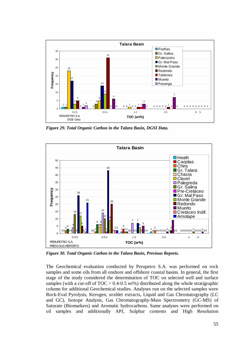
55
Figure 29. Total Organic Carbon in the Talara Basin, DGSI Data.
Figure 30. Total Organic Carbon in the Talara Basin, Previous Reports.
The Geochemical evaluation conducted by Perupetro S.A. was performed on rock samples and some oils from all onshore and offshore coastal basins. In general, the first stage of the study considered the determination of TOC on selected well and surface samples (with a cut-off of TOC > 0.4-0.5 wt%) distributed along the whole stratigraphic column for additional Geochemical studies. Analyses run on the selected samples were Rock-Eval Pyrolysis, Kerogen, soxhlet extracts, Liquid and Gas Chromatography (LC and GC), Isotope Analysis, Gas Chromatography-Mass Spectrometry (GC-MS) of Saturate (Biomarkers) and Aromatic hydrocarbons. Same analyses were performed on oil samples and additionally API, Sulphur contents and High Resolution
Talara Basin
10 0 0 0
13
0 0 0
23
5
10 0
17
14
0 0 0
3
9
0 0 0
5
31
1 100 0
10 0
1
6
3
7
02
0 0 0 00
5
10
15
20
25
30
35
0-0.5 0.5-1 1-2 2-5 más de 5
TOC (wt%)
Freq
uenc
yPariñasGr. SalinaPaleozoicoGr. Mal PasoMonte GrandeRedondoTablonesMuertoPananga
PERUPETRO S.A. DGSI Data
>
Talara Basin
0 0 1 1 00 0
3
0 02 1 1 2
0
3
6
1 0 00
4
0 0 00
6
0 0 0
4
14
7
0 0
13
10
0 0 10 1 0 0 0
26
43
7
1 0
12
9
4
0 0
5
20
02
00 0
5
9
11 20 0 0
21
20 0 0
0
5
10
15
20
25
30
35
40
45
50
0-0.5 0.5-1 1-2 2-5 más de 5
TOC (w%)
Freq
uenc
y
HeathCarpitasChiraGr. TalaraChacraClavelPalegredaGr. SalinaPre-CretáceoGr. Mal PasoMonte GrandeRedondoMuertoCretáceo Indif.Amotape
PERUPETRO S.A.PREVIOUS REPORTS
>
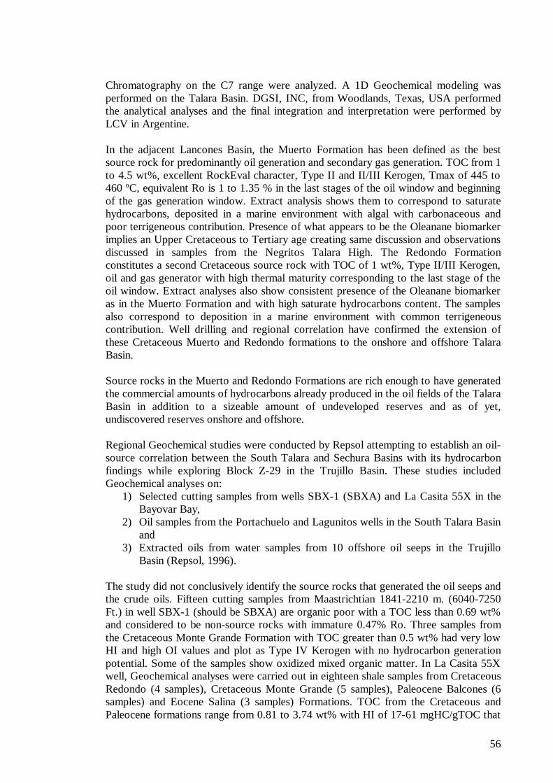
56
Chromatography on the C7 range were analyzed. A 1D Geochemical modeling was performed on the Talara Basin. DGSI, INC, from Woodlands, Texas, USA performed the analytical analyses and the final integration and interpretation were performed by LCV in Argentine. In the adjacent Lancones Basin, the Muerto Formation has been defined as the best source rock for predominantly oil generation and secondary gas generation. TOC from 1 to 4.5 wt%, excellent RockEval character, Type II and II/III Kerogen, Tmax of 445 to 460 ºC, equivalent Ro is 1 to 1.35 % in the last stages of the oil window and beginning of the gas generation window. Extract analysis shows them to correspond to saturate hydrocarbons, deposited in a marine environment with algal with carbonaceous and poor terrigeneous contribution. Presence of what appears to be the Oleanane biomarker implies an Upper Cretaceous to Tertiary age creating same discussion and observations discussed in samples from the Negritos Talara High. The Redondo Formation constitutes a second Cretaceous source rock with TOC of 1 wt%, Type II/III Kerogen, oil and gas generator with high thermal maturity corresponding to the last stage of the oil window. Extract analyses also show consistent presence of the Oleanane biomarker as in the Muerto Formation and with high saturate hydrocarbons content. The samples also correspond to deposition in a marine environment with common terrigeneous contribution. Well drilling and regional correlation have confirmed the extension of these Cretaceous Muerto and Redondo formations to the onshore and offshore Talara Basin. Source rocks in the Muerto and Redondo Formations are rich enough to have generated the commercial amounts of hydrocarbons already produced in the oil fields of the Talara Basin in addition to a sizeable amount of undeveloped reserves and as of yet, undiscovered reserves onshore and offshore. Regional Geochemical studies were conducted by Repsol attempting to establish an oil-source correlation between the South Talara and Sechura Basins with its hydrocarbon findings while exploring Block Z-29 in the Trujillo Basin. These studies included Geochemical analyses on:
1) Selected cutting samples from wells SBX-1 (SBXA) and La Casita 55X in the Bayovar Bay,
2) Oil samples from the Portachuelo and Lagunitos wells in the South Talara Basin and
3) Extracted oils from water samples from 10 offshore oil seeps in the Trujillo Basin (Repsol, 1996).
The study did not conclusively identify the source rocks that generated the oil seeps and the crude oils. Fifteen cutting samples from Maastrichtian 1841-2210 m. (6040-7250 Ft.) in well SBX-1 (should be SBXA) are organic poor with a TOC less than 0.69 wt% and considered to be non-source rocks with immature 0.47% Ro. Three samples from the Cretaceous Monte Grande Formation with TOC greater than 0.5 wt% had very low HI and high OI values and plot as Type IV Kerogen with no hydrocarbon generation potential. Some of the samples show oxidized mixed organic matter. In La Casita 55X well, Geochemical analyses were carried out in eighteen shale samples from Cretaceous Redondo (4 samples), Cretaceous Monte Grande (5 samples), Paleocene Balcones (6 samples) and Eocene Salina (3 samples) Formations. TOC from the Cretaceous and Paleocene formations range from 0.81 to 3.74 wt% with HI of 17-61 mgHC/gTOC that
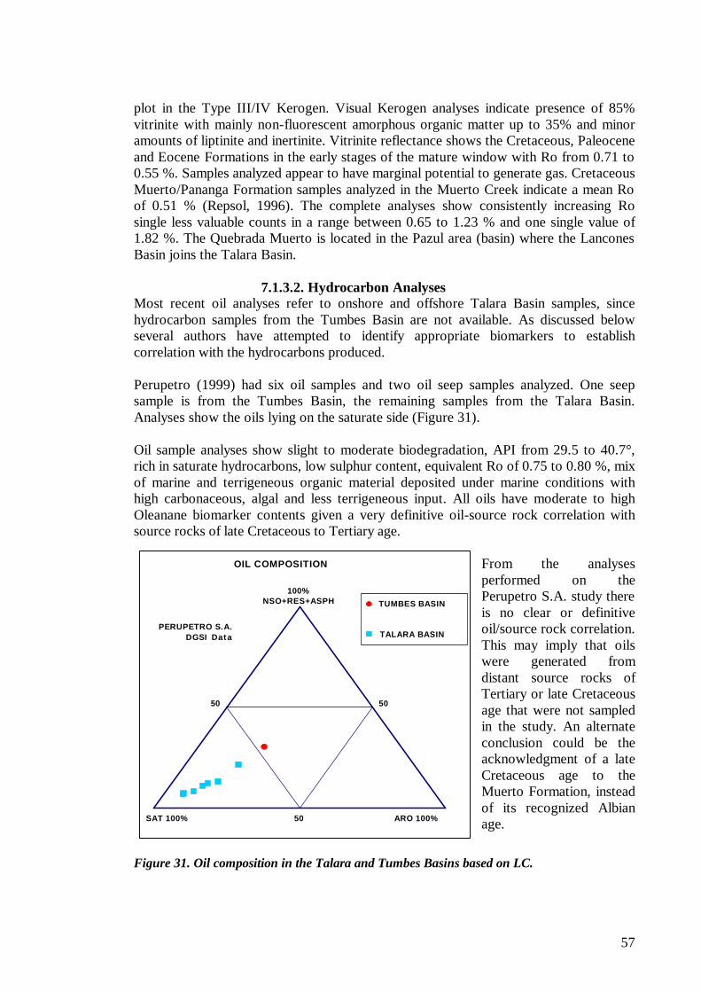
57
Cca. Progreso
Cca. Talara
100%NSO+RES+ASPH
ARO 100%SAT 100%
50 50
50
PERUPETRO S.A.DGSI Data
OIL COMPOSITION
TUMBES BASIN
TALARA BASIN
plot in the Type III/IV Kerogen. Visual Kerogen analyses indicate presence of 85% vitrinite with mainly non-fluorescent amorphous organic matter up to 35% and minor amounts of liptinite and inertinite. Vitrinite reflectance shows the Cretaceous, Paleocene and Eocene Formations in the early stages of the mature window with Ro from 0.71 to 0.55 %. Samples analyzed appear to have marginal potential to generate gas. Cretaceous Muerto/Pananga Formation samples analyzed in the Muerto Creek indicate a mean Ro of 0.51 % (Repsol, 1996). The complete analyses show consistently increasing Ro single less valuable counts in a range between 0.65 to 1.23 % and one single value of 1.82 %. The Quebrada Muerto is located in the Pazul area (basin) where the Lancones Basin joins the Talara Basin.
7.1.3.2. Hydrocarbon Analyses
Most recent oil analyses refer to onshore and offshore Talara Basin samples, since hydrocarbon samples from the Tumbes Basin are not available. As discussed below several authors have attempted to identify appropriate biomarkers to establish correlation with the hydrocarbons produced. Perupetro (1999) had six oil samples and two oil seep samples analyzed. One seep sample is from the Tumbes Basin, the remaining samples from the Talara Basin. Analyses show the oils lying on the saturate side (Figure 31). Oil sample analyses show slight to moderate biodegradation, API from 29.5 to 40.7°, rich in saturate hydrocarbons, low sulphur content, equivalent Ro of 0.75 to 0.80 %, mix of marine and terrigeneous organic material deposited under marine conditions with high carbonaceous, algal and less terrigeneous input. All oils have moderate to high Oleanane biomarker contents given a very definitive oil-source rock correlation with source rocks of late Cretaceous to Tertiary age.
From the analyses performed on the Perupetro S.A. study there is no clear or definitive oil/source rock correlation. This may imply that oils were generated from distant source rocks of Tertiary or late Cretaceous age that were not sampled in the study. An alternate conclusion could be the acknowledgment of a late Cretaceous age to the Muerto Formation, instead of its recognized Albian age.
Figure 31. Oil composition in the Talara and Tumbes Basins based on LC.
58
Crude oils from the Portachuelo field (five samples from wells 4352, 4912, 5237, 5558 and 5942), from the Inca 5-1 well (Sechura Basin, 1 sample) and from the Lagunitos well 6120 have a common organic source with similar thermal maturities (Repsol, 1996). Biomarker analyses and high concentrations of Oleanane suggest a source with mixed organic algal-bacterial-terrigeneous facies of Tertiary age, likely different than oils from offshore seeps in the Trujillo Basin interpreted as derived from source rocks of mixed organic facies rich in marine algal organic matter possibly of late Cretaceous age. Although these statements differentiate Trujillo and Talara oils, it is clearly indicated a potential correlation with a late Cretaceous origin for the Talara oils, since Oleanane biomarkers are also indicative of this age. Geochemical analyses of three oil samples from the Talara Basin wells and one oil seep from Lobos de Afuera Island further south were carried out by UPPPL (1993). The light crude, low sulfur oil samples correlate to a single oil family genetically related to a source rock with strikingly similar Kerogen composition. Differences between them in API gravity and wax paraffin contents reflect post generation history of alterations caused by slight to moderate biodegradation, water washing and weathering. The oil samples are from the Eocene Pariñas Formation in well 3927 in the Llano Field, the Eocene Salina-Mogollon Formation in well 7496 in the Mirador Field and the Paleozoic Amotape Formation in well 5166 in the Portachuelo Field. Oil sample analyses show API from 29.5 to 40.7°, rich in saturate hydrocarbons and low sulphur content. Kerogen contains predominant Type II oil prone marine organic matter deposited under anoxic conditions with terrestrial contribution. Source rocks were in the main phase of oil generation with thermal maturities equivalents to Ro of 0.7 to 0.8-wt%. A scale can be set up with increasing maturity from least maturity observed in the Llano well, more maturity in the Pariñas and Portachuelo oils and most maturity in the Mirador well. A major conclusion is that all three oil samples belong to one oil family with low sulfur content and a well-defined Kerogen Type. Biomarker contents point to a shale source rock with influence of carbonates, a marine deltaic slightly reducing environment superimposed over a marine carbonate platform. This Cretaceous or Paleocene carbonate platform would not be the effective source rocks. Similar basin character has been reported in the Santa Elena Eocene Basin in Ecuador, the Niger Delta in Nigeria, the Indonesian Mahakan delta and in the Angola Congo Delta. The light 36-38º API oils are capable of long distance lateral or vertical migration, a migration supported by their low resin and asphalthene contents. All oils have moderate to high Oleanane biomarker contents given a very definitive oil-source rock correlation with source rocks of late Cretaceous to Tertiary age.
7.1.3.3. Oil Families Current data does not permit to group the different oils into major genetic oil families produced and or tested in the Talara and Tumbes Basins. However, there appears to be a consensus to group all Talara Basin oils into one single oil group possibly one family generated from one single source rock. It is difficult to visualize this single source rock to be present outside the proper Talara Basin, although an oil-source rock correlation from Talara oils to Tumbes Basin source rocks is mentioned and recent Geochemical analyses suggest a Tertiary age, possibly the Heath Formation, as source rocks for the Talara oils.
59
7.1.3.4. Oil-Oil and Oil-Source Rock Correlations Various authors have attempted to establish positive correlation to potential source rocks of the giant oil accumulation in the Talara Basin and of the hydrocarbon occurrences in the Tumbes Basin. These analyses and discussions are also described with some detail above. From the analyses performed on the Perupetro S.A. study there is no clear or definitive oil/source rock correlation. The potential source rocks of Cretaceous to Tertiary age analyzed have not identified them as source rocks to definitely establish a genetic link to the oils analyzed. The biomarker Oleanane is present in all oils analyzed, however, absence of complete similar analyses on most well and surface samples does not allow establishing a definitive oil-source rock correlation. A sample from the Muerto Formation in well Lomitos 3835 in the Talara Basin had a TOC of 3.78 w% Tmax from pyrolysis of 442 ºC, Type II mature Kerogen. LC, GC, isotopes and biomarker analyses on extracts confirm good oil mostly algal marine source rock presently in the oil window with equivalent estimated 0.9-1.0 Ro. The sample shows a very likely Oleanane peak suggesting a source rock/oil correlation with most of the analyzed oils. The Muerto Formation then is the effective source rock in this part of the basin; however, the Albian age of this unit does not correlate with the abundance of the peak identified as Oleanane that suggests a younger age for the unit. Additional similar analyses are still needed to identify biomarkers to confirm positively the regional oil/source rock correlation established locally in the above well. The Oleanane discussion suggests the existence of source rocks of late Cretaceous and/or Tertiary age in distant kitchens implying distant migration routes. The oil discovered in rocks of Paleozoic age in the San Pedro 1X well in the Bayovar Bay this year testifies this case. This may imply that oils were generated from distant source rocks of Tertiary or late Cretaceous age that were not sampled in the study. An alternate conclusion could be the acknowledgment of a late Cretaceous age to the Muerto Formation, instead of its recognized Albian age. The Oleanane age creates a discussion between some of the authors of Geochemical studies in the Talara and Tumbes Basins. Gonzáles and Alarcón (2002) attributes a late Cretaceous age to the abundant presence of Oleanane, supported by “ high resolution Biostratigraphy”, to define the main source rocks as the Redondo Formation. Fildani, et al. (2005) correlates the abundance of this biomarker to only Tertiary age and it goes even further to suggest a correlation to the Heath Formation as the main source rock. More details of these studies are presented in other portions of this report. Mobil (1993) correlates the abundance of this biomarker to a late Cretaceous to Tertiary age and the high heavy isotope composition d13 C derived to mid-Oligocene to younger source rocks. There is also no agreement as to the indications of biomarkers to establish a correlation to a source rock with carbonate contents. Fildani (2005) again rules out the carbonate contents in the source rocks, whereas UPPPL (1993) finds correlation to a source rock with carbonate contents. The potential source rocks with carbonate contents includes the Muerto Formation of Albian age.
60
7.1.3.5. Migration and Remigration of Hydrocarbons Modeling in the Lomitos Field and the distribution of the oil accumulations and potential source rocks in the Talara Basin suggest that the hydrocarbons have followed a local and a regional eastward migration pathway from kitchens in the western offshore portions of the basin to the onshore/offshore Talara Negritos High. The regional implication is that the kitchen areas extend offshore to unexplored areas in deeper water depths than has historically been drilled. Short-range gas and oil migration from deep adjacent depocenters or kitchens known onshore offshore (Lagunitos, Malacas and Siches Grabens) to the north and south of the three major structural highs (Talara-Negritos, Lobitos and El Alto-Peña Negra Highs) is also implied. The recent offshore San Pedro oil discovery announced by PetroTech in the South Talara Basin gives a sound understanding of migration routes. Based on old tests in the offshore Belco’s La Casita 55X well, the area is dry-gas prone in the Cretaceous and Tertiary reservoirs and in the extension of this basin to the onshore Sechura Basin where commercial dry-gas production has been established by Olympic in Block XIII-B. Dry-gas tests in Cretaceous and Tertiary reservoirs and dry-gas prone source rocks in La Casita well also point to a different distant source rock for the San Pedro oil, a source rock that has not been drilled in the area. The other Belco well in the Bayovar Bay SBXA TD’d in the Cretaceous Redondo Formation and was short of drilling a prominent Paleozoic structure some 2Km. to the south with a culmination at 2500 m. subsea. Wells La Casita and SBXA were abandoned in 1975 and 1985, respectively. Remigration is also acknowledged in the Talara Basin caused during extensional faulting and also possibly due to gravity sliding. The tectonism that created the extremely complex normal block faulting occurred after primary migration. Detailed structural work in the basin defines numerous major blocks bounded by sealing normal faults. These major blocks are additionally faulted into smaller blocks where faults are not seals, a condition known for the common oil-water contact affecting all the smaller blocks. Hydrocarbons remigrated within these minor blocks to establish this condition. Adjacent blocks tend to have their own oil-water contacts at different depths. Repetition of large scale wedges caused by gravity sliding is also common, especially on the northern portion of the basin where the Echino Formation and adjacent formations are repeated even three times in some wells. Original hydrocarbon entrapment suffered remigration during this younger gravity phenomenon and it is seen that blocks in shallower wedges have lost original reservoir pressures and very likely have also lost hydrocarbons. As stated on the PARSEP reports “HC remigration is not adequately addressed for the Peruvian oil fields”. At this stage, it is very early in the exploration history of the Tumbes Basin to address the issue of young or old hydrocarbon recharge or migration patterns caused by remigration. It is a fact that with more than one petroleum system and the several tectonic episodes affecting the basin the presence of mixed petroleum systems cannot be ruled out.
7.1.3.6. Hydrocarbon Kitchens The interpreted tectonic, geologic history, geohistory modeling, oil occurrences and production data point towards the presence of more than one hydrocarbon kitchen, very likely representing major separate kitchens for the Talara and Tumbes Basins and

61
possibly a commingled kitchen where the two basins join and share common geologic events. The hydrocarbon kitchen(s) is (are) interpreted to be more likely present along the western deep and/or offshore portions of the whole Talara Basin or local depocenters where source rocks with adequate organic contents have reached best maturity conditions. Measured vitrinite maturities in the Cretaceous and Tertiary sections mostly do not exceed the late maturity oil window. Source rocks of early Tertiary or Upper Cretaceous age reached a late maturity stage and generated hydrocarbons from late Eocene to early Oligocene time in the Talara Basin. Hydrocarbons were expelled to the east into offshore/onshore traps possibly former anticlines? during Oligocene time before major tectonics faulted the original traps into smaller blocks with sealing faults. Younger age tectonics faulted larger individual blocks into even smaller blocks many of which were downthrown keeping their original oil-water levels at deeper depths. It is emphasized here the nature of the numerous major faulted blocks bounded by normal faults with sealing capacity, all these faulted blocks remained in a virgin state with sealed pressures. A scenario with post-Oligocene source rocks that sourced the hydrocarbons accumulation in the Talara Basin was hard to visualize since 1) they could have hardly reached the oil window stage for lack of appropriate burial depth and 2) a long distance hydrocarbons migration from source rocks in the deep Tumbes Basin must have encountered numerous sealing fault barriers. Oil discovery in Block Z-2B announced recently by Petrotech contrasts with Geochemical data and Basin Modeling in the Bayovar Bay, an area where the South Talara Basin merges with the Sechura Basin. Integration of available data from La Casita 55X and SBXA wells and the San Pedro discovery establishes a long hydrocarbon migration route from pre-Tertiary source rocks possibly of Cretaceous age in hydrocarbon kitchens very likely located to the westernmost portions of the Bayovar Bay. This same condition is the rule in the proper Talara Basin to the north and other Peruvian basins.
7.1.3.7. Hydrocarbon Occurrences and Petroleum Systems The late Cretaceous to early Eocene stratigraphic section includes the most likely source rock of the major petroleum system that accounts for the giant oil accumulation in the onshore and offshore Talara Basin. There are questions that remain to be answered as the correct identification of the main source rock and kitchens in the basin. This main Talara Petroleum System extends from the South Talara Basin in the Bayovar Bay (with the recent oil discovery in well San Pedro 1X) to the North Talara Basin possibly up to the Piedra Redonda-Zorritos Horst area. This petroleum system includes secondary and/or combined petroleum systems with multiple reservoirs present in the whole Cretaceous and Eocene sandstones and in the Paleozoic metamorphic sediments. The most prolific oil accumulations in the numerous oil fields are found in reservoirs of Eocene age. This common source rock that generated the oil accumulated in the Cretaceous-Eocene reservoirs is also responsible for feeding the petroleum system defined with reservoirs in Paleozoic reservoirs. Three prolific oil accumulations of this petroleum system are widely distributed in the Talara Basin from Laguna in the north, Portachuelo in the south both sealed by Cretaceous shales and further to the south in the recent San Pedro oil discovery.
62
The potential source rocks of possible Talara Shale age in the Mancora town area in the north Talara Basin will be investigated with more detail. Presence of coarse-grained sandstones and conglomerates within this shale unit are attributed to some still undated deep-sea turbidite deposits. Under favorable conditions the Talara Shale may proved to be a self-contained petroleum system in this portion of the basin. In the Talara Basin to the south, the Talara Shale unit is brown colored and it includes some turbidite units with good reservoir character, as the Helico Member in the Carrizo Field. However, most of the Eocene sequence lacks source rock potential onshore and in the shallow offshore platform.
7.1.3.8. Reservoirs, Seals and Traps The main oil and gas reservoirs are sandstones interbedded with shale seals in the complete Eocene sequence. The Salina, Negritos, Lobitos and Lagunitos Groups consist of fluvial, deltaic to nearshore marine sandstones. Main producing formations include the Basal Salina, Mogollon, Pariñas Formation, Cabo Blanco and Echinocyamus Formations of Early Eocene age. The Middle and Late Eocene Talara Group include sandstone reservoirs in the Terebratula, Helico, Talara and Verdun Formations. Few fields (Laguna, Portachuelo among others) produce oil and gas from fractured quartzites of the Amotape Formation. Cretaceous production is found in four fields in sandstones and conglomerates of the Redondo, Ancha and the Petacas Formations. Two fields produce from shallow-marine sandstones of the Mesa and Balcones Formations of Paleocene age. It should be noted that slight oil shows were recorded in untested Paleozoic intervals in the offshore Chira sub-basin bordering the Paita High in the South Talara Basin. The short Paleozoic interval drilled between 1965 and 2040 ft in well PHX A consists of 70% gray sandstone and quartzite, with fine to medium grains: 20% white sandstone, occasional green gray, medium to coarse grains, 10% metamorphic rocks. This section had traces of fluorescence bright yellow. The RCX3-15X well had occasional oil shows in cuttings from the Amotape with some fast streaming fluorescence and cut. Primary seals are interbedded and overlying marine shales. Hydrocarbons fields are normally found as numerous block-faulted traps caused mainly by extensional structural normal faulting in the onshore and offshore Talara Basin. Other faulting includes low-angle gravitational slide faults and large vertical transcurrent faults. 7.1.4. Tumbes Basin
7.1.4.1. Sample Analyses Geochemical analyses were performed on surface samples from the following units in the Tumbes Basin (Perupetro, 1999).
? ? Cardalitos Middle Miocene ? ? Mancora Late Oligocene-Early Miocene ? ? Heath Early Miocene
Outcrops samples from some levels of the Heath Formation are the only rocks found with good potential hydrocarbons generative capability under more mature conditions. These samples have TOC of 2.61 and 1.78 wt% with good S2 pyrolysis peaks, immature Tmax 415 and 412 ºC derived from pyrolysis, amorphous organic material
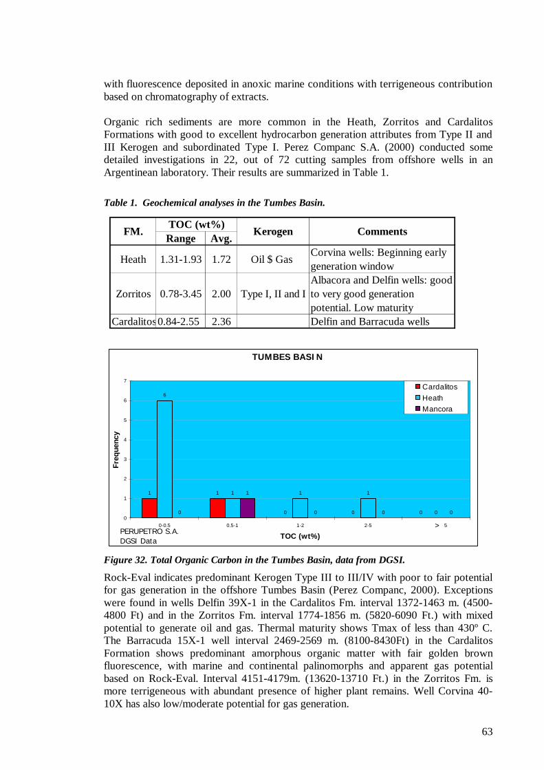
63
TUMBES BASIN
1 1
0 0 0
6
1 1 1
00
1
0 0 00
1
2
3
4
5
6
7
0-0.5 0.5-1 1-2 2-5 más de 5
TOC (wt%)
Freq
uenc
y
CardalitosHeathMancora
PERUPETRO S.A.DGSI Data
>
with fluorescence deposited in anoxic marine conditions with terrigeneous contribution based on chromatography of extracts. Organic rich sediments are more common in the Heath, Zorritos and Cardalitos Formations with good to excellent hydrocarbon generation attributes from Type II and III Kerogen and subordinated Type I. Perez Companc S.A. (2000) conducted some detailed investigations in 22, out of 72 cutting samples from offshore wells in an Argentinean laboratory. Their results are summarized in Table 1.
Table 1. Geochemical analyses in the Tumbes Basin.
Figure 32. Total Organic Carbon in the Tumbes Basin, data from DGSI.
Rock-Eval indicates predominant Kerogen Type III to III/IV with poor to fair potential for gas generation in the offshore Tumbes Basin (Perez Companc, 2000). Exceptions were found in wells Delfin 39X-1 in the Cardalitos Fm. interval 1372-1463 m. (4500-4800 Ft) and in the Zorritos Fm. interval 1774-1856 m. (5820-6090 Ft.) with mixed potential to generate oil and gas. Thermal maturity shows Tmax of less than 430º C. The Barracuda 15X-1 well interval 2469-2569 m. (8100-8430Ft) in the Cardalitos Formation shows predominant amorphous organic matter with fair golden brown fluorescence, with marine and continental palinomorphs and apparent gas potential based on Rock-Eval. Interval 4151-4179m. (13620-13710 Ft.) in the Zorritos Fm. is more terrigeneous with abundant presence of higher plant remains. Well Corvina 40-10X has also low/moderate potential for gas generation.
Range Avg.
Heath 1.31-1.93 1.72 Oil $ Gas Corvina wells: Beginning early generation window
Zorritos 0.78-3.45 2.00 Type I, II and IAlbacora and Delfin wells: good to very good generation potential. Low maturity
Cardalitos0.84-2.55 2.36 Delfin and Barracuda wells
TOC (wt%)Kerogen CommentsFM.
64
TUMBES BASIN
10
10 0
2
0 0 0 0
43
2
0 01
0 0 0 0
9
4
2 23
22
20
25
2
0
21
0 0 0
9
54
10
5
21
0 0
3
0 0 0 0
14
5
10 0
21
0 0 01 1
0 0 01
2 2
0 00
5
10
15
20
25
30
0-0.5 0.5-1 1-2 2-5 más de 5
TOC (wt%)
Freq
uenc
yPlio-Pleist.PliocenoCardalitosCardalitos-ZorritosZorritosHeathHeath-MancoraMancoraChiraVerdúnGr. TalaraChacraPalegredaGr. Salina
PERUPETRO S.A.PREVIOUS REPORTS
>
Figure 33. Total Organic Carbon in the Tumbes Basin, data Perupetro Files.
Shallow formations in the offshore Tumbes Basin also show high organic content as in well Albacora 8X-1 (Sunmark, 1978). TOC’s from 12 shale and clay samples from the Pliocene La Cruz and from 14 samples from the upper Miocene Mal Pelo average 2.81 and 0.81 wt%, respectively. Although organically rich and with excellent oil potential these formations were found thermally marginally immature for the generation and migration of liquid hydrocarbons. Previous analyses by Graña y Montero Petrolera S.A. and American International Company also found TOC highest average of 2.78 wt% in Zorritos from samples in the entire section of the Tumbes Basin. Other older reports as in the onshore well RT-65 indicate that the dark fine-grained shales of the Heath Formation from 3990 to 4320 m (13,090-14,180 Ft) may be source for oil and associated gas. TOC varies from 1 to 2wt%. This same interval may be considered a better source potential for oil and associated gas and/or gas alone in a deeper portion of the basin (ESSO, 1967). In summary, the Mancora and Heath Formations in the Tumbes Basin have potential to generate hydrocarbons. Data analyses from these source rocks from the sampled sites of both formations indicate that they are not mature enough. Hydrocarbons occurrences and thermal maturity, however, suggests existence of adjacent effective source rocks in kitchen areas with deep depocenters.
7.1.4.2. Hydrocarbon Analyses The Tumbes Basin lacks gas analyses to determine its origin, generation and correlation with potential source rocks. Previous reported analyses show gas composition with near 98% methane and 2% of ethane, propane and CO2 in the Piedra Redonda and Corvina gas wells.
65
7.1.4.3. Oil Families Current data does not permit to group the different oils into major genetic oil families produced and or tested in the Talara and Tumbes Basins.
7.1.4.4. Migration and Remigration of Hydrocarbons A more complex migration pattern is interpreted in the Tumbes Basin due the presence of more complex petroleum systems to account for all the hydrocarbons in the basin. Basin modeling emphasizes the presence of the hydrocarbons kitchens in the deepest undrilled portions of the Tumbes Basin bordering to the southeast and south of the Banco Peru. At depths of 4.5 sec. the three or four main potential source rocks have generated oil and gas. Hydrocarbons migration then occurred from these kitchens into the shallow offshore platform and to the onshore basin to the east and northeast where drilling has proved the hydrocarbons presence. Lateral migration distances of less than 50 km from the main kitchen areas or even shorter distances from local kitchens controlled by the complex fault systems is established. This HC migration pathway takes into account the lack of maturity conditions observed in all potential organic reach source rocks defined in the offshore and onshore well cuttings and outcrops. Vertical migration from pre-Mancora sequences, possibly of Eocene age, is also an additional source for some of the hydrocarbons tested in the offshore Tumbes Basin. Well Delfin 39-1X drilled to a TD of 2500 m. encountered the Zorritos and Heath Formations at 1550 and 2200 m., respectively, and tested pure oil from both formations and gas in the Zorritos Formation. Similarly, some oil was also tested in addition to the gas in Piedra Redonda. These two structures have potential to have received some of their hydrocarbons through vertical migration pathways. A recent paper defined the dry gas occurrence in the Amistad Gas Field in Ecuador just across the Peru-Ecuador border and north of the Albacora Oil Field as being biogenic in origin (Deckelman, et.al., 2005). As stated on the PARSEP reports “HC remigration is not adequately addressed for the Peruvian oil fields”. At this stage, it is very early in the exploration history of the Tumbes Basin to address the issue of young or old hydrocarbon recharge or migration patterns caused by remigration. It is a fact that with more than one petroleum system and the several tectonic episodes affecting the basin the presence of mixed petroleum systems cannot be ruled out.
7.1.4.5. Hydrocarbon Kitchens The interpreted tectonic, geologic history, geohistory modeling, oil occurrences and production data point towards the presence of more than one hydrocarbon kitchen, very likely representing major separate kitchens for the Talara and Tumbes Basins and possibly a commingled kitchen where the two basins join and share common geologic events. A more complex scenario is present for the hydrocarbon kitchens in the offshore Tumbes Basin. Source rocks and reservoirs are present in most of the stratigraphic column in the onshore and the shallow offshore wells drilled in the Tumbes Basin. Oil and gas were produced and tested in the Zorritos Formation in the Albacora field, pure oil was also produced and tested in the Heath and Zorritos Formations in the Delfin well, oil was tested in the Cardalitos Formation in the Barracuda well and pure gas was
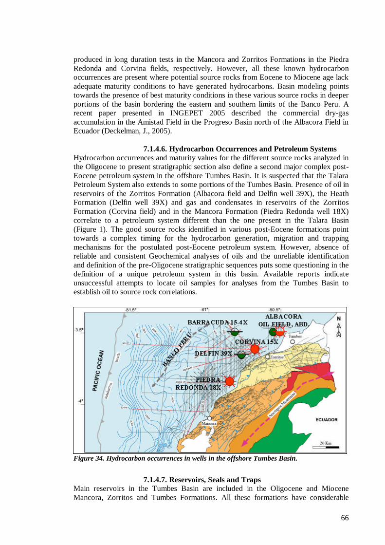
66
produced in long duration tests in the Mancora and Zorritos Formations in the Piedra Redonda and Corvina fields, respectively. However, all these known hydrocarbon occurrences are present where potential source rocks from Eocene to Miocene age lack adequate maturity conditions to have generated hydrocarbons. Basin modeling points towards the presence of best maturity conditions in these various source rocks in deeper portions of the basin bordering the eastern and southern limits of the Banco Peru. A recent paper presented in INGEPET 2005 described the commercial dry-gas accumulation in the Amistad Field in the Progreso Basin north of the Albacora Field in Ecuador (Deckelman, J., 2005).
7.1.4.6. Hydrocarbon Occurrences and Petroleum Systems Hydrocarbon occurrences and maturity values for the different source rocks analyzed in the Oligocene to present stratigraphic section also define a second major complex post-Eocene petroleum system in the offshore Tumbes Basin. It is suspected that the Talara Petroleum System also extends to some portions of the Tumbes Basin. Presence of oil in reservoirs of the Zorritos Formation (Albacora field and Delfin well 39X), the Heath Formation (Delfin well 39X) and gas and condensates in reservoirs of the Zorritos Formation (Corvina field) and in the Mancora Formation (Piedra Redonda well 18X) correlate to a petroleum system different than the one present in the Talara Basin (Figure 1). The good source rocks identified in various post-Eocene formations point towards a complex timing for the hydrocarbon generation, migration and trapping mechanisms for the postulated post-Eocene petroleum system. However, absence of reliable and consistent Geochemical analyses of oils and the unreliable identification and definition of the pre-Oligocene stratigraphic sequences puts some questioning in the definition of a unique petroleum system in this basin. Available reports indicate unsuccessful attempts to locate oil samples for analyses from the Tumbes Basin to establish oil to source rock correlations.
Figure 34. Hydrocarbon occurrences in wells in the offshore Tumbes Basin.
7.1.4.7. Reservoirs, Seals and Traps
Main reservoirs in the Tumbes Basin are included in the Oligocene and Miocene Mancora, Zorritos and Tumbes Formations. All these formations have considerable
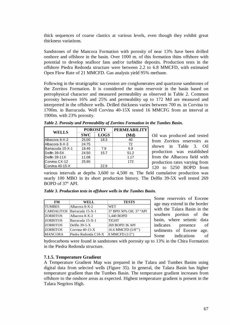
67
FM WELL TESTSTUMBES Albacora 8-X-2 WETCARDALITOS Barracuda 15-X-1 37 BPD 50% OIL 37 °APIZORRITOS Albacora 8-X-2 1,440 BOPDZORRITOS Barracuda 15-X-1 TIGHTZORRITOS Delfín 39-5-X 269 BOPD 36 APIZORRITOS Corvina 40-15-X 16.6 MMCFD (5/8"")MANCORA Piedra Redonda C18-X 8 MMCFD (1/2")
SWC LOGSAlbacora 8-X-2 25.00 18.3 40Albacora 8-X-3 24.75 72Barracuda 15-X-1 18.46 7.9 6.9Delfin 39-5X 24.50 15.7 51.2Delfin 39-11X 11.08 1.17Corvina CX-12 25.90 172Corvina 40-15-X 22.9
POROSITYWELLS PERMEABILITY
(Md)
thick sequences of coarse clastics at various levels, even though they exhibit great thickness variations. Sandstones of the Mancora Formation with porosity of near 13% have been drilled onshore and offshore in the basin. Over 1000 m. of this formation thins offshore with potential to develop seafloor fans and/or turbidite deposits. Production tests in the offshore Piedra Redonda structure were between 2.2 to 6.8 MMCFD, with estimated Open Flow Rate of 21 MMCFD. Gas analysis yield 95% methane. Following in the stratigraphic succession are conglomerates and quartzose sandstones of the Zorritos Formation. It is considered the main reservoir in the basin based on petrophysical character and measured permeability as observed in Table 2. Common porosity between 16% and 25% and permeability up to 172 Md are measured and interpreted in the offshore wells. Drilled thickness varies between 700 m. in Corvina to 1700m. in Barracuda. Well Corvina 40-15X tested 16 MMCFG from an interval at 1900m. with 23% porosity.
Table 2. Porosity and Permeability of Zorritos Formation in the Tumbes Basin.
Oil was produced and tested from Zorritos reservoirs as shown in Table 3. Oil production was established from the Albacora field with production rates varying from 120 to 5250 BOPD from
various intervals at depths 3,600 to 4,500 m. The field cumulative production was nearly 100 MBO in its short production history. The Delfin 39-5X well tested 269 BOPD of 37º API.
Table 3. Production tests in offshore wells in the Tumbes Basin.
Some reservoirs of Eocene age may extend in the border with the Talara Basin in the southern portion of the basin, where seismic data indicates presence of sediments of Eocene age. Some indications of
hydrocarbons were found in sandstones with porosity up to 13% in the Chira Formation in the Piedra Redonda structure. 7.1.5. Temperature Gradient A Temperature Gradient Map was prepared in the Talara and Tumbes Basins using digital data from selected wells (Figure 35). In general, the Talara Basin has higher temperature gradient than the Tumbes Basin. The temperature gradient increases from offshore to the onshore areas as expected. Highest temperature gradient is present in the Talara Negritos High.
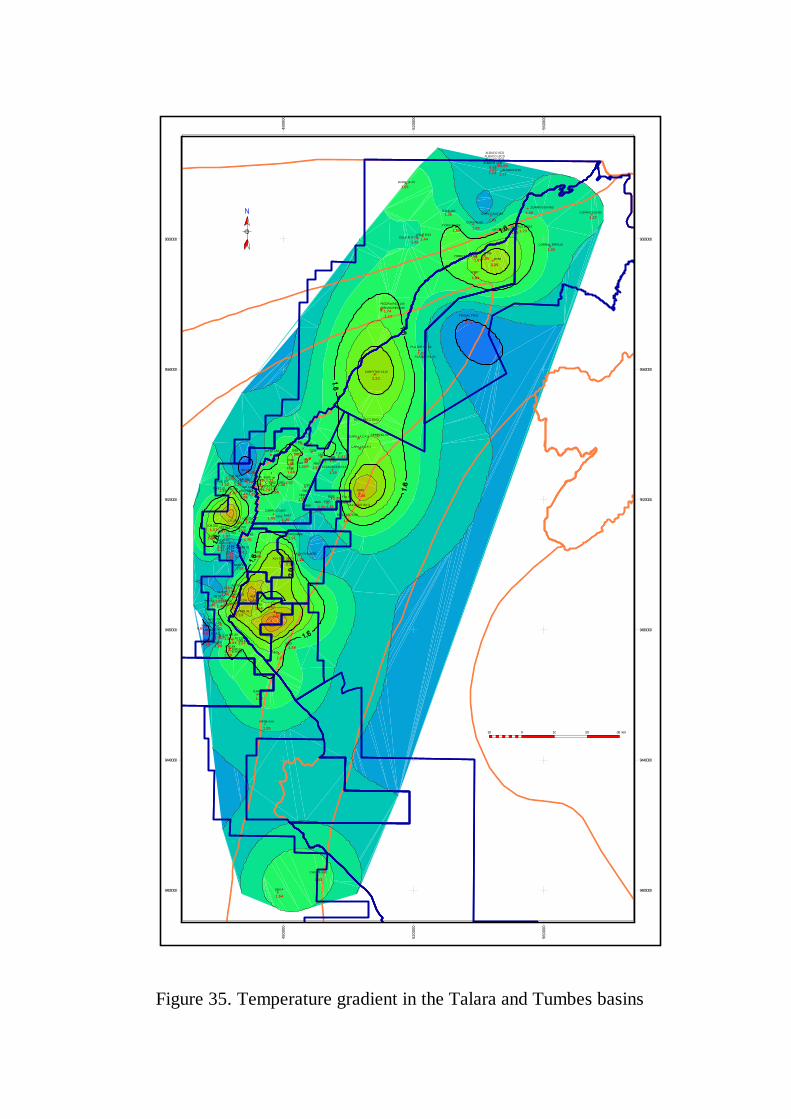
CORV 40 10X
1.66
DELF B 11CD
1.35
38351.64
ALV OVE 3885
2.26
40001.67
40152.81
41202.64
4690
1.30
ALBACO 12CD
0.89
FONDO 48001.51
ALV OVE 4835
1.22
48751.66
5080
1.25MISC SAL 5135
1.64
53251.49
5340
1.35
55051.36
5565
1.72
H7 X3
1.70LO10-7X
1.11
PIEDRA RED 14X
1.74
CX12 16X1.36
1540
1.5715451.62
15551.85
15701.74
1740
1.68
1860
1.40
18651.46
18751.80
19101.30
CORV CX13 18X
1.03
20101.85
PIEDRA RED 13X
1.17
2239
PLATER PL X2
1.37
131
PLATER PL X3
5630
1.535655
1.53
56651.89
5668
1.53
56801.32
CORRAL EPRCX1
1.35
TRIGAL TRX1
0.79
ZORRITOS 5200
1.27
LA CRUZ Z52051.55
LA CRUZ Z5215
1.73
ALBACO 8 3C1.17
DD 12X
1.44
EE X31.54
CC X151.07
CASITA 55X
1.53
SICH 61X
LL 1151.34
A1 5X
1.74
A5 9X1.57
XX 11X0.55
A4 19X
1.45
A3 22X1.67
LO1 9X2.51
EX6 2XEX6 8X
1.79
EX6 6X
1.77
PN1 12X
LO3 22X1.07
EX4 15X
1.52
1.18
PVX8 13X1.991.53
MLX9 15X1.08
A1 8X
1.55
PVX13 6
2.06
NHX1 19X1.25
PN2 8X1.87
LT8 11X
1.84
NHX1 7X
1.32
A1 6X
0.78
NHX 20.78
NHX 60.67
NHX 51.28
NHX 7
0.54
NHX 40.61
LO6 13X1.84
LO10 20A1.28
LO5 13X1.43
BARR 15 4X
1.55
PN3 11X1.34
PN8 17X1.52
ORXA 13X
1.33
PV15 101.63
P26B X12.13
1.10
6B X1
1.461.57
7B X11.46
8A X1
1.590.64
B 3 X4
7B X2
1.08
H9A X1
0.91
H5S X101.53
AA 18X0.99
SBX A
1.54
BARRANCO BAX1
CEREZAL CEX1
CAPILLA CX 1
CAPILLA CX 2
OLLOCOS OX- 2
T14 1
1.64
53801.67
6035
2.46
CARPITAS C115
2.23
T 171.41
CORV 41 6X
1.26
TX 35 1.42
1725
1855
1.24
1940
1.49
CARRIZO 1980
1.48
DELF B 5X
1.44
6060
AX25
1.20
ALBACO 7CD
1.23
ATASCADERO 1X
1.19
NPXB-24X
1.25
ZORRITOS RT481.87 RT50
2.20
ALBACO 8CD
1.13
RT59
2.05
ALBACO 9CD
1.14
ZORRITOS RT65
1.29
RX67
1.84
9400000 9400000
9440000 9440000
9480000 9480000
9520000 9520000
9560000 9560000
9600000 9600000
4800
0048
0000
5200
0052
0000
5600
0056
0000
10 0 10 20 30 km
Figure 35. Temperature gradient in the Talara and Tumbes basins
69
7.1.6. Geochemical Analysis. Sea Bottom Microbial Geochemical Analysis Petrotech in Block Z-2B conducted Sea Bottom Microbial Geochemical Analysis. Information gathered by this method was rated as successful as it confirmed prospectivity previously detected in the area by seismic and Airmagnetometry and Air gravity studies. Two hundred and seven samples (out of 311 attempts) were recovered in a program run in the offshore Paita High area in the southern half of Block Z-2B in 1999. Samples consisted of 3-6’ taken at distances between 1 and 2 km. in water depths of 50 to 500’.
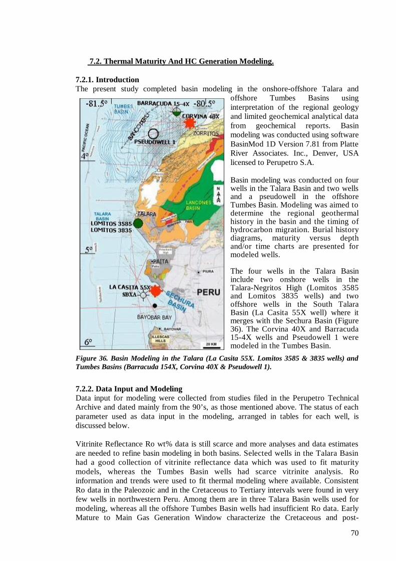
70
7.2. Thermal Maturity And HC Generation Modeling. 7.2.1. Introduction The present study completed basin modeling in the onshore-offshore Talara and
offshore Tumbes Basins using interpretation of the regional geology and limited geochemical analytical data from geochemical reports. Basin modeling was conducted using software BasinMod 1D Version 7.81 from Platte River Associates. Inc., Denver, USA licensed to Perupetro S.A. Basin modeling was conducted on four wells in the Talara Basin and two wells and a pseudowell in the offshore Tumbes Basin. Modeling was aimed to determine the regional geothermal history in the basin and the timing of hydrocarbon migration. Burial history diagrams, maturity versus depth and/or time charts are presented for modeled wells. The four wells in the Talara Basin include two onshore wells in the Talara-Negritos High (Lomitos 3585 and Lomitos 3835 wells) and two offshore wells in the South Talara Basin (La Casita 55X well) where it merges with the Sechura Basin (Figure 36). The Corvina 40X and Barracuda 15-4X wells and Pseudowell 1 were modeled in the Tumbes Basin.
Figure 36. Basin Modeling in the Talara (La Casita 55X. Lomitos 3585 & 3835 wells) and Tumbes Basins (Barracuda 154X, Corvina 40X & Pseudowell 1).
7.2.2. Data Input and Modeling Data input for modeling were collected from studies filed in the Perupetro Technical Archive and dated mainly from the 90’s, as those mentioned above. The status of each parameter used as data input in the modeling, arranged in tables for each well, is discussed below. Vitrinite Reflectance Ro wt% data is still scarce and more analyses and data estimates are needed to refine basin modeling in both basins. Selected wells in the Talara Basin had a good collection of vitrinite reflectance data which was used to fit maturity models, whereas the Tumbes Basin wells had scarce vitrinite analysis. Ro information and trends were used to fit thermal modeling where available. Consistent Ro data in the Paleozoic and in the Cretaceous to Tertiary intervals were found in very few wells in northwestern Peru. Among them are in three Talara Basin wells used for modeling, whereas all the offshore Tumbes Basin wells had insufficient Ro data. Early Mature to Main Gas Generation Window characterize the Cretaceous and post-
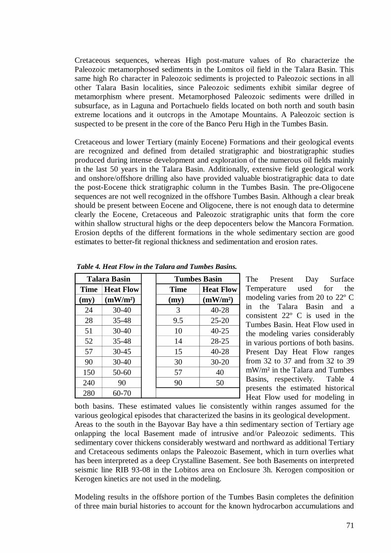
71
Time Heat Flow Time Heat Flow(my) (mW/m²) (my) (mW/m²)
24 30-40 3 40-2828 35-48 9.5 25-2051 30-40 10 40-2552 35-48 14 28-2557 30-45 15 40-2890 30-40 30 30-20150 50-60 57 40240 90 90 50280 60-70
Tumbes BasinTalara Basin
Cretaceous sequences, whereas High post-mature values of Ro characterize the Paleozoic metamorphosed sediments in the Lomitos oil field in the Talara Basin. This same high Ro character in Paleozoic sediments is projected to Paleozoic sections in all other Talara Basin localities, since Paleozoic sediments exhibit similar degree of metamorphism where present. Metamorphosed Paleozoic sediments were drilled in subsurface, as in Laguna and Portachuelo fields located on both north and south basin extreme locations and it outcrops in the Amotape Mountains. A Paleozoic section is suspected to be present in the core of the Banco Peru High in the Tumbes Basin. Cretaceous and lower Tertiary (mainly Eocene) Formations and their geological events are recognized and defined from detailed stratigraphic and biostratigraphic studies produced during intense development and exploration of the numerous oil fields mainly in the last 50 years in the Talara Basin. Additionally, extensive field geological work and onshore/offshore drilling also have provided valuable biostratigraphic data to date the post-Eocene thick stratigraphic column in the Tumbes Basin. The pre-Oligocene sequences are not well recognized in the offshore Tumbes Basin. Although a clear break should be present between Eocene and Oligocene, there is not enough data to determine clearly the Eocene, Cretaceous and Paleozoic stratigraphic units that form the core within shallow structural highs or the deep depocenters below the Mancora Formation. Erosion depths of the different formations in the whole sedimentary section are good estimates to better-fit regional thickness and sedimentation and erosion rates.
Table 4. Heat Flow in the Talara and Tumbes Basins.
The Present Day Surface Temperature used for the modeling varies from 20 to 22º C in the Talara Basin and a consistent 22º C is used in the Tumbes Basin. Heat Flow used in the modeling varies considerably in various portions of both basins. Present Day Heat Flow ranges from 32 to 37 and from 32 to 39 mW/m² in the Talara and Tumbes Basins, respectively. Table 4 presents the estimated historical Heat Flow used for modeling in
both basins. These estimated values lie consistently within ranges assumed for the various geological episodes that characterized the basins in its geological development. Areas to the south in the Bayovar Bay have a thin sedimentary section of Tertiary age onlapping the local Basement made of intrusive and/or Paleozoic sediments. This sedimentary cover thickens considerably westward and northward as additional Tertiary and Cretaceous sediments onlaps the Paleozoic Basement, which in turn overlies what has been interpreted as a deep Crystalline Basement. See both Basements on interpreted seismic line RIB 93-08 in the Lobitos area on Enclosure 3h. Kerogen composition or Kerogen kinetics are not used in the modeling. Modeling results in the offshore portion of the Tumbes Basin completes the definition of three main burial histories to account for the known hydrocarbon accumulations and
72
FM. TOP M. Ro%Gr. Mal Paso 151 0.74Gr. Mal Paso 167 0.75Gr. Mal Paso 1036 0.62Gr. Mal Paso 1311 0.71Gr. Mal Paso 1692 0.74Gr. Mal Paso 1783 0.74Monte Grande 1859 0.80Monte Grande 2073 0.80
Redondo 2286 0.89Redondo 2362 0.90Redondo 2545 0.90Muerto 2609 0.93Muerto 2621 0.97Muerto 2637 0.96
TD 2763
Well Sandino 6020
occurrences in the North western coastal basins in Peru. The oldest burial history of pre-Cretaceous age is recognised in the Talara Basin where it is masked by metamorphism of the Paleozoic sequences and by the unknown both geological history and of the complete stratigraphic column and geological events of lower Mesozoic and Paleozoic ages. Post-maturation of the pre-Cretaceous section accounts for the high vitrinite reflectance Ro ranging from 3.8 to 5.0 wt% found in Paleozoic sediments in the onshore South Talara Basin. Paleozoic sediments are known to present different degrees of metamorphism in north western Peru. No hydrocarbons of Paleozoic age are recognized nor interpreted to be present in the study area of the Talara and Tumbes Basins. A second major burial episode is reflected in the existing Cretaceous to Eocene sequences in the Talara Basin. 7.2.3. Talara Basin The burial modeling performed in the Talara Basin outlines the regional maturity conditions of the source rock sequences of Paleozoic, Mesozoic and Cenozoic ages. Lack of sufficient data does not allow preparing of regional maps of the modeled maturities in the Basin. Most of the stratigraphic section in the Talara Basin was subjected to continuous burial and subsequent maturation during Cretaceous to Oligocene time. This maturation history is superimposed on an old pre-Cretaceous maturation burial of a thick Paleozoic section and an unknown Lower Mesozoic section regionally identified underlying the Cenozoic section of the Basin.
Table 5. Well Sandino 6020 in the Talara Basin.
Modeling was performed in four wells including the onshore Lomitos 3585 and Lomitos 3835 wells located on the Talara Negritos High within current Block VII and the offshore La Casita 55X and SBX-A wells located on current Block Z-2AB operated by SAPET and PetroTech, respectively, all in the south Talara Basin. The Lomitos wells are located on the onshore Talara-Negritos High, whereas offshore wildcats La Casita 55X and SBX-A were drilled in the Bayovar Bay in the South Talara Basin where it merges with the Sechura Basin. These two wells are located 25 Km north and 20 Km NW of well San Pedro 1X, the recent 35° API oil discovery by PetroTech. Vitrinite reflectance data reveals the original presence of an important post-Eocene overburden to account for the extrapolated maturity values encountered in the Talara Negritos High. In
addition to the Lomitos well, the Sandino 6020 well has similar Ro data to place the Paleocene and Cretaceous sections within the oil window as shown in Table 5. The San Pedro 1X oil discovery in Block Z-2B by PetroTech contrasts with Geochemical results and Basin Modeling conducted in wells SBX-A and La Casita
73
FM OR EVENT NAMEEVENT TYPE
BEGIN AGE (my)
TOP (m)
THICKNESS (m)
TABLAZO F 1.6 5 19EROSION8 E 10HEATH/MANCORA ERODED D 25EROSION7 E 32C.HILL/MIRADOR/CHIRA/VERD D 40EROSION6 E 41TALARA SHALE ERODED D 42TALARA SHALE F 52 24 500EROSION5 E 53CHACRA/PAR ERODED D 55PALEGREDA/SALINA F 57 524 223EROSION4 E 58BALCONES ERODED D 59BALCONES F 62 747 379MESA F 65 1126 252EROSION3 E 66.4PETACAS/ANCHA ERODED D 68PETACAS/ANCHA F 74 1378 795REDONDO F 83 2173 281EROSION2 E 90MUERTO ERODED D 95MUERTO/PANANGA F 112 2454 114HIATUS H 245EROSION1 E 256AMOTAPE ERODED D 308AMOTAPE F 322.8 2568 300
WELL LOMITOS 3585
55X. This discovery and burial modeling interpretation establish a long hydrocarbon migration path in this part of the basin as in other Peruvian basins. Well SBXA found dry gas (Methane) on top of both the Eocene Salina Formation and on the top of Cretaceous Monte Grande Formation sealed by shales of the Talara and Mal Paso (Balcones?) Formations respectively. The La Casita 55X well with its dry-gas tests is more likely located in a hydrocarbon kitchen related to the onshore Sechura Basin, where dry-gas accumulations were discovered in the 50’s by IPC. This discovery was followed by additional dry-gas discoveries in the exploration campaign in the 90’s by Olympic in current Block XIII-B, where a commercial gas project is under development.
7.2.3.1. Well Lomitos 3585, Negritos Talara High The Lomitos 3585 well was drilled to a total depth of 2595m. in the Amotape Formation. The stratigraphic section penetrated and geological events are presented in Table 6.
Table 6. Well Lomitos 3585 in the Talara Basin.
Current modeling in the Lomitos 3585 well on the Negritos Talara High adds additional value to the previous modeling performed by Perupetro S.A (Perupetro, 1999) in this well. The burial history Time Vs. Depth diagram on Figure 37 shows two major burial episodes of pre-Cretaceous and post-Cretaceous ages. The former burial is less known, whereas a continuous deposition marks the post-Cretaceous burial episode from late Cretaceous, Paleocene to early Eocene time. An erosion event took place during middle Eocene followed by thick deposition until late Eocene and an erosive event in the late
Eocene to mid-Oligocene. The maturity data show most of the pre-Mesa section frozen in the “oil window”. The Cretaceous source rocks entered the Early Mature Window during Paleocene and the Mid and Late Mature Windows since late Eocene, where they are at present time. Potential source rocks of early Tertiary age entered the Early Mature Window since late Paleocene time, where they are also at present time. The Talara Group reached the Early Mature Window. The Maturity vs. Depth diagram on Figure 38 supports this model, as seen by the agreement with the measured vitrinite reflectance in the pre- and post Cretaceous burials. The calculated curve is a best fit with the measured vitrinite reflectance data.
74
Figure 37. Pre- Cretaceous and post-Cretaceous Maturity burials in the Lomitos 3585 Well.
Figure 38. Post-Cretaceous Maturity burial in the Lomitos 3585 Well.
75
The Lagunitos Graben to the south of the Talara Negritos High is considered one of the onshore kitchens for the Talara Basin. Basin modeling in this deep through must consider preservation of a complete Eocene section in excess of 7,500 m. in addition to the sediments of Paleocene and Cretaceous age. Presence of rich gas is known to occur in the north and south borders of the graben. Based on the Time Vs. Depth burial chart of Figure 38 the source rocks at well Lomitos at the Negritos Talara High were already in the main phase of the oil window and were generating and expulsing oil before uplift and major block faulting. This area acted as an oil kitchen since the late Eocene and this stage was frozen after the uplift that stripped off most of the post-Talara sediments.
Figure 39. Maturity Vs. Depth. 1D Modeling in the Negritos High in the Talara Basin.
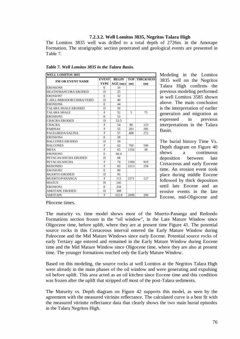
76
FM OR EVENT NAMEEVENT TYPE
BEGIN AGE (my)
TOP (m)
THICKNESS (m)
EROSION8 E 10HEATH/MANCORA ERODED D 25EROSION7 E 32C.HILL/MIRADOR/CHIRA/VERD D 40EROSION6 E 44TALARA SHALE ERODED D 50TALARA SHALE F 52 5 75EROSION5 E 53CHACRA ERODED D 53.5CHACRA F 54 80 123PARINAS F 55 203 285PALEGREDA/SALINA F 57 488 272EROSION4 E 58BALCONES ERODED D 59BALCONES F 62 760 596MESA F 65 1356 38EROSION3 E 66.4PETACAS/ANCHA ERODED D 68PETACAS/ANCHA F 74 1394 919REDONDO F 83 2313 258EROSION2 E 90MUERTO ERODED D 95MUERTO/PANANGA F 112 2571 127HIATUS H 245EROSION1 E 256AMOTAPE ERODED D 308AMOTAPE F 322.8 2698 200
WELL LOMITOS 3835
7.2.3.2. Well Lomitos 3835, Negritos Talara High The Lomitos 3835 well was drilled to a total depth of 2726m. in the Amotape Formation. The stratigraphic section penetrated and geological events are presented in Table 7.
Table 7. Well Lomitos 3835 in the Talara Basin.
Modeling in the Lomitos 3835 well on the Negritos Talara High confirms the previous modeling performed in well Lomitos 3585 shown above. The main conclusion is the interpretation of earlier generation and migration as expressed in previous interpretations in the Talara Basin. The burial history Time Vs. Depth diagram on Figure 40 shows a continuous deposition between late Cretaceous and early Eocene time. An erosion event took place during middle Eocene followed by thick deposition until late Eocene and an erosive events in the late Eocene, mid-Oligocene and
Pliocene times. The maturity vs. time model shows most of the Muerto-Pananga and Redondo Formations section frozen in the “oil window”, in the Late Mature Window since Oligocene time, before uplift, where they are at present time Figure 41. The potential source rocks in this Cretaceous interval entered the Early Mature Window during Paleocene and the Mid Mature Windows since early Eocene. Potential source rocks of early Tertiary age entered and remained in the Early Mature Window during Eocene time and the Mid Mature Window since Oligocene time, where they are also at present time. The younger formations reached only the Early Mature Window. Based on this modeling, the source rocks at well Lomitos at the Negritos Talara High were already in the main phases of the oil window and were generating and expulsing oil before uplift. This area acted as an oil kitchen since Eocene time and this condition was frozen after the uplift that stripped off most of the post-Talara sediments. The Maturity vs. Depth diagram on Figure 42 supports this model, as seen by the agreement with the measured vitrinite reflectance. The calculated curve is a best fit with the measured vitrinite reflectance data that clearly shows the two main burial episodes in the Talara Negritos High.
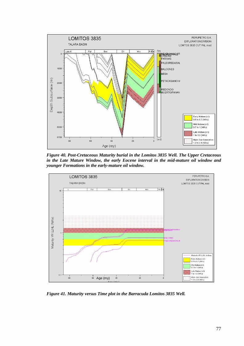
77
Figure 40. Post-Cretaceous Maturity burial in the Lomitos 3835 Well. The Upper Cretaceous in the Late Mature Window, the early Eocene interval in the mid-mature oil window and younger Formations in the early-mature oil window.
Figure 41. Maturity versus Time plot in the Barracuda Lomitos 3835 Well.
Age (my)
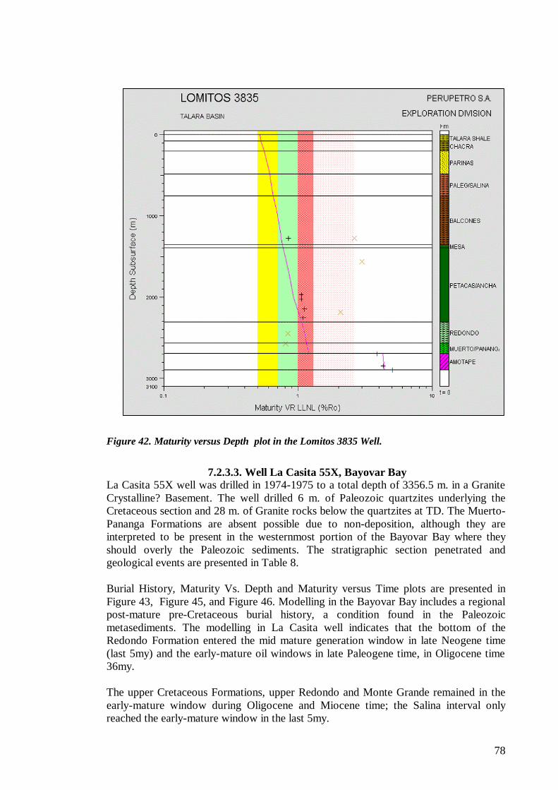
78
Figure 42. Maturity versus Depth plot in the Lomitos 3835 Well.
7.2.3.3. Well La Casita 55X, Bayovar Bay
La Casita 55X well was drilled in 1974-1975 to a total depth of 3356.5 m. in a Granite Crystalline? Basement. The well drilled 6 m. of Paleozoic quartzites underlying the Cretaceous section and 28 m. of Granite rocks below the quartzites at TD. The Muerto-Pananga Formations are absent possible due to non-deposition, although they are interpreted to be present in the westernmost portion of the Bayovar Bay where they should overly the Paleozoic sediments. The stratigraphic section penetrated and geological events are presented in Table 8. Burial History, Maturity Vs. Depth and Maturity versus Time plots are presented in Figure 43, Figure 45, and Figure 46. Modelling in the Bayovar Bay includes a regional post-mature pre-Cretaceous burial history, a condition found in the Paleozoic metasediments. The modelling in La Casita well indicates that the bottom of the Redondo Formation entered the mid mature generation window in late Neogene time (last 5my) and the early-mature oil windows in late Paleogene time, in Oligocene time 36my. The upper Cretaceous Formations, upper Redondo and Monte Grande remained in the early-mature window during Oligocene and Miocene time; the Salina interval only reached the early-mature window in the last 5my.
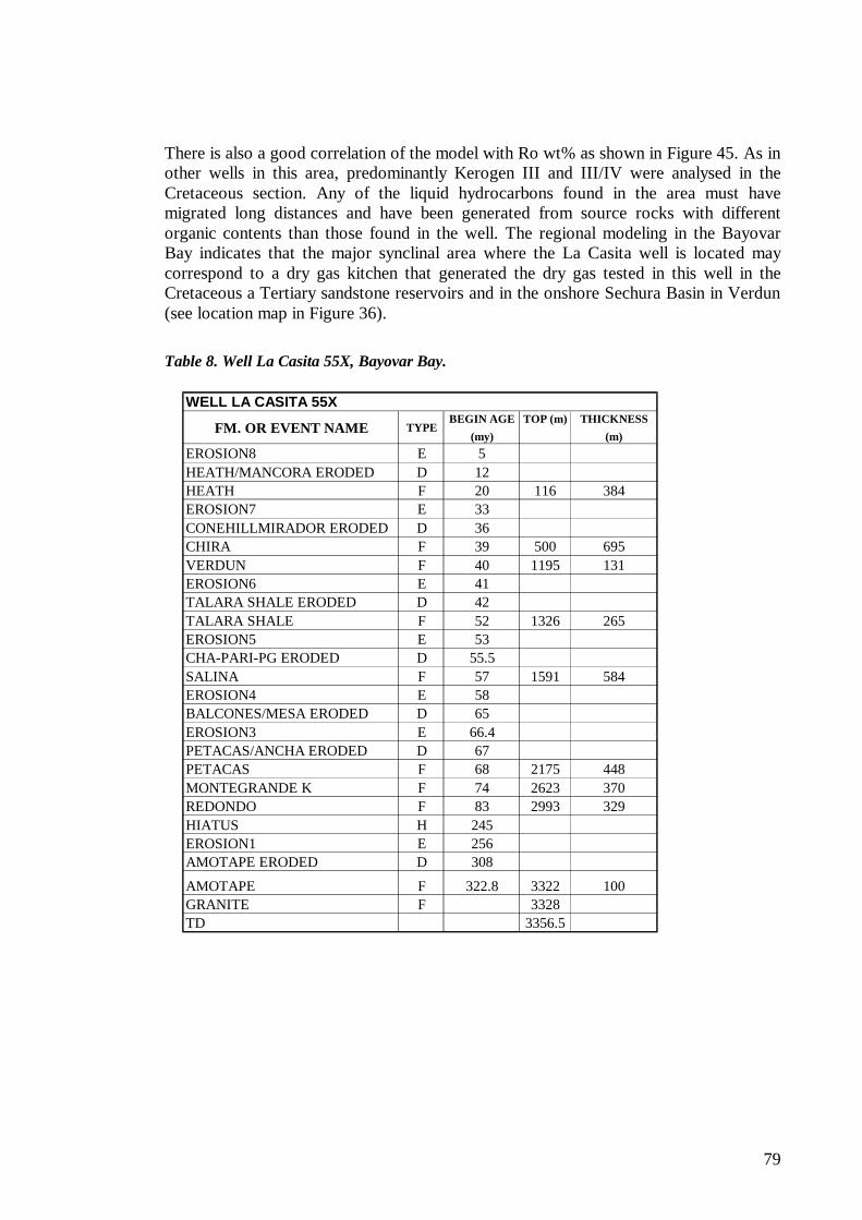
79
FM. OR EVENT NAME TYPEBEGIN AGE
(my)TOP (m) THICKNESS
(m)EROSION8 E 5HEATH/MANCORA ERODED D 12HEATH F 20 116 384EROSION7 E 33CONEHILLMIRADOR ERODED D 36CHIRA F 39 500 695VERDUN F 40 1195 131EROSION6 E 41TALARA SHALE ERODED D 42TALARA SHALE F 52 1326 265EROSION5 E 53CHA-PARI-PG ERODED D 55.5SALINA F 57 1591 584EROSION4 E 58BALCONES/MESA ERODED D 65EROSION3 E 66.4PETACAS/ANCHA ERODED D 67PETACAS F 68 2175 448MONTEGRANDE K F 74 2623 370REDONDO F 83 2993 329HIATUS H 245EROSION1 E 256AMOTAPE ERODED D 308
AMOTAPE F 322.8 3322 100GRANITE F 3328TD 3356.5
WELL LA CASITA 55X
There is also a good correlation of the model with Ro wt% as shown in Figure 45. As in other wells in this area, predominantly Kerogen III and III/IV were analysed in the Cretaceous section. Any of the liquid hydrocarbons found in the area must have migrated long distances and have been generated from source rocks with different organic contents than those found in the well. The regional modeling in the Bayovar Bay indicates that the major synclinal area where the La Casita well is located may correspond to a dry gas kitchen that generated the dry gas tested in this well in the Cretaceous a Tertiary sandstone reservoirs and in the onshore Sechura Basin in Verdun (see location map in Figure 36).
Table 8. Well La Casita 55X, Bayovar Bay.
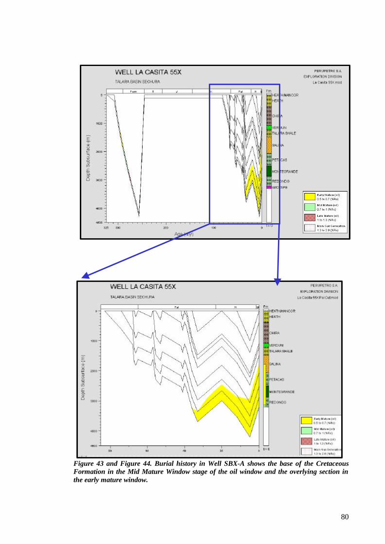
80
Figure 43 and Figure 44. Burial history in Well SBX-A shows the base of the Cretaceous Formation in the Mid Mature Window stage of the oil window and the overlying section in the early mature window.
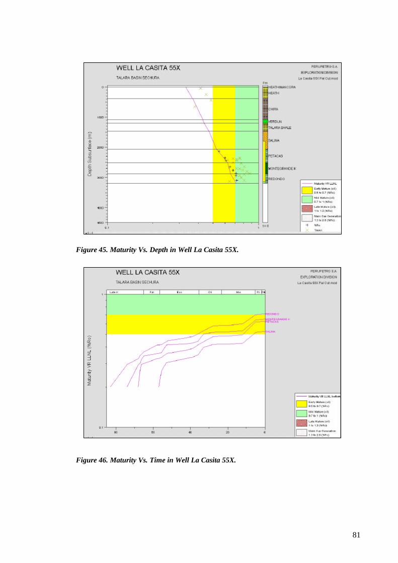
81
Figure 45. Maturity Vs. Depth in Well La Casita 55X.
Figure 46. Maturity Vs. Time in Well La Casita 55X.
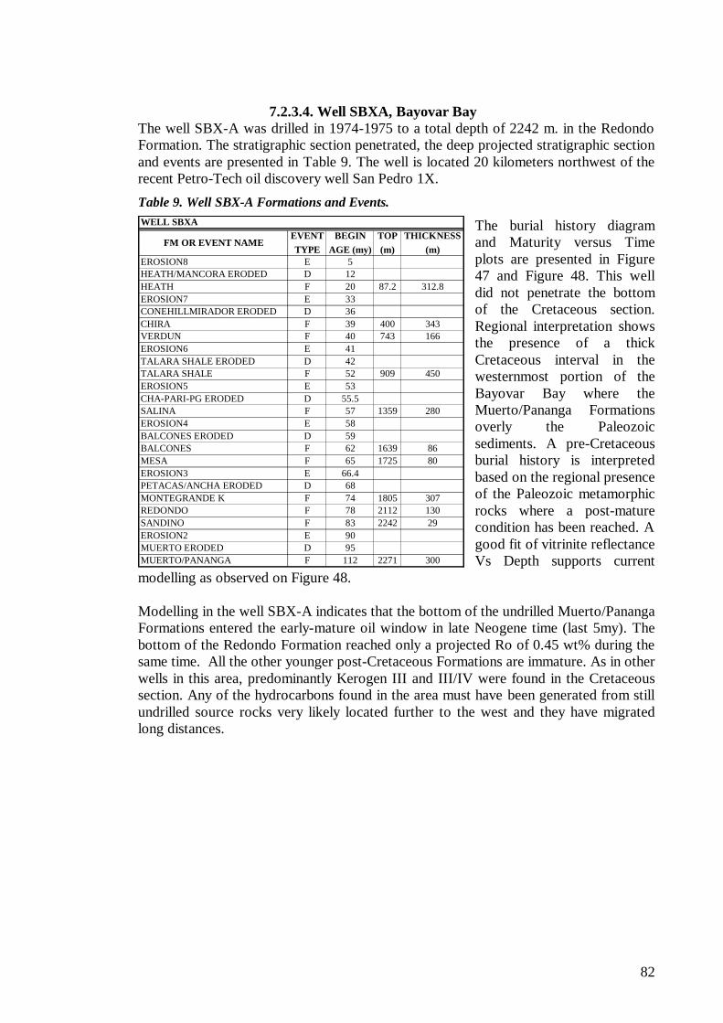
82
FM OR EVENT NAMEEVENT TYPE
BEGIN AGE (my)
TOP (m)
THICKNESS (m)
EROSION8 E 5HEATH/MANCORA ERODED D 12HEATH F 20 87.2 312.8EROSION7 E 33CONEHILLMIRADOR ERODED D 36CHIRA F 39 400 343VERDUN F 40 743 166EROSION6 E 41TALARA SHALE ERODED D 42TALARA SHALE F 52 909 450EROSION5 E 53CHA-PARI-PG ERODED D 55.5SALINA F 57 1359 280EROSION4 E 58BALCONES ERODED D 59BALCONES F 62 1639 86MESA F 65 1725 80EROSION3 E 66.4PETACAS/ANCHA ERODED D 68MONTEGRANDE K F 74 1805 307REDONDO F 78 2112 130SANDINO F 83 2242 29EROSION2 E 90MUERTO ERODED D 95MUERTO/PANANGA F 112 2271 300
WELL SBXA
7.2.3.4. Well SBXA, Bayovar Bay The well SBX-A was drilled in 1974-1975 to a total depth of 2242 m. in the Redondo Formation. The stratigraphic section penetrated, the deep projected stratigraphic section and events are presented in Table 9. The well is located 20 kilometers northwest of the recent Petro-Tech oil discovery well San Pedro 1X.
Table 9. Well SBX-A Formations and Events.
The burial history diagram and Maturity versus Time plots are presented in Figure 47 and Figure 48. This well did not penetrate the bottom of the Cretaceous section. Regional interpretation shows the presence of a thick Cretaceous interval in the westernmost portion of the Bayovar Bay where the Muerto/Pananga Formations overly the Paleozoic sediments. A pre-Cretaceous burial history is interpreted based on the regional presence of the Paleozoic metamorphic rocks where a post-mature condition has been reached. A good fit of vitrinite reflectance Vs Depth supports current
modelling as observed on Figure 48. Modelling in the well SBX-A indicates that the bottom of the undrilled Muerto/Pananga Formations entered the early-mature oil window in late Neogene time (last 5my). The bottom of the Redondo Formation reached only a projected Ro of 0.45 wt% during the same time. All the other younger post-Cretaceous Formations are immature. As in other wells in this area, predominantly Kerogen III and III/IV were found in the Cretaceous section. Any of the hydrocarbons found in the area must have been generated from still undrilled source rocks very likely located further to the west and they have migrated long distances.
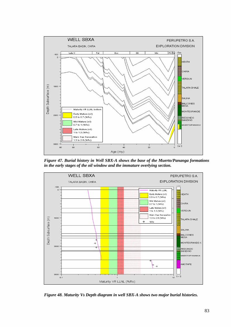
83
Figure 47. Burial history in Well SBX-A shows the base of the Muerto/Pananga formations in the early stages of the oil window and the immature overlying section.
Figure 48. Maturity Vs Depth diagram in well SBX-A shows two major burial histories.
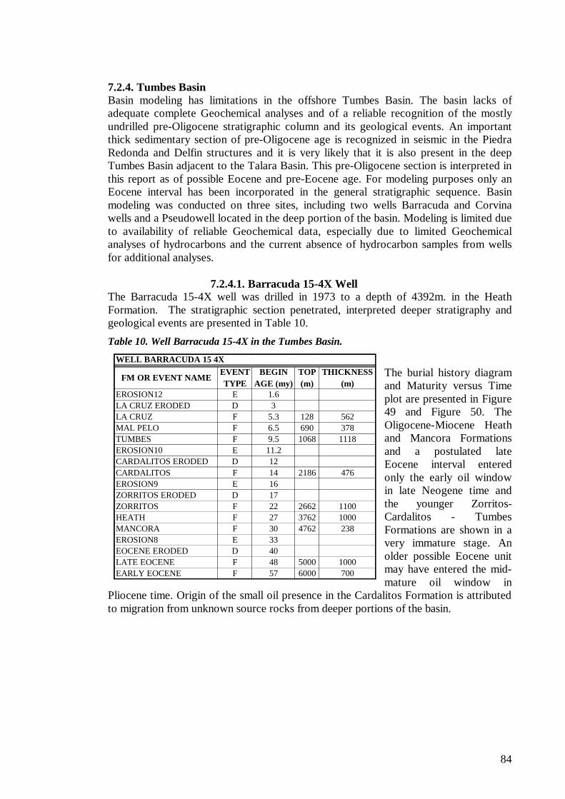
84
FM OR EVENT NAMEEVENT TYPE
BEGIN AGE (my)
TOP (m)
THICKNESS (m)
EROSION12 E 1.6LA CRUZ ERODED D 3LA CRUZ F 5.3 128 562MAL PELO F 6.5 690 378TUMBES F 9.5 1068 1118EROSION10 E 11.2CARDALITOS ERODED D 12CARDALITOS F 14 2186 476EROSION9 E 16ZORRITOS ERODED D 17ZORRITOS F 22 2662 1100HEATH F 27 3762 1000MANCORA F 30 4762 238EROSION8 E 33EOCENE ERODED D 40LATE EOCENE F 48 5000 1000EARLY EOCENE F 57 6000 700
WELL BARRACUDA 15 4X
7.2.4. Tumbes Basin Basin modeling has limitations in the offshore Tumbes Basin. The basin lacks of adequate complete Geochemical analyses and of a reliable recognition of the mostly undrilled pre-Oligocene stratigraphic column and its geological events. An important thick sedimentary section of pre-Oligocene age is recognized in seismic in the Piedra Redonda and Delfin structures and it is very likely that it is also present in the deep Tumbes Basin adjacent to the Talara Basin. This pre-Oligocene section is interpreted in this report as of possible Eocene and pre-Eocene age. For modeling purposes only an Eocene interval has been incorporated in the general stratigraphic sequence. Basin modeling was conducted on three sites, including two wells Barracuda and Corvina wells and a Pseudowell located in the deep portion of the basin. Modeling is limited due to availability of reliable Geochemical data, especially due to limited Geochemical analyses of hydrocarbons and the current absence of hydrocarbon samples from wells for additional analyses.
7.2.4.1. Barracuda 15-4X Well The Barracuda 15-4X well was drilled in 1973 to a depth of 4392m. in the Heath Formation. The stratigraphic section penetrated, interpreted deeper stratigraphy and geological events are presented in Table 10.
Table 10. Well Barracuda 15-4X in the Tumbes Basin.
The burial history diagram and Maturity versus Time plot are presented in Figure 49 and Figure 50. The Oligocene-Miocene Heath and Mancora Formations and a postulated late Eocene interval entered only the early oil window in late Neogene time and the younger Zorritos- Cardalitos - Tumbes Formations are shown in a very immature stage. An older possible Eocene unit may have entered the mid-mature oil window in
Pliocene time. Origin of the small oil presence in the Cardalitos Formation is attributed to migration from unknown source rocks from deeper portions of the basin.
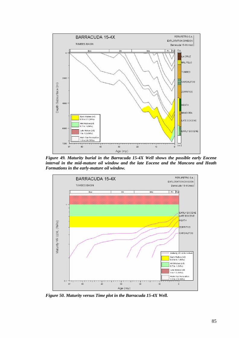
85
Figure 49. Maturity burial in the Barracuda 15-4X Well shows the possible early Eocene interval in the mid-mature oil window and the late Eocene and the Mancora and Heath Formations in the early-mature oil window.
Figure 50. Maturity versus Time plot in the Barracuda 15-4X Well.
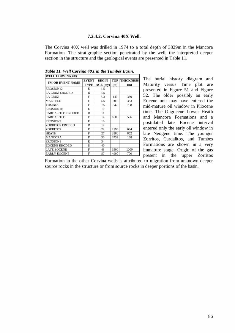
86
FM OR EVENT NAMEEVENT TYPE
BEGIN AGE (my)
TOP (m)
THICKNESS (m)
EROSION12 E 1.5LA CRUZ ERODED D 3.5LA CRUZ F 5.3 140 369MAL PELO F 6.5 509 333TUMBES F 9.5 842 758EROSION10 E 10CARDALITOS ERODED D 11CARDALITOS F 14 1600 596EROSION9 E 16ZORRITOS ERODED D 17ZORRITOS F 22 2196 684HEATH F 27 2880 852MANCORA F 30 3732 168EROSION8 E 34EOCENE ERODED D 40LATE EOCENE F 48 3900 1000EARLY EOCENE F 57 4900 700
WELL CORVINA 40X
7.2.4.2. Corvina 40X Well. The Corvina 40X well was drilled in 1974 to a total depth of 3829m in the Mancora Formation. The stratigraphic section penetrated by the well, the interpreted deeper section in the structure and the geological events are presented in Table 11.
Table 11. Well Corvina 40X in the Tumbes Basin.
The burial history diagram and Maturity versus Time plot are presented in Figure 51 and Figure 52. The older possibly an early Eocene unit may have entered the mid-mature oil window in Pliocene time. The Oligocene Lower Heath and Mancora Formations and a postulated late Eocene interval entered only the early oil window in late Neogene time. The younger Zorritos, Cardalitos, and Tumbes Formations are shown in a very immature stage. Origin of the gas present in the upper Zorritos
Formation in the other Corvina wells is attributed to migration from unknown deeper source rocks in the structure or from source rocks in deeper portions of the basin.
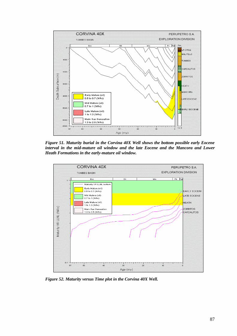
87
Figure 51. Maturity burial in the Corvina 40X Well shows the bottom possible early Eocene interval in the mid-mature oil window and the late Eocene and the Mancora and Lower Heath Formations in the early-mature oil window.
Figure 52. Maturity versus Time plot in the Corvina 40X Well.
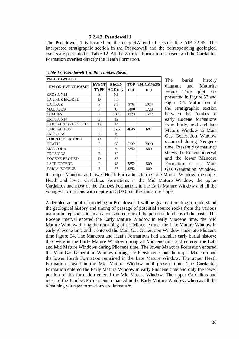
88
FM OR EVENT NAMEEVENT TYPE
BEGIN AGE (my)
TOP (m)
THICKNESS (m)
EROSION12 E 0.5LA CRUZ ERODED D 1.5LA CRUZ F 5.3 376 1024MAL PELO F 8 1400 1723TUMBES F 10.4 3123 1522EROSION10 E 12CARDALITOS ERODED D 14CARDALITOS F 16.6 4645 687EROSION9 E 19ZORRITOS ERODED D 23HEATH F 28 5332 2020MANCORA F 30 7352 500EROSION8 E 32EOCENE ERODED D 37LATE EOCENE F 48 7852 500EARLY EOCENE F 57 8352 500
PSEUDOWELL 1
7.2.4.3. Pseudowell 1 The Pseudowell 1 is located on the deep SW end of seismic line AIP 92-49. The interpreted stratigraphic section in the Pseudowell and the corresponding geological events are presented in Table 12. All the Zorritos Formation is absent and the Cardalitos Formation overlies directly the Heath Formation.
Table 12. Pseudowell 1 in the Tumbes Basin.
The burial history diagram and Maturity versus Time plot are presented in Figure 53 and Figure 54. Maturation of the stratigraphic section between the Tumbes to early Eocene formations from Early, mid and late Mature Window to Main Gas Generation Window occurred during Neogene time. Present day maturity shows the Eocene interval and the lower Mancora Formation in the Main Gas Generation Window,
the upper Mancora and lower Heath Formations in the Late Mature Window, the upper Heath and lower Cardalitos Formations in the Mid Mature Window, the upper Cardalitos and most of the Tumbes Formations in the Early Mature Window and all the youngest formations with depths of 3,000m in the immature stage. A detailed account of modeling in Pseudowell 1 will be given attempting to understand the geological history and timing of passage of potential source rocks from the various maturation episodes in an area considered one of the potential kitchens of the basin. The Eocene interval entered the Early Mature Window in early Miocene time, the Mid Mature Window during the remaining of the Miocene time, the Late Mature Window in early Pliocene time and it entered the Main Gas Generation Window since late Pliocene time Figure 54. The Mancora and Heath Formations had a similar early burial history; they were in the Early Mature Window during all Miocene time and entered the Late and Mid Mature Windows during Pliocene time. The lower Mancora Formation entered the Main Gas Generation Window during late Pleistocene, but the upper Mancora and the lower Heath Formation remained in the Late Mature Window. The upper Heath Formation stayed in the Mid Mature Window until present time. The Cardalitos Formation entered the Early Mature Window in early Pliocene time and only the lower portion of this formation entered the Mid Mature Window. The upper Cardalitos and most of the Tumbes Formations remained in the Early Mature Window, whereas all the remaining younger formations are immature.
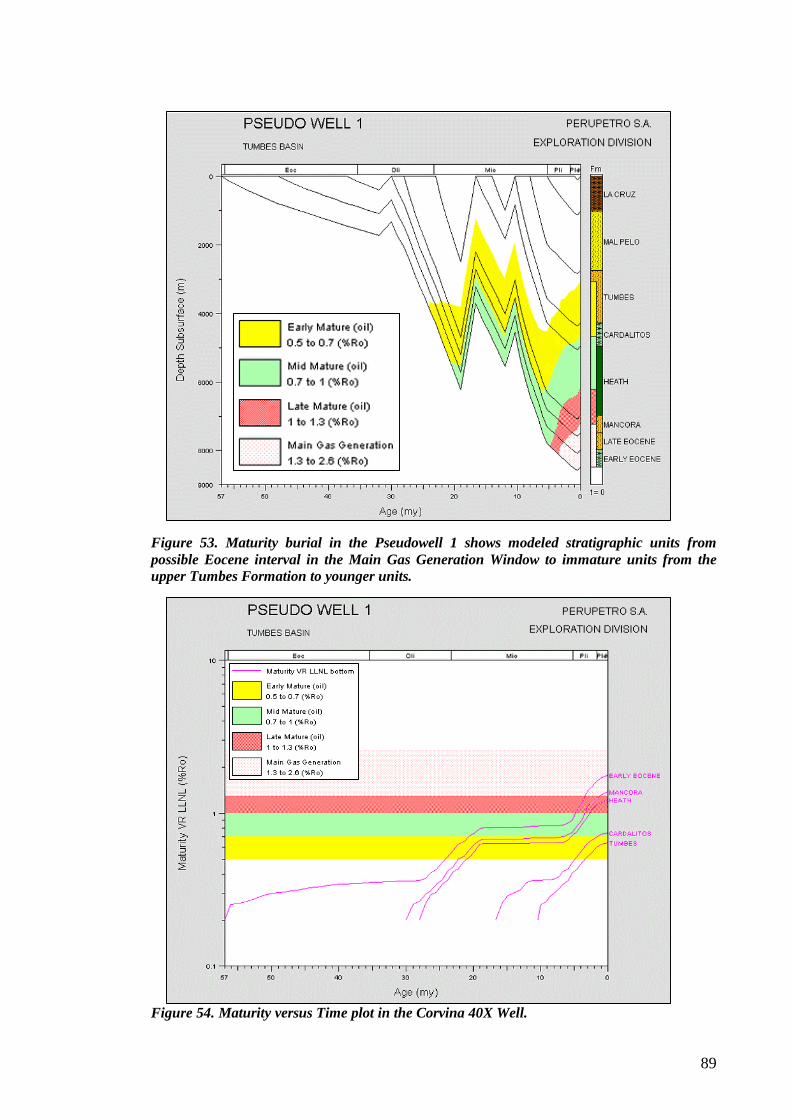
89
Figure 53. Maturity burial in the Pseudowell 1 shows modeled stratigraphic units from possible Eocene interval in the Main Gas Generation Window to immature units from the upper Tumbes Formation to younger units.
Figure 54. Maturity versus Time plot in the Corvina 40X Well.
90
Modeling of Pseudowell 1 places the various potential source rocks in maturity condition to have generated oil and gas on this particular location, a situation tested by the hydrocarbons occurrences in the different offshore wells. Modeling places the Upper Oligocene Lower Mancora Formation and the pre-Oligocene sequence, possibly Eocene, in the Main Gas Generation Window since Pliocene time. The other two potential source rocks Heath and Cardalitos Formations contributed to oil generation in the basin and may be source for some of the tested oils. A portion of the pre-Oligocene sequence may correlate with a Talara Shale unit that outcrops in the onshore Mancora area with source rock potential as described above Figure 28. Hydrocarbons charge contributed by deeper potential source rocks is unknown in the Tumbes Basin.
91
8.0. PROSPECTS AND LEADS IN THE TALARA AND TUMBES FOREARC BASINS
The Tumbes and Talara Basins have excellent potential with a variety of opportunities that remain as untested prospects and leads to target extensive stratigraphic columns. In the course of this study six of them in the Talara Basin and thirteen in the Tumbes Basin have been documented in Chapter 8 (Table 13). The areas adjacent to some of them also offer additional exploration opportunities as indicated below. Although most areas in these basins are under different exploration stages, there exist prospects and leads of especial interest for future promotion as those defined in open areas or in areas under PEA’s (Block Z-34) or under negotiations (Blocks Z-37 and Z-38) where license contracts are not yet signed. Oil discovery in the San Pedro 1X well renewed hydrocarbon exploration of the Paleozoic rocks in the whole NW Peru. Prospects and leads and areas for additional exploration of Paleozoic include the Calamar Lead and similar areas to the south, west of the Bayovar Bay in areas interpreted as potential hydrocarbon kitchens (Block Z-37). In the very shallow offshore open area west of the Paita High oil shows were found in Paleozoic rocks but were not tested. All these areas are geologically related to the San Pedro discovery and need additional seismic data to fully evaluate their hydrocarbon potential. The Caballa and Tortugas are well-defined structures located near San Pedro in Block Z-2B. Similar geological conditions develop further to the north on the western border of the shallow platform in the border of PEA’s Z-34 and Block Z-2B. This area is highly attractive for exploration of pre-Eocene sequences of which the Paleozoic is also the main target. These areas are the offshore western extension of the three main tectonic highs of the Talara Basin. The Deeper Lobitos Lead is defined as an example of what can be defined on this platform. The deep platform of the Talara Basin in Area Z-34 offers a sedimentary section attractive for deep-water exploration that needs extensive additional seismic data. Scarce seismic defines the Tiburon Lead as a large structure. The Mero, Merluza, Paiche, Atun and Banco Peru structures and partially the Lenguado and Espada structures are located in Block Z-38 in the Tumbes Basin. The Jurel, Raya, Perico, Toyo, Chita and Deeper Delfin structures include hydrocarbon prospectivity, which had not been described as potential plays in Block Z-1. The Zorritos-Piedra Redonda High or Lead is another attractive exploration site located in the transition zone between the offshore Tumbes Basin and the onshore Talara and Tumbes Basins. The ZPR Lead runs for 60 Km as a SW-NE trending horst bounded by steeply dipping normal listric faults, that place the structure updip of both offshore and onshore potential kitchens areas. This onshore kitchen also represents a kitchen area for the onshore fields. Previous studies defined other potential prospects and leads, but with a different petroleum system as defined in the present study. This old prospects and leads are described in Appendix 4. The attractiveness for hydrocarbon exploration of potential Cenozoic and Paleozoic sections in the Banco Peru, for instance, had never been recognized. This feature has poor seismic definition and it is larger than the Talara
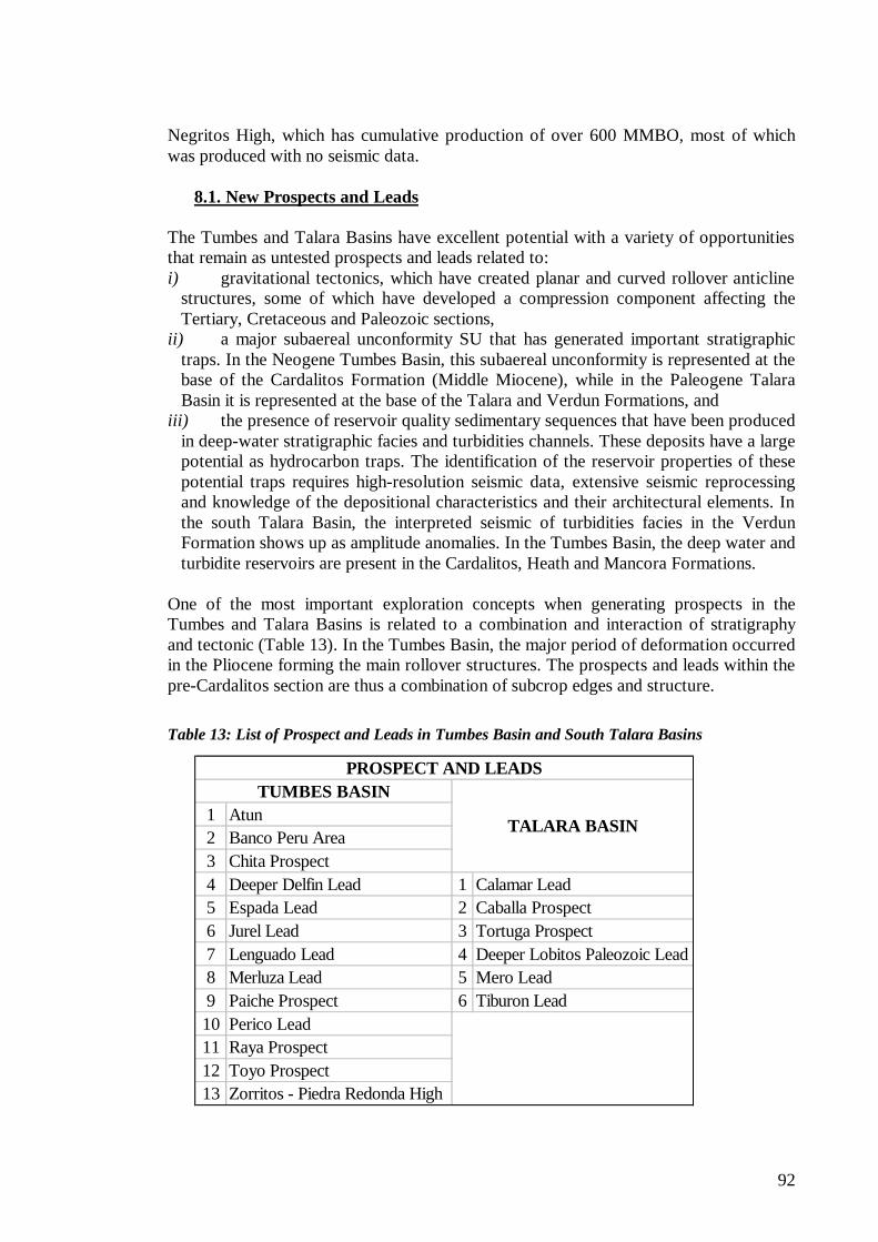
92
1 Atun2 Banco Peru Area3 Chita Prospect4 Deeper Delfin Lead 1 Calamar Lead5 Espada Lead 2 Caballa Prospect6 Jurel Lead 3 Tortuga Prospect7 Lenguado Lead 4 Deeper Lobitos Paleozoic Lead8 Merluza Lead 5 Mero Lead9 Paiche Prospect 6 Tiburon Lead10 Perico Lead11 Raya Prospect12 Toyo Prospect13 Zorritos - Piedra Redonda High
PROSPECT AND LEADS
TALARA BASIN
TUMBES BASIN
Negritos High, which has cumulative production of over 600 MMBO, most of which was produced with no seismic data.
8.1. New Prospects and Leads The Tumbes and Talara Basins have excellent potential with a variety of opportunities that remain as untested prospects and leads related to: i) gravitational tectonics, which have created planar and curved rollover anticline
structures, some of which have developed a compression component affecting the Tertiary, Cretaceous and Paleozoic sections,
ii) a major subaereal unconformity SU that has generated important stratigraphic traps. In the Neogene Tumbes Basin, this subaereal unconformity is represented at the base of the Cardalitos Formation (Middle Miocene), while in the Paleogene Talara Basin it is represented at the base of the Talara and Verdun Formations, and
iii) the presence of reservoir quality sedimentary sequences that have been produced in deep-water stratigraphic facies and turbidities channels. These deposits have a large potential as hydrocarbon traps. The identification of the reservoir properties of these potential traps requires high-resolution seismic data, extensive seismic reprocessing and knowledge of the depositional characteristics and their architectural elements. In the south Talara Basin, the interpreted seismic of turbidities facies in the Verdun Formation shows up as amplitude anomalies. In the Tumbes Basin, the deep water and turbidite reservoirs are present in the Cardalitos, Heath and Mancora Formations.
One of the most important exploration concepts when generating prospects in the Tumbes and Talara Basins is related to a combination and interaction of stratigraphy and tectonic (Table 13). In the Tumbes Basin, the major period of deformation occurred in the Pliocene forming the main rollover structures. The prospects and leads within the pre-Cardalitos section are thus a combination of subcrop edges and structure.
Table 13: List of Prospect and Leads in Tumbes Basin and South Talara Basins
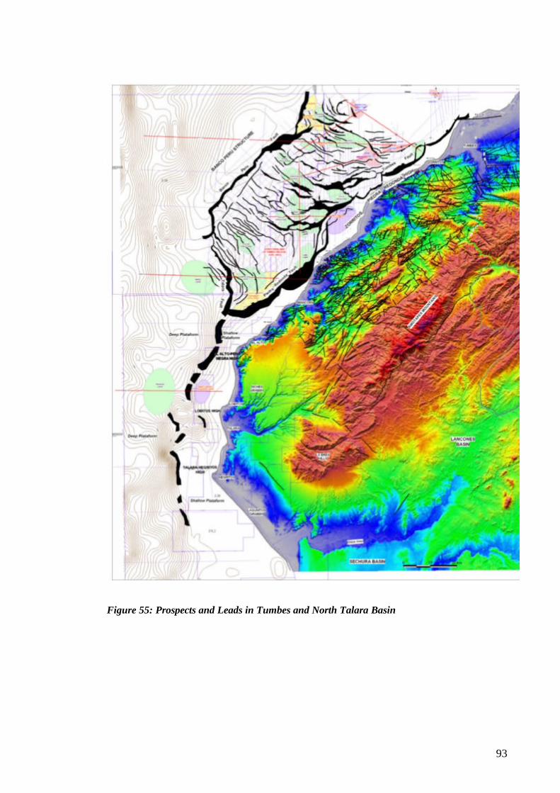
93
Figure 55: Prospects and Leads in Tumbes and North Talara Basin
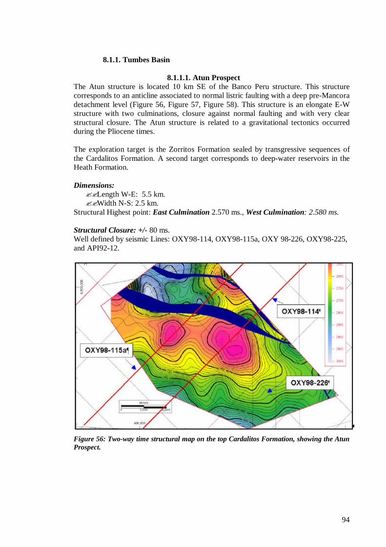
94
8.1.1. Tumbes Basin
8.1.1.1. Atun Prospect The Atun structure is located 10 km SE of the Banco Peru structure. This structure corresponds to an anticline associated to normal listric faulting with a deep pre-Mancora detachment level (Figure 56, Figure 57, Figure 58). This structure is an elongate E-W structure with two culminations, closure against normal faulting and with very clear structural closure. The Atun structure is related to a gravitational tectonics occurred during the Pliocene times. The exploration target is the Zorritos Formation sealed by transgressive sequences of the Cardalitos Formation. A second target corresponds to deep-water reservoirs in the Heath Formation. Dimensions: ??Length W-E: 5.5 km. ??Width N-S: 2.5 km.
Structural Highest point: East Culmination 2.570 ms., West Culmination: 2.580 ms. Structural Closure: +/- 80 ms. Well defined by seismic Lines: OXY98-114, OXY98-115a, OXY 98-226, OXY98-225, and API92-12.
Figure 56: Two-way time structural map on the top Cardalitos Formation, showing the Atun Prospect.
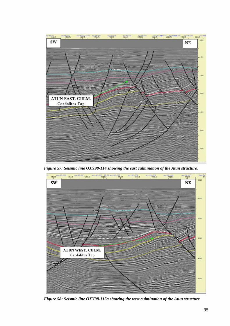
95
Figure 57: Seismic line OXY98-114 showing the east culmination of the Atun structure.
Figure 58: Seismic line OXY98-115a showing the west culmination of the Atun structure.
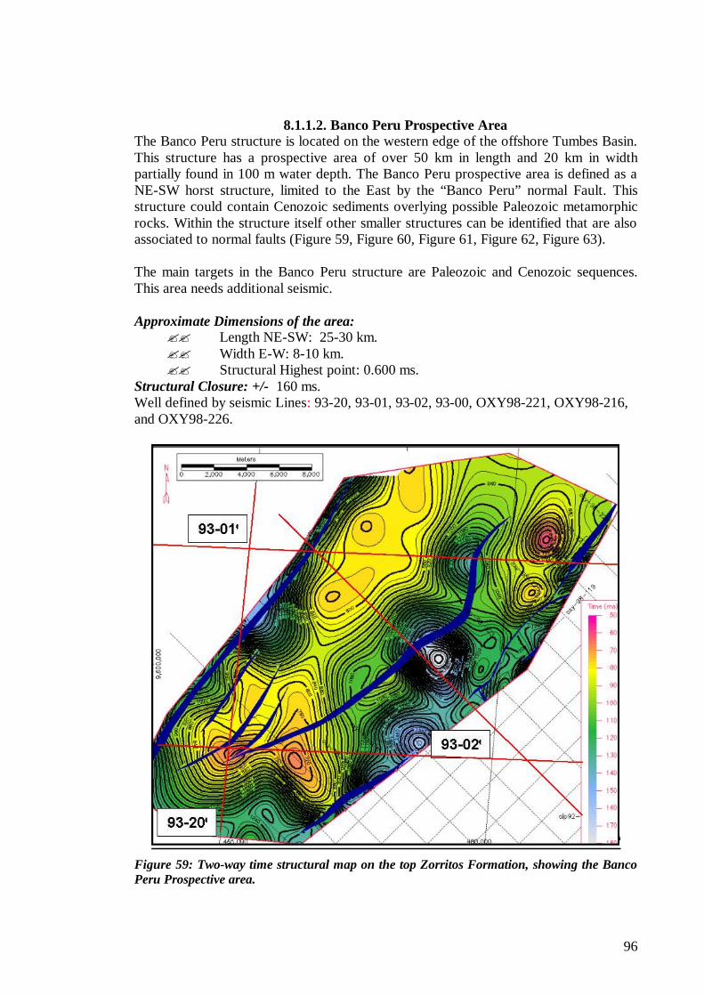
96
8.1.1.2. Banco Peru Prospective Area
The Banco Peru structure is located on the western edge of the offshore Tumbes Basin. This structure has a prospective area of over 50 km in length and 20 km in width partially found in 100 m water depth. The Banco Peru prospective area is defined as a NE-SW horst structure, limited to the East by the “Banco Peru” normal Fault. This structure could contain Cenozoic sediments overlying possible Paleozoic metamorphic rocks. Within the structure itself other smaller structures can be identified that are also associated to normal faults (Figure 59, Figure 60, Figure 61, Figure 62, Figure 63). The main targets in the Banco Peru structure are Paleozoic and Cenozoic sequences. This area needs additional seismic. Approximate Dimensions of the area:
?? Length NE-SW: 25-30 km. ?? Width E-W: 8-10 km. ?? Structural Highest point: 0.600 ms.
Structural Closure: +/- 160 ms. Well defined by seismic Lines: 93-20, 93-01, 93-02, 93-00, OXY98-221, OXY98-216, and OXY98-226.
Figure 59: Two-way time structural map on the top Zorritos Formation, showing the Banco Peru Prospective area.
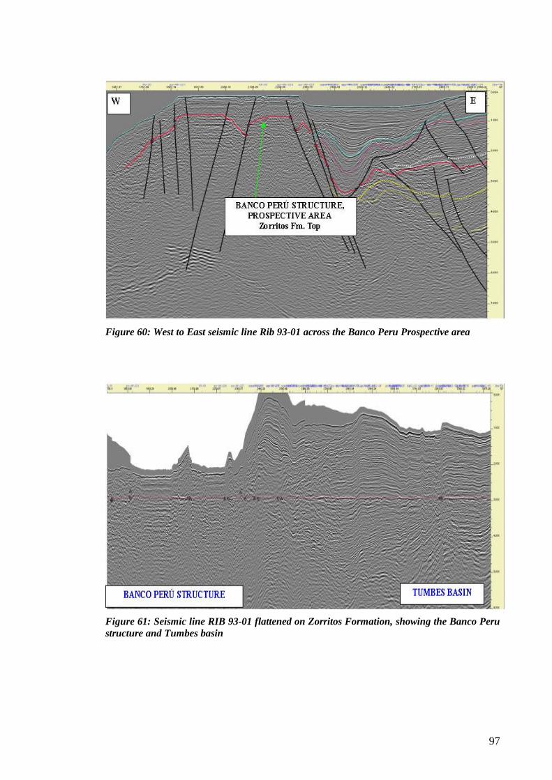
97
Figure 60: West to East seismic line Rib 93-01 across the Banco Peru Prospective area
Figure 61: Seismic line RIB 93-01 flattened on Zorritos Formation, showing the Banco Peru structure and Tumbes basin
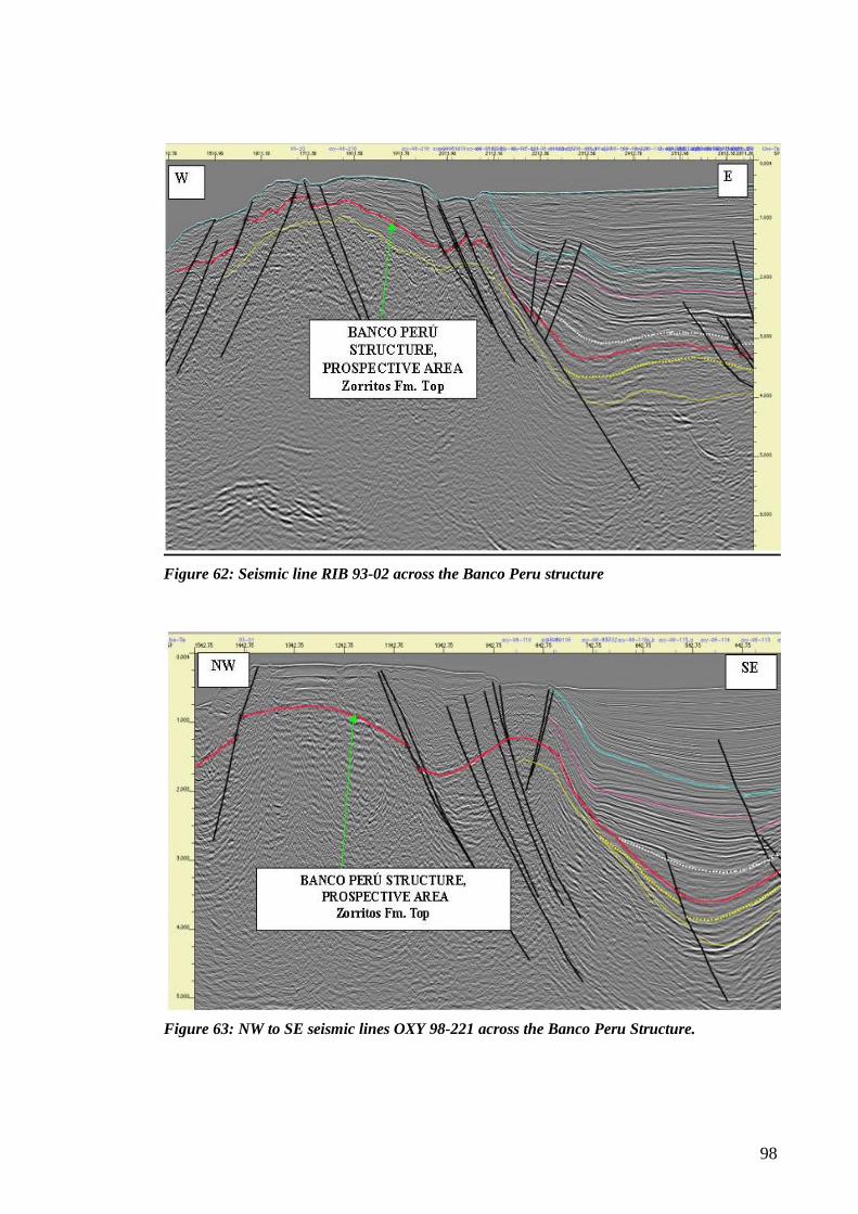
98
Figure 62: Seismic line RIB 93-02 across the Banco Peru structure
Figure 63: NW to SE seismic lines OXY 98-221 across the Banco Peru Structure.
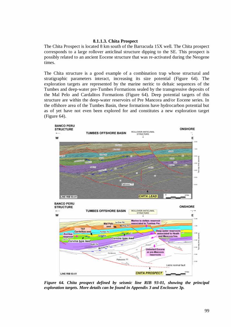
99
8.1.1.3. Chita Prospect
The Chita Prospect is located 8 km south of the Barracuda 15X well. The Chita prospect corresponds to a large rollover anticlinal structure dipping to the SE. This prospect is possibly related to an ancient Eocene structure that was re-activated during the Neogene times. The Chita structure is a good example of a combination trap whose structural and stratigraphic parameters interact, increasing its size potential (Figure 64). The exploration targets are represented by the marine neritic to deltaic sequences of the Tumbes and deep-water pre-Tumbes Formations sealed by the transgressive deposits of the Mal Pelo and Cardalitos Formations (Figure 64). Deep potential targets of this structure are within the deep-water reservoirs of Pre Mancora and/or Eocene series. In the offshore area of the Tumbes Basin, these formations have hydrocarbon potential but as of yet have not even been explored for and constitutes a new exploration target (Figure 64).
Figure 64. Chita prospect defined by seismic line RIB 93-01, showing the principal exploration targets. More details can be found in Appendix 3 and Enclosure 3p.
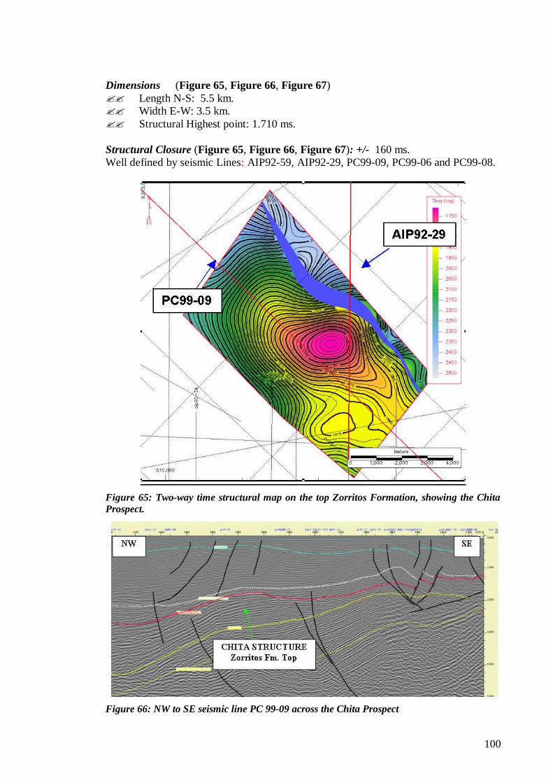
100
Dimensions (Figure 65, Figure 66, Figure 67) ?? Length N-S: 5.5 km. ?? Width E-W: 3.5 km. ?? Structural Highest point: 1.710 ms. Structural Closure (Figure 65, Figure 66, Figure 67): +/- 160 ms. Well defined by seismic Lines: AIP92-59, AIP92-29, PC99-09, PC99-06 and PC99-08.
Figure 65: Two-way time structural map on the top Zorritos Formation, showing the Chita Prospect.
Figure 66: NW to SE seismic line PC 99-09 across the Chita Prospect
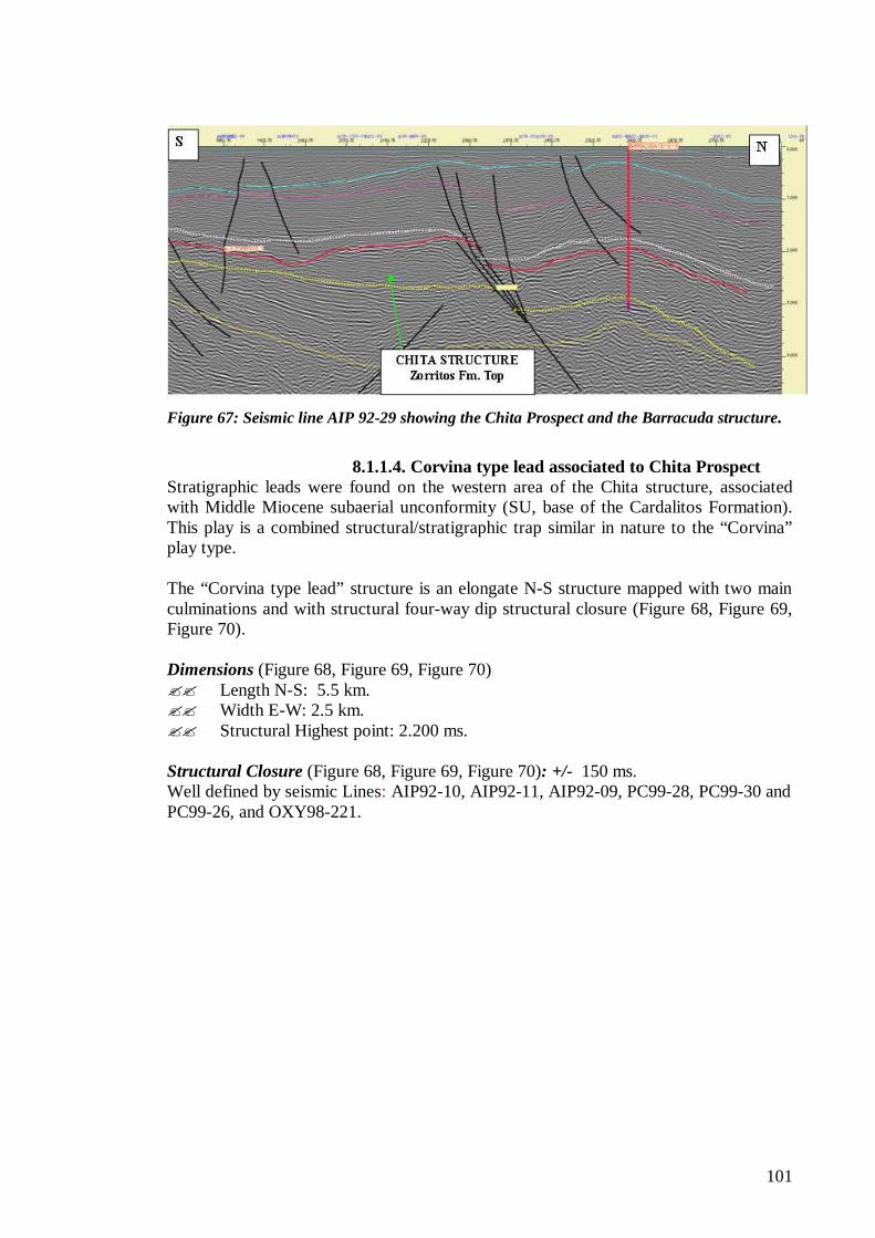
101
Figure 67: Seismic line AIP 92-29 showing the Chita Prospect and the Barracuda structure.
8.1.1.4. Corvina type lead associated to Chita Prospect
Stratigraphic leads were found on the western area of the Chita structure, associated with Middle Miocene subaerial unconformity (SU, base of the Cardalitos Formation). This play is a combined structural/stratigraphic trap similar in nature to the “Corvina” play type. The “Corvina type lead” structure is an elongate N-S structure mapped with two main culminations and with structural four-way dip structural closure (Figure 68, Figure 69, Figure 70). Dimensions (Figure 68, Figure 69, Figure 70) ?? Length N-S: 5.5 km. ?? Width E-W: 2.5 km. ?? Structural Highest point: 2.200 ms. Structural Closure (Figure 68, Figure 69, Figure 70): +/- 150 ms. Well defined by seismic Lines: AIP92-10, AIP92-11, AIP92-09, PC99-28, PC99-30 and PC99-26, and OXY98-221.
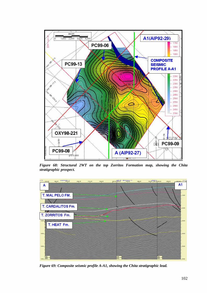
102
Figure 68: Structural 2WT on the top Zorritos Formation map, showing the Chita stratigraphic prospect.
Figure 69: Composite seismic profile A-A1, showing the Chita stratigraphic lead.
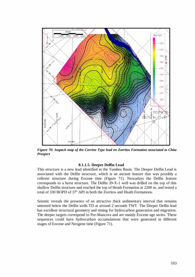
103
Figure 70: Isopach map of the Corvine Type lead on Zorritos Formation associated to Chita Prospect
8.1.1.5. Deeper Delfin Lead
This structure is a new lead identified in the Tumbes Basin. The Deeper Delfin Lead is associated with the Delfin structure, which is an ancient feature that was possibly a rollover structure during Eocene time (Figure 71). Nowadays the Delfin feature corresponds to a horst structure. The Delfin 39-X-1 well was drilled on the top of this shallow Delfin structure and reached the top of Heath Formation at 2200 m. and tested a total of 330 BOPD of 37º API in both the Zorritos and Heath Formations. Seismic reveals the presence of an attractive thick sedimentary interval that remains untested below the Delfin wells TD at around 2 seconds TWT. The Deeper Delfin lead has excellent structural geometry and timing for hydrocarbon generation and migration. The deeper targets correspond to Pre-Mancora and are mainly Eocene age series. These sequences could have hydrocarbon accumulations that were generated in different stages of Eocene and Neogene time (Figure 71).
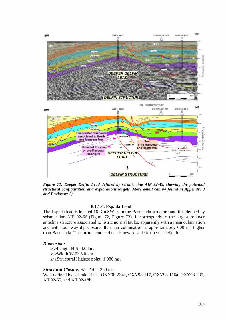
104
Figure 71: Deeper Delfín Lead defined by seismic line AIP 92-49, showing the potential structural configuration and explorations targets. More detail can be found in Appendix 3 and Enclosure 3p.
8.1.1.6. Espada Lead
The Espada lead is located 16 Km SW from the Barracuda structure and it is defined by seismic line AIP 92-66 (Figure 72, Figure 73). It corresponds to the largest rollover anticline structure associated to listric normal faults, apparently with a main culmination and with four-way dip closure. Its main culmination is approximately 600 ms higher than Barracuda. This prominent lead needs new seismic for better definition Dimensions ??Length N-S: 4.0 km. ??Width W-E: 3.0 km. ??Structural Highest point: 1.080 ms.
Structural Closure: +/- 250 – 280 ms. Well defined by seismic Lines: OXY98-234a, OXY98-117, OXY98-116a, OXY98-235, AIP92-65, and AIP92-18b.
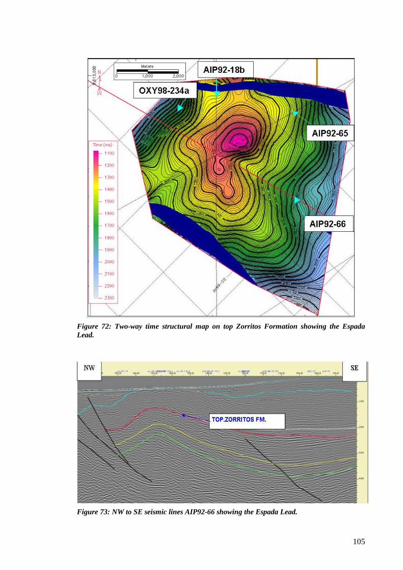
105
Figure 72: Two-way time structural map on top Zorritos Formation showing the Espada Lead.
Figure 73: NW to SE seismic lines AIP92-66 showing the Espada Lead.
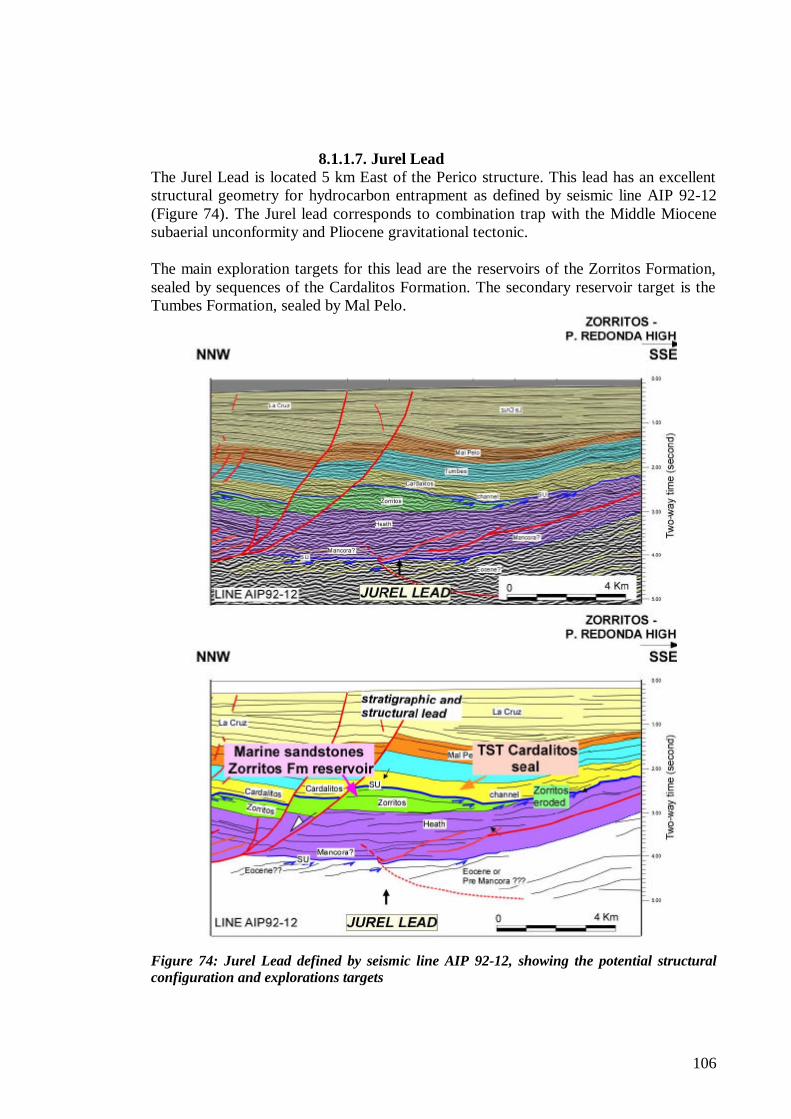
106
8.1.1.7. Jurel Lead The Jurel Lead is located 5 km East of the Perico structure. This lead has an excellent structural geometry for hydrocarbon entrapment as defined by seismic line AIP 92-12 (Figure 74). The Jurel lead corresponds to combination trap with the Middle Miocene subaerial unconformity and Pliocene gravitational tectonic. The main exploration targets for this lead are the reservoirs of the Zorritos Formation, sealed by sequences of the Cardalitos Formation. The secondary reservoir target is the Tumbes Formation, sealed by Mal Pelo.
Figure 74: Jurel Lead defined by seismic line AIP 92-12, showing the potential structural configuration and explorations targets
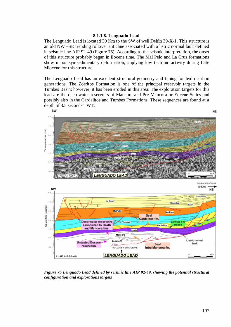
107
8.1.1.8. Lenguado Lead The Lenguado Lead is located 30 Km to the SW of well Delfin 39-X-1. This structure is an old NW –SE trending rollover anticline associated with a listric normal fault defined in seismic line AIP 92-49 (Figure 75). According to the seismic interpretation, the onset of this structure probably began in Eocene time. The Mal Pelo and La Cruz formations show minor syn-sedimentary deformation, implying low tectonic activity during Late Miocene for this structure. The Lenguado Lead has an excellent structural geometry and timing for hydrocarbon generations. The Zorritos Formation is one of the principal reservoir targets in the Tumbes Basin; however, it has been eroded in this area. The exploration targets for this lead are the deep-water reservoirs of Mancora and Pre Mancora or Eocene Series and possibly also in the Cardalitos and Tumbes Formations. These sequences are found at a depth of 3.5 seconds TWT.
Figure 75 Lenguado Lead defined by seismic line AIP 92-49, showing the potential structural configuration and explorations targets
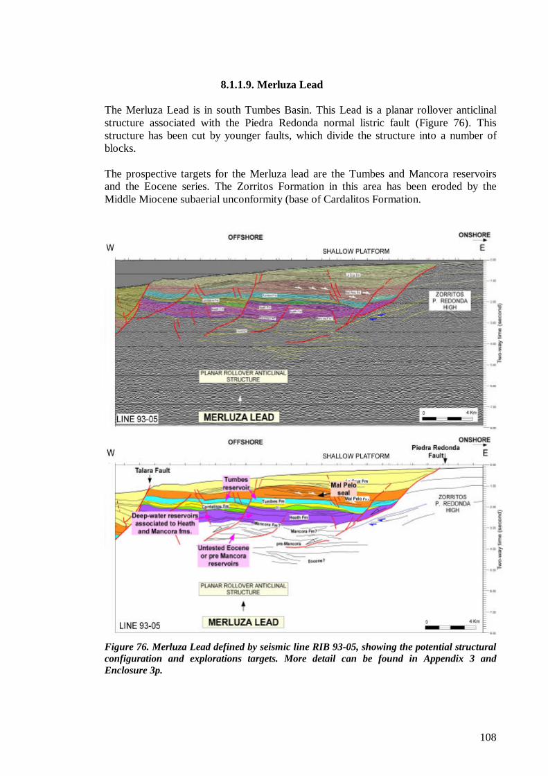
108
8.1.1.9. Merluza Lead The Merluza Lead is in south Tumbes Basin. This Lead is a planar rollover anticlinal structure associated with the Piedra Redonda normal listric fault (Figure 76). This structure has been cut by younger faults, which divide the structure into a number of blocks. The prospective targets for the Merluza lead are the Tumbes and Mancora reservoirs and the Eocene series. The Zorritos Formation in this area has been eroded by the Middle Miocene subaerial unconformity (base of Cardalitos Formation.
Figure 76. Merluza Lead defined by seismic line RIB 93-05, showing the potential structural configuration and explorations targets. More detail can be found in Appendix 3 and Enclosure 3p.
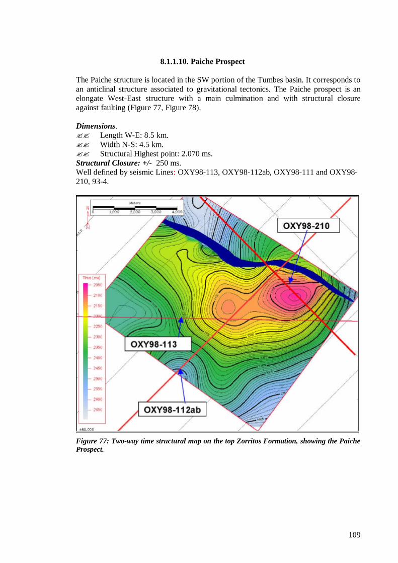
109
8.1.1.10. Paiche Prospect The Paiche structure is located in the SW portion of the Tumbes basin. It corresponds to an anticlinal structure associated to gravitational tectonics. The Paiche prospect is an elongate West-East structure with a main culmination and with structural closure against faulting (Figure 77, Figure 78). Dimensions. ?? Length W-E: 8.5 km. ?? Width N-S: 4.5 km. ?? Structural Highest point: 2.070 ms. Structural Closure: +/- 250 ms. Well defined by seismic Lines: OXY98-113, OXY98-112ab, OXY98-111 and OXY98-210, 93-4.
Figure 77: Two-way time structural map on the top Zorritos Formation, showing the Paiche Prospect.
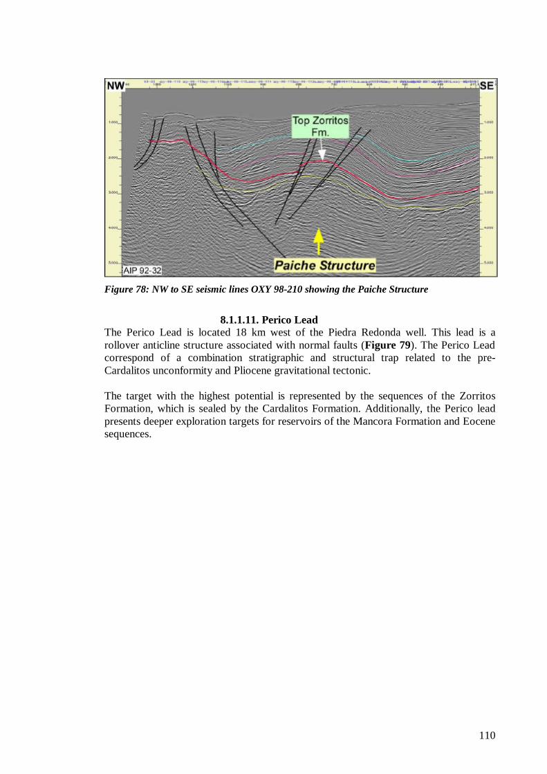
110
Figure 78: NW to SE seismic lines OXY 98-210 showing the Paiche Structure
8.1.1.11. Perico Lead
The Perico Lead is located 18 km west of the Piedra Redonda well. This lead is a rollover anticline structure associated with normal faults (Figure 79). The Perico Lead correspond of a combination stratigraphic and structural trap related to the pre-Cardalitos unconformity and Pliocene gravitational tectonic. The target with the highest potential is represented by the sequences of the Zorritos Formation, which is sealed by the Cardalitos Formation. Additionally, the Perico lead presents deeper exploration targets for reservoirs of the Mancora Formation and Eocene sequences.
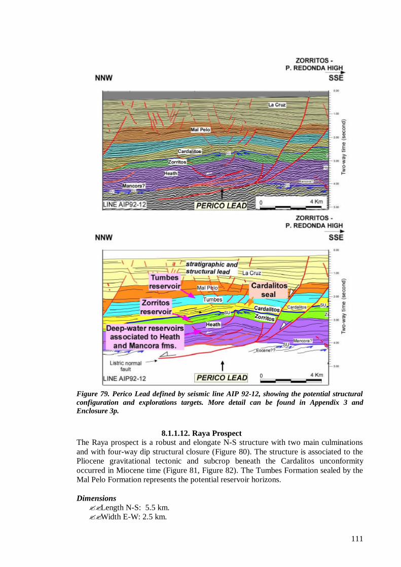
111
Figure 79. Perico Lead defined by seismic line AIP 92-12, showing the potential structural configuration and explorations targets. More detail can be found in Appendix 3 and Enclosure 3p.
8.1.1.12. Raya Prospect
The Raya prospect is a robust and elongate N-S structure with two main culminations and with four-way dip structural closure (Figure 80). The structure is associated to the Pliocene gravitational tectonic and subcrop beneath the Cardalitos unconformity occurred in Miocene time (Figure 81, Figure 82). The Tumbes Formation sealed by the Mal Pelo Formation represents the potential reservoir horizons. Dimensions ??Length N-S: 5.5 km. ??Width E-W: 2.5 km.
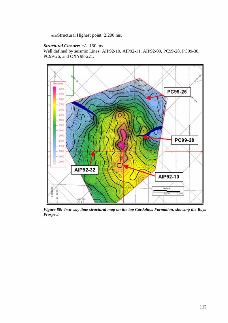
112
??Structural Highest point: 2.200 ms. Structural Closure: +/- 150 ms. Well defined by seismic Lines: AIP92-10, AIP92-11, AIP92-09, PC99-28, PC99-30, PC99-26, and OXY98-221.
Figure 80: Two-way time structural map on the top Cardalitos Formation, showing the Raya Prospect
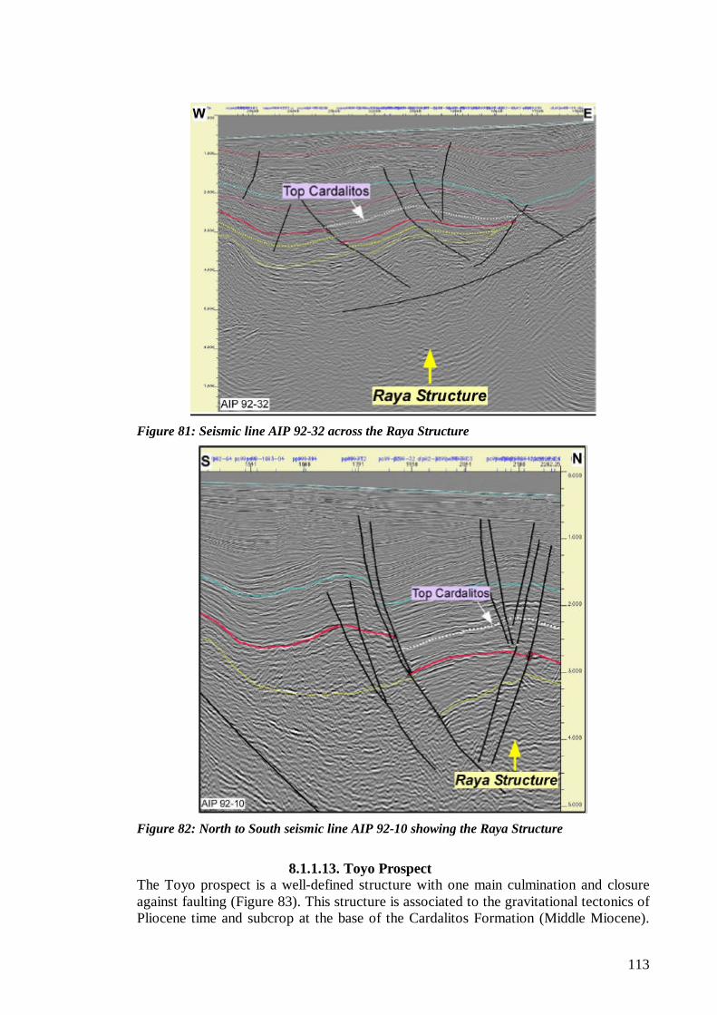
113
Figure 81: Seismic line AIP 92-32 across the Raya Structure
Figure 82: North to South seismic line AIP 92-10 showing the Raya Structure
8.1.1.13. Toyo Prospect
The Toyo prospect is a well-defined structure with one main culmination and closure against faulting (Figure 83). This structure is associated to the gravitational tectonics of Pliocene time and subcrop at the base of the Cardalitos Formation (Middle Miocene).
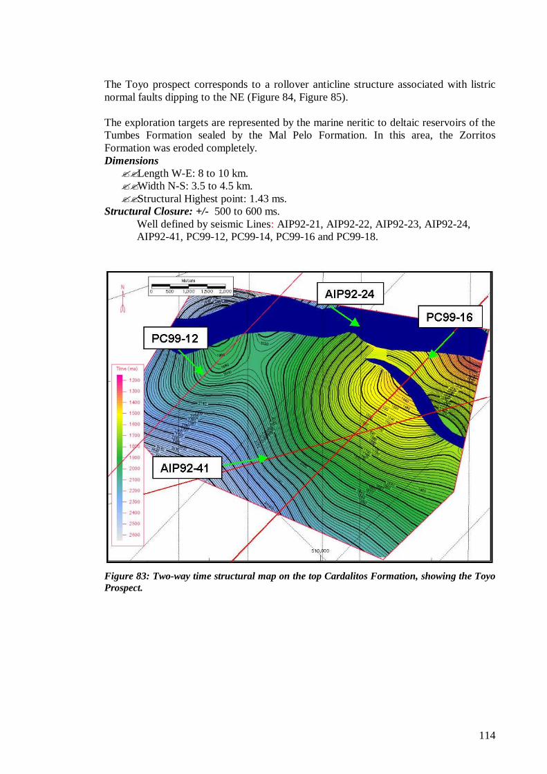
114
The Toyo prospect corresponds to a rollover anticline structure associated with listric normal faults dipping to the NE (Figure 84, Figure 85). The exploration targets are represented by the marine neritic to deltaic reservoirs of the Tumbes Formation sealed by the Mal Pelo Formation. In this area, the Zorritos Formation was eroded completely. Dimensions ??Length W-E: 8 to 10 km. ??Width N-S: 3.5 to 4.5 km. ??Structural Highest point: 1.43 ms.
Structural Closure: +/- 500 to 600 ms. Well defined by seismic Lines: AIP92-21, AIP92-22, AIP92-23, AIP92-24, AIP92-41, PC99-12, PC99-14, PC99-16 and PC99-18.
Figure 83: Two-way time structural map on the top Cardalitos Formation, showing the Toyo Prospect.
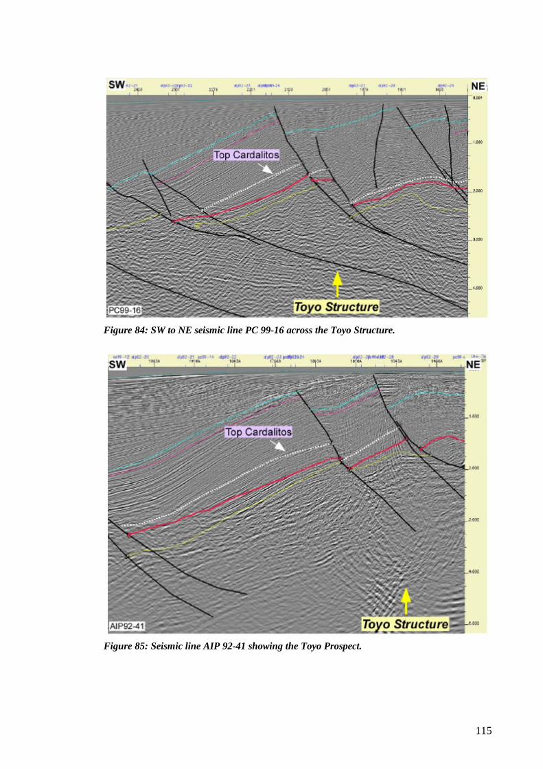
115
Figure 84: SW to NE seismic line PC 99-16 across the Toyo Structure.
Figure 85: Seismic line AIP 92-41 showing the Toyo Prospect.
116
8.1.1.14. Zorritos-Piedra Redonda Lead This lead is located in the transition zone between the offshore Tumbes Basin and the onshore Talara and Tumbes Basins (Figure 86). The ZPR Lead is a SW-NE trending horst bounded on the SE and NW flanks by steeply dipping normal listric faults. Internally, other structures can be seen associated with normal faults that set up several other prospective leads. The importance of the Zorritos-Piedra Redonda High is that it is a structure located updip of both offshore and onshore potential kitchens areas (Figure 86). This onshore kitchen also represents a kitchen area for the onshore fields. The seismic interpretation shows the Zorritos-Piedra Redonda High deformed by an older set of faults involving Eocene sequences.
Figure 86. Zorritos-Piedra Redonda Lead.
8.1.2. Talara Basin
The offshore Talara Basin is comprised of two Deep and Shallow platforms separated by the Talara and a series of listric normal faults. All exploration and development have been carried out only in the shallow platform. These platforms still have high potential for additional hydrocarbon exploration. In general, all exploration in the Talara Basin requires additional modern seismic and new structural and geological concepts. The Petrotech oil discovery San Pedro 1X has open all the Bayobar Bay and surrounding areas for exploration of Paleozoic metamorphic rocks. Untested Paleozoic intervals exist in nearby areas with and without license contracts, as west and north of La Casita well (Figure 88). Since Paleozoic production extends now from onshore Laguna Field to the north to San Pedro on the offshore south Talara Basin, the whole basin has received renewed interest for hydrocarbon exploration of Paleozoic.
117
Of especial interest is the interpretation of results in well La Casita drilled by Belco in a syncline and that TD’d in Crystalline Granite Basement underlying Cretaceous sediments. This well tested dry gas in Cretaceous and Tertiary sediments in a synclinal area as seen on the TWT structural map of Paleozoic in the Bayobar Bay in Figure 88. This area can be interpreted as a potential kitchen for the dry-gas production established in the onshore Sechura Basin to the east. It must be mentioned here that the platform selected to drill the original location could not spudded at the recommended site since a water depth of 80 m. was found. The platform had to be moved to an area with water depth of only 70 m., its maximum operational capacity (Ex-Belco Roger Palomino, personal communication on January 31st, 2006, Houston). As seen in the mentioned figure, the La Casita kitchen area is separated from the Tortuga Prospect by a large normal listric fault that even cuts the Basement. This fault may have served as a barrier for La Casita dry gas migration to the south and/or has served as a barrier for the oil migration from San Pedro oil kitchens to the west and SW. This and other prospects and leads in the area have also been exposed to any liquid hydrocarbons migrated from the same western kitchens. A series of prospects and leads encountered in the Talara Basin are described below from south to north.
8.1.2.1. Calamar Lead The Calamar Lead is located in the south Talara Basin within the western edge of the shallow platform, on the west Bayovar Bay. This lead corresponds to an important anticline structure associated with a listric normal fault (Figure 87). The exploration targets within this lead are sequences of Paleozoic, Cretaceous and Tertiary age closely related to potential Cretaceous and lower Tertiary source rocks within local kitchen areas.
118
Figure 87. Calamar Lead defined by seismic line RIB 93-16, showing the potential structural configuration and explorations targets. More detail can be found in Appendix 3.
8.1.2.2. Caballa Prospect
The Caballa structure corresponds to a rollover anticline with four-way dip closure associated with normal listric faults and with very good seismic definition (Figure 88, Figure 89). It is located 22 Km. NW of the San Pedro oil discovery and some 16 Km. to the west of the Tortuga Prospect. Belco drilled wildcat SBXA on the north flank of the structure and TD’d in Cretaceous sediments. The main targets are the Paleozoic metamorphic rocks. Dimensions ?? Length N-S: +/- 8 km. ?? Width W-E: +/- 4 km. ?? Structural Highest point: 1.530 ms.
Structural Closure: +/- 160 to 200 ms. Well defined by seismic Lines: PTP98-18, PTP98-38, PTP98-17, 93-22 and PTP99-43.
8.1.2.3. Tortuga Prospect
The Tortuga structure is located in the Bayovar Bay 15 Km NW of the San Pedro oil discovery and 6 Km. SE of La Casita Well from which it is separated by a large normal listric fault dipping to the NW. Tortuga is a prominent structural high with a very well closure definition of nearly 100 Km2 (Figure 88, Figure 89). It corresponds to the
119
gravitational structures associated with normal and listric faults. The detachment level is connected on the Basement. The main targets are also the Paleozoic metamorphic rocks. Dimensions ?? Length W-E: +/- 12 km. ?? Width N-S: +/- 9 km. ?? Structural Highest point: 1.240 ms.
Structural Closure: +/- 180 to 200 ms. Well defined by seismic Lines: PTP98-19, PTP98-39, PTP98-17, PTP98-40, and PTP98-18.
Figure 88: Two-way time structural map on top of Paleozoic Basement, showing the in the east the Tortuga prospect and in the west part, the Caballa structure.
Figure 89: West to East seismic line PTP 98-17, showing the Tortuga and Caballa structure. See location on Figure 34.
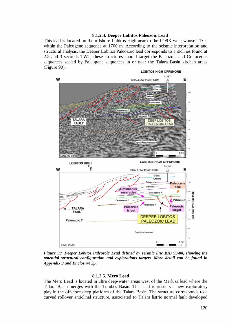
120
8.1.2.4. Deeper Lobitos Paleozoic Lead This lead is located on the offshore Lobitos High near to the LO9X well; whose TD is within the Paleogene sequence at 1700 m. According to the seismic interpretation and structural analysis, the Deeper Lobitos Paleozoic lead corresponds to anticlines found at 2.5 and 3 seconds TWT, these structures should target the Paleozoic and Cretaceous sequences sealed by Paleogene sequences in or near the Talara Basin kitchen areas (Figure 90).
Figure 90. Deeper Lobitos Paleozoic Lead defined by seismic line RIB 93-08, showing the potential structural configuration and explorations targets. More detail can be found in Appendix 3 and Enclosure 3p.
8.1.2.5. Mero Lead
The Mero Lead is located in ultra deep-water areas west of the Merluza lead where the Talara Basin merges with the Tumbes Basin. This lead represents a new exploratory play in the offshore deep platform of the Talara Basin. The structure corresponds to a curved rollover anticlinal structure, associated to Talara listric normal fault developed
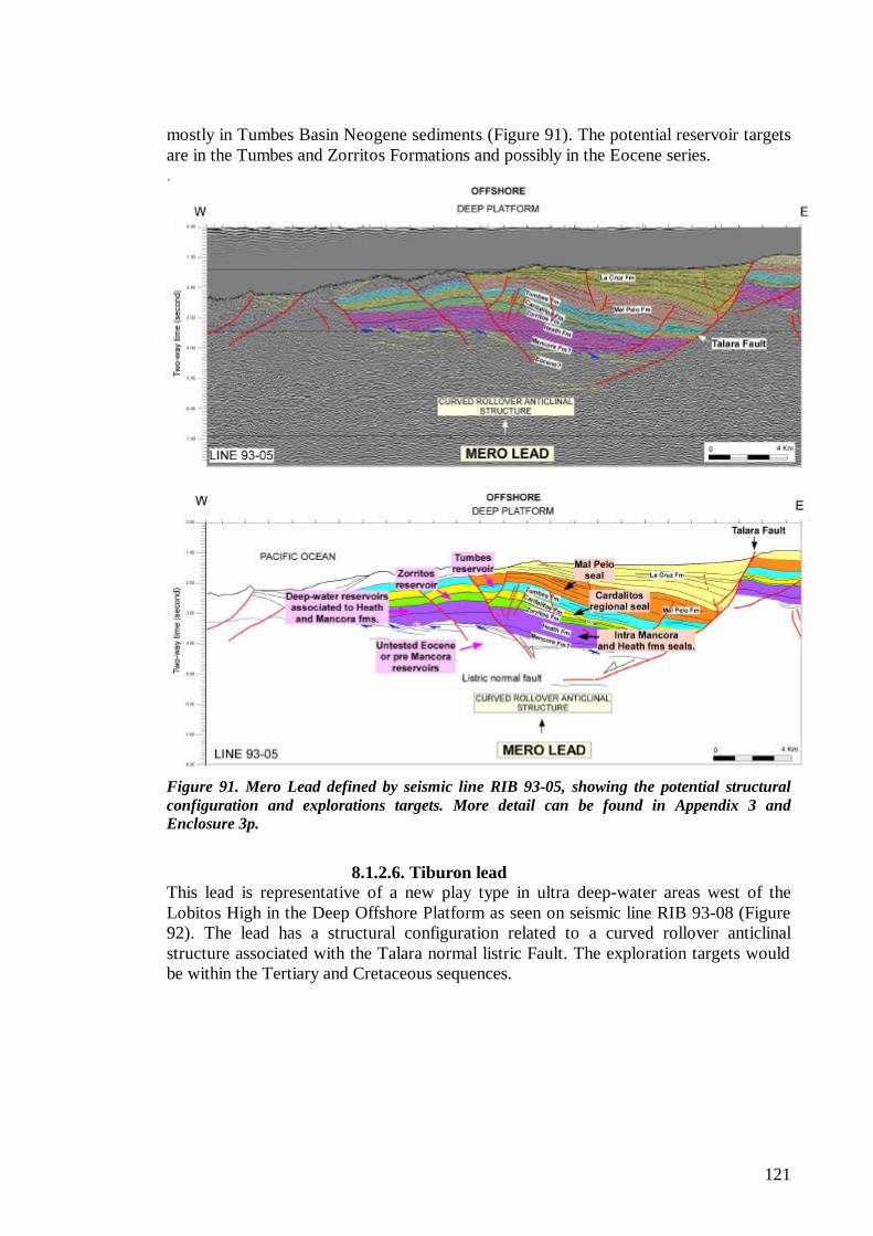
121
mostly in Tumbes Basin Neogene sediments (Figure 91). The potential reservoir targets are in the Tumbes and Zorritos Formations and possibly in the Eocene series. .
Figure 91. Mero Lead defined by seismic line RIB 93-05, showing the potential structural configuration and explorations targets. More detail can be found in Appendix 3 and Enclosure 3p.
8.1.2.6. Tiburon lead
This lead is representative of a new play type in ultra deep-water areas west of the Lobitos High in the Deep Offshore Platform as seen on seismic line RIB 93-08 (Figure 92). The lead has a structural configuration related to a curved rollover anticlinal structure associated with the Talara normal listric Fault. The exploration targets would be within the Tertiary and Cretaceous sequences.
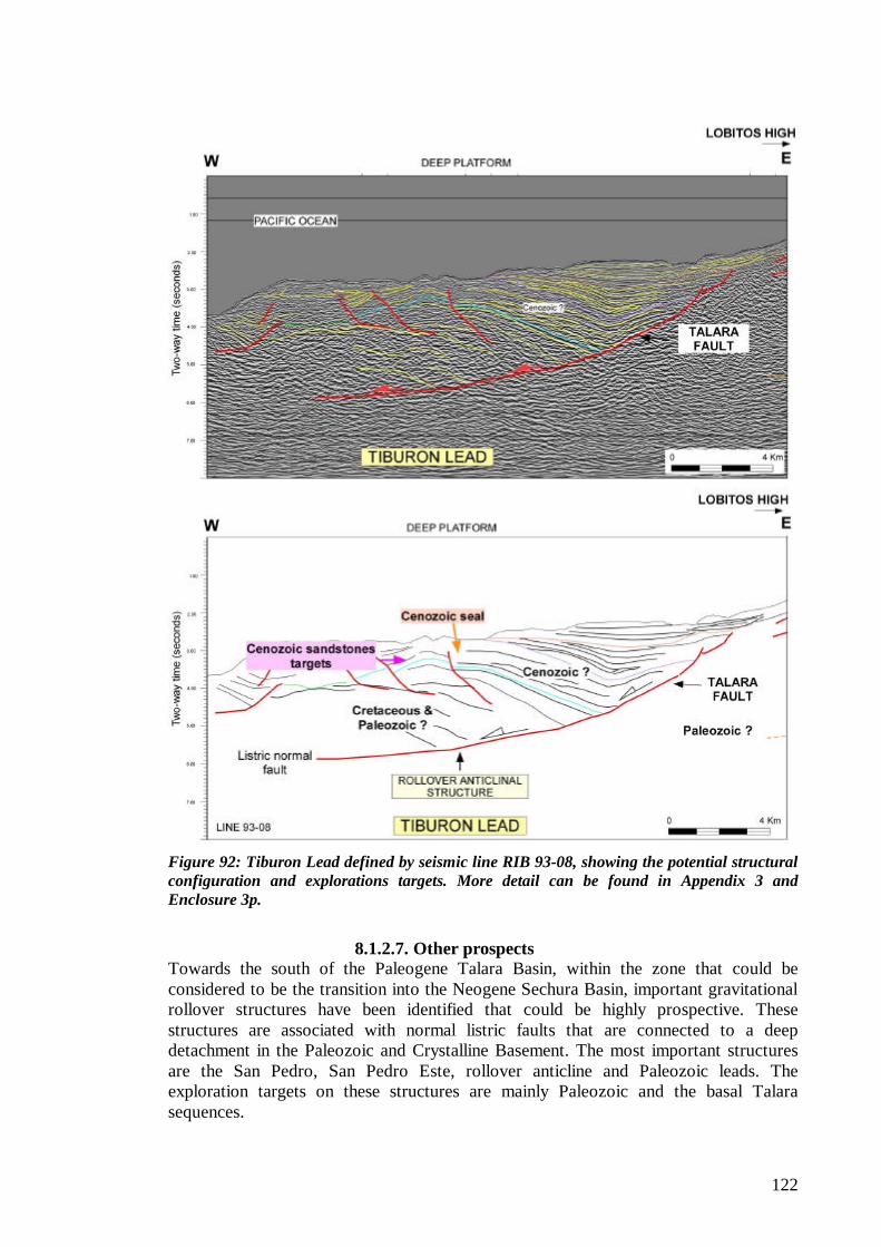
122
Figure 92: Tiburon Lead defined by seismic line RIB 93-08, showing the potential structural configuration and explorations targets. More detail can be found in Appendix 3 and Enclosure 3p.
8.1.2.7. Other prospects
Towards the south of the Paleogene Talara Basin, within the zone that could be considered to be the transition into the Neogene Sechura Basin, important gravitational rollover structures have been identified that could be highly prospective. These structures are associated with normal listric faults that are connected to a deep detachment in the Paleozoic and Crystalline Basement. The most important structures are the San Pedro, San Pedro Este, rollover anticline and Paleozoic leads. The exploration targets on these structures are mainly Paleozoic and the basal Talara sequences.
123
8.2. Previously Defined Prospects and Leads
The description of previously defined prospects and leads are included in Appendix 4.
124
9.0. CONCLUSIONS 9.1. General ? ? All offshore development and exploratory drilling has been concentrated in
maximum water depths of less than 120 m (400 ft) in the Talara and Tumbes Basins. A rough estimate places some 80% of the wells in water depths of less than 90 m in the Talara Basin. Eighteen wells have been drilled in the offshore Tumbes Basin and some 13,200 wells in the Talara Basin, including near 1,300 offshore wells.
? ? Cumulative production is about 1.4 BBO and 1.7 TCF in the Talara Basin and 100 MBO in the Tumbes Basin. Over 90% of the cumulative production was discovered, developed and produced with no seismic data.
? ? Based on published literature mean estimated recoverable undiscovered hydrocarbons in the Talara Basin are in the range between 2.2 to 1.71 BBO, 5.84 to 4.79 TCFG, and 255 MMB of NGL. These estimates are between 85 to 70% offshore and between 15 to 30% onshore. Mean estimated recoverable undiscovered oil, gas and natural gas liquids in the Tumbes (Peru) and bordering Progreso Basins are 237 MMBO, 255 BCFG, and 32 MMB of NGL, respectively. These undiscovered reserves include the 2,005 San Pedro oil discovery whose reserves are being estimated in an area with several other similar structures.
9.2. Stratigraphy ? ? The Talara and Tumbes Basins developed as Paleogene and Neogene basins,
respectively. They include thick stratigraphic sequences of Paleozoic to Tertiary ages that extend offshore and onshore along the Coastal region far beyond the present basins. The pre-Tertiary interval is part of the regional sedimentary succession characterizing all the Peruvian territory that eventually pinch out onto the Brazilian and Guyana Shields. Some of the Paleogene Talara Basin extends north under the Neogene Tumbes Basin, past the Peru-Ecuador border into the Santa Elena Peninsula and overlies a regional incomplete Mesozoic Cretaceous basin overlying a Paleozoic and Crystalline Basements best known in the Talara Basin proper.
? ? The fill of the Talara and Tumbes basins is characterized by different stratigraphic sequences associated with significant tectonic events and sea level global changes, which generated erosional surfaces, changes in the depositional environment, rate of sedimentation and depocenter migration. The stratigraphic architecture reflects shifts in basin accommodation space, which derives from the interplay of extensional tectonics, sediment supply and eustatic sea level changes. The internal sequence architecture shows the retrogradational, progradational and agradational stacking patterns.
? ? Sediment source for the Talara Basin to the east deposited from 9,700 to 7,900 m. of sediments of Paleocene and Eocene ages above the Cretaceous in 35 my. An early Oligocene section has been completed eroded off in the Talara Basin. The Tumbes Basin was also the site of very rapid sedimentation of 6,600 m. to 7,200 m. of Oligocene, Miocene and Pliocene sediments in 30 my.
9.3. Tectonics ? ? The Talara and Tumbes basins developed as a forearc basin system in the NW
coastal Peruvian Andes during Paleogene and Neogene times. The modern structural
126
occurrences in the Oligo-Miocene sequences of the Tumbes Basin. Few fields produce from fractured metamorphic and metasediments of the Paleozoic Amotape Formation and sandstones of Cretaceous and Paleocene age in the Talara Basin.
? ? The late Cretaceous to early Eocene stratigraphic section dated by biomarker Oleanane includes the most likely source rock of the major petroleum system that accounts for the giant oil accumulation in the Talara Basin.
? ? The interpreted geohistory modeling, oil occurrences and production data point towards the presence of more than one hydrocarbon kitchen, very likely representing major kitchens for the Talara and Tumbes Basins. Source rocks are interpreted to contain adequate organic contents and have reached best maturity conditions along the western deep and/or offshore portions of the whole Talara Basin and on deep depocenters to the east and south of the Banco Peru in the Tumbes Basin.
? ? Basin modeling was conducted on four wells in the Talara Basin and two wells and a Pseudowell in the offshore Tumbes Basin.
? ? Mid to Late Mature Windows characterize the Cretaceous and post-Cretaceous sequences, whereas High post-mature values of Ro characterize the Paleozoic metamorphosed sediments in the Lomitos oil field in the Talara Basin. Modeling suggests that source rocks reached a late maturity stage and generated hydrocarbons from late Eocene to early Oligocene time in the Talara Basin. Hydrocarbons were expelled to the east into offshore/onshore traps, possibly former anticlines, during Oligocene time before major tectonics faulted the original traps into the numerous smaller blocks with sealing faults.
? ? Any of the liquid hydrocarbons found in the Bayovar Bay must have migrated long distances and have been generated from source rocks with different organic contents than those found in La Casita 55X well. The regional modeling indicates that the major synclinal area where the well is located may correspond to a dry gas kitchen that generated the dry gas tested in this well in the Cretaceous and Tertiary sandstone reservoirs and in the onshore Sechura Basin in Verdun sands.
? ? Basin modeling has limitations in the offshore Tumbes Basin due to lack of complete Geochemical analyses and of reliable recognition of the undrilled pre-Oligocene stratigraphic column and its geological events. Basin modeling in wells Barracuda with oil test in Cardalitos and Corvina with gas in Zorritos yields immature burial for the known source rocks of Oligocene/Miocene ages. A postulated upper Eocene Formation entered the mid mature oil window in late Neogene. Pseudowell 1 in an interpreted kitchen has source rocks of various formations in the Mid Mature to Main Gas Generation Windows, conditions acquired from early Neogene to present.
9.5. Prospects and Leads ? ? Six and thirteen prospects and leads have been documented in offshore portions of
the Talara and Tumbes Basins, respectively. They have excellent potential to target extensive stratigraphic columns of Paleozoic, Cretaceous, Eocene and Oligo-Miocene in or near interpreted kitchen areas and in water depths between 100 to over 2,000m. Of especial interest are those defined in open areas or in areas where exploration license contracts have not been signed yet.
? ? Recent oil discovery in the San Pedro 1X well in the south offshore Talara Basin in conjunction with other existing Paleozoic oil fields as Laguna in the Pena Negra/El Alto High in the extreme north onshore Talara Basin, has renewed interest for hydrocarbon exploration of Paleozoic rocks in the whole NW Peru. There is a highly attractive area for pre-Eocene, Cretaceous and Paleozoic exploration in the
125
configuration is related to a complex geodynamic history associated with the interaction of the tectonics, eustatic and sedimentary processes that is controlled by the direction and velocity of the relative subduction of the oceanic crust, the aseismic subduction ridges and mainly by the Andes Mountain building processes. Both basins have onshore and offshore components and are bounded on their ocean side by a subduction complex wedge and on its landward side by the Amotape Mountains.
? ? The present-day structural configuration of the Talara Basin is the result of complex extensional and gravitational tectonics that occurred since Paleocene and mainly during middle Eocene time, with reactivation in Neogene time. Most of the offshore portion presents a shallow platform where all drilling activity has been carried out and a deep platform, which has little seismic data.
? ? The structural style of the Neogene Tumbes basin is the result of a NW regional tilt associated with the Banco Peru Fault, the south extension of the Dolores-Guayaquil mega shear. The net result is the formation of gravitational tectonic structures, which have generated both curved and planar rollover anticline structures and some rotated fault blocks. These structures are associated to listric normal faults dipping to the NW down to basin, with detachment levels at the base of the Heath Formation and Pre Mancora series.
? ? The major period of development for these gravitational structures occurred during the deposition of the Mal Pelo and La Cruz formations (Pliocene Pleistocene times). In the present time, the Tumbes basin has the configuration of a major half graben with the thickest section controlled by the Banco Peru Fault. Many of the structures in the Tumbes basin are currently active as indicated by the recent deformation of the younger sedimentary deposits.
9.4. Petroleum Systems and Basin Modeling ? ? Few regional Geochemical studies have been conducted in the Talara and Tumbes
Basins to clearly define the petroleum systems. This effort is still incomplete to clearly recognize all the elements responsible for the giant oil accumulation in the Talara Basin and the hydrocarbon occurrences in the Tumbes Basin.
? ? Main potential source rocks include the Redondo Formation of Campanian-Maastrichtian age, Muerto Formation of Albian age and Paleocene and Eocene Formations in the Talara Basin. The Cretaceous Redondo Formation constitutes a source rock with TOC of 1 wt%, Type II/III Kerogen, oil and gas generator with high thermal maturity corresponding to the last stage of the oil window in the Talara Negritos High. The Muerto Formation has TOC from 1 to 4.5 wt%, excellent RockEval character, Type II and II/III Kerogen, Tmax of 445 to 460 ºC, equivalent Ro is 1 to 1.35 % in the adjacent Lancones Basin. Source rocks in the Muerto and Redondo Formations are rich enough to have generated the commercial amounts of hydrocarbons already produced in the oil fields of the Talara Basin in addition to a sizeable amount of undeveloped reserves and as of yet, undiscovered reserves onshore and offshore.
? ? Source rocks in the Tumbes Basin include Eocene Formations, Oligocene Mancora Formation, Oligocene/Miocene Heath Formation and Miocene Zorritos and Cardalitos Formations. TOC values in excess of 1.0 wt% are found in samples from these formations with Type II and III Kerogen and subordinated Type I and poor maturity.
? ? The main oil and gas reservoirs are sandstones interbedded with shale seals in both the whole prolific Eocene sequences in the Talara Basin and in the hydrocarbon
127
areas between the shallow and deep platforms in the Talara Basin. The Deeper Lobitos Paleozoic Lead in the Lobitos High and the Calamar Lead west of the Bayovar Bay are two examples on this highly prospective area.
? ? The Banco Peru offers a large prospective area (larger than the Talara Negritos High = 600+ MMBO cumulative production) with a large portion in shallow waters of less than 100m. The Banco Peru has a core with dense rocks, which based on its tectonic history gives potential for exploration of both fractured Paleozoic(?) reservoirs and of the interpreted Cenozoic sequences especially in its eastern border faulted by the Banco Peru Fault. This lead is conveniently located to receive hydrocarbons from the Tumbes Basin kitchens. The stratigraphic sequences west of the Banco Peru show less defined chaotic structures.
128
10.0. SELECTED REFERENCES 1. American International Petroleum Inc. (1993) Exploration Significance and
Interpretation of Geochemical Data From Block Z-1, Tumbes Basin and Surrounding Area, Northwest Perú. Perupetro Technical Archive No. IT-05673.
2. Aspden J.A. & McCourt, W.J. (1986). Mesozoic oceanic terrane in the Central Andes of Colombia. Geology, 14, 415-418.
3. Aubouin, J. and von Huene, R., (1982), Initial Reports of the Deep Sea Drilling Project Volume 67: Washington, D.C., U.S., Government Printing Office, 799 p.
4. Baby P., Rivadeneira M., Christophoul F. & Barragan R. (1999). Style and timing of deformation in the Oriente Basin of Ecuador. Fourth International Symposium on Andean Geodynamics, pp. 68-72.
5. Belco Petroleum Corporation (1975), Well Reports La Casita Z-2-75-55X. Perupetro S.A. Technical Archive No. IPP22046 and IPP22047.
6. Daly M.C. (1989). Correlations between Nazca/Farallon plate kinematics and forearc basin evolution in Ecuador. Tectonics, 8, 4, 769-790.
7. Deckelman, J., Connors, F., Shultz, A., Glagola, P., Menard, W., Schwegal, S.-ConocoPhillips Company; Shearer, J.- Applied Petrologic Technology (2005) An Integrated Characterization of Neogene Oil and Gas Reservoirs, Progreso Basin, Offshore Ecuador & Peru: Implications for Petroleum Exploration and Exploitation. Perupetro S.A. INGEPET 2005.
8. DeMets C., Gordon R.G., Argus D.F. & Stein S. (1990). Current plate motions. Geophys. J. Intl., 101, 425-478.
9. Ego F. (1995). Accomodation de la convergence oblique dans une chaîne de type cordilleraine : les Andes d.Equateur. Thèse de doctorat, Université de Paris Sud Orsay, 167 p.
10. Esso Production Reasearch (1967), Organic Geochemical Analyses on 12 Cuttings Samples from One Well (EPF RT-65) in Northwest Peru. Perupetro S.A. Technical Archive IT 529.
11. Fildani A., Hanson D.H., Zhengzheng C., Moldowan J.M., Graham S.A. and Arriola P.R. (2005) Geochemical characteristics of oil and source rocks and implications for petroleum system, Talara Basin, northwest Peru. AAPG Bull. V. 89, No. 11.
12. Gansser A. (1973). Facts and theories on the Andes. Journal geological Society London, 129, 93-131.
13. Gonzales, E, and Alarcón, P. (2002). Potencial Hidrocarburifero de la Cuenca Talara. INGEPET 2002.
14. Graña y Montero Petrolera S. A. (2003). Geochemical Survey in the La Cruz District, Near the Zorritos Oil Field, Peru. A Passive Soil Gas Geochemical Exploration Method. GORETM Surveys for Petroleum Exploration. Perupetro Technical Archive.
15. Gutscher M.A., Malavieille J., Lallemand S. and Collot J. Y. (1999). Tectonic segmentation of the North Andean margin: impact of the Carnegie Ridge collision. Earth and Planetary Science Letters 168. ELSEVIER science B.V. Earth Plan. Sci. Lett, 168: 225-270.
16. Herron E.M. (1972). Sea-floor spreading and the Cenozoic history of the East-Central Pacific. GSA Bull., 83, 1671- 1692.
17. Hey, R.N. (1977). Tectonic evolution of the Cocos-Nazca spreading center. Geol. Soc. America Bull., 88, 1404-1420.
129
18. Higley, D. (2001). The Talara Basin Province of Northwestern Peru: Cretaceous-Tertiary Total Petroleum System (608101). Partial Report of the World Energy Project for the US Geological Survey.
19. Higley, D. (2001). The Progreso Basin Province of Northwestern Peru and Southwestern Ecuador: Neogene (608301) and Cretaceous-Paleogene (608302) Total Petroleum System. Partial Report of the World Energy Project for the US Geological Survey.
20. Jordan T., B. Isacks R. Allmendinger J. Brewer V. Ramos et Ando C. (1983). Andean tectonics related to geometry of the subducted Nazca plate, Geol. Soc. Am. Bull., 94, 341-361, 1983.
21. Lonsdale P. (1978). Ecuadorian Subduction System. AAPG Bull. 62, 12, 2454-2477.
22. Macellari Carlos, (1985). Cretaceous Basins of Western South America. University of South Carolina, Earth Resources Institute Volumes I and II.
23. Mammerickx J., Herron E.,& Dorman L. (1980). Evidence for two fossil spreading ridges in the southeast Pacific. Geol. Soc. Am. Bull., 1, 91, 263-271.
24. Manrique C., P (1994). Interpretación Estructural y Posibilidades Petrolíferas del Area Carpitas. GMP S.A. Exploration Department.
25. McIntosh, K.D., Silver, E.A., and Shipley, T., (1993). Evidence and mechanisms for forearc extension at the accretionary Costa Rica convergent margin. Tectonics, 12:1380-1392.
26. Minster J.B. & Jordan T.H. (1978). Present day plate motions. J. Geol. Res., 83, 5331-5354.
27. Mobil Oil Production and Producing Peru (1993), Talara Basin, Peru: Source Rock Characterization. Perupetro S.A. Technical Archive IT 03810
28. OXY, Sucursal del Perú (2001), Reporte Final Block Z-3 Cuenca Progreso-Tumbes, Perú. Perupetro Technical Archive ITP21932.
29. Pardo-Casas, F. et Molnar P. (1987). Relative motion of the Nazca (Farallon) and South American plates since Late Cretaceous time. Tectonics 6, 233-248.
30. PARSEP (2002). Ucayali & Ene Basins Technical Report. Perupetro S.A. Technical Archive ITP 22174 to 22178.
31. Pecom Energía, (2001). Evaluación Geoquímica de una Muestra de Petróleo, Pozo RT-48, Perú. Perupetro Technical Archive.
32. Pérez Companc S.A. (2000). Informe Final del Primer Período Exploratorio (1998-2000) Lote Z1, Cuenca de Tumbes-Progreso, Perú, Perupetro S.A. Technical Archive ITP 21693 to 21695. Segundo Período ITP 21771.
33. Pérez Companc S.A. (2000). Evaluaciones de Potenciales Rocas Generadoras de Hidrocarburos en el Lote Z1, Perú. Pozos Corvina 40-10X, Albacora 8-X4, Albacora 8 X5, Delfín 39 X1 y Barracuda X1. Perupetro S.A. Technical Archive ITP 21697.
34. Perupetro S.A. (1999). Estudios de Investigación Geoquímica del Potencial de Hidrocarburos Lotes del Zócalo Continental y de Tierra. Perupetro S.A., Technical Archive ITP 21002 to ITP 21005. 4 Volumes.
35. Petroperu S.A., (1982). Proyecto Laguna Zapotal, Plates. Perupetro S.A. Technical Archive ITP 20937.
36. Petróleos del Perú, (1983). Evaluación Geológica del Yacimiento Laguna Sur Talara. Perupetro S.A. Technical Archive IT00018.
37. Petroperu S.A. (1983). Evaluación Geológica del Paleozoico Noroeste. Exploration Area, Volumes I, II and III. Perupetro Technical Archive IT00974, IT 00975 and IT00976.
130
38. Petroperu S.A. (1990). Proyecto Laguna Zapotal, Informe Final, Primera Parte. Perupetro S.A. Technical Archive IT 04641.
39. Petroperu S.A., (1990). Proyecto Laguna Zapotal, Informe Final, Segunda Parte. Perupetro S.A. Technical Archive IT 04642.
40. Petroperu S.A., (1970). Estudio Geológico del Basamento Paleozoico en las Montañas Amotape. Perupetro S.A. Technical Archive IT 00255.
41. Petro-Tech Peruana S.A. (1999). Evaluación Geológica y Geofísica del Cretáceo, Area Chira. Perupetro S.A. Technical Archive ITP 21795.
42. Petro-Tech Peruana S.A. (2000). Lote Z-2B Evaluación Geológica y Geofísica. Area Cabo Blanco-Punta Sal. Perupetro S.A. Technical Archive ITP 21797.
43. Petro-Tech Peruana S.A. (2001). Evaluación Integral de la fase de Exploración del Lote Z-2B, 1994-2000. Perupetro S.A. Technical Archive ITP 21794.
44. Repsol Exploración, Peru, (1996). Geochemical Evaluation of selected Well, Seep and Oil Samples from Peru, Final Report. CoreLab Report, Perupetro S.A. Technical Archive ITP 20125.
45. Reyes, L. and Vergara, (1987) Evaluación Geológica y Potencial Petrolífero Cuenca Lancones. Perupetro Technical Archive No. IT03453.
46. Roperch, P., F. Megard, L.A.J. Carlo, T. Mourier, T.M. Clube, and C. Noblet, (1987). Rotated oceanic blocks in western Ecuador, Geophys. Res. Lett., 14, 558-561; 1.
47. Serra O. (1985) Diagraphies Différées: Bases de l'interprétation. Tome2: Interprétation des données diagraphiques, Elf-Aquitaine/BRGM/TECHNIP 631p
48. Shepherd, Glenn L. and Moberly, Ralph (1981). Coastal Structure of the Continental Margin, Northwest Peru and Southwest Ecuador. The Nazca Plate Crustal Formation and Andean Convergence. Geological Society of America, Memoir 154.
49. Sunmark Exploration Co., Geochemical Group (1978). Organic Geochemistry of the 8-X1 well, Offshore Peru. Perupetro S.A. Technical Archive IT 00526.
50. Travis, R. B. (1953). La Brea Pariñas Oil Field, Northwestern Peru. AAPG Bulletin, Vol. 37, No. 9.
51. Union Pacific Petroleum Peru, Ltd. (1993). Geochemical Oil Correlations for UPPPL Oils and Offshore Oil Seep, Talara Basin, Peru. Perupetro S.A. CoreLab Report, Technical Archive IT 03727.
52. Vail, P.R. (1987). Seismic Stratigraphy Interpretation Using Sequence Stratigraphy: Part I. Seismic Stratigraphy Procedures AAPG Studies In Geology 27, P 1-10.
53. Van Thournout F., Hertogen J. et Quebedo L. (1992). Allochtonous terranes in northwestern Ecuador. Tectonophysics, 205, 205-221
54. Van Wagoner, J. C., Mitchum R.M., Campion K.M. and Rahmanian V.D. (1990). Siliciclastic Sequence Stratigraphy in Well Logs, Cores and Outcrops. AAPG Methods in Exploration Series 7, P. 1-55.
55. Von Huene R. & Lallemand S. (1990). Tectonic erosion along the Japan and Peru convergent margins. Geol. Soc. America Bull., 102, 704-720.
56. Von Huene R. & Scholl D.W. (1991). Observations at convergent margins concerning sediment subduction, subduction erosion, and the growth of continental crust. Rev. Geophysics, 20, 279-316.
57. Wortel M.J.R. (1984). Spatial and temporal variations in the Andean subduction zone. J. Geol. Soc., London, 141, 254-286.
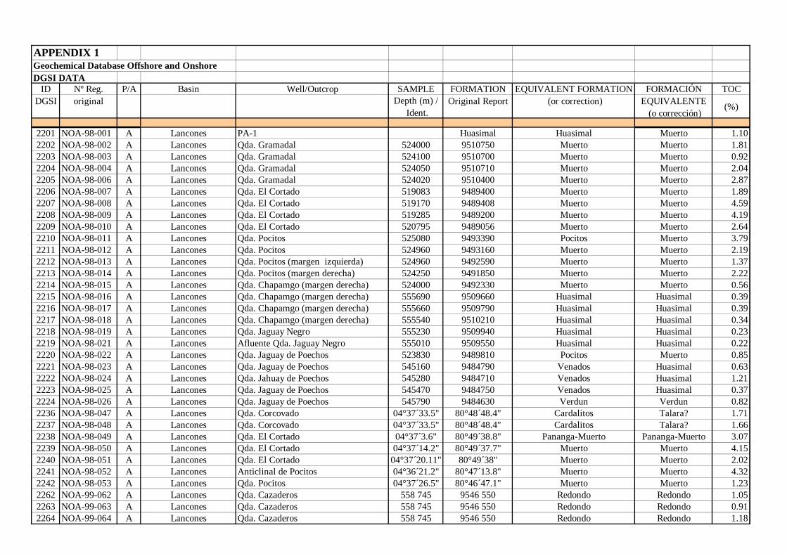
APPENDIX 1Geochemical Database Offshore and OnshoreDGSI DATA
ID Nº Reg. P/A Basin Well/Outcrop SAMPLE FORMATION EQUIVALENT FORMATION FORMACIÓN TOCDGSI original Depth (m) /
Ident.Original Report (or correction) EQUIVALENTE
(o corrección)(%)
2201 NOA-98-001 A Lancones PA-1 Huasimal Huasimal Muerto 1.102202 NOA-98-002 A Lancones Qda. Gramadal 524000 9510750 Muerto Muerto 1.812203 NOA-98-003 A Lancones Qda. Gramadal 524100 9510700 Muerto Muerto 0.922204 NOA-98-004 A Lancones Qda. Gramadal 524050 9510710 Muerto Muerto 2.042205 NOA-98-006 A Lancones Qda. Gramadal 524020 9510400 Muerto Muerto 2.872206 NOA-98-007 A Lancones Qda. El Cortado 519083 9489400 Muerto Muerto 1.892207 NOA-98-008 A Lancones Qda. El Cortado 519170 9489408 Muerto Muerto 4.592208 NOA-98-009 A Lancones Qda. El Cortado 519285 9489200 Muerto Muerto 4.192209 NOA-98-010 A Lancones Qda. El Cortado 520795 9489056 Muerto Muerto 2.642210 NOA-98-011 A Lancones Qda. Pocitos 525080 9493390 Pocitos Muerto 3.792211 NOA-98-012 A Lancones Qda. Pocitos 524960 9493160 Muerto Muerto 2.192212 NOA-98-013 A Lancones Qda. Pocitos (margen izquierda) 524960 9492590 Muerto Muerto 1.372213 NOA-98-014 A Lancones Qda. Pocitos (margen derecha) 524250 9491850 Muerto Muerto 2.222214 NOA-98-015 A Lancones Qda. Chapamgo (margen derecha) 524000 9492330 Muerto Muerto 0.562215 NOA-98-016 A Lancones Qda. Chapamgo (margen derecha) 555690 9509660 Huasimal Huasimal 0.392216 NOA-98-017 A Lancones Qda. Chapamgo (margen derecha) 555660 9509790 Huasimal Huasimal 0.392217 NOA-98-018 A Lancones Qda. Chapamgo (margen derecha) 555540 9510210 Huasimal Huasimal 0.342218 NOA-98-019 A Lancones Qda. Jaguay Negro 555230 9509940 Huasimal Huasimal 0.232219 NOA-98-021 A Lancones Afluente Qda. Jaguay Negro 555010 9509550 Huasimal Huasimal 0.222220 NOA-98-022 A Lancones Qda. Jaguay de Poechos 523830 9489810 Pocitos Muerto 0.852221 NOA-98-023 A Lancones Qda. Jaguay de Poechos 545160 9484790 Venados Huasimal 0.632222 NOA-98-024 A Lancones Qda. Jahuay de Poechos 545280 9484710 Venados Huasimal 1.212223 NOA-98-025 A Lancones Qda. Jaguay de Poechos 545470 9484750 Venados Huasimal 0.372224 NOA-98-026 A Lancones Qda. Jaguay de Poechos 545790 9484630 Verdun Verdun 0.822236 NOA-98-047 A Lancones Qda. Corcovado 04°37´33.5" 80°48´48.4" Cardalitos Talara? 1.712237 NOA-98-048 A Lancones Qda. Corcovado 04°37´33.5" 80°48´48.4" Cardalitos Talara? 1.662238 NOA-98-049 A Lancones Qda. El Cortado 04°37´3.6" 80°49´38.8" Pananga-Muerto Pananga-Muerto 3.072239 NOA-98-050 A Lancones Qda. El Cortado 04°37´14.2" 80°49´37.7" Muerto Muerto 4.152240 NOA-98-051 A Lancones Qda. El Cortado 04°37´20.11" 80°49´38" Muerto Muerto 2.022241 NOA-98-052 A Lancones Anticlinal de Pocitos 04°36´21.2" 80°47´13.8" Muerto Muerto 4.322242 NOA-98-053 A Lancones Qda. Pocitos 04°37´26.5" 80°46´47.1" Muerto Muerto 1.232262 NOA-99-062 A Lancones Qda. Cazaderos 558 745 9546 550 Redondo Redondo 1.052263 NOA-99-063 A Lancones Qda. Cazaderos 558 745 9546 550 Redondo Redondo 0.912264 NOA-99-064 A Lancones Qda. Cazaderos 558 745 9546 550 Redondo Redondo 1.18
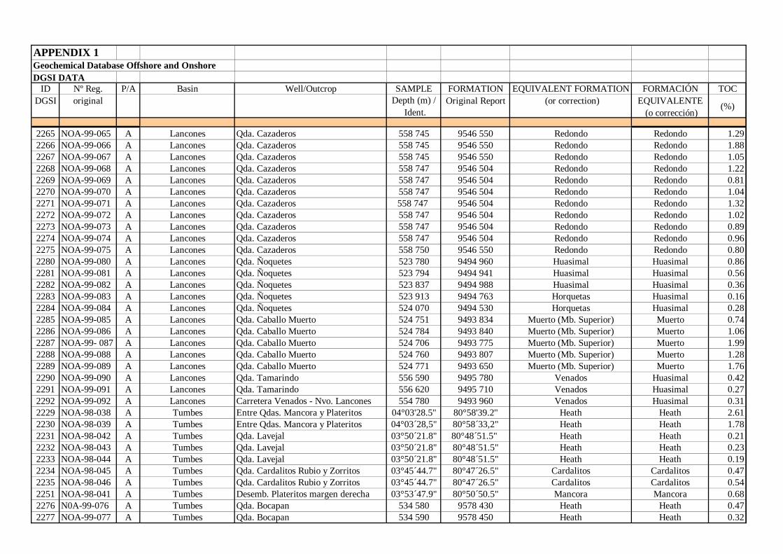
APPENDIX 1Geochemical Database Offshore and OnshoreDGSI DATA
ID Nº Reg. P/A Basin Well/Outcrop SAMPLE FORMATION EQUIVALENT FORMATION FORMACIÓN TOCDGSI original Depth (m) /
Ident.Original Report (or correction) EQUIVALENTE
(o corrección)(%)
2265 NOA-99-065 A Lancones Qda. Cazaderos 558 745 9546 550 Redondo Redondo 1.292266 NOA-99-066 A Lancones Qda. Cazaderos 558 745 9546 550 Redondo Redondo 1.882267 NOA-99-067 A Lancones Qda. Cazaderos 558 745 9546 550 Redondo Redondo 1.052268 NOA-99-068 A Lancones Qda. Cazaderos 558 747 9546 504 Redondo Redondo 1.222269 NOA-99-069 A Lancones Qda. Cazaderos 558 747 9546 504 Redondo Redondo 0.812270 NOA-99-070 A Lancones Qda. Cazaderos 558 747 9546 504 Redondo Redondo 1.042271 NOA-99-071 A Lancones Qda. Cazaderos 558 747 9546 504 Redondo Redondo 1.322272 NOA-99-072 A Lancones Qda. Cazaderos 558 747 9546 504 Redondo Redondo 1.022273 NOA-99-073 A Lancones Qda. Cazaderos 558 747 9546 504 Redondo Redondo 0.892274 NOA-99-074 A Lancones Qda. Cazaderos 558 747 9546 504 Redondo Redondo 0.962275 NOA-99-075 A Lancones Qda. Cazaderos 558 750 9546 550 Redondo Redondo 0.802280 NOA-99-080 A Lancones Qda. Ñoquetes 523 780 9494 960 Huasimal Huasimal 0.862281 NOA-99-081 A Lancones Qda. Ñoquetes 523 794 9494 941 Huasimal Huasimal 0.562282 NOA-99-082 A Lancones Qda. Ñoquetes 523 837 9494 988 Huasimal Huasimal 0.362283 NOA-99-083 A Lancones Qda. Ñoquetes 523 913 9494 763 Horquetas Huasimal 0.162284 NOA-99-084 A Lancones Qda. Ñoquetes 524 070 9494 530 Horquetas Huasimal 0.282285 NOA-99-085 A Lancones Qda. Caballo Muerto 524 751 9493 834 Muerto (Mb. Superior) Muerto 0.742286 NOA-99-086 A Lancones Qda. Caballo Muerto 524 784 9493 840 Muerto (Mb. Superior) Muerto 1.062287 NOA-99- 087 A Lancones Qda. Caballo Muerto 524 706 9493 775 Muerto (Mb. Superior) Muerto 1.992288 NOA-99-088 A Lancones Qda. Caballo Muerto 524 760 9493 807 Muerto (Mb. Superior) Muerto 1.282289 NOA-99-089 A Lancones Qda. Caballo Muerto 524 771 9493 650 Muerto (Mb. Superior) Muerto 1.762290 NOA-99-090 A Lancones Qda. Tamarindo 556 590 9495 780 Venados Huasimal 0.422291 NOA-99-091 A Lancones Qda. Tamarindo 556 620 9495 710 Venados Huasimal 0.272292 NOA-99-092 A Lancones Carretera Venados - Nvo. Lancones 554 780 9493 960 Venados Huasimal 0.312229 NOA-98-038 A Tumbes Entre Qdas. Mancora y Plateritos 04°03'28.5'' 80°58'39.2'' Heath Heath 2.612230 NOA-98-039 A Tumbes Entre Qdas. Mancora y Plateritos 04°03´28,5" 80°58´33,2" Heath Heath 1.782231 NOA-98-042 A Tumbes Qda. Lavejal 03°50´21.8" 80°48´51.5" Heath Heath 0.212232 NOA-98-043 A Tumbes Qda. Lavejal 03°50´21.8" 80°48´51.5" Heath Heath 0.232233 NOA-98-044 A Tumbes Qda. Lavejal 03°50´21.8" 80°48´51.5" Heath Heath 0.192234 NOA-98-045 A Tumbes Qda. Cardalitos Rubio y Zorritos 03°45´44.7" 80°47´26.5" Cardalitos Cardalitos 0.472235 NOA-98-046 A Tumbes Qda. Cardalitos Rubio y Zorritos 03°45´44.7" 80°47´26.5" Cardalitos Cardalitos 0.542251 NOA-98-041 A Tumbes Desemb. Plateritos margen derecha 03°53´47.9" 80°50´50.5" Mancora Mancora 0.682276 N0A-99-076 A Tumbes Qda. Bocapan 534 580 9578 430 Heath Heath 0.472277 NOA-99-077 A Tumbes Qda. Bocapan 534 590 9578 450 Heath Heath 0.32
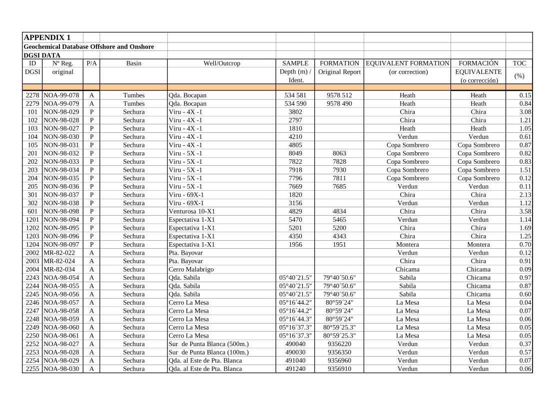
APPENDIX 1Geochemical Database Offshore and OnshoreDGSI DATA
ID Nº Reg. P/A Basin Well/Outcrop SAMPLE FORMATION EQUIVALENT FORMATION FORMACIÓN TOCDGSI original Depth (m) /
Ident.Original Report (or correction) EQUIVALENTE
(o corrección)(%)
2278 NOA-99-078 A Tumbes Qda. Bocapan 534 581 9578 512 Heath Heath 0.152279 NOA-99-079 A Tumbes Qda. Bocapan 534 590 9578 490 Heath Heath 0.84101 NON-98-029 P Sechura Viru - 4X -1 3802 Chira Chira 3.08102 NON-98-028 P Sechura Viru - 4X -1 2797 Chira Chira 1.21103 NON-98-027 P Sechura Viru - 4X -1 1810 Heath Heath 1.05104 NON-98-030 P Sechura Viru - 4X -1 4210 Verdun Verdun 0.61105 NON-98-031 P Sechura Viru - 4X -1 4805 Copa Sombrero Copa Sombrero 0.87201 NON-98-032 P Sechura Viru - 5X -1 8049 8063 Copa Sombrero Copa Sombrero 0.82202 NON-98-033 P Sechura Viru - 5X -1 7822 7828 Copa Sombrero Copa Sombrero 0.83203 NON-98-034 P Sechura Viru - 5X -1 7918 7930 Copa Sombrero Copa Sombrero 1.51204 NON-98-035 P Sechura Viru - 5X -1 7796 7811 Copa Sombrero Copa Sombrero 0.12205 NON-98-036 P Sechura Viru - 5X -1 7669 7685 Verdun Verdun 0.11301 NON-98-037 P Sechura Viru - 69X-1 1820 Chira Chira 2.13302 NON-98-038 P Sechura Viru - 69X-1 3156 Verdun Verdun 1.12601 NON-98-098 P Sechura Venturosa 10-X1 4829 4834 Chira Chira 3.58
1201 NON-98-094 P Sechura Espectativa 1-X1 5470 5465 Verdun Verdun 1.141202 NON-98-095 P Sechura Espectativa 1-X1 5201 5200 Chira Chira 1.691203 NON-98-096 P Sechura Espectativa 1-X1 4350 4343 Chira Chira 1.251204 NON-98-097 P Sechura Espectativa 1-X1 1956 1951 Montera Montera 0.702002 MR-82-022 A Sechura Pta. Bayovar Verdun Verdun 0.122003 MR-82-024 A Sechura Pta. Bayovar Chira Chira 0.912004 MR-82-034 A Sechura Cerro Malabrigo Chicama Chicama 0.092243 NOA-98-054 A Sechura Qda. Sabila 05°40´21.5" 79°40´50.6" Sabila Chicama 0.972244 NOA-98-055 A Sechura Qda. Sabila 05°40´21.5" 79°40´50.6" Sabila Chicama 0.872245 NOA-98-056 A Sechura Qda. Sabila 05°40´21.5" 79°40´50.6" Sabila Chicama 0.602246 NOA-98-057 A Sechura Cerro La Mesa 05°16´44.2" 80°59´24" La Mesa La Mesa 0.042247 NOA-98-058 A Sechura Cerro La Mesa 05°16´44.2" 80°59´24" La Mesa La Mesa 0.072248 NOA-98-059 A Sechura Cerro La Mesa 05°16´44.3" 80°59´24" La Mesa La Mesa 0.062249 NOA-98-060 A Sechura Cerro La Mesa 05°16´37.3" 80°59´25.3" La Mesa La Mesa 0.052250 NOA-98-061 A Sechura Cerro La Mesa 05°16´37.3" 80°59´25.3" La Mesa La Mesa 0.052252 NOA-98-027 A Sechura Sur de Punta Blanca (500m.) 490040 9356220 Verdun Verdun 0.372253 NOA-98-028 A Sechura Sur de Punta Blanca (100m.) 490030 9356350 Verdun Verdun 0.572254 NOA-98-029 A Sechura Qda. al Este de Pta. Blanca 491040 9356960 Verdun Verdun 0.072255 NOA-98-030 A Sechura Qda. al Este de Pta. Blanca 491240 9356910 Verdun Verdun 0.06
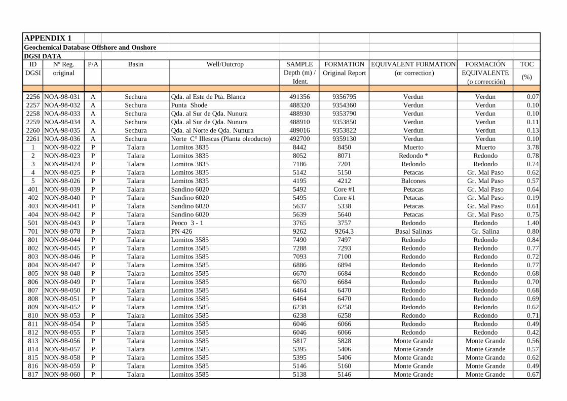
APPENDIX 1Geochemical Database Offshore and OnshoreDGSI DATA
ID Nº Reg. P/A Basin Well/Outcrop SAMPLE FORMATION EQUIVALENT FORMATION FORMACIÓN TOCDGSI original Depth (m) /
Ident.Original Report (or correction) EQUIVALENTE
(o corrección)(%)
2256 NOA-98-031 A Sechura Qda. al Este de Pta. Blanca 491356 9356795 Verdun Verdun 0.072257 NOA-98-032 A Sechura Punta Shode 488320 9354360 Verdun Verdun 0.102258 NOA-98-033 A Sechura Qda. al Sur de Qda. Nunura 488930 9353790 Verdun Verdun 0.102259 NOA-98-034 A Sechura Qda. al Sur de Qda. Nunura 488910 9353850 Verdun Verdun 0.112260 NOA-98-035 A Sechura Qda. al Norte de Qda. Nunura 489016 9353822 Verdun Verdun 0.132261 NOA-98-036 A Sechura Norte C° Illescas (Planta oleoducto) 492700 9359130 Verdun Verdun 0.10
1 NON-98-022 P Talara Lomitos 3835 8442 8450 Muerto Muerto 3.782 NON-98-023 P Talara Lomitos 3835 8052 8071 Redondo * Redondo 0.783 NON-98-024 P Talara Lomitos 3835 7186 7201 Redondo Redondo 0.744 NON-98-025 P Talara Lomitos 3835 5142 5150 Petacas Gr. Mal Paso 0.625 NON-98-026 P Talara Lomitos 3835 4195 4212 Balcones Gr. Mal Paso 0.57
401 NON-98-039 P Talara Sandino 6020 5492 Core #1 Petacas Gr. Mal Paso 0.64402 NON-98-040 P Talara Sandino 6020 5495 Core #1 Petacas Gr. Mal Paso 0.19403 NON-98-041 P Talara Sandino 6020 5637 5338 Petacas Gr. Mal Paso 0.61404 NON-98-042 P Talara Sandino 6020 5639 5640 Petacas Gr. Mal Paso 0.75501 NON-98-043 P Talara Peoco 3 - 1 3765 3757 Redondo Redondo 1.40701 NON-98-078 P Talara PN-426 9262 9264.3 Basal Salinas Gr. Salina 0.80801 NON-98-044 P Talara Lomitos 3585 7490 7497 Redondo Redondo 0.84802 NON-98-045 P Talara Lomitos 3585 7288 7293 Redondo Redondo 0.77803 NON-98-046 P Talara Lomitos 3585 7093 7100 Redondo Redondo 0.72804 NON-98-047 P Talara Lomitos 3585 6886 6894 Redondo Redondo 0.77805 NON-98-048 P Talara Lomitos 3585 6670 6684 Redondo Redondo 0.68806 NON-98-049 P Talara Lomitos 3585 6670 6684 Redondo Redondo 0.70807 NON-98-050 P Talara Lomitos 3585 6464 6470 Redondo Redondo 0.68808 NON-98-051 P Talara Lomitos 3585 6464 6470 Redondo Redondo 0.69809 NON-98-052 P Talara Lomitos 3585 6238 6258 Redondo Redondo 0.62810 NON-98-053 P Talara Lomitos 3585 6238 6258 Redondo Redondo 0.71811 NON-98-054 P Talara Lomitos 3585 6046 6066 Redondo Redondo 0.49812 NON-98-055 P Talara Lomitos 3585 6046 6066 Redondo Redondo 0.42813 NON-98-056 P Talara Lomitos 3585 5817 5828 Monte Grande Monte Grande 0.56814 NON-98-057 P Talara Lomitos 3585 5395 5406 Monte Grande Monte Grande 0.57815 NON-98-058 P Talara Lomitos 3585 5395 5406 Monte Grande Monte Grande 0.62816 NON-98-059 P Talara Lomitos 3585 5146 5160 Monte Grande Monte Grande 0.49817 NON-98-060 P Talara Lomitos 3585 5138 5146 Monte Grande Monte Grande 0.67
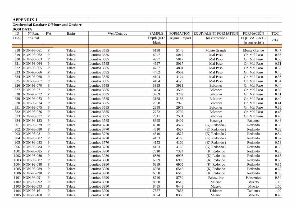
APPENDIX 1Geochemical Database Offshore and OnshoreDGSI DATA
ID Nº Reg. P/A Basin Well/Outcrop SAMPLE FORMATION EQUIVALENT FORMATION FORMACIÓN TOCDGSI original Depth (m) /
Ident.Original Report (or correction) EQUIVALENTE
(o corrección)(%)
818 NON-98-061 P Talara Lomitos 3585 5138 5146 Monte Grande Monte Grande 0.47819 NON-98-062 P Talara Lomitos 3585 4997 5017 Mal Paso Gr. Mal Paso 0.56820 NON-98-063 P Talara Lomitos 3585 4997 5017 Mal Paso Gr. Mal Paso 0.56821 NON-98-064 P Talara Lomitos 3585 4997 5017 Mal Paso Gr. Mal Paso 0.61822 NON-98-065 P Talara Lomitos 3585 4787 4804 Mal Paso Gr. Mal Paso 0.52823 NON-98-066 P Talara Lomitos 3585 4482 4502 Mal Paso Gr. Mal Paso 0.40824 NON-98-068 P Talara Lomitos 3585 4104 4124 Mal Paso Gr. Mal Paso 0.36825 NON-98-067 P Talara Lomitos 3585 4104 4126 Mal Paso Gr. Mal Paso 0.54826 NON-98-070 P Talara Lomitos 3585 3895 3911 Balcones Gr. Mal Paso 0.44827 NON-98-071 P Talara Lomitos 3585 3484 3503 Balcones Gr. Mal Paso 0.59828 NON-98-072 P Talara Lomitos 3585 3269 3289 Balcones Gr. Mal Paso 0.41829 NON-98-073 P Talara Lomitos 3585 3168 3188 Balcones Gr. Mal Paso 0.40830 NON-98-074 P Talara Lomitos 3585 2958 2978 Balcones Gr. Mal Paso 0.41831 NON-98-075 P Talara Lomitos 3585 2958 2978 Balcones Gr. Mal Paso 0.36832 NON-98-076 P Talara Lomitos 3585 2772 2792 Balcones Gr. Mal Paso 0.46833 NON-98-077 P Talara Lomitos 3585 2511 2531 Balcones Gr. Mal Paso 0.46834 NON-98-133 P Talara Lomitos 3585 8395 8402 Pananga Pananga 0.43901 NON-98-079 P Talara Lomitos 3770 4510 4527 (K) Redondo ? Redondo 0.58902 NON-98-080 P Talara Lomitos 3770 4510 4527 (K) Redondo ? Redondo 0.59903 NON-98-081 P Talara Lomitos 3770 4510 4527 (K) Redondo ? Redondo 0.54904 NON-98-082 P Talara Lomitos 3770 4153 4166 (K) Redondo ? Redondo 0.57905 NON-98-083 P Talara Lomitos 3770 4153 4166 (K) Redondo ? Redondo 0.59906 NON-98-084 P Talara Lomitos 3770 4153 4166 (K) Redondo ? Redondo 0.52
1001 NON-98-085 P Talara Lomitos 3980 7310 7324 (K) Redondo Redondo 0.231002 NON-98-086 P Talara Lomitos 3980 6889 6905 (K) Redondo Redondo 0.651003 NON-98-087 P Talara Lomitos 3980 6889 6905 (K) Redondo Redondo 0.651004 NON-98-088 P Talara Lomitos 3980 6889 6905 (K) Redondo Redondo 0.851005 NON-98-089 P Talara Lomitos 3980 6538 6548 (K) Redondo Redondo 0.671006 NON-98-090 P Talara Lomitos 3980 6538 6548 (K) Redondo Redondo 0.331101 NON-98-091 P Talara Lomitos 3990 8740 8750 Paleozoico Paleozoico 0.501102 NON-98-092 P Talara Lomitos 3990 8508 8516 Muerto Muerto 1.181103 NON-98-093 P Talara Lomitos 3990 8435 8442 Muerto Muerto 1.661104 NON-98-161 P Talara Lomitos 3990 7857 7853 Tablones Tablones 1.991105 NON-98-160 P Talara Lomitos 3990 8374 8368 Muerto Muerto 0.40
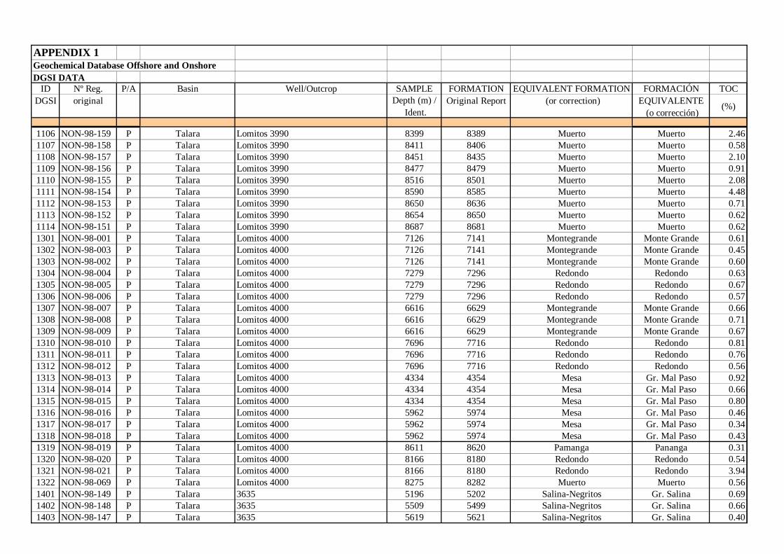
APPENDIX 1Geochemical Database Offshore and OnshoreDGSI DATA
ID Nº Reg. P/A Basin Well/Outcrop SAMPLE FORMATION EQUIVALENT FORMATION FORMACIÓN TOCDGSI original Depth (m) /
Ident.Original Report (or correction) EQUIVALENTE
(o corrección)(%)
1106 NON-98-159 P Talara Lomitos 3990 8399 8389 Muerto Muerto 2.461107 NON-98-158 P Talara Lomitos 3990 8411 8406 Muerto Muerto 0.581108 NON-98-157 P Talara Lomitos 3990 8451 8435 Muerto Muerto 2.101109 NON-98-156 P Talara Lomitos 3990 8477 8479 Muerto Muerto 0.911110 NON-98-155 P Talara Lomitos 3990 8516 8501 Muerto Muerto 2.081111 NON-98-154 P Talara Lomitos 3990 8590 8585 Muerto Muerto 4.481112 NON-98-153 P Talara Lomitos 3990 8650 8636 Muerto Muerto 0.711113 NON-98-152 P Talara Lomitos 3990 8654 8650 Muerto Muerto 0.621114 NON-98-151 P Talara Lomitos 3990 8687 8681 Muerto Muerto 0.621301 NON-98-001 P Talara Lomitos 4000 7126 7141 Montegrande Monte Grande 0.611302 NON-98-003 P Talara Lomitos 4000 7126 7141 Montegrande Monte Grande 0.451303 NON-98-002 P Talara Lomitos 4000 7126 7141 Montegrande Monte Grande 0.601304 NON-98-004 P Talara Lomitos 4000 7279 7296 Redondo Redondo 0.631305 NON-98-005 P Talara Lomitos 4000 7279 7296 Redondo Redondo 0.671306 NON-98-006 P Talara Lomitos 4000 7279 7296 Redondo Redondo 0.571307 NON-98-007 P Talara Lomitos 4000 6616 6629 Montegrande Monte Grande 0.661308 NON-98-008 P Talara Lomitos 4000 6616 6629 Montegrande Monte Grande 0.711309 NON-98-009 P Talara Lomitos 4000 6616 6629 Montegrande Monte Grande 0.671310 NON-98-010 P Talara Lomitos 4000 7696 7716 Redondo Redondo 0.811311 NON-98-011 P Talara Lomitos 4000 7696 7716 Redondo Redondo 0.761312 NON-98-012 P Talara Lomitos 4000 7696 7716 Redondo Redondo 0.561313 NON-98-013 P Talara Lomitos 4000 4334 4354 Mesa Gr. Mal Paso 0.921314 NON-98-014 P Talara Lomitos 4000 4334 4354 Mesa Gr. Mal Paso 0.661315 NON-98-015 P Talara Lomitos 4000 4334 4354 Mesa Gr. Mal Paso 0.801316 NON-98-016 P Talara Lomitos 4000 5962 5974 Mesa Gr. Mal Paso 0.461317 NON-98-017 P Talara Lomitos 4000 5962 5974 Mesa Gr. Mal Paso 0.341318 NON-98-018 P Talara Lomitos 4000 5962 5974 Mesa Gr. Mal Paso 0.431319 NON-98-019 P Talara Lomitos 4000 8611 8620 Pamanga Pananga 0.311320 NON-98-020 P Talara Lomitos 4000 8166 8180 Redondo Redondo 0.541321 NON-98-021 P Talara Lomitos 4000 8166 8180 Redondo Redondo 3.941322 NON-98-069 P Talara Lomitos 4000 8275 8282 Muerto Muerto 0.561401 NON-98-149 P Talara 3635 5196 5202 Salina-Negritos Gr. Salina 0.691402 NON-98-148 P Talara 3635 5509 5499 Salina-Negritos Gr. Salina 0.661403 NON-98-147 P Talara 3635 5619 5621 Salina-Negritos Gr. Salina 0.40
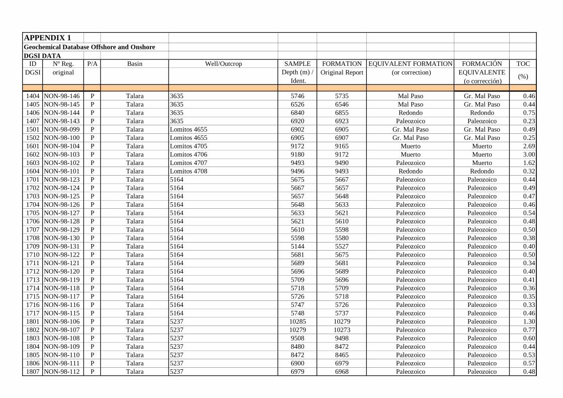
APPENDIX 1Geochemical Database Offshore and OnshoreDGSI DATA
ID Nº Reg. P/A Basin Well/Outcrop SAMPLE FORMATION EQUIVALENT FORMATION FORMACIÓN TOCDGSI original Depth (m) /
Ident.Original Report (or correction) EQUIVALENTE
(o corrección)(%)
1404 NON-98-146 P Talara 3635 5746 5735 Mal Paso Gr. Mal Paso 0.461405 NON-98-145 P Talara 3635 6526 6546 Mal Paso Gr. Mal Paso 0.441406 NON-98-144 P Talara 3635 6840 6855 Redondo Redondo 0.751407 NON-98-143 P Talara 3635 6920 6923 Paleozoico Paleozoico 0.231501 NON-98-099 P Talara Lomitos 4655 6902 6905 Gr. Mal Paso Gr. Mal Paso 0.491502 NON-98-100 P Talara Lomitos 4655 6905 6907 Gr. Mal Paso Gr. Mal Paso 0.251601 NON-98-104 P Talara Lomitos 4705 9172 9165 Muerto Muerto 2.691602 NON-98-103 P Talara Lomitos 4706 9180 9172 Muerto Muerto 3.001603 NON-98-102 P Talara Lomitos 4707 9493 9490 Paleozoico Muerto 1.621604 NON-98-101 P Talara Lomitos 4708 9496 9493 Redondo Redondo 0.321701 NON-98-123 P Talara 5164 5675 5667 Paleozoico Paleozoico 0.441702 NON-98-124 P Talara 5164 5667 5657 Paleozoico Paleozoico 0.491703 NON-98-125 P Talara 5164 5657 5648 Paleozoico Paleozoico 0.471704 NON-98-126 P Talara 5164 5648 5633 Paleozoico Paleozoico 0.461705 NON-98-127 P Talara 5164 5633 5621 Paleozoico Paleozoico 0.541706 NON-98-128 P Talara 5164 5621 5610 Paleozoico Paleozoico 0.481707 NON-98-129 P Talara 5164 5610 5598 Paleozoico Paleozoico 0.501708 NON-98-130 P Talara 5164 5598 5580 Paleozoico Paleozoico 0.381709 NON-98-131 P Talara 5164 5144 5527 Paleozoico Paleozoico 0.401710 NON-98-122 P Talara 5164 5681 5675 Paleozoico Paleozoico 0.501711 NON-98-121 P Talara 5164 5689 5681 Paleozoico Paleozoico 0.341712 NON-98-120 P Talara 5164 5696 5689 Paleozoico Paleozoico 0.401713 NON-98-119 P Talara 5164 5709 5696 Paleozoico Paleozoico 0.411714 NON-98-118 P Talara 5164 5718 5709 Paleozoico Paleozoico 0.361715 NON-98-117 P Talara 5164 5726 5718 Paleozoico Paleozoico 0.351716 NON-98-116 P Talara 5164 5747 5726 Paleozoico Paleozoico 0.331717 NON-98-115 P Talara 5164 5748 5737 Paleozoico Paleozoico 0.461801 NON-98-106 P Talara 5237 10285 10279 Paleozoico Paleozoico 1.301802 NON-98-107 P Talara 5237 10279 10273 Paleozoico Paleozoico 0.771803 NON-98-108 P Talara 5237 9508 9498 Paleozoico Paleozoico 0.601804 NON-98-109 P Talara 5237 8480 8472 Paleozoico Paleozoico 0.441805 NON-98-110 P Talara 5237 8472 8465 Paleozoico Paleozoico 0.531806 NON-98-111 P Talara 5237 6900 6979 Paleozoico Paleozoico 0.571807 NON-98-112 P Talara 5237 6979 6968 Paleozoico Paleozoico 0.48
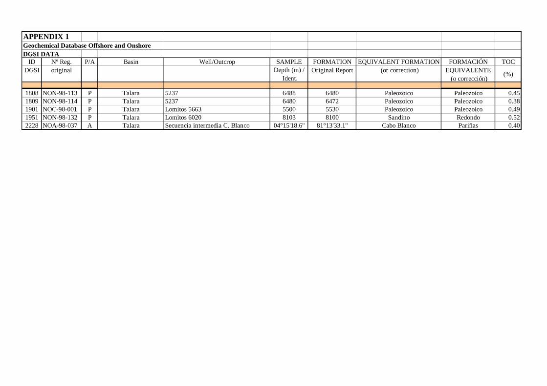
APPENDIX 1Geochemical Database Offshore and OnshoreDGSI DATA
ID Nº Reg. P/A Basin Well/Outcrop SAMPLE FORMATION EQUIVALENT FORMATION FORMACIÓN TOCDGSI original Depth (m) /
Ident.Original Report (or correction) EQUIVALENTE
(o corrección)(%)
1808 NON-98-113 P Talara 5237 6488 6480 Paleozoico Paleozoico 0.451809 NON-98-114 P Talara 5237 6480 6472 Paleozoico Paleozoico 0.381901 NOC-98-001 P Talara Lomitos 5663 5500 5530 Paleozoico Paleozoico 0.491951 NON-98-132 P Talara Lomitos 6020 8103 8100 Sandino Redondo 0.522228 NOA-98-037 A Talara Secuencia intermedia C. Blanco 04°15'18.6'' 81°13'33.1'' Cabo Blanco Pariñas 0.40
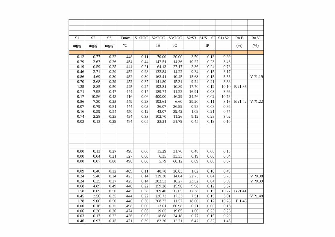
S1 S2 S3 Tmax S1/TOC S2/TOC S3/TOC S2/S3 S1/S1+S2 S1+S2 Ro B Ro V
mg/g mg/g mg/g ºC IH IO IP (%) (%)
0.12 0.77 0.22 448 0.11 70.00 20.00 3.50 0.13 0.890.79 2.67 0.26 454 0.44 147.51 14.36 10.27 0.23 3.460.19 0.59 0.25 444 0.21 64.13 27.17 2.36 0.24 0.780.46 2.71 0.29 452 0.23 132.84 14.22 9.34 0.15 3.170.86 4.69 0.30 452 0.30 163.41 10.45 15.63 0.15 5.55 V ?1.190.70 2.68 0.29 452 0.37 141.80 15.34 9.24 0.21 3.381.25 8.85 0.50 445 0.27 192.81 10.89 17.70 0.12 10.10 B ?1.360.71 7.95 0.47 444 0.17 189.74 11.22 16.91 0.08 8.660.17 10.56 0.43 416 0.06 400.00 16.29 24.56 0.02 10.730.86 7.30 0.25 449 0.23 192.61 6.60 29.20 0.11 8.16 B ?1.42 V ?1.220.07 0.79 0.81 444 0.03 36.07 36.99 0.98 0.08 0.860.16 0.59 0.54 450 0.12 43.07 39.42 1.09 0.21 0.750.74 2.28 0.25 454 0.33 102.70 11.26 9.12 0.25 3.020.03 0.13 0.29 484 0.05 23.21 51.79 0.45 0.19 0.16
0.00 0.13 0.27 498 0.00 15.29 31.76 0.48 0.00 0.130.00 0.04 0.21 527 0.00 6.35 33.33 0.19 0.00 0.040.00 0.07 0.80 498 0.00 5.79 66.12 0.09 0.00 0.07
0.09 0.40 0.22 489 0.11 48.78 26.83 1.82 0.18 0.490.24 5.46 0.24 423 0.14 319.30 14.04 22.75 0.04 5.70 V ?0.380.24 6.35 0.27 425 0.14 382.53 16.27 23.52 0.04 6.59 V ?0.390.68 4.89 0.49 446 0.22 159.28 15.96 9.98 0.12 5.571.58 8.69 0.50 445 0.38 209.40 12.05 17.38 0.15 10.27 B ?1.410.45 2.56 0.35 444 0.22 126.73 17.33 7.31 0.15 3.01 V ?1.481.28 9.00 0.50 446 0.30 208.33 11.57 18.00 0.12 10.28 B 1.460.00 0.16 0.75 498 0.00 13.01 60.98 0.21 0.00 0.160.06 0.20 0.20 474 0.06 19.05 19.05 1.00 0.23 0.260.03 0.17 0.22 436 0.03 18.68 24.18 0.77 0.15 0.200.46 0.97 0.15 471 0.39 82.20 12.71 6.47 0.32 1.43
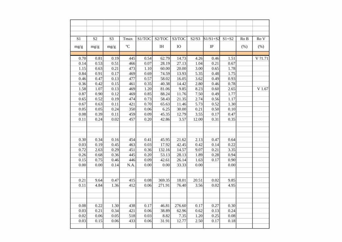
S1 S2 S3 Tmax S1/TOC S2/TOC S3/TOC S2/S3 S1/S1+S2 S1+S2 Ro B Ro V
mg/g mg/g mg/g ºC IH IO IP (%) (%)
0.70 0.81 0.19 445 0.54 62.79 14.73 4.26 0.46 1.51 V ?1.710.14 0.53 0.51 466 0.07 28.19 27.13 1.04 0.21 0.671.15 0.63 0.21 473 1.10 60.00 20.00 3.00 0.65 1.780.84 0.91 0.17 469 0.69 74.59 13.93 5.35 0.48 1.750.46 0.47 0.13 477 0.57 58.02 16.05 3.62 0.49 0.930.36 0.42 0.15 461 0.35 40.38 14.42 2.80 0.46 0.781.58 1.07 0.13 469 1.20 81.06 9.85 8.23 0.60 2.65 V 1.670.87 0.90 0.12 469 0.85 88.24 11.76 7.50 0.49 1.770.65 0.52 0.19 474 0.73 58.43 21.35 2.74 0.56 1.170.67 0.63 0.11 421 0.70 65.63 11.46 5.73 0.52 1.300.05 0.05 0.24 350 0.06 6.25 30.00 0.21 0.50 0.100.08 0.39 0.11 459 0.09 45.35 12.79 3.55 0.17 0.470.11 0.24 0.02 457 0.20 42.86 3.57 12.00 0.31 0.35
0.30 0.34 0.16 454 0.41 45.95 21.62 2.13 0.47 0.640.03 0.19 0.45 463 0.03 17.92 42.45 0.42 0.14 0.220.72 2.63 0.29 451 0.36 132.16 14.57 9.07 0.21 3.350.26 0.68 0.36 445 0.20 53.13 28.13 1.89 0.28 0.940.15 0.75 0.46 446 0.09 42.61 26.14 1.63 0.17 0.900.00 0.00 0.14 N.A. 0.00 0.00 33.33 0.00 0.00
0.21 9.64 0.47 415 0.08 369.35 18.01 20.51 0.02 9.850.11 4.84 1.36 412 0.06 271.91 76.40 3.56 0.02 4.95
0.08 0.22 1.30 438 0.17 46.81 276.60 0.17 0.27 0.300.03 0.21 0.34 421 0.06 38.89 62.96 0.62 0.13 0.240.02 0.06 0.05 518 0.03 8.82 7.35 1.20 0.25 0.080.03 0.15 0.06 433 0.06 31.91 12.77 2.50 0.17 0.18
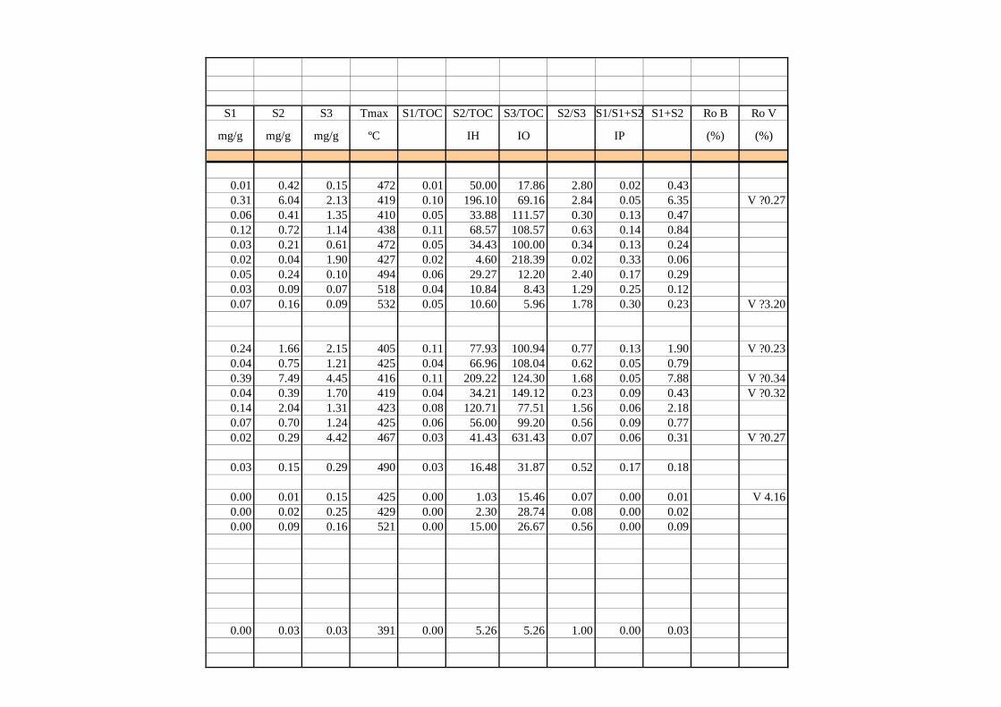
S1 S2 S3 Tmax S1/TOC S2/TOC S3/TOC S2/S3 S1/S1+S2 S1+S2 Ro B Ro V
mg/g mg/g mg/g ºC IH IO IP (%) (%)
0.01 0.42 0.15 472 0.01 50.00 17.86 2.80 0.02 0.430.31 6.04 2.13 419 0.10 196.10 69.16 2.84 0.05 6.35 V ?0.270.06 0.41 1.35 410 0.05 33.88 111.57 0.30 0.13 0.470.12 0.72 1.14 438 0.11 68.57 108.57 0.63 0.14 0.840.03 0.21 0.61 472 0.05 34.43 100.00 0.34 0.13 0.240.02 0.04 1.90 427 0.02 4.60 218.39 0.02 0.33 0.060.05 0.24 0.10 494 0.06 29.27 12.20 2.40 0.17 0.290.03 0.09 0.07 518 0.04 10.84 8.43 1.29 0.25 0.120.07 0.16 0.09 532 0.05 10.60 5.96 1.78 0.30 0.23 V ?3.20
0.24 1.66 2.15 405 0.11 77.93 100.94 0.77 0.13 1.90 V ?0.230.04 0.75 1.21 425 0.04 66.96 108.04 0.62 0.05 0.790.39 7.49 4.45 416 0.11 209.22 124.30 1.68 0.05 7.88 V ?0.340.04 0.39 1.70 419 0.04 34.21 149.12 0.23 0.09 0.43 V ?0.320.14 2.04 1.31 423 0.08 120.71 77.51 1.56 0.06 2.180.07 0.70 1.24 425 0.06 56.00 99.20 0.56 0.09 0.770.02 0.29 4.42 467 0.03 41.43 631.43 0.07 0.06 0.31 V ?0.27
0.03 0.15 0.29 490 0.03 16.48 31.87 0.52 0.17 0.18
0.00 0.01 0.15 425 0.00 1.03 15.46 0.07 0.00 0.01 V 4.160.00 0.02 0.25 429 0.00 2.30 28.74 0.08 0.00 0.020.00 0.09 0.16 521 0.00 15.00 26.67 0.56 0.00 0.09
0.00 0.03 0.03 391 0.00 5.26 5.26 1.00 0.00 0.03
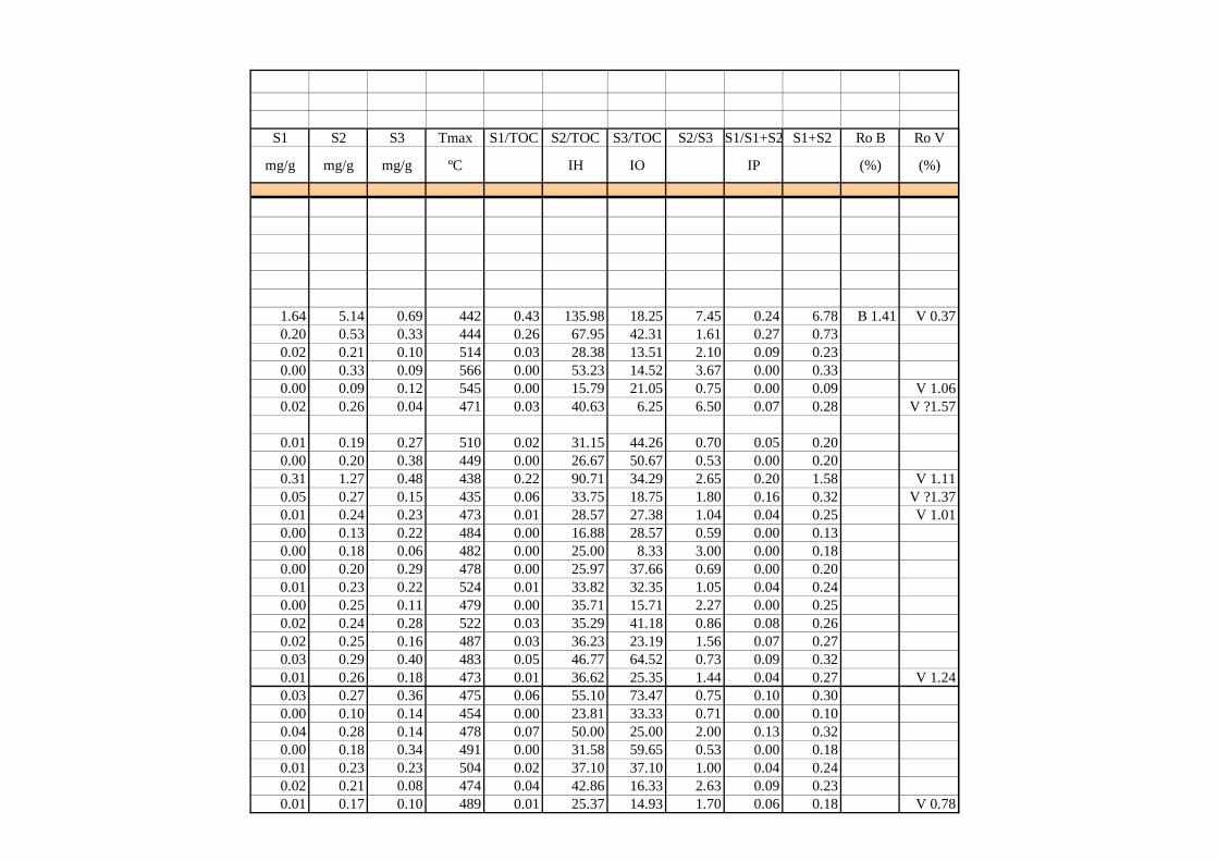
S1 S2 S3 Tmax S1/TOC S2/TOC S3/TOC S2/S3 S1/S1+S2 S1+S2 Ro B Ro V
mg/g mg/g mg/g ºC IH IO IP (%) (%)
1.64 5.14 0.69 442 0.43 135.98 18.25 7.45 0.24 6.78 B 1.41 V 0.370.20 0.53 0.33 444 0.26 67.95 42.31 1.61 0.27 0.730.02 0.21 0.10 514 0.03 28.38 13.51 2.10 0.09 0.230.00 0.33 0.09 566 0.00 53.23 14.52 3.67 0.00 0.330.00 0.09 0.12 545 0.00 15.79 21.05 0.75 0.00 0.09 V 1.060.02 0.26 0.04 471 0.03 40.63 6.25 6.50 0.07 0.28 V ?1.57
0.01 0.19 0.27 510 0.02 31.15 44.26 0.70 0.05 0.200.00 0.20 0.38 449 0.00 26.67 50.67 0.53 0.00 0.200.31 1.27 0.48 438 0.22 90.71 34.29 2.65 0.20 1.58 V 1.110.05 0.27 0.15 435 0.06 33.75 18.75 1.80 0.16 0.32 V ?1.370.01 0.24 0.23 473 0.01 28.57 27.38 1.04 0.04 0.25 V 1.010.00 0.13 0.22 484 0.00 16.88 28.57 0.59 0.00 0.130.00 0.18 0.06 482 0.00 25.00 8.33 3.00 0.00 0.180.00 0.20 0.29 478 0.00 25.97 37.66 0.69 0.00 0.200.01 0.23 0.22 524 0.01 33.82 32.35 1.05 0.04 0.240.00 0.25 0.11 479 0.00 35.71 15.71 2.27 0.00 0.250.02 0.24 0.28 522 0.03 35.29 41.18 0.86 0.08 0.260.02 0.25 0.16 487 0.03 36.23 23.19 1.56 0.07 0.270.03 0.29 0.40 483 0.05 46.77 64.52 0.73 0.09 0.320.01 0.26 0.18 473 0.01 36.62 25.35 1.44 0.04 0.27 V 1.240.03 0.27 0.36 475 0.06 55.10 73.47 0.75 0.10 0.300.00 0.10 0.14 454 0.00 23.81 33.33 0.71 0.00 0.100.04 0.28 0.14 478 0.07 50.00 25.00 2.00 0.13 0.320.00 0.18 0.34 491 0.00 31.58 59.65 0.53 0.00 0.180.01 0.23 0.23 504 0.02 37.10 37.10 1.00 0.04 0.240.02 0.21 0.08 474 0.04 42.86 16.33 2.63 0.09 0.230.01 0.17 0.10 489 0.01 25.37 14.93 1.70 0.06 0.18 V 0.78
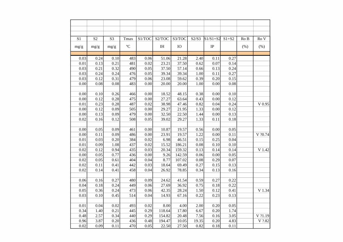
S1 S2 S3 Tmax S1/TOC S2/TOC S3/TOC S2/S3 S1/S1+S2 S1+S2 Ro B Ro V
mg/g mg/g mg/g ºC IH IO IP (%) (%)
0.03 0.24 0.10 483 0.06 51.06 21.28 2.40 0.11 0.270.01 0.13 0.21 481 0.02 23.21 37.50 0.62 0.07 0.140.03 0.21 0.32 490 0.05 37.50 57.14 0.66 0.13 0.240.03 0.24 0.24 476 0.05 39.34 39.34 1.00 0.11 0.270.03 0.12 0.31 479 0.06 23.08 59.62 0.39 0.20 0.150.00 0.08 0.08 483 0.00 20.00 20.00 1.00 0.00 0.08
0.00 0.10 0.26 466 0.00 18.52 48.15 0.38 0.00 0.100.00 0.12 0.28 475 0.00 27.27 63.64 0.43 0.00 0.120.01 0.23 0.28 487 0.02 38.98 47.46 0.82 0.04 0.24 V 0.950.00 0.12 0.09 505 0.00 29.27 21.95 1.33 0.00 0.120.00 0.13 0.09 479 0.00 32.50 22.50 1.44 0.00 0.130.02 0.16 0.12 508 0.05 39.02 29.27 1.33 0.11 0.18
0.00 0.05 0.09 461 0.00 10.87 19.57 0.56 0.00 0.050.00 0.11 0.09 486 0.00 23.91 19.57 1.22 0.00 0.11 V ?0.740.01 0.03 0.20 384 0.02 6.98 46.51 0.15 0.25 0.040.01 0.09 1.08 437 0.02 15.52 186.21 0.08 0.10 0.100.02 0.12 0.94 435 0.03 20.34 159.32 0.13 0.14 0.14 V 1.420.00 0.05 0.77 436 0.00 9.26 142.59 0.06 0.00 0.050.02 0.05 0.61 404 0.04 8.77 107.02 0.08 0.29 0.070.02 0.11 0.41 442 0.03 18.64 69.49 0.27 0.15 0.130.02 0.14 0.41 458 0.04 26.92 78.85 0.34 0.13 0.16
0.06 0.16 0.27 480 0.09 24.62 41.54 0.59 0.27 0.220.04 0.18 0.24 449 0.06 27.69 36.92 0.75 0.18 0.220.05 0.36 0.24 473 0.06 42.35 28.24 1.50 0.12 0.41 V 1.340.03 0.10 0.45 514 0.04 14.93 67.16 0.22 0.23 0.13
0.01 0.04 0.02 493 0.02 8.00 4.00 2.00 0.20 0.050.34 1.40 0.21 445 0.29 118.64 17.80 6.67 0.20 1.740.48 2.57 0.34 440 0.29 154.82 20.48 7.56 0.16 3.05 V ?1.190.96 3.87 0.20 436 0.48 194.47 10.05 19.35 0.20 4.83 V ?.820.02 0.09 0.11 470 0.05 22.50 27.50 0.82 0.18 0.11
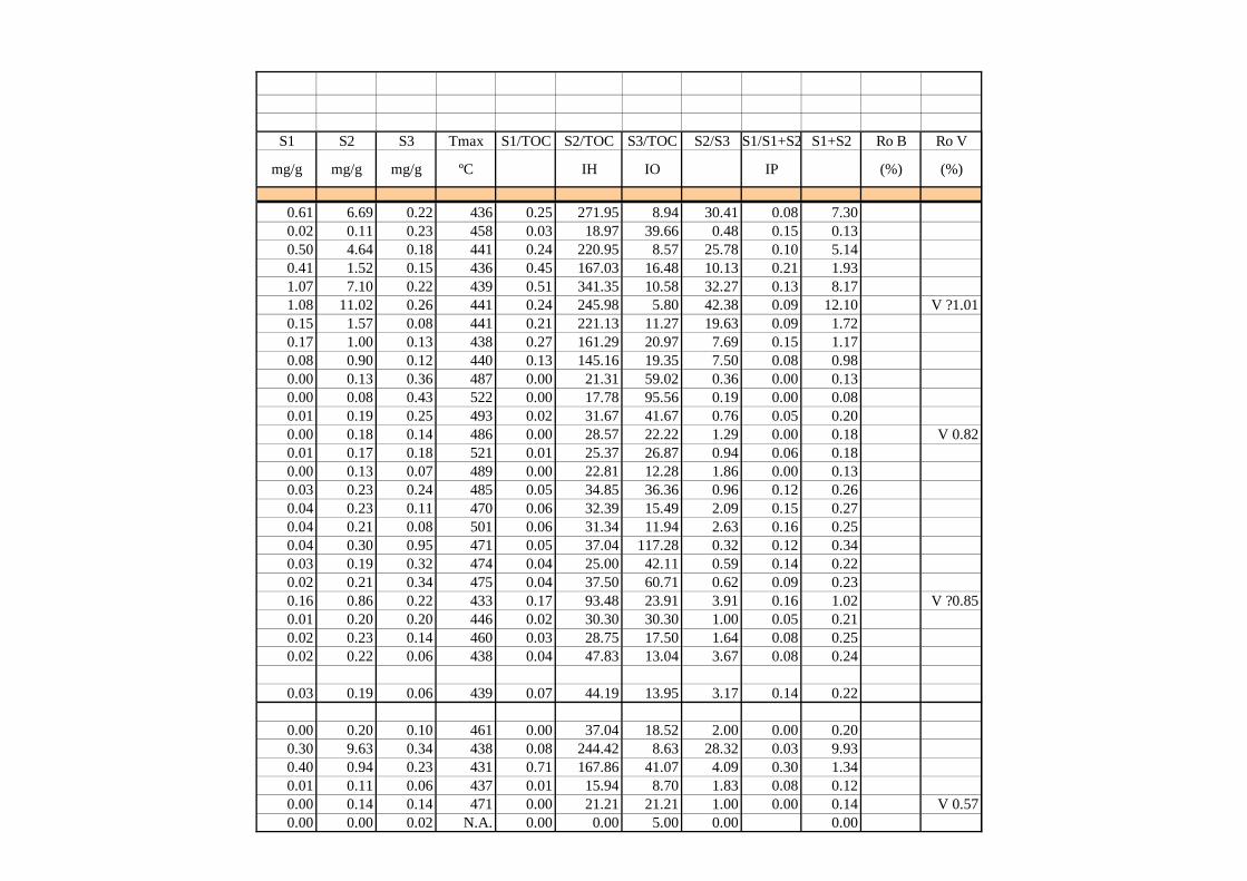
S1 S2 S3 Tmax S1/TOC S2/TOC S3/TOC S2/S3 S1/S1+S2 S1+S2 Ro B Ro V
mg/g mg/g mg/g ºC IH IO IP (%) (%)
0.61 6.69 0.22 436 0.25 271.95 8.94 30.41 0.08 7.300.02 0.11 0.23 458 0.03 18.97 39.66 0.48 0.15 0.130.50 4.64 0.18 441 0.24 220.95 8.57 25.78 0.10 5.140.41 1.52 0.15 436 0.45 167.03 16.48 10.13 0.21 1.931.07 7.10 0.22 439 0.51 341.35 10.58 32.27 0.13 8.171.08 11.02 0.26 441 0.24 245.98 5.80 42.38 0.09 12.10 V ?1.010.15 1.57 0.08 441 0.21 221.13 11.27 19.63 0.09 1.720.17 1.00 0.13 438 0.27 161.29 20.97 7.69 0.15 1.170.08 0.90 0.12 440 0.13 145.16 19.35 7.50 0.08 0.980.00 0.13 0.36 487 0.00 21.31 59.02 0.36 0.00 0.130.00 0.08 0.43 522 0.00 17.78 95.56 0.19 0.00 0.080.01 0.19 0.25 493 0.02 31.67 41.67 0.76 0.05 0.200.00 0.18 0.14 486 0.00 28.57 22.22 1.29 0.00 0.18 V 0.820.01 0.17 0.18 521 0.01 25.37 26.87 0.94 0.06 0.180.00 0.13 0.07 489 0.00 22.81 12.28 1.86 0.00 0.130.03 0.23 0.24 485 0.05 34.85 36.36 0.96 0.12 0.260.04 0.23 0.11 470 0.06 32.39 15.49 2.09 0.15 0.270.04 0.21 0.08 501 0.06 31.34 11.94 2.63 0.16 0.250.04 0.30 0.95 471 0.05 37.04 117.28 0.32 0.12 0.340.03 0.19 0.32 474 0.04 25.00 42.11 0.59 0.14 0.220.02 0.21 0.34 475 0.04 37.50 60.71 0.62 0.09 0.230.16 0.86 0.22 433 0.17 93.48 23.91 3.91 0.16 1.02 V ?0.850.01 0.20 0.20 446 0.02 30.30 30.30 1.00 0.05 0.210.02 0.23 0.14 460 0.03 28.75 17.50 1.64 0.08 0.250.02 0.22 0.06 438 0.04 47.83 13.04 3.67 0.08 0.24
0.03 0.19 0.06 439 0.07 44.19 13.95 3.17 0.14 0.22
0.00 0.20 0.10 461 0.00 37.04 18.52 2.00 0.00 0.200.30 9.63 0.34 438 0.08 244.42 8.63 28.32 0.03 9.930.40 0.94 0.23 431 0.71 167.86 41.07 4.09 0.30 1.340.01 0.11 0.06 437 0.01 15.94 8.70 1.83 0.08 0.120.00 0.14 0.14 471 0.00 21.21 21.21 1.00 0.00 0.14 V 0.570.00 0.00 0.02 N.A. 0.00 0.00 5.00 0.00 0.00
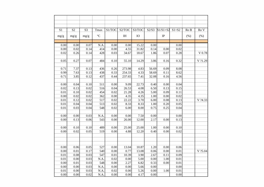
S1 S2 S3 Tmax S1/TOC S2/TOC S3/TOC S2/S3 S1/S1+S2 S1+S2 Ro B Ro V
mg/g mg/g mg/g ºC IH IO IP (%) (%)
0.00 0.00 0.07 N.A. 0.00 0.00 15.22 0.00 0.000.00 0.02 0.14 414 0.00 4.55 31.82 0.14 0.00 0.020.02 0.26 0.14 428 0.03 34.67 18.67 1.86 0.07 0.28 V 0.78
0.05 0.27 0.07 484 0.10 55.10 14.29 3.86 0.16 0.32 V ?1.29
0.71 7.37 0.13 436 0.26 273.98 4.83 56.69 0.09 8.080.99 7.63 0.13 438 0.33 254.33 4.33 58.69 0.11 8.620.71 3.85 0.12 437 0.44 237.65 7.41 32.08 0.16 4.56
0.00 0.04 0.10 511 0.00 9.09 22.73 0.40 0.00 0.040.02 0.13 0.02 516 0.04 26.53 4.08 6.50 0.13 0.150.01 0.10 0.02 454 0.02 21.28 4.26 5.00 0.09 0.110.00 0.02 0.02 362 0.00 4.35 4.35 1.00 0.00 0.020.01 0.12 0.02 517 0.02 22.22 3.70 6.00 0.08 0.13 V ?4.330.01 0.04 0.04 513 0.02 8.33 8.33 1.00 0.20 0.050.01 0.03 0.04 548 0.02 6.00 8.00 0.75 0.25 0.04
0.00 0.00 0.03 N.A. 0.00 0.00 7.50 0.00 0.000.00 0.13 0.06 543 0.00 26.00 12.00 2.17 0.00 0.13
0.00 0.10 0.10 489 0.00 25.00 25.00 1.00 0.00 0.100.00 0.02 0.05 519 0.00 4.88 12.20 0.40 0.00 0.02
0.00 0.06 0.05 527 0.00 13.04 10.87 1.20 0.00 0.060.00 0.01 0.17 540 0.00 0.77 13.08 0.06 0.00 0.01 V ?5.040.01 0.08 0.03 547 0.01 10.39 3.90 2.67 0.11 0.090.01 0.00 0.03 N.A. 0.02 0.00 5.00 0.00 1.00 0.010.00 0.01 0.03 548 0.00 2.27 6.82 0.33 0.00 0.010.00 0.00 0.03 N.A. 0.00 0.00 5.66 0.00 0.000.01 0.00 0.03 N.A. 0.02 0.00 5.26 0.00 1.00 0.010.00 0.00 0.02 N.A. 0.00 0.00 4.17 0.00 0.00
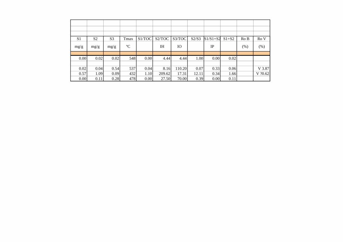
S1 S2 S3 Tmax S1/TOC S2/TOC S3/TOC S2/S3 S1/S1+S2 S1+S2 Ro B Ro V
mg/g mg/g mg/g ºC IH IO IP (%) (%)
0.00 0.02 0.02 548 0.00 4.44 4.44 1.00 0.00 0.02
0.02 0.04 0.54 537 0.04 8.16 110.20 0.07 0.33 0.06 V 3.870.57 1.09 0.09 432 1.10 209.62 17.31 12.11 0.34 1.66 V ?0.620.00 0.11 0.28 478 0.00 27.50 70.00 0.39 0.00 0.11