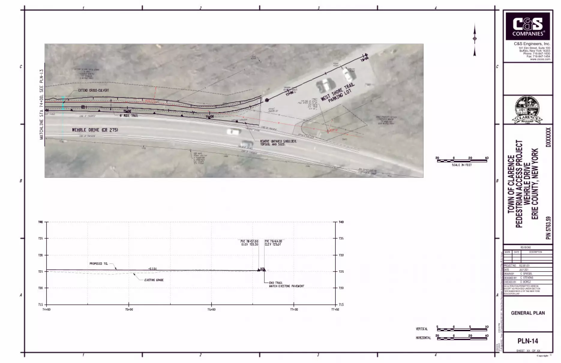
transportation project report - erie county
TRANSCRIPT
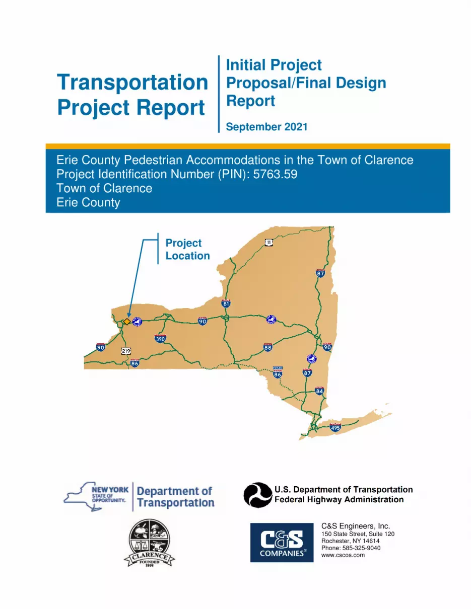
Transportation Project Report
Initial Project Proposal/Final Design Report
September 2021
Erie County Pedestrian Accommodations in the Town of Clarence Project Identification Number (PIN): 5763.59 Town of Clarence Erie County
Project Location
C&S Engineers, Inc. 150 State Street, Suite 120 Rochester, NY 14614 Phone: 585-325-9040 www.cscos.com
September 2021 Initial Project Proposal/Final Design Report PIN 5763.59
ii
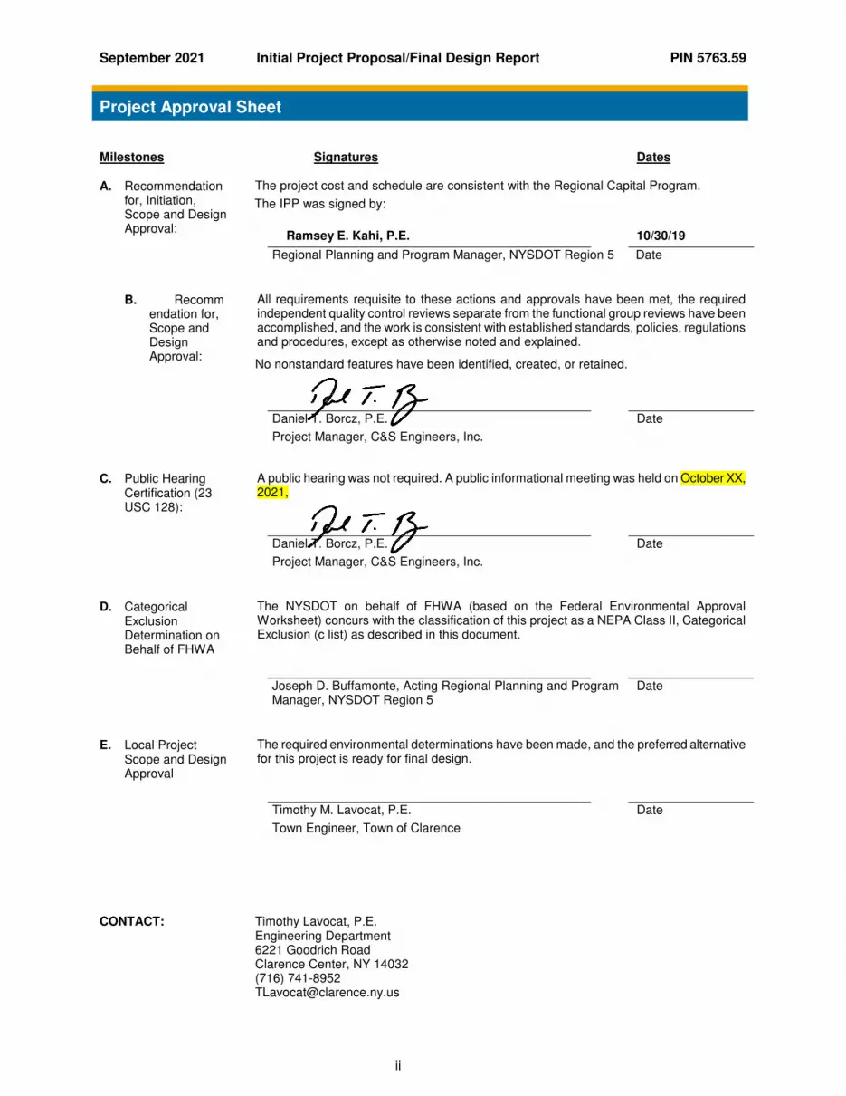
Project Approval Sheet
Milestones Signatures Dates
A. Recommendation for, Initiation, Scope and Design Approval:
The project cost and schedule are consistent with the Regional Capital Program.
The IPP was signed by:
Ramsey E. Kahi, P.E.
10/30/19
Regional Planning and Program Manager, NYSDOT Region 5 Date
B. Recommendation for, Scope and Design Approval:
All requirements requisite to these actions and approvals have been met, the required independent quality control reviews separate from the functional group reviews have been accomplished, and the work is consistent with established standards, policies, regulations and procedures, except as otherwise noted and explained.
No nonstandard features have been identified, created, or retained.
Daniel T. Borcz, P.E.
Project Manager, C&S Engineers, Inc.
Date
C. Public Hearing Certification (23 USC 128):
A public hearing was not required. A public informational meeting was held on October XX, 2021,
Daniel T. Borcz, P.E.
Project Manager, C&S Engineers, Inc.
Date
D. Categorical Exclusion Determination on Behalf of FHWA
The NYSDOT on behalf of FHWA (based on the Federal Environmental Approval Worksheet) concurs with the classification of this project as a NEPA Class II, Categorical Exclusion (c list) as described in this document.
Joseph D. Buffamonte, Acting Regional Planning and Program Manager, NYSDOT Region 5
Date
E. Local Project Scope and Design Approval
The required environmental determinations have been made, and the preferred alternative for this project is ready for final design.
Timothy M. Lavocat, P.E.
Town Engineer, Town of Clarence
Date
CONTACT: Timothy Lavocat, P.E.
Engineering Department 6221 Goodrich Road Clarence Center, NY 14032 (716) 741-8952 [email protected]

September 2021 Initial Project Proposal/Final Design Report PIN 5763.59
iii
List of Preparers
Group Director Responsible for Production of this Initial Project Proposal/Final Design Report (IPP/FDR): Daniel T. Borcz, P.E., Project Manager, C&S Engineers, Inc. Description of Work Performed by Firm: Directed the preparation of the Design Approval Document in accordance with established standards, policies, regulations and procedures, except as otherwise explained in this document.
Note: It is a violation of law for any person, unless they are acting under the direction of a licensed professional engineer, architect, landscape architect, or land surveyor, to alter an item in any way. If an item bearing the stamp of a licensed professional is altered, the altering engineer, architect, landscape architect, or land surveyor shall stamp the document and include the notation "altered by" followed by their signature, the date of such alteration, and a specific description of the alteration.
C&S Engineers, Inc. 141 Elm Street, Suite 100 Buffalo, NY 14203 Phone: 716-847-1630 Fax: 716-847-1454www.cscos.com
Daniel T. Borcz, PE NYSPE 093244

September 2021 Initial Project Proposal/Final Design Report PIN 5763.59
1
Table of Contents
1.1. PUBLIC FRIENDLY DESCRIPTION OF PROJECT .......................................................... 2
1.2. PROJECT LOCATION ........................................................................................................ 2
1.3. PROJECT NEED ................................................................................................................. 2
1.4. PURPOSE/OBJECTIVES.................................................................................................... 3
1.5. DESCRIPTION OF PROPOSED WORK ............................................................................ 3
2.1 DESIGN STANDARDS ........................................................................................................ 3
2.2 OTHER DESIGN PARAMETERS ....................................................................................... 4
2.3 NON-STANDARD/NON-CONFORMING FEATURES ........................................................ 4
2.4 SPECIAL TECHNICAL ACTIVITES REQUIRED ................................................................ 4
2.5 WORKZONE SAFETY & MOBILITY .................................................................................. 5
2.6 ASSET MANAGEMENT ...................................................................................................... 5
2.7 POTENTIAL UTILITY INVOLVEMENT ............................................................................... 5
2.8 RIGHT OF WAY ................................................................................................................... 5
2.9 ACCIDENT ANALYSIS ........................................................................................................ 6
3.1 ENVIRONMENTAL CLASSIFICATION ............................................................................. 6
3.2 ENVIRONMENTAL DOCUMENTATION ............................................................................. 6
3.3 ANTICIPATED PERMITS/CERTIFICATIONS/COORDINATION ....................................... 9
3.4 NYS SMART GROWTH PUBLIC INFRASTRUCTURE POLICY ACT (SGPIPA) ............. 9
4.1 FUNDING ............................................................................................................................. 9
4.2 COST AND SCHEDULE ..................................................................................................... 9
5.1 PUBLIC INVOLVEMENT ................................................................................................... 11
6.1 LIST OF ATTACHMENTS / APPENDICES ...................................................................... 11
September 2021 Initial Project Proposal/Final Design Report PIN 5763.59
2
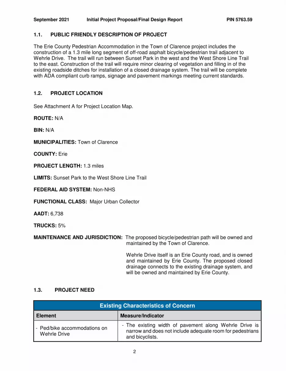
1.1. PUBLIC FRIENDLY DESCRIPTION OF PROJECT The Erie County Pedestrian Accommodation in the Town of Clarence project includes the construction of a 1.3 mile long segment of off-road asphalt bicycle/pedestrian trail adjacent to Wehrle Drive. The trail will run between Sunset Park in the west and the West Shore Line Trail to the east. Construction of the trail will require minor clearing of vegetation and filling in of the existing roadside ditches for installation of a closed drainage system. The trail will be complete with ADA compliant curb ramps, signage and pavement markings meeting current standards.
1.2. PROJECT LOCATION
See Attachment A for Project Location Map. ROUTE: N/A BIN: N/A MUNICIPALITIES: Town of Clarence COUNTY: Erie PROJECT LENGTH: 1.3 miles LIMITS: Sunset Park to the West Shore Line Trail
FEDERAL AID SYSTEM: Non-NHS FUNCTIONAL CLASS: Major Urban Collector AADT: 6,738 TRUCKS: 5% MAINTENANCE AND JURISDICTION: The proposed bicycle/pedestrian path will be owned and
maintained by the Town of Clarence. Wehrle Drive itself is an Erie County road, and is owned
and maintained by Erie County. The proposed closed drainage connects to the existing drainage system, and will be owned and maintained by Erie County.
1.3. PROJECT NEED
Existing Characteristics of Concern
Element Measure/Indicator
- Ped/bike accommodations on Wehrle Drive
- The existing width of pavement along Wehrle Drive is narrow and does not include adequate room for pedestrians and bicyclists.
September 2021 Initial Project Proposal/Final Design Report PIN 5763.59
3
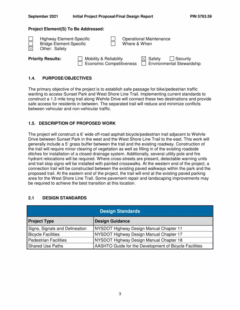
Project Element(S) To Be Addressed:
Highway Element-Specific Operational Maintenance Bridge Element-Specific Where & When Other: Safety
Priority Results: Mobility & Reliability Safety Security
Economic Competitiveness Environmental Stewardship
1.4. PURPOSE/OBJECTIVES
The primary objective of the project is to establish safe passage for bike/pedestrian traffic wanting to access Sunset Park and West Shore Line Trail. Implementing current standards to construct a 1.3 mile long trail along Wehrle Drive will connect these two destinations and provide safe access for residents in between. The separated trail will reduce and minimize conflicts between vehicular and non-vehicular traffic.
1.5. DESCRIPTION OF PROPOSED WORK
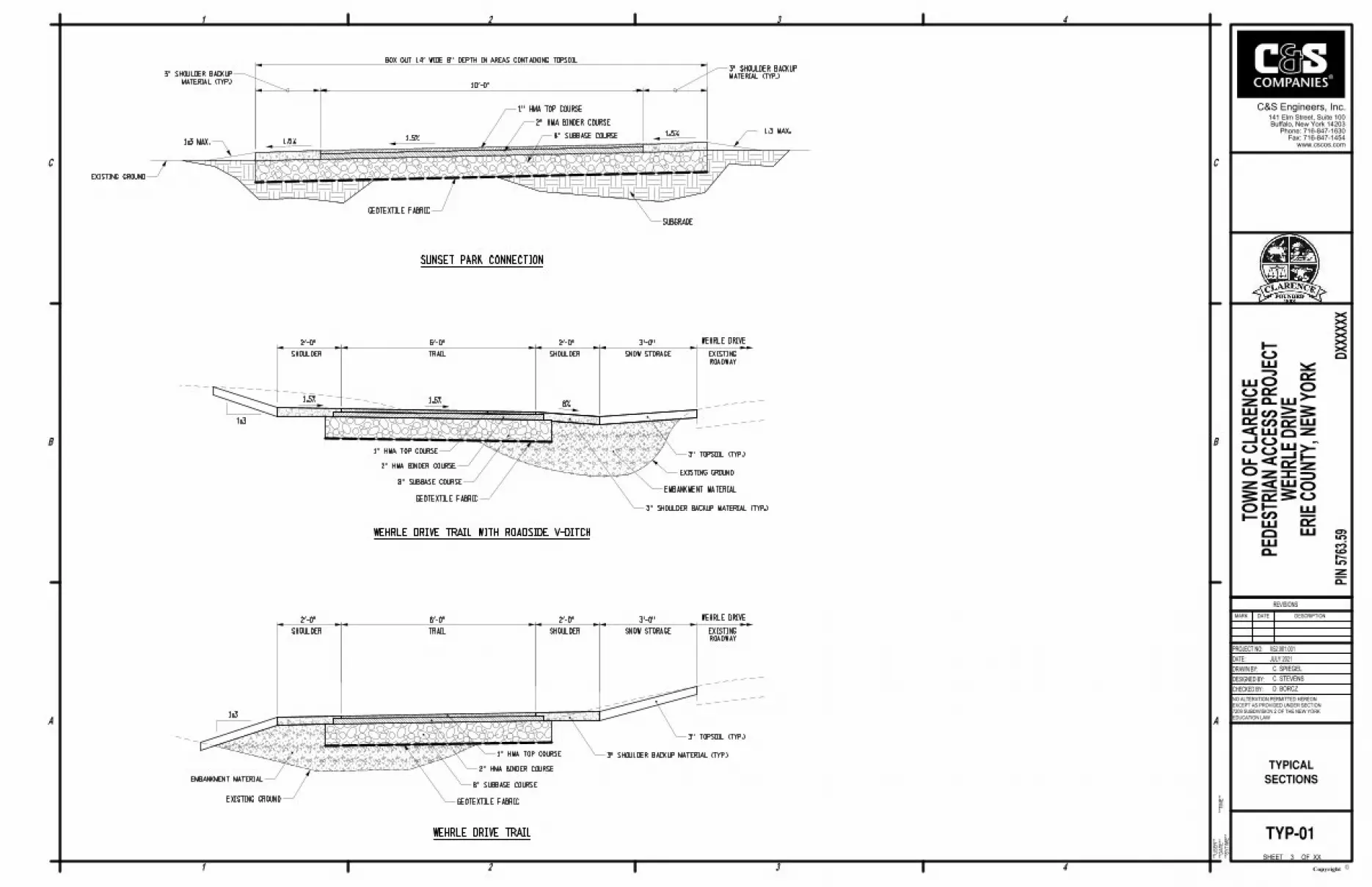
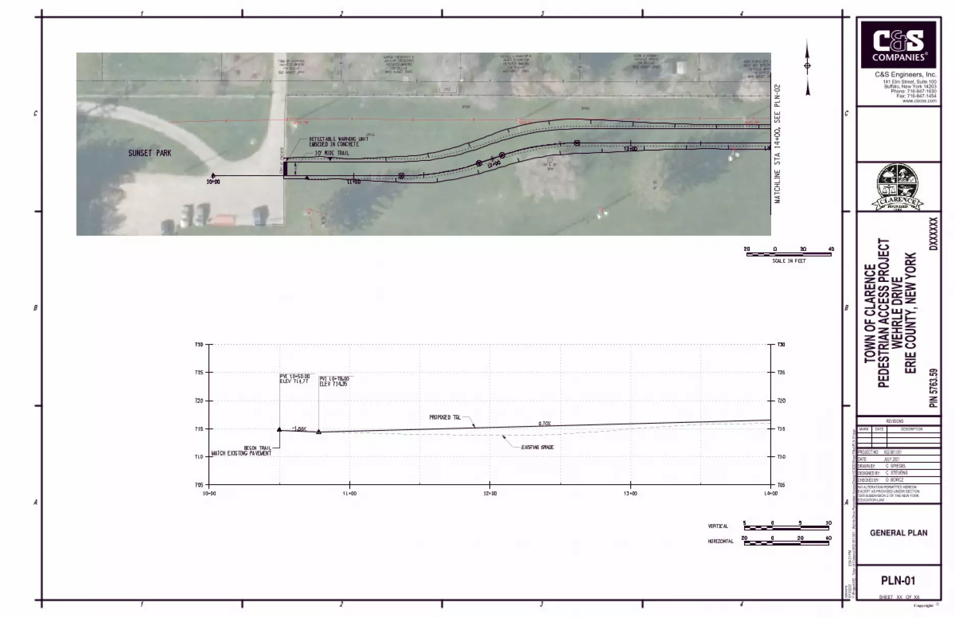
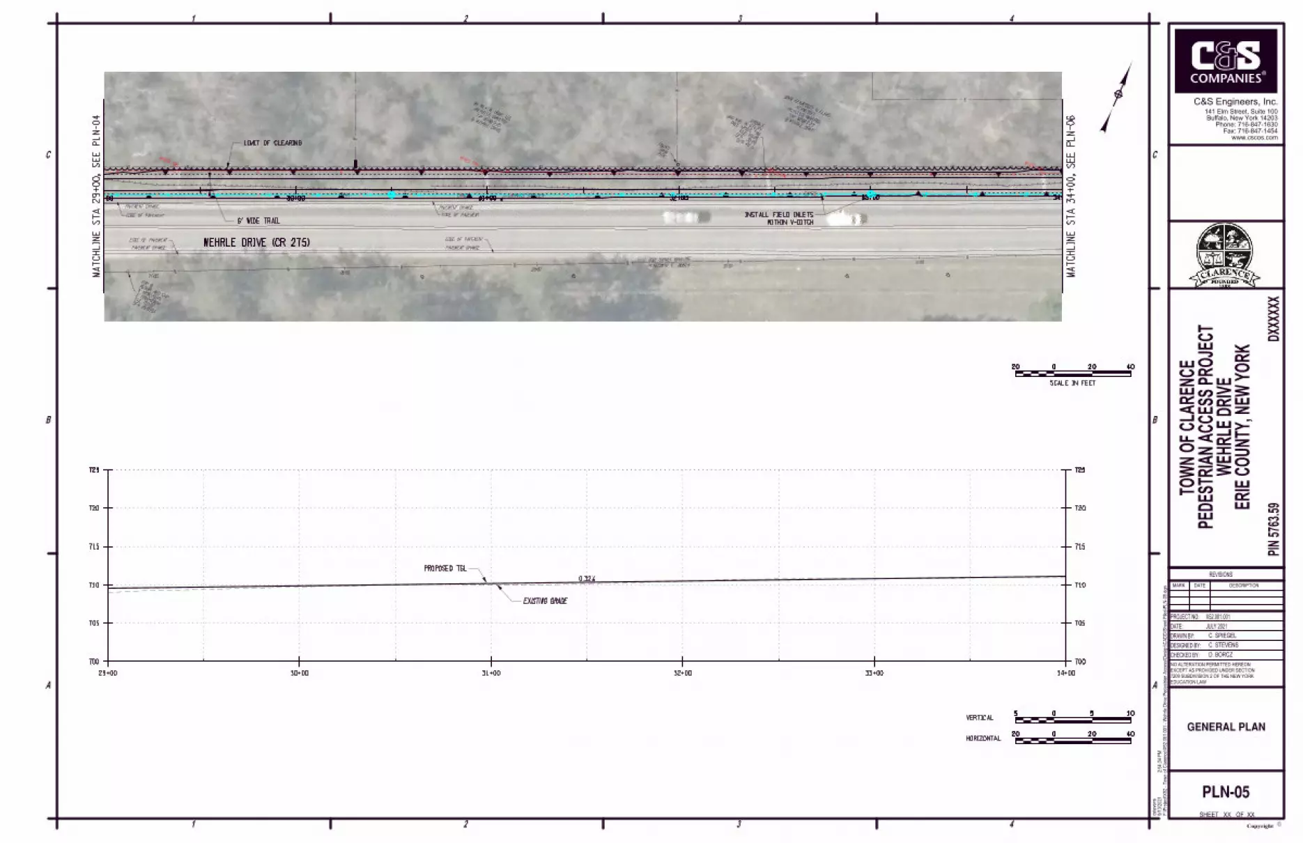
The project will construct a 6’ wide off-road asphalt bicycle/pedestrian trail adjacent to Wehrle Drive between Sunset Park in the west and the West Shore Line Trail to the east. This work will generally include a 5’ grass buffer between the trail and the existing roadway. Construction of the trail will require minor clearing of vegetation as well as filling in of the existing roadside ditches for installation of a closed drainage system. Additionally, several utility pole and fire hydrant relocations will be required. Where cross-streets are present, detectable warning units and trail stop signs will be installed with painted crosswalks. At the western end of the project, a connection trail will be constructed between the existing paved walkways within the park and the proposed trail. At the eastern end of the project, the trail will end at the existing paved parking area for the West Shore Line Trail. Some pavement repair and landscaping improvements may be required to achieve the best transition at this location. 2.1 DESIGN STANDARDS
Design Standards
Project Type Design Guidance
Signs, Signals and Delineation NYSDOT Highway Design Manual Chapter 11
Bicycle Facilities NYSDOT Highway Design Manual Chapter 17
Pedestrian Facilities NYSDOT Highway Design Manual Chapter 18
Shared Use Paths AASHTO Guide for the Development of Bicycle Facilities

September 2021 Initial Project Proposal/Final Design Report PIN 5763.59
4
Primary Design Values for Paved Shared-Use Path
Element Standard Value Source1 Proposed Value
Design Speed 18 mph AASHTO 18 mph
Shared Use Width 10 ft min. AASHTO 6 ft**
Adjacent Graded Width 2 ft min. width
AASHTO 2 ft
1:6 max. cross slope 8%
Maximum Grade 5% max. or match grade of adjacent roadway
AASHTO 5% max.
Cross Slope 2% max. HDM Chapter 18 1.5%
Horizontal Curvature 74 ft min. AASHTO 170 ft min.
Stopping Sight Distance 134 ft min. AASHTO 222 ft min.
Horizontal Sight Distance 28 ft min. AASHTO 35 ft min.
Crest Vertical Curve 178 ft min. AASHTO 354 ft min.
Horizontal Clearance 2 ft min. AASHTO 2 ft
Vertical Clearance 10 ft min. AASHTO 10 ft
1 2012 AASHTO Guide for the Development of Bicycle Facilities. 2 ** Denotes non-conforming feature
2.2 OTHER DESIGN PARAMETERS
None 2.3 NON-STANDARD/NON-CONFORMING FEATURES Existing pedestrian facilities within the scope of this project have been evaluated for conformance with the applicable standards in the NYSDOT Critical Elements for the Design, Layout and Acceptance of Pedestrian Facilities found on the NYSDOT Highway Design Manual Chapter 18 webpage. If the work at any facility will not meet the applicable standards, then the procedural requirements identified in ED 15-004 - Design, Construction and Inspection of Pedestrian Facilities in the Public Right of Way will be followed and the facility will be rehabilitated, replaced or justified as nonstandard. The proposed trail width is a non-conforming feature as the trail width does not meet the 10ft width standard value. The 6ft trail width was used based on the tight geometric constraints along the north side of Wehrle Drive. The overhead utilities and tight ROW make meeting the 10ft width infeasible. 2.4 SPECIAL TECHNICAL ACTIVITES REQUIRED This project will be constructed using two separate fund sources. The main portion of the project will be constructed with support of the FHWA’s TAP program. The connection within Sunset Park will be constructed entirely with local funds.
September 2021 Initial Project Proposal/Final Design Report PIN 5763.59
5
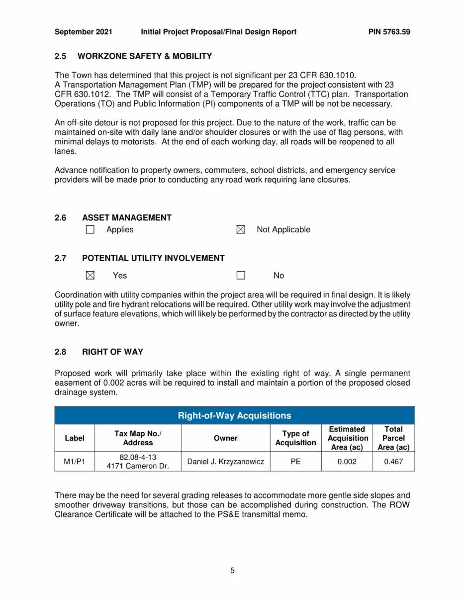
2.5 WORKZONE SAFETY & MOBILITY The Town has determined that this project is not significant per 23 CFR 630.1010. A Transportation Management Plan (TMP) will be prepared for the project consistent with 23 CFR 630.1012. The TMP will consist of a Temporary Traffic Control (TTC) plan. Transportation Operations (TO) and Public Information (PI) components of a TMP will be not be necessary. An off-site detour is not proposed for this project. Due to the nature of the work, traffic can be maintained on-site with daily lane and/or shoulder closures or with the use of flag persons, with minimal delays to motorists. At the end of each working day, all roads will be reopened to all lanes. Advance notification to property owners, commuters, school districts, and emergency service providers will be made prior to conducting any road work requiring lane closures.
2.6 ASSET MANAGEMENT
Applies Not Applicable
2.7 POTENTIAL UTILITY INVOLVEMENT
Yes No Coordination with utility companies within the project area will be required in final design. It is likely utility pole and fire hydrant relocations will be required. Other utility work may involve the adjustment of surface feature elevations, which will likely be performed by the contractor as directed by the utility owner.
2.8 RIGHT OF WAY
Proposed work will primarily take place within the existing right of way. A single permanent easement of 0.002 acres will be required to install and maintain a portion of the proposed closed drainage system.
Right-of-Way Acquisitions
Label Tax Map No./
Address Owner
Type of Acquisition
Estimated Acquisition
Area (ac)
Total Parcel
Area (ac)
M1/P1 82.08-4-13
4171 Cameron Dr. Daniel J. Krzyzanowicz PE 0.002 0.467
There may be the need for several grading releases to accommodate more gentle side slopes and smoother driveway transitions, but those can be accomplished during construction. The ROW Clearance Certificate will be attached to the PS&E transmittal memo.

September 2021 Initial Project Proposal/Final Design Report PIN 5763.59
6
2.9 ACCIDENT ANALYSIS
An accident analysis was not performed for this project. No known abnormal or concentrations of accidents are known to occur within the project limits, nor are the number or severity of accidents expected to be above statewide averages. No known high accident locations (HAL) or priority investigation locations (PIL) are within the project limits. This project will help minimize conflicts between vehicular and non-vehicular traffic.
3.1 ENVIRONMENTAL CLASSIFICATION
NEPA (National Environmental Policy Act): This project is being progressed as a NEPA Class II action (Categorical Exclusion). In accordance with the Federal Highway Administration’s regulations in 23 CFR 771.117(c) this is an action which will not have significant environmental effects and does not normally require additional federal approval regarding NEPA. Specifically this action meets the description in 23 CFR 771.117(c) described as c(3) "Construction of bicycle and pedestrian lanes, paths, and facilities." This is further detailed in the Federal Environmental Approvals Worksheet (FEAW) included in Attachment C. SEQRA (State Environmental Quality Review Act): In accordance with 6 NYCRR 617.5, the Town of Clarence has determined that this project is a SEQR Type II Action. Additional information related to how the project meets the SEQR Type II criteria is included in Attachment C. The following Checklist(s) are attached:
Federal Environmental Approvals Worksheet (FEAW) Social, Economic and Environmental Resources Checklist Capital Projects Complete Streets Checklist Smart Growth Screening Tool
3.2 ENVIRONMENTAL DOCUMENTATION
The project has been reviewed for compliance with federal and state environmental laws and NYSDOT environmental policies and best practices. These issues have been identified and briefly discussed in the Social, Economic, and Environmental Resources Checklist (refer to Attachment C). Those issues that require further discussion are listed below: Social, Economic and Environmental Resource Checklist Impacts Social B.3 – Neighborhood and Community Cohesion, Potential Changes to Travel Patterns This project will provide new pedestrian and bicycle access between Sunset Park and the West Shore Line Trail, providing alternate and active modes of transportation.
September 2021 Initial Project Proposal/Final Design Report PIN 5763.59
7
C.3 – General Social Groups, Alterations to Pedestrian Facilities Accessibility will be improved for the elderly and disabled by installing new pedestrian facilities meeting PROWAG and NYSDOT guidelines, including crosswalk striping and detectable warning units. D.1 – Community Services, Potential to Affect Access The project will have an overall positive impact on access to and use of schools, recreation areas and places of worship by providing new pedestrian and bicycle accommodations that meet PROWAG and NYSDOT guidelines. Specifically, this project will connect to a park and a recreational trail. Economic None No businesses in the project area are expected to benefit from improved pedestrian access. Environmental 1. – Wetlands A wetland and surface water delineation was completed to confirm the type, size, and boundaries of wetlands in the area. The wetlands delineation included an examination of the National Wetlands Inventory, New York State Department of Environmental Conservation (NYSDEC) Freshwater Wetlands Maps, United States Geological Survey (USGS) and National Resources Conservation Service (NRCS). No regulated wetlands were identified through the referenced resources, but a field survey identified several wetlands near the project site. A map of these wetlands in relation to the project site can be found in Attachment G. It is anticipated the proposed project with require minor temporary and permanent impacts the wetlands identified as Wetland A and Wetland C, totaling 0.026 acres. Permanent impacts include clearing and grubbing activities and site grading. There is no alternative to construction in wetlands since avoidance is not practicable. However, all practicable measures to minimize impacts to wetlands will be utilized. Mitigation for these impacts is not required since the impacts will be less than 0.10 acres. Site delineated wetlands are federally regulated. This project will meet the criteria for a Section 404 Nationwide Permit #14. A Blanket Section 401 Water Quality Certification (WQC) applies to this project since the work would meet the requirements of a Section 404 Nationwide Permit #14. NYSDEC has issued a “Blanketed” WQC for NWP #14. As such, a “Blanketed” WQC is feasible for this project. 9. – Ground Disturbance This project will disturb more than one acre and will require a SPDES General Permit for Construction Activity, GP-0-15-002. As a “bike paths and trails” project, the post-construction stormwater management component is not required. A Stormwater Pollution Prevention Plan (SWPPP) and SPDES Notice of Intent (NOI) will be prepared prior to construction. Erosion and sedimentation control plans will be consistent with the NYSDOT Standard Specification for Temporary Soil Erosion and Water Pollution Control, New York State Stormwater Management Design Manual, and the Standards and Specifications for Erosion and Sediment Control.
September 2021 Initial Project Proposal/Final Design Report PIN 5763.59
8
10. – Threatened and Endangered Species An IPaC review was conducted on June 11, 2021 for the project. The review indicated that there is one (1) federally listed, endangered or threatened species identified within the project location. The northern long-eared bat (NLEB) (Myotis septentrionalis) is listed as threatened. There are trees that are suitable for roosting within the project area, leading to the assumed presence of NLEB. The project will involve the removal of approximately 7 trees greater than 3” diameter breast height and the possibility of additional removals within 0.35 acres of clearing and grubbing. Although suitable summer habitat exists in the Project area, NYNHP data indicate the Project is not within 0.25 mile of a hibernaculum or within 150 feet of a known maternity roost. As a result, no avoidance or minimization measures are required to maintain consistency with ESA and the 4(d) rule established by the USFWS. The project was input to the USFWS IPaC system for regulatory review and a consistency letter was generated stating that the project “may effect – not likely to effect” the NLEB. Under FHWA’s ESA Section 7, 3-Step Process, the Town of Clarence, in conjunction with the NYSDOT has made a “May effect – not likely to effect” determination based on review of the IPaC Official Species List, the USFWS List Consistency Letter, and the Section 7 ESA Process: ESA Transmittal Sheet. These documents, are included in Attachment C of this report. A review of the NYSDEC Environmental Resource Mapper was conducted on June 11, 2021. Other than the state listing of the federal species, old or potential records were identified for the state listed species Northern Tansy-mustard. This mustard is typically found in dry, well-lit, open, thinly soiled or disturbed settings. These conditions are not located within the project limits and it is unlikely that the Northern Tansy-mustard is present. Additionally, the project is located within a half mile of a significant natural community “oak openings”. This community is characterized as a grass-oak savanna. There is no significant presence of oak trees within the project limits and the absence of this community has been confirmed. Pursuant to 6 NYCRR Part 182, the Town of Clarence, in conjunction with the NYSDOT has determined that the proposed activity is not likely to result in the take or taking of any of these species or communities and therefore, the Town of Clarence has determined that the project will have “No Effect” on these resources. The NYNHP review information is included in Attachment C of this report. 12. – Historic and Cultural Resources A cultural resources screening was completed for the proposed project site. A review of the State Historic Preservation Office (SHPO) website was used to determine the presence of National Historic Registered districts or buildings within the area of potential effect (APE) and also to identify archeological sensitive areas. The search of the SHPO website revealed no eligible or listed National Registered structures adjacent to the APE. The search did reveal the APE between Sunset Park and Summerville Road are within the identified limits of Archeological Sensitive Areas. The construction impacts, however, will be limited to disturbing land previously disturbed during the construction of the roadway. As a result, the project is not anticipated to disturb any significant Cultural or Historic Resources. A Section 106 Project Submittal Package (PSP) was prepared and submitted to the NYSDOT Regional Cultural Resources Coordinator (RCRC) on July 7, 2021 for determination as to potential cultural resource impacts. Final determination from the RCRC was received on August 31, 2021 indicating The project activities have no potential to cause effects on historic properties in accordance with 36 CFR 800.3(a)(1) therefore, there are no further obligations for compliance with Section 106 of the National Historic Preservation Act. Copies of the Section 106 letters are included in Attachment C of this report.
September 2021 Initial Project Proposal/Final Design Report PIN 5763.59
9
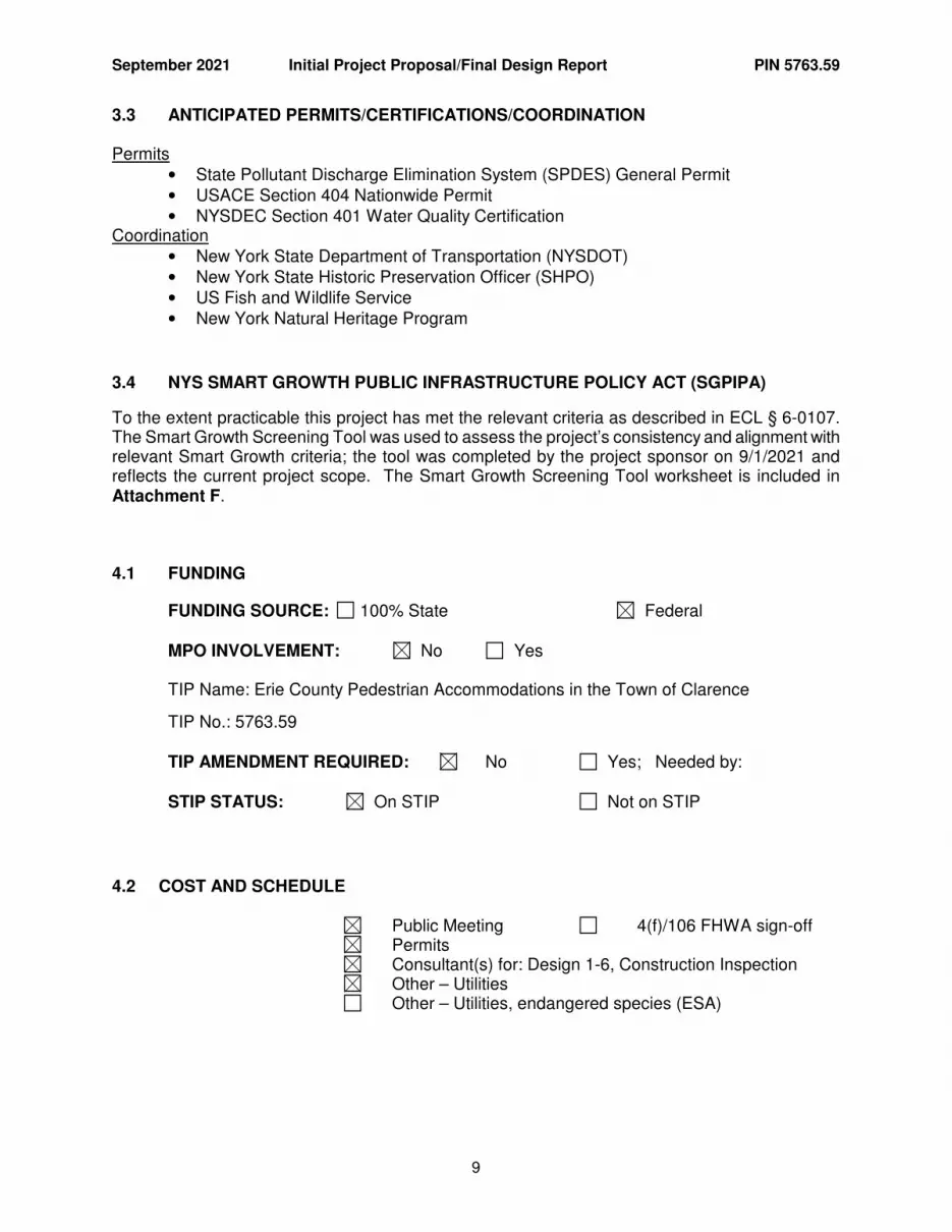
3.3 ANTICIPATED PERMITS/CERTIFICATIONS/COORDINATION Permits
• State Pollutant Discharge Elimination System (SPDES) General Permit • USACE Section 404 Nationwide Permit • NYSDEC Section 401 Water Quality Certification
Coordination • New York State Department of Transportation (NYSDOT) • New York State Historic Preservation Officer (SHPO) • US Fish and Wildlife Service • New York Natural Heritage Program
3.4 NYS SMART GROWTH PUBLIC INFRASTRUCTURE POLICY ACT (SGPIPA)
To the extent practicable this project has met the relevant criteria as described in ECL § 6-0107. The Smart Growth Screening Tool was used to assess the project’s consistency and alignment with relevant Smart Growth criteria; the tool was completed by the project sponsor on 9/1/2021 and reflects the current project scope. The Smart Growth Screening Tool worksheet is included in Attachment F.
4.1 FUNDING
FUNDING SOURCE: 100% State Federal MPO INVOLVEMENT: No Yes TIP Name: Erie County Pedestrian Accommodations in the Town of Clarence TIP No.: 5763.59 TIP AMENDMENT REQUIRED: No Yes; Needed by: STIP STATUS: On STIP Not on STIP
4.2 COST AND SCHEDULE Public Meeting 4(f)/106 FHWA sign-off Permits Consultant(s) for: Design 1-6, Construction Inspection Other – Utilities Other – Utilities, endangered species (ESA)
September 2021 Initial Project Proposal/Final Design Report PIN 5763.59
10
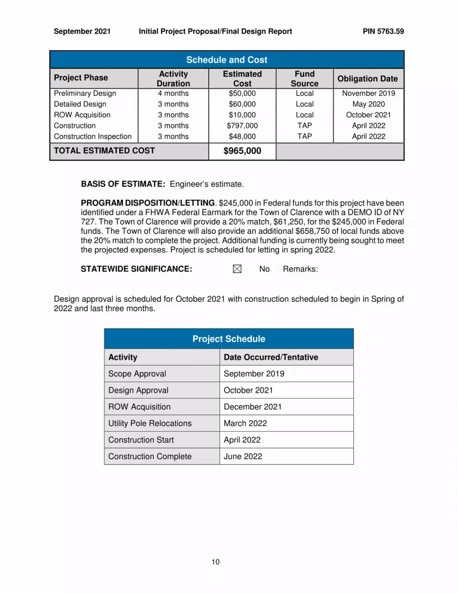
Schedule and Cost
Project Phase Activity Duration
Estimated Cost
Fund Source
Obligation Date
Preliminary Design 4 months $50,000 Local November 2019
Detailed Design 3 months $60,000 Local May 2020
ROW Acquisition 3 months $10,000 Local October 2021
Construction 3 months $797,000 TAP April 2022
Construction Inspection 3 months $48,000 TAP April 2022
TOTAL ESTIMATED COST $965,000
BASIS OF ESTIMATE: Engineer’s estimate. PROGRAM DISPOSITION/LETTING. $245,000 in Federal funds for this project have been identified under a FHWA Federal Earmark for the Town of Clarence with a DEMO ID of NY 727. The Town of Clarence will provide a 20% match, $61,250, for the $245,000 in Federal funds. The Town of Clarence will also provide an additional $658,750 of local funds above the 20% match to complete the project. Additional funding is currently being sought to meet the projected expenses. Project is scheduled for letting in spring 2022. STATEWIDE SIGNIFICANCE: No Remarks:
Design approval is scheduled for October 2021 with construction scheduled to begin in Spring of 2022 and last three months.
Project Schedule
Activity Date Occurred/Tentative
Scope Approval September 2019
Design Approval October 2021
ROW Acquisition December 2021
Utility Pole Relocations March 2022
Construction Start April 2022
Construction Complete June 2022
September 2021 Initial Project Proposal/Final Design Report PIN 5763.59
11
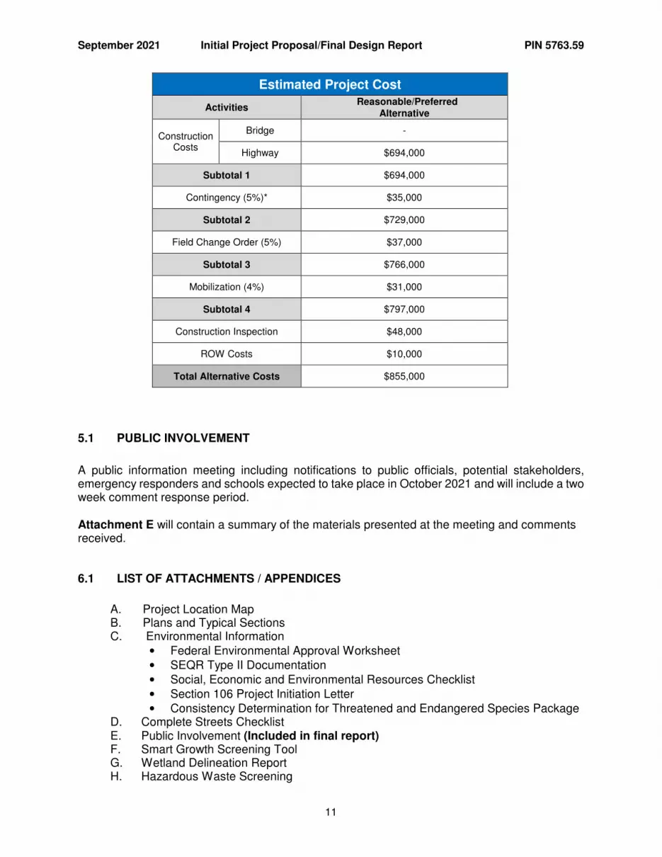
Estimated Project Cost
Activities Reasonable/Preferred
Alternative
Construction Costs
Bridge -
Highway $694,000
Subtotal 1 $694,000
Contingency (5%)* $35,000
Subtotal 2 $729,000
Field Change Order (5%) $37,000
Subtotal 3 $766,000
Mobilization (4%) $31,000
Subtotal 4 $797,000
Construction Inspection $48,000
ROW Costs $10,000
Total Alternative Costs $855,000
5.1 PUBLIC INVOLVEMENT
A public information meeting including notifications to public officials, potential stakeholders, emergency responders and schools expected to take place in October 2021 and will include a two week comment response period. Attachment E will contain a summary of the materials presented at the meeting and comments received.
6.1 LIST OF ATTACHMENTS / APPENDICES
A. Project Location Map B. Plans and Typical Sections C. Environmental Information
• Federal Environmental Approval Worksheet • SEQR Type II Documentation • Social, Economic and Environmental Resources Checklist • Section 106 Project Initiation Letter • Consistency Determination for Threatened and Endangered Species Package
D. Complete Streets Checklist E. Public Involvement (Included in final report) F. Smart Growth Screening Tool G. Wetland Delineation Report H. Hazardous Waste Screening
Attachment A
Project Location Map
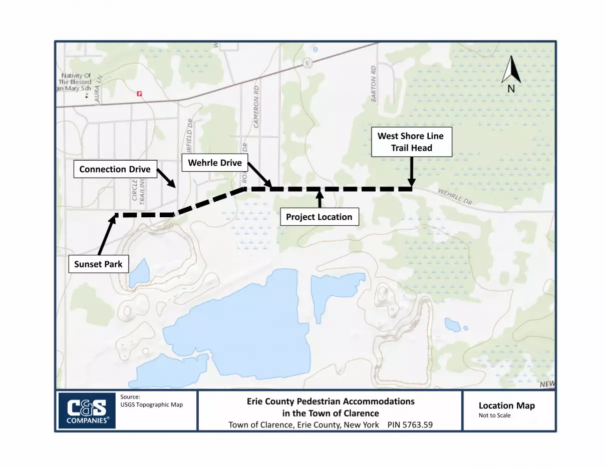
Source:
USGS Topographic Map Location MapNot to Scale
Erie County Pedestrian Accommodations
in the Town of Clarence
Town of Clarence, Erie County, New York PIN 5763.59
Connection DriveWehrle Drive
Project Location
West Shore Line
Trail Head
Sunset Park

Attachment B
Plans & Typical Sections
C. SPIEGEL
DESIGNED BY:
PROJECT NO:
DATE:
DRAWN BY:
4
C
B
3
C
1 2
1 3 42
A
B
A
**S
YTIM
E**
**TIM
E**
**D
AT
E**
**U
SE
R**
EDUCATION LAW
NO ALTERATION PERMITTED HEREON
EXCEPT AS PROVIDED UNDER SECTION
7209 SUBDIVISION 2 OF THE NEW YORK
CHECKED BY:
PIN 5
763.5
9D
XX
XX
XX
X52.001.001
MARK DATE DESCRIPTION
REVISIONS
ERIE C
OU
NT
Y,
NE
W Y
OR
K
C. STEVENS
D. BORCZ
JULY 2021
SHEET OF XX
Copyrightc
www.cscos.com
Fax: 716-847-1454
Phone: 716-847-1630
Buffalo, New York 14203
141 Elm Street, Suite 100
C&S Engineers, Inc.
TO
WN O
F C
LA
RE
NC
E
PE
DE
ST
RIA
N A
CC
ES
S P
ROJE
CT
WE
HR
LE D
RIV
E
SECTIONS
TYPICAL
TYP-01
3
6'-0" 2'-0"2'-0" 3'-0"
SNOW STORAGESHOULDER SHOULDERTRAIL
3" TOPSOIL (TYP.)
3" SHOULDER BACKUP MATERIAL (TYP.)
8" SUBBASE COURSE
2" HMA BINDER COURSE
1" HMA TOP COURSE
GEOTEXTILE FABRIC
EXISTING GROUND
1.5%8%
1" HMA TOP COURSE
SUNSET PARK CONNECTION
EMBANKMENT MATERIAL
1.5%
WEHRLE DRIVE
ROADWAY
EXISTING
BOX OUT 14' WIDE 8" DEPTH IN AREAS CONTAINING TOPSOIL
1:3 MAX.
SUBGRADE
2" HMA BINDER COURSE
8" SUBBASE COURSE
GEOTEXTILE FABRIC
MATERIAL (TYP.)
3" SHOULDER BACKUP MATERIAL (TYP.)
3" SHOULDER BACKUP
10'-0"
6'-0" 2'-0"2'-0" 3'-0"
SNOW STORAGESHOULDER SHOULDERTRAIL
3" TOPSOIL (TYP.)
3" SHOULDER BACKUP MATERIAL (TYP.)
8" SUBBASE COURSE
2" HMA BINDER COURSE
1" HMA TOP COURSE
GEOTEXTILE FABRICEXISTING GROUND
WEHRLE DRIVE TRAIL
EMBANKMENT MATERIAL
WEHRLE DRIVE
ROADWAY
EXISTING
1.5%
1.5%
1.5%
1:3
1:3
WEHRLE DRIVE TRAIL WITH ROADSIDE V-DITCH
EXISTING GROUND
1:3 MAX.
12+00
13+00 14+00
11+0010+00
ED
GE
OF P
AVE
ME
NT
GRASSGRASS
GRASS
SHED
8645 SUNSET DRIVE
TA# 82.11-1-21
(REPUTED OWNERS)
KELLY NEIL BYREITER ETAL
HUGH M NEIL LIFE USE &
8635 SUNSET DRIVE
TA# 82.11-1-20
(REPUTED OWNER)
SUSAN M O'DONNEL
8631 SUNSET DRIVE
TA# 82.11-1-19
(REPUTED OWNERS)
AMBER S HAMILTON
MICHAEL L HAMILTON &
8625 SUNSET DRIVE
TA# 82.11-1-18
(REPUTED OWNERS)
JOSCELYN FREDERICKS
MARTIN FREDERICKS &
8615 SUNSET DRIVE
TA# 82.11-1-17
(REPUTED OWNER)
TOWN OF CLARENCE
NYSEG T82 NYSEG 83 NYSEG T84
24"
32"
TWIN
24" & 30"
C. SPIEGEL
DESIGNED BY:
PROJECT NO:
DATE:
DRAWN BY:
4
C
B
3
C
1 2
1 3 42
A
B
A
F:\Project\
X52 - T
ow
n of
Clare
nce\X
52.0
01.0
01 - W
ehrle Drive P
edestria
n A
ccess\D
esig
n\C
AD
D\S
heet Files\P
LN-0
1.d
gn
2:5
4:2
1 P
M9/1
3/2
021
cste
vens
EDUCATION LAW
NO ALTERATION PERMITTED HEREON
EXCEPT AS PROVIDED UNDER SECTION
7209 SUBDIVISION 2 OF THE NEW YORK
CHECKED BY:
PIN 5
763.5
9D
XX
XX
XX
X52.001.001
MARK DATE DESCRIPTION
REVISIONS
ERIE C
OU
NT
Y,
NE
W Y
OR
K
C. STEVENS
D. BORCZ
JULY 2021
SHEET OF XX
Copyrightc
www.cscos.com
Fax: 716-847-1454
Phone: 716-847-1630
Buffalo, New York 14203
141 Elm Street, Suite 100
C&S Engineers, Inc.
TO
WN O
F C
LA
RE
NC
E
PE
DE
ST
RIA
N A
CC
ES
S P
ROJE
CT
WE
HR
LE D
RIV
E
705
710
715
720
725
730730
705
710
715
720
725
730730
10+00 11+00 12+00 13+00 14+00
PVI 10+50.00
ELEV 714.77PVI 10+78.00
ELEV 714.35
-1.50%
0.70%
PROPOSED TGL
EXISTING GRADE
MATCH EXISTING PAVEMENT
BEGIN TRAIL
20020 40
XX
PLN-01
GENERAL PLAN
SCALE IN FEET
MA
TC
HLIN
E
ST
A 14
+00,
SE
E
PL
N-02
SUNSET PARK 10' WIDE TRAIL
EMBEDED IN CONCRETE
DETECTABLE WARNING UNIT
HORIZONTAL
VERTICAL
20020 40
505 10

19+0
0
14+00 15+00 16+00 17+00 18+00
GRASS
16+00
SHED
GRASS
GRASSGRASS
8665 SUNSET DRIVE
TA# 82.11-1-23
(REPUTED OWNER)
MICHAEL THOMAS
8655 SUNSET DRIVE
TA# 82.11-1-22
(REPUTED OWNER)
MARY M DIETRICH
DANIEL F DIETRICH &
8645 SUNSET DRIVE
TA# 82.11-1-21
(REPUTED OWNERS)
KELLY NEIL BYREITER ETAL
HUGH M NEIL LIFE USE &
8685 SUNSET DRIVE
TA# 82.11-1-26
(REPUTED OWNERS)
BAIN
SCHYLER HDANA BAIN & CAMERON W
8675 SUNSET DRIVE
TA# 82.11-1-24
(REPUTED OWNERS)
SEAN & JULIE TRUSTEES
BYRON FAMILY TRUST THE TUST & BYRON
NYSEG T85 NYSEG T86
NYSEG T87
15"
SIGN
PARK
CHAINLIN
K FENCE
GRASS
PAVEMENT
CHANGE
EDGE OF P
AVEMENT
C. SPIEGEL
DESIGNED BY:
PROJECT NO:
DATE:
DRAWN BY:
4
C
B
3
C
1 2
1 3 42
A
B
A
F:\Project\
X52 - T
ow
n of
Clare
nce\X
52.0
01.0
01 - W
ehrle Drive P
edestria
n A
ccess\D
esig
n\C
AD
D\S
heet Files\P
LN-0
2.d
gn
2:5
4:2
4 P
M9/1
3/2
021
cste
vens
EDUCATION LAW
NO ALTERATION PERMITTED HEREON
EXCEPT AS PROVIDED UNDER SECTION
7209 SUBDIVISION 2 OF THE NEW YORK
CHECKED BY:
PIN 5
763.5
9D
XX
XX
XX
X52.001.001
MARK DATE DESCRIPTION
REVISIONS
ERIE C
OU
NT
Y,
NE
W Y
OR
K
C. STEVENS
D. BORCZ
JULY 2021
SHEET OF XX
Copyrightc
www.cscos.com
Fax: 716-847-1454
Phone: 716-847-1630
Buffalo, New York 14203
141 Elm Street, Suite 100
C&S Engineers, Inc.
TO
WN O
F C
LA
RE
NC
E
PE
DE
ST
RIA
N A
CC
ES
S P
ROJE
CT
WE
HR
LE D
RIV
E
705
710
715
720
725
730730
705
710
715
720
725
730730
14+00 15+00 16+00 17+00 18+00 19+00
PVI 15+50.00
ELEV 717.65
PVI 16+50.00
ELEV 719.65 PVI 17+50.00
ELEV 718.65
0.70%
2.00%-1.00%
-2.00%
EXISTING GRADE
PROPOSED TGL
20020 40
XX
PLN-02
GENERAL PLAN
SCALE IN FEET
MA
TC
HLIN
E
ST
A 14
+00,
SE
E
PL
N-01
MATCHLIN
E ST
A 19+00,
SEE PLN-03
WEHRLE DRIV
E (CR
275)
10' WIDE TRAIL
6' WIDE SIDEWALK
HORIZONTAL
VERTICAL
20020 40
505 10

19+00 20+00 21+00 22+00 23+00 24+00
PAVEMENT CHANGE
UNPAVED SHOULDER
PAVEMENT CHANGE
GRASS
GRASS
UNPAVED SHOULDERUNPAVED SHOULDER
12"12" 12" 24"
15"24"24"
N 67°37'20" E 572.66'17+00 18+00 19+00 20+00 21+00
EDGE OF PAVEMENT
EDGE OF PAVEMENT
"STOP/WEHRLE/CONNECTION"
2021 SURVEY BASELINE
4117 HEATHER DRIVE
TA# 82.08-1-41
(REPUTED OWNER)
AARON AMABILE
0 WEHRLE DRIVE
TA# 82.11-1-31
(REPUTED OWNER)
DANA HAMMER8689 SUNSET DRIVE
TA# 82.11-1-27.11
(REPUTED OWNER)
DANA R HAMMER
NO #765 T
NYSEG T90
O/S 55' L
STA 20+82
ELE 713.04
POLE NYSEG 12-6
MAG NAIL IN UTILITY
CPBM-2
12"
PVC
STA 21+26.33
ELE 710.550
E 1125724.054
N 1078017.489
REBAR AND CAP
CBP 5
C. SPIEGEL
DESIGNED BY:
PROJECT NO:
DATE:
DRAWN BY:
4
C
B
3
C
1 2
1 3 42
A
B
A
F:\Project\
X52 - T
ow
n of
Clare
nce\X
52.0
01.0
01 - W
ehrle Drive P
edestria
n A
ccess\D
esig
n\C
AD
D\S
heet Files\P
LN-0
3.d
gn
2:5
4:2
7 P
M9/1
3/2
021
cste
vens
EDUCATION LAW
NO ALTERATION PERMITTED HEREON
EXCEPT AS PROVIDED UNDER SECTION
7209 SUBDIVISION 2 OF THE NEW YORK
CHECKED BY:
PIN 5
763.5
9D
XX
XX
XX
X52.001.001
MARK DATE DESCRIPTION
REVISIONS
ERIE C
OU
NT
Y,
NE
W Y
OR
K
C. STEVENS
D. BORCZ
JULY 2021
SHEET OF XX
Copyrightc
www.cscos.com
Fax: 716-847-1454
Phone: 716-847-1630
Buffalo, New York 14203
141 Elm Street, Suite 100
C&S Engineers, Inc.
TO
WN O
F C
LA
RE
NC
E
PE
DE
ST
RIA
N A
CC
ES
S P
ROJE
CT
WE
HR
LE D
RIV
E
700
705
710
715
720
725725
700
705
710
715
720
725725
19+00 20+00 21+00 22+00 23+00 24+00
PVI 19+25.00
ELEV 715.15 PVI 19+95.00
ELEV 714.45PVI 20+45.00
ELEV 712.95PVI 22+52.00
ELEV 711.70PVI 23+15.00
ELEV 711.22
-2.00%-1.00%
-3.00%
-0.60%
-1.50%
EXISTING GRADE
PROPOSED TGL
MATCH EXISTING PAVEMENT
STOP TRAIL
MATCH EXISTING PAVEMENT
RESUME TRAIL
CONNECTION DRIVE
XX
PLN-03
GENERAL PLAN
MA
TC
HLIN
E
ST
A 24
+00,
SE
E
PL
N-04
MA
TC
HLIN
E
ST
A 19
+00,
SE
E
PL
N-02
CO
NNECTIO
N
DRIV
E
WEHRLE DRIVE (CR 275)
6' WIDE SIDEWALK
LIMIT OF CLEARING
ERIE COUNTY CONFIGURATION.
EMBEDED IN CONCRETE.
DETECTABLE WARNING UNITS
HORIZONTAL
VERTICAL
20020 40
505 10
20020 40
SCALE IN FEET
INSTALL DRAINAGE INLET
INSTALLED BY OTHERS
CROSS-CULVERT TO BE
(BY OTHERS)
REMOVE EXISTING CROSS CULVERT

24+00 25+00 26+00 27+00 28+00 29+00
GRASSGRASS
GRASS
PAVEMENT CHANGE
PAVEMENT CHANGE
UNPAVED SHOULDERUNPAVED SHOULDER
N 67°48'18" E 560.29'22+00 23+00 24+00 25+00 26+00
EDGE OF PAVEMENT
EDGE OF PAVEMENT
"STOP/WEHRLE/HEATHER"
SHED
WOOD
2021 SURVEY BASELINE
HEADWALLCONCRETE
INV 707.49
18"
VTP
INV 706.77
INV 707.33
12" CMP
INV 707.39
END SECTION END SECTION
4141 HEATHER DRIVE
TA# 82.08-2-20.1
(REPUTED OWNER)
MY RENTAL HOME LLC
4117 HEATHER DRIVE
TA# 82.08-1-41
(REPUTED OWNER)
AARON AMABILE
4120 HEATHER DRIVE
TA# 82.08-2-21.2
(REPUTED OWNERS)
WOJTKOWSKI JT TNT
MATTHEW J COLOCOUSIS JT TNT & KALI
NYSEG T92NYSEG T93
6"
DIP
C. SPIEGEL
DESIGNED BY:
PROJECT NO:
DATE:
DRAWN BY:
4
C
B
3
C
1 2
1 3 42
A
B
A
F:\Project\
X52 - T
ow
n of
Clare
nce\X
52.0
01.0
01 - W
ehrle Drive P
edestria
n A
ccess\D
esig
n\C
AD
D\S
heet Files\P
LN-0
4.d
gn
2:5
4:3
0 P
M9/1
3/2
021
cste
vens
EDUCATION LAW
NO ALTERATION PERMITTED HEREON
EXCEPT AS PROVIDED UNDER SECTION
7209 SUBDIVISION 2 OF THE NEW YORK
CHECKED BY:
PIN 5
763.5
9D
XX
XX
XX
X52.001.001
MARK DATE DESCRIPTION
REVISIONS
ERIE C
OU
NT
Y,
NE
W Y
OR
K
C. STEVENS
D. BORCZ
JULY 2021
SHEET OF XX
Copyrightc
www.cscos.com
Fax: 716-847-1454
Phone: 716-847-1630
Buffalo, New York 14203
141 Elm Street, Suite 100
C&S Engineers, Inc.
TO
WN O
F C
LA
RE
NC
E
PE
DE
ST
RIA
N A
CC
ES
S P
ROJE
CT
WE
HR
LE D
RIV
E
695
700
705
710
715
720720
695
700
705
710
715
720720
24+00 25+00 26+00 27+00 28+00 29+00
PVI 24+75.00
ELEV 708.82
PVI 26+97.00
ELEV 709.19
PVI 27+67.00
ELEV 709.16
-1.50% 0.17%0.32%
EXISTING GRADE
PROPOSED TGL
MATCH EXISTING PAVEMENT
STOP TRAIL
MATCH EXISTING PAVEMENT
RESUME TRAIL
HEATHER DRIVE
XX
PLN-04
GENERAL PLAN
MA
TC
HLIN
E
ST
A 24
+00,
SE
E
PL
N-03
MA
TC
HLIN
E
ST
A 29
+00,
SE
E
PL
N-05
HEATHER DRIV
E
WEHRLE DRIVE (CR 275)ERIE COUNTY CONFIGURATION.
EMBEDED IN CONCRETE.
DETECTABLE WARNING UNITS
DRAINAGE PIPE
REMOVE EXISTING
WITHIN V-DITCH
INSTALL FIELD INLETS
WITH END-SECTION OUTLET
CONCRETE DRAINAGE INLET
LIMIT OF CLEARINGLIMIT OF CLEARING
6' WIDE TRAIL
HORIZONTAL
VERTICAL
20020 40
505 10
20020 40
SCALE IN FEET
29+00 30+00 31+00 32+00 33+00 34+00GRASS GRASS
PAVEMENT CHANGE
PAVEMENT CHANGE PAVEMENT CHANGE
PAVEMENT CHANGE
GRASS UNPAVED SHOULDER
N 66°28'51" E 868.24'
27+0028+00
29+0030+00
31+00
EDGE OF PAVEMENT
EDGE OF PAVEMENT
EDGE OF PAVEMENT
EDGE OF PAVEMENT
2021 SURVEY BASELINE
PIPE
IRON
FOUND
0 WEHRLE DRIVE
TA# 82.08-2-25
(REPUTED OWNERS)
MY RENTAL HOME LLC4141 HEATHER DRIVE
TA# 82.08-2-20.1
(REPUTED OWNER)
MY RENTAL HOME LLC0 WEHRLE DRIVE
TA# 82.08-2-23
(REPUTED OWNERS)
HENNESSEY
JOHN HENNESSEY & ELAINE
NYSEG T94
NYSEG T95
NYSEG T96
NYSEG T97
O/S 45' L
STA 30+20
ELE 712.28
POLE NYSEG T96
MAG NAIL IN UTILITY
CPBM-3
STA 26+86.63
ELE 709.197
E 1126242.832
N 1078229.145
REBAR AND CAP
CBP 6
C. SPIEGEL
DESIGNED BY:
PROJECT NO:
DATE:
DRAWN BY:
4
C
B
3
C
1 2
1 3 42
A
B
A
F:\Project\
X52 - T
ow
n of
Clare
nce\X
52.0
01.0
01 - W
ehrle Drive P
edestria
n A
ccess\D
esig
n\C
AD
D\S
heet Files\P
LN-0
5.d
gn
2:5
4:3
4 P
M9/1
3/2
021
cste
vens
EDUCATION LAW
NO ALTERATION PERMITTED HEREON
EXCEPT AS PROVIDED UNDER SECTION
7209 SUBDIVISION 2 OF THE NEW YORK
CHECKED BY:
PIN 5
763.5
9D
XX
XX
XX
X52.001.001
MARK DATE DESCRIPTION
REVISIONS
ERIE C
OU
NT
Y,
NE
W Y
OR
K
C. STEVENS
D. BORCZ
JULY 2021
SHEET OF XX
Copyrightc
www.cscos.com
Fax: 716-847-1454
Phone: 716-847-1630
Buffalo, New York 14203
141 Elm Street, Suite 100
C&S Engineers, Inc.
TO
WN O
F C
LA
RE
NC
E
PE
DE
ST
RIA
N A
CC
ES
S P
ROJE
CT
WE
HR
LE D
RIV
E
700
705
710
715
720
725725
700
705
710
715
720
725725
29+00 30+00 31+00 32+00 33+00 34+00
0.32%
EXISTING GRADE
PROPOSED TGL
XX
PLN-05
GENERAL PLAN
MA
TC
HLIN
E
ST
A 34
+00,
SE
E
PL
N-06
MA
TC
HLIN
E
ST
A 29
+00,
SE
E
PL
N-04
WEHRLE DRIVE (CR 275)
WITHIN V-DITCH
INSTALL FIELD INLETS6' WIDE TRAIL
LIMIT OF CLEARING
HORIZONTAL
VERTICAL
20020 40
505 10
20020 40
SCALE IN FEET
34+00
35+00
36+00 37+00
38+00
39+00
WETLAND A
GRASS
GRASS
PAVEMENT CHANGE
PAVEMENT CHANGE
GRASS
GRASS
PAVEMENT CHANGE
PAVEMENT CHANGE
UNPAVED SHOULDER
UNPAVED SHOULDER
UNPAVED SHOULDER
32+00
33+00
34+00
35+00
36+00
"STOP/WEHRLE/ROXBURY"
EDGE OF PAVEMENT
EDGE OF PAVEMENT
EDGE OF PAVEMENT
EDGE OF PAVEMENT
PAIN
TE
D
GAS LI
NE
4171 ROXBURY DRIVE
TA# 82.08-3-13
(REPUTED OWNER)
GERALD R CARRIGAN
4170 ROXBURY DRIVE
TA# 82.08-3-12
(REPUTED OWNERS)
DEC D'AMICO
MARY ANN D'AMICO & GEORGE
0 WEHRLE DRIVE
TA# 82.08-2-23
(REPUTED OWNERS)
HENNESSEY
JOHN HENNESSEY & ELAINE
NYSEG T98
NYSEG T99
NYSEG T100
12"
PVC
STA 35+54.86
ELE 711.932
E 1127038.944
N 1078575.620
REBAR AND CAP
CBP 7
C. SPIEGEL
DESIGNED BY:
PROJECT NO:
DATE:
DRAWN BY:
4
C
B
3
C
1 2
1 3 42
A
B
A
F:\Project\
X52 - T
ow
n of
Clare
nce\X
52.0
01.0
01 - W
ehrle Drive P
edestria
n A
ccess\D
esig
n\C
AD
D\S
heet Files\P
LN-0
6.d
gn
2:5
4:3
7 P
M9/1
3/2
021
cste
vens
EDUCATION LAW
NO ALTERATION PERMITTED HEREON
EXCEPT AS PROVIDED UNDER SECTION
7209 SUBDIVISION 2 OF THE NEW YORK
CHECKED BY:
PIN 5
763.5
9D
XX
XX
XX
X52.001.001
MARK DATE DESCRIPTION
REVISIONS
ERIE C
OU
NT
Y,
NE
W Y
OR
K
C. STEVENS
D. BORCZ
JULY 2021
SHEET OF XX
Copyrightc
www.cscos.com
Fax: 716-847-1454
Phone: 716-847-1630
Buffalo, New York 14203
141 Elm Street, Suite 100
C&S Engineers, Inc.
TO
WN O
F C
LA
RE
NC
E
PE
DE
ST
RIA
N A
CC
ES
S P
ROJE
CT
WE
HR
LE D
RIV
E
700
705
710
715
720
725725
700
705
710
715
720
725725
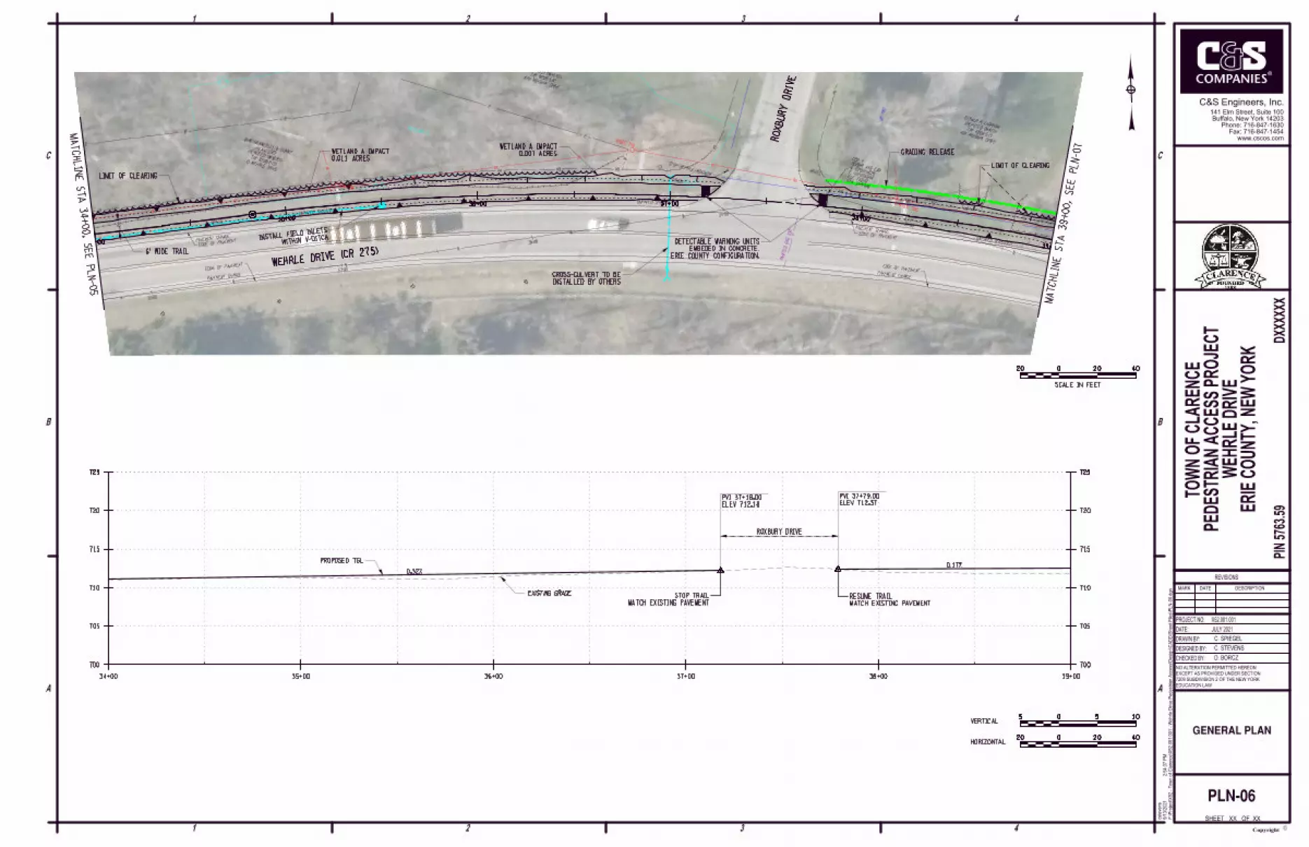
34+00 35+00 36+00 37+00 38+00 39+00
PVI 37+18.00
ELEV 712.18
PVI 37+79.00
ELEV 712.37
0.32%0.17%
EXISTING GRADE
PROPOSED TGL
MATCH EXISTING PAVEMENT
STOP TRAIL
MATCH EXISTING PAVEMENT
RESUME TRAIL
ROXBURY DRIVE
XX
PLN-06
GENERAL PLAN
MAT
CHLIN
E ST
A 34+00,
SEE PL
N-05
MATC
HLIN
E ST
A 39+00,
SEE PL
N-07
RO
XB
UR
Y
DRIV
E
WEHRLE DRIVE (CR 275)WITHIN V-DITCHINSTALL FIELD INLETS
ERIE COUNTY CONFIGURATION.
EMBEDED IN CONCRETE.
DETECTABLE WARNING UNITS
LIMIT OF CLEARING
6' WIDE TRAIL
LIMIT OF CLEARING
HORIZONTAL
VERTICAL
20020 40
505 10
20020 40
SCALE IN FEET
GRADING RELEASE
INSTALLED BY OTHERS
CROSS-CULVERT TO BE
0.011 ACRES
WETLAND A IMPACT 0.007 ACRES
WETLAND A IMPACT
STUMPSTUMP
STUMP
STUMP
39+0040+00 41+00 42+00 43+00 44+00GRASS
GRASS
PAVEMENT CHANGE
PAVEMENT CHANGE
GRASS GRASS
UNPAVED SHOULDER UNPAVED SHOULDER
20"
12" 12" 15"
8"
6" 5"
12" 12" 12"
12"
10" 10"
10"
10" 10" 10"
10" 10"
37+00
38+00
39+00
40+00
41+00
"LEFT ARROW SYMBOL"
"STOP/WEHRLE/CAMERON"
"40 MPH"
EDGE OF PAVEMENT
EDGE OF PAVEMENT
18"
CIP
INV 711.28
INV 711.56
HEADWALL
CONCRETE
S 88°02'35" E 749.15'
2021 SURVEY BASELINE
PIPE
IRON
FOUND
4171 CAMERON DRIVE
TA# 82.08-4-13
(REPUTED OWNER)
DANIEL J KRZYZANOWICZ
4170 CAMERON DRIVE
TA# 82.08-3-37
(REPUTED OWNERS)
CALORICO
DAWN WASIECZKO & RICHARD
NYSEG T101NYSEG T102
NYSEG T103
O/S 51' L
STA 39+04
ELE 714.28
BONNET BOLT
X-CUT ON SOUTHWEST
CPBM-4
C. SPIEGEL
DESIGNED BY:
PROJECT NO:
DATE:
DRAWN BY:
4
C
B
3
C
1 2
1 3 42
A
B
A
F:\Project\
X52 - T
ow
n of
Clare
nce\X
52.0
01.0
01 - W
ehrle Drive P
edestria
n A
ccess\D
esig
n\C
AD
D\S
heet Files\P
LN-0
7.d
gn
2:5
4:4
0 P
M9/1
3/2
021
cste
vens
EDUCATION LAW
NO ALTERATION PERMITTED HEREON
EXCEPT AS PROVIDED UNDER SECTION
7209 SUBDIVISION 2 OF THE NEW YORK
CHECKED BY:
PIN 5
763.5
9D
XX
XX
XX
X52.001.001
MARK DATE DESCRIPTION
REVISIONS
ERIE C
OU
NT
Y,
NE
W Y
OR
K
C. STEVENS
D. BORCZ
JULY 2021
SHEET OF XX
Copyrightc
www.cscos.com
Fax: 716-847-1454
Phone: 716-847-1630
Buffalo, New York 14203
141 Elm Street, Suite 100
C&S Engineers, Inc.
TO
WN O
F C
LA
RE
NC
E
PE
DE
ST
RIA
N A
CC
ES
S P
ROJE
CT
WE
HR
LE D
RIV
E
705
710
715
720
725
730730
705
710
715
720
725
730730
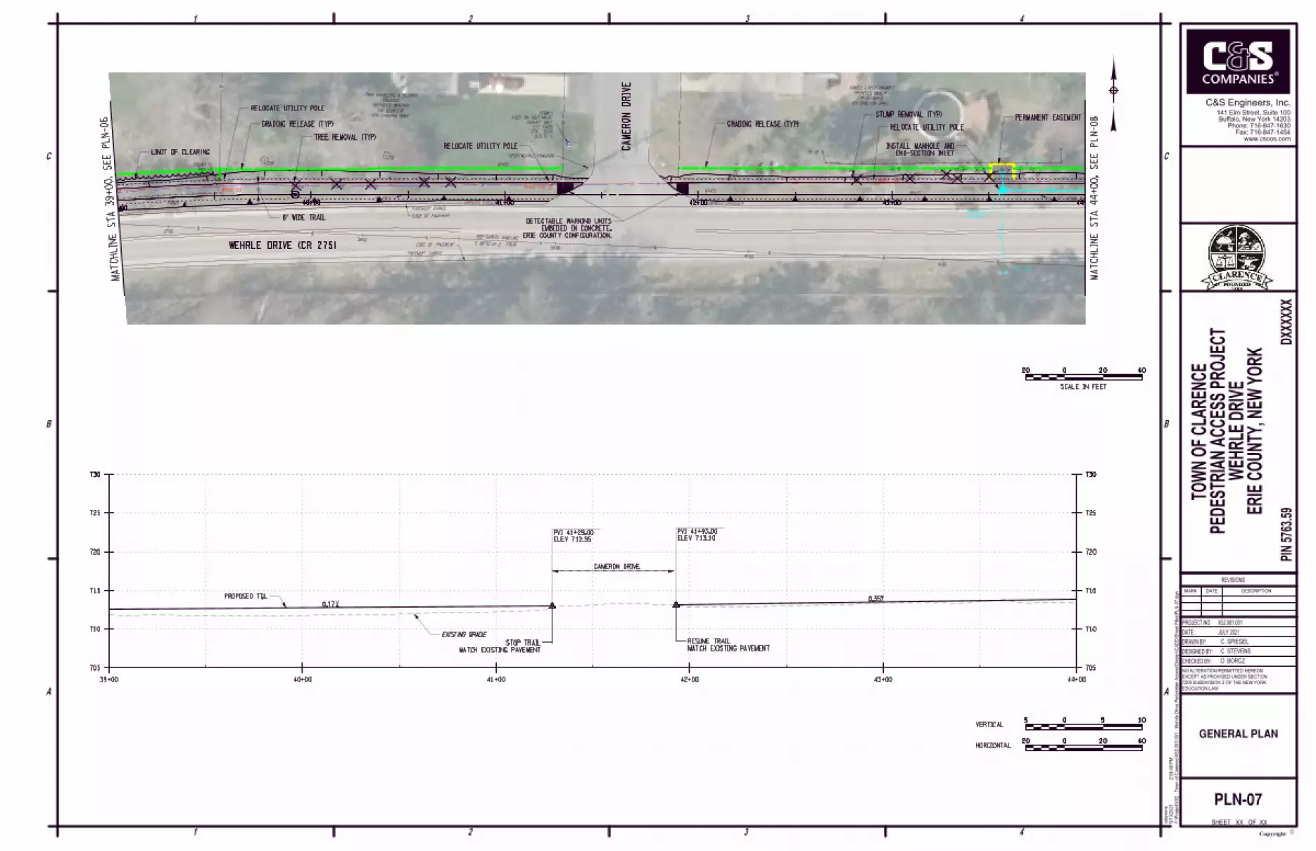
39+00 40+00 41+00 42+00 43+00 44+00
PVI 41+29.00
ELEV 712.95
PVI 41+93.00
ELEV 713.10
0.17%0.35%
EXISTING GRADE
PROPOSED TGL
MATCH EXISTING PAVEMENT
STOP TRAILMATCH EXISTING PAVEMENT
RESUME TRAIL
CAMERON DRIVE
XX
PLN-07
GENERAL PLAN
MAT
CHLIN
E ST
A 39+00,
SEE PL
N-06
MA
TC
HLIN
E
ST
A 44
+00,
SE
E
PL
N-08
CA
ME
RO
N
DRIV
E
WEHRLE DRIVE (CR 275)
ERIE COUNTY CONFIGURATION.
EMBEDED IN CONCRETE.
DETECTABLE WARNING UNITS
LIMIT OF CLEARING
6' WIDE TRAIL
TREE REMOVAL (TYP)
PERMANENT EASEMENT
END-SECTION INLET
INSTALL MANHOLE AND
HORIZONTAL
VERTICAL
20020 40
505 10
20020 40
SCALE IN FEET
RELOCATE UTILITY POLE
RELOCATE UTILITY POLE
RELOCATE UTILITY POLEGRADING RELEASE (TYP) GRADING RELEASE (TYP)
STUMP REMOVAL (TYP)
44+00 45+00 46+00 47+00 48+00 49+00
STUMPSTUMP
STUMP STUMP
GRASS
PAVEMENT CHANGE
PAVEMENT CHANGE
GRASS
GRASS
GRASS
PAVEMENT CHANGE
EDGE OF PAVEMENT
DRIVEWAY
ASPHALT
DRIV
EW
AY
CONCRETE
UNPAVED SHOULDER UNPAVED SHOULDER
PAVEMENT CHANGE
UNPAVED SHOULDER
18" 30" 18"
33"
42+00
43+00
44+00
45+00
46+00
"T" INTERSECTION SYMBOL
"STOP"
"WEHRLE/SHIMMERVILLE"
"LEFT ARROW SYMBOL"
EDGE OF PAVEMENTEDGE OF PAVEMENT
EDGE OF PAVEMENT
HEDGEHEDGE
HEDGE
HEDGE
12" HDPE
INV 714.17
INV 713.03
N 85°55'53" E 700.39'
2021 SURVEY BASELINE
GRASS LOT
PARKING
GRAVEL
PIPE
IRON
FOUND
4164 SHIMERVILLE ROAD
TA# 82.08-4-14
SCRIVANI (REPUTED OWNERS)
DAVID SCRIVANI & DOMINIC
NYSEG T104
NYSEG T105 BELL 201
8920 WEHRLE DRIVE
TA# 82.08-4-40
(REPUTED OWNER)
CATHY STEVENS
STA 43+04.02
ELE 715.177
E 1127787.658
N 1078550.036
REBAR AND CAP
CBP 8
C. SPIEGEL
DESIGNED BY:
PROJECT NO:
DATE:
DRAWN BY:
4
C
B
3
C
1 2
1 3 42
A
B
A
F:\Project\
X52 - T
ow
n of
Clare
nce\X
52.0
01.0
01 - W
ehrle Drive P
edestria
n A
ccess\D
esig
n\C
AD
D\S
heet Files\P
LN-0
8.d
gn
2:5
4:4
3 P
M9/1
3/2
021
cste
vens
EDUCATION LAW
NO ALTERATION PERMITTED HEREON
EXCEPT AS PROVIDED UNDER SECTION
7209 SUBDIVISION 2 OF THE NEW YORK
CHECKED BY:
PIN 5
763.5
9D
XX
XX
XX
X52.001.001
MARK DATE DESCRIPTION
REVISIONS
ERIE C
OU
NT
Y,
NE
W Y
OR
K
C. STEVENS
D. BORCZ
JULY 2021
SHEET OF XX
Copyrightc
www.cscos.com
Fax: 716-847-1454
Phone: 716-847-1630
Buffalo, New York 14203
141 Elm Street, Suite 100
C&S Engineers, Inc.
TO
WN O
F C
LA
RE
NC
E
PE
DE
ST
RIA
N A
CC
ES
S P
ROJE
CT
WE
HR
LE D
RIV
E
705
710
715
720
725
730730
705
710
715
720
725
730730
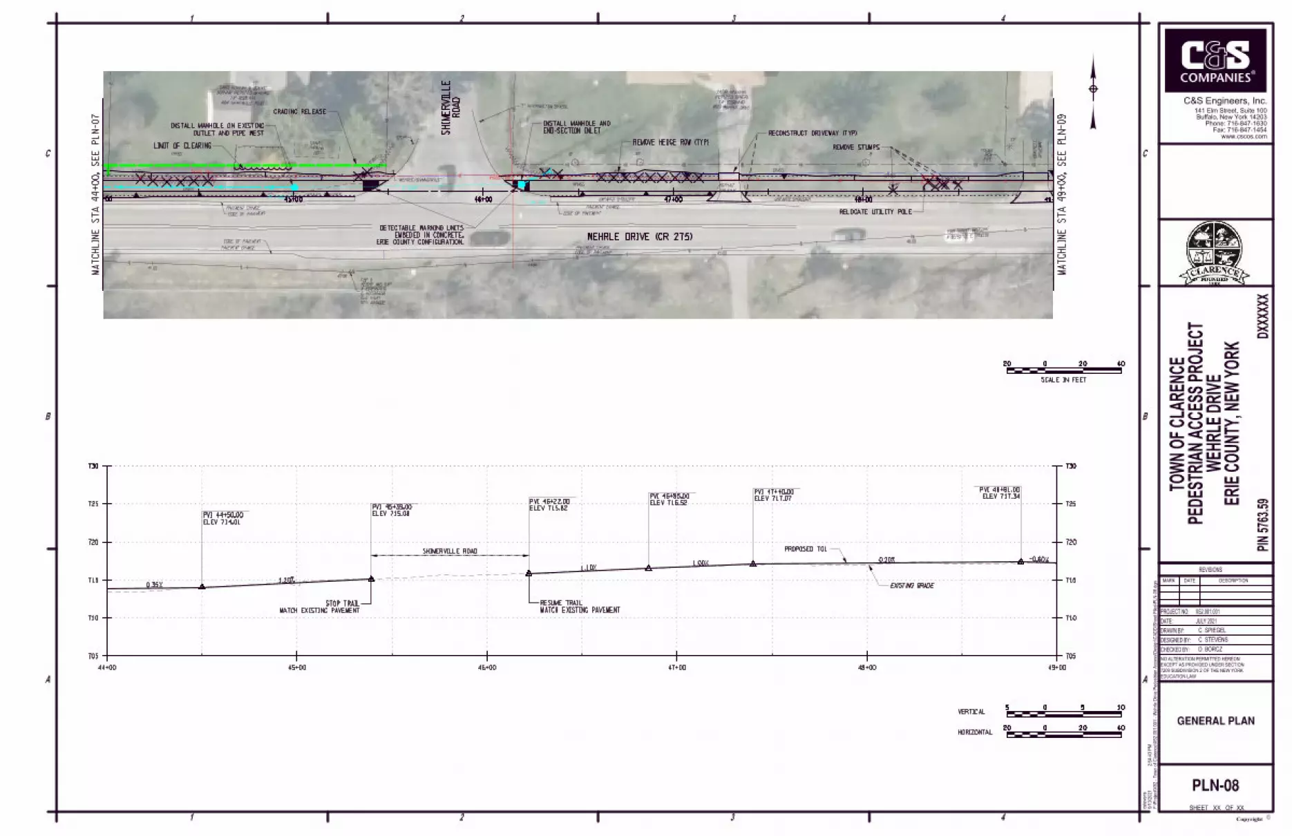
44+00 45+00 46+00 47+00 48+00 49+00
PVI 44+50.00
ELEV 714.01
PVI 45+39.00
ELEV 715.08
PVI 46+22.00
ELEV 715.82
PVI 46+85.00
ELEV 716.52
PVI 47+40.00
ELEV 717.07
0.35%1.20%
1.10%1.00%
0.20% -0.60%
EXISTING GRADE
PROPOSED TGLSHIMERVILLE ROAD
MATCH EXISTING PAVEMENT
STOP TRAILMATCH EXISTING PAVEMENT
RESUME TRAIL
ELEV 717.34
PVI 48+81.00
XX
PLN-08
GENERAL PLAN
MA
TC
HLIN
E
ST
A 49
+00,
SE
E
PL
N-09
MA
TC
HLIN
E
ST
A 44
+00,
SE
E
PL
N-07 R
OA
D
SHI
ME
RVIL
LE
WEHRLE DRIVE (CR 275)ERIE COUNTY CONFIGURATION.
EMBEDED IN CONCRETE.
DETECTABLE WARNING UNITS
LIMIT OF CLEARING
OUTLET AND PIPE WEST
INSTALL MANHOLE ON EXISTINGEND-SECTION INLET
INSTALL MANHOLE AND
REMOVE HEDGE ROW (TYP)REMOVE STUMPS
RECONSTRUCT DRIVEWAY (TYP)
HORIZONTAL
VERTICAL
20020 40
505 10
20020 40
SCALE IN FEET
RELOCATE UTILITY POLE
GRADING RELEASE

LIGHT
FLAG
49+00 50+00 51+00 52+00 53+00 54+00
GRASS
GRASS
GRASS
GRASS GRASS
GRASS
DRIV
EW
AY
ASP
HALT
DRIV
EW
AY
ASP
HALT
DRIV
EW
AY
ASP
HALT
DRIV
EW
AY
ASP
HALT
DRIV
EW
AY
ASP
HALT
DRIV
EW
AY
ASP
HALT
UNPAVED SHOULDER
EDGE OF PAVEMENT
EDGE OF PAVEMENT EDGE OF PAVEMENT
EDGE OF PAVEMENT
UNPAVED SHOULDER UNPAVED SHOULDER UNPAVED SHOULDER
FE
NCE
CH
AIN
LIN
K
FE
NCE
CH
AIN
LIN
K
AREA
LANDSCAPED
AREA
LANDSCAPED
AREA
LANDSCAPED
AREA
LANDSCAPED
23"
18"
18"
20" 21" 21"
21"
21"
4"
17"
21" 11"
47+00
48+00
49+00
50+00
51+00"T" INTERSECTION SYMBOL
12" CMP 12" CMP12" CMP 12" HDPE 12" CMP
12"
CMP
W 714.77
E 714.80
TG 716.76
W 714.23
S 714.57
E 714.40
TG 716.90
INV 714.34
INV 714.70
INV 715.63
INV 716.11
INV FILLED W/ DEBRIS
INV FILLED W/ DEBRISUNPAVED SHOULDER
CONC PAD
DRIV
EW
AY
ASP
HALT
REBAR
FOUND REBAR
FOUND
PIPE
IRON
FOUND
NYSEG 17
NYSEG 18
NYSEG 19
BATH
BIRD
8950 WEHRLE DRIVE
TA# 82.08-4-41
OWNER)
CLARENCE CENTRAL SCHOOL DISTRICT (REPUTED
8964 WEHRLE DRIVE
TA# 82.08-4-42
OWNER)
JEFFREY J PARKES (REPUTED
8970 WEHRLE DRIVE
TA# 82.08-4-43
(REPUTED OWNERS)
KACZMAREK
CRAIG M TIERNEY & PATRICE A
8976 WEHRLE DRIVE
TA# 83.00-1-1
(REPUTED OWNERS)
SZYKLINSKI
ARTHUR J SZYKLINSKI & CAROL A
8980 WEHRLE DRIVE
TA# 83.00-1-2
(REPUTED OWNER)
ETAL ANGELA WILT
G
STA 50+04.41
ELE 716.543
E 1128486.283
N 1078599.729
REBAR AND CAP
CBP 9
G
C. SPIEGEL
DESIGNED BY:
PROJECT NO:
DATE:
DRAWN BY:
4
C
B
3
C
1 2
1 3 42
A
B
A
F:\Project\
X52 - T
ow
n of
Clare
nce\X
52.0
01.0
01 - W
ehrle Drive P
edestria
n A
ccess\D
esig
n\C
AD
D\S
heet Files\P
LN-0
9.d
gn
2:5
4:4
6 P
M9/1
3/2
021
cste
vens
EDUCATION LAW
NO ALTERATION PERMITTED HEREON
EXCEPT AS PROVIDED UNDER SECTION
7209 SUBDIVISION 2 OF THE NEW YORK
CHECKED BY:
PIN 5
763.5
9D
XX
XX
XX
X52.001.001
MARK DATE DESCRIPTION
REVISIONS
ERIE C
OU
NT
Y,
NE
W Y
OR
K
C. STEVENS
D. BORCZ
JULY 2021
SHEET OF XX
Copyrightc
www.cscos.com
Fax: 716-847-1454
Phone: 716-847-1630
Buffalo, New York 14203
141 Elm Street, Suite 100
C&S Engineers, Inc.
TO
WN O
F C
LA
RE
NC
E
PE
DE
ST
RIA
N A
CC
ES
S P
ROJE
CT
WE
HR
LE D
RIV
E
705
710
715
720
725
730730
705
710
715
720
725
730730
49+00 50+00 51+00 52+00 53+00 54+00
PVI 49+05.00
ELEV 717.20
PVI 49+75.00
ELEV 717.55
PVI 50+05.00
ELEV 717.52 PVI 51+05.00
ELEV 716.82PVI 52+00.00
ELEV 716.34
PVI 52+92.00
ELEV 716.62
PVI 53+45.00
ELEV 717.42
-0.60% 0.50% -0.10% -0.70%-0.50% 0.30%
1.50%-0.10%
EXISTING GRADE
PROPOSED TGL
XX
PLN-09
GENERAL PLAN
MA
TC
HLIN
E
ST
A 49
+00,
SE
E
PL
N-08
MA
TC
HLIN
E
ST
A 54
+00,
SE
E
PL
N-10
WEHRLE DRIVE (CR 275)
6' WIDE TRAIL
WITH FIELD INLETS (TYP)
INSTALL CLOSED DRAINAGEAND RETURN TO OWNER
REMOVE LANDSCAPING BLOCK
RECONSTRUCT DRIVEWAY (TYP)
DRAINAGE PIPE (TYP)
REMOVE DRIVEWAY
FENCING (TYP)
REMOVE STOCKADE
GRADING RELEASE
HORIZONTAL
VERTICAL
20020 40
505 10
20020 40
SCALE IN FEET
RELOCATE UTILITY POLE RELOCATE UTILITY POLE
PROTECT RESIDENTIAL LIGHTING
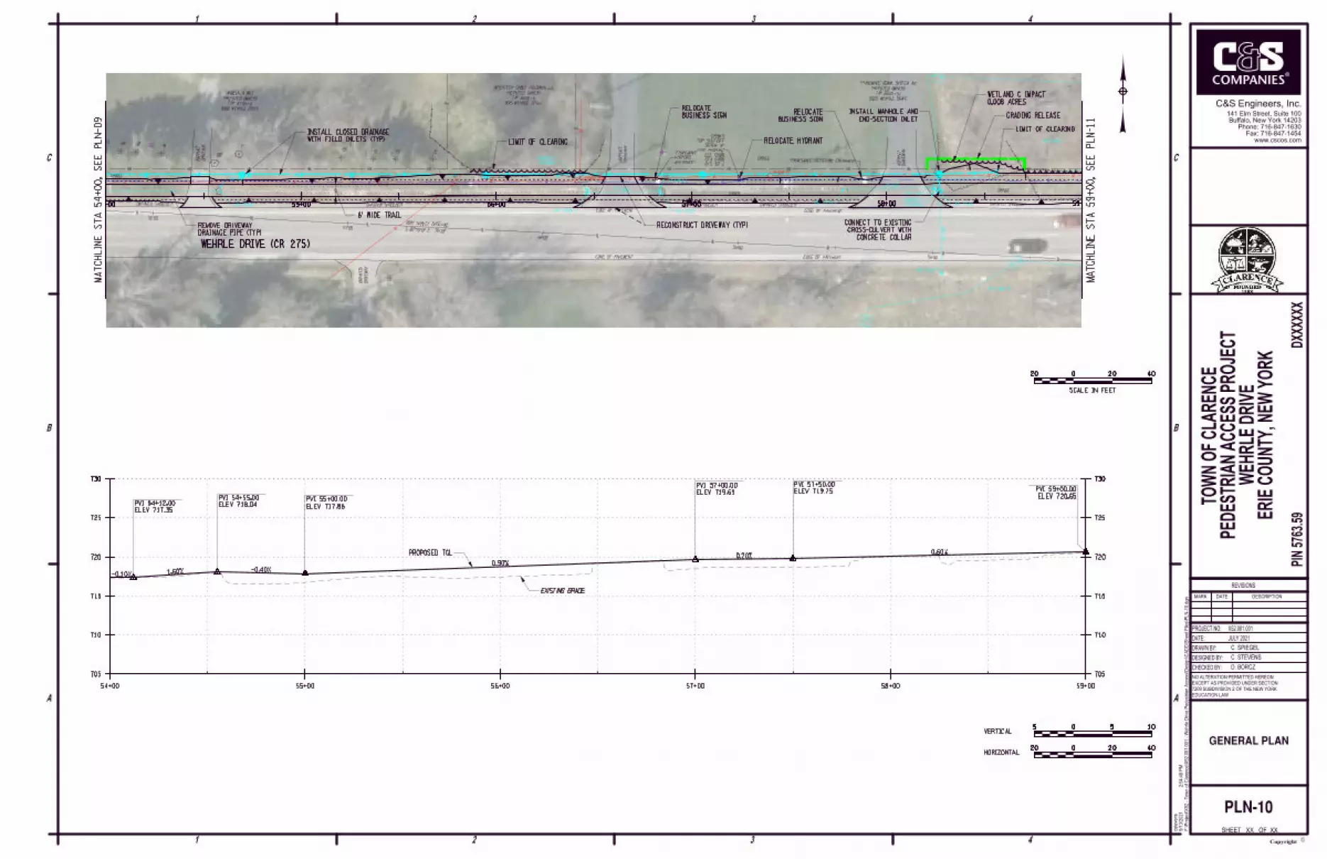
WETLAND C
WETLAND B
54+00 55+00 56+00 57+00 58+00 59+00
GRASS GRASS
GRASS
GRASS
DRIV
EW
AY
ASP
HALT
DRIV
EW
AY
ASP
HALT
DRIV
EW
AY
ASP
HALT
GRASS
EDGE OF PAVEMENT
EDGE OF PAVEMENT
EDGE OF PAVEMENT
EDGE OF PAVEMENT
UNPAVED SHOULDER UNPAVED SHOULDER UNPAVED SHOULDER UNPAVED SHOULDER
12" 18" 18" 18"
29"
7"15"
15" 15" 15"
S 87°35'19" E 767.07'
52+00
53+00
54+00
55+00
56+00
"TRANSWAVE RECIEVING ENTRANCE"
12" CMP12" CMP
18"
CMP
INV 717.15
INV 717.59
INV 717.51
HEADWALL
CONCRETEINV 717.34
INV 717.22INV 716.89
INV 715.80
HEADWALL
CONCRETE
HEADWALL
CONCRETE
RIP-RAP
UNPAVED SHOULDER
2021 SURVEY BASELINE
DRIV
EW
AY
UNP
AVE
D
9020 WEHRLE DRIVE
TA# 83.00-1-5.1
(REPUTED OWNER)
TRANSWAVE COMM. SYSTEM INC
NO # NYSEG 20A
NYSEG 21
O/S 32' L
STA 54+99
ELE 721.98
FIRE HYDRANT
SCREW OF
TOP SHUT-OFF
CPBM-5
ENTRANCE"
VISITORS
"TRANSWAVE
8990 WEHRLE DRIVE
TA# 83.00-1-3
(REPUTED OWNER)
ANGELA A WILT
9015 WEHRLE DRIVE
TA# 83.00-1-11
(REPUTED OWNER)
INTERTECH CABLE HOLDINGS LLC
G
G
C. SPIEGEL
DESIGNED BY:
PROJECT NO:
DATE:
DRAWN BY:
4
C
B
3
C
1 2
1 3 42
A
B
A
F:\Project\
X52 - T
ow
n of
Clare
nce\X
52.0
01.0
01 - W
ehrle Drive P
edestria
n A
ccess\D
esig
n\C
AD
D\S
heet Files\P
LN-1
0.d
gn
2:5
4:4
8 P
M9/1
3/2
021
cste
vens
EDUCATION LAW
NO ALTERATION PERMITTED HEREON
EXCEPT AS PROVIDED UNDER SECTION
7209 SUBDIVISION 2 OF THE NEW YORK
CHECKED BY:
PIN 5
763.5
9D
XX
XX
XX
X52.001.001
MARK DATE DESCRIPTION
REVISIONS
ERIE C
OU
NT
Y,
NE
W Y
OR
K
C. STEVENS
D. BORCZ
JULY 2021
SHEET OF XX
Copyrightc
www.cscos.com
Fax: 716-847-1454
Phone: 716-847-1630
Buffalo, New York 14203
141 Elm Street, Suite 100
C&S Engineers, Inc.
TO
WN O
F C
LA
RE
NC
E
PE
DE
ST
RIA
N A
CC
ES
S P
ROJE
CT
WE
HR
LE D
RIV
E
705
710
715
720
725
730730
705
710
715
720
725
730730
54+00 55+00 56+00 57+00 58+00 59+00
PVI 54+12.00
ELEV 717.35
PVI 54+55.00
ELEV 718.04PVI 55+00.00
ELEV 717.86
PVI 57+00.00
ELEV 719.65
PVI 57+50.00
ELEV 719.75
-0.10% 1.60% -0.40%0.90%
0.20%0.60%
EXISTING GRADE
PROPOSED TGL
PVI 59+00.00
ELEV 720.65
XX
PLN-10
GENERAL PLAN
MA
TC
HLIN
E
ST
A 54
+00,
SE
E
PL
N-09
MA
TC
HLIN
E
ST
A 59
+00,
SE
E
PL
N-11
WEHRLE DRIVE (CR 275)
WITH FIELD INLETS (TYP)
INSTALL CLOSED DRAINAGE
RECONSTRUCT DRIVEWAY (TYP)
DRAINAGE PIPE (TYP)
REMOVE DRIVEWAY
6' WIDE TRAIL
LIMIT OF CLEARING
LIMIT OF CLEARING
END-SECTION INLET
INSTALL MANHOLE AND
CONCRETE COLLAR
CROSS-CULVERT WITH
CONNECT TO EXISTING
HORIZONTAL
VERTICAL
20020 40
505 10
20020 40
SCALE IN FEET
GRADING RELEASE
RELOCATE HYDRANT
BUSINESS SIGN
RELOCATE
BUSINESS SIGN
RELOCATE
0.008 ACRES
WETLAND C IMPACT
WETLAND C
WETLAND B
59+00 60+00 61+00 62+00 63+00 64+00
DRIV
EW
AY
ASP
HALT
DRIV
EW
AY
ASP
HALT
DRIV
EW
AY
ASP
HALT
GRASS
GRASS
GRASS
GRASS
EDGE OF PAVEMENT
EDGE OF PAVEMENT
UNPAVED SHOULDER UNPAVED SHOULDER UNPAVED SHOULDER UNPAVED SHOULDER
24"
22"
17"
SHRUBS
SHRUBS SHRUBS
57+0058+00
59+00
60+00
61+00
"40 MPH"
N 85°12'32" E 512.91'
2021 SURVEY BASELINE
PIPE
IRON
FOUND
PIPE
IRON
FOUND
REBAR
FOUND
9070 WEHRLE DRIVE
TA# 83.00-1-8
(REPUTED OWNERS)
& MARINA B BINISZKIEWICZ
BERNADINE GINTER LIFE USE
9060 WEHRLE DRIVE
TA# 83.00-1-7
(REPUTED OWNER)
JEFFERY HANSEN
9040 WEHRLE DRIVE
TA# 83.00-1-6
(REPUTED OWNER)
RANDOLPH D GALLO
NYSEG 22
NYSEG 23 NYSEG 24
STA 57+71.48
ELE 721.083
E 1129252.674
N 1078567.455
REBAR AND CAP
CBP 10
C. SPIEGEL
DESIGNED BY:
PROJECT NO:
DATE:
DRAWN BY:
4
C
B
3
C
1 2
1 3 42
A
B
A
F:\Project\
X52 - T
ow
n of
Clare
nce\X
52.0
01.0
01 - W
ehrle Drive P
edestria
n A
ccess\D
esig
n\C
AD
D\S
heet Files\P
LN-1
1.d
gn
2:5
4:5
2 P
M9/1
3/2
021
cste
vens
EDUCATION LAW
NO ALTERATION PERMITTED HEREON
EXCEPT AS PROVIDED UNDER SECTION
7209 SUBDIVISION 2 OF THE NEW YORK
CHECKED BY:
PIN 5
763.5
9D
XX
XX
XX
X52.001.001
MARK DATE DESCRIPTION
REVISIONS
ERIE C
OU
NT
Y,
NE
W Y
OR
K
C. STEVENS
D. BORCZ
JULY 2021
SHEET OF XX
Copyrightc
www.cscos.com
Fax: 716-847-1454
Phone: 716-847-1630
Buffalo, New York 14203
141 Elm Street, Suite 100
C&S Engineers, Inc.
TO
WN O
F C
LA
RE
NC
E
PE
DE
ST
RIA
N A
CC
ES
S P
ROJE
CT
WE
HR
LE D
RIV
E
710
715
720
725
730
735735
710
715
720
725
730
735735
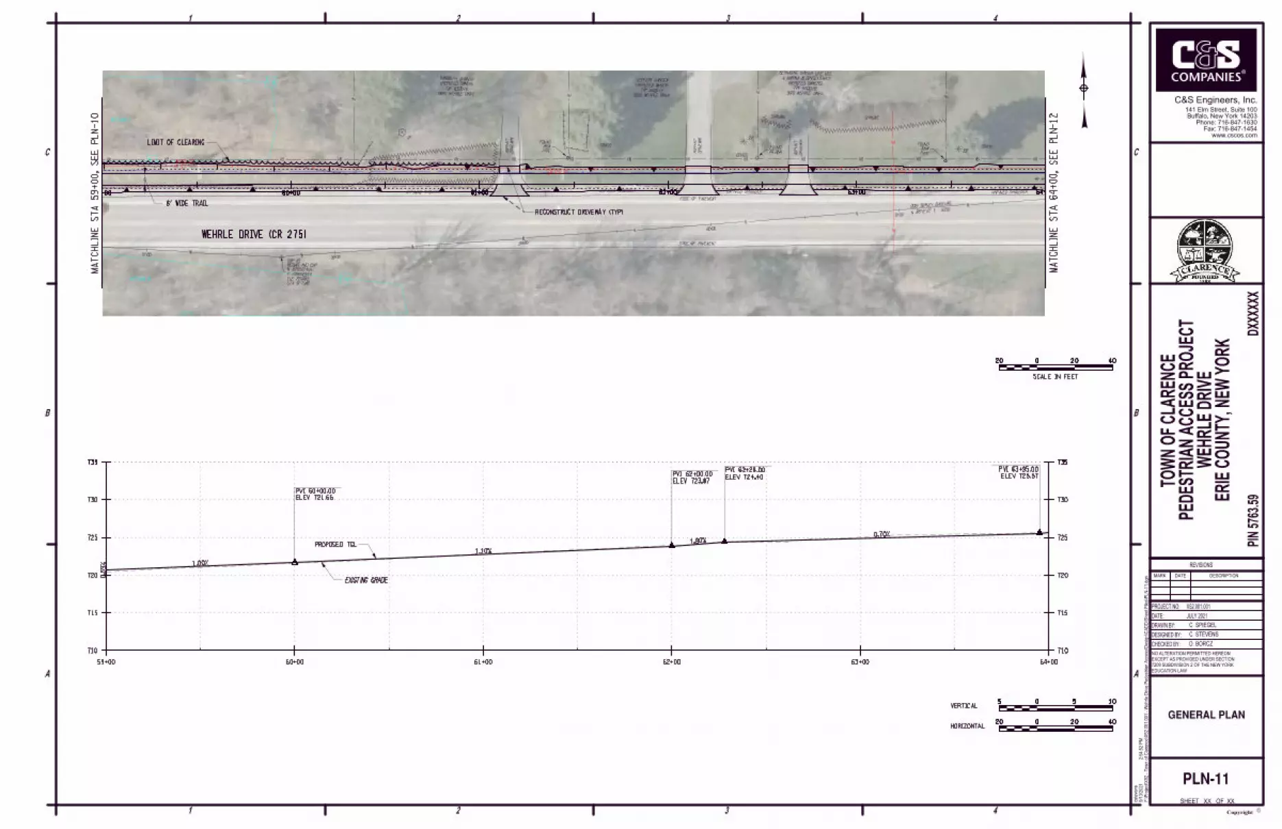
59+00 60+00 61+00 62+00 63+00 64+00
PVI 60+00.00
ELEV 721.66
PVI 62+00.00
ELEV 723.87
PVI 62+28.00
ELEV 724.40
0.5
9% 1.00%
1.10%
1.90%0.70%
EXISTING GRADE
PROPOSED TGL
ELEV 725.57
PVI 63+95.00
XX
PLN-11
GENERAL PLAN
MA
TC
HLIN
E
ST
A 64
+00,
SE
E
PL
N-12
MA
TC
HLIN
E
ST
A 59
+00,
SE
E
PL
N-10
WEHRLE DRIVE (CR 275)
RECONSTRUCT DRIVEWAY (TYP)
6' WIDE TRAIL
LIMIT OF CLEARING
HORIZONTAL
VERTICAL
20020 40
505 10
20020 40
SCALE IN FEET
69+0068+0067+0064+00 65+00 66+00
DRIV
EW
AY
ASP
HALT
DRIV
EW
AY
GR
AVEL
DRIV
EW
AY
GR
AVEL
DRIV
EW
AY
ASP
HALT
GRASS
GRASS
GRASS
EDGE OF PAVEMENT
EDGE OF PAVEMENT
EDGE OF PAVEMENT
EDGE OF PAVEMENT
UNPAVED SHOULDER UNPAVED SHOULDER UNPAVED SHOULDER UNPAVED SHOULDER
17"
24"
42" 15" 34"
36"
33"
24"
N 89°27'58" E 425.79'
62+00
63+00 64+00
65+00 66+00 & RIGHT ARROW"
"BARTON ROAD/ LEFT"40 MPH"
GRASS
2021 SURVEY BASELINE
PIPE
IRON
FOUND
PIPE
IRON
FOUND
REBAR
FOUND
9110 WEHRLE DRIVE
TA# 83.00-1-12
(REPUTED OWNER)
BARBARA J KRAUSE
9015 MAIN STREET
TA# 83.00-1-11
(REPUTED OWNER)
INTERTECH CABLE HOLDINGS LLC
9080 WEHRLE DRIVE
TA# 83.00-1-9
(REPUTED OWNERS)
PANDORA P RATHGEBER
FREDERICK J RATHGEBER &
NYSEG 25
O/S 7' L
STA 63+85
ELE 728.59
BONNET BOLT
X-CUT ON SOUTHEAST
CPBM-6
NYSEG 26
NYSEG 27
STA 62+84.39
ELE 725.915
E 1129763.796
N 1078610.296
REBAR AND CAP
CBP 11
C. SPIEGEL
DESIGNED BY:
PROJECT NO:
DATE:
DRAWN BY:
4
C
B
3
C
1 2
1 3 42
A
B
A
F:\Project\
X52 - T
ow
n of
Clare
nce\X
52.0
01.0
01 - W
ehrle Drive P
edestria
n A
ccess\D
esig
n\C
AD
D\S
heet Files\P
LN-1
2.d
gn
2:5
4:5
4 P
M9/1
3/2
021
cste
vens
EDUCATION LAW
NO ALTERATION PERMITTED HEREON
EXCEPT AS PROVIDED UNDER SECTION
7209 SUBDIVISION 2 OF THE NEW YORK
CHECKED BY:
PIN 5
763.5
9D
XX
XX
XX
X52.001.001
MARK DATE DESCRIPTION
REVISIONS
ERIE C
OU
NT
Y,
NE
W Y
OR
K
C. STEVENS
D. BORCZ
JULY 2021
SHEET OF XX
Copyrightc
www.cscos.com
Fax: 716-847-1454
Phone: 716-847-1630
Buffalo, New York 14203
141 Elm Street, Suite 100
C&S Engineers, Inc.
TO
WN O
F C
LA
RE
NC
E
PE
DE
ST
RIA
N A
CC
ES
S P
ROJE
CT
WE
HR
LE D
RIV
E
715
720
725
730
735
740740
715
720
725
730
735
740740
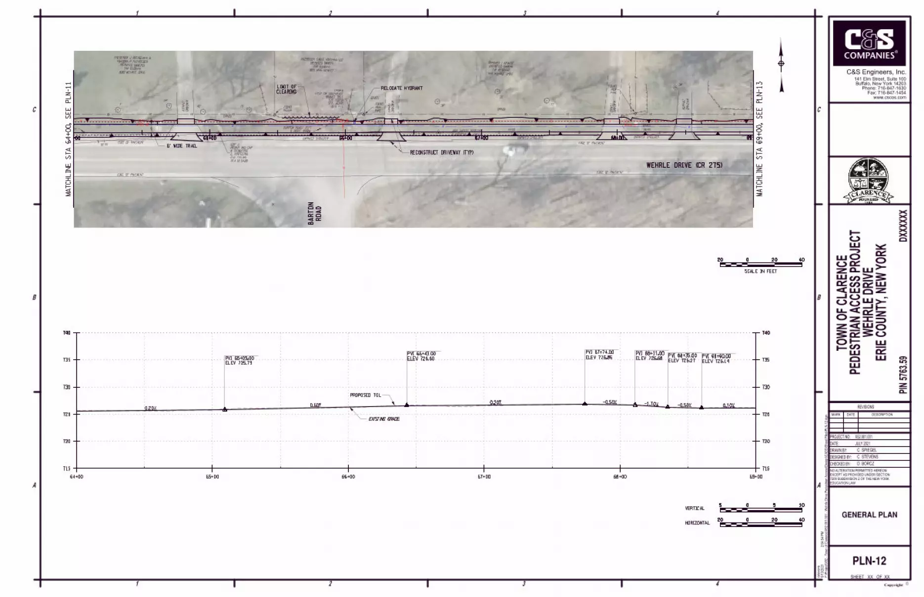
64+00 65+00 66+00 67+00 68+00 69+00
PVI 65+09.00
ELEV 725.79
PVI 66+43.00
ELEV 726.60
PVI 67+74.00
ELEV 726.86PVI 68+11.00
ELEV 726.68PVI 68+35.00
ELEV 726.27PVI 68+60.00
ELEV 726.14
0.20%0.60%
0.20% -0.50% -1.70% -0.50% 0.10%
EXISTING GRADE
PROPOSED TGL
XX
PLN-12
GENERAL PLAN
MA
TC
HLIN
E
ST
A 69
+00,
SE
E
PL
N-13
MA
TC
HLIN
E
ST
A 64
+00,
SE
E
PL
N-11
RO
AD
BA
RT
ON
WEHRLE DRIVE (CR 275)
RECONSTRUCT DRIVEWAY (TYP)
6' WIDE TRAIL
CLEARING
LIMIT OF
HORIZONTAL
VERTICAL
20020 40
505 10
20020 40
SCALE IN FEET
RELOCATE HYDRANT
STUMP
74+0073+0072+0071+0070+0069+00
DRIVEWAY
ASPHALT
DRIVEWAY
ASPHALT
GRASSGRASSGRASS
GRASSSCHRUB
SCHRUB
EDGE OF PAVEMENT
EDGE OF PAVEMENT
EDGE OF PAVEMENT
EDGE OF PAVEMENT
UNPAVED SHOULDERUNPAVED SHOULDER
UNPAVED SHOULDER
STUMP STUMP STUMPSTUMP STUMP
HE
DGE
17"
10"
12"
STA 67+10.18
ELE 726.243
E 1130189.563
N 1078614.264
REBAR AND CAP
CBP 12
"NO THRU TRUCKS"67+00
GATE
2021 SURVEY BASELINES 85°53'10" E 646.43'
9140 WEHRLE DRIVE
TA# 83.00-1-14
(REPUTED OWNERS)
KAREN C MAY
GLENN M MAY &
REBAR
FOUND
9126 WEHRLE DRIVE
TA# 83.00-1-13
(REPUTED OWNERS)
TAMI DIESTLER
MICHAEL D DIESTLER &
68+00
69+00
70+00
71+00
PAVEMENT CHANGEPAVEMENT CHANGE
PAVEMENT CHANGE
BOLLARD
BOLLARD
NYSEG 28NYSEG 29
NYSEG 30
C. SPIEGEL
DESIGNED BY:
PROJECT NO:
DATE:
DRAWN BY:
4
C
B
3
C
1 2
1 3 42
A
B
A
F:\Project\
X52 - T
ow
n of
Clare
nce\X
52.0
01.0
01 - W
ehrle Drive P
edestria
n A
ccess\D
esig
n\C
AD
D\S
heet Files\P
LN-1
3.d
gn
2:5
4:5
9 P
M9/1
3/2
021
cste
vens
EDUCATION LAW
NO ALTERATION PERMITTED HEREON
EXCEPT AS PROVIDED UNDER SECTION
7209 SUBDIVISION 2 OF THE NEW YORK
CHECKED BY:
PIN 5
763.5
9D
XX
XX
XX
X52.001.001
MARK DATE DESCRIPTION
REVISIONS
ERIE C
OU
NT
Y,
NE
W Y
OR
K
C. STEVENS
D. BORCZ
JULY 2021
SHEET OF XX
Copyrightc
www.cscos.com
Fax: 716-847-1454
Phone: 716-847-1630
Buffalo, New York 14203
141 Elm Street, Suite 100
C&S Engineers, Inc.
TO
WN O
F C
LA
RE
NC
E
PE
DE
ST
RIA
N A
CC
ES
S P
ROJE
CT
WE
HR
LE D
RIV
E
715
720
725
730
735
740740
715
720
725
730
735
740740
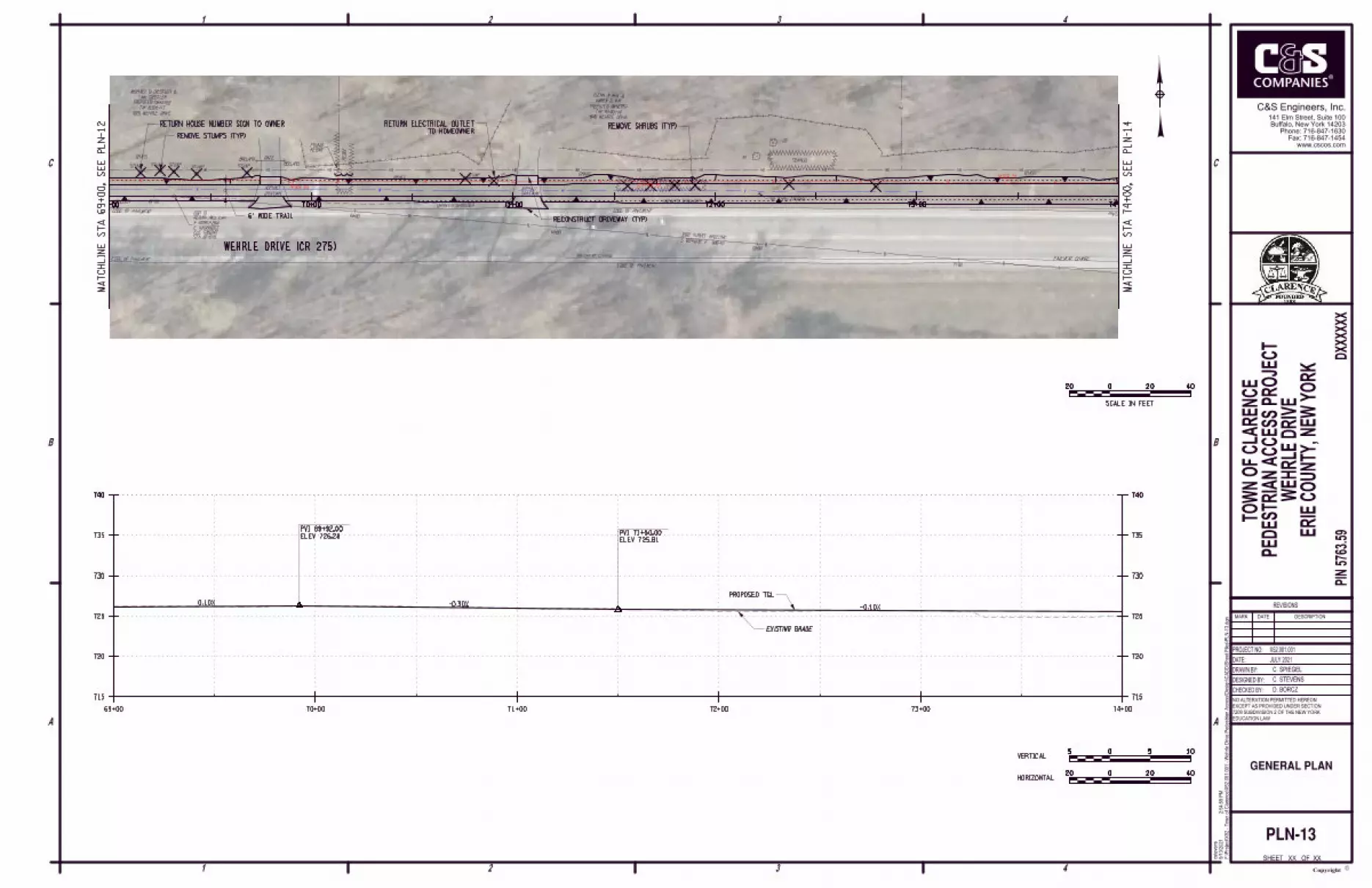
69+00 70+00 71+00 72+00 73+00 74+00
PVI 69+92.00
ELEV 726.28PVI 71+50.00
ELEV 725.81
0.10% -0.30%-0.10%
EXISTING GRADE
PROPOSED TGL
XX
PLN-13
GENERAL PLAN
MA
TC
HLIN
E
ST
A 74
+00,
SE
E
PL
N-14
MA
TC
HLIN
E
ST
A 69
+00,
SE
E
PL
N-12
WEHRLE DRIVE (CR 275)
RECONSTRUCT DRIVEWAY (TYP)6' WIDE TRAIL
REMOVE STUMPS (TYP)
REMOVE SHRUBS (TYP)
HORIZONTAL
VERTICAL
20020 40
505 10
20020 40
SCALE IN FEET
RETURN HOUSE NUMBER SIGN TO OWNER
TO HOMEOWNER
RETURN ELECTRICAL OUTLET
75+00
76+00
74+00
77+0
0
78+0
0
PARKING LOTASPHALT
GRASS
GRASS
EDGE OF PAVEMENT
EDGE OF PAVEMENT
EDGE OF PAVEMENT
EDGE OF PAVEMENT
UNPAVED SHOULDER
STA 73+56.61
ELE 729.474
E 1130834.325
N 1078567.890
REBAR AND CAP
CBP 4GPS
S 83°37'19" E 328.30'
2021 SURVEY BASELINE
TA# 83.00-1-29.1
(REPUTED OWNER)
UNKNOWN OWNER
9200 WEHRLE DRIVE
TA# 83.00-1-18.2
(REPUTED OWNER)
GRACE PROPERTY SERVICE
REBAR
FOUND
REBAR
FOUND
REBAR
FOUND
72+00
73+00
74+00
75+00
76+00
0 WEHRLE DRIVE
TA# 83.00-1-16
(REPUTED OWNERS)
M VINAL
GREGORY M VINAL SR & JEANNE
O/S 42' L
STA 75+20
ELE 726.76
POLE NYSEG 32 VZ 217
MAG NAIL IN UTILITY
CPBM-7
PAVEMENT CHANGE
PAVEMENT CHANGE
PAVEMENT CHANGE
NYSEG 31
NYSEG 32
UNPAVED SHOULDER
C. SPIEGEL
DESIGNED BY:
PROJECT NO:
DATE:
DRAWN BY:
4
C
B
3
C
1 2
1 3 42
A
B
A
F:\Project\
X52 - T
ow
n of
Clare
nce\X
52.0
01.0
01 - W
ehrle Drive P
edestria
n A
ccess\D
esig
n\C
AD
D\S
heet Files\P
LN-1
4.d
gn
2:5
5:0
2 P
M9/1
3/2
021
cste
vens
EDUCATION LAW
NO ALTERATION PERMITTED HEREON
EXCEPT AS PROVIDED UNDER SECTION
7209 SUBDIVISION 2 OF THE NEW YORK
CHECKED BY:
PIN 5
763.5
9D
XX
XX
XX
X52.001.001
MARK DATE DESCRIPTION
REVISIONS
ERIE C
OU
NT
Y,
NE
W Y
OR
K
C. STEVENS
D. BORCZ
JULY 2021
SHEET OF XX
Copyrightc
www.cscos.com
Fax: 716-847-1454
Phone: 716-847-1630
Buffalo, New York 14203
141 Elm Street, Suite 100
C&S Engineers, Inc.
TO
WN O
F C
LA
RE
NC
E
PE
DE
ST
RIA
N A
CC
ES
S P
ROJE
CT
WE
HR
LE D
RIV
E
715
720
725
730
735
740740
715
720
725
730
735
740740
74+00 75+00 76+00 77+00 77+50
PVI 76+64.00
ELEV 725.37
-0.10% 1.00%
EXISTING GRADE
PROPOSED TGL
MATCH EXISTING PAVEMENT
END TRAIL
ELEV 725.30
PVI 76+57.00
XX
PLN-14
GENERAL PLAN
MA
TC
HLIN
E
ST
A 74
+00,
SE
E
PL
N-13
PARKING
LOT
WEST SHORE
TRAIL
WEHRLE DRIVE (CR 275)
6' WIDE TRAIL
TOPSOIL AND SEED.
REMOVE UNPAVED SHOULDER.
HORIZONTAL
VERTICAL
20020 40
505 10
20020 40
SCALE IN FEET
EXTEND CROSS-CULVERT
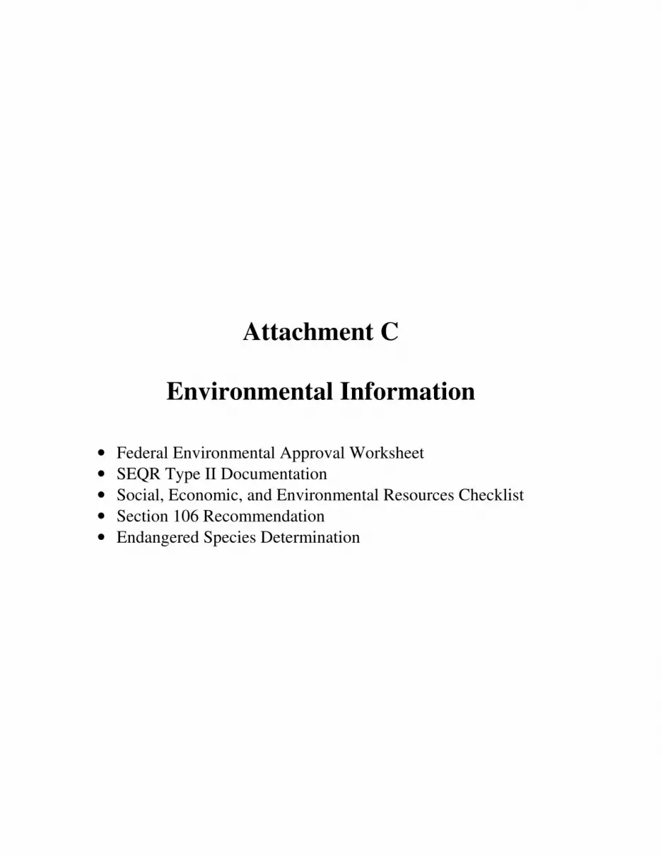
Attachment C
Environmental Information
• Federal Environmental Approval Worksheet
• SEQR Type II Documentation
• Social, Economic, and Environmental Resources Checklist
• Section 106 Recommendation
• Endangered Species Determination
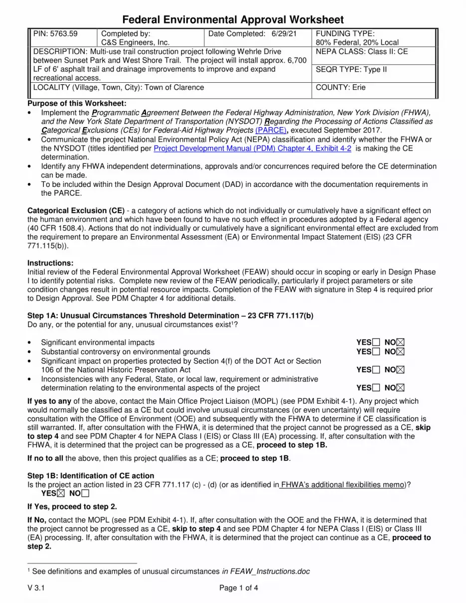
Federal Environmental Approval Worksheet
V 3.1 Page 1 of 4
PIN: 5763.59
Completed by: C&S Engineers, Inc.
Date Completed: 6/29/21 FUNDING TYPE: 80% Federal, 20% Local
DESCRIPTION: Multi-use trail construction project following Wehrle Drive between Sunset Park and West Shore Trail. The project will install approx. 6,700 LF of 6' asphalt trail and drainage improvements to improve and expand recreational access.
NEPA CLASS: Class II: CE
SEQR TYPE: Type II
LOCALITY (Village, Town, City): Town of Clarence COUNTY: Erie
Purpose of this Worksheet:
• Implement the Programmatic Agreement Between the Federal Highway Administration, New York Division (FHWA), and the New York State Department of Transportation (NYSDOT) Regarding the Processing of Actions Classified as Categorical Exclusions (CEs) for Federal-Aid Highway Projects (PARCE), executed September 2017.
• Communicate the project National Environmental Policy Act (NEPA) classification and identify whether the FHWA or the NYSDOT (titles identified per Project Development Manual (PDM) Chapter 4, Exhibit 4-2 is making the CE determination.
• Identify any FHWA independent determinations, approvals and/or concurrences required before the CE determination can be made.
• To be included within the Design Approval Document (DAD) in accordance with the documentation requirements in the PARCE.
Categorical Exclusion (CE) - a category of actions which do not individually or cumulatively have a significant effect on the human environment and which have been found to have no such effect in procedures adopted by a Federal agency (40 CFR 1508.4). Actions that do not individually or cumulatively have a significant environmental effect are excluded from the requirement to prepare an Environmental Assessment (EA) or Environmental Impact Statement (EIS) (23 CFR 771.115(b)). Instructions: Initial review of the Federal Environmental Approval Worksheet (FEAW) should occur in scoping or early in Design Phase I to identify potential risks. Complete new review of the FEAW periodically, particularly if project parameters or site condition changes result in potential resource impacts. Completion of the FEAW with signature in Step 4 is required prior to Design Approval. See PDM Chapter 4 for additional details. Step 1A: Unusual Circumstances Threshold Determination – 23 CFR 771.117(b) Do any, or the potential for any, unusual circumstances exist1?
• Significant environmental impacts YES NO
• Substantial controversy on environmental grounds YES NO
• Significant impact on properties protected by Section 4(f) of the DOT Act or Section 106 of the National Historic Preservation Act YES NO
• Inconsistencies with any Federal, State, or local law, requirement or administrative determination relating to the environmental aspects of the project YES NO
If yes to any of the above, contact the Main Office Project Liaison (MOPL) (see PDM Exhibit 4-1). Any project which would normally be classified as a CE but could involve unusual circumstances (or even uncertainty) will require consultation with the Office of Environment (OOE) and subsequently with the FHWA to determine if CE classification is still warranted. If, after consultation with the FHWA, it is determined that the project cannot be progressed as a CE, skip to step 4 and see PDM Chapter 4 for NEPA Class I (EIS) or Class III (EA) processing. If, after consultation with the FHWA, it is determined that the project can be progressed as a CE, proceed to step 1B.
If no to all the above, then this project qualifies as a CE; proceed to step 1B. Step 1B: Identification of CE action Is the project an action listed in 23 CFR 771.117 (c) - (d) (or as identified in FHWA’s additional flexibilities memo)? YES NO
If Yes, proceed to step 2.
If No, contact the MOPL (see PDM Exhibit 4-1). If, after consultation with the OOE and the FHWA, it is determined that the project cannot be progressed as a CE, skip to step 4 and see PDM Chapter 4 for NEPA Class I (EIS) or Class III (EA) processing. If, after consultation with the FHWA, it is determined that the project can continue as a CE, proceed to step 2.
1 See definitions and examples of unusual circumstances in FEAW_Instructions.doc
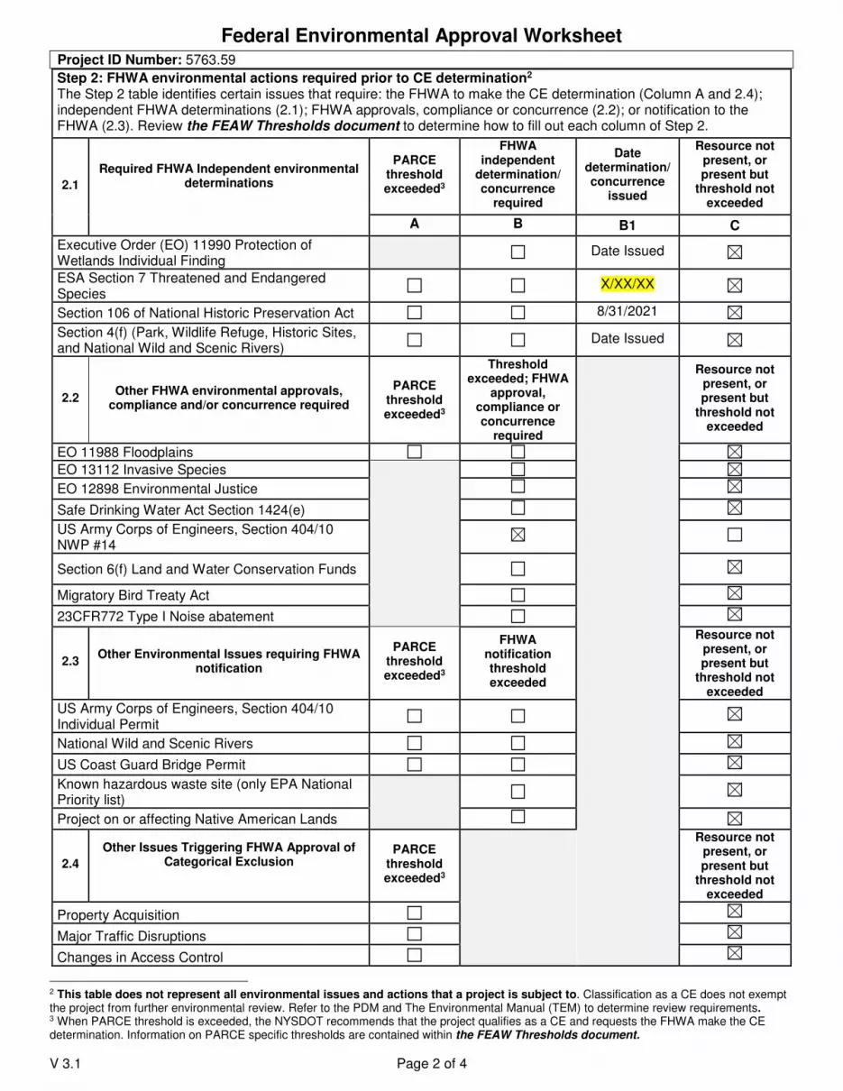
Federal Environmental Approval Worksheet
V 3.1 Page 2 of 4
Project ID Number: 5763.59
Step 2: FHWA environmental actions required prior to CE determination2 The Step 2 table identifies certain issues that require: the FHWA to make the CE determination (Column A and 2.4); independent FHWA determinations (2.1); FHWA approvals, compliance or concurrence (2.2); or notification to the FHWA (2.3). Review the FEAW Thresholds document to determine how to fill out each column of Step 2.
2.1
Required FHWA Independent environmental determinations
PARCE threshold exceeded3
FHWA independent
determination/ concurrence
required
Date determination/ concurrence
issued
Resource not present, or present but
threshold not exceeded
A B B1 C
Executive Order (EO) 11990 Protection of Wetlands Individual Finding Date Issued
ESA Section 7 Threatened and Endangered Species
X/XX/XX
Section 106 of National Historic Preservation Act 8/31/2021
Section 4(f) (Park, Wildlife Refuge, Historic Sites, and National Wild and Scenic Rivers)
Date Issued
2.2 Other FHWA environmental approvals,
compliance and/or concurrence required
PARCE threshold exceeded3
Threshold exceeded; FHWA
approval, compliance or concurrence
required
Resource not present, or present but
threshold not exceeded
EO 11988 Floodplains
EO 13112 Invasive Species
EO 12898 Environmental Justice
Safe Drinking Water Act Section 1424(e)
US Army Corps of Engineers, Section 404/10 NWP #14
Section 6(f) Land and Water Conservation Funds
Migratory Bird Treaty Act
23CFR772 Type I Noise abatement
2.3 Other Environmental Issues requiring FHWA
notification
PARCE threshold exceeded3
FHWA notification threshold exceeded
Resource not present, or present but
threshold not exceeded
US Army Corps of Engineers, Section 404/10 Individual Permit
National Wild and Scenic Rivers
US Coast Guard Bridge Permit
Known hazardous waste site (only EPA National Priority list)
Project on or affecting Native American Lands
2.4
Other Issues Triggering FHWA Approval of Categorical Exclusion
PARCE threshold exceeded3
Resource not present, or present but
threshold not exceeded
Property Acquisition
Major Traffic Disruptions
Changes in Access Control
2 This table does not represent all environmental issues and actions that a project is subject to. Classification as a CE does not exempt the project from further environmental review. Refer to the PDM and The Environmental Manual (TEM) to determine review requirements. 3 When PARCE threshold is exceeded, the NYSDOT recommends that the project qualifies as a CE and requests the FHWA make the CE determination. Information on PARCE specific thresholds are contained within the FEAW Thresholds document.

Federal Environmental Approval Worksheet
V 3.1 Page 3 of 4
Step 3: Who makes the NEPA CE Determination?
To identify which party, either the FHWA or the NYSDOT, makes the CE determination in accordance with the PARCE, follow the instructions found in the table below, beginning in Step 3A. This step also identifies which correspondence shell to use to distribute the FEAW and other environmental notifications or approvals.
Project ID Number: 5763.59
3 Determine whether the FHWA or the NYSDOT makes the CE determination and whether additional notifications or approvals are required.
3A
Is the project an action listed in 23 CFR 771.117 (c) - (d) (Answered yes in Step 1B)? YES If Yes, proceed to 3B. NO If No, the FHWA makes the CE determination.
• For Locally Administered Federal Aid Projects only, the DAD, the NYSDOT recommendation and request (that the FHWA determines the project qualifies as a CE) are sent from the Regional Planning and Program Manager (RPPM) to the FHWA directly using Shell 4.
• For all other projects, the DAD and the NYSDOT recommendation and request (that the FHWA determines the project qualifies as a CE) are sent to the MOPL for review using Shell 3. Proceed to Step 4.
3B
Are any of the CE Thresholds from the PARCE not met (Are there any checks in Column A of Step 2)?
YES If Yes, the FHWA makes the CE determination.
• For Locally Administered Federal Aid Projects only, the DAD and the NYSDOT recommendation and request (that the FHWA determines the project qualifies as a CE) are sent from the RPPM to the FHWA directly using Shell 4.
• For all other projects, the DAD and the NYSDOT recommendation and request (that the FHWA determines the project qualifies as a CE) are sent to the MOPL for review using Shell 3. Proceed to Step 4.
NO If No, proceed to 3C.
3C
Are there outstanding independent environmental approvals or concurrences? (Are there checks in column B of Step 2.1 without dates in column B1)?
YES If Yes, then the FHWA makes the CE determination.
• For Locally Administered Federal Aid Projects only, the DAD and the NYSDOT recommendation and request (that the FHWA determines the project qualifies as a CE) are sent from the RPPM to the FHWA directly using Shell 4.
• For all other projects, the DAD and the NYSDOT recommendation and request (that the FHWA determines the project qualifies as a CE) are sent to the MOPL for review using Shell 3. Proceed to Step 4.
NO If No, the NYSDOT makes the NEPA CE determination. Proceed to 3D.
3D
Are there any circumstances requiring demonstration of applicable EO compliance (any checks in column B of
Table 2.2); or any issues requiring the FHWA environmental notification (any checks in column B of Table 2.3)?
YES If either box is checked, once all required approvals and concurrences have been secured, the NYSDOT makes the CE determination but the information must be forwarded to FHWA for notification or action prior to Design Approval using Shell 1. Proceed to step 5. NO If neither box is checked, once all required approvals and concurrences have been secured the NYSDOT makes the CE determination without notification to the FHWA. The project will use Shell 2. Proceed to step 4.
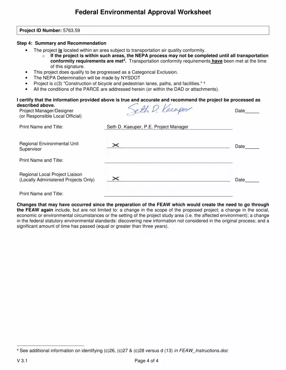
Federal Environmental Approval Worksheet
V 3.1 Page 4 of 4
Step 4: Summary and Recommendation
• The project is located within an area subject to transportation air quality conformity. o If the project is within such areas, the NEPA process may not be completed until all transportation
conformity requirements are met4. Transportation conformity requirements have been met at the time of this signature.
• This project does qualify to be progressed as a Categorical Exclusion.
• The NEPA Determination will be made by NYSDOT
• Project is c(3) "Construction of bicycle and pedestrian lanes, paths, and facilities." 4
• All the conditions of the PARCE are addressed herein (or within the DAD or attachments). I certify that the information provided above is true and accurate and recommend the project be processed as described above. Project Manager/Designer (or Responsible Local Official)
Date
Print Name and Title: Seth D. Kaeuper, P.E. Project Manager
Regional Environmental Unit Supervisor
X
Date
Print Name and Title:
Regional Local Project Liaison (Locally Administered Projects Only)
X
Date
Print Name and Title:
Changes that may have occurred since the preparation of the FEAW which would create the need to go through the FEAW again include, but are not limited to: a change in the scope of the proposed project; a change in the social, economic or environmental circumstances or the setting of the project study area (i.e. the affected environment); a change in the federal statutory environmental standards: discovering new information not considered in the original process; and a significant amount of time has passed (equal or greater than three years).
4 See additional information on identifying (c)26, (c)27 & (c)28 versus d (13) in FEAW_Instructions.doc
Project ID Number: 5763.59

6 CRR-NY 617.5NY-CRR
(a) Actions or classes of actions identified in subdivision (c) of this section are not subject to review under this Part, except as
otherwise provided in this section. These actions have been determined not to have a significant impact on the environment or are
otherwise precluded from environmental review under Environmental Conservation Law, article 8. The actions identified in subdivision
(c) of this section apply to all agencies.
(b) Each agency may adopt its own list of Type II actions to supplement the actions in subdivision (c) of this section. No agency is
bound by an action on another agency's Type II list. The fact that an action is identified as a Type II action in an agency’s procedures
does not mean that it must be treated as a Type II action by any other involved agency not identifying it as a Type II action in its
procedures. An agency that identifies an action as not requiring any determination or procedure under this Part is not an involved
agency. Each of the actions on an agency Type II list must:
(1) in no case, have a significant adverse impact on the environment based on the criteria contained in section 617.7(c) of this
Part; and
(2) not be a Type I action as defined in section 617.4 of this Part.
(c) The following actions are not subject to review under this Part:
(1) maintenance or repair involving no substantial changes in an existing structure or facility;
(2) replacement, rehabilitation or reconstruction of a structure or facility, in kind, on the same site, including upgrading buildings
to meet building, energy, or fire codes unless such action meets or exceeds any of the thresholds in section 617.4 of this Part;
(3) retrofit of an existing structure and its appurtenant areas to incorporate green infrastructure;
(4) agricultural farm management practices, including construction, maintenance and repair of farm buildings and structures, and
land use changes consistent with generally accepted principles of farming;
(5) repaving of existing highways not involving the addition of new travel lanes;
(6) street openings and right-of-way openings for the purpose of repair or maintenance of existing utility facilities;
(7) installation of telecommunication cables in existing highway or utility rights of way utilizing trenchless burial or aerial
placement on existing poles;
(8) maintenance of existing landscaping or natural growth;
(9) construction or expansion of a primary or accessory/appurtenant, nonresidential structure or facility involving less than 4,000
square feet of gross floor area and not involving a change in zoning or a use variance and consistent with local land use controls,
but not radio communication or microwave transmission facilities;
(10) routine activities of educational institutions, including expansion of existing facilities by less than 10,000 square feet of gross
floor area and school closings, but not changes in use related to such closings;
(11) construction or expansion of a single-family, a two-family or a three-family residence on an approved lot including provision
of necessary utility connections as provided in paragraph (13) of this subdivision and the installation, maintenance or upgrade of
a drinking water well or a septic system or both, and conveyances of land in connection therewith;
(12) construction, expansion or placement of minor accessory/appurtenant residential structures, including garages, carports,
patios, decks, swimming pools, tennis courts, satellite dishes, fences, barns, storage sheds or other buildings not changing land
use or density;
New York Codes, Rules and Regulations
OFFICIAL COMPILATION OF CODES, RULES AND REGULATIONS OF THE STATE OF NEW YORK
TITLE 6. DEPARTMENT OF ENVIRONMENTAL CONSERVATIONCHAPTER VI. GENERAL REGULATIONS
PART 617. STATE ENVIRONMENTAL QUALITY REVIEW
6 CRR-NY 617.5
6 CRR-NY 617.5
617.5 Type II actions.
(13) extension of utility distribution facilities, including gas, electric, telephone, cable, water and sewer connections to render
service in approved subdivisions or in connection with any action on this list;
(14) installation of solar energy arrays where such installation involves 25 acres or less of physical alteration on the following
sites:
(i) closed landfills;
(ii) brownfield sites that have received a Brownfield Cleanup Program certificate of completion (COC) pursuant to ECL
section 27-1419 and section 375-3.9 of this Title or environmental restoration project sites that have received a COC
pursuant to section 375-4.9 of this Title, where the COC under either program for a particular site has an allowable use of
commercial or industrial, provided that the change of use requirements in section 375-1.11(d) of this Title are complied with;
(iii) sites that have received an inactive hazardous waste disposal site full liability release or a COC pursuant to section
375-2.9 of this Title, where the department has determined an allowable use for a particular site is commercial or industrial,
provided that the change of use requirements in section 375-1.11(d) of this Title are complied with;
(iv) currently disturbed areas at publicly-owned wastewater treatment facilities;
(v) currently disturbed areas at sites zoned for industrial use; and
(vi) parking lots or parking garages;
(15) installation of solar energy arrays on an existing structure provided the structure is not:
(i) listed on the National or State Register of Historic Places;
(ii) located within a district listed in the National or State Register of Historic Places;
(iii) been determined by the Commissioner of the Office of Parks, Recreation and Historic Preservation to be eligible for
listing on the State Register of Historic Places pursuant to sections 14.07 or 14.09 of the Parks, Recreation and Historic
Preservation Law; or
(iv) within a district that has been determined by the Commissioner of the Office of Parks, Recreation and Historic
Preservation to be eligible for listing on the State Register of Historic Places pursuant to sections 14.07 or 14.09 of the
Parks, Recreation and Historic Preservation Law;
(16) granting of individual setback and lot line variances and adjustments;
(17) granting of an area variance for a single-family, two-family or three-family residence;
(18) reuse of a residential or commercial structure, or of a structure containing mixed residential and commercial uses, where the
residential or commercial use is a permitted use under the applicable zoning law or ordinance, including permitted by special use
permit, and the action does not meet or exceeds any of the thresholds in section 617.4 of this Part;
(19) the recommendations of a county or regional planning board or agency pursuant to General Municipal Law sections 239-m
or 239-n;
(20) public or private best forest management (silviculture) practices on less than 10 acres of land, but not including waste
disposal, land clearing not directly related to forest management, clear-cutting or the application of herbicides or pesticides;
(21) minor temporary uses of land having negligible or no permanent impact on the environment;
(22) installation of traffic control devices on existing streets, roads and highways;
(23) mapping of existing roads, streets, highways, natural resources, land uses and ownership patterns;
(24) information collection including basic data collection and research, water quality and pollution studies, traffic counts,
engineering studies, surveys, subsurface investigations and soils studies that do not commit the agency to undertake, fund or
approve any Type I or Unlisted action;
(25) official acts of a ministerial nature involving no exercise of discretion, including building permits and historic preservation
permits where issuance is predicated solely on the applicant's compliance or noncompliance with the relevant local building or
preservation code(s);
(26) routine or continuing agency administration and management, not including new programs or major reordering of priorities
that may affect the environment;
(27) conducting concurrent environmental, engineering, economic, feasibility and other studies and preliminary planning and
budgetary processes necessary to the formulation of a proposal for action, provided those activities do not commit the agency to
commence, engage in or approve such action;
(28) collective bargaining activities;
(29) investments by or on behalf of agencies or pension or retirement systems, or refinancing existing debt;
(30) inspections and licensing activities relating to the qualifications of individuals or businesses to engage in their business or
profession;
(31) purchase or sale of furnishings, equipment or supplies, including surplus government property, other than the following: land,
radioactive material, pesticides, herbicides, or other hazardous materials;
(32) license, lease and permit renewals, or transfers of ownership thereof, where there will be no material change in permit
conditions or the scope of permitted activities;
(33) adoption of regulations, policies, procedures and local legislative decisions in connection with any action on this list;
(34) engaging in review of any part of an application to determine compliance with technical requirements, provided that no such
determination entitles or permits the project sponsor to commence the action unless and until all requirements of this Part have
been fulfilled;
(35) civil or criminal enforcement proceedings, whether administrative or judicial, including a particular course of action
specifically required to be undertaken pursuant to a judgment or order, or the exercise of prosecutorial discretion;
(36) adoption of a moratorium on land development or construction;
(37) interpretation of an existing code, rule or regulation;
(38) designation of local landmarks or their inclusion within historic districts;
(39) an agency’s acquisition and dedication of 25 acres or less of land for parkland, or dedication of land for parkland that was
previously acquired, or acquisition of a conservation easement;
(40) sale and conveyance of real property by public auction pursuant to article 11 of the Real Property Tax Law;
(41) construction and operation of an anaerobic digester, within currently disturbed areas at an operating publicly-owned landfill,
provided the digester has a feedstock capacity of less than 150 wet tons per day, and only produces class A digestate (as
defined in section 361-3.7 of this Title) that can be beneficially used or biogas to generate electricity or to make vehicle fuel, or
both;
(42) emergency actions that are immediately necessary on a limited and temporary basis for the protection or preservation of life,
health, property or natural resources, provided that such actions are directly related to the emergency and are performed to
cause the least change or disturbance, practicable under the circumstances, to the environment. Any decision to fund, approve
or directly undertake other activities after the emergency has expired is fully subject to the review procedures of this Part;
(43) actions undertaken, funded or approved prior to the effective dates set forth in SEQR (see chapters 228 of the Laws of 1976,
253 of the Laws of 1977 and 460 of the Laws of 1978), except in the case of an action where it is still practicable either to modify
the action in such a way as to mitigate potentially adverse environmental impacts, or to choose a feasible or less environmentally
damaging alternative, the commissioner may, at the request of any person, or on his own motion, require the preparation of an
environmental impact statement; or, in the case of an action where the responsible agency proposed a modification of the action
and the modification may result in a significant adverse impact on the environment, an environmental impact statement must be
prepared with respect to such modification;
(44) actions requiring a certificate of environmental compatibility and public need under article VII, VIII, X or 10 of the Public
Service Law and the consideration of, granting or denial of any such certificate;
(45) actions subject to the class A or class B regional project jurisdiction of the Adirondack Park Agency or a local government
pursuant to sections 807, 808 and 809 of the Executive Law, except class B regional projects subject to review by local
government pursuant to section 807 of the Executive Law located within the Lake George Park as defined by subdivision one of
section 43-0103 of the Environmental Conservation Law; and
(46) actions of the Legislature and the Governor of the State of New York or of any court, but not actions of local legislative
bodies except those local legislative decisions such as rezoning where the local legislative body determines the action will not be
entertained.
CROSS REFERENCES:
Preparation of environmental impact statement, Environmental Conservation Law § 8-0109.
Coordination of reporting; limitations; lead agency, Environmental Conservation Law § 8-0111.
Rules and regulations, Environmental Conservation Law § 8-0113.
Phased implementation, Environmental Conservation Law § 8-0117.
RESEARCH REFERENCES AND PRACTICE AIDS:
National Environmental Policy Act of 1969, Generally. 42 U.S.C.A. § 4321.
12 NY Jur 2d, Buildings, Zoning, and Land Controls § 83.
55 NY Jur 2d, Environmental Rights and Remedies §§ 57, 60, 61, 62, 64, 65.

© 2019 Thomson Reuters
61A Am Jur 2d, Pollution Control §§ 46, 47.
6 CRR-NY 617.5
Current through January 15, 2019
END OF DOCUMENT © 2019 Thomson Reuters. No claim to original U.S. Government Works.

Social, Economic and Environmental Resources Checklist (SEERC)
Introduction
For projects that use the IPP/FDR, PSR/FDR, and Bridge Rehabilitation Report design approval
document formats, the SEERC is used to determine the topics and resources that will need to
be analyzed to determine extent of adverse and beneficial impacts. The SEERC should not be
used as the location to document the results of impact analysis. The results of these analyses
should only be documented in the body of the design approval document. The SEERC must be
attached or appended to the DAD as appropriate.
Instructions:
1. Answer the questions posed under the Social, Economic and Environmental headings to determine whether there is a potential for a project to affect the topics/resources.
2. Beginning with the first question under the Social heading, if the answer to a question is No, check off No in the first checkbox column and proceed to the next question.
3. If the answer to a question is Yes:
a. Create a heading or section in the appropriate location in the IPP/FDR or PSR/FDR to document the particular resource or topic in question.
b. Proceed to the Impact or Issue column. Once enough information is available, check off Yes or No in the Impact or Issue column, as applicable
4. Document all Yes and No answers in the Impact or Issue columns in the DAD under the
section or heading created for the topic. This documentation must indicate the location, extent and/or a full description of the topic/resource. The documentation must appropriately illustrate the impact determination and measures to mitigate impacts. For No answers, ensure the documentation is complete as to the explanation of why the resource/topic will not be impacted.
5. For Yes answers, be sure to document adverse as well as beneficial impacts in the resource/topic sections of the DAD. For example, a project that is adding a project that impacts wetland for a SPDES practice will benefit the remaining wetland by treating stormwater. This documentation must include the nature and size or extent of an impact; measures taken to avoid or minimize impacts; and any mitigation being provided. Documentation for each issue should clearly note any necessary approvals and/or expected permits.
6. Prior to completing the Certification at the end of the checklist, review the checklist and appropriate sections of the DAD to ensure checkmarks and statements are valid (particularly review against changes in project scope) and for consistency between the checklist and DAD sections.
7. Complete the Certification.

8. Attach or append the checklist to the Design Approval document.

September 2021 PIN 5763.59
4/14/17 Page 1 of 4 SEERC V1
Social, Economic and Environmental Resources Checklist
PIN:5763.59 FUNDING TYPE:Federal
DESCRIPTION: Erie County Pedestrian Accommodations in the Town of Clarence
DATE:09/12/2021
REVISION DATE:
MUNICIPALITY:Town of Clarence NEPA CLASS:II CE
COUNTY:Erie SEQRA TYPE:II
SCOPE: The project consists of constructing a separated asphalt multi-use trail, which will include street crossings meeting current standards at several stop-controlled intersections. Roadside ditches will be filled in and a closed drainage system installed.
SOCIAL, ECONOMIC AND ENVIRONMENTAL CONSIDERATIONS
IF YES, GO TO IMPACT OR
ISSUE; IF NO CHECK BOX
BELOW
IMPACT1 OR ISSUE?
NO YES NO
Social
A. Land Use
1. Is there potential to affect current land use/zoning?
2. Is there a lack of consistency with community’s comprehensive plan and/or other local or regional planning goals?
3. Will the project affect any planned or future development?
B. Neighborhoods and Community Cohesion
1. Are relocations of homes or businesses proposed or acquisition of community resources anticipated?
2. Is there potential for changes to neighborhood character?
3. Is there a potential to impact transportation options (e.g., transit, walking, bicycling)?
4. Are there potential changes to travel patterns that could affect neighborhood quality of life?
5. Will the project divide or isolate portions of the community or generate new development that could affect the current community structure?
C. General Social Groups
1. Are there potential effects to the ability of transit dependent, elderly, or disabled populations to access destinations (particularly local businesses and health care facilities)?
2. Does the project have the potential to disproportionately impact low income or minority populations (Environmental Justice)?
3. Are there alterations to pedestrian facilities that would affect the elderly or disabled such as lengthening pedestrian crossings or providing median refuge?
D. Community Services
1. Is there potential to affect access to or use of Schools, Recreation Areas or Places of Worship (e.g., detours, sidewalk removal, addition of curb ramps, crosswalks, pedestrian signals, etc.)?

September 2021 PIN 5763.59
4/14/17 Page 2 of 4 SEERC V1
SOCIAL, ECONOMIC AND ENVIRONMENTAL CONSIDERATIONS
IF YES, GO TO IMPACT OR
ISSUE; IF NO CHECK BOX
BELOW
IMPACT1 OR ISSUE?
NO YES NO
2. Is there potential to affect emergency service response?
Economic
A. Regional and Local Economies
1. Is there potential to affect local economic viability (e.g., development potential, tax revenues, employment opportunities, retail sales or public expenditures)?
2. Is there a potential to divert traffic away from businesses?
B. Business Districts
1. Are there potential effects on the viability or character of Business Districts?
2. Will the project affect transportation options available for patrons getting into or out of the District?
3. Will sidewalks, bicycling opportunities or transit opportunities to or within the district be affected?
4. Will parking within the district be affected?
C. Specific Business Impacts
1. Are effects to specific businesses anticipated? (e.g., sidewalks, bicycling opportunities, or handicapped access to and from businesses)?
2. Will the project affect available transportation options for patrons to businesses?
3. Will the project affect the ability of businesses to receive deliveries?
4. Will parking for businesses be affected?
Environmental
1. Are there wetlands within or immediately adjacent to the project limits? See Environmental Procedures Manual (EPM) 4.A.R, Executive Order (EO) 11990 may apply.
2. Are there Surface Waters (other than wetlands) within or immediately adjacent to the project limits? lakes, ponds streams or wetlands of any jurisdiction
3. Is there a designated Wild or Scenic River within or immediately adjacent to the project limits? (See The Environmental Manual (TEM) 4.4.3)
4. Will the project require a U.S. Coast Guard Bridge Permit? Project area includes a bridge over navigable waters of U.S.
5. Does the project area contain waters regulated as Navigable by U. S. Army Corps of Engineers? Section 404/10 Individual Permit or NWP 23 may be required
6. Is the project in a mapped Flood Zone? TEM section 4.?, EO 11988
7. Is the project in or could it affect a designated coastal area? FAN and/or Consistency determination may be required. See TEM 4.6
8. Is the project area above a Sole Source Aquifer? See TEM 4.4 Coordination with FHWA and/or EPA may be required.

September 2021 PIN 5763.59
4/14/17 Page 3 of 4 SEERC V1
SOCIAL, ECONOMIC AND ENVIRONMENTAL CONSIDERATIONS
IF YES, GO TO IMPACT OR
ISSUE; IF NO CHECK BOX
BELOW
IMPACT1 OR ISSUE?
NO YES NO
9. Will the project involve one (1) acre of ground disturbance (or 5,000 sf in the East of Hudson watershed)?
10. Are federally/state listed endangered species or designated critical habitat indicated for the project county? Coordination with DEC and/or a FHWA determination may be required. See TEM 4.4.9.3
11. Is the project in a designated Critical Environmental Area? TEM 4.4.11(SEQR issue)
12. Are there any resources protected by Section 106 (or Section 1409) within the project limits or immediate area? See TEM 4.4.12 Appendix G
13. Is Native American coordination required outside of Section 106 consultation? The project on or affecting Native American Lands or other areas of interest
14. Is there a use, constructive use or temporary occupancy of a 4(f) resource? See SECTION 4(f) POLICY PAPER and contact Area Engineer.
15. Will the project involve conversion of a 6(f) resource? listed as having Land and Water Conservation funds spent on the resource
16. Is there any potential to affect the character of important and possibly significant the visual resources of the project area and its environs? (See PDM Chapter 3.2.2.2 )
17. Will the project convert land protected by the Federal Farmland Protection Act? See TEM 4.4.15
18. Will the project acquire active farmland from an Agricultural District? (SEQR issue)
19. Is the project in a non-attainment area and exceed the CO screening criteria? see EPM Chapter 1 1.1-19 an Air Quality Analysis required
20. Is the project in a non-attainment area and exceed the PM screening criteria? see EPM Chapter 1 1.1-19? A hot spot analysis is required
21. Is the project a Type I Noise project as per 23 CFR 772? See TEM 4.4.18
22. Will the project require the removal of Asbestos Containing Materials? See TEM 4.4.19
23. Does the project area contain Contaminated and Hazardous Materials? EPA National Priority List
24. Will the project increase the height of towers, construct new towers or other obstructions in a known migratory bird flyway?
NOTES: 1 The term “impacts” means both positive and negative effects. Both types of effects should be
discussed in the body of the report as appropriate.
September 2021 PIN 5763.59
4/14/17 Page 4 of 4 SEERC V1
PREPARED BY (Print Name and Title): Chad Stevens, Engineer, C&S Engineers CERTIFICATION:
I certify that the information provided above is true and accurate. Regional/Main Office Environmental Unit Supervisor _________________________ Date ___________
Print Name and Title: _______________________________________________

New York State Office of Parks, Recreation and Historic Preservation
Division for Historic Preservation, Peebles Island, PO Box 189, Waterford, New York 12188-0189 (518) 237-8643 • https://parks.ny.gov/shpo
KATHY HOCHUL
ERIK KULLESEID
Governor
Commissioner
August 31, 2021
Mr. Andrew Brayman Cultural Resource Coordinator New York State Department of Transportation Region 5 100 Seneca Street Buffalo, NY 14203
Re:
FHWA PIN 5763.59 Wehrle Drive Pedestrian Access Project Wehrle Drive, Town of Clarence, Erie County, NY 21PR01249
Dear Mr. Brayman:
Thank you for requesting the comments of the New York State Historic Preservation Office (SHPO). We have reviewed the provided information in accordance with Section 106 of the National Historic Preservation Act of 1966. These comments are those of the SHPO and relate only to Historic/Cultural resources. Based upon the information provided, the SHPO concurs with the Department of Transportation’s (DOT) determination that this undertaking will have No Effect on Historic Properties, including archaeological and/or historic resources, listed in or eligible for the New York State and National Registers of Historic Places, and thus an archaeological survey is not warranted. This recommendation pertains only to the Area of Potential Effects (APE) examined during the above-referenced investigation. Should the project design change, the SHPO recommends further consultation with this office. If you have any questions, I can be reached at 518-268-2218 or via e-mail at [email protected]. Sincerely,
Josalyn Ferguson, Ph.D. Scientist Archaeology via e-mail only c.c. Marie Thornton, Erie County Dept. of Environment and Planning c.c. Matthew Amara, DOT

September 17, 2021
Christopher P. Church
Project Liaison, Local Projects Unit
NYSDOT Region 5
100 Seneca Street
Buffalo, NY 14203
Re: Consistency Determination for Endangered Species Act (ESA), Section 7 Review
Erie County Pedestrian Accommodations PIN: 5763.59 Town of Clarence, Erie County, New York
File: X52.001.001
Dear Mr. Lavocat:
Town of Clarence, in conjunction with the New York State Department of Transportation
(NYSDOT) Region 5 is in the preliminary design phase for the above referenced project. As part
of the environmental process for this federally funded project, the determination of impacts to rare,
threatened or endangered species and to critical habitat within the project action area is required.
At this time, we are seeking concurrence with the following effect determination for a federally
listed species, or their habitat in the project area.
Project Description
The Erie County Pedestrian Accommodation is the Town of Clarence project includes the
construction of a 1.3 mile long segment of off-road asphalt bicycle/pedestrian trail adjacent to
Wehrle Drive. The trail will run between Sunset Park in the west to the West Shore Line Trail to
the east. Construction of the trail will require some clearing of vegetation and filling in of the
existing roadside ditches for installation of a closed drainage system. The trail will be complete
with ADA compliant curb ramps, signage and pavement markings meeting current standards.
NYS Natural Heritage Review
Review of the NYSDEC Environmental Mapper on June 11, 2021 listed a old or potential record
of Northern Tansy-mustard (Descurainia pinnata ssp. brachycarpa) (endangered) listed within the
project area. There is also a natural communities, Oak openings, listed in the vicinity of the project
area (See Attachments).
State Species Review
Northern Tansy-mustard: In New York, this species has been found in a variety of thin soiled or
disturbed settings including along railroad tracks, roadsides, in an open weedy meadow, on
disturbed sites and bare soil near limestone or rocks, on limestone on both a low island and an open
wood. Habitats are generally calcareous and well-lit. (New York Natural Heritage Program 2015)1.
Threats to the species include mowing, invasive species and native species that generate shade. The
project involves work along roadside ditches, forested habitat and mowed roadside. Due to the
1 Northern Tansy Mustard Guide - New York Natural Heritage Program (nynhp.org)
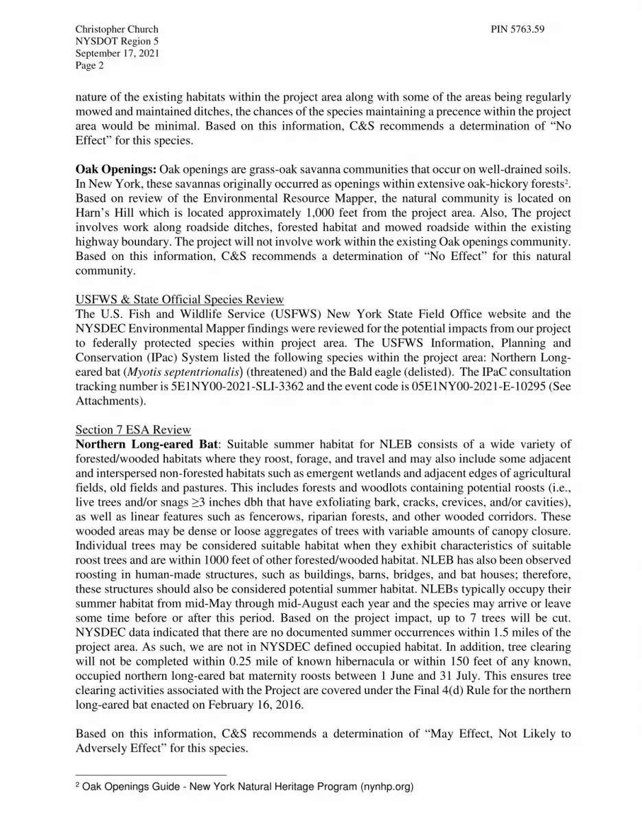
Christopher Church PIN 5763.59
NYSDOT Region 5
September 17, 2021
Page 2
nature of the existing habitats within the project area along with some of the areas being regularly
mowed and maintained ditches, the chances of the species maintaining a precence within the project
area would be minimal. Based on this information, C&S recommends a determination of “No
Effect” for this species.
Oak Openings: Oak openings are grass-oak savanna communities that occur on well-drained soils.
In New York, these savannas originally occurred as openings within extensive oak-hickory forests2.
Based on review of the Environmental Resource Mapper, the natural community is located on
Harn’s Hill which is located approximately 1,000 feet from the project area. Also, The project
involves work along roadside ditches, forested habitat and mowed roadside within the existing
highway boundary. The project will not involve work within the existing Oak openings community.
Based on this information, C&S recommends a determination of “No Effect” for this natural
community.
USFWS & State Official Species Review
The U.S. Fish and Wildlife Service (USFWS) New York State Field Office website and the
NYSDEC Environmental Mapper findings were reviewed for the potential impacts from our project
to federally protected species within project area. The USFWS Information, Planning and
Conservation (IPac) System listed the following species within the project area: Northern Long-
eared bat (Myotis septentrionalis) (threatened) and the Bald eagle (delisted). The IPaC consultation
tracking number is 5E1NY00-2021-SLI-3362 and the event code is 05E1NY00-2021-E-10295 (See
Attachments).
Section 7 ESA Review
Northern Long-eared Bat: Suitable summer habitat for NLEB consists of a wide variety of
forested/wooded habitats where they roost, forage, and travel and may also include some adjacent
and interspersed non-forested habitats such as emergent wetlands and adjacent edges of agricultural
fields, old fields and pastures. This includes forests and woodlots containing potential roosts (i.e.,
live trees and/or snags ≥3 inches dbh that have exfoliating bark, cracks, crevices, and/or cavities),
as well as linear features such as fencerows, riparian forests, and other wooded corridors. These
wooded areas may be dense or loose aggregates of trees with variable amounts of canopy closure.
Individual trees may be considered suitable habitat when they exhibit characteristics of suitable
roost trees and are within 1000 feet of other forested/wooded habitat. NLEB has also been observed
roosting in human-made structures, such as buildings, barns, bridges, and bat houses; therefore,
these structures should also be considered potential summer habitat. NLEBs typically occupy their
summer habitat from mid-May through mid-August each year and the species may arrive or leave
some time before or after this period. Based on the project impact, up to 7 trees will be cut.
NYSDEC data indicated that there are no documented summer occurrences within 1.5 miles of the
project area. As such, we are not in NYSDEC defined occupied habitat. In addition, tree clearing
will not be completed within 0.25 mile of known hibernacula or within 150 feet of any known,
occupied northern long-eared bat maternity roosts between 1 June and 31 July. This ensures tree
clearing activities associated with the Project are covered under the Final 4(d) Rule for the northern
long-eared bat enacted on February 16, 2016.
Based on this information, C&S recommends a determination of “May Effect, Not Likely to
Adversely Effect” for this species.
2 Oak Openings Guide - New York Natural Heritage Program (nynhp.org)

Christopher Church PIN 5763.59
NYSDOT Region 5
September 17, 2021
Page 3
Bald Eagle: Though the Bald Eagle was delisted in 2007 from the Endangered Species Act (ESA),
it is still afforded federal protection under the Bald and Golden Eagle Protection Act (BGEPA).
The Bald Eagle is still listed as threatened in New York State. Bald Eagles are typically found
near large bodies of water, such as bays, rivers, and lakes, which support a healthy population of
fish and waterfowl, their primary food source. Generally, Bald Eagles tend to avoid areas with
human activities. They will perch in either deciduous or coniferous trees. Large, heavy nests are
usually built near water in tall pine, spruce, fir, cottonwood, oak, poplar, or beech trees. Non-
breeding adults and wintering birds are known to have communal roost sites. During the winter, the
roost sites may be farther away from food sources. This may be due to the need for a more sheltered,
warmer area. Feeding areas during the winter months usually have a high concentration of fish and
waterfowl and open water3. The project does not involve the cutting of any known Bald eagle
nesting trees or constructing any towers, wires and/or other obstructions known to potentially affect
the Bald eagle. Also, NYS Natural Heritage correspondence did not list the Bald eagle within or
near the project area.
C&S made a preliminary determination of “Unlikely to disturb nesting Bald eagles” for this species.
Effect Determination
C&S Engineers completed the IPaC FHWA Programmatic Consultation Determination Key for
Transportation Projects Affecting the NLEB or Indiana bat on July 9, 2021. C&S completed the
associated ESA Transmittal Sheet (see attached). Upon conclusion of the site visit and USFWS
and NYNHP consultation, C&S determined that the Project will impact habitat suitable for the
NLEB, however, tree clearing activities associated with the Project are covered under the Final 4(d)
Rule for the northern long-eared bat enacted on February 16, 2016. Therefore, we are seeking
FHWA’s affirmation that the project “May Affect, Not Likley to Adversely Affect” the Northern
long-eared Bat.
Based on the project impacts and there are no documented nests or presence of Bald Eagle within
or near the project area, C&S is seeking FHWA’s affirmation that the project “Unlikely to disturb
nesting Bald eagles”.
If you have any questions or require additional information, please contact Justin Strong at (315)
455-2000.
Very truly yours,
C&S ENGINEERS, INC.
Justin Strong
Project Environmental Scientist
3 NYNHAP: Bald Eagle: http://www.acris.nynhp.org/guide.php?id=6811&part=2

Christopher Church PIN 5763.59
NYSDOT Region 5
September 17, 2021
Page 4
Enclosures
1. Project Location Map
2. NYSDEC Environmental Resources Map
3. USFWS IPaC Official Species List
4. USFWS Consistency Letter
5. ESA Transmittal Sheet
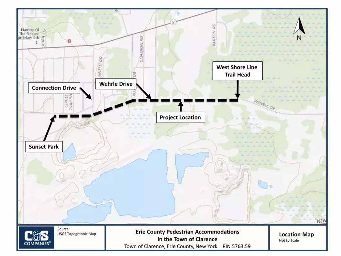
Source:USGS Topographic Map Location Map
Not to Scale
Erie County Pedestrian Accommodationsin the Town of Clarence
Town of Clarence, Erie County, New York PIN 5763.59
Connection DriveWehrle Drive
Project Location
West Shore Line Trail Head
Sunset Park

��������� �������� ��������������������� ��
���
�������� �!"#$% &�'�( $)"** �
+, $(���-��"! &$�.$!, $*���!$/�'$(#�(0 -$��$"� 1
2
3+)$452 �"&6�71222289::;<=98998>?:>@2 A��!,��712222>?B8CC<=?@9:B@?8?
2
D��7�!'- ED"6!'- 2 D��7�!'- 12222F?C=BB@C@:@CCBCBB<2 D"6!'- 12222>8=<B99:;9>;:?@<9>
+, $"**��G��"! $"--� &&$�.$!, $*���!$/�'$(#�(0 -$��$�&1CC8>FCCB82HIJKLI2MKN2OLPKIQRIN2SIT2UVKWN2:>9@:
X�'�!/12YKZI+�[�12OLPKIQRI3\]\$'"-12_SOabYc
d#-$��$e�! �6"#$% (��-&$fA�!$-�&*#"/ -$��$!, $�"*g
X�����$A"� 1$SVKhJIKQ2bPQijFklihPKm\(� �6n($A"� 1$MIiRlKPZQZP2oZQQPhP2iio=2pKPRJjRPKoPq"! $D"&!$q�('� �! -1$:<@?D�("6��1$rPKKZi2rZLLAs\$e��! (! -1$YQmPQtIKIm
A"!'�"#$X���'��6 &$��$!, $u�(���!/
A"!'�"#$X���'��!/$A"� 1$vPW2VoIQZQtiD�("6��1$rPKKZi2rZLL�(�#�7�("#$\/&! �1$woLPQmi
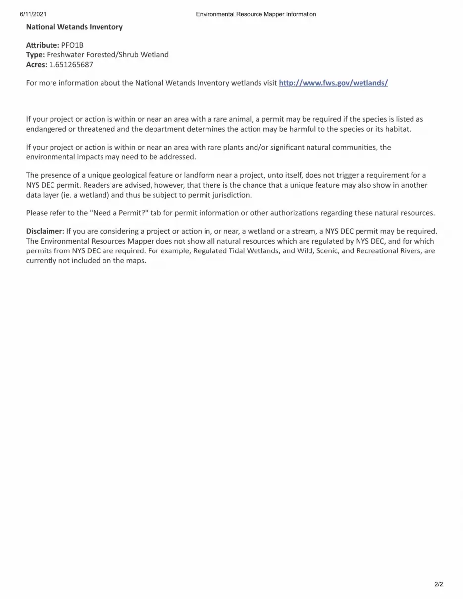
��������� �������� ��������������������� ��
���
�������� !"��#$�%�&!�"�'(
)*'+,-"!.�/01234(5!.�06789:;<76=0>678<7?@A96BC=D7<E;F?)G'!$.�2HIJ2KIJILM
0>6=N>67=OFP>6N;Q>F=;C>B<=<97=R;Q>F;E=D7<;F?8=SFT7F<>6U=:7<E;F?8=TO8O<=V*5.WWXXXYZX$Y[�&WX!"���#$W
SP=U>B6=\6>]7<=>6=;Q>F=O8=:O<9OF=>6=F7;6=;F=;67;=:O<9=;=6;67=;FON;E_=;=\76NO<=N;U=C7=67BO67?=OP=<97=8\7O78=O8=EO8<7?=;87F?;Fa767?=>6=<967;<7F7?=;F?=<97=?7\;6<N7F<=?7<76NOF78=<97=;Q>F=N;U=C7=9;6NPBE=<>=<97=8\7O78=>6=O<8=9;CO<;<H
SP=U>B6=\6>]7<=>6=;Q>F=O8=:O<9OF=>6=F7;6=;F=;67;=:O<9=6;67=\E;F<8=;F?@>6=8OaFOb;F<=F;<B6;E=>NNBFOQ78_=<977FTO6>FN7F<;E=ON\;<8=N;U=F77?=<>=C7=;??67887?H
c97=\6787F7=>P=;=BFOB7=a7>E>aO;E=P7;<B67=>6=E;F?P>6N=F7;6=;=\6>]7<_=BF<>=O<87EP_=?>78=F><=<6Oaa76=;=67BO67N7F<=P>6=;RdA=efg=\76NO<H=h7;?768=;67=;?TO87?_=9>:7T76_=<9;<=<9767=O8=<97=9;F7=<9;<=;=BFOB7=P7;<B67=N;U=;E8>=89>:=OF=;F><976?;<;=E;U76=iO7H=;=:7<E;F?j=;F?=<9B8=C7=8BC]7<=<>=\76NO<=]B6O8?OQ>FH
/E7;87=67P76=<>=<97=kR77?=;=/76NO<lk=<;C=P>6=\76NO<=OFP>6N;Q>F=>6=><976=;B<9>6Om;Q>F8=67a;6?OFa=<9787=F;<B6;E=678>B678H
n+$G��+o!'.=SP=U>B=;67=>F8O?76OFa=;=\6>]7<=>6=;Q>F=OF_=>6=F7;6_=;=:7<E;F?=>6=;=8<67;N_=;=RdA=efg=\76NO<=N;U=C7=67BO67?Hc97=fFTO6>FN7F<;E=h78>B678=p;\\76=?>78=F><=89>:=;EE=F;<B6;E=678>B678=:9O9=;67=67aBE;<7?=CU=RdA=efg_=;F?=P>6=:9O9\76NO<8=P6>N=RdA=efg=;67=67BO67?H=0>6=7q;N\E7_=h7aBE;<7?=cO?;E=D7<E;F?8_=;F?=DOE?_=A7FO_=;F?=h767;Q>F;E=hOT768_=;67B667F<EU=F><=OFEB?7?=>F=<97=N;\8H
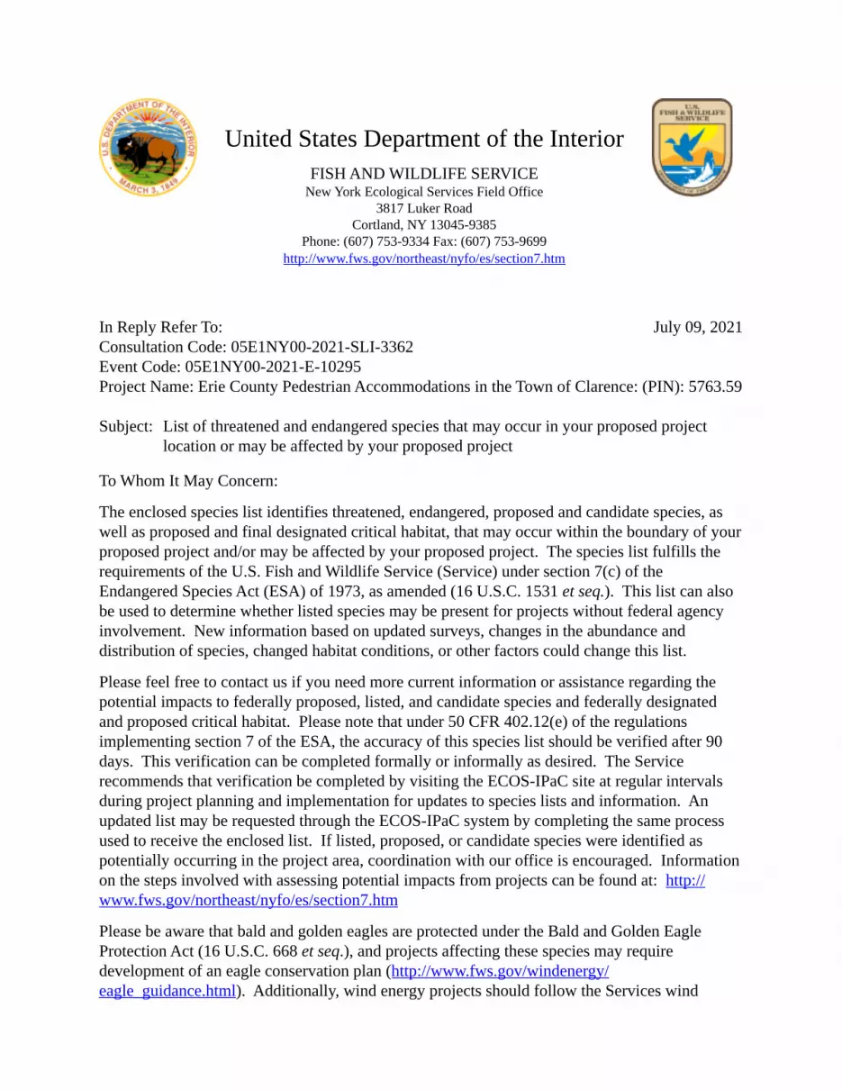
July 09, 2021
United States Department of the InteriorFISH AND WILDLIFE SERVICE
New York Ecological Services Field Office3817 Luker Road
Cortland, NY 13045-9385Phone: (607) 753-9334 Fax: (607) 753-9699
http://www.fws.gov/northeast/nyfo/es/section7.htm
In Reply Refer To: Consultation Code: 05E1NY00-2021-SLI-3362 Event Code: 05E1NY00-2021-E-10295 Project Name: Erie County Pedestrian Accommodations in the Town of Clarence: (PIN): 5763.59 Subject: List of threatened and endangered species that may occur in your proposed project
location or may be affected by your proposed project
To Whom It May Concern:
The enclosed species list identifies threatened, endangered, proposed and candidate species, as well as proposed and final designated critical habitat, that may occur within the boundary of your proposed project and/or may be affected by your proposed project. The species list fulfills the requirements of the U.S. Fish and Wildlife Service (Service) under section 7(c) of the Endangered Species Act (ESA) of 1973, as amended (16 U.S.C. 1531 et seq.). This list can also be used to determine whether listed species may be present for projects without federal agency involvement. New information based on updated surveys, changes in the abundance and distribution of species, changed habitat conditions, or other factors could change this list.
Please feel free to contact us if you need more current information or assistance regarding the potential impacts to federally proposed, listed, and candidate species and federally designated and proposed critical habitat. Please note that under 50 CFR 402.12(e) of the regulations implementing section 7 of the ESA, the accuracy of this species list should be verified after 90 days. This verification can be completed formally or informally as desired. The Service recommends that verification be completed by visiting the ECOS-IPaC site at regular intervals during project planning and implementation for updates to species lists and information. An updated list may be requested through the ECOS-IPaC system by completing the same process used to receive the enclosed list. If listed, proposed, or candidate species were identified as potentially occurring in the project area, coordination with our office is encouraged. Information on the steps involved with assessing potential impacts from projects can be found at: http:// www.fws.gov/northeast/nyfo/es/section7.htm
Please be aware that bald and golden eagles are protected under the Bald and Golden Eagle Protection Act (16 U.S.C. 668 et seq.), and projects affecting these species may require development of an eagle conservation plan (http://www.fws.gov/windenergy/ eagle_guidance.html). Additionally, wind energy projects should follow the Services wind
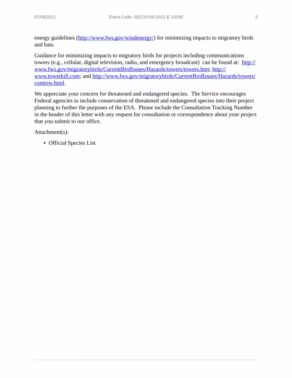
07/09/2021 Event Code: 05E1NY00-2021-E-10295 2
▪
energy guidelines (http://www.fws.gov/windenergy/) for minimizing impacts to migratory birds and bats.
Guidance for minimizing impacts to migratory birds for projects including communications towers (e.g., cellular, digital television, radio, and emergency broadcast) can be found at: http:// www.fws.gov/migratorybirds/CurrentBirdIssues/Hazards/towers/towers.htm; http:// www.towerkill.com; and http://www.fws.gov/migratorybirds/CurrentBirdIssues/Hazards/towers/ comtow.html.
We appreciate your concern for threatened and endangered species. The Service encourages Federal agencies to include conservation of threatened and endangered species into their project planning to further the purposes of the ESA. Please include the Consultation Tracking Number in the header of this letter with any request for consultation or correspondence about your project that you submit to our office.
Attachment(s):
Official Species List
07/09/2021 Event Code: 05E1NY00-2021-E-10295 1
Official Species ListThis list is provided pursuant to Section 7 of the Endangered Species Act, and fulfills the requirement for Federal agencies to "request of the Secretary of the Interior information whether any species which is listed or proposed to be listed may be present in the area of a proposed action".
This species list is provided by:
New York Ecological Services Field Office3817 Luker RoadCortland, NY 13045-9385(607) 753-9334

07/09/2021 Event Code: 05E1NY00-2021-E-10295 2
Project SummaryConsultation Code: 05E1NY00-2021-SLI-3362Event Code: 05E1NY00-2021-E-10295Project Name: Erie County Pedestrian Accommodations in the Town of Clarence: (PIN):
5763.59Project Type: RECREATION CONSTRUCTION / MAINTENANCEProject Description: The project will construct a 6’ wide off-road asphalt bicycle/pedestrian
trail adjacent to Wehrle Drive between Sunset Park in the west to the West Shore Line Trail to the east. This work will generally include a 5’ grass buffer from the existing roadway. Construction of the trail will require some clearing of vegetation and filling in of the existing roadside ditches for installation of a closed drainage system. Additionally, some utility pole relocations may be required. Where cross-streets are present, detectable warning units and trail stop signs will be installed with painted crosswalks. At the western end of the project, a connection trail will be constructed between the existing paved walkways within the park and the proposed trail. At the eastern end of the project, the trail will end at the existing paved parking area for the West Shore Line Trail. Some pavement repair and landscaping improvements may be required to achieve the best transition at this location.
Project Location:Approximate location of the project can be viewed in Google Maps: https:// www.google.com/maps/@42.9593016,-78.66565812580316,14z
Counties: Erie County, New York
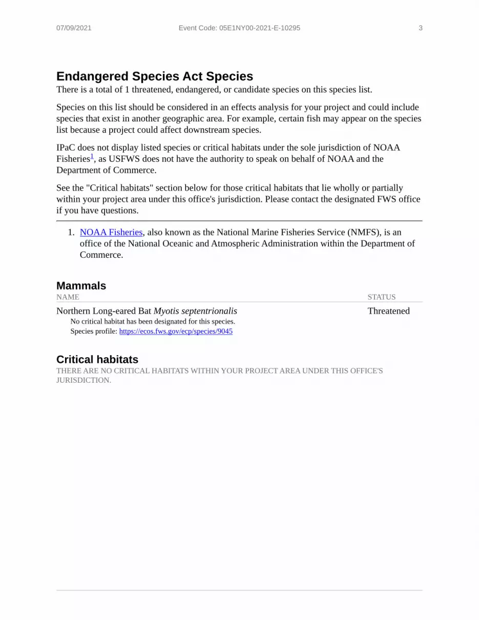
07/09/2021 Event Code: 05E1NY00-2021-E-10295 3
1.
Endangered Species Act SpeciesThere is a total of 1 threatened, endangered, or candidate species on this species list.
Species on this list should be considered in an effects analysis for your project and could include species that exist in another geographic area. For example, certain fish may appear on the species list because a project could affect downstream species.
IPaC does not display listed species or critical habitats under the sole jurisdiction of NOAA Fisheries , as USFWS does not have the authority to speak on behalf of NOAA and the Department of Commerce.
See the "Critical habitats" section below for those critical habitats that lie wholly or partially within your project area under this office's jurisdiction. Please contact the designated FWS office if you have questions.
NOAA Fisheries, also known as the National Marine Fisheries Service (NMFS), is an office of the National Oceanic and Atmospheric Administration within the Department of Commerce.
MammalsNAME STATUS
Northern Long-eared Bat Myotis septentrionalisNo critical habitat has been designated for this species.Species profile: https://ecos.fws.gov/ecp/species/9045
Threatened
Critical habitatsTHERE ARE NO CRITICAL HABITATS WITHIN YOUR PROJECT AREA UNDER THIS OFFICE'S JURISDICTION.
1
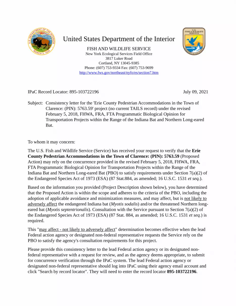
July 09, 2021
United States Department of the InteriorFISH AND WILDLIFE SERVICE
New York Ecological Services Field Office3817 Luker Road
Cortland, NY 13045-9385Phone: (607) 753-9334 Fax: (607) 753-9699
http://www.fws.gov/northeast/nyfo/es/section7.htm
IPaC Record Locator: 895-103722196 Subject: Consistency letter for the 'Erie County Pedestrian Accommodations in the Town of
Clarence: (PIN): 5763.59' project (no current TAILS record) under the revised February 5, 2018, FHWA, FRA, FTA Programmatic Biological Opinion for Transportation Projects within the Range of the Indiana Bat and Northern Long-eared Bat.
To whom it may concern:
The U.S. Fish and Wildlife Service (Service) has received your request to verify that the Erie County Pedestrian Accommodations in the Town of Clarence: (PIN): 5763.59 (Proposed Action) may rely on the concurrence provided in the revised February 5, 2018, FHWA, FRA, FTA Programmatic Biological Opinion for Transportation Projects within the Range of the Indiana Bat and Northern Long-eared Bat (PBO) to satisfy requirements under Section 7(a)(2) of the Endangered Species Act of 1973 (ESA) (87 Stat.884, as amended; 16 U.S.C. 1531 et seq.).
Based on the information you provided (Project Description shown below), you have determined that the Proposed Action is within the scope and adheres to the criteria of the PBO, including the adoption of applicable avoidance and minimization measures, and may affect, but is not likely to adversely affect the endangered Indiana bat (Myotis sodalis) and/or the threatened Northern long- eared bat (Myotis septentrionalis). Consultation with the Service pursuant to Section 7(a)(2) of the Endangered Species Act of 1973 (ESA) (87 Stat. 884, as amended; 16 U.S.C. 1531 et seq.) is required.
This "may affect - not likely to adversely affect" determination becomes effective when the lead Federal action agency or designated non-federal representative requests the Service rely on the PBO to satisfy the agency's consultation requirements for this project.
Please provide this consistency letter to the lead Federal action agency or its designated non- federal representative with a request for review, and as the agency deems appropriate, to submit for concurrence verification through the IPaC system. The lead Federal action agency or designated non-federal representative should log into IPaC using their agency email account and click "Search by record locator". They will need to enter the record locator 895-103722196.
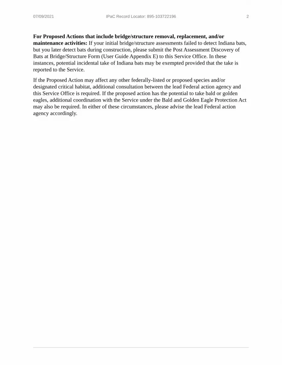
07/09/2021 IPaC Record Locator: 895-103722196 2
For Proposed Actions that include bridge/structure removal, replacement, and/or maintenance activities: If your initial bridge/structure assessments failed to detect Indiana bats, but you later detect bats during construction, please submit the Post Assessment Discovery of Bats at Bridge/Structure Form (User Guide Appendix E) to this Service Office. In these instances, potential incidental take of Indiana bats may be exempted provided that the take is reported to the Service.
If the Proposed Action may affect any other federally-listed or proposed species and/or designated critical habitat, additional consultation between the lead Federal action agency and this Service Office is required. If the proposed action has the potential to take bald or golden eagles, additional coordination with the Service under the Bald and Golden Eagle Protection Act may also be required. In either of these circumstances, please advise the lead Federal action agency accordingly.
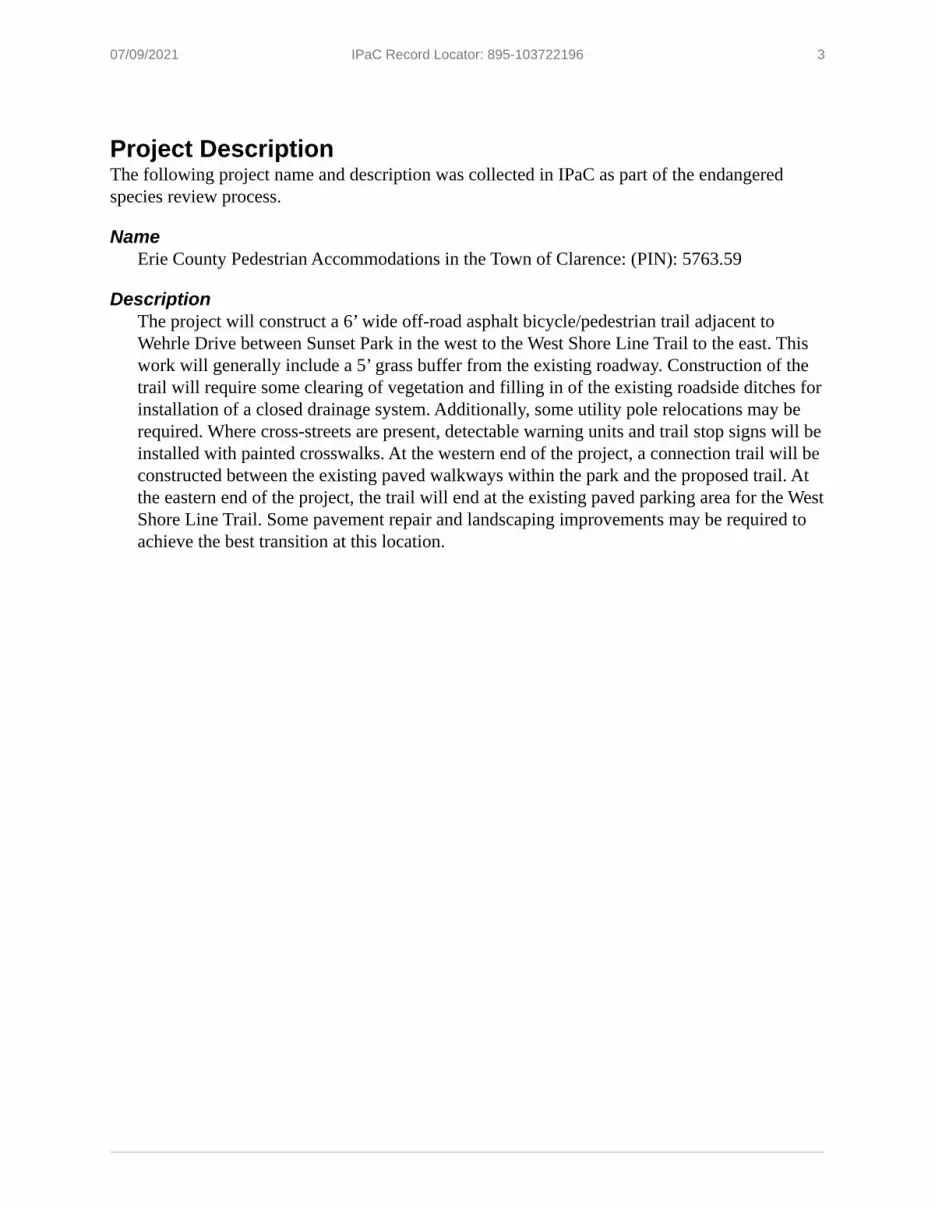
07/09/2021 IPaC Record Locator: 895-103722196 3
Project DescriptionThe following project name and description was collected in IPaC as part of the endangered species review process.
NameErie County Pedestrian Accommodations in the Town of Clarence: (PIN): 5763.59
DescriptionThe project will construct a 6’ wide off-road asphalt bicycle/pedestrian trail adjacent to Wehrle Drive between Sunset Park in the west to the West Shore Line Trail to the east. This work will generally include a 5’ grass buffer from the existing roadway. Construction of the trail will require some clearing of vegetation and filling in of the existing roadside ditches for installation of a closed drainage system. Additionally, some utility pole relocations may be required. Where cross-streets are present, detectable warning units and trail stop signs will be installed with painted crosswalks. At the western end of the project, a connection trail will be constructed between the existing paved walkways within the park and the proposed trail. At the eastern end of the project, the trail will end at the existing paved parking area for the West Shore Line Trail. Some pavement repair and landscaping improvements may be required to achieve the best transition at this location.
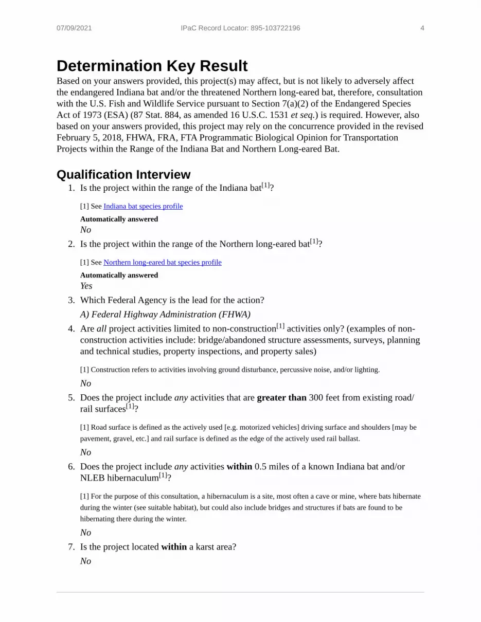
07/09/2021 IPaC Record Locator: 895-103722196 4
1.
2.
3.
4.
5.
6.
7.
Determination Key ResultBased on your answers provided, this project(s) may affect, but is not likely to adversely affect the endangered Indiana bat and/or the threatened Northern long-eared bat, therefore, consultation with the U.S. Fish and Wildlife Service pursuant to Section 7(a)(2) of the Endangered Species Act of 1973 (ESA) (87 Stat. 884, as amended 16 U.S.C. 1531 et seq.) is required. However, also based on your answers provided, this project may rely on the concurrence provided in the revised February 5, 2018, FHWA, FRA, FTA Programmatic Biological Opinion for Transportation Projects within the Range of the Indiana Bat and Northern Long-eared Bat.
Qualification InterviewIs the project within the range of the Indiana bat ?
[1] See Indiana bat species profile
Automatically answeredNoIs the project within the range of the Northern long-eared bat ?
[1] See Northern long-eared bat species profile
Automatically answeredYesWhich Federal Agency is the lead for the action?A) Federal Highway Administration (FHWA)Are all project activities limited to non-construction activities only? (examples of non- construction activities include: bridge/abandoned structure assessments, surveys, planning and technical studies, property inspections, and property sales)
[1] Construction refers to activities involving ground disturbance, percussive noise, and/or lighting.
NoDoes the project include any activities that are greater than 300 feet from existing road/ rail surfaces ?
[1] Road surface is defined as the actively used [e.g. motorized vehicles] driving surface and shoulders [may be pavement, gravel, etc.] and rail surface is defined as the edge of the actively used rail ballast.
NoDoes the project include any activities within 0.5 miles of a known Indiana bat and/or NLEB hibernaculum ?
[1] For the purpose of this consultation, a hibernaculum is a site, most often a cave or mine, where bats hibernate during the winter (see suitable habitat), but could also include bridges and structures if bats are found to be hibernating there during the winter.
NoIs the project located within a karst area?No
[1]
[1]
[1]
[1]
[1]
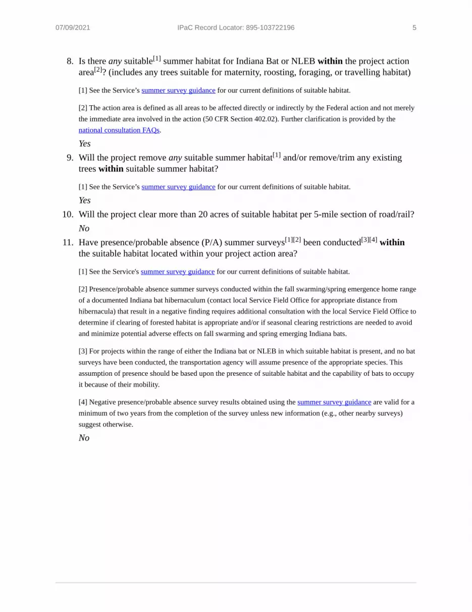
07/09/2021 IPaC Record Locator: 895-103722196 5
8.
9.
10.
11.
Is there any suitable summer habitat for Indiana Bat or NLEB within the project action area ? (includes any trees suitable for maternity, roosting, foraging, or travelling habitat)
[1] See the Service’s summer survey guidance for our current definitions of suitable habitat.
[2] The action area is defined as all areas to be affected directly or indirectly by the Federal action and not merely the immediate area involved in the action (50 CFR Section 402.02). Further clarification is provided by the national consultation FAQs.
YesWill the project remove any suitable summer habitat and/or remove/trim any existing trees within suitable summer habitat?
[1] See the Service’s summer survey guidance for our current definitions of suitable habitat.
YesWill the project clear more than 20 acres of suitable habitat per 5-mile section of road/rail?NoHave presence/probable absence (P/A) summer surveys been conducted within the suitable habitat located within your project action area?
[1] See the Service's summer survey guidance for our current definitions of suitable habitat.
[2] Presence/probable absence summer surveys conducted within the fall swarming/spring emergence home range of a documented Indiana bat hibernaculum (contact local Service Field Office for appropriate distance from hibernacula) that result in a negative finding requires additional consultation with the local Service Field Office to determine if clearing of forested habitat is appropriate and/or if seasonal clearing restrictions are needed to avoid and minimize potential adverse effects on fall swarming and spring emerging Indiana bats.
[3] For projects within the range of either the Indiana bat or NLEB in which suitable habitat is present, and no bat surveys have been conducted, the transportation agency will assume presence of the appropriate species. This assumption of presence should be based upon the presence of suitable habitat and the capability of bats to occupy it because of their mobility.
[4] Negative presence/probable absence survey results obtained using the summer survey guidance are valid for a minimum of two years from the completion of the survey unless new information (e.g., other nearby surveys) suggest otherwise.
No
[1][2]
[1]
[1][2] [3][4]

07/09/2021 IPaC Record Locator: 895-103722196 6
12.
13.
14.
15.
16.
17.
18.
19.
20.
21.
22.
Does the project include activities within documented NLEB habitat ?
[1] Documented roosting or foraging habitat – for the purposes of this consultation, we are considering documented habitat as that where Indiana bats and/or NLEB have actually been captured and tracked using (1) radio telemetry to roosts; (2) radio telemetry biangulation/triangulation to estimate foraging areas; or (3) foraging areas with repeated use documented using acoustics. Documented roosting habitat is also considered as suitable summer habitat within 0.25 miles of documented roosts.)
[2] For the purposes of this key, we are considering documented corridors as that where Indiana bats and/or NLEB have actually been captured and tracked to using (1) radio telemetry; or (2) treed corridors located directly between documented roosting and foraging habitat.
NoWill the removal or trimming of habitat or trees occur within suitable but undocumented NLEB roosting/foraging habitat or travel corridors?YesWhat time of year will the removal or trimming of habitat or trees within suitable but undocumented NLEB roosting/foraging habitat or travel corridors occur?B) During the inactive seasonWill any tree trimming or removal occur within 100 feet of existing road/rail surfaces?YesWill any tree trimming or removal occur between 100-300 feet of existing road/rail surfaces?NoAre all trees that are being removed clearly demarcated?YesWill the removal of habitat or the removal/trimming of trees include installing new or replacing existing permanent lighting?NoDoes the project include wetland or stream protection activities associated with compensatory wetland mitigation?NoDoes the project include slash pile burning?NoDoes the project include any bridge removal, replacement, and/or maintenance activities (e.g., any bridge repair, retrofit, maintenance, and/or rehabilitation work)?NoDoes the project include the removal, replacement, and/or maintenance of any structure other than a bridge? (e.g., rest areas, offices, sheds, outbuildings, barns, parking garages, etc.)No
[1][2]
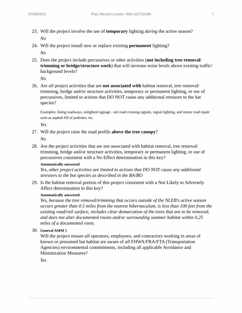
07/09/2021 IPaC Record Locator: 895-103722196 7
23.
24.
25.
26.
27.
28.
29.
30.
Will the project involve the use of temporary lighting during the active season?NoWill the project install new or replace existing permanent lighting?NoDoes the project include percussives or other activities (not including tree removal/ trimming or bridge/structure work) that will increase noise levels above existing traffic/ background levels?NoAre all project activities that are not associated with habitat removal, tree removal/ trimming, bridge and/or structure activities, temporary or permanent lighting, or use of percussives, limited to actions that DO NOT cause any additional stressors to the bat species?
Examples: lining roadways, unlighted signage , rail road crossing signals, signal lighting, and minor road repair such as asphalt fill of potholes, etc.
YesWill the project raise the road profile above the tree canopy?NoAre the project activities that are not associated with habitat removal, tree removal/ trimming, bridge and/or structure activities, temporary or permanent lighting, or use of percussives consistent with a No Effect determination in this key?Automatically answeredYes, other project activities are limited to actions that DO NOT cause any additional stressors to the bat species as described in the BA/BOIs the habitat removal portion of this project consistent with a Not Likely to Adversely Affect determination in this key?Automatically answeredYes, because the tree removal/trimming that occurs outside of the NLEB's active season occurs greater than 0.5 miles from the nearest hibernaculum, is less than 100 feet from the existing road/rail surface, includes clear demarcation of the trees that are to be removed, and does not alter documented roosts and/or surrounding summer habitat within 0.25 miles of a documented roost.General AMM 1Will the project ensure all operators, employees, and contractors working in areas of known or presumed bat habitat are aware of all FHWA/FRA/FTA (Transportation Agencies) environmental commitments, including all applicable Avoidance and Minimization Measures?Yes
07/09/2021 IPaC Record Locator: 895-103722196 8
31.
32.
33.
1.
2.
3.
Tree Removal AMM 1Can all phases/aspects of the project (e.g., temporary work areas, alignments) be modified, to the extent practicable, to avoid tree removal in excess of what is required to implement the project safely?
Note: Tree Removal AMM 1 is a minimization measure, the full implementation of which may not always be practicable. Projects may still be NLAA as long as Tree Removal AMMs 2, 3, and 4 are implemented and LAA as long as Tree Removal AMMs 3, 5, 6, and 7 are implemented.
[1] The word “trees” as used in the AMMs refers to trees that are suitable habitat for each species within their range. See the USFWS’ current summer survey guidance for our latest definitions of suitable habitat.
YesTree Removal AMM 3Can tree removal be limited to that specified in project plans and ensure that contractors understand clearing limits and how they are marked in the field (e.g., install bright colored flagging/fencing prior to any tree clearing to ensure contractors stay within clearing limits)?YesTree Removal AMM 4Can the project avoid cutting down/removal of all (1) documented Indiana bat or NLEB roosts (that are still suitable for roosting), (2) trees within 0.25 miles of roosts, and (3) documented foraging habitat any time of year?
[1] The word documented means habitat where bats have actually been captured and/or tracked.
[2] Documented roosting or foraging habitat – for the purposes of this consultation, we are considering documented habitat as that where Indiana bats and/or NLEB have actually been captured and tracked using (1) radio telemetry to roosts; (2) radio telemetry biangulation/triangulation to estimate foraging areas; or (3) foraging areas with repeated use documented using acoustics. Documented roosting habitat is also considered as suitable summer habitat within 0.25 miles of documented roosts.)
Yes
Project QuestionnaireHave you made a No Effect determination for all other species indicated on the FWS IPaC generated species list?N/AHave you made a May Affect determination for any other species on the FWS IPaC generated species list?N/AHow many acres of trees are proposed for removal between 0-100 feet of the existing road/rail surface?
[1] If described as number of trees, multiply by 0.09 to convert to acreage and enter that number.
2
[1]
[1][2]
[1]

07/09/2021 IPaC Record Locator: 895-103722196 9
Avoidance And Minimization Measures (AMMs)This determination key result includes the committment to implement the following Avoidance and Minimization Measures (AMMs):
TREE REMOVAL AMM 2Apply time of year restrictions for tree removal when bats are not likely to be present, or limit tree removal to 10 or fewer trees per project at any time of year within 100 feet of existing road/ rail surface and outside of documented roosting/foraging habitat or travel corridors; visual emergence survey must be conducted with no bats observed.
TREE REMOVAL AMM 3Ensure tree removal is limited to that specified in project plans and ensure that contractors understand clearing limits and how they are marked in the field (e.g., install bright colored flagging/fencing prior to any tree clearing to ensure contractors stay within clearing limits).
TREE REMOVAL AMM 4Do not remove documented Indiana bat or NLEB roosts that are still suitable for roosting, or trees within 0.25 miles of roosts, or documented foraging habitat any time of year.
GENERAL AMM 1Ensure all operators, employees, and contractors working in areas of known or presumed bat habitat are aware of all FHWA/FRA/FTA (Transportation Agencies) environmental commitments, including all applicable AMMs.
TREE REMOVAL AMM 1Modify all phases/aspects of the project (e.g., temporary work areas, alignments) to avoid tree removal.

07/09/2021 IPaC Record Locator: 895-103722196 10
Determination Key Description: FHWA, FRA, FTA Programmatic Consultation For Transportation Projects Affecting NLEB Or Indiana BatThis key was last updated in IPaC on April 22, 2021. Keys are subject to periodic revision.
This decision key is intended for projects/activities funded or authorized by the Federal Highway Administration (FHWA), Federal Railroad Administration (FRA), and/or Federal Transit Administration (FTA), which may require consultation with the U.S. Fish and Wildlife Service (Service) under Section 7 of the Endangered Species Act (ESA) for the endangered Indiana bat (Myotis sodalis) and the threatened Northern long-eared bat (NLEB) (Myotis septentrionalis).
This decision key should only be used to verify project applicability with the Service’s February 5, 2018, FHWA, FRA, FTA Programmatic Biological Opinion for Transportation Projects. The programmatic biological opinion covers limited transportation activities that may affect either bat species, and addresses situations that are both likely and not likely to adversely affect either bat species. This decision key will assist in identifying the effect of a specific project/activity and applicability of the programmatic consultation. The programmatic biological opinion is not intended to cover all types of transportation actions. Activities outside the scope of the programmatic biological opinion, or that may affect ESA-listed species other than the Indiana bat or NLEB, or any designated critical habitat, may require additional ESA Section 7 consultation.

ESA Does
Not Apply
No Effect, Activity-
Based
No Effect
No Effect, No
Suitable Habitat
Bat PA IPaC
Submittal- Winter
Tree Removal (MA, NLAA)
NLEB PA IPaC Submittal-
April/Aug/Sept
Tree Removal
Individual
Submission to
USFWS
MA, LAA-
Formal
Consultation
Northern Long-eared Bat
X
Indiana Bat X NA
Bog Turtle X NA NA
Mollusks (Dwarf Wedge
Mussel, Rayed Bean,
Clubshell, Chittenango
Ovate Amber Snail)
X
NA
NA
Karner Blue Butterfly X NA NA
Other (Red Knot, Piping
Plover, etc.) List Species: X
NA
NA
Documentation Required
The IPaC
Official
Species List
is included in
the DAD.
Record the
corresponding
number of the
activity in the box.
This sheet and the
IPaC Official Species
List are included in
the DAD.
NYSDOT
submits "No
Effect"
determination
to FHWA.
FHWA will
concur or not
concur.
NYSDOT submits
"No Effect, No
determination to
FHWA. Concurrence
has been obtained if
7 days pass without
correspondence
from FHWA.
NYSDOT submits
through IPaC w/
Area Engineer
included.
Concurrence is
obtained if 14
days pass without
correspondence
from USFWS.
NYSDOT submits
through IPaC w/
Area Engineer
included.
Concurrence is
obtained if 30
days pass without
correspondence
from USFWS.
NYSDOT
submits either
BE or BA to
FHWA, who
submits to
USFWS for
concurrence.
NYSDOT
submits BA to
FHWA for
Initiation of
Formal
Consultation
with USFWS.
Submission to FHWA
Required?
No
No
Yes
Yes
cc: only
cc: only
Yes
Yes
Submission to USFWS by DOT through IPAC
Required?
No
No
No
No
Yes
Yes
No
No
Submission to USFWS by
FHWA Required?
No
No
No
No
No
No
Yes
Yes
PIN: 5763.3 PROJECT NAME: Erie County Pedestrian Accommodations in the Town of Clarence Date: July 12, 2021
Section 7 ESA Process for USFWS Species: ESA Transmittal Sheet Step 3: Documentation. Please complete the appropriate boxes below and complete the documentation as described.
Suitable Habitat"
Instructions: This Summary Sheet is to be included all submissions to FHWA. A submittal package includes all documentation for all species requiring concurrence
with a cover letter requesting concurrence, so that FHWA can make one ESA determination. SEE EACH SPECIES-SPECIFIC PACKAGE FOR SPECIFIC
DOCUMENTATION REQUIREMENTS FOR SUBMITTALS. Also, FHWA requires documentation of compliance with ESA in the DAD.

PIN: 5763.31 PROJECT NAME: Wehrle Drive from Harlem Road to Aero Drive Date: July 2, 2020
Section 7 ESA Process for NMFS Species: ESA/EFH Transmittal Sheet Step 3: Documentation. Please complete the appropriate boxes below and complete the documentation as described.
ESA/EFH Does
Not Apply
No Effect,
Activity-Based
No Effect
ESA
Programmatic
Agreement
Applies
EFH
Programmatic
Agreement
Applies
Informal
Consultation/
Individual
Submission to
NMFS
MA, LAA Formal
Consultation and/or
Individual EFH
Consultation is
Required
Sturgeon (Shortnose,
Atlantic) X
NA
Sea Turtles X NA
Atlantic Large Whales X NA
EFH Resources X NA
Documentation Required
Both the NMFS
ESA and EFH
Maps printouts
are included in
the DAD.
Record the
corresponding number
of the activity in the
boxes above. This sheet
and both the NMFS ESA
and EFH Maps printouts
are included in the DAD.
NYSDOT submits
"No Effect"
determination for
NMFS ESA, EFH,
or both to FHWA.
FHWA will concur
or not concur.
NYSDOT submits
the ESA
Verification
Form to NMFS
with a cc: to the
FHWA Area
Engineer
NYSDOT submits
the EFH
Verification
Form to NMFS
with a cc: to the
FHWA Area
Engineer
NYSDOT submits
either BE or BA for
ESA, and/or an EFH
Assessment Report
to FHWA, who
submits to NMFS
for concurrence.
NYSDOT submits BA
for ESA and/or an
EFH Assessment to
FHWA for Initiation
of Formal
Consultation with
NMFS.
Submission to FHWA
Required?
No
No
Yes
Yes
Yes
Yes
Yes
Submission to NMFS by
FHWA Required?
No
No
No
No
No
Yes
Yes
Note: NMFS ESA Submittals for Programmatic Agreement Verification, Informal, and Formal Consultation is sent to the NOAA/NMFS Protected Resources Division
of the Gloucester, MA office. NMFS EFH Submittals for Programmatic Agreement Verification, Informal, and Formal Consultation is sent to the NOAA/NMFS Habitat
Conservation Division in Sandy Hook, NJ. Email addresses are located in the respective forms.
Instructions: This Summary Sheet is to be included all submissions to FHWA. A submittal package includes all documentation for all species requiring concurrence
with a cover letter requesting concurrence, so that FHWA can make one ESA determination. SEE EACH SPECIES-SPECIFIC PACKAGE FOR SPECIFIC DOCUMENTATION
REQUIREMENTS FOR SUBMITTALS. Also, FHWA requires documentation of compliance with ESA in the DAD.

Attachment D
Complete Streets Checklist
APPENDIX A
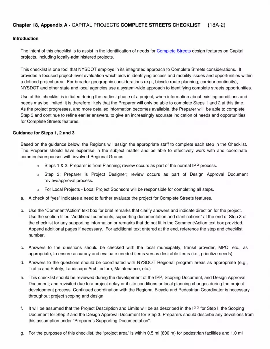
Chapter 18, Appendix A - CAPITAL PROJECTS COMPLETE STREETS CHECKLIST (18A-2)
Introduction
The intent of this checklist is to assist in the identification of needs for Complete Streets design features on Capital
projects, including locally-administered projects.
This checklist is one tool that NYSDOT employs in its integrated approach to Complete Streets considerations. It
provides a focused project-level evaluation which aids in identifying access and mobility issues and opportunities within
a defined project area. For broader geographic considerations (e.g., bicycle route planning, corridor continuity),
NYSDOT and other state and local agencies use a system-wide approach to identifying complete streets opportunities.
Use of this checklist is initiated during the earliest phase of a project, when information about existing conditions and
needs may be limited; it is therefore likely that the Preparer will only be able to complete Steps 1 and 2 at this time.
As the project progresses, and more detailed information becomes available, the Preparer will be able to complete
Step 3 and continue to refine earlier answers, to give an increasingly accurate indication of needs and opportunities
for Complete Streets features.
Guidance for Steps 1, 2 and 3
Based on the guidance below, the Regions will assign the appropriate staff to complete each step in the Checklist.
The Preparer should have expertise in the subject matter and be able to effectively work with and coordinate
comments/responses with involved Regional Groups.
o Steps 1 & 2: Preparer is from Planning; review occurs as part of the normal IPP process.
o Step 3: Preparer is Project Designer; review occurs as part of Design Approval Document
review/approval process.
o For Local Projects - Local Project Sponsors will be responsible for completing all steps.
a. A check of “yes” indicates a need to further evaluate the project for Complete Streets features.
b. Use the “Comment/Action” text box for brief remarks that clarify answers and indicate direction for the project.
Use the section titled “Additional comments, supporting documentation and clarifications” at the end of Step 3 of
the checklist for any supporting information or remarks that do not fit in the Comment/Action text box provided.
Append additional pages if necessary. For additional text entered at the end, reference the step and checklist
number.
c. Answers to the questions should be checked with the local municipality, transit provider, MPO, etc., as
appropriate, to ensure accuracy and evaluate needed items versus desirable items (i.e., prioritize needs).
d. Answers to the questions should be coordinated with NYSDOT Regional program areas as appropriate (e.g.,
Traffic and Safety, Landscape Architecture, Maintenance, etc.)
e. This checklist should be reviewed during the development of the IPP, Scoping Document, and Design Approval
Document; and revisited due to a project delay or if site conditions or local planning changes during the project
development process. Continued coordination with the Regional Bicycle and Pedestrian Coordinator is necessary
throughout project scoping and design.
f. It will be assumed that the Project Description and Limits will be as described in the IPP for Step I, the Scoping
Document for Step 2 and the Design Approval Document for Step 3. Preparers should describe any deviations from
this assumption under “Preparer’s Supporting Documentation”.
g. For the purposes of this checklist, the “project area” is within 0.5 mi (800 m) for pedestrian facilities and 1.0 mi

Chapter 18, Appendix A - CAPITAL PROJECTS COMPLETE STREETS CHECKLIST (18A-3)
(1600 m) for bicycle facilities. In some circumstances, bicyclists may travel up to 7 miles for a unique generator,
attraction or event. These special circumstances may be considered and described as appropriate.
h. For background on Complete Streets features and terminology, please visit the following websites:
http://www.fhwa.dot.gov/environment/bicycle_pedestrian/guidance/design_guidance/design_nonmotor/highway/index.cfm
http://www.fhwa.dot.gov/publications/publicroads/10julaug/03.cfm
http://www.smartgrowthamerica.org/complete-streets/
i. Refer to Highway Design Manual Chapter 18, Section 18.5.1 for further information and guidance on the use of this
checklist.
j. For projects with multiple sites, Preparers may choose to prepare multiple checklists for each site.
Definitions
• CAMCI (Comprehensive Asset Management/Capital Investment) Viewer - A web-based GIS application used
for planning purposes and located at http://gisweb/camci/.
• Generator - A generator, in this document, refers to both origins and destinations for bicycle and/or pedestrian
trips (e.g., schools, libraries, shopping areas, bus stops, transit stations, depots/terminals).
• HDM - New York State Department of Transportation’s Highway Design Manual.
• Maintenance project - For the purposes of this checklist, maintenance projects are listed as the following project
types: Rigid pavement repairs, pavement grooving, drainage system restoration, recharge basin reconditioning,
SPDES facilities maintenance, underdrain installation, guide rail and/or median barrier upgrading, impact
attenuator repair, and/or replacement, reference marker replacement, traffic management systems
maintenance, repair and replace loop detectors, highway lighting upgrades, noise wall rehab/replacement,
retaining wall rehab/replacement, graffiti removal/prevention, vegetation management, permanent traffic count
detectors, weigh-in-motion detectors, slope stabilization, ditch cleaning, bridge washing/cleaning, bridge joint
repair, bridge painting and crack sealing.
• MPO (Metropolitan Planning Organization) - A federally mandated and federally funded transportation policy-
making organization made up of representatives from local government and governmental transportation
authorities.
• Raised Pedestrian Refuge Medians and Corner Islands - Raised elements within the street at an intersection or
midblock crossing that provide a clear or safety zone to separate pedestrians, bicyclists, and other non-motorized
modes, from motor vehicles . See FHWA’s Safety Effects of Marked vs. Unmarked Crosswalks at Uncontrolled
Locations at http://www.fhwa.dot.gov/publications/research/safety/04100/04100.pdf.
• Road diet - A transportation planning technique used to achieve systemic improvements to safety or provide space
for alternate modes of travel. For example, a two-way, four lane road might be reduced to one travel lane in each
direction, with more space allocated to pedestrian and cyclist facilities. Also known as a lane reduction or road
re-channelization.
• Transit facilities - Includes facilities such as transit shelters, bus turnouts and standing pads.
• 1R project - A road resurfacing project that includes the placement or replacement of the top and/or binder
pavement course(s) to extend or renew the existing pavement design life and to improve serviceability while not
degrading safety.
• 2R project - A multicourse structural pavement and resurfacing project that may include: milling, super
elevation, traffic signals, turn lanes, driveway modifications, roadside work, minor safety work, lane and
shoulder widening, shoulder reconstruction, drainage work, sidewalk curb ramps, etc.
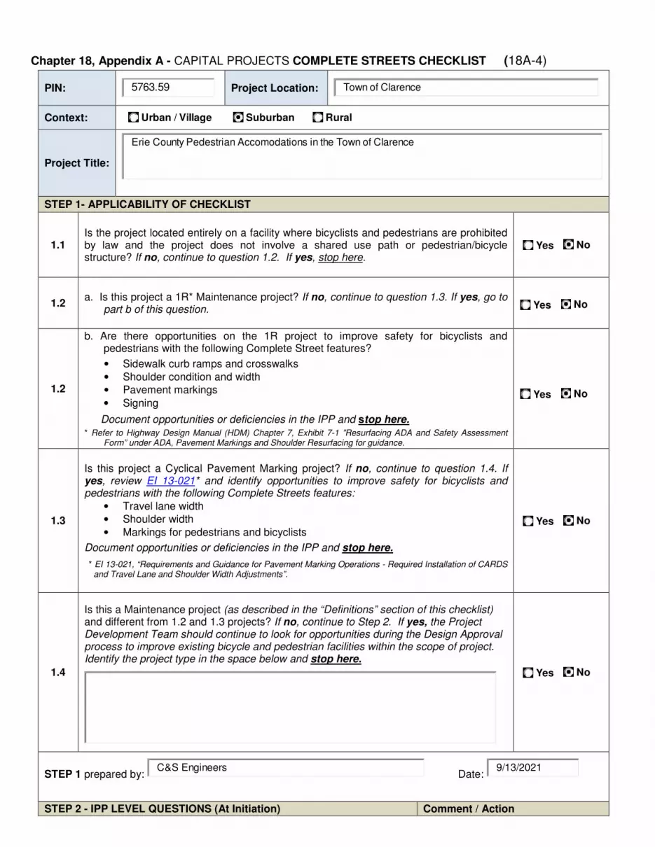
Chapter 18, Appendix A - CAPITAL PROJECTS COMPLETE STREETS CHECKLIST (18A-4)
PIN: 5763.59
Project Location: Town of Clarence
Context:
Urban / Village Suburban Rural
Project Title:
Erie County Pedestrian Accomodations in the Town of Clarence
STEP 1- APPLICABILITY OF CHECKLIST
1.1 Is the project located entirely on a facility where bicyclists and pedestrians are prohibited by law and the project does not involve a shared use path or pedestrian/bicycle structure? If no, continue to question 1.2. If yes, stop here.
Yes No
1.2 a. Is this project a 1R* Maintenance project? If no, continue to question 1.3. If yes, go to
part b of this question.
Yes No
1.2
b. Are there opportunities on the 1R project to improve safety for bicyclists and pedestrians with the following Complete Street features?
• Sidewalk curb ramps and crosswalks
• Shoulder condition and width
• Pavement markings
• Signing
Document opportunities or deficiencies in the IPP and stop here.
* Refer to Highway Design Manual (HDM) Chapter 7, Exhibit 7-1 ”Resurfacing ADA and Safety Assessment Form” under ADA, Pavement Markings and Shoulder Resurfacing for guidance.
Yes No
1.3
Is this project a Cyclical Pavement Marking project? If no, continue to question 1.4. If yes, review EI 13-021* and identify opportunities to improve safety for bicyclists and pedestrians with the following Complete Streets features:
• Travel lane width
• Shoulder width
• Markings for pedestrians and bicyclists
Document opportunities or deficiencies in the IPP and stop here.
* EI 13-021, “Requirements and Guidance for Pavement Marking Operations - Required Installation of CARDS and Travel Lane and Shoulder Width Adjustments”.
Yes No
1.4
Is this a Maintenance project (as described in the “Definitions” section of this checklist) and different from 1.2 and 1.3 projects? If no, continue to Step 2. If yes, the Project Development Team should continue to look for opportunities during the Design Approval process to improve existing bicycle and pedestrian facilities within the scope of project. Identify the project type in the space below and stop here.
Yes No
STEP 1 prepared by: C&S Engineers
Date: 9/13/2021
STEP 2 - IPP LEVEL QUESTIONS (At Initiation) Comment / Action

Chapter 18, Appendix A - CAPITAL PROJECTS COMPLETE STREETS CHECKLIST (18A-5)
2.1
Are there public policies or approved known development plans (e.g., community Complete Streets policy, Comprehensive Plan, MPO Long Range and/or Bike/Ped plan, Corridor Study, etc.) that call for consideration of pedestrian, bicycle or transit facilities in, or linking to, the project area? Contact municipal planning office, Regional Planning Group and Regional Bicycle/Pedestrian Coordinator.
Yes No
2.2 Is there an existing or planned sidewalk, shared use path, bicycle facility, pedestrian-crossing facility or transit stop in the project area?
Yes No
This project will install a shared-use path.
2.3
a. Is the highway part of an existing or planned State, regional or local bicycle route? If no, proceed to question 2.4. If yes, go to part b of this question.
b. Do the existing bicycle accommodations meet the minimum standard guidelines of HDM Chapter 17 or the AASHTO “Guide for the Development of Bicycle Facilities”? * Contact Regional Bicycle/Pedestrian Coordinator
* Per HDM Chapter 17- Section 17.4.3, Minimum Standards and Guidelines.
Yes No
Yes No
2.4 Is the highway considered important to bicycle tourism by the municipality or region?
Yes No
2.5
Is the highway affected by special events (e.g., fairs, triathlons, festivals) that might influence bicycle, pedestrian or transit users? Contact Regional Traffic and Safety
Yes No
2.6
Are there existing or proposed generators within the project area (refer to the “Guidance” section) that have the potential to generate pedestrian or bicycle traffic or improved transit accommodations? Contact the municipal planning office, Regional Planning Group, and refer to the CAMCI Viewer, described in the “Definitions” section.
Yes No
This project will connect to a local park.
2.7
Is the highway an undivided 4 lane section in an urban or suburban setting, with narrow shoulders, no center turn lanes, and existing Annual Average Daily Traffic (AADT) < 15,000 vehicles per day? If yes, consider a road diet evaluation for the scoping/design phase. Refer to the “Definitions” section for more information on road diets.
Yes No

Chapter 18, Appendix A - CAPITAL PROJECTS COMPLETE STREETS CHECKLIST (18A-6)
2.8 Is there evidence of pedestrian activity (e.g., a worn path) and no or limited pedestrian infrastructure?
Yes No
STEP 2 prepared by: C&S Engineers
Date: 9/13/2021
Bicycle/Pedestrian Coordinator has been provided an opportunity to comment: Yes No
ATTACH TO IPP AND INCLUDE RECOMMENDATIONS FOR SCOPING/DESIGN.
STEP 3 - PROJECT DEVELOPMENT LEVEL QUESTIONS (Scoping/Design Stage)
Comment / Action
3.1 Is there an identified need for bicycle/pedestrian/ transit or “way finding” signs that could be incorporated into the project?
Yes No
3.2
Is there history of bicycle or pedestrian crashes in
the project area for which improvements have not
yet been made? Yes No
3.3 Are there existing curb ramps, crosswalks, pedestrian traffic signal features, or sidewalks that don’t meet ADA standards per HDM Chapter 18?
Yes No
3.4
Is the posted speed limit is 40 mph or more and the paved shoulder width less than 4’ (1.2 m) (6’ in the Adirondack or other State Park)? Refer to EI 13-021.
Yes No
These conditions exist and present hazardous conditions to non-vehicles. This project will move these users off the roadway.
3.5
Is there a perceived pedestrian safety or access concern that could be addressed by the use of traffic calming tools (e.g., bulb outs, raised pedestrian refuge medians, corner islands, raised crosswalks, mid-block crossings)?
Yes No
3.6 Are there conflicts among vehicles (moving or parked) and bike, pedestrian or transit users which could be addressed by the project?
Yes No
The existing narrow shoulders create conflict and deter non-vehicular traffic.
3.7
Are there opportunities (or has the community expressed a desire) for new/improved pedestrian-level lighting, to create a more inviting or safer environment?
Yes No
While this project may benefit from pedestrian level lighting, it is beyond the current scope and budget.
3.8 Does the community have an existing street furniture program or a desire for street appurtenances (e.g., bike racks, benches)?
Yes No
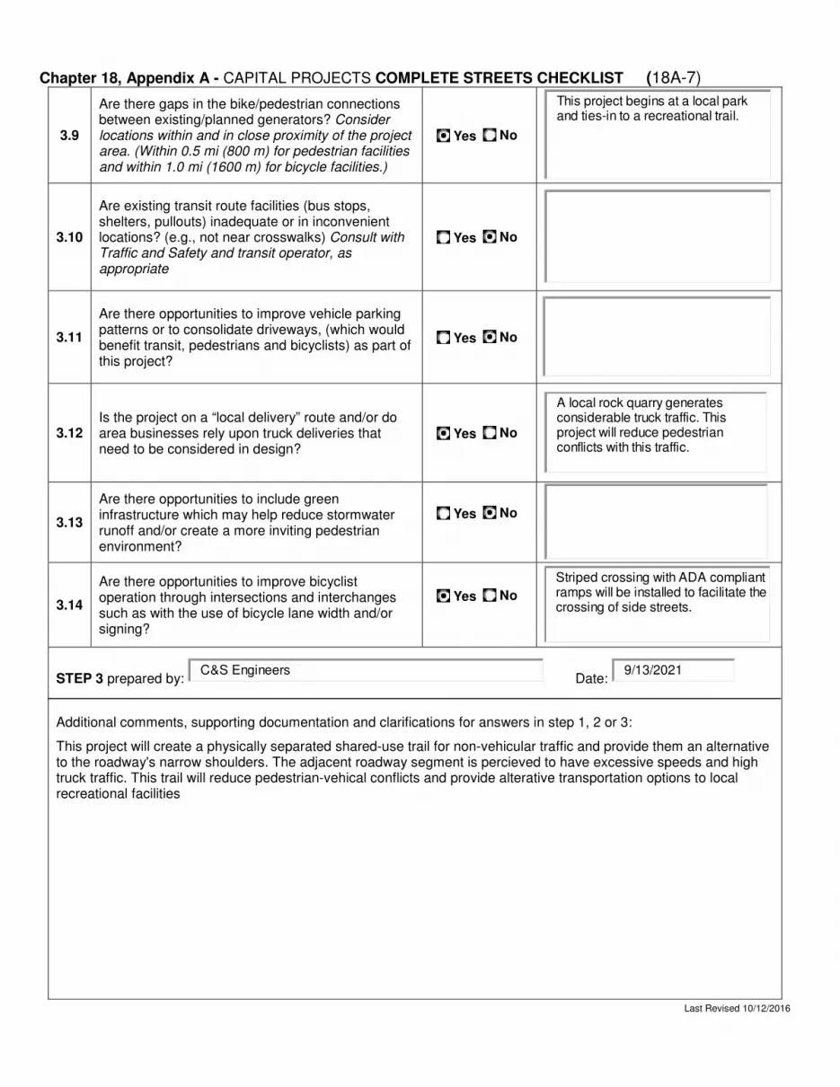
Chapter 18, Appendix A - CAPITAL PROJECTS COMPLETE STREETS CHECKLIST (18A-7)
3.9
Are there gaps in the bike/pedestrian connections between existing/planned generators? Consider locations within and in close proximity of the project area. (Within 0.5 mi (800 m) for pedestrian facilities and within 1.0 mi (1600 m) for bicycle facilities.)
Yes No
This project begins at a local park and ties-in to a recreational trail.
3.10
Are existing transit route facilities (bus stops, shelters, pullouts) inadequate or in inconvenient locations? (e.g., not near crosswalks) Consult with Traffic and Safety and transit operator, as appropriate
Yes No
3.11
Are there opportunities to improve vehicle parking patterns or to consolidate driveways, (which would benefit transit, pedestrians and bicyclists) as part of this project?
Yes No
3.12 Is the project on a “local delivery” route and/or do area businesses rely upon truck deliveries that need to be considered in design?
Yes No
A local rock quarry generates considerable truck traffic. This project will reduce pedestrian conflicts with this traffic.
3.13
Are there opportunities to include green infrastructure which may help reduce stormwater runoff and/or create a more inviting pedestrian environment?
Yes No
3.14
Are there opportunities to improve bicyclist operation through intersections and interchanges such as with the use of bicycle lane width and/or signing?
Yes No
Striped crossing with ADA compliant ramps will be installed to facilitate the crossing of side streets.
STEP 3 prepared by: C&S Engineers
Date: 9/13/2021
Additional comments, supporting documentation and clarifications for answers in step 1, 2 or 3:
This project will create a physically separated shared-use trail for non-vehicular traffic and provide them an alternative to the roadway's narrow shoulders. The adjacent roadway segment is percieved to have excessive speeds and high truck traffic. This trail will reduce pedestrian-vehical conflicts and provide alterative transportation options to local recreational facilities
Last Revised 10/12/2016
Attachment E
Public Information Meeting Materials
Insert Public Info Meeting Materials
Attachment F
Smart Growth Screening Tool
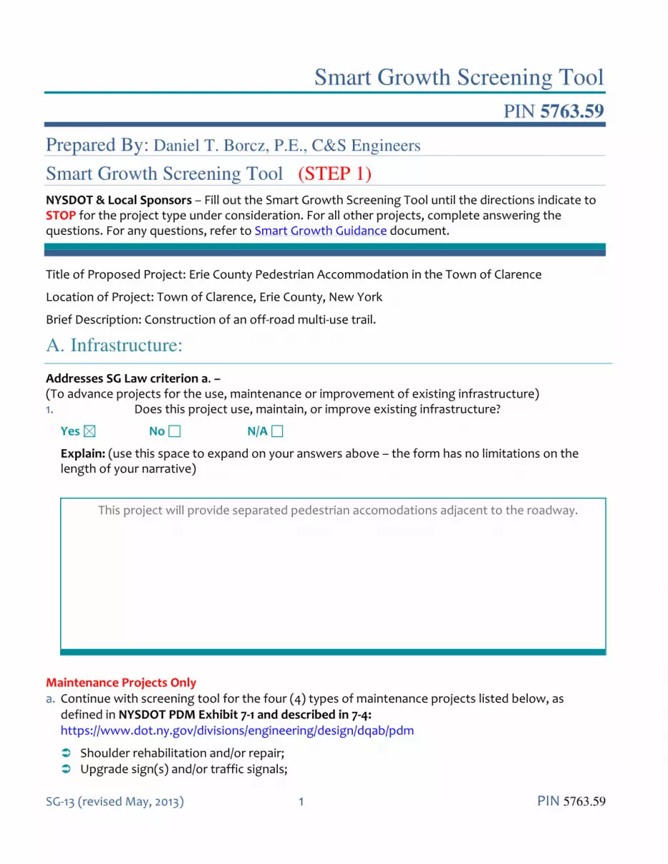
Smart Growth Screening Tool
SG-13 (revised May, 2013) 1 PIN 5763.59
PIN 5763.59
Prepared By: Daniel T. Borcz, P.E., C&S Engineers
Smart Growth Screening Tool (STEP 1)
NYSDOT & Local Sponsors – Fill out the Smart Growth Screening Tool until the directions indicate to STOP for the project type under consideration. For all other projects, complete answering the questions. For any questions, refer to Smart Growth Guidance document.
Title of Proposed Project: Erie County Pedestrian Accommodation in the Town of Clarence
Location of Project: Town of Clarence, Erie County, New York
Brief Description: Construction of an off-road multi-use trail.
A. Infrastructure:
Addresses SG Law criterion a. – (To advance projects for the use, maintenance or improvement of existing infrastructure) 1. Does this project use, maintain, or improve existing infrastructure?
Yes No N/A
Explain: (use this space to expand on your answers above – the form has no limitations on the length of your narrative)
This project will provide separated pedestrian accomodations adjacent to the roadway.
Maintenance Projects Only a. Continue with screening tool for the four (4) types of maintenance projects listed below, as
defined in NYSDOT PDM Exhibit 7-1 and described in 7-4: https://www.dot.ny.gov/divisions/engineering/design/dqab/pdm
Shoulder rehabilitation and/or repair; Upgrade sign(s) and/or traffic signals;
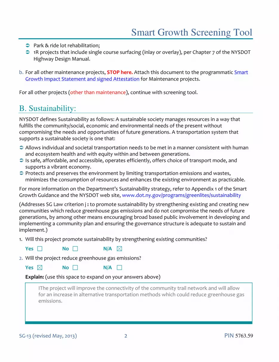
Smart Growth Screening Tool
SG-13 (revised May, 2013) 2 PIN 5763.59
Park & ride lot rehabilitation; 1R projects that include single course surfacing (inlay or overlay), per Chapter 7 of the NYSDOT
Highway Design Manual.
b. For all other maintenance projects, STOP here. Attach this document to the programmatic Smart Growth Impact Statement and signed Attestation for Maintenance projects.
For all other projects (other than maintenance), continue with screening tool.
B. Sustainability:
NYSDOT defines Sustainability as follows: A sustainable society manages resources in a way that fulfills the community/social, economic and environmental needs of the present without compromising the needs and opportunities of future generations. A transportation system that supports a sustainable society is one that:
Allows individual and societal transportation needs to be met in a manner consistent with human and ecosystem health and with equity within and between generations.
Is safe, affordable, and accessible, operates efficiently, offers choice of transport mode, and supports a vibrant economy.
Protects and preserves the environment by limiting transportation emissions and wastes, minimizes the consumption of resources and enhances the existing environment as practicable.
For more information on the Department’s Sustainability strategy, refer to Appendix 1 of the Smart Growth Guidance and the NYSDOT web site, www.dot.ny.gov/programs/greenlites/sustainability
(Addresses SG Law criterion j : to promote sustainability by strengthening existing and creating new communities which reduce greenhouse gas emissions and do not compromise the needs of future generations, by among other means encouraging broad based public involvement in developing and implementing a community plan and ensuring the governance structure is adequate to sustain and implement.)
1. Will this project promote sustainability by strengthening existing communities?
Yes No N/A
2. Will the project reduce greenhouse gas emissions?
Yes No N/A
Explain: (use this space to expand on your answers above)
IThe project will improve the connectivity of the community trail network and will allow for an increase in alternative transportation methods which could reduce greenhouse gas emissions.

Smart Growth Screening Tool
SG-13 (revised May, 2013) 3 PIN 5763.59
C. Smart Growth Location:
Plans and investments should preserve our communities by promoting its distinct identity through a local vision created by its citizens.
(Addresses SG Law criteria b and c: to advance projects located in municipal centers; to advance projects in developed areas or areas designated for concentrated infill development in a municipally approved comprehensive land use plan, local waterfront revitalization plan and/or brownfield opportunity area plan.)
1. Is this project located in a developed area?
Yes No N/A
2. Is the project located in a municipal center?
Yes No N/A
3. Will this project foster downtown revitalization?
Yes No N/A
4. Is this project located in an area designated for concentrated infill development in a municipally approved comprehensive land use plan, waterfront revitalization plan, or Brownfield Opportunity Area plan?
Yes No N/A
Explain: (use this space to expand on your answers above)
This project is located in a suburban area of Erie County.
D. Mixed Use Compact Development:
Future planning and development should assure the availability of a range of choices in housing and affordability, employment, education transportation and other essential services to encourage a jobs/housing balance and vibrant community-based workforce.
(Addresses SG Law criteria e and i: to foster mixed land uses and compact development, downtown revitalization, brownfield redevelopment, the enhancement of beauty in public spaces, the diversity and affordability of housing in proximity to places of employment, recreation and commercial

Smart Growth Screening Tool
SG-13 (revised May, 2013) 4 PIN 5763.59
development and the integration of all income groups; to ensure predictability in building and land use codes.)
1. Will this project foster mixed land uses?
Yes No N/A
2. Will the project foster brownfield redevelopment?
Yes No N/A
3. Will this project foster enhancement of beauty in public spaces?
Yes No N/A
4. Will the project foster a diversity of housing in proximity to places of employment and/or recreation?
Yes No N/A
5. Will the project foster a diversity of housing in proximity to places of commercial development and/or compact development?
Yes No N/A
6. Will this project foster integration of all income groups and/or age groups?
Yes No N/A
7. Will the project ensure predictability in land use codes?
Yes No N/A
8. Will the project ensure predictability in building codes?
Yes No N/A
Explain: (use this space to expand on your answers above)
This project will improve local access to parks and recreational facilities. It will not significantly alter the character of the area or its development.
E. Transportation and Access:
NYSDOT recognizes that Smart Growth encourages communities to offer a wide range of transportation options, from walking and biking to transit and automobiles, which increase people’s access to jobs, goods, services, and recreation.
(Addresses SG Law criterion f: to provide mobility through transportation choices including improved public transportation and reduced automobile dependency.)
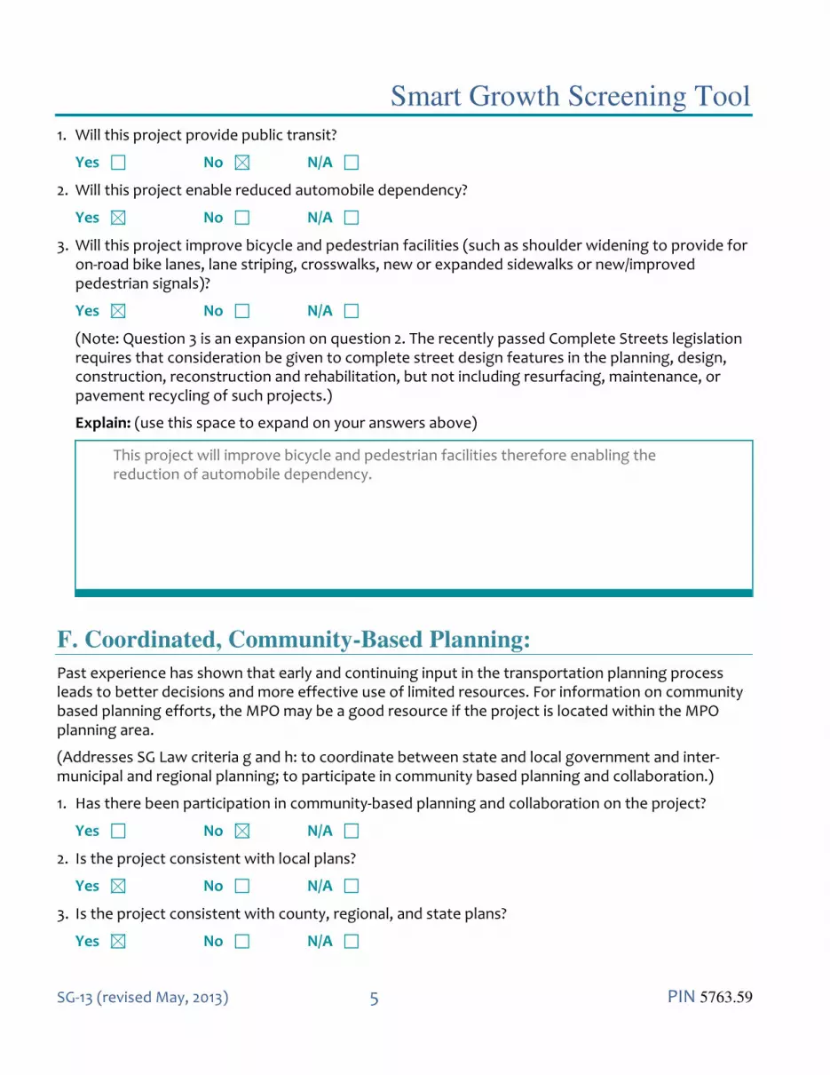
Smart Growth Screening Tool
SG-13 (revised May, 2013) 5 PIN 5763.59
1. Will this project provide public transit?
Yes No N/A
2. Will this project enable reduced automobile dependency?
Yes No N/A
3. Will this project improve bicycle and pedestrian facilities (such as shoulder widening to provide for on-road bike lanes, lane striping, crosswalks, new or expanded sidewalks or new/improved pedestrian signals)?
Yes No N/A
(Note: Question 3 is an expansion on question 2. The recently passed Complete Streets legislation requires that consideration be given to complete street design features in the planning, design, construction, reconstruction and rehabilitation, but not including resurfacing, maintenance, or pavement recycling of such projects.)
Explain: (use this space to expand on your answers above)
This project will improve bicycle and pedestrian facilities therefore enabling the reduction of automobile dependency.
F. Coordinated, Community-Based Planning:
Past experience has shown that early and continuing input in the transportation planning process leads to better decisions and more effective use of limited resources. For information on community based planning efforts, the MPO may be a good resource if the project is located within the MPO planning area.
(Addresses SG Law criteria g and h: to coordinate between state and local government and inter-municipal and regional planning; to participate in community based planning and collaboration.)
1. Has there been participation in community-based planning and collaboration on the project?
Yes No N/A
2. Is the project consistent with local plans?
Yes No N/A
3. Is the project consistent with county, regional, and state plans?
Yes No N/A
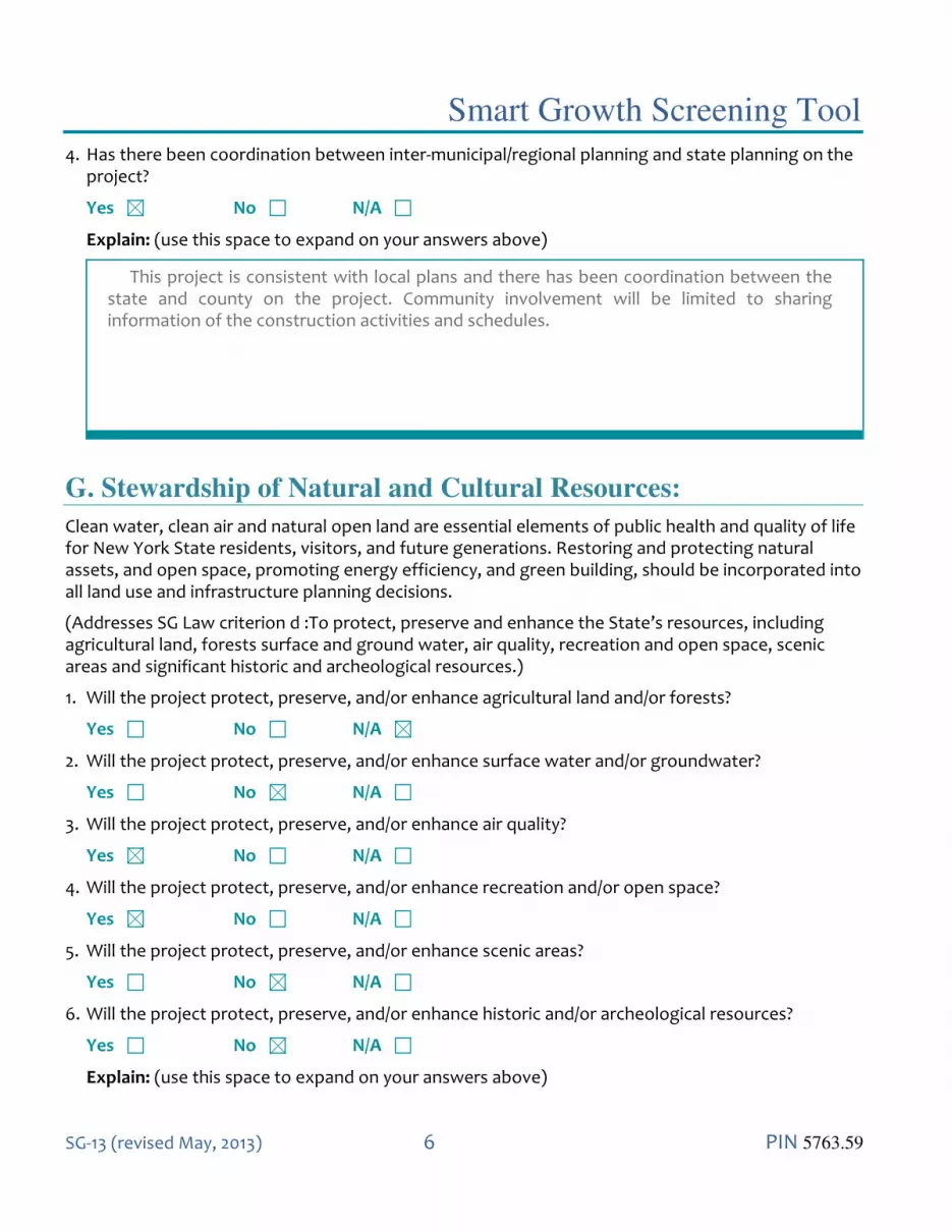
Smart Growth Screening Tool
SG-13 (revised May, 2013) 6 PIN 5763.59
4. Has there been coordination between inter-municipal/regional planning and state planning on the project?
Yes No N/A
Explain: (use this space to expand on your answers above)
This project is consistent with local plans and there has been coordination between the state and county on the project. Community involvement will be limited to sharing information of the construction activities and schedules.
G. Stewardship of Natural and Cultural Resources:
Clean water, clean air and natural open land are essential elements of public health and quality of life for New York State residents, visitors, and future generations. Restoring and protecting natural assets, and open space, promoting energy efficiency, and green building, should be incorporated into all land use and infrastructure planning decisions.
(Addresses SG Law criterion d :To protect, preserve and enhance the State’s resources, including agricultural land, forests surface and ground water, air quality, recreation and open space, scenic areas and significant historic and archeological resources.)
1. Will the project protect, preserve, and/or enhance agricultural land and/or forests?
Yes No N/A
2. Will the project protect, preserve, and/or enhance surface water and/or groundwater?
Yes No N/A
3. Will the project protect, preserve, and/or enhance air quality?
Yes No N/A
4. Will the project protect, preserve, and/or enhance recreation and/or open space?
Yes No N/A
5. Will the project protect, preserve, and/or enhance scenic areas?
Yes No N/A
6. Will the project protect, preserve, and/or enhance historic and/or archeological resources?
Yes No N/A
Explain: (use this space to expand on your answers above)

Smart Growth Screening Tool
SG-13 (revised May, 2013) 7 PIN 5763.59
The construction of a multi-use trail will enhance recreational opportunities and may improve air quality by reducing reliance on motor vehicles.
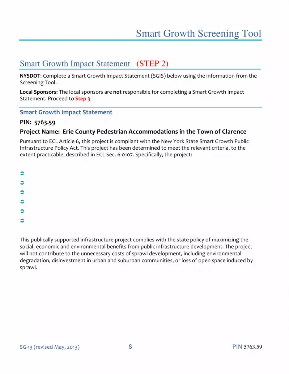
Smart Growth Screening Tool
SG-13 (revised May, 2013) 8 PIN 5763.59
Smart Growth Impact Statement (STEP 2)
NYSDOT: Complete a Smart Growth Impact Statement (SGIS) below using the information from the Screening Tool.
Local Sponsors: The local sponsors are not responsible for completing a Smart Growth Impact Statement. Proceed to Step 3.
Smart Growth Impact Statement
PIN: 5763.59
Project Name: Erie County Pedestrian Accommodations in the Town of Clarence
Pursuant to ECL Article 6, this project is compliant with the New York State Smart Growth Public Infrastructure Policy Act. This project has been determined to meet the relevant criteria, to the extent practicable, described in ECL Sec. 6-0107. Specifically, the project:
This publically supported infrastructure project complies with the state policy of maximizing the social, economic and environmental benefits from public infrastructure development. The project will not contribute to the unnecessary costs of sprawl development, including environmental degradation, disinvestment in urban and suburban communities, or loss of open space induced by sprawl.

Smart Growth Screening Tool
SG-13 (revised May, 2013) 9 PIN 5763.59
Review & Attestation Instructions (STEP 3)
Local Sponsors: Once the Smart Growth Screening Tool is completed, the next step is to submit the project certification statement (Section A) to Responsible Local Official for signature. After signing the document, the completed Screening Tool and Certification statement should be sent to NYSDOT for review as noted below. NYSDOT: For state-let projects, the Screening Tool and SGIS is forwarded to Regional Director/ RPPM/Main Office Program Director or designee for review, and upon approval, the attestation is signed (Section B.2). For locally administered projects, the sponsor’s submission and certification statement is reviewed by NYSDOT staff, the appropriate box (Section B.1) is checked, and the attestation is signed (Section B.2). A. CERTIFICATION (LOCAL PROJECT) I HEREBY CERTIFY, to the best of my knowledge, all of the above to be true and correct. Preparer of this document: 9/1/2021 Signature Date Managing Engineer, C&S Engineers Daniel T. Borcz, P.E. Title Printed Name Responsible Local Official (for local projects): Signature Date Title Printed Name
Smart Growth Screening Tool
SG-13 (revised May, 2013) 10 PIN 5763.59
B. ATTESTATION (NYSDOT) 1. I HEREBY:
Concur with the above certification, thereby attesting that this project is in compliance with the State Smart Growth Public Infrastructure Policy Act
Concur with the above certification, with the following conditions (information requests, confirming studies, project modifications, etc.):
(Attach additional sheets as needed)
do not concur with the above certification, thereby deeming this project ineligible to be a recipient of State funding or a subrecipient of Federal funding in accordance with the State Smart Growth Public Infrastructure Policy Act.
2. NOW THEREFORE, pursuant to ECL Article 6, this project is compliant with the New York
State Smart Growth Public Infrastructure Policy Act, to the extent practicable, as described in the attached Smart Growth Impact Statement.
NYSDOT Commissioner, Regional Director, MO Program Director, Regional Planning & Programming Manager (or official designee): Signature Date Title Printed Name
Attachment G
Wetland Delineation Report

USGS The National Map: National Boundaries Dataset, 3DEP ElevationProgram, Geographic Names Information System, National Hydrography Dataset,National Land Cover Database, National Structures Dataset, and NationalTransportation Dataset; USGS Global Ecosystems; U.S. Census BureauTIGER/Line data; USFS Road Data; Natural Earth Data; U.S. Department ofState Humanitarian Information Unit; and NOAA National Centers forEnvironmental Information, U.S. Coastal Relief Model. Data refreshed October2018.
µ
0 500Feet
1 inch = 1,000 feet
Figure 1
Notes:1. WETLAND & WATERWAYS BOUNDARIES WERE DELINEATED BY C&S ENGINEERS ON 6/24/20212. WETLAND & WATERWAYS BOUNDARIES WERE SURVEYED VIA TRIMBLE GPS UNIT
LegendArea of InterestC&S Delineated Wetlands
Project Location MapErie County Pedestrian Accommodations: PIN 5763.59
Town of Clarence, Erie County, New York

B
C(T)
B
B
LA-2
LA-4
LA-14
LA-14
LA-15LA-15 Source: Esri, Digita lGlobe, GeoEye, Earthstar Geographics, CNES/Airbus DS,USDA, USGS, AeroGRID, IGN, and the GIS User Community
µ
0 500Feet
1 inch = 1,500 feet
Figure 2
Notes:1. WETLAND & WATERWAYS BOUNDARIES WERE DELINEATED BY C&S ENGINEERS ON 6/24/20212. WETLAND & WATERWAYS BOUNDARIES WERE SURVEYED VIA TRIMBLE GPS UNIT
LegendArea of InterestC&S Delineated WetlandsNYSDEC Mapped WetlandsNYSDEC Mapped Streams
NYSDEC Wetlands & Streams MapErie County Pedestrian Accomodations: PIN 5763.59
Town of Clarence, Erie County, New York

L1UBHx
L1UBHx
PEM1E
PEM5Eh
PFO1/SS1B
PFO1/SS1E
PFO1B
PFO1B
PFO1B
PFO1B
PFO1B
PFO1BPFO1B
PFO1B
PFO1E
PSS1/EM1B
PSS1/EM1E
PSS1BPSS1B
PSS1B
PSS1B
PUBFx
PUBHx
PUBHxPUBHx
PUBHx
PUBHxPUBHx
PUBHx
PUSCx
R4SBC Source: Esri, Digita lGlobe, GeoEye, Earthstar Geographics, CNES/Airbus DS,USDA, USGS, AeroGRID, IGN, and the GIS User Community
µ
0 200Feet
1 inch = 1,000 feet
Figure 3
Notes:1. WETLAND & WATERWAYS BOUNDARIES WERE DELINEATED BY C&S ENGINEERS ON 6/24/20212. WETLAND & WATERWAYS BOUNDARIES WERE SURVEYED VIA TRIMBLE GPS UNIT
LegendArea of InterestC&S Delineated WetlandsUSFWS NWI Mapped Wetlands
USFWS NWI Wetlands MapErie County Pedestrian Accommodations: PIN 5763.59
Town of Clarence, Erie County, New York

WaAMh BfANe
BfA
WaA
WaAWaA
OvA
OvA
Source: Esri, Digita lGlobe, GeoEye, Earthstar Geographics, CNES/Airbus DS,USDA, USGS, AeroGRID, IGN, and the GIS User Community
µ
0 500Feet
1 inch = 1,000 feet
Figure 4
Notes:1. WETLAND & WATERWAYS BOUNDARIES WERE DELINEATED BY C&S ENGINEERS ON 6/24/20212. WETLAND & WATERWAYS BOUNDARIES WERE SURVEYED VIA TRIMBLE GPS UNIT
LegendArea of InterestUSDA NRCS Mapped SoilsC&S Delineated Wetlands
Soil Name Soil DescriptionBfA Benson very channery loam, 0 to 3 percent slopesMh Minoa very fine sandy loamNe Newstead loam
OvA Ovid silt loam, 0 to 3 percent slopesWaA Wassaic silt loam, 0 to 3 percent slopes
USDA NRCS Soils MapErie County Pedestrian Accommodations: PIN 5763.59Town
of Clarence, Erie County, New York
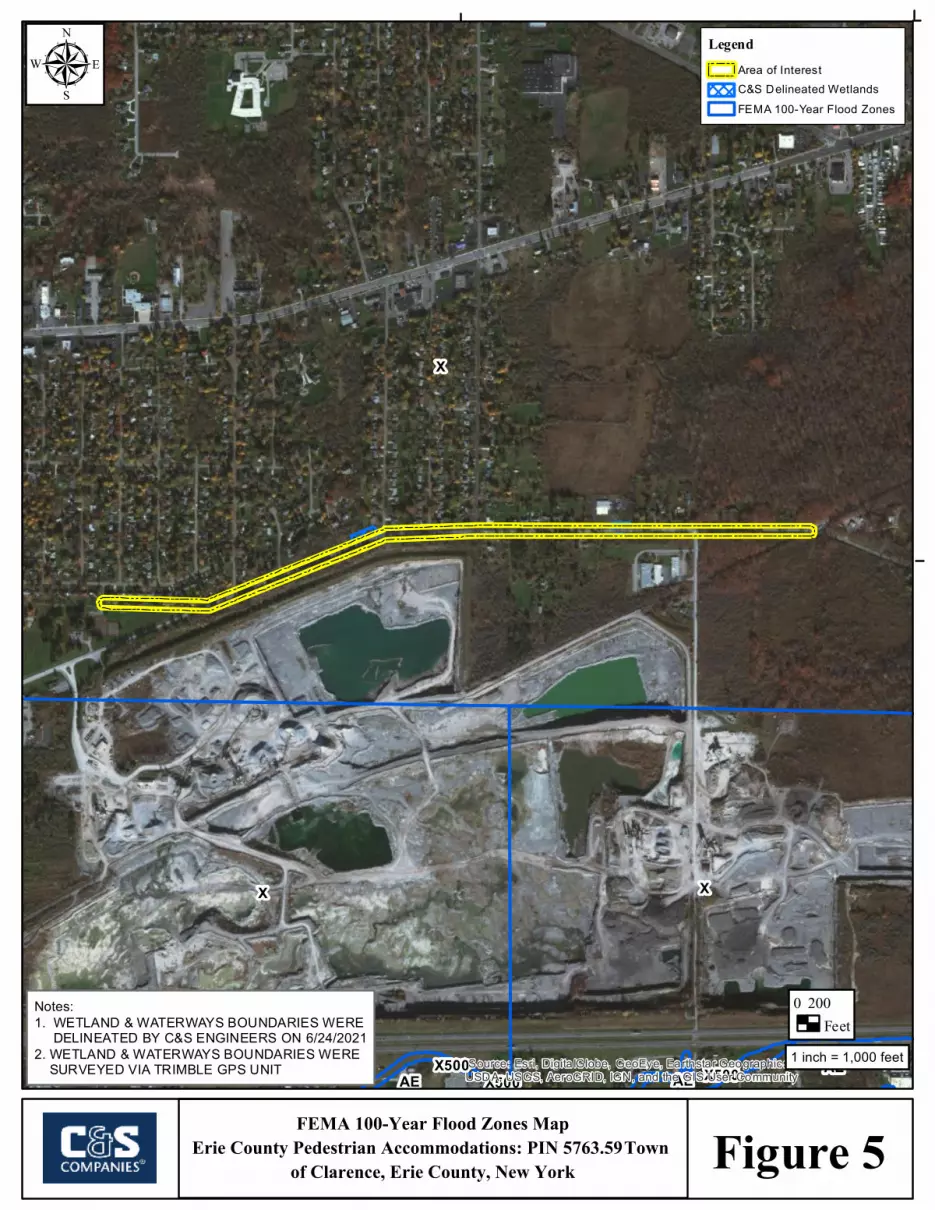
X
X X
AE AE AEX500 X500X500 Source: Esri, Digita lGlobe, GeoEye, Earthstar Geographics, CNES/Airbus DS,
USDA, USGS, AeroGRID, IGN, and the GIS User Community
µ
0 200Feet
1 inch = 1,000 feet
Figure 5
Notes:1. WETLAND & WATERWAYS BOUNDARIES WERE DELINEATED BY C&S ENGINEERS ON 6/24/20212. WETLAND & WATERWAYS BOUNDARIES WERE SURVEYED VIA TRIMBLE GPS UNIT
LegendArea of InterestC&S Delineated WetlandsFEMA 100-Year Flood Zones
FEMA 100-Year Flood Zones MapErie County Pedestrian Accommodations: PIN 5763.59Town
of Clarence, Erie County, New York
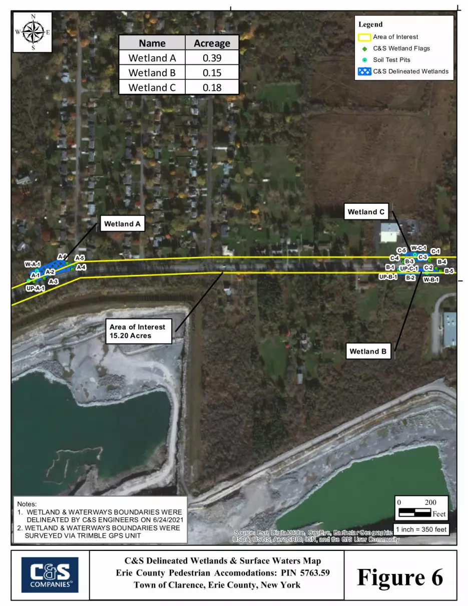
!.
!.
!.!.
!.
!.
@?@?
@?
@?@?@?
@? @?@? @?
@?
@?@?@?@?
@?
W-A-1
UP-A-1W-B-1UP-B-1
W-C-1
UP-C-1A-1 A-2
A-3
A-4A-5A-6
B-1B-2
B-3 B-4B-5
C-1
C-2C-3C-4
C-5
Source: Esri, Digita lGlobe, GeoEye, Earthstar Geographics, CNES/Airbus DS,USDA, USGS, AeroGRID, IGN, and the GIS User Community
µ
0 200Feet
1 inch = 350 feet
Figure 6
Wetland A
Area of Interest 15.20 Acres
Notes:1. WETLAND & WATERWAYS BOUNDARIES WERE DELINEATED BY C&S ENGINEERS ON 6/24/20212. WETLAND & WATERWAYS BOUNDARIES WERE SURVEYED VIA TRIMBLE GPS UNIT
LegendArea of Interest
@? C&S Wetland Flags!. Soil Test Pits
C&S Delineated Wetlands
Wetland B
Wetland C
Name AcreageWetland A 0.39Wetland B 0.15Wetland C 0.18
C&S Delineated Wetlands & Surface Waters MapErie County Pedestrian Accomodations: PIN 5763.59
Town of Clarence, Erie County, New York
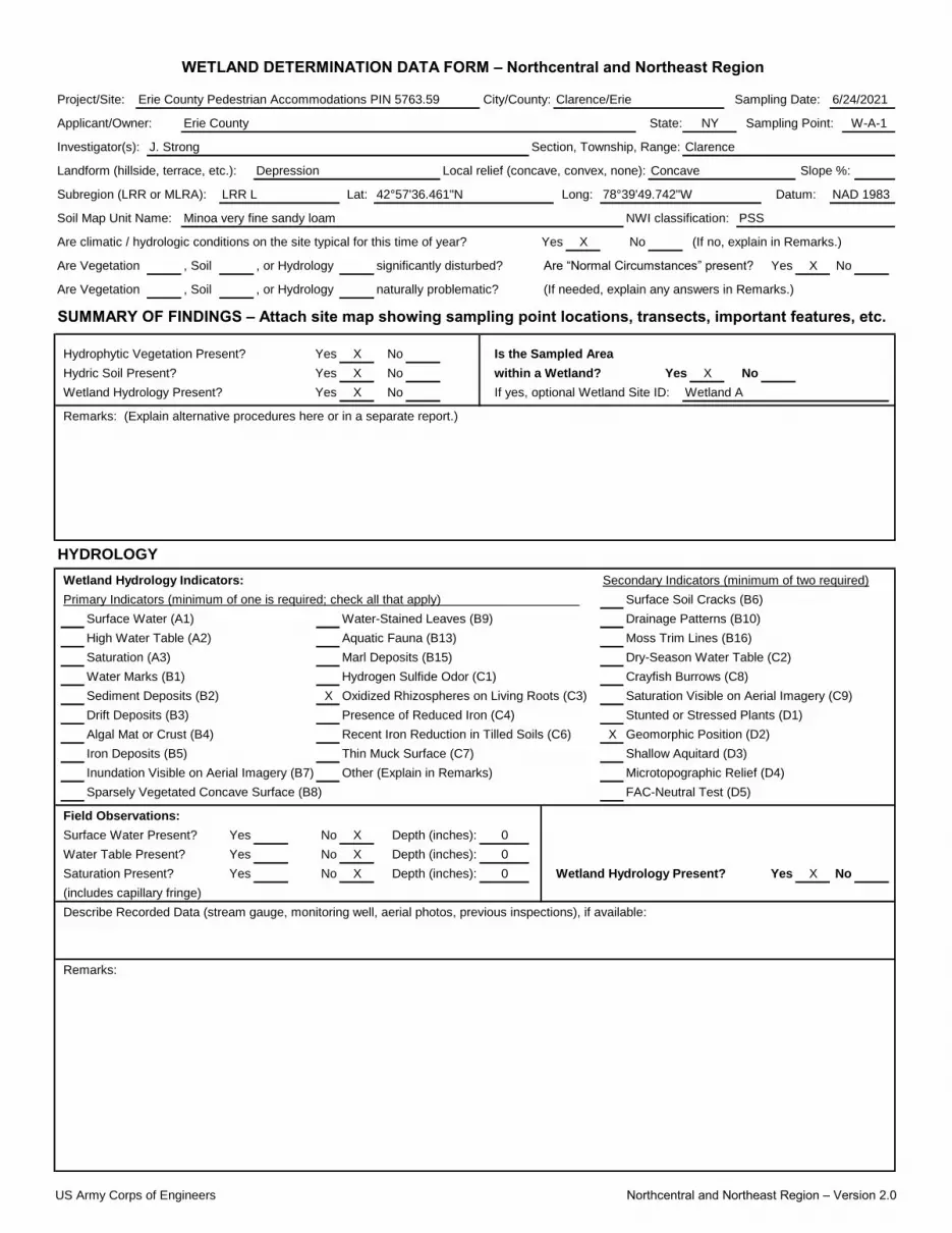
Project/Site:
Applicant/Owner: State:
Investigator(s):
Lat:
Soil Map Unit Name: NWI classification:
X
Are Vegetation , Soil , or Hydrology Yes X
Are Vegetation , Soil , or Hydrology
SUMMARY OF FINDINGS – Attach site map showing sampling point locations, transects, important features, etc.
X No
X No X
X No
X
X
X
X
X Yes X
Remarks:
No
(includes capillary fringe)
Describe Recorded Data (stream gauge, monitoring well, aerial photos, previous inspections), if available:
Saturation Present? Yes No Depth (inches): 0 Wetland Hydrology Present?
0
Water Table Present? Yes No Depth (inches): 0
Sparsely Vegetated Concave Surface (B8) FAC-Neutral Test (D5)
Field Observations:
Surface Water Present? Yes No Depth (inches):
Iron Deposits (B5) Thin Muck Surface (C7) Shallow Aquitard (D3)
Inundation Visible on Aerial Imagery (B7) Other (Explain in Remarks) Microtopographic Relief (D4)
Drift Deposits (B3) Presence of Reduced Iron (C4) Stunted or Stressed Plants (D1)
Algal Mat or Crust (B4) Recent Iron Reduction in Tilled Soils (C6) Geomorphic Position (D2)
Remarks: (Explain alternative procedures here or in a separate report.)
HYDROLOGY
Wetland Hydrology Indicators: Secondary Indicators (minimum of two required)
Primary Indicators (minimum of one is required; check all that apply) Surface Soil Cracks (B6)
Surface Water (A1)
Water Marks (B1) Hydrogen Sulfide Odor (C1) Crayfish Burrows (C8)
Sediment Deposits (B2) Oxidized Rhizospheres on Living Roots (C3) Saturation Visible on Aerial Imagery (C9)
Water-Stained Leaves (B9) Drainage Patterns (B10)
High Water Table (A2) Aquatic Fauna (B13) Moss Trim Lines (B16)
Saturation (A3) Marl Deposits (B15) Dry-Season Water Table (C2)
Is the Sampled Area
Hydric Soil Present? Yes within a Wetland? Yes No
significantly disturbed? Are “Normal Circumstances” present? No
naturally problematic? (If needed, explain any answers in Remarks.)
Hydrophytic Vegetation Present? Yes
Wetland Hydrology Present? Yes If yes, optional Wetland Site ID: Wetland A
NAD 1983
Minoa very fine sandy loam PSS
Are climatic / hydrologic conditions on the site typical for this time of year? Yes No (If no, explain in Remarks.)
Subregion (LRR or MLRA): LRR L 42°57'36.461"N Long: 78°39'49.742"W Datum:
WETLAND DETERMINATION DATA FORM – Northcentral and Northeast Region
Erie County Pedestrian Accommodations PIN 5763.59 City/County: Clarence/Erie Sampling Date: 6/24/2021
Landform (hillside, terrace, etc.): Depression Local relief (concave, convex, none): Concave Slope %:
Erie County NY Sampling Point: W-A-1
J. Strong Section, Township, Range: Clarence
US Army Corps of Engineers Northcentral and Northeast Region – Version 2.0
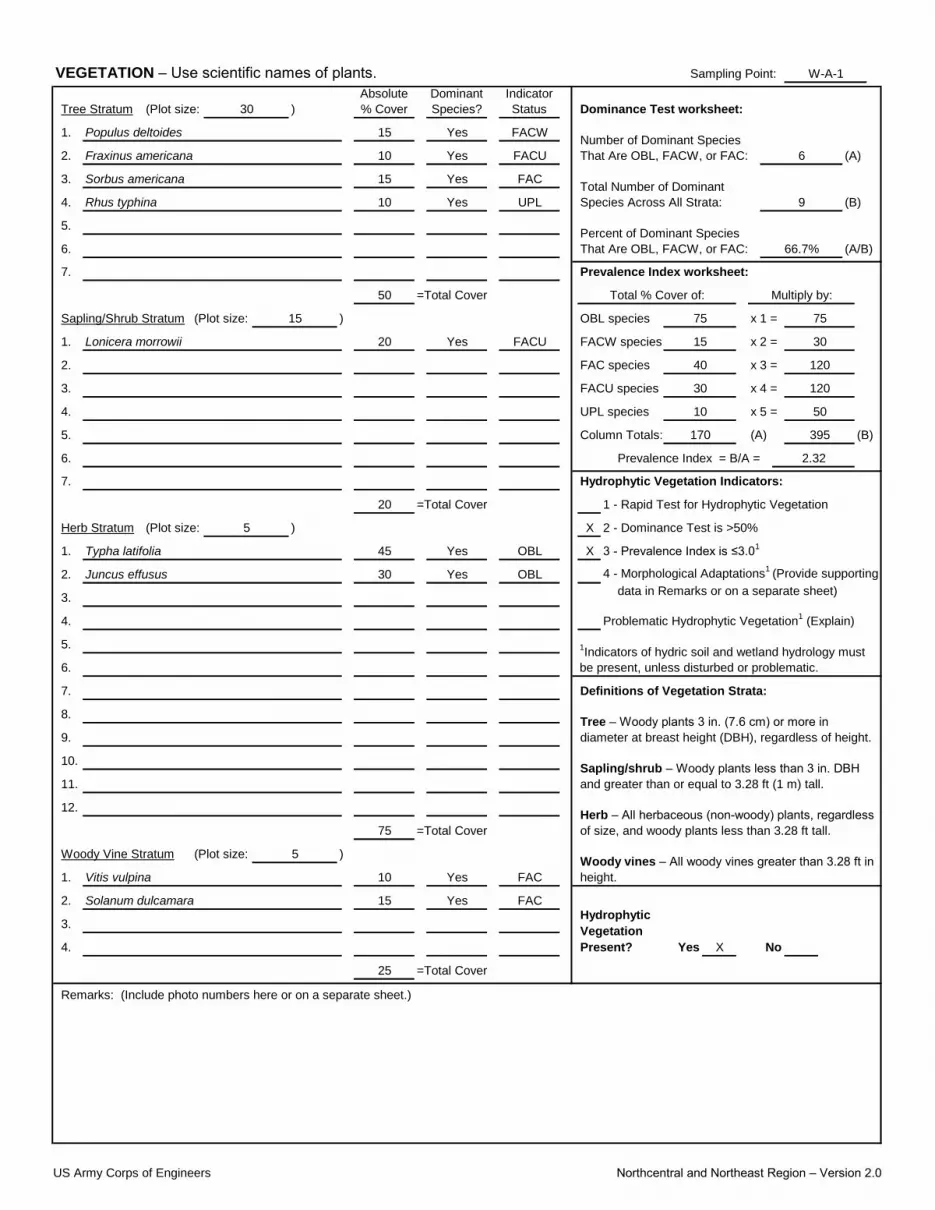
Sampling Point:
(Plot size:
1.
2.
3.
4.
5.
6. (A/B)
7.
Sapling/Shrub Stratum (Plot size: x 1 =
1. x 2 =
2. x 3 =
3. x 4 =
4. x 5 =
5. Column Totals: (B)
6.
7.
Herb Stratum (Plot size: X
1. X
2. 4 - Morphological Adaptations1
(Provide supporting
3.
4.
5.
6.
7.
8.
9.
10.
11.
12.
(Plot size:
1.
2.
3.
4. X
Remarks: (Include photo numbers here or on a separate sheet.)
25 =Total Cover
Solanum dulcamara 15 Yes FACHydrophytic
Vegetation
Present? Yes No
10 Yes FAC
Herb – All herbaceous (non-woody) plants, regardless
of size, and woody plants less than 3.28 ft tall.75 =Total Cover
Sapling/shrub – Woody plants less than 3 in. DBH
and greater than or equal to 3.28 ft (1 m) tall.
Definitions of Vegetation Strata:
Tree – Woody plants 3 in. (7.6 cm) or more in
diameter at breast height (DBH), regardless of height.
Woody Vine Stratum 5 )Woody vines – All woody vines greater than 3.28 ft in
height.Vitis vulpina
OBL
Problematic Hydrophytic Vegetation1 (Explain)
1Indicators of hydric soil and wetland hydrology must
be present, unless disturbed or problematic.
data in Remarks or on a separate sheet)
20 =Total Cover 1 - Rapid Test for Hydrophytic Vegetation
5 ) 2 - Dominance Test is >50%
Hydrophytic Vegetation Indicators:
Typha latifolia 45 Yes OBL 3 - Prevalence Index is ≤3.01
Juncus effusus 30 Yes
50 =Total Cover
395
Prevalence Index = B/A = 2.32
170 (A)
15 ) OBL species
Multiply by:
FACW species 15
120
UPL species 10 50
FACU species 30
FACU
Prevalence Index worksheet:
FAC species 40 120
75 75
Total % Cover of:
30
UPL 9 (B)
Percent of Dominant Species
That Are OBL, FACW, or FAC: 66.7%
Lonicera morrowii 20 Yes
10 Yes FACU 6 (A)
Sorbus americana 15 Yes FACTotal Number of Dominant
Species Across All Strata:
VEGETATION – Use scientific names of plants. W-A-1
Tree Stratum 30 )
Absolute
% Cover
Dominant
Species?
Indicator
Status Dominance Test worksheet:
Populus deltoides 15 Yes FACWNumber of Dominant Species
That Are OBL, FACW, or FAC:Fraxinus americana
Rhus typhina 10 Yes
US Army Corps of Engineers Northcentral and Northeast Region – Version 2.0
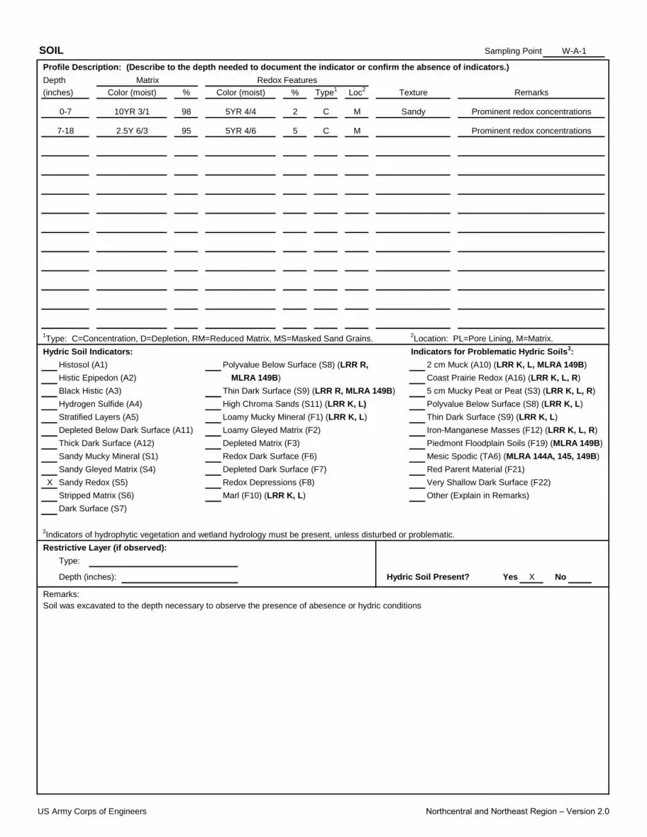
Sampling Point:
X
XYes No
Remarks:
Soil was excavated to the depth necessary to observe the presence of abesence or hydric conditions
Restrictive Layer (if observed):
Type:
Depth (inches): Hydric Soil Present?
Stripped Matrix (S6) Marl (F10) (LRR K, L) Other (Explain in Remarks)
Dark Surface (S7)
3Indicators of hydrophytic vegetation and wetland hydrology must be present, unless disturbed or problematic.
Sandy Gleyed Matrix (S4) Depleted Dark Surface (F7) Red Parent Material (F21)
Sandy Redox (S5) Redox Depressions (F8) Very Shallow Dark Surface (F22)
Polyvalue Below Surface (S8) (LRR K, L)
1Type: C=Concentration, D=Depletion, RM=Reduced Matrix, MS=Masked Sand Grains.
2Location: PL=Pore Lining, M=Matrix.
Thick Dark Surface (A12) Depleted Matrix (F3) Piedmont Floodplain Soils (F19) (MLRA 149B)
Sandy Mucky Mineral (S1) Redox Dark Surface (F6) Mesic Spodic (TA6) (MLRA 144A, 145, 149B)
Stratified Layers (A5) Loamy Mucky Mineral (F1) (LRR K, L) Thin Dark Surface (S9) (LRR K, L)
Depleted Below Dark Surface (A11) Loamy Gleyed Matrix (F2) Iron-Manganese Masses (F12) (LRR K, L, R)
0-7 10YR 3/1 98 5YR 4/4 2 C M
Hydric Soil Indicators: Indicators for Problematic Hydric Soils3:
Histosol (A1) Polyvalue Below Surface (S8) (LRR R, 2 cm Muck (A10) (LRR K, L, MLRA 149B)
Histic Epipedon (A2) MLRA 149B) Coast Prairie Redox (A16) (LRR K, L, R)
Black Histic (A3) Thin Dark Surface (S9) (LRR R, MLRA 149B) 5 cm Mucky Peat or Peat (S3) (LRR K, L, R)
Hydrogen Sulfide (A4) High Chroma Sands (S11) (LRR K, L)
95 5YR 4/6 5 C
Sandy Prominent redox concentrations
Loc2
Texture Remarks
M
SOIL W-A-1
Profile Description: (Describe to the depth needed to document the indicator or confirm the absence of indicators.)
Depth Matrix Redox Features
Prominent redox concentrations
(inches) Color (moist) % Color (moist) % Type1
7-18 2.5Y 6/3
US Army Corps of Engineers Northcentral and Northeast Region – Version 2.0

Project/Site:
Applicant/Owner: State:
Investigator(s):
Lat:
Soil Map Unit Name: NWI classification:
X
Are Vegetation , Soil , or Hydrology Yes X
Are Vegetation , Soil , or Hydrology
SUMMARY OF FINDINGS – Attach site map showing sampling point locations, transects, important features, etc.
No X
No X X
No X
?
?
X
X
X Yes X
WETLAND DETERMINATION DATA FORM – Northcentral and Northeast Region
Erie County Pedestrian Accommodations PIN 5763.59 City/County: Clarence/Erie Sampling Date: 6/24/2021
Landform (hillside, terrace, etc.): roadside Local relief (concave, convex, none): convex Slope %:
Erie County NY Sampling Point: UP-A-1
J. Strong Section, Township, Range: Clarence
NAD 1983
Minoa very fine sandy loam N/A
Are climatic / hydrologic conditions on the site typical for this time of year? Yes No (If no, explain in Remarks.)
Subregion (LRR or MLRA): LRR L 42°57'35.836"N Long: 78°39'50.41"W Datum:
significantly disturbed? Are “Normal Circumstances” present? No
naturally problematic? (If needed, explain any answers in Remarks.)
Hydrophytic Vegetation Present? Yes
Wetland Hydrology Present? Yes If yes, optional Wetland Site ID:
Is the Sampled Area
Hydric Soil Present? Yes within a Wetland? Yes No
Remarks: (Explain alternative procedures here or in a separate report.)
HYDROLOGY
Wetland Hydrology Indicators: Secondary Indicators (minimum of two required)
Primary Indicators (minimum of one is required; check all that apply) Surface Soil Cracks (B6)
Surface Water (A1)
Water Marks (B1) Hydrogen Sulfide Odor (C1) Crayfish Burrows (C8)
Sediment Deposits (B2) Oxidized Rhizospheres on Living Roots (C3) Saturation Visible on Aerial Imagery (C9)
Water-Stained Leaves (B9) Drainage Patterns (B10)
High Water Table (A2) Aquatic Fauna (B13) Moss Trim Lines (B16)
Saturation (A3) Marl Deposits (B15) Dry-Season Water Table (C2)
Iron Deposits (B5) Thin Muck Surface (C7) Shallow Aquitard (D3)
Inundation Visible on Aerial Imagery (B7) Other (Explain in Remarks) Microtopographic Relief (D4)
Drift Deposits (B3) Presence of Reduced Iron (C4) Stunted or Stressed Plants (D1)
Algal Mat or Crust (B4) Recent Iron Reduction in Tilled Soils (C6) Geomorphic Position (D2)
0
Water Table Present? Yes No Depth (inches): 0
Sparsely Vegetated Concave Surface (B8) FAC-Neutral Test (D5)
Field Observations:
Surface Water Present? Yes No Depth (inches):
Remarks:
No
(includes capillary fringe)
Describe Recorded Data (stream gauge, monitoring well, aerial photos, previous inspections), if available:
Saturation Present? Yes No Depth (inches): 0 Wetland Hydrology Present?
US Army Corps of Engineers Northcentral and Northeast Region – Version 2.0
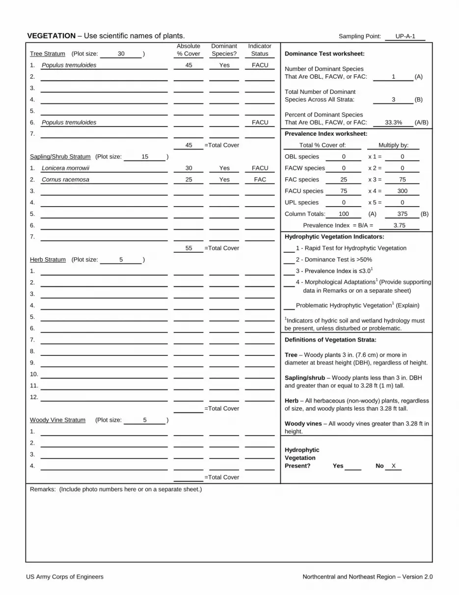
Sampling Point:
(Plot size:
1.
2.
3.
4.
5.
6. (A/B)
7.
Sapling/Shrub Stratum (Plot size: x 1 =
1. x 2 =
2. x 3 =
3. x 4 =
4. x 5 =
5. Column Totals: (B)
6.
7.
Herb Stratum (Plot size:
1.
2. 4 - Morphological Adaptations1
(Provide supporting
3.
4.
5.
6.
7.
8.
9.
10.
11.
12.
(Plot size:
1.
2.
3.
4. X
VEGETATION – Use scientific names of plants. UP-A-1
Tree Stratum 30 )
Absolute
% Cover
Dominant
Species?
Indicator
Status Dominance Test worksheet:
Populus tremuloides 45 Yes FACUNumber of Dominant Species
That Are OBL, FACW, or FAC: 1 (A)
Total Number of Dominant
Species Across All Strata: 3 (B)
Percent of Dominant Species
That Are OBL, FACW, or FAC:Populus tremuloides FACU 33.3%
Lonicera morrowii 30 Yes FACU
Prevalence Index worksheet:
25 Yes FAC FAC species 25 75
0 0
Total % Cover of:
0
Cornus racemosa
UPL species 0 0
FACU species 75
45 =Total Cover
375
Prevalence Index = B/A = 3.75
100 (A)
15 ) OBL species
Multiply by:
FACW species 0
300
55 =Total Cover 1 - Rapid Test for Hydrophytic Vegetation
5 ) 2 - Dominance Test is >50%
Hydrophytic Vegetation Indicators:
3 - Prevalence Index is ≤3.01
Problematic Hydrophytic Vegetation1 (Explain)
1Indicators of hydric soil and wetland hydrology must
be present, unless disturbed or problematic.
data in Remarks or on a separate sheet)
Sapling/shrub – Woody plants less than 3 in. DBH
and greater than or equal to 3.28 ft (1 m) tall.
Definitions of Vegetation Strata:
Tree – Woody plants 3 in. (7.6 cm) or more in
diameter at breast height (DBH), regardless of height.
Woody Vine Stratum 5 )Woody vines – All woody vines greater than 3.28 ft in
height.
Herb – All herbaceous (non-woody) plants, regardless
of size, and woody plants less than 3.28 ft tall.=Total Cover
Hydrophytic
Vegetation
Present? Yes No
Remarks: (Include photo numbers here or on a separate sheet.)
=Total Cover
US Army Corps of Engineers Northcentral and Northeast Region – Version 2.0

Sampling Point:
X
SOIL UP-A-1
Profile Description: (Describe to the depth needed to document the indicator or confirm the absence of indicators.)
Depth Matrix Redox Features
(inches) Color (moist) % Color (moist) % Type1
Sandy
Loc2
Texture Remarks
Hydric Soil Indicators: Indicators for Problematic Hydric Soils3:
Histosol (A1) Polyvalue Below Surface (S8) (LRR R, 2 cm Muck (A10) (LRR K, L, MLRA 149B)
Histic Epipedon (A2) MLRA 149B) Coast Prairie Redox (A16) (LRR K, L, R)
Black Histic (A3) Thin Dark Surface (S9) (LRR R, MLRA 149B) 5 cm Mucky Peat or Peat (S3) (LRR K, L, R)
Hydrogen Sulfide (A4) High Chroma Sands (S11) (LRR K, L) Polyvalue Below Surface (S8) (LRR K, L)
1Type: C=Concentration, D=Depletion, RM=Reduced Matrix, MS=Masked Sand Grains.
2Location: PL=Pore Lining, M=Matrix.
Thick Dark Surface (A12) Depleted Matrix (F3) Piedmont Floodplain Soils (F19) (MLRA 149B)
Sandy Mucky Mineral (S1) Redox Dark Surface (F6) Mesic Spodic (TA6) (MLRA 144A, 145, 149B)
Stratified Layers (A5) Loamy Mucky Mineral (F1) (LRR K, L) Thin Dark Surface (S9) (LRR K, L)
Depleted Below Dark Surface (A11) Loamy Gleyed Matrix (F2) Iron-Manganese Masses (F12) (LRR K, L, R)
0-10 10YR 3/3 100
Stripped Matrix (S6) Marl (F10) (LRR K, L) Other (Explain in Remarks)
Dark Surface (S7)
3Indicators of hydrophytic vegetation and wetland hydrology must be present, unless disturbed or problematic.
Sandy Gleyed Matrix (S4) Depleted Dark Surface (F7) Red Parent Material (F21)
Sandy Redox (S5) Redox Depressions (F8) Very Shallow Dark Surface (F22)
Yes No
Remarks:
Soil was excavated to the depth necessary to observe the presence of abesence or hydric conditions
Restrictive Layer (if observed):
Type: Rock/stone
Depth (inches): 10 Hydric Soil Present?
US Army Corps of Engineers Northcentral and Northeast Region – Version 2.0

Project/Site:
Applicant/Owner: State:
Investigator(s):
Lat:
Soil Map Unit Name: NWI classification:
X
Are Vegetation , Soil , or Hydrology Yes X
Are Vegetation , Soil , or Hydrology
SUMMARY OF FINDINGS – Attach site map showing sampling point locations, transects, important features, etc.
X No
X No X
X No
X
X
X
X Yes X
WETLAND DETERMINATION DATA FORM – Northcentral and Northeast Region
Erie County Pedestrian Accommodations PIN 5763.59 City/County: Clarence/Erie Sampling Date: 6/24/2021
Landform (hillside, terrace, etc.): Depression Local relief (concave, convex, none): Concave Slope %:
Erie County NY Sampling Point: W-B-1
J. Strong Section, Township, Range: Clarence
NAD 1983
Newstead Loam N/A
Are climatic / hydrologic conditions on the site typical for this time of year? Yes No (If no, explain in Remarks.)
Subregion (LRR or MLRA): LRR L 42°57'36.349"N Long: 78°39'16.409"W Datum:
significantly disturbed? Are “Normal Circumstances” present? No
naturally problematic? (If needed, explain any answers in Remarks.)
Hydrophytic Vegetation Present? Yes
Wetland Hydrology Present? Yes If yes, optional Wetland Site ID: Wetland B
Is the Sampled Area
Hydric Soil Present? Yes within a Wetland? Yes No
Remarks: (Explain alternative procedures here or in a separate report.)
HYDROLOGY
Wetland Hydrology Indicators: Secondary Indicators (minimum of two required)
Primary Indicators (minimum of one is required; check all that apply) Surface Soil Cracks (B6)
Surface Water (A1)
Water Marks (B1) Hydrogen Sulfide Odor (C1) Crayfish Burrows (C8)
Sediment Deposits (B2) Oxidized Rhizospheres on Living Roots (C3) Saturation Visible on Aerial Imagery (C9)
Water-Stained Leaves (B9) Drainage Patterns (B10)
High Water Table (A2) Aquatic Fauna (B13) Moss Trim Lines (B16)
Saturation (A3) Marl Deposits (B15) Dry-Season Water Table (C2)
Iron Deposits (B5) Thin Muck Surface (C7) Shallow Aquitard (D3)
Inundation Visible on Aerial Imagery (B7) Other (Explain in Remarks) Microtopographic Relief (D4)
Drift Deposits (B3) Presence of Reduced Iron (C4) Stunted or Stressed Plants (D1)
Algal Mat or Crust (B4) Recent Iron Reduction in Tilled Soils (C6) Geomorphic Position (D2)
0
Water Table Present? Yes No Depth (inches): 0
Sparsely Vegetated Concave Surface (B8) FAC-Neutral Test (D5)
Field Observations:
Surface Water Present? Yes No Depth (inches):
Remarks:
No
(includes capillary fringe)
Describe Recorded Data (stream gauge, monitoring well, aerial photos, previous inspections), if available:
Saturation Present? Yes No Depth (inches): 0 Wetland Hydrology Present?
US Army Corps of Engineers Northcentral and Northeast Region – Version 2.0
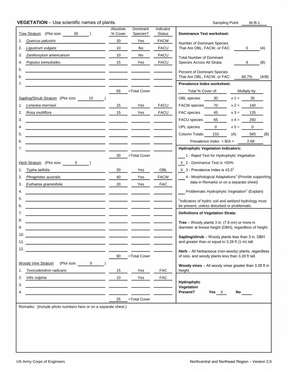
Sampling Point:
(Plot size:
1.
2.
3.
4.
5.
6. (A/B)
7.
Sapling/Shrub Stratum (Plot size: x 1 =
1. x 2 =
2. x 3 =
3. x 4 =
4. x 5 =
5. Column Totals: (B)
6.
7.
Herb Stratum (Plot size: X
1. X
2. 4 - Morphological Adaptations1
(Provide supporting
3.
4.
5.
6.
7.
8.
9.
10.
11.
12.
(Plot size:
1.
2.
3.
4. X
VEGETATION – Use scientific names of plants. W-B-1
Tree Stratum 30 )
Absolute
% Cover
Dominant
Species?
Indicator
Status Dominance Test worksheet:
Quercus palustris 30 Yes FACWNumber of Dominant Species
That Are OBL, FACW, or FAC:Ligustrum vulgare
Populus tremuloides 15 Yes
10 No FACU 6 (A)
Zanthoxylum americanum 10 No FACUTotal Number of Dominant
Species Across All Strata:FACU 9 (B)
Percent of Dominant Species
That Are OBL, FACW, or FAC: 66.7%
Lonicera morrowii 15 Yes FACU
Prevalence Index worksheet:
15 Yes FACU FAC species 45 135
30 30
Total % Cover of:
140
Rosa multiflora
UPL species 0 0
FACU species 65
65 =Total Cover
565
Prevalence Index = B/A = 2.69
210 (A)
15 ) OBL species
Multiply by:
FACW species 70
260
30 =Total Cover 1 - Rapid Test for Hydrophytic Vegetation
5 ) 2 - Dominance Test is >50%
Hydrophytic Vegetation Indicators:
Typha latifolia 30 Yes OBL 3 - Prevalence Index is ≤3.01
Phragmites australis 40 Yes FACW
Problematic Hydrophytic Vegetation1 (Explain)
1Indicators of hydric soil and wetland hydrology must
be present, unless disturbed or problematic.
Euthamia graminifolia 20 Yes FACdata in Remarks or on a separate sheet)
Sapling/shrub – Woody plants less than 3 in. DBH
and greater than or equal to 3.28 ft (1 m) tall.
Definitions of Vegetation Strata:
Tree – Woody plants 3 in. (7.6 cm) or more in
diameter at breast height (DBH), regardless of height.
Woody Vine Stratum 5 )Woody vines – All woody vines greater than 3.28 ft in
height.Toxicodendron radicans 15 Yes FAC
Herb – All herbaceous (non-woody) plants, regardless
of size, and woody plants less than 3.28 ft tall.90 =Total Cover
Vitis vulpina 10 Yes FACHydrophytic
Vegetation
Present? Yes No
Remarks: (Include photo numbers here or on a separate sheet.)
25 =Total Cover
US Army Corps of Engineers Northcentral and Northeast Region – Version 2.0
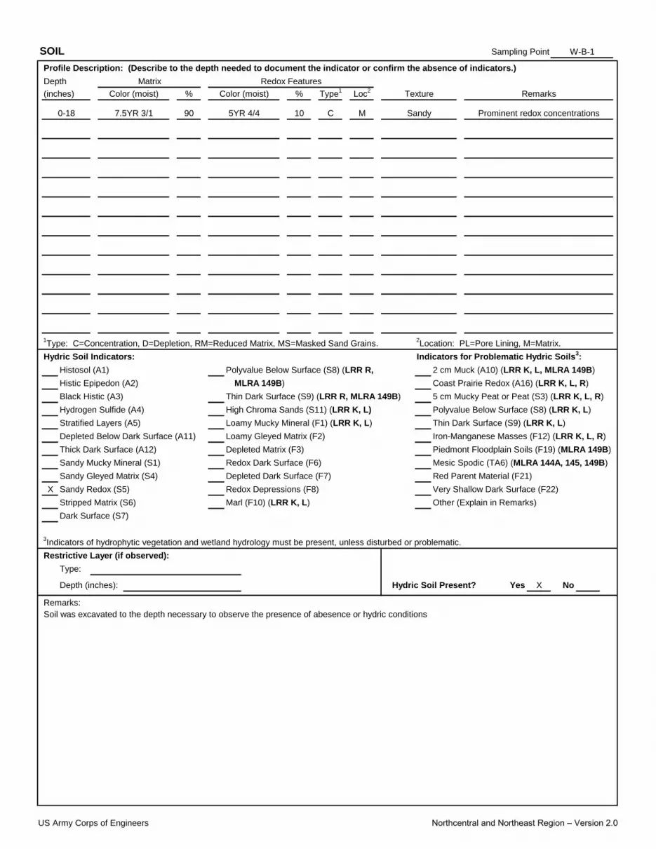
Sampling Point:
X
X
SOIL W-B-1
Profile Description: (Describe to the depth needed to document the indicator or confirm the absence of indicators.)
Depth Matrix Redox Features
(inches) Color (moist) % Color (moist) % Type1
Sandy Prominent redox concentrations
Loc2
Texture Remarks
Hydric Soil Indicators: Indicators for Problematic Hydric Soils3:
Histosol (A1) Polyvalue Below Surface (S8) (LRR R, 2 cm Muck (A10) (LRR K, L, MLRA 149B)
Histic Epipedon (A2) MLRA 149B) Coast Prairie Redox (A16) (LRR K, L, R)
Black Histic (A3) Thin Dark Surface (S9) (LRR R, MLRA 149B) 5 cm Mucky Peat or Peat (S3) (LRR K, L, R)
Hydrogen Sulfide (A4) High Chroma Sands (S11) (LRR K, L) Polyvalue Below Surface (S8) (LRR K, L)
1Type: C=Concentration, D=Depletion, RM=Reduced Matrix, MS=Masked Sand Grains.
2Location: PL=Pore Lining, M=Matrix.
Thick Dark Surface (A12) Depleted Matrix (F3) Piedmont Floodplain Soils (F19) (MLRA 149B)
Sandy Mucky Mineral (S1) Redox Dark Surface (F6) Mesic Spodic (TA6) (MLRA 144A, 145, 149B)
Stratified Layers (A5) Loamy Mucky Mineral (F1) (LRR K, L) Thin Dark Surface (S9) (LRR K, L)
Depleted Below Dark Surface (A11) Loamy Gleyed Matrix (F2) Iron-Manganese Masses (F12) (LRR K, L, R)
0-18 7.5YR 3/1 90 5YR 4/4 10 C M
Stripped Matrix (S6) Marl (F10) (LRR K, L) Other (Explain in Remarks)
Dark Surface (S7)
3Indicators of hydrophytic vegetation and wetland hydrology must be present, unless disturbed or problematic.
Sandy Gleyed Matrix (S4) Depleted Dark Surface (F7) Red Parent Material (F21)
Sandy Redox (S5) Redox Depressions (F8) Very Shallow Dark Surface (F22)
Yes No
Remarks:
Soil was excavated to the depth necessary to observe the presence of abesence or hydric conditions
Restrictive Layer (if observed):
Type:
Depth (inches): Hydric Soil Present?
US Army Corps of Engineers Northcentral and Northeast Region – Version 2.0

Project/Site:
Applicant/Owner: State:
Investigator(s):
Lat:
Soil Map Unit Name: NWI classification:
X
Are Vegetation , Soil , or Hydrology Yes X
Are Vegetation , Soil , or Hydrology
SUMMARY OF FINDINGS – Attach site map showing sampling point locations, transects, important features, etc.
No X
No X X
No X
?
X
X
X Yes X
WETLAND DETERMINATION DATA FORM – Northcentral and Northeast Region
Erie County Pedestrian Accommodations PIN 5763.59 City/County: Clarence/Erie Sampling Date: 6/24/2021
Landform (hillside, terrace, etc.): roadside Local relief (concave, convex, none): convex Slope %:
Erie County NY Sampling Point: UP-B-1
J. Strong Section, Township, Range: Clarence
NAD 1983
Newstead loam N/A
Are climatic / hydrologic conditions on the site typical for this time of year? Yes No (If no, explain in Remarks.)
Subregion (LRR or MLRA): LRR L 42°57'36.615"N Long: 78°39'18.777"W Datum:
significantly disturbed? Are “Normal Circumstances” present? No
naturally problematic? (If needed, explain any answers in Remarks.)
Hydrophytic Vegetation Present? Yes
Wetland Hydrology Present? Yes If yes, optional Wetland Site ID:
Is the Sampled Area
Hydric Soil Present? Yes within a Wetland? Yes No
Remarks: (Explain alternative procedures here or in a separate report.)
HYDROLOGY
Wetland Hydrology Indicators: Secondary Indicators (minimum of two required)
Primary Indicators (minimum of one is required; check all that apply) Surface Soil Cracks (B6)
Surface Water (A1)
Water Marks (B1) Hydrogen Sulfide Odor (C1) Crayfish Burrows (C8)
Sediment Deposits (B2) Oxidized Rhizospheres on Living Roots (C3) Saturation Visible on Aerial Imagery (C9)
Water-Stained Leaves (B9) Drainage Patterns (B10)
High Water Table (A2) Aquatic Fauna (B13) Moss Trim Lines (B16)
Saturation (A3) Marl Deposits (B15) Dry-Season Water Table (C2)
Iron Deposits (B5) Thin Muck Surface (C7) Shallow Aquitard (D3)
Inundation Visible on Aerial Imagery (B7) Other (Explain in Remarks) Microtopographic Relief (D4)
Drift Deposits (B3) Presence of Reduced Iron (C4) Stunted or Stressed Plants (D1)
Algal Mat or Crust (B4) Recent Iron Reduction in Tilled Soils (C6) Geomorphic Position (D2)
0
Water Table Present? Yes No Depth (inches): 0
Sparsely Vegetated Concave Surface (B8) FAC-Neutral Test (D5)
Field Observations:
Surface Water Present? Yes No Depth (inches):
Remarks:
No
(includes capillary fringe)
Describe Recorded Data (stream gauge, monitoring well, aerial photos, previous inspections), if available:
Saturation Present? Yes No Depth (inches): 0 Wetland Hydrology Present?
US Army Corps of Engineers Northcentral and Northeast Region – Version 2.0
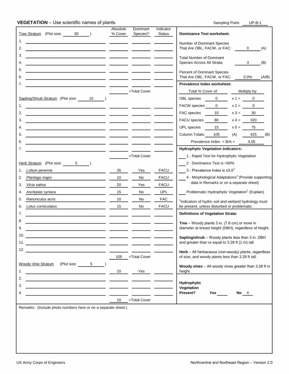
Sampling Point:
(Plot size:
1.
2.
3.
4.
5.
6. (A/B)
7.
Sapling/Shrub Stratum (Plot size: x 1 =
1. x 2 =
2. x 3 =
3. x 4 =
4. x 5 =
5. Column Totals: (B)
6.
7.
Herb Stratum (Plot size:
1.
2. 4 - Morphological Adaptations1
(Provide supporting
3.
4.
5.
6.
7.
8.
9.
10.
11.
12.
(Plot size:
1.
2.
3.
4. X
VEGETATION – Use scientific names of plants. UP-B-1
Tree Stratum 30 )
Absolute
% Cover
Dominant
Species?
Indicator
Status Dominance Test worksheet:
Number of Dominant Species
That Are OBL, FACW, or FAC: 0 (A)
Total Number of Dominant
Species Across All Strata: 3 (B)
Percent of Dominant Species
That Are OBL, FACW, or FAC: 0.0%
Prevalence Index worksheet:
FAC species 10 30
0 0
Total % Cover of:
0
UPL species 15 75
FACU species 80
=Total Cover
425
Prevalence Index = B/A = 4.05
105 (A)
15 ) OBL species
Multiply by:
FACW species 0
320
=Total Cover 1 - Rapid Test for Hydrophytic Vegetation
5 ) 2 - Dominance Test is >50%
Hydrophytic Vegetation Indicators:
Lolium perenne 35 Yes FACU 3 - Prevalence Index is ≤3.01
Plantago major 10 No FACU
Problematic Hydrophytic Vegetation1 (Explain)
Ranunculus acris 10 No FAC 1Indicators of hydric soil and wetland hydrology must
be present, unless disturbed or problematic.
Vicia sativa 20 Yes FACUdata in Remarks or on a separate sheet)
Lotus corniculatus 15 No FACU
Asclepias syriaca 15 No UPL
Sapling/shrub – Woody plants less than 3 in. DBH
and greater than or equal to 3.28 ft (1 m) tall.
Definitions of Vegetation Strata:
Tree – Woody plants 3 in. (7.6 cm) or more in
diameter at breast height (DBH), regardless of height.
Woody Vine Stratum 5 )Woody vines – All woody vines greater than 3.28 ft in
height.10 Yes
Herb – All herbaceous (non-woody) plants, regardless
of size, and woody plants less than 3.28 ft tall.105 =Total Cover
Hydrophytic
Vegetation
Present? Yes No
Remarks: (Include photo numbers here or on a separate sheet.)
10 =Total Cover
US Army Corps of Engineers Northcentral and Northeast Region – Version 2.0

Sampling Point:
X
SOIL UP-B-1
Profile Description: (Describe to the depth needed to document the indicator or confirm the absence of indicators.)
Depth Matrix Redox Features
(inches) Color (moist) % Color (moist) % Type1
Sandy
Loc2
Texture Remarks
Hydric Soil Indicators: Indicators for Problematic Hydric Soils3:
Histosol (A1) Polyvalue Below Surface (S8) (LRR R, 2 cm Muck (A10) (LRR K, L, MLRA 149B)
Histic Epipedon (A2) MLRA 149B) Coast Prairie Redox (A16) (LRR K, L, R)
Black Histic (A3) Thin Dark Surface (S9) (LRR R, MLRA 149B) 5 cm Mucky Peat or Peat (S3) (LRR K, L, R)
Hydrogen Sulfide (A4) High Chroma Sands (S11) (LRR K, L) Polyvalue Below Surface (S8) (LRR K, L)
1Type: C=Concentration, D=Depletion, RM=Reduced Matrix, MS=Masked Sand Grains.
2Location: PL=Pore Lining, M=Matrix.
Thick Dark Surface (A12) Depleted Matrix (F3) Piedmont Floodplain Soils (F19) (MLRA 149B)
Sandy Mucky Mineral (S1) Redox Dark Surface (F6) Mesic Spodic (TA6) (MLRA 144A, 145, 149B)
Stratified Layers (A5) Loamy Mucky Mineral (F1) (LRR K, L) Thin Dark Surface (S9) (LRR K, L)
Depleted Below Dark Surface (A11) Loamy Gleyed Matrix (F2) Iron-Manganese Masses (F12) (LRR K, L, R)
0-10 10YR 3/3 100
Stripped Matrix (S6) Marl (F10) (LRR K, L) Other (Explain in Remarks)
Dark Surface (S7)
3Indicators of hydrophytic vegetation and wetland hydrology must be present, unless disturbed or problematic.
Sandy Gleyed Matrix (S4) Depleted Dark Surface (F7) Red Parent Material (F21)
Sandy Redox (S5) Redox Depressions (F8) Very Shallow Dark Surface (F22)
Yes No
Remarks:
Soil was excavated to the depth necessary to observe the presence of abesence or hydric conditions
Restrictive Layer (if observed):
Type: Rock/stone
Depth (inches): 10 Hydric Soil Present?
US Army Corps of Engineers Northcentral and Northeast Region – Version 2.0
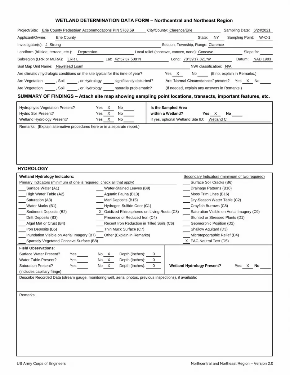
Project/Site:
Applicant/Owner: State:
Investigator(s):
Lat:
Soil Map Unit Name: NWI classification:
X
Are Vegetation , Soil , or Hydrology Yes X
Are Vegetation , Soil , or Hydrology
SUMMARY OF FINDINGS – Attach site map showing sampling point locations, transects, important features, etc.
X No
X No X
X No
X
X
X
X
X Yes X
WETLAND DETERMINATION DATA FORM – Northcentral and Northeast Region
Erie County Pedestrian Accommodations PIN 5763.59 City/County: Clarence/Erie Sampling Date: 6/24/2021
Landform (hillside, terrace, etc.): Depression Local relief (concave, convex, none): Concave Slope %:
Erie County NY Sampling Point: W-C-1
J. Strong Section, Township, Range: Clarence
NAD 1983
Newstead Loam N/A
Are climatic / hydrologic conditions on the site typical for this time of year? Yes No (If no, explain in Remarks.)
Subregion (LRR or MLRA): LRR L 42°57'37.508"N Long: 78°39'17.321"W Datum:
significantly disturbed? Are “Normal Circumstances” present? No
naturally problematic? (If needed, explain any answers in Remarks.)
Hydrophytic Vegetation Present? Yes
Wetland Hydrology Present? Yes If yes, optional Wetland Site ID: Wetland C
Is the Sampled Area
Hydric Soil Present? Yes within a Wetland? Yes No
Remarks: (Explain alternative procedures here or in a separate report.)
HYDROLOGY
Wetland Hydrology Indicators: Secondary Indicators (minimum of two required)
Primary Indicators (minimum of one is required; check all that apply) Surface Soil Cracks (B6)
Surface Water (A1)
Water Marks (B1) Hydrogen Sulfide Odor (C1) Crayfish Burrows (C8)
Sediment Deposits (B2) Oxidized Rhizospheres on Living Roots (C3) Saturation Visible on Aerial Imagery (C9)
Water-Stained Leaves (B9) Drainage Patterns (B10)
High Water Table (A2) Aquatic Fauna (B13) Moss Trim Lines (B16)
Saturation (A3) Marl Deposits (B15) Dry-Season Water Table (C2)
Iron Deposits (B5) Thin Muck Surface (C7) Shallow Aquitard (D3)
Inundation Visible on Aerial Imagery (B7) Other (Explain in Remarks) Microtopographic Relief (D4)
Drift Deposits (B3) Presence of Reduced Iron (C4) Stunted or Stressed Plants (D1)
Algal Mat or Crust (B4) Recent Iron Reduction in Tilled Soils (C6) Geomorphic Position (D2)
0
Water Table Present? Yes No Depth (inches): 0
Sparsely Vegetated Concave Surface (B8) FAC-Neutral Test (D5)
Field Observations:
Surface Water Present? Yes No Depth (inches):
Remarks:
No
(includes capillary fringe)
Describe Recorded Data (stream gauge, monitoring well, aerial photos, previous inspections), if available:
Saturation Present? Yes No Depth (inches): 0 Wetland Hydrology Present?
US Army Corps of Engineers Northcentral and Northeast Region – Version 2.0
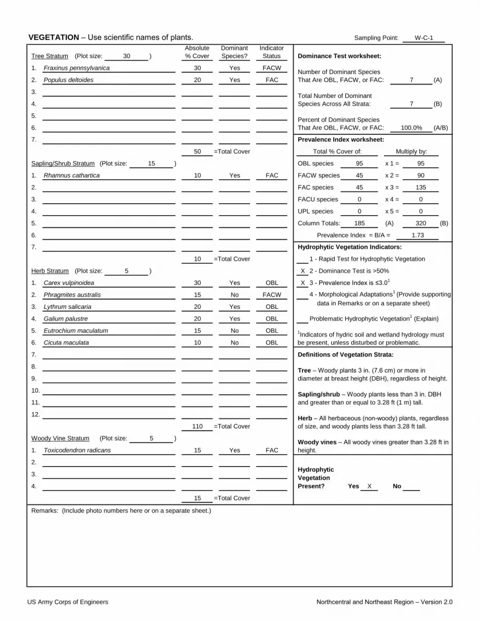
Sampling Point:
(Plot size:
1.
2.
3.
4.
5.
6. (A/B)
7.
Sapling/Shrub Stratum (Plot size: x 1 =
1. x 2 =
2. x 3 =
3. x 4 =
4. x 5 =
5. Column Totals: (B)
6.
7.
Herb Stratum (Plot size: X
1. X
2. 4 - Morphological Adaptations1
(Provide supporting
3.
4.
5.
6.
7.
8.
9.
10.
11.
12.
(Plot size:
1.
2.
3.
4. X
VEGETATION – Use scientific names of plants. W-C-1
Tree Stratum 30 )
Absolute
% Cover
Dominant
Species?
Indicator
Status Dominance Test worksheet:
Fraxinus pennsylvanica 30 Yes FACWNumber of Dominant Species
That Are OBL, FACW, or FAC:Populus deltoides 20 Yes FAC 7 (A)
Total Number of Dominant
Species Across All Strata: 7 (B)
Percent of Dominant Species
That Are OBL, FACW, or FAC: 100.0%
Rhamnus cathartica 10 Yes FAC
Prevalence Index worksheet:
FAC species 45 135
95 95
Total % Cover of:
90
UPL species 0 0
FACU species 0
50 =Total Cover
320
Prevalence Index = B/A = 1.73
185 (A)
15 ) OBL species
Multiply by:
FACW species 45
0
10 =Total Cover 1 - Rapid Test for Hydrophytic Vegetation
5 ) 2 - Dominance Test is >50%
Hydrophytic Vegetation Indicators:
Carex vulpinoidea 30 Yes OBL 3 - Prevalence Index is ≤3.01
Phragmites australis 15 No FACW
Problematic Hydrophytic Vegetation1 (Explain)
Eutrochium maculatum 15 No OBL 1Indicators of hydric soil and wetland hydrology must
be present, unless disturbed or problematic.
Lythrum salicaria 20 Yes OBLdata in Remarks or on a separate sheet)
Cicuta maculata 10 No OBL
Galium palustre 20 Yes OBL
Sapling/shrub – Woody plants less than 3 in. DBH
and greater than or equal to 3.28 ft (1 m) tall.
Definitions of Vegetation Strata:
Tree – Woody plants 3 in. (7.6 cm) or more in
diameter at breast height (DBH), regardless of height.
Woody Vine Stratum 5 )Woody vines – All woody vines greater than 3.28 ft in
height.Toxicodendron radicans 15 Yes FAC
Herb – All herbaceous (non-woody) plants, regardless
of size, and woody plants less than 3.28 ft tall.110 =Total Cover
Hydrophytic
Vegetation
Present? Yes No
Remarks: (Include photo numbers here or on a separate sheet.)
15 =Total Cover
US Army Corps of Engineers Northcentral and Northeast Region – Version 2.0
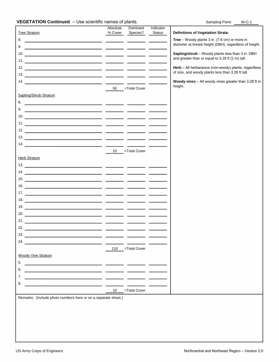
Sampling Point:
8.
9.
10.
11.
12.
13.
14.
8.
9.
10.
11.
12.
13.
14.
13.
14.
15.
16.
17.
18.
19.
20.
21.
22.
23.
24.
5.
6.
7.
8.
VEGETATION Continued – Use scientific names of plants.
Remarks: (Include photo numbers here or on a separate sheet.)
Sapling/shrub – Woody plants less than 3 in. DBH
and greater than or equal to 3.28 ft (1 m) tall.
Herb – All herbaceous (non-woody) plants, regardless
of size, and woody plants less than 3.28 ft tall.
Woody vines – All woody vines greater than 3.28 ft in
height.
Tree Stratum
Sapling/Shrub Stratum
15 =Total Cover
Woody Vine Stratum
110 =Total Cover
Definitions of Vegetation Strata:
Tree – Woody plants 3 in. (7.6 cm) or more in
diameter at breast height (DBH), regardless of height.
10 =Total Cover
Herb Stratum
50 =Total Cover
W-C-1
Absolute
% Cover
Dominant
Species?
Indicator
Status
US Army Corps of Engineers Northcentral and Northeast Region – Version 2.0

Sampling Point:
X
X
SOIL W-C-1
Profile Description: (Describe to the depth needed to document the indicator or confirm the absence of indicators.)
Depth Matrix Redox Features
(inches) Color (moist) % Color (moist) % Type1
Sandy Prominent redox concentrations
Loc2
Texture Remarks
Hydric Soil Indicators: Indicators for Problematic Hydric Soils3:
Histosol (A1) Polyvalue Below Surface (S8) (LRR R, 2 cm Muck (A10) (LRR K, L, MLRA 149B)
Histic Epipedon (A2) MLRA 149B) Coast Prairie Redox (A16) (LRR K, L, R)
Black Histic (A3) Thin Dark Surface (S9) (LRR R, MLRA 149B) 5 cm Mucky Peat or Peat (S3) (LRR K, L, R)
Hydrogen Sulfide (A4) High Chroma Sands (S11) (LRR K, L) Polyvalue Below Surface (S8) (LRR K, L)
1Type: C=Concentration, D=Depletion, RM=Reduced Matrix, MS=Masked Sand Grains.
2Location: PL=Pore Lining, M=Matrix.
Thick Dark Surface (A12) Depleted Matrix (F3) Piedmont Floodplain Soils (F19) (MLRA 149B)
Sandy Mucky Mineral (S1) Redox Dark Surface (F6) Mesic Spodic (TA6) (MLRA 144A, 145, 149B)
Stratified Layers (A5) Loamy Mucky Mineral (F1) (LRR K, L) Thin Dark Surface (S9) (LRR K, L)
Depleted Below Dark Surface (A11) Loamy Gleyed Matrix (F2) Iron-Manganese Masses (F12) (LRR K, L, R)
0-18 10YR 3/1 90 5YR 5/6 10 C M
Stripped Matrix (S6) Marl (F10) (LRR K, L) Other (Explain in Remarks)
Dark Surface (S7)
3Indicators of hydrophytic vegetation and wetland hydrology must be present, unless disturbed or problematic.
Sandy Gleyed Matrix (S4) Depleted Dark Surface (F7) Red Parent Material (F21)
Sandy Redox (S5) Redox Depressions (F8) Very Shallow Dark Surface (F22)
Yes No
Remarks:
Soil was excavated to the depth necessary to observe the presence of abesence or hydric conditions
Restrictive Layer (if observed):
Type:
Depth (inches): Hydric Soil Present?
US Army Corps of Engineers Northcentral and Northeast Region – Version 2.0

Project/Site:
Applicant/Owner: State:
Investigator(s):
Lat:
Soil Map Unit Name: NWI classification:
X
Are Vegetation , Soil , or Hydrology Yes X
Are Vegetation , Soil , or Hydrology
SUMMARY OF FINDINGS – Attach site map showing sampling point locations, transects, important features, etc.
No X
No X X
No X
?
X
X
X Yes X
WETLAND DETERMINATION DATA FORM – Northcentral and Northeast Region
Erie County Pedestrian Accommodations PIN 5763.59 City/County: Clarence/Erie Sampling Date: 6/24/2021
Landform (hillside, terrace, etc.): roadside Local relief (concave, convex, none): convex Slope %:
Erie County NY Sampling Point: UP-C-1
J. Strong Section, Township, Range: Clarence
NAD 1983
Newstead Loam N/A
Are climatic / hydrologic conditions on the site typical for this time of year? Yes No (If no, explain in Remarks.)
Subregion (LRR or MLRA): LRR L 42°57'37.107"N Long: 78°39'17.867"W Datum:
significantly disturbed? Are “Normal Circumstances” present? No
naturally problematic? (If needed, explain any answers in Remarks.)
Hydrophytic Vegetation Present? Yes
Wetland Hydrology Present? Yes If yes, optional Wetland Site ID:
Is the Sampled Area
Hydric Soil Present? Yes within a Wetland? Yes No
Remarks: (Explain alternative procedures here or in a separate report.)
HYDROLOGY
Wetland Hydrology Indicators: Secondary Indicators (minimum of two required)
Primary Indicators (minimum of one is required; check all that apply) Surface Soil Cracks (B6)
Surface Water (A1)
Water Marks (B1) Hydrogen Sulfide Odor (C1) Crayfish Burrows (C8)
Sediment Deposits (B2) Oxidized Rhizospheres on Living Roots (C3) Saturation Visible on Aerial Imagery (C9)
Water-Stained Leaves (B9) Drainage Patterns (B10)
High Water Table (A2) Aquatic Fauna (B13) Moss Trim Lines (B16)
Saturation (A3) Marl Deposits (B15) Dry-Season Water Table (C2)
Iron Deposits (B5) Thin Muck Surface (C7) Shallow Aquitard (D3)
Inundation Visible on Aerial Imagery (B7) Other (Explain in Remarks) Microtopographic Relief (D4)
Drift Deposits (B3) Presence of Reduced Iron (C4) Stunted or Stressed Plants (D1)
Algal Mat or Crust (B4) Recent Iron Reduction in Tilled Soils (C6) Geomorphic Position (D2)
0
Water Table Present? Yes No Depth (inches): 0
Sparsely Vegetated Concave Surface (B8) FAC-Neutral Test (D5)
Field Observations:
Surface Water Present? Yes No Depth (inches):
Remarks:
No
(includes capillary fringe)
Describe Recorded Data (stream gauge, monitoring well, aerial photos, previous inspections), if available:
Saturation Present? Yes No Depth (inches): 0 Wetland Hydrology Present?
US Army Corps of Engineers Northcentral and Northeast Region – Version 2.0

Sampling Point:
(Plot size:
1.
2.
3.
4.
5.
6. (A/B)
7.
Sapling/Shrub Stratum (Plot size: x 1 =
1. x 2 =
2. x 3 =
3. x 4 =
4. x 5 =
5. Column Totals: (B)
6.
7.
Herb Stratum (Plot size:
1.
2. 4 - Morphological Adaptations1
(Provide supporting
3.
4.
5.
6.
7.
8.
9.
10.
11.
12.
(Plot size:
1.
2.
3.
4. X
VEGETATION – Use scientific names of plants. UP-C-1
Tree Stratum 30 )
Absolute
% Cover
Dominant
Species?
Indicator
Status Dominance Test worksheet:
Fraxinus pennsylvanica 15 Yes FACWNumber of Dominant Species
That Are OBL, FACW, or FAC:FAC 2 (A)
Total Number of Dominant
Species Across All Strata: 6 (B)
Percent of Dominant Species
That Are OBL, FACW, or FAC: 33.3%
Prevalence Index worksheet:
FAC species 10 30
0 0
Total % Cover of:
80
UPL species 25 125
FACU species 50
15 =Total Cover
435
Prevalence Index = B/A = 3.48
125 (A)
15 ) OBL species
Multiply by:
FACW species 40
200
=Total Cover 1 - Rapid Test for Hydrophytic Vegetation
5 ) 2 - Dominance Test is >50%
Hydrophytic Vegetation Indicators:
Phragmites australis 25 Yes FACW 3 - Prevalence Index is ≤3.01
Lolium perenne 15 Yes FACU
Problematic Hydrophytic Vegetation1 (Explain)
Euthamia graminifolia 10 No FAC 1Indicators of hydric soil and wetland hydrology must
be present, unless disturbed or problematic.
Plantago major 15 Yes FACUdata in Remarks or on a separate sheet)
Cynanchum louiseae 25 Yes UPL
Taraxacum officinale 10 No FACU
Sapling/shrub – Woody plants less than 3 in. DBH
and greater than or equal to 3.28 ft (1 m) tall.
Definitions of Vegetation Strata:
Tree – Woody plants 3 in. (7.6 cm) or more in
diameter at breast height (DBH), regardless of height.
Woody Vine Stratum 5 )Woody vines – All woody vines greater than 3.28 ft in
height.Vitis labrusca 10 Yes FACU
Herb – All herbaceous (non-woody) plants, regardless
of size, and woody plants less than 3.28 ft tall.100 =Total Cover
Hydrophytic
Vegetation
Present? Yes No
Remarks: (Include photo numbers here or on a separate sheet.)
10 =Total Cover
US Army Corps of Engineers Northcentral and Northeast Region – Version 2.0
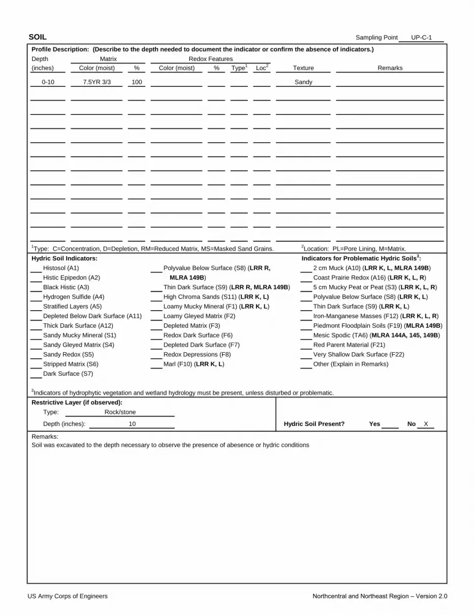
Sampling Point:
X
SOIL UP-C-1
Profile Description: (Describe to the depth needed to document the indicator or confirm the absence of indicators.)
Depth Matrix Redox Features
(inches) Color (moist) % Color (moist) % Type1
Sandy
Loc2
Texture Remarks
Hydric Soil Indicators: Indicators for Problematic Hydric Soils3:
Histosol (A1) Polyvalue Below Surface (S8) (LRR R, 2 cm Muck (A10) (LRR K, L, MLRA 149B)
Histic Epipedon (A2) MLRA 149B) Coast Prairie Redox (A16) (LRR K, L, R)
Black Histic (A3) Thin Dark Surface (S9) (LRR R, MLRA 149B) 5 cm Mucky Peat or Peat (S3) (LRR K, L, R)
Hydrogen Sulfide (A4) High Chroma Sands (S11) (LRR K, L) Polyvalue Below Surface (S8) (LRR K, L)
1Type: C=Concentration, D=Depletion, RM=Reduced Matrix, MS=Masked Sand Grains.
2Location: PL=Pore Lining, M=Matrix.
Thick Dark Surface (A12) Depleted Matrix (F3) Piedmont Floodplain Soils (F19) (MLRA 149B)
Sandy Mucky Mineral (S1) Redox Dark Surface (F6) Mesic Spodic (TA6) (MLRA 144A, 145, 149B)
Stratified Layers (A5) Loamy Mucky Mineral (F1) (LRR K, L) Thin Dark Surface (S9) (LRR K, L)
Depleted Below Dark Surface (A11) Loamy Gleyed Matrix (F2) Iron-Manganese Masses (F12) (LRR K, L, R)
0-10 7.5YR 3/3 100
Stripped Matrix (S6) Marl (F10) (LRR K, L) Other (Explain in Remarks)
Dark Surface (S7)
3Indicators of hydrophytic vegetation and wetland hydrology must be present, unless disturbed or problematic.
Sandy Gleyed Matrix (S4) Depleted Dark Surface (F7) Red Parent Material (F21)
Sandy Redox (S5) Redox Depressions (F8) Very Shallow Dark Surface (F22)
Yes No
Remarks:
Soil was excavated to the depth necessary to observe the presence of abesence or hydric conditions
Restrictive Layer (if observed):
Type: Rock/stone
Depth (inches): 10 Hydric Soil Present?
US Army Corps of Engineers Northcentral and Northeast Region – Version 2.0
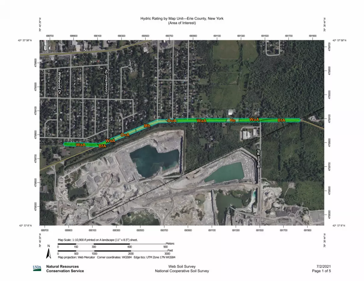
Hydric Rating by Map Unit—Erie County, New York(Area of Interest)
Natural ResourcesConservation Service
Web Soil SurveyNational Cooperative Soil Survey
7/2/2021Page 1 of 5
4758
300
4758
500
4758
700
4758
900
4759
100
4759
300
4759
500
4758
300
4758
500
4758
700
4758
900
4759
100
4759
300
4759
500
4759
700
689700 689900 690100 690300 690500 690700 690900 691100 691300 691500 691700 691900
689700 689900 690100 690300 690500 690700 690900 691100 691300 691500 691700 691900
42° 57' 58'' N78
° 4
0' 2
9'' W
42° 57' 58'' N
78° 3
8' 4
4'' W
42° 57' 8'' N
78° 4
0' 2
9'' W
42° 57' 8'' N
78° 3
8' 4
4'' W
N
Map projection: Web Mercator Corner coordinates: WGS84 Edge tics: UTM Zone 17N WGS840 500 1000 2000 3000
Feet0 150 300 600 900
MetersMap Scale: 1:10,900 if printed on A landscape (11" x 8.5") sheet.

MAP LEGEND MAP INFORMATION
Area of Interest (AOI)Area of Interest (AOI)
SoilsSoil Rating Polygons
Hydric (100%)
Hydric (66 to 99%)
Hydric (33 to 65%)
Hydric (1 to 32%)
Not Hydric (0%)
Not rated or not available
Soil Rating LinesHydric (100%)
Hydric (66 to 99%)
Hydric (33 to 65%)
Hydric (1 to 32%)
Not Hydric (0%)
Not rated or not available
Soil Rating PointsHydric (100%)
Hydric (66 to 99%)
Hydric (33 to 65%)
Hydric (1 to 32%)
Not Hydric (0%)
Not rated or not available
Water FeaturesStreams and Canals
TransportationRails
Interstate Highways
US Routes
Major Roads
Local Roads
BackgroundAerial Photography
The soil surveys that comprise your AOI were mapped at 1:15,800.
Please rely on the bar scale on each map sheet for map measurements.
Source of Map: Natural Resources Conservation ServiceWeb Soil Survey URL: Coordinate System: Web Mercator (EPSG:3857)
Maps from the Web Soil Survey are based on the Web Mercator projection, which preserves direction and shape but distorts distance and area. A projection that preserves area, such as the Albers equal-area conic projection, should be used if more accurate calculations of distance or area are required.
This product is generated from the USDA-NRCS certified data as of the version date(s) listed below.
Soil Survey Area: Erie County, New YorkSurvey Area Data: Version 20, Jun 11, 2020
Soil map units are labeled (as space allows) for map scales 1:50,000 or larger.
Date(s) aerial images were photographed: Jul 4, 2020—Jul 10, 2020
The orthophoto or other base map on which the soil lines were compiled and digitized probably differs from the background imagery displayed on these maps. As a result, some minor shifting of map unit boundaries may be evident.
Hydric Rating by Map Unit—Erie County, New York(Area of Interest)
Natural ResourcesConservation Service
Web Soil SurveyNational Cooperative Soil Survey
7/2/2021Page 2 of 5
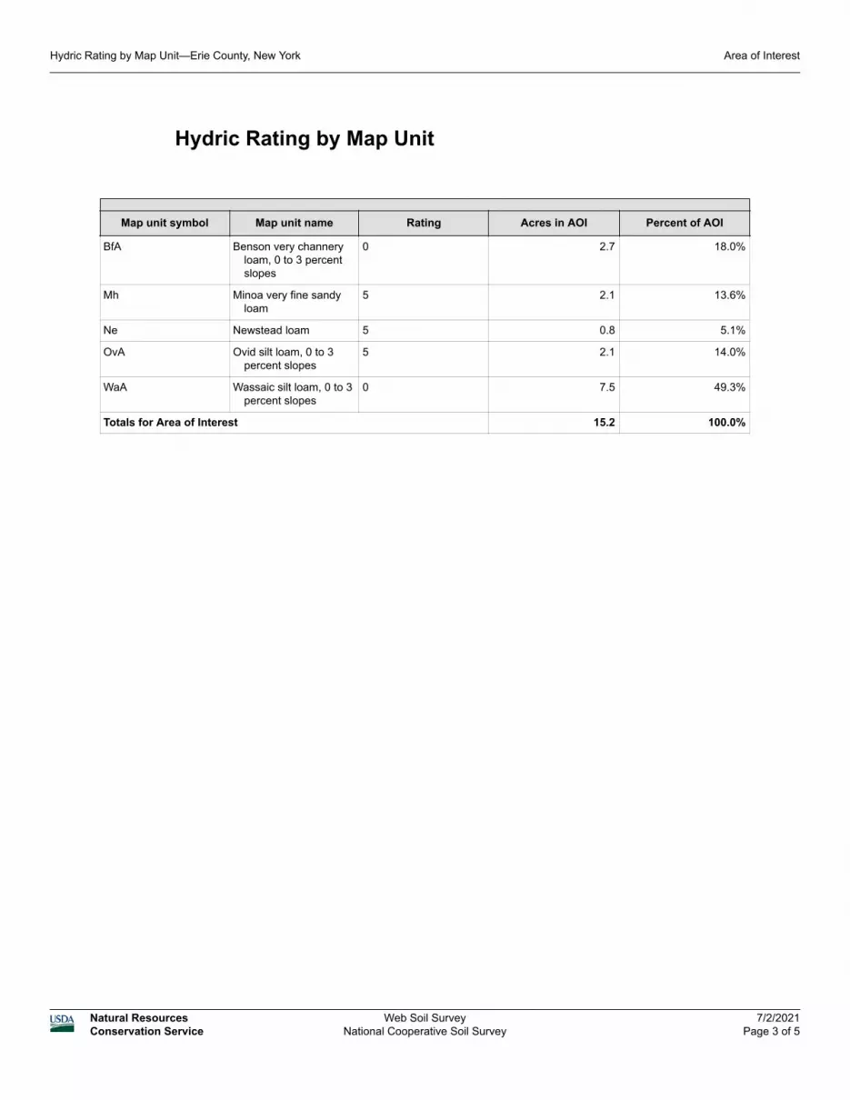
Hydric Rating by Map Unit
Map unit symbol Map unit name Rating Acres in AOI Percent of AOI
BfA Benson very channery loam, 0 to 3 percent slopes
0 2.7 18.0%
Mh Minoa very fine sandy loam
5 2.1 13.6%
Ne Newstead loam 5 0.8 5.1%
OvA Ovid silt loam, 0 to 3 percent slopes
5 2.1 14.0%
WaA Wassaic silt loam, 0 to 3 percent slopes
0 7.5 49.3%
Totals for Area of Interest 15.2 100.0%
Hydric Rating by Map Unit—Erie County, New York Area of Interest
Natural ResourcesConservation Service
Web Soil SurveyNational Cooperative Soil Survey
7/2/2021Page 3 of 5

Description
This rating indicates the percentage of map units that meets the criteria for hydric soils. Map units are composed of one or more map unit components or soil types, each of which is rated as hydric soil or not hydric. Map units that are made up dominantly of hydric soils may have small areas of minor nonhydric components in the higher positions on the landform, and map units that are made up dominantly of nonhydric soils may have small areas of minor hydric components in the lower positions on the landform. Each map unit is rated based on its respective components and the percentage of each component within the map unit.
The thematic map is color coded based on the composition of hydric components. The five color classes are separated as 100 percent hydric components, 66 to 99 percent hydric components, 33 to 65 percent hydric components, 1 to 32 percent hydric components, and less than one percent hydric components.
In Web Soil Survey, the Summary by Map Unit table that is displayed below the map pane contains a column named 'Rating'. In this column the percentage of each map unit that is classified as hydric is displayed.
Hydric soils are defined by the National Technical Committee for Hydric Soils (NTCHS) as soils that formed under conditions of saturation, flooding, or ponding long enough during the growing season to develop anaerobic conditions in the upper part (Federal Register, 1994). Under natural conditions, these soils are either saturated or inundated long enough during the growing season to support the growth and reproduction of hydrophytic vegetation.
The NTCHS definition identifies general soil properties that are associated with wetness. In order to determine whether a specific soil is a hydric soil or nonhydric soil, however, more specific information, such as information about the depth and duration of the water table, is needed. Thus, criteria that identify those estimated soil properties unique to hydric soils have been established (Federal Register, 2002). These criteria are used to identify map unit components that normally are associated with wetlands. The criteria used are selected estimated soil properties that are described in "Soil Taxonomy" (Soil Survey Staff, 1999) and "Keys to Soil Taxonomy" (Soil Survey Staff, 2006) and in the "Soil Survey Manual" (Soil Survey Division Staff, 1993).
If soils are wet enough for a long enough period of time to be considered hydric, they should exhibit certain properties that can be easily observed in the field. These visible properties are indicators of hydric soils. The indicators used to make onsite determinations of hydric soils are specified in "Field Indicators of Hydric Soils in the United States" (Hurt and Vasilas, 2006).
References:
Federal Register. July 13, 1994. Changes in hydric soils of the United States.
Federal Register. September 18, 2002. Hydric soils of the United States.
Hydric Rating by Map Unit—Erie County, New York Area of Interest
Natural ResourcesConservation Service
Web Soil SurveyNational Cooperative Soil Survey
7/2/2021Page 4 of 5

Hurt, G.W., and L.M. Vasilas, editors. Version 6.0, 2006. Field indicators of hydric soils in the United States.
Soil Survey Division Staff. 1993. Soil survey manual. Soil Conservation Service. U.S. Department of Agriculture Handbook 18.
Soil Survey Staff. 1999. Soil taxonomy: A basic system of soil classification for making and interpreting soil surveys. 2nd edition. Natural Resources Conservation Service. U.S. Department of Agriculture Handbook 436.
Soil Survey Staff. 2006. Keys to soil taxonomy. 10th edition. U.S. Department of Agriculture, Natural Resources Conservation Service.
Rating Options
Aggregation Method: Percent Present
Component Percent Cutoff: None Specified
Tie-break Rule: Lower
Hydric Rating by Map Unit—Erie County, New York Area of Interest
Natural ResourcesConservation Service
Web Soil SurveyNational Cooperative Soil Survey
7/2/2021Page 5 of 5
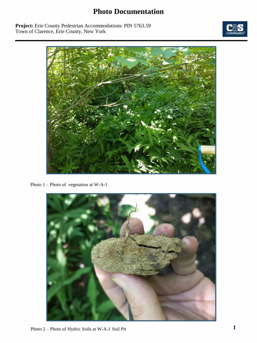
Project: Erie County Pedestrian Accommodations: PIN 5763.59 Town of Clarence, Erie County, New York
Photo 1 – Photo of vegetation at W-A-1
Photo 2 – Photo of Hydric Soils at W-A-1 Soil Pit 1
Photo Documentation
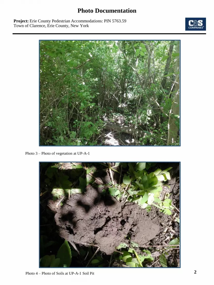
Project: Erie County Pedestrian Accommodations: PIN 5763.59 Town of Clarence, Erie County, New York
Photo 3 – Photo of vegetation at UP-A-1
Photo 4 – Photo of Soils at UP-A-1 Soil Pit 2
Photo Documentation

Photo 5 – Photo of vegetation at W-B-1
3
Photo Documentation
Photo 6 – Photo of Hydric Soils at W-B-1 Soil Pit
Project: Erie County Pedestrian Accommodations: PIN 5763.59 Town of Clarence, Erie County, New York

Project: Erie County Pedestrian Accommodations: PIN 5763.59 Town of Clarence, Erie County, New York
Photo 7 – Photo of vegetation at UP-B-1
Photo 8 – Photo of Soils at UP-B-1 Soil Pit 4
Photo Documentation

Photo 9 – Photo of vegetation at W-C-1
5
Photo Documentation
Photo 10 – Photo of Hydric Soils at W-C-1 Soil Pit
Project: Erie County Pedestrian Accommodations: PIN 5763.59 Town of Clarence, Erie County, New York
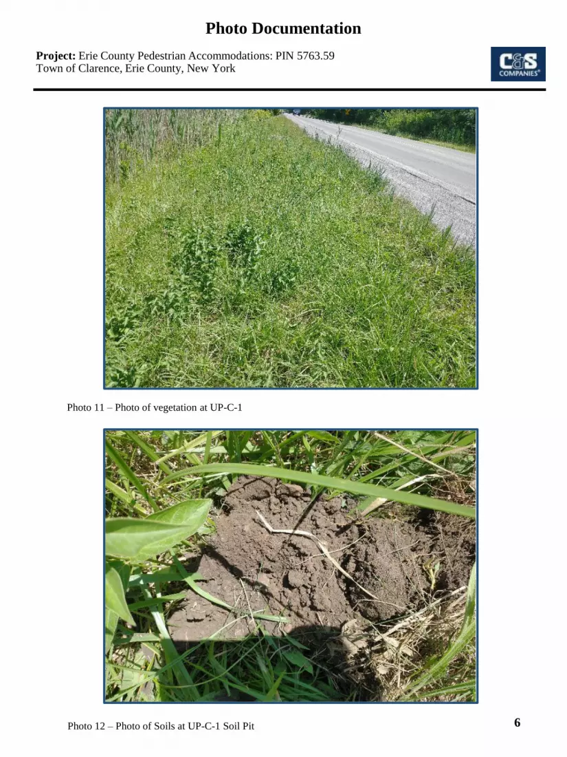
Project: Erie County Pedestrian Accommodations: PIN 5763.59 Town of Clarence, Erie County, New York
Photo 11 – Photo of vegetation at UP-C-1
Photo 12 – Photo of Soils at UP-C-1 Soil Pit 6
Photo Documentation

Attachment H
Contaminated Materials and Hazardous
Substances Screening
P a g e | 1
Memo
To: Dan Borcz – C&S Engineers Transportation Service Group From: Wayne Randall – C&S Engineers Infrastructure & Environment Services Group Date: July 14, 2021 Re: PIN 5763.59 Erie County, New York - Wehrle Drive Pedestrian Access Project - Contaminated Materials and Hazardous Substances Screening File: X52.001.001 A Contaminated Materials and Hazardous Substances Screening (i.e. Screening) was performed for the proposed Erie County, Wehrle Drive Pedestrian Access Project, (i.e. Project or Project Area) located in the Town of Clarence, Erie County, New York. The Project / Project Area includes a stretch of William Street in Lancaster, between Transit Road and Bowen Road. The objective of the screening was to identify historical or current land use practices that may indicate the presence of contaminated materials or hazardous substances within the Project Area that could potentially be encountered during construction phases of the Project. This screening was performed generally consistent with Chapter 4.4.20 (Contaminated and Hazardous Materials) of the New York State Department of Transportation (NYSDOT) document: The Environmental Manual (TEM), effective February 2012 and with Chapter 7 of the NYSDOT’s manual, Procedures for Locally Administered Federal Aid Projects. The purpose of the screening was to identify to the extent feasible “Recognized Environmental Conditions (RECs)” in connection with the Project / Project Area. A “Recognized Environmental Condition” is defined as: “The presence or likely presence of any hazardous substances or petroleum products in, on, or at a property: (1) due to any release to the environment; (2) under conditions indicative of a release to the environment; or (3) under conditions that pose a material threat to the environment.” The screening did not include assessments related to asbestos, radon, lead-based paint, lead in drinking water, wetlands, regulatory compliance, mold, industrial hygiene, health and safety, ecological resources, endangered species, air quality, cultural and historic resources, or biological agents.
P a g e | 2
Consistent with TEM 4.4.20, the Screening consisted of the following elements:
1) Investigation of historical and current site use(s). In an effort to identify Project and adjacent activities or uses of concern, C&S reviewed the following documents provided by Environmental Risk Information Services (ERIS):
a) Sanborn Fire Insurance Maps for the west portion of the project in one year only (1946).
b) Historical aerial photographs, date range 1928 to 2019. c) Historical topographic map, dated 2016.
These documents are attached.
2) Review of an environmental database report prepared by ERIS, consistent with
ASTM E 1527-13. The report provides details regarding properties that are located within a 1-mile radius of the Project Area that are listed in one or more of a myriad of local, state, and federal environmental databases searched; and
3) Completion of a site visit of the Project Area. During the site visit, the properties adjoining the Project Area were viewed from edge of pavement within the right-of-way. The purpose of the site visit was to gather information regarding present conditions and to identify observable physical evidence that may be indicative of contamination, such as stained soil, seepage, stressed or dead vegetation, and sheens or discolored water within drainage swales and ditches. Also during the walkover, attention was paid to existing property uses and commercial enterprises in the area of the project, especially those that may be associated with an environmental concern.
As a result of the completion of the above elements, the following findings are provided: Historical Records Review: Review of the historical information sources (aerial photos and topographic maps) indicate the project area consisted primarily as agricultural use dating back to 1928. A significant increase in residential development can be observed along the project location as well as on surrounding properties beginning in 1958 and continued until present day. The project area remains primarily residential to the north side of the corridor and to the south there has been a quarry. The quarry can be seen for the first time in 1958 and has been developed over the years and expanded to the east. Environmental Database Review:
• Significant proximate sites are listed: o 4122 Vinewood is listed in the NY SPILLS database and is approximately 300
ft. north of Wehrle Dr. The spill occurred when a hydraulic line on a refuse truck ruptured. Approximately 3-gallons of hydraulic fluid was discharged on pavement and the spill was cleaned up. The spill was cleaned and closed as no further action necessary. None of the information indicated a concern with respect to the Project.
P a g e | 3
o 8615 Wehrle Dr.is listed under the NY SPILLS database. This site is the
address of the Wehrle /Barton Quarry located adjacent to the project corridor to the south. Two spills reported at the quarry site and cleaned up meeting NYSDEC standards. None of the information indicated a concern with respect to the Project.
Site Visit Observations:
• Current land use in the vicinity of the Project Area consists of residential properties along the north side of the corridor and a quarry that is developed to the south of the corridor.
• A site visit of the Project Area was performed on July 13, 2021. No obvious environmental concerns were observed in association with the Project or adjacent properties.
Based upon the information gathered during the completion of this Contaminated Materials and Hazardous Substances Screening, and the scope of the Project, no information was gathered and no evidence was observed that would constitute a Recognized Environmental Condition with respect to the Project. Therefore, no further action is necessary.

P a g e | 4
P a g e | 5
Supporting Documentation
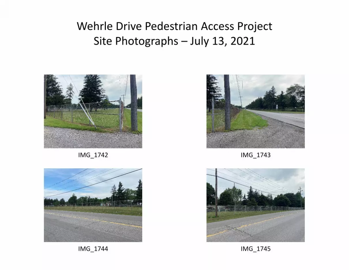
Wehrle Drive Pedestrian Access ProjectSite Photographs – July 13, 2021
IMG_1742 IMG_1743
IMG_1744 IMG_1745

Wehrle Drive Pedestrian Access ProjectSite Photographs – July 13, 2021
IMG_1746 IMG_1747
IMG_1748 IMG_1749
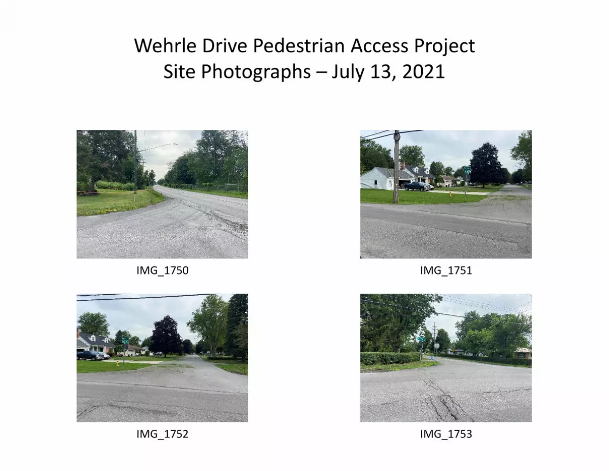
Wehrle Drive Pedestrian Access ProjectSite Photographs – July 13, 2021
IMG_1750 IMG_1751
IMG_1752 IMG_1753

Wehrle Drive Pedestrian Access ProjectSite Photographs – July 13, 2021
IMG_1754 IMG_1755
IMG_1756 IMG_1757
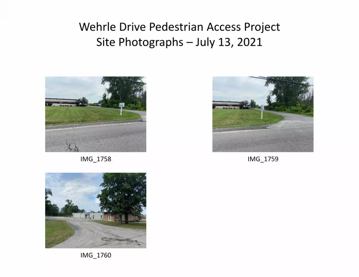
Wehrle Drive Pedestrian Access ProjectSite Photographs – July 13, 2021
IMG_1758 IMG_1759
IMG_1760
Project Property: Wehrle Dr Ped AccessWehrle Dr., Clarence NY
Project No: X52001001.1602 Report Type: Database Report Order No: 21070600059 Requested by: C&S Companies Date Completed: July 9, 2021
2 erisinfo.com | Environmental Risk Information Services Order No: 21070600059
h-Table of Contents
Notice: IMPORTANT LIMITATIONS and YOUR LIABILITY
Reliance on information in Report: This report DOES NOT replace a full Phase I Environmental Site Assessment but is solely intended to be used asdatabase review of environmental records.
License for use of information in Report: No page of this report can be used without this cover page, this notice and the project property identifier.The information in Report(s) may not be modified or re-sold.
Your Liability for misuse: Using this Service and/or its reports in a manner contrary to this Notice or your agreement will be in breach of copyright andcontract and ERIS may obtain damages for such mis-use, including damages caused to third parties, and gives ERIS the right to terminate your account,rescind your license to any previous reports and to bar you from future use of the Service.
No warranty of Accuracy or Liability for ERIS: The information contained in this report has been produced by ERIS Information Inc. ("ERIS") usingvarious sources of information, including information provided by Federal and State government departments. The report applies only to the address andup to the date specified on the cover of this report, and any alterations or deviation from this description will require a new report. This report and thedata contained herein does not purport to be and does not constitute a guarantee of the accuracy of the information contained herein and does notconstitute a legal opinion nor medical advice. Although ERIS has endeavored to present you with information that is accurate, ERIS disclaims, any andall liability for any errors, omissions, or inaccuracies in such information and data, whether attributable to inadvertence, negligence or otherwise, and forany consequences arising therefrom. Liability on the part of ERIS is limited to the monetary value paid for this report.
Trademark and Copyright: You may not use the ERIS trademarks or attribute any work to ERIS other than as outlined above. This Service and Report(s) are protected by copyright owned by ERIS Information Inc. Copyright in data used in the Service or Report(s) (the "Data") is owned by ERIS or itslicensors. The Service, Report(s) and Data may not be copied or reproduced in whole or in any substantial part without prior written consent of ERIS.
Table of Contents
Table of Contents...........................................................................................2Executive Summary........................................................................................3 Executive Summary: Report Summary.......................................................................................................................4
Executive Summary: Site Report Summary - Project Property...................................................................................8
Executive Summary: Site Report Summary - Surrounding Properties........................................................................9
Executive Summary: Summary by Data Source.......................................................................................................11
Map...............................................................................................................15Aerial.............................................................................................................18Topographic Map..........................................................................................19Detail Report.................................................................................................20Unplottable Summary.................................................................................124Unplottable Report......................................................................................125Appendix: Database Descriptions...............................................................137Definitions...................................................................................................149

3 erisinfo.com | Environmental Risk Information Services Order No: 21070600059
h-Executive Summary
Property Information:
Project Property: Wehrle Dr Ped AccessWehrle Dr., Clarence NY
Project No: X52001001.1602
Coordinates:
Latitude: 42.95926713 Longitude: -78.65929388 UTM Northing: 4,758,949.87 UTM Easting: 690,916.95 UTM Zone: 17T
Elevation: 714 FT
Order Information:
Order No: 21070600059 Date Requested: July 6, 2021 Requested by: C&S Companies Report Type: Database Report
Historicals/Products:
Aerial Photographs Historical Aerials (Boundaries)
ERIS Xplorer ERIS Xplorer Excel Add-On Excel Add-On
Fire Insurance Maps US Fire Insurance Maps
Physical Setting Report (PSR) Physical Setting Report (PSR)
Executive Summary

4 erisinfo.com | Environmental Risk Information Services Order No: 21070600059
h-Executive Summary: Report Summary
Database Searched Search Radius
Project Property
Within 0.12mi
0.125mi to 0.25mi
0.25mi to0.50mi
0.50mi to1.00mi
Total
Standard Environmental Records
Federal
rr-DOE FUSRAP-aa Y 1 0 0 0 0 0 0
rr-NPL-aa Y 1 0 0 0 0 0 0
rr-PROPOSED NPL-aa Y 1 0 0 0 0 0 0
rr-DELETED NPL-aa Y 0.5 0 0 0 0 - 0
rr-SEMS-aa Y 0.5 0 0 0 0 - 0
rr-ODI-aa Y 0.5 0 0 0 0 - 0
rr-SEMS ARCHIVE-aa Y 0.5 0 0 0 0 - 0
rr-CERCLIS-aa Y 0.5 0 0 0 0 - 0
rr-IODI-aa Y 0.5 0 0 0 0 - 0
rr-CERCLIS NFRAP-aa Y 0.5 0 0 0 0 - 0
rr-CERCLIS LIENS-aa Y PO 0 - - - - 0
rr-RCRA CORRACTS-aa Y 1 0 0 0 0 0 0
rr-RCRA TSD-aa Y 0.5 0 0 0 0 - 0
rr-RCRA LQG-aa Y 0.25 0 1 0 - - 1
rr-RCRA SQG-aa Y 0.25 0 0 0 - - 0
rr-RCRA VSQG-aa Y 0.25 0 1 0 - - 1
rr-RCRA NON GEN-aa Y 0.25 0 0 0 - - 0
rr-FED ENG-aa Y 0.5 0 0 0 0 - 0
rr-FED INST-aa Y 0.5 0 0 0 0 - 0
rr-LUCIS-aa Y 0.5 0 0 0 0 - 0
rr-ERNS 1982 TO 1986-aa Y PO 0 - - - - 0
rr-ERNS 1987 TO 1989-aa Y PO 0 - - - - 0
rr-ERNS-aa Y PO 0 - - - - 0
rr-FED BROWNFIELDS-aa Y 0.5 0 0 0 0 - 0
rr-FEMA UST-aa Y 0.25 0 0 0 - - 0
rr-FRP-aa Y 0.25 0 0 0 - - 0
rr-HIST GAS STATIONS-aa Y 0.25 0 0 0 - - 0
DOE FUSRAP
NPL
PROPOSED NPL
DELETED NPL
SEMS
ODI
SEMS ARCHIVE
CERCLIS
IODI
CERCLIS NFRAP
CERCLIS LIENS
RCRA CORRACTS
RCRA TSD
RCRA LQG
RCRA SQG
RCRA VSQG
RCRA NON GEN
FED ENG
FED INST
LUCIS
ERNS 1982 TO 1986
ERNS 1987 TO 1989
ERNS
FED BROWNFIELDS
FEMA UST
FRP
HIST GAS STATIONS
Executive Summary: Report Summary

5 erisinfo.com | Environmental Risk Information Services Order No: 21070600059
Database Searched Search Radius
Project Property
Within 0.12mi
0.125mi to 0.25mi
0.25mi to0.50mi
0.50mi to1.00mi
Total
rr-REFN-aa Y 0.25 0 0 0 - - 0
rr-BULK TERMINAL-aa Y 0.25 0 0 0 - - 0
rr-SEMS LIEN-aa Y PO 0 - - - - 0
rr-SUPERFUND ROD-aa Y 1 0 0 0 0 0 0
State
rr-SHWS-aa Y 1 0 0 0 0 0 0
rr-DELISTED SHWS-aa Y 1 0 0 0 0 0 0
rr-HSWDS-aa Y 1 0 0 0 0 0 0
rr-VAPOR-aa Y 1 0 0 0 0 0 0
rr-SWF/LF-aa Y 0.5 0 0 0 1 - 1
rr-LANDFILL INACTIVE-aa Y 0.5 0 0 0 0 - 0
rr-WASTE TIRE-aa Y 0.5 0 0 0 0 - 0
rr-RECYCLING-aa Y 0.5 0 0 0 0 - 0
rr-LST-aa Y 0.5 0 0 0 3 - 3
rr-DELISTED LST-aa Y 0.5 0 0 0 0 - 0
rr-UST-aa Y 0.25 0 2 0 - - 2
rr-AST-aa Y 0.25 0 1 0 - - 1
rr-TANKS-aa Y 0.25 0 0 0 - - 0
rr-MOSF-aa Y 0.5 0 0 0 0 - 0
rr-CBS-aa Y 0.25 0 0 0 - - 0
rr-DELISTED TANKS-aa Y 0.25 0 0 0 - - 0
rr-DELISTED COUNTY-aa Y 0.25 0 0 0 - - 0
rr-ENG-aa Y 0.5 0 0 0 0 - 0
rr-INST-aa Y 0.5 0 0 0 0 - 0
rr-VCP-aa Y 0.5 0 0 0 0 - 0
rr-ERP-aa Y 0.5 0 0 0 0 - 0
rr-BROWNFIELDS-aa Y 0.5 0 0 0 0 - 0
Tribal
rr-INDIAN LUST-aa Y 0.5 0 0 0 0 - 0
rr-INDIAN UST-aa Y 0.25 0 0 0 - - 0
rr-DELISTED ILST-aa Y 0.5 0 0 0 0 - 0
rr-DELISTED IUST-aa Y 0.25 0 0 0 - - 0
County No County databases were selected to be included in the search.
REFN
BULK TERMINAL
SEMS LIEN
SUPERFUND ROD
SHWS
DELISTED SHWS
HSWDS
VAPOR
SWF/LF
LANDFILL INACTIVE
WASTE TIRE
RECYCLING
LST
DELISTED LST
UST
AST
TANKS
MOSF
CBS
DELISTED TANKS
DELISTED COUNTY
ENG
INST
VCP
ERP
BROWNFIELDS
INDIAN LUST
INDIAN UST
DELISTED ILST
DELISTED IUST
6 erisinfo.com | Environmental Risk Information Services Order No: 21070600059
Database Searched Search Radius
Project Property
Within 0.12mi
0.125mi to 0.25mi
0.25mi to0.50mi
0.50mi to1.00mi
Total
Additional Environmental Records
Federal
rr-PFAS NPL-aa Y 0.5 0 0 0 0 - 0
rr-FINDS/FRS-aa Y PO 0 - - - - 0
rr-TRIS-aa Y PO 0 - - - - 0
rr-PFAS TRI-aa Y 0.5 0 0 0 0 - 0
rr-PFAS WATER-aa Y 0.5 0 0 0 0 - 0
rr-HMIRS-aa Y 0.125 0 0 - - - 0
rr-NCDL-aa Y 0.125 0 0 - - - 0
rr-TSCA-aa Y 0.125 0 1 - - - 1
rr-HIST TSCA-aa Y 0.125 0 0 - - - 0
rr-FTTS ADMIN-aa Y PO 0 - - - - 0
rr-FTTS INSP-aa Y PO 0 - - - - 0
rr-PRP-aa Y PO 0 - - - - 0
rr-SCRD DRYCLEANER-aa Y 0.5 0 0 0 0 - 0
rr-ICIS-aa Y PO 0 - - - - 0
rr-FED DRYCLEANERS-aa Y 0.25 0 0 0 - - 0
rr-DELISTED FED DRY-aa Y 0.25 0 0 0 - - 0
rr-FUDS-aa Y 1 0 0 0 0 0 0
rr-FORMER NIKE-aa Y 1 0 0 0 0 0 0
rr-PIPELINE INCIDENT-aa Y PO 0 - - - - 0
rr-MLTS-aa Y PO 0 - - - - 0
rr-HIST MLTS-aa Y PO 0 - - - - 0
rr-MINES-aa Y 0.25 0 1 0 - - 1
rr-SMCRA-aa Y 1 0 0 0 0 0 0
rr-MRDS-aa Y 1 0 0 0 0 3 3
rr-URANIUM-aa Y 1 0 0 0 0 0 0
rr-ALT FUELS-aa Y 0.25 0 0 0 - - 0
rr-SSTS-aa Y 0.25 0 0 0 - - 0
rr-PCB-aa Y 0.5 0 0 0 0 - 0
State
rr-UIC-aa Y PO 0 - - - - 0
rr-MGP-aa Y 1 0 0 0 0 0 0
rr-NY SPILLS-aa Y 0.125 0 3 - - - 3
PFAS NPL
FINDS/FRS
TRIS
PFAS TRI
PFAS WATER
HMIRS
NCDL
TSCA
HIST TSCA
FTTS ADMIN
FTTS INSP
PRP
SCRD DRYCLEANER
ICIS
FED DRYCLEANERS
DELISTED FED DRY
FUDS
FORMER NIKE
PIPELINE INCIDENT
MLTS
HIST MLTS
MINES
SMCRA
MRDS
URANIUM
ALT FUELS
SSTS
PCB
UIC
MGP
NY SPILLS

7 erisinfo.com | Environmental Risk Information Services Order No: 21070600059
Database Searched Search Radius
Project Property
Within 0.12mi
0.125mi to 0.25mi
0.25mi to0.50mi
0.50mi to1.00mi
Total
rr-PFAS CONTAM-aa Y 0.5 0 0 0 0 - 0
rr-PFAS-aa Y 0.5 0 0 0 0 - 0
rr-PFAS LANDFILL-aa Y 0.5 0 0 0 0 - 0
rr-DRYCLEANERS-aa Y 0.25 0 0 0 - - 0
rr-DELISTED DRYCLEANERS-aa Y 0.25 0 0 0 - - 0
rr-NY MANIFEST-aa Y 0.125 0 0 - - - 0
rr-REC MANIFEST-aa Y 0.25 0 0 0 - - 0
rr-GEN MANIFEST-aa Y 0.125 0 1 - - - 1
rr-E DESIGNATION-aa Y 0.125 0 0 - - - 0
rr-TIER 2-aa Y 0.125 0 1 - - - 1
rr-PROJECTS-aa Y 0.25 0 0 0 - - 0
rr-AIR PERMITS-aa Y 0.25 0 1 0 - - 1
rr-LIEN-aa Y PO 0 - - - - 0
Tribal No Tribal additional environmental record sources available for this State.
County No County additional environmental record sources available for this State.
Total: 0 13 0 4 3 20
* PO – Property Only* 'Property and adjoining properties' database search radii are set at 0.25 miles.
PFAS CONTAM
PFAS
PFAS LANDFILL
DRYCLEANERS
DELISTED DRYCLEANERS
NY MANIFEST
REC MANIFEST
GEN MANIFEST
E DESIGNATION
TIER 2
PROJECTS
AIR PERMITS
LIEN
8 erisinfo.com | Environmental Risk Information Services Order No: 21070600059
h-Executive Summary: Site Report Summary - Project Property
MapKey
DB Company/Site Name Address Direction Distance(mi/ft)
Elev Diff(ft)
Page Number
No records found in the selected databases for the project property.
Executive Summary: Site Report Summary - Project Property
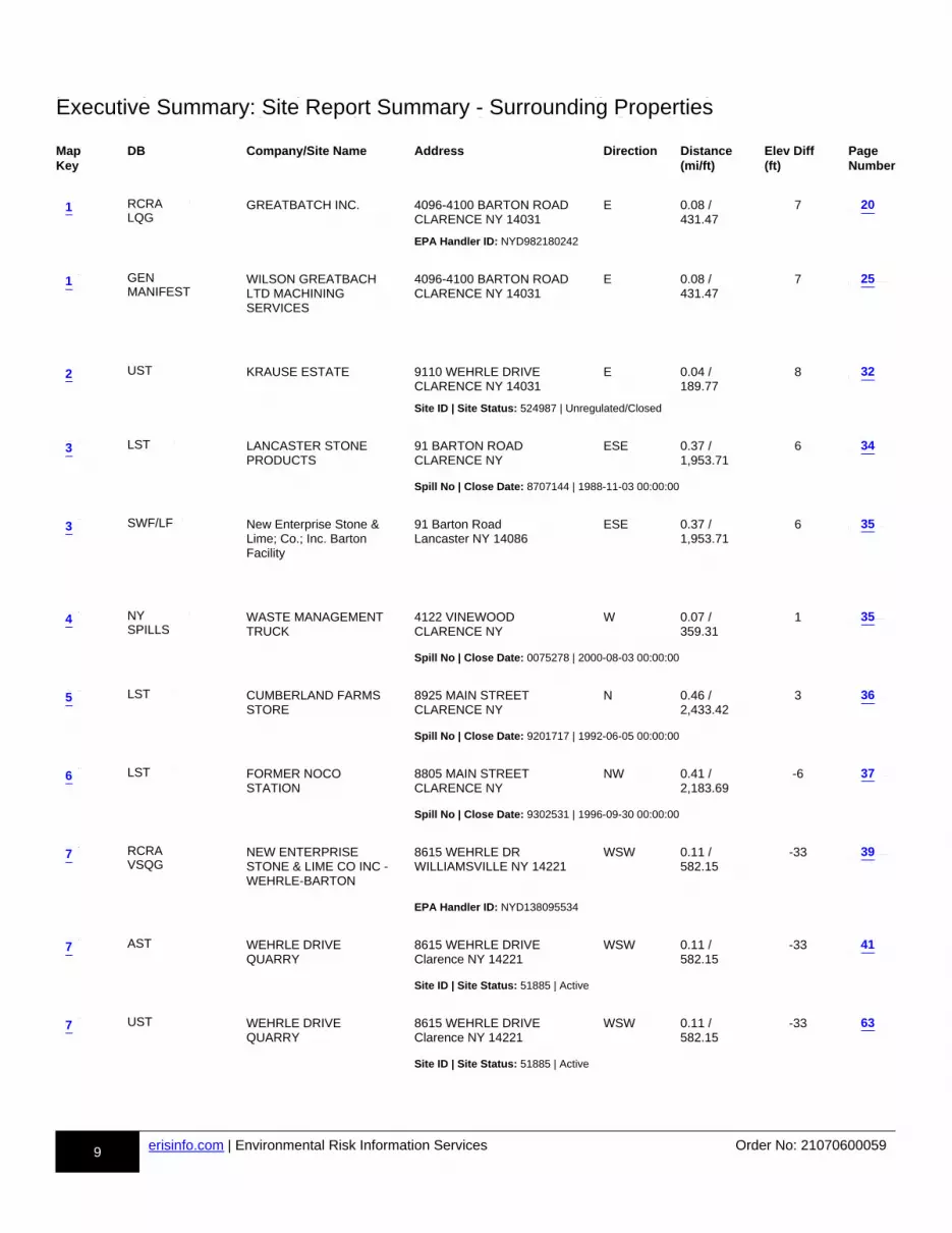
9 erisinfo.com | Environmental Risk Information Services Order No: 21070600059
h-Executive Summary: Site Report Summary - Surrounding Properties
MapKey
DB Company/Site Name Address Direction Distance(mi/ft)
Elev Diff(ft)
Page Number
m1ddd-RCRA LQG-810508018-aa
GREATBATCH INC. 4096-4100 BARTON ROAD CLARENCE NY 14031
E 0.08 / 431.47
7 p1p-20-810508018-x1x
EPA Handler ID: NYD982180242
m1ddd-GEN MANIFEST-874677078-aa
WILSON GREATBACH LTD MACHINING SERVICES
4096-4100 BARTON ROAD CLARENCE NY 14031
E 0.08 / 431.47
7 p1p-25-874677078-x1x
m2ddd-UST-844754613-aa
KRAUSE ESTATE 9110 WEHRLE DRIVE CLARENCE NY 14031
E 0.04 / 189.77
8 p1p-32-844754613-x1x
Site ID | Site Status: 524987 | Unregulated/Closed
m3ddd-LST-814043706-aa
LANCASTER STONE PRODUCTS
91 BARTON ROAD CLARENCE NY
ESE 0.37 / 1,953.71
6 p1p-34-814043706-x1x
Spill No | Close Date: 8707144 | 1988-11-03 00:00:00
m3ddd-SWF/LF-881495451-aa
New Enterprise Stone & Lime; Co.; Inc. Barton Facility
91 Barton Road Lancaster NY 14086
ESE 0.37 / 1,953.71
6 p1p-35-881495451-x1x
m4ddd-NY SPILLS-813762614-aa
WASTE MANAGEMENT TRUCK
4122 VINEWOOD CLARENCE NY
W 0.07 / 359.31
1 p1p-35-813762614-x1x
Spill No | Close Date: 0075278 | 2000-08-03 00:00:00
m5ddd-LST-814039327-aa
CUMBERLAND FARMS STORE
8925 MAIN STREET CLARENCE NY
N 0.46 / 2,433.42
3 p1p-36-814039327-x1x
Spill No | Close Date: 9201717 | 1992-06-05 00:00:00
m6ddd-LST-813998367-aa
FORMER NOCO STATION
8805 MAIN STREET CLARENCE NY
NW 0.41 / 2,183.69
-6 p1p-37-813998367-x1x
Spill No | Close Date: 9302531 | 1996-09-30 00:00:00
m7ddd-RCRA VSQG-810514021-aa
NEW ENTERPRISE STONE & LIME CO INC - WEHRLE-BARTON
8615 WEHRLE DR WILLIAMSVILLE NY 14221
WSW 0.11 / 582.15
-33 p1p-39-810514021-x1x
EPA Handler ID: NYD138095534
m7ddd-AST-810892945-aa
WEHRLE DRIVE QUARRY
8615 WEHRLE DRIVE Clarence NY 14221
WSW 0.11 / 582.15
-33 p1p-41-810892945-x1x
Site ID | Site Status: 51885 | Active
m7ddd-UST-810948336-aa
WEHRLE DRIVE QUARRY
8615 WEHRLE DRIVE Clarence NY 14221
WSW 0.11 / 582.15
-33 p1p-63-810948336-x1x
Site ID | Site Status: 51885 | Active
20
25
32
34
35
35
36
37
39
41
63
1
1
2
3
3
4
5
6
7
7
7
RCRALQG
GENMANIFEST
UST
LST
SWF/LF
NYSPILLS
LST
LST
RCRAVSQG
AST
UST
Executive Summary: Site Report Summary - Surrounding Properties
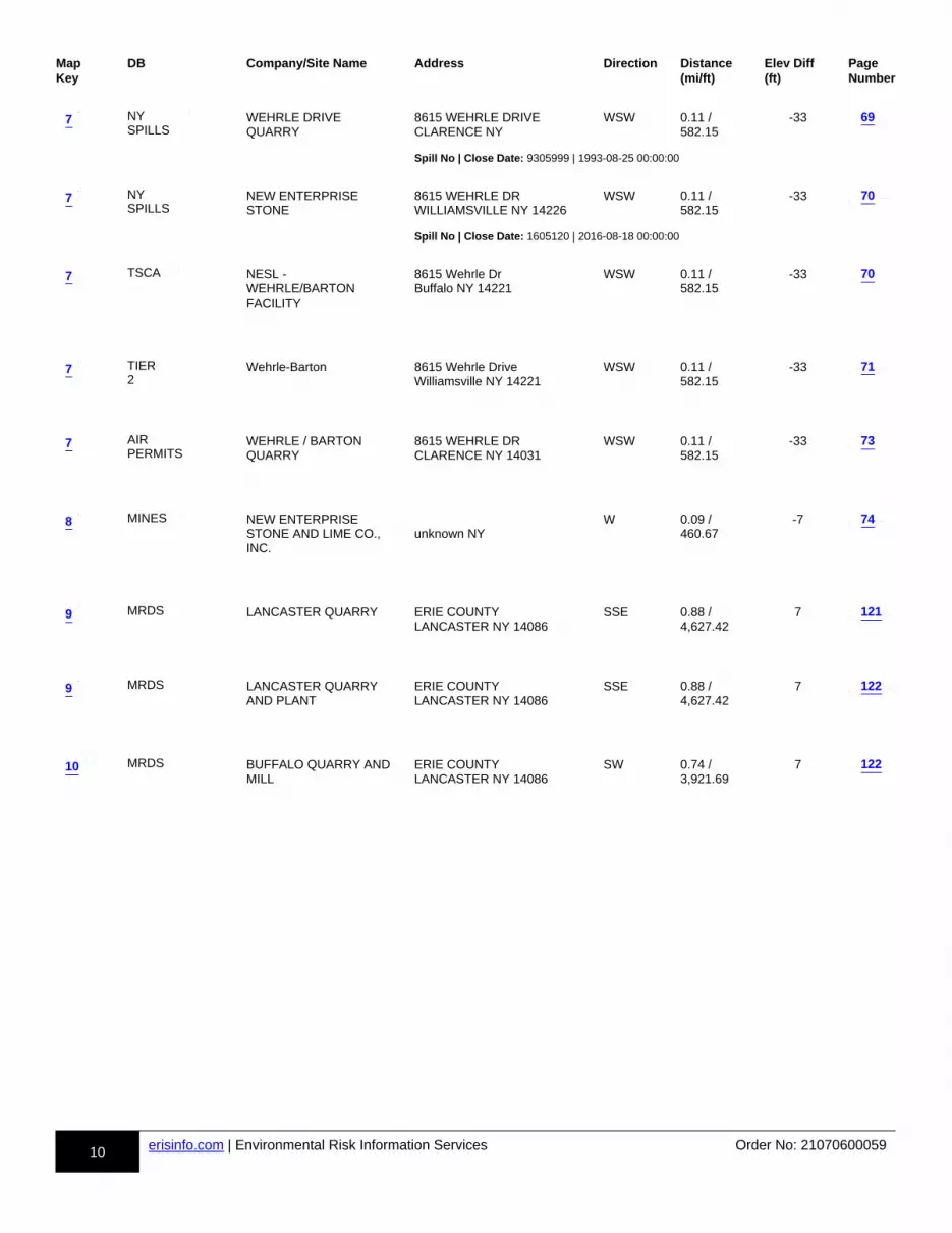
10 erisinfo.com | Environmental Risk Information Services Order No: 21070600059
MapKey
DB Company/Site Name Address Direction Distance(mi/ft)
Elev Diff(ft)
Page Number
m7ddd-NY SPILLS-813949922-aa
WEHRLE DRIVE QUARRY
8615 WEHRLE DRIVE CLARENCE NY
WSW 0.11 / 582.15
-33 p1p-69-813949922-x1x
Spill No | Close Date: 9305999 | 1993-08-25 00:00:00
m7ddd-NY SPILLS-857844738-aa
NEW ENTERPRISE STONE
8615 WEHRLE DR WILLIAMSVILLE NY 14226
WSW 0.11 / 582.15
-33 p1p-70-857844738-x1x
Spill No | Close Date: 1605120 | 2016-08-18 00:00:00
m7ddd-TSCA-861693543-aa
NESL - WEHRLE/BARTON FACILITY
8615 Wehrle Dr Buffalo NY 14221
WSW 0.11 / 582.15
-33 p1p-70-861693543-x1x
m7ddd-TIER 2-872765301-aa
Wehrle-Barton 8615 Wehrle Drive Williamsville NY 14221
WSW 0.11 / 582.15
-33 p1p-71-872765301-x1x
m7ddd-AIR PERMITS-891998704-aa
WEHRLE / BARTON QUARRY
8615 WEHRLE DR CLARENCE NY 14031
WSW 0.11 / 582.15
-33 p1p-73-891998704-x1x
m8ddd-MINES-848291774-aa
NEW ENTERPRISE STONE AND LIME CO., INC.
unknown NY
W 0.09 / 460.67
-7 p1p-74-848291774-x1x
m9ddd-MRDS-888523803-aa
LANCASTER QUARRY ERIE COUNTY LANCASTER NY 14086
SSE 0.88 / 4,627.42
7 p1p-121-888523803-x1x
m9ddd-MRDS-888625313-aa
LANCASTER QUARRY AND PLANT
ERIE COUNTY LANCASTER NY 14086
SSE 0.88 / 4,627.42
7 p1p-122-888625313-x1x
m10ddd-MRDS-888587593-aa
BUFFALO QUARRY AND MILL
ERIE COUNTY LANCASTER NY 14086
SW 0.74 / 3,921.69
7 p1p-122-888587593-x1x
69
70
70
71
73
74
121
122
122
7
7
7
7
7
8
9
9
10
NYSPILLS
NYSPILLS
TSCA
TIER2
AIRPERMITS
MINES
MRDS
MRDS
MRDS

11 erisinfo.com | Environmental Risk Information Services Order No: 21070600059
h-Executive Summary: Summary by Data Source
Standard
Federal
RCRA LQG - RCRA Generator List
A search of the RCRA LQG database, dated Apr 5, 2021 has found that there are 1 RCRA LQG site(s) within approximately 0.25 miles of the project property.
Equal/Higher Elevation Address Direction Distance (mi/ft) Map Key
GREATBATCH INC. 4096-4100 BARTON ROAD CLARENCE NY 14031
E 0.08 / 431.47 m-1-810508018-a
EPA Handler ID: NYD982180242
RCRA VSQG - RCRA Very Small Quantity Generators List
A search of the RCRA VSQG database, dated Apr 5, 2021 has found that there are 1 RCRA VSQG site(s) within approximately 0.25 miles of the project property.
Lower Elevation Address Direction Distance (mi/ft) Map Key
NEW ENTERPRISE STONE & LIME CO INC - WEHRLE-BARTON
8615 WEHRLE DR WILLIAMSVILLE NY 14221
WSW 0.11 / 582.15 m-7-810514021-a
EPA Handler ID: NYD138095534
State
SWF/LF - Solid Waste Facilities and Landfills
A search of the SWF/LF database, dated Dec 31, 2020 has found that there are 1 SWF/LF site(s) within approximately 0.50 miles of theproject property.
Equal/Higher Elevation Address Direction Distance (mi/ft) Map Key
New Enterprise Stone & Lime; Co.;Inc. Barton Facility
91 Barton Road Lancaster NY 14086
ESE 0.37 / 1,953.71 m-3-881495451-a
LST - Leaking Storage Tanks
A search of the LST database, dated Jun 3, 2021 has found that there are 3 LST site(s) within approximately 0.50 miles of the project property.
Equal/Higher Elevation Address Direction Distance (mi/ft) Map Key
LANCASTER STONE PRODUCTS 91 BARTON ROAD CLARENCE NY
ESE 0.37 / 1,953.71 m-3-814043706-a
Spill No | Close Date: 8707144 | 1988-11-03 00:00:00
CUMBERLAND FARMS STORE 8925 MAIN STREET CLARENCE NY
N 0.46 / 2,433.42 m-5-814039327-a
1
7
3
3
5
Executive Summary: Summary by Data Source
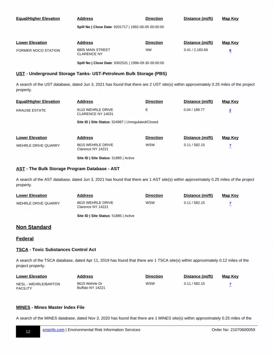
12 erisinfo.com | Environmental Risk Information Services Order No: 21070600059
Equal/Higher Elevation Address Direction Distance (mi/ft) Map Key
Spill No | Close Date: 9201717 | 1992-06-05 00:00:00
Lower Elevation Address Direction Distance (mi/ft) Map Key
FORMER NOCO STATION 8805 MAIN STREET CLARENCE NY
NW 0.41 / 2,183.69 m-6-813998367-a
Spill No | Close Date: 9302531 | 1996-09-30 00:00:00
UST - Underground Storage Tanks- UST-Petroleum Bulk Storage (PBS)
A search of the UST database, dated Jun 3, 2021 has found that there are 2 UST site(s) within approximately 0.25 miles of the project property.
Equal/Higher Elevation Address Direction Distance (mi/ft) Map Key
KRAUSE ESTATE 9110 WEHRLE DRIVE CLARENCE NY 14031
E 0.04 / 189.77 m-2-844754613-a
Site ID | Site Status: 524987 | Unregulated/Closed
Lower Elevation Address Direction Distance (mi/ft) Map Key
WEHRLE DRIVE QUARRY 8615 WEHRLE DRIVE Clarence NY 14221
WSW 0.11 / 582.15 m-7-810948336-a
Site ID | Site Status: 51885 | Active
AST - The Bulk Storage Program Database - AST
A search of the AST database, dated Jun 3, 2021 has found that there are 1 AST site(s) within approximately 0.25 miles of the project property.
Lower Elevation Address Direction Distance (mi/ft) Map Key
WEHRLE DRIVE QUARRY 8615 WEHRLE DRIVE Clarence NY 14221
WSW 0.11 / 582.15 m-7-810892945-a
Site ID | Site Status: 51885 | Active
Non Standard
Federal
TSCA - Toxic Substances Control Act
A search of the TSCA database, dated Apr 11, 2019 has found that there are 1 TSCA site(s) within approximately 0.12 miles of the project property.
Lower Elevation Address Direction Distance (mi/ft) Map Key
NESL - WEHRLE/BARTON FACILITY
8615 Wehrle Dr Buffalo NY 14221
WSW 0.11 / 582.15 m-7-861693543-a
MINES - Mines Master Index File
A search of the MINES database, dated Nov 3, 2020 has found that there are 1 MINES site(s) within approximately 0.25 miles of the
6
2
7
7
7
13 erisinfo.com | Environmental Risk Information Services Order No: 21070600059
project property.
Lower Elevation Address Direction Distance (mi/ft) Map Key
NEW ENTERPRISE STONE AND LIME CO., INC.
unknown NY
W 0.09 / 460.67 m-8-848291774-a
MRDS - Mineral Resource Data System
A search of the MRDS database, dated Mar 15, 2006 has found that there are 3 MRDS site(s) within approximately 1.00 miles of the project property.
Equal/Higher Elevation Address Direction Distance (mi/ft) Map Key
LANCASTER QUARRY ERIE COUNTY LANCASTER NY 14086
SSE 0.88 / 4,627.42 m-9-888523803-a
LANCASTER QUARRY AND PLANT
ERIE COUNTY LANCASTER NY 14086
SSE 0.88 / 4,627.42 m-9-888625313-a
BUFFALO QUARRY AND MILL ERIE COUNTY LANCASTER NY 14086
SW 0.74 / 3,921.69 m-10-888587593-a
State
NY SPILLS - Spill Incidents Database
A search of the NY SPILLS database, dated Jun 3, 2021 has found that there are 3 NY SPILLS site(s) within approximately 0.12 miles of the project property.
Equal/Higher Elevation Address Direction Distance (mi/ft) Map Key
WASTE MANAGEMENT TRUCK 4122 VINEWOOD CLARENCE NY
W 0.07 / 359.31 m-4-813762614-a
Spill No | Close Date: 0075278 | 2000-08-03 00:00:00
Lower Elevation Address Direction Distance (mi/ft) Map Key
NEW ENTERPRISE STONE 8615 WEHRLE DR WILLIAMSVILLE NY 14226
WSW 0.11 / 582.15 m-7-857844738-a
Spill No | Close Date: 1605120 | 2016-08-18 00:00:00
WEHRLE DRIVE QUARRY 8615 WEHRLE DRIVE CLARENCE NY
WSW 0.11 / 582.15 m-7-813949922-a
Spill No | Close Date: 9305999 | 1993-08-25 00:00:00
GEN MANIFEST - Generators from Hazardous Waste Manifests
A search of the GEN MANIFEST database, dated May 12, 2021 has found that there are 1 GEN MANIFEST site(s) within approximately 0.12 miles of the project property.
8
9
9
10
4
7
7

14 erisinfo.com | Environmental Risk Information Services Order No: 21070600059
Equal/Higher Elevation Address Direction Distance (mi/ft) Map Key
WILSON GREATBACH LTD MACHINING SERVICES
4096-4100 BARTON ROAD CLARENCE NY 14031
E 0.08 / 431.47 m-1-874677078-a
TIER 2 - Tier 2 Report
A search of the TIER 2 database, dated Jan 28, 2019 has found that there are 1 TIER 2 site(s) within approximately 0.12 miles of the project property.
Lower Elevation Address Direction Distance (mi/ft) Map Key
Wehrle-Barton 8615 Wehrle Drive Williamsville NY 14221
WSW 0.11 / 582.15 m-7-872765301-a
AIR PERMITS - Air Permitted Facilities
A search of the AIR PERMITS database, dated Aug 3, 2020 has found that there are 1 AIR PERMITS site(s) within approximately 0.25 miles of the project property.
Lower Elevation Address Direction Distance (mi/ft) Map Key
WEHRLE / BARTON QUARRY 8615 WEHRLE DR CLARENCE NY 14031
WSW 0.11 / 582.15 m-7-891998704-a
1
7
7
#*
#*
#*
#*
#*
#*
#*
#*
#*
#*m6c
m8c
m5c
m4c
m2c
m10c
m3c(2)
m1c(2)
m7c(8)
m9c(2)
E l l icott Creek
Got t C reekGot t Creek
E ll icott Creek
I -90 E I-90 W
Main St
78°37'30"W78°38'W78°38'30"W78°39'W78°39'30"W78°40'W78°40'30"W78°41'W78°41'30"W
42°59
'N 42°59
'N
42°58
'30"N
42°58
'30"N
42°58
'N 42°58
'N
42°57
'30"N
42°57
'30"N
42°57
'N 42°57
'N
42°56
'30"N
42°56
'30"N
42°56
'N0.45 0 0.450.225Miles
Order Number: 21070600059Map: 1.0 Mile Radius
1:29000
Address: Wehrle Dr., Clarence, NY
Source: © 2016 ESRI © ERIS Information Inc.
Local Roads and Ramps
PlumeBuffer Outline#* Eris Sites with Higher Elevation") Eris Sites with Same Elevation
#*
Eris Sites with Lower Elevation
( Eris Sites with Unknown ElevationCounty Boundary
RailsMajor HighwaysMajor Highways RampsMajor RoadsMajor Roads RampsSecondary RoadsSecondary Roads Ramps
State BoundaryNational Priority List SitesNational WetlandIndian Reserve Land100 Year Flood Zone500 Year Flood Zone
FWS Special Designation AreasState Brownfield SitesState Brownfield AreasState Superfund Areas:Dept. of DefenseState Superfund Areas:NPLWQARF AreasFederal Lands: Dept. of Defense (owned/administered areas)Historic Fill
6
8
5
4
2
10
3 (2)
1 (2)
7 (8)
9 (2)
#*
#*
#*
#*
#*
#*
#*
#*
#*
#*m6c
m8c
m5c
m4c
m2c
m10c
m3c(2)
m1c(2)
m7c(8)
m9c(2)I -90 EI-90 W
Main St
78°38'30"W78°39'W78°39'30"W78°40'W78°40'30"W
42°58
'30"N
42°58
'30"N
42°58
'N 42°58
'N
42°57
'30"N
42°57
'30"N
42°57
'N 42°57
'N42
°56'30
"N
0.3 0 0.30.15Miles
Order Number: 21070600059Map: 0.5 Mile Radius
1:19700
Address: Wehrle Dr., Clarence, NY
Source: © 2016 ESRI © ERIS Information Inc.
Local Roads and Ramps
PlumeBuffer Outline#* Eris Sites with Higher Elevation") Eris Sites with Same Elevation
#*
Eris Sites with Lower Elevation
( Eris Sites with Unknown ElevationCounty Boundary
RailsMajor HighwaysMajor Highways RampsMajor RoadsMajor Roads RampsSecondary RoadsSecondary Roads Ramps
State BoundaryNational Priority List SitesNational WetlandIndian Reserve Land100 Year Flood Zone500 Year Flood Zone
FWS Special Designation AreasState Brownfield SitesState Brownfield AreasState Superfund Areas:Dept. of DefenseState Superfund Areas:NPLWQARF AreasFederal Lands: Dept. of Defense (owned/administered areas)Historic Fill
6
8
5
4
2
10
3 (2)
1 (2)
7 (8)
9 (2)
#*
#*
#*
#*
#*
#*
#*
#*
#*
#*m6c
m8c
m5c
m4c
m2c
m10c
m3c(2)
m1c(2)
m7c(8)
m9c(2)I -90 E
I-90 W
Main St
78°38'30"W78°39'W78°39'30"W78°40'W78°40'30"W
42°58
'N 42°58
'N
42°57
'30"N
42°57
'30"N
42°57
'N 42°57
'N
0.2 0 0.20.1Miles
Order Number: 21070600059Map: 0.25 Mile Radius
1:15000
Address: Wehrle Dr., Clarence, NY
Source: © 2016 ESRI © ERIS Information Inc.
Local Roads and Ramps
PlumeBuffer Outline#* Eris Sites with Higher Elevation") Eris Sites with Same Elevation
#*
Eris Sites with Lower Elevation
( Eris Sites with Unknown ElevationCounty Boundary
RailsMajor HighwaysMajor Highways RampsMajor RoadsMajor Roads RampsSecondary RoadsSecondary Roads Ramps
State BoundaryNational Priority List SitesNational WetlandIndian Reserve Land100 Year Flood Zone500 Year Flood Zone
FWS Special Designation AreasState Brownfield SitesState Brownfield AreasState Superfund Areas:Dept. of DefenseState Superfund Areas:NPLWQARF AreasFederal Lands: Dept. of Defense (owned/administered areas)Historic Fill
6
8
5
4
2
10
3 (2)
1 (2)
7 (8)
9 (2)
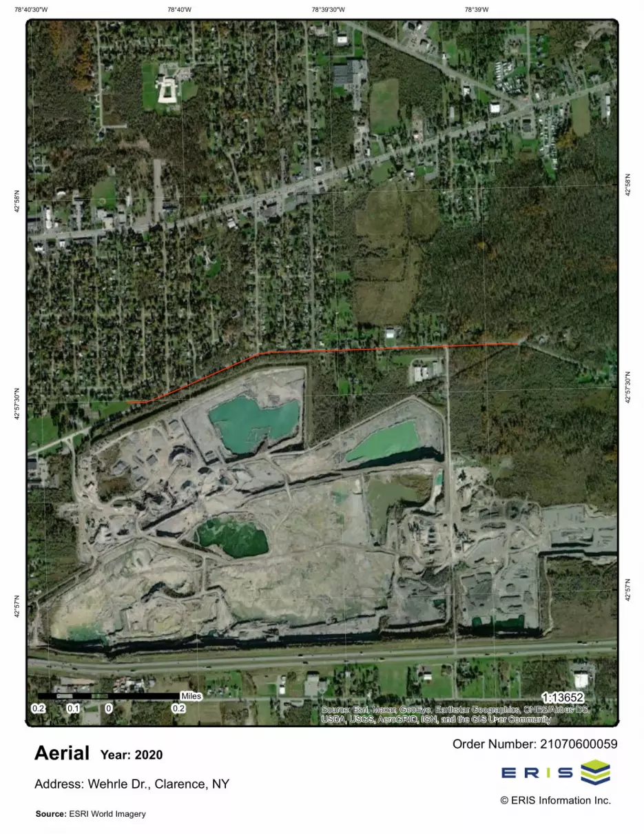
Source: Esri, Maxar, GeoEye, Earthstar Geographics, CNES/Airbus DS,USDA, USGS, AeroGRID, IGN, and the GIS User Community
78°39'W78°39'30"W78°40'W78°40'30"W42
°58'N 42
°58'N
42°57
'30"N
42°57
'30"N
42°57
'N 42°57
'N
0.2 0 0.20.1Miles
Order Number: 21070600059Aerial
1:13652
Address: Wehrle Dr., Clarence, NY© ERIS Information Inc.
Source: ESRI World Imagery
Year: 2020
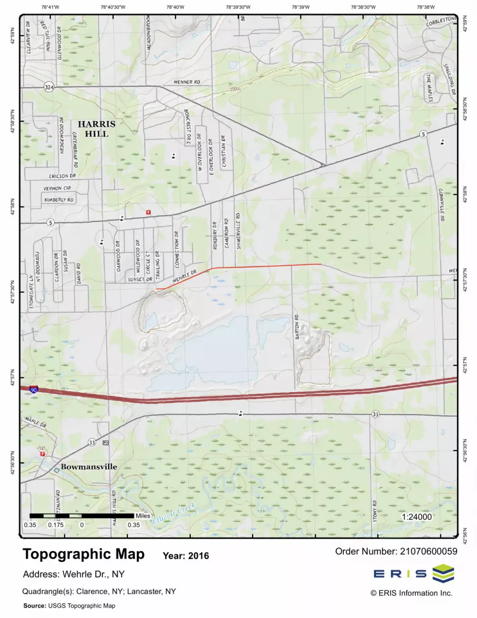
78°38'W78°38'30"W78°39'W78°39'30"W78°40'W78°40'30"W78°41'W42
°59'N 42
°59'N
42°58
'30"N
42°58
'30"N
42°58
'N 42°58
'N
42°57
'30"N
42°57
'30"N
42°57
'N 42°57
'N
42°56
'30"N
42°56
'30"N
42°56
'N
0.35 0 0.350.175Miles
Order Number: 21070600059Topographic Map
1:24000
Address: Wehrle Dr., NY© ERIS Information Inc.
Source: USGS Topographic MapQuadrangle(s): Clarence, NY; Lancaster, NY
Year: 2016
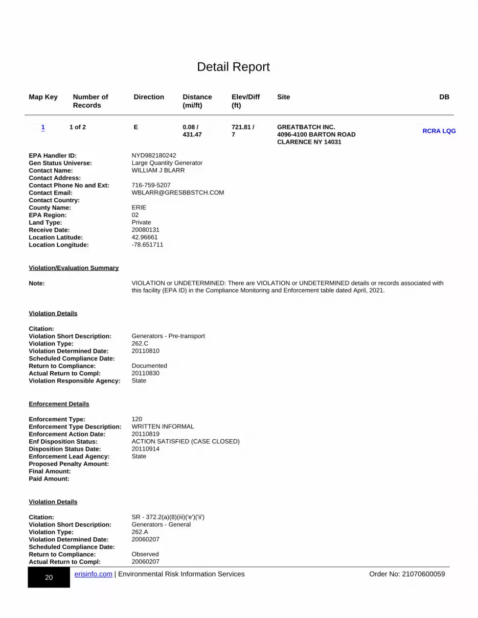
20 erisinfo.com | Environmental Risk Information Services Order No: 21070600059
h-Detail Report
Map Key Number of Records
Direction Distance(mi/ft)
Elev/Diff(ft)
Site DB
m-1-810508018-b
1 of 2 E 0.08 / 431.47
721.81 / 7
GREATBATCH INC. 4096-4100 BARTON ROAD CLARENCE NY 14031
dd-RCRA LQG-810508018-bb
p1p-810508018-y1y
EPA Handler ID: NYD982180242Gen Status Universe: Large Quantity GeneratorContact Name: WILLIAM J BLARRContact Address:Contact Phone No and Ext: 716-759-5207Contact Email: [email protected] Country:County Name: ERIEEPA Region: 02Land Type: PrivateReceive Date: 20080131Location Latitude: 42.96661Location Longitude: -78.651711
Violation/Evaluation Summary Note: VIOLATION or UNDETERMINED: There are VIOLATION or UNDETERMINED details or records associated with
this facility (EPA ID) in the Compliance Monitoring and Enforcement table dated April, 2021.
Violation Details Citation:Violation Short Description: Generators - Pre-transportViolation Type: 262.CViolation Determined Date: 20110810Scheduled Compliance Date:Return to Compliance: DocumentedActual Return to Compl: 20110830Violation Responsible Agency: State
Enforcement Details Enforcement Type: 120Enforcement Type Description: WRITTEN INFORMALEnforcement Action Date: 20110819Enf Disposition Status: ACTION SATISFIED (CASE CLOSED)Disposition Status Date: 20110914Enforcement Lead Agency: StateProposed Penalty Amount:Final Amount:Paid Amount:
Violation Details Citation: SR - 372.2(a)(8)(iii)('e')('ii')Violation Short Description: Generators - GeneralViolation Type: 262.AViolation Determined Date: 20060207Scheduled Compliance Date:Return to Compliance: ObservedActual Return to Compl: 20060207
1RCRA LQG
Detail Report

21 erisinfo.com | Environmental Risk Information Services Order No: 21070600059
Map Key Number of Records
Direction Distance(mi/ft)
Elev/Diff(ft)
Site DB
Violation Responsible Agency: State
Enforcement Details Enforcement Type: 120Enforcement Type Description: WRITTEN INFORMALEnforcement Action Date: 20060213Enf Disposition Status:Disposition Status Date:Enforcement Lead Agency: StateProposed Penalty Amount:Final Amount:Paid Amount:
Violation Details Citation: SR - 372.2(b)(2)(i) & (ii)Violation Short Description: Generators - Pre-transportViolation Type: 262.CViolation Determined Date: 20060207Scheduled Compliance Date:Return to Compliance: ObservedActual Return to Compl: 20060207Violation Responsible Agency: State
Enforcement Details Enforcement Type: 120Enforcement Type Description: WRITTEN INFORMALEnforcement Action Date: 20060213Enf Disposition Status:Disposition Status Date:Enforcement Lead Agency: StateProposed Penalty Amount:Final Amount:Paid Amount:
Violation Details Citation:Violation Short Description: Generators - GeneralViolation Type: 262.AViolation Determined Date: 20021008Scheduled Compliance Date:Return to Compliance: DocumentedActual Return to Compl: 20030529Violation Responsible Agency: EPA
Enforcement Details Enforcement Type: 120Enforcement Type Description: WRITTEN INFORMALEnforcement Action Date: 20030417Enf Disposition Status:Disposition Status Date:Enforcement Lead Agency: EPAProposed Penalty Amount:Final Amount:Paid Amount:
Evaluation Details
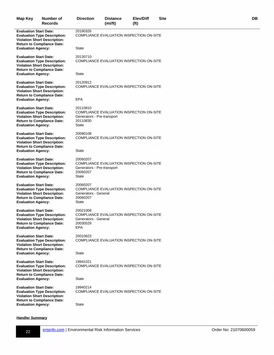
22 erisinfo.com | Environmental Risk Information Services Order No: 21070600059
Map Key Number of Records
Direction Distance(mi/ft)
Elev/Diff(ft)
Site DB
Evaluation Start Date: 20190326Evaluation Type Description: COMPLIANCE EVALUATION INSPECTION ON-SITEViolation Short Description:Return to Compliance Date:Evaluation Agency: State Evaluation Start Date: 20130710Evaluation Type Description: COMPLIANCE EVALUATION INSPECTION ON-SITEViolation Short Description:Return to Compliance Date:Evaluation Agency: State Evaluation Start Date: 20120912Evaluation Type Description: COMPLIANCE EVALUATION INSPECTION ON-SITEViolation Short Description:Return to Compliance Date:Evaluation Agency: EPA Evaluation Start Date: 20110810Evaluation Type Description: COMPLIANCE EVALUATION INSPECTION ON-SITEViolation Short Description: Generators - Pre-transportReturn to Compliance Date: 20110830Evaluation Agency: State Evaluation Start Date: 20090108Evaluation Type Description: COMPLIANCE EVALUATION INSPECTION ON-SITEViolation Short Description:Return to Compliance Date:Evaluation Agency: State Evaluation Start Date: 20060207Evaluation Type Description: COMPLIANCE EVALUATION INSPECTION ON-SITEViolation Short Description: Generators - Pre-transportReturn to Compliance Date: 20060207Evaluation Agency: State Evaluation Start Date: 20060207Evaluation Type Description: COMPLIANCE EVALUATION INSPECTION ON-SITEViolation Short Description: Generators - GeneralReturn to Compliance Date: 20060207Evaluation Agency: State Evaluation Start Date: 20021008Evaluation Type Description: COMPLIANCE EVALUATION INSPECTION ON-SITEViolation Short Description: Generators - GeneralReturn to Compliance Date: 20030529Evaluation Agency: EPA Evaluation Start Date: 20010823Evaluation Type Description: COMPLIANCE EVALUATION INSPECTION ON-SITEViolation Short Description:Return to Compliance Date:Evaluation Agency: State Evaluation Start Date: 19941021Evaluation Type Description: COMPLIANCE EVALUATION INSPECTION ON-SITEViolation Short Description:Return to Compliance Date:Evaluation Agency: State Evaluation Start Date: 19940214Evaluation Type Description: COMPLIANCE EVALUATION INSPECTION ON-SITEViolation Short Description:Return to Compliance Date:Evaluation Agency: State
Handler Summary
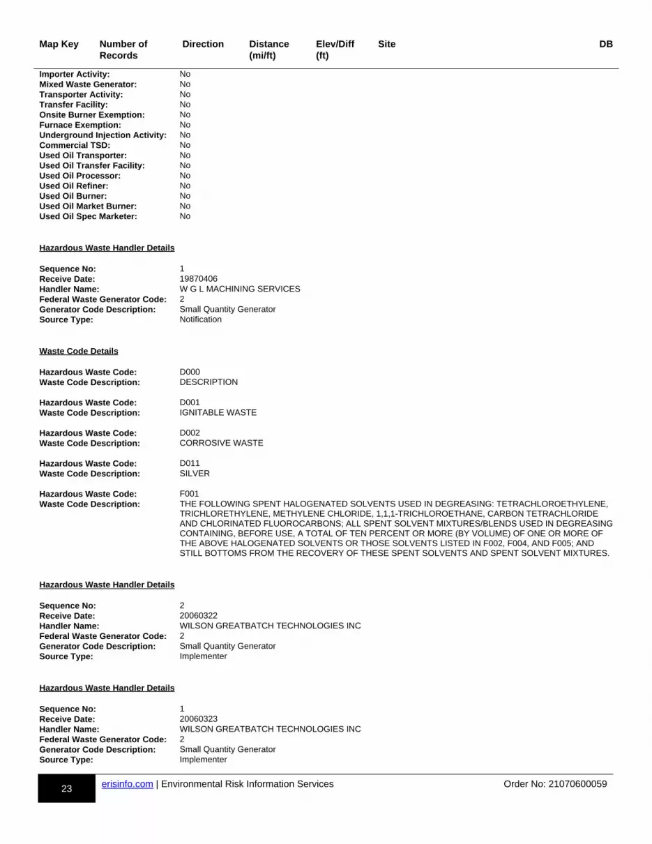
23 erisinfo.com | Environmental Risk Information Services Order No: 21070600059
Map Key Number of Records
Direction Distance(mi/ft)
Elev/Diff(ft)
Site DB
Importer Activity: NoMixed Waste Generator: NoTransporter Activity: NoTransfer Facility: NoOnsite Burner Exemption: NoFurnace Exemption: NoUnderground Injection Activity: NoCommercial TSD: NoUsed Oil Transporter: NoUsed Oil Transfer Facility: NoUsed Oil Processor: NoUsed Oil Refiner: NoUsed Oil Burner: NoUsed Oil Market Burner: NoUsed Oil Spec Marketer: No
Hazardous Waste Handler Details Sequence No: 1Receive Date: 19870406Handler Name: W G L MACHINING SERVICESFederal Waste Generator Code: 2Generator Code Description: Small Quantity GeneratorSource Type: Notification
Waste Code Details Hazardous Waste Code: D000Waste Code Description: DESCRIPTION Hazardous Waste Code: D001Waste Code Description: IGNITABLE WASTE Hazardous Waste Code: D002Waste Code Description: CORROSIVE WASTE Hazardous Waste Code: D011Waste Code Description: SILVER Hazardous Waste Code: F001Waste Code Description: THE FOLLOWING SPENT HALOGENATED SOLVENTS USED IN DEGREASING: TETRACHLOROETHYLENE,
TRICHLORETHYLENE, METHYLENE CHLORIDE, 1,1,1-TRICHLOROETHANE, CARBON TETRACHLORIDE AND CHLORINATED FLUOROCARBONS; ALL SPENT SOLVENT MIXTURES/BLENDS USED IN DEGREASINGCONTAINING, BEFORE USE, A TOTAL OF TEN PERCENT OR MORE (BY VOLUME) OF ONE OR MORE OF THE ABOVE HALOGENATED SOLVENTS OR THOSE SOLVENTS LISTED IN F002, F004, AND F005; AND STILL BOTTOMS FROM THE RECOVERY OF THESE SPENT SOLVENTS AND SPENT SOLVENT MIXTURES.
Hazardous Waste Handler Details Sequence No: 2Receive Date: 20060322Handler Name: WILSON GREATBATCH TECHNOLOGIES INCFederal Waste Generator Code: 2Generator Code Description: Small Quantity GeneratorSource Type: Implementer
Hazardous Waste Handler Details Sequence No: 1Receive Date: 20060323Handler Name: WILSON GREATBATCH TECHNOLOGIES INCFederal Waste Generator Code: 2Generator Code Description: Small Quantity GeneratorSource Type: Implementer
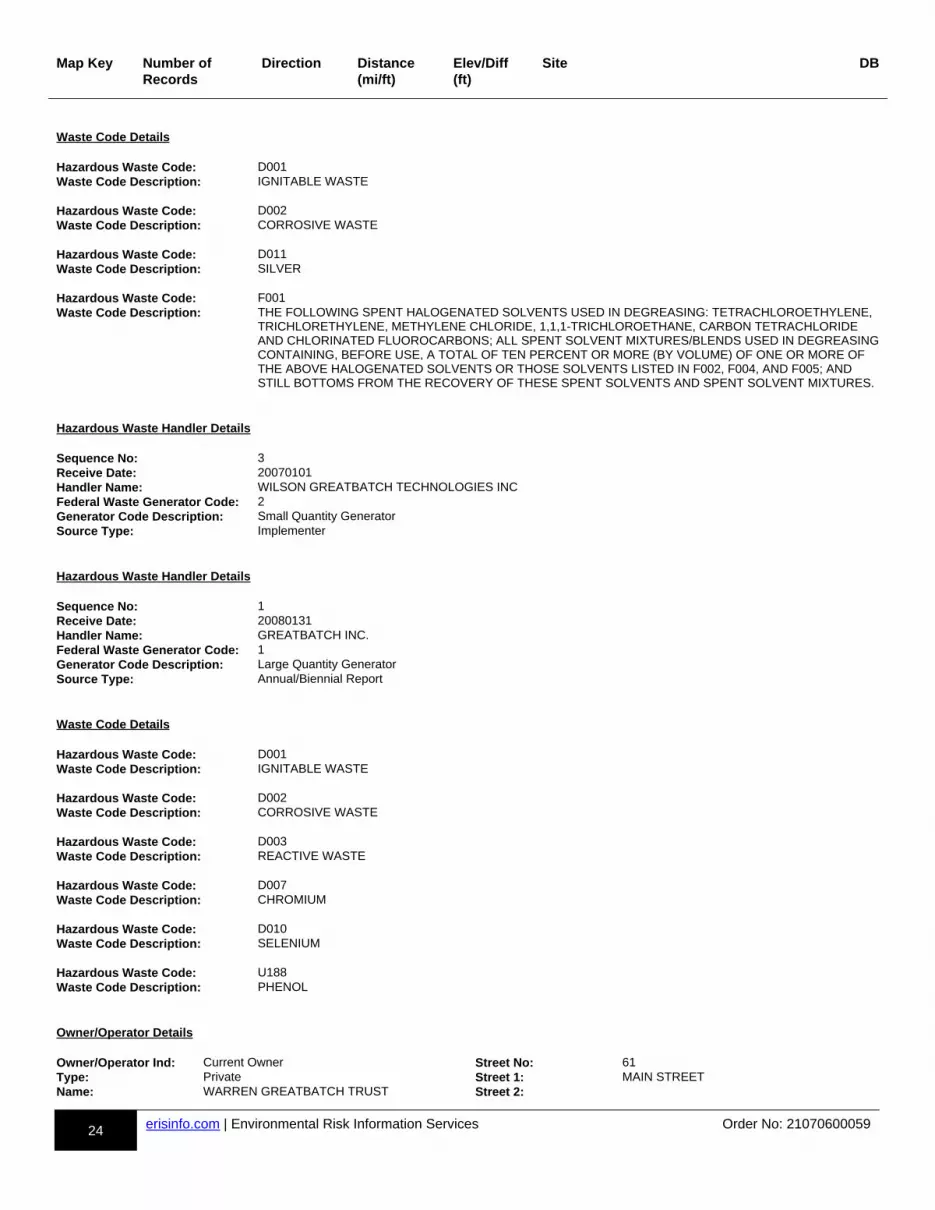
24 erisinfo.com | Environmental Risk Information Services Order No: 21070600059
Map Key Number of Records
Direction Distance(mi/ft)
Elev/Diff(ft)
Site DB
Waste Code Details Hazardous Waste Code: D001Waste Code Description: IGNITABLE WASTE Hazardous Waste Code: D002Waste Code Description: CORROSIVE WASTE Hazardous Waste Code: D011Waste Code Description: SILVER Hazardous Waste Code: F001Waste Code Description: THE FOLLOWING SPENT HALOGENATED SOLVENTS USED IN DEGREASING: TETRACHLOROETHYLENE,
TRICHLORETHYLENE, METHYLENE CHLORIDE, 1,1,1-TRICHLOROETHANE, CARBON TETRACHLORIDE AND CHLORINATED FLUOROCARBONS; ALL SPENT SOLVENT MIXTURES/BLENDS USED IN DEGREASINGCONTAINING, BEFORE USE, A TOTAL OF TEN PERCENT OR MORE (BY VOLUME) OF ONE OR MORE OF THE ABOVE HALOGENATED SOLVENTS OR THOSE SOLVENTS LISTED IN F002, F004, AND F005; AND STILL BOTTOMS FROM THE RECOVERY OF THESE SPENT SOLVENTS AND SPENT SOLVENT MIXTURES.
Hazardous Waste Handler Details Sequence No: 3Receive Date: 20070101Handler Name: WILSON GREATBATCH TECHNOLOGIES INCFederal Waste Generator Code: 2Generator Code Description: Small Quantity GeneratorSource Type: Implementer
Hazardous Waste Handler Details Sequence No: 1Receive Date: 20080131Handler Name: GREATBATCH INC.Federal Waste Generator Code: 1Generator Code Description: Large Quantity GeneratorSource Type: Annual/Biennial Report
Waste Code Details Hazardous Waste Code: D001Waste Code Description: IGNITABLE WASTE Hazardous Waste Code: D002Waste Code Description: CORROSIVE WASTE Hazardous Waste Code: D003Waste Code Description: REACTIVE WASTE Hazardous Waste Code: D007Waste Code Description: CHROMIUM Hazardous Waste Code: D010Waste Code Description: SELENIUM Hazardous Waste Code: U188Waste Code Description: PHENOL
Owner/Operator Details Owner/Operator Ind: Current Owner Street No: 61Type: Private Street 1: MAIN STREETName: WARREN GREATBATCH TRUST Street 2:
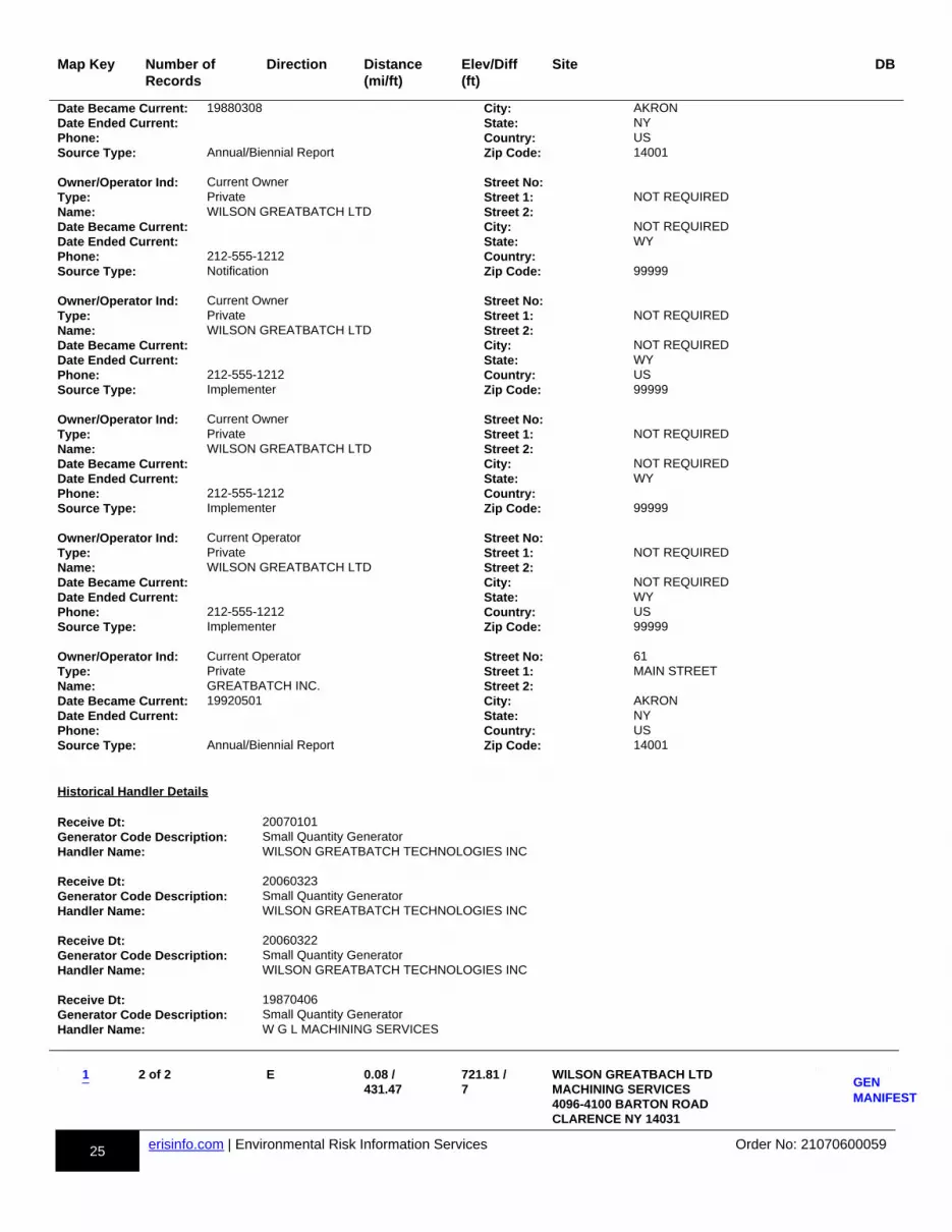
25 erisinfo.com | Environmental Risk Information Services Order No: 21070600059
Map Key Number of Records
Direction Distance(mi/ft)
Elev/Diff(ft)
Site DB
Date Became Current: 19880308 City: AKRONDate Ended Current: State: NYPhone: Country: USSource Type: Annual/Biennial Report Zip Code: 14001 Owner/Operator Ind: Current Owner Street No:Type: Private Street 1: NOT REQUIREDName: WILSON GREATBATCH LTD Street 2:Date Became Current: City: NOT REQUIREDDate Ended Current: State: WYPhone: 212-555-1212 Country:Source Type: Notification Zip Code: 99999 Owner/Operator Ind: Current Owner Street No:Type: Private Street 1: NOT REQUIREDName: WILSON GREATBATCH LTD Street 2:Date Became Current: City: NOT REQUIREDDate Ended Current: State: WYPhone: 212-555-1212 Country: USSource Type: Implementer Zip Code: 99999 Owner/Operator Ind: Current Owner Street No:Type: Private Street 1: NOT REQUIREDName: WILSON GREATBATCH LTD Street 2:Date Became Current: City: NOT REQUIREDDate Ended Current: State: WYPhone: 212-555-1212 Country:Source Type: Implementer Zip Code: 99999 Owner/Operator Ind: Current Operator Street No:Type: Private Street 1: NOT REQUIREDName: WILSON GREATBATCH LTD Street 2:Date Became Current: City: NOT REQUIREDDate Ended Current: State: WYPhone: 212-555-1212 Country: USSource Type: Implementer Zip Code: 99999 Owner/Operator Ind: Current Operator Street No: 61Type: Private Street 1: MAIN STREETName: GREATBATCH INC. Street 2:Date Became Current: 19920501 City: AKRONDate Ended Current: State: NYPhone: Country: USSource Type: Annual/Biennial Report Zip Code: 14001
Historical Handler Details Receive Dt: 20070101Generator Code Description: Small Quantity GeneratorHandler Name: WILSON GREATBATCH TECHNOLOGIES INC Receive Dt: 20060323Generator Code Description: Small Quantity GeneratorHandler Name: WILSON GREATBATCH TECHNOLOGIES INC Receive Dt: 20060322Generator Code Description: Small Quantity GeneratorHandler Name: WILSON GREATBATCH TECHNOLOGIES INC Receive Dt: 19870406Generator Code Description: Small Quantity GeneratorHandler Name: W G L MACHINING SERVICES
m-1-874677078-b
2 of 2 E 0.08 / 431.47
721.81 / 7
WILSON GREATBACH LTD MACHINING SERVICES 4096-4100 BARTON ROAD CLARENCE NY 14031
dd-GEN MANIFEST-874677078-bb
p1p-874677078-y1y 1GENMANIFEST
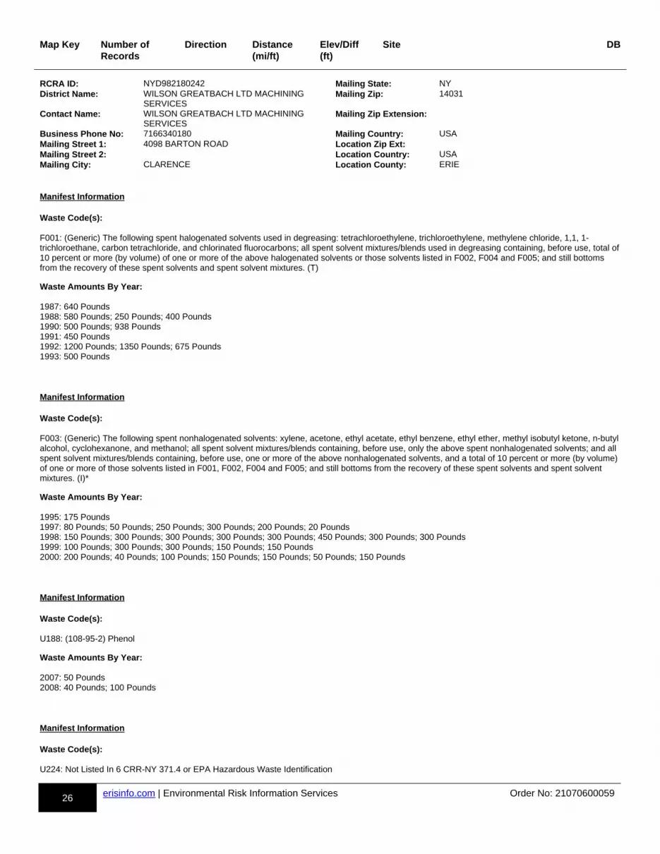
26 erisinfo.com | Environmental Risk Information Services Order No: 21070600059
Map Key Number of Records
Direction Distance(mi/ft)
Elev/Diff(ft)
Site DB
RCRA ID: NYD982180242 Mailing State: NYDistrict Name: WILSON GREATBACH LTD MACHINING
SERVICESMailing Zip: 14031
Contact Name: WILSON GREATBACH LTD MACHINING SERVICES
Mailing Zip Extension:
Business Phone No: 7166340180 Mailing Country: USAMailing Street 1: 4098 BARTON ROAD Location Zip Ext:Mailing Street 2: Location Country: USAMailing City: CLARENCE Location County: ERIE
Manifest Information Waste Code(s):
F001: (Generic) The following spent halogenated solvents used in degreasing: tetrachloroethylene, trichloroethylene, methylene chloride, 1,1, 1-trichloroethane, carbon tetrachloride, and chlorinated fluorocarbons; all spent solvent mixtures/blends used in degreasing containing, before use, total of 10 percent or more (by volume) of one or more of the above halogenated solvents or those solvents listed in F002, F004 and F005; and still bottoms from the recovery of these spent solvents and spent solvent mixtures. (T)
Waste Amounts By Year:
1987: 640 Pounds1988: 580 Pounds; 250 Pounds; 400 Pounds1990: 500 Pounds; 938 Pounds1991: 450 Pounds1992: 1200 Pounds; 1350 Pounds; 675 Pounds1993: 500 Pounds
Manifest Information Waste Code(s):
F003: (Generic) The following spent nonhalogenated solvents: xylene, acetone, ethyl acetate, ethyl benzene, ethyl ether, methyl isobutyl ketone, n-butyl alcohol, cyclohexanone, and methanol; all spent solvent mixtures/blends containing, before use, only the above spent nonhalogenated solvents; and all spent solvent mixtures/blends containing, before use, one or more of the above nonhalogenated solvents, and a total of 10 percent or more (by volume) of one or more of those solvents listed in F001, F002, F004 and F005; and still bottoms from the recovery of these spent solvents and spent solvent mixtures. (I)*
Waste Amounts By Year:
1995: 175 Pounds1997: 80 Pounds; 50 Pounds; 250 Pounds; 300 Pounds; 200 Pounds; 20 Pounds1998: 150 Pounds; 300 Pounds; 300 Pounds; 300 Pounds; 300 Pounds; 450 Pounds; 300 Pounds; 300 Pounds1999: 100 Pounds; 300 Pounds; 300 Pounds; 150 Pounds; 150 Pounds2000: 200 Pounds; 40 Pounds; 100 Pounds; 150 Pounds; 150 Pounds; 50 Pounds; 150 Pounds
Manifest Information Waste Code(s):
U188: (108-95-2) Phenol
Waste Amounts By Year:
2007: 50 Pounds2008: 40 Pounds; 100 Pounds
Manifest Information Waste Code(s):
U224: Not Listed In 6 CRR-NY 371.4 or EPA Hazardous Waste Identification
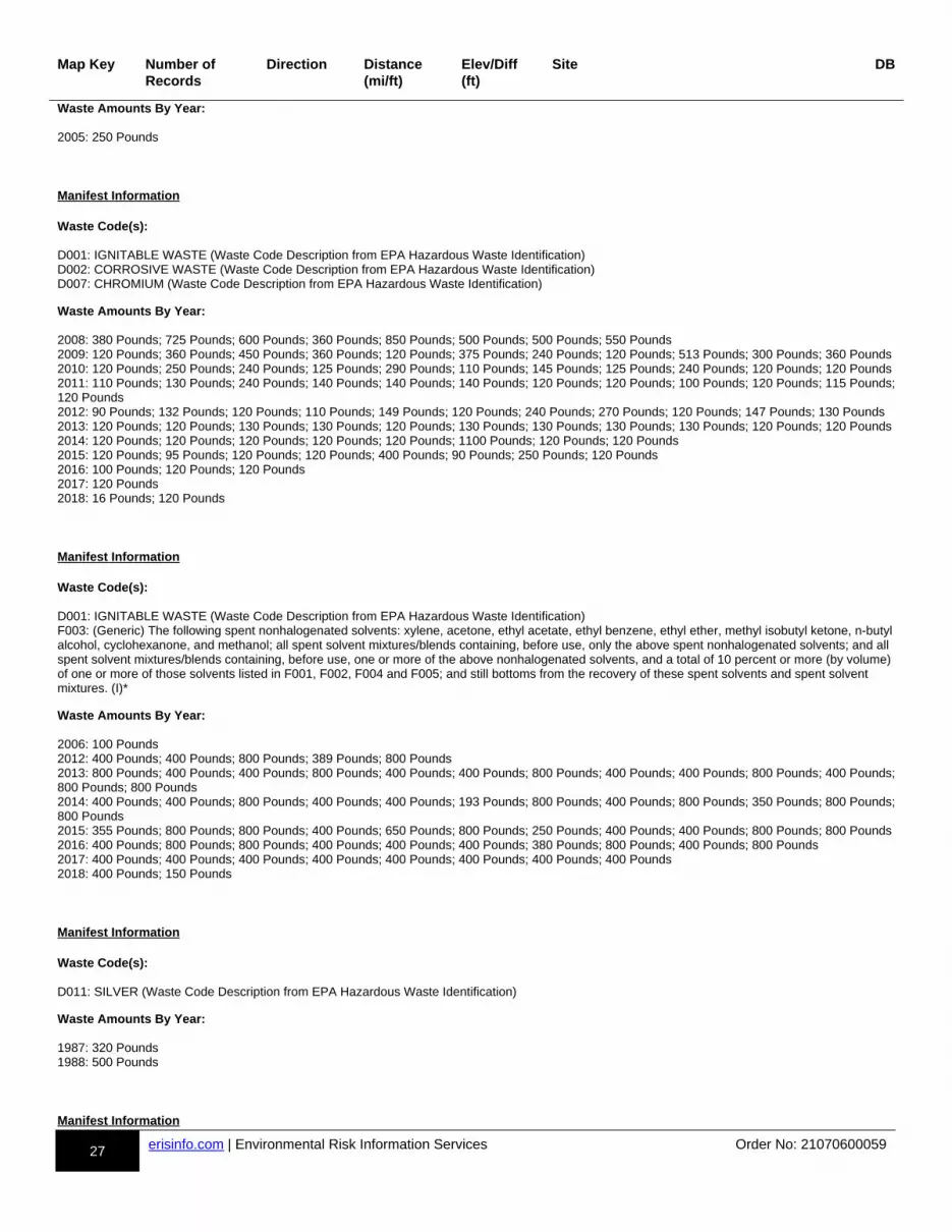
27 erisinfo.com | Environmental Risk Information Services Order No: 21070600059
Map Key Number of Records
Direction Distance(mi/ft)
Elev/Diff(ft)
Site DB
Waste Amounts By Year:
2005: 250 Pounds
Manifest Information Waste Code(s):
D001: IGNITABLE WASTE (Waste Code Description from EPA Hazardous Waste Identification)D002: CORROSIVE WASTE (Waste Code Description from EPA Hazardous Waste Identification)D007: CHROMIUM (Waste Code Description from EPA Hazardous Waste Identification)
Waste Amounts By Year:
2008: 380 Pounds; 725 Pounds; 600 Pounds; 360 Pounds; 850 Pounds; 500 Pounds; 500 Pounds; 550 Pounds2009: 120 Pounds; 360 Pounds; 450 Pounds; 360 Pounds; 120 Pounds; 375 Pounds; 240 Pounds; 120 Pounds; 513 Pounds; 300 Pounds; 360 Pounds2010: 120 Pounds; 250 Pounds; 240 Pounds; 125 Pounds; 290 Pounds; 110 Pounds; 145 Pounds; 125 Pounds; 240 Pounds; 120 Pounds; 120 Pounds2011: 110 Pounds; 130 Pounds; 240 Pounds; 140 Pounds; 140 Pounds; 140 Pounds; 120 Pounds; 120 Pounds; 100 Pounds; 120 Pounds; 115 Pounds;120 Pounds2012: 90 Pounds; 132 Pounds; 120 Pounds; 110 Pounds; 149 Pounds; 120 Pounds; 240 Pounds; 270 Pounds; 120 Pounds; 147 Pounds; 130 Pounds2013: 120 Pounds; 120 Pounds; 130 Pounds; 130 Pounds; 120 Pounds; 130 Pounds; 130 Pounds; 130 Pounds; 130 Pounds; 120 Pounds; 120 Pounds2014: 120 Pounds; 120 Pounds; 120 Pounds; 120 Pounds; 120 Pounds; 1100 Pounds; 120 Pounds; 120 Pounds2015: 120 Pounds; 95 Pounds; 120 Pounds; 120 Pounds; 400 Pounds; 90 Pounds; 250 Pounds; 120 Pounds2016: 100 Pounds; 120 Pounds; 120 Pounds2017: 120 Pounds2018: 16 Pounds; 120 Pounds
Manifest Information Waste Code(s):
D001: IGNITABLE WASTE (Waste Code Description from EPA Hazardous Waste Identification)F003: (Generic) The following spent nonhalogenated solvents: xylene, acetone, ethyl acetate, ethyl benzene, ethyl ether, methyl isobutyl ketone, n-butyl alcohol, cyclohexanone, and methanol; all spent solvent mixtures/blends containing, before use, only the above spent nonhalogenated solvents; and all spent solvent mixtures/blends containing, before use, one or more of the above nonhalogenated solvents, and a total of 10 percent or more (by volume) of one or more of those solvents listed in F001, F002, F004 and F005; and still bottoms from the recovery of these spent solvents and spent solvent mixtures. (I)*
Waste Amounts By Year:
2006: 100 Pounds2012: 400 Pounds; 400 Pounds; 800 Pounds; 389 Pounds; 800 Pounds2013: 800 Pounds; 400 Pounds; 400 Pounds; 800 Pounds; 400 Pounds; 400 Pounds; 800 Pounds; 400 Pounds; 400 Pounds; 800 Pounds; 400 Pounds;800 Pounds; 800 Pounds2014: 400 Pounds; 400 Pounds; 800 Pounds; 400 Pounds; 400 Pounds; 193 Pounds; 800 Pounds; 400 Pounds; 800 Pounds; 350 Pounds; 800 Pounds;800 Pounds2015: 355 Pounds; 800 Pounds; 800 Pounds; 400 Pounds; 650 Pounds; 800 Pounds; 250 Pounds; 400 Pounds; 400 Pounds; 800 Pounds; 800 Pounds2016: 400 Pounds; 800 Pounds; 800 Pounds; 400 Pounds; 400 Pounds; 400 Pounds; 380 Pounds; 800 Pounds; 400 Pounds; 800 Pounds2017: 400 Pounds; 400 Pounds; 400 Pounds; 400 Pounds; 400 Pounds; 400 Pounds; 400 Pounds; 400 Pounds2018: 400 Pounds; 150 Pounds
Manifest Information Waste Code(s):
D011: SILVER (Waste Code Description from EPA Hazardous Waste Identification)
Waste Amounts By Year:
1987: 320 Pounds1988: 500 Pounds
Manifest Information

28 erisinfo.com | Environmental Risk Information Services Order No: 21070600059
Map Key Number of Records
Direction Distance(mi/ft)
Elev/Diff(ft)
Site DB
Waste Code(s):
D001: IGNITABLE WASTE (Waste Code Description from EPA Hazardous Waste Identification)
Waste Amounts By Year:
1987: 264 Pounds1988: 83 Pounds; 96 Pounds; 42 Pounds; 125 Pounds1993: 450 Pounds1994: 180 Pounds1995: 190 Pounds1996: 30 Pounds; 30 Pounds; 25 Pounds; 150 Pounds; 150 Pounds; 150 Pounds; 60 Pounds; 90 Pounds1997: 35 Pounds; 300 Pounds; 35 Pounds; 10 Pounds; 90 Pounds; 150 Pounds; 300 Pounds1998: 40 Pounds; 50 Pounds; 150 Pounds; 150 Pounds1999: 40 Pounds; 40 Pounds; 45 Pounds; 150 Pounds; 90 Pounds; 150 Pounds; 150 Pounds; 150 Pounds2000: 150 Pounds; 100 Pounds; 250 Pounds; 100 Pounds; 150 Pounds; 5 Pounds; 200 Pounds; 35 Pounds; 100 Pounds; 100 Pounds; 150 Pounds; 10 Pounds2001: 450 Pounds; 150 Pounds; 300 Pounds; 600 Pounds; 150 Pounds; 10 Pounds; 150 Pounds; 150 Pounds; 300 Pounds; 450 Pounds2002: 300 Pounds; 350 Pounds; 300 Pounds; 300 Pounds; 400 Pounds; 150 Pounds; 350 Pounds; 100 Pounds; 325 Pounds; 150 Pounds; 100 Pounds;100 Pounds; 10 Pounds2003: 320 Pounds; 600 Pounds; 450 Pounds; 300 Pounds; 650 Pounds; 600 Pounds; 200 Pounds; 300 Pounds; 5 Pounds; 450 Pounds; 300 Pounds; 600 Pounds2004: 350 Pounds; 50 Pounds; 100 Pounds; 450 Pounds; 750 Pounds; 600 Pounds; 50 Pounds; 850 Pounds; 450 Pounds; 55 Pounds; 450 Pounds; 300 Pounds; 1050 Pounds; 300 Pounds; 450 Pounds; 450 Pounds; 475 Pounds; 205 Pounds2005: 12 Pounds; 450 Pounds; 1700 Pounds; 900 Pounds; 600 Pounds; 450 Pounds; 1400 Pounds; 600 Pounds; 900 Pounds; 305 Gallons2006: 105 Gallons; 900 Pounds; 450 Pounds; 110 Pounds; 500 Pounds; 60 Gallons; 1200 Pounds; 120 Gallons; 900 Pounds; 1050 Pounds; 25 Pounds;210 Pounds2007: 150 Pounds; 150 Pounds; 60 Pounds; 400 Pounds; 300 Pounds; 150 Pounds; 300 Pounds; 200 Pounds; 28 Pounds; 150 Pounds; 750 Pounds; 550 Pounds; 100 Pounds; 150 Pounds; 325 Pounds; 300 Pounds; 500 Pounds2008: 900 Pounds; 52 Pounds; 700 Pounds; 400 Pounds; 900 Pounds; 20 Pounds; 10 Pounds; 40 Pounds; 40 Pounds; 450 Pounds; 450 Pounds; 710 Pounds; 1260 Pounds; 400 Pounds; 450 Pounds2009: 450 Pounds; 440 Pounds; 380 Pounds; 6 Pounds; 450 Pounds; 450 Pounds; 900 Pounds; 430 Pounds; 325 Pounds; 450 Pounds; 450 Pounds; 400 Pounds; 12 Pounds2010: 402 Pounds; 400 Pounds; 370 Pounds; 450 Pounds; 50 Pounds; 450 Pounds; 450 Pounds; 400 Pounds; 35 Pounds; 450 Pounds; 330 Pounds; 425 Pounds2011: 430 Pounds; 450 Pounds; 450 Pounds; 727 Pounds; 450 Pounds; 375 Pounds; 375 Pounds; 440 Pounds; 450 Pounds; 400 Pounds; 450 Pounds2012: 450 Pounds; 400 Pounds; 576 Pounds; 450 Pounds; 900 Pounds; 800 Pounds2017: 22 Pounds; 90 Pounds
Manifest Information Waste Code(s):
D001: IGNITABLE WASTE (Waste Code Description from EPA Hazardous Waste Identification)D002: CORROSIVE WASTE (Waste Code Description from EPA Hazardous Waste Identification)
Waste Amounts By Year:
2008: 175 Pounds2009: 90 Pounds; 15 Pounds2012: 18 Pounds2018: 40 Pounds; 12 Pounds
Manifest Information Waste Code(s):
D001: IGNITABLE WASTE (Waste Code Description from EPA Hazardous Waste Identification)D002: CORROSIVE WASTE (Waste Code Description from EPA Hazardous Waste Identification)D003: REACTIVE WASTE (Waste Code Description from EPA Hazardous Waste Identification)
Waste Amounts By Year:
2009: 360 Pounds
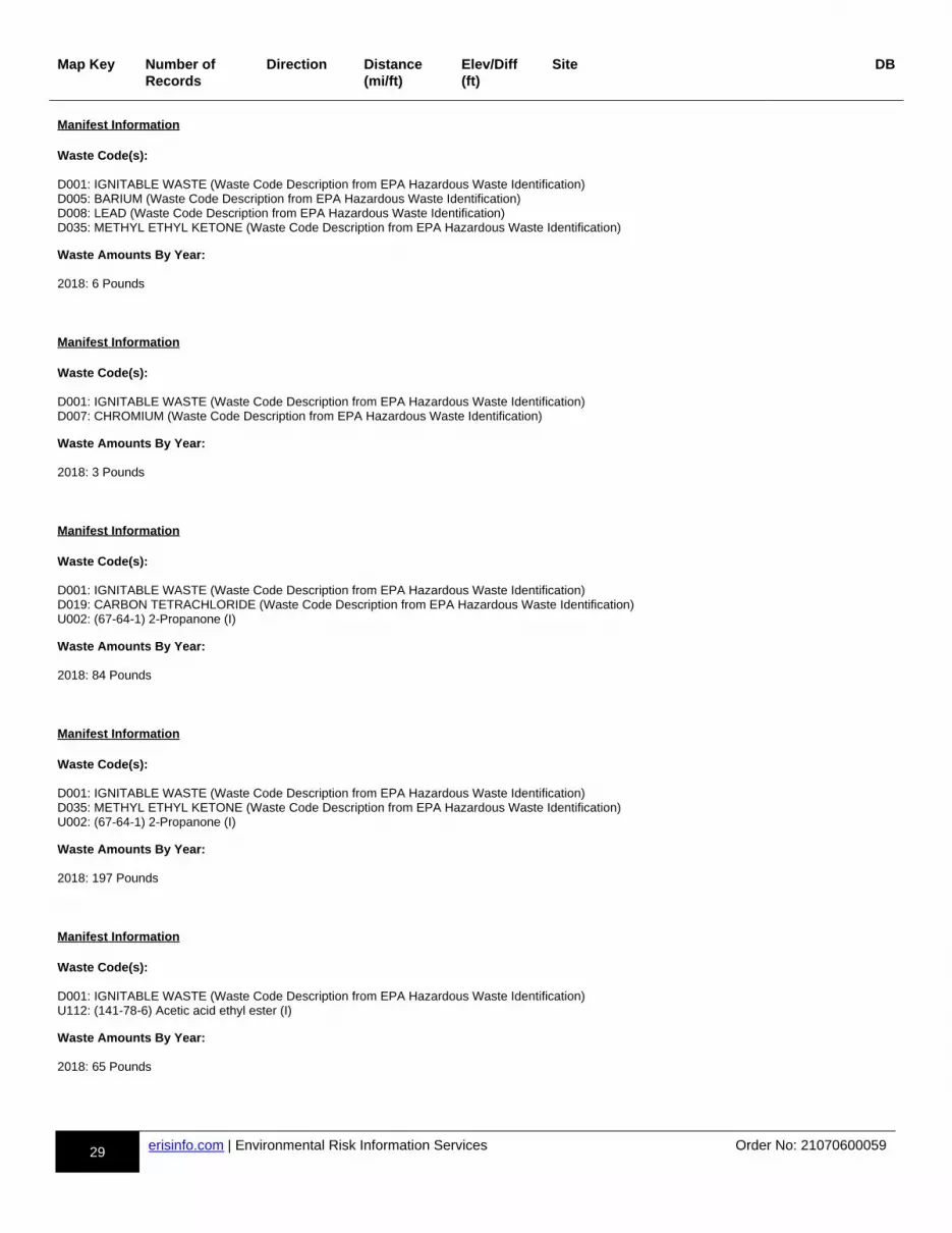
29 erisinfo.com | Environmental Risk Information Services Order No: 21070600059
Map Key Number of Records
Direction Distance(mi/ft)
Elev/Diff(ft)
Site DB
Manifest Information Waste Code(s):
D001: IGNITABLE WASTE (Waste Code Description from EPA Hazardous Waste Identification)D005: BARIUM (Waste Code Description from EPA Hazardous Waste Identification)D008: LEAD (Waste Code Description from EPA Hazardous Waste Identification)D035: METHYL ETHYL KETONE (Waste Code Description from EPA Hazardous Waste Identification)
Waste Amounts By Year:
2018: 6 Pounds
Manifest Information Waste Code(s):
D001: IGNITABLE WASTE (Waste Code Description from EPA Hazardous Waste Identification)D007: CHROMIUM (Waste Code Description from EPA Hazardous Waste Identification)
Waste Amounts By Year:
2018: 3 Pounds
Manifest Information Waste Code(s):
D001: IGNITABLE WASTE (Waste Code Description from EPA Hazardous Waste Identification)D019: CARBON TETRACHLORIDE (Waste Code Description from EPA Hazardous Waste Identification)U002: (67-64-1) 2-Propanone (I)
Waste Amounts By Year:
2018: 84 Pounds
Manifest Information Waste Code(s):
D001: IGNITABLE WASTE (Waste Code Description from EPA Hazardous Waste Identification)D035: METHYL ETHYL KETONE (Waste Code Description from EPA Hazardous Waste Identification)U002: (67-64-1) 2-Propanone (I)
Waste Amounts By Year:
2018: 197 Pounds
Manifest Information Waste Code(s):
D001: IGNITABLE WASTE (Waste Code Description from EPA Hazardous Waste Identification)U112: (141-78-6) Acetic acid ethyl ester (I)
Waste Amounts By Year:
2018: 65 Pounds

30 erisinfo.com | Environmental Risk Information Services Order No: 21070600059
Map Key Number of Records
Direction Distance(mi/ft)
Elev/Diff(ft)
Site DB
Manifest Information Waste Code(s):
D002: CORROSIVE WASTE (Waste Code Description from EPA Hazardous Waste Identification)
Waste Amounts By Year:
1990: 50 Pounds1992: 15 Gallons1993: 450 Pounds1994: 120 Pounds1995: 60 Pounds; 20 Pounds1996: 150 Pounds; 150 Pounds; 120 Pounds; 200 Pounds; 75 Pounds; 175 Pounds1997: 99 Pounds; 70 Pounds; 225 Pounds; 100 Pounds; 23 Pounds; 60 Pounds; 70 Pounds2001: 100 Pounds2002: 260 Pounds; 120 Pounds2003: 150 Pounds; 160 Pounds; 170 Pounds; 300 Pounds; 150 Pounds; 300 Pounds; 150 Pounds; 5 Pounds; 10 Pounds; 450 Pounds; 50 Pounds; 300 Pounds2004: 150 Pounds; 150 Pounds; 450 Pounds; 50 Pounds; 350 Pounds; 300 Pounds; 300 Pounds; 150 Pounds; 150 Pounds; 36 Pounds; 300 Pounds2005: 300 Pounds; 150 Pounds; 140 Pounds; 22 Pounds; 140 Gallons; 1000 Pounds; 300 Pounds; 350 Pounds; 750 Pounds; 450 Pounds2006: 15 Gallons; 450 Pounds; 30 Gallons; 300 Pounds; 60 Pounds; 75 Gallons; 450 Pounds2008: 58 Pounds; 11 Pounds2016: 5 Pounds; 15 Pounds2018: 100 Pounds; 54 Pounds; 3 Pounds; 7 Pounds; 34 Pounds
Manifest Information Waste Code(s):
D002: CORROSIVE WASTE (Waste Code Description from EPA Hazardous Waste Identification)D007: CHROMIUM (Waste Code Description from EPA Hazardous Waste Identification)
Waste Amounts By Year:
2006: 125 Pounds; 600 Pounds; 200 Pounds; 175 Pounds; 300 Pounds2007: 150 Pounds; 300 Pounds; 300 Pounds; 80 Pounds; 80 Pounds; 400 Pounds; 300 Pounds; 150 Pounds; 300 Pounds; 75 Pounds; 150 Pounds; 150 Pounds; 300 Pounds2008: 400 Pounds
Manifest Information Waste Code(s):
D002: CORROSIVE WASTE (Waste Code Description from EPA Hazardous Waste Identification)U134: (7664-39-3) Hydrofluoric acid (C,T)
Waste Amounts By Year:
2009: 27 Pounds
Manifest Information Waste Code(s):
D003: REACTIVE WASTE (Waste Code Description from EPA Hazardous Waste Identification)D007: CHROMIUM (Waste Code Description from EPA Hazardous Waste Identification)D010: SELENIUM (Waste Code Description from EPA Hazardous Waste Identification)
Waste Amounts By Year:
2007: 75 Pounds
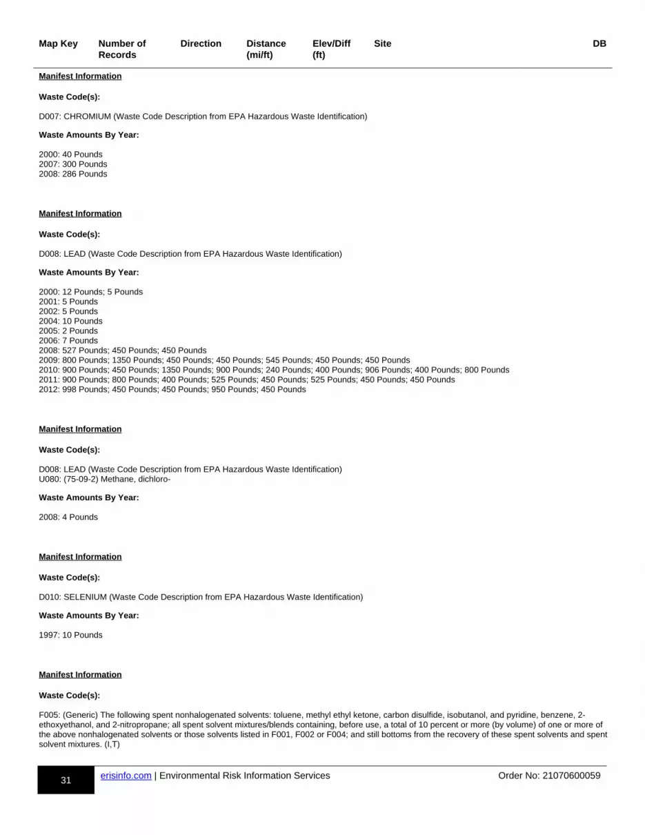
31 erisinfo.com | Environmental Risk Information Services Order No: 21070600059
Map Key Number of Records
Direction Distance(mi/ft)
Elev/Diff(ft)
Site DB
Manifest Information Waste Code(s):
D007: CHROMIUM (Waste Code Description from EPA Hazardous Waste Identification)
Waste Amounts By Year:
2000: 40 Pounds2007: 300 Pounds2008: 286 Pounds
Manifest Information Waste Code(s):
D008: LEAD (Waste Code Description from EPA Hazardous Waste Identification)
Waste Amounts By Year:
2000: 12 Pounds; 5 Pounds2001: 5 Pounds2002: 5 Pounds2004: 10 Pounds2005: 2 Pounds2006: 7 Pounds2008: 527 Pounds; 450 Pounds; 450 Pounds2009: 800 Pounds; 1350 Pounds; 450 Pounds; 450 Pounds; 545 Pounds; 450 Pounds; 450 Pounds2010: 900 Pounds; 450 Pounds; 1350 Pounds; 900 Pounds; 240 Pounds; 400 Pounds; 906 Pounds; 400 Pounds; 800 Pounds2011: 900 Pounds; 800 Pounds; 400 Pounds; 525 Pounds; 450 Pounds; 525 Pounds; 450 Pounds; 450 Pounds2012: 998 Pounds; 450 Pounds; 450 Pounds; 950 Pounds; 450 Pounds
Manifest Information Waste Code(s):
D008: LEAD (Waste Code Description from EPA Hazardous Waste Identification)U080: (75-09-2) Methane, dichloro-
Waste Amounts By Year:
2008: 4 Pounds
Manifest Information Waste Code(s):
D010: SELENIUM (Waste Code Description from EPA Hazardous Waste Identification)
Waste Amounts By Year:
1997: 10 Pounds
Manifest Information Waste Code(s):
F005: (Generic) The following spent nonhalogenated solvents: toluene, methyl ethyl ketone, carbon disulfide, isobutanol, and pyridine, benzene, 2-ethoxyethanol, and 2-nitropropane; all spent solvent mixtures/blends containing, before use, a total of 10 percent or more (by volume) of one or more of the above nonhalogenated solvents or those solvents listed in F001, F002 or F004; and still bottoms from the recovery of these spent solvents and spentsolvent mixtures. (I,T)
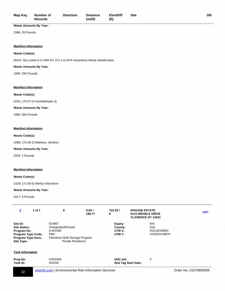
32 erisinfo.com | Environmental Risk Information Services Order No: 21070600059
Map Key Number of Records
Direction Distance(mi/ft)
Elev/Diff(ft)
Site DB
Waste Amounts By Year:
1996: 20 Pounds
Manifest Information Waste Code(s):
MA01: Not Listed In 6 CRR-NY 371.4 or EPA Hazardous Waste Identification
Waste Amounts By Year:
1998: 200 Pounds
Manifest Information Waste Code(s):
U001: (75-07-0) Acetaldehyde (I)
Waste Amounts By Year:
1996: 300 Pounds
Manifest Information Waste Code(s):
U080: (75-09-2) Methane, dichloro-
Waste Amounts By Year:
2003: 2 Pounds
Manifest Information Waste Code(s):
U226: (71-55-6) Methyl chloroform
Waste Amounts By Year:
2017: 9 Pounds
m-2-844754613-b
1 of 1 E 0.04 / 189.77
722.29 / 8
KRAUSE ESTATE 9110 WEHRLE DRIVE CLARENCE NY 14031
dd-UST-844754613-bb
p1p-844754613-y1y
Site ID: 524987 Expiry: N/ASite Status: Unregulated/Closed County: ErieProgram No: 9-601569 UTM X: 202139.80904Program Type Code: PBS UTM Y: 4762929.08870Program Type Desc: Petroleum Bulk Storage ProgramSite Type: Private Residence
Tank Information Prog No: 9-601569 UDC Ind: 0Tank ID: 261033 Red Tag Start Date:
2UST
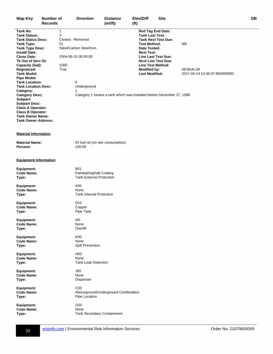
33 erisinfo.com | Environmental Risk Information Services Order No: 21070600059
Map Key Number of Records
Direction Distance(mi/ft)
Elev/Diff(ft)
Site DB
Tank No: 1 Red Tag End Date:Tank Status: 3 Tank Last Test:Tank Status Desc: Closed - Removed Tank Next Test Due:Tank Type: 01 Test Method: NNTank Type Desc: Steel/Carbon Steel/Iron Date Tested:Install Date: Next Test:Close Date: 2004-06-10 00:00:00 Line Last Test Due:Tk Out of Serv Dt: Next Line Test Due:Capacity (Gal): 1000 Line Test Method:Registered: True Modified by: AESKALSKTank Model: Last Modified: 2017-04-14 14:30:47.863000000Pipe Model:Tank Location: 5Tank Location Desc: UndergroundCategory: 1Category Desc: Category 1 means a tank which was installed before December 27, 1986Subpart:Subpart Desc:Class A Operator:Class B Operator:Tank Owner Name:Tank Owner Address:
Material Information Material Name: #2 fuel oil (on-site consumption)Percent: 100.00
Equipment Information Equipment: B01Code Name: Painted/Asphalt CoatingType: Tank External Protection Equipment: A00Code Name: NoneType: Tank Internal Protection Equipment: D10Code Name: CopperType: Pipe Type Equipment: I00Code Name: NoneType: Overfill Equipment: K00Code Name: NoneType: Spill Prevention Equipment: H00Code Name: NoneType: Tank Leak Detection Equipment: J00Code Name: NoneType: Dispenser Equipment: C03Code Name: Aboveground/Underground CombinationType: Pipe Location Equipment: G00Code Name: NoneType: Tank Secondary Containment

34 erisinfo.com | Environmental Risk Information Services Order No: 21070600059
Map Key Number of Records
Direction Distance(mi/ft)
Elev/Diff(ft)
Site DB
Affiliation Information Affiliation Type: 01Affiliation Name: Facility OwnerAffiliation Sub Type: NNNCompany: KRAUSE ESTATEContact Title:Contact Name:Address1: 9110 WEHRLE DRAddress2:City: CLARENCEState: NYZip Code: 14031Country Code: 001Phone:Phone Ext:Email:Fax:
m-3-814043706-b
1 of 2 ESE 0.37 / 1,953.71
720.79 / 6
LANCASTER STONE PRODUCTS 91 BARTON ROAD CLARENCE NY
dd-LST-814043706-bb
p1p-814043706-y1y
Spill No: 8707144 Spill Date: 1987-11-19 17:00:00Site ID: 293148 Rcvd Date: 1987-11-19 17:39:00DER Facility ID: 237279 CAC Date: 1988-11-03 00:00:00CID: Insp Date:Program Type: ER Close Date: 1988-11-03 00:00:00SWIS Code: 1532 Create Date: 1987-11-23 00:00:00Contribute Factor: Tank Test Failure Update Date: 1988-11-14 00:00:00Water Body: DEC Region: 9Source: Commercial/Industrial Lead DEC: COOKEClass: Reported by: Tank TesterMeets Std: True Referred to:Penalty: False County: ErieREM Phase: 0 After Hours: TrueUST Trust: True Caller Remark:
"2000 GALLON TANK FAILURE RATE -0.064"
Dec Remark:
"Prior to Sept, 2004 data translation this spill Lead_DEC Field was JDC / / : RGS TELECON 11/19/87, TANK TO BE ISOLATED AND RETESTED. / / : JDC TELCON W/ GREG CRAMMER 11/24/87 OF LANCASTER CRUSHED STONE, TANK TO BE UNCOVERED AND RETESTED WK OF DEC 1, 87.03/29/88: JDC ON SITE W/ C. FASO AND D. HEGMANN - REMOVED 2000 WAS FOUND TO PENCIL SIZE HOLE TO TOP OF TANK NEAR FILL PORT. GROUNDWATER AND SOILS HAD NO CONTAMINATION. REQUESTED RECIEPTS FOR TANK CLEANING. 09/26/88: JDC WAITING ON TANK CLEANING RECIEPTS BEFORE CLOSING FILE. 11/03/88: JDC RECIEVED DISPOSAL INFORMATION ON WATER AS REQUESTED. NO FURHTER ACTION WILL BE REQUIRED AT THIS TIME. 11/10/88: JDC SENT LETTER TO MR HAGMANN REQUESTING TANK CLEANING VARIFICATION BY RECEIPTS. "
Material Information OP Unit ID: 911035 Med Air: FalseOU: 01 Med in Air: FalseMaterial ID: 466118 Med GW: TrueMaterial Code: 0009 Med SW: FalseMaterial Name: gasoline Med DW: FalseCAS No: Med Sewer: FalseMaterial Family: Petroleum Med Surf: FalseQuantity: .00 Med Subway: FalseUnits: G Med Utility: FalseRecovered: .00 Oxygenate:Med Soil: False
3LST
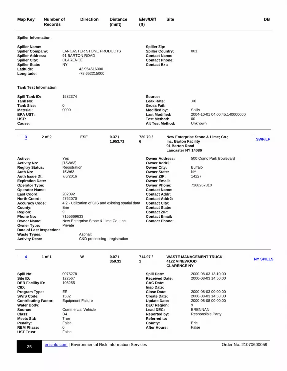
35 erisinfo.com | Environmental Risk Information Services Order No: 21070600059
Map Key Number of Records
Direction Distance(mi/ft)
Elev/Diff(ft)
Site DB
Spiller Information Spiller Name: Spiller Zip:Spiller Company: LANCASTER STONE PRODUCTS Spiller Country: 001Spiller Address: 91 BARTON ROAD Contact Name:Spiller City: CLARENCE Contact Phone:Spiller State: NY Contact Ext:Latitude: 42.954616000Longitude: -78.652215000
Tank Test Information Spill Tank ID: 1532374 Source:Tank No: Leak Rate: .00Tank SIze: 0 Gross Fail:Material: 0009 Modified by: SpillsEPA UST: Last Modified: 2004-10-01 04:00:45.140000000UST: Test Method: 00Cause: Alt Test Method: Unknown
m-3-881495451-b
2 of 2 ESE 0.37 / 1,953.71
720.79 / 6
New Enterprise Stone & Lime; Co.;Inc. Barton Facility 91 Barton Road Lancaster NY 14086
dd-SWF/LF-881495451-bb
p1p-881495451-y1y
Active: Yes Owner Address: 500 Como Park BoulevardActivity No: [15W63] Owner Addr2:Regltry Status: Registration Owner City: BuffaloAuth No: 15W63 Owner State: NYAuth Issue Dt: 7/6/2016 Owner ZIP: 14227Expiration Date: Owner Email:Operator Type: Owner Phone: 7168267310Operator Name: Contact Name:East Coord: 202092 Contact Addr:North Coord: 4762070 Contact Addr2:Accuracy Code: 4.2 - Utilization of GIS and existing spatial data Contact City:County: Erie Contact State:Region: 9 Contact ZIP:Phone No: 7165669633 Contact Email:Owner Name: New Enterprise Stone & Lime Co.; Inc. Contact Phone:Owner Type: PrivateDate of Last Inspection:Waste Types: AsphaltActivity Desc: C&D processing - registration
m-4-813762614-b
1 of 1 W 0.07 / 359.31
714.97 / 1
WASTE MANAGEMENT TRUCK 4122 VINEWOOD CLARENCE NY
dd-NY SPILLS-813762614-bb
p1p-813762614-y1y
Spill No: 0075278 Spill Date: 2000-08-03 13:10:00Site ID: 122567 Received Date: 2000-08-03 14:50:00DER Facility ID: 106255 CAC Date:CID: Insp Date:Program Type: ER Close Date: 2000-08-03 00:00:00SWIS Code: 1532 Create Date: 2000-08-03 14:53:00Contributing Factor: Equipment Failure Update Date: 2000-08-08 00:00:00Water Body: DEC Region: 9Source: Commercial Vehicle Lead DEC: BRENNANClass: D4 Reported by: Responsible PartyMeets Std: True Referred to:Penalty: False County: ErieREM Phase: 0 After Hours: FalseUST Trust: False
3
4
SWF/LF
NY SPILLS

36 erisinfo.com | Environmental Risk Information Services Order No: 21070600059
Map Key Number of Records
Direction Distance(mi/ft)
Elev/Diff(ft)
Site DB
Caller Remark:
"RUPTURED HYDRAULIC LINE ON REFUSE TRUCK SPILLAGE CLEANED UP."
DEC Remark:
"Prior to Sept, 2004 data translation this spill Lead_DEC Field was KAB 08/03/00: KAB NOTE TO FILE, MINOR SPILLAGE OF APPROXIMATELY THREE GALLONS OF HYDRAULIC FLUID TO PAVEMENT. SPILLAGE CLEANED UP WITH SPEEDY-DRI AND DISPOSED IN REGULAR WASTE STREAM. NO FURTHER ACTION NECESSARY. CLOSE OUT."
Material Information OP Unit ID: 836633 Med Air: FalseOU: 01 Med Ind Air: FalseMaterial ID: 571767 Med GW: FalseMaterial Code: 0010 Med SW: FalseMaterial Name: hydraulic oil Med DW: FalseCAS No: Med Sewer: FalseMaterial Family: Petroleum Med Surf: FalseQuantity: 3.00 Med Subway: FalseUnits: G Med Utility: FalseRecovered: 3.00 Oxygenate:Med Soil: True
Spiller Information Spiller Name: DUANE WILLIAMS Spiller Zip: 14030-Spiller Company: WASTE MANAGEMENT Spiller Country: 001Spiller Address: 10860 OLEAN ROAD Contact Name:Spiller City: CHAFFEE Contact Phone:Spiller State: NY Contact Ext:Latitude: 42.959768670Longitude: -78.669355420
m-5-814039327-b
1 of 1 N 0.46 / 2,433.42
717.42 / 3
CUMBERLAND FARMS STORE 8925 MAIN STREET CLARENCE NY
dd-LST-814039327-bb
p1p-814039327-y1y
Spill No: 9201717 Spill Date: 1992-05-12 11:00:00Site ID: 67981 Rcvd Date: 1992-05-12 12:21:00DER Facility ID: 64883 CAC Date: 1992-06-05 00:00:00CID: Insp Date: 1992-06-05 00:00:00Program Type: ER Close Date: 1992-06-05 00:00:00SWIS Code: 1532 Create Date: 1992-05-12 00:00:00Contribute Factor: Tank Test Failure Update Date: 1992-11-05 00:00:00Water Body: DEC Region: 9Source: Gasoline Station or other PBS Facility Lead DEC: RMCROSSEClass: B3 Reported by: Responsible PartyMeets Std: True Referred to:Penalty: False County: ErieREM Phase: 0 After Hours: FalseUST Trust: True Caller Remark:
"LOOSE COUPLING FOUND, TO REPAIR AND RETEST."
Dec Remark:
"Prior to Sept, 2004 data translation this spill Lead_DEC Field was RMC / / : RMC/. 06/05/92: RMC/SITE TEST RESULTS OK AFTER ABOVE GROUND LINE REPAIR. SITE OK ....CLOSE OUT. "
Material Information
5LST
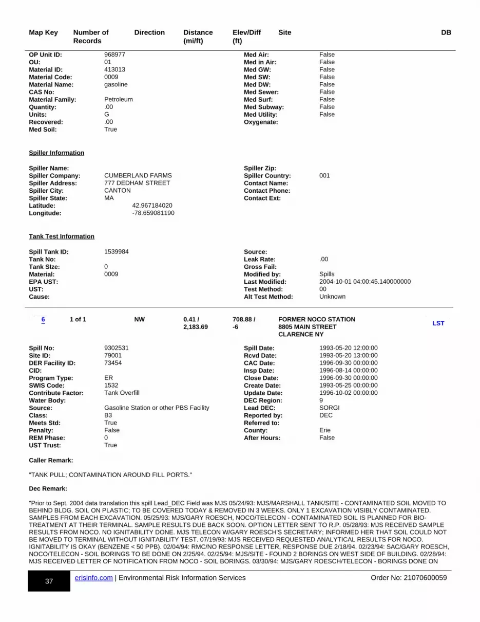
37 erisinfo.com | Environmental Risk Information Services Order No: 21070600059
Map Key Number of Records
Direction Distance(mi/ft)
Elev/Diff(ft)
Site DB
OP Unit ID: 968977 Med Air: FalseOU: 01 Med in Air: FalseMaterial ID: 413013 Med GW: FalseMaterial Code: 0009 Med SW: FalseMaterial Name: gasoline Med DW: FalseCAS No: Med Sewer: FalseMaterial Family: Petroleum Med Surf: FalseQuantity: .00 Med Subway: FalseUnits: G Med Utility: FalseRecovered: .00 Oxygenate:Med Soil: True
Spiller Information Spiller Name: Spiller Zip:Spiller Company: CUMBERLAND FARMS Spiller Country: 001Spiller Address: 777 DEDHAM STREET Contact Name:Spiller City: CANTON Contact Phone:Spiller State: MA Contact Ext:Latitude: 42.967184020Longitude: -78.659081190
Tank Test Information Spill Tank ID: 1539984 Source:Tank No: Leak Rate: .00Tank SIze: 0 Gross Fail:Material: 0009 Modified by: SpillsEPA UST: Last Modified: 2004-10-01 04:00:45.140000000UST: Test Method: 00Cause: Alt Test Method: Unknown
m-6-813998367-b
1 of 1 NW 0.41 / 2,183.69
708.88 / -6
FORMER NOCO STATION 8805 MAIN STREET CLARENCE NY
dd-LST-813998367-bb
p1p-813998367-y1y
Spill No: 9302531 Spill Date: 1993-05-20 12:00:00Site ID: 79001 Rcvd Date: 1993-05-20 13:00:00DER Facility ID: 73454 CAC Date: 1996-09-30 00:00:00CID: Insp Date: 1996-08-14 00:00:00Program Type: ER Close Date: 1996-09-30 00:00:00SWIS Code: 1532 Create Date: 1993-05-25 00:00:00Contribute Factor: Tank Overfill Update Date: 1996-10-02 00:00:00Water Body: DEC Region: 9Source: Gasoline Station or other PBS Facility Lead DEC: SORGIClass: B3 Reported by: DECMeets Std: True Referred to:Penalty: False County: ErieREM Phase: 0 After Hours: FalseUST Trust: True Caller Remark:
"TANK PULL; CONTAMINATION AROUND FILL PORTS."
Dec Remark:
"Prior to Sept, 2004 data translation this spill Lead_DEC Field was MJS 05/24/93: MJS/MARSHALL TANK/SITE - CONTAMINATED SOIL MOVED TO BEHIND BLDG. SOIL ON PLASTIC; TO BE COVERED TODAY & REMOVED IN 3 WEEKS. ONLY 1 EXCAVATION VISIBLY CONTAMINATED. SAMPLES FROM EACH EXCAVATION. 05/25/93: MJS/GARY ROESCH, NOCO/TELECON - CONTAMINATED SOIL IS PLANNED FOR BIO-TREATMENT AT THEIR TERMINAL. SAMPLE RESULTS DUE BACK SOON. OPTION LETTER SENT TO R.P. 05/28/93: MJS RECEIVED SAMPLE RESULTS FROM NOCO. NO IGNITABILITY DONE. MJS TELECON W/GARY ROESCH'S SECRETARY; INFORMED HER THAT SOIL COULD NOT BE MOVED TO TERMINAL WITHOUT IGNITABILITY TEST. 07/19/93: MJS RECEIVED REQUESTED ANALYTICAL RESULTS FOR NOCO. IGNITABILITY IS OKAY (BENZENE < 50 PPB). 02/04/94: RMC/NO RESPONSE LETTER, RESPONSE DUE 2/18/94. 02/23/94: SAC/GARY ROESCH, NOCO/TELECON - SOIL BORINGS TO BE DONE ON 2/25/94. 02/25/94: MJS/SITE - FOUND 2 BORINGS ON WEST SIDE OF BUILDING. 02/28/94: MJS RECEIVED LETTER OF NOTIFICATION FROM NOCO - SOIL BORINGS. 03/30/94: MJS/GARY ROESCH/TELECON - BORINGS DONE ON
6LST
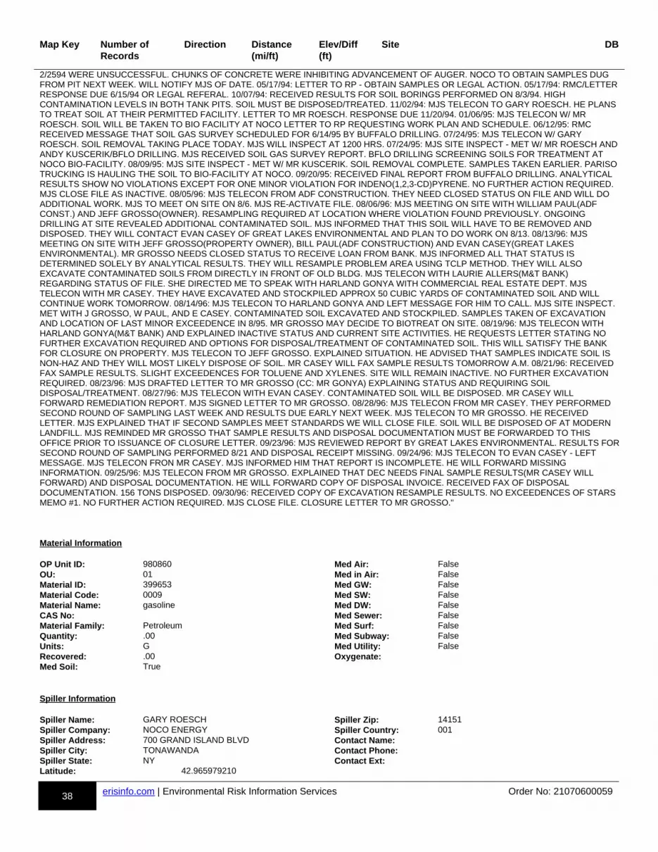
38 erisinfo.com | Environmental Risk Information Services Order No: 21070600059
Map Key Number of Records
Direction Distance(mi/ft)
Elev/Diff(ft)
Site DB
2/2594 WERE UNSUCCESSFUL. CHUNKS OF CONCRETE WERE INHIBITING ADVANCEMENT OF AUGER. NOCO TO OBTAIN SAMPLES DUG FROM PIT NEXT WEEK. WILL NOTIFY MJS OF DATE. 05/17/94: LETTER TO RP - OBTAIN SAMPLES OR LEGAL ACTION. 05/17/94: RMC/LETTERRESPONSE DUE 6/15/94 OR LEGAL REFERAL. 10/07/94: RECEIVED RESULTS FOR SOIL BORINGS PERFORMED ON 8/3/94. HIGH CONTAMINATION LEVELS IN BOTH TANK PITS. SOIL MUST BE DISPOSED/TREATED. 11/02/94: MJS TELECON TO GARY ROESCH. HE PLANS TO TREAT SOIL AT THEIR PERMITTED FACILITY. LETTER TO MR ROESCH. RESPONSE DUE 11/20/94. 01/06/95: MJS TELECON W/ MR ROESCH. SOIL WILL BE TAKEN TO BIO FACILITY AT NOCO LETTER TO RP REQUESTING WORK PLAN AND SCHEDULE. 06/12/95: RMC RECEIVED MESSAGE THAT SOIL GAS SURVEY SCHEDULED FOR 6/14/95 BY BUFFALO DRILLING. 07/24/95: MJS TELECON W/ GARY ROESCH. SOIL REMOVAL TAKING PLACE TODAY. MJS WILL INSPECT AT 1200 HRS. 07/24/95: MJS SITE INSPECT - MET W/ MR ROESCH ANDANDY KUSCERIK/BFLO DRILLING. MJS RECEIVED SOIL GAS SURVEY REPORT. BFLO DRILLING SCREENING SOILS FOR TREATMENT AT NOCO BIO-FACILITY. 08/09/95: MJS SITE INSPECT - MET W/ MR KUSCERIK. SOIL REMOVAL COMPLETE. SAMPLES TAKEN EARLIER. PARISO TRUCKING IS HAULING THE SOIL TO BIO-FACILITY AT NOCO. 09/20/95: RECEIVED FINAL REPORT FROM BUFFALO DRILLING. ANALYTICAL RESULTS SHOW NO VIOLATIONS EXCEPT FOR ONE MINOR VIOLATION FOR INDENO(1,2,3-CD)PYRENE. NO FURTHER ACTION REQUIRED. MJS CLOSE FILE AS INACTIVE. 08/05/96: MJS TELECON FROM ADF CONSTRUCTION. THEY NEED CLOSED STATUS ON FILE AND WILL DO ADDITIONAL WORK. MJS TO MEET ON SITE ON 8/6. MJS RE-ACTIVATE FILE. 08/06/96: MJS MEETING ON SITE WITH WILLIAM PAUL(ADF CONST.) AND JEFF GROSSO(OWNER). RESAMPLING REQUIRED AT LOCATION WHERE VIOLATION FOUND PREVIOUSLY. ONGOING DRILLING AT SITE REVEALED ADDITIONAL CONTAMINATED SOIL. MJS INFORMED THAT THIS SOIL WILL HAVE TO BE REMOVED AND DISPOSED. THEY WILL CONTACT EVAN CASEY OF GREAT LAKES ENVIRONMENTAL AND PLAN TO DO WORK ON 8/13. 08/13/96: MJS MEETING ON SITE WITH JEFF GROSSO(PROPERTY OWNER), BILL PAUL(ADF CONSTRUCTION) AND EVAN CASEY(GREAT LAKES ENVIRONMENTAL). MR GROSSO NEEDS CLOSED STATUS TO RECEIVE LOAN FROM BANK. MJS INFORMED ALL THAT STATUS IS DETERMINED SOLELY BY ANALYTICAL RESULTS. THEY WILL RESAMPLE PROBLEM AREA USING TCLP METHOD. THEY WILL ALSO EXCAVATE CONTAMINATED SOILS FROM DIRECTLY IN FRONT OF OLD BLDG. MJS TELECON WITH LAURIE ALLERS(M&T BANK) REGARDING STATUS OF FILE. SHE DIRECTED ME TO SPEAK WITH HARLAND GONYA WITH COMMERCIAL REAL ESTATE DEPT. MJS TELECON WITH MR CASEY. THEY HAVE EXCAVATED AND STOCKPILED APPROX 50 CUBIC YARDS OF CONTAMINATED SOIL AND WILL CONTINUE WORK TOMORROW. 08/14/96: MJS TELECON TO HARLAND GONYA AND LEFT MESSAGE FOR HIM TO CALL. MJS SITE INSPECT. MET WITH J GROSSO, W PAUL, AND E CASEY. CONTAMINATED SOIL EXCAVATED AND STOCKPILED. SAMPLES TAKEN OF EXCAVATION AND LOCATION OF LAST MINOR EXCEEDENCE IN 8/95. MR GROSSO MAY DECIDE TO BIOTREAT ON SITE. 08/19/96: MJS TELECON WITH HARLAND GONYA(M&T BANK) AND EXPLAINED INACTIVE STATUS AND CURRENT SITE ACTIVITIES. HE REQUESTS LETTER STATING NO FURTHER EXCAVATION REQUIRED AND OPTIONS FOR DISPOSAL/TREATMENT OF CONTAMINATED SOIL. THIS WILL SATISFY THE BANK FOR CLOSURE ON PROPERTY. MJS TELECON TO JEFF GROSSO. EXPLAINED SITUATION. HE ADVISED THAT SAMPLES INDICATE SOIL IS NON-HAZ AND THEY WILL MOST LIKELY DISPOSE OF SOIL. MR CASEY WILL FAX SAMPLE RESULTS TOMORROW A.M. 08/21/96: RECEIVED FAX SAMPLE RESULTS. SLIGHT EXCEEDENCES FOR TOLUENE AND XYLENES. SITE WILL REMAIN INACTIVE. NO FURTHER EXCAVATION REQUIRED. 08/23/96: MJS DRAFTED LETTER TO MR GROSSO (CC: MR GONYA) EXPLAINING STATUS AND REQUIRING SOIL DISPOSAL/TREATMENT. 08/27/96: MJS TELECON WITH EVAN CASEY. CONTAMINATED SOIL WILL BE DISPOSED. MR CASEY WILL FORWARD REMEDIATION REPORT. MJS SIGNED LETTER TO MR GROSSO. 08/28/96: MJS TELECON FROM MR CASEY. THEY PERFORMED SECOND ROUND OF SAMPLING LAST WEEK AND RESULTS DUE EARLY NEXT WEEK. MJS TELECON TO MR GROSSO. HE RECEIVED LETTER. MJS EXPLAINED THAT IF SECOND SAMPLES MEET STANDARDS WE WILL CLOSE FILE. SOIL WILL BE DISPOSED OF AT MODERN LANDFILL. MJS REMINDED MR GROSSO THAT SAMPLE RESULTS AND DISPOSAL DOCUMENTATION MUST BE FORWARDED TO THIS OFFICE PRIOR TO ISSUANCE OF CLOSURE LETTER. 09/23/96: MJS REVIEWED REPORT BY GREAT LAKES ENVIRONMENTAL. RESULTS FORSECOND ROUND OF SAMPLING PERFORMED 8/21 AND DISPOSAL RECEIPT MISSING. 09/24/96: MJS TELECON TO EVAN CASEY - LEFT MESSAGE. MJS TELECON FRON MR CASEY. MJS INFORMED HIM THAT REPORT IS INCOMPLETE. HE WILL FORWARD MISSING INFORMATION. 09/25/96: MJS TELECON FROM MR GROSSO. EXPLAINED THAT DEC NEEDS FINAL SAMPLE RESULTS(MR CASEY WILL FORWARD) AND DISPOSAL DOCUMENTATION. HE WILL FORWARD COPY OF DISPOSAL INVOICE. RECEIVED FAX OF DISPOSAL DOCUMENTATION. 156 TONS DISPOSED. 09/30/96: RECEIVED COPY OF EXCAVATION RESAMPLE RESULTS. NO EXCEEDENCES OF STARS MEMO #1. NO FURTHER ACTION REQUIRED. MJS CLOSE FILE. CLOSURE LETTER TO MR GROSSO."
Material Information OP Unit ID: 980860 Med Air: FalseOU: 01 Med in Air: FalseMaterial ID: 399653 Med GW: FalseMaterial Code: 0009 Med SW: FalseMaterial Name: gasoline Med DW: FalseCAS No: Med Sewer: FalseMaterial Family: Petroleum Med Surf: FalseQuantity: .00 Med Subway: FalseUnits: G Med Utility: FalseRecovered: .00 Oxygenate:Med Soil: True
Spiller Information Spiller Name: GARY ROESCH Spiller Zip: 14151Spiller Company: NOCO ENERGY Spiller Country: 001Spiller Address: 700 GRAND ISLAND BLVD Contact Name:Spiller City: TONAWANDA Contact Phone:Spiller State: NY Contact Ext:Latitude: 42.965979210
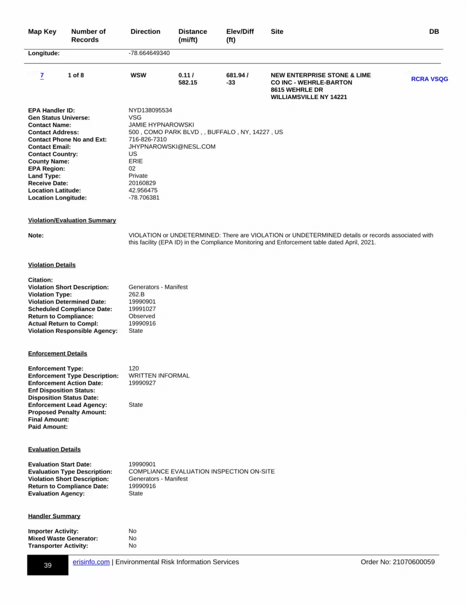
39 erisinfo.com | Environmental Risk Information Services Order No: 21070600059
Map Key Number of Records
Direction Distance(mi/ft)
Elev/Diff(ft)
Site DB
Longitude: -78.664649340
m-7-810514021-b
1 of 8 WSW 0.11 / 582.15
681.94 / -33
NEW ENTERPRISE STONE & LIMECO INC - WEHRLE-BARTON 8615 WEHRLE DR WILLIAMSVILLE NY 14221
dd-RCRA VSQG-810514021-bb
p1p-810514021-y1y
EPA Handler ID: NYD138095534Gen Status Universe: VSGContact Name: JAMIE HYPNAROWSKIContact Address: 500 , COMO PARK BLVD , , BUFFALO , NY, 14227 , USContact Phone No and Ext: 716-826-7310Contact Email: [email protected] Country: USCounty Name: ERIEEPA Region: 02Land Type: PrivateReceive Date: 20160829Location Latitude: 42.956475Location Longitude: -78.706381
Violation/Evaluation Summary Note: VIOLATION or UNDETERMINED: There are VIOLATION or UNDETERMINED details or records associated with
this facility (EPA ID) in the Compliance Monitoring and Enforcement table dated April, 2021.
Violation Details Citation:Violation Short Description: Generators - ManifestViolation Type: 262.BViolation Determined Date: 19990901Scheduled Compliance Date: 19991027Return to Compliance: ObservedActual Return to Compl: 19990916Violation Responsible Agency: State
Enforcement Details Enforcement Type: 120Enforcement Type Description: WRITTEN INFORMALEnforcement Action Date: 19990927Enf Disposition Status:Disposition Status Date:Enforcement Lead Agency: StateProposed Penalty Amount:Final Amount:Paid Amount:
Evaluation Details Evaluation Start Date: 19990901Evaluation Type Description: COMPLIANCE EVALUATION INSPECTION ON-SITEViolation Short Description: Generators - ManifestReturn to Compliance Date: 19990916Evaluation Agency: State
Handler Summary Importer Activity: NoMixed Waste Generator: NoTransporter Activity: No
7RCRA VSQG
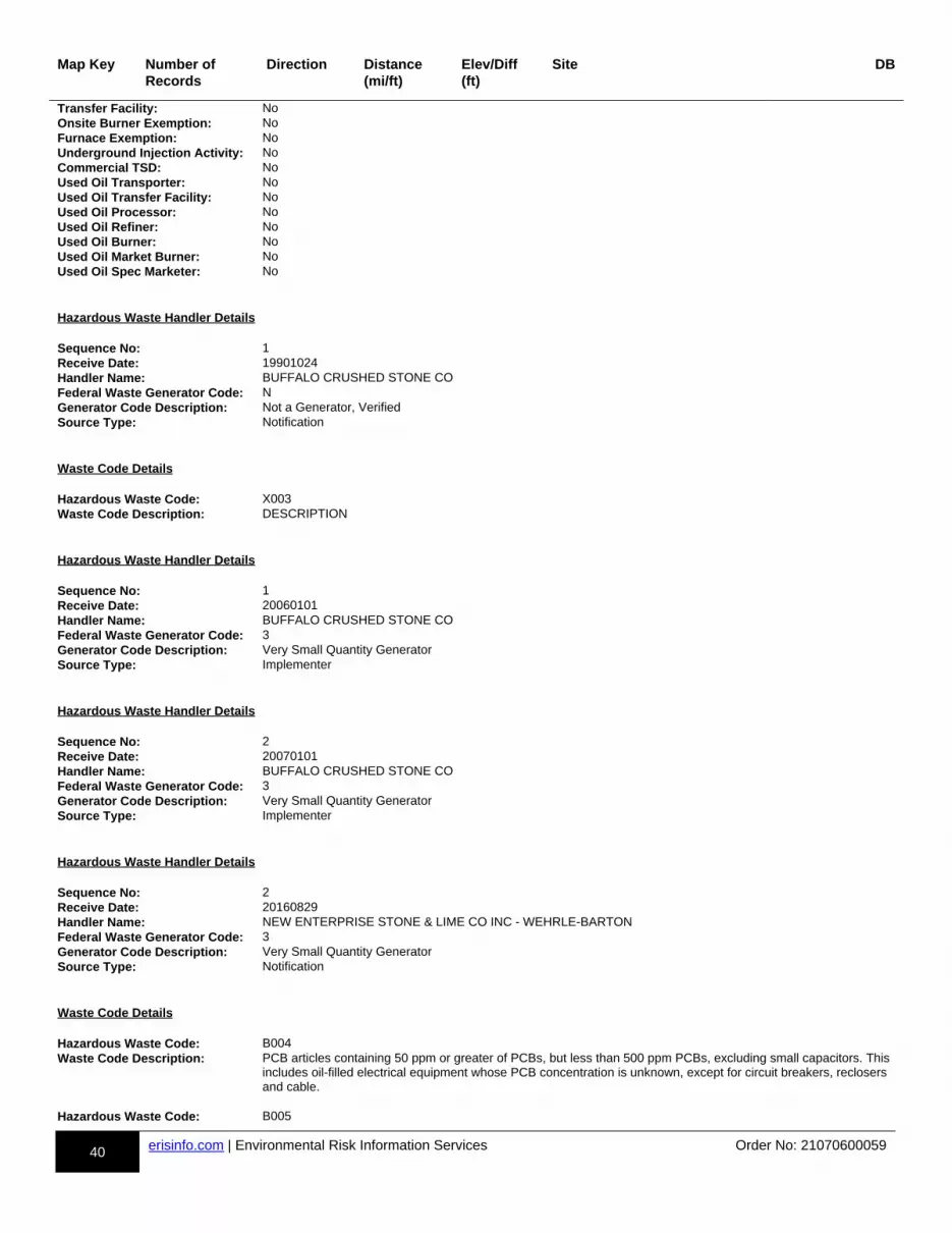
40 erisinfo.com | Environmental Risk Information Services Order No: 21070600059
Map Key Number of Records
Direction Distance(mi/ft)
Elev/Diff(ft)
Site DB
Transfer Facility: NoOnsite Burner Exemption: NoFurnace Exemption: NoUnderground Injection Activity: NoCommercial TSD: NoUsed Oil Transporter: NoUsed Oil Transfer Facility: NoUsed Oil Processor: NoUsed Oil Refiner: NoUsed Oil Burner: NoUsed Oil Market Burner: NoUsed Oil Spec Marketer: No
Hazardous Waste Handler Details Sequence No: 1Receive Date: 19901024Handler Name: BUFFALO CRUSHED STONE COFederal Waste Generator Code: NGenerator Code Description: Not a Generator, VerifiedSource Type: Notification
Waste Code Details Hazardous Waste Code: X003Waste Code Description: DESCRIPTION
Hazardous Waste Handler Details Sequence No: 1Receive Date: 20060101Handler Name: BUFFALO CRUSHED STONE COFederal Waste Generator Code: 3Generator Code Description: Very Small Quantity GeneratorSource Type: Implementer
Hazardous Waste Handler Details Sequence No: 2Receive Date: 20070101Handler Name: BUFFALO CRUSHED STONE COFederal Waste Generator Code: 3Generator Code Description: Very Small Quantity GeneratorSource Type: Implementer
Hazardous Waste Handler Details Sequence No: 2Receive Date: 20160829Handler Name: NEW ENTERPRISE STONE & LIME CO INC - WEHRLE-BARTONFederal Waste Generator Code: 3Generator Code Description: Very Small Quantity GeneratorSource Type: Notification
Waste Code Details Hazardous Waste Code: B004Waste Code Description: PCB articles containing 50 ppm or greater of PCBs, but less than 500 ppm PCBs, excluding small capacitors. This
includes oil-filled electrical equipment whose PCB concentration is unknown, except for circuit breakers, reclosers and cable.
Hazardous Waste Code: B005

41 erisinfo.com | Environmental Risk Information Services Order No: 21070600059
Map Key Number of Records
Direction Distance(mi/ft)
Elev/Diff(ft)
Site DB
Waste Code Description: PCB articles, other than transformers, that contain 500 ppm or greater of PCBs, excluding small capacitors. Hazardous Waste Code: D001Waste Code Description: IGNITABLE WASTE Hazardous Waste Code: D008Waste Code Description: LEAD
Owner/Operator Details Owner/Operator Ind: Current Operator Street No:Type: Private Street 1:Name: NEW ENTERPRISE STONE & LIME CO INC Street 2:Date Became Current: 20000701 City:Date Ended Current: State:Phone: Country: USSource Type: Notification Zip Code: Owner/Operator Ind: Current Owner Street No:Type: Private Street 1: NOT REQUIREDName: RICHARD E GARMAN Street 2:Date Became Current: City: NOT REQUIREDDate Ended Current: State: WYPhone: 212-555-1212 Country: USSource Type: Implementer Zip Code: 99999 Owner/Operator Ind: Current Owner Street No:Type: Private Street 1: NOT REQUIREDName: RICHARD E GARMAN Street 2:Date Became Current: City: NOT REQUIREDDate Ended Current: State: WYPhone: 212-555-1212 Country:Source Type: Notification Zip Code: 99999 Owner/Operator Ind: Current Owner Street No:Type: Private Street 1: PO BOX 77Name: NEW ENTERPRISE STONE & LIME CO INC Street 2:Date Became Current: 20000701 City: NEW ENTERPRISEDate Ended Current: State: PAPhone: 814-766-2211 Country: USSource Type: Notification Zip Code: 16664 Owner/Operator Ind: Current Operator Street No:Type: Private Street 1: NOT REQUIREDName: RICHARD E GARMAN Street 2:Date Became Current: City: NOT REQUIREDDate Ended Current: State: WYPhone: 212-555-1212 Country: USSource Type: Implementer Zip Code: 99999
Historical Handler Details Receive Dt: 20070101Generator Code Description: Very Small Quantity GeneratorHandler Name: BUFFALO CRUSHED STONE CO Receive Dt: 20060101Generator Code Description: Very Small Quantity GeneratorHandler Name: BUFFALO CRUSHED STONE CO Receive Dt: 19901024Generator Code Description: Not a Generator, VerifiedHandler Name: BUFFALO CRUSHED STONE CO
m-7-810892945-b
2 of 8 WSW 0.11 / 582.15
681.94 / -33
WEHRLE DRIVE QUARRY 8615 WEHRLE DRIVE
dd-AST-810892945-bb
p1p-810892945-y1y 7AST
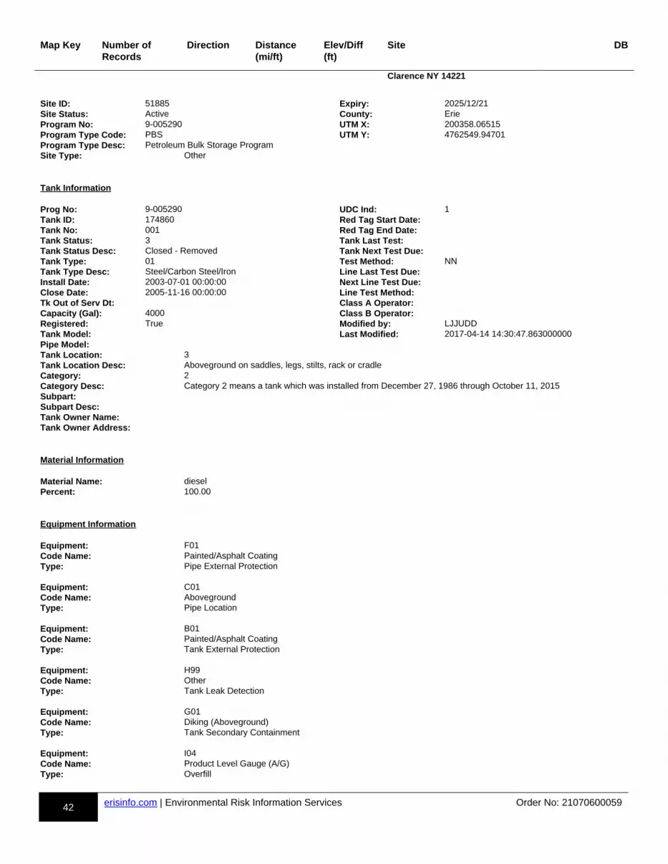
42 erisinfo.com | Environmental Risk Information Services Order No: 21070600059
Map Key Number of Records
Direction Distance(mi/ft)
Elev/Diff(ft)
Site DB
Clarence NY 14221
Site ID: 51885 Expiry: 2025/12/21Site Status: Active County: ErieProgram No: 9-005290 UTM X: 200358.06515Program Type Code: PBS UTM Y: 4762549.94701Program Type Desc: Petroleum Bulk Storage ProgramSite Type: Other
Tank Information Prog No: 9-005290 UDC Ind: 1Tank ID: 174860 Red Tag Start Date:Tank No: 001 Red Tag End Date:Tank Status: 3 Tank Last Test:Tank Status Desc: Closed - Removed Tank Next Test Due:Tank Type: 01 Test Method: NNTank Type Desc: Steel/Carbon Steel/Iron Line Last Test Due:Install Date: 2003-07-01 00:00:00 Next Line Test Due:Close Date: 2005-11-16 00:00:00 Line Test Method:Tk Out of Serv Dt: Class A Operator:Capacity (Gal): 4000 Class B Operator:Registered: True Modified by: LJJUDDTank Model: Last Modified: 2017-04-14 14:30:47.863000000Pipe Model:Tank Location: 3Tank Location Desc: Aboveground on saddles, legs, stilts, rack or cradleCategory: 2Category Desc: Category 2 means a tank which was installed from December 27, 1986 through October 11, 2015Subpart:Subpart Desc:Tank Owner Name:Tank Owner Address:
Material Information Material Name: dieselPercent: 100.00
Equipment Information Equipment: F01Code Name: Painted/Asphalt CoatingType: Pipe External Protection Equipment: C01Code Name: AbovegroundType: Pipe Location Equipment: B01Code Name: Painted/Asphalt CoatingType: Tank External Protection Equipment: H99Code Name: OtherType: Tank Leak Detection Equipment: G01Code Name: Diking (Aboveground)Type: Tank Secondary Containment Equipment: I04Code Name: Product Level Gauge (A/G)Type: Overfill
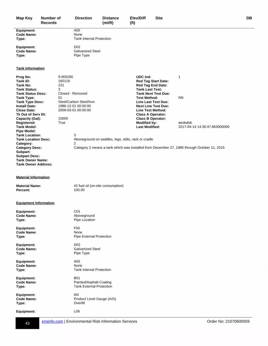
43 erisinfo.com | Environmental Risk Information Services Order No: 21070600059
Map Key Number of Records
Direction Distance(mi/ft)
Elev/Diff(ft)
Site DB
Equipment: A00Code Name: NoneType: Tank Internal Protection Equipment: D02Code Name: Galvanized SteelType: Pipe Type
Tank Information Prog No: 9-005290 UDC Ind: 1Tank ID: 160116 Red Tag Start Date:Tank No: 231 Red Tag End Date:Tank Status: 3 Tank Last Test:Tank Status Desc: Closed - Removed Tank Next Test Due:Tank Type: 01 Test Method: NNTank Type Desc: Steel/Carbon Steel/Iron Line Last Test Due:Install Date: 1986-12-01 00:00:00 Next Line Test Due:Close Date: 2009-03-01 00:00:00 Line Test Method:Tk Out of Serv Dt: Class A Operator:Capacity (Gal): 15000 Class B Operator:Registered: True Modified by: aeskalskTank Model: Last Modified: 2017-04-14 14:30:47.863000000Pipe Model:Tank Location: 3Tank Location Desc: Aboveground on saddles, legs, stilts, rack or cradleCategory: 2Category Desc: Category 2 means a tank which was installed from December 27, 1986 through October 11, 2015Subpart:Subpart Desc:Tank Owner Name:Tank Owner Address:
Material Information Material Name: #2 fuel oil (on-site consumption)Percent: 100.00
Equipment Information Equipment: C01Code Name: AbovegroundType: Pipe Location Equipment: F00Code Name: NoneType: Pipe External Protection Equipment: D02Code Name: Galvanized SteelType: Pipe Type Equipment: A00Code Name: NoneType: Tank Internal Protection Equipment: B01Code Name: Painted/Asphalt CoatingType: Tank External Protection Equipment: I04Code Name: Product Level Gauge (A/G)Type: Overfill Equipment: L09
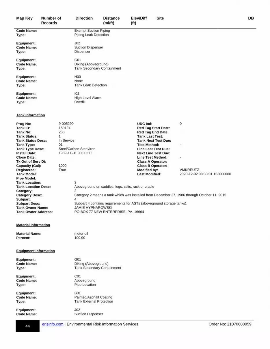
44 erisinfo.com | Environmental Risk Information Services Order No: 21070600059
Map Key Number of Records
Direction Distance(mi/ft)
Elev/Diff(ft)
Site DB
Code Name: Exempt Suction PipingType: Piping Leak Detection Equipment: J02Code Name: Suction DispenserType: Dispenser Equipment: G01Code Name: Diking (Aboveground)Type: Tank Secondary Containment Equipment: H00Code Name: NoneType: Tank Leak Detection Equipment: I02Code Name: High Level AlarmType: Overfill
Tank Information Prog No: 9-005290 UDC Ind: 0Tank ID: 160124 Red Tag Start Date:Tank No: 238 Red Tag End Date:Tank Status: 1 Tank Last Test:Tank Status Desc: In Service Tank Next Test Due:Tank Type: 01 Test Method: -Tank Type Desc: Steel/Carbon Steel/Iron Line Last Test Due:Install Date: 1989-11-01 00:00:00 Next Line Test Due:Close Date: Line Test Method: -Tk Out of Serv Dt: Class A Operator:Capacity (Gal): 1000 Class B Operator:Registered: True Modified by: VMKREUTZTank Model: Last Modified: 2020-12-02 08:33:01.153000000Pipe Model:Tank Location: 3Tank Location Desc: Aboveground on saddles, legs, stilts, rack or cradleCategory: 2Category Desc: Category 2 means a tank which was installed from December 27, 1986 through October 11, 2015Subpart: 4Subpart Desc: Subpart 4 contains requirements for ASTs (aboveground storage tanks).Tank Owner Name: JAMIE HYPNAROWSKITank Owner Address: PO BOX 77 NEW ENTERPRISE, PA. 16664
Material Information Material Name: motor oilPercent: 100.00
Equipment Information Equipment: G01Code Name: Diking (Aboveground)Type: Tank Secondary Containment Equipment: C01Code Name: AbovegroundType: Pipe Location Equipment: B01Code Name: Painted/Asphalt CoatingType: Tank External Protection Equipment: J02Code Name: Suction Dispenser

45 erisinfo.com | Environmental Risk Information Services Order No: 21070600059
Map Key Number of Records
Direction Distance(mi/ft)
Elev/Diff(ft)
Site DB
Type: Dispenser Equipment: A00Code Name: NoneType: Tank Internal Protection Equipment: H00Code Name: NoneType: Tank Leak Detection Equipment: L09Code Name: Exempt Suction PipingType: Piping Leak Detection Equipment: F00Code Name: NoneType: Pipe External Protection Equipment: K00Code Name: NoneType: Spill Prevention Equipment: I05Code Name: Vent WhistleType: Overfill Equipment: D02Code Name: Galvanized SteelType: Pipe Type Equipment: E00Code Name: NoneType: Piping Secondary Containment
Tank Information Prog No: 9-005290 UDC Ind: 0Tank ID: 160125 Red Tag Start Date:Tank No: 239 Red Tag End Date:Tank Status: 1 Tank Last Test:Tank Status Desc: In Service Tank Next Test Due:Tank Type: 01 Test Method: -Tank Type Desc: Steel/Carbon Steel/Iron Line Last Test Due:Install Date: 1989-11-01 00:00:00 Next Line Test Due:Close Date: Line Test Method: -Tk Out of Serv Dt: Class A Operator:Capacity (Gal): 1000 Class B Operator:Registered: True Modified by: VMKREUTZTank Model: Last Modified: 2020-12-02 08:33:01.160000000Pipe Model:Tank Location: 3Tank Location Desc: Aboveground on saddles, legs, stilts, rack or cradleCategory: 2Category Desc: Category 2 means a tank which was installed from December 27, 1986 through October 11, 2015Subpart: 4Subpart Desc: Subpart 4 contains requirements for ASTs (aboveground storage tanks).Tank Owner Name: JAMIE HYPNAROWSKITank Owner Address: PO BOX 77 NEW ENTERPRISE, PA. 16664
Material Information Material Name: transmission fluidPercent: 100.00
Equipment Information
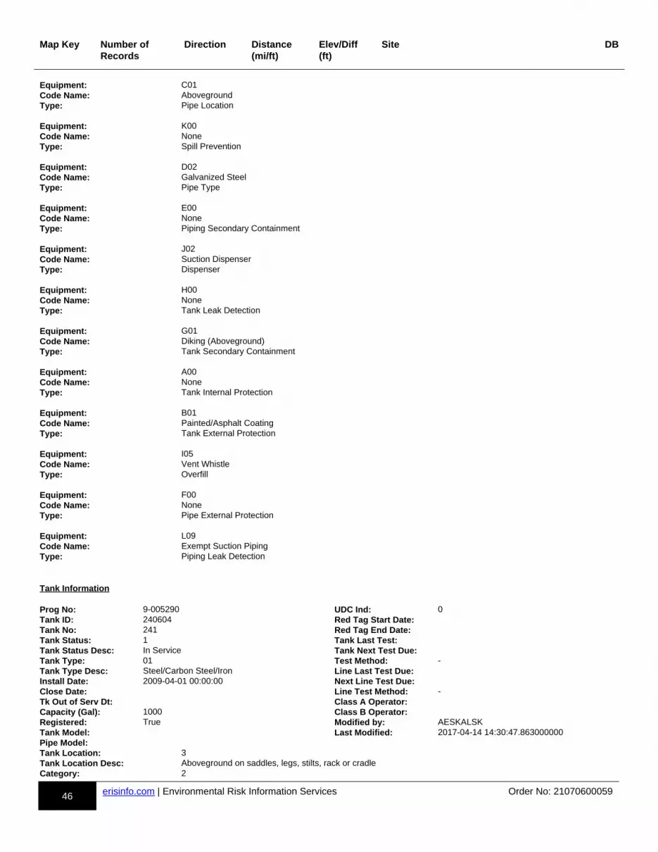
46 erisinfo.com | Environmental Risk Information Services Order No: 21070600059
Map Key Number of Records
Direction Distance(mi/ft)
Elev/Diff(ft)
Site DB
Equipment: C01Code Name: AbovegroundType: Pipe Location Equipment: K00Code Name: NoneType: Spill Prevention Equipment: D02Code Name: Galvanized SteelType: Pipe Type Equipment: E00Code Name: NoneType: Piping Secondary Containment Equipment: J02Code Name: Suction DispenserType: Dispenser Equipment: H00Code Name: NoneType: Tank Leak Detection Equipment: G01Code Name: Diking (Aboveground)Type: Tank Secondary Containment Equipment: A00Code Name: NoneType: Tank Internal Protection Equipment: B01Code Name: Painted/Asphalt CoatingType: Tank External Protection Equipment: I05Code Name: Vent WhistleType: Overfill Equipment: F00Code Name: NoneType: Pipe External Protection Equipment: L09Code Name: Exempt Suction PipingType: Piping Leak Detection
Tank Information Prog No: 9-005290 UDC Ind: 0Tank ID: 240604 Red Tag Start Date:Tank No: 241 Red Tag End Date:Tank Status: 1 Tank Last Test:Tank Status Desc: In Service Tank Next Test Due:Tank Type: 01 Test Method: -Tank Type Desc: Steel/Carbon Steel/Iron Line Last Test Due:Install Date: 2009-04-01 00:00:00 Next Line Test Due:Close Date: Line Test Method: -Tk Out of Serv Dt: Class A Operator:Capacity (Gal): 1000 Class B Operator:Registered: True Modified by: AESKALSKTank Model: Last Modified: 2017-04-14 14:30:47.863000000Pipe Model:Tank Location: 3Tank Location Desc: Aboveground on saddles, legs, stilts, rack or cradleCategory: 2

47 erisinfo.com | Environmental Risk Information Services Order No: 21070600059
Map Key Number of Records
Direction Distance(mi/ft)
Elev/Diff(ft)
Site DB
Category Desc: Category 2 means a tank which was installed from December 27, 1986 through October 11, 2015Subpart: 4Subpart Desc: Subpart 4 contains requirements for ASTs (aboveground storage tanks).Tank Owner Name: JAMIE HYPNAROWSKITank Owner Address: PO BOX 77 NEW ENTERPRISE, PA. 16664
Material Information Material Name: dieselPercent: 100.00
Equipment Information Equipment: E00Code Name: NoneType: Piping Secondary Containment Equipment: H00Code Name: NoneType: Tank Leak Detection Equipment: L09Code Name: Exempt Suction PipingType: Piping Leak Detection Equipment: J03Code Name: GravityType: Dispenser Equipment: D01Code Name: Steel/Carbon Steel/IronType: Pipe Type Equipment: G01Code Name: Diking (Aboveground)Type: Tank Secondary Containment Equipment: I04Code Name: Product Level Gauge (A/G)Type: Overfill Equipment: K00Code Name: NoneType: Spill Prevention Equipment: F00Code Name: NoneType: Pipe External Protection Equipment: A00Code Name: NoneType: Tank Internal Protection Equipment: B01Code Name: Painted/Asphalt CoatingType: Tank External Protection Equipment: C01Code Name: AbovegroundType: Pipe Location
Tank Information Prog No: 9-005290 UDC Ind: 1Tank ID: 160119 Red Tag Start Date:
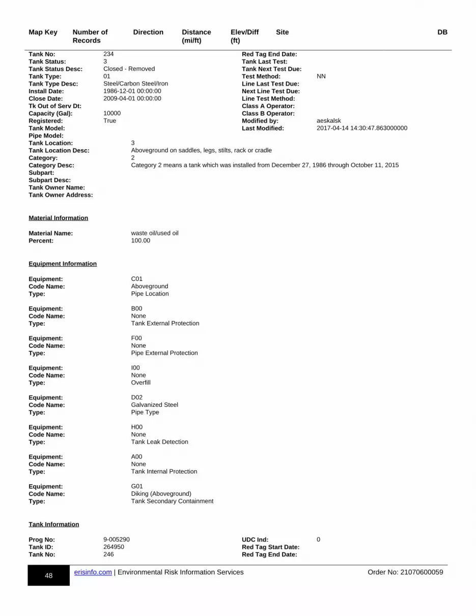
48 erisinfo.com | Environmental Risk Information Services Order No: 21070600059
Map Key Number of Records
Direction Distance(mi/ft)
Elev/Diff(ft)
Site DB
Tank No: 234 Red Tag End Date:Tank Status: 3 Tank Last Test:Tank Status Desc: Closed - Removed Tank Next Test Due:Tank Type: 01 Test Method: NNTank Type Desc: Steel/Carbon Steel/Iron Line Last Test Due:Install Date: 1986-12-01 00:00:00 Next Line Test Due:Close Date: 2009-04-01 00:00:00 Line Test Method:Tk Out of Serv Dt: Class A Operator:Capacity (Gal): 10000 Class B Operator:Registered: True Modified by: aeskalskTank Model: Last Modified: 2017-04-14 14:30:47.863000000Pipe Model:Tank Location: 3Tank Location Desc: Aboveground on saddles, legs, stilts, rack or cradleCategory: 2Category Desc: Category 2 means a tank which was installed from December 27, 1986 through October 11, 2015Subpart:Subpart Desc:Tank Owner Name:Tank Owner Address:
Material Information Material Name: waste oil/used oilPercent: 100.00
Equipment Information Equipment: C01Code Name: AbovegroundType: Pipe Location Equipment: B00Code Name: NoneType: Tank External Protection Equipment: F00Code Name: NoneType: Pipe External Protection Equipment: I00Code Name: NoneType: Overfill Equipment: D02Code Name: Galvanized SteelType: Pipe Type Equipment: H00Code Name: NoneType: Tank Leak Detection Equipment: A00Code Name: NoneType: Tank Internal Protection Equipment: G01Code Name: Diking (Aboveground)Type: Tank Secondary Containment
Tank Information Prog No: 9-005290 UDC Ind: 0Tank ID: 264950 Red Tag Start Date:Tank No: 246 Red Tag End Date:
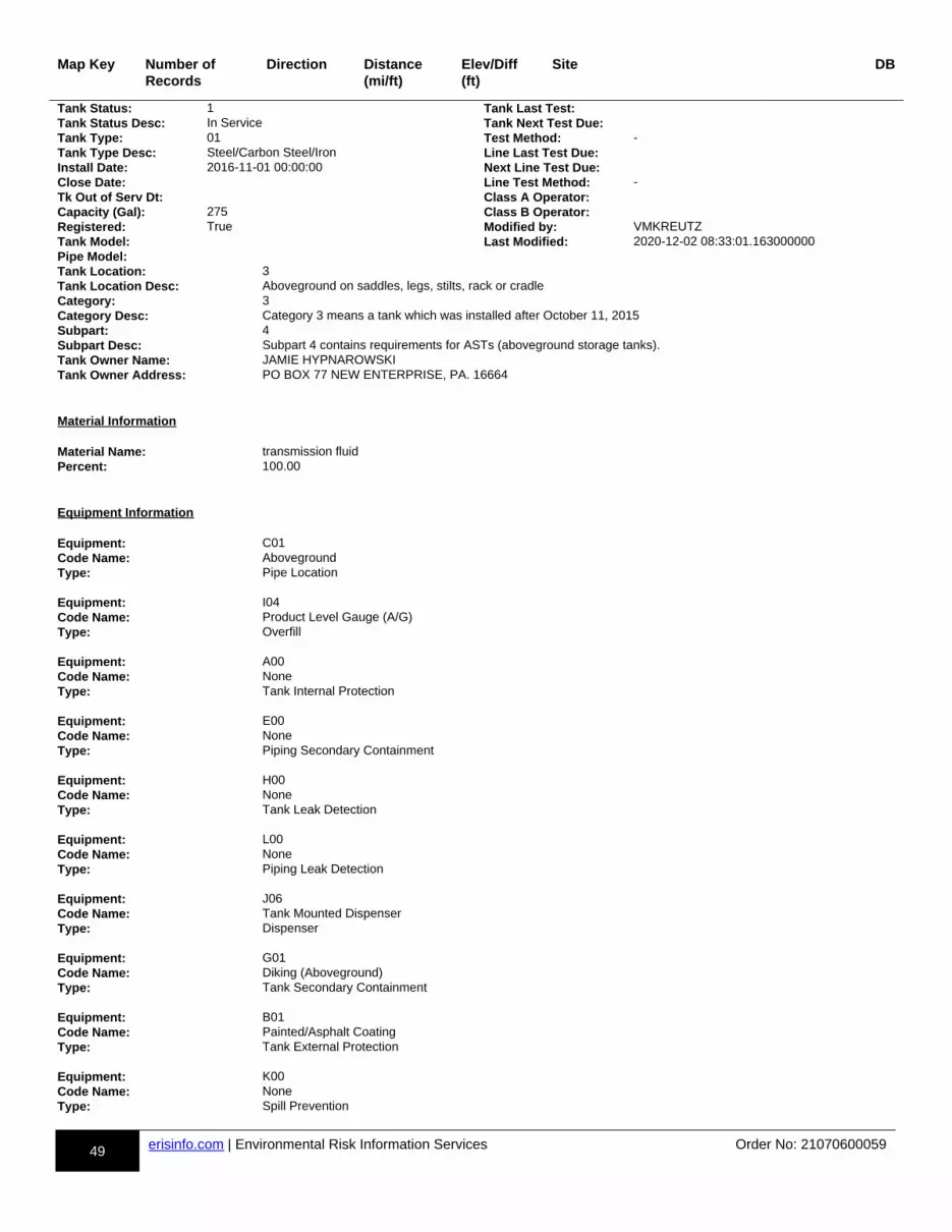
49 erisinfo.com | Environmental Risk Information Services Order No: 21070600059
Map Key Number of Records
Direction Distance(mi/ft)
Elev/Diff(ft)
Site DB
Tank Status: 1 Tank Last Test:Tank Status Desc: In Service Tank Next Test Due:Tank Type: 01 Test Method: -Tank Type Desc: Steel/Carbon Steel/Iron Line Last Test Due:Install Date: 2016-11-01 00:00:00 Next Line Test Due:Close Date: Line Test Method: -Tk Out of Serv Dt: Class A Operator:Capacity (Gal): 275 Class B Operator:Registered: True Modified by: VMKREUTZTank Model: Last Modified: 2020-12-02 08:33:01.163000000Pipe Model:Tank Location: 3Tank Location Desc: Aboveground on saddles, legs, stilts, rack or cradleCategory: 3Category Desc: Category 3 means a tank which was installed after October 11, 2015Subpart: 4Subpart Desc: Subpart 4 contains requirements for ASTs (aboveground storage tanks).Tank Owner Name: JAMIE HYPNAROWSKITank Owner Address: PO BOX 77 NEW ENTERPRISE, PA. 16664
Material Information Material Name: transmission fluidPercent: 100.00
Equipment Information Equipment: C01Code Name: AbovegroundType: Pipe Location Equipment: I04Code Name: Product Level Gauge (A/G)Type: Overfill Equipment: A00Code Name: NoneType: Tank Internal Protection Equipment: E00Code Name: NoneType: Piping Secondary Containment Equipment: H00Code Name: NoneType: Tank Leak Detection Equipment: L00Code Name: NoneType: Piping Leak Detection Equipment: J06Code Name: Tank Mounted DispenserType: Dispenser Equipment: G01Code Name: Diking (Aboveground)Type: Tank Secondary Containment Equipment: B01Code Name: Painted/Asphalt CoatingType: Tank External Protection Equipment: K00Code Name: NoneType: Spill Prevention
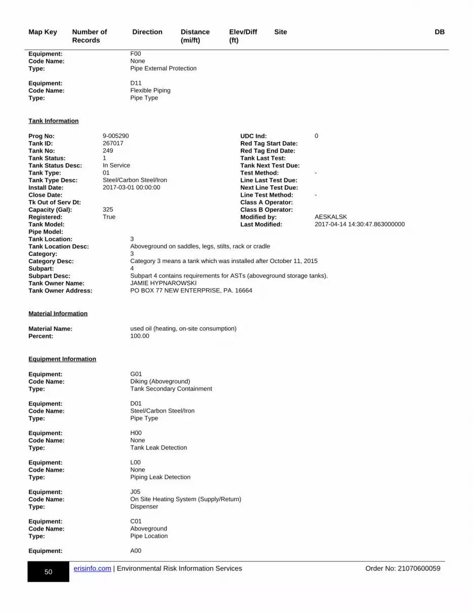
50 erisinfo.com | Environmental Risk Information Services Order No: 21070600059
Map Key Number of Records
Direction Distance(mi/ft)
Elev/Diff(ft)
Site DB
Equipment: F00Code Name: NoneType: Pipe External Protection Equipment: D11Code Name: Flexible PipingType: Pipe Type
Tank Information Prog No: 9-005290 UDC Ind: 0Tank ID: 267017 Red Tag Start Date:Tank No: 249 Red Tag End Date:Tank Status: 1 Tank Last Test:Tank Status Desc: In Service Tank Next Test Due:Tank Type: 01 Test Method: -Tank Type Desc: Steel/Carbon Steel/Iron Line Last Test Due:Install Date: 2017-03-01 00:00:00 Next Line Test Due:Close Date: Line Test Method: -Tk Out of Serv Dt: Class A Operator:Capacity (Gal): 325 Class B Operator:Registered: True Modified by: AESKALSKTank Model: Last Modified: 2017-04-14 14:30:47.863000000Pipe Model:Tank Location: 3Tank Location Desc: Aboveground on saddles, legs, stilts, rack or cradleCategory: 3Category Desc: Category 3 means a tank which was installed after October 11, 2015Subpart: 4Subpart Desc: Subpart 4 contains requirements for ASTs (aboveground storage tanks).Tank Owner Name: JAMIE HYPNAROWSKITank Owner Address: PO BOX 77 NEW ENTERPRISE, PA. 16664
Material Information Material Name: used oil (heating, on-site consumption)Percent: 100.00
Equipment Information Equipment: G01Code Name: Diking (Aboveground)Type: Tank Secondary Containment Equipment: D01Code Name: Steel/Carbon Steel/IronType: Pipe Type Equipment: H00Code Name: NoneType: Tank Leak Detection Equipment: L00Code Name: NoneType: Piping Leak Detection Equipment: J05Code Name: On Site Heating System (Supply/Return)Type: Dispenser Equipment: C01Code Name: AbovegroundType: Pipe Location Equipment: A00

51 erisinfo.com | Environmental Risk Information Services Order No: 21070600059
Map Key Number of Records
Direction Distance(mi/ft)
Elev/Diff(ft)
Site DB
Code Name: NoneType: Tank Internal Protection Equipment: B01Code Name: Painted/Asphalt CoatingType: Tank External Protection Equipment: F00Code Name: NoneType: Pipe External Protection Equipment: I04Code Name: Product Level Gauge (A/G)Type: Overfill Equipment: K00Code Name: NoneType: Spill Prevention Equipment: E00Code Name: NoneType: Piping Secondary Containment
Tank Information Prog No: 9-005290 UDC Ind: 0Tank ID: 264952 Red Tag Start Date:Tank No: 248 Red Tag End Date:Tank Status: 1 Tank Last Test:Tank Status Desc: In Service Tank Next Test Due:Tank Type: 01 Test Method: -Tank Type Desc: Steel/Carbon Steel/Iron Line Last Test Due:Install Date: 2016-11-01 00:00:00 Next Line Test Due:Close Date: Line Test Method: -Tk Out of Serv Dt: Class A Operator:Capacity (Gal): 275 Class B Operator:Registered: True Modified by: VMKREUTZTank Model: Last Modified: 2020-12-02 08:33:01.170000000Pipe Model:Tank Location: 3Tank Location Desc: Aboveground on saddles, legs, stilts, rack or cradleCategory: 3Category Desc: Category 3 means a tank which was installed after October 11, 2015Subpart: 4Subpart Desc: Subpart 4 contains requirements for ASTs (aboveground storage tanks).Tank Owner Name: JAMIE HYPNAROWSKITank Owner Address: PO BOX 77 NEW ENTERPRISE, PA. 16664
Material Information Material Name: transmission fluidPercent: 100.00
Equipment Information Equipment: H00Code Name: NoneType: Tank Leak Detection Equipment: G01Code Name: Diking (Aboveground)Type: Tank Secondary Containment Equipment: I04Code Name: Product Level Gauge (A/G)
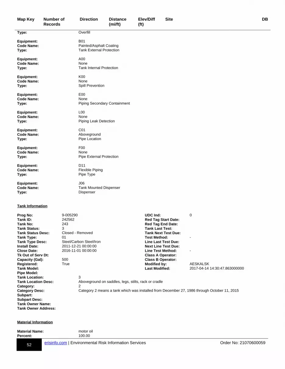
52 erisinfo.com | Environmental Risk Information Services Order No: 21070600059
Map Key Number of Records
Direction Distance(mi/ft)
Elev/Diff(ft)
Site DB
Type: Overfill Equipment: B01Code Name: Painted/Asphalt CoatingType: Tank External Protection Equipment: A00Code Name: NoneType: Tank Internal Protection Equipment: K00Code Name: NoneType: Spill Prevention Equipment: E00Code Name: NoneType: Piping Secondary Containment Equipment: L00Code Name: NoneType: Piping Leak Detection Equipment: C01Code Name: AbovegroundType: Pipe Location Equipment: F00Code Name: NoneType: Pipe External Protection Equipment: D11Code Name: Flexible PipingType: Pipe Type Equipment: J06Code Name: Tank Mounted DispenserType: Dispenser
Tank Information Prog No: 9-005290 UDC Ind: 0Tank ID: 242562 Red Tag Start Date:Tank No: 243 Red Tag End Date:Tank Status: 3 Tank Last Test:Tank Status Desc: Closed - Removed Tank Next Test Due:Tank Type: 01 Test Method: -Tank Type Desc: Steel/Carbon Steel/Iron Line Last Test Due:Install Date: 2011-12-21 00:00:00 Next Line Test Due:Close Date: 2016-11-01 00:00:00 Line Test Method: -Tk Out of Serv Dt: Class A Operator:Capacity (Gal): 500 Class B Operator:Registered: True Modified by: AESKALSKTank Model: Last Modified: 2017-04-14 14:30:47.863000000Pipe Model:Tank Location: 3Tank Location Desc: Aboveground on saddles, legs, stilts, rack or cradleCategory: 2Category Desc: Category 2 means a tank which was installed from December 27, 1986 through October 11, 2015Subpart:Subpart Desc:Tank Owner Name:Tank Owner Address:
Material Information Material Name: motor oilPercent: 100.00
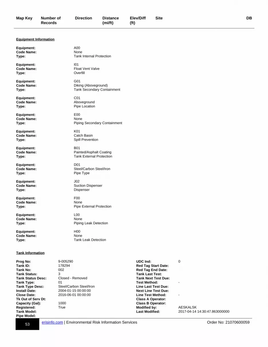
53 erisinfo.com | Environmental Risk Information Services Order No: 21070600059
Map Key Number of Records
Direction Distance(mi/ft)
Elev/Diff(ft)
Site DB
Equipment Information Equipment: A00Code Name: NoneType: Tank Internal Protection Equipment: I01Code Name: Float Vent ValveType: Overfill Equipment: G01Code Name: Diking (Aboveground)Type: Tank Secondary Containment Equipment: C01Code Name: AbovegroundType: Pipe Location Equipment: E00Code Name: NoneType: Piping Secondary Containment Equipment: K01Code Name: Catch BasinType: Spill Prevention Equipment: B01Code Name: Painted/Asphalt CoatingType: Tank External Protection Equipment: D01Code Name: Steel/Carbon Steel/IronType: Pipe Type Equipment: J02Code Name: Suction DispenserType: Dispenser Equipment: F00Code Name: NoneType: Pipe External Protection Equipment: L00Code Name: NoneType: Piping Leak Detection Equipment: H00Code Name: NoneType: Tank Leak Detection
Tank Information Prog No: 9-005290 UDC Ind: 0Tank ID: 178294 Red Tag Start Date:Tank No: 002 Red Tag End Date:Tank Status: 3 Tank Last Test:Tank Status Desc: Closed - Removed Tank Next Test Due:Tank Type: 01 Test Method: -Tank Type Desc: Steel/Carbon Steel/Iron Line Last Test Due:Install Date: 2004-01-15 00:00:00 Next Line Test Due:Close Date: 2016-06-01 00:00:00 Line Test Method: -Tk Out of Serv Dt: Class A Operator:Capacity (Gal): 1000 Class B Operator:Registered: True Modified by: AESKALSKTank Model: Last Modified: 2017-04-14 14:30:47.863000000Pipe Model:
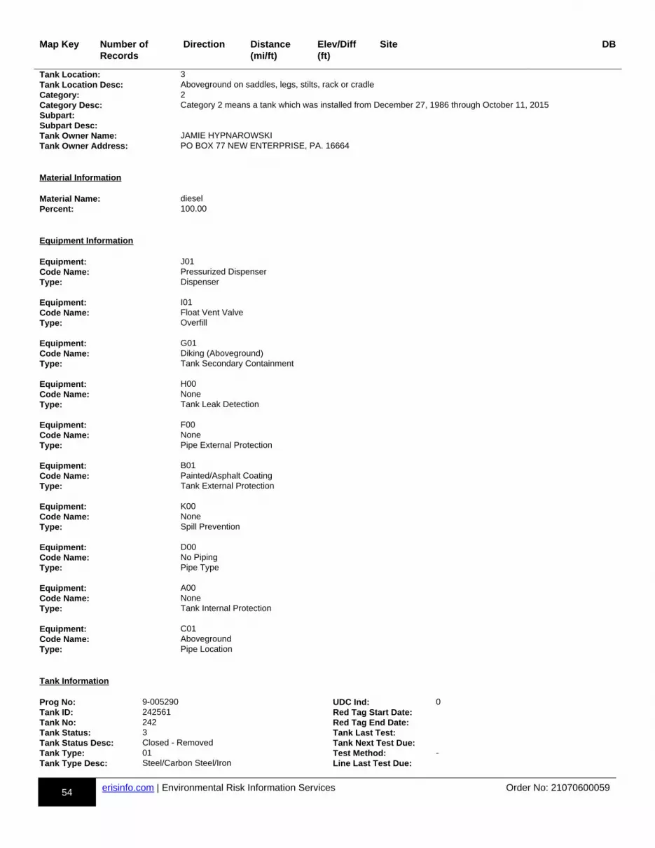
54 erisinfo.com | Environmental Risk Information Services Order No: 21070600059
Map Key Number of Records
Direction Distance(mi/ft)
Elev/Diff(ft)
Site DB
Tank Location: 3Tank Location Desc: Aboveground on saddles, legs, stilts, rack or cradleCategory: 2Category Desc: Category 2 means a tank which was installed from December 27, 1986 through October 11, 2015Subpart:Subpart Desc:Tank Owner Name: JAMIE HYPNAROWSKITank Owner Address: PO BOX 77 NEW ENTERPRISE, PA. 16664
Material Information Material Name: dieselPercent: 100.00
Equipment Information Equipment: J01Code Name: Pressurized DispenserType: Dispenser Equipment: I01Code Name: Float Vent ValveType: Overfill Equipment: G01Code Name: Diking (Aboveground)Type: Tank Secondary Containment Equipment: H00Code Name: NoneType: Tank Leak Detection Equipment: F00Code Name: NoneType: Pipe External Protection Equipment: B01Code Name: Painted/Asphalt CoatingType: Tank External Protection Equipment: K00Code Name: NoneType: Spill Prevention Equipment: D00Code Name: No PipingType: Pipe Type Equipment: A00Code Name: NoneType: Tank Internal Protection Equipment: C01Code Name: AbovegroundType: Pipe Location
Tank Information Prog No: 9-005290 UDC Ind: 0Tank ID: 242561 Red Tag Start Date:Tank No: 242 Red Tag End Date:Tank Status: 3 Tank Last Test:Tank Status Desc: Closed - Removed Tank Next Test Due:Tank Type: 01 Test Method: -Tank Type Desc: Steel/Carbon Steel/Iron Line Last Test Due:
55 erisinfo.com | Environmental Risk Information Services Order No: 21070600059
Map Key Number of Records
Direction Distance(mi/ft)
Elev/Diff(ft)
Site DB
Install Date: 2011-12-20 00:00:00 Next Line Test Due:Close Date: 2016-11-01 00:00:00 Line Test Method: -Tk Out of Serv Dt: Class A Operator:Capacity (Gal): 1000 Class B Operator:Registered: True Modified by: AESKALSKTank Model: Last Modified: 2017-04-14 14:30:47.863000000Pipe Model:Tank Location: 3Tank Location Desc: Aboveground on saddles, legs, stilts, rack or cradleCategory: 2Category Desc: Category 2 means a tank which was installed from December 27, 1986 through October 11, 2015Subpart:Subpart Desc:Tank Owner Name:Tank Owner Address:
Material Information Material Name: motor oilPercent: 100.00
Equipment Information Equipment: H00Code Name: NoneType: Tank Leak Detection Equipment: E00Code Name: NoneType: Piping Secondary Containment Equipment: A00Code Name: NoneType: Tank Internal Protection Equipment: G01Code Name: Diking (Aboveground)Type: Tank Secondary Containment Equipment: L00Code Name: NoneType: Piping Leak Detection Equipment: K01Code Name: Catch BasinType: Spill Prevention Equipment: C01Code Name: AbovegroundType: Pipe Location Equipment: B01Code Name: Painted/Asphalt CoatingType: Tank External Protection Equipment: F00Code Name: NoneType: Pipe External Protection Equipment: I01Code Name: Float Vent ValveType: Overfill Equipment: D01Code Name: Steel/Carbon Steel/IronType: Pipe Type

56 erisinfo.com | Environmental Risk Information Services Order No: 21070600059
Map Key Number of Records
Direction Distance(mi/ft)
Elev/Diff(ft)
Site DB
Equipment: J02Code Name: Suction DispenserType: Dispenser
Tank Information Prog No: 9-005290 UDC Ind: 0Tank ID: 160120 Red Tag Start Date:Tank No: 235 Red Tag End Date:Tank Status: 1 Tank Last Test:Tank Status Desc: In Service Tank Next Test Due:Tank Type: 01 Test Method: -Tank Type Desc: Steel/Carbon Steel/Iron Line Last Test Due:Install Date: 1986-12-01 00:00:00 Next Line Test Due:Close Date: Line Test Method: -Tk Out of Serv Dt: Class A Operator:Capacity (Gal): 10000 Class B Operator:Registered: True Modified by: AESKALSKTank Model: Last Modified: 2017-04-14 14:30:47.863000000Pipe Model:Tank Location: 3Tank Location Desc: Aboveground on saddles, legs, stilts, rack or cradleCategory: 2Category Desc: Category 2 means a tank which was installed from December 27, 1986 through October 11, 2015Subpart: 4Subpart Desc: Subpart 4 contains requirements for ASTs (aboveground storage tanks).Tank Owner Name: JAMIE HYPNAROWSKITank Owner Address: PO BOX 77 NEW ENTERPRISE, PA. 16664
Material Information Material Name: dieselPercent: 100.00
Equipment Information Equipment: C01Code Name: AbovegroundType: Pipe Location Equipment: D01Code Name: Steel/Carbon Steel/IronType: Pipe Type Equipment: A00Code Name: NoneType: Tank Internal Protection Equipment: B01Code Name: Painted/Asphalt CoatingType: Tank External Protection Equipment: I05Code Name: Vent WhistleType: Overfill Equipment: H00Code Name: NoneType: Tank Leak Detection Equipment: L09Code Name: Exempt Suction PipingType: Piping Leak Detection Equipment: G01

57 erisinfo.com | Environmental Risk Information Services Order No: 21070600059
Map Key Number of Records
Direction Distance(mi/ft)
Elev/Diff(ft)
Site DB
Code Name: Diking (Aboveground)Type: Tank Secondary Containment Equipment: K00Code Name: NoneType: Spill Prevention Equipment: F00Code Name: NoneType: Pipe External Protection Equipment: E00Code Name: NoneType: Piping Secondary Containment Equipment: J02Code Name: Suction DispenserType: Dispenser
Tank Information Prog No: 9-005290 UDC Ind: 0Tank ID: 259573 Red Tag Start Date:Tank No: 245 Red Tag End Date:Tank Status: 3 Tank Last Test:Tank Status Desc: Closed - Removed Tank Next Test Due:Tank Type: 01 Test Method: -Tank Type Desc: Steel/Carbon Steel/Iron Line Last Test Due:Install Date: 2015-07-20 00:00:00 Next Line Test Due:Close Date: 2019-11-26 00:00:00 Line Test Method: -Tk Out of Serv Dt: Class A Operator:Capacity (Gal): 250 Class B Operator:Registered: True Modified by: PTDIEZTank Model: Last Modified: 2020-04-06 15:12:27.277000000Pipe Model:Tank Location: 3Tank Location Desc: Aboveground on saddles, legs, stilts, rack or cradleCategory: 2Category Desc: Category 2 means a tank which was installed from December 27, 1986 through October 11, 2015Subpart: 4Subpart Desc: Subpart 4 contains requirements for ASTs (aboveground storage tanks).Tank Owner Name: JAMIE HYPNAROWSKITank Owner Address: PO BOX 77 NEW ENTERPRISE, PA. 16664
Material Information Material Name: kerosene [#1 fuel oil] (on-site consumption)Percent: 100.00
Equipment Information Equipment: B01Code Name: Painted/Asphalt CoatingType: Tank External Protection
Tank Information Prog No: 9-005290 UDC Ind: 0Tank ID: 160123 Red Tag Start Date:Tank No: 230 Red Tag End Date:Tank Status: 1 Tank Last Test:Tank Status Desc: In Service Tank Next Test Due:Tank Type: 01 Test Method: -Tank Type Desc: Steel/Carbon Steel/Iron Line Last Test Due:
58 erisinfo.com | Environmental Risk Information Services Order No: 21070600059
Map Key Number of Records
Direction Distance(mi/ft)
Elev/Diff(ft)
Site DB
Install Date: 1990-12-01 00:00:00 Next Line Test Due:Close Date: Line Test Method: -Tk Out of Serv Dt: Class A Operator:Capacity (Gal): 500 Class B Operator:Registered: True Modified by: AESKALSKTank Model: Last Modified: 2017-04-14 14:30:47.863000000Pipe Model:Tank Location: 3Tank Location Desc: Aboveground on saddles, legs, stilts, rack or cradleCategory: 2Category Desc: Category 2 means a tank which was installed from December 27, 1986 through October 11, 2015Subpart: 4Subpart Desc: Subpart 4 contains requirements for ASTs (aboveground storage tanks).Tank Owner Name: JAMIE HYPNAROWSKITank Owner Address: PO BOX 77 NEW ENTERPRISE, PA. 16664
Material Information Material Name: gasolinePercent: 100.00
Equipment Information Equipment: H00Code Name: NoneType: Tank Leak Detection Equipment: A00Code Name: NoneType: Tank Internal Protection Equipment: F00Code Name: NoneType: Pipe External Protection Equipment: I04Code Name: Product Level Gauge (A/G)Type: Overfill Equipment: L09Code Name: Exempt Suction PipingType: Piping Leak Detection Equipment: J02Code Name: Suction DispenserType: Dispenser Equipment: G01Code Name: Diking (Aboveground)Type: Tank Secondary Containment Equipment: E00Code Name: NoneType: Piping Secondary Containment Equipment: C01Code Name: AbovegroundType: Pipe Location Equipment: D02Code Name: Galvanized SteelType: Pipe Type Equipment: B01Code Name: Painted/Asphalt CoatingType: Tank External Protection

59 erisinfo.com | Environmental Risk Information Services Order No: 21070600059
Map Key Number of Records
Direction Distance(mi/ft)
Elev/Diff(ft)
Site DB
Equipment: K00Code Name: NoneType: Spill Prevention
Tank Information Prog No: 9-005290 UDC Ind: 0Tank ID: 242563 Red Tag Start Date:Tank No: 244 Red Tag End Date:Tank Status: 3 Tank Last Test:Tank Status Desc: Closed - Removed Tank Next Test Due:Tank Type: 01 Test Method: -Tank Type Desc: Steel/Carbon Steel/Iron Line Last Test Due:Install Date: 2011-12-20 00:00:00 Next Line Test Due:Close Date: 2016-11-01 00:00:00 Line Test Method: -Tk Out of Serv Dt: Class A Operator:Capacity (Gal): 500 Class B Operator:Registered: True Modified by: AESKALSKTank Model: Last Modified: 2017-04-14 14:30:47.863000000Pipe Model:Tank Location: 3Tank Location Desc: Aboveground on saddles, legs, stilts, rack or cradleCategory: 2Category Desc: Category 2 means a tank which was installed from December 27, 1986 through October 11, 2015Subpart:Subpart Desc:Tank Owner Name:Tank Owner Address:
Material Information Material Name: motor oilPercent: 100.00
Equipment Information Equipment: B01Code Name: Painted/Asphalt CoatingType: Tank External Protection Equipment: C01Code Name: AbovegroundType: Pipe Location Equipment: H00Code Name: NoneType: Tank Leak Detection Equipment: K01Code Name: Catch BasinType: Spill Prevention Equipment: E00Code Name: NoneType: Piping Secondary Containment Equipment: L00Code Name: NoneType: Piping Leak Detection Equipment: J02Code Name: Suction DispenserType: Dispenser Equipment: G01
60 erisinfo.com | Environmental Risk Information Services Order No: 21070600059
Map Key Number of Records
Direction Distance(mi/ft)
Elev/Diff(ft)
Site DB
Code Name: Diking (Aboveground)Type: Tank Secondary Containment Equipment: A00Code Name: NoneType: Tank Internal Protection Equipment: I01Code Name: Float Vent ValveType: Overfill Equipment: F00Code Name: NoneType: Pipe External Protection Equipment: D01Code Name: Steel/Carbon Steel/IronType: Pipe Type
Tank Information Prog No: 9-005290 UDC Ind: 0Tank ID: 264951 Red Tag Start Date:Tank No: 247 Red Tag End Date:Tank Status: 1 Tank Last Test:Tank Status Desc: In Service Tank Next Test Due:Tank Type: 01 Test Method: -Tank Type Desc: Steel/Carbon Steel/Iron Line Last Test Due:Install Date: 2016-11-01 00:00:00 Next Line Test Due:Close Date: Line Test Method: -Tk Out of Serv Dt: Class A Operator:Capacity (Gal): 275 Class B Operator:Registered: True Modified by: VMKREUTZTank Model: Last Modified: 2020-12-02 08:33:01.167000000Pipe Model:Tank Location: 3Tank Location Desc: Aboveground on saddles, legs, stilts, rack or cradleCategory: 3Category Desc: Category 3 means a tank which was installed after October 11, 2015Subpart: 4Subpart Desc: Subpart 4 contains requirements for ASTs (aboveground storage tanks).Tank Owner Name: JAMIE HYPNAROWSKITank Owner Address: PO BOX 77 NEW ENTERPRISE, PA. 16664
Material Information Material Name: transmission fluidPercent: 100.00
Equipment Information Equipment: C01Code Name: AbovegroundType: Pipe Location Equipment: B01Code Name: Painted/Asphalt CoatingType: Tank External Protection Equipment: D11Code Name: Flexible PipingType: Pipe Type Equipment: K00Code Name: None
61 erisinfo.com | Environmental Risk Information Services Order No: 21070600059
Map Key Number of Records
Direction Distance(mi/ft)
Elev/Diff(ft)
Site DB
Type: Spill Prevention Equipment: F00Code Name: NoneType: Pipe External Protection Equipment: G01Code Name: Diking (Aboveground)Type: Tank Secondary Containment Equipment: L00Code Name: NoneType: Piping Leak Detection Equipment: J06Code Name: Tank Mounted DispenserType: Dispenser Equipment: E00Code Name: NoneType: Piping Secondary Containment Equipment: H00Code Name: NoneType: Tank Leak Detection Equipment: A00Code Name: NoneType: Tank Internal Protection Equipment: I04Code Name: Product Level Gauge (A/G)Type: Overfill
Tank Information Prog No: 9-005290 UDC Ind: 0Tank ID: 160126 Red Tag Start Date:Tank No: 240 Red Tag End Date:Tank Status: 1 Tank Last Test:Tank Status Desc: In Service Tank Next Test Due:Tank Type: 01 Test Method: -Tank Type Desc: Steel/Carbon Steel/Iron Line Last Test Due:Install Date: 1990-12-01 00:00:00 Next Line Test Due:Close Date: Line Test Method: -Tk Out of Serv Dt: Class A Operator:Capacity (Gal): 10000 Class B Operator:Registered: True Modified by: VMKREUTZTank Model: Last Modified: 2020-12-02 08:33:01.163000000Pipe Model:Tank Location: 3Tank Location Desc: Aboveground on saddles, legs, stilts, rack or cradleCategory: 2Category Desc: Category 2 means a tank which was installed from December 27, 1986 through October 11, 2015Subpart: 4Subpart Desc: Subpart 4 contains requirements for ASTs (aboveground storage tanks).Tank Owner Name: JAMIE HYPNAROWSKITank Owner Address: PO BOX 77 NEW ENTERPRISE, PA. 16664
Material Information Material Name: used oil (heating, on-site consumption)Percent: 100.00
Equipment Information

62 erisinfo.com | Environmental Risk Information Services Order No: 21070600059
Map Key Number of Records
Direction Distance(mi/ft)
Elev/Diff(ft)
Site DB
Equipment: B01Code Name: Painted/Asphalt CoatingType: Tank External Protection Equipment: H00Code Name: NoneType: Tank Leak Detection Equipment: I05Code Name: Vent WhistleType: Overfill Equipment: K00Code Name: NoneType: Spill Prevention Equipment: L09Code Name: Exempt Suction PipingType: Piping Leak Detection Equipment: G01Code Name: Diking (Aboveground)Type: Tank Secondary Containment Equipment: J02Code Name: Suction DispenserType: Dispenser Equipment: F00Code Name: NoneType: Pipe External Protection Equipment: C01Code Name: AbovegroundType: Pipe Location Equipment: E00Code Name: NoneType: Piping Secondary Containment Equipment: A00Code Name: NoneType: Tank Internal Protection Equipment: D01Code Name: Steel/Carbon Steel/IronType: Pipe Type
Affiliation Information Affiliation Type: 11Affiliation Name: Emergency ContactAffiliation Sub Type: NNNCompany: NEW ENTERPRISE STONE & LIME CO INCContact Title:Contact Name: GARY RYCKMANAddress1:Address2:City:State: NNZip Code:Country Code: 999Phone: (716) 826-7310Phone Ext:Email:Fax:
63 erisinfo.com | Environmental Risk Information Services Order No: 21070600059
Map Key Number of Records
Direction Distance(mi/ft)
Elev/Diff(ft)
Site DB
Affiliation Type: 04Affiliation Name: Facility OperatorAffiliation Sub Type: NNNCompany: WEHRLE DRIVE QUARRYContact Title:Contact Name: NEW ENTERPRISE STONE & LIME CO., INC.Address1:Address2:City:State: NNZip Code:Country Code: 001Phone: (716) 631-7500Phone Ext:Email:Fax: Affiliation Type: 01Affiliation Name: Facility OwnerAffiliation Sub Type: ECompany: NEW ENTERPRISE STONE & LIME CO INCContact Title: OPERATIONS MANAGERContact Name: GARY RYCKMANAddress1: PO BOX 77Address2:City: NEW ENTERPRISEState: PAZip Code: 16664Country Code: 001Phone: (716) 826-7310Phone Ext:Email:Fax: Affiliation Type: 07Affiliation Name: Mail ContactAffiliation Sub Type: NNNCompany: NEW ENTERPRISE STONE & LIME CO., INC.Contact Title: PRESIDENTContact Name: GARY RYCKMANAddress1: 500 COMO PARK BLVDAddress2:City: CHEEKTOWAGAState: NYZip Code: 14227Country Code: 001Phone: (716) 826-7310Phone Ext: 5249Email:Fax:
m-7-810948336-b
3 of 8 WSW 0.11 / 582.15
681.94 / -33
WEHRLE DRIVE QUARRY 8615 WEHRLE DRIVE Clarence NY 14221
dd-UST-810948336-bb
p1p-810948336-y1y
Site ID: 51885 Expiry: 2025/12/21Site Status: Active County: ErieProgram No: 9-005290 UTM X: 200358.06515Program Type Code: PBS UTM Y: 4762549.94701Program Type Desc: Petroleum Bulk Storage ProgramSite Type: Other
Tank Information Prog No: 9-005290 UDC Ind: 1Tank ID: 160117 Red Tag Start Date:Tank No: 232 Red Tag End Date:
7UST
64 erisinfo.com | Environmental Risk Information Services Order No: 21070600059
Map Key Number of Records
Direction Distance(mi/ft)
Elev/Diff(ft)
Site DB
Tank Status: 6 Tank Last Test:Tank Status Desc: Closed Prior to 03/1991 Tank Next Test Due:Tank Type: 01 Test Method: NNTank Type Desc: Steel/Carbon Steel/Iron Date Tested:Install Date: Next Test:Close Date: Line Last Test Due:Tk Out of Serv Dt: Next Line Test Due:Capacity (Gal): 1000 Line Test Method:Registered: True Modified by: LJJUDDTank Model: Last Modified: 2017-04-14 14:30:47.863000000Pipe Model:Tank Location: 5Tank Location Desc: UndergroundCategory: 1Category Desc: Category 1 means a tank which was installed before December 27, 1986Subpart:Subpart Desc:Class A Operator:Class B Operator:Tank Owner Name:Tank Owner Address:
Material Information Material Name: otherPercent: 100.00
Equipment Information Equipment: B00Code Name: NoneType: Tank External Protection Equipment: A00Code Name: NoneType: Tank Internal Protection Equipment: D02Code Name: Galvanized SteelType: Pipe Type Equipment: C00Code Name: No PipingType: Pipe Location Equipment: H99Code Name: OtherType: Tank Leak Detection Equipment: G00Code Name: NoneType: Tank Secondary Containment Equipment: I00Code Name: NoneType: Overfill Equipment: F00Code Name: NoneType: Pipe External Protection
Tank Information Prog No: 9-005290 UDC Ind: 1Tank ID: 160121 Red Tag Start Date:

65 erisinfo.com | Environmental Risk Information Services Order No: 21070600059
Map Key Number of Records
Direction Distance(mi/ft)
Elev/Diff(ft)
Site DB
Tank No: 236 Red Tag End Date:Tank Status: 6 Tank Last Test:Tank Status Desc: Closed Prior to 03/1991 Tank Next Test Due:Tank Type: 01 Test Method: NNTank Type Desc: Steel/Carbon Steel/Iron Date Tested:Install Date: Next Test:Close Date: Line Last Test Due:Tk Out of Serv Dt: Next Line Test Due:Capacity (Gal): 8000 Line Test Method:Registered: True Modified by: LJJUDDTank Model: Last Modified: 2017-04-14 14:30:47.863000000Pipe Model:Tank Location: 5Tank Location Desc: UndergroundCategory: 1Category Desc: Category 1 means a tank which was installed before December 27, 1986Subpart:Subpart Desc:Class A Operator:Class B Operator:Tank Owner Name:Tank Owner Address:
Material Information Material Name: #2 fuel oil (on-site consumption)Percent: 100.00
Equipment Information Equipment: J02Code Name: Suction DispenserType: Dispenser Equipment: I00Code Name: NoneType: Overfill Equipment: D02Code Name: Galvanized SteelType: Pipe Type Equipment: F00Code Name: NoneType: Pipe External Protection Equipment: G00Code Name: NoneType: Tank Secondary Containment Equipment: H99Code Name: OtherType: Tank Leak Detection Equipment: B00Code Name: NoneType: Tank External Protection Equipment: C00Code Name: No PipingType: Pipe Location Equipment: A00Code Name: NoneType: Tank Internal Protection

66 erisinfo.com | Environmental Risk Information Services Order No: 21070600059
Map Key Number of Records
Direction Distance(mi/ft)
Elev/Diff(ft)
Site DB
Tank Information Prog No: 9-005290 UDC Ind: 1Tank ID: 160122 Red Tag Start Date:Tank No: 237 Red Tag End Date:Tank Status: 6 Tank Last Test:Tank Status Desc: Closed Prior to 03/1991 Tank Next Test Due:Tank Type: 01 Test Method: NNTank Type Desc: Steel/Carbon Steel/Iron Date Tested:Install Date: Next Test:Close Date: Line Last Test Due:Tk Out of Serv Dt: Next Line Test Due:Capacity (Gal): 4000 Line Test Method:Registered: True Modified by: LJJUDDTank Model: Last Modified: 2017-04-14 14:30:47.863000000Pipe Model:Tank Location: 5Tank Location Desc: UndergroundCategory: 1Category Desc: Category 1 means a tank which was installed before December 27, 1986Subpart:Subpart Desc:Class A Operator:Class B Operator:Tank Owner Name:Tank Owner Address:
Material Information Material Name: gasolinePercent: 100.00
Equipment Information Equipment: J02Code Name: Suction DispenserType: Dispenser Equipment: G00Code Name: NoneType: Tank Secondary Containment Equipment: A00Code Name: NoneType: Tank Internal Protection Equipment: B00Code Name: NoneType: Tank External Protection Equipment: I00Code Name: NoneType: Overfill Equipment: C00Code Name: No PipingType: Pipe Location Equipment: D02Code Name: Galvanized SteelType: Pipe Type Equipment: F00Code Name: NoneType: Pipe External Protection

67 erisinfo.com | Environmental Risk Information Services Order No: 21070600059
Map Key Number of Records
Direction Distance(mi/ft)
Elev/Diff(ft)
Site DB
Equipment: H99Code Name: OtherType: Tank Leak Detection
Tank Information Prog No: 9-005290 UDC Ind: 1Tank ID: 160118 Red Tag Start Date:Tank No: 233 Red Tag End Date:Tank Status: 6 Tank Last Test:Tank Status Desc: Closed Prior to 03/1991 Tank Next Test Due:Tank Type: 01 Test Method: NNTank Type Desc: Steel/Carbon Steel/Iron Date Tested:Install Date: Next Test:Close Date: Line Last Test Due:Tk Out of Serv Dt: Next Line Test Due:Capacity (Gal): 1000 Line Test Method:Registered: True Modified by: LJJUDDTank Model: Last Modified: 2017-04-14 14:30:47.863000000Pipe Model:Tank Location: 5Tank Location Desc: UndergroundCategory: 1Category Desc: Category 1 means a tank which was installed before December 27, 1986Subpart:Subpart Desc:Class A Operator:Class B Operator:Tank Owner Name:Tank Owner Address:
Material Information Material Name: otherPercent: 100.00
Equipment Information Equipment: B00Code Name: NoneType: Tank External Protection Equipment: J02Code Name: Suction DispenserType: Dispenser Equipment: C00Code Name: No PipingType: Pipe Location Equipment: H99Code Name: OtherType: Tank Leak Detection Equipment: I00Code Name: NoneType: Overfill Equipment: D02Code Name: Galvanized SteelType: Pipe Type Equipment: F00Code Name: NoneType: Pipe External Protection
68 erisinfo.com | Environmental Risk Information Services Order No: 21070600059
Map Key Number of Records
Direction Distance(mi/ft)
Elev/Diff(ft)
Site DB
Equipment: G00Code Name: NoneType: Tank Secondary Containment Equipment: A00Code Name: NoneType: Tank Internal Protection
Affiliation Information Affiliation Type: 01Affiliation Name: Facility OwnerAffiliation Sub Type: ECompany: NEW ENTERPRISE STONE & LIME CO INCContact Title: OPERATIONS MANAGERContact Name: GARY RYCKMANAddress1: PO BOX 77Address2:City: NEW ENTERPRISEState: PAZip Code: 16664Country Code: 001Phone: (716) 826-7310Phone Ext:Email:Fax: Affiliation Type: 04Affiliation Name: Facility OperatorAffiliation Sub Type: NNNCompany: WEHRLE DRIVE QUARRYContact Title:Contact Name: NEW ENTERPRISE STONE & LIME CO., INC.Address1:Address2:City:State: NNZip Code:Country Code: 001Phone: (716) 631-7500Phone Ext:Email:Fax: Affiliation Type: 07Affiliation Name: Mail ContactAffiliation Sub Type: NNNCompany: NEW ENTERPRISE STONE & LIME CO., INC.Contact Title: PRESIDENTContact Name: GARY RYCKMANAddress1: 500 COMO PARK BLVDAddress2:City: CHEEKTOWAGAState: NYZip Code: 14227Country Code: 001Phone: (716) 826-7310Phone Ext: 5249Email:Fax: Affiliation Type: 11Affiliation Name: Emergency ContactAffiliation Sub Type: NNNCompany: NEW ENTERPRISE STONE & LIME CO INCContact Title:Contact Name: GARY RYCKMAN

69 erisinfo.com | Environmental Risk Information Services Order No: 21070600059
Map Key Number of Records
Direction Distance(mi/ft)
Elev/Diff(ft)
Site DB
Address1:Address2:City:State: NNZip Code:Country Code: 999Phone: (716) 826-7310Phone Ext:Email:Fax:
m-7-813949922-b
4 of 8 WSW 0.11 / 582.15
681.94 / -33
WEHRLE DRIVE QUARRY 8615 WEHRLE DRIVE CLARENCE NY
dd-NY SPILLS-813949922-bb
p1p-813949922-y1y
Spill No: 9305999 Spill Date: 1993-08-01 12:00:00Site ID: 162611 Received Date: 1993-08-12 12:00:00DER Facility ID: 137190 CAC Date: 1993-08-25 00:00:00CID: Insp Date: 1993-08-25 00:00:00Program Type: ER Close Date: 1993-08-25 00:00:00SWIS Code: 1532 Create Date: 1993-08-16 00:00:00Contributing Factor: Housekeeping Update Date: 2002-04-04 00:00:00Water Body: DEC Region: 9Source: Commercial/Industrial Lead DEC: SORGIClass: B3 Reported by: DECMeets Std: True Referred to:Penalty: False County: ErieREM Phase: 0 After Hours: FalseUST Trust: False Caller Remark:
"CONTAMINATED SOIL DISCOVERED DURING PBS INSPECTION."
DEC Remark:
"Prior to Sept, 2004 data translation this spill Lead_DEC Field was MJS 08/25/93: MJS SITE INSPECT. FOUND PETRO STAINS ON GROUND NEAR TWO TANKS - VERY MINOR PROBLEM. NO FREE PRODUCT. MJS ASKED THAT AREAS BE SCRAPED AND DISPOSED IN REGULAR WASTE STREAM. NO FURTHER ACTION. MJS CLOSE. "
Material Information OP Unit ID: 984153 Med Air: FalseOU: 01 Med Ind Air: FalseMaterial ID: 395894 Med GW: FalseMaterial Code: 0008 Med SW: FalseMaterial Name: diesel Med DW: FalseCAS No: Med Sewer: FalseMaterial Family: Petroleum Med Surf: FalseQuantity: .00 Med Subway: FalseUnits: L Med Utility: FalseRecovered: .00 Oxygenate:Med Soil: True
Spiller Information Spiller Name: Spiller Zip:Spiller Company: WEHRLE DRIVE QUARRY Spiller Country: 001Spiller Address: 8615 WEHRLE DRIVE Contact Name:Spiller City: CLARENCE Contact Phone:Spiller State: NY Contact Ext:Latitude: 42.958783190Longitude: -78.667237320
7NY SPILLS
70 erisinfo.com | Environmental Risk Information Services Order No: 21070600059
Map Key Number of Records
Direction Distance(mi/ft)
Elev/Diff(ft)
Site DB
m-7-857844738-b
5 of 8 WSW 0.11 / 582.15
681.94 / -33
NEW ENTERPRISE STONE 8615 WEHRLE DR WILLIAMSVILLE NY 14226
dd-NY SPILLS-857844738-bb
p1p-857844738-y1y
Spill No: 1605120 Spill Date: 2016-08-18 10:59:00Site ID: 531656 Received Date: 2016-08-18 10:59:00DER Facility ID: 485704 CAC Date:CID: Insp Date: 2016-08-18 00:00:00Program Type: ER Close Date: 2016-08-18 00:00:00SWIS Code: 1532 Create Date: 2016-08-18 11:02:00Contributing Factor: Human Error Update Date: 2016-08-18 15:49:13.253000000Water Body: DEC Region: 9Source: Commercial/Industrial Lead DEC: RMCROSSEClass: B3 Reported by: Responsible PartyMeets Std: True Referred to:Penalty: False County: ErieREM Phase: 0 After Hours: FalseUST Trust: False Caller Remark:
"loss to two areas, loss from mobile fuel truck. CONTAINED, NO SEWERS etc... C/u in progress, ****CALLER requests advice from DEC"
DEC Remark:
"08/18/16 RMC/FILE. CONTACTED CAROLINE SPICHER, NEW ENTERPISE STONE OWNERS OF BUFFALO CRUSHED STONE. SPILL HAPPENED WHILE REFUELING EQUIPMENT, ALL IN THE QUARRY NO WATER OR SEWERS IMPACTED. THEY WILL SCRAPE IT UP AND PUT IT ON PLASTIC. RMC WILL MEET GARY RYCKMAN AT 2PM TODAY. 08/18/16 RMC/GARY RYCKMAN, 716-523-3655/SITE. PERSON OVERFILLED/OVERFLOWED EQUIPMENT IN TWO AREAS. LIMESTONE SCREENINGS WERE SPREAD OVER BOTH SPOTS AND SCRAPED UPTO VISUAL CLEAN. THREE DUMP TRUCK LOADS STAGED FOR DISPOSAL OR BENEFICIAL USE. RMC TO CONSULT WITH PETER GRASSO. SAC TELECON ERIE COUNTY EMERGENCY SERVICES NOTIFYING THEM OF SPILL. 08/18/16 RMC/FILE. DISCUSSED STONE COLLECTED WITH PETER GRASSO, MATERIAL CAN BE USED IN THE BLACKTOP PLANT. RMC LEFT MESSAGE FOR GARY RYCKMAN ADVISING SUCH. NO FURTHER ACTION REQUIRED. CLOSE OUT."
Material Information OP Unit ID: 1280434 Med Air: FalseOU: 01 Med Ind Air: FalseMaterial ID: 2285613 Med GW: FalseMaterial Code: 0008 Med SW: FalseMaterial Name: diesel Med DW: FalseCAS No: Med Sewer: FalseMaterial Family: Petroleum Med Surf: FalseQuantity: 165.00 Med Subway: FalseUnits: G Med Utility: FalseRecovered: 165.00 Oxygenate:Med Soil: True
Spiller Information Spiller Name: CAROLINE SPICHER Spiller Zip: 14227Spiller Company: NEW ENTERPRISE STONE Spiller Country: 999Spiller Address: 8615 WEHLER DR Contact Name: CAROLINE SPICHERSpiller City: WILLIAMSVILLE Contact Phone: (814) 224-6828Spiller State: NY Contact Ext:Latitude:Longitude:
m-7-861693543-b
6 of 8 WSW 0.11 / 582.15
681.94 / -33
NESL - WEHRLE/BARTON FACILITY 8615 Wehrle Dr Buffalo NY 14221
dd-TSCA-861693543-bb
p1p-861693543-y1y
Site County: Erie CountyZip 2:
7
7
NY SPILLS
TSCA

71 erisinfo.com | Environmental Risk Information Services Order No: 21070600059
Map Key Number of Records
Direction Distance(mi/ft)
Elev/Diff(ft)
Site DB
2016 Site Details Consolidated ID: 7257691 PPV. 2012: WithheldChemical ID No: 8052-42-4 Parent Comp Name: New Enterprise Stone & Lime Co., Inc.Stripped Chem ID No: 8052424 Parent Address: 3912 Brumbaugh RoadChemical Name: Asphalt Parent Suppl Addr:Activity: Imported Parent City: New EnterpriseDom MFG LB: Withheld Parent County: BedfordImported LB: Withheld Parent State: PADom Import: Withheld Parent Zip: 16664Import Never at Site: NO Submitter First Name: JamieVolume Used: 0 Submitter Mid Initial:Volume Exported: 0 Submitter Last Name: HypnarowskiNo of Workers: At least 100 but fewer than 500 workers Submitter Suffix:Max Concentration: At least 90% by weight Submitter Title: MrChemical Recycled: NO NAT AGG PV: 30,000,000,000 - 40,000,000,000 lbPhysical Forms: Liquid NAT AGG PPV 2014: 50,000,000,000 - 60,000,000,000 lbPPV. 2014: Withheld NAT AGG PPV 2013: 30,000,000,000 - 40,000,000,000 lbPPV. 2013: Withheld NAT AGG PPV 2012: 40,000,000,000 - 50,000,000,000 lb
m-7-872765301-b
7 of 8 WSW 0.11 / 582.15
681.94 / -33
Wehrle-Barton 8615 Wehrle Drive Williamsville NY 14221
dd-TIER 2-872765301-bb
p1p-872765301-y1y
Facility ID: 6077657 Zip: 14221County: Erie Latitude: 42.95619726345547State: NY Longitude: -78.67076219531248
Online Report CAS No: 0000000 EHS:Company Name: New Enterprise Stone & Lime Co., Inc.- New
York MaterialsSolid: T
Chemical Name: Aluminosilicates (Fly Ash) Liquid: FFiling Year: 2017(Tier2) Gas: F CAS No: 68334305 EHS:Company Name: New Enterprise Stone & Lime Co., Inc.- New
York MaterialsSolid: F
Chemical Name: Diesel Fuel Liquid: TFiling Year: 2017(Tier2) Gas: F CAS No: 0000000 EHS:Company Name: New Enterprise Stone & Lime Co., Inc.- New
York MaterialsSolid: F
Chemical Name: Petroleum Base Oil & Additives Liquid: TFiling Year: 2017(Tier2) Gas: F CAS No: 65996692 EHS:Company Name: New Enterprise Stone & Lime Co., Inc.- New
York MaterialsSolid: T
Chemical Name: Slags, Ferrous Metal, Blast Furnace Liquid: FFiling Year: 2017(Tier2) Gas: F CAS No: 13397245 EHS:Company Name: New Enterprise Stone & Lime Co., Inc.- New
York MaterialsSolid: T
Chemical Name: Gypsum Liquid: FFiling Year: 2017(Tier2) Gas: F CAS No: 7783064 EHS: TCompany Name: New Enterprise Stone & Lime Co., Inc.- New
York MaterialsSolid: F
Chemical Name: Hydrogen Sulfide Liquid: TFiling Year: 2017(Tier2) Gas: T
7TIER 2
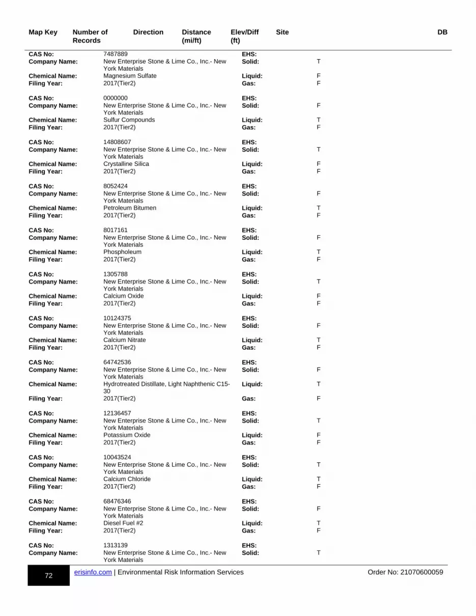
72 erisinfo.com | Environmental Risk Information Services Order No: 21070600059
Map Key Number of Records
Direction Distance(mi/ft)
Elev/Diff(ft)
Site DB
CAS No: 7487889 EHS:Company Name: New Enterprise Stone & Lime Co., Inc.- New
York MaterialsSolid: T
Chemical Name: Magnesium Sulfate Liquid: FFiling Year: 2017(Tier2) Gas: F CAS No: 0000000 EHS:Company Name: New Enterprise Stone & Lime Co., Inc.- New
York MaterialsSolid: F
Chemical Name: Sulfur Compounds Liquid: TFiling Year: 2017(Tier2) Gas: F CAS No: 14808607 EHS:Company Name: New Enterprise Stone & Lime Co., Inc.- New
York MaterialsSolid: T
Chemical Name: Crystalline Silica Liquid: FFiling Year: 2017(Tier2) Gas: F CAS No: 8052424 EHS:Company Name: New Enterprise Stone & Lime Co., Inc.- New
York MaterialsSolid: F
Chemical Name: Petroleum Bitumen Liquid: TFiling Year: 2017(Tier2) Gas: F CAS No: 8017161 EHS:Company Name: New Enterprise Stone & Lime Co., Inc.- New
York MaterialsSolid: F
Chemical Name: Phospholeum Liquid: TFiling Year: 2017(Tier2) Gas: F CAS No: 1305788 EHS:Company Name: New Enterprise Stone & Lime Co., Inc.- New
York MaterialsSolid: T
Chemical Name: Calcium Oxide Liquid: FFiling Year: 2017(Tier2) Gas: F CAS No: 10124375 EHS:Company Name: New Enterprise Stone & Lime Co., Inc.- New
York MaterialsSolid: F
Chemical Name: Calcium Nitrate Liquid: TFiling Year: 2017(Tier2) Gas: F CAS No: 64742536 EHS:Company Name: New Enterprise Stone & Lime Co., Inc.- New
York MaterialsSolid: F
Chemical Name: Hydrotreated Distillate, Light Naphthenic C15-30
Liquid: T
Filing Year: 2017(Tier2) Gas: F CAS No: 12136457 EHS:Company Name: New Enterprise Stone & Lime Co., Inc.- New
York MaterialsSolid: T
Chemical Name: Potassium Oxide Liquid: FFiling Year: 2017(Tier2) Gas: F CAS No: 10043524 EHS:Company Name: New Enterprise Stone & Lime Co., Inc.- New
York MaterialsSolid: T
Chemical Name: Calcium Chloride Liquid: TFiling Year: 2017(Tier2) Gas: F CAS No: 68476346 EHS:Company Name: New Enterprise Stone & Lime Co., Inc.- New
York MaterialsSolid: F
Chemical Name: Diesel Fuel #2 Liquid: TFiling Year: 2017(Tier2) Gas: F CAS No: 1313139 EHS:Company Name: New Enterprise Stone & Lime Co., Inc.- New
York MaterialsSolid: T
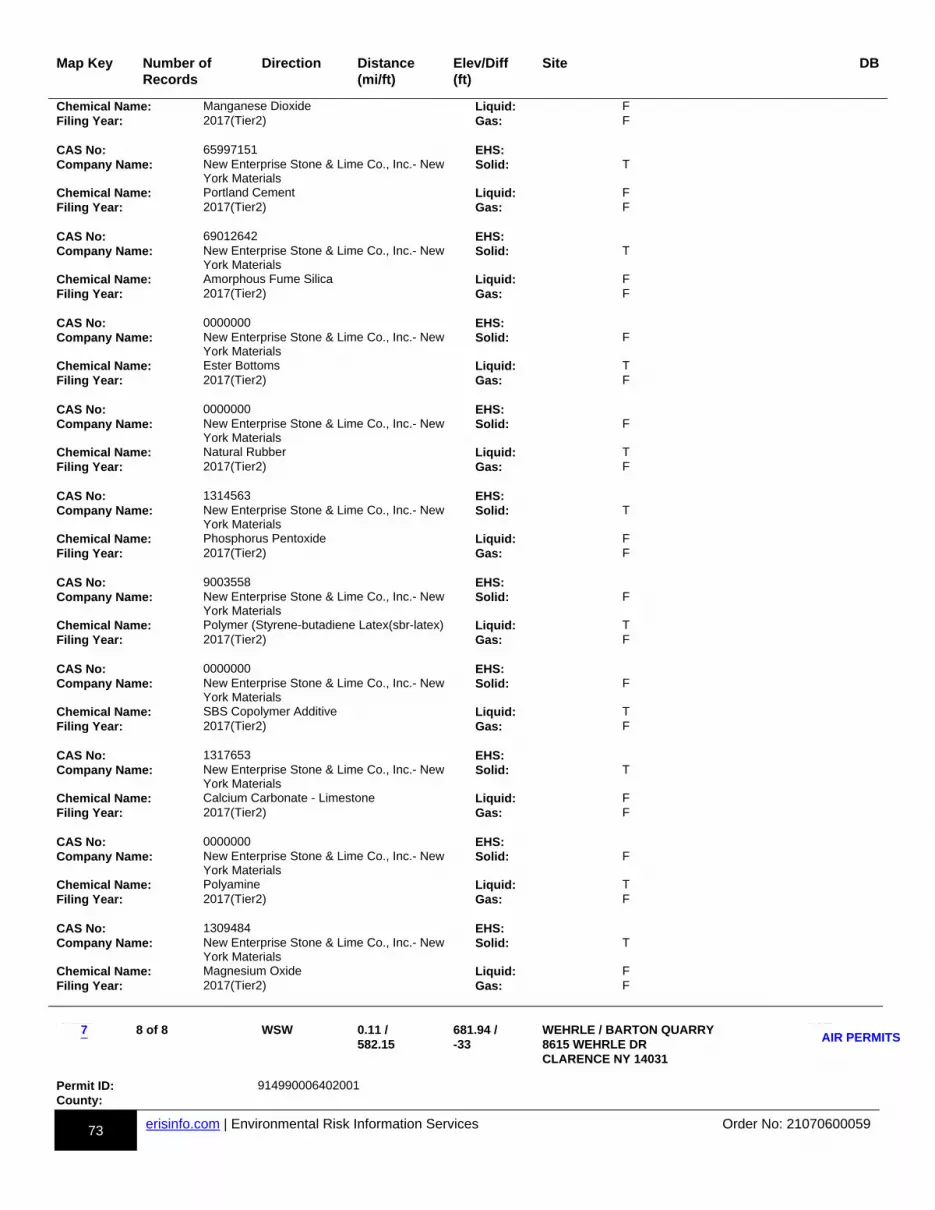
73 erisinfo.com | Environmental Risk Information Services Order No: 21070600059
Map Key Number of Records
Direction Distance(mi/ft)
Elev/Diff(ft)
Site DB
Chemical Name: Manganese Dioxide Liquid: FFiling Year: 2017(Tier2) Gas: F CAS No: 65997151 EHS:Company Name: New Enterprise Stone & Lime Co., Inc.- New
York MaterialsSolid: T
Chemical Name: Portland Cement Liquid: FFiling Year: 2017(Tier2) Gas: F CAS No: 69012642 EHS:Company Name: New Enterprise Stone & Lime Co., Inc.- New
York MaterialsSolid: T
Chemical Name: Amorphous Fume Silica Liquid: FFiling Year: 2017(Tier2) Gas: F CAS No: 0000000 EHS:Company Name: New Enterprise Stone & Lime Co., Inc.- New
York MaterialsSolid: F
Chemical Name: Ester Bottoms Liquid: TFiling Year: 2017(Tier2) Gas: F CAS No: 0000000 EHS:Company Name: New Enterprise Stone & Lime Co., Inc.- New
York MaterialsSolid: F
Chemical Name: Natural Rubber Liquid: TFiling Year: 2017(Tier2) Gas: F CAS No: 1314563 EHS:Company Name: New Enterprise Stone & Lime Co., Inc.- New
York MaterialsSolid: T
Chemical Name: Phosphorus Pentoxide Liquid: FFiling Year: 2017(Tier2) Gas: F CAS No: 9003558 EHS:Company Name: New Enterprise Stone & Lime Co., Inc.- New
York MaterialsSolid: F
Chemical Name: Polymer (Styrene-butadiene Latex(sbr-latex) Liquid: TFiling Year: 2017(Tier2) Gas: F CAS No: 0000000 EHS:Company Name: New Enterprise Stone & Lime Co., Inc.- New
York MaterialsSolid: F
Chemical Name: SBS Copolymer Additive Liquid: TFiling Year: 2017(Tier2) Gas: F CAS No: 1317653 EHS:Company Name: New Enterprise Stone & Lime Co., Inc.- New
York MaterialsSolid: T
Chemical Name: Calcium Carbonate - Limestone Liquid: FFiling Year: 2017(Tier2) Gas: F CAS No: 0000000 EHS:Company Name: New Enterprise Stone & Lime Co., Inc.- New
York MaterialsSolid: F
Chemical Name: Polyamine Liquid: TFiling Year: 2017(Tier2) Gas: F CAS No: 1309484 EHS:Company Name: New Enterprise Stone & Lime Co., Inc.- New
York MaterialsSolid: T
Chemical Name: Magnesium Oxide Liquid: FFiling Year: 2017(Tier2) Gas: F
m-7-891998704-b
8 of 8 WSW 0.11 / 582.15
681.94 / -33
WEHRLE / BARTON QUARRY 8615 WEHRLE DR CLARENCE NY 14031
dd-AIR PERMITS-891998704-bb
p1p-891998704-y1y
Permit ID: 914990006402001County:
7AIR PERMITS
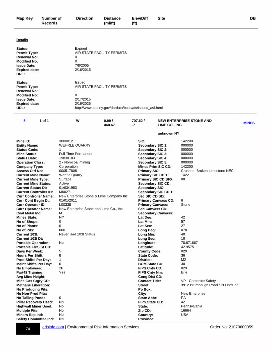
74 erisinfo.com | Environmental Risk Information Services Order No: 21070600059
Map Key Number of Records
Direction Distance(mi/ft)
Elev/Diff(ft)
Site DB
Details Status: ExpiredPermit Type: AIR STATE FACILITY PERMITSRenewal No: 0Modified No: 0Issue Date: 7/8/2005Expired date: 2/16/2015URL: Status: IssuedPermit Type: AIR STATE FACILITY PERMITSRenewal No: 1Modified No: 0Issue Date: 2/17/2015Expired date: 2/16/2025URL: http://www.dec.ny.gov/dardata/boss/afs/issued_asf.html
m-8-848291774-b
1 of 1 W 0.09 / 460.67
707.62 / -7
NEW ENTERPRISE STONE AND LIME CO., INC. unknown NY
dd-MINES-848291774-bb
p1p-848291774-y1y
Mine ID: 3000012 SIC: 142200Entity Name: WEHRLE QUARRY Secondary SIC 1: 000000Status Code: 1 Secondary SIC 2: 000000Mine Status: Full-Time Permanent Secondary SIC 3: 000000Status Date: 19830103 Secondary SIC 4: 000000Operation Class: 2 - Non-coal mining Secondary SIC 5: 000000Company Type: Corporation Mines Prim SIC CD: 142200Assess Ctrl No: 000517808 Primary SIC: Crushed, Broken Limestone NECCurrent Mine Name: Wehrle Quarry Primary SIC CD 1: 1422Current Mine Type: Surface Primary SIC CD SFX: 00Current Mine Status: Active Secondary SIC CD:Current Status Dt: 01/03/1983 Secondary SIC:Current Controller ID: M00271 Secondary SIC CD 1:Curr Controller Name: New Enterprise Stone & Lime Company Inc Sec SIC CD Sfx:Curr Cont Begin Dt: 01/01/2011 Primary Canvass CD: 6Curr Operator ID: L00335 Primary Canvass: StoneCurr Operator Name: New Enterprise Stone and Lime Co., Inc. Sec Canvass CD:Coal Metal Ind: M Secondary Canvass:Mines State: NY Lat Deg: 42No of Shops: 0 Lat Min: 57No of Plants: 0 Lat Sec: 27No of Pits: 000 Long Deg: 078Current 103I: Never Had 103I Status Long Min: 40Current 103I Dt: Long Sec: 18Portable Operation: No Longitude: 78.671667Portable FIPS St CD: Latitude: 42.9575Days Per Week: 5 County Code: 029Hours Per Shift: 8 State Code: 36Prod Shifts Per Day: 1 District: M2Maint Shifts Per Day: 0 BOM State CD: 30No Employees: 26 FIPS Cnty CD: 029Part48 Training: Yes FIPS Cnty Nm: ErieAvg Mine Height: Cong Dist CD:Mine Gas Ctgry CD: Contact Title: VP - Corporate SafetyMethane Liberation: Street: 3912 Brumbaugh Road / PO Box 77No Producing Pits: Po Box:No Non-Prod Pits: City: New EnterpriseNo Tailing Ponds: 0 State Abbr: PAPillar Recovery Used: No FIPS State CD: 42Highwall Miner Used: No State: PennsylvaniaMultiple Pits: No Zip CD: 16664Miners Rep Ind: No Country: USASafety Committee Ind: No Province:
8MINES
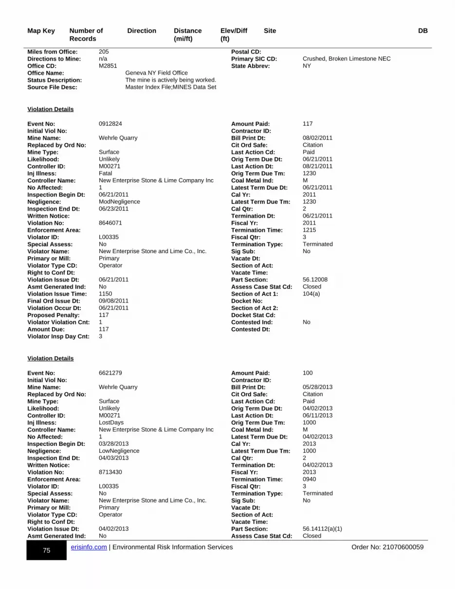
75 erisinfo.com | Environmental Risk Information Services Order No: 21070600059
Map Key Number of Records
Direction Distance(mi/ft)
Elev/Diff(ft)
Site DB
Miles from Office: 205 Postal CD:Directions to Mine: n/a Primary SIC CD: Crushed, Broken Limestone NECOffice CD: M2851 State Abbrev: NYOffice Name: Geneva NY Field OfficeStatus Description: The mine is actively being worked.Source File Desc: Master Index File;MINES Data Set
Violation Details Event No: 0912824 Amount Paid: 117Initial Viol No: Contractor ID:Mine Name: Wehrle Quarry Bill Print Dt: 08/02/2011Replaced by Ord No: Cit Ord Safe: CitationMine Type: Surface Last Action Cd: PaidLikelihood: Unlikely Orig Term Due Dt: 06/21/2011Controller ID: M00271 Last Action Dt: 08/21/2011Inj Illness: Fatal Orig Term Due Tm: 1230Controller Name: New Enterprise Stone & Lime Company Inc Coal Metal Ind: MNo Affected: 1 Latest Term Due Dt: 06/21/2011Inspection Begin Dt: 06/21/2011 Cal Yr: 2011Negligence: ModNegligence Latest Term Due Tm: 1230Inspection End Dt: 06/23/2011 Cal Qtr: 2Written Notice: Termination Dt: 06/21/2011Violation No: 8646071 Fiscal Yr: 2011Enforcement Area: Termination Time: 1215Violator ID: L00335 Fiscal Qtr: 3Special Assess: No Termination Type: TerminatedViolator Name: New Enterprise Stone and Lime Co., Inc. Sig Sub: NoPrimary or Mill: Primary Vacate Dt:Violator Type CD: Operator Section of Act:Right to Conf Dt: Vacate Time:Violation Issue Dt: 06/21/2011 Part Section: 56.12008Asmt Generated Ind: No Assess Case Stat Cd: ClosedViolation Issue Time: 1150 Section of Act 1: 104(a)Final Ord Issue Dt: 09/08/2011 Docket No:Violation Occur Dt: 06/21/2011 Section of Act 2:Proposed Penalty: 117 Docket Stat Cd:Violator Violation Cnt: 1 Contested Ind: NoAmount Due: 117 Contested Dt:Violator Insp Day Cnt: 3
Violation Details Event No: 6621279 Amount Paid: 100Initial Viol No: Contractor ID:Mine Name: Wehrle Quarry Bill Print Dt: 05/28/2013Replaced by Ord No: Cit Ord Safe: CitationMine Type: Surface Last Action Cd: PaidLikelihood: Unlikely Orig Term Due Dt: 04/02/2013Controller ID: M00271 Last Action Dt: 06/11/2013Inj Illness: LostDays Orig Term Due Tm: 1000Controller Name: New Enterprise Stone & Lime Company Inc Coal Metal Ind: MNo Affected: 1 Latest Term Due Dt: 04/02/2013Inspection Begin Dt: 03/28/2013 Cal Yr: 2013Negligence: LowNegligence Latest Term Due Tm: 1000Inspection End Dt: 04/03/2013 Cal Qtr: 2Written Notice: Termination Dt: 04/02/2013Violation No: 8713430 Fiscal Yr: 2013Enforcement Area: Termination Time: 0940Violator ID: L00335 Fiscal Qtr: 3Special Assess: No Termination Type: TerminatedViolator Name: New Enterprise Stone and Lime Co., Inc. Sig Sub: NoPrimary or Mill: Primary Vacate Dt:Violator Type CD: Operator Section of Act:Right to Conf Dt: Vacate Time:Violation Issue Dt: 04/02/2013 Part Section: 56.14112(a)(1)Asmt Generated Ind: No Assess Case Stat Cd: Closed

76 erisinfo.com | Environmental Risk Information Services Order No: 21070600059
Map Key Number of Records
Direction Distance(mi/ft)
Elev/Diff(ft)
Site DB
Violation Issue Time: 0915 Section of Act 1: 104(a)Final Ord Issue Dt: 07/04/2013 Docket No:Violation Occur Dt: 04/02/2013 Section of Act 2:Proposed Penalty: 100 Docket Stat Cd:Violator Violation Cnt: 3 Contested Ind: NoAmount Due: 100 Contested Dt:Violator Insp Day Cnt: 14
Violation Details Event No: 6811396 Amount Paid: 121Initial Viol No: Contractor ID:Mine Name: Wehrle Quarry Bill Print Dt: 05/07/2019Replaced by Ord No: Cit Ord Safe: CitationMine Type: Surface Last Action Cd: PaidLikelihood: Unlikely Orig Term Due Dt: 04/03/2019Controller ID: M00271 Last Action Dt: 09/10/2019Inj Illness: Permanent Orig Term Due Tm: 0945Controller Name: New Enterprise Stone & Lime Company Inc Coal Metal Ind: MNo Affected: 1 Latest Term Due Dt: 04/03/2019Inspection Begin Dt: 04/01/2019 Cal Yr: 2019Negligence: LowNegligence Latest Term Due Tm: 0945Inspection End Dt: 04/04/2019 Cal Qtr: 2Written Notice: No Termination Dt: 04/03/2019Violation No: 9460129 Fiscal Yr: 2019Enforcement Area: Termination Time: 0912Violator ID: L00335 Fiscal Qtr: 3Special Assess: No Termination Type: TerminatedViolator Name: New Enterprise Stone and Lime Co., Inc. Sig Sub: NoPrimary or Mill: Primary Vacate Dt:Violator Type CD: Operator Section of Act:Right to Conf Dt: Vacate Time:Violation Issue Dt: 04/03/2019 Part Section: 56.14105Asmt Generated Ind: No Assess Case Stat Cd: ClosedViolation Issue Time: 0908 Section of Act 1: 104(a)Final Ord Issue Dt: 06/14/2019 Docket No:Violation Occur Dt: 04/03/2019 Section of Act 2:Proposed Penalty: 121 Docket Stat Cd:Violator Violation Cnt: 5 Contested Ind: NoAmount Due: 121 Contested Dt:Violator Insp Day Cnt: 9
Violation Details Event No: 0761179 Amount Paid: 55Initial Viol No: Contractor ID:Mine Name: Wehrle Quarry Bill Print Dt: 10/04/2001Replaced by Ord No: Cit Ord Safe: CitationMine Type: Surface Last Action Cd: PaidLikelihood: Unlikely Orig Term Due Dt:Controller ID: M00271 Last Action Dt: 11/05/2001Inj Illness: LostDays Orig Term Due Tm:Controller Name: New Enterprise Stone & Lime Company Inc Coal Metal Ind: MNo Affected: 1 Latest Term Due Dt: 08/30/2001Inspection Begin Dt: 08/28/2001 Cal Yr: 2001Negligence: ModNegligence Latest Term Due Tm: 0815Inspection End Dt: 08/30/2001 Cal Qtr: 3Written Notice: Termination Dt: 08/30/2001Violation No: 7745848 Fiscal Yr: 2001Enforcement Area: Termination Time: 0815Violator ID: L17690 Fiscal Qtr: 4Special Assess: No Termination Type: TerminatedViolator Name: Buffalo Crushed Stone Company Inc Sig Sub: NoPrimary or Mill: Primary Vacate Dt:Violator Type CD: Operator Section of Act:Right to Conf Dt: 08/29/2001 Vacate Time:Violation Issue Dt: 08/29/2001 Part Section: 56.14101(a)(2)

77 erisinfo.com | Environmental Risk Information Services Order No: 21070600059
Map Key Number of Records
Direction Distance(mi/ft)
Elev/Diff(ft)
Site DB
Asmt Generated Ind: No Assess Case Stat Cd: ClosedViolation Issue Time: 1400 Section of Act 1: 104(a)Final Ord Issue Dt: 11/05/2001 Docket No:Violation Occur Dt: 08/29/2001 Section of Act 2:Proposed Penalty: 55 Docket Stat Cd:Violator Violation Cnt: 0 Contested Ind: NoAmount Due: 55 Contested Dt:Violator Insp Day Cnt: 0
Violation Details Event No: 0887600 Amount Paid: 60Initial Viol No: Contractor ID:Mine Name: Wehrle Quarry Bill Print Dt: 11/09/2005Replaced by Ord No: Cit Ord Safe: CitationMine Type: Surface Last Action Cd: PaidLikelihood: Unlikely Orig Term Due Dt: 10/18/2005Controller ID: M00271 Last Action Dt: 12/28/2005Inj Illness: Permanent Orig Term Due Tm: 0930Controller Name: New Enterprise Stone & Lime Company Inc Coal Metal Ind: MNo Affected: 1 Latest Term Due Dt: 10/18/2005Inspection Begin Dt: 10/18/2005 Cal Yr: 2005Negligence: ModNegligence Latest Term Due Tm: 0930Inspection End Dt: 10/20/2005 Cal Qtr: 4Written Notice: Termination Dt: 10/18/2005Violation No: 6023564 Fiscal Yr: 2006Enforcement Area: Termination Time: 0920Violator ID: L17690 Fiscal Qtr: 1Special Assess: No Termination Type: TerminatedViolator Name: Buffalo Crushed Stone Company Inc Sig Sub: NoPrimary or Mill: Mill Vacate Dt:Violator Type CD: Operator Section of Act:Right to Conf Dt: Vacate Time:Violation Issue Dt: 10/18/2005 Part Section: 56.14206(b)Asmt Generated Ind: No Assess Case Stat Cd: ClosedViolation Issue Time: 0915 Section of Act 1: 104(a)Final Ord Issue Dt: 03/08/2006 Docket No:Violation Occur Dt: 10/18/2005 Section of Act 2:Proposed Penalty: 60 Docket Stat Cd:Violator Violation Cnt: 8 Contested Ind: NoAmount Due: 60 Contested Dt:Violator Insp Day Cnt: 23
Violation Details Event No: 0899025 Amount Paid: 100Initial Viol No: Contractor ID:Mine Name: Wehrle Quarry Bill Print Dt: 02/06/2008Replaced by Ord No: Cit Ord Safe: CitationMine Type: Surface Last Action Cd: PaidLikelihood: Unlikely Orig Term Due Dt: 12/13/2007Controller ID: M00271 Last Action Dt: 03/31/2008Inj Illness: Permanent Orig Term Due Tm: 1600Controller Name: New Enterprise Stone & Lime Company Inc Coal Metal Ind: MNo Affected: 1 Latest Term Due Dt: 12/13/2007Inspection Begin Dt: 12/13/2007 Cal Yr: 2007Negligence: ModNegligence Latest Term Due Tm: 1600Inspection End Dt: 12/14/2007 Cal Qtr: 4Written Notice: Termination Dt: 12/13/2007Violation No: 6054356 Fiscal Yr: 2008Enforcement Area: Termination Time: 1200Violator ID: L17690 Fiscal Qtr: 1Special Assess: No Termination Type: TerminatedViolator Name: Buffalo Crushed Stone Company Inc Sig Sub: NoPrimary or Mill: Primary Vacate Dt:Violator Type CD: Operator Section of Act:Right to Conf Dt: Vacate Time:
78 erisinfo.com | Environmental Risk Information Services Order No: 21070600059
Map Key Number of Records
Direction Distance(mi/ft)
Elev/Diff(ft)
Site DB
Violation Issue Dt: 12/13/2007 Part Section: 56.14100(b)Asmt Generated Ind: No Assess Case Stat Cd: ClosedViolation Issue Time: 1115 Section of Act 1: 104(a)Final Ord Issue Dt: 03/22/2008 Docket No:Violation Occur Dt: 12/13/2007 Section of Act 2:Proposed Penalty: 100 Docket Stat Cd:Violator Violation Cnt: 7 Contested Ind: NoAmount Due: 100 Contested Dt:Violator Insp Day Cnt: 11
Violation Details Event No: 0905930 Amount Paid: 127Initial Viol No: Contractor ID:Mine Name: Wehrle Quarry Bill Print Dt: 09/09/2009Replaced by Ord No: Cit Ord Safe: CitationMine Type: Surface Last Action Cd: PaidLikelihood: Unlikely Orig Term Due Dt: 07/29/2009Controller ID: M00271 Last Action Dt: 09/29/2009Inj Illness: LostDays Orig Term Due Tm: 1200Controller Name: New Enterprise Stone & Lime Company Inc Coal Metal Ind: MNo Affected: 1 Latest Term Due Dt: 07/29/2009Inspection Begin Dt: 07/29/2009 Cal Yr: 2009Negligence: ModNegligence Latest Term Due Tm: 1200Inspection End Dt: 08/05/2009 Cal Qtr: 3Written Notice: Termination Dt: 07/29/2009Violation No: 6536966 Fiscal Yr: 2009Enforcement Area: Termination Time: 0915Violator ID: L17690 Fiscal Qtr: 4Special Assess: No Termination Type: TerminatedViolator Name: Buffalo Crushed Stone Company Inc Sig Sub: NoPrimary or Mill: Primary Vacate Dt:Violator Type CD: Operator Section of Act:Right to Conf Dt: Vacate Time:Violation Issue Dt: 07/29/2009 Part Section: 56.12006Asmt Generated Ind: No Assess Case Stat Cd: ClosedViolation Issue Time: 0905 Section of Act 1: 104(a)Final Ord Issue Dt: 10/15/2009 Docket No:Violation Occur Dt: 07/29/2009 Section of Act 2:Proposed Penalty: 127 Docket Stat Cd:Violator Violation Cnt: 14 Contested Ind: NoAmount Due: 127 Contested Dt:Violator Insp Day Cnt: 9
Violation Details Event No: 0761179 Amount Paid: 55Initial Viol No: Contractor ID:Mine Name: Wehrle Quarry Bill Print Dt: 10/04/2001Replaced by Ord No: Cit Ord Safe: CitationMine Type: Surface Last Action Cd: PaidLikelihood: Unlikely Orig Term Due Dt:Controller ID: M00271 Last Action Dt: 11/05/2001Inj Illness: LostDays Orig Term Due Tm:Controller Name: New Enterprise Stone & Lime Company Inc Coal Metal Ind: MNo Affected: 1 Latest Term Due Dt: 08/29/2001Inspection Begin Dt: 08/28/2001 Cal Yr: 2001Negligence: ModNegligence Latest Term Due Tm: 1420Inspection End Dt: 08/30/2001 Cal Qtr: 3Written Notice: Termination Dt: 08/29/2001Violation No: 7745847 Fiscal Yr: 2001Enforcement Area: Termination Time: 1420Violator ID: L17690 Fiscal Qtr: 4Special Assess: No Termination Type: TerminatedViolator Name: Buffalo Crushed Stone Company Inc Sig Sub: NoPrimary or Mill: Primary Vacate Dt:Violator Type CD: Operator Section of Act:
79 erisinfo.com | Environmental Risk Information Services Order No: 21070600059
Map Key Number of Records
Direction Distance(mi/ft)
Elev/Diff(ft)
Site DB
Right to Conf Dt: 08/28/2001 Vacate Time:Violation Issue Dt: 08/28/2001 Part Section: 56.19075Asmt Generated Ind: No Assess Case Stat Cd: ClosedViolation Issue Time: 1445 Section of Act 1: 104(a)Final Ord Issue Dt: 11/05/2001 Docket No:Violation Occur Dt: 08/28/2001 Section of Act 2:Proposed Penalty: 55 Docket Stat Cd:Violator Violation Cnt: 0 Contested Ind: NoAmount Due: 55 Contested Dt:Violator Insp Day Cnt: 0
Violation Details Event No: 0900118 Amount Paid: 100Initial Viol No: Contractor ID:Mine Name: Wehrle Quarry Bill Print Dt: 03/11/2009Replaced by Ord No: Cit Ord Safe: CitationMine Type: Surface Last Action Cd: PaidLikelihood: Unlikely Orig Term Due Dt: 01/27/2009Controller ID: M00271 Last Action Dt: 04/03/2009Inj Illness: LostDays Orig Term Due Tm: 1100Controller Name: New Enterprise Stone & Lime Company Inc Coal Metal Ind: MNo Affected: 1 Latest Term Due Dt: 01/27/2009Inspection Begin Dt: 01/27/2009 Cal Yr: 2009Negligence: ModNegligence Latest Term Due Tm: 1100Inspection End Dt: 01/29/2009 Cal Qtr: 1Written Notice: Termination Dt: 01/27/2009Violation No: 6064389 Fiscal Yr: 2009Enforcement Area: Termination Time: 1004Violator ID: L17690 Fiscal Qtr: 2Special Assess: No Termination Type: TerminatedViolator Name: Buffalo Crushed Stone Company Inc Sig Sub: NoPrimary or Mill: Primary Vacate Dt:Violator Type CD: Operator Section of Act:Right to Conf Dt: Vacate Time:Violation Issue Dt: 01/27/2009 Part Section: 56.12006Asmt Generated Ind: No Assess Case Stat Cd: ClosedViolation Issue Time: 0940 Section of Act 1: 104(a)Final Ord Issue Dt: 04/16/2009 Docket No:Violation Occur Dt: 01/27/2009 Section of Act 2:Proposed Penalty: 100 Docket Stat Cd:Violator Violation Cnt: 10 Contested Ind: NoAmount Due: 100 Contested Dt:Violator Insp Day Cnt: 11
Violation Details Event No: 6752037 Amount Paid: 134Initial Viol No: Contractor ID:Mine Name: Wehrle Quarry Bill Print Dt: 08/03/2016Replaced by Ord No: Cit Ord Safe: CitationMine Type: Surface Last Action Cd: PaidLikelihood: Unlikely Orig Term Due Dt: 06/02/2016Controller ID: M00271 Last Action Dt: 10/17/2016Inj Illness: Fatal Orig Term Due Tm: 1600Controller Name: New Enterprise Stone & Lime Company Inc Coal Metal Ind: MNo Affected: 1 Latest Term Due Dt: 06/02/2016Inspection Begin Dt: 05/31/2016 Cal Yr: 2016Negligence: ModNegligence Latest Term Due Tm: 1600Inspection End Dt: 06/07/2016 Cal Qtr: 2Written Notice: Termination Dt: 06/02/2016Violation No: 8925861 Fiscal Yr: 2016Enforcement Area: Termination Time: 0927Violator ID: L00335 Fiscal Qtr: 3Special Assess: No Termination Type: TerminatedViolator Name: New Enterprise Stone and Lime Co., Inc. Sig Sub: NoPrimary or Mill: Primary Vacate Dt:
80 erisinfo.com | Environmental Risk Information Services Order No: 21070600059
Map Key Number of Records
Direction Distance(mi/ft)
Elev/Diff(ft)
Site DB
Violator Type CD: Operator Section of Act:Right to Conf Dt: Vacate Time:Violation Issue Dt: 06/02/2016 Part Section: 56.12008Asmt Generated Ind: No Assess Case Stat Cd: ClosedViolation Issue Time: 0841 Section of Act 1: 104(a)Final Ord Issue Dt: 10/04/2016 Docket No:Violation Occur Dt: 06/02/2016 Section of Act 2:Proposed Penalty: 134 Docket Stat Cd:Violator Violation Cnt: 6 Contested Ind: NoAmount Due: 134 Contested Dt:Violator Insp Day Cnt: 11
Violation Details Event No: 0761179 Amount Paid: 113Initial Viol No: Contractor ID:Mine Name: Wehrle Quarry Bill Print Dt: 10/04/2001Replaced by Ord No: Cit Ord Safe: CitationMine Type: Surface Last Action Cd: PaidLikelihood: Reasonably Orig Term Due Dt:Controller ID: M00271 Last Action Dt: 11/05/2001Inj Illness: LostDays Orig Term Due Tm:Controller Name: New Enterprise Stone & Lime Company Inc Coal Metal Ind: MNo Affected: 1 Latest Term Due Dt: 08/28/2001Inspection Begin Dt: 08/28/2001 Cal Yr: 2001Negligence: ModNegligence Latest Term Due Tm: 1400Inspection End Dt: 08/30/2001 Cal Qtr: 3Written Notice: Termination Dt: 08/28/2001Violation No: 7745846 Fiscal Yr: 2001Enforcement Area: Termination Time: 1400Violator ID: L17690 Fiscal Qtr: 4Special Assess: No Termination Type: TerminatedViolator Name: Buffalo Crushed Stone Company Inc Sig Sub: YesPrimary or Mill: Primary Vacate Dt:Violator Type CD: Operator Section of Act:Right to Conf Dt: 08/28/2001 Vacate Time:Violation Issue Dt: 08/28/2001 Part Section: 56.11002Asmt Generated Ind: No Assess Case Stat Cd: ClosedViolation Issue Time: 1100 Section of Act 1: 104(a)Final Ord Issue Dt: 11/05/2001 Docket No:Violation Occur Dt: 08/28/2001 Section of Act 2:Proposed Penalty: 113 Docket Stat Cd:Violator Violation Cnt: 0 Contested Ind: NoAmount Due: 113 Contested Dt:Violator Insp Day Cnt: 0
Violation Details Event No: 0894982 Amount Paid: 117Initial Viol No: Contractor ID:Mine Name: Wehrle Quarry Bill Print Dt: 06/06/2007Replaced by Ord No: Cit Ord Safe: CitationMine Type: Surface Last Action Cd: PaidLikelihood: Unlikely Orig Term Due Dt: 04/24/2007Controller ID: M00271 Last Action Dt: 08/22/2007Inj Illness: Fatal Orig Term Due Tm: 0800Controller Name: New Enterprise Stone & Lime Company Inc Coal Metal Ind: MNo Affected: 1 Latest Term Due Dt: 04/24/2007Inspection Begin Dt: 04/23/2007 Cal Yr: 2007Negligence: ModNegligence Latest Term Due Tm: 0800Inspection End Dt: 04/26/2007 Cal Qtr: 2Written Notice: Termination Dt: 04/24/2007Violation No: 6045659 Fiscal Yr: 2007Enforcement Area: Termination Time: 0830Violator ID: L17690 Fiscal Qtr: 3Special Assess: No Termination Type: TerminatedViolator Name: Buffalo Crushed Stone Company Inc Sig Sub: No

81 erisinfo.com | Environmental Risk Information Services Order No: 21070600059
Map Key Number of Records
Direction Distance(mi/ft)
Elev/Diff(ft)
Site DB
Primary or Mill: Primary Vacate Dt:Violator Type CD: Operator Section of Act:Right to Conf Dt: Vacate Time:Violation Issue Dt: 04/24/2007 Part Section: 56.12032Asmt Generated Ind: No Assess Case Stat Cd: ClosedViolation Issue Time: 0730 Section of Act 1: 104(a)Final Ord Issue Dt: 07/21/2007 Docket No:Violation Occur Dt: 04/24/2007 Section of Act 2:Proposed Penalty: 117 Docket Stat Cd:Violator Violation Cnt: 5 Contested Ind: NoAmount Due: 117 Contested Dt:Violator Insp Day Cnt: 11
Violation Details Event No: 0900118 Amount Paid: 263Initial Viol No: Contractor ID:Mine Name: Wehrle Quarry Bill Print Dt: 03/11/2009Replaced by Ord No: Cit Ord Safe: CitationMine Type: Surface Last Action Cd: PaidLikelihood: Unlikely Orig Term Due Dt: 01/27/2009Controller ID: M00271 Last Action Dt: 04/03/2009Inj Illness: Fatal Orig Term Due Tm: 1500Controller Name: New Enterprise Stone & Lime Company Inc Coal Metal Ind: MNo Affected: 1 Latest Term Due Dt: 01/27/2009Inspection Begin Dt: 01/27/2009 Cal Yr: 2009Negligence: ModNegligence Latest Term Due Tm: 1500Inspection End Dt: 01/29/2009 Cal Qtr: 1Written Notice: Termination Dt: 01/29/2009Violation No: 6064388 Fiscal Yr: 2009Enforcement Area: Termination Time: 1339Violator ID: L17690 Fiscal Qtr: 2Special Assess: No Termination Type: TerminatedViolator Name: Buffalo Crushed Stone Company Inc Sig Sub: NoPrimary or Mill: Primary Vacate Dt:Violator Type CD: Operator Section of Act:Right to Conf Dt: Vacate Time:Violation Issue Dt: 01/27/2009 Part Section: 56.14100(b)Asmt Generated Ind: No Assess Case Stat Cd: ClosedViolation Issue Time: 0925 Section of Act 1: 104(a)Final Ord Issue Dt: 04/16/2009 Docket No:Violation Occur Dt: 01/27/2009 Section of Act 2:Proposed Penalty: 263 Docket Stat Cd:Violator Violation Cnt: 10 Contested Ind: NoAmount Due: 263 Contested Dt:Violator Insp Day Cnt: 11
Violation Details Event No: 0761179 Amount Paid: 55Initial Viol No: Contractor ID:Mine Name: Wehrle Quarry Bill Print Dt: 10/04/2001Replaced by Ord No: Cit Ord Safe: CitationMine Type: Surface Last Action Cd: PaidLikelihood: Unlikely Orig Term Due Dt:Controller ID: M00271 Last Action Dt: 11/05/2001Inj Illness: LostDays Orig Term Due Tm:Controller Name: New Enterprise Stone & Lime Company Inc Coal Metal Ind: MNo Affected: 1 Latest Term Due Dt: 08/28/2001Inspection Begin Dt: 08/28/2001 Cal Yr: 2001Negligence: ModNegligence Latest Term Due Tm: 1410Inspection End Dt: 08/30/2001 Cal Qtr: 3Written Notice: Termination Dt: 08/28/2001Violation No: 7745845 Fiscal Yr: 2001Enforcement Area: Termination Time: 1410Violator ID: L17690 Fiscal Qtr: 4Special Assess: No Termination Type: Terminated

82 erisinfo.com | Environmental Risk Information Services Order No: 21070600059
Map Key Number of Records
Direction Distance(mi/ft)
Elev/Diff(ft)
Site DB
Violator Name: Buffalo Crushed Stone Company Inc Sig Sub: NoPrimary or Mill: Primary Vacate Dt:Violator Type CD: Operator Section of Act:Right to Conf Dt: 08/28/2001 Vacate Time:Violation Issue Dt: 08/28/2001 Part Section: 56.14101(a)(2)Asmt Generated Ind: No Assess Case Stat Cd: ClosedViolation Issue Time: 1045 Section of Act 1: 104(a)Final Ord Issue Dt: 11/05/2001 Docket No:Violation Occur Dt: 08/28/2001 Section of Act 2:Proposed Penalty: 55 Docket Stat Cd:Violator Violation Cnt: 0 Contested Ind: NoAmount Due: 55 Contested Dt:Violator Insp Day Cnt: 0
Violation Details Event No: 6811396 Amount Paid: 121Initial Viol No: Contractor ID:Mine Name: Wehrle Quarry Bill Print Dt: 05/07/2019Replaced by Ord No: Cit Ord Safe: CitationMine Type: Surface Last Action Cd: PaidLikelihood: Unlikely Orig Term Due Dt: 04/03/2019Controller ID: M00271 Last Action Dt: 09/10/2019Inj Illness: LostDays Orig Term Due Tm: 0900Controller Name: New Enterprise Stone & Lime Company Inc Coal Metal Ind: MNo Affected: 1 Latest Term Due Dt: 04/03/2019Inspection Begin Dt: 04/01/2019 Cal Yr: 2019Negligence: ModNegligence Latest Term Due Tm: 0900Inspection End Dt: 04/04/2019 Cal Qtr: 2Written Notice: No Termination Dt: 04/03/2019Violation No: 9460128 Fiscal Yr: 2019Enforcement Area: Termination Time: 0820Violator ID: L00335 Fiscal Qtr: 3Special Assess: No Termination Type: TerminatedViolator Name: New Enterprise Stone and Lime Co., Inc. Sig Sub: NoPrimary or Mill: Primary Vacate Dt:Violator Type CD: Operator Section of Act:Right to Conf Dt: Vacate Time:Violation Issue Dt: 04/03/2019 Part Section: 56.4603(b)Asmt Generated Ind: No Assess Case Stat Cd: ClosedViolation Issue Time: 0815 Section of Act 1: 104(a)Final Ord Issue Dt: 06/14/2019 Docket No:Violation Occur Dt: 04/03/2019 Section of Act 2:Proposed Penalty: 121 Docket Stat Cd:Violator Violation Cnt: 5 Contested Ind: NoAmount Due: 121 Contested Dt:Violator Insp Day Cnt: 9
Violation Details Event No: 0880993 Amount Paid: 60Initial Viol No: Contractor ID:Mine Name: Wehrle Quarry Bill Print Dt: 08/10/2005Replaced by Ord No: Cit Ord Safe: CitationMine Type: Surface Last Action Cd: PaidLikelihood: Unlikely Orig Term Due Dt: 06/28/2005Controller ID: M00271 Last Action Dt: 09/28/2005Inj Illness: LostDays Orig Term Due Tm: 0800Controller Name: New Enterprise Stone & Lime Company Inc Coal Metal Ind: MNo Affected: 1 Latest Term Due Dt: 06/28/2005Inspection Begin Dt: 06/27/2005 Cal Yr: 2005Negligence: ModNegligence Latest Term Due Tm: 0800Inspection End Dt: 06/30/2005 Cal Qtr: 2Written Notice: Termination Dt: 06/28/2005Violation No: 6023970 Fiscal Yr: 2005Enforcement Area: Termination Time: 0750Violator ID: L17690 Fiscal Qtr: 3

83 erisinfo.com | Environmental Risk Information Services Order No: 21070600059
Map Key Number of Records
Direction Distance(mi/ft)
Elev/Diff(ft)
Site DB
Special Assess: No Termination Type: TerminatedViolator Name: Buffalo Crushed Stone Company Inc Sig Sub: NoPrimary or Mill: Primary Vacate Dt:Violator Type CD: Operator Section of Act:Right to Conf Dt: Vacate Time:Violation Issue Dt: 06/27/2005 Part Section: 56.16009Asmt Generated Ind: No Assess Case Stat Cd: ClosedViolation Issue Time: 1520 Section of Act 1: 104(a)Final Ord Issue Dt: 09/28/2005 Docket No:Violation Occur Dt: 06/27/2005 Section of Act 2:Proposed Penalty: 60 Docket Stat Cd:Violator Violation Cnt: 6 Contested Ind: NoAmount Due: 60 Contested Dt:Violator Insp Day Cnt: 23
Violation Details Event No: 6752037 Amount Paid: 134Initial Viol No: Contractor ID:Mine Name: Wehrle Quarry Bill Print Dt: 08/03/2016Replaced by Ord No: Cit Ord Safe: CitationMine Type: Surface Last Action Cd: PaidLikelihood: Unlikely Orig Term Due Dt: 06/02/2016Controller ID: M00271 Last Action Dt: 10/17/2016Inj Illness: Fatal Orig Term Due Tm: 0500Controller Name: New Enterprise Stone & Lime Company Inc Coal Metal Ind: MNo Affected: 1 Latest Term Due Dt: 06/02/2016Inspection Begin Dt: 05/31/2016 Cal Yr: 2016Negligence: ModNegligence Latest Term Due Tm: 0500Inspection End Dt: 06/07/2016 Cal Qtr: 2Written Notice: Termination Dt: 06/02/2016Violation No: 8925860 Fiscal Yr: 2016Enforcement Area: Termination Time: 0728Violator ID: L00335 Fiscal Qtr: 3Special Assess: No Termination Type: TerminatedViolator Name: New Enterprise Stone and Lime Co., Inc. Sig Sub: NoPrimary or Mill: Primary Vacate Dt:Violator Type CD: Operator Section of Act:Right to Conf Dt: Vacate Time:Violation Issue Dt: 06/01/2016 Part Section: 56.12004Asmt Generated Ind: No Assess Case Stat Cd: ClosedViolation Issue Time: 1410 Section of Act 1: 104(a)Final Ord Issue Dt: 10/04/2016 Docket No:Violation Occur Dt: 06/01/2016 Section of Act 2:Proposed Penalty: 134 Docket Stat Cd:Violator Violation Cnt: 6 Contested Ind: NoAmount Due: 134 Contested Dt:Violator Insp Day Cnt: 10
Violation Details Event No: 0900115 Amount Paid: 108Initial Viol No: Contractor ID:Mine Name: Wehrle Quarry Bill Print Dt: 01/07/2009Replaced by Ord No: Cit Ord Safe: CitationMine Type: Surface Last Action Cd: PaidLikelihood: Unlikely Orig Term Due Dt: 11/25/2008Controller ID: M00271 Last Action Dt: 01/29/2009Inj Illness: LostDays Orig Term Due Tm: 1200Controller Name: New Enterprise Stone & Lime Company Inc Coal Metal Ind: MNo Affected: 1 Latest Term Due Dt: 11/25/2008Inspection Begin Dt: 11/25/2008 Cal Yr: 2008Negligence: ModNegligence Latest Term Due Tm: 1200Inspection End Dt: 11/26/2008 Cal Qtr: 4Written Notice: Termination Dt: 11/25/2008Violation No: 6064373 Fiscal Yr: 2009Enforcement Area: Termination Time: 1103

84 erisinfo.com | Environmental Risk Information Services Order No: 21070600059
Map Key Number of Records
Direction Distance(mi/ft)
Elev/Diff(ft)
Site DB
Violator ID: L17690 Fiscal Qtr: 1Special Assess: No Termination Type: TerminatedViolator Name: Buffalo Crushed Stone Company Inc Sig Sub: NoPrimary or Mill: Primary Vacate Dt:Violator Type CD: Operator Section of Act:Right to Conf Dt: Vacate Time:Violation Issue Dt: 11/25/2008 Part Section: 56.12004Asmt Generated Ind: No Assess Case Stat Cd: ClosedViolation Issue Time: 1046 Section of Act 1: 104(a)Final Ord Issue Dt: 02/12/2009 Docket No:Violation Occur Dt: 11/25/2008 Section of Act 2:Proposed Penalty: 108 Docket Stat Cd:Violator Violation Cnt: 11 Contested Ind: NoAmount Due: 108 Contested Dt:Violator Insp Day Cnt: 8
Violation Details Event No: 0880951 Amount Paid: 60Initial Viol No: Contractor ID:Mine Name: Wehrle Quarry Bill Print Dt: 02/09/2005Replaced by Ord No: Cit Ord Safe: CitationMine Type: Surface Last Action Cd: PaidLikelihood: Unlikely Orig Term Due Dt:Controller ID: M00271 Last Action Dt: 03/10/2005Inj Illness: LostDays Orig Term Due Tm:Controller Name: New Enterprise Stone & Lime Company Inc Coal Metal Ind: MNo Affected: 1 Latest Term Due Dt: 01/04/2005Inspection Begin Dt: 01/04/2005 Cal Yr: 2005Negligence: ModNegligence Latest Term Due Tm: 1200Inspection End Dt: 01/06/2005 Cal Qtr: 1Written Notice: Termination Dt: 01/04/2005Violation No: 6023876 Fiscal Yr: 2005Enforcement Area: Termination Time: 1145Violator ID: L17690 Fiscal Qtr: 2Special Assess: No Termination Type: TerminatedViolator Name: Buffalo Crushed Stone Company Inc Sig Sub: NoPrimary or Mill: Primary Vacate Dt:Violator Type CD: Operator Section of Act:Right to Conf Dt: 01/04/2005 Vacate Time:Violation Issue Dt: 01/04/2005 Part Section: 56.12008Asmt Generated Ind: No Assess Case Stat Cd: ClosedViolation Issue Time: 0945 Section of Act 1: 104(a)Final Ord Issue Dt: 03/26/2005 Docket No:Violation Occur Dt: 01/04/2005 Section of Act 2:Proposed Penalty: 60 Docket Stat Cd:Violator Violation Cnt: 7 Contested Ind: NoAmount Due: 60 Contested Dt:Violator Insp Day Cnt: 31
Violation Details Event No: 6752037 Amount Paid: 100Initial Viol No: Contractor ID: M0BMine Name: Wehrle Quarry Bill Print Dt: 07/21/2016Replaced by Ord No: Cit Ord Safe: CitationMine Type: Surface Last Action Cd: PaidLikelihood: Unlikely Orig Term Due Dt: 06/07/2016Controller ID: Last Action Dt: 08/10/2016Inj Illness: Permanent Orig Term Due Tm: 1300Controller Name: Coal Metal Ind: MNo Affected: 1 Latest Term Due Dt: 06/07/2016Inspection Begin Dt: 05/31/2016 Cal Yr: 2016Negligence: LowNegligence Latest Term Due Tm: 1300Inspection End Dt: 06/07/2016 Cal Qtr: 2Written Notice: Termination Dt: 06/07/2016Violation No: 8925865 Fiscal Yr: 2016
85 erisinfo.com | Environmental Risk Information Services Order No: 21070600059
Map Key Number of Records
Direction Distance(mi/ft)
Elev/Diff(ft)
Site DB
Enforcement Area: Termination Time: 1200Violator ID: M0B Fiscal Qtr: 3Special Assess: No Termination Type: TerminatedViolator Name: Hilltop Energy Inc Sig Sub: NoPrimary or Mill: Primary Vacate Dt:Violator Type CD: Contractor Section of Act:Right to Conf Dt: Vacate Time:Violation Issue Dt: 06/07/2016 Part Section: 56.4200(b)(2)Asmt Generated Ind: No Assess Case Stat Cd: ClosedViolation Issue Time: 1109 Section of Act 1: 104(a)Final Ord Issue Dt: 09/04/2016 Docket No:Violation Occur Dt: 06/07/2016 Section of Act 2:Proposed Penalty: 100 Docket Stat Cd:Violator Violation Cnt: 2 Contested Ind: NoAmount Due: 100 Contested Dt:Violator Insp Day Cnt: 0
Violation Details Event No: 6752037 Amount Paid: 114Initial Viol No: Contractor ID:Mine Name: Wehrle Quarry Bill Print Dt: 08/03/2016Replaced by Ord No: Cit Ord Safe: CitationMine Type: Surface Last Action Cd: PaidLikelihood: Unlikely Orig Term Due Dt: 06/02/2016Controller ID: M00271 Last Action Dt: 10/17/2016Inj Illness: LostDays Orig Term Due Tm: 0800Controller Name: New Enterprise Stone & Lime Company Inc Coal Metal Ind: MNo Affected: 1 Latest Term Due Dt: 06/02/2016Inspection Begin Dt: 05/31/2016 Cal Yr: 2016Negligence: ModNegligence Latest Term Due Tm: 0800Inspection End Dt: 06/07/2016 Cal Qtr: 2Written Notice: Termination Dt: 06/01/2016Violation No: 8925859 Fiscal Yr: 2016Enforcement Area: Termination Time: 1430Violator ID: L00335 Fiscal Qtr: 3Special Assess: No Termination Type: TerminatedViolator Name: New Enterprise Stone and Lime Co., Inc. Sig Sub: NoPrimary or Mill: Primary Vacate Dt:Violator Type CD: Operator Section of Act:Right to Conf Dt: Vacate Time:Violation Issue Dt: 06/01/2016 Part Section: 56.4130(b)Asmt Generated Ind: No Assess Case Stat Cd: ClosedViolation Issue Time: 1102 Section of Act 1: 104(a)Final Ord Issue Dt: 10/04/2016 Docket No:Violation Occur Dt: 06/01/2016 Section of Act 2:Proposed Penalty: 114 Docket Stat Cd:Violator Violation Cnt: 6 Contested Ind: NoAmount Due: 114 Contested Dt:Violator Insp Day Cnt: 10
Violation Details Event No: 0905930 Amount Paid: 343Initial Viol No: Contractor ID:Mine Name: Wehrle Quarry Bill Print Dt: 09/09/2009Replaced by Ord No: Cit Ord Safe: CitationMine Type: Surface Last Action Cd: PaidLikelihood: Reasonably Orig Term Due Dt: 08/04/2009Controller ID: M00271 Last Action Dt: 04/16/2012Inj Illness: Fatal Orig Term Due Tm: 1100Controller Name: New Enterprise Stone & Lime Company Inc Coal Metal Ind: MNo Affected: 1 Latest Term Due Dt: 08/04/2009Inspection Begin Dt: 07/29/2009 Cal Yr: 2009Negligence: ModNegligence Latest Term Due Tm: 1100Inspection End Dt: 08/05/2009 Cal Qtr: 3Written Notice: Termination Dt: 08/04/2009

86 erisinfo.com | Environmental Risk Information Services Order No: 21070600059
Map Key Number of Records
Direction Distance(mi/ft)
Elev/Diff(ft)
Site DB
Violation No: 6536968 Fiscal Yr: 2009Enforcement Area: Termination Time: 1519Violator ID: L17690 Fiscal Qtr: 4Special Assess: No Termination Type: TerminatedViolator Name: Buffalo Crushed Stone Company Inc Sig Sub: YesPrimary or Mill: Primary Vacate Dt:Violator Type CD: Operator Section of Act:Right to Conf Dt: Vacate Time:Violation Issue Dt: 08/04/2009 Part Section: 56.3131Asmt Generated Ind: No Assess Case Stat Cd: ClosedViolation Issue Time: 1047 Section of Act 1: 104(a)Final Ord Issue Dt: 01/13/2012 Docket No: YORK 2009-248MViolation Occur Dt: 08/04/2009 Section of Act 2:Proposed Penalty: 1530 Docket Stat Cd: AcceptedViolator Violation Cnt: 14 Contested Ind: YesAmount Due: 343 Contested Dt: 09/21/2009Violator Insp Day Cnt: 12
Violation Details Event No: 0899046 Amount Paid: 100Initial Viol No: Contractor ID:Mine Name: Wehrle Quarry Bill Print Dt: 05/07/2008Replaced by Ord No: Cit Ord Safe: CitationMine Type: Surface Last Action Cd: PaidLikelihood: Unlikely Orig Term Due Dt: 04/02/2008Controller ID: M00271 Last Action Dt: 05/23/2008Inj Illness: LostDays Orig Term Due Tm: 1600Controller Name: New Enterprise Stone & Lime Company Inc Coal Metal Ind: MNo Affected: 1 Latest Term Due Dt: 04/02/2008Inspection Begin Dt: 04/02/2008 Cal Yr: 2008Negligence: ModNegligence Latest Term Due Tm: 1600Inspection End Dt: 04/04/2008 Cal Qtr: 2Written Notice: Termination Dt: 04/02/2008Violation No: 6058745 Fiscal Yr: 2008Enforcement Area: Termination Time: 1458Violator ID: L17690 Fiscal Qtr: 3Special Assess: No Termination Type: TerminatedViolator Name: Buffalo Crushed Stone Company Inc Sig Sub: NoPrimary or Mill: Primary Vacate Dt:Violator Type CD: Operator Section of Act:Right to Conf Dt: Vacate Time:Violation Issue Dt: 04/02/2008 Part Section: 56.14100(b)Asmt Generated Ind: No Assess Case Stat Cd: ClosedViolation Issue Time: 1024 Section of Act 1: 104(a)Final Ord Issue Dt: 06/11/2008 Docket No:Violation Occur Dt: 04/02/2008 Section of Act 2:Proposed Penalty: 100 Docket Stat Cd:Violator Violation Cnt: 6 Contested Ind: NoAmount Due: 100 Contested Dt:Violator Insp Day Cnt: 7
Violation Details Event No: 0911568 Amount Paid: 117Initial Viol No: Contractor ID:Mine Name: Wehrle Quarry Bill Print Dt: 07/07/2010Replaced by Ord No: Cit Ord Safe: CitationMine Type: Surface Last Action Cd: PaidLikelihood: Unlikely Orig Term Due Dt: 06/02/2010Controller ID: M00271 Last Action Dt: 07/29/2010Inj Illness: Fatal Orig Term Due Tm: 1100Controller Name: New Enterprise Stone & Lime Company Inc Coal Metal Ind: MNo Affected: 1 Latest Term Due Dt: 06/02/2010Inspection Begin Dt: 06/02/2010 Cal Yr: 2010Negligence: ModNegligence Latest Term Due Tm: 1100Inspection End Dt: 06/04/2010 Cal Qtr: 2
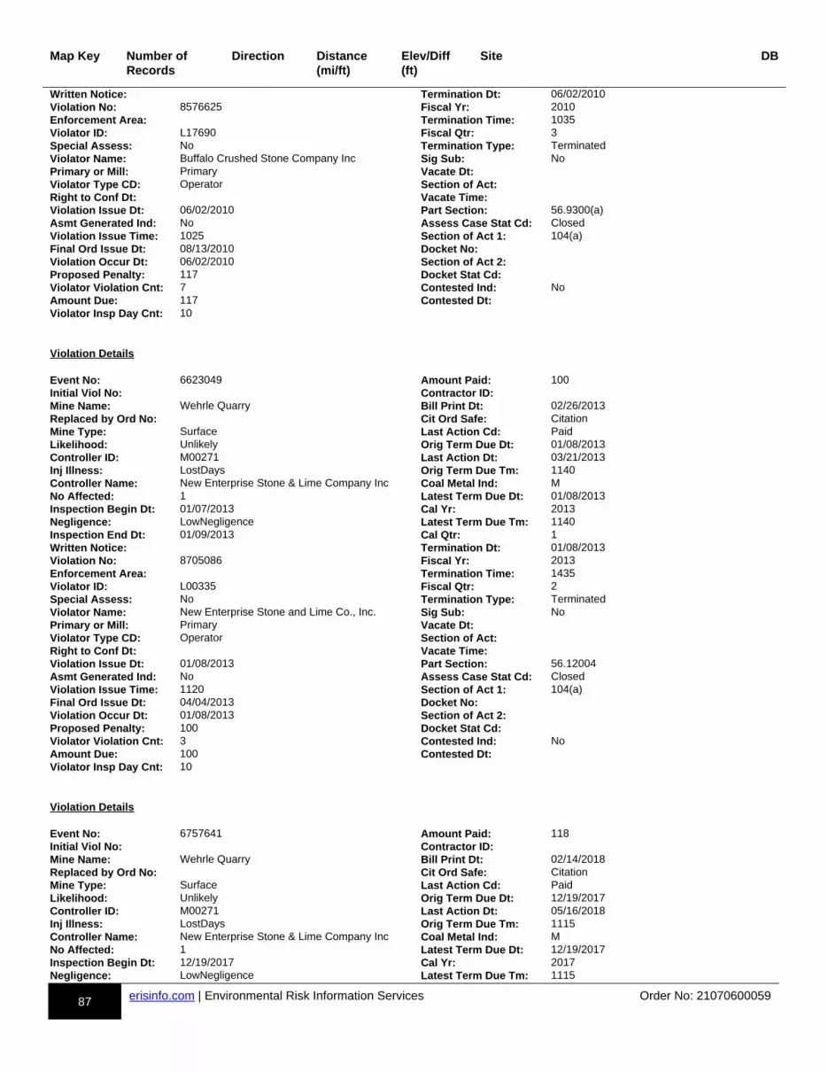
87 erisinfo.com | Environmental Risk Information Services Order No: 21070600059
Map Key Number of Records
Direction Distance(mi/ft)
Elev/Diff(ft)
Site DB
Written Notice: Termination Dt: 06/02/2010Violation No: 8576625 Fiscal Yr: 2010Enforcement Area: Termination Time: 1035Violator ID: L17690 Fiscal Qtr: 3Special Assess: No Termination Type: TerminatedViolator Name: Buffalo Crushed Stone Company Inc Sig Sub: NoPrimary or Mill: Primary Vacate Dt:Violator Type CD: Operator Section of Act:Right to Conf Dt: Vacate Time:Violation Issue Dt: 06/02/2010 Part Section: 56.9300(a)Asmt Generated Ind: No Assess Case Stat Cd: ClosedViolation Issue Time: 1025 Section of Act 1: 104(a)Final Ord Issue Dt: 08/13/2010 Docket No:Violation Occur Dt: 06/02/2010 Section of Act 2:Proposed Penalty: 117 Docket Stat Cd:Violator Violation Cnt: 7 Contested Ind: NoAmount Due: 117 Contested Dt:Violator Insp Day Cnt: 10
Violation Details Event No: 6623049 Amount Paid: 100Initial Viol No: Contractor ID:Mine Name: Wehrle Quarry Bill Print Dt: 02/26/2013Replaced by Ord No: Cit Ord Safe: CitationMine Type: Surface Last Action Cd: PaidLikelihood: Unlikely Orig Term Due Dt: 01/08/2013Controller ID: M00271 Last Action Dt: 03/21/2013Inj Illness: LostDays Orig Term Due Tm: 1140Controller Name: New Enterprise Stone & Lime Company Inc Coal Metal Ind: MNo Affected: 1 Latest Term Due Dt: 01/08/2013Inspection Begin Dt: 01/07/2013 Cal Yr: 2013Negligence: LowNegligence Latest Term Due Tm: 1140Inspection End Dt: 01/09/2013 Cal Qtr: 1Written Notice: Termination Dt: 01/08/2013Violation No: 8705086 Fiscal Yr: 2013Enforcement Area: Termination Time: 1435Violator ID: L00335 Fiscal Qtr: 2Special Assess: No Termination Type: TerminatedViolator Name: New Enterprise Stone and Lime Co., Inc. Sig Sub: NoPrimary or Mill: Primary Vacate Dt:Violator Type CD: Operator Section of Act:Right to Conf Dt: Vacate Time:Violation Issue Dt: 01/08/2013 Part Section: 56.12004Asmt Generated Ind: No Assess Case Stat Cd: ClosedViolation Issue Time: 1120 Section of Act 1: 104(a)Final Ord Issue Dt: 04/04/2013 Docket No:Violation Occur Dt: 01/08/2013 Section of Act 2:Proposed Penalty: 100 Docket Stat Cd:Violator Violation Cnt: 3 Contested Ind: NoAmount Due: 100 Contested Dt:Violator Insp Day Cnt: 10
Violation Details Event No: 6757641 Amount Paid: 118Initial Viol No: Contractor ID:Mine Name: Wehrle Quarry Bill Print Dt: 02/14/2018Replaced by Ord No: Cit Ord Safe: CitationMine Type: Surface Last Action Cd: PaidLikelihood: Unlikely Orig Term Due Dt: 12/19/2017Controller ID: M00271 Last Action Dt: 05/16/2018Inj Illness: LostDays Orig Term Due Tm: 1115Controller Name: New Enterprise Stone & Lime Company Inc Coal Metal Ind: MNo Affected: 1 Latest Term Due Dt: 12/19/2017Inspection Begin Dt: 12/19/2017 Cal Yr: 2017Negligence: LowNegligence Latest Term Due Tm: 1115

88 erisinfo.com | Environmental Risk Information Services Order No: 21070600059
Map Key Number of Records
Direction Distance(mi/ft)
Elev/Diff(ft)
Site DB
Inspection End Dt: 12/21/2017 Cal Qtr: 4Written Notice: Termination Dt: 12/19/2017Violation No: 9364971 Fiscal Yr: 2018Enforcement Area: Termination Time: 1045Violator ID: L00335 Fiscal Qtr: 1Special Assess: No Termination Type: TerminatedViolator Name: New Enterprise Stone and Lime Co., Inc. Sig Sub: NoPrimary or Mill: Primary Vacate Dt:Violator Type CD: Operator Section of Act:Right to Conf Dt: Vacate Time:Violation Issue Dt: 12/19/2017 Part Section: 56.14100(c)Asmt Generated Ind: No Assess Case Stat Cd: ClosedViolation Issue Time: 1015 Section of Act 1: 104(a)Final Ord Issue Dt: 03/19/2018 Docket No:Violation Occur Dt: 12/19/2017 Section of Act 2:Proposed Penalty: 118 Docket Stat Cd:Violator Violation Cnt: 8 Contested Ind: NoAmount Due: 118 Contested Dt:Violator Insp Day Cnt: 10
Violation Details Event No: 6752037 Amount Paid: 114Initial Viol No: Contractor ID:Mine Name: Wehrle Quarry Bill Print Dt: 08/03/2016Replaced by Ord No: Cit Ord Safe: CitationMine Type: Surface Last Action Cd: PaidLikelihood: Unlikely Orig Term Due Dt: 06/02/2016Controller ID: M00271 Last Action Dt: 10/17/2016Inj Illness: Permanent Orig Term Due Tm: 1600Controller Name: New Enterprise Stone & Lime Company Inc Coal Metal Ind: MNo Affected: 1 Latest Term Due Dt: 06/02/2016Inspection Begin Dt: 05/31/2016 Cal Yr: 2016Negligence: ModNegligence Latest Term Due Tm: 1600Inspection End Dt: 06/07/2016 Cal Qtr: 2Written Notice: Termination Dt: 06/02/2016Violation No: 8925863 Fiscal Yr: 2016Enforcement Area: Termination Time: 1357Violator ID: L00335 Fiscal Qtr: 3Special Assess: No Termination Type: TerminatedViolator Name: New Enterprise Stone and Lime Co., Inc. Sig Sub: NoPrimary or Mill: Primary Vacate Dt:Violator Type CD: Operator Section of Act:Right to Conf Dt: Vacate Time:Violation Issue Dt: 06/02/2016 Part Section: 47.41(a)(1)Asmt Generated Ind: No Assess Case Stat Cd: ClosedViolation Issue Time: 1355 Section of Act 1: 104(a)Final Ord Issue Dt: 10/04/2016 Docket No:Violation Occur Dt: 06/02/2016 Section of Act 2:Proposed Penalty: 114 Docket Stat Cd:Violator Violation Cnt: 6 Contested Ind: NoAmount Due: 114 Contested Dt:Violator Insp Day Cnt: 11
Violation Details Event No: 0900115 Amount Paid: 138Initial Viol No: Contractor ID:Mine Name: Wehrle Quarry Bill Print Dt: 01/07/2009Replaced by Ord No: Cit Ord Safe: CitationMine Type: Surface Last Action Cd: PaidLikelihood: Unlikely Orig Term Due Dt: 11/26/2008Controller ID: M00271 Last Action Dt: 01/29/2009Inj Illness: Permanent Orig Term Due Tm: 1430Controller Name: New Enterprise Stone & Lime Company Inc Coal Metal Ind: MNo Affected: 1 Latest Term Due Dt: 11/26/2008Inspection Begin Dt: 11/25/2008 Cal Yr: 2008
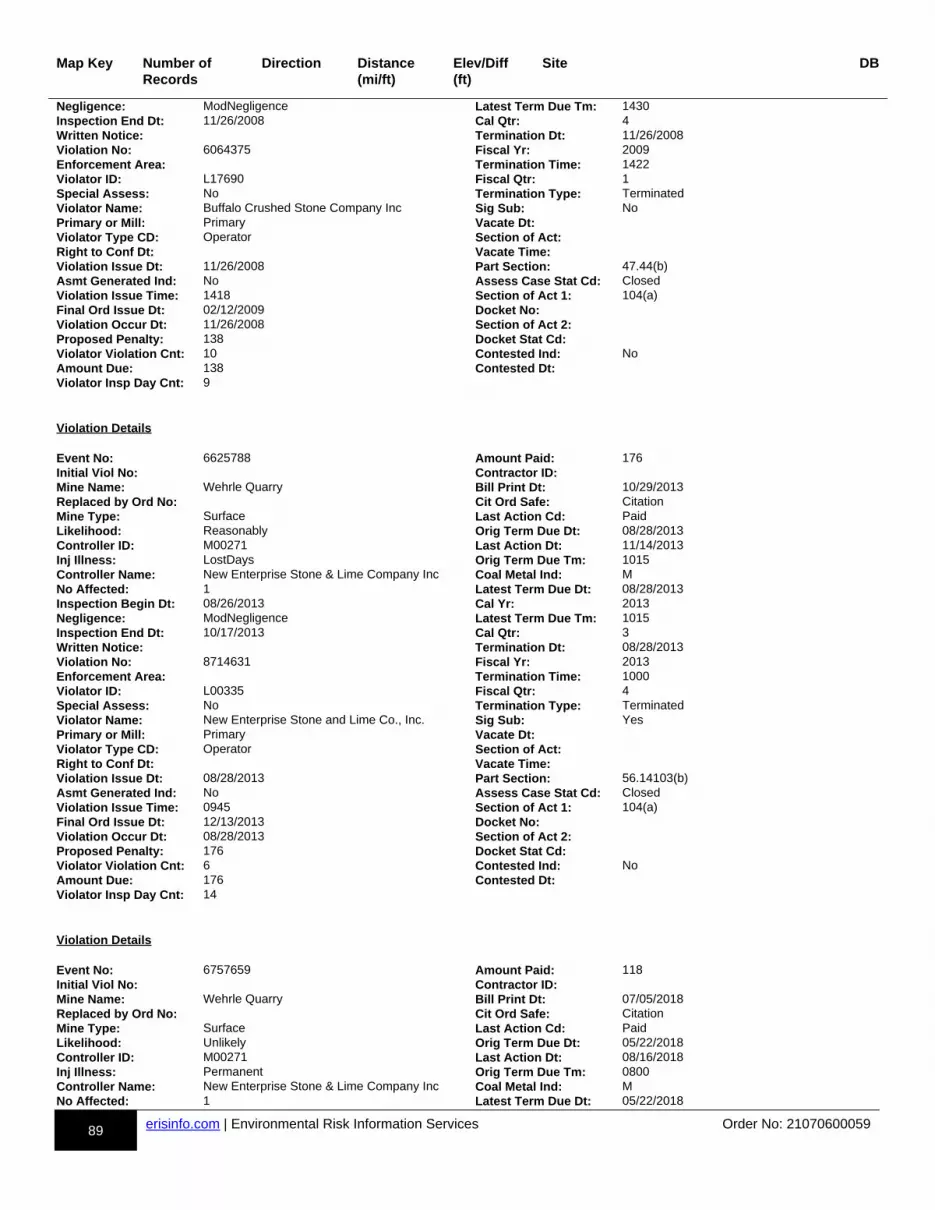
89 erisinfo.com | Environmental Risk Information Services Order No: 21070600059
Map Key Number of Records
Direction Distance(mi/ft)
Elev/Diff(ft)
Site DB
Negligence: ModNegligence Latest Term Due Tm: 1430Inspection End Dt: 11/26/2008 Cal Qtr: 4Written Notice: Termination Dt: 11/26/2008Violation No: 6064375 Fiscal Yr: 2009Enforcement Area: Termination Time: 1422Violator ID: L17690 Fiscal Qtr: 1Special Assess: No Termination Type: TerminatedViolator Name: Buffalo Crushed Stone Company Inc Sig Sub: NoPrimary or Mill: Primary Vacate Dt:Violator Type CD: Operator Section of Act:Right to Conf Dt: Vacate Time:Violation Issue Dt: 11/26/2008 Part Section: 47.44(b)Asmt Generated Ind: No Assess Case Stat Cd: ClosedViolation Issue Time: 1418 Section of Act 1: 104(a)Final Ord Issue Dt: 02/12/2009 Docket No:Violation Occur Dt: 11/26/2008 Section of Act 2:Proposed Penalty: 138 Docket Stat Cd:Violator Violation Cnt: 10 Contested Ind: NoAmount Due: 138 Contested Dt:Violator Insp Day Cnt: 9
Violation Details Event No: 6625788 Amount Paid: 176Initial Viol No: Contractor ID:Mine Name: Wehrle Quarry Bill Print Dt: 10/29/2013Replaced by Ord No: Cit Ord Safe: CitationMine Type: Surface Last Action Cd: PaidLikelihood: Reasonably Orig Term Due Dt: 08/28/2013Controller ID: M00271 Last Action Dt: 11/14/2013Inj Illness: LostDays Orig Term Due Tm: 1015Controller Name: New Enterprise Stone & Lime Company Inc Coal Metal Ind: MNo Affected: 1 Latest Term Due Dt: 08/28/2013Inspection Begin Dt: 08/26/2013 Cal Yr: 2013Negligence: ModNegligence Latest Term Due Tm: 1015Inspection End Dt: 10/17/2013 Cal Qtr: 3Written Notice: Termination Dt: 08/28/2013Violation No: 8714631 Fiscal Yr: 2013Enforcement Area: Termination Time: 1000Violator ID: L00335 Fiscal Qtr: 4Special Assess: No Termination Type: TerminatedViolator Name: New Enterprise Stone and Lime Co., Inc. Sig Sub: YesPrimary or Mill: Primary Vacate Dt:Violator Type CD: Operator Section of Act:Right to Conf Dt: Vacate Time:Violation Issue Dt: 08/28/2013 Part Section: 56.14103(b)Asmt Generated Ind: No Assess Case Stat Cd: ClosedViolation Issue Time: 0945 Section of Act 1: 104(a)Final Ord Issue Dt: 12/13/2013 Docket No:Violation Occur Dt: 08/28/2013 Section of Act 2:Proposed Penalty: 176 Docket Stat Cd:Violator Violation Cnt: 6 Contested Ind: NoAmount Due: 176 Contested Dt:Violator Insp Day Cnt: 14
Violation Details Event No: 6757659 Amount Paid: 118Initial Viol No: Contractor ID:Mine Name: Wehrle Quarry Bill Print Dt: 07/05/2018Replaced by Ord No: Cit Ord Safe: CitationMine Type: Surface Last Action Cd: PaidLikelihood: Unlikely Orig Term Due Dt: 05/22/2018Controller ID: M00271 Last Action Dt: 08/16/2018Inj Illness: Permanent Orig Term Due Tm: 0800Controller Name: New Enterprise Stone & Lime Company Inc Coal Metal Ind: MNo Affected: 1 Latest Term Due Dt: 05/22/2018
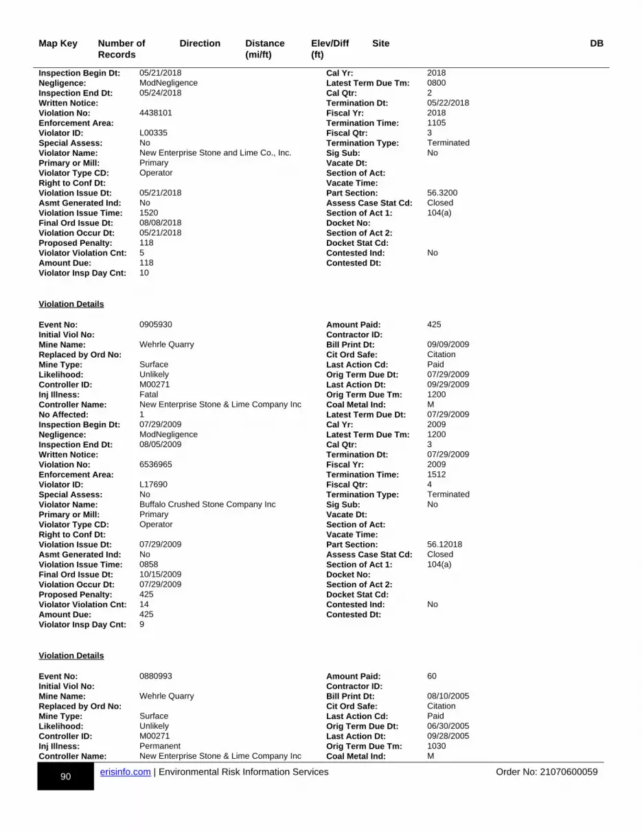
90 erisinfo.com | Environmental Risk Information Services Order No: 21070600059
Map Key Number of Records
Direction Distance(mi/ft)
Elev/Diff(ft)
Site DB
Inspection Begin Dt: 05/21/2018 Cal Yr: 2018Negligence: ModNegligence Latest Term Due Tm: 0800Inspection End Dt: 05/24/2018 Cal Qtr: 2Written Notice: Termination Dt: 05/22/2018Violation No: 4438101 Fiscal Yr: 2018Enforcement Area: Termination Time: 1105Violator ID: L00335 Fiscal Qtr: 3Special Assess: No Termination Type: TerminatedViolator Name: New Enterprise Stone and Lime Co., Inc. Sig Sub: NoPrimary or Mill: Primary Vacate Dt:Violator Type CD: Operator Section of Act:Right to Conf Dt: Vacate Time:Violation Issue Dt: 05/21/2018 Part Section: 56.3200Asmt Generated Ind: No Assess Case Stat Cd: ClosedViolation Issue Time: 1520 Section of Act 1: 104(a)Final Ord Issue Dt: 08/08/2018 Docket No:Violation Occur Dt: 05/21/2018 Section of Act 2:Proposed Penalty: 118 Docket Stat Cd:Violator Violation Cnt: 5 Contested Ind: NoAmount Due: 118 Contested Dt:Violator Insp Day Cnt: 10
Violation Details Event No: 0905930 Amount Paid: 425Initial Viol No: Contractor ID:Mine Name: Wehrle Quarry Bill Print Dt: 09/09/2009Replaced by Ord No: Cit Ord Safe: CitationMine Type: Surface Last Action Cd: PaidLikelihood: Unlikely Orig Term Due Dt: 07/29/2009Controller ID: M00271 Last Action Dt: 09/29/2009Inj Illness: Fatal Orig Term Due Tm: 1200Controller Name: New Enterprise Stone & Lime Company Inc Coal Metal Ind: MNo Affected: 1 Latest Term Due Dt: 07/29/2009Inspection Begin Dt: 07/29/2009 Cal Yr: 2009Negligence: ModNegligence Latest Term Due Tm: 1200Inspection End Dt: 08/05/2009 Cal Qtr: 3Written Notice: Termination Dt: 07/29/2009Violation No: 6536965 Fiscal Yr: 2009Enforcement Area: Termination Time: 1512Violator ID: L17690 Fiscal Qtr: 4Special Assess: No Termination Type: TerminatedViolator Name: Buffalo Crushed Stone Company Inc Sig Sub: NoPrimary or Mill: Primary Vacate Dt:Violator Type CD: Operator Section of Act:Right to Conf Dt: Vacate Time:Violation Issue Dt: 07/29/2009 Part Section: 56.12018Asmt Generated Ind: No Assess Case Stat Cd: ClosedViolation Issue Time: 0858 Section of Act 1: 104(a)Final Ord Issue Dt: 10/15/2009 Docket No:Violation Occur Dt: 07/29/2009 Section of Act 2:Proposed Penalty: 425 Docket Stat Cd:Violator Violation Cnt: 14 Contested Ind: NoAmount Due: 425 Contested Dt:Violator Insp Day Cnt: 9
Violation Details Event No: 0880993 Amount Paid: 60Initial Viol No: Contractor ID:Mine Name: Wehrle Quarry Bill Print Dt: 08/10/2005Replaced by Ord No: Cit Ord Safe: CitationMine Type: Surface Last Action Cd: PaidLikelihood: Unlikely Orig Term Due Dt: 06/30/2005Controller ID: M00271 Last Action Dt: 09/28/2005Inj Illness: Permanent Orig Term Due Tm: 1030Controller Name: New Enterprise Stone & Lime Company Inc Coal Metal Ind: M

91 erisinfo.com | Environmental Risk Information Services Order No: 21070600059
Map Key Number of Records
Direction Distance(mi/ft)
Elev/Diff(ft)
Site DB
No Affected: 1 Latest Term Due Dt: 06/30/2005Inspection Begin Dt: 06/27/2005 Cal Yr: 2005Negligence: ModNegligence Latest Term Due Tm: 1030Inspection End Dt: 06/30/2005 Cal Qtr: 2Written Notice: Termination Dt: 06/30/2005Violation No: 6023973 Fiscal Yr: 2005Enforcement Area: Termination Time: 0950Violator ID: L17690 Fiscal Qtr: 3Special Assess: No Termination Type: TerminatedViolator Name: Buffalo Crushed Stone Company Inc Sig Sub: NoPrimary or Mill: Primary Vacate Dt:Violator Type CD: Operator Section of Act:Right to Conf Dt: Vacate Time:Violation Issue Dt: 06/30/2005 Part Section: 56.14107(a)Asmt Generated Ind: No Assess Case Stat Cd: ClosedViolation Issue Time: 0835 Section of Act 1: 104(a)Final Ord Issue Dt: 09/28/2005 Docket No:Violation Occur Dt: 06/30/2005 Section of Act 2:Proposed Penalty: 60 Docket Stat Cd:Violator Violation Cnt: 6 Contested Ind: NoAmount Due: 60 Contested Dt:Violator Insp Day Cnt: 23
Violation Details Event No: 6757641 Amount Paid: 691Initial Viol No: Contractor ID:Mine Name: Wehrle Quarry Bill Print Dt: 02/14/2018Replaced by Ord No: Cit Ord Safe: CitationMine Type: Surface Last Action Cd: PaidLikelihood: Reasonably Orig Term Due Dt: 12/20/2017Controller ID: M00271 Last Action Dt: 09/11/2018Inj Illness: Fatal Orig Term Due Tm: 1425Controller Name: New Enterprise Stone & Lime Company Inc Coal Metal Ind: MNo Affected: 1 Latest Term Due Dt: 12/20/2017Inspection Begin Dt: 12/19/2017 Cal Yr: 2017Negligence: ModNegligence Latest Term Due Tm: 1425Inspection End Dt: 12/21/2017 Cal Qtr: 4Written Notice: Termination Dt: 12/20/2017Violation No: 9364974 Fiscal Yr: 2018Enforcement Area: Termination Time: 1405Violator ID: L00335 Fiscal Qtr: 1Special Assess: No Termination Type: TerminatedViolator Name: New Enterprise Stone and Lime Co., Inc. Sig Sub: YesPrimary or Mill: Primary Vacate Dt:Violator Type CD: Operator Section of Act:Right to Conf Dt: Vacate Time:Violation Issue Dt: 12/20/2017 Part Section: 56.12068Asmt Generated Ind: No Assess Case Stat Cd: ClosedViolation Issue Time: 1355 Section of Act 1: 104(a)Final Ord Issue Dt: 03/19/2018 Docket No:Violation Occur Dt: 12/20/2017 Section of Act 2:Proposed Penalty: 691 Docket Stat Cd:Violator Violation Cnt: 8 Contested Ind: NoAmount Due: 691 Contested Dt:Violator Insp Day Cnt: 11
Violation Details Event No: 0867042 Amount Paid: 55Initial Viol No: Contractor ID: V1DMine Name: Wehrle Quarry Bill Print Dt: 10/18/2002Replaced by Ord No: Cit Ord Safe: CitationMine Type: Surface Last Action Cd: PaidLikelihood: Unlikely Orig Term Due Dt:Controller ID: Last Action Dt: 10/29/2002Inj Illness: LostDays Orig Term Due Tm:
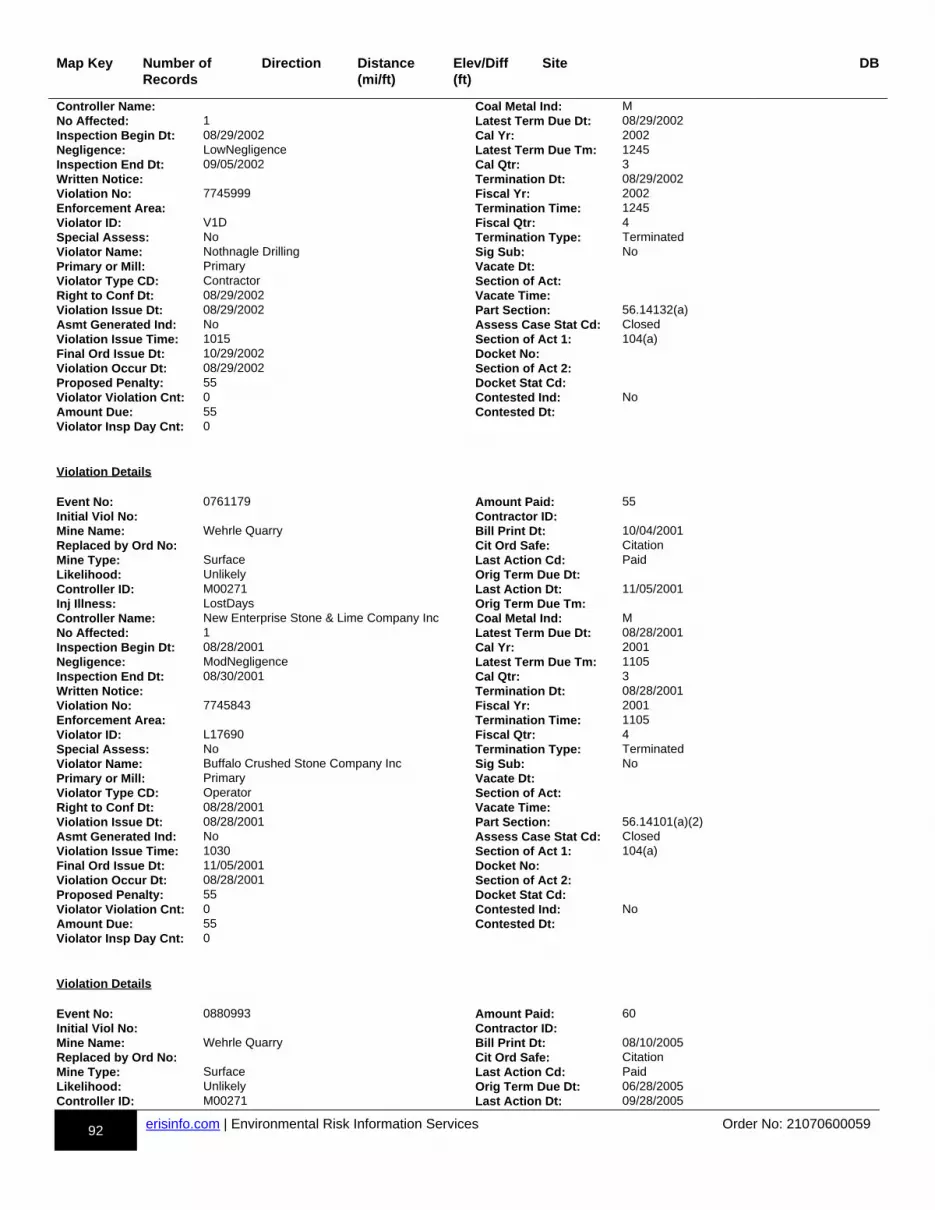
92 erisinfo.com | Environmental Risk Information Services Order No: 21070600059
Map Key Number of Records
Direction Distance(mi/ft)
Elev/Diff(ft)
Site DB
Controller Name: Coal Metal Ind: MNo Affected: 1 Latest Term Due Dt: 08/29/2002Inspection Begin Dt: 08/29/2002 Cal Yr: 2002Negligence: LowNegligence Latest Term Due Tm: 1245Inspection End Dt: 09/05/2002 Cal Qtr: 3Written Notice: Termination Dt: 08/29/2002Violation No: 7745999 Fiscal Yr: 2002Enforcement Area: Termination Time: 1245Violator ID: V1D Fiscal Qtr: 4Special Assess: No Termination Type: TerminatedViolator Name: Nothnagle Drilling Sig Sub: NoPrimary or Mill: Primary Vacate Dt:Violator Type CD: Contractor Section of Act:Right to Conf Dt: 08/29/2002 Vacate Time:Violation Issue Dt: 08/29/2002 Part Section: 56.14132(a)Asmt Generated Ind: No Assess Case Stat Cd: ClosedViolation Issue Time: 1015 Section of Act 1: 104(a)Final Ord Issue Dt: 10/29/2002 Docket No:Violation Occur Dt: 08/29/2002 Section of Act 2:Proposed Penalty: 55 Docket Stat Cd:Violator Violation Cnt: 0 Contested Ind: NoAmount Due: 55 Contested Dt:Violator Insp Day Cnt: 0
Violation Details Event No: 0761179 Amount Paid: 55Initial Viol No: Contractor ID:Mine Name: Wehrle Quarry Bill Print Dt: 10/04/2001Replaced by Ord No: Cit Ord Safe: CitationMine Type: Surface Last Action Cd: PaidLikelihood: Unlikely Orig Term Due Dt:Controller ID: M00271 Last Action Dt: 11/05/2001Inj Illness: LostDays Orig Term Due Tm:Controller Name: New Enterprise Stone & Lime Company Inc Coal Metal Ind: MNo Affected: 1 Latest Term Due Dt: 08/28/2001Inspection Begin Dt: 08/28/2001 Cal Yr: 2001Negligence: ModNegligence Latest Term Due Tm: 1105Inspection End Dt: 08/30/2001 Cal Qtr: 3Written Notice: Termination Dt: 08/28/2001Violation No: 7745843 Fiscal Yr: 2001Enforcement Area: Termination Time: 1105Violator ID: L17690 Fiscal Qtr: 4Special Assess: No Termination Type: TerminatedViolator Name: Buffalo Crushed Stone Company Inc Sig Sub: NoPrimary or Mill: Primary Vacate Dt:Violator Type CD: Operator Section of Act:Right to Conf Dt: 08/28/2001 Vacate Time:Violation Issue Dt: 08/28/2001 Part Section: 56.14101(a)(2)Asmt Generated Ind: No Assess Case Stat Cd: ClosedViolation Issue Time: 1030 Section of Act 1: 104(a)Final Ord Issue Dt: 11/05/2001 Docket No:Violation Occur Dt: 08/28/2001 Section of Act 2:Proposed Penalty: 55 Docket Stat Cd:Violator Violation Cnt: 0 Contested Ind: NoAmount Due: 55 Contested Dt:Violator Insp Day Cnt: 0
Violation Details Event No: 0880993 Amount Paid: 60Initial Viol No: Contractor ID:Mine Name: Wehrle Quarry Bill Print Dt: 08/10/2005Replaced by Ord No: Cit Ord Safe: CitationMine Type: Surface Last Action Cd: PaidLikelihood: Unlikely Orig Term Due Dt: 06/28/2005Controller ID: M00271 Last Action Dt: 09/28/2005
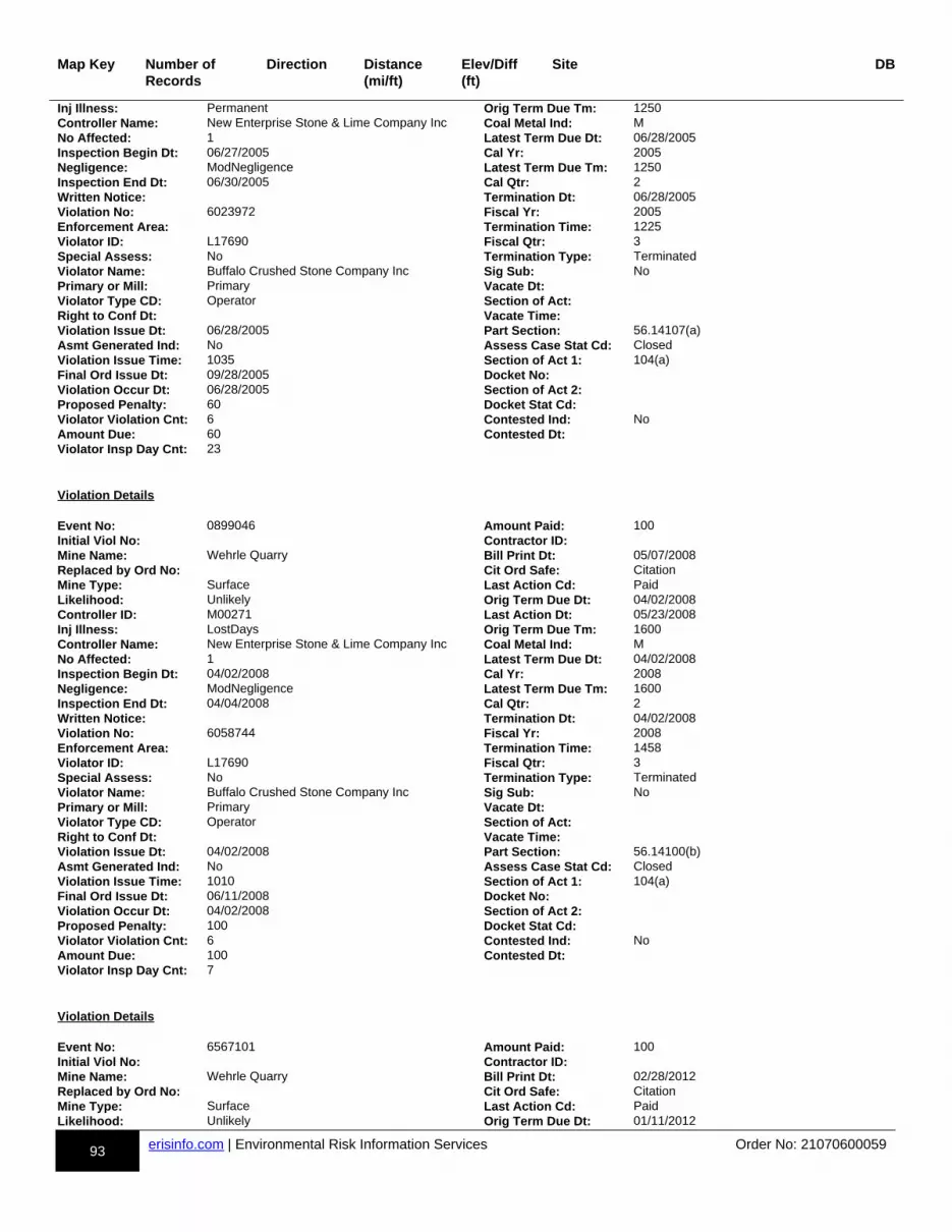
93 erisinfo.com | Environmental Risk Information Services Order No: 21070600059
Map Key Number of Records
Direction Distance(mi/ft)
Elev/Diff(ft)
Site DB
Inj Illness: Permanent Orig Term Due Tm: 1250Controller Name: New Enterprise Stone & Lime Company Inc Coal Metal Ind: MNo Affected: 1 Latest Term Due Dt: 06/28/2005Inspection Begin Dt: 06/27/2005 Cal Yr: 2005Negligence: ModNegligence Latest Term Due Tm: 1250Inspection End Dt: 06/30/2005 Cal Qtr: 2Written Notice: Termination Dt: 06/28/2005Violation No: 6023972 Fiscal Yr: 2005Enforcement Area: Termination Time: 1225Violator ID: L17690 Fiscal Qtr: 3Special Assess: No Termination Type: TerminatedViolator Name: Buffalo Crushed Stone Company Inc Sig Sub: NoPrimary or Mill: Primary Vacate Dt:Violator Type CD: Operator Section of Act:Right to Conf Dt: Vacate Time:Violation Issue Dt: 06/28/2005 Part Section: 56.14107(a)Asmt Generated Ind: No Assess Case Stat Cd: ClosedViolation Issue Time: 1035 Section of Act 1: 104(a)Final Ord Issue Dt: 09/28/2005 Docket No:Violation Occur Dt: 06/28/2005 Section of Act 2:Proposed Penalty: 60 Docket Stat Cd:Violator Violation Cnt: 6 Contested Ind: NoAmount Due: 60 Contested Dt:Violator Insp Day Cnt: 23
Violation Details Event No: 0899046 Amount Paid: 100Initial Viol No: Contractor ID:Mine Name: Wehrle Quarry Bill Print Dt: 05/07/2008Replaced by Ord No: Cit Ord Safe: CitationMine Type: Surface Last Action Cd: PaidLikelihood: Unlikely Orig Term Due Dt: 04/02/2008Controller ID: M00271 Last Action Dt: 05/23/2008Inj Illness: LostDays Orig Term Due Tm: 1600Controller Name: New Enterprise Stone & Lime Company Inc Coal Metal Ind: MNo Affected: 1 Latest Term Due Dt: 04/02/2008Inspection Begin Dt: 04/02/2008 Cal Yr: 2008Negligence: ModNegligence Latest Term Due Tm: 1600Inspection End Dt: 04/04/2008 Cal Qtr: 2Written Notice: Termination Dt: 04/02/2008Violation No: 6058744 Fiscal Yr: 2008Enforcement Area: Termination Time: 1458Violator ID: L17690 Fiscal Qtr: 3Special Assess: No Termination Type: TerminatedViolator Name: Buffalo Crushed Stone Company Inc Sig Sub: NoPrimary or Mill: Primary Vacate Dt:Violator Type CD: Operator Section of Act:Right to Conf Dt: Vacate Time:Violation Issue Dt: 04/02/2008 Part Section: 56.14100(b)Asmt Generated Ind: No Assess Case Stat Cd: ClosedViolation Issue Time: 1010 Section of Act 1: 104(a)Final Ord Issue Dt: 06/11/2008 Docket No:Violation Occur Dt: 04/02/2008 Section of Act 2:Proposed Penalty: 100 Docket Stat Cd:Violator Violation Cnt: 6 Contested Ind: NoAmount Due: 100 Contested Dt:Violator Insp Day Cnt: 7
Violation Details Event No: 6567101 Amount Paid: 100Initial Viol No: Contractor ID:Mine Name: Wehrle Quarry Bill Print Dt: 02/28/2012Replaced by Ord No: Cit Ord Safe: CitationMine Type: Surface Last Action Cd: PaidLikelihood: Unlikely Orig Term Due Dt: 01/11/2012
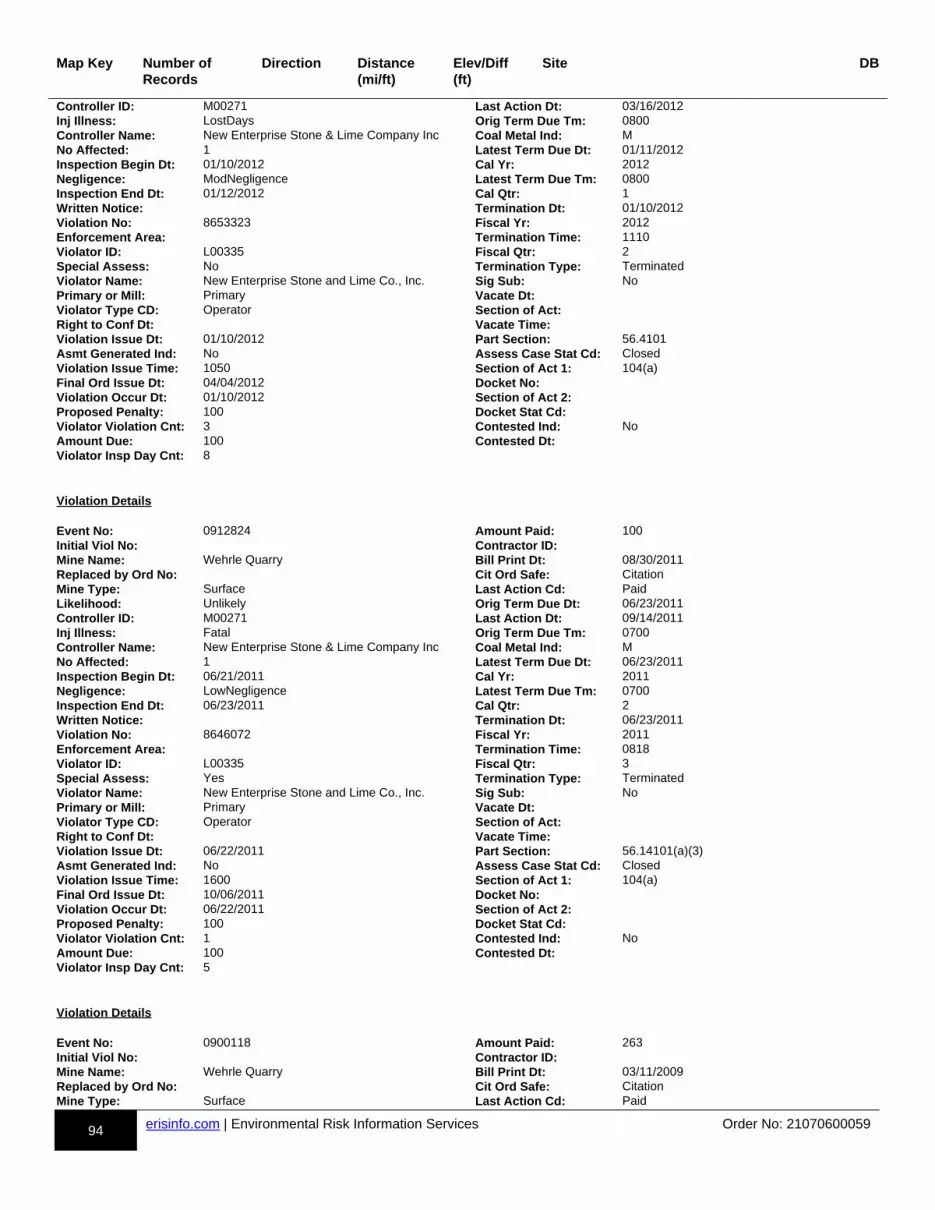
94 erisinfo.com | Environmental Risk Information Services Order No: 21070600059
Map Key Number of Records
Direction Distance(mi/ft)
Elev/Diff(ft)
Site DB
Controller ID: M00271 Last Action Dt: 03/16/2012Inj Illness: LostDays Orig Term Due Tm: 0800Controller Name: New Enterprise Stone & Lime Company Inc Coal Metal Ind: MNo Affected: 1 Latest Term Due Dt: 01/11/2012Inspection Begin Dt: 01/10/2012 Cal Yr: 2012Negligence: ModNegligence Latest Term Due Tm: 0800Inspection End Dt: 01/12/2012 Cal Qtr: 1Written Notice: Termination Dt: 01/10/2012Violation No: 8653323 Fiscal Yr: 2012Enforcement Area: Termination Time: 1110Violator ID: L00335 Fiscal Qtr: 2Special Assess: No Termination Type: TerminatedViolator Name: New Enterprise Stone and Lime Co., Inc. Sig Sub: NoPrimary or Mill: Primary Vacate Dt:Violator Type CD: Operator Section of Act:Right to Conf Dt: Vacate Time:Violation Issue Dt: 01/10/2012 Part Section: 56.4101Asmt Generated Ind: No Assess Case Stat Cd: ClosedViolation Issue Time: 1050 Section of Act 1: 104(a)Final Ord Issue Dt: 04/04/2012 Docket No:Violation Occur Dt: 01/10/2012 Section of Act 2:Proposed Penalty: 100 Docket Stat Cd:Violator Violation Cnt: 3 Contested Ind: NoAmount Due: 100 Contested Dt:Violator Insp Day Cnt: 8
Violation Details Event No: 0912824 Amount Paid: 100Initial Viol No: Contractor ID:Mine Name: Wehrle Quarry Bill Print Dt: 08/30/2011Replaced by Ord No: Cit Ord Safe: CitationMine Type: Surface Last Action Cd: PaidLikelihood: Unlikely Orig Term Due Dt: 06/23/2011Controller ID: M00271 Last Action Dt: 09/14/2011Inj Illness: Fatal Orig Term Due Tm: 0700Controller Name: New Enterprise Stone & Lime Company Inc Coal Metal Ind: MNo Affected: 1 Latest Term Due Dt: 06/23/2011Inspection Begin Dt: 06/21/2011 Cal Yr: 2011Negligence: LowNegligence Latest Term Due Tm: 0700Inspection End Dt: 06/23/2011 Cal Qtr: 2Written Notice: Termination Dt: 06/23/2011Violation No: 8646072 Fiscal Yr: 2011Enforcement Area: Termination Time: 0818Violator ID: L00335 Fiscal Qtr: 3Special Assess: Yes Termination Type: TerminatedViolator Name: New Enterprise Stone and Lime Co., Inc. Sig Sub: NoPrimary or Mill: Primary Vacate Dt:Violator Type CD: Operator Section of Act:Right to Conf Dt: Vacate Time:Violation Issue Dt: 06/22/2011 Part Section: 56.14101(a)(3)Asmt Generated Ind: No Assess Case Stat Cd: ClosedViolation Issue Time: 1600 Section of Act 1: 104(a)Final Ord Issue Dt: 10/06/2011 Docket No:Violation Occur Dt: 06/22/2011 Section of Act 2:Proposed Penalty: 100 Docket Stat Cd:Violator Violation Cnt: 1 Contested Ind: NoAmount Due: 100 Contested Dt:Violator Insp Day Cnt: 5
Violation Details Event No: 0900118 Amount Paid: 263Initial Viol No: Contractor ID:Mine Name: Wehrle Quarry Bill Print Dt: 03/11/2009Replaced by Ord No: Cit Ord Safe: CitationMine Type: Surface Last Action Cd: Paid
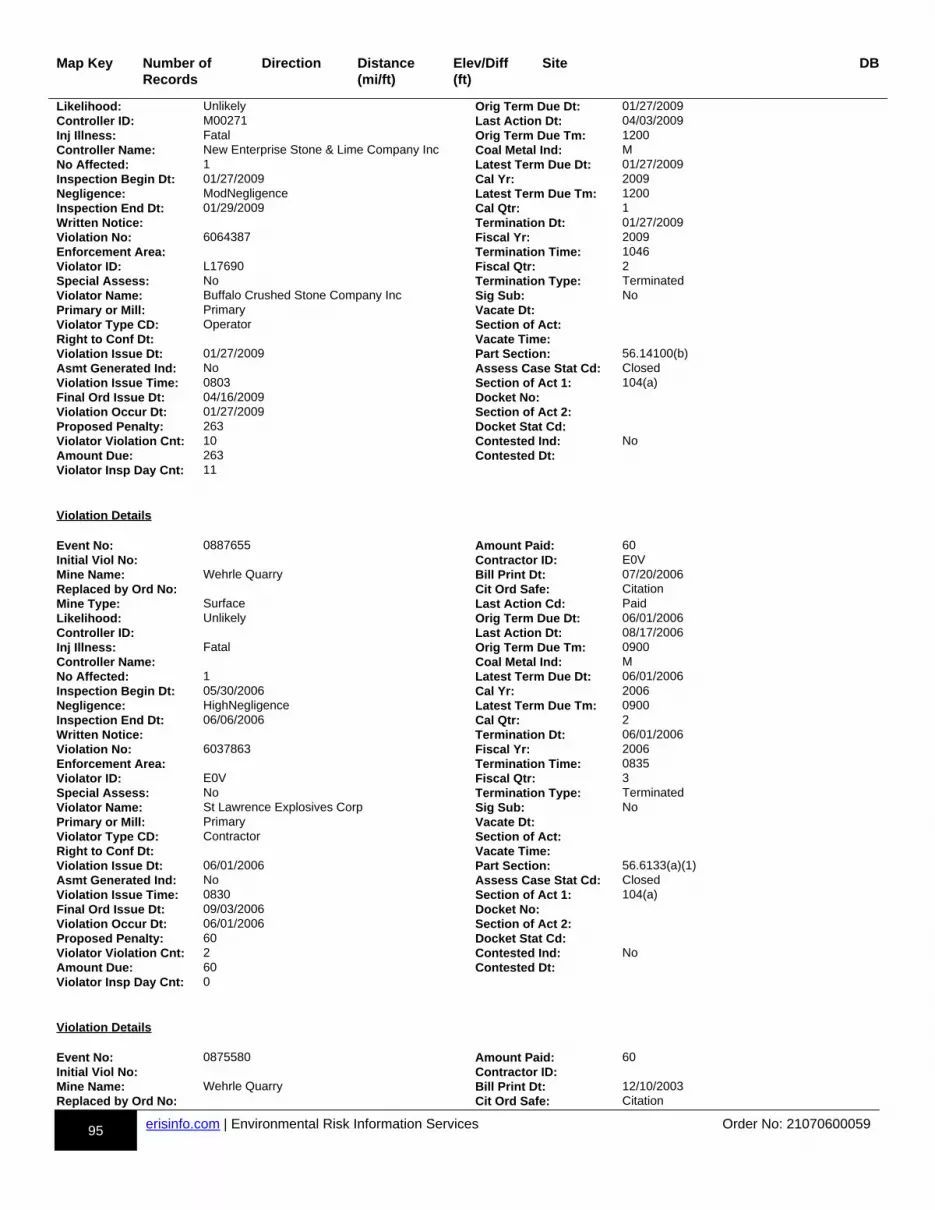
95 erisinfo.com | Environmental Risk Information Services Order No: 21070600059
Map Key Number of Records
Direction Distance(mi/ft)
Elev/Diff(ft)
Site DB
Likelihood: Unlikely Orig Term Due Dt: 01/27/2009Controller ID: M00271 Last Action Dt: 04/03/2009Inj Illness: Fatal Orig Term Due Tm: 1200Controller Name: New Enterprise Stone & Lime Company Inc Coal Metal Ind: MNo Affected: 1 Latest Term Due Dt: 01/27/2009Inspection Begin Dt: 01/27/2009 Cal Yr: 2009Negligence: ModNegligence Latest Term Due Tm: 1200Inspection End Dt: 01/29/2009 Cal Qtr: 1Written Notice: Termination Dt: 01/27/2009Violation No: 6064387 Fiscal Yr: 2009Enforcement Area: Termination Time: 1046Violator ID: L17690 Fiscal Qtr: 2Special Assess: No Termination Type: TerminatedViolator Name: Buffalo Crushed Stone Company Inc Sig Sub: NoPrimary or Mill: Primary Vacate Dt:Violator Type CD: Operator Section of Act:Right to Conf Dt: Vacate Time:Violation Issue Dt: 01/27/2009 Part Section: 56.14100(b)Asmt Generated Ind: No Assess Case Stat Cd: ClosedViolation Issue Time: 0803 Section of Act 1: 104(a)Final Ord Issue Dt: 04/16/2009 Docket No:Violation Occur Dt: 01/27/2009 Section of Act 2:Proposed Penalty: 263 Docket Stat Cd:Violator Violation Cnt: 10 Contested Ind: NoAmount Due: 263 Contested Dt:Violator Insp Day Cnt: 11
Violation Details Event No: 0887655 Amount Paid: 60Initial Viol No: Contractor ID: E0VMine Name: Wehrle Quarry Bill Print Dt: 07/20/2006Replaced by Ord No: Cit Ord Safe: CitationMine Type: Surface Last Action Cd: PaidLikelihood: Unlikely Orig Term Due Dt: 06/01/2006Controller ID: Last Action Dt: 08/17/2006Inj Illness: Fatal Orig Term Due Tm: 0900Controller Name: Coal Metal Ind: MNo Affected: 1 Latest Term Due Dt: 06/01/2006Inspection Begin Dt: 05/30/2006 Cal Yr: 2006Negligence: HighNegligence Latest Term Due Tm: 0900Inspection End Dt: 06/06/2006 Cal Qtr: 2Written Notice: Termination Dt: 06/01/2006Violation No: 6037863 Fiscal Yr: 2006Enforcement Area: Termination Time: 0835Violator ID: E0V Fiscal Qtr: 3Special Assess: No Termination Type: TerminatedViolator Name: St Lawrence Explosives Corp Sig Sub: NoPrimary or Mill: Primary Vacate Dt:Violator Type CD: Contractor Section of Act:Right to Conf Dt: Vacate Time:Violation Issue Dt: 06/01/2006 Part Section: 56.6133(a)(1)Asmt Generated Ind: No Assess Case Stat Cd: ClosedViolation Issue Time: 0830 Section of Act 1: 104(a)Final Ord Issue Dt: 09/03/2006 Docket No:Violation Occur Dt: 06/01/2006 Section of Act 2:Proposed Penalty: 60 Docket Stat Cd:Violator Violation Cnt: 2 Contested Ind: NoAmount Due: 60 Contested Dt:Violator Insp Day Cnt: 0
Violation Details Event No: 0875580 Amount Paid: 60Initial Viol No: Contractor ID:Mine Name: Wehrle Quarry Bill Print Dt: 12/10/2003Replaced by Ord No: Cit Ord Safe: Citation

96 erisinfo.com | Environmental Risk Information Services Order No: 21070600059
Map Key Number of Records
Direction Distance(mi/ft)
Elev/Diff(ft)
Site DB
Mine Type: Surface Last Action Cd: PaidLikelihood: Unlikely Orig Term Due Dt:Controller ID: M00271 Last Action Dt: 02/21/2004Inj Illness: Fatal Orig Term Due Tm:Controller Name: New Enterprise Stone & Lime Company Inc Coal Metal Ind: MNo Affected: 1 Latest Term Due Dt: 10/30/2003Inspection Begin Dt: 10/28/2003 Cal Yr: 2003Negligence: ModNegligence Latest Term Due Tm: 1100Inspection End Dt: 10/30/2003 Cal Qtr: 4Written Notice: Termination Dt: 10/30/2003Violation No: 6012018 Fiscal Yr: 2004Enforcement Area: Termination Time: 1000Violator ID: L17690 Fiscal Qtr: 1Special Assess: No Termination Type: TerminatedViolator Name: Buffalo Crushed Stone Company Inc Sig Sub: NoPrimary or Mill: Mill Vacate Dt:Violator Type CD: Operator Section of Act:Right to Conf Dt: 10/30/2003 Vacate Time:Violation Issue Dt: 10/30/2003 Part Section: 56.14209(b)Asmt Generated Ind: No Assess Case Stat Cd: ClosedViolation Issue Time: 0937 Section of Act 1: 104(a)Final Ord Issue Dt: 02/06/2004 Docket No:Violation Occur Dt: 10/30/2003 Section of Act 2:Proposed Penalty: 60 Docket Stat Cd:Violator Violation Cnt: 9 Contested Ind: NoAmount Due: 60 Contested Dt:Violator Insp Day Cnt: 24
Violation Details Event No: 0899046 Amount Paid: 100Initial Viol No: Contractor ID:Mine Name: Wehrle Quarry Bill Print Dt: 05/07/2008Replaced by Ord No: Cit Ord Safe: CitationMine Type: Surface Last Action Cd: PaidLikelihood: Unlikely Orig Term Due Dt: 04/02/2008Controller ID: M00271 Last Action Dt: 05/23/2008Inj Illness: LostDays Orig Term Due Tm: 1200Controller Name: New Enterprise Stone & Lime Company Inc Coal Metal Ind: MNo Affected: 1 Latest Term Due Dt: 04/02/2008Inspection Begin Dt: 04/02/2008 Cal Yr: 2008Negligence: ModNegligence Latest Term Due Tm: 1200Inspection End Dt: 04/04/2008 Cal Qtr: 2Written Notice: Termination Dt: 04/03/2008Violation No: 6058742 Fiscal Yr: 2008Enforcement Area: Termination Time: 0640Violator ID: L17690 Fiscal Qtr: 3Special Assess: No Termination Type: TerminatedViolator Name: Buffalo Crushed Stone Company Inc Sig Sub: NoPrimary or Mill: Primary Vacate Dt:Violator Type CD: Operator Section of Act:Right to Conf Dt: Vacate Time:Violation Issue Dt: 04/02/2008 Part Section: 56.4201(a)(1)Asmt Generated Ind: No Assess Case Stat Cd: ClosedViolation Issue Time: 0712 Section of Act 1: 104(a)Final Ord Issue Dt: 06/11/2008 Docket No:Violation Occur Dt: 04/02/2008 Section of Act 2:Proposed Penalty: 100 Docket Stat Cd:Violator Violation Cnt: 6 Contested Ind: NoAmount Due: 100 Contested Dt:Violator Insp Day Cnt: 7
Violation Details Event No: 6752037 Amount Paid: 114Initial Viol No: Contractor ID:Mine Name: Wehrle Quarry Bill Print Dt: 08/03/2016
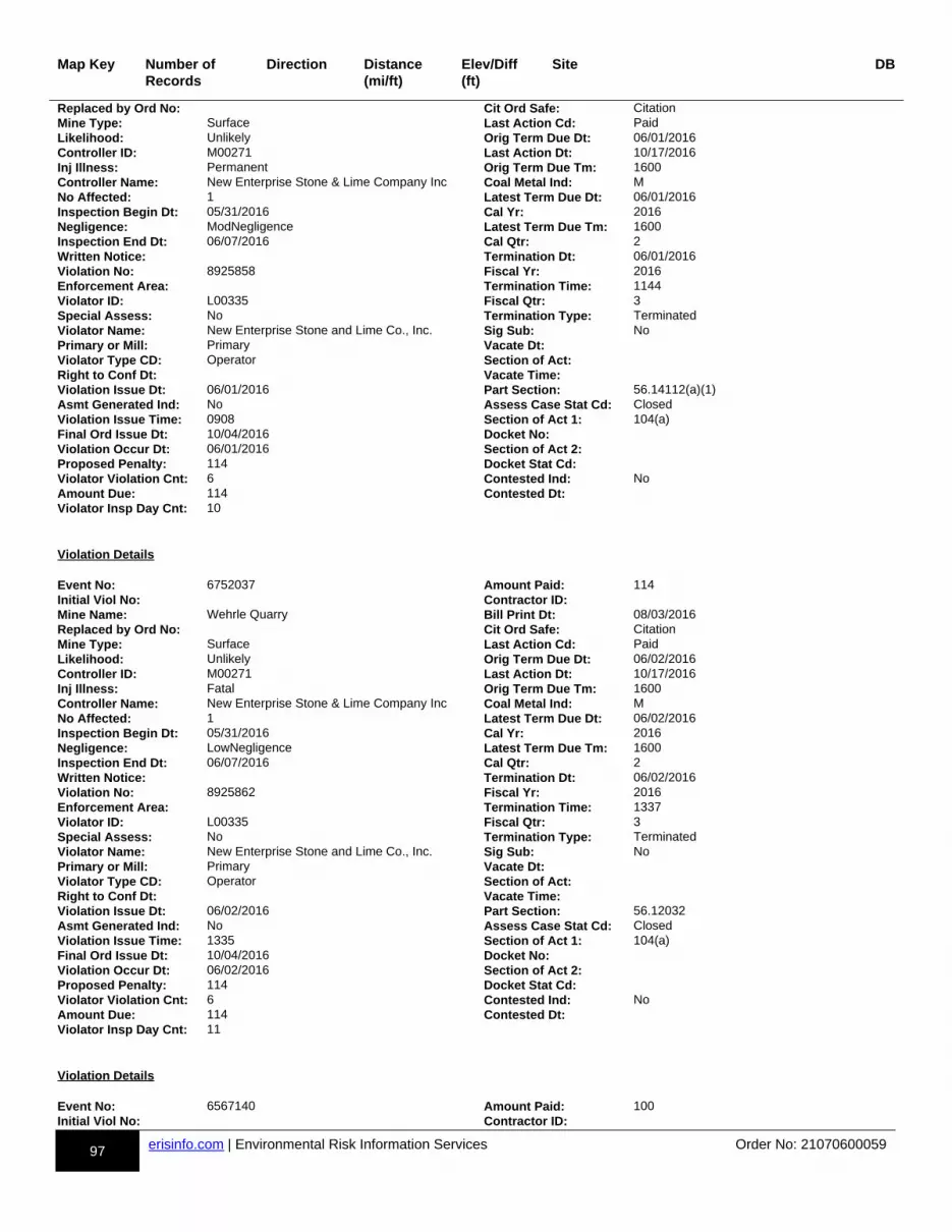
97 erisinfo.com | Environmental Risk Information Services Order No: 21070600059
Map Key Number of Records
Direction Distance(mi/ft)
Elev/Diff(ft)
Site DB
Replaced by Ord No: Cit Ord Safe: CitationMine Type: Surface Last Action Cd: PaidLikelihood: Unlikely Orig Term Due Dt: 06/01/2016Controller ID: M00271 Last Action Dt: 10/17/2016Inj Illness: Permanent Orig Term Due Tm: 1600Controller Name: New Enterprise Stone & Lime Company Inc Coal Metal Ind: MNo Affected: 1 Latest Term Due Dt: 06/01/2016Inspection Begin Dt: 05/31/2016 Cal Yr: 2016Negligence: ModNegligence Latest Term Due Tm: 1600Inspection End Dt: 06/07/2016 Cal Qtr: 2Written Notice: Termination Dt: 06/01/2016Violation No: 8925858 Fiscal Yr: 2016Enforcement Area: Termination Time: 1144Violator ID: L00335 Fiscal Qtr: 3Special Assess: No Termination Type: TerminatedViolator Name: New Enterprise Stone and Lime Co., Inc. Sig Sub: NoPrimary or Mill: Primary Vacate Dt:Violator Type CD: Operator Section of Act:Right to Conf Dt: Vacate Time:Violation Issue Dt: 06/01/2016 Part Section: 56.14112(a)(1)Asmt Generated Ind: No Assess Case Stat Cd: ClosedViolation Issue Time: 0908 Section of Act 1: 104(a)Final Ord Issue Dt: 10/04/2016 Docket No:Violation Occur Dt: 06/01/2016 Section of Act 2:Proposed Penalty: 114 Docket Stat Cd:Violator Violation Cnt: 6 Contested Ind: NoAmount Due: 114 Contested Dt:Violator Insp Day Cnt: 10
Violation Details Event No: 6752037 Amount Paid: 114Initial Viol No: Contractor ID:Mine Name: Wehrle Quarry Bill Print Dt: 08/03/2016Replaced by Ord No: Cit Ord Safe: CitationMine Type: Surface Last Action Cd: PaidLikelihood: Unlikely Orig Term Due Dt: 06/02/2016Controller ID: M00271 Last Action Dt: 10/17/2016Inj Illness: Fatal Orig Term Due Tm: 1600Controller Name: New Enterprise Stone & Lime Company Inc Coal Metal Ind: MNo Affected: 1 Latest Term Due Dt: 06/02/2016Inspection Begin Dt: 05/31/2016 Cal Yr: 2016Negligence: LowNegligence Latest Term Due Tm: 1600Inspection End Dt: 06/07/2016 Cal Qtr: 2Written Notice: Termination Dt: 06/02/2016Violation No: 8925862 Fiscal Yr: 2016Enforcement Area: Termination Time: 1337Violator ID: L00335 Fiscal Qtr: 3Special Assess: No Termination Type: TerminatedViolator Name: New Enterprise Stone and Lime Co., Inc. Sig Sub: NoPrimary or Mill: Primary Vacate Dt:Violator Type CD: Operator Section of Act:Right to Conf Dt: Vacate Time:Violation Issue Dt: 06/02/2016 Part Section: 56.12032Asmt Generated Ind: No Assess Case Stat Cd: ClosedViolation Issue Time: 1335 Section of Act 1: 104(a)Final Ord Issue Dt: 10/04/2016 Docket No:Violation Occur Dt: 06/02/2016 Section of Act 2:Proposed Penalty: 114 Docket Stat Cd:Violator Violation Cnt: 6 Contested Ind: NoAmount Due: 114 Contested Dt:Violator Insp Day Cnt: 11
Violation Details Event No: 6567140 Amount Paid: 100Initial Viol No: Contractor ID:

98 erisinfo.com | Environmental Risk Information Services Order No: 21070600059
Map Key Number of Records
Direction Distance(mi/ft)
Elev/Diff(ft)
Site DB
Mine Name: Wehrle Quarry Bill Print Dt: 07/31/2012Replaced by Ord No: Cit Ord Safe: CitationMine Type: Surface Last Action Cd: PaidLikelihood: Unlikely Orig Term Due Dt: 06/07/2012Controller ID: M00271 Last Action Dt: 08/15/2012Inj Illness: LostDays Orig Term Due Tm: 0900Controller Name: New Enterprise Stone & Lime Company Inc Coal Metal Ind: MNo Affected: 1 Latest Term Due Dt: 06/07/2012Inspection Begin Dt: 06/05/2012 Cal Yr: 2012Negligence: ModNegligence Latest Term Due Tm: 0900Inspection End Dt: 06/08/2012 Cal Qtr: 2Written Notice: Termination Dt: 06/06/2012Violation No: 8653380 Fiscal Yr: 2012Enforcement Area: Termination Time: 1135Violator ID: L00335 Fiscal Qtr: 3Special Assess: No Termination Type: TerminatedViolator Name: New Enterprise Stone and Lime Co., Inc. Sig Sub: NoPrimary or Mill: Primary Vacate Dt:Violator Type CD: Operator Section of Act:Right to Conf Dt: Vacate Time:Violation Issue Dt: 06/06/2012 Part Section: 56.12020Asmt Generated Ind: No Assess Case Stat Cd: ClosedViolation Issue Time: 1050 Section of Act 1: 104(a)Final Ord Issue Dt: 09/05/2012 Docket No:Violation Occur Dt: 06/06/2012 Section of Act 2:Proposed Penalty: 100 Docket Stat Cd:Violator Violation Cnt: 4 Contested Ind: NoAmount Due: 100 Contested Dt:Violator Insp Day Cnt: 11
Violation Details Event No: 6685366 Amount Paid: 100Initial Viol No: Contractor ID:Mine Name: Wehrle Quarry Bill Print Dt: 02/11/2016Replaced by Ord No: Cit Ord Safe: CitationMine Type: Surface Last Action Cd: PaidLikelihood: Unlikely Orig Term Due Dt: 01/05/2016Controller ID: M00271 Last Action Dt: 05/04/2016Inj Illness: Permanent Orig Term Due Tm: 0930Controller Name: New Enterprise Stone & Lime Company Inc Coal Metal Ind: MNo Affected: 1 Latest Term Due Dt: 01/05/2016Inspection Begin Dt: 01/04/2016 Cal Yr: 2016Negligence: LowNegligence Latest Term Due Tm: 0930Inspection End Dt: 01/06/2016 Cal Qtr: 1Written Notice: Termination Dt: 01/05/2016Violation No: 8922298 Fiscal Yr: 2016Enforcement Area: Termination Time: 0924Violator ID: L00335 Fiscal Qtr: 2Special Assess: No Termination Type: TerminatedViolator Name: New Enterprise Stone and Lime Co., Inc. Sig Sub: NoPrimary or Mill: Primary Vacate Dt:Violator Type CD: Operator Section of Act:Right to Conf Dt: Vacate Time:Violation Issue Dt: 01/05/2016 Part Section: 56.4603(b)Asmt Generated Ind: No Assess Case Stat Cd: ClosedViolation Issue Time: 0920 Section of Act 1: 104(a)Final Ord Issue Dt: 03/19/2016 Docket No:Violation Occur Dt: 01/05/2016 Section of Act 2:Proposed Penalty: 100 Docket Stat Cd:Violator Violation Cnt: 3 Contested Ind: NoAmount Due: 100 Contested Dt:Violator Insp Day Cnt: 8
Violation Details Event No: 0899025 Amount Paid: 100
99 erisinfo.com | Environmental Risk Information Services Order No: 21070600059
Map Key Number of Records
Direction Distance(mi/ft)
Elev/Diff(ft)
Site DB
Initial Viol No: Contractor ID:Mine Name: Wehrle Quarry Bill Print Dt: 02/06/2008Replaced by Ord No: Cit Ord Safe: CitationMine Type: Surface Last Action Cd: PaidLikelihood: Unlikely Orig Term Due Dt: 12/13/2007Controller ID: M00271 Last Action Dt: 03/03/2008Inj Illness: Permanent Orig Term Due Tm: 1600Controller Name: New Enterprise Stone & Lime Company Inc Coal Metal Ind: MNo Affected: 1 Latest Term Due Dt: 12/13/2007Inspection Begin Dt: 12/13/2007 Cal Yr: 2007Negligence: ModNegligence Latest Term Due Tm: 1600Inspection End Dt: 12/14/2007 Cal Qtr: 4Written Notice: Termination Dt: 12/13/2007Violation No: 6054355 Fiscal Yr: 2008Enforcement Area: Termination Time: 1140Violator ID: L17690 Fiscal Qtr: 1Special Assess: No Termination Type: TerminatedViolator Name: Buffalo Crushed Stone Company Inc Sig Sub: NoPrimary or Mill: Primary Vacate Dt:Violator Type CD: Operator Section of Act:Right to Conf Dt: Vacate Time:Violation Issue Dt: 12/13/2007 Part Section: 56.14100(b)Asmt Generated Ind: No Assess Case Stat Cd: ClosedViolation Issue Time: 1040 Section of Act 1: 104(a)Final Ord Issue Dt: 03/22/2008 Docket No:Violation Occur Dt: 12/13/2007 Section of Act 2:Proposed Penalty: 100 Docket Stat Cd:Violator Violation Cnt: 7 Contested Ind: NoAmount Due: 100 Contested Dt:Violator Insp Day Cnt: 11
Violation Details Event No: 0875616 Amount Paid: 60Initial Viol No: Contractor ID:Mine Name: Wehrle Quarry Bill Print Dt: 05/05/2004Replaced by Ord No: Cit Ord Safe: CitationMine Type: Surface Last Action Cd: PaidLikelihood: Unlikely Orig Term Due Dt:Controller ID: M00271 Last Action Dt: 12/01/2004Inj Illness: Fatal Orig Term Due Tm:Controller Name: New Enterprise Stone & Lime Company Inc Coal Metal Ind: MNo Affected: 1 Latest Term Due Dt: 03/31/2004Inspection Begin Dt: 03/30/2004 Cal Yr: 2004Negligence: ModNegligence Latest Term Due Tm: 1600Inspection End Dt: 04/02/2004 Cal Qtr: 1Written Notice: Termination Dt: 03/31/2004Violation No: 6012051 Fiscal Yr: 2004Enforcement Area: Termination Time: 1500Violator ID: L17690 Fiscal Qtr: 2Special Assess: No Termination Type: TerminatedViolator Name: Buffalo Crushed Stone Company Inc Sig Sub: NoPrimary or Mill: Mill Vacate Dt:Violator Type CD: Operator Section of Act:Right to Conf Dt: 03/31/2004 Vacate Time:Violation Issue Dt: 03/31/2004 Part Section: 56.14209(b)Asmt Generated Ind: No Assess Case Stat Cd: ClosedViolation Issue Time: 1350 Section of Act 1: 104(a)Final Ord Issue Dt: 06/11/2004 Docket No:Violation Occur Dt: 03/31/2004 Section of Act 2:Proposed Penalty: 60 Docket Stat Cd:Violator Violation Cnt: 3 Contested Ind: NoAmount Due: 60 Contested Dt:Violator Insp Day Cnt: 19
Violation Details

100 erisinfo.com | Environmental Risk Information Services Order No: 21070600059
Map Key Number of Records
Direction Distance(mi/ft)
Elev/Diff(ft)
Site DB
Event No: 0899046 Amount Paid: 585Initial Viol No: Contractor ID:Mine Name: Wehrle Quarry Bill Print Dt: 05/07/2008Replaced by Ord No: Cit Ord Safe: CitationMine Type: Surface Last Action Cd: PaidLikelihood: Reasonably Orig Term Due Dt: 04/04/2008Controller ID: M00271 Last Action Dt: 05/23/2008Inj Illness: Fatal Orig Term Due Tm: 0800Controller Name: New Enterprise Stone & Lime Company Inc Coal Metal Ind: MNo Affected: 1 Latest Term Due Dt: 04/04/2008Inspection Begin Dt: 04/02/2008 Cal Yr: 2008Negligence: ModNegligence Latest Term Due Tm: 0800Inspection End Dt: 04/04/2008 Cal Qtr: 2Written Notice: Termination Dt: 04/04/2008Violation No: 6058747 Fiscal Yr: 2008Enforcement Area: Termination Time: 0645Violator ID: L17690 Fiscal Qtr: 3Special Assess: No Termination Type: TerminatedViolator Name: Buffalo Crushed Stone Company Inc Sig Sub: YesPrimary or Mill: Mill Vacate Dt:Violator Type CD: Operator Section of Act:Right to Conf Dt: Vacate Time:Violation Issue Dt: 04/03/2008 Part Section: 56.11001Asmt Generated Ind: No Assess Case Stat Cd: ClosedViolation Issue Time: 0745 Section of Act 1: 104(a)Final Ord Issue Dt: 06/11/2008 Docket No:Violation Occur Dt: 04/03/2008 Section of Act 2:Proposed Penalty: 585 Docket Stat Cd:Violator Violation Cnt: 6 Contested Ind: NoAmount Due: 585 Contested Dt:Violator Insp Day Cnt: 9
Violation Details Event No: 6623049 Amount Paid: 100Initial Viol No: Contractor ID:Mine Name: Wehrle Quarry Bill Print Dt: 02/26/2013Replaced by Ord No: Cit Ord Safe: CitationMine Type: Surface Last Action Cd: PaidLikelihood: Unlikely Orig Term Due Dt: 01/08/2013Controller ID: M00271 Last Action Dt: 03/21/2013Inj Illness: LostDays Orig Term Due Tm: 1045Controller Name: New Enterprise Stone & Lime Company Inc Coal Metal Ind: MNo Affected: 1 Latest Term Due Dt: 01/08/2013Inspection Begin Dt: 01/07/2013 Cal Yr: 2013Negligence: LowNegligence Latest Term Due Tm: 1045Inspection End Dt: 01/09/2013 Cal Qtr: 1Written Notice: Termination Dt: 01/08/2013Violation No: 8705084 Fiscal Yr: 2013Enforcement Area: Termination Time: 1135Violator ID: L00335 Fiscal Qtr: 2Special Assess: No Termination Type: TerminatedViolator Name: New Enterprise Stone and Lime Co., Inc. Sig Sub: NoPrimary or Mill: Primary Vacate Dt:Violator Type CD: Operator Section of Act:Right to Conf Dt: Vacate Time:Violation Issue Dt: 01/08/2013 Part Section: 56.4101Asmt Generated Ind: No Assess Case Stat Cd: ClosedViolation Issue Time: 1020 Section of Act 1: 104(a)Final Ord Issue Dt: 04/04/2013 Docket No:Violation Occur Dt: 01/08/2013 Section of Act 2:Proposed Penalty: 100 Docket Stat Cd:Violator Violation Cnt: 3 Contested Ind: NoAmount Due: 100 Contested Dt:Violator Insp Day Cnt: 10
Violation Details
101 erisinfo.com | Environmental Risk Information Services Order No: 21070600059
Map Key Number of Records
Direction Distance(mi/ft)
Elev/Diff(ft)
Site DB
Event No: 0899046 Amount Paid: 263Initial Viol No: Contractor ID:Mine Name: Wehrle Quarry Bill Print Dt: 05/07/2008Replaced by Ord No: Cit Ord Safe: CitationMine Type: Surface Last Action Cd: PaidLikelihood: Reasonably Orig Term Due Dt: 04/02/2008Controller ID: M00271 Last Action Dt: 05/23/2008Inj Illness: Permanent Orig Term Due Tm: 1200Controller Name: New Enterprise Stone & Lime Company Inc Coal Metal Ind: MNo Affected: 1 Latest Term Due Dt: 04/02/2008Inspection Begin Dt: 04/02/2008 Cal Yr: 2008Negligence: ModNegligence Latest Term Due Tm: 1200Inspection End Dt: 04/04/2008 Cal Qtr: 2Written Notice: Termination Dt: 04/02/2008Violation No: 6058743 Fiscal Yr: 2008Enforcement Area: Termination Time: 0950Violator ID: L17690 Fiscal Qtr: 3Special Assess: No Termination Type: TerminatedViolator Name: Buffalo Crushed Stone Company Inc Sig Sub: YesPrimary or Mill: Primary Vacate Dt:Violator Type CD: Operator Section of Act:Right to Conf Dt: Vacate Time:Violation Issue Dt: 04/02/2008 Part Section: 56.14100(a)Asmt Generated Ind: No Assess Case Stat Cd: ClosedViolation Issue Time: 0750 Section of Act 1: 104(a)Final Ord Issue Dt: 06/11/2008 Docket No:Violation Occur Dt: 04/02/2008 Section of Act 2:Proposed Penalty: 263 Docket Stat Cd:Violator Violation Cnt: 6 Contested Ind: NoAmount Due: 263 Contested Dt:Violator Insp Day Cnt: 7
Violation Details Event No: 6819174 Amount Paid: 123Initial Viol No: Contractor ID:Mine Name: Wehrle Quarry Bill Print Dt: 07/07/2020Replaced by Ord No: Cit Ord Safe: CitationMine Type: Surface Last Action Cd: PaidLikelihood: Unlikely Orig Term Due Dt: 06/01/2020Controller ID: M00271 Last Action Dt: 08/09/2020Inj Illness: Permanent Orig Term Due Tm: 1520Controller Name: New Enterprise Stone & Lime Company Inc Coal Metal Ind: MNo Affected: 1 Latest Term Due Dt: 06/01/2020Inspection Begin Dt: 06/01/2020 Cal Yr: 2020Negligence: ModNegligence Latest Term Due Tm: 1520Inspection End Dt: 06/04/2020 Cal Qtr: 2Written Notice: No Termination Dt: 06/04/2020Violation No: 9466284 Fiscal Yr: 2020Enforcement Area: Termination Time: 1041Violator ID: L00335 Fiscal Qtr: 3Special Assess: No Termination Type: TerminatedViolator Name: New Enterprise Stone and Lime Co., Inc. Sig Sub: NoPrimary or Mill: Primary Vacate Dt:Violator Type CD: Operator Section of Act:Right to Conf Dt: Vacate Time:Violation Issue Dt: 06/01/2020 Part Section: 56.12004Asmt Generated Ind: No Assess Case Stat Cd: ClosedViolation Issue Time: 1517 Section of Act 1: 104(a)Final Ord Issue Dt: 08/15/2020 Docket No:Violation Occur Dt: 06/01/2020 Section of Act 2:Proposed Penalty: 123 Docket Stat Cd:Violator Violation Cnt: 3 Contested Ind: NoAmount Due: 123 Contested Dt:Violator Insp Day Cnt: 7
102 erisinfo.com | Environmental Risk Information Services Order No: 21070600059
Map Key Number of Records
Direction Distance(mi/ft)
Elev/Diff(ft)
Site DB
Violation Details Event No: 0894982 Amount Paid: 263Initial Viol No: Contractor ID:Mine Name: Wehrle Quarry Bill Print Dt: 07/11/2007Replaced by Ord No: Cit Ord Safe: CitationMine Type: Surface Last Action Cd: PaidLikelihood: Reasonably Orig Term Due Dt: 04/24/2007Controller ID: M00271 Last Action Dt: 07/19/2007Inj Illness: Fatal Orig Term Due Tm: 1205Controller Name: New Enterprise Stone & Lime Company Inc Coal Metal Ind: MNo Affected: 1 Latest Term Due Dt: 04/24/2007Inspection Begin Dt: 04/23/2007 Cal Yr: 2007Negligence: LowNegligence Latest Term Due Tm: 1205Inspection End Dt: 04/26/2007 Cal Qtr: 2Written Notice: Termination Dt: 04/24/2007Violation No: 6045660 Fiscal Yr: 2007Enforcement Area: Termination Time: 1205Violator ID: L17690 Fiscal Qtr: 3Special Assess: No Termination Type: TerminatedViolator Name: Buffalo Crushed Stone Company Inc Sig Sub: YesPrimary or Mill: Primary Vacate Dt:Violator Type CD: Operator Section of Act:Right to Conf Dt: Vacate Time:Violation Issue Dt: 04/24/2007 Part Section: 56.14131(a)Asmt Generated Ind: No Assess Case Stat Cd: ClosedViolation Issue Time: 1200 Section of Act 1: 104(a)Final Ord Issue Dt: 08/25/2007 Docket No:Violation Occur Dt: 04/24/2007 Section of Act 2:Proposed Penalty: 263 Docket Stat Cd:Violator Violation Cnt: 5 Contested Ind: NoAmount Due: 263 Contested Dt:Violator Insp Day Cnt: 11
Violation Details Event No: 0880993 Amount Paid: 60Initial Viol No: Contractor ID:Mine Name: Wehrle Quarry Bill Print Dt: 08/10/2005Replaced by Ord No: Cit Ord Safe: CitationMine Type: Surface Last Action Cd: PaidLikelihood: Unlikely Orig Term Due Dt: 06/28/2005Controller ID: M00271 Last Action Dt: 09/28/2005Inj Illness: LostDays Orig Term Due Tm: 1200Controller Name: New Enterprise Stone & Lime Company Inc Coal Metal Ind: MNo Affected: 1 Latest Term Due Dt: 06/28/2005Inspection Begin Dt: 06/27/2005 Cal Yr: 2005Negligence: ModNegligence Latest Term Due Tm: 1200Inspection End Dt: 06/30/2005 Cal Qtr: 2Written Notice: Termination Dt: 06/28/2005Violation No: 6023971 Fiscal Yr: 2005Enforcement Area: Termination Time: 1120Violator ID: L17690 Fiscal Qtr: 3Special Assess: No Termination Type: TerminatedViolator Name: Buffalo Crushed Stone Company Inc Sig Sub: NoPrimary or Mill: Primary Vacate Dt:Violator Type CD: Operator Section of Act:Right to Conf Dt: Vacate Time:Violation Issue Dt: 06/28/2005 Part Section: 56.11001Asmt Generated Ind: No Assess Case Stat Cd: ClosedViolation Issue Time: 1020 Section of Act 1: 104(a)Final Ord Issue Dt: 09/28/2005 Docket No:Violation Occur Dt: 06/28/2005 Section of Act 2:Proposed Penalty: 60 Docket Stat Cd:Violator Violation Cnt: 6 Contested Ind: NoAmount Due: 60 Contested Dt:Violator Insp Day Cnt: 23
103 erisinfo.com | Environmental Risk Information Services Order No: 21070600059
Map Key Number of Records
Direction Distance(mi/ft)
Elev/Diff(ft)
Site DB
Violation Details Event No: 0875616 Amount Paid: 60Initial Viol No: Contractor ID:Mine Name: Wehrle Quarry Bill Print Dt: 05/05/2004Replaced by Ord No: Cit Ord Safe: CitationMine Type: Surface Last Action Cd: PaidLikelihood: Unlikely Orig Term Due Dt:Controller ID: M00271 Last Action Dt: 12/01/2004Inj Illness: Permanent Orig Term Due Tm:Controller Name: New Enterprise Stone & Lime Company Inc Coal Metal Ind: MNo Affected: 1 Latest Term Due Dt: 03/31/2004Inspection Begin Dt: 03/30/2004 Cal Yr: 2004Negligence: ModNegligence Latest Term Due Tm: 1305Inspection End Dt: 04/02/2004 Cal Qtr: 1Written Notice: Termination Dt: 03/31/2004Violation No: 6012050 Fiscal Yr: 2004Enforcement Area: Termination Time: 1300Violator ID: L17690 Fiscal Qtr: 2Special Assess: No Termination Type: TerminatedViolator Name: Buffalo Crushed Stone Company Inc Sig Sub: NoPrimary or Mill: Mill Vacate Dt:Violator Type CD: Operator Section of Act:Right to Conf Dt: 03/31/2004 Vacate Time:Violation Issue Dt: 03/31/2004 Part Section: 56.15004Asmt Generated Ind: No Assess Case Stat Cd: ClosedViolation Issue Time: 1255 Section of Act 1: 104(a)Final Ord Issue Dt: 06/11/2004 Docket No:Violation Occur Dt: 03/31/2004 Section of Act 2:Proposed Penalty: 60 Docket Stat Cd:Violator Violation Cnt: 3 Contested Ind: NoAmount Due: 60 Contested Dt:Violator Insp Day Cnt: 19
Violation Details Event No: 0880951 Amount Paid: 60Initial Viol No: Contractor ID:Mine Name: Wehrle Quarry Bill Print Dt: 02/09/2005Replaced by Ord No: Cit Ord Safe: CitationMine Type: Surface Last Action Cd: PaidLikelihood: Unlikely Orig Term Due Dt:Controller ID: M00271 Last Action Dt: 03/10/2005Inj Illness: LostDays Orig Term Due Tm:Controller Name: New Enterprise Stone & Lime Company Inc Coal Metal Ind: MNo Affected: 1 Latest Term Due Dt: 01/04/2005Inspection Begin Dt: 01/04/2005 Cal Yr: 2005Negligence: ModNegligence Latest Term Due Tm: 1400Inspection End Dt: 01/06/2005 Cal Qtr: 1Written Notice: Termination Dt: 01/04/2005Violation No: 6023877 Fiscal Yr: 2005Enforcement Area: Termination Time: 1330Violator ID: L17690 Fiscal Qtr: 2Special Assess: No Termination Type: TerminatedViolator Name: Buffalo Crushed Stone Company Inc Sig Sub: NoPrimary or Mill: Primary Vacate Dt:Violator Type CD: Operator Section of Act:Right to Conf Dt: 01/04/2005 Vacate Time:Violation Issue Dt: 01/04/2005 Part Section: 56.12018Asmt Generated Ind: No Assess Case Stat Cd: ClosedViolation Issue Time: 1025 Section of Act 1: 104(a)Final Ord Issue Dt: 03/26/2005 Docket No:Violation Occur Dt: 01/04/2005 Section of Act 2:Proposed Penalty: 60 Docket Stat Cd:Violator Violation Cnt: 7 Contested Ind: NoAmount Due: 60 Contested Dt:
104 erisinfo.com | Environmental Risk Information Services Order No: 21070600059
Map Key Number of Records
Direction Distance(mi/ft)
Elev/Diff(ft)
Site DB
Violator Insp Day Cnt: 31
Violation Details Event No: 6757641 Amount Paid: 118Initial Viol No: Contractor ID:Mine Name: Wehrle Quarry Bill Print Dt: 02/14/2018Replaced by Ord No: Cit Ord Safe: CitationMine Type: Surface Last Action Cd: PaidLikelihood: Unlikely Orig Term Due Dt: 12/19/2017Controller ID: M00271 Last Action Dt: 05/16/2018Inj Illness: LostDays Orig Term Due Tm: 1205Controller Name: New Enterprise Stone & Lime Company Inc Coal Metal Ind: MNo Affected: 1 Latest Term Due Dt: 12/19/2017Inspection Begin Dt: 12/19/2017 Cal Yr: 2017Negligence: LowNegligence Latest Term Due Tm: 1205Inspection End Dt: 12/21/2017 Cal Qtr: 4Written Notice: Termination Dt: 12/19/2017Violation No: 9364972 Fiscal Yr: 2018Enforcement Area: Termination Time: 1135Violator ID: L00335 Fiscal Qtr: 1Special Assess: No Termination Type: TerminatedViolator Name: New Enterprise Stone and Lime Co., Inc. Sig Sub: NoPrimary or Mill: Primary Vacate Dt:Violator Type CD: Operator Section of Act:Right to Conf Dt: Vacate Time:Violation Issue Dt: 12/19/2017 Part Section: 56.12004Asmt Generated Ind: No Assess Case Stat Cd: ClosedViolation Issue Time: 1105 Section of Act 1: 104(a)Final Ord Issue Dt: 03/19/2018 Docket No:Violation Occur Dt: 12/19/2017 Section of Act 2:Proposed Penalty: 118 Docket Stat Cd:Violator Violation Cnt: 8 Contested Ind: NoAmount Due: 118 Contested Dt:Violator Insp Day Cnt: 10
Violation Details Event No: 6682256 Amount Paid: 100Initial Viol No: Contractor ID:Mine Name: Wehrle Quarry Bill Print Dt: 06/02/2015Replaced by Ord No: Cit Ord Safe: CitationMine Type: Surface Last Action Cd: PaidLikelihood: Unlikely Orig Term Due Dt: 04/22/2015Controller ID: M00271 Last Action Dt: 08/18/2015Inj Illness: Permanent Orig Term Due Tm: 1400Controller Name: New Enterprise Stone & Lime Company Inc Coal Metal Ind: MNo Affected: 1 Latest Term Due Dt: 04/22/2015Inspection Begin Dt: 04/22/2015 Cal Yr: 2015Negligence: ModNegligence Latest Term Due Tm: 1400Inspection End Dt: 04/29/2015 Cal Qtr: 2Written Notice: Termination Dt: 04/22/2015Violation No: 8801955 Fiscal Yr: 2015Enforcement Area: Termination Time: 1330Violator ID: L00335 Fiscal Qtr: 3Special Assess: No Termination Type: TerminatedViolator Name: New Enterprise Stone and Lime Co., Inc. Sig Sub: NoPrimary or Mill: Primary Vacate Dt:Violator Type CD: Operator Section of Act:Right to Conf Dt: Vacate Time:Violation Issue Dt: 04/22/2015 Part Section: 56.12004Asmt Generated Ind: No Assess Case Stat Cd: ClosedViolation Issue Time: 1315 Section of Act 1: 104(a)Final Ord Issue Dt: 08/23/2015 Docket No:Violation Occur Dt: 04/22/2015 Section of Act 2:Proposed Penalty: 100 Docket Stat Cd:Violator Violation Cnt: 1 Contested Ind: No
105 erisinfo.com | Environmental Risk Information Services Order No: 21070600059
Map Key Number of Records
Direction Distance(mi/ft)
Elev/Diff(ft)
Site DB
Amount Due: 100 Contested Dt:Violator Insp Day Cnt: 7
Violation Details Event No: 6685366 Amount Paid: 100Initial Viol No: Contractor ID:Mine Name: Wehrle Quarry Bill Print Dt: 02/11/2016Replaced by Ord No: Cit Ord Safe: CitationMine Type: Surface Last Action Cd: PaidLikelihood: Unlikely Orig Term Due Dt: 01/05/2016Controller ID: M00271 Last Action Dt: 05/04/2016Inj Illness: Fatal Orig Term Due Tm: 1300Controller Name: New Enterprise Stone & Lime Company Inc Coal Metal Ind: MNo Affected: 1 Latest Term Due Dt: 01/05/2016Inspection Begin Dt: 01/04/2016 Cal Yr: 2016Negligence: LowNegligence Latest Term Due Tm: 1300Inspection End Dt: 01/06/2016 Cal Qtr: 1Written Notice: Termination Dt: 01/05/2016Violation No: 8922299 Fiscal Yr: 2016Enforcement Area: Termination Time: 1200Violator ID: L00335 Fiscal Qtr: 2Special Assess: No Termination Type: TerminatedViolator Name: New Enterprise Stone and Lime Co., Inc. Sig Sub: NoPrimary or Mill: Primary Vacate Dt:Violator Type CD: Operator Section of Act:Right to Conf Dt: Vacate Time:Violation Issue Dt: 01/05/2016 Part Section: 56.12008Asmt Generated Ind: No Assess Case Stat Cd: ClosedViolation Issue Time: 1100 Section of Act 1: 104(a)Final Ord Issue Dt: 03/19/2016 Docket No:Violation Occur Dt: 01/05/2016 Section of Act 2:Proposed Penalty: 100 Docket Stat Cd:Violator Violation Cnt: 3 Contested Ind: NoAmount Due: 100 Contested Dt:Violator Insp Day Cnt: 8
Violation Details Event No: 0906683 Amount Paid: 117Initial Viol No: Contractor ID:Mine Name: Wehrle Quarry Bill Print Dt: 04/07/2010Replaced by Ord No: Cit Ord Safe: CitationMine Type: Surface Last Action Cd: PaidLikelihood: Unlikely Orig Term Due Dt: 02/18/2010Controller ID: M00271 Last Action Dt: 07/14/2010Inj Illness: Fatal Orig Term Due Tm: 1218Controller Name: New Enterprise Stone & Lime Company Inc Coal Metal Ind: MNo Affected: 1 Latest Term Due Dt: 02/18/2010Inspection Begin Dt: 02/16/2010 Cal Yr: 2010Negligence: ModNegligence Latest Term Due Tm: 1218Inspection End Dt: 02/19/2010 Cal Qtr: 1Written Notice: Termination Dt: 02/18/2010Violation No: 6539793 Fiscal Yr: 2010Enforcement Area: Termination Time: 1218Violator ID: L17690 Fiscal Qtr: 2Special Assess: No Termination Type: TerminatedViolator Name: Buffalo Crushed Stone Company Inc Sig Sub: NoPrimary or Mill: Primary Vacate Dt:Violator Type CD: Operator Section of Act:Right to Conf Dt: Vacate Time:Violation Issue Dt: 02/18/2010 Part Section: 56.14100(b)Asmt Generated Ind: No Assess Case Stat Cd: ClosedViolation Issue Time: 0855 Section of Act 1: 104(a)Final Ord Issue Dt: 05/13/2010 Docket No:Violation Occur Dt: 02/18/2010 Section of Act 2:Proposed Penalty: 117 Docket Stat Cd:

106 erisinfo.com | Environmental Risk Information Services Order No: 21070600059
Map Key Number of Records
Direction Distance(mi/ft)
Elev/Diff(ft)
Site DB
Violator Violation Cnt: 9 Contested Ind: NoAmount Due: 117 Contested Dt:Violator Insp Day Cnt: 15
Violation Details Event No: 0761179 Amount Paid: 55Initial Viol No: Contractor ID:Mine Name: Wehrle Quarry Bill Print Dt: 10/04/2001Replaced by Ord No: Cit Ord Safe: CitationMine Type: Surface Last Action Cd: PaidLikelihood: Unlikely Orig Term Due Dt:Controller ID: M00271 Last Action Dt: 11/05/2001Inj Illness: LostDays Orig Term Due Tm:Controller Name: New Enterprise Stone & Lime Company Inc Coal Metal Ind: MNo Affected: 1 Latest Term Due Dt: 08/29/2001Inspection Begin Dt: 08/28/2001 Cal Yr: 2001Negligence: ModNegligence Latest Term Due Tm: 0800Inspection End Dt: 08/30/2001 Cal Qtr: 3Written Notice: Termination Dt: 08/29/2001Violation No: 7745844 Fiscal Yr: 2001Enforcement Area: Termination Time: 0800Violator ID: L17690 Fiscal Qtr: 4Special Assess: No Termination Type: TerminatedViolator Name: Buffalo Crushed Stone Company Inc Sig Sub: NoPrimary or Mill: Primary Vacate Dt:Violator Type CD: Operator Section of Act:Right to Conf Dt: 08/28/2001 Vacate Time:Violation Issue Dt: 08/28/2001 Part Section: 56.14100(b)Asmt Generated Ind: No Assess Case Stat Cd: ClosedViolation Issue Time: 1035 Section of Act 1: 104(a)Final Ord Issue Dt: 11/05/2001 Docket No:Violation Occur Dt: 08/28/2001 Section of Act 2:Proposed Penalty: 55 Docket Stat Cd:Violator Violation Cnt: 0 Contested Ind: NoAmount Due: 55 Contested Dt:Violator Insp Day Cnt: 0
Violation Details Event No: 6685366 Amount Paid: 100Initial Viol No: Contractor ID:Mine Name: Wehrle Quarry Bill Print Dt: 02/11/2016Replaced by Ord No: Cit Ord Safe: CitationMine Type: Surface Last Action Cd: PaidLikelihood: Unlikely Orig Term Due Dt: 01/15/2016Controller ID: M00271 Last Action Dt: 05/04/2016Inj Illness: LostDays Orig Term Due Tm: 1600Controller Name: New Enterprise Stone & Lime Company Inc Coal Metal Ind: MNo Affected: 1 Latest Term Due Dt: 01/15/2016Inspection Begin Dt: 01/04/2016 Cal Yr: 2016Negligence: ModNegligence Latest Term Due Tm: 1600Inspection End Dt: 01/06/2016 Cal Qtr: 1Written Notice: Termination Dt: 01/14/2016Violation No: 8922300 Fiscal Yr: 2016Enforcement Area: Termination Time: 0842Violator ID: L00335 Fiscal Qtr: 2Special Assess: No Termination Type: TerminatedViolator Name: New Enterprise Stone and Lime Co., Inc. Sig Sub: NoPrimary or Mill: Primary Vacate Dt:Violator Type CD: Operator Section of Act:Right to Conf Dt: Vacate Time:Violation Issue Dt: 01/06/2016 Part Section: 56.14103(b)Asmt Generated Ind: No Assess Case Stat Cd: ClosedViolation Issue Time: 0859 Section of Act 1: 104(a)Final Ord Issue Dt: 03/19/2016 Docket No:Violation Occur Dt: 01/06/2016 Section of Act 2:
107 erisinfo.com | Environmental Risk Information Services Order No: 21070600059
Map Key Number of Records
Direction Distance(mi/ft)
Elev/Diff(ft)
Site DB
Proposed Penalty: 100 Docket Stat Cd:Violator Violation Cnt: 3 Contested Ind: NoAmount Due: 100 Contested Dt:Violator Insp Day Cnt: 10
Violation Details Event No: 0894982 Amount Paid: 117Initial Viol No: Contractor ID:Mine Name: Wehrle Quarry Bill Print Dt: 06/06/2007Replaced by Ord No: Cit Ord Safe: CitationMine Type: Surface Last Action Cd: PaidLikelihood: Unlikely Orig Term Due Dt: 04/25/2007Controller ID: M00271 Last Action Dt: 08/22/2007Inj Illness: Fatal Orig Term Due Tm: 1445Controller Name: New Enterprise Stone & Lime Company Inc Coal Metal Ind: MNo Affected: 1 Latest Term Due Dt: 04/25/2007Inspection Begin Dt: 04/23/2007 Cal Yr: 2007Negligence: ModNegligence Latest Term Due Tm: 1445Inspection End Dt: 04/26/2007 Cal Qtr: 2Written Notice: Termination Dt: 04/25/2007Violation No: 6045661 Fiscal Yr: 2007Enforcement Area: Termination Time: 1430Violator ID: L17690 Fiscal Qtr: 3Special Assess: No Termination Type: TerminatedViolator Name: Buffalo Crushed Stone Company Inc Sig Sub: NoPrimary or Mill: Primary Vacate Dt:Violator Type CD: Operator Section of Act:Right to Conf Dt: Vacate Time:Violation Issue Dt: 04/25/2007 Part Section: 56.12030Asmt Generated Ind: No Assess Case Stat Cd: ClosedViolation Issue Time: 1400 Section of Act 1: 104(a)Final Ord Issue Dt: 07/21/2007 Docket No:Violation Occur Dt: 04/25/2007 Section of Act 2:Proposed Penalty: 117 Docket Stat Cd:Violator Violation Cnt: 5 Contested Ind: NoAmount Due: 117 Contested Dt:Violator Insp Day Cnt: 13
Violation Details Event No: 0886366 Amount Paid: 60Initial Viol No: Contractor ID:Mine Name: Wehrle Quarry Bill Print Dt: 11/08/2006Replaced by Ord No: Cit Ord Safe: CitationMine Type: Surface Last Action Cd: PaidLikelihood: Unlikely Orig Term Due Dt: 10/03/2006Controller ID: M00271 Last Action Dt: 01/22/2007Inj Illness: LostDays Orig Term Due Tm: 1200Controller Name: New Enterprise Stone & Lime Company Inc Coal Metal Ind: MNo Affected: 1 Latest Term Due Dt: 10/03/2006Inspection Begin Dt: 10/02/2006 Cal Yr: 2006Negligence: ModNegligence Latest Term Due Tm: 1200Inspection End Dt: 10/05/2006 Cal Qtr: 4Written Notice: Termination Dt: 10/03/2006Violation No: 6043706 Fiscal Yr: 2007Enforcement Area: Termination Time: 1022Violator ID: L17690 Fiscal Qtr: 1Special Assess: No Termination Type: TerminatedViolator Name: Buffalo Crushed Stone Company Inc Sig Sub: NoPrimary or Mill: Primary Vacate Dt:Violator Type CD: Operator Section of Act:Right to Conf Dt: Vacate Time:Violation Issue Dt: 10/03/2006 Part Section: 56.14112(b)Asmt Generated Ind: No Assess Case Stat Cd: ClosedViolation Issue Time: 1014 Section of Act 1: 104(a)Final Ord Issue Dt: 12/23/2006 Docket No:
108 erisinfo.com | Environmental Risk Information Services Order No: 21070600059
Map Key Number of Records
Direction Distance(mi/ft)
Elev/Diff(ft)
Site DB
Violation Occur Dt: 10/03/2006 Section of Act 2:Proposed Penalty: 60 Docket Stat Cd:Violator Violation Cnt: 9 Contested Ind: NoAmount Due: 60 Contested Dt:Violator Insp Day Cnt: 15
Violation Details Event No: 0911568 Amount Paid: 263Initial Viol No: Contractor ID:Mine Name: Wehrle Quarry Bill Print Dt: 07/07/2010Replaced by Ord No: Cit Ord Safe: CitationMine Type: Surface Last Action Cd: PaidLikelihood: Reasonably Orig Term Due Dt: 06/03/2010Controller ID: M00271 Last Action Dt: 07/29/2010Inj Illness: Permanent Orig Term Due Tm: 1000Controller Name: New Enterprise Stone & Lime Company Inc Coal Metal Ind: MNo Affected: 1 Latest Term Due Dt: 06/03/2010Inspection Begin Dt: 06/02/2010 Cal Yr: 2010Negligence: ModNegligence Latest Term Due Tm: 1000Inspection End Dt: 06/04/2010 Cal Qtr: 2Written Notice: Termination Dt: 06/03/2010Violation No: 8576626 Fiscal Yr: 2010Enforcement Area: Termination Time: 0753Violator ID: L17690 Fiscal Qtr: 3Special Assess: No Termination Type: TerminatedViolator Name: Buffalo Crushed Stone Company Inc Sig Sub: YesPrimary or Mill: Primary Vacate Dt:Violator Type CD: Operator Section of Act:Right to Conf Dt: Vacate Time:Violation Issue Dt: 06/02/2010 Part Section: 56.9300(b)Asmt Generated Ind: No Assess Case Stat Cd: ClosedViolation Issue Time: 1438 Section of Act 1: 104(a)Final Ord Issue Dt: 08/13/2010 Docket No:Violation Occur Dt: 06/02/2010 Section of Act 2:Proposed Penalty: 263 Docket Stat Cd:Violator Violation Cnt: 7 Contested Ind: NoAmount Due: 263 Contested Dt:Violator Insp Day Cnt: 10
Violation Details Event No: 6625835 Amount Paid: 100Initial Viol No: Contractor ID:Mine Name: Wehrle Quarry Bill Print Dt: 04/29/2014Replaced by Ord No: Cit Ord Safe: CitationMine Type: Surface Last Action Cd: PaidLikelihood: Unlikely Orig Term Due Dt: 03/19/2014Controller ID: M00271 Last Action Dt: 05/14/2014Inj Illness: Permanent Orig Term Due Tm: 1100Controller Name: New Enterprise Stone & Lime Company Inc Coal Metal Ind: MNo Affected: 1 Latest Term Due Dt: 03/19/2014Inspection Begin Dt: 03/13/2014 Cal Yr: 2014Negligence: ModNegligence Latest Term Due Tm: 1100Inspection End Dt: 03/20/2014 Cal Qtr: 1Written Notice: Termination Dt: 03/19/2014Violation No: 8714662 Fiscal Yr: 2014Enforcement Area: Termination Time: 1053Violator ID: L00335 Fiscal Qtr: 2Special Assess: No Termination Type: TerminatedViolator Name: New Enterprise Stone and Lime Co., Inc. Sig Sub: NoPrimary or Mill: Primary Vacate Dt:Violator Type CD: Operator Section of Act:Right to Conf Dt: Vacate Time:Violation Issue Dt: 03/19/2014 Part Section: 56.11001Asmt Generated Ind: No Assess Case Stat Cd: ClosedViolation Issue Time: 1050 Section of Act 1: 104(a)
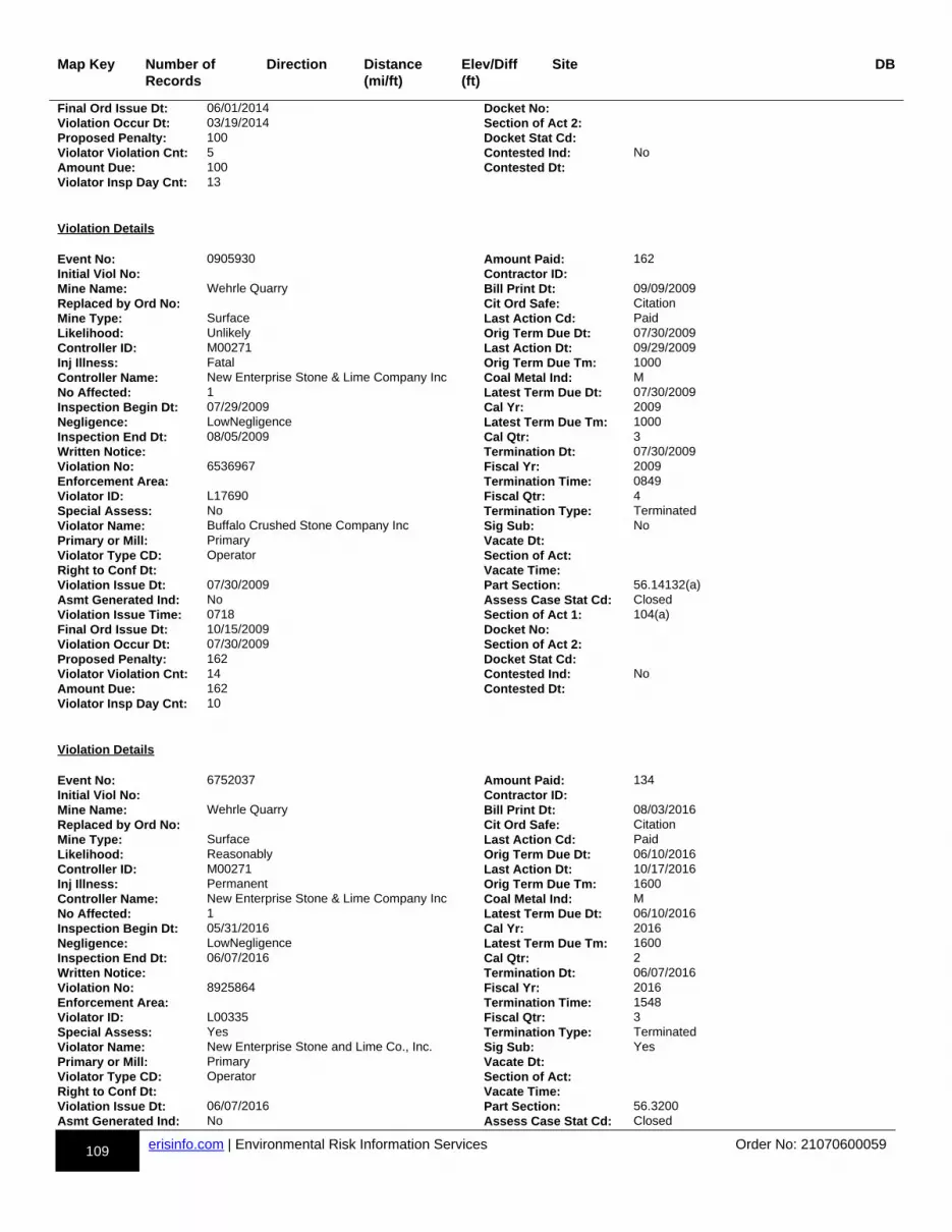
109 erisinfo.com | Environmental Risk Information Services Order No: 21070600059
Map Key Number of Records
Direction Distance(mi/ft)
Elev/Diff(ft)
Site DB
Final Ord Issue Dt: 06/01/2014 Docket No:Violation Occur Dt: 03/19/2014 Section of Act 2:Proposed Penalty: 100 Docket Stat Cd:Violator Violation Cnt: 5 Contested Ind: NoAmount Due: 100 Contested Dt:Violator Insp Day Cnt: 13
Violation Details Event No: 0905930 Amount Paid: 162Initial Viol No: Contractor ID:Mine Name: Wehrle Quarry Bill Print Dt: 09/09/2009Replaced by Ord No: Cit Ord Safe: CitationMine Type: Surface Last Action Cd: PaidLikelihood: Unlikely Orig Term Due Dt: 07/30/2009Controller ID: M00271 Last Action Dt: 09/29/2009Inj Illness: Fatal Orig Term Due Tm: 1000Controller Name: New Enterprise Stone & Lime Company Inc Coal Metal Ind: MNo Affected: 1 Latest Term Due Dt: 07/30/2009Inspection Begin Dt: 07/29/2009 Cal Yr: 2009Negligence: LowNegligence Latest Term Due Tm: 1000Inspection End Dt: 08/05/2009 Cal Qtr: 3Written Notice: Termination Dt: 07/30/2009Violation No: 6536967 Fiscal Yr: 2009Enforcement Area: Termination Time: 0849Violator ID: L17690 Fiscal Qtr: 4Special Assess: No Termination Type: TerminatedViolator Name: Buffalo Crushed Stone Company Inc Sig Sub: NoPrimary or Mill: Primary Vacate Dt:Violator Type CD: Operator Section of Act:Right to Conf Dt: Vacate Time:Violation Issue Dt: 07/30/2009 Part Section: 56.14132(a)Asmt Generated Ind: No Assess Case Stat Cd: ClosedViolation Issue Time: 0718 Section of Act 1: 104(a)Final Ord Issue Dt: 10/15/2009 Docket No:Violation Occur Dt: 07/30/2009 Section of Act 2:Proposed Penalty: 162 Docket Stat Cd:Violator Violation Cnt: 14 Contested Ind: NoAmount Due: 162 Contested Dt:Violator Insp Day Cnt: 10
Violation Details Event No: 6752037 Amount Paid: 134Initial Viol No: Contractor ID:Mine Name: Wehrle Quarry Bill Print Dt: 08/03/2016Replaced by Ord No: Cit Ord Safe: CitationMine Type: Surface Last Action Cd: PaidLikelihood: Reasonably Orig Term Due Dt: 06/10/2016Controller ID: M00271 Last Action Dt: 10/17/2016Inj Illness: Permanent Orig Term Due Tm: 1600Controller Name: New Enterprise Stone & Lime Company Inc Coal Metal Ind: MNo Affected: 1 Latest Term Due Dt: 06/10/2016Inspection Begin Dt: 05/31/2016 Cal Yr: 2016Negligence: LowNegligence Latest Term Due Tm: 1600Inspection End Dt: 06/07/2016 Cal Qtr: 2Written Notice: Termination Dt: 06/07/2016Violation No: 8925864 Fiscal Yr: 2016Enforcement Area: Termination Time: 1548Violator ID: L00335 Fiscal Qtr: 3Special Assess: Yes Termination Type: TerminatedViolator Name: New Enterprise Stone and Lime Co., Inc. Sig Sub: YesPrimary or Mill: Primary Vacate Dt:Violator Type CD: Operator Section of Act:Right to Conf Dt: Vacate Time:Violation Issue Dt: 06/07/2016 Part Section: 56.3200Asmt Generated Ind: No Assess Case Stat Cd: Closed

110 erisinfo.com | Environmental Risk Information Services Order No: 21070600059
Map Key Number of Records
Direction Distance(mi/ft)
Elev/Diff(ft)
Site DB
Violation Issue Time: 1034 Section of Act 1: 104(a)Final Ord Issue Dt: 10/04/2016 Docket No:Violation Occur Dt: 06/07/2016 Section of Act 2:Proposed Penalty: 134 Docket Stat Cd:Violator Violation Cnt: 6 Contested Ind: NoAmount Due: 134 Contested Dt:Violator Insp Day Cnt: 14
Violation Details Event No: 6567140 Amount Paid: 100Initial Viol No: Contractor ID:Mine Name: Wehrle Quarry Bill Print Dt: 07/31/2012Replaced by Ord No: Cit Ord Safe: CitationMine Type: Surface Last Action Cd: PaidLikelihood: Unlikely Orig Term Due Dt: 06/08/2012Controller ID: M00271 Last Action Dt: 08/15/2012Inj Illness: LostDays Orig Term Due Tm: 1600Controller Name: New Enterprise Stone & Lime Company Inc Coal Metal Ind: MNo Affected: 1 Latest Term Due Dt: 06/08/2012Inspection Begin Dt: 06/05/2012 Cal Yr: 2012Negligence: LowNegligence Latest Term Due Tm: 1600Inspection End Dt: 06/08/2012 Cal Qtr: 2Written Notice: Termination Dt: 06/08/2012Violation No: 8653381 Fiscal Yr: 2012Enforcement Area: Termination Time: 0840Violator ID: L00335 Fiscal Qtr: 3Special Assess: No Termination Type: TerminatedViolator Name: New Enterprise Stone and Lime Co., Inc. Sig Sub: NoPrimary or Mill: Primary Vacate Dt:Violator Type CD: Operator Section of Act:Right to Conf Dt: Vacate Time:Violation Issue Dt: 06/06/2012 Part Section: 56.14100(b)Asmt Generated Ind: No Assess Case Stat Cd: ClosedViolation Issue Time: 1400 Section of Act 1: 104(a)Final Ord Issue Dt: 09/05/2012 Docket No:Violation Occur Dt: 06/06/2012 Section of Act 2:Proposed Penalty: 100 Docket Stat Cd:Violator Violation Cnt: 4 Contested Ind: NoAmount Due: 100 Contested Dt:Violator Insp Day Cnt: 11
Violation Details Event No: 6757641 Amount Paid: 691Initial Viol No: Contractor ID:Mine Name: Wehrle Quarry Bill Print Dt: 02/14/2018Replaced by Ord No: Cit Ord Safe: CitationMine Type: Surface Last Action Cd: PaidLikelihood: Reasonably Orig Term Due Dt: 12/19/2017Controller ID: M00271 Last Action Dt: 09/11/2018Inj Illness: Fatal Orig Term Due Tm: 1136Controller Name: New Enterprise Stone & Lime Company Inc Coal Metal Ind: MNo Affected: 1 Latest Term Due Dt: 12/19/2017Inspection Begin Dt: 12/19/2017 Cal Yr: 2017Negligence: ModNegligence Latest Term Due Tm: 1136Inspection End Dt: 12/21/2017 Cal Qtr: 4Written Notice: Termination Dt: 12/19/2017Violation No: 9364973 Fiscal Yr: 2018Enforcement Area: Termination Time: 1135Violator ID: L00335 Fiscal Qtr: 1Special Assess: No Termination Type: TerminatedViolator Name: New Enterprise Stone and Lime Co., Inc. Sig Sub: YesPrimary or Mill: Primary Vacate Dt:Violator Type CD: Operator Section of Act:Right to Conf Dt: Vacate Time:Violation Issue Dt: 12/19/2017 Part Section: 56.12030

111 erisinfo.com | Environmental Risk Information Services Order No: 21070600059
Map Key Number of Records
Direction Distance(mi/ft)
Elev/Diff(ft)
Site DB
Asmt Generated Ind: No Assess Case Stat Cd: ClosedViolation Issue Time: 1106 Section of Act 1: 104(a)Final Ord Issue Dt: 03/19/2018 Docket No:Violation Occur Dt: 12/19/2017 Section of Act 2:Proposed Penalty: 691 Docket Stat Cd:Violator Violation Cnt: 8 Contested Ind: NoAmount Due: 691 Contested Dt:Violator Insp Day Cnt: 10
Violation Details Event No: 0886366 Amount Paid: 60Initial Viol No: Contractor ID:Mine Name: Wehrle Quarry Bill Print Dt: 11/08/2006Replaced by Ord No: Cit Ord Safe: CitationMine Type: Surface Last Action Cd: PaidLikelihood: Unlikely Orig Term Due Dt: 10/05/2006Controller ID: M00271 Last Action Dt: 01/22/2007Inj Illness: Permanent Orig Term Due Tm: 1600Controller Name: New Enterprise Stone & Lime Company Inc Coal Metal Ind: MNo Affected: 1 Latest Term Due Dt: 10/05/2006Inspection Begin Dt: 10/02/2006 Cal Yr: 2006Negligence: LowNegligence Latest Term Due Tm: 1600Inspection End Dt: 10/05/2006 Cal Qtr: 4Written Notice: Termination Dt: 10/05/2006Violation No: 6043708 Fiscal Yr: 2007Enforcement Area: Termination Time: 0740Violator ID: L17690 Fiscal Qtr: 1Special Assess: No Termination Type: TerminatedViolator Name: Buffalo Crushed Stone Company Inc Sig Sub: NoPrimary or Mill: Primary Vacate Dt:Violator Type CD: Operator Section of Act:Right to Conf Dt: Vacate Time:Violation Issue Dt: 10/04/2006 Part Section: 56.14107(a)Asmt Generated Ind: No Assess Case Stat Cd: ClosedViolation Issue Time: 1108 Section of Act 1: 104(a)Final Ord Issue Dt: 12/23/2006 Docket No:Violation Occur Dt: 10/04/2006 Section of Act 2:Proposed Penalty: 60 Docket Stat Cd:Violator Violation Cnt: 9 Contested Ind: NoAmount Due: 60 Contested Dt:Violator Insp Day Cnt: 15
Violation Details Event No: 6623049 Amount Paid: 100Initial Viol No: Contractor ID:Mine Name: Wehrle Quarry Bill Print Dt: 02/26/2013Replaced by Ord No: Cit Ord Safe: CitationMine Type: Surface Last Action Cd: PaidLikelihood: Unlikely Orig Term Due Dt: 01/08/2013Controller ID: M00271 Last Action Dt: 03/21/2013Inj Illness: LostDays Orig Term Due Tm: 1115Controller Name: New Enterprise Stone & Lime Company Inc Coal Metal Ind: MNo Affected: 1 Latest Term Due Dt: 01/08/2013Inspection Begin Dt: 01/07/2013 Cal Yr: 2013Negligence: ModNegligence Latest Term Due Tm: 1115Inspection End Dt: 01/09/2013 Cal Qtr: 1Written Notice: Termination Dt: 01/08/2013Violation No: 8705085 Fiscal Yr: 2013Enforcement Area: Termination Time: 1130Violator ID: L00335 Fiscal Qtr: 2Special Assess: No Termination Type: TerminatedViolator Name: New Enterprise Stone and Lime Co., Inc. Sig Sub: NoPrimary or Mill: Primary Vacate Dt:Violator Type CD: Operator Section of Act:Right to Conf Dt: Vacate Time:
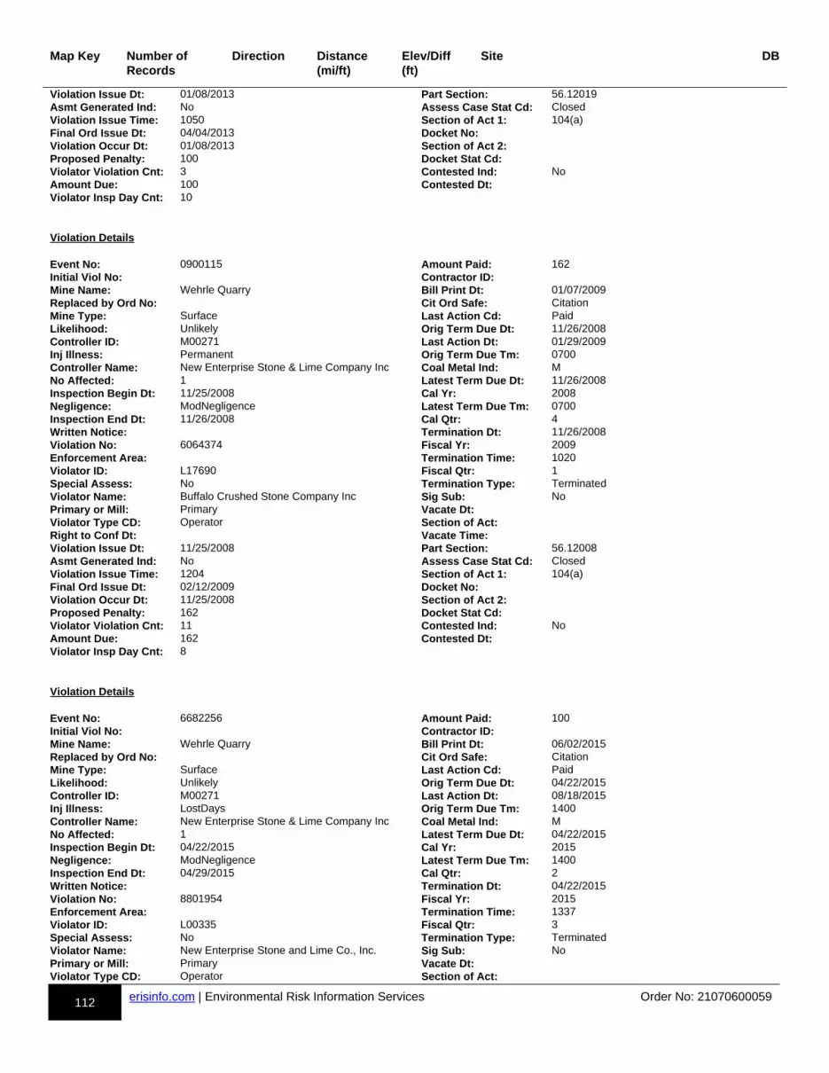
112 erisinfo.com | Environmental Risk Information Services Order No: 21070600059
Map Key Number of Records
Direction Distance(mi/ft)
Elev/Diff(ft)
Site DB
Violation Issue Dt: 01/08/2013 Part Section: 56.12019Asmt Generated Ind: No Assess Case Stat Cd: ClosedViolation Issue Time: 1050 Section of Act 1: 104(a)Final Ord Issue Dt: 04/04/2013 Docket No:Violation Occur Dt: 01/08/2013 Section of Act 2:Proposed Penalty: 100 Docket Stat Cd:Violator Violation Cnt: 3 Contested Ind: NoAmount Due: 100 Contested Dt:Violator Insp Day Cnt: 10
Violation Details Event No: 0900115 Amount Paid: 162Initial Viol No: Contractor ID:Mine Name: Wehrle Quarry Bill Print Dt: 01/07/2009Replaced by Ord No: Cit Ord Safe: CitationMine Type: Surface Last Action Cd: PaidLikelihood: Unlikely Orig Term Due Dt: 11/26/2008Controller ID: M00271 Last Action Dt: 01/29/2009Inj Illness: Permanent Orig Term Due Tm: 0700Controller Name: New Enterprise Stone & Lime Company Inc Coal Metal Ind: MNo Affected: 1 Latest Term Due Dt: 11/26/2008Inspection Begin Dt: 11/25/2008 Cal Yr: 2008Negligence: ModNegligence Latest Term Due Tm: 0700Inspection End Dt: 11/26/2008 Cal Qtr: 4Written Notice: Termination Dt: 11/26/2008Violation No: 6064374 Fiscal Yr: 2009Enforcement Area: Termination Time: 1020Violator ID: L17690 Fiscal Qtr: 1Special Assess: No Termination Type: TerminatedViolator Name: Buffalo Crushed Stone Company Inc Sig Sub: NoPrimary or Mill: Primary Vacate Dt:Violator Type CD: Operator Section of Act:Right to Conf Dt: Vacate Time:Violation Issue Dt: 11/25/2008 Part Section: 56.12008Asmt Generated Ind: No Assess Case Stat Cd: ClosedViolation Issue Time: 1204 Section of Act 1: 104(a)Final Ord Issue Dt: 02/12/2009 Docket No:Violation Occur Dt: 11/25/2008 Section of Act 2:Proposed Penalty: 162 Docket Stat Cd:Violator Violation Cnt: 11 Contested Ind: NoAmount Due: 162 Contested Dt:Violator Insp Day Cnt: 8
Violation Details Event No: 6682256 Amount Paid: 100Initial Viol No: Contractor ID:Mine Name: Wehrle Quarry Bill Print Dt: 06/02/2015Replaced by Ord No: Cit Ord Safe: CitationMine Type: Surface Last Action Cd: PaidLikelihood: Unlikely Orig Term Due Dt: 04/22/2015Controller ID: M00271 Last Action Dt: 08/18/2015Inj Illness: LostDays Orig Term Due Tm: 1400Controller Name: New Enterprise Stone & Lime Company Inc Coal Metal Ind: MNo Affected: 1 Latest Term Due Dt: 04/22/2015Inspection Begin Dt: 04/22/2015 Cal Yr: 2015Negligence: ModNegligence Latest Term Due Tm: 1400Inspection End Dt: 04/29/2015 Cal Qtr: 2Written Notice: Termination Dt: 04/22/2015Violation No: 8801954 Fiscal Yr: 2015Enforcement Area: Termination Time: 1337Violator ID: L00335 Fiscal Qtr: 3Special Assess: No Termination Type: TerminatedViolator Name: New Enterprise Stone and Lime Co., Inc. Sig Sub: NoPrimary or Mill: Primary Vacate Dt:Violator Type CD: Operator Section of Act:

113 erisinfo.com | Environmental Risk Information Services Order No: 21070600059
Map Key Number of Records
Direction Distance(mi/ft)
Elev/Diff(ft)
Site DB
Right to Conf Dt: Vacate Time:Violation Issue Dt: 04/22/2015 Part Section: 56.4501Asmt Generated Ind: No Assess Case Stat Cd: ClosedViolation Issue Time: 1255 Section of Act 1: 104(a)Final Ord Issue Dt: 08/23/2015 Docket No:Violation Occur Dt: 04/22/2015 Section of Act 2:Proposed Penalty: 100 Docket Stat Cd:Violator Violation Cnt: 1 Contested Ind: NoAmount Due: 100 Contested Dt:Violator Insp Day Cnt: 7
Violation Details Event No: 0887655 Amount Paid: 60Initial Viol No: Contractor ID: V1DMine Name: Wehrle Quarry Bill Print Dt: 07/19/2006Replaced by Ord No: Cit Ord Safe: CitationMine Type: Surface Last Action Cd: PaidLikelihood: Unlikely Orig Term Due Dt: 05/31/2006Controller ID: Last Action Dt: 08/05/2006Inj Illness: Permanent Orig Term Due Tm: 1600Controller Name: Coal Metal Ind: MNo Affected: 1 Latest Term Due Dt: 05/31/2006Inspection Begin Dt: 05/30/2006 Cal Yr: 2006Negligence: HighNegligence Latest Term Due Tm: 1600Inspection End Dt: 06/06/2006 Cal Qtr: 2Written Notice: Termination Dt: 05/31/2006Violation No: 6037862 Fiscal Yr: 2006Enforcement Area: Termination Time: 1321Violator ID: V1D Fiscal Qtr: 3Special Assess: No Termination Type: TerminatedViolator Name: Nothnagle Drilling Sig Sub: NoPrimary or Mill: Primary Vacate Dt:Violator Type CD: Contractor Section of Act:Right to Conf Dt: Vacate Time:Violation Issue Dt: 05/31/2006 Part Section: 56.4201(a)(2)Asmt Generated Ind: No Assess Case Stat Cd: ClosedViolation Issue Time: 1005 Section of Act 1: 104(a)Final Ord Issue Dt: 09/02/2006 Docket No:Violation Occur Dt: 05/31/2006 Section of Act 2:Proposed Penalty: 60 Docket Stat Cd:Violator Violation Cnt: 1 Contested Ind: NoAmount Due: 60 Contested Dt:Violator Insp Day Cnt: 0
Violation Details Event No: 0759615 Amount Paid: 55Initial Viol No: Contractor ID:Mine Name: Wehrle Quarry Bill Print Dt: 08/09/2002Replaced by Ord No: Cit Ord Safe: CitationMine Type: Surface Last Action Cd: PaidLikelihood: Reasonably Orig Term Due Dt:Controller ID: M00271 Last Action Dt: 09/27/2002Inj Illness: NoLostDays Orig Term Due Tm:Controller Name: New Enterprise Stone & Lime Company Inc Coal Metal Ind: MNo Affected: 1 Latest Term Due Dt: 12/05/2001Inspection Begin Dt: 12/04/2001 Cal Yr: 2001Negligence: ModNegligence Latest Term Due Tm: 1000Inspection End Dt: 12/05/2001 Cal Qtr: 4Written Notice: Termination Dt: 12/05/2001Violation No: 7742119 Fiscal Yr: 2002Enforcement Area: Termination Time: 0915Violator ID: L17690 Fiscal Qtr: 1Special Assess: No Termination Type: TerminatedViolator Name: Buffalo Crushed Stone Company Inc Sig Sub: NoPrimary or Mill: Mill Vacate Dt:
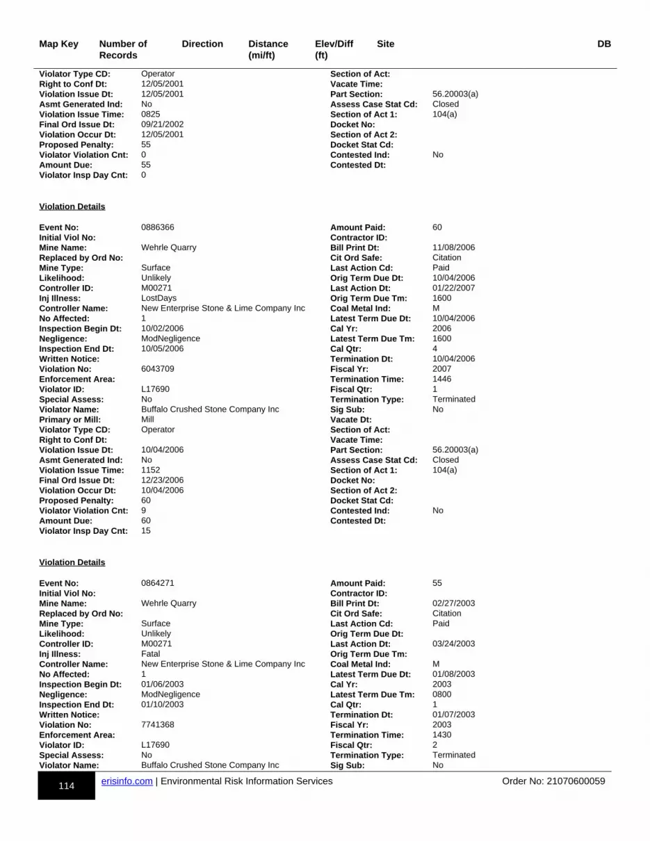
114 erisinfo.com | Environmental Risk Information Services Order No: 21070600059
Map Key Number of Records
Direction Distance(mi/ft)
Elev/Diff(ft)
Site DB
Violator Type CD: Operator Section of Act:Right to Conf Dt: 12/05/2001 Vacate Time:Violation Issue Dt: 12/05/2001 Part Section: 56.20003(a)Asmt Generated Ind: No Assess Case Stat Cd: ClosedViolation Issue Time: 0825 Section of Act 1: 104(a)Final Ord Issue Dt: 09/21/2002 Docket No:Violation Occur Dt: 12/05/2001 Section of Act 2:Proposed Penalty: 55 Docket Stat Cd:Violator Violation Cnt: 0 Contested Ind: NoAmount Due: 55 Contested Dt:Violator Insp Day Cnt: 0
Violation Details Event No: 0886366 Amount Paid: 60Initial Viol No: Contractor ID:Mine Name: Wehrle Quarry Bill Print Dt: 11/08/2006Replaced by Ord No: Cit Ord Safe: CitationMine Type: Surface Last Action Cd: PaidLikelihood: Unlikely Orig Term Due Dt: 10/04/2006Controller ID: M00271 Last Action Dt: 01/22/2007Inj Illness: LostDays Orig Term Due Tm: 1600Controller Name: New Enterprise Stone & Lime Company Inc Coal Metal Ind: MNo Affected: 1 Latest Term Due Dt: 10/04/2006Inspection Begin Dt: 10/02/2006 Cal Yr: 2006Negligence: ModNegligence Latest Term Due Tm: 1600Inspection End Dt: 10/05/2006 Cal Qtr: 4Written Notice: Termination Dt: 10/04/2006Violation No: 6043709 Fiscal Yr: 2007Enforcement Area: Termination Time: 1446Violator ID: L17690 Fiscal Qtr: 1Special Assess: No Termination Type: TerminatedViolator Name: Buffalo Crushed Stone Company Inc Sig Sub: NoPrimary or Mill: Mill Vacate Dt:Violator Type CD: Operator Section of Act:Right to Conf Dt: Vacate Time:Violation Issue Dt: 10/04/2006 Part Section: 56.20003(a)Asmt Generated Ind: No Assess Case Stat Cd: ClosedViolation Issue Time: 1152 Section of Act 1: 104(a)Final Ord Issue Dt: 12/23/2006 Docket No:Violation Occur Dt: 10/04/2006 Section of Act 2:Proposed Penalty: 60 Docket Stat Cd:Violator Violation Cnt: 9 Contested Ind: NoAmount Due: 60 Contested Dt:Violator Insp Day Cnt: 15
Violation Details Event No: 0864271 Amount Paid: 55Initial Viol No: Contractor ID:Mine Name: Wehrle Quarry Bill Print Dt: 02/27/2003Replaced by Ord No: Cit Ord Safe: CitationMine Type: Surface Last Action Cd: PaidLikelihood: Unlikely Orig Term Due Dt:Controller ID: M00271 Last Action Dt: 03/24/2003Inj Illness: Fatal Orig Term Due Tm:Controller Name: New Enterprise Stone & Lime Company Inc Coal Metal Ind: MNo Affected: 1 Latest Term Due Dt: 01/08/2003Inspection Begin Dt: 01/06/2003 Cal Yr: 2003Negligence: ModNegligence Latest Term Due Tm: 0800Inspection End Dt: 01/10/2003 Cal Qtr: 1Written Notice: Termination Dt: 01/07/2003Violation No: 7741368 Fiscal Yr: 2003Enforcement Area: Termination Time: 1430Violator ID: L17690 Fiscal Qtr: 2Special Assess: No Termination Type: TerminatedViolator Name: Buffalo Crushed Stone Company Inc Sig Sub: No
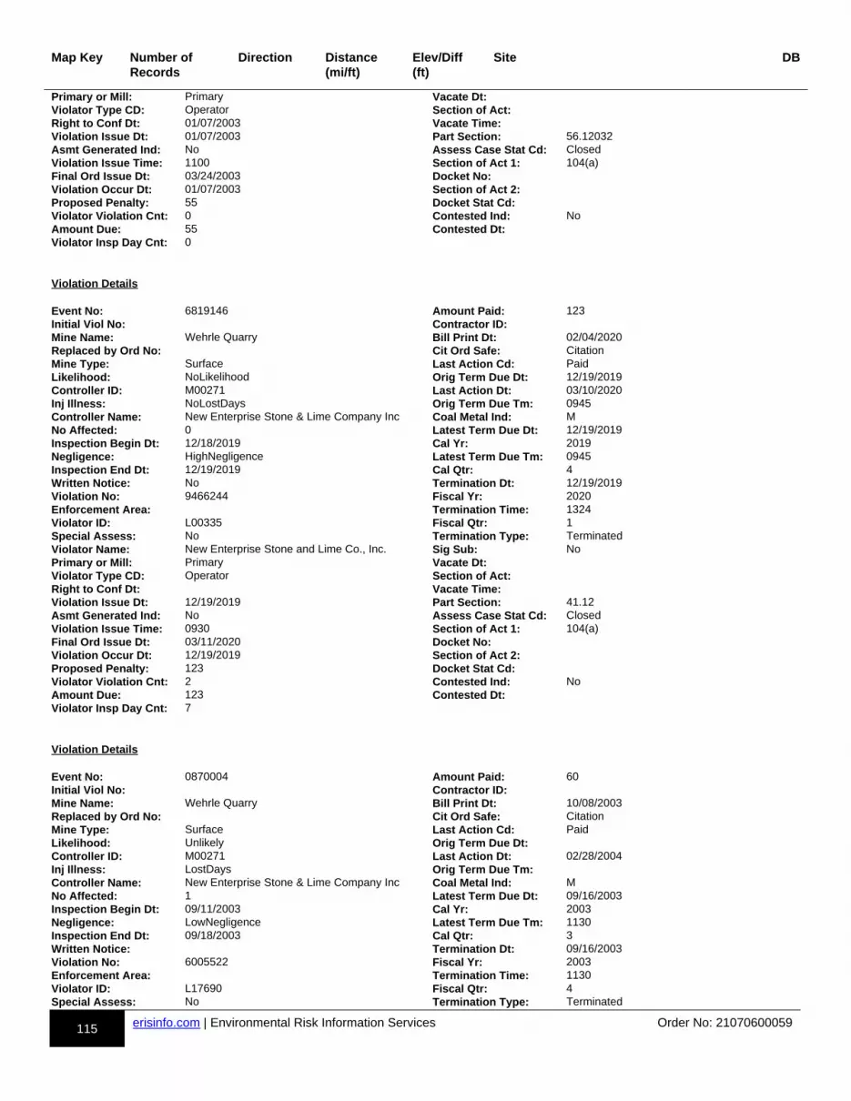
115 erisinfo.com | Environmental Risk Information Services Order No: 21070600059
Map Key Number of Records
Direction Distance(mi/ft)
Elev/Diff(ft)
Site DB
Primary or Mill: Primary Vacate Dt:Violator Type CD: Operator Section of Act:Right to Conf Dt: 01/07/2003 Vacate Time:Violation Issue Dt: 01/07/2003 Part Section: 56.12032Asmt Generated Ind: No Assess Case Stat Cd: ClosedViolation Issue Time: 1100 Section of Act 1: 104(a)Final Ord Issue Dt: 03/24/2003 Docket No:Violation Occur Dt: 01/07/2003 Section of Act 2:Proposed Penalty: 55 Docket Stat Cd:Violator Violation Cnt: 0 Contested Ind: NoAmount Due: 55 Contested Dt:Violator Insp Day Cnt: 0
Violation Details Event No: 6819146 Amount Paid: 123Initial Viol No: Contractor ID:Mine Name: Wehrle Quarry Bill Print Dt: 02/04/2020Replaced by Ord No: Cit Ord Safe: CitationMine Type: Surface Last Action Cd: PaidLikelihood: NoLikelihood Orig Term Due Dt: 12/19/2019Controller ID: M00271 Last Action Dt: 03/10/2020Inj Illness: NoLostDays Orig Term Due Tm: 0945Controller Name: New Enterprise Stone & Lime Company Inc Coal Metal Ind: MNo Affected: 0 Latest Term Due Dt: 12/19/2019Inspection Begin Dt: 12/18/2019 Cal Yr: 2019Negligence: HighNegligence Latest Term Due Tm: 0945Inspection End Dt: 12/19/2019 Cal Qtr: 4Written Notice: No Termination Dt: 12/19/2019Violation No: 9466244 Fiscal Yr: 2020Enforcement Area: Termination Time: 1324Violator ID: L00335 Fiscal Qtr: 1Special Assess: No Termination Type: TerminatedViolator Name: New Enterprise Stone and Lime Co., Inc. Sig Sub: NoPrimary or Mill: Primary Vacate Dt:Violator Type CD: Operator Section of Act:Right to Conf Dt: Vacate Time:Violation Issue Dt: 12/19/2019 Part Section: 41.12Asmt Generated Ind: No Assess Case Stat Cd: ClosedViolation Issue Time: 0930 Section of Act 1: 104(a)Final Ord Issue Dt: 03/11/2020 Docket No:Violation Occur Dt: 12/19/2019 Section of Act 2:Proposed Penalty: 123 Docket Stat Cd:Violator Violation Cnt: 2 Contested Ind: NoAmount Due: 123 Contested Dt:Violator Insp Day Cnt: 7
Violation Details Event No: 0870004 Amount Paid: 60Initial Viol No: Contractor ID:Mine Name: Wehrle Quarry Bill Print Dt: 10/08/2003Replaced by Ord No: Cit Ord Safe: CitationMine Type: Surface Last Action Cd: PaidLikelihood: Unlikely Orig Term Due Dt:Controller ID: M00271 Last Action Dt: 02/28/2004Inj Illness: LostDays Orig Term Due Tm:Controller Name: New Enterprise Stone & Lime Company Inc Coal Metal Ind: MNo Affected: 1 Latest Term Due Dt: 09/16/2003Inspection Begin Dt: 09/11/2003 Cal Yr: 2003Negligence: LowNegligence Latest Term Due Tm: 1130Inspection End Dt: 09/18/2003 Cal Qtr: 3Written Notice: Termination Dt: 09/16/2003Violation No: 6005522 Fiscal Yr: 2003Enforcement Area: Termination Time: 1130Violator ID: L17690 Fiscal Qtr: 4Special Assess: No Termination Type: Terminated
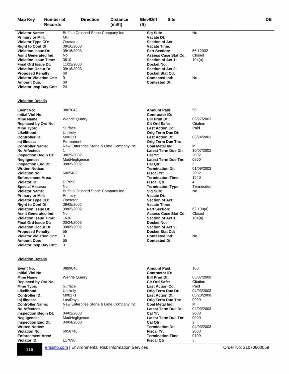
116 erisinfo.com | Environmental Risk Information Services Order No: 21070600059
Map Key Number of Records
Direction Distance(mi/ft)
Elev/Diff(ft)
Site DB
Violator Name: Buffalo Crushed Stone Company Inc Sig Sub: NoPrimary or Mill: Mill Vacate Dt:Violator Type CD: Operator Section of Act:Right to Conf Dt: 09/16/2003 Vacate Time:Violation Issue Dt: 09/16/2003 Part Section: 56.12032Asmt Generated Ind: No Assess Case Stat Cd: ClosedViolation Issue Time: 0810 Section of Act 1: 104(a)Final Ord Issue Dt: 11/22/2003 Docket No:Violation Occur Dt: 09/16/2003 Section of Act 2:Proposed Penalty: 60 Docket Stat Cd:Violator Violation Cnt: 9 Contested Ind: NoAmount Due: 60 Contested Dt:Violator Insp Day Cnt: 24
Violation Details Event No: 0867042 Amount Paid: 55Initial Viol No: Contractor ID:Mine Name: Wehrle Quarry Bill Print Dt: 02/27/2003Replaced by Ord No: Cit Ord Safe: CitationMine Type: Surface Last Action Cd: PaidLikelihood: Unlikely Orig Term Due Dt:Controller ID: M00271 Last Action Dt: 03/24/2003Inj Illness: Permanent Orig Term Due Tm:Controller Name: New Enterprise Stone & Lime Company Inc Coal Metal Ind: MNo Affected: 1 Latest Term Due Dt: 10/07/2002Inspection Begin Dt: 08/29/2002 Cal Yr: 2002Negligence: ModNegligence Latest Term Due Tm: 0800Inspection End Dt: 09/05/2002 Cal Qtr: 3Written Notice: Termination Dt: 01/09/2003Violation No: 6005402 Fiscal Yr: 2002Enforcement Area: Termination Time: 1540Violator ID: L17690 Fiscal Qtr: 4Special Assess: No Termination Type: TerminatedViolator Name: Buffalo Crushed Stone Company Inc Sig Sub: NoPrimary or Mill: Primary Vacate Dt:Violator Type CD: Operator Section of Act:Right to Conf Dt: 09/05/2002 Vacate Time:Violation Issue Dt: 09/05/2002 Part Section: 62.130(a)Asmt Generated Ind: No Assess Case Stat Cd: ClosedViolation Issue Time: 1630 Section of Act 1: 104(a)Final Ord Issue Dt: 03/24/2003 Docket No:Violation Occur Dt: 09/05/2002 Section of Act 2:Proposed Penalty: 55 Docket Stat Cd:Violator Violation Cnt: 0 Contested Ind: NoAmount Due: 55 Contested Dt:Violator Insp Day Cnt: 0
Violation Details Event No: 0899046 Amount Paid: 100Initial Viol No: Contractor ID:Mine Name: Wehrle Quarry Bill Print Dt: 05/07/2008Replaced by Ord No: Cit Ord Safe: CitationMine Type: Surface Last Action Cd: PaidLikelihood: Unlikely Orig Term Due Dt: 04/03/2008Controller ID: M00271 Last Action Dt: 05/23/2008Inj Illness: LostDays Orig Term Due Tm: 0900Controller Name: New Enterprise Stone & Lime Company Inc Coal Metal Ind: MNo Affected: 1 Latest Term Due Dt: 04/03/2008Inspection Begin Dt: 04/02/2008 Cal Yr: 2008Negligence: ModNegligence Latest Term Due Tm: 0900Inspection End Dt: 04/04/2008 Cal Qtr: 2Written Notice: Termination Dt: 04/03/2008Violation No: 6058746 Fiscal Yr: 2008Enforcement Area: Termination Time: 0709Violator ID: L17690 Fiscal Qtr: 3
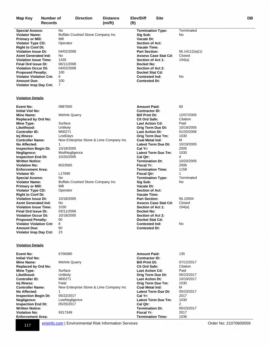
117 erisinfo.com | Environmental Risk Information Services Order No: 21070600059
Map Key Number of Records
Direction Distance(mi/ft)
Elev/Diff(ft)
Site DB
Special Assess: No Termination Type: TerminatedViolator Name: Buffalo Crushed Stone Company Inc Sig Sub: NoPrimary or Mill: Mill Vacate Dt:Violator Type CD: Operator Section of Act:Right to Conf Dt: Vacate Time:Violation Issue Dt: 04/02/2008 Part Section: 56.14112(a)(1)Asmt Generated Ind: No Assess Case Stat Cd: ClosedViolation Issue Time: 1435 Section of Act 1: 104(a)Final Ord Issue Dt: 06/11/2008 Docket No:Violation Occur Dt: 04/02/2008 Section of Act 2:Proposed Penalty: 100 Docket Stat Cd:Violator Violation Cnt: 6 Contested Ind: NoAmount Due: 100 Contested Dt:Violator Insp Day Cnt: 7
Violation Details Event No: 0887600 Amount Paid: 60Initial Viol No: Contractor ID:Mine Name: Wehrle Quarry Bill Print Dt: 12/07/2005Replaced by Ord No: Cit Ord Safe: CitationMine Type: Surface Last Action Cd: PaidLikelihood: Unlikely Orig Term Due Dt: 10/19/2005Controller ID: M00271 Last Action Dt: 01/20/2006Inj Illness: LostDays Orig Term Due Tm: 1030Controller Name: New Enterprise Stone & Lime Company Inc Coal Metal Ind: MNo Affected: 1 Latest Term Due Dt: 10/19/2005Inspection Begin Dt: 10/18/2005 Cal Yr: 2005Negligence: ModNegligence Latest Term Due Tm: 1030Inspection End Dt: 10/20/2005 Cal Qtr: 4Written Notice: Termination Dt: 10/20/2005Violation No: 6023565 Fiscal Yr: 2006Enforcement Area: Termination Time: 1158Violator ID: L17690 Fiscal Qtr: 1Special Assess: No Termination Type: TerminatedViolator Name: Buffalo Crushed Stone Company Inc Sig Sub: NoPrimary or Mill: Mill Vacate Dt:Violator Type CD: Operator Section of Act:Right to Conf Dt: Vacate Time:Violation Issue Dt: 10/18/2005 Part Section: 56.15004Asmt Generated Ind: No Assess Case Stat Cd: ClosedViolation Issue Time: 1030 Section of Act 1: 104(a)Final Ord Issue Dt: 03/11/2006 Docket No:Violation Occur Dt: 10/18/2005 Section of Act 2:Proposed Penalty: 60 Docket Stat Cd:Violator Violation Cnt: 8 Contested Ind: NoAmount Due: 60 Contested Dt:Violator Insp Day Cnt: 23
Violation Details Event No: 6756580 Amount Paid: 135Initial Viol No: Contractor ID:Mine Name: Wehrle Quarry Bill Print Dt: 07/12/2017Replaced by Ord No: Cit Ord Safe: CitationMine Type: Surface Last Action Cd: PaidLikelihood: Unlikely Orig Term Due Dt: 05/23/2017Controller ID: M00271 Last Action Dt: 10/19/2017Inj Illness: Fatal Orig Term Due Tm: 1030Controller Name: New Enterprise Stone & Lime Company Inc Coal Metal Ind: MNo Affected: 1 Latest Term Due Dt: 05/23/2017Inspection Begin Dt: 05/22/2017 Cal Yr: 2017Negligence: LowNegligence Latest Term Due Tm: 1030Inspection End Dt: 05/25/2017 Cal Qtr: 2Written Notice: Termination Dt: 05/23/2017Violation No: 9317349 Fiscal Yr: 2017Enforcement Area: Termination Time: 1036
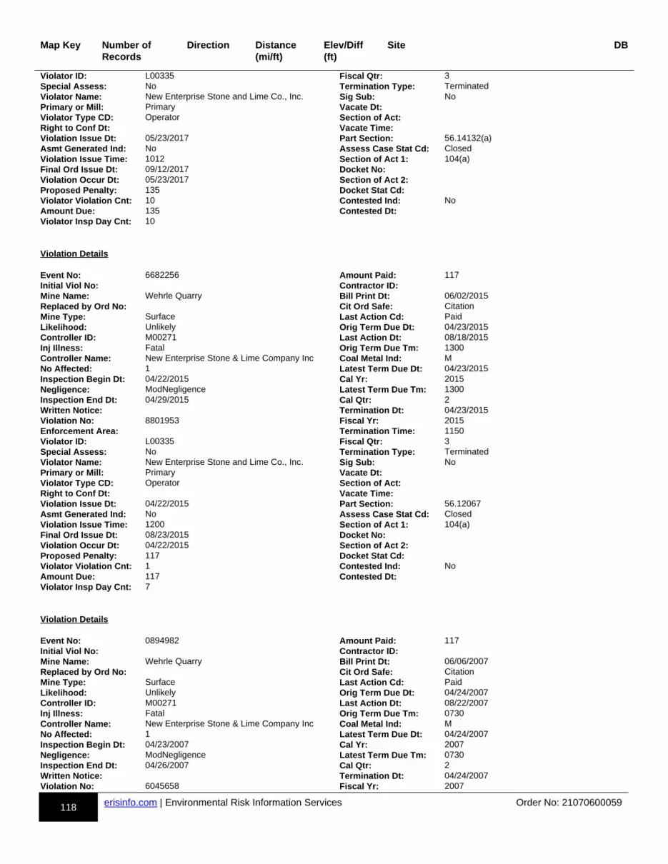
118 erisinfo.com | Environmental Risk Information Services Order No: 21070600059
Map Key Number of Records
Direction Distance(mi/ft)
Elev/Diff(ft)
Site DB
Violator ID: L00335 Fiscal Qtr: 3Special Assess: No Termination Type: TerminatedViolator Name: New Enterprise Stone and Lime Co., Inc. Sig Sub: NoPrimary or Mill: Primary Vacate Dt:Violator Type CD: Operator Section of Act:Right to Conf Dt: Vacate Time:Violation Issue Dt: 05/23/2017 Part Section: 56.14132(a)Asmt Generated Ind: No Assess Case Stat Cd: ClosedViolation Issue Time: 1012 Section of Act 1: 104(a)Final Ord Issue Dt: 09/12/2017 Docket No:Violation Occur Dt: 05/23/2017 Section of Act 2:Proposed Penalty: 135 Docket Stat Cd:Violator Violation Cnt: 10 Contested Ind: NoAmount Due: 135 Contested Dt:Violator Insp Day Cnt: 10
Violation Details Event No: 6682256 Amount Paid: 117Initial Viol No: Contractor ID:Mine Name: Wehrle Quarry Bill Print Dt: 06/02/2015Replaced by Ord No: Cit Ord Safe: CitationMine Type: Surface Last Action Cd: PaidLikelihood: Unlikely Orig Term Due Dt: 04/23/2015Controller ID: M00271 Last Action Dt: 08/18/2015Inj Illness: Fatal Orig Term Due Tm: 1300Controller Name: New Enterprise Stone & Lime Company Inc Coal Metal Ind: MNo Affected: 1 Latest Term Due Dt: 04/23/2015Inspection Begin Dt: 04/22/2015 Cal Yr: 2015Negligence: ModNegligence Latest Term Due Tm: 1300Inspection End Dt: 04/29/2015 Cal Qtr: 2Written Notice: Termination Dt: 04/23/2015Violation No: 8801953 Fiscal Yr: 2015Enforcement Area: Termination Time: 1150Violator ID: L00335 Fiscal Qtr: 3Special Assess: No Termination Type: TerminatedViolator Name: New Enterprise Stone and Lime Co., Inc. Sig Sub: NoPrimary or Mill: Primary Vacate Dt:Violator Type CD: Operator Section of Act:Right to Conf Dt: Vacate Time:Violation Issue Dt: 04/22/2015 Part Section: 56.12067Asmt Generated Ind: No Assess Case Stat Cd: ClosedViolation Issue Time: 1200 Section of Act 1: 104(a)Final Ord Issue Dt: 08/23/2015 Docket No:Violation Occur Dt: 04/22/2015 Section of Act 2:Proposed Penalty: 117 Docket Stat Cd:Violator Violation Cnt: 1 Contested Ind: NoAmount Due: 117 Contested Dt:Violator Insp Day Cnt: 7
Violation Details Event No: 0894982 Amount Paid: 117Initial Viol No: Contractor ID:Mine Name: Wehrle Quarry Bill Print Dt: 06/06/2007Replaced by Ord No: Cit Ord Safe: CitationMine Type: Surface Last Action Cd: PaidLikelihood: Unlikely Orig Term Due Dt: 04/24/2007Controller ID: M00271 Last Action Dt: 08/22/2007Inj Illness: Fatal Orig Term Due Tm: 0730Controller Name: New Enterprise Stone & Lime Company Inc Coal Metal Ind: MNo Affected: 1 Latest Term Due Dt: 04/24/2007Inspection Begin Dt: 04/23/2007 Cal Yr: 2007Negligence: ModNegligence Latest Term Due Tm: 0730Inspection End Dt: 04/26/2007 Cal Qtr: 2Written Notice: Termination Dt: 04/24/2007Violation No: 6045658 Fiscal Yr: 2007
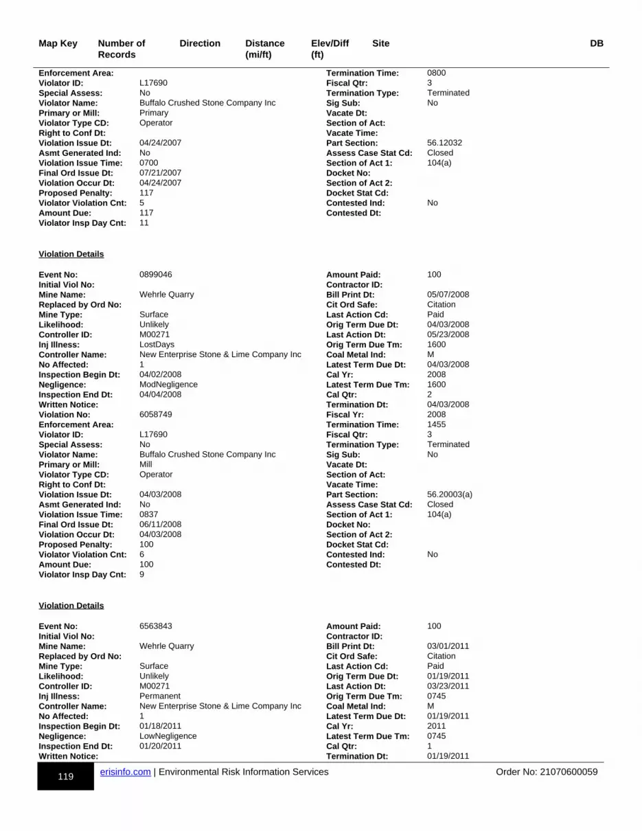
119 erisinfo.com | Environmental Risk Information Services Order No: 21070600059
Map Key Number of Records
Direction Distance(mi/ft)
Elev/Diff(ft)
Site DB
Enforcement Area: Termination Time: 0800Violator ID: L17690 Fiscal Qtr: 3Special Assess: No Termination Type: TerminatedViolator Name: Buffalo Crushed Stone Company Inc Sig Sub: NoPrimary or Mill: Primary Vacate Dt:Violator Type CD: Operator Section of Act:Right to Conf Dt: Vacate Time:Violation Issue Dt: 04/24/2007 Part Section: 56.12032Asmt Generated Ind: No Assess Case Stat Cd: ClosedViolation Issue Time: 0700 Section of Act 1: 104(a)Final Ord Issue Dt: 07/21/2007 Docket No:Violation Occur Dt: 04/24/2007 Section of Act 2:Proposed Penalty: 117 Docket Stat Cd:Violator Violation Cnt: 5 Contested Ind: NoAmount Due: 117 Contested Dt:Violator Insp Day Cnt: 11
Violation Details Event No: 0899046 Amount Paid: 100Initial Viol No: Contractor ID:Mine Name: Wehrle Quarry Bill Print Dt: 05/07/2008Replaced by Ord No: Cit Ord Safe: CitationMine Type: Surface Last Action Cd: PaidLikelihood: Unlikely Orig Term Due Dt: 04/03/2008Controller ID: M00271 Last Action Dt: 05/23/2008Inj Illness: LostDays Orig Term Due Tm: 1600Controller Name: New Enterprise Stone & Lime Company Inc Coal Metal Ind: MNo Affected: 1 Latest Term Due Dt: 04/03/2008Inspection Begin Dt: 04/02/2008 Cal Yr: 2008Negligence: ModNegligence Latest Term Due Tm: 1600Inspection End Dt: 04/04/2008 Cal Qtr: 2Written Notice: Termination Dt: 04/03/2008Violation No: 6058749 Fiscal Yr: 2008Enforcement Area: Termination Time: 1455Violator ID: L17690 Fiscal Qtr: 3Special Assess: No Termination Type: TerminatedViolator Name: Buffalo Crushed Stone Company Inc Sig Sub: NoPrimary or Mill: Mill Vacate Dt:Violator Type CD: Operator Section of Act:Right to Conf Dt: Vacate Time:Violation Issue Dt: 04/03/2008 Part Section: 56.20003(a)Asmt Generated Ind: No Assess Case Stat Cd: ClosedViolation Issue Time: 0837 Section of Act 1: 104(a)Final Ord Issue Dt: 06/11/2008 Docket No:Violation Occur Dt: 04/03/2008 Section of Act 2:Proposed Penalty: 100 Docket Stat Cd:Violator Violation Cnt: 6 Contested Ind: NoAmount Due: 100 Contested Dt:Violator Insp Day Cnt: 9
Violation Details Event No: 6563843 Amount Paid: 100Initial Viol No: Contractor ID:Mine Name: Wehrle Quarry Bill Print Dt: 03/01/2011Replaced by Ord No: Cit Ord Safe: CitationMine Type: Surface Last Action Cd: PaidLikelihood: Unlikely Orig Term Due Dt: 01/19/2011Controller ID: M00271 Last Action Dt: 03/23/2011Inj Illness: Permanent Orig Term Due Tm: 0745Controller Name: New Enterprise Stone & Lime Company Inc Coal Metal Ind: MNo Affected: 1 Latest Term Due Dt: 01/19/2011Inspection Begin Dt: 01/18/2011 Cal Yr: 2011Negligence: LowNegligence Latest Term Due Tm: 0745Inspection End Dt: 01/20/2011 Cal Qtr: 1Written Notice: Termination Dt: 01/19/2011

120 erisinfo.com | Environmental Risk Information Services Order No: 21070600059
Map Key Number of Records
Direction Distance(mi/ft)
Elev/Diff(ft)
Site DB
Violation No: 8582058 Fiscal Yr: 2011Enforcement Area: Termination Time: 0743Violator ID: L00335 Fiscal Qtr: 2Special Assess: No Termination Type: TerminatedViolator Name: New Enterprise Stone and Lime Co., Inc. Sig Sub: NoPrimary or Mill: Primary Vacate Dt:Violator Type CD: Operator Section of Act:Right to Conf Dt: Vacate Time:Violation Issue Dt: 01/19/2011 Part Section: 56.16005Asmt Generated Ind: No Assess Case Stat Cd: ClosedViolation Issue Time: 0740 Section of Act 1: 104(a)Final Ord Issue Dt: 04/06/2011 Docket No:Violation Occur Dt: 01/19/2011 Section of Act 2:Proposed Penalty: 100 Docket Stat Cd:Violator Violation Cnt: 0 Contested Ind: NoAmount Due: 100 Contested Dt:Violator Insp Day Cnt: 0
Violation Details Event No: 0880951 Amount Paid: 60Initial Viol No: Contractor ID:Mine Name: Wehrle Quarry Bill Print Dt: 02/09/2005Replaced by Ord No: Cit Ord Safe: CitationMine Type: Surface Last Action Cd: PaidLikelihood: Unlikely Orig Term Due Dt:Controller ID: M00271 Last Action Dt: 03/10/2005Inj Illness: Permanent Orig Term Due Tm:Controller Name: New Enterprise Stone & Lime Company Inc Coal Metal Ind: MNo Affected: 1 Latest Term Due Dt: 01/05/2005Inspection Begin Dt: 01/04/2005 Cal Yr: 2005Negligence: ModNegligence Latest Term Due Tm: 1300Inspection End Dt: 01/06/2005 Cal Qtr: 1Written Notice: Termination Dt: 01/05/2005Violation No: 6023878 Fiscal Yr: 2005Enforcement Area: Termination Time: 1210Violator ID: L17690 Fiscal Qtr: 2Special Assess: No Termination Type: TerminatedViolator Name: Buffalo Crushed Stone Company Inc Sig Sub: NoPrimary or Mill: Primary Vacate Dt:Violator Type CD: Operator Section of Act:Right to Conf Dt: 01/05/2005 Vacate Time:Violation Issue Dt: 01/05/2005 Part Section: 56.12018Asmt Generated Ind: No Assess Case Stat Cd: ClosedViolation Issue Time: 1055 Section of Act 1: 104(a)Final Ord Issue Dt: 03/26/2005 Docket No:Violation Occur Dt: 01/05/2005 Section of Act 2:Proposed Penalty: 60 Docket Stat Cd:Violator Violation Cnt: 7 Contested Ind: NoAmount Due: 60 Contested Dt:Violator Insp Day Cnt: 31
Violation Details Event No: 0899046 Amount Paid: 100Initial Viol No: Contractor ID:Mine Name: Wehrle Quarry Bill Print Dt: 05/07/2008Replaced by Ord No: Cit Ord Safe: CitationMine Type: Surface Last Action Cd: PaidLikelihood: Unlikely Orig Term Due Dt: 04/03/2008Controller ID: M00271 Last Action Dt: 05/23/2008Inj Illness: Permanent Orig Term Due Tm: 1600Controller Name: New Enterprise Stone & Lime Company Inc Coal Metal Ind: MNo Affected: 1 Latest Term Due Dt: 04/03/2008Inspection Begin Dt: 04/02/2008 Cal Yr: 2008Negligence: ModNegligence Latest Term Due Tm: 1600Inspection End Dt: 04/04/2008 Cal Qtr: 2
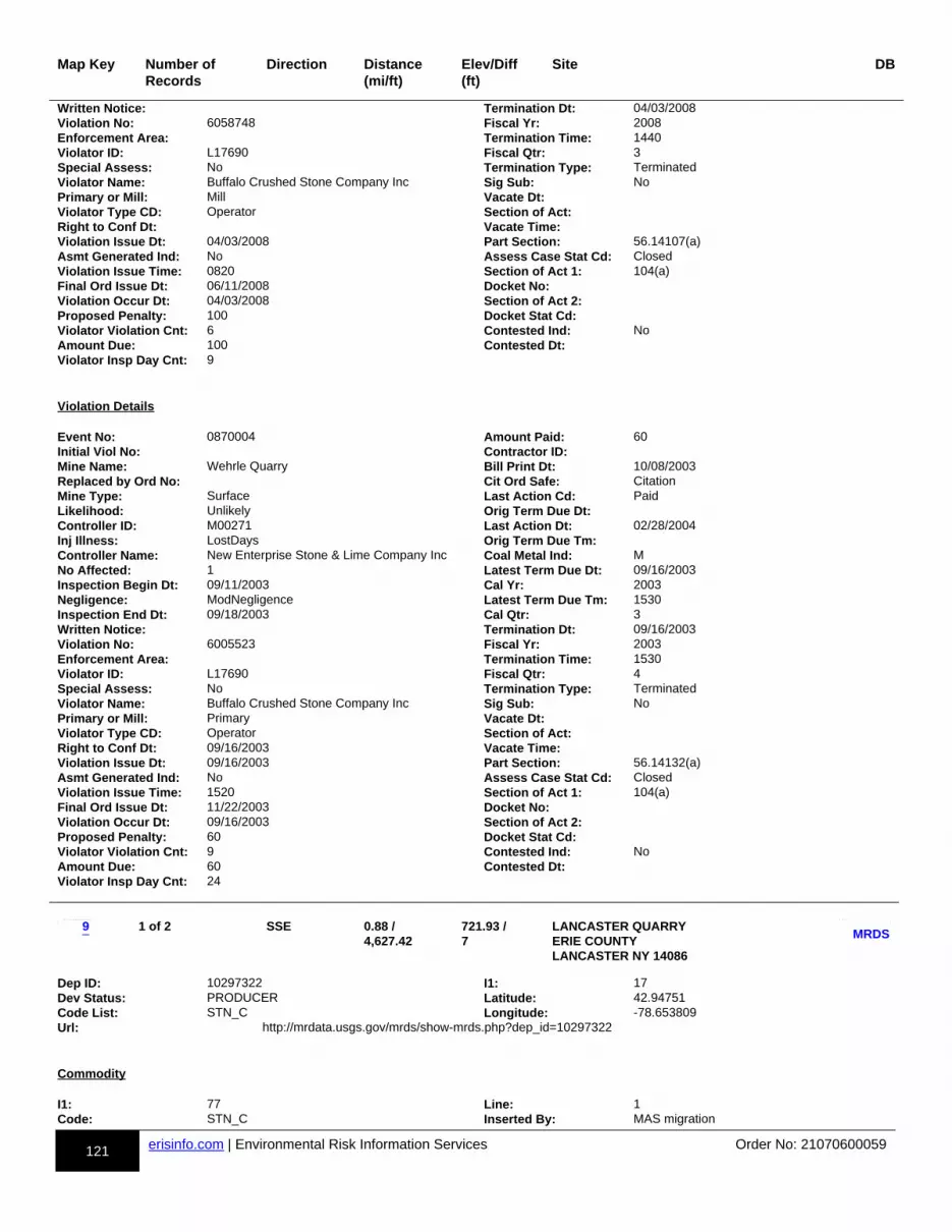
121 erisinfo.com | Environmental Risk Information Services Order No: 21070600059
Map Key Number of Records
Direction Distance(mi/ft)
Elev/Diff(ft)
Site DB
Written Notice: Termination Dt: 04/03/2008Violation No: 6058748 Fiscal Yr: 2008Enforcement Area: Termination Time: 1440Violator ID: L17690 Fiscal Qtr: 3Special Assess: No Termination Type: TerminatedViolator Name: Buffalo Crushed Stone Company Inc Sig Sub: NoPrimary or Mill: Mill Vacate Dt:Violator Type CD: Operator Section of Act:Right to Conf Dt: Vacate Time:Violation Issue Dt: 04/03/2008 Part Section: 56.14107(a)Asmt Generated Ind: No Assess Case Stat Cd: ClosedViolation Issue Time: 0820 Section of Act 1: 104(a)Final Ord Issue Dt: 06/11/2008 Docket No:Violation Occur Dt: 04/03/2008 Section of Act 2:Proposed Penalty: 100 Docket Stat Cd:Violator Violation Cnt: 6 Contested Ind: NoAmount Due: 100 Contested Dt:Violator Insp Day Cnt: 9
Violation Details Event No: 0870004 Amount Paid: 60Initial Viol No: Contractor ID:Mine Name: Wehrle Quarry Bill Print Dt: 10/08/2003Replaced by Ord No: Cit Ord Safe: CitationMine Type: Surface Last Action Cd: PaidLikelihood: Unlikely Orig Term Due Dt:Controller ID: M00271 Last Action Dt: 02/28/2004Inj Illness: LostDays Orig Term Due Tm:Controller Name: New Enterprise Stone & Lime Company Inc Coal Metal Ind: MNo Affected: 1 Latest Term Due Dt: 09/16/2003Inspection Begin Dt: 09/11/2003 Cal Yr: 2003Negligence: ModNegligence Latest Term Due Tm: 1530Inspection End Dt: 09/18/2003 Cal Qtr: 3Written Notice: Termination Dt: 09/16/2003Violation No: 6005523 Fiscal Yr: 2003Enforcement Area: Termination Time: 1530Violator ID: L17690 Fiscal Qtr: 4Special Assess: No Termination Type: TerminatedViolator Name: Buffalo Crushed Stone Company Inc Sig Sub: NoPrimary or Mill: Primary Vacate Dt:Violator Type CD: Operator Section of Act:Right to Conf Dt: 09/16/2003 Vacate Time:Violation Issue Dt: 09/16/2003 Part Section: 56.14132(a)Asmt Generated Ind: No Assess Case Stat Cd: ClosedViolation Issue Time: 1520 Section of Act 1: 104(a)Final Ord Issue Dt: 11/22/2003 Docket No:Violation Occur Dt: 09/16/2003 Section of Act 2:Proposed Penalty: 60 Docket Stat Cd:Violator Violation Cnt: 9 Contested Ind: NoAmount Due: 60 Contested Dt:Violator Insp Day Cnt: 24
m-9-888523803-b
1 of 2 SSE 0.88 / 4,627.42
721.93 / 7
LANCASTER QUARRY ERIE COUNTY LANCASTER NY 14086
dd-MRDS-888523803-bb
p1p-888523803-y1y
Dep ID: 10297322 I1: 17Dev Status: PRODUCER Latitude: 42.94751Code List: STN_C Longitude: -78.653809Url: http://mrdata.usgs.gov/mrds/show-mrds.php?dep_id=10297322
Commodity I1: 77 Line: 1Code: STN_C Inserted By: MAS migration
9MRDS

122 erisinfo.com | Environmental Risk Information Services Order No: 21070600059
Map Key Number of Records
Direction Distance(mi/ft)
Elev/Diff(ft)
Site DB
Commodity: Stone, Crushed/Broken Insert Date: 29-OCT-2002 09:00:24Commodity Type: Non-metallic Updated By: USGSCommodity Group: Stone, Crushed Update Date: 29-OCT-2002 09:02:33Importance: Primary
Names I1: 16 Inserted By: MAS migrationStatus: Current Insert Date: 29-OCT-02Site Name: Lancaster Quarry Updated By: USGSLine: 1 Update Date: 29-OCT-02
Names I1: 16 Inserted By: MAS migrationStatus: Previous Insert Date: 29-OCT-02Site Name: Lancaster Stone Products Corp. Updated By: USGSLine: 3 Update Date: 29-OCT-02
m-9-888625313-b
2 of 2 SSE 0.88 / 4,627.42
721.93 / 7
LANCASTER QUARRY AND PLANT ERIE COUNTY LANCASTER NY 14086
dd-MRDS-888625313-bb
p1p-888625313-y1y
Dep ID: 10074240 I1: 85Dev Status: PAST PRODUCER Latitude: 42.94751Code List: LST Longitude: -78.653809Url: http://mrdata.usgs.gov/mrds/show-mrds.php?dep_id=10074240
Commodity I1: 12 Line: 1Code: LST Inserted By: MRDS migrationCommodity: Limestone, General Insert Date: 29-OCT-2002 09:00:24Commodity Type: Non-metallic Updated By: USGSCommodity Group: Limestone Update Date: 29-OCT-2002 09:01:01Importance: Primary
Materials I1: 13 Inserted B: MRDS migrationMaterial: Limestone Insert Dat: 29-OCT-2002 09:44:3Ore or Gangue: Ore Updated By:Rec: 1 Update Dat:
Names I1: 21 Inserted By: MRDS migrationStatus: Current Insert Date: 29-OCT-02Site Name: Lancaster Quarry and Plant Updated By: USGSLine: 1 Update Date: 29-OCT-02
m-10-888587593-b
1 of 1 SW 0.74 / 3,921.69
721.66 / 7
BUFFALO QUARRY AND MILL ERIE COUNTY LANCASTER NY 14086
dd-MRDS-888587593-bb
p1p-888587593-y1y
Dep ID: 10074242 I1: 28Dev Status: PAST PRODUCER Latitude: 42.94751Code List: LST Longitude: -78.669678Url: http://mrdata.usgs.gov/mrds/show-mrds.php?dep_id=10074242
9
10
MRDS
MRDS

123 erisinfo.com | Environmental Risk Information Services Order No: 21070600059
Map Key Number of Records
Direction Distance(mi/ft)
Elev/Diff(ft)
Site DB
Commodity I1: 56 Line: 1Code: LST Inserted By: MRDS migrationCommodity: Limestone, General Insert Date: 29-OCT-2002 09:00:24Commodity Type: Non-metallic Updated By: USGSCommodity Group: Limestone Update Date: 29-OCT-2002 09:01:01Importance: Primary
Materials I1: 22 Inserted B: MRDS migrationMaterial: Limestone Insert Dat: 29-OCT-2002 09:44:3Ore or Gangue: Ore Updated By:Rec: 1 Update Dat:
Names I1: 93 Inserted By: MRDS migrationStatus: Current Insert Date: 29-OCT-02Site Name: Buffalo Quarry and Mill Updated By: USGSLine: 1 Update Date: 29-OCT-02
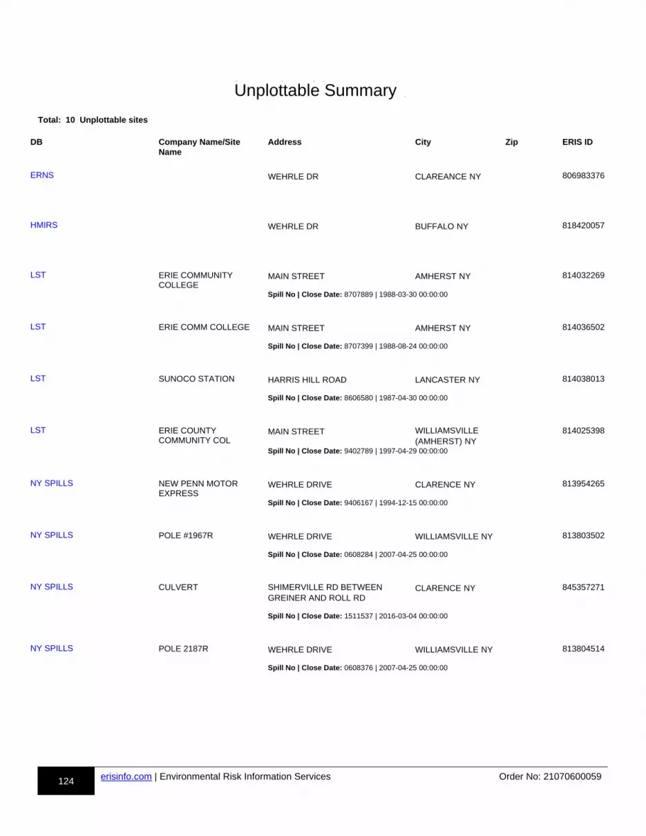
124 erisinfo.com | Environmental Risk Information Services Order No: 21070600059
h-Unplottable Summary
Total: 10 Unplottable sites
DB Company Name/Site Name
Address City Zip ERIS ID
uu-ERNS-806983376-aa WEHRLE DR CLAREANCE NY 806983376
uu-HMIRS-818420057-aa WEHRLE DR BUFFALO NY 818420057
uu-LST-814032269-aa ERIE COMMUNITY COLLEGE
MAIN STREET AMHERST NY 814032269
Spill No | Close Date: 8707889 | 1988-03-30 00:00:00
uu-LST-814036502-aa ERIE COMM COLLEGE MAIN STREET AMHERST NY 814036502
Spill No | Close Date: 8707399 | 1988-08-24 00:00:00
uu-LST-814038013-aa SUNOCO STATION HARRIS HILL ROAD LANCASTER NY 814038013
Spill No | Close Date: 8606580 | 1987-04-30 00:00:00
uu-LST-814025398-aa ERIE COUNTY COMMUNITY COL
MAIN STREET WILLIAMSVILLE (AMHERST) NY
814025398
Spill No | Close Date: 9402789 | 1997-04-29 00:00:00
uu-NY SPILLS-813954265-aa NEW PENN MOTOR EXPRESS
WEHRLE DRIVE CLARENCE NY 813954265
Spill No | Close Date: 9406167 | 1994-12-15 00:00:00
uu-NY SPILLS-813803502-aa POLE #1967R WEHRLE DRIVE WILLIAMSVILLE NY 813803502
Spill No | Close Date: 0608284 | 2007-04-25 00:00:00
uu-NY SPILLS-845357271-aa CULVERT SHIMERVILLE RD BETWEEN GREINER AND ROLL RD
CLARENCE NY 845357271
Spill No | Close Date: 1511537 | 2016-03-04 00:00:00
uu-NY SPILLS-813804514-aa POLE 2187R WEHRLE DRIVE WILLIAMSVILLE NY 813804514
Spill No | Close Date: 0608376 | 2007-04-25 00:00:00
ERNS
HMIRS
LST
LST
LST
LST
NY SPILLS
NY SPILLS
NY SPILLS
NY SPILLS
Unplottable Summary
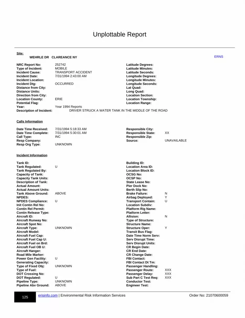
125 erisinfo.com | Environmental Risk Information Services Order No: 21070600059
h-Unplottable Report
Site: WEHRLE DR CLAREANCE NY uu-ERNS-806983376-bb
NRC Report No: 252742 Latitude Degrees:Type of Incident: MOBILE Latitude Minutes:Incident Cause: TRANSPORT ACCIDENT Latitude Seconds:Incident Date: 7/31/1994 2:43:00 AM Longitude Degrees:Incident Location: Longitude Minutes:Incident Dtg: OCCURRED Longitude Seconds:Distance from City: Lat Quad:Distance Units: Long Quad:Direction from City: Location Section:Location County: ERIE Location Township:Potential Flag: Location Range:Year: Year 1994 ReportsDescription of Incident: DRIVER STRUCK A WATER TANK IN THE MIDDLE OF THE ROAD
Calls Information Date Time Received: 7/31/1994 5:18:33 AM Responsible City:Date Time Complete: 7/31/1994 5:30:01 AM Responsible State: XXCall Type: INC Responsible Zip:Resp Company: Source: UNAVAILABLEResp Org Type: UNKNOWN
Incident Information Tank ID: Building ID:Tank Regulated: U Location Area ID:Tank Regulated By: Location Block ID:Capacity of Tank: OCSG No:Capacity Tank Units: OCSP No:Description of Tank: State Lease No:Actual Amount: Pier Dock No:Actual Amount Units: Berth Slip No:Tank Above Ground: ABOVE Brake Failure: NNPDES: Airbag Deployed: YNPDES Compliance: U Transport Contain: UInit Contin Rel No: Location Subdiv:Contin Rel Permit: Platform Rig Name:Contin Release Type: Platform Letter:Aircraft ID: Allision: NAircraft Runway No: Type of Structure:Aircraft Spot No: Structure Name:Aircraft Type: UNKNOWN Structure Oper: YAircraft Model: Transit Bus Flag:Aircraft Fuel Cap: Date Time Norm Serv:Aircraft Fuel Cap U: Serv Disrupt Time:Aircraft Fuel on Brd: Serv Disrupt Units:Aircraft Fuel OB U: CR Begin Date:Aircraft Hanger: CR End Date:Road Mile Marker: CR Change Date:Power Gen Facility: U FBI Contact:Generating Capacity: FBI Contact Dt Tm:Type of Fixed Obj: UNKNOWN Passenger Handling:Type of Fuel: Passenger Route: XXXDOT Crossing No: Passenger Delay: XXXDOT Regulated: U Sub Part C Test Req: XXXPipeline Type: UNKNOWN Conductor Test:Pipeline Abv Ground: ABOVE Engineer Test:
ERNS
Unplottable Report
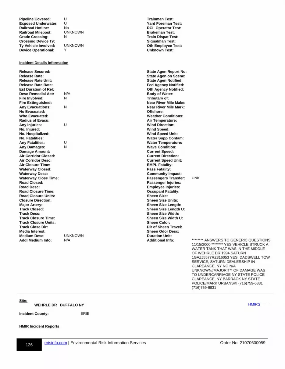
126 erisinfo.com | Environmental Risk Information Services Order No: 21070600059
Pipeline Covered: U Trainman Test:Exposed Underwater: U Yard Foreman Test:Railroad Hotline: No RCL Operator Test:Railroad Milepost: UNKNOWN Brakeman Test:Grade Crossing: N Train Dispat Test:Crossing Device Ty: Signalman Test:Ty Vehicle Involved: UNKNOWN Oth Employee Test:Device Operational: Y Unknown Test:
Incident Details Information Release Secured: State Agen Report No:Release Rate: State Agen on Scene:Release Rate Unit: State Agen Notified:Release Rate Rate: Fed Agency Notified:Est Duration of Rel: Oth Agency Notified:Desc Remedial Act: N/A Body of Water:Fire Involved: N Tributary of:Fire Extinguished: Near River Mile Make:Any Evacuations: N Near River Mile Mark:No Evacuated: Offshore:Who Evacuated: Weather Conditions:Radius of Evacu: Air Temperature:Any Injuries: U Wind Direction:No. Injured: Wind Speed:No. Hospitalized: Wind Speed Unit:No. Fatalities: Water Supp Contam:Any Fatalities: U Water Temperature:Any Damages: N Wave Condition:Damage Amount: Current Speed:Air Corridor Closed: Current Direction:Air Corridor Desc: Current Speed Unit:Air Closure Time: EMPL Fatality:Waterway Closed: Pass Fatality:Waterway Desc: Community Impact:Waterway Close Time: Passengers Transfer: UNKRoad Closed: Passenger Injuries:Road Desc: Employee Injuries:Road Closure Time: Occupant Fatality:Road Closure Units: Sheen Size:Closure Direction: Sheen Size Units:Major Artery: Sheen Size Length:Track Closed: Sheen Size Length U:Track Desc: Sheen Size Width:Track Closure Time: Sheen Size Width U:Track Closure Units: Sheen Color:Track Close Dir: Dir of Sheen Travel:Media Interest: Sheen Odor Desc:Medium Desc: UNKNOWN Duration Unit:Addl Medium Info: N/A Additional Info: ******** ANSWERS TO GENERIC QUESTIONS
11/15/2000 ******** YES VEHICLE STRUCK A WATER TANK THAT WAS IN THE MIDDLE OF WEHRLE DR 1994 SATURN 1GAZJ5577RZ316053 YES, DADSWELL TOWSERVICE, SATURN DEALERSHIP IN CLAREANCE, NY NO N/A UNKNOWN//MAJORITY OF DAMAGE WAS TO UNDERCARRIAGE NY STATE POLICE CLAREANCE, NY BARRACK NY STATE POLICE/MARK URBANSKI (716)759-6831 (716)759-6831
Site: WEHRLE DR BUFFALO NY uu-HMIRS-818420057-bb
Incident County: ERIE
HMIR Incident Reports
HMIRS

127 erisinfo.com | Environmental Risk Information Services Order No: 21070600059
Report No: I-2002020461 Fed DOT Agency Nm:Report Type: A hazardous material incident Fed DOT Report No:Date of Incident: 2001-05-16 Report Submit Src: PaperTime of Incident: 1220 Inc Multiple Rows: NoHaz Class Code: Inc Non US State:Hazardous Class: 8 Mode Transport: HighwayCommodity Short Nm: POTASSIUM HYDROXIDE, SOL Transport Phase: UnloadingCommodity Long Nm: POTASSIUM HYDROXIDE, SOLUTION Incident Occrrnce:Trade Name: Mat Ship Approval?: NoID No: UN1814 Mat Ship Approv No:Haz Waste Ind: No Undecl Hazmat Ship?: NoHaz Waste EPA No: Packaging Type: Non-BulkHMIS Tox Inhalation?: No Packing Group:TIH Hazard Zone: Carrier Reporter: JEVIC TRANSPORTATION INCQty Released: 0.03125 CR Street Name: 600 CREEK ROAD-PO BOX 5157Unit of Measure: Liquid - Gallon CR City: DELANCOWhat Failed: 109 CR State: NJWhat Failed Desc: Closure (e.g., Cap, Top, or Plug) CR Postal Code: 080755157How Failed Code: 310 CR Non US State:How Failed Desc: Ripped or Torn CR Fed DOT ID: 243018Failure Cause Code: CR Hazmat Reg ID:Failure Cause Desc: CR Country: USIdent. Markings: Shipper Name: ECO-LABS INCCont1 Pkging Type: Shipper Street Name: 255 BLAIR ROADCont1 Const Mat: Shipper City: AVENELCont1 Head Type: Shipper State: NJCont1 Pkg Capacity: 5 Shipper Postal:C1 Capacity UOM: LGA Shipper Non US St:Cont1 Pkg Amt: 0 Shipper Country: USC1 Pkg Amt UOM: Shipper Waybill: 06970309Cont1 Pkg No: 1 Ship Hazmat Reg ID:C1 Pkg NO Failed: 1 Origin City:Cont1 Pkg Mnfctr: NOT REPORTED BY CARRIER Origin State:Cont1 Pkg Mnfct Dt: 0-00-00 00:00:00 Origin Postal:Cont1 Pkg Serial NO: Origin Non US St:C1 Pkg Last Test Dt: 0-00-00 00:00:00 Origin Country: USC1 Test Const Mat: Destination City: BUFFALOC1 Pkg Dsign Pres.: 0 Destination State: NEW YORKC1 Dsign Press UOM: Destination Postal:C1 Pkg Shell Thick: 0 Destination Non US:C1 Shell Thick UOM: Destination Country: USC1 Head Thickness: 0 Cont2 Package Type:C1 Head Thick UOM: Cont2 Const Mat:C1 Pkg Srvc Pres.: 0 Cont2 Pkg Capacity: 0C1 Srvc Press UOM: Cont2 Capacity UOM:C1 Valve/Device Fail?: No Cont2 Pkg Amount: 0C1 Device Type: Cont2 Pkg Amt UOM:C1 Device Mnfctr: Cont2 Pkg No: 0C1 Device Model: Cont2 Pkg No Failed: 0NRC No: RAM Pkg Category: Haz NonHosp Public: 0RAM Pkg Cert.: FALSE Haz NonHosp Old:RAM Pkg Cert. NBR: Tot Haz Non Hosp Inj:RAM Nuclide S: Total Hazmat Injuries: 0RAM Transport Index: Evacuation Indicator: NoRAM UOM: Public Evacuated: 0RAM Activity Rpted: 0 Employees Evac: 0RAM UOM Rpted: Total Evacuated: 0RAM Activity: 0 Total Evacuation Hrs: 0RAM Activity UOM: Major Artery Closed: NoRAM Mat Safety: Mjr Artery Hrs Closed: 0Spillage Result: Yes Material Involved: NoFire Result: No Estimated Speed: 0Explosion Result: No Weather Conditions:Water Sewer Result: No Vehicle Overturn: NoGas Dispersion: No Vehicle Left Roadway: NoEnvironment Damage: No Passenger Aircraft: NoNo Release Result: No Cargo Baggage:Fire EMS Report: No Ship Non Transport: NoFire EMS EMS Report: Ship Air First Flight: No
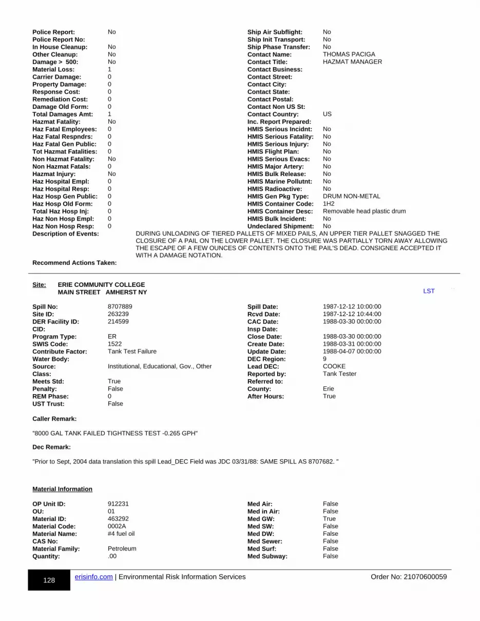
128 erisinfo.com | Environmental Risk Information Services Order No: 21070600059
Police Report: No Ship Air Subflight: NoPolice Report No: Ship Init Transport: NoIn House Cleanup: No Ship Phase Transfer: NoOther Cleanup: No Contact Name: THOMAS PACIGADamage > 500: No Contact Title: HAZMAT MANAGERMaterial Loss: 1 Contact Business:Carrier Damage: 0 Contact Street:Property Damage: 0 Contact City:Response Cost: 0 Contact State:Remediation Cost: 0 Contact Postal:Damage Old Form: 0 Contact Non US St:Total Damages Amt: 1 Contact Country: USHazmat Fatality: No Inc. Report Prepared:Haz Fatal Employees: 0 HMIS Serious Incidnt: NoHaz Fatal Respndrs: 0 HMIS Serious Fatality: NoHaz Fatal Gen Public: 0 HMIS Serious Injury: NoTot Hazmat Fatalities: 0 HMIS Flight Plan: NoNon Hazmat Fatality: No HMIS Serious Evacs: NoNon Hazmat Fatals: 0 HMIS Major Artery: NoHazmat Injury: No HMIS Bulk Release: NoHaz Hospital Empl: 0 HMIS Marine Pollutnt: NoHaz Hospital Resp: 0 HMIS Radioactive: NoHaz Hosp Gen Public: 0 HMIS Gen Pkg Type: DRUM NON-METALHaz Hosp Old Form: 0 HMIS Container Code: 1H2Total Haz Hosp Inj: 0 HMIS Container Desc: Removable head plastic drumHaz Non Hosp Empl: 0 HMIS Bulk Incident: NoHaz Non Hosp Resp: 0 Undeclared Shipment: NoDescription of Events: DURING UNLOADING OF TIERED PALLETS OF MIXED PAILS, AN UPPER TIER PALLET SNAGGED THE
CLOSURE OF A PAIL ON THE LOWER PALLET. THE CLOSURE WAS PARTIALLY TORN AWAY ALLOWING THE ESCAPE OF A FEW OUNCES OF CONTENTS ONTO THE PAIL'S DEAD. CONSIGNEE ACCEPTED IT WITH A DAMAGE NOTATION.
Recommend Actions Taken:
Site: ERIE COMMUNITY COLLEGE MAIN STREET AMHERST NY uu-LST-814032269-bb
Spill No: 8707889 Spill Date: 1987-12-12 10:00:00Site ID: 263239 Rcvd Date: 1987-12-12 10:44:00DER Facility ID: 214599 CAC Date: 1988-03-30 00:00:00CID: Insp Date:Program Type: ER Close Date: 1988-03-30 00:00:00SWIS Code: 1522 Create Date: 1988-03-31 00:00:00Contribute Factor: Tank Test Failure Update Date: 1988-04-07 00:00:00Water Body: DEC Region: 9Source: Institutional, Educational, Gov., Other Lead DEC: COOKEClass: Reported by: Tank TesterMeets Std: True Referred to:Penalty: False County: ErieREM Phase: 0 After Hours: TrueUST Trust: False Caller Remark:
"8000 GAL TANK FAILED TIGHTNESS TEST -0.265 GPH"
Dec Remark:
"Prior to Sept, 2004 data translation this spill Lead_DEC Field was JDC 03/31/88: SAME SPILL AS 8707682. "
Material Information OP Unit ID: 912231 Med Air: FalseOU: 01 Med in Air: FalseMaterial ID: 463292 Med GW: TrueMaterial Code: 0002A Med SW: FalseMaterial Name: #4 fuel oil Med DW: FalseCAS No: Med Sewer: FalseMaterial Family: Petroleum Med Surf: FalseQuantity: .00 Med Subway: False
LST

129 erisinfo.com | Environmental Risk Information Services Order No: 21070600059
Units: G Med Utility: FalseRecovered: .00 Oxygenate:Med Soil: False
Spiller Information Spiller Name: Spiller Zip:Spiller Company: ERIE COMMUNITY COLLEGE Spiller Country: 001Spiller Address: YOUNGS RD Contact Name:Spiller City: WILLIAMSVILLE Contact Phone:Spiller State: ZZ Contact Ext:Latitude: 42.966175000Longitude: -78.720346000
Tank Test Information Spill Tank ID: 1532642 Source:Tank No: Leak Rate: .00Tank SIze: 0 Gross Fail:Material: 0002 Modified by: SpillsEPA UST: Last Modified: 2004-10-01 04:00:45.140000000UST: Test Method: 00Cause: Alt Test Method: Unknown
Site: ERIE COMM COLLEGE MAIN STREET AMHERST NY uu-LST-814036502-bb
Spill No: 8707399 Spill Date: 1987-11-25 10:30:00Site ID: 263238 Rcvd Date: 1987-11-28 13:09:00DER Facility ID: 214599 CAC Date: 1988-08-24 00:00:00CID: Insp Date: 1988-05-09 00:00:00Program Type: ER Close Date: 1988-08-24 00:00:00SWIS Code: 1522 Create Date: 1987-11-30 00:00:00Contribute Factor: Tank Test Failure Update Date: 1988-10-31 00:00:00Water Body: DEC Region: 9Source: Commercial/Industrial Lead DEC: MXFRANKSClass: Reported by: Tank TesterMeets Std: True Referred to:Penalty: False County: ErieREM Phase: 0 After Hours: TrueUST Trust: False Caller Remark:
"UNABLE TO OBTAIN LEAK RATE"
Dec Remark:
"Prior to Sept, 2004 data translation this spill Lead_DEC Field was MF / / : JDC TELCON TO MR CONRAD BURCHECK, ERIE COMM COLLEGE 11/30/87 - NO ANSWER. / / : JDC RECIEVED LETTER 12/28/87 - WORK TO BE COMPLETED 1/1/88. TELCON W/ CONRAD G. 1/7/88 - WAITING ON WRITTEN WORK COST ESTIMATES. / / : 12/14/87 JDC TELCON W/ MR GRZYBEK, MAINT SUPER ECC NORTH - TANK FAILED SECOND AND THIRD TEST. TANK EMPTIED/ REMOVAL BEING SCHEDUALED. / / : JDC TELCON W/ MR GRUZACK 12/23/87 - LETTER OF INTENT CONCERNING FAILED TANK BEING FORWARDED. 03/31/88: JDC TELCON W/ MR GRYZBECK REGARDING REMOVAL STATUS - ACCEPTED BIDS FROM CONTRACTORS HAVE GONE TO BUDGE DEPT FOR SELECTION. HE WILL CONTACT WHEN A CONTRACTOR HAS BEEN SELECTED. 05/02/88: MF SITE VISIT/CONRAD GRZYBEK & DR. J. MCDONNELL VP OF NORTH CAMPUS, I EXPLAINED THE WORK TO BE DONE & THAT THE COUNTY WILL GET BILLED FOR THIS WORK. DR. MCDONNELL SIGNED RIGHT OF ENTRY FORM. 05/02/88: MF TELECON FLEISHMANN'S TO GIVE THEM THE JOB OF REMOVING THE TANK, THEY DECLINED. GAVE THE JOB TO SLC CONSULTANTS. 05/05/88: MF SITE VISIT/SLC, TANK BEING REMOVED & CLEANED. NO CONTAMINATION NOTICED IN GROUNDWATER. 05/06/88: MF SITE VISIT, SLC ON SITE CLEANING TANK & BACKFILLING AREA. I GOT CALLED OFF SITE AFTER 15 MINUTES FOR SPILL # 8801147. 05/09/88: MF SITE VISIT AREA BACKFILLED, RESOILED & GRASS SEED IN PLACE. NO FUTHER VISITS NECESSARY. 08/24/88: MF ALL BILLS IN AND SENT TO ALBANY. "
Material Information OP Unit ID: 913096 Med Air: FalseOU: 01 Med in Air: FalseMaterial ID: 466353 Med GW: True
LST
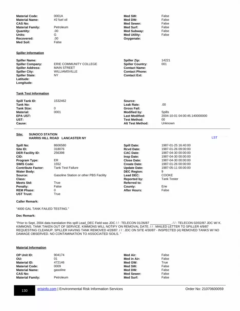
130 erisinfo.com | Environmental Risk Information Services Order No: 21070600059
Material Code: 0001A Med SW: FalseMaterial Name: #2 fuel oil Med DW: FalseCAS No: Med Sewer: FalseMaterial Family: Petroleum Med Surf: FalseQuantity: .00 Med Subway: FalseUnits: G Med Utility: FalseRecovered: .00 Oxygenate:Med Soil: False
Spiller Information Spiller Name: Spiller Zip: 14221Spiller Company: ERIE COMMUNITY COLLEGE Spiller Country: 001Spiller Address: MAIN STREET Contact Name:Spiller City: WILLIAMSVILLE Contact Phone:Spiller State: NY Contact Ext:Latitude:Longitude:
Tank Test Information Spill Tank ID: 1532462 Source:Tank No: Leak Rate: .00Tank SIze: 0 Gross Fail:Material: 0001 Modified by: SpillsEPA UST: Last Modified: 2004-10-01 04:00:45.140000000UST: Test Method: 00Cause: Alt Test Method: Unknown
Site: SUNOCO STATION HARRIS HILL ROAD LANCASTER NY uu-LST-814038013-bb
Spill No: 8606580 Spill Date: 1987-01-25 16:40:00Site ID: 318076 Rcvd Date: 1987-01-26 09:00:00DER Facility ID: 256398 CAC Date: 1987-04-30 00:00:00CID: Insp Date: 1987-04-30 00:00:00Program Type: ER Close Date: 1987-04-30 00:00:00SWIS Code: 1552 Create Date: 1987-01-26 00:00:00Contribute Factor: Tank Test Failure Update Date: 1987-05-11 00:00:00Water Body: DEC Region: 9Source: Gasoline Station or other PBS Facility Lead DEC: COOKEClass: Reported by: Tank TesterMeets Std: True Referred to:Penalty: False County: ErieREM Phase: 0 After Hours: FalseUST Trust: True Caller Remark:
"4000 GAL TANK FAILED TESTING."
Dec Remark:
"Prior to Sept, 2004 data translation this spill Lead_DEC Field was JDC / / : TELECON 01/26/87 ____________. / / : TELECON 02/02/87 JDC W/ K. KIMMONS. TANK TAKEN OUT OF SERVICE. KIMMONS WILL NOTIFY ON REMOVAL DATE. / / : MAILED LETTER TO SPILLER 4/9/87 REQUESTING CLEANUP. SPILLER HAVING TANK REMOVED 4/28/87. / / : JDC ON SITE 4/30/87 - INSPECTED (4) REMOVED TANKS W/ NO DAMAGE OBSERVED. NO CONTAMINATION TO ASSOCIATED SOILS. "
Material Information OP Unit ID: 904174 Med Air: FalseOU: 01 Med in Air: FalseMaterial ID: 472146 Med GW: TrueMaterial Code: 0009 Med SW: FalseMaterial Name: gasoline Med DW: FalseCAS No: Med Sewer: FalseMaterial Family: Petroleum Med Surf: False
LST

131 erisinfo.com | Environmental Risk Information Services Order No: 21070600059
Quantity: .00 Med Subway: FalseUnits: G Med Utility: FalseRecovered: .00 Oxygenate:Med Soil: False
Spiller Information Spiller Name: Spiller Zip:Spiller Company: DAVID SMITH Spiller Country: 001Spiller Address: 237 MAIN STREET Contact Name:Spiller City: BUFFALO Contact Phone:Spiller State: NY Contact Ext:Latitude: 42.934154993Longitude: -78.677269016
Tank Test Information Spill Tank ID: 1530530 Source:Tank No: Leak Rate: .00Tank SIze: 0 Gross Fail:Material: 0009 Modified by: SpillsEPA UST: Last Modified: 2004-10-01 04:00:45.140000000UST: Test Method: 00Cause: Alt Test Method: Unknown
Site: ERIE COUNTY COMMUNITY COL MAIN STREET WILLIAMSVILLE (AMHERST) NY uu-LST-814025398-bb
Spill No: 9402789 Spill Date: 1994-05-01 12:00:00Site ID: 263255 Rcvd Date: 1994-05-25 09:00:00DER Facility ID: 282390 CAC Date:CID: Insp Date: 1997-04-15 00:00:00Program Type: ER Close Date: 1997-04-29 00:00:00SWIS Code: 1522 Create Date: 1994-05-31 00:00:00Contribute Factor: Tank Failure Update Date: 1997-06-18 00:00:00Water Body: DEC Region: 9Source: Institutional, Educational, Gov., Other Lead DEC: COOKEClass: C3 Reported by: Affected PersonsMeets Std: True Referred to:Penalty: False County: ErieREM Phase: 0 After Hours: FalseUST Trust: True Caller Remark:
"GASOLINE ODORS IN GROUNDWATER IRRIGATION SYSTEM"
Dec Remark:
"Prior to Sept, 2004 data translation this spill Lead_DEC Field was JDC 05/26/94: JDC INSPECTED NOCO AND PETRO SERVICE STATIONS FOUNDNO IMMEDIATED SPILL OR STORAGE PROBLEMS. JDC/A FELTZ, MAINT SUPER. WELL TO BE ACTIVATED TOMORROW. 05/27/94: JDC ON SITE AND COLLECETED WATER SAMPLE FOR TESTING UNDER 8021. CALL BACK 6/15/94. 06/15/94: GW ANALYSIS DATED 5/27/94 SHOWS MTBE. NO SPILL RECORDS FOR PETRO OR NOCO SITES; ECC SN:9104381 GASOLINE TANK REMOVED AND 8707399 FUEL OIL TANK REMOVED. WILL PURSUE THROUGH ERIE COUNTY, RICK RUTKOWSKI 06/20/94: JDC TELCON WITH RUTKOWOSKI, TO OBTAIN WELL INFORMATION AT ECC WITH ED O'CONNER, MAINT SUPER. 06/20/94: ECC SN: 87O7399, NO CONTAMINATION TO SOIL OR WATER WAS FOUND. SN: 9104381, CONTAMINATED SOILS REMOVED, GW PUMPED AND TESTED CLEAN. 06/21/94: JDC ON SITE AND BAILED MONITORING WELL AT NUNAN CTR, FOUND NO EVIDENCE OF SHEEN OR PETROLEUM ODOR. WILL CONTACT COUNTY TO DISCUSS SITE INVESTIGATION. 06/24/94: JDC TELCON WITH RUTKOWSKI, EC ENVIRONMENTAL - NO DECISION ON WHICH OFFICE WILL CONTINUE WITH THE INVESTIGATION, COUNTY OR DEC. ANSWER EXPECTED WEEK OF 6/27/94. 07/06/94: JDC TELCON WITH RUTKOOWSKI, STILL SEARCHING INFO ON IRRIGATION WELLS. SITE INVESTIGATION RESPONSIBILITIES BETWEEN DEC AND ERIE COUNTY BEING DISCUSSED.CHECK BACK 7/15/94. 07/12/94: JDC TELCON WITH RUTKOWSKI, NO INFORMATION AVAILIABLE ON WELL INSTALLATIONS. WILL SEND LETTER TO CAMPUS PRES. REQUESTING FURTHER SITE INVESTIGATION WORK. 07/12/94: JDC INSPECTED PETRO USA SITE AT LINE EXCAVATION AND REPAIR AND FOUND NO EVIDENCE OF CONTAMINATION. ADVISED RON HALPIN THAT TANK TESTING MAY BE REQUIRED. 07/12/94: JDC INSPECTED PETRO USA SITE AT LINE EXCAVATION AND REPAIR AND FOUND NO EVIDENCE OF CONTAMINATION. ADVISED RON HALPIN THAT TANK TESTING MAY BE REQUIRED. 07/19/94: JDC TELCON WITH RUTKOWSKI WHO REPORTED PRODUCT LOSS FROM THEIR 1,OOO GALLON GASOLINE STORAGE TANK AT 100 GALLONS ON 7/13/94. SUSPECTED LOSS DUETO VANDALS, LOCKED TANK AND FOUND 3-4 GALLONS LOSS ON 7/1. 07/19/94: (CON'T) TANK FILLED FOR TESTING ON 7/15. ON 7/18 TANK LOST APPROX. 30 GALLONS. NO TESTING WAS DONE AND PRODUCT WAS REMOVED FROM THE TANK ON 7/18 & 19. SENT LETTER TO ECC REQUESTING SITE INVESTIGATION. 07/19/94: (CON'T) R RUTKOWSKI REQUESTED DEC DO TANK REMOVAL AND SITE INVESTIGATION
LST
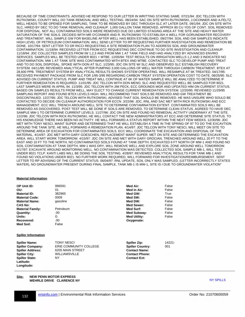
132 erisinfo.com | Environmental Risk Information Services Order No: 21070600059
BECAUSE OF TIME CONSTRAINTS. ADVISED HE RESPOND TO OUR LETTER IN WRITTING STATING SAME. 07/21/94: JDC TELCON WITH RUTKOWSKI, COUNTY WILL DO TANK REMOVAL AND WELL TESTING. 08/24/94: SAC ON SITE WITH RUTKOWSKI, J.OCONNER AND A.FELTZ,WELL HEADS TO BE OPENED FOR SAMPLING, TANK TO BE REMOVED BY DEC THROUGH SLC AT LATER DATE. 09/1/94: JDC ON SITE WITH SLC, HIRED BY DEC TO DO TANK REMOVAL AND CLEANUP. 1,000 GALLON TANK REMOVED, APPROX 80 CU YDS OF CONT. SOIL REMOVEDFOR DISPOSAL. NOT ALL CONTAMINATED SOILS WERE REMOVED DUE DO LIMITED STAGING AREA AT THE SITE AND HEAVY WATER SATURATION OF THE SOILS. DECIDED WITH MR O'CONNER AND R. RUTKOWSKI TO ESTABLISH A WELL FOR GORUNDWATER RECOVERY AND TREATMENT. WILL SAMPLE GW FOR BASELINE AFTER WELL HAS BEEN ESTABLISHED. 09/27/94: SOIL AND GW SAMPLES INDICATE HIGH LEVEL OF PETROLEUM CONTAMINATION. WILL SEND LETTER TO RP REQUESTING FURTHER INVESTIGATION AND REMEDIATION BEDONE. 10/17/94: SENT LETTER TO DR RICCI REQUESTING A SITE REMEDIATION PLAN TO ADDRESS SOIL AND GROUNDWATER CONTAMINATION. 11/18/94: RECEIVED LETTER FROM ECC REQUESTING DEC CONTINUE TO DO SITE INVESTIGATION AND CLEANUP. 11/18/94: JDC COLLECTED SAMPLES FROM IW 1,2,3 AND FROM MW 1 AT TANK FIELD AND HAD ANALYZED BY ADVANCED ENVIRO SERVICES. SAMPLES WILL BE TESTED UNDER 8021 + MTBE. 12/05/94: TEST RESULTS ON IRRIGATION WELLS 1,2 AND 3 INDICATED NO CONTAMINATION. MW 1 AT TANK SITE WAS CONTAMINATED WITH BTEX AND MTBE. CONTACTED SLC TO DEVELOP PUMP AND TREAT AND TO DO SOIL DISPOSAL. SPOKE WITH DON AT SLC. 1/23/95: JDC ON SITE W/ SLC AND OBSERVED SLC ESTABLISH RECOVERY SYSTEM. 04/11/95: REVIEWED ANALYTICAL AFTER PUMPING 3,000 GALLONS OF WELL WATER THROUGH CARBON TREATMENT. BTEX AT 28,600 PPB. TREATMENT SYSTEM BY ANALYTICAL RESULTS SHOWS SYSTEM OPERATING. WILL RESAMPLE AT 6K TREATED. 04/17/95: RECEIVED PAYMENT PACKAGE FROM SLC FOR 1/95-3/95 REGARDING CARBON TREAT SYSTEM OPERATION COST TO DATE. 08/25/95: SLCADVISED ON CURRENT STATUS. PUMP AND TREAT WILL CONTINUE AT 6K OF WATER SAMPLE WILL BE ANALYZED TO DETERMINE IF FURTHER REMEDIATION IS REQUIRED. 11/01/95: JDC TELCON WITH DON MENO, SLC AND REQUESTED WELL BE SAMPLED FOR 8021. LAST SAMPLES WERE IN APRIL 94. 11/3/95: JDC TELCON WITH JIM PECK, ECC GROUNDS MGR AND UPDATED HIM ON CURRENT STATUS. BASED ON SAMPLES RESULTS FROM WELL, MAY ELECT TO CHANGE CURRENT REMEDIATION SYSTEM. 12/20/95: REVIEWED 11/29/95 SAMPLING REPORT AND FOUND BTEX LEVELS HIGH. WILL RECOMMEND THAT SOILS BE REMOVED AND GW TREATMENT BE DISCONTINUED. 12/27/95: JDC TELCON WITH RUTKOWSKI, ADVISED THAT SOIL SHOULD BE REMOVED. HE WAS UNSURE WHO SOULD BE CONTACTED TO DECIDE ON CLEANUP AUTHORIZATION FOR ECCN. 3/22/96: JDC, RNL AND SAC MET WITH RICK RUTKOWSKI AND ECC MANAGEMENT. ECC WILL TRENCH AROUND WELL SITE TO DETERMINE CONTAMINATION EXTENT. CONTAMINATED SOILS WILL BE REMOVED AS DISCOVERED. POST TEST WILL BE DONE IF SOILS ARE REMOVED, TO DETERMINE CLEAN STATUS. AGREED TO HAVE DEC SAMPLE MW-1 TO DETERMINE CURRENT LEVELS. 11/27/96: JDC ON SITE AND FOUND NO REMEDIAL ACTIVITY UNDERWAY AT THE SITE. 12/2/96: JDC TELCON WITH RICK RUTKOWSKI, HE WILL CONTACT THE NEW ADMINISTRATORS AT ECC AND DETERMINE SITE STATUS. TO HIS KNOWLEDGE THERE HAS BEEN NO ACTIVITY. HE WILL FORWARD A STATUS REPORT WITHIN THE NEXT FEW WEEKS. 12/30/96: JDC MET WITH TONY NESCI, MAINT SUPER AND DETERMINED THAT HE WILL ESTABLISH A TIME IN THE SPRING OF 97 TO DO THE EXCAVTION AROUND THE TANK SITE. HE WILL FORWARD A REMEDIATION PLAN. 4/14/97: JDC TELCON WITH TONY NESCI, WILL MEET ON SITE TO DETERMINE AREA OF EXCAVATION FOR CONTAMINATED SOILS. ECC WILL COORDINATE THE EXCAVATION AND DISPOSAL OF THE MATERIAL. 4/14/97: JDC MET WITH GARY GOESCHEN, REPLACEMENT MAINT SUPER. MET ON SITE AND DETERMINED THE EXCAVATION AREA. WILL START WORK TOMORROW. 4/15/97: JDC ON SITE AND MET WITH GARY GROCIAN, TRENCHED AROUND WELL 20 FT TO THE EAST AND 10 FT TO THE NORTH, NO CONTAMINATED SOILS FOUND AT TANK DEPTH. EXCAVATED 6 FT NORTH OF MW-1 AND FOUND NO SOIL CONTAMINATION AT TANK DEPTH. MW-1 WAS DRY, WILL REMOVE WELL AND EXPLORE SOIL ZONE AROUND WELL TOMORROW. 4/17/97: EXCAVATE AROUND MONITORING WELL. NO CONTAMINATION WAS DETECTED. COLLECTED SOIL SAMPLE MB-1, WILL TEST UNDER 8021 TCLP. KANTI LABS WILL BE DOING THE SOIL TESTING. 4/28/97: REVIEWED ANALYTICAL RESULTS FOR TANK MB-1 AND FOUND NO VIOLATIONS UNDER 8021. NO FURTHER WORK REQUIRED, WILL FORWARD FOR INVESTIGATION/REIMBURSEMENT. SENT LETTER TO RP ADVISING OF THE CURRENT STATUS. 06/04/97: RNL UPDATE, SOIL ONLY WAS SAMPLED, (LETTER INCORRECTLY STATES WATER), NO GROUNDWATER PRESENT DURING FINAL SAMPLE, TANK MB-1 IS MW-1, SITE IS I DUE TO GROUNDWATER VIOLATION"
Material Information OP Unit ID: 996591 Med Air: FalseOU: 01 Med in Air: FalseMaterial ID: 382965 Med GW: TrueMaterial Code: 0009 Med SW: FalseMaterial Name: gasoline Med DW: FalseCAS No: Med Sewer: FalseMaterial Family: Petroleum Med Surf: FalseQuantity: .00 Med Subway: FalseUnits: G Med Utility: FalseRecovered: .00 Oxygenate:Med Soil: False
Spiller Information Spiller Name: TONY NESCI Spiller Zip: 14221-Spiller Company: ERIE COMMUNITY COLLEGE Spiller Country: 001Spiller Address: 6205 MAIN STREET Contact Name:Spiller City: WILLIAMSVILLE Contact Phone:Spiller State: NY Contact Ext:Latitude:Longitude:
Site: NEW PENN MOTOR EXPRESS WEHRLE DRIVE CLARENCE NY uu-NY SPILLS-813954265-bbNY SPILLS
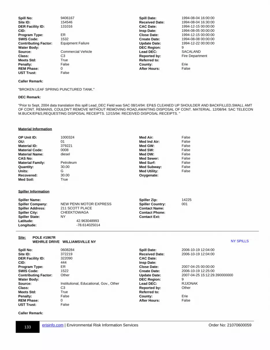
133 erisinfo.com | Environmental Risk Information Services Order No: 21070600059
Spill No: 9406167 Spill Date: 1994-08-04 16:00:00Site ID: 154546 Received Date: 1994-08-04 16:30:00DER Facility ID: 131016 CAC Date: 1994-12-15 00:00:00CID: Insp Date: 1994-08-05 00:00:00Program Type: ER Close Date: 1994-12-15 00:00:00SWIS Code: 1532 Create Date: 1994-08-08 00:00:00Contributing Factor: Equipment Failure Update Date: 1994-12-22 00:00:00Water Body: DEC Region: 9Source: Commercial Vehicle Lead DEC: SACALANDClass: C3 Reported by: Fire DepartmentMeets Std: True Referred to:Penalty: False County: ErieREM Phase: 0 After Hours: FalseUST Trust: False Caller Remark:
"BROKEN LEAF SPRING PUNCTURED TANK."
DEC Remark:
"Prior to Sept, 2004 data translation this spill Lead_DEC Field was SAC 08/14/94: EP&S CLEANED UP SHOULDER AND BACKFILLED,SMALL AMT OF CONT. REMAINS, COULDN'T REMOVE WITHOUT REMOVING ROAD,AWAITING DISPOSAL OF CONT. MATERIAL. 12/08/94: SAC TELECON M.BUCK/EP&S,REQUESTING DISPOSAL RECEIPTS. 12/15/94: RECEIVED DISPOSAL RECEIPTS. "
Material Information OP Unit ID: 1000324 Med Air: FalseOU: 01 Med Ind Air: FalseMaterial ID: 379221 Med GW: FalseMaterial Code: 0008 Med SW: FalseMaterial Name: diesel Med DW: FalseCAS No: Med Sewer: FalseMaterial Family: Petroleum Med Surf: FalseQuantity: 30.00 Med Subway: FalseUnits: G Med Utility: FalseRecovered: 30.00 Oxygenate:Med Soil: True
Spiller Information Spiller Name: Spiller Zip: 14225Spiller Company: NEW PENN MOTOR EXPRESS Spiller Country: 001Spiller Address: 211 SCOTT PLACE Contact Name:Spiller City: CHEEKTOWAGA Contact Phone:Spiller State: NY Contact Ext:Latitude: 42.963048993Longitude: -78.614025014
Site: POLE #1967R WEHRLE DRIVE WILLIAMSVILLE NY uu-NY SPILLS-813803502-bb
Spill No: 0608284 Spill Date: 2006-10-19 12:04:00Site ID: 372219 Received Date: 2006-10-19 12:04:00DER Facility ID: 322090 CAC Date:CID: 444 Insp Date:Program Type: ER Close Date: 2007-04-25 00:00:00SWIS Code: 1522 Create Date: 2006-10-19 12:25:00Contributing Factor: Other Update Date: 2007-04-25 15:12:29.390000000Water Body: DEC Region: 9Source: Institutional, Educational, Gov., Other Lead DEC: RJJONAKClass: C3 Reported by: OtherMeets Std: True Referred to:Penalty: False County: ErieREM Phase: 0 After Hours: FalseUST Trust: False Caller Remark:
NY SPILLS
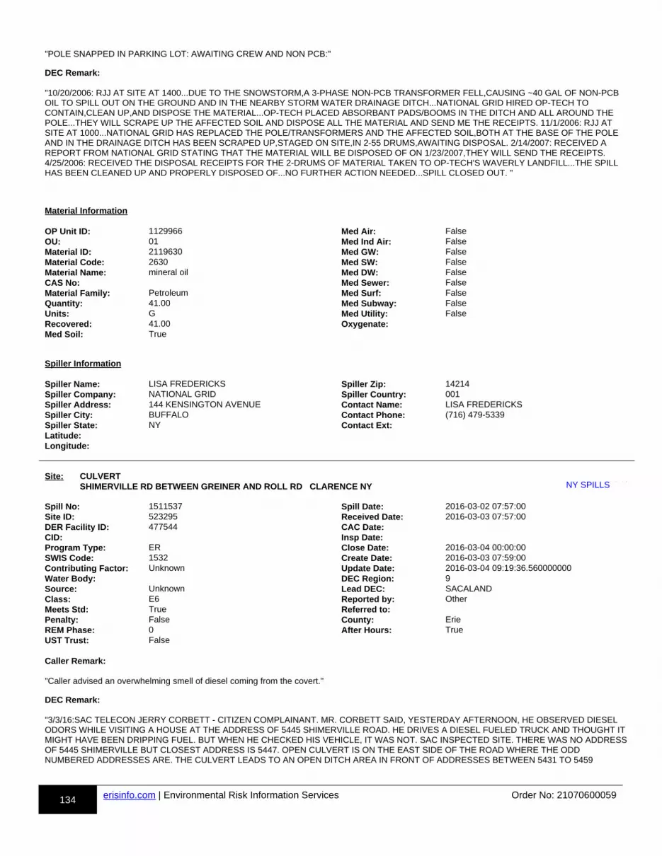
134 erisinfo.com | Environmental Risk Information Services Order No: 21070600059
"POLE SNAPPED IN PARKING LOT: AWAITING CREW AND NON PCB:"
DEC Remark:
"10/20/2006: RJJ AT SITE AT 1400...DUE TO THE SNOWSTORM,A 3-PHASE NON-PCB TRANSFORMER FELL,CAUSING ~40 GAL OF NON-PCB OIL TO SPILL OUT ON THE GROUND AND IN THE NEARBY STORM WATER DRAINAGE DITCH...NATIONAL GRID HIRED OP-TECH TO CONTAIN,CLEAN UP,AND DISPOSE THE MATERIAL...OP-TECH PLACED ABSORBANT PADS/BOOMS IN THE DITCH AND ALL AROUND THE POLE...THEY WILL SCRAPE UP THE AFFECTED SOIL AND DISPOSE ALL THE MATERIAL AND SEND ME THE RECEIPTS. 11/1/2006: RJJ AT SITE AT 1000...NATIONAL GRID HAS REPLACED THE POLE/TRANSFORMERS AND THE AFFECTED SOIL,BOTH AT THE BASE OF THE POLE AND IN THE DRAINAGE DITCH HAS BEEN SCRAPED UP,STAGED ON SITE,IN 2-55 DRUMS,AWAITING DISPOSAL. 2/14/2007: RECEIVED A REPORT FROM NATIONAL GRID STATING THAT THE MATERIAL WILL BE DISPOSED OF ON 1/23/2007,THEY WILL SEND THE RECEIPTS. 4/25/2006: RECEIVED THE DISPOSAL RECEIPTS FOR THE 2-DRUMS OF MATERIAL TAKEN TO OP-TECH'S WAVERLY LANDFILL...THE SPILL HAS BEEN CLEANED UP AND PROPERLY DISPOSED OF...NO FURTHER ACTION NEEDED...SPILL CLOSED OUT. "
Material Information OP Unit ID: 1129966 Med Air: FalseOU: 01 Med Ind Air: FalseMaterial ID: 2119630 Med GW: FalseMaterial Code: 2630 Med SW: FalseMaterial Name: mineral oil Med DW: FalseCAS No: Med Sewer: FalseMaterial Family: Petroleum Med Surf: FalseQuantity: 41.00 Med Subway: FalseUnits: G Med Utility: FalseRecovered: 41.00 Oxygenate:Med Soil: True
Spiller Information Spiller Name: LISA FREDERICKS Spiller Zip: 14214Spiller Company: NATIONAL GRID Spiller Country: 001Spiller Address: 144 KENSINGTON AVENUE Contact Name: LISA FREDERICKSSpiller City: BUFFALO Contact Phone: (716) 479-5339Spiller State: NY Contact Ext:Latitude:Longitude:
Site: CULVERT SHIMERVILLE RD BETWEEN GREINER AND ROLL RD CLARENCE NY uu-NY SPILLS-845357271-bb
Spill No: 1511537 Spill Date: 2016-03-02 07:57:00Site ID: 523295 Received Date: 2016-03-03 07:57:00DER Facility ID: 477544 CAC Date:CID: Insp Date:Program Type: ER Close Date: 2016-03-04 00:00:00SWIS Code: 1532 Create Date: 2016-03-03 07:59:00Contributing Factor: Unknown Update Date: 2016-03-04 09:19:36.560000000Water Body: DEC Region: 9Source: Unknown Lead DEC: SACALANDClass: E6 Reported by: OtherMeets Std: True Referred to:Penalty: False County: ErieREM Phase: 0 After Hours: TrueUST Trust: False Caller Remark:
"Caller advised an overwhelming smell of diesel coming from the covert."
DEC Remark:
"3/3/16:SAC TELECON JERRY CORBETT - CITIZEN COMPLAINANT. MR. CORBETT SAID, YESTERDAY AFTERNOON, HE OBSERVED DIESEL ODORS WHILE VISITING A HOUSE AT THE ADDRESS OF 5445 SHIMERVILLE ROAD. HE DRIVES A DIESEL FUELED TRUCK AND THOUGHT IT MIGHT HAVE BEEN DRIPPING FUEL. BUT WHEN HE CHECKED HIS VEHICLE, IT WAS NOT. SAC INSPECTED SITE. THERE WAS NO ADDRESSOF 5445 SHIMERVILLE BUT CLOSEST ADDRESS IS 5447. OPEN CULVERT IS ON THE EAST SIDE OF THE ROAD WHERE THE ODD NUMBERED ADDRESSES ARE. THE CULVERT LEADS TO AN OPEN DITCH AREA IN FRONT OF ADDRESSES BETWEEN 5431 TO 5459
NY SPILLS
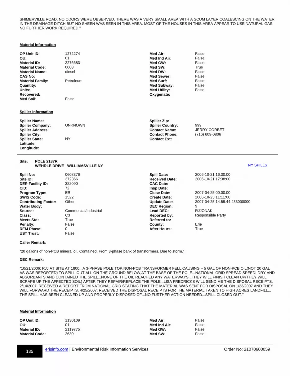
135 erisinfo.com | Environmental Risk Information Services Order No: 21070600059
SHIMERVILLE ROAD. NO ODORS WERE OBSERVED. THERE WAS A VERY SMALL AREA WITH A SCUM LAYER COALESCING ON THE WATERIN THE DRAINAGE DITCH BUT NO SHEEN WAS SEEN IN THIS AREA. MOST OF THE HOUSES IN THIS AREA APPEAR TO USE NATURAL GAS. NO FURTHER WORK REQUIRED."
Material Information OP Unit ID: 1272274 Med Air: FalseOU: 01 Med Ind Air: FalseMaterial ID: 2276683 Med GW: FalseMaterial Code: 0008 Med SW: TrueMaterial Name: diesel Med DW: FalseCAS No: Med Sewer: FalseMaterial Family: Petroleum Med Surf: FalseQuantity: Med Subway: FalseUnits: Med Utility: FalseRecovered: Oxygenate:Med Soil: False
Spiller Information Spiller Name: Spiller Zip:Spiller Company: UNKNOWN Spiller Country: 999Spiller Address: Contact Name: JERRY CORBETSpiller City: Contact Phone: (716) 609-0806Spiller State: NY Contact Ext:Latitude:Longitude:
Site: POLE 2187R WEHRLE DRIVE WILLIAMSVILLE NY uu-NY SPILLS-813804514-bb
Spill No: 0608376 Spill Date: 2006-10-21 16:30:00Site ID: 372366 Received Date: 2006-10-21 17:38:00DER Facility ID: 322090 CAC Date:CID: 72 Insp Date:Program Type: ER Close Date: 2007-04-25 00:00:00SWIS Code: 1522 Create Date: 2006-10-23 11:11:00Contributing Factor: Other Update Date: 2007-04-25 14:59:44.433000000Water Body: DEC Region: 9Source: Commercial/Industrial Lead DEC: RJJONAKClass: C3 Reported by: Responsible PartyMeets Std: True Referred to:Penalty: False County: ErieREM Phase: 0 After Hours: TrueUST Trust: False Caller Remark:
"20 gallons of non-PCB mineral oil. Contained. From 3-phase bank of transformers. Due to storm."
DEC Remark:
"10/21/2006: RJJ AT SITE AT 1800...A 3-PHASE POLE TOP,NON-PCB TRANSFORMER FELL,CAUSING ~ 5 GAL OF NON-PCB OIL(NOT 20 GAL AS WAS REPORTED) TO SPILL OUT,ALL ON THE GROUND BELOW,AT THE BASE OF THE POLE...NATIONAL GRID SPREAD SPEEDI-DRY ANDABSORBANTS AND CONTAINED THE SPILL...NONE OF THE OIL REACHED ANY WATERWAYS...THEY WILL FINISH CLEAN UP(THEY WILL SCRAPE UP THE AFFECTED SOIL) AFTER THEY REPAIR/REPLACE THE POLE...LISA FREDRICKS WILL SEND ME THE DISPOSAL RECEIPTS. 2/14/2007; RECEIVED A REPORT FROM NATIONAL GRID STATING THAT THE MATERIAL WAS SENT FOR DISPOSAL ON 1/23/2007 AND THEY WILL FORWARD THE RECEIPTS. 4/25/2007: RECEIVED THE DISPOSAL RECEIPTS FOR THE MATERIAL TAKEN TO HIGH ACRES LANDFILL...THE SPILL HAS BEEN CLEANED UP AND PROPERLY DISPOSED OF...NO FURTHER ACTION NEEDED...SPILL CLOSED OUT."
Material Information OP Unit ID: 1130109 Med Air: FalseOU: 01 Med Ind Air: FalseMaterial ID: 2119775 Med GW: FalseMaterial Code: 2630 Med SW: False
NY SPILLS
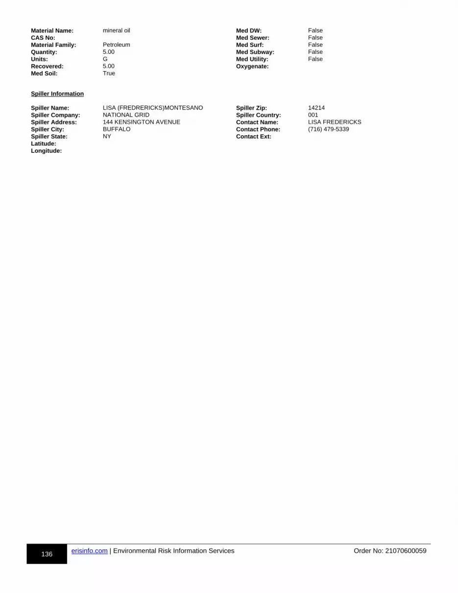
136 erisinfo.com | Environmental Risk Information Services Order No: 21070600059
Material Name: mineral oil Med DW: FalseCAS No: Med Sewer: FalseMaterial Family: Petroleum Med Surf: FalseQuantity: 5.00 Med Subway: FalseUnits: G Med Utility: FalseRecovered: 5.00 Oxygenate:Med Soil: True
Spiller Information Spiller Name: LISA (FREDRERICKS)MONTESANO Spiller Zip: 14214Spiller Company: NATIONAL GRID Spiller Country: 001Spiller Address: 144 KENSINGTON AVENUE Contact Name: LISA FREDERICKSSpiller City: BUFFALO Contact Phone: (716) 479-5339Spiller State: NY Contact Ext:Latitude:Longitude:
137 erisinfo.com | Environmental Risk Information Services Order No: 21070600059
h-Appendix: Database Descriptions
Environmental Risk Information Services (ERIS) can search the following databases. The extent of historical information varies with each database and current information is determined by what is publicly available to ERIS at the time of update. ERIS updates databases as set out in ASTM Standard E1527-13, Section 8.1.8 Sources of Standard Source Information:
"Government information from nongovernmental sources may be considered current if the source updates the information at least every90 days, or, for information that is updated less frequently than quarterly by the government agency, within 90 days of the date the government agency makes the information available to the public."
Standard Environmental Record Sources
Federal
Formerly Utilized Sites Remedial Action Program: rr-DOE FUSRAP-bb
The U.S. Department of Energy (DOE) established the Formerly Utilized Sites Remedial Action Program (FUSRAP) in 1974 to remediate sites where radioactive contamination remained from the Manhattan Project and early U.S. Atomic Energy Commission (AEC) operations. The DOE Office of Legacy Management (LM) established long-term surveillance and maintenance (LTS&M) requirements for remediated FUSRAP sites. DOE evaluates the final site conditions of a remediated site on the basis of risk for different future uses. DOE then confirms that LTS&M requirements will maintain protectiveness.Government Publication Date: Mar 4, 2017
National Priority List: rr-NPL-bb
National Priorities List (Superfund)-NPL: EPA's (United States Environmental Protection Agency) list of the most serious uncontrolled or abandoned hazardous waste sites identified for possible long-term remedial action under the Superfund program. The NPL, which EPA is required to update at leastonce a year, is based primarily on the score a site receives from EPA's Hazard Ranking System. A site must be on the NPL to receive money from the Superfund Trust Fund for remedial action.Government Publication Date: Apr 27, 2021
National Priority List - Proposed: rr-PROPOSED NPL-bb
Includes sites proposed (by the EPA, the state, or concerned citizens) for addition to the NPL due to contamination by hazardous waste and identified bythe Environmental Protection Agency (EPA) as a candidate for cleanup because it poses a risk to human health and/or the environment.Government Publication Date: Apr 27, 2021
Deleted NPL: rr-DELETED NPL-bb
The National Oil and Hazardous Substances Pollution Contingency Plan (NCP) establishes the criteria that the EPA uses to delete sites from the NPL. In accordance with 40 CFR 300.425.(e), sites may be deleted from the NPL where no further response is appropriate.Government Publication Date: Apr 27, 2021
SEMS List 8R Active Site Inventory: rr-SEMS-bb
The Superfund Program has deployed the Superfund Enterprise Management System (SEMS), which integrates multiple legacy systems into a comprehensive tracking and reporting tool. This inventory contains active sites evaluated by the Superfund program that are either proposed to be or are on the National Priorities List (NPL) as well as sites that are in the screening and assessment phase for possible inclusion on the NPL. The Active Site Inventory Report displays site and location information at active SEMS sites. An active site is one at which site assessment, removal, remedial, enforcement, cost recovery, or oversight activities are being planned or conducted.Government Publication Date: Mar 23, 2021
Inventory of Open Dumps, June 1985: rr-ODI-bb
The Resource Conservation and Recovery Act (RCRA) provides for publication of an inventory of open dumps. The Act defines "open dumps" as facilities which do not comply with EPA's "Criteria for Classification of Solid Waste Disposal Facilities and Practices" (40 CFR 257).Government Publication Date: Jun 1985
DOE FUSRAP
NPL
PROPOSED NPL
DELETED NPL
SEMS
ODI
Appendix: Database Descriptions
138 erisinfo.com | Environmental Risk Information Services Order No: 21070600059
SEMS List 8R Archive Sites: rr-SEMS ARCHIVE-bb
The Superfund Enterprise Management System (SEMS) Archived Site Inventory displays site and location information at sites archived from SEMS. An archived site is one at which EPA has determined that assessment has been completed and no further remedial action is planned under the Superfund program at this time.Government Publication Date: Mar 23, 2021
Comprehensive Environmental Response, Compensation and Liability Information System - CERCLIS:
rr-CERCLIS-bb
Superfund is a program administered by the United States Environmental Protection Agency (EPA) to locate, investigate, and clean up the worst hazardous waste sites throughout the United States. CERCLIS is a database of potential and confirmed hazardous waste sites at which the EPA Superfund program has some involvement. It contains sites that are either proposed to be or are on the National Priorities List (NPL) as well as sites that are in the screening and assessment phase for possible inclusion on the NPL. The EPA administers the Superfund program in cooperation with individual states and tribal governments; this database is made available by the EPA.Government Publication Date: Oct 25, 2013
EPA Report on the Status of Open Dumps on Indian Lands: rr-IODI-bb
Public Law 103-399, The Indian Lands Open Dump Cleanup Act of 1994, enacted October 22, 1994, identified congressional concerns that solid waste open dump sites located on American Indian or Alaska Native (AI/AN) lands threaten the health and safety of residents of those lands and contiguous areas. The purpose of the Act is to identify the location of open dumps on Indian lands, assess the relative health and environment hazards posed by those sites, and provide financial and technical assistance to Indian tribal governments to close such dumps in compliance with Federal standards and regulations or standards promulgated by Indian Tribal governments or Alaska Native entities.Government Publication Date: Dec 31, 1998
CERCLIS - No Further Remedial Action Planned: rr-CERCLIS NFRAP-bb
An archived site is one at which EPA has determined that assessment has been completed and no further remedial action is planned under the Superfund program at this time. The Archive designation means that, to the best of EPA's knowledge, assessment at a site has been completed and that EPA has determined no further steps will be taken to list this site on the National Priorities List (NPL). This decision does not necessarily mean that there is no hazard associated with a given site; it only means that, based upon available information, the location is not judged to be a potential NPL site.Government Publication Date: Oct 25, 2013
CERCLIS Liens: rr-CERCLIS LIENS-bb
A Federal Superfund lien exists at any property where EPA has incurred Superfund costs to address contamination ("Superfund site") and has provided notice of liability to the property owner. A Federal CERCLA ("Superfund") lien can exist by operation of law at any site or property at which EPA has spent Superfund monies. This database is made available by the United States Environmental Protection Agency (EPA).Government Publication Date: Jan 30, 2014
RCRA CORRACTS-Corrective Action: rr-RCRA CORRACTS-bb
RCRA Info is EPA's comprehensive information system, providing access to data supporting the Resource Conservation and Recovery Act (RCRA) of 1976 and the Hazardous and Solid Waste Amendments (HSWA) of 1984. At these sites, the Corrective Action Program ensures that cleanups occur. EPA and state regulators work with facilities and communities to design remedies based on the contamination, geology, and anticipated use unique to each site.Government Publication Date: Apr 5, 2021
RCRA non-CORRACTS TSD Facilities: rr-RCRA TSD-bb
RCRA Info is EPA's comprehensive information system, providing access to data supporting the Resource Conservation and Recovery Act (RCRA) of 1976 and the Hazardous and Solid Waste Amendments (HSWA) of 1984. This database includes Non-Corrective Action sites listed as treatment, storage and/or disposal facilities of hazardous waste as defined by the Resource Conservation and Recovery Act (RCRA).Government Publication Date: Apr 5, 2021
RCRA Generator List: rr-RCRA LQG-bb
RCRA Info is EPA's comprehensive information system, providing access to data supporting the Resource Conservation and Recovery Act (RCRA) of 1976 and the Hazardous and Solid Waste Amendments (HSWA) of 1984. RCRA Info replaces the data recording and reporting abilities of the Resource Conservation and Recovery Information System (RCRIS) and the Biennial Reporting System (BRS). A hazardous waste generator is any person or site whose processes and actions create hazardous waste (see 40 CFR 260.10). Large Quantity Generators (LQGs) generate 1,000 kilograms per month or more of hazardous waste or more than one kilogram per month of acutely hazardous waste.Government Publication Date: Apr 5, 2021
SEMS ARCHIVE
CERCLIS
IODI
CERCLIS NFRAP
CERCLIS LIENS
RCRA CORRACTS
RCRA TSD
RCRA LQG
139 erisinfo.com | Environmental Risk Information Services Order No: 21070600059
RCRA Small Quantity Generators List: rr-RCRA SQG-bb
RCRA Info is the EPA's comprehensive information system, providing access to data supporting the Resource Conservation and Recovery Act (RCRA) of 1976 and the Hazardous and Solid Waste Amendments (HSWA) of 1984. RCRA Info replaces the data recording and reporting abilities of the Resource Conservation and Recovery Information System (RCRIS) and the Biennial Reporting System (BRS). A hazardous waste generator is any person or site whose processes and actions create hazardous waste (see 40 CFR 260.10). Small Quantity Generators (SQGs) generate more than 100 kilograms, but less than 1,000 kilograms, of hazardous waste per month.Government Publication Date: Apr 5, 2021
RCRA Very Small Quantity Generators List: rr-RCRA VSQG-bb
RCRA Info is the EPA's comprehensive information system, providing access to data supporting the Resource Conservation and Recovery Act (RCRA) of 1976 and the Hazardous and Solid Waste Amendments (HSWA) of 1984. A hazardous waste generator is any person or site whose processes and actions create hazardous waste (see 40 CFR 260.10). Very Small Quantity Generators (VSQG) generate 100 kilograms or less per month of hazardouswaste, or one kilogram or less per month of acutely hazardous waste. Additionally, VSQG may not accumulate more than 1,000 kilograms of hazardous waste at any time.Government Publication Date: Apr 5, 2021
RCRA Non-Generators: rr-RCRA NON GEN-bb
RCRA Info is EPA's comprehensive information system, providing access to data supporting the Resource Conservation and Recovery Act (RCRA) of 1976 and the Hazardous and Solid Waste Amendments (HSWA) of 1984. RCRA Info replaces the data recording and reporting abilities of the Resource Conservation and Recovery Information System (RCRIS) and the Biennial Reporting System (BRS). A hazardous waste generator is any person or site whose processes and actions create hazardous waste (see 40 CFR 260.10). Non-Generators do not presently generate hazardous waste.Government Publication Date: Apr 5, 2021
Federal Engineering Controls-ECs: rr-FED ENG-bb
Engineering controls (ECs) encompass a variety of engineered and constructed physical barriers (e.g., soil capping, sub-surface venting systems, mitigation barriers, fences) to contain and/or prevent exposure to contamination on a property. This database is made available by the United States Environmental Protection Agency (EPA).Government Publication Date: Feb 23, 2021
Federal Institutional Controls- ICs: rr-FED INST-bb
Institutional controls are non-engineered instruments, such as administrative and legal controls, that help minimize the potential for human exposure to contamination and/or protect the integrity of the remedy. Although it is EPA's (United States Environmental Protection Agency ) expectation that treatment or engineering controls will be used to address principal threat wastes and that groundwater will be returned to its beneficial use whenever practicable, ICs play an important role in site remedies because they reduce exposure to contamination by limiting land or resource use and guide human behavior at a site.Government Publication Date: Feb 23, 2021
Land Use Control Information System: rr-LUCIS-bb
The LUCIS database is maintained by the U.S. Department of the Navy and contains information for former Base Realignment and Closure (BRAC) properties across the United States.Government Publication Date: Sep 1, 2006
Emergency Response Notification System: rr-ERNS 1982 TO 1986-bb
Database of oil and hazardous substances spill reports controlled by the National Response Center. The primary function of the National Response Center is to serve as the sole national point of contact for reporting oil, chemical, radiological, biological, and etiological discharges into the environment anywhere in the United States and its territories.Government Publication Date: 1982-1986
Emergency Response Notification System: rr-ERNS 1987 TO 1989-bb
Database of oil and hazardous substances spill reports controlled by the National Response Center. The primary function of the National Response Center is to serve as the sole national point of contact for reporting oil, chemical, radiological, biological, and etiological discharges into the environment anywhere in the United States and its territories.Government Publication Date: 1987-1989
Emergency Response Notification System: rr-ERNS-bb
Database of oil and hazardous substances spill reports made available by the United States Coast Guard National Response Center (NRC). The NRC fields initial reports for pollution and railroad incidents and forwards that information to appropriate federal/state agencies for response. These data contain initial incident data that has not been validated or investigated by a federal/state response agency.Government Publication Date: Nov 9, 2020
RCRA SQG
RCRA VSQG
RCRA NON GEN
FED ENG
FED INST
LUCIS
ERNS 1982 TO 1986
ERNS 1987 TO 1989
ERNS
140 erisinfo.com | Environmental Risk Information Services Order No: 21070600059
The Assessment, Cleanup and Redevelopment Exchange System (ACRES) Brownfield Database: rr-FED BROWNFIELDS-bb
Brownfields are real property, the expansion, redevelopment, or reuse of which may be complicated by the presence or potential presence of a hazardous substance, pollutant, or contaminant. Cleaning up and reinvesting in these properties protects the environment, reduces blight, and takes development pressures off greenspaces and working lands. This database is made available by the United States Environmental Protection Agency (EPA).Government Publication Date: Jan 6, 2021
FEMA Underground Storage Tank Listing: rr-FEMA UST-bb
The Federal Emergency Management Agency (FEMA) of the Department of Homeland Security maintains a list of FEMA owned underground storage tanks.Government Publication Date: Dec 31, 2017
Facility Response Plan: rr-FRP-bb
List of facilities that have submitted Facility Response Plans (FRP) to EPA. Facilities that could reasonably be expected to cause "substantial harm" to the environment by discharging oil into or on navigable waters are required to prepare and submit Facility Response Plans (FRPs). Harm is determined based on total oil storage capacity, secondary containment and age of tanks, oil transfer activities, history of discharges, proximity to a public drinking water intake or sensitive environments.Government Publication Date: Dec 2, 2020
Historical Gas Stations: rr-HIST GAS STATIONS-bb
This historic directory of service stations is provided by the Cities Service Company. The directory includes Cities Service filling stations that were located throughout the United States in 1930.Government Publication Date: Jul 1, 1930
Petroleum Refineries: rr-REFN-bb
List of petroleum refineries from the U.S. Energy Information Administration (EIA) Refinery Capacity Report. Includes operating and idle petroleum refineries (including new refineries under construction) and refineries shut down during the previous year located in the 50 States, the District of Columbia, Puerto Rico, the Virgin Islands, Guam, and other U.S. possessions. Survey locations adjusted using public data.Government Publication Date: Jul 10, 2020
Petroleum Product and Crude Oil Rail Terminals: rr-BULK TERMINAL-bb
List of petroleum product and crude oil rail terminals made available by the U.S. Energy Information Administration (EIA). Includes operable bulk petroleum product terminals located in the 50 States and the District of Columbia with a total bulk shell storage capacity of 50,000 barrels or more, and/or the ability to receive volumes from tanker, barge, or pipeline; also rail terminals handling the loading and unloading of crude oil that were active between 2017 and 2018. Petroleum product terminals comes from the EIA-815 Bulk Terminal and Blender Report, which includes working, shell in operation, and shell idle for several major product groupings. Survey locations adjusted using public data.Government Publication Date: Apr 28, 2020
LIEN on Property: rr-SEMS LIEN-bb
The EPA Superfund Enterprise Management System (SEMS) provides LIEN information on properties under the EPA Superfund Program.Government Publication Date: Mar 23, 2021
Superfund Decision Documents: rr-SUPERFUND ROD-bb
This database contains a listing of decision documents for Superfund sites. Decision documents serve to provide the reasoning for the choice of (or) changes to a Superfund Site cleanup plan. The decision documents include Records of Decision (ROD), ROD Amendments, Explanations of Significant Differences (ESD), along with other associated memos and files. This information is maintained and made available by the US EPA (Environmental Protection Agency).Government Publication Date: Jun 28, 2021
State
Registry of Inactive Hazardous Waste Disposal Sites in New York State: rr-SHWS-bb
State-and tribal- equivalent CERCLIS. State Superfund Program (Inactive Hazardous Waste Disposal Site Remedial Program) (IHWDS) - Oversees the identification, investigation and cleanup of sites where consequential amounts of hazardous waste exist. These sites go through a process of investigation, evaluation, cleanup and monitoring that has several distinct stages. This list is made available by New York State Department of Environmental Conservation's State Superfund Program.
FED BROWNFIELDS
FEMA UST
FRP
HIST GAS STATIONS
REFN
BULK TERMINAL
SEMS LIEN
SUPERFUND ROD
SHWS
141 erisinfo.com | Environmental Risk Information Services Order No: 21070600059
Government Publication Date: Jun 3, 2021
Delisted Registry of Inactive Hazardous Waste Disposal Sites in New York: rr-DELISTED SHWS-bb
This database contains a Registry of Inactive Hazardous Waste Disposal sites which have been removed from New York Department of Environmental Conservation's Environmental Site Remediation database.Government Publication Date: Jun 3, 2021
Hazardous Substance Waste Disposal Sites: rr-HSWDS-bb
A list of sites included in Hazardous Substance Waste Disposal Site Study reports made available by the New York Department of Environmental Conservation Division of Hazardous Waste Remediation. Provides information regarding the evolving status of hazardous substance waste disposal sites in New York.Government Publication Date: Oct 24, 2003
Vapor Intrusion Legacy Site List: rr-VAPOR-bb
New York is currently re-evaluating previous assumptions and decisions regarding the potential for soil vapor intrusion exposures at sites. As a result, allpast, current, and future contaminated sites will be evaluated to determine whether these sites have the potential for exposures related to soil vapor intrusion. This list is made available by Department of Environmental Conservation's Vapor Intrusion Legacy Site List. This database is state equivalent CERCLIS.Government Publication Date: Dec 31, 2018
Solid Waste Facilities and Landfills: rr-SWF/LF-bb
Solid Waste Information Management System (SWIMS) is an inventory containing active and inactive facilities throughout the state. This list is made available by Department of Environmental Conservation's Solid Waste Information Management System (SWIMS).Government Publication Date: Dec 31, 2020
Inactive Landfill Facilities: rr-LANDFILL INACTIVE-bb
List of inactive landfills in the State of New York. This data is made available by the New York State Department of Environmental Conservation (DEC). DEC notes that these are preliminary data and should not be regarded as a complete inventory of all landfills in the State, and also that site locations and attributes are preliminary and should not be relied upon without independent verification.Government Publication Date: Jun 30, 2020
Waste Tire Facilities: rr-WASTE TIRE-bb
This list of active Waste Tire Facilities is maintained by the New York State Department of Environmental Conservation. Waste tire storage facilities (WTSF) store waste tires or portions of waste tires. Most of these facilities require Part 360 permits, but under certain conditions a registration maybe available.Government Publication Date: Dec 24, 2019
Recycling Facilities: rr-RECYCLING-bb
The Department of Environmental Conservation (DEC), Division of Materials Management (DMM), Bureau of Permitting and Planning regulates solid waste management facilities in accordance with 6 NYCRR Part 360. Information pertaining to those facilities is maintained with the Division's Solid Waste Information Management System (SWIMS) database. The Facility List is a dataset related to solid waste management facilities operating in the state, and includes such information as facility location, contact names and associated information, waste types managed, and regulatory information.Government Publication Date: Dec 24, 2019
Leaking Storage Tanks: rr-LST-bb
This database contains records of chemical and petroleum spill incidents. They include leaking aboveground storage tanks or leaking underground storage tanks, with incidents of tank test failures, tank failures and tank overfill. This list is made available by New York State Department of Environmental Conservation's Spill Response Program.Government Publication Date: Jun 3, 2021
Delisted Leaking Storage Tanks: rr-DELISTED LST-bb
List of Leaking Storage Tank sites which has been removed from New York Department of Environmental Conservation's Spill Response ProgramGovernment Publication Date: Jun 3, 2021
Underground Storage Tanks- UST-Petroleum Bulk Storage (PBS): rr-UST-bb
Facilities within the Petroleum Bulk Storage (PBS) that have underground storage tanks. Underground petroleum storage facilities with a combined storage capacity over eleven hundred (1,100) gallons. This list is made available by NewYork Department of Environmental Conservation's Environmental Site Database Search.
DELISTED SHWS
HSWDS
VAPOR
SWF/LF
LANDFILL INACTIVE
WASTE TIRE
RECYCLING
LST
DELISTED LST
UST
142 erisinfo.com | Environmental Risk Information Services Order No: 21070600059
Government Publication Date: Jun 3, 2021
The Bulk Storage Program Database - AST: rr-AST-bb
Facilities within the Petroleum Bulk Storage (PBS) that have aboveground storage tanks. Aboveground petroleum storage facilities with a combined storage capacity over eleven hundred (1,100) gallons. This list is made available by New York State Department of Environmental conservation's Petroleum Bulk Storage (PBS) program.Government Publication Date: Jun 3, 2021
Petroleum Bulk Storage: rr-TANKS-bb
The Bulk Storage Program Database maintains the registrations of active and inactive bulk storage sites statewide. This database includes Petroleum Bulk Storage (PBS) tanks where no information is available on whether they are ASTs or USTs. This list is made available by Department of Environmental Conservation's Petroleum Bulk Storage (PBS) program.Government Publication Date: Jun 3, 2021
Major Oil Storage Facilities (MOSF): rr-MOSF-bb
In 1977, the New York State Legislature passed the "Oil Spill Prevention, Control and Compensation Act" (Article 12 of the Navigation Law). This law regulates all oil terminals and transport vessels operating in the waters of the State which have a storage capacity of 400,000 gallons or more. (Terminals and vessels with a capacity of 400,000 gallons or more are commonly referred to as major oil storage facilities or MOSFs). This list is made available by Department of Environmental Conservation's Major Oil Storage Facility (MOSF) Program.Government Publication Date: Jun 3, 2021
Chemical Bulk Storage (CBS): rr-CBS-bb
Facilities that store regulated hazardous substances in underground tanks . "Hazardous substance" means any substance listed as hazardous or acutely hazardous in 6 NYCRR Part 597 or a mixture thereof. This list is made available by Department of Environmental Conservation's Chemical BulkStorage (CBS) Program.Government Publication Date: Jun 3, 2021
Delisted Storage Tanks: rr-DELISTED TANKS-bb
List of Storage Tank sites which has been removed from New York Department of Environmental Conservation's Environmental Site Database.Government Publication Date: Jun 3, 2021
Delisted County Records: rr-DELISTED COUNTY-bb
Records removed from county databases. Records may be removed from the county lists made available by the respective county departments because they are inactive, or because they have been deemed to be below reportable thresholds.Government Publication Date: May 7, 2021
Registry of Engineering Controls in New York State: rr-ENG-bb
Registry of Engineering Controls in New York State taken from the Environmental Site Remediation Database. Government Publication Date: Jun 3, 2021
Registry of Institutional Controls in New York State: rr-INST-bb
Registry of Institutional Controls in New York State taken from the Environmental Site Remediation Database.Government Publication Date: Jun 3, 2021
Voluntary Cleanup Agreements: rr-VCP-bb
New York established its Voluntary Cleanup Program (VCP) to address the environmental, legal and financial barriers that often hinder the redevelopment and reuse of contaminated properties. The Voluntary Cleanup Program was developed to enhance private sector cleanup of brownfields by enabling parties to remediate sites using private rather than public funds and to reduce the development pressures on "greenfield" sites. This list is made available by Department of Environmental Conservation's Voluntary Cleanup Program.Government Publication Date: Jun 3, 2021
Environmental Restoration Program Listing: rr-ERP-bb
Environmental Restoration Program - Provides municipalities with financial assistance for site investigation and remediation at eligible brownfield sites. In an effort to spur the cleanup and redevelopment of brownfields, New Yorkers approved a $200 million Environmental Restoration Fund as part of the $1.75 billion Clean Water/Clean Air Bond Act of 1996 (Bond Act). Under the Environmental Restoration Program, the State provides grants to municipalities to reimburse up to 90 percent of on-site eligible costs and 100% of off-site eligible costs for site investigation and remediation activities. This list is made available by Department of Environmental Conservation's Environmental Restoration Program.Government Publication Date: Jun 3, 2021
AST
TANKS
MOSF
CBS
DELISTED TANKS
DELISTED COUNTY
ENG
INST
VCP
ERP
143 erisinfo.com | Environmental Risk Information Services Order No: 21070600059
Brownfields Site List (Subset of Site Remediation): rr-BROWNFIELDS-bb
Brownfield Cleanup Program was developed to enhance private-sector cleanups of brownfields and to reduce development pressure on "Greenfields". ABrownfield site is real property, the redevelopment or reuse of which may be complicated by the presence or potential presence of a contaminant. Contaminants include hazardous waste and/or petroleum. This list is made available by Department of Environmental Conservation's Brownfield Cleanup Program.Government Publication Date: Jun 3, 2021
Tribal
Leaking Underground Storage Tanks (LUSTs) on Tribal/Indian Lands: rr-INDIAN LUST-bb
LUSTs on Tribal/Indian Lands in Region 2, which includes New York and New Jersey. There are no LUST records in New York at this time.Government Publication Date: Jan 28, 2016
Underground Storage Tanks (USTs) on Indian Lands: rr-INDIAN UST-bb
USTs on Tribal/Indian Lands in Region 2, which includes New York and New Jersey.Government Publication Date: Apr 04, 2016
Delisted Tribal Leaking Storage Tanks: rr-DELISTED ILST-bb
Leaking Underground Storage Tank facilities which have been removed from the Regional Tribal LUST lists made available by the EPA.Government Publication Date: Apr 14, 2020
Delisted Tribal Underground Storage Tanks: rr-DELISTED IUST-bb
Underground Storage Tank facilities which have been removed from the Regional Tribal UST lists made available by the EPA.Government Publication Date: Apr 14, 2020
County
No County databases were selected to be included in the search.
Additional Environmental Record Sources
Federal
PFOA/PFOS Contaminated Sites: rr-PFAS NPL-bb
List of sites where PFOA or PFOS contaminants have been found in drinking water or soil. Made available by the Federal Environmental Protection Agency (EPA).Government Publication Date: Mar 1, 2021
Facility Registry Service/Facility Index: rr-FINDS/FRS-bb
The Facility Registry Service (FRS) is a centrally managed database that identifies facilities, sites, or places subject to environmental regulations or of environmental interest. FRS creates high-quality, accurate, and authoritative facility identification records through rigorous verification and management procedures that incorporate information from program national systems, state master facility records, and data collected from EPA's Central Data Exchange registrations and data management personnel. This list is made available by the Environmental Protection Agency (US EPA).Government Publication Date: Nov 2, 2020
Toxics Release Inventory (TRI) Program: rr-TRIS-bb
The EPA's Toxics Release Inventory (TRI) is a database containing data on disposal or other releases of over 650 toxic chemicals from thousands of U.S. facilities and information about how facilities manage those chemicals through recycling, energy recovery, and treatment. One of TRI's primary purposes is to inform communities about toxic chemical releases to the environment.Government Publication Date: Feb 19, 2020
Perfluorinated Alkyl Substances (PFAS) Releases: rr-PFAS TRI-bb
BROWNFIELDS
INDIAN LUST
INDIAN UST
DELISTED ILST
DELISTED IUST
PFAS NPL
FINDS/FRS
TRIS
PFAS TRI
144 erisinfo.com | Environmental Risk Information Services Order No: 21070600059
List of Toxics Release Inventory (TRI) facilities at which the reported chemical is a Per- or polyfluorinated alkyl substance (PFAS) included in the Environmental Protection Agency (EPA)'s consolidated PFAS Master List of PFAS Substances. The EPA's Toxics Release Inventory (TRI) is a databasecontaining data on disposal or other releases of over 650 toxic chemicals from thousands of U.S. facilities and information about how facilities manage those chemicals through recycling, energy recovery, and treatment.Government Publication Date: Feb 19, 2020
Perfluorinated Alkyl Substances (PFAS) Water Quality: rr-PFAS WATER-bb
The Water Quality Portal (WQP) is a cooperative service sponsored by the United States Geological Survey (USGS), the Environmental Protection Agency (EPA), and the National Water Quality Monitoring Council (NWQMC). This listing includes records from the Water Quality Portal where the characteristic (environmental measurement) is in the Environmental Protection Agency (EPA)'s consolidated PFAS Master List of PFAS Substances.Government Publication Date: Jul 20, 2020
Hazardous Materials Information Reporting System: rr-HMIRS-bb
US DOT - Department of Transportation Pipeline and Hazardous Materials Safety Administration (PHMSA) Incidents Reports Database taken from Hazmat Intelligence Portal, U.S. Department of Transportation.Government Publication Date: Sep 1, 2020
National Clandestine Drug Labs: rr-NCDL-bb
The U.S. Department of Justice ("the Department") provides this data as a public service. It contains addresses of some locations where law enforcement agencies reported they found chemicals or other items that indicated the presence of either clandestine drug laboratories or dumpsites. In most cases, the source of the entries is not the Department, and the Department has not verified the entry and does not guarantee its accuracy.Government Publication Date: Oct 5, 2020
Toxic Substances Control Act: rr-TSCA-bb
The Environmental Protection Agency (EPA) is amending the Toxic Substances Control Act (TSCA) section 8(a) Inventory Update Reporting (IUR) rule and changing its name to the Chemical Data Reporting (CDR) rule. The CDR enables EPA to collect and publish information on the manufacturing, processing, and use of commercial chemical substances and mixtures (referred to hereafter as chemical substances) on the TSCA Chemical Substance Inventory (TSCA Inventory). This includes current information on chemical substance production volumes, manufacturing sites, and how the chemical substances are used. This information helps the Agency determine whether people or the environment are potentially exposed to reported chemical substances. EPA publishes submitted CDR data that is not ConfidentialBusiness Information (CBI).Government Publication Date: Apr 11, 2019
Hist TSCA: rr-HIST TSCA-bb
The Environmental Protection Agency (EPA) is amending the Toxic Substances Control Act (TSCA) section 8(a) Inventory Update Reporting (IUR) rule and changing its name to the Chemical Data Reporting (CDR) rule.The 2006 IUR data summary report includes information about chemicals manufactured or imported in quantities of 25,000 pounds or more at a single site during calendar year 2005. In addition to the basic manufacturing information collected in previous reporting cycles, the 2006 cycle is the first time EPA collected information to characterize exposure during manufacturing, processing and use of organic chemicals. The 2006 cycle also is the first timemanufacturers of inorganic chemicals were required to report basic manufacturing information.Government Publication Date: Dec 31, 2006
FTTS Administrative Case Listing: rr-FTTS ADMIN-bb
An administrative case listing from the Federal Insecticide, Fungicide, & Rodenticide Act (FIFRA) and Toxic Substances Control Act (TSCA), together known as FTTS. This database was obtained from the Environmental Protection Agency's (EPA) National Compliance Database (NCDB). The FTTS and NCDB was shut down in 2006.Government Publication Date: Jan 19, 2007
FTTS Inspection Case Listing: rr-FTTS INSP-bb
An inspection case listing from the Federal Insecticide, Fungicide, & Rodenticide Act (FIFRA) and Toxic Substances Control Act (TSCA), together known as FTTS. This database was obtained from the Environmental Protection Agency's (EPA) National Compliance Database (NCDB). The FTTS and NCDB was shut down in 2006.Government Publication Date: Jan 19, 2007
Potentially Responsible Parties List: rr-PRP-bb
Early in the cleanup process, the Environmental Protection Agency (EPA) conducts a search to find the potentially responsible parties (PRPs). EPA looks for evidence to determine liability by matching wastes found at the site with parties that may have contributed wastes to the site.Government Publication Date: Apr 27, 2021
PFAS WATER
HMIRS
NCDL
TSCA
HIST TSCA
FTTS ADMIN
FTTS INSP
PRP
145 erisinfo.com | Environmental Risk Information Services Order No: 21070600059
State Coalition for Remediation of Drycleaners Listing: rr-SCRD DRYCLEANER-bb
The State Coalition for Remediation of Drycleaners (SCRD) was established in 1998, with support from the U.S. Environmental Protection Agency (EPA) Office of Superfund Remediation and Technology Innovation. Coalition members are states with mandated programs and funding for drycleaner site remediation. Current members are Alabama, Connecticut, Florida, Illinois, Kansas, Minnesota, Missouri, North Carolina, Oregon, South Carolina, Tennessee, Texas, and Wisconsin.Government Publication Date: Nov 08, 2017
Integrated Compliance Information System (ICIS): rr-ICIS-bb
The Integrated Compliance Information System (ICIS) is a system that provides information for the Federal Enforcement and Compliance (FE&C) and the National Pollutant Discharge Elimination System (NPDES) programs. The FE&C component supports the Environmental Protection Agency's (EPA) Civil Enforcement and Compliance program activities. These activities include Compliance Assistance, Compliance Monitoring and Enforcement. The NPDES program supports tracking of NPDES permits, limits, discharge monitoring data and other program reports.Government Publication Date: Mar 24, 2021
Drycleaner Facilities: rr-FED DRYCLEANERS-bb
A list of drycleaner facilities from Enforcement and Compliance History Online (ECHO) online search. The Environmental Protection Agency (EPA) tracks facilities that possess NAIC and SIC codes that classify businesses as drycleaner establishments.Government Publication Date: May 5, 2021
Delisted Drycleaner Facilities: rr-DELISTED FED DRY-bb
List of sites removed from the list of Drycleaner Facilities (sites in the EPA's Integrated Compliance Information System (ICIS) with NAIC or SIC codes identifying the business as a drycleaner establishment).Government Publication Date: May 5, 2021
Formerly Used Defense Sites: rr-FUDS-bb
Formerly Used Defense Sites (FUDS) are properties that were formerly owned by, leased to, or otherwise possessed by and under the jurisdiction of theSecretary of Defense prior to October 1986, where the Department of Defense (DoD) is responsible for an environmental restoration. This list is published by the U.S. Army Corps of Engineers.Government Publication Date: Jan 28, 2020
Former Military Nike Missile Sites: rr-FORMER NIKE-bb
This information was taken from report DRXTH-AS-IA-83A016 (Historical Overview of the Nike Missile System, 12/1984) which was performed by Environmental Science and Engineering, Inc. for the U.S. Army Toxic and Hazardous Materials Agency Assessment Division. The Nike system was deployed between 1954 and the mid-1970's. Among the substances used or stored on Nike sites were liquid missile fuel (JP-4); starter fluids (UDKH, aniline, and furfuryl alcohol); oxidizer (IRFNA); hydrocarbons (motor oil, hydraulic fluid, diesel fuel, gasoline, heating oil); solvents (carbon tetrachloride, trichloroethylene, trichloroethane, stoddard solvent); and battery electrolyte. The quantities of material a disposed of and procedures for disposal are notdocumented in published reports. Virtually all information concerning the potential for contamination at Nike sites is confined to personnel who were assigned to Nike sites. During deactivation most hardware was shipped to depot-level supply points. There were reportedly instances where excess materials were disposed of on or near the site itself at closure. There was reportedly no routine site decontamination.Government Publication Date: Dec 1, 1984
PHMSA Pipeline Safety Flagged Incidents: rr-PIPELINE INCIDENT-bb
A list of flagged pipeline incidents made available by the U.S. Department of Transportation (US DOT) Pipeline and Hazardous Materials Safety Administration (PHMSA). PHMSA regulations require incident and accident reports for five different pipeline system types.Government Publication Date: Jul 7, 2020
Material Licensing Tracking System (MLTS): rr-MLTS-bb
A list of sites that store radioactive material subject to the Nuclear Regulatory Commission (NRC) licensing requirements. This list is maintained by the NRC. As of September 2016, the NRC no longer releases location information for sites. Site locations were last received in July 2016.Government Publication Date: May 11, 2021
Historic Material Licensing Tracking System (MLTS) sites: rr-HIST MLTS-bb
A historic list of sites that have inactive licenses and/or removed from the Material Licensing Tracking System (MLTS). In some cases, a site is removed from the MLTS when the state becomes an "Agreement State". An Agreement State is a State that has signed an agreement with the Nuclear Regulatory Commission (NRC) authorizing the State to regulate certain uses of radioactive materials within the State.Government Publication Date: Jan 31, 2010
SCRD DRYCLEANER
ICIS
FED DRYCLEANERS
DELISTED FED DRY
FUDS
FORMER NIKE
PIPELINE INCIDENT
MLTS
HIST MLTS
146 erisinfo.com | Environmental Risk Information Services Order No: 21070600059
Mines Master Index File: rr-MINES-bb
The Master Index File (MIF) contains mine identification numbers issued by the Department of Labor Mine Safety and Health Administration (MSHA) for mines active or opened since 1971. Note that addresses may or may not correspond with the physical location of the mine itself.Government Publication Date: Nov 3, 2020
Surface Mining Control and Reclamation Act Sites: rr-SMCRA-bb
An inventory of land and water impacted by past mining (primarily coal mining) is maintained by the Office of Surface Mining Reclamation and Enforcement (OSMRE) to provide information needed to implement the Surface Mining Control and Reclamation Act of 1977 (SMCRA). The inventory contains information on the location, type, and extent of Abandoned Mine Land (AML) impacts, as well as information on the cost associated with the reclamation of those problems. The inventory is based upon field surveys by State, Tribal, and OSMRE program officials. It is dynamic to the extent that it is modified as new problems are identified and existing problems are reclaimed.Government Publication Date: Dec 18, 2020
Mineral Resource Data System: rr-MRDS-bb
The Mineral Resource Data System (MRDS) is a collection of reports describing metallic and nonmetallic mineral resources throughout the world. Included are deposit name, location, commodity, deposit description, geologic characteristics, production, reserves, resources, and references. This database contains the records previously provided in the Mineral Resource Data System (MRDS) of USGS and the Mineral Availability System/Mineral Industry Locator System (MAS/MILS) originated in the U.S. Bureau of Mines, which is now part of USGS. The USGS has ceased systematic updates ofthe MRDS database with their focus more recently on deposits of critical minerals while providing a well-documented baseline of historical mine locations from USGS topographic maps.Government Publication Date: Mar 15, 2006
Uranium Mill Tailings Radiation Control Act Sites: rr-URANIUM-bb
The Legacy Management Office of the Department of Energy (DOE) manages radioactive and chemical waste, environmental contamination, and hazardous material at over 100 sites across the U.S. The L.M. Office manages this database of sites registered under the Uranium Mill Tailings Control Act (UMTRCA).Government Publication Date: Mar 4, 2017
Alternative Fueling Stations: rr-ALT FUELS-bb
List of alternative fueling stations made available by the US Department of Energy's Office of Energy Efficiency & Renewable Energy. Includes Biodieselstations, Ethanol (E85) stations, Liquefied Petroleum Gas (Propane) stations, Ethanol (E85) stations, Natural Gas stations, Hydrogen stations, and Electric Vehicle Supply Equipment (EVSE). The National Renewable Energy Laboratory (NREL) obtains information about new stations from trade media, Clean Cities coordinators, a Submit New Station form on the Station Locator website, and through collaborating with infrastructure equipment and fuel providers, original equipment manufacturers (OEMs), and industry groups.Government Publication Date: Apr 27, 2021
Registered Pesticide Establishments: rr-SSTS-bb
List of active EPA-registered foreign and domestic pesticide-producing and device-producing establishments based on data from the Section Seven Tracking System (SSTS). The Federal Insecticide, Fungicide, and Rodenticide Act (FIFRA) Section 7 requires that facilities producing pesticides, activeingredients, or devices be registered. The list of establishments is made available by the EPA.Government Publication Date: Apr 13, 2021
Polychlorinated Biphenyl (PCB) Notifiers: rr-PCB-bb
Facilities included in the national list of facilities that have notified the United States Environmental Protection Agency (EPA) of Polychlorinated Biphenyl (PCB) activities. Any company or person storing, transporting or disposing of PCBs or conducting PCB research and development must notify the EPA and receive an identification number.Government Publication Date: Nov 19, 2020
State
Underground Injection Control Wells: rr-UIC-bb
A well permit is required from the Division of Mineral Resources for any brine disposal well deeper than 500 feet. This includes any operation to drill, deepen, plug back or convert a well. Regardless of well depth, the NYSDEC Division of Water must be contacted for a determination of whether a SPDES permit is necessary to operate any brine disposal well.Government Publication Date: Aug 6, 2018
MINES
SMCRA
MRDS
URANIUM
ALT FUELS
SSTS
PCB
UIC

147 erisinfo.com | Environmental Risk Information Services Order No: 21070600059
Manufactured Gas Plants: rr-MGP-bb
A list of former Manufactured Gas Plants (MGP) made available by the New York Department of Environmental Conservation (NYSDEC). From the late 1800's to the mid 1900's, hundreds of manufactured gas plants across New York State supplied homes and industry with fuel. Former MGP structures such as gas holders, tar separators, wells, and tanks were often susceptible to spills and leaks. As a result, these structures were a significant source of contamination from the release of tar and other toxic by-products.Government Publication Date: Oct 16, 2019
Spill Incidents Database: rr-NY SPILLS-bb
Spill Incidents Database has records dating back to 1978. This database contains records of chemical and petroleum spill incidents. The DEC Spill Response program receives and compiles reports of hazardous material spills occurring anywhere in New York State. These reports are submitted through the Spill Hotline and other mechanisms, and entered by DEC spill response staff into the state's official data base of Spill Incidents Reports. This list is made available by New York State Department of Environmental Conservation's Spill Response Program.Government Publication Date: Jun 3, 2021
PFAS Remedial Sites: rr-PFAS CONTAM-bb
List of sites being addressed under one of the New York Department of Environmental Conservation (DEC) Division of Environmental Remediation (DER)'s remedial programs, where the waste or contaminant of concern is a Per- or polyfluorinated alkyl substance (PFAS) included in the Environmental Protection Agency (EPA)'s consolidated PFAS Master List of PFAS Substances.Government Publication Date: Jun 3, 2021
Per- and Polyfluoroalkyl Substances (PFAS): rr-PFAS-bb
A list of sites surveyed by the New York Department of Environmental Conservation to determine locations that manufacture, use, store, or release into the environment materials containing Per- and Polyfluoroalkyl Substances (PFAS). Per- and Polyfluoroalkyl Substances (PFAS) are a group of chemicals used to make fluoropolymer coatings and products that resist heat, oil, stains, grease, and water. Some PFAS are difficult to break down and persist in the environment that may cause harm to the public. This list is made available by the Department of Environmental Conservation of New York State.Government Publication Date: Jan 16, 2019
Landfill Investigations PFAS Sampling Results: rr-PFAS LANDFILL-bb
A list of inactive landfill sites that have been investigated for Per- and Polyfluoroalkyl Substances (PFAS) in the state of New York made available by theNew York State Department of Environmental Conservation.Government Publication Date: Jun 30, 2020
Registed Dry Cleaner Facilities: rr-DRYCLEANERS-bb
The Division of Air Resources of the Department of Environmental Conservation (DEC) tracks all registered dry cleaner facilities.Government Publication Date: Jun 2, 2021
Delisted Dry Cleaner Facilities: rr-DELISTED DRYCLEANERS-bb
Sites removed from the list of dry cleaner facilities registered with the Department of Environmental Conservation (DEC)'s Division of Air Resources.Government Publication Date: Jun 2, 2021
Hazardous Waste Manifest - Facilities: rr-NY MANIFEST-bb
List of facilities located in New York that are included in the Hazardous Waste Manifest Data Downloads Location Address data file made available by the New York Department of Environmental Conservation (DEC), with which no manifests are associated. The Hazardous Waste Manifest Data made available by the NY DEC is compiled from hazardous waste manifest shipments to, from, or within New York State. The Bureau of Program Management, in the Division of Environmental Remediation, is responsible for maintaining hazardous waste manifest records.Government Publication Date: May 12, 2021
Receivers from Hazardous Waste Manifests: rr-REC MANIFEST-bb
List of receiver facilities located in New York that are included in the Hazardous Waste Manifest Data Downloads Location Address data file made available by the New York Department of Environmental Conservation (DEC), which are identified as a receiver in associated manifests. The HazardousWaste Manifest Data made available by the NY DEC is compiled from hazardous waste manifest shipments to, from, or within New York State. The Bureau of Program Management, in the Division of Environmental Remediation, is responsible for maintaining hazardous waste manifest records. Hazardous Waste Code Descriptions are from NY Part 371.4 (6 CRR-NY 371.4) Identification and Listings of Hazardous Waste, unless otherwise noted.Government Publication Date: May 12, 2021
Generators from Hazardous Waste Manifests: rr-GEN MANIFEST-bb
MGP
NY SPILLS
PFAS CONTAM
PFAS
PFAS LANDFILL
DRYCLEANERS
DELISTED DRYCLEANERS
NY MANIFEST
REC MANIFEST
GEN MANIFEST
148 erisinfo.com | Environmental Risk Information Services Order No: 21070600059
List of generator facilities located in New York that are included in the Hazardous Waste Manifest Data Downloads Location Address data file made available by the New York Department of Environmental Conservation (DEC), which are identified as a generator in associated manifests. The Hazardous Waste Manifest Data made available by the NY DEC is compiled from hazardous waste manifest shipments to, from, or within New York State. The Bureau of Program Management, in the Division of Environmental Remediation, is responsible for maintaining hazardous waste manifest records. Hazardous Waste Code Descriptions are from NY Part 371.4 (6 CRR-NY 371.4) Identification and Listings of Hazardous Waste, unless otherwise noted.Government Publication Date: May 12, 2021
New York City E-Designated Sites: rr-E DESIGNATION-bb
List of sites with an E-Designation - a NYC zoning map designation that indicates the presence of an environmental requirement pertaining to potential hazardous materials contamination, window/wall noise attenuation, or air quality impacts on a particular tax lot. The New York City Office of Environmental Remediation administers the E-Designation Environmental Review Program to avoid significant adverse impacts to human health or the environment through exposure to these hazards.Government Publication Date: Jul 30, 2020
Tier 2 Report: rr-TIER 2-bb
A list of Tier 2 facilities in the state of New York. This is a list of facilities which have reported hazardous substances provided by Homeland Security andEmergency Services.Government Publication Date: Jan 28, 2019
NY DEC Projects of Interest: rr-PROJECTS-bb
A list of permits for notable projects - permit applications that have received a lot of public attention - made available by the New York Department of Environmental Conservation (DEC).Government Publication Date: Apr 19, 2021
Air Permitted Facilities: rr-AIR PERMITS-bb
This list of issued state facility air permits is maintained by the New York State Department of Environmental Conservation. Owners or operators of emission sources that are subject to 6 NYCRR Subpart 201-5 must obtain a State facility permit. Draft permits are official versions of permits whose initial development is complete, public notice given, and made available for public review and comment. These permits are prepared by the Division of Air Resources regional staff of the New York Department of Environmental Conservation. Please note: An Issued permit is valid for a stated period of time. Modifications may be made to an issued permit for the remainder of the active permit.Government Publication Date: Aug 3, 2020
Liens Listing: rr-LIEN-bb
New York Environmental Protection and Spill Compensation Fund (Oil Spill Fund) places liens on properties that are sites of oil spills when the owners are responsible parties and fail to pay for cleanup. The Office of the State Comptroller provides this listing of liens information from the Oil Spill Fund.Government Publication Date: May 20, 2020
Tribal
No Tribal additional environmental record sources available for this State.
County
No County additional environmental record sources available for this State.
E DESIGNATION
TIER 2
PROJECTS
AIR PERMITS
LIEN
149 erisinfo.com | Environmental Risk Information Services Order No: 21070600059
h-Definitions
Database Descriptions: This section provides a detailed explanation for each database including: source, information available, time coverage, andacronyms used. They are listed in alphabetic order.
Detail Report: This is the section of the report which provides the most detail for each individual record. Records are summarized by location, startingwith the project property followed by records in closest proximity.
Distance: The distance value is the distance between plotted points, not necessarily the distance between the sites' boundaries. All values are anapproximation.
Direction: The direction value is the compass direction of the site in respect to the project property and/or center point of the report.
Elevation: The elevation value is taken from the location at which the records for the site address have been plotted. All values are an approximation.Source: Google Elevation API.
Executive Summary: This portion of the report is divided into 3 sections:
'Report Summary'- Displays a chart indicating how many records fall on the project property and, within the report search radii.
'Site Report Summary'-Project Property'- This section lists all the records which fall on the project property. For more details, see the 'Detail Report'section.
'Site Report Summary-Surrounding Properties'- This section summarizes all records on adjacent properties, listing them in order of proximity from theproject property. For more details, see the 'Detail Report' section.
Map Key: The map key number is assigned according to closest proximity from the project property. Map Key numbers always start at #1. The projectproperty will always have a map key of '1' if records are available. If there is a number in brackets beside the main number, this will indicate the numberof records on that specific property. If there is no number in brackets, there is only one record for that property.
The symbol and colour used indicates 'elevation': the red inverted triangle will dictate 'ERIS Sites with Lower Elevation', the yellow triangle will dictate'ERIS Sites with Higher Elevation' and the orange square will dictate 'ERIS Sites with Same Elevation.'
Unplottables: These are records that could not be mapped due to various reasons, including limited geographic information. These records may ormay not be in your study area, and are included as reference.
Definitions
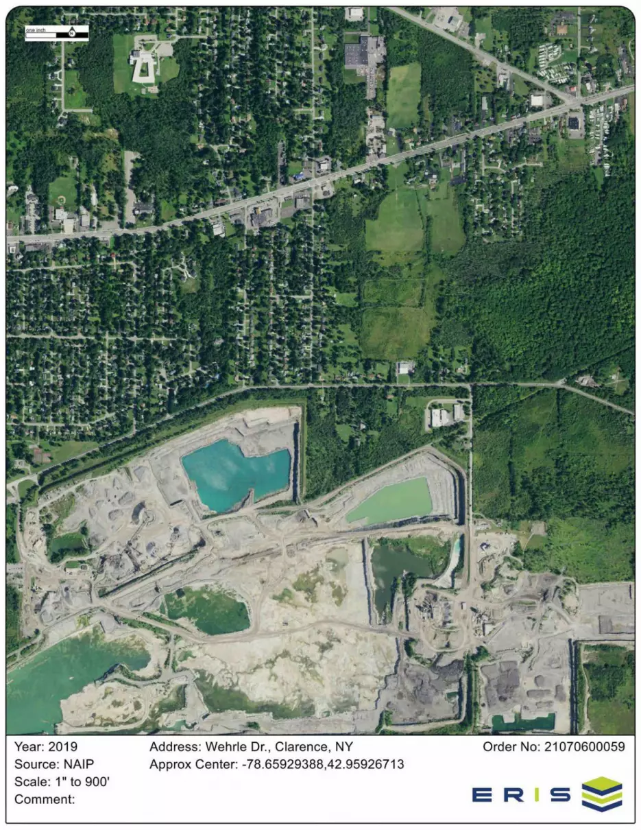

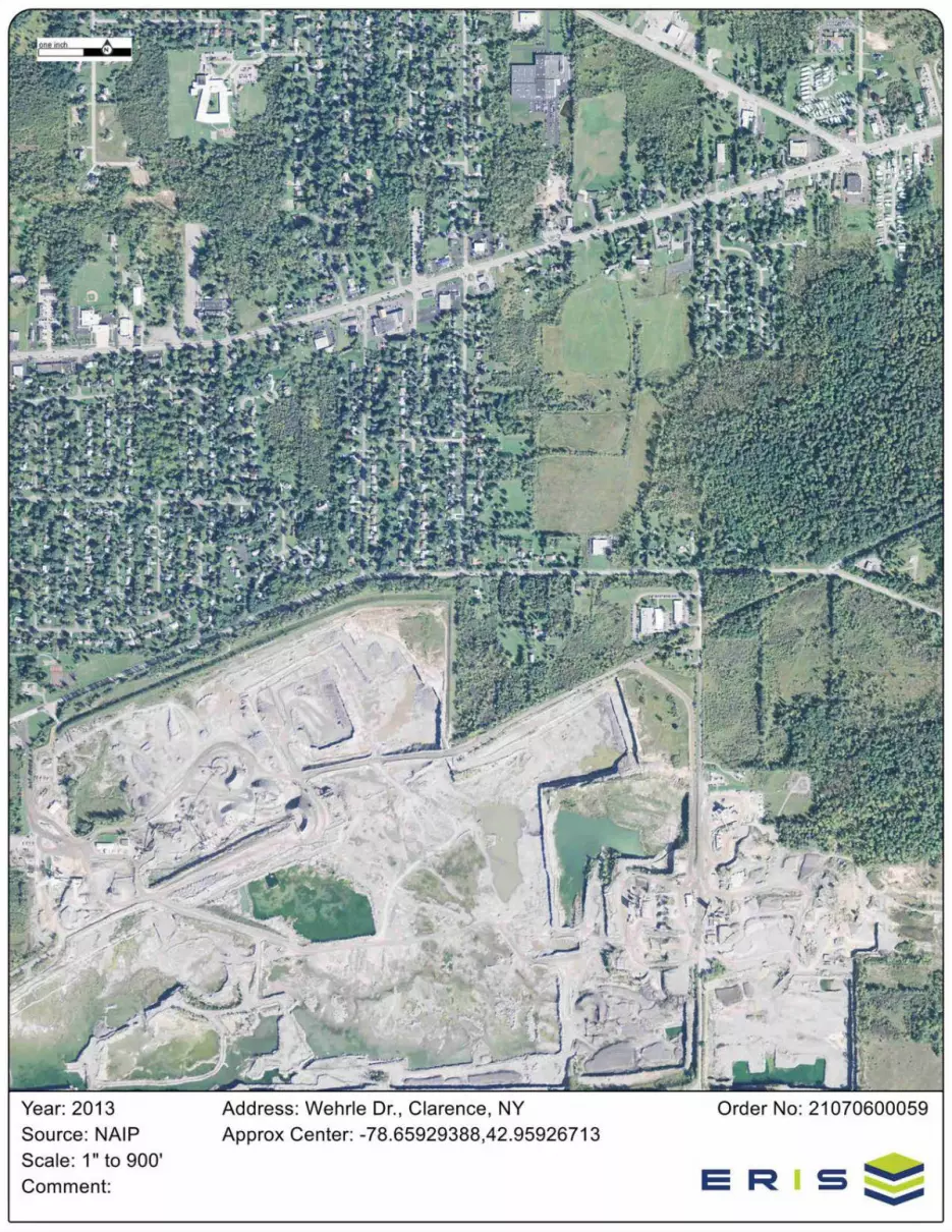


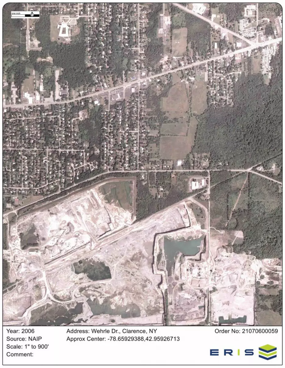

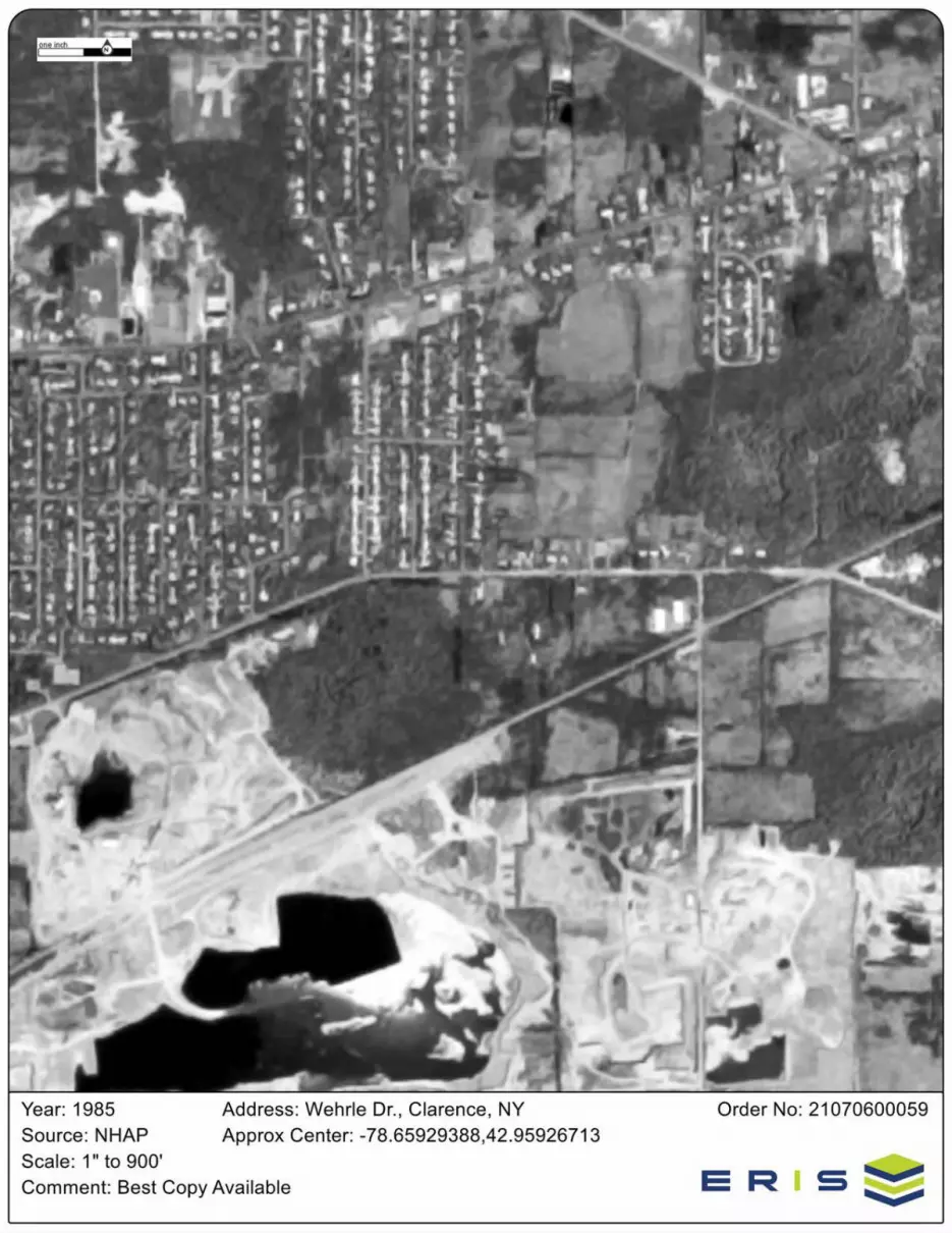
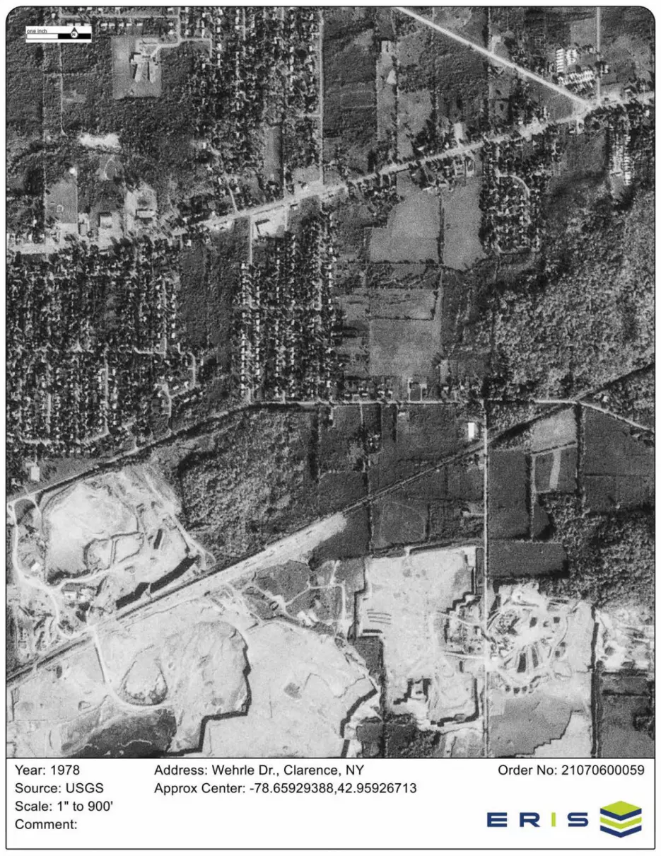
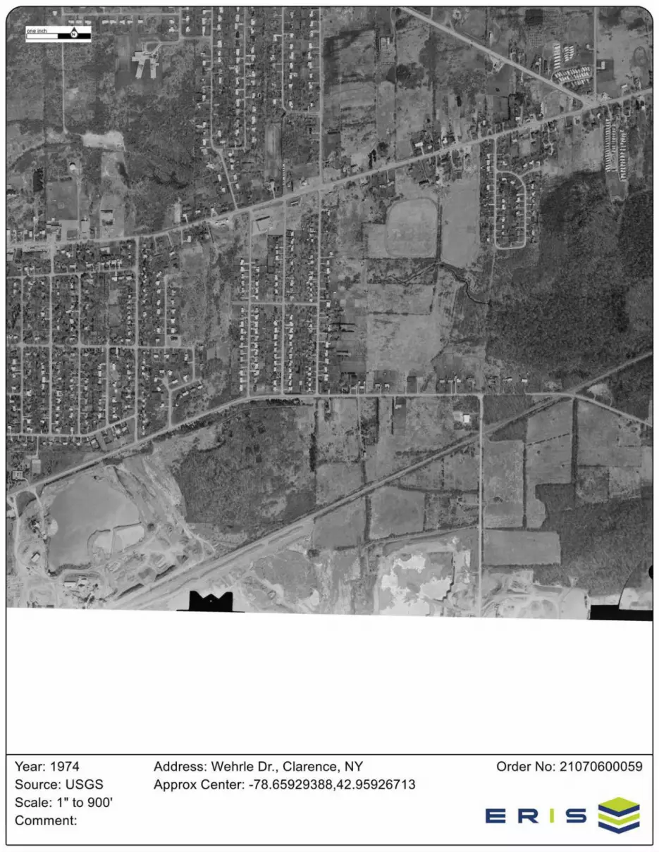
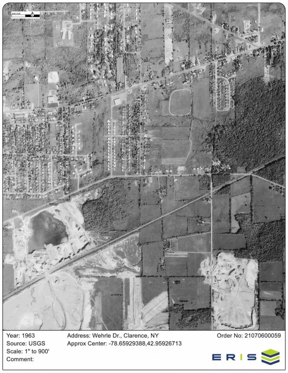


Project Property:
Project No:
Requested By:
Order No:
Date Completed:
Wehrle Dr Ped Access
Wehrle Dr.
Clarence NY
X52001001.1602
C&S Companies
21070600059
July 07, 2021

Listed below, please find the results of our search for historic fire insurance maps from our in-house collection, performed inconjuction with your ERIS report.
Individual Fire Insurance Maps for the subject property and/or adjacent sites are included with the ERIS environmental database report to be used for research purposes only and cannot be resold for any other commercial uses other than for use in a Phase Ienvironmental assessment.
Date City State Volume Sheet Number(s)
1946 Clarence New York 5
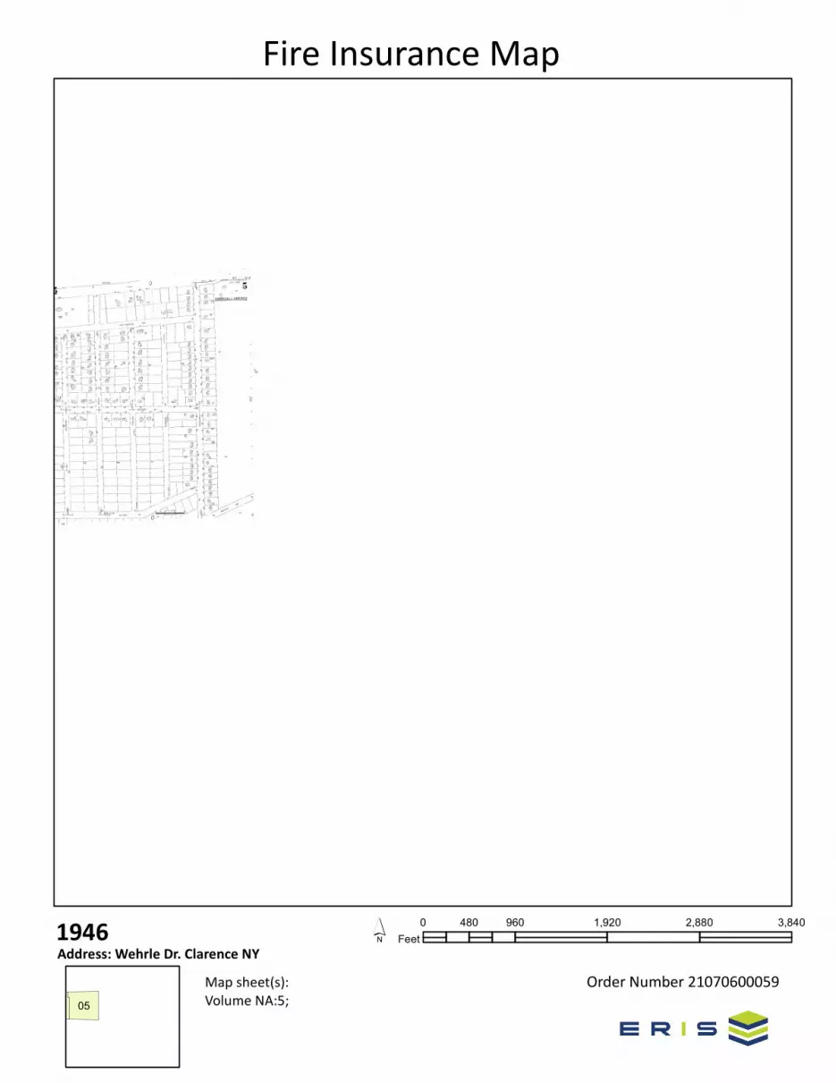
0 960 1,920 2,880 3,840480Feet
Order Number 21070600059
1946Address: Wehrle Dr. Clarence NY
Map sheet(s): Volume NA:5;
´
Fire Insurance Map
05
1 erisinfo.com| Environmental Risk Information Services Order No: 21070600059p
Property Information
Order Number: 21070600059p
Date Completed: July 7, 2021
Project Number: X52001001.1602
Project Property: Wehrle Dr Ped AccessWehrle Dr., Clarence NY
Coordinates:Latitude: 42.95926713Longitude: -78.65929388UTM Northing: 4759050.09917 MetersUTM Easting: 690914.210281 MetersUTM Zone: UTM Zone 17TElevation: 716.01 ftSlope Direction: SW
Topographic Information........................................................................................................................................2Hydrologic Information.........................................................................................................................................12Geologic Information............................................................................................................................................24Soil Information....................................................................................................................................................28Wells and Additional Sources..............................................................................................................................43
Summary..........................................................................................................................................................48Detail Report....................................................................................................................................................50
Radon Information...............................................................................................................................................76Appendix..............................................................................................................................................................77Liability Notice......................................................................................................................................................79
The ERIS Physical Setting Report - PSR provides comprehensive information about the physical setting around a site and includes a
complete overview of topography and surface topology, in addition to hydrologic, geologic and soil characteristics. The location and
detailed attributes of oil and gas wells, water wells, public water systems and radon are also included for review.
The compilation of both physical characteristics of a site and additional attribute data is useful in assessing the impact of migration of
contaminants and subsequent impact on soils and groundwater.
Disclaimer
This Report does not provide a full environmental evaluation for the site or adjacent properties. Please see the terms and disclaimer at
the end of the Report for greater detail.
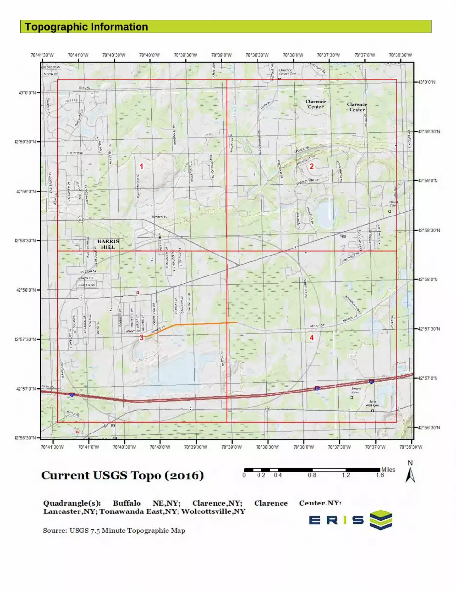
Topographic Information

Topographic Information
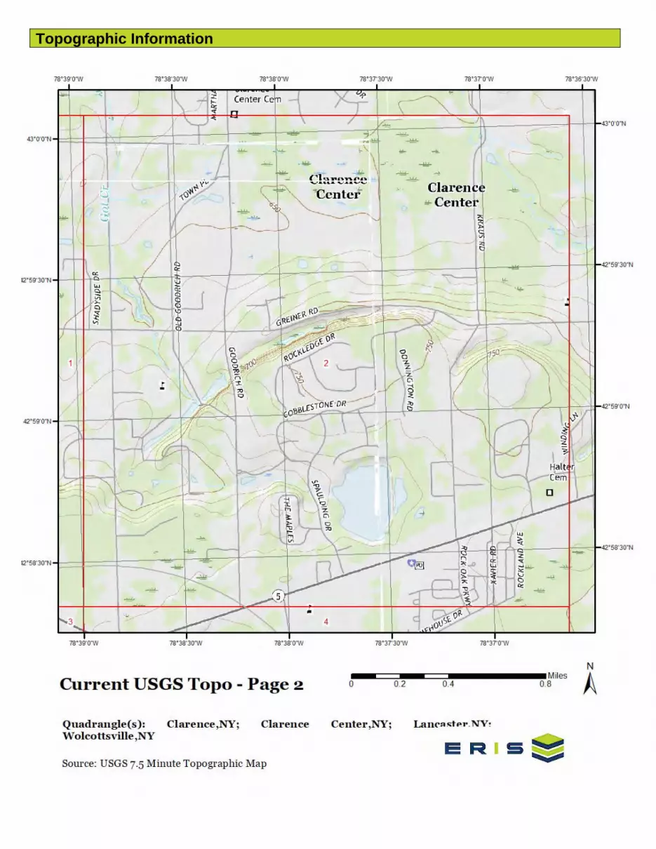
Topographic Information

Topographic Information

Topographic Information

Topographic Information
7 erisinfo.com| Environmental Risk Information Services Order No: 21070600059p
The previous topographic map(s) are created by seamlessly merging and cutting current USGS topographic data. Below are shaded relief map(s), derived from USGS elevation data to show surrounding topography in further detail.
Topographic information at project property:
Elevation: 716.01 ftSlope Direction: SW

Topographic Information
8 erisinfo.com| Environmental Risk Information Services Order No: 21070600059p

Topographic Information
9 erisinfo.com| Environmental Risk Information Services Order No: 21070600059p
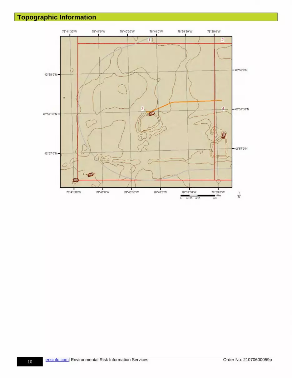
Topographic Information
10 erisinfo.com| Environmental Risk Information Services Order No: 21070600059p
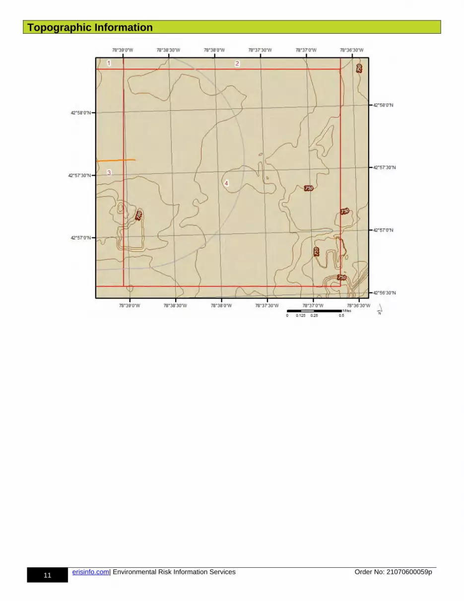
Topographic Information
11 erisinfo.com| Environmental Risk Information Services Order No: 21070600059p
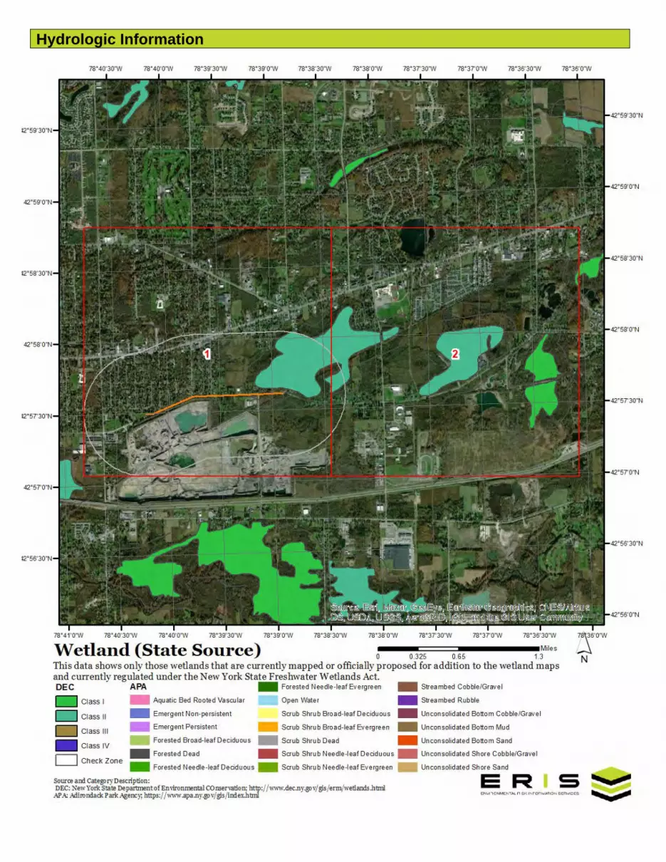
Hydrologic Information
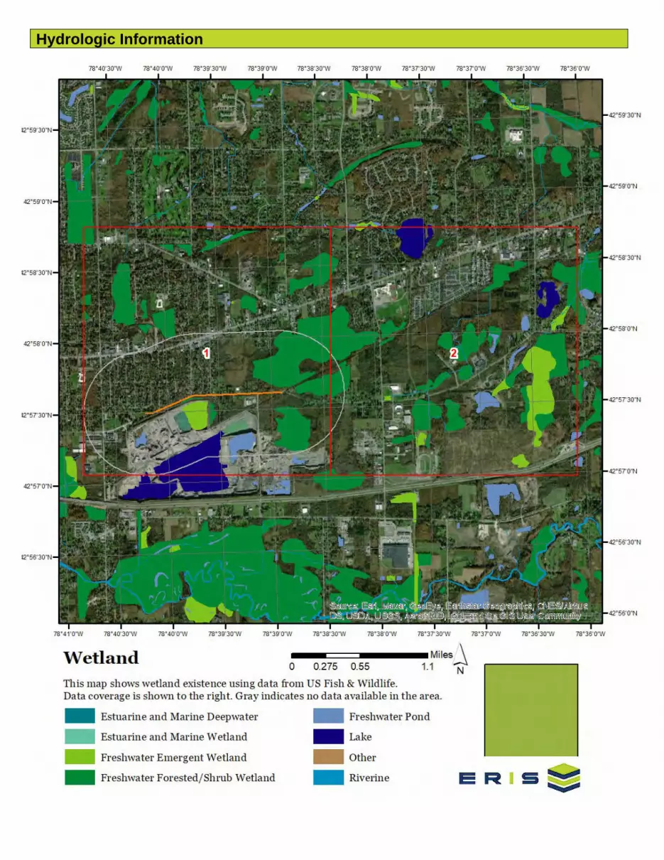
Hydrologic Information
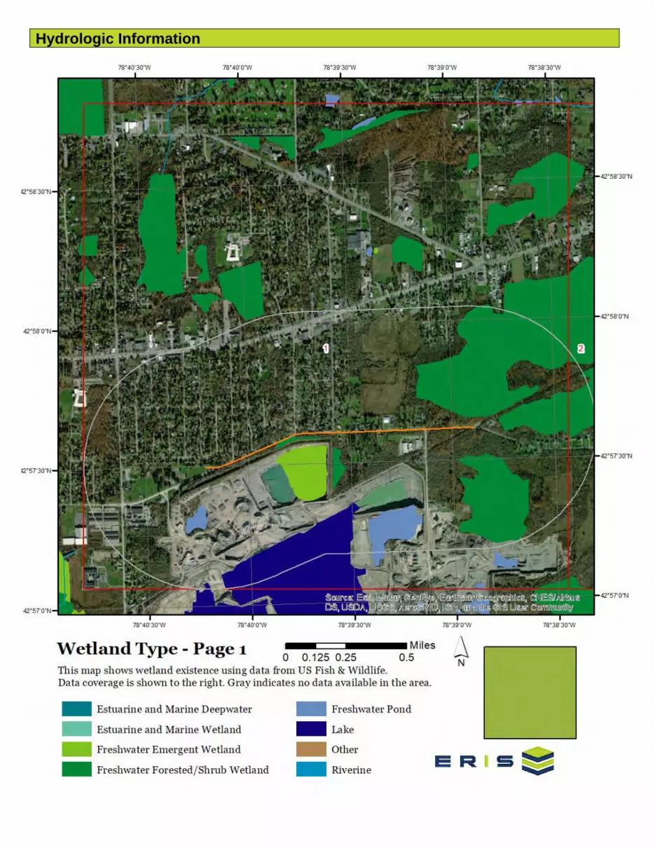
Hydrologic Information
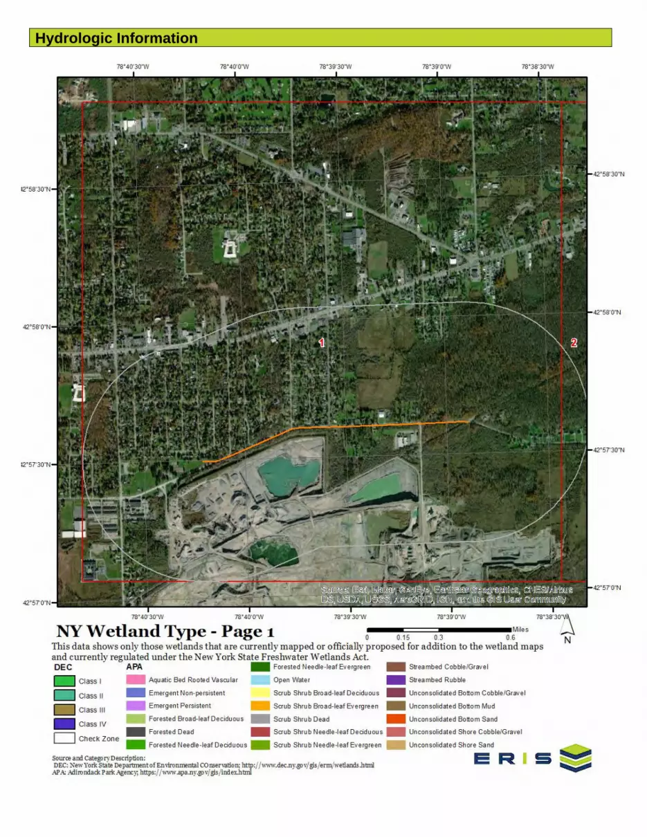
Hydrologic Information
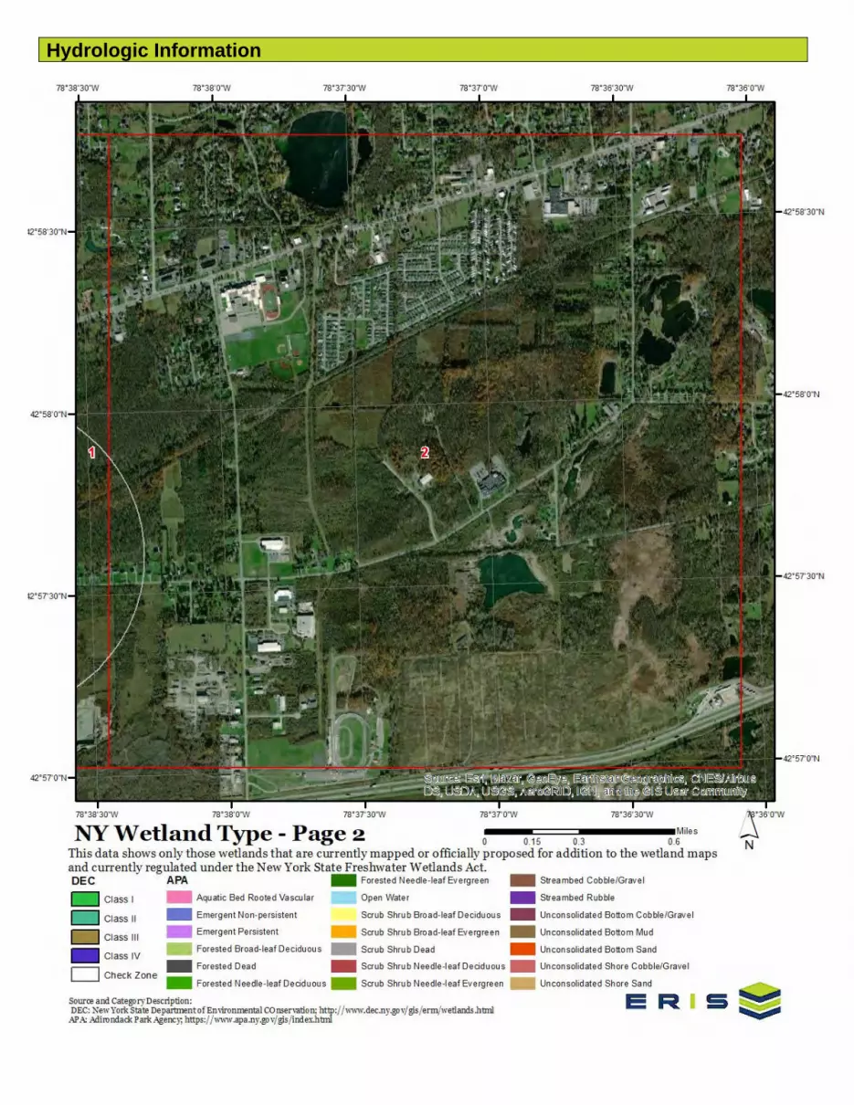
Hydrologic Information

Hydrologic Information

Hydrologic Information
Hydrologic Information
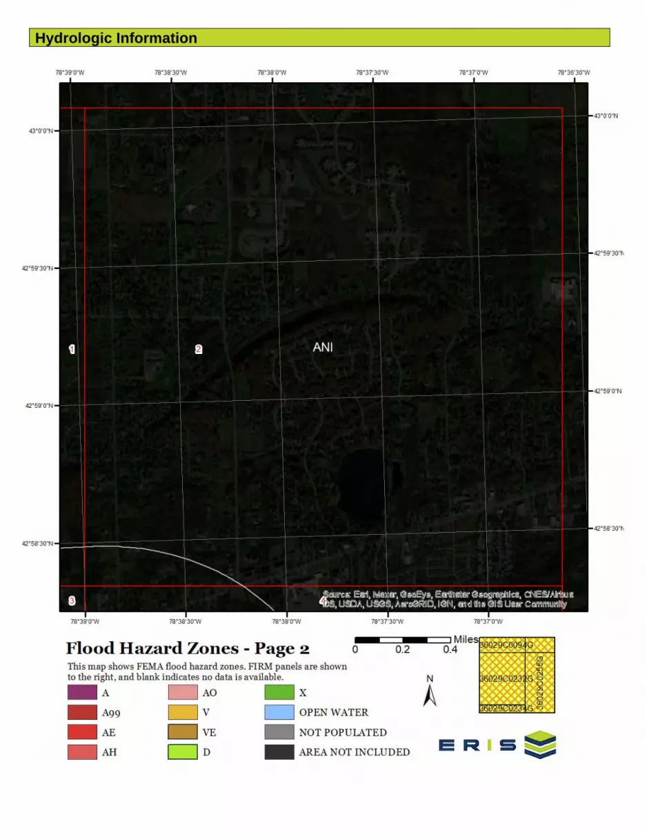
Hydrologic Information
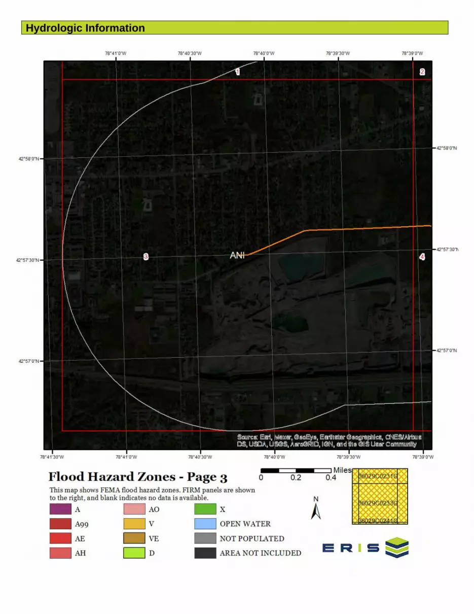
Hydrologic Information
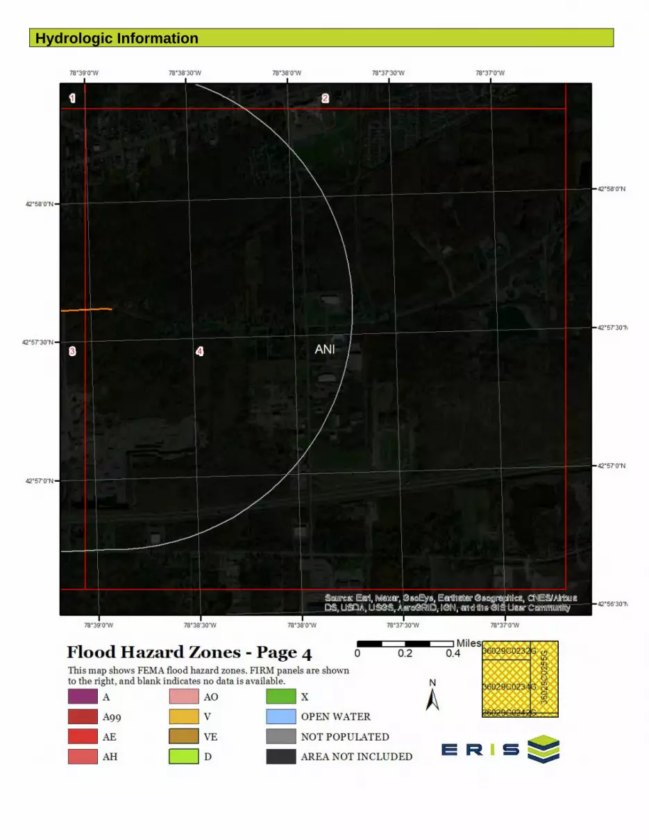
Hydrologic Information
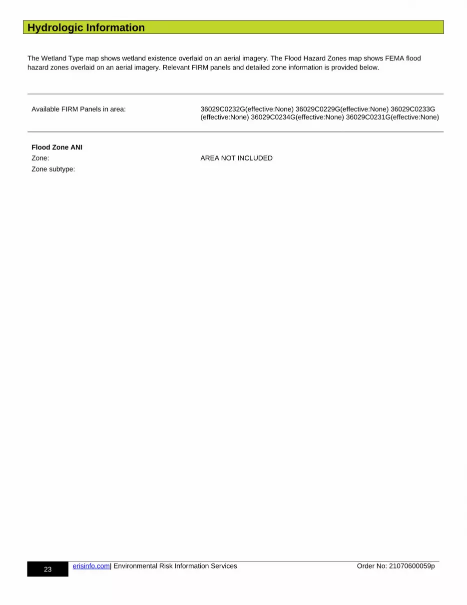
Hydrologic Information
23 erisinfo.com| Environmental Risk Information Services Order No: 21070600059p
The Wetland Type map shows wetland existence overlaid on an aerial imagery. The Flood Hazard Zones map shows FEMA flood hazard zones overlaid on an aerial imagery. Relevant FIRM panels and detailed zone information is provided below.
Available FIRM Panels in area: 36029C0232G(effective:None) 36029C0229G(effective:None) 36029C0233G(effective:None) 36029C0234G(effective:None) 36029C0231G(effective:None)
Flood Zone ANI
Zone: AREA NOT INCLUDED
Zone subtype:

Geologic Information

Geologic Information

Geologic Information
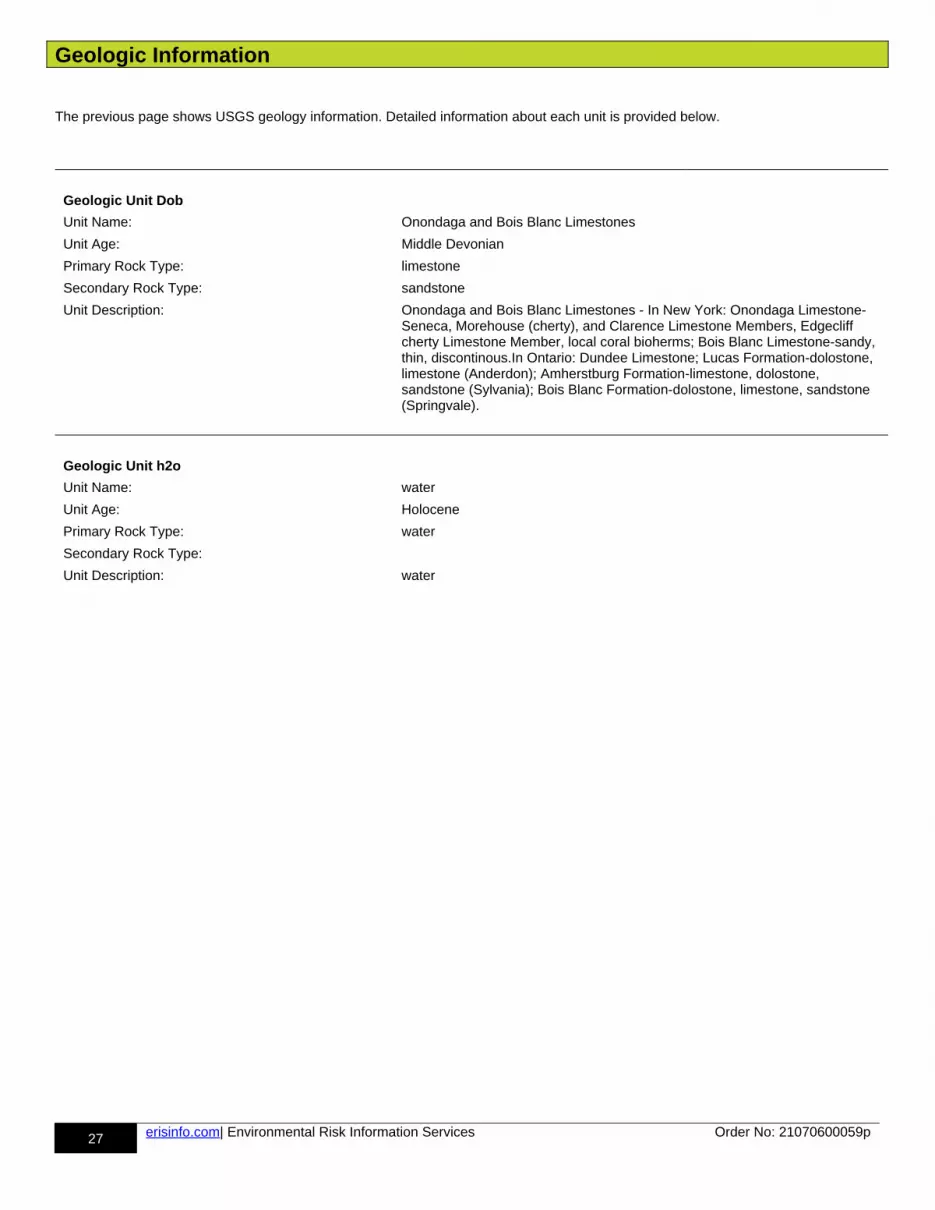
Geologic Information
27 erisinfo.com| Environmental Risk Information Services Order No: 21070600059p
The previous page shows USGS geology information. Detailed information about each unit is provided below.
Geologic Unit Dob
Unit Name: Onondaga and Bois Blanc Limestones
Unit Age: Middle Devonian
Primary Rock Type: limestone
Secondary Rock Type: sandstone
Unit Description: Onondaga and Bois Blanc Limestones - In New York: Onondaga Limestone-Seneca, Morehouse (cherty), and Clarence Limestone Members, Edgecliff cherty Limestone Member, local coral bioherms; Bois Blanc Limestone-sandy, thin, discontinous.In Ontario: Dundee Limestone; Lucas Formation-dolostone, limestone (Anderdon); Amherstburg Formation-limestone, dolostone, sandstone (Sylvania); Bois Blanc Formation-dolostone, limestone, sandstone (Springvale).
Geologic Unit h2o
Unit Name: water
Unit Age: Holocene
Primary Rock Type: water
Secondary Rock Type:
Unit Description: water
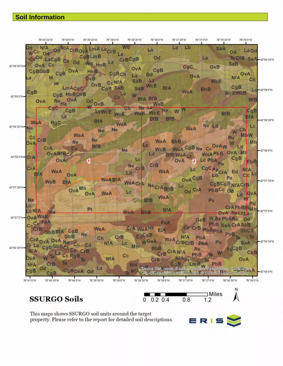
Soil Information

Soil Information
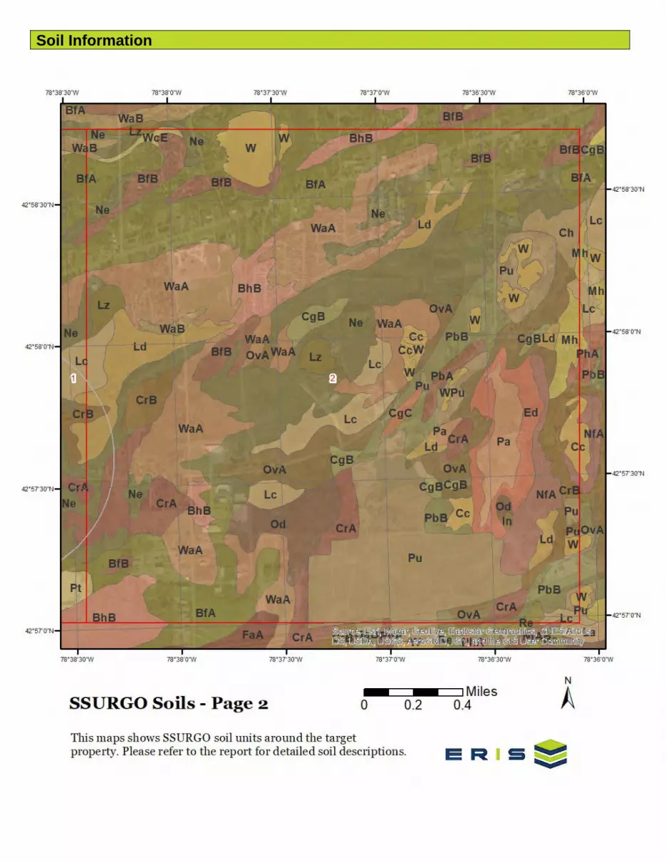
Soil Information

Soil Information
31 erisinfo.com| Environmental Risk Information Services Order No: 21070600059p
The previous page shows a soil map using SSURGO data from USDA Natural Resources Conservation Service. Detailed information about each unit is provided below.
Map Unit BfA (35.46%)
Map Unit Name: Benson very channery loam, 0 to 3 percent slopes
Bedrock Depth - Min: 38cm
Watertable Depth - Annual Min: null
Drainage Class - Dominant: Somewhat excessively drained
Hydrologic Group - Dominant: D - Soils in this group have high runoff potential when thoroughly wet. Water movement through the soil is restricted or very restricted.
Major components are printed below
Benson(75%)
horizon H1(0cm to 15cm) Very channery loam horizon H2(15cm to 38cm) Very channery loam horizon H3(38cm to 48cm) Unweathered bedrock
Component Description:
Minor map unit components are excluded from this report.
Map Unit: BfA - Benson very channery loam, 0 to 3 percent slopes
Component: Benson (75%)The Benson component makes up 75 percent of the map unit. Slopes are 0 to 3 percent. This component is on benches, ridges, till plains. The parent material consists of channery loamy till underlain by limestone or calcareous shale. Depth to a root restrictive layer, bedrock, lithic, is 10 to 20 inches. The natural drainage class is somewhat excessively drained. Water movement in the most restrictive layer is very low. Available water to a depth of 60 inches (or restricted depth) is very low. Shrink-swell potential is low. This soil is not flooded. It is not ponded. There is no zone of water saturation within a depth of 72 inches. Organic matter content in the surface horizon is about 4 percent. Nonirrigated land capability classification is 3s. This soil does not meet hydric criteria.
Component: Farmington (5%)Generated brief soil descriptions are created for major soil components. The Farmington soil is a minor component.
Component: Wassaic (5%)Generated brief soil descriptions are created for major soil components. The Wassaic soil is a minor component.
Component: Newstead (5%)Generated brief soil descriptions are created for major soil components. The Newstead soil is a minor component.
Component: Lima (5%)Generated brief soil descriptions are created for major soil components. The Lima soil is a minor component.
Component: Unnamed soils (5%)Generated brief soil descriptions are created for major soil components. The Unnamed soils soil is a minor component.
Map Unit BfB (0.36%)
Map Unit Name: Benson very channery loam, 3 to 8 percent slopes
Bedrock Depth - Min: 38cm
Watertable Depth - Annual Min: null
Drainage Class - Dominant: Somewhat excessively drained
Hydrologic Group - Dominant: D - Soils in this group have high runoff potential when thoroughly wet. Water movement through the soil is restricted or very restricted.
Major components are printed below
Benson(75%)

Soil Information
32 erisinfo.com| Environmental Risk Information Services Order No: 21070600059p
horizon H1(0cm to 15cm) Very channery loam horizon H2(15cm to 38cm) Very channery loam horizon H3(38cm to 48cm) Unweathered bedrock
Component Description:
Minor map unit components are excluded from this report.
Map Unit: BfB - Benson very channery loam, 3 to 8 percent slopes
Component: Benson (75%)The Benson component makes up 75 percent of the map unit. Slopes are 3 to 8 percent. This component is on till plains, ridges, benches. The parent material consists of channery loamy till underlain by limestone or calcareous shale. Depth to a root restrictive layer, bedrock, lithic, is 10 to 20 inches. The natural drainage class is somewhat excessively drained. Water movement in the most restrictive layer is very low. Available water to a depth of 60 inches (or restricted depth) is very low. Shrink-swell potential is low. This soil is not flooded. It is not ponded. There is no zone of water saturation within a depth of 72 inches. Organic matter content in the surface horizon is about 4 percent. Nonirrigated land capability classification is 3s. This soil does not meet hydric criteria.
Component: Farmington (5%)Generated brief soil descriptions are created for major soil components. The Farmington soil is a minor component.
Component: Unnamed soils (5%)Generated brief soil descriptions are created for major soil components. The Unnamed soils soil is a minor component.
Component: Lima (5%)Generated brief soil descriptions are created for major soil components. The Lima soil is a minor component.
Component: Newstead (5%)Generated brief soil descriptions are created for major soil components. The Newstead soil is a minor component.
Component: Wassaic (5%)Generated brief soil descriptions are created for major soil components. The Wassaic soil is a minor component.
Map Unit Cc (0.58%)
Map Unit Name: Canandaigua silt loam
Bedrock Depth - Min: null
Watertable Depth - Annual Min: 15cm
Drainage Class - Dominant: Poorly drained
Hydrologic Group - Dominant: C/D - These soils have moderately high runoff potential when drained and highrunoff potential when undrained.
Major components are printed below
Canandaigua(75%)
horizon H1(0cm to 23cm) Silt loam horizon H2(23cm to 94cm) Silt loam horizon H3(94cm to 152cm) Silt loam
Component Description:
Minor map unit components are excluded from this report.
Map Unit: Cc - Canandaigua silt loam
Component: Canandaigua (75%)The Canandaigua component makes up 75 percent of the map unit. Slopes are 0 to 3 percent. This component is on depressions. The parent material consists of silty and clayey glaciolacustrine deposits. Depth to a root restrictive layer is greater than 60 inches. The natural drainage class is poorly drained. Water movement in the most restrictive layer is moderately high. Available water to a depth of 60 inches (or restricted depth) is very high. Shrink-swell potential is low. This soil is not flooded. It is frequently ponded. A seasonal zone of water saturation is at 6 inches during January, February, March, April, May, November, December. Organic matter content in the surface horizon is about 10 percent. Nonirrigated land capability classification is 3w. This soil meets hydric criteria. Thecalcium carbonate equivalent within 40 inches, typically, does not exceed 1 percent.
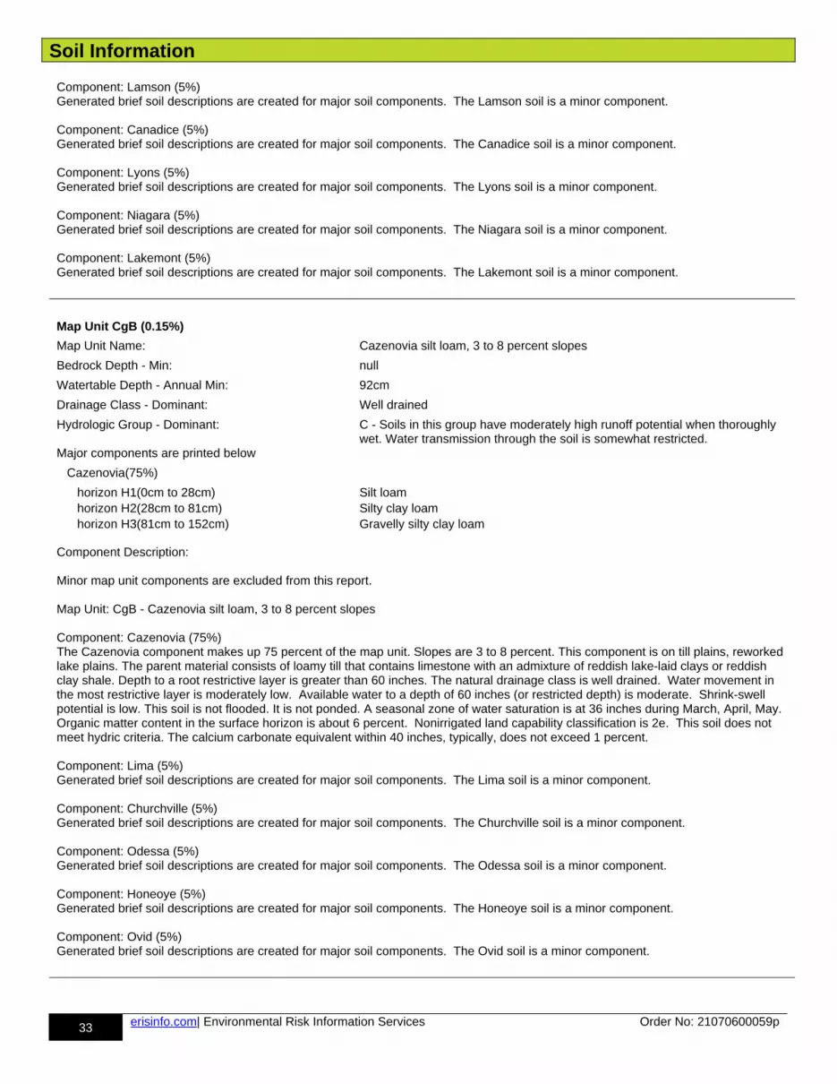
Soil Information
33 erisinfo.com| Environmental Risk Information Services Order No: 21070600059p
Component: Lamson (5%)Generated brief soil descriptions are created for major soil components. The Lamson soil is a minor component.
Component: Canadice (5%)Generated brief soil descriptions are created for major soil components. The Canadice soil is a minor component.
Component: Lyons (5%)Generated brief soil descriptions are created for major soil components. The Lyons soil is a minor component.
Component: Niagara (5%)Generated brief soil descriptions are created for major soil components. The Niagara soil is a minor component.
Component: Lakemont (5%)Generated brief soil descriptions are created for major soil components. The Lakemont soil is a minor component.
Map Unit CgB (0.15%)
Map Unit Name: Cazenovia silt loam, 3 to 8 percent slopes
Bedrock Depth - Min: null
Watertable Depth - Annual Min: 92cm
Drainage Class - Dominant: Well drained
Hydrologic Group - Dominant: C - Soils in this group have moderately high runoff potential when thoroughly wet. Water transmission through the soil is somewhat restricted.
Major components are printed below
Cazenovia(75%)
horizon H1(0cm to 28cm) Silt loam horizon H2(28cm to 81cm) Silty clay loam horizon H3(81cm to 152cm) Gravelly silty clay loam
Component Description:
Minor map unit components are excluded from this report.
Map Unit: CgB - Cazenovia silt loam, 3 to 8 percent slopes
Component: Cazenovia (75%)The Cazenovia component makes up 75 percent of the map unit. Slopes are 3 to 8 percent. This component is on till plains, reworked lake plains. The parent material consists of loamy till that contains limestone with an admixture of reddish lake-laid clays or reddish clay shale. Depth to a root restrictive layer is greater than 60 inches. The natural drainage class is well drained. Water movement in the most restrictive layer is moderately low. Available water to a depth of 60 inches (or restricted depth) is moderate. Shrink-swell potential is low. This soil is not flooded. It is not ponded. A seasonal zone of water saturation is at 36 inches during March, April, May. Organic matter content in the surface horizon is about 6 percent. Nonirrigated land capability classification is 2e. This soil does not meet hydric criteria. The calcium carbonate equivalent within 40 inches, typically, does not exceed 1 percent.
Component: Lima (5%)Generated brief soil descriptions are created for major soil components. The Lima soil is a minor component.
Component: Churchville (5%)Generated brief soil descriptions are created for major soil components. The Churchville soil is a minor component.
Component: Odessa (5%)Generated brief soil descriptions are created for major soil components. The Odessa soil is a minor component.
Component: Honeoye (5%)Generated brief soil descriptions are created for major soil components. The Honeoye soil is a minor component.
Component: Ovid (5%)Generated brief soil descriptions are created for major soil components. The Ovid soil is a minor component.
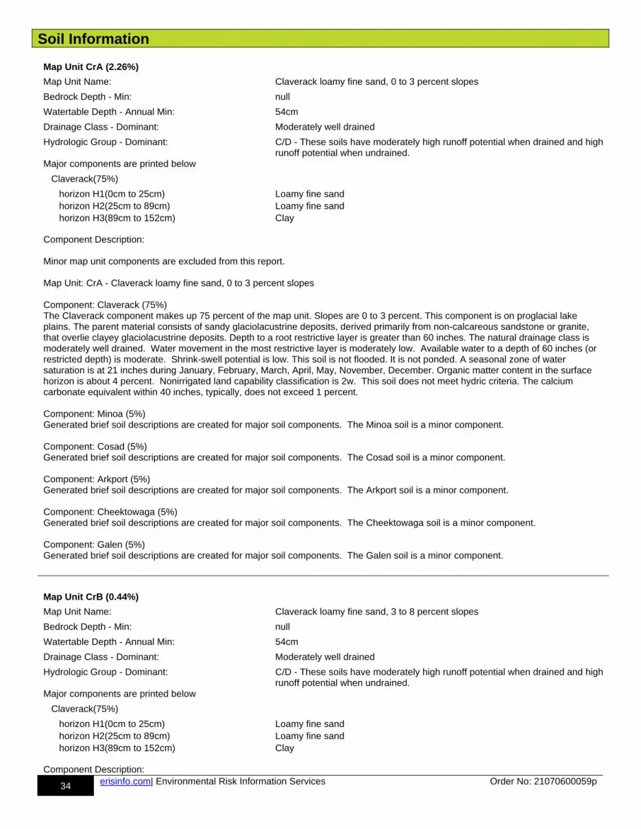
Soil Information
34 erisinfo.com| Environmental Risk Information Services Order No: 21070600059p
Map Unit CrA (2.26%)
Map Unit Name: Claverack loamy fine sand, 0 to 3 percent slopes
Bedrock Depth - Min: null
Watertable Depth - Annual Min: 54cm
Drainage Class - Dominant: Moderately well drained
Hydrologic Group - Dominant: C/D - These soils have moderately high runoff potential when drained and highrunoff potential when undrained.
Major components are printed below
Claverack(75%)
horizon H1(0cm to 25cm) Loamy fine sand horizon H2(25cm to 89cm) Loamy fine sand horizon H3(89cm to 152cm) Clay
Component Description:
Minor map unit components are excluded from this report.
Map Unit: CrA - Claverack loamy fine sand, 0 to 3 percent slopes
Component: Claverack (75%)The Claverack component makes up 75 percent of the map unit. Slopes are 0 to 3 percent. This component is on proglacial lake plains. The parent material consists of sandy glaciolacustrine deposits, derived primarily from non-calcareous sandstone or granite, that overlie clayey glaciolacustrine deposits. Depth to a root restrictive layer is greater than 60 inches. The natural drainage class is moderately well drained. Water movement in the most restrictive layer is moderately low. Available water to a depth of 60 inches (or restricted depth) is moderate. Shrink-swell potential is low. This soil is not flooded. It is not ponded. A seasonal zone of water saturation is at 21 inches during January, February, March, April, May, November, December. Organic matter content in the surface horizon is about 4 percent. Nonirrigated land capability classification is 2w. This soil does not meet hydric criteria. The calcium carbonate equivalent within 40 inches, typically, does not exceed 1 percent.
Component: Minoa (5%)Generated brief soil descriptions are created for major soil components. The Minoa soil is a minor component.
Component: Cosad (5%)Generated brief soil descriptions are created for major soil components. The Cosad soil is a minor component.
Component: Arkport (5%)Generated brief soil descriptions are created for major soil components. The Arkport soil is a minor component.
Component: Cheektowaga (5%)Generated brief soil descriptions are created for major soil components. The Cheektowaga soil is a minor component.
Component: Galen (5%)Generated brief soil descriptions are created for major soil components. The Galen soil is a minor component.
Map Unit CrB (0.44%)
Map Unit Name: Claverack loamy fine sand, 3 to 8 percent slopes
Bedrock Depth - Min: null
Watertable Depth - Annual Min: 54cm
Drainage Class - Dominant: Moderately well drained
Hydrologic Group - Dominant: C/D - These soils have moderately high runoff potential when drained and highrunoff potential when undrained.
Major components are printed below
Claverack(75%)
horizon H1(0cm to 25cm) Loamy fine sand horizon H2(25cm to 89cm) Loamy fine sand horizon H3(89cm to 152cm) Clay
Component Description:

Soil Information
35 erisinfo.com| Environmental Risk Information Services Order No: 21070600059p
Minor map unit components are excluded from this report.
Map Unit: CrB - Claverack loamy fine sand, 3 to 8 percent slopes
Component: Claverack (75%)The Claverack component makes up 75 percent of the map unit. Slopes are 3 to 8 percent. This component is on proglacial lake plains. The parent material consists of sandy glaciolacustrine deposits, derived primarily from non-calcareous sandstone or granite, that overlie clayey glaciolacustrine deposits. Depth to a root restrictive layer is greater than 60 inches. The natural drainage class is moderately well drained. Water movement in the most restrictive layer is moderately low. Available water to a depth of 60 inches (or restricted depth) is moderate. Shrink-swell potential is low. This soil is not flooded. It is not ponded. A seasonal zone of water saturation is at 21 inches during January, February, March, April, May, November, December. Organic matter content in the surface horizon is about 4 percent. Nonirrigated land capability classification is 2w. This soil does not meet hydric criteria. The calcium carbonate equivalent within 40 inches, typically, does not exceed 1 percent.
Component: Minoa (5%)Generated brief soil descriptions are created for major soil components. The Minoa soil is a minor component.
Component: Cheektowaga (5%)Generated brief soil descriptions are created for major soil components. The Cheektowaga soil is a minor component.
Component: Cosad (5%)Generated brief soil descriptions are created for major soil components. The Cosad soil is a minor component.
Component: Arkport (5%)Generated brief soil descriptions are created for major soil components. The Arkport soil is a minor component.
Component: Galen (5%)Generated brief soil descriptions are created for major soil components. The Galen soil is a minor component.
Map Unit Cv (1.71%)
Map Unit Name: Cosad loamy fine sand
Bedrock Depth - Min: null
Watertable Depth - Annual Min: 31cm
Drainage Class - Dominant: Somewhat poorly drained
Hydrologic Group - Dominant: C/D - These soils have moderately high runoff potential when drained and highrunoff potential when undrained.
Major components are printed below
Cosad(75%)
horizon H1(0cm to 23cm) Loamy fine sand horizon H2(23cm to 53cm) Loamy fine sand horizon H3(53cm to 61cm) Fine sandy loam horizon H4(61cm to 152cm) Silty clay
Component Description:
Minor map unit components are excluded from this report.
Map Unit: Cv - Cosad loamy fine sand
Component: Cosad (75%)The Cosad component makes up 75 percent of the map unit. Slopes are 0 to 3 percent. This component is on proglacial lake plains. The parent material consists of sandy glaciofluvial or deltaic deposits over clayey glaciolacustrine deposits. Depth to a root restrictive layer is greater than 60 inches. The natural drainage class is somewhat poorly drained. Water movement in the most restrictive layer is moderately low. Available water to a depth of 60 inches (or restricted depth) is moderate. Shrink-swell potential is moderate. This soil is not flooded. It is not ponded. A seasonal zone of water saturation is at 12 inches during January, February, March, April, May, November, December. Organic matter content in the surface horizon is about 5 percent. Nonirrigated land capability classification is 3w. This soil does not meet hydric criteria. The calcium carbonate equivalent within 40 inches, typically, does not exceed 1 percent.
Component: Claverack (5%)
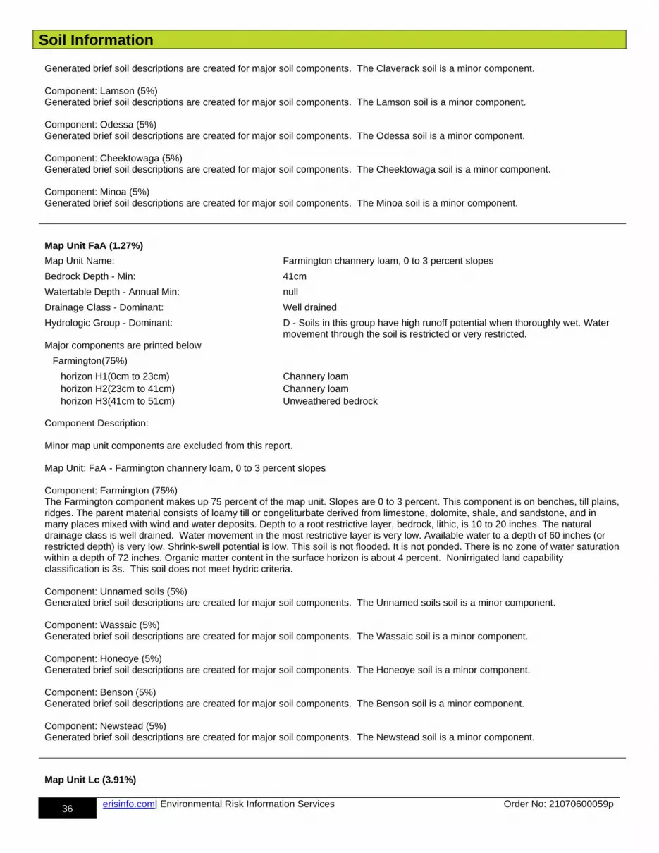
Soil Information
36 erisinfo.com| Environmental Risk Information Services Order No: 21070600059p
Generated brief soil descriptions are created for major soil components. The Claverack soil is a minor component.
Component: Lamson (5%)Generated brief soil descriptions are created for major soil components. The Lamson soil is a minor component.
Component: Odessa (5%)Generated brief soil descriptions are created for major soil components. The Odessa soil is a minor component.
Component: Cheektowaga (5%)Generated brief soil descriptions are created for major soil components. The Cheektowaga soil is a minor component.
Component: Minoa (5%)Generated brief soil descriptions are created for major soil components. The Minoa soil is a minor component.
Map Unit FaA (1.27%)
Map Unit Name: Farmington channery loam, 0 to 3 percent slopes
Bedrock Depth - Min: 41cm
Watertable Depth - Annual Min: null
Drainage Class - Dominant: Well drained
Hydrologic Group - Dominant: D - Soils in this group have high runoff potential when thoroughly wet. Water movement through the soil is restricted or very restricted.
Major components are printed below
Farmington(75%)
horizon H1(0cm to 23cm) Channery loam horizon H2(23cm to 41cm) Channery loam horizon H3(41cm to 51cm) Unweathered bedrock
Component Description:
Minor map unit components are excluded from this report.
Map Unit: FaA - Farmington channery loam, 0 to 3 percent slopes
Component: Farmington (75%)The Farmington component makes up 75 percent of the map unit. Slopes are 0 to 3 percent. This component is on benches, till plains,ridges. The parent material consists of loamy till or congeliturbate derived from limestone, dolomite, shale, and sandstone, and in many places mixed with wind and water deposits. Depth to a root restrictive layer, bedrock, lithic, is 10 to 20 inches. The natural drainage class is well drained. Water movement in the most restrictive layer is very low. Available water to a depth of 60 inches (or restricted depth) is very low. Shrink-swell potential is low. This soil is not flooded. It is not ponded. There is no zone of water saturationwithin a depth of 72 inches. Organic matter content in the surface horizon is about 4 percent. Nonirrigated land capability classification is 3s. This soil does not meet hydric criteria.
Component: Unnamed soils (5%)Generated brief soil descriptions are created for major soil components. The Unnamed soils soil is a minor component.
Component: Wassaic (5%)Generated brief soil descriptions are created for major soil components. The Wassaic soil is a minor component.
Component: Honeoye (5%)Generated brief soil descriptions are created for major soil components. The Honeoye soil is a minor component.
Component: Benson (5%)Generated brief soil descriptions are created for major soil components. The Benson soil is a minor component.
Component: Newstead (5%)Generated brief soil descriptions are created for major soil components. The Newstead soil is a minor component.
Map Unit Lc (3.91%)

Soil Information
37 erisinfo.com| Environmental Risk Information Services Order No: 21070600059p
Map Unit Name: Lamson very fine sandy loam
Bedrock Depth - Min: null
Watertable Depth - Annual Min: 7cm
Drainage Class - Dominant: Very poorly drained
Hydrologic Group - Dominant: A/D - These soils have low runoff potential when drained and high runoff potential when undrained.
Major components are printed below
Lamson(75%)
horizon H1(0cm to 23cm) Very fine sandy loam horizon H2(23cm to 102cm) Fine sandy loam horizon H3(102cm to 152cm) Loamy very fine sand
Component Description:
Minor map unit components are excluded from this report.
Map Unit: Lc - Lamson very fine sandy loam
Component: Lamson (75%)The Lamson component makes up 75 percent of the map unit. Slopes are 0 to 3 percent. This component is on depressions. The parent material consists of deltaic or glaciolacustrine deposits with a high content of fine and very fine sand. Depth to a root restrictive layer is greater than 60 inches. The natural drainage class is very poorly drained. Water movement in the most restrictive layer is moderately high. Available water to a depth of 60 inches (or restricted depth) is moderate. Shrink-swell potential is low. This soil is not flooded. It is not ponded. A seasonal zone of water saturation is at 3 inches during January, February, March, April, May, December. Organic matter content in the surface horizon is about 7 percent. Nonirrigated land capability classification is 5w. This soilmeets hydric criteria.
Component: Canandaigua (5%)Generated brief soil descriptions are created for major soil components. The Canandaigua soil is a minor component.
Component: Halsey (5%)Generated brief soil descriptions are created for major soil components. The Halsey soil is a minor component.
Component: Minoa (5%)Generated brief soil descriptions are created for major soil components. The Minoa soil is a minor component.
Component: Cheektowaga (5%)Generated brief soil descriptions are created for major soil components. The Cheektowaga soil is a minor component.
Component: Elnora (5%)Generated brief soil descriptions are created for major soil components. The Elnora soil is a minor component.
Map Unit Ld (3.51%)
Map Unit Name: Lamson mucky very fine sandy loam
Bedrock Depth - Min: null
Watertable Depth - Annual Min: 7cm
Drainage Class - Dominant: Very poorly drained
Hydrologic Group - Dominant: A/D - These soils have low runoff potential when drained and high runoff potential when undrained.
Major components are printed below
Lamson(75%)
horizon H1(0cm to 23cm) Mucky very fine sandy loam horizon H2(23cm to 102cm) Fine sandy loam horizon H3(102cm to 152cm) Loamy very fine sand
Component Description:
Minor map unit components are excluded from this report.
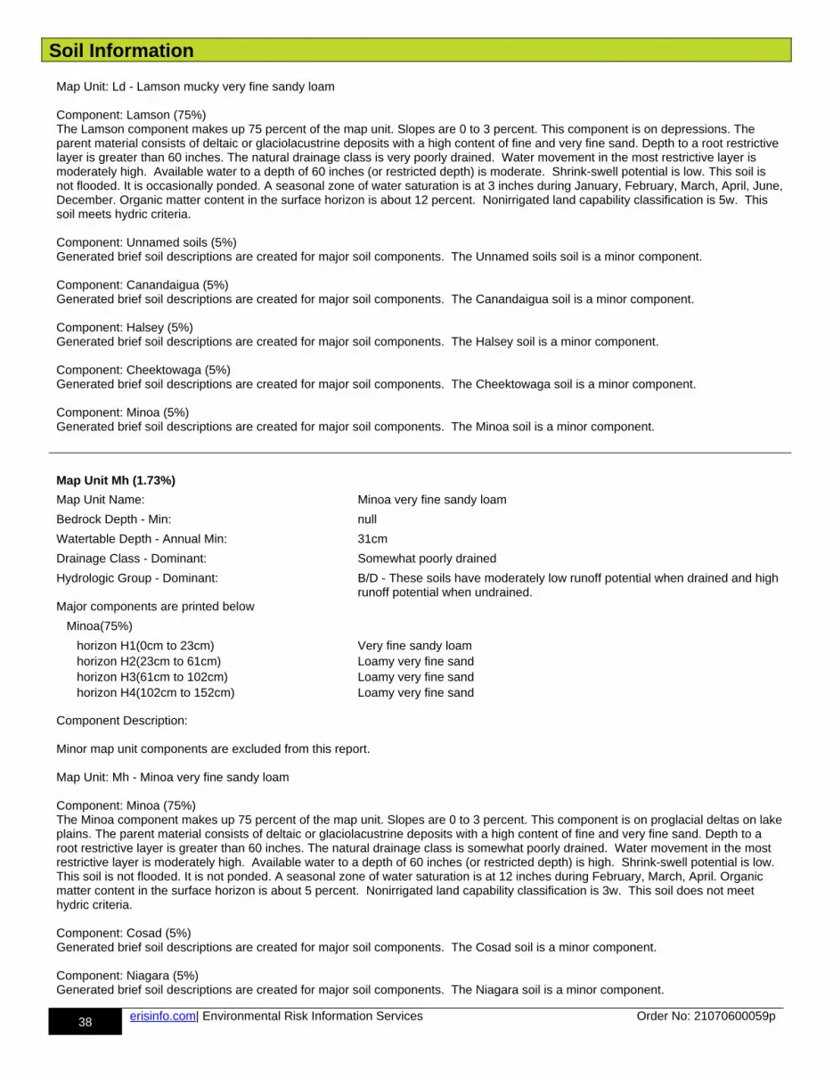
Soil Information
38 erisinfo.com| Environmental Risk Information Services Order No: 21070600059p
Map Unit: Ld - Lamson mucky very fine sandy loam
Component: Lamson (75%)The Lamson component makes up 75 percent of the map unit. Slopes are 0 to 3 percent. This component is on depressions. The parent material consists of deltaic or glaciolacustrine deposits with a high content of fine and very fine sand. Depth to a root restrictive layer is greater than 60 inches. The natural drainage class is very poorly drained. Water movement in the most restrictive layer is moderately high. Available water to a depth of 60 inches (or restricted depth) is moderate. Shrink-swell potential is low. This soil is not flooded. It is occasionally ponded. A seasonal zone of water saturation is at 3 inches during January, February, March, April, June,December. Organic matter content in the surface horizon is about 12 percent. Nonirrigated land capability classification is 5w. This soil meets hydric criteria.
Component: Unnamed soils (5%)Generated brief soil descriptions are created for major soil components. The Unnamed soils soil is a minor component.
Component: Canandaigua (5%)Generated brief soil descriptions are created for major soil components. The Canandaigua soil is a minor component.
Component: Halsey (5%)Generated brief soil descriptions are created for major soil components. The Halsey soil is a minor component.
Component: Cheektowaga (5%)Generated brief soil descriptions are created for major soil components. The Cheektowaga soil is a minor component.
Component: Minoa (5%)Generated brief soil descriptions are created for major soil components. The Minoa soil is a minor component.
Map Unit Mh (1.73%)
Map Unit Name: Minoa very fine sandy loam
Bedrock Depth - Min: null
Watertable Depth - Annual Min: 31cm
Drainage Class - Dominant: Somewhat poorly drained
Hydrologic Group - Dominant: B/D - These soils have moderately low runoff potential when drained and high runoff potential when undrained.
Major components are printed below
Minoa(75%)
horizon H1(0cm to 23cm) Very fine sandy loam horizon H2(23cm to 61cm) Loamy very fine sand horizon H3(61cm to 102cm) Loamy very fine sand horizon H4(102cm to 152cm) Loamy very fine sand
Component Description:
Minor map unit components are excluded from this report.
Map Unit: Mh - Minoa very fine sandy loam
Component: Minoa (75%)The Minoa component makes up 75 percent of the map unit. Slopes are 0 to 3 percent. This component is on proglacial deltas on lakeplains. The parent material consists of deltaic or glaciolacustrine deposits with a high content of fine and very fine sand. Depth to a root restrictive layer is greater than 60 inches. The natural drainage class is somewhat poorly drained. Water movement in the most restrictive layer is moderately high. Available water to a depth of 60 inches (or restricted depth) is high. Shrink-swell potential is low. This soil is not flooded. It is not ponded. A seasonal zone of water saturation is at 12 inches during February, March, April. Organic matter content in the surface horizon is about 5 percent. Nonirrigated land capability classification is 3w. This soil does not meet hydric criteria.
Component: Cosad (5%)Generated brief soil descriptions are created for major soil components. The Cosad soil is a minor component.
Component: Niagara (5%)Generated brief soil descriptions are created for major soil components. The Niagara soil is a minor component.
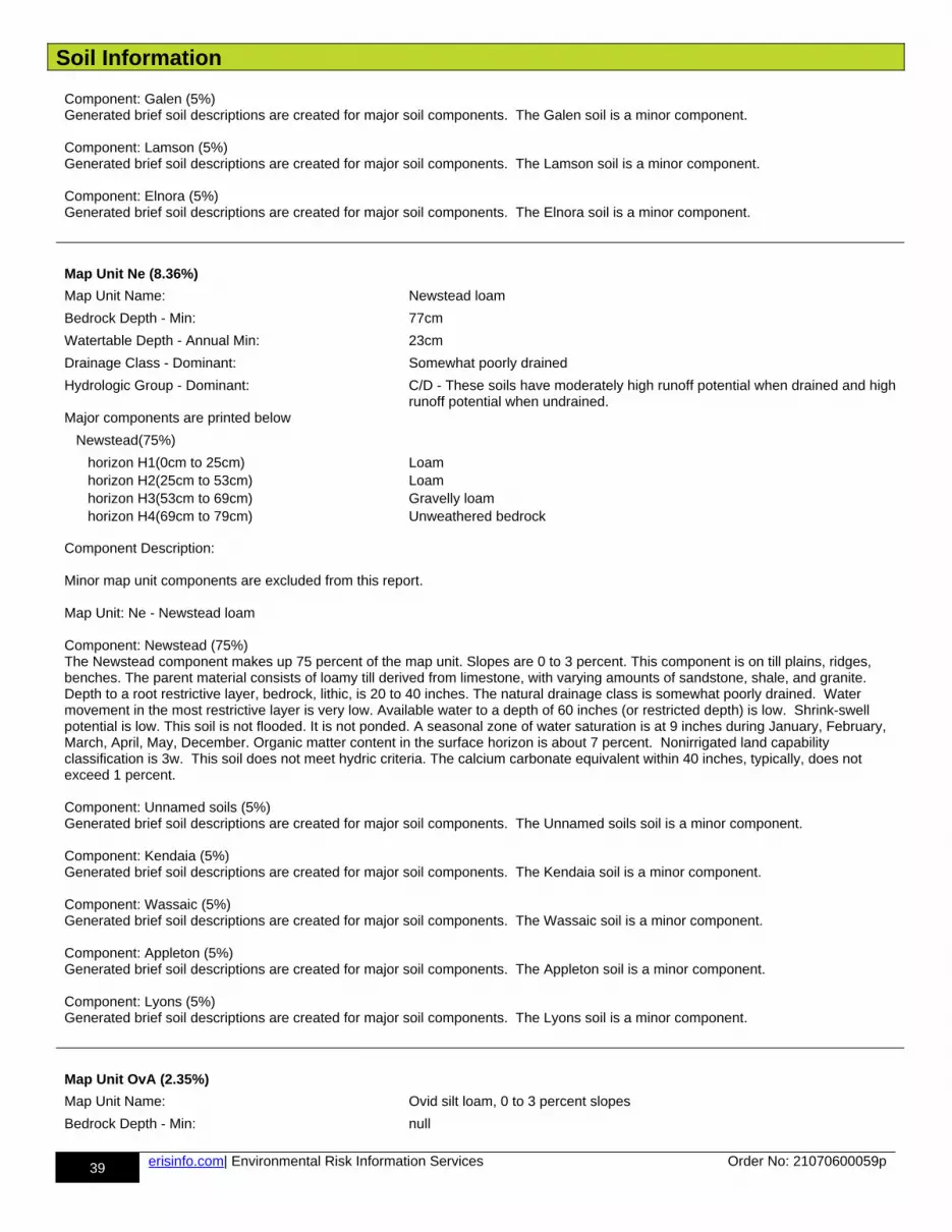
Soil Information
39 erisinfo.com| Environmental Risk Information Services Order No: 21070600059p
Component: Galen (5%)Generated brief soil descriptions are created for major soil components. The Galen soil is a minor component.
Component: Lamson (5%)Generated brief soil descriptions are created for major soil components. The Lamson soil is a minor component.
Component: Elnora (5%)Generated brief soil descriptions are created for major soil components. The Elnora soil is a minor component.
Map Unit Ne (8.36%)
Map Unit Name: Newstead loam
Bedrock Depth - Min: 77cm
Watertable Depth - Annual Min: 23cm
Drainage Class - Dominant: Somewhat poorly drained
Hydrologic Group - Dominant: C/D - These soils have moderately high runoff potential when drained and highrunoff potential when undrained.
Major components are printed below
Newstead(75%)
horizon H1(0cm to 25cm) Loam horizon H2(25cm to 53cm) Loam horizon H3(53cm to 69cm) Gravelly loam horizon H4(69cm to 79cm) Unweathered bedrock
Component Description:
Minor map unit components are excluded from this report.
Map Unit: Ne - Newstead loam
Component: Newstead (75%)The Newstead component makes up 75 percent of the map unit. Slopes are 0 to 3 percent. This component is on till plains, ridges, benches. The parent material consists of loamy till derived from limestone, with varying amounts of sandstone, shale, and granite. Depth to a root restrictive layer, bedrock, lithic, is 20 to 40 inches. The natural drainage class is somewhat poorly drained. Water movement in the most restrictive layer is very low. Available water to a depth of 60 inches (or restricted depth) is low. Shrink-swell potential is low. This soil is not flooded. It is not ponded. A seasonal zone of water saturation is at 9 inches during January, February, March, April, May, December. Organic matter content in the surface horizon is about 7 percent. Nonirrigated land capability classification is 3w. This soil does not meet hydric criteria. The calcium carbonate equivalent within 40 inches, typically, does not exceed 1 percent.
Component: Unnamed soils (5%)Generated brief soil descriptions are created for major soil components. The Unnamed soils soil is a minor component.
Component: Kendaia (5%)Generated brief soil descriptions are created for major soil components. The Kendaia soil is a minor component.
Component: Wassaic (5%)Generated brief soil descriptions are created for major soil components. The Wassaic soil is a minor component.
Component: Appleton (5%)Generated brief soil descriptions are created for major soil components. The Appleton soil is a minor component.
Component: Lyons (5%)Generated brief soil descriptions are created for major soil components. The Lyons soil is a minor component.
Map Unit OvA (2.35%)
Map Unit Name: Ovid silt loam, 0 to 3 percent slopes
Bedrock Depth - Min: null
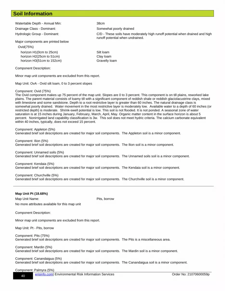
Soil Information
40 erisinfo.com| Environmental Risk Information Services Order No: 21070600059p
Watertable Depth - Annual Min: 38cm
Drainage Class - Dominant: Somewhat poorly drained
Hydrologic Group - Dominant: C/D - These soils have moderately high runoff potential when drained and highrunoff potential when undrained.
Major components are printed below
Ovid(75%)
horizon H1(0cm to 25cm) Silt loam horizon H2(25cm to 51cm) Clay loam horizon H3(51cm to 152cm) Gravelly loam
Component Description:
Minor map unit components are excluded from this report.
Map Unit: OvA - Ovid silt loam, 0 to 3 percent slopes
Component: Ovid (75%)The Ovid component makes up 75 percent of the map unit. Slopes are 0 to 3 percent. This component is on till plains, reworked lake plains. The parent material consists of loamy till with a significant component of reddish shale or reddish glaciolacustrine clays, mixed with limestone and some sandstone. Depth to a root restrictive layer is greater than 60 inches. The natural drainage class is somewhat poorly drained. Water movement in the most restrictive layer is moderately low. Available water to a depth of 60 inches (orrestricted depth) is moderate. Shrink-swell potential is low. This soil is not flooded. It is not ponded. A seasonal zone of water saturation is at 15 inches during January, February, March, April, May. Organic matter content in the surface horizon is about 5 percent. Nonirrigated land capability classification is 3w. This soil does not meet hydric criteria. The calcium carbonate equivalent within 40 inches, typically, does not exceed 15 percent.
Component: Appleton (5%)Generated brief soil descriptions are created for major soil components. The Appleton soil is a minor component.
Component: Ilion (5%)Generated brief soil descriptions are created for major soil components. The Ilion soil is a minor component.
Component: Unnamed soils (5%)Generated brief soil descriptions are created for major soil components. The Unnamed soils soil is a minor component.
Component: Kendaia (5%)Generated brief soil descriptions are created for major soil components. The Kendaia soil is a minor component.
Component: Churchville (5%)Generated brief soil descriptions are created for major soil components. The Churchville soil is a minor component.
Map Unit Pt (18.68%)
Map Unit Name: Pits, borrow
No more attributes available for this map unit
Component Description:
Minor map unit components are excluded from this report.
Map Unit: Pt - Pits, borrow
Component: Pits (75%)Generated brief soil descriptions are created for major soil components. The Pits is a miscellaneous area.
Component: Mardin (5%)Generated brief soil descriptions are created for major soil components. The Mardin soil is a minor component.
Component: Canandaigua (5%)Generated brief soil descriptions are created for major soil components. The Canandaigua soil is a minor component.
Component: Palmyra (5%)
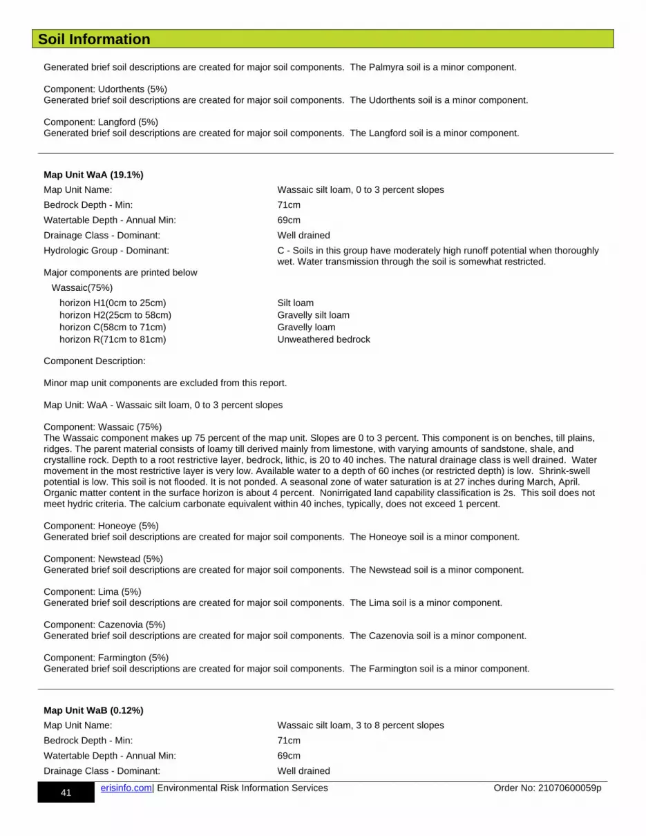
Soil Information
41 erisinfo.com| Environmental Risk Information Services Order No: 21070600059p
Generated brief soil descriptions are created for major soil components. The Palmyra soil is a minor component.
Component: Udorthents (5%)Generated brief soil descriptions are created for major soil components. The Udorthents soil is a minor component.
Component: Langford (5%)Generated brief soil descriptions are created for major soil components. The Langford soil is a minor component.
Map Unit WaA (19.1%)
Map Unit Name: Wassaic silt loam, 0 to 3 percent slopes
Bedrock Depth - Min: 71cm
Watertable Depth - Annual Min: 69cm
Drainage Class - Dominant: Well drained
Hydrologic Group - Dominant: C - Soils in this group have moderately high runoff potential when thoroughly wet. Water transmission through the soil is somewhat restricted.
Major components are printed below
Wassaic(75%)
horizon H1(0cm to 25cm) Silt loam horizon H2(25cm to 58cm) Gravelly silt loam horizon C(58cm to 71cm) Gravelly loam horizon R(71cm to 81cm) Unweathered bedrock
Component Description:
Minor map unit components are excluded from this report.
Map Unit: WaA - Wassaic silt loam, 0 to 3 percent slopes
Component: Wassaic (75%)The Wassaic component makes up 75 percent of the map unit. Slopes are 0 to 3 percent. This component is on benches, till plains, ridges. The parent material consists of loamy till derived mainly from limestone, with varying amounts of sandstone, shale, and crystalline rock. Depth to a root restrictive layer, bedrock, lithic, is 20 to 40 inches. The natural drainage class is well drained. Water movement in the most restrictive layer is very low. Available water to a depth of 60 inches (or restricted depth) is low. Shrink-swell potential is low. This soil is not flooded. It is not ponded. A seasonal zone of water saturation is at 27 inches during March, April. Organic matter content in the surface horizon is about 4 percent. Nonirrigated land capability classification is 2s. This soil does not meet hydric criteria. The calcium carbonate equivalent within 40 inches, typically, does not exceed 1 percent.
Component: Honeoye (5%)Generated brief soil descriptions are created for major soil components. The Honeoye soil is a minor component.
Component: Newstead (5%)Generated brief soil descriptions are created for major soil components. The Newstead soil is a minor component.
Component: Lima (5%)Generated brief soil descriptions are created for major soil components. The Lima soil is a minor component.
Component: Cazenovia (5%)Generated brief soil descriptions are created for major soil components. The Cazenovia soil is a minor component.
Component: Farmington (5%)Generated brief soil descriptions are created for major soil components. The Farmington soil is a minor component.
Map Unit WaB (0.12%)
Map Unit Name: Wassaic silt loam, 3 to 8 percent slopes
Bedrock Depth - Min: 71cm
Watertable Depth - Annual Min: 69cm
Drainage Class - Dominant: Well drained
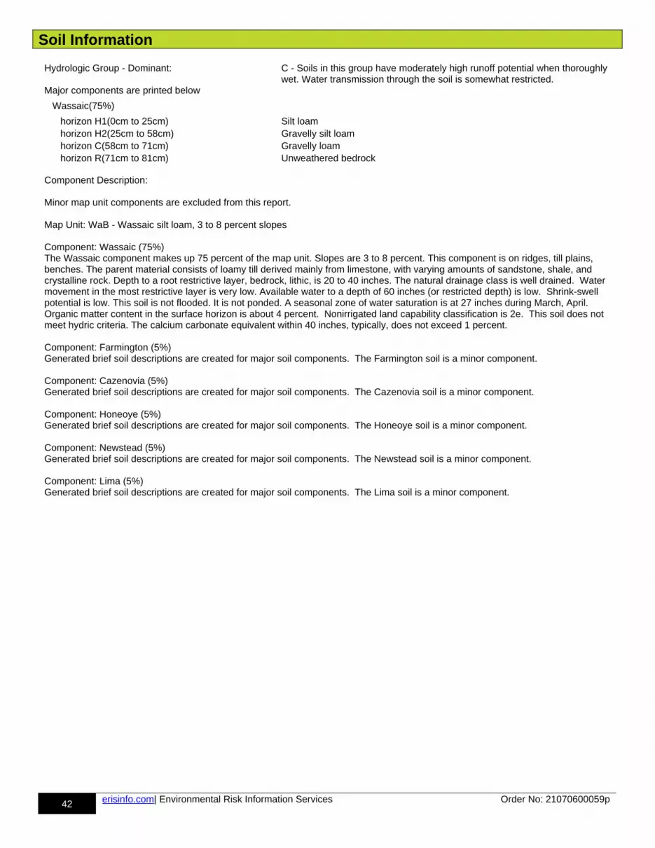
Soil Information
42 erisinfo.com| Environmental Risk Information Services Order No: 21070600059p
Hydrologic Group - Dominant: C - Soils in this group have moderately high runoff potential when thoroughly wet. Water transmission through the soil is somewhat restricted.
Major components are printed below
Wassaic(75%)
horizon H1(0cm to 25cm) Silt loam horizon H2(25cm to 58cm) Gravelly silt loam horizon C(58cm to 71cm) Gravelly loam horizon R(71cm to 81cm) Unweathered bedrock
Component Description:
Minor map unit components are excluded from this report.
Map Unit: WaB - Wassaic silt loam, 3 to 8 percent slopes
Component: Wassaic (75%)The Wassaic component makes up 75 percent of the map unit. Slopes are 3 to 8 percent. This component is on ridges, till plains, benches. The parent material consists of loamy till derived mainly from limestone, with varying amounts of sandstone, shale, and crystalline rock. Depth to a root restrictive layer, bedrock, lithic, is 20 to 40 inches. The natural drainage class is well drained. Water movement in the most restrictive layer is very low. Available water to a depth of 60 inches (or restricted depth) is low. Shrink-swell potential is low. This soil is not flooded. It is not ponded. A seasonal zone of water saturation is at 27 inches during March, April. Organic matter content in the surface horizon is about 4 percent. Nonirrigated land capability classification is 2e. This soil does not meet hydric criteria. The calcium carbonate equivalent within 40 inches, typically, does not exceed 1 percent.
Component: Farmington (5%)Generated brief soil descriptions are created for major soil components. The Farmington soil is a minor component.
Component: Cazenovia (5%)Generated brief soil descriptions are created for major soil components. The Cazenovia soil is a minor component.
Component: Honeoye (5%)Generated brief soil descriptions are created for major soil components. The Honeoye soil is a minor component.
Component: Newstead (5%)Generated brief soil descriptions are created for major soil components. The Newstead soil is a minor component.
Component: Lima (5%)Generated brief soil descriptions are created for major soil components. The Lima soil is a minor component.
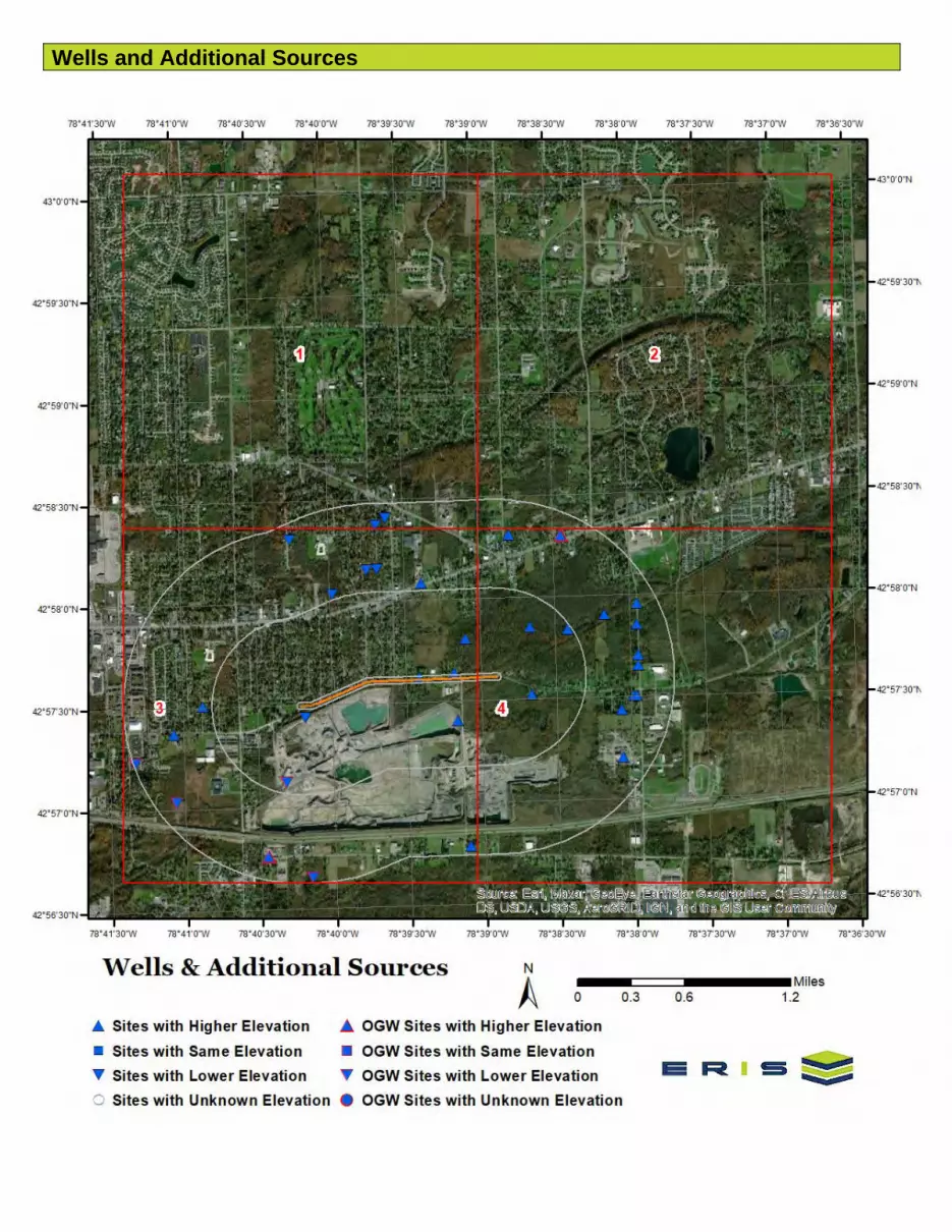
Wells and Additional Sources
Wells and Additional Sources

Wells and Additional Sources
Wells and Additional Sources
Wells and Additional Sources
Wells and Additional Sources Summary
48 erisinfo.com| Environmental Risk Information Services Order No: 21070600059p
Federal Sources
Public Water Systems Violations and Enforcement Data
Map Key ID Distance (ft) Direction
No records found
Safe Drinking Water Information System (SDWIS)
Map Key ID Distance (ft) Direction
No records found
USGS National Water Information System
Map Key Monitoring Loc Identifier Distance (ft) Direction
1 USGS-425737078392601 55.766211724514 E2 USGS-425738078391201 146.790199453481 E3 USGS-425724078391101 1271.348849496227 SE4 USGS-425748078390701 1153.903795320188 ENE5 USGS-425804078392301 2857.802935739881 NNE6 USGS-425726078401201 360.372729506433 WSW7 USGS-425802078400001 2781.890772390447 NW8 USGS-425809078394201 3300.659474002545 NNW9 USGS-425809078394601 3302.612941259755 NNW10 USGS-425731078384101 1166.245377232868 E11 USGS-425751078384101 1782.365203132634 ENE13 USGS-425822078394201 4616.879854673134 N14 USGS-425824078393801 4819.392901686759 N15 USGS-425750078382601 2532.377187676878 ENE16 USGS-425818078401501 4785.655580951986 NW17 USGS-425647078390701 5021.138644172829 SSE18 USGS-425818078384701 4238.610703591969 NE19 USGS-425730078405301 2902.076933918838 W21 USGS-425754078381101 3699.780625280476 ENE24 USGS-425726078380501 3849.862445358616 E25 USGS-425722078410501 3870.657707694491 WSW26 USGS-425730078380001 4123.937692306339 E27 USGS-425712078380501 4457.041420290571 ESE28 USGS-425730078375901 4197.352495390035 E29 USGS-425739078375801 4225.784080527716 E29 USGS-425739078375802 4225.784080527716 E30 USGS-425742078375801 4254.267193946238 E31 USGS-425751078375801 4464.340607790542 ENE32 USGS-425757078375800 4698.317552966771 ENE
State Sources
Oil and Gas Wells
Map Key API Well No Distance (ft) Direction
12 31029012110000 2331.525173563509 SW20 31029036940000 5117.230302276119 SSW22 31029162010000 4599.775502212572 NE
Wells and Additional Sources Summary
49 erisinfo.com| Environmental Risk Information Services Order No: 21070600059p
23 31029037000000 4589.477781871406 SW33 31029055300000 4701.460674193793 WSW34 31029054930000 5223.156386035538 WSW
Underground Injection Control Wells
Map Key ID Distance (ft) Direction
No records found
Water Wells Database
Map Key ID Distance (ft) Direction
No records found
Wells and Additional Sources Detail Report
50 erisinfo.com| Environmental Risk Information Services Order No: 21070600059p
USGS National Water Information System
Map Key Direction Distance (mi) Distance (ft) Elevation (ft) DB
1 E 0.01 55.77 718.15 FED USGS
Organiz Identifier: USGS-NY Formation Type: Onondaga Limestone
Organiz Name: USGS New York Water Science Center
Aquifer Name: New York and New England carbonate-rock aquifers
Well Depth: 45 Aquifer Type:
Well Depth Unit: ft Country Code: US
Well Hole Depth: Provider Name: NWIS
W Hole Depth Unit: County: ERIE
Construction Date: Latitude: 42.9603363
Source Map Scale: 24000 Longitude: -78.656973
Monitoring Loc Name: E 477
Monitoring Loc Identifier: USGS-425737078392601
Monitoring Loc Type: Well
Monitoring Loc Desc:
HUC Eight Digit Code: 04120104
Drainage Area:
Drainage Area Unit:
Contrib Drainage Area:
Contrib Drainage Area Unit:Horizontal Accuracy: 5
Horizontal Accuracy Unit: seconds
Horizontal Collection Mthd:
Interpolated from MAP.
Horiz Coord Refer System:
NAD83
Vertical Measure: 721
Vertical Measure Unit: feet
Vertical Accuracy: 1
Vertical Accuracy Unit: feet
Vertical Collection Mthd: Interpolated from topographic map.
Vert Coord Refer System: NGVD29
Map Key Direction Distance (mi) Distance (ft) Elevation (ft) DB
2 E 0.03 146.79 721.98 FED USGS
Organiz Identifier: USGS-NY Formation Type: Onondaga Limestone
Organiz Name: USGS New York Water Science Center
Aquifer Name: New York and New England carbonate-rock aquifers
Well Depth: 77 Aquifer Type:
Well Depth Unit: ft Country Code: US
Well Hole Depth: Provider Name: NWIS
W Hole Depth Unit: County: ERIE
Wells and Additional Sources Detail Report
51 erisinfo.com| Environmental Risk Information Services Order No: 21070600059p
Construction Date: Latitude: 42.9606141
Source Map Scale: 24000 Longitude: -78.653084
Monitoring Loc Name: E 482
Monitoring Loc Identifier: USGS-425738078391201
Monitoring Loc Type: Well
Monitoring Loc Desc:
HUC Eight Digit Code: 04120104
Drainage Area:
Drainage Area Unit:
Contrib Drainage Area:
Contrib Drainage Area Unit:Horizontal Accuracy: 5
Horizontal Accuracy Unit: seconds
Horizontal Collection Mthd:
Interpolated from MAP.
Horiz Coord Refer System:
NAD83
Vertical Measure: 727
Vertical Measure Unit: feet
Vertical Accuracy: 1
Vertical Accuracy Unit: feet
Vertical Collection Mthd: Interpolated from topographic map.
Vert Coord Refer System: NGVD29
Map Key Direction Distance (mi) Distance (ft) Elevation (ft) DB
3 SE 0.24 1,271.35 719.67 FED USGS
Organiz Identifier: USGS-NY Formation Type: Onondaga Limestone
Organiz Name: USGS New York Water Science Center
Aquifer Name: New York and New England carbonate-rock aquifers
Well Depth: 66 Aquifer Type:
Well Depth Unit: ft Country Code: US
Well Hole Depth: 66 Provider Name: NWIS
W Hole Depth Unit: ft County: ERIE
Construction Date: 19800801 Latitude: 42.9567252
Source Map Scale: 24000 Longitude: -78.6528062
Monitoring Loc Name: E 452
Monitoring Loc Identifier: USGS-425724078391101
Monitoring Loc Type: Well
Monitoring Loc Desc:
HUC Eight Digit Code: 04120104
Drainage Area:
Drainage Area Unit:
Contrib Drainage Area:
Contrib Drainage Area Unit:Horizontal Accuracy: 5
Horizontal Accuracy Unit: seconds

Wells and Additional Sources Detail Report
52 erisinfo.com| Environmental Risk Information Services Order No: 21070600059p
Horizontal Collection Mthd:
Interpolated from MAP.
Horiz Coord Refer System:
NAD83
Vertical Measure: 725
Vertical Measure Unit: feet
Vertical Accuracy: 5
Vertical Accuracy Unit: feet
Vertical Collection Mthd: Interpolated from topographic map.
Vert Coord Refer System: NGVD29
Map Key Direction Distance (mi) Distance (ft) Elevation (ft) DB
4 ENE 0.22 1,153.90 722.00 FED USGS
Organiz Identifier: USGS-NY Formation Type:
Organiz Name: USGS New York Water Science Center
Aquifer Name:
Well Depth: 40 Aquifer Type:
Well Depth Unit: ft Country Code: US
Well Hole Depth: 47.3 Provider Name: NWIS
W Hole Depth Unit: ft County: ERIE
Construction Date: 19810820 Latitude: 42.9633919
Source Map Scale: 24000 Longitude: -78.651695
Monitoring Loc Name: E 501
Monitoring Loc Identifier: USGS-425748078390701
Monitoring Loc Type: Well
Monitoring Loc Desc:
HUC Eight Digit Code: 04120104
Drainage Area:
Drainage Area Unit:
Contrib Drainage Area:
Contrib Drainage Area Unit:Horizontal Accuracy: 5
Horizontal Accuracy Unit: seconds
Horizontal Collection Mthd:
Interpolated from MAP.
Horiz Coord Refer System:
NAD83
Vertical Measure: 695
Vertical Measure Unit: feet
Vertical Accuracy: 1
Vertical Accuracy Unit: feet
Vertical Collection Mthd: Interpolated from topographic map.
Vert Coord Refer System: NGVD29
Map Key Direction Distance (mi) Distance (ft) Elevation (ft) DB
5 NNE 0.54 2,857.80 721.82 FED USGS
Wells and Additional Sources Detail Report
53 erisinfo.com| Environmental Risk Information Services Order No: 21070600059p
Organiz Identifier: USGS-NY Formation Type: Bedrock
Organiz Name: USGS New York Water Science Center
Aquifer Name:
Well Depth: 125 Aquifer Type:
Well Depth Unit: ft Country Code: US
Well Hole Depth: Provider Name: NWIS
W Hole Depth Unit: County: ERIE
Construction Date: Latitude: 42.9680278
Source Map Scale: 24000 Longitude: -78.6564694
Monitoring Loc Name: E3036
Monitoring Loc Identifier: USGS-425804078392301
Monitoring Loc Type: Well
Monitoring Loc Desc:
HUC Eight Digit Code: 04120104
Drainage Area:
Drainage Area Unit:
Contrib Drainage Area:
Contrib Drainage Area Unit:Horizontal Accuracy: .1
Horizontal Accuracy Unit: seconds
Horizontal Collection Mthd:
Interpolated from Digital MAP.
Horiz Coord Refer System:
NAD83
Vertical Measure: 722
Vertical Measure Unit: feet
Vertical Accuracy: 4.3
Vertical Accuracy Unit: feet
Vertical Collection Mthd: Interpolated from Digital Elevation Model
Vert Coord Refer System: NAVD88
Map Key Direction Distance (mi) Distance (ft) Elevation (ft) DB
6 WSW 0.07 360.37 685.61 FED USGS
Organiz Identifier: USGS-NY Formation Type:
Organiz Name: USGS New York Water Science Center
Aquifer Name:
Well Depth: Aquifer Type:
Well Depth Unit: Country Code: US
Well Hole Depth: 121 Provider Name: NWIS
W Hole Depth Unit: ft County: ERIE
Construction Date: 19820418 Latitude: 42.9572807
Source Map Scale: 24000 Longitude: -78.6697512
Monitoring Loc Name: E 456
Monitoring Loc Identifier: USGS-425726078401201
Monitoring Loc Type: Well: Test hole not completed as a well
Monitoring Loc Desc:
HUC Eight Digit Code: 04120104
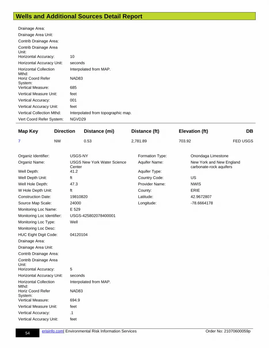
Wells and Additional Sources Detail Report
54 erisinfo.com| Environmental Risk Information Services Order No: 21070600059p
Drainage Area:
Drainage Area Unit:
Contrib Drainage Area:
Contrib Drainage Area Unit:Horizontal Accuracy: 10
Horizontal Accuracy Unit: seconds
Horizontal Collection Mthd:
Interpolated from MAP.
Horiz Coord Refer System:
NAD83
Vertical Measure: 685
Vertical Measure Unit: feet
Vertical Accuracy: 001
Vertical Accuracy Unit: feet
Vertical Collection Mthd: Interpolated from topographic map.
Vert Coord Refer System: NGVD29
Map Key Direction Distance (mi) Distance (ft) Elevation (ft) DB
7 NW 0.53 2,781.89 703.92 FED USGS
Organiz Identifier: USGS-NY Formation Type: Onondaga Limestone
Organiz Name: USGS New York Water Science Center
Aquifer Name: New York and New England carbonate-rock aquifers
Well Depth: 41.2 Aquifer Type:
Well Depth Unit: ft Country Code: US
Well Hole Depth: 47.3 Provider Name: NWIS
W Hole Depth Unit: ft County: ERIE
Construction Date: 19810820 Latitude: 42.9672807
Source Map Scale: 24000 Longitude: -78.6664178
Monitoring Loc Name: E 529
Monitoring Loc Identifier: USGS-425802078400001
Monitoring Loc Type: Well
Monitoring Loc Desc:
HUC Eight Digit Code: 04120104
Drainage Area:
Drainage Area Unit:
Contrib Drainage Area:
Contrib Drainage Area Unit:Horizontal Accuracy: 5
Horizontal Accuracy Unit: seconds
Horizontal Collection Mthd:
Interpolated from MAP.
Horiz Coord Refer System:
NAD83
Vertical Measure: 694.9
Vertical Measure Unit: feet
Vertical Accuracy: .1
Vertical Accuracy Unit: feet

Wells and Additional Sources Detail Report
55 erisinfo.com| Environmental Risk Information Services Order No: 21070600059p
Vertical Collection Mthd: Level or other surveyed method.
Vert Coord Refer System: NGVD29
Map Key Direction Distance (mi) Distance (ft) Elevation (ft) DB
8 NNW 0.63 3,300.66 706.07 FED USGS
Organiz Identifier: USGS-NY Formation Type: Onondaga Limestone
Organiz Name: USGS New York Water Science Center
Aquifer Name: New York and New England carbonate-rock aquifers
Well Depth: Aquifer Type:
Well Depth Unit: Country Code: US
Well Hole Depth: Provider Name: NWIS
W Hole Depth Unit: County: ERIE
Construction Date: Latitude: 42.9692251
Source Map Scale: 24000 Longitude: -78.6614176
Monitoring Loc Name: E 533
Monitoring Loc Identifier: USGS-425809078394201
Monitoring Loc Type: Well
Monitoring Loc Desc:
HUC Eight Digit Code: 04120104
Drainage Area:
Drainage Area Unit:
Contrib Drainage Area:
Contrib Drainage Area Unit:Horizontal Accuracy: 5
Horizontal Accuracy Unit: seconds
Horizontal Collection Mthd:
Interpolated from MAP.
Horiz Coord Refer System:
NAD83
Vertical Measure: 705
Vertical Measure Unit: feet
Vertical Accuracy: 5
Vertical Accuracy Unit: feet
Vertical Collection Mthd: Interpolated from topographic map.
Vert Coord Refer System: NGVD29
Map Key Direction Distance (mi) Distance (ft) Elevation (ft) DB
9 NNW 0.63 3,302.61 705.07 FED USGS
Organiz Identifier: USGS-NY Formation Type: Onondaga Limestone
Organiz Name: USGS New York Water Science Center
Aquifer Name: New York and New England carbonate-rock aquifers
Well Depth: Aquifer Type:
Well Depth Unit: Country Code: US
Well Hole Depth: Provider Name: NWIS
W Hole Depth Unit: County: ERIE

Wells and Additional Sources Detail Report
56 erisinfo.com| Environmental Risk Information Services Order No: 21070600059p
Construction Date: Latitude: 42.9692251
Source Map Scale: 24000 Longitude: -78.6625288
Monitoring Loc Name: E 534
Monitoring Loc Identifier: USGS-425809078394601
Monitoring Loc Type: Well
Monitoring Loc Desc:
HUC Eight Digit Code: 04120104
Drainage Area:
Drainage Area Unit:
Contrib Drainage Area:
Contrib Drainage Area Unit:Horizontal Accuracy: 5
Horizontal Accuracy Unit: seconds
Horizontal Collection Mthd:
Interpolated from MAP.
Horiz Coord Refer System:
NAD83
Vertical Measure: 705
Vertical Measure Unit: feet
Vertical Accuracy: 5
Vertical Accuracy Unit: feet
Vertical Collection Mthd: Interpolated from topographic map.
Vert Coord Refer System: NGVD29
Map Key Direction Distance (mi) Distance (ft) Elevation (ft) DB
10 E 0.22 1,166.25 727.87 FED USGS
Organiz Identifier: USGS-NY Formation Type: Onondaga Limestone
Organiz Name: USGS New York Water Science Center
Aquifer Name: New York and New England carbonate-rock aquifers
Well Depth: 30 Aquifer Type:
Well Depth Unit: ft Country Code: US
Well Hole Depth: Provider Name: NWIS
W Hole Depth Unit: County: ERIE
Construction Date: Latitude: 42.9586697
Source Map Scale: 24000 Longitude: -78.6444726
Monitoring Loc Name: E 467
Monitoring Loc Identifier: USGS-425731078384101
Monitoring Loc Type: Well
Monitoring Loc Desc:
HUC Eight Digit Code: 04120104
Drainage Area:
Drainage Area Unit:
Contrib Drainage Area:
Contrib Drainage Area Unit:Horizontal Accuracy: 5
Horizontal Accuracy Unit: seconds
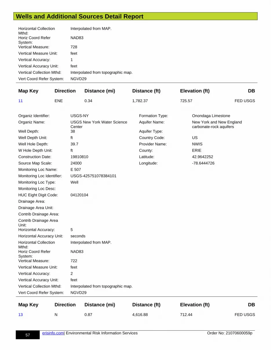
Wells and Additional Sources Detail Report
57 erisinfo.com| Environmental Risk Information Services Order No: 21070600059p
Horizontal Collection Mthd:
Interpolated from MAP.
Horiz Coord Refer System:
NAD83
Vertical Measure: 728
Vertical Measure Unit: feet
Vertical Accuracy: 1
Vertical Accuracy Unit: feet
Vertical Collection Mthd: Interpolated from topographic map.
Vert Coord Refer System: NGVD29
Map Key Direction Distance (mi) Distance (ft) Elevation (ft) DB
11 ENE 0.34 1,782.37 725.57 FED USGS
Organiz Identifier: USGS-NY Formation Type: Onondaga Limestone
Organiz Name: USGS New York Water Science Center
Aquifer Name: New York and New England carbonate-rock aquifers
Well Depth: 38 Aquifer Type:
Well Depth Unit: ft Country Code: US
Well Hole Depth: 39.7 Provider Name: NWIS
W Hole Depth Unit: ft County: ERIE
Construction Date: 19810810 Latitude: 42.9642252
Source Map Scale: 24000 Longitude: -78.6444726
Monitoring Loc Name: E 507
Monitoring Loc Identifier: USGS-425751078384101
Monitoring Loc Type: Well
Monitoring Loc Desc:
HUC Eight Digit Code: 04120104
Drainage Area:
Drainage Area Unit:
Contrib Drainage Area:
Contrib Drainage Area Unit:Horizontal Accuracy: 5
Horizontal Accuracy Unit: seconds
Horizontal Collection Mthd:
Interpolated from MAP.
Horiz Coord Refer System:
NAD83
Vertical Measure: 722
Vertical Measure Unit: feet
Vertical Accuracy: 2
Vertical Accuracy Unit: feet
Vertical Collection Mthd: Interpolated from topographic map.
Vert Coord Refer System: NGVD29
Map Key Direction Distance (mi) Distance (ft) Elevation (ft) DB
13 N 0.87 4,616.88 712.44 FED USGS
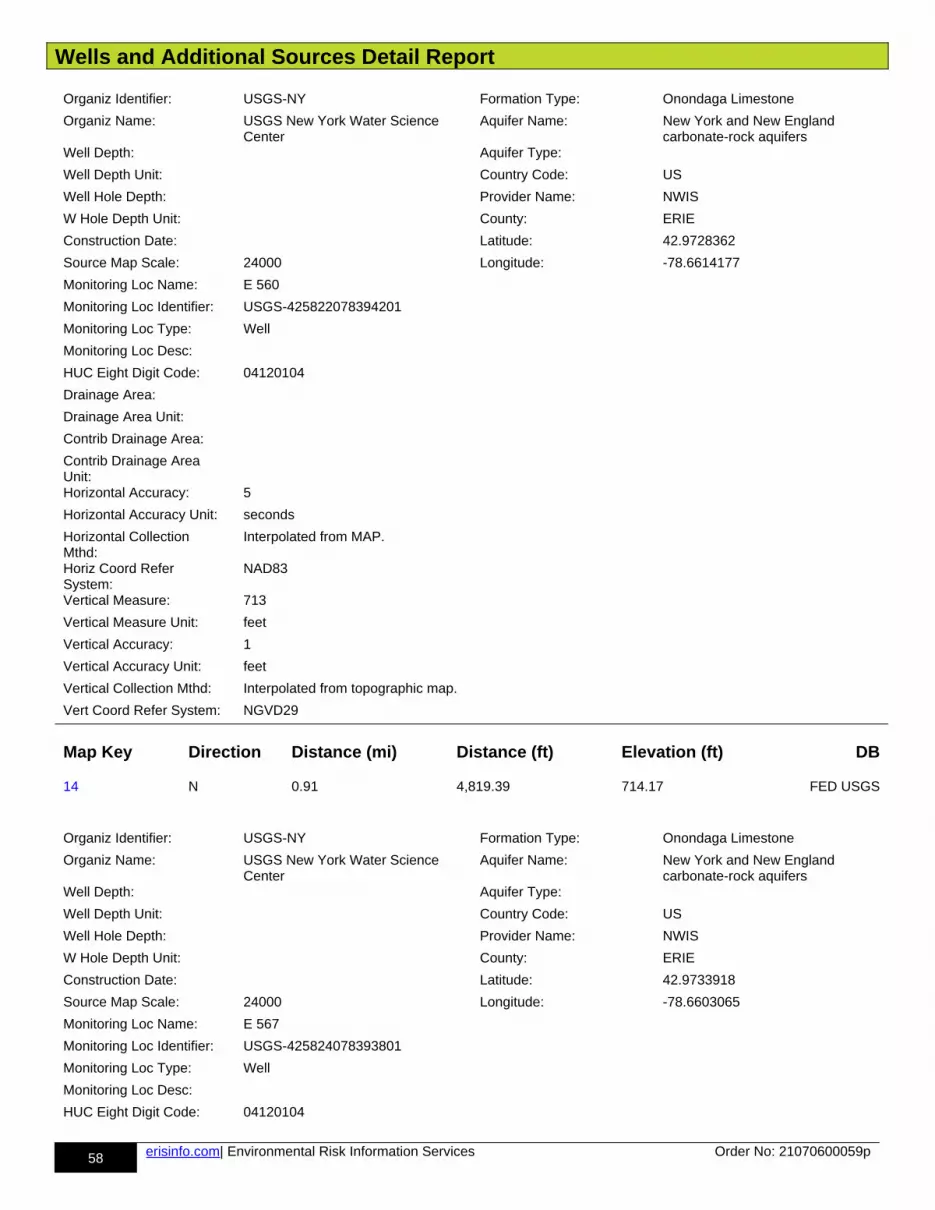
Wells and Additional Sources Detail Report
58 erisinfo.com| Environmental Risk Information Services Order No: 21070600059p
Organiz Identifier: USGS-NY Formation Type: Onondaga Limestone
Organiz Name: USGS New York Water Science Center
Aquifer Name: New York and New England carbonate-rock aquifers
Well Depth: Aquifer Type:
Well Depth Unit: Country Code: US
Well Hole Depth: Provider Name: NWIS
W Hole Depth Unit: County: ERIE
Construction Date: Latitude: 42.9728362
Source Map Scale: 24000 Longitude: -78.6614177
Monitoring Loc Name: E 560
Monitoring Loc Identifier: USGS-425822078394201
Monitoring Loc Type: Well
Monitoring Loc Desc:
HUC Eight Digit Code: 04120104
Drainage Area:
Drainage Area Unit:
Contrib Drainage Area:
Contrib Drainage Area Unit:Horizontal Accuracy: 5
Horizontal Accuracy Unit: seconds
Horizontal Collection Mthd:
Interpolated from MAP.
Horiz Coord Refer System:
NAD83
Vertical Measure: 713
Vertical Measure Unit: feet
Vertical Accuracy: 1
Vertical Accuracy Unit: feet
Vertical Collection Mthd: Interpolated from topographic map.
Vert Coord Refer System: NGVD29
Map Key Direction Distance (mi) Distance (ft) Elevation (ft) DB
14 N 0.91 4,819.39 714.17 FED USGS
Organiz Identifier: USGS-NY Formation Type: Onondaga Limestone
Organiz Name: USGS New York Water Science Center
Aquifer Name: New York and New England carbonate-rock aquifers
Well Depth: Aquifer Type:
Well Depth Unit: Country Code: US
Well Hole Depth: Provider Name: NWIS
W Hole Depth Unit: County: ERIE
Construction Date: Latitude: 42.9733918
Source Map Scale: 24000 Longitude: -78.6603065
Monitoring Loc Name: E 567
Monitoring Loc Identifier: USGS-425824078393801
Monitoring Loc Type: Well
Monitoring Loc Desc:
HUC Eight Digit Code: 04120104

Wells and Additional Sources Detail Report
59 erisinfo.com| Environmental Risk Information Services Order No: 21070600059p
Drainage Area:
Drainage Area Unit:
Contrib Drainage Area:
Contrib Drainage Area Unit:Horizontal Accuracy: 5
Horizontal Accuracy Unit: seconds
Horizontal Collection Mthd:
Interpolated from MAP.
Horiz Coord Refer System:
NAD83
Vertical Measure: 714
Vertical Measure Unit: feet
Vertical Accuracy: 1
Vertical Accuracy Unit: feet
Vertical Collection Mthd: Interpolated from topographic map.
Vert Coord Refer System: NGVD29
Map Key Direction Distance (mi) Distance (ft) Elevation (ft) DB
15 ENE 0.48 2,532.38 727.04 FED USGS
Organiz Identifier: USGS-NY Formation Type:
Organiz Name: USGS New York Water Science Center
Aquifer Name:
Well Depth: 34.5 Aquifer Type:
Well Depth Unit: ft Country Code: US
Well Hole Depth: 37 Provider Name: NWIS
W Hole Depth Unit: ft County: ERIE
Construction Date: 19810806 Latitude: 42.9639475
Source Map Scale: 24000 Longitude: -78.6403058
Monitoring Loc Name: E 504
Monitoring Loc Identifier: USGS-425750078382601
Monitoring Loc Type: Well
Monitoring Loc Desc:
HUC Eight Digit Code: 04120104
Drainage Area:
Drainage Area Unit:
Contrib Drainage Area:
Contrib Drainage Area Unit:Horizontal Accuracy: 5
Horizontal Accuracy Unit: seconds
Horizontal Collection Mthd:
Interpolated from MAP.
Horiz Coord Refer System:
NAD83
Vertical Measure: 722.42
Vertical Measure Unit: feet
Vertical Accuracy: 10
Vertical Accuracy Unit: feet

Wells and Additional Sources Detail Report
60 erisinfo.com| Environmental Risk Information Services Order No: 21070600059p
Vertical Collection Mthd: Interpolated from topographic map.
Vert Coord Refer System: NGVD29
Map Key Direction Distance (mi) Distance (ft) Elevation (ft) DB
16 NW 0.91 4,785.66 704.68 FED USGS
Organiz Identifier: USGS-NY Formation Type:
Organiz Name: USGS New York Water Science Center
Aquifer Name:
Well Depth: 100 Aquifer Type:
Well Depth Unit: ft Country Code: US
Well Hole Depth: Provider Name: NWIS
W Hole Depth Unit: County: ERIE
Construction Date: Latitude: 42.9718306
Source Map Scale: 24000 Longitude: -78.6710806
Monitoring Loc Name: E1368
Monitoring Loc Identifier: USGS-425818078401501
Monitoring Loc Type: Well
Monitoring Loc Desc:
HUC Eight Digit Code: 04120104
Drainage Area:
Drainage Area Unit:
Contrib Drainage Area:
Contrib Drainage Area Unit:Horizontal Accuracy: .1
Horizontal Accuracy Unit: seconds
Horizontal Collection Mthd:
Interpolated from Digital MAP.
Horiz Coord Refer System:
NAD83
Vertical Measure: 705
Vertical Measure Unit: feet
Vertical Accuracy: 4.3
Vertical Accuracy Unit: feet
Vertical Collection Mthd: Interpolated from Digital Elevation Model
Vert Coord Refer System: NAVD88
Map Key Direction Distance (mi) Distance (ft) Elevation (ft) DB
17 SSE 0.95 5,021.14 719.72 FED USGS
Organiz Identifier: USGS-NY Formation Type: Onondaga Limestone
Organiz Name: USGS New York Water Science Center
Aquifer Name: New York and New England carbonate-rock aquifers
Well Depth: Aquifer Type:
Well Depth Unit: Country Code: US
Well Hole Depth: Provider Name: NWIS
W Hole Depth Unit: County: ERIE
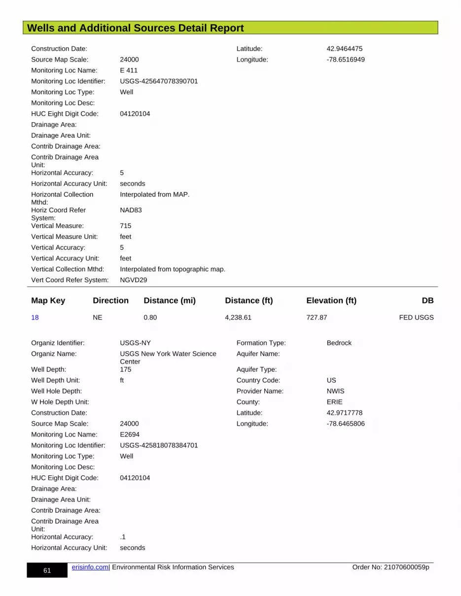
Wells and Additional Sources Detail Report
61 erisinfo.com| Environmental Risk Information Services Order No: 21070600059p
Construction Date: Latitude: 42.9464475
Source Map Scale: 24000 Longitude: -78.6516949
Monitoring Loc Name: E 411
Monitoring Loc Identifier: USGS-425647078390701
Monitoring Loc Type: Well
Monitoring Loc Desc:
HUC Eight Digit Code: 04120104
Drainage Area:
Drainage Area Unit:
Contrib Drainage Area:
Contrib Drainage Area Unit:Horizontal Accuracy: 5
Horizontal Accuracy Unit: seconds
Horizontal Collection Mthd:
Interpolated from MAP.
Horiz Coord Refer System:
NAD83
Vertical Measure: 715
Vertical Measure Unit: feet
Vertical Accuracy: 5
Vertical Accuracy Unit: feet
Vertical Collection Mthd: Interpolated from topographic map.
Vert Coord Refer System: NGVD29
Map Key Direction Distance (mi) Distance (ft) Elevation (ft) DB
18 NE 0.80 4,238.61 727.87 FED USGS
Organiz Identifier: USGS-NY Formation Type: Bedrock
Organiz Name: USGS New York Water Science Center
Aquifer Name:
Well Depth: 175 Aquifer Type:
Well Depth Unit: ft Country Code: US
Well Hole Depth: Provider Name: NWIS
W Hole Depth Unit: County: ERIE
Construction Date: Latitude: 42.9717778
Source Map Scale: 24000 Longitude: -78.6465806
Monitoring Loc Name: E2694
Monitoring Loc Identifier: USGS-425818078384701
Monitoring Loc Type: Well
Monitoring Loc Desc:
HUC Eight Digit Code: 04120104
Drainage Area:
Drainage Area Unit:
Contrib Drainage Area:
Contrib Drainage Area Unit:Horizontal Accuracy: .1
Horizontal Accuracy Unit: seconds
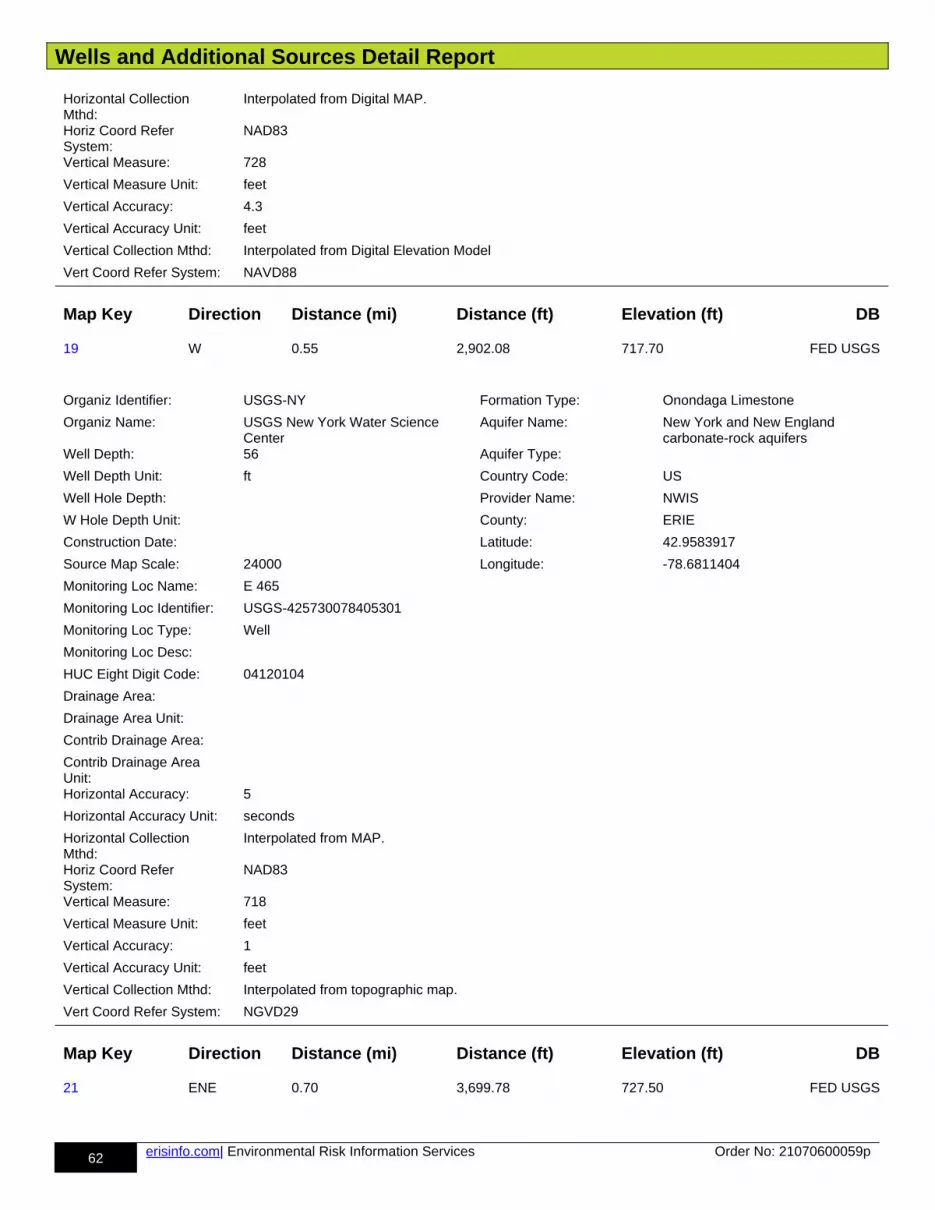
Wells and Additional Sources Detail Report
62 erisinfo.com| Environmental Risk Information Services Order No: 21070600059p
Horizontal Collection Mthd:
Interpolated from Digital MAP.
Horiz Coord Refer System:
NAD83
Vertical Measure: 728
Vertical Measure Unit: feet
Vertical Accuracy: 4.3
Vertical Accuracy Unit: feet
Vertical Collection Mthd: Interpolated from Digital Elevation Model
Vert Coord Refer System: NAVD88
Map Key Direction Distance (mi) Distance (ft) Elevation (ft) DB
19 W 0.55 2,902.08 717.70 FED USGS
Organiz Identifier: USGS-NY Formation Type: Onondaga Limestone
Organiz Name: USGS New York Water Science Center
Aquifer Name: New York and New England carbonate-rock aquifers
Well Depth: 56 Aquifer Type:
Well Depth Unit: ft Country Code: US
Well Hole Depth: Provider Name: NWIS
W Hole Depth Unit: County: ERIE
Construction Date: Latitude: 42.9583917
Source Map Scale: 24000 Longitude: -78.6811404
Monitoring Loc Name: E 465
Monitoring Loc Identifier: USGS-425730078405301
Monitoring Loc Type: Well
Monitoring Loc Desc:
HUC Eight Digit Code: 04120104
Drainage Area:
Drainage Area Unit:
Contrib Drainage Area:
Contrib Drainage Area Unit:Horizontal Accuracy: 5
Horizontal Accuracy Unit: seconds
Horizontal Collection Mthd:
Interpolated from MAP.
Horiz Coord Refer System:
NAD83
Vertical Measure: 718
Vertical Measure Unit: feet
Vertical Accuracy: 1
Vertical Accuracy Unit: feet
Vertical Collection Mthd: Interpolated from topographic map.
Vert Coord Refer System: NGVD29
Map Key Direction Distance (mi) Distance (ft) Elevation (ft) DB
21 ENE 0.70 3,699.78 727.50 FED USGS

Wells and Additional Sources Detail Report
63 erisinfo.com| Environmental Risk Information Services Order No: 21070600059p
Organiz Identifier: USGS-NY Formation Type: Onondaga Limestone
Organiz Name: USGS New York Water Science Center
Aquifer Name: New York and New England carbonate-rock aquifers
Well Depth: 34.8 Aquifer Type:
Well Depth Unit: ft Country Code: US
Well Hole Depth: 37 Provider Name: NWIS
W Hole Depth Unit: ft County: ERIE
Construction Date: 19810806 Latitude: 42.9650586
Source Map Scale: 24000 Longitude: -78.636139
Monitoring Loc Name: E 515
Monitoring Loc Identifier: USGS-425754078381101
Monitoring Loc Type: Well
Monitoring Loc Desc:
HUC Eight Digit Code: 04120104
Drainage Area:
Drainage Area Unit:
Contrib Drainage Area:
Contrib Drainage Area Unit:Horizontal Accuracy: 5
Horizontal Accuracy Unit: seconds
Horizontal Collection Mthd:
Interpolated from MAP.
Horiz Coord Refer System:
NAD83
Vertical Measure: 722.5
Vertical Measure Unit: feet
Vertical Accuracy: 1
Vertical Accuracy Unit: feet
Vertical Collection Mthd: Interpolated from topographic map.
Vert Coord Refer System: NGVD29
Map Key Direction Distance (mi) Distance (ft) Elevation (ft) DB
24 E 0.73 3,849.86 734.09 FED USGS
Organiz Identifier: USGS-NY Formation Type: Onondaga Limestone
Organiz Name: USGS New York Water Science Center
Aquifer Name: New York and New England carbonate-rock aquifers
Well Depth: Aquifer Type:
Well Depth Unit: Country Code: US
Well Hole Depth: Provider Name: NWIS
W Hole Depth Unit: County: ERIE
Construction Date: Latitude: 42.9572809
Source Map Scale: 24000 Longitude: -78.6344722
Monitoring Loc Name: E 455
Monitoring Loc Identifier: USGS-425726078380501
Monitoring Loc Type: Well
Monitoring Loc Desc:
HUC Eight Digit Code: 04120104
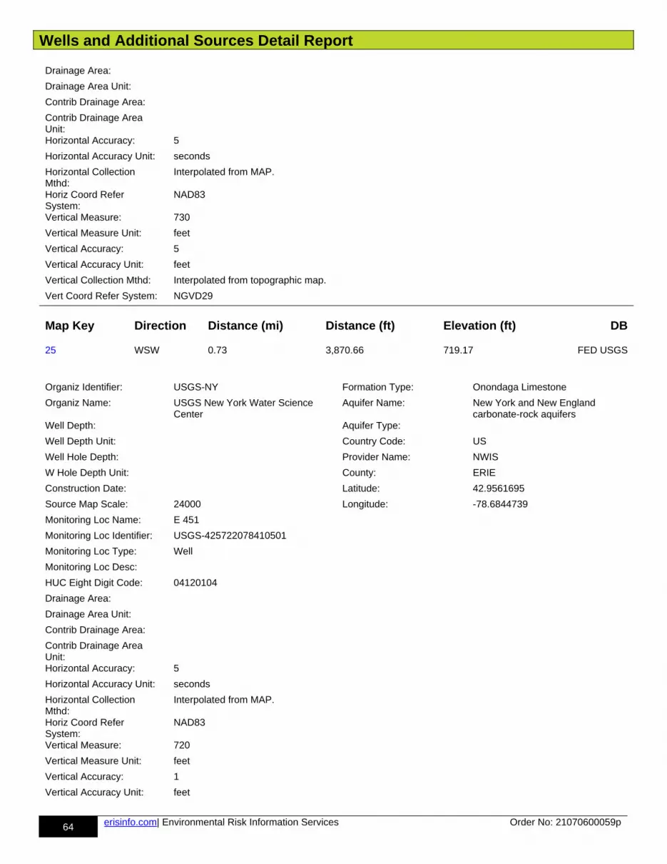
Wells and Additional Sources Detail Report
64 erisinfo.com| Environmental Risk Information Services Order No: 21070600059p
Drainage Area:
Drainage Area Unit:
Contrib Drainage Area:
Contrib Drainage Area Unit:Horizontal Accuracy: 5
Horizontal Accuracy Unit: seconds
Horizontal Collection Mthd:
Interpolated from MAP.
Horiz Coord Refer System:
NAD83
Vertical Measure: 730
Vertical Measure Unit: feet
Vertical Accuracy: 5
Vertical Accuracy Unit: feet
Vertical Collection Mthd: Interpolated from topographic map.
Vert Coord Refer System: NGVD29
Map Key Direction Distance (mi) Distance (ft) Elevation (ft) DB
25 WSW 0.73 3,870.66 719.17 FED USGS
Organiz Identifier: USGS-NY Formation Type: Onondaga Limestone
Organiz Name: USGS New York Water Science Center
Aquifer Name: New York and New England carbonate-rock aquifers
Well Depth: Aquifer Type:
Well Depth Unit: Country Code: US
Well Hole Depth: Provider Name: NWIS
W Hole Depth Unit: County: ERIE
Construction Date: Latitude: 42.9561695
Source Map Scale: 24000 Longitude: -78.6844739
Monitoring Loc Name: E 451
Monitoring Loc Identifier: USGS-425722078410501
Monitoring Loc Type: Well
Monitoring Loc Desc:
HUC Eight Digit Code: 04120104
Drainage Area:
Drainage Area Unit:
Contrib Drainage Area:
Contrib Drainage Area Unit:Horizontal Accuracy: 5
Horizontal Accuracy Unit: seconds
Horizontal Collection Mthd:
Interpolated from MAP.
Horiz Coord Refer System:
NAD83
Vertical Measure: 720
Vertical Measure Unit: feet
Vertical Accuracy: 1
Vertical Accuracy Unit: feet

Wells and Additional Sources Detail Report
65 erisinfo.com| Environmental Risk Information Services Order No: 21070600059p
Vertical Collection Mthd: Interpolated from topographic map.
Vert Coord Refer System: NGVD29
Map Key Direction Distance (mi) Distance (ft) Elevation (ft) DB
26 E 0.78 4,123.94 733.83 FED USGS
Organiz Identifier: USGS-NY Formation Type:
Organiz Name: USGS New York Water Science Center
Aquifer Name:
Well Depth: 58 Aquifer Type: Unconfined single aquifer
Well Depth Unit: ft Country Code: US
Well Hole Depth: Provider Name: NWIS
W Hole Depth Unit: County: ERIE
Construction Date: Latitude: 42.958392
Source Map Scale: 24000 Longitude: -78.6330833
Monitoring Loc Name: E 860
Monitoring Loc Identifier: USGS-425730078380001
Monitoring Loc Type: Well
Monitoring Loc Desc:
HUC Eight Digit Code: 04120104
Drainage Area:
Drainage Area Unit:
Contrib Drainage Area:
Contrib Drainage Area Unit:Horizontal Accuracy: 5
Horizontal Accuracy Unit: seconds
Horizontal Collection Mthd:
Interpolated from MAP.
Horiz Coord Refer System:
NAD83
Vertical Measure: 732
Vertical Measure Unit: feet
Vertical Accuracy: 10
Vertical Accuracy Unit: feet
Vertical Collection Mthd: Interpolated from topographic map.
Vert Coord Refer System: NGVD29
Map Key Direction Distance (mi) Distance (ft) Elevation (ft) DB
27 ESE 0.84 4,457.04 735.75 FED USGS
Organiz Identifier: USGS-NY Formation Type: Onondaga Limestone
Organiz Name: USGS New York Water Science Center
Aquifer Name: New York and New England carbonate-rock aquifers
Well Depth: 30 Aquifer Type:
Well Depth Unit: ft Country Code: US
Well Hole Depth: Provider Name: NWIS
W Hole Depth Unit: County: ERIE
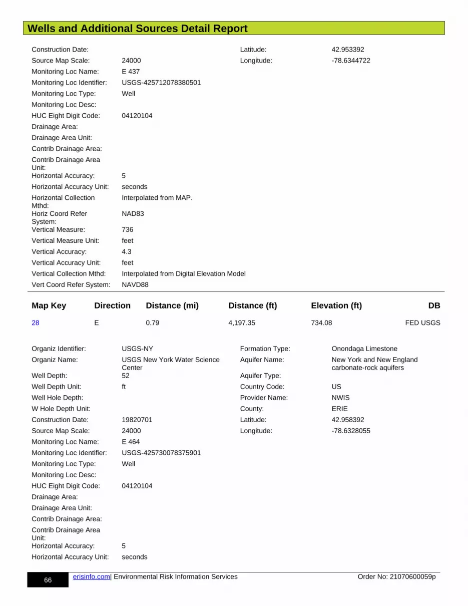
Wells and Additional Sources Detail Report
66 erisinfo.com| Environmental Risk Information Services Order No: 21070600059p
Construction Date: Latitude: 42.953392
Source Map Scale: 24000 Longitude: -78.6344722
Monitoring Loc Name: E 437
Monitoring Loc Identifier: USGS-425712078380501
Monitoring Loc Type: Well
Monitoring Loc Desc:
HUC Eight Digit Code: 04120104
Drainage Area:
Drainage Area Unit:
Contrib Drainage Area:
Contrib Drainage Area Unit:Horizontal Accuracy: 5
Horizontal Accuracy Unit: seconds
Horizontal Collection Mthd:
Interpolated from MAP.
Horiz Coord Refer System:
NAD83
Vertical Measure: 736
Vertical Measure Unit: feet
Vertical Accuracy: 4.3
Vertical Accuracy Unit: feet
Vertical Collection Mthd: Interpolated from Digital Elevation Model
Vert Coord Refer System: NAVD88
Map Key Direction Distance (mi) Distance (ft) Elevation (ft) DB
28 E 0.79 4,197.35 734.08 FED USGS
Organiz Identifier: USGS-NY Formation Type: Onondaga Limestone
Organiz Name: USGS New York Water Science Center
Aquifer Name: New York and New England carbonate-rock aquifers
Well Depth: 52 Aquifer Type:
Well Depth Unit: ft Country Code: US
Well Hole Depth: Provider Name: NWIS
W Hole Depth Unit: County: ERIE
Construction Date: 19820701 Latitude: 42.958392
Source Map Scale: 24000 Longitude: -78.6328055
Monitoring Loc Name: E 464
Monitoring Loc Identifier: USGS-425730078375901
Monitoring Loc Type: Well
Monitoring Loc Desc:
HUC Eight Digit Code: 04120104
Drainage Area:
Drainage Area Unit:
Contrib Drainage Area:
Contrib Drainage Area Unit:Horizontal Accuracy: 5
Horizontal Accuracy Unit: seconds
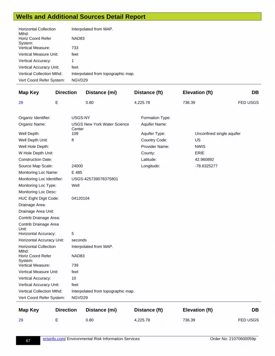
Wells and Additional Sources Detail Report
67 erisinfo.com| Environmental Risk Information Services Order No: 21070600059p
Horizontal Collection Mthd:
Interpolated from MAP.
Horiz Coord Refer System:
NAD83
Vertical Measure: 733
Vertical Measure Unit: feet
Vertical Accuracy: 1
Vertical Accuracy Unit: feet
Vertical Collection Mthd: Interpolated from topographic map.
Vert Coord Refer System: NGVD29
Map Key Direction Distance (mi) Distance (ft) Elevation (ft) DB
29 E 0.80 4,225.78 736.39 FED USGS
Organiz Identifier: USGS-NY Formation Type:
Organiz Name: USGS New York Water Science Center
Aquifer Name:
Well Depth: 109 Aquifer Type: Unconfined single aquifer
Well Depth Unit: ft Country Code: US
Well Hole Depth: Provider Name: NWIS
W Hole Depth Unit: County: ERIE
Construction Date: Latitude: 42.960892
Source Map Scale: 24000 Longitude: -78.6325277
Monitoring Loc Name: E 485
Monitoring Loc Identifier: USGS-425739078375801
Monitoring Loc Type: Well
Monitoring Loc Desc:
HUC Eight Digit Code: 04120104
Drainage Area:
Drainage Area Unit:
Contrib Drainage Area:
Contrib Drainage Area Unit:Horizontal Accuracy: 5
Horizontal Accuracy Unit: seconds
Horizontal Collection Mthd:
Interpolated from MAP.
Horiz Coord Refer System:
NAD83
Vertical Measure: 739
Vertical Measure Unit: feet
Vertical Accuracy: 10
Vertical Accuracy Unit: feet
Vertical Collection Mthd: Interpolated from topographic map.
Vert Coord Refer System: NGVD29
Map Key Direction Distance (mi) Distance (ft) Elevation (ft) DB
29 E 0.80 4,225.78 736.39 FED USGS
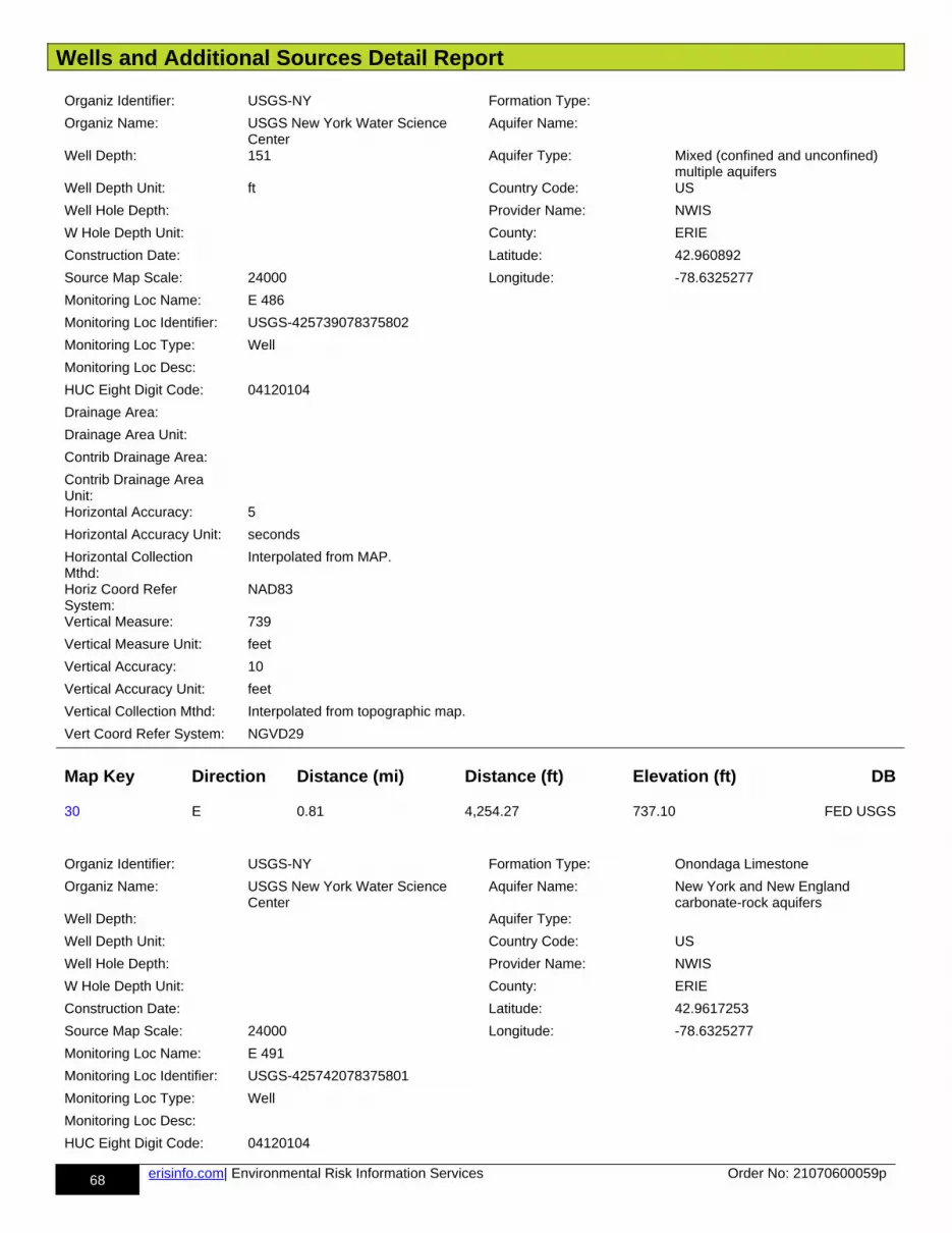
Wells and Additional Sources Detail Report
68 erisinfo.com| Environmental Risk Information Services Order No: 21070600059p
Organiz Identifier: USGS-NY Formation Type:
Organiz Name: USGS New York Water Science Center
Aquifer Name:
Well Depth: 151 Aquifer Type: Mixed (confined and unconfined) multiple aquifers
Well Depth Unit: ft Country Code: US
Well Hole Depth: Provider Name: NWIS
W Hole Depth Unit: County: ERIE
Construction Date: Latitude: 42.960892
Source Map Scale: 24000 Longitude: -78.6325277
Monitoring Loc Name: E 486
Monitoring Loc Identifier: USGS-425739078375802
Monitoring Loc Type: Well
Monitoring Loc Desc:
HUC Eight Digit Code: 04120104
Drainage Area:
Drainage Area Unit:
Contrib Drainage Area:
Contrib Drainage Area Unit:Horizontal Accuracy: 5
Horizontal Accuracy Unit: seconds
Horizontal Collection Mthd:
Interpolated from MAP.
Horiz Coord Refer System:
NAD83
Vertical Measure: 739
Vertical Measure Unit: feet
Vertical Accuracy: 10
Vertical Accuracy Unit: feet
Vertical Collection Mthd: Interpolated from topographic map.
Vert Coord Refer System: NGVD29
Map Key Direction Distance (mi) Distance (ft) Elevation (ft) DB
30 E 0.81 4,254.27 737.10 FED USGS
Organiz Identifier: USGS-NY Formation Type: Onondaga Limestone
Organiz Name: USGS New York Water Science Center
Aquifer Name: New York and New England carbonate-rock aquifers
Well Depth: Aquifer Type:
Well Depth Unit: Country Code: US
Well Hole Depth: Provider Name: NWIS
W Hole Depth Unit: County: ERIE
Construction Date: Latitude: 42.9617253
Source Map Scale: 24000 Longitude: -78.6325277
Monitoring Loc Name: E 491
Monitoring Loc Identifier: USGS-425742078375801
Monitoring Loc Type: Well
Monitoring Loc Desc:
HUC Eight Digit Code: 04120104
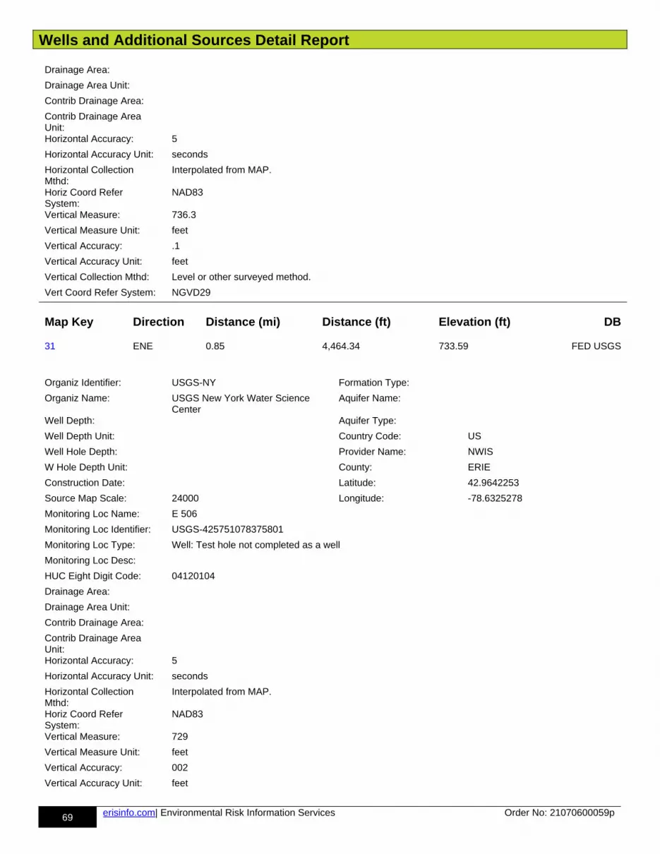
Wells and Additional Sources Detail Report
69 erisinfo.com| Environmental Risk Information Services Order No: 21070600059p
Drainage Area:
Drainage Area Unit:
Contrib Drainage Area:
Contrib Drainage Area Unit:Horizontal Accuracy: 5
Horizontal Accuracy Unit: seconds
Horizontal Collection Mthd:
Interpolated from MAP.
Horiz Coord Refer System:
NAD83
Vertical Measure: 736.3
Vertical Measure Unit: feet
Vertical Accuracy: .1
Vertical Accuracy Unit: feet
Vertical Collection Mthd: Level or other surveyed method.
Vert Coord Refer System: NGVD29
Map Key Direction Distance (mi) Distance (ft) Elevation (ft) DB
31 ENE 0.85 4,464.34 733.59 FED USGS
Organiz Identifier: USGS-NY Formation Type:
Organiz Name: USGS New York Water Science Center
Aquifer Name:
Well Depth: Aquifer Type:
Well Depth Unit: Country Code: US
Well Hole Depth: Provider Name: NWIS
W Hole Depth Unit: County: ERIE
Construction Date: Latitude: 42.9642253
Source Map Scale: 24000 Longitude: -78.6325278
Monitoring Loc Name: E 506
Monitoring Loc Identifier: USGS-425751078375801
Monitoring Loc Type: Well: Test hole not completed as a well
Monitoring Loc Desc:
HUC Eight Digit Code: 04120104
Drainage Area:
Drainage Area Unit:
Contrib Drainage Area:
Contrib Drainage Area Unit:Horizontal Accuracy: 5
Horizontal Accuracy Unit: seconds
Horizontal Collection Mthd:
Interpolated from MAP.
Horiz Coord Refer System:
NAD83
Vertical Measure: 729
Vertical Measure Unit: feet
Vertical Accuracy: 002
Vertical Accuracy Unit: feet
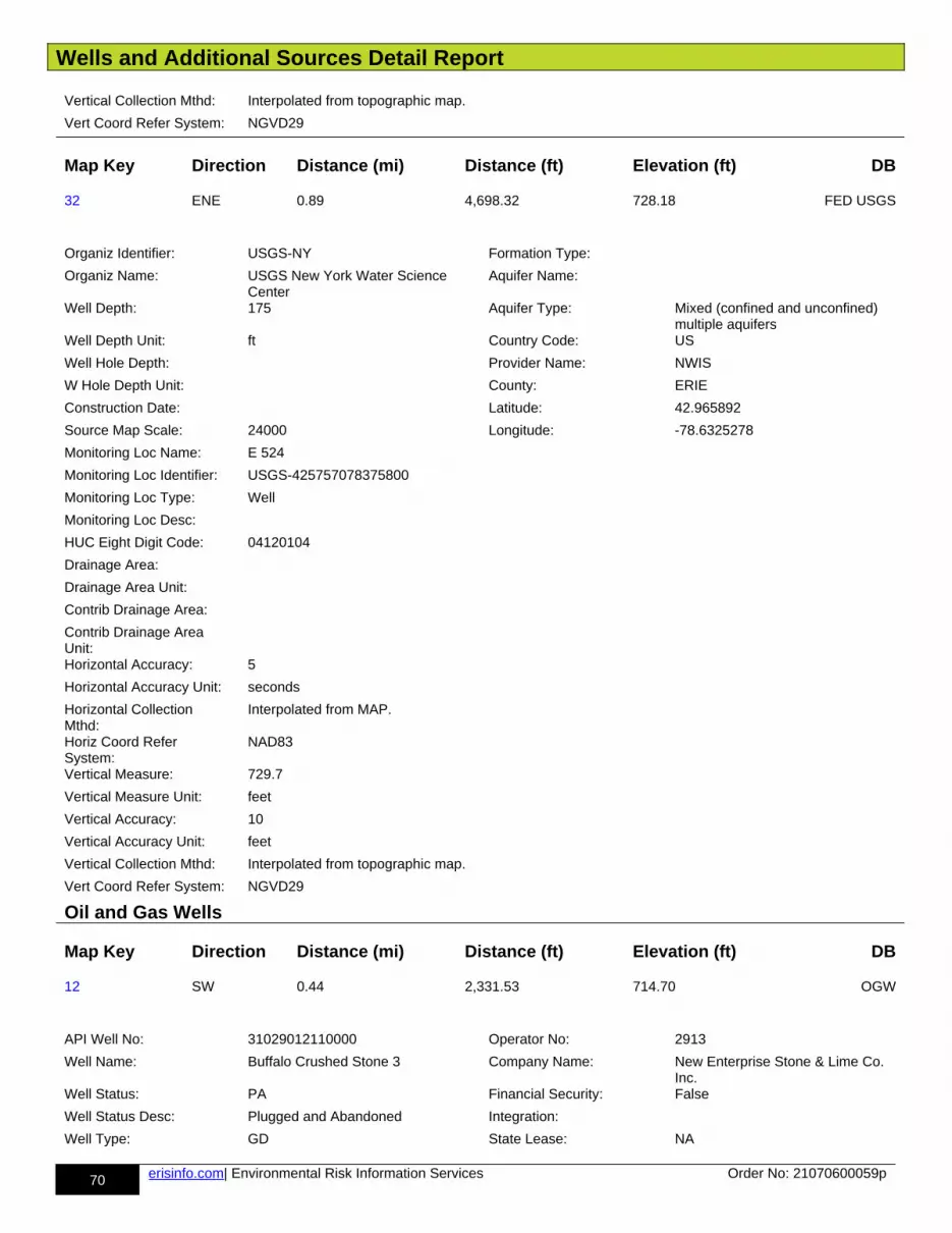
Wells and Additional Sources Detail Report
70 erisinfo.com| Environmental Risk Information Services Order No: 21070600059p
Vertical Collection Mthd: Interpolated from topographic map.
Vert Coord Refer System: NGVD29
Map Key Direction Distance (mi) Distance (ft) Elevation (ft) DB
32 ENE 0.89 4,698.32 728.18 FED USGS
Organiz Identifier: USGS-NY Formation Type:
Organiz Name: USGS New York Water Science Center
Aquifer Name:
Well Depth: 175 Aquifer Type: Mixed (confined and unconfined) multiple aquifers
Well Depth Unit: ft Country Code: US
Well Hole Depth: Provider Name: NWIS
W Hole Depth Unit: County: ERIE
Construction Date: Latitude: 42.965892
Source Map Scale: 24000 Longitude: -78.6325278
Monitoring Loc Name: E 524
Monitoring Loc Identifier: USGS-425757078375800
Monitoring Loc Type: Well
Monitoring Loc Desc:
HUC Eight Digit Code: 04120104
Drainage Area:
Drainage Area Unit:
Contrib Drainage Area:
Contrib Drainage Area Unit:Horizontal Accuracy: 5
Horizontal Accuracy Unit: seconds
Horizontal Collection Mthd:
Interpolated from MAP.
Horiz Coord Refer System:
NAD83
Vertical Measure: 729.7
Vertical Measure Unit: feet
Vertical Accuracy: 10
Vertical Accuracy Unit: feet
Vertical Collection Mthd: Interpolated from topographic map.
Vert Coord Refer System: NGVD29
Oil and Gas Wells
Map Key Direction Distance (mi) Distance (ft) Elevation (ft) DB
12 SW 0.44 2,331.53 714.70 OGW
API Well No: 31029012110000 Operator No: 2913
Well Name: Buffalo Crushed Stone 3 Company Name: New Enterprise Stone & Lime Co. Inc.
Well Status: PA Financial Security: False
Well Status Desc: Plugged and Abandoned Integration:
Well Type: GD State Lease: NA
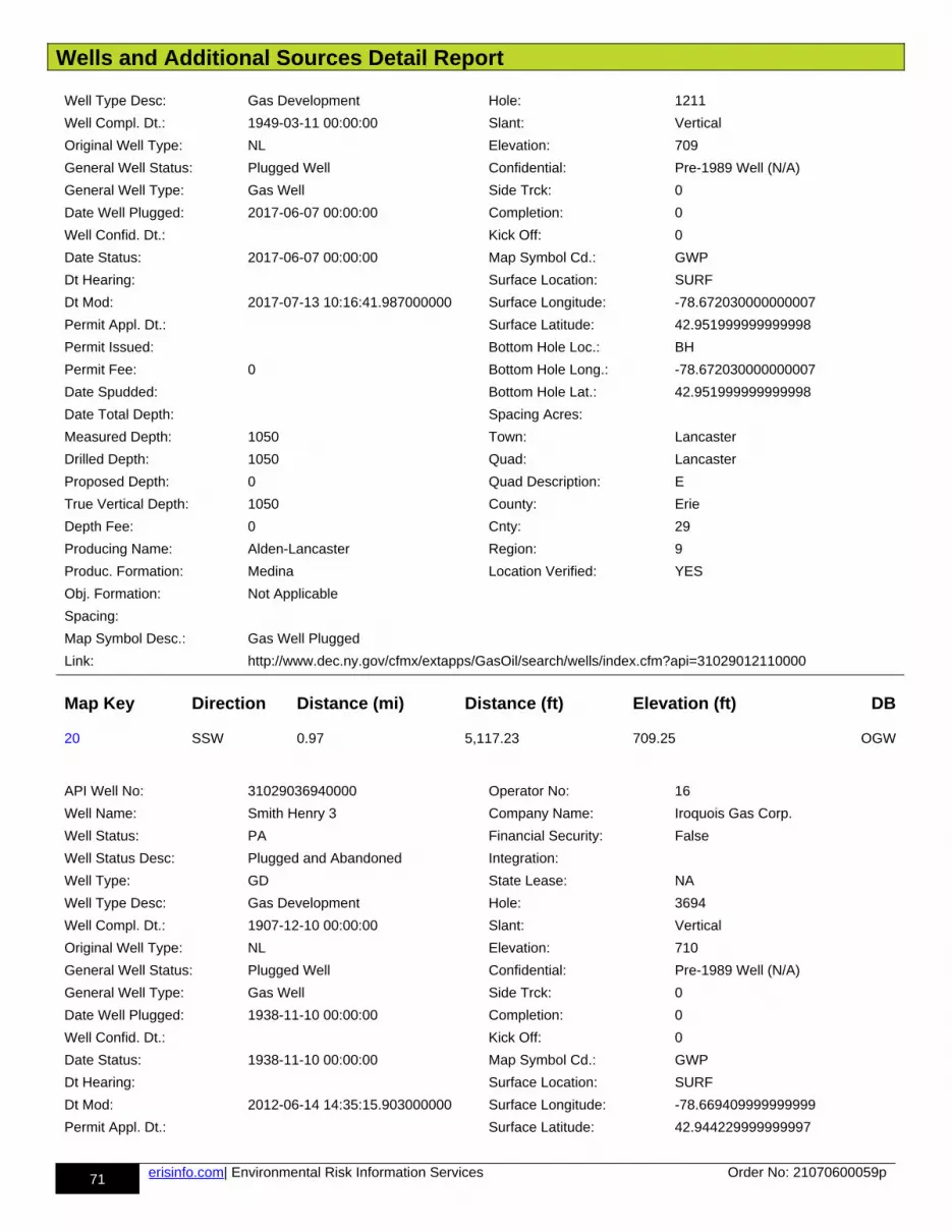
Wells and Additional Sources Detail Report
71 erisinfo.com| Environmental Risk Information Services Order No: 21070600059p
Well Type Desc: Gas Development Hole: 1211
Well Compl. Dt.: 1949-03-11 00:00:00 Slant: Vertical
Original Well Type: NL Elevation: 709
General Well Status: Plugged Well Confidential: Pre-1989 Well (N/A)
General Well Type: Gas Well Side Trck: 0
Date Well Plugged: 2017-06-07 00:00:00 Completion: 0
Well Confid. Dt.: Kick Off: 0
Date Status: 2017-06-07 00:00:00 Map Symbol Cd.: GWP
Dt Hearing: Surface Location: SURF
Dt Mod: 2017-07-13 10:16:41.987000000 Surface Longitude: -78.672030000000007
Permit Appl. Dt.: Surface Latitude: 42.951999999999998
Permit Issued: Bottom Hole Loc.: BH
Permit Fee: 0 Bottom Hole Long.: -78.672030000000007
Date Spudded: Bottom Hole Lat.: 42.951999999999998
Date Total Depth: Spacing Acres:
Measured Depth: 1050 Town: Lancaster
Drilled Depth: 1050 Quad: Lancaster
Proposed Depth: 0 Quad Description: E
True Vertical Depth: 1050 County: Erie
Depth Fee: 0 Cnty: 29
Producing Name: Alden-Lancaster Region: 9
Produc. Formation: Medina Location Verified: YES
Obj. Formation: Not Applicable
Spacing:
Map Symbol Desc.: Gas Well Plugged
Link: http://www.dec.ny.gov/cfmx/extapps/GasOil/search/wells/index.cfm?api=31029012110000
Map Key Direction Distance (mi) Distance (ft) Elevation (ft) DB
20 SSW 0.97 5,117.23 709.25 OGW
API Well No: 31029036940000 Operator No: 16
Well Name: Smith Henry 3 Company Name: Iroquois Gas Corp.
Well Status: PA Financial Security: False
Well Status Desc: Plugged and Abandoned Integration:
Well Type: GD State Lease: NA
Well Type Desc: Gas Development Hole: 3694
Well Compl. Dt.: 1907-12-10 00:00:00 Slant: Vertical
Original Well Type: NL Elevation: 710
General Well Status: Plugged Well Confidential: Pre-1989 Well (N/A)
General Well Type: Gas Well Side Trck: 0
Date Well Plugged: 1938-11-10 00:00:00 Completion: 0
Well Confid. Dt.: Kick Off: 0
Date Status: 1938-11-10 00:00:00 Map Symbol Cd.: GWP
Dt Hearing: Surface Location: SURF
Dt Mod: 2012-06-14 14:35:15.903000000 Surface Longitude: -78.669409999999999
Permit Appl. Dt.: Surface Latitude: 42.944229999999997
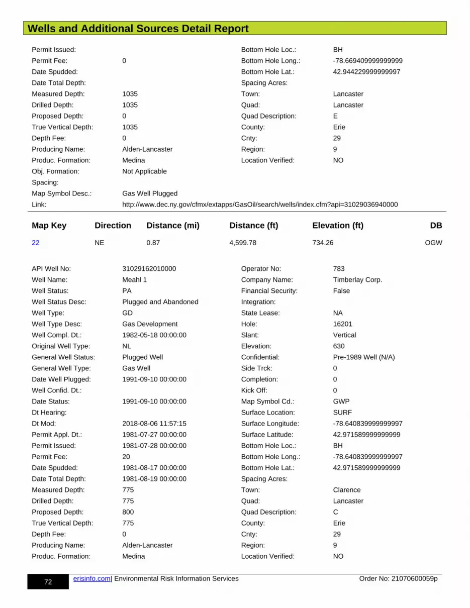
Wells and Additional Sources Detail Report
72 erisinfo.com| Environmental Risk Information Services Order No: 21070600059p
Permit Issued: Bottom Hole Loc.: BH
Permit Fee: 0 Bottom Hole Long.: -78.669409999999999
Date Spudded: Bottom Hole Lat.: 42.944229999999997
Date Total Depth: Spacing Acres:
Measured Depth: 1035 Town: Lancaster
Drilled Depth: 1035 Quad: Lancaster
Proposed Depth: 0 Quad Description: E
True Vertical Depth: 1035 County: Erie
Depth Fee: 0 Cnty: 29
Producing Name: Alden-Lancaster Region: 9
Produc. Formation: Medina Location Verified: NO
Obj. Formation: Not Applicable
Spacing:
Map Symbol Desc.: Gas Well Plugged
Link: http://www.dec.ny.gov/cfmx/extapps/GasOil/search/wells/index.cfm?api=31029036940000
Map Key Direction Distance (mi) Distance (ft) Elevation (ft) DB
22 NE 0.87 4,599.78 734.26 OGW
API Well No: 31029162010000 Operator No: 783
Well Name: Meahl 1 Company Name: Timberlay Corp.
Well Status: PA Financial Security: False
Well Status Desc: Plugged and Abandoned Integration:
Well Type: GD State Lease: NA
Well Type Desc: Gas Development Hole: 16201
Well Compl. Dt.: 1982-05-18 00:00:00 Slant: Vertical
Original Well Type: NL Elevation: 630
General Well Status: Plugged Well Confidential: Pre-1989 Well (N/A)
General Well Type: Gas Well Side Trck: 0
Date Well Plugged: 1991-09-10 00:00:00 Completion: 0
Well Confid. Dt.: Kick Off: 0
Date Status: 1991-09-10 00:00:00 Map Symbol Cd.: GWP
Dt Hearing: Surface Location: SURF
Dt Mod: 2018-08-06 11:57:15 Surface Longitude: -78.640839999999997
Permit Appl. Dt.: 1981-07-27 00:00:00 Surface Latitude: 42.971589999999999
Permit Issued: 1981-07-28 00:00:00 Bottom Hole Loc.: BH
Permit Fee: 20 Bottom Hole Long.: -78.640839999999997
Date Spudded: 1981-08-17 00:00:00 Bottom Hole Lat.: 42.971589999999999
Date Total Depth: 1981-08-19 00:00:00 Spacing Acres:
Measured Depth: 775 Town: Clarence
Drilled Depth: 775 Quad: Lancaster
Proposed Depth: 800 Quad Description: C
True Vertical Depth: 775 County: Erie
Depth Fee: 0 Cnty: 29
Producing Name: Alden-Lancaster Region: 9
Produc. Formation: Medina Location Verified: NO
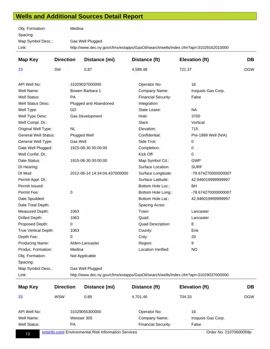
Wells and Additional Sources Detail Report
73 erisinfo.com| Environmental Risk Information Services Order No: 21070600059p
Obj. Formation: Medina
Spacing:
Map Symbol Desc.: Gas Well Plugged
Link: http://www.dec.ny.gov/cfmx/extapps/GasOil/search/wells/index.cfm?api=31029162010000
Map Key Direction Distance (mi) Distance (ft) Elevation (ft) DB
23 SW 0.87 4,589.48 721.37 OGW
API Well No: 31029037000000 Operator No: 16
Well Name: Bowen Barbara 1 Company Name: Iroquois Gas Corp.
Well Status: PA Financial Security: False
Well Status Desc: Plugged and Abandoned Integration:
Well Type: GD State Lease: NA
Well Type Desc: Gas Development Hole: 3700
Well Compl. Dt.: Slant: Vertical
Original Well Type: NL Elevation: 715
General Well Status: Plugged Well Confidential: Pre-1989 Well (N/A)
General Well Type: Gas Well Side Trck: 0
Date Well Plugged: 1915-08-30 00:00:00 Completion: 0
Well Confid. Dt.: Kick Off: 0
Date Status: 1915-08-30 00:00:00 Map Symbol Cd.: GWP
Dt Hearing: Surface Location: SURF
Dt Mod: 2012-06-14 14:34:04.437000000 Surface Longitude: -78.674270000000007
Permit Appl. Dt.: Surface Latitude: 42.946019999999997
Permit Issued: Bottom Hole Loc.: BH
Permit Fee: 0 Bottom Hole Long.: -78.674270000000007
Date Spudded: Bottom Hole Lat.: 42.946019999999997
Date Total Depth: Spacing Acres:
Measured Depth: 1063 Town: Lancaster
Drilled Depth: 1063 Quad: Lancaster
Proposed Depth: 0 Quad Description: E
True Vertical Depth: 1063 County: Erie
Depth Fee: 0 Cnty: 29
Producing Name: Alden-Lancaster Region: 9
Produc. Formation: Medina Location Verified: NO
Obj. Formation: Not Applicable
Spacing:
Map Symbol Desc.: Gas Well Plugged
Link: http://www.dec.ny.gov/cfmx/extapps/GasOil/search/wells/index.cfm?api=31029037000000
Map Key Direction Distance (mi) Distance (ft) Elevation (ft) DB
33 WSW 0.89 4,701.46 704.33 OGW
API Well No: 31029055300000 Operator No: 16
Well Name: Weisser 305 Company Name: Iroquois Gas Corp.
Well Status: PA Financial Security: False

Wells and Additional Sources Detail Report
74 erisinfo.com| Environmental Risk Information Services Order No: 21070600059p
Well Status Desc: Plugged and Abandoned Integration:
Well Type: GD State Lease: NA
Well Type Desc: Gas Development Hole: 5530
Well Compl. Dt.: Slant: Vertical
Original Well Type: NL Elevation: 710
General Well Status: Plugged Well Confidential: Pre-1989 Well (N/A)
General Well Type: Gas Well Side Trck: 0
Date Well Plugged: 1968-09-04 00:00:00 Completion: 0
Well Confid. Dt.: Kick Off: 0
Date Status: 1968-09-04 00:00:00 Map Symbol Cd.: GWP
Dt Hearing: Surface Location: SURF
Dt Mod: 1993-07-02 00:00:00 Surface Longitude: -78.684370000000001
Permit Appl. Dt.: Surface Latitude: 42.95055
Permit Issued: Bottom Hole Loc.: BH
Permit Fee: 0 Bottom Hole Long.: -78.684370000000001
Date Spudded: Bottom Hole Lat.: 42.95055
Date Total Depth: Spacing Acres:
Measured Depth: 1005 Town: Lancaster
Drilled Depth: 1005 Quad: Lancaster
Proposed Depth: 0 Quad Description: E
True Vertical Depth: 1005 County: Erie
Depth Fee: 0 Cnty: 29
Producing Name: Alden-Lancaster Region: 9
Produc. Formation: Medina Location Verified: NO
Obj. Formation: Not Applicable
Spacing:
Map Symbol Desc.: Gas Well Plugged
Link: http://www.dec.ny.gov/cfmx/extapps/GasOil/search/wells/index.cfm?api=31029055300000
Map Key Direction Distance (mi) Distance (ft) Elevation (ft) DB
34 WSW 0.99 5,223.16 712.79 OGW
API Well No: 31029054930000 Operator No: 16
Well Name: Meyers 1-314 Company Name: Iroquois Gas Corp.
Well Status: PA Financial Security: False
Well Status Desc: Plugged and Abandoned Integration:
Well Type: NL State Lease: NA
Well Type Desc: Not Listed Hole: 5493
Well Compl. Dt.: Slant: Vertical
Original Well Type: NL Elevation:
General Well Status: Plugged Well Confidential: Pre-1989 Well (N/A)
General Well Type: Other Well Side Trck: 0
Date Well Plugged: 1968-09-23 00:00:00 Completion: 0
Well Confid. Dt.: Kick Off: 0
Date Status: 1968-09-23 00:00:00 Map Symbol Cd.: OP
Dt Hearing: Surface Location: SURF
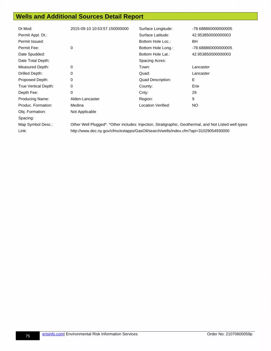
Wells and Additional Sources Detail Report
75 erisinfo.com| Environmental Risk Information Services Order No: 21070600059p
Dt Mod: 2015-09-10 10:53:57.150000000 Surface Longitude: -78.688860000000005
Permit Appl. Dt.: Surface Latitude: 42.953850000000003
Permit Issued: Bottom Hole Loc.: BH
Permit Fee: 0 Bottom Hole Long.: -78.688860000000005
Date Spudded: Bottom Hole Lat.: 42.953850000000003
Date Total Depth: Spacing Acres:
Measured Depth: 0 Town: Lancaster
Drilled Depth: 0 Quad: Lancaster
Proposed Depth: 0 Quad Description: E
True Vertical Depth: 0 County: Erie
Depth Fee: 0 Cnty: 29
Producing Name: Alden-Lancaster Region: 9
Produc. Formation: Medina Location Verified: NO
Obj. Formation: Not Applicable
Spacing:
Map Symbol Desc.: Other Well Plugged*. *Other includes: Injection, Stratigraphic, Geothermal, and Not Listed well types
Link: http://www.dec.ny.gov/cfmx/extapps/GasOil/search/wells/index.cfm?api=31029054930000
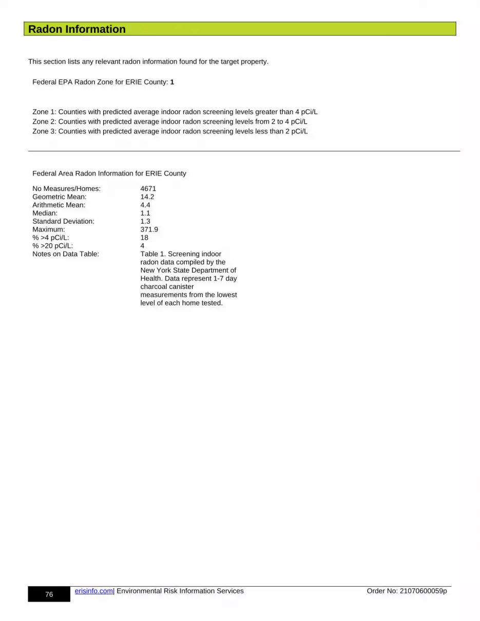
Radon Information
76 erisinfo.com| Environmental Risk Information Services Order No: 21070600059p
This section lists any relevant radon information found for the target property.
Federal EPA Radon Zone for ERIE County: 1
Zone 1: Counties with predicted average indoor radon screening levels greater than 4 pCi/LZone 2: Counties with predicted average indoor radon screening levels from 2 to 4 pCi/LZone 3: Counties with predicted average indoor radon screening levels less than 2 pCi/L
Federal Area Radon Information for ERIE County
No Measures/Homes: 4671Geometric Mean: 14.2Arithmetic Mean: 4.4Median: 1.1Standard Deviation: 1.3Maximum: 371.9% >4 pCi/L: 18% >20 pCi/L: 4Notes on Data Table: Table 1. Screening indoor
radon data compiled by the New York State Department of Health. Data represent 1-7 day charcoal canister measurements from the lowest level of each home tested.
Appendix
77 erisinfo.com| Environmental Risk Information Services Order No: 21070600059p
Federal Sources
FEMA National Flood Hazard Layer FEMA FLOOD
The National Flood Hazard Layer (NFHL) data incorporates Flood Insurance Rate Map (FIRM) databases published by the Federal Emergency Management Agency (FEMA), and any Letters Of Map Revision (LOMRs) that have been issued against those databases since their publication date. The FIRM Database is the digital, geospatial version of the flood hazard information shown on the published paper FIRMs. The FIRM Database depicts flood risk information and supporting data used to develop the risk data. The FIRMDatabase is derived from Flood Insurance Studies (FISs), previously published FIRMs, flood hazard analyses performed in support of the FISs and FIRMs, and new mapping data, where available.
Indoor Radon Data INDOOR RADON
Indoor radon measurements tracked by the Environmental Protection Agency(EPA) and the State Residential Radon Survey.
Public Water Systems Violations and Enforcement Data PWSV
List of drinking water violations and enforcement actions from the Safe Drinking Water Information System (SDWIS) made available by the Drinking Water Protection Division of the US EPA's Office of Groundwater and Drinking Water. Enforcement sensitive actions are not included in the data released by the EPA. Address information provided in SWDIS may correspond either with the physical location of the water system, or with a contact address.
Radon Zone Level RADON ZONE
Areas showing the level of Radon Zones (level 1, 2 or 3) by county. This data is maintained by the Environmental Protection Agency (EPA).
Safe Drinking Water Information System (SDWIS) SDWIS
The Safe Drinking Water Information System (SDWIS) contains information about public water systems as reported to US Environmental Protection Agency (EPA) by the states. Addresses may correspond with the location of the water system, or with a contact address.
Soil Survey Geographic database SSURGO
The Soil Survey Geographic database (SSURGO) contains information about soil as collected by the National Cooperative Soil Survey at the Natural Resources Conservation Service (NRCS). Soil maps outline areas called map units. The map units are linked to soil properties in a database. Each map unit may contain one to three major components and some minor components.
U.S. Fish & Wildlife Service Wetland Data US WETLAND
The U.S. Fish & Wildlife Service Wetland layer represents the approximate location and type of wetlands and deepwater habitats in the United States.
USGS Current Topo US TOPO
US Topo topographic maps are produced by the National Geospatial Program of the U.S. Geological Survey (USGS). The project was launched in late 2009, and the term "US Topo" refers specifically to quadrangle topographic maps published in 2009 and later.
USGS Geology US GEOLOGY
Seamless maps depicting geological information provided by the United States Geological Survey (USGS).
USGS National Water Information System FED USGS
The U.S. Geological Survey (USGS)'s National Water Information System (NWIS) is the nation's principal repository of water resources data. This database includes comprehensive information of well-construction details, time-series data for gage height, streamflow, groundwater level, and precipitation and water use data.
State Sources
Oil and Gas Wells OGW
The Division of Mineral Resources maintains a data management system on wells regulated under the Oil,
Appendix
78 erisinfo.com| Environmental Risk Information Services Order No: 21070600059p
Gas and Solution Mining Law (OGSML). To assist the Division in the regulation of wells subject to the OGSML, a database of the wells was created in the early 1980's and significantly upgraded in 1998 by the adoption of the Risk Based Data Management System. This system provides information on well ownership, well owners and operators, registered driller, pluggers and companies that provide financial security instruments.
Regulatory Freshwater Wetlands WETLAND
The Regulatory Freshwater Wetlands data are a set of ARC/INFO coverages composed of polygonal and linear features. Coverages are based on official New York State Freshwater Wetlands Maps as described in Article 24-0301 of the Environmental Conservation Law. Coverages are not, however, a legal substitute for the official maps. Coverages are available on a county basis for all areas of New York State outside the Adirondack Park. This dataset is provided by New York State Department of Environmental Conservation.
Underground Injection Control Wells UIC
A well permit is required from the Division of Mineral Resources for any brine disposal well deeper than 500 feet. This includes any operation to drill, deepen, plug back or convert a well. Regardless of well depth,the NYSDEC Division of Water must be contacted for a determination of whether a SPDES permit is necessary to operate any brine disposal well.
Water Wells Database WATER WELLS
The New York State Department of Environmental Conservation (DEC) Bureau of Water Resource Management works to protect, manage, and conserve New York State's groundwater and surface water supply sources, develop management strategies to enhance and protect these waters, and protect both thegroundwater and surface water quality in the New York City Watershed and other major watersheds. This dataset does not include information on wells located in Nassau, Suffolk, Kings, and Queens counties.
Liability Notice
79 erisinfo.com| Environmental Risk Information Services Order No: 21070600059p
Reliance on information in Report: The Physical Setting Report (PSR) DOES NOT replace a full Phase I Environmental Site
Assessment but is solely intended to be used as a review of environmental databases and physical characteristics for the site or
adjacent properties.
License for use of information in Report: No page of this report can be used without this cover page, this notice and the project
property identifier. The information in Report(s) may not be modified or re-sold.
Your Liability for misuse: Using this Service and/or its reports in a manner contrary to this Notice or your agreement will be in breach
of copyright and contract and ERIS may obtain damages for such mis-use, including damages caused to third parties, and gives ERIS
the right to terminate your account, rescind your license to any previous reports and to bar you from future use of the Service.
No warranty of Accuracy or Liability for ERIS: The information contained in this report has been produced by ERIS Information Inc.
("ERIS") using various sources of information, including information provided by Federal and State government departments. The report
applies only to the address and up to the date specified on the cover of this report, and any alterations or deviation from this description
will require a new report. This report and the data contained herein does not purport to be and does not constitute a guarantee of the
accuracy of the information contained herein and does not constitute a legal opinion nor medical advice. Although ERIS has
endeavored to present you with information that is accurate, ERIS Information Inc. disclaims, any and all liability for any errors,
omissions, or inaccuracies in such information and data, whether attributable to inadvertence, negligence or otherwise, and for any
consequences arising therefrom. Liability on the part of ERIS is limited to the monetary value paid for this report.
Trademark and Copyright: You may not use the ERIS trademarks or attribute any work to ERIS other than as outlined above. This
Service and Report(s) are protected by copyright owned by ERIS Information Inc. Copyright in data used in the Service or Report(s)
(the "Data") is owned by ERIS or its licensors. The Service, Report(s) and Data may not be copied or reproduced in whole or in any
substantial part without prior written consent of ERIS.