toward seamless indoor-outdoor applications: developing stakeholder-oriented location-based services
TRANSCRIPT
Geo-spatial Information Science 14(2):109-118 Volume 14, Issue 2 DOI 10.1007/s11806-011-0469-0 June 2011
Article ID: 1009-5020(2011)02-109-10 Document code: A
Toward Seamless Indoor-Outdoor Applications: Developing Stakeholder-Oriented Location-Based Services
Kohei OGAWA1,2, Edward VERBREE2, Sisi ZLATANOVA2, Naohiko KOHTAKE1, Yoshiaki OHKAMI1 1. Graduate School of System Design and Management, Keio University, 1-1, Hiyoshi 4-chome, Kohoku-ku, Yokohama,
Kanagawa, Japan
2. GISt, OTB, Delft University of Technology, Jaffalaan 9, 2628 BX, Delft, the Netherlands
© Wuhan University and Springer-Verlag Berlin Heidelberg 2011
Abstract Location-Based Services (LBS), an emerging new business based on smartphone and mobile networks, are becoming
more and more popular. Most of these LBSs, however, only offer non-seamless indoor/outdoor applications and simple applications
without giving stakeholders the chance to play an active role. Our specific aim is to solve these issues. This paper presents concepts
to solve these issues by expanding the Open Location Services Interface Standard (OpenLS) to allow seamless indoor/outdoor
positioning and to extend the content of the services to include information recommended by stakeholders.
Keywords location based services; OpenLS; stakeholder; seamless; indoor; outdoor; applications; standardized; IMES
CLC number P208
Introduction
Location-Based Services(LBS) have become an integral part of modern life. The availability of loca-tion-sensitive smartphones, such as Apple’s iPhone or Android-based devices with wireless broadband high-speed connections, has made low-cost applica-tions available to a huge audience. However, most of these applications merely offer simple “where am I” and “give me directions to something near me” searches, without giving stakeholders the chance to play an active role in recommending route directions to suggested stock locations. The devices employ GPS receivers or network-based approximations for positioning, which limits their use to outdoor applica-
tions only. In this paper we will present some ideas about how
to develop seamless indoor/outdoor LBS. This can be made possible by defining an extra match between user preference and stakeholder recommendation, and by allowing the search option for the optimal route from outdoor to indoor to be controlled by the stake-holder.
We have chosen to adopt the OpenLS specification, as its open and standardized interface ensures that ap-plication developers will have standard services to use when building LBS applications. However, the use of OpenLS is limited to outdoor applications only, as the services provided are only defined for 2D scenarios. For that reason we have chosen to extend the OpenLS specification for indoor use by incorporating an indoor
► Received on December 21, 2010.
► Kohei Ogawa’s main research area is location based service. In 2010 he participated in an exchange program to Delft University where he partici-
pated in the Technology Policy and Management Lecture and OTB institute GIS section.
►E-mail: [email protected]
Geo-spatial Information Science 14(2): 109-118 110
addressing schema.
1 Related work
Presently, the increasing demand for advanced, context-aware and seamless indoor/outdoor applica-tions has led to a convergence of technology. Much research has been reported; completed developments utilize different components and explore different ap-proaches to satisfy the demand for advanced applica-tions.[1] Many systems for indoor positioning have been reported in the literature. For example, Pa-pataxiarhis et al.[2] developed a MNISIKLIS based on WiFi and the dead reckoning technique. Kargl, et al.[3] presented an iNAV navigation system that makes seamless use of different sensors (WiFi, ultrasonic, infrared, RFID and Bluetooth) to localize a user in buildings. The system architecture is based on differ-ent ‘plug-ins’ (used for the different sensors) and protocols to complete the navigation and the services. Rehrl et al.[4] reported about RENA, an in-door/outdoor resource-adaptive multi-modal transport navigation system that seamlessly switches between indoor (WLAN) and outdoor (GPS) positioning. Sev-eral other examples for indoor/outdoor systems can be found in the work of Jensen et al.[5] An extensive overview of indoor positioning systems can be found in Go et al. and Hui et al.[6,7] The authors conclude that each sensor used for indoor positioning has limi-tations and cannot entirely satisfy “the system re-quirements of performance and cost”.
Another research area concentrates on con-text-aware services. Usually service providers attempt to reduce communication with users to a minimum, with the provision of a very limited set of simple ser-vices for general purpose users. Ahn and Nah[8] re-ported on a system that allows a certain type of dis-cussion between users and the server at specific loca-tions, thereby collecting more information about the preferences of the users. Angin et al.[9] proposed a navigation for the blind. The users of Geographical Information Systems are also exploring ideas for the development of LBS applications, as LBS provides possibilities to perform spatial analysis and therefore to extend the types of services that can be pro-vided.[10]
Although they provide very advanced positioning and services, such systems rely on proprietary com-ponents, which are, in most cases, implemented as closed applications. In this respect the reason for us-ing open standards is apparent: they allow for inter-operable solutions, the re-use of developments, wider implementation on various devices, etc. The Open Geospatial Consortium (OGS) has taken the initiative to develop standards related to geo-information. As a part of these developments, the Open Location Ser-vices[11] (OpenLS) standard emerged to support the developments of LBS applications. OpenLS allows new types of applications to be developed.[12]
Since the release of this standard in 2003, several large software vendors have provided OpenLS APIs. For example, the ArcWeb Services OpenLS API supports geocoding/reverse geocoding, presentation, routing, directory (POI), and giving the locations of a mobile device. Oracle Spatial supports the OpenLS services: location utility (geocoding/reverse geocod-ing), presentation, routing, and directory services. Two APIs are available for developing OpenLS applications, i.e., Web and PL/SQL (the latter of which is imple-mented in the SDO_OLS package). Open LS is also used for the OpenRouteService (OpenStreetMap).
The interest of researchers in OpenLS is significant. Various proposals to extend the OpenLS into the third dimension have been made.[13-15] Niels and Zipf[16] proposed a 3D presentation service, and Neis et al. [17] proposed the extension of OpenLS with Web Analysis Services. In this paper we discuss some more modi-fications of OpenLS that can be applied to help achieve seamless indoor/outdoor positioning and ex-tend the content of the services with information that can be of interest to users. We focus on two types of information: user preferences and recommendations of shops/restaurants.
2 Technical background
To be able to develop an LBS application, several components are necessary: a positioning approach, protocol (services), maps (models) and data that can be given to the user. Seamless indoor and outdoor LBS could be supported by any of a number of dif-ferent Commercial Off-the-Shelf (COTS) compo-
Kohei OGAWA, et al./ Toward Seamless Indoor-Outdoor Applications: … 111
nents. Each of them has advantages and disadvan-tages that need to be taken into account when devel-oping the demanded system. In the text below we give a short overview of the current developments within OpenLS and the indoor positioning system IMES.
2.1 OpenLS
OpenLS has been developed as a standardized way for Location Services or GIS Location Services by the OGC. Since 2000, the OGC initiative has developed implementation specifications (interfaces and protocols) for standardized services that are relevant for LBS.[16] At the moment, the OpenLS service framework con-sists of five core services (OpenLS, 2000).
Recently, a sixth service has been standardized by OGC: the Tracking Service allows users to find or track a specific object, such as the user himself, a car or a train. However, it is not yet included in “core” OpenLS services.
Generally, it is considered expensive to provide LBS for indoor use. First, indoor models (such as building information models and indoor maps) are still not commonly available; and second, the equip-ment for indoor positioning systems is still diverse and expensive. In this respect it is difficult to imagine just one software vendor, such as Google or Micro-soft, being able to provide indoor services worldwide. In fact, since 2008, Micello (http://www.micello.com) has been providing indoor navigational maps and an API by expanding Google Maps. However, it em-ploys its own protocols, API (different from that of Google API) and indoor data to provide interoperable seamless indoor/outdoor LBS.[9]
In this context, OpenLS has advantages over pro-prietary vendor standards because it has been de-veloped as an interoperable and standardized proto-col by a large number of companies[12] such as GIS software vendors, map providers and mobile phone network companies. This implies that they would also be interested in indoor LBS. Theoretically, an open standard helps the developers to create faster LBS applications, since they can re-use APIs. With-out interoperability, application and services do-mains will continue to remain diverse stand-alone implementations, which can only be used by dedi-
cated users.[1] In this paper we argue that OpenLS has the potential to be employed as a seamless in-door/outdoor LBS platform.
2.2 IMES
Most of the outdoor navigation systems employ GPS for positioning. However, GPS can only be used outdoors because GPS signals cannot penetrate building materials. Many positioning technologies can identify locations in indoor environments. These include RFID, WiFi, Visible Light Communication and indoor GPS. [6,7] These systems all have their ad-vantages and disadvantages. Comparisons can be found in the literature. In this research we consider the Indoor Messaging Systems(IMES)[18] as a very promising indoor positioning system for the support of indoor applications.
An IMES transmitter sends radio frequency signals similar to that of GPS, giving its three-dimensional position, revealing the position in its cell coverage zone. [19] The radio frequency characteristics of IMES are the same as the L1 C/A code for GPS (1575.42 MHz). IMES has a bandwidth of 2.046 MHz or more, including the main lobe. In the current interface speci-fication for GPS, the US government has approved al-location of the Pseudorandom Noise (PRN) code 173 to 182 for use by other GNSS allocations such as IMES. The IMES receiver uses the codes only for de-spreading the spread-spectrum modulation and as a step for decoding the navigation message. Pseudo range or time determination is not necessary because the desired position is read directly from the navigation message. To achieve a high positioning accuracy, IMES devices have to be installed relatively densely (2-3 per 20 m2), but for positioning in shopping malls, one device per shopping section (50-100 m2) is likely to be sufficient.
We conclude from the above specifications that IMES is the indoor positioning system most capable of supporting indoor/outdoor seamless applications on mobile phones. This is because mobile phones are able to detect IMES signals as well (which are not different from GPS signals). Assuming that in the near future all mobile phones will be able to receive GPS signals both indoors and outdoors, the localiza-tion service will be redundant.
Geo-spatial Information Science 14(2): 109-118 112
3 Stakeholders scenario in the shop-ping mall use
To be able to illustrate the idea of indoor/outdoor LBS, we introduce three scenarios based on shopping mall use. We assumed that a shopping mall is the most likely place in terms of developing and operat-ing a seamless indoor/outdoor application business. The emergency use research was investigated. We assume that to develop a sustainable business a seamless indoor/outdoor LBS must be deployed be-fore emergency situations arise. This is because ex-pensive indoor LBS equipment is needed for every seamless indoor/outdoor LBS.
We will first introduce several definitions used through the rest of this text: customer, customer rec-ommendation, user, user preference, and service pro-vider.
Customer: A customer is an authority (a person, company, organization, etc.), who pays money to the service provider to have information about its prod-ucts included in the LBS. Kim[20] investigated the identity of stakeholders in indoor/outdoor LBS. In our scenarios, we define that customer interest in us-ing LBS is based on the increased sale of products. If, for example, there is a small shopping mall that has only one shop inside the building, the customer will be both the shop owner and the building manager. In many cases, shopping malls have several indoor shops, and then all the shop owners and the building manager might be the customers.
Customer recommendation: Customer recom-mendation is the changeable information, provided by the customer, which can be of value to the user. In our scenarios, sales (such as winter sales, sales of the week or of a limited number of products) could be this kind of information. It is given as a first option when a user requests the LBS service. Adding these recommendations to the services is expected to stimulate both the customers and the users. The cus-tomer will have an interest in investing in indoor LBS, because he can send important messages to the user. The user will be pleased because he can receive in-formation about cheap or popular products in de-mand.
User: The user is a person who uses the LBS ap-
plications. In our user scenarios, a user is a shopper who uses these services and applications for free. In practical use, expected LBS applications users in-clude store employees, but here we defined user as shopper to make the scenario clear. It could be also possible to pay for the services while obtaining the applications and websites for free or vice versa.
User preference: User preference is the informa-tion that a user can provide to the service provider with respect to services and applications he wants to use. In our customer scenario, a list of products or shops could be this information. This information is expected to increase the number of users, because us-ers can avoid using the system if they do not like or cannot use (e.g., cannot pay for) specific services and applications.
Service provider: The service provider is a person or company who has the authority to manage data and provide service and applications. A service provider has the important role of checking customer recom-mendations and conveying this information to the user when the user looks for similar information. In each scenario, the service provider has roles to reflect user preference and customer recommendation, and also to provide seamless indoor/outdoor LBS.
3.1 User (shopper) scenario
A user is thinking about dinner menus on his way home. He picks up the mobile phone and types “fresh” and “cheap” into the website. The website requests a navigation application, provided by the service provider, to receive route guidance. The ap-plication searches shops around the user’s location according to the typed request. The shopper follows the proposed outdoor route to the shopping mall where the food store is located. When the user arrives at the front of the shopping mall, the application on the mobile phone asks, “Change navigation to in-door?” If the user clicks “yes”, the indoor guidance is loaded with the route to the food shop that offers cheap and fresh products. The shopper follows this guidance inside the mall.
When a family visits a large shopping mall for the first time, they do not know which shop has nice products and what is the best place for kids. Mother takes the mobile phone from her pocket and types in
Kohei OGAWA, et al./ Toward Seamless Indoor-Outdoor Applications: … 113
“for child” and “no congestion”. The website requests directions from the Geo-Mobility Server. The Geo-Mobility Server searches for an appropriate place according to the information and also provides other additional information. The family can make their way to the requested places, thereby satisfying their requirements.
3.2 Customer (shop owner) scenario
The owner of a shop in a shopping mall is nervous because the shop is taking losses. Thus, the shop owner decides to reduce prices for one week. The shop owner sends information, which includes the newly reduced prices of a product, to the service provider. The service provider stores this informa-tion as the shop owner’s recommendation. This in-formation is sent to the users each time they look for a similar product. Thus, the shop owner can attract the attention of clients and eventually increase the sales.
4 System architecture
Our aim is to work out those very scenarios com-bining outdoor and indoor searches. However, the given three scenarios are complex and comprehensive. Therefore, we separate them into the following re-quirements.
(1) The customer should be able to upload recom-mendations in real-time;
(2) The user should be able to look for information indoors influencing customer recommendations from indoor/outdoor environment; and
(3) The service provider should be able to match user preference and customer recommendations.
In realizing these requirements, two developments are needed. The first is extending the OpenLS infor-mation model, because currently no model includes the function to reflect customer recommendations or provides services inside buildings. The second part is an indoor addressing schema to provide seamless in-door/outdoor LBS in OpenLS, because the indoor en-vironment is missing a standard for the addressing schema of indoor environments.[21]
It could be also interesting to add the following
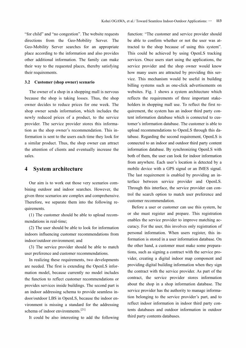
function: “The customer and service provider should be able to confirm whether or not the user was at-tracted to the shop because of using this system”. This could be achieved by using OpenLS tracking services. Once users start using the applications, the service provider and the shop owner would know how many users are attracted by providing this ser-vice. This mechanism would be useful in building billing systems such as one-click advertisements on websites. Fig. 1 shows a system architecture which reflects the requirements of three important stake-holders in shopping mall use. To reflect the first re-quirement, the system has an indoor third party con-tent information database which is connected to cus-tomer’s information database. The customer is able to upload recommendations to OpenLS through this da-tabase. Regarding the second requirement, OpenLS is connected to an indoor and outdoor third party content information database. By synchronizing OpenLS with both of them, the user can look for indoor information from anywhere. Each user’s location is detected by a mobile device with a GPS signal or an IMES signal. The last requirement is enabled by providing an in-terface between service provider and OpenLS. Through this interface, the service provider can con-trol the search option to match user preference and customer recommendation.
Before a user or customer can use this system, he or she must register and prepare. This registration enables the service provider to improve matching ac-curacy. For the user, this involves only registration of personal information. When users register, this in-formation is stored in a user information database. On the other hand, a customer must make some prepara-tions, such as signing a contract with the service pro-vider, creating a digital indoor map component and providing digital building information when they sign the contract with the service provider. As part of the contract, the service provider stores information about the shop in a shop information database. The service provider has the authority to manage informa-tion belonging to the service provider’s part, and to reflect indoor information in indoor third party con-tents databases and outdoor information in outdoor third party contents databases.
Geo-spatial Information Science 14(2): 109-118 114
Fig.1 System architecture with key stakeholders
4.1 Extending OpenLS for representing cus-
tomer recommendation
In this section an abstract extended OpenLS is in-troduced to overcome the first step. It aims to provide seamless navigation reflecting customer recommenda-tions and user preferences. These criteria are important in terms of practical use, because users would avoid using navigation systems if they cannot access the re-quested route guidance. Also, the huge investment for indoor positioning systems would be a waste of money for customers if they cannot attract users and increase sales by providing recommendations. Therefore, ex-tending OpenLS to reflect customer recommendations is necessary for indoor applications.
So far, research that aims to extend OpenLS to the indoor environment has been done,[2,13] and these stud-ies are still in progress. We strongly agree that LBS needs to be extended to include an indoor 3D model (or a 2D horizontal model) as soon as possible and also a “full” 3D model (i.e., BIM and CityGML) must be developed in the future. In most research,[5,22] route finding is supported by using Points of Interest (POI) and Landmarks inside of buildings. However, they
hardy exist in terms of customer recommendations. (1) Point of Interest (POI): A POI is a primary
output from a directory service, and thus it is also the “place” where one might obtain a product or service. It contains the name, type, category, address, phone number, and other directory information about a place, product or service.
(2) Landmark: Raubal and Winter[23] define a Landmark as “an object or structure that marks a lo-cality and its user as a point of reference”. Brun-ner-Friedrich and Radaczky[24] suggested that the term “Active Landmark” be used to guide users in indoor environments.
Of the two options, expanding POI offers more possibilities, because it has more parameters in an OpenLS specification. We assume that reflecting a customer’s recommendation will become possible by adding new parameters to existing POI.
As shown in the customer’s scenario, a customer’s recommendation must be changed according to the situation inside the building. However, POI is mainly targeted to stable information (i.e., unchanged infor-mation in real-time). Our concept for extending its
Kohei OGAWA, et al./ Toward Seamless Indoor-Outdoor Applications: … 115
function is to add a time axis to the POI specification. By doing this, the system is able to distinguish be-tween new POI information and old POI information. This is because customer recommendations are al-ways changing (i.e., new information is always being added) while other information rarely changes (i.e., the old information remains in the database). To dis-tinguish the difference, we call this new feature the “time-sensitive point of interest”.
Updating a POI to change map information will sometimes happen. This means that the system would not distinguish the difference between a customer recommendation POI and a map POI. However, this issue can be solved alongside other implementation issues.
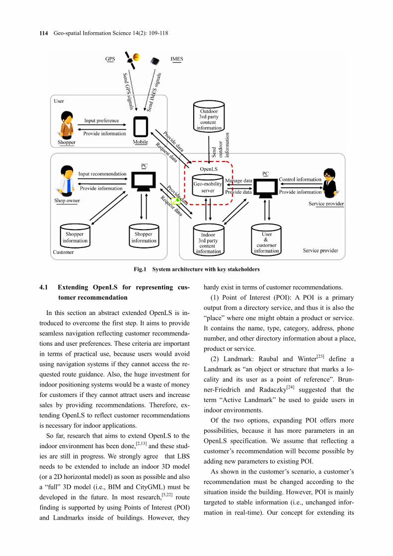
Fig. 2 illustrates a model for extending OpenLS in-formation to include the indoor environment. Each da-tabase interacts with indoor third party contents and outdoor third party contents. Fig. 3 shows how this ex-tended information model works when a user wants to receive services. These figures are applied from previ-ous research.[16] In these figures, both the customer and
the service provider have roles to provide optimal ser-vice reflecting the customer’s recommendation.
Fig.2 Extended OpenLS information model to reflect customer recommendations
The first service provider role happens when the Indoor Extended Directory Service is searching through the Directories, because the proximity ser-vice, including the customer recommendation, is sent to the user when matching services are found. When the user sends a service request to directory services, the service provider must match this request with di-rectories to reflect the customer’s recommendation. This matching function should be done using an al- gorithm such as collaborative filtering. The customer recommendation is stored as a time-sensitive POI and
Fig.3 Sequence diagram of extended OpenLS information model to find services
Geo-spatial Information Science 14(2): 109-118 116
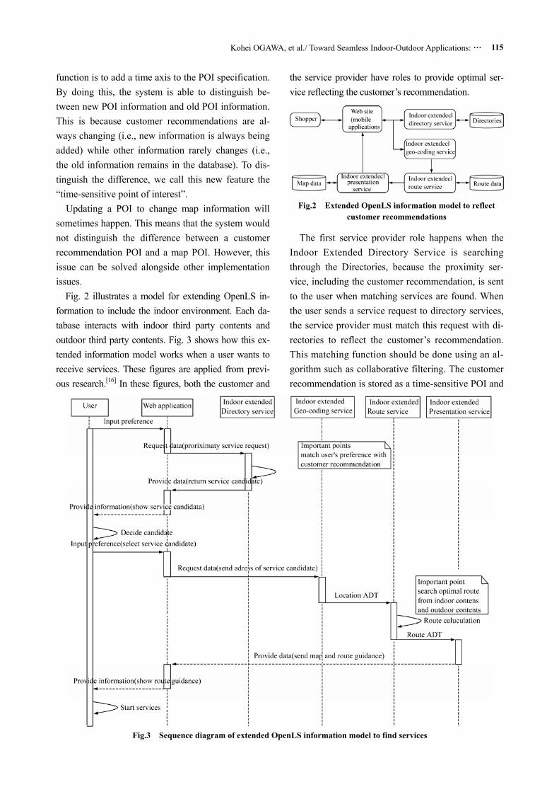
is transferred from indoor third party contents through XML. To realize this, applying a “service matching process”, as suggested by Ahn and Nah[8] would be useful. Fig. 4 shows an applied flowchart for distinguishing between time-sensitive POI and stable POI (existing POI) and returning services that reflect customer recommendations.
The second service provider role phase happens when the route service calculates a route, because route calculation must be able to flow seamlessly between indoor and outdoor information (i.e., the user should be able to find all destinations, both indoors and outdoors). Therefore, the service provider should be able to calculate a route by matching indoor with outdoor contents.
Fig.4 Distinguishing process for returning a list of service
candidates to the user
4.2 Extending OpenLS to incorporate an indoor addressing schema
Extending the addressing schema into the indoor environment remains an issue for indoor LBS. Goestz and Zipf[21] report that several important develop-ments are observed in this area. They state that Hong[25] has a possible solution schema to connect the indoor and outdoor environments. In that research, entitled “Indoor GML”, the terms “qualitative de-
scription” and “cell-based positioning” are introduced as the most likely ways to deal with indoor space en-vironment for developing seamless indoor/outdoor addressing schema.
In this system, we deploy a cell-based positioning system, because we assume that most of the building can be divided into cell-part (10 m2) and, furthermore, because the cell-based positioning system is suitable for IMES. Once this mechanism is applied, the indoor address should be provided to each space and stored in the OpenLS. For example, a room address should be something like “Room 1-318, Jaffalaan 9, 2628 BX Delft”; a hallway should be indicated as “Hallway-A, Part1, Jaffalaan 9, 2628 BX Delft”. However, progress must still be made with regard to moving objects such as escalators and elevators.[14]
As mentioned in the previous section, the goal of this indoor addressing schema is to be able to provide seamless indoor/outdoor LBS. Our indoor and out-door information is stored separately. These divided contents must be used seamlessly when the user en-ters a building while running the application. There-fore, a mechanism for switching between indoor and outdoor contents is needed.
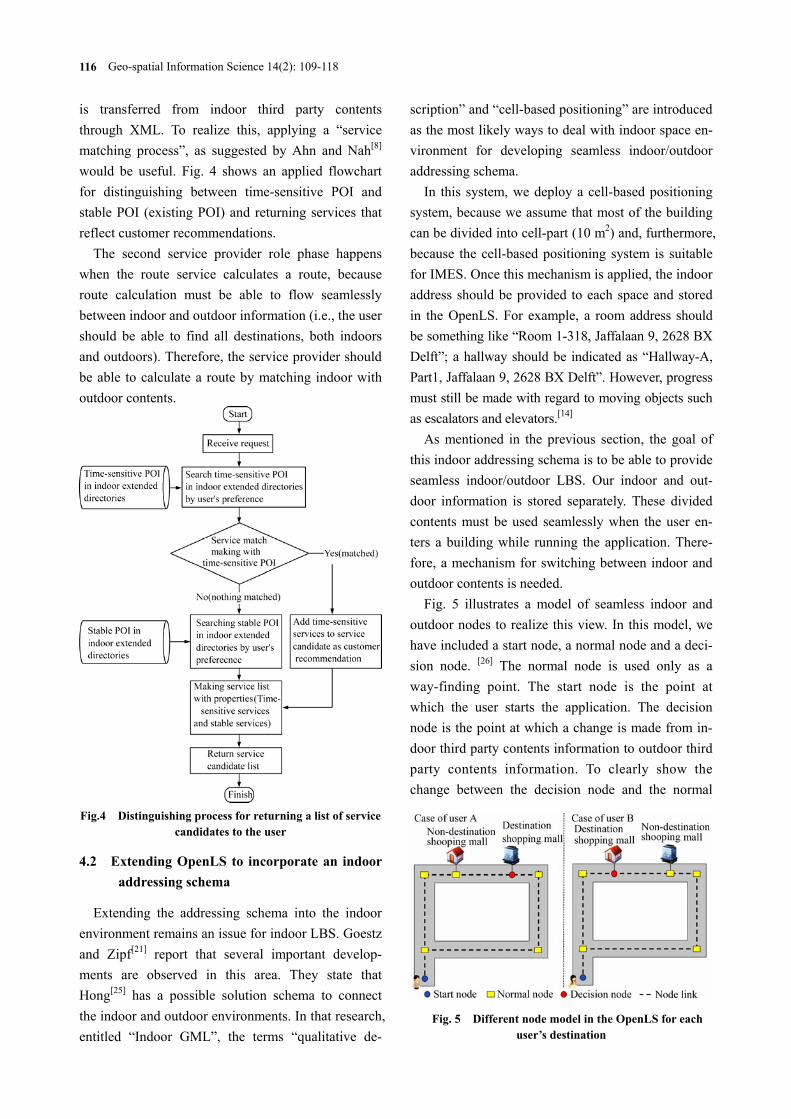
Fig. 5 illustrates a model of seamless indoor and outdoor nodes to realize this view. In this model, we have included a start node, a normal node and a deci-sion node. [26] The normal node is used only as a way-finding point. The start node is the point at which the user starts the application. The decision node is the point at which a change is made from in-door third party contents information to outdoor third party contents information. To clearly show the change between the decision node and the normal
Fig. 5 Different node model in the OpenLS for each user’s destination
Kohei OGAWA, et al./ Toward Seamless Indoor-Outdoor Applications: … 117
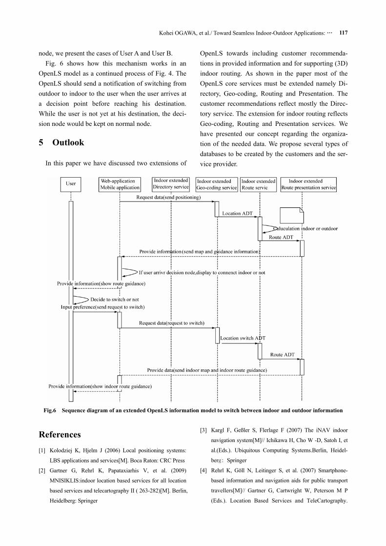
node, we present the cases of User A and User B. Fig. 6 shows how this mechanism works in an
OpenLS model as a continued process of Fig. 4. The OpenLS should send a notification of switching from outdoor to indoor to the user when the user arrives at a decision point before reaching his destination. While the user is not yet at his destination, the deci-sion node would be kept on normal node.
5 Outlook
In this paper we have discussed two extensions of
OpenLS towards including customer recommenda-tions in provided information and for supporting (3D) indoor routing. As shown in the paper most of the OpenLS core services must be extended namely Di-rectory, Geo-coding, Routing and Presentation. The customer recommendations reflect mostly the Direc-tory service. The extension for indoor routing reflects Geo-coding, Routing and Presentation services. We have presented our concept regarding the organiza-tion of the needed data. We propose several types of databases to be created by the customers and the ser-vice provider.
Fig.6 Sequence diagram of an extended OpenLS information model to switch between indoor and outdoor information
References [1] Kolodziej K, Hjelm J (2006) Local positioning systems:
LBS applications and services[M]. Boca Raton: CRC Press
[2] Gartner G, Rehrl K, Papataxiarhis V, et al. (2009)
MNISIKLIS:indoor location based services for all location
based services and telecartography II ( 263-282)[M]. Berlin,
Heidelberg: Springer
[3] Kargl F, Geßler S, Flerlage F (2007) The iNAV indoor
navigation system[M]// Ichikawa H, Cho W -D, Satoh I, et
al.(Eds.). Ubiquitous Computing Systems.Berlin, Heidel-
berg: Springer
[4] Rehrl K, Göll N, Leitinger S, et al. (2007) Smartphone-
based information and navigation aids for public transport
travellers[M]// Gartner G, Cartwright W, Peterson M P
(Eds.). Location Based Services and TeleCartography.
Geo-spatial Information Science 14(2): 109-118 118
Berlin, Heidelberg: Springer
[5] Jensen B, Kruse R, Wendholt B (2009) Application of in-
door navigation technologies under practical conditions [C].
WPNC 2009, Volos, Greece
[6] Yanying G, Lo A, Niemegeers I (2009) A survey of indoor
positioning systems for wireless personal networks[J].
Communications Surveys & Tutorials, IEEE, 11(1): 13-32
[7] Hui L, Darabi H, Banerjee P, et al. (2007) Survey of wire-
less indoor positioning techniques and systems[J]. Systems,
Man, and Cybernetics, Part C: Applications and Reviews,
IEEE Transactions on, 37(6): 1067-1080
[8] Ahn C, Nah Y (2010) Design of location-based web service
framework for context-aware applications in ubiquitous en-
vironments[C].The Sensor Networks, Ubiquitous, and
Trustworthy Computing (SUTC), Taichung
[9] Angin P, Bhargava B, Helal S (2010) A mobile-cloud col-
laborative traffic lights detector for blind navigation[C].
The Mobile Data Management (MDM), Kanas City, Mis-
souri, USA
[10] Huang H, Gartner G (2010) A survey of mobile indoor
navigation systems[M]//Gartner G,Ortag F(Eds.). Cartog-
raphy in Central and Eastern Europe. Berlin, Heidelberg:
Springer
[11] Open Street Map (2010) Open route service[OL].
http://wiki.openstreetmap.org/wiki/OpenRouteService
[12] Spinney J (2003) A brief history of LBS and how OpenLS
fits into the new value chain[J]. Java Location Services
Newsletter
[13] Verbree E, Zlatanova S (2007) Positioning LBS to the third
dimension[M]//Gartner G,Cartwright W, Peterson M P
(Eds.). Location Based Services and TeleCartography. Ber-
lin, Heidelberg: Springer
[14] Zlatanova S, Verbree E (2005) The third dimension in
LBS: the steps to go[J]. Geowissenschaftliche Mitteilungen,
Heft, 74, 185-190
[15] Zlatanova S, Verbree E (2003) Technological Developments
within 3-D location-based services[C]. International Sympo-
sium and Exhibition on Geoinformation 2003, Shah Alam,
Malaysia
[16] Neis P L Dietze, Zipf A (2007) A Web accessibility analy-
sis service based on the OpenLS route service, AGILE
2007[J]. International Conference on Geographic Informa-
tion Science of the Association of Geographic Information
Laboratories for Europe (AGILE), Aalborg, Denmark
[17] Neis P, Zipf A (2008) Generating 3-D focus maps for the
(mobile) Web: An Interoperable Approach[J]. International
Journal of Location Based Services (JLBS), 2(2)
[18] Dempster A (2009) QZSS’s indoor messaging system,
GNSS Friend or Foe[OL]. http://www.insidegnss.com
[19] Manandhar D, Kawaguchi S, Uchida M, et al. (2008) IMES
for mobile users:social implementation and experiments
based on existing cellular phones for seamless position-
ing[C].Proceedings of the International Symposium on
GPS/GNSS 2008, Tokyo, Japan
[20] Kim S, Minato K, Busser N, et al. (2010) Transforming
seamless positioning technology into a business using a
systems design approach: scenario-based amorphous de-
sign[C]. IEEE International Systems Conference, INCOSE
Track, Salt Lake City UT
[21] Goetz M, Zipf A (2010) Open issues in bringing 3D to lo-
cation based services (LBS)-A review focusing on 3D data
streaming and 3D indoor navigation [J].Remote Sensing
and Spatial Information Sciences, 38-4/W15
[22] Jiejun H, Yunjun Z, Wei C, et al. (2010) Development of a
campus information navigation system based on GIS[C].
The Computer Design and Applications (ICCDA), Qin-
huangdao, Hebei, China
[23] Raubal M, Winter S (2002) Enriching way-finding instruc-
tions with local landmarks[M]//GISscience 2002. Ber-
lin:Springer
[24] Brunner-Friedrich B, Radoczky V (2006) Active landmarks
in indoor environments[M]// Bres S, Laurini R (Eds.). Vis-
ual Information and Information Systems. Berlin, Hei-
delberg: Springer
[25] Hong S (2008) Ubiquitous Geographic Information (UBGI)
and address standards[C]. ISO Workshop on Address
Standards, Denmark
[26] Karimi H A, Ghafourian M (2010) Indoor routing for indi-
viduals with special needs and preferences[J]. Transactions
in GIS, 14(3):299-329