title of thesis: - diva portal
TRANSCRIPT

Water and Environmental Studies Department of Thematic Studies Linköping University
Master’s programme Science for Sustainable Development
Master’s Thesis, 30 ECTS credits
ISRN: LIU-TEMAV/MPSSD-A--09/004--SE
Linköpings Universitet
Participatory watershed management to decrease land degradation and sediment transport in Kagera
and Nyando catchments of Lake Victoria basin
Kenge James Gunya


Water and Environmental Studies Department of Thematic Studies Linköping University
Master’s programme Science for Sustainable Development
Master’s Thesis, 30 ECTS credits
Supervisors: Hans Bertil Wittgren & Karin Tonderski
Examiner: Lotta Andersson
2009 i
Participatory watershed management to decrease
land degradation and sediment transport in Kagera and Nyando catchments of Lake Victoria basin
Kenge James Gunya

ii
Upphovsrätt
Detta dokument hålls tillgängligt på Internet – eller dess framtida ersättare – under 25 år från publiceringsdatum under förutsättning att inga extraordinära omständigheter uppstår.
Tillgång till dokumentet innebär tillstånd för var och en att läsa, ladda ner, skriva ut enstaka kopior för enskilt bruk och att använda det oförändrat för ickekommersiell forskning och för undervisning. Överföring av upphovsrätten vid en senare tidpunkt kan inte upphäva detta tillstånd. All annan användning av dokumentet kräver upphovsmannens medgivande. För att garantera äktheten, säkerheten och tillgängligheten finns lösningar av teknisk och administrativ art.
Upphovsmannens ideella rätt innefattar rätt att bli nämnd som upphovsman i den omfattning som god sed kräver vid användning av dokumentet på ovan beskrivna sätt samt skydd mot att dokumentet ändras eller presenteras i sådan form eller i sådant sammanhang som är kränkande för upphovsmannens litterära eller konstnärliga anseende eller egenart.
För ytterligare information om Linköping University Electronic Press se förlagets hemsida http://www.ep.liu.se/. Copyright
The publishers will keep this document online on the Internet – or its possible replacement – for a period of 25 years starting from the date of publication barring exceptional circumstances.
The online availability of the document implies permanent permission for anyone to read, to download, or to print out single copies for his/her own use and to use it unchanged for non-commercial research and educational purpose. Subsequent transfers of copyright cannot revoke this permission. All other uses of the document are conditional upon the consent of the copyright owner. The publisher has taken technical and administrative measures to assure authenticity, security and accessibility.
According to intellectual property law the author has the right to be mentioned when his/her work is accessed as described above and to be protected against infringement.
For additional information about Linköping University Electronic Press and its procedures for publication and for assurance of document integrity, please refer to its www home page: http://www.ep.liu.se/. © Kenge James Gunya

iii
Table of Contents
Abstract ………………………………………………………………………………1 LIST OF ACRONYMS AND ABBREVIATIONS..............................................................2
CHAPTER ONE…………………………………………………………………………3 1. Introduction ………………………………………………………………………….3
1.1. Environmental situation in Lake Victoria Basin (LVB) and its catchments........ 3 1.2. Current watershed management in the Lake Victoria Basin................................ 4 1.3. Aim of the study................................................................................................... 5 1.3.1. Basis for formulation of hypothesis and research questions ............................. 5 1.3.2. Hypothesis and research questions.................................................................... 6
CHAPTER TWO............................................................................................................... 7 2. Theoretical framework and literature review ………………………………………..7
2.1. Participatory Watershed Management as a concept............................................. 7 2.2. Key elements of participatory watershed management........................................ 8 2.3. Challenges in adopting participatory watershed management............................. 8 2.4. Attempts to implement PWM .............................................................................. 9
CHAPTER THREE ........................................................................................................ 11 3. Material and Methods ……………………………………………………………..11
3.1. Study area description: Lake Victoria Basin (Kagera and Nyando catchments)11 3.1.1. Kagera river basin ........................................................................................... 13 3.1.2. Nyando river basin .......................................................................................... 13 3.2. Research design.................................................................................................. 14 3.2.1 Interviews ......................................................................................................... 15 3.2.2 Field observations ............................................................................................ 16 3.2.3. Secondary data collection................................................................................ 16
CHAPTER FOUR........................................................................................................... 18 4. Results ……………………………………………………………………………..18
4.1. Causes of land degradation in Kagera and Nyando catchments ........................ 18 4.1.1. Population pressure ......................................................................................... 18 4.1.2 Poverty ............................................................................................................. 19 4.1.3 Agricultural methods and crop systems ........................................................... 20 4.2. Magnitude of land degradation and soil erosion ................................................ 20 4.3. Existence of policy framework for watershed management in LVB................. 22 4.4. Weaknesses in policy implementation ............................................................... 23 4.5. Assessment of available land management practices......................................... 24 4.6. Partnership and stakeholder coordination .......................................................... 25 4.7. NGO, CBOs and community responses to combat land degradation ................ 26
CHAPTER FIVE............................................................................................................. 28 5. Discussion …………………………………………………………………………..28
5.1. Land management practices. .............................................................................. 28 5.2. Policy implementation in the Kagera and Nyando catchments.......................... 29 5.3. Partnership and institutional framework ............................................................ 31 5.4. Obstacles in administrative and stakeholders involvement................................ 32 5.5. Comparison of land management policies and practices in Kagera and Nyando catchments................................................................................................................. 33 5.6. Recommendations .............................................................................................. 34 5.7. Conclusions ........................................................................................................ 35
Acknowledgment ……………………………………….……………………………..37

iv
References ……………………………………………………………………………38 APPENDIX 1 ………………………………………………………………………………..42 List of Figures Figure 3.1 Lake Victoria Basin ............................................................................................. 12
Figure 4.1. (i & ii): .......... 19 Evidence of land fragmentation in Kagera sever gullies in Nyando
Figure 4.2. (i & ii): ............................................ 20 Agricultual activties at Nyando River Bank
Figure 4.3. (i & ii): .............................. 22
soil erosion and sediment transport in Kangera river evidence by the
accumulation of silt at the bank of the river and the red colour of the water
Figure 4.4. ............................ 23 Reasons for weak policy implemntation in the riparian countries
Figure 4.5. Constraints for low level of land management practices in the catchments .............. 25
List of Tables Table: 3.1. Category of respondents interviewed in Kagera and Nyando catchments…...15 Table: 4.1. The main causes of land degradation in Nyando and Kagera Catchments……18 Table: 4.2. The magnitude of soil erosion in Kagera and Nyando catchments……………21
1
ABSTRACT Attention to participatory watershed management is increasing across the developing world as soil erosion continues to degrade agricultural land; reservoirs and irrigation infrastructure are clogged with sediment. The realization of the importance of watersheds is crucial for sustainable utilization especially in developing countries where rural livelihoods and economies are highly dependant on the exploitation of natural resources. The Lake Victoria basin is characterized by high population pressures, low productive subsistence agriculture, poor farming methods, loss of soil fertility and deforestation due to demand of fuel wood and charcoal, timber and building materials that are posing serious threat to watersheds. High population density in the basin also means new needs emerge too fast to which rural societies cannot respond in time leading to more area expansion for agricultural land. In spite of positive efforts under the Lake Victoria Basin Commission, there remains a huge gap between policy and institutional framework development at the top level and the actual implementation of actions on the ground to prevent land degradation, soil erosion and decrease sediment load. The study focused on Kagera and Nyando catchments of Lake Victoria Basin and aiming to establish if there exist and the extent to which participatory watershed management has been implemented on the ground to decrease land degradation and sediment load. It therefore provides an insight into watershed management in the Kagera and Nyando catchments by illustrating the link between policy formulation and actual implementation and enforcement. Key words: Kagera and Nyando catchments, Lake Victoria basin, land degradation, participatory watershed management, policy

2
LIST OF ACRONYMS AND ABBREVIATIONS CBOs Community Based Organizations CHEMA Community Habitat Environment Management CMS Catchment Management Strategy DWD Directorate of Water Development
EAC East African Community
GWP Global Water Partnership ICRAF International Centre for Research in Agroforestry AHI African Highland Initiative KBO Kagera Basin Organization LVB Lake Victoria Basin LVBC Lake Victoria Basin Commission LVEMP Lake Victoria Environnent Management Programme LVSC Lake Victoria South Catchment NAADs National Agricultural Advisory Service NBI Nile Basin Initiative NEMA National Environment Management Authority NGOs Non-Governmental Organizations PRSP Poverty Reduction Strategy Program PWM Participatory Watershed Management REMA Rwanda Environment Management Authority SIWI Stockholm International Water Institute UNEP United Nations Environment Programme VIRED Victoria International Research Environment and Development WRMA Water Resource Management Authority WFP World Food Program
3
CHAPTER ONE
1. INTRODUCTION The world’s freshwater resources are under increasing pressure. Growth of population, increased economic activity and improved standards of living lead to increased competition for available freshwater resources. Freshwater resources are not evenly distributed across the world by season or location. Some parts of the world are prone to drought making water a scarce and precious commodity, while in other parts of the world it appears in raging torrents often resulting to floods that lead to loss of life and property. On the other hand, some regions have to prepare for both increased risks of floods and droughts. Approximately a third of the world’s population live in countries facing moderate to high water stress where water consumption is more than 10 percent of the renewable freshwater resources (GEO-3, 2002). Systematically, available freshwater resources are being rapidly exploited, leading to depletion. Inadequate poverty alleviation programs coupled with lack of proper land management practices in developing countries force people to over exploit soil and forest resources. This further increases the pressure on the hydrologic function of watersheds. As a consequence, dramatic changes occur in the biotic and hydrologic components of watersheds leading to unprecedented problems manifested in form of land degradation and soil erosion. The realization of sustainable utilization of the watersheds is therefore crucial, especially in developing countries where rural livelihoods and economies are highly dependant on direct exploitation of natural resources. 1.1. Environmental situation in Lake Victoria Basin (LVB) and its catchments Until 1960s, Lake Victoria could boast a rich, well-balanced community of plant and animal species, but over the last 40-50 years the lake and its watersheds have undergone rapid ecological changes (Greenwood, 1956; ICRAF, 2000). Currently, Lake Victoria is experiencing severe threats that are impacting negatively on the socio-economic situation of the communities living in the basin and on the ecological values of the lake. Major environmental threats in the Lake Victoria Basin (LVB) include unsustainable agriculture and deforestation in the catchments. This has resulted in sedimentation and proliferation of aquatic plants in the lake, most notably phytoplankton and an increase in water hyacinth, originating from the Kagera river basin. The threats facing the lake have caused considerable hardship for the population depending on it for their livelihoods (FAO, 1998) and have also reduced the biodiversity of the lake’s fauna, especially the phytoplankton and fish. Many of the threats are a result of the rapidly increasing population in the basin, which is estimated at 6% per annum in urban centres and over 3% in rural areas (Ntimba et al, 2001). Forests in the river catchments are rapidly cleared for agriculture, firewood, charcoal and settlements. Deforestation coupled with bad agricultural practices has exacerbated the problem of sedimentation in the lake.
4
A study conducted by Ogutu, et al (2005) has shown that encroachment on forest reserves and wetlands, transformation of farm lands from perennial to annual cropping system characterize the major changes in land cover and use in the LVB. The sustainability of these changes and their effect on the livelihoods of the local communities and the environmental health of LVB is raising concern. In addition, land use changes in the LVB coupled with deforestation are linked to land degradation, especially soil erosion in prime agricultural areas within the catchments (Kayombo et al, 2006). Several studies have also shown significant land use changes, including land fragmentation, clearing of natural vegetation for cultivation and fuel wood. However, as stated by Gleick (1998) freshwater resources are typically considered renewable; they can be used in a manner that does not affect the long-term sustainability of the same resources. More important, achieving environmental sustainability and at same time satisfying the needs for increased livelihoods, enhanced economic growth and poverty reduction, is an issue of growing importance among developing countries (Kinaro, 2007). Hence water resources can be used sustainably without jeopardizing economic growth. 1.2. Current watershed management in the Lake Victoria Basin Inappropriate management of watersheds leads to a wide range of ecological and human crisis in both upstream and downstream of a basin. These may include destabilization of aquatic ecosystems, extinction of species and finally eutrophication due to nutrient and sediment load. Land degradation and soil erosion coupled with declining per capita availability of land and freshwater are posing serious threat to watersheds. To decrease the effects of degradation, it requires a process that promotes a coordinated development and management of water and land. Such a process is expected to maximize the resultant economic and social welfare in an equitable manner without compromising the sustainability of vital eco-systems (GWP, 2002). Being an important resource and a shared water body, the riparian countries are taking measures to restore the health of the Lake to a better quality for biodiversity to thrive and human welfare to be supported. The riparian governments since the resurrection of the East African Community (EAC) and the development of its protocol for sustainable management of the LVB are coordinating their efforts well in managing the fisheries. They have also developed an action plan for management of the entire lake and its catchments across all sectors (EAC secretariat, 2006). The EAC as a regional inter-governmental body in 2003 concluded and signed a Protocol for Sustainable Development of LVB under the provisions of the EAC Treaty. Among other important issues, the Protocol provides for the establishment of an institutional framework for better management of the LVB. Under the protocol, Lake Victoria Basin Commission (LVBC) was formed as an apex institution responsible for all the initiatives in the LVB (EAC, 2003). Article 3 of the Protocol further requires the riparian countries to cooperate in the areas that relate to the conservation and sustainable utilization of resources in the basin and the catchments. Issues of importance include promotion of sustainable agriculture and

5
land management practices, irrigation and promotion of stakeholder involvement at various levels in planning and decision-making. More over, Lake Victoria Environmental Management Project (LVEMP) has also been undertaking conversation activities in the basin until recently when the project came to a halt. The LVEMP only involved 3 partner countries (Kenya, Tanzania and Uganda), Burundi and Rwanda did not participate since they were not members of the EAC treaty during the period. Other management bodies involved in the LVB include Nile Basin Initiative (NBI) which is involved with projects in all, 9 countries within the Nile basin. Another body is Nile Equatorial Lakes Subsidiary Action Programme (NELSAP) focusing on the eradication of poverty, the promotion of economic growth and a reversal of environmental degradation. It is from this basis that the study aims to assess the extent of participatory watershed management being applied since the conclusion of the protocol for the sustainable development of LVB and the formation of LVBC. Kagera and Nyando catchments have been selected as case studies. Kagera carrying the largest volume of water into Lake Victoria while Nyando being the biggest contributor of sediments among the catchments draining to Lake Victoria. 1.3. Aim of the study The general objective of the study was to establish if there exists and to what extent participatory watershed management approach is being implemented on the ground to reduce land degradation and sediment transport in Kagera and Nyando catchments. Insights provided include the magnitude of land degradation in the catchments, the links between land degradation and the increased deposition of sediments into Lake Victoria. 1.3.1. Basis for formulation of hypothesis and research questions To achieve the general aim of the study, four research questions were posed. The questions focused in the areas of policy framework, land management practices, the obstacles for meaningful coordination and comparison of Kagera and Nyando catchments. The aim of the investigation was to gain understanding in involvement of stakeholders in policy development process, their role in implementation of policies and land management practices. Questions have been raised regarding, how activities are coordinated among implementing agents and NGOs regionally as well as at national, district and local levels and finally identifying the obstacles encountered in coordination and implementation. However, during the course of investigations, the causes of land degradation was added, this opened further discussions on land management policies and practices. Participatory Watershed Management (PWM) is a management approach that seeks to engage the public in the decision making process (Rowe et al 2000 and Conley et al 2003). According to Sharma (1999) it is a process of utilization, development and conservation of land, water and forest resources for continually improving livelihoods of communities in a given hydrologically independent geographic area. FAO (2002) also stated that PWM is a coordinating framework of management that attempts to

6
focus public and private, community and individual efforts towards addressing high priority land and water related issues. It involves reducing soil erosion and land degradation, promoting vegetative cover and coordinating the actions of numerous land users in a watershed. Since watershed management integrates components of soil, water and vegetative cover conservation, agriculture, rural communities’ livelihoods and better environment conditions. Therefore aspects such as land management policies, land management practices and coordination of different actors were taken to be important in forming a basis for assessing PWM in Kagera and Nyando catchments. The following hypothesis and research questions that guided the study were therefore aimed to capture these dimensions in the two catchments and LVB as a whole. 1.3.2. Hypothesis and research questions Coordinated participatory watershed management of Kagera and Nyando catchments can be a viable means to achieve reduction of land degradation and sediment transport into Lake Victoria.
Are there any land management policies and institutional framework available at catchment level aimed at reducing soil erosion and land degradation?
What are the land management practices available officially implemented in Kagera and Nyando catchments?
What are the obstacles for meaningful coordination among different administrative levels and other stakeholders involved in watershed management in Kagera and Nyando catchments?
Are there any similarities or differences in land management policies and practices in the two catchments and do they fit with the overall objectives of the LVBC?

7
CHAPTER TWO
2. THEORETICAL FRAMEWORK AND LITERATURE REVIEW 2.1. Participatory Watershed Management as a concept Water resource management presents complex challenges since it is a common-pool resource that links multiple ecosystems and user groups. There has been a marked shift from traditional technical approach towards focusing water resource management on the watershed scale to account for these complexities (Lisa, 2007). This shift has led to the emergence of watershed conservation groups and to the increased importance and recognition of participatory management of common-pool resources. As already mentioned in chapter one, PWM is a management approach that seeks to engage the public in the decision making process (Rowe et al 2000 and Conley et al 2003). Similarly, according to Sharma (1999) sustainable integrated watershed management is defined as a process of utilization, development and conservation of land, water and forest resources for continually improving livelihoods of communities in a given hydrologically independent geographic area. FAO (2002) further stresses that watershed management is a coordinating framework for management that attempts to focus public and private, community and individual efforts toward addressing high priority land and water-related issues within a hydrologically defined geographic area. PWM is therefore, geared towards the management of natural resources in a given watershed that enable communities to overcome problems and gain more control over their livelihoods. It places local people in the development process as 'stewards' of the environment. The concept gained recognition due to the pattern of failures observed in past top-down methods used by the public sector to implement watershed management projects in which communities were less passive recipients of external interventions (Lisa, 2007). These failures have fostered a more serious recognition that success depends upon enhancing communities’ inherent abilities to apply and adapt new and indigenous technologies. Overall, local institutions should be involved to manage and conserve natural resources. Attention to PWM is increasing across the developing world as soil erosion continues to degrade agricultural land, while dams, reservoirs and irrigation infrastructure continue to be clogged with sediment (Abdelsalam, 2008). The broader view through participatory management of watersheds (basins and catchments) is to capture dimensions and societal issues that are not normally included in a land use planning and management (Budumuru et al, 2006). These include causes of natural resource degradation and related land use activities. The importance of PWM is therefore to ensure that use and modification of water resources, land based activities at catchments do not undermine the function of ecosystems and other resources. Participatory approach of water resource management is one of the principles of the Dublin convention which requires water development and management be based on

8
involvement of all users, planners and policymakers at all levels (GWP, 2000). It further aims at managing the land and water resources of drainages in a manner that sustains adequate levels of water, soil and fiber production (FAO/FORC, 2003). In the context of LVB and its catchments, it therefore requires an approach that inculcates the core values of the EAC vision with real actions on the ground. To achieve proper management of the basin and its catchments, efforts are therefore required for regional coordination as well as planning at national, district and local levels. More important, direct involvement of local communities as demanded by the principles of PWM. 2.2. Key elements of participatory watershed management This section culls out the key elements of participatory processes that are considered essential for watershed management. There is recognition that traditional top-down, supply led, technically based and sectoral approaches to watershed management are imposing unsustainably high economic, social and ecological costs on societies and environment (Sharma, 1999). The concept of PWM as one of its elements emphasizes inter-disciplinary and multi-institutional mechanisms. This implies that watershed management is an inter-disciplinary field which requires the performance of different disciplines, cooperation and coordination among all concerned actors (FAO, 2002). It provides opportunities for stakeholders to bring forward and jointly negotiate their interests, set priorities, evaluate opportunities, implement and monitor the outcomes (Wani et al, 2005). It further emphasizes and gives priority for inclusion of stakeholders at all levels and steps of the participation process, e.g. decision making, planning, design and implementation with all concerned stakeholders. According to Rowe et al (2000) the inclusion of the broader public at different stages of the decision making process e.g. defining the problem of designing and implementing solutions is beneficial since it builds trust, taps local knowledge and creates a feeling of ownership. Therefore, the elements of PWM are considered highly important since community members, government officials, and planners work together to identify and understand the various biophysical and socio-cultural elements in a watershed. They then together develop strategies for building locally controlled and self-reliant solutions that are closely tied to the use and sustainability of the resources in a watershed. Therefore, stakeholder participation and involvement in the decision making process is guaranteed in PWM. In a way, it empowers local communities to be active participants regarding preferred policy options, decision-making process. This is an evolution away from technocratic based decision making in conventional watershed management. These elements have been implemented in a variety of similar policy domains ranging from the cleanup of nuclear weapons facilities to ecosystem management, species and habitat restoration. This can be achieved in watershed management as long as local communities are fully involved. 2.3. Challenges in adopting participatory watershed management Although PWM is considered highly important in basin and catchment management, it has got several weaknesses. First is the time and effort needed to involve

9
stakeholders in an attempt to gain a consciousness on the issues of watershed management. The disadvantage is that PWM demands a lot of time, as well as local willingness to participate (Andersson et al, 2008) and especially negotiating the practical issues may prove to be very difficult. GWP (2008) further noted, while the participatory process is essential to build participants knowledge however, it requires ample time and patience to build the necessary trust. There are always conflicting demands on the part of the stakeholders since different groups represent different interests and reaching consensus may be difficult. Once again, this may require a lot of time. Bellamy (2002) further stated that during consultations, people unable to attend meetings sent representatives but their stand-ins may not be empowered to make any decisions. He argues that often a different person each time attends meetings, thus continuity and consistence in understanding the issues being discussed becomes a problem. Such meetings rarely lead to resolutions of any issues or decisions that could effectively facilitate problem-solving outcomes. There is often a problem of power relations when implementing PWM. It is difficult to engage different types of stakeholders that have different power to influence issues pertaining to natural resource management since they have got different interests. In societies like the ones in the riparian countries where majority of the population is poor, most of the decision making can easily be influenced by those who are better off and well connected than the poor. In addition, women in this regard may not have their voices heard as most of the decisions in the society are still dominated by men even though women are more directly involved in resource exploitation. More often there are inadequate resources to carry out PWM, the involvement of all stakeholders can be cumbersome and resources may be stretched in terms of mobilizing the different interest groups to participate. In developing countries and especially the riparian countries, such resources are always a problem as the governments may neither give priority nor have the necessary funds needed to involve all the stakeholders. This therefore, hinders the process of actually participation of the local people and involvement of all stakeholders. 2.4. Attempts to implement PWM Despite the challenges of PWM, there have been considerable attempts to introduce and implement PWM in different parts of the world. Many of the initiatives of PWM implementation have registered success for instance in Latin America, implementation in the highlands of Costa Rica and Colombia (Perez et al, 2003). The Fundación de la Cordillera Volcánica Central is cutting across traditional lines to promote better land management by involving local communities in Costa Rica. On a larger scale are the ambitious and successful attempts of the Corporación del Valle del Cauca in Colombia. In Africa examples include catchment management in Mali, Malawi, Senegal, Zambia, South Africa and Madagascar GWP (2008) while in Asia and Oceania examples are found in India and Australia.

10
In all the catchments mentioned, the approach of PWM has mobilized communities and laid the foundation for improved community participation in watershed management. It has also facilitated stakeholders to get together, promoted sharing of resources and helped to build consensus on watershed management problems. For instance in Australia, there has been a shift in catchment management from government as administrator of policy on behalf of communities’ as passive recipients, to government as ‘enabler’ and ‘facilitator’ to support a more empowered community that articulates catchment strategies (Bellamy et al, 2002). More so, Indo-German micro watershed development in 20 districts of Maharashtra in India has similar results (Farrington et al, 1997). These examples of PWM are easily replicable and represent a significant step forward.

11
CHAPTER THREE
3. MATERIAL AND METHODS 3.1. Study area description: Lake Victoria Basin (Kagera and Nyando catchments) The geographical context of the study is the Lake Victoria Basin, specifically the catchments of Kagera and Nyando. Kagera drains through Burundi, Rwanda, Tanzania and Uganda while Nyando on the other hand drains western Kenya (see figure 3.1). With a surface area of 68,800 km2 and an average depth of 40m, Lake Victoria is the world’s second largest freshwater body and the largest in the tropics. It is of crucial socio-economic importance to its riparian population. The three surrounding countries of Tanzania, Kenya and Uganda control 49%, 6% and 45% respectively of the area of the lake and utilize its resources for fishery, freshwater, energy and transport. The watershed of the lake covers a total area of 251,000km2 (UNEP, 2006), 44% of which is in Tanzania, 22% Kenya, 16% Uganda, 11% Rwanda and 7% Burundi. The Kagera River, which drains from Burundi and Rwanda Tanzania and Uganda, is the single largest river flowing into the lake (Abdelsalam, 2008). However, rivers entering the lake from Kenya, which contains the smallest portion of the lake, contribute over 37.6 % of surface water inflows while according to (Makalle et al, 2008) the average of total annual inflow to the lake from its catchment area is about 20 km3, about 7.5 km3 of which comes from the Kagera basin, 8.4 km3 from the Kenyan rivers and forests, 3.2 km3 from Tanzania and 1 to 2 km3 from North West Ugandan swamps. The only surface outlet from the lake is the Nile River and therefore the LVB forms a large part of the Nile basin. Any changes in resources within LVB will even affect people in more than 10 countries in Africa most notably Egypt and Sudan. In addition, a study conducted by (Yanda, 2001) has shown that the Nyando basin is a major source of sediment load into Lake Victoria and 61% of the basin’s 3,500 km2 is constituting a source area with average erosion rates of >40 t/ha/yr. On the other hand Kagera basin which is a transboundary basin stretching across Burundi, Rwanda, Tanzania and Uganda has similar effects of drainage system as those of Nyando. Although LVB is endowed with rich natural resources, approximately half of the total population lives below poverty line. IMF (2001) regards living below poverty line in under developed countries as those people who live on less than $1 a day. Approximately 30 million people live within the region and the catchments, with 2 million of the population depending directly or indirectly on the water resources (Ntimba et al 2001). More than 80% of the population is engaged in agricultural production (Makalle et al, 2008) and the river catchments form a significant base for agriculture and livestock keeping that maintain the livelihoods of small-scale farmers. The majority of these small-scale farmers are engaged in livestock keeping and production of crops such as maize, millet, groundnuts, beans, bananas and cash crops

12
such as sugar, tea, coffee and cotton. According to NEMA Uganda (2001) fish resources of the lake directly and indirectly sustain livelihoods of about 3 million people engaged in subsistence and commercial fishing. These activities increasingly press heavy demand on the watershed resources and the basin continues to be deforested as demand for more land to up scale farming increases. This leads to land degradation which is characterized by fertility losses, soil erosion and increased sediment load into Lake Victoria thus adversely affecting the quality of water and biodiversity. Wetlands in the LVB are also increasingly facing serious problems of degradation due to large-scale conversion to agricultural land. The conversion implies that the wetland’s capacity to buffer and filter sediments and retain nutrients has diminished. Proper management of wetland resources through institutions at micro, meso and macro level could produce societal as well as ecosystem benefits. Given the dependence of communities on the natural resources and the linkages of impacts of their activities in LVB watersheds, there is need to manage the catchments in an integrated and adaptive manner.
Figure 3.1 Lake Victoria Basin
Source: ICRAF

13
3.1.1. Kagera river basin The Kagera River basin which is a sub-catchment of LVB is distributed in four countries of Burundi, Rwanda, Tanzania and Uganda. The basin carries 34% of the annual inflow to Lake Victoria and 75% of the land area of Rwanda and 52% of Burundi lie within the basin (Ndomba et al, 2008). The general elevation in the Kagera basin varies between 1,200 and 1,600 m above mean sea level (m amsl), but rises above 2,500 m in the west, with peaks reaching 4,500m in the north-western corner. The basin has an absolute minimum elevation of 1,134 m amsl, corresponding to the average level of Lake Victoria. The drainage density in the catchment areas of Nyabarongo, Akanyaru and Ruvubu is very high, particularly on the eastern part of the Congo-Nile Crest. The upper tributaries, Akanyaru and Nyabarongo are generally steep but include flatter areas where swamps have formed. Although the western part of the basin is partly forested, much of the basin has become intensively cultivated and even fragile lands located on steep slopes are cultivated. This has resulted in erosion and sediment load from the high rainfall areas (Sutcliffe, 1999). Data collected by LVEMP from 2000 to 2005, has shown estimates of 4,905 kilo tons per year of suspended sediments load, ultimately deposited in the Lake Victoria, of which Kagera catchment contributes 26.1%, equivalent to a basin sediment yield of 21.4 ton/km²/year (Myanza et al, 2005, quoted by Lugomela and Sanga, 2007). These data suggests that the sediment load of the Kagera has doubled since Hydromet’s measurements, which is over the last 30 years. The natural resources in the basin face increasing pressure as a result of rapid population growth, intensification of agriculture and livestock activities and unsustainable land management practices. The mean annual demographic growth rate in Kagera catchment is 2.7% and the fertility rate per woman is 6.34. The rates are higher when compared with Sub-Saharan countries where the mean population growth rate is 2.5% and the mean fertility rate is 5.4 (World Bank, 2007). Moreover, the population density is 248 people sq km which is more than 8 times the (28 people sq km) average for Sub-Saharan Africa. The basin is an important source for hydropower especially at Rusumo waterfall. Around 14 million people, most of them subsistence farmers, live within the catchment (Ndomba et al, 2008). There is persistent land degradation in the Kagera River Basin, accompanied by serious loss of biodiversity and impacts on the agro-ecosystems that are affecting the livelihoods of local people who largely depend upon the natural resources for their living (TAMP, 2005). The role of the Kagera River as a main contributor of water inflow, nutrients and water hyacinth makes it an important consideration when evaluating policy options for sustainable management of the LVB. 3.1.2. Nyando river basin The Nyando river basin in western Kenya is one of the sub-catchments that drain into Lake Victoria. Together with its tributaries, the Nyando catchment extends over an area of 3600 km2 originating in Tinderet forest. The river forms a deep V-shape valley in the hilly area of Mau escarpments with a steep gradient in the upstream but the gradient gentles downstream in the Kano plains. The major tributaries of the Nyando River in the upper course are Ainamutua and Pararget while within the swamp area in

14
the lower reaches; major tributaries are the Asawo and Awach Kano rivers. The River pours into the Winam Gulf of Lake Victoria which has a total basin area of 197, 500 km2 with a lake surface area of 69, 300 km2 and the catchment area of the Nyando at the river mouth is 3,618 km2. The River Basin is a major source of sediment and phosphorus flow into Lake Victoria. Of the eleven main rivers draining into Lake Victoria from Kenya, the Nyando river basin has the highest average slope and sediment transport capacity. A study conducted by (Yanda, 2001) has shown that the Nyando basin is a major source of sediment load into Lake Victoria and 61% of the basin’s 3,500 km2 is constituting a source area with average erosion rates of >40 t/ha/yr. Floods in the Kano plain are becoming more severe and frequent as the river has gradually lost its ability to buffer environmental variability (ICRAF, 2000). There are severe land degradation and soil erosion problems throughout the river basin leading to severe rill, gully and stream bank erosion in lower parts of the river basin. The principal causes of land degradation and soil erosion include deforestation of headwaters and overuse of extensive areas of fragile lands on hill slopes and plains. This is coupled with the loss of watershed filtering functions through encroachment on wetlands and loss of riverine vegetation. Recent data on turbidity levels in the Nyando indicate that the river is carrying such heavy loads of pollutants that aquatic plant and animal life is severely impacted (Onyango et al, 2004). The land use in the Nyando catchment is primarily small-scale subsistence agriculture and large-scale sugar and tea cultivation. Livestock rearing is also a major activity with large areas left for pasture. Studies conducted by (Njogu, 2000; Brent et al, 2005; ICRAF, 2000) on water quality, land use and soil degradation across the Nyando basin during recent years indicate increased nutrient and sediment loads in the river which are linked to the mentioned land use activities. The same studies also estimate that about 61% of the basin is a sediment “source” area with average net erosion rates of 43 tones per hectare per year. Njogu (2000) further stated that the sediment source areas in the Nyando catchment are distinguished into areas with relatively high erosion rates (fast erosion) and relatively slow erosion rates (slow erosion) depending on the land use and gradient. Fast erosion is concentrated in hilly slopes in the flood-prone Kano plains and some of the steep hillsides in the upper and mid-altitude parts of the basin. An analysis of sediment cores from the outlet of Nyando River into Lake Victoria shows a historical trend towards higher levels of sedimentation. The strong peaks in sediment deposition are during high rainfall events associated with El Nino (Brent et al, 2005). Increased nutrient and sediment loads in the Nyando are linked to both point and non-point sources of pollution. Key point sources are sugar processing and agro-chemical factories, while non-point sources are the thousands of small farm families who operate throughout the basin. 3.2. Research design The study was conducted in Kagera and Nyando Catchments of LVB and the research design utilized a case study model. The two catchments have been selected on the basis of their importance considering the fact that the two rivers have got distinct characteristics. Kagera is the single largest river that carries 34.5% volume of water into Lake Victoria while Nyando is the biggest contributor in terms of sediments

15
which became very relevant during the literature review process. The study targeted government agencies, NGOs, CBOs and intergovernmental institutions. Interviews were conducted with government agencies working in the catchments, line ministries and departments concerned with water resources. Both qualitative and quantitative research methods were used and analysis of secondary data both published and unpublished was also reviewed. Field studies which involved individual standardized interviews and onsite observations were used. The purpose was to examine the existing institutional frameworks, policies in place, available land management practices and identifying obstacles in implementation of these policies and practices. The views and opinions of the key stakeholders regarding policies, institutional structure and land management practices were collected through interviews supplemented with secondary data. Purposive sampling method was applied and multi-stage sampling where two to three sampling methods which combined for example setting up stratified process within a cluster were used to present a rich variety of analytical approaches. The sampling was approached with a specific plan since there were specifically predefined groups the study was seeking to engage i.e. experts in government agencies, people working within Non-Governmental Organizations and Community Based Organizations (CBOs) who have experience working in Kagera and Nyando catchments and the entire LVB. 3.2.1 Interviews Interviews were conducted with key informants to capture the links and interaction of land use, land degradation and conservation practices in place aimed to decrease land degradation and sediment load in the catchments. Open-ended, one-to-one interviews were conducted with twenty (20) respondents representing government agencies, regional institutional bodies and NGOs both local and international. The interviews were conducted in 4 countries (Kenya, Rwanda, Tanzania and Uganda) with 5 interviews conducted in each country. The respondents were categorized into four major groups (see table 3.1.), 5 respondents were interviewed in Nyando catchment and 15 in Kagera. However, the views of respondents working with inter-governmental organizations were taken to be for both catchments since they served for the entire watersheds of the LVB. Table 3.1. Category of respondents interviewed in Kagera and Nyando catchments (No: 20)
Country Inter-governmental National level District level NGOs and CBOs
Kenya 1 1 1 2
Rwanda 1 2 1 1
Tanzania - 1 2 2
Uganda 1 2 1 1
Total 3 6 5 6
16
Key informants were purposively selected based on their experience working in water resources, environmental management, natural resources, agricultural and line ministries. Individuals in positions directly involved with the mentioned areas were selected as they were therefore expected to have a substantial contribution to the study. As stated by Merters (1998), this procedure is one of the best sampling approaches, in which samples are selected with the aim of identifying information rich respondents in order to allow for an in-depth case study. An interview guide (see appendex.1) with both open ended and structured questions was used as a tool for data collection. The open ended questions provided room for discussions between the author and the respondents on specific issues where detailed information was needed while the structured questions provided definite answers. Questions were specifically directed to identify land management policies and practices, institutional structure available at catchment level and especially whether the implementation of these policies and practical steps have achieved positive results on the ground in terms of watershed quality improvement. Interviews lasted between 45 minutes-1 hour which were digitally recorded and then transcribed. The transcribed interviews were read thoroughly to eliminate hanging data and the opinions and perceptions of the people interviewed have been put to interpretation. The results have been presented and discussed in chapter four and five respectively. 3.2.2 Field observations Another qualitative method the study employed was the direct observations on the activities and physical environment in the catchments. A visit was made to Nyabarongo River, the main tributary of Kagera River in Rwanda, Karagwe-Tanzania at the middle course of Kagera River and Sango bay-Uganda at the mouth of the river at its entry point into Lake Victoria. The site in the upstream in Rwanda was selected due to its high population density. The aim of the visit was to asses if this had any direct relationship with land use activities and if there was any relationship between what the respondents had stated and the real situation on the ground. In Tanzania, Kyaka in Karagwe was visited as it is on the downstream of the river. The purpose of the visit was to compare similarities or difference in land use activities, downstream with those in upstream. In Uganda, Sango Bay around the entry point of the river into Lake Victoria in Rakai district was selected on the basis that the area lies within the cattle corridor of Uganda. The aim was to assess if pastoralists were not involved in any land management practices as had featured through out the interviews in the basin. In Nyando catchment Kano plains was visited, an area in the lower course of the river frequently affected by floods and where the river often changes course. 3.2.3. Secondary data collection Data relevant to the study subject was gathered from documents, publications, reports of National Environment Management Authority (NEMA) for Kenya and Uganda, the wetland division in Uganda, Directorate of Water Development (DWD), the forest department all included sources of secondary data. Other important sources of secondary data were reports and publications of the Nile Basin Initiative (NBI), LVBC and some of the important institutions like Kawanda Agricultural Research institute in Uganda, Rwanda Environment Management Authority (REMA), VI agro

17
forestry (Swedish Corporative Centre) in Karagwe district-Tanzania, Water Resource Management Authority (WRMA) Kenya, Community Habitat Environment Management (CHEMA) Karagwe and LVEMP. Reports from other NGOs and the private sector also provided valuable information regarding activities outside government agencies. The secondary sources were reviewed to supplement the opinions of the respondents and observations made during field visits. However, the secondary data has only been used to supplement the discussions in chapter five.

18
CHAPTER FOUR
4. RESULTS In this chapter the results of the study have been presented, mainly summarized in form of figures and tables. The results have been discussed in chapter five in relation to the aim, hypothesis and research questions as stated in chapter one. The research questions closely follow the interview guide hence the structure of chapter four and five are linked to the research questions and the interview guide. The results are therefore based on the opinions of respondents and the authors own field observations which are supplemented with secondary data in the discussion chapter. 4.1. Causes of land degradation in Kagera and Nyando catchments The study interviewed a total of 20 respondents in four countries within the LVB (see table 3.1.). The results of the study revealed that the LVB and the two catchments have experienced land degradation and soil erosion causing negative environmental impacts in terms of accelerated sediment transport into Lake Victoria. The major causes of land degradation and soil erosion according to the respondents are categorized as population pressure, deforestation, steep slopes, poverty and bad farming practices (See table 4.1.). Land degradation and especially soil erosion is easily the leading environmental problem in LVB like in many developing regions. Land as the basic source of livelihood is used for grazing, it is tilled for cultivation, and trees are cut to provide fuel wood, timber and building material. Analysis of the interviews revealed that population pressure and poverty are determinant factors of land degradation as they accelerate deforestation, cultivation in steep areas and bad farming methods. Other causes are therefore highly dependant on the determinant factors. Table: 4.1. The main causes of land degradation in Nyando and Kagera Catchments (No=20)
Cause Number of respondents Percentage
Population pressure 6 30
Deforestation 5 25
Poor farming methods 2 10
Poverty 5 25
Farming at steep slopes 2 10
Total 20 100
4.1.1. Population pressure Land degradation and erosion hazard potential is reported to be high in densely populated areas. With rising population, the pressures on forests, rangelands and marginal agricultural lands has led to forest removal, encroachment on fragile lands and over grazing. Increased population pressure and lack of proper investment
19
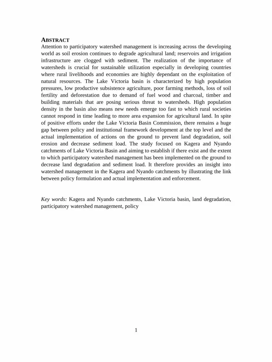
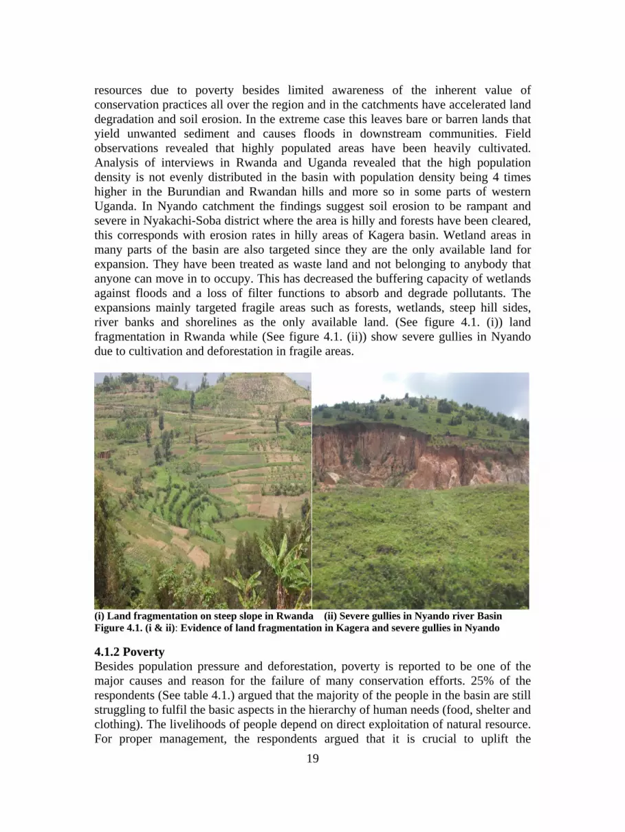
resources due to poverty besides limited awareness of the inherent value of conservation practices all over the region and in the catchments have accelerated land degradation and soil erosion. In the extreme case this leaves bare or barren lands that yield unwanted sediment and causes floods in downstream communities. Field observations revealed that highly populated areas have been heavily cultivated. Analysis of interviews in Rwanda and Uganda revealed that the high population density is not evenly distributed in the basin with population density being 4 times higher in the Burundian and Rwandan hills and more so in some parts of western Uganda. In Nyando catchment the findings suggest soil erosion to be rampant and severe in Nyakachi-Soba district where the area is hilly and forests have been cleared, this corresponds with erosion rates in hilly areas of Kagera basin. Wetland areas in many parts of the basin are also targeted since they are the only available land for expansion. They have been treated as waste land and not belonging to anybody that anyone can move in to occupy. This has decreased the buffering capacity of wetlands against floods and a loss of filter functions to absorb and degrade pollutants. The expansions mainly targeted fragile areas such as forests, wetlands, steep hill sides, river banks and shorelines as the only available land. (See figure 4.1. (i)) land fragmentation in Rwanda while (See figure 4.1. (ii)) show severe gullies in Nyando due to cultivation and deforestation in fragile areas.
(i) Land fragmentation on steep slope in Rwanda (ii) Severe gullies in Nyando river Basin Figure 4.1. (i & ii): Evidence of land fragmentation in Kagera and severe gullies in Nyando
4.1.2 Poverty Besides population pressure and deforestation, poverty is reported to be one of the major causes and reason for the failure of many conservation efforts. 25% of the respondents (See table 4.1.) argued that the majority of the people in the basin are still struggling to fulfil the basic aspects in the hierarchy of human needs (food, shelter and clothing). The livelihoods of people depend on direct exploitation of natural resource. For proper management, the respondents argued that it is crucial to uplift the

20
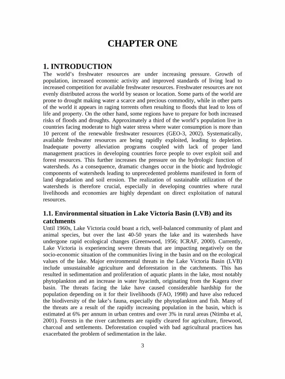
standards of the rural poor in an effort for the conservation activities to succeed. The linkage of poverty and failure of conservation efforts featured throughout the investigations and the respondents suggested that the riparian governments should set up strategies to address both poverty and environmental issues. In summary, the basin is characterized by high population pressures, low output subsistence agriculture, poor farming methods causing loss of soil fertility. In addition, deforestation due to exploitation of fuel wood and charcoal, timber and building materials and encroachment into fragile watersheds has increasingly resulted in loss of natural forests and soil erosion. These environmental problems are reflected in terms of land and water resource degradation resulting in increasing sediment and nutrient loads in the rivers. 4.1.3. Agricultural methods and crop systems The types of crops grown play a big role in land degradation. It featured during interviews among NGOs in Kenya that specific types of crops accelerate land degradation. It was reported that Lower Nyando which is suitable for rice growing, was instead used for maize growing which accelerates soil erosion. This is either due to lack of knowledge or the culture of eating maize instead of rice. On the other hand it was further revealed that sugar cane which is grown in the middle basin is harvested by burning the sugarcane plantations which exposes the soil to erosion. Agricultural activities are also taking place close to river banks and shorelines (See figure 4.2. (i) and (ii)). The occurrence of frequent floods in Nyando suggests the accumulation of silt on the river bed. The river also constantly changes its course at Kano plain due to frequent floods that are the result of the silt blocking the water ways.
(i) Maize field on the banks of river Nyando (ii) Cattle grazing on the banks of river Nyando Figure 4.2. (i & ii): Agricultural activities on the banks of river Nyando
4.2. Magnitude of land degradation and soil erosion On assessing the magnitude of land degradation and soil erosion in the basin, 70% of the respondents reported it to be severe and 20% thought it was moderate while 10%

21
said it was mild (See table. 4.2). Most of the respondents reported that the rate of land degradation and soil erosion varied in the catchments, with hot spot areas where it is unbearable and reaching unacceptable levels. For instance, soil erosion was reported to be severe in densely populated areas where land has been heavily put into use while it was reported to be moderate in areas where there is low level of cultivation. These results suggest the variations in land degradation in different sections of the catchments is dependant on factors such as population pressure, gradient of slope, vegetation cover, types of crops and farming practices. Table: 4.2. The magnitude of soil erosion in Kagera and Nyando catchments (No=20)
Magnitude Number of respondents Percentage
Severe 14 70
Moderate 4 20
Mild 2 10
Total 20 100
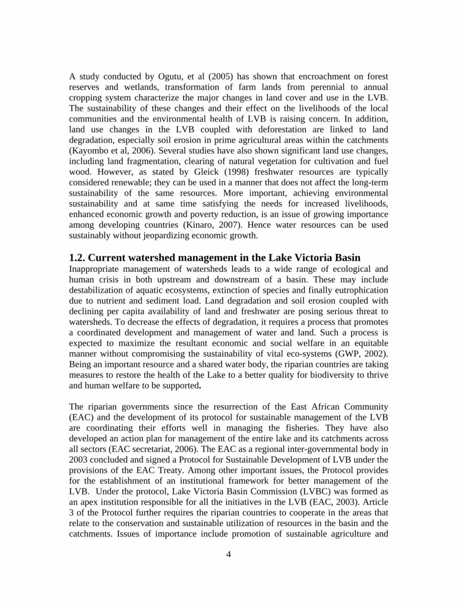
The respondents further classified the river courses as the upper, middle and lower courses of the catchments. It was again reported that, the magnitude of soil erosion is severe in the upper and middle courses while moderate at the lower course and the lower course was experiencing frequent floods in the case of Nyando. Although there are variations in soil erosion across the catchments, majority of the respondents agreed that in totality the magnitude of land degradation and soil erosion was severe. Soil erosion is therefore rampant in Kagera and Nyando catchments although the magnitude varies across the basin depending on the land use system, population pressure, vegetation cover, gradient, and vulnerability of soils, poor agricultural practices and encroachment into fragile ecosystems. Also due to high rainfall in most areas, the soils are easily exposed to erosion resulting in sediment load into the rivers. (See figure 5.1. (i and ii)) show silting on the bank of Kagera River and the red colour of the water is evidence of sediment transport.

22
(i) Upper course of Kagera river in Rwanda (ii) Lower course of Kagera rive in Tanzania Figure 4.3. (i & ii): Soil erosion and sediment transport in Kagera river evidence by the accumulation of silt at the bank of the river and the red colour of the water
4.3. Existence of policy framework for watershed management in LVB All the 20 respondents interviewed reported presence of policy framework for water resource management in the riparian countries, and LVB in particular. The policies, according to respondents, are i) the agricultural act, ii) the water act that addresses issues of water resources, protection of river banks, wetlands and buffer zone, iii) the forest act, iv) the land act, v) the survey act, vi) land consolidation act, vii) the environmental act which stipulates EIA requirements for development projects. The 5 respondents from Kenya were concerned about the lack of policy framework for wetland management; it was reported to be a grey area in Kenya and that currently the country does not have a wetland management policy although wetland policy was reported to be present in the other riparian countries. In all the categories of respondents, it featured that there has been consultations made during the formulation of policies to have the opinions of stakeholders including local communities incorporated. However they argued that the opinions of NGOs were always taken to be those of the local communities as the local communities are expected to assemble in a given way either as NGOs or CBOs. It is obvious that NGOs have got their own agendas and may not be representing local communities. All the respondents interviewed thought there were weaknesses with policy implementation and enforcement at the national, district and local levels. However, their opinions regarding the reasons for weak implementation of the policies varied (See figure 4.4.) The respondents in high ranking positions in government offices played down the weaknesses of policy implementation and instead blamed local communities for their lack of implementation. Moreover, assessment of uniformity of policies across the basin revealed that some of the policies varied on the same issues from one country to another for instance in the Kagera basin policies related to grazing and management

23
of pasture lands between Rwanda and Tanzania were reported to be different. According to the respondents, in Rwanda zero grazing or paddock system is practiced while in Tanzania land is reported to be set aside for communal grazing.
Figure 4.4. Reasons for weak policy implementation in the riparian countries (No=20)
4.4. Weaknesses in policy implementation Although existence of policy framework is reported to be present in all the riparian countries, the implementation and enforcement according to the opinions of respondents is hampered by the political system, corruption, sectoral nature, lack of resources, creation of new ministries, regional variation of policies and few personnel at the various levels. None of the respondents thought poor stakeholder involvement was a problem although they reported that in many cases the views of NGOs and CBOs are taken by the government officials as the views of local communities. However, in the discussion section, poor stakeholder involvement has been dealt with as one of the reasons for weak policy implementation. The sectoral nature of the policies results to over lapping of activities or nothing being done. For instance in Kenya, the respondents most frequently highlighted that four to five ministries have got similar policy guidelines that relate to soil and water management. The problem definitely is coordination of the various ministries for effective policy implementation. In addition, the continued creation of new ministries and departments presents a major obstacle in terms of having meaningful coordination. African governments in their political views keep on changing goal posts and create new ministries from departments to appease and provide posts for their supporters. Each time elections are held, it follows that new ministries are

24
created and it is difficult to realign efforts to produce tangible results. As one respondent explains that in Kenya, the ministry of agriculture has been divided into two, to form another ministry (ministry of agriculture and ministry of water and irrigation) and both were reported to provide the same services. There can be two to three ministries handling the same issue which leads to wastage of resources, duplication of services and inefficiencies. The study investigations revealed numerous loopholes in policy implementation and found that efforts to harmonize the policies also have not yielded fruit. 4.5. Assessment of available land management practices This Sub-section gives an insight of officially available land management practices and reasons for the lack of wide adoption of the practices as per the opinions of the respondents. A basin wide effort of land management practices to curtail land degradation and soil erosion were reported to be promoted by the riparian governments. Anti-erosion and practices such as terraces, “Fanya ju and fanya chin” (double digging), tree planting on the hilly areas, along the river banks and, development of water pans to breakwater velocity and reduce run off especially in Nyando catchment, agro forestry and reforestation and mulching are in place. The efforts were reported to be in small-scale, isolated and the effects are minimal in reducing land degradation and soil erosion. In regards to the issue of land management practices to prevent land degradation and soil erosion, all the respondents interviewed reported promotion of basin wide-scale land management practices and anti-erosion measures. However, they thought activities have not been sufficient enough to reverse the trends of land degradation. The respondents working in inter-governmental bodies, at district level and for NGOs argued that the land management practices were only effectively undertaken by a group of farmers which they referred to as progressive farmers. They reported the practices to be uncommon among the subsistence famers and further argued that the progressive farmers (large-scale farmers) represent the smallest portion of all the farmers. Of all respondents 55% reported that the progressive farmers represent a tiny fraction of the farmers approximately 5%. It is an indication that the biggest percentage of subsistence farmers are not involved in any productive land management practices. The respondents varied in their opinions over the constraints leading to low level of implementation across the basin (See figure 4.5.). A section of respondents in Kenya, Tanzania and Uganda suggested that besides extension services being inadequate they also focused on crop productivity rather than water and soil conservation. If any conservation measures were taken, it was done accidentally or with the aim of improving crop productivity. “You see, famers practice mulching in banana plantations for increasing yields but its presence actually prevents soil erosion”, a respondent stated in Uganda. A similar situation was observed in Rwanda where extension and advisory services never reached the subsistence farmers. In summary, the extension and advisory services offered by the governments were accessed mainly by the progressive farmers and the subsistence farmers have very limited access.

25
Figure 4.5. Constraints for low level of land management practices in the catchments (No=20)
On the issue of management of pasture lands and grazing areas, interviews with respondents in Kenya, Uganda and Tanzania revealed that pastoralists were not involved in any land management practices in cattle grazing areas. In Tanzania, they instead practiced bush burning which accelerates land degradation and soil erosion. In an effort to prevent bush burning, officials in Tanzania are trying to provide incentives for the pastoralists. The Karagwe district natural resources officer had this to say, “we now tell the pastoralists that those of you who will not burn the grass will transport your cows to the market without paying any market dues and you will get free Veterinary services”. He said that the incentives are playing a great role in reducing the incidence of bushfires in the district. While across the border in Rakai district in Uganda, pastoralists continue burning the bushes without any efforts to prevent them. It became evident during a field trip by the author to a grazing area of Sango Bay Rakai district where there was evidence of over grazing and bush burning being practiced. 4.6. Partnership and stakeholder coordination The majority of the respondents especially those working at national and inter-governmental levels stated that, coordination among government agencies at the top level, say ministries, and other bodies like the environmental authorities in the respective countries was well established. Interview results further revealed that the NEMA bodies in Kenya, Tanzania and Uganda, together with REMA of Rwanda, are

26
mandated to monitor and regulate all environmental activities related to water resource management in the LVB. They also cooperate with bodies like NBI, LVBC and LVEMP in all aspects of policies related to water resource management among the riparian countries. In addition, harmonization of policies at national level was reported to be through such bodies which coordinate and implement the will of the riparian countries. While during planning for LVEMP, communities were consulted at the implementation phase (at the end of the planning process) which is contrary with principles of real participation that requires stakeholders at all levels of political and social structure to have an input on decisions at various levels of water management. Hence the consultative mechanisms seem merely to be employed to legitimize decisions already made which leaves communities with no choice but only to follow what has already been decided. Coordination between government agencies and NGOs like African Highland Initiative (AHI), ICRAFT and VI agro forest (Swedish corporation Centre) were reported to be smooth. Interviews with different categories of respondents revealed that NGOs were taken to be implementing partners of the governments. Despite the smooth coordination, their actions have not been realized on the ground where land degradation and soil erosion still occur. More important stakeholder consultation which is considered vital in policy formulation is mostly aimed at NGO participation. In times of consultation, local communities were only involved when projects directly affected their daily livelihoods. Analysis of interview results clearly showed that the opinions of NGOs and CBOs were in most cases taken to be the views of the local communities. This is because the communities are expected to assemble in a given way either as NGOs or CBOs. However, it is difficult to justify if the views of NGOs and CBOs in reality represent those of the local communities however such has been the assumption made among government officials incase of any consultations. 4.7. NGO, CBOs and community responses to combat land degradation This section explores the conservation activities undertaken by NGOs and CBOs with involvement of local communities. While the aggregate picture may indicate less efforts being undertaken by subsistence farmers, interviews with NGOs and CBOs revealed significant cases where local interventions have registered positive results. The study established that some NGOs and CBOs were better equipped in involving local communities in conservation of catchments. It featured in interviews with representatives of CHEMA, VI agro forestry (Swedish Corporative Centre) and VIRED that NGOs are providing community conservation activities that enhance sustainable use and management of watersheds. One such activity was the management of wetlands through introduction of traditional bee keeping as an income generating activity in wetland areas. Bee keeping is in directly preventing the conversion of wetlands for brick making as the bee hives require undisturbed environment and tree shade readily available in wetlands. The provision of alternative activities like traditional bee keeping raises income for poor farming communities and enables them generate income.

27
Besides getting income, the traditional beehives are hung in trees and ensuring that many people keep beehives is a protection measure against deforestation. These activities are also practiced in wetland areas that perform important ecosystem functions but are under pressure from rural communities'. With increasing pressures on wetlands, such activities are making a break through in terms of conversing wetlands. One important aspect is that NGOs are putting efforts to conserve the wetlands hand in hand with provision of other synergies for improving livelihood of the local communities. In Tanzania, assessment shows that a participatory approach which involves local communities in development and management of natural resources has proved to be a more promising way to manage natural resources than continued reliance on protection by centralized government (Iddi, 2008). It is an indication that the NGOs are better prepared in working with local communities in an effort to conserve watersheds and provide a sustainable livelihood.
28
CHAPTER FIVE
5. DISCUSSION 5.1. Land management practices Analysis of the study results revealed that land degradation and soil erosion is a result of land use activities. The main causes according to the opinions of the respondents were population pressure, poverty, land fragmentation, deforestation and farming in steep slopes. Frequent tillage without incorporating soil conservation measures, cultivation of steep slopes and hillsides, extending cultivation close to watercourses and encroaching on wetlands and turning of vital forests into farmland and settlements have either loosened or exposed the soil to erosion. These causes of land degradation are similar to studies done by FAO (2002) in developing countries which concluded that increasing population particularly in steep mountainous watersheds are rapidly depleting the existing natural resource base because the soil and vegetation systems cannot support present levels of use. In a sense, the carrying capacity of the land is being exceeded due to rapid population growth that demands expansion into fragile areas. On the other hand the main reasons for unsuccessful wide adoption of land management practices as per the opinions of the respondents were inadequate extension services, poverty and size of farms. 35% of the respondents argued that lack of inclusion of subsistence farmers has resulted to isolated application of better land management practices. It featured through out the interviews that advisory and extension services were better accessed by progressive farmers excluding the majority of the farmers thus leading to solutions that bring benefits to few farmers in the catchments. This has slowed down basin wide adoption and sustainability of improved land management approaches. Studies conducted by ICRAF (2007) in Ethiopian and Uganda found that provision of extension and advisory services also targeted large-scale farmers. The same study stated that lack of demonstration farms makes it difficult for the subsistence farmers to fully participate and cope with the new methods of farming. This therefore, leaves the subsistence farmers with no chance to improve their knowledge regarding proper management practices hence the largest section of the farmers do not engage in any land management practices. In summary, the majority of the farmers in Kagera and Nyando catchments and LVB at large work in isolation without access to better farming methods and information which is essential for choosing the right crop varieties. Involvement of big farmers (private) compared to small-holders is due to investment policy to attract investors. Land management practices that promote innovative approaches that lessen land degradation and have a lasting effect on productivity are not widely used.

29
Poverty and insufficient budgetary allocations to finance activities, poor people definitely lack the financial resources to implement better land practices. The respondents most frequently referred to inadequacy of resources from the riparian governments to carry out land management practices. Active community participation in land management practices is hampered by their inability to adopt improved methods of farming. Such improved methods require investment to purchase the right farm implements and more finances to undertake the necessary training to have the knowledge required in managements of the field. As majority of the farmers in the basin are poor, it becomes an obstacle for them to afford the practices. Besides, poor people are forced to exploit the available land resources to sustain their livelihood e.g. they have to cut reeds in the wetland to sell, extract sand, lay brick to get some income which further accelerate degradation. German et al (2006) states in the words of Reddy (2000); it is increasingly clear that the success of watershed management programs rests on the integration of conservation with livelihood goals. Hence it is a big challenge to sustainably manage the catchments when the majority of the population derives much of their livelihood from the same resource to be conserved. Insufficient budgetary allocations, one of the reasons respondents reported for low adoption of land management practices was a lack of resources to undertake activities on the part of governments. This is similar to Kimaru et al, (2005) who stated that the low priority and inadequate resources given to land, water and forestry management activities by officials in development programmes is a result of the limited adoption of land management practices among the majority of the farmers. He continues that soil conservation is seen as a minor concern in developing countries and erosion continues to accelerate leading to severe impacts. At the local level, the farmers’ knowledge of sustainable land management practices relies on traditional techniques and knowledge that has been passed through generations. In some cases, what might have been a sustainable land use practice in the past may not be viable anymore. Reddy et al (2004) stated that in many developing countries, rural development priorities are less considered and agriculture in most cases receives the lowest budget. Hence the goal of sustainable land management remains elusive because it often competes with other priorities (GEF, 2006). The number of farmers who have adopted better land management approaches are way below expectation (Kimaru, 2003) there by making many of the small-farm zones have unacceptably high levels of erosion and land degradation. This corresponds with what the respondents have stated that a small percentage of the farmers engage in land management practices. Hence inadequate resources on the part of governments, weak links to service providers like extension and advisory services and poverty were argued to be the main reasons for failure to effectively manage the LVB and Kagera-Nyando watersheds. 5.2. Policy implementation in the Kagera and Nyando catchments Based on the opinions of the respondents, the reasons for lack of policy implementation included the political system, sectoral nature of policies, corruption, few personnel, and creation of new ministries and regional variation of policies. The sectoral nature of the policies results in over lapping of activities or nothing being

30
done. Bfunkerhoff (1996) stated that the most immediate barrier is between the requirements for participating in lateral coordination of actions at the field level and in vertical sectoral hierarchies. Some of the difficulties here arise from barriers imposed by the different ministries and administration that place limits on the activities to be undertaken. Findings revealed that harmonization of the policies are still a problem in many of the riparian countries; the policies are sectoral in nature and not worked together. The top-down nature of approach where government officials without any direct involvement of communities decide on the kind of activities to be practiced by the communities creates the feeling of not being part of the activities which hampers policy implementation. Political system, investigations clearly indicated that top-down command and control which relies on compliance and enforcement system of management is applied in much of the riparian countries. It was revealed during interviews with respondents that districts implement decisions made at the national level. The problem with this kind of system is the inability to make policies clear at local levels. GEF (2006) states that in top-down management, laws and regulations are often poorly understood and subject to varying interpretations. Studies conducted by GWP (2008) in different catchments in Mali, Malawi, Senegal, South Africa and Zambia have indentified similar problems related to a lack of understanding between the officials at national levels with those at mid and local levels. There is therefore, a communication gap among different levels of administration. More so, another problem is lack of proper stakeholder involvement and implementation strategy in Kagera and Nyando catchments. Although it most frequently featured during interviews that there was stakeholder involvement in policy formulation, in depth analysis revealed that local communities were not directly involved. Most times the views of the NGOs and CBOs were taken to be those of the local communities since the government agencies expect local communities to assemble in a given way either as NGOs or CBOs. Many of the policies therefore have not addressed issues such land tenure, ownership, landlessness and equitable access especially for the socially and economically disadvantaged due to the approach used in stakeholder involvement. According to Bfunkerhoff (1996) local community participation is a key issue in policy formulation and process aspects of implementation. He argues that the role of local communities in policy content is central to the society’s realignment to a particular policy since they have a direct stake in the policy outcomes and play a pivotal role in the implementation process. Andersson et al (2008) further stated that the advantage of involving communities in a participatory process is the use of local potentials to take action in environmental problems that are in a way not easily obtained in a “top down” implementation of different remedies. Participation has several advantages including increased awareness and acceptance, a more transparent decision making processes and an effective learning process between the public, governments, and experts Jonsson (2005). Once such a process is missing, implementation becomes a problem.
31
5.3. Partnership and institutional framework Results from the interviews suggest that, the management of LVB and its watersheds is delegated to LVBC as reported by all the 20 respondents interviewed. As part of its mandate to manage water resources, the EAC adopted a framework for cooperation and joint management of LVB natural resources through LVBC. Under the EAC treaty, the LVBC is charged with the responsibility of ensuring that various on going activities within the basin confer with proper management of the water resources. One of the challenges since its creation was the inability of LVBC to cover the entire basin until 2007. This has limited the operation and effectiveness in dealing with environmental issues originating in the Kagera catchment. The implementation of LVEMP1 without the involvement of Rwanda and Burundi which are in the upstream meant that conservation activities never covered a significant portion of the basin since Kagera river is the single largest catchment draining into Lake Victoria. This was partly due to the fact that Burundi and Rwanda were not at that time part of the EAC treaty under which LVBC was formed. As stated by Onyando (2oo6) institutions are important in the sense that they provide a forum for stakeholder participation among water users and other interested persons before policies relating to the management and use of water resources are implemented. The importance is the stakeholder’s participation to formulate a coherent approach and focus for managing the water resources in a catchment (Hirsch, 2004). SIWI (2006) stated that development and implementation of transboundary cooperation in shared river basins is not an easy matter. It goes on to explain that time, patience and perseverance is required to fully develop shared water resources in a manner that is environmentally and economically sustainable and ensures equitable sharing of the benefits. Despite the challenges, it is still important that actors at different levels are involved to ensure that decisions taken suit the circumstances prevailing in a country and the basin at large. The purpose is to make stakeholders aware and committed to ensuring that the intentions enunciated in policy statements are in fact implemented to realize the goals of watershed management. However, management of Kagera river Basin currently lacks a clear institutional structure. Since 2004 Kagera Basin Organization (KBO) was dissolved and according to the respondents, there are proposals to form Kagera Management Unit KMU) under the LVBC institutional and legal framework to handle and oversee management issues in the catchment. Therefore, currently the institutional framework for management of the river basin is practically non existent. In contrast, the management of water resources in Kenya is delegated to the Water Resources Management Authority (WRMA) as an institution to ensure adequate management of all watersheds. The WRMA is structured on a river basin level and all the rivers draining to the southern part of Lake Victoria, including Nyando River, are managed by Lake Victoria South Catchment (LVSC) with its regional office in Kisumu (WRMA, 2008). The LVSC has developed a Catchment Management Strategy (CMS) for a systematic, coordinated and participatory management of water resources. Nyando catchment falls under the Mid Catchment with other rivers like Mara, Sondu and Gucha-Migori. The CMS, strictly speaking, is a top-down approach

32
of management. The major concern for LVSC in Nyando basin is management of floods and very limited aspects of flood prevention. Conclusively, Kagera and Nyando have different management structures and the adequate representation and participation of all stakeholders is yet to be realized in both catchments. 5.4. Obstacles in administrative and stakeholders involvement Watershed management projects need to start with systematic analyses of the nature and roles of stakeholders in a watershed to design interventions that address the threats and create opportunities for watershed management. Analysis of the study investigations captured during interviews reveal a number of obstacles that have hindered meaningful stakeholder coordination in Kagera and Nyando catchments. Most frequently, respondents affirmed that the land management practices come as a package with little involvement of local communities in the initial stage of planning. They argued that these are either government moulded projects aimed to appease voters or a politician fighting to develop his/her constituency. One respondent from an NGO in Nyando basin lamented that “a minister just decides and says I want this to be done to my people”, and the people will always refer to such projects as the ministers project. A similar observation made by Bfunkerhoff (1996) where he stated that coordination in such projects is an executive function, designed and managed by some central node(s) of authority. In the end, every practice that is introduced becomes a trial since the communities were not involved from the initial planning stage. Hence communities do not feel any ownership and are less motivated to participate and in most cases they feel the projects do not address their needs and aspirations. The link between the national and local levels often suffers from budgetary cuts and low capacities. (Bfunkerhoff, 1996) has observed that, the potential of giving priority and allocating funds to some particular activities in conservation are rare in developing countries especially where resources are scarce. The riparian governments fall suit as they do not have the necessary funds to implement watershed management activities. For instance lack of budget allocation in the riparian countries has resulted to inefficient extension services being provided only to progressive farmers. Therefore lack of resources underlies the reasons for low, delayed coordination and adoption of land management practices in the two catchments. 25% respondents reported lack of resources when implementing policies. Bellamy et al (2002) has observed that in a situation where inter-sectoral ministries compete for the same resources, agencies may divert resources from activities they are interested in maintaining leaving other areas un attended. For instance in Kenya, the respondents most frequently highlighted that four to five ministries have got similar policy guidelines that relate to soil and water management and most definitely they have to compete for the available funds. In addition, the continued creation of new ministries and departments presents a major obstacle in terms of having meaningful coordination. Majority of African governments in their political views keep on changing goal posts and create new ministries from departments to appease and provide posts for their supporters and thus it becomes difficult to realign efforts to produce tangible results. It echoed throughout

33
interviews that in Kenya, the ministry of agriculture has been divided into ministry of agriculture and ministry of water and irrigation while both are said to provide the same services. Handling the same issues by many ministries leads to wastage of resources. Bfunkerhoff, (1996) also argues that limited individual, institutional, and systemic capacities frequently undermine commitment in developing countries to institute sustainable land management. He continues that at national and regional levels, government institutions and ministries often lack personnel with technical skills. Therefore, inter-institutional and inter-sectoral coordination and cooperation is often lacking. Regarding lack of proper stakeholder involvement in the catchments, Perez et al (2003) noted that the stakeholders often belong to different social, ethnic groups, farming and pastoralists communities with diverse economic, social and political power but all of them derive different benefits from the watershed resources. Given such diversity, disagreements may become obvious since stakeholders may not share a common vision in reaching conscious on implementation of policies and practices. This is evident in the riparian countries where fights between pastoralists and farming communities have been reported. Leach et al (2002) observed that, it may be more difficult to engage a diverse group of stakeholders in discussions that are needed to build a consensus on watershed management. This is similar with the findings of this study which revealed that in consultations, the views and opinions of the NGOs were taken to be the views of local communities. It was also reported that some communities were less interested to involve themselves in environmental issues and more unlikely to trust government to handle such issues. Due to lack of a strong legislation support, the main problem with the policies is the gap at national levels and their implementation at local level. Many of the policies have not been translated into legislations hence they cannot fully be turned into action due to lack of legislation support. Hence there is a need to bridge the gap between national and local level to foster an understanding of the policies. Achieving this type of coordination is a complex undertaking that has often been attempted but seldom satisfactorily accomplished (Perez et al, 2003). Besides, lack of personnel to carry out activities, the small number of staff affects negatively the attainment of active stakeholders’ involvement since processes go slowly and may become inadequate at the end. To have a basin wide implementation of land management practices, it demands a reasonable size of personnel than what is at present. 5.5. Comparison of land management policies and practices in Kagera and Nyando catchments There are significant differences in institutional structure between the two catchments (Kagera and Nyando). Kagera being a transboundary river basin means that the countries within the catchment (Burundi, Rwanda, Tanzania and Uganda) would have to set and agree on a management structure in reference to the policy framework of the LVBC. However, in terms of institutional setting Kagera in the mean time does not have any institutional framework as the KBO has been dissolved and the proposal

34
to form Kagera basin management unit are still under way and not yet formalized. There is no management structure in place since KBO was dissolved in 2004. Currently there is a proposal to form a Kagera Basin Management Unit (KBMU) to be under LVBC but it is still in an early development stage. Each country tries to manage their portion of the river basin. On the other hand, Nyando as a single country catchment which is managed by the WRMA and specifically under the Lake Victoria South meaning Nyando has a proper management structure. There is also a CMS in Nyando though focusing mainly on flood management. In terms of policy framework and land management practice implementation, both catchments face the same challenges. In addition, land management policies within a catchment (upstream and down stream) vary significantly. It is evident for instance in Kagera basin where land management policy for grazing and pasture land management in the upper catchment (upstream) on the Rwandan side encourages practice of zero grazing or “one family one cow” while in Tanzania which is in the downstream, land is instead set aside by the district or local councils as “grazing areas” which is used communally by the community in a given area. Communal grazing system practiced in Karagwe-Tanzania where individuals have large herds of cattle definitely causes land degradation whilst on the other hand adopting zero grazing or paddock systems reduces the impacts of degradation. While in Nyando, policies related to wetland management are not present and therefore there is no framework for wetland management. 5.6. Recommendations Alternative livelihoods or options for communities should be provided not to compromise with their daily livelihoods. For instance, small scale farmers may not fallow their land due to land shortage. However, if other alternative activities such as bee keeping that are compatible with the size of their land are made available, then they would eagerly get involved. There is a need to set aside income generating activities for the local communities to address the issue of poverty. The use of bee keeping as already started by NGOs in the catchments should be expanded to have a larger impact in poverty reduction and other income generating activities should also be included. In support, the respondents suggested that the riparian governments should set up strategies to address both poverty and environmental issues. Use of incentives should widely be adopted in the catchments, for instance incentives applied in Karagwe district to control bushfires from pastoralists should act as an example to prevent land degradation in the basin. The incentives should equally be used in other areas of land management especially wetlands and forests which are facing rapid encroachment. A mix of incentives should be used to create more positive attitudes to conservation and help accelerate conservation. Farmers should also be advised to visit demonstration farms to create a clear link between conservation and higher productivity and to improve farmer’s access to market
35
information in high value crops. Horticulture in particular can be introduced in many conservation areas. Formation of village watershed committees, the village committees would function as mediators of information among stakeholders, especially local communities within a catchment and the government agencies at district level. This will ensure that management plans are well rooted in the local communities in a catchment. Involvement of local communities through watershed committees will also enable the use of local knowledge and resources in developing cost-effective plans and to increase the acceptability of these plans among stakeholders. In terms of involvement and consultation of communities, the committees would play a vital role in mobilizing the local communities or act as representatives since they directly discuss the interests and aspirations of the communities and present their views in times of stakeholder involvement. Focus on land management practices should emphasize the inclusion of perennial crops. Promotion of perennial crops such as pigeon peas, citrus, other types of fruit trees, coffee bananas and tea are more likely to protect the soils on steep hillsides than annual crops. More so, a balanced combination of annual and perennial crops will do a lot more for the economy of the farmers and watershed conservation than annual crop production alone as it does for much of the region. The shades provided by the trees and crops would also be a good site for bee keeping which is already practiced in some parts of the catchments. There should be a budget allocated for undertaking land management activities or as part of support (funds) from governments or donor agencies meant to undertake activities that are aimed to address land degradation, soil and water conservation instead of allocating funds in other areas without considering land management. Such funds should especially be allocated in setting up demonstration centres in villages and training local extension workers who are readily accessible by subsistence farmers to gain knowledge on the best practices of land management. In addition, the riparian countries should create a funding scheme purposely meant to undertake conservation activities continuously to avoid over dependency on donors. Funding from donors may sometimes be unreliable since many of the donor funded projects have got specific targets which are within a specified time frame and continuity of such projects should entirely be planned by the riparian governments. For instance, since the LVEMP project phase 1 ended; all the activities have come to a halt. There are no more funds to continue with the activities and the riparian governments are waiting for more funds from World Bank as if they can not allocate a budget of their own to finance the activities. 5.7. Conclusions The big picture is that there are reforms that have led to establishment of policy framework and formation of institutions in LVB. The institutional framework under the LVBC has provided a platform for coordination and the formation of strategies for

36
catchment management. The coordination and exchange of information is mainly at top levels. The challenges of successful implementation of policy framework and land management practices are still numerous. Issues, include poverty where most people in the basin are struggling for basic needs and ineffective political and administrative systems. There is a clear relationship between poverty and environmental degradation reflected by the inability to adopt and undertake conservation measures by majority of the people. This creates unfavourable conditions for the effective coordination and involvement of local communities. There are still challenges with coordination among the different government agencies to achieve stakeholder involvement at various levels for proper planning, decision making and implementation of proposed measures. Therefore, aspects of participatory watershed management in Kagera and Nyando catchment and LVB at large are applied to have only minimal positive impacts. Although significant progress has been made in formulating land management policies and the promotion of land management practices, much remains to be done for scaling up and translating the policies into concrete actions at the micro watershed level. Finally, each part of the four research questions together have contributed in generating answers to the study.

37
ACKNOWLEDGMENT I owe many thanks to my supervisors Assoc Prof: Hans Bertil Wittgren and Assoc Prof: Karin Tonderski for their continued support and advice throughout the thesis project. I appreciate their careful guidance and review of the thesis drafts that improved it from time to time. I also wish to express my appreciation to Assoc Prof. Hans Holmen for his comments during the field study preparations and especially advice on developing the interview guide. I would like to thank all the staff at TEMA institute for providing a conducive environment favorable for accomplishing my studies.
I am indebted to my sponsor for the programme, the Swedish Institute (SI) and Swedish International Development Cooperation Agency (SIDA) for the generous financial support that has made it possible for me to undertake the studies. Special thanks also go to the following people, Mr. Nabide Isha who arranged every thing for my field studies in Rwanda. I wish to convey my gratitude to him and the staff of NBI and REMA for allowing me use their office space during my field studies in Rwanda, Mrs. Harriet Namara who helped to arrange an interview with the NEMA official in Uganda, Mr. Zachary Omambia Kinaro for providing guidance during my field studies in Kenya and Mr. Wilking Shuma who guided me in Tanzania. Finally, I would like to extend my sincere appreciation to all the respondents for being very open and generous with their time.

38
References Abdelsalam. A. A, 2008. Sediment in the Nile River System. UNESCO-IHP- International Sediment Initiative. Andersson. L, Olsson. J. A, Arheimer. B and Jonsson. A, 2008. Use of participatory scenario modelling as platform in stakeholder dialogues. Swedish Meteorological and Hydrological Institute, Lund University and Linköping University, Sweden. Bellamy. J, Ross. H, Ewing. S and Meppem. T, 2002. Integrated Catchment Management: Learning from the Australian Experience for the Murray- Darling Basin. CSIRO Sustainable Ecosystems, Brisbane. Bfunkerhoff. D. W, 1996. Coordination Issues in Policy Implementation Networks: An Illustration from Madagascar’s Environmental Action Plan. World Development, Vol. 24, No. 9, pp. 1497-1510. Bfunkerhoff. D. W, 1996. Process Perspectives on Policy Change: Highlighting Implementation. World Development, Vol. 24, No. 9, pp. 1395-1401 Brent S, Onyango. L and Meinzen-Dick. R, 2005. Catchment Property Rights and the Case of Kenya’s Nyando Basin. Budumuru .Y and Tesfa. G. G, 2006. Participatory watershed management for sustainable rural livelihoods in India. Burton. J, 2001. Integrated water resource management on a basin level. UNESCO,) Manuel de formation, Institut de l’énergie et de l’environnement pour la Francophonie (IEPF). Conley, A. and Moote M. A., 2003. "Evaluating Collaborative Natural Resource Management." Society and Natural Resources 16: 371-386. EAC, 2001. Institutional and legal arrangement for sustainable development of Lake Victoria and its basin, Arusha, Tanzania. EAC, 2004. The Vision and Strategy framework for management and development of. Lake Victoria Basin, Arusha, Tanzania. EAC, Secretariat, 2006. Special report of the declining of water levels of Lake Victoria; Arusha, Tanzania. EAC, 2003. Protocol for sustainable development of Lake Victoria Basin. FAO Publication, 2000. Developing Participatory and Integrated Watershed Management: A Case Study of the FAO/Italy Inter-regional Project for Participatory Upland Conservation and Development (PUCD). FAO, 1998. The state of the world fisheries; Food and Agricultural Organization, Rome, Italy. Farrington. J and Lobo. C, 1997. Scaling up participatory watershed development in India. Lessons from Indo-German watershed development programme. ODI Natural Resource Perspectives Number 17. FAO/FORC, 2003. Review and Assessment of Watershed Management Strategies and Approaches. German. L, Mansoor. H, Alemu. G, Mazengia. W, Amede. T and Anne Stroud, 2006. Participatory Integrated Watershed Management. Evolution of Concepts and Methods. African Highland Initiative (AHI).

39
GEF, 2006. Removing barriers to sustainable land management. Global action on sustainable land management. Global Environment Facility 1818 H Street NW Washington DC 20433 USA. GEO-3, 2002. Past, present and future perspectives, UNEP, Earthscan publications Ltd, 120 Pentonville road, London-UK. Gleick. P. H, 1998, Water in crisis: Paths to sustainable water use; Ecological Greenwood P. H, 1956. The fishes of Uganda. Uganda J. I-III, 1-80. GWP, 2008. Foreword: Participation in water management. Lessons from water.
Management planning in Africa. Planning for a water secure future.
GWP, 2007. Toolbox for Integrated Water Resources Management. Stockholm, Sweden. http://www.gwptoolbox.org/. Hirsch. P, 2004. Catchment management Frameworks and Issues of Scale. South East Asia Geography Conference Panel: Water Governance in Context. Australian Mekong Resource Centre School of Geosciences University of Sydney. ICRAF, 2000. Improved Land Management in the Lake Victoria Basin: Linking Land
& Lake, Research & Extension, and Catchment & Lake Basin. First Report
of Progress and Results, July 1999 to March 2000. Nairobi: ICRAF and
Ministry of Agriculture and Rural Development.
Iddi. H. H, 2007. Reliability of Payment for water Resources as an Environmental
Service towards the sustainable management of watershed forests in
Zanzibar, Tanzania: (A Case study of Kiwengwa - Pongwe Forest
Reserve). Thesis for Masters of Science in Water Resources and Livelihood
Security. Linköping University.
IMF, 2001. Rural poverty in developing countries. Implications for public policy.
Economic issues, No. 26.
Jonsson. A, 2005. Public Participation in Water Resources Management: Stakeholder Voices on Degree, Scale, Potential, and Methods in Future Water Management. Royal Swedish Academy of Sciences. Ambio Vol. 34, No. 7. Kayombo. S and Sven.E.J, 2005. Lake Victoria, Experiences and lessons learned brief. Kimaru G. and Jama B. 2005 Improving land management in eastern and southern Africa: A review of practices and policies. ICRAF Working Paper no. 18. Nairobi, Kenya. World Agro forestry Centre. Kinaro. O. Z, 2008. Wetland Conversion to large-scale agricultural production;
implications on the livelihoods of rural communities, Yala Swamp, Lake

40
Victoria basin, Kenya. Linköping University.
Kurian, M.; Dietz, T. 2005. How pro-poor are participatory watershed management projects? – An Indian case study. Research Report 92. Colombo, Sri Lanka: International Water Management Institute. Leach. W. D, Pelkey. N. W and Sabatier. P. A, 2002. Stakeholder Partnerships as Collaborative Policy making: Evaluation Criteria Applied to Watershed Management in California and Washington. Journal of Policy Analysis and Management, Vol. 21, No. 4, 645–670. Lisa. M. L, 2007. Evaluating Participatory Watershed Management: A Case Study of
the Albemarle Pamlico. Masters project submitted to the Nicholas School of
the Environment and Earth Sciences of Duke University.
Makalle. M. Obando. J and Bamutaze. Y, 2008. Effects of land use practices on livelihoods in the transboundary sub-catchments of the Lake Victoria Basin. African Journal of Environmental Science and Technology Vol. 2 (10). pp. 309-317. Makalle. M. Obando. J and Bamutaze. Y, 2007. A Framework for Integrated
Management of Transboundary Basins: The case of Sio sub-catchment in
East Africa. Catchment and Lake Research.
Meinzen-Dick, R., Knox, A., Place, F., Swallow, B., 2002. Innovation in Natural Resource Management: The Role of Property Rights and Collective Action in Developing Countries. IFPRI, Washington, D.C., 317 pp. Merters. E. J, 1998. Research Methods in Education and Psychology: Integrating Diversity with quantitative and qualitative approaches, UK, SAGE Publication Ltd. Mott Macdonald, M and E Associates, 2001. Management of Industrial and Municipal Effluents and Urban Runoff in Lake Victoria Basin. Final Report, Government of Uganda, Ministry of Water, Land and Environment, LVEMP, National Water and Sewarage Corporation: Cambridge, United kingdom. NBI, 2008. Kagera River basin Monograph. Basin development report. NEMA, 2001. State of environment report, 2000 – 2001. Ministry of Water, Lands and Environment, Uganda government. Ndomba. P.M. and. Birhanu. B.Z, 2008. Problems and Prospects of SWAT Model Applications in NILOTIC Catchments: A Review. Nile Basin Water Engineering Scientific Magazine, Vol.1. Njogu. A. K, 2000. An integrated river basin planning approach-Nyando case study in Kenya. 1st WARFSA/WaterNet Symposium: Sustainable Use of Water Resources; Maputo. Ntiba. M. J., Kudoja. W. M and Mukasa. C. T, 2001. Management issues in the Lake Victoria watershed, lakes and reservoirs. 6: 211-216. Odada. O. E, Daniel. O. O, Kulindwa. K, Ntiba. M and Wandiga. S, 2004. Mitigation

41
of Environmental Problems in Lake Victoria, East Africa: Causal Chain and Policy Options Analyses. Royal Swedish Academy of Sciences. Ambio Vol. 33 No. 1–2. Ogutu, Z.A.; Misana, S.; and Mwaka, V. 2005. Land Use Research in the Lake Victoria Basin: Analysis and Synthesis. IUCEA, SIDA. Onyando. J, 2006. Framework for Development of Catchment Management Strategy (CMS) in Kenya. Participatory Watershed Management Plan. FWU, Vol. 5. Onyango. L, Mungai. D, Swallow. B, Mburu. J and Njui. A, 2004. Workshop on Reversing Environmental and Agricultural Decline in the Nyando River Basin. Workshop Summary. Perez. C and Tschinkel. H, 2003. Improving watershed management in developing countries: A framework for prioritizing sites and practices. Agricultural Research & Extension Network. Network Paper No. 129. Reddy, V.; Reddy, G.; Galab, S.; Soussan, J.; Baginski, S. 2004. Participatory Watershed Development in India: Can it Sustain Rural Livelihoods? Development and Change, 35(2): 297-326. Rowe, G. and L. J. Frewer, 2000. "Public Participation Methods: A Framework for Evaluation." Science, Technology, & Human Values 25(1): 3-29. Sharma. P. N, 1999. Participatory processes for integrated watershed management.
Participatory Watershed Management Training in Asia (PWMTA) and
Farmer-centred Agricultural Resource Management (FARM) Programs,
Netherlands/UNDP/FAO, GCP/RAS/161/NET - RAS/93/062.
TAMP, 2005. Development of filed assessment methods using transect and other PRA techniques for sample sites across the Kagera river basin. Workshop report. UNEP, 2006. Lake Victoria Basin Environment Outlook: Environment and Development. UNEP, Nairobi. UNCED. 1992. Report of the United Nations Conference on environment and development.Ro declaration on environment and development. http://www.un.org/documents/ga/conf151/aconf15126-1annex1.htm (accessed May 29 2009). Yanda. P.Z.; Shishira. E. K., F.N. Madulu; and Kauzeni. A. S, 2001. Survey and Mapping of Land Use/Cover and Erosion Hazard in Lake Victoria Basin. Institute of Resource Assessment (IRA) in Collaboration with Lake Victoria Environmental Management Project (LVEMP) Final Report. Wani, S. P., Singh, H.P., Sreedevi, T.K., Pathak, P., Rego, T.J., Shiferaw, B., and Iyer, S.R, 2005. Farmer-Participatory Integrated watershed Management: Adarsha Watershed, Kothapally India. An Innovative and Upscalable Approach”. case 7 in part 3 case example series, ICRISAT, India. World Bank. April 2007. World Development Indicators database. http://go.worldbank.org/3JU2HA60D0 World Bank. 2005. Integrated Management of Critical Ecosystems Project. Project Appraisal Document on a Proposed Global Environment Facility Trust

42
Fund Grant in the amount of USD4.3 Million to the Republic of Rwanda. Report No: 30513-RW. WRMA, 2008. Integrated flood management for Nyando river basin. Ministry of water and irrigation. Draft final report.
APPENDIX 1 INTERVIEW GUIDE FOR GOVERNMENT AGENCIES AND DISTRICT PERSONNEL/NGOs Personal information May be we can start with your name and the education level you have attained
What is your current position?
For how long have you been working here in your current position?
And what are your major responsibilities?
What about your previous experiences, have you worked in a similar position before?
Land management policies 1. 1a. Does the farmers experience problems with soil erosion and/or land? degradation in your district?
Yes……………………………..No……………………………. 1b. what is the magnitude of the problems? Severe……….... Moderate……………… Mild…………… 1c. what are the main causes of soil erosion / land degradation in this district?
2. 2a. Currently are there any land management policies to prevent soil erosion and land degradation in this district?
2b. Can you mention the land management policies in place in the district?
3. 3a. Are there any problems related to implementation of the policies?
Yes…….. ……………… No……………………
3b. What are the reasons for weak implementation of the policies?
3c. Are there any strategies available being used to overcome these problems?
4. What kind of institutional framework is in place to deal with soil erosion and land degradation? Explain the kind of institutional framework and how it works.
5. What are the challenges you face in smooth execution of land management policies and practices? Are there any steps being undertaken to overcome these challenges? Can you mention some?
6. 6a. What kind of policies, legislation and regulations are in place to protect
wetlands from encroachment in the basin?

43
6b. How are these legislations and regulations enforced?
7. 7a. What kind of policies, by-laws, legislation and regulations are in place to
Protect wetlands from encroachment in the basin? 7b. How are these by-laws and regulations enforced?
8. 8a. When did policies and practices of improved land management started being applied in this area? 8b. How long did it take to get the plan up and running and can you explain if it was difficult to put the policies into action?
9. Do you see any critical gaps or areas where more policies and institutional framework is required?
Partnership Cooperation
10. 10a. Do you cooperate with NGOs dealing with land management?
10b. Can you give examples of some of the NGOs?
11. Which other organs of the government in the district do you cooperate with when it comes to implementing land management policies and practices?
12. Do these agencies have the same policies as you do?
13. 13a. Are there challenges that you face when working with these NGOs and
agencies?
13b. If any; what kind of challenges?
13c. Can you suggest ways of how your cooperation can be improved?
14. 14a. Do you think NGOs can play more roles in the development of policies,
institutional framework for better land management practices?
14b. How should they be involved and what would be their major role in the
process?
15. From the initial start, how do you involve and mobilize local communities in planning and implementation of land management practices/activities?
16. What are the obstacles in getting a monitoring or management plan developed and how can they over come these obstacles?
Land management practices
17. Better land management practices are known worldwide to prevent land degradation and further reduce soil erosion. What improved land management practices are being implemented in the river basin/district?
18. How do you reliably assess and monitor erosion and land degradation risks in the basin so as to recommend appropriate management practices?

44
19. 19a. What are the Land management practices to prevent land degradation?
19b. Do you face constraints in implementation of the practices?
Yes……………………… No……………………
19c. If yes, what are the constraints that you face?
20. 18a. What are the existing soil conservation methods to reduce soil erosion?
18b. Why were these methods chosen in this area?
21. In your experience working in this area, what land use changes have occurred for the last 10 years?
22. Is there any river basin authority managing the issues of the Nyando/Kagera?
Yes……………………………… No ……………………
If no, why hasn’t there been any authority? If yes, what land management
issues are being undertaken by the river basin authority to prevent soil erosion?
23. What are the steps being undertaken for better management of grazing areas and pasture lands to decrease land degradation?
24. 24a. From your experience, is there any relationship between type of crops grown and land degradation?
24b. Would change in crop types lead to reduction in land degradation and prevent soil erosion? Advisory, extension services and other Conservation programmes
25. What is the level of community awareness about upstream or downstream outside their area regarding land degradation and soil erosion?
26. How are the capacities of the local communities strengthened for easy adoption of the improved land use and management practices?
27. How fast is the adoption of improved land use systems and management practices by the farmers and cattle keepers?
28. 28a. Does your organization offer any advisory and extension services to farmers to cope with new improved methods of farming and curb things like soil erosion? 28b. If yes; what kind of advisory and extension services do you offer to the farmers?
29. 29a. Are there incentives being given to the farmers for easy adoption of the improved land use and management practices? 29b. If any; what kind of incentives? 30. 30a. Are there programmes of afforestation and reforestation going on in the
district/area? 30b. Under whose initiatives are these programmes?
31. 31a. Do farmers practice agro-forestry in this area? 31b. What are the incentives given to them to accept practicing agro-forestry?

45
32. Are there similar programmes being implemented in other catchments across the Lake basin?
33. 33a. Do you coordinate and share information with agencies that are working
in those catchments?
33b. If yes; what kind of information?
Opinion questions
34. 34a. Do you think unsustainable land management is the main cause of sediment load into the Lake?
34b. Can you suggest other causes apart from those of land degradation?
35. In your experience working in the Lake Victoria basin, does the land management methods/practices here differ from those you have seen from other regions within the lake basin or applied by other organizations?
36. What would be considered success and failures in the effort of combating land
degradation since the Lake Victoria Basin Commission came in to existence?
Note:
Two sets of interview guides were prepared, one for government personnel and another for NGOs. The questions in both sets of interview guides were similar except their formulation differed. Here is one set of the interview guide just to show the nature of questions that were asked.