the southernmost quaternary niche glacier system in great britain
TRANSCRIPT
The southernmost Quaternary niche glacier system inGreat Britain
STEPHAN HARRISON,1,* JASPER KNIGHT2 and ANN V. ROWAN3,4
1College of Life and Environmental Sciences, University of Exeter, Penryn TR10 9EZ, UK2School of Geography, Archaeology and Environmental Studies, University of the Witwatersrand, Private Bag 3, Wits 2050,Johannesburg, South Africa
3Department of Geography, University of Sheffield, Sheffield S10 2TN, UK4British Geological Survey, Environmental Science Centre, Nottingham, UK
Received 9 October 2014; Revised 29 January 2015; Accepted 3 February 2015
ABSTRACT: Until recently, the scientific consensus has been that the uplands of south-west Britain remainedunglaciated throughout the Quaternary, with glacial ice sheet limits lying to the north of the south-west peninsula.However, recent work has shown that small glaciers and ice caps existed in the uplands of Exmoor and Dartmoorduring the late Quaternary, demonstrating that the consensus of an unglaciated south-west Britain requiresconsiderable revision. Here we report geomorphological and sedimentary evidence supported by glacier-climate modelling for a Quaternary niche glacier from west Cornwall, south-west England. This niche glacierrepresents the southernmost such system from mainland Great Britain, and provides evidence for the presence ofextra-glacial niche glaciers probably during the Last Glacial Maximum of the Devensian glaciation, and welloutside the limits of the main British–Irish Ice Sheet. Copyright # 2015 John Wiley & Sons, Ltd.
KEYWORDS: Cornwall; glacier modelling; niche glaciers; palaeoclimate; Quaternary.
Introduction
Perennial snowbanks (or snowpatches) and niche glaciersrepresent the initial stages of glacier development, and can befound well outside the limits of present-day glaciers and icecaps in climatically favourable positions, such as the shadedand lee sides of mountain tops where wind-blown snowaccumulates (Rapp, 1984; Lewkowicz and Harry, 1991; Allen,1998; Kariya, 2002; Palacios et al., 2003; Brenning andTrombotto, 2006). The strong topographic and climatic con-trols on glacier occurrence have been used as a guide tosuggest locations where perennial snowbanks and nicheglaciers may have been present in the past, outside the knownlimits of the late Quaternary British–Irish Ice Sheet (BIIS)during the Last Glacial Maximum (LGM) or Younger Dryas(YD) cooling event (Ballantyne, 1985; Carr, 2001; Colemanet al., 2009; Mills et al., 2009; Margold et al., 2011). Althoughniche glaciers usually leave a detectable erosional anddepositional imprint on the landscape (Carr, 2001; Colemanand Carr, 2008; Coleman et al., 2009), the geomorphologicaland sedimentary processes and signatures of large perennialsnowbanks – which are transitional to niche glaciers – are notwell known. The generally non-erosive nature of largesnowbanks or small niche glaciers, their short-lived timeframeand restricted capacity for sediment transport except in apassive mode through the formation of protalus (better termed‘pronival’) ramparts mean that such palaeo-features are under-reported in the literature relative to the frequency with whichthey are found in contemporary mountainous and extra-glacial environments (Brown and Ward, 1996; Shakesby,1997). Furthermore, pronival ramparts are very variable interms of their morphology and sedimentology depending ongeological setting and sediment supply, which is mainly bybackwall weathering (Christiansen, 1998; Anderson et al.,2001; Palacios et al., 2003; Margold et al., 2011), and arelikely to occur as polygenetic features formed in severalphases (Ballantyne, 1985; Nyberg, 1991; Caine, 1992,1995;Ballantyne and Benn, 1994). Identifying palaeo-snowbanks
and niche glaciers in the geological record based on morpho-sedimentary evidence is therefore problematic (Henderson,1956; Ballantyne, 1985; Shakesby, 1997). This identificationcan be made, however, from the presence of fronting ridgescomposed of preexisting weathered materials, which can beeasily moved by even small glacionival features.Geological evidence has often been used to calculate the
difference in mean annual air temperature (MAAT) required tosustain these snow and ice forms, based on calculated equilibri-um line altitudes (ELAs) of small niche or cirque glaciers (Carr,2001). However, wind-blown snow is a significant andpoorly constrained factor in maintaining such small snow andice forms (Mitchell, 1996; Hughes, 2002), and thus calculationsof palaeo-ELAs are also problematic and not suitable for allsituations. Palaeo-snowbanks and niche or small cirque glaciersof presumed LGM or later age have been reported from outsidethe margins of the late Devensian BIIS, for example on Exmoorand Dartmoor (Harrison et al., 1998, 2001; Harrison, 2001;Evans et al., 2012; Evans and Harrison, 2014), and YD-age features have also been reported within BIIS limits (Mitchell,1996; Anderson et al., 1998; Carr, 2001; McDougall, 2001).The relatively low elevation ranges of the sites on Exmoor andDartmoor (around 300–400 and 370–410m asl, respectively)and their locations well outside late Devensian limits suggestthat these glaciers were of LGM age, which is also supported bythe decrease in MAAT required to yield the calculated ELAvalues (Harrison, 2001). The discovery of these niche glaciersites in south-west Britain has led to renewed investigations ofother possible niche glaciers or perennial snowbanks, herecollectively termed glacionival features.We report evidence for a significant glacionival feature in
extreme west Cornwall in south-west Britain, located some120 km south-west from Dartmoor and directly adjacent to theBristol Channel (Fig. 1). This is the southernmost and western-most extent of such a glacionival feature on the Britishmainland.It shows that these features were likely to have been morenumerous during the LGM than was previously thought, and hasimplications for reconstruction of LGM ice extent and climate inareas previously considered extra-glacial. In this paper, we firstcontextualize the late Devensian history of west Cornwall, and
�Correspondence: S. Harrison, as aboveE-mail: [email protected]
Copyright # 2015 John Wiley & Sons, Ltd.
JOURNAL OF QUATERNARY SCIENCE (2015) 30(4) 325–334 ISSN 0267-8179. DOI: 10.1002/jqs.2772
present detailed geomorphological and sedimentary evidencefrom Rosemergy in the West Penwith region of west Cornwallthat shows the presence of a significant glacionival feature. Wediscuss the geomorphological processes associated with theformation of the Rosemergy glacionival feature, and apply aglacier model to test the hypothesis that the conditions requiredto sustain the late Devensian ice sheet were conducive toglaciation in west Cornwall. We then discuss implications forthe regional palaeoclimate and the nature of late Quaternary icemasses outside the limits of theQuaternary ice sheets.
The late Devensian climate history of westCornwall
Mainland Cornwall is thought never to have been glaciatedduring the Quaternary ice ages (Bowen, 1994; Cullingford,
1998; Clark et al., 2004). Instead, it is assumed that aridperiglacial conditions prevailed throughout the Quaternary,with the formation of tors, altiplanation terraces, extensivesolifluction sheets and aeolian loess and coversands (tePunga, 1956; Scourse, 1996). Some luminescence dates fromloess deposits suggest arid and windy conditions during theLGM (Wintle, 1981). Radiocarbon ages from organic lensesthat have been buried and deformed by later solifluctionsuggest cool, vegetated land surfaces around 30 ka duringmarine oxygen isotope stage (MIS) 3 (Scourse, 1996). There isgeomorphological, sedimentary and geochronological evi-dence for Irish Sea ice impinging on the Isles of Scilly,located west of mainland Cornwall (Hiemstra et al., 2006),but no ice or snow masses have been previously reported onthe mainland, although in east Cornwall Cullingford (1998)identified some rounded hollows with dry valley heads where
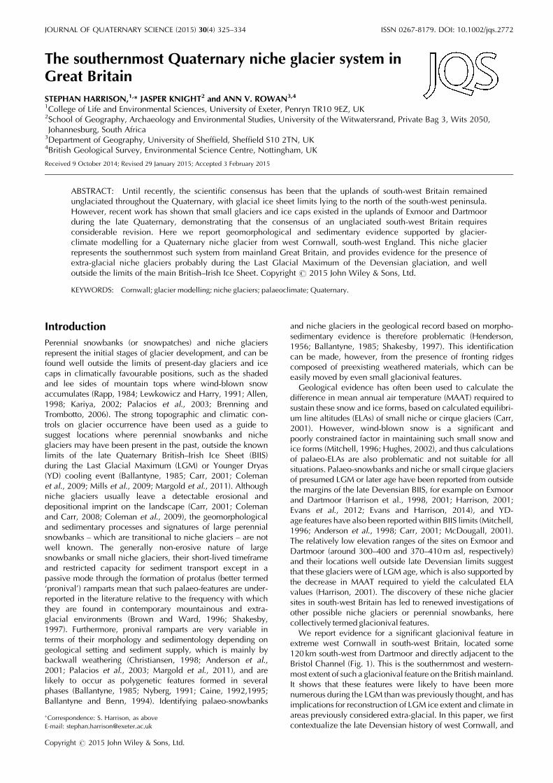
Figure 1. Location and geomorphology of the study site in west Cornwall, including (A) site geomorphology and (B) location of sediment logsshown in Fig. 3. In (A), CG is Carn Galver hilltop, and elevation in given in metres.
Copyright # 2015 John Wiley & Sons, Ltd. J. Quaternary Sci., Vol. 30(4) 325–334 (2015)
326 JOURNAL OF QUATERNARY SCIENCE
snowbanks may have accumulated. The southernmost extentof the BIIS during the Quaternary was not thought to havereached the north Cornwall coast, even during the Anglianstage (Stephens, 1970; Bowen et al., 1986), although it mayhave impounded marginal lakes and deposited outwashgravels on some north coast estuaries in Devon and Cornwall(Mitchell and Orme, 1967; Stephens, 1970). Recent worksuggests, however, that an ice margin reached Lundy Islandoffshore from north Devon during MIS 4 (Rolfe et al., 2012).The previously presumed absence of glaciation throughoutthe Quaternary has meant that periglacial weathering hasbeen viewed as a dominant geomorphological process duringthis time (Cullingford, 1998), seen in particular in theformation of tors developed on the granite uplands (Linton,1955). The high sediment yield due to periglacial weatheringhas resulted in thick lowland solifluction sequences, particu-larly around coasts (James, 1981; Scourse, 1987, 1991;Gerrard, 1988; Murton and Lautridou, 2003; Knight, 2005).Much previous research has emphasized the role of long-
term landscape evolution under warm Tertiary climates, inparticular the role of high sea levels in land surfaceplanation and deep tropical weathering in the formation oftors (Linton, 1955; Eden and Green, 1971). More recentwork, however, suggests that repeated periglacial cyclesduring the Quaternary have had a stronger landscapeimprint, and that tors formed mainly under Quaternaryperiglacial climates and processes (Palmer and Neilson,1962; Waters, 1964; Bowen, 1994; Murton and Lautridou,2003). This work suggests that Quaternary landscape evolu-tion may have been more significant for the geomorphologyof south-west England than hitherto realized (Cullingford,1998).
Study site
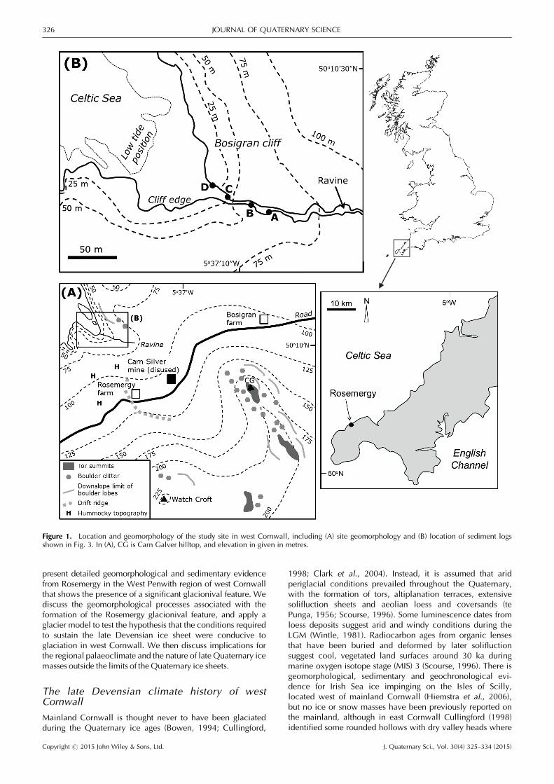
The field site is located on the moors of west Cornwall inthe far south-west corner of Great Britain at Rosemergy(UK national grid reference SW14220566; 50˚1001900N, 5˚3603600W), 8 km north-west of Penzance in the West Penwithregion of west Cornwall (Fig. 1) and between the settlementsof Morvah and Zennor. The area is underlain by Land’s Endgranite, which is a biotite granite associated with extensivemetamorphism and mineralization (Mitropoulos, 1984). Abroad hollow (around 650m long, 430m wide) is present onthe NE-facing side of Watch Croft, which is the highest pointin west Cornwall at 252m asl (Fig. 2A). The geomorphologyof the study area (Fig. 1), in particular tors, ridge forms andboulder structures, was mapped using stereo air photos at 1 :10 000 scale and verified in detail in the field. The properties,structures and clast fabrics of sediments exposed in gullysections were investigated. Spoil heaps resulting from pastmining activity in the area were identified to distinguish thesefrom non-anthropogenic landforms.
Description of field evidence
The hollow at Rosemergy is broad and shallow with a floor ataround 140m asl, and faces towards the north-west (to 330˚).Tor-topped hills are located on both lateral margins of thehollow. The col at the head of the hollow has a much lowerelevation (21–34m difference) than the lateral margins. Thesemargins extend for 630m distance from the head of thehollow, and terminate at 680m distance from the contempo-rary cliff edge at Bosigran (120m high) on the adjacent CelticSea coast. The hollow is asymmetrical in cross profile (Figs 1and 2A). The NE-facing side of the hollow is steeper (1:1.25)than the SW-facing side (1:2.1). This valley-side asymmetry istypical across extra-glacial southern England (Ollier and
Thomasson, 1957; Cullingford, 1998). Specific landformsinterpreted as glacionival in origin are now described fromlocations around the hollow.
Geomorphology
Erosional and depositional periglacial and glacionival land-forms are present around the hollow at Rosemergy. Tors oneither side of the hollow are well developed. These tors rise5–20m above the surrounding landscape (Fig. 2B, C) and arecomposed of weathered and joint-defined in situ anddetached granite bedrock blocks that are strongly controlled
Figure 2. Views of the site location and geomorphology. (A) Thehollow from the north, showing its size (it is 430m wide) and itsasymmetrical profile. (B) Looking towards Carn Galver from WatchCroft. (C) Photograph looking from Carn Galver towards the north-west. Rosemergy farm can be seen in the distance. This figure isavailable in colour online at wileyonlinelibrary.com.
Copyright # 2015 John Wiley & Sons, Ltd. J. Quaternary Sci., Vol. 30(4) 325–334 (2015)
THE SOUTHERNMOST QUATERNARY NICHE GLACIER SYSTEM IN GREAT BRITAIN 327
by preexisting joint patterns. Tor peaks are not concordantand are spaced up to 30m apart. Fractures in the in situbedrock can be identified to a depth of 2–3m.Surface-parallel and vertical fractures in the granite bed-
rock have created weathered blocks that are up to 5m inwidth. Blocks are edge-rounded, tabular to equant in shape,and may show a stacked morphology where dissociated fromrockhead. Detached blocks are present both around tor topsand on adjacent slopes where they form a clitter of variablethickness in which non-touching boulders are scattered acrossthe land surface, or interact with each other by processes ofstacking and slope-controlled imbrication forming accumula-tions of more than one block thickness. Variations in blockdistribution can be mapped from field and air photo observa-tions. Blocks are present in particular on the easternmost sideof the hollow, on the flanks of the tor Carn Galver. Blocks arenot uniformly distributed across this hill flank, but areconcentrated across-slope declining in elevation seaward(Fig. 2B). Blocks are more common on the eastern than onthe western sides of the hollow. Despite this, the western(NE-facing) side of the hollow is much steeper than theeastern side (Fig. 2C).The eastern flank of Carn Galver is also block-covered, but
here blocks are non-uniformly distributed and form boulderlobes that extend downslope and have overlapping margins.These boulder lobes are up to 30m wide and 40m long, and
have steep, lobate margins and convex upper surfaces. Blockscomprising the boulder lobes are up to 1.6m in dimension,subrounded in shape, and all show the same degree ofsurface weathering, including lichen cover. The blocks areopenwork, interlocking and with occasional upslope imbrica-tion and are estimated to attain a thickness of 4m aboverockhead. No outsized blocks are observed ahead of lobemargins. A prominent boulder lobe (Fig. 1A) is locatedimmediately downslope of a break in the tor long profile.
Sedimentology
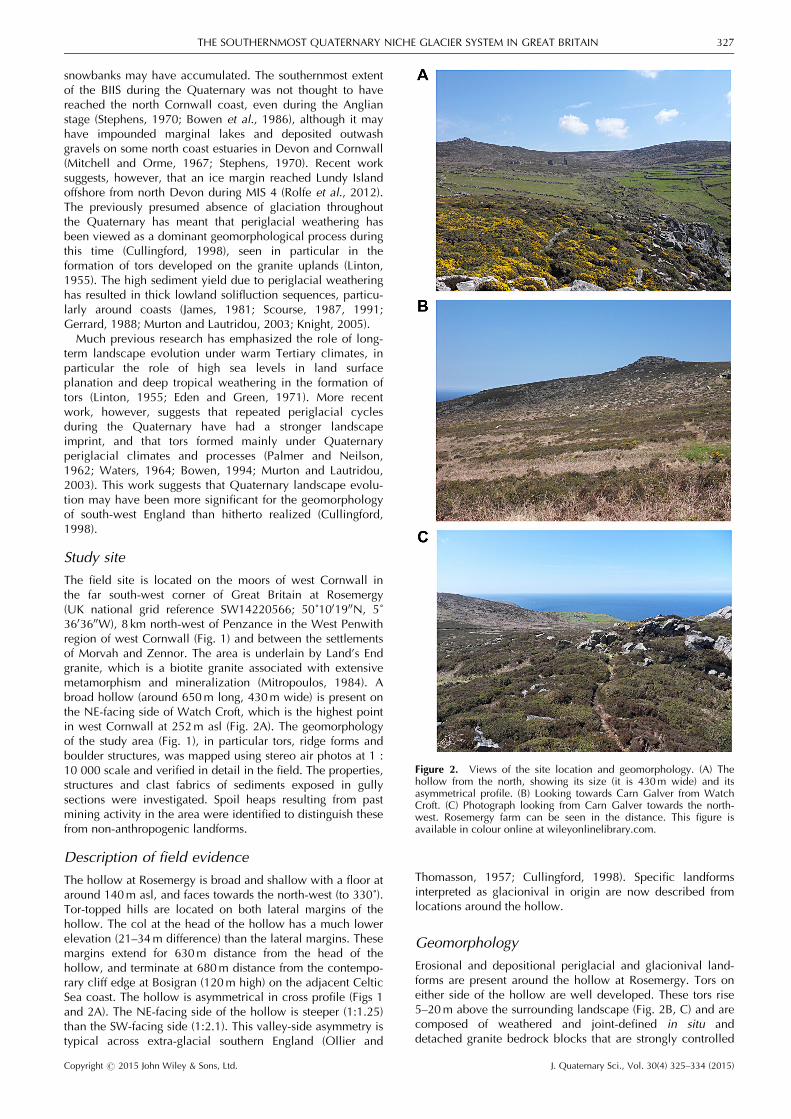
Four sections (A–D) are described from the gully cut intocoastal cliff sections to the west of Bosigran cliff (Fig. 3).Throughout, clasts are wholly derived from the underlyinggranite and its surrounding metamorphic aureole. No exoticclasts have been observed that may indicate long-distance glacial transport or deposition, coastal longshoredrift or storm/tsunami overwashing from the Bristol Channeland Celtic Sea located to the north-west. Two generalizedunits are identified. The lowermost unit 1 comprises faciesthat are considered consistent with sedimentation at ordirectly in front of an ice margin (Dmm, Dms/Gms, Ss/Smfacies; Eyles, 1983; Evans and Benn, 2004; Lukas et al.,2013). Evidence for this comes from the diamictonunits being overconsolidated and the presence of striated
D0
7
mDmm/Dms
Gms/Gcs/Ss/Sm
Gcs/Ss
A0
4
m Dmm/Dms
Sample 1
B0
2
m
Dmm/Dms/Gms
Sample 2
C0
3
m
Dmm/Gmm
Dmm/Dms
Ss/Sm
Gms/Ss
Sample 3
Sample 1Unit 2N=25S1 0.736S3 0.112V1 298.72
Sample 2Unit 1N=25S1 0.574S3 0.103V1 330.42
Sample 3Unit 2N=25S1 0.655S3 0.115V1 335.03
Sample 1 Sample 3Sample 2
Unit 2
Unit 1
Unit 2 Unit 2
Unit 1
Cryoturbation
Figure 3. Sedimentology of sec-tions A–D from the gully atBosigran cliff (shown in Fig. 1B).
Copyright # 2015 John Wiley & Sons, Ltd. J. Quaternary Sci., Vol. 30(4) 325–334 (2015)
328 JOURNAL OF QUATERNARY SCIENCE
bullet-shaped clasts. Unit 2 comprises facies that are consid-ered deposited by solifluction mass and debris flows (Dmm/Gmm, Dms/Gcs, Ss) and corresponding to post-LGM sloperelaxation.Section A (4m high) is composed of massive to vaguely
planar stratified gravelly diamicton (Dmm to Dms facies; unit2). Stratification, where seen, is marked by the presence oflarger flat-lying and non-touching clasts (20–40 cm in diame-ter). Pebbles (5–8 cm in diameter) dominate within a coarsegranule matrix composed of quartz and plagioclase crystalsweathered from the granite country rock.Section B (2m high), which is located farther downslope
than Section A but is considered stratigraphically equivalent,shows massive to planar stratified gravelly diamicton beds(Dmm/Dms/Gms facies; unit 2) which are arranged inlaterally continuous layers 10–20 cm thick. Bed boundaries,where apparent, are demarcated by concentrations oflarger clasts (10–12 cm in diameter) compared with themiddle of beds which are massive and clast supported bypebbles (2–4 cm in diameter).Section C (3m high), which is located downslope from
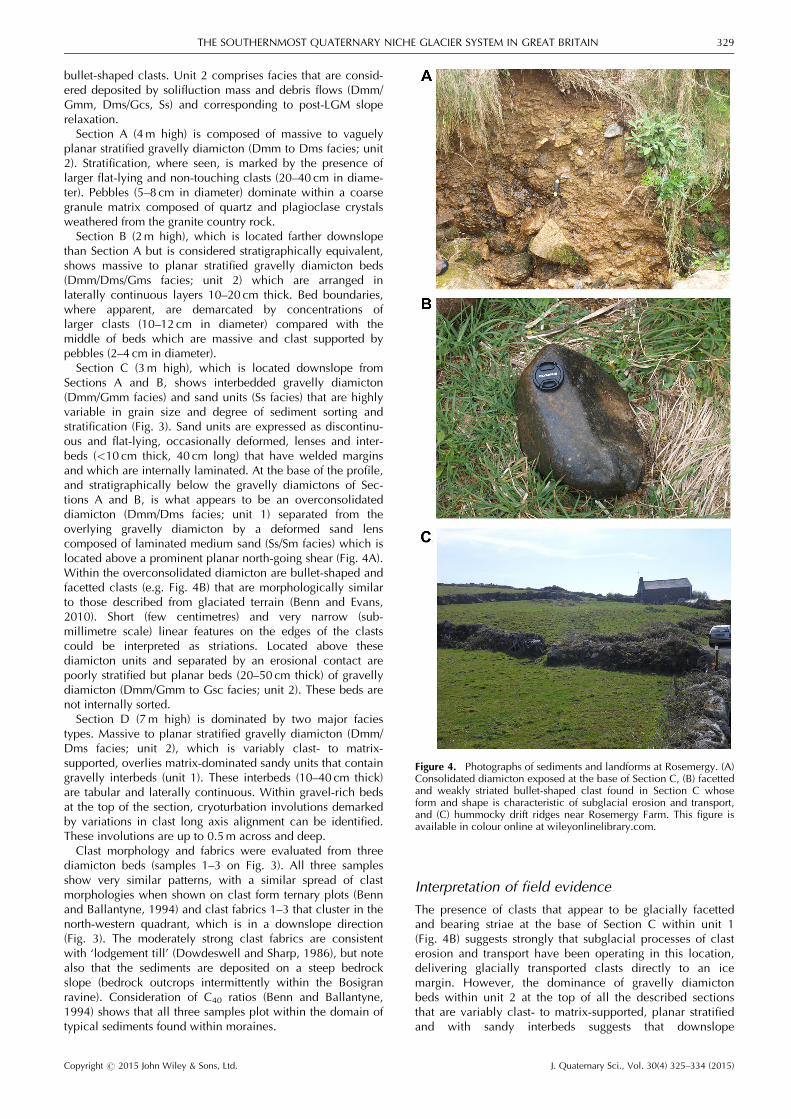
Sections A and B, shows interbedded gravelly diamicton(Dmm/Gmm facies) and sand units (Ss facies) that are highlyvariable in grain size and degree of sediment sorting andstratification (Fig. 3). Sand units are expressed as discontinu-ous and flat-lying, occasionally deformed, lenses and inter-beds (<10 cm thick, 40 cm long) that have welded marginsand which are internally laminated. At the base of the profile,and stratigraphically below the gravelly diamictons of Sec-tions A and B, is what appears to be an overconsolidateddiamicton (Dmm/Dms facies; unit 1) separated from theoverlying gravelly diamicton by a deformed sand lenscomposed of laminated medium sand (Ss/Sm facies) which islocated above a prominent planar north-going shear (Fig. 4A).Within the overconsolidated diamicton are bullet-shaped andfacetted clasts (e.g. Fig. 4B) that are morphologically similarto those described from glaciated terrain (Benn and Evans,2010). Short (few centimetres) and very narrow (sub-millimetre scale) linear features on the edges of the clastscould be interpreted as striations. Located above thesediamicton units and separated by an erosional contact arepoorly stratified but planar beds (20–50 cm thick) of gravellydiamicton (Dmm/Gmm to Gsc facies; unit 2). These beds arenot internally sorted.Section D (7m high) is dominated by two major facies
types. Massive to planar stratified gravelly diamicton (Dmm/Dms facies; unit 2), which is variably clast- to matrix-supported, overlies matrix-dominated sandy units that containgravelly interbeds (unit 1). These interbeds (10–40 cm thick)are tabular and laterally continuous. Within gravel-rich bedsat the top of the section, cryoturbation involutions demarkedby variations in clast long axis alignment can be identified.These involutions are up to 0.5m across and deep.Clast morphology and fabrics were evaluated from three
diamicton beds (samples 1–3 on Fig. 3). All three samplesshow very similar patterns, with a similar spread of clastmorphologies when shown on clast form ternary plots (Bennand Ballantyne, 1994) and clast fabrics 1–3 that cluster in thenorth-western quadrant, which is in a downslope direction(Fig. 3). The moderately strong clast fabrics are consistentwith ‘lodgement till’ (Dowdeswell and Sharp, 1986), but notealso that the sediments are deposited on a steep bedrockslope (bedrock outcrops intermittently within the Bosigranravine). Consideration of C40 ratios (Benn and Ballantyne,1994) shows that all three samples plot within the domain oftypical sediments found within moraines.
Interpretation of field evidence
The presence of clasts that appear to be glacially facettedand bearing striae at the base of Section C within unit 1(Fig. 4B) suggests strongly that subglacial processes of clasterosion and transport have been operating in this location,delivering glacially transported clasts directly to an icemargin. However, the dominance of gravelly diamictonbeds within unit 2 at the top of all the described sectionsthat are variably clast- to matrix-supported, planar stratifiedand with sandy interbeds suggests that downslope
Figure 4. Photographs of sediments and landforms at Rosemergy. (A)Consolidated diamicton exposed at the base of Section C, (B) facettedand weakly striated bullet-shaped clast found in Section C whoseform and shape is characteristic of subglacial erosion and transport,and (C) hummocky drift ridges near Rosemergy Farm. This figure isavailable in colour online at wileyonlinelibrary.com.
Copyright # 2015 John Wiley & Sons, Ltd. J. Quaternary Sci., Vol. 30(4) 325–334 (2015)
THE SOUTHERNMOST QUATERNARY NICHE GLACIER SYSTEM IN GREAT BRITAIN 329
reworking of ice-contact sediments was the major mecha-nism of sediment transport and emplacement (Curry, 1999).The dominant downslope fabric of sediments within unit 2confirms that gravity-driven reworking in the form of sheetsolifluction, mass flows and possibly debris flows wasdirected into a preexisting bedrock valley (which is proba-bly of a previous interstadial in age) (e.g. Harrison et al.,2010). This dominance of the post-LGM slope sedimentreworking is very likely given the steep bedrock slopesthroughout the north Cornwall coast region (e.g. Scourse,1996) and this must have occurred before the last phase ofperiglacial cryoturbation, which has affected the topmostsediments in Section D. It is likely that the ridge morpholo-gy seen immediately adjacent to the Bosigran section atRosemergy farm (Fig. 4C) is part of a previously moreextensive terminal moraine system from which the Bosigransediments were derived, and this is supported by the presenceof hummocky topography immediately outside this ridge. Thismay represent a paraglacial slope response to deglaciation inthis setting, strongly mediated by the steep nature of theproglacial environment (e.g. Curry, 1999).
Glacier–climate modelling
To test the hypothesis that palaeoclimatic conditions duringthe Late Devensian were sufficient to sustain a niche glacierat our field site, we applied a two-dimensional (2D) glacier–climate model to the study area. The glacier model (Plummerand Phillips, 2003) is particularly suitable for the investigationof small glaciers where topography and solar position exert astrong control on mass balance.
Model design
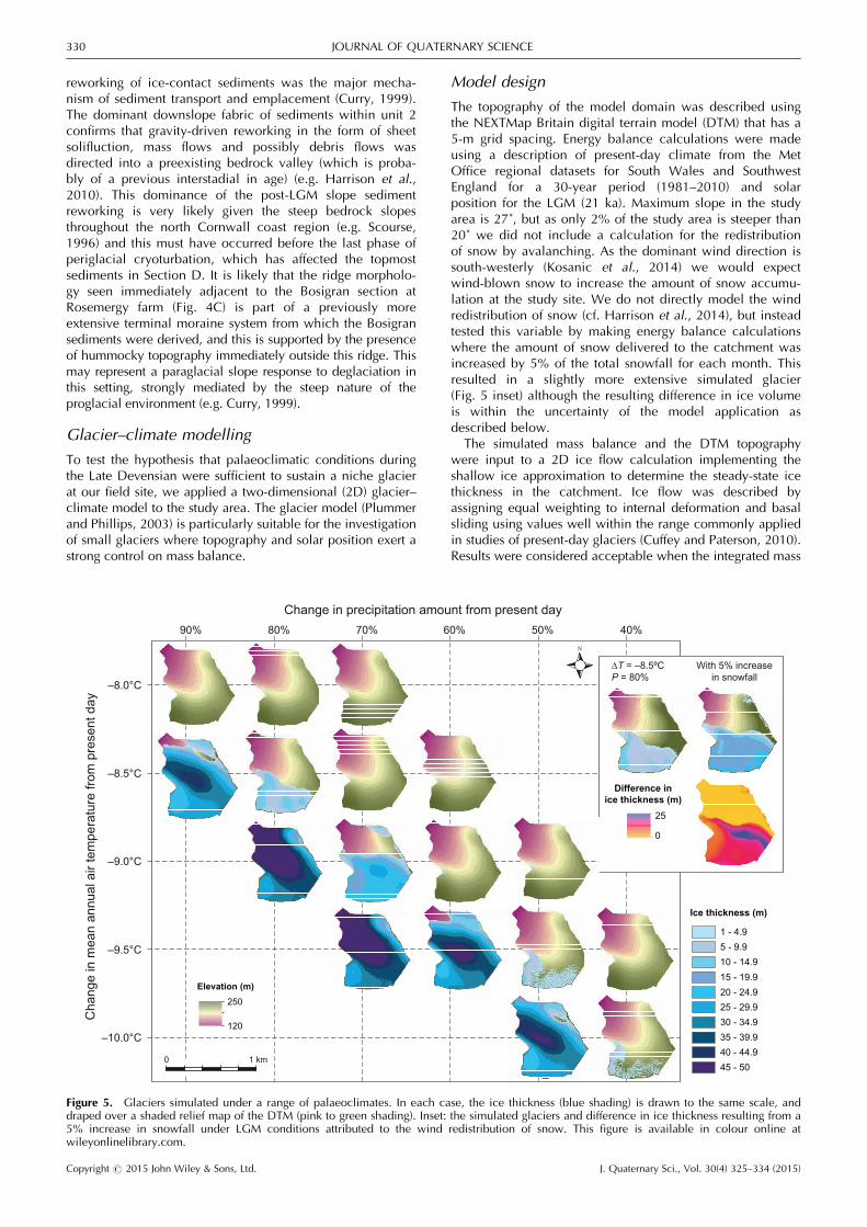
The topography of the model domain was described usingthe NEXTMap Britain digital terrain model (DTM) that has a5-m grid spacing. Energy balance calculations were madeusing a description of present-day climate from the MetOffice regional datasets for South Wales and SouthwestEngland for a 30-year period (1981–2010) and solarposition for the LGM (21 ka). Maximum slope in the studyarea is 27˚, but as only 2% of the study area is steeper than20˚ we did not include a calculation for the redistributionof snow by avalanching. As the dominant wind direction issouth-westerly (Kosanic et al., 2014) we would expectwind-blown snow to increase the amount of snow accumu-lation at the study site. We do not directly model the windredistribution of snow (cf. Harrison et al., 2014), but insteadtested this variable by making energy balance calculationswhere the amount of snow delivered to the catchment wasincreased by 5% of the total snowfall for each month. Thisresulted in a slightly more extensive simulated glacier(Fig. 5 inset) although the resulting difference in ice volumeis within the uncertainty of the model application asdescribed below.The simulated mass balance and the DTM topography
were input to a 2D ice flow calculation implementing theshallow ice approximation to determine the steady-state icethickness in the catchment. Ice flow was described byassigning equal weighting to internal deformation and basalsliding using values well within the range commonly appliedin studies of present-day glaciers (Cuffey and Paterson, 2010).Results were considered acceptable when the integrated mass
∆T = –8.5ºCP = 80%
With 5% increasein snowfall
25
0
Difference inice thickness (m)
240
240
1 - 4.95 - 9.910 - 14.915 - 19.920 - 24.925 - 29.930 - 34.935 - 39.940 - 44.945 - 50
Ice thickness (m)
1 km0
Elevation (m)250
120
Change in precipitation amount from present day
Cha
nge
in m
ean
annu
al a
ir te
mpe
ratu
re fr
om p
rese
nt d
ay
–8.0°C
–8.5°C
–9.0°C
–9.5°C
–10.0°C
90% 80% 70% 60% 50% 40%
Figure 5. Glaciers simulated under a range of palaeoclimates. In each case, the ice thickness (blue shading) is drawn to the same scale, anddraped over a shaded relief map of the DTM (pink to green shading). Inset: the simulated glaciers and difference in ice thickness resulting from a5% increase in snowfall under LGM conditions attributed to the wind redistribution of snow. This figure is available in colour online atwileyonlinelibrary.com.
Copyright # 2015 John Wiley & Sons, Ltd. J. Quaternary Sci., Vol. 30(4) 325–334 (2015)
330 JOURNAL OF QUATERNARY SCIENCE
balance was within 0.1% of steady state. Palaeoclimaticuncertainty in the application of this glacier model has beenquantified for present-day and Holocene glaciers in theSouthern Alps of New Zealand as equivalent to a differencein MAAT of 0.25 ˚C (Rowan et al., 2014). In the current study,under LGM conditions the change in glacier volume resultingfrom a difference in precipitation amount of� 10% was offsetby a difference in MAAT of�0.25 ˚C, which is the valueassigned to the palaeoclimatic uncertainty in the modelapplication. Parameter values used in these simulations aregiven in Table 1.Conditions during the LGM were likely to have been colder
and drier than present, with increased temperature seasonali-ty. However, constraining the difference in climate betweenthe present day and the last glacial is challenging due to thevariation in palaeoclimatic conditions represented by proxyrecords. We tested a range of plausible values for differencesin MAAT (DT) and precipitation amount (P), and made aconservative estimate of LGM seasonality of 3 ˚C comparedwith the present day, giving a mean LGM temperature of 7 ˚Cfor July and �10 ˚C for January (Table 1). A slightly highervalue for LGM wind speed (10m s�1) than are observed insouth-west England (mean monthly values of 6m s�1) wasused to represent inferred windier conditions. The LGMpalaeoclimate was simulated using a range of scenarios withDT of between �8.0 and �10.0 ˚C in increments of 0.5 ˚C,and P of between 40 and 100% of present-day values (Fig. 5).Simulations made using the present-day climate and solarposition produced no glacier ice or perennial snow in thestudy area and are not presented.
Glacier–climate reconstructions
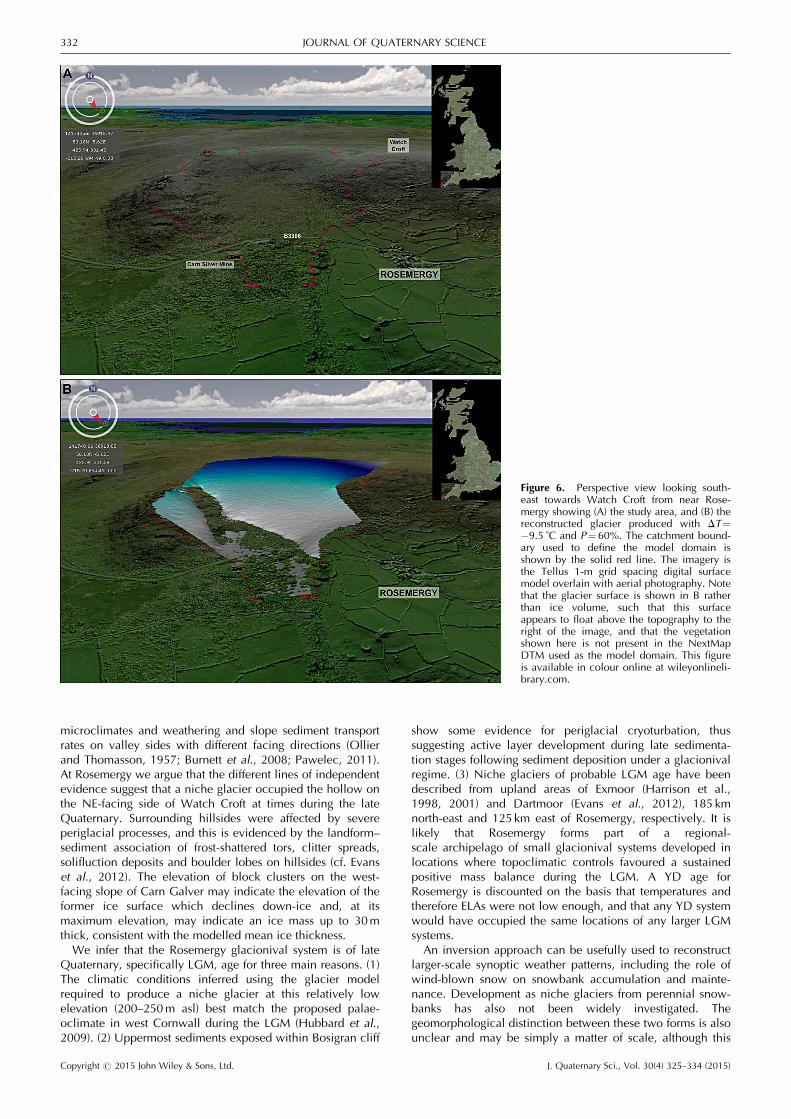
Our simulations demonstrate that a niche glacier could haveformed in the hollow on the NE-facing side of Watch Croftunder conditions within the range of the regional LGM,equivalent to DT of �9.5 ˚C accompanied by P of 60%compared with present-day values (Figs 5 and 6). Summertemperatures at least 7 ˚C cooler than present were requiredto form this glacier. The palaeoclimate could have variedby� 0.5 ˚C and in precipitation amount by� 10% aroundthese values and still produced conditions favourable toglaciation. This envelope of palaeoclimate that could formand sustain a niche glacier is consistent with LGM palae-oclimate modelled for the North Atlantic region (Otto-Bliesner et al., 2006; Arpe et al., 2011), and simulations ofthe LGM BIIS (Hubbard et al., 2009). The LGM niche glacierhad an area of 0.44 km2, a maximum ice thickness of 51m, amean ice thickness of 29m and an ELA of 184� 17m.Response times for these simulations are long (over 500 yearsfor DT of �0.5 ˚C), indicating that it is unlikely that marginalniche glaciers such as this did maintain steady state, andwere instead likely to have been short-lived features that mayonly have reached the extent described in this study brieflywhen the palaeoclimate was favourable.
Discussion
Valleys that are asymmetrical in cross-profile have beenpreviously reported from glacial and periglacial settings (e.g.Currey, 1964; Crampton, 1977; Naylor and Gabet, 2007).Valley asymmetry is most commonly attributed to different
Table 1. (A) Glacier model parameters used in the simulations described in this study. For the climatological parameters (B), annual and 6-month summer (April–September) and winter (October–March) values are given. All values used in these simulations were monthly means exceptwhere only annual values are given. Values given here describe the present-day climate, except where LGM temperatures are given. Precipitationtotals describe the amount of precipitation falling within the model domain.
(A) Glacier model parameters.
Model domain descriptionGrid spacing of the NextMap DTM (m) 5Vertical resolution of the NextMap DTM (m) 1Model domain grid size 178 � 165
Glaciological parametersHigh albedo 0.8Low albedo 0.4Ice deformation constant (a�1 kPa�3) 2.1 � 10�7
Ice sliding constant (m a�1 kPa�2) 1.5 � 10�3
(B) Climatological parameters Annual Summer Winter
LGM monthly sea-level air temperature (˚C) 0.3 5.1 �5.5Standard deviation of daily temperatures (˚C) 1.1 1.0 1.2Atmospheric lapse rate (˚C km�1) �6 � �Critical temperature for snowfall (˚C) 2 � �Precipitation maximum (mm) 1836 786 1050Precipitation minimum (mm) 1524 630 894Precipitation mean (mm) 1703 719 984Precipitation standard deviation (mm) 82 41 41Snowfall mean as SWE (mm) 56 0 56Snowfall standard deviation as SWE (mm) 14 0 14Wind speed (m s�1) 10 � �Cloudiness 0.75 � �Relative humidity 0.80 � �Emissivity of snow 0.99 � �Emissivity of the surrounding terrain 0.94 � �Dimensionless transfer coefficient for snow 0.0015 � �Ground heat flux (Wm�2) 0.1 � �Monthly sea-level air temperature (˚C) 9.8 13.1 6.5
Copyright # 2015 John Wiley & Sons, Ltd. J. Quaternary Sci., Vol. 30(4) 325–334 (2015)
THE SOUTHERNMOST QUATERNARY NICHE GLACIER SYSTEM IN GREAT BRITAIN 331
microclimates and weathering and slope sediment transportrates on valley sides with different facing directions (Ollierand Thomasson, 1957; Burnett et al., 2008; Pawelec, 2011).At Rosemergy we argue that the different lines of independentevidence suggest that a niche glacier occupied the hollow onthe NE-facing side of Watch Croft at times during the lateQuaternary. Surrounding hillsides were affected by severeperiglacial processes, and this is evidenced by the landform–sediment association of frost-shattered tors, clitter spreads,solifluction deposits and boulder lobes on hillsides (cf. Evanset al., 2012). The elevation of block clusters on the west-facing slope of Carn Galver may indicate the elevation of theformer ice surface which declines down-ice and, at itsmaximum elevation, may indicate an ice mass up to 30mthick, consistent with the modelled mean ice thickness.We infer that the Rosemergy glacionival system is of late
Quaternary, specifically LGM, age for three main reasons. (1)The climatic conditions inferred using the glacier modelrequired to produce a niche glacier at this relatively lowelevation (200–250m asl) best match the proposed palae-oclimate in west Cornwall during the LGM (Hubbard et al.,2009). (2) Uppermost sediments exposed within Bosigran cliff
show some evidence for periglacial cryoturbation, thussuggesting active layer development during late sedimenta-tion stages following sediment deposition under a glacionivalregime. (3) Niche glaciers of probable LGM age have beendescribed from upland areas of Exmoor (Harrison et al.,1998, 2001) and Dartmoor (Evans et al., 2012), 185 kmnorth-east and 125 km east of Rosemergy, respectively. It islikely that Rosemergy forms part of a regional-scale archipelago of small glacionival systems developed inlocations where topoclimatic controls favoured a sustainedpositive mass balance during the LGM. A YD age forRosemergy is discounted on the basis that temperatures andtherefore ELAs were not low enough, and that any YD systemwould have occupied the same locations of any larger LGMsystems.An inversion approach can be usefully used to reconstruct
larger-scale synoptic weather patterns, including the role ofwind-blown snow on snowbank accumulation and mainte-nance. Development as niche glaciers from perennial snow-banks has also not been widely investigated. Thegeomorphological distinction between these two forms is alsounclear and may be simply a matter of scale, although this
Figure 6. Perspective view looking south-east towards Watch Croft from near Rose-mergy showing (A) the study area, and (B) thereconstructed glacier produced with DT¼�9.5 ˚C and P¼60%. The catchment bound-ary used to define the model domain isshown by the solid red line. The imagery isthe Tellus 1-m grid spacing digital surfacemodel overlain with aerial photography. Notethat the glacier surface is shown in B ratherthan ice volume, such that this surfaceappears to float above the topography to theright of the image, and that the vegetationshown here is not present in the NextMapDTM used as the model domain. This figureis available in colour online at wileyonlineli-brary.com.
Copyright # 2015 John Wiley & Sons, Ltd. J. Quaternary Sci., Vol. 30(4) 325–334 (2015)
332 JOURNAL OF QUATERNARY SCIENCE
hypothesis has not been tested. Niche glaciers are generallythin (<10m thickness) and thus do not experience rotationalgravity-driven ice flow that allows for bed excavation andoverdeepening. As such, niche glaciers may show little or noevidence for active subglacial abrasion, plucking and sedi-ment transport, although the basal ice thermal condition isprobably a considerable control on rock weathering bysuppressing freeze–thaw action.
Conclusions
We have presented geomorphological and sedimentologicalevidence to suggest that a north-facing shallow hollow inwest Cornwall was occupied by a small glacier, probablyduring LGM times when the southerly margin of the BIIS layjust offshore of the present Cornish coast. This finding issupported by glacier–climate modelling that shows that areduction in MAAT of between �9 and �10 ˚C accompaniedby a reduction in precipitation of up to 50% was sufficient toform and sustain a niche glacier in the hollow. This nicheglacier represents the southernmost such system from GreatBritain, and provides evidence for the presence of extra-glacial niche glaciers outside the limits of the main ice sheet.This work adds to the suggestion that glacial ice in theuplands of south-west Britain beyond the southern margins ofthe BIIS may well have been extensive during cold phases ofthe late Quaternary.
Acknowledgements. Regional climate data used in the glacier model-ling simulations were provided by the Met Office (www.metoffice.gov.uk/climate/uk/sw/accessed on 18 June 14). The Tellus LiDAR digitalsurface model is freely available data supplied by Natural EnvironmentResearch Council (Centre for Ecology and Hydrology; British AntarcticSurvey; British Geological Survey) #NERC (Centre for Ecology andHydrology; British Antarctic Survey; British Geological Survey). Wethank the reviewers Ian Evans and Sven Lukas for their incisive anddetailed comments on an earlier version of the manuscript, and JamesScourse for discussing the site and its geomorphology.
Abbreviations. BIIS, British–Irish Ice Shee; DTM, digital terrain model;ELA, equilibrium line altitude; LGM, Last Glacial Maximum; MAAT,mean annual air temperature; MIS, marine isotope stage; YD, YoungerDryas.
References
Allen TR. 1998. Topographic context of glaciers and perennialsnowfields, Glacier National Park, Montana. Geomorphology 21:207–216.
Anderson E, Harrison S, Passmore D. 2001. A late-glacial protalusrampart in Macgillycuddy’s Reeks, south-west Ireland. Irish Journalof Earth Sciences 19: 43–50.
Anderson E, Harrison S, Passmore DG et al. 1998. Geomorphicevidence of Younger Dryas glaciation in the Macgillycuddy’sReeks, south west Ireland. Quaternary Proceedings 6: 75–90.
Arpe K, Leroy SAG, Mikolajewicz U. 2011. A comparison of climatesimulations for the Last Glacial Maximum with three differentversions of the ECHAM model and implications for summer-green tree refugia. Climate of the Past 7: 91–114.
Ballantyne CK. 1985. Nivation landforms and snowpatch erosion ontwo massifs in the Northern Highlands of Scotland. ScottishGeographical Magazine 101: 40–49.
Ballantyne CK, Benn DI. 1994. Glaciological constraints on protalusrampart development. Permafrost and Periglacial Processes 5: 145–153.
Benn DI, Ballantyne CK. 1994. Reconstructing the transport history ofglacigenic sediments: a new approach based on the co-variance ofclast form indices. Sedimentary Geology 91: 215–227.
Benn DI, Evans DJA. 2010. Glaciers and Glaciation. Hodder Educa-tion: London.
Bowen DQ. 1994. Late Cenozoic Wales and south-west England.Proceedings of the Ussher Society 8: 209–213.
Bowen DQ, Rose J, McCabe AM et al. 1986. Correlation ofQuaternary glaciations in England, Ireland, Scotland and Wales.Quaternary Science Reviews 5: 299–340.
Brenning A, Trombotto D. 2006. Logistic regression modeling of rockglacier and glacier distribution: topographic and climatic controlsin the semi-arid Andes. Geomorphology 81: 141–154.
Brown I, Ward R. 1996. The influence of topography on snowpatchdistribution in southern Iceland: a new hypothesis for glacierformation? Geografiska Annaler 78A: 197–207.
Burnett BN, Meyer GA, McFadden LD. 2008. Aspect-related microclimatic influences on slope forms and processes,northeastern Arizona. Journal of Geophysical Research 113:F03002.
Caine N. 1992. Sediment transfer on the floor of the Martinellisnowpatch, Colorado Front Range, U.S.A. Geografiska Annaler74A: 133–144.
Caine N. 1995. Snowpack influences on geomorphic processes inGreen Lakes Valley, Colorado Front Range. The GeographicalJournal 161: 55–68.
Carr SJ. 2001. A glaciological approach for the discrimination ofLoch Lomond Stadial glacial landforms in the Brecon Beacons,South Wales. Proceedings of the Geologists’ Association 112: 253–261.
Christiansen HH. 1998. Nivation forms and processes in unconsoli-dated sediments, NE Greenland. Earth Surface Processes andLandforms 23: 751–760.
Clark CD, Gibbard PL, Rose J. 2004. Pleistocene glacial limits inEngland, Scotland and Wales. In Quaternary Glaciations – Extentand Chronology, Ehlers J, Gibbarde PL, (eds.). Elsevier: Amsterdam;47–82.
Coleman CG, Carr SJ. 2008. Complex relationships between YoungerDryas glacial, periglacial and paraglacial landforms, BreconBeacons, South Wales. Proceedings of the Geologists’ Association119: 259–276.
Coleman CG, Carr SJ, Parker AG. 2009. Modelling topoclimaticcontrols on palaeoglaciers: implications for inferring palaeoclimatefrom geomorphic evidence. Quaternary Science Reviews 28: 249–259.
Crampton CB. 1977. A note on asymmetric valleys in the centralMackenzie River catchment, Canada. Earth Surface Processes 2:427–429.
Cuffey KM, Paterson WSB. 2010. The Physics of Glaciers 4th edn.Academic Press: New York.
Cullingford RA. 1998. The Quaternary. In The Geology of Cornwalland the Isles of Scilly, Selwood EB, Currance EM, Bristow CM(eds.). University of Exeter Press: Exeter; 199–210.
Currey DR. 1964. A preliminary study of valley asymmetry in theOgotoruk Creek area, northwestern Alaska. Arctic 17: 84–98.
Curry AM. 1999. Paraglacial modification of slope form. EarthSurface Processes and Landforms 24: 1213–1228.
Dowdeswell JA, Sharp MJ. 1986. Characterization of pebble fabricsin modern terrestrial glacigenic sediments. Sedimentology 33: 699–710.
Eden MJ, Green CP. 1971. Some aspects of granite weatheringand tor formation on Dartmoor, England. Geografiska Annaler 53A:92–99.
Evans DA, Benn DI. 2004. A Practical Guide to the Study of GlacialSediments. Arnold: London.
Evans DJA, Harrison S, editors. 2014. The Quaternary Glaciation ofDartmoor� Field Guide. Quaternary Research Association:London.
Evans DJA, Harrison S, Vieli A et al. 2012. The glaciation ofDartmoor: the southernmost independent Pleistocene ice cap inthe British Isles. Quaternary Science Reviews 45: 31–53.
Eyles N. 1983. Glacial Geology: an Introduction to Engineers andEarth Scientists. Pergamon Press: Oxford.
Gerrard AJW. 1988. Periglacial modification of the CoxTor-Staples Tor area of western Dartmoor, England. PhysicalGeography 9: 280–300.
Harrison S. 2001. Speculations on the glaciation of Dartmoor.Quaternary Newsletter 93: 15–26.
Copyright # 2015 John Wiley & Sons, Ltd. J. Quaternary Sci., Vol. 30(4) 325–334 (2015)
THE SOUTHERNMOST QUATERNARY NICHE GLACIER SYSTEM IN GREAT BRITAIN 333
Harrison S, Anderson E, Passmore DG. 1998. A small glacial cirquebasin on Exmoor, Somerset. Proceedings of the Geologists’ Associ-ation 109: 149–158.
Harrison S, Anderson E, Passmore DG. 2001. Further glacial tills onExmoor, southwest England: implications for small ice cap andvalley glaciation. Proceedings of the Geologists’ Association 112:1–5.
Harrison S, Bailey RM, Anderson E et al. 2010. Optical dates fromBritish Isles ’solifluction sheets’ suggests rapid landscape responseto Late Pleistocene climate change. Scottish Geographical Journal126: 101–111.
Harrison S, Rowan AV, Glasser NF et al. 2014. Little Ice Age glaciersin Britain: glacier-climate modelling in the Cairngorm Mountains.The Holocene 24: 135–140.
Henderson EP. 1956. Large nivation hollows near Knob Lake,Quebec. Journal of Geology 64: 607–616.
Hiemstra JF, Evans DJA, Scourse JD et al. 2006. New evidence for agrounded Irish Sea glaciation of the Isles of Scilly, UK. QuaternaryScience Reviews 25: 299–309.
Hubbard A, Bradwell T, Golledge N et al. 2009. Dynamic cycles, icestreams and their impact on the extent, chronology and deglacia-tion of the British-Irish ice sheet. Quaternary Science Reviews 28:758–776.
Hughes PD. 2002. Loch Lomond Stadial glaciers in the Aran andArenig Mountains, North Wales, Great Britain. Geology Journal 37:9–15.
James HCL. 1981. Pleistocene sections at Gerrans Bay, south Corn-wall. Proceedings of the Ussher Society 5: 239–240.
Kariya Y. 2002. Geomorphic processes at a snowpatch hollow onGassan Volcano, Northern Japan. Permafrost and PeriglacialProcesses 13: 107–116.
Knight J. 2005. Regional climatic versus local controls on periglacialslope deposition: a case study from west Cornwall. Geoscience insouth-west England 11: 151–157.
Kosanic A, Harrison S, Anderson K et al. 2014. Present and historicalclimate variability in south west England. Climatic Change 124:221–237.
Lewkowicz AG, Harry DG. 1991. Internal structure and environmen-tal significance of a perennial snowbank, Melville Island, N.W.T.Arctic 44: 74–82.
Linton DL. 1955. The problem of tors. Geographical Journal 121:470–487.
Lukas S, Benn DI, Boston CM et al. 2013. Clast shape analysis andclast transport paths in glacial environments: A critical review ofmethods and the role of lithology. Earth-Science Reviews 121: 96–116.
Margold M, Treml V, Petr L et al. 2011. Snowpatch hollows andpronival ramparts in the Krkono�se Mountains, Czech Republic:distribution, morphology and chronology of formation. GeografiskaAnnaler 93A: 137–150.
McDougall DA. 2001. The geomorphological impact of LochLomond (Younger Dryas) Stadial plateau icefields in the centralLake District, northwest England. Journal of Quaternary Science16: 531–543.
Mills SC, Grab SW, Carr SJ. 2009. Recognition and palaeoclimaticimplications of late Quaternary niche glaciation in eastern Lesotho.Journal of Quaternary Science 24: 647–663.
Mitchell GF, Orme AR. 1967. The Pleistocene deposits of theIsles of Scilly. Quarterly Journal of the Geological Society 123:59–92.
Mitchell WA. 1996. Significance of snowblow in the generation ofLoch Lomond Stadial (Younger Dryas) glaciers in the westernPennines, northern England. Journal of Quaternary Science 11:233–248.
Mitropoulos P. 1984. Rare-earth element distribution in the metabasicrocks of the Land’s End granite aureole, SW England. MineralogicalMagazine 48: 495–505.
Murton JB, Lautridou J-P. 2003. Recent advances in the understand-ing of Quaternary periglacial features of the English Channelcoastlands. Journal of Quaternary Science 18: 301–307.
Naylor S, Gabet EJ. 2007. Valley asymmetry and glacial versusnonglacial erosion in the Bitterroot Range, Montana, USA. Geology35: 375–378.
Nyberg R. 1991. Geomorphic processes at snowpatch sites in theAbisko Mountains, Northern Sweden. Zeitschrift f€ur Geomorpholo-gie 35: 321–343.
Ollier CD, Thomasson AJ. 1957. Asymmetrical valleys of the ChilternHills. The Geographical Journal 123: 71–80.
Otto-Bliesner BL, Brady EC, Clauzet G et al. 2006. Last GlacialMaximum and Holocene climate in CC SM3. Journal of Climate19: 2526–2544.
Palacios D, de Andr�es N, Luengo E. 2003. Distribution and effective-ness of nivation in Mediterranean mountains: Pe~nalara (Spain).Geomorphology 54: 157–178.
Palmer JA, Neilson RA. 1962. The origin of granite tors on Dartmoor,Devonshire. Proceedings of the Yorkshire Geological Society 33:315–340.
Pawelec H. 2011. Periglacial evolution of slopes — rock controlversus climatic factors (Cracow Upland, S Poland). Geomorpholo-gy 132: 139–152.
Plummer MA, Phillips FM. 2003. A 2-D numerical model of snow/iceenergy balance and ice flow for paleoclimatic interpretation ofglacial geomorphic features. Quaternary Science Reviews 22:1389–1406.
te Punga MT. 1956. Altiplanation terraces in southern England.Biuletyn Peryglacjalny 4: 331–338.
Rapp A. 1984. Nivation hollows and glacial cirques in S€oderasen,Scania, south Sweden. Geografiska Annaler 66A: 11–28.
Rolfe CJ, Hughes PD, Fenton CR et al. 2012. Paired 26Al and 10Beexposure ages from Lundy: new evidence for the extent and timingof Devensian glaciation in the southern British Isles. QuaternaryScience Reviews 43: 61–73.
Rowan AV, Brocklehurst SH, Schultz DM et al. 2014. Late Quaterna-ry glacier sensitivity to temperature and precipitation distribution inthe Southern Alps of New Zealand. Journal of GeophysicalResearch: Earth Surface 119: 1064–1081.
Scourse JD. 1987. Periglacial sediments and landforms in the Isles ofScilly and Cornwall. In Periglacial Processes and Landforms inBritain and Ireland, Boardman J (ed.). Cambridge University Press:Cambridge; 225–236.
Scourse JD. 1991. Late Pleistocene stratigraphy and palaeobotany ofthe Isles of Scilly. Philosophical Transactions of the Royal SocietyB: Biological Sciences 334: 405–448.
Scourse JD. 1996. Late Pleistocene stratigraphy and palaeobotany ofnorth and west Cornwall. Transactions of the Royal GeologicalSociety of Cornwall 22: 2–56.
Shakesby RA. 1997. Pronival (protalus) ramparts: a review of forms,processes, diagnostic criteria and palaeoenvironmental implica-tions. Progress in Physical Geography 21: 394–418.
Stephens N. 1970. The west country and southern Ireland. In TheGlaciations of Wales and Adjoining Regions, Lewis CA (ed.).Longman: London; 267–314.
Waters RS. 1964. The Pleistocene legacy to the geomorphology ofDartmoor. In Dartmoor Essays, Simmons IG (ed.). DevonshireAssociation for the Advancement of Science, Literature and Arts,73–96.
Wintle AG. 1981. Thermoluminescence dating of Late Devensianloesses in southern England. Nature 289: 479–480.
Copyright # 2015 John Wiley & Sons, Ltd. J. Quaternary Sci., Vol. 30(4) 325–334 (2015)
334 JOURNAL OF QUATERNARY SCIENCE