the road building sands and gravels of washington - wa
TRANSCRIPT
WASHINGTON GEOLOGICAL SURVEY
HBNRY LANDES, State Geologist
BULLETIN N o. 22
The Road Building Sands and Gravels of Washington
By MORRIS M. LEIGHTON
OLY.Mp_ll
FRL"IK M. 1,Al\t:BORN ~ PVBLIC PRINTER
11)19
BOARD OF GEOLOGICAL SURVEY.
Governor ER~EST L ISTER, Cllairma·n. Lieutenant Governor Louis F. HAR'r, Vice-Chairman. State Treastuer W. W. SrrERl\lAN, Secretary. President lli:NRY SuzzALLO.
President ER~EST 0. Hor.LAND.
HEKRY LANDES, State Geolo{Jist.
LETTER OF TRANSnHTTAL.
Governor E1'1nest Dister, Ohair1main, and NI embers of the Board of Geotog-ical Su,rvey:
GENTLEMEN : I have the honor to submit herewith a report entitled "The Road Building Sands and Gravels of Washington,'' by Morris M. Leighton, with the recommendation that it be printed as Bulletin No. 22 of the Survey reports.
Very r espectfully, HENRY LA:Nnr:s,
State G('ologist.
University Station, Seattle, November 1, 1918.
TABLE OF CONTENTS.
CHAPTER I. J :).'TllOIH:C'l'TO;-;
Page 15
Choice of Materials Important. . . . . . . . . . . . . . . . . . . . . . . . . . . . . . . . 15 Field Studies . . . . . . . . . . . . . . . . . . . . . . . . . . . . . . . . . . . . . . . . . . . . . . . 16
Tbeir Character . . . . . . . . . . . . . . . . . . . . . . . . . . . . . . . . . . . . . . . . . 16 Scope of the Studies...................................... 17
Inspection of the Materials in Service........................ 18 Need o( Traffic Census. . . . . . . . . . . . . . . . . . . . . . . . . . . . . . . . . . . . 18
General Kinds of Laboratory Tests Made. . . . . . . . . . . . . . . . . . . . . . 20 Acknowledgments . . . . . . . . . . . . . . . . . . . . . . . . . . . . . . . . . . . . . . . . . . . 21
CHAPTER II. GENERAL D1sT11111UT10N OF Trn; SA.1\D A:),'D G1tAYF.L
FOR~rATIONS OF WASIITNG'rON . . • • • • . • • . • . . • • • . . . • • . . • • . . 23 General Statement . . . . . . . . . . . . . . . . . . . . . . . . . . . . . . . . . . . . . . . . . . 23 Description of the Sand and Gravel Deposits by Provinces..... 24
Olympic Mountain Province . . . . . . . . . . . . . . . . . . . . . . . . . . . . . . 24
Puget Sound Province . . . . . . . . . . . . . . . . . . . . . . . . . . . . . . . . . . . 27 Soutbwestern Province . . . . . . . . . . . . . . . . . . . . . . . . . . . . . . . . . . . 29 Columbia Gorge Province . . . . . . . . . . . . . . . . . . . . . . . . . . . . . . . . 30 Yakima River Province. . . . . . . . . . . . . . . . . . . . . . . . . . . . . . . . . . . 31 Okanogan Province . . . . . . . . . . . . . . . . . . . . . . . . . . . . . . . . . . . . . . 32 Columbia Plateau Province . . . . . . . . . . . . . . . . . . . . . . . . . . . . . . . 34
Blue Mountain Province . . . . . . . . . . . . . . . . . . . . . . . . . . . . . . . . . . 35
CHAPTER III. SA..'10 A.XI> GIL\l'EI. FOR Gl11\.VEL MACAOUL......... 38 The Essentlal Requirements of a Road Gravel................. 38 Character of the Examinatiou and Tests Made on Road Gravels 40
Petrological Detern1ination . . . . . . . . . . . . . . . . . . . . . . . . . . . . . . . 40
Hardness Test . . . . . . . . . . . . . . . . . . . . . . . . . . . . . . . . . . . . . . . . . . . 40 Abrasion Test . . . . . . . . . . . . . . . . . . . . . . . . . . . . . . . . . . . . . . . . . . . 41 Mechanical Analysis . . . . . . . . . . . . . . . . . . . . . . . . . . . . . . . . . . . . . 43 Cementatlon Test . . . . . . . . . . . . . . . . . . . . . . . . . . . . . . . . . . . . . . . . 43 Tenacity Test of the Binder Portion of Gravels............. 44
Results of the 'l'ests . . . . . . . . . . . . . . . . . . . . . . . . . . . . . . . . . . . . . . . . . 45 Gradation of the Various Gravels......................... . 45
Percentage of Hardness . . . . . . . . . . . . . . . . . . . . . . . . . . . . . . . . . . 48 Results of the Abrasion Test.. . ........................... 48 Quality of the Binder Portion of the Gravels...... ........ . 49
CHAPTER IV. SA.ND A.No GnA YEL 1-·on PonTLA1''1> CEMENT CoNClllcTE, Bn·u~LINOUS CONCRE'fE ,\1\"l) SA:0.'1) l'Olt SnD:r ASl'lTALT
CoxsTRUC·rrox . . . . • . • • • . . . . . . . . . . • . . • • • . . • • . . . . . • • . . . . . 56 Porlland Cement Concrete . . . . . . . . . . . . . . . . . . . . . . . . . . . . . . . . . . . 56
Fine Aggregate . . . . . . . . . . . . . . . . . . . . . . . . . . . . . . . . . . . . . . . . . . 66
6 Table of Contents
CHAPTER IV. SANO ANO GRA,'EL FOR PORTLAND CE~(E'NT CONCRETE,
BtTU.M.U\OUS 0oNCRE'l'E AND SAl(D FOR SHEET ASPHALT
CONS'rRUCTION-Oontinued.:
Poi;tland Cement Concrete Pane Description of Tests Performed. . . . . . . . . . . . . . . . . . . . . . . . . . . 57
Mec.hanical Analysis . . . . . . . . . . . .. . . . . . . . . . . . . . . . . . . . . . 57 Determination of Voids . . . . . . . . . . . . . . . . . . . . . . . . . . . . . . . 57 Tensile Strength Tests of Mortar. . . . . . . . . . . . . . . . . . . . . . . 58 Colorimetric Tests . . . . . . . . . . . . . . . . . . . . . . . . . . . . . . . . . . . . 58 Chemical Analysis for A!l{a!i Content. . . . . . . . . . . . . . . . . . . 60
Results of Tests Made on Fine Aggregate........... . . .. .. . 60 Physical Properties . . . . . . . . . . . . . . . . . . . . . . . . . . . . . . . . . . . 60 Tensile Strength and Colorimetric Tests. . . . . . . . . . . . . . . . 61 Chemical Test for Alkali Content. . . . . . . . . . . . . . . . . . . . . . . 62
Coarse Aggregate . . . . . . . . . . . . . . . . . . . . . . . . . . . . . . . . . . . . . . . . 63 Test of Size of Grading of Coarse Aggregate.. . .... . ... . 64 Abrasion Test . . . . . . . . . . . . . . . . . . . . . . . . . . . . . . . . . . . . . . . . 64
Field Tests of Portland Cement Concrete. . . . . . . . . . . . . . . . . . 64 Result of Tests on Coarse Aggregate. . . . . . . . . . . . . . . . . . . . G5
Percentage of Wear . . . . . . . . . . . . . . . . . . . . . . . . . . . . . . . . 66 Compressional Strength of Concrete Cylinders Made
in Field Tests . . . . . . . . . . . . . . . . . . . . . . . . . . . . . . . . . . 67 Results of Certain Tests Made by R. T. Borhek on the
Gravel Aggregates of the Steilacoom Deposit and at Lakeview, Pierce County . . . . . . . . . . . . . . . . . . . . . . . . 68
Character and Quality of the Sand........ . .. . ..... . ...... . 68 Gravel . . . . . . . . . . . . . ... . . . . . . . . . . . . . . . . . . . . . . . . . . . . . . . . . . . 70
Gravel for Bituminous Concr ete Roads . ................ . . . ... . 71 Sand for Sheet Asphalt Construction. . . . . . . . . . . . . . . . . . . 72
CHAPTER V. TIIE DISTRTBUTION AND CJ:u\llAC'fElt OF ·nm ROAD·
Bon,DING SANOS AND GnAn:r.s 1W COUNTit:s •.•.•.•..••••• 101
Adams Cou.nty . . . . . . . . . . . . . . . . . . . . . . . . . . . . . . . . . . . . . . . . . . . . . . 101 General Statement . . . . . . . . . . . . . . . . . . . . . . . . . . . . . . . . . . . . . . . 101 Topography . . . . . . . . . . . . . . . . . . . . . . . . . . . . . . . . . . . . . . . . . . . . . 101 Subsoil . . . . . .. . . . . . . . . . . . . . . . . . . . . . . . . . . . . . . . . . . . . . . . . . . . 102 Climate . . . . . . . . . . . . . . . . . . . . . . . . . . . . . . . . . . . . . . . . . . . . . . . . . 102 Deposits of Road Gravels . . . . . . . . . . . . . . . . • . . . . . . . . . . . . . . . . 104
Distribution . . . . . . . . . . . . . . . . . . . . . . . . . . . . . . . . . . . . . . . . . . 104 Laboratory Tests . . . . . . . . . . . . . . . . . . . . . . . . . . . . . . . . . . . . . . 106
Asotin County .............................. . . .............. 107 General Statement ......... .. ....... . ......... : . . . . . . . . . . 107 H ighway Conditions ........... . .... . . . . ............ .. ... 107 Distribution of Road Materials . . . . . . . . . . . . . . . . . . . . . . . . . . . 109 Tests on Samples .. . . ..... ................ . ... . .... . . .. .. 110
Gravels for Road Surfacing . . . . . . . . . . . . . . . . . . . . . . . . . . . . 110 Sand for Concrete . . . . . . . . . . . . . . . . . . . . . . . . . . . . . . . . . . . . . 111
Table of Contents
CHAPTER V. Tm,: D1s·rnmoTtON AN1> C1tABAC'r£1t or •rrm ROAnB otr:.01.:-10 SA~l)S A!\'O GRAVELS BY COVNTIES-00nlimtec1:
(
Pa11e Benton County . . . . . . . . . . . . . . . . . . . . . . . . . . . . . . . . . .. . . . . . . . . . . . 112
General Statement . . . . . . . . . . . . . . . . . . . . . . . . . . . . . . . . . . . . . . . 112 To1logra1>hY and Raln!all . . . . . . . . . . . . . . . . . . . . . . . . . . . . . . . . . 112 General Distribution o[ Road Gravels. . . . . . . . . . . . . . . . . . . . . . 114 Tests on Road Gravels . . . . . . . . . . . . . . . . . . . . . . . . . . . . . . . . . . . 114 •rests for Concrete . . . .. . . .. . . .. . . . . . . . . . . . . . . . .. . .. .. .. . . 117
Chelan County . . . . . . . . . . . . . . . . . . . . . . . . . . . . . . . . . . . . . . . . . . . . . . 118 General Statement .......................... . . . .......... 118 Topography . . . . . . . . . . . . . . . . . . . . . . . . . . . . . . . . . . . . . . . . . . . . . . 120 Road Gravels ......................... . .................. 120
General Distribution . . . . . . . . . . . . . . . . . . . . . . . . . . . . . . . . . . 120 Tests on Road Gravels .......... .. .................... l21 Tests for Concrete . . . . . . . . . . . . . . . . . . . . . . . . . . . . . . . . . . . . 123
Commercial Pits ..... ......... ........................... 124 Clallam County . . . . . . . . . . . . . . . . . . . . . . . . . . . . . . . . . . . . . . . . . . . . . 124
General Statement . . . . . . . . . . . . . . . . . . . . . . . . . . . . . . . . . . . . . . . 124 Road Materials .. . ................. ....... ............... 126 Sand and Gravel for Concrete . . . . . . . . . . . . . . . . . . . . . . . . . . . . 128
Clarke County .............................................. 129 General Statement . . . . . . . . . . . . . . . . . . . . . . . . . . . . . . . . . . . . . . . 129 Topography . . . . . . . . . . . . . . . . . . . . . . . . . . . . . . . . . . . . . . . . . . . . . 129 Climatic Factors . . . . . . . . . . . . . . . . . . . . . . . . . . . . . . . . . . . . . . . . . 129 Road Materials . .. . ............... .... ....... . ........... 130
Character of the Gravels ............................. . 132 Tests for Concrete . . . . . . . . . . . . . . . . . . . . . . . . . . . . . . . . . . . . . . . 133
Columbia County . . . . . . . . . . . . . . . . . . . . . . . . . . . . . . . . . . . . . . . . . . . 134 General Statement ....................................... 134 Topography ..................................... ......... 135 Road Materials . . . . . . . . . . . . . . . . . . . . . . . . . . . . . . . . . . . . . . . . . . 136
Cowlitz County .......... . . ................................ . 137 General Statement . . . . . . . . . . . . . . . . . . . . . . . . . . . . . . . . . . . . . . . 137 Topography . . . . . . . . . . . . . . . . . . . . . . . . . . . . . . . . . . . . . . . . . . . . . . 138 Climatic Factors . . . . . . . . . . . . . . . . . . . . . . . . . . . . . . . . . . . . . . . . . 138 Road Materials .......................................... 138
Tests on .Road Gravels . . . . . . . . . . . . . . . . . . . . . . . . . . . . . . . . 139 Tests for Concrete . . . . . . . .. . . . . . . . . . . . . . . . . . . . . . . . . . . . 141
Douglas County ..................................... ...... .. 142 General Statement . . . . . . . . . . . . . . . . . . . . . . . . . . . . . . . . . . . . . . . 142 Topography . . . . . . . . . . . . . . . . . . . . . . . . . . . . . . . . . . . . . . . . . . . . . . 142 Climatic Factors . . . . . . . . . . . . . . . . . . . . . . . . . . . . . . . . . . . . . . . . . 144
Distribution of Road Gravels. . . . . . . . . . . . . . . . . . . . . . . . . . . . . . H5 Tests on Samples . . . . . . . . . . . . . . . . . . . . . . . . . . . . . . . . . . . . . l 46 Tests for Concrete . . . . . . . . . . . . . . . . . . . . . . . . . . . . . . . . . . . . 148
Ferry County . . . . . . . . . . . . . . . . . . . . . . . . . . . . . . . . . . . . . . . . . . . . . . . 149 General Statement .............. . ................. ..... .. H9
8 Table of Contents
CHAPTER V. TB1s D1ST1UBU'fI0N AND CaAllACTKR 01' 'l'llE R OA l.>
Bun;on:O SANDS A:-tD GRAVELS BY CouxT1Es-Contimted:
Ferry County P<1ge Distribution of Gravel Deposits . . . . . . . . . . . . . . . . . . . . . . . . . . . 150
Tests on Samples . . . . . . . . . . . . . . . . . . . . . . . . . . . . . . . . . . . . . 150 Other Road Building Materials .. . ..... .............. . ..... 152
F ranklin County . . . . . . . . . . . . . . . . . . . . . . . . . . . . . . . . . . . . . . . . . . . . 152 General Statement . . . . . . . . . . . . . . . . . . . . . . . . . . . . . . . . . . . . . . . 152 Topography . . . . . . . . . . . . . . . . . . . . . . . . . . . . . . . . . . . . . . . . . . . . . 153 Subsoil . . . . . . . . . . . . . . . . . . . . . . . . . . . . . . . . . . . . . . . . . . . . . . . . . . 154 Tests on Road Gravels . . . . . . . . . . .. . . . . . . . . . . . . . . . . . . . . . . . . 154 Tests fo r Concrete . . . . . . . . . . . . . . . . . . . . . . . . . . . . . . . . . . . . . . . 158
Garfield County .................... .. ........ .. ............. 168 General Statement . . . . . . . . . . . . . . . . . . . . . . . . . . . . . . . . . . . . . . . 158 Subsoil . . . . . . . . . . . . . . . . . . . . . . . . . . . . . . . . . . . . . . . . . . . . . . . . . . 160 Climate . . . . . . . . . . . . . . . . . . . . . .. . . . . . . . . . . . . . . . . . . . . . . . . . . . 160 Distribution or Road Materials ............. ... .. ......... . 160
Grant County .......... . ....... ...... ......... .............. 161 General Statement ... . .............................. . .... 161 1'opograpl1ic Factors . . . . . . . . . . . . . . . . . . . . . . . . . . . . . . . . . . . . . 163 Climate . . . . . . . . . . . . . . . . . . . . . . . . . . . . . . . . . . . . . . . . . . . . . . . . . . 163 Distribution of Road Gravels . ....................... .. .... 164
Tests on Samples ................................ . ..... 164 Tests for Concrete .. ... ............. . ............... . . 166
Grays Harbor County . . . . . . . . . . . . . . . . . . . . . . . . . . . . . . . . . . . . . . . . 167 General Statement . . . . . . . . . . . . . . . . . . . . . . . . . . . . . . . . . . . . . . . 167 Distribution of Gravel Deposits ........... . ......... . ..... 167
Tests on Samples ..................... . ............... 170 Tests ror Concrete .......................... .. ... . .... 172
fsland County ... ..... . ..................................... 174 General Statement ............................... . ....... 174
Jefferson County ............................................ 175 General Statement .......... ........ ...... ... .... .. ..... . 175 Climate . ......... . ... .. ... . ................ . ............. 177 Road Materials . . . . . . . . . . . . . . . . . . . . . . . . . . . . . . . . . . . . . . . . . . 177
Distribution or the Gravel Deposits ....... . ............. 177 King Coun ty ...... .. .. .. . .................. .. . . ...... . ...... 179
General Statement . . . . . . . . . . . . . . . . . . . . . . . . . . . . . . . . . . . . . . . 179 Topography . . . . . . . . . . . . . . . . . . . . . . . . . . . . . . . . . . . . . . . . . . . . . . 181 Cl:in1ate . . . . . . . . . . . . . . . . . . . . . . . . . . . . . . . . . . . . . . . . . . . . . . . . . 181 Distribution of Road Gravels . . . . . . . . . . . . . . . . . . . . . . . . . . . . . 182 Briquet Tests of the Sands ... ..................... .. . ..... 182 Strength Tests of Field Concrete Cylinders .... ..... . ....... 183
Kitsap County ............. . .................... ............ 184 General Statement . . . . . . . . . . . . . . . . . . . . . . . . . . . . . . . . . . . . . . . 184 Distribution of Road Materia.ls . . ... ... .... ... ..... . . ...... 184
Table of Contents
CHAPTER V. TuE D1s•rrunu·no~ A1''1> Cn.\R~CT&R or- 'ftra RoAnBUILorno SAXDS ,U,;J) GRAVl':LS BY OoUN'rJ.ES-Oontinuecl:
9
Pitoe Kittitas County . . . . . . . . . . . . . . . . . . . . . . . . . . . . . . . . . . . . . . . . . . . . . 185
General Statement . . . . . . . .. . . . . . . . . . . . . . . . . . . . . . . . . . . . . . . 185 Topography a.nd Its Influence ... . .................... .. ... 185 Clin1ate . . . . . . . . . . . . . . . . . . . . . . . . . . . . . . . . . . . . . . . . . . . . . . . . . 186 General Distribution of Road GraYels ........ .. .... ..... . . . 186
Tests on Road Gravels.. . .. . .. .. . .. .. .. .. .. .. . .. .. .. .. . 188 Tests for Concrete ........... . ......................... 189
Klickitat County . . . . . . . . . . . . . . . . . . . . . . . . . . . . . . . . . . . . . . . . . . . . 190 General Statement . . . . . . . . . . . . . . . . . . . . . . . . . . . . . . . . . . . . . . . 190 Topography .... . ......................................... 192 Climate . . . . . . . . . . . . . . .. . . . . . . . . . . . . . . . . . . . . . . . . . . . . . . . . . . 192 Road Materials . . . . . . . . . . . . . . . . . . . . . . . . . . . . . . . . . . . . . . . . . . 192
Tests for Road Surfacing . . . . . . . . . . . . . . . . . . . . . . . . . . . . . . 193 Tests for Concrete . . . . . . . . . . . . . . . . . . . . . . . . . . . . . . . . . . . . 194
Lewis County .. ............................................. 195 General Statement . . . . . . . . . . . . . . . . . . . . . . . . . . . . . . . . . . . . . . . 195 Topographic Conditions . . . . . . . . . . . . . . . . . . . . . . . . . . . . . . . . . . 195 Climate .................................................. 197 General Distribution of Road GraYels ...................... 197
'rests for Concrete. . . . . . . . . . . . . . . . . . . . . . . . . . . . . . . . . . . . . 198 Lincoln County . . . . . . . . . . . . . . . . . . . . . . . . . . . . . . . . . . . . . . . . . . . . . 199
General Statement ....................................... 199 Transportation Facilities . . . . . . . . . . . . . . . . . . . . . . . . . . . . . . . . . 199 'fopograpby ............................................. 200 Subsoil . . . . . . . . . . . . . . . . . . . . . . . . . . . . . . . . . . . . . . . . . . . . . . . . . . 200 Climate ...................... . ................ . ......... 202 General Distribution and Character of Road Gravels. . . . . . . . 203
Samples Tested . . . . . . . . . . . . . . . . . . . . . . . . . . . . . . . . . . . . . . . 203 Concrete Briquet Tests . . . . . . . . . . . . . . . . . . . . . . . . . . . . . . . . 207
1\IIason County . . . . . . . . . . . . . . . . . . . . . . . . . . . . . . . . . . . . . . . . . . . . . . 208 General Statement . . . . . . . . . . . . . . . . . . . . . . . . . . . . . . . . . . . . . . . 208 Topography . . . . . . . . . . . . . . . . . . . . . . . . . . . . . . . . . . . . . . . . . . . . . 209 Climate . . .. .. . . .. . . .. .. .. .. . .. . .. . .. .. .. .. . . . . .. . .. . . . .. . 209 Distribution of the Gravel Formations ..................... 209
Character of the Gravels . . . . . . . . . . . . . . . . . . . . . . . . . . . . . . 211 Okanogan County . . . . . . . . . . . . . . . . . . . . . . . . . . . . . . . . . . . . . . . . . . . 212
General Statement . . . . . . . . . . . . . . . . . . . . . . . . . . . . . . . . . . . . . . . 212 Climatic Factors . . . . . . . . . . . . . . . . . . . . . . . . . . . . . . . . . . . . . . . . . 212 General Distribution or Road Gravels ...................... 214
The Okanogan Valley ............................... .. 214 The Methow Valley . . . . . . . . . . . . . . . . . . . . . . . . . . . . . . . . . . . 214
Tests on Road Gravels. . . . . . . . . . . . . . . . . . . . . . . . . . . . . . . . . . . . 215 Other Deposits Examined . . . . . . . . . . . . . . . . . . . . . . . . . . . . . . . . 217 Other Klnds of Road Metal.. . . . . . . . . . . .. . . . . . . . . . . . . . . . . . . 217 Tests for Concrete . . . . . . . . . . . . . . . . . . . . . . . . . . . . . . . . . . . . . . . 218
10 Table of Contents
CHAPTER V . THE DIS'rtl1BOTl0N AND CIIARAOT&R OF TllE ROAO
BOILDINO SANDS Ai.'i'D G1tAV£LS n\' CouisTIEs-Contimted: Page
Pacific County . . . . . . . . . . . . . . . . . . . . . . . . . . . . . . . . . . . . . . . . . . . . . . 218 General Statement . . . . . . . . . . . . . . . . . . . . . . . . . . . . . . . . . . . . . . . 218 Gravel Deposits ................................. . ........ 220
Tests on Sa,mples for Road Surfacing. . . . . . . . . . . . . . . . . . . 221 Tests for Concrete . . . . . . . . . . . . . . . . . . . . . . . . . . . . . . . . . . . . 222
Pend Oreille County . . . . . . . . . . . . . . . . . . . . . . . . . . . . . . . . . . . . . . . . 223 General Statement .......................... . . ........... 223 Topography . . . . . . . .. . • . . . . . . . . . . . . . . . . . . . . . . . .•. . . . . . . . . . . 224 Clilnate . . . . . . . . . . . . . . . . . . . . . . . . . . . . . . . . . . . . . . . . . . . . . . . . . . 224 Deposits of Road Gravels ................................. 224
Tests for Road Surfacing. . . . . . . . . . . . . . . . . . . . . . . . . . . . . . . 226 Other Gravel Pits Examiped ..............•......... . .. 227 Tests for Concrete . . . . . . . . . . . . . . . . . . . . . . . . . . . . . . . . • • . . 228
Pierce Cou_nt)· . . . . . . . . . . . . . . . . . . . . . . . . . . . . . . . . • . . . . . . . . . . . . . 229 General Statement . . . . . . . . . . . . . . . . . . . . . . . . . . . . . . . . . . . . . . . 229 Topography ...................... . ........ .. ... ... .... . .. 229 Climate ... . . ............. . ...... . ....................... 230 Distribution of the Gravels .... . ............. . ............. 231 Briquet Tests of the Sands . . . . . . . . . . . . . . . . . . . . . . . . . . . . . . . . 231 Tests on Field Concrete Cylinders. . . . . . . . . . . . . . . . . . . . . . . . . 232
Skagit County . . . . . . . . . . . . . . . . . . . . . . . . . . . . . . . . . . . . . . . . . . . . . . 233 General Statement . . . . . . . . . . . . . . . . . . . . . . . . . . . . . . . . . . . . . . . 233 Climate . . . . . . . . . . . . . . . . . . . . . . . . . . . . . . . . . . . . . . . . . . . . . .. . . . 233 Distribution oE Road Gravels .......... . ....... ..... . .. ... . 234
Tests on Samples for Concrete. . . . . . . . . . . . . . . . . . . . . . . . . . 234 Field Concrete ·rests . . . . . . . . . . . . . . . . . . . . . . . . . . . . . . . . . . 236
Skamania Cotmty ............... .. . ... . .... .. .. ... ... . ... .. . 237 General Statement . . . . • . . . . . . . . . . . . . . . . . . . . . . . . . . . . . . . . . . 237 Tests on Samples . . . . . . . . . . . . . . . . . . . . . . . . . . . . . . . . . . . . . . . . 238 Tests for Concrete . . . . . . . . . . . . . . . . . . . . . . . . . . . . . . . . . . . . . . . 239
Snohomish County . . . . . . . . . . . . . . . . . . . . . . . . . . . . . . • . . . . . . . . . . . 240 General Statement .. .. .............. . .. . . ................ 240 Topogra11hy . . . . . . . . . . . . . . . . . . . • . . . . . . . . • . . . . . . . . . . . . . . . . . 241 Subsoil . . . . . . . . . . . . . . . . . . . . . . . . . . . . . . . . . • . . . . . . . . . . . . . . . . 241 Climate . . . . . . . . . . . . . . . . . . . . . . . . . . . . . . . . . . . . . . . . . . . . . . . . . . 241 General Distribution of Road Gravels. . . . .. . . . . . . . . . . . . . . . . 2-13
Tests 011 Samples . . . . . . . . . . . . . . . . . . . . . . . . . . . . . . . . . . . . . 243 Spokane County . . . . . . . . . . . . . . . . . . . . . . . . . . . . . . . . . . . . . . . . . . . . . 245
General Statement . . . . . . . . . . . . . . . . . . . . . . . . . . . . . . . . . . . . . . . 245 Topography . . . . . . . . . . . . . . . . . . . . . . . . . . . . . . . . . . . . . . . . . . . . . . 246 S11bsoil . . . . . . . . . . . . . . . . . . . . . . . . . . . . . . . . . . . . . . . . . . . . . . . . . . 246 Climate .................................................. 248 General Distribution of Road Gravels ...................... 248
Tests on Samples ..... ...... .... ........ . .... .......... 249
Table of Oonte1its
CHAPTER V. TUE DrsTIUBUTION AND CIIARAC'l'ER OF Tn~: ROAD
Bun.urno SANl);:1 ANO G1u\ ELS DY Coo1'n.ES-0ontinued: Spokane County
11
General Distribution of Road Gravels P ,i116 Other Deposits Examined ......... .... ..... . .......... 250 Tests for Concrete . . . . . . . . . . . . . . . . . . . . . . . . . . . . . . . . . . . . 253 Concrete Field Tests . . . . . . . . . . . . . . . . . . . . . . . . . . . . . . . . . . 254
Stevens County . . . . . . . . . . . . . . . . . . . . . . . . . . . . . . . . . . . . . . . . . . . . . 255 General Statement. . . . . . . . . . . . . . . . . . . . . . . . . . . . . . . . . . . . . . . . 256 Topography . . . . . . . . . . . . . . . . . . . . . . . . . . . . . . . . . . . . . . . . . . . . . . 256 Subsoil ... ... ..... ..... . ............ .... .. ............. . . 256 Cllmate . . . . . . . . . . . . . . . . . . . . . . . . . . . . . . . . . . . . . . . . . . . . . . . . . . 256 Deposits of Road Gravels. . . . . . . . . . . . . . . . . . . . . . . . . . . . . . . . . 258
Tests on Samples . . . . . . . . . . . . . . . . . . . . . . . . . . . . . . . . . . . . . 258 Other Deposits Examined . . . . . . . . . . . . . . . . . . . . . . . . . . . . . . 259 Tests for Concrete . . . . . . . . . . . . . . . . . . . . . . . . . . . . . . . . . . . . 261
Other Road-Surfacing Materials . . . . . . . . . . . . . . . . . . . . . . . . . . . 261
Thurston County ........................................... 262 General Statement ........ . .... . . .. ....... ... ............ 262 Topography . . . . . . . . . . . . . . . . . . . . . . . . . . . . . . . . . . . . . . . . . . . . . 262 Climate . . . . . . . . . . . . . . . . . . . . . . . . . . . . . . . . . . . . . . . . . . . . . . . . . . 2G3 Road Materials . . . . . . . . . . . . . . . . . . . . . . . . . . . . . . . . . . . . . . . . . . 264
Distribution . . . . . . . . . . . . . . . . . . . . . . . . . . . . . . . . . . . . . . . . . . 264 Quality of the Road Gravels ...... ....... .. . ............ 264 Tests l\.Iade . . . . . . . . . . . . . . . . . . . . . . . . . . . . . . . . . . . . . . . . . . . 264
Walla "Walla County . . . . . . . . . . . . . . . . . . . . . . . . . . . . . . . . . . . . . . . . 265 General Statement . . . . . . . . . . . . . . . . . . . . . . . . . . . . . . . . . . . . . . . 265 •ropography . . . . . . . . . . . . . . . . . . . . . . . . . . . . . . . . . . . . . . . . . . . . . . 265 Climate . . . . . . . . . . . . . . . . . . . . . . . . . . . . . . . . . . . . . . . . . . . . . . . . . . 266 Distribution of Road Materials ............................ 267
Tests on Road Gravels . . . . . . . . . . . . . . . . . . . . . . . . . . . . . . . . 268 'l'ests for Concrete . . . . . . . . . . . . . . . . . . . . . . . . . . . . . . . . . . . . 270
Whatcom County . . . . . . . . . . . . . . . . . .. . . . . . . . . . . . . . . . . . . . . . . . . . 271 General Statement . . . . . . . . . . . . . . . . . . . . . . . . . . . . . . . . . . . . . . . 271
Topography . . . . . . . . . . . .. . . . . . . . . . . . . . . . . . . . . . . . . . . . . . . . . . 272 Subsoil . . . . . . . . . . . . . . . . . . . . . . . . . . . . . . . . . . . . . . . . . . . . . . . . . . 272 Climate ........ . ....... ......... .... ........ . ..... ....... 21a Distribution of the Gravel Formations ..................... 274
Tests for Concrete . . . . . . . . . . . . . . . . . . . . . . . . . . . . . . . . . . . . 274 Abrasion Test of the Coarse Aggregate ........... . ...... 276 Strength Tests of Concrete Field Cylinders .. ........... 276
Whitman County . . . . . . . . . . . . . . . . . . . . . . . . . . . . . . . . . . . . . . . . . . . 277 General Statement ....................................... 277 Topography . . . . . . . . . . . . . . . . . . . . . . . . . . . . . . . . . . . . . . . . . . . . . . 278 Subsoil . . . . . . . . . . . . . . . . . . . . . . . . . . . . . . . . . . . . . . . . . . . . . . . . . . 279 Climate . . . . . . . . . . . . . . . . . . . . . . . . . . . . . . . . . . . . . . . . . . . . . . . . . . 279
12 Table of Contents
CHAPTER V. TID:l DISTllIBUTION AND CIURACTElt OF TUE ROAO
BUILDl~O SANDS ;1.:::m GRAV]i;LS BY CoUNTIES-Oontintted: Whitman County PaqG
Distribution of Road Gravels ............ . ................. 280 Tests on Road Gravels. . . . . . . . . . . . . . . . . . . . . . . . . . . . . . . . . 280 Tests for Concrete . . . . . . . . . . . . . . . . . . . . . . . . . . . . . . . . . . . . 283
Yakima County . . . . . . . . . . . . . . . . . . . . . . . . . . . . . . . . . . . . . . . . . . . . . 284 General Statement . . • . . . . . . . . . . . . . . . . . . . . . . . . . . . . . . . . . . . . 284 Topography . . . . . . . . . . . . . . . . . . . . . . . . . . . . . . . . . . . . . . . . . . . . . . 284 General Distribution of Road Gravels. . . . . . . . . . . . . . . . . . . . . . 286
Tests on Road Gravels .......... ...................... . 286 Sand for Concrete . . . . . . . . . . . . . . . . . . . . . . . . . . . . . . . . . . . . 289
A.PPENDIX I. BIBLIOORAPUY • • . . . • • . . • . . • • • • . . . . . . . • . • . . • • • • . . . 292
TABLES. Page
I. Physical Features and Results of Tests Made on Samples of Road Gravels . . . . . . . . . . . . . . . . . . . . . . . . . . . . . . . . . . . . . . 73
II. Composition, Mechanical Analyses, Tenacity Value, and Cementation Value of the Building Material of Various Road Gravels of Washington.......................... 80
III. Composition and Mechanical Analyses of Sands Tested for Use in Cement Concrete . . . . . . . . . . . . . . . . . . . . . . . . . . . . . . . 83
IV. Results of Tensile Strength Tests and Colorimetric Tests Made on Various Sands of Washington. . . . . . . . . . . . . . . . . 90
V. Physical Character and Mechanical Analyses of Certain Coarse Aggregates Used for Cement Concrete in Wash-ington . . . . . ... . . . . . . . . . . . . . . . . . . . . . . . . . . . . . . . . . . . . . . . . 94
VI. Results of Compressional Strength Tests on Field Concrete Cylinders . . . . . . . . . . . . . . . . . . . . . . . . . . . . . . . . . . . . . . . . . . . . . 96
VII. Physical Properties of Fine and Coarse Aggregates Used in Tests Made of Steilacoom and Lakeview Sand and Gravel . . . . . . . . .. . . . . . . . . . . . . . . . . . . . . . . . . . . . . . . . . . . . . . . 99
VIII. Compressional Strength of Cylinders Made from Aggregates Described in Table VIL . . . . . . . . . . . . . . . . . . . . . . . . . . . . . . . . 100
PLATES.
Facing Pa.ge
I. Relief Map of Washington, Showing the State Highways Authorized by the Legislature . . . . . . . . . . . . . . . . . . . . . . . . . 16
II. Relief Map of Washington, Showing the Various Gravel Provinces of the State.. . .......... .. .................. 24
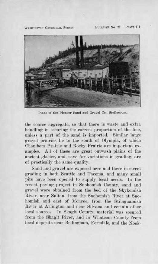
III. Plant of the Pioneer Sand and Gravel Company, Steilacoom 29
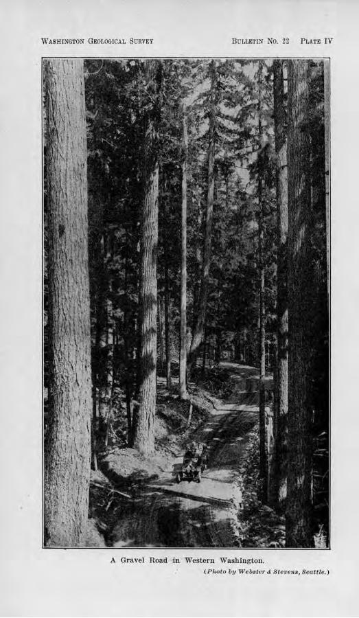
rv. A Gravel Road in Western Washington.................... 37
V. A Gravel Pit Used Without Stripping Away the Soil....... 43
VT. The Apple Way, East or Spokane......................... 47
VU. A Double Cone, Secured in the Compressional Strength Tests . . . . . . . . . . . . . ... . . . . . . . . . . . . . . . . . . . . . . . . . . . . . . . . . 58
VIII. The Usual Type of Gravel Exposure Found Along the Olym-pic Highway, West Side of Hood Canal................. 64
IX. A Gravel Outwash Plain in Thurston County and a Highway Constructed on It by the Removal of the Coarse Material 71
FIGURES. Paue
1. Outline Map of Adams County .. ........................... . 103 2. Outline Map of Asotin County .............................. 108 3. Outline Map of Benton County . ....... ... ........... .. ...... 113 4. Outline Map of a. Portion of Cl1elan County. . . . . . . . . . . . . . . . . . 1Hl 5. Outline Map of Clallam County. . . . . . . . . . . . . . . . . . . . . . . . . . . . . 125 6. Outline Map of Clarke County. . . . . . . . . . . . . . . . . . . . • . . . . . . . . . 130
7. Outline ?\·rap of a Portion of Columbia County ............ ... 135 8. Outline Map of Cowlitz County . ....... .... .... ... .......... 13!J 9. Outline Map of the Main Portion of Douglas County ......... 14::l
10. Outline Map of Ferry County .............................. 151
11. Outline Map of Franklin County . .......................... 155
12. Outline Map of a Portion of Garfie ld County. . . . . . . . . . . . . . . . . 16!1 13. Outline Map of Grant County ... ................ . ........... 102 14. Outline Map of Grays Harbor County . . . . . . . . . . . . . . . . . . . . . . . lG!l 15. Outline Map of Island County ................. . ........... . 174 16. Outline Map of a Portion of Jefferson County ................ 176 17. Outline Map of a Portion o.f King County . . . .. .... ...... . ... 180 18. Outline Ma-p of the Main Portion of Kittitas County. . . . . . • . . . J.87 19. Outline l\'[ap of a Por t ion of Klickitat County ....... ......... 191 20. Outline Map of the Main Portion of Lewis County ... . ........ 196 2 t. Outline Map of Lincoln County.. . .. . . . . . .. .. . .. .. .. . .. . . .. . 201 22. Outline Map of Mason County .. ... ..... . . ........... .... ... 210 23. Outline Map of the Main Portion oC Okanogan County ..... ... 213 24. Outline Map of Pacif:lc County. . . . . . . . . . . . . . . . . . . . . . . . . . . . . . 219 25. Outline Map of Fencl Oreille County . . . . . . . . . . . . . . . . . . . . . . . . . 225 26. Outline Map of a Portion of Pierce County ......... .... . .... 230 27. Outline Map of a Portion of Skagit County .................. 235 28. Outline Map of a Portion of Skamania County. . . . . . . . . • . . . . . 238 29. Outline Map of Snohomisb County ................... • . . .... 242 30. Outline Map of Spokane County ........................... . . 247 31. Outline Ma(J of Stevens County. . . . . . . . . . . . . . . . . . . . . . . . . . . . . 257 32. Outline Map of the Main Por tion of Thurston County . . . . . . . . 263 33. Outline Map of tbe Main Portion or Walla Walla County. . . . . 266 34. Outline Map of a Portion of Whatcom County .. ... . ......... 273 35. Outline Map of Whitman County ................ ............ 278 36. Outline Map or the Mai.a Portion of Yakima C-0untr. . . . . . . . . . 287
THE ROAD BUILDING SANDS AND GRAVELS OF WASHINGTON
CHAPTER I .
INTRODUCTION.
The problems of road-building have been re\7olutionized within the last few years by the almost universal change from horse-drawn, steel-tired conveyances to motor-driven vehicles. This change has brought heavier loads, greater speed, and increased traffic for our highways to bear. Not only has the traffic become more severe, but a new mode of destruction has been introduced. Instead of confining the wearing processes chiefly to abrasion and crushing, as was the case with the steeltired, horse-drawn vehicles, the driving wheels of motor cars viciously attack the ]if e of a road by shearing the constituents from their position and tru:owing the loose materials, together with the binder, from the wheel courses. Thus the need of greater maintenance bas become imperative and the cost increased. On the main highways, howe·vor, where the traffic is e.xceedi11gly heavy, even maintenance has been found to be insufficient and uneconomical, and highway engineers have turned to some type of paving in their recommendations to meet traffic demands.
CHOICE) OF MATERIALS IMPORTANT.
Under the new conditions a careful selection of materials to be used in ordinary macadam for light to medium traffic and in paYement for heary traffic has assumed great importance. Other things being equal, the life of a road is thereby increased and the cost accordingly lessened.
16 Bulletin No. 22, W a,sh,ington Geological Sumey
In 1911, the Washington Geological Survey conducted a sru·,--ey of the bedrock formations of the state and collected a large series of samples which were tested for road-building purposes. The results were published in Bulletin No. 2 of the S1.1rvey's series. Since that time gravels have come more and more into use for road surfacing, due largely to their ready availability as contrasted with the expense and labor of quaITying and crushing the hard rock. At present gravel is used predominantly for road-metal in the majority of the counties.
The chang~ from crushed rock to gravel was a change to a type of material which had not pr eviously been studied. The general distribution and quality of the gravel deposits in the different parts of the state ·were only partially known. H ence, the need of a study ,;vas apparent and the Washington Geological Survey was authorized to undertake the work, the results of which are published in the following pages of this bulletin.
FIELD S'fUDIES.
THEIR CHARACTER.
All of the counties of the state which have important highways were traversed during this investigation. Foru.· counties which are dependent chiefly on water transportation were not surveyed, these being San Juan, Island, Kitsap, and Wahkiakum.
Usually the county being studied was surveyed in company with the County Engineer. The representative gravel pits and many of the minor ones were examined for the purpose of observing the character of the material as it occurs in the natural deposit, its availability, and of determining its geologic relations so that its probable extent might be inf erred in areas where there might be future need for such materials. In Chapter V, in connection with the discussion of each individual county, a small map is included showing the probable ex-
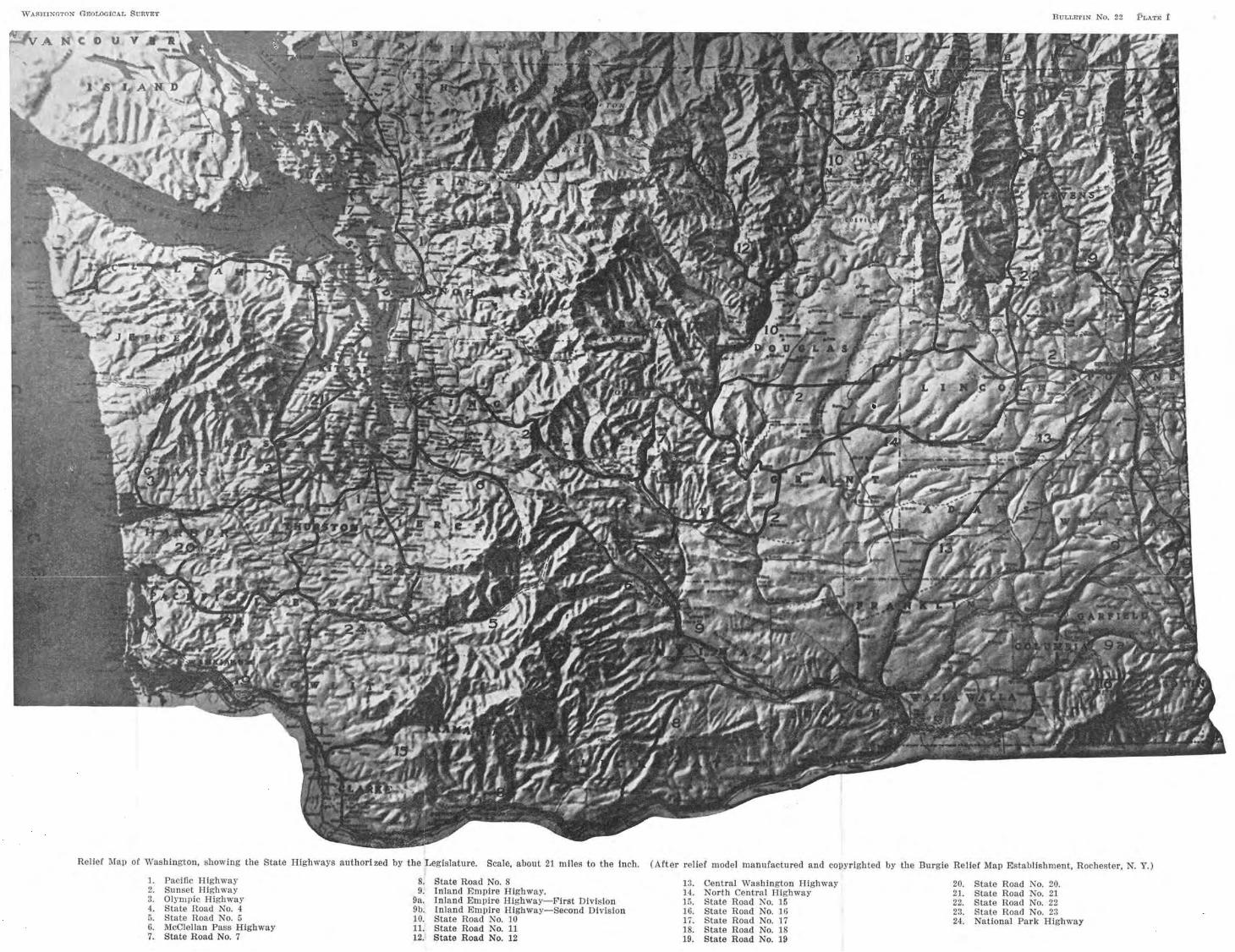
WASHlNGTON GEOLOGICAL SURVEY ButtEr1N No. 22 PLATE t
Relief Map or Washington, showing the State Highways authorized by the Legislature. Scale, about 21 miles to the Inch. (Arter relier model n1anufactured and copyrighted by the Burgie Relief Map Establishment, Rochester, N. Y.)
1. Pacific Highway 8. State Road No. 8 13. Central Washington Highway 20. Stale Road Ko. 20. 2. Sunset Highway !l. Inland Empire Highway. l4. North Central Highway 21 . Slate Road No. 21 3. Olympic Highway 9a. Inland Empire Highway-First Division 15. State Road No. 15 22. State Road No. 22 4. State Road No. 4 9b. Inland Empire Highway-Second Division 16. State .Road No. 16 23. State Road No. 23 5. State Road No. 5 10. State Road No. 10 li. State Road No. 17 24. National Park Highway 6. McClellan Pass Highway 11. State Road No. 11 18. State Road No. 18 7. State Road No. 7 12. State Road No. 12 19. State Road No. 19
Road Building Sands and Graveis 17
tent of the gravel formations, as well as several of tho c11ief gravel pits from which material is being obtailleu ind from which samples were collected for testing.
SCOPE OF THE STUDIES.
The studies made were, therefore, of a two-fold nature: A :field examination to determine the nature, eX·· tent, and manner of occurrence of tbe gravel deposits; ana laborntory tests to ascertain their probable quality for gravel macndam and the various forms of pavement iu which sand and gra~el arc use<l. As a result of ona senson 's field work a11cl some months of laboratory investigation, a definite knowledge of the gravel formations of the whole state, and of their quality, was gained, and a basis formed for more extended studies in the future, as increased traffic demands may necessitate. It was impossible, however, to cover most of the counties in detail. When the large area of the sta tc is taken into consideration, it is obvious that the amount of work which can be done in one season limits the investigation to little more than a careful reconnaissance. To cover one county in detail, to make scores of test-pits at. 1JCW points in order to ,rerify the actual existence of suitable materials, to collect samples from each place, and to put them through a series of tests to determine their adaptability for various road uses, would rcqufrc several mouths I time, and the aid of several assistants. And to co,~cr the thirty-nine counties of the state in this way woulu obviously consume several years. .K either time nor funds were available for such intensive study, but it is believed that ample data were obtained to meet the needs for the next seYeral y-ears1 and a basis laid for more extended studies in the future.
The samples were collected partly from pits now in operation and partly from gravel soru·ces not yet touched. They were so chosen as to represent as nearly
-2
18 Bulletin No. 22, W ashitigton Geological 8utvey
as possible the average run of the material. The size of most of the samples was approximately :fifty pounds, but in some cases a smaller amount was taken, the amount depending on the number and the kinds of tests desired.
INSPECTION OF THE MATERIALS 1N SEJRVICE.
In almost every case an inspection of the roads was made to determine the wearing and cementing qualities of tlte materials in actual service. These inspections were made in most cases with th£> C01mty Engineer, who was usuaHy ab]e to supply the desired information as to how long the materials had been in use, the means used in grading the m~terials in the process of surfacing, the thickness of the surfacing, the manner of spreading, the mode of packing the material, the roadiness with which it packed under tTaffic, the plan of 11p
keep and patrol, and various other items of information which should be in hand for properly judging and comparing the wear of road materials in actual service, under a given set of conditions. Such information was also desired in the interpretation of laboratory r esnlts, but in the testing it was not possible in all cases to gauge the tests and make a thorough scientific anal)1sis of the problems presented, due to the fact that the T esting Engineer in charge had but limited ti.in<! in preparation for army service, and after his departure another technically trained man conld not be obtained. However, as far as possible it was the first principfo of this investigation to judge the quality of a given roadmetal by its efficiency in actual service, where ~mch knowledge was at hand.
NEE-0 Oil' TRAFFIC CENSUS.
There are some factors which limit any attempt to judge the efficiency of a given gravel in actual practice or to compare its efficiency with that of another gravel.
Road Bwildin,g Sands and Gravels 19
One of these factors is the diff erencc in the amount of traffic which cli:fferent roads may have or different parts of the same road may Cc:'l.rTy ; also the character of the traffic with r espect to type of vehicles used, whethe1· automobiles, trucks, wagons, or buggies; tho size or weight of loads carried and their p1·oportion to the total traffic; the dominant rate at which they travel, whether tbe road is chiefly a thoroughfare for local tTaffie of ordinary speed or a highway followed largely by cross-country tourists; the time of year at which the most severe traffic occurs, whether at a time when the road materials are so thoroughly dry that they ravel most easily, or during the wet season when the wheels are likely to cut deeply, or at an intermediate . season when the amount of moisture in the ground is just right to afford the maximum strength in bearing power. In addition to these there are other .factors such as mode of construction, time of construction, character of maintenance, etc., etc., which limit the degree to which the efficiency of a metal ou 0110 road may be confidently compared with the metal on anoil1er road.
A better basis, howe,er, may be afforded in the future for such comparisons when the engineers in churge of the highways in the different counties have instituted a scientific system of ascertaining lhc traffic demands on a givcm highway and records made of the same. In a £cw counties considerable data J:iavc bee11 collected in this respect, while in most counties little more than an initial attempt has been made and rn some counties none. A record for one year means something, but lacks scientific thoroughness and dependability. A traffic census of several years' duration is by all means to be preferred.
The terms "light traffic", "medium traffic", and "heavy traffic" arc variously use<l and do not seem to
20 Bulletin No. 22, Washvngton Geological S.urvey
have a commonly accepted meaning. Some engineers employ the terms in a comparative way in speaking of the different amounts of traffic on the diffeTent 1·oads in their own county. A cei·tai.n highway may average less than 250 vehicles per day, but if this happens to be the laTgest record in the county, the highway carrying such traffic is said to have "heavy traffic", and the others are classified as "light" or " medium " , according to the general estimate. Again, some use the terms with respect to the average weight of loads hauled over a given road.
Thus, confusion is bound to arise in the interpreta.tion. of just what is meant in the use of these t el'ros. Accordingly, it would seem expedient and wise to define such terms and urge a common acceptance of Ruch usage. Attention is therefore called to the definition of these terms by the Office of Public Roads and Rural Engineering, appearing in Bulletin 370 of the U. S. Department of Agriculture, Office of Public R oads and Rural Engineering, page 9. Here " light t r affic" is defined as a traffic of less than 100 vehicles per day; "moderate traffic", 100 to 250 vehicles per day; "heavy traffic", over 250 vehicles per day.
GENERAL KINDS OF LABORATORY TESTS MADE.
The kinds of laboratory tests which were made on a given sample depended upon what kind of service it was likely to be put iu the future, whether for road surfacing, concrete pavement, or some other form of road service. In a few instances, however , samples were tested for their value in Portland cement concrete, not because the gravel of that vicinity was likely to be used in paving, but to determine its value for br idge pm-poses and other local uses.
Besides the tensile strength tests and tests of the or ganic content of the sands, chemical analyses were made
Roatl Building Sands aml Gravels 21
to determine whethe1· or not a.Jka)j was pres<mt in t11e sands and gravels of Eastern Washington. ]field compressional tests were also made of tho concrete pavements which were being laid iii several of the counties, including Whatcom, Skagit, Pierce, Spokane, Thurston, aud King.
ACKNOWLEDGl'.rENTS.
Appreciation is herewith acknowledged of the services of the various County Engineers, who so heartily cooperated in this study by giving of theiT time and lrnqwleclgc of local conditions and in most cases by personally conducting the investigator OYer their respective counties, thus making it possible nol only to examine the various deposits but to note the actual service which the materials were rnndering on the roads.
Sincere thanks are also extended to Ur. James Allen, State Highway Commissioner, and the members of his Department, .for sen"ice and counsel cheerfully gi vcn. .Much aid was also given by :Mr. C. N. Reitze, District Engineer of the Portla1ld Cement Association, and his assistants. Helpful counsel was generously contributed by Prof es soi: A. H. Fuller, formerly Dean of the College of Engineering of the State University of Washington, by Mr. R. H. Thomson, Consulting Engineer of Seattle, and others whose judgment in matters of highway construction is especially Yalued.
The tests on the samples collected were under taken by :Mr. A. W. Swattz, formerly Chemical Engineer of Snohomish County, wl1ose technical training and expel'ience :fitted him for this work. The various lines of investigation were in part nearly completed and in part well stm·ted when he was cRlled for war service. Subse'l_uently, the remaining concrete cylinders whiC'h had not been previously broken, were ably tested fol' their compressional strength by :Mr. Everett G. Snell, Instructor in Civil Engineering, in the State University
22 Bulletin No. 22, Washington Geological Survey
of Washington. The completion of the other tests was accomplished partly under the latter's direction and the writer's, and by the aid of various students from the University whose services, though inexperienced, were fortunately secured at this time of shortage of skilled labor due to war conditions.
CHAPTER II.
GEN1DR.AL DISTRIBUTION OF THE SAND Al~D GRAVEL FORUATl ONS OF WASIDNGTON.
GENERAL STATEMENT.
Deposits of sand and gravel are genei-ally abtmdant in the northern part of the state, where extensive glaciation occmrred during the last Glacial Epoch. This is generally the case in any area in the United States where the effects of the last glacial action wel'e felt. The Puget Sound region, the Olympic Mountains, the northern Cascades, and the Okanogan Highlands were all intensively glaciated, and in these sections a plentiful supply of sand and gravel may be found, with but few exceptions. Fortunately, sand and gravel were canied by streams for long distances south and west from their glacial source, thereby giving these materials a more extensive distribution than would have been the case if confined to the glaciated ar·ea. The Chehalis River Valley is an excellent example on the west side, while the Columbia River Valley, the Spokane River Valley, numerous coulecs which cross the Columbia Plateau, and the Snake River Valley may be cited for the east side.
Unfortunately, the Willapa Hills of southwestern Washington, the Palouse Country of easte1·n Washington, and the uplands south of the Snake River were not glaciated, neither were these affected to any notable extent by glacial ch·ainage. Consequently there is a scarcity of good sand and gravel deposits. In most instances recourse must be taken in these piuts to crushed rock for road-metal, except where railroad or motor truck transportation can be economically employed in bringing in sand and gravel.
The gravels of Washington vary so widely in kind, quality, and occurrence that a general description will hardly suffice. However, within a given area they have
24 Bulleti,n No. 22, W ashvngton Geological Sqirvey
similar characteristics to a COllSiderable degree, thus making it possible to discuss more clearly the actual qualities of the sand and gravel by districts or provinces.
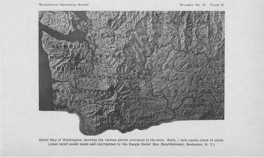
The state, for this pru·pose, may be divilled into eight gravel provinces, as shown in P late II, three on the west side, four on the east, and one along the Columbia River Gorge. The thl:ee on the west side are: the Olympic Mountain Province, the Puget Sound Province, and the Southwestern Province. The four on the east side are: the Okanogan Province, the Columbia Plateau Province, the Yakima River Province, and the Blue Mountain Province. The one along tbe Columbia River Gorge through the Cascade Mountains may be termed the Columbia Gorge Province.
DESCRIPTION OF THE SAND AND GRAVEL DEPOSITS BY PROVINCES.
OLYMPIC MOUNTAIN PRO\-r:L."'ClD.
The Olympic Mountain Province, as shown in Plate II, includes all of the counties west of Puget Sound and north of the Chehalis River. These are Mason, Clallam, and J o-fforson counties, and the northern two-thirds of Grays Harbot County.
The counties adjacent to the Sound and to the StTait or Juan de Fuca were affected by the glaciation_ of Puget Sound, and in many places there a,re extensive deposits of gravel typical of the P ug·et Sound region. This is especially true of Mason County ru1d of the Olympic Highway where it follows Hood Canal. The gravel is generally firm and tough, well rounded, and of the granitic and siliceous variety. In most cases, it may be obtained directly from the roadside, thus making road constTuction and maintenance a simple matter so far as surfacing is concerned. 0)1 the peninsula on which PoTt Townsend is situated the gravel is present in µatches but not abundant. In several cases, good pits are situated
W/\S:R:INOTON GEOV~OICAL SURVflY BuuLETIN No. 22 PLA.T.E ll
Relief Map of Washington, showing the various gravel p rovi11ces i11 the state. Scale, 1 inch equals about 44 miles. (After relief model made and copyrighted by the Burgie Relief Map Establishment, Rochester, N. Y.)
26 Bulletin No. 22, W as1vington Geological Siwvey
several miles from where the material is needed. Aside from the fact that the deposits are scattered, much of the country is wooded or covered with underbrush, thus obscuring such landscape features as suggest gravel content. The materials along the beach south from Port Townsend are too sandy to use without screening out the excess portion.
Clallam County is more fortunate. A large gravel flat exists for several miles on either side of the Dungeness River, from which material of excellent character can be obtained, save where it is locally coarse and bouldery. Large deposits are being drawn upon where the Olympie Highway crosses Morse Creek, and local deposits occur southwest of P ort Angeles. A cemented conglomerate is bejng q~anied and ~rushed near Joyce which has especially good qualities of cementation and wearing value. Beyond Lake Crescent gravel occul's continuously in a bl'oad belt along the Solecluck River to the coast. Some of the pebbles are soft, but in the main the gravel is good and well graded, and its occurrence :in such Jarge quantities along the roadway makes the situation extremely favorable, and especially so during tbe present time of large -spruce production.
South of the Olympics, abundant gravel is found along the Chehalis River, but the intimate relations of good and poo1· material r equire caution in making selections. West of Montesano, the tributary streams to the Chehalis RiveT contain low benches of gravel which have so much soft material that it cannot be used at all for good concrete and only for surfacing secondary roads having the lightest traffic. East of Montesano, however, such tributaries to the Chehalis as the· Satsop River, the Cloquallam River, and Mock Chehalis carry good gravels. All along the Chehalis itself there aregravels of first quality which are like those of Puget
Road, Buuding Sc11nds a;nd Gravels 27
Sound and which, in fact, are a part of the same glacial outwash. They occur both in benches along the stream and in the stream itself. Those in the stream-bed are somewhat superior for concrete, due to the constant washing of the waters and the consequent elimination of soft material. After a mile or so below Montesano, in the lower reaches of the stream where its cunent is sluggish, tl1e sand and gravel are mixed with a large amount of silt, thus discouraging any attempts to obtain material here.
PUGET SOUND PROVINCE.
The Puget Sound Province comprises all of the counties adjacent to Puget Sound on the east and south, and, in addition, the counties of Kitsap, Island and San J uau (Plate II). This province has some of the best gravels to be obtained anywhere. Those at Steilacoom, southwest of Tftcoma, arn perhaps as well known as any. They are composed of gi·anites, diorites, basalts, quartzites, and other :firm and siliceous rocks, and are well graded. Great quantities are exposed here in the bluff overlooking Puget Sound.
Other similaT occuuences are farther south, near the property of the Du. Pont Powder Works, and farther north in the south part of Tacoma, on Vashon Island, at Three Tree Point, at Richmond Beach north of Seattle, on Whidby Island, and elsewhere. In most of these instances, the deposits are so situated in bluffs 100 to 300 foct high that the material can be easily excavated, brought down by gravity, screened, washed, and put into loading bunkers or cars, boats, trucks or other convey,. ances. ( See Plate ID).
On the upland southwest of Tacoma, there is an extensive gravel plain of fresh and firm mate1·ial. Pierce County has opened a large pit in this deposit at Lakeview. For concrete, this gravel contains an excess of
WASHINGTON GEOU>GtCAL SURVEY BULLETIN No. 22 PL,\'l'.E Ill
Plant of the Pioneer Sand and Gravel Co., Steilacoom.
the coarse aggl'egate, so that there is waste and extra handling in securing the correct proportion of the fine, unless a part of the sand is imported. Similar large gra.vel prairies lie to the south of Olympia, of which Chambers Prairie and Rocky Prairie are important examples. All of these are great outwash plains of the ancient glacier, and, save for variations in grading, are of practically the same quality.
Sand and gravel are exposed here and there in street grading in both Seattle and Tacoma, and many small pits lla,7 e been opened to supply local needs. In the Tecent paving project in Snohomish County, sand and gravel were obtained from the bed of the Skykomish River, near SuUan, from the Snohomish River at Snohomish and east of :Monroe, from the Stilaguamish River at Arlington and near Silvana and certain other local sources. In Skagit County, material was secured from the Skagit River, and in W'hatcom County from local deposits near Bellingham, Ferndale, and the Nook-
Road Build'ing Sands amcl Gra'Vels 29
sak River near Nugent's Bridge. The sand and grave] along the N ooksak River and the Skagit River contain some pumice from Mt. Baker which make them somewhat inferior to the gravels fnrther south in this ProYince.
SOUTirn'ESTJ!JRN PROVINCE.
The Southwestern Province includes all of the area south of the Chehalis River and south of the ThurstonLewis Com1ty line. It comprises Lewis, Cowlitz, Clarke, Wahkialum1, and Pacific counUes, and the southern part of Grays Harbor County (Plate II).
This province is abnost entirely devoid of anything like the glacial gravels of Puget Sound except that small portion of the Chehalis Valley from Oenb:alia no1-th, which was invaded by glacial outwash through the Skookumchuck Valley and across :Mound Prairje. The Twin City Sand and GTavcl Company of Centralia has opened a large pit in these deposits.
Gravels of inferior quality for concrete, but suited for roads of light traffic, are found along the north and south forks of Newaukum River, aucl fairly hard basaltic gravels along the headwaters of the Chehalis RiYer near J)oty a11d Pe Ell. Along "\Villapa River, Nern.ah River, and Nasel River, in Pacific County, there are also gravel bars scattered along the streams, and some gravel benches, but in no case is the material fit for concrete work. On the west side of Long I sland, in Willapa Harbor, thel·e are sands which are different in character from the others of the province and which might be used for concrete if the organic content can be r emoved by washing. The N al1cotta Saud and Gravel Company of Raymond obtain their sands from here. The pebbles in this deposit are small and too few in proportion to the amount of sand to supply coarse aggregate, without wasting an excess of the sand.
30 Bulletin No. 22, Washington Geological Survey
A few gravel bars are distributed along the Cowlitz R.ive1·, as at Castle Rock, but usually, the abundance of cobbles necessitates crushing and the larger proportion is composed of fairly dense pumiceous rocks. Along the Columbia there is considerable bank-gravel, but too frequently it is interbedded or overlain with so much clay as to make it difficult and costly to handle. Along the North Fork of the Lewis River the gravels contain considerable soft pumice, which make them doubtfully good even for concrete sidewalks or £01· surf acing highways with light traffic.
In Clarke County there is a wide area of upland gravels bordering the Columbia River which in most localities unfortunately contain enough decayed and soft pebbles to prevent their being· used for other than road surfacing. At Vancouver, sand for concrete is brought by J\1Iinsinger BrotheTS and Company from the Columbia River near Ellsworth, where it is dredged from the middle of the river; masonry sand from the vicinity of the inter-state bridge, and gravel for coarse aggregate from the ·willamette Valley.
COLUMBIA GORGE PROVINCE.
The Columbia Gorge Province includes Skamania and Klickitat counties and the southern part of Benton County (See P late II).
At the present time no highway runs continuously along the north side of the Columbia River between Collins and Underwood. In many places along this stretch sheer cliffs of basalt project to the water's edge in picturesque fashion, and e2qJensive blasting will be necessary to make a r.oa:d. Elsewhere along the Columbia River, gravel may generally be found. In some cases it is found on high benches, as at the towns of White Salmon, Lyle and Cooks; in ~ther. cases close to the river level, as west of Fallbridge. .The hlgnei· material is
Road Building Swnds and Gravels 31
usually no larger than pea-gravel, although firm, whereas the lower material has a wider range in size and is -fit for concrete. Large quantities of the gravel near Fallbridge were used in the concrete piers of the S., P. & S. Railway bridge across the Oolumbja at this point. At Maryhill, on the property of Mr. Samuel Hill, there is an excellent deposit of clean, coarse, basaltic sand, which has been found by the County Engineer to be satisfactory for concrete.
YAKIMA RIVER PROVINCE.
The Yakima River Province includes those counties through which Yakima River runs, viz. : Kittitas, Yakima, and the northern part of Benton County (Plate II).
The gravels of this provjnce have a general dishibution along the line of the gTeatest population, that is, along the river, but they vary widely in kind and quality. The gravels occurring in bars on the flood-plain are practically the only ones .:fit for concrete. The selection of these, however, is usually attended with some uncertain factors, for the proportion of sand is low in some cases, or where it is in abundance it is prone to be too fine. The conditions are also likely to change from year to year as the floods come and go and the material in the stream-bed is shifted. Rising above the floodplain there is a gravel formation of erratic distribution, locally known as '' cement gravel'' and known to geologists as the Ellensburg Formation. It occurs on both low and high elevations. Its content of soft pebbles is in some cases so high as to limit its service to roads of light traffic. On Badger :Mountain, west of Sunnyside, there ar~ gravels, aside from the soft variety, which consist mostly of flattened quartzite pebbles and a few granites, with a :fine sand matrix. These have poor cementing qualities. Along the Columbia River a somewhat similar condition prevails, in that the sand of the
'32 Bulletvn, No. 22, Washington Geoiogfoal, S1vrvey
gTavels is too fine to permit packing. In the vicinity of Richland, on bars of the Columbia, thero is a reddish clayey gravel which has been used to some extent 011 the roads with fair wearing results.
OKANOGAN PROVINCE.
The Okanogan Province comprises all of the coui1ties north of the Spokane River and north of the Columbia RiveT down to Wenatchee. The counties so included are Chelan, Okanogan, Ferry, Stevens, Pend Oreille aucl the northern part of Spokane County (Plate II) .
.Along the Wenatchee River a large variety of gravel occurs, ranging from sandy clay to sandy gravel and bouldery gravel. The flood-plains of the stream contain perhaps the best material for concrete purposes, but commonly the pebbles are so large as to necessitate crushing. In the northwest part of Wenatchee, along the Wenatchee River, pits have been opened in materials which may pTove satisfactory for concrete. Below Wenatchee, on the east side of the river, the Columbia Engineering and Construction Company operates a pit in a small ridge of gravel to meet local demands. The materials are firm, the sand has good range, and there is but little oversize.
Along the Columbia River east of Brewster and along the Okanogan River to a point north of Tonasket there are high benches composed of silt, sand, and gravel, mostly below the 1700-foot level. The materials, however, are so intermixed and interlayered with a notable percentage of silt that usually the amount of suitable grMrel which can be obtained is small. There are, of course, some exceptions, as at Tonasket and Omak. At the latter place the Omak Cement Products Company is using sand and gravel for making concrete irrigation and culvert pipe.
Roacl Building Samls amcl Gravels 33
Almost the whole length of the Columbia River, along the west side of Stevens County and through the northern part, is bordered by a tenace of silt and fine sand witb. local lenses and pockets of gravels, which, because of their Iine sandy matrix, aTe poor road-metal. Above the 1700-foot level, better graded gravels cau be found in local deposits.
In Stevens County, gravels occur at high levels in 1·emnants of old tenaces along the Colville River, frequently with an excess of sand. At Addy, on the west side of the river, a pit has been opened in a high bench ex.'Posing gravels of good quality but carrying a low percentage of pebbles larger than one inch :in size. For road surfacing this is excellent. East of Colville the gravel beneath Church Flat is too sandy for surfacing purposes, but with screening would be satisfactory. The low benches along the Colville River consist almost enti.J:ely of fine silt. Near Meyers Falls, the river has cut a small canyon in these silts in its rapid descent to the Columbia River, exposing good sectious to view.
In Pend Oreille County, gravels are found gener'ally in high terraces along the Clark Fork as far north as Ione, and southwest of Newpott along the ancient channel of the Pend Oreille River. Material of a wide range of quality and sizes and rounding may be found here at different levels and localities.
Along the Spokane River, east of the city of Spokane, a wide flat is underlain with gravel to a great depth, which represents glacial outwash from the Coeur d'Alene Mountains. Many pits have been opened to supply the needs of the county for miles around. At different levels and at different places the material varies in size and lrintl. On the broad flat the gravels are conspicuously granitic, on the high benches basaltic. Both are :firm and sound, but the gravel on the flat seems to have a defi-
34 Bidletim, No. 22, Washington Geological Survey
ciency of sand, while the high benches have a deficiency in gravel, but there are exceptions. In the northern paTt of the county local deposits of glacial gravel are generally distributed, as is also the case west of the river and north of Cheney.
COLUMBIA PLA'rEAU PROVTNCE.
All of the area south and east of the Columbia River, south of the Spokane River, and north of the Snake River is herein considered as the Columbia Plateau Province. The counties are Douglas, Lincoln, Grant, Adams, Whitman, Franklin, and the southern part of Spokane (Plate II).
This province is quite different from the Okanogan Province in several ways. The topography is that of a somewhat broken plateau, the area is unglaciated except along tho northern border, the gravels occur chiefly in conlees which are now almost stream1ess, and the gravels ru:e almost entirely basaltic in composition.
When the ice sheet which covered the Okanogan Mow1tain area, lapped upon the northern border of this district, the normal drainage of the Spokane and Columbia rivers was diverted across the plateau in numerous courses, now known as coulees, having a south to southwest direction. The Grand Coulee was one of these. The coulees were filled to a considerable height, and later much of the sand and gravel was eroded away, leaving but 1·enmants of the former deposit. In many cases these remnants occur and are to be looked £or, in protected places on the southwest side of isolated hills of rock, or in the recesses of small tributaries. The Sunset Highway from Waterville to Spokane crosses these old water-courses time and again, and the Central Washington Highway follows one or more most of the way from Pasco to Spokane.
Road Building Sands amJ Gravels 35
The gravels are generally used for road surfacing, and for this they a1·e excellent. In many localities they are the proper size to use without screening, whereas in others there is enough oversize to warrant crushing. Many deposits of coarse sand and pea-gravel have been opened for use as road-dressing. Selection for concrete work must be made with care. Frequently the sand runs coarse without enough :fine to :fill the matrix or the peb . bles are small and too low in proportion. In some cases, too, the pebbles are coated with lime, or cemented together in small lumps, which unfit them for concrete work The pea-gravel and coarse sand usually occur in the recesses of small tributaries where the glacial waters were not so torrential and conditions were proper for the deposition of the fine.
In Whitman County, except in the nOTthwest portion, these conditions do not pTevail. There are large areas of this fertile wheat country where no gravel is to be found. The streams did not carry glacial drainage and hence tbis region is without the benefits of a well distributed deposit of sand and gravel. It is fortunate, however, that the gravel area in the northwestern portion of the county contains a sufficient abundance at Rosalia, Ewan, Gravel Station, La.Crosse, and other places to supply the remainder of the county, but, of course, the cost of transportation limits their use.
BLUE MOUNTAIN PROVINCE.
The counties lying south of the Snake River-Asotin, Garfield, Columbia, and Walla Walla counties-are included in this province (see Plate II). With perhaps the exception of the Southwestern Province, it is the most destitute of available sand and gravel deposits in the state. None of the glacial outwash from the north reached beyond the Snake River, and it is thought that
WASHINGTON GEOLOGICAL SORVEY BULT,ETu~ No. 22 PLATE IV
A Gravel Road in Western Washington. (Photo by Webster & Stevens, Seattle.)
Road Building Scunds OJ1'ld Gravels 37
the Blue Mo1mtains had no glaciers, unless possibly at the head of the WaJla Walla aucl Touchet rivers. These two streams contain gravel scattered along their courses in bars which have been drawn upon for use on the Inland Empire Highway and local roads cast of Walla ~.,.alla to Dayton. In the latter locality they are coarse and should be crushed before being used. Taken as a whole, they are generally pm-tly lacking in binding quality. Benches of gravel are distributed along the Snalce River, but the great depth of its valley is au obstacle in utilizing them, except at a few places, as at Clarkston in Asotin County. Asotin Creek, west of Asotin, contains coarse material, which, if run through the crusher pit-run, would undoubtedly prove satisfactory for the highway in that vicinity. The roads of Garfield County and on the uplands of Asotin County must be surfaced mostly with crushed tock.
CHAPTER ill.
S.A . .ND AND GRAVEL FOR GRAVEL MACADAM.
The kinds of laboratory tests to be performed upon samples of sand and gravel for gravel macadam should be determined by the nature of the demands which traffic makes upon the material. At the present time the nature of these demands should be considered in the light of motor traffic, for although the percentage of motor vehicles as compared with horse-drawn vehicles is perhaps not so high in the agricultural sections as in the
urban districts, yet the use of the automobile has become important even in the remotest parts of the state, and will become increasingly so. Because of increased production incident to war conditions, and the priority orders of the government for the transportation of war materials by freight, the tonnage of motor truck haulage on the state's highways has gone beyond all predictions, and promises to remain a strong competitor of railroad transportation after the war.
TlIE ESSENTIAL REQUIREMENTS OF A ROAD GRAVEL.
'rhe gravel in a gravel macadam is subjected to impact, which tends to break and displace the constituents; to compression which tends to crush the pebbles; to abrasion by the shearing of the driving wheels of motor cars and the slipping or skidding of the wheels; and to deterioration by climatic agencies which tend to blow, or wash, the fine cementing materials away and disrupt or weaken the road-bed. These severe conditions demand a gravel which is made of hard and tough pebbles, properly graded according to the vru·ious sizes so as to give the maximum degree of compactness and density; and which contain a sufficient amount of clay of the
Road Buildvng Soods and Gravels 39
quality that will cement the materials together and yield a minimum of displacement.
The wheels of motor cars develop a grinding or shearing action between the wheel and ihe road when the machine by its own power is gaining speed, or when the wheels are made to drag by the use o:f: the brake, or when, in passing over uneven places, the driving wheels leave the ground and momentarily l'ace, causing additional shear in striking the ground again. The tendency of cars to slew in turning curves or in turning out to pass approaching vehicles produces much waste at the roadside, some of which is never brought back, even by careful maintenance. If the material is of insufficient thlckness, heavy hauling will cause the sub-base to yield, producing ruts, and this increase of irregularities is accompanied by increase in wear. Traction engines or heavily loaded trucks commonly initiate such results.
The state of Washington as a whole is not so severely affected by frost-action as are other states in its latitude. West of the Cascade Mountains deep freezing of the grou11d is exceptional, while east of the mountains the small amount of moisture in the ground diminishes the effect which would ordinarily result if the ground were full of moistu1·e. The chief effects of climate on gravel macadam in western Washington are: The saturation of the grom1d with the heavy rainfall of winter, thus weakening the bearing power of the road; and the drying out of the materials during the summer, thus weakening the cementing action of the clay in the macadam. and permitting the gravel to ravel. In eastern ·washington the gravel macadam is helped rather than injured by the moderate rains and snowfall of winter, but in summer the extreme dryness of the atmosphere so thoroughly removes the moistlll'e from the gravel macadam by evaporation that its cementing qualities are reduced to a minimum and the roads rut and ravel badly.
40 Bulletin No. 22, Wa.shington, Geological Survey
Winds arc also strongest at this time and the road is deprived of much of its binder. Unfortunately, too, the heavy hauling of marketing comes at this season when the f'fficiency of the roads is the lowest.
CHARACTER OF THE EXAMINATION AND TESTS MADE ON ROAD GRAVEL.
PJj;TROLOGICAL DETERMINA'rION.
One of the fundamental factors in judging the service-efficiency of a gravel is to ascertain its petrological composition, that is, the kinds of pebbles of which the gravel is composed. A gravel which is made up of pumice, or soft sandstone, or cleavable slate, or pebbles of merely hardened clay, or soft schist, or so.ft limerock, or any other kind of soft rock substance, or any combination of them, is evidently of little value for roadbuildiug. Granites, cliorites, gabbros, basalts, Thyolites, andesites, quartzites, and other siliceous rocks are, when unweathercd, usually very resistant and tough and give life to a road. If, however, these have been weathered so that they have become soft through cl1emical changes, then they are little better than the ones previously mentioned. In a report of a given gravel, if the composition is stated, together with the percentage of hard and soft, a fair basis is aheady pr ovided for judging its weaTing value for gravel macadam. Thus far, no satisfactory test has been devised to determine the toughness of a gravel. Their heterogeneity in composition and their wide range in shapes and sizes present difficulties in obtaining consistent results. Consequently consideTable reliance must be placed on the composition of the material together with other qualities to be considered.
HARDNESS TEST.
The percentage of hard and soft were approximately determined by taking 100 pebbles at random and classifying as "soft" all pebbles which are easily scratched
Road Building Sands and Gravels 41
with a knife, and as "hard" those not easily scrntched, if at all. This is a test which may well be used in the :field, but in the laboratory should be supplemented by the abrasion test.
A13RASION TEST.
Few states have thus far made abrasion tests on gravel aggregates, due to the fact that the standard abrasion test for rock is not satisfactory for pebble aggregates. A rnoclification of this test for rock has been made by the Ohio State Highway Department and adapted for dcter:minmg the per cent of wear of gravels. This test was recommended for general use by tho First Oonference of State Highway Testing Engineers and Chemists, called by the U. S. Office of Public Roads and Rural Engin('ering at Washington, D. 0., in 1917.
The aggregate is :first screened through screens baving circular openings 2 inches, J ii1ch, and ;1:z inch in diameter. The sizes used for this test are equally divided between those passing the 2-inch and Tetained on the 1-inch screen, and those passing the 1-inch and retained on the l/2-incb screen. The material of these sizes is washed and dried. The following weights of the dried stone are then taken: 2,500 grams of the size passing the 2-inch and retained on the 1-incb screen, and 2,500 g1·ams of the size passing the 1-inch and retained on the ¥2-inch screen. This material is placed in the cast-iron cylinder of the Deval machine as specified for the abrasion test on stone. Briefly descrilx~d, this machine consists of a frame and two or more cylinders mounted at an angle of 30° with the axis of rotation. The cylinders are of the following size : 20 cm. diameter by 34 cm. deep, inside dimensions. Six cast-iron spheres 1.875 inches in diameter and weighing approximately 0.95 pounds (0.45 kg.) each are placed in the cylinder as an abrasion charge. The iron composing these spheres is of
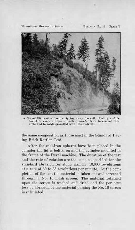
WASHINGTON GEOLOGICAL SURVEY BULLETIN No. 22 PLATE V
A Gravel Pit used without stripping away the soil. Such gravel is bound to contain organic matter harmful both to cement concrete and to roads gravelled with this material.
the same composition_ as those used in the Standard Paving Brick Rattler Test.
After the cast-iron spheres have been placed in the cylinder the li<l is bolted on and the cylinder mounted in the frame of the Deval machine. The duration of the test and tlie rate of rotation are the same as specified for the standard abrasion for stone, namely, 10,000 revolutions at a rate of 30 to 33 r evolutions per minute. At the completion or the test the material is taken out and screened through a No. 16 mesh screen. The material retained upon the screen is washed and dried and the per cent loss by abrasion of the material passing the No. 16 screen is calculated.
•
Road Biiilding San,ds an,d, Gravels 43
MECHANICAL AN.ALYSLS.
This test was made in order to show the gradation in sizes of the constituents and to afford a measlU'e as to how closely the sample from a given deposit measures up Lo standard specifications. The following mechanical analysis limits are recommended by the U. S. Office of Public Roads and Rural Engineering:
FOR USE IN THE BASE COURSE OF GR.A VEL ROADS.
All to pass a 2%-lncb screen ancl lo have at least 55 and not mol'e than 75 per cent retained on a 1.4 -lnch screen.
Al least 25 and not more than 76 per cent of the total coarse aggregate (material over ¥. Inch In size) to be retained on a 1-lnch screen.
At least 65 and not more than S5 per cent or lhe total fine aggregate (material under 'A, Inch in size) to be retained on a 200-mesb sieve.
These specifications jnvolve a mixture such that the vo'ids between the 1arge:r pebbles are filled with the smaller particles and the mass has a maximum of stability under the weight of traffic.
CEMEI\'TATION TEST.
A gravel which is made up of the most resistant pebbles is of little use for gravel macadam, if the constituents are not bonded together to withstand the disturbing action of traffic. The bond may be iron oxide, carbonate of lime, or clay having binding pToperties. Some deposits of gravel contain a natural binder while others do not. A good test in the field is the ability of the gravel in the natural deposit to stand with vertical face. Where it does not contain the proper cementing substance, the material slumps in the face of the pit. In such case clay must be added, and its selection should be made cautiously, for not all clays are good binding clays.
The tests on the cementing value of samples of gravel from various parts of the state were made upon the fine material which passed the 14,-inch sieve. Five hundred g1·ams were taken and placed in a ball mill with 90 cubic centimeters of water and 3 steel shot, each weighing 16% pounds. The sample was ground for 6,000 revolu-
44 Bulletin No. 22, Washvngton, Geological Survey
tions of the machine until a stiff paste was made. The pas:e was then taken from the ball mill and molded into briquettes one inch in diameter and one inch high, under a pressure of 132 kilogTams per square centimeter of 1877 pounds per square inch. Five briquettes were made of each sample and allowed to dry in the air for twenty hours, at the end of which time they were placed in an oven maintained at a temperaturn of nearly 200 degrees Fahrenheit and kept for four hours. When removed from the oven they were put in a desiccator for twenty minutes and then tested in the small Page impact machine. The number of blows required to destroy a cylinder was taken as the comparative bonding str ength of the mateTial used.
TENACITY T.EJST OF THE BINDER PORTION OF GRAVELS.
To supplement the cementation tests described above, tests were made on the tenacity OT coherency of the binder portion of the gravels. Since this test is made on the materials passing the 10-mesh sieve without grinding, while the cementation test was made on the materials after being ground, it is thought that this test would throw some light on the readiness with which the material would pack under traffic before there had been much chance for grinding action.
A stiff paste was made of the material passing the 10-mesh sieve and then molded into cyfu1ders, 25 mm. by 25 mm. (approximately 1 inch by 1 inch). These were thoroughly dried at a temperature of about 200 degrees Fahrenheit, and then broken with the small Page impact machine. The number of strokes necessary to break a cylinder was taken as the relative measure of its tenacity.
The plastic character and adhesiveness of clay can be fairly judged in the field by feeling the mud made from this material, by its adherence to the hands, and its
Road Bu11lcli11g Sands and Gravels 45
ability to stretch m1der light pu1ling. This test may be used in the field where a choice is to be made of two or more available clays for binding purposes.
RESULTS OF THEJ TESTS.
The results of the tests and examina Lions made are given in tabulated form in Table I. An inspection of the compositi.on of the gravels iu tho thfrd column will reveal the fact thl'lt practically all of the gravels in the state arc made up of igneous and metamorphic rockpebbles, most of which are nrm, durable ancl resistant to abrasion. There are few if any soft sandstones and shale rocks among them. In most cases they are either granites, diorites, quartzitcs, and complex metamorphic rocks, or basalts, andesites, and a mixture of the foregoing pebbles. Pumice ancl soft andesitc arc local in occurrence, the pumice being confined chieAy to the streams which <lrni11 from Mt. St. Helens or Mt. Baker, the soft andesites to the Yakima River Valley. In Pacific County antl in certaiu other localities the basaltic pebbles have been softened by decay, but when the state is considered as a whole and compared with other states, its quality of gravel deposits are believed to rank high.
G-RADATlON 011' THE VAJUOUS GRAVELS.
It would l.,e expected th.at the number of deposits containing gravel proper1y proportioned as to size would be few. Such is actually the case. In opening a pit in any deposit plans should be made either for screening out the oversize, or, if the proportion of excess size warrants, a crusher should be installed and all of the materials run through "pit-run." This not only pTovidcs mateTials of the proper size and better proportioned, but increases the amount of binder by the increment of rock-dust. Where the sand is in excess amount, a portion should be screened out to insure pro.f:itable and sat-
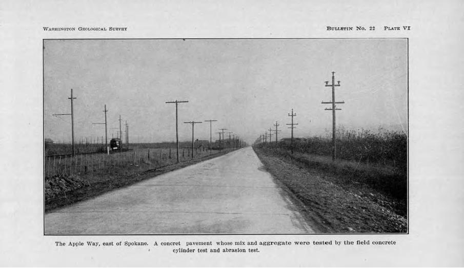
V,7 ASHINGTON GEOLOGICAL S1rRVmY B lrLLElTIN No. 22 PLATE Vl
~
'l'he Apple Way, east of Spokan.e. A concret pavement whose mix and aggregate were tested by the field concrete cylinder test and abrasion test.
Road Bi~itding Bands and Gra,veis 47
isfactory returns in 1:>aek:ing for the large amount of funds invested in the surfacing. E}.'Perienced highway engineers are aware of the difficulty of packing a sandy gravel, especially if the sand is a fine sand. This appears to be the case north of W allula along the Columbia River, and along tl1e Columbia River in northern Stevens County and south from Kettle Falls. Some deposits of coarse sand and :fine gravel occur at various points ,•..,.hlch are exceUent for dressing purposes. Some examples are: The granitic deposit in Spokane County on Pleasant Prairie, the quartzite and g1·ani te "torpedo sand'' 4 miles north of Dartford, the basaltic sandy clay one-half mile southeast of Odessa in Lincoln County, the pea-gravel 3lh miles east of Krupp in the same county; th(} material of the same character at Asotin and Clarkston in Asotin County, 1¥3 miles south of Trinidad in Douglas County, at Connell in Franklin County, % mile south of Toucbet in Walla Walla County, at Lyle and White Salmon in Klickitat County, and at Wind Mountain and east of Cornns in Skamania County. OthoTS will he noted in the description of the various counties in Chapter "V, and there arc probably others yet to be found and utilized. Spokane County has pTobably made as e).iensivc and efficient use of these materials as any other county, and has obtained good results in preventing the ravel Ling of the grave] in tl1e lower course and providing smooth roads of rohltivcly slight tracti-Ye resistance.
111any of the basaltic gravels of the Columbia Plateau District in eastern ,,ashi11gton are very scant in thefr content of binding materi<'!l. Some of the gravels contain scarcely anytlting smaller in size than a coarse sand. This necessitates the addition of clay. The amount of clay which can be used with success varies with the climate and the quality of the clay. On the east side of the mountains the use of too much clay results in a
48 Bulletin No. 22, W ashvng ton, Geological Survey
dusty road during · the long, dry summer, while on the west side, it results in a soft or muddy road dm·ing the long, wet winter. Many of the gravels of the west side are also lacking in clay for binder, in spi.te of the fact that it must be used with caution for the reason just stated. Since tl1ere is a great difference in the cementing· value of different clays, care should be used in selecting a good binding clay ·where a choice is possible.
PERCENTAGE OF HARDNESS.
The pe1·centage of hardness was determined, in most
cases, by a selection of 100 pebbles at random and calling those "hard" which were not easily scratched with the knife, and "soft" those which were easily scratched. The results at·e given in Table I.
RESULTS OF TREJ ABRASION TEST.
Sixty-nine samples of road gravel were tested for their resistance to abrasion. The maximum loss by abrasion on any one of these samples was 32.8 per cent; the minimum loss, 2.2 per cent; the average loss, 10.9 per cent. .A. further analysis of the results in Table I, gives the following data:
P e,· cent loss by abrcision
11 srunples or the 69 showed less than. . . . . . . . 5 per cent 38 samples of the 69 showed l ess than ........ 10 per cent 54 samples of the 69 showed less lhn.n . . ...... 15 per cent 61 samples of the 69 showed l ess Uian ........ 20 per cent
These results tog-ether with the results of the abrasion tests made on samples of gravels which have been used in cement concrete pavements, show that in general the gravels in Washington have a remarkable r esistance to abTasion. J.n fact, it is suTinisecl that possibly their abrasive resistance prevents the contribution of enough rock-dust under motor traffic to keep the binder portion of the gravels renewed. Increased importance is there-
Road Building Sands a,nd Gravels 49
fore attached to the question of the cementing qualities of the gravel and the use of dressing material wherever such material is available.
QUALITY OF THE :BINDER-PORTION OF THE GRAVELS.
The C'}mtntity of binder present in the gravels has been rliscnssed; the tests on the quality of the binder are now to be considered. An attempt was made in these tests to distinguish between, first, the readiness of the gravel to pack, and, second, the quality of the binder which would later be added by the wear of the road and what its cbaracter would be after ruoisture conditions would permit the action of permanent cementation to go on. Accordmgly, the results which are listed under the heading, "Tenacity Value of the Binder," were obtained by the simple process of molding cylinders from a sample of the :fine material aheady in the gravel which passed the 10-mesh sieve, without any grinding ( sec description of test in the .first part of this chapter), and the results given under the heading "Cementntion of Binder,'' were obtained by 1kst grinding to a powder, in a ball mill, material passing the J,1,i_-inch screen and making cylinders of the resultant paste.
Un:forttmately, the great length of time xequircd to make the latter test on a given sample and tho 1'\ck of technical assistants during the present war limited the number of tests to thirty, but b~v distributing these among the different types of gravel collected from over the state, it is thought that a fairly accurate notion was obtained of the cementing qualities of most of the gl'avels.
J\Iany of the samples used in the teuacity test were passed tlu:ough the Tyler Standard Screens in order to analyze the results of the cohesive tests in the light of the gradation of sizes of the material. This was not done for the samples used in the ccmentation test in view
-3
50 Biilleti1·i No. 22, W a-shingto1i Geological, Siirvey
of the fact that the material bad to be ground dov.-rn to a powder in the ball mill. For convenience in considering the results, they have been compiled in tabular form in Table II.
In interpTeting the data given under the heading "Tenacity Value," and under the heading "Cementation Value,'' some caution is required. The :figures in the two columns are not to be compared on the basis of numel'ical value. A basis of comparison may, however, be afforded by running down both columns and forming an opinion as to what are the high values, the medium values and the low values for either kind of test.
As has previously been suggested, the cementation of the gravels i.s one of the paramount questions in constructing gravel macadam roads in Washington. 1\fost of the gravels are firm and, as observed from data, already presented, their 1·esistance to abrasion is a notable feature. After a careful and rather universal inspection of the roads of the state, the conviction has become more and more definite that the life of the large majority of roads in Washington depends primarily on their cementation. Under motor traffic, their binding qualities are so severely taxed that much of the material is thrown to one side, thus producing much wastage. It is therefore essential that attention be given to the binding qualities of a proposed gravel before it is selected for use. Tests are consequently of importance if they can be made to throw light on this question.
The destructive action of motor traffic calls for a road gravel which ,vill pack rather quickly in order that the ultimate cementing properties of the road metal will have a chance to function. A loose road gravel which r efuses to pack yields comparatively little rock powder from abrasion and delays to that extent the cementing action of the rock powder which comes from that source. It is important therefore that the readiness with which
Road Builditng Sands a1id Gravels 51
the gravel will pack be ascertained, as well as its ultimate cementing value. An examination of the results obtained from the tenacity test, and of the mechanical analyses of the binding material, given in Table II, together with the cementation value of the various samples raises certain pertinent questions. These questions are:
1. Is gradation, or lhe proportion of sizes, a factor in the readiness with whjch a road gravel will packt
2. I s there any importance to be attached to the composition of the clay in the binding materiaH
3. Is there any relation between the tenacity of the binder and the ultimate cementa ii on of the material?
These questions may be considered in their order and Table II referred to in seeking a solution.
1. Is gradation, or the proportion of sizes, a facto·r in the readiness with which a road gravel will pack1 Gradation is generally conceded to be important as far as the percentage of the constituents over Vt -inch in the size to the percentage of those under ll,i-inch is concerned, and also the amount of clay in the fine aggregate passing the 200-mesh to that retained on the 200-mesb. That which passes the Jj.1-inch screen is usually considered the binder. In Table II, Sample Map Ko. 5 which had 40 per cent retained on ihe 14-mesh, 93 per cent on the 48-mesh, and 99 per cent 011 the 200-mesh, with only 1 per cent passing, is shown to have given a tenacity value of zero; in othe1· words, due to insufficient binder a sufficiently plastic paste could not be made from the material to mold a cylinder.
The same may be noted as true of Map Nos. 6, 10, 15, 28, and others. All were deficient in the amount of clay passing the 200-mesh to furnish a bond between the coarser particles. Gradation is thus shown to be an important factor.
52 Bulletin No . .22, Washington Geological 81,irvey
2. I s the co1nposition of the clay of a1ny importance in f1.trnishing an initial set to the material? In other words, is there any other factor besides gradation which is important ? Inasmuch as no chemical analyses could be made and direct evidence obtained, we may turn to other lines of evidence which are suggestive. That gr~dation is not the only factor is shown by the results in Map Nos. 1, 11, 13, 19, 26, 30, 32, and others. By referring to Table II, it will be seen that in Map No. 1, :!2 per cent was retained on the 14-rnesh, 58 per cent on the 48-mesh, 71 per cent on the 100-mesh, and 83 per cent
on the 200-mesh, with 17 per cent passing the 200-mesh. Yet the tenacity value obtained was only 13. It m.ight be said that this low Tesult was due to too much clay passing the 200-mesh. Map No. 13 shows only 10 per cent passing the 200-mesh with the other sizes apparently well graded, and yet its tenacity value was found to be only 4-. Map No. J9 had also 10 per cent passing the 200-mesh with the pToportions of the other constituents also apparently proper, yet the tenacity value was low. Map No. 48 and :Map No. 52 showed a gradation which was nearly identical, yet the tenacity value of the one is considerably higher than the other. Map No. 70 and Map No. 73 have comparable gradation values, but their t enacity values are in contrast. It seems, therefore, that some factor other than gradation must be operative, and the composition of the clay seems to be the probable one.
3. Is there any r elatiMb between the cohesive chara,cte1· of the binder and the cementation of the material? It seems that there is in some cases a rather definite r elation between the tenacity or cohesive value and the cementation value. In Map No. 70, the binder portion gave low values for both tests. Even though the gradation was about proper, the clay was apparently of such a nature that it possessed no binding qualities in spite of the proper gradation. This would reflect itself in both
Road Buildilng Sands and Gravels 53
the tenacity value and the cementation value. According to the investigations of the U. S. Bureau of Chemistry, "all rock powders that cement are hydrated, i. e., contain water of combination, although it does not follow that all hydrated rock powders will cement. It seems that only a certain kind of water combination is concerned ·with and measures the cernentation value."'*
Map No. 73 shows this parallelism of evidence in another way. This sample has a gradation similar to :Map No. 70 and has about the same content of clay, but gave a relatively high tenacity value; it also gave a high cementation value. There may be, however, no relation between the tenacity and cementation values of a given gra,el. If there is a lack of clay to bind the coarser grains together, obv:iously the tenacity value would be low. But if the material is ground up and made into a paste, as is done in the cementation test, then a high cementation value may be obtained. This was found to be tbe case in Map No. 41. In this instance the cementation value misrepresents tbe packing qualities of the binder. Both tests are, therefore, needed to determine the real nature and deficiencies of the binder. Whereas a low tenacity value may go either with a low or a high cementation value, a high tenacity value should be accompanied by a high cementation value. An inspection of the Table will reveal that this is borne out to a remal'kable degree in Map Nos. 23, 37, 52, and 73. A more extended series of tests, however, are needed to definitely establish this. Some variation might be possible if the chemical composition of the coarser material were different from that which passed the 200-mesh.
Map No. 54 might be cited as showing a discrepancy in ~hat the tenacity value is not comparable to the percentage of clay content or the cementation value. But
• U. S. Department o! Agriculture, Office of Public Roads, Bulletin 41, 1912, page 18.
54 Bulletin No. 22, W ashvn,gton Geological Sitrvey
in this case it would seem that for the tenacity test the amount of clay is too high and the proportion of coarse sand too low to give a strong test.
At any rate, the amount of evidence here presented, although too slender to draw sweeping conclusions, points to the following principles :
1. The tenacity value of the binder of a road gravel may be low if the constituents of the binder are not properly proportioned.
2. The tenacity valAie of the binder may be low if the chemical composition of the clay (probably its hydrated character) is not proper, even though the constituents may be properly proportioned.
3. The tenacity value of the binder may be high only if its constituents are properly proportioned and the clay is of the proper composition.
4. If the constituents of the binder are well proportioned and the tenacity value of the binder is low, the cernentation value of the binder is likely to be low. An exception might occur if the composition of the material ground up is unlike the clay.
5. If the constituents of the binder are well proportioned and the tenacity value of the binder is high, the ce1nentation value of the binder is likely to be high. An exception might follow for the same reason stated in ( 4).
6. The cementation valite of the binder is not necessarily an indication of the initial packing qualities of the gravel.
In view of the fact that the readiness with which a road gravel packs is an important factor of economy and may, in some cases, determine the ultimate cementation of the road, and in view of the fact that the cementation test fails to show this and that the tenacity test promises to be valuable in determining this question, it is urged that the tenacity test be made to supple-
Road Buildin,g Sands (1!11,d Gravels 55
ment the cementation test. It is not proposed, however , that the tenacity test be substituted for the ceroentation test, but that both be made. For the state of Washington, these two tests are deemed of great importance, and should be made before any considerable stretch of road is surfaced with a gravel of unlmown properties.
CHAPTER IV.
SAl"\JD AND ORA VEL FOR PORTLAND CEMENT CONCRETE, BITUMINOUS CONCRETE,
AND SAND FOR SHEET ASPHALT CONSTRUCTION.
Specifications for P ortland Cement Concrete and Bituminous Concrete usually treat the sand and gravel as "fine aggregate" and "coarse aggregate", the fine aggregate including all sand grains which pass the ¥!inch screen and coarse aggregate those fragments which are retained in a 1,.i-inch screen. Since the requirements of these materials are different, they will be discussed separately.
PORTLAND CEMENT CONCRETE.
FINE AGGREGATE.
The part which sand should play in Portland Cement Concrete is snccintly stated by Mr. Cloyd M. Chapman and Mr. Nathan C. Johnson in the Enginee1·ing Record of June 19, 1915, as follows :
"First, in order that the cement may properly attach to the grains, ea.ch grain must be clean-there must be no coating such as would prevent adherence or the cem ent. Second, slnce each of these grains make up a portion of the mass, each of them, whether l arge or small, must bear a portion of the total load Imposed on the concrete; and to bear this burden they must be structural l y strong. Thi,·d, in order that this l oad may be distributed among as many grains as possible, so tbat the l oad Imposed on each shall not be beyond its ablllty to sustain, and al so In order that an undue quantity of cement shall not be r equired, the g rains shall be graded In size, so that the medium sized grains may fill between the la rge grains, the small grains between the m edium grains, and the fine grains fill between the small g,-ains."
These functions require tests of the following character to be made on the sand : Mechanical analysis test, determination of voids, tensile strength tests, tests for organic content or the colorimetric test, and such other tests as local conditions may require. In the case of Eastern Washing-ton sands, chemical analyses were made of certain selected samples to determine whether or not
Road Building SMlds and Gravels 57
the deposits of that part of the state have any alkali content.
DESCRIPTION OF TESTS PERFORMED.
U ecbanical Analysis .
In order to determine the gradation in size of the sands from the various gravel samples, a mechanical analysis was made. The fine aggregate was obtained from each sample of gravel by taking that po1-tion which passed a Y1-inch screen. The material was then washed and dried and passed successively through the 10, 20, 30, 40, 50, 80, 100, and 200 mesh sieves. The percentages by weight passing each sieve were calculated and recorded.
Determination of Voids.
The percentage of voids was determined with Le Chatelier's flask. .A. lmown quantity of sand, carefully determined, was introduced in the flask, which contained a known amount of water. The sand and water were thoroughly shaken and then left to stand for several minutes, after which a reading was made of the combined volume. The following computation was then made :
V = .A.+B-C X 100, .A.
where V percentage of voids A volume of the sand (measured as stated
below) B volume of water, indicated by the water-level
before the sand was added C=eombined volume of sand and water, indicated
by the water-level after the sand was introduced.
The volume of the sand was carefully measured in .a graduated cylinder, the sand being introduced tln·ough .a funnel from a height of about 8 inches. The sand was poured against the side of the funnel in such a way
58 Bulletin No. 22, Washington GeologicaJ Survey
that a circular motion was developed and the sand allowed to flow steadily into the graduate.
Tensile Strength Tests of Mortar.
Most of the counties of Washington which have issued specifications for concrete pavement include a clause requiring the briquettes made from the sand proposed for use to show a tensile strength at least equal to the tensile strength of briquettes made from Ottawa Standard sand. This test was made on all the sands which came from localities where it seemed advisable to know their concrete making qualities. The recommendations of the American Society for Testing Materials were followed. Both the 7-day and 28-day tests were ma.de on each sample and their tensile strength obtained by the Riehle machine. In each case briquettes were also made of the Standard Ottawa sand and the same kind of cement and their tensile strength ascertained as a basis of comparison.
Colorimetric Test.
As a result of researches carried on at Lewis Institute on the causes of impure sands for concrete and remedies for them, a colorimetric test has been devised which indicates the presence of organic impurities in sands and whether or not they are present in such quantities as would be injurious to concrete. The test is recommended by the 'American Society for Testing Materials, and the following excerpt is taken from the Proceedings of the Society's Twentieth Annual Meeting, Vol. XVII, 1917, Part I, pp. 327-333:
'' A sample of the sand is digested at ordinary temperatures in a solution of sodium hydroxide (NaOH). If the sand contains certain organic materials, thought to be largely of a humus nature, the :filtered solution resulting from this treatment will be found to be of a color ranging from light yellow up through the reds to
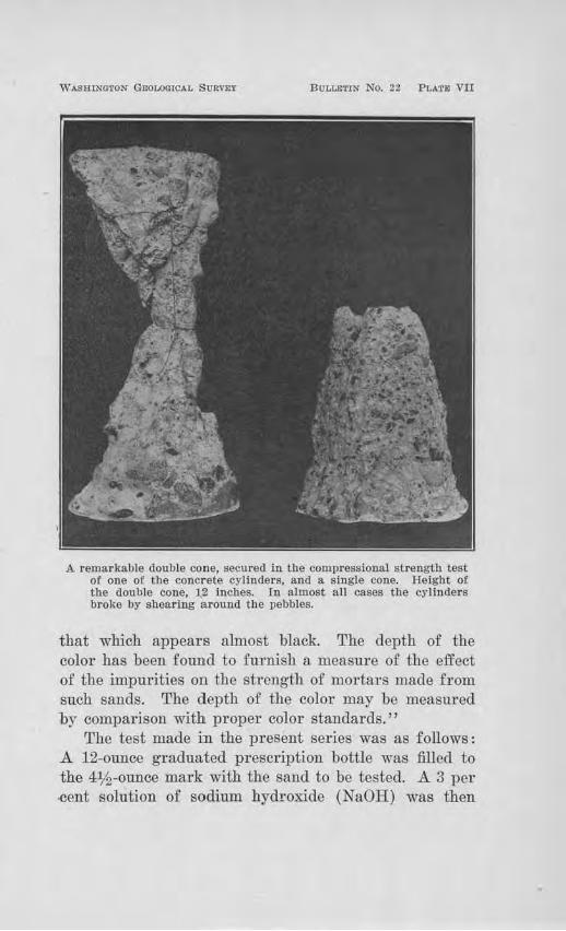
W ASRJNOTON GEOLOOICAL SURVEY BULLlilTIN NO. 22 PLATE VII
A remarkable double cone, secured in the compressional strength test of one of the concrete cylinders, and a single cone. Height of the double cone, 1.2 inches. ln almost all cases the cylinders broke by shearing around the pebbles.
that which appears almost black. The depth of the color has been found to furnish a measure of the effect of the impurities 011 the stTcngth of mol'tars made from such sands. ~['he depth of the color may be measured by compaxison with proper color standards.''
The test made in the present series was as follows: A 12-ounce graduated prescription bottle was filled to the 4:J/2-ounce mark with the sand to be tested. A 3 per -cent solution of sodium hydr·oxide (NaOH) was then
60 Bulletin No. 22, Washington Geological Survey
added until the volume of the sand and the solution, after shaking, amounted to 7 ounces. After shaking thoroughly, the solution was let stand for 24 hours and the color of the supernatant liquid then observed. If the clear supernatant liquid was colorless, or had a light yellow color, the sand was regarded as satisfactory for conc1·ete in so far as organic impurities were concerned. But if a dark colo1·ed solution, ranging from dark red to black was obtained, the sand was considered questionable. In such a case reference should be made to the mortar strength tests.
Chemical Analyses for Alkali Content.
BM~mgo of tho gcimi-n11idity of tho climnte of eastern ,Vashington, and of the rather common occurrence of white particles and fragments in the sands and gravels which are popularly called alkali, some chemical analyses were made to determine whether these ingredients wer e actually alkali and of a character harmful to concrete. The analyses were made by the firm of Charles A . Newhall Co., I ndustrial Chemists and Assayers of Seattle, assoc:iatecl with the Pittsburgh Testing Laboratory. Determinations were made for Silica and other insoluble matter , I ron and Aluminum oxides, Calcium Carbonate, Magnesium Carbonate, Sulphates, Chlorides, and water soluble alkalies.
RESULTS OF TESTS MADE ON FIN.El AGGREGATE.
Phys ical Propel'ties
The results of the examination of the physical properties of samples of sand are given in tabulated form in Table ID. Those include a statement regarding their location, their general character, and composition, sieve analyses, and percentage of voids. It will be noted that the sands from those counties in the Columbia Plateau Province ru:·e coarse basaltic sands, and most of them are deficient in fine material, while along the Yakima River
Road B~1,ilding Smnds Mid Gravels 61
in the Yakima District, they are generally deficient in coarse constituents.
The suitability of any particular sand, so far as gl'adation in size is concerned, may be judged from the following specifications of the Office of Public Roads and Rm·al Engineering, U. S. Department of Agriculh1re:
For Use as F ine Aggregate, Cement Concrete, Fil'st Olass. "AU to pass a 1,4 -inch sieve, to have at least 2 0 and not more
than 60 per cent retained on a 20-mesh sieve, at least 80 per cent retined on a 50-mesh sieve, and at least 97 per cent retained on a 200-mesh sieve."
For Use as Fiue Agg-.·egate, Cement Conc1·ete, Second Class.
"All to pass a 1,4 -incb sieve, to have not more than 80 per cent retained on a 50-mesh sieve, and at least 97 per cent retained on a ta.lned on a 50-mesl1 sieve, and at least 95 per cent retained on a. 200-mesh sieve:·
General notes am made in the "Rem1uks column" of Table ID to indicate the deficiencies of the ,·arious samples of sand in meeting the above specifications. Specific remarks as to the percentage o.f deficiencies are purposely avoided, for the reason that the gradation of the sand from a given pit may vary from time to time and analyses must be made at various stages during the progress of a large job to keep this information up-todate.
Tensile So·ength and Colorimetric Tests.
In Table IV are assembled the results of the tensile strength and colorimetric tests made upon the sands. The average strength of three briquettes having values ·within reasonable limits, was taken to ascertain the comparative strength of a given mortar of a certain age, made from a certain sand. The strength ratio was obtained by dividing the strength of the sand under test by the strength of the Ottawa Standard sand. In almost all cases both the 7-day and 28-day results are shown. For :fiTst-class cement concrete the specifications of the Office of Public Roads of the U. S. Department of Agriculture, require '' a tensile strength ratio, wl1en
62 Bulletin No. 221 W ashvn,gton Geological Survey
compared to Standard Ottawa sand mortar briquettes, of at least 100 per cent;" for second-class concrete, "a tensile strength ratio of at least 75 per cent.''
By referring to Table IV, the adaptability of a given sand so far as determined by this test, may readily be seen. It should not be overlooke4 however, that after the removal of considerable material from a pit, new tests should be made, as the character of a pit may change as material is taken out. The results herein given may, however, be taken as an indication of the general quality of the sand. Samples which are marked with an asterisk (*) were tested by the Portland Cement Association, in which case duplications were not made.
The results of the colorimetric tests are stated in terms of color. Where the solution remained clear, the sand is free from organic content; if colored a light yellow, the sand is still satisfactory as far as organic impurities are concerned. But if the solution became dark colored, ranging from dark red to black, the amount of organic matter is dangerous. In the latter case the sand should be rejected for use until it is washed and tested again. These tests emphasize the necessity of precautionary measures in selecting sand for concrete. Pits which have not been stripped of humus soil and rootlets, as shown in P late V, are likely to nullify all other attempts at securing first-class concrete.
Chemical Test for Alkali Oont,eu t
As previously r eferred to; the semi~aridity of the climate of Eastern Washington, together with the common occurrence of white particles of mineral matter in the sands and gravels, made it desirable to make chemical tests for alkali content. Three such tests were made, one of a sample taken from a gravel pit % mile southwest of the Northern Pacific Railway Station at Ritzville, another of a sample collected from a bed of
Road Buildi11,g Sands ood Gravels 63
''lime-rock'' 21/2 miles east of Othello, and a thiTd of a sample obtained from a pit 5 miles south of Quincy, Grant County. The locations of these points are designated on the county maps in Chapter V, as 2 and 4 in Adams County and 42 in Grant County, respectively. In all three cases the white mineral was the constituent analyzed.
The r esults of the anaJyses are reported by the Charles A. Newhall Company, Seattle, as follows:
Map No. 2 Silica and insoluble ......... 51.20% Iron and Aluminum oxides ... 3.80% Calcium carbonate ......... 33.78% Magnesium carbonate ...... 11.20% Sulphates . . . . . . . . . . . . . . . . absent Chlorides . . . . . . . . . . . . . . . . absent Water soluble alkalies ...... absent
1\fap No. 4 Map No. 42 46.00% 30.30o/o
2.40% 4.70% 38.76% 56.18% 12.80% 8.80% absent absent absent absent absent absent
From the above it is clear that the white substance which is so common in the gravels o.f eastern Washington, especially on the Columbia Plateau, is not alkali but lime and magnesium carbonate and silica. Their harmfulness lies chiefly in cases where they coat the pebbles, causing a plane of weakness around the pebbles in concrete, or where the particles occur in ,abundance as constituents of gravel, in which case they lower the strength of the aggregate and decrease its resistance to abrasion. Their variability in amount in different pits, from practically nothing to a considerable percentage, makes careful selection necessary.
COARSE AGGREGATE.
The coarse aggregate used in Portland Cement concrete pavements is subjected to the abrasion, impact, and compression of traffic--a service which is much more severe than in concrete walls, foundations, etc. Cleanliness, hardness, and toughness and proper grading are the essential properties. It would be desirable to make tests for toughness, but the heterogeneity in size and
64 Bulletvn No. 22, Washington Geological Survey
kind of pebbles which usually make up a gravel present difficulties which have not yet been overcome.
Test of Size of Grading of Coarse .Aggregate.
In this test a sample was usually taken of the material weighing not less than fifty times the size of the largest stone and when thoroughly dried was passed through screens of the following size, having circular openings : 2-inch, llh-inch, 1-inch, %-inch, :11,1-inch. The percentage by weight on each screen was determined, together with that which passed the lj.1-inch screen, if any.
Abrasion Test.
Abrasion tests were performed on the samples of coarse aggregate in the same way as has been described for "Road-gravel", Chapter Ill.
FIELD TESTS OF PORTLAND CEMENT CONCRETE.
In order to ascertain the quality of the cement concrete which was being put into concrete pavements with accepted brands of cement and various types of gravel, :field tests were made of the concrete which was being laid in the counties of Whatcom, Skagit, Snohomish, King, Pierce, Thurston, and Spokane. Following the recommendations of the U. S. Office of P ublic Roads, cylindrical forms were made, 6 inches in diameter and 12 inches high. The test was undertaken by digging a shallow trench large enough to hold several cylinders in an uptight position, alongside the place where the pavement was being laid. The molds were placed in flat, nonabsorbent surfaces and the concrete was put in the molds in layers of 3 or 4 inches and slightly puddled to give a dense product. After 24 hourn, they were covered with earth in the same way as the pavement, kept wet for 10 days, and, in every possible way, cured under the same conditions as the pavement. After 60 clays, and
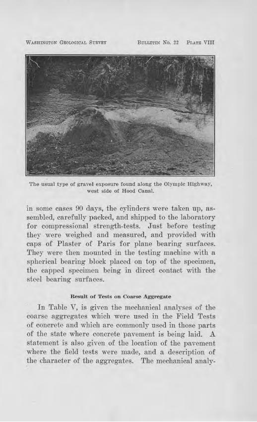
WASHINGTON GEOLOOTCAL SVRYEY BULLETIN No. 22 Pl.ATE vm
The usual type of gravel exposure found along the Olympic Highway, west side of Hood Canal.
in some cases 90 days, the cylinders were taken up, assembled, carefully packed, and shipped to the la bo1·atory for compressional strength-tests. J ust before testing they were weighed and measured, and provided with caps of Plaster of Paris for plane bearing surfaces. They were then mountecl in the testing machine with a spherical bearing block placed on top of the specimen, the capped specimen being in direct contact with the steel bea.ring surfaces.
Result of Tests on Coarse Agg•·egate
In Table V, is given the mechanical analyses of the coarse aggregates which were used in the Field Tests of concrete and which arc commonly used in those parts of the state where concrete pavement is being laid. A statement is also given of the location of the pavement where the field tests were made, and a descrjption of the charactm· of the aggregates. The mechanical analy-
66 Bulletin No. 221 Washington Geological Survey
ses of other g·ravels over the state which have thus far not been used in concrete pavements are given in Table I . The reader is also referred to Chapter V for the discussion of the gr·avel conditions in each county.
Percentage of Wear.
Inasmuch as it is desirable to know the degree of resistance which a given aggregate would offer to abrasion in a concrete pavement the percentage of wear is given for the concrete aggregates described in Table V and also for many of the aggregates described und~r "Road Gravels" in Table I.
Not many states have included the abrasion test in their specifications, but undoubtedly this will be done more and more in the future. The Ohio State Highway Department at present specifies a wearing value for pebble aggregates used in the concrete wearing surface not to exceed 12 per cent. loss by abrasion. Whatever percentage of wear is adopted by each state obviously shou1d depend in a large measure on the local conditions and the character of the material available.
Table V reveals that most of the coarse aggregates thus far used in cement concrete pavements have a low percentage of wear. The minimum is 2.4 per cent, the maximum 14.8 per cent, and the average 5.2 per cent. All except the Cowlitz River gravels at Castle Rock and the Skagit River gravels at Sedro Woolley showed a per cent loss by abrasion less than 7 per cent, and four less than 3 per cent. The four were from the Chehalis River in Grays Harbor County, from Maury Island, from the Steilacoom deposits, and from the Twin City Sand and Gravel Company's pit at Centralia.
The percentage of wear of 64 other gravels in the state which have not as yet been used for concrete pavement is given in Table I. The average of these is 10.9 per cent, with 32.8 per cent as the maximum and 2.2 per cent as the minimum.
Road, Building Sand,s ood Gravels 67
Compressional-Strength of Concrete Oylinders--1\Iade in Field Tests.
All of the cylindrical molds used in this series of tests were 12 inches high and 6 inches in diameter. The location of the field tests, the map number of the source of the aggregate, the brand of cement used, the age of the cylinders at the time of breaking, and the results of the tests showing their compressional strength are given in Table VI. The proportions of mix in all cases were 1 :2 :3, except in the case of the concrete dock at Dash Point, Pierce County, where the proportions were 1 :2 :4. The results of the latter are accordingly lower than the others. Most of the cylinders broke into approximately conical forms, but a few broke through the top and bottom, as for example C-3, C-4, and C-10. In view of the fact that the maximum load was high, in the last mentioned cases, it would seem that the cause for breaking through the top and bottom may be credited to the final rupture of the plaster caps, for there was no segregation of the aggreg·ate which would favor this.
An examination of the cones showed that in all cases but one, the breaking took place by shearing around the pebbles rather than by breaking through them. This is taken to indicate that the strength of the pebbles exceeds the mortar matrix, which is the most that could be desired of any aggregate. The only exception to this was in cylinder C-44, which broke thTough the pebbles. So far as can be judged from one case, namely, the Spokane County cylinders, the gravels of eastern Washington are equal in strength to the first-class g1·avels of the Puget Sound Province. The former are less resistant to abrasion, however, than the latter, but this may not depreciate the value of the former, for if the aggregate approaches the m01·tar matrix in hardness the surface of the pavement is less likely to wear rough than if the pebbles are superior in hardness to the matrix.
68 Bulletin No. 22, Washington Geological Survey
It would be well if su.ch tests would be made by all the counties who invest in concrete pavements, and include in the specifications that the concrete shall have a compressional str ength of at least a certain amount, governed by the local demands of traffic. The inauguration of freight transportation by heavy trucks makes this highly desirable.
Results of Certain Tests Macle by R. J. Bo1·hek on the Gravel Aggregates of the Steilacoom Deposit a.ncl at
Lake,,iew, Pierce Comity.
In the spring of 1917, Mr. R. J. Borhek, of Tacoma, made some cylinder tests of the concrete which went into the pavement of Steilacoom Boulevard, between Steilacoom and Tacoma, and also of hand mixed materials from the Steilacoom deposit and from the P ierce County Pit at Lakeview. The conditions under which the molding was done and the curing accomplished is described in Table VII. The cylinders were brought to the Testing Laboratory of the University of Washington and broken by Mr. Everett G. Snell, Instructor in Civil Engineering in the College of Engineering. The cylinders broke into conical forms, such as is shown in Plate VII, one of them giving an almost perfect double cone. The breaks took place around the pebbles in almost all cases, thus indicating again the superiority in strength of the gravel aggregate over the mo,rtar matrix. The voids were well filled.
CHARACTER ANI> QUALITY OF nm SAND,
The chief points regarding the sand of W ashingtou may be summarized as follows :
1. The sands of the Puget Sound Province are generally first-class in character, being composed of hard, durable, angular to rounded grains of granite, quartz, basalt, andesite, quartzite, and other hard metamor phic rock particles. Some of the deposits are properly
Road B'l1,ilding Sands wnd Gravels 69
graded in their natural occurrence, but as is the case in almost aU areas, they vary to such an extent that mechanical analyses must be made from time to time as material is drawn from a given pit to insme proper control of the gradation for first-class work
2. In the Southwestcm Province the glacial sands and gravels are a bscut except in a small area north of Centralia, along the Skookumchuck River and that part of the Chehalis River rmming northwest from Centralia. Elsewhere, basaltic and andcsitic sands occur along most of the main streams, with a scant quantity along the minor tributaries. .Along the Columbia River the sands aro composed of basalt, quartzite, and granite.
3. The Okanogan Province has deposits which are patchy in distribution, being intimately interbeclded with silts along the main streams chiefly. Local deposits are being used for concrete pipe manufacture at Omak. The higher benches of the Colville VaUey and the high terraces southwest of Newport contain sands suitable for concrete after washing.
4. The black sands of the Columbia Plateau Province are almost eutu-ely basaltic in composition and are generally very strong, but their chief failure is their lack of :fine grains to fill the voids ancl give proper density to the concrete. In a few cases they contain particles of soft lime-rock, rarely as high as 20 i:>er cent, which should l)e avoicled for concrete of fiTSt-class strength. Chemical analyses show that the lime particles are not alkali and have no deleterious effect in a chemical way.
5. The Yakima River contains scattered bars of sand and gravel which have high strength in the quality of rock particles, but they show a tendency to contain organic material to a slight extent. Caution is therefore needed in using them and colorimetric tests should be made from time to time during the progress of concrete
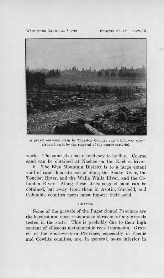
WASHINGTON GEOLOGICAL SURVEY BULLETIN No. 22 PLATE IX
A gravel outwash plain in Thurston County, and a highway constructed on it by the removal of the coarse material.
work. The sand also has a tendency to be fine. Coarse sand can be obtained at Naches on the Naches River .
6. The BJue :Mountain District is to a large extent void of sand deposits except along the Snake River, the Touchet River, and the Walla Walla River, and the Columbia River. Along these streams good sand can be obtained, but away from them in Asotin, Garfield, and Columbia counties users must import their sand.
GRAVEL.
Some of the gravels of the Puget Sound Province are the hardest and most r esistant to abrasion of any gravels tested in the state. This is probably due to their high content of siliceous metamorphic rock fragments. Gravels of the Southwestern Province, especially in Pacific and Cowlitz counties, are, in general, more inferior in
Road Building Sands and Gravels 71
character than any others in the state. The gravels on the Columbia Plateau are dominantly basaltic and generally firm and of average wearing value. Some, however~ contain pebbles coated with lime, as for example, those northeast of Ritzville, which unfits them for use as coarse aggregate in concrete, by introducing a plane of weal-:ness between the bend of the mortar and the pebbles. Instances of these, however, are compaa:atively few. The gravels on the slopes bordering the valley of the Yakima River are too soft and weak to be of any use in concrete. The same is also true of the red gravels in the high benches along the lower part of the Chehalis Rfrer.
GRAVEL FOR BITUMINOUS CONCRETE ROADS.
In bituminous concrete roads, bituminous materials such as asphalts, heavy asphaltic oils, refined water gas tars, refined coal tars, combinations of tars, or combinations of tars and certain kinds of asphalts are used as the cement to bind together the aggregate. Crushed Tock is commonly the mineral aggregate used, for one of the chief factors in this type of pavement is in the inter-locking of the constituents. Gravel is not well adapted because of the r ounded form of the pebbles. "Where gravel has been used much labor and experimentation has been requb:ed to attain the desired coherency .
.Aside from the matter of coheTency to give stability to the pavement, the pebbles should be properly graded, firm and resistant to abrasion. The Office of Public Roads and Rural Enginecl'ing of the U. S. Department of .Agriculture specify a gradation of the materials such that all shall pass a 11/2-inch screen and be retained on a ~-inch screen, with at least 25 and not more than 60 per cent r etained on a %-inch screen.
The gradation, percentage of wear and physical characters of samples of gravel collected from various par·ts
72 Bttlletin No. 22, W ashvngton Geological S'Urvey
of the state are given in Tables I and V, to which the reader is referred.
The sand which is to be used as fine aggregate in bituminous concrete should pass a l) ~ -inch sieve, 40 to 60 per cent should be retained 011 a 40-mesh sieve, and at least 90 per cent retained on a 200-mesh sieve. The mechanical analyses of the various sands are recorded in Table III.
SAND FOR SHEET ASPHALT CONSTRUCTION
A sheet asphalt pavement has a wearing surface com
posed of a sand of a certain specified' grading, fine material or filler, and asphalt cement The sand and filler should be clean, moderately sharp, and free from loam or other impm·ities. According to the U. S. Office of Public Roads and Rul'al Engin.eeTing, all should pass a 10-mesh sieve, at least 20 pel' cent and not more than 30 per cent should be retained on a 40-mesh sieve, at least 40 and not more than 50 per cent should pass the 40-mesh sieve and be retained on the 80-mesh sieve, and at least 25 per cent and not more than 35 per cent should pass the 80-mesh and be retained on the 200-mesh sieve.
It is seldom that a deposit of sand is found which exactly meets these gradation requirements, and so screening is usually necessary to give the prope1· proportions. The natural run of the deposits over the state is given in tabular form in Table III. From these judgment can be made in a given case rega1·ding the adaptability of material in a given community. It will be noted that in most places in the Columbia Plateau. P rovince of eastern Washington, the basaltic sands are too coarse for sheet asphalt purposes and materials must be imported.
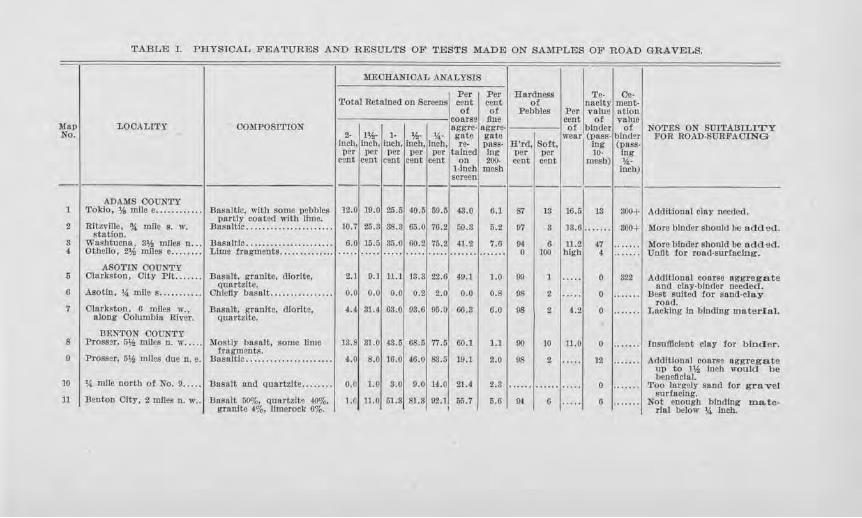
TABLE I. PHYSICAL FEATURES AND RESULTS OF TESTS MADE ON SAMPLES OF ROAD GRAVELS.
~lEOBANIOAL ANALYSIS
I Per Per Hardness Te· Oe· Total Retained on Screens c!!Ilt cent of nacity ment·
o! ot Pebbles Per volue ntion coarse fine C<'Dt of value
J\lap LOOALITY COMPOSITION aggre- aggre- of binder of NOTES ON SUITABTLITY No. 2· 1¥.,· l• 1>2· 14· gate gute wear (pass- binder FOR ROAD·SUllFAOlNG
Inch, jnc.b, Inch, lncb, Inch, re- POSS· lI'rd, Solt. Ing (PUSS· per per -per per per talned fng TJer par 10· Ing
cent cent cent cent cent on 2()0. cent cent mesh) 'A· l·lnch mesh lncb) screen -~ ------------·-~ ---------
ADAMS OOUNTY 1 Tokio, ',/, mlle e ....••..•... Doso !tic, with soma pebbles 12.0 19.0 25.5 {0.5 59.5 43.0 6.1 Si 13 16.5 13 soo+ Additional clay needed.
portly con ted wilb lime. 10.7 More binder should be added. 2 Rltzvllle, '!:I mac s. w. :Basaltic ...................... 25.3 38.3 65.0 76.2 50.S 5. 2 07 3 13.6 .. ... .. 800+ station.
8 Washtucna 3'>!. miles n ... nnsnltlc ...................... 6.0 15.5 85.0 60.2 75.2 41.2 7.0 1)4 6 11.2 47 .... ... Moro binder should IJO add 2d. 4 Othello, 2¥,i mJJes e ........ Lime fragments ....... ....... 0 100 high 4 ....... Unfit iot road,su.rioclng.
ASO'l'IN OOUNTY 6 Olnrkston, Olty Pit ....... :Bnsalt, grnnite, dlorltc, 2.1 9.1 11.1 13.3 22.GI 49.1 l.O 99 1 ····· 0 322 Additional coarse aggregate
quartzite. and clay-blntler needed. 6 Asotin, *miles ........... Ohiel!y basalt ................ o.o o.o o.o 0.2 2.0, 0.0 0.8 98 2 ..... 0 . ...... Best aultcd for snnd-cla.y
road. 7 Olnrkston, 6 miles w., Basalt, granite, dlorltc, 4.4 31.4 6S.O 98.G 05.0 66.3 6.0 98 2 •1.2 0 ....... Lacking to binding ma.terinl.
along Columbia River. quartzite.
BENTON OOUN'l'Y 8 l'rossar, 5* miles n. ,r ..... Mostly bnsnlt, some lime 1S.8 Sl.O 43.5 68,5 77.5 60.l 1.1 90 10 11.0 0 ....... losufflclent olay for binder.
Cragment,s. 9 Prosser, 5¥., miles due n. e. Bus11lt1c .... .. ... ............. 4.0 8.0 16.0 46.0 83.6 19.1 2.0 98 2 ..... 12 . ...... AddJUonal coarse aggregate
up to 11A, inch won Id be bcmeftelal.
10 1' mile north of No. 0 ..... Basalt and quartzite . ... . ... 0.0 1.0 s.o o.o 14..0 zt.4 2.S ...... ...... . .... 0 . ...... Too largely sand for gravel sur!aclng.
11 :Benton City, 2 miles n. w,. Basalt 50%, quartzltg 40%. l.O 11.0 51 .3 81.3 92.J 65.7 6.6 OJ (I ..... 6 . ...... Not enough binding mate-grnnlte 4%, limeroolc 0%. I rlnl below '4 Inch.
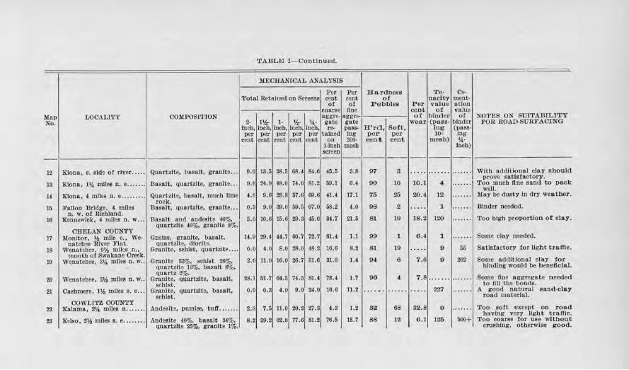
TABLEJ I- Continued.
MEORANIOAL ANALYSIS
Per Per Hardness T e- Oe· Toto! Retained on Screens cent cent of naclty ment-
ot of P ebbles Per value ntion coarse line cent of valt1e
Mop LOCALITY COMPOSITION nggre· aggre- of binder o! NO'l'ES ON SUITADILtTY No. 2· 1¥.,- 1- 'Ai· 14· gato gate wear (pass- binder FOR ROAD·SURFACJ:NG
In.ch, incb, inch, inch, lncb, re- POSS• H'rd, So:tt, ing (paSS· per per per per per tnined Ing per per 10- ing
cent cent cent cent cent on 20(). cent cent .rnesb) '>'· 1-lnch mesh lneb) screen ---------------- - -------
12 Kionn, s. side o:t river ..... Quart:zlte, basalt, granite . . . 9.0 13.5 38.5 68.4. 84.6 45.5 3.8 07 a ..... ........ ....... With additional clay should
9.6 48.0 prove satisfactory.
13 Klona, 1'4 Ollles n. e ....... Basalt, quartzite, granite ... 2~.o 74.0 81.2 59.1 6.4 90 10 10.1 4 ....... Too much tine sand to pack well.
14 Kionn, 4 mlles n. e ......... Qunrt,zite, basalt, much lime 4.E 0.6 28.S 57.6 69.6 41.4 17.1 75 25 20.4 12 ....... May be dusty in dry weather. rock.
15 Fallon Bridge. 4 miles Basal:t, quartzite, granite ... 0.6 9.0 39.0 59.6 67.0 58.2 4.0 98 2 .. ... 1 ....... Binder needed. n. w. of Richland.
16 Kennewick, 4 miles n. w ..• Bnsal:t and andcsite 46%, 5.0 10.6 15.6 29.3 45.0 84.7 21.5 81 19 18.2 120 ....... •.roo Wgb proportion of clay. quartzite ~%, granite 8%.
OHELAN COUNTY 17 Monitor, ',/, mile e., We· Gneiss, granite, basalt, 14.9 29.4 44.7 60.7 72.7 61.4 1.1 99 1 6.4 1 ....... Soma clay needed.
natchee River Flat. quartzite, dlorlte. 18 Wenatchee, 0¥., miles n., Granite, schist, quartzltP .... o.o 4.0 8.0 28.0 48.2 16.6 8.2 81 19 ..... 9 55 Satisfactory tor light traffic.
mouth of Swalrnne Oreek. 19 Wenatchee , 3~ miles n. w .. Granite 53%, schist 26%, 2.6 11.0 16.0 26.7 51.6 31.0 1.4 94 6 7.6 9 262 Some additional clay for
qua.rtzite 13%, basalt 6%, binding would be bene ftcial. quartz 2%.
20 Wenatchee, 2',!, miles o. w .. Grnnlte, quartzite, basalt, 28.J 61.7 64-.5 74.5 81.4 78.4 1.7 96 4 7.8 ........ ...... . Some fine aggregate needed scbist. to nn the bonds.
21 Cashmere, 1¥., miles s. e ... GrnnJte, quartzite, basalt, 0.0 0.3 4.0 9.0 24.0 16.6 11.2 .. . ... ...... ···· · 227 ..... . . A good natural sand-clay scbist. road material.
COWLITZ COUNTY 22 Xalama, 2!4 miles n . ...... Andesite, pumlce, tutf ....... 2.0 7.5 11.0 20.2 27.3 4.3 1.2 82 68 32.8 0 ..... . . Too sort except on road
having very light traffic. 28 Xclso, 2¥., mlles s. e ........ Andeslte 40%, basalt 34%,
QUal!'tzite 25%. granJte 1%. 8.2 39.2 G2.0 77.6 81.2 76.5 15.7 88 12 6.) 125 500+ Too conrse for use without
crushing, otherwise good.
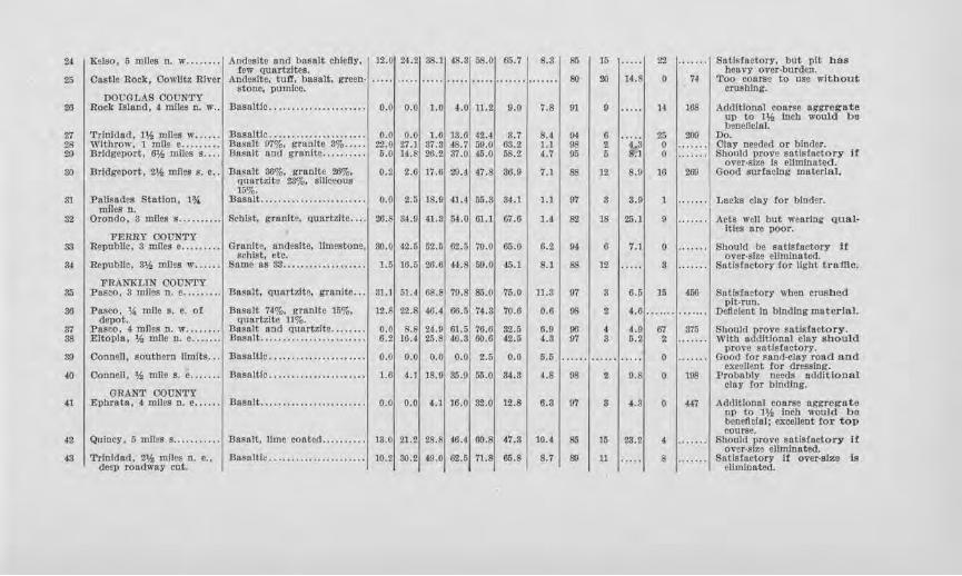
24 I Kelso, 5 miles n. w . ....... Andes1te and basalt chiefly, 12..0 24.2 SS.1 48.3 58.0 65.7 8.3 86 15 ..... 22 .. ..... SatlRfactory, but pit bas few quartzltes. heavy over-burden.
25 Castle Rock, Cowllt?. River And.aslte, tuff, basalt, green- ..... 80 20 14.S 0 74 Too coarse to use without stone, pumlce. crushing.
DOUGLAS OOID.'TY 26 I Bock rs111nd, 4 mlles n. w .. Basaltic ...................... 0.0 0.0 l.O 4.0 U.2 9.0 7.8 91 9 ..... 14 168 Additional coarse aggTegate
up to 1 'h Inch would be bencftclal.
'1:1 Trinidad, Hi mnes iv ..... . Basaltic ...................... 0.0 o.o 1.6 18.6 42.4 3.7 8.4 9} G 25 209 Do. 2S Withrow, 1 mne e .. ....... Desalt 07%, granite 8% ..... 22.0 '1:1.l 37.3 48.7 59.0 63.2 l.l 98 2 -4-3 0 ....... Olay needed or binder. 29 Bridgeport, 6¥., miles s .... nasnlt and gnnJte ....... ... 6.0 14.8 26.2 37.0 45.0 58.2 4. 7 95 5 &:1 0 Sbonld prove satisfactory It
over,slzj) la eliminated. so Bridgeport, 2'h miles s. e .. Basalt 36%, granlte 26%, 0.2 2.6 17.6 29.4 47.8 36.0 7.1 88 12 8 .0 16 200 Good surfacing material.
quurtzlte 23%, siliceous 15%.
31 I Palisades Station, HI. llnsalt ........................ 0.0 2.5 18.9 41.4 55.3 34.l 1.1 07 3 3.9 1 ....... Lacks clay for biod9r. mncs n.
32 Oronclo, 8 miles s . .. ....... Schist, granite, quartzite . .. . 26.8 34.9 il. 8 54.0 61.l 67.6 1.t 82 18 25.1 9 .. ..... Acts ,veil but wearing <u.1al-
FERRY OOUNTY !ties are poor.
33 I Republic, S miles e ......... Gran.lte, ondeslte, limestone, !lO.O 42.5 62.6 02.5 70.0 66.0 6.2 04 0 7.1 0 ....... Should be satisfactory it schist, etc. over,slze eUmlnated.
34 Republic, S'h mlles w •..... Same 8Jl 38 ................... 1.5 16.5 26.6 44.S 69. 0 45.1 8.1 6S 12 .. ... s . .... .. Satisfactory tor light traffic.
FRANKLIN OOUNTY 35 Posco, 3 mlles n. e ......... Basalt, quartzite, granite ... 31.l 61.4 08. 8 70.S 85. 0 76.0 1) .3 07 8 6.6 15 450 Satisfactory when crushed
Basalt 74%, granite 15%, pit-run.
86 Pasco. 14 mile s. e. of 12.8 22.8 46.4 66.5 74.3 70.6 0.6 98 2 4. 6 ....... ....... Deficient In binding matorlal. depot. Qaartzito 11%.
37 Pasco, ! miles n. w .... ... . Basalt and Quartzite ........ o.o 8.B 24.9 61.6 76.6 82.5 0.9 00 4 4.9 67 375 Should prove satisfactory. ss Eltopla, 'h mile n. e ....... Basalt ..... ........ ... ........ 0.2 16.4 25.8 40.3 60.6 42.5 4.3 97 s 5.2 2 ·· ·· ··· With additional clay should
Basaltic .................... . . prove satlstactory.
39 Oonnllll, southern limits .. . o.o 0.0 o.o o.o 2.5 o.o 5.5 ...... ...... ..... 0 . ..... . Good tor sand-clay road and excellent tor d~ssing.
40 Connell, 1,!, mile s. e ....... Basaltic ...................... 1.6 4.1 18.9 So.II 55.0 34.3 4.S 9S 2 9.S 0 108 Probably needs ndditlonal
GRANT COUNTY clay for binding.
41 I Epbratl\, • miles n. c ...... D8llalt ........................ o.o o.o 4.1 16.0 32.0 12.8 6.3 97 s 4.3 0 44-'I Addltlonal coarse aggregn t e up to JJ,i Inch would be bencft~lal; excellent tor top
I 1.~:~1
course. 42 I Quincy, 5 mnes s ........... l Dasnlt, lime coated .......... , 13.0121.2128.81 t0.4160.8147.3, l0.4 I 85 15 4 , ....... , Should prove satisfactory If
over-size ellmlnattd. 43 Trinidad, 2* miles n. c. , .Basaltie ........ .............. 10.2 30.2 "-9.0 62.6 71.8 65.8 8.7 81) 11 8 .. .. .. . Sntlsfuctory ff over-size Is
deep rondwny cut. eliminated.
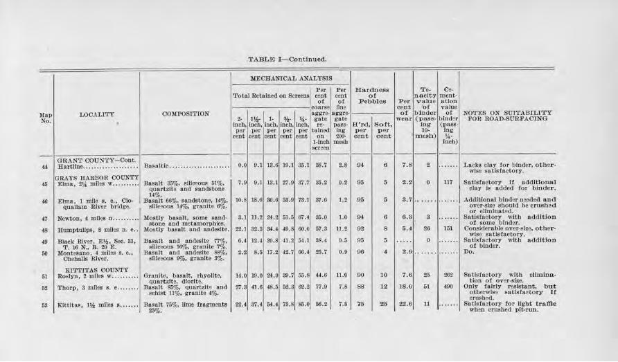
.TABLE I-Cpntinued.
MECHANlOAL ANALYSIS
I Per Per Hardness T e- Oe-
Tota l Retained on Sereens cent cent of nnclty ment-of ot :Pebbles P er value atlon
coarse fine cent of valne Map LOCALITY COMPOSITION l~-l 1-
aggre- a11gre- ot b inder of NOTES ON SU1TABrLITY No. 2- ~- '4- g11tc gate wear (pass- binder FOR ROAD-SUR.FACING
loch. lnch, lncb, lncb, In.Cb, re- PUSS• H'rd, So:Ct, ing (J)8SS· per per per per per tainod ing p er p er 10- ing
cent cent cent cent cent on 200- ce.nt cent mesh) %.-l-lncb mesli inch) screen
------------._ --------GRAN'r 000:,J'l'Y-Cont.
44 Hartline ....... •.. . ......... Dasnltic ... . ............ ..... . o.o 9.1 18.6 19.1 35.1 38.7 2.8 94 6 7.8 2 ······· Lacks clay !or binder, other-wls9 satlstnctory.
GRAYS HARllOR COUNTY 45 Elma, 214 miles w .......... Basalt 35%, smceous 51%, 7.0 9.1 13.1 27.9 37.7 85.2 0.2 95 5 2.2 0 117 Satisfactory If additional
Qua rtzlte and sandstone clay Is added tor binder. H%,
10.8 18.6 46 Elma, l mJle s. e., Clo· Basalt 66%, sandstone, 14%, 80.6 53.9 73.l 37.6 1.2 95 5 3.7 ·- ..... ....... Additional binder needed and qunllnm River bridge. Sll1e2ous J.1.%, granite 6%. ovcr-slzo shou Id be crushed
or eliminated. 47 Newton, 4 miles n .......... Mostly bnsalt, somo snnd· 3.1 ll.2 24.2 51.5 67.4 35.0 1.0 04 6 6.3 3 .... ... Satisfactory with addition
stone and mstamorphles. ot some binder. 4S .Humptulips, s mJJes n. e .. .Mostly basalt and nndeslte. 22.J 92.8 34.4 49.8 60.0 57.3 11.2 92 8 5.4 26 151 Ooosldorablo ovnr-slio, other-
Black River. E'h, Sec. 33, Basalt andesits 77%, 88.;l wisa S!ttisfllctory.
(9 and 6.4 12.4 20.8 41.2 54.1 0.5 95 5 .. ... 0 ....... Satisfactory with addition T. 16 N., rt. 20 E. siliceous 16%, granite 7%. oi binder.
50 Montesano, 4 miles s. c .. Basalt and andeslte SS%, 2.2 8.6 17 .2 42.7 66') ~-7
0.9 96 4. 2.9 .... .. . ....... Do. Ohebnlfs River. slllceons 9%, granite 3%.
KI'l'TITAS COUNTY 51 Roslyn, 2 miles w ... .... -•. GranJte, basalt, rhyolite, 14.0 10.0 24.9 80.7 65. 44.0 11.0 90 10 7.6 25 262 Satisfactory with ellmina-
Quartzite. dlorlte. tlon of over-size. 52 Thorp, 3 miles s. e ........ Basalt S.~%. Quartzit1l nod 27.3 41.6 48.5 52.8 62.2 77.9 7.S 88 12 18.0 51 490 Only fairly resistant, but
schist 11%, granite 4%. otherwise sntisfnetory i1 crnsbed.
58 Klttitas, l'h miles s. ...... Basalt 75%, llme !ragments 22.4 37.4 54.( 73.8 85.0 li6.2 7.6 '15 25 22.6 11 ·· ·· ··· Satisfactory for light traffic 25%. when crushed pit-run.
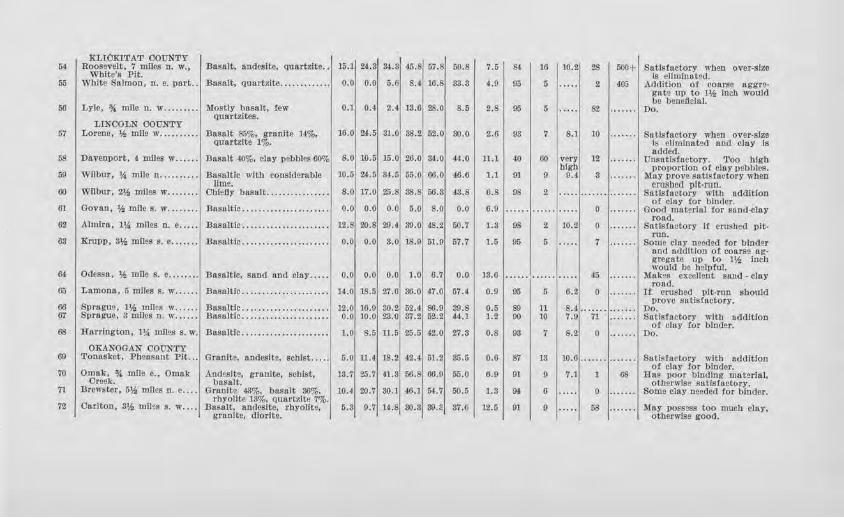
XLTOKITAT COUNTY 54 I Roosevelt, 7 miles n. w., I Basalt, nndeslte, Quartzite .. 115.11 M.3184.3, 45.8167.81 50.81 '1.5 1 &t
I 16 1-~~J 28 I 500+1 Satisfactory when over-size
White's Pit. is eliminated. 55 White Salmon, n. e. part .. Basalt, quartzite............. o.o o.o 5.6 8.4 10.s 83.3 4.9 95 5 2 405 Addition of coarse nggre-
gat9 up to Hi Inell would
56 I Lyle, * mne n. w ......... , Mostly basalt, few I 0.11 0,41 2.41 13.61 ?.S.01 8 .5 I 2.s 1 95 I 5 1 ..... 1 82 I ....... I D~.e beneficial. Quartzltes.
LINCOLN COUNTY 67 I Lorene, 'h mile w .......... Basalt 85%, granite 14%, 16.0 24.5 31.0' 38.2162.0 30.0 2.6 93 7 8.1 10 ....... Satisfactory when over-size
quartzite 1%. is elhnfnat2d and cloy Is added.
68 Davenport, 4 miles w ...... .Basalt 40%, clay pebbles 60o/o 8.0 10.5 15.0 26.0 84.0 44.0 ll.l 40 60 very 12 ....... Unse tfs(aetory. Too high high proportion of clay pebbles.
69 Wilbur, 14 mile n .......... .Basaltic with considerable 10.5 24.5 84.5 55.0 66.0 46.6 1.1 01 9 9.4 3 ....... May prove satisfactory when lime. cmsbcd pit-run.
60 ~Vllbur, 2'h miles w ........ Chiefly basalt ................ 8.0 17.0 25.8 38.8 56.3 43.8 0.8 98 2 .... . ....... ... .... Satisfactory with addition of clay for binder.
61 Govan, 'h mlle s. w ........ Basaltic ...................... 0.0 0.0 0.0 5.0 8.0 o.o 6.9 ...... ...... ..... 0 ....... Good materlul for sand-clay road.
62 Almira, 1\( miles n. e ..... Basaltic ...................... 12.8 20.8 29.4 39.0, 48.2 50.7 1.3 98 2 10.2 0 ······· Satlstactorr if crushed pit-run.
63 Krupp, 3'h miles s. e ....... Basaltic ...................... 0.0 0.0 3.0 18.9 51.9 57.7 J.5 95 5 ..... 7 . ...... Some clay needed for binder and ttdclltlon ot coarse ng-gregate up to I* Inch would be h elpful.
64 Odessa, 'h mile s. e ........ Basaltic, sand and cla}' ..... o.o o.o 0.0 1.0 6.7 o.o 13.6 ...... ...... ····· 45 .. .. ... Mak~s excellent sand - clay road.
65 Lnmonn, 5 miles s. w .. .... Dosaltic ...................... 14.0 18.5 27.0 36.0 47.0 57.4 0.9 9'j 5 6.2 0 ....... If crushed pit-run should
Sprague, 1¥., mlles w ... ..• 16.0 prove satisfactory.
66 Basaltic ...................... 12.0 30.2 52.4 86.9 39.8 0.5 S9 11 8.4 ······· ....... Do. 67 Sprague, 3 miles n. w ...... Basaltic ...................... o.o 10.0 23.0 37.2 5Z.2 44.1 1.2 90 10 7.9 n ....... Satisfactory with addition
of cloy (or binder. 68 Harrington, 1% mlles s. w. Basaltic ...................... 1.0 8.5 ll.5 25.5 42.0 27.3 0.8 93 7 8.2 0 ...... . Do.
OKAJ.~OGAN COUNTY 69 Tonasket, Pheasant Pit ... Granite, andeslte. schist ..... 5.0 ll.4 18.2 42.4 51.2 35.5 0.6 87 13 10.6 ....... ....... Sntfsfnctory with addition
of clay (or binder. 70 Omak, % mile e., Omak Andesfte, granite, schist, 13.7 25.7 41.3 56.8 66.9 55.0 6.9 91 9 7.1 1 68 Has poor binding material,
Creek. basalt. oth~rnise satisfactory. 71 Brewster, 512 mnes n. e .... Granite 43%, basalt 36%, 10.4 20.7 80.1 46.l !H.7 50.5 1.3 94 6 ..... 0 . ..... . Some clay needed for binder.
Oarlton, 312 miles s. w .... rbyoflte 13%, quartzite 7%.
72 Dasalt, andcslte, rhyoflt9, 5.S 9.7 H.8 30.3 39.8 37.6 12.5 91 9 ..... 58 . ...... May possess too rnucb clay, granite, dlorlte. otherwlso good.
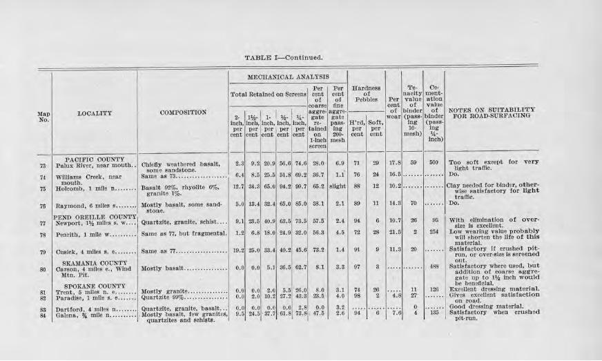
TABLE I-Continued.
MEORru'IIOAL ANALYSIS . Per Per Hardness Te· Ce·
'l'otal Retained on Screens cent cent ot naclty ment-ot of Pebbles Per value atlon
coarse llne cent ot value
Map LOCALITY COMPOSITION 2. l'f.,- 1 1. I 11.a-I 'k
nggre · aggre of binder of NOTES ON SU1'1'AJ3U,I'l'Y
No. gnte gate wear (pass- binder FOR ROAD-SURFACING Inch, Inch, i1ncb, inch, Inch , re· pass· H'rd, Soft, Ing (pass-per per per I per per talned log per _per 10· Ing
cent cent cent cent cent on 200- cent cent mesh) 'A· 1-lncb mesh inch) screen ----------------------
PACIFIC COUNTY 73 Palm: River, near mouth .. 2.3 9.2 20.9 56. 6 74.0 ?.8.0 6.9 71 29 17.8 59 500 '
74 Williams Creek, near 6.4 8.5 25.6 51.8 60.2 S6 .7 1.1 76 u 16.5 ······· ....... mouth.
75 Holcomb, l mile n ........ 12.7 34. 3 65.0 94.2 99.7 65.2 slight 88 12 10.2 ...... . ". " .. (
76 Raymond, 6 mrtes s .. . ..... 5.0 13.4 32.4 65.0 85.( 38.l 2.1 89 11 U.3 70 . ......
PEND OREILLE OOON'rY 77 Newport, 11,: mrtes s. w ... ·I 9.) 23 .5 40 .9 63.5 78.5 57.5 2.4 9~ 6 10.7 26 95
78 Penrith, 1 mile w .......... 1.2 6.8 18.0 24.9 82. 0 56 .3 4.5 72 28 21.5 2 254
79 Cusick, 4 miles s. e . . .... . . 19.2 25.0 33.4 40.2 45 .6 73.2 1.4 91 9 11.8 20 ······· SKAMA...'IIA COUNTY
so Carson, 4 miles e. , Wind 0.0 0.0 5.1 S6 .5 62.7 8.1 8.S 97 3 ..... ....... 488 Mtn. Pit.
SPOKANE COUNTY 81 Trent, 5 miles n. e ........ o.o o.o 2.0 5.5 26.0 8.0 3.1 74 26 11 126
82 PMadise, l mile s. e ....... 0.0 2.0 10.2 27.2 43.S 28.5 4.0 98 2 4.8 27 . ......
83 Dartford, 4 miles n .. ...... 0.0 o.o o.o 0.0 2.8 o.o 3.2 0 84 Galena, %. mJle n .......... 9.5 24.5 •37.7 :61.8 78.8 , 47.5 2.6 94 6 7.6 4 185
q, pi
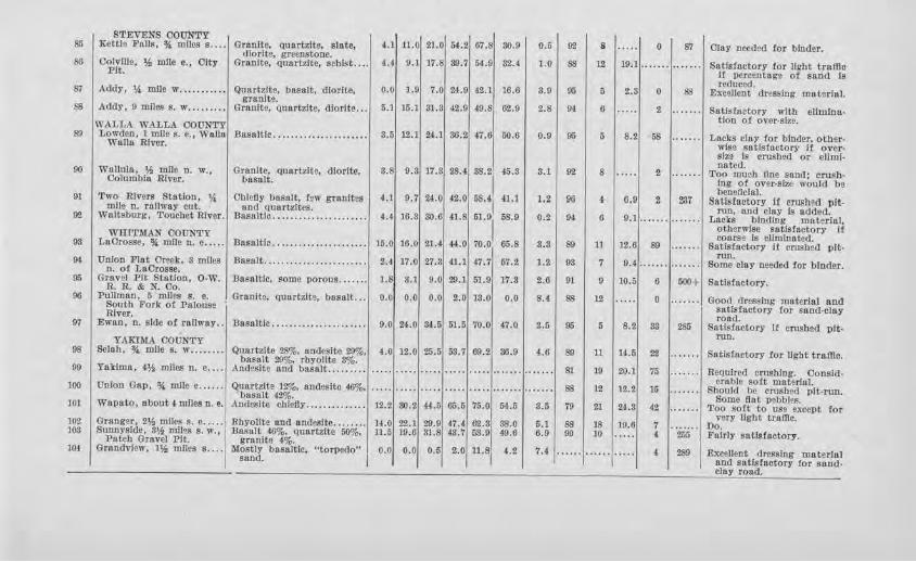
STEVENS OOUNTY 85 I Kettle Falls, % mncs s .... Granite, Quartzite, slate, u 11.0 21.0 M.2 67.8 30.9 0.5 9'l 8 ..... 0 87 Olay needed tor binder. dlorlte, grecnst-one.
39.'l 1.0 88 19,l Satfsfnctory for Jfgbt traffic 8G Oolv!Ue, Y.i mlle c., Olty Granite, quart,Jte, schist .... 4.4 9.1 17.8 611,.9 82.4 12 ······· ······· Pit. If pereentago ot sand Is reduced. 87 I Addy, ~ mlle w ........... Quartzite, basalt, dlorite, 0.0 1.9 7.0 24.9 42.1 16.6 3.9 95 5 2.8 0 ss Excellent dressing mutuiul. granite.
15.l 31.S 42.9 49.8 62.9 2.8 94 6 Satls!nctory S8 Addy, 9 mlles s. w ......... Hranlte, quartzite, dlorite ... 6.1 ..... 2 . ...... with ellmina-tlon ot over-size. WALLA WALLA COUNTY
so I Lowden, l mile s. e., Walla Basaltic ...................... 3.6 12.1 24.1 36.2 47.6 60.6 0.9 95 5 8.2 58 ....... Lacks clay for binder, other· Walla River. wise satisfactory JI over· size Is crushed or ellmf.
88.21 45.3 noted. 00 I Wallula, 1,f, mlle n. w., Granlte, quartzlt~ dlorlte, 3.8 9.3 17.8 28.4 s.1 92 8 ..... 2 . ...... Too much fine sand; cnu>h· Oolambia Rlver. basalt. Ing Of OVFl.l'•Slze would be beaellcial. 91 I Two Rivers Station, * Ohlcfly basalt, few gr~nltes u 9.7 U,O 4.2,0 58.41 il,l 1.2 9G 4 0.9 z ?.17 Satisfactory If crushed i,lt-mile n. railway cut. and quartzites. rnn, and clay Is added. 92 Waitsburg, 'l'oucbet River. Basaltic ...................... 4.4 16.3 30.6 41.8 61.91 58.0 0.2 94 6 9.1 Lacks blndln~ materlal,
WHITMAN COUNTY otherwise sa lslactory It coarse ls eUmloatcd. 93 LaOrosse, % mile a. o ... . . Basaltic ...................... 15.0 10.0 21.4 44.0 70.0 65.8 3.3 so 11 12.6 so ....... Satlstuctory If crushed pit-
9! Union Flat Oreek. 3 mnes a. of LaOrosse.
Basalt ........................ 2.4 17.0 27.3 4.1.1 47.'1 67.2 1.2 98 7 9.4 run. .. ..... ....... Some clay needed tor blnder.
95 Gravel Pit Stat.Ion, 0-W. Basaltic, some porous ....... 1.8 3.1 9.0 29.l 51.9 17.3 2.0 01 0 10.5 6 500+ Satisfactory. R.R. & N. Oo. 96 Pullman, 5 miles s. e. • GranJte, quartzlt~. basalt ... 0.0 0.0 o.o 2.0 18.0 0.0 8.( 6S 12 ..... 0 .. ..... Good dressing material and South Fork of Palouse satls factory tor sand-clay River. road. 97 I Ewan, a. side of railway .. Basaltfc ...... . ............... 0.0 z.i .o 34.5 51.6 70.0 47.0 2.5 95 5 8.2 83 285 Satisfactory If crashed plt-
YAKIMA COUNTY nm. 98 Selah, % mile s. w ........ Quartzite 28%, andeslte 29%. 4.0 12.0 25.5 58.7 69.2 36.0 4.6 89 11 li.5 22 ....... Satisfactory for Ught traffic. basalt 29%, rbyoJJte 3%. 99 Yakima, 4,1h miles n. e .... Andesltc and basalt ...... ... ..... ... .. ..... ..... ..... ....... ···· ··· 81 19 20.J 76 . ..... . Required crushing. Oonsld·
erable soft material. 100 Unlon Gap, % mile e ...... Quartzite 12%, andeslte ~. ..... ..... ..... ..... ..... ....... . ...... 88 12 12.2 15 .. ..... Should be crushed pit-run. basalt !2%. Some flo t pebbles. ]01 Wapato, about 4 mlles n. e. Andeslte ch le6y .............. 12.2 30.2 (4.6 65.5 75.0 5,J-.5 3.5 79 21 24.8 42 ....... Too sort to use except for Granger, 2% miles s. e ..... very llgbt traffic. 102 Rbyollte and andeslte ........ H.O 22.1 20.9 47.4 62.S 88. 0 6.1 88 18 19.0 7 ....... Do. 103 Sunnyside, 3% miles s. w., Basalt 46%, quartzlto 50%, 11.5 19.6 31.8 43.7 58.9 49.6 6.0 00 10 .. ... 4 255 Fairly satisfactory. Patch Gravel Pit. granite 4%.
104 Grandview, 1% miles s.... Mostly basaltic, "torpedo" o.o 0.0 0.5 2.0 11.8 4.2 7.4 ... ... ······ ..... 4 289 Excellent dressing material sand. I nod satisfactory for sand-clay road.
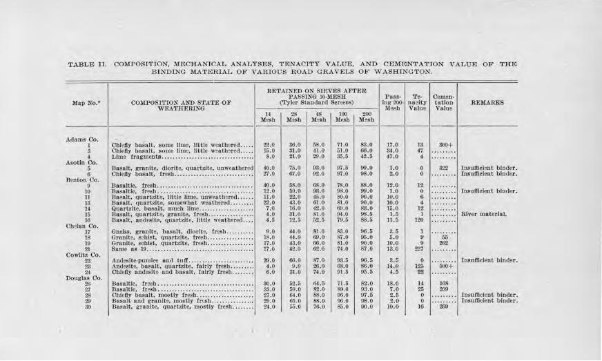
TABLE II. COMPOSITION, MECHANICAL ANALYSES, TENACITY VALUE, AND CEMENTATION VALUE OF THE BINDING MATERIAL OF VARIOU S ROAD GRAVELS OF WASHINGTON.
RETAINED ON STEVES AF'.rER PASSINO 10-MESH Puss· Te- Oemen-
Map No.* OOillPOSITlON ANU STATE OF (Tyler Standard Screens) Ing 200· naclty tatlon REMARKS WEA'.rHERlNG M esh Value Value
14 28 4S 100 200 Mesh Mesh Mesh Mesh Mesh - -------- - --------
Adams Co. l Oh!e6y basalt, isome lime, Jlttle weathered ..... 22.0 36.0 58.0 71 .0 83.0 17.0 13 300+ 8 Ohlef!y basalt, some lime, little weathered ... . . 15.0 31.0 41.0 51.0 66.0 S4.0 47 ········· 4 Lime tragmente .. . ................. .... .......... 8.0 21.0 29 .0 S5.5 42.5 47.0 4 .........
Asotin Oo. 6 Basalt, granite, dlorlte, quart:7.lte, unweathered 4.0 .0 75.0 93.0 97.5 99.0 1.0 0 322 In.sufficient binder. 6 Oblefly basalt, tresh ......... . ................. .. 27.0 6i.O 02 .0 97 .0 98.0 2.0 0 ......... Insufficient binder.
Benton Co. 0 Basaltic, fres.b ................................... 40.0 58.0 68.0 78.0 88.0 ]2.0 12 .. .......
10 Basaltic, fresh ................................... 12.0 59.0 93 .0 9S.O 99.0 1.0 0 Insufficient binder. l1 Basalt, quartzite, little lime, unweatb!red ...... ll.0 22.0 45.0 80.0 00.0 10.0 6 ......... 13 Basalt, quartzite, somewhat weathered ......... 2'2.0 43.0 61.0 81.0 90.0 10 .0 4 ......... 14 Quartzite, basalt, much lime .................... 7.0 10.0 42 .0 69.0 83.0 15.0 12 ... ...... ]6 Basalt, quartzite, granite, !resb ... .............. ~.o 81.0 81.0 9-1.0 9$.5 1.6 1 ......... River material. 16 Basalt, andeslte, quurtzite, Jlttle weatbared .... 4.5 12.6 62 .5 '19.6 8$.5 11.5 120 .........
Chelan Oo. 17 Gneiss. {rr&Jlltc, basalt. dlorltc, fresh .......... 0.0 44.0 81.0 83.0 00.5 3.5 1 18 Granite, schist, quartzite, lresh .. ......... . ..... 18.0 44.0 69.0 87.0 95.0 5.0 0 55 10 Granite, sch ist, Qtrnrt.zitc, tresh ....... ...... .... 17.0 43.0 60.0 81.0 90.0 10.0 0 262 21 Same as 19 ....................................... ]7.0 42.0 62.0 74.0 $7 .0 13.0 227 .........
Oowlltz Oo. 22 Andesite-pumica and tuff ...................... . . 29.0 oo.o 87.0 93.5 96.5 3.5 0 ... ...... Insufficient binder. 28 Andeslte. basalt, Quart?Jte. fairly fresh ......... 4.0 0.0 20.0 os.o 86,0 14.0 l2o 500+ 24 Oblefly andeslte and basalt, fairly fresb ........ 6.0 3l.O 74.0 91.5 95.5 4.5 22 ········· Douglas Oo. 26 Basaltic, fresh .. ...................... . ... ....... . 30.0 52.5 H4.5 71.5 82.0 ]8.0 14 168 27 Basaltic, fresh ................................... ss.o 59.0 82.0 89.0 93.0 7 .0 25 209 28 Ohtc!ly basalt, mostly fresh ..................... 27.0 &LO 88.0 96.0 97.5 2.6 0 ......... Insufficient binder. 29 Basalt nnd granite, mostly lresh ................ 29.0 65.0 ss.o 96.0 os.o z.o 0 ......... Insufficient binder. so Basalt, granJte, quartzite, lllOstfy fresh ........ 24.0 65.0 70.0 85. 0 oo.o 10.0 16 2$
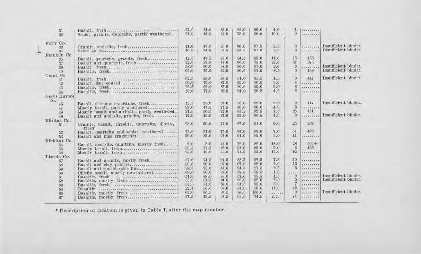
31 :::i~t g!~1~~c; · q·~,;,uii;: ·iia~tir' ivea·1 i;ei=;ti:::: I 37.0 I 74.0 I 88.0 I 03.0 I oo.o I u I 1 32 21.0 45.0 66.0 78.0 00.0 10.0 9
"Ferr:t' Oo.
I 83 Oranltr, nndfslte. fresh . .......... . ... .. ... . ..... 11.0 47.0 8'7.0 00.0 07.5 2.5 0 . ........ I Insufficient binder. ... 3-1 $nine as 33 .. . .................................... 10.0 34.0 50.5 82.5 01.0 9.0 0 .. .. .. .. . Insuftlclent binder.
Frllll.kLin Oo. 35 Basalt, q1rnrizlte, granite. fresh . ............... 12.5 47.5 70.0 64.5 89.0 11.0 15 456 :n Basalt and quartzJte, fresh ...................... 22.0 38.0 49.0 66.0 78 .0 2'1.0 67 375 30 Basntt, fresh . .................................... 65.0 90.0 95 .0 oo.o 07.0 s.o 0 .. ...... ·1 !nsufficient binder. 40 Dnsn ltlc, 1.rcsh ................................... 05.0 75.6 81.o 86.5 Ol.5 8.5 0 198 Insufficient binder.
Grant Oo. 41 Ba~alt, tre~h .. ...... .. ............... .... . ....... G2.5 85.0 $7.5 01.0 95.5 4.5 0 447 Insufficient binder. 42 Basalt, Jlme coat, ct .............................. 00.0 79.0 82.5 ss.o 9().5 9.6 4 43 DusuJtle, trrsh ................................... 2-Z.6 62.0 82.5 oo.o 05.0 5.0 8 « BIISalH~. frc~h ................................... 89.0 77.0 90.5 04.0 06.5 9.5 2
Grays Harbor Oo.
~6 Basalt, sJJiceous sandstone, fresh ............... 12.5 55.0 93.0 96.0 08.0 2.0 0 117 I rnsuftlelnnt binder. 47 Mostly bnsult, partly weathered .............. . . 23.0 47.5 73. 5 &l.O oo.o 4.0 s 48 Mostly basalt IUld omlesltc, partly weothgred .. 21.6 50.5 '72.0 S.'l. 5 02.5 7.5 26 151 40 Basnlt and andeslte, gruolte. trei,b ............. 12.0 43.0 82.0 02.0 00.5 4.0 0 ......... J rnsuftlclent binder.
Klttltos Oo. 51 Grnolte, basalt, rhyollte, quartzite, cliorlt-e, 23.0 50.0 73.0 87.0 94.0 0.0 26 262
fresh. 52 Bos11lt, quartzite and schist, weathcnd ........ 22.0 51.0 77.0 87.0 03.0 7.0 51 4.90 58 l3oselt onc'I lime fragments ...................... 50.0 &5.0 93.0 04.0 95.0 6.0 11
:rrnckitn t Oo. 54 Bnsalt, andesite, quortzil~, mostly ircsu ....... 2.0 8.0 40.0 72.0 S2.0 18.0 ,1 600+ 6.5 liostly l)es11Jt. trc~h . ............................ 52.5 77.5 87.0 Ol.O Oii.O 5.0 405
w Mostly bosatt, ir~sh ............................. 26.0 46.0 58.0 71.0 83.0 17.0 82 Llnroln Oo.
57 13nsalt and l!l'unftc, mostly tresb ............... 37.0 74.5 84.5 S$.5 92 .5 7.5 JO 5!! Basu.It aod cloy p• bblc~ .......... . .. .. ........ . . 68.0 90.0 05.0 07.0 08.0 2.0 12 50 l3o8alt and conslde.rnble lime .................. . . 38.5 76.0 89.5 94.5 97.5 2.5 s 00 Ohfefly bosaJL, n1ostly un1vMi hcr•,1. ............ 00. 0 00.0 95.0 (11.0 98.5 1 . 0
..... o·r:::::::11nsumclent binder. m Bn!'nltl~. c-resb .......... ....................... .. 01.0 ss.o 95.Q 0'1.0 OS.6 l.G 62 Basultfc, mostly fresh .......................... 65.0 87.!j 04.0 06.(l 08.0 2.0 O .. .. .. • • • Iosufllclent binder. GS Basu I tic. fre~h ......... .. .................... . .. . 62.G St.0 8S.5 91 . 6 05.0 5.0 'T 01 Basaltic ............................ : ......... . .... 2'lA 5().0 60.0 81.0 tf) .0 u.o 45 a;; D»~n!Uc, mo,;lly fresh .......................... 02.0 116.5 97.5 98.6 100.0 o I. ........ I Iosufilcll.lllt binder. 07 Uasaltlc, moslly tresh .............. . .. . . .... ... 27.5 43.5 63.5 63.6 74.6 25.5 71
• Descdptlon oi loca.tiQn is given in Table I, after the map number.
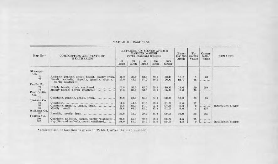
TABLE Jl-Continuecl.
RETAINED ON SIEVES Al'TE R PASSINO 10·l\1ESR Pass- Te- Oemen-
l'ilall No.• 00llfP0Sl'1't0N AND STATE OP (Tyler Standar,l Screens) ing 200- nacity tntlon REMA RKS WEATHERING Mesh Value Vnlue
14 28 48 100 200 Mesh llesb Mesh Mesn Mesh ------ ------ - ------
Okanogan Oo.
70 Andeslte, granite, scl1ist, basalt, mostly fresh. 14.0 36.0 63 .0 82.0 90.0 10.0 1 68 72 Basalt, nncleslte, rbyollte, granite, dlortte, 19.0 ,J3. 0 57.0 66.0 '16.0 2,1.0 58 .........
partly we11tber1id. Pacific Co.
73 Cblcfly basalt, much weathered ................ . 16.0 36.0 G2.0 79.0 89.0 11.0 59 500 76 Mostly basalt, partly went.hared ............•. . . 40.0 69.0 83.0 00.0 95.0 5 .0 70 ..... ....
Pelld Oreille Oo.
77 Quartzite, granite, schist, fresh . . .... ..... .... . . 28.0 52.0 65.0 S-1.0 90.0 JO.O 26 05 Spokane Oo.
82 Quartzite .... .. .... .. ... . ... ............. . .. .. . . .. 17.0 44.0 61.0 ss.o 91.0 9.0 27 ..... .... 83 Quartzite, granite, bnsnlt, tnSh ... .... . .. .... . . 4$.0 so.o 91.0 95 .0 97.0 3.0 0 Insufficient binder. 84 Mostly basalt ................................• .. . ~ -0 6t.O 82.0 S7.0 9) .0 9 .0 4 135
Whitroan Oo. 07 Basaltic, mostly fresh ......... ... ... . .......... . 57.0 73.0 70.0 &1.0 90.0 10.0 83 285
Yaklrnu Co. 100 Quartzite, andeslte. basalt, partly weathered .. 21.0 55.0 82.0 92.0 95.5 4.5 l6 ·· ·· ····· 102 Rbyolite and und~slte, much weathered ......... 58.0 S3.0 98.0 91.5 95.5 4.6 0 ... .. .... Insufficient bindH.
• De::;c1·iptio11 o f location is given In Table I. after the map r1umber.
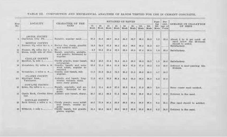
TABLID IJJ. COMPOSITION ANTI MECHANICAL ANALYSES OF SANTIS TESTED FOR USE IN CEMENT CONCRETE.
RETAIN.ED ON SIEVES Pass- Per-Map LOCALITY OHARAOTER OF 'l'HE Ing cent- REMARKS ON GRADATION No. SAND JO- 20- 30- 40· I 60- SO- 100- 2.00· 200. ago ot OF SIZES
"Mcsb Mesh Mesh Mesh Mew Mesh .Mesh Mesh Mesh Voids
ASOTIN COUNTY 5 Clo r'cston C'I ty Pll . .. ....• 13os111!ic. angular snnd ...... 27.2 00.9 69.7 SS.8 90.2 92.7 06.8 98.8 1.2 Sli.4 About 5 to JO per cent of
Sand below the 20-mesb RENTON COt7NTY should be atlded.
9 J?roPser, 6% mll~s due n. e. Ho I h•r tin•, ~harp, gnmltlc H.9 34.6 6i.4 SS.3 98.5 08.0 09.3 91.8 8.7 ....... Satisfactory. and bnsn ltlc snnd.
10 Prosser, 6* mll,ij ,Jue n. e. Do ............................ ~-8 25.0 (17.4 82.8 92.4- 05.8 97.4 99.0 LO 3S.4 Satisfactory. 12 Klona, soulb side of river. J3nsult, quartzll~. ondcslte,
and granite. Subround to angular.
CHELAN COUNTY 17 Monitor, 11., mile e .... .. .... Chitlly gronlt•, some bnslllt, 34.3 4S.6 67.4 76.4 83.8 86.8 113.S 08.5 1.6 36.6 Satisfactory.
subangular. w Wenatchee, 3~ miles n. w. Gronlte, basalt. and some &3.6 76.4 86.4 91.4 !».O 97.0 07.-! 99.2 0.8 36.6 Deficient In sand J)assing the
w~ak scblst. ao1,'tllur to 20·mesh. rounded.
20 weonicbe~. 2 miles n. w ....
OL.\RKB COUNTY
Grnnit~ and basalt, sub-angular.
11.6 31.2 68.3 76.2 86.2 91.5 96.6 00.8 0. 7 M.2
105 MiD.l!lnger .Bros., Vancouver.
Andeslte a nil llasnlt, frog. mcntul YOlconlc sum!,
ll.6 41.S 76.S 86 .4 OU 98.4 os.s 00.8 0.2 37.8
00\"l'LlTZ COUNTY some rusts• !fl"llla~.
23 Kelso, 21!, rnlles s. e ........ 13usalt, qua rtzlte. and ttn· clrsite. Rounded to nn·
s.o 16.~ 40.9 67.9 85.8 90.4 01.9 98.0 2.0 ······· Some coarse sand needed.
25 gular.
Cnstle Rock, Cow!Jtz Illver Andeslte and bnsnlt, sharp .. 26.0 52.4 56.4 91.4 bar.
oo., 98.2 98.6 09.6 0.4 37.2 Deficient In fine sand.
DOUGLAS COUNTY 26 Rock lllln.ml, 4 miles n. w .. Ohlelly g;nnlt~. ~ome schist 48.6 '19.8
and basalt, mostly an-90.4 93.S 06.6 98.4 08.6 99.G o., 35.1 Fine snod should be added.
28 Withrow, l mile e .......... gnlnr.
Ohl~)' basalt, few granite grains, angular.
48.4 80.S 94.8 \JS.O 00.2 99.8 99.8 99.8 0.2 34.0 Deficient In line sand.
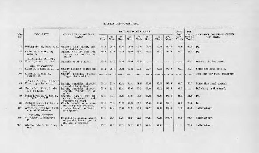
TABLE Ill-Continu ed.
RET AL'IIED ON $TEVES Pass- Per-Map LOOALITY CHARAOl'RR, OF 'l'BE log cent- REMARKS ON GRADATrON No. $.\ND 10- 2U· 3(). 40· 5(). SO- 100- 200· 200- age of OF SIZES
M2Sb Mesh Mesh Mesh Mesh M,w M esh :Mesll M esh Voids --- - ----- - -- - --------
30 Bridgeport. 2* miles s. e . . Gran ft ~ 8.0(1 basnlt. sub- 44,0 72.0 87.G 92.0 96.0 98.6 99.0 99.8 0.2 29.5 Do. rounded to sharp.
81 Pnfisodes Station, 1~ Basalt, with few lime frag- 46.0 82.6 98 .S 96.6 9S.4 00.il. 09.7 99.9 0.1 88.3 Do. miles o. meots. no coo ting on
FRANKLIN OOONTY groins.
39 Oonnell, southern If in It$ . . . Bnsalt lc snnd, angular. 85.4 SS.2 98.G 99.G 99 .0 ..... .. . .. .... ....... . .... .. 3$ .1 Dellclent ln floe sand.
ORA...'sT COUNTY 41 El)brttta, 4 miles n. e ... . .. Chiefly basaltic, coarse and 55.2 92.S 98.2 99.2 99.5 09.7 99.8 99.9 0.1 39.7 Some fine sand needed.
Ephrata, * mile w., Shari>.
106 Obielly nntlcslte, porous, ....... ....... ... .. .. ....... ······· ······· ....... ··· ···· .. ..... ....... Too fine for good concrct;e. Pruitt Pit. fragmental and J1ne.
GRAYS HA.RllOR COUNTY 46 Elma, 2.M, mnes w .•..... •.• nnsult, ounrt?.lte, rhvoUtc, 31.4 51.0 62 .4 94 .4 98.6 99.6 99.8 99 .9 0.1 80.l Some fl ne sand needed.
46 OioQnn)lam 1ih•er, l mile rounded to angular.
Deficiency fn fine s and. nasn.lt, quartzite, rbyollte, 53.6 72.S 83.4 S9.6 96 .2 99.0 99.2 99.S 0 .2 ....... s. e. ot Elma. granite, rounded to an·
Dlack .Rh•cr, E. 'h, Sec. 83, gulnr.
49 Granite, bnRnlt, nnd Sili· 42.6 61.4 SJ.6 90.6 ~5.6 9$.2 98.6 99 . 6 0.4 31.9 Do. T. 16 N., R. 2 W. ceous fragments, sub·
Oh~balls River, 4 miles s. e. r Otmded to sharp.
50 Oblefiy b11sa1t, some grnn- $2 .6 61.S 76.S 92.8 05.3 97.6 98.6 99.1 0 . 9 29.G Do. of Mootesnno. ite. fairly well rounded.
107 Wi•nooche River bn r, 1 mile Angular bosalt, n.ndesite, 16.9 44.4 03.6 79.9 90.7 94. '1 97.3 99.0 1.0 39.9 Satisfactory. s. e. of Montesano. and quartz.
ISLAND COUNTY 108 Ft. 011sey, Hesselgrave Rounded to angular grains 15.1 27 .7 49.7 64 .9 62.9 97.2 98.2 100.0 0.0 34-.3 Sn tlsfactory.
Pit. of granite, basalt, quartz-
Whidby Tsland, .Ft. Onsey lte, 1,1.ocl greenstone.
98.6 26 . 0 Satisfactory. •141 Do .... ...... .......... . ....... 30.2 48.1 06 .1 74 .2 86.G 05.0 . ... ... ... .... Pit.
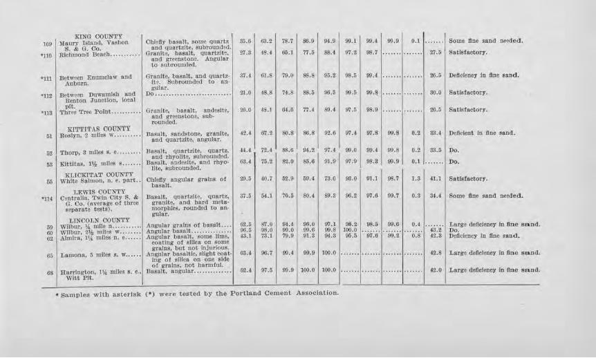
KING COUNTY 1091 Maury Island, VashQJl S. & G. Co.
•no Rlehnlond l3euch ........ •..
•111
•uz
Between Enumclaw and Auburn.
Oblcfty l)asnlt, some quartz nncl quartzite subrounded.
Granite, basalt, quartzite, nnd greenstooe. Angular to subronncled.
Grnnlte. basalt, nncl quartzite. Subrounded to an· gular.
Do ........... . ............... .
•u3
Between Duwamfsh and Renton Junction, local pit.
Three Tree Point ..... . .... ·1 Granite, basalt, andesJte, nod i:reeostone, $Db· rounded.
35.6
27.3
37.4
21.0
26.0
63.2
48.~
61.S
48.S
4$.1
78.7
65.1
79.0
74.S
6-1.6
86,0
77.5
88.S
SS.5
77.4
94.0
88.4
95.2
96.5
S!l.4
99.l
97.2
98.5
90.5
97.5
99.4
!JS. 7
90.4
90.8
98.9
99.9
1UT'l'1'l'AS CO !ThT!J'Y 51 I Roslyn, 2 miles w ..•••. ... ·I Brumit, sandstone, gl'nnlte, 42.41 07.21 80.81 86.81 92.61 97.4 07.8 90.8
and quartzite, ruigular.
52 I Thorp, 3 mlle.s s. e ........ . Basalt, <1nartzltc, Q11nrtz, 44.a 72.4 88.6 94.2 97.4 ro.o 00.4 90.S
I nod rbyoUte, subronnded. I I I I I 53 Kittitas, l'>i miles s. . . .. . . Basa.It, nnd!'.>lte, and rbyO· 03.4 75.2 82.0 85.0 91.9 97.9 98,3 99.9
lite, subrounded. ITT,IOKt'l'AT OOUN'rY
rn; I Wbfte Salmon, n. e. part .. Chiefly angular gl'alus of I 29.5 I 40.7 I 52.9 I 69.4 I i3.0 I 93.0 I 91.1 I ~.7 basalt.
LF.WIS COUNTY •114 I Oentrallu, •rwln Oity S. &
G. Oo. (nvorngo of three separate tests).
Basalt, quartzite, quart?., granite, and bard metnmor1>lllcs, rounded to angular.
87.6 54.1 70.5 I so.4 I S9.3 I 00.2 I 97.6 I 09. 7
0.1
27.5
26.6
30.0
26.5
Some fine sand needed.
Satisfactory.
Thlflclency In fine sand .
Satisfactory.
Sa tlstactory.
o.z I 33.t I Jnllclcnt In fine sand.
0.2 l 33.61 Do.
0,1 ....... Do.
1.3 I 41.1 I Satisfactory.
0.3 I M.4 I Some One sand neecled.
LINCOLN OOUNTY 00 I Wilbur, \I, mile n ....... . .. . 00 Wilbur, 21h miles w .......• 02 Almira, 11&: miles n. e ......
Angular gr,Uns of basalt ... . Angular basalt ............. . . Angular basnlt, some llme,
G2.5 96.5 -!3.1
87.0 98.0 73.1
94.4 99.0 79.0
oo.o 99.0 91.8
07.1 I 08.2 99.8 100.0 9-1.:3 95.5
98.51 00.0 I 0.41····· ··1 Large claflclency In fin e sand. . . . . . . . . .. . . .. . . . . . 43.2 Do. 97 .6 99.2 0,8 42.3 Dellaiency In fine .sand.
G5 I Lamontl, 5 miles 8. w .•••••
68 I liarrinJtoo, 114 mlles s. e .• Witt l'lt.
coatl.ng ot silica on some grains, but not Injurious.
Angular ba$altlc, slight cont· Ing of silica on one side o( groins, not hnrm!uJ.
Basalt, angular ............. .
a:u 00.7 1)9.4 99.0 1100.0
62.t 07.5 99.9 I 100.0 I 100.0
• Samples with asterisk (•) were tested by the Portland Cement Association.
42.8 I Large detlclency In tine sand.
42.0 Large deficiency In nne sand.
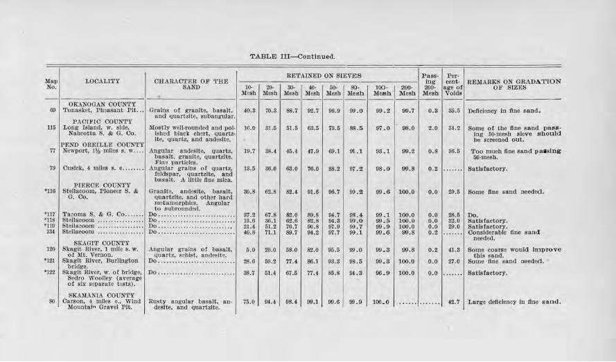
TABLE III-Continued.
RE'£AINED ON SIEVES Pass- Per-
' LOOALITY OB.ARAOTER OF '!'BE log cent- REMARKS ON GRADATfON SAND 10· 20· SO- 40· 50- SO· 100· 200• 200· age of OF SIZES
llesb Mesh Mesb Me&b Mesh Me6h Mesh Mesh Mesh Voids --------- · OKANOGAN COUNTY i- - - - ---------
Toonsket, Pbiasnnt Pit ... Gralns of grnnlte, busalt, {0.8 70 .3 88.7 92.7 96.9 oo .o 99 .2 99.7 0 .3 35.5 Deficiency ln fine sand. Mel quartzite, subnngular.
PACTFIO COUN'rY Long lsJand, w. side. Mostly well-roundecl ancl DOl· JG.O 31.5 51.5 68 .5 'lll.5 SS.5 97 .0 98.0 2 .0 S4. 2 Some ot tbe 11.ne s and pass-
Nn:JJcotta S. & G. Co. !shed blac); cbsrt, quartz. log 50-mesb sieve should lte, quartz, and andeslte. be screened out.
PEND OREfLLE COUNTY Newport, JV., miles s. w .... Angu:lar nndcsltc, quartz. 19.7 88 .4 45.4 47.0 69.1 91.1. 03 . 1. 99.2 0.8 36.5 Too mncb 11.ne sand p a1slng
basalt, granite, quartzite. 50-mcsb. Fine particles.
OusicJc, 4 miles s. e ........ Anga:lar grains ot quartz, 13.5 36.0 68.0 76.0 88.2 97 .2 98 .0 99.8 0 .2 .... ... Satisfactory. feJ<iS1l8T, quartzite, and basalt. A llttle tine mien.
PIERCE COUNTY Steilncoom, Pioneer S. & Grnolte, andesite, basalt, 80.8 62.8 82. <l 91.6 96.7 99 .2 00.6 100.0 o.o 29.5 Some fine sand needed.
G. Co. quartzite, and other hard meto.morpbics. Angu)at' to .subrounded.
"l . •·
Tacoma S. & 0. Co ....... Do ......... ............... . ... 37.2 67.8 82.0 S9.8 04.7 08 ·"'
99 .1 100.0 o.o 28.5 Do. Steilacoom ................. Do ...... . ..................... 13.6 86. l 62.6 82.8 9U 99.0 00.5 100.0 0 .0 32.0 Satisfactory. Stdlacoom ................. Do ...... . .. ......... . .. . . . ... 21.4 61.2 76.7 90.8 97 .9 99 .7 00.9 100.0 0 .0 29.0 Satisfactory. Steilacoom ................ . Do . ... . .......... . ..... , ...... 40.8 71.l S9.7 0-1.2 07.7 99 .l 00 . 6 99.8 0.2 ····· ·· Considerable tine s and
SKAGIT COUNTY needed.
Skagit River, 1 mne s. w. Angu.lar groins of basalt, 5.0 20.0 58.0 82.0 95.5 90.0 99. 3 99.8 0 .2 41.3 Some coarse would im prove of Mt. Vernon. quartz, schist. nndeslte. this sand.
Skagit River, Burllngton Do ............. .... .. ......... 28.6 59.2 77.4 86.] 03.8 98.5 99. 3 100.0 o.o 27 .0 Some One sand needed. • bridge.
Skagit River, w. of bridge, Do ............. . ... ........... SS.7 51.4 07.5 77.4 S5.8 IJ.LS 96. 9 100.0 o.o ....... Satisfactory. Sedro Woolley (overage of six separate tests).
SKAMAl-'L\ COONTY Carson, 4 mflcs o., Wind Rusty angular basalt, 8.ll· 75.0 !».4 98.4
Mountain Gravel Pit. desite, and quartzite. 99.1 99.6 99 .9 100. 0 ....... ....... 42.7 Large deficiency In fine so.ad.
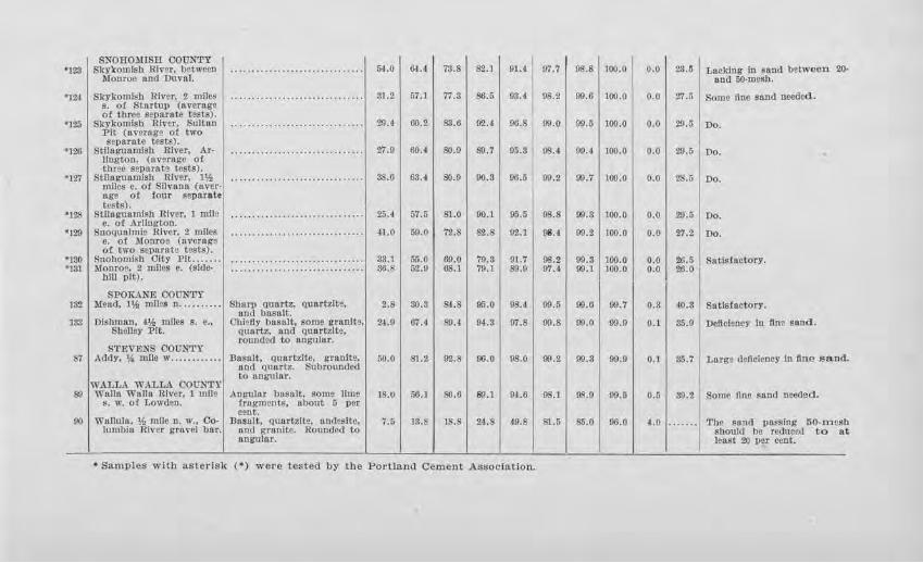
SNOHOlUSR COUNTY ' 128 Skyl<omlsl1 Rl\"er, between
Mon.roe and Dnval. ..... ~ ......................... 54.0 64.4 73.S 82.1 91.4-
'124 Skykomish River. 2 miles ·························· ····· 31.2 57.l 77.8 86.5 03.4 s. of Stortup (average of thron s~pu.rate tests) .
29.4 G0.2 83.6 '125 SJ..-ykomlsh River, Sultan ·························· ····· 92.t 00.8 :Pit (average ot two scpnrnle tests).
27.9 60.4 S0.9 S9.7 '126 Stlh11,•unmlsh River. Ar· ...... .................... ..... 05.3 Uogton, (av•rage ot lluto separate tests).
' 127 Stllugunmlsh RJycr, l'h ...................... ......... 88.6 63.4 S0.9 90.3 00.5 m1Ies e. of Sllvu.na (aver-nge ot !our separate tests).
' 128 Stllugunmlsh River, J mm• ······ ························· 25 .4 57.6 81 .0 90.1 95.5 e. of ArUngton.
•1119 Snoqualmie River, 2 mllcs ..... ... ....................... .Jl.O 59.0 '12.8 82.8 92.l e. of Monroe (nverags of two sepnrato tests).
•t30 Snohomish City Pit .. ... .. ......... ............... ..... ... 33.1 56 .0 69.0 70.8 91.'T •131 Monroe. 2 rnllcs e, (side· .......... .. ................... 36.8 62 .0 68.1 79.1 89.0
WU pit).
SPOK.\NE COUNTY 182 Me11d, I* milts n ....... ... Sharp Quartz, quartzite,
and bnsnlt. 2.8 30.3 84.8 95.0 9$.4
138 Dlshmnn, 4'h mfles s. e .. ClWefly b11s1tlt, some granlt,, 24.0 67.4 89.4 94 .3 97.S Shelley Pit. quartz, and Qunrtzlta.
rounded to ongular. STEVEJ:IS COON'l'Y
87 Addy, \~ mile w .... .. ...... Dasnlt, quartzite, l!'f8nite, 00.0 81.2 92.S 00.0 08.0 ur\d quartz. Subroun<)ed
WALLA WALLA COONTY to angull, r.
89 Walla Wallo. River. 1 mile ADl,'ltlltr basnlt, some lime IS.I/ 56.1 80.6 B!l.1 94.6 s. w. o1 Lowden. fragments. ubout 5 per
cent. 00 Wullah1. 1h mile n. w., Co· Basalt, quartzite, andeslte, 7.5 13.S 18.S 24.8 49.8
lumbia River gravel bar. nnd gra ui te. Rounded to angular.
• Samples wllh aslerlsk (•) were tested by the Porlland Cement Association.
97.7 98.8 100.0 0.0 23.5
98.2 99 .6 100.0 o.o 27.5
09.0 90.5 100.0 0.0 29 .5
9S.4 90.4 100.0 0.0 20.5
99.2 09.7 100.0 o.o 28.5
98.8 011.3 100.0 o.o 20.5
98.! 09.2 100.0 o.o 27.2
!)8.2 09.3 100.0 o.o 26.5 07.4 O'J.l 100.0 0.0 26. 0
09.5 00.6 09.7 0.3 40.3
00.8 09.0 99.9 0.1 35.0
99. 2 99.3 09. 9 0.1 85.'T
OS.I 98.0 99.5 0.5 39.2
81.5 85.0 06.0 4.0 ........
Laeldng in sand b~tween ~ ond oo-mesh.
Some fine sand needed.
Do.
Do . .. Do .
Do.
Do .
Sntls:fnctor:v.
Sat isfactory.
Deficiency in flno s&nd .
Lar~ deficiency In tin e s a.n
Sonic llne sand needed.
'l'he sand vn~slng 50.mei should be reanced to least 20 per cent.
d.
b .t
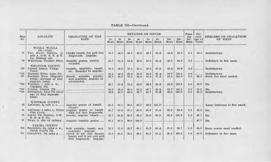
Mnp No.
LOCALITY OHARAOTER OF TRE SAND
WALLA WALLA 00.-0ont.
91 I Two Rivers Station. , 'A 1 .0hiefly bn.salt, few soft lime mfle s., 0-W. R. R. & N. tragments. Angular. Oo. Rnilwny cut.
92 I Waitsburg, 'l'oucbet ruver. Basaltic grallll!, mostly rounded.
135
*186 137
'138
*139 '140
WHATCOM COUNTY Lumm! Island, vmoge
Point. Nooksnk River, Acme Pit .. Nooksnk River (Nugent's
bridge (average of four separate tests).
Ferndale, 1 mile s. w., Olnrlrson Pit.
Lynden, County Plt ...... . 13ellfngbaro, Llncl Plt (aver·
nge of four separate tests).
WHITMAN COUN'l'Y 98 I Lacrosse, % mne n. e .. ····I
94. LnOrosse, 8 miles n., Union Flat Oreek.
95 Gravel Pit Stntlon, O·W. R.R. & N. Co.
07 E11·an, n. sldo of ran·wny ..
103
104,
YAKIMA OOUNTY Sunnyside, 8* mJles s. w.,
Patch Gravel Pit. Grandview, l'h runes s .....
Granite, quartzite, basalt, etc. Hounded to angular.
ii~s.;.i.;; · · an'ciesite." · -~irn1i-.e: · and gunrtzlt-e. Angulnr to s111;>rounded.
Angular grnlns of basalt. Oonrse.
Angulnr gc,tlns of basalt wltb tew limo fragm~nts.
Porous, ungulnr basalt .... .
Angular basnltlc grains .... .
Soft ondosite, basalt, and I qanrtzlte. Angular.
About so per cent durable: basalt and 20 per cent soft! lime fragments. AnguJar. '
TABLE III- Continued.
RETAINED ON SIEVES
10- 20- so- 40· 50- 80· i\tes.h Mesh Mesb Mesh Mesh Mesh --- -----10.7 #.7 69.7 80.5 92.'T 08 . 9
55.7 Sl.3 01.3 93.0 95.5 9S.2
28.2 49.8 70.4 80.4 90.2 97.5
31.0 44.3 67.2 69.9 S,1.8 95.4 26.8 58.6 78.0 8$.5 04.2 97 . 8
80.1 67.4 73.0 88.5 92.8 98.3
26.6 00.8 90.0 95.5 f'/1.'1 99.2 18.0 45 .7 63.8 81.7 91.'T 97 .8
91.5 99.1 99.0 99.7 99.8 100.0
47.7 8'7.6 07.5 99.0 99.6 00 . 8
73.7 98.3 09.o 99.8 99 .9 00 . 9
83.3 99.4 00.9 100.0 ....... .......
12.l 17.0 38.7 68.1 S9.2 96.4
10.S 08.5 98.2 00 .0 99.2 99.2
Pass- Per-Ing cent- REMA:UXS ON GRADATIO N
100· 200· 200- age of OF SIZES M esh Mesh Mesh Voids ----- --
99.2 99.9 0.1 38.3 Satisfactory.
98.'l 99.9 0.1 ....... DeJlclency In fine sand.
98. 2 99.8 0.2 ....... Satisfactory.
99.7 100.0 0.0 Satisfactory. 98.S 100.0 0.0 20.2 Some fine sand needed.
99.2 100.0 o.o 29.5 Do.
99.7 100.0 o.o 31.0 Do. 98.9 100.0 o.o 29.3 Sa tlsfactory.
. ...... ....... .. .. ... ....... Large dellciency In llne sand.
99.9 99.9 0.1 42.3 Do.
99.9 100.0 o.o 45 .1 Do.
........ ....... ....... 47.7 Do.
97.9 99.7 o.s '4.0 Some coarse sand needed.
99.3 100.0 0.0 42.2 Dellcloncy In fine s11Da.
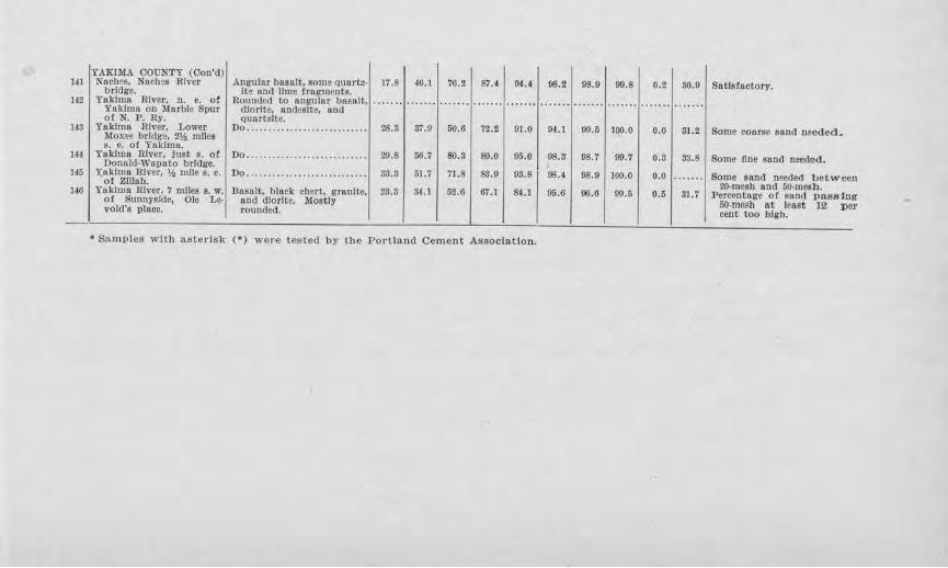
lH
142
us
1H
li5
146
.
YAKIMA OOONTY (Oon'd) Nacbes, Naebes River .Angular basalt, some quartz· 17.8 46.1 76.2 87.4 9,1.4
bridge. i~ ond Ume tragments. Yakima River, n. e. of Rounded to angular basaJt,
Yakltna on Marble $par diorlte. and•sftc, and o1 N. P. Ry. quartzite.
Ynkh:nn River, Lower Do ............................ 28.8 37.9 50.6 72.2 91.0 Moxee bridge, 2'/.t mlles s. e. of Y11Jdma.
Yakima River, just s. of Do ... ..................... . ... 20.8 56.7 80.3 89.0 95.0 Donnld-Wapato bridge.
71.8 83.9 93.8 Yakima River, ¥., mll~ s. e. Do ............................ 33.S 51.7 of Zillah.
Yakima River, 7 miles s. w. of Sunnyside, vold's place.
Ole Le-Basalt, black chert, granite,
110<.1 dlorlU. rounded.
Moist:ly 23.3 84.l 62.6 67.l &1.1
• Samples with a.stel·Lsk (•) we1·e tested by the Portland Cement Association.
98.2 98.9 99.8 0.2
94.l 99.5 100.0 0.0
98.3 98.7 99.7 0.3
9!!.4 98.9 100.0 0.0
95.6 oo.o 99.5 0.5
86.0
31.2
33.S
. ...... 31.7
Satisfactory.
Some coarse sand needecl.
Some One sand needed.
Some sand needed betw-e, n 20•rnesh and 00-mesb.
F ereeotage of san/1 passJ1 g e:r 60-mcsb at l~nst 12 :p
cent too high .
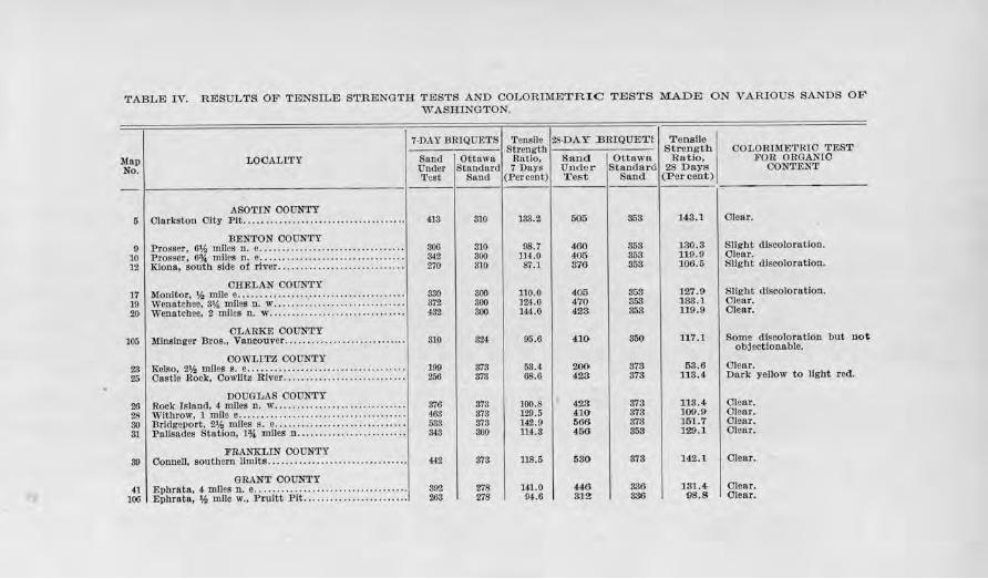
TABLE IV. RESULTS OF TENSILE STRENGTH TESTS AND COLORIMETRI C TESTS MADID ON V.A.RIOUS SANDS OF WASHINGTON.
7,DAY BRIQOETS Tensile 28-DAY J3.RIQUET! Tensile Strnngtb Strengtb COLORIMETRIO TEST
.Map LOOALrn.'Y Sancl Ottawa H11tlo, Sand Ottawa Rutio, FOR ORGANTO No. Oncler Standard 7 Days Under Standard 28 Days OONTEN'l:
~·est Sand (:Percent) Test Sand (Percent)
--5 413 310 133.2 505 353 143.1 Clenr.
9 806 810 08.7 460 3ii3 180.8 Slight discolorntlon. 10 842 300 JH.O !i05 853 119.9 Clear. 12 270 310 87.1 876 853 106.5 Slight discoloration.
17 330 800 1.10.0 405 358 127.9 Slight discoloration. 19 372 800 ]24.0 470 353 133.1 Clear. 20 432 800 144.0 423 853 119.9 Olenr.
105 310 324 95.0 410 850 117. l Some clJscolornt!on but not objectionable.
23 199 378 58.4 200 373 53.6 Clear. 25 256 373 68.6 428 373 113.4 Dark yellow to light red.
26 376 373 J0().8 428 373 118.4- C lear. 28 468 373 129.5 410 873 100.9 C lear. so 533 373 1'12.9 566 873 161.7 Clear. 31 343 300 114.3 456 858 129.1 Clear.
39 442 378 118.5 580 378 142.1 Olear.
41 392 278 141.0 446 336 131.4 Clear. 100 2.63 278 94.6 312 336 98.8 Clear. pl
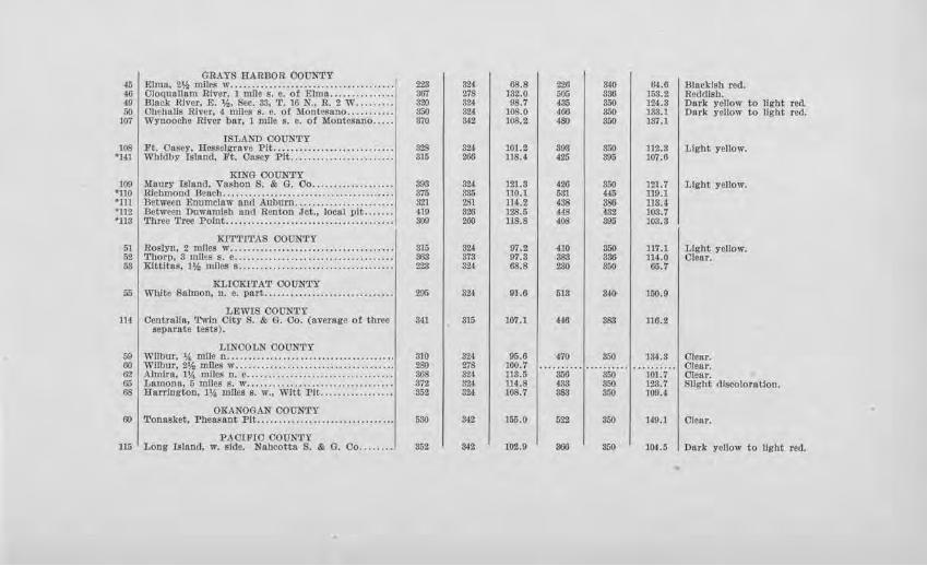
GRAYS RARDOR COUNTY 45 Elma, 2% miles w ............. . ....... . ........... . .. .. 223 824 68.8 226 340 64 .6 I Blnc1dsb red. 46 Cloqunll11m River, I mlle s. e. of Elmo ......... . ..... 367 278 JS2.0 505 886 153.2 Reddish. 49 Blnek River, E. %, Sec. 33, 'I'. 16 N., R. 2 W . ........ 320 324 OS.7 435 350 124.3 Dork yellow to light rett 50 Chehalis River, 4 mlles s . e. of lliontesaoo ........... 350 324 108.0 466 350 133.l Dark yellow to light red.
107 Wynooche River bo-r, 1 mile s . e. of ll!ootesono ..... 370 842 108.2 480 350 137.1
ISLAl\'D COUNTY 108 1 Fl. Casey, He~selgrnvc Pit . . .......................... , 8"....S I SU I IOU! I 300 I 350 I 112.3 I Light yellow.
•141 \Vbldby tslnnd, Ft. Casey PJt .. ...... . .... .. .. .. ..... 315 266 l.18,4 425 S95 107.6
KING COUNTY 109 Maury Tslancl, Vashon S. & G. Oo ................... 303 324 121.3 42.6 850 121.7 I Light yellow.
•no R-fchmond Beach ........................................ 375 835 110.1 681 H5 119.l •111 Betweon E11.umclaw ancJ Auburn ....................... S'll ?lil 114.2 4.38 386 118.4 '112 Between Duwa.mlsh and Renton Jct .. local pit ... . ... H9 S26 1.28.5 448 482 103.7 •113 'l'hree 'l'ree Point ....................................... 309 2.60 llll.8 40.S 395 103.3
Kl1lvl'ITA$ OOUN'l'Y I 51 Roslyn, 2 miles w ...................................... 316 S24 07.2 410 350 117.1 I Light yellow. 621 Thorp, 3 m!Jes s. e ............................... . ..... 003 373 97.3 383 336 114.0 Clear. 53 Kittitas, Hf miles s ............................. ....... 22S 324 6$.8 230 350 65.'I
KLIOXITAT COUNTY 65 I White Salmon, n. c. part .... ..... .... ...... ... .... .... 1 295 I 324 I 91.6 I 613 I 340 I 150.0
LEWIS COUNTY JU I Cootralln, Twin City $. & G. Oo. (average of three I
separate tests). 341 I 315 I 107.1 I 440 I 883 I 116.2
LINCO'LN COUNTY 59 Wilbur, V. mne n ................................... .. .. 310 824 95.6 470 350 134.3 I Clear. 60 Wilbur, 21h miles w ........................ .. ....... .. .. 2SO 278 100.7 .. ........ Clear. 62 Almira, l'A miles o. e ....................... . ....... . .. sos 824 U3.5 856 350 101. 7 Olear. 05 Lamon a, 6 miles s. w .................................. 372 32<1 lU.8 433 850 128. 7 Slight discoloration. 68 Harrington, 1'4 mlil!s s. w., Witt l'lt ...... . .......... 352 324 10S.7 383 350 100.4.
OKANOGAN COUNTY 00 I Tonasket, Pheas;:::;:~. ~~;~~ ................... , 580
I 342
I 166.0
I 622
I 350
I 149.1 I Clear.
115 ' Long Island, w. side. Nabcotta S. & G. Co .. . .... . S5Z 342 102.9 366 350 104.5 Dark yellow to Ugbt red.
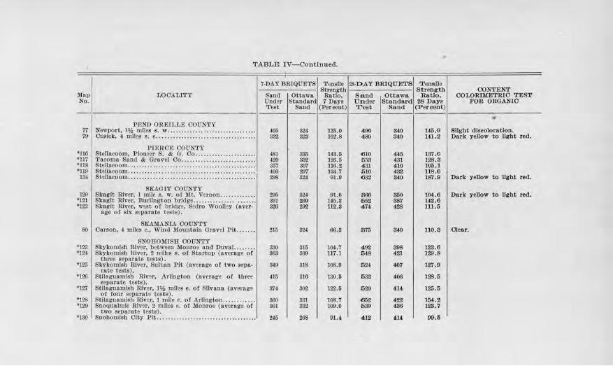
TABLE IV-Continued.
7-DAY BRIQUETS Tensile 28-D .AY BRIQUETS T ensile Strength Sttength CONTENT
?,fop LOOAl,l'l'Y Sand Ottawu Ratio, Sand Ottawa :Ratio, OOLORIMETRIO TEST No. Unde:r Stnnd&rd 7 Days On dsr Standard 28 Days FOR ORGANIO
Test Sand (Percent) Test Sand (Per coot) ---- ..
PEND OREILLE OOUNTY 77 Newport, 1% mllfs s. ,v ....... ......... .......... ...... 405 324 lZ.S.O 490 340 146. 9 Slight discoloration. 79 Cusick, 4 miles s . e ............... . ... .. .. . . .... . .. . ... 332 323 102.8 480 340 141.2 Dark yellow to light red.
PCEROE OOm.'TY •uo Steilacoom, Piomer S. & G. Oo . . .. ................. . !1$1 335 143.5 610 445 ]87.0 •117 Tacoma Sood & Gravel Oo .. ............... ... ...... . 4-20 832 126.5 553 t3l 128.3 •us Stellocoom ......................... .... . ...... . .... .. ... 857 307 116.2 431 410 105.1 •n9 Steilucoom .. . ............................... . ... . ....... 400 201 13'1.7 510 432 llS.O 184 Stsllncoom .... ... . ........................... ..... .... .. 29S 324 91 .0 6 32 840 187.9 Dark yello" to light red.
SKAGIT COUNTY 120 Skagit River, l mile s. w. o f lilt. Vernon . ........ .... 295 324 01.0 366 350 104.6 Dark yellow to light red.
*121 Skagit R.iver, Burlington bridge ...................... 891 ~ 14-5.3 552 38'1 142. 6 •122 Skagit River, wost of bridg2, S2dro Woolley (aver- 326 29'l 112.3 474 428 111.5
age of six separate tests) .
SR'.AMA.NtA OOUN'l'Y 80 Corson, 4 miles e., Wind Mountain Gravel Pit ....... 215 324 66 .S 375 340 110.3 Olear.
SNOHOMISH OOO};TY •123 Skykomlsl1 River, between Monroe and Duval. ....... 330 315 l (», 7 4 92 898 123.6 •12~ SJ..-ykomisb Rlvo,r, 2 mfles s. of Startup (average or 303 SOI) 117.1 648 421 129.8
tllree separate tests). '125 Skylromlsh River, Sultnn Pit (overngo of two seDII· 349 818 108.9 52,1 407 127.9
rn te tests). '126 Stllngunrnlsb River, Arlington (overage ot three 415 316 130.5 532 406 128.5
separate tests). •127 Stllogunmlsb River, 1~ ml.les e. ot Silvana (average 374- 302 122.6 520 414 125.5
ot four separate tests) . *128 Stlloguam.ish R iver, l mile e. of Arlington . .. ... .. ... . 860 331 108.7 652 422 )5.(.2 •120 SnoQunlmlo Jlivar, 2 mlles c. of Monroe (avcrug1? of 361 382 109.0 539 436 123.7
two separate tests). •130 Snohomish Oity P it .. ................ .... ... ... ........ 245 268 01.4 412 4-14 99.5
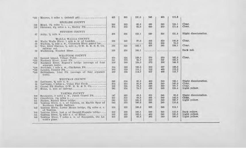
.,,, I .... ro,. , ...... ''""'" • ., ....................... , 415 I 809 I 181.0 I 545 I 490 I 111.2
132 Mead, llh mn~ s:~~~~~ .~~~:~ .................. , 300 I 323 I 92.6 I 490 I 840 I 144.l I Olear. 138 Dllihman, 4¥., Jlllli:s ~. e., Shelley PIL .................. 2J)8 8'12 85.6 600 350 1'71.4 Olear.
STEVENS OOUN'l'Y ft1 I Addy, 'A mllo w ........................................ I 496 I 324 I 153.1 I 580 I 350 I 151.4 I Slight discoloration.
WALLA WALLA COUNTY 89 waua Wallo. RiVllr, 1 mile s. w. of Lowden ...... .... 382 34.2 97.0 ,19$ 350 140.9 Clear. !JO Wollula, ¥., mile ll. w., Oolmnbht River gr,wcJ bn1 .... 252 350 72.0 91 Two River Station, 14 mile- n., O·W. R . .R. ,e,, N. Co. 380 324 102.l 456 UO lM.l Olear.
rallwny cut. 92 Waitsburg, Touchet River ............ . ................ 330 324 102.l .......... ......... . ......... Dark red.
WRA'fOOM OOUNTY 185 Lum ml IJ;Jand, Village J>olnl. .... .. ................... 450 324 188.0 570 850 162.8 I Clear.
•130 Nooksnk River, Acme Pit ....................... . ...... 241 278 86.7 419 397 105.5 •137 Nook8nk River. Nugont's bridge (average of !cur 359 289 lU.O 572 800 l«.2
$er,nrnte tests). •1:is 'Ferndale, l mHe s. w., Olnrkston Pit ............... . .. 30! 30.1 130.5 500 897 126.S •139 LyndJm, OounL)' Pit ................................. ... 862 szo 113.1 522 405 112.2 •HO J3elllngba.o1, Lind Pit (a,,erage of four ~e.parate 369 322 114.7 537 400 115.7
tfsts).
WHITMAN OOONTY
I I I I 93 1 LrlOrosse, % mlle n. w ...................... ........... 1 280 324 ~.51 463 340 136.1 I Slight dlscoloratlon. !).t LnOross~, Smiles n., Uolon Flat Oreek ................ 803 SU 03.3 496 340 145.9 01.ear. o;; Gravel Pit Station, 0-W. R. R. & N. Co ..... ....... 236 824 72.8 346 340 101.7 Olear. 07 E\1•Rn, n. l!ide 01 railway ............. . ............... 2J2 32,1 '74-.7 423 340 124.4 Light yellow.
YAKIMA OOU.NTY IOS Sunnysld~. 3 mll28 s. ,v., Patch C:lravel Pit . ....... ... 147 323 4S,5 315 340 02.6 I Slight discoloration. 104 G.rnndvlew, 11), miles s ................................. 200 323 !l!l.8 4S6 340 142.0 Ole11r. HI NMh~i,, Nnches River brltfge ........................... 840 328 105.2 523 UO ]56.7 Light yellow. 142 Yakima Ulver, n. o. of Yaklmn, on Marble Spur of 343 323 11)6,2 300 840 l]G.4
Nortpcrn Pnclllc Rnllwny. 143 Yakima Rlv0 r, Lower Moxee bridge, 2% miles s. e, 353 828 100.8 388 340 114.1
of Yukima. ]4,1 Y1tklmu River, Justs. of Doneld-Wnpato brldi;a ..... 330 323 102.1 530 3~0 116.9 I Dar)< yellow. l-15 Yakima River, Y.i miles. e. of 2Ull1b .................. 333 823 1.03,1 ~60 3-10 135.6 Light yellow. 146 Ynl<imn Rh'cr, 7 1:nllcs s. w. ot Sunnyside, Ole Le· 30$ 323 93.8 862 340 ] ()6.5 Light yellow.
vold's place.
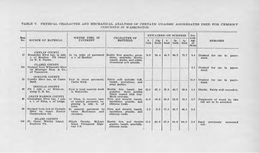
TABLE V. PHYSICAL CBARAC'l'ER AND MECHANICAL ANALYSES OF CERTAIN COARSE AGGREGATES USED FOR CEMENT CONCRETE IN WASHINGTON.
Map No. I SOUROE OF MATERIAL
WHE.R,E USED TN PAVEMENT
CliARAOTER OF MATERIAL
RETAINED ON SCREENS I Per--------- ---- cent-2. I 1.¥.a· I l• I *· I '4· age Iueh Inch I.och Inch Inch ot
REMARKS
Wear - I : I 1--1--1--1--1--·1--I---------
CRELAN COUNTY 17 I Wenatchee River bar, Y; mile
e. ot Monitor. Pit owned by W. E. Tliylor.
CLARKE COUN'l'Y
In JJ,4 miles of pavement !Mostly firm granita, green· I 14.9 s. e. of Monitor. stone, quartzite, dlorfte,
basnlt. gneiss, and scbfst. Occasional soft granite.
105 I Dredged trom Willamette River, ... . •• .. . .. . •.. . .. . . . . . . ....... by Mlnsluger Bros. & Co.,; o! Vancouver . I
COWLI'l'Z COUN'.l'Y
29.4 44.7 60.7 72.7 6.4
3.2
Crushed for use io pavement.
Crushed tor use In pavement.
25 I Cowlitz River bar, at Castle R-Ock.
Used lo street pavement, I FalTly soft anilesfte tuff, 1 ...... 1 ..... . 1 .. .... 1 ...... 1 ....... 1 IA.S Castle .Rock. basalt, greenstone, and
some pumice.
Crushed fo.r use lo ment.
pave-
DOUGLAS COUNTY 28 I Pit 1 mile e. ot Withrow.
along G. N. Ry.
GRAYS RARUOR COUNTY 46 I Cloquallnm Rfv<lr bar, l mlle
s. e. o! Elma, s. ot bridge.
50 I Dredged from bed of Cbehalls River by Grays Barbor Construction Co.
ISLAND OOONTY 148 I Ft. Casey, Whidby Island.
Keystone Pit.
Used In local concrete work I Mostly firm basalt, few I 22.0 I 27 .1 I 37 .3 I 4S. 7 I 59.0 I in Waterville. gronltes. Some pebbles
At ElmR, in concrete base ot asphalt pavement, be· ginning l,,!, mile w. of town.
tn concrete pavement be-tween Montesano and Aberdeen.
Skugit County, McLean Uoad. Permanent Highway SB.
thinly coated with lime. Muc.h over•siza.
Firm and duroble bas alt, 1 10.s I JS .O I 30.6 I 53.9 1 73.l j sandstone, granlte, and siliceous rocks.
Firm and dnrable basalt, I sandstone, grao.ite, and smeeous rocl<s.
2.2 I
Mostly Orm and durable! 15.5 granite, basalt, QtUlrtzlte, siliceous rocks.
s.s I 11.2 I 42.7 I 66.4 I
46.3 67.9 94 .s I 100.0
4.3 I Glacial. Fairly well rounded.
3. 7 I Fragments o! wood lo tlu, bar are to be avoided.
2.9
S.6 I Sand previously out.
screened
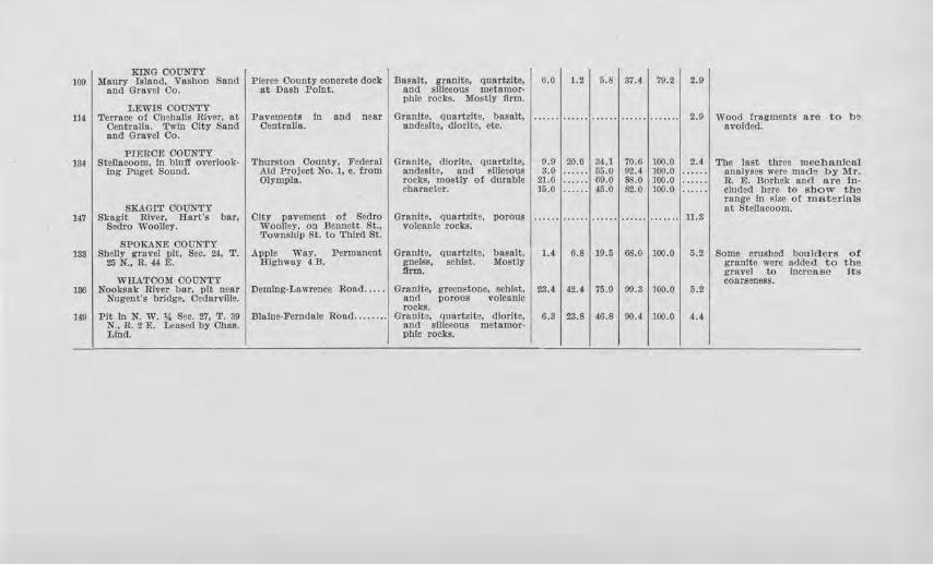
KING COUNTY 100 Maury tsland, Vashon Snnd Pierce County concrete doo.k Basalt, granite, quartzite, o.o 1.2 5.8 87.4 79.2 2.0
and Gravel Oo. at Dash Point. and siliceous metnmor• phic roc)<S. Mostly firm.
LEWI$ COUNTY 114 Terrace o! Chehalis River, at Pavements In nnd near Granite. quartzite, l)asalt,
Oentrnlla. 'l'wtn Olty $and Centralia. andes.lte, dlorlt~, etc. and Gravel Oo.
...... ...... ...... ...... ....... 2.9 Wood fragments are to be avold.ed.
PIERCE COUNTY 134 Steilacoom, In bluff overlook· Thmston County, Federnl GranJte. dlorlte, quartzite, 9.0 20.0 84.l 70.G 100.0 2.4 The last three mechaofoal
Ing Puget SoWld. Aid Project No. 1, e. from andeslte, and 81Ji020US 3.0 . ..... 55.0 02.4 100.0 . ..... analyses were mnde by Mr. Olympia. rocks, mostly of durable 21.0 ...... 69.0 ss.o 100.0 . ..... R. E. Dorhek and n.re in-
Character. 15.0 ...... 45.0 82,0 100.0 . ..... eluded bore to show tbe
SKAGIT COUNTY range In ~17.$ o( matla'rlals at Steilacoom.
147 Skagit River, Hart's bar, City pavement of Scdro Granite. (lUartzitg, vorous ...... .. .... ...... ...... ....... 11.3 Sedro Woolley. Woolley. on Bmnett St., volcanlc rocks.
Township St. to Third St. SPOKANE COUNTY
183 Shelly gravel pit, See. 24, T. Apple Way, Permanent Granite, quartzite, basalt, 1.4 6.8 19.5 68.0 100.0 5.2 Some crushed boulders of 25 N., U. 44 E. Hlgbway 4D. ~ofss, schist. Mostly granite were 11<lded to the
tlrm. grnvel to Increase Its WHATCOM COUNTY coarseness.
186 Nooksak River bar, pit near Deming-Lawrence Road ..... Granite, gl'Ccnstooe. schist, 23.4 42.1 75.9 99.3 100.0 5.2 Nugent·s bridge, Cedarvffie. an(l porous volcanic
rocks. 149 Pit In N. W. 1A Sec. ZT. T. 30 Blalne·Fenidale Road ........ Granite, quartldt!, dlorlte, 6.3 23.8 4-0.8 90.4 100.0 4.4
N., .R,. 2 E. Lensed by Obas. 81)(1 snlceous metamor· Ltnd. phio rocks.
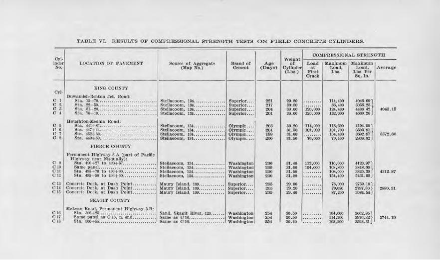
TABLE VJ. RESULTS OF COMPRESSIONAL STRENGTH TESTS ON FIELD CONCRETE CYLINDERS.
Oyl· 1 inder No.
0y1.
LOOATION OF P AVEMENT
KING OOONTY
Source of Aggregate (Map No.)
Brand of Oement
Duwamlsh.Renton Jct. Road: 0 1 I Stn. 15+70 .•.. .... . ......•.... . ... . ..... , Stellncoom, .134 ....... •• ....... Superior .. . . O 2 Sta, 22Hi0...... . ... . . . . . . . . . . . . . . . . . . . . Ste.Uacoom, 134. . .............. Superlor ... . 0 3 Sta. 81+20.. ......... .. . . . . . . • . . . .. . . .. . Steilacoom, 134. •• . . . . . . . . . . .• . Superior ... . 0 4 Sta. 76+10....... . . . • . • . . • . . . •• . . • • . . . . . Steilacoom, 134. •• • • . • • . • . • . . . • Superior . .. .
l:Ioughton-Medlun Road: 0 51 Stn. 441+81 ..................... . .... . .. Steilacoom, 134 ................ Olympic ... . 0 6 Sta. 447+44... . ......................... Steilacoom, 134. .. .. . . . . . . . . . . . Olympic ... . 0 7 Sta. 452+82............... . .. ... . .. ..... Steilacoom, 134....... ........ . Olympic . .. . 0 8 Sta. 440+60.. ....... . . . . . . . . . . . . . . . . . . . . Steilacoom, 13'!. .. ............. Olympic ... .
0 9 010 OU 01.2
PIERCE OOON'.l'Y
Permanent Highway S ,\ (part ot Pacillc Highway near Nlsqually) :
Stn. 490+27 to 490+57 ................ ·1 SteJJacoom, 134 ............... ·1 Washington Snmo P_nnel............................. Stellncoom, 134.............. .. Wnshlngt-on Sta. 49,)+70 to 400+ 00 ................. Steilacoom, 184. .. ............. Wnshlngton Sta. 495+ 60 to 400+ 00... ... ........... Steilacoom, 18-l.. . ............. Wasblngtonj
0 14- Ooncrctc Dock, nt Dash Point....... ... .. Maury Island, 109. . • . . •. . . . . . . Superior ... . 013 1 Concrete Dock, at Dash Point ....... .. .. · 1 Maury Island, 109 .••.•••. . •••• , Superior ... .
015 Oon!lrete Dock, at Dash Point............ Maury Island, 109. •. . . •. . . • • . • Superior ... .
SKAOIT OO'UNTY
McLean Road, Parmanent Highway 3 B: 010 I Sta. 300+ 25 ............................ · 1 Sand, Skagit River, IM .. . ... · 1 Washington 0 17 Same pone! 11s O 16, n. end ........... , Sumo as O 16.................. Washington 018 Sta. 306+55 .... ...... ... ................ Same as 016 ... . .............. Washington
Age (Days)
221 217 204 201
208 201 189 200
206 205 200 200
205 205 205
254 25( 254
OOM.PltESSIONAL STRENGTH.
of Load Mnxbnw:n ll'.laxJmu.m Weight I Cylinder at I Load, I Lonc:t, I Average (Lbs.) First Lbs. Lbs. Per
29.80 ao.so 30.00 30. 00
80.20 31.50 31.00 31.60
31.40 81.00 81.60 31.00
29.00 29 .20 29.40
80.50 80.60 30.40
Orack SQ. In.
·iio;ooo· 120,000
ll4.,000 101,000
76,000
112,000 104,000
114,400 86,400
124,400 182,000
118,600 101,700 10-!,400 79,400
116,000 108,800 108,000 154,400
78,000 'lll,OSO 87,200
10!,000 lU,200 103,200
4046.69) 3056.23 l 4400.42J 4009.26
4194-.901 8598.91 l 3002.97J 2808.62
4120.971 3848.60 3820.ao r 5401.62J
2759.101
4048.)5
3572.60
4312. 87
2197 .so f I 2880. s1 3084.54-J
3662.95} 3976.32 3593.31
3744.19
Sedro Woolley, Fifth Street: Superior .... 019 60 it. w. ot Intersection, Fifth nnd Skagit River, 147 .............. 260 30.50 88,000 92,000 3203.&.ll
Dennett Streets. 020 Same as O 19 ........................... Skagit Rlv<U', 147, ............. Superior .... 260 80.50 116,000 117,000 4060.118 JI 8466.50 021 Same as O 19 ........................ .. . Skagit River, 147 .............. Suporlor .... 260 80.20 6,l,000 SS,000 8064.07 022 !JO ft. from lnterseetlon of l'ifth nnd Skagit River, 147.............. Superior .... 260 30.70 00,000 102,SOO 8548.60
13ennett Streets.
SPOKANE COUNTY
Apple Wuy, Permanent Highway 4 D: 0 26 Stl1. 1ss+oo to JSS+ 60 ................ Shciley gravel pit, 133, with Leblgb ...... 200 29.40 09,000 108,600 3841.501
cmshed rock. 027 Same na 026 ............... .. .......... $ame as O 26, \l;tbout Lehigh ...... 201 29.30 100,MO 106,000
S'71UO r 3755. 70 cru!!hed rock.
028 Same ns 026 ....... .. .................. Same as 027 .................. Leblgb ...... 201 29.50 93,000 3810.90 029 Same ns O 26 ... , .. ... .................. Same ns 027 .................. Leh]gh ...... 201 29.80 102,000 117,500 4l50.30
Alend Road: oao Sln. 258+70 ............................. Sand from local pit, gravel S_pokane .... 197 30.00 ......... 106,600 3785.40}
from Hillyard. I 4322.60 OSI Stn. 258+70 ............. . ........ . ...... Same us 030 .................. Spokane .. .. 197 29.80 122,000 138,800 4909.80
THURSTON OOUN'l'Y
Fedornl Aid Project No. 1, 1017: 032 Sta. 21HG2 tq 29+92 ................ ... Steilacoom, JU ................ Superior .... 206 81.M) 95,800 -~1 033 Sta. 80+20 to 30+50 ................... Steilacoom, JU ................ Superlor .... 206 81.20 98,000 103,800 36TI.70 034 Sta. 30+50 to 30+80 ................... Steilacoom, JU ................ Superior .... 206 80.60 U0,000 ll3,000 3997.10 I 41ss.10 035 Sta. 40+07 to 40+37 ................... Stellacoom, 184 ................ Superior .... 200 30.25 140,000 158,200 5596.03 CSG Stu. o2HS to 52+78 ................... Stfilacoom, 184 ................ Superior .... 107 81.60 118,500 180,800 4600.10 087 Sta. 43+38 to 43+68 ................... Steilacoom, 134 ................ Superior .... 200 27.25 100,000 100,400 3870.00
-WHATCOM COUNTY
Olty ot Delllngbom:
::~ 1·,a2:ooo·I I O 381 P. s. T. L. ,Cl> P. Co., Pole 1079 ....... , Ft. Casoy, HeEselgrnve Pit . .. l Olympic .... , 202 I 110,800 3900.001 OS9 Samo as 085 ........................... Ft. Oasoy, Hesselgrave Pit ... Olympic.... 2U 139,000 4692.601' 4316.60 0 40 Same as O 36.. ............... ... . .. .... Ft. Onscy, Resselgrave Plt... Olympic ............. so.so 108,000 110,4-00 4157.40
Oyl- 1 lniler No.
LOOATION OF PAVEMENT
Geneva Road, Bellingham to Old Mill Site, west line Sec. 36, T . 88 N., R. 8 E.:
TABLE VI-Continued.
Source of Aggregate (Map No.)
Drancl of Cement
0411 Sta. 56+50, Panel 87 ................... Eureka Pit, Lind Gravel Olympic .. .. Co., 140.
042 Sta.-................................ Same as 041 ..... . ... .. .. ... .. OJymp!c ... . O 43 Sta. - .. . .. .. .. . • .. .. .. .. . . .. . . . . . . . .. Same as O 41............ . .. . . . OJy1np1c .. ..
Deming-Lawrence Roa.d: 0 441 Sta. S3+iO ......... ,, .. .. .. .. . .. .. .. .. .. . Nooksnk River, Nugent's Olympic .. ..
Bridge, 135. 0 45 Same as O 44...... .. .. .. .. .. . .. .. • .. .. . Same as O 44........... ....... Olympic .. . . 0 46 Sta. S7.......... . .. .. .. .. .. . .. .. . • . .. .. . So me as O 44.................. Olymplc ... .
BlaJne-Ferndale Road: C 47 I Panel 355. .............................. Lind P it, near Ferndale, 149.. Olympic .. .. 0 ,JS Panel Soo..... . .... .. .. .. .. . . .. .. . . .. . . . Same llS O 47.. ................ Olympic ... .
Age (Dn-ys)
2i>2
uo 230
250
23-2 2<1c'()
242 232
COMPRESSIONAL STRENGTH
of Load llnxlmum Maxlmmn ·w eight I Cylinder at I Load, I Load, I Average (Lbs.) First L bs. Lbs. Per
80 . 60
30.10 29.70
S0.90
31.80 80.70
31.3() 31.50
Crack Sq. In.
104,000
96,000
112,200
134,GOO 107,400
145,800
120,100 135,600
132,SOO 104,600
3906,601
4086.GOJ 8789.60
5076.60 l
4.110.90
4137.lOfl 4645.03 4721.40 J
4624.30 l 3642.oo r I ,13s.15
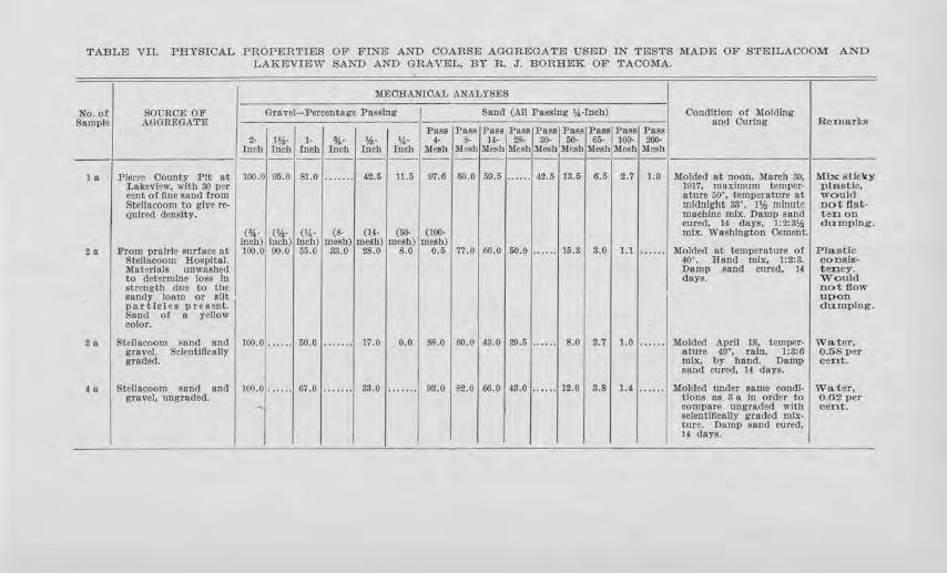
TABLEJ VIL PHYSICAL PROPERTIES OF FINE AND COARS.E AGGREGATE USED IN TESTS l\1ADEJ OF STEILACOOM AND LAKEVIEW SAND AND GRAVEL, BY R. J". BORHEK OF TACOl\!A..
M.EORANIOAL ANALYSES
No.of SOURCE OF Gravel- Percentage Pnsslng Sand (All Passing ~i-Inch) Condition of Molding Sample AGGREGATE and Curing Remarks
l'8Sll Poss Puss Pass Puss,Pass Pass Pass Pnss 2· n!.· l· %· ¥.,, 'A· 4. 8- H- 28- 30· 50· tl;j. 100- 200-
Inch lncb Inch Inch Inch Tnch Mesh Mesh Mesh lllesh llleshMesh Mesh Mesh Mesh ----------- - - ------------I---18 Pierce County Pit at 100.0 95.0 81.0 ....... 42.o 11.5 07.6 80.0 59.5 ...... 42.5 JS.o 6.5 2.7 1.0 Molded nt noon, March 80, M.J:x sticky
Lakeview, with 80 per 1917, maximum temJllU'· plastic, cent of floe sand from nture 50• , temperature at would Steilucoom to give ro- midnight &r'. l'h minute not flat· Qulred density. machine mL--c. Damp sand t en on
cured. u duys, 1:2:3* dumping. (%· (¥.,· <'A· (8· (14· (50- (100· .mix. Washington Cement.
lnch) Inch) Inch) mesh) mesh) mesh) mesh) 2a From prairie surface at 100.() 90.0 55.0 33.0 28.0 8.0 0.5 77.0 60.0 50.0 ...... 15.S s.o l.l ...... Molded at temperature of Pla.stlc
Slellucoom Hospital. 40' . Rand mix, 1:2:3. CODSIS• M11t9rlols unwashed Damp sand cured, H tency. to determine los.5 In days. Would strength due to the not flow sandy loam or silt upon particles present. da.mplng. Sand of II yellow color.
Sn Steilacoom sand and 100.0 ...... 50.0 ······· 17.0 o.o 88.0 60.0 43.0 29.5 ...... 8.0 2.'7 1.0 . ..... Molded .A prll 18, temper- Water, gravel. Sclenti11call:r oture 40", rain. l:S:6 0.58P8r graded. mix, by hand. Dn.ml) cent.
sand cured, 14 days.
4a Steilacoom Sllnd and 100.0 ...... 67.0 ....... 83.0 . ...... os.o 62. 0 00.0 43.0 ...... 12.0 3.8 1.( . ..... Molded under an.mo condl, Water, gravel, ungraded. tlons as 3 a In order to 0.62 per
- compare ungraded with cent. scleotlftcally graded mix-ture. Damp sand CUTCd, 14 (111-ys.
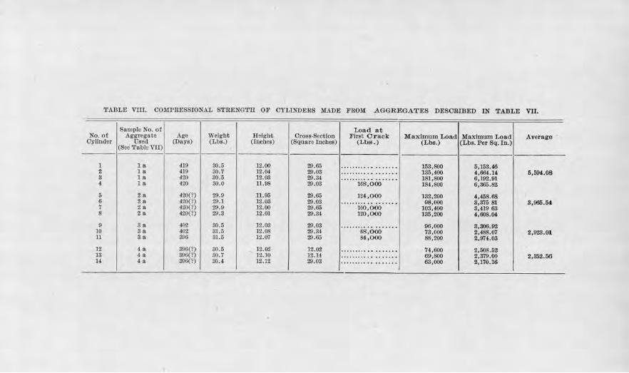
'l'ADL.E vm. 00l1IPRESSI0NAL STRENGTH OF CYLINDERS ll.lADE FRO!:[ .AGGREGAT~S DESCRIBED IN TABLE vn.
Sample No. of Lottd at No. of Aggregate Age Wclgbt H eight Oross-Scctlon First Crack Maximum Load Maximum Load Av erage
Oylfuder Usud (Days) (Lbs.) (Iocbes) (Square Inchc.s) (Lbs . ) (Lbs.) (Lbs. Per SQ. I n .) (Soe Table VII)
1 la 419 3(),5 12.00 29.65 .......... .... ..... 153,800 6,153.46 2 la 419 30.7 12.0J. 29.03 .. ... ..... . ....... 185,400 4,664.l<l 5,594.08 3 la 42.0 30,5 12.03 29 . 84 .......... . ····· ·· 181,800 6,192.91 4 la 420 80.0 11.98 29 .03 168,000 184,800 6,865.82
5 2n 42.0F> 29.9 ll.95 29.65 124,000 182,200 4,458.68 6 20
420 ?~ 29.l 12.03 29.03 ............. ..... 98·,000 3,375 81 3,965.5,
7 2a 42.0(? 20.9 12.00 29.65 100,000 103,400 3,419 6S 8 2a 420(? 29 .3 12.01 29.34 120,000 135,200 4,608.0i
9 3a 402 30.5 ]2.03 29.03 ·· ····· ·· · · ··· ···· 96 ,000 3,306.92 10 38 402 31.5 12.08 29.34 68,000 73, 000 2,488.07 2,923.01 11 Sa 396 81.5 12.07 29.65 84,000 88,200 2,974.03
12 4a 396(?) 30.5 12.0'Z 12.02 .. ................ 74,600 2,608.52 13 4a 396(?~ 30.7 12.10 12.14 ................... 69,800 2,379.00 2,852.56 14 4n 396(? so.i 12.12 29.03 .... ....... ······· 63,000 2,170.16
CHAPTER V.
THE DISTRIBUTION AND CHARACTER OF THE ROADBUILDING SANDS Al\TD GRAVELS
BY COUNTIES.
ADAMS COUNTY
GENERAL STATEMENT.
Adams county is located slightly south of the east central part of Washington, on the Columbia Plateau. Its area is 1912 square miles, and in 1910 its total population was 10,920, or 5.7 persons per square mile. It ranks :fifteenth in size and twenty-second in population in the state, thus falling below the average in density of settlement. The chief resource is wheat raising. Several railway lines cross the county in 'Vru:ious directions and provide convenient shipping points. The roads which lead to these, over which the wheat is hauled to market, and the tluough trunk lines, are of prime importance. Only a part of ihem haYe been surfaced. The highway from Ritzville, through Ralston, l.las been metaled, and affords rapid and easy travel-an example of what ,vill probably be the case on other iuter-town routes. One state highway, the Central W ashb1gton Highway, passes through the couuty, followiug a coulce from the boundary south of Cunningham to Ritzville and a shallow clepTcssiou from there lo Sprague. A part of this from RitzYi.lle to Sprague is surfaced.
TOPOGRAPIIT.
There are se,eral geologic factors to be considered ju constructing highways in this county. The first of these is topography. Adams county is m a plateau country ancl its range in elevations is from about 2000 feet in the northeastel'n portion to about 850 feet in the
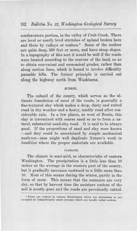
102 Bulletvn No. 22, W a.sltington, Geological Survey
southwestern portion, in the valley of Crab Creek. There are level or nearly level stretches of upland broken her e and there by valleys or coulees. • Some of the coulees ar e quite deep, 500 feet or more, and have steep slopes. In a topography of this sor t it wou'ld be well if the roads were located according to the contour of the land, so as to obtain convenient and economical grades, rather than along section lines, which is boru1d to involve difficultly passable hills. The former principle is carried out along the highway north from Washtucna.
SUBSOIL.
The subsoil of the county, which serves as the ultimate foundation of most of the roads, is generally a fine-textured clay which makes a deep, dusty and rutted road in dry weather and a heavy, muddy road after considerable rain. In a few places, as west of Bemis, this clay is intermixed with coarse sand so as to form a natural, substantial sand-clay road. It is said to be always good. If the proportions of sand and clay were lmown - and they could be ascertained by simple mechanical analyses-man might well duplicate Nature's work in localities where the proper materials are available.
CLll\fA'l'E.
The climate is semi-arid, so characteristic of eastern Washington. The precipitation is a little less than 10 inches on the average in the western part of the county, but it gradually increases eastward to a little more than 10. Most of this occurs during the winter, partly in the form of snow. This means that the summers are very dry, so that by harvest time the moisture content of the soil is mostly gone and the roads are prevalently rutted.
• '.l.'here are valleys In eastern Washlngton wllich a re streamless or ru·e occupied by lnslg niflcanUl· small _streams whlc)1 ase locally called coulees.
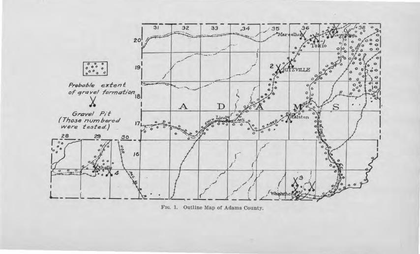
~o O O O oo O
O O 0
I 31
201.#
191
32 33
,,,...--·t·- --..,. ...
,.34
,,, _ ... /·
I /! t-] ~ ~ :7~!2,~;~;;1.,,,6[- ~ ~~/·_:.~= ==
Gravel Pit ~· ~<z, l>L
(Those nvmbered were t e3 fed.)
28 29 r -71---0 o • o O//o t° • o !
L __ L •• ,,I
,-· (:
,.r1
I
( (1
/ ; ~- (.
.. · -~
Frn. l. Outline Mall of Adams County.
104 Bulletin No. 22, Washington Geological Survey
DEPOSITS OF ROAD GRAVEL.
D.istribnt:ion
The deposits of road gravel in Adams county are confined almost entirely to the coulees, and to certain flattish areas which lie below the general level of the upland. (See outline map of the county, Fig. 1.) Scattered deposits underlie parts of several townships in the northeastern part. From Sprague to southwest of Ritzville, gravels occur in patches all along the highway, some of them too coarse for use as they are, but if crushed would make splendid road material. Many of them are to be found on the southwest sides of knol1s or small hills of rock. The reason for this is that thBy are parts of a former extensive deposit, most of which was washed away by waters coming from a northeasterly direction, the present deposits being left in protected places on the southwest side of rock projections.
A large gravel (fat lies to the north of Keystone. One-eighth mile east of Tokio ther e is a pit on the south side of the road which exposes sand and gravel beneath 2 to 31h feet of clay. lfost of the gTavel is under 2:Y!? inches in size and is chiefly basaltic in composition but differs from the other gravel to the east by containing fragments of lime. Its use on the road here has been found to be satisfactory. Simi1ar material has been used from a pit 1 mile west of Tokio, on the north side of the Northern Pacific Railway, and also from another pit in the S. E. 14 of Sec. 7, on the south side of the road.
Three-fourths of a mile southwest of the Northern Pacific Station at Ritzville the county owns a gravel flat comprising two city blocks. The materials are basaltic, firm, sub-rounded, and well-graded. There is enough oversize to warrant crushing. The equipment consists of an Aurora and a Ft. Wayne crusher, loading bunkers, belt buckets, and a revolving screen. The material was crushed and screened to 21h inches, and used on P erman-
Road Building Sands ancl Gravels 105
ent Highway No. 1 for one mile south of town, built in 1912, and on 2 miles of No. 1 A, which is an extension of No. 1, in 1914. No. 1 was oiled. The road is in good condition.
Other gravels occur along the coulee which passes Ralston. The pit at Ralston is 20 to 25 feet deep and the bottom has not been reached. The mateTials are well graded from clay to ovoTSize material. After being crushed, they have been used with satisfaction on 4 miles of road north from Ralston, on 51/2 miles of road south, and on 2 miles of road west. The coulee in which Lhese gravels lie trends southwestward to westward and joins another at Lind. Materials should be found along the latter for use on the Washington Central Highway.
Within the coulee at Washtucna good road gravels occur. In the south limits of Washtucna the deposits run strong to coarse sand and likewise in some of the high benches north and west of Washtucna. The sand is of the size generally lmown as '' torpedo sand.'' Coarser gravels lie above this level, as in the S. E .¥1, of Sec. 9, T . 15 N., R. 36 E . The S. P . & S. Ry. has a large gravel }Jit in the southern part of Washtucna, in an eroded bench that stands nearly 100 feet high.
That part of the county between Washtucna and Cunningham is semi-rolling upland, underlain with clay and sandy clay. No road materials occur here except in a fe,y outcrops of basalt in small coulecs. Several miles of country west of Cunningham is also barren of good road material.
Some fragments of lime r ock have been taken .from the creek channel, 21h miles east of Otlrnllo, and used on the road, but found to be unsatisfactoTy. It is too soft to wear well and after encrusting on the surface it breaks through under the weight of heavy loads.
Some deposits of a fair grade of graye} have been found at Othello, and one mile to the east. At the latter
106 Bulletin No. 22, W ashin,gton Geological Survey
point it contains some basalt but is mostly lime-rock, and of pea-size. If the basalt is sufficient, in quantity, to meet the wearing demands of the road, the pebbles of lime will furnish good binder, and the road should prove satisfactory.
Laboratory Tests
Map Nimiber 1. This sample was collected from a deposit 1/s mile east of Tokio. (See outline map of the county.) The pebbles are of basalt, but some or them are coated with lime, and lime fragments are scattered through the deposit. TheTe is some oversize, but the constituents are well graded down to sand and clay. The tenacity value 0£ the binder i.s low, but accorcli.ng to the cementation tests the ultimate cementation under traffic should be good. Some tenacious clay might aid the initial packing of the gravel.
Map Number 2. This sawple was obtained from the county pit at Ritzville, % mile southwest of the Northern Pacific Railway station. The gravels are basaltic, subrounded, and contain enough oversize to warrant crushing the material pit-run. Most of the pebbles appear to be firm, but they gave a loss due to abrasion of 13.6 per cent, which is rather hig·h. The ultimate cementation of the gravel should be good, if some binder is added.
JJ!Iap Nwrnber 3. This sample was taken from a gravel pit on the east side of the road, 3Vz miles north of Washtucna. This gravel is composed of subrounded to angular basalt with some lime fragments. The constituents range in size from sand to cobbles and fragments 8 to 10 inches in diameter, thus warranting crushing. The tenacity value is high and the percentage of wear is 11.2 per cent, slightly above the average. This gravel has been used on the nearby l'oad for 21;1 miles, and has given satisfaction. The gravels occur in an eroded gravel bench, rising 75 to 100 feet above the flat at Washtucna.
Road Building Sands and GraveZs 107
Map Number 4. This sample was collected from a deposit of lime-rock along the creek channel 21/z miles east of Othello, on the south side of the road. A ledge of the rock is exposed in the creek bank and fragments have been deposited on the inside of the curve by the intemlittent stream. The rock is soft and crushes readily. It was used on the local road, but proved too soft to wear.
The foregoing results are given in tabular form, together with those from other counties, in Table I .
ASOTIN COUNTY
GENERAL STATEMENT.
Asotin county, situated in the extreme southeastern corner of the state, and bo1·dered by the Snake River canyon on the one hand and the Blue :Mountains on the other, has a topography of high uplands and canyon slopes. In 1916, the population was estimated to be 7,381 by the Census Bureau, or an average of about 12 persons to the square mile.
HIGHWAY CONDITIONS.
The chief highways are the Clarkston-Asotin road, tlte Asotin-Anatone road, the Asotin-Cloverland road, the Clarkston-Pcola road, and the Clarkston-Silcott road. The Clarkston-Asotin road is entirely smfaced, partly ·with gra,Tcl, partly with crushed Tock, and pa1'ily wit.h asphalt pavement, and is in satisfactory condition. Parts of the others are surfaced, but many miles are still badly in need of meta.ling. A clay soil covers the uplands, rather thinly on the .Anatono ridge and fairly thickly on the Clove1·land divide. This Tuts badly in veTy dry weather and muds deeply in wet weather, but in the spring and early summer affords a good, hard road. Along Alpowa Creek, there is a great deal of light, fluffy clay which has no virtue as a road foundation. Some
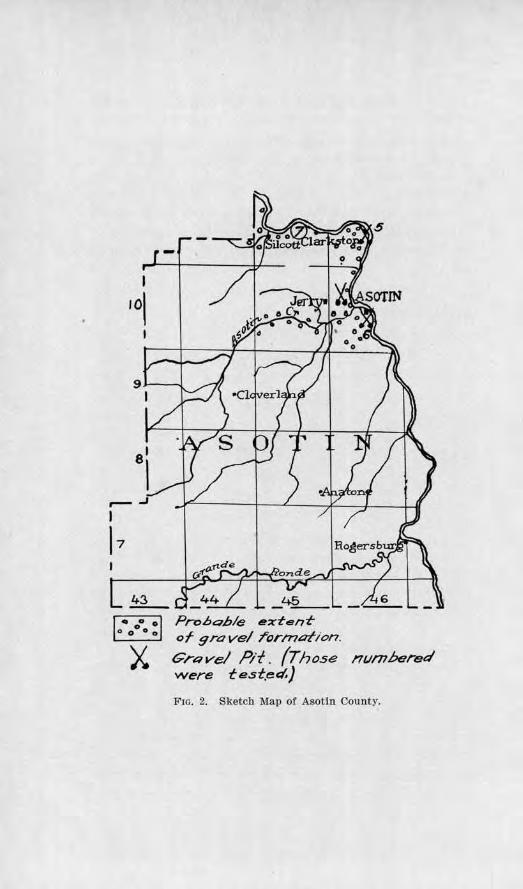
I
,01
~ ~
X.
-
Probahle ext-ent-or gravel rorn-u::,tion.
GrRve/ Pit. (Those were test.eel,}
nt1mbered
Frn. 2. Sketch 1\llap of Asotin County.
Road B1tilding Sands and Gravels 109
sand stretches occur along the Snake River which are bad in dry seasons.
DISTRIBUTION OF ROAD MATERIALS.
Gravels have such a limited distribution in the county that bedl'ock will have to be used where the former is not available. Large deposits of graYel, however, occur along the Snake River in benches, as at Clarkston, and in local deposits high above the river, as at Asotin and 3 miles north of Asotin.
Along the Anatone road, a large deposj t of coarse gravels occurs at the cemetery about half way up the steep grade which, although not suited in their present state, would make good road-building material if passed through a crusher pit-run. This would reduce the constituents to the proper size, and the dust resulting from the crushing added to that which is already present would probably make good binder. An oYel'bul'den of 1 to 4 feet of clay would need to be stripped. The pebbles are mostly basalt with a few quartzites. The former ai·e rather angular. On the upland proper, the surface rises gently toward Anatone with about a 3 per cent gmde. No gravels are arnilable here, but basaltic rock lies close to the surface as shown by outcrops and fragments M·ouud the base of telephone poles. Much of that exposed is porous, but good, firm basalt can be selected in many places.
Along the Cloverland road, although the soil is deeper than along the Anatone road, rock can be obtained near the heads of gulleys. ·where the road follows Asotin Creek, a bank of coarse gravels of basaltic composition is generally present, which when crushed would give materials of good gradation, :firm quality and probably good bjnder. In some cases, clay may need to be added to give the p1·oper percentage of binder. About half way up the steep grade, in ascending to the upland, is a shelf
110 Bulletin No. 22, Washington Geological Survey
on which occurs some old gravels, moderately weathered, but which would probably give fair satisfaction if crushed. Clarkston is situated on a broad bench of gravels, about 100 feet above the river. The town has opened a pit along the river, and the county operates a pit at the western edge. Some large cobbles and a few boulders are scattered through the material, but as a whole the constituents are coarse sand and pea gravel. The materials are slow to bind at first, but after some traffic it packs nicely and makes a smooth road.
West of Clarkston, on the slopes of a higher bench, coarse gravels outcrop, consisting of quartzite, granite, diorite, and basalt. The granites are etched and softened by weathering, but most of the other kinds are still firm and should make good surfacing metal provided it is run through a crusher.
TESTS ON SAMPLES.
Gravels for Road Surfacing
The bedrock of Asotin county was examined and tested in 1911 by the Washington Geological Survey, and the results published in Bulletin No. 2 of the Survey series. Attention is given in the pl'esent study chief:ly to the gravels. A tabulation of the results of the tests on "Road Gravel" is given in Table I. The location of the places from whi.ch the following samples were taken is shown on the outline map of the county, Fig. 2.
S er'ial N itmber 5. This sample was taken from the Clarkston City pit, located at the eastern edge of town. The pebbles consist of basalt, granite, diorite, and quartzite, almost all of them are firm, but few are oversize, and the greater proportion, about 75 per cent, is coarse sand. The tenacity test showed it to be low in binding material, but the ultimate cementation value was found to be high. These r esults are borne out in practice. The material is slow to pack but after having been
Road Building 8a1icls and Gravels 111
subjected to traffic it makes a smooth road. A remedy might be found for its slow packing qualities by tho addition of a small amount of tenacious clay. The county owns a pit in the same formation at the western edge of town.
Map Niimber 6. About one-foru·th mile south of Asotin, a pit has been opened ju the side slope of a gulch, exposing coarse sand and fine gravel in a face 40 feet high. The sand and gravel are chiefly basaltic, crossbedded, with irregular stringers of silt. For ordinary surfacing it is too iine, but if properly mixed with clay it should make a satisfactory sand-clay road. As it is, it permits the wagon wheels to cut deeply. Its tenacity value is low, possibly duo only to its coarseness.
JJiav Nmnber 7 . This sample was obtained from a ridge of gravel along the Columbia River, about 6 miles west of Clarkston. The ridge is about 50 feet high, 75 yards wide, and 300 yards long. But little sand occurs in the grnvel and where material has been removed, the remaining portion will not stand ·with steep face, indicating that the cem~nting qualities are low. This was borne out by the tenacity test. The pebbles, howeYer, are almost all firm, yielding a percentage of ,year of only 4.2 per cent. If properly sized and graded and some clay added, it should prove satisfactory for 1·oad build-ing.
Sand for Oonorete
The sand of Map Number 5, from the Clarkston City pit, was washed and tested for its quality in concrete work, by making concrete briquets of the sand an<l comparing their tensile strength with that of the Ottawa Standard sand, according to the method described in Chapter IV.
Both the 7 and 28-day tests showed a te11silc strength greater than that of the Otta"'a Standard sand, the 7-day ratio being 133.2 per cent and the 28-day ratio 143.1
112 Bulletin No. 22, Washington Geological Survey
per cent. No organic matter was detected by chemical tests. This sand should therefore be entirely satisfactory for concrete, if washed, but the gravel is too :fine for first-class concrete pavement.
The results of this test are given in tabulated form, together with those from other counties, in Tables III and IV.
BENTON COUNTY
GENERAL STATEMENT.
Benton county is located in the lower portion of the Yakima River Valley and within the bend of the Columbia River, where it turns westward to pass through the Cascade Mountain Range. The county has a maximum length of about 60 miles and a width of about 50 miles, but its area is 1671 square miles. Its population of 8,000 or more people is chiefly concentrated along the Yakima River Valley, which fact also centTalizes the highway system and the necessity of immediate road surfacing. Prosser is the county seat, and Kennewick, Kiona, Hanford, and White Bluffs are other towns.
The main line of the Northern Pacific Railway and the branch of the 0.-W. R. R. and N. Co. lie within the valley of the Yakima River, and the Inla11d Empire Highway closely parallels them. These facilities for transportation adequately care fol' the products of agriculture, horticulture, and stock Taising of the county. Irrigation products are yielding good returns, and the promise of the future is £or a much increased population. For the present, however, surfaced roads will meet the demands of the comparatively light traffic.
TOPOGRAPHY AND RAINFALL.
The northe1·n part of the county is a part of the gTeat plains of the Columbia, wi.tb the exception of a spur of the Rattlesnake Hills which, after attaining m1 elevation of 3500 feet near the west line, rapidly declines east-
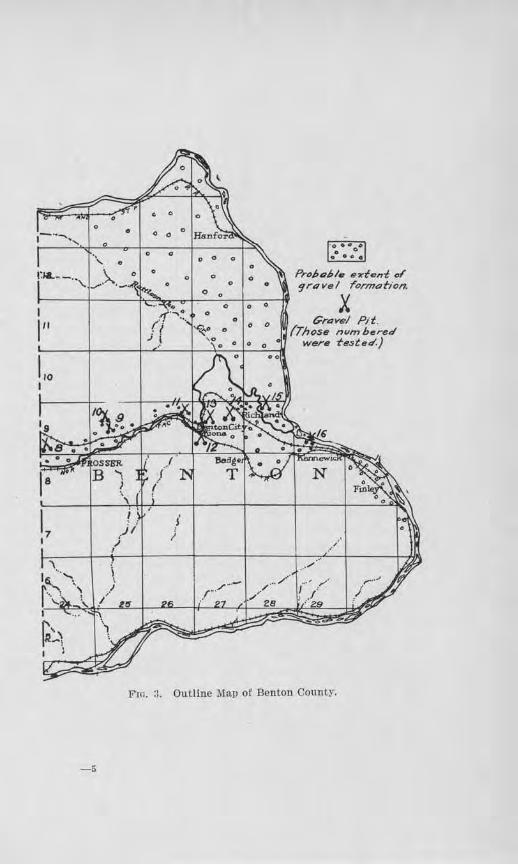
0 0
I
I" ~ . ...,o ...
0 0 ProJ,o,!,le a,tfent oi'
0 0 9rovel rormotion. 0 0
X 0 0 0
0 0 Grovel Pit . 0 0
0 (Those nvm bered were fest ed.)
Lo I
F10. 3. Outline Map of Benton County.
-6
114 Bulletin. No. 22, Washington Geological Survey
ward. South of the Yakima River Valley js the northfacing escarpment of the Horse Heaven Hills, at the crest of which is a plateau sloping southward to the Columbia River. These rugher hills and the plateau are composed of basalt, while the plain of the Columbia and broad £lat of the Yakima River are underlain largely by clays, sands and gravels. The cfays and sands afford li.ttle bearing power f OT traffic purposes and mu::;t be surfaced.
The annual precipitation averages about eight inches, a part 0£ which is snmvfall. The long dry summers deprive the earth-roads of their moisture so thoroughly that they not only become deeply covered with dust but l'ut badly. There is but little trouble from mud conditions during the rainy spells on account of the sa11dy nature of the soil in many places.
GENERAL DISTRIBUTION OF ROAD GRAVELS.
The sketch-map j11 Fig. 3 shows by small circles the general area under lain by gravels and, b~r cros ed shovels, the location of some of the pits which have been opened. Those from which samples were obtained and tested are uumbered. It should not be assumed that suitable gravel can be obtained everywhere within the area mapped, for the character of the material varies widely from p lace to place and a choice must be made after testpits have been opened. Along a given stretch of highway within the mapped portion it is likely, howeYcr, that satjsfactory deposits may be found.
TESTS ON ROAD GRAVELS.
lJ!lap Number 8 . This sample was taken from a deposit fiYe and one-half rojles northwest of Prosser, aloug the north li.J.1e of Sec. 31, T. 9 .r J"., R. 24 E. A large area is here underlain hr gravels chiefly basaltic in composition but containing some fragments of lime-rock. The materials are well graded up to oversize, which is pres-
Road Bitildiug Sands a11d Gravels 115
ent iu sufficient abundance to warrant crushing. About 90 per cent of the constituents ar e firm and have good wearing value. Biuding material, howeYer , is lacking in quantity, and clay will probably have to be added. The lack of a good quality of clay probably accoUllts fo r the low tenacity value. Only a test pit has been opened in this deposit thus far.
Map Nmnber 9. In the N. E . 1,4, Sec. 15, T. 9 N., R. 25 E ., there is a deposit of gravel e::(pose<l along a. ravine containing basaltic sand and pebbles mostly of the size of ''pea-gravel,'' all of which a r e firm and would probably give excellent wearing results. Silt and lime haYe been filtrated down through the gravel. According to test this shows a fair tenacity value. Large quantities are availab1e. This has had a practical test on the highway east from Prosser fo r two years and is giving excellent satisfaction, but at :first was somewhat slow in packing.
lllap Number 10. This sample was taken from a deposit V-i: mile north of .N"umber 9. Here a lai-ge proportion of the mate1·ial is coarse sand, sharp, well graded, and compm·atively clean except u1 the lower part. The minor amount of gravel consists of basalt and quartzite pebbles, together with a few fragments of lime. It is too largely sand for sm-facing unless used for dressing. A test was made of this for concrete uses aud the results are given on a follo-wing page.
Map Number 11. This sample was obtained from a deposit on a high bench two miles northwest of Benton City, in the S. ,F./. 14, Sec. 12, T. 9 N., R. 26 E . Fifty per cent of the pebbles are basalt, 40 per cent quartzite, 6 per cent lime fragments, and 4 per cent granite. About 95 per cent of the pebbles are firm and have good wearing qualities. rrhe materials are mostly well .gra<le<l in size, but there is a large enough percelltage of oversize to warrant c1·ushing. By passing the material through
116 Bulletin No. 22, W a,Shington Geological Suirvey
a crusher pit-run, not only would there be a gain in proper grading, but binder would be contributed. As it is, the tenacity value of the binder is low. Some of the gravel has been used on the road for 1 mile east of this point and 2 miles west since 1915 and found satisfactory. Clays occur to the east, from which binding mateTial may be secured.
Map Nivmber 12. This sample was collected from a low bench at Kiona on the south side of the river. A fair percentage of tbe material is oversize but there is enough to make crushing advantageous. On the whole, the deposit is lacking in binding material in its natural
state, and from the sample obtained not enough of the fine was available to test for quality. The pebbles include varieties of quartzite, basalt, and granite, and almost all are fu·m and hard and have good weari11g virtues. Some aTe flat but there are not enough of them to hinder the binding of the gravel if clay is added.
Map Number 13. This sample was taken from a deposit on the high flat, 1% miles noTtheast of Kiona, and shows a variety of rounded pebbles of quartzite, basalt, granite, diorite and porphyry embedded ju a matrix of fine sand. Ninety per cent of the pebbles show a firmness which warrants satisfactory wearing, but the :fine sand is a poor binder. The cementation test gave a low value. Whel'e used on the road this gravel has not packed well, and the cause seems to lie in the lack of good tenacious clay for binder and the presence chiefly of :fine sand, and of flattened pebbles.
lJIIap Number 14. This sample was collected near the eastern edge of the same flat about 4 miles northeast of Kiona. This deposit is light-colored and varies in texture from place to place. The pebbles are quartzite and basalt with much lime rock, embedded in a :fine-textured, light powdery substance. The pebbles have such a high percentage of soft constituents that its wearing
Roa,l B1tilai1ig Sands ancl Gravels 117
value is doubtful. The test for tenacity of the portion passing the 10-mesh gave a fair value. When the deposit was visited, the material was being used for surfacing the road in this vicinity and seemed to be packing fairly well, but the .fine powdery matrix may yield dust.
Map Number 15. This sample was obtained from a gravel bar just cast o.£ the Fallon b1·idge, about 4 miles northwest of Richland. Although t.he materials are well-graded, round, and :firm, the tenacity test of the binder gave a low value. Unless a good tenacious clay is added, there would probably be considerable difficulty in making the material pack.
Detailed results of the foregoing tests are given in Table I of Chapter ill.
TESTS FOR CONCRE'.rE.
Map Numbel' 9, from a deposit described on a preceiling page, ·was tested for its tensile strength for concrete use by making concrete briquols 0£ the sand and compru·ing their st-:rength with those from Ottawa Standard sand, according to the method described in Chapter IV. The seven-day briquets of tho sand under test showed a strength of 98.7 per cent that of tlie StandaTd sand briq_uets, and the twent.y-eigbt day briquets tested 130.3 per cent as strong. .A. slight amount of organic matter was detected by the colorimetric test, but not in sufficient quantities to be injurious.
Map Number 10, obtained from the deposit just north of Number 9, tested 114.0 per cent for the 7-day tensile strength ratio, i. e., 114.0 per cent as strong as the Ottawa StandaTd sand, and 119.9 per cent for the 28-da.y ratio. The colorimetric test showed no 01·ganic content.
:Map Number 12, from the deposit at Kiona, was screened for its sand portion, and the 7-day briquets made from the washed sand tested in strength 87.1 per
118 Bulletvn No. 22, Wa.shingto·t~ Geolog·ical Survey
cent that of the Ottawa Standard sand, and the 28-day briquets 106.5 per cent. The color imetric test showed a slight amotmt of organic matter present, but not in objectionable amounts.
The detailed resttlts of these tests are tabulated with those of sands from other counties in Tables III and IV oi Chapter IV.
CHELAN COUNTY
GE1'TERAL STAT.Eli\1:ENT.
Chelan county is located in the northe111 part of the state, on the east flanks of the Cascade Range, roaahing to the Columbia River on the east. It is the third largest county in the state, its area including 2900 square miles. In 1916, the Census Bureau estimated its population to be 22,129. The larger part of this is concentrated along the Wenatchee River from Leavenworth down to Wenatchee and along the Columbia River Valley for a few miles below Wenatchee. A certain percentage, also, lives north along the Columbia River Valley as far as Chelan. Wenatchee is the county seat a11d most important city. Leavenworth, Peshastin, Cashmere, Chelan, Lakeside, and Entiat are importa11t towns.
The large acreage of apple orchards and the reputation of the Wenatchee apple suggest at once to the visitor that apple growing is the chief industry. Besides this there is general farming, dairying, lumbering, ancl mining. A good system of highways is especially needed in the Wenatchee VaJley and the county authoTities have been devoting thefr efforts to perfecting it as rapidly as possible. One and one-quarter mi1es of paving were laid east of Monito1· in 19) 7 and more is contemplated. The Stmset Highway, whi.ch is the main Seattle-Spokane automobile highway, enters the county at the southeast corner and passes through Wenatchee. where it crosses the river into Douglas County. State
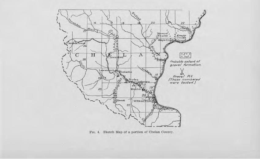
Probable extent. or gn:wel rormotion.
i Gr.:wel Pit
(Those nwnhered were tested,)
Fm. 4. Sketch Map oC a portion of Chelan County.
120 Bulletin No. 22, W Mhington Geological Survey
Road No. 7 also furnishes an important outlet over the mountains by way of Wenatchee Valley and Peshastin Valley, over Blewett Pass. State Road No. 10 runs northward along the Columbia River into the Okanogan counti-y. The main line of the Great Northern Railroad traverses the county from the Cascade Tunnel at the summit to the southeast corner, and has two branches, one to Oroville and one to Waterville.
TOPOGRAPHY.
The mountainous topography of the county make:; road gradients a difficult and important item outside of the valleys. The Wenatchee, Columbia, and Entiat valleys serve as trunk lines for the larger part of the populace, but there must needs be some penetratjon of highways into both the tributary mountain valleys and ascension to the higher flats. The Blewett Pass road is an example of the former and the road to the Wenatchee Heights of the latter.
The impor tance of subsoil is well illustrated along the Columbia River. Where the highway passes over tracts of wind-blown sand and silt, as near Entiat, surfacing is essential, but where alluvial fans of granitic material between here and Chelan are traversed the road is always good. There are stretches of sand and light silt in the Wenatchee Valley which have comparatively little bearing power, especially in dry weatl1er, and these must also be surfaced.
ROAD GRAVELS.
Geuc1·al Distribution
Terraces of r oad gravel of fresh and :fhm materials occur in the vicinity of Wenatchee near the mouth of the Wenatchee Rive1·, where there is perhaps the greatest demand for them. Gravels of varying texture and binding and wearing qualities also occur here and there further up the Wenatchee River as far as Leavenworth
Road Building San&s rmd Gravels 121
and along the Columbia River to Chelan and beyond. Along the Blewett Pass Road, 01· State Road No. 7, gravels are distributed jn two sets of terraces for three miles or so in the lower portion of the valley, and then there seems to be a scarcity until the junction of Ingalls and P eshastin creeks is reached. Here a gravel flat, 100 yards broad, affords good material of suitable size. Ascending the mgh road no gravels are to be had for some distance, but there is an abundance of slide-rock of good quality from which materials of proper size can be -chosen. In the v icinity of Old Blewett there is considerable gravel but its coarseness would require crushing.
An outline map of the county, showing the distribution of the gravel and the places from which sRmples were taken for testing, is given m Fig. 4.
Tests on Road Gravels
11Iav N'lm1ber 17. This sample was taken from the flood-plain of the Wenatchee River, lh mile east of 1Uonitor, on the property of W. E. Taylor. The materials are well graded, with considerable oversize to wanant crushing. Pebbles of gneiss, granite, basalt, quartzite and diorite make up the deposit and almost all o.f them are :firm and hard and would give excellent wear. The binding material, however, is of poor quality, there being scarcely enough of silt to ruake a plastic paste for the tenacity test. Olay would have to be added if this were used for sudacing. Tho deposit, however, was used as a source for the aggtegate in the concrete paving of 1¥i_ miles in this vici.njty. A crusher was installed and the materials were crushed and washed. The results of the sand tests for concrete use will be mentioned under '' Tests for Concrete.''
Map Ntt1nber 18. This sample was taken from a deposit at the mouth of Swakane Creek, along the Columbia River, 91/2 miles north of Wenatchee. The constit-
122 Bulletin No. 22, TV ashi1igton Geo~ogical Survey
uents are granite, schist, and quartzite. They range in size from ll/2 inch down, with about 50 per cent passing the 14-inch screen. Their wearing value is fair, but both the tenacity auc.l cementation values tested low, suggesting that the materials will not pack readily or cement well ·without additional clay of good cementing quality. A 4-foot over-bul'den of coarser material shauld be shipped. The deposit in its natural state shows some inci.pient cementation.
Map Number 19. This sample was obtained from the high gravel bench 311,1 miles north of Wenatchee on the
north side of Wenatchee Rive1·. The gravel bank here rises about 100 feet above the str eam. A pit 100 feet long and 75 feet high has been opened, giving a good selection for examination. The material stands with vertical face, and is made up dominantly of gravel less than 2 inches in size, w:ith a few large scattered boulders and scarcely any fine sand. By test, the wearing value is better than the average for the state. The tenacity ancl cementation tests show only fair values. It is believed that if clay of good tenacious value is available, its addition would be beneficial. Where used 011 the county roads in the vicinity of Sunnyslope, it bas Tequircd sprinl<l.ing to keep it packed under the heavy traffic of dry weather. The results of the concrete briquet tests are given on a following page.
IJ!ap Nu11iber 20. This sample was taken from a deposit located 2112 miles northwest of Wenatchee, on the property of Mr. Larson. :Most of the materials are firm, but there are some so£ t pebbles which, if this deposit were to be used for concrete pavii1g, would have to be thrown out. The wearjng quality of the material is shown by test to be good. No cementation test was made of tho binder portion. For the results of the briquet tests the reader is r ef erred to tl1e discussion on the following page.
Road Bttild·inig Sands and Gravels 123
lJlap Niwiber 21. This sample was obtai11e<l from a deposit 1112 miles southeast of Cashmere, in the :K. W. *' Sec. 3, T. 23 N ., R. 19 E . Here a pit has been opened in a bank of sand-clay containing fragments of rock, most of which are less than one inch in size and 76 per cent passes a 1A,-inch screen. This high percentage of :fine would be objectionable if it were not for tbe cementation value o.f tho deposit.. According to both the tenacity test and the cementation results on the r oad nearby this is very high. The road w.ithstai1ds the traffic of this important higb,,·ay in remarkable fashion. Considerable quantities are available.
Tests for Oonc1·ete
Map Number 17. Thls sample was taken from a pit 112 mile east of Monitor, which has already been described, and from which tho aggregate was obtained -for the paved road nearby. Concrete briqucts were made of the sand and tested and compared \\-rith concrete bl'iquets made from Ottawa Standard sand, according to lhe methods giYen in Chapter l\T. After seven days three of these briquets were tested for their tensile streugth and found to hav"e 110.0 per cent the strength of the hl'iquets of the same age made from the Ottawa Stand::u·d sand. The 28-day br iqucts of the sand under test showed a strength of 127.9 pe1· cent that of the standard snnd. By the colorimetr ic test a slight amount of 01·ganic matter was found, but not in objectionable amounts.
lllap Number 19. This sample was taken from tbe terrace of gravels, 31,4 miles northwest of \\' euatcllee1
which is descr ibed on a foregoing page. Seven-day briquets made from this san<l had a strength of 1 U .O pe1· cent that of the briquets made :from the standard sand, an<l 28-day briquets g·ave a ratio of 133.1 per
'
124 Bulletin No. 22, W ash1ilngton Geological Survey
cent. No reaction for organic content was obtained by the colorimetric test.
Map Nurnber 20. This sample was taken from the Lar son pit, 2 miles northwest of Wenatchee. The 7-day briquet ratio of this sand was 144.0 per cent, and the 28-day ratio was 119.9 per cent. No organic matter was fo1md to be present.
COMMERCIAL PITS.
The Columbia Engineering and Construction Co., of Wenatchee, operates a gravel pit to supply local demands across the river in Douglas county, in the south J/2 of Sec. 11, T. 22 N., R. 20 E. The pit is locatecl in a low ridge of gravel which is a cut 200 yards long and 75 yards wide. The material consists of granite, quartzite, and basalt pebbles of good quality and mostly under 21/z inches in diameter. The pit is operated by Ccc'lble and clam-shell bucket to a platform from which the mater ial is passed through a rotary screen down into bunkers.
CLALLAM COUNTY
GENERAL STATEMENT.
Clallam county is situated iD the northwesteTn paTt of the sta te, bordering tbe Strait of J uan de Fuca on the north and the P acific Ocean on the west. It has an area of 1,726 square miles and a population in 1916 of 7,479. P ort Angeles is the county seat, and Forks, Sequim, Dungeness, and N eah Bay are other importa.nt towns.
The chief industries are lumbering and fishing. Al the present time the county is contributing an enormous amount of spruce for the nation's ael'oplane construction. Transportation facilities are afforded by a local line of the Chicago, Milwaukee and St. Paul Railroad and the county's highways. The Olympic High-
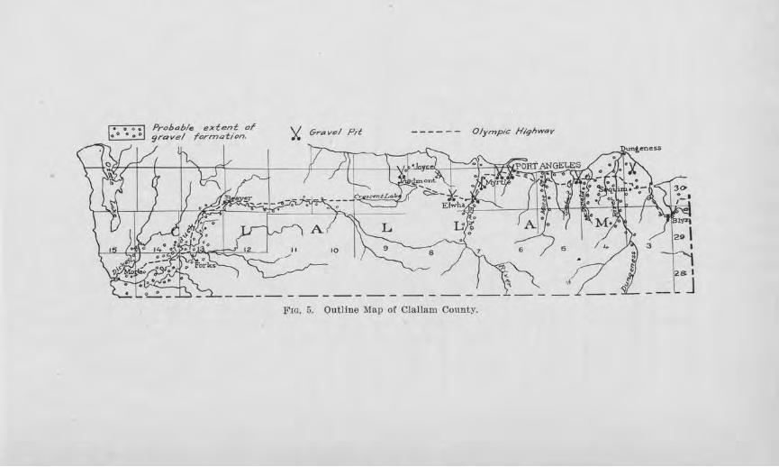
~ ~
Probable extent or gravel formation.
Olympic H/qhwav
Fw. 5. Outline Map of Clallam County.
126 Bi~lletin No. 22, W ashingto1i Geological 811 rvey
way enters the county northeast of Blyn, and except for an interruption at Lake Crescent, wbern fenies are used, it extends nearly to ::Mora, near the Pacific coast. It is improved over the entiJ:e distance.
The southem part of the county is mountainous, but the northern portion consists of a partially dissected table-land along the coast, which in places merges grad-ually to sea-level and in other places ends in wave-cut cliffs. Almost all of the population of the county live on the table-land, and consequently most of the roads are located here. A few high hills, such as occur on
both sides of Morse Creek and the Elwha River, had to be overcome by carefnl locations, but modQrato grades at these places are now the result.
All of the table-land, up to the mountain flanks, was glaciated, so that the subsoil over large tracts is pebbly clay, interspersed with gravels and sandy areas. The rainfall has a wide variation. In the Sequim district it amounts to but little over 20 in.ches, while in the higher mountains near the P acific Coast, it is 120 inches or more. The average for the table-laud is probably about 50 inches.
ROAD l'liATERJALS.
The chief road materials which have been used in the county are gravels. The genernl distribution of the gravels, together with the location of some of the gTavel pits, is shown on the outline map of the county.
Sandy gravels occur at Blyn and to the east. The screening out of the excess portion of sand is necessary to their satisfactory use. A 50-foot section is m~.-posed in a railway cut at Blyn. Along the west side of Sequim Bay gravels occur at intervals, and in places old beach gravels, now 15 to 20 feet above present sea-level contain quantities of fragile shells. This material makes a good dressing material but is not good road-metal in itself. Sequim is located on a large delta flat of the
Road Builcling Sands aHcl Gravels 127
Dnngenoss River, and gravel occurs abundantly fol' several miles westward to Carlsborg and for many miles in a north-south direction. East of Sequim they are bouldery, but west of Sequim there is a bcmch of finer gravel, well graded on the whole, ,vith scarcely any oversize, but lacking, at least in part, clay for binder. On the east aud west sides of :l\forse Creek, fresh gravel occurs in considerable thicknesses overlying tilted beds of highly colored gravel, sands, and clays. The latter are considerably softened by weathering. The former arc mostly firm and arc being drawn upon 011 the west side of the valley for surfacing.
Local occurrences of gravel are found in the vicinity of PoTt Angeles. About 21/2 miles west and south of town, a lru·ge pit has been opened in gravels, the pebbles of which are coated with silt which seems to conh'ibute good binder to the material. The composition of these is typical for the county, being composed mostly of basalt, quart~itc, and veiued metamo.rphics, with some granite and shale. Tho gravel here is not fit for concrete, but gives good service as a road-metal. Near the foot of the hill on the east side of Elwha Rfrer there is a cong1ornernte cemented with lime carbonate, which, if crushed, should make excellent surfacing. Similar material is now being crushed and used about 3 miles east of Joyce. F1·om here to Lake Crescent the deposits are local.
Beginning a bout 2% miles west of Lake Crescent a continuous belt of gravels occur all along the Soleduck River, practicaily to its mouth. On the whole the gravels are well gra<lecl and fairly firm, and pits can be put down alongside the road whcre,,el' materials are needed. The abundance and proxirnitr of the gravels along this portion of the Olympic Highway is of especial value at the present time, since much spruce is being transported ove1· the Highway.
128 Bulletin No. 22, W as71Jington Geological Survey
Due to the fact that the Testing E.ngineer for the Washington Geological Survey had been called for war service, no samples were collected for testing.
SAND AND GRAVEL FOR CONCRETE.
As already noted, the sand in the gravel at Blyn is relatively :fine, and the coarse aggregate is low in proportion to the sand content. Fairly good gravel can be obtained at various places on the gravel flat in the vicinity of Carlsborg.
The fresh gravel on the west side of Morse Creek,
well up the grade, is exposed in a large pit. The materials are well graded from sand to 2 inches in size, with a small percentage above this size. The pebbles appear firm and resistant and the amount of clay present is small. If washed, this should make good concrete material. This deposit is not to be confused with the orange-colored gravel farther down the slope which would be unfit for concrete.
In Port Angeles, sand and gravel is being obtained from the cliff which fronts the Strait, in the west part of town. It appears to be of fair quality.
It was not possible to make tests of the material from this county, but through the courtesy of the Portland Cement Association some mechanical analyses were obtained of samples of sand taken at various points along the Solecluck River. These are given in Table III.
Roa& Buildi·ng Sa1ids (Mid Gravels 129
CLARKE COUNTY
GENERAL STAT&"1ENT.
Clarke county lies within the bend of the Columbia River in the southwestern part of the state. Lewis River forms its northern bo1mdary. It is one of the smaller counties of the state, having 634 square miles within its confines. In 1916, the Census Bureau estimated its population to be 3,639. 'Vancouver is the county seat and largest town, and Camas, Washougal, Yacolt, Battle Gro1md, Ridgefield, La Center, and Orchards are other tlu·ivjng towns. Tbe people are engaged mostly in diversified farming, dairying, lumbering, and fruit growing. With the increasing population and the extension of farming pursuits the demand for good roads is assuming a broader scope. The county has constructed and surfaced some excellent roads, including the Pacific Highway, which runs north from Vancouver , and State Road No. 8, which runs east. With these and the several railroad lines the transportation problems of the cotmty are well in hand.
TOPOGRAPHY.
The larger part of the agricultural section of Clarke county is an undulating plain which lies about 200 feet above the Columbia River. A few streams have incised the upland with deep narrow valleys which necessitate the practice of modern engineering principles to secure moderate and economical grades. This is the case, for example, where the Pacific Highway crosses Salmon Creek Valley and the valley of the South Fork of Lewis RiveT at La Center. The northeastern and eastern parts of the county are foothills which rapidly assume mountainous proportions near the eastern border.
CUMA.TIC FACTORS.
About forty inches of 1·ain falls each year. Most of this occurs during the winter season, so that the
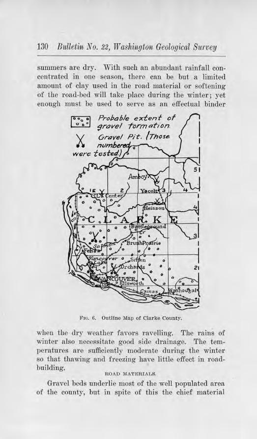
130 Bulletin No. 22, Washington Geological Survey
summers are dry. With such an abundant rainfall concenhated in one season, thel'e can be but a limited amount of clay used in the road material or softening of the road-bed will take place during the winter; yet enough must be used to serve as an effectual binder
X
Probable edenf of 9ravel -formation.
Pit. /Those
Fro. 6. Outline Map of Clarke County.
when the dry weather favors ravelling. The rains of winter also necessitate good side drainage. The temperatures are sufficiently moderate during the winter so that thawing· and freezing have little effect in roadbuilding.
ROAD MATERIALS.
Gravel beds underlie most of the well populated area of the county, but in spite of this the chief material
Road Building Sands ainrl Gravels 131
which is used for road sm·facing is crushed rock. This is due partly to the fact that the gravels in places are considerably weathered and partly to their lower cementation value than the rock material. In 1911, the Washington Geological SurYey conducted an examination of the bedrock of the state which might be available for road-macadam. Samples from this county were collected for testing purposes from near Yacolt and Fisher. The results were pubUshcd in Bulletin No. 2 of the Survey series. Regarding the rock near Yacolt the following statement is made:
"The rock is a fine-grained, da1·k greenish gray basalt. According to the test it has a'\'erage hardness, rather high resistance to wear, a11d a--;:cellent cementing value. All of these qualities combine to make this rock an excellent road material. Basalt occru·s very commonly along the south fork of the Lewis River, in this part of the county. In general the rock is quite uniform in character-hard, dark in color, fine-grained and compact, somewhat brittle, and breaking with a shc1ly fracture.''
The sample of rock takeu from the large quarry one mile east of Fisher is characterized as follows :
"The sample when tested showed that the rock is a basalt, with a coloT more grayish than usual. The 1·ock is dense and compact, and fairly hanl. It is tough, has a high resistance to wear, and possesses fair cementing value. As far as the tests can determine the matter tLe rock should make a satisfactory road material."
East of Camas a good grade of basalt outcrops at conYenient points along the Washougal River for tho surfacing of this portion of State Road No. 8. The comity has opened a quarry at a few of these points and installed a p01·table crusher for obtaining material of suitable size.
132 Bulletin No. 22, Washington Geological Survey
· For the r oads in the western part of the county, crushed rock from St. Helens, Oregon, is shipped in. This is a :firm type of basalt, offering resistance to wear, and when sufficient screenings are included with the larger size has good binding qualities. Where used on the highways, it has given satisfaction.
About two miles east of La Center an outcrop of basalt occurs at about the center of the E. 1h of Sec. 1, T. 4 N., R. 1 E., in a tributary to Lockwood Creek. The county is planning to open a quarry at this point and install a crusher to provide road metal for this part of the county. The rock has but little overburden, is but slightly weathered on the outside, and on fresh fractures is black, dense, and firm, thus prnmising good wearing value. According to test the rock has an excellent cementation value. The height to which the section can be quarried is over 40 feet, and the County Engineer estimates over 100,000 cubic yards are available.
Character of the G1·avels
The distribution of the gravels is shown on the outline map of the county. About 11,4 miles northeast of Sifton, in the N. W . %, Sec. 12, T. 2 N., R. 2 E., is an old county gravel pit which e},.__'l)OSes coarse gravels beneath 4 to 6 feet of soi.I and subsoil. The amount of coarse cobbles is so great that the material had to be crushed to be satisfactorily used. The pebbles include varieties of quartzite, basalt, andesite, tuff, chert, and clay pebbles. Ten to twenty per cent of them are too soft for use in any concrete work. The sand is sharp but the grains are coated with silt. A few years ago the county installed a crusher at this point and surfaced the road to Sif ton with this material. The road is said to be satisfactory in winter, but is dusty in summer.
A part of the road from Vancouver to Fisher is surfaced with gravel which was obtained from pits in the
Roacl Building Bands cmd Gravels 133
side-slope along the highway. The gravel is better graded than in the pit near Sifton and the constituents are fresher and firmer. On the road it makes a smooth surface and with maintenance gi-res satisfaction.
Gravel beds are exposed for several miles in the bluff along the railway hack northwest oi Vancouver, up to an elevation of about 200 feet. Some of the gravel beds are interlaid with silt, and in places the material is dominantly silt. It appears that this gravel underlies the bordering upland for seve1·al miles to the eastward, for it is exposed aI011g Salmon C1·eek and elsewhere. A pit has been opened in sancJy gravel about 2 miles north of Vancouver along the Pacific Highway, and one in coarse gravel where the road cros~es Whipple Creek about 7 miles north of Vancouver. This pit affords a section 150 feet long and 25 feet high, the bottom of the gravel not being exposed. Though coarse, it has a sand matrix, and it is believed that if crushed proper gradations could be secured. Most of the pebbles are firm, consisting of basalt, quartzite and andesite. Where used on the road north of this point, the surface shows roughness, probably due to including too coarse materials and adding too much clay. The gravel from the Armstrong pit east of Pioneer Ohurch was sized before placing, and this has resulted in a smooth road suTface. A gravel deposit containing considerable clay occui·s in the hillside, 1 mile south of La Center.
TESTS FOR CONCRETE.
The only sand known to be used for concrete on any extensive scale is that which is secured from the Columbia River by dredging. Sand for concrete is thus obtained from near Ellsworth while masonry sand is gotten from the vicinity of the bridge near Vancouver. Briquet tests were made of the concrete sand according to the method described in Chapter IV, and compared with the strength of the Ottawa Standard sand.
134 Bulleti1i No. 22, TV ashi1igton Geological B'lirvey
1YlO!J? Nivmber 105. This sample of sand, which was collected from the Columbia River near Ellsworth by Minsinger Bros. of Vancouver, showed a tensile strength in the 7-day briquets equal to 95.6 per cent that shown by the briquets of the same age made from the Ottawa Standard sand and the same kind of cement, and the 28-day briquets 117.1 per cent of the standard sand briquets. By colorimetric test, some organic material was detected to be present but not in objectionable quantities. The sand was washed before tested, which may have eliminated a part of the organic content. Detailed
results of this test are given in Tables ill and IV, along with those from other counties.
The coarse aggregate, which is dredged from Willamette Rive1· and supplied to the concrete trade in this locality, was found by test to be very £rm, yielding a loss by abrasion of only 3.2 per cent.
COLUMBIA COUNTY
GENERAL STATEl\1:filNT.
Columbia county is situated in the southeastern part of tbe state, south of the Snake RiveT. Its area includes 858 square miles, the southern part of which is in the Blue Mountains. Dayton is the county seat and chief town, and Huntsville, Starbuck and Turner are also impor tant trading centers. Stock-raising, wheat, and fruitgrowing are the chief industTies. The farms are large, making the population of tbe larger part of the area relatively small, with the concentration chiefly ii1 the towns and also in the valley of the T ouchet River, where fruit-growing is important. The chief roads to be surfaced in the immediate future are probably the trunk roads connecting the various towns. A good macadam road has already been constructed from Dayton to Huntsville, which is a part of the Inland Empire High-
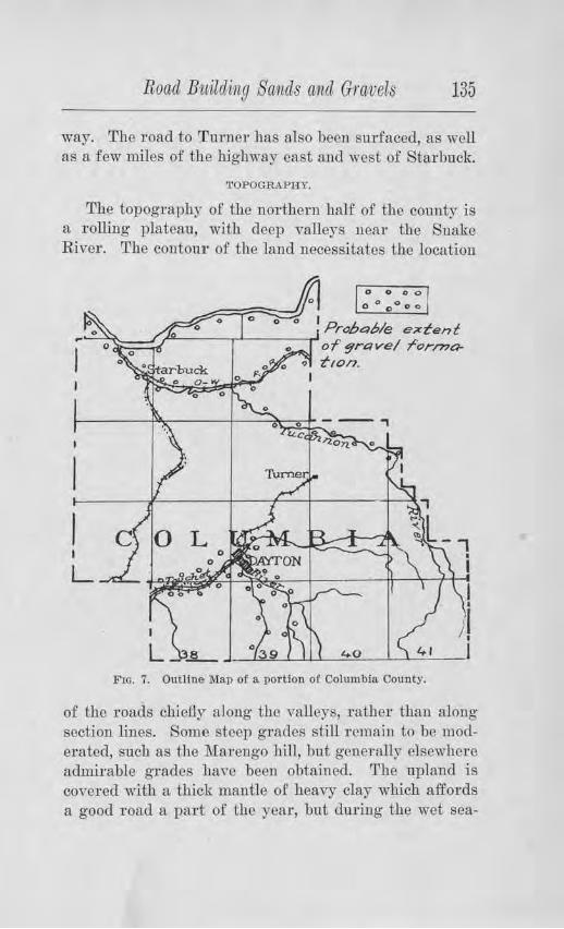
Road Bwilding Sands ancl Gravels 135
way. The road to Turner has also been surfaced, as well as a few miles of the highway east and west of Starbuck.
TOPOGRAPHY.
The topography of the northem half of the county is a rolling plateau, with deep valleys neai· the Snake River. The contour of the land necessitates the location
0 0 0 O
0 0 000 0
1 Probable e;;ctent ,--~==~~----'------' of" 9r&1ve/ ror/?70-
0 t,on.
Fm. 7. Outline Map of a portion of Columbia County.
of the roads chiefly along the valleys, rather than along section lines. Some steep grades still remain to be moderated, such as the Marengo hill, but generally elsewheI"e admirable grades liavc been obtained. The upland is covered with a thic.k mantle of heavy clay which affords a good road a part of the year, but during the wet sea-
136 Bulletin No. 22, Washington, Geological Sumey
son is almost impassable and during very dry seasons becomes badly rutted. Along Tucannon River, Pataha Creek, and the valley south of Starbuck, there is a fine fluffy clay encountered in places which is worthless as a road foundation, and because of the frequent rutty places which it permits, the roads along these valleys should be surf aced.
ROAD MATERIALS.
Gravels occur in bars and benches along Tucannon River, west of Marengo, along Pataha Creek, along theSnake River, and along the Touchet River, including both forks. This is shown on the outline map of the cotmty.
The benches along Tucannon River are made up of coarse fragments. of basaltic rock, some rounded gravels, and much clay . A careful selection would be necessary to secure suitable material. As a whole, better gravel can be obtained from the bars along the stream, but these are commonly limited in quantity and clay would have to be added for binder. The location of the present road is such that wash from the side gulches fills the TOad with considerable debris from this bench.
Along Pata.ha Creek, much light, fluffy silt abounds, making a very bad road-bed. Except near Starbuck, most of the road-metal will have to come from the rock ledges along the valley slopes and occasional alluvial fans. Near Starbuck, considerable gravel can be gotten from the stream-bed and at certain places along the beµches which rise 100 or more feet high. Where this has been used on the nearby road, it appears to be satisfactory.
Along the valley south from Starbuck to Alto, fine sand prevails. The basal tic ledges will be the only source for road material aside from the gravel which can be obtained from Pataha Creek at Starbuck. From
Road Building Sands and, Gravels 137
about one mile north of Alto to within a few miles of Waitsburg, not even rock outcrops. Gravel, however, can be obtained for that portion of the road south from Alto, from the Touchet River.
The Touchet River southeast and southwest from Dayton carries large quantities of firm, well-rounded basalt gi·avel. Considerable oversize is present, necessitating either screening OT crushing. Binding material is lacking and clay will have to be added. Where this has been used on the Inland Empire Highway, it makes a smooth, :firm road-bed, and apparently has good wearing qualities, as the traffic between Dayton and Walla Walla is heavy.
For the first and latter parts of the Dayton-Starbuck road, gravel can be gotten from Touchet River and Pataha Creek respectively, but the basaltic bedrock will have to be drawn upon for the middle portion.
COWLITZ COUNTY
GENERAL STATEMENT.
Cowlitz county is one o.f the southwestern counties of the state, bordering the Columbia River and lying no1-th of Lewis River. Eleven hundred and filty-three square miles are included within its boundaries. In 1916, the Census Bureau estimated its population to be 15,506. Castle Rock is the largest town, and Kalama the county seat. Other towns are Kelso, W oodlancl, Ariel, and Silver L:ake. Lumbering and dairying are the
chief induf ries. The gr atest demands of traffic arc along the Pacific
Highway hich enters the county from the south at Woodland, follows the Columbia River to Kelso, and then the <Dowlitz River across the northern boundary. This road an .. ies a great deal of tl1e coast tourist travel. Unfortuna cly, this happens <luring the summer ,vhen tho bindin quality of any surfacing material is likely
138 Bitlletin No. 22, TV ashington Geological Survey
to be lowest. On accotmt of this factor, special care in the selection of suitable materials is important. If the local demands were only to be considered, the present type of road probably would suffice, but the time is not far off when some kin<l of paving will necessarily be undeTtaken.
TOPOGRAPHY.
Cowlitz county has a rough topography on the whole. It is fortunate for reasons of transportation that the Cowlitz River Valley serves as a nOTth-south gateway. In places, however, the valley is so narrow that the highway is crowded out of the valley by the railroad and river, and in scv·cral instances steep grades are encountered. In the eastern_ part of the county the hills rapidly increase in height to fair mountainous proportions.
CLIMATIC FACTORS.
The climate is very moist dm·ing the winter and dry dUl'ing July and August. During the rainy season, about 55 inches of rain generally falls . Natm·al earth roads then become almost impassable. On the main arteries of tl'avel, therefore, some sort of surfacing is necessary. But care must be exeTCi.sed in choosing the material to avoid too much clay binder which will make the road soft in wet weather, or too little binder, which will permit ravelling dur ing the dry summer months, when tourist travel is at the maximum. Frost action is of little consequence for the winters are usually mild.
ROAD MATERIALS.
Gravels have a limited distribution in the cow1ty when the whole area is considc1·ed, as shown by the accompanying outline map of the county. Oommonly, silt terraces border the streams rather than gravel formations, especially in the lower part of the Cowlitz and Toutle river valleys, so that the occurrence of gravel is confined mostly to a few scattered bars a long the stream,
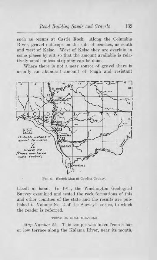
Road Biiild,iJng Sattids and Gravels 139
such as occuTs at Castle Rocle Along the Columbia River, gravel outcrops on the side of benches, as south and west of Kelso. West of Kelso they are oYerlain in some places by silt so that the amount available is relatively small unless stripping can be done.
Where there is not a neal' source of gravel there is usually an abundant amount of tough ancl 1·esistant
A-oboble .,.,rt,u,t- or ~r.wsl f"ormatlon,
X Gr.zv• I Pit
(rhose ',.,vl'nb.,...d wer• t.ste.l.}
F10. 8. Sketch Map of Cowlitz County.
basalt at hand. In 191], the Washing Lon Geological Survey examined ancl tested the rock formations of this and other counties of the state and the results are published in Volume No. 2 of the Survey's series, to which the reader is ref erred.
TESTS ON ROAD GRAVELS.
Map N'l.t1nber .22.. This sample was taken from a bar or low terrace along the Kalama River, near its mouth,
140 Bulletin No. 22, W ashi??,gton Geological Survey
about 21.4 miles north of Kalama. Something like 70 per cent of the material passes a l,4-inch screen, so that the gravel would be called a sanely g1·avel. A few pebbles and cobbles range up to 6 inches in diameter, but these are not so abundant but that they can be screened or possibly raked out. The chief objectionable feature is probably the softness of the pebbles, most of them being andesite pumice and tuff, ·with some basalt. Nearly 68 per cent are soft and by test they showed a loss by abrasion of 32.8 per cent. They probably have their origin in the volcanic rocks of Mt. St. Helens, so that the materials which this stream carries are generally of the same nonresistant character. The absence of proper material for binder is also an objection. This gravel might be used for dressing pm·poses on crushed rock macadam, but for the body of the 1·oad it is not recommended.
lJ!lap Number 23. This sample ·was collected from the side of a high bench, about 2% miles southeast of Kelso. This is a coarse gravel with a relatively low amount of material which would pass a %-inch screen. So much oversize is present that crushing would be warranted. If all of the material were passed through a crusher pit-run, not only would there be a better gradation but there would be a larger amount of binder secured. The quality of the binder already present is high as shown by both the tenacity and cementation tests. Forty per cent of the pebbles are andesite, 34 per cent basalt, 25 per cent quartzite, and 1 per cent granite. Of these 78 per cent are bard and offer strong resistance to wear. Only 6.1 per cent loss r esulted from the abrasion test. For light traffic this material is considered satisfactory if propel'ly prepared.
lJ!lap Number 24. This sample was collected from a side-hill pit about 5 miles northwest of Kelso. Here the gravel, which has a thickness of 12 feet, is overlain by
Road Btiildi11g Sands a1id Gravels Hl
about 15 feet of clay, which limits the amount of material that may be taken out at any one place. The gravel is well graded except that there is about 12 per cent of oversize. The pebbles are chiefly andesites and basalts with some quartzites, and about 85 per cent of them are :firm. By test, the tenacity value is fairly good. Some of the gravel had just been put on State Road Ko. 19 when this locality was ,~sited, and it appeared to be packing satisfactorily.
1vlap N1.i11iber 25. This sample was obtained from the gravel bar of Cowlitz River at Castle Rock. The materials were too variable from place to place to warrant making a mechanical analysis, and there is so much oversize that crushing is an economic necessity. Eighty per cent of the pebbles, which consist of andcsite, tnff, basalt, grconstone, and pumice, arc fairly fhm while tho rest offer little resistance to wear. As is common to most stream gravels, the tenacity value is very low, and in this case the comentation value is also low. In actual practice a good, tenacious clay will ha.ve to be added.
TESTS FOR CONCRETE.
Two of the samples of gravel collected were screened and washed, and the sand was used in mnh.ing concrete briquets for the tensile strength tests of tho sand. Tho character of the test is described in Chapter lV. The briquets of the sand under test were compared with briquets of tho sam(} age made from Standard Ottawa sand and the same brand of cement.
Map Number 23, which has ali·eady been described as being obtained from the side of a high bench about 2% miles southeast of Kelso, showed a tensile strength in the 7-day briquets equal to 53.4 per cent of that shown by the standard sand briquets of the same age, and tile 28-day briquets gave .a value 53.6 per cent as high as the standard sand briquets. The colorimetric test showed an absence of organic matter. It is eYident from the me-
14:2 Bulletin No. 22, W a-Shington Geological Siwvey
chanical analysis of the sand given in Table IV, that an addition of coarse sand is needed.
Map Number 25, collected from the gravel bar of the Cowlitz River at Castle Rocle In the 7-day test, thls sand showed a strength 68.6 per cent as great as the Standard Ottawa sand, but in the 28-day test a greater strength was shown, namely 113.4 per cent. A considerable amount of organic matter was detected by the colorimetric test which would be a dangerous element unless this was removed by washing.
The results of these tests are given in some detail, along with those from other counties, in Tables IV and V.
DOUGLAS COUNTY GENERAL STATEMENT.
Located in the big bend of the Columbia River, Douglas county is bounded on the north and west by this master stream and on the east by the ancient course of this stream, the Grand Coulee. Its area is 1,787 square miles. In 1910 its population was 9,227, most of which is rural. The northeastern portion is but sparsely inhabited. Waterville is the county seat and chief town, and others of importance are Mansfield, Bridgeport, Withrow, and Douglas.
Wheat is the chief product of the county. Some of the largest wheat fields of the country are to be seen here, and the large production calls for properly surfaced roads in order to market it. Foresight is being exercised by the county authorities for the coming of the motor truck. Considerable stock is also raised and dairying is of importance. In Moses Coulee, many acres are devoted to orchards.
TOPOGRAPHY.
In general the topography is a high rolling plateau, averaging 2,000 or more feet in altitude. ~Phe miJ1or valleys in many instances lead to coulees of canyon propor-
•
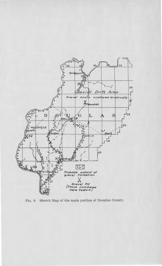
za
I
( 123 \'hf"------jf\;,:,~-4,---.;f;i,;p:;:_.:u,...~ 1~-__!
Fro. 9. Sketch Map or the main portion of Douglas County.
144 Bulletin No. 22, W ashvngton Geological Survey
tions. At some points Moses Coulee is about 2,000 feet deep and very scenic. The Badger Mountains, an upwarp of the plateau, lie in the southwestern part of the county. The bedrock is mostly basalt. Some schists occru· in the deep valleys west of Waterville. As a result of the deep coulees and canyons, the problem of obtaining moderate grades up their side slopes is imperative and frequently very clifficult. The excellent grade and scenic ''switch-backs'' in the tributary canyon west of Waterville is an accomplishment of high 01·der.
North of the dotted line drawn on the outline map of the county, the basalt is covered by a glacial formation whose topography consists of hillocks and depressions of erratic distribution. The soil is heterogeneous and stony, consisting of clay and r ock material intimately mixed. Some localities are sandy. East of Mansfield huge boulders dot the landscape which were brought by the glacier which deposited the stony soil.
South of the dotted line the soil is very largely a clay which varies from heavy to light in character. In the valleys, this has been removed and the underlying basalt exposed. Along the Columbia River, from Orondo southward to the latitude of Wenatchee there is much sand. This requires a somewhat thicker surfacing to carry heavier loads than the clay. The clay muds to some extent during wet weather, but this condition usually does not remain for long. The heavy clay makes a very hard road during the summer, but the Ugbt becomes 1·utty. The variation from heavy to light may take place abruptly so that an otherwise splendid road may become bad by the occurrence of ruts at intervals.
CLIMATIC FACTORS.
Douglas county has a semi-arid climate. Its precipitation averages about 13 inches each year, one-third of which is snow. The drought of summer is particularly felt in harvest time when the moisture has been taken
Road Buildi1bg Sa1ids and Gravels 145
from the roads by evaporation, thus reducing their ability to support heavy loads. In consequence the wheathauling . must be done over roads full of '' chuck holes,'' unless the road has been properly surfaced with gravel. Strewing the road with straw is sometimes resorted to as a temporary emergency measure. GraduaUy the policy of road surfacing is being extended, either by gravel where it is availab1c, or by crushed rock, where the gravel is not, so that in the near future most of the main highways will be improved.
The semi-aridity of the climate affects road maintenance and construction in another way. The fine material which ordina-m:ily would serve as binder is loosened by tTaffic dming the dry spells and carried away by the strong winds of this plateau. Its effect is seen in the ravelling of the road. Not only is the road metal deprived of much of what it had originally, but of practically all that would accrue from the wear of traffic.
If enough moisture is present in the soil when freezing of winter comes on, frost action in the early spring produces a soit roadbed and wheels are likely to cut deep coui·ses. This is corrected by prope1· maintenance before dry weather comes.
DlSTBIBU'.rIO'N OF ROAD GRAVELS.
Within the m·ea of glacial drift there are many knolls of graYel to be fom1d. These cannot always be identilied as gravel-bea1·ing without making test-pits, but sometimes they can be detected by their smooth and rounded contour, their steepness of slope, and the character of the soil-co,,ering. Their clistribution is so erratic that their occurrence in any certain locality cannot be predicted, but they may be found most anywhere.
The drainage lines which lead away from the glacial drift area usually contain deposits of gravel which we1·e transported and deposited there by the waters from the melting ice. Moses Coulee is an example, and the small
-6
146 Bulletin No. 221 Washington Geological Survey
valley east of Withrow another. The Columbia River Valley also represents such a relationship. The materials of the east sjde of tbe Columbia River, however, seem to contain too much fine sand until a point is reached a few miles below Wenatcbee. The small ,•alleys west of Waterville arc barren of graYels because their sources were outside of the gravel-bearing waters of the glacier.
Tests on Samples
Map Nutnber 26. This sample was taken from the deposit on the north side of the Columbia River, 4 miles northwest of Rock Island. Here a high benoh attaining a height of nearly 500 feet above the river, contains immense quantities of gravel. The mechanical analysis shows that the material is mostly a mi~ture of "pcagravel" and "torpedo-sand." The pebbles are fresh and firm and show good wearing value. The finer portion, which passed through a 10-mesh sieve, and which may be con.sidered as the binder, tested rather low both in tenacity value and cemcntation value. In the lower terrace the gravels are much coarser and less satisfactory. The Wenatchee-Rock Island road was surfaced with the material from the higher terrace, and although it was slow in setting, the road is now a splendid one.
Map Nwmber 27. This sample was obtained from a deposit l Vz miles west of Trinidad, and is very similar to the one just noted. The gravel is of essentially the same texture, although less of it passes the %-inch screen. Practically all of it is basaltic in composition. The bincleT of this sample tested moderately well both as to its tenacity properties and its cementation. This has been used on the Sunset Highway east of Trinidad, chiefly as a dressing ove1· coarser gravel, and has gi,en satisfaction, aftel" the addition of more binder.
lltfap Nimiber 28. This si:imple was taken from a deposit of gravel, 1 mile east of Witlu·ow, by- the railway
Roacl Building Sands a,nd Gmvel.s 147
track. This gravel is coarse and basaltic in compos.ition to the extent of i1bout 97 per cent. About 23 per cent is r etained on a 2-incb screen and about 28 per cent passes the %-inch screen. Prncticnlly all of it is fu-m and excellent in wearing quality. The binder portion is very small in amount and too small to make a plastic paste for testing its tenacity ,value. The percentage of over size would undoubtedly warrant nrn:niug all of the material through a crusher pit-run. The binder would probably be increased by so doing. :Much of this gravel is used for concxete purposes in Waterville. The r esults of the concrete briquct tests arc given on a following page, as well as in Tables III and IV.
JJiap Ni1.,1nber 29. This sample was taken to represent the avemge of the deposit in a low bench along Foster Creek, 61/2 miles south of Bridgeport. The gravel formation is at least 100 yards 1011g, but is overlain by 5 to 6 feet of light gray silts which must be stripped in order to secure the gTave1. The materials are mostly basalt ,Yith some granite, and well graded save for some o,ersize. The pebbfos axe fresh an<.1 hard and show good wcar.ing value. The binder is low in quuntity and tested low iu cohosfreness. A tenacious clay shoulcl be added lo compeusatc for this lack in essential qualities.
Jlap Number 30. This sample was taken from the gravel pit ne:n the mouth of Foster Creek, 2% miles southeast of Bridgepo1·t. The pit-face is 50 feet long and 30 feet high and stands vertically. The lower 10 feet contains material suitably graded up to 2 inches in size, while fue overl~1ing is coarser but also contains :fine material. The sample was taken from lhe lower portion. Thirty-six per cent of the pebbles arc basalt, 26 per cent granite, 23 per cent quartzite, and J5 per cent siliceous rock. About 88 lJcr cent are firm. By test the graYel shows good wearing qualities, and the binder is
148 Bulletin No. 22, W a-shington Geological 8urvey
fairly good in its cohesiveness and cementation. Where used on the highway it has given good satisfaction.
Map Nwmber 31. This sample was taken from a deposit in Moses Coulee, about 134 miles north of the present P alisades Station. A 200-foot bench occur s here, containing immense quantities of gravel ranging in texture from coarse sand to 2-inch pebbles, with a few oversize constituents which can be easily discarded either in the excavation or in spreading on the road. The materials are rounded and consist mostly of basalt. Ninetyseven per cent are firm, and the loss they yield to abrasion is r~markably low, 3.9 per cent. The chief disadvantage is in its low binding qualities as indicated by its tenacity value. Not only is there an insufficiency of binder which passes the l,I.J,-inch screen, but not enough passes the 200-mesh.
1-Ylap Nurn,ber 31. This sample was obtained from a deposit along the Columbia River on the east side, 3 miles south of Orondo, where fragments of g,Tanite, quartzite, and schist have been washed out of a tributary canyon and deposited in the form of an alluvial fan. Nearly 20 per cent are oversize, but the r est are well graded. If crushed pit-nm, it should make a desirable surfacing material. The schist constituents are soft, which reduces its wearing value, but this may be advantageous jn one way in that binder is thereby contributed. In its natural occurrence the deposit is lacking in this essential element. The tenacity test gave a low value for the binder as it occurs naturally. Material from here was crushed and used on the road of this locality in 1915 and was found to pack readily, giving good service since.
Tests for Concrete
Map Number 26, her etofore described, was screened and washed and the sand used in making concrete briquets, whose tensile str ength was tested and com-
Road Building Sands and Gravels 149
pared w:ith the strength of briquets made from Ottawa Standard sand ancl the same brand of cement. The character of this test is recorded in Chapter IV. Three of the briquets of the sand under test wcl'e broken when seven days old and found to have a strength 100.8 per cent that of the b1·iquets of Ottawa Stanchud sand of the same age, and the 28-day brjquets iestecl 113.4 per cent as great. In actual practice the sand may be found to be a little too coarse and some -fine may be needed. The colorimetric test showed no organic matter.
Map Number 28, from a deposit already described, yielded briquets which tested 129.5 per cent the strengthefficiency of Standard sand briquets in the 7-day briquets, and 109.9 per cent in the 28-day briquets. The sand is too coarse to give the proper density and fine sand or crusher dust should be added. No organic matter was found to be present.
Map Number 30, previously described, gave as the 7-day ratio, when compared w:ith the Ottawa Standard Sand, 142.9 per cent, and as the 28-day ratio, 151.7 per cent. The sand was shown by the colorimetric test to be free of any organic content.
Map Number 31, from a deposit herein described, tested 114.3 per cent the strength-efficiency of Ottawa Standard sand in th,e 7-day briqucts, and 129.1 pei- cent in the 28-day briquets. The sand. should have some fine sand or fine crusher added to give the proper density. No organic matter was found by test.
FERRY COUNTY
GENERAL STATEMENT.
Ferry county iB m the central part of the Okanogan Highlands, and is mountainous e~cept for the SanpoilKettle River Valley, which, forhmately, runs lengthwise through the county and provides a continuous passage for transportation and communication. The State High-
150 Bulletin No. 22, W a.shington Geological Survey
way Department has established a state road, State Roa,d No. 4, along this valley, beginning at Ferry on the northern boundary and connecting with the Sunset Highway at Wilbur in Lincoln county. A branch of State Road No. 4, running west from Republic, connects Ferry county with Okanogan county.
The population of the county, as estimated by the Census Bureau in 1916, was 4,951. The amount of traffic is accordingly light and the expenditm·e of money on roads cannot be large. Dairying, stock-raising, mining, lumbering, and diversified farming are the main industries.
The rainfall is not excessive for the proper maintenance of roads, the precipitation averaging about 17 inches, a certain amount of which is snowfall. In early springtime, frost action and moisture conditions are likely to make the road-beds soft and permit ruts from wheel-cutting.
DISTRIBUTION OF GRAVEL DEPOSITS.
Gravels are found along all of the chief valleys, such as the Sanpoil, Columbia, and Kettle River valleys, but they vary greatly as to gradation and sand content. Along the Kettle River Valley in the northern part of the county an abtmdance of good gravels may be had by screening out the over-size material. In fact, the roads in this part of the county have in part a natural gravel road-bed. In the lower portion of the Sanpoil River Valley and along the Columbia River, there is a great deal of fine sand and silt below an elevation of about 1700 feet which makes a poor sub-soil for a r oadbed and in many cases necessitates the securing of good road-gravels at higher levels.
Tests on Samples
Map Nurnber 33. This sample was taken from a deep road cut in the gravel formation, 3 miles east of
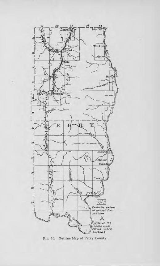
F1G. 10. Outline Map of Ferry County.
152 Bulletvn No. 22, Washington Geological Survey
Republic. The gravels here form a bench-like feature along the lake, on which the road is located. They are well graded but contain considerable over-size. About 70 per cent are retained on a 1J.t-inch screen. The pebbles are composed chiefly of firm granites and andesites and have good wearing qualities. The cementing material, however, is lacking in sufficient clay to give it good binding qualities, as shown by the tenacity test, described in Chapter ill. Crushing might aid this factor if a good tenacious clay is not available.
Map Nwmber 34. This sample was collected from a
road-side cut 3% miles west of Republic. Its composi-tion is much the same as Sample 33, as far as kinds of pebbles are concerned, but there is a greater percentage of soft, and the gradation in size is better. Wbere used on the road, it has proven satisfactory for light traffic.
OTHER ROAD-BUfLOING MATERIALS.
Wbere gravels am not at hand or of suitable quality, there is an abundance of rock exposed that is suitable for road-building. Much andesite occurs along the Sanpoil Valley from Republic south and in the vicinity of Curlew. Gxanite and diorite also occur nOTtheast of Curlew and along Kettle River from Orient to Laurier. These rocks were tested in 1911, and tl1e results published in Bulletin No. 2 of the Survey series.
FRANKLIN COUNTY
GENERAL STATE.MlilNT.
Franklin county is situated just north of the junction of the Snake and Columbia rivers, in the southeastern part of the state. Its area of 1206 square miles is but little populated in several of its townships, and all told its population in 1916 was estimated by the Census Bureau at 8,087, of which Pasco, the county seat, has about one-fourth. Connell, Eltopia, Mesa, and Kahlotus are the other chief towns.
Road Building Sands a1ui Gravels 153
The main line of the Northern Pacific Railroad passes northward thl.-ough the county, a branch line of tbe same railway connects Connell and Kahlotus with northern points, and another follows the Snake River canyon to Lewiston, Idaho. The S., P. & S. Ry. also uses the track of the latter to Snake River Jimction, and then by a line of its own ascends the canyon slope to the pass south of Kahlotus through which it reaches the Washtucna Coulee and thereby leaves the county.
The demand for good roads is quite prevalent, but they need not be plaUDed for more than light traffic for perhaps several years. Surfaced 1·oads should be provided over at least the sandy portions of the comity, where the marketing of the wheat soon cuts the natural roads until they are almost impassable, and along the Central Washington Highway, which is the main automobile highway through the county.
TOPOGRAPHY.
In the eastern portion of the county is a rolling plateau, 800 to 1800 feet above sea-level, which is underlain mostly by clay and which is much cut up into hills and Yalleys. In the northwestern part of the county there are high-lying flats and jn the vicinity of Pasco are bench lands which more or less gradually decline to the level of the Columbia River, at 350 feet above tide. The Washtucna Coulee, an ancient and imposing valley, now without a permanent stream, runs from Washtucna to Connell by way of Kahlotus and thei·e joins the Esquatzel Coulee which trends southwestward and gradually becomes shallower until it merges into the bench land north of Pasco. The valley occupied by the Snake River is a very deep canyon from the eastern line to a short distance east of Pasco.
154 Bulletin No. 22, Washington Geological Su,rvey
SUBSOIL.
The soil for some miles around Pasco is extremely sandy. Northeast this merges into a coarse sand and gravel of Esquatzel Coulee. The soil of the higher plateau to the east is mostly a heavy clay, but the dryness of the summers in this county is sufficient to deprive the clay of its moisture-binder and permit the roads to become very rutty when the season for heavy wheat hauling is at hand. The average precipitation for the whole
year is only about 7 inches. This is reflected in the sagebrush vegetation of the area.
Progress is now being made in surfacing the main highways. Sevi;iral miles were surfaced in 1917 northeast of Pasco, and a stretch of the Central Washington Highway, beginning at Pasco, is at present being metaled.
On the outline map of the county, the areas which are probably underlain by gravel are shown. It should not be understood that gravel occurs universally in these areas, for there is known to be some scab-land ·within these limits, as well as wind-blown sand. But the geological indications together with certain test-pits show that gravel may be found in many places within the areas mapped.
TESTS ON ROAD GRAVELS.
Map Number 35. This sample was taken from a deposit three miles northeast of Pasco, in the S. E. 1.4 of Sec. 2, T. 9 N., R. 30 E. A pit in this deposit shows coarse rounded gravels of basalt, quartzite, and granite, most of which are firm and have excellent wearing value. The amount of oversize warrants putting the whole material through a crusher, thus giving not only well graded constituents but increasing the binder content. The tenacity test on the binder showed that its quality, as it occurs in the gravel, is fairly good, and the cemen-
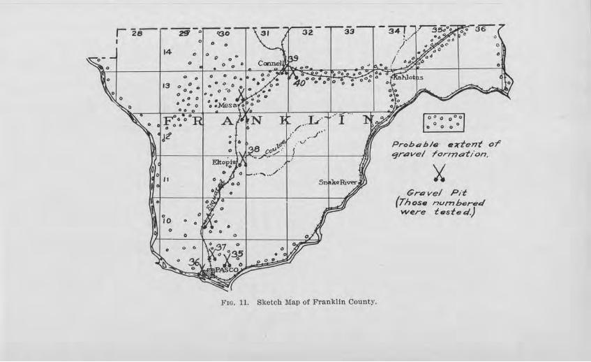
rz~ ~-:1 14 0
J2'
~101 11
0
Fro. 11. Sketch Map of Franklin County.
00 0000
·o O o o 0
ProbR his· e-;rtent or qrave/ rcrmation.
~ Grovel Pd
{Those nvmbered were test e el.}
156 Butletin No. 22, Washington Geological Survey
tation test shows that after the material is gl'Ound up its cementing qualities will be high. Material was takeu from this deposit for the newly gravelled highway northeast of the irrigation ditch.
llia,p }l1.i1nber 36. This sample was taken from the pit 14 mile southeast of the passenger depot at Pasco. A great deal of gravel has been removed from this pit so that now it has a £ace about 150 yards long and 10 to 15 foet high. The material stands well in the pit, but this ma.y be due partly to its coarseness. Such as is used for surfacing must be crushed. Seventy-four per cent of the pebbles in the sample were basalt, 15 per cent granite, and 11 per cent qual'tzite. P ractically all of these arc hard and have excellent wearing value. The sand is present in varying quantities, usually low in percentage, and so was not graded. Silt coats the pebbles in some horizons which increases theiT cementation value, but if the gravel worn to be used for first-class concrete this f eatuTe would make washing necessary. Some of the quartzite pebbles arc flattened, but their percentage is believed to be too small to a-ffect the packing qualities of the gravel.
Jllla,p Nitmber 37. This sample was collected from a deposit 4 miles northwest of Pasco, along the Northern P acific Railway. A test pit had been opened, which exposed the characteristics of the gravel fairly well. The pebbles consist of basalt and quartzite, have excellent wearing value and are well graded, there being but little oversize. The cohesiYeness of the binder is very high as shown by test, and the ultimate cementation is also high. This deposit may be drawn upon for the Washington Central Highway in this vicinity.
JJ!Iap Nri1,mber 38. 'rhis sample of gravel was taken from a deposit 1h mile northeast of Eltopia, in Smith's Canyon. The deposit is an eroded bench of considerable size, and the fact that it is a remnant of a bench
Road Biiilding Sands and Gravels 157
shows that other deposits are likely to bo found in this vicinity. The pit-C:!\.'})OSure shows a little oversize but as a whole the gravel appears well graded. Most of the pebbles are basalt and have very good wearing value. The tenacity value tested low, indicating that an addition of clay is necessaTy. If this is done, it should make a very satisfactory road material. Five miles of the Smith Canyon road was surfaced with this material, and under heavy steel-tired traffic, such as prevails during the wheat-hauling season, llie material has packed well. Some clay was added from the roadside.
Map Numiber 39. This sample was obtained .from the deposit in the southern limits of Connell and is almost entirely a "torpedo sand" of basaltic composition, without any perceptible softening by weathering. So little silt material is contained in the coarse sand that a cohesive paste could not be made for the tenacity test. This material has been subjected to a practical test on the road for 1/z mile north of town and found to pack and wear well. It would make excellent material for dressing purposes and should also prove satisfactory for use in a sand-clay road.
"Map Number 40. This sample was taken from another deposit near Connell, locatecl 1h mile southeast of town. This is a typical gravel in which but little oversize is present, the pebbles are hard and have average wearing value, but the binder is low in its content of clay. This was used on the highway for 1 mile wost of town and with the addition of clay is reported to have packed promptly without rain.
In about the central part of Sec. 19, T. 13 N., R. 31 E ., on the no1-th side of the railway, the N orthem P acific Railroad has O})ened a large pit, 300 yards or more long in a deposit which stands 50 to 60 feet high. The pebbles are mostly small, the gravel being a true '' pea-
158 Bulletin No. 22, W ash1ington Geological Survey
gravel.'' They are dominantly of basalt. Large quantities have been used for railroad ballast.
In a high bench along the road north of Mesa, gravel of good quality is exposed. Where this forms the roadbed it seems to be entirely satisfactory. North of Kahlotus and elsewhere along Washtucna Coulee, gravel deposits occur in benches 100 to 150 feet h.igh. Those at Kahlotus are well graded, with but little oversize and scarcely any sand. Where used on the highway in th.is vicinity it seems to have good binding and wearing qualities.
TESTS FOR CONCRETEJ.
The sand from Map Number 39, heretofore described, was washed and tested for concrete. The method used is described in Chapter IV and the results of the tests are tabulated with those from other counties in Tables TIT and IV. It tested in tensile strength 118.5 per cent as strong as Ottawa Standard sand, in the case of the 7-day briquets, and 142.1 per cent as strong in the case of the 28-day briquets. No organic content was found by the colorimetric test.
GARFIELD COUNTY
GENERAL STATEl\1'ENT.
This county is situated south of the Snake River in the southeastern part of the state. The extreme southern projection lies in the Blue Mountains, but most of the county is a high plateau, dissected by many deep canyons. The main canyo11s trend in a northwesterly to westerly direction. The existence of these, together with their trend, necessitates winding grades over high divides for roads leading from the northern part of the county to Pomeroy, the county seat. P a.taha Creek, however, makes possible a grade for a railway branch of the 0.-W. R. R. & N. Co. to enter the county and afford
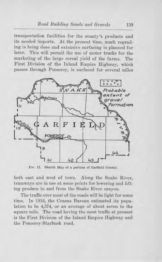
Road Building Bands and Gravels 159
transportation facilities for the county's products and its needed imports. At the present time, much regrading is being done and extensive surfacing is planned for later. This will permit the use of motor trucks for the marketing of the large cereal yield of the farms. The First Division of the I nland Empire Highway, which passes through Pomeroy, is surfaced for several m1les
Prob4h/e /m-+---- - -+----~i---;::,___~ extent- or
.:=,-___,,, grave I rormation.
43
Ftc. 12. Sketch Map of a portion of Garfield County.
both east and west of town. Along the Snake River, tramways are in use at some points for lowering and lifting produce to and from the Snake River canyon.
The traffic over most of the roads will be light for some time. In 1916, the Census Bureau estimated its population to be 4,374, or an average of about seven to the square mile. The road having the most traffic at present is the First Division of the Inland Empire Highway and the Pomeroy-Starbuck road.
160 Bulletin, No. 22, Washington Geological Sitrvey
SUBSOIL.
A heavy clay soil covers the upland areas to considerable depth north of Columbia Center. This makes a good earth road in the late spring and early summer, but during early spring and late fall such roads are usually almost impassable on account of rnud. In the deeper canyons and gulches, below the 1200-foot level, a light fluffy clay abounds which is scarcely capable of making a good road at any season of the year. Another difficulty which must be contended with in the lower portions of the gulches is the great amount of debris which torrential rains wash down from the higher slopes. In some cases, roads are thus effectuaJly blocked.
CLIMATE.
The average annual precipitation at Pomeroy is 18 inches. This amount is increased on the higher slopes of the Blue Mountains and decreased in the lower valleys near Snake River. The summers are dry, permitting the natural earth road to become almost entirely free of moisture and rutted in the marketing season when the traffic is fairly heavy.
DISTRIBUTION OF ROAD MATERIALS.
The gravels are confined almost entiTely to the Snake River Valley and the lower reaches of Deadman Creek and Pataha Creek. The benches along the Snake River are not continuous but are remnants chiefly on the inner sides of the curves of the stream. They are commonly 50 to 75 feet high, and large quantities are available, but the difficulty of transporting them to the roads of the plateau is almost prohibitive. Along Deadman Creek and Pataha Creek, below the 1200-foot level, the1·e are alluvial fans located at the mouths of tributary gulches composed of fragmontal materials which have been washed down from the higher slopes. In a few cases
Road Bu,ildilng Sands a;nd Gravels 161
suitable material may be secured, but usually the material is too coarse to use without crushing. Some small gravel bars are scattered along these streams, but these are commonly deficient in binding material.
Above the 1200-foot level, the bedrock is the chief source of road-metal. The rock is made up of basaltic lava-flows and is dominantly porous, fragmental and rather soft, with reddish horizons here and there. Indeed, its character is such that a most careful selection is necessary in order to locate a good quarry, and even after a quarry is once opened, objectionable rock may be encountered as the work progresses. This is illustrated in the case of the county quarry 3 miles west of Pomeroy. The quarry 11/2 miles east of town is of somewhat better quality.
GRANT COUNTY
GENERAL STATEMENT.
This county, the fourth in size in the state, is situated in central Washington within the Big Bend of Columbia River. It is about 92 miles long in its longest dimension and 50 miles wide, and contains 2,720 square miles. This great area intensi..6.es the difficulty of very extensive roadbuilding, for a county of its small population and lmv assessment value of the land. The population in 1910 was 8,6981 or an average of 3.2 persons to a square mile. There is some concentration of the inhabitants along the Great Northern Railroad in the vicinities of Quincy, Winchester, Ephrata, Adrian, Wilson Creek, and Krupp, and also a fair percentage in the vicinity of Coulee City and Hartline, in the northern part of the county, and at Beverly, Smyrna, and Warden in the southern part. Thus the demands for good roads, while localized, are after all scattered over a wide territory.
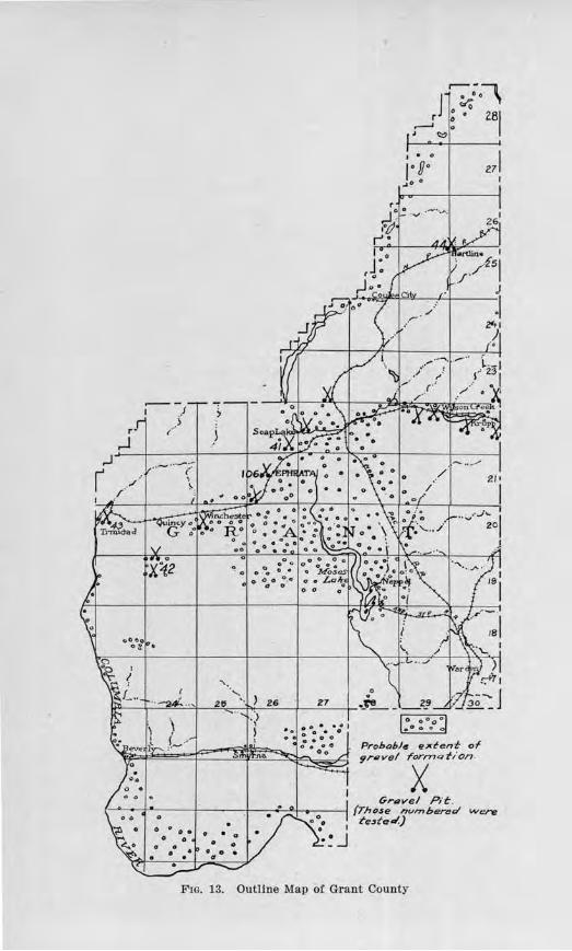
r· ,.J i ,
.----, J
• • • ' clo r ; • 281
..--' Q
' <::::,
I • o
, • 90 ....
Prohob/e extent of 9r.,vel rorrnatlon.
X Grilvel Pit:.
{Those n vrnbe=cl ""ere t'e:,fo.l.}
Flo. 13. Outline Map or Grant County
Road Building Sands (llnd Grnvels 163
The chief industry of the county is wheat growing. Some alfalfa, rye, a:nd fruit are also grown, and some mineral salts and diatomaceous earth are mined. The county is traversed by two transcontinental railways, the Great Northern through the central part and the Chicago, Milwaukee and St. Paul through the southern. A branch line of the Northern Pacific Railroad provides north and south connections.
The State Highway Department has established two roads, the North Central Highway from Quincy to Krupp, and the Sunset Highway from Vantage to Trinidad, and across the northern part through Coulee City and Hartline. Only a part of these roads has been surfaced.
TOPOGRAPfilC FACTORS.
[1he topography offers few difficulties in the way of roadbuilding. The county consists of .flattish plains south of Soap Lake, with the exception of the Frenchman Hills and the Saddle :Mountains, and a rolling plateau to the north. The latter is cut by the impressive Grand Coulee, which was occupied by the Columbia River during glacial times.
A large part of the plains have a sandy subsoil which causes abominable roads in chy weather. Some progress has been made in surfacing these. Along Crab Creek, in the vicinity of Redrock, there is a fine silt which is nearly as prohibitive to traffic in summer as sand. There are considerable areas, however, northeast of Ephrata where gravel underlies the surface, and the roads here are almost universally good.
CLIMATE.
Grant county must contend with a semi-arid climate in its construction and maintenance of roads. The rainfall is usually less than 8 inches each year. The long dry season taxes the binding qualities of the surfacing
164 Bulletin No. 22, W ashi1igton Geological Sumey
materials, especially when marketing is on or the tourist travel is large. In constructing roads it has been found that new suTfacing· made in the late spring packs less readily during the summer and makes a much less satisfactory road than if the surfacing were clone in the fall and received the benefits of the winter's moisture.
DISTRIBUTION OF ROAD GRAVELS.
Due to the fact that the Columbia River was diverted from its present course during a part of the Glacial Period and made to fl.ow through the Grand Coulee and by way of :Moses Lake and Crab Creek, a large amount of sand and gravel was brought into the county and deposited over co11siderable territory in the vicinity of Soap Lake and Adrian and south beyond :Moses Lake. The sketch map of the county shows by small circles the areas in which road gravel can likely be found, and by a symbol of crossed shovels some of the places where pits have already been opened.
The gravel seems to be coarser and more bouldery south of Soap Lake and Ad.Tian and in the immediate vicinity of Moses Lake, but at the south end of the lake there is much wind-blown sand which has deeply buried tho graYcl and filled the old channel-way. Gravel occurs north of Corfu, but along Crab Creek from here to Beverly the deposits are patchy and consist mostly of fine sand and sandy silt. Along the outer border of the gravel area as mapped, as for example on the Morrison Flat, the materials are mostly coarse sand and peagravel.
Tests on Samples
JJ1a,p Num,ber 41. This sample was taken from a deposit in the N. E. 14 of Sec. 35, T . 22 N., R. 26 E., on the property of :Mr. Robert Ing1·am. The material is chiefly pea-gravel and '' torpedo sand,'' and mostly basaltic, over 90 per cent of which is hard and has very
Road Bitilding Sa1nds and Gravels 165
good wearing virtues. The tenacity test, however, showed that the material is likely to have a slow initial set, but the cementation test reveals that after the binder becomes ground up ii will baYe a high cementing value. A remedy for the slow initial packing would be to add some tenacious clay. The deposit in its natural state would make good dressing material.
A coarser deposit occuTs on the north side of the road, in which the pebbles range up to 3 inches in size. Gravel from these pits has been used on the road from Ephrata to Soap Lake, and was redressed in 1917 with the finer material. The traffic in summer is estimated at 200 vehicles per day, most of them fast tourist cars. In winter the travel is much less.
Mav Nii1nber 42. This sample was taken from a deposit 5 miles south of Quincy. The materials are basaltic graYels, mixed with a considerable amount of lime fragments. A certain percentage is oversize which is screened and discarded. At a depth of about 6 feet clay beds are encountered. A little over 80 per cent of the constituents are hard, the remaining 20 per cent or less reducing the wearing virtues of the gra-vel but increasing its cementing qualities by yielding binder. T1ie binder portion has a low tenacity -value as shown by test, indicating that an addition of clay is needed.
JJtla.p Nwrnbe1· 43. This sample was taken from the deep roadway cut, 2112 miles northeast of Trinidad. About 70 per cent of this sample consisted of pebbles and fragments over 11,1-inch in size, and 10 per cent over 2 inches. A laye1· of lime-rock at the top of the gravel and beneath the soil yields a considerable amount of soft material which in the sample amounted to about 11 per cent. The remaining 89 per cent is hard, and would give good wear. The binder portion gave a low tenacity test, indicating that some clay is needed. This deposit was uncovered in the process of excavating for
166 Bulletin No. 22, Washing ton Geological Survey
the cut, and the material was used on the road, with :fine gravel from west of Trinidad for dressing. The result has been very satisfactory.
Map Ni111nbe1· 44. This is a sample of the material from the Hartline Gravel Pit. This deposit, ,vhich has yielded so much road metal for the highways in this vicinity, has pebbles mostly under 11/z inches in size, fairly well rounded, and nearly 40 per cent of which passes the ]l,i-inch screen. About 95 per cent are :fixm, showing very good wearing qualities, but the binder portion tested low in its cohesiveness. This was borne out in actual practice by its slowness in packing and the considerable amount of maintenancc necessary. After it is made to pack, it gives very good service. The slow initial set could probably be remedied by the addition of a good tenacious clay.
Tests fo1· Concrete
Map Niirnber 41. This sample, which was taken from Mr. Robert Ingram's pit previously described, was tested for concrete by making six concrete briquets according to the method described in Chapter IV. Three of these briquets were tested for their tensile strength when 7 days old and compared with briquets of similar age which had been made from Ottawa Standard sand and the same kind of cement. The 7-day briquets of the sand under test showed a tensile strength 141.0 per cent as great as those of the Ottawa Standard sand, and the 28-day briquets 131.4 per cent as great. The sand has no organic content, as shown by the colorimetric test. Due to the coarseness of the sand, fine sand or crusher dust should be added.
Map Number 106, taken from the Pruitt pit, 112 mile west of Ephrata. The 7-day briquets tested 94.6 per cent as strong as the Ottawa Standard, and the 28-day
Road B'liilding Sands and Gravels 167
briquets 98.8 per cent, which indicate its unfitness for :first-class concrete. Its inferiority is probably due to its fineness.
GRAYS HARBOR COUNTY
GENER.AL STATEMENT.
This county is located on the Pacific Ocean and includes the bay which bears its name. Its area is 1927 square miles, and its population in 1916 was 48,457. :Much the larger part of the population live in the southern half of the county, chiefly along the Chehalis River. Here is where the chief requirement for improved roads exists, and a1so in the lumbering region of the Olympics where the railroads have not as yet entered.
The county has a hilly topography except in the northeastern part ,vhere the uplands pass rapidly into the rugged topography of the mountains. Some wavecut terraces border tho narrow coastal plain. The irregular surface of tho county necessitates the location of ihe highways chiefly along the valleys, where moderate g1·ades facilitate travel. Here, too, the roads commonly lie on gravel benches and have excellent foundations while the uplands are covered with a heavy mantle of clay soil.
Situated close to the coast, this county receives a heavy rainfall. Most of it occurs during the winter, and the summers are fairly dry. Both extremes of climate are, therefore, present to affect road-building. The amount of clay which can be used in the binding portion of gravel is limited by the moisture of the winter season, but enough must be present to prevent ravelling during the summer. The temperature is so mild that severe frost action does not prevail . Good drainage is, of course, a prerequisite.
DISTRIBUTION OF GRAVEL DEPOSITS.
Before discussing the distribution of the gravel formations of this county, attention should first be called
168 Bulletin No. 22, W ashmgton Geolog-icalr Survey
to the fact that there are two distinct gravel formations present which differ widely in their road-building qualities. One is a red or reddish brown gravel which is usually composed of soft, decayed pebbles, and is worthless as a road-metal, the other is a grayish to yellowish gravel, firm in character. The cause for the difference in character between the two is that the former is much older and has been weathernd deeply, while the latter represents the outwash of the Puget Sound glacier and is comparatively recent in age. The former usually occurs on divides or in high te1Taces, while the latter fo11ns relatively low benches along the Chehalis River.
Gravel of fresh character is found in benches along the Chehalis River from 20 to 40 feet above the floodplain, practically the whole distance from where the river enters the county to Aberdeen. Similar gravels occur along the Cloquallam River, Wildcat Creek, :Mock Chehalis Creek, and the eastern benches of the Satsop River.
The reddish brown gravel occurs in the higher bluffs at Cosmopolis, between Aberdeen and :Montesano, near Rutherford, 1 mile west of Satsop village, and from Satsop to Elma. It also is found along the West Fork of the Satsop River, the Wynooche River, the Wishkah River, the Hoquiam River, and in bluffs along Grays Harbor nea1·ly to the coast. Gravel of :first-class quality cannot be expected to occur in any valley west of the West Fork of the Satsop River tmtil the Humptulips River is reached. The soft, reddish gravel is found in some instances from near the bottom of these streams to the top of the divides. In practically all cases it occurs well above the valley-fiat and can easily be identified by its reddish color. Some of the low benches, such as occur in the Wynooche, have been drawn upon for local uses, but while this is better than the gravel higher up on the slopes, its life is shor t.
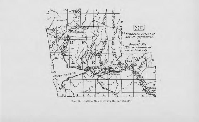
••• 0 .. 0 o O 0
jzo Prohob/e t!!xt1nt or 9n:7v-,/ f'orrno-tion.
' itJ/ "*~ -a ~'!;II j 4 I •,:tj ~ ~ I \./ \ 0 _~~ c..JJ /Ai1 .1 Jf.
19 Grav•/ P/t. I (Those nvmbered
~ 4/' .'[Jr47 ,~ /J ~'i ~·4~-t'' fj lit~ ~ wer~ teste</) L ~- . ./ I ·'"• ;.;~.>. 1 ~ ll
1
Fm. 14. Outline Map of Grays Harbor County.
170 Bitlletin No. 22, Washington Geological Survey
The Humptulips River contains bars of fresher and firmer material than the streams immediately to the east, but not quite so firm as the Chehalis River gravel. The Humptulips River drained from a valley glacier in the Olympic Mountains during the last glacial epoch, whereas the Hoquiam River and others had no such source for fresh material. Benches occur upstream containing unlimited quantities of good material. Some of it is coarse, but a selection of properly graded gravel can usually be located.
Two classes of gravel characterize the coast of Grays Harbor County : a beach gravel and a reddish gravel. The beach gravel is made up of firm pebbles of r ock with more or less sand, which has been washed and thrown up by the waves. Because of the wear and assortment by the waves, the gravel has very little binding material left in it. The 1·edclish gra,el is similar to that which has been mentioned, being usually soft and inferior . It occurs over broad benches and in wave-cut cliffs. The bars, which near ly enclose the mouth of Grays Harbor, al'e comi:>osed mostly of wind-blown sand, too fine for concrete.
Tests on Sa.m1>les
In 19111 the bedrock of this county was studied to ascertain its adaptability for road macadam. The basalt north of Hoquiam and another outcrop one mile west of Oakville were tested and the results published in Bulletin No. 2, of the Washington Geological Survey. The present report has to do primarily ,vitb the gravels.
Mav Niimber 45. This sample was taken from the Brady pit, 21A, miles west of Elma. The gravel here occurs in a broad terrace, and is composed of basalt, 35 per cent; siliceous rock, 51 per cent; quartzite and sandstone, 14 per cent. 0,1er 90 pe1· cent of the pebbles are :firm and have strong resistance to wear or rupture.
Road B'l1,ildvng Sands and Gravels 171
This sample gave the lowest percentage of wear of all the samples tested. They are well rounded and fairly well graded, with a considerable amount of oversize. The chief objection is the lack of good initial binding qualities, as shown by the tenacity test. The addition of tenacious clay would be beneficial, both as to its initial packing and to its ultimate cementation.
Map N1..1,1nber 46. This sample was obtained from a gravel bar of the Cloquallam River, 1 mile southeast of Elma. The bar is about 100 feet wide by 300 feet long. Material has been excavated to the depth of 3 feet. This gravel represents the re-working of the glacial outwash gravel which occur s in the banks of the stream. Sixty-SL'{ per cent of the pebbles are basalt, 14 per cent sandstone, 14 per cent siliceous rock, and 6 per cent granite. About 95 per cent are firm and of first-class wearing quality. It js lacking, however, in binding material, as might be expected in the case of a stream gravel.
Map Nmnber 47. This sample was taken from a bar of the Humptulips River, 4 miles nor th of Newton, where the county was obtaining gravel with a sky-line ch·ag. :Most of the pebbles are basalt with some sandstone and metamorphic varieties. Over 90 per cent are firm and have good wearing value. By test the tenacity value is low, indicating that clay should be added. The material was being placed on the Olympic Highway at the time of this examination, but it was too early to note its prnctical value.
J.llfa,p N1..imber 48. This sample was collected from a pit located in a te1Tace, 8 miles northeast of Humptulips, in the N. E . Yi, of Sec. 14, T . 21 N., R. 10 W. The pit face shows a two-foot covering of brown soil, below which are fresh, light-colored gravels ratheT imperfectly assorted. Much clay occurs in the matrix which would enhance the binding virtues of the mate-
172 Bulletin No. 22, Washington Geological Survey
rial. In the tenacity test, this showed a fairly good value. About 90 per cent of the pebbles are fiTm and sound, and have good resistance to wear and rupture.
Jl(la,p Nwniber 49. This sample was obtained from Black River, in the E. 1/2 of Sec. 33, T. 16 N, R. 2 W . In composition, the gravel runs as follows : basalt and andesite, 77 per cent; siljceous rock, 16 per cent; granite, 7 per cent. About 95 per cent of the pebbles are hard and sound and appear to have good wearing qualities. It lacks, however, in binding material, there being an insufficient amo1mt in a 30-pound sample to test. The gravel, however, would be satisfactory for concrete pavement.
lVJa,p Nwmbe1- 50. This sample was dredged from the Chehalis River about 4 miles southeast of Montesa:no·, by the Grays Harbor Construction Co., of Hoquiam. The gravel is well graded, contains 88 per cent of basalt and andesite, 9 per cent of siliceous rock, and 3 per cent of grarute, and practically all of it is :firm and hard. By test, it- showed a loss due to abrasion of only 2.9 per cent. It is a :first-class concrete gravel. It is unlikely that material from this source would be used for surfacing, but if it were, its cementing qualities would probably be found to be low, as much of the binder portion has been washed out.
The detailed results of the foregoing tests are tabulated with those of other counties in Table I.
Tests for Conc1·ete
Map Number 45, from the Brady pit, 214 miles west of Elma, was screened, and the sand washed and used . in making concrete test briquets, according to the meth-od described in Chapter IV. These were tested for their tensile strength with the following results: The 7-day briquets showed a strength equal to 68.8 per cent that of the briquets made from Ottawa Standard sand,
Road Building Sands and Gravels 173
and the 28-day briquets a strength equal to 64.6 per cent. The chemical test gave a blackish red color, showing an injurious amount of organic matter to be present. With this removed the strength would probably equal or exceed the StandaTd Ottawa sand, as the sand un<ler test appears first-class.
Map Numbel' 46, from the Cloquallam River bar, 1 mile southeast of Elma, was washed and tested with the following results : The 7-day briquets showed a tensile strength 132.0 per cent as great as the strength of the standard sand briquets, and the 28-day briquets a strength ratio of 153.2 per cent. By the colorimetric test, enough organic matter was found to be present to make washing desirable before using. Additional tests should be made from time to time as a precautionary measure while the sand is being used.
l\Iap Number 49, from Black River, in the E. Vz of Sec. 33, T. 16 N., R. 2 W., gave a 7-day ratio of 98.7 per cent and a 28-day ratio of 124.3 per cent. A small amount of organic matter was detected by test, but apparently not in sufficient amounts to be injurious.
l\Iap Number 50, from the bed of Chehalis River, 4 miles southeast of Montesano, dredged by the Grays Harbor Construction Co., of Hoquiam, gave the following results : The 7-day briquets had a tensile strength 108.0 per cent as great as the standard sand briquets, and the 28-day briquets a strength of 133.1 per cent as great. Some organic matter was detected by the colorimetric test, but not in injurious amounts. Careful washing probabl.v would eliminate practically all that is pre~ent.
Map Number 107, from the Wynooche River bar, 1 mile southeast of Montesano, showed an efficiency test of 108.2 per cent as compared with Ottawa Standard
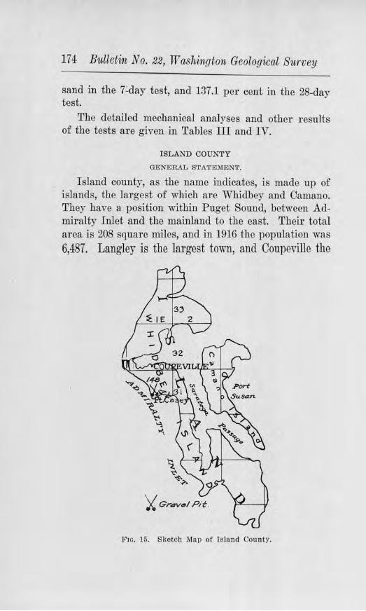
17 4 Bulletin No. 22, ·washing ton Geological Survey
sand in the 7-day test, and 137.1 per cent in the 28-day test.
The detailed mechanical analyses and other results of the tests are given in Tables III and IV.
ISLAND COUNTY
GENERAL STATEMENT.
I sland county, as the name indicates, is made up of islands, the largest of which are Whidbey and Camano. They have a position within Puget Sound, between Admiralty Inlet and the mainland to the east. Their total area is 208 square miles, and in 1916 the population was 6,487. Langley is the largest town, and Coupeville the
Frn. 15. Sketch Map of Island County.
Road B1.tilding Sands (Jlncl Gravels 175
county seat. These, together with several small villages, are all located on the coast. Dairying, fruit growing, vegetable raising, and salmon .fishing are the chief industries. The topography is gently rolling, and the coastline is indented with many bays and harbors. In many places the coast is bounded by sea-cliffs. The rainfall averages about 21 inches, and the other features of the climate arc characteristic of the Puget Sound country.
I n view of the fact that all of the towns are located on the water 's edge, water transportation is much more important than land transportation. The need for a well developed system of highways is, therefore, not so great as in most counties of the state. To meet such demands for surfacing as there arc, the numerous local deposits of gravel can be drawn upon. All of the islands are covered with glacial deposits. Two important commercial pits have been opened at Ft. Casey. Samples of the sand and gravel from these were tested for their concrete making qualities. The results are given in tabulated fo1·m, with those from other counties, in Tables ill, IV, V, and VI.
JEFFERSON COUNTY
GENERAL STATEMENT.
Jefferson county is a very long county passing through the heart of the Olympjc }\fountains, from the P aci.fie Ocean on the west. to H ood Canal on the east, and thence north, ending in a point at P ort Townsend. The total area is 1,747 square miles. Nearly all of the county's population live in the extr eme eastern and northeastern portions. In 1916 the number of inhabitants was 9,987. Lumbering and .fishing rank first in importance, but dairying and stock-raising are increasing in prominence. P ort Townsend is the county seat
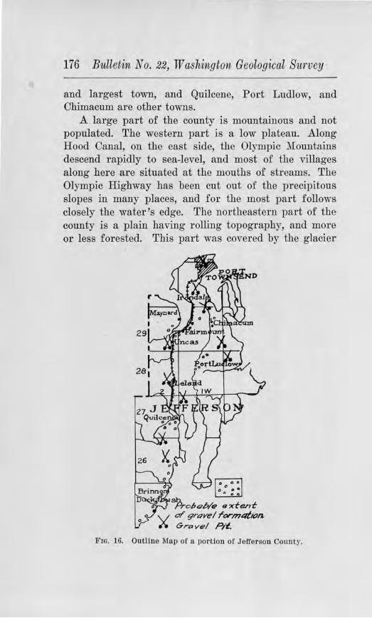
176 Bulletin No. 22, W a.shington Geological Sitrvey
and largest town, and Quilcene, Port Ludlow, and Chimacum are other towns.
A large part of the county is mountainous and not populated. The western part is a low plateau. Along Hood Canal, on the east side, the Olympic :Mountains descend rapidly to sea-level, and most of the villages along here are situated at the mouths of str eams. The Olympic Highway has been cut out of the precipitous slopes in many places, and for the most part follows closely the water 's edge. The northeastern part of the county is a plain having rolling topography, and mor e or less forested. This part was covered by the glacier
FIG. 16. Outline Map of a portion of Jefferson County.
Road Building Sands and Gravels 177
du1·ing the Glacial Period, which also flauked the high slopes of the Olympics on the east and north.
CLI1\IATE.
Jefferson county has a val'iation in rainfall as great as, if not greater than, any other county in the state. Pol't Townsend receives an average of only 20 inches or less JJer year, while tho western slopes of the Olympic Mountains are drenched wilh more than 120 inches. Otherwise, the climate is much like that of the rest of the Puget Sound country, save for the higher parts of the Ol)~mpics, which receive a heavy snowfall. The light rainfa.11 of the northeastern portion makes possible the use of more clay binder in tho road gravels than is possible fo1· any other part of western Washington. In this respect it resembles parts of eastern Washington.
ROAD MATERIALS.
In 1911, the Washington Geologjcal Survey made a study of the bedrock formations of the state to ascertain their a<laptability for macadam roads. Several samples were collected from this county and tested, the r esults of which were published in Bulletin No. 2 of the Survey's series. The present investigation wc1s devoted chiefly to a study of the gravel deposits.
DISTRIBUTION OF THE GRA YEL DEPOSITS
Along practically the whole length of Hood Canal to north of Brinnon, grave] deposits arc abundant. Few highways in the state ai·e as econo1rucally situated with respect to a,;-ailable gravel for s1n-faci ng as tl1c Olympic Hjghway for this pol'tion of its course. In its construction, excavations were made in 1 he side slope of the ruainhlntl and gravels of good quality exposed. There is scarcely an instance where the material must be hauled o,~er a greater distance than a half mile. The manner of occurrence of the deposits is illustrated in
-7
178 Bulletin No. 22, Washington Geological Survey
Plate VIII. The pebbles are mostly hard and :firm varieties of granite, basalt, quartzite, and other siliceous metamorphics. All gradations, of course, occur, but materials suitably graded can be obtained without difficulty. There are some deposits of sma11 sized gravel suitable for dressing purposes.
In passing over the high point of land norLh of Brinnon, the road rises above the gravel plain. Road cuts in places expose angular basalt talus which is used to good effect. It appeal's to contain about the right amount of clay for binding. At Quilcene another gravel deposit is encountered, but from here north the area is notable for its lack of gravels. There are instances where the material must be hauled several miles to the place where it is to be used. Indeed, from Quilcene northward to Port Discovery, the Olympic Highway passes through territory which is unfortunately almost barren of good material. Not only is there a paucity of road gravel but of good bedrock. Chiefly soft sandstones and shales are exposed from beneath the mantle of glacial debrjs.
Chimacum is located on a gravel flat. From Chimacum southeastward along the Port Ludlow road, a few deposits are to be found, as in the S. E. 1,4 of Sec. 25, T. 29 N., R. 1 W. This deposit, however, is so surrounded and overlain with clay and fine sand that but little can be taken out. Fairly good gravel occurs near the junction of the Center Road with the P ort Ludlow road. At hondale and Hadlock, the deposits are sandy. Northwest from Chimacum to Port Townsend, good gravel is somewhat more abundant.
About two blocks north of the high school at Port Townsend, on the south side of the road, a gravel pit has been opened in a sideslope exposing materials of variable quality. On the north side the gravel is coarse, containing some large boulders and fragments of clayey
Road Building Sa1nds and Gravels 179
till, which make the gravel unfit for concrete. On the south side of the pit sand appears to be satisfactory for concrete. Except for the included fragments of clay the gravel is nrm. An overburden of 2 to 3 feet of clayey soil, filled with roots of vegetation, should be stripped before the material is used, either for sul'facing or concrete.
Along the P ort Discovery road a few small patches of gravel occur. At Maynard there is a high bank of gravel 60 feet high, and 200 yards long. The materials vary gr eatly in size. Very coarse and bouldery gravel occurs at the top, north of the railroad viaduct, but a few yards fmther north finer material is to be had. The chief objection is the absence of binder. The presence of many fragments of soft shale and sandstone make the deposit undesirable for concrete aggregate.
On account of the Survey 's Tes ling Engineer being called for war service, no samples of material were collected for testing.
KING COUNTY
GENERAL STATEJ1\flll.NT.
King connty is situated in the west central part of the state, e:xtending from the crest of the Cascade Mountains to the shores of Puget Sounc1. Its area is 2,Ul square miles. This is the most populous county in the state, its population in 1916 being 394,397, as gi,~cn by the U. S. Census Bureau. hluch the larger part of this is concentrated in Seattle and the adjoining val1eys, although settlement is fairly widespread in the motmi.ain valleys. The concentration in the western part, however, produces traffic demands which are too great in many cases for ordinary macadam roads and many miles of paving have been laid. These arc so planned that they carrr most judiciously the haffic of the various lumber mills, shipyards, factories of all sorts, feed and cereal mills, packing plants, canneries, conueusaries, machine
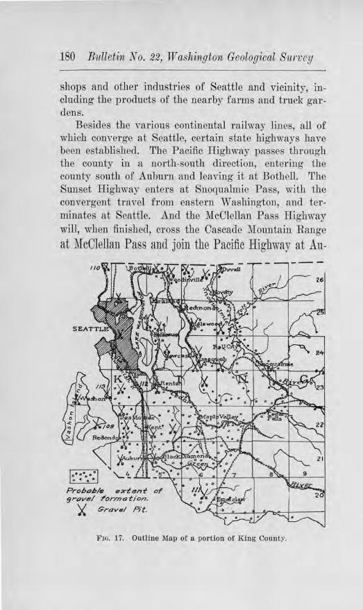
180 Bulletin No. 22, Washington Geological 81,1"/;cy
shops and other industries of Seattle and vicinity, including the products of the nearby farms and truck gardens.
Besides the various continental railway lines, all of which converge at Seattle, cer tain state highways hm~e been established. The Pacific Highway passes through the county in a north-south direction, entering the county south of Auburn and leaving it at Bothell. The Sunset Highway enters at Snoq_ualmic Pass, with the convergent travel from eastern Washington, and terminates at Seattle. And the !foOlellan P ass Highway ·will, when finished, cross the Cascade :Mountain Range
at McClellan Pass and join the Pacific Highway at Au-
Prohoh/e ext<!lnt or 9rov<!I/ t"Orn?otion.
;( Grava/ Pit.
F10. 17. Outline Map of a portion of King County.
Road Building Sands and Gravels 181
burn. In adcution to these the county has <levised a system of highways to meet the demands in the various parts.
TOPOGRAPHY.
The county has almost every type of topography withill its bom1daries, from mountains and canyons 011
the east to })lains and broad valleys on the west. This incurs many problems of grade in which the principles of modern highway engineering have been well carried out. The Sunset Highway, for example, crosses the Cascade Mountain Range on a maximum grade of 5 per cent. The mountains leave off rather abruptly west of Duvall, Fall City, Kanasket and Enumclaw and give way to more or less broad plateau-like areas incised by river Yalleys. In the western par t these valleys have broad flood-plains. The shores of P uget Sound on the west are marked by wave-cut cliffs.
CLL'\lAT.El.
The rainfall of King com1ty averages about 60 inches, but this jncludes the hea,,y rainfall of the higher portions of the Cascades. At Seattle the precipitation is about 35 inches per year. :Most of the rainfa 11 occurs in the winter season and .July and August usually have but little rain. This gives the two extreme conditions of moisture and aridity, according to which the highways must be suTfaced and mai]]tainecl Caution is exercised to avoid using too much clay-binder on account of the moisture conditions of winter, and yet enough must be used, if possible, to provide proper cementation foT the dry months. D1·essing material is i:t1 some places resorted to, to prevent excessive ravelling during the summer.
Snowfall is generally light and of short occurrence in the western part of the county, 0]] account of mariJ1e influences, but in the higher portions of the Cascades
182 Bulletin No. 22, Washington Geological Survey
the snowfall is so heavy that the Sunset Highway is closed for several months of the year. Snowslides and floods wash much material from the higher slopes in places, and expensive maintenance must be carried on, especially in the spring.
DISTRIBUTION OF ROAD GRAVELS.
The gravel of the county has a wide distribution in the western portion. West of the foot of the mountain range, glacial gravel is generally abundant. This is especially t rue west of Cedar Falls and Black Diamond. Much glacial wash covered this region, and material for surfacing can be procured at most any point a.Jong the highways, or at least within shor t hauling distances. The county operates scor es of pits, one of the largest being at Auburn. Large commercial pits have been opened in the cliffs of Puget Sound at Three Tree Point, on Vashon Island, and Richmond Beach, which supply much of the trade material used for concrete purposes. At present the deposit at Richmond Beach is not being worked. The general distribution of the g1·avels and the locations of various gravel pits are given on the outline map of the cotmty. There are numerous other local pits, most of which ar e of local character, which are not given.
BRIQUET TESTS OF THE SANDS.
Briquet tests were made of some of the sands of the county to indicate their quality for concrete use. Many of the tests in the county had been made by the Portland Cement Association, who have kindly placed the results at the Survey's disposal.
Map Number 109. This sample taken from a pit of the Vashon Sand and Gravel Co., on Maury I sland, showed a tensile strength in the 7-day briquets 121.3 per cent as str ong as the briquets of the same age made
Road B1.tildvng Sands and Gravels 183
from Standard Ottawa Sand, and the 28-day ratio was 121.7 per cent.
i1fop Number 110. This sample from Richmond Beach gave a 7-day ratio of 110.1 per cent and a 28-day ratio of 119.1 per cent.
Map Nimiber 111. This sample from a deposit between Enumclaw and Aubum, which was used in the concrete pavement of this locality, was found to have a 7-day ratio of 114.2 per cent and a 28-day ratio of 113.4 per cent.
Map Number 112. This sample taken from a local pit between Duwamish and Renton Junction, gave a 7-day r atio of 128.5 per cent, and a 28-day ratio of 103.7 per cent.
Map Number 113. This sample obtained from Three Tree Point, gave a 7-day ratio of 118.8 per cent and a 28-day ratio of 103.3 per cent.
More detailed information concerning the character and the chemical analyses of the sands is given in Tables I II and IV, of Chapter IV.
STRENG'rH TESTS OF FIELD CONCRETE CYLI1\'"DERS.
According to the method described in Chapter IV, concrete cylinder tests were made of the mix which ,vent into two of the pavements laid in King county in 1917. These cylinders were cured as far as possible under the same conditions as the pavements. These were later tested for their compressional strength at the Engineering Testing Laboratory of the University of Washington.
F our cylinders which were made of the material in the Duwamish-Renton J unction pavement averaged 4,043.15 lbs. per square inch. The source of tbe aggregate which was used in the concrete was the Steilacoom deposits. A sample of these gravels showed them to be composed of pebbles of granite, cliorite, quartzite,
184 Bttlletin No. 22, Washington Geological Survey
andesite and siliceous r ock, most of which were of firm and durable character. The abrasion test was made on these gravels and the results show an excellent value. The percentage of wear was only 2.4 per cent.
On the Houghton-Medina Road the four test cylinders averaged in compressional strength 3,572.6 lbs. per square inch. The source of the aggregate in this case was also the Steilacoom deposits. More detailed information concerning the character of the aggregate and the strength tests is given in Tables V and VI.
KITSAP COUNTY
GENERAL STATEMENT.
Kitsap county is located in the central part of the Puget Sound Basin. It has an area of 371 square miles and a population of 24,487, according to the 1916 census. Lumbering and the manufacturing of wood pToducts are the most important industries, while others are :fishing, poultry raising, truck farming, stock raising, and shipbuilding. Bremerton is the largest town and Port Orchard the county seat.
On account of the indented coast-line and the nearness to good harbors from any part of the interior of the island, the roads are short. As the logged-off land is prepared for farming purposes, the surfacing of the roads is extended. The average rainfall is about 41 inches per year, with the gr eater part occurring in the winter season. The other factors of climate are also like those of the rest of the Puget Sound country.
DISTRIBUTION OF ROAD MATERIALS.
This county has a thick covering of glacial drift, in which the materials range from a pebbly clay to a good quality of gravel. Deposits of gravel are widely distributed and jn most cases are first-class. Because of their similarity in quality to the other gravels of the
Road Btt6ilcling SalJ/.ds and Gravels 185
Puget Sound region, and of the light traffic which the highways of the county carry, no samples were collected for testing.
KITTITAS COUNTY
GENERAL STAT.EMEN'r.
Occupying nearly a central position in the state, this county reaches from the crest of the Cascades on the west to the Columbia River on the cast, the entire width of the east flank of the mountains. The Yakima River Valley forms a frunk route tru:ough the county from northwest to southeast, and it is along this valley, particularly in its very broad portions, that the larger percentage of the population lives. In the Kittitas valley, east of Ellensburg, and in other parts, f1·uit interests, the growing of hay, and stock-raising suppOTt a large number of people. In the vicinity of Roslyn, many are employed in coal mining, and in the northern mountainous area gold mining is cru:Tied on to some extent.
TOPOGRAPHY AND ITS INFLUENCE.
The existence or the broad Yakima Valley simpli:fies the road system of the county, and for many lineal miles affords an excellent grade. Steep grades are encountered only where detours are made around cauyou passes, or in the mountainous topography of the northern, wcstem, and southwestern parts. The Sunset Highway runs the entfre length of the county from Snoqualmie Pass to Vantage. Tl1e amount of tourist travel which this highway carries aclds much to the expense of maintenance. Up to the present much of the tourist auto travel has taken the short-cut of State Road No. 7 over Blewett Pass to Wenatchee, instead of going by way of Vantage. At Ellensbmg the Inland Empire Highway begins and runs southwestward over :Manastash Ridge into Yakima county. Railway transportation facilities are offered by two transcontinental lines,
186 Bulletin No. 22, Washington Geological Survey
the Northern P acific Railway and the Chicago, Milwaukee and St. Paul Railway.
CLIMATE.
The precipitation of the county varies greatly and affects r oad-construction and maintenance accordingly. At Lake Kachess the precipitation averages about 47 inches, at Ole Elum 25 inches, at Ellensburg· about 10 inches, and in the eastern part of the county about 8 inches or less. Washouts and slides are usual accompaniments of heavy continued rainfall in the western mountainous section, \Vhile in the eastern part the dry summers cause ravelling of the graveled roads or rutting of the earth roads. Heavy snowfall in the vicinity of Snoqualmie Pass closes the Sunset Highway for several months in the winter and spring. During this time avalanches bring down much debris from the higher slopes which later must be cleared away.
GENERAL DISTRIBUTION OF ROAD GR.A VELS.
Most of the gravels which are available for roadbuilding in this county are situated along the Yakima. River, in the broad portions of the valley and on high rock benches. Kittitas Valley, east and west of Ellensburg, is underlain by a thick deposit which varies in coarseness from place to place. These extend up theriver to the canyon northwest of Thorp. East of Thorp there is a ridge of silt, sand and gravel 400 to 500 feet high which extends northwest nearly to Horse Canyon. Much of the gravel is coarse and would require crushing. Similar gravel occurs at a similar height on the west side of the river north of the mouth of Taneum Creek.
In the vicinity of Cle Elum, benches of gravel occur along the stream and from here to Lake Keechelus, along the Yalcima River, and to Cle Elum Lake, along the,
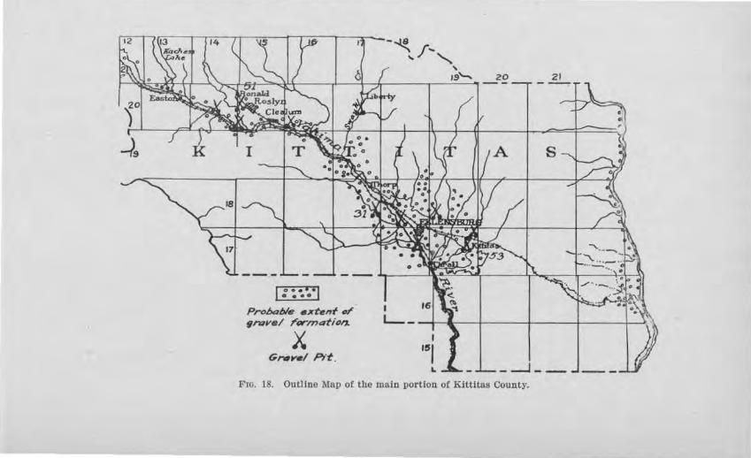
~9
(::~·.·1 Prohelt,/s 11xt11nt or ~rant/ rorn,4fion.
X G,w,,-./ Plt .
-~f--......._ ' /9'-.
I
20 21
L_ _ - '-'11.--1----+---+---;---;
_ _J __
F10. 18. Outline l\lap of the main portion of Klttit.as County.
J 88 Bulletin, No. 22, W ashvngton Geological Survey
Cle Elum River, the same sjtnation prevails. Most of these gTavcls are fresher and firmer than those mentioned near Thorp.
~'ests on R-0a<l Gra,,els
I n 19ll, an examination was made of the rock of this county which would be suitable for crushed rock macadam. Some samples were tested and the results published in Bulletin No. 2 of the Washington Geological Survey series. The present study was therefore confined to the gravel formations. Tests were made of representative deposits both for uses as road surfacing material and for concrete. Those whiah wore tested for road surfacing material will ho first considered.
The sketch map of the county attempts to show the general distribution of the gravel deposits, and the location of some of the pits by the conventional symbol of crossed shovels. The deposits which are numbered are those tested. The results are given in tabulated form, with those of other counties, in Table I .
Map Nitmbe1· 51. This sample \Yas taken from a deposit about 2 miles west of Roslyn, which here forms a rather high bench above the Cle Elum River. A considerable percentage of this gravel is oversize, but that which is under 2% inches is well graded. A variety of pebbles occur, most of which are hard a11d have good wearing value. Granite, basalt, rhyolite, quarfaite, and diorite are among the varieties repTeseuted. The tests for tenacity and cementation showed that the binder material has a fair value. One and one-quarter miles of the Roslyn-Ronald road were surfaced ·with this in 1917, the coarse material being screened out. Clay was added fo1· binder. No conclusion regarding the satisfaction of this material in actual practice can be made at this early date.
Road Buildi1ig Samds arncl Gravels 189
iJi ap N iwiber 52. This sample was secured :from a deposit of iron-stained gravel, 3 miles southeast of Thorp, in the south central part of Sec. 24, T. 18 N., R. 17 E. The materials are well graded from clay and sand for bindeT to oversize, of which there is a considerable amount, enough to warrant crushing. By pebble count, 85 per cent of the pebbles are basalt, 11 per cent schist, aud 4 per cent granite. The tenacity and cementation tests showed that the binder is :first-class. The results of the abrasive test, however, gave a high percentage of wear. In 1915, this material wn.s drawn upon for metalling the highway nearby. The gravel was crushed and put on in two courses, each sprinkled and rolled. The result has been a hard surfaced road, having splendid binding qualities and thus far good wear.
Map Number 53, collected from a deposit ll/2 miles south of Kittitas on the farm owned by :M. M. Wheeler. A pit has been opened here exposing well graded mateTial up to oversize, which is present in large enough quantities to warrant crushing all of the material pitrw1. One to oue aud one-half feet of the gravel beneath the soil is infiltrated with lime, which yields considerable so:ft material when excavated. These soft lime fr8t:,oments increase the percentage of wear, as refiected in the abrasive test, so that the gravel is harcliy suitable for other than light traffic roads. The tenacity value of the binder is rather low, partly clue at least to the lack of enough tenacious clay.
Tests fo1· Concrete
Map Number 51, which has already been described as taken from a deposit 2 miles west of Roslyn, was screened, and the sand washed and used in making concrete briquets. These were tested for their tensile strength and compared with briqucts made from Ottawa Standard sand and the same kind of cement. The
•
190 Bulletin No. 22, Washir1igton Geological Siirvey
details of the test are described in Chapter IV. The 7-day briquets showed a tensile strength 97.2 per cent the strength of those made from the Standard sand, and the 28-day briquets a tensile strength equal to 117.1 per cent that of the Standard sand. A small amount of organic material was detected by the colorimetric test, but not enough is pI'esent to be, injurious.
Map Number 52. This sample from the deposit 2 miles west of Roslyn tested 97.3 per cent as strong as the Ottawa Standard sand in the 7-day test, and 11'1.0 per cent as strong in the 28-day test. No organic reac-
tion was obtained by test. Map Number 53, collected from the deposit 1% miles
south of Kittitas, showed a tensile strength 68.8 per cent as strong as the Standard sand in the 7-day briquets, and 65.7 per cent as strong in the 28-day briquets. This sand, according to this test, should therefore not be used for concrete.
More detailed results of these tests, together with those from other counties, are gi1ren in Tables ID and IY.
KLICKITAT COUNTY
GENERAL STATEMENT.
This county is situated just east of the Columbia River gorge, on the east flanks of the Cascade Range. Tbe county is 84 miles long, and averages about 25 miles wide. In 1910 its population was 10,180, or an average of 5.6 persons per square mile. Goldendale is the county seat and largest town, and White Salmon, Bicldeton, Lyle, Guler, Centerviile, Glenwood, Maryhill, Trout Lake, and Roosevelt are important. Agriculture and horticulture are the chief industries, and considerable lumbering is carried on. The S., P. & S. Ry. follows the Columbia River throughout the length of the county, with a branch running from Lyle to Goldendale. The steamers along the river also provide means of trans-
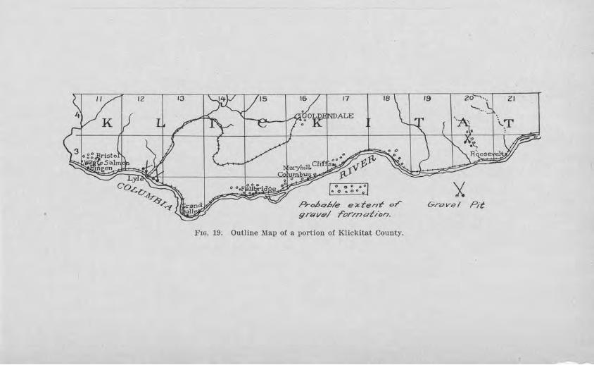
12 10
L,:
Co~D-+ <S>..,>-~
I O O •• ·1 •0 .. 009
Pro/,c7.6/e extentf or gravel ror,,nat/or).
Fro. 19. Outline Map of a portion of Klickitat County.
19 20·
'"'-..
'X Gravel Pit
ZI
192 Bulletin No. 22, Washington Geolog1ical S11,rvey
portation. A state road, known as State Road No. 8, has been established, which when completed will connect with the P acific Highway at Vancouver and the Inland Empire Highway near Mabton in Benton County. This road will pass through White Salmon, Lyle, Grand Dalles, :MaryhiU, and Goldendale. Pr:1ctically all of the traffic within the county may be classified as "light traffic."
TOPOGRAPHY.
Klickitat County has a topography that is mountainous in the western part and a plateau in the eastern, with slopes that in places descend gently to the Columbia
River and in places precipitously. Deep valleys and small canyons trend north and south, giving the county a very rough surface with high grades for east-west roads. Along the Columbia River, where sheer cliffs come to the water's edge, expensive blasting is necessary to locate a road. From Maryhill to Goldendale the steep grades of the old road have been admirably overcome by location according to modern highway engineering.
CLIMATE.
The western part of the cow1ty has a much greater rainfall than the eastern. According to government reports the average annual precipitation in the western part is 25 inches and upwai·d, while in the eastern it is as little as 61h inches. I£ the county were uniformly populated, this would mean that there would be more difficulty in retaining the binder and in keeping the metaled roads from ravelling in the easter11 part than in the western, but fortunately the larger percentage of the people live in the western part.
ROAD MATERIALS.
The scarcity of gravel along the main highways and the prevalence of basalt rock necessitates the use of
Road Building Sands am-d Gravels 193
the latter for most road-surf acing. In 1911, the Geological Survey made a stud.Y of the be<l-rock formations of the stato with respect to their suitability for roadbuilding. The results of the tests made on the samples collected were published in Bulletin 2 of the Sun·ey series.
Gravel deposits occur in patches along tl1e Co1u:mbia River, as at White Salm011, Lyle, F allbridge, Maryhill, east 0£ Cliffs, and northeast of Roosevelt along a creek valley. (See outline map of the county.) Gravels also occur in the vicinity of Goldendale, bnt hore they seem to be inferior to the rock which is available. The deposit at Fallbridge was drawn upon by- tho S ., P. & S. Ry. for construction of the concrete piers of their bridge across the Columbia River.
Tests <for Road Surfacing
JJiap Number 54. This sample was taken from the deposit 7 miles n01·thwest of Roosevelt from what is known as White's pit. The gravel occurs in_ a high bench which forms the south slope of the creek valley. About 15 per cent of the material is oversize, the largest of which are cobbles up to 6 or 8 inches. The pebbles include varieties of basalt, andesite, and quartzite, some of which ha~e been softened by decay, but as a whole Lave fair wearing Yaloo. The amount of oversize would warrant crushing, which would give not only a better gradation for the wl1ole but would do awa)- with some of the flattened pebbles, give angularity to the 1·ounc.1ed, and increase the amount of binder. The tenacity test of the binder as it occurs natui-ally showed the material to be good and the cementation test of the binder after being ground up indicated that it would ultimately have high cementing value. This material has been used on the nearby road and found to be satisfactory.
194 Bulletin No. 22, Washitigton Geological Survey
JYlap Number 55. This sample was collected from the deposit in the northeastern part of the town of White Salmon. This material consists of fine gravel and coarse sand, the constituents of which are basalt with some quartzite. The materials are fairly well rounded. The natural cohesiveness of the binder portion tested low, due chiefly to the lack of enough clay. The ultimate cementation value, however, is high. As a dressing material for roads it is of the proper size and would be excellent, but if used for the body it would be less satisfactory on account of the absence of pebbles over 1 inch and the high propor tion of sand.
Map Niirnber 56. This sample obtained from the deposit % mile northwest of Lyle, on the east side of the road, was found to be very similar to Map Number 55 in gTadation, size, and kinds of pebbles. The binder content, however, is in greater abundance, giving it a higher tenacity value. Where used on the highway in this immediate vicinity it has made an excellent surfacing. Great quantities are available, the material forming a high bench for a quarter of a mile or more to the eastward.
The detailed results of the fo1·egoing tests, witll those of other counties, are given in Table I.
Tests ror Concrete
Map Numbel' 55, which was taken from the deposit in the northeast part of White Salmon, and which has already been described, was screened and the sand washed and used in the making of concrete briquets. These were tested for theiI' tensile strength, and compared with the strength of briquets of the same age made from Standard Ottawa sand and the same brand of cement. The briquets of the sand under test, which were seven days old, showed a tensile strength of 91.6 per cent as great as the briquets of the Standard sand,
Road Building Sands (1/J1,d Gravels 195
and the 28-day briquets a strength 150.9 per cent as gi·eat.
More detailed results are given in Tables III and IV, with those from other counties.
LEWIS COUNTY
GE1'"ERAL STATEMENT.
Lewis county extends from near the crest of the low Coast Range, or Willapa Hills, on the west to the summit of the Cascade Mountains on the east, a distance of 96 miles. When the construction of State Road No. 5 is completed in the Cascades, there will then be a continuous highway demanding maintenance from one end of the county to the other, having a length considerably greater than 100 miles. This, together with the responsibility of maintaining the Pacific Highway, which carries heavy traffic in a north-south direction across the county, will entail large responsibilities on the County Enginee,r.
The population of the county in 1916 was 42,795, according to the Census Bureau. Centralia is the largest town and Chehalis the county seat. Other impo1·tant towns are Winlock, Napavine, Pe Ell, Doty, Dryad, Littell, Vader, Mendota, Morton, Mossy Rock, Mineral, and Silver Creek. Lmnbe1·ing is the chief industrial resource of the county, although agriculture and coal mining are important. Besides having to caITy the traffic incident to the county's industries, the Pacific Highway has a large tourist traffic, and the National Park Highway over the Coast Range is the main artery of travel to and from the Willapa Bay country. A considerable portion of the Pacific Highway has been paved as an economic necessity, ordinary surfacing being i:I1-capable of withstanding the traffic.
TOPOGRAPHIC CONUITIONS.
That part of the county traversed by the Pacific Highway and the main line railways is the lowest part
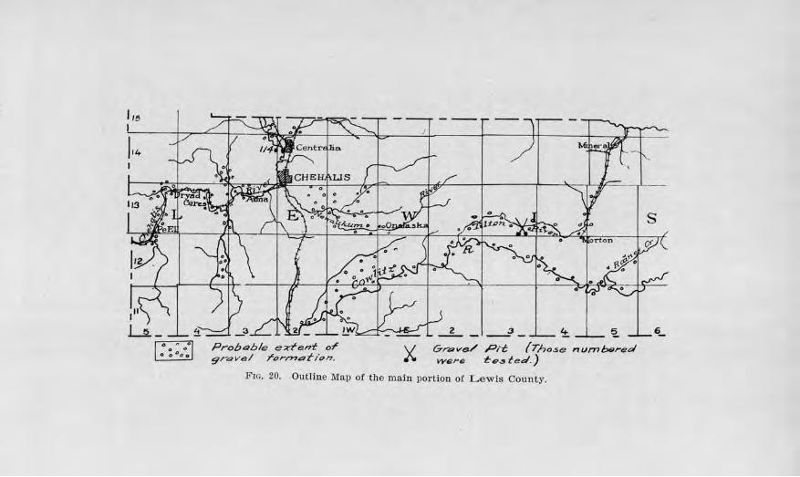
'" l
114
0 • • 0 0
0 0 °o 0
__ 3_ ~ !?.. 6_
Probable e;i;-tent 01' V Gn,ve/ Pit (Those numb9red 9rave/ rorrnof-i.,n. I\. were f:e.:,fed.)
Fm. 20. Outline Map or tile main por tion or L ewis County.
Roacl B1tilding Scvnds and Gravels l9i
of the county, being a continuation of the down-warp of the Puget Sound trough. This geologic feature makes moderate grades possible. In crossing the Coast Range at Phwius a good grade has been obtained by following the Chehalis River Valley. Rolling uplands exist cast of Centralia and Chehalis, and usually in less than a half scol'e of miles assume semi-mountainous proportions and rapidly become mountainous. State Road No. 5 has been projected along the Cowlitz Rive1· in order to obtain the best natural grade to the summit of the Cascades. The subsoil which overlies most of the county is a heavy clay which makes an almost impassable Toad in wet weathe1·. Hence, the necessity for sm·facing.
CLIMATE.
The climate of the county is an important factor in road-building and maintenance. From 50 inches to 70 inches of rain falls each year in the low lantls and higher hills respectively, and much of the largel' part of this occurs during the winter. Materials for road sru·facing, therefore, must be limited in tho content of clay for binder, to prevent excessive softening during the winter. On the other hand, there must be enough binder for the clry season when the moisture of the roads is taken up by evaporation and the binding quality is reduced to the minimum. Some ravelling is prone to be common at this period in spite of precautionary measures. Frost action is of little consequence, because of the mild tempera.tures that usually prevail.
GENERAL OISTRIBU'1'ION OF ROAD GRAVELS.
A small area of excellent road gravels occms north of Centralia along the Skool'11Illchuck River and the Chehalis RiveT. H<n-o it forms benches along the sh eams. South of Centr alia the gravel gives way to a broad flat of silt along the Chehalis and N ewaukum
198 Bulletvn No. 2,2, W a,shington Geological Survey
Rivers until the vicinity of Forest is reached. East of the latter point gravels may be found along several fotks for some distance upstream.
West of Chehalis, gravels appear along the stream neaJ.· Adna, partly in bars and partly in high benches. Gravels and basalt bedrock alternate for most of the distance to the west boTder of the county. The gravels here, as well as along the upper reaches of Newau.kum River, are only of fair grade. The Cowlitz Valley east and northeast of Vader contains large quantities of gravel of varying qualities from place to place. The
sketch map of the county shows the areas of gravel of the county so far as was possible to ascertain by reconnaissance study and geological relations. The great variation in coarseness and quality of the gravel for road purposes within short distances require open test pits to determine their adaptability.
Test for Conc1·ete
ll!lap Number 114. This sample was taken from the pit of the Centralia Sand and Gravel Co., at Centralia. The gravel underlies the broad fiat bordering the river and continues northward along the Chehalis and Skookumchuck rivers. At the pit of the company, the sand and gravel has been obtained to a depth of 50 feet without change in the general character of the material. ScatteTed bits of ·wood float are sometimes incorporated with the gravel which make it objectionable for concrete paving unless removed. The sample collected was screened and washed and the sand used in malting concrete briquets, which were tested for their tensile strength and compared with the strength of briquets of the same age made from Ottawa Standard sand and the same brand of concrete. The 7-day hriquets of the sand under test had a strength 107.1 per cent that of the
1:load B1.1,ildi,ng Sam,ds amd Gravels 199
briquets made from the Standard sand, and the 28-day briquets 116.2 per cent.
The results of this test with those from other counties are given in Tables ID, IV, and V.
LINCOLN COUNTY
GliJ:NERAL STATE1\iENT.
This county is situated in the east central part of Washington within one tier of counties of the Idaho line. It is approximately quadrangular in form and comprises 2,302 square miles. It is a part of the great Columbia plateau. In 1916 the Census Bureau estimated its population to be 21,042. Davenport is the county seat and the chief town, with a population of 1,229 in 1910. Other important towns are Reardan, Wilbur, Creston, Almira, Edwall, Sprague and Harrington.
TRANSPORTATION FACILITIES.
The county is one of the greatest wheat producing sections of the state. Other cereals are also grown, together with some fruit. The marketing of the products calls for an improved system of roads, and the county and state are making rapid strides in providing them. The Sunset Highway crosses the county from east to west, passing through Almira, ,Vilbur, Creston, Davenport, Reardan, and other towns. The North Central Highway enters from the southwest at Krupp and passes through Odessa, Lamona, and Harrington, and ends at Davenport. The Central Washington Highway, which is the main road of travel from Spokane to Pasco, passes through the southeastern part of the county, thus giving Sprague and the surrotmding country the advantages of direct outside connections. The Sunset Highway is improved over much of its mileage east of Creston, and the Central Washington Highway is metaled from Sprague southwest nearly to Ritzville. The North Central Highway is splendidly surfaced from
•
200 Bulletin No. 22, W aslvington Geological Survey
Davenport to Harrington and work is in progress on parts of the remaining portion.
Railway facilities are also good. The main line of the Great Northern Railway serves the southern part, and a branch line of the Northern Pacific the northern portion. The main line of the Northern Pacific Railway is the chief one which carries the exports and imports of the southeastern district.
TOPOGRAPHY.
Lincoln county is a rolling plateau, broken here and there by deep valleys and coulees. The higher upland ranges from about 2,000 feet above sea-level south of Almira to about 2,500 feet in the vicinity of Reardan. Crab Creek Valley, where it leaves the county, is about 1,300 feet above sea, which gives an average maximum relief of approximately 1,200 feet. When the highways were first laid out they were made to correspond as nearly as possible with section lines, but the new locations are being adapted to the topography, following the contour of the land sufficiently to give good gradient for heavy and comparatively rapid hauling. The present valleys appear to be an inheritance of an epoch of more humid conditions in the past, for at present but few of them are occupied by permanent streams, and such streams as there are are small. The humid epoch may have belonged to the Glacial P eriod, for at this time there was drainage across the county in a northsouth direction, caused by the movement of a glacier from the Okanogan Highlands into the northern part of the county. An abundance of gravels were distributed along these old drainage lines and now are rmportant sources of road-building material.
SUBSOIL.
Practically all of Lincoh1 county is underlain by basalt, save for a few occurrences of granite in the
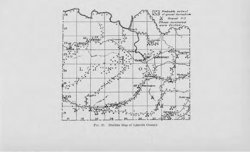
I 21
1~4
I
L (. •.lo
• . r.
12' &-..2t_l_ .2L -
/'''":l •. i..,.,::> .. ............ _. 0 • ::i .• .. ~ ,P{"
0 O e e • J_ O O
:1· • 0
;!3
• • ON·.
0
~ ;!Q.
fo:oo) Pn:,bcble s;,r f,.,,f ~ or 9=v•I format,ol,.
X Gn:.v.il p,t
(Tho.se nvmbered f:e:.ted.1
Frn. 21. Outline Map of Lincoln County.
202 Bulletin No. 22, Washington Geological Survey
northern part. The basalt is in tuTn overlain by a thick ma.ntle of clay except where it has been eroded off along the old stream courses. "Where the latter bas taken place there is much " scab-land". Over the northern part this clay formation is partly covered by glacial material which is usually quite stony.
The clay varies from a heavy to a light fluffy texture. The heavy clay makes a good, Lard road in dry weather, but muds heavily 1n wet seasons. The light fluffy clay makes a poor foundation for a road at most any season, for it not only muds up during moist times, but produces a very rutty and dusty road during the latter part of the summer and early fall, when the season of marketing is on.
In some places the clay is inter laid with 1% feet to 2 or 3 feet of lime substance which outcrops on the hillside. "Where the road passes over this nonresistant layer a rut is bound to ensue. Such occurrence may be cited on the hill slopes of the higher upland east of Lamona. Tl1ese ruts arc frequently so deep that they are particularly dangerous for automobiles in descending the hills and are obstructive in going up. To correct this, the whitish lime material might be thoroughly cut out for a few feet back and clay, like that above and below, put in its place.
CLIMATE.
The serni-ai·id climate of Lincoln county has a direct bearing on the maintenance of the roads and the choice of materials for surfacing. In the southwestern paTt of the county the rainfall averages less than 10 inches per year, but this increases northward to 13.7 inches at Wilbur and eastward to 16.3 inches at Reardan. One-third of this p1·ecipitation is snow. Vel·y little rain falls during the sununer months of June, July, and August ; and the moisture which aids so much in binding a road .material is nearly all evaporated by har-
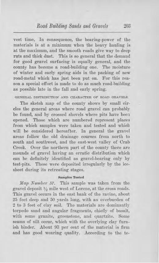
Road Building Swnds a1id Gravels 203
vest time, In consequence, the bearing-power of the materials is at a minimum when the heavy hauling is at the maximum, and the smooth roads give way to deep ruts and thick dust. This is so general that the demand for good gravel surfacing is equally general, and the county has become a road-building one. Tho moisture of winter and early spring aids in the packing of new road-metal which has just been put on. For this reason a special effort is made to do as much road-building as possible late in the fall and early spring.
GENERAL DISTRIBU'rION AND CHARACTER OF ROAD GRAVELS.
The sketch map of the county shows by small circles the general areas where road gravel can probably be found, and by crossed shovels where pits have been opened. Those which are numbered represent places from which samples were taken and tested and which will be considered hereafter. In general the gra,cl areas follow the old drainage courses from north to south and southwest, and the east-west valley of Orab Creek. Over the northern part of the county there are mounds of gravel having an erratic distribution which can be definitely identified as gravel-bearing only by test-pits. These were deposited iJ:regularly by the icesheet dUl'ing its retreating stages.
Samples 'l'estccl
llfop Nirniber 57. This sample was taken from the gravel deposit lf2 mile west of Lorenc, at the cross roads. This gravel occurs in the east bank of the ran.no, about 25 feet deep and 50 ya1·ds long, wiil1 an overburden of 2 to 3 feet of clay soil. The mate1'ials arc dominantly torpedo sand and angular fragments, ch.ieOy- of basa1L, with some granite, greenstonc, am1 quartzite. Some seams of silt occur, which with the ovedying clay fuTnish binder. .A.bout 93 per ce11t of the material is :firm and has good wearing quality. According to the tc-
204 Bulletin No. 22, lV ashington Geological Siwvey
nacity test, the gravel will pack slo·wly, due to lack of enough tenacious clay for bindi11g.
Map Nimiber 58. This sample was taken from a deposit along the Sunset Highway, 4 miles west of Dave11-po1-t, along the north line of the N. E. ¥.i, of Sec. 26, T. 25 N., R. 36 E . About 60 per cent of the pebbles in this deposit are rounded pebbles of clay, making the gravel wo1-thless for road surfacing. The materjal has been used on the Sunset Highway between Davenport and Rocklyn since 19] 6, and the poor quality of the pebbles shows in the rouglmess and irregularities of the road.
Map Number 59. One-fourth mile north of Wilbur, on the west side of the road on the hillside, a gravel pit has been opened in a large deposit of gravel which consists of well graded material with enough oversize to warrant crushing pit-run instead of screening, thereby improving the binder as well as the gradation. Tl1ere is an occasional quartzite or other foreign Tock and some coating of lime in the upper four feet, but otherwise the local basalt is the chief constituent. The constituents have good wearing qualities, 91 per cent of them being .firm. The low tenacity test indicates that an addition of tenacious clay to the binder would be beneficial. A short stretch of road east of Reardan was surfaced from this pit in 1908. Barring too large rock for easy riding, the road is in excellent condition without any repair since placing.
Map Ni,1nber 60. This sample was taken from th(~ deposit 2% miles west of Wilbur, in the S. E . %, of Sec. 11, T. 26 N., R. 32 E . Tbe gravel is almost entirely basalt, pa1·tly dense, partly porous, yet firm in character. Enough oversize is present to warrant rmuting all o.f it through the crusher. Some of the pebbles have a slight coating of lime. Not enough of the fine was pres-
Road Bilildin,g Sa11,ds ancl Gravels 205
ent in the sample to make a paste to test fo1· tenacity. This gravel has hecn used on the road east for nearly one mile for eight ycal'S without rcpai r :md shows wonder fol wearing qualities. Its reacliness to pack when fiTSt put on could not be leamed but tl1e 1ahorntory test would indicate that it would set slowly. The addition of a tenacious cla3~ would probably- he helpful. This deposit seems to extend 1101'th for at least one-eigllth to one-fourth mile, and to have a width of 100 to 150 yards.
1.llav Number 61. This sample was taken from a deposit % mile southwest of Govan. The material consists maiJtly of "torpedo sand" with a few larger fragmeuts scaitcrcd through the material. There is an absence of fine which would do for binder, but ou the road it seems to be giving good s01vice 1111d has for six years. This would probably make an excellent dressing material.
Map N m11 be r 62. Ah out l L,4 miles northeast of Almira, aud ahout 100 yards southeast of the road, there is a bench of graYel Tising 50 feet above the draw, contai11i:ng hasaltic gravels ranging in texture from furn to boulders 11/:.? feet in <liameter and dominantly firm. By test, the percentage of wear is about average. The bottom portion seems to he mostly torpedo s.mc.l, wru1c the coarse gravels occur abo,·e. On account or au insufficient amount of the fine binder, no tenacity test could be made. Some clay should p robably be added when it is placed on tho road.
Map Numbr>r 6/J. This sample ,vas taken from n deposit about 3112 miles southeast of Krnpp, in the north central part of Sec. 2J . T . 12 N., B. 31 W., and about 100 yc1rds northeast of the main road, in the s ide of a high bench. This is dominantly a "pea gravel" and "torpedo sand", basaltic in composition, and firm in character. The tenacity test gave a low Yalue on ac-
206 Bulletvn No. 22, Washington Geological Sitrvey
count of insufficient clay. This is to be used for surfacing from Krupp to Irby when the permanent grade is made and should prove satisfactory if some tenacious clay is added.
Map Nurnber 64. One-half mile southeast of Odessa, on the side of the road there is a sand-clay deposit, which contains a few larger fragments but in the main is a mixture of coarse sand and clay in such proportion that it is suitable for making a sand-clay road. The tenacity test gave a high value for its initial setting qualities. This was placed on the highway for llh miles east of Odessa in 1914 and is in good condition today w.ithout maintenance. It cloes not mud in wet weather and yields scarcely any dust when dry and makes a :firm, smooth surface.
Ma,p Nwmber 65. This sample was taken from a deposit 5 miles southwest of Lamona, along the north line of the N. W. % of Sec. 5, T. 21 N., R. 34 E . The formation occurs as a low ridge on the north side of the new road. It is well graded from coarse sand to about 14 per cent oversize. When the pit is opened it may seem advantageous to run the gravel through a crusher. Ninety-five per cent of the pebbles are hard and the pe1·centage of wear is low. The binder portion lacks tenacity to set readily on account of the absence of clay.
Map Num.be·r 66. This sample was collected from a deposit 1112 miles west of Sprague, along the Central v\Tashington Highway. Gravel may be found along this higl1way for several miles in scattered patches. This sample showed 89 per cent of the pebbles to be ha1·d, the wearing quality is ]mown to be good by test, but its readiness to pack would be slow without the addition of a good quality o:f clay. If used without crushing, a top course of fine should be added.
Road Buildvng Sands cvncl Gravels ·201
Map Number 67. This sample was taken from a deposit along the new Sprague-Harrington Road, three miles northwest of Sprague. It consisted chiefly of the :fine material ,vhich had been crushed and screened and used on the top course of the road. The constituents are hard and though the amount of binder is small its packing quality is indicated by test to be good. The material packed readily on the road after a few weeks of traffic.
lvlap Number 68. One and one-fourth miles southwest of Harrington, in the N. E. Vi of Sec. 21, T . 23 N., R. 36 E., is the Witt gravel pit. The material is mainly a "pea-gravel" with some larger materials. Basalt pebbles make up the great mass of the deposit, and of these about 93 per cent were found to be firm and hard, insuring good wearing results. The deposit, however, is lacking in good binding material, and good tenacious clay should be added.
The r eader is rnferred to Table I for the detailed results of the foregoing tests.
Some disiJ1tegrated granite occurs along the Sm1set Highway about 31/2 miles southeast of Creston, which has been used in a short stretch of the road and promises excellent results as a dressing material.
Concrete Briquet Tests
According· to the method described in Chapter IV, concrete briquets were made of severnl samples of sand from this county, the results of which are tabulated in Tables ill and IV. These will be briefly reviewed here.
Map Nwnuer 59. Seven-day briqucts made from this sand showed a tensional strength 95.6 per cent as great as the briquets made from Ottawa Stnndru:<l sand, with the same kind of cement. The 28-day briquets, however, showed a strength 134.3 per cent as great as the 28-day briquets made from the Ottawa Standard
208 Bulletin No. 22, Washington Geological Survey
sand. No organic content was found by the colorimetric test. Fine sand should be added to give the desired density.
The sand from sample No. 60 gave briquets which in the 7-day test were 100.7 per cent as strong as the briquets made from Standard Ottawa sand. By oversight the 28-day test was not made. A colorimetric test showed no organic content. On account of the coarseness of the sand, :fine sand or crusher dust should be added.
Map Number 62, from the deposit lV,i, miles northeast of Almira, tested 113.5 per cent as strong as the Ottawa Standard sand in thQ 7-day fast, and 101.7 p~1~ cent as strong in the 28-day test. No organic content was found by test. This sand also has a deficiency of :fine material.
Map Number 65, taken from 5 miles southwest of Lamona, tested 114.8 per cent and 123.7 per cent as strong as the Standard Ottawa sand in the 7-day and 28-day tests, respectively. Analyses showed this sand to be so coarse that an addition of fine sand or crusher dust should be made. A very slight and unobjectionable amount of organic impurity was detected.
In Sample No. 68, wbich was taken from the Witt pit, 11,4 miles southwest of Harrington, the 7-day briquets were 108.7 per cent as strong as those made from the Standard Ottawa sand, and the 28-day briquets were 109.4 per cent as strong. This sand should have fine sand or crusher dust added to give the desired density in concrete.
MASON COUNTY
GENERAL STATEMENT.
Mason county is located in the west central part of Washington, just west of the southern limits of Puget Sound. It has an area of 930 squa;re miles. Due to the ramifylllg arms and inlets of the Sound and Hood Canal
Road Build1111g Sands and Graveis 209
it has a long coast line. The population in 1916 was 6,001. Shelton is tho county seat and largest town. Lumbering, general farming, a11<.l oyster growing are the chief industries. Locnl logging railways bring tho forest products down to the water's edge, from whence they arc shipped by boat. No other railways enter the county. The Olympic Highway enters at the southeastern part, passes through Shelton to the northward and follows at the foot of the bluffs along IIood Oanal. The county has established main roads leading to Matlock, Cloquallam, Allyn, Clifton, Union, and Lake Cushman, besides various minor roads.
TOPOGRAPHY.
The northwestern portion of the county is mountainous, while the southeastern part is a rolling plain. It is the latter which contains practically all of the population. The plain has considerable stretches of flat upland, but where the streams have incised deeply the steep val ley slopes introduce some problems of grade. The subsoil OYer much of tile plain is gravel, but in the southern part there is considerable heavy clay. Originally a heavy forest covered the area, and most of the a1·ea is still forested, but the laJ1C1 is gradually being cleared.
CL:DIA'.l'El.
:Mason county has an abundant rainfall. The average precipitation is 83 inches per year, an<l much of it comes in the winter season. This necessitates tile surfacing of the main roads, in spite of the fact that almost all of the traffic, except on the Olympic Ilighway, woul<l be classified as "light traffic". The other features or the climate arc similar to the rest of the Puget Sound Basin.
DISTRIBUTION OF THE GRAVEL F01U[A.TIONS.
There are compal'atively few areas jn the plai11 poTtio11 of the county ,,Thich are not underlain with gravel,
-8
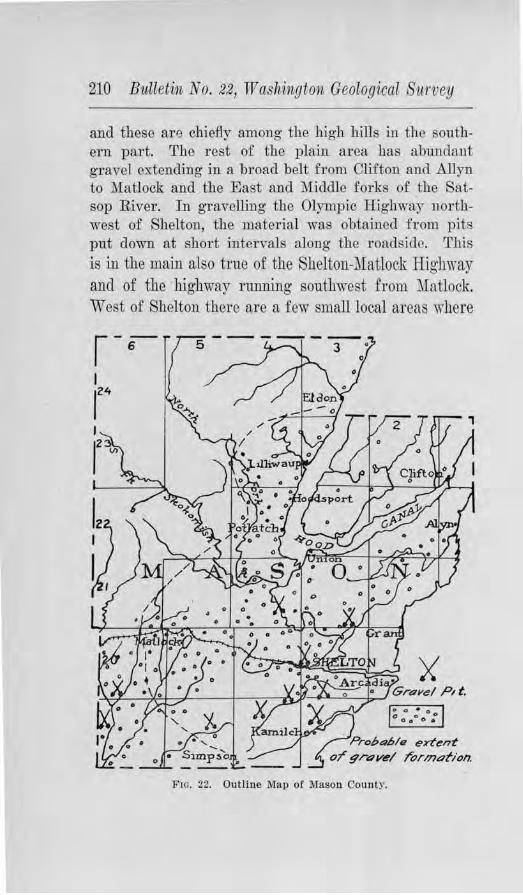
210 Bulletin No. 22, TV ashington Geological Survey
and these are chiefly among the high hills in the southern part. The rest of the plain area has abundant gravel extending in a broad belt from Clifton aucl Allyn to Matlock and the East and :Middle fol'l{s of the Satsop River. In gravelling the Olympic Highway northwest of Shelton, the material was obtained from pits put down at short intervals along the roadsic.le. This is in the main also true of the Shelton-::VIa tlock Highway and of the highway running southwest from Matlock. West of Shelton there are a few small local areas where
X 0 0 • 0 0 O O
0 o O O
Pro!,4i,/11 extent
or gravel J'ormation.
Fro. 22. OuUine Map of M:ason County.
Roa,l Bv.,i&clin,g Sands and Gravels 211
pebbly clay prevails instead of gravel. Along the Hood Canal, abundant material can be obtained from the roadside at tho foot of the high slopes. The general distribution is shown on the outline map of the county.
Chai:·acter of t11e Gravels
The gravel is a part of the great deposit left by the last glacier which invaded the Puget Sound region during the Glacial P eriod. For a considerable length of time the glacier had a position approximately along the dotted line shown on the outline map, and immense quantities of graYel were washed from the front of the glacier down all of the forks of the Satsop River, except the west fork. As the ice was gradually melted back the outwash was extended more and more to the northwest, thus fortunately providing the area of Lhe County with large quantities of gTavel.
The gravels in the main are fresh and fhm, and consist of pebbles of granite, basalt, q uartzHe, and other siliceous metamorphic rocks. The gradation varies from place to place, but in only a few places arc there very coarse materials. Some of it is lacking partly in binder, so that. if none is added the gravel is slow to pack. Along the north side of Isabella Lake gravels of :fine quality abound, with but little o,·ersize. Their results on the rood in this vicinity ha,·e been highly satisfactory, producing one of the best roads in the county. Only the .fhst few miles of the highway from Shelton to Allyn and Clifton have been improYed, but when the improvement is unde1·taken, there will be no lack of good gravels to draw upon for practically the whole distance.
In view of the fact that the Testing Engineer of tb~ Geological Survey had been called for war service, no samples were collected for testing.
212 Biilletin No. 22, Washington Geological Sitrvey
OKANOGAN COUNTY
GENERAL STATEll\!ElNT.
This county is in the north central part of the state, bounded on the north by the International Boundary. Its area includes 5,221 square miles, ,v-hich makes it the largest county in the state. In addition to its size affecting the work of the Ootmty Engineer, is the factor of its mountainous topography. The Okanogan Valley on the east and the Methow Valley on the west, both of which are fairly well populated, are separated by a mountain range across which there al'e but few roads. The problems of road-building are further enhanced
by steep grades and also by sandy subsoil which requires Slll'facing. Fniit-growing jg one of the chief industries ancl marketing comes at the dry time of year when the roads are least able to stand heavy loads. The l'oads must be built and maintained, therefore, with this in view.
A branch of the Great Northern runs from Wenatchee to 0Toville, thus serving the towns along the Colombia and Okanogan rivers, and indirectly the towns along the :Mcthow Valley by stage-line from Pateros.
State Road No. 10 has been established along the Okanogan Valley and graded and surfacoc1 a considm:able part of the distance. State Road No. 12 runs along the J\Iethow Valley, beginning at Mazama and joining State Road No. 10 at Pateros. Much of it has been grnde<l and surfaced.
CLIMATIC FACTORS.
The average annual precipitation of Okanogan county is 15 inches, of which one-third is snow-fall. Cloudbursts occur occasionally which work havoc to bridges and highways. During the summer, the dTy spells are frequently prolonged enough to depnve the road-beds of moisture and reduce their wearing power below the
Proba/Jls elt'tan-1: o-f" gravel l'ornu,tlon.
'i Grovel Pit
(Those numbered were tasted)
2.) 22 23
K A
'\ I
'----li'IG. 23. Outline Map of tbe main portion of Okanogan County.
214 Bulletin No. 22, Washington Geological Survey
minimum required. As a r esult the heavy hauling during the fruit-marketing season cuts up the r oads except where the sm--facing is of the proper quality and thickness.
Frost action dm·ing early spring also loosens and softens the road-bed so that careful maintenance is required to keep the roads in good condition.
GENERAL DISTRIBUTION OF ROAD GRAVELS.
The Okanogan Valley
Terraces of sand and gravel are found here and there along the Okanogan Valley from Whitestone Mountain southward. They rise several hundred feet above the river to an altitude of about 1,300 feet. Dm·ing glacial times the valley was filled to this level with silt, sand, and gravel, and subsequently the stream removed all except the remnant benches which 110,v exist. Some of these are from one to three miles wide.
It is unfortunate, however, that the material consists so dominantly of fine silt and sand. Pockets or thin layers of gr·avel occur at varying horizons in most any section, but they are usually so interstratified with the valueless silt that they cannot be economically excavated except in a very few cases. Fortunately, talu!:; deposits of good "shell rock", andesite and rhyolite, flank the rock cliffs at various places, as for example, llh miles south of Oro~e, at Whitestone :Mo1mtain, northeast of Omak and north and northeast of Okanogan. G1·anite has been quarried and crushed for roadmetal 4% miles northeast of Brewster.
The l\Iethow Valley
In this valley the situation is somewhat different. Gravels are found in remnants of benches up to 600 feet high, which have less of the objectionable fine material than occurs in the Okanogan Valley. On the whole fairly good materials can be found here within hauling
Road Building Sands ancl Gravels 215
distance. Southeast, east and north of Twisp, there is abundant slide-rock to be Lad which, when crushed, is satisfacto1·y on the roads.
The outline map of the County shows the general distribution of road gravels.
Tests on Road Gravels
1Ua,v Number 69. This sample was taken from the Pheasant Pit at Tonasket, on the west side of foe river. The face of the pit in the side slope of the bench is 25 feet high and stands ,~ertically, showing good binding poweT. At the top is 4 to 5 tect of light gray silt, then 3 feet of cobbles below and 8 feet of coarse gravel, below which js 10 foet of fine gravel, well graded up to 21/2
inches in size and sho"-ring incipient c<nnentation. About 50 per cent of the pebbles arc retained on a %-inch sieve and about 5 per cent arc larger than 2 inches. About 87 per cent of the pebbles are firm and by test show average wearing quality. The gravel has been used on State llighway No. 10 for 1 mile north of Tonasket and wears nicely. In obtaining the mate1·ial from the pit, if sand pockets are encountered, clay is mixed in. The pit is owned by Olaf Lauraguard.
Map Number 70. This sample was taken from an alluvial fan at the mouth of Omak Creek, across the ri,·er from Oroak. The gravel contains considerable o,·ersizc material but the rocks are almost all firm. The sample, which was taken from helow the surface, tested low in cohesiveness, showing that it has insufficient clay to pack readily. If it had been taken from the surface portion, the cementa hon value would probably have been higher, for it contains more clay. This gravel has been used on the main street 1n Omak and cru·e was used in obtaining it and spreading it. The r esults are highly satisfactory.
216 Biilletin No. 22, W a,sh111igton Geological Survey
Map Number 71. This sample was taken from a gravel pit on top of Brewster Flat, and about 5% miles nor theast of Brewster, on the right-of-way near the laud owned by Ray Perkins. In the natural state, the gravel is rather sandy and lacks enough binding material without the addition of clay. In the test for tenacity, the sand would not adhere sufficiently to make the necessary cylinders. Obviously, a good tenacious clay is needed. The wearing quality of the pebbles, however, is believed to be good, as 94 per cent of them are firm and they consist of 43 per cent granite, 36 per cent basalt, 13 per cent rhyolite, and 7 per cent quartzite. These gravels
have not had an extensive practical test on the road. Map N1.Mnb e1· 72. This sample was collected from a
deposit of gravel 3:Y2 miles southwest of Carlton, about ~ mile west of the hlghway. The gravel occurs in a bench which rises about 300 feet above the valley flat. The materials consist of a considerable amount of clay mixed with the pebbles, which consist of basalt, andesite, rhyolite, granite, and diorite. About 69 per cent of the material passes the %,-inch screen, and only about 5 per cent are oversize. Ninety-one per cent of the pebbles are firm. The tenacity test gave a high value, indicating that the binder is good and the material will pack readily.
This gravel deposit was being drawn upon for surfacing the adjacent section of the highway in the fall of 1917. The pit was located in the side-slope of the terrace so that gravity would aid in bringing the material down to the bunlrnrs. The hauling was being done by trucks. The terrace seems to run consistently in kind and quality of materials, and appears to be a fortunate deposit for machine handling.
The detailed results of tests on the foregoing samples are given in Table I, along with those from other counties.
Road Building Sands and Gravels 217
OTHER DEPOSITS EXAMINED.
About 1 % miles northeast of Oroville there is a bank of angular gravel which contains much clay. This pit is known as the Carroll pit. The materials show little wear by water and consist lru·gely o.f local material which accumulated here from the higher ledges. They have been used for road metaling and found to be satisfactory.
About on the north line of the city limits of Omak, the Omak Cement Products Co. has opened a gravel pit on the slope of a terrace. The materials are firm and mostly of good quality. They are used by the company in the manufacture of concrete irrigation- and culvert. pipe.
About l(2 mile below the mouth of Benson Creek, in the S. W. %, of Sec. 10, T . 32 N., R. 22 E., there is a gravel pit in the side of a terrace, 100 feet high, in which the materials are chiefly coarse sand wi.th a fair percentage of pebbles. Where used on the road, this material packs fairly well.
OTHER KINDS OF ROAD METALS.
On the west and northwest sides of Whitestone :Mountain, north of Tonasket, there is a great talus deposit o.f white calcru:eous volcanic tuff, and andesite and basalt flows. A selection of proper sized materials can be made -very easily and immense amounts secured. The white Tock would probably make an excellent binder, while the andesite and basalt would give firm rock for wear.
About 1'(2 miles southwest of Oroville, a large talus apron borders a high point of rock, the talus reaching to a height of 100 to 150 feet and containing thousands of cubic yards of andesitic material. Some of the material has been used on the roads near here and in Oroville with satisfactory results.
About 2% miles northeast of Okanogan, a point of xock is flanked by "shell rock" of felsite, which in places
218 Bulletvn No. 22, W ashitigton Geological Survey
is of suitable size for road metal, and where used on the road has given satisfaction except where it was put on too thin. Some of it has borne heavy fruit hauling for four years.
Qwte similar material is also found in the talus deposit which flanks the rocky point about 4 miles nor theast of Omak, and which occurs along the rock bluff west of Pogue Flat.
Tests for Concrete
Sand from the Pheasant Pit, at Tonasket, was used in making· concrete briquets for comparison in tensile strength with Ottawa Standard sand. Three 7-day briquets of the former averagecl 155 per cent as strong in tensile stl'ength as those of Standard Ottawa sand, and the 28-day briquets of the former averaged 149.l per cent greater. No organic content was found. See Tables ID and IV for detailed results and comparison with other sands.
PACIFIC COUNTY
GENERAL ST ATE~iENT.
Situated in the extreme southwest part of the state, on the Pacific Ocean, P acific county has a heavy rainfall generally averaging about 75 inches per year. This necessitates the suTfacing of at least the main highways of traffic. Most of the National P ark Hjghway east of South Bend to the eastern limits of the county has been metaled, and much of the highway southwest from South Bend. The subsoil in most cases is a heavy clay, which, if not surfaced, makes an almost impassable road during many months of the year.
In 1916, the population of the county was estimated by the Census Bur eau to be 16,649. South Bend is the county seat and largest town, with Raymond a close second according to the 1910 census. Ilwaco, Nahcotta, Tokeland, Lebam, Chinook and Long Beach are the other towns. The chief industry of the county is lumbering,
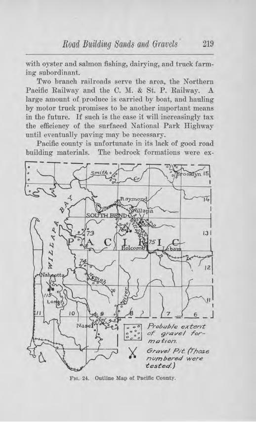
Road Buuding So.mids and Gravels 219
with oyster and salmon fishing, dairying, and truck farming subordinant.
Two branch railroads serve the area, the Northern Pacific Railway and the C. J\L & St. P. Railway. A large amount of produce jg carried by boat, and hauling by motor truck promises to be another important means in the future. If such is the case it will increasingly tax the efficiency of the surfaced National Park Highway until eventually paving may be necessary.
Pacific county is unfortunate in its lack of good road building mate1·ials. The bedrock formations were ex-
• • •
Prolu~/:,/e exten-t or 9r4 ve I rorm ertion.
Gre:we/ P/t. (Those nvmbered were 'CeS'Ct!!Q.)
F10. 24. Outline Map of Pacific County.
220 Bulletin, No. 22, Washington, Geological Survey
amined and tested by the Washington Geological Survey in 1911, and some outcrops were located which would seem to yield satisfactory material, but in most cases the rocks are too soft and so much weathered that after crushing the fragments " slack" and break into smaller pieces and eventually become so fine as to make mud. The rock of the area consists chiefly of basalt, sandstone, and shale. The results of the study were published in Bulletin No. 2 of the Survey's series.
The present investigation was confined chiefly to the :possible occurrence of gravels for road surfacing and
concrete. ORA VEL DEPOSITS.
Pacific county lies outside of the glaciated area, and apart from any drainage lines which canied glacial wash. As a consequence its gravel resouTces are very limited. Some gravel bars occm· along the Willapa River for some distance upstream from Raymond, along the lower part of ~Iill Creek, il1 the bed of the North Fork of Palux River, and along Nasel River. The general distribution is shown on the outline map of the county. Gravel also occurs on the west side of Long Island, and along a part of the coast, although much of this is sand.
In view of the soft character of the sandstone and shale formations and of the weathered condition of thebasalt, it might be expected that such gl'avels as have been derived from these formations would be inferiol' in quality. This is borne out by field inspection. Nowhere was there found a gravel deposit along a stream that could be called first-class material. Some of the pebbles are hru:d, but there is such an intermixtm·e of wea therecl constituents that their weaTing value is considerably below par and their use in concrete is not r ecommended. The gravel along the west side of Long Island
Road Builcling Sancls ancl Gravels 221
is firmer than the river gravel, but there is a deficiency of pebbles as compared to the sand content.
Tests on Samples for Road Sm •facing
1vlap Ni,t11ber 73. This sample was obtained from a quantity of gravel which had been brought from a few miles up Palux River for surfacing the National P ark Highway in the vicinity of Bay Center. The gi-avel is well graded, has but little oversize, is composed chiefly of basalt with some sandstone, and the pebbles are fairly well rounded. About 30 per cent of them, however, are soft and by test the ·whole grnvel gave high Yalues, indicating that the material will pack readily and have good ultimate cementation. In actual use on the road this is found to be true. The road is also smooth and will serve the light traffic of this region fairly well.
},,fop Nivmber 74. This sample was obtained from a deposit near the mouth of Williams Creek, a tributary to Nemah River, neaT the National Park Ilighway. This gravel is much like the one just described in composition, but its sand content is very low. A small percentage is oversize. About 25 per cent of the pebbles are soft, which gives the whole gravel rather infe1-ior wearing qualities. So little binder was present that no tenacity test could be made. This would indicate that some binder should be added in order to facilitate packing and cementation, although caution must be exercised on account of the wet climate.
Map Number 75. This sample was collected from a bar along the Willapa River, 1 mile north of Holcomb. The bar is about 200 feet wide by 300 feet long, and contains much coarse material of semi-rounded to rounded character. The pebbles consist of over 90 per cent basalt, some of which are decomposed, but in the main aTe firm enough to give good wearing results in the abrasion test. The a.mount of binder is very small,
222 Bullet,i,n No. 22, Washington Geological Sitrvey
not enoug·h being present in a 40-pound sample to make the tenacity test. Crushing, pit-run, would not only give a better gradation but would increase the binder portion. Some additional binder might also be required. This should make the gravel fairly satisfactory for road metal.
Jlllap Number 76. This sample was secured from a bar along the South Fork of Willapa River, about 6 miles south of Raymond. The pebbles are dominantly of basalt, with some sandstone. .A.bout 90 per cent are firm and, according to test, have fair wearing quality.
There is an insufficiency of the fine below one-quarter inch in size for binding, but the amount present gave good results in the tenacity test. This gravel would likely prove satisfactory for road-metal, if good binder can be added.
The detailed 1·esults of the foregoing tests arc given with those from other counties, in Table I.
Tests fol' Ooncrete
JJ{ap Nu11iber 115. This sand was obtained from the bunkers of the Nahcotta Sand and Gravel Co., of Raymond, and was secured by them from the west side of Long Island. The sand ,vas washed and used in making concrete briquets to be compared in tensile strength with briquets made from Standard Ottawa sand and the same kind of cement. The method followed is described in Chapter IV.
The 7-day briquets of the sand under test showed a tensile strength 102.9 per cent as great as the 7-day briquets made from Standard sand, and the 28-day briquets of the former tested 104.5 per cent as strong as the 28-day briquets of the latter. A chemical test showed enough organic matter to be present to require other tests to be made from time to time if this sand is to be used for any sort of concrete. The reader is re-
Road B1.iilding Sands and Gra.vels 223
f erred to Tables ill and IV for the details of this test and comparison with tests from other counties.
Unfol'tunately, the gravel from Long Island is insufficient in quantity of coarse aggregate without wasting much of the sand, but it would seem that coarse aggregate might be secured by crushing the rock from the sandstone quarry about 1 mile northwest of Raymond, on the property of the Raymond Sand and Imp1·ovement Company. The rock seems to be firm in quality. It occurs u1 a high bluff, and could be brought down to the river by gravity and transported by scows.
PEND OREILLE COUNTY
GENERAL STATEMENT.
Pend Oreille county is in the extreme northeast corner of the state, next to the Canadian and Idaho boundary lines. Its area includes 1,472 square miles. The valley of the Clark Fork enters the county at NewpoTt, and at Dalkena trends northward for the remaining length of the county and joins the valley of the Columbia River a short distance north of the Canadian line . .Along this valley are located the chief towns of the county. The population of the county is comparatively small, and the amount of the traffic correspondingly light. Grazing and lumbering are the chief industries, but farming and mining arc rapidly developing.
Two railway lines serve the county. The transcontinental line of the Great Northern crosses the southeastern portion and the Idaho and Washington Northern Railway follows the Clark Fork from Metaline Falls to Newport, and crosses into Idaho by way of Penrith.
State Road No. 23 serves all vehicle traffic from Newport to Spokane. This is now improved the entire distance. The chief county road paraDels the Clark Fork along the west side, providing good transportation facilities between Newport, Dalkena, Usk, Cusick, Locke,
224 Bulletiti No. 22, Washington Geological Survey
Ruby, Blueslide, and Ione. Another highway parallels the Clru:k along the east side. Tributary roads branch from these to the various communities in the tributary valleys.
TOPOGRAPHY.
Although this is a rolling to mountainous county, the valley of the Clark Fork and the pass southwest from Newport ptovide remarkably good conditions of grade for the main highways. The valley of the Clark Fork is broad most of the distance south from Jared and between Blueslide and Ione, and throughout this distance bas a low gradient.
North of Cusick, nearly to Jared, the subsoil is a lake-deposited clay which makes a muddy road during wet seasons and a rough, hard, and dusty road when dry, especially after a period of heavy hauling. Elsewhere, as a general rule, the subsoil is a sandy or gravelly formation. Both types have been much improved by sur-facing.
CLIMATE.
The average precipitation is about 25 inches per annum, of which about one-£ ourth is snowfall. Government records show that July, August, and September are the driest months, but nevertheless the rainfall is usually sufficient to prevent such a thorough drying out of the roads, with consequent rutting, as occurs in the interior of the Columbia Plateau. Thawing and freezing during the winter make a soft road for early spring and necessitates maintenance.
DEPOSITS OF ROAD GRAVELS.
The distribution of gravel formations and the location of some of the pits are shown on the outline map of the county. Gravel is found in abundant quantity southwest of Newport and in benches along the Clark Fork as far north as Usk. From Usk southward it is .scarce, except in the vicinity of Ione. Granite is being
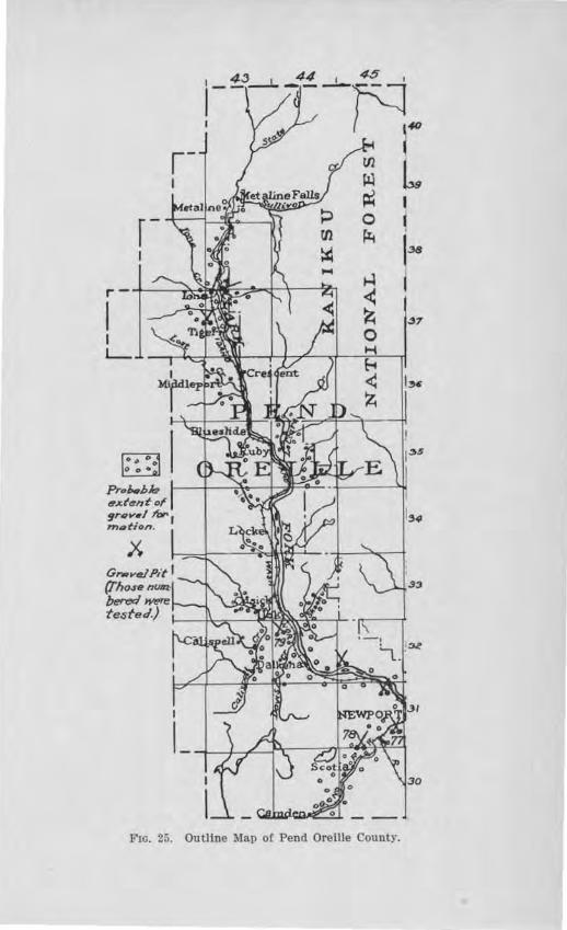
Prob.,b/e eJCten'tof srqv,l to,. I moti or,.
X
FIG. 25. Outline Map of Pend Oreille County.
1~
33
226 Bulletvn, No. 22, W ashinigton Geological S1urvey
crushed and used along the road south from Ruby, and slide rock and tailli1gs at various places on the north side of the river, east of Dalkena. In the southwest quarter of Sec. 30, T. 32 N., R. 45 E., there is a talus deposit of calcareous slates and schists, angular in form, and well graded in size, which has been used with success on the Usk Road for two years. The material was transported across the river by barges. River gravel has been used on the road on the north side of the river from Newport, but its binding qualities are still poor after three years' service.
Tests for Road Sm-facing
1-Ylap Nu,rnber 77. This sample was taken from the gravel pit, located 1% miles southwest of Newport, on the south side of the I. & W. N. Ry., in the S. E. 1,4 of Sec. 23, T. 31 N., R. 45 E. The gravel formation here forms a bench about 60 feet high. The gravel is well graded, composed of pebbles of durable rock, such as quartzite, granite, and schist, of ·which 94 per cent are fh'm . By test these are known to have an average ,vearing value. The gravel has been in use on that portion of State Highway No. 23, known as Permanent Highway No. 1, and found to be a most excellent road gravel, ranking among the best gravels of the state. Besides having good wearing qualities its property of natural cementation is high. A small section was cut out from the roadbed for an examination of the factors involved in its cementation. The section showed that the material was well graded so as to give compactness and the pebbles of the natural deposit are coated with a clay which after wetting possesses good binding qualities.
Map Nurnber 78. This sample was taken from the gravel pit loec'tted about 1 mile west of Penrith. The materials consist of stratified granite debris, angular and fai.rlj well graded from :fine to oversize, with a prob-
Road Bitilding Sands arnd Gravels 227
able excess of sand.. Upon examination, about 28 per cent of the fragments are soft or partially disintegrated, and their percentage of wear is high, as shown by test. The binding material which passed a 10-mesh sieve, tested low in its power to pack readily, but its ultimate cemcntation is good. This material should not be used on roads except those having light traffic.
Map N'Umiber 79. This sample was taken from a gravel pit 4 miles southeast of Cusick, in the S. W. l)! of the S. E. JJi of Sec. 5, T. 32 N.1 R. 44 E. The gravel deposit forms a low bench on the broad flat. The materials are only fairly well graded, with some oversize, and have average wearing qualities, as shown by test. Enough decomposed granite seems to enter into the binde1· portion to give it a good cementation value. The tenacity test shows that it would pack fairly readily. In actual practice it packs well and seems to be very satisfactory.
The foreg·oing results are given in detail in Table I, with those from other counties.
Other Gravel Pi ts Examined
N. E. %, Sec. 33, T. 31 N., R. 45 E. This pit occurs in the side of a high terrace. The materials a1;e dominantly fine sand and small pebbles, ·with a few cobbles and boulders up to :2 or 3 feet. They consist of quartzite, argillite, granite, dolerite, basalt, and slate and schist. Although of a good wearing quality, the materials do not seem to be properly graded to pack well. Some of the sand should be eliminated.
S. W. 1.4, Sec. 1, T. 31 N.1 R. 45 E. This is a sideroad pit on a high bench, exposing a pea-gravel The material has been used on the road for two years, giving good wearing service and packing well.
S. E. 1,4 of S. E. 1,4, Sec. 7, T. 37 N.1 R. 43 E. This pit is located on a low tenace, made up of lenses of silt,
228 Bulletin No. 22, Washington Geological Siwvey
sand and gravel ·which are discontinuous and variable. Some of the layers are iron-stained. It was being drawn upon for use on Permanent Highway 4 A, south of Ione, and where :it has been put on, it seemed to be packing well.
N. W. 1,4, Sec. 5, T. 37 N., R. 43 E . This gravel pit is located on the east side of the river across from Ione, near the ferry. The gravel stands with a vertical face, 30 to 40 feet high, and 70 to 80 feet wide, and is made up of pebbles of all sizes up to oversize material, some of which consists of two-foot boulders. The matrix is a fine sand and silt; "torpedo" sand is lacking. When screened this material should make an excellent road gravel as the pebbles are hard and resistant and the whole body shows good natural cementat:ion.
Tests for Concrete
Tests were made on Samples 77 and 79, whose locations are given on a preceding page. In the case of Map Number 88, the 7-day briquets showed a tensile strength 125.0 per cent as great as the briquets made from Standard Ottawa sand, and the 28-day briquets 145.9 per cent as great. The colorimetric test showed the sand to be practically free of organic content.
The 7-day briquets of Map Number 79 tested 102.8 per cent as strong as the briquets of Standard Ottawa aand, and the 28-day briquets 141.2 peT cent as strong. Some organic matter was shmvn to exist in the sample. Car e will need to be exercised in stripping the pit, to keep out all humus and other organic material.
The detailed results of these tests are given in Tables III and IV.
Road Buil,ding Sands and Gravels 229
PIERCE COUNTY
GENERAL STATEMENT.
This county is situated in the west central part of Washington, southeast of Puget Sound. It reaches from the summit of the Cascades to the southern shores of the Sound and includes an area of 1,701 squaTe miles. In 1916, the population amounted to 161,863 inhabHants. The larger portion of this occurs in the northwestern part of the county. Manulacturing, lumbering, coal mining, and :fishing are important industries, together with berry raising, dairying, stock raising, truck f ai·ming, and poultry raising. Tacoma is the county seat anu largest city.
The transportation requirements of the county al'O
served by several of ihe transcontinental r ailway lines, together with certain state highways and ihe county system of roads. The Pacific IDghway enters the county north of Sumner, passes through Tacoma, and ]eaves the county at Nisqually. Tho National Park Highway leads from Tacoma to :Mt. Rainier. Both of these highways ar e improved, the Pacific Iljghway being paved throughout its whole cotU'Se in the county. ]Host of the important county highways are surfaced.
TOPOGRAPHY.
The topography of Pierce county includes mountaills and plains, this combination giving a wide range of problems to be contended by tho highway engineers. The mountains give way rather abruptly to ihe plains along a line clTawn tln:ongh LaGrande, Eatonville and Or ting. The plains consist of broad table-lands, more or less rolling in cha1·acter and incised by a few valleys, the most notable o.f which is the P uyallup River Valley. The subsoil in the valleys consists chiefly of loam and sand, but m~ch of Lhe plain area, especially south of Tacoma, is u:.:iderlain by gravel.
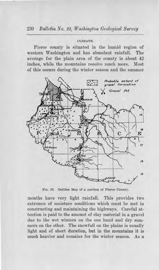
230 BulleDi111, No. 221 Washington Geolog:ical Survey
CLIM.A.TE.
Pierce county is situated in the humid region of western Washington and bas abundant rainfall. The average for the plain area of the county is about 42 inches, while the mountains receive much more. Most of this occurs during the winter season and the summer
r::o-::1 ~
f=rol,ohl• extent of' 9rttvel rornu:1tion.
)< Gravel Pit.
F1G. 26. Outline Map of a portion of Pierce County.
18
17
/6
15
months have very light rainfall. T11is pTovides two extremes of moisture conditions which must be met in constructing and maintaining the highways. Careful attention is paid to the amount of clay material in a gravel due to the wet winters on the one hand and dry summers on the other. The snowfall on the plains is usually light and of short duration, but in the mountains it is much heavier and remains for the winter season. As a
Road BiiUding Sands and Gravels 231
result of avalanches and flood conditions the highways which enter the mountain valleys must be maintained at considerable expense.
DISTRIBUTION OF THE GRAVELS.
The western pai·t of Pierce coui1ty is almost entirely underlaid with gravel, the chief exce1Jtion being the flood plain of the Puyallup River, the materials of which are chiefly silt. The gravels belong to the last glacial epoch and were deposited under glacial conditions. During the melting of the ice a large amount of gravel was washed out of the ice and deposited in extensive outwash plains.
Along the cliffs of Puget Sound, southwest of Tacoma, extensive gravel deposits occur at Steilacoom and at the mouth of Sequalitchew Creek. The gravels at Steilacoom are known throughout western Washington for their firm quality and use for concrete. They occur in a cliff which rises about 160 feet above the Sound. This position makes possible the use of gravity in bringing the material down to the bunkers where it is washed, screened and loaded onto cars or scows. The Pioneer Sand and Gravel Co. and the Tacoma Sand and Gravel Co. operate pits here. Large deposits also occur in the southern part of Tacoma.
The general distribution of the gravels is shown on the outline map of the county. The gravels are dominantly of siliceous composition, being composed of granites, basalts, andesites, rhyolites, quartzites, and other igneous and metamo1·phic rocks. As a rule but few soft pebbles are found among them. Abrasion tests which were made on the gravels occurring at Steilacoom showed them to have a remarkably low percentage of wear, the amount being about 2.4 per cent.
Briquet Test,s of the Sands
Briquet tests ~ere made of some of the sands in order to determine their quality for concrete use. Many
232 Bullet1in No. 22, lif! ashvngton Geological Survey
of these tests were made by the Portland Cement Association and to them the Survey is indebted for much of the data. All of the tests made averaged higher than 100 per cent in strength ratio as compared with Standard Ottawa sand, for both the 7-day and 28-day briquets. Detailed results of analyses of these sands and of the strength of the briquets are given in Tables III and lV, of Chapter IV.
Tests on Field Concrete Oylindex·s
Field concrete cylinders were made of the concrete mix which was used in the pavements of the Pacific
Highway near Nisqually, designated by the county as P ermanent Highway No. 8 A. Four of these cylinders, after being cured under as nearly as possible the same conditions as the pavement, were tested for their compressional strength in the testing laboratory of the University of Washington. They were fotmd to have an average compressional strength of 4,312.87 lbs. per square inch.
Three concrete cylinders of the mix which went ii1to the concrete dock at Dash Point averaged 2,880.31 lbs. }Jer square inch. In the case of the Paci.fie Highway the proportions of mix were 1 :2 :3, while in the latter the proportions were 1 :2 :4. The aggregates for the Paci.fie Highway pavement were from Steilacoom and those for the concrete dock from Maury Island. More detailed information concerning the character of the aggregates used and of the concrete cylinder tests is given in Tables V and VI.
A rather extensive series of tests were made by Mr. R. J. Borhek of Tacoma on the concrete making qualities of the gravel at Lakeview and at Steilacoom. The cylinders which were made in these series of tests were tested in the Engineering Laboratory of the University of Washington by :i)fr. Everett G. Snell, Instructor in Civil
Road Bi~ilding Sands and Gravels 233
Engineering. The physical properties of the fine and coarse aggregates used in the tests, together with the resulLs of the compressional tests of the cylinders, are given in Tables VII and VIII of Chapter IV.
SKAGIT COUNTY
GE1''BRAL STATEMENT.
Skagit county is in the north,Yestcrn part of the state, in the second tier of counties from the Canadian line. It fronts t.he waters of the Strait of Juan de Fuca on the west, and reaches eastward to the crest of the Cascade Range. The greater par t of the population live in the west one-third, the remaining portion of the county being mountainous. A certain percentage of the population, however, live along the valley of the Skagit River whern lumbering is an important industry, and the manufacture of cement is being conducted on an incr easing scale at Concrete. F arming and dairying are the important occupations in the western plain portion, especially on the broad delta flat of the Skagit River. In 1916, the number of inhabitants was estimated by the Census Bureau to be 38,652. Mount V crnon is the county seat and Anacortes lhe largest town. Some of the other towns are Sedro W oollcy, Burlington, La Conner, Biglake, Clearlake, Concrete, and hlcl\lurray.
Railroad transportation facilities are afforded by the Groat Northern Railway :rn<l the Pacific Noriliwcst Ti-action Company. The Pacific Highway, which passes through the western part of lhe county, js tho chief thoroughfare.
CLil\IATE.
Skagit colmty has an abundant rainfall, most of which occuTS duTing the winter. The a"erage each year is about 60 inches. Occasionally flood conditions ensue on the broad delta flat of the Skagit River. This heavy rainfall prohibits the use of excess clay matel'ials in the
234 B11lleti11, No. 22, TV ashitngton Geolog·ical Survey
gravels for road sm·facing. In places on the delta flat, the subsoil consists of bog deposits which necessitate a goodly amount of crushed rock or gravel fill in order to provide a.good foundation for pavement. The increased heavy hauling of the farming section west of Mount Vernon is creating demands foT paved highways. Several miles have already been laid by the county. Concrete cylinder te'Sts of one section were made and the results are given on a following page.
DISTRIBUTION OF ROAD GRAVELS.
Gravel formations are found generally along the
Skagit Ri,·er in benches and bars, and along the East Fork of the Samish River. Those along the latter stream, especially near Prairie, are very hlgh. For the paving along the McLean Road, P ermanent Highway 3 B, the sand was gotten from the Skagit River near :Mour1t Vernon and the gravel from the Keystone Pit at Fort Casey on Whidbey I sland. Tho aggregate which entered into the paving of Bennett Street in Sedro Woolley in 1917 was obtained from a bar of the Skagit River south of town. Local deposits for road gravelling are to be found on the hill-slopes of western Skagit county outside of the delta flat.
In almost all cases tho gravels arc firm and of good quality. Those along the Skagit River contain some pumice matcTial ·which the waters have transported from Mt. Balcer. For road surfacing the river gravels are not so good as the bench graYols, the former lacking good binding quality.
Tests o.n Samples for Oonct·ete
111.av Niimber 120. This sample was obtained from the Skagit River one mile southwest of :Mount Vernon. Six briquet tests were made of the washed sand which passed the 11.i,-inch screen. At the end of 7 days the ten-
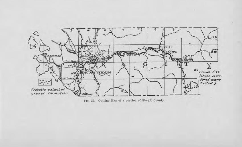
FIG. 27. Outline Map of a por tion of Skagit County.
34 :t GraV'tl Pit (Those r,untbe-t:l w~nr -tested.)
236 Bulletin No. 22, Washington Geological Survey
sile strength of three of these were made and compared with the strength of briquets which had been made from Standard Ottawa sand, according to the manner described jn Chapter IV. The results showed the sand under test to have a strength 91 per cent as great as the Standard sand. At the close of 28 days, the remaining three briquets averaged 104.6 per cent the strength of those ruade from the Standard sand. By the colorimetric test, organic matter was found to be present to an extent whi.ch shows that this factor would need to be controlled if first-class concrete paving were desired.
Map Niimber 121. This sample was taken from the Skagit Rive1·, nea1· the Burlington bridge, by the Portland Cement Association and tested for its tensile strength in concrete briquets. Their results show that the 7-day briquets bad a strength 145.3 per ce11t as great as the briquets of the same age made from Standard Ottawa sand, and the 28-day briquets 142.6 per cent as great. No test was made fo1· organic content.
Map Nmnbe1· 122 . This sample was obtained from the Skagit River, west of the bl'idge, near Sedro Woolley. Six separate tests by the Port]and Cement Association showed the 7-day briquets to have a tensile strength averaging 112.3 pe1· cent as great as those made .from Ottawa Standard sand, and the 28-day briquets lJl.5 per cent as great. The colorimetric test to ascertain the presence or organic matter was not made.
The detailed results of the above tests are given in Tables III and IV.
Field Couc1-ete Tests
On the McLean Road, Permanent Highway 3 B, concrete cylinder tests wer e made of the material which was put into · the pavement at Station 306+25 to 306+55. The material was taken at random as it came from the
Road Building Sands ancl Gravels 237
mbrnr and poured into three cylindrical molds, 6 inches in diameter and 12 inches in length. Care was exercised in puddling to obtain the same appro.ximate density as would be obtained in the pavement pr oper. After twenty-four hours the cylinders were covered with earth in the same way as the pavement and for thirty days were cm:ed under appro2...imatcly ilic same conditions as the pavement. ·when 254 days old, thefr compressional strength was tested in the Engineering Testing Laboratories of the Univel'Sity of Washington. The tlll:ee cylinders were found capable of sustaining a maximum load of 3,662.9G lbs., 2,976.32 lbs., and 3,593.31 lbs. per square inch, respectively.
Four similar tests were made of the concrete paving which was laid on Bennett Street in SedTo Woolley, between Township and Thi.rd streets. When 260 clays old these showed a maximum compressional strength of 3,203.34 lbs., 4,050.98 lbs., 3,064..07 lbs., and 3,543.60 lbs. per square inch, respecti-vely.
The reader is referred to Tables V and VI fo1· a tabulation of results and comparison with other pavements.
SKAMANIA COUNTY
GENERAL STATE"h,lEN'l'.
This county lies along the Oo1umbia Ri,er gorge, in the southern part of the state. Having a most rugged mountain topography, the inhabited pOl'tion is confined to the Colombia River Valley. In 1916 the Census Bureau estimated its population to be 3,639. The chief industries are fruit and berry raising, dairying, poultry raising, lumbering and :fishing.
The need for sm·faced roads is limited almost entirely to State Road No. 8, which follows the Columbia River to Vancouver and there coilllccts with the P acific Highway. In the eastern part of the county, the cliffs
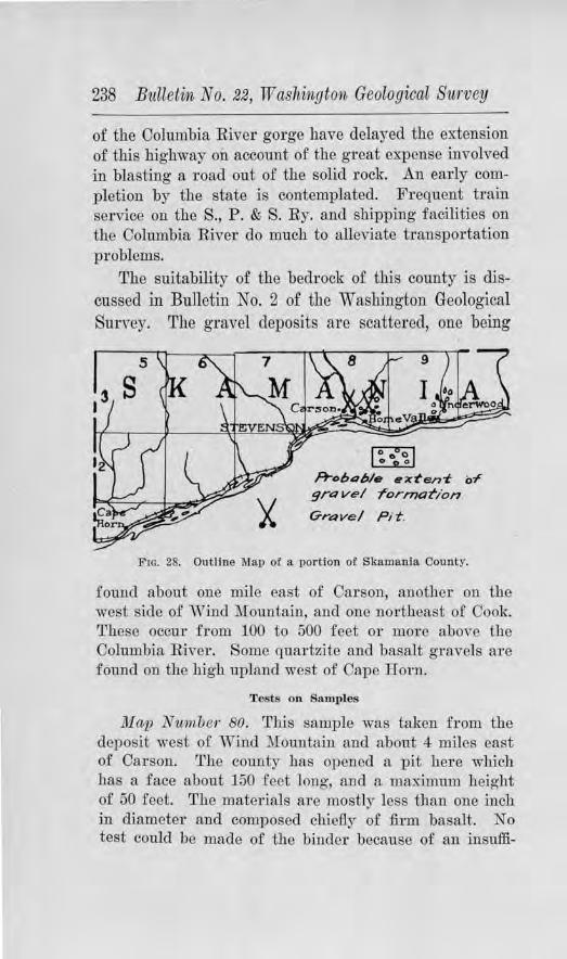
238 Bulletin No. 22, W ashinigton Geological Survey
of the Oolumbia River gorge have delayed the extension of this highway on account of the great expense involved in blasting a road out of the solid rock. An early completion by the state is contemplated. Frequent train service on the S., P . & S. Ry. antl shipping facilities on the Columbia River do much to alleviate tTansportation problems.
The suitability of the bedrock of this county is discussed in Bulletin No. 2 of the Washington Geological Survey. The gravel deposits are scattered, one being
rn Ft-obahl• e-xt'en-t of
grove/ formation
Grave l P i t .
FIG. 28. Outline Map of a portion of Skamania County.
found about one mile east of Carson, another on the west side of Wind Mountain, and one northeast of Cook. These occur from 100 to 500 feet or more above the Columbia River. Some quartzite and basalt gravels are found on the high upland west of Cape Horn.
Tests on Samples
Map Nwmb er 80. This sample was taken from the deposit west of Wind Mountain and about 4 miles east of Carson. The county bas opened a pit here which has a face about 150 feet long, and a maximum height of 50 feet. The materials are mostly less than one inch in diameter and composed chiefly of firm basalt. No test could be made of the binder because of an insuffi-
Roacl Building Sands and GratVels 239
ciency of fine material to make a plastic paste, but where used on the road it gives excellent satisfaction. One street in Stevenson has been sul'faced with this gravel since 1908. The county has purchased 20 acres from which material will be ch·awn £or metalling in this part of the county. The location is close to the S., P. & S. Ry. so that a spur can readily be built.
Somewhat similar materials are exposed about one mile east of Carson, but here they are somewhat finer. They would serve as excellent dressing material but are too fine to form the body of the road.
In the western part of the county, local basalt will probably have to be used. A crusher has been installed about 2 miles southwest of Skamania.
Tests for Concrete
JI ap Nttniber 80. This sample was screened and the sand washed a11d used for testing its quality for concrete uses. Briquets were made of the material according to the process descTibed in Chapter IV, and at the end of seven and twenty-eight day periods their tensile strength was ascerta iued and compared with the tensile strength of brigucts of the same age which were made from Standard Ottawa sand and from the same lcind of cement. The tensile strength of the 7-day briquets of the sand under test was 66.3 per cent as great as the strength of the briquets made from the standard sand, but the 28-day briqnets showed a marked increase, showing a strength of 110.3 per cent of that of the standard sand. No organic material was detected by the colorimetric test. Due to the coarseness of the sand, :fine sand or crusher dust should be added to give the necessary density. Tabl'es 11I and IV give the <letails of these tests, together with those of samples from other counties.
240 B1tlleti1i No. 221 W ashtington Geological Survey
SNOHOMISH COUNTY
GIDNERAL STATEMENT.
This county is situated in the noTthwestern part of the state, in the third tier of counties south of the International Boundary and fronting Puget Sound on the west. It is 24 miles wide and reaches from the shores of Puget Sound to the crest of the Cascades, comprising 2,664 square miles of territory.
In 1916 its estimated population was 81,375. Everett is the county seat and one of the important smaller cities of the state. Other towns are Snohomish, Monroe, Marysville, Arlington, Edmonds, Stanwood, Gold Bar, Granite Falls, Index and Sultan. By far the larger part of the population live in the western one-third of the county, and it is here where the traffic demands for good roads are great. A wide range of occupations arc engaged in, inclucling lumbering, dairying, agriculture, horticulture, manufacturing·, :fishing and mining. The imports and exports of the county are handled by railways, steamships, and highways. The main line of the Great Northern Railway follows the Skykomish and Snohomish river val1eys to Everett and the P uget Sound beach southward to Seattle. A branch line of the Great Northern, NoTthern Pacific, and the Chicago, Milwaukee & St. Paul railways traverse the western part from north to south. The excellent harbor at Everett provides ample shipping facilities by water. The Pacific Highway passes through Everett, Mar·ysville, Silvana, and Stanwood in its north-south course. Besides this the county has constructed a remarkable system of highways of its own which marks an advanced step in highway provision in the state. The paving of 140 miles of trunk highways has been nearly carried to completion. tion.
Road Buuding Sands and Gral/)els 241
TOPOGRAPHY.
Tho surface is affected by a rolling plain in the westexn one-third and rugged mountains in the remaining eastern portions. Passage into these mountains is made possible by the YaUeys of the Skykomish River, the South Fork of the Stilaguamish River and the North Fork of the Stilaguam:ish River. Within the mountain fastnesses are immense quantities of timber and considerable mirteral ore. The ti·out sh·eams and magnificent scenery attrnct many tourists.
The western plains portion has a rolling surface with smooth contours which were shaped chiefly by the Puget Sound glacier during the I ce Age. The river valleys are compaTati,·ely shallow and broad and among the hills are scattered lakes and ponds. Except along a stretch north of Marysville the highways are winding to avoid steep hill-grades.
SUBSOIL.
Along the main r ivers and most of the smaller streams the subsoil is of gra,rel which senes as an excellent foundation for all types of roads. In many places, however, whc:n·e the highways descend the side slopes, clay formations are crosse<l, which in wet weather cause slides. This factor is a difficult one to overcome in obtaining a good location for a pavement. Bog areas are encountered on certain upland areas and on the tidal fiats, particularly near the mouth of Snohomish River. IIere a considerable fill has been made necessary by the soft subsoil and high waters during flood-time.
CLIMATE.
Snohomish county is in the humid area of Washington. Its precipitation averages from 40 to 100 inches or more, the latter :figure applying to the high, mountainous portion. Since the larger percentage of this occurs during the winter season, and since the grouuJ
- 9
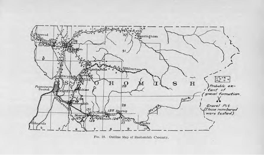
~~ '\
l ' \ /'-\
/ r· ,_,,,...
( ... , ~ .... :0 ...... -~-----,o 1
)Probqb/e ex:-1' t-ent or
~
H
,..-:,'\L) [o]}_- _\_ I \ / ( J \. C ( 9n:;ve/ ronmdion . . rr I k.~ rc » ~ 1 r- -, ~_ ... 1uJ , X
.§ __ ,_.JL
F10. 29. Outline l\fap of Snohomish C ounty .
j Gravel Pit: , 1(Those numbered
\ were rested.) \
'--. l
~
Road Building Sands and Gravels 243
remains unfrozen throughout most of the time, the subsoil becomes saturated and the bearing power is greatly reduced. Clays in particular absorb so much of tbe moisture that a clayey g1·avel will soften and be unfit for even moderate traffic. During some winters extra heavy rains or the rapid melting of snow in the mountains by warm winds or a combination of these two factors may result in devastating floods in the lower portions of the valley.
GENERAL DISTRIBUTION OF ROAD GRAVELS.
The roatl gravels of Snohomish county are found in three situations: fu·st, in gravel bars along the streams close to the water's edge; second, in benches or terraces along the streams ; third, in local and usually small deposits scattered over the upland in hillocks. The sketchmap of the county shows the general distribution o.E the gravels. From Arlington to Marysville thel'e is a rather exceptional area of gravel in that it covers a continuous area about 3 miles wide across the divide between the Stilaguamish River and the Snohomish River. This strip represents the course of a glacial stream when the mouth of the Stilaguamish River was blocked by the glacier.
Tests on Samples
Dm'ing the construction of the concrete pavements of Snohomish county a careful check of the character of the sands which were being used in the concrete was kept by the Portland Cement Association in order to insure a fu·st class quality of pavement. The number of the samples collected and tested were so much latger than could be permitted by the time allotted to the present survey that a duplication was not attempted. Through the ge11erosity of the Association their results are herewith published. A full tabulation of the tensile strength of the briquets and the mechanical analyses of the sands is given in Tables III and IV.
244 Biilletin No . 22, TVashington Geological Sitrvey
JJ1ap Number 123. This sample was taken from the Skykomish River, between Monroe and Duval. The 7-day briquets which were made from this sand showed a tensile strength 104.7 per cent as great as the briquets of the same age made from the Ottawa Standard sand, and the 28-day briquets tested 123.6 per cent as strong.
111.ap Nitmber 124. This sample was taken from the Sk)rkomish River, 2 miles south of Startup. The average of three separate tests gave 117.l per cent for the 7-day ratio and 129.8 per cent for the 28-clay ratio.
Map Ni1,1nber 125. This sampfe was obtained from the Skykomish River, at the Sultan pit, ancl tested 108.9 per cent as strong as the Ottawa Standard sand in the 7-day briquets, and 127.9 per cent as strong in the 28-day briquets.
lllap Numbe1· 126. This sample was obtained from the Stilaguamish River at Arlington. Three separate tests wer e made and the following averages were deduced : 130.5 per ce11t for the 7-day ratio, and J 28.5 per cent for the 28-day ratio.
Map Nwmber 127. This sand from the Stilaguamish River, 11/2 miles east of Silvana, was tested in folll' different instances an<l averaged 122.5 per cent for the 7-day ratio, and 122.5 per cent for the 28-day ratio.
Ma,p Number 128. This samplo was sec11red from the Stilaguamish River, 1 mile east of Arlington, and gave 108.7 peT cent for the 7-day ratio, and 154.2 per cent for the 28-day ratio.
Map Nmnbe-r 12.9. This sample, obtained from the Snoqualmie River, 2 miles east of Monroe, ave1·aged the following in two sepa1·ate tests : J 09.0 per cent for the 7-day ratio, and 123.7 per cent for the 28-day ratio.
Map Nwnber 130. This sample which represents the sand obtained from the Snohomish city pit, gave 91.4
Road Building 8a1ids and Gravels 245
per cent as the 7-uay ratio, and 99.5 per cent for the 28-day ratio.
111ap Number 131. This sample was taken from a sidehill pit 2 miles east of lllonroe, tested 131.0 per cent for the 7-<lay ratio, ancl 111.2 per cent for the 28-day ratio.
SPOKANE COUNTY
Glll.NERAL STATEMENT.
Spokane cou11ty has a position jn the east central part of the state, boTderiug the Idaho line. Its area is 1,756 square miles. Spokane, its county seat, is the second largest city in the state, having a population of 190,870 people, according to the estimate of the Census Bureau, July 1, 1916. :0Ianufacturing and diversified agriculture are the important industries, with apple g1·owing and dairying as important phases.
Spokane is the great market center of eastern Washington and nearly all of the transcontinental lines of the Northwest converge here. The county has an excellent system of highways, many miles of which are paved and the rest of the mileage of the important ones surf aced. The Inland Empire Highway enters the county from the south at Rosalia, the Central Washington Highway from the southwest, the Sunset Ilighway from the west and State Road No. 23 from t~e north. The Pacific Highway passes on into Idaho through the eastern part of the county, and the Inland Empire Highway runs tlu·ough into Stevens county by a northern route.
TOPOGRAPflY.
The eastent part of the county is affected by the foothills and subsidiary ranges of the Bocky Mountain system, while the western part is ty·pical of the Columbia basalt plateau of eastern Washington. The mountains reach an .altitude of 3,500 to 4,500 feet above the sea, Mt. Spokane, the chief peak, ascending to a
246 Bulletvn No. 22, W ashvngton Geological Swrvey
height of 5,808 feet. The mountains are composed chiefly of old granites, gneisses, schists, and quaJ:tzites.
The plateau portion has a level to rolling surface with an occasi011al high hill rising above the general surroundings. The extreme southeastern portion is maturely dissected into hills and valleys, and covered by a deep mantle of soil. The plateau is underlain by basalt, and north of Cheney is mantled with glacial drift.
The Spokane River enters the county from the east in a broad capacious valley, which is deeply underlain with gTavel. At Spokane it turns northwestward and flows through a deep narrow valley quite unlike that east of the city. Latah Creek with its tributaries, Rock Creek, Spangle Creek, and Lake Creek, drain the southeastern section; Deep Creek and Coulee Creek the northwestern part; and Little Spokane River the northern portion. All of these with the exception of the latter have cut deep valleys throughout a large part of their course.
There a1·e few roads in the northeastern part be- • cause of the mountainous topography. The broad valley of the Spokane River east of Spokane and the flattish area on the western basalt plateau permit roads to be established along section lines, but in the hilly area of the southeastern part there are many curving and di-agonal roads which must be angling in order to obtain proper grade. This is true to a certain extent in the northern part, also.
SUBSOIL.
The natural subsoil conditions are extremely varied. The gravel flat of the broad Spokane Valley affords a most admirable foundation for roads of all descriptions. In the Dennison area of the north there is much sand, and on the western plateau there is a mantle of glacial drift composed of much stony material. Iu the Rock-
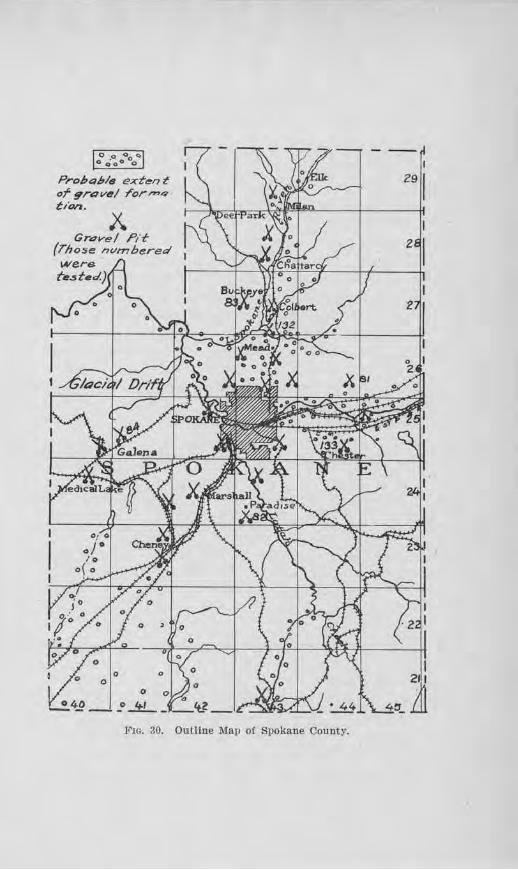
0 0 0 0 () o Ooo o
Probabls ext~n ~ of 9rt:1vf!!/ ror-4 tion.
0 0
0 0 " -!. 4.9 __ o ..!tL. _ _ 't_l _
F10. 30. Outline Map of Spokane County.
248 Bulletin No. 22, W ashvngton Geotogical Survey
ford-Fairfield section the subsoil is a :fine clay, and southwest of Cheney there is much ''scab-land. ' '
CLIMATE.
Although the county is but 36 miles wide, there is a considerable increase in rainfall from west to east. This is reflected in the vegetation. Near the western border, the landscape is unbroken by trees while in the vicinity of Cheney the coniferous type begins to increase markedly in numbers, and on the higher hills and mountains of the eastern border they clothe the landscape. The precipitation at Spokane averages about 17 inches per year. One-fourth of this is snow-fall. June, July and August are usually dry months and it is at this time that the binding quality of the road-metal is severely tested. Much of the heavy hauling also occurs at this time. Thawing and freezing· in the latter part of the winter also has some effect in softening the road-bed and making it susceptible to cutting.
GENERAL DISTRIBUTION OF ROAD GRAVELS.
Unlimited quantities of road gravel occur in the Spokane Valley and in the vicinity of Hillyard. These are in the main fairly coarse. Some also are found in scattered deposits in the locality of Colbel't, Chattaroy, and Milan, and near Fairview, Four Lakes, and Dykes. On Pleasant P rairie, Five Mile P rairie, and other tablelands of similar height deposits of excellent dressing material are to be had. ''Pea-gravel'' commonly occurs in the side of such table-lands above the 2,000-foot contour. The gra,.el pits at Marshall and along the N. P. Ry. in the western part of Spokane are mostly of this type.
The gravels near Moran and on the western plateau are scattered and in many cases occur in hillocks. This is due to their glacial origin, they having been deposited promiscuously at the front of the glacier during the
Road Bioilcling Sands a;ncl, Gravels 249
several stages of its retreat. This, therefore, means that no SJ>ecific prediction can be made as to just where these are likely to occur or what hillocks and 1rnolls contain gravel but that they are likely to be found in various places as far south as the vicinity of Cheney.
The southeastern part of the county is almost entirely devoid of gravels for lhe reason that the drainage of the glaciers did not reach this district. Whcl'e gravel can not be economically hauled or shipped, basalt will have to be relied upon. The nearest known point from which gra,els may be obtained is in the area northwest of Spangle or from the Pine Creek Valley near North P ine.
The outline map of the count? shows the general distribution of the gra\"el formation.
Tests on Samples
lllap Nwmbe1· 81. Five milos nol'theast of Trent, on Pleasant Prairie there is a deposit of stratifiecl gravel consisting chiefly of small, angular particles of granite and gneiss. Most of the material is less than 1 inch in size and on the road cements nicely, producing a smooth and nearly dustless surface. It is an admirable dressing material for automobile r oads. Several e:\.rposures of this occur here and at the western eclge of the Prairie showing that a large quantity is available.
Map Kuniber 82. A somewhat similal' deposit occurs 1 mile southeast of Paradise, in the N. E . 14 of Sec. 32, r:l1• 24 N ., R . 43 E ., except that the materials are chiefly quartzitic instead of granitic. These have high Fearing value; the percentage of loss by the abrasion test was Temarkably low. The constituents a re angular and mostly 1 inch and less in size. Some cl~y lenses are inte1·stratified which add to tbe binding elements of the material. The chief Yalue of this del)Osit is fo1· road-dressing purposes and its efficiency has
250 Bulletin No. 22, Washing ton Geological Survey
been well tested on the nearby road. The surface of the roadbed is hard, and dragging easily keeps it in condition. The county owns 3 acres at this point.
lJ!lap Numbe1· 83. This sample was taken from a deposit on Ralf Moon P rairie, about 4 miles north of Dartford, in the N. E. 14 of Sec. 18, T. 27 N., R. 43 E. The material is chiefly a :fine pea-gravel and "torpedo sand,'' made up of particles of quartzite, granite, and basalt. Most of it is :firm but it is low in packing qualities, ther e being insufficient binder to make a paste for the tenacity test. Its chief use is for road-dressing purposes. A large quantity is available.
JYla,z:> Niimber 84. This sample was collected from a deposit located %, mile north of Galena. The gravel is mostly under 3 inches in size and consists chiefly of angular to subangular fragments of basalt, with a few granites, quartzites and schists intermingled. The soil covering is about 11/2 to 2 feet thick. About 94 per cent of the constituents are firm and show very good wearing value by test. The binder, however, is of rather low quality, partly due to the lack of clay. If run through a crusher, pit run, as the County Engineer recommends, the binding· qualities should be enhanced. The county has purchased 2 acres for pit operations.
The detailed results of the foregoing tests are given in Table I, with those from other counties.
Other Deposits Exantin e<l
One-quarter mile sou th of Hillyard, a pit has been opened on the 2,000-foot flat in well-graded and nearly clean gravels. Some of the pebbles are coated with silt, but washing would easily remove this. Some of the pebbles are cemented together in lumps, which is an objection for concr ete paving, for if these came to the surface they would likely work loose and cause pits.
Road Builditng Soods a;nd, Graveis 251
In the western part of Spokane the Northern Pacific Railway is excavating gravel from the face of the high bluff by steam shovel. The materials are mostly coarse sands, horizontally to cross-bedded, containing erratic bowlders and angular blocks of large size scatter ed promiscuously throughout. The greatest height exposed is about 200 feet. The material is being used for fill and ballast by the company.
In the southeast corner of Sec. 22, T. 25 N., R. 41 E ., a large gravel mound has been opened for road material on the Pacific Highway. This exposes an angular basaltic gravel intermixed with reddish brown gumbolike clay in chunks and thin seams. There is an overburden of 2 to 4 feet of pebbly soil. The amount of the overburden and the presence of the gumbo-like clay 1·educes the value of the material.
About %, mile west of Dykes, in about the S. W . 14 of Sec. 1, T. 23 N., R. 41 E., there is a deposit of coarse sand and :fine gravel with a few scattered fragments of larger material. With the natural clay soil of this region the coarse sand should make a good sand-clay road. From here south ·to Cheney there are several similar gravel knolls which should serve as a source for road material. About one and one-half miles southwest of Cheney a knoll similar to the foregoing has been opened and the gravel used with success on the nearby road. There is enough coarse material to warrant crushing, which should also increase the binding nrtues of the material.
The materials for the Cheney road from Meadow Lake to the Sunset Highway were obtained from a large pit east of the Interurban line and about 1 mile southwest of Meadow Lake. The presence of considerable oversize necessitated screening, but with this portion eliminated the gravel seems to be well graded and to have satisfactory binding qualities.
252 Biilletin No. 22, W ashiAigton Geological Siwvey
.A.bout %, mile northwest of P antops, the Interurban Railway has opened a large pit in a fine gravelly material which in r eality is composed of small pea gravel and coarse sand with large angular bowlders scattered here and tbern throughout. About half of the small pebbles are quartzite and the rest are gra.nite, gneiss, and schist. Most of the large bowlders belong to the local gneiss and schist series, and tbern are some quartzites and granites. The material is being used by the Interurban company for ballast.
The Hawkeye Fuel Co. of Spokane operates a pit at Irvin, 9 miles east of Spokane on the south side of the Spokane River. The pit is on the gravel flat, and at present is about 300 feet long by 250 feet wide by 25 to 30 feet deep. Excavation is by bucket with skyline cable. They have gone nearly 50 feet deep in places and found the material satisfactory all the way. The oversize is crushed, and all of the material is screened into several sizes : sand, pea gravel, 1-inch gravel, 11/2-incb gravel, and 2%.,-inch gravel. Down to about 35 feet in depth the sand runs in proportion to the gravel about 1 to 7. The sand is sha1·p and clean but is a little coarse. The pebbles are first class for all kinds of high grade concrete work. Bunker s, consisting of compartments for the various sized material, are situated along the tracks for loading, and there are also attachment bunkers for loading trucks, and a bin for the oversize rock which is to run into the crusher. Ten acres are owned by the company.
The Ross Holding Company owns a gravel plant 1f2 mile east of the city limits of Spokm1e and 34 mile south of Sprague A venue. The gravel occurs in a little rise above the general flat of the valley and the material obtained is sand and pebbles not over 1;2 inch in size. They consist of basalt, quar tzite and granite. The present pit covers about an acre, and has been found to be faiTly
Road Building Sands arnd Gravels 253
consistent with depth. Ten acres are owned by the company.
A large pit is operated by the Union Sand and Gravel Co. at Ft. WTight, in the N. W. 111 of Sec. 14-, T. 25 N., R. 42 E. The pit is being operated in the face of a high bench about 200 feet above the river by drag-line to a conveying elevator belt and thence to the bunkers where it is washed and screened on stationary screens by a fl.ow of 750 gallons of water per minute. The water is pumped by their own plant from the river. The equipment provides for screening to seven sizes. Each of the seven compartments of the bunkers have a capacity of 180 to 200 cubic yards. A sidetrack about l/2 mile long and capable of holding 13 loaded and 16 empty cars at one time, run alongside the bunkers. The gravel consists very largely of basalt, there being an occasional foroign bowlder of granite and other rocks.
The A. J. Smith Sand Co. operates a pit in a low rise at the south foot of Five :Mile P1·airie, on land owned by Mrs. Elizabeth McKenzie. The sand is chiefly basaltic and relatively fine, and is used almost altogether for masonry work. Hauling is done from a loading platform by motor trucks and teams.
Tests J'ot· Concrete
lrlap Ni,,,mber 132. The sand from the pit located 1% miles north of :Mead, which was the source of the sand for the :Mead Road pavement, was tested by making six concrete briquets, throe for a 7-day test and three for a 28-clay test. Their tensile strength was ascertained and compared with briquots of the same age made from Standard Ottawa sand and the same kind of cement. The reader is referred to Tables III and IV for detailed results and comparison with other sands from other parts 01 the state. The 7-day briquets of
254 Bulletin No. 22, Washington Geological Survey
the sand under test showed a strength 92.8 per cent as great as that of the Standard Ottawa sand briquets, while the 28-day briquets showed a sfrength 144.l per cent as great. The color imetric test showed an absence of organic matter.
Map N1.miber 133. This sample was taken from the Shelley pit 41h miles southeast of Dishman, and was the source of the aggregate of Apple Way. The 7-day briquets of this sand showed a strength 85.6 per cent as gTeat as the briquets made from the Standard Ottawa sand and the 28-day briquets had a strength 171.4 per cent as great. This sand g-ave no reaction for organic content.
ConCJ·ete F.ield Tes ts
According to the descrjption given in Chapter IV, four concrete cylinders were put down on Apple Way, Permanent Highway 4B, at Station 188+00 to 188+50, and cured under the same conditions a.s the pavement. When 200 days old, each cylinde1' was tested in the Engineering Testing Laboratory at the University of Washington and found capable of sustaining a weight of 3,841.5 lbs., 3,714.2 lbs., 3,310.9 lbs., and 4,156.3 lbs. per square inch, respectively. The aggregate used in the first two was a mi..'rture of gravel and crushed rock, while in the last two it was only gravel. Their average strength, however, is nearly the same.
Two cylinder tests were made on the Mead Road pavement by Mr. A. L. Strong, of the County Engineer's staff, for this survey, at Station 258+70. At the age of 197 days, these showed a compressional strength of 3,735.5, and 4,909.8 pounds per square inch respectively, or an average of 4,332 pounds per square inch. C-30 was taken from a "wet" mix and C-31 from a "dry" one. This is suggestive of the efficiency of the different ~onsistencies of mix, but it is unsafe to chaw definite conclusions on this slender amount of data.
Road Building Sands a,nd Gravels 255
STEVENS COUNTY
GE!\"EJRAL STATEMEN•r.
Stevens county is in the northeastern part of the state in the second tier of counties from the Idaho line and bordering the International Boundary on the north. It is 84 miles long, avcl'ages 32 miles wide, and inclt1cles 2,394 square miles. It ranks fifth in size in the state and in 1910 had a population of 25,297, which is widely distributed along the valleys of the Colville and Columbia rivers.
The chief industl'ies arc lumbe1·ing, fruit raising, agriculture, and mining. Only locally and along comparatively short stretches of road is the traffic, resulting from these industries, greater than would be classed as ''light'' traffic.
A branch of the Great Northern enters the county at Olayton and folJows the Colville Valley to its mouth. At Marcus it forks, one going to Northport and Canadian stations, the other to Republic and Oroville by way of Canada. The Columbia '\Talley below :Marcus has no railroad, and the various towns depend chiefly on the highways for exporting their products and importing their necessaries. The county's greatest traffic, however, is along the Col ville Valley.
The State Highway Department. has planned two systems of highways: the Inland Empire llighway which enters the county at Clayton and follows the Colville Valley to Meyers Falls and thence the Kettle River Valley to Laurier, and State Road No. 22 which runs north from Davenport, crosses the Spokane River at Detillion Bridge, and follows the Columbia River to Meyers Falls. Only small portions of these highways have been improved, but gradually the work is being extended.
256 Bulletin No. 22, Washing ton Geologicai Survey
TOPOGRAPHY.
The county has a diversified topography. The Huckleberry Mountains, between the Colville Valley and the Columbia Valley, range from 3,200 feet to 6,200 feet in height. The western slope is considerably steeper than the eastern, due to the greater depth of the Columbia Valley than the Colville Valley. This range is crossed by highways in three or four different places. The mountain range between the Kettle River Valley and the Columbia, in the northwest part of the county, is an ex-tension of the Huckleberry Mountains. East of the Colville Valley and forming the high divide between Stevens county and P end Oreille county, is the Calispell Range. The average elevation is between 5,000 and 5,500 feet. With this type of topography, trunk highways were necessarily established along the Colville and Columbia valleys, with lateral branches reaching· into the tributary valleys.
SUBSOIL.
Along the Colville Valley from Gray northward to beyond Colville, the Inland Empire Highway in many places is located on a light gray silt which is very dusty during dry spells, and soft and muddy in wet weather. In the vicinity of Meyers Falls this changes to a sandy subsoil, which makes an excellent road as long as it is damp, but an abominable one when dry. A sandy subsoil is characteristic of the Columbia River Valley for most of its eA.'ient in this county.
CLIMATE.
Stevens county receives an average precipitation of about 18 to 20 inches per year. Of this, over one-third falls in the summer and less than two-thirds in the winter, part of which is snowfall. Muddy roads are cha1·acteristic during the spring, fall, and part of the winter. Sometimes during August and September the roads be-

~ •
X
37 40 -91
40 I
L__--l-~-1---~~::::t=----r'f=----r-J
I .3s
:J+
I .32
I :3/
-1
Z9
F10. 31. Outline Map of Stevens County.
258 Bulletin No. 22, Washington Geolog'ical Survey
come so dry as to offer little bearing power and tmder heavy loads become very rutty and dusty. Thawing and freezing during the late ·winter and early spring loosens the subsoil and makes the roads soft.
D EP0$ITS OF ROAD G-RA VELS.
Deposits of good gravel occm· in many places along the Colville Valley. It varies from a sanely gravel to a "pea-gravel." Along the Columbia River the gravel contains much fine sand and little if any binder. This is true particularly of most of the benches bol9w the elevation of 1,700 feet. All but the high pofats of Ste-vens county have been glaciated and local deposits of gravel may be found in high benches on the sides of the valley slopes. The outline map of the cotmty shows the general distribution.
Tests on Sample~
Jl!lap Nmnber 85. Tl1-is sample was taken from an exposure of gravel % mile south of Kettle Falls, where the road descends into the immedJate valley of the rjver. The gravel is well graded, as shown by the mechanical analyses, has but a small percentage of oversize, is composed of durable pebbles of granite, quartzite, cliorite, greenstone, and slate, shows very good wearing qualities, but lacks binding material. In using this for surfacing, a tenacious clay should be added.
Map Niimbe1· 86. This sample was collected from the Oolville City pit, located % mile east 0£ town, at the western edge of Church Flat. The face of the gravel pit at the time of inspection stood vertically for nearly 50 feet in height. There is an excess of sand and a deficiency of building material, but if properly screened and some clay were added the gravel would be good .for road surfacing. The pebbles consist of granite and quartzite, with some schist, and some are coated with lime. The
Road Bui.lding S011uls and Gravels 259
abrasion test showed a high percentage of wear. The materials were used pit-run on the road for a few miles south and north of town, but the large amount of :fine sand retarded packing.
Map Nwniber 87. This sample was obtained from a gravel deposit in the north side of a hill west of Addy. The pit is 25 feet deep and 150 feet long, with 3 to 5 feet of clay overburden. The gra,·el is dominantly a pea gravel and coarse sand, with a fair amount of pebbles up to 3 inches in size. About 97 per cent of the pebbles are firm, and show excellent wearing quality, but the binding qualities are low for road surfacing. Some cfay could be added to advantage. This gravel has been used on the Addy-Gifford Permanent Highway No. 1 for 5 years, for a distance of 1 mile, and where it was put on in sufficient thiclmess it has given satisfaction.
Map Number 88. This sample was taken from a pit 9 miles southwest of Addy, in the south pa:rt of Sec. 1, T. 32 N.1 R. 38 E., near the top of the graYel bench. The gravel body contains some pockets of sand and silt, indicating that some variation j s to be expected. About 94: per cent of the pebbles are firm and appear to have good wearing qualities. The tenacity of the binder was shown by test to be low, probably due to an insufficient amount of tenacious clay. This gravel was put on the adjacent road during 1917.
The detailed results of the fo1·egoing tests are given in Table I of Chapter ill.
Otl1or Deposits E.xanl.ined
Just north of U1e center of Sec. 21, T. 35 K., R. 39 E.1
at the side of the road and in the adjoining :field, is a gravel cle1Josit, containing considerable slate, shale, and schist, with ,cry little oversize and a goodly amount of clay for binding. Tb.ere is some evidence of cementation by lime.
260 Bulletin, No . ~, W ashingt0ti Geolog-ical Survey
In the S. E. 34 of Sec. 31, T. 35 N., R. 39 E., a gravel pit occurs on the east side of the road, 20 to 25 feet high and 150 f ect long. The pebbles are coated with a fine powdery clay which in dry weather does not bind the gravel, malcing the road a little rough and dusty. The constituents are of a good quality of rock. Sand streaks are few.
In the N. W. 1;.'1 0£ Sec. 12, T. 33 N., R. 39 E., a small gravel pit shows the body of gravel to vary from fine to coarse, with some granite and clay balls. The variation in quality and size would require careful selection to obtain satisfactory material.
In the N. W. 1Af of Sec. 23, T. 33 N., R. 39 E., a gravel d.cposit just north of Darri.nger 's saw mill, on the north side of the road, contains :firm gravel, but there is too high a pernentagc of sand, and some oversize.
In the S. W . 1,4 of Sec. 27, T. 33 N., R. 39 E., a gravel deposit fo1·ms a bank 30 to 40 feet high, in which a pit has been opened. The exposul'e shows an admixture of fine and coarse in such a way that a very careful selection would be necessary to get material that is properly graded. Some of the material has been used on the road here for a couple of miles and has been found to have poor binding qualities in dry weather and to yield dust.
In tho N. W. J;.'~ of Sec. 35, T. 33 N., R. 38 E., a gravel bench occurs 50 to 60 feet above the road, on the property of l\fr. Grinnell. This will probably be drawn upon for surfacing the road west from here. The gravel as exposed in a test pit shows proper grading and sufficiently durable rocks for the traffic of the road in question. Many of the pebbles are coated with lime and should cement well
In the S. W. 1,4 of Sec. 34, T . 33 N., R. 38 E ., a high, level-topped ridge, at an altitude of about 3,200 feet, contains gravel in immense quantities and well graded with little oversize. Many of the pebbles arn impure
Road Building 80;nds a.nd Gravels 261
limestone, although there is a good pe1·centage of grnnite and quartzite. The material appears to have suitable binding qualities.
Tests tor Concrete
The sand from the pit 1.4 mile west of Addy, l\Iap No. 871 was used in making concrete briqucts, the tensile strength of which was compared with the strength of briquets made from the Standard Ottawa sand. The 7-day briqucts of the .Addy sand showed a strength 153.1 per cent as great as the briquets of Standard Ottawa sand, and the 28-clay briquets 151.4 per cent as great. The test for organic content showed but a slight discoloration.
The detailed results a1·e given in Tables ID and IV, in Chapter IV, with those of other counties.
OTIIE'R ROAD-SURFACING MATER.IA.LS.
One-half mile east of :Meyers Falls, along a cliff, there is an immense deposit of "shell-rock" or "sliclerock," of basaltic composition which is mai11ly of tbc proper size aud gradation to make good roncl material The material has been used on the road west of Meyers Falls for a distance of 2 miles, for 8 years. The writer was told that it was put on without preparation of any kind and had no maintenance, but made a good road for 5 years.
In the S. W. 1,4 of Sec. ]5, T. 35 N., R. 39 E., by the roadside, is a pit in shaly and slaty rock which has been ch·awn upon for the :Minor Street road. The material is bl'ittle and soft, and wonld ordina1·ily be classed as unsatisfactory, but in actual practice it packs readily and has given C'xcellent satjsfaction for 3 years without maintenance. It does not mud up in wet weather and yields but comparatively little dust in dry weather.
In the north part of Sec. 5, T. 35 N., R. 39 E ., along the hillside, there is a talus deposit of shale and slato
262 Bulletin No. 22, W ashvngton Geological Survey
"!.'ock, which has been used on the road north and northwest of Colville with satisfaction. The material is so soft that it breaks readily and would ordinarily be classed as un:6.t for surfacing, but after 3 years' wear on the road it proves to wear well, provides a smooth roadbed, and makes but little mud in wet seasons or dust in dry seasons.
THURSTON COUNTY
GENERAL STATlllMENT.
Thurston county is located at the southern end of Puget Sound. Its area includes 709 square miles and
its population in 1916 was 22,393. Shell fishing and lum-bering are its chief industries, and dairying, fruit, stock, and poultry raising are also important. Building stone is quarried at Tenino. Olympia is the county seat and largest town, and a1so the state capital.
The transportation needs of the county arc met by the several transcontinental lines of railway which run between Portland and Seattle, and their branch lines, and also by steamboats and bigbways. The P acific Highway crosses the county in a north-south direction, and the Olympic Highway enters the comity in the 11orthwestern part. Besides these there are the various county highways. :M:ost of them are surfaced, and the Pacific Highway east of Olympia is paved.
'rOPOGRAPHY.
The county has a glacial topography of rolling to flat plains. The rolling portion is in part underlain with bedrock, as near Tenino, and in part made up of glacial moraines, as in the vicinity of Lacey. F]at and undulat,i11g plains of outwash gravel occur in various parts of the county, such as Mound P rairie, northeast of Grand Mound, Rocky P rairie, southeast of Maytown, Chambers Prairie, southwest of St. Clair, Tenalquat
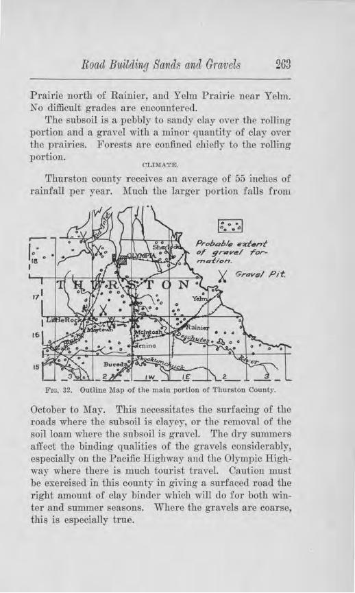
Road Building Sands ancl Gravels 263
Prairie north of Raimer, and Yelm Prairie near Yelm. No difficult grades are e11countered.
The subsoil is a pebbly to sanely clay over the rolling portion and a gravel with a minor quantity of clay over the prairies. Forests are confined chiefly to the rolling portion.
CLIMATE.
Thurston county receives an average of 55 inches of rainfall per year. Much the larger portion falls from
15
Proba6/s eddnt OT grav~I rorrna-fl on.
Grove l Pit
Fm. 32. Outline Map of the main portion of Thurston County.
October to May. This necessitates the surfacing of the roads where the subsoil is clayey, or the removal of the soil loam whcTe the subsoil is gravel. The dry summers affect the binding qualities of the gravels considerably, especially on the Pacific Highway a11d the Olympic Highway where there is much tourist travel. Caution must be exercised in this county in giving a surfaced road the 1·ight amount of clay binder which will do for both winter and summer seasons. Where the gravels are coarse, this is especially true.
264 Bulletin No. 221 Washi11,gton Geological Survey
ROAD MATERIALS.
Distribution
The chief road materials of this county a.re gravels. During the last glacial epoch, the ice-sheet which invaded the Puget Sound region extended over nearly all of Thurston County, save for a small strip in the southern and western parts. As a result, great quantities of gravels were deposited by the outwash, constituting the various prairies named Mound Prairie, Rocky Prairie, Chambers Prairie, Tenalquat Prairie, Yelm Prairie, and others. (See outline map of the county in Fig. 32.) In ma.ny plaoes on these prairies, all that is necessary in constructing a gravel road is to remove the soil loam, crown the roadbed and provide d.Tainage ditches, and r emove the cobbles, bowlders, and other coarse material. An illustration of this type of road is shown in Plate IX.
Quality of the Road Gravels
The gravels of the county a:re of fixst class quality with respect to hardness. They are composed of granite, basalt, andesite, quartzite, and other siliceous metamorphic rocks. Generally they are very well rounded. They vary largely in size and gradation, some deposits being very coarse, while others are mostly sand. The amount of binder which they contain is seldom enough to bind the gravels well for summer traffic. Either some tenacious clay, free from humus material, should be added, 01· a dressing material used on the wearing course.
•.rests Made
Due to the fact that the Survey's Testing Engineer had been called for wax service when this county was studied for its road gravels, no samples were collected for testing. Some tests, however, were made earlier on the cement concrete pavement which was laid clown east of Olympia. These were compressional strength tests
Road Biiilding Sands and Gravels 265
of cylinders which ,,,ere made in the field of the mix as it went into the pavement. The details of these tests, together with the results, are given in Chapter IV.
WALLA WALLA COUNTY GEL'l'ERA.L STATEMENT.
Wal.la Walla cotmty includes over twelve hundred square miles of territory just east of the junction of the Snake and Columbia rivers. Its population in 1916 wa;; estimated by the Census Bureau to be 40,262. Walla Walla, one of the important cities of the state, and the county seat of the county, has a population of 25,136.
The chief jndustries arc general farming, dairying, stock-raising, manufacturing, and horticulture. Most of the traffic takes place along the Inland Empire Highway from Wallula to ·wana WaDa and thence to ·wailsburg, and along the Waitsbul'g-Lamar highway. These are surfaced most of their distance. Besides these there are county roads over which much of the farm products must be hauled to market but which have not been surfaced.
TOPOGRAPRi".
The topography of the county is made up mostly of hills and valleys, having an average relief of about 200 feet or more. The Eureka Flat in the northwest part of the county and the flat along the Walla Walla River east of Touchet are the chief exceptions. The rough type of topography forbids the location of roads along the section lines as a general rule, if moderate grades are to be obtajned.
A heavy mantle of clay covers the bedrock in the eastern part of the county. Toward the west this becomes more and more sandy unLil the sand plain of the Columbia Rive1· is reached. The1·e nre three horizons of clay formations which vary in thei.r properties for use as a road foundation. The clays which cover the hills
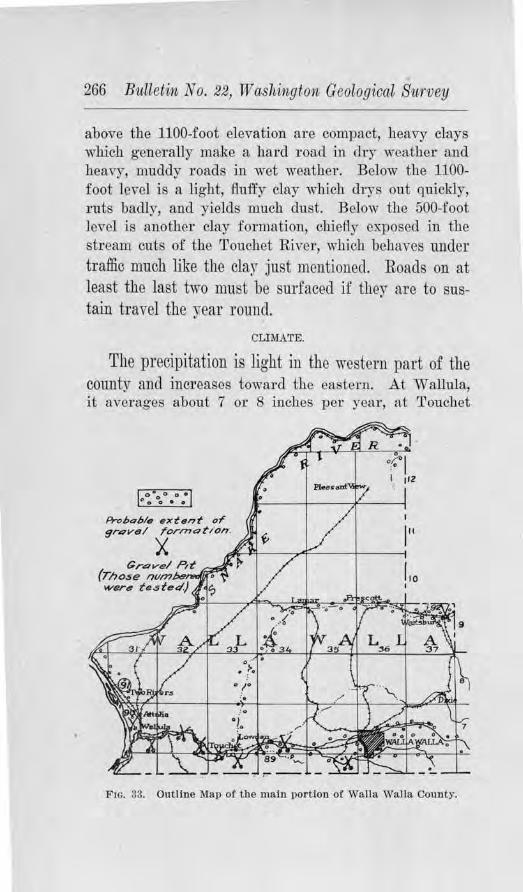
266 Bitlletin No. 22, Washington Geological Survey
above the 1100-foot elevation are compact, heavy clays which generally make a hard road in dry weather and heavy, muddy roads in wet weather. Below the 1100-foot level is a light, fluffy clay which drys out quickly, ruts badly, and yields much dust. Below the 500-foot level is another clay formation, chiefly exposed in the stream cuts of the Touchet River, which behaves under traffic much like the clay just mentioned. Roads on at least the last two must be surfaced if they are to sustain travel the year round.
CLIMATE.
The precipitation is light in the western part of the county and incm~ases toward the eastern. .A.t Wallula, it averages about 7 or 8 inches pel' year, at Touchet
Prohohla extent or 9r.:?VBI rorrnot/ on. 111
X ~-A-----,..-<F----!-----t Grovel Pd ~
(Those numJ:,e, o
wer4 tes tetl.) ? Lo I
Fm. 33. Outline Map of the ruain por tion o[ Walla Walla County.
Road Bi£ilding Sands ancl Gravels 267
about 10 inches, ancl at Walla Walla 17 inches. The summers are usually long and dry, thus taxing the cementing power of any surfacing material and increasing its tendency to ravel under traffic, which unfortunately is heaviest at this season.
DISTRIBUTION OF ROAD MATERIALS.
The bedrock of this county -was examined and tested fol' its road-making qualities in 1911, and the results published in Bulletin No. 2 of the Washington Geological Stll'vey se1·ies. The gravels, therefore, claimed chief attention in this study.
The gravel deposits are confined almost entirely to the Snake, Columbia, Walla Walla, and Touchet rivers, as shown in the outline map of the county. Because the larger portion of the tTa:ffic is in the vicinity of the Walla Walla and Touchet rivers, the deposits along these streams are of the most importance. From the outline map, the interesting fact will be observed that these two drainage lines Jiavc east-west couTses through the most thickly populated pol'tion of the county and will be impo1·tant sources for materials to surface the LamarWalla Walla and Prescott-W al1'\ Walla roads, just as they are important sources toda,y for the highways paralleling these valleys.
The city of WaUa Walla is located on a large gravel flat which has been deposited at the confluence of the various forks of Walla Walla River. This deposit extends east\vard and northeastward up the forks, and westward along the river to the Columbia. The Inland Empire Highway west from ·w alla Walla was surfaced from the various bars which occur along 1.he stream. Similarly the deposits along the Touchet River were drawn upon for the highway west of Waitsburg.
Gravel along the east side of the Columbia occurs not only on the !lat which is but little abo-ve high-water,
268 Bi1lletin No. 22, 1V ashington Geological Biwvey
but also in benches ·which Tise 100 to 150 feet above the lower flat, about two and a half miles northwest of Two Rivers Station. In both occurrences, the matrix is frequently a fine sand which woultl probably offeT difficulties to ready packing, but in places near the top of the high bench, this objectionable feature doe~ not appear to exist. From heTe, it is believed that suitable road metal can be obtained. The gravels on the lower flat are well e:Kposed in a railway cut of the 0.-W. R.R. & N. Co., just south of the center of Sec. 29, T. 8 N., R. 31 E.
In the extreme northeastern part of the county, about five miles northeast of Pleasant View, scattered deposits of gravel occur along a tributary t.o the Snake River. These appear to be firm and well graded, and where the road passes over them, they appear to serve excellently as road metal. From Pleasant View, extending southeast along the N ortbern Pacific Ry., there is a broad depr ession with a wi<le fiat, which has the appearance of having once been the valley of Snake River . The Eureka Flats lie within the confines of this feature. The soil is a sandy loam in which an occasional pebble is found. This, together with the valley-like aspect of the flat and bordering slopes, suggests that possibly a few feet below the level of the fiat, gravel may be found, but its presence cannot be positively predicted.
'l'ests on Roarl Gravels
Map Nu1nbe·r 89. This sample was selected as being r epresentative of the kind of material taken from the Walla Walla River for use on the Inland Empire Highway. As shown on the sketch-map, it came from one mile southwest of Lowden. The pebbles arc entirely of basalt, well rounded, and well g;raded. About ninetylive per cent of them are firm, and their wearing value is good. The tenacity test gave a satisfactory value for the binding portion. In practical use on the highway,
Road Buildi·ng Sands ancl Gravels 269
where the oversize was eliminated, the gravel is giving satisfaction.
Jlap Nwmber 90. This sample was taken from the deposit on the lower flat of the Columbia Rh,.er, about one-half mile northwest of Wallula. It was cJifficult to obtain a representative sample as rcganls gradation, as tlle grm·el varies greatly in coarseness from place to place. Indeed, it ma_y be found wise, if this material is used, to pass all of it through a crusher. The sample, howeYer, shows the other qualities well. Granite, l)_uartzite, diorite, antl basalt arc all present ancl ninety per cent or more are ffrm and appear to ba-ve good weari11g value. Much fine sand is generally present, which is responsible for the low tenacity value. Without the addition of clay, which is not convenientlr at band in this locality, this material would probably bind slowly and imperfectly.
Map Number 91. This sample was obtained from the gravel exposed in the raihrny cut of the 0.-W. R. R. & N. Co., about onc-fol1rlh mile·norlhwest of Two Rivers Station. This material consists cl1iefly of basalt pebbles, with a few granites and qunrtzites scattered through. .Almost all of them arc firm and hav-c 't'ery good wearing value. The sand-matrix is coarser than in Sample No. 90, and the materials are well graded, with some o,ersize. By test, the binning material has a low tenacjty value, which would make tl1e gravel slow in packing, but its ultimate cemenf ation after the materials are ground up is fa irly high. If th.is material were to be used in road-building, the addition of a tenacious clay would enhance its packing qualities.
Ma,p N1,irnber 92. This sample was taken from the gravel bar at Waitsbm·g, just east of the bridge, and is believed to be representative to a fair <legree of the Touchet River gravel. The constituents are basaltic in
270 Bulletiln No. 22, TV ashingto11, Geological Survey
composition, rounded, fresh, and fairly well graded with some oversize. .A.bout ninety-five per cent of them are fhm, and show good resistance to abrasion. Not enough binder could be secured from a forty pound sample to make a tenacity test, which indjcates that it has poor cementing qualities of its own. In use, clay would have to be added, which in this part of the county occurs abundantly along most any road. This source of gravel was drawn upon for surfacing three miles of the Inland Empire Highway, south from Wait burg, in 1914. Without maintenance it rave11ed rather badly during the dry summer of 1917.
The detailed results of these tests, together with those from other cotmties, are given in tabulated form jn Table I , of Chapter III.
Tests fol' Concrete
Map N1,1,111be1· 8.9. The sand from this sample which came from the Walla Walla River, one mile southwest of Lowden, was washed and tested for concrete use by making concrete briquets, according to the method described in Chapter IV. The seven-day briquets had a tensile sh'ength of 97.0 per cent as great as briquets of the same age, made from Standard Ottawa sand. This ratio was considerably increased in the t\venty-eight clay briqucts, to 140.9 per cent. No organic matter was detected by the colorimetric test.
lliap Nimiber 90. This sample from the graYel flat, one-half mile northwest of Wallula, tested 72.0 per cent efficiency in the twenty-eight day briquets as compared with Standard Ottawa sand. The seven day test was omitted. This sand, by mechanical analysis, is s1w,Yn to be too :fine for concrete use.
111ap Nim1ber 91. This sample from the 0.-W. R. R. & N. Co. 's cut, one-fourth mile noTth of Two Rivers Station, gave a sand which, when washed, tested as follows :
Road Building Sa11uls a111d G-ra.ve.ls 271
The seven day ratio, of the sand under test as compared with Standard Ottawa sand, was 102.1 per cent, and the twenty-eight day ratio, 134.1 per cent. The colorimetric test showed no organic content.
lJiap Number 92. This sand, which came from the Touchet River at ·waitsburg, was washed :md tested and found to have a str ength of 102.1 per cent as great as the standard sand in the seven day briquets. The results of ilie twenty-eig·ht day test were lost and another test could not be macle.
The results of these tests are giYen in Tables m and IV, of Chapter V, together with those .from other counties.
WHATCOM COUNTY
GEl\".ERAL STATEMENT.
Whatcom county is in the extreme northwestern part of the state, just soulh of the Can,1dian boundary line. It has a width of about 25 miles and an average length of nearly 90 miles. According to the estimate of the Census Bureau it had a population of 40,262 in J 917. Bellingham, a city of nearly 33,000, is the chief market center of the county and acconlingly ihe highways of the county in genera] converge towards it. Other important towns are Blaine, Sumas, Lynden, Ferndale, Kendall, and Custer. Farming, lumbering, manuincturing, coal mining and dairying are tlie chief industries.
Branch lines of Uie Great Northern Ry. and of the N orthcrn Pacific Ry. enter the county from the south and give <liTect transportation to Seattle and Tacou.1a and eastern points, and also with Vancouver and other Canadian points on the north. The Bellingham & British Columbia Ry. runs from Bellingham to Glacier, and the electric line of the Pacific Northw·est Traction Co. connects Bellingham and Mt. V emou.
272 Bulletin No. 22, Washington Geological Survey
The Pacific Highway enters the county at the southwestern corner, follows the Sound to Bellingham and then takes a northwesterly direction to Blai11e. A portion of this, from Bellingham to Ferndale, is paved. Other paved roads radiating from :Bellingham are th~ Geneva Road, extending along Lake vVhatcom for 2¥2 miles, the Northeast Diagonal Road to Lawrence and Deming, the Laurel Road, the Blaine-Ferndale Road, which is paved as far as Pleasant Valley, and the Whatcom-Marietta Road.
TOPOGRAPHY.
Whatcom county has a mountain and plain topogra
phy. That portion in which the greater part of the population lives and where the demands of traffic arc greatest is naturally the plain area. The sm:·face is gently rolling in the main, with rounded hills and ridges scarcely reaching an elevation higher than 300 or 400 feet, and with slopes that grade gently to the broad valleys. Along the coast wave-cut cliffs border the Sound. The N ooksak River heads in the mountains to the east in thr ee forks and on the plains these forks join to form the major stream which empties into the Sound at Bellingham Bay. The Sumas River heads in the vicinity of Lawrence, close to the N ooksak River, and flows northward, leaving the state at Sumas. Only to a minor degree do the hills and ridges of the plain cause departures from straight roads for the sake of obtaining the proper grade.
SUBSOIL.
Whatcom county is in the glaciated area of Puget Sound, and its soils as well as the curving profiles of its plain area are largely due to glaciation. Generally the subsoil is a clay containing scattered pebbles and bowlders which becomes very sticky when wet and in some instances impassable, but in summer usually makes a good road. However, the1·e are variations from this
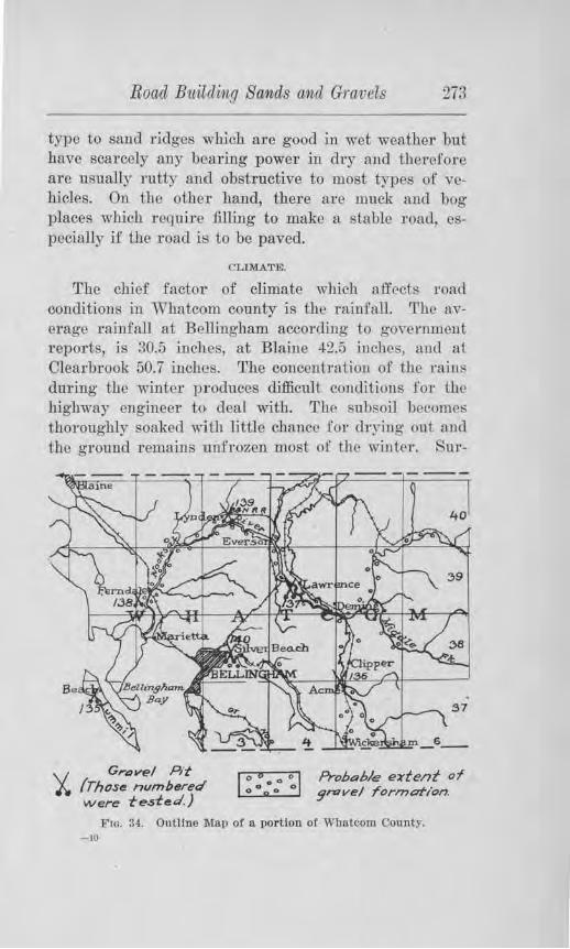
Roacl Bicilclin,q Sands and Gravels 273
type to sand 1·idges wbfoh are good in wet weather but have scarcely any bearing power in dry aud therefore are usually rutty and obstructive to most types of vehicles. On the otheT hand, there arc muck and hog places which require filling to make a stable Toad, especially if the road is to be paved.
CLIMATE.
The chief factor of climate which affects road conilitions in Whatcom county is the rainfall. The iwerage rninfnll at Bellingham according to government reports, is 30.5 inches, at Blaine J2.5 jnchcs, au<.1 at ClearbTook 50.7 inches. rr he concentration of the mini. during the winter p r oduces difficult conditions for the highway engineer to deal with. The subsoil bccomei:; thoroughly soaked with uitle chance for cb-~ing out an<l the ground 1·emains unfrozen most of the wiutcr. Sur-
Gravel Pit {Those nvmbered were te.sted.)
I o 6 0 a O I Probable e~tent of
0 O o O O grovel rorme:rt/on.
Fm. 34. Outline Map o! a por tion ot Whatcom County. -Iii
274 Bulletin No. 221 Washin,gton Geological Siwvey
facing is a necessity and the grave] must contain only a limited amount of clay.
Occasionally the rains in the winter produce slumping or slides and unless the side drainage is perfect the foundations of pavements may become soft and yielding and the pavement u1 sections destroyed. To some extent flood conditions have to be dealt with also. The summers are comparatively dry. In some years, the dry spells are of long enough duration that the moisture content of the gravel-surfaced roads is evaporated, and when this happens the road ravels and becomes rutted.
DISTRIBUTION OF THE GRAVEL FORMATIONS.
In 1911 the Washington Geological Survey investigated the rock formations of the state and collected samples for testing to determine their adaptability for crushed rock macadam. The results were published in Bulletin No. 2 of the Survey 's series.
The present study, therefore, deals chiefly with the gravel formations. In Whatcom county gravel beds occur along Lake "Whatcom, along the Nooksak River, and in glacial knolls scattered mdiscriminate]y over the upland. The general distribution is shown on the outline map of the cotmty. The gravel lmolls on tbe upland are local in their occurrence and their quality in each case must be determined by test-pits. The materials occuning in bars along the streams are mostly firm, but have been deprived of their bmder by stream action. Whern these materials are used for surfacing ~lay must be added for binder.
Tests for Concrete
In view of the extensive paving program ,vhich the county has adopted samples were collected of the sand and gravel which was being used as aggregate in the concrete pavements.
Road Buildi1ig Sands ahUl Gravels 275
Map Number 135. This sample was taken .from the pit near Village Point on Lum.mi Islancl. As will be seen by the mechanical analysis in Table III of Chapter IV, the sand from this place is well graded, composed of hard materials, and showed a tensile strength in the 7-day briquets 138.9 per cent as great as the Standard Ottawa sand, and in the 28-day briqucts 162.8 per cent as great. No organic content was detected by the coloTimetric test.
Map Number 136. This sample collected from the Acme pit along the Nooksak River, was found by the Portland Cement Association to have the following ratios: the 7-day ratio ( obtained by divicling the sh·cngth of the briquets made from the sand un<ler test by the strength of the briquets made from Standard Ottawa sand) was 86.7 per cent, and the 28-day ratio 105.5 per cent.
}lap Nuniber 137. This sample was obtaine<l from the gravel bar of the Nooksak River at Nugent's bridge. The average of four separate tests gave a value of 124.0 per cent fo1· the 7-day ratio, and 144.2 per ceut for the 28-day ratio.
Mcip Nurnber 138. This sample was taken from the Clarkson pit, 1 mile southwest of Fe1·ndalc. This test, made by the P ortland Cement Association, gi,we a value of 130.5 per cent for the 7-day ratio, and 126.3 per cent for the 28-day ratio.
Mav Number 139. This sample was secured from the county pit at Lynden. This sand gave a value of U3.1 per cent for the 7-day ratio, and 112.2 per cent for the 28-day ratio.
lliap Number 140. This sample was collected from the Lind pit at Bellingham, and averaged in four separate tests, made by the Portland Cement Association, J14.5
276 Bulletin, No. 22, Washington Geological Survey
per cent for the 7-day ratio, and 115.7 per cent for the 28-day ratio.
The mechanical analyses of these sands are given in Table III.
Ab1·asi.on Test of the Coarse A,ggregate
Map Number 1361 from the rooksak River bar at Nugent's bridge, and which is a sample of the material used in the Deming-Lawrence pavement, showed a loss due to abrasion of 5.2 per cent. .Although slightly higher than for most other Puget Sound gravels, this percentage indicates that the gravel has good wearing value.
Map Number 149, whi.ch was taken from the pit leased by Mr. Chas. Lind in the N. W. 1f.b of Sec. 27, T. 39 r., R. 2 E.1 and which represents the material used in the Blaine-Ferndale pavement showed a percentage of wear of 4.4 per cent.
The lithologic composition and mechanical analyses of these graYels arc given in Table V of Chapter IV.
Sti-engtb Tests of Concrete 'Field Cylinders
Three concrete cylinders, which were made of the concrete mix which went into the Gene,-ra Road southeast of Bellingham, were tested for theil.· compressional strength in the Testing Laboratories of the University o.f ~ Tasbington and found to have an average strength of 4110.90 lbs. per square inch. The coarse aggregate and sand which was used came from tho Eureka pit of the Ljnd Gravel Co. The contractoTs who laid the pavement wel'e Riddle & Hawkins. On the DemingLawrence road, throe concrete cylinders averaged jn compressio1,al stre11gth 4645.03 lbs. per square inch. The sand and coarse aggregate came from the Nooksak River bar at Nugent's bridge. The Washington Paving Co. were the contractors.
Two cylindel's were tested of the mix which went into the Blaine-Ferndale road and found to have an average
Road Building Sands and Gravels 277
compressional strength of 4133.15 lbs. per square inch. The sand and coarse aggregate came from the Lind pit near Ferndale, and the pavement was laid by Ledingham & Cooper.
Three cylinders @f the mix which went into the street pavement near the Bellingham Normal School avernged 43J 6.6 lbs. per squaTe inch in compressional strength. The aggregate came from the Hesselgl'ave pit
WHITMAN COUNTY C.ENElRAL STATIDi\1:ENT.
This county has a position in the eastern pru:t of the state, north of the Snake Rive1· and bordering the Idaho line. It includes a total a1·ea of 2,108 square miles. This, the Palouse country, is one of the most noted grain-growing districts in the state. W11eat, oats and barley are the chief cereals. Dairying and stock raising are also important industries. In 1916, the Census Bureau estimated the population of the county to be 38,260. Colfax is tlic county seat and the largest town, but Pullman, Tekoa, Palouse, Garfield, and Rosalia are also important.
The productiveness of the soil calls for transportation facilities of every kind. The 0 .-W. R. R. & N. Co. operates several of their branch lines through the fertile districts, the main line of the C. i r. & St. P. Ry. crosses the northern part, and a branch of the :N' orthern Pacific Ry. trave1·ses the county from north to south. The State Highway Department has established two trnnk highways through the county from nori.b to south, the main Inland Empire Highway running from Central Ferry to Rosalia and the Secon<l Division from Clarkston to the same point where they both unite and pass northward into Spokane. The county has laid out certain trunk highways of its own between the principal towns and has begun the task of regrading and
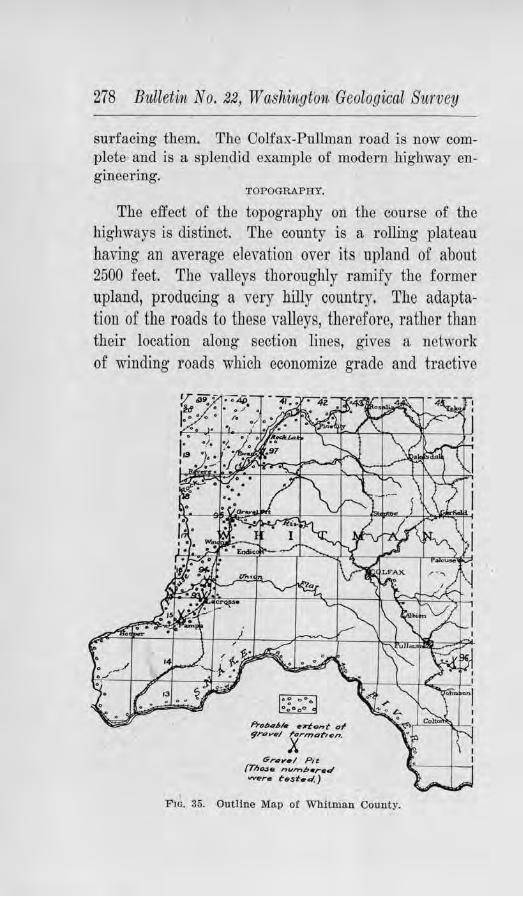
278 Bulletin No. 22, Washington Geological Survey
surfacing them. The Colfax-Pullman road is now complete and is a splendid example of modern highway engineering.
TOPOGRAPHY.
The effect of the topography on the course of the highways is distinct. The county is a rolling plateau having an average elevation over its upland of about 2500 feet. The valleys thoroughly ramify the former upland, producing a very hilly country. The adaptation of the roads to these valleys, therefore, rather than their location along section lines, gives a network of winding roads which economize grade and tractive
f'l-,u,.,1,1- ttrlent 0~
9ravt1/ /'ormar,on.
X Gr111y•/ P i t
/Tl1ose ,,.,,,,.b•r•d vv-,r• ~est•d. )
F10. 35. Outline Map of Whitman County.
Road Building SOJnds mid Gravels 279
force. Along the south boundary of the county the Snake River has cut a canyon over 2,000 feet deep which constitutes a barrier bebveen this county and those lying to the south. Some smaller though considerable canyons have been cut by the Palouse River and some of its tributaries which involve problems of grade for the highway engineer in ascending their walls. A few buttes rise above the general plateau level, but these enter very little into the question of road-building.
SUBSOIL.
Except in the northwest part, the subsoil of the county is a thick clay which varies from light to heavy in different places. The hcayy soil in dry weather makes a :firm hard road, but the light soil ruts bailly, especially in the latter part of the dry season. Both give muddy roads in moist seasons. In a fow places there are earth roads which are generally good the year round, and these are on the so-called alkali flats. Rebel Flat, east of Endicott, is perhaps the best example. The reason for this is a subject fo r investigation.
The formation below the thick clay is generally basalt, as shown in the deeper valleys ancl eJi.t>OSed over th., "scab-land" axeas of the northwest district. The buttes, however, are not basalt, but either granite or g11eiss or quartzite. The scab-land of the no1·thwest part is due to the removal of the clay formation by the glacial waters which deposited the gravels of tliat area.
CLIMATE.
Whitman county receives an average of 22 inches of precipitation each yeaT, a part of which falls as snow. Most of the rains come during the fall, winter, and early spring, leaving the summer with comparntfrely little moisture. The results of these conditions on the cfay formation have already been mentioned. The work of frost during the latter pa1·t of winter and early spring
280 Bulletin No. 22, W ashin.gton Geofogical Survey
also affects the roads by softening them and requiring maintenance in order to prevent them from cutting up.
DJSTnIBUTION Oil' ROAD GRAVELS.
In. 1911, the Washington Geological Sru'vey conducted an investigation of the bedrock of the county to ascertain its adaptability for crushed rock macadam. The results were published in Bulletin No. 2, of the Survey series. The present study has had to do chiefly with the gravels which could be utilized.
Most of Whitman county is devoid of sands and gravels. The outline map of the county shows that the general area in which deposits of any gxtent al'e found is in the no-rLhwestcrn part of the county. This limited distribution is due to the fact that only those Yalleys in that part were drainage lines from the ice-sheet which lay to the north in Spokane county dUl'ing the Glacial Period, and which wore therefore the only ones that car-1·ied glacial gravels. The removal of the clay formation from over the basalt was also accomplished at this time and this Tesulted iu rather extensive areas of "scabland." While the gravels cannot fully compensate for this loss of agricultul'al soil, yet there js some compensation in the fact that this area carries these va lnable deposits.
Tests on Road Ot·avels
J.lla;p Niimber 93. This sample was take11 from the deposit %, mile northeast of LaCrosse. The gravel underlies the flat in the northwest outskirts of town and is e}..---posed i11 a pit about 100 yards square and 10 to 12 feet deep. A great deal of oversize is present, indeed so much that there is much waste in screening and it would se.em the point of economy to run the material through a crusher pit-run. They consist chiefly of basalt rock, some of which are porous and the remainder dense. About 90 per cent appear firm and have fair wearing value as shown by the abrasion test. The
Road Building Sa,nds cvnd Gravels 281
amom1t of binder is comparatively small and moTc is needed but what there is has good tenacity and will pack readily. Crushing would add somc,vhat to the hinder content. The coUllty owns live acres. The new road east of LaCrosse was surfaced with this in 1917.
llf ap Nuniber .94. Tl1is sample was takeu from a gravel bench along Uruon Flat Creek, 3 miles north of LaCrosse where a new bridge was being constructed. The material here is also basalt but is better graded than the deposit at La.Crosse. Ninety per cent and more are fum and have good weru:ing value. No tcnaci ty test was made because of the lack of clay to make a plastic paste. With the addition of clay fo1· binder this should make a satisfactory road metal. A test was made of the sand for concrete uses which will be considered in a later connection.
Map N,wmber 95. This sample was ohtnined from the high bench at Gravel Pit Station on the 0 .-W. R. R. & N. Company's line. The gra,el is on the whole comparatively fine but ranges in size up to 2 inches. There are some silt layers at di:ff erent horizons which will a.tld to the binding portion of the gravel. The pebbles are chiefly basalt fai.I·ly well rounded, about 90 per cent are :firm and have average wearing value. The cementation test showed that the binding material is somewhat deficient in quality and quantity. The county has purchased 52 acres ,vhich insmes unlimited quantities. The gravel is loaded directly into railroad cars or motor frucks by n Jarmine loader which operates by gasoline power. If freight rates permit, much will be shipped to other parts of the county for use on the highways. The sand was tested for concrete uses, and the results are given on a following page.
Map N1.imber 96. This sample was taken from a deposit along the strnam bed of the South Fork of Palouse River, 5 miles southeast of Pullman. There are
282 Bulletin No. 22,, W aslwngton Geological Sii,rvey
some pebbles but most of the material is a coru:se to fine sand, which, when mixed with the clay of the roadbed, makes a good sand-clay road. The materials have been washed from one of the higher buttes which is situated near the headwaters of the stream, and consist of granite, quartzite and basalt. Where used on the road it has rendered good service and withstands heavy wheat haulmg.
Map Nwmber 97. This sample was taken from the ridge of gravel located on the north side of the railway track at Ewan. The ridge is about 11! mile long and 30
to 40 feet high, and contains immense quantities. ~'he C. M. & St. P. Ry., which owns the deposit, has excavated thousands of cubic yards for road ballast, and has offered a portion of the rest for the su1·facing of the roads in the vicinity of Ewan. About ten per cent are oversize, but the rest are well g1·aded. Tho material is basaltic, some of the pebbles are porous, but practically all of it has very good wearing value as shown by the abrasion test. A test of the binder showed it to be fairly tenacious and to have good ultimate cementation value. It would seem advisable from the standpoint of grading and increasing the binder content to run the gravel through a crusher pit-run.
About % mile east of LaCrosse there is a ridge of gravel considerably finer than that at La Crosse. No pit has yet been opened in this. Between Union Flat Creek and Winona there is a broad sag with gravels scattered at different places along the way. A pit has been opened in a gravel bench in the N. W. 1Jt, of Section 17, T. 17 N., R. 40 E.
Detailed results of the foregoing are given in Table I, of Chapter ID, together with those from other counties.
Road Building Sands and Gravels 283
Tests for Ooncrete
The sands of the samples which have already been described, were washed and tested for their tensile strength in concrete briquets, according to the method described in Chapter IV.
JJ!ap Nu.inzber 93. Three briquets made from this sample, which was collected from the deposit % ruile northeast of LaCrosse, were found to have a tensile strength at the end of 7 da~-s 88.5 as great as the briquets made from Standard Ottawa sand. This percentage, however, was increased to 136.1 per cent in the 28-day test. By the colorimetric, only a slight content of organic matter was found.
Map N1.11nber 94. This sample of sand is from the deposit 3 miles north of LaCrosse at Union Flat Creek. The 7-day briquets of this sand showed a sh'ength-ratjo of 93.8 per cent, and the 28-day briquets a strength-ratio of 145.9 per cent. The sand is free of organic matter, as shown by the colo1·im.etric lest.
Map number 95, taken from the deposit at Gravel Pit Station, on the 0.-W. R. R. & N. Co. line, gave a stTength ratio of 72.8 per cent for the 7-clay briquets and 101.7 per cent for the 28-day briquets. No organic content was found by test.
.Map number 97, obtained from the deposit at Ewan, on the north side of the railway, tested 74.7 per cent for the 7-day ratio and 124.4 per cent for the 28-clay ratio. Some organic material was indicated to be present by the colorimetric test, but not in objectionable quantities .
.AJ1 of the foTegoing sands are too coarse to give the desired density without the addition of fine sand or crusher dust. Otherwise they ru:e believed to be satisfactory. :More detailed results are given in Tables Ill and l V of Chapter IV.
284 Bulletin No. 22, TV ashington Geolog,ical Su1·vey
Y .A.KIM.A COUNTY
GENERAL STATEMEN'r.
Ranking the secolld in size in the state, this county includes over 5,000 square miles of territory on the east flanks of the Cascades, in the south central part of the state. fo population it ranks sixth, according to the census of 1910, at which time the inhabitants numbered 411709. Since then its population has probably increased notably.
The high slopes of the Cascades gradually descend to the broad floor of the Yakima Valley which crosses the eastern part of the county in a southeasterly direction. It is in this trunk -valley where most of the population is concentrated and where the demand for good roads exists. As the result o:f irrigation parts of this valley are intensively cultivated for agricultural and horticultural products and the productivity supports a large population. Some roads, therefore, carry heavier traffic than surf aced or macadam roads can bear with economical maintenance, and these arc now being paved. Yakima, the county seat, is one of the ranki11g cities of the state. Other towns are Toppenish, Sunnyside, Zillah, :Mabton, Granger, Grandview, Wapato, Outlook, Selah, and Moxee City.
TOPOGRAPHY.
Tn leaving the county on the north, over Umptanum Ridg·e, and south over Horse Heaven Hills, the topography entails some problems of grade. N ortbward the road at present crosses the Umptanum Ridge, the canyon of tho Yakima River being too narrow .for a highway location ,,Tjthout much expensive rock cutting~ Southward, State Road No. 8 leaves the county by ascending· the slopes and crossing the summit of Horse Heaven Hills, which attain an altitude of nearly 3,000' feet. .Aside from this the capacious Ya1(irua River Val-
Road Building Sands and Gravels 285
ley and the Naches Yalley provide excellent natural grades.
The natural subsoil of the Yakima Valley on which the roads are located consists largely of silt and sand. The bearing power of these materials is easily exceeded by most conveyances and hence, this necessitates surfacing of some sort on even the secondary Toads. The prevalent dry air of summer reduces the shengtb and binding power of any loose material to a minimum. In consequence the silt or sand roads become almost impassable with ruts, an<l the crushed rock macadam or gravelled highways are prone to ra,el, especially during the market season of heavy hauling.
There is every encouragement for a maximum production by the county in tho various facilities of transportation which it possesses. Bosides the Inland Empfre HighwaJ which traYerses the full length of the county, the main line of the Northern Pacific Ry . and the 0 .-W. R. R. & N. Co. offer ready means for foreign marketing. In the near future the McClellan Pass Jiigl,way will probably be open with suitable grade across the Cascades at :McClellan Pass.
GENERAL DISTRIBUTION OF ROAD GRA.V,ELS.
Two classes of 1·oad gravels are fouud in Yakima county. Fresh gravels occur in bars and islands along the Yakima and Naches rivers, and more or less weathered gravels occur erratically here and there at varying elevations on the slopes above the valley floor. The general distribution is mapped on the outline map of the county by a symbol of small circles. Where pits have been opened some of these are shown by the conventional sign of crossed shovels, and those which WCl'e tested fil'e given a map numbeT.
It should not be taken for granted that 1.he mapped area includes only tl,e gravel deposits suitable for road
286 Bulletin No. 22, Washingto1i Geological Si1rrvey
building. A very detailed survey necessitating many test-pits and several months of time would be required to make such a map, but it is thought that a generalized sketch of the area from which satisfactory material is likely to be found and selected will be helpful.
Tests on Road Gravels
Two series of tests were made on the gravels of this county according to the uses to which they would likely be put, namely, gravels to be used for road suJ'facing, and samples of sand from gravel deposits which are conveniently situated for concrete uses. The discussion of the latter wiU be considered later on succeeding pages. The 1·esuHs 0£ the tests on gravels for suTfadng are tabulated with those of other com1ties in Table I, of Chapter III. Herewith is given a brief discussiou as to their occurrence, abundance and general value.
Map Nitmber 98. This sample was taken from a deposit of gravels 011 the upland % mile southwest of Selah, from a rock known as the EllensbuTg formation. rrhis sample showed good gradation, with a small percentage of oversize. By determination of 100 pebbles taken at random, 29 per cent were found to be basalt, 29 per cent andesite, 28 per cent quartzite, and 3 per cent rhyolite. About 10 per cent of them are soft, the remainder beu1g hard to very hard and having fail' ,vearing value. Most of them ar e coated with a light silt which, with the other fine material of the deposit, was found to have fair tenacity value, thus indicating that the gravel would pack fairly promptly. At this point a large pit has been opened by the county, in the hillslope, and several miles of road in this vicinity surfaced ,vith the materials, with fair to good results. Locally this formation is known as the '' cement gravel.''
ll!fop Nu11nber 99. This sample was obtained from a test-pit in a deposit occupying the position of a sloping
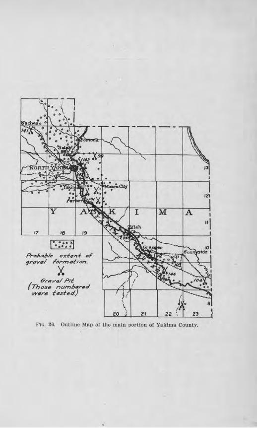
17
y
.... .... 0
•••••
19
Prol,al,/e exf11nf oF 9rav~I rornu~t/01'7.
X Gr4vel Pit
(Tho.s, numh,r•d Wflre tested)
M A
.-('
};
20 \
ZI 22
Fro. 36. Outllne Map of the main portion of Yakima County.
121
288 Bulletin No . 22, Washington Geological Sitrvey
bench above the Yakima River flat, 4% miles northeast of Yakima. The pebbles are chiefly anclesite and basalt, are coated wi.th silt like those in Sample 98, but a larger percentage a.:re soft and have poor wearing qualities as shown by the abrnsion test. A mec.hanical analysis was not made on account of the uncertain variation of the deposit. The tenacity test, however, showed that the binder has a high value, wbich suggests that the materi.al will pack readily. The percentage of oversize seemed to be large enough to warrant crushing all of the material pit-rUil.
Map Nwnber 100. This sample was obtained from a deposit on the north side of the .A.tanum Ridge, %. mile east of Union Gap. These gravel beds are tilted southw·ard at an angle of 70 degrees, and contain lenses and seams of sand and silt. About 42 per cent of the pebbles are basalt, 46 per cent andesite, and 12 per cent quar tzite. Somewhat less than 90 per cent of them are firm and have fair wearing qualities. The gravel var ies too much to warrant giving a mechanical analysis. By test the tenacity value is low, indicating that the addition of clay would be beneficial. One mile of road is to be sur faced f rom this deposit in 1918. Crushing is recommended.
Mav Nwmber 101. About 4 miles northeast of Wapato a gravel pit has been opened in a deposit ve1·y similar in appearance to the one described as Map Number 99. It has a position on the slopes north of the flat of Yakima River. The composition is mostly pink and gray andesitc, with a few quartzites and diorites; about 80 per cent ar e firm enough for road gravel, and about 12 per cent are oversjze. By test tho percentage of wear is so high that its use is recommended only for light traffic, and if so used it should be crushed.
lYiap Nwmber 102. This sample, taken from a deposit along the south side of Snipe's Mountain, 2V:.i to 3
Road Building Sm-ids mid Gravels 289
miles southeast of Granger, is a gravel coated with light silt, composed of pebbles of andesite and rhyolitc, and decayed to the extent that nearly 20 per cent of the pebbles are soft. The percentage of wear, according to test, is high and the binder shows a low value in cohesiveness. This gravel would be suitable only for a road haviug light traffic.
1l'Iav Niimber 103. This sample was collected from the Patch Gra'7el pit, about 31/2 miles southwest of Sunnyside. The materials, as exposed in the pit, occur in strntified layers tilted about 80 degrees to the south and consist of interbedded gravels and greenish gray and whitish silts. Fifty per cent of the pebbles are quartzite, 46 per cent basalt, and 4 per cent granite. Tl1e va1·iability of the gravels pl'event any dependence being made on a mechanical analysis. Some of the pebbles, especially the quartzites, are flattened, the Test are rounded. About 20 per cent are hard and firm, with good wearing quality. The binder tested low in tenacity, and fair in cementaLion. This gravel is considered only fairly satisfactory for road purposes on account of the flattened pebbles, and its low tenacity.
Map Number 104. This sample is largely a "torpedo sand'' taken from a deposit llh miles south of Grandview. )Iost of it is basaltic, which gives it the black color, but there are a few fragments of lime rock scattered through it. By test the tenacity value is low, but where it has been used 011 the road, as north of Grandview, it makes a smooth, .ffrm road, permitting a minimum of wear on motor tires. It is an excellent dressing material.
Sand for Concrete
Samples of sands were collected at various points along the Yakima and Naches rivers and after being washed were used in the making of concrete briquets whose strength was tested and compared with that of
290 Bulletin No . 22, W ashvngtinb Geological Stirvey
briquets of the same age made from Ottawa Standard sand and the same brand of cement. The character of this test is described more fully in ChapteT IV. Besides the following general results which are noted for eacl1 sample the full results are tabulated with those from other counties in Tables III and IV.
Map N'Ullnber 103. This sample which was taken from the Patch gravel pit, 31h miles southwest of Sunnyside, was screened and the sand used for the briquet test. The briquets which were made from this sand, when 7 days old, showed a tensile strength 45.5 per cent that of the briquets made from the Ottawa Standard sand, and when 28 days old, 92.6 per cent. The mechanical analysis shows that the sand is too fine for concrete purposes. It is almost free, however, from any organic content, as shown by the colorimetric test.
Map Number 104, a sample fr om the deposit, 11/z miles south of Grandview, which has been described, tested 89.8 per cent as strong as the Standard sand in the 7-day test, and 142.9 per cent as strong in the 28-day test. This sand is too coarse to give the proper density without the addition of fine sand or cxusher dust. No organic matter was detected by the colorimetric test.
Map Nwrnber 141. This sand was screened from the sample of gravel ,vhich was collected from a bar of the Naches River at Naches, just below the bridge. The 7-day briquets had a str ength 105.2 as great as the b1·iquets of the Standard sand, and the 28-day briquets 156.7 per cent as strong. This sand seems to be a desirable one fol' concrete. The amount of organic matter detected is very small and unobjectionable.
Map Number 142, taken from a bar along the Yakima River, northeast of Yakima, on the Marble SpUl' of the Nor thern Pacific Railway, showed a tensile strength in the 7-day briquets equal to 106.2 per cent that of the
Roa<Z Builclitig Sa1uls (JJnd Graveis 291
Standard sand, and a sti·ength in the 28-day briquets equal to 116.4 per cent that of the Standai·d sand.
Map Number 143, collected from a bar on the west side of the Yakima River, just south of the Lower :Moxee bridge, 2% miles southeast of Yakima, showed a strength 109.3 per cent as great as that of tho Standard sand in the 7-clay briquets, and 114.1 per cent as great in the 28-day briquets. The mechanical analysis indieates that the sand is lacking in coarse constituents.
Map Nimiber 144. This sample is from the bar along the Yakima River, on the west side, just below the Donald-Wapato bridge. The 7-day rntio in this case was 102.1 per cent and the 28-day ratio 155.9 per cent. By the colorimetric t.est organic matter was inilicated to be present in amounts that are somewhat objectionable, aud this feature should be watched and tested for from time to time if the material is used.
lJ!Iap Number 145. A bar along the Yakima River, lh mile southeast of Zillah, was sampled. This sand gave an efficiency test of 103.1 per cent of the shength of Standard sand in the 7-day briquets, and 135.6 per cent in the 28-day test. Some organic matter was found to be present by test.
Map Number 146, taken from a bar of the Yakima River, 7 miles southwest of Sunnyside, on Ole Levold's place, tested 93.8 per cent for the 7-day ratio, and 106.5 per cent for the 28-day ratio. A small inconsequential amount of organic matter was found by chemical test. The mechanical analysis of this sand indicates that some coarse sand should be added.
The coarse aggregate of the river gra,els is of good quality and fairly clean, but in the case of the Patch gravel pit the pebbles ai-e coated wilh silt. The gradation varies in size even in the same bar, but with caution proper materials can be obtained.
APPENDIX I.
BIBLIOGRAPHY.
1880. Willis, Bailey. 10th Census of United States. Vol. XV, 759-771. "Report on tbe Coal Fields of Western Washington." Mainly a summarizing r eport so far as the southwestern Washington fields were concerned.
1888. White, O. A. Am. Jour. of Sci. 3rd Series, Vol. 36, 443-460. "On the P uget Group of Washington Territory." A review of the work of Willis and Newberry with the suggestion of possible correlation of the Puget Sound rocks with the Laramie, Tejon, etc.
1889. Wb:ite, C. A. Bull. 51, U. S. Geol. Survey. " On Invertebrate Fossils from the Pacific Coast.11
First applies the name Puget to the coal-bearing series of Vi'ash ington.
1891. Clark, Wm. B. Bull. 83, U. S. Geol. Survey. 100-110. Correlation Papers : Eocene.
1802. Ruffner, ,v. H. Science, Vol. 19, 58. "Some Recent Mineral Discoveries in tbe State of Washington."
1893. Co1·ey, T. n. Jour. Ill. Mining Inst., May, 1893, Vol. 11, No. 1, 14-30. "Coal Fields of Western Washington."
1808. La.wson, A. C. Am. Geologist, Vol. 13, 486-437. "Note on the Chehalis Sandstone." Notes the finding or marine fossils-Tertiary- in sandstones apparently associated with the lignite beds.
1001. Lancles, Hem·y. Annual Report of State Geologist, Vol. I , Pt. IV, 61-6 5. "Coal Deposits of Washington." Discusses b riefly the Bucoda-Tenino fielcl in Thurston county; the Centralia-Chehalis field in Lewis county, and tbe Kelso-Castle Rock field in Cowlitz county, and mentions higher grade coals in Upper Cowlitz valley.
1002. Landes, B em·y, Annual Report of State Geologist, Vol. II, 238-257. A somewhat more detailed account (than that of 1901) or the known fields, viz.: Bucocla-Tenino, Chehalis-Centralia, Alpha, Cinnabar, Morton, Packwood, Davis, Kelso-CasUe Rock.
1 902. Smith, Geo. Otis. 22nd Ann. Report U. S. Geo!. Survey, Pt. III, 473-513. Coal horizon placed in Eocene, but no specific details of the Southwest Washington fields. Base of Puget series in southern Puget Sound fields not k.nown. In the northern part it r ests on schlsts.
293
1905. Diller, J. S. Bull. 260, U. S. Geo!. Survey, 411-412. "Coal in Washington, near Portland, Oregon." A brief discussion of some of the occurrences in Cowlitz county.
1006. Al'llol<l, Ralph. Prof. Paper 47, U. S. Geol. Suney. "The Tertiary and Quaternary Pectens of California." Mentions the occurrence or certain fossils in the vicinity of Little Falls [Vader) and places the age of these beds as probably Upper Eocene, possibly above the Tejou.
1911. Smith, E . E. Bull. 474, U. S. Geol. Survey. "Coals of the State of Washington." Gives 3 from Cowlitz county, 32 from Lewis county, 9 from Thurston county. Analyses of section secured and discussion as to rank of coal, mining methods and character of samples.
1012. ·weaver, Chus. E- Bull. 15, Wash. Geo!. Survey. "A Preliminary Report on the Tertiary Paleontology of Western Washington." A general statement of the geologic history of Western Washington with fauna! lists and description ot eigbtyfou.r new species.
1013. White, David, and 'l'hiessen, Reinhru·dt. Bull. 38, Bureau ot Mines, Department of Interior. "The Origin or Coal." A technical discussion of the subject Introducing the most recent material as to methods of examination and results.
1918. Arnold, Ralph, and Hannibal, Harold. Proc. Am. Phil. Soc., Vol. 52, 566-571. "Stratigraphy of the North Pacific Coast of America." The Tejon is subdivided into the Chehalis, Olequa and Arago formations, of which the first two are present in southwestern Washington. On the basis of fossil flora il was concluded that colder climatic conditions obtained during Chehalis than during Olequa times.
1013. B1-etz, J. Hadan. Bull. Wash. Geol. Survey, No. 8. "Glaciation or Puget Sound Region." The origin of the Pleistocene deposits in southern Thurston county is discussed in connection with the Puget Sound deposits.
101::i. Dickerson, Roy E. Cal. Acad. Sci. Proc., 4th Series, Vol. 5, 35-51. "The Fauna of the Type Tejon, Its Relation to the Cowlitz Phase of the Tejon Group in Washington." The writer concludes that the Cowlitz phase of the Washington Tejon appears to represent the same fauna! facies as the fauna of the type Tejon.
294 Appendix
1016, Weaver, Chas. E. Bull. 13, Wash. Geol. Survey. "The Tertiary Formations of Washington." A report on the geology and paleontology of the Tertiary of Western Washington with maps, structure sections and fauna! lists.
1910. Wea.ve1·, Chas. E. Cal. Acad. Sci. Proc., 4th Series, Vol. 6, 1-40. "Eocene of Lower Cowlitz Valley, Wash." "Post Eocene Formations in West. Wash." A description of strata and fossil zones with inferences as to geologic history.
INDEX.
Page Aberdeen . . . . . . . . . . . . . . . . . . . . . . . . . . . . . . . . . . . . . . . . . . . . . . . . . . . . . . . 16S Abrasion test . . . . . . . . . . . . . . . . . . . . . . . . . . . . . • . . . . . . . . . . . . . . . . . . . . 41 Acknowledgments . . . . . . . . . . . . . . . . . . . ... . . . . • . . . . . . . . . . . . . . . . . . . 21 Acme . . . . . . . . . . . . . . . . . . . . . . . . . . . . . . . . . . . . . . • . . . . . . . . . . . . . . . . . . . 275 Adams County .. . ... . .......................... . ............ 34, 101, lO<i
1~aborato1·y tests ..... .. .... . ......... •.... ...... .. ......... 106, 107 Addy .... . ................................... .. .............. 33, 259, 261 Admiralty Inlet . . . . . . . . . • . . . . . . . . . . . . . . . . . . . . . . . . . . . . . . . . . . . . . . 173 Adna . . . . . . . . . . . . . . . . . . . . . . . . . . . . . . . . . . . . . ... . . . . . . . . . . . . . . . . . . . 198 Adrian ..................................... •• .................. 161, 164. Allen, James . . . . . . . . . . . . . . . . . . . . . . . . . . . . . • • . . . . . . . . . . . . . . . . . . . . 21 Allyn . ..................................................... 209, 210, 211 Almil'a ..................................... •... ..... ...... . 190, 200,208 Alpowa C!'eek . . . . . . . . . . . . . . . . . . . . . . . . . . . . . . . . . . . . . . . . . . . . . . . . . . 107 Alto ............. . ... . ....................•.. •.....•. .......... 136, 137 American Society for Testing Materials.... .... ................. 58 Anacortes . . . . . . . . . . . . . . . . . . . . . . . . . . . . . . . . . . . . . . . . . . . . . . . . . . . . . . 233 Anatone . . . . . . . . . . . . . . . . . . . . . . . . . . . . . . . . . . . . . . . . . . . . . ... . . . . . . . . 109 Apple Way . . . . . . . . . . . . . . . . . . . . . . . . . . . . . . . . . . . . . . . . . . . . . . . . . . . . • 254. Al'lel . . . . . . . . • . . . . . . . . . . . . . . . . . . . . • . . . . . . • . . . . . . . . . . . . . . . . . . . . . . 137 Arlington .............. . ................... •.... ........ 28, 240, 243, 24•1 Ao:1otlt1 . . . . . . . . . . . . . . . . . . . . . . . . • . . . . .. . . . . . . . • • . . . . . . . . . . . . . . . . . . 109 Asotin-Ana tone Road. . . . . . . . . . . . . . . . . . . . . . . . . . . . . . . . . . . . . . . . . . 107 Asotin-Cloverland Road . . . . . . . . . . . . . . . . . . . • . . . . . . . . . . . . . . . . . . . 107 Asotin County ...... . ... . .................•............ 36. 37. 47, 70,107
Concrete Sands . . . . . . • . . . . . . . . . . . . . . . . . . . . . . . . . . . . . . . . . . . . . . 109 Road Surfacing . . . . . • . . . . . . . . . . . . . . . . . • • . . . . . . . . . . . . . . . . . . . 109 Tests, Laboratory . . . • . . . . . . . . . . . . . . . . . . . . . . . . . . . . . . . . . . . . . . 109
Auburn ................................................ 179, 181,182, 183
Badger Mountains .......•........ . .......... . . . ................ Sl, 144 Battle Ground . . . . . . . . . . . . . . . . . . . . . . . . . . . . . • . . . . . . . . . . . . . . . . . . . . 129 Bay Cente1· . . . . . . . . . . . . . . • . . . . . . . . . . . . . . . . . . . . . . . . . . . . . . . . . . . . . . 221 Bellingham . . ............................................ 28, 271, 273, 275 Benton City • . . . . . . . . . . . . • . . . . • . . . . . . . . . . . . . . . . . . . . . . . . . . . . . . . . . 115 Benton County ..... . ............................ . .... 30, 31,112,114,190
Laboratory tests of concrete ..................... . ... .. .. . .. 117, 118 Laboratory tests of giravels ................................. 114, 117
Beverly ........... .. ....•...................................... 161, 164 Big Bend o! Columbia River........ . ........................... 161 Big Lake . . . . . . . . . . . . . . . . . . . . . . . . . . . . . . . . . . . . . . . .. . . . . . . . . . . . . . . 233 Binder:
Cementatlon of ... . ..... .. .......... •• . . . . ............. 49, 60, 52, 54 Cohesive c ha racter of... . . . . . . . . . . . . . . • . . . . . . . . . . . . . . . . . . . . . 52 Tenacity value of the ............. . ........................ 49, 50, 54
Black Diamond . . . . . . . . . . • . . . . . . . . . . . . . . . • . . . . . . . . . . . . . . . . . . . . . . 182 Black River .... . ........•................ • ... . ................. 172, 173 Blaine . . . . . . . . . . . . . . . . . . . . . . . . . . . . . . . . . . . . . . . . . . . . ... . . . . . . . . . . . 273 Blewett Pass .. . .........•............. . . •• ... . ... . ....... . . 120, 121,185 B lue Mountain Province .................•. .. ........ . .... . . 24, 35, 70, 107 Blue Mount.a.Ins .........•.................... . .......... 37, 134,158,160 BluesUde . . . . . . . . . . . . . . . . . • • . . . . . . . . . . . . . . . . . . . . . . . . . . . . . . . . . . . . 224 Blyn ....... . ... . ............................................... 126, 128
296 Inclex
Page Borhek, R. J.. . . . . . . . . . . . . . . . . . . . . . . . . . . . . . . . . . . . . . . . . . . . . . . . . . . 68. 232 Bothell . . . . . . . . . . . . . . . . . . . . . . . . . . . . . . . . . . . . . . . . . . . . . . . . . . . . . . . . . 170 Bremerton . . . . . . . . . . . . . . . . . . . . . . • . . . . . . . . . . . . . . . . . . . . . . . . . . . . . . 1 84 Brewster . . . . . . . . . . . . . . . . . . . . . . . . . . . . . . . . . . . . . . . . . . . . . . . . . . . . . . . 32 Brewster Flat . . . . . . . . . . . . . . . . . . . . . . . . . . . . . . . . . . . . . . . • . . . . . . . . . . 216 Bridgeport .. .. . .. . . . ...... • .... • .....................•.... . ... . 142, 146 Brin non ........... . ........•....•.............................. 177, 178 Burlington . . . . . . . . . . . . . . . . . . . . . • . . . . . . . . . . . . . . . . . . . . . . . . . . . . . . . 233 Burlington Bridge . . . . . . . . . . . . . . . . . . . . . . . . . . . . . . . . . . . . . . . . . . . . . . 236
Cal ispell Range . . . . . . . . . . . . . . . . . . . . . . . . . . . . . . . . . . . . . . . . . . . . . . . . 256 Camano Island . . . . . . . • . . . . . . . . . .. • . . . . . . . . . . . . . . . . . . . . • . . . . . . . . . 173 Camas . .... ... .......... ...... . .. • .. . ............... ........... 129, 131 Canada . . . . . . . . . . . . . . . . . . . . . . . . . . . . . . . .. . . . . . . . . . . . . . . • . . . . . . . . . 255 Cape Horn . . . . . . . . . . . . . . . . . . . . . . . . . . . . . . . . . . . . . . . . . . . . . . . . . . . . . 238 Carlsborg ....... ... ..................... ..... ... ... . . . ......... 126, 128 Carlton . . . . . • . . . . . . . . . . . . . . . . . . . . . . . . . . . . . . . . . . . . . . . . . . . . . . . . . . 216 Carson . . . . . . . . . . . . . . . . . . . . . . . . . . . . . . . . . . . . . . . . . . . . . . . . . . . . . . . . . 238 Cascade 11ountains ............ . 112, 118, 179,180,181,190,195,229,233,239 Cascatles, northern . . . . . . . . . . . . . . . . . . . . . . . . . . . . . . . . . . . . . . . . . . . . . 23 Cascade T1Lnnel . . . . . . . . . . . . . . . . . . . . . . . . . . . . . . . . . . . . . . . . . . . . . . . . 120 Cashmere .............. . ........ • ... ............ ......... ...... 118, 123 Castle Rock ... . .............................. .... 30, 66. 137. 1-39. 140, 142 Cedi,r Falls . . . . . . . . . . . . . . . . . . . . . . . . . . . . . . . . . . . . . . . . . . . . . . . . . . . . . 181 Cementsition of b inder .............. . .... . .. ....... .... ,. ...... . . 49, 50 Cementatlon test . . . . . . . . . . . . . . . . . . . . . . . . . . . . . . . . . . . . . . . . . . . . . . . 43 CenLralia .. .... . ...... . ... .. .................. . .... . ..... . 29, 66,195, 198 Central ia Sa.nd and Gravel Co...................... . ............. 198 Central Wash ington High.vay ... .... 34, 101, 105, 158, 154, 156, J.99, 206, 245 Chambers Ptalrle . . . . . . . . . . . . . . . . . . . .. . . . . . . . . . . . . . . . . . . . . . . . . . . 28 Chattaroy . . . . . . . . . . . . . . . . . . . . . . . . . . . . . . . . . . . . . . . . . . . . . . . . . . . . . . 248 Chehal is ruver ........... . . .. ... . . .... 66, 69, 71, J.67, 168,170,172, 173, 198 Chehalis River Valley ...................................... 23, 26, 29, 197 Che lan ................... . ........ ... . ................... . ..... 118, 121 Chelan County ................. .. ......... .... . .... . ..... .. . 32,118, 120
Distribution of road gravels. ...... .... .... .. . . ............. . 120 T ests for concrete . . . . . . . . . . . . . . . . . . . . . . . . . . . . . . . . . . . . . . . . . . . 123 Tes ts on road g ravels ....... ... . ... ... .. . .. .. .. ... ... ....... 121
Chemical analyses . . . . . . . . . . . . . . . . . • . . . . . . . . . . . . . . . . . . . . . . . . . . . . 60, 62 Cheney ... ..... . ........•................. ........... 34, 246, 248, 249, 251 C., M. & St. P. Ry .......... .. . . .................. . .. . ... 163, 1S6, 219,240 Chlmacum ..... . ........•... . . .......... .....•.. .. .. . ...... . . ... 176, 178 Ch inook . . . . . . . . . . . . . . . . . . . . . . . . . . . . . . . . . . . . . . . . . . . . . . . . . ... . . . . 218 Church Flat .. ....... . .. . .... . . .... • .. ... ............... ,....... 33 Clallam County ............................•.. .. . .... ........ 24, 26, llM
Road Materials . . . . . . . . . . . . . . . . . . . . . . . . . . . . . . . . . . . . . . . . . . . . . 126 Cla rk Fork River ................... • ........... . .......•... . 33. 223, 224 Clarke County ............... ..... . •• .. .. . . .... ......... ... .. . . 29, 129
Brlquet test . . . . . . . . . . . . . . . . . . . . . . . . . . . . . . . . . . . . . . . . . . . . . . . . 133 Character of gravels....... ..... ....... . ... . ..... . ....... .. . . 132
Clarkston ............. ..... . ........•.. ..... ..... 37, 47,107, 109, 110. 111 Clarkston- Feola Road . . . . . . . . . . . . . . . . . . . . . . . . . . . . . . . . . . . . . . . . . 107 Clarl<ston-Silcox Road . . . . . . . . . . . . . . . . . . . . . . . . . . . . . . . . . . • . . . . • . 107 Clay, composition of...... .. ........... .. . .. ... . .... .. . .... .. .... 62 Clayton . . . . . . . . . . . . . . . . . . . . . . . . . . . . . . . . . . . . . . . . . . . . . . . . . . . . . . . . 256 Cle:i.rbrook . . . . . . . . . . . . . . . . . . . . . . . . . . . . . . . . . . . . . . . . . . . . . . • . . . . . . 273 Clear Lake . . . . . . . . . . . . . . . . . . . . . • . . . . . . . . . . . . . . . . . . . . . . . . . • . . . . . 233 Cle Elum . . . . . . . . . . . . . . . . . . . . . . . . . . . . . . . . . . . . . . . . . . . . . . . . . . . . . . . 186
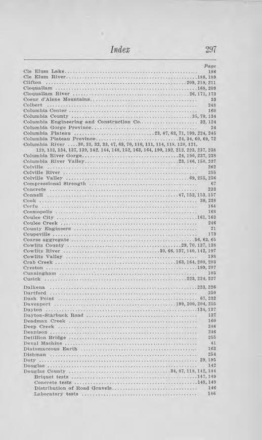
Index 297
Page Cle Elum Lake. . . . • . . . . . . . . . . . . . . . . . . . . . . . . . . . . . . . . . . . . . . . . . . . . . 186 Cle Elum River .............................. . .................. 188, 189 Clifton .................... . ............. . ... , ........... .. . 209, 210,211 Cloquallam ....... ............... ............•.................. 168, 209 Cloquallam River ............. ... ......................... •.. 26, 171, 173 Coeur d"Alene Mountains........................................ 38 Colberl • . . . . . . . . . . . . . . . . . . . . . . . . . . . . . . . . . . . . . . • . . . . . . . . . . . . . . . . 248 Columbia Center . . . . . . . . . . . . . . . . . . . . . . . . . . . . . . . . . . . . . . . . . . . . . . . . IGO Col um Ma County ........................•..... . ... ..... .. •... 35, 70, J 3-1 Columbia Engineering and Construction Co .. .................... 32,124 Columbia Gorge Province........................................ 24 Columbia Plateau .. ............................ 23, 47, 68, 71,199,224,245 Columbia Plateau Province ........................... . ... 24, 34, 60, 60. 72 Columbia River .... 30, 31, .32, 33, 47, 69, 70, 110, 111, 114, 118. 120, 121,
129,133. 134,137,139, 1~2.144,148, 162,163,164,190,192,212,223. 237,238 ColumblA. River Gorge .... . .. ..... . ..... ... ........... .... 24, 190,237,238 Columbia River Ya.1Je1• ................................... 23, 140, 150. 237 Colville . . . . . . . . . . . . . . . . . . . . . . . . . . . . . . . . . • . . . . • . . . . . . . . . . . . . . . . . 262 Colville River .................... . ...... . .... •........ ....... , . 256 Colville Valley ..... ......................................... 69, 265, 25G Compressional Strength . . . . . . . . . . . . . . . . . . . . . . .•. . . . • . . . . . . . . . . . 07 Concrete . . . . . . . . . . . . . . . . . . . . . . . . . . . . . . . . . . . . . . • . . . . . . . . . . . . . . . . 233 Connell ................................................. 47, 152, 153, 157 Cool< ... ........ .......... ... ................................. . . 30, 238 Corfu . . . .................•.. , . . . . . . . . . . . . . . • . . . . . . . . . . . • . . . . . 164-Cosmopolls . . . . . . . . . . . . . . . . . . . . . . . . . . . . . . . . . . . . . . • . . . . . . . . . . . . . . ltlS Coulee Clll' .. . .. .... ... . . .. .... ..... ........................•... 161, 163 Coulee Creek . . . . . . . . . . . . . . . . . . . . . . . . . . . . . . . . . . . . . . . . . . . . . . . . . . . 246 County Engineers . . . . . . . . . . . . . . . . . . . . . . . . . . . . . . . . . . . . . . . . . . . . . . 21 Coupeville . . . . . . . . . . . . . . . . . . . . . . . . . . . . . . . . . . . . . . . . . . . . . . . . . . . . . . 173 Coru·se aggregate ............................•... .. ............ 66, 63, 66 Cowlltz County ........................................... 29, 70,137,138 Cowlitz River .................................... 30, 06, 137, HO, 1-1.2, 197 Cowlitz Valley . • . . . . . . . . . . • . . . . . . . . . . • . . • . . . . . . . . . . . . . . . . . . . . . . 198 Crab Creek ........ . .................................... 163, 164. 200, 203 Creston ....... .... ................ . ............................. 199, 207 Cunningham . . . . . . . . . . . . . . . . . . . • • . . . . . . . . .. . . . . . . . . . . . . . . . . . . . . . 105 Cusick .......................................•............. 223. 224, 227
Oalkena .... .................... . .............. . . .... • ......... 223, 226 Dartford . . . . . . . . . . . . . . . . . . . . . . . . . . . . . . . . . . . . . . . . . . . . . . . . . . . . . . . 250 Dash Point ..............•..................................... 67, 232 Davenport ....................•...................... , .. 199, 200, 204, 255 Dayton .........................• . .............................. 134, 137 Dayton-Starbuck Road . . . . . . . . . . . . . . . . . . . . . . . . . . .. . . . . . . . . . . . . . . 137 Dead man Creek ................................ , . . . . . . . . • . . . . . . 1110 Deep Creek . . . . . . . . . . . . . . . . . . . . . . . . . . . . . . . . . . . . . . . . . . . . . . . . . . . . 246 Dennison . . . . . . . . . . . . . . . . . . . . . . . . . . . . . . . . . . . . . . . . . . . . . . . . . . . . . . . 240 Delllllon Bridge . . . . . . . . . • . . . . . . . . . . . . . . . . . . . . . . . . . . . . . . . . . . . . . . 266 Deval Maclllne .......................................• , . . . . . . . . . 41 Diatomaceous Earth . . . . . . . . . . . . • . . . • . . . . . . . . . . . . . . . . . . . . . . . . .. . 163 Dishman • . . . . . . . . . . . . . . . . . . . . . . . . . . . . . . . . . . . . . . . . . . . . . . . . . . . . . . 254 Doty ..........................................•................ 29, 196 Douglas . . . . . . . . . . . . . . . . . . . . . . . . . . . . . . . . . . . . • . . . . . . . . . . . . . . . . . . . 142 Douglas County ............................. •. ....... 34, 47, US, 1'12. 14-1
Brlquet tests ............................................ . .. 14 7, 149 Concrete tests .........................••................... 148. 149 DistrlbuUon of Road Gravels............ . ................... 146 Laboratory tests . . . . . . . . . . . . . . . . . . . . . . . . . . . . • . . . . . . . . . . . . . . 146
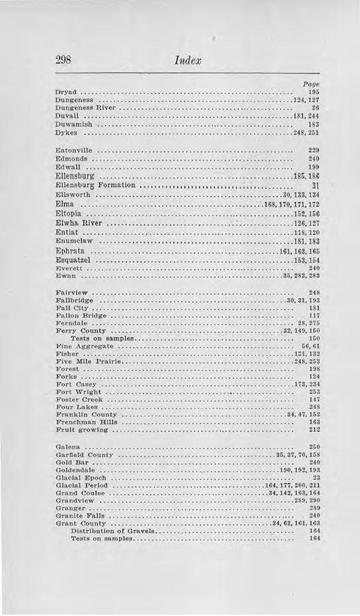
298 Index
Pane Dryad . . . . . . . . . . . . . . . . . . . . . . . . . • . . . . . . . . . . . . . . . . . . . . . . . . . • . . . . . . 195 Dungeness .... .. ..... . .. . .... .... ........ ...................... 124, 127 Dungeness River . . . . . . . . . . . . . . . . . . . . . . . . . . . . . . . . . .. . . . . . . . . . . . . . 26 Duvall ....... ... . .. .. .. ............ .•• .. . ...... .. ..... . .. : •.. .. 181, 244 Duwamish . . . . . . . . . . . . . . . • . . . . . . . . . . . . . . . .. . . . . . . . . . . . . . . . • . . . . . 183 Dykes ....... ..••........... ...... . .. . .. . . .. ... ..........•.... . 248, 251
Eatonville . . . . . . . . . . . . . . . . . . . . . . . . . . . . . . . . . . . . • . . . . . . . . . . . . . . . . . 22!1 Edmonds .. .. ...... . . . . .. .. . .. . ... • • .. .. .. ...... : . . . . . . . • . . . . . . . 240 Edwall . . . . . . . . . . . . . . . . . . . . . . . . . . . . . . . . . . . . . . . . . . . . . . . . . . . . . ... . 199 Ellensburg ....... . ................ . ................. ... .. ...... 186, 186 Ellensburg Formation , .. , . , .. , , , , , , , , . , , , , , , .... . , i ~, • • • • • • • • • • 31 Ellsworth ... ... . ....... . ........ • •.... .......... ............ 30, 133, 134 E lma . .................... ... .. ...•.... .. . . ............ 168,170, 171,172 Eltopia ... . . ............................................. .. ..... 162, 156 Elwha River .................... .. . . .•........... . .... . .. . ..... 126, 127 Entiat ...... .......... .. ............ .... ........ . . .. ... . . .... ... 118, 120 Enumclaw . ..... ..... . ...... . . ..... .... . .......... .. .. . .. . ... . . 181, 183 Ephrata ................ ... .............................. .. . 161, 163, 165 Esquatzel ............. ... .. . . .. . .• .... . .. . .. ... . . ... ........... 153, 154 filverett . . . . . . . . . . . . . . . . . . . . . . . . . . . . . . . . . . . . . . . . . .. . . . . . . . . . . . . . . 210 lilwan .................................................. .. ... 35, 282, 283
Fairview . . . . . . . . . . . . . . . . . . . . . . . . • . . . . . . . . . . . . . . . . . . . . . . . . . . . . . . 248 F a ll bridge .... . ..... . . . ....... • .............. .......• .. ...... 30, 31, 193 Fall Ci ty . . . . . . . . . . . . . . • . . . . . . . . . . . . . . • . . . . . . . . . . . . . . . . . . . . • . . . . 181 Fallon Bridge . . . . . . . . . . . . . . . . . . . . . . . . . . . . . . . . . . . . . . . . . . . . . . . . . . 117 Ferndale . . . . . . . . . . . . . . . . . . . . . . . . . . . . . . . . . . . . . . . . . . . . . . . . . . . . . . . 28, 276 Feri·y County . . ... ............ •. ....• .... .. . ..... .. •• ....... 82,149, 160
Tests on samples . . . . . . . . . . . . . . . . . . . . . . . . . . . . . . . . . . . . . . . . . . . . 160 l•'lne Aggregate . . . . . . . . . . . . . . . . • . . . . . . . . . . . . . . . . . . . . • . . . . . . . . . . 66, 61 Fisher . ............. . ............................... .. .......... 1::i, 132 Five Mlle Pn1,lrle .................................... ... : ....... 248. 253 Forest . . . . . . . . . . . . . . . . . . . . . . . . . . . . . . . . . . . • . . . . .•. . . . . . . . . . . . . . . . 198 Forks . . . . . . . . . . . . . . . . . . . . . . . . . . . . . . . . . . . . . . . . . . . . . . . . . . . . . . . . . . 124 Fort Casey ......... .. ... .... .. . .... ..... .... . .......... .. ...... 173, 234 Fort Wright . . . . . . . . . . . . . . . . . . . . . . . . . . . . . . . . . . • . . . . . • . . . . . . . . . . . 258 Foster Creel<: . . . . . . . . . . . . . . . . . . . • . . . . . . . . . . . . . . . . . . . . . . . . . . . . . . . 147 Four Lakes . . . . . . . . . • . . . . . . . . . . . . . . . . . . . . . . . . . . . . . . . . . . . . . . . . . . . 24S Franklln County ......... ................ ............. ... .... 34, 47. 152 Frenchman Hills . . . . . . . . . . • . . . . • • . . . . . . . . . . . . . . . . . . . . . . . . . . . . . . 163 l<'rult growlng ... .... , . . . . . . . . . . . . . . . . . . . . • .. . . . . . . . . . . . . . . . . . . . 212
Galena . . . . . . . . . . . . . . . . . . . . . . . .. • . . . . . . . . . . . . . . . . . . . . • . . . . . . . . . . 260 Garfield County .................. . .. ........ .. ..... ....... 35, 37, 70, 158 Gold Bar . . . . . . . . . . . . . . . . . . . . . . . . . . . . . . . . . . . . . . . . . . . . . . . . . . . . . . . 240 Goldendale .......... . .... . ...... .. .. .. ..... ........... . .... 190, 192, 193 Glacial Epoch . . . . . . . . . . . . . . . . • . . . . . . . . . . . . . . . . . . . . . . . . . . . . . . . . . 23 Glacia l Period ................ . .................... .. ... 164, 177,200, 21.l Grand Coulee .................... ... ............... . ..... 34, 142, 163, 164 Grandview .. ........ . .... ... .... .............. .... . . ..... . ..... 289, 290 Granger . . . . . . . . . . . . . . . . . . . . . . . . . . . . . . . . . . . . . . . . . . . . . . . . . . . . . . . . 289 G ranite Falls . . . . . . . . . . . . . . . . . . . . . . . . . . . . • . . . . . . . . . . . . . . . . . . .. . . 240 G r an t County .... .... ... ... . ..••. ... . . .... . .... . ..•... .. . 34, 63,161, 163
Distribution of Gravels...... . ........ . ......... . .. . ......... 164 Tests on samples . .. .... . . .. .......... ... ......... . ....... ... 164
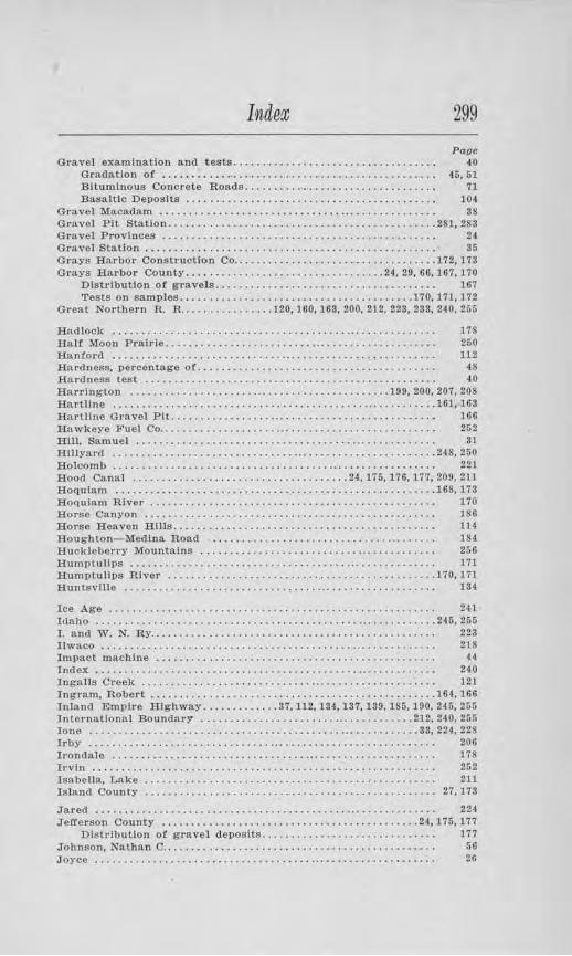
Indea; 299 Page
Gravel examination and tests................................... 40 G rada.tlon of . . . . . . . . . . . . . . . . . . . . . . . . . . . . . . . . . . . . . . . . . . . . . . . 45, 51 Bituminous Concrete Roads................................. 71 Basaltic Deposits . . . . . . . . . . . . . . . . . . . . . . . . . . . . . . . . . . . . . . . . . . . 104
Gravel Macadam ............. , , ............... , ... . . . . . . . . . . . . . . 38 Gravel Pit Station ..........................•.. .... ............. 281, 283 Gravel Provinces . . . . . . . . . . . . . . . . . . . . . . . . . . . . . . . . . . . . . . . . . . . . . . . 24 Gravel Station . . . . . . . . . . . . . . . . . . . . . . . . . . . . . . . . . . . . . . . . . . . . . . . . . . 35 O t·ays Harbor Conslruction Co .............. , ... . ................ 172, 173 Orays H arbor County ...................... , .........•. 24, 29, 66,167,170
Dlstdbutlon of gt·avels...................................... 167 Tests on samples .......... ......... .............. ....... 170, 171, 172
Great Northern R. R. ...... .. ....... 120, 160, 163, 200, 212, 223, 233, 240, 265
Hadlock ....... ................ , . . . . . . . . . . . . . . . . .. . . . . . . . . . . . . . . 17S Hal! Moon Pralrle .. ............ . .......... ... . . . . . . . . . . . . . . . . . . . 260 Hanford ....................... , • . . . . . . . . . . . . • . . . . . . . . . . . . . . . . . . 112 Hardness, percentage of......................................... 48 Hardness test . . . . . . . . . . . • . . . . . . . . . . . . . . . . . . . . . . . . . . . . . . . . . . . . . . 40 Han·lngton ..................• , ......................... 199, 200,207, 208 Hartline ..................... , .................................. 161, 163 Hartline Gravel Pit. ........... , ..................... .. .......... 166 Hawkeye Fuel Co.. . . . . . . . . . . . . . • . . . . . . . . . . . . . • . . . . . . . . . • . . . . . . . . 252 HUl, Samuel . . . . . . . . . . . . . . . . . . . . . . . . . . . . . . . . . . . . . .•. . . . . . . . . . . . . 31 Hillyard ..................................... . .................. 248, 250 Holcomb ...................... , . . . . . . . . . . . . . . .. . . . . . . . . . . . . . . . . . 221 Hood Canal .............. . ...................... 24, 175, 176, 177, 209,211 Hoquiam .......................... . ........•.............•..... .168, 173 Hoquiam River . . . . . . . . . . . . . . . . . . . . . . . . . . . . . . . . . . . . . . . . . . . . . . . . . 170 Horse Canyon . . . . . . . . . . . . . . . . . . . . . . . . . . . . . . . . . . . . . . . . . . . . . . . . . . 186 Horse Heaven Rills. . . . . . . . . . . . . . . . . . . . . . . . . . . • . . . . . . . . . . . . . . . . . 114 Houghton-Medina Road ..... , . . . . . . . . . . . . . . . . . . . . . . . . ... . . . . . . 184 Huckleberry Mountains . . . . . . . . . . . . . . . . . . . . . . . . . . . ... . . . . . . . . . . . 256 Humptullps . .. . . . . . . . . . . . . . . . . . . . . . . . . . . . . . . . . . . ... . . . . . . . . . . . . . 171 E.umpLullps River ........................................... . .. 170. 17 l Huntsville . . . . . . . . . . . . . . . . . . . . . . . . . . . . . . . . . ... . . . . . . . . . . . . . . . . . . 134
Ice Age . . . . . . . . . . . . . . . . . . . . . . . . . . . . . . . . • . . . . . . . . . . . . . . . . . . . . . . . 241 Idaho ........................................................... 245, 255 I. and W. N. Ry.............................. .. ................. 223 Uwaco . . . . . . . . . . . . . . . . . . . . . . . . . . . . . . . . . . . . . . . . . . . ... . . . • . . . . . . . . 218 Impact machine ..... , . . . . . . . . . . . . . . . . . . . . . . . • . . . . . . . . . . . . . • . . . . 44 Index . . . . . . . . . . . . . . . . . . . . . . . . . • . . . . . . . . . . . . . . . . . . . .. . . . . . . . . . . . . 240 Ingalls Creek . . . . . . . . . . . . . . . . . . . . . . . . . . . . . .. . . . . . . . . . . . . . . . . . . . . 121 Ingram, Robert ........................ ............. . . ... ....... 164, lGG Inland Empire Highway ............. 37.112, 134,137,189,186,190,246, 251i International Boundary .................................... . 212, 240, 255 lone ......................................................... 33, 224, 228 Irby . . . . . . . . . . . . . . . . . . . . . . . . . . . . . . . ... . . . . . . . . • . . . . . . . . . . . . . . . . . 206 !J'ondale ..... .. ......... . ...... , . . . . . . . . . .. . . . . . . . . . . • . . . . . . . . . . 178 Irvin . . . . . . . . . . . . . . . . . . . . . . . . . . . . . . . . . . . . . . . • . . . . . . . . . . . . . . . . . . . 252 Isabella, Lake . . . . . . . . . . . . . . . . . . . . . . . . . . . . . . . . . . . . . . . . . . . . . . . . . . 211 Islnnd County .............•.................................... 27, 173
Jared . . . . . . . . . . . . . . . . . . . . . . . . . . . . . . . . . . . . . . . . . . . ... . . . . . . . . . . . . . 224 J efferson County ...... .... ..................•............... 24, 175,177
Dh1trlbution of gn,vel deposits.............................. 177 Johnson, Nalhan C.. . . . . . . . . . . . . . . . . . . . . . . . . . . . • . . . . . . . . . . . . . . . . . 50 Joyee ...........................•... , . . . . . .. . . . . . . . . . . . . . . . . . . . . 26
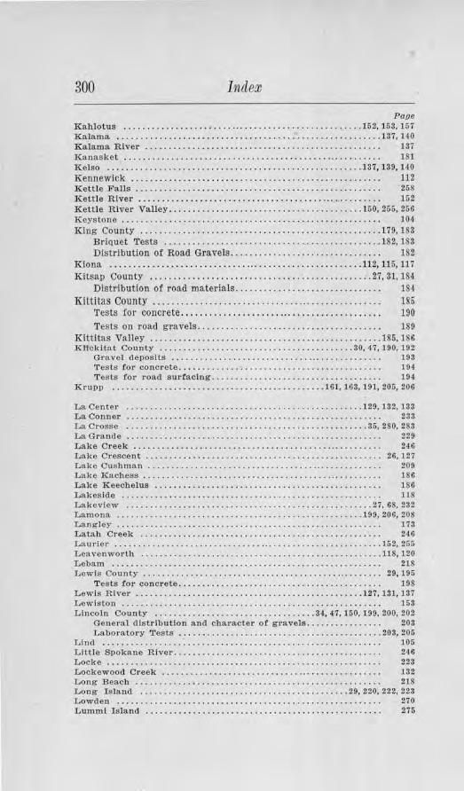
300 Indem
Page Kahlotus ................................... , ............... 152, 153, 167 Kalama. . ... . ............................. • ..................... 137, 140 Ka.lama River . . . . . . . . . . . . . . . . . . . . . . . . . . . . . • . . . . . . . . . . . . . . . . . . . . 137 Ka.nasket . . . . . . . . . . . . . . . . . . . . . . . . . . . . . . . . . . . . . . . . . . . .. . . . . . . . . . . 181 Kelso .. .. .......... . .... . .................. . ............... 137, 139, HO Kennewick . . . . . . . . . . . . . . . . . . . . . . . . . . . . . . . . . . . . . . . . . . . . . . . . . . . . . 112 Kettle Fa.Us . . . . . . . . . . . . . . . . . . . . . . . . . . . . . . . . . . . . . . . . . . . . . . . . . . . . 268 Kettle River . . . . . . . . . . . . . . . . . . . . . . . . . . . . . . . . . . . . . . . . . . . . . . . . . . . . 152 Kettle River Valley .................. .. ... ... , . ...... .... ... 150, 255, 256 J(eys tone . . . . . . . . . . . . . . . . . . . . . . . . . . . . . . . . . • . . . . . . . . . . . . . . . . . . . . . 104 King County . ... . .... . ......................................... 179, 183
Briquet Tests .......... . .... . ........... ... ............... . 182, 183 Dlstrlbution of Road Gravels............................... . 182
Kiona ........... ............................ ............... 112, 116,117 Kitsap County . ...... . .. .. ................. ... ............... 27, 31, 184
Distl'ibution of road materials............................... 184
Kittitas County . . . . . .. . . . . . . .. . . . . . . . . . . . .. . .. .. . . . . . . . . . . . . . .. . 185 'l'ests for concrete ....... .................................. .. 190 Tests on road gravels................... . ................... 189
Kittitas Valley ................................................. 186, 186 Kllck!Lat County ........................ . ................ 30, 47, 190,192
Gravel deposits . . . . . . . . . . . . . . . . . . . . . . . . . . . . . .. . . . . . . . . . . . . . . 193 Tests for concrete.. . . . . . . . . . . . . . . . . . . . . . . . . . . . . . . . . . . . . . . . . . 194 Tests tor road surfacing... . . . . . . . . . . . . . . . . . . . . . . . . . . . . . . . . . 104
Krupp ..................... • ............ • ........ . . 161, 163, 191, 205, 206
La Center ........... • ........... . ................... . ...... 129, 132, 133 La. Conner . . . . . . . . . • . . . . . . . . • . . . . . . . . . . . . . . . . . . . . . . . . . . . . . . . . . . . 233 La Crosse . ............ . ..................................... 35, 280, 283 La Gran(le . . . . . . . . . . . . . . . . . . . . . . . . . . . . . . . . . . . . . . . . . . . . . . . . . . . . . . 229 Lake Creek . . . . . . . . . . . . . . . . . . . . . . . . . . . . . . . . . . . . . . . . . .. . . . . . . . . . . 246 Lake Crescent . . . . . • . . . . . . . . . . . . . . . . . . . . . . . . . . . . . . . . . . . . . . . . . . . . 26, J 27 Lake Cusl1man . . . . . . . . . . . . . . . . . . . . . . . . . . . . . . . . . . . .. . . . . . . . . . . . . . 200 Lake Ka.chess . . . . . . . . . . . . . . . . . . . . . . . . . . . . . . . . . . . . . . • ... . . . . . . . . . 186 Lake Keechelus . . . . . . . . . . . . . . . . . . . . . . . . . . . . . . . . . . . . . . . . . . . . . . . . 186 Lakeside .......... •.... .... .... ...... , . . . . . . . . . . . . . . . . . . . . . . . . . 118 Lakeview ............ . . .................. • ................... 27, 68, 232 Lamona .... . .............................•................. 199, 206, 20!! Langley . . . . . . . . . . . . . . . . . . . . . . . . . . . . . . . . . • . . . . . . . . . . . . . . . . . . . . . . 173 La.tab Creek . . . . . . . . . . . . . . . . . . . . . . . . . . . . . . . . . . . . . . . . . . . . . . . . . . . 246 Laurier ........ ............ .... ...... .... .................... . .. 152, 255 Leavenworth ......•............ . ........................... .. .. 118, 120 Lebam . . . . . . . . . . . . . . . . . . . . . . . . . . • . . . . . . . . • . . . . . • . . . . . . . . . . . . . . . 218 Lewis County ................................................... 29, 195
Tests /.or concrete ... ........................................ 198 Lewis River .............................•... . .............. 127, 131,137 Lewiston . . . . . . . . . . . . . . . . . . . . . . . . . . . . . . . . . . . . . . . . . . . . . . . . . . . . . . . 153 Lincoln County .................................. 34, 47,150, 199, 200. 202
General distribution and character ot gravels................ 203 Laboratory Tests ........................................ . .. 203, 205
Lind . . . . . . . . . . . . . . . . . . . . . . . . . . . . . . . . . . . . . . . . . . . . . . . . . . . . . . . . . . . 105 Little Spokane River... . ................. . . .................. . .. 246 Locke . . . . . . . . . . . . . . . . . . . . . . . . . . . . . . . . . . . . . . . . . . . . . . . . . . . . . . . . . . 223 Lockewood Creek . . . . . . . . . . . . . . . . . . . . . . . . . . . . . ... . . . . . . . . . . . . . . . 132 Long Beach . . . . . . . . . . . . . . . . . . . . . . . . . . . . . . . . . . . . . . . . . . . . . . . . . . . . 21S Long Island ......... • . .................. .. ......... . ... 20, 220. 222, 223 Lowden . . . . . . . . . . . . . . . . . . . . . . . . . . . . . . . . . . . . . . . . . . . . . . . . . . . . . . . . 270 Luntml Island . . . . . • . . . . . . . . . . . . . . . . . . . • . . . . . . . . . . . . . . . . . . . . . . . . 275
Index 301
Paoe
~~~~e~· ·.-."." .. .".".".".".'.' .. .".'.".·.·.·. ·:.·:::.".". :::::::::::::::::::::::: ~~·. ~~·.190; !~: Mabton . ........... . , ......................... .. .. . ........•... , 190 Macadam, Gravel ............................. .. .. ..... , ... , . . . . 38 Manastash R idge . . . . . . . . . . . . . . . . . . . . . . . . . . . . . . . . . . . . . . . . . . • . . . . 185 Mansfield . . . . . . . . . . . . . . . . . . . . . . . . . . . . . . . . . . . . . . . . . . . . . . . . . . . . . . . 142 Marcus . . . . . . . . . . . . . . . . . . . . . . . . . . . . . . . . . . . . . . . . . . . . . . . . . . . . . . . . . 255 Marengo Hill ...•............... • .........•....•........... . .. . 135, 136 Marshall ............... .. ........ .. ... .. .............. .. .. , . . . . . 248 Maryhill ......................... ..... . ...................... 31, 192,193 Marysville .....................•........................... 240, 241, 243 Mason County ....... .. ........ .. ..... , .............. ... ........ 24, 208
Character of gravels. . . . . . . . . . . . . . . . . . . . . . . . . . . . . . . . . . . . . . . . 211 Mallock ... ..................................................... 209, 210 Maury Isl.and .... , ....... ............ ...... .. . , ............ , . 66, 182, 232 Maynard . . . . . . . . . . . . . . . . . . . . . . . . • . . . . . . . . . . . . . . . . . . . . . . . . . . . . . . 179 Mazama . .............. .. . . .. . . . . . . . ... . . .. . . . . . . . . . . . . . . •• . . . . . 212 McClellan Pass . . . . . . . . . . . . . . . . . . . . . . . . . . . . . . . . . . . . . . . . . . . . . . . . . 180 McCle llan Pass HJghway.. . . . . . . . . . . . . . . . . . . . . . . . . . . . . . . . . . . . . . . 180 McMui-ray . . . . . . . . . . . . . . . . . . . . . . . . . . . . . . . . . . . . . . . . . . . . . . . . . • . . . . 233 McLean Road .................. • .......................... • .... 234, 236 Mead . . . . . . . . . . . . . . . . . . . . . . . . . . . . . . . . . . . . . . . . . . . . . . . . . . . . . . • . . . . 253 Mead Road ........... .. .. . ...... . ...... .... .. .. .. . .. ... . .• ..... 253, 254 Meadow Lake . . . . . . . . . . . . . . . . . . . . . . . . . . . . . . . . . . . . . . . . . . . . . . . . . . . 251 Mechanical analysis ........... , . . . . . . . . . . . . . . . . . . . . . . . . . . . . . . . . 43 Mesa ...................... .. . .. ... ... . .....•... ..........•..... 152, 157 Meta.line Falls . , . , . . . . . . . . . . . . . • . . . . . . . . . . . . . . . . . . . . . . . . . . . . . . . . 223 Methow Valley ................. , , . . . . . . . . . . . . . . . . . . . . . . . . . . . . . . 212 Meyers Falls ...... .. ........ . •• ... ..... .................... 255, 256, 2Gl Milan . . . . . . . . . . . . . . . . . . . . . . . . . . . . . . . . . . . . . . . . . . . . . . . . . . . . . . . . . . 248 Mill Creek . . . . . . . . . . . . . . . . . . . . . . . . . . . . . . . . . . . . . . . . . . . . . . . . . . . . . . 220 l\Llneral Salts . . . . . . . . . . . . . . . . . . . . . . . . . . . . . . . . . . . . . . . . . . . . . • . . . . . 163 Mlnslnger B r others . . . . . . . . . . • . . . . . . . . . . . . . . . . . . . . . . . . . . . . . . . . . . 133 "Mock Chehalis River ... ........ ... ............. . ................ 26, 168 Monitor ......... .. ..........•... . , ............................. 118, 121 Monroe .. ........ .. .. . ..... .. ...................... . ... . 28, 240, 24-4, 245 Montesano ........................................... 26, 27,168,172,173 Morrison Flat . . . . . . . . . . . . . . . • . . . . . . . . . . . . . . . . . . . . . . . . . . . . . . . . . . 164 Morse Creek ................... .... .................. .. . 26, 126,127.128 Moses Coulee ........................................... 142,144, 145,148 :Moses LR.lee . . . . . . . . . . . . . . . . . • . . . . . . . . . . . . . . . . . . . . . . . . • . . . . . . . . . 164 Mound Prairie . . . . . . . . . . . . . • . . . . . . . . . . . . . . . . . . . . . . . . . . . • . . . . . . . . 29 Mount Baker ..... , . . . . . . . . . . . . . . . . . . . . . . . • . . . . . . . . . . . . . . . . . . . . . 234 Mount Rainier . . . . . . . . . . . . . • • . . . . . . . . . . . . . . . . . . . . . . . . . . • . . . . . . . 229 1v(ount St. Helens. . .............................................. 1-40, 1viount Vernon .......... .. ...•............ .. ........... • ........ 233, 234
Naches ... . ... ..... .................................... .. ....... 70, 200 Naches River . . . . . . . . . . . . • . . . . . . . . . . . . • • . . . . . . . . . . . . . . . . . . . . . . . . 70 Nahcotta . . . . . . . . . . . . . . . . • . . . . . . . . . . . . . . . • . . . . . . . . . . . . . . . . . . . . . . 218 Nahcotta. Sand and Gravel Co ......................•.•........... 29, 221 Napavine . . . . . . . . . . . . . . . . . . . . . . . . . . . . . . . . . . . . . . . . . .. • . . . . . . . . . . . 195 Nase! River ................. , . . . . . . . . . . . . . . . . . . . . . . . . . . . . . . . . . . 29, 220 National Park Highway ................ ..... ............ 218, 219,221,229 Neah Bay . . . . . . . . . . . . . . . . . . . . . . . . . . . . . . . . . . . . . . . . . . . . . . . . . . . . . . J 24 Nemah River . . . . . . . . . . . . . . . . . . . . . . . . . . . . . . . . . . . . . . ...... ...... 2!), 221 Newaukum River ....... ......... .................•........ .... 29, 197
302 Index
Page Newhall, Chas. A. Go.. . . . . . . . . . . • . . . . . . . . . . . . . . . . . . . • . . . . . . . . . . . 60 Newport ............................................ • ........... 223, 226 Newton . . . . . . . . . . . . . . . . . . . . . . . . . . . . . . . . . . . . • . . . . . . . . . . . . . . . . . . . 171 Nlsqually ...................... . ............................... 229, 232 Nooksack River . . . . . . . . . . . . . . . . . . . . . . . . . . . . . . . . . . . . . . . . . . . . . . . . 29 North Central Highway . . . ...................................... 163, 199 Northern Pacific Ry. 104,112,124,153,156,157,163, 186, 200, 219, 240, 248, 250 North Pine . . . . . . . . . . . . . . . . . . . . . . . . . . . . . . . . . . . . . . . . . . . . . . . . . .. . . 249 Northport . . . . . . . . . . . . . . . . . . . . . . . . . . . . . . . . . . . . . . • . . . . • • . . . . . . . . . 255 Nugent's Bridge ...... .. ... . .......... ....................... ... 275, 27.6
Oakville . . . . . . . . . . . . . . . . . . . . . . . . . . . . . . . . . . . . . . . . . . . . . . . . . . . . . . . 170 Odessa ................ . ....... ... ................... • .......... 199, 206 Ohio State Highway Department. ..... ..... • •... . • . . . , . ......... 41, 46 Okanogan ...................................................... 214, 217 Okanogan County .......... . ............ ........... ..... 32, 120, 160, 212
Climate . . . . . . . . . . . . . . . . . . . . . . . . . . . . . . . . . . . . . . . . . . . . . . . . . . . . 212 General Distribution of Road Gravels . . . . . . . . . . . . . . . . . . . . . . . . 214 Tests of road gravels ........................................ 215, 217
Okanogan Highlands .............................. .... ...... 23. 149, 200 Okanogan Province ............. ... ........................... 24-, 32, 69 Okanogan River . . . . . . • . . . . . . . . . . . . . . . . . . . . . . . . . . . . . . . . . . . . . . . . . 32, 212 Okanogan Valley ... .. . . ................................. . ...... 212, 214 Old Blewett . . . . . . . . . . . . . . . . . . . . . . . . . . . . . . . . . . . . . . . . . . . . . . . . . . . . 121 Olympia . . . . . . . . . . . . . . . . . . . . . . . . . . . . . ... . . . . . . . . . . . . . . . . . . . . . . . . 28 Olympic Highway ............ .. .. 24, 26, 124,127, 171,176,177,178,209,210 Olympic '.Mountain Province..................................... 21 Olympic Mountains ...................... ........ 23, 167,170,175, 176.177 Omak ............................................ 32, 69, 214, 215, 217, 218 Omak Cement and Products Co.. . . . . . . . . . . . . . . . . . . . . . . . . . . . . . . . . . 32, 217 Omak Creek . . . . . . . . . . . . . . . . . . . . . . . . . . . . . . . . . . . . . . . . . • . . . . . . . . . . 216 0.-W. R. R. and Nav. Go .......... • .. ............................ 112, 158 Orchards ........................................ . .............. 129, 142 Orient . . . . . . . . . . . . . . . . . . . . . . . . . . . • . . . . . . . . . . . . . . . . . . . . . . . . . . . . . 152 Oronclo ......................... .• .......... . ................... 144, 14$ Oroville .......................... . .... • ... .. .. ..... 120, 212,214,217,256 Orting . . . . . . . . . . . . . . . . . . . . . . . . . . . . . . . . . . . . . . . . . . . ... . . . . . . . . . . . . 229 Ottawa Standard Sand.......................................... 58 Othello . . . . . . . . . . . . . . . . . . . . . . . . . . . . . . . . . . . . . . . . . . . . . . . . . . . . . . . . . 105 Outwash plains . . . . . . . . . . . . . . . . . . . . . . . . . . . . . .. . . . . . . . . . . . . . . . . . . 28
Pacific County ........... . ........................ 29, 45, 70, 218, 219, 220 Pacific Highway ... 129, 133.-137, 180,190,195,229,232,233,237,240,245, 251
Testa for road surfacing.... . . . . . . . . . . . . . . . . . . . . . . . . . . . . . . . . 221 Pacific Northwest Traction Co ...... , . .................. , , . . . . • • . 233 Palisades Station . . . . . . . . . . . . . . . . . . . . . . . . . . . . . . . . . . . . . . . . . . . . . . . 148 Palouse Country . . . . . . . . . . . . . . . . . . . . . . . . . . . . . . . . . . . . . . . . . . . . . . . . 23 Palux River ...................... . ............................. 220, 221 Pantops . . . . . . . • . . . . . . . . . . . . . . . . . . . . . . . . . . . . . . . . . . . . . . . . . . . . . . . . 252 Paradise . . . . . . . . . . . . . . . . . . . . . . . . . . . . . . . . . . . . . . . .. . . . . . . . . . . . . . . . 249 Pasco . ............................................. l 52, 163, 154, 156, 199 Pateros . . . . . . . . . . . . . . . . . . . . . . . . . . . . • . . . . . . . . . . . . . . . . . . . . . . . . . . . 212 Pe E ll . . . . . . . . . . . . . . . . . . . . . . . . . . . . . . . . . . . . . . . . . . . . . . . . . . . . . . . . . 29, 195 Pend Oreille County ................ ... .. ............ ..... 32, 33, 223, 256
Glim ate . . . . . . . . . . . . . . . . . . . . . . . . . . . . . . . . . . . . . . . . . . . . . . . . . . . . . 224 Road gravels . . . . . . . . . . . . . . . . . . . . . . . . . . . .. . . . . . . . . . . . • . . . . . . 224 Tests for Road Samples. . . . . . . . . . . . . . . . . . . . . . . . . . . . . . . . . . . . . 226 Tests for Concrete................. .. ....... .. ....... . ...... 228
Index 303
Paoq Pend Oreille River . . . . . . . . . . . . . • • . . . . . . . . . . . . . . . . . . . . . . . . . . • . . . . 33 Penrith .. . .......................... . .......................... 223. 226 Per·klns, Ray . . . . . . . . . . . . . . . . . . . . . . . . ... . . . . . . . . . . . . . . . . . . . . • . . . . 216 Peshastin . . .....................••.. . ...................... , . . . 120 Peshastln Creek . . . . . . . . . . . . . . . . . . . . . . . . . . . . . . . . . . . . . . . . . . . . . . . . 121 Petrological Determination . . . . . . . . . . . . . . . . . . . . . . . . . . . . . . . . . . . . . 40 Pierce County ................... • .................... 27, 67, 68, 229, 231
Climate ......................................•............. 229, 230 Distribution of Gravels...................................... 231 Tests for Brlquets . .......................... ... . . . . . . . . . . • . . 231 Tests 011 Fieltl Concrete.... . . . . . . . . . • . . . . . . . . . . . . . . . . . . . . • . . 232
Pine Creek Valley ........................... ,................... 249 Pioneer Church . . . . . . . . . . • . . . . . . . . . . . . . . . . . . . . . . . . . . . . . . . . . . . . . . 133 Pioneer Sand and Gravel Co.. . . . . . . • . . . . . . . . . . • . . . . . . . . . . . . . . . . . 231 Pleasant Prairie ............................................. 47, 248,249 Pluv!us . . . . . . . . . . . . . . . . . . . . . . . . . . . . • . . . . . . . . . . . . . . . . . . . . . . . . . . . 107 Pogue Flat .......................•..... , . . . . . . . . . . . . . . . . . . . . . . . 217 Pomeroy .................•............................. 156. 159, 160, l Gl Pomeroy-Starb\1ck Road . . . . . . . . . . . . . . . . . . . . . . . . . . . . . . . . . . . . . . . . 169 Port Angeles . .....................•.. . .................. 26, 124.127, l 28 Port Discovery ................................................. 178, 179 Port Discovery Road. . . . . . . . . . . . . . . . • . . . . . . . . . . • . . . . . . . . . . . . . . . . 170 Portland Cement Association .. . ...•. . ............. 21, 62,128,232,236,243 Portland Cement concrete....................................... 56
Field tests of......... . . . . . . . . . . . . . . . . . . . . . . . . . . . . . . . . . . . . . . 04 Port Ludlow . . . . . . . . . . . . . . . . . . . . . . . . . . . . . . . . . . . . . • . . . . . . . . . . . . . . 176 rort Orchard . . . . . . . . . . . . . . . . . . . . . . . . . . . . . . . . . . . . . . . . . . . . . . . . . . . 184 Port Townsend ..................... . ......•.............. 24, 26, 175. 177 Prairie . . . . . . . . . . . . . . . . . . . . . . . . . . . . . . . . . . . . . . . . . . . . . . . . . . . . . . . . . 234 Prosser ..................................................... 112, lH, 115 Puget Sound Glacier ...............•...•......................•. 168, 241 Puget Sounrl Province ...............•... . ............... 24, 27, 67, 68, 70 Puget Sound Region. . . . . . . . . . . . . . . . . • . . . . . . . . . . . . . . . . . . . . . . . . . . 23, 24 Puget Sound Trough. . . . . . . . . . . . . . . . . . . • . . . . . . . . . . . . . . . . . . . . . . . . tn7 Puyallup River Valley ........................................... 229, 231
Qullcene .............................•......................... l 75. l 7S Quincy ..................•.................................. 161, 163, 166
Ralston ........................................................ 104, 106 Rattler test . . . . . . . . . . . . . . . . . . • . . . . . . . . . . . . . . . . . . . . . . . . . . . . . . . . . . 42 Rattlesnake Hills . . . . . . . . . . . . . . . . . . . . • . . . . . . • . . . . . . . . . . . . • . . . . . 112 Raymond ... . .......................................... 218, 220, 222, 223 Raymond Sanrl and Improvement Co.............................. 223 Roarda.n ............................................... 199, 200, 202, 204 Red Rock . . . . . . . . . . . . . . . . . . . . . . . . . . . . . . . . . . . . . . . . . • . . . . . . . . . . . . . 16S Reltze, C. N.... . . . . . . . . . . . . . . . . . . . . . . . . . . . . . . . . . . . . . . . . . . . . . . . . . 21 Renton Junction . . . • . . . . . . . . . . . . . . . . . . . . . . . . . . . . . ... . . . . . . . . . . . . lSS Republic ..... . ......................•..................... , 150, 152, 265 Richland .... . ......................... . ....................... . 31,117 Richmond Beach .....................•...................... 27, 182, l S3 Rit:r.vlllc .. . .......................•........................ 101.104.199 Rock Creek ........... , . . . . . . . . . . . . . . . . . . . . . . . . . . • ... . . . . . . . . . . . 240 Rock 1!lland . . . • . • . . . . • . . . . . . . . . . • . . . . . . . . . • • . . . . . . . . . . . . . . . . . . • 146 RockY Mountains . . . . . . . . . . . . . . . . . . . • . . . . . . . . . . . . . . . . . . . . . . . . . . . 245 Rocky Prairie . . . . . . . . . . . . . . . . . . . . . . . . . . . . . . . . . . . . . . . . . . . . . . . . . . 28 Rosalia ................... . .................................... . 35, 245 Roslyn ................................•............. . ... . ...... 185, 189
304 Index
Page Roslyn-Ronald Co ...... . ......... . ............ ............. • .. , . 189 Ross Holding Co.. . . . . . . . . . . . . . . . . . . . . . . . . . . . . . . . . . . . . . . . . . . . . . . . 252 Ruby ....... .... , ........... . ....•.......... .. .......... . ....... 224, 226 Rutherford . . . . . . . . . . . . . . . . . . . . . . . . . . . . . . . . . . . . . . . . . . . . . . . . . . . . . 168
Saddle Mountains . . . . . . . . . . . . . . . . . . . . . . • . . . . • . . . . . . . . . . . . . . . . . . 163 Salmon Creek . . . . . . . . . . . . . . . . . . . . . . . . . . . . . . . . . . . . . . . . . . . . . . . . . . . 133 Salmon Creek Valley.......................... . .. ............... 127 Samish Rtver . . . . . . . . . . . . . . . . . . . . . . . . . . . . . . . . . . . . . . . . . . . . . . . . . . . 234 Sand and gravel deposits, Descl'iptlon or... . .................... 24 Sa.ncl and gravel, Distribu tion of by Counties................... 101 Sand and gravel formations, Distribution of.. .................. 23 Sand, cha!'acter and quality of. .... .... .... .. ................ .. . 68 Sand, for sheet asphalt construction... . . . . • . . . . . • . . . . . . . . . . . . . . 72 San Juan County. . . . . . . . . . . . . . . . . . . . . . . . . . . . . . . . . . . . . . . . . . . . . . . . 27 San poll-Kettle River Valley. . . . . . . . . . . • . . . . . . . . . • . . . . . . . . . . . . . . . 149 Sanpoll Valley ...... .. ................... • .................. .. . 150, 152 Satsop . . . . . . . . . . . . . . . . . . . . . . . . . . . . . . . . . . . . • . . . . . . . . . . . . . . . . . . . . 168 Satsop River ........................ .. .•.. • ............. 26, 168,210,211
Seattle ..................... ....... ... ...•.. ...... ....... 28, l&O, 181. 240 Seattle-Spokane Highway . .. . .. .. . .. .. .. .. .. .. . . .. .. . .. . . . .. .. . . 118 Seclro-Woolley ............•........ . ..... . ..... ... .. 66, 233, 234, 236, 237 Selah . . . . . . . . . . . . . . . . . . . . . . . . . . • . . . . . . . . . . . . . . . . . . . . . . . . . . . . . . . . 286 Sequa.Jltchew River . . . . . . . . . . . . . . . . . . . . . . . . . . . . . . . . . . . . . . . . . . . . . 231 Sequim ........ . .. . ....... . . .... . .. . ... . ..... .. .... ........... .. 124 , 126 Shelley pit . . . . . . . . . . . . . . . . . . . . . . . . . . . . . . . • . . . . . . . . . . . . . . . . . . . . . 254 Shelton ...... ...... ........... ............. ... ............. 209, 210, 211 Shelton-Matlocl< Highway . . . . . . . . . . . . . . . . . . . ... . . . . . . . . . . . . . . . . . 210 Sitton ............ . ........................................ . . ... 132-133 Silvana .. ............•.......... . ........ • ... .. ............... . 28, 240 Silver Lake • . . . . . . . . . . . . . . . . . . . . . . . . . . . . . . . . . . . .. . . . . . . . . . . . . . . . 13'1 Skagit County . . . . . . . . . . . . . . . . . . . . . . . . . . . . . . . . . . . . . . . . . . . . . . . . . . 28, 233
General distribution of road gravels................... ...... 234 Tests on concrete........................................... 234 Tests on briquets.................. . ............ . ....... . .... 234
Skagit River ............ .. ............. . .. ........ 28, 29, 66, 233, 234, 236 Skamania . . . . . . . . . . . . . . . . . • . . . . . . . . . . . . . . • . . . . . . . . . . . . . . . . . . . . . 23S Skamania County ...... . .. . . . ...........•.................... 30, 47, 237
Brlquet tests . . . . . . . . . . . . . . . . . . . . . . . . . . . . . . . . . . . . . . . . . . . . . . . 238 Tests for concrete. . . . . . . . . . . . . . . . . . . . . . . . . . . . . . . . . . . . . . . . . . . . . . . 238 Skookumcbuck River .......... ... .. ....• • .. .... .. ........... 69, 197, 198 Skookumcltuck Valley . . . . . . . . . . . . . . . . . . . . . . . . . . . . . . . . . • . . . . . . . . 29 Skykomish River . ... ......... •...... ... . ..... . .......... 28. 240. 241, 244 Smilll, A . .J. Sand Co.. . . . . . . . . . . . . . . . . . . . • . . . . . . . . . . . . . . . . . . . . . . 263 Smith's Canyon .......... .................... . , . . . . . . . . . . . . . . . . . 136 Smith's Ca1,-yon Road... . ....... . ........................ .. ..... . i57 Smyrna . . . . . . . . . . . . . . . . . . . . . . . . . . . . . . . . . . . . . . . . . . . . . . . . . . . . . . . . 161 Snake River .... ... . . .. 23, 37, 70,107,109, 134, 135,136,152, 153, 158, 159.160 Snell, Everett G ..... . ........ .. . . ............................. 21, GS, 232 Snolioml!lll . . . . . . . . . . . . . . . . . . . . . . . . . . . . . . . . . . . . . . . . . . . . . . . . . . . . . 28, 240 Snohomish County ........................................... . .. 28, 240
General Distrlbution of Gravels . ................ . . .. .. . ..... 243 Tests . . . . . . . . . . . . . . . . . . . . . . . . . . . . . . . . . . . . . . . . . . . . . . . . . . . . . . . 243
Snobomi:sh River ....................... •. ...... . ........ 2S, 240, 241, 243 Snoqualmie . . . . . . . . . . . . . . . . . • . . . . . . . . . . . . . . . . . .. . . . . . . . . . . . . . . . . 180 Snoqu:ilmie Pass ... . .. ..................... . ................. . . 186, 186 Snoqualmie River . . . . . . . . . . . . .. . . . . . . . . . . . . . . . . . . . . . . . . . • .. . . . . . 244 Soap Lake ......... • ....................................... 163, 164, 166
bulex 305
Paga Soleduck . . . . . . . . . . . . . . . . . . . . . . . . . . . . . . . . . . . . . . . . . . . . . . . . . . . . . . . 127 Soleduck RI ver . . . . . . . . . . . . . . . . . . . . . . . . . . . . . . • . . . . . . . . . . . . . . . . . . 26, 128 South Ben<l . .. . . . . .. .. .. . . . . . . . • . . . . . . . . . . . . . . . . . . .. . . . . . . . . . . . . 218 Southwestern Province ...................... . .. . ........... 24, 29, 69, 70 S., P. and S. Ry .... ... ....•........................... 31,158. 190. 193, 238 Spangle . . . . . . . . . . . . . . . . . . . . . . . . . . . . . . . . . . . . . . . . . . . . . . . . . . . . . . . . 249 Spangle Creel< . . . . . . . . . . . . . . . . . . . . . . . . . . . . . . . . . . . . . . . . . . . . . . . . . . 246 Spokane ....................................... 199, 223,245,246, 24S., 251 Spokane County ........................................ 32. 34, 47, 67,245
General D istribution of Road Gravels...... .. ............... 248 Tests on concrete .........................•................. 253, 25-t Tests on samples.................. . ... . .............. . ...... 240
Spokane River Valey ......... .. . • .................. . .. 23, 38, 246, 252, 255 Sprague ........................ ... ............ . ... . .... 104, 199, 206. 207 Sprague-Hanington Road . . . . . . . . . . . . . . . . . . . . . . . . . . . . . . . . . . . . . . 207 Stanwood . . . . . . . . . . . . . . . . . . . . . . . . • . . . . . . . . . . • . . . . . . . . . . . . . . . . . . . 240 Starbuck . ...................................... • ...... ..... 134, 135, 136 State Highway Department...................... ... . . ........... 255 Steilacoom .............................•....... . ...... 27. 66, 68, 231, 232 Stevens County ............... ....... ........... . ...... 32, 33. 47, 245. 25ij
Climate . . . . . . . . . . . . . . . . . . . . . . . . . . . . . . . . . . . . . . . . . . . . . . . . . . . . 256 Deposits of Roacl Gravels................... . ............... 258 Laboratory tests . . . . . . . . . . . . . . . . . . . . . . . . . . . • • . . . . . . . . . . . . . . . 268
Stevenson • . . . . . . . . . . . . . . . . . . . . . . . . . . . . . . . . . . . . . . . . . . . . . . . . . . . . . 238 St. Helens . . . . . . . . . . . . . . . . . . • . . . . . . . . . . . . . . . . . . . . . . . . . . . . • . . . . . . 132 Stll.aguamfsh River . . ............ .. ..............•.. .. ... 28, 241. 243, 244 $trail ot Juan de Fuca . ......................................... 24, 233 Sultan . .............................. ... ............. ... ........ 28, 240 Sumner . . . . . . . . . . . . . . . . . . . . . . . . . . . . . . . . . . . . . . . . . . . . . . . . . . . . . . . . 229 Sunnyside ..................... ................... ....... .. . 289, 290, 291 Sunnyslope . . . . . . . . . . . . . . • . . . . . . . . . . . . . . . . . . . . . . . . . . . . . . . . . . . . . . 122 Sunset Highway ......... ... ......... . ......................... .
. . . . . . . . . 34, 118, HG, 16,0, 163,180,181,182, 185.1$6, 199,204,207.245, 251 Swaka.ne Cr·eek ........ .. _ . . . . . . . . . . . . . . . . . . . . . . . . . . . . . . . . . . . . . . 121 Swartz, A. \V ...................................... • • ..... , . . . . . . 21
Tables: 1. 2.
Physical features an<I results o( tests.................... 73-79 Composition. mechanical analyses. tenacity ancl cemenla-
tlon values .... ..... .................. ............. . 3. Composllion and mechanlcal analyse!! of sanda .......... . 4. Tensile strength and colorimetric tests ................ . . . 5. f'hyslcal character and mechanical analyses of coarse ag-
6. 7. 8.
gregates .......................................... . Compressional strength tests on cylinders .............. . Tests on Ste'llacoom and Lakeview Sand ancl Gravel. .... . ComJlressional strength of cylinders made Crom aggregate
80-82 83-89 90-93
described In table 7... . . . . . . . • . . . . . . . . . . . . . . . . . . . . . . 100 Tacomo. ................ . ................................. 27, 28. 229,231 Tacoma Sand an(! Gravel Co.... . . . . . . . . . . . . . . . . . . . . . . . . . . . . . . . . . 231 Taneum ............................. . ........... •• ............. Taylor, \V. E ....................... ... .. . .......•... .. .......... 'tenacity value or binder ... ......... . ... .... ........ .... ....... . Tests:
186 121
49.50
Abrasion ................................... . ....... ....... 41, 64, 66 Oementation . . . . . . . . . . . . . . . . . . . . . . . . . . . . . . . • • . . . . . . . . . . . . . . 43. 65 Chemical analy~es . .. ......................•... . ........... 60, 62, G3 Colorimetric ............ ..... .. .. . ........ . ..... .... . . 58, 61,236,254
-ll
306 Index
'l'ests-Conthrnc<l. Page Compressional Strength ....•................... , ........... 66, 23:l Determination of Voicls..... . ................................ 57 Field . . . . . . . . . . . . . . . . . . . . . . . . . . . . . . . . . . . . . . . . . . . . • . . . . . . . . . . 64, 66 Hardness . . . . . . . . . . . . . . . . . . . . . . . . . . . . . . . . . . . . . . . • . . . . . . . . . . . 40 Mechanical anal~·sis . . . . . . . . . . . . . . . . . . . . . . . . . . . . . . . . . . . . . . . . 67 Resulls of ...................... .... ........... . .... 45, 4S. 51, 60. 101 Size of grading.............................................. 64 1'enaoity . . . . . . . . . . . . . . . . . . . . . . . . . . . . . . . . . . . . . . . . . • . . . . . . . . . 45, 55 Tensile St1·e11gth ...................................... fi8, Ill , 236,254
Thomson, R. H.. . . . . . . . . . . . . . . . . . . • . . . . . . . . . . . . . . . . . . . . . . . . . . . . . 21 Tl1orpe . . . . . . . . . . . . . • . . . . . . . . . . . . . . . . . . . . . .. . . . . . . . . . • . . . . . . . . . . 186 'l'hree 'l'ree Point ............................................ 27, 182.183 Thurston County . . . . • . . . . . . . . . . . . . . . . . . . . • . . . . . . . . . . . .. . . . . . . . . . 262
Climate . . . . . . . . . . . . . . . . . . . . . • . . . . . . . . . . . . . . . . . . . • . . . . . . . . . . 262 Road Materials . . . . . . . . • . . . . • . . . . . . . . . . • . . . • • . . . . • . . . . • . . . . . 26•1
'l'okeland . . . . . . . . . . . . . . . . . . . . . . . . . . . . . . . . . . . . . . . . . . . . • . . . . . . . . . 218 Tokio . . . . . . . . . . . . . . . . • . . . . • . . . . • .. . . . . . . . . . . . . . . . . . . • . . . . . . . . . . 104 Tonasket . . . . . . . . . . . . . . . . . . . . . . . . . . . . . . . . . . • .. . . . . . . . . . . . . . . . . . . 215
Torpedo Sand . . . . . . . . . . . • . . . . . . . . . . . . . . . . . . . . . . . . . . . . . .. . . . . . . . . 47 Touchet River ....................................... 37, 70, J 34, 13G, 137 Trent . . . . . . . . . . . . . . . . . . . . . . . . . . . . . . . . . . . . • ... . . . . . . . . . . . . . . . . . . . 249 Trinidad .............................................. . 140, 163,165,166 'fucannon . . . . . . . . . . . . . . . . . . . . . . . . . . . . . . . . . . . . . . . . . . . . . . . . . . . . . . . 136 •turner ........................................... . ............. 134, 130 Twin City Sancl a,ul Gravel Co................................... 29. 66 T'WI!,']) . . . . . . . . . . . . . . . . . . . . . . . . . . . . . . . • . . . • . . . . . • . . . . • • . . . . • . . . . . 2] 5 Two RI ver Station .............................................. 269, 270 Tyler Standard Screens .......... ...... ... .•.. ... , ... ,, ; ......... 49
lJnion . . . . . . . . . . . . . . . . . . . . . . . . . . . . . . . . . . . . . . . . . . . . . . . • . . . . . . . . . . 209 Union Fial Creek . ..............•.. ........ ............ ... ...... 281, 2S3 Union Gap . . . . . . . . . . . . . . . . . . . . . . . . . . . . . . . . . . . . • . . . • . . . . . . . . . . . . 288 Union Sand aTid Gravel Co............................ . ... ....... 253 United States Bureau of Chemistry.............................. 53 University of tVashington. . .. . .... . . .. .. ... . . . . .. . ...... . ..... . . 21. 60 Usie .......... . .............. . ...•..........• .. .......•......... 223, 224 Usk Road . . . . . . . . . . . . . . . . . . . . . . . . . . . . . . . . . . . . . . . . . . . . . . . . . . . . . . 226
Vancouver .................................. 30, 129, 132. 133, 134. 190, 237 Vantage .................... . ......................... . . . ....... 163. 185 Vashon Island ................................ . .............. , .. 27, 182 Vasliot1 Sand at1d Gravel Co..................................... 182
,Vaitsburg ........ . ......................................... 137. 269, 271 Wahkiakum ••.• , .•• , • , ••••..• , •.• , ..... , , , • . . . . . . . . . • . . . . . . . . . . 29 ,valla Walla .. . .... ...... .. .. ... ... .. •..... .... .....•.......... 137. 267 Walla Wa.lla County ........................................... 35, 47. 265
Climate . . . . . . . . . . . . . . . . . . . . . . . . . . . . . . . . . . . . . . . . . . . • . . . . . . . . 266 Distribution of Road Material!! . ..... . ....................... 267 ·.rests on Road G1·a vels. . . . . . . . . . . . . . . . . . . . . . . . . . . . . . . . . . . . . . 268
Walla Walla River ... ....... .... , ............................... 37, '10 Wallula ........................................................ 269, 270 Wapato . . . . . . . . . . . . . . . . . . . . . . . . . . . . . . . . . . . . . . . . . . . . . . • . . . . . . . . . 28S ,varden . . . . . . . . . . . . . . . . . . . . . . . . . . . . . . . . • . . . . . . . . . • . . . . . . . . . . ... J 61 vVa!!hougal .... ... .. ... ...................... .. ..••............. 129. 131 ,vashlUcna . ........... ..... .. ... • .. .. ...... ........ . ........... 105, lli~ Water,•llle ............................................. 120, 142,144,146 Wenatchee ........................... . ..... 118, 121, 122, 144, 146. 185, 212
Index 307
PHUf' Wenatchee Hclg-hts . . . . . . . . . . . . . . . . . . . . . . . . . . . . . . . . . . . . . . . . . . . . . 120 Wentll<:fhee ru ver . ... . ... . .. . .................. • ......... 3'.!. 118, 121, 122 Wenn.tchee-.Rock rstaud Road... ... .............. . .. ... ......... 146 Wen:nchee Val ley . . . . . . . . . . . . . . . . . . . . . . . . . . . . . . . . . . . . . . . . . . . . . 120 Whatcom COUllLY • . . . . . . . . . . . • . . • • . . . . ...... , . . . . . • • . . . • . . . . . . 28, 271
Climate . . . . . . . . . . . . . . . . . . . . . . . . . . . . . . . . . . . . . . . . . . . . . . . . . . . . 273 Distribution of Gravel t:ormallons............ ............... 274 Tests tor Concrete. . . . . . . . . . . . . . . . . . . . . . . . . . . . . . . . . . . . . . . . . . . 274
\\'heeler, M. M........ ... ... ......... ... ... ...... ... ...... ...... . 190 \>Vllidb~· Island ............................................... 27.17:J. 23'1 Whipple Ct·eek ..•..•.....•................... , . . . . . . . . . . . . . . . . 133 W11ile Bluffs . • . . . . . . . . . . . . . . . . . . . . . . . . . . . . . . . • . . . . . . . . . . . . . . . . . 112 White Salmon ............................................ 30, 47,193,194 While>1tone Mountain .................. , . . . . . . . . . . . . . . . . . . . . . . . !lH Wb 1tnrn.n Cou nty ........ .. .. ................. . , . .... ......... a4, 35,227
Climate . . . . . . . . . . . . . . . . . . . . . . . . . . . . . . . . . .. . . . . . . . . . . . . . . . . . . 279 Dlslrlhullon of Road Gravels.. . ............................. 280 Tests on non<J Gravels..................... ... ............... 280 Tests f<11· Co11c1·ete. . . . • . . . . . . . . • . . . . . . . . . . . . . . . . . . . . . . . . . . . . 2:,3
\Vllbm· ........ ......................................... 150, 199. 202. 2Q,t \Vlld Cat Creek........... . . . • • . . . . . . . • . . . . . . . . . . . . . • . . . . . . . . . . . 168 \VillnmetLe River ............................. , ... .. .. .. ....• ... \,V lllamette Valley ..... • ........ .. . . ......... .. ................. Willapa Harl.HU' ................... .. ............. ... ........... . W'iUaptL HUis . , ...............•....•. , ...... , . , . , . , .. , .... , , .. . \Vlllap,L River· •..... . ........................................... \Vllliams Creek ................ . .. .. ... ..... ...... . ....... ..... . \Vih,on Creek .................. •.. .......... .. ...... .. .. ..... ... WlnchC!-ltCI' ................... . ............................ .... .
134 30 2P
23.196 2tl
221 161 161
Wind ll!ountaln .................................... , ............ 47, 238 \Vin lock . .. .. .. .. .. . . .. . . .. .. .. .. .. .. . .. . .... . .. . . .. . .. . . .. . .. . . 195 Vvlshkah River ... .. ... ......... .......... , , . . . . . . . . . . . . . . . . . . . . lGS \VI throw ..... .. .•........•.... • ................ .. .. .. .... •.. ... lt2. 146
Ya.coll ........... .. .. . ............................ . .. ......... .. 12n, 131 Yakima . . . . . . . . . . . . . . . . . . . . . . • . . . ...••......•...•.•..... 288, 2!10, 291 Yaklmit County ..... ... ....... .. ........................ ..... 31. 185,284
Heneral J>istl'lbution of Road Gravels.... .. ..... ..... . . ..... 28& ~and for Concrete........................................... 2S~ Te::1L:; on Road (;ravels...... .............. .. ................ 286
Yakilmi 1lills . . . . . . . . . . . . . . . . . . . . . . . . . . . . . . . . . . . • . . . . . . . . . . . . . . . 114. Yakima Rivel' ...... •.... •... .•. •..•.... , ....... 31, 40, no, 71. 112. I sr,, l S6 Yakima River Province...................... . .................. 24. 31 Yakima Valley . . . . . . . . . . • . . . . . . . . . . . . . . . . . . . . . . . . . . . . . . . . . . . . . . l~:i
7.(llri1, • !WI
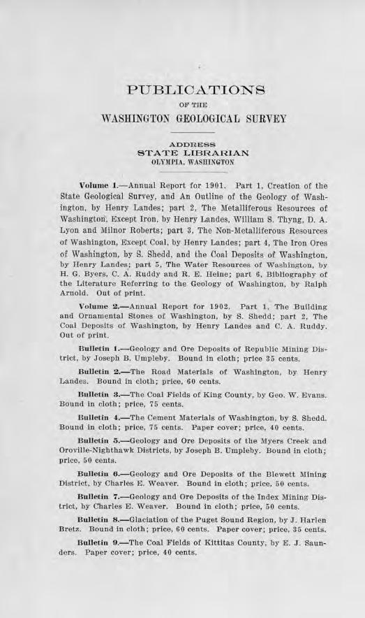
PUBLIOATIONS OF 'l'HE
WASHINGTON GEOLOGICAL SURVEY
ADDRESS STATE LIBRARIAN
OLYMl'IA. WASfilN~TON
Vohm1e 1.-Annual Report for 1901. Part 1, Creation of the State Geological Survey, and An Outline of the Geology of Washington, by Henry Landes; part 2, The Metalliferous Resources of Washington , Except Iron, by Hemy Landes, William S. Thyng, D. A. Lyon and Milnor Roberts; part 3, Tbe Non-Metalliterous Resources of Washington, Except Coal, by Henry Landes; part 4, The Iron Ores of Washington, by S. Shedd, a nd the Coal Deposits of Washington, by Henry Landes ; par t 5, The Water Resources of Washington, by H. G. Byers, C. A. Ruddy and R. E. Heine; part 6, Bibliography of the Literature Referring to the Geology of Washington, by Ralph Arnold. Out of print.
Volume 2.-Annual Report for 1902. Pait 1. The Building and Ornamental Stones of Washington, by S. Shedd; par t 2, The Coal Deposits of Washington, by Henry Landes and C. A. Ruddy. Out of prin t.
B ulletin 1.-Geology and Ore Deposi ts of Republic Mining District, by Joseph B. Umpleby. Bound in cloth; price 35 cents.
BulJetin 2.-Tbe Road Materials of Washington, by Henry Landes. Bound in cloth; price, 60 cents .
Bulle tin 3.-Tbe Coal Fie lds of King County, by Geo. W . Evans. Bound in cloth; price, 75 cents.
Bulletin ,1.-The Cement Materials of Washington. by S. Shedd. Bound in cloth; price, 75 cents. Paper cover; price, 40 cents.
B ulletin 5.-Geology and Ore Deposits of the Myers Creek ancl Oroville-Nighthawk Districts, by Jose1>h B. Umpleby. Bound in cloth; price, 50 cents.
Bulletin 6.-Geology and Ore Deposits of tb e Blewett Mining District, by Cha rles E. Weaver. Bouncl in cloth; price, 50 cents.
Bulletin 7.-Geology and Ore Deposits of the Index Mining District, by Charles E. W eaver. Bound in cloth; price, 50 cents.
Bullet.it1 8.-Glaciation or the Puget Sou11d Region, by J. Harle11 Bretz. Bound in cloth; price, 60 cents. Paper cover; 1>r ice, 35 cents.
Bulletin 9.-The Coal Fields of Kittitas County, by E. J . Saunde rs . Paper cover; price, 40 cents.
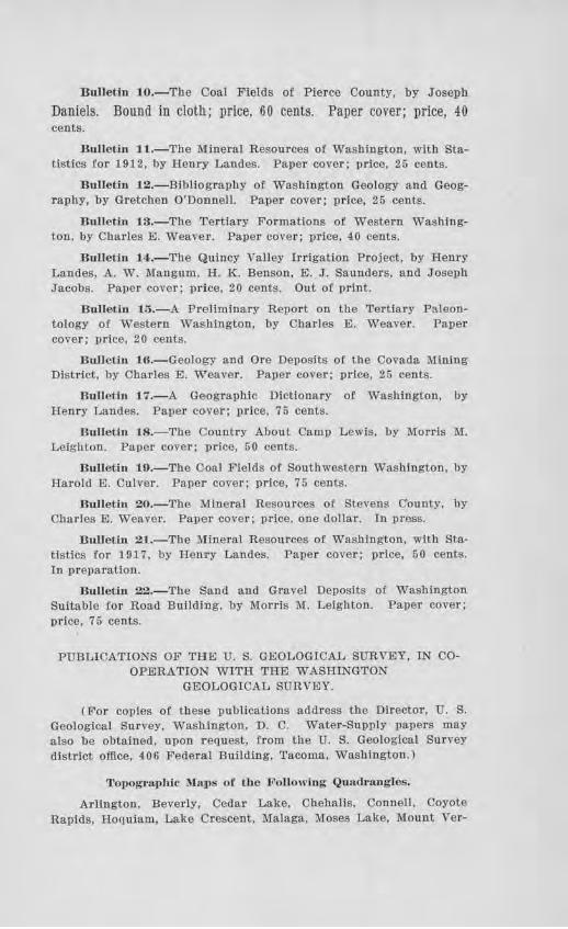
E111letin 10.-The Coat Fields or Pierce County, by Joseph
Daniels. Bound in cloth; price, 60 cents. Paper cover; price, 40 cents.
Bulletin J 1.-Tbe Mineral Resources of Washington, with Statistics for 1912, by Henry Landes. Paper cover; price, 25 cents.
Bulletin 12.-Bibliogra.phy or Washington Geology a.nd Geography, by Gretchen O'Donnell. Paper cover; price, 25 cents.
Bulletin 13.-The Tertiary Formations of Western Washington, by Charles E. Weaver. Paper cover; price, 40 cents.
Bulletin 14:.-Tbe Quincy Valley Irrigation Project, by Henry Landes, A. W. Mangum, II. K. Benson, E. J. Saunders, and J oseph Jacobs. Paper cover; price, 20 cents. Out of print.
Bulletin 15.-A Preliminary Report on the Tertiary Paleontology of Western Washington, by Charles E. Weaver. Paper cover; price, 20 cants.
Bulletin 16.-Geology and Ore De1)osits of the Covada Mining District, by Charles E. Weaver. Paper cover ; price, 25 cents.
Bulletin 17.-A Geographic Dictionary ot Washington, by Henry Landes. l?aper cover ; price, 75 cents.
Bulletin 18.-Tbe Country About Camp Lewis, by Morris M. Leighton. Paper cover; '])rice, 50 cents.
Bulletin 10.-Tbe Coal Fields of Southwestern Washington, by Harold E. Culver. Paper cover; price, 75 cents.
Bulletin 20.-The Mineral Resources of Stevens County, by Charles El. Weaver. Paper cover ; price, one dollar. In press.
Bulletill 21.-The J\[ineral Resources of Washington, with Sta· tistics for 1917, by Henry Landes. Paper cover; price, 50 cents. In preparation.
Uulleth1 22.-The Sand and Gravel Deposits of Washington Suitable for Road Building, by Morris lli. Leighton. Paper cover; price, 75 cents.
PUBLICATIONS OF THE U. S. GEOLOGICAL SURVEY, IN COOPERATION WITH THE WASHINGTON
GEOLOGICAL SURYEY.
(For copies of these publications address the Director, U. S. Geological Survey, Washington , D. C. Water-Supply papers may also be obtained, upon request, from the U. S. Geological Survey district office, 406 Federal Building, Tacoma, Washington.)
Topographic ~faps or the Ji'ollowi:ng Quad..angles.
Arlington, Beverly, Cedar Lake, Chehalis, Connell, Coyote Rapids, Hoquiam, Lake Crescent. Malaga, Moses Lake, Mount Ver-
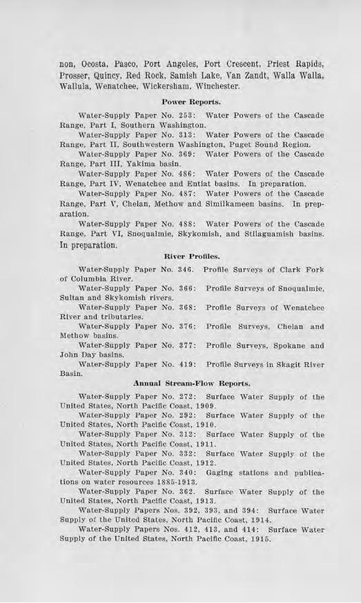
non, Ocosta, Pasco, Port Angeles, Port Crescent, Priest Rapids, Prosser, Quincy, Red Rock, Samish Lake, Van Zandt, Walla Walla, Wallula, Wenatchee, Wickersham, Winchester.
Power Reports.
Water-Supply Paper No. 253 : Water Powers of the Cascade Range, Part I, Southern Washington.
Water-Supply Paper No. 313 : Water Powe1·s of the Cascade Range, Part II, Southwestern Washington, Puget Sound Region.
Water-Supply Paper No. 369 : Water Powers of the Cascade Range, Part III, Yakima basin.
Water-Supply Paper No. 486: Water Powers of the Cascade Range, Part IV, Wenatchee and Entiat basins. In preparation.
Water-Supply Paper No. 487 : Water Powers of the Cascade Range, Part V, Chelan, 1\1ethow and Similkameen basins. In preparation.
Water-Supply Paper No. 488: Water Powers of the Cascade Range, Part VI, Snoqualmie, Skykomish, and Stilaguamish basins.
In preparation. River P romes.
Water-Su1>ply Paper No. 346. Profile Surveys of Clark Fork of Columbia River.
Water-Supply Paper No. 366: Profile Surveys of Snoqualmie, Sultan and Skylcomish rivers.
Water-Supply Paper No. 368: Profile Surveys or. Wenatcl1ee River and tributaries.
Water-Supply Paper No. 376: Profile Surveys, Chelan and Methow basins.
Water-Supply Paper No. 377 : Profile Surveys, Spokane and John Day basins.
Water-Supply Paper No. 419: P rofile Suneys in Skagit River Basin.
Annual Sb·eam-F lo"· Reports.
Wate1·-Supply Paper No. 27 2: Surface Water Supply of the United States. North Pacific Coast, 190 9.
Water-Supply Paper No. 292 : Surface Water Supply of the Un:ited States, North Pacific Coast, 1910.
Water-Supply Pa.per No. 312 : Surface Water Supply of tile United States, North Pacific Coast, 1911.
Water-Supply Paper No. 332: Surface Water Supply of the United States, North Pacific Coast, 1912.
Water-Supply Paper No. 340: Gaging stations and publications on water resources 1885-1913.
Water-Supply Pa.per No. 362. Surface Water Supply of the United States, North Pacific Coast, 1913.
Water-Supply Papers Nos. 392, 393, and 394: Surface Water Supply of U1e United States, North Pacific Coast, 1914.
Water-Supply Pa_pers Nos. 412, 4-13. and 414: Surface Water Supply of the United States, North Pacific Coast. 1915.
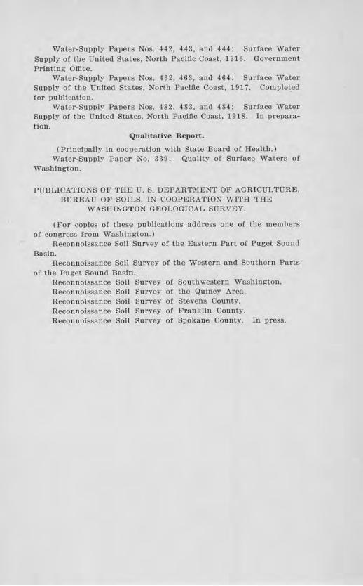
Water-Supply Pa1,ers Nos. 442, 443, and 444: Surface Water Supply of the United States, North Pacific Coast, 1916. Government Printing Office.
Water-Supply Papers Nos. 462, 463, and 464: Su_rface Water Supply of the United States, North Pacific Coast, 1917. Completed for publication.
Water-Supply Papers Nos. 482, 483, and 484: Surface Water Supply of the United States, North Pacific Coast, 1918. In preparation.
Qualitative Re i101.1:.
(Principally in cooperation with State Board of Health.) Water-Supply Paper No. 339: Quality o! Su_rface Waters of
Washington.
PUBLICATIONS OF THE U.S. DEPARTMENT OF AGRICULTURE, BUREAU OF SOILS, IN COOPERATION WITH THE
WASHINGTON GEOLOGICAL SURYEY.
(For copies of these publications address one of the member:; of cong_ress from Washington.)
Reconnoissance Soil Survey of the Eastern Part of Puget Sound Basin.
Reconnoissance Soil Survey of the Western and Southern Parts of the Puget Sound Basin.
Reconnoissance Soil Survey of Southwestern Washington. Reconnoissance Soil Survey of the Quincy Area. Reconnaissance Soil Survey 0£ Stevens County. Reconnoissance Soil Survey of Franklin County. Reconnaissance Soil Survey of Spokane County. In press.