the contribution of water geochemistry to the understanding of the regional hydrogeological system
TRANSCRIPT

The contribution of water geochemistry to the understandingof the regional hydrogeological system
STÉPHANE BUSCHAERT1, SOPHIE GIANNESINI2,3,1, VÉRONIQUE LAVASTRE4,5, LUCILLA BENEDETTI6,ERIC C. GAUCHER7, MICHEL LACROIX2, BERNARD LAVIELLE4, JEAN-LUC MICHELOT8,
CHRISTIAN FRANCE-LANORD3, DIDIER BOURLES6, JOËL LANCELOT2,HAKIM BENABDERRAHMANE1, SARAH DEWONCK1* and AGNÈS VINSOT1*
Key-words. – Deep groundwaters, Argillites porewaters, Geochemical modelling, Natural tracers, Residence time, Paris Basin.
Abstract. – The main results of hydrogeochemical investigations around the Andra Underground Research Laboratory(URL) located in eastern part of the Paris Basin are described hereafter. Groundwater data (chemistry and isotopiccomposition) have been acquired all around the URL to determine the origin and residence time of water circulations inlimestones of Oxfordian and Dogger age, surrounding the Callovo-Oxfordian argillites, and to determine the hydrogeo-logic role of the argillites regarding aquifers. The main geochemical result is that deep groundwaters from Oxfordianand Dogger limestones are significantly dissimilar to waters of superficial formations. Chemical and isotopic composi-tions indicate differences between these two deep-aquifer groundwaters. Groundwaters from the Oxfordian limestoneare typically meteoric while some groundwater samples from Dogger limestone may correspond to a mixture of meteo-ric-brine water. Geochemical and hydrogeologic evidence indicates that these deep samples are old groundwaters. Waterfrom Oxfordian limestone may have residence times of the order of 104_105 year, while the age of water in the Dogger isprobably older. Natural tracer studies in the overall sedimentary series indicate that the argillites allow chlorine transferby diffusion from the Dogger to Oxfordian aquifer. For the porewater of argillites, the approach is totally different: geo-chemical modelling has been developed to define the chemistry which relies entirely on a complete set of measuredphysical and chemical parameters.
Apport de l’hydrogéochimie à la compréhension du fonctionnementdu système hydrogéologique régional
Mots clés. – Eaux souterraines profondes, Eaux porales des argilites, Modélisation géochimique, Traceurs naturels, Temps de rési-dence, Bassin de Paris.
Résumé. – Cet article aborde les principaux résultats des investigations hydrogéochimiques, obtenus dans l’environne-ment du Laboratoire souterrain de Meuse/Haute-Marne de l’Andra, situé sur la bordure est du bassin de Paris. Des don-nées géochimiques et isotopiques sur les eaux prélevées dans les calcaires de l’Oxfordien et du Dogger ont permis depréciser leur origine et leur temps de résidence. Le rôle hydrogéologique des argilites du Callovo-Oxfordien et les inte-ractions avec les deux ensembles calcaires, qui les encadrent, ont également été examinés à l’aide de profils en traceursnaturels.
Les principaux résultats indiquent à la fois que les eaux profondes de l’Oxfordien et du Dogger sont de nature trèsdifférente des eaux prélevées en subsurface, mais aussi que les eaux de ces deux aquifères profonds sont très distinctesentre elles. Les eaux prélevées dans l’Oxfordien sont typiquement météoriques, alors que la signature isotopique de cer-taines eaux des calcaires du Dogger pourrait indiquer la contribution d’eaux saumurées. Les données géochimiques etles résultats des investigations hydrogéologiques (perméabilité) sont en faveur de temps de résidence élevés: l’âge deseaux des calcaires de l’Oxfordien est de l’ordre de 104-105 ans, mais est probablement supérieur pour les eaux du Dog-ger.
Les études de la distribution des traceurs naturels, et notamment les chlorures, dans la série sédimentairemontrent que les argilites permettent principalement des transferts par diffusion du Dogger vers l’Oxfordien calcaire.Quant aux résultats sur l’eau porale des argilites du Callovo-Oxfordien, ils relèvent d’une démarche différente. L’eauporale n’ayant pu être prélevée dans le passé (avant 2005), une modélisation géochimique fondée sur un set complet demesures physiques et chimiques sur échantillons carottés a été réalisée pour en déterminer la composition.
Mém. Soc. géol. France, n.s., 2007, n° 178, pp. 91-114
Mém. Soc. géol. Fr., 2007, n° 178
1 Andra, Agence Nationale pour la gestion des déchets radioactifs, 92298 Châtenay-Malabry, France, tel.: 01 46 11 82 82, fax: 01 46 11 82 08,e-mail: [email protected]* Andra, Laboratoire de Meuse/Haute-Marne, RD960, 55290 Bure, France.2 CEREGE–GIS, Parc Scientifique et Technique G. Besse, 30035 Nîmes, France.3 CRPG-CNRS, Rue N-D-des Pauvres, 54500 Vandoeuvre, France.4 Laboratoire de Chimie Nucléaire Analytique et Bio-environnementale, UMR 5084, 33175 Gradignan cedex, France.5 Laboratoire de Géochimie des Isotopes Stables, Université Paris VII – IPGP, 75251 Paris cedex 05, France.6 CEREGE, CNRS UMR 6635, Université Aix-Marseille III, Europôle Méditerranéen de l’Arbois BP 80, 13545 Aix en Provence, France.7 BRGM, 3 avenue C. Guillemin, BP 6009, Orléans cedex 2, 45060, France.8 Orsay, UMR CNRS “IDES”, Université Paris-Sud, 91405 Orsay, France.

INTRODUCTION
In order to perform experiments in an UndergroundResearch Laboratory (URL) to study the feasibility of anuclear waste disposal, in agreement with the Frenchgovernment, Andra (French Agency for Nuclear WasteManagement) has selected a study area situated in theeastern part of the Paris Basin near the locality of Bure(fig. 1). Having identified the site, geological andhydrogeological characteristics of the study area have been
investigated in detail through several seismic and boreholecampaigns since 1994. This zone is characterised by a thicklayer (130-145 m) of argillite (clayey formation) at acces-sible depth (around 420-560 m at the URL location) andsurrounded by two limestone (and locally marl) sequences.The argillite is of Callovo-Oxfordian age and the bracketinglimestone is of Bajocian/Bathonian age at the bottom, andof Oxfordian to Kimmeridgian (marls) age at the top. Thesedimentary sequence ends with limestone of Tithonian age(fig. 2).
Mém. Soc. géol. Fr., 2007, n° 178
92 BUSCHAERT S. et al.
FIG. 1. – Geological map of the study area with location of URL and network of boreholes.FIG. 1. – Carte géologique de la zone d’étude – Situation du Laboratoire de Recherches Souterrain de Meuse/Haute-Marne (URL) et du réseau des princi-paux forages profonds d’investigation hydrogéologique.
The hydrogeological investigations of the site includeenvironmental head and hydrogeochemistry data acquisi-tion both in aquifers and aquitard. The purpose of this paperis to describe the hydrochemical conditions (groundwaterchemistry and isotopic compositions) around the URL, thewater types and origin, residence times, the hydraulic roleof the Callovo-Oxfordian aquitard with respect to theunder- and over-lying aquifers and to place these interpreta-tions within the hydrogeological system on a regional scale.
Data sets are not extensively presented here, as thepaper ’s a im was to g ive a broad overv iew of thehydrogeochemical understanding of the area. The interpre-tations presented here are indeed based on several studies ortechnical reports, to which readers must refer for furtherdetails on methodology, techniques, modelling strategies,and extensive results and data tables. The various topics weare dealing with are described hereafter.
– The rocks of the Callovo-Oxfordian could play therole of geological barrier in the storage concept for deepwaste disposal. The chemical composition of porewatermust be known as it is an important property and necessaryin order to determine other major radionuclide transfercharacteristics of the argillite (radionuclide retention anddiffusion properties, etc.) and interactions with disposalcomponents (canisters and engineered barriers, etc.). Thewater characterization of a low permeability material ischallenging task due to the difficulty of completelyextracting interstitial fluids from the argillite. Recentlydeveloped techniques for water extraction (squeezing,leaching or long term sampling in special boreholes withgas control) provide valuable results that can be used tocharacterize the water chemistry. However, each of thesetechniques may introduce experimental and analyticalartefacts. In the case of leaching, it is generally consideredto be really suitable only for some anions such as chlorideor bromide and very dependant on core sample preservationfor sulphates. As water yields are highly dependent on theprocedure used for mechanical high pressure squeezing (30to 40% of total water content is the upper limit on waterthat can generally be recovered [Pearson et al., 2003]),some corrections on chemical parameters are necessary.Even for conservative ions like Cl, squeezing techniquesgenerate artefacts [Fernández et al., 2003]. The high pres-sures used for squeezing techniques can also dissolve someminerals. The methodology used here, which is complemen-tary to these techniques, is based on a geochemical model-ling taking into account the main properties of the argillite(water content, mineralogy, cationic exchange capacity, etc.).
– As regards the charac te r i sa t ion of the deepgroundwaters of Dogger and Oxfordian limestones, themethodology is more standard although they also have verylow permeability, and cannot really be considered anaquifer. The methodology is based on borehole watersampling. Hydrochemical data obtained from differentboreholes drilled on a regional scale are summarised andinterpreted in terms of water origin, interactions betweenlayers and water time residences.
– The understanding of the overall geo-hydrologicalsystems and their evolution in time and space are also ofparticular importance in predicting the hydrodynamicbehaviour of low-permeability rock. The study of the depthdistribution of chloride content and isotopic composition in
argillite porewater and groundwater in its environment is away of determining solute transport properties. This isfinally a method of appreciating the hydrogeologicalprocesses undergone by the sedimentary sequence and eval-uating the interactions between layers.
The analysis of the geo-hydro-chemical data led to abetter understanding of the actual flow behaviour in theaquifer system. The evaluation and modelling of the verticalprofiles of the chloride concentration and isotopic composi-tion through the Callovo-Oxfordian host formation and theDogger and Oxfordian aquifers, as well as the plan viewassociated spatial variability, make it possible to estimatethe solute transport parameters. The next paragraph givesthe geological and hydrological background of the study,which is necessary for the understanding and the interpreta-tion of the geochemical data.
GEO-HYDROLOGICAL BACKGROUND
Geology
The Paris Basin is a large subsiding zone in northernEurope initiated after the Variscan orogeny. Lithosphericcooling and sedimentation mechanisms triggered subsi-dence during the Permian-Triassic. The basin is filled witha thick accumulation of Mesozoic and Cenozoic sedimentsand is currently almost devoid of a major tectonic activity(low seismicity, only slight vertical movements). The sedi-mentary formations of the eastern Paris Basin slightly dip tothe west and the north-west, as a simple monocline. This isrelated to the subsidence of the central part of the ParisBasin. Except for the major regional fault zones in the ParisBasin (Bray, Vittel and Metz faults) and the faults ofGondrecourt and Marne, which delimit the area investigatedby Andra (fig. 1), there is very little evidence of deforma-tion [Andra, 2005].
The formations studied correspond to the transgres-sion-regression cycle of the Callovo-Tithonian age[Vincent, 2001; Vincent et al., 2004]. Under this series,Triassic sandstones, Lias marls and Dogger limestone (ofBajocian – Bathonian – Callovian age) are found. TheLower Callovian, predominantly limestone, is in continuitywith the underlying Bathonian series (fig. 2), both corre-sponding to a limestone platform. Above this lies aclay-rich formation, the sedimentation of which beganduring the middle and late Callovian age. This formation iscalled hereafter argillite (of Callovo-Oxfordian age). Theargillite is a claystone with up to 45-50% of clay mineralslike illite, ordered mixed-layered illite-smectite mineralsdominated by illite (I/S R1), kaolinite, minor amounts ofchlorite [see Gaucher et al., 2004 for extensive mineralo-gical review] cemented by c. 20-30 wt.% of micro-crystal-line calcite cement (called micrite). The Lower Oxfordianstage is marked by a transitional clayey sequence indicativeof a high sea level. It is characterised by a significantchange in clay mineralogy with respect to the Callovianlayer, namely the loss of kaolinite and chlorite and the gainof a significant amount of disordered mixed-layeredmineral (illite/smectite of R0 type, I/S R0, with more than60% smectite). According to Pellenard et al. [1999], thismineralogical transition, which occurs within a few meters,does not result from a temperature increase during burial.
Mém. Soc. géol. Fr., 2007, n° 178
WATER GEOCHEMISTRY AND THE REGIONAL HYDROGEOLOGICAL SYSTEM 93

Rather, it corresponds to a maximum flooding level and aprobable change of sediment sources, which is also markedby a shift in the nature and source of the organic matter[Landais and Elie, 1999].
In argillite, the carbonate cements are essentiallymicritic and thus of marine origin [Clauer et al., 2006],contributing with the high clay mineral content to the verylow permeability of this rock. Crystallization of calcitespars (both in voids/fractures infillings and microporosity)is also responsible [Buschaert et al., 2004; Clauer et al.,2006] for the strong porosity reduction and the low perme-ability observed in the bracketing limestones (calcareoussurrounding formations). This feature is not reallyfrequently observed for this type of limestone rocks. Theseobservations are at the origin of the properties of the lime-stone formations, which could not be considered true aqui-fers (K ≤ 10-7 m/s). This past crystallization event inlimestone results from the circulation of meteoric fluids at aperiod related to the Tertiary tectonic activity.
The hydrogeological properties of aquifers describedhereafter, particularly the low permeability, are, in part, aconsequence of diagenesis caused by the past meteoric fluidcirculations. However, in marked contrast with thesurrounding limestones, the Callovo-Oxfordian argillitedoes not record the effects of this later major event of fluidflow [Clauer et al., 2006]. This reveals that the argillite wasalready working in the past as a low permeability barrier toadvective transfers, even in period during which thesurrounding formations were strongly affected by fluid flowand cementation. This also indicates no vertical paleo-flowthrough the argillite matrix. One of the purposes of thispaper is to investigate the actual flow behaviour of thegeological system.
Structure of the hydrogeological system
The hydrogeological system of the Paris Basin includingthe area of the Meuse/Haute-Marne site on the eastern partis a multilayered system. It is characterised by a successionof hydrogeological units, which hydraulically representaquifers and aquitards or even aquicludes [de Marsily,1986]. The aquifers are supplied at the outcrops throughinfiltration of meteoric water and surface river runoff.
For the Paris Basin, the hydrogeological maps availableconcern only the upper aquifers (Albian, Neocomian). Therunoff from these aquifers reveals an outlet towards theChannel. The hydrogeological models of the basin showthat deep water flow is relatively slow and oriented from theoutcrops towards the centre of the basin and the Channel[Béon and Vidard, 2001]. Water flow in surface aquifers iscomplex and generally linked to the hydrographic networks.
In the area of the Meuse/Haute-Marne, the Trias andLias include both aquifers and semi-permeable formations.The Dogger, considered as an aquifer in spite of locallyvery weak permeability (from 10-12 to 10-9 m/s) is overlainby Callovo-Oxfordian argillite, which is a semi-permeableformation. The Oxfordian limestone layer is also generallyconsidered an aquifer [Vidard and Le Nindre, 2000]compared to the Cal lovo-Oxfordian argi l l i te (K <10-13 m/s). Kimmeridgian marl has very low permeabilityand is not an aquifer. It is overlain by the aquifers ofBarrois limestone (End-Kimmeridgian and Tithonian)[Jaquet et al., 2001].
The Dogger and Oxfordian pass through a free aquiferflow regime in the southeastern part of the area where theyjoin the captive underground aquifer in the centre andnorth-west. The outcropping parts of these formations arealtered. This gives them relatively high permeabilitycompared with the covered formations.
Hydrogeological function on the scale of the area ischaracterised by horizontal flow in the aquifer formations(Dogger, Oxfordian and End-Kimmeridgian/Tithonian).Due to their low permeability, the Callovo-Oxfordian andmarly Kimmeridgian formations display semi-permeabilitywhere flow by vertical leakage is induced by the hydraulicgradients of the surrounding aquifers. The conceptualhydrogeological model of the multilayer system is:
– aquifers recharged at the outcrops by infiltration ofmeteoric water and local hydraulic exchange (supply orleakage) in valley bottoms from rivers, the flow of which isgoverned by the topography;
– horizontal flow in aquiferous formations;
Mém. Soc. géol. Fr., 2007, n° 178
94 BUSCHAERT S. et al.
FIG. 2. – Lithological description of the geological formations. All thedepths and locations of porous levels in Oxfordian limestones are represen-ted at the URL site. Depths of Callovo-Oxfordian argillites range from425-550 m. Symbols drawn according to international geological forma-lism. Limestones are represented in yellow, marl layers in green, argillitesin blue and evaporites and sansdstones are in white colour.FIG. 2. – Log lithologique synthétique des formations géologiques rencon-trées au droit du Laboratoire de Recherches Souterrain. Les horizons Hp1à Hp7 donnent la position sur le site des niveaux poreux rencontrés dansl’Oxfordien calcaire. Les argilites du Callovo-Oxfordien, où est implantéle Laboratoire (490 m) sont situées entre 425 et 550 m de profondeur. Lessymboles des couches et différents faciès sont choisis en accord avec leformalisme géologique international. Les calcaires sont représentés enjaune, les marnes en vert, les argilites en bleu, les évaporites et les grèssont en blanc.
– hydraulic exchange between aquifers by leakagethrough semi-permeable and eventually hydraulically activefaults.
The hydrochemical investigations focus mainly on thehost formation of the Callovo-Oxfordian and on thesurrounding limestone Dogger and Oxfordian layers.
Hydrogeology of the Oxfordian and Doggerlimestones
Oxfordian
The Oxfordian limestone covering the Callovo-Oxfordianargillites, can be considered to be an aquifer because of the
several productive levels (3 to 14 l/min) encountered by theboreholes on the site and in the sector. Most of these waterinflows are from levels characterised by relatively high po-rosity, higher than 18%, but not all porous levels are neces-sarily aquifers. The geometry of these porous bodies (Hp1to Hp7) and their lateral spatial distribution makes themstructurally discontinuous, and they cannot be correlated ona kilometric scale. The hydraulic head measured in the bo-reholes shows an Oxfordian aquifer, which is captive butnot artesian, even locally.
The hydrodynamic react ion of porous horizonsobserved at the monitoring boreholes (EST201, EST203,etc.) below the sinking of the access shaft, before the shaft
Mém. Soc. géol. Fr., 2007, n° 178
WATER GEOCHEMISTRY AND THE REGIONAL HYDROGEOLOGICAL SYSTEM 95
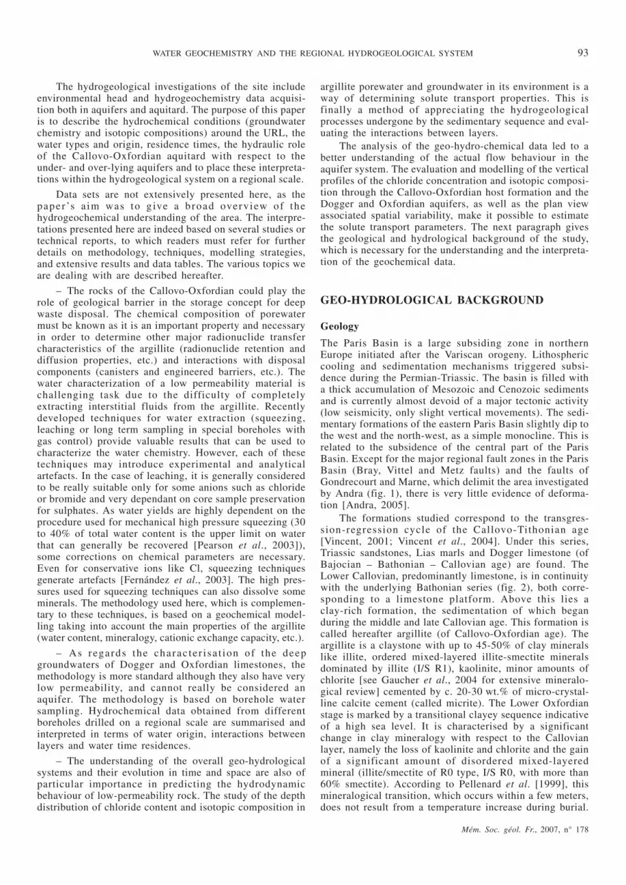
FIG. 3. – Piezometric layout of the shallow and deep Oxfordian aquifers. The EST103 point represents the location of the URL site.FIG. 3. – Carte piézométrique des calcaires de l’Oxfordien en zone affleurante et en zone captive. Le forage EST103 donne la localisation du laboratoiresouterrain.
reached them, can be explained by hydraulic connection ofhead transfer, by sedimentary and/or structural pathways.
The piezometric sketch produced from the datao b t a in e d f r o m b o r e h o l e s in s t a l l e d o n Mid - a n dUpper-Oxfordian outcrops, shows flow oriented towards thenorth-north-east to north-west and locally south-west(fig. 3). The directions of flow, deduced from isolated headmeasurements, are north-north-east to north-west in thenorthern part of the area, whereas at the south of boreholesEST331 and EST351, flow is preferably oriented towardsthe west and south-west (fig. 3). The hydraulic gradients areof the order of 0.4% for the entire area.
The Oxfordian is fed essentially from the outcrops bythe infiltration of rainwater and losses from rivers (effectiverain represents 45% of mean interannual precipitation 900to 1,100 mm/year) [Vidard and Le Nindre, 2000]. Supplyfrom losses is greater where karstification develops. TheMeuse and the Marne drain the groundwater from the Mid-and Upper-Oxfordian. In addition, the Ornain towardsGondrecourt-le-Château, drains the groundwater consider-ably and seems to constitute an outlet [Vidard and LeNindre, 2000].
The electrical conductivities in the Oxfordian measuredin the regional boreholes are distinctly inferior to those of
Mém. Soc. géol. Fr., 2007, n° 178
96 BUSCHAERT S. et al.
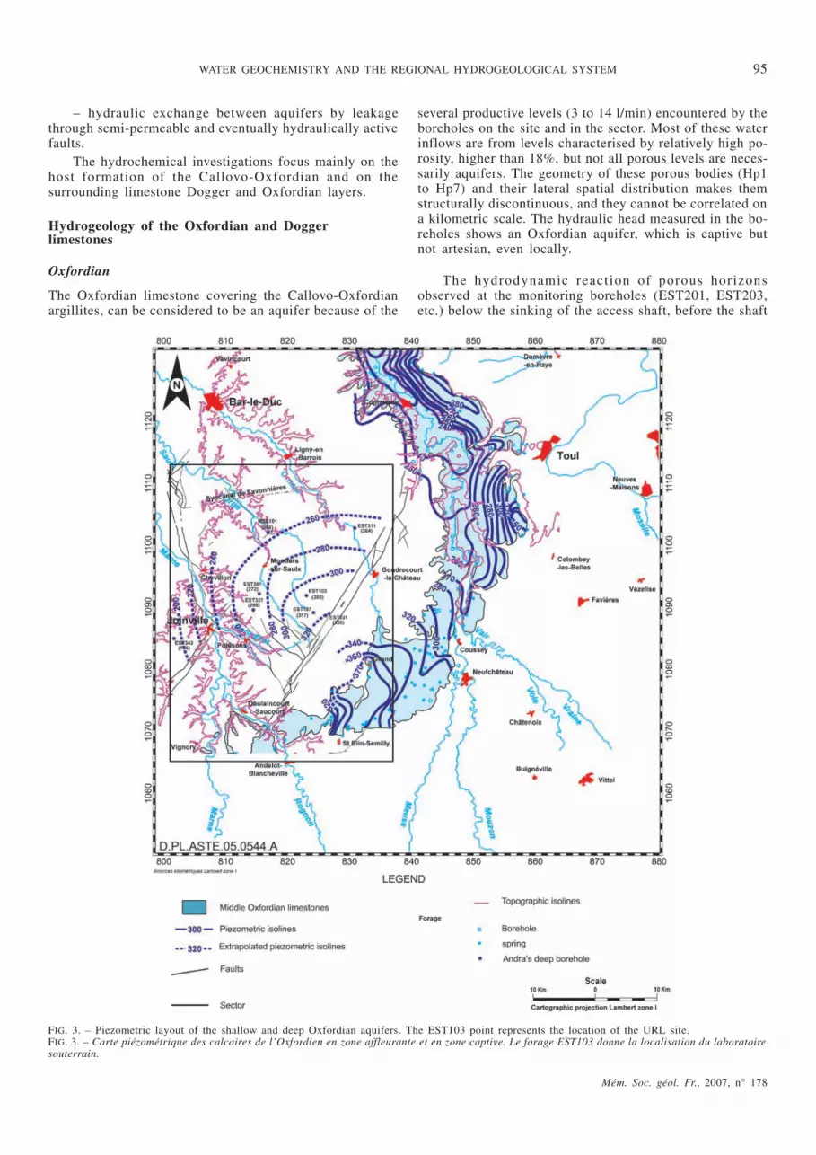
FIG. 4. – Piezometric layout of shallow and deep Dogger aquifers. The EST210 point represents the location of the URL site.FIG. 4. – Carte piézométrique des calcaires du Dogger en zone affleurante et en zone captive. Le forage EST210 donne la localisation du laboratoire sou-terrain.

the Dogger: the highest values are recorded at boreholesEST311 (2,310 µS/cm) and EST342 (1,172 µS/cm). Atborehole EST321, conductivity is only 426 µS/cm; thecorresponding low mineralisation could be explained by thegreater influence of surface water, linked to microfracturingin the north-north-west with a piezometric level close to thealtitude at the bottom of the Thonnance valley, one kilo-metre to the south.
Close to the Marne valley, between the faults of thesame name and the Gondrecourt rift, water ingress relatedto the presence of subvertical joints has been revealed inboreholes EST321 (between 389 and 410 m deep), EST322(between 296 and 298 m deep) and EST351 (between 293and 413 m). The low mineralisation of the groundwatersindicates a hydraulic relationship between this fracturingand surface water. The hydrological influence of thisdiffuse fracturation, is revealed in the north-west drainagefrom the Oxfordian aquifer. The extension of minor, diffusefracturing to the south-west of the Saulx valley, affects theflow capacity of the Oxfordian limestone.
Dogger
Dogger formation is mainly characterised by the Bathonianand Bajocian aquifers separated by the thin layer of theLongwy marls. A regional piezometric layout of the Dogger(with no distinction between Bathonian and Bajocian) isdrawn from asynchronous piezometric measurements (overseveral years) of boreholes essentially located on theoutcrops outside the sector [Vidard and Le Nindre, 2000].Flow is oriented towards the north-west with a hydraulicgradient of around 1.5%.
On the scale of the area (fig. 1), recent boreholesEST312, EST322 and EST342 are added to the two olderAndra boreholes capturing the Bathonian (HTM102 andMSE101) to define flow generally oriented towards thewest (fig. 4). The hydraulic gradient upstream of the siteseems lower (0.06%) than that which prevails downstream(0.2%).
The Dogger outcropping to the east and south-east ofthe area, constitutes an unconfined aquifer feed zonethrough infiltration of meteoric water and losses from riverscrossing the outcrops. The aquifer becomes confinedthroughout almost all the sector and artesian in boreholesMSE101 and EST312 located in the valley bottom (respec-tive piezometric levels + 26 m/ground and + 15 m/ground)(fig. 4).
The salinity of the Bathonian water is consistent withthat of the Dogger water in the Paris Basin, which is low atthe edges and increases to 30 g/l in the centre of the basin[Marty et al., 2003].
T h e e l e c t r i c a l c o n d u c t iv i t y m e a s u r e d d u r in ghydrogeological tests increases with depth in the boreholes:f o r i n s t a n c e , a t M S E 1 0 1 ( f i g . 1 ) , i t f a l l s f r o m6,280 µS/cm–2,899 mg/l (NGF measurement of – 405 m) to9,140 µS/cm–3,857 mg/l (NGF measurement of – 500 m)giving a vertical salinity gradient of around 13 mg/m. Thesame phenomenon is repeated at EST312 (salinity gradientof around 9 mg/m). As for the entire Paris Basin, which hasa steeper salinity gradient towards the centre, this increasewith depth can be explained by the flow of rainwater fromthe outcrops towards the centre of the basin.
Potential exchange through Callovo-Oxfordian argillite
Hydraulic exchanges between the surrounding formationstake place across the Callovo-Oxfordian host formation.Because of its lithological nature and resulting low perme-ability (less than 10-13 m/s), this formation is considered anaquitard. This implies that horizontal flow is not significantand the hydrogeology of this semi-permeable formationdepends on surrounding aquifers. The predominant flowsare vertical. They are generated by the gradients induced byhead differences between the Dogger and Oxfordian lime-stone groundwater. One zone was identified with anascending gradient (0.035 – 0.59) and one with a descendinggradient (0.22), which is thought to include the Bure site.The transition zone (head gradient close to zero) or gradientinversion appears to be north and west of the site.
It is difficult to evaluate the hydraulic role played bythe Gondrecourt faults with respect to underground flow inthe Oxfordian and Dogger limestones. Two factors supportthe idea that the hydraulic role is very limited:
– the rift throw (< 60 m) is distinctly less than theaquifer formation thickness and does not interrupt theirlithological continuity;
– the vertical hydraulic gradient induced by thesurrounding formation does not seem to be influenced bythe presence of the Gondrecourt faults either. The hydraulicg r a d i e n t s c a l c u l a t e d in l i n e w i t h b o r e h o l e sHTM102/EST331 (descending gradient of – 22%) andEST311/312 (ascending gradient of + 17.5%) do not indi-cate significant hydraulic activity linked to those faults.
AQUIFER GROUNDWATERS
Hydrogeochemical investigations in limestone
First, for comparison with deep aquifer water, shallowgroundwaters have been sampled in superficial aquifers inthe area where these Oxfordian and Dogger limestonesoutcrop. These unconfined parts of the aquifers, located atthe east of the study area, constitute the recharge area of thesystems. Subsurface water samples have been collectedfrom some springs or shallow boreholes. The existing bore-holes mostly tap the Tithonian aquifer and more rarely theKimmeridgian/Oxfordian and Dogger limestones becauseof their low productivity. Andra has drilled few shallow bore-holes (Tithonian: e.g. EST1011, 1020, 1021; Kimmeridgian:EST206) on or close to the URL site (fig. 1).
Data on deep groundwater have been acquired fromseveral sampling campaigns. Different hydrogeologicaloperations have indeed been realised before and during thesite building and the shaft sinking. Main boreholes arepresented in table I.
The principal source of deep groundwater sample wasthe URL site itself, where sampling was performed in bore-holes reaching the formations of Oxfordian age (e.g.EST201 and EST203) during the hydrological characterisa-tion phase and, later on, in cored boreholes in the inner wallof the URL main shaft (PPA for “puits principal d’accès”).Small inclined boreholes (PPA boreholes) have thus beenregularly drilled in the Oxfordian limestone. When theypass through a relatively more porous layer or horizon(called Hp in the text for “ horizon poreux”, fig. 2), the
Mém. Soc. géol. Fr., 2007, n° 178
WATER GEOCHEMISTRY AND THE REGIONAL HYDROGEOLOGICAL SYSTEM 97

boreholes might be water productive (a few l/min) and arte-sian depending on the shaft floor, making it possible tosample groundwater from Oxfordian limestone.
In the vicinity of the URL, the limestones bracketingth e a rg i l l i t e u su a l ly h ave ve ry low p ermeab i l i t y(10-9-10-12 m/s) and porosity (down to 3-5%). However, asalready mentioned, in the Oxfordian layer, seven levels(Hp) with higher porosity (up to 17-24%), were generallyencountered, numbered from Hp1 (deepest) to Hp7 (shal-lowest). The PPA boreholes have provided an opportunityto sample water from all the Hp’s.
Groundwaters from Oxfordian and Dogger limestoneshave been sampled through a regional borehole network ona scale of 10 to 25 km around the URL. As the opposite ofPPA boreholes, samples from regional boreholes generallyrepresent the major water productive porous layers when itwas possible to distinguish them among the various Hp by
well logging. Each deep sampling was performed on thistype of protocol after several weeks of water production.
Results in shallow groundwater
The stable isotope content of shallow groundwater displayssmall variations (δ2H between –44 and –51‰ and δ18Obetween –6.9 and –7.9‰SMOW; fig. 5). Tritium concentra-tions [Matray et al., 2001; Forpro, 2002] range from 6.3 to20 tritium units (TU; one TU corresponds to 0.118 Bq/l).Nuclear reactions between cosmic radiation and nitrogen inthe upper atmosphere lead to a natural tritium concentrationof few TU in precipitation. Due to the atmosphericnuclear-weapon tests during the 1950’s and early 1960’s,tritium fall-out increased up to several thousands of TU.The highest value was reached in 1963. Since then, becauseof the short turn-over time of atmospheric water and of the
Mém. Soc. géol. Fr., 2007, n° 178
98 BUSCHAERT S. et al.
TABLE I. – Network of main deep boreholes for the groundwater sampling.TABL. I. – Description des principaux forages profonds du réseau d’investigation hydrogéologique etd’échantillonnage en eau.
Rock Location Boreholename
Groundwater details
OtherobservationsDepth (m) Depth
(m NGF)
Conductivityat 25°C(µS/cm)
Kimmeridgianmarls andlimestones
URL EST206 30 - 55 310-335 1 136 Shallowgroundwater
Oxfordianlimestones
URL
PPA0012 163 - 168 198 - 203 1 055 Hp7
PPA0013 178 - 182 184 - 188 1 010 Hp6 - Hp7
PPA0015 223 - 235 131- 143 960 Hp5
PPA0016 257 - 278 88 - 109 1 053 Hp4
PPA0017-18 280 - 305 61 - 86 1 087 Hp4 - Hp3b
PPA0019 306 - 316 50 - 60 1 097 Hp3a
PPA0020-21 322 - 338 28 - 44 1 161 Hp2
PPA0022 340 - 358 8 - 26 1 226 Hp1
Cirfontaines-en-Ornois EST331 60 - 280 99 - 319 545
Demange-aux-Eaux EST311
110 - 112 165 - 167 2 310 Hp7
230 - 290 -13 - 47 1 315
Montreuil-sur-
ThonanceEST321 390 - 410 -45- -25 426
Effincourt EST351 398 - 438 -78 - -38 676
Nomécourt EST342 147 - 590 -297 - 146 1 172
Morley MSE101
248 - 254 6 - 12 1 168
316 - 328 -56 - -68 1 282
430 - 442 -162 - -170 1 459
Doggerlimestones
Demange-aux-Eaux EST312
562 - 582 -305 -282 12 880
592 - 597 -320 -315 13 180
Montreuil-sur-
ThonanceEST322 660-665 -300 -295 2 390
Nomécourt EST342648 - 662 -369 -355 4 530
708 - 710 -417 -415 4 570
Morley MSE101
665 -405 6 280
725 -465 6 560
760 -500 9 140
short half-life of tritium (12.32 y), the 3H concentration ofprecipitation has quickly decreased. In 2002, one canassume that this concentration was between 5 and 10 TU[see IAEA/WMO, http://www.iaea.org/programs/ri/gnip/gnipmain.htm). Thus, the 3H concentrations measured inthe shallow groundwater are typical of recently infiltratedmeteoric water. The 14C activities of the dissolved inorganicand organic carbon are also consistent with a recentrecharge of shallow aquifers [Matray et al., 2001]. The pHof water is about 7 to 7.8. Oxygen concentrations are nearsaturation, leading to high values of redox potential (Eh >200 mV).
These groundwaters have low salinities, as indicated bylow conductivity values ranging from 300 to 650 µS/cm[Matray et al., 2001; Négrel, 2003]. The salinity values forDogger water at boreholes EST5128 at Saint-Blin-Semilly
(186 m deep) and EST5127 at Anderlot-Blancheville(115 m deep), 393 mg/l and 339 mg/l, respectively, arelower but close to the salinity of borehole EST322(446 mg/l) about 30 km away. This conforms to the spatialconfiguration of salinity on the scale of the basin. It can bededuced that those boreholes are located in flow tracksoriented from outcrops towards the north-west. They areCa-HCO3 type (except for groundwater sampled in theTithonian – borehole EST1021 – which is Ca-Mg-HCO3type) and indeed have a low total salinity of 300-760 mg/l.These groundwaters are characterised by low Cl-concentra-tions, about 5-16 mg/l and the δ37Cl values of water fromTithonian limestone varies between – 0.18 and 0.16‰SMOC.Shallow groundwater presents significant nitrate contentsindicative of run-off pollution linked to agricultural fertil-izers. Chloride and nitrate content are correlated [Ravigne,2003].
Speciation calculations have been performed withPHREEQC [Parkhurst and Appelo, 1999] using the thermo-dynamic database llnl.dat [Wolery, 1992]. This type ofgroundwater is in equilibrium with calcite and quartz, andunder-saturated with respect to other carbonate andsulphate minerals. Partial pressures of CO2 are around1.8 10-2 and 2.2 10-3 bar, because of interactions with thesoils and limestones.
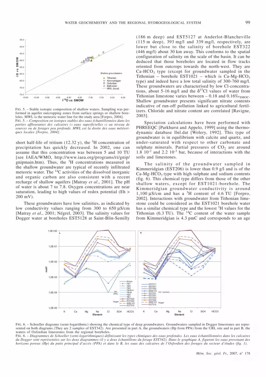
T h e s a l i n i t y o f th e g r o u n d wa te r s a m p le d inKimmeridgian (EST206) is lower than 0.9 g/l and is of theCa-Mg-HCO3 type with high sulphate and sodium contents(fig. 6). This chemical type differs from those of the othershallow waters, except for EST1021-borehole. TheKimmeridgian groundwater conductivi ty is around1,100 µS/cm and has a 3H content of 4.6 TU [Forpro,2002]. Interactions with groundwater from Tithonian lime-stone could be considered as the EST1021 borehole waterhas a similar chemical type and the lowest 3H values for theTithonian (6.3 TU). The 14C content of the water samplefrom Kimmeridgian is 4.3 pmC and corresponds to an age
Mém. Soc. géol. Fr., 2007, n° 178
WATER GEOCHEMISTRY AND THE REGIONAL HYDROGEOLOGICAL SYSTEM 99
FIG. 5. – Stable isotopic composition of shallow waters. Sampling was per-formed in aquifer outcropping zones from surface springs or shallow bore-loles. MWL is the meteoric water line for the study area [Forpro, 2004].FIG. 5. – Composition en isotopes stables des eaux échantillonnées dans lesparties affleurantes des calcaires (« eaux superficielles ») au niveau desources ou de forages peu profonds. MWL est la droite des eaux météori-ques locales [Forpro, 2004].
FIG. 6. – Schoeller diagrams (semi-logarithmic) showing the chemical type of deep groundwaters. Groundwaters sampled in Dogger limestones are repre-sented on both diagrams (They are 2 samples of EST342). Are presented in part A, the groundwaters (Hp from PPA) from the URL site and in part B, thewaters of Oxfordian limestones from the regional boreholes.FIG. 6. – Diagrammes de Schoeller (semi-logarithmiques) définissant les types chimiques des eaux profondes. Les eaux échantillonnées dans les calcairesdu Dogger sont représentées sur les deux diagrammes (il y a deux échantillons du forage EST342). Dans le graphique A, figurent les eaux provenant deshorizons poreux (Hp) du puits principal d’accès (PPA) et dans le B, les eaux des calcaires de l’Oxfordien des forages du secteur d’études (fig. 1).

of 8,000 to 13,000 y, taking into account the 13C content[Forpro, 2002]. This is an average value as this groundwatercould result from a mix of recent (< 50 y) and older(< 50,000 y) components.
Results on deep aquifer groundwater
Chemical composition
Oxfordian
On the URL site, the water produced by Oxfordian lime-stone (e.g. PPA boreholes) is of the Ca-(Mg/Na)-HCO3-SO4type ( f ig . 6A) . Deeper Hp (Hp1 to 4) a re o f theC a - N a - H C O 3 - S O 4 ty p e , w h i l e th e H p 5 - 7 a r eCa-Mg-HCO3-SO4. The chloride content decreases towardsthe surface from 85 mg/l in Hp1 to 15 mg/l in Hp7. Thesalinity of these groundwaters is around 1 g/l. Thegroundwaters sampled in regional boreholes present alarger variation in salinity. Higher salinity values are foundin boreholes EST311, MSE101 and EST342. The chemistryof these waters is very close to that of waters from the URLsite, but the water in EST311 differs from this trend onaccount of its high Mg and SO4 contents. All other waterfrom Oxfordian limestone is of the HCO3-SO4 type and hashigh Mg and Na (fig. 6B) contents. Groundwater from otherboreholes (EST351, EST321 and EST331) have lowersalinity values (with lower Na content) and a very similarchemical type.
The chloride content of waters is variable in regionalboreholes (11-58 mg/l). Thermodynamic calculations showthat these waters are equilibrated with carbonate mineralsand that they are representative for in-situ conditions. CO2partial pressures are around 10-2 bar. The variation insalinity could, however, indicate a variable degree and
duration of interaction with its host rock. Two salinityzones are identified. The high salinity zone is located in thenorth east of the study zone and includes EST311, MSE101and PPA boreholes. The second zone, which has lowersalinity values, integrates boreholes EST351, EST331 andEST321 (fig. 6). The low salinity values measured at bore-hole EST321 could be explained by their location in a frac-tured area (Poissons faults) through which surface watermight percolate. The salinity increases downstream andfollows the schema of the regional salinity distribution fromthe outcropping, low concentration zones to high concentra-tion towards the centre of the Paris Basin.
Dogger
The chemistry of these groundwaters is very different fromthe Oxfordian groundwater chemistry. The salinity andchloride contents can reach 4 to 9 g/l and 0.9 to 3.5 g/l,respectively. The waters are of a Na-Cl-SO4 type (fig. 6). Asfor the Oxfordian, the salinity increases down stream. Thetrend of the major stream lines is to the north and to thenorth-west. The location of borehole EST322 in a drainedzone (Poissons faults) may explain the low salinity(446 mg/l) which is however higher than the salinitymeasured near the outcrop (390 mg/l at borehole EST5128).The spatial variability of measured salinity seems consis-tent with the regional distribution.
The chloride and sodium contents present a positivecorrelation, suggesting, with the high chloride contents, aparticipation of NaCl source to the composition of Doggerwaters. The northern part of the study area shows the highersalinity both in Dogger (EST312, MSE101) and inOxfordian limestones (EST311, MSE101).
Mém. Soc. géol. Fr., 2007, n° 178
100 BUSCHAERT S. et al.
FIG. 7. – δ18O vs D diagram for deep groundwaters of Oxfordian and Dogger limestones. Data are compared to waters from Triassic sandstones (at the eastof the study zone) [Marty et al., 2003] and from Dogger limestones (centre of the Paris Basin) [Matray et al., 1994]. The Global Meteoric Water Line(GMWL) is also represented.FIG. 7. – Composition en isotopes stables des eaux profondes des calcaires de l’Oxfordien et du Dogger. Les données acquises sont comparées à la littéra-ture (eaux des grès triasiques à l’est du secteur d’études [Marty et al., 2003] ; eaux du Dogger du centre du bassin de Paris [Matray et al., 1994]). Ladroite des eaux météoriques mondiales (GMWL) est représentée.

Stable isotope composition of water
Deep groundwaters from Oxfordian limestone have δ18Oand δD values defining a narrow domain lying on or veryclose to the Global Meteoric Water Line (GMWL) infigure 7. They have more negative values in δ18O and δD(-9.5/-8.3‰SMOW and -64/-54‰SMOW, respectively) than theshallow waters. Considering that shallow waters representmodern conditions (from their 3H data), the signatures ofOxfordian aquifer groundwaters would reflect colderclimatic recharge conditions.
As the standard deviation of multiple measurements isindeed better than 0.1‰ for δ18O and 1‰ for δD, threegroups of Oxfordian PPA Hp can be distinguished (fig. 8).Two groups are formed comprising Hp7-6 and Hp1-4. Thelast one is Hp5, which has an intermediate positionalthough it is close to the Hp7-6 group. Inside these 3 units,the Hp could be connected as they present similar signa-tures. This observation is consistent with hydrogeologicaltests during the shaft excavation with connected Hpdrawdown responses inside these groups in URL surveyboreholes [Vinsot et al., 2004]. This can be explained bythe presence of two clayey interlayers between each Hpunit. On a regional scale, as for chemical data, two groupsin particular emerge from the stable isotopic data: a firstgroup with the waters with the more negative values ismade up of boreholes EST351, EST331 and EST321 (asalso seen with the grouping of chloride contents) and asecond group with water from EST311 and PPA.
Unlike in the Oxfordian limestone, groundwaters fromDogger layers provide δ18O and δD values lying on theGMWL with a broad range of variation between thedifferent boreholes (-8.5<δ18O<-5.3‰, -56<δD<-33‰;fig. 7). However, the water samples coming from differentlayers in the same borehole present rather homogeneousisotopic compositions. Without taking into account theresults of EST322, which is the borehole closer to theoutcrops of Dogger, these isotopic results confirm thechemical differences between waters of the Dogger andOxfordian aquifers. As for salinity and chlorine content, theparticular stable isotopic signature of Dogger waters could
be related to the mixing of brines [according to Matray etal., 1994]. However, waters sampled in Triassic rock a fewtenths of kilometres to the east of the study area [Marty etal., 2003; plotted in fig. 7] are not matching with thishypothesis since they have significantly lower isotopiccompositions, but the real stable isotopic signature ofwaters in Trias in the study zone is not known at themoment. The EST312 Dogger groundwater seems to becompatible with Dogger waters from the centre of the ParisBasin [Matray et al., 1994] (fig. 7). These waters wereinterpreted as mixing between meteoric waters and brinesof Triassic origin. Because of the lack of data on Triassicgroundwaters below the study zone, it is difficult toenhance the interpretation of Dogger signature origin. In allc a s e s , o n e imp o r t an t o b s e r va t io n i s th a t D o g g e rgroundwaters are relatively heterogeneous over 300 km2.This implies either bad connection between layers insidethis aquifer and/or very low flow rate.
Chlorine concentration and isotopic composition
Comparison of Cl-δ37Cl data clearly show a contrastbetween deep aquifer groundwaters (fig. 9) all over thestudy area [Forpro, 2005]. In spite of a significant differ-ence in Cl-content, both deep aquifer waters are systemati-cally characterised by negative δ37Cl in the range of-1.55/-0.20‰SMOC and -2.13/-0.07‰SMOC respectively.Vertical Cl and δ37Cl profiles in Oxfordian limestone wereobtained by the analysis of Hp waters (in PPA boreholes).Data describe a Cl-concentration gradient through theOxfordian aquifer. Higher Cl-concentration values aremeasured in the deep Oxfordian layers. A lower Cl-concen-tration is found in the Hp7 (fig. 15). δ37Cl data describe a“v-shape” in Oxfordian at around 250 m in depth. SameCl-concentration gradient and δ37Cl “v-shape” trends areobserved in the EST311 borehole (fig. 15).
As the initial marine waters in sediments were flushedout of Oxfordian and Dogger limestones, probably just afterthe emersion of the sedimentary series, present-day chlo-rine-contents in Dogger and Oxfordian aquifers should bethe result of subsequent local Cl-transfer events. The highsalinity of Dogger water could be explained by exchangeswith deeper formations as Triassic layers rich in evaporites.Matray et al. [1994] suggest a cross-formational brinetransfer in the centre of the Paris Basin between Trias andDogger layers via faults. This process could be possible viaregional tectonic structures. It could also be considered apossible chloride transfer by diffusion from the Trias to theDogger via the Lias argillite, although data on noble gases[Marty et al., 2003] have shown that diffusive transfers ofgases could be limited through the Lias argillite. The deepTriassic groundwaters have not been sampled in the studyarea, but chemical data are available for other locations inthe Paris Basin. At the east of the basin, in the Vosges,Triassic waters are of the Ca(±Mg)-HCO3 type and havelow salinity values (< 1 g/l). It is known that they becomemore saline with depth. Matray et al. [1989] mentionsalinity of 100 g/l under the Paris region. Their salinity isa t t r ibu ted to in teract ions with Keuper evapor i tes .Cl-transfer processes are considered in the last section byintegrating all the data on both limestones and Callovo-Oxfordian argillite.
Mém. Soc. géol. Fr., 2007, n° 178
WATER GEOCHEMISTRY AND THE REGIONAL HYDROGEOLOGICAL SYSTEM 101
FIG. 8. – δ18O vs δD diagram for deep groundwaters of Oxfordian limesto-nes. The Global Meteoric Water Line (GMWL) is also represented.FIG. 8. – Composition détaillée en isotopes stables des eaux profondes descalcaires de l’Oxfordien. La droite des eaux météoriques mondiales(GMWL) est représentée.

Strontium isotopic composition
The isotopic composition of strontium (87Sr/86Sr) forgroundwater from Oxfordian limestone is very uniformwith values ranging from 0.707089 to 0.707145 (fig. 10)[Forpro, 2005] with a mean value of 0.707115 and a stan-dard deviation of 0.000018 for the whole set of 16Oxfordian waters. All data are included in the range ofvariation of Oxfordian seawater [Koepnick et al., 1990](fig. 10). These data are slightly more radiogenic than theSr isotopic composition of the carbonate minerals ofOxfordian limestone (this study and Maes [2002]). Thecoherence of isotopic Sr signatures suggests a commonorigin for these waters, which are in equilibrium with lime-stone (mixture of carbonate minerals and some radiogenicclay minerals).
Sr isotopic ratios of Dogger limestone are consistentwith those of Bathonian seawater according to Koepnick etal. [1990]. This is due to groundwater interactions withDogger limestones. These data are also slightly more radio-genic than the limestone calcites [Maes, 2002]. Doggergroundwater data define a probable mixing line in the87Sr/86Sr vs 1/[Sr] diagram. The less radiogenic end-membercorresponds to the 87Sr/86Sr of the Bathonian limestone[Maes, 2002]. The other end-member could correspond tothe radiogenic Trias signature. This could indicate the influ-ence on Dogger waters by the deepest Trias groundwaters. Srdata (fig. 10) clearly distinguishes the groundwaters fromOxfordian and Dogger limestones. This suggests in thestudied area the lack of evident hydraulic connectionbetween the two formations.
Groundwater dating
The residence time of deep groundwater is a key point forthe understanding of the hydrogeological system. Informa-tion and indices about this point have been obtained byusing several radioactive isotopes with different half-livesto cover a wide age range.
Mém. Soc. géol. Fr., 2007, n° 178
102 BUSCHAERT S. et al.
FIG. 9. – Groundwater distribution on a δ37Cl versus 1/[Cl-] diagram.FIG. 9. – Composition isotopique des eaux profondes du Dogger et de l’Oxfordien et des eaux superficielles du Tithonien en chlorures (d37Cl) en fonction de1/[Cl-].
FIG. 10. – Binary diagram 87Sr/86Sr vs 1/[Sr] of deep groundwaters ofOxfordian and Dogger limestones. Calcite signatures from host-rock arealso represented, as well as the range of isotopic variations of Oxfordianand Dogger seawaters [Koepnick et al., 1990].FIG. 10. – Composition isotopique des eaux profondes des calcaires del’Oxfordien et du Dogger en strontium 87Sr/86Sr en fonction de 1/[Sr]. Lessignatures isotopiques des calcites des calcaires sont figurées en or-donnée, ainsi les domaines de variation isotopique des eaux marines pen-dant les périodes du Dogger et de l’Oxfordien [Koepnick et al., 1990].

Tritium3H data obtained from deep groundwaters from Oxfordianand Dogger limestones are below the detection limit andthese groundwaters probably do not contain any 3H [Forpro,2005]. This could be an argument for the absence of recentmeteoric recharge in deep groundwaters; they certainlyinfiltrated more than 50 years ago. Although tritium is not avery sensitive tool for detecting small amounts of contami-nation, the low tritium content could indicate the goodquality of sampling with respect to potential contamination.Such contamination may have occurred during the drilling,when it became necessary to inject shallow water in bore-holes to prevent the drilling tools from jamming. Injectedshallow water has been eliminated by one to several weeksof water production (PPA) or pumping (deep boreholes).
14-carbone measurements
The measurements were made by Accelerator Mass Spec-trometry (GDR “Tandétron”, then UMS “LMC14”; [Forpro,2005]). The 14C content measured in groundwaters fromOxfordian and Dogger limestone ranges between the detec-tion limit and 1.5 pmC for samples that have beenwell-preserved from atmospheric contamination in specificbottles. The highest values are quite surprising and still notwell understood. They could result from small contamina-tions by either atmospheric CO2 during sampling or shallowgroundwater injected during borehole drilling. Carbon 14 isin this case much more sensitive than tritium to suchcontaminations.
Paleo-temperatures of recharge
In Oxfordian, two groups of waters have been defined bythe geochemical and isotopic study. The first group ofwaters (EST321, EST331 and EST351) has the most nega-tive stable isotopes values. According to their low minerali-sation, they could be younger than the second group (PPA,EST311, EST342 and MSE101). Dansgaard [1964] hasestablished the following relation between atmospherictemperature and δD/δ18O of rain waters:
δ18O = 0.695 Tannual – 13.6‰SMOW
δD = 5.6 Tannual – 100‰SMOW
The estimated recharge temperature would be 6oC forthe first group and 8oC for the second. However, these areonly estimates, several studies having shown that transposi-tion to the past of Dangaard’s equations computed fromdata on present-day precipitation is somewhat problematic.
Moreover, Ne, Ar, Kr and Xe concentration measure-ments in groundwaters of Oxfordian and Dogger limestoneshave been performed in order to complete the age determi-nation by paleorecharge temperatures [Forpro, 2005].Noble gases are controlled by temperature, pressure (alti-tude) and salinity during water recharge in contact with theatmosphere. We assume that their concentrations will not beaffected into aquifers. Uncertainties range between 0.7 and1.4oC for all samples, except for the sample EST311-250m.Several cold and moderate periods in the 19 k.y. – 2.7 m.y.period appear as potential recharge of Oxfordian waterscollected at the MSE101 (NGT= 3.1oC), URL (5.4oC),EST311-170 m (4.5oC), EST311-250 m (10.6 ± 3.6oC),EST331 (5.2oC) and EST351 (8oC) sites. In particular, thecold temperatures (< 6oC) found at the MSE101, at URLsite and at EST331 suggest that the recharge times for the
water could occur during the cold events reported at about19 k.y., and 130-180 k.y. [Guiter et al., 2003; Kandiano etal., 2004], and at 430-460 k.y. [González-Donoso et al.,2004].
36-chlorine measurements
Chlorine-36 has emerged recently as a useful tracer ingroundwater studies [e.g. Bentley and Davis, 1982;Fabryka-Martin et al., 1987; Phillips, 2000]. Naturalproduction of this radionuclide (half-life of 301,000 y),derives from three sources: atmospheric, surface and under-ground production [e.g. Phillips, 2000]. Atmospheric 36Clis produced in the upper stratosphere through the action ofcosmic protons or neutrons on argon gas. Atmospheric resi-dence time is minimal and 36Cl, together with stable Cl-, iswashed to the surface by precipitation or arrive as dryfallout. Common 35Cl can also be irradiated by cosmic fluxto produce 36Cl. Production can also take place near theland surface by spallation and neutron capture of Cl, K, Caand Ar in minerals and soil moisture. Subsequently, 36Clenters the hydrological cycle and begins to decay. Providedthat the input of cosmogenic 36Cl from both fallout andsurface production can be determined, decay of the signalcan provide an indication of the water residence time.However, 36Cl is also produced in the deep subsurfacethrough thermal neutron capture [e.g. Andrews et al., 1986]on the stable nuclide chlorine-35. It can therefore bederived that rapidly circulating groundwater is dominatedby 36Cl with a primarily atmospheric and surface source,while almost static groundwater will be dominated by 36Clfrom subsurface production [e.g. Phillips, 2000]. The chlo-rine 36 and chloride concentrations of water samples weredetermined by isotope dilution accelerator mass spectrom-etry at the Lawrence Livermore National Laboratory CAMSfacility [Forpro, 2005].
Chlorine-36 concentrations from water samplescollected in Dogger limestone are higher (between 104 and105 atom of 36Cl/g of water) than in the Oxfordian (~103
atom of 36Cl/g of water). All groundwaters from Doggerlimestone have significantly lower 36Cl/Cl ratios in therange of 1 to 5 10-15. To identify the source of the 36Cl inthe water samples, the 36Cl/Cl ratio is plotted against the36Cl-concentration (fig. 11A). If we consider the EST321sample as the closest to the 36Cl/Cl input ratio, and if theatmosphere was, in a preliminary approach, the only sourceof 36Cl, the results of all water samples should plot along avertical line (between EST321 and zero) due to 36Cl-decay[e.g. Lippmann et al., 2003]. On the contrary, Dogger watersamples plot off the decay line and have a higher 36Clconcentration than water sampled in Oxfordian limestone.This, together with a low and constant 36Cl/Cl ratio suggestCl addition. These results suggest that the chloridedissolved in Dogger water, which presents a probablesecular equilibrium, is older than 1.5 m.y., 4-5 times the36Cl half-life, but the relation described in figure 11A bythe addition of Cl to the Dogger from underlying levelsprevents the use of a 36Cl tracer for the calculation of anyresidence time of water. This situation may be the sameparticularly for the deepest Hp samples (Oxfordian) in PPAboreholes. They also receive a chloride addition as shownby figure 11B. This addition is also demonstrated by the Cland δ37Cl profiles (fig. 15) and is linked to the diffusion
Mém. Soc. géol. Fr., 2007, n° 178
WATER GEOCHEMISTRY AND THE REGIONAL HYDROGEOLOGICAL SYSTEM 103
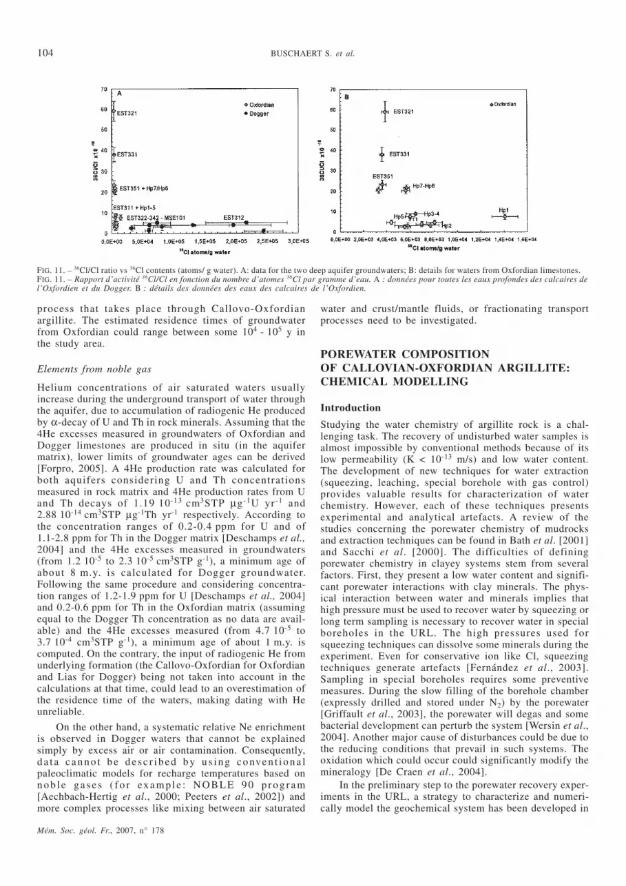
process that takes place through Callovo-Oxfordianargillite. The estimated residence times of groundwaterfrom Oxfordian could range between some 104 - 105 y inthe study area.
Elements from noble gas
Helium concentrations of air saturated waters usuallyincrease during the underground transport of water throughthe aquifer, due to accumulation of radiogenic He producedby α-decay of U and Th in rock minerals. Assuming that the4He excesses measured in groundwaters of Oxfordian andDogger limestones are produced in situ (in the aquifermatrix), lower limits of groundwater ages can be derived[Forpro, 2005]. A 4He production rate was calculated forboth aquifers considering U and Th concentrationsmeasured in rock matrix and 4He production rates from Uand Th decays of 1.19 10-13 cm3STP µg-1U yr-1 and2.88 10-14 cm3STP µg-1Th yr-1 respectively. According tothe concentration ranges of 0.2-0.4 ppm for U and of1.1-2.8 ppm for Th in the Dogger matrix [Deschamps et al.,2004] and the 4He excesses measured in groundwaters(from 1.2 10-5 to 2.3 10-5 cm3STP g-1), a minimum age ofabout 8 m.y. is calculated for Dogger groundwater.Following the same procedure and considering concentra-tion ranges of 1.2-1.9 ppm for U [Deschamps et al., 2004]and 0.2-0.6 ppm for Th in the Oxfordian matrix (assumingequal to the Dogger Th concentration as no data are avail-able) and the 4He excesses measured (from 4.7 10-5 to3.7 10-4 cm3STP g-1), a minimum age of about 1 m.y. iscomputed. On the contrary, the input of radiogenic He fromunderlying formation (the Callovo-Oxfordian for Oxfordianand Lias for Dogger) being not taken into account in thecalculations at that time, could lead to an overestimation ofthe residence time of the waters, making dating with Heunreliable.
On the other hand, a systematic relative Ne enrichmentis observed in Dogger waters that cannot be explainedsimply by excess air or air contamination. Consequently,d a t a c a n n o t b e d e s c r ib e d b y u s in g c o nve n t io n a lpaleoclimatic models for recharge temperatures based onn o b le ga s e s ( f o r ex a m p le : N O BL E 9 0 p r o g r a m[Aechbach-Hertig et al., 2000; Peeters et al., 2002]) andmore complex processes like mixing between air saturated
water and crust/mantle fluids, or fractionating transportprocesses need to be investigated.
POREWATER COMPOSITIONOF CALLOVIAN-OXFORDIAN ARGILLITE:CHEMICAL MODELLING
Introduction
Studying the water chemistry of argillite rock is a chal-lenging task. The recovery of undisturbed water samples isalmost impossible by conventional methods because of itslow permeability (K < 10-13 m/s) and low water content.The development of new techniques for water extraction(squeezing, leaching, special borehole with gas control)provides valuable results for characterization of waterchemistry. However, each of these techniques presentsexperimental and analytical artefacts. A review of thestudies concerning the porewater chemistry of mudrocksand extraction techniques can be found in Bath et al. [2001]and Sacchi et al. [2000]. The difficulties of definingporewater chemistry in clayey systems stem from severalfactors. First, they present a low water content and signifi-cant porewater interactions with clay minerals. The phys-ical interaction between water and minerals implies thathigh pressure must be used to recover water by squeezing orlong term sampling is necessary to recover water in specialboreholes in the URL. The high pressures used forsqueezing techniques can dissolve some minerals during theexperiment. Even for conservative ion like Cl, squeezingtechniques generate artefacts [Fernández et al., 2003].Sampling in special boreholes requires some preventivemeasures. During the slow filling of the borehole chamber(expressly drilled and stored under N2) by the porewater[Griffault et al., 2003], the porewater will degas and somebacterial development can perturb the system [Wersin et al.,2004]. Another major cause of disturbances could be due tothe reducing conditions that prevail in such systems. Theoxidation which could occur could significantly modify themineralogy [De Craen et al., 2004].
In the preliminary step to the porewater recovery exper-iments in the URL, a strategy to characterize and numeri-cally model the geochemical system has been developed in
Mém. Soc. géol. Fr., 2007, n° 178
104 BUSCHAERT S. et al.
FIG. 11. – 36Cl/Cl ratio vs 36Cl contents (atoms/ g water). A: data for the two deep aquifer groundwaters; B: details for waters from Oxfordian limestones.FIG. 11. – Rapport d’activité 36Cl/Cl en fonction du nombre d’atomes 36Cl par gramme d’eau. A : données pour toutes les eaux profondes des calcaires del’Oxfordien et du Dogger. B : détails des données des eaux des calcaires de l’Oxfordien.

the framework of the THERMOAR project through theAndra-BRGM partnership. The construction of the modelmakes it possible to define the porewater chemistry and alsodescribe the reaction pathways. The model is a powerfultool for modelling perturbations (alkaline solution, oxida-tion, bacterial, etc.). In the THERMOAR methodology, acomplete set of physical and chemical parameters has beenobtained. This methodology and the pCO2(g) measurementcells in particular were first developed on Opalinus Clay inSwitzerland [Gaucher et al. 2006]. These parameters deter-mine the construction of a geochemical model. The origi-nality of this approach lies in the fact that no parametershave been estimated, and that all major mineral phases aretaken into account. In the past, porewater modelling [forinstance Bradbury and Baeyens, 1998] in the case of theOpal inus Clay Formation (Switzer land) , general lyprescribed a hypothetical partial pressure of CO2. Anothermodel, developed for Boom Clay [Beaucaire et al., 2000]disregarded the clay 2:1 and ion exchange reactions. In thecase of the Callovian-Oxfordian argillites, the modelling ofMotellier et al. [2003], which includes ion exchanges for3 types of sorption sites, however, partially calculated theaqueous speciation and does not take the SO4
2- content intoaccount. The first complete modelling was applied to theOpalinus Clay porewater in the framework of the MontTerri Project [Pearson et al., 2003]. The purpose of thiss e c t i o n i s t o s u m m a r i s e t h e d a t a o b t a i n e d f r o mCallovian-Oxfordian core samples and to use them toconstrain the model.
Methodology: input parameters and constraints
The parameters used in the construction of the model are asfollows:
– the total reducing capacity of the rock (TRC);– mineral identification and cristallinity of minerals;– water content and texture of the argillites;– leaching of anions;– cation exchange capacity (CEC) and adsorbed
cationic population;– ionic exchange constants (KH/Na, KK/Na, KCa/Na,
KMg/Na, KSr/Na);– partial pressure of the CO2(g) and the isotopic signa-
ture of the gas.
The methodology was first applied to core samplesfrom the EST205 borehole drilled above the URL site (onthe location of the main shaft of the URL before it wassunk). Some additional samples from regional boreholeswere then added to the original set. The materials andmethods used to obtain the data are presented in Gaucher etal. [2004] for core sampling under a special drillingoil-based mud. The analytical techniques used to identifyand characterize the minerals, to determine the watercontent and the textural properties, the leaching of anions,the cation exchange capacity and the adsorbed cationicpopulation are also detailed in Gaucher et al. [2004]. Theexperimental protocol for the ionic exchange constants arepublished in Gaucher et al. [2005]. The method forobtaining the pCO2(g) and the isotopic signature of the gasis presented by Girard et al. [2005]. The following itemsshow how these data were used to constrain the modelling.
Total reduced capacity of the rock (TRC)
The TRC is an index of the redox state of the rock andrepresents its “oxydisability”. The mean value for theformation is 4.7 ± 1.3 meq/g. Theses values are similar tothose measured in the Opalinus Clay Formation 4.8 ±0.9 meq/g [Waber et al., 2003]. The TRC do not vary a lotin argillite (of Callovo-Oxfordian age). The lower valuesare mainly due to calcareous beds (1.6 meq/g). The TRC islinked to the organic matter content and mainly to thesulphide minerals. Pyrite is the major sulphide, however,recent observation demonstrates that pyrrhotite is alsopresent. By way of conclusion, the conditions in the forma-tion are clearly reduced. For the modelling, the redox statecan be regulated by pyrite. Regulation by pyrrhotite is alsopossible.
Mineral identification and cristallinity of minerals
For the modelling, it was necessary to identify all mineralspresent, even at trace level. As several minerals can controlthe aqueous speciation of an element, it was also necessaryto determine a cristallinity criterion. Indeed, a mineralwhich presents alteration or an unbalanced structuralformula is not considered at equilibrium in the modelling.The extended list of minerals found in the Callovian-Oxfordian formation is presented in table II with relativeabundance, their distribution and some information oncristallinity. Table II also states whether the phase has to betaken into account in geochemical modelling.
It should be noted that a montmorillonite which is inde-pendent from the interlayered clays has been described byClaret et al. [2002]. This phase is ubiquitous in the forma-tion.
Water content and texture of the argillite
The Callovian-Oxfordian argillite has a low water contentranging from 6% to 9% (dry base). Some small contentsmeasured (1.5%) correspond to levels that are rich in finecarbonate cement. According to Horseman et al. [1996], thewater content of the argillite includes four different types ofwater:
– interlayer water within the sheet structures of clayminerals. This water is largely adsorbed;
– another largely adsorbed water at the clay mineralsurface is the (structured) water participating in thehydration shells of the cations (which locally balance themineral surface charges);
– loosely-held water in the diffuse-layer;– free water.Pearson [1999] has demonstrated that, for geochemical
purposes, it is convenient to only distinguish “bound”water, which includes interlayer, largely adsorbed and somediffuse layer waters, as well as the “free” water (whichincludes not only Horseman’s free water, but also some ofthe diffuse layer and surface-sorbed waters as well). Thisdistinction is rough, however practical. The thickness of the“bound” water is estimated to be about 2 to 3 water layersin the case of argillite. Following the method of Gaboriau etal. [2001], the two types of water have been quantifiedthrough the measurement of the specific wetted surfaceusing the water sorption isotherm obtained for sample K119
Mém. Soc. géol. Fr., 2007, n° 178
WATER GEOCHEMISTRY AND THE REGIONAL HYDROGEOLOGICAL SYSTEM 105

(476.6 m) from borehole EST205. Knowing the SBETH2O and
the thickness of the water layer, the volume of the “bound”water is estimated to be about 50% of the total water.
Leaching of anions
The leaching of ions is a conventional technique forobtaining the Cl-, Br-, and in some cases I- and SO4
2-
contents of porewater. Information concerning the cations,aqueous silica, carbonates and fluorides is generallydisturbed by the dissolution of minerals. The concentrationsof leached conservative anions produce straight lines as afunction of the solid/liquid ratio of the batch systems(fig. 12). Control by the solubility of a mineral phase givesa hyperbole. The oxidation of the rock samples producesscattered values.
The behaviour of SO42- during the leaching experiment
with a regression coefficient of 0.997 shows a perfectconservative character. The experiment is not disturbed bypyrite oxidation. The measurement of the Sr concentrationindicates that celestite is not significantly dissolved duringleaching. The SO4
2- concentrations obtained by leaching areprobably the maximum values present in the porewater.
In the case of the higher Cl concentrations given byGaucher et al. [2004], it should be noted that these werecontaminated by oil-mud drilling containing CaCl2 brine.Some samples, the borders of which were cut immediatelyafter drilling, present a lower Cl-content, which is morerealistic. The sawing of the core edges thus avoidedCl-contamination as has been observed with recent leachingof cores from new boreholes (drilled with other fluids). Theconcentrations of Cl-, Br-, SO4
2- in the totality of theporewater (TW) or in the geochemical porosity (GP) aregiven in table III. The Cl-content of the porewater has alsobeen systematically acquired for each borehole drilled byAndra (fig. 14).
Cation exchange capacity (CEC) and adsorbed cationicpopulation
The CEC of the argillite is 15.3 ± 5.0 meq/100g. The lowestva lues a re obse rved in the more ca lca reous beds(3.3 meq/100g). The highest values are obtained in the I/SR0zone (22.9 meq/100g at 463.7 m). The I/SR1 (less rich in
Mém. Soc. géol. Fr., 2007, n° 178
106 BUSCHAERT S. et al.
TABLE II. – Synthesis of the mineralogical information obtained from Callovo-Oxfordian argillites.TABL. II. – Synthèse des informations minéralogiques obtenues sur les argilites du Callovo-Oxfordien.
Mineral Abundance Depth at the URL location Crystallinity Insertion in the modelling
Illite +++ ever-present good, fe-rich yes
Interlayered I/SR0 +++ 422 to ∼ 493 m good yes
Interlayered I/SR1 +++ ∼ 489 to 554 m good yes
Glauconite Trace no systematic no
Kaolinite + ∼ 454 to 554m good can be tested
Montmorillonite ++ special level at 425.03-425.08 good can be tested
Chlorite Trace ever-present various fe-content yes
Biotite Trace no systematic chloritised no
Muscovite/Phengite Trace no systematic detrital no
Microcline/Orthoclase Trace no systematic good, detrital can be tested
Albite/plagioclase very rare very rare detrital no
Quartz +++ ever-present good, detrital figures yes
Chalcedony Trace no systematic good can be tested
Calcite +++ ever-present good, several crystalliza-tions
yes
Aragonite Trace no systematic good no
Ca-rich Dolomite ++ ever-present good yes
Ankerite/Siderite ++ ever-present good yes
Celestite trace to ++ ever-present good yes
Pyrite + ever-present polymorph, good yes
Pyrrhotite Trace no systematic very small particle can be tested
Sphalerite/Chalcopyrite very rare very rare no
Native Sulfur very rare very rare very small particle no
Rutile/Anatase Trace ever-present good no
Apatite/Collophane Trace no systematic no
FIG. 12. – Leaching experiment. Concentration of Cl-, SO42-, HCO3
- lea-ched vs. the solid/liquid ratio. The hyperbolic behaviour of HCO3
- illustra-tes a non-conservative character by contrast with Cl- and SO4
2-.FIG. 12. – Concentrations en Cl-, SO4
2- et HCO3- obtenues par expériences
de lixiviation des argillites en fonction du rapport eau/roche. Le comporte-ment en hyperbole de HCO3
- montre le caractère non conservatif de cetélément à la différence des données en Cl- et SO4
2-.
TABLE III. – Cl-, Br-, SO42- content in the geochemical porosity
(GP) calculated from the leaching experiment.TABL. III. – Concentrations en Cl-, Br-, SO4
2- dans la porosité géo-chimique (GP) calculées d’après les données de lixiviation.
EST205Sample
depth (m) Cl- mol/l Br- mol/l SO42- mol/l
K100 423.68-424.48 2.90 10-2 5.1 10-5 8.35 10-2
K119 476.57-476.97 3.01 10-2 6.5 10-5 6.28 10-2

smectite) presents a very stable average value of 13.5 ±0.4 meq/100g. As Bradbury and Baeyens [1998] haspointed out, the adsorbed cationic population is an imprintof the solution in equilibrium with the mineral assemblage.The proportions of exchangeable cations are extremelyconstant in Oxfordian units of the argillite. Including the4% of exchangeable Sr2+, the adsorption sites are mainlytaken up by 45.3 ± 1.6% of Ca, 25.0 ± 2.1% of Mg, 17.7 ±1.9% of Na, 8.1 ± 1.1% of K. The homogeneity of theadsorbed cationic population is a robust indication thatcationic proportion in the porewater should be constant andthat reaction pathways concerning the major cations areidentical in the argillites.
Ionic selectivity coefficients (KH/Na, KK/Na, KCa/Na, KMg/Na, KSr/Na)
Following previous work [e.g Thorstenton et al., 1979;Plummer et al., 1990; Appelo et al. 1990; Griffault et al.,1997; Bradbury and Baeyens, 1998; Walreavens andCardenal, 1999; Motellier et al., 2003 and Pearson et al.,2003], there is a large consensus that ion exchange reac-tions are essential for modelling the porewater chemistryof clay-rich formations. For this purpose, a complete setof ion exchange constants (KGT H\Na, KGT K\Na, KGT NH4\Na,KGT Ca\Na, KGT Mg\Na, KGT Sr\Na) was determined on the< 2 µm clay fractions [Gaucher et al., 2005] using theGaines-Thomas formalism. Contrary to Motellier et al.[2003] and Jacquier et al. [2004], who use H+, our cation ofreference is Na+. This gives constants comparable to thedata presented in the other studies. From the Na/Hisotherm, it was possible to distinguish 3 types of exchangesites (for pH < 11). By modelling the Na/K isotherm, it waspossible to identify illite-type and smectite-type sites. In thecase of Opalinus Clay, a comparable observation was made[Gaucher et al., 2001]. However, the global approachconsidering the ion exchange sites as a whole was used forthe modelling of porewater in neutral conditions. So, in thispaper, only the global constants are presented in table IV.
Studies are currently under way to refine this approach[Tournassat et al., 2006]. The activity coefficient ofexchanged species will be introduced as a function of thecomposition of adsorbed cation. An increase of the K/Naselectivity coefficient is expected, leading to a decrease ofthe K+ concentration in the modelling porewater.
Partial pressure of the CO2(g) and isotopic signature of thegas
The most innovative measure of the THERMOAR method-ology is the direct analysis of partial pressure of CO2 on
core samples [Gaucher et al., 2006] previously developedon Opalinus Clay. The core samples are confined in a rigidcontainer, immediately after the drilling and the sawing ofthe core edges. The temperature and the pressure of the cellare continuously monitored. The cell is placed in a venti-lated cupboard at a temperature of 25oC. The gases arereleased in the cell and an analytical survey by gas chroma-tography was performing until the pCO2 reaches a stabilitylevel. At this point, CO2 isotope analyses are performed[Girard et al., 2005].
The pCO2 results are between 3.10 and 7.17 mbar (LogpCO2 of –2.51/-2.15). These results fall within the range ofdata compiled by Coudrain-Ribstein et al. [1998] for sedi-mentary confined aquifers (1 to 100 mbar at 25oC). It waspossible to determine the isotopic composition of the bicar-bonate ions at equilibrium with the gas. The δ13C signaturesof the bicarbonates and the carbonate cements of theargillites (mainly calcite and few dolomite and siderite) aretotally similar [Clauer et al., 2006]. This proves that thepCO2 is fixed by the mineralogical assemblage and not bydegradation of organic matter or diffusion of gas comingfrom outside the formation, as the δ13C signatures would beaffected.
Modelling
In view of the stability of the nature of the minerals and thegeochemical data, it was considered that the porewaterchemistry is quite constant in the argillite at the URL loca-tion. The I/S R0 to I/S R1 transition does not affect themodelling as illite is only considered in the modelling. Allcalculations were conducted at the thermodynamic equilib-rium. Considering the very low permeability of the argillite(K < 10-13 m/s) and the probable residence time of water, itis realistic to suppose that the thermodynamic equilibriumcan be reached in such geological media. The numericalmodelling of the porewater chemistry follows two conve-nient steps. First, seawater is diluted by pure water, andsecondly, the resulting water (dilute seawater) is equili-brated with the mineralogical assemblage and the exchangesites (X) of the argillite. The dilution is defined to obtainthe Cl concentration determined in the section “Leaching ofanions”. The whole mineral assemblage fixes the followingelements: e-, S, C, Si, Ca, Mg, Na, K, Sr, Fe, Al. Somegeochemical subsystems can be distinguished in the model.Na is only determined by ion exchange (NaX). Thesubsystem Fe, S, e-, Sr, also considers daphnite, celestite,pyrite, and ion exchange (SrX2). The subsystem Si, Al, K isdetermined by quartz, illite, and ion exchange (KX). Thesubsystem C, Ca, Mg, is controlled by pCO2, calcite, dolo-mite. The ion exchange equation concerning Ca and Mg isconsidered in the equation system. However, they are notdetermining for the water chemistry. They can only adjustthe distribution of cations in the exchanger. The pH iscalculated by iteration to obtain the electroneutrality of thesolution.
The calculations are performed with the PHREEQCcode [Parkhurst and Appelo, 1999] using the llnl.dat data-base [Wolery, 1992]. The simulations consider the Clconcentrations determined in the geochemical porosity.Three cases are presented in table V and figure 13. Simula-tions A consider the pCO2 at the maximum measured valueand simulations B, at the minimum value (see previous
Mém. Soc. géol. Fr., 2007, n° 178
WATER GEOCHEMISTRY AND THE REGIONAL HYDROGEOLOGICAL SYSTEM 107
TABLE IV. – Gaines-Thomas parameters for a global type of exchangesites.TABL. IV. – Constantes d’échanges Gaines-Thomas pour un modèle à unseul site.
Model 1 type of sites Constant Standard Deviation Log Constant
H\Na CE1+2 13.0 2.63 1.11
K\Na CE1+2 2.78 0.12 0.44
NH4\Na CE1+2 2.98 0.14 0.47
Ca\Na CE1+2 3.17 0.1 0.50
Mg\Na CE1+2 2.41 0.09 0.38
Sr\Na CE1+2 4.75 0.19 0.68

section). The “Chlo” simulations correspond to test caseswhere the pCO2 is not fixed. Mg-chlorite has been added tothe phase assemblage following the model produced byCoudrain-Ribstein et al. [1998]. In this model, the pCO2 isnot controlled externally and is determined by the equilib-rium between calcite, dolomite, and a Mg-aluminosilicate.
The figure 13 shows that the solutions are relativelyconcentrated with an ionic strength of 10-1M. The pH isbetween 7.09 and 7.30. The Eh is low (-156 mV < EhSHE <-181 mV). The waters are of the Na-Cl-SO4 type. Na is twotimes more concentrated than Ca and Mg and four timesmore than K. The recent refinement of the K/Na selectivitycoefficient decreases the K content of the porewater byabout one order of magnitude. The alkalinity is moderatebetween 1 and 3 mmol/kgw. The Al and Si contents agreewith a system controlled by silicates and aluminosilicates.The Fe contents (determined by the equilibrium withdaphnite) are quite high. However, the model fixes analmost equilibrium with the siderite, which was foundlocally in the formation. The LogpCO2 obtained by calcu-lation in the simulations “Chlo” (-1.96) are close to theLogpCO2 measurements (-2.15/-2.51). This is a good indi-cation that the modelling is consistent with representativechemistry. Another check is possible by the proportion ofabsorbed cations that are kept by the modelling. Incontrast, if microcline is introduced in the modellinginstead of illite, the percentage of adsorbed cations issignificantly modified. This indicates that this phase doesnot participate to the regulation of the porewater chem-istry.
Mém. Soc. géol. Fr., 2007, n° 178
108 BUSCHAERT S. et al.
FIG. 13. – Schoeller diagram of the test cases A, B and Chlo.FIG. 13. – Diagramme de Schoeller des cas de modélisation A, B et Chlo.
TABLE V. – Modelling results: Various test cases of porewater chemistry. (*: Fixed pCO2).TABL. V. – Résultats de modélisations de la chimie de l’eau porale pour les différents cas A, B et Chlo.
A B Chlo
Porewater chemistry mol/kgw mol/kgw mol/kgw
pH 7.10 7.28 7.00
Eh mV -163 -176 -156
Alk 1.97E-03 1.29E-03 2.46E-03
Ionic strength 1.16E-01 1.16E-01 1.17E-01
Cl 3.01E-02 3.01E-02 3.01E-02
S 3.39E-02 3.40E-02 3.39E-02
Na 3.21E-02 3.20E-02 3.21E-02
K 7.09E-03 7.07E-03 7.10E-03
Ca 1.49E-02 1.48E-02 1.50E-02
Mg 1.41E-02 1.41E-02 1.42E-02
Sr 1.12E-03 1.12E-03 1.12E-03
Si 9.41E-05 9.43E-05 9.40E-05
Al 7.36E-09 8.62E-09 6.85E-09
Fe 2.14E-04 9.40E-05 3.32E-04
Log(pCO2(g)) bar -2.15* -2.51* -1.96
saturation index (si)
si_Illite 0 0 0
si_Montmor-Ca -0.177 -0.143 -0.195
si_Microcline 0.5581 0.652 0.509
si_Calcite 0 0 0
si_Dolomite 0 0 0
si_Daphnite-14A 0 0 0
si_Quartz 0 0 0
si_Siderite 0.0906 -0.235 0.261
si_Pyrite 0 0 0
si_Celestite 0 0 0
si_Gypsum -0.0085 -0.0086 -0.0085
si_Clinochlore-14A -5.64 -4.01 -6.49
si_Chlorite-14A 0.85 2.48 0
ion exchange
SrX2 4 % 4 % 4 %
KX 8 % 8 % 8 %
NaX 14 % 14 % 14 %
MgX2 28 % 28 % 28 %
CaX2 45 % 45 % 45 %
STUDY OF THE SOLUTE TRANSPORTIN SEDIMENTARY SERIESBY NATURAL TRACERS
Porewater in Callovo-Oxfordian argillites has been studiedfor the information they could give on solute transport.Natural tracer distribution profiles can be considered as atransfer experiment both in terms of spatial (regional) andtime scales. They could provide independent information ontransport properties from other characterizations (obtainedfrom cores by diffusion tests or in-situ URL experiments).The isotopic character isat ion of porewaters of theCallovo-Oxfordian layer has shown a meteoric origin[Clauer et al., 2006]. Preliminary data on stable isotopesand helium profiles seem to indicate diffusive transportthrough the argillite. We will focus here on chlorine tracers(Cl-content and isotopic composition) to illustrate the trans-port processes.
Distribution of Cl concentration in Callovo-Oxfordianargillite
Chlorine distribution has been acquired in the study area forseveral regional boreholes. Chlorides were extracted fromargillite by leaching. The data are presented in figure 14with those obtained previously in aquifers groundwaters. Inthe case of argillite porewater, Cl-contents are calculatedusing a geochemical porosity (supposed to be equal to 50%of the total pore space) due to anion exclusion phenomenon(see section on “argillite porewater modelling”). Chlorineconcentration in argillite porewater is quite low in compar-ison to seawater content (around 19 g/l). During the sedi-mentation of argillites, seawater was present in the argillite[Clauer et al., 2006]. A process has occurred to decrease theCl-content. The data on argillites show that the Cl-contentis laterally highly variable in the study area. Consideringthe available Cl-content data in Dogger water, it appearsthat the Dogger behaves as a boundary conditions of thesystem. These Cl distribution profiles clearly materialize agradient and could be interpreted by the existence of anupward diffusive flow. The Dogger supplies the concentra-tion gradient of the system. The salinity of Doggerg r o u n d wa te r s c o u ld b e d u e to in t e r a c t i o n s w i thgroundwaters in contact with Triassic salt-levels and/or todiffusive process taking place in Trias aquifer through theLias argillite.
Distribution of Cl isotopic composition inCallovo-Oxfordian argillite
The Cl isotopic composition of porewaters from the argillitehas been determined for HTM102 (fig. 15). Twenty-onerock samples were collected in the 394-464 m depth range.Chlorides were extracted from pore space by leaching withpure water as described in the following paragraph. Theisotopic data from groundwaters sampled in Oxfordianlimestones (PPA and EST311) are also presented in thefigure 15.
Methodology
HTM102 core samples were ground to < 63 µm and leachedtwice with ultra pure water (Milli-Q® quality) to extractabout 100% of chlorine from both pore water and residual
sa l t s . F i r s t and second leacha tes were mixed forCl-concentration and Cl-isotopic measurements. Theanalytical procedure for Cl-isotopic analysis is based onmeasurement of the 37Cl/35Cl ratio on the ClCH3 molecule[Kaufmann, 1988; Long et al., 1993 and Godon et al.,2004] measured with a VG Optima mass spectrometer. Theδ37Cl gives the deviation of the 37Cl/35Cl ratio of the samplerelative to the Standard Mean Oceanic Chloride (SMOC):
δ 3737 35
37 351Cl
Cl Cl
Cl ClSample
Sample
SMOC
= −⎛
⎝⎜⎜
( / )
( / )
⎞
⎠⎟⎟ *103 Eq. 1
Results
Cl-concentrations and δ37Cl of porewater from the argilliterange between 336 and 1788 mg/l and between -0.34 and+0.65‰, respectively. The middle part of the argillite(454-480 m on figure 15), which has a maximum claycontent and cationic exchange capacity (CEC), is differenti-ated from external parts (480-552 m and 402-454 m onfigure 15) by a homogeneously low Cl concentration (601 ±132 mg/l) and constant and positive δ37Cl (+0.27±0.11‰).No mixing process can be identified in the argillites fromCl-concentrations and δ37Cl data.
Interpretation in terms of transfer processes
The discussion on solute transfers between the argillite andits surrounding aquifers is based on the Cl-concentrationand δ37Cl data obtained from the HTM102 boreholeporewaters (in Bathonian limestone, argillite and basalOxfordian), from the main shaft boreholes (Oxfordian
Mém. Soc. géol. Fr., 2007, n° 178
WATER GEOCHEMISTRY AND THE REGIONAL HYDROGEOLOGICAL SYSTEM 109
FIG. 14. – Chlorine distribution profile in the study area. For regional bore-holes, depths are corrected to position all data on the URL site. (GW=groundwater).Fig. 14. – Profil de distribution des chlorinités dans les eaux des calcaires(GW) et des argilites (rock leaching) avec la profondeur. Pour les foragesde secteur, les profondeurs sont corrigées pour positionner les données audroit du Laboratoire souterrain.

groundwater) and from boreholes made in Tithonian(surface waters). All data are represented on a same profilewhere the depth reference is the Oxfordian aquifer/argilliteboundary depth at the URL site (fig. 15).
Cl-concentration and 37Cl consequences
The Cl-concentration profile, the recurring change of posi-tive and negative δ37Cl zones corresponding to the aquifersand argillites respectively, and the δ37Cl v-shape observedin Oxfordian aquifer suggest that a diffusion-like processcontrols the upward Cl-transport from Dogger towardsO x f o r d i a n a n d Ti th o n i a n a q u i f e r s t h r o u g h th eCallovo-Oxfordian argillite. The hydrogeological relation-ship between the Dogger aquifer and the argillites has notbeen considered in this model, as the Dogger Cl signature isprobably the result of another process which is a gain fromunderlying layers (Trias, Lias). Consequently, the followingmodelling and discussion aim to describe Cl-transfer in theOxfordian/Tithonian aquifers.
Diffusion is often invoked to explain chlorine isotopicvariations where a chlorine concentration gradient isobserved [Beekman et al., 1992; Eggenkamp et al., 1994;Groen et al., 2000; Hesse et al., 2000; Eastoe et al., 2001].It is well known that diffusion produces Cl-isotopic frac-tionation because 35Cl moves faster than 37Cl. Conse-quently, a 37Cl-enrichment of the chloride-rich reservoirand a 37Cl-depletion of the chloride poor reservoir areexpected [Desaulniers et al., 1986; Eggenkamp et al., 1994;Eggenkamp et al., 1997].
Main hydrogeological features of Oxfordian/Tithonianaquifers
The transfer of meteoric waters in the Oxfordian aquiferoccurs mainly by horizontal advection towards the west,from recharge areas to the URL site. The distance betweenthe two locations is about 20 kilometres. In such a conti-nental area, meteoric waters are depleted in chloride and anadditional Cl-source is necessary to explain the Cl concen-trations in these groundwaters. The closest source of chlo-ride is the argillite porewater. Two main transfer processescould be pointed out from the chloride profile vs. depthfrom Dogger to Tithonian formation. The host formation ofthe Callovo-Oxfordian shows a steep profile indicating aweak concentration gradient induced mainly by diffusionprocess. While, in the overlying Oxfordian, the chlorideprofile indicates dilution upwards. Those two transferp r o c e s s e s in t e r a c t , ve r t i c a l d i f f u s i o n f r o m th eCallovo-Oxfordian and horizontal groundwater advectionwhose magnitude increases upward inducing a dilution. Theincrease of the velocities upward in the Oxfordian is consis-tent with the groundwater modelling results [Le Gallo,2004].
Modelling
According to the Cl-concentrations and δ37Cl signaturesand the main hydrogeological features, hydrodynamicdispersion which associates mechanical dispersion (oradvection) and diffusion is the main process able todescribe Cl-transfer in the Oxfordian/Tithonian aquifers.
Mém. Soc. géol. Fr., 2007, n° 178
110 BUSCHAERT S. et al.
FIG. 15. – Model of Cl-transport in Oxfordian/Tithonian aquifers. The model for the URL site is represented for DCl.t = 2414 m2, Cbound = 1.18 mole/m3,C0=0.02 mole/m3, δ37Clbound=0‰, δ37Cl0=0‰, α=1.0014. The model for the EST311 site is represented for DCl.t =1565 m2, Cbound = 1.18 mole/m3,C0=0.02 mole/m3, δ37Clbound=0‰, δ37Cl0=0‰, α=1.0022.FIG. 15. – Modèle de transport des ions chlorures dans les calcaires de l’Oxfordien du Tithonien. Le modèle sur le site du Laboratoire est paramétrécomme suit : DCl.t = 2414 m2, Cbound = 1.18 mole/m3, C0=0.02 mole/m3, δ37Clbound=0‰, δ37Cl0=0‰, α=1.0014. Le modèle pour le forage EST311 est para-métré comme suit : DCl.t =1565 m2, Cbound = 1.18 mole/m3, C0=0.02 mole/m3, δ37Clbound=0‰, δ37Cl0=0‰, α=1.0022.

Data were taken from equation 2 [Crank, 1975] which is ananalytical solution to the second Fick’s law [for more expla-nations, see Lavastre et al., 2005].
C C
C Cerfc
x
D t
x t
bound Cl
, −−
=0
0 2Eq. 2
where x is the distance to the diffusion boundary and x ≥ 0;t is the time; Cbound is the constant boundary rockCl-concentration at x = 0 (argillites), C0 is the initial rockCl-concentration in the Cl-depleted reservoir (Oxfordian /Tithonian aquifers) at t = 0; Cx,t is the rock Cl-concentrationat x > 0 and t > 0 (Oxfordian/Tithonian aquifers); and DCl isthe chloride hydrodynamic dispersion coefficient in therock. The Cl-concentration in the rock (C) is equal to[Cl]water*n were n is the porosity of the rock.
Equation 2 was written separately for transport of 35Cland 37Cl. The chlorine concentration curve is simplyobtained by adding 35Cx,t and 37Cx,t (equation 3). The δ37Clevolution was then deduced from equation 1.
Cx,t = 35Cx,t + 37Cx,t Eq. 3
Model constraints and parameters
The diffusion boundary is set at a depth about 407 m in thebasal part of the Oxfordian aquifer (fig. 15) where animportant change in clay content occurs. Oxfordian/Tithonian aquifers are considered homogeneous in terms ofphysical, hydrogeologic (porosity, permeability) and hydro-dynamic properties (dispersive and diffusive). Boundaryconditions (Cbound and δ37Clbound), initial Cl-concentration(C0) and δ37Cl (δ37Cl0) in Oxfordian/Tithonian aquifers andporosity of Oxfordian limestone used to fit URL andEST311 data are reported in table VI.
Implication of the model
According to equation 2, good fits of URL and EST311 sitedata were obtained for parameter values reported intable VI. This shows that hydrodynamic dispersion mightcontrol Cl-transfer over a large geographical area, thedifference in DClt product range probably corresponds tothe difference of Cl-accumulation time in Oxfordian/Tithonian aquifers (site EST311 is located about 10 kmaway from the recharges areas versus 20 km for the URLsite).
According to the optimised DClt values and consid-ering:
– a Cl-hydrodynamic dispersion coefficient equal tothe Cl-molecular diffusion coefficient in Oxfordian
limestone (mean value about 10-11m2/s [Blin et al., 2005]),a maximum time of about 7-8 and 4-5.6 m.y. is calculatedfor the establishment of URL and EST311 Cl-profiles,respectively;
– a res idence t ime of about 100,000 y for theOxfordian limestone waters, a maximum chlorine hydrody-namic dispersion coefficient of 7.6 10-10 m2/s can be calcu-lated.
These parameters indicate that the effect of hydrody-namic dispersion on the vertical transport component couldbe significant compared to simple molecular diffusion inlimestone. Chlorine vertical transport can be increased by afactor of 70 compared to a simple system with moleculardiffusion in this limestone. However, the computed value islower than the Cl-diffusion coefficient in pure water (about2 10-9 m2/s). This suggests a slow vertical transport ofchlorine.
UNDERSTANDING THE HYDRO-GEOCHEMICAL SYSTEM
Subsurface waters
Subsurface waters have been sampled in free-water aqui-fers. This recent water has geochemical signatures thatreflect typical rain-waters. This is consistent with ourunderstanding of the groundwater and surface water (rapidcirculations mostly to the hydrographic network) relation-ship at the study area. All waters have similar chemicalcharacteristics such as low mineralisation and salinity.Their compositions indicate a run-off pollution linked toa g r i c u l t u r a l f e r t i l i z e r s . T h e s h a l l ow wa t e r f r o mKimmeridgian marl present a higher mineralisation thanmost of the water from free aquifers. Its residence time isestimated to be around 104 y.
Deep groundwaters
The groundwaters of Oxfordian, Callovo-Oxfordian andDogger format ions are cons iderably diss imi lar tosubsurface waters. They are old groundwaters, which havesignificant mineralisation and salinity and do not presentany indication of pollution. Their composition reflectslonger interactions with their host-formations. Variation inthe salinity and Cl-content of each deep formation is,however, observed on the scale of the borehole (vs. depth)and also laterally on the scale of the study area.
Mém. Soc. géol. Fr., 2007, n° 178
WATER GEOCHEMISTRY AND THE REGIONAL HYDROGEOLOGICAL SYSTEM 111
TABLE VI. – Modeling Cl-transfer through the Oxfordian/Tithonian limestone at the URL and EST311 sites. Modelconstraints, parameters and fitting results (α is the isotopic fractionation of chlorine). * values measured close tothe interface between Callovo-Oxfordian argillite and Oxfordian limestone. + meteoric values measured in the wa-ters of Tithonian aquifer.TABL. VI. – Données d’entrée et résultats de la modélisation du transport des chlorures à travers les calcaires del’Oxfordien et du Tithonien au droit du Laboratoire Souterrain et du forage EST311.* valeurs mesurées à proximité de l’interface entre les argilites du Callovo-Oxfordien et des calcaires de l’Oxfor-dien. + valeurs mesurées dans les eaux météoriques de l’aquifère du Tithonien.
Location
Boundary conditions Initial conditions Equation 2 fit parameters
Cbound mole/m3 δ37Clbound ‰SMOC
C0 mole/m3 δ37Cl0‰ /SMOC
DClt m2 α=D35Cl/D37Cl
URL site0.68-1.18* 0* 0.02+ 0+
2210-2610 1.0014±0.0002
EST311 site 1360-1770 1.0022±0.0006

In the case of groundwater from Oxfordian limestonesampled on the URL site (Hp samples from PPA), isotopiccompositions favour the individualization of 3 waterproductive zones (Hp7-6; Hp5; Hp1-4). This is consistentwith the hydrodynamic reactions of Hps monitored at theboreholes during the shaft excavation. These reactions indi-cate hydraulic connections inside each zone, whereasconnection between zones is weak. This could be explainedby the aquitard role of small clayey interlayers betweenthese zones (fig. 2). On a regional scale, for chemical andisotopic data, two groups of waters emerge: a first group isformed by water from boreholes EST351, EST331 andEST321) and a second, by water from EST311 and PPA. Onaccount of its mineralisation, the first group seems to beyounger than the second one. As a general rule, Oxfordiangroundwaters have, however, an estimated mean residencetime of the order of 104-105 y. By considering both resi-dence-time and distance between recharge areas, the meanflow velocity is lower than one to ten km per 100,000 y.,which is reconciliable with the hydrogeological modellingresu l t s [Le-Gal lo e t a l . , 2004] . Accord ing to theincertainties of the modelling parameters, we consider thecalculated mean velocity as consistent with the estimatedOxfordian water mean age.
In the case of the chemical composition of theporewater of Callovo-Oxfordian argillite, as the completeextraction of porewater is difficult, a methodology has beendeveloped for the characterization of water composition.The THERMOAR methodology can be used to characterizeits geochemistry in detail. As transfers in the argillite arevery slow, the water chemistry has been calculated byconsidering a thermodynamic equilibrium with the rockmineralogy. The set of data has been completely acquiredand allows the construction of a model without any esti-mated parameters . The model l ing of porewater ofCallovo-Oxfordian argillite is a tool that allows the compar-ison and the interpretation of the future hydro-geochemicaldata acquisition from Andra underground long-term experi-ments. The different calculations presented in this papergive an indication of the variability of the porewater chem-istry at the URL site. At present, the best-estimate of theporewater composition is given by the A and B composi-tions. The “Chlo” model is the most representative of thereaction pathways that occur in the argillites. Future devel-opments of that modelling will have to consider the refine-ment of the selectivity coefficient and the Cl variability inthe study area.
Indeed, the groundwaters of Dogger limestone havehigher salinity levels and Cl-contents than those from
Oxfordian and Callovo-Oxfordian layers. The study ofnatural tracers in the overall sedimentary series indicatesthat:
– th e va r i a t i o n in s a l i n i t y a n d Cl - c o n t e n t i nCallovo-Oxfordian argillite is mainly induced by those ofthe Dogger groundwater. The mapping of the spatial vari-ability of the Callovo-Oxfordian salinity and Cl-content ismainly governed by the salinity and Cl-content of theu n d e r ly in g D o g g e r a q u i f e r. A s a n a q u i t a r d , t h eCallovo-Oxfordian has a salinity and Cl-content layout thatreflects the Dogger salinity/Cl-content layout;
– the argillite mainly allows transport by diffusionfrom the Dogger to Oxfordian aquifer;
– as this process also implies an upward diffusive fluxof chloride from the argillites towards upper limestone, thechlorine variability in the Oxfordian aquifer is induced bythe Callovo-Oxfordian one. The δ37Cl profiles of theOxfordian groundwaters characterizes a slow kinetics (lowmean velocity) of the flow in this aquifer.
Chemical (especially salinity and Cl-content) andisotopic compositions indicate a considerable differentia-tion between groundwaters of the two deep-aquifers.According to the previous interpretation of pure diffusiontransport, the Callovo-Oxfordian argillite probably isolatesthe two aquifers and does not allow hydraulic connexioneven near tectonic structures. The hydrogeological charac-terisation and modelling results are consistent with theprevious hydrochemical interpretation results.
Finally, the Dogger groundwater might present someindices of interaction with Triassic groundwater whosesalinity may reach 200 g/L in the Paris Basin. Transfer mayoccur by advective and/or more probably by diffusiveprocess through Lias argillite. The residence time ofgroundwaters from Dogger limestone is estimated to beolder than those sampled in Oxfordian limestone. Thegeochemical indices on groundwater from Dogger lime-stone and particularly the hydrogeological modellingresu l ts indica te a mean veloc i ty around 1 km per1,000,000 y.
Acknowledgments. – This study was supported by Andra through two mainresearch programmes: i) GdR FORPRO –mainly by the Action 2003.I–French national research PACE programme between CNRS and Andra. S.Giannesini was funded by Andra for her PhD thesis; ii) BRGM-Andrascientific partnership. We thoroughly acknowledge Robert C. Finkel for the36Cl AMS measurements that were done at CAMS-LLNL.
References
AECHBACH-HERTIG W, PEETERS F., BEYERLE U. & KIPFER R. (2000). –Paleotemperature reconstruction from noble gases in groundwa-ter accounting for equilibrium with entrapped air. – Nature, 405,1040-1044.
ANDRA (2005). – Dossier 2005. Référentiel du site de Meuse/Haute-Marne. –Andra report noC.RP.ADS.04.0002, 3 tomes.
ANDREWS J.-N., FONTES J.-C., MICHELOT J.-L. & ELMORE D. (1986). – Insitu neutron flux, 36Cl production and groundwater evolution atStripa, Sweden. – Earth Planet. Sci. Lett., 77, 49-58.
APPELO C.-A.-J., WILLEMSEN A., BEEKMAN H.-E. & GRIFFIOEN J. (1990). –Geochemical calculations and observations on salt water intru-sions. II. Validation of a geochemical model with laboratory ex-periments. – J. Hydrol., 120, 225-250.
BATH A.-H., PEARSON F.J., GAUTSCHI A. & WABER H.-N. (2001). – Wa-ter-rock interactions in mudrocks and similar low permeabilitymaterial. In: R. CIDU, Ed., Water-rock interaction: Proceedingsof the 10th International Symposium on Water-Rock Interaction,Villasimius, Sardinia. – A.A. Balkema, Rotterdam., 1, p. 3-12.
Mém. Soc. géol. Fr., 2007, n° 178
112 BUSCHAERT S. et al.

BEAUCAIRE C., PITSCH H., TOULHOAT P., MOTELLIER S. & LOUVAT D. (2000).– Regional fluid characterisation and modelling of water-rockequilibria in the Boom Clay Formation and in the Rupelian aqui-fer at Mol, Belgium. – Applied Geochem., 15, 5, 667-686;
BEEKMAN E., EGGENKAMP H.-G.-M., APPELO C.A. & KREULEN R. (1992). –37Cl/35Cl transport modelling in accumulating sediments of aformer brackish lagoonal environment. In: Proc. 7th Int. Symp.Water-Rock Interaction. – Balkema, Rotterdam, 209-211.
BENTLEY H.W. & DAVIS S.N. (1982). – Applications of AMS to hydrology.In: W. KUTSCHERA, Ed., Symposium on accelerator mass spec-trometry. – Argonne National Laboratory, ANL/PHY, 81, 1,193-227.
BÉON O. & VIDARD B. (2001). – Site Meuse/Haute-Marne. Elaborationd’un modèle fusionné et calage du modèle en régime permanent.– Andra report no D.RP.0ANT.01.005.A
BLIN V., DESCOSTES M., GRENUT B., MEIER P., TEVISSEN E. & BUSCHAERT
S. (2005). – HTO and 36Cl-diffusion in Callovo-Oxfordian argil-lites and Oxfordian limestones. – Proc. of International Meetingon Clays in natural and engineered barriers for radioactivewaste, March 14-18, 2005, Tours, France, O/08/4, 127-128.
BRADBURY M.-H. & BAEYENS B. (1998). – A physico-chemical characteri-sation and geochemical modelling approach for determining po-rewater chemistries in argillaceous rock. – Geochim.Cosmochim. Acta, 62, 5, 783-795.
BUSCHAERT S., FOURCADE, S., CATHELINEAU M., DELOULE E., MARTINEAU
F., AYT OUGOUGDAL M. & TROUILLER A. (2004). – Widespreadcementation induced by inflow of continental water in the eas-tern part of the Paris Basin: O and C isotopic study of carbonatecements. – Applied Geochem., 19, 8, 1201-1215.
CLARET F, BAUER A, SCHAFER T, GRIFFAULT L & LANSON B. (2002). – Expe-rimental investigation of the interaction of clays with high pHsolutions: a case study from the Callovo-Oxfordian formation,Meuse-Haute Marne underground laboratory (France). – ClayClay Miner., 50, 633-646.
CLAUER N., FOURCADE S., CATHELINEAU M., GIRARD J.-P., VINCENT B., ELIE
M., BUSCHAERT S. & ROUSSET D. (2007). – The diagenetic evolu-tion of the Dogger to Tithonian sedimentary sequence from eas-tern Paris Basin – Impact on the physical and chemical rockproperties. – Mém. Soc. géol. Fr., 178 (this issue).
COUDRAIN-RIBSTEIN A., GOUZE P. & MARSILY G. de (1998). – Tempera-ture-carbon dioxide partial pressure trends in confined aquifers.– Chem. Geol., 145, 73-89.
CRANK J. (1975). – The mathematics of diffusion. 2nd edition. – ClarendonPress, Oxford.
DANSGAARD W. (1964). – Stable isotopes in precipitation. – Tellus, 16,436-468.
DE CRAEN M., VAN GEET M., WANG L. & PUT M. (2004). – High sulphateconcentrations in squeezed Boom Clay pore water: evidence ofoxidation of clay cores. – Physics and Chemistry of the Earth,Parts A/B/C, 29, 1, 91-103.
DESAULNIERS D.-E., CHERRY J.-A., KAUFMANN R.-S. & BENTLEY H.-W.(1986). – 37Cl-35Cl variations in a diffusion-controlled ground-water system. – Geochim. Cosmochim. Acta, 50, 1757-1764.
DESCHAMPS P., HILLAIRE-MARCEL C., MICHELOT J.-L., DOUCELANCE R.,GHALEB B. & BUSCHAERT S. (2004). – 234U/238U disequilibriumalong stylolitic discontinuities in deep Mesozoic limestone for-mations of the eastern Paris Basin: evidence for discrete ura-nium mobility over the last 1-2 millions years. – Hydrology andEarth System Sciences, 8, 1 35-46.
EASTOE C.-J., LONG A., LAND L.-S. & KYLE J.-R. (2001). – Stable chlorineisotopes in halite and brine from the Gulf Coast Basin: brine ge-nesis and evolution. – Chem. Geol., 176, 343-360.
EGGENKAMP H.-G.-M., MIDDELBURG J.-J. & KREULEN R. (1994). – Prefe-rential diffusion of 35Cl relative to 37Cl in sediments of Kau Bay,Halmahera, Indonesia. – Chem. Geol., 116, 317-325.
EGGENKAMP H.-G.-M., POUYA A. & COLEMAN M.-L. (1997). – Can diffu-sion and shale compaction be causes of chlorine isotope fractio-nation in basinal brines? – Geofluids Conference, Ext. Abstract,322-325.
FABRYKA-MARTIN J.-T., DAVIS S.-N. & ELMORE D. (1987). – Applicationsof 129I and 36Cl to hydrology. – Nucl. Instrum. Methods Phys.Res., B29, 361-371.
FERNÁNDEZ A.-M., BATH A., WABER H.-N. & OYAMA T. (2003). – Watersampling by squeezing drillcores. Annex 2. In: J. PEARSON et al.,Geochemistry of water in the Opalinus Clay Formation at theMont Terri Rock Laboratory. – Report Swiss Federal Office forWater and Geology, Geol. Ser., 5, 319 p, ISBN 3-906723-59-3.
FORPRO (2002). – Etat zéro du site de Meuse/Haute-Marne à partir des fo-rages préalables au fonçage des puits (2000.III) et des forages degarde du puits principal (2002.I). – Rapport Forpro 2002/15RfRe. (Lancelot J. et al., 34 co-auteurs).
FORPRO (2005). – Forages scientifiques profonds: Etat zéro du site deMeuse/Haute-Marne (suite) à partir des forages FSP réalisés en2003. – Rapport Forpro 2004/08 Rf. (Lancelot J. et al., 29 co-au-teurs)
GABORIAU H., SERON A., SAADA A., VILLÉRAS F. & GRIFFAULT L. (2001). –Characterization and distribution of porewater in low permeableclayey formations: contribution of physical methods. In: R.CIDU, Ed., Proc. 10th International Symposium on Water-RockInteraction, Villasimius, Italy. – A. A. Balkema, Rotterdam,Vol 2, 1327–1330.
GAUCHER E.-C., ALTMANN S., BLANC P., BARDOT F., JACQUOT E., LASSIN A.,BRAIBANT G., BREEZE D., CROUZET C. & MOUSSAY-GAUTIER A.(2005). – Simulation de la chimie des eaux du Callovo-Oxfor-dien. – C.R. Geoscience, 337.
GAUCHER E.-C., CAILLEAU A. & GRIFFAULT L. (2001). – Specific determina-tion of ion exchange constants: the Opalinus Clay example. In:R. CIDU, Ed., Proc. 10th International Symposium on Water-RockInteraction, Villasimius, Italy – A. A. Balkema, Rotterdam,Vol 2, 1331-1334.
GAUCHER E.-C., LASSIN A., GIRARD J.-P., CROUZET C., FLEHOC C., PROUST
E., A. & POINCLOU C. (2006). – A new analytical method toconstrain the partial pressure of CO2 in mudrocks. – AppliedGeochem. (in press).
GAUCHER E.-C., ROBELIN C., MATRAY J. M., NEGREL G., GROS Y., HEITZ
J.-F., VINSOT A., REBOURS H., CASSABAGNERE A. & BOUCHET A.(2004). – Andra underground research laboratory: interpretationof the mineralogical and geochemical data acquired in the Callo-vian-Oxfordian Formation by investigative drilling. – Physicsand chemistry of the Earth, Spec. issue: Water Geochemistryand Hydrogeology, 29, 1, 55-77.
GIRARD J.-P., FLEHOC C. & GAUCHER.E.-C. (2005). – Stable isotope compo-sition of CO2 outgassed from cores of argillites: a simple me-thod to constrain δ18O of porewater and δ13C of dissolvedcarbon in mudrocks. – Applied Geochem., 20, 713-725.
GODON A., JENDRZEJEWSKI N., EGGENKAMP H.G.M., BANKS D.A., ADER M.COLEMAN M.L. & PINEAU F. (2004). – A cross-calibration ofchlorine isotopic measurements and suitability of seawater asthe international reference material. – Chem. Geol., 207, 1-12.
GONZÁLEZ-DONOSO J.-M., SERRANO F. & LINARES D. (2004). – Sea surfacetemperature during the Quaternary at ODP Sites 976 and 975(western Mediterranean). – Palaeogeogr. Palaeoclimatol. Pa-laeoecol., 162, 17-44.
GUITER F., ANDRIEU-PONEL V., DE BEAULIEU J.-L., CHEDDADI R., CALVEZ
M., PONEL P., REILLE M., KELLER T. & GOEURY C. (2003). – Thelast climatic cycles in western Europe: a comparison betweenlong continuous lacustrine sequences from France and other ter-restrial records. – Quaternary Internat., 111, 59-74.
GRIFFAULT L., BAUER C., WABER H.-N., PEARSON F.J., FIERZ T., SCHOLTIS
A., DEGUELDRE C. & EICHINGER L. (2003). – Water sampling andanalyses for boreholes and seepages. In: J. PEARSON et al., Eds,Geochemistry of water in the Opalinus Clay Formation at theMont Terri Rock laboratory. – Report of the Swiss FederalOffice for Water and Geology, Geol. Ser., 5, 319p., ISBN3-906723-59-3.
GRIFFAULT L., MERCERON T., MOSSMANN J.R., NEERDAEL B., DE CANNIERE
P., BEAUCAIRE C., DAUMAS S., BIANCHI A. & CHRISTEN R.(1997). – Acquisition and regulation of the water chemistry inclay environment. Project “Archimède”. – CEC final report EUR17454, Science and nuclear techniques, 176 p., ISBN92-827-9046-0.
GROEN J., MEESTERS A.-G.-C.-A. & VELSTRA J. (2000). – Salinization pro-cesses in paleowaters in coastal sediments of Suriname: evi-dence from 37Cl analysis and diffusion modelling. – J. Hydrol.,234, 1-20.
HESSE R., FRAPE S.-K., EGEBERG.-P.-K. & MATSUMOTO R. (2000). –12-stable isotope studies (Cl, O, and H) of interstitial water fromsite 997, blake ridge hydrate field, west Atlantic. – Proc. of theOcean Drilling Program, Scientific Results, 164, 129-137.
HORSEMAN S.T., HIGGO J.J.W., ALEXANDER J. & HARRINGTON J.F. (1996). –Water, gas and solute movement through argillaceous media.NEA working group on measurement and physical understan-ding of groundwater flow through argillaceous media. – Clay
Mém. Soc. géol. Fr., 2007, n° 178
WATER GEOCHEMISTRY AND THE REGIONAL HYDROGEOLOGICAL SYSTEM 113

Club’ Report CC-96/1, Nuclear Energy Agency of the OECD,Paris, 290p.
JACQUIER P., LY J. & BEAUCAIRE C. (2004). – The ion-exchange propertiesof the Tournemire argillite. I. Study of the H, Na, K, Cs, Ca andMg behaviour. – Applied Clay Science, 26, 163-170.
JAQUET O., SIEGEL P. & KLUBERTANZ G. (2001). – Andra site de l’Est. Mo-délisation géométrique et hydrogéologique des calcaires du bar-rois. – Réf. Colenco, 4627/003
KANDIANO E.-S., BAUCH H.A. & MÜLLER A. (2004). – Sea surface tempera-ture variability in the North Atlantic during the last two gla-cial-interglacial cycles: comparison of faunal, oxygen isotopic,and Mg/Ca-derived records. – Palaeogeogr. Palaeoclimatol. Pa-laeoecol., 204, 145-164.
KAUFMANN R., LONG A., BENTLEY H.-W. & DAVIS S.-N. (1988). – Naturalchlorine isotopes variations. – Nature, 309, 338-340.
KOEPNICK R.-B., DENISON R.-E., BURKE W.-H., HETHERINGTON E.-A. &DAHL D.-A. (1990). – Construction of the Triassic and Jurassicportion of the Phanerozoic curve of seawater 87Sr/86Sr. – Chem.Geol., 80, 327-349.
LANDAIS P. & ELIE M. (1999). – Utilisation de la géochimie organique pourla détermination du paléoenvironnement et de la paléothermicitédans le Callovo-Oxfordien du site de l’Est de la France. – Proc.of ‘Journées Scientifiques CNRS/Andra’, Bar-le Duc, 20 et21 oct. 1997. – EDP Sciences, Paris, 35-58.
LAVASTRE V., JENDRZEJEWSKI, AGRINIER P., JAVOY M. & EVRARD M. (2006).– Chlorine out of a very low permeability clay sequence (ParisBasin, France): 35Cl and 37Cl evidence. – Geochim. Cosmochim.Acta, 69, 21, 4949-4961.
LE GALLO Y. (2004). – Site Meuse/Haute-Marne. Evolution du modèle hy-drogéologique région/secteur. Consolidation et recalage du mo-dèle d’écoulement. – Andra report no C RP 0IFP 04-58288.
LIPPMANN J., STUTE M., TORGERSEN T., MOSER D.-P., HALL J.-A., LIN L.,BORCSIK M., BELLAMY R.-E.-S. & ONSTOTT T.-C. (2003). – Da-ting ultra-deep mine waters with noble gases and 36Cl, Witwa-tersrand Basin, South Africa. – Geochim. Cosmochim. Acta, 67,23, 4597-4619.
LONG A., EASTOE C.-J., KAUFMANN R.S., MARTIN J.-G., WIRT L. & FINLEY
J.-B. (1993). – High-precision measurement of chlorine stableisotope ratios. – Geochim. Cosmochim. Acta, 57, 12, 2907-2912.
MAES P. (2002). – Circulation de fluides et interactions eau-roche passéeset actuelles dans la pile sédimentaire du site de Meuse/HauteMarne: Apport des isotopes du Sr et conséquences. – Thèse del’Université de Montpellier II, 308 pp.
MARSILY G. de (1986). – Quantitative hydrogeology. Groundwater for engi-neers. – Academic Press Inc., New York, 440 p.
MARTY B., DEWONCK S. & FRANCE-LANORD C. (2003). – Geochemical evi-dence for efficient aquifer isolation over geological timeframes.– Nature, 425, 55-58.
MATRAY J.-M., LAMBERT M. & FONTES J.-C. (1994). – Stable isotopeconservation and origin of saline waters from the Middle Juras-sic aquifer of the Paris Basin, France. – App. Geochem., 9,297-309.
MATRAY J.-M., MEUNIER A., THOMAS M. & FONTES J.-C. (1989). – Les eauxde formation du Trias et du Dogger du Bassin parisien: effetsdiagénétiques sur les réservoirs. – Bull. Soc. Nat. Elf-Aquitaine(Production), 13, 484-504.
MATRAY J.-M., MICHELOT J.-L. & VIDART B. (2001). – Site Est: Caractérisa-tion chimique et isotopique de l’eau et du carbone organique etinorganique dissous dans les eaux des formations carbonatéesaffleurantes encadrant la couche des argilites callovo-oxfordien-nes. – Andra report no D.RP.0ANT.00.067.
MOTELLIER S., LY J., GORGEON L., CHARLES Y., HAINOS D., MEIER P. &PAGE J. (2003). – Modelling of the ion-exchange properties andindirect determination of the interstitial water composition of anargillaceous rock. Application to the Callovo-Oxfordian low-wa-ter-content formation. – Applied Geochem., 18, 10, 1517-1530.
NÉGREL G. (2003). – Laboratoire de recherche souterrain Meuse/Haute-Marne. Etude des exutoires de l’Oxfordien. – Andrareport noD.RP.0ANT.03.018.
PARKHURST D.-L. & APPELO C.-A.-J. (1999). – User’s guide to PHREEQC(version 2) – A computer program for speciation, batch-reaction,one-dimensional transport, and inverse geochemical calcula-tions. – U.S. Geological Survey Water-Resources Investigations,Report no99-4259.
PEARSON F.-J. (1999). – What is the porosity of a mudrock? In: A.C. APLIN,A.J. FLEET & J.H.S. MACQUAKER, Eds, Muds and mudstones:
physical and fluid flow properties. – Spec. Publ. geol. Soc. Lon-don, 158, 9-21.
PEARSON F.-J., ARCOS D., BATH A., BOISSON J.-Y., FERNANDEZ A.-M.,GAEBLER H.-E., GAUCHER E.-C., GAUTSCHI A., GRIFFAULT L.,HERNAN P. & WABER H.-N. (2003). – Mont Terri Project – Geo-chemistry of water in the Opalinus Clay Formation at the MontTerri Rock Laboratory. – Report of the Swiss Federal Office forWater and Geology, Geol. Ser., 5, 319 p., ISBN 3-906723-59-3
PEETERS F., BEYERLE U., AESCHBACH-HERTIG W., HOLOCHER J., BRENNWALD
M.-S. & KIPFER R. (2002). – Improving noble gas based paleo-climate reconstruction and groundwater dating using 20Ne/22Neratios. – Geochim. Cosmochim. Acta, 67, 587-600.
PELLENARD P., DECONINCK J.-F., MARCHAND D., THIERRY J., FORTWENGLER
D. & VIGNERON G. (1999). – Eustatic and volcanic influence du-ring Middle Callovian to Middle Oxfordian clay sedimentationin the eastern part of the Paris Basin. – C. R. Acad. Sci., Paris,328, 12, 807-813.
PHILLIPS F.-M. (2000). – Chlorine-36. In: P.G. COOK & A.L. HERCZEG, Eds,Environmental tracers in subsurface hydrology. – Kluwer, Bos-ton, 229-348.
PLUMMER L.-N., BUBSY F.-F., LEE R.-W. & HANSHAW B.-B. (1990). – Geo-chemical modelling of the Madison aquifer in part of Montana,Wyoming and South Dakota. – Water Resour. Res., 26,1981-2014.
RAVIGNE L. (2003). – Laboratoire de Recherche souterrainMeuse/Haute-Marne ; Synthèse hydrogéologique des calcairesdu Barrois ; Bilan des connaissances géologiques et hydrogéolo-giques sur le site de l’Est. – Andra report noD.RP.0HYN.03.004.
SACCHI E., MICHELOT J.-L. & PITSCH H. (2000). – Porewater extractionfrom argillaceous rocks for geochemical characterisation. Me-thods and interpretation. – OECD/NEA report 66 2000 02.
THORSTENSON D.C., FISHER D.W. & CROFT M.G. (1979). – The geochemis-try of the fox Hills-Basal Hell Creek Aquifer in the southwes-tern North Dakota and the northwestern South Dakota. – WaterResour. Res., 15, 6, 1479-1498.
TOURNASSAT C., GAILHANOU H., CROUZET C., BRAIBANT G., GAUTIER A.,BLANC P. & GAUCHER E.C. (2006). – A cation exchange databasefor montmorillonite and illite, including exchange thermodyna-mics constants and activity coefficients. In prep.
VIDARD B. & LE NINDRE Y. (2000). – Projet Meuse/Haute-Marne. Hydro-géologie des calcaires du Kimméridgien, de l’Oxfordien et duDogger. Phase 2. Synthèse et exploitation des données disponi-bles. – Andra report no D.RP.0ANT.00.022/A
VINCENT B. (2001). – Sédimentologie et géochimie de la diagenèse des car-bonates. Application au Malm de la bordure est du bassin deParis. – Thèse de Doctorat de l’Université de Bourgogne (Di-jon), 380 p.
VINCENT B., EMMANUEL L. & LOREAU J.-P. (2004). – Signification du signalisotopique (δ18O, δ13C) des carbonates néritiques: composantediagénétique et composante originelle (Jurassique supérieur del’Est du bassin de Paris, France). – C. R. Geosciences, 336,29-39.
VINSOT A., ANDRE G., REBOURS H., MOREL J., WILEVEAU Y., CRUCHAUDET
M., DISTINGUIN M., DEWONCK S. & SONNKE J. (2004). –Oxfordien Calcaire. Rapport de Synthèse – Laboratoire de Re-cherche souterrain de Meuse/Haute-Marne. – Andra reportnoD.RP.ADPE04.1109.
WABER H.N., GAUCHER E., FERNANDEZ A.M. & BATH A. (2003). – Aqueousleachates and cation exchange properties of Mont Terri claysto-nes. In: Mont Terri Project, Geochemisty of water in the Opali-nus clay formation at the Mont Terri Rock laboratory. – SwissFederal Office for Water and Geology, Bern, A3, 200-237.
WALRAEVENS K. & CARDENAL J. (1999). – Preferential pathways in an Eo-cene clay: Hydrogeological and hydrogeochemical evidence. In:Muds and mudstones: Physical and fluid flow properties. – Spec.Publ. geol. Soc. London, 158, 175-186.
WERSIN P., GAUTSCHI A., VINSOT A., DE CANNIÈRE P., HERNAN P., GÄBLER
H.E., HAMA K., MAHARA Y. & GAUCHER E. (2004). – Resultsfrom the Porewater Chemistry (PC) experiment at Mont Terri,Switzerland. In: WANTY & SEAL II, Eds, WRI-11 – 11th Interna-tional Symposium of Water Rock Interaction, Saragota Springs,New York, USA - 27/06-02/07/2004. – A.A. Balkema Publis-hers, vol. 1, 523-526.
WOLERY T-.J. (1992). – EQ3/6, a software package for geochemical model-ling of aqueous systems: Package overview and installationguide. – Lawrence Livermore National Laboratory, Livermore,California.
Mém. Soc. géol. Fr., 2007, n° 178
114 BUSCHAERT S. et al.